

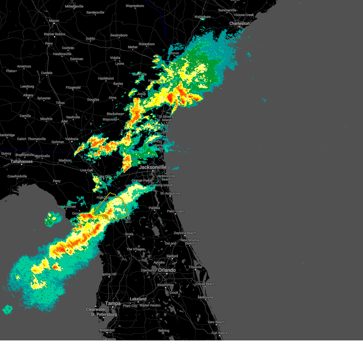
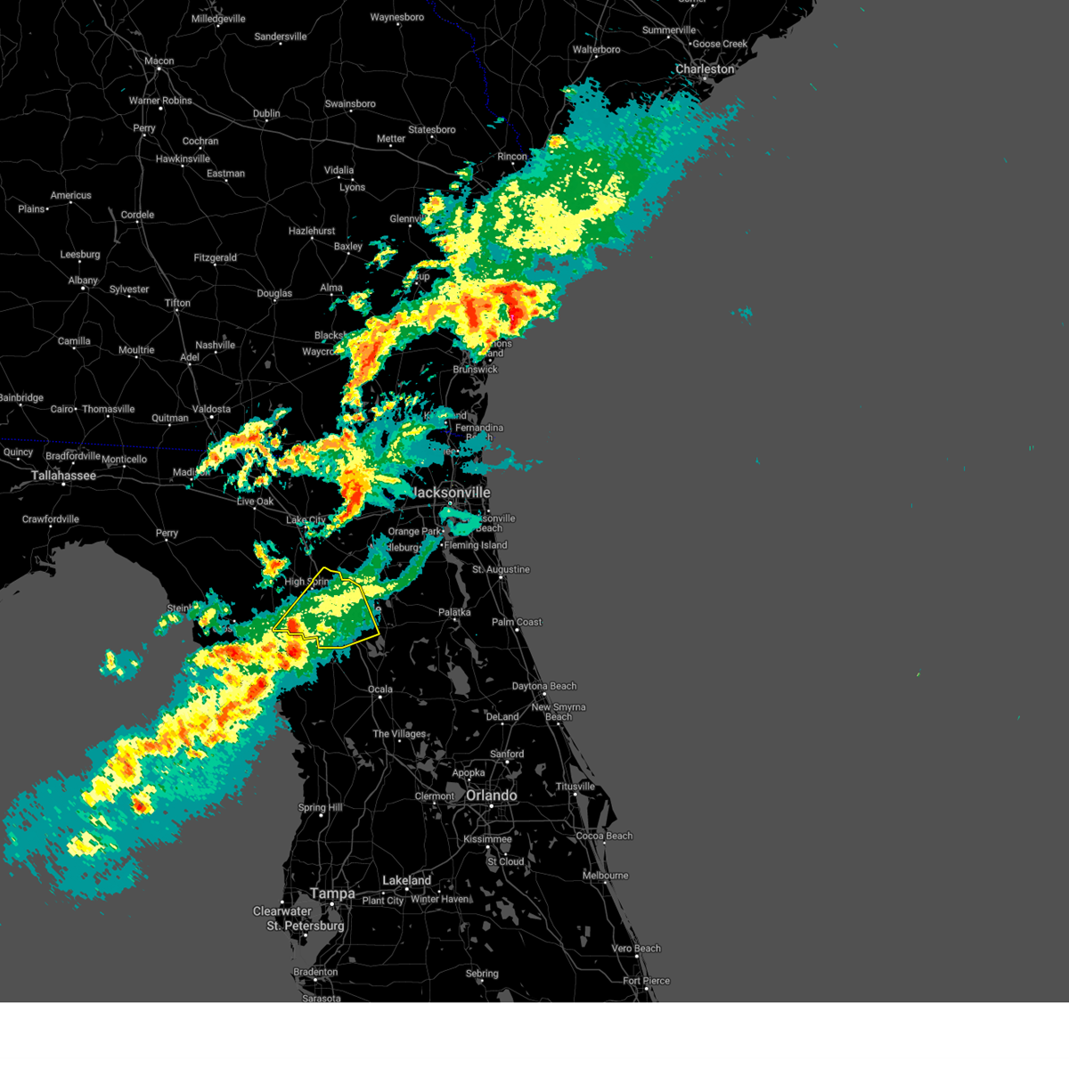
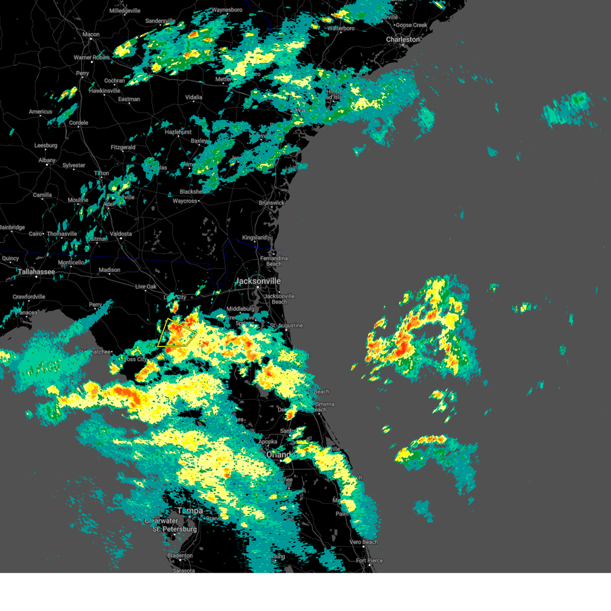
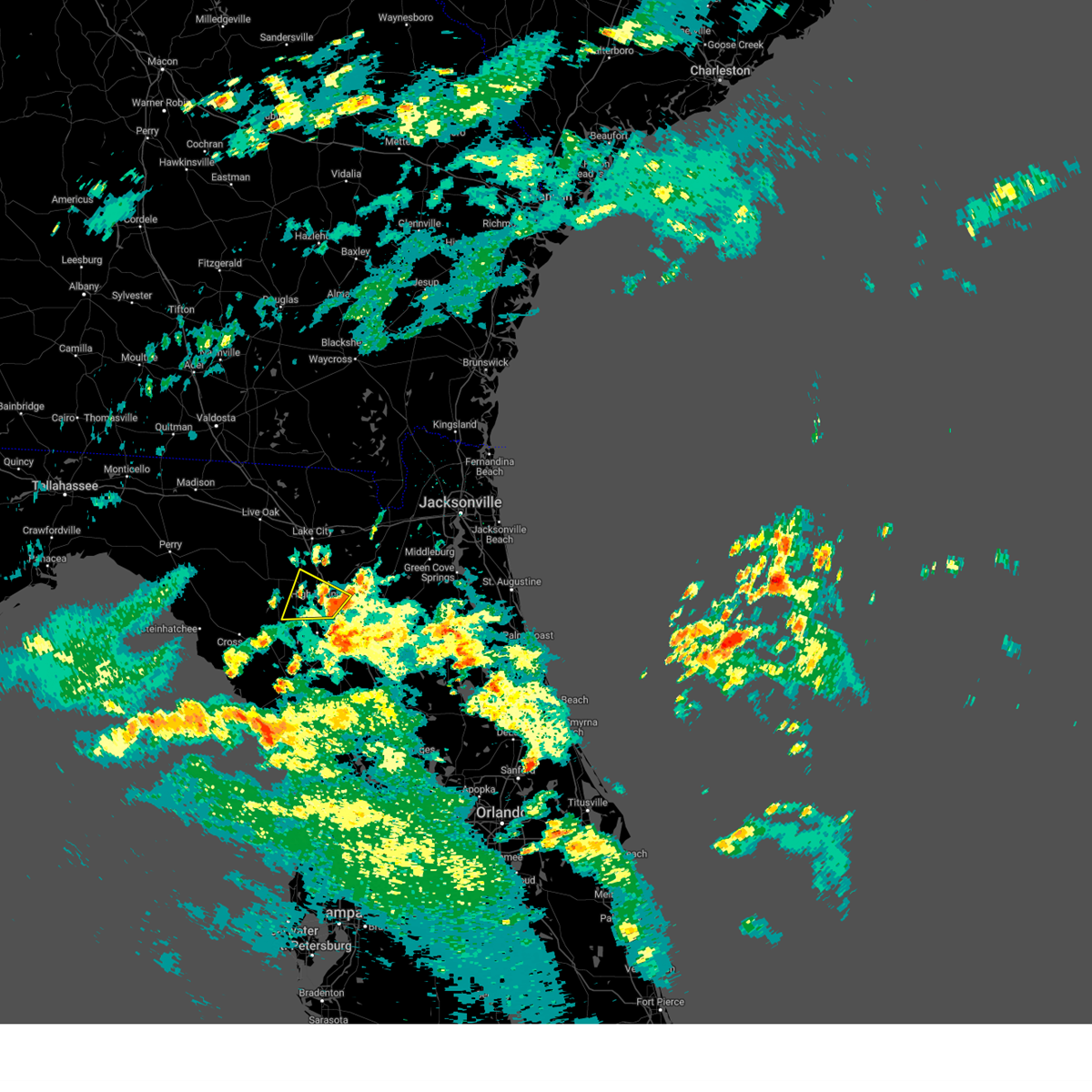
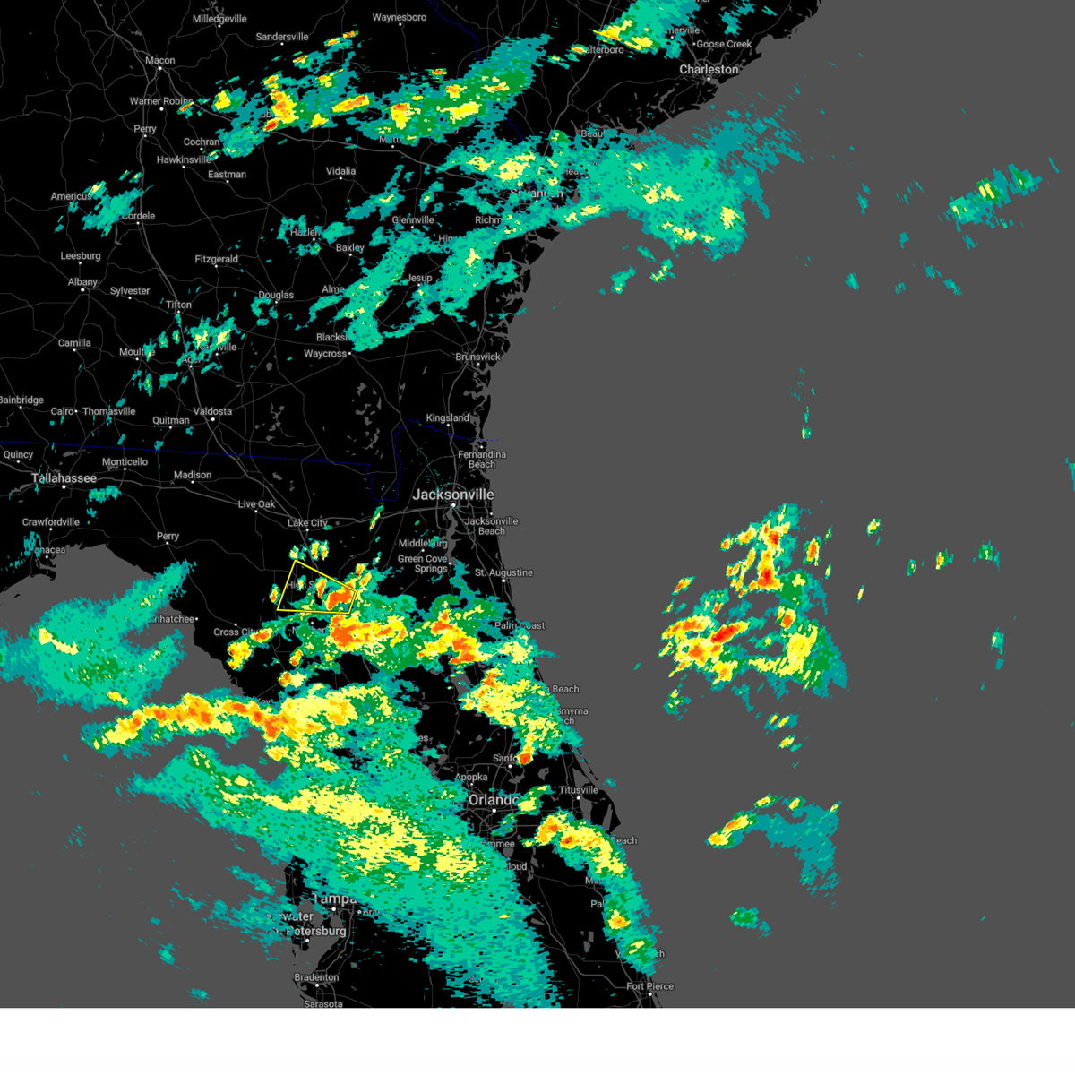
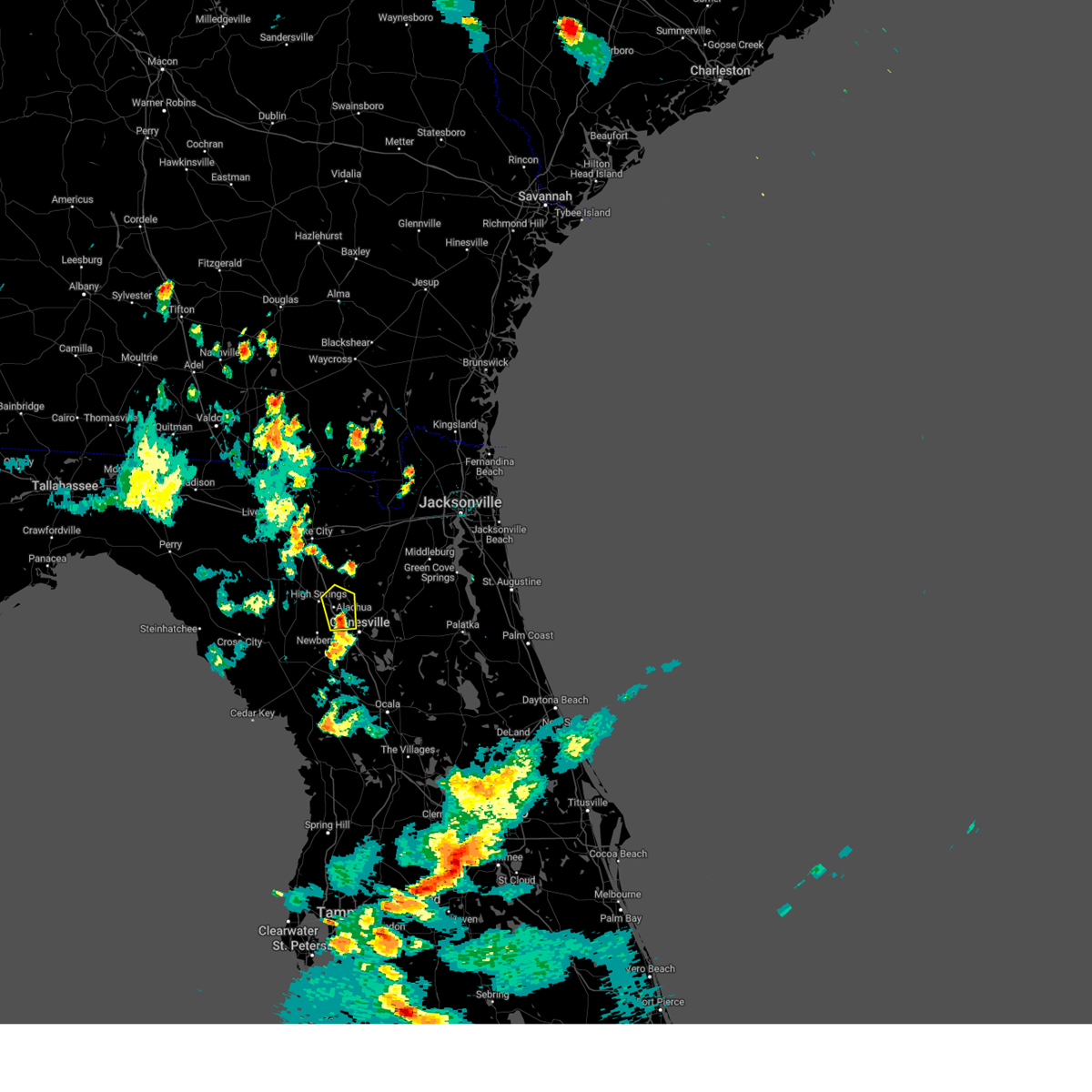
Hail Map for High Springs, FL
The High Springs, FL area has had 3 reports of on-the-ground hail by trained spotters, and has been under severe weather warnings 6 times during the past 12 months. Doppler radar has detected hail at or near High Springs, FL on 72 occasions, including 4 occasions during the past year.
| Name: | High Springs, FL |
| Where Located: | 66.5 miles WSW of Jacksonville, FL |
| Map: | Google Map for High Springs, FL |
| Population: | 5350 |
| Housing Units: | 2361 |
| More Info: | Search Google for High Springs, FL |
2
The Top Recent Hail Date for High Springs, FL is Wednesday, June 18, 2025 (14th out of 72)

Hail and Wind Damage Spotted near High Springs, FL
| Date / Time | Report Details |
|---|---|
| 3/16/2025 12:14 PM EDT |
 the severe thunderstorm warning has been cancelled and is no longer in effect the severe thunderstorm warning has been cancelled and is no longer in effect
|
| 3/16/2025 11:56 AM EDT |
 Svrjax the national weather service in jacksonville has issued a * severe thunderstorm warning for, southeastern gilchrist county in northern florida, alachua county in northern florida, * until 1230 pm edt. * at 1156 am edt, a severe thunderstorm was located near trenton, moving northeast at 40 mph (radar indicated). Hazards include 60 mph wind gusts and penny size hail. expect damage to roofs, siding, and trees Svrjax the national weather service in jacksonville has issued a * severe thunderstorm warning for, southeastern gilchrist county in northern florida, alachua county in northern florida, * until 1230 pm edt. * at 1156 am edt, a severe thunderstorm was located near trenton, moving northeast at 40 mph (radar indicated). Hazards include 60 mph wind gusts and penny size hail. expect damage to roofs, siding, and trees
|
| 8/4/2024 2:56 PM EDT |
 The storm which prompted the warning has weakened below severe limits, and no longer poses an immediate threat to life or property. therefore, the warning will be allowed to expire. however, gusty winds and heavy rain are still possible with this thunderstorm. a tornado watch remains in effect until 800 pm edt for northern florida. The storm which prompted the warning has weakened below severe limits, and no longer poses an immediate threat to life or property. therefore, the warning will be allowed to expire. however, gusty winds and heavy rain are still possible with this thunderstorm. a tornado watch remains in effect until 800 pm edt for northern florida.
|
| 8/4/2024 2:43 PM EDT |
 At 243 pm edt, a severe thunderstorm was located over alachua, or 10 miles southwest of worthington spring, moving northwest at 35 mph (radar indicated). Hazards include 60 mph wind gusts. Expect damage to roofs, siding, and trees. Locations impacted include, alachua, high springs, fort white, and la crosse. At 243 pm edt, a severe thunderstorm was located over alachua, or 10 miles southwest of worthington spring, moving northwest at 35 mph (radar indicated). Hazards include 60 mph wind gusts. Expect damage to roofs, siding, and trees. Locations impacted include, alachua, high springs, fort white, and la crosse.
|
| 8/4/2024 2:33 PM EDT |
 Svrjax the national weather service in jacksonville has issued a * severe thunderstorm warning for, northeastern gilchrist county in northern florida, northwestern alachua county in northern florida, southwestern columbia county in northern florida, * until 300 pm edt. * at 233 pm edt, a severe thunderstorm was located near alachua, or 7 miles northwest of gainesville, moving west at 35 mph (radar indicated). Hazards include 60 mph wind gusts. expect damage to roofs, siding, and trees Svrjax the national weather service in jacksonville has issued a * severe thunderstorm warning for, northeastern gilchrist county in northern florida, northwestern alachua county in northern florida, southwestern columbia county in northern florida, * until 300 pm edt. * at 233 pm edt, a severe thunderstorm was located near alachua, or 7 miles northwest of gainesville, moving west at 35 mph (radar indicated). Hazards include 60 mph wind gusts. expect damage to roofs, siding, and trees
|
| 7/30/2024 6:53 PM EDT |
 Svrjax the national weather service in jacksonville has issued a * severe thunderstorm warning for, northwestern alachua county in northern florida, * until 730 pm edt. * at 653 pm edt, a severe thunderstorm was located near alachua, or 7 miles northwest of gainesville, moving north at 15 mph (radar indicated). Hazards include 60 mph wind gusts and penny size hail. expect damage to roofs, siding, and trees Svrjax the national weather service in jacksonville has issued a * severe thunderstorm warning for, northwestern alachua county in northern florida, * until 730 pm edt. * at 653 pm edt, a severe thunderstorm was located near alachua, or 7 miles northwest of gainesville, moving north at 15 mph (radar indicated). Hazards include 60 mph wind gusts and penny size hail. expect damage to roofs, siding, and trees
|
| 5/10/2024 8:18 AM EDT |
 Svrjax the national weather service in jacksonville has issued a * severe thunderstorm warning for, gilchrist county in northern florida, western alachua county in northern florida, baker county in northeastern florida, union county in northern florida, southeastern suwannee county in northern florida, columbia county in northern florida, eastern hamilton county in northern florida, southeastern echols county in southeastern georgia, southern ware county in southeastern georgia, southeastern clinch county in southeastern georgia, central charlton county in southeastern georgia, * until 900 am edt. * at 818 am edt, severe thunderstorms were located along a line extending from 6 miles south of homerville to near white springs to near cross city, moving east at 60 mph (radar indicated). Hazards include 70 mph wind gusts and quarter size hail. Hail damage to vehicles is expected. expect considerable tree damage. Wind damage is also likely to mobile homes, roofs, and outbuildings. Svrjax the national weather service in jacksonville has issued a * severe thunderstorm warning for, gilchrist county in northern florida, western alachua county in northern florida, baker county in northeastern florida, union county in northern florida, southeastern suwannee county in northern florida, columbia county in northern florida, eastern hamilton county in northern florida, southeastern echols county in southeastern georgia, southern ware county in southeastern georgia, southeastern clinch county in southeastern georgia, central charlton county in southeastern georgia, * until 900 am edt. * at 818 am edt, severe thunderstorms were located along a line extending from 6 miles south of homerville to near white springs to near cross city, moving east at 60 mph (radar indicated). Hazards include 70 mph wind gusts and quarter size hail. Hail damage to vehicles is expected. expect considerable tree damage. Wind damage is also likely to mobile homes, roofs, and outbuildings.
|
| 4/3/2024 10:59 AM EDT |
 At 1059 am edt, severe thunderstorms were located along a line extending from near glen st. mary to near high springs, moving east at 50 mph (radar indicated). Hazards include 60 mph wind gusts and penny size hail. Expect damage to roofs, siding, and trees. Locations impacted include, lake butler, raiford, worthington spring, alachua, macclenny, high springs, worthington springs, groves, beasley, and new river. At 1059 am edt, severe thunderstorms were located along a line extending from near glen st. mary to near high springs, moving east at 50 mph (radar indicated). Hazards include 60 mph wind gusts and penny size hail. Expect damage to roofs, siding, and trees. Locations impacted include, lake butler, raiford, worthington spring, alachua, macclenny, high springs, worthington springs, groves, beasley, and new river.
|
| 4/3/2024 10:59 AM EDT |
 the severe thunderstorm warning has been cancelled and is no longer in effect the severe thunderstorm warning has been cancelled and is no longer in effect
|
| 4/3/2024 10:47 AM EDT |
 At 1047 am edt, severe thunderstorms were located along a line extending from near sanderson to near high springs, moving east at 50 mph (radar indicated). Hazards include 60 mph wind gusts and penny size hail. Expect damage to roofs, siding, and trees. locations impacted include, lake butler, bell, raiford, worthington spring, alachua, macclenny, high springs, glen st. Mary, worthington springs, and palestine community. At 1047 am edt, severe thunderstorms were located along a line extending from near sanderson to near high springs, moving east at 50 mph (radar indicated). Hazards include 60 mph wind gusts and penny size hail. Expect damage to roofs, siding, and trees. locations impacted include, lake butler, bell, raiford, worthington spring, alachua, macclenny, high springs, glen st. Mary, worthington springs, and palestine community.
|
| 4/3/2024 10:31 AM EDT |
 the severe thunderstorm warning has been cancelled and is no longer in effect the severe thunderstorm warning has been cancelled and is no longer in effect
|
| 4/3/2024 10:31 AM EDT |
 At 1030 am edt, severe thunderstorms were located along a line extending from near watertown to near bell, moving east at 40 mph (radar indicated). Hazards include 60 mph wind gusts and penny size hail. Expect damage to roofs, siding, and trees. Locations impacted include, lake city, lake butler, bell, raiford, worthington spring, columbia, alachua, macclenny, high springs, and fort white. At 1030 am edt, severe thunderstorms were located along a line extending from near watertown to near bell, moving east at 40 mph (radar indicated). Hazards include 60 mph wind gusts and penny size hail. Expect damage to roofs, siding, and trees. Locations impacted include, lake city, lake butler, bell, raiford, worthington spring, columbia, alachua, macclenny, high springs, and fort white.
|
| 4/3/2024 10:12 AM EDT |
 Svrjax the national weather service in jacksonville has issued a * severe thunderstorm warning for, central gilchrist county in northern florida, central bradford county in northern florida, northwestern alachua county in northern florida, southern baker county in northeastern florida, union county in northern florida, southeastern suwannee county in northern florida, southern columbia county in northern florida, * until 1115 am edt. * at 1012 am edt, severe thunderstorms were located along a line extending from near wellborn to 6 miles north of bell, moving east at 35 mph (radar indicated). Hazards include 60 mph wind gusts and penny size hail. expect damage to roofs, siding, and trees Svrjax the national weather service in jacksonville has issued a * severe thunderstorm warning for, central gilchrist county in northern florida, central bradford county in northern florida, northwestern alachua county in northern florida, southern baker county in northeastern florida, union county in northern florida, southeastern suwannee county in northern florida, southern columbia county in northern florida, * until 1115 am edt. * at 1012 am edt, severe thunderstorms were located along a line extending from near wellborn to 6 miles north of bell, moving east at 35 mph (radar indicated). Hazards include 60 mph wind gusts and penny size hail. expect damage to roofs, siding, and trees
|
| 3/27/2024 9:21 AM EDT |
 The storms which prompted the warning have weakened below severe limits, and have exited the warned area. therefore, the warning will be allowed to expire. however, gusty winds and heavy rain are still possible with these thunderstorms. The storms which prompted the warning have weakened below severe limits, and have exited the warned area. therefore, the warning will be allowed to expire. however, gusty winds and heavy rain are still possible with these thunderstorms.
|
| 3/27/2024 9:13 AM EDT |
 At 913 am edt, severe thunderstorms were located along a line extending from near fort white to near bronson, moving east at 45 mph (radar indicated). Hazards include 60 mph wind gusts. Expect damage to roofs, siding, and trees. Locations impacted include, trenton, high springs, and newberry. At 913 am edt, severe thunderstorms were located along a line extending from near fort white to near bronson, moving east at 45 mph (radar indicated). Hazards include 60 mph wind gusts. Expect damage to roofs, siding, and trees. Locations impacted include, trenton, high springs, and newberry.
|
| 3/27/2024 8:57 AM EDT |
 At 857 am edt, severe thunderstorms were located along a line extending from 6 miles southwest of ichetucknee spring to near chiefland, moving northeast at 40 mph (radar indicated). Hazards include 60 mph wind gusts and penny size hail. Expect damage to roofs, siding, and trees. Locations impacted include, trenton, bell, high springs, and newberry. At 857 am edt, severe thunderstorms were located along a line extending from 6 miles southwest of ichetucknee spring to near chiefland, moving northeast at 40 mph (radar indicated). Hazards include 60 mph wind gusts and penny size hail. Expect damage to roofs, siding, and trees. Locations impacted include, trenton, bell, high springs, and newberry.
|
| 3/27/2024 8:38 AM EDT |
 Svrjax the national weather service in jacksonville has issued a * severe thunderstorm warning for, gilchrist county in northern florida, northwestern alachua county in northern florida, south central columbia county in northern florida, * until 930 am edt. * at 838 am edt, severe thunderstorms were located along a line extending from 10 miles northwest of bell to 21 miles southwest of fowlers bluff, moving east at 40 mph (radar indicated). Hazards include 60 mph wind gusts and penny size hail. expect damage to roofs, siding, and trees Svrjax the national weather service in jacksonville has issued a * severe thunderstorm warning for, gilchrist county in northern florida, northwestern alachua county in northern florida, south central columbia county in northern florida, * until 930 am edt. * at 838 am edt, severe thunderstorms were located along a line extending from 10 miles northwest of bell to 21 miles southwest of fowlers bluff, moving east at 40 mph (radar indicated). Hazards include 60 mph wind gusts and penny size hail. expect damage to roofs, siding, and trees
|
| 1/9/2024 2:25 PM EST |
 The severe thunderstorm warning for northeastern gilchrist, northwestern alachua, western baker, western union, columbia, south central ware and southeastern clinch counties will expire at 230 pm est, the storms which prompted the warning have moved out of the warned area. therefore, the warning will be allowed to expire. a tornado watch remains in effect until 300 pm est for northern florida, and southeastern georgia. a tornado watch also remains in effect until 600 pm est for northern and northeastern florida. The severe thunderstorm warning for northeastern gilchrist, northwestern alachua, western baker, western union, columbia, south central ware and southeastern clinch counties will expire at 230 pm est, the storms which prompted the warning have moved out of the warned area. therefore, the warning will be allowed to expire. a tornado watch remains in effect until 300 pm est for northern florida, and southeastern georgia. a tornado watch also remains in effect until 600 pm est for northern and northeastern florida.
|
| 1/9/2024 2:24 PM EST |
 The severe thunderstorm warning for gilchrist and west central alachua counties will expire at 230 pm est, the storms which prompted the warning have weakened below severe limits, and no longer pose an immediate threat to life or property. therefore, the warning will be allowed to expire. however, gusty winds are still possible with these thunderstorms. a tornado watch remains in effect until 300 pm est for northern florida. a tornado watch also remains in effect until 600 pm est for northern florida. The severe thunderstorm warning for gilchrist and west central alachua counties will expire at 230 pm est, the storms which prompted the warning have weakened below severe limits, and no longer pose an immediate threat to life or property. therefore, the warning will be allowed to expire. however, gusty winds are still possible with these thunderstorms. a tornado watch remains in effect until 300 pm est for northern florida. a tornado watch also remains in effect until 600 pm est for northern florida.
|
| 1/9/2024 2:14 PM EST |
 At 213 pm est, severe thunderstorms were located along a line extending from 11 miles south of stephen foster state park to near lulu, moving east at 40 mph (radar indicated). Hazards include 60 mph wind gusts. Expect damage to roofs, siding, and trees. Locations impacted include, lake city, ichetucknee spring, columbia, taylor, high springs, fort white, palestine community, providence, olustee, and upland pines. At 213 pm est, severe thunderstorms were located along a line extending from 11 miles south of stephen foster state park to near lulu, moving east at 40 mph (radar indicated). Hazards include 60 mph wind gusts. Expect damage to roofs, siding, and trees. Locations impacted include, lake city, ichetucknee spring, columbia, taylor, high springs, fort white, palestine community, providence, olustee, and upland pines.
|
| 1/9/2024 2:09 PM EST |
 At 209 pm est, severe thunderstorms were located along a line extending from near high springs to 20 miles northwest of crystal river airport, moving east at 45 mph (radar indicated). Hazards include 60 mph wind gusts. expect damage to roofs, siding, and trees At 209 pm est, severe thunderstorms were located along a line extending from near high springs to 20 miles northwest of crystal river airport, moving east at 45 mph (radar indicated). Hazards include 60 mph wind gusts. expect damage to roofs, siding, and trees
|
| 1/9/2024 2:02 PM EST |
 At 201 pm est, severe thunderstorms were located along a line extending from 7 miles north of taylor to near high springs, moving east at 40 mph (radar indicated). Hazards include 60 mph wind gusts. expect damage to roofs, siding, and trees At 201 pm est, severe thunderstorms were located along a line extending from 7 miles north of taylor to near high springs, moving east at 40 mph (radar indicated). Hazards include 60 mph wind gusts. expect damage to roofs, siding, and trees
|
| 1/9/2024 1:39 PM EST |
 At 139 pm est, severe thunderstorms were located along a line extending from 7 miles south of obrien to 6 miles southwest of fowlers bluff, moving east at 30 mph (radar indicated). Hazards include 60 mph wind gusts. expect damage to roofs, siding, and trees At 139 pm est, severe thunderstorms were located along a line extending from 7 miles south of obrien to 6 miles southwest of fowlers bluff, moving east at 30 mph (radar indicated). Hazards include 60 mph wind gusts. expect damage to roofs, siding, and trees
|
| 1/9/2024 1:27 PM EST |
 At 126 pm est, severe thunderstorms were located along a line extending from 9 miles northwest of belmont to near obrien, moving east at 40 mph (radar indicated). Hazards include 60 mph wind gusts. expect damage to roofs, siding, and trees At 126 pm est, severe thunderstorms were located along a line extending from 9 miles northwest of belmont to near obrien, moving east at 40 mph (radar indicated). Hazards include 60 mph wind gusts. expect damage to roofs, siding, and trees
|
| 7/30/2023 9:21 PM EDT |
 The severe thunderstorm warning for bradford, alachua, northeastern marion, western putnam, union and southwestern clay counties will expire at 930 pm edt, the storms which prompted the warning have weakened below severe limits, and no longer pose an immediate threat to life or property. therefore, the warning will be allowed to expire. however gusty winds and heavy rain are still possible with these thunderstorms. The severe thunderstorm warning for bradford, alachua, northeastern marion, western putnam, union and southwestern clay counties will expire at 930 pm edt, the storms which prompted the warning have weakened below severe limits, and no longer pose an immediate threat to life or property. therefore, the warning will be allowed to expire. however gusty winds and heavy rain are still possible with these thunderstorms.
|
| 7/30/2023 8:55 PM EDT |
 At 855 pm edt, severe thunderstorms were located along a line extending from near worthington spring to near lake delancy, moving southwest at 20 mph (radar indicated). Hazards include 60 mph wind gusts. expect damage to roofs, siding, and trees At 855 pm edt, severe thunderstorms were located along a line extending from near worthington spring to near lake delancy, moving southwest at 20 mph (radar indicated). Hazards include 60 mph wind gusts. expect damage to roofs, siding, and trees
|
| 6/17/2023 7:20 PM EDT |
 The severe thunderstorm warning for southern columbia and east central suwannee counties will expire at 730 pm edt, the storm which prompted the warning has weakened below severe limits, and no longer poses an immediate threat to life or property. therefore, the warning will be allowed to expire. however small hail, gusty winds and heavy rain are still possible with this thunderstorm. The severe thunderstorm warning for southern columbia and east central suwannee counties will expire at 730 pm edt, the storm which prompted the warning has weakened below severe limits, and no longer poses an immediate threat to life or property. therefore, the warning will be allowed to expire. however small hail, gusty winds and heavy rain are still possible with this thunderstorm.
|
| 6/17/2023 7:01 PM EDT |
 At 701 pm edt, a severe thunderstorm was located near columbia, or near ichetucknee spring, moving southeast at 15 mph (radar indicated). Hazards include 60 mph wind gusts and quarter size hail. Hail damage to vehicles is expected. Expect wind damage to roofs, siding, and trees. At 701 pm edt, a severe thunderstorm was located near columbia, or near ichetucknee spring, moving southeast at 15 mph (radar indicated). Hazards include 60 mph wind gusts and quarter size hail. Hail damage to vehicles is expected. Expect wind damage to roofs, siding, and trees.
|
| 6/16/2023 7:10 AM EDT |
 At 710 am edt, a severe thunderstorm was located 10 miles south of high springs, or 11 miles east of trenton, moving southeast at 20 mph (radar indicated). Hazards include 60 mph wind gusts and quarter size hail. Hail damage to vehicles is expected. Expect wind damage to roofs, siding, and trees. At 710 am edt, a severe thunderstorm was located 10 miles south of high springs, or 11 miles east of trenton, moving southeast at 20 mph (radar indicated). Hazards include 60 mph wind gusts and quarter size hail. Hail damage to vehicles is expected. Expect wind damage to roofs, siding, and trees.
|
| 6/16/2023 6:45 AM EDT |
 At 645 am edt, a severe thunderstorm was located near bell, moving southeast at 20 mph (radar indicated). Hazards include 60 mph wind gusts and penny size hail. Expect damage to roofs, siding, and trees. Locations impacted include, trenton and newberry. At 645 am edt, a severe thunderstorm was located near bell, moving southeast at 20 mph (radar indicated). Hazards include 60 mph wind gusts and penny size hail. Expect damage to roofs, siding, and trees. Locations impacted include, trenton and newberry.
|
| 6/16/2023 6:29 AM EDT |
 At 629 am edt, a severe thunderstorm was located over bell, moving east at 20 mph (radar indicated). Hazards include 60 mph wind gusts and penny size hail. expect damage to roofs, siding, and trees At 629 am edt, a severe thunderstorm was located over bell, moving east at 20 mph (radar indicated). Hazards include 60 mph wind gusts and penny size hail. expect damage to roofs, siding, and trees
|
| 6/14/2023 11:21 PM EDT |
 At 1121 pm edt, severe thunderstorms were located along a line extending from near worthington spring to near archer to 7 miles southeast of fowlers bluff, moving southeast at 40 mph (radar indicated). Hazards include 70 mph wind gusts. Expect considerable tree damage. damage is likely to mobile homes, roofs, and outbuildings. locations impacted include, gainesville, alachua, high springs, hawthorne, archer, university of florida, rochelle, cross creek, orange heights and gainesville airport. thunderstorm damage threat, considerable hail threat, radar indicated max hail size, <. 75 in wind threat, radar indicated max wind gust, 70 mph. At 1121 pm edt, severe thunderstorms were located along a line extending from near worthington spring to near archer to 7 miles southeast of fowlers bluff, moving southeast at 40 mph (radar indicated). Hazards include 70 mph wind gusts. Expect considerable tree damage. damage is likely to mobile homes, roofs, and outbuildings. locations impacted include, gainesville, alachua, high springs, hawthorne, archer, university of florida, rochelle, cross creek, orange heights and gainesville airport. thunderstorm damage threat, considerable hail threat, radar indicated max hail size, <. 75 in wind threat, radar indicated max wind gust, 70 mph.
|
| 6/14/2023 11:13 PM EDT |
 At 1113 pm edt, severe thunderstorms were located along a line extending from near worthington spring to 6 miles north of archer to near fowlers bluff, moving southeast at 40 mph (radar indicated). Hazards include 60 mph wind gusts. Expect damage to roofs, siding, and trees. locations impacted include, gainesville, trenton, alachua, high springs, hawthorne, archer, university of florida, rochelle, cross creek and orange heights. hail threat, radar indicated max hail size, <. 75 in wind threat, radar indicated max wind gust, 60 mph. At 1113 pm edt, severe thunderstorms were located along a line extending from near worthington spring to 6 miles north of archer to near fowlers bluff, moving southeast at 40 mph (radar indicated). Hazards include 60 mph wind gusts. Expect damage to roofs, siding, and trees. locations impacted include, gainesville, trenton, alachua, high springs, hawthorne, archer, university of florida, rochelle, cross creek and orange heights. hail threat, radar indicated max hail size, <. 75 in wind threat, radar indicated max wind gust, 60 mph.
|
| 6/14/2023 11:02 PM EDT |
 At 1102 pm edt, severe thunderstorms were located along a line extending from 6 miles northwest of olustee to near providence to 7 miles east of bell, moving southeast at 45 mph (radar indicated). Hazards include 60 mph wind gusts. Expect damage to roofs, siding, and trees. locations impacted include, bell, ichetucknee spring, columbia, fort white, branford and hildreth. hail threat, radar indicated max hail size, <. 75 in wind threat, radar indicated max wind gust, 60 mph. At 1102 pm edt, severe thunderstorms were located along a line extending from 6 miles northwest of olustee to near providence to 7 miles east of bell, moving southeast at 45 mph (radar indicated). Hazards include 60 mph wind gusts. Expect damage to roofs, siding, and trees. locations impacted include, bell, ichetucknee spring, columbia, fort white, branford and hildreth. hail threat, radar indicated max hail size, <. 75 in wind threat, radar indicated max wind gust, 60 mph.
|
| 6/14/2023 10:55 PM EDT |
 At 1054 pm edt, severe thunderstorms were located along a line extending from near watertown to 6 miles southwest of high springs to 8 miles south of cross city, moving southeast at 40 mph (radar indicated). Hazards include 60 mph wind gusts. expect damage to roofs, siding, and trees At 1054 pm edt, severe thunderstorms were located along a line extending from near watertown to 6 miles southwest of high springs to 8 miles south of cross city, moving southeast at 40 mph (radar indicated). Hazards include 60 mph wind gusts. expect damage to roofs, siding, and trees
|
| 6/14/2023 10:41 PM EDT |
 At 1041 pm edt, severe thunderstorms were located along a line extending from near belmont to 6 miles southeast of wellborn to 6 miles south of obrien, moving southeast at 45 mph (radar indicated). Hazards include 60 mph wind gusts. Expect damage to roofs, siding, and trees. locations impacted include, lake city, white springs, bell, ichetucknee spring, columbia, fort white, winfield, suwannee valley, belmont and mcalpin. hail threat, radar indicated max hail size, <. 75 in wind threat, radar indicated max wind gust, 60 mph. At 1041 pm edt, severe thunderstorms were located along a line extending from near belmont to 6 miles southeast of wellborn to 6 miles south of obrien, moving southeast at 45 mph (radar indicated). Hazards include 60 mph wind gusts. Expect damage to roofs, siding, and trees. locations impacted include, lake city, white springs, bell, ichetucknee spring, columbia, fort white, winfield, suwannee valley, belmont and mcalpin. hail threat, radar indicated max hail size, <. 75 in wind threat, radar indicated max wind gust, 60 mph.
|
| 6/14/2023 10:26 PM EDT |
 At 1026 pm edt, severe thunderstorms were located along a line extending from near belmont to near mcalpin to near mayo, moving southeast at 40 mph (radar indicated). Hazards include 60 mph wind gusts. expect damage to roofs, siding, and trees At 1026 pm edt, severe thunderstorms were located along a line extending from near belmont to near mcalpin to near mayo, moving southeast at 40 mph (radar indicated). Hazards include 60 mph wind gusts. expect damage to roofs, siding, and trees
|
| 6/9/2023 4:12 PM EDT |
 At 412 pm edt, a severe thunderstorm was located near fort white, or near ichetucknee spring, moving southeast at 10 mph (radar indicated). Hazards include 60 mph wind gusts and quarter size hail. Hail damage to vehicles is expected. Expect wind damage to roofs, siding, and trees. At 412 pm edt, a severe thunderstorm was located near fort white, or near ichetucknee spring, moving southeast at 10 mph (radar indicated). Hazards include 60 mph wind gusts and quarter size hail. Hail damage to vehicles is expected. Expect wind damage to roofs, siding, and trees.
|
| 5/12/2023 7:30 PM EDT | Alachua county 911/dispatch reports that a tree was downed over a powerline by strong wind gusts along nw 154th place in the vicinity of high springs. time of damage ba in alachua county FL, 1.4 miles NW of High Springs, FL |
| 5/12/2023 7:20 PM EDT |
 The severe thunderstorm warning for east central gilchrist and northwestern alachua counties will expire at 730 pm edt, the storm which prompted the warning has weakened below severe limits, and no longer poses an immediate threat to life or property. therefore, the warning will be allowed to expire. however small hail, gusty winds and heavy rain are still possible with this thunderstorm. The severe thunderstorm warning for east central gilchrist and northwestern alachua counties will expire at 730 pm edt, the storm which prompted the warning has weakened below severe limits, and no longer poses an immediate threat to life or property. therefore, the warning will be allowed to expire. however small hail, gusty winds and heavy rain are still possible with this thunderstorm.
|
| 5/12/2023 6:57 PM EDT |
 At 657 pm edt, a severe thunderstorm was located over high springs, or 12 miles southwest of worthington spring, and is nearly stationary (radar indicated). Hazards include 60 mph wind gusts and quarter size hail. Hail damage to vehicles is expected. Expect wind damage to roofs, siding, and trees. At 657 pm edt, a severe thunderstorm was located over high springs, or 12 miles southwest of worthington spring, and is nearly stationary (radar indicated). Hazards include 60 mph wind gusts and quarter size hail. Hail damage to vehicles is expected. Expect wind damage to roofs, siding, and trees.
|
| 5/11/2023 5:30 PM EDT | Golf Ball sized hail reported 3.5 miles ENE of High Springs, FL, reports of a mix of hail sizes... pea to golf ball sized... just southwest of high springs. |
| 5/11/2023 5:13 PM EDT |
 At 513 pm edt, a severe thunderstorm was located near high springs, or 11 miles southeast of ichetucknee spring, moving northwest at 10 mph (radar indicated). Hazards include two inch hail and 60 mph wind gusts. People and animals outdoors will be injured. expect hail damage to roofs, siding, windows, and vehicles. Expect wind damage to roofs, siding, and trees. At 513 pm edt, a severe thunderstorm was located near high springs, or 11 miles southeast of ichetucknee spring, moving northwest at 10 mph (radar indicated). Hazards include two inch hail and 60 mph wind gusts. People and animals outdoors will be injured. expect hail damage to roofs, siding, windows, and vehicles. Expect wind damage to roofs, siding, and trees.
|
| 5/11/2023 4:55 PM EDT | Ping Pong Ball sized hail reported 2.9 miles ENE of High Springs, FL, photos of ping pong size hail reported west of high springs by a trained spotter... relayed by em. exact location estimated from radar. |
| 5/11/2023 4:55 PM EDT |
 At 455 pm edt, a severe thunderstorm was located near high springs, or 13 miles east of bell, moving northwest at 10 mph (radar indicated). Hazards include ping pong ball size hail and 60 mph wind gusts. People and animals outdoors will be injured. expect hail damage to roofs, siding, windows, and vehicles. expect wind damage to roofs, siding, and trees. locations impacted include, high springs. hail threat, radar indicated max hail size, 1. 50 in wind threat, radar indicated max wind gust, 60 mph. At 455 pm edt, a severe thunderstorm was located near high springs, or 13 miles east of bell, moving northwest at 10 mph (radar indicated). Hazards include ping pong ball size hail and 60 mph wind gusts. People and animals outdoors will be injured. expect hail damage to roofs, siding, windows, and vehicles. expect wind damage to roofs, siding, and trees. locations impacted include, high springs. hail threat, radar indicated max hail size, 1. 50 in wind threat, radar indicated max wind gust, 60 mph.
|
| 5/11/2023 4:47 PM EDT |
 At 446 pm edt, a severe thunderstorm was located near high springs, or 13 miles east of bell, and is nearly stationary (radar indicated). Hazards include two inch hail and 60 mph wind gusts. People and animals outdoors will be injured. expect hail damage to roofs, siding, windows, and vehicles. expect wind damage to roofs, siding, and trees. locations impacted include, high springs. thunderstorm damage threat, considerable hail threat, radar indicated max hail size, 2. 00 in wind threat, radar indicated max wind gust, 60 mph. At 446 pm edt, a severe thunderstorm was located near high springs, or 13 miles east of bell, and is nearly stationary (radar indicated). Hazards include two inch hail and 60 mph wind gusts. People and animals outdoors will be injured. expect hail damage to roofs, siding, windows, and vehicles. expect wind damage to roofs, siding, and trees. locations impacted include, high springs. thunderstorm damage threat, considerable hail threat, radar indicated max hail size, 2. 00 in wind threat, radar indicated max wind gust, 60 mph.
|
| 5/11/2023 4:35 PM EDT |
 At 435 pm edt, a severe thunderstorm was located near high springs, or 15 miles east of bell, moving northwest at 10 mph (radar indicated). Hazards include 60 mph wind gusts and quarter size hail. Hail damage to vehicles is expected. Expect wind damage to roofs, siding, and trees. At 435 pm edt, a severe thunderstorm was located near high springs, or 15 miles east of bell, moving northwest at 10 mph (radar indicated). Hazards include 60 mph wind gusts and quarter size hail. Hail damage to vehicles is expected. Expect wind damage to roofs, siding, and trees.
|
| 3/10/2023 6:56 PM EST |
 At 656 pm est, a severe thunderstorm was located near columbia, or 8 miles northeast of ichetucknee spring, moving southeast at 30 mph (radar indicated). Hazards include 60 mph wind gusts. expect damage to roofs, siding, and trees At 656 pm est, a severe thunderstorm was located near columbia, or 8 miles northeast of ichetucknee spring, moving southeast at 30 mph (radar indicated). Hazards include 60 mph wind gusts. expect damage to roofs, siding, and trees
|
| 1/4/2023 3:20 PM EST |
 At 320 pm est, a severe thunderstorm was located near archer, or 13 miles northeast of bronson, moving northeast at 40 mph (radar indicated). Hazards include 70 mph wind gusts and quarter size hail. Hail damage to vehicles is expected. expect considerable tree damage. wind damage is also likely to mobile homes, roofs, and outbuildings. Locations impacted include, gainesville, worthington spring, alachua, high springs, archer, worthington springs, university of florida, groves, providence and beasley. At 320 pm est, a severe thunderstorm was located near archer, or 13 miles northeast of bronson, moving northeast at 40 mph (radar indicated). Hazards include 70 mph wind gusts and quarter size hail. Hail damage to vehicles is expected. expect considerable tree damage. wind damage is also likely to mobile homes, roofs, and outbuildings. Locations impacted include, gainesville, worthington spring, alachua, high springs, archer, worthington springs, university of florida, groves, providence and beasley.
|
| 1/4/2023 3:14 PM EST |
 At 313 pm est, a severe thunderstorm was located 7 miles south of alachua, or 10 miles west of gainesville, moving northeast at 40 mph (radar indicated). Hazards include 70 mph wind gusts and quarter size hail. possible tornado. Hail damage to vehicles is expected. expect considerable tree damage. Wind damage is also likely to mobile homes, roofs, and outbuildings. At 313 pm est, a severe thunderstorm was located 7 miles south of alachua, or 10 miles west of gainesville, moving northeast at 40 mph (radar indicated). Hazards include 70 mph wind gusts and quarter size hail. possible tornado. Hail damage to vehicles is expected. expect considerable tree damage. Wind damage is also likely to mobile homes, roofs, and outbuildings.
|
| 1/4/2023 3:01 PM EST |
 At 301 pm est, severe thunderstorms were located along a line extending from groves to near worthington spring to 6 miles north of bronson, moving east at 50 mph (radar indicated). Hazards include 60 mph wind gusts and penny size hail. Expect damage to roofs, siding, and trees. locations impacted include, gainesville, worthington spring, alachua, high springs, archer, worthington springs, university of florida, groves, beasley and new river. hail threat, radar indicated max hail size, 0. 75 in wind threat, radar indicated max wind gust, 60 mph. At 301 pm est, severe thunderstorms were located along a line extending from groves to near worthington spring to 6 miles north of bronson, moving east at 50 mph (radar indicated). Hazards include 60 mph wind gusts and penny size hail. Expect damage to roofs, siding, and trees. locations impacted include, gainesville, worthington spring, alachua, high springs, archer, worthington springs, university of florida, groves, beasley and new river. hail threat, radar indicated max hail size, 0. 75 in wind threat, radar indicated max wind gust, 60 mph.
|
| 1/4/2023 2:43 PM EST |
 At 242 pm est, severe thunderstorms were located along a line extending from 8 miles north of st. george to near fort white, moving east at 35 mph (radar indicated). Hazards include 60 mph wind gusts and half dollar size hail. Hail damage to vehicles is expected. Expect wind damage to roofs, siding, and trees. At 242 pm est, severe thunderstorms were located along a line extending from 8 miles north of st. george to near fort white, moving east at 35 mph (radar indicated). Hazards include 60 mph wind gusts and half dollar size hail. Hail damage to vehicles is expected. Expect wind damage to roofs, siding, and trees.
|
| 1/4/2023 2:40 PM EST |
 At 240 pm est, severe thunderstorms were located along a line extending from fort white to trenton, moving east at 45 mph (radar indicated). Hazards include 60 mph wind gusts and penny size hail. expect damage to roofs, siding, and trees At 240 pm est, severe thunderstorms were located along a line extending from fort white to trenton, moving east at 45 mph (radar indicated). Hazards include 60 mph wind gusts and penny size hail. expect damage to roofs, siding, and trees
|
| 8/3/2022 6:36 PM EDT | Strong winds caused damage to a residence. extent of damage unknow in alachua county FL, 1 miles ENE of High Springs, FL |
| 7/23/2022 5:24 PM EDT |
 The severe thunderstorm warning for southeastern gilchrist and west central alachua counties will expire at 530 pm edt, the storm which prompted the warning has weakened below severe limits, and no longer poses an immediate threat to life or property. therefore, the warning will be allowed to expire. however heavy rain is still possible with this thunderstorm. The severe thunderstorm warning for southeastern gilchrist and west central alachua counties will expire at 530 pm edt, the storm which prompted the warning has weakened below severe limits, and no longer poses an immediate threat to life or property. therefore, the warning will be allowed to expire. however heavy rain is still possible with this thunderstorm.
|
| 7/23/2022 5:15 PM EDT |
 At 515 pm edt, a severe thunderstorm was located 10 miles northeast of trenton, moving northwest at 5 mph (radar indicated). Hazards include 60 mph wind gusts and penny size hail. Expect damage to roofs, siding, and trees. locations impacted include, high springs and newberry. hail threat, radar indicated max hail size, 0. 75 in wind threat, radar indicated max wind gust, 60 mph. At 515 pm edt, a severe thunderstorm was located 10 miles northeast of trenton, moving northwest at 5 mph (radar indicated). Hazards include 60 mph wind gusts and penny size hail. Expect damage to roofs, siding, and trees. locations impacted include, high springs and newberry. hail threat, radar indicated max hail size, 0. 75 in wind threat, radar indicated max wind gust, 60 mph.
|
| 7/23/2022 5:02 PM EDT |
 At 501 pm edt, a severe thunderstorm was located 10 miles south of high springs, or 11 miles east of trenton, moving northwest at 5 mph (radar indicated). Hazards include 60 mph wind gusts and penny size hail. expect damage to roofs, siding, and trees At 501 pm edt, a severe thunderstorm was located 10 miles south of high springs, or 11 miles east of trenton, moving northwest at 5 mph (radar indicated). Hazards include 60 mph wind gusts and penny size hail. expect damage to roofs, siding, and trees
|
| 6/29/2022 7:56 PM EDT | Tree down at stop sign by ne 80th ave and ne 30th stree in gilchrist county FL, 5.2 miles ENE of High Springs, FL |
| 6/24/2022 4:28 PM EDT |
 The severe thunderstorm warning for gilchrist, western alachua and southwestern columbia counties will expire at 430 pm edt, the storm which prompted the warning has weakened below severe limits, and no longer poses an immediate threat to life or property. therefore, the warning will be allowed to expire. however gusty winds and heavy rain are still possible with this thunderstorm. to report severe weather, contact your nearest law enforcement agency. they will relay your report to the national weather service jacksonville. The severe thunderstorm warning for gilchrist, western alachua and southwestern columbia counties will expire at 430 pm edt, the storm which prompted the warning has weakened below severe limits, and no longer poses an immediate threat to life or property. therefore, the warning will be allowed to expire. however gusty winds and heavy rain are still possible with this thunderstorm. to report severe weather, contact your nearest law enforcement agency. they will relay your report to the national weather service jacksonville.
|
| 6/24/2022 4:11 PM EDT |
 At 410 pm edt, a severe thunderstorm was located 8 miles southwest of alachua, or 14 miles west of gainesville, moving south at 25 mph (radar indicated). Hazards include 60 mph wind gusts and penny size hail. Expect damage to roofs, siding, and trees. locations impacted include, gainesville, trenton, bell, alachua, high springs, archer, fort white, university of florida and newberry. hail threat, radar indicated max hail size, 0. 75 in wind threat, radar indicated max wind gust, 60 mph. At 410 pm edt, a severe thunderstorm was located 8 miles southwest of alachua, or 14 miles west of gainesville, moving south at 25 mph (radar indicated). Hazards include 60 mph wind gusts and penny size hail. Expect damage to roofs, siding, and trees. locations impacted include, gainesville, trenton, bell, alachua, high springs, archer, fort white, university of florida and newberry. hail threat, radar indicated max hail size, 0. 75 in wind threat, radar indicated max wind gust, 60 mph.
|
| 6/24/2022 4:03 PM EDT |
 At 402 pm edt, a severe thunderstorm was located near high springs, or 13 miles northeast of trenton, moving southwest at 30 mph (radar indicated). Hazards include 60 mph wind gusts and penny size hail. expect damage to roofs, siding, and trees At 402 pm edt, a severe thunderstorm was located near high springs, or 13 miles northeast of trenton, moving southwest at 30 mph (radar indicated). Hazards include 60 mph wind gusts and penny size hail. expect damage to roofs, siding, and trees
|
| 5/17/2022 5:25 PM EDT |
 The severe thunderstorm warning for central gilchrist, west central alachua and southwestern columbia counties will expire at 530 pm edt, the storm which prompted the warning has weakened below severe limits, and no longer poses an immediate threat to life or property. therefore, the warning will be allowed to expire. The severe thunderstorm warning for central gilchrist, west central alachua and southwestern columbia counties will expire at 530 pm edt, the storm which prompted the warning has weakened below severe limits, and no longer poses an immediate threat to life or property. therefore, the warning will be allowed to expire.
|
| 5/17/2022 5:03 PM EDT |
 At 503 pm edt, a severe thunderstorm was located near fort white, or near ichetucknee spring, moving southeast at 10 mph (radar indicated). Hazards include 60 mph wind gusts and quarter size hail. Hail damage to vehicles is expected. Expect wind damage to roofs, siding, and trees. At 503 pm edt, a severe thunderstorm was located near fort white, or near ichetucknee spring, moving southeast at 10 mph (radar indicated). Hazards include 60 mph wind gusts and quarter size hail. Hail damage to vehicles is expected. Expect wind damage to roofs, siding, and trees.
|
| 5/15/2022 5:46 PM EDT |
 At 546 pm edt, severe thunderstorms were located along a line extending from near suwannee springs to near upland pines, moving northeast at 15 mph (radar indicated). Hazards include 60 mph wind gusts and quarter size hail. Hail damage to vehicles is expected. expect wind damage to roofs, siding, and trees. locations impacted include, lake city, white springs, suwannee springs, columbia, fort white, wellborn, upland pines, providence, five points and watertown. hail threat, radar indicated max hail size, 1. 00 in wind threat, radar indicated max wind gust, 60 mph. At 546 pm edt, severe thunderstorms were located along a line extending from near suwannee springs to near upland pines, moving northeast at 15 mph (radar indicated). Hazards include 60 mph wind gusts and quarter size hail. Hail damage to vehicles is expected. expect wind damage to roofs, siding, and trees. locations impacted include, lake city, white springs, suwannee springs, columbia, fort white, wellborn, upland pines, providence, five points and watertown. hail threat, radar indicated max hail size, 1. 00 in wind threat, radar indicated max wind gust, 60 mph.
|
| 5/15/2022 5:26 PM EDT |
 At 525 pm edt, severe thunderstorms were located along a line extending from near suwannee springs to near columbia, moving north at 20 mph (radar indicated). Hazards include 60 mph wind gusts and quarter size hail. Hail damage to vehicles is expected. Expect wind damage to roofs, siding, and trees. At 525 pm edt, severe thunderstorms were located along a line extending from near suwannee springs to near columbia, moving north at 20 mph (radar indicated). Hazards include 60 mph wind gusts and quarter size hail. Hail damage to vehicles is expected. Expect wind damage to roofs, siding, and trees.
|
| 5/13/2022 7:21 PM EDT |
 The severe thunderstorm warning for south central columbia county will expire at 730 pm edt, the storm which prompted the warning has weakened below severe limits. therefore, the warning will be allowed to expire. however gusty winds and heavy rain are still possible with this thunderstorm. The severe thunderstorm warning for south central columbia county will expire at 730 pm edt, the storm which prompted the warning has weakened below severe limits. therefore, the warning will be allowed to expire. however gusty winds and heavy rain are still possible with this thunderstorm.
|
| 5/13/2022 7:06 PM EDT |
 At 706 pm edt, a severe thunderstorm was located near fort white, or 7 miles southeast of ichetucknee spring, and is nearly stationary (radar indicated). Hazards include 60 mph wind gusts and penny size hail. Expect damage to roofs, siding, and trees. this severe thunderstorm will remain over mainly rural areas of south central columbia county. hail threat, radar indicated max hail size, 0. 75 in wind threat, radar indicated max wind gust, 60 mph. At 706 pm edt, a severe thunderstorm was located near fort white, or 7 miles southeast of ichetucknee spring, and is nearly stationary (radar indicated). Hazards include 60 mph wind gusts and penny size hail. Expect damage to roofs, siding, and trees. this severe thunderstorm will remain over mainly rural areas of south central columbia county. hail threat, radar indicated max hail size, 0. 75 in wind threat, radar indicated max wind gust, 60 mph.
|
| 5/13/2022 6:55 PM EDT |
 At 655 pm edt, a severe thunderstorm was located near fort white, or 8 miles southeast of ichetucknee spring, and is nearly stationary (radar indicated). Hazards include 60 mph wind gusts and quarter size hail. Hail damage to vehicles is expected. Expect wind damage to roofs, siding, and trees. At 655 pm edt, a severe thunderstorm was located near fort white, or 8 miles southeast of ichetucknee spring, and is nearly stationary (radar indicated). Hazards include 60 mph wind gusts and quarter size hail. Hail damage to vehicles is expected. Expect wind damage to roofs, siding, and trees.
|
| 7/7/2021 6:14 AM EDT |
 At 613 am edt, a vigorous shower capable of producing a tornado was located 7 miles east of alachua, or 8 miles southeast of worthington spring, moving northwest at 35 mph (radar indicated rotation). Hazards include tornado. Flying debris will be dangerous to those caught without shelter. mobile homes will be damaged or destroyed. damage to roofs, windows, and vehicles will occur. tree damage is likely. this dangerous storm will be near, worthington springs around 630 am edt. Other locations impacted by this tornadic thunderstorm include brooker and la crosse. At 613 am edt, a vigorous shower capable of producing a tornado was located 7 miles east of alachua, or 8 miles southeast of worthington spring, moving northwest at 35 mph (radar indicated rotation). Hazards include tornado. Flying debris will be dangerous to those caught without shelter. mobile homes will be damaged or destroyed. damage to roofs, windows, and vehicles will occur. tree damage is likely. this dangerous storm will be near, worthington springs around 630 am edt. Other locations impacted by this tornadic thunderstorm include brooker and la crosse.
|
| 7/7/2021 6:02 AM EDT |
 At 602 am edt, a severe thunderstorm capable of producing a tornado was located near gainesville airport, or near gainesville, moving northwest at 35 mph (radar indicated rotation). Hazards include tornado. Flying debris will be dangerous to those caught without shelter. mobile homes will be damaged or destroyed. damage to roofs, windows, and vehicles will occur. tree damage is likely. this dangerous storm will be near, alachua around 615 am edt. worthington springs around 630 am edt. Other locations impacted by this tornadic thunderstorm include brooker and la crosse. At 602 am edt, a severe thunderstorm capable of producing a tornado was located near gainesville airport, or near gainesville, moving northwest at 35 mph (radar indicated rotation). Hazards include tornado. Flying debris will be dangerous to those caught without shelter. mobile homes will be damaged or destroyed. damage to roofs, windows, and vehicles will occur. tree damage is likely. this dangerous storm will be near, alachua around 615 am edt. worthington springs around 630 am edt. Other locations impacted by this tornadic thunderstorm include brooker and la crosse.
|
| 6/15/2021 5:15 PM EDT |
 At 515 pm edt, a severe thunderstorm was located near gainesville, moving east at 30 mph (radar indicated). Hazards include 60 mph wind gusts and quarter size hail. Hail damage to vehicles is expected. Expect wind damage to roofs, siding, and trees. At 515 pm edt, a severe thunderstorm was located near gainesville, moving east at 30 mph (radar indicated). Hazards include 60 mph wind gusts and quarter size hail. Hail damage to vehicles is expected. Expect wind damage to roofs, siding, and trees.
|
| 6/15/2021 4:19 PM EDT |
 At 419 pm edt, severe thunderstorms were located along a line extending from near raiford to 6 miles south of worthington spring, moving east at 20 mph (radar indicated). Hazards include 60 mph wind gusts and quarter size hail. Hail damage to vehicles is expected. Expect wind damage to roofs, siding, and trees. At 419 pm edt, severe thunderstorms were located along a line extending from near raiford to 6 miles south of worthington spring, moving east at 20 mph (radar indicated). Hazards include 60 mph wind gusts and quarter size hail. Hail damage to vehicles is expected. Expect wind damage to roofs, siding, and trees.
|
| 3/18/2021 3:12 PM EDT |
 The tornado warning for northwestern alachua county will expire at 315 pm edt, the storm which prompted the warning has moved out of the area. therefore, the warning will be allowed to expire. however gusty winds and heavy rain are still possible with this thunderstorm. a tornado watch remains in effect until 600 pm edt for northern florida. to report severe weather, contact your nearest law enforcement agency. they will relay your report to the national weather service jacksonville. The tornado warning for northwestern alachua county will expire at 315 pm edt, the storm which prompted the warning has moved out of the area. therefore, the warning will be allowed to expire. however gusty winds and heavy rain are still possible with this thunderstorm. a tornado watch remains in effect until 600 pm edt for northern florida. to report severe weather, contact your nearest law enforcement agency. they will relay your report to the national weather service jacksonville.
|
| 3/18/2021 3:11 PM EDT |
 The severe thunderstorm warning for gilchrist and western alachua counties will expire at 315 pm edt, the severe thunderstorm which prompted the warning has moved out of the warned area. therefore, the warning will be allowed to expire. a tornado watch remains in effect until 600 pm edt for northern florida. to report severe weather, contact your nearest law enforcement agency. they will relay your report to the national weather service jacksonville. remember, a tornado warning still remains in effect for alachua county. The severe thunderstorm warning for gilchrist and western alachua counties will expire at 315 pm edt, the severe thunderstorm which prompted the warning has moved out of the warned area. therefore, the warning will be allowed to expire. a tornado watch remains in effect until 600 pm edt for northern florida. to report severe weather, contact your nearest law enforcement agency. they will relay your report to the national weather service jacksonville. remember, a tornado warning still remains in effect for alachua county.
|
| 3/18/2021 3:05 PM EDT |
 At 304 pm edt, a severe thunderstorm capable of producing a tornado was located near alachua, or 9 miles southwest of worthington spring, moving northeast at 45 mph (radar indicated rotation). Hazards include tornado. Flying debris will be dangerous to those caught without shelter. mobile homes will be damaged or destroyed. damage to roofs, windows, and vehicles will occur. tree damage is likely. This tornadic thunderstorm will remain over mainly rural areas of northwestern alachua county. At 304 pm edt, a severe thunderstorm capable of producing a tornado was located near alachua, or 9 miles southwest of worthington spring, moving northeast at 45 mph (radar indicated rotation). Hazards include tornado. Flying debris will be dangerous to those caught without shelter. mobile homes will be damaged or destroyed. damage to roofs, windows, and vehicles will occur. tree damage is likely. This tornadic thunderstorm will remain over mainly rural areas of northwestern alachua county.
|
| 3/18/2021 2:50 PM EDT |
 At 250 pm edt, a severe thunderstorm capable of producing a tornado was located near high springs, or 11 miles east of bell, moving east at 40 mph (radar indicated rotation). Hazards include tornado. Flying debris will be dangerous to those caught without shelter. mobile homes will be damaged or destroyed. damage to roofs, windows, and vehicles will occur. tree damage is likely. this dangerous storm will be near, high springs around 300 pm edt. Alachua around 310 pm edt. At 250 pm edt, a severe thunderstorm capable of producing a tornado was located near high springs, or 11 miles east of bell, moving east at 40 mph (radar indicated rotation). Hazards include tornado. Flying debris will be dangerous to those caught without shelter. mobile homes will be damaged or destroyed. damage to roofs, windows, and vehicles will occur. tree damage is likely. this dangerous storm will be near, high springs around 300 pm edt. Alachua around 310 pm edt.
|
| 3/18/2021 2:41 PM EDT | Possible tornado damage. damage to tractor near cr 337 & cr 23 in gilchrist county FL, 7.1 miles NNE of High Springs, FL |
| 3/18/2021 2:40 PM EDT |
 At 240 pm edt, a severe thunderstorm capable of producing a tornado was located near trenton, moving east at 40 mph (radar indicated rotation). Hazards include tornado. Flying debris will be dangerous to those caught without shelter. mobile homes will be damaged or destroyed. damage to roofs, windows, and vehicles will occur. tree damage is likely. this dangerous storm will be near, high springs around 300 pm edt. Alachua around 310 pm edt. At 240 pm edt, a severe thunderstorm capable of producing a tornado was located near trenton, moving east at 40 mph (radar indicated rotation). Hazards include tornado. Flying debris will be dangerous to those caught without shelter. mobile homes will be damaged or destroyed. damage to roofs, windows, and vehicles will occur. tree damage is likely. this dangerous storm will be near, high springs around 300 pm edt. Alachua around 310 pm edt.
|
| 3/18/2021 2:29 PM EDT |
 At 229 pm edt, a severe thunderstorm was located near trenton, moving east at 40 mph (radar indicated). Hazards include 60 mph wind gusts. possible tornado. expect damage to roofs, siding, and trees At 229 pm edt, a severe thunderstorm was located near trenton, moving east at 40 mph (radar indicated). Hazards include 60 mph wind gusts. possible tornado. expect damage to roofs, siding, and trees
|
| 2/6/2021 5:43 PM EST |
 The severe thunderstorm warning for bradford, northern alachua and southern union counties will expire at 545 pm est, the storm which prompted the warning has weakened below severe limits, and no longer poses an immediate threat to life or property. therefore, the warning will be allowed to expire. however small hail and heavy rain are still possible with this thunderstorm. a tornado watch remains in effect until midnight est for northern florida. to report severe weather, contact your nearest law enforcement agency. they will relay your report to the national weather service jacksonville. The severe thunderstorm warning for bradford, northern alachua and southern union counties will expire at 545 pm est, the storm which prompted the warning has weakened below severe limits, and no longer poses an immediate threat to life or property. therefore, the warning will be allowed to expire. however small hail and heavy rain are still possible with this thunderstorm. a tornado watch remains in effect until midnight est for northern florida. to report severe weather, contact your nearest law enforcement agency. they will relay your report to the national weather service jacksonville.
|
| 2/6/2021 5:23 PM EST |
 At 523 pm est, a severe thunderstorm was located near worthington spring, moving northeast at 50 mph (radar indicated). Hazards include quarter size hail. Damage to vehicles is expected. Locations impacted include, starke, lake butler, raiford, worthington spring, alachua, high springs, worthington springs, groves, new river and beasley. At 523 pm est, a severe thunderstorm was located near worthington spring, moving northeast at 50 mph (radar indicated). Hazards include quarter size hail. Damage to vehicles is expected. Locations impacted include, starke, lake butler, raiford, worthington spring, alachua, high springs, worthington springs, groves, new river and beasley.
|
| 2/6/2021 5:08 PM EST |
 At 508 pm est, a severe thunderstorm was located near high springs, or 11 miles southwest of worthington spring, moving northeast at 55 mph (radar indicated). Hazards include quarter size hail. Damage to vehicles is expected. Locations impacted include, starke, trenton, lake butler, bell, raiford, worthington spring, alachua, high springs, worthington springs and groves. At 508 pm est, a severe thunderstorm was located near high springs, or 11 miles southwest of worthington spring, moving northeast at 55 mph (radar indicated). Hazards include quarter size hail. Damage to vehicles is expected. Locations impacted include, starke, trenton, lake butler, bell, raiford, worthington spring, alachua, high springs, worthington springs and groves.
|
| 2/6/2021 4:59 PM EST |
 At 459 pm est, a severe thunderstorm was located near high springs, or 13 miles east of bell, moving northeast at 55 mph (radar indicated). Hazards include 60 mph wind gusts and quarter size hail. Hail damage to vehicles is expected. Expect wind damage to roofs, siding, and trees. At 459 pm est, a severe thunderstorm was located near high springs, or 13 miles east of bell, moving northeast at 55 mph (radar indicated). Hazards include 60 mph wind gusts and quarter size hail. Hail damage to vehicles is expected. Expect wind damage to roofs, siding, and trees.
|
| 12/24/2020 6:03 PM EST |
 At 602 pm est, severe thunderstorms were located along a line extending from 10 miles southeast of stephen foster state park to near sanderson to alachua, moving east at 60 mph (radar indicated). Hazards include 60 mph wind gusts. Expect damage to roofs, siding, and trees. Locations impacted include, starke, hilliard, lake butler, keystone heights, callahan, raiford, worthington spring, taylor, alachua and macclenny. At 602 pm est, severe thunderstorms were located along a line extending from 10 miles southeast of stephen foster state park to near sanderson to alachua, moving east at 60 mph (radar indicated). Hazards include 60 mph wind gusts. Expect damage to roofs, siding, and trees. Locations impacted include, starke, hilliard, lake butler, keystone heights, callahan, raiford, worthington spring, taylor, alachua and macclenny.
|
| 12/24/2020 5:42 PM EST |
 At 542 pm est, severe thunderstorms were located along a line extending from 6 miles southeast of fargo to near watertown to 6 miles northeast of trenton, moving east at 55 mph (radar indicated). Hazards include 60 mph wind gusts. expect damage to roofs, siding, and trees At 542 pm est, severe thunderstorms were located along a line extending from 6 miles southeast of fargo to near watertown to 6 miles northeast of trenton, moving east at 55 mph (radar indicated). Hazards include 60 mph wind gusts. expect damage to roofs, siding, and trees
|
| 4/30/2020 1:44 AM EDT |
 At 144 am edt, severe thunderstorms were located along a line extending from near high springs to 7 miles west of university of florida to near archer, moving northeast at 45 mph (radar indicated). Hazards include 60 mph wind gusts. Expect damage to roofs, siding, and trees. Locations impacted include, gainesville, alachua, high springs, archer, university of florida, gainesville airport, newnans lake, rochelle, micanopy and la crosse. At 144 am edt, severe thunderstorms were located along a line extending from near high springs to 7 miles west of university of florida to near archer, moving northeast at 45 mph (radar indicated). Hazards include 60 mph wind gusts. Expect damage to roofs, siding, and trees. Locations impacted include, gainesville, alachua, high springs, archer, university of florida, gainesville airport, newnans lake, rochelle, micanopy and la crosse.
|
| 4/30/2020 1:37 AM EDT |
 At 136 am edt, severe thunderstorms were located along a line extending from 6 miles southwest of high springs to 8 miles west of university of florida to near archer, moving northeast at 45 mph (radar indicated). Hazards include 60 mph wind gusts. Expect damage to roofs, siding, and trees. Locations impacted include, gainesville, alachua, high springs, archer, university of florida, gainesville airport, newnans lake, rochelle, newberry and micanopy. At 136 am edt, severe thunderstorms were located along a line extending from 6 miles southwest of high springs to 8 miles west of university of florida to near archer, moving northeast at 45 mph (radar indicated). Hazards include 60 mph wind gusts. Expect damage to roofs, siding, and trees. Locations impacted include, gainesville, alachua, high springs, archer, university of florida, gainesville airport, newnans lake, rochelle, newberry and micanopy.
|
| 4/30/2020 1:15 AM EDT |
 At 115 am edt, severe thunderstorms were located along a line extending from near trenton to near bronson to near williston highlands, moving northeast at 45 mph (radar indicated). Hazards include 60 mph wind gusts. expect damage to roofs, siding, and trees At 115 am edt, severe thunderstorms were located along a line extending from near trenton to near bronson to near williston highlands, moving northeast at 45 mph (radar indicated). Hazards include 60 mph wind gusts. expect damage to roofs, siding, and trees
|
| 4/23/2020 9:57 PM EDT |
 At 956 pm edt, a severe thunderstorm capable of producing a tornado was located over alachua, or 10 miles southwest of worthington spring, moving east at 40 mph (radar indicated rotation). Hazards include tornado. Flying debris will be dangerous to those caught without shelter. mobile homes will be damaged or destroyed. damage to roofs, windows, and vehicles will occur. tree damage is likely. this dangerous storm will be near, alachua around 1005 pm edt. gainesville around 1010 pm edt. Other locations impacted by this tornadic thunderstorm include brooker and la crosse. At 956 pm edt, a severe thunderstorm capable of producing a tornado was located over alachua, or 10 miles southwest of worthington spring, moving east at 40 mph (radar indicated rotation). Hazards include tornado. Flying debris will be dangerous to those caught without shelter. mobile homes will be damaged or destroyed. damage to roofs, windows, and vehicles will occur. tree damage is likely. this dangerous storm will be near, alachua around 1005 pm edt. gainesville around 1010 pm edt. Other locations impacted by this tornadic thunderstorm include brooker and la crosse.
|
| 4/23/2020 9:34 PM EDT |
 At 933 pm edt, a severe thunderstorm capable of producing a tornado was located near bell, moving east at 30 mph (radar indicated rotation). Hazards include tornado. Flying debris will be dangerous to those caught without shelter. mobile homes will be damaged or destroyed. damage to roofs, windows, and vehicles will occur. tree damage is likely. this dangerous storm will be near, high springs around 955 pm edt. alachua around 1010 pm edt. gainesville around 1015 pm edt. Other locations impacted by this tornadic thunderstorm include brooker and la crosse. At 933 pm edt, a severe thunderstorm capable of producing a tornado was located near bell, moving east at 30 mph (radar indicated rotation). Hazards include tornado. Flying debris will be dangerous to those caught without shelter. mobile homes will be damaged or destroyed. damage to roofs, windows, and vehicles will occur. tree damage is likely. this dangerous storm will be near, high springs around 955 pm edt. alachua around 1010 pm edt. gainesville around 1015 pm edt. Other locations impacted by this tornadic thunderstorm include brooker and la crosse.
|
| 4/23/2020 9:12 PM EDT |
 At 912 pm edt, a confirmed tornado was located near ichetucknee spring, moving east at 35 mph (weather spotters confirmed tornado). Hazards include damaging tornado and quarter size hail. Flying debris will be dangerous to those caught without shelter. mobile homes will be damaged or destroyed. damage to roofs, windows, and vehicles will occur. tree damage is likely. this tornado will be near, ichetucknee spring around 915 pm edt. fort white around 920 pm edt. high springs around 930 pm edt. Other locations impacted by this tornadic thunderstorm include branford and hildreth. At 912 pm edt, a confirmed tornado was located near ichetucknee spring, moving east at 35 mph (weather spotters confirmed tornado). Hazards include damaging tornado and quarter size hail. Flying debris will be dangerous to those caught without shelter. mobile homes will be damaged or destroyed. damage to roofs, windows, and vehicles will occur. tree damage is likely. this tornado will be near, ichetucknee spring around 915 pm edt. fort white around 920 pm edt. high springs around 930 pm edt. Other locations impacted by this tornadic thunderstorm include branford and hildreth.
|
| 4/23/2020 9:02 PM EDT |
 At 902 pm edt, a severe thunderstorm capable of producing a tornado was located 8 miles southwest of ichetucknee spring, moving east at 45 mph (radar indicated rotation). Hazards include tornado. Flying debris will be dangerous to those caught without shelter. mobile homes will be damaged or destroyed. damage to roofs, windows, and vehicles will occur. tree damage is likely. this dangerous storm will be near, ichetucknee spring around 915 pm edt. fort white around 920 pm edt. high springs around 925 pm edt. Other locations impacted by this tornadic thunderstorm include branford and hildreth. At 902 pm edt, a severe thunderstorm capable of producing a tornado was located 8 miles southwest of ichetucknee spring, moving east at 45 mph (radar indicated rotation). Hazards include tornado. Flying debris will be dangerous to those caught without shelter. mobile homes will be damaged or destroyed. damage to roofs, windows, and vehicles will occur. tree damage is likely. this dangerous storm will be near, ichetucknee spring around 915 pm edt. fort white around 920 pm edt. high springs around 925 pm edt. Other locations impacted by this tornadic thunderstorm include branford and hildreth.
|
| 4/23/2020 8:50 PM EDT |
 At 849 pm edt, a severe thunderstorm capable of producing a tornado was located 13 miles northwest of bell, moving east at 45 mph (radar indicated rotation). Hazards include tornado. Flying debris will be dangerous to those caught without shelter. mobile homes will be damaged or destroyed. damage to roofs, windows, and vehicles will occur. tree damage is likely. this dangerous storm will be near, ichetucknee spring around 915 pm edt. fort white around 920 pm edt. high springs around 925 pm edt. Other locations impacted by this tornadic thunderstorm include branford and hildreth. At 849 pm edt, a severe thunderstorm capable of producing a tornado was located 13 miles northwest of bell, moving east at 45 mph (radar indicated rotation). Hazards include tornado. Flying debris will be dangerous to those caught without shelter. mobile homes will be damaged or destroyed. damage to roofs, windows, and vehicles will occur. tree damage is likely. this dangerous storm will be near, ichetucknee spring around 915 pm edt. fort white around 920 pm edt. high springs around 925 pm edt. Other locations impacted by this tornadic thunderstorm include branford and hildreth.
|
| 2/6/2020 9:46 PM EST | High springs fire department reported via facebook a tree and wires down blocking poe springs road near poe spring par in alachua county FL, 3.3 miles E of High Springs, FL |
| 2/6/2020 9:44 PM EST |
 At 944 pm est, severe thunderstorms were located along a line extending from near st. george to 6 miles northeast of archer, moving east at 35 mph. some storms could potentially produce brief tornadoes (radar indicated). Hazards include 70 mph wind gusts. Expect considerable tree damage. damage is likely to mobile homes, roofs, and outbuildings. Locations impacted include, gainesville, starke, lake butler, keystone heights, callahan, raiford, melrose, worthington spring, taylor and alachua. At 944 pm est, severe thunderstorms were located along a line extending from near st. george to 6 miles northeast of archer, moving east at 35 mph. some storms could potentially produce brief tornadoes (radar indicated). Hazards include 70 mph wind gusts. Expect considerable tree damage. damage is likely to mobile homes, roofs, and outbuildings. Locations impacted include, gainesville, starke, lake butler, keystone heights, callahan, raiford, melrose, worthington spring, taylor and alachua.
|
| 2/6/2020 9:22 PM EST |
 At 920 pm est, severe thunderstorms were located along a line extending from 10 miles northwest of taylor to near high springs, moving east at 45 mph. some storms could potentially produce brief tornadoes (radar indicated). Hazards include 70 mph wind gusts. Expect considerable tree damage. Damage is likely to mobile homes, roofs, and outbuildings. At 920 pm est, severe thunderstorms were located along a line extending from 10 miles northwest of taylor to near high springs, moving east at 45 mph. some storms could potentially produce brief tornadoes (radar indicated). Hazards include 70 mph wind gusts. Expect considerable tree damage. Damage is likely to mobile homes, roofs, and outbuildings.
|
| 2/6/2020 9:07 PM EST |
 A severe thunderstorm warning remains in effect until 930 pm est for northern gilchrist. northwestern alachua. western baker. western union. columbia and southeastern suwannee counties. At 906 pm est, severe thunderstorms were located along a line extending from 6 miles south of fargo to near bell, moving east at 40 mph. A severe thunderstorm warning remains in effect until 930 pm est for northern gilchrist. northwestern alachua. western baker. western union. columbia and southeastern suwannee counties. At 906 pm est, severe thunderstorms were located along a line extending from 6 miles south of fargo to near bell, moving east at 40 mph.
|
| 2/6/2020 8:55 PM EST |
 At 855 pm est, a severe thunderstorm was located 7 miles northwest of trenton, moving east at 35 mph (radar indicated). Hazards include 60 mph wind gusts. expect damage to roofs, siding, and trees At 855 pm est, a severe thunderstorm was located 7 miles northwest of trenton, moving east at 35 mph (radar indicated). Hazards include 60 mph wind gusts. expect damage to roofs, siding, and trees
|
| 2/6/2020 8:41 PM EST |
 At 841 pm est, severe thunderstorms were located along a line extending from 8 miles southwest of needmore to 10 miles south of obrien, moving east at 40 mph (radar indicated). Hazards include 60 mph wind gusts. expect damage to roofs, siding, and trees At 841 pm est, severe thunderstorms were located along a line extending from 8 miles southwest of needmore to 10 miles south of obrien, moving east at 40 mph (radar indicated). Hazards include 60 mph wind gusts. expect damage to roofs, siding, and trees
|
| 7/3/2019 6:42 PM EDT |
 The severe thunderstorm warning for northwestern alachua and south central columbia counties will expire at 645 pm edt, the storm which prompted the warning has weakened below severe limits, and has exited the warned area. therefore, the warning will be allowed to expire. however small hail and gusty winds are still possible with this thunderstorm. The severe thunderstorm warning for northwestern alachua and south central columbia counties will expire at 645 pm edt, the storm which prompted the warning has weakened below severe limits, and has exited the warned area. therefore, the warning will be allowed to expire. however small hail and gusty winds are still possible with this thunderstorm.
|
| 7/3/2019 6:13 PM EDT |
 At 612 pm edt, a severe thunderstorm was located over high springs, or 10 miles southwest of worthington spring, moving north at 10 mph (public reported small hail recently already in high springs). Hazards include 60 mph wind gusts and penny size hail. Expect damage to roofs, siding, and trees. Locations impacted include, alachua and high springs. At 612 pm edt, a severe thunderstorm was located over high springs, or 10 miles southwest of worthington spring, moving north at 10 mph (public reported small hail recently already in high springs). Hazards include 60 mph wind gusts and penny size hail. Expect damage to roofs, siding, and trees. Locations impacted include, alachua and high springs.
|
| 7/3/2019 6:01 PM EDT | 911 call center passed on several reports of trees down in the high springs are in alachua county FL, 0.4 miles SW of High Springs, FL |
| 7/3/2019 5:58 PM EDT |
 At 558 pm edt, a severe thunderstorm was located over high springs, or 11 miles southwest of worthington spring, moving north at 5 mph (radar indicated). Hazards include 60 mph wind gusts and penny size hail. expect damage to roofs, siding, and trees At 558 pm edt, a severe thunderstorm was located over high springs, or 11 miles southwest of worthington spring, moving north at 5 mph (radar indicated). Hazards include 60 mph wind gusts and penny size hail. expect damage to roofs, siding, and trees
|
| 4/19/2019 11:29 AM EDT |
 At 1129 am edt, severe thunderstorms were located along a line extending from near raybon to near raiford, moving northeast at 55 mph (radar indicated). Hazards include 70 mph wind gusts. Expect considerable tree damage. damage is likely to mobile homes, roofs, and outbuildings. Locations impacted include, gainesville, starke, folkston, lake butler, raiford, worthington spring, stephen foster state park, taylor, alachua and macclenny. At 1129 am edt, severe thunderstorms were located along a line extending from near raybon to near raiford, moving northeast at 55 mph (radar indicated). Hazards include 70 mph wind gusts. Expect considerable tree damage. damage is likely to mobile homes, roofs, and outbuildings. Locations impacted include, gainesville, starke, folkston, lake butler, raiford, worthington spring, stephen foster state park, taylor, alachua and macclenny.
|
| 4/19/2019 11:15 AM EDT |
 At 1114 am edt, severe thunderstorms were located along a line extending from near braganza to near alachua, moving northeast at 55 mph (radar indicated). Hazards include 70 mph wind gusts. Expect considerable tree damage. damage is likely to mobile homes, roofs, and outbuildings. Locations impacted include, gainesville, starke, folkston, lake butler, raiford, worthington spring, stephen foster state park, taylor, alachua and macclenny. At 1114 am edt, severe thunderstorms were located along a line extending from near braganza to near alachua, moving northeast at 55 mph (radar indicated). Hazards include 70 mph wind gusts. Expect considerable tree damage. damage is likely to mobile homes, roofs, and outbuildings. Locations impacted include, gainesville, starke, folkston, lake butler, raiford, worthington spring, stephen foster state park, taylor, alachua and macclenny.
|
| 4/19/2019 11:00 AM EDT |
 At 1100 am edt, severe thunderstorms were located along a line extending from 8 miles west of stephen foster state park to 7 miles north of bronson, moving northeast at 55 mph (radar indicated). Hazards include 70 mph wind gusts. Expect considerable tree damage. Damage is likely to mobile homes, roofs, and outbuildings. At 1100 am edt, severe thunderstorms were located along a line extending from 8 miles west of stephen foster state park to 7 miles north of bronson, moving northeast at 55 mph (radar indicated). Hazards include 70 mph wind gusts. Expect considerable tree damage. Damage is likely to mobile homes, roofs, and outbuildings.
|
| 4/19/2019 10:54 AM EDT |
 At 1053 am edt, severe thunderstorms were located along a line extending from near needmore to near high springs, moving northeast at 55 mph (radar indicated). Hazards include 70 mph wind gusts. Expect considerable tree damage. damage is likely to mobile homes, roofs, and outbuildings. Locations impacted include, lake city, trenton, white springs, bell, ichetucknee spring, columbia, fort white, five points, watertown and lulu. At 1053 am edt, severe thunderstorms were located along a line extending from near needmore to near high springs, moving northeast at 55 mph (radar indicated). Hazards include 70 mph wind gusts. Expect considerable tree damage. damage is likely to mobile homes, roofs, and outbuildings. Locations impacted include, lake city, trenton, white springs, bell, ichetucknee spring, columbia, fort white, five points, watertown and lulu.
|
| 4/19/2019 10:48 AM EDT |
 At 1048 am edt, severe thunderstorms were located along a line extending from near belmont to 8 miles east of trenton, moving northeast at 55 mph (radar indicated). Hazards include 70 mph wind gusts. Expect considerable tree damage. damage is likely to mobile homes, roofs, and outbuildings. Locations impacted include, lake city, trenton, white springs, bell, ichetucknee spring, columbia, fort white, winfield, suwannee valley and wellborn. At 1048 am edt, severe thunderstorms were located along a line extending from near belmont to 8 miles east of trenton, moving northeast at 55 mph (radar indicated). Hazards include 70 mph wind gusts. Expect considerable tree damage. damage is likely to mobile homes, roofs, and outbuildings. Locations impacted include, lake city, trenton, white springs, bell, ichetucknee spring, columbia, fort white, winfield, suwannee valley and wellborn.
|
| 4/19/2019 10:19 AM EDT |
 At 1019 am edt, severe thunderstorms were located along a line extending from near live oak to 6 miles east of fowlers bluff, moving northeast at 55 mph (radar indicated). Hazards include 60 mph wind gusts. expect damage to roofs, siding, and trees At 1019 am edt, severe thunderstorms were located along a line extending from near live oak to 6 miles east of fowlers bluff, moving northeast at 55 mph (radar indicated). Hazards include 60 mph wind gusts. expect damage to roofs, siding, and trees
|
| 12/3/2018 8:10 AM EST |
 The severe thunderstorm warning for northeastern gilchrist, columbia and suwannee counties will expire at 815 am est, the storm which prompted the warning has weakened below severe limits, and no longer poses an immediate threat to life or property. therefore, the warning will be allowed to expire. however gusty winds are still possible with this thunderstorm. The severe thunderstorm warning for northeastern gilchrist, columbia and suwannee counties will expire at 815 am est, the storm which prompted the warning has weakened below severe limits, and no longer poses an immediate threat to life or property. therefore, the warning will be allowed to expire. however gusty winds are still possible with this thunderstorm.
|
| 12/3/2018 7:28 AM EST |
 At 728 am est, severe thunderstorms were located along a line extending from near luraville to near ichetucknee spring to 6 miles southwest of high springs, moving northeast at 55 mph (radar indicated). Hazards include 60 mph wind gusts. Expect damage to roofs, siding, and trees. Locations impacted include, lake city, live oak, ichetucknee spring, columbia, fort white, winfield, suwannee valley, luraville, mcalpin and wellborn. At 728 am est, severe thunderstorms were located along a line extending from near luraville to near ichetucknee spring to 6 miles southwest of high springs, moving northeast at 55 mph (radar indicated). Hazards include 60 mph wind gusts. Expect damage to roofs, siding, and trees. Locations impacted include, lake city, live oak, ichetucknee spring, columbia, fort white, winfield, suwannee valley, luraville, mcalpin and wellborn.
|
| 12/3/2018 7:24 AM EST |
 At 724 am est, severe thunderstorms were located along a line extending from near luraville to 6 miles southeast of obrien to 8 miles east of bell, moving northeast at 50 mph (radar indicated). Hazards include 60 mph wind gusts. expect damage to roofs, siding, and trees At 724 am est, severe thunderstorms were located along a line extending from near luraville to 6 miles southeast of obrien to 8 miles east of bell, moving northeast at 50 mph (radar indicated). Hazards include 60 mph wind gusts. expect damage to roofs, siding, and trees
|
| 8/17/2018 4:53 PM EDT |
 At 452 pm edt, a severe thunderstorm was located near fort white, or 9 miles east of ichetucknee spring, moving north at 5 mph (radar indicated). Hazards include 60 mph wind gusts and penny size hail. expect damage to roofs, siding, and trees At 452 pm edt, a severe thunderstorm was located near fort white, or 9 miles east of ichetucknee spring, moving north at 5 mph (radar indicated). Hazards include 60 mph wind gusts and penny size hail. expect damage to roofs, siding, and trees
|
| 7/22/2018 3:52 PM EDT |
 The severe thunderstorm warning for northeastern gilchrist, northwestern alachua and southwestern columbia counties will expire at 400 pm edt, the storm which prompted the warning has weakened below severe limits, and no longer poses an immediate threat to life or property. therefore, the warning will be allowed to expire. a severe thunderstorm watch remains in effect until 800 pm edt for northern florida. The severe thunderstorm warning for northeastern gilchrist, northwestern alachua and southwestern columbia counties will expire at 400 pm edt, the storm which prompted the warning has weakened below severe limits, and no longer poses an immediate threat to life or property. therefore, the warning will be allowed to expire. a severe thunderstorm watch remains in effect until 800 pm edt for northern florida.
|
| 7/22/2018 3:33 PM EDT |
 At 332 pm edt, a severe thunderstorm capable of producing a tornado was located over high springs, or 11 miles southwest of worthington spring, moving east at 20 mph (radar indicated rotation). Hazards include tornado and quarter size hail. Flying debris will be dangerous to those caught without shelter. mobile homes will be damaged or destroyed. damage to roofs, windows, and vehicles will occur. tree damage is likely. This dangerous storm will be near, alachua around 345 pm edt. At 332 pm edt, a severe thunderstorm capable of producing a tornado was located over high springs, or 11 miles southwest of worthington spring, moving east at 20 mph (radar indicated rotation). Hazards include tornado and quarter size hail. Flying debris will be dangerous to those caught without shelter. mobile homes will be damaged or destroyed. damage to roofs, windows, and vehicles will occur. tree damage is likely. This dangerous storm will be near, alachua around 345 pm edt.
|
| 7/22/2018 3:21 PM EDT |
 At 321 pm edt, a severe thunderstorm capable of producing a tornado was located near high springs, or 10 miles southeast of ichetucknee spring, moving east at 20 mph (radar indicated rotation). Hazards include tornado. Flying debris will be dangerous to those caught without shelter. mobile homes will be damaged or destroyed. damage to roofs, windows, and vehicles will occur. tree damage is likely. this dangerous storm will be near, high springs around 330 pm edt. Alachua around 345 pm edt. At 321 pm edt, a severe thunderstorm capable of producing a tornado was located near high springs, or 10 miles southeast of ichetucknee spring, moving east at 20 mph (radar indicated rotation). Hazards include tornado. Flying debris will be dangerous to those caught without shelter. mobile homes will be damaged or destroyed. damage to roofs, windows, and vehicles will occur. tree damage is likely. this dangerous storm will be near, high springs around 330 pm edt. Alachua around 345 pm edt.
|
| 7/22/2018 3:20 PM EDT |
 At 319 pm edt, a severe thunderstorm was located near fort white, or 7 miles southeast of ichetucknee spring, moving east at 20 mph (radar indicated). Hazards include 60 mph wind gusts and quarter size hail. Hail damage to vehicles is expected. Expect wind damage to roofs, siding, and trees. At 319 pm edt, a severe thunderstorm was located near fort white, or 7 miles southeast of ichetucknee spring, moving east at 20 mph (radar indicated). Hazards include 60 mph wind gusts and quarter size hail. Hail damage to vehicles is expected. Expect wind damage to roofs, siding, and trees.
|
| 7/22/2018 2:24 PM EDT |
 At 224 pm edt, a severe thunderstorm was located near ichetucknee spring, moving southeast at 30 mph (radar indicated). Hazards include 60 mph wind gusts and quarter size hail. Hail damage to vehicles is expected. Expect wind damage to roofs, siding, and trees. At 224 pm edt, a severe thunderstorm was located near ichetucknee spring, moving southeast at 30 mph (radar indicated). Hazards include 60 mph wind gusts and quarter size hail. Hail damage to vehicles is expected. Expect wind damage to roofs, siding, and trees.
|
| 7/22/2018 2:04 PM EDT |
 At 203 pm edt, a severe thunderstorm was located near fort white, or near ichetucknee spring, moving southeast at 25 mph (radar indicated). Hazards include 60 mph wind gusts and quarter size hail. Hail damage to vehicles is expected. expect wind damage to roofs, siding, and trees. Locations impacted include, lake butler, worthington spring, ichetucknee spring, columbia, alachua, high springs, fort white, worthington springs, groves and providence. At 203 pm edt, a severe thunderstorm was located near fort white, or near ichetucknee spring, moving southeast at 25 mph (radar indicated). Hazards include 60 mph wind gusts and quarter size hail. Hail damage to vehicles is expected. expect wind damage to roofs, siding, and trees. Locations impacted include, lake butler, worthington spring, ichetucknee spring, columbia, alachua, high springs, fort white, worthington springs, groves and providence.
|
| 7/22/2018 1:38 PM EDT |
 At 138 pm edt, a severe thunderstorm was located near ichetucknee spring, moving southeast at 25 mph (radar indicated). Hazards include 60 mph wind gusts and quarter size hail. Hail damage to vehicles is expected. Expect wind damage to roofs, siding, and trees. At 138 pm edt, a severe thunderstorm was located near ichetucknee spring, moving southeast at 25 mph (radar indicated). Hazards include 60 mph wind gusts and quarter size hail. Hail damage to vehicles is expected. Expect wind damage to roofs, siding, and trees.
|
| 7/22/2018 12:58 PM EDT |
 At 1257 pm edt, a severe thunderstorm was located over alachua, or 8 miles south of worthington spring, moving east at 50 mph (radar indicated). Hazards include 60 mph wind gusts and quarter size hail. Hail damage to vehicles is expected. Expect wind damage to roofs, siding, and trees. At 1257 pm edt, a severe thunderstorm was located over alachua, or 8 miles south of worthington spring, moving east at 50 mph (radar indicated). Hazards include 60 mph wind gusts and quarter size hail. Hail damage to vehicles is expected. Expect wind damage to roofs, siding, and trees.
|
| 7/22/2018 11:29 AM EDT |
 At 1128 am edt, a severe thunderstorm was located near gainesville, moving east at 15 mph (radar indicated). Hazards include 70 mph wind gusts. Expect considerable tree damage. damage is likely to mobile homes, roofs, and outbuildings. Locations impacted include, gainesville, alachua, high springs, hawthorne, university of florida, rochelle, cross creek, orange heights, gainesville airport and newnans lake. At 1128 am edt, a severe thunderstorm was located near gainesville, moving east at 15 mph (radar indicated). Hazards include 70 mph wind gusts. Expect considerable tree damage. damage is likely to mobile homes, roofs, and outbuildings. Locations impacted include, gainesville, alachua, high springs, hawthorne, university of florida, rochelle, cross creek, orange heights, gainesville airport and newnans lake.
|
| 7/22/2018 11:21 AM EDT |
 At 1121 am edt, a severe thunderstorm was located near alachua, or near gainesville, moving east at 15 mph (radar indicated). Hazards include 70 mph wind gusts. Expect considerable tree damage. Damage is likely to mobile homes, roofs, and outbuildings. At 1121 am edt, a severe thunderstorm was located near alachua, or near gainesville, moving east at 15 mph (radar indicated). Hazards include 70 mph wind gusts. Expect considerable tree damage. Damage is likely to mobile homes, roofs, and outbuildings.
|
| 7/21/2018 3:18 PM EDT |
 At 318 pm edt, severe thunderstorms were located along a line extending from 13 miles northwest of bell to near alachua, moving southeast at 40 mph (radar indicated). Hazards include 60 mph wind gusts. Expect damage to roofs, siding, and trees. Locations impacted include, trenton, bell, high springs and newberry. At 318 pm edt, severe thunderstorms were located along a line extending from 13 miles northwest of bell to near alachua, moving southeast at 40 mph (radar indicated). Hazards include 60 mph wind gusts. Expect damage to roofs, siding, and trees. Locations impacted include, trenton, bell, high springs and newberry.
|
| 7/21/2018 2:38 PM EDT |
 At 237 pm edt, severe thunderstorms were located along a line extending from near luraville to near columbia, moving south at 30 mph (radar indicated). Hazards include 60 mph wind gusts. expect damage to roofs, siding, and trees At 237 pm edt, severe thunderstorms were located along a line extending from near luraville to near columbia, moving south at 30 mph (radar indicated). Hazards include 60 mph wind gusts. expect damage to roofs, siding, and trees
|
| 6/4/2018 3:25 PM EDT |
 At 325 pm edt, a severe thunderstorm was located near high springs, or 12 miles southwest of worthington spring, moving southeast at 30 mph (radar indicated). Hazards include 60 mph wind gusts and quarter size hail. Hail damage to vehicles is expected. expect wind damage to roofs, siding, and trees. Locations impacted include, alachua and high springs. At 325 pm edt, a severe thunderstorm was located near high springs, or 12 miles southwest of worthington spring, moving southeast at 30 mph (radar indicated). Hazards include 60 mph wind gusts and quarter size hail. Hail damage to vehicles is expected. expect wind damage to roofs, siding, and trees. Locations impacted include, alachua and high springs.
|
| 6/4/2018 3:12 PM EDT |
 At 312 pm edt, a severe thunderstorm was located near high springs, or 12 miles southeast of ichetucknee spring, moving southeast at 30 mph (radar indicated). Hazards include 60 mph wind gusts and quarter size hail. Hail damage to vehicles is expected. Expect wind damage to roofs, siding, and trees. At 312 pm edt, a severe thunderstorm was located near high springs, or 12 miles southeast of ichetucknee spring, moving southeast at 30 mph (radar indicated). Hazards include 60 mph wind gusts and quarter size hail. Hail damage to vehicles is expected. Expect wind damage to roofs, siding, and trees.
|
| 6/3/2018 6:16 PM EDT |
 At 616 pm edt, a severe thunderstorm was located near alachua, or 11 miles west of gainesville, moving southeast at 15 mph (radar indicated). Hazards include 60 mph wind gusts and quarter size hail. Hail damage to vehicles is expected. Expect wind damage to roofs, siding, and trees. At 616 pm edt, a severe thunderstorm was located near alachua, or 11 miles west of gainesville, moving southeast at 15 mph (radar indicated). Hazards include 60 mph wind gusts and quarter size hail. Hail damage to vehicles is expected. Expect wind damage to roofs, siding, and trees.
|
| 4/15/2018 12:39 PM EDT |
 The severe thunderstorm warning for western baker, columbia, eastern suwannee, southeastern hamilton, western brantley, ware, southeastern clinch and northwestern charlton counties will expire at 1245 pm edt, the storms which prompted the warning have weakened below severe limits, and no longer pose an immediate threat to life or property. therefore, the warning will be allowed to expire. however gusty winds and heavy rain are still possible with these thunderstorms. a tornado watch remains in effect until 600 pm edt for northern and northeastern florida, and southeastern georgia. The severe thunderstorm warning for western baker, columbia, eastern suwannee, southeastern hamilton, western brantley, ware, southeastern clinch and northwestern charlton counties will expire at 1245 pm edt, the storms which prompted the warning have weakened below severe limits, and no longer pose an immediate threat to life or property. therefore, the warning will be allowed to expire. however gusty winds and heavy rain are still possible with these thunderstorms. a tornado watch remains in effect until 600 pm edt for northern and northeastern florida, and southeastern georgia.
|
| 4/15/2018 12:01 PM EDT |
 At 1201 pm edt, severe thunderstorms were located along a line extending from near waycross to near fargo to 12 miles south of mayo, moving northeast at 45 mph (radar indicated). Hazards include 60 mph wind gusts. expect damage to roofs, siding, and trees At 1201 pm edt, severe thunderstorms were located along a line extending from near waycross to near fargo to 12 miles south of mayo, moving northeast at 45 mph (radar indicated). Hazards include 60 mph wind gusts. expect damage to roofs, siding, and trees
|
| 3/20/2018 3:11 PM EDT |
 The severe thunderstorm warning for gilchrist, northern alachua, bradford, southern baker, union and southern columbia counties will expire at 315 pm edt, the storms which prompted the warning have weakened below severe limits, and have exited the warned area. therefore the warning will be allowed to expire. however small hail, gusty winds and heavy rain are still possible with these thunderstorms. a tornado watch remains in effect until 700 pm edt for northern and northeastern florida. The severe thunderstorm warning for gilchrist, northern alachua, bradford, southern baker, union and southern columbia counties will expire at 315 pm edt, the storms which prompted the warning have weakened below severe limits, and have exited the warned area. therefore the warning will be allowed to expire. however small hail, gusty winds and heavy rain are still possible with these thunderstorms. a tornado watch remains in effect until 700 pm edt for northern and northeastern florida.
|
| 3/20/2018 2:44 PM EDT |
 At 243 pm edt, severe thunderstorms were located along a line extending from 6 miles southeast of columbia to 9 miles northeast of trenton, moving northeast at 55 mph (radar indicated). Hazards include ping pong ball size hail and 60 mph wind gusts. People and animals outdoors will be injured. expect hail damage to roofs, siding, windows, and vehicles. expect wind damage to roofs, siding, and trees. locations impacted include, gainesville, starke, trenton, lake butler, bell, raiford, worthington spring, ichetucknee spring, columbia and alachua. A tornado watch remains in effect until 700 pm edt for northern and northeastern florida. At 243 pm edt, severe thunderstorms were located along a line extending from 6 miles southeast of columbia to 9 miles northeast of trenton, moving northeast at 55 mph (radar indicated). Hazards include ping pong ball size hail and 60 mph wind gusts. People and animals outdoors will be injured. expect hail damage to roofs, siding, windows, and vehicles. expect wind damage to roofs, siding, and trees. locations impacted include, gainesville, starke, trenton, lake butler, bell, raiford, worthington spring, ichetucknee spring, columbia and alachua. A tornado watch remains in effect until 700 pm edt for northern and northeastern florida.
|
| 3/20/2018 2:23 PM EDT |
 At 223 pm edt, severe thunderstorms were located along a line extending from 8 miles north of bell to near manattee road, moving northeast at 55 mph (radar indicated). Hazards include ping pong ball size hail and 60 mph wind gusts. People and animals outdoors will be injured. expect hail damage to roofs, siding, windows, and vehicles. Expect wind damage to roofs, siding, and trees. At 223 pm edt, severe thunderstorms were located along a line extending from 8 miles north of bell to near manattee road, moving northeast at 55 mph (radar indicated). Hazards include ping pong ball size hail and 60 mph wind gusts. People and animals outdoors will be injured. expect hail damage to roofs, siding, windows, and vehicles. Expect wind damage to roofs, siding, and trees.
|
| 3/20/2018 1:51 PM EDT |
 At 151 pm edt, a severe thunderstorm was located over alachua, or 12 miles southwest of worthington spring, moving northeast at 55 mph (radar indicated). Hazards include 60 mph wind gusts and quarter size hail. Hail damage to vehicles is expected. Expect wind damage to roofs, siding, and trees. At 151 pm edt, a severe thunderstorm was located over alachua, or 12 miles southwest of worthington spring, moving northeast at 55 mph (radar indicated). Hazards include 60 mph wind gusts and quarter size hail. Hail damage to vehicles is expected. Expect wind damage to roofs, siding, and trees.
|
| 3/19/2018 6:41 AM EDT |
 At 641 am edt, severe thunderstorms were located along a line extending from near alachua to near bronson, moving east at 55 mph (radar indicated). Hazards include 60 mph wind gusts and penny size hail. Expect damage to roofs, siding, and trees. Locations impacted include, gainesville, alachua, archer, university of florida, gainesville airport, newberry and waldo. At 641 am edt, severe thunderstorms were located along a line extending from near alachua to near bronson, moving east at 55 mph (radar indicated). Hazards include 60 mph wind gusts and penny size hail. Expect damage to roofs, siding, and trees. Locations impacted include, gainesville, alachua, archer, university of florida, gainesville airport, newberry and waldo.
|
| 3/19/2018 6:24 AM EDT |
 At 624 am edt, severe thunderstorms were located along a line extending from near high springs to near andrews, moving east at 55 mph. radar indicated weak rotation with this storm. tornadoes can quickly develop with little or no advanced warning (radar indicated). Hazards include 60 mph wind gusts and penny size hail. expect damage to roofs, siding, and trees At 624 am edt, severe thunderstorms were located along a line extending from near high springs to near andrews, moving east at 55 mph. radar indicated weak rotation with this storm. tornadoes can quickly develop with little or no advanced warning (radar indicated). Hazards include 60 mph wind gusts and penny size hail. expect damage to roofs, siding, and trees
|
| 10/7/2017 8:42 PM EDT |
 The severe thunderstorm warning for east central gilchrist, northwestern alachua, southwestern union and southwestern columbia counties will expire at 845 pm edt, the storm which prompted the warning has weakened below severe limits, and no longer poses an immediate threat to life or property. therefore the warning will be allowed to expire. however gusty winds and heavy rain are still possible with this thunderstorm. to report severe weather, contact your nearest law enforcement agency. they will relay your report to the national weather service jacksonville. The severe thunderstorm warning for east central gilchrist, northwestern alachua, southwestern union and southwestern columbia counties will expire at 845 pm edt, the storm which prompted the warning has weakened below severe limits, and no longer poses an immediate threat to life or property. therefore the warning will be allowed to expire. however gusty winds and heavy rain are still possible with this thunderstorm. to report severe weather, contact your nearest law enforcement agency. they will relay your report to the national weather service jacksonville.
|
| 10/7/2017 8:23 PM EDT |
 At 823 pm edt, a severe thunderstorm was located near alachua, or 14 miles west of gainesville, moving north at 25 mph (radar indicated). Hazards include 60 mph wind gusts. Expect damage to roofs, siding, and trees. Locations impacted include, alachua, high springs, fort white, upland pines and providence. At 823 pm edt, a severe thunderstorm was located near alachua, or 14 miles west of gainesville, moving north at 25 mph (radar indicated). Hazards include 60 mph wind gusts. Expect damage to roofs, siding, and trees. Locations impacted include, alachua, high springs, fort white, upland pines and providence.
|
| 10/7/2017 8:08 PM EDT |
 At 807 pm edt, a severe thunderstorm was located 8 miles southwest of alachua, or 12 miles west of gainesville, moving north at 25 mph (radar indicated). Hazards include 60 mph wind gusts. expect damage to roofs, siding, and trees At 807 pm edt, a severe thunderstorm was located 8 miles southwest of alachua, or 12 miles west of gainesville, moving north at 25 mph (radar indicated). Hazards include 60 mph wind gusts. expect damage to roofs, siding, and trees
|
| 8/9/2017 3:36 PM EDT |
 At 336 pm edt, a severe thunderstorm was located near high springs, or 7 miles southwest of worthington spring, and is nearly stationary (radar indicated). Hazards include 60 mph wind gusts. expect damage to roofs, siding, and trees At 336 pm edt, a severe thunderstorm was located near high springs, or 7 miles southwest of worthington spring, and is nearly stationary (radar indicated). Hazards include 60 mph wind gusts. expect damage to roofs, siding, and trees
|
| 7/16/2017 4:03 PM EDT |
 At 403 pm edt, a severe thunderstorm was located near providence, or 9 miles west of worthington spring, moving northeast at 20 mph (radar indicated). Hazards include 60 mph wind gusts and penny size hail. Expect damage to roofs, siding, and trees. Locations impacted include, ichetucknee spring, high springs, fort white, upland pines, groves and providence. At 403 pm edt, a severe thunderstorm was located near providence, or 9 miles west of worthington spring, moving northeast at 20 mph (radar indicated). Hazards include 60 mph wind gusts and penny size hail. Expect damage to roofs, siding, and trees. Locations impacted include, ichetucknee spring, high springs, fort white, upland pines, groves and providence.
|
| 7/16/2017 3:52 PM EDT |
 At 351 pm edt, a severe thunderstorm was located over fort white, or near ichetucknee spring, moving northeast at 15 mph (radar indicated). Hazards include 60 mph wind gusts and penny size hail. expect damage to roofs, siding, and trees At 351 pm edt, a severe thunderstorm was located over fort white, or near ichetucknee spring, moving northeast at 15 mph (radar indicated). Hazards include 60 mph wind gusts and penny size hail. expect damage to roofs, siding, and trees
|
| 4/4/2017 6:52 AM EDT |
 At 652 am edt, severe thunderstorms were located along a line extending from 6 miles south of mayo to luraville, moving east at 35 mph (radar indicated). Hazards include 60 mph wind gusts. expect damage to roofs, siding, and trees At 652 am edt, severe thunderstorms were located along a line extending from 6 miles south of mayo to luraville, moving east at 35 mph (radar indicated). Hazards include 60 mph wind gusts. expect damage to roofs, siding, and trees
|
| 2/7/2017 9:52 PM EST |
 The severe thunderstorm warning for southeastern columbia, union, western alachua, west central bradford, southwestern baker and southern gilchrist counties will expire at 1000 pm est, the storm which prompted the warning has exited the warned area. therefore the warning will be allowed to expire. however gusty winds are still possible with this thunderstorm. a severe thunderstorm watch remains in effect until midnight est for northeastern and northern florida. to report severe weather, contact your nearest law enforcement agency. they will relay your report to the national weather service jacksonville. The severe thunderstorm warning for southeastern columbia, union, western alachua, west central bradford, southwestern baker and southern gilchrist counties will expire at 1000 pm est, the storm which prompted the warning has exited the warned area. therefore the warning will be allowed to expire. however gusty winds are still possible with this thunderstorm. a severe thunderstorm watch remains in effect until midnight est for northeastern and northern florida. to report severe weather, contact your nearest law enforcement agency. they will relay your report to the national weather service jacksonville.
|
| 2/7/2017 9:39 PM EST |
 At 938 pm est, a severe thunderstorm was located near obrien, or 9 miles northwest of ichetucknee spring, moving east at 55 mph (radar indicated). Hazards include 60 mph wind gusts and nickel size hail. Expect damage to roofs, siding, and trees. Locations impacted include, trenton, lake butler, worthington spring, alachua, high springs, archer, worthington springs, groves, sanderson and upland pines. At 938 pm est, a severe thunderstorm was located near obrien, or 9 miles northwest of ichetucknee spring, moving east at 55 mph (radar indicated). Hazards include 60 mph wind gusts and nickel size hail. Expect damage to roofs, siding, and trees. Locations impacted include, trenton, lake butler, worthington spring, alachua, high springs, archer, worthington springs, groves, sanderson and upland pines.
|
| 2/7/2017 9:19 PM EST |
 At 918 pm est, a severe thunderstorm was located near columbia, or near lake city, moving east at 45 mph (radar indicated). Hazards include 60 mph wind gusts and quarter size hail. Hail damage to vehicles is expected. Expect wind damage to roofs, siding, and trees. At 918 pm est, a severe thunderstorm was located near columbia, or near lake city, moving east at 45 mph (radar indicated). Hazards include 60 mph wind gusts and quarter size hail. Hail damage to vehicles is expected. Expect wind damage to roofs, siding, and trees.
|
| 2/7/2017 9:18 PM EST | 12x24 awning ripped from ground in alachua county FL, 2.6 miles NNE of High Springs, FL |
| 1/22/2017 6:17 PM EST |
 At 617 pm est, severe thunderstorms were located along a line extending from 8 miles north of macclenny to near williston, moving northeast at 70 mph (radar indicated). Hazards include 60 mph wind gusts and quarter size hail. Hail damage to vehicles is expected. expect wind damage to roofs, siding, and trees. locations impacted include, jacksonville, gainesville, saint augustine, fernandina beach, palatka, orange park, green cove springs, starke, lake butler and interlachen. A tornado watch remains in effect until 800 pm est for northeastern and northern florida, and southeastern georgia. At 617 pm est, severe thunderstorms were located along a line extending from 8 miles north of macclenny to near williston, moving northeast at 70 mph (radar indicated). Hazards include 60 mph wind gusts and quarter size hail. Hail damage to vehicles is expected. expect wind damage to roofs, siding, and trees. locations impacted include, jacksonville, gainesville, saint augustine, fernandina beach, palatka, orange park, green cove springs, starke, lake butler and interlachen. A tornado watch remains in effect until 800 pm est for northeastern and northern florida, and southeastern georgia.
|
| 1/22/2017 6:06 PM EST |
 At 605 pm est, severe thunderstorms were located along a line extending from near sanderson to near williston highlands, moving northeast at 70 mph (radar indicated). Hazards include 60 mph wind gusts and quarter size hail. Hail damage to vehicles is expected. Expect wind damage to roofs, siding, and trees. At 605 pm est, severe thunderstorms were located along a line extending from near sanderson to near williston highlands, moving northeast at 70 mph (radar indicated). Hazards include 60 mph wind gusts and quarter size hail. Hail damage to vehicles is expected. Expect wind damage to roofs, siding, and trees.
|
| 1/22/2017 6:01 PM EST |
 At 601 pm est, severe thunderstorms were located along a line extending from 8 miles northwest of taylor to lulu, moving east at 90 mph (radar indicated). Hazards include 60 mph wind gusts and quarter size hail. Hail damage to vehicles is expected. expect wind damage to roofs, siding, and trees. locations impacted include, lake city, trenton, worthington spring, ichetucknee spring, columbia, alachua, high springs, fort white, worthington springs and groves. A tornado watch remains in effect until 800 pm est for northeastern and northern florida. At 601 pm est, severe thunderstorms were located along a line extending from 8 miles northwest of taylor to lulu, moving east at 90 mph (radar indicated). Hazards include 60 mph wind gusts and quarter size hail. Hail damage to vehicles is expected. expect wind damage to roofs, siding, and trees. locations impacted include, lake city, trenton, worthington spring, ichetucknee spring, columbia, alachua, high springs, fort white, worthington springs and groves. A tornado watch remains in effect until 800 pm est for northeastern and northern florida.
|
| 1/22/2017 5:28 PM EST |
 At 528 pm est, severe thunderstorms were located along a line extending from near obrien to near manattee road, moving northeast at 90 mph (radar indicated). Hazards include 60 mph wind gusts and quarter size hail. Hail damage to vehicles is expected. Expect wind damage to roofs, siding, and trees. At 528 pm est, severe thunderstorms were located along a line extending from near obrien to near manattee road, moving northeast at 90 mph (radar indicated). Hazards include 60 mph wind gusts and quarter size hail. Hail damage to vehicles is expected. Expect wind damage to roofs, siding, and trees.
|
| 1/3/2017 5:14 AM EST |
 The tornado warning for southwestern columbia, southeastern suwannee and north central gilchrist counties will expire at 515 am est, the storm which prompted the warning has weakened below severe limits, and no longer appears capable of producing a tornado. therefore the warning will be allowed to expire. The tornado warning for southwestern columbia, southeastern suwannee and north central gilchrist counties will expire at 515 am est, the storm which prompted the warning has weakened below severe limits, and no longer appears capable of producing a tornado. therefore the warning will be allowed to expire.
|
| 1/3/2017 5:01 AM EST |
 At 500 am est, a severe thunderstorm capable of producing a tornado was located near ichetucknee spring, moving east at 15 mph (radar indicated rotation). Hazards include tornado. Flying debris will be dangerous to those caught without shelter. mobile homes will be damaged or destroyed. damage to roofs, windows, and vehicles will occur. tree damage is likely. Locations impacted include, ichetucknee spring, columbia, fort white and hildreth. At 500 am est, a severe thunderstorm capable of producing a tornado was located near ichetucknee spring, moving east at 15 mph (radar indicated rotation). Hazards include tornado. Flying debris will be dangerous to those caught without shelter. mobile homes will be damaged or destroyed. damage to roofs, windows, and vehicles will occur. tree damage is likely. Locations impacted include, ichetucknee spring, columbia, fort white and hildreth.
|
| 1/3/2017 4:50 AM EST |
 At 449 am est, a severe thunderstorm capable of producing a tornado was located near obrien, or near ichetucknee spring, moving east at 15 mph (radar indicated rotation). Hazards include tornado. Flying debris will be dangerous to those caught without shelter. mobile homes will be damaged or destroyed. damage to roofs, windows, and vehicles will occur. tree damage is likely. this dangerous storm will be near, ichetucknee spring and fort white around 515 am est. Other locations impacted by this tornadic thunderstorm include hildreth. At 449 am est, a severe thunderstorm capable of producing a tornado was located near obrien, or near ichetucknee spring, moving east at 15 mph (radar indicated rotation). Hazards include tornado. Flying debris will be dangerous to those caught without shelter. mobile homes will be damaged or destroyed. damage to roofs, windows, and vehicles will occur. tree damage is likely. this dangerous storm will be near, ichetucknee spring and fort white around 515 am est. Other locations impacted by this tornadic thunderstorm include hildreth.
|
| 7/23/2016 10:03 PM EDT |
 At 1002 pm edt, a severe thunderstorm was located over high springs, or 13 miles southeast of ichetucknee spring, moving northwest at 20 mph (radar indicated). Hazards include 60 mph wind gusts and quarter size hail. a funnel cloud was spotted near high springs by law enforcement. Hail damage to vehicles is expected. expect wind damage to roofs, siding, and trees. Locations impacted include, ichetucknee spring, alachua, high springs and fort white. At 1002 pm edt, a severe thunderstorm was located over high springs, or 13 miles southeast of ichetucknee spring, moving northwest at 20 mph (radar indicated). Hazards include 60 mph wind gusts and quarter size hail. a funnel cloud was spotted near high springs by law enforcement. Hail damage to vehicles is expected. expect wind damage to roofs, siding, and trees. Locations impacted include, ichetucknee spring, alachua, high springs and fort white.
|
| 7/23/2016 9:39 PM EDT |
 At 938 pm edt, a severe thunderstorm was located over high springs, or 14 miles southeast of ichetucknee spring, moving northwest at 25 mph (radar indicated). Hazards include 60 mph wind gusts and quarter size hail. Hail damage to vehicles is expected. expect wind damage to roofs, siding, and trees. Locations impacted include, ichetucknee spring, alachua, high springs and fort white. At 938 pm edt, a severe thunderstorm was located over high springs, or 14 miles southeast of ichetucknee spring, moving northwest at 25 mph (radar indicated). Hazards include 60 mph wind gusts and quarter size hail. Hail damage to vehicles is expected. expect wind damage to roofs, siding, and trees. Locations impacted include, ichetucknee spring, alachua, high springs and fort white.
|
| 7/23/2016 9:24 PM EDT |
 At 924 pm edt, a severe thunderstorm was located near alachua, or 13 miles northwest of gainesville, moving northwest at 25 mph (radar indicated). Hazards include 60 mph wind gusts and quarter size hail. Hail damage to vehicles is expected. Expect wind damage to roofs, siding, and trees. At 924 pm edt, a severe thunderstorm was located near alachua, or 13 miles northwest of gainesville, moving northwest at 25 mph (radar indicated). Hazards include 60 mph wind gusts and quarter size hail. Hail damage to vehicles is expected. Expect wind damage to roofs, siding, and trees.
|
| 7/16/2016 3:57 PM EDT |
 At 357 pm edt, a severe thunderstorm was located over upland pines, or near worthington spring, moving north at 15 mph (radar indicated). Hazards include 60 mph wind gusts and nickel size hail. Expect damage to roofs. siding. And trees. At 357 pm edt, a severe thunderstorm was located over upland pines, or near worthington spring, moving north at 15 mph (radar indicated). Hazards include 60 mph wind gusts and nickel size hail. Expect damage to roofs. siding. And trees.
|
| 7/15/2016 3:40 PM EDT |
 The severe thunderstorm warning for southwestern columbia, southwestern union, western alachua and eastern gilchrist counties will expire at 345 pm edt, the storm which prompted the warning has weakened below severe limits, and no longer pose an immediate threat to life or property. therefore, the warning will be allowed to expire. however heavy rain is still possible with this thunderstorm. The severe thunderstorm warning for southwestern columbia, southwestern union, western alachua and eastern gilchrist counties will expire at 345 pm edt, the storm which prompted the warning has weakened below severe limits, and no longer pose an immediate threat to life or property. therefore, the warning will be allowed to expire. however heavy rain is still possible with this thunderstorm.
|
| 7/15/2016 3:25 PM EDT |
 At 324 pm edt, a severe thunderstorm was located 9 miles northwest of archer, or 12 miles east of trenton, moving north at 25 mph (radar indicated). Hazards include 60 mph wind gusts and penny size hail. Expect damage to roofs. siding. and trees. Locations impacted include, ichetucknee spring, alachua, high springs, archer, fort white, groves, upland pines, providence and newberry. At 324 pm edt, a severe thunderstorm was located 9 miles northwest of archer, or 12 miles east of trenton, moving north at 25 mph (radar indicated). Hazards include 60 mph wind gusts and penny size hail. Expect damage to roofs. siding. and trees. Locations impacted include, ichetucknee spring, alachua, high springs, archer, fort white, groves, upland pines, providence and newberry.
|
| 7/15/2016 3:02 PM EDT |
 At 302 pm edt, a severe thunderstorm was located 9 miles south of high springs, or 12 miles east of trenton, moving north at 20 mph (radar indicated). Hazards include 60 mph wind gusts and penny size hail. Expect damage to roofs. siding. And trees. At 302 pm edt, a severe thunderstorm was located 9 miles south of high springs, or 12 miles east of trenton, moving north at 20 mph (radar indicated). Hazards include 60 mph wind gusts and penny size hail. Expect damage to roofs. siding. And trees.
|
| 6/10/2016 7:00 PM EDT |
 At 659 pm edt, severe thunderstorms were located along a line extending from near keystone heights to 8 miles northwest of archer, moving south at 15 mph (radar indicated). Hazards include 60 mph wind gusts and penny size hail. Expect damage to roofs. siding. and trees. Locations impacted include, gainesville, alachua, high springs, hawthorne, archer, cross creek, university of florida, orange heights, gainesville airport, newnans lake, rochelle, newberry, waldo, micanopy, grove park and lochloosa. At 659 pm edt, severe thunderstorms were located along a line extending from near keystone heights to 8 miles northwest of archer, moving south at 15 mph (radar indicated). Hazards include 60 mph wind gusts and penny size hail. Expect damage to roofs. siding. and trees. Locations impacted include, gainesville, alachua, high springs, hawthorne, archer, cross creek, university of florida, orange heights, gainesville airport, newnans lake, rochelle, newberry, waldo, micanopy, grove park and lochloosa.
|
| 6/10/2016 6:39 PM EDT |
 At 639 pm edt, severe thunderstorms were located along a line extending from 6 miles south of starke to 8 miles south of high springs, moving south at 15 mph (radar indicated). Hazards include 60 mph wind gusts and penny size hail. Expect damage to roofs. siding. And trees. At 639 pm edt, severe thunderstorms were located along a line extending from 6 miles south of starke to 8 miles south of high springs, moving south at 15 mph (radar indicated). Hazards include 60 mph wind gusts and penny size hail. Expect damage to roofs. siding. And trees.
|
| 2/24/2016 6:37 AM EST |
 The severe thunderstorm warning for gilchrist, southwestern columbia and northwestern alachua counties will expire at 645 am est, the storm which prompted the warning has weakened below severe limits. therefore the warning will be allowed to expire. however gusty winds of 45 to 55 mph are still possible. a tornado watch remains in effect until 1000 am est for northern florida. The severe thunderstorm warning for gilchrist, southwestern columbia and northwestern alachua counties will expire at 645 am est, the storm which prompted the warning has weakened below severe limits. therefore the warning will be allowed to expire. however gusty winds of 45 to 55 mph are still possible. a tornado watch remains in effect until 1000 am est for northern florida.
|
| 2/24/2016 6:18 AM EST |
 At 617 am est, a severe thunderstorm was located 7 miles northeast of bell, moving northeast at 50 mph (radar indicated). Hazards include 60 mph wind gusts. Expect damage to roofs. siding and trees. locations impacted include, gainesville, trenton, bell, ichetucknee spring, columbia, alachua, high springs, fort white, worthington springs, newberry, fanning springs, la crosse and guaranto springs. A tornado watch remains in effect until 1000 am est for northern florida. At 617 am est, a severe thunderstorm was located 7 miles northeast of bell, moving northeast at 50 mph (radar indicated). Hazards include 60 mph wind gusts. Expect damage to roofs. siding and trees. locations impacted include, gainesville, trenton, bell, ichetucknee spring, columbia, alachua, high springs, fort white, worthington springs, newberry, fanning springs, la crosse and guaranto springs. A tornado watch remains in effect until 1000 am est for northern florida.
|
| 2/24/2016 5:54 AM EST |
 At 554 am est, a severe thunderstorm was located 7 miles east of cross city, moving northeast at 60 mph (radar indicated). Hazards include 60 mph wind gusts. Expect damage to roofs. Siding and trees. At 554 am est, a severe thunderstorm was located 7 miles east of cross city, moving northeast at 60 mph (radar indicated). Hazards include 60 mph wind gusts. Expect damage to roofs. Siding and trees.
|
| 9/12/2015 12:50 PM EDT | Large tree down near 2222nd st and 165th ave time estimated by radar in alachua county FL, 0.4 miles SW of High Springs, FL |
| 8/17/2015 3:29 PM EDT |
 At 329 pm edt, doppler radar indicated a severe thunderstorm capable of producing damaging winds in excess of 60 mph. this storm was located over gainesville, and moving east at 10 mph. At 329 pm edt, doppler radar indicated a severe thunderstorm capable of producing damaging winds in excess of 60 mph. this storm was located over gainesville, and moving east at 10 mph.
|
| 8/13/2015 5:18 PM EDT | Tree down near the intersection of northeast 3rd ave and northeast 4th street. time estimated by rada in alachua county FL, 1 miles SSW of High Springs, FL |
| 8/13/2015 5:00 PM EDT |
 At 500 pm edt, doppler radar indicated a severe thunderstorm capable of producing damaging winds in excess of 60 mph. this storm was located near upland pines, or near worthington spring, and moving southwest at 10 mph. At 500 pm edt, doppler radar indicated a severe thunderstorm capable of producing damaging winds in excess of 60 mph. this storm was located near upland pines, or near worthington spring, and moving southwest at 10 mph.
|
| 8/7/2015 6:54 PM EDT |
 At 653 pm edt, doppler radar indicated a line of severe thunderstorms capable of producing damaging winds in excess of 60 mph. these storms were located along a line extending from near orange heights to 6 miles northwest of andrews, moving southeast at 35 mph. locations impacted include, gainesville, trenton, bell, alachua, high springs, archer, cross creek, university of florida, gainesville airport, newnans lake, rochelle, newberry, fanning springs, micanopy, la crosse, fletcher springs and guaranto springs. At 653 pm edt, doppler radar indicated a line of severe thunderstorms capable of producing damaging winds in excess of 60 mph. these storms were located along a line extending from near orange heights to 6 miles northwest of andrews, moving southeast at 35 mph. locations impacted include, gainesville, trenton, bell, alachua, high springs, archer, cross creek, university of florida, gainesville airport, newnans lake, rochelle, newberry, fanning springs, micanopy, la crosse, fletcher springs and guaranto springs.
|
| 8/7/2015 6:33 PM EDT |
 At 632 pm edt, doppler radar indicated a line of severe thunderstorms capable of producing damaging winds in excess of 60 mph. these storms were located along a line extending from near sampson to high springs, moving southeast at 25 mph. locations impacted include, gainesville, worthington spring, alachua, high springs, hawthorne, worthington springs, groves, university of florida, orange heights, upland pines, gainesville airport, newnans lake, rochelle, waldo, la crosse, brooker, grove park and dukes. At 632 pm edt, doppler radar indicated a line of severe thunderstorms capable of producing damaging winds in excess of 60 mph. these storms were located along a line extending from near sampson to high springs, moving southeast at 25 mph. locations impacted include, gainesville, worthington spring, alachua, high springs, hawthorne, worthington springs, groves, university of florida, orange heights, upland pines, gainesville airport, newnans lake, rochelle, waldo, la crosse, brooker, grove park and dukes.
|
| 8/7/2015 6:30 PM EDT | Trees were blown down along ne 80th and ne 24th loo in gilchrist county FL, 5.7 miles ENE of High Springs, FL |
| 8/7/2015 6:08 PM EDT |
 At 608 pm edt, doppler radar indicated a line of severe thunderstorms capable of producing damaging winds in excess of 60 mph. these storms were located along a line extending from upland pines to 11 miles northeast of steinhatchee, and moving southeast at 35 mph. At 608 pm edt, doppler radar indicated a line of severe thunderstorms capable of producing damaging winds in excess of 60 mph. these storms were located along a line extending from upland pines to 11 miles northeast of steinhatchee, and moving southeast at 35 mph.
|
| 8/7/2015 6:01 PM EDT |
 At 600 pm edt, doppler radar indicated a line of severe thunderstorms capable of producing damaging winds in excess of 60 mph. these storms were located along a line extending from near maxville to near alachua, moving southeast at 30 mph. locations impacted include, gainesville, starke, lake butler, keystone heights, raiford, middleburg, worthington spring, melrose, alachua, high springs, hawthorne, worthington springs, george`s lake, groves, lake geneva, upland pines, kingsley, university of florida, camp blanding and orange heights. At 600 pm edt, doppler radar indicated a line of severe thunderstorms capable of producing damaging winds in excess of 60 mph. these storms were located along a line extending from near maxville to near alachua, moving southeast at 30 mph. locations impacted include, gainesville, starke, lake butler, keystone heights, raiford, middleburg, worthington spring, melrose, alachua, high springs, hawthorne, worthington springs, george`s lake, groves, lake geneva, upland pines, kingsley, university of florida, camp blanding and orange heights.
|
| 8/7/2015 5:39 PM EDT |
 At 539 pm edt, doppler radar indicated a line of severe thunderstorms capable of producing damaging winds in excess of 60 mph. these storms were located along a line extending from near glen st. mary to near upland pines, and moving southeast at 30 mph. At 539 pm edt, doppler radar indicated a line of severe thunderstorms capable of producing damaging winds in excess of 60 mph. these storms were located along a line extending from near glen st. mary to near upland pines, and moving southeast at 30 mph.
|
| 8/3/2015 7:17 PM EDT |
 At 716 pm edt, doppler radar indicated a line of severe thunderstorms capable of producing damaging winds in excess of 60 mph. these storms were located along a line extending from 8 miles south of high springs to cross creek, moving east at 5 mph. locations impacted include, gainesville, high springs, cross creek, newberry and micanopy. At 716 pm edt, doppler radar indicated a line of severe thunderstorms capable of producing damaging winds in excess of 60 mph. these storms were located along a line extending from 8 miles south of high springs to cross creek, moving east at 5 mph. locations impacted include, gainesville, high springs, cross creek, newberry and micanopy.
|
| 8/3/2015 6:58 PM EDT |
 At 657 pm edt, doppler radar indicated a line of severe thunderstorms capable of producing damaging winds in excess of 60 mph. these storms were located along a line extending from 6 miles south of high springs to cross creek, and moving east at 5 mph. At 657 pm edt, doppler radar indicated a line of severe thunderstorms capable of producing damaging winds in excess of 60 mph. these storms were located along a line extending from 6 miles south of high springs to cross creek, and moving east at 5 mph.
|
| 7/20/2015 2:35 PM EDT | Broadcast media relayed a report of a tree down on a power line in high spring in alachua county FL, 1 miles SSE of High Springs, FL |
| 7/5/2015 3:37 PM EDT | Several large trees at poe springs park and 3-5 patients with minor injuries in alachua county FL, 3.3 miles E of High Springs, FL |
| 5/31/2015 7:42 PM EDT | The severe thunderstorm warning for southwestern columbia, northeastern gilchrist and southeastern suwannee counties will expire at 745 pm edt, the storms which prompted the warning have weakened below severe limits and exited the warned area. therefore the warning will be allowed to expire. however gusty winds are still possible with these thunderstorms. |
| 5/31/2015 7:25 PM EDT | At 725 pm edt, doppler radar indicated a line of severe thunderstorms capable of producing quarter size hail and damaging winds in excess of 60 mph. these storms were located along a line extending from 6 miles southwest of providence to near fort white. these storms were nearly stationary. locations impacted include, ichetucknee spring, fort white and hildreth. |
| 5/31/2015 7:16 PM EDT | At 716 pm edt, doppler radar indicated a line of severe thunderstorms capable of producing quarter size hail and damaging winds in excess of 60 mph. these storms were located along a line extending from 6 miles southwest of providence to near fort white. these storms were nearly stationary. locations impacted include, ichetucknee spring, fort white and hildreth. |
| 5/31/2015 6:47 PM EDT | At 647 pm edt, doppler radar indicated a line of severe thunderstorms capable of producing quarter size hail and damaging winds in excess of 60 mph. these storms were located along a line extending from near fort white to 7 miles west of high springs. these storms were nearly stationary. |
| 5/31/2015 6:34 PM EDT | Power lines downed in columbia county FL, 3.6 miles SE of High Springs, FL |
| 5/31/2015 6:29 PM EDT | At 628 pm edt, doppler radar indicated a line of severe thunderstorms capable of producing quarter size hail and damaging winds in excess of 60 mph. these storms were located along a line extending from near high springs to near east bronson, and moving northwest at 5 mph. |
| 5/31/2015 6:22 PM EDT | At 622 pm edt, doppler radar indicated a severe thunderstorm capable of producing damaging winds in excess of 60 mph. this storm was located near high springs, or 10 miles southeast of ichetucknee spring, and moving northwest at 15 mph. nickel size hail may also accompany the damaging winds. |
| 7/16/2014 6:47 PM EDT | Trees were blown down just north of oleno state park. the time of the event was based on radar imager in columbia county FL, 8.8 miles SSW of High Springs, FL |
| 1/1/0001 12:00 AM | A large tree was reported down on nw 142 avenue just east of u.s. highways 27 and 4 in alachua county FL, 2.6 miles NNE of High Springs, FL |
| 1/1/0001 12:00 AM | Trees down near high springs. time estimated based on rada in alachua county FL, 1 miles SSW of High Springs, FL |
| 1/1/0001 12:00 AM | Quarter sized hail reported 6.2 miles SSW of High Springs, FL, quarter size hail was reported along old bellamy |
Hail Maps for High Springs, FL
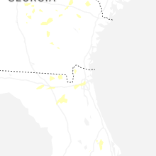
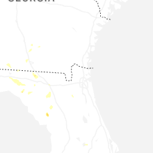
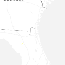


Connect with Interactive Hail Maps