

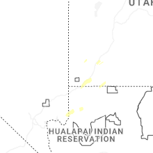
Hail Map for Hildale, UT
The Hildale, UT area has had 0 reports of on-the-ground hail by trained spotters, and has been under severe weather warnings 0 times during the past 12 months. Doppler radar has detected hail at or near Hildale, UT on 23 occasions, including 3 occasions during the past year.
| Name: | Hildale, UT |
| Where Located: | 33.8 miles ESE of Saint George, UT |
| Map: | Google Map for Hildale, UT |
| Population: | 2726 |
| Housing Units: | 285 |
| More Info: | Search Google for Hildale, UT |
3
The Top Recent Hail Date for Hildale, UT is Thursday, October 17, 2024 (4th out of 23)

Hail and Wind Damage Spotted near Hildale, UT
| Date / Time | Report Details |
|---|---|
| 8/2/2023 10:28 AM MST |
 The severe thunderstorm warning for north central mohave county will expire at 1030 am mst, the storm which prompted the warning near colorado city has moved out of the area. therefore, the warning will be allowed to expire. The severe thunderstorm warning for north central mohave county will expire at 1030 am mst, the storm which prompted the warning near colorado city has moved out of the area. therefore, the warning will be allowed to expire.
|
| 8/2/2023 10:14 AM MST |
 At 1014 am mst, a severe thunderstorm was located near colorado city, moving northeast at 15 mph (radar indicated). Hazards include 60 mph wind gusts and quarter size hail. Hail damage to vehicles is expected. expect wind damage to roofs and trees. locations impacted include, colorado city. this includes the following roads, state route 389 in mohave county between mile markers 0 and 11. mount trumbull loop road between mile markers 99 and 110. hail threat, radar indicated max hail size, 1. 00 in wind threat, radar indicated max wind gust, 60 mph. At 1014 am mst, a severe thunderstorm was located near colorado city, moving northeast at 15 mph (radar indicated). Hazards include 60 mph wind gusts and quarter size hail. Hail damage to vehicles is expected. expect wind damage to roofs and trees. locations impacted include, colorado city. this includes the following roads, state route 389 in mohave county between mile markers 0 and 11. mount trumbull loop road between mile markers 99 and 110. hail threat, radar indicated max hail size, 1. 00 in wind threat, radar indicated max wind gust, 60 mph.
|
| 8/2/2023 9:50 AM MST |
 At 950 am mst, a severe thunderstorm was located near colorado city, moving northeast at 15 mph (radar indicated). Hazards include 60 mph wind gusts and quarter size hail. Hail damage to vehicles is expected. Expect wind damage to roofs and trees. At 950 am mst, a severe thunderstorm was located near colorado city, moving northeast at 15 mph (radar indicated). Hazards include 60 mph wind gusts and quarter size hail. Hail damage to vehicles is expected. Expect wind damage to roofs and trees.
|
| 7/30/2022 7:40 PM MST |
 The severe thunderstorm warning for north central mohave county will expire at 745 pm mst, the storm which prompted the warning has moved out of the area. therefore, the warning will be allowed to expire. however heavy rain is still possible with this thunderstorm. The severe thunderstorm warning for north central mohave county will expire at 745 pm mst, the storm which prompted the warning has moved out of the area. therefore, the warning will be allowed to expire. however heavy rain is still possible with this thunderstorm.
|
| 7/30/2022 7:12 PM MST |
 At 711 pm mst, a severe thunderstorm was located near colorado city, moving south at 10 mph (radar indicated). Hazards include 60 mph wind gusts. Expect damage to roofs, trees, and power lines. locations impacted include, colorado city. hail threat, radar indicated max hail size, <. 75 in wind threat, radar indicated max wind gust, 60 mph. At 711 pm mst, a severe thunderstorm was located near colorado city, moving south at 10 mph (radar indicated). Hazards include 60 mph wind gusts. Expect damage to roofs, trees, and power lines. locations impacted include, colorado city. hail threat, radar indicated max hail size, <. 75 in wind threat, radar indicated max wind gust, 60 mph.
|
| 7/30/2022 6:38 PM MST |
 At 637 pm mst, a severe thunderstorm was located near colorado city, moving south at 10 mph (radar indicated). Hazards include 60 mph wind gusts. expect damage to roofs, trees, and power lines At 637 pm mst, a severe thunderstorm was located near colorado city, moving south at 10 mph (radar indicated). Hazards include 60 mph wind gusts. expect damage to roofs, trees, and power lines
|
| 7/24/2021 2:42 PM MDT |
 The severe thunderstorm warning for southeastern washington county will expire at 245 pm mdt, the storm which prompted the warning has weakened below severe limits, and has exited the warned area. therefore, the warning will be allowed to expire. The severe thunderstorm warning for southeastern washington county will expire at 245 pm mdt, the storm which prompted the warning has weakened below severe limits, and has exited the warned area. therefore, the warning will be allowed to expire.
|
| 7/24/2021 2:35 PM MDT |
 At 234 pm mdt, a severe thunderstorm was located near colorado city, moving southwest at 15 mph (radar indicated). Hazards include quarter size hail. Damage to vehicles is expected. Locations impacted include, hildale. At 234 pm mdt, a severe thunderstorm was located near colorado city, moving southwest at 15 mph (radar indicated). Hazards include quarter size hail. Damage to vehicles is expected. Locations impacted include, hildale.
|
| 7/24/2021 2:24 PM MDT | Hildale dispatch reported 10 powerpoles down throughout the city along with multiple downed trees. time estimated by rada in washington county UT, 1 miles WSW of Hildale, UT |
| 7/24/2021 2:24 PM MDT |
 At 222 pm mdt, a severe thunderstorm was located over colorado city, moving southwest at 15 mph (radar indicated). Hazards include quarter size hail. damage to vehicles is expected At 222 pm mdt, a severe thunderstorm was located over colorado city, moving southwest at 15 mph (radar indicated). Hazards include quarter size hail. damage to vehicles is expected
|
| 7/13/2021 9:52 PM MST |
 The severe thunderstorm warning for northeastern mohave county will expire at 1000 pm mst, the storms which prompted the warning have weakened below severe limits. therefore, the warning will be allowed to expire. however gusty winds to 50 mph are still possible. The severe thunderstorm warning for northeastern mohave county will expire at 1000 pm mst, the storms which prompted the warning have weakened below severe limits. therefore, the warning will be allowed to expire. however gusty winds to 50 mph are still possible.
|
| 7/13/2021 8:29 PM MST |
 At 829 pm mst, a severe thunderstorm was located over littlefield, moving southeast at 15 mph (radar indicated). Hazards include 60 mph wind gusts. expect damage to roofs and trees At 829 pm mst, a severe thunderstorm was located over littlefield, moving southeast at 15 mph (radar indicated). Hazards include 60 mph wind gusts. expect damage to roofs and trees
|
| 7/30/2016 8:55 PM MST |
 The severe thunderstorm warning for northeastern mohave county will expire at 900 pm mst, the storm which prompted the warning has weakened below severe limits, and no longer poses an immediate threat to life or property. therefore the warning will be allowed to expire. however gusty winds and heavy rain are still possible with this thunderstorm and additional thunderstorms in the warned area. The severe thunderstorm warning for northeastern mohave county will expire at 900 pm mst, the storm which prompted the warning has weakened below severe limits, and no longer poses an immediate threat to life or property. therefore the warning will be allowed to expire. however gusty winds and heavy rain are still possible with this thunderstorm and additional thunderstorms in the warned area.
|
| 7/30/2016 8:41 PM MST |
 At 838 pm mst, doppler radar indicated a severe thunderstorm capable of producing quarter size hail and damaging winds in excess of 60 mph. this storm was located 14 miles south of st. george, or 15 miles south of st george, moving southeast at 10 mph. locations impacted include, colorado city, beaver dam, littlefield, virgin river gorge, virgin river campground, kaibab and pipe spring. At 838 pm mst, doppler radar indicated a severe thunderstorm capable of producing quarter size hail and damaging winds in excess of 60 mph. this storm was located 14 miles south of st. george, or 15 miles south of st george, moving southeast at 10 mph. locations impacted include, colorado city, beaver dam, littlefield, virgin river gorge, virgin river campground, kaibab and pipe spring.
|
| 7/30/2016 8:23 PM MST |
 At 821 pm mst, doppler radar indicated multiple severe thunderstorms capable of producing quarter size hail and damaging winds in excess of 60 mph. these storms were located from st george to hurricane, with additional thunderstorms developing towrad colorado city. storms are generally moving east at 35 mph. At 821 pm mst, doppler radar indicated multiple severe thunderstorms capable of producing quarter size hail and damaging winds in excess of 60 mph. these storms were located from st george to hurricane, with additional thunderstorms developing towrad colorado city. storms are generally moving east at 35 mph.
|
| 7/1/2015 5:39 PM MST |
 At 537 pm mst, doppler radar continued to indicate a severe thunderstorm capable of producing quarter size hail and damaging winds in excess of 60 mph. this storm was located near colorado city, moving southwest at 25 mph. locations impacted include, colorado city cane beds colorado city airport. At 537 pm mst, doppler radar continued to indicate a severe thunderstorm capable of producing quarter size hail and damaging winds in excess of 60 mph. this storm was located near colorado city, moving southwest at 25 mph. locations impacted include, colorado city cane beds colorado city airport.
|
| 7/1/2015 5:24 PM MST |
 At 524 pm mst, doppler radar indicated a severe thunderstorm capable of producing quarter size hail and damaging winds in excess of 60 mph. this storm was located near colorado city, and moving southeast at 15 mph. At 524 pm mst, doppler radar indicated a severe thunderstorm capable of producing quarter size hail and damaging winds in excess of 60 mph. this storm was located near colorado city, and moving southeast at 15 mph.
|
Hail Maps for Hildale, UT


Connect with Interactive Hail Maps