

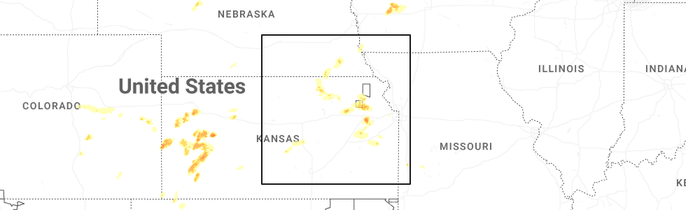
Hail Map for Hollenberg, KS
The Hollenberg, KS area has had 3 reports of on-the-ground hail by trained spotters, and has been under severe weather warnings 1 time during the past 12 months. Doppler radar has detected hail at or near Hollenberg, KS on 111 occasions, including 5 occasions during the past year.
| Name: | Hollenberg, KS |
| Where Located: | 59.9 miles NNW of Manhattan, KS |
| Map: | Google Map for Hollenberg, KS |
| Population: | 21 |
| Housing Units: | 23 |
| More Info: | Search Google for Hollenberg, KS |
1
The Top Recent Hail Date for Hollenberg, KS is Wednesday, April 23, 2025 (40th out of 111)
Hail and Wind Damage Spotted near Hollenberg, KS
| Date / Time | Report Details |
|---|---|
| 8/14/2024 6:05 PM CDT |
 Svrtop the national weather service in topeka has issued a * severe thunderstorm warning for, northeastern washington county in north central kansas, northwestern marshall county in northeastern kansas, * until 630 pm cdt. * at 605 pm cdt, a severe thunderstorm was located near hollenberg, moving northeast at 35 mph (radar indicated). Hazards include ping pong ball size hail and 60 mph wind gusts. People and animals outdoors will be injured. expect hail damage to roofs, siding, windows, and vehicles. Expect wind damage to roofs, siding, and trees. Svrtop the national weather service in topeka has issued a * severe thunderstorm warning for, northeastern washington county in north central kansas, northwestern marshall county in northeastern kansas, * until 630 pm cdt. * at 605 pm cdt, a severe thunderstorm was located near hollenberg, moving northeast at 35 mph (radar indicated). Hazards include ping pong ball size hail and 60 mph wind gusts. People and animals outdoors will be injured. expect hail damage to roofs, siding, windows, and vehicles. Expect wind damage to roofs, siding, and trees.
|
| 6/26/2024 1:48 AM CDT |
 Svrtop the national weather service in topeka has issued a * severe thunderstorm warning for, republic county in north central kansas, washington county in north central kansas, northern cloud county in north central kansas, marshall county in northeastern kansas, * until 230 am cdt. * at 148 am cdt, severe thunderstorms were located along a line extending from near johnson to near courtland, moving southeast at 35 mph (radar indicated). Hazards include 60 mph wind gusts and nickel size hail. expect damage to roofs, siding, and trees Svrtop the national weather service in topeka has issued a * severe thunderstorm warning for, republic county in north central kansas, washington county in north central kansas, northern cloud county in north central kansas, marshall county in northeastern kansas, * until 230 am cdt. * at 148 am cdt, severe thunderstorms were located along a line extending from near johnson to near courtland, moving southeast at 35 mph (radar indicated). Hazards include 60 mph wind gusts and nickel size hail. expect damage to roofs, siding, and trees
|
| 6/15/2024 6:26 PM CDT |
 The storms which prompted the warning have moved out of the area. therefore, the warning will be allowed to expire. a tornado watch remains in effect until 1000 pm cdt for north central and northeastern kansas. The storms which prompted the warning have moved out of the area. therefore, the warning will be allowed to expire. a tornado watch remains in effect until 1000 pm cdt for north central and northeastern kansas.
|
| 6/15/2024 6:14 PM CDT |
 At 614 pm cdt, severe thunderstorms were located along a line extending from 4 miles southwest of steele city to 4 miles northeast of hollenberg to 3 miles south of bremen, moving northeast at 55 mph (radar indicated). Hazards include 60 mph wind gusts and nickel size hail. Expect damage to roofs, siding, and trees. Locations impacted include, hanover, hollenberg, and bremen. At 614 pm cdt, severe thunderstorms were located along a line extending from 4 miles southwest of steele city to 4 miles northeast of hollenberg to 3 miles south of bremen, moving northeast at 55 mph (radar indicated). Hazards include 60 mph wind gusts and nickel size hail. Expect damage to roofs, siding, and trees. Locations impacted include, hanover, hollenberg, and bremen.
|
| 6/15/2024 6:04 PM CDT |
 At 604 pm cdt, severe thunderstorms were located along a line extending from 3 miles northeast of morrowville to 4 miles south of hollenberg to 3 miles northeast of barnes, moving northeast at 35 mph (radar indicated). Hazards include 60 mph wind gusts and nickel size hail. Expect damage to roofs, siding, and trees. Locations impacted include, washington, hanover, barnes, oketo, hollenberg, and bremen. At 604 pm cdt, severe thunderstorms were located along a line extending from 3 miles northeast of morrowville to 4 miles south of hollenberg to 3 miles northeast of barnes, moving northeast at 35 mph (radar indicated). Hazards include 60 mph wind gusts and nickel size hail. Expect damage to roofs, siding, and trees. Locations impacted include, washington, hanover, barnes, oketo, hollenberg, and bremen.
|
| 6/15/2024 5:55 PM CDT |
 At 555 pm cdt, a severe thunderstorm was located near barnes, moving northeast at 45 mph (radar indicated). Hazards include 60 mph wind gusts and nickel size hail. Expect damage to roofs, siding, and trees. Locations impacted include, washington, hanover, linn, greenleaf, barnes, oketo, hollenberg, and bremen. At 555 pm cdt, a severe thunderstorm was located near barnes, moving northeast at 45 mph (radar indicated). Hazards include 60 mph wind gusts and nickel size hail. Expect damage to roofs, siding, and trees. Locations impacted include, washington, hanover, linn, greenleaf, barnes, oketo, hollenberg, and bremen.
|
| 6/15/2024 5:55 PM CDT |
 the severe thunderstorm warning has been cancelled and is no longer in effect the severe thunderstorm warning has been cancelled and is no longer in effect
|
| 6/15/2024 5:40 PM CDT |
 Svrtop the national weather service in topeka has issued a * severe thunderstorm warning for, eastern washington county in north central kansas, northeastern clay county in north central kansas, northwestern marshall county in northeastern kansas, * until 630 pm cdt. * at 540 pm cdt, a severe thunderstorm was located 9 miles north of green, moving northeast at 55 mph (radar indicated). Hazards include 60 mph wind gusts and quarter size hail. Hail damage to vehicles is expected. Expect wind damage to roofs, siding, and trees. Svrtop the national weather service in topeka has issued a * severe thunderstorm warning for, eastern washington county in north central kansas, northeastern clay county in north central kansas, northwestern marshall county in northeastern kansas, * until 630 pm cdt. * at 540 pm cdt, a severe thunderstorm was located 9 miles north of green, moving northeast at 55 mph (radar indicated). Hazards include 60 mph wind gusts and quarter size hail. Hail damage to vehicles is expected. Expect wind damage to roofs, siding, and trees.
|
| 6/7/2024 11:30 PM CDT |
 The storms which prompted the warning have weakened below severe limits, and no longer pose an immediate threat to life or property. therefore, the warning has been allowed to expire. however, gusty winds and heavy rain are still possible with these thunderstorms. a severe thunderstorm watch remains in effect until 100 am cdt for north central and northeastern kansas. The storms which prompted the warning have weakened below severe limits, and no longer pose an immediate threat to life or property. therefore, the warning has been allowed to expire. however, gusty winds and heavy rain are still possible with these thunderstorms. a severe thunderstorm watch remains in effect until 100 am cdt for north central and northeastern kansas.
|
| 6/7/2024 11:09 PM CDT |
 At 1109 pm cdt, severe thunderstorms were located along a line extending from 3 miles southwest of wymore to near greenleaf, moving southeast at 45 mph (radar indicated). Hazards include 60 mph wind gusts and penny size hail. Expect damage to roofs, siding, and trees. Locations impacted include, marysville, washington, hanover, waterville, linn, greenleaf, barnes, oketo, hollenberg, and bremen. At 1109 pm cdt, severe thunderstorms were located along a line extending from 3 miles southwest of wymore to near greenleaf, moving southeast at 45 mph (radar indicated). Hazards include 60 mph wind gusts and penny size hail. Expect damage to roofs, siding, and trees. Locations impacted include, marysville, washington, hanover, waterville, linn, greenleaf, barnes, oketo, hollenberg, and bremen.
|
| 6/7/2024 10:52 PM CDT |
 Svrtop the national weather service in topeka has issued a * severe thunderstorm warning for, washington county in north central kansas, northwestern marshall county in northeastern kansas, * until 1130 pm cdt. * at 1052 pm cdt, severe thunderstorms were located along a line extending from 3 miles east of harbine to near morrowville, moving southeast at 45 mph (radar indicated). Hazards include 60 mph wind gusts and quarter size hail. Hail damage to vehicles is expected. Expect wind damage to roofs, siding, and trees. Svrtop the national weather service in topeka has issued a * severe thunderstorm warning for, washington county in north central kansas, northwestern marshall county in northeastern kansas, * until 1130 pm cdt. * at 1052 pm cdt, severe thunderstorms were located along a line extending from 3 miles east of harbine to near morrowville, moving southeast at 45 mph (radar indicated). Hazards include 60 mph wind gusts and quarter size hail. Hail damage to vehicles is expected. Expect wind damage to roofs, siding, and trees.
|
| 5/25/2024 9:35 PM CDT |
 At 934 pm cdt, a severe thunderstorm was located near marysville, moving east at 35 mph (emergency management. at 934 pm cdt, winds 4 miles west of marysville were estimated to be 60 mph). Hazards include 60 mph wind gusts and quarter size hail. Hail damage to vehicles is expected. expect wind damage to roofs, siding, and trees. Locations impacted include, marysville, hanover, greenleaf, beattie, oketo, hollenberg, and bremen. At 934 pm cdt, a severe thunderstorm was located near marysville, moving east at 35 mph (emergency management. at 934 pm cdt, winds 4 miles west of marysville were estimated to be 60 mph). Hazards include 60 mph wind gusts and quarter size hail. Hail damage to vehicles is expected. expect wind damage to roofs, siding, and trees. Locations impacted include, marysville, hanover, greenleaf, beattie, oketo, hollenberg, and bremen.
|
| 5/25/2024 9:16 PM CDT |
 The storm which prompted the warning has moved into northeast washington county. a new severe thunderstorm warning has been issued for this area until 10 pm cdt. the original warning has been allowed to expire. a tornado watch remains in effect until 100 am cdt for north central kansas. The storm which prompted the warning has moved into northeast washington county. a new severe thunderstorm warning has been issued for this area until 10 pm cdt. the original warning has been allowed to expire. a tornado watch remains in effect until 100 am cdt for north central kansas.
|
| 5/25/2024 9:10 PM CDT |
 Svrtop the national weather service in topeka has issued a * severe thunderstorm warning for, northeastern washington county in north central kansas, northern marshall county in northeastern kansas, * until 1000 pm cdt. * at 910 pm cdt, a severe thunderstorm was located 4 miles southwest of hanover, moving east at 40 mph (trained weather spotters). Hazards include 70 mph wind gusts and ping pong ball size hail. People and animals outdoors will be injured. expect hail damage to roofs, siding, windows, and vehicles. expect considerable tree damage. Wind damage is also likely to mobile homes, roofs, and outbuildings. Svrtop the national weather service in topeka has issued a * severe thunderstorm warning for, northeastern washington county in north central kansas, northern marshall county in northeastern kansas, * until 1000 pm cdt. * at 910 pm cdt, a severe thunderstorm was located 4 miles southwest of hanover, moving east at 40 mph (trained weather spotters). Hazards include 70 mph wind gusts and ping pong ball size hail. People and animals outdoors will be injured. expect hail damage to roofs, siding, windows, and vehicles. expect considerable tree damage. Wind damage is also likely to mobile homes, roofs, and outbuildings.
|
| 5/25/2024 8:59 PM CDT |
 At 858 pm cdt, a severe thunderstorm was located near morrowville, moving northeast at 50 mph (trained weather spotters. at 856 pm cdt, spotters in morrowville reported hail up to the size of half dollars). Hazards include 60 mph wind gusts and half dollar size hail. Hail damage to vehicles is expected. expect wind damage to roofs, siding, and trees. Locations impacted include, washington, hanover, morrowville, haddam, and hollenberg. At 858 pm cdt, a severe thunderstorm was located near morrowville, moving northeast at 50 mph (trained weather spotters. at 856 pm cdt, spotters in morrowville reported hail up to the size of half dollars). Hazards include 60 mph wind gusts and half dollar size hail. Hail damage to vehicles is expected. expect wind damage to roofs, siding, and trees. Locations impacted include, washington, hanover, morrowville, haddam, and hollenberg.
|
| 5/25/2024 8:53 PM CDT |
 Svrtop the national weather service in topeka has issued a * severe thunderstorm warning for, northern washington county in north central kansas, * until 915 pm cdt. * at 852 pm cdt, a severe thunderstorm was located near morrowville, moving northeast at 50 mph (radar indicated). Hazards include 60 mph wind gusts and half dollar size hail. Hail damage to vehicles is expected. Expect wind damage to roofs, siding, and trees. Svrtop the national weather service in topeka has issued a * severe thunderstorm warning for, northern washington county in north central kansas, * until 915 pm cdt. * at 852 pm cdt, a severe thunderstorm was located near morrowville, moving northeast at 50 mph (radar indicated). Hazards include 60 mph wind gusts and half dollar size hail. Hail damage to vehicles is expected. Expect wind damage to roofs, siding, and trees.
|
| 5/24/2024 2:36 AM CDT |
 The storms which prompted the warning have moved out of the area, northeast into nebraska. therefore, the warning will be allowed to expire. a severe thunderstorm watch remains in effect until 800 am cdt for north central kansas. The storms which prompted the warning have moved out of the area, northeast into nebraska. therefore, the warning will be allowed to expire. a severe thunderstorm watch remains in effect until 800 am cdt for north central kansas.
|
| 5/24/2024 2:25 AM CDT |
 At 225 am cdt, severe thunderstorms were located along a line extending from 4 miles north of odell to near hanover to near morrowville, moving east at 45 mph (radar indicated). Hazards include 60 mph wind gusts. Expect damage to roofs, siding, and trees. Locations impacted include, morrowville and hollenberg. At 225 am cdt, severe thunderstorms were located along a line extending from 4 miles north of odell to near hanover to near morrowville, moving east at 45 mph (radar indicated). Hazards include 60 mph wind gusts. Expect damage to roofs, siding, and trees. Locations impacted include, morrowville and hollenberg.
|
| 5/24/2024 2:20 AM CDT |
 At 219 am cdt, severe thunderstorms were located along a line extending from 3 miles northwest of odell to 4 miles south of hollenberg to 3 miles northwest of haddam, moving east at 45 mph (radar indicated). Hazards include 60 mph wind gusts. Expect damage to roofs, siding, and trees. Locations impacted include, morrowville, haddam, mahaska, and hollenberg. At 219 am cdt, severe thunderstorms were located along a line extending from 3 miles northwest of odell to 4 miles south of hollenberg to 3 miles northwest of haddam, moving east at 45 mph (radar indicated). Hazards include 60 mph wind gusts. Expect damage to roofs, siding, and trees. Locations impacted include, morrowville, haddam, mahaska, and hollenberg.
|
| 5/24/2024 2:20 AM CDT |
 the severe thunderstorm warning has been cancelled and is no longer in effect the severe thunderstorm warning has been cancelled and is no longer in effect
|
| 5/24/2024 2:10 AM CDT |
 At 210 am cdt, severe thunderstorms were located along a line extending from 3 miles west of diller to 6 miles northeast of morrowville to near munden, moving east at 45 mph (radar indicated). Hazards include 60 mph wind gusts. Expect damage to roofs, siding, and trees. Locations impacted include, belleville, morrowville, haddam, munden, narka, mahaska, and hollenberg. At 210 am cdt, severe thunderstorms were located along a line extending from 3 miles west of diller to 6 miles northeast of morrowville to near munden, moving east at 45 mph (radar indicated). Hazards include 60 mph wind gusts. Expect damage to roofs, siding, and trees. Locations impacted include, belleville, morrowville, haddam, munden, narka, mahaska, and hollenberg.
|
| 5/24/2024 2:06 AM CDT |
 At 205 am cdt, severe thunderstorms were located along a line extending from near endicott to 6 miles north of morrowville to 4 miles north of belleville, moving east at 45 mph (radar indicated). Hazards include 60 mph wind gusts. Expect damage to roofs, siding, and trees. Locations impacted include, belleville, morrowville, republic, haddam, munden, narka, mahaska, and hollenberg. At 205 am cdt, severe thunderstorms were located along a line extending from near endicott to 6 miles north of morrowville to 4 miles north of belleville, moving east at 45 mph (radar indicated). Hazards include 60 mph wind gusts. Expect damage to roofs, siding, and trees. Locations impacted include, belleville, morrowville, republic, haddam, munden, narka, mahaska, and hollenberg.
|
| 5/24/2024 1:54 AM CDT |
 Svrtop the national weather service in topeka has issued a * severe thunderstorm warning for, northern republic county in north central kansas, northern washington county in north central kansas, * until 245 am cdt. * at 153 am cdt, severe thunderstorms were located along a line extending from near fairbury to mahaska to republic, moving east at 45 mph (radar indicated). Hazards include 60 mph wind gusts. expect damage to roofs, siding, and trees Svrtop the national weather service in topeka has issued a * severe thunderstorm warning for, northern republic county in north central kansas, northern washington county in north central kansas, * until 245 am cdt. * at 153 am cdt, severe thunderstorms were located along a line extending from near fairbury to mahaska to republic, moving east at 45 mph (radar indicated). Hazards include 60 mph wind gusts. expect damage to roofs, siding, and trees
|
| 4/6/2024 5:43 PM CDT |
 Svrtop the national weather service in topeka has issued a * severe thunderstorm warning for, northwestern geary county in east central kansas, western riley county in northeastern kansas, washington county in north central kansas, eastern clay county in north central kansas, western marshall county in northeastern kansas, * until 630 pm cdt. * at 543 pm cdt, severe thunderstorms were located along a line extending from 4 miles south of endicott to 7 miles north of green to near talmage, moving northeast at 60 mph (radar indicated). Hazards include 70 mph wind gusts and quarter size hail. Hail damage to vehicles is expected. expect considerable tree damage. Wind damage is also likely to mobile homes, roofs, and outbuildings. Svrtop the national weather service in topeka has issued a * severe thunderstorm warning for, northwestern geary county in east central kansas, western riley county in northeastern kansas, washington county in north central kansas, eastern clay county in north central kansas, western marshall county in northeastern kansas, * until 630 pm cdt. * at 543 pm cdt, severe thunderstorms were located along a line extending from 4 miles south of endicott to 7 miles north of green to near talmage, moving northeast at 60 mph (radar indicated). Hazards include 70 mph wind gusts and quarter size hail. Hail damage to vehicles is expected. expect considerable tree damage. Wind damage is also likely to mobile homes, roofs, and outbuildings.
|
| 3/14/2024 12:43 AM CDT |
 The storms which prompted the warning have weakened below severe limits, and no longer pose an immediate threat to life or property. therefore, the warning will be allowed to expire. however, small hail and gusty winds are still possible with these thunderstorms. a severe thunderstorm watch remains in effect until 100 am cdt for north central and northeastern kansas. The storms which prompted the warning have weakened below severe limits, and no longer pose an immediate threat to life or property. therefore, the warning will be allowed to expire. however, small hail and gusty winds are still possible with these thunderstorms. a severe thunderstorm watch remains in effect until 100 am cdt for north central and northeastern kansas.
|
| 3/14/2024 12:36 AM CDT |
 the severe thunderstorm warning has been cancelled and is no longer in effect the severe thunderstorm warning has been cancelled and is no longer in effect
|
| 3/14/2024 12:36 AM CDT |
 At 1235 am cdt, severe thunderstorms were located along a line extending from 3 miles southwest of hanover to near randolph, moving northeast at 50 mph (radar indicated). Hazards include 60 mph wind gusts and quarter size hail. Hail damage to vehicles is expected. expect wind damage to roofs, siding, and trees. Locations impacted include, marysville, washington, blue rapids, hanover, waterville, greenleaf, olsburg, randolph, barnes, hollenberg, and bremen. At 1235 am cdt, severe thunderstorms were located along a line extending from 3 miles southwest of hanover to near randolph, moving northeast at 50 mph (radar indicated). Hazards include 60 mph wind gusts and quarter size hail. Hail damage to vehicles is expected. expect wind damage to roofs, siding, and trees. Locations impacted include, marysville, washington, blue rapids, hanover, waterville, greenleaf, olsburg, randolph, barnes, hollenberg, and bremen.
|
| 3/14/2024 12:19 AM CDT |
 Svrtop the national weather service in topeka has issued a * severe thunderstorm warning for, northwestern riley county in northeastern kansas, northwestern pottawatomie county in northeastern kansas, washington county in north central kansas, northeastern clay county in north central kansas, western marshall county in northeastern kansas, * until 1245 am cdt. * at 1219 am cdt, severe thunderstorms were located along a line extending from 5 miles southwest of washington to 5 miles west of riley, moving northeast at 50 mph (radar indicated). Hazards include 60 mph wind gusts and half dollar size hail. Hail damage to vehicles is expected. Expect wind damage to roofs, siding, and trees. Svrtop the national weather service in topeka has issued a * severe thunderstorm warning for, northwestern riley county in northeastern kansas, northwestern pottawatomie county in northeastern kansas, washington county in north central kansas, northeastern clay county in north central kansas, western marshall county in northeastern kansas, * until 1245 am cdt. * at 1219 am cdt, severe thunderstorms were located along a line extending from 5 miles southwest of washington to 5 miles west of riley, moving northeast at 50 mph (radar indicated). Hazards include 60 mph wind gusts and half dollar size hail. Hail damage to vehicles is expected. Expect wind damage to roofs, siding, and trees.
|
| 9/16/2023 3:52 PM CDT |
 At 352 pm cdt, a severe thunderstorm was located near bremen, moving south at 20 mph (radar indicated). Hazards include 60 mph wind gusts and half dollar size hail. Hail damage to vehicles is expected. Expect wind damage to roofs, siding, and trees. At 352 pm cdt, a severe thunderstorm was located near bremen, moving south at 20 mph (radar indicated). Hazards include 60 mph wind gusts and half dollar size hail. Hail damage to vehicles is expected. Expect wind damage to roofs, siding, and trees.
|
| 8/9/2023 1:00 AM CDT |
 At 1259 am cdt, a severe thunderstorm was located over hollenberg, moving east at 30 mph (radar indicated). Hazards include 60 mph wind gusts and quarter size hail. Hail damage to vehicles is expected. expect wind damage to roofs, siding, and trees. locations impacted include, hanover and hollenberg. hail threat, radar indicated max hail size, 1. 00 in wind threat, radar indicated max wind gust, 60 mph. At 1259 am cdt, a severe thunderstorm was located over hollenberg, moving east at 30 mph (radar indicated). Hazards include 60 mph wind gusts and quarter size hail. Hail damage to vehicles is expected. expect wind damage to roofs, siding, and trees. locations impacted include, hanover and hollenberg. hail threat, radar indicated max hail size, 1. 00 in wind threat, radar indicated max wind gust, 60 mph.
|
| 8/9/2023 12:52 AM CDT |
 At 1251 am cdt, a severe thunderstorm was located 5 miles west of hollenberg, moving east at 30 mph (radar indicated). Hazards include 60 mph wind gusts and quarter size hail. Hail damage to vehicles is expected. Expect wind damage to roofs, siding, and trees. At 1251 am cdt, a severe thunderstorm was located 5 miles west of hollenberg, moving east at 30 mph (radar indicated). Hazards include 60 mph wind gusts and quarter size hail. Hail damage to vehicles is expected. Expect wind damage to roofs, siding, and trees.
|
| 8/5/2023 11:18 PM CDT |
 At 1117 pm cdt, severe thunderstorms were located along a line extending from near hanover to 3 miles southwest of leonardville, moving east at 40 mph (personal weather station recorded a 59 mph wind gust 1 mile east of barnes at 11:10 pm). Hazards include 60 mph wind gusts and nickel size hail. expect damage to roofs, siding, and trees At 1117 pm cdt, severe thunderstorms were located along a line extending from near hanover to 3 miles southwest of leonardville, moving east at 40 mph (personal weather station recorded a 59 mph wind gust 1 mile east of barnes at 11:10 pm). Hazards include 60 mph wind gusts and nickel size hail. expect damage to roofs, siding, and trees
|
| 7/29/2023 8:33 AM CDT |
 At 831 am cdt, severe thunderstorms were located along a line extending from 7 miles east of blue springs to 3 miles southwest of hanover, moving east-southeast at 45 mph (radar indicated). Hazards include 60 mph wind gusts and penny size hail. expect damage to roofs, siding, and trees At 831 am cdt, severe thunderstorms were located along a line extending from 7 miles east of blue springs to 3 miles southwest of hanover, moving east-southeast at 45 mph (radar indicated). Hazards include 60 mph wind gusts and penny size hail. expect damage to roofs, siding, and trees
|
| 6/29/2023 6:04 AM CDT |
 At 603 am cdt, a severe thunderstorm was located over agenda, moving east at 50 mph (radar indicated. at 552 am cdt, a 66 mph gust was recorded at the belleville mesonet site). Hazards include golf ball size hail and 70 mph wind gusts. People and animals outdoors will be injured. expect hail damage to roofs, siding, windows, and vehicles. expect considerable tree damage. Wind damage is also likely to mobile homes, roofs, and outbuildings. At 603 am cdt, a severe thunderstorm was located over agenda, moving east at 50 mph (radar indicated. at 552 am cdt, a 66 mph gust was recorded at the belleville mesonet site). Hazards include golf ball size hail and 70 mph wind gusts. People and animals outdoors will be injured. expect hail damage to roofs, siding, windows, and vehicles. expect considerable tree damage. Wind damage is also likely to mobile homes, roofs, and outbuildings.
|
| 5/7/2023 10:41 PM CDT |
 The severe thunderstorm warning for northeastern republic, northern washington and northwestern marshall counties will expire at 1045 pm cdt, the storms which prompted the warning have weakened below severe limits, and no longer pose an immediate threat to life or property. therefore, the warning will be allowed to expire. however gusty winds are still possible with these showers and thunderstorms. a severe thunderstorm watch remains in effect until 100 am cdt for north central and northeastern kansas. The severe thunderstorm warning for northeastern republic, northern washington and northwestern marshall counties will expire at 1045 pm cdt, the storms which prompted the warning have weakened below severe limits, and no longer pose an immediate threat to life or property. therefore, the warning will be allowed to expire. however gusty winds are still possible with these showers and thunderstorms. a severe thunderstorm watch remains in effect until 100 am cdt for north central and northeastern kansas.
|
| 5/7/2023 10:33 PM CDT |
 At 1033 pm cdt, severe thunderstorms were located along a line extending from near western to near odell, moving northeast at 40 mph (radar indicated). Hazards include 60 mph wind gusts. Expect damage to roofs, siding, and trees. locations impacted include, washington, hanover, morrowville, haddam, narka, mahaska, oketo, hollenberg and bremen. hail threat, radar indicated max hail size, <. 75 in wind threat, radar indicated max wind gust, 60 mph. At 1033 pm cdt, severe thunderstorms were located along a line extending from near western to near odell, moving northeast at 40 mph (radar indicated). Hazards include 60 mph wind gusts. Expect damage to roofs, siding, and trees. locations impacted include, washington, hanover, morrowville, haddam, narka, mahaska, oketo, hollenberg and bremen. hail threat, radar indicated max hail size, <. 75 in wind threat, radar indicated max wind gust, 60 mph.
|
| 5/7/2023 10:12 PM CDT |
 At 1011 pm cdt, severe thunderstorms were located along a line extending from near alexandria to 3 miles northwest of hanover, moving northeast at 40 mph. strong winds have occurred behind this line of thunderstorms (radar indicated). Hazards include 60 mph wind gusts. expect damage to roofs, siding, and trees At 1011 pm cdt, severe thunderstorms were located along a line extending from near alexandria to 3 miles northwest of hanover, moving northeast at 40 mph. strong winds have occurred behind this line of thunderstorms (radar indicated). Hazards include 60 mph wind gusts. expect damage to roofs, siding, and trees
|
| 5/7/2023 9:56 PM CDT |
 At 955 pm cdt, severe thunderstorms were located along a line extending from 5 miles southwest of hollenberg to near linn, moving east at 50 mph (radar indicated). Hazards include 60 mph wind gusts and quarter size hail. Hail damage to vehicles is expected. expect wind damage to roofs, siding, and trees. locations impacted include, belleville, washington, linn, scandia, greenleaf, courtland, cuba, morrowville, republic, palmer, haddam, munden, narka, mahaska, agenda and hollenberg. hail threat, radar indicated max hail size, 1. 00 in wind threat, radar indicated max wind gust, 60 mph. At 955 pm cdt, severe thunderstorms were located along a line extending from 5 miles southwest of hollenberg to near linn, moving east at 50 mph (radar indicated). Hazards include 60 mph wind gusts and quarter size hail. Hail damage to vehicles is expected. expect wind damage to roofs, siding, and trees. locations impacted include, belleville, washington, linn, scandia, greenleaf, courtland, cuba, morrowville, republic, palmer, haddam, munden, narka, mahaska, agenda and hollenberg. hail threat, radar indicated max hail size, 1. 00 in wind threat, radar indicated max wind gust, 60 mph.
|
| 5/7/2023 9:23 PM CDT |
 At 922 pm cdt, severe thunderstorms were located along a line extending from munden to 3 miles north of aurora, moving east at 50 mph (trained weather spotters). Hazards include 60 mph wind gusts and quarter size hail. Hail damage to vehicles is expected. Expect wind damage to roofs, siding, and trees. At 922 pm cdt, severe thunderstorms were located along a line extending from munden to 3 miles north of aurora, moving east at 50 mph (trained weather spotters). Hazards include 60 mph wind gusts and quarter size hail. Hail damage to vehicles is expected. Expect wind damage to roofs, siding, and trees.
|
| 5/7/2023 9:16 PM CDT |
 At 915 pm cdt, a severe thunderstorm was located over bremen, moving east at 35 mph (radar indicated). Hazards include 60 mph wind gusts and half dollar size hail. Hail damage to vehicles is expected. expect wind damage to roofs, siding, and trees. locations impacted include, washington, hanover, hollenberg and bremen. hail threat, radar indicated max hail size, 1. 25 in wind threat, radar indicated max wind gust, 60 mph. At 915 pm cdt, a severe thunderstorm was located over bremen, moving east at 35 mph (radar indicated). Hazards include 60 mph wind gusts and half dollar size hail. Hail damage to vehicles is expected. expect wind damage to roofs, siding, and trees. locations impacted include, washington, hanover, hollenberg and bremen. hail threat, radar indicated max hail size, 1. 25 in wind threat, radar indicated max wind gust, 60 mph.
|
| 5/7/2023 8:46 PM CDT |
 At 846 pm cdt, a severe thunderstorm was located near morrowville, moving northeast at 40 mph (radar indicated). Hazards include 60 mph wind gusts and quarter size hail. Hail damage to vehicles is expected. Expect wind damage to roofs, siding, and trees. At 846 pm cdt, a severe thunderstorm was located near morrowville, moving northeast at 40 mph (radar indicated). Hazards include 60 mph wind gusts and quarter size hail. Hail damage to vehicles is expected. Expect wind damage to roofs, siding, and trees.
|
| 5/7/2023 8:04 PM CDT |
 At 804 pm cdt, a severe thunderstorm was located 4 miles east of hollenberg, moving northeast at 30 mph (radar indicated). Hazards include tennis ball size hail and 60 mph wind gusts. People and animals outdoors will be injured. expect hail damage to roofs, siding, windows, and vehicles. expect wind damage to roofs, siding, and trees. locations impacted include, hanover, oketo, hollenberg and bremen. thunderstorm damage threat, considerable hail threat, radar indicated max hail size, 2. 50 in wind threat, radar indicated max wind gust, 60 mph. At 804 pm cdt, a severe thunderstorm was located 4 miles east of hollenberg, moving northeast at 30 mph (radar indicated). Hazards include tennis ball size hail and 60 mph wind gusts. People and animals outdoors will be injured. expect hail damage to roofs, siding, windows, and vehicles. expect wind damage to roofs, siding, and trees. locations impacted include, hanover, oketo, hollenberg and bremen. thunderstorm damage threat, considerable hail threat, radar indicated max hail size, 2. 50 in wind threat, radar indicated max wind gust, 60 mph.
|
| 5/7/2023 7:54 PM CDT |
 At 754 pm cdt, a severe thunderstorm was located near hollenberg, moving northeast at 30 mph (radar indicated). Hazards include golf ball size hail and 60 mph wind gusts. People and animals outdoors will be injured. expect hail damage to roofs, siding, windows, and vehicles. expect wind damage to roofs, siding, and trees. locations impacted include, washington, hanover, oketo, hollenberg and bremen. thunderstorm damage threat, considerable hail threat, radar indicated max hail size, 1. 75 in wind threat, radar indicated max wind gust, 60 mph. At 754 pm cdt, a severe thunderstorm was located near hollenberg, moving northeast at 30 mph (radar indicated). Hazards include golf ball size hail and 60 mph wind gusts. People and animals outdoors will be injured. expect hail damage to roofs, siding, windows, and vehicles. expect wind damage to roofs, siding, and trees. locations impacted include, washington, hanover, oketo, hollenberg and bremen. thunderstorm damage threat, considerable hail threat, radar indicated max hail size, 1. 75 in wind threat, radar indicated max wind gust, 60 mph.
|
| 5/7/2023 7:42 PM CDT |
 At 742 pm cdt, a severe thunderstorm was located 5 miles north of washington, moving northeast at 30 mph (radar indicated). Hazards include golf ball size hail and 60 mph wind gusts. People and animals outdoors will be injured. expect hail damage to roofs, siding, windows, and vehicles. Expect wind damage to roofs, siding, and trees. At 742 pm cdt, a severe thunderstorm was located 5 miles north of washington, moving northeast at 30 mph (radar indicated). Hazards include golf ball size hail and 60 mph wind gusts. People and animals outdoors will be injured. expect hail damage to roofs, siding, windows, and vehicles. Expect wind damage to roofs, siding, and trees.
|
| 4/20/2023 2:33 AM CDT |
 At 232 am cdt, severe thunderstorms were located along a line extending from 4 miles northwest of hanover to 6 miles south of barnes to 4 miles northeast of wakefield, moving northeast at 60 mph (trained weather spotters). Hazards include 60 mph wind gusts and quarter size hail. Hail damage to vehicles is expected. expect wind damage to roofs, siding, and trees. locations impacted include, clay center, minneapolis, washington, wakefield, bennington, clifton, linn, greenleaf, tescott, morganville, morrowville, green, culver, wells, palmer, haddam, manchester, mahaska, longford and vining. hail threat, radar indicated max hail size, 1. 00 in wind threat, radar indicated max wind gust, 60 mph. At 232 am cdt, severe thunderstorms were located along a line extending from 4 miles northwest of hanover to 6 miles south of barnes to 4 miles northeast of wakefield, moving northeast at 60 mph (trained weather spotters). Hazards include 60 mph wind gusts and quarter size hail. Hail damage to vehicles is expected. expect wind damage to roofs, siding, and trees. locations impacted include, clay center, minneapolis, washington, wakefield, bennington, clifton, linn, greenleaf, tescott, morganville, morrowville, green, culver, wells, palmer, haddam, manchester, mahaska, longford and vining. hail threat, radar indicated max hail size, 1. 00 in wind threat, radar indicated max wind gust, 60 mph.
|
| 4/20/2023 2:05 AM CDT |
 At 205 am cdt, severe thunderstorms were located along a line extending from 5 miles east of agenda to near idana to 4 miles west of talmage, moving northeast at 55 mph (trained weather spotters reported 60 mph winds in clyde). Hazards include 60 mph wind gusts and quarter size hail. Hail damage to vehicles is expected. expect wind damage to roofs, siding, and trees. locations impacted include, concordia, clay center, minneapolis, belleville, washington, wakefield, clyde, bennington, clifton, miltonvale, linn, delphos, greenleaf, tescott, morganville, cuba, morrowville, green, culver and wells. hail threat, radar indicated max hail size, 1. 00 in wind threat, radar indicated max wind gust, 60 mph. At 205 am cdt, severe thunderstorms were located along a line extending from 5 miles east of agenda to near idana to 4 miles west of talmage, moving northeast at 55 mph (trained weather spotters reported 60 mph winds in clyde). Hazards include 60 mph wind gusts and quarter size hail. Hail damage to vehicles is expected. expect wind damage to roofs, siding, and trees. locations impacted include, concordia, clay center, minneapolis, belleville, washington, wakefield, clyde, bennington, clifton, miltonvale, linn, delphos, greenleaf, tescott, morganville, cuba, morrowville, green, culver and wells. hail threat, radar indicated max hail size, 1. 00 in wind threat, radar indicated max wind gust, 60 mph.
|
| 4/20/2023 1:56 AM CDT |
 At 155 am cdt, severe thunderstorms were located along a line extending from 4 miles northwest of clyde to 4 miles west of talmage, moving northeast at 60 mph (trained weather spotters reported 65 mph winds and quarter size hail in glasco). Hazards include 60 mph wind gusts and quarter size hail. Hail damage to vehicles is expected. Expect wind damage to roofs, siding, and trees. At 155 am cdt, severe thunderstorms were located along a line extending from 4 miles northwest of clyde to 4 miles west of talmage, moving northeast at 60 mph (trained weather spotters reported 65 mph winds and quarter size hail in glasco). Hazards include 60 mph wind gusts and quarter size hail. Hail damage to vehicles is expected. Expect wind damage to roofs, siding, and trees.
|
| 7/16/2022 11:50 PM CDT |
 The severe thunderstorm warning for northeastern washington and northwestern marshall counties will expire at midnight cdt, the storms which prompted the warning have weakened below severe limits, and no longer pose an immediate threat to life or property. therefore, the warning will be allowed to expire. however gusty winds and heavy rain are still possible with these thunderstorms. The severe thunderstorm warning for northeastern washington and northwestern marshall counties will expire at midnight cdt, the storms which prompted the warning have weakened below severe limits, and no longer pose an immediate threat to life or property. therefore, the warning will be allowed to expire. however gusty winds and heavy rain are still possible with these thunderstorms.
|
| 7/16/2022 11:45 PM CDT |
 At 1145 pm cdt, severe thunderstorms were located along a line extending from near odell to 4 miles south of bremen to 5 miles southwest of barnes, moving east at 40 mph (radar indicated). Hazards include 60 mph wind gusts and nickel size hail. Expect damage to roofs, siding, and trees. locations impacted include, marysville, washington, hanover, waterville, greenleaf, barnes, hollenberg and bremen. hail threat, radar indicated max hail size, 0. 88 in wind threat, radar indicated max wind gust, 60 mph. At 1145 pm cdt, severe thunderstorms were located along a line extending from near odell to 4 miles south of bremen to 5 miles southwest of barnes, moving east at 40 mph (radar indicated). Hazards include 60 mph wind gusts and nickel size hail. Expect damage to roofs, siding, and trees. locations impacted include, marysville, washington, hanover, waterville, greenleaf, barnes, hollenberg and bremen. hail threat, radar indicated max hail size, 0. 88 in wind threat, radar indicated max wind gust, 60 mph.
|
| 7/16/2022 11:34 PM CDT |
 At 1134 pm cdt, severe thunderstorms were located along a line extending from 5 miles east of hollenberg to near hanover to near linn, moving east at 40 mph (radar indicated). Hazards include 60 mph wind gusts and nickel size hail. Expect damage to roofs, siding, and trees. locations impacted include, marysville, washington, hanover, waterville, greenleaf, barnes, morrowville, hollenberg and bremen. hail threat, radar indicated max hail size, 0. 88 in wind threat, radar indicated max wind gust, 60 mph. At 1134 pm cdt, severe thunderstorms were located along a line extending from 5 miles east of hollenberg to near hanover to near linn, moving east at 40 mph (radar indicated). Hazards include 60 mph wind gusts and nickel size hail. Expect damage to roofs, siding, and trees. locations impacted include, marysville, washington, hanover, waterville, greenleaf, barnes, morrowville, hollenberg and bremen. hail threat, radar indicated max hail size, 0. 88 in wind threat, radar indicated max wind gust, 60 mph.
|
| 7/16/2022 11:26 PM CDT |
 At 1126 pm cdt, severe thunderstorms were located along a line extending from hollenberg to 6 miles northeast of washington to 3 miles northwest of linn, moving southeast at 40 mph (radar indicated). Hazards include 60 mph wind gusts. expect damage to roofs, siding, and trees At 1126 pm cdt, severe thunderstorms were located along a line extending from hollenberg to 6 miles northeast of washington to 3 miles northwest of linn, moving southeast at 40 mph (radar indicated). Hazards include 60 mph wind gusts. expect damage to roofs, siding, and trees
|
| 6/11/2022 5:57 PM CDT |
 At 557 pm cdt, a severe thunderstorm was located over hanover, moving southeast at 20 mph (radar indicated). Hazards include golf ball size hail and 70 mph wind gusts. People and animals outdoors will be injured. expect hail damage to roofs, siding, windows, and vehicles. expect considerable tree damage. Wind damage is also likely to mobile homes, roofs, and outbuildings. At 557 pm cdt, a severe thunderstorm was located over hanover, moving southeast at 20 mph (radar indicated). Hazards include golf ball size hail and 70 mph wind gusts. People and animals outdoors will be injured. expect hail damage to roofs, siding, windows, and vehicles. expect considerable tree damage. Wind damage is also likely to mobile homes, roofs, and outbuildings.
|
| 4/29/2022 7:11 PM CDT |
 At 711 pm cdt, a severe thunderstorm capable of producing a tornado was located 5 miles north of bremen, moving northeast at 40 mph (radar indicated rotation). Hazards include tornado and quarter size hail. Flying debris will be dangerous to those caught without shelter. mobile homes will be damaged or destroyed. damage to roofs, windows, and vehicles will occur. tree damage is likely. Locations impacted include, hanover, oketo, hollenberg and bremen. At 711 pm cdt, a severe thunderstorm capable of producing a tornado was located 5 miles north of bremen, moving northeast at 40 mph (radar indicated rotation). Hazards include tornado and quarter size hail. Flying debris will be dangerous to those caught without shelter. mobile homes will be damaged or destroyed. damage to roofs, windows, and vehicles will occur. tree damage is likely. Locations impacted include, hanover, oketo, hollenberg and bremen.
|
| 4/29/2022 7:08 PM CDT |
 The tornado warning for northcentral washington county will expire at 715 pm cdt, the tornado threat has diminished and the tornado warning has been cancelled. however, large hail and damaging winds remain likely and a severe thunderstorm warning remains in effect for the area. a tornado warning remains in effect for northeast washingtion county. a tornado watch remains in effect until 1100 pm cdt for north central and northeastern kansas. remember, a severe thunderstorm warning still remains in effect for washington county. The tornado warning for northcentral washington county will expire at 715 pm cdt, the tornado threat has diminished and the tornado warning has been cancelled. however, large hail and damaging winds remain likely and a severe thunderstorm warning remains in effect for the area. a tornado warning remains in effect for northeast washingtion county. a tornado watch remains in effect until 1100 pm cdt for north central and northeastern kansas. remember, a severe thunderstorm warning still remains in effect for washington county.
|
| 4/29/2022 6:56 PM CDT |
 At 656 pm cdt, a severe thunderstorm capable of producing a tornado was located 4 miles northwest of hanover, moving northeast at 45 mph (radar indicated rotation). Hazards include tornado and ping pong ball size hail. Flying debris will be dangerous to those caught without shelter. mobile homes will be damaged or destroyed. damage to roofs, windows, and vehicles will occur. Tree damage is likely. At 656 pm cdt, a severe thunderstorm capable of producing a tornado was located 4 miles northwest of hanover, moving northeast at 45 mph (radar indicated rotation). Hazards include tornado and ping pong ball size hail. Flying debris will be dangerous to those caught without shelter. mobile homes will be damaged or destroyed. damage to roofs, windows, and vehicles will occur. Tree damage is likely.
|
| 4/29/2022 6:48 PM CDT |
 At 648 pm cdt, a confirmed tornado was located 4 miles northeast of washington, moving northeast at 25 mph (public confirmed tornado. at 6:40pm, a tornado was reported just north of washington). Hazards include damaging tornado and ping pong ball size hail. Flying debris will be dangerous to those caught without shelter. mobile homes will be damaged or destroyed. damage to roofs, windows, and vehicles will occur. tree damage is likely. Locations impacted include, washington, hanover, morrowville and hollenberg. At 648 pm cdt, a confirmed tornado was located 4 miles northeast of washington, moving northeast at 25 mph (public confirmed tornado. at 6:40pm, a tornado was reported just north of washington). Hazards include damaging tornado and ping pong ball size hail. Flying debris will be dangerous to those caught without shelter. mobile homes will be damaged or destroyed. damage to roofs, windows, and vehicles will occur. tree damage is likely. Locations impacted include, washington, hanover, morrowville and hollenberg.
|
| 4/29/2022 6:44 PM CDT |
 At 643 pm cdt, a severe thunderstorm capable of producing a tornado was located near washington, moving northeast at 25 mph (weather spotters reported a funnel cloud. at 5:40pm, a funnel cloud and rotating wall cloud were observed near washington). Hazards include tornado and ping pong ball size hail. Flying debris will be dangerous to those caught without shelter. mobile homes will be damaged or destroyed. damage to roofs, windows, and vehicles will occur. tree damage is likely. Locations impacted include, washington, hanover, morrowville and hollenberg. At 643 pm cdt, a severe thunderstorm capable of producing a tornado was located near washington, moving northeast at 25 mph (weather spotters reported a funnel cloud. at 5:40pm, a funnel cloud and rotating wall cloud were observed near washington). Hazards include tornado and ping pong ball size hail. Flying debris will be dangerous to those caught without shelter. mobile homes will be damaged or destroyed. damage to roofs, windows, and vehicles will occur. tree damage is likely. Locations impacted include, washington, hanover, morrowville and hollenberg.
|
| 4/29/2022 6:39 PM CDT |
 At 639 pm cdt, a severe thunderstorm capable of producing a tornado was located over washington, moving northeast at 25 mph (radar indicated rotation). Hazards include tornado and ping pong ball size hail. Flying debris will be dangerous to those caught without shelter. mobile homes will be damaged or destroyed. damage to roofs, windows, and vehicles will occur. Tree damage is likely. At 639 pm cdt, a severe thunderstorm capable of producing a tornado was located over washington, moving northeast at 25 mph (radar indicated rotation). Hazards include tornado and ping pong ball size hail. Flying debris will be dangerous to those caught without shelter. mobile homes will be damaged or destroyed. damage to roofs, windows, and vehicles will occur. Tree damage is likely.
|
| 4/29/2022 6:26 PM CDT |
 At 625 pm cdt, a severe thunderstorm was located near morrowville, moving northeast at 25 mph (radar indicated). Hazards include golf ball size hail and 60 mph wind gusts. People and animals outdoors will be injured. expect hail damage to roofs, siding, windows, and vehicles. Expect wind damage to roofs, siding, and trees. At 625 pm cdt, a severe thunderstorm was located near morrowville, moving northeast at 25 mph (radar indicated). Hazards include golf ball size hail and 60 mph wind gusts. People and animals outdoors will be injured. expect hail damage to roofs, siding, windows, and vehicles. Expect wind damage to roofs, siding, and trees.
|
| 4/12/2022 8:11 PM CDT |
 At 811 pm cdt, severe thunderstorms were located along a line extending from near hollenberg to 3 miles southwest of palmer, moving east at 35 mph (trained weather spotters reported quarter size hail near clyde). Hazards include 60 mph wind gusts and quarter size hail. Hail damage to vehicles is expected. expect wind damage to roofs, siding, and trees. locations impacted include, washington, hanover, clifton, linn, greenleaf, barnes, morrowville, palmer, vining and hollenberg. hail threat, observed max hail size, 1. 00 in wind threat, radar indicated max wind gust, 60 mph. At 811 pm cdt, severe thunderstorms were located along a line extending from near hollenberg to 3 miles southwest of palmer, moving east at 35 mph (trained weather spotters reported quarter size hail near clyde). Hazards include 60 mph wind gusts and quarter size hail. Hail damage to vehicles is expected. expect wind damage to roofs, siding, and trees. locations impacted include, washington, hanover, clifton, linn, greenleaf, barnes, morrowville, palmer, vining and hollenberg. hail threat, observed max hail size, 1. 00 in wind threat, radar indicated max wind gust, 60 mph.
|
| 4/12/2022 7:58 PM CDT |
 At 757 pm cdt, severe thunderstorms were located along a line extending from near hollenberg to clifton, moving east at 35 mph (radar indicated). Hazards include 70 mph wind gusts and ping pong ball size hail. People and animals outdoors will be injured. expect hail damage to roofs, siding, windows, and vehicles. expect considerable tree damage. Wind damage is also likely to mobile homes, roofs, and outbuildings. At 757 pm cdt, severe thunderstorms were located along a line extending from near hollenberg to clifton, moving east at 35 mph (radar indicated). Hazards include 70 mph wind gusts and ping pong ball size hail. People and animals outdoors will be injured. expect hail damage to roofs, siding, windows, and vehicles. expect considerable tree damage. Wind damage is also likely to mobile homes, roofs, and outbuildings.
|
| 4/12/2022 7:54 PM CDT |
 At 754 pm cdt, severe thunderstorms were located along a line extending from near hollenberg to 3 miles northeast of clifton, moving east at 40 mph (radar indicated). Hazards include 70 mph wind gusts and ping pong ball size hail. People and animals outdoors will be injured. expect hail damage to roofs, siding, windows, and vehicles. expect considerable tree damage. wind damage is also likely to mobile homes, roofs, and outbuildings. locations impacted include, washington, clyde, hanover, linn, greenleaf, morrowville, palmer, haddam, agenda and hollenberg. thunderstorm damage threat, considerable hail threat, radar indicated max hail size, 1. 50 in wind threat, radar indicated max wind gust, 70 mph. At 754 pm cdt, severe thunderstorms were located along a line extending from near hollenberg to 3 miles northeast of clifton, moving east at 40 mph (radar indicated). Hazards include 70 mph wind gusts and ping pong ball size hail. People and animals outdoors will be injured. expect hail damage to roofs, siding, windows, and vehicles. expect considerable tree damage. wind damage is also likely to mobile homes, roofs, and outbuildings. locations impacted include, washington, clyde, hanover, linn, greenleaf, morrowville, palmer, haddam, agenda and hollenberg. thunderstorm damage threat, considerable hail threat, radar indicated max hail size, 1. 50 in wind threat, radar indicated max wind gust, 70 mph.
|
| 4/12/2022 7:45 PM CDT |
 At 745 pm cdt, severe thunderstorms were located along a line extending from 4 miles west of hollenberg to near clifton, moving east at 40 mph (trained weather spotters reported quarter size hail east of cuba). Hazards include 60 mph wind gusts and quarter size hail. Hail damage to vehicles is expected. expect wind damage to roofs, siding, and trees. locations impacted include, washington, clyde, hanover, linn, greenleaf, morrowville, palmer, haddam, agenda and hollenberg. hail threat, radar indicated max hail size, 1. 00 in wind threat, radar indicated max wind gust, 60 mph. At 745 pm cdt, severe thunderstorms were located along a line extending from 4 miles west of hollenberg to near clifton, moving east at 40 mph (trained weather spotters reported quarter size hail east of cuba). Hazards include 60 mph wind gusts and quarter size hail. Hail damage to vehicles is expected. expect wind damage to roofs, siding, and trees. locations impacted include, washington, clyde, hanover, linn, greenleaf, morrowville, palmer, haddam, agenda and hollenberg. hail threat, radar indicated max hail size, 1. 00 in wind threat, radar indicated max wind gust, 60 mph.
|
| 4/12/2022 7:40 PM CDT |
 At 740 pm cdt, severe thunderstorms were located along a line extending from 6 miles west of hollenberg to near vining, moving east at 40 mph (radar indicated). Hazards include 60 mph wind gusts and quarter size hail. Hail damage to vehicles is expected. expect wind damage to roofs, siding, and trees. locations impacted include, washington, clyde, hanover, linn, greenleaf, cuba, morrowville, palmer, haddam, mahaska, agenda and hollenberg. hail threat, radar indicated max hail size, 1. 00 in wind threat, radar indicated max wind gust, 60 mph. At 740 pm cdt, severe thunderstorms were located along a line extending from 6 miles west of hollenberg to near vining, moving east at 40 mph (radar indicated). Hazards include 60 mph wind gusts and quarter size hail. Hail damage to vehicles is expected. expect wind damage to roofs, siding, and trees. locations impacted include, washington, clyde, hanover, linn, greenleaf, cuba, morrowville, palmer, haddam, mahaska, agenda and hollenberg. hail threat, radar indicated max hail size, 1. 00 in wind threat, radar indicated max wind gust, 60 mph.
|
| 4/12/2022 7:14 PM CDT |
 At 713 pm cdt, severe thunderstorms were located along a line extending from 3 miles northwest of mahaska to 4 miles northeast of concordia, moving east at 45 mph (radar indicated). Hazards include 60 mph wind gusts and quarter size hail. Hail damage to vehicles is expected. Expect wind damage to roofs, siding, and trees. At 713 pm cdt, severe thunderstorms were located along a line extending from 3 miles northwest of mahaska to 4 miles northeast of concordia, moving east at 45 mph (radar indicated). Hazards include 60 mph wind gusts and quarter size hail. Hail damage to vehicles is expected. Expect wind damage to roofs, siding, and trees.
|
| 12/15/2021 3:12 PM CST |
 At 309 pm cst, severe thunderstorms were located along a line extending from 3 miles west of plymouth to near hollenberg to 6 miles east of longford, moving northeast at 60 mph. these are destructive storms! (trained weather spotters. winds around 80 mph and damage to power poles and transformers as well as trees have been reported). Hazards include 80 mph wind gusts. Flying debris will be dangerous to those caught without shelter. mobile homes will be heavily damaged. expect considerable damage to roofs, windows, and vehicles. extensive tree damage and power outages are likely. locations impacted include, clay center, washington, wakefield, hanover, clifton, linn, greenleaf, morganville, barnes, morrowville, green, palmer, manchester, longford, vining, oak hill, hollenberg, talmage, idana and bremen. thunderstorm damage threat, destructive hail threat, radar indicated max hail size, <. 75 in wind threat, observed max wind gust, 80 mph. At 309 pm cst, severe thunderstorms were located along a line extending from 3 miles west of plymouth to near hollenberg to 6 miles east of longford, moving northeast at 60 mph. these are destructive storms! (trained weather spotters. winds around 80 mph and damage to power poles and transformers as well as trees have been reported). Hazards include 80 mph wind gusts. Flying debris will be dangerous to those caught without shelter. mobile homes will be heavily damaged. expect considerable damage to roofs, windows, and vehicles. extensive tree damage and power outages are likely. locations impacted include, clay center, washington, wakefield, hanover, clifton, linn, greenleaf, morganville, barnes, morrowville, green, palmer, manchester, longford, vining, oak hill, hollenberg, talmage, idana and bremen. thunderstorm damage threat, destructive hail threat, radar indicated max hail size, <. 75 in wind threat, observed max wind gust, 80 mph.
|
| 12/15/2021 3:05 PM CST |
 At 302 pm cst, severe thunderstorms were located along a line extending from 6 miles north of fairbury to 4 miles northeast of morrowville to near manchester, moving northeast at 60 mph. these are destructive storms! (trained weather spotters. reports of tree damage have been reported about 2 miles east of agenda at 302 pm). Hazards include 80 mph wind gusts. Flying debris will be dangerous to those caught without shelter. mobile homes will be heavily damaged. expect considerable damage to roofs, windows, and vehicles. extensive tree damage and power outages are likely. locations impacted include, clay center, washington, wakefield, clyde, hanover, bennington, clifton, miltonvale, linn, greenleaf, morganville, barnes, morrowville, green, wells, palmer, haddam, manchester, mahaska and longford. thunderstorm damage threat, destructive hail threat, radar indicated max hail size, <. 75 in wind threat, observed max wind gust, 80 mph. At 302 pm cst, severe thunderstorms were located along a line extending from 6 miles north of fairbury to 4 miles northeast of morrowville to near manchester, moving northeast at 60 mph. these are destructive storms! (trained weather spotters. reports of tree damage have been reported about 2 miles east of agenda at 302 pm). Hazards include 80 mph wind gusts. Flying debris will be dangerous to those caught without shelter. mobile homes will be heavily damaged. expect considerable damage to roofs, windows, and vehicles. extensive tree damage and power outages are likely. locations impacted include, clay center, washington, wakefield, clyde, hanover, bennington, clifton, miltonvale, linn, greenleaf, morganville, barnes, morrowville, green, wells, palmer, haddam, manchester, mahaska and longford. thunderstorm damage threat, destructive hail threat, radar indicated max hail size, <. 75 in wind threat, observed max wind gust, 80 mph.
|
| 12/15/2021 2:42 PM CST |
 At 240 pm cst, severe thunderstorms were located along a line extending from 5 miles north of hubbell to near agenda to 4 miles east of culver, moving northeast at 60 mph. these are destructive storms! (trained weather spotters). Hazards include 80 mph wind gusts. Flying debris will be dangerous to those caught without shelter. mobile homes will be heavily damaged. expect considerable damage to roofs, windows, and vehicles. Extensive tree damage and power outages are likely. At 240 pm cst, severe thunderstorms were located along a line extending from 5 miles north of hubbell to near agenda to 4 miles east of culver, moving northeast at 60 mph. these are destructive storms! (trained weather spotters). Hazards include 80 mph wind gusts. Flying debris will be dangerous to those caught without shelter. mobile homes will be heavily damaged. expect considerable damage to roofs, windows, and vehicles. Extensive tree damage and power outages are likely.
|
| 8/31/2021 7:30 AM CDT |
 At 730 am cdt, a severe thunderstorm was located 4 miles northeast of diller, moving southeast at 35 mph (radar indicated). Hazards include 60 mph wind gusts. expect damage to roofs, siding, and trees At 730 am cdt, a severe thunderstorm was located 4 miles northeast of diller, moving southeast at 35 mph (radar indicated). Hazards include 60 mph wind gusts. expect damage to roofs, siding, and trees
|
| 8/20/2021 6:52 PM CDT |
 At 652 pm cdt, a severe thunderstorm was located 5 miles north of greenleaf, moving east at 20 mph (radar indicated). Hazards include 60 mph wind gusts and quarter size hail. Hail damage to vehicles is expected. Expect wind damage to roofs, siding, and trees. At 652 pm cdt, a severe thunderstorm was located 5 miles north of greenleaf, moving east at 20 mph (radar indicated). Hazards include 60 mph wind gusts and quarter size hail. Hail damage to vehicles is expected. Expect wind damage to roofs, siding, and trees.
|
| 8/20/2021 6:48 PM CDT |
 At 647 pm cdt, a severe thunderstorm was located near hollenberg, moving east at 20 mph (radar indicated). Hazards include 70 mph wind gusts and quarter size hail. Hail damage to vehicles is expected. expect considerable tree damage. wind damage is also likely to mobile homes, roofs, and outbuildings. Locations impacted include, hanover and hollenberg. At 647 pm cdt, a severe thunderstorm was located near hollenberg, moving east at 20 mph (radar indicated). Hazards include 70 mph wind gusts and quarter size hail. Hail damage to vehicles is expected. expect considerable tree damage. wind damage is also likely to mobile homes, roofs, and outbuildings. Locations impacted include, hanover and hollenberg.
|
| 8/20/2021 6:44 PM CDT | Personal weather station: kksholle in washington county KS, 1.8 miles NE of Hollenberg, KS |
| 8/20/2021 6:39 PM CDT |
 At 638 pm cdt, a severe thunderstorm was located 4 miles southwest of hollenberg, moving northeast at 30 mph (radar indicated). Hazards include 70 mph wind gusts and quarter size hail. Hail damage to vehicles is expected. expect considerable tree damage. wind damage is also likely to mobile homes, roofs, and outbuildings. Locations impacted include, hanover, morrowville and hollenberg. At 638 pm cdt, a severe thunderstorm was located 4 miles southwest of hollenberg, moving northeast at 30 mph (radar indicated). Hazards include 70 mph wind gusts and quarter size hail. Hail damage to vehicles is expected. expect considerable tree damage. wind damage is also likely to mobile homes, roofs, and outbuildings. Locations impacted include, hanover, morrowville and hollenberg.
|
| 8/20/2021 6:25 PM CDT |
 At 625 pm cdt, a severe thunderstorm was located 6 miles north of morrowville, moving northeast at 40 mph (radar indicated). Hazards include 60 mph wind gusts and quarter size hail. Hail damage to vehicles is expected. Expect wind damage to roofs, siding, and trees. At 625 pm cdt, a severe thunderstorm was located 6 miles north of morrowville, moving northeast at 40 mph (radar indicated). Hazards include 60 mph wind gusts and quarter size hail. Hail damage to vehicles is expected. Expect wind damage to roofs, siding, and trees.
|
| 8/7/2021 9:24 PM CDT |
 At 924 pm cdt, severe thunderstorms were located along a line extending from 7 miles southeast of fairbury to 3 miles southwest of clay center, moving east at 45 mph (trained weather spotters). Hazards include 60 mph wind gusts. Expect damage to roofs, siding, and trees. locations impacted include, clay center, washington, hanover, clifton, leonardville, linn, greenleaf, morganville, barnes, morrowville, green, palmer, haddam, mahaska, vining, hollenberg and idana. hail threat, radar indicated max hail size, <. 75 in wind threat, radar indicated max wind gust, 60 mph. At 924 pm cdt, severe thunderstorms were located along a line extending from 7 miles southeast of fairbury to 3 miles southwest of clay center, moving east at 45 mph (trained weather spotters). Hazards include 60 mph wind gusts. Expect damage to roofs, siding, and trees. locations impacted include, clay center, washington, hanover, clifton, leonardville, linn, greenleaf, morganville, barnes, morrowville, green, palmer, haddam, mahaska, vining, hollenberg and idana. hail threat, radar indicated max hail size, <. 75 in wind threat, radar indicated max wind gust, 60 mph.
|
| 8/7/2021 8:56 PM CDT |
 The national weather service in topeka has issued a * severe thunderstorm warning for. northwestern riley county in northeastern kansas. washington county in north central kansas. northern clay county in north central kansas. Until 945 pm cdt. The national weather service in topeka has issued a * severe thunderstorm warning for. northwestern riley county in northeastern kansas. washington county in north central kansas. northern clay county in north central kansas. Until 945 pm cdt.
|
| 7/10/2021 12:40 AM CDT |
 At 1240 am cdt, severe thunderstorms were located along a line extending from near marysville to near morganville, moving southeast at 55 mph (radar indicated). Hazards include 70 mph wind gusts. Expect considerable tree damage. damage is likely to mobile homes, roofs, and outbuildings. Locations impacted include, washington, hanover, clifton, linn, greenleaf, morrowville, palmer, haddam, vining and hollenberg. At 1240 am cdt, severe thunderstorms were located along a line extending from near marysville to near morganville, moving southeast at 55 mph (radar indicated). Hazards include 70 mph wind gusts. Expect considerable tree damage. damage is likely to mobile homes, roofs, and outbuildings. Locations impacted include, washington, hanover, clifton, linn, greenleaf, morrowville, palmer, haddam, vining and hollenberg.
|
| 7/10/2021 12:19 AM CDT |
 At 1219 am cdt, severe thunderstorms were located along a line extending from 6 miles west of hollenberg to 3 miles northeast of concordia, moving southeast at 50 mph (radar indicated). Hazards include 70 mph wind gusts and penny size hail. Expect considerable tree damage. damage is likely to mobile homes, roofs, and outbuildings. Locations impacted include, washington, hanover, clifton, linn, greenleaf, morrowville, palmer, haddam, mahaska, vining and hollenberg. At 1219 am cdt, severe thunderstorms were located along a line extending from 6 miles west of hollenberg to 3 miles northeast of concordia, moving southeast at 50 mph (radar indicated). Hazards include 70 mph wind gusts and penny size hail. Expect considerable tree damage. damage is likely to mobile homes, roofs, and outbuildings. Locations impacted include, washington, hanover, clifton, linn, greenleaf, morrowville, palmer, haddam, mahaska, vining and hollenberg.
|
| 7/9/2021 11:54 PM CDT |
 At 1153 pm cdt, severe thunderstorms were located along a line extending from 5 miles south of western to 3 miles south of formoso, moving east at 60 mph (radar indicated). Hazards include 70 mph wind gusts and penny size hail. Expect considerable tree damage. Damage is likely to mobile homes, roofs, and outbuildings. At 1153 pm cdt, severe thunderstorms were located along a line extending from 5 miles south of western to 3 miles south of formoso, moving east at 60 mph (radar indicated). Hazards include 70 mph wind gusts and penny size hail. Expect considerable tree damage. Damage is likely to mobile homes, roofs, and outbuildings.
|
| 5/25/2021 5:43 PM CDT |
 At 542 pm cdt, a severe thunderstorm was located over hanover, moving east at 25 mph (radar indicated). Hazards include 60 mph wind gusts and quarter size hail. Hail damage to vehicles is expected. expect wind damage to roofs, siding, and trees. Locations impacted include, bremen. At 542 pm cdt, a severe thunderstorm was located over hanover, moving east at 25 mph (radar indicated). Hazards include 60 mph wind gusts and quarter size hail. Hail damage to vehicles is expected. expect wind damage to roofs, siding, and trees. Locations impacted include, bremen.
|
| 5/25/2021 5:25 PM CDT |
 At 525 pm cdt, a severe thunderstorm was located 4 miles north of washington, moving east at 25 mph (radar indicated). Hazards include 60 mph wind gusts and quarter size hail. Hail damage to vehicles is expected. expect wind damage to roofs, siding, and trees. this severe thunderstorm will be near, hollenberg around 530 pm cdt. hanover around 545 pm cdt. Other locations in the path of this severe thunderstorm include bremen. At 525 pm cdt, a severe thunderstorm was located 4 miles north of washington, moving east at 25 mph (radar indicated). Hazards include 60 mph wind gusts and quarter size hail. Hail damage to vehicles is expected. expect wind damage to roofs, siding, and trees. this severe thunderstorm will be near, hollenberg around 530 pm cdt. hanover around 545 pm cdt. Other locations in the path of this severe thunderstorm include bremen.
|
| 5/8/2021 9:00 PM CDT |
 At 900 pm cdt, severe thunderstorms were located along a line extending from 5 miles southwest of odell to 5 miles south of hanover, moving east at 35 mph (radar indicated). Hazards include 60 mph wind gusts and quarter size hail. Hail damage to vehicles is expected. expect wind damage to roofs, siding, and trees. Locations impacted include, marysville, washington, hanover, waterville, barnes, hollenberg and bremen. At 900 pm cdt, severe thunderstorms were located along a line extending from 5 miles southwest of odell to 5 miles south of hanover, moving east at 35 mph (radar indicated). Hazards include 60 mph wind gusts and quarter size hail. Hail damage to vehicles is expected. expect wind damage to roofs, siding, and trees. Locations impacted include, marysville, washington, hanover, waterville, barnes, hollenberg and bremen.
|
| 5/8/2021 8:38 PM CDT |
 At 838 pm cdt, severe thunderstorms were located along a line extending from 5 miles southwest of hollenberg to 3 miles south of morrowville, moving east at 35 mph (radar indicated). Hazards include 60 mph wind gusts and quarter size hail. Hail damage to vehicles is expected. Expect wind damage to roofs, siding, and trees. At 838 pm cdt, severe thunderstorms were located along a line extending from 5 miles southwest of hollenberg to 3 miles south of morrowville, moving east at 35 mph (radar indicated). Hazards include 60 mph wind gusts and quarter size hail. Hail damage to vehicles is expected. Expect wind damage to roofs, siding, and trees.
|
| 5/8/2021 8:25 PM CDT |
 At 825 pm cdt, a severe thunderstorm was located 6 miles north of morrowville, moving east at 40 mph (radar indicated). Hazards include ping pong ball size hail and 60 mph wind gusts. People and animals outdoors will be injured. expect hail damage to roofs, siding, windows, and vehicles. expect wind damage to roofs, siding, and trees. Locations impacted include, washington, morrowville, mahaska and hollenberg. At 825 pm cdt, a severe thunderstorm was located 6 miles north of morrowville, moving east at 40 mph (radar indicated). Hazards include ping pong ball size hail and 60 mph wind gusts. People and animals outdoors will be injured. expect hail damage to roofs, siding, windows, and vehicles. expect wind damage to roofs, siding, and trees. Locations impacted include, washington, morrowville, mahaska and hollenberg.
|
| 5/8/2021 7:56 PM CDT |
 At 756 pm cdt, a severe thunderstorm was located near munden, moving east at 40 mph (radar indicated). Hazards include ping pong ball size hail and 60 mph wind gusts. People and animals outdoors will be injured. expect hail damage to roofs, siding, windows, and vehicles. Expect wind damage to roofs, siding, and trees. At 756 pm cdt, a severe thunderstorm was located near munden, moving east at 40 mph (radar indicated). Hazards include ping pong ball size hail and 60 mph wind gusts. People and animals outdoors will be injured. expect hail damage to roofs, siding, windows, and vehicles. Expect wind damage to roofs, siding, and trees.
|
| 8/16/2020 8:22 PM CDT |
 At 821 pm cdt, severe thunderstorms were located along a line extending from 6 miles north of barnes to 3 miles east of agenda to near belleville, moving south at 60 mph (trained weather spotters in mahaska at 610 pm cdt). Hazards include 60 mph wind gusts and quarter size hail. Hail damage to vehicles is expected. expect wind damage to roofs, siding, and trees. Locations impacted include, belleville, washington, clyde, linn, greenleaf, cuba, morrowville, palmer, haddam, munden, narka, mahaska, agenda and hollenberg. At 821 pm cdt, severe thunderstorms were located along a line extending from 6 miles north of barnes to 3 miles east of agenda to near belleville, moving south at 60 mph (trained weather spotters in mahaska at 610 pm cdt). Hazards include 60 mph wind gusts and quarter size hail. Hail damage to vehicles is expected. expect wind damage to roofs, siding, and trees. Locations impacted include, belleville, washington, clyde, linn, greenleaf, cuba, morrowville, palmer, haddam, munden, narka, mahaska, agenda and hollenberg.
|
| 8/16/2020 8:07 PM CDT |
 At 807 pm cdt, severe thunderstorms were located along a line extending from 4 miles southwest of hanover to near munden to near byron, moving south at 50 mph (radar indicated). Hazards include 60 mph wind gusts and quarter size hail. Hail damage to vehicles is expected. expect wind damage to roofs, siding, and trees. Locations impacted include, concordia, belleville, washington, clyde, clifton, linn, scandia, greenleaf, jamestown, courtland, cuba, morrowville, norway, republic, palmer, haddam, munden, narka, mahaska and agenda. At 807 pm cdt, severe thunderstorms were located along a line extending from 4 miles southwest of hanover to near munden to near byron, moving south at 50 mph (radar indicated). Hazards include 60 mph wind gusts and quarter size hail. Hail damage to vehicles is expected. expect wind damage to roofs, siding, and trees. Locations impacted include, concordia, belleville, washington, clyde, clifton, linn, scandia, greenleaf, jamestown, courtland, cuba, morrowville, norway, republic, palmer, haddam, munden, narka, mahaska and agenda.
|
| 8/16/2020 7:50 PM CDT |
 At 749 pm cdt, severe thunderstorms were located along a line extending from 6 miles northeast of fairbury to 3 miles southeast of hebron to 5 miles south of edgar, moving south at 50 mph (radar indicated). Hazards include 60 mph wind gusts and half dollar size hail. Hail damage to vehicles is expected. Expect wind damage to roofs, siding, and trees. At 749 pm cdt, severe thunderstorms were located along a line extending from 6 miles northeast of fairbury to 3 miles southeast of hebron to 5 miles south of edgar, moving south at 50 mph (radar indicated). Hazards include 60 mph wind gusts and half dollar size hail. Hail damage to vehicles is expected. Expect wind damage to roofs, siding, and trees.
|
| 7/9/2020 1:24 AM CDT |
 At 124 am cdt, severe thunderstorms were located along a line extending from 3 miles south of oketo to near randolph to near tescott, moving southeast at 55 mph (radar indicated). Hazards include 60 mph wind gusts and penny size hail. Expect damage to roofs, siding, and trees. Locations impacted include, clay center, washington, clyde, hanover, clifton, miltonvale, glasco, linn, delphos, greenleaf, morganville, barnes, morrowville, green, palmer, aurora, vining, oak hill, hollenberg and idana. At 124 am cdt, severe thunderstorms were located along a line extending from 3 miles south of oketo to near randolph to near tescott, moving southeast at 55 mph (radar indicated). Hazards include 60 mph wind gusts and penny size hail. Expect damage to roofs, siding, and trees. Locations impacted include, clay center, washington, clyde, hanover, clifton, miltonvale, glasco, linn, delphos, greenleaf, morganville, barnes, morrowville, green, palmer, aurora, vining, oak hill, hollenberg and idana.
|
| 7/9/2020 1:13 AM CDT |
 At 112 am cdt, severe thunderstorms were located along a line extending from 4 miles northeast of bremen to 4 miles north of green to 4 miles south of delphos, moving southeast at 45 mph (trained weather spotters in glasco reported 65 mph winds at 1240 am cdt). Hazards include 60 mph wind gusts and penny size hail. Expect damage to roofs, siding, and trees. Locations impacted include, clay center, washington, clyde, hanover, clifton, miltonvale, glasco, linn, delphos, greenleaf, morganville, barnes, morrowville, green, palmer, haddam, agenda, aurora, vining and oak hill. At 112 am cdt, severe thunderstorms were located along a line extending from 4 miles northeast of bremen to 4 miles north of green to 4 miles south of delphos, moving southeast at 45 mph (trained weather spotters in glasco reported 65 mph winds at 1240 am cdt). Hazards include 60 mph wind gusts and penny size hail. Expect damage to roofs, siding, and trees. Locations impacted include, clay center, washington, clyde, hanover, clifton, miltonvale, glasco, linn, delphos, greenleaf, morganville, barnes, morrowville, green, palmer, haddam, agenda, aurora, vining and oak hill.
|
| 7/9/2020 1:10 AM CDT |
 At 109 am cdt, severe thunderstorms were located along a line extending from 4 miles north of bremen to 5 miles north of green to 4 miles southwest of delphos, moving southeast at 45 mph (automated weather station at 103 am cdt). Hazards include 60 mph wind gusts and penny size hail. Expect damage to roofs, siding, and trees. Locations impacted include, clay center, washington, clyde, hanover, clifton, miltonvale, glasco, linn, delphos, greenleaf, morganville, barnes, morrowville, green, palmer, haddam, agenda, aurora, vining and oak hill. At 109 am cdt, severe thunderstorms were located along a line extending from 4 miles north of bremen to 5 miles north of green to 4 miles southwest of delphos, moving southeast at 45 mph (automated weather station at 103 am cdt). Hazards include 60 mph wind gusts and penny size hail. Expect damage to roofs, siding, and trees. Locations impacted include, clay center, washington, clyde, hanover, clifton, miltonvale, glasco, linn, delphos, greenleaf, morganville, barnes, morrowville, green, palmer, haddam, agenda, aurora, vining and oak hill.
|
| 7/9/2020 1:01 AM CDT |
 At 101 am cdt, severe thunderstorms were located along a line extending from 5 miles southwest of odell to 6 miles northeast of morganville to 6 miles north of ada, moving southeast at 45 mph (radar indicated). Hazards include 60 mph wind gusts and penny size hail. Expect damage to roofs, siding, and trees. Locations impacted include, clay center, washington, clyde, hanover, clifton, miltonvale, glasco, linn, delphos, greenleaf, morganville, barnes, morrowville, green, palmer, haddam, agenda, aurora, vining and oak hill. At 101 am cdt, severe thunderstorms were located along a line extending from 5 miles southwest of odell to 6 miles northeast of morganville to 6 miles north of ada, moving southeast at 45 mph (radar indicated). Hazards include 60 mph wind gusts and penny size hail. Expect damage to roofs, siding, and trees. Locations impacted include, clay center, washington, clyde, hanover, clifton, miltonvale, glasco, linn, delphos, greenleaf, morganville, barnes, morrowville, green, palmer, haddam, agenda, aurora, vining and oak hill.
|
| 7/9/2020 12:45 AM CDT |
 At 1244 am cdt, severe thunderstorms were located along a line extending from 9 miles east of mahaska to 3 miles northwest of vining to 5 miles northeast of delphos, moving southeast at 50 mph (radar indicated). Hazards include 70 mph wind gusts and penny size hail. Expect considerable tree damage. Damage is likely to mobile homes, roofs, and outbuildings. At 1244 am cdt, severe thunderstorms were located along a line extending from 9 miles east of mahaska to 3 miles northwest of vining to 5 miles northeast of delphos, moving southeast at 50 mph (radar indicated). Hazards include 70 mph wind gusts and penny size hail. Expect considerable tree damage. Damage is likely to mobile homes, roofs, and outbuildings.
|
| 6/28/2020 2:58 AM CDT |
 The severe thunderstorm warning for northern washington county will expire at 300 am cdt, the storms which prompted the warning have weakened below severe limits, and no longer pose an immediate threat to life or property. therefore, the warning will be allowed to expire. however gusty winds and heavy rain are still possible with these thunderstorms. The severe thunderstorm warning for northern washington county will expire at 300 am cdt, the storms which prompted the warning have weakened below severe limits, and no longer pose an immediate threat to life or property. therefore, the warning will be allowed to expire. however gusty winds and heavy rain are still possible with these thunderstorms.
|
| 6/28/2020 2:37 AM CDT |
 At 237 am cdt, severe thunderstorms were located along a line extending from 6 miles west of hollenberg to 5 miles northeast of morrowville to 6 miles northwest of linn, moving east at 45 mph (radar indicated). Hazards include 60 mph wind gusts. Expect damage to roofs, siding, and trees. Locations impacted include, washington, hanover, morrowville, haddam, mahaska and hollenberg. At 237 am cdt, severe thunderstorms were located along a line extending from 6 miles west of hollenberg to 5 miles northeast of morrowville to 6 miles northwest of linn, moving east at 45 mph (radar indicated). Hazards include 60 mph wind gusts. Expect damage to roofs, siding, and trees. Locations impacted include, washington, hanover, morrowville, haddam, mahaska and hollenberg.
|
| 6/28/2020 2:15 AM CDT |
 At 214 am cdt, severe thunderstorms were located along a line extending from near narka to 5 miles west of haddam to 3 miles northwest of agenda, moving east at 45 mph (radar indicated). Hazards include 60 mph wind gusts. expect damage to roofs, siding, and trees At 214 am cdt, severe thunderstorms were located along a line extending from near narka to 5 miles west of haddam to 3 miles northwest of agenda, moving east at 45 mph (radar indicated). Hazards include 60 mph wind gusts. expect damage to roofs, siding, and trees
|
| 6/18/2020 7:31 PM CDT |
 At 731 pm cdt, severe thunderstorms were located along a line extending from 3 miles south of odell to 4 miles northwest of linn, moving east at 20 mph (radar indicated). Hazards include 70 mph wind gusts and quarter size hail. Hail damage to vehicles is expected. expect considerable tree damage. wind damage is also likely to mobile homes, roofs, and outbuildings. Locations impacted include, washington, hanover, linn, greenleaf, hollenberg and bremen. At 731 pm cdt, severe thunderstorms were located along a line extending from 3 miles south of odell to 4 miles northwest of linn, moving east at 20 mph (radar indicated). Hazards include 70 mph wind gusts and quarter size hail. Hail damage to vehicles is expected. expect considerable tree damage. wind damage is also likely to mobile homes, roofs, and outbuildings. Locations impacted include, washington, hanover, linn, greenleaf, hollenberg and bremen.
|
| 6/18/2020 7:22 PM CDT |
 At 722 pm cdt, severe thunderstorms were located along a line extending from near odell to 6 miles northwest of linn, moving northeast at 30 mph (radar indicated). Hazards include 70 mph wind gusts and quarter size hail. Hail damage to vehicles is expected. expect considerable tree damage. wind damage is also likely to mobile homes, roofs, and outbuildings. Locations impacted include, washington, hanover, linn, greenleaf, morrowville, hollenberg and bremen. At 722 pm cdt, severe thunderstorms were located along a line extending from near odell to 6 miles northwest of linn, moving northeast at 30 mph (radar indicated). Hazards include 70 mph wind gusts and quarter size hail. Hail damage to vehicles is expected. expect considerable tree damage. wind damage is also likely to mobile homes, roofs, and outbuildings. Locations impacted include, washington, hanover, linn, greenleaf, morrowville, hollenberg and bremen.
|
| 6/18/2020 7:15 PM CDT |
 At 715 pm cdt, severe thunderstorms were located along a line extending from 5 miles southwest of odell to 5 miles south of morrowville, moving northeast at 35 mph (radar indicated). Hazards include 60 mph wind gusts and penny size hail. expect damage to roofs, siding, and trees At 715 pm cdt, severe thunderstorms were located along a line extending from 5 miles southwest of odell to 5 miles south of morrowville, moving northeast at 35 mph (radar indicated). Hazards include 60 mph wind gusts and penny size hail. expect damage to roofs, siding, and trees
|
| 6/5/2020 12:50 AM CDT |
 At 1248 am cdt, severe thunderstorms were located along a line extending from 6 miles west of oketo to near clay center, moving east at 40 mph (radar indicated). Hazards include 70 mph wind gusts and quarter size hail. Hail damage to vehicles is expected. expect considerable tree damage. wind damage is also likely to mobile homes, roofs, and outbuildings. locations impacted include, clay center, marysville, washington, blue rapids, riley, hanover, waterville, leonardville, linn, greenleaf, morganville, randolph, barnes, green, palmer, oketo, hollenberg and bremen. At 1241 am, law enforcement reported down power lines in hanover. At 1248 am cdt, severe thunderstorms were located along a line extending from 6 miles west of oketo to near clay center, moving east at 40 mph (radar indicated). Hazards include 70 mph wind gusts and quarter size hail. Hail damage to vehicles is expected. expect considerable tree damage. wind damage is also likely to mobile homes, roofs, and outbuildings. locations impacted include, clay center, marysville, washington, blue rapids, riley, hanover, waterville, leonardville, linn, greenleaf, morganville, randolph, barnes, green, palmer, oketo, hollenberg and bremen. At 1241 am, law enforcement reported down power lines in hanover.
|
| 6/5/2020 12:39 AM CDT |
 At 1238 am cdt, severe thunderstorms were located along a line extending from 4 miles north of hanover to 3 miles south of morganville, moving southeast at 40 mph (radar indicated). Hazards include 70 mph wind gusts and quarter size hail. Hail damage to vehicles is expected. expect considerable tree damage. wind damage is also likely to mobile homes, roofs, and outbuildings. Locations impacted include, clay center, marysville, washington, blue rapids, riley, hanover, waterville, leonardville, linn, greenleaf, morganville, randolph, barnes, green, palmer, oketo, hollenberg and bremen. At 1238 am cdt, severe thunderstorms were located along a line extending from 4 miles north of hanover to 3 miles south of morganville, moving southeast at 40 mph (radar indicated). Hazards include 70 mph wind gusts and quarter size hail. Hail damage to vehicles is expected. expect considerable tree damage. wind damage is also likely to mobile homes, roofs, and outbuildings. Locations impacted include, clay center, marysville, washington, blue rapids, riley, hanover, waterville, leonardville, linn, greenleaf, morganville, randolph, barnes, green, palmer, oketo, hollenberg and bremen.
|
| 6/5/2020 12:32 AM CDT |
 At 1231 am cdt, severe thunderstorms were located along a line extending from 5 miles east of hollenberg to near palmer, moving east at 45 mph (radar indicated). Hazards include 60 mph wind gusts and quarter size hail. Hail damage to vehicles is expected. expect wind damage to roofs, siding, and trees. Locations impacted include, washington, hanover, linn, greenleaf, morrowville, palmer, haddam, mahaska and hollenberg. At 1231 am cdt, severe thunderstorms were located along a line extending from 5 miles east of hollenberg to near palmer, moving east at 45 mph (radar indicated). Hazards include 60 mph wind gusts and quarter size hail. Hail damage to vehicles is expected. expect wind damage to roofs, siding, and trees. Locations impacted include, washington, hanover, linn, greenleaf, morrowville, palmer, haddam, mahaska and hollenberg.
|
| 6/5/2020 12:30 AM CDT |
 At 1229 am cdt, severe thunderstorms were located along a line extending from hollenberg to near morganville, moving southeast at 40 mph (radar indicated). Hazards include 60 mph wind gusts and quarter size hail. Hail damage to vehicles is expected. Expect wind damage to roofs, siding, and trees. At 1229 am cdt, severe thunderstorms were located along a line extending from hollenberg to near morganville, moving southeast at 40 mph (radar indicated). Hazards include 60 mph wind gusts and quarter size hail. Hail damage to vehicles is expected. Expect wind damage to roofs, siding, and trees.
|
| 6/5/2020 12:18 AM CDT |
 At 1218 am cdt, severe thunderstorms were located along a line extending from 5 miles west of hollenberg to 3 miles northwest of vining, moving east at 45 mph (radar indicated). Hazards include 60 mph wind gusts and quarter size hail. Hail damage to vehicles is expected. expect wind damage to roofs, siding, and trees. Locations impacted include, washington, clyde, hanover, linn, greenleaf, cuba, morrowville, palmer, haddam, narka, mahaska, agenda and hollenberg. At 1218 am cdt, severe thunderstorms were located along a line extending from 5 miles west of hollenberg to 3 miles northwest of vining, moving east at 45 mph (radar indicated). Hazards include 60 mph wind gusts and quarter size hail. Hail damage to vehicles is expected. expect wind damage to roofs, siding, and trees. Locations impacted include, washington, clyde, hanover, linn, greenleaf, cuba, morrowville, palmer, haddam, narka, mahaska, agenda and hollenberg.
|
| 6/5/2020 12:09 AM CDT |
 At 1208 am cdt, severe thunderstorms were located along a line extending from 6 miles east of mahaska to 4 miles west of clyde, moving east at 45 mph (radar indicated). Hazards include 60 mph wind gusts and nickel size hail. Expect damage to roofs, siding, and trees. Locations impacted include, belleville, washington, clyde, hanover, linn, greenleaf, cuba, morrowville, palmer, haddam, munden, narka, mahaska, agenda and hollenberg. At 1208 am cdt, severe thunderstorms were located along a line extending from 6 miles east of mahaska to 4 miles west of clyde, moving east at 45 mph (radar indicated). Hazards include 60 mph wind gusts and nickel size hail. Expect damage to roofs, siding, and trees. Locations impacted include, belleville, washington, clyde, hanover, linn, greenleaf, cuba, morrowville, palmer, haddam, munden, narka, mahaska, agenda and hollenberg.
|
| 6/4/2020 11:55 PM CDT |
 At 1154 pm cdt, severe thunderstorms were located along a line extending from 5 miles northeast of mahaska to 8 miles northeast of concordia, moving east at 55 mph (radar indicated). Hazards include 60 mph wind gusts and nickel size hail. expect damage to roofs, siding, and trees At 1154 pm cdt, severe thunderstorms were located along a line extending from 5 miles northeast of mahaska to 8 miles northeast of concordia, moving east at 55 mph (radar indicated). Hazards include 60 mph wind gusts and nickel size hail. expect damage to roofs, siding, and trees
|
| 6/4/2020 12:02 AM CDT |
 At 1201 am cdt, severe thunderstorms were located along a line extending from near baileyville to 6 miles north of olsburg to near longford, moving southeast at 55 mph (radar indicated). Hazards include 70 mph wind gusts and nickel size hail. Expect considerable tree damage. damage is likely to mobile homes, roofs, and outbuildings. Locations impacted include, clay center, marysville, washington, blue rapids, clyde, hanover, waterville, clifton, miltonvale, leonardville, linn, greenleaf, beattie, morganville, randolph, barnes, morrowville, green, palmer and oketo. At 1201 am cdt, severe thunderstorms were located along a line extending from near baileyville to 6 miles north of olsburg to near longford, moving southeast at 55 mph (radar indicated). Hazards include 70 mph wind gusts and nickel size hail. Expect considerable tree damage. damage is likely to mobile homes, roofs, and outbuildings. Locations impacted include, clay center, marysville, washington, blue rapids, clyde, hanover, waterville, clifton, miltonvale, leonardville, linn, greenleaf, beattie, morganville, randolph, barnes, morrowville, green, palmer and oketo.
|
| 6/3/2020 11:48 PM CDT |
 At 1147 pm cdt, severe thunderstorms were located along a line extending from 5 miles southeast of oketo to 8 miles southeast of linn to 6 miles north of wells, moving east at 55 mph (spotter reported 60 mph wind gusts 5 miles south of clyde at 1140 pm cdt). Hazards include 70 mph wind gusts and nickel size hail. Expect considerable tree damage. damage is likely to mobile homes, roofs, and outbuildings. Locations impacted include, concordia, clay center, marysville, washington, blue rapids, clyde, hanover, waterville, clifton, miltonvale, glasco, leonardville, linn, greenleaf, beattie, morganville, randolph, barnes, cuba and morrowville. At 1147 pm cdt, severe thunderstorms were located along a line extending from 5 miles southeast of oketo to 8 miles southeast of linn to 6 miles north of wells, moving east at 55 mph (spotter reported 60 mph wind gusts 5 miles south of clyde at 1140 pm cdt). Hazards include 70 mph wind gusts and nickel size hail. Expect considerable tree damage. damage is likely to mobile homes, roofs, and outbuildings. Locations impacted include, concordia, clay center, marysville, washington, blue rapids, clyde, hanover, waterville, clifton, miltonvale, glasco, leonardville, linn, greenleaf, beattie, morganville, randolph, barnes, cuba and morrowville.
|
| 6/3/2020 11:28 PM CDT |
 At 1127 pm cdt, severe thunderstorms were located along a line extending from 4 miles northeast of bremen to 4 miles west of palmer to 3 miles west of delphos, moving east at 55 mph (radar indicated). Hazards include 70 mph wind gusts and quarter size hail. Hail damage to vehicles is expected. expect considerable tree damage. Wind damage is also likely to mobile homes, roofs, and outbuildings. At 1127 pm cdt, severe thunderstorms were located along a line extending from 4 miles northeast of bremen to 4 miles west of palmer to 3 miles west of delphos, moving east at 55 mph (radar indicated). Hazards include 70 mph wind gusts and quarter size hail. Hail damage to vehicles is expected. expect considerable tree damage. Wind damage is also likely to mobile homes, roofs, and outbuildings.
|
| 6/3/2020 11:15 PM CDT |
 At 1115 pm cdt, severe thunderstorms were located along a line extending from 4 miles southwest of oketo to near morrowville, moving southeast at 50 mph (radar indicated). Hazards include 70 mph wind gusts and quarter size hail. Hail damage to vehicles is expected. expect considerable tree damage. wind damage is also likely to mobile homes, roofs, and outbuildings. Locations impacted include, marysville, washington, hanover, linn, greenleaf, barnes, morrowville, haddam, mahaska, oketo, hollenberg and bremen. At 1115 pm cdt, severe thunderstorms were located along a line extending from 4 miles southwest of oketo to near morrowville, moving southeast at 50 mph (radar indicated). Hazards include 70 mph wind gusts and quarter size hail. Hail damage to vehicles is expected. expect considerable tree damage. wind damage is also likely to mobile homes, roofs, and outbuildings. Locations impacted include, marysville, washington, hanover, linn, greenleaf, barnes, morrowville, haddam, mahaska, oketo, hollenberg and bremen.
|
| 6/3/2020 11:03 PM CDT |
 At 1103 pm cdt, severe thunderstorms were located along a line extending from near odell to 6 miles east of mahaska, moving southeast at 55 mph (radar indicated). Hazards include 60 mph wind gusts and quarter size hail. Hail damage to vehicles is expected. Expect wind damage to roofs, siding, and trees. At 1103 pm cdt, severe thunderstorms were located along a line extending from near odell to 6 miles east of mahaska, moving southeast at 55 mph (radar indicated). Hazards include 60 mph wind gusts and quarter size hail. Hail damage to vehicles is expected. Expect wind damage to roofs, siding, and trees.
|
| 10/1/2019 3:36 PM CDT |
 The tornado warning for north central washington county will expire at 345 pm cdt, the storm which prompted the warning has moved out of the area. therefore, the warning will be allowed to expire. a tornado watch remains in effect until 1000 pm cdt for north central kansas. The tornado warning for north central washington county will expire at 345 pm cdt, the storm which prompted the warning has moved out of the area. therefore, the warning will be allowed to expire. a tornado watch remains in effect until 1000 pm cdt for north central kansas.
|
| 10/1/2019 3:25 PM CDT |
 At 324 pm cdt, a severe thunderstorm capable of producing a tornado was located 5 miles west of hollenberg, moving northeast at 50 mph (radar indicated rotation). Hazards include tornado and quarter size hail. Flying debris will be dangerous to those caught without shelter. mobile homes will be damaged or destroyed. damage to roofs, windows, and vehicles will occur. tree damage is likely. This dangerous storm will be near, hollenberg around 330 pm cdt. At 324 pm cdt, a severe thunderstorm capable of producing a tornado was located 5 miles west of hollenberg, moving northeast at 50 mph (radar indicated rotation). Hazards include tornado and quarter size hail. Flying debris will be dangerous to those caught without shelter. mobile homes will be damaged or destroyed. damage to roofs, windows, and vehicles will occur. tree damage is likely. This dangerous storm will be near, hollenberg around 330 pm cdt.
|
| 9/21/2019 9:27 PM CDT |
 At 927 pm cdt, severe thunderstorms were located along a line extending from 4 miles southwest of wymore to near bremen to 4 miles southwest of washington, moving northeast at 35 mph (radar indicated). Hazards include 60 mph wind gusts and penny size hail. expect damage to roofs, siding, and trees At 927 pm cdt, severe thunderstorms were located along a line extending from 4 miles southwest of wymore to near bremen to 4 miles southwest of washington, moving northeast at 35 mph (radar indicated). Hazards include 60 mph wind gusts and penny size hail. expect damage to roofs, siding, and trees
|
| 8/26/2019 8:35 AM CDT |
 At 834 am cdt, a severe thunderstorm was located 4 miles northeast of hollenberg, moving southeast at 40 mph (spotter reported golf ball size hail in the town of diller in nebraska at 831 am cdt). Hazards include two inch hail and 60 mph wind gusts. People and animals outdoors will be injured. expect hail damage to roofs, siding, windows, and vehicles. expect wind damage to roofs, siding, and trees. Locations impacted include, marysville, blue rapids, hanover, waterville, beattie, summerfield, oketo, hollenberg and bremen. At 834 am cdt, a severe thunderstorm was located 4 miles northeast of hollenberg, moving southeast at 40 mph (spotter reported golf ball size hail in the town of diller in nebraska at 831 am cdt). Hazards include two inch hail and 60 mph wind gusts. People and animals outdoors will be injured. expect hail damage to roofs, siding, windows, and vehicles. expect wind damage to roofs, siding, and trees. Locations impacted include, marysville, blue rapids, hanover, waterville, beattie, summerfield, oketo, hollenberg and bremen.
|
| 8/26/2019 8:19 AM CDT |
 The national weather service in topeka has issued a * severe thunderstorm warning for. northeastern washington county in north central kansas. northwestern marshall county in northeastern kansas. until 915 am cdt. At 818 am cdt, a severe thunderstorm was located 5 miles west of. The national weather service in topeka has issued a * severe thunderstorm warning for. northeastern washington county in north central kansas. northwestern marshall county in northeastern kansas. until 915 am cdt. At 818 am cdt, a severe thunderstorm was located 5 miles west of.
|
| 8/12/2019 2:09 AM CDT |
 At 209 am cdt, severe thunderstorms were located along a line extending from near hanover to near waterville to 6 miles south of clay center, moving east at 50 mph (radar indicated). Hazards include 60 mph wind gusts. Expect damage to roofs, siding, and trees. Locations impacted include, clay center, washington, hanover, linn, greenleaf, barnes, green, hollenberg, bremen and idana. At 209 am cdt, severe thunderstorms were located along a line extending from near hanover to near waterville to 6 miles south of clay center, moving east at 50 mph (radar indicated). Hazards include 60 mph wind gusts. Expect damage to roofs, siding, and trees. Locations impacted include, clay center, washington, hanover, linn, greenleaf, barnes, green, hollenberg, bremen and idana.
|
| 8/12/2019 1:53 AM CDT |
 At 152 am cdt, severe thunderstorms were located along a line extending from 6 miles northeast of morrowville to near linn to 4 miles northwest of oak hill, moving east at 50 mph (radar indicated). Hazards include 60 mph wind gusts. Expect damage to roofs, siding, and trees. Locations impacted include, clay center, washington, hanover, clifton, miltonvale, linn, greenleaf, morganville, barnes, morrowville, green, palmer, haddam, vining, hollenberg, idana and bremen. At 152 am cdt, severe thunderstorms were located along a line extending from 6 miles northeast of morrowville to near linn to 4 miles northwest of oak hill, moving east at 50 mph (radar indicated). Hazards include 60 mph wind gusts. Expect damage to roofs, siding, and trees. Locations impacted include, clay center, washington, hanover, clifton, miltonvale, linn, greenleaf, morganville, barnes, morrowville, green, palmer, haddam, vining, hollenberg, idana and bremen.
|
| 8/12/2019 1:32 AM CDT |
 At 132 am cdt, severe thunderstorms were located along a line extending from near narka to near agenda to 4 miles northeast of delphos, moving east at 50 mph (radar indicated). Hazards include 60 mph wind gusts. expect damage to roofs, siding, and trees At 132 am cdt, severe thunderstorms were located along a line extending from near narka to near agenda to 4 miles northeast of delphos, moving east at 50 mph (radar indicated). Hazards include 60 mph wind gusts. expect damage to roofs, siding, and trees
|
| 7/10/2019 6:28 AM CDT |
 At 627 am cdt, severe thunderstorms were located along a line extending from near marysville to 7 miles northeast of randolph to near wakefield, moving east at 45 mph (radar indicated). Hazards include 60 mph wind gusts and quarter size hail. Hail damage to vehicles is expected. expect wind damage to roofs, siding, and trees. Locations impacted include, clay center, marysville, washington, blue rapids, wakefield, riley, hanover, waterville, clifton, milford, leonardville, linn, greenleaf, olsburg, beattie, morganville, randolph, barnes, morrowville and green. At 627 am cdt, severe thunderstorms were located along a line extending from near marysville to 7 miles northeast of randolph to near wakefield, moving east at 45 mph (radar indicated). Hazards include 60 mph wind gusts and quarter size hail. Hail damage to vehicles is expected. expect wind damage to roofs, siding, and trees. Locations impacted include, clay center, marysville, washington, blue rapids, wakefield, riley, hanover, waterville, clifton, milford, leonardville, linn, greenleaf, olsburg, beattie, morganville, randolph, barnes, morrowville and green.
|
| 7/10/2019 6:07 AM CDT |
 At 606 am cdt, severe thunderstorms were located along a line extending from near hanover to 8 miles southeast of linn to 5 miles south of idana, moving east at 45 mph (trained weather spotters. at 603 am cdt...trained spotters reported estimated 60 mph wind gusts and 2 inch diameter hail 2 miles west northwest of linn). Hazards include two inch hail and 60 mph wind gusts. People and animals outdoors will be injured. expect hail damage to roofs, siding, windows, and vehicles. expect wind damage to roofs, siding, and trees. Locations impacted include, concordia, clay center, marysville, washington, blue rapids, wakefield, riley, clyde, hanover, waterville, clifton, miltonvale, milford, leonardville, linn, greenleaf, olsburg, beattie, morganville and randolph. At 606 am cdt, severe thunderstorms were located along a line extending from near hanover to 8 miles southeast of linn to 5 miles south of idana, moving east at 45 mph (trained weather spotters. at 603 am cdt...trained spotters reported estimated 60 mph wind gusts and 2 inch diameter hail 2 miles west northwest of linn). Hazards include two inch hail and 60 mph wind gusts. People and animals outdoors will be injured. expect hail damage to roofs, siding, windows, and vehicles. expect wind damage to roofs, siding, and trees. Locations impacted include, concordia, clay center, marysville, washington, blue rapids, wakefield, riley, clyde, hanover, waterville, clifton, miltonvale, milford, leonardville, linn, greenleaf, olsburg, beattie, morganville and randolph.
|
| 7/10/2019 6:01 AM CDT |
 At 600 am cdt, severe thunderstorms were located along a line extending from 5 miles northeast of washington to 3 miles east of palmer to 4 miles north of oak hill, moving east at 45 mph (trained weather spotters. at 551 am cdt...trained spotters reported a 6 inch tree limb down with estimated 60 mph wind gusts, 5 miles south of clyde). Hazards include 60 mph wind gusts and quarter size hail. Hail damage to vehicles is expected. expect wind damage to roofs, siding, and trees. Locations impacted include, concordia, clay center, marysville, belleville, washington, blue rapids, wakefield, riley, clyde, hanover, waterville, clifton, miltonvale, milford, leonardville, linn, scandia, greenleaf, jamestown and olsburg. At 600 am cdt, severe thunderstorms were located along a line extending from 5 miles northeast of washington to 3 miles east of palmer to 4 miles north of oak hill, moving east at 45 mph (trained weather spotters. at 551 am cdt...trained spotters reported a 6 inch tree limb down with estimated 60 mph wind gusts, 5 miles south of clyde). Hazards include 60 mph wind gusts and quarter size hail. Hail damage to vehicles is expected. expect wind damage to roofs, siding, and trees. Locations impacted include, concordia, clay center, marysville, belleville, washington, blue rapids, wakefield, riley, clyde, hanover, waterville, clifton, miltonvale, milford, leonardville, linn, scandia, greenleaf, jamestown and olsburg.
|
| 7/10/2019 5:53 AM CDT |
 At 552 am cdt, severe thunderstorms were located along a line extending from 6 miles north of washington to near palmer to near miltonvale, moving east at 45 mph (radar indicated). Hazards include 60 mph wind gusts and quarter size hail. Hail damage to vehicles is expected. Expect wind damage to roofs, siding, and trees. At 552 am cdt, severe thunderstorms were located along a line extending from 6 miles north of washington to near palmer to near miltonvale, moving east at 45 mph (radar indicated). Hazards include 60 mph wind gusts and quarter size hail. Hail damage to vehicles is expected. Expect wind damage to roofs, siding, and trees.
|
| 7/10/2019 5:37 AM CDT |
 At 537 am cdt, severe thunderstorms were located along a line extending from near mahaska to agenda to 5 miles west of aurora, moving east at 45 mph (law enforcement. at 535 am cdt...law enforcement in belleville were estimating 60 mph wind gusts). Hazards include 60 mph wind gusts and half dollar size hail. Hail damage to vehicles is expected. expect wind damage to roofs, siding, and trees. Locations impacted include, concordia, belleville, washington, clyde, scandia, jamestown, cuba, morrowville, norway, haddam, munden, narka, mahaska, agenda, aurora and hollenberg. At 537 am cdt, severe thunderstorms were located along a line extending from near mahaska to agenda to 5 miles west of aurora, moving east at 45 mph (law enforcement. at 535 am cdt...law enforcement in belleville were estimating 60 mph wind gusts). Hazards include 60 mph wind gusts and half dollar size hail. Hail damage to vehicles is expected. expect wind damage to roofs, siding, and trees. Locations impacted include, concordia, belleville, washington, clyde, scandia, jamestown, cuba, morrowville, norway, haddam, munden, narka, mahaska, agenda, aurora and hollenberg.
|
| 7/10/2019 5:32 AM CDT |
 At 532 am cdt, severe thunderstorms were located along a line extending from near narka to 3 miles west of agenda to 6 miles south of concordia, moving east at 45 mph (radar indicated). Hazards include 60 mph wind gusts and half dollar size hail. Hail damage to vehicles is expected. expect wind damage to roofs, siding, and trees. Locations impacted include, concordia, belleville, washington, clyde, scandia, jamestown, cuba, morrowville, norway, haddam, munden, narka, mahaska, agenda, aurora and hollenberg. At 532 am cdt, severe thunderstorms were located along a line extending from near narka to 3 miles west of agenda to 6 miles south of concordia, moving east at 45 mph (radar indicated). Hazards include 60 mph wind gusts and half dollar size hail. Hail damage to vehicles is expected. expect wind damage to roofs, siding, and trees. Locations impacted include, concordia, belleville, washington, clyde, scandia, jamestown, cuba, morrowville, norway, haddam, munden, narka, mahaska, agenda, aurora and hollenberg.
|
| 7/10/2019 5:11 AM CDT |
 At 510 am cdt, severe thunderstorms were located along a line extending from near hubbell to near scandia to 4 miles south of randall, moving east at 45 mph (trained weather spotters). Hazards include 60 mph wind gusts and half dollar size hail. Hail damage to vehicles is expected. Expect wind damage to roofs, siding, and trees. At 510 am cdt, severe thunderstorms were located along a line extending from near hubbell to near scandia to 4 miles south of randall, moving east at 45 mph (trained weather spotters). Hazards include 60 mph wind gusts and half dollar size hail. Hail damage to vehicles is expected. Expect wind damage to roofs, siding, and trees.
|
| 6/21/2019 7:21 AM CDT |
 The severe thunderstorm warning for washington, northwestern clay and northeastern cloud counties will expire at 730 am cdt, the storms which prompted the warning have moved out of the area. therefore, the warning will be allowed to expire. however gusty winds are still possible with these thunderstorms. a severe thunderstorm watch remains in effect until 1000 am cdt for north central kansas. The severe thunderstorm warning for washington, northwestern clay and northeastern cloud counties will expire at 730 am cdt, the storms which prompted the warning have moved out of the area. therefore, the warning will be allowed to expire. however gusty winds are still possible with these thunderstorms. a severe thunderstorm watch remains in effect until 1000 am cdt for north central kansas.
|
| 6/21/2019 7:11 AM CDT |
 At 711 am cdt, severe thunderstorms were located along a line extending from 4 miles south of odell to 5 miles south of hanover to near linn, moving east at 50 mph (radar indicated). Hazards include 60 mph wind gusts and penny size hail. Expect damage to roofs, siding, and trees. Locations impacted include, concordia, washington, clyde, clifton, linn, morrowville, palmer, haddam, vining and hollenberg. At 711 am cdt, severe thunderstorms were located along a line extending from 4 miles south of odell to 5 miles south of hanover to near linn, moving east at 50 mph (radar indicated). Hazards include 60 mph wind gusts and penny size hail. Expect damage to roofs, siding, and trees. Locations impacted include, concordia, washington, clyde, clifton, linn, morrowville, palmer, haddam, vining and hollenberg.
|
| 6/21/2019 6:48 AM CDT |
 At 648 am cdt, severe thunderstorms were located along a line extending from 3 miles northwest of morrowville to 6 miles east of agenda to 3 miles west of clyde, moving east at 50 mph (radar indicated). Hazards include 60 mph wind gusts and penny size hail. Expect damage to roofs, siding, and trees. Locations impacted include, concordia, washington, clyde, clifton, linn, cuba, morrowville, norway, palmer, haddam, narka, mahaska, agenda, vining and hollenberg. At 648 am cdt, severe thunderstorms were located along a line extending from 3 miles northwest of morrowville to 6 miles east of agenda to 3 miles west of clyde, moving east at 50 mph (radar indicated). Hazards include 60 mph wind gusts and penny size hail. Expect damage to roofs, siding, and trees. Locations impacted include, concordia, washington, clyde, clifton, linn, cuba, morrowville, norway, palmer, haddam, narka, mahaska, agenda, vining and hollenberg.
|
| 6/21/2019 6:27 AM CDT |
 At 627 am cdt, severe thunderstorms were located along a line extending from 3 miles southwest of hubbell to near belleville to norway, moving east at 45 mph (radar indicated). Hazards include 60 mph wind gusts and penny size hail. expect damage to roofs, siding, and trees At 627 am cdt, severe thunderstorms were located along a line extending from 3 miles southwest of hubbell to near belleville to norway, moving east at 45 mph (radar indicated). Hazards include 60 mph wind gusts and penny size hail. expect damage to roofs, siding, and trees
|
| 5/28/2019 8:17 PM CDT |
 At 817 pm cdt, severe thunderstorms were located along a line extending from 3 miles southwest of odell to 4 miles south of hanover to 6 miles southeast of linn, moving northeast at 45 mph (trained weather spotters). Hazards include golf ball size hail and 60 mph wind gusts. People and animals outdoors will be injured. expect hail damage to roofs, siding, windows, and vehicles. expect wind damage to roofs, siding, and trees. Locations impacted include, marysville, blue rapids, hanover, waterville, greenleaf, barnes, oketo, hollenberg and bremen. At 817 pm cdt, severe thunderstorms were located along a line extending from 3 miles southwest of odell to 4 miles south of hanover to 6 miles southeast of linn, moving northeast at 45 mph (trained weather spotters). Hazards include golf ball size hail and 60 mph wind gusts. People and animals outdoors will be injured. expect hail damage to roofs, siding, windows, and vehicles. expect wind damage to roofs, siding, and trees. Locations impacted include, marysville, blue rapids, hanover, waterville, greenleaf, barnes, oketo, hollenberg and bremen.
|
| 5/28/2019 8:11 PM CDT |
 At 811 pm cdt, severe thunderstorms were located along a line extending from 3 miles east of hollenberg to 6 miles northeast of greenleaf to 5 miles east of palmer, moving northeast at 35 mph (radar indicated). Hazards include golf ball size hail and 60 mph wind gusts. People and animals outdoors will be injured. expect hail damage to roofs, siding, windows, and vehicles. expect wind damage to roofs, siding, and trees. Locations impacted include, marysville, washington, blue rapids, hanover, waterville, linn, greenleaf, barnes, oketo, hollenberg and bremen. At 811 pm cdt, severe thunderstorms were located along a line extending from 3 miles east of hollenberg to 6 miles northeast of greenleaf to 5 miles east of palmer, moving northeast at 35 mph (radar indicated). Hazards include golf ball size hail and 60 mph wind gusts. People and animals outdoors will be injured. expect hail damage to roofs, siding, windows, and vehicles. expect wind damage to roofs, siding, and trees. Locations impacted include, marysville, washington, blue rapids, hanover, waterville, linn, greenleaf, barnes, oketo, hollenberg and bremen.
|
| 5/28/2019 8:05 PM CDT |
 At 805 pm cdt, a severe thunderstorm was located near greenleaf, moving northeast at 45 mph (radar indicated). Hazards include golf ball size hail and 60 mph wind gusts. People and animals outdoors will be injured. expect hail damage to roofs, siding, windows, and vehicles. Expect wind damage to roofs, siding, and trees. At 805 pm cdt, a severe thunderstorm was located near greenleaf, moving northeast at 45 mph (radar indicated). Hazards include golf ball size hail and 60 mph wind gusts. People and animals outdoors will be injured. expect hail damage to roofs, siding, windows, and vehicles. Expect wind damage to roofs, siding, and trees.
|
| 5/28/2019 8:01 PM CDT | Baseball sized hail reported 2.2 miles ENE of Hollenberg, KS, relayed report from wfo oax. |
| 5/28/2019 7:50 PM CDT |
 At 750 pm cdt, a severe thunderstorm capable of producing a tornado was located near hollenberg, moving northeast at 35 mph (radar indicated rotation). Hazards include tornado and ping pong ball size hail. Flying debris will be dangerous to those caught without shelter. mobile homes will be damaged or destroyed. damage to roofs, windows, and vehicles will occur. tree damage is likely. This dangerous storm will be near, hollenberg around 755 pm cdt. At 750 pm cdt, a severe thunderstorm capable of producing a tornado was located near hollenberg, moving northeast at 35 mph (radar indicated rotation). Hazards include tornado and ping pong ball size hail. Flying debris will be dangerous to those caught without shelter. mobile homes will be damaged or destroyed. damage to roofs, windows, and vehicles will occur. tree damage is likely. This dangerous storm will be near, hollenberg around 755 pm cdt.
|
| 5/28/2019 7:30 PM CDT |
 At 730 pm cdt, a severe thunderstorm capable of producing a tornado was located near haddam, moving northeast at 35 mph (radar indicated rotation). Hazards include tornado and golf ball size hail. Flying debris will be dangerous to those caught without shelter. mobile homes will be damaged or destroyed. damage to roofs, windows, and vehicles will occur. tree damage is likely. This dangerous storm will be near, hollenberg around 800 pm cdt. At 730 pm cdt, a severe thunderstorm capable of producing a tornado was located near haddam, moving northeast at 35 mph (radar indicated rotation). Hazards include tornado and golf ball size hail. Flying debris will be dangerous to those caught without shelter. mobile homes will be damaged or destroyed. damage to roofs, windows, and vehicles will occur. tree damage is likely. This dangerous storm will be near, hollenberg around 800 pm cdt.
|
| 5/27/2019 2:38 AM CDT |
 At 237 am cdt, severe thunderstorms were located along a line extending from 7 miles east of mahaska to near olsburg to 14 miles east of el dorado, moving east at 50 mph (at 228 am trained spotters reported 70 mph winds 5 miles west of junction city). Hazards include 70 mph wind gusts and penny size hail. Expect considerable tree damage. damage is likely to mobile homes, roofs, and outbuildings. locations impacted include, emporia, wamego, blue rapids, alma, eskridge, st. marys, americus, onaga, hanover, maple hill, olpe, hartford, neosho rapids, mcfarland, harveyville, reading, paxico, belvue, emmett and louisville. this includes the following highways, interstate 35 between mile markers 128 and 142. interstate 70 between mile markers 323 and 345. Kansas turnpike between mile markers 116 and 154. At 237 am cdt, severe thunderstorms were located along a line extending from 7 miles east of mahaska to near olsburg to 14 miles east of el dorado, moving east at 50 mph (at 228 am trained spotters reported 70 mph winds 5 miles west of junction city). Hazards include 70 mph wind gusts and penny size hail. Expect considerable tree damage. damage is likely to mobile homes, roofs, and outbuildings. locations impacted include, emporia, wamego, blue rapids, alma, eskridge, st. marys, americus, onaga, hanover, maple hill, olpe, hartford, neosho rapids, mcfarland, harveyville, reading, paxico, belvue, emmett and louisville. this includes the following highways, interstate 35 between mile markers 128 and 142. interstate 70 between mile markers 323 and 345. Kansas turnpike between mile markers 116 and 154.
|
| 5/27/2019 2:29 AM CDT |
 At 228 am cdt, severe thunderstorms were located along a line extending from near mahaska to near randolph to 8 miles east of el dorado, moving east at 50 mph (radar indicated). Hazards include 70 mph wind gusts and penny size hail. Expect considerable tree damage. Damage is likely to mobile homes, roofs, and outbuildings. At 228 am cdt, severe thunderstorms were located along a line extending from near mahaska to near randolph to 8 miles east of el dorado, moving east at 50 mph (radar indicated). Hazards include 70 mph wind gusts and penny size hail. Expect considerable tree damage. Damage is likely to mobile homes, roofs, and outbuildings.
|
| 5/27/2019 2:23 AM CDT |
 At 223 am cdt, severe thunderstorms were located along a line extending from 4 miles northwest of hubbell to near palmer, moving northeast at 60 mph (radar indicated). Hazards include 60 mph wind gusts and penny size hail. Expect damage to roofs, siding, and trees. these severe storms will be near, greenleaf around 235 am cdt. barnes around 240 am cdt. waterville around 245 am cdt. bremen around 250 am cdt. Marysville around 255 am cdt. At 223 am cdt, severe thunderstorms were located along a line extending from 4 miles northwest of hubbell to near palmer, moving northeast at 60 mph (radar indicated). Hazards include 60 mph wind gusts and penny size hail. Expect damage to roofs, siding, and trees. these severe storms will be near, greenleaf around 235 am cdt. barnes around 240 am cdt. waterville around 245 am cdt. bremen around 250 am cdt. Marysville around 255 am cdt.
|
| 5/27/2019 2:03 AM CDT |
 At 203 am cdt, severe thunderstorms were located along a line extending from near republic to 6 miles east of aurora, moving northeast at 55 mph (radar indicated). Hazards include 60 mph wind gusts and penny size hail. Expect damage to roofs, siding, and trees. severe thunderstorms will be near, greenleaf around 235 am cdt. barnes around 240 am cdt. waterville around 245 am cdt. bremen around 250 am cdt. Marysville around 255 am cdt. At 203 am cdt, severe thunderstorms were located along a line extending from near republic to 6 miles east of aurora, moving northeast at 55 mph (radar indicated). Hazards include 60 mph wind gusts and penny size hail. Expect damage to roofs, siding, and trees. severe thunderstorms will be near, greenleaf around 235 am cdt. barnes around 240 am cdt. waterville around 245 am cdt. bremen around 250 am cdt. Marysville around 255 am cdt.
|
| 5/24/2019 3:21 AM CDT |
 At 320 am cdt, severe thunderstorms were located along a line extending from 8 miles north of morrowville to near linn to 6 miles east of longford, moving northeast at 60 mph (radar indicated). Hazards include 60 mph wind gusts and quarter size hail. Hail damage to vehicles is expected. expect wind damage to roofs, siding, and trees. Locations impacted include, clay center, washington, clyde, clifton, linn, greenleaf, morganville, morrowville, green, palmer, haddam, longford, vining, oak hill, hollenberg and idana. At 320 am cdt, severe thunderstorms were located along a line extending from 8 miles north of morrowville to near linn to 6 miles east of longford, moving northeast at 60 mph (radar indicated). Hazards include 60 mph wind gusts and quarter size hail. Hail damage to vehicles is expected. expect wind damage to roofs, siding, and trees. Locations impacted include, clay center, washington, clyde, clifton, linn, greenleaf, morganville, morrowville, green, palmer, haddam, longford, vining, oak hill, hollenberg and idana.
|
| 5/24/2019 2:56 AM CDT |
 At 256 am cdt, severe thunderstorms were located along a line extending from 3 miles west of cuba to 7 miles southwest of miltonvale to 3 miles northeast of bennington, moving northeast at 50 mph (radar indicated). Hazards include 60 mph wind gusts and quarter size hail. Hail damage to vehicles is expected. Expect wind damage to roofs, siding, and trees. At 256 am cdt, severe thunderstorms were located along a line extending from 3 miles west of cuba to 7 miles southwest of miltonvale to 3 miles northeast of bennington, moving northeast at 50 mph (radar indicated). Hazards include 60 mph wind gusts and quarter size hail. Hail damage to vehicles is expected. Expect wind damage to roofs, siding, and trees.
|
| 5/23/2019 7:57 PM CDT |
 At 756 pm cdt, a severe thunderstorm was located near linn, moving northeast at 60 mph (radar indicated). Hazards include 60 mph wind gusts and half dollar size hail. Hail damage to vehicles is expected. Expect wind damage to roofs, siding, and trees. At 756 pm cdt, a severe thunderstorm was located near linn, moving northeast at 60 mph (radar indicated). Hazards include 60 mph wind gusts and half dollar size hail. Hail damage to vehicles is expected. Expect wind damage to roofs, siding, and trees.
|
| 5/6/2019 4:21 PM CDT |
 At 414 pm cdt, severe thunderstorms were located along a line extending from 6 miles north of morrowville to 4 miles north of clifton to 7 miles northwest of idana, moving east at 40 mph (radar indicated). Hazards include ping pong ball size hail and 60 mph wind gusts. People and animals outdoors will be injured. expect hail damage to roofs, siding, windows, and vehicles. expect wind damage to roofs, siding, and trees. Locations impacted include, clay center, marysville, washington, hanover, waterville, leonardville, linn, greenleaf, morganville, barnes, green, palmer, hollenberg, idana and bremen. At 414 pm cdt, severe thunderstorms were located along a line extending from 6 miles north of morrowville to 4 miles north of clifton to 7 miles northwest of idana, moving east at 40 mph (radar indicated). Hazards include ping pong ball size hail and 60 mph wind gusts. People and animals outdoors will be injured. expect hail damage to roofs, siding, windows, and vehicles. expect wind damage to roofs, siding, and trees. Locations impacted include, clay center, marysville, washington, hanover, waterville, leonardville, linn, greenleaf, morganville, barnes, green, palmer, hollenberg, idana and bremen.
|
| 5/6/2019 4:14 PM CDT |
 At 414 pm cdt, severe thunderstorms were located along a line extending from 6 miles north of morrowville to 4 miles north of clifton to 7 miles northwest of idana, moving east at 40 mph (radar indicated). Hazards include ping pong ball size hail and 60 mph wind gusts. People and animals outdoors will be injured. expect hail damage to roofs, siding, windows, and vehicles. expect wind damage to roofs, siding, and trees. Locations impacted include, clay center, marysville, washington, hanover, waterville, leonardville, linn, greenleaf, morganville, barnes, green, palmer, hollenberg, idana and bremen. At 414 pm cdt, severe thunderstorms were located along a line extending from 6 miles north of morrowville to 4 miles north of clifton to 7 miles northwest of idana, moving east at 40 mph (radar indicated). Hazards include ping pong ball size hail and 60 mph wind gusts. People and animals outdoors will be injured. expect hail damage to roofs, siding, windows, and vehicles. expect wind damage to roofs, siding, and trees. Locations impacted include, clay center, marysville, washington, hanover, waterville, leonardville, linn, greenleaf, morganville, barnes, green, palmer, hollenberg, idana and bremen.
|
| 5/6/2019 4:05 PM CDT |
 At 405 pm cdt, severe thunderstorms were located along a line extending from 4 miles southeast of mahaska to 4 miles northeast of clyde to near aurora, moving east at 40 mph (trained weather spotters). Hazards include ping pong ball size hail and 60 mph wind gusts. People and animals outdoors will be injured. expect hail damage to roofs, siding, windows, and vehicles. Expect wind damage to roofs, siding, and trees. At 405 pm cdt, severe thunderstorms were located along a line extending from 4 miles southeast of mahaska to 4 miles northeast of clyde to near aurora, moving east at 40 mph (trained weather spotters). Hazards include ping pong ball size hail and 60 mph wind gusts. People and animals outdoors will be injured. expect hail damage to roofs, siding, windows, and vehicles. Expect wind damage to roofs, siding, and trees.
|
| 3/28/2019 10:46 AM CDT |
 At 1045 am cdt, a severe thunderstorm was located near morrowville, moving northeast at 40 mph (radar indicated). Hazards include ping pong ball size hail. People and animals outdoors will be injured. expect damage to roofs, siding, windows, and vehicles. this severe thunderstorm will be near, washington around 1050 am cdt. hollenberg around 1100 am cdt. hanover around 1105 am cdt. Bremen around 1110 am cdt. At 1045 am cdt, a severe thunderstorm was located near morrowville, moving northeast at 40 mph (radar indicated). Hazards include ping pong ball size hail. People and animals outdoors will be injured. expect damage to roofs, siding, windows, and vehicles. this severe thunderstorm will be near, washington around 1050 am cdt. hollenberg around 1100 am cdt. hanover around 1105 am cdt. Bremen around 1110 am cdt.
|
| 9/20/2018 7:42 PM CDT |
 At 742 pm cdt, severe thunderstorms were located along a line extending from 8 miles south of fairbury to near miltonvale, moving east at 40 mph (radar indicated). Hazards include 60 mph wind gusts. Expect damage to roofs, siding, and trees. Locations impacted include, concordia, belleville, washington, clyde, clifton, miltonvale, linn, morganville, cuba, morrowville, palmer, haddam, munden, narka, mahaska, agenda, aurora, vining, hollenberg and idana. At 742 pm cdt, severe thunderstorms were located along a line extending from 8 miles south of fairbury to near miltonvale, moving east at 40 mph (radar indicated). Hazards include 60 mph wind gusts. Expect damage to roofs, siding, and trees. Locations impacted include, concordia, belleville, washington, clyde, clifton, miltonvale, linn, morganville, cuba, morrowville, palmer, haddam, munden, narka, mahaska, agenda, aurora, vining, hollenberg and idana.
|
| 9/20/2018 7:33 PM CDT |
 At 733 pm cdt, severe thunderstorms were located along a line extending from 6 miles east of mahaska to 5 miles southwest of miltonvale, moving east at 30 mph (radar indicated). Hazards include 60 mph wind gusts and penny size hail. Expect damage to roofs, siding, and trees. Locations impacted include, concordia, belleville, washington, clyde, clifton, miltonvale, linn, morganville, cuba, morrowville, palmer, haddam, munden, narka, mahaska, agenda, aurora, vining, hollenberg and idana. At 733 pm cdt, severe thunderstorms were located along a line extending from 6 miles east of mahaska to 5 miles southwest of miltonvale, moving east at 30 mph (radar indicated). Hazards include 60 mph wind gusts and penny size hail. Expect damage to roofs, siding, and trees. Locations impacted include, concordia, belleville, washington, clyde, clifton, miltonvale, linn, morganville, cuba, morrowville, palmer, haddam, munden, narka, mahaska, agenda, aurora, vining, hollenberg and idana.
|
| 9/20/2018 7:07 PM CDT |
 At 707 pm cdt, severe thunderstorms were located along a line extending from 3 miles west of gilead to near glasco, moving east at 40 mph (public reported tree damage resulting from these storms in the town of republic). Hazards include 60 mph wind gusts and penny size hail. expect damage to roofs, siding, and trees At 707 pm cdt, severe thunderstorms were located along a line extending from 3 miles west of gilead to near glasco, moving east at 40 mph (public reported tree damage resulting from these storms in the town of republic). Hazards include 60 mph wind gusts and penny size hail. expect damage to roofs, siding, and trees
|
| 9/1/2018 9:05 PM CDT |
 The severe thunderstorm warning for northeastern washington and northwestern marshall counties will expire at 915 pm cdt, the storms which prompted the warning have moved out of the area. therefore, the warning will be allowed to expire. a severe thunderstorm watch remains in effect until 1100 pm cdt for north central and northeastern kansas. The severe thunderstorm warning for northeastern washington and northwestern marshall counties will expire at 915 pm cdt, the storms which prompted the warning have moved out of the area. therefore, the warning will be allowed to expire. a severe thunderstorm watch remains in effect until 1100 pm cdt for north central and northeastern kansas.
|
| 9/1/2018 8:55 PM CDT |
 At 854 pm cdt, severe thunderstorms were located along a line extending from 3 miles southwest of beatrice to 3 miles east of odell to near hanover, moving east-northeast at 40 mph (radar indicated). Hazards include 60 mph wind gusts and penny size hail. Expect damage to roofs, siding, and trees. Locations impacted include, hanover, oketo, hollenberg and bremen. At 854 pm cdt, severe thunderstorms were located along a line extending from 3 miles southwest of beatrice to 3 miles east of odell to near hanover, moving east-northeast at 40 mph (radar indicated). Hazards include 60 mph wind gusts and penny size hail. Expect damage to roofs, siding, and trees. Locations impacted include, hanover, oketo, hollenberg and bremen.
|
| 9/1/2018 8:42 PM CDT |
 At 841 pm cdt, severe thunderstorms were located along a line extending from 4 miles northeast of diller to 4 miles southwest of odell to 3 miles southwest of hanover, moving northeast at 40 mph (trained weather spotters estimated 60 mph wind gusts 6 miles north of hanover). Hazards include 60 mph wind gusts and penny size hail. Expect damage to roofs, siding, and trees. Locations impacted include, hanover, morrowville, oketo, hollenberg and bremen. At 841 pm cdt, severe thunderstorms were located along a line extending from 4 miles northeast of diller to 4 miles southwest of odell to 3 miles southwest of hanover, moving northeast at 40 mph (trained weather spotters estimated 60 mph wind gusts 6 miles north of hanover). Hazards include 60 mph wind gusts and penny size hail. Expect damage to roofs, siding, and trees. Locations impacted include, hanover, morrowville, oketo, hollenberg and bremen.
|
| 9/1/2018 8:30 PM CDT |
 At 826 pm cdt, severe thunderstorms were located along a line extending from 3 miles west of diller to near hollenberg to washington, moving northeast at 45 mph (at 810 pm a storm spotter estimated 60 mph wind gusts 9 miles north of morrowville.). Hazards include 60 mph wind gusts and penny size hail. expect damage to roofs, siding, and trees At 826 pm cdt, severe thunderstorms were located along a line extending from 3 miles west of diller to near hollenberg to washington, moving northeast at 45 mph (at 810 pm a storm spotter estimated 60 mph wind gusts 9 miles north of morrowville.). Hazards include 60 mph wind gusts and penny size hail. expect damage to roofs, siding, and trees
|
| 9/1/2018 8:09 PM CDT |
 At 806 pm cdt, severe thunderstorms were located along a line extending from 6 miles northeast of mahaska to near morrowville to 3 miles southwest of vining, moving northeast at 40 mph (radar indicated). Hazards include 60 mph wind gusts and penny size hail. Expect damage to roofs, siding, and trees. Locations impacted include, washington, hanover, clifton, linn, greenleaf, barnes, morrowville, palmer, haddam, mahaska, vining and hollenberg. At 806 pm cdt, severe thunderstorms were located along a line extending from 6 miles northeast of mahaska to near morrowville to 3 miles southwest of vining, moving northeast at 40 mph (radar indicated). Hazards include 60 mph wind gusts and penny size hail. Expect damage to roofs, siding, and trees. Locations impacted include, washington, hanover, clifton, linn, greenleaf, barnes, morrowville, palmer, haddam, mahaska, vining and hollenberg.
|
| 9/1/2018 7:52 PM CDT |
 At 751 pm cdt, severe thunderstorms were located along a line extending from near hubbell to near agenda to 3 miles northeast of aurora, moving east at 40 mph (radar indicated). Hazards include 60 mph wind gusts and nickel size hail. expect damage to roofs, siding, and trees At 751 pm cdt, severe thunderstorms were located along a line extending from near hubbell to near agenda to 3 miles northeast of aurora, moving east at 40 mph (radar indicated). Hazards include 60 mph wind gusts and nickel size hail. expect damage to roofs, siding, and trees
|
| 7/13/2018 5:41 PM CDT |
 The severe thunderstorm warning for southeastern republic, central washington and northwestern marshall counties will expire at 545 pm cdt, the storm which prompted the warning has weakened below severe limits, and no longer poses an immediate threat to life or property. therefore, the warning will be allowed to expire. however gusty winds and heavy rain are still possible with this thunderstorm. The severe thunderstorm warning for southeastern republic, central washington and northwestern marshall counties will expire at 545 pm cdt, the storm which prompted the warning has weakened below severe limits, and no longer poses an immediate threat to life or property. therefore, the warning will be allowed to expire. however gusty winds and heavy rain are still possible with this thunderstorm.
|
| 7/13/2018 4:58 PM CDT |
 At 457 pm cdt, a line of severe thunderstorms was located near agenda northeast to oketo moving northeast at 20 mph (radar indicated). Hazards include 60 mph wind gusts and quarter size hail. Hail damage to vehicles is expected. Expect wind damage to roofs, siding, and trees. At 457 pm cdt, a line of severe thunderstorms was located near agenda northeast to oketo moving northeast at 20 mph (radar indicated). Hazards include 60 mph wind gusts and quarter size hail. Hail damage to vehicles is expected. Expect wind damage to roofs, siding, and trees.
|
| 6/19/2018 8:20 PM CDT |
 At 820 pm cdt, severe thunderstorms were located along a line extending from 4 miles southwest of hollenberg to 6 miles northeast of agenda, moving southeast at 10 mph (radar indicated). Hazards include 60 mph wind gusts. Expect damage to roofs, siding, and trees. Locations impacted include, washington, hanover, greenleaf, morrowville, haddam and hollenberg. At 820 pm cdt, severe thunderstorms were located along a line extending from 4 miles southwest of hollenberg to 6 miles northeast of agenda, moving southeast at 10 mph (radar indicated). Hazards include 60 mph wind gusts. Expect damage to roofs, siding, and trees. Locations impacted include, washington, hanover, greenleaf, morrowville, haddam and hollenberg.
|
| 6/19/2018 8:06 PM CDT |
 At 806 pm cdt, severe thunderstorms were located along a line extending from 6 miles west of hollenberg to 3 miles southwest of haddam, moving east at 5 mph (radar indicated). Hazards include 60 mph wind gusts. Expect damage to roofs, siding, and trees. Locations impacted include, washington, hanover, greenleaf, morrowville, haddam and hollenberg. At 806 pm cdt, severe thunderstorms were located along a line extending from 6 miles west of hollenberg to 3 miles southwest of haddam, moving east at 5 mph (radar indicated). Hazards include 60 mph wind gusts. Expect damage to roofs, siding, and trees. Locations impacted include, washington, hanover, greenleaf, morrowville, haddam and hollenberg.
|
| 6/19/2018 7:54 PM CDT |
 At 754 pm cdt, severe thunderstorms were located along a line extending from 3 miles southwest of hollenberg to near haddam, moving southeast at 15 mph (radar indicated). Hazards include 60 mph wind gusts. Expect damage to roofs, siding, and trees. Locations impacted include, washington, hanover, linn, greenleaf, barnes, morrowville, haddam, mahaska and hollenberg. At 754 pm cdt, severe thunderstorms were located along a line extending from 3 miles southwest of hollenberg to near haddam, moving southeast at 15 mph (radar indicated). Hazards include 60 mph wind gusts. Expect damage to roofs, siding, and trees. Locations impacted include, washington, hanover, linn, greenleaf, barnes, morrowville, haddam, mahaska and hollenberg.
|
| 6/19/2018 7:35 PM CDT |
 At 735 pm cdt, severe thunderstorms were located along a line extending from 4 miles northwest of hollenberg to near haddam, moving east at 25 mph (radar indicated). Hazards include 60 mph wind gusts. expect damage to roofs, siding, and trees At 735 pm cdt, severe thunderstorms were located along a line extending from 4 miles northwest of hollenberg to near haddam, moving east at 25 mph (radar indicated). Hazards include 60 mph wind gusts. expect damage to roofs, siding, and trees
|
| 6/19/2018 5:25 PM CDT |
 At 525 pm cdt, severe thunderstorms were located along a line extending from near diller to 6 miles east of mahaska to near hubbell, moving southeast at 25 mph (radar indicated). Hazards include 60 mph wind gusts. Expect damage to roofs, siding, and trees. Locations impacted include, morrowville, haddam, narka, mahaska and hollenberg. At 525 pm cdt, severe thunderstorms were located along a line extending from near diller to 6 miles east of mahaska to near hubbell, moving southeast at 25 mph (radar indicated). Hazards include 60 mph wind gusts. Expect damage to roofs, siding, and trees. Locations impacted include, morrowville, haddam, narka, mahaska and hollenberg.
|
| 6/19/2018 5:14 PM CDT |
 At 513 pm cdt, severe thunderstorms were located along a line extending from 6 miles east of fairbury to near munden, moving south at 15 mph (radar indicated). Hazards include 60 mph wind gusts. Expect damage to roofs, siding, and trees. Locations impacted include, morrowville, haddam, narka, mahaska and hollenberg. At 513 pm cdt, severe thunderstorms were located along a line extending from 6 miles east of fairbury to near munden, moving south at 15 mph (radar indicated). Hazards include 60 mph wind gusts. Expect damage to roofs, siding, and trees. Locations impacted include, morrowville, haddam, narka, mahaska and hollenberg.
|
| 6/19/2018 5:05 PM CDT |
 At 505 pm cdt, severe thunderstorms were located along a line extending from 5 miles southwest of plymouth to 4 miles southwest of fairbury to near hubbell, moving southeast at 20 mph (radar indicated). Hazards include 60 mph wind gusts. expect damage to roofs, siding, and trees At 505 pm cdt, severe thunderstorms were located along a line extending from 5 miles southwest of plymouth to 4 miles southwest of fairbury to near hubbell, moving southeast at 20 mph (radar indicated). Hazards include 60 mph wind gusts. expect damage to roofs, siding, and trees
|
| 6/18/2018 4:04 PM CDT |
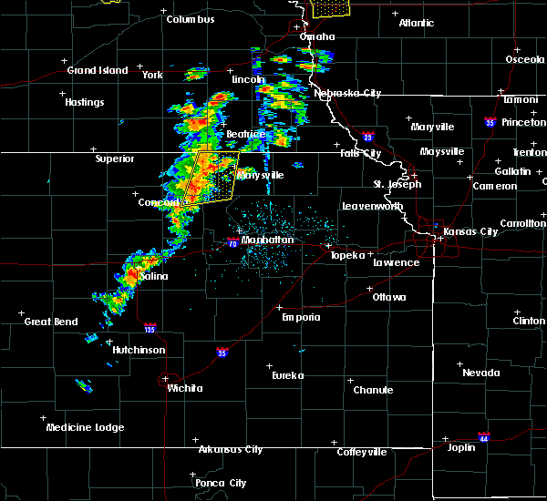 At 404 pm cdt, severe thunderstorms were located along a line extending from 5 miles north of hanover to 4 miles north of green, moving northeast at 20 mph (radar indicated). Hazards include 60 mph wind gusts. Expect damage to roofs, siding, and trees. Locations impacted include, marysville, washington, blue rapids, hanover, waterville, linn, greenleaf, barnes, oketo, hollenberg and bremen. At 404 pm cdt, severe thunderstorms were located along a line extending from 5 miles north of hanover to 4 miles north of green, moving northeast at 20 mph (radar indicated). Hazards include 60 mph wind gusts. Expect damage to roofs, siding, and trees. Locations impacted include, marysville, washington, blue rapids, hanover, waterville, linn, greenleaf, barnes, oketo, hollenberg and bremen.
|
| 6/18/2018 3:54 PM CDT |
 At 354 pm cdt, severe thunderstorms were located along a line extending from 4 miles northeast of hollenberg to 7 miles northwest of green, moving northeast at 35 mph (radar indicated). Hazards include 60 mph wind gusts. expect damage to roofs, siding, and trees At 354 pm cdt, severe thunderstorms were located along a line extending from 4 miles northeast of hollenberg to 7 miles northwest of green, moving northeast at 35 mph (radar indicated). Hazards include 60 mph wind gusts. expect damage to roofs, siding, and trees
|
| 6/18/2018 3:46 PM CDT |
 At 346 pm cdt, a severe thunderstorm was located near washington, moving northeast at 35 mph (radar indicated). Hazards include 60 mph wind gusts. Expect damage to roofs, siding, and trees. Locations impacted include, washington, hanover and hollenberg. At 346 pm cdt, a severe thunderstorm was located near washington, moving northeast at 35 mph (radar indicated). Hazards include 60 mph wind gusts. Expect damage to roofs, siding, and trees. Locations impacted include, washington, hanover and hollenberg.
|
| 6/18/2018 3:41 PM CDT |
 At 341 pm cdt, a severe thunderstorm was located over washington, moving northeast at 30 mph (radar indicated). Hazards include 60 mph wind gusts. Expect damage to roofs, siding, and trees. Locations impacted include, washington, hanover and hollenberg. At 341 pm cdt, a severe thunderstorm was located over washington, moving northeast at 30 mph (radar indicated). Hazards include 60 mph wind gusts. Expect damage to roofs, siding, and trees. Locations impacted include, washington, hanover and hollenberg.
|
| 6/18/2018 3:33 PM CDT |
 At 333 pm cdt, a severe thunderstorm was located over washington, moving northeast at 35 mph (radar indicated). Hazards include 60 mph wind gusts. expect damage to roofs, siding, and trees At 333 pm cdt, a severe thunderstorm was located over washington, moving northeast at 35 mph (radar indicated). Hazards include 60 mph wind gusts. expect damage to roofs, siding, and trees
|
| 5/1/2018 6:59 PM CDT |
 At 659 pm cdt, severe thunderstorms were located along a line extending from near hollenberg to 6 miles north of washington, moving east at 30 mph (radar indicated). Hazards include 60 mph wind gusts. Expect damage to roofs, siding, and trees. these severe thunderstorms will remain over mainly rural areas of northeastern washington and northwestern marshall counties. A tornado watch remains in effect until 1000 pm cdt for north central and northeastern kansas. At 659 pm cdt, severe thunderstorms were located along a line extending from near hollenberg to 6 miles north of washington, moving east at 30 mph (radar indicated). Hazards include 60 mph wind gusts. Expect damage to roofs, siding, and trees. these severe thunderstorms will remain over mainly rural areas of northeastern washington and northwestern marshall counties. A tornado watch remains in effect until 1000 pm cdt for north central and northeastern kansas.
|
| 5/1/2018 6:31 PM CDT |
 At 631 pm cdt, severe thunderstorms were located along a line extending from 6 miles east of mahaska to 3 miles north of haddam, moving east at 25 mph (radar indicated). Hazards include 60 mph wind gusts. Expect damage to roofs, siding, and trees. these severe storms will be near, hollenberg around 700 pm cdt. A tornado watch remains in effect until 1000 pm cdt for north central kansas. At 631 pm cdt, severe thunderstorms were located along a line extending from 6 miles east of mahaska to 3 miles north of haddam, moving east at 25 mph (radar indicated). Hazards include 60 mph wind gusts. Expect damage to roofs, siding, and trees. these severe storms will be near, hollenberg around 700 pm cdt. A tornado watch remains in effect until 1000 pm cdt for north central kansas.
|
| 5/1/2018 6:08 PM CDT |
 At 607 pm cdt, severe thunderstorms were located along a line extending from 4 miles northeast of hubbell to near narka to 3 miles southeast of munden, moving east at 35 mph (radar indicated). Hazards include 60 mph wind gusts. Expect damage to roofs, siding, and trees. severe thunderstorms will be near, mahaska around 615 pm cdt. hollenberg around 700 pm cdt. A tornado watch remains in effect until 1000 pm cdt for north central kansas. At 607 pm cdt, severe thunderstorms were located along a line extending from 4 miles northeast of hubbell to near narka to 3 miles southeast of munden, moving east at 35 mph (radar indicated). Hazards include 60 mph wind gusts. Expect damage to roofs, siding, and trees. severe thunderstorms will be near, mahaska around 615 pm cdt. hollenberg around 700 pm cdt. A tornado watch remains in effect until 1000 pm cdt for north central kansas.
|
| 6/16/2017 10:48 PM CDT |
 At 1047 pm cdt, severe thunderstorms were located along a line extending from 5 miles east of oketo to 3 miles northeast of marysville to 5 miles southeast of bremen to 3 miles southwest of hanover, moving southeast at 50 mph. these are very dangerous storms (trained weather spotters. at 1045pm...70 to 80 mph winds were reported north of marysville). Hazards include 80 mph wind gusts and quarter size hail. Flying debris will be dangerous to those caught without shelter. mobile homes will be heavily damaged. expect considerable damage to roofs, windows, and vehicles. extensive tree damage and power outages are likely. these severe storms will be near, marysville around 1050 pm cdt. beattie around 1055 pm cdt. frankfort and waterville around 1105 pm cdt. Blue rapids around 1110 pm cdt. At 1047 pm cdt, severe thunderstorms were located along a line extending from 5 miles east of oketo to 3 miles northeast of marysville to 5 miles southeast of bremen to 3 miles southwest of hanover, moving southeast at 50 mph. these are very dangerous storms (trained weather spotters. at 1045pm...70 to 80 mph winds were reported north of marysville). Hazards include 80 mph wind gusts and quarter size hail. Flying debris will be dangerous to those caught without shelter. mobile homes will be heavily damaged. expect considerable damage to roofs, windows, and vehicles. extensive tree damage and power outages are likely. these severe storms will be near, marysville around 1050 pm cdt. beattie around 1055 pm cdt. frankfort and waterville around 1105 pm cdt. Blue rapids around 1110 pm cdt.
|
| 6/16/2017 10:37 PM CDT |
 At 1037 pm cdt, severe thunderstorms were located along a line extending from 3 miles south of wymore to 5 miles southwest of odell to near hollenberg, moving southeast at 50 mph (radar indicated). Hazards include 60 mph wind gusts and quarter size hail. Hail damage to vehicles is expected. expect wind damage to roofs, siding, and trees. severe thunderstorms will be near, oketo and bremen around 1045 pm cdt. hanover around 1050 pm cdt. marysville around 1055 pm cdt. beattie around 1100 pm cdt. waterville around 1105 pm cdt. Blue rapids and frankfort around 1110 pm cdt. At 1037 pm cdt, severe thunderstorms were located along a line extending from 3 miles south of wymore to 5 miles southwest of odell to near hollenberg, moving southeast at 50 mph (radar indicated). Hazards include 60 mph wind gusts and quarter size hail. Hail damage to vehicles is expected. expect wind damage to roofs, siding, and trees. severe thunderstorms will be near, oketo and bremen around 1045 pm cdt. hanover around 1050 pm cdt. marysville around 1055 pm cdt. beattie around 1100 pm cdt. waterville around 1105 pm cdt. Blue rapids and frankfort around 1110 pm cdt.
|
| 4/19/2017 5:58 PM CDT |
 At 557 pm cdt, severe thunderstorms were located along a line extending from 4 miles east of mahaska to 5 miles north of concordia, moving east at 40 mph (radar indicated). Hazards include 60 mph wind gusts. Expect damage to roofs, siding, and trees. These severe storms will be near, hollenberg around 620 pm cdt. At 557 pm cdt, severe thunderstorms were located along a line extending from 4 miles east of mahaska to 5 miles north of concordia, moving east at 40 mph (radar indicated). Hazards include 60 mph wind gusts. Expect damage to roofs, siding, and trees. These severe storms will be near, hollenberg around 620 pm cdt.
|
| 4/19/2017 5:45 PM CDT |
 At 544 pm cdt, a severe thunderstorm was located 4 miles east of belleville, moving northeast at 45 mph (radar indicated). Hazards include 60 mph wind gusts and quarter size hail. Hail damage to vehicles is expected. expect wind damage to roofs, siding, and trees. this severe thunderstorm will be near, haddam and narka around 600 pm cdt. mahaska around 605 pm cdt. Hollenberg around 625 pm cdt. At 544 pm cdt, a severe thunderstorm was located 4 miles east of belleville, moving northeast at 45 mph (radar indicated). Hazards include 60 mph wind gusts and quarter size hail. Hail damage to vehicles is expected. expect wind damage to roofs, siding, and trees. this severe thunderstorm will be near, haddam and narka around 600 pm cdt. mahaska around 605 pm cdt. Hollenberg around 625 pm cdt.
|
| 10/4/2016 5:10 PM CDT |
 The severe thunderstorm warning for northeastern washington county will expire at 515 pm cdt, the storm which prompted the warning has weakened below severe limits, and have exited the warned area. therefore the warning will be allowed to expire. a tornado watch remains in effect until 900 pm cdt for north central kansas. The severe thunderstorm warning for northeastern washington county will expire at 515 pm cdt, the storm which prompted the warning has weakened below severe limits, and have exited the warned area. therefore the warning will be allowed to expire. a tornado watch remains in effect until 900 pm cdt for north central kansas.
|
| 10/4/2016 4:51 PM CDT |
 At 450 pm cdt, a severe thunderstorm was located near washington, moving north at 45 mph (trained weather spotters reported quarter sized hail 2 west northwest of linn). Hazards include quarter size hail. Damage to vehicles is expected. locations impacted include, washington, hanover, greenleaf, morrowville and hollenberg. A tornado watch remains in effect until 900 pm cdt for north central kansas. At 450 pm cdt, a severe thunderstorm was located near washington, moving north at 45 mph (trained weather spotters reported quarter sized hail 2 west northwest of linn). Hazards include quarter size hail. Damage to vehicles is expected. locations impacted include, washington, hanover, greenleaf, morrowville and hollenberg. A tornado watch remains in effect until 900 pm cdt for north central kansas.
|
| 10/4/2016 4:32 PM CDT |
 At 431 pm cdt, a severe thunderstorm was located over palmer, moving north at 45 mph (trained weather spotters reported quarter and ping pong ball sized hail). Hazards include ping pong ball size hail. People and animals outdoors will be injured. Expect damage to roofs, siding, windows, and vehicles. At 431 pm cdt, a severe thunderstorm was located over palmer, moving north at 45 mph (trained weather spotters reported quarter and ping pong ball sized hail). Hazards include ping pong ball size hail. People and animals outdoors will be injured. Expect damage to roofs, siding, windows, and vehicles.
|
| 5/24/2016 11:04 PM CDT | The national weather service in topeka has issued a * severe thunderstorm warning for. washington county in north central kansas. marshall county in northeastern kansas. northwestern riley county in northeastern kansas. Until 1145 pm cdt. |
| 5/9/2016 7:26 PM CDT |
 The severe thunderstorm warning for northeastern washington county will expire at 730 pm cdt, the storm which prompted the warning has weakened below severe limits, and no longer pose an immediate threat to life or property. therefore the warning will be allowed to expire. however, another severe thunderstorm may be developing across northwest washington county. a severe thunderstorm watch remains in effect until 900 pm cdt for north central kansas. The severe thunderstorm warning for northeastern washington county will expire at 730 pm cdt, the storm which prompted the warning has weakened below severe limits, and no longer pose an immediate threat to life or property. therefore the warning will be allowed to expire. however, another severe thunderstorm may be developing across northwest washington county. a severe thunderstorm watch remains in effect until 900 pm cdt for north central kansas.
|
| 5/9/2016 6:59 PM CDT |
 At 658 pm cdt, a severe thunderstorm was located over hollenberg, moving north at 10 mph (radar indicated). Hazards include half dollar size hail. damage to vehicles is expected At 658 pm cdt, a severe thunderstorm was located over hollenberg, moving north at 10 mph (radar indicated). Hazards include half dollar size hail. damage to vehicles is expected
|
| 5/9/2016 6:34 PM CDT |
 At 633 pm cdt, a severe thunderstorm was located near hollenberg, moving north at 15 mph (radar indicated). Hazards include ping pong ball size hail. People and animals outdoors will be injured. expect damage to roofs, siding, windows, and vehicles. Locations impacted include, hollenberg. At 633 pm cdt, a severe thunderstorm was located near hollenberg, moving north at 15 mph (radar indicated). Hazards include ping pong ball size hail. People and animals outdoors will be injured. expect damage to roofs, siding, windows, and vehicles. Locations impacted include, hollenberg.
|
| 5/9/2016 6:10 PM CDT |
 At 610 pm cdt, a severe thunderstorm was located near hanover, moving north at 20 mph (radar indicated). Hazards include half dollar size hail. damage to vehicles is expected At 610 pm cdt, a severe thunderstorm was located near hanover, moving north at 20 mph (radar indicated). Hazards include half dollar size hail. damage to vehicles is expected
|
| 5/9/2016 2:28 AM CDT | At 228 am cdt, a severe thunderstorm was located near washington, moving northeast at 35 mph (radar indicated). Hazards include quarter size hail. Damage to vehicles is expected. Locations impacted include, hollenberg. |
| 5/9/2016 2:09 AM CDT | At 209 am cdt, a severe thunderstorm was located over morrowville, moving northeast at 35 mph (radar indicated. this storm has a history of producing severe hail). Hazards include quarter size hail. damage to vehicles is expected |
| 4/26/2016 5:19 PM CDT |
 At 518 pm cdt, a severe thunderstorm was located near hanover, moving northeast at 35 mph (radar indicated). Hazards include ping pong ball size hail and 60 mph wind gusts. People and animals outdoors will be injured. expect hail damage to roofs, siding, windows, and vehicles. expect wind damage to roofs, siding, and trees. locations impacted include, hanover. A tornado watch remains in effect until 900 pm cdt for north central kansas. At 518 pm cdt, a severe thunderstorm was located near hanover, moving northeast at 35 mph (radar indicated). Hazards include ping pong ball size hail and 60 mph wind gusts. People and animals outdoors will be injured. expect hail damage to roofs, siding, windows, and vehicles. expect wind damage to roofs, siding, and trees. locations impacted include, hanover. A tornado watch remains in effect until 900 pm cdt for north central kansas.
|
| 4/26/2016 4:55 PM CDT |
 At 454 pm cdt, a severe thunderstorm was located over washington, moving northeast at 35 mph (radar indicated). Hazards include ping pong ball size hail and 60 mph wind gusts. People and animals outdoors will be injured. expect hail damage to roofs, siding, windows, and vehicles. Expect wind damage to roofs, siding, and trees. At 454 pm cdt, a severe thunderstorm was located over washington, moving northeast at 35 mph (radar indicated). Hazards include ping pong ball size hail and 60 mph wind gusts. People and animals outdoors will be injured. expect hail damage to roofs, siding, windows, and vehicles. Expect wind damage to roofs, siding, and trees.
|
| 4/26/2016 4:34 PM CDT |
 At 434 pm cdt, a severe thunderstorm was located near washington, moving northeast at 40 mph (radar indicated). Hazards include 60 mph wind gusts and half dollar size hail. Hail damage to vehicles is expected. expect wind damage to roofs, siding, and trees. locations impacted include, washington, hanover, morrowville and hollenberg. A tornado watch remains in effect until 900 pm cdt for north central kansas. At 434 pm cdt, a severe thunderstorm was located near washington, moving northeast at 40 mph (radar indicated). Hazards include 60 mph wind gusts and half dollar size hail. Hail damage to vehicles is expected. expect wind damage to roofs, siding, and trees. locations impacted include, washington, hanover, morrowville and hollenberg. A tornado watch remains in effect until 900 pm cdt for north central kansas.
|
| 4/26/2016 4:16 PM CDT |
 At 416 pm cdt, a severe thunderstorm was located over morrowville, moving northeast at 20 mph (radar indicated). Hazards include ping pong ball size hail and 60 mph wind gusts. People and animals outdoors will be injured. expect hail damage to roofs, siding, windows, and vehicles. Expect wind damage to roofs, siding, and trees. At 416 pm cdt, a severe thunderstorm was located over morrowville, moving northeast at 20 mph (radar indicated). Hazards include ping pong ball size hail and 60 mph wind gusts. People and animals outdoors will be injured. expect hail damage to roofs, siding, windows, and vehicles. Expect wind damage to roofs, siding, and trees.
|
| 4/26/2016 3:54 AM CDT |
 At 354 am cdt, a severe thunderstorm was located over haddam, moving north at 40 mph (trained weather spotters). Hazards include ping pong ball size hail. People and animals outdoors will be injured. expect damage to roofs, siding, windows, and vehicles. Locations impacted include, washington, hanover, greenleaf, barnes, morrowville, haddam, mahaska and hollenberg. At 354 am cdt, a severe thunderstorm was located over haddam, moving north at 40 mph (trained weather spotters). Hazards include ping pong ball size hail. People and animals outdoors will be injured. expect damage to roofs, siding, windows, and vehicles. Locations impacted include, washington, hanover, greenleaf, barnes, morrowville, haddam, mahaska and hollenberg.
|
| 4/26/2016 3:37 AM CDT |
 At 337 am cdt, a severe thunderstorm was located 6 miles southeast of agenda, moving northeast at 25 mph (radar indicated). Hazards include half dollar size hail. damage to vehicles is expected At 337 am cdt, a severe thunderstorm was located 6 miles southeast of agenda, moving northeast at 25 mph (radar indicated). Hazards include half dollar size hail. damage to vehicles is expected
|
| 4/24/2016 7:44 PM CDT |
 At 744 pm cdt, a severe thunderstorm was located over hollenberg, moving east at 30 mph (radar indicated). Hazards include 60 mph wind gusts and quarter size hail. Hail damage to vehicles is expected. expect wind damage to roofs, siding, and trees. locations impacted include, hollenberg. A tornado watch remains in effect until 1100 pm cdt for north central kansas. At 744 pm cdt, a severe thunderstorm was located over hollenberg, moving east at 30 mph (radar indicated). Hazards include 60 mph wind gusts and quarter size hail. Hail damage to vehicles is expected. expect wind damage to roofs, siding, and trees. locations impacted include, hollenberg. A tornado watch remains in effect until 1100 pm cdt for north central kansas.
|
| 4/24/2016 7:29 PM CDT |
 At 728 pm cdt, a severe thunderstorm was located 8 miles north of morrowville, moving east at 45 mph (radar indicated). Hazards include 60 mph wind gusts and quarter size hail. Hail damage to vehicles is expected. Expect wind damage to roofs, siding, and trees. At 728 pm cdt, a severe thunderstorm was located 8 miles north of morrowville, moving east at 45 mph (radar indicated). Hazards include 60 mph wind gusts and quarter size hail. Hail damage to vehicles is expected. Expect wind damage to roofs, siding, and trees.
|
| 9/7/2015 4:14 PM CDT |
 At 414 pm cdt, a severe thunderstorm capable of producing a tornado was located near odell, and is moving east at 30 mph (radar indicated rotation). Hazards include tornado and hail up to two inches in diameter. Flying debris will be dangerous to those caught without shelter. mobile homes will be damaged or destroyed. damage to roofs, windows and vehicles will occur. tree damage is likely. This tornadic thunderstorm will remain over mainly rural areas of northeastern washington county. At 414 pm cdt, a severe thunderstorm capable of producing a tornado was located near odell, and is moving east at 30 mph (radar indicated rotation). Hazards include tornado and hail up to two inches in diameter. Flying debris will be dangerous to those caught without shelter. mobile homes will be damaged or destroyed. damage to roofs, windows and vehicles will occur. tree damage is likely. This tornadic thunderstorm will remain over mainly rural areas of northeastern washington county.
|
| 9/7/2015 3:57 PM CDT |
 At 357 pm cdt, a severe thunderstorm capable of producing a tornado was located over hollenberg, moving east at 30 mph (radar indicated rotation). Hazards include tornado and two inch hail. Flying debris will be dangerous to those caught without shelter. mobile homes will be damaged or destroyed. damage to roofs, windows and vehicles will occur. tree damage is likely. This dangerous storm will be near, hanover around 410 pm cdt. At 357 pm cdt, a severe thunderstorm capable of producing a tornado was located over hollenberg, moving east at 30 mph (radar indicated rotation). Hazards include tornado and two inch hail. Flying debris will be dangerous to those caught without shelter. mobile homes will be damaged or destroyed. damage to roofs, windows and vehicles will occur. tree damage is likely. This dangerous storm will be near, hanover around 410 pm cdt.
|
| 9/7/2015 3:39 PM CDT |
 At 339 pm cdt, a confirmed tornado was located 6 miles northwest of hollenberg, moving east at 30 mph (weather spotters confirmed tornado. a tornado was spotted 5 miles south of fairbury earlier). Hazards include damaging tornado and ping pong ball size hail. Flying debris will be dangerous to those caught without shelter. mobile homes will be damaged or destroyed. damage to roofs, windows and vehicles will occur. tree damage is likely. the tornado will be near, hollenberg around 350 pm cdt. Hanover around 405 pm cdt. At 339 pm cdt, a confirmed tornado was located 6 miles northwest of hollenberg, moving east at 30 mph (weather spotters confirmed tornado. a tornado was spotted 5 miles south of fairbury earlier). Hazards include damaging tornado and ping pong ball size hail. Flying debris will be dangerous to those caught without shelter. mobile homes will be damaged or destroyed. damage to roofs, windows and vehicles will occur. tree damage is likely. the tornado will be near, hollenberg around 350 pm cdt. Hanover around 405 pm cdt.
|
| 9/7/2015 3:19 PM CDT |
 At 319 pm cdt, a severe thunderstorm was located 6 miles northeast of mahaska, moving southeast at 35 mph (radar indicated). Hazards include two inch hail and 70 mph wind gusts. People and animals outdoors will be injured. expect hail damage to roofs, siding, windows and vehicles. expect considerable tree damage. Wind damage is also likely to mobile homes, roofs and outbuildings. At 319 pm cdt, a severe thunderstorm was located 6 miles northeast of mahaska, moving southeast at 35 mph (radar indicated). Hazards include two inch hail and 70 mph wind gusts. People and animals outdoors will be injured. expect hail damage to roofs, siding, windows and vehicles. expect considerable tree damage. Wind damage is also likely to mobile homes, roofs and outbuildings.
|
| 8/22/2015 7:31 PM CDT |
 At 730 pm cdt, a severe thunderstorm was located near oketo, moving east at 25 mph (radar indicated). Hazards include 60 mph wind gusts and quarter size hail. Hail damage to vehicles is expected. expect wind damage to roofs, siding and trees. locations impacted include, marysville, washington, hanover, morrowville, oketo, hollenberg and bremen. A tornado watch remains in effect until midnight cdt for northeastern kansas. At 730 pm cdt, a severe thunderstorm was located near oketo, moving east at 25 mph (radar indicated). Hazards include 60 mph wind gusts and quarter size hail. Hail damage to vehicles is expected. expect wind damage to roofs, siding and trees. locations impacted include, marysville, washington, hanover, morrowville, oketo, hollenberg and bremen. A tornado watch remains in effect until midnight cdt for northeastern kansas.
|
| 8/22/2015 7:09 PM CDT |
 At 708 pm cdt, a severe thunderstorm was located 6 miles north of hanover, moving east at 25 mph (radar indicated). Hazards include 60 mph wind gusts and quarter size hail. Hail damage to vehicles is expected. Expect wind damage to roofs, siding and trees. At 708 pm cdt, a severe thunderstorm was located 6 miles north of hanover, moving east at 25 mph (radar indicated). Hazards include 60 mph wind gusts and quarter size hail. Hail damage to vehicles is expected. Expect wind damage to roofs, siding and trees.
|
| 8/8/2015 1:38 AM CDT |
 The severe thunderstorm warning for washington and eastern republic counties will expire at 145 am cdt, the storms which prompted the warning have weakened below severe limits, and no longer pose an immediate threat to life or property. therefore the warning will be allowed to expire. The severe thunderstorm warning for washington and eastern republic counties will expire at 145 am cdt, the storms which prompted the warning have weakened below severe limits, and no longer pose an immediate threat to life or property. therefore the warning will be allowed to expire.
|
| 8/8/2015 1:18 AM CDT |
 At 117 am cdt, severe thunderstorms were located along a line extending from 6 miles northeast of haddam to near agenda, moving east at 25 mph (radar indicated). Hazards include 60 mph wind gusts. Expect damage to roofs. siding and trees. Locations impacted include, washington, hanover, linn, greenleaf, barnes, cuba, morrowville, palmer, haddam, munden, narka, mahaska, agenda and hollenberg. At 117 am cdt, severe thunderstorms were located along a line extending from 6 miles northeast of haddam to near agenda, moving east at 25 mph (radar indicated). Hazards include 60 mph wind gusts. Expect damage to roofs. siding and trees. Locations impacted include, washington, hanover, linn, greenleaf, barnes, cuba, morrowville, palmer, haddam, munden, narka, mahaska, agenda and hollenberg.
|
| 8/8/2015 1:01 AM CDT |
 At 100 am cdt, severe thunderstorms were located along a line extending from near mahaska to agenda, moving east at 45 mph (trained weather spotters). Hazards include 60 mph wind gusts and nickel size hail. Expect damage to roofs. Siding and trees. At 100 am cdt, severe thunderstorms were located along a line extending from near mahaska to agenda, moving east at 45 mph (trained weather spotters). Hazards include 60 mph wind gusts and nickel size hail. Expect damage to roofs. Siding and trees.
|
| 6/23/2015 1:24 PM CDT | Golf Ball sized hail reported 0.1 miles NNW of Hollenberg, KS |
| 6/23/2015 1:12 PM CDT | Quarter sized hail reported 0.1 miles NNW of Hollenberg, KS, quarter size stones mixed with a lot of pea size stones. |
| 6/23/2015 1:01 PM CDT |
 At 101 pm cdt, a severe thunderstorm was located over hollenburg, moving southeast at 25 mph (radar indicated). Hazards include 60 mph wind gusts and half dollar size hail. Hail damage to vehicles is expected. expect wind damage to roofs, siding and trees. Locations impacted include, hanover, hollenberg and hollenburg. At 101 pm cdt, a severe thunderstorm was located over hollenburg, moving southeast at 25 mph (radar indicated). Hazards include 60 mph wind gusts and half dollar size hail. Hail damage to vehicles is expected. expect wind damage to roofs, siding and trees. Locations impacted include, hanover, hollenberg and hollenburg.
|
| 6/23/2015 12:40 PM CDT |
 At 1240 pm cdt, a severe thunderstorm was located 6 miles northwest of hollenburg, moving southeast at 20 mph (radar indicated). Hazards include ping pong ball size hail and 60 mph wind gusts. People and animals outdoors will be injured. expect hail damage to roofs, siding, windows and vehicles. Expect wind damage to roofs, siding and trees. At 1240 pm cdt, a severe thunderstorm was located 6 miles northwest of hollenburg, moving southeast at 20 mph (radar indicated). Hazards include ping pong ball size hail and 60 mph wind gusts. People and animals outdoors will be injured. expect hail damage to roofs, siding, windows and vehicles. Expect wind damage to roofs, siding and trees.
|
| 5/10/2015 12:57 PM CDT | At 1253 pm cdt, a severe thunderstorm was located 3 miles southwest of hollenberg, and moving north at 45 mph (radar indicated). Hazards include 60 mph wind gusts and quarter size hail. Hail damage to vehicles is expected. expect wind damage to roofs, siding and trees. locations impacted include, , 1. 00in. |
| 5/10/2015 12:51 PM CDT | At 1249 pm cdt, a severe thunderstorm was located 3 miles northwest of washington, and moving north at 45 mph (radar indicated). Hazards include 60 mph wind gusts and quarter size hail. Hail damage to vehicles is expected. expect wind damage to roofs, siding and trees. locations impacted include, hanover and hollenberg. 1. 00in. |
| 5/10/2015 12:48 PM CDT | At 1245 pm cdt, a severe thunderstorm was located near washington, and moving north at 45 mph (radar indicated). Hazards include 60 mph wind gusts and quarter size hail. Hail damage to vehicles is expected. Expect wind damage to roofs, siding and trees. |
| 5/7/2015 4:59 PM CDT | At 456 pm cdt, a severe thunderstorm was located 5 miles west of palmer, and moving northeast at 20 mph. a second severe thunderstorm was located 2 miles southwest of hanover, and moving northeast at 5 mph (radar indicated). Hazards include 60 mph wind gusts and half dollar size hail. Hail damage to vehicles is expected. Expect wind damage to roofs, siding and trees. |
| 5/6/2015 11:08 PM CDT | The tornado warning for north central washington county will expire at 1115 pm cdt, the storm which prompted the warning has moved out of the warned area. additional strong thunderstorms are still possible, and a tornado watch remains in effect until 200 am. |
| 5/6/2015 10:54 PM CDT | At 1047 pm cdt, a confirmed tornado was located 3 miles southwest of hollenberg, and moving northeast at 40 mph (weather spotters confirmed tornado). Hazards include damaging tornado and golf ball size hail. Flying debris will be dangerous to those caught without shelter. mobile homes will be damaged or destroyed. damage to roofs, windows and vehicles will occur. tree damage is likely. this tornadic storm will affect mainly rural areas of north central washington county. Observed. |
| 5/6/2015 10:43 PM CDT | At 1036 pm cdt, a confirmed tornado was located 3 miles northwest of washington, and moving northeast at 35 mph (weather spotters confirmed tornado). Hazards include damaging tornado and golf ball size hail. Flying debris will be dangerous to those caught without shelter. mobile homes will be damaged or destroyed. damage to roofs, windows and vehicles will occur. tree damage is likely. this tornadic storm will be near, hollenberg around 1055 pm cdt. Observed. |
| 5/6/2015 10:39 PM CDT | At 1037 pm cdt, a severe thunderstorm capable of producing a tornado was located near washington, and moving northeast at 35 mph (radar indicated rotation). Hazards include tornado and golf ball size hail. Flying debris will be dangerous to those caught without shelter. mobile homes will be damaged or destroyed. damage to roofs, windows and vehicles will occur. tree damage is likely. this dangerous storm will be near, hollenberg around 1055 pm cdt. Radar indicated. |
| 5/6/2015 9:55 PM CDT | The severe thunderstorm warning for north central washington county will expire at 1000 pm cdt, the storm which prompted the warning has moved out of the warned area. however, small hail and gusty winds are still possible with this thunderstorm. in addition, strong thunderstorms may redevelop, and a tornado watch remains in effect until 200 am. |
| 5/6/2015 9:42 PM CDT | The tornado warning for north central washington county will expire at 945 pm cdt, the storm which prompted the warning has weakened below severe limits, and no longer poses an immediate threat to life or property. however, small hail and gusty winds are still possible with this thunderstorm. in addition, strong thunderstorms may redevelop, and a tornado watch remains in effect until 200 am. |
| 5/6/2015 9:36 PM CDT | At 933 pm cdt, a severe thunderstorm was located near morrowville, and moving northeast at 30 mph (radar indicated). Hazards include 60 mph wind gusts and quarter size hail. Hail damage to vehicles is expected. Expect wind damage to roofs, siding and trees. |
| 5/6/2015 9:31 PM CDT | At 929 pm cdt, a severe thunderstorm capable of producing a tornado was located near morrowville, and moving northeast at 30 mph (radar indicated rotation). Hazards include tornado and quarter size hail. Flying debris will be dangerous to those caught without shelter. mobile homes will be damaged or destroyed. damage to roofs, windows and vehicles will occur. tree damage is likely. this dangerous storm will be near, hollenberg around 945 pm cdt. Radar indicated. |
| 5/6/2015 9:14 PM CDT | At 910 pm cdt, a severe thunderstorm capable of producing a tornado was located near haddam, and moving northeast at 50 mph (radar indicated rotation). Hazards include tornado and quarter size hail. Flying debris will be dangerous to those caught without shelter. mobile homes will be damaged or destroyed. damage to roofs, windows and vehicles will occur. tree damage is likely. this dangerous storm will be near, hollenberg around 935 pm cdt. Radar indicated. |
| 4/12/2015 9:10 PM CDT | The severe thunderstorm warning for northeastern washington county will expire at 915 pm cdt. the storm which prompted the warning has weakened and will continue to move out of the warned area. however. Gusty winds and heavy rain are still possible with this thunderstorm. |
| 4/12/2015 9:03 PM CDT | A severe thunderstorm warning remains in effect for northeastern washington county until 915 pm cdt. at 901 pm cdt. a severe thunderstorm was located near hollenberg. and moving east at 40 mph. hazard. 60 mph wind gusts and quarter size hail. source. Radar indicated. |
| 4/12/2015 8:49 PM CDT | A severe thunderstorm warning remains in effect for northeastern washington county until 915 pm cdt. at 847 pm cdt. a severe thunderstorm was located near hollenberg. and moving east at 50 mph. hazard. 60 mph wind gusts and penny size hail. source. trained weather spotters. at 846 pm. A trained spotter. |
| 4/12/2015 8:37 PM CDT | The national weather service in topeka has issued a * severe thunderstorm warning for. northern washington county in north central kansas. until 915 pm cdt * at 835 pm cdt. a severe thunderstorm was located 6 miles east of mahaska. And moving east at 45 mph. |
| 4/2/2015 12:08 AM CDT | The national weather service in topeka has issued a * severe thunderstorm warning for. washington county in north central kansas. until 100 am cdt * at 1205 am cdt. severe thunderstorms were located along a line extending from haddam to agenda. And moving east at 25 mph. |
| 3/23/2015 11:42 PM CDT | The severe thunderstorm warning for northern washington county will expire at 1145 pm cdt. the storm which prompted the warning has weakened below severe limits. and no longer poses an immediate threat to life or property. however. Small hail up to the size of pennies is still possible with this thunderstorm. |
| 3/23/2015 11:28 PM CDT | A severe thunderstorm warning remains in effect for northern washington county until 1145 pm cdt. at 1126 pm cdt. a severe thunderstorm was located near haddam. and moving northeast at 35 mph. hazard. quarter size hail. source. Radar indicated. |
Hail Maps for Hollenberg, KS
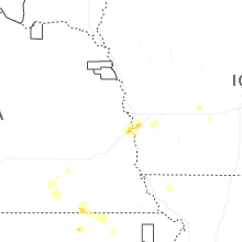

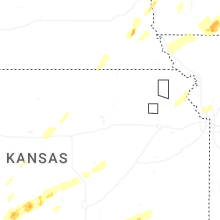


Connect with Interactive Hail Maps