

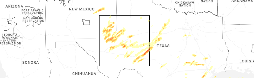
Hail Map for Iraan, TX
The Iraan, TX area has had 38 reports of on-the-ground hail by trained spotters, and has been under severe weather warnings 19 times during the past 12 months. Doppler radar has detected hail at or near Iraan, TX on 68 occasions, including 6 occasions during the past year.
| Name: | Iraan, TX |
| Where Located: | 70.3 miles SSE of Odessa, TX |
| Map: | Google Map for Iraan, TX |
| Population: | 1229 |
| Housing Units: | 526 |
| More Info: | Search Google for Iraan, TX |
1
The Top Recent Hail Date for Iraan, TX is Monday, May 5, 2025 (29th out of 68)
Hail and Wind Damage Spotted near Iraan, TX
| Date / Time | Report Details |
|---|---|
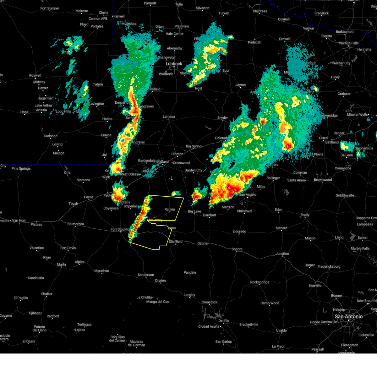
| 5/6/2025 1:09 AM CDT |
 The storm which prompted the warning has moved out of the area. therefore, the warning will be allowed to expire. a tornado watch remains in effect until 400 am cdt for southwestern texas. The storm which prompted the warning has moved out of the area. therefore, the warning will be allowed to expire. a tornado watch remains in effect until 400 am cdt for southwestern texas.
|
| 5/6/2025 1:01 AM CDT |
 Svrmaf the national weather service in midland has issued a * severe thunderstorm warning for, eastern pecos county in southwestern texas, * until 115 am cdt. * at 101 am cdt, a severe thunderstorm was located 12 miles northwest of sheffield, moving northeast at 35 mph (radar indicated). Hazards include 60 mph wind gusts and quarter size hail. Hail damage to vehicles is expected. Expect wind damage to roofs, siding, and trees. Svrmaf the national weather service in midland has issued a * severe thunderstorm warning for, eastern pecos county in southwestern texas, * until 115 am cdt. * at 101 am cdt, a severe thunderstorm was located 12 miles northwest of sheffield, moving northeast at 35 mph (radar indicated). Hazards include 60 mph wind gusts and quarter size hail. Hail damage to vehicles is expected. Expect wind damage to roofs, siding, and trees.
|
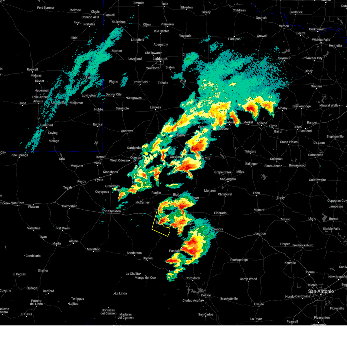
| 4/29/2025 7:14 PM CDT |
 At 714 pm cdt, a severe thunderstorm was located 18 miles south of rankin, moving northeast at 30 mph (radar indicated). Hazards include 60 mph wind gusts and quarter size hail. Hail damage to vehicles is expected. expect wind damage to roofs, siding, and trees. Locations impacted include, iraan and iraan municipal airport. At 714 pm cdt, a severe thunderstorm was located 18 miles south of rankin, moving northeast at 30 mph (radar indicated). Hazards include 60 mph wind gusts and quarter size hail. Hail damage to vehicles is expected. expect wind damage to roofs, siding, and trees. Locations impacted include, iraan and iraan municipal airport.
|
| 4/29/2025 7:00 PM CDT | Golf Ball sized hail reported 0.3 miles NNE of Iraan, TX, picture of approximately golf ball size hail in iraan. |
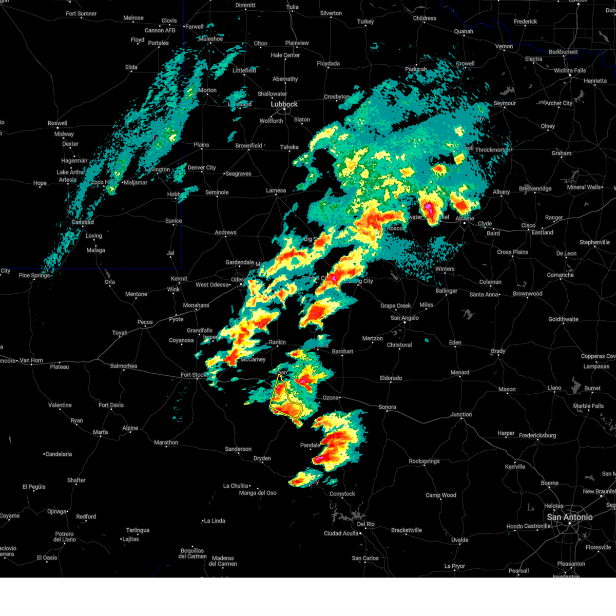
| 4/29/2025 6:59 PM CDT |
 Svrmaf the national weather service in midland has issued a * severe thunderstorm warning for, east central pecos county in southwestern texas, * until 730 pm cdt. * at 659 pm cdt, a severe thunderstorm was located 17 miles northwest of sheffield, moving northeast at 25 mph (radar indicated). Hazards include 60 mph wind gusts and half dollar size hail. Hail damage to vehicles is expected. Expect wind damage to roofs, siding, and trees. Svrmaf the national weather service in midland has issued a * severe thunderstorm warning for, east central pecos county in southwestern texas, * until 730 pm cdt. * at 659 pm cdt, a severe thunderstorm was located 17 miles northwest of sheffield, moving northeast at 25 mph (radar indicated). Hazards include 60 mph wind gusts and half dollar size hail. Hail damage to vehicles is expected. Expect wind damage to roofs, siding, and trees.
|
| 4/29/2025 6:31 PM CDT | At 631 pm cdt, a severe thunderstorm was located 18 miles southeast of mccamey, moving east at 30 mph (radar indicated). Hazards include ping pong ball size hail and 60 mph wind gusts. People and animals outdoors will be injured. expect hail damage to roofs, siding, windows, and vehicles. expect wind damage to roofs, siding, and trees. locations impacted include, iraan, bakersfield, and iraan municipal airport. This includes interstate 10 between mile markers 296 and 309. |
| 4/29/2025 6:16 PM CDT |
 Svrmaf the national weather service in midland has issued a * severe thunderstorm warning for, east central pecos county in southwestern texas, * until 700 pm cdt. * at 615 pm cdt, a severe thunderstorm was located 13 miles south of mccamey, moving northeast at 20 mph (radar indicated). Hazards include ping pong ball size hail and 60 mph wind gusts. People and animals outdoors will be injured. expect hail damage to roofs, siding, windows, and vehicles. Expect wind damage to roofs, siding, and trees. Svrmaf the national weather service in midland has issued a * severe thunderstorm warning for, east central pecos county in southwestern texas, * until 700 pm cdt. * at 615 pm cdt, a severe thunderstorm was located 13 miles south of mccamey, moving northeast at 20 mph (radar indicated). Hazards include ping pong ball size hail and 60 mph wind gusts. People and animals outdoors will be injured. expect hail damage to roofs, siding, windows, and vehicles. Expect wind damage to roofs, siding, and trees.
|
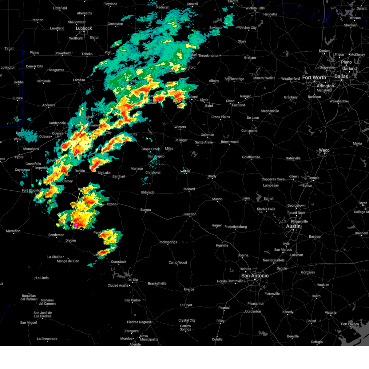
| 4/29/2025 5:09 PM CDT | At 508 pm cdt, a severe thunderstorm was located 14 miles south of mccamey, moving east at 15 mph (radar indicated). Hazards include tennis ball size hail and 70 mph wind gusts. People and animals outdoors will be injured. expect hail damage to roofs, siding, windows, and vehicles. expect considerable tree damage. wind damage is also likely to mobile homes, roofs, and outbuildings. locations impacted include, iraan and iraan municipal airport. This includes interstate 10 between mile markers 297 and 309. |
| 4/29/2025 4:55 PM CDT | Svrmaf the national weather service in midland has issued a * severe thunderstorm warning for, east central pecos county in southwestern texas, * until 600 pm cdt. * at 454 pm cdt, severe thunderstorms were located along a line extending from 11 miles southeast of mccamey to 29 miles northwest of sheffield, moving east at 15 mph (radar indicated). Hazards include two inch hail and 70 mph wind gusts. People and animals outdoors will be injured. expect hail damage to roofs, siding, windows, and vehicles. expect considerable tree damage. Wind damage is also likely to mobile homes, roofs, and outbuildings. |
| 4/29/2025 4:50 PM CDT |
 At 449 pm cdt, a severe thunderstorm was located 12 miles south of mccamey, moving east at 25 mph (radar indicated). Hazards include golf ball size hail and 70 mph wind gusts. People and animals outdoors will be injured. expect hail damage to roofs, siding, windows, and vehicles. expect considerable tree damage. wind damage is also likely to mobile homes, roofs, and outbuildings. Locations impacted include, iraan. At 449 pm cdt, a severe thunderstorm was located 12 miles south of mccamey, moving east at 25 mph (radar indicated). Hazards include golf ball size hail and 70 mph wind gusts. People and animals outdoors will be injured. expect hail damage to roofs, siding, windows, and vehicles. expect considerable tree damage. wind damage is also likely to mobile homes, roofs, and outbuildings. Locations impacted include, iraan.
|
| 4/29/2025 4:50 PM CDT |
 the severe thunderstorm warning has been cancelled and is no longer in effect the severe thunderstorm warning has been cancelled and is no longer in effect
|
| 4/29/2025 4:19 PM CDT |
 At 418 pm cdt, severe thunderstorms were located along a line extending from 6 miles southeast of mccamey to 30 miles south of crane, moving east at 25 mph (radar indicated). Hazards include 60 mph wind gusts and half dollar size hail. Hail damage to vehicles is expected. expect wind damage to roofs, siding, and trees. Locations impacted include, iraan and upton county airport. At 418 pm cdt, severe thunderstorms were located along a line extending from 6 miles southeast of mccamey to 30 miles south of crane, moving east at 25 mph (radar indicated). Hazards include 60 mph wind gusts and half dollar size hail. Hail damage to vehicles is expected. expect wind damage to roofs, siding, and trees. Locations impacted include, iraan and upton county airport.
|
| 4/29/2025 3:55 PM CDT |
 Svrmaf the national weather service in midland has issued a * severe thunderstorm warning for, northeastern pecos county in southwestern texas, southeastern crane county in western texas, southern upton county in western texas, * until 500 pm cdt. * at 354 pm cdt, severe thunderstorms were located along a line extending from near mccamey to 19 miles southwest of rankin to 30 miles south of crane, moving east at 15 mph (radar indicated). Hazards include golf ball size hail and 70 mph wind gusts. People and animals outdoors will be injured. expect hail damage to roofs, siding, windows, and vehicles. expect considerable tree damage. Wind damage is also likely to mobile homes, roofs, and outbuildings. Svrmaf the national weather service in midland has issued a * severe thunderstorm warning for, northeastern pecos county in southwestern texas, southeastern crane county in western texas, southern upton county in western texas, * until 500 pm cdt. * at 354 pm cdt, severe thunderstorms were located along a line extending from near mccamey to 19 miles southwest of rankin to 30 miles south of crane, moving east at 15 mph (radar indicated). Hazards include golf ball size hail and 70 mph wind gusts. People and animals outdoors will be injured. expect hail damage to roofs, siding, windows, and vehicles. expect considerable tree damage. Wind damage is also likely to mobile homes, roofs, and outbuildings.
|
| 4/19/2025 10:42 PM CDT |
 At 1042 pm cdt, severe thunderstorms were located along a line extending from 8 miles south of garden city to 10 miles southwest of sheffield, moving east at 40 mph (radar indicated). Hazards include 60 mph wind gusts and quarter size hail. Hail damage to vehicles is expected. expect wind damage to roofs, siding, and trees. locations impacted include, stiles, sheffield, iraan municipal airport, big lake, reagan county airport, saint lawrence, best, and iraan. This includes interstate 10 between mile markers 316 and 327. At 1042 pm cdt, severe thunderstorms were located along a line extending from 8 miles south of garden city to 10 miles southwest of sheffield, moving east at 40 mph (radar indicated). Hazards include 60 mph wind gusts and quarter size hail. Hail damage to vehicles is expected. expect wind damage to roofs, siding, and trees. locations impacted include, stiles, sheffield, iraan municipal airport, big lake, reagan county airport, saint lawrence, best, and iraan. This includes interstate 10 between mile markers 316 and 327.
|
| 4/19/2025 10:11 PM CDT |
 Svrmaf the national weather service in midland has issued a * severe thunderstorm warning for, east central pecos county in southwestern texas, southeastern glasscock county in western texas, reagan county in western texas, eastern upton county in western texas, northeastern terrell county in southwestern texas, * until 1115 pm cdt. * at 1010 pm cdt, severe thunderstorms were located along a line extending from 20 miles southwest of garden city to 28 miles west of sheffield, moving northeast at 40 mph (radar indicated). Hazards include 60 mph wind gusts and quarter size hail. Hail damage to vehicles is expected. Expect wind damage to roofs, siding, and trees. Svrmaf the national weather service in midland has issued a * severe thunderstorm warning for, east central pecos county in southwestern texas, southeastern glasscock county in western texas, reagan county in western texas, eastern upton county in western texas, northeastern terrell county in southwestern texas, * until 1115 pm cdt. * at 1010 pm cdt, severe thunderstorms were located along a line extending from 20 miles southwest of garden city to 28 miles west of sheffield, moving northeast at 40 mph (radar indicated). Hazards include 60 mph wind gusts and quarter size hail. Hail damage to vehicles is expected. Expect wind damage to roofs, siding, and trees.
|
| 4/19/2025 9:50 PM CDT |
 At 950 pm cdt, severe thunderstorms were located along a line extending from 13 miles northwest of rankin to 28 miles south of mccamey, moving east at 30 mph (radar indicated). Hazards include 60 mph wind gusts and quarter size hail. Hail damage to vehicles is expected. expect wind damage to roofs, siding, and trees. locations impacted include, mccamey, upton county airport, bakersfield, rankin, king mountain, and iraan. This includes interstate 10 between mile markers 285 and 317. At 950 pm cdt, severe thunderstorms were located along a line extending from 13 miles northwest of rankin to 28 miles south of mccamey, moving east at 30 mph (radar indicated). Hazards include 60 mph wind gusts and quarter size hail. Hail damage to vehicles is expected. expect wind damage to roofs, siding, and trees. locations impacted include, mccamey, upton county airport, bakersfield, rankin, king mountain, and iraan. This includes interstate 10 between mile markers 285 and 317.
|
| 4/19/2025 9:17 PM CDT |
 Svrmaf the national weather service in midland has issued a * severe thunderstorm warning for, northeastern pecos county in southwestern texas, west central reagan county in western texas, southeastern crane county in western texas, upton county in western texas, * until 1015 pm cdt. * at 917 pm cdt, severe thunderstorms were located along a line extending from near crane to 16 miles southeast of fort stockton, moving east at 30 mph (radar indicated). Hazards include 60 mph wind gusts and quarter size hail. Hail damage to vehicles is expected. Expect wind damage to roofs, siding, and trees. Svrmaf the national weather service in midland has issued a * severe thunderstorm warning for, northeastern pecos county in southwestern texas, west central reagan county in western texas, southeastern crane county in western texas, upton county in western texas, * until 1015 pm cdt. * at 917 pm cdt, severe thunderstorms were located along a line extending from near crane to 16 miles southeast of fort stockton, moving east at 30 mph (radar indicated). Hazards include 60 mph wind gusts and quarter size hail. Hail damage to vehicles is expected. Expect wind damage to roofs, siding, and trees.
|
| 4/4/2025 1:11 AM CDT |
 the severe thunderstorm warning has been cancelled and is no longer in effect the severe thunderstorm warning has been cancelled and is no longer in effect
|
| 4/4/2025 12:53 AM CDT |
 At 1253 am cdt, a severe thunderstorm was located near sheffield, moving northeast at 50 mph (radar indicated). Hazards include quarter size hail. Damage to vehicles is expected. locations impacted include, iraan, sheffield, and iraan municipal airport. This includes interstate 10 between mile markers 317 and 327. At 1253 am cdt, a severe thunderstorm was located near sheffield, moving northeast at 50 mph (radar indicated). Hazards include quarter size hail. Damage to vehicles is expected. locations impacted include, iraan, sheffield, and iraan municipal airport. This includes interstate 10 between mile markers 317 and 327.
|
| 4/4/2025 12:30 AM CDT |
 Svrmaf the national weather service in midland has issued a * severe thunderstorm warning for, east central pecos county in southwestern texas, northeastern terrell county in southwestern texas, * until 130 am cdt. * at 1230 am cdt, a severe thunderstorm was located 9 miles west of terrell county gas plant, or 22 miles north of dryden, moving northeast at 35 mph (radar indicated). Hazards include ping pong ball size hail. People and animals outdoors will be injured. Expect damage to roofs, siding, windows, and vehicles. Svrmaf the national weather service in midland has issued a * severe thunderstorm warning for, east central pecos county in southwestern texas, northeastern terrell county in southwestern texas, * until 130 am cdt. * at 1230 am cdt, a severe thunderstorm was located 9 miles west of terrell county gas plant, or 22 miles north of dryden, moving northeast at 35 mph (radar indicated). Hazards include ping pong ball size hail. People and animals outdoors will be injured. Expect damage to roofs, siding, windows, and vehicles.
|
| 5/30/2024 5:02 PM CDT |
 Svrmaf the national weather service in midland has issued a * severe thunderstorm warning for, northeastern pecos county in southwestern texas, * until 600 pm cdt. * at 502 pm cdt, a severe thunderstorm was located 12 miles southwest of mccamey, moving east at 25 mph (radar indicated). Hazards include 60 mph wind gusts and quarter size hail. Hail damage to vehicles is expected. Expect wind damage to roofs, siding, and trees. Svrmaf the national weather service in midland has issued a * severe thunderstorm warning for, northeastern pecos county in southwestern texas, * until 600 pm cdt. * at 502 pm cdt, a severe thunderstorm was located 12 miles southwest of mccamey, moving east at 25 mph (radar indicated). Hazards include 60 mph wind gusts and quarter size hail. Hail damage to vehicles is expected. Expect wind damage to roofs, siding, and trees.
|
| 5/28/2024 4:13 PM CDT |
 At 413 pm cdt, a severe thunderstorm was located 14 miles southeast of mccamey, moving east at 25 mph (radar indicated). Hazards include golf ball size hail and 60 mph wind gusts. People and animals outdoors will be injured. expect hail damage to roofs, siding, windows, and vehicles. expect wind damage to roofs, siding, and trees. locations impacted include, iraan and iraan municipal airport. This includes interstate 10 between mile markers 300 and 314. At 413 pm cdt, a severe thunderstorm was located 14 miles southeast of mccamey, moving east at 25 mph (radar indicated). Hazards include golf ball size hail and 60 mph wind gusts. People and animals outdoors will be injured. expect hail damage to roofs, siding, windows, and vehicles. expect wind damage to roofs, siding, and trees. locations impacted include, iraan and iraan municipal airport. This includes interstate 10 between mile markers 300 and 314.
|
| 5/28/2024 3:48 PM CDT |
 Svrmaf the national weather service in midland has issued a * severe thunderstorm warning for, east central pecos county in southwestern texas, * until 430 pm cdt. * at 348 pm cdt, a severe thunderstorm was located 12 miles south of mccamey, moving east at 25 mph (radar indicated). Hazards include golf ball size hail and 60 mph wind gusts. People and animals outdoors will be injured. expect hail damage to roofs, siding, windows, and vehicles. Expect wind damage to roofs, siding, and trees. Svrmaf the national weather service in midland has issued a * severe thunderstorm warning for, east central pecos county in southwestern texas, * until 430 pm cdt. * at 348 pm cdt, a severe thunderstorm was located 12 miles south of mccamey, moving east at 25 mph (radar indicated). Hazards include golf ball size hail and 60 mph wind gusts. People and animals outdoors will be injured. expect hail damage to roofs, siding, windows, and vehicles. Expect wind damage to roofs, siding, and trees.
|
| 5/3/2024 6:16 PM CDT |
 At 616 pm cdt, a severe thunderstorm was located 22 miles south of mccamey, moving east at 25 mph (radar indicated). Hazards include tennis ball size hail and 70 mph wind gusts. People and animals outdoors will be injured. expect hail damage to roofs, siding, windows, and vehicles. expect considerable tree damage. wind damage is also likely to mobile homes, roofs, and outbuildings. locations impacted include, sheffield, iraan, iraan municipal airport, and bakersfield. This includes interstate 10 between mile markers 295 and 327. At 616 pm cdt, a severe thunderstorm was located 22 miles south of mccamey, moving east at 25 mph (radar indicated). Hazards include tennis ball size hail and 70 mph wind gusts. People and animals outdoors will be injured. expect hail damage to roofs, siding, windows, and vehicles. expect considerable tree damage. wind damage is also likely to mobile homes, roofs, and outbuildings. locations impacted include, sheffield, iraan, iraan municipal airport, and bakersfield. This includes interstate 10 between mile markers 295 and 327.
|
| 5/3/2024 6:00 PM CDT |
 Svrmaf the national weather service in midland has issued a * severe thunderstorm warning for, east central pecos county in southwestern texas, * until 700 pm cdt. * at 600 pm cdt, a severe thunderstorm was located 19 miles south of mccamey, moving east at 35 mph (radar indicated). Hazards include two inch hail and 70 mph wind gusts. People and animals outdoors will be injured. expect hail damage to roofs, siding, windows, and vehicles. expect considerable tree damage. Wind damage is also likely to mobile homes, roofs, and outbuildings. Svrmaf the national weather service in midland has issued a * severe thunderstorm warning for, east central pecos county in southwestern texas, * until 700 pm cdt. * at 600 pm cdt, a severe thunderstorm was located 19 miles south of mccamey, moving east at 35 mph (radar indicated). Hazards include two inch hail and 70 mph wind gusts. People and animals outdoors will be injured. expect hail damage to roofs, siding, windows, and vehicles. expect considerable tree damage. Wind damage is also likely to mobile homes, roofs, and outbuildings.
|
| 5/3/2024 5:32 PM CDT |
 At 532 pm cdt, a severe thunderstorm was located 19 miles southwest of mccamey, moving northeast at 25 mph (radar indicated). Hazards include 60 mph wind gusts and quarter size hail. Hail damage to vehicles is expected. expect wind damage to roofs, siding, and trees. locations impacted include, iraan, bakersfield, and iraan municipal airport. This includes interstate 10 between mile markers 280 and 308. At 532 pm cdt, a severe thunderstorm was located 19 miles southwest of mccamey, moving northeast at 25 mph (radar indicated). Hazards include 60 mph wind gusts and quarter size hail. Hail damage to vehicles is expected. expect wind damage to roofs, siding, and trees. locations impacted include, iraan, bakersfield, and iraan municipal airport. This includes interstate 10 between mile markers 280 and 308.
|
| 5/3/2024 5:15 PM CDT |
 Svrmaf the national weather service in midland has issued a * severe thunderstorm warning for, east central pecos county in southwestern texas, * until 615 pm cdt. * at 514 pm cdt, a severe thunderstorm was located 21 miles southwest of mccamey, moving northeast at 20 mph (radar indicated). Hazards include 60 mph wind gusts and half dollar size hail. Hail damage to vehicles is expected. Expect wind damage to roofs, siding, and trees. Svrmaf the national weather service in midland has issued a * severe thunderstorm warning for, east central pecos county in southwestern texas, * until 615 pm cdt. * at 514 pm cdt, a severe thunderstorm was located 21 miles southwest of mccamey, moving northeast at 20 mph (radar indicated). Hazards include 60 mph wind gusts and half dollar size hail. Hail damage to vehicles is expected. Expect wind damage to roofs, siding, and trees.
|
| 5/1/2024 6:52 PM CDT |
 At 652 pm cdt, severe thunderstorms were located along a line extending from 14 miles west of sheffield to 17 miles northeast of sanderson, moving east at 30 mph (radar indicated). Hazards include 60 mph wind gusts and quarter size hail. Hail damage to vehicles is expected. expect wind damage to roofs, siding, and trees. locations impacted include, sheffield, terrell county gas plant, iraan, iraan municipal airport, and bakersfield. This includes interstate 10 between mile markers 294 and 327. At 652 pm cdt, severe thunderstorms were located along a line extending from 14 miles west of sheffield to 17 miles northeast of sanderson, moving east at 30 mph (radar indicated). Hazards include 60 mph wind gusts and quarter size hail. Hail damage to vehicles is expected. expect wind damage to roofs, siding, and trees. locations impacted include, sheffield, terrell county gas plant, iraan, iraan municipal airport, and bakersfield. This includes interstate 10 between mile markers 294 and 327.
|
| 5/1/2024 6:39 PM CDT |
 At 639 pm cdt, severe thunderstorms were located along a line extending from 18 miles west of sheffield to 15 miles northeast of sanderson, moving east at 30 mph (radar indicated). Hazards include 60 mph wind gusts and quarter size hail. Hail damage to vehicles is expected. expect wind damage to roofs, siding, and trees. locations impacted include, sheffield, sanderson, terrell county gas plant, iraan, iraan municipal airport, and bakersfield. This includes interstate 10 between mile markers 292 and 327. At 639 pm cdt, severe thunderstorms were located along a line extending from 18 miles west of sheffield to 15 miles northeast of sanderson, moving east at 30 mph (radar indicated). Hazards include 60 mph wind gusts and quarter size hail. Hail damage to vehicles is expected. expect wind damage to roofs, siding, and trees. locations impacted include, sheffield, sanderson, terrell county gas plant, iraan, iraan municipal airport, and bakersfield. This includes interstate 10 between mile markers 292 and 327.
|
| 5/1/2024 6:22 PM CDT |
 Svrmaf the national weather service in midland has issued a * severe thunderstorm warning for, southeastern pecos county in southwestern texas, terrell county in southwestern texas, * until 715 pm cdt. * at 621 pm cdt, severe thunderstorms were located along a line extending from 25 miles west of sheffield to 12 miles north of sanderson, moving east at 30 mph (radar indicated). Hazards include 60 mph wind gusts and quarter size hail. Hail damage to vehicles is expected. Expect wind damage to roofs, siding, and trees. Svrmaf the national weather service in midland has issued a * severe thunderstorm warning for, southeastern pecos county in southwestern texas, terrell county in southwestern texas, * until 715 pm cdt. * at 621 pm cdt, severe thunderstorms were located along a line extending from 25 miles west of sheffield to 12 miles north of sanderson, moving east at 30 mph (radar indicated). Hazards include 60 mph wind gusts and quarter size hail. Hail damage to vehicles is expected. Expect wind damage to roofs, siding, and trees.
|
| 4/30/2024 6:19 PM CDT |
 At 619 pm cdt, a severe thunderstorm was located 10 miles northwest of sheffield, moving southeast at 20 mph (public reports of large hail and damaged vehicles). Hazards include two inch hail and 70 mph wind gusts. People and animals outdoors will be injured. expect hail damage to roofs, siding, windows, and vehicles. expect considerable tree damage. wind damage is also likely to mobile homes, roofs, and outbuildings. locations impacted include, sheffield, iraan, and iraan municipal airport. This includes interstate 10 between mile markers 312 and 327. At 619 pm cdt, a severe thunderstorm was located 10 miles northwest of sheffield, moving southeast at 20 mph (public reports of large hail and damaged vehicles). Hazards include two inch hail and 70 mph wind gusts. People and animals outdoors will be injured. expect hail damage to roofs, siding, windows, and vehicles. expect considerable tree damage. wind damage is also likely to mobile homes, roofs, and outbuildings. locations impacted include, sheffield, iraan, and iraan municipal airport. This includes interstate 10 between mile markers 312 and 327.
|
| 4/30/2024 6:11 PM CDT |
 Svrmaf the national weather service in midland has issued a * severe thunderstorm warning for, east central pecos county in southwestern texas, north central terrell county in southwestern texas, * until 700 pm cdt. * at 611 pm cdt, a severe thunderstorm was located 12 miles northwest of sheffield, moving southeast at 20 mph (radar indicated). Hazards include two inch hail and 70 mph wind gusts. People and animals outdoors will be injured. expect hail damage to roofs, siding, windows, and vehicles. expect considerable tree damage. Wind damage is also likely to mobile homes, roofs, and outbuildings. Svrmaf the national weather service in midland has issued a * severe thunderstorm warning for, east central pecos county in southwestern texas, north central terrell county in southwestern texas, * until 700 pm cdt. * at 611 pm cdt, a severe thunderstorm was located 12 miles northwest of sheffield, moving southeast at 20 mph (radar indicated). Hazards include two inch hail and 70 mph wind gusts. People and animals outdoors will be injured. expect hail damage to roofs, siding, windows, and vehicles. expect considerable tree damage. Wind damage is also likely to mobile homes, roofs, and outbuildings.
|
| 4/30/2024 6:06 PM CDT | Hen Egg sized hail reported 9 miles NE of Iraan, TX, photos and video of hail and broken windshields. |
| 4/30/2024 6:02 PM CDT |
 At 601 pm cdt, a severe thunderstorm was located near sheffield, moving southeast at 20 mph. this is a destructive storm for i-10 near mile marker 316 (radar indicated). Hazards include baseball size hail and 70 mph wind gusts. People and animals outdoors will be severely injured. expect shattered windows, extensive damage to roofs, siding, and vehicles. locations impacted include, iraan and iraan municipal airport. This includes interstate 10 between mile markers 308 and 325. At 601 pm cdt, a severe thunderstorm was located near sheffield, moving southeast at 20 mph. this is a destructive storm for i-10 near mile marker 316 (radar indicated). Hazards include baseball size hail and 70 mph wind gusts. People and animals outdoors will be severely injured. expect shattered windows, extensive damage to roofs, siding, and vehicles. locations impacted include, iraan and iraan municipal airport. This includes interstate 10 between mile markers 308 and 325.
|
| 4/30/2024 5:58 PM CDT |
 At 558 pm cdt, a severe thunderstorm was located near sheffield, moving southeast at 20 mph (radar indicated). Hazards include tennis ball size hail and 70 mph wind gusts. People and animals outdoors will be injured. expect hail damage to roofs, siding, windows, and vehicles. expect considerable tree damage. wind damage is also likely to mobile homes, roofs, and outbuildings. locations impacted include, iraan and iraan municipal airport. This includes interstate 10 between mile markers 306 and 327. At 558 pm cdt, a severe thunderstorm was located near sheffield, moving southeast at 20 mph (radar indicated). Hazards include tennis ball size hail and 70 mph wind gusts. People and animals outdoors will be injured. expect hail damage to roofs, siding, windows, and vehicles. expect considerable tree damage. wind damage is also likely to mobile homes, roofs, and outbuildings. locations impacted include, iraan and iraan municipal airport. This includes interstate 10 between mile markers 306 and 327.
|
| 4/30/2024 5:52 PM CDT |
 At 552 pm cdt, a severe thunderstorm was located near sheffield, moving southeast at 20 mph (radar indicated). Hazards include two inch hail and 70 mph wind gusts. People and animals outdoors will be injured. expect hail damage to roofs, siding, windows, and vehicles. expect considerable tree damage. wind damage is also likely to mobile homes, roofs, and outbuildings. locations impacted include, iraan and iraan municipal airport. This includes interstate 10 between mile markers 306 and 327. At 552 pm cdt, a severe thunderstorm was located near sheffield, moving southeast at 20 mph (radar indicated). Hazards include two inch hail and 70 mph wind gusts. People and animals outdoors will be injured. expect hail damage to roofs, siding, windows, and vehicles. expect considerable tree damage. wind damage is also likely to mobile homes, roofs, and outbuildings. locations impacted include, iraan and iraan municipal airport. This includes interstate 10 between mile markers 306 and 327.
|
| 4/30/2024 5:52 PM CDT |
 the severe thunderstorm warning has been cancelled and is no longer in effect the severe thunderstorm warning has been cancelled and is no longer in effect
|
| 4/30/2024 5:11 PM CDT |
 Svrmaf the national weather service in midland has issued a * severe thunderstorm warning for, east central pecos county in southwestern texas, northeastern terrell county in southwestern texas, * until 615 pm cdt. * at 511 pm cdt, a severe thunderstorm was located 14 miles northwest of sheffield, moving southeast at 20 mph (radar indicated). Hazards include tennis ball size hail and 70 mph wind gusts. People and animals outdoors will be injured. expect hail damage to roofs, siding, windows, and vehicles. expect considerable tree damage. Wind damage is also likely to mobile homes, roofs, and outbuildings. Svrmaf the national weather service in midland has issued a * severe thunderstorm warning for, east central pecos county in southwestern texas, northeastern terrell county in southwestern texas, * until 615 pm cdt. * at 511 pm cdt, a severe thunderstorm was located 14 miles northwest of sheffield, moving southeast at 20 mph (radar indicated). Hazards include tennis ball size hail and 70 mph wind gusts. People and animals outdoors will be injured. expect hail damage to roofs, siding, windows, and vehicles. expect considerable tree damage. Wind damage is also likely to mobile homes, roofs, and outbuildings.
|
| 4/30/2024 4:56 PM CDT |
 the severe thunderstorm warning has been cancelled and is no longer in effect the severe thunderstorm warning has been cancelled and is no longer in effect
|
| 4/30/2024 4:56 PM CDT |
 At 455 pm cdt, a severe thunderstorm was located 15 miles southeast of mccamey, moving east at 15 mph (radar indicated). Hazards include tennis ball size hail and 70 mph wind gusts. People and animals outdoors will be injured. expect hail damage to roofs, siding, windows, and vehicles. expect considerable tree damage. wind damage is also likely to mobile homes, roofs, and outbuildings. Locations impacted include, iraan and iraan municipal airport. At 455 pm cdt, a severe thunderstorm was located 15 miles southeast of mccamey, moving east at 15 mph (radar indicated). Hazards include tennis ball size hail and 70 mph wind gusts. People and animals outdoors will be injured. expect hail damage to roofs, siding, windows, and vehicles. expect considerable tree damage. wind damage is also likely to mobile homes, roofs, and outbuildings. Locations impacted include, iraan and iraan municipal airport.
|
| 4/30/2024 4:31 PM CDT |
 At 431 pm cdt, a severe thunderstorm was located 11 miles southeast of mccamey, moving east at 15 mph (radar indicated). Hazards include tennis ball size hail and 70 mph wind gusts. People and animals outdoors will be injured. expect hail damage to roofs, siding, windows, and vehicles. expect considerable tree damage. wind damage is also likely to mobile homes, roofs, and outbuildings. locations impacted include, iraan and iraan municipal airport. This includes interstate 10 near mile marker 304. At 431 pm cdt, a severe thunderstorm was located 11 miles southeast of mccamey, moving east at 15 mph (radar indicated). Hazards include tennis ball size hail and 70 mph wind gusts. People and animals outdoors will be injured. expect hail damage to roofs, siding, windows, and vehicles. expect considerable tree damage. wind damage is also likely to mobile homes, roofs, and outbuildings. locations impacted include, iraan and iraan municipal airport. This includes interstate 10 near mile marker 304.
|
| 4/30/2024 4:13 PM CDT |
 Svrmaf the national weather service in midland has issued a * severe thunderstorm warning for, east central pecos county in southwestern texas, south central upton county in western texas, * until 515 pm cdt. * at 412 pm cdt, a severe thunderstorm was located 10 miles south of mccamey, moving east at 15 mph (radar indicated). Hazards include tennis ball size hail and 70 mph wind gusts. People and animals outdoors will be injured. expect hail damage to roofs, siding, windows, and vehicles. expect considerable tree damage. Wind damage is also likely to mobile homes, roofs, and outbuildings. Svrmaf the national weather service in midland has issued a * severe thunderstorm warning for, east central pecos county in southwestern texas, south central upton county in western texas, * until 515 pm cdt. * at 412 pm cdt, a severe thunderstorm was located 10 miles south of mccamey, moving east at 15 mph (radar indicated). Hazards include tennis ball size hail and 70 mph wind gusts. People and animals outdoors will be injured. expect hail damage to roofs, siding, windows, and vehicles. expect considerable tree damage. Wind damage is also likely to mobile homes, roofs, and outbuildings.
|
| 4/27/2024 10:15 PM CDT |
 At 1015 pm cdt, severe thunderstorms were located along a line extending from 16 miles southeast of rankin to 14 miles north of sheffield to 29 miles south of mccamey, moving east at 30 mph (radar indicated). Hazards include 60 mph wind gusts and quarter size hail. Hail damage to vehicles is expected. expect wind damage to roofs, siding, and trees. locations impacted include, sheffield, iraan, iraan municipal airport, and bakersfield. This includes interstate 10 between mile markers 294 and 327. At 1015 pm cdt, severe thunderstorms were located along a line extending from 16 miles southeast of rankin to 14 miles north of sheffield to 29 miles south of mccamey, moving east at 30 mph (radar indicated). Hazards include 60 mph wind gusts and quarter size hail. Hail damage to vehicles is expected. expect wind damage to roofs, siding, and trees. locations impacted include, sheffield, iraan, iraan municipal airport, and bakersfield. This includes interstate 10 between mile markers 294 and 327.
|
| 4/27/2024 10:15 PM CDT |
 the severe thunderstorm warning has been cancelled and is no longer in effect the severe thunderstorm warning has been cancelled and is no longer in effect
|
| 4/27/2024 10:02 PM CDT |
 At 1001 pm cdt, severe thunderstorms were located along a line extending from 12 miles southeast of rankin to 17 miles northwest of sheffield to 30 miles south of mccamey, moving east at 30 mph (radar indicated). Hazards include 60 mph wind gusts and quarter size hail. Hail damage to vehicles is expected. expect wind damage to roofs, siding, and trees. locations impacted include, sheffield, iraan, iraan municipal airport, and bakersfield. This includes interstate 10 between mile markers 292 and 327. At 1001 pm cdt, severe thunderstorms were located along a line extending from 12 miles southeast of rankin to 17 miles northwest of sheffield to 30 miles south of mccamey, moving east at 30 mph (radar indicated). Hazards include 60 mph wind gusts and quarter size hail. Hail damage to vehicles is expected. expect wind damage to roofs, siding, and trees. locations impacted include, sheffield, iraan, iraan municipal airport, and bakersfield. This includes interstate 10 between mile markers 292 and 327.
|
| 4/27/2024 9:30 PM CDT |
 Svrmaf the national weather service in midland has issued a * severe thunderstorm warning for, east central pecos county in southwestern texas, northeastern terrell county in southwestern texas, * until 1030 pm cdt. * at 930 pm cdt, severe thunderstorms were located along a line extending from 10 miles southeast of mccamey to 27 miles northwest of sheffield to 24 miles southeast of fort stockton, moving east at 30 mph (radar indicated). Hazards include 60 mph wind gusts and quarter size hail. Hail damage to vehicles is expected. Expect wind damage to roofs, siding, and trees. Svrmaf the national weather service in midland has issued a * severe thunderstorm warning for, east central pecos county in southwestern texas, northeastern terrell county in southwestern texas, * until 1030 pm cdt. * at 930 pm cdt, severe thunderstorms were located along a line extending from 10 miles southeast of mccamey to 27 miles northwest of sheffield to 24 miles southeast of fort stockton, moving east at 30 mph (radar indicated). Hazards include 60 mph wind gusts and quarter size hail. Hail damage to vehicles is expected. Expect wind damage to roofs, siding, and trees.
|
| 3/15/2024 7:19 AM CDT |
 the severe thunderstorm warning has been cancelled and is no longer in effect the severe thunderstorm warning has been cancelled and is no longer in effect
|
| 3/15/2024 6:51 AM CDT |
 At 651 am cdt, a severe thunderstorm was located near sheffield, moving northeast at 35 mph (radar indicated). Hazards include 60 mph wind gusts and quarter size hail. Hail damage to vehicles is expected. expect wind damage to roofs, siding, and trees. locations impacted include, sheffield, iraan, and iraan municipal airport. This includes interstate 10 between mile markers 317 and 327. At 651 am cdt, a severe thunderstorm was located near sheffield, moving northeast at 35 mph (radar indicated). Hazards include 60 mph wind gusts and quarter size hail. Hail damage to vehicles is expected. expect wind damage to roofs, siding, and trees. locations impacted include, sheffield, iraan, and iraan municipal airport. This includes interstate 10 between mile markers 317 and 327.
|
| 3/15/2024 6:51 AM CDT |
 the severe thunderstorm warning has been cancelled and is no longer in effect the severe thunderstorm warning has been cancelled and is no longer in effect
|
| 3/15/2024 6:28 AM CDT |
 Svrmaf the national weather service in midland has issued a * severe thunderstorm warning for, east central pecos county in southwestern texas, north central terrell county in southwestern texas, * until 730 am cdt. * at 628 am cdt, a severe thunderstorm was located 10 miles west of sheffield, moving north at 10 mph (radar indicated). Hazards include 60 mph wind gusts and quarter size hail. Hail damage to vehicles is expected. Expect wind damage to roofs, siding, and trees. Svrmaf the national weather service in midland has issued a * severe thunderstorm warning for, east central pecos county in southwestern texas, north central terrell county in southwestern texas, * until 730 am cdt. * at 628 am cdt, a severe thunderstorm was located 10 miles west of sheffield, moving north at 10 mph (radar indicated). Hazards include 60 mph wind gusts and quarter size hail. Hail damage to vehicles is expected. Expect wind damage to roofs, siding, and trees.
|
| 10/4/2023 6:16 PM CDT | Storm damage reported in crockett county TX, 20.5 miles NW of Iraan, TX |
| 6/2/2023 5:14 PM CDT | Tea Cup sized hail reported 16.6 miles NNW of Iraan, TX |
| 5/7/2023 6:34 PM CDT |
 At 634 pm cdt, a severe thunderstorm was located 18 miles north of sheffield, moving northeast at 15 mph (radar indicated). Hazards include 60 mph wind gusts and quarter size hail. Hail damage to vehicles is expected. expect wind damage to roofs, siding, and trees. locations impacted include, iraan and iraan municipal airport. hail threat, radar indicated max hail size, 1. 00 in wind threat, radar indicated max wind gust, 60 mph. At 634 pm cdt, a severe thunderstorm was located 18 miles north of sheffield, moving northeast at 15 mph (radar indicated). Hazards include 60 mph wind gusts and quarter size hail. Hail damage to vehicles is expected. expect wind damage to roofs, siding, and trees. locations impacted include, iraan and iraan municipal airport. hail threat, radar indicated max hail size, 1. 00 in wind threat, radar indicated max wind gust, 60 mph.
|
| 5/7/2023 6:14 PM CDT |
 At 614 pm cdt, a severe thunderstorm was located 17 miles north of sheffield, moving northeast at 15 mph (radar indicated). Hazards include 60 mph wind gusts and quarter size hail. Hail damage to vehicles is expected. Expect wind damage to roofs, siding, and trees. At 614 pm cdt, a severe thunderstorm was located 17 miles north of sheffield, moving northeast at 15 mph (radar indicated). Hazards include 60 mph wind gusts and quarter size hail. Hail damage to vehicles is expected. Expect wind damage to roofs, siding, and trees.
|
| 5/7/2023 6:01 PM CDT |
 At 600 pm cdt, a severe thunderstorm was located 16 miles northwest of sheffield, moving northeast at 15 mph (radar indicated). Hazards include 60 mph wind gusts and quarter size hail. Hail damage to vehicles is expected. expect wind damage to roofs, siding, and trees. locations impacted include, iraan and iraan municipal airport. hail threat, radar indicated max hail size, 1. 00 in wind threat, radar indicated max wind gust, 60 mph. At 600 pm cdt, a severe thunderstorm was located 16 miles northwest of sheffield, moving northeast at 15 mph (radar indicated). Hazards include 60 mph wind gusts and quarter size hail. Hail damage to vehicles is expected. expect wind damage to roofs, siding, and trees. locations impacted include, iraan and iraan municipal airport. hail threat, radar indicated max hail size, 1. 00 in wind threat, radar indicated max wind gust, 60 mph.
|
| 5/7/2023 5:46 PM CDT |
 At 546 pm cdt, a severe thunderstorm was located 16 miles northwest of sheffield, moving northeast at 15 mph (radar indicated). Hazards include 60 mph wind gusts and quarter size hail. Hail damage to vehicles is expected. Expect wind damage to roofs, siding, and trees. At 546 pm cdt, a severe thunderstorm was located 16 miles northwest of sheffield, moving northeast at 15 mph (radar indicated). Hazards include 60 mph wind gusts and quarter size hail. Hail damage to vehicles is expected. Expect wind damage to roofs, siding, and trees.
|
| 5/4/2022 5:13 PM CDT |
 At 513 pm cdt, a severe thunderstorm was located 16 miles west of sheffield, moving east at 15 mph (radar indicated). Hazards include 60 mph wind gusts and quarter size hail. Hail damage to vehicles is expected. Expect wind damage to roofs, siding, and trees. At 513 pm cdt, a severe thunderstorm was located 16 miles west of sheffield, moving east at 15 mph (radar indicated). Hazards include 60 mph wind gusts and quarter size hail. Hail damage to vehicles is expected. Expect wind damage to roofs, siding, and trees.
|
| 4/3/2022 8:16 PM CDT |
 At 816 pm cdt, a severe thunderstorm was located 14 miles northwest of sheffield, moving east at 25 mph (radar indicated). Hazards include 60 mph wind gusts and quarter size hail. Hail damage to vehicles is expected. expect wind damage to roofs, siding, and trees. locations impacted include, sheffield, iraan and iraan municipal airport. this includes interstate 10 between mile markers 307 and 327. hail threat, radar indicated max hail size, 1. 00 in wind threat, radar indicated max wind gust, 60 mph. At 816 pm cdt, a severe thunderstorm was located 14 miles northwest of sheffield, moving east at 25 mph (radar indicated). Hazards include 60 mph wind gusts and quarter size hail. Hail damage to vehicles is expected. expect wind damage to roofs, siding, and trees. locations impacted include, sheffield, iraan and iraan municipal airport. this includes interstate 10 between mile markers 307 and 327. hail threat, radar indicated max hail size, 1. 00 in wind threat, radar indicated max wind gust, 60 mph.
|
| 4/3/2022 7:47 PM CDT |
 At 746 pm cdt, a severe thunderstorm was located 15 miles south of mccamey, moving southeast at 25 mph (radar indicated). Hazards include 60 mph wind gusts and quarter size hail. Hail damage to vehicles is expected. Expect wind damage to roofs, siding, and trees. At 746 pm cdt, a severe thunderstorm was located 15 miles south of mccamey, moving southeast at 25 mph (radar indicated). Hazards include 60 mph wind gusts and quarter size hail. Hail damage to vehicles is expected. Expect wind damage to roofs, siding, and trees.
|
| 5/24/2021 5:40 PM CDT |
 At 539 pm cdt, a severe thunderstorm was located over upton county airport, or over mccamey, moving northeast at 15 mph (radar indicated). Hazards include 60 mph wind gusts and half dollar size hail. Hail damage to vehicles is expected. expect wind damage to roofs, siding, and trees. this severe thunderstorm will be near, mccamey around 550 pm cdt. Other locations impacted by this severe thunderstorm include iraan municipal airport, king mountain and upton county airport. At 539 pm cdt, a severe thunderstorm was located over upton county airport, or over mccamey, moving northeast at 15 mph (radar indicated). Hazards include 60 mph wind gusts and half dollar size hail. Hail damage to vehicles is expected. expect wind damage to roofs, siding, and trees. this severe thunderstorm will be near, mccamey around 550 pm cdt. Other locations impacted by this severe thunderstorm include iraan municipal airport, king mountain and upton county airport.
|
| 5/19/2021 5:52 PM CDT |
 At 552 pm cdt, a severe thunderstorm was located 16 miles southeast of mccamey, moving north at 25 mph (radar indicated). Hazards include 60 mph wind gusts and quarter size hail. Hail damage to vehicles is expected. expect wind damage to roofs, siding, and trees. locations impacted include, sheffield, iraan and iraan municipal airport. This includes interstate 10 between mile markers 300 and 327. At 552 pm cdt, a severe thunderstorm was located 16 miles southeast of mccamey, moving north at 25 mph (radar indicated). Hazards include 60 mph wind gusts and quarter size hail. Hail damage to vehicles is expected. expect wind damage to roofs, siding, and trees. locations impacted include, sheffield, iraan and iraan municipal airport. This includes interstate 10 between mile markers 300 and 327.
|
| 5/19/2021 5:35 PM CDT |
 At 534 pm cdt, a severe thunderstorm was located over sheffield, moving northeast at 20 mph (radar indicated). Hazards include 60 mph wind gusts and quarter size hail. Hail damage to vehicles is expected. expect wind damage to roofs, siding, and trees. locations impacted include, sheffield, iraan and iraan municipal airport. This includes interstate 10 between mile markers 300 and 327. At 534 pm cdt, a severe thunderstorm was located over sheffield, moving northeast at 20 mph (radar indicated). Hazards include 60 mph wind gusts and quarter size hail. Hail damage to vehicles is expected. expect wind damage to roofs, siding, and trees. locations impacted include, sheffield, iraan and iraan municipal airport. This includes interstate 10 between mile markers 300 and 327.
|
| 5/19/2021 5:29 PM CDT | Tennis Ball sized hail reported 16.1 miles NNW of Iraan, TX |
| 5/19/2021 5:28 PM CDT | Golf Ball sized hail reported 16.1 miles NNW of Iraan, TX |
| 5/19/2021 5:12 PM CDT |
 At 511 pm cdt, a severe thunderstorm was located near sheffield, moving east at 25 mph (radar indicated). Hazards include golf ball size hail and 60 mph wind gusts. People and animals outdoors will be injured. expect hail damage to roofs, siding, windows, and vehicles. expect wind damage to roofs, siding, and trees. locations impacted include, sheffield, iraan and iraan municipal airport. This includes interstate 10 between mile markers 298 and 327. At 511 pm cdt, a severe thunderstorm was located near sheffield, moving east at 25 mph (radar indicated). Hazards include golf ball size hail and 60 mph wind gusts. People and animals outdoors will be injured. expect hail damage to roofs, siding, windows, and vehicles. expect wind damage to roofs, siding, and trees. locations impacted include, sheffield, iraan and iraan municipal airport. This includes interstate 10 between mile markers 298 and 327.
|
| 5/19/2021 4:54 PM CDT |
 At 453 pm cdt, a severe thunderstorm was located 14 miles southwest of sheffield, moving east at 25 mph. another severe storm is in eastern pecos county, just south of i-10 (radar indicated). Hazards include 60 mph wind gusts and quarter size hail. Hail damage to vehicles is expected. Expect wind damage to roofs, siding, and trees. At 453 pm cdt, a severe thunderstorm was located 14 miles southwest of sheffield, moving east at 25 mph. another severe storm is in eastern pecos county, just south of i-10 (radar indicated). Hazards include 60 mph wind gusts and quarter size hail. Hail damage to vehicles is expected. Expect wind damage to roofs, siding, and trees.
|
| 5/24/2020 4:26 PM CDT |
 At 426 pm cdt, a cluster of severe thunderstorms was located near sheffield, moving northeast at 25 mph (radar indicated). Hazards include 60 mph wind gusts and quarter size hail. Hail damage to vehicles is expected. expect wind damage to roofs, siding, and trees. locations impacted include, sheffield, terrell county gas plant, iraan and iraan municipal airport. This includes interstate 10 between mile markers 312 and 327. At 426 pm cdt, a cluster of severe thunderstorms was located near sheffield, moving northeast at 25 mph (radar indicated). Hazards include 60 mph wind gusts and quarter size hail. Hail damage to vehicles is expected. expect wind damage to roofs, siding, and trees. locations impacted include, sheffield, terrell county gas plant, iraan and iraan municipal airport. This includes interstate 10 between mile markers 312 and 327.
|
| 5/24/2020 3:58 PM CDT |
 At 358 pm cdt, a cluster of severe thunderstorms was located 12 miles southwest of sheffield, moving northeast at 35 mph (radar indicated). Hazards include golf ball size hail and 70 mph wind gusts. People and animals outdoors will be injured. expect hail damage to roofs, siding, windows, and vehicles. expect considerable tree damage. Wind damage is also likely to mobile homes, roofs, and outbuildings. At 358 pm cdt, a cluster of severe thunderstorms was located 12 miles southwest of sheffield, moving northeast at 35 mph (radar indicated). Hazards include golf ball size hail and 70 mph wind gusts. People and animals outdoors will be injured. expect hail damage to roofs, siding, windows, and vehicles. expect considerable tree damage. Wind damage is also likely to mobile homes, roofs, and outbuildings.
|
| 5/20/2020 6:32 PM CDT |
 At 631 pm cdt, a severe thunderstorm was located 21 miles west of sheffield, moving northeast at 25 mph (radar indicated). Hazards include 60 mph wind gusts and quarter size hail. Hail damage to vehicles is expected. expect wind damage to roofs, siding, and trees. locations impacted include, sheffield, iraan and iraan municipal airport. This includes interstate 10 between mile markers 306 and 327. At 631 pm cdt, a severe thunderstorm was located 21 miles west of sheffield, moving northeast at 25 mph (radar indicated). Hazards include 60 mph wind gusts and quarter size hail. Hail damage to vehicles is expected. expect wind damage to roofs, siding, and trees. locations impacted include, sheffield, iraan and iraan municipal airport. This includes interstate 10 between mile markers 306 and 327.
|
| 5/20/2020 6:05 PM CDT |
 At 605 pm cdt, a severe thunderstorm was located 26 miles north of sanderson, moving northeast at 25 mph (radar indicated). Hazards include 60 mph wind gusts and quarter size hail. Hail damage to vehicles is expected. Expect wind damage to roofs, siding, and trees. At 605 pm cdt, a severe thunderstorm was located 26 miles north of sanderson, moving northeast at 25 mph (radar indicated). Hazards include 60 mph wind gusts and quarter size hail. Hail damage to vehicles is expected. Expect wind damage to roofs, siding, and trees.
|
| 5/7/2020 5:18 PM CDT |
 At 517 pm cdt, a severe thunderstorm was located 19 miles northwest of sheffield, moving southeast at 15 mph (radar indicated). Hazards include two inch hail and 60 mph wind gusts. People and animals outdoors will be injured. expect hail damage to roofs, siding, windows, and vehicles. expect wind damage to roofs, siding, and trees. locations impacted include, iraan and iraan municipal airport. This includes interstate 10 between mile markers 297 and 319. At 517 pm cdt, a severe thunderstorm was located 19 miles northwest of sheffield, moving southeast at 15 mph (radar indicated). Hazards include two inch hail and 60 mph wind gusts. People and animals outdoors will be injured. expect hail damage to roofs, siding, windows, and vehicles. expect wind damage to roofs, siding, and trees. locations impacted include, iraan and iraan municipal airport. This includes interstate 10 between mile markers 297 and 319.
|
| 5/7/2020 5:13 PM CDT |
 At 513 pm cdt, a severe thunderstorm was located 20 miles south of mccamey, moving southeast at 15 mph (radar indicated). Hazards include 60 mph wind gusts and half dollar size hail. Hail damage to vehicles is expected. expect wind damage to roofs, siding, and trees. locations impacted include, iraan and iraan municipal airport. This includes interstate 10 between mile markers 297 and 319. At 513 pm cdt, a severe thunderstorm was located 20 miles south of mccamey, moving southeast at 15 mph (radar indicated). Hazards include 60 mph wind gusts and half dollar size hail. Hail damage to vehicles is expected. expect wind damage to roofs, siding, and trees. locations impacted include, iraan and iraan municipal airport. This includes interstate 10 between mile markers 297 and 319.
|
| 5/7/2020 4:51 PM CDT |
 At 451 pm cdt, a severe thunderstorm was located 16 miles south of mccamey, moving southeast at 15 mph (radar indicated). Hazards include 60 mph wind gusts and half dollar size hail. Hail damage to vehicles is expected. Expect wind damage to roofs, siding, and trees. At 451 pm cdt, a severe thunderstorm was located 16 miles south of mccamey, moving southeast at 15 mph (radar indicated). Hazards include 60 mph wind gusts and half dollar size hail. Hail damage to vehicles is expected. Expect wind damage to roofs, siding, and trees.
|
| 4/12/2020 2:16 AM CDT |
 At 216 am cdt, severe thunderstorms were located along a line extending from 19 miles southeast of rankin to 15 miles southwest of sheffield, moving east at 35 mph (radar indicated). Hazards include 60 mph wind gusts and quarter size hail. Hail damage to vehicles is expected. Expect wind damage to roofs, siding, and trees. At 216 am cdt, severe thunderstorms were located along a line extending from 19 miles southeast of rankin to 15 miles southwest of sheffield, moving east at 35 mph (radar indicated). Hazards include 60 mph wind gusts and quarter size hail. Hail damage to vehicles is expected. Expect wind damage to roofs, siding, and trees.
|
| 4/12/2020 1:49 AM CDT |
 At 149 am cdt, severe thunderstorms were located along a line extending from 7 miles west of rankin to 28 miles west of sheffield, moving east at 40 mph (radar indicated). Hazards include 60 mph wind gusts and quarter size hail. Hail damage to vehicles is expected. expect wind damage to roofs, siding, and trees. locations impacted include, sheffield, iraan, iraan municipal airport and bakersfield. This includes interstate 10 between mile markers 296 and 327. At 149 am cdt, severe thunderstorms were located along a line extending from 7 miles west of rankin to 28 miles west of sheffield, moving east at 40 mph (radar indicated). Hazards include 60 mph wind gusts and quarter size hail. Hail damage to vehicles is expected. expect wind damage to roofs, siding, and trees. locations impacted include, sheffield, iraan, iraan municipal airport and bakersfield. This includes interstate 10 between mile markers 296 and 327.
|
| 4/12/2020 1:22 AM CDT |
 At 122 am cdt, severe thunderstorms were located along a line extending from near mccamey to 30 miles southeast of fort stockton, moving east at 40 mph (radar indicated). Hazards include 60 mph wind gusts and quarter size hail. Hail damage to vehicles is expected. Expect wind damage to roofs, siding, and trees. At 122 am cdt, severe thunderstorms were located along a line extending from near mccamey to 30 miles southeast of fort stockton, moving east at 40 mph (radar indicated). Hazards include 60 mph wind gusts and quarter size hail. Hail damage to vehicles is expected. Expect wind damage to roofs, siding, and trees.
|
| 5/30/2019 3:58 PM CDT |
 At 358 pm cdt, a severe thunderstorm was located 12 miles west of sheffield, moving east at 30 mph. this is a very dangerous storm (radar indicated). Hazards include three inch hail and 70 mph wind gusts. People and animals outdoors will be severely injured. expect shattered windows, extensive damage to roofs, siding, and vehicles. locations impacted include, sheffield, iraan and iraan municipal airport. This includes interstate 10 between mile markers 302 and 327. At 358 pm cdt, a severe thunderstorm was located 12 miles west of sheffield, moving east at 30 mph. this is a very dangerous storm (radar indicated). Hazards include three inch hail and 70 mph wind gusts. People and animals outdoors will be severely injured. expect shattered windows, extensive damage to roofs, siding, and vehicles. locations impacted include, sheffield, iraan and iraan municipal airport. This includes interstate 10 between mile markers 302 and 327.
|
| 5/30/2019 3:47 PM CDT |
 At 346 pm cdt, a severe thunderstorm was located 19 miles west of sheffield, moving east at 30 mph. fm 2400 to tx 349 in terrell county will be impacted within the next five to ten minutes (radar indicated). Hazards include tennis ball size hail and 70 mph wind gusts. People and animals outdoors will be injured. expect hail damage to roofs, siding, windows, and vehicles. expect considerable tree damage. wind damage is also likely to mobile homes, roofs, and outbuildings. locations impacted include, sheffield, iraan and iraan municipal airport. This includes interstate 10 between mile markers 302 and 327. At 346 pm cdt, a severe thunderstorm was located 19 miles west of sheffield, moving east at 30 mph. fm 2400 to tx 349 in terrell county will be impacted within the next five to ten minutes (radar indicated). Hazards include tennis ball size hail and 70 mph wind gusts. People and animals outdoors will be injured. expect hail damage to roofs, siding, windows, and vehicles. expect considerable tree damage. wind damage is also likely to mobile homes, roofs, and outbuildings. locations impacted include, sheffield, iraan and iraan municipal airport. This includes interstate 10 between mile markers 302 and 327.
|
| 5/30/2019 3:31 PM CDT |
 At 331 pm cdt, a severe thunderstorm was located 26 miles west of sheffield, moving east at 30 mph (radar indicated). Hazards include tennis ball size hail and 70 mph wind gusts. People and animals outdoors will be injured. expect hail damage to roofs, siding, windows, and vehicles. expect considerable tree damage. wind damage is also likely to mobile homes, roofs, and outbuildings. locations impacted include, sheffield, iraan and iraan municipal airport. This includes interstate 10 between mile markers 302 and 327. At 331 pm cdt, a severe thunderstorm was located 26 miles west of sheffield, moving east at 30 mph (radar indicated). Hazards include tennis ball size hail and 70 mph wind gusts. People and animals outdoors will be injured. expect hail damage to roofs, siding, windows, and vehicles. expect considerable tree damage. wind damage is also likely to mobile homes, roofs, and outbuildings. locations impacted include, sheffield, iraan and iraan municipal airport. This includes interstate 10 between mile markers 302 and 327.
|
| 5/30/2019 3:21 PM CDT |
 At 321 pm cdt, a severe thunderstorm was located 30 miles west of sheffield, moving east at 30 mph (radar indicated). Hazards include two inch hail and 70 mph wind gusts. People and animals outdoors will be injured. expect hail damage to roofs, siding, windows, and vehicles. expect considerable tree damage. wind damage is also likely to mobile homes, roofs, and outbuildings. locations impacted include, sheffield, iraan and iraan municipal airport. This includes interstate 10 between mile markers 302 and 327. At 321 pm cdt, a severe thunderstorm was located 30 miles west of sheffield, moving east at 30 mph (radar indicated). Hazards include two inch hail and 70 mph wind gusts. People and animals outdoors will be injured. expect hail damage to roofs, siding, windows, and vehicles. expect considerable tree damage. wind damage is also likely to mobile homes, roofs, and outbuildings. locations impacted include, sheffield, iraan and iraan municipal airport. This includes interstate 10 between mile markers 302 and 327.
|
| 5/30/2019 3:14 PM CDT |
 At 313 pm cdt, a severe thunderstorm was located 28 miles north of sanderson, moving east at 30 mph. trained spotters 20 miles south of bakersfield have confirmed quarter size hail falling in the storm at 309 pm cdt (trained weather spotters). Hazards include 60 mph wind gusts and quarter size hail. Hail damage to vehicles is expected. Expect wind damage to roofs, siding, and trees. At 313 pm cdt, a severe thunderstorm was located 28 miles north of sanderson, moving east at 30 mph. trained spotters 20 miles south of bakersfield have confirmed quarter size hail falling in the storm at 309 pm cdt (trained weather spotters). Hazards include 60 mph wind gusts and quarter size hail. Hail damage to vehicles is expected. Expect wind damage to roofs, siding, and trees.
|
| 5/25/2019 8:01 PM CDT |
 At 800 pm cdt, a severe thunderstorm was located 7 miles southeast of mccamey, moving east at 25 mph (radar indicated). Hazards include tennis ball size hail and 60 mph wind gusts. People and animals outdoors will be injured. expect hail damage to roofs, siding, windows, and vehicles. expect wind damage to roofs, siding, and trees. Locations impacted include, mccamey, rankin, iraan and upton county airport. At 800 pm cdt, a severe thunderstorm was located 7 miles southeast of mccamey, moving east at 25 mph (radar indicated). Hazards include tennis ball size hail and 60 mph wind gusts. People and animals outdoors will be injured. expect hail damage to roofs, siding, windows, and vehicles. expect wind damage to roofs, siding, and trees. Locations impacted include, mccamey, rankin, iraan and upton county airport.
|
| 5/25/2019 7:27 PM CDT |
 At 726 pm cdt, a severe thunderstorm was located 11 miles southwest of mccamey, moving east at 25 mph (radar indicated). Hazards include tennis ball size hail and 60 mph wind gusts. People and animals outdoors will be injured. expect hail damage to roofs, siding, windows, and vehicles. expect wind damage to roofs, siding, and trees. locations impacted include, mccamey, rankin, iraan, upton county airport, bakersfield and girvin. This includes interstate 10 near mile marker 279, and between mile markers 282 and 303. At 726 pm cdt, a severe thunderstorm was located 11 miles southwest of mccamey, moving east at 25 mph (radar indicated). Hazards include tennis ball size hail and 60 mph wind gusts. People and animals outdoors will be injured. expect hail damage to roofs, siding, windows, and vehicles. expect wind damage to roofs, siding, and trees. locations impacted include, mccamey, rankin, iraan, upton county airport, bakersfield and girvin. This includes interstate 10 near mile marker 279, and between mile markers 282 and 303.
|
| 5/25/2019 7:17 PM CDT |
 At 717 pm cdt, a severe thunderstorm was located 15 miles southwest of mccamey, moving east at 25 mph (radar indicated). Hazards include ping pong ball size hail and 60 mph wind gusts. People and animals outdoors will be injured. expect hail damage to roofs, siding, windows, and vehicles. Expect wind damage to roofs, siding, and trees. At 717 pm cdt, a severe thunderstorm was located 15 miles southwest of mccamey, moving east at 25 mph (radar indicated). Hazards include ping pong ball size hail and 60 mph wind gusts. People and animals outdoors will be injured. expect hail damage to roofs, siding, windows, and vehicles. Expect wind damage to roofs, siding, and trees.
|
| 5/24/2019 6:20 PM CDT | Golf Ball sized hail reported 12.8 miles E of Iraan, TX, report with photograph of golf ball size hail at mile marker 307 on interstate 10. |
| 5/24/2019 3:57 PM CDT | Hen Egg sized hail reported 12.7 miles E of Iraan, TX, golf ball to lime size hail a few miles from bakersfield on interstate 10. location estimated from radar. |
| 5/21/2019 1:25 AM CDT |
 At 125 am cdt, a severe thunderstorm was located near sheffield, moving east at 20 mph (radar indicated). Hazards include 60 mph wind gusts and quarter size hail. Hail damage to vehicles is expected. expect wind damage to roofs, siding, and trees. locations impacted include, sheffield, terrell county gas plant, iraan and iraan municipal airport. This includes interstate 10 between mile markers 314 and 327. At 125 am cdt, a severe thunderstorm was located near sheffield, moving east at 20 mph (radar indicated). Hazards include 60 mph wind gusts and quarter size hail. Hail damage to vehicles is expected. expect wind damage to roofs, siding, and trees. locations impacted include, sheffield, terrell county gas plant, iraan and iraan municipal airport. This includes interstate 10 between mile markers 314 and 327.
|
| 5/21/2019 1:07 AM CDT |
 At 106 am cdt, a severe thunderstorm was located near sheffield, moving east at 35 mph (radar indicated). Hazards include 60 mph wind gusts and half dollar size hail. Hail damage to vehicles is expected. expect wind damage to roofs, siding, and trees. locations impacted include, sheffield, terrell county gas plant, iraan and iraan municipal airport. This includes interstate 10 between mile markers 314 and 327. At 106 am cdt, a severe thunderstorm was located near sheffield, moving east at 35 mph (radar indicated). Hazards include 60 mph wind gusts and half dollar size hail. Hail damage to vehicles is expected. expect wind damage to roofs, siding, and trees. locations impacted include, sheffield, terrell county gas plant, iraan and iraan municipal airport. This includes interstate 10 between mile markers 314 and 327.
|
| 5/21/2019 12:55 AM CDT |
 At 1255 am cdt, a severe thunderstorm was located near sheffield, moving east at 40 mph (radar indicated). Hazards include ping pong ball size hail and 60 mph wind gusts. People and animals outdoors will be injured. expect hail damage to roofs, siding, windows, and vehicles. Expect wind damage to roofs, siding, and trees. At 1255 am cdt, a severe thunderstorm was located near sheffield, moving east at 40 mph (radar indicated). Hazards include ping pong ball size hail and 60 mph wind gusts. People and animals outdoors will be injured. expect hail damage to roofs, siding, windows, and vehicles. Expect wind damage to roofs, siding, and trees.
|
| 5/17/2019 7:35 PM CDT |
 At 734 pm cdt, a severe thunderstorm capable of producing a tornado was located 14 miles north of sheffield, moving east at 25 mph. this storm is moving along i-10 and will create very dangerous driving conditions (radar indicated rotation). Hazards include tornado and baseball size hail. Flying debris will be dangerous to those caught without shelter. mobile homes will be damaged or destroyed. damage to roofs, windows, and vehicles will occur. tree damage is likely. locations impacted include, iraan and iraan municipal airport. This includes interstate 10 between mile markers 308 and 324. At 734 pm cdt, a severe thunderstorm capable of producing a tornado was located 14 miles north of sheffield, moving east at 25 mph. this storm is moving along i-10 and will create very dangerous driving conditions (radar indicated rotation). Hazards include tornado and baseball size hail. Flying debris will be dangerous to those caught without shelter. mobile homes will be damaged or destroyed. damage to roofs, windows, and vehicles will occur. tree damage is likely. locations impacted include, iraan and iraan municipal airport. This includes interstate 10 between mile markers 308 and 324.
|
| 5/17/2019 7:09 PM CDT |
 At 705 pm cdt, tennis ball size hail was reported in iraan from a severe thunderstorm capable of producing a tornado. this storm was centered 13 miles northwest of sheffield, moving east at 25 mph (radar indicated rotation). Hazards include tornado and tennis ball size hail. Flying debris will be dangerous to those caught without shelter. mobile homes will be damaged or destroyed. damage to roofs, windows, and vehicles will occur. tree damage is likely. locations impacted include, iraan and iraan municipal airport. This includes interstate 10 between mile markers 297 and 325. At 705 pm cdt, tennis ball size hail was reported in iraan from a severe thunderstorm capable of producing a tornado. this storm was centered 13 miles northwest of sheffield, moving east at 25 mph (radar indicated rotation). Hazards include tornado and tennis ball size hail. Flying debris will be dangerous to those caught without shelter. mobile homes will be damaged or destroyed. damage to roofs, windows, and vehicles will occur. tree damage is likely. locations impacted include, iraan and iraan municipal airport. This includes interstate 10 between mile markers 297 and 325.
|
| 5/17/2019 7:05 PM CDT | Tennis Ball sized hail reported 0.3 miles NNE of Iraan, TX |
| 5/17/2019 7:05 PM CDT |
 At 703 pm cdt, a severe thunderstorm capable of producing a tornado was located near iraan, moving east at 25 mph. at 659 pm cdt, golf ball size hail was reported by the iraan fire department (radar indicated rotation). Hazards include tornado and two inch hail. Flying debris will be dangerous to those caught without shelter. mobile homes will be damaged or destroyed. damage to roofs, windows, and vehicles will occur. tree damage is likely. locations impacted include, iraan and iraan municipal airport. This includes interstate 10 between mile markers 297 and 325. At 703 pm cdt, a severe thunderstorm capable of producing a tornado was located near iraan, moving east at 25 mph. at 659 pm cdt, golf ball size hail was reported by the iraan fire department (radar indicated rotation). Hazards include tornado and two inch hail. Flying debris will be dangerous to those caught without shelter. mobile homes will be damaged or destroyed. damage to roofs, windows, and vehicles will occur. tree damage is likely. locations impacted include, iraan and iraan municipal airport. This includes interstate 10 between mile markers 297 and 325.
|
| 5/17/2019 6:59 PM CDT | Golf Ball sized hail reported 0.3 miles NNE of Iraan, TX |
| 5/17/2019 6:57 PM CDT |
 At 656 pm cdt, a severe thunderstorm capable of producing a tornado was located 15 miles northwest of sheffield, moving east at 25 mph (radar indicated rotation). Hazards include tornado and hail up to two inches in diameter. Flying debris will be dangerous to those caught without shelter. mobile homes will be damaged or destroyed. damage to roofs, windows, and vehicles will occur. tree damage is likely. this tornadic thunderstorm will remain over mainly rural areas of east central pecos county, including the following locations, iraan and iraan municipal airport. This includes interstate 10 between mile markers 297 and 325. At 656 pm cdt, a severe thunderstorm capable of producing a tornado was located 15 miles northwest of sheffield, moving east at 25 mph (radar indicated rotation). Hazards include tornado and hail up to two inches in diameter. Flying debris will be dangerous to those caught without shelter. mobile homes will be damaged or destroyed. damage to roofs, windows, and vehicles will occur. tree damage is likely. this tornadic thunderstorm will remain over mainly rural areas of east central pecos county, including the following locations, iraan and iraan municipal airport. This includes interstate 10 between mile markers 297 and 325.
|
| 5/17/2019 6:37 PM CDT |
 At 635 pm cdt, a severe thunderstorm capable of producing a tornado was located along interstate 10 about 18 miles south of mccamey, moving east at 25 mph. at 626pm cdt, a trained spotter reported ping pong ball size hail 12 miles west of iraan (radar indicated rotation). Hazards include tornado and two inch hail. Flying debris will be dangerous to those caught without shelter. mobile homes will be damaged or destroyed. damage to roofs, windows, and vehicles will occur. tree damage is likely. locations impacted include, iraan, bakersfield and iraan municipal airport. This includes interstate 10 between mile markers 293 and 315. At 635 pm cdt, a severe thunderstorm capable of producing a tornado was located along interstate 10 about 18 miles south of mccamey, moving east at 25 mph. at 626pm cdt, a trained spotter reported ping pong ball size hail 12 miles west of iraan (radar indicated rotation). Hazards include tornado and two inch hail. Flying debris will be dangerous to those caught without shelter. mobile homes will be damaged or destroyed. damage to roofs, windows, and vehicles will occur. tree damage is likely. locations impacted include, iraan, bakersfield and iraan municipal airport. This includes interstate 10 between mile markers 293 and 315.
|
| 5/17/2019 6:26 PM CDT | Ping Pong Ball sized hail reported 12 miles E of Iraan, TX |
| 5/17/2019 6:15 PM CDT |
 At 614 pm cdt, a severe thunderstorm capable of producing a tornado was located along interstate 10 about 19 miles south of mccamey, moving east at 25 mph (radar indicated rotation). Hazards include tornado and tennis ball size hail. Flying debris will be dangerous to those caught without shelter. mobile homes will be damaged or destroyed. damage to roofs, windows, and vehicles will occur. tree damage is likely. this tornadic thunderstorm will remain over mainly rural areas of east central pecos county, including the following locations, iraan, bakersfield and iraan municipal airport. This includes interstate 10 between mile markers 293 and 315. At 614 pm cdt, a severe thunderstorm capable of producing a tornado was located along interstate 10 about 19 miles south of mccamey, moving east at 25 mph (radar indicated rotation). Hazards include tornado and tennis ball size hail. Flying debris will be dangerous to those caught without shelter. mobile homes will be damaged or destroyed. damage to roofs, windows, and vehicles will occur. tree damage is likely. this tornadic thunderstorm will remain over mainly rural areas of east central pecos county, including the following locations, iraan, bakersfield and iraan municipal airport. This includes interstate 10 between mile markers 293 and 315.
|
| 5/17/2019 5:11 PM CDT |
 At 509 pm cdt, a severe thunderstorm was located 18 miles southwest of mccamey, moving east at 25 mph. this storm has had a history of producing tennis ball size hail and a tornado (radar indicated). Hazards include tennis ball size hail and 60 mph wind gusts. People and animals outdoors will be injured. expect hail damage to roofs, siding, windows, and vehicles. expect wind damage to roofs, siding, and trees. locations impacted include, mccamey, iraan, iraan municipal airport, upton county airport, bakersfield and girvin. This includes interstate 10 between mile markers 277 and 314. At 509 pm cdt, a severe thunderstorm was located 18 miles southwest of mccamey, moving east at 25 mph. this storm has had a history of producing tennis ball size hail and a tornado (radar indicated). Hazards include tennis ball size hail and 60 mph wind gusts. People and animals outdoors will be injured. expect hail damage to roofs, siding, windows, and vehicles. expect wind damage to roofs, siding, and trees. locations impacted include, mccamey, iraan, iraan municipal airport, upton county airport, bakersfield and girvin. This includes interstate 10 between mile markers 277 and 314.
|
| 5/17/2019 4:39 PM CDT |
 At 438 pm cdt, a severe thunderstorm was located 18 miles east of fort stockton, moving east at 30 mph. hail up to tennis ball size has been reported with this storm (radar indicated). Hazards include tennis ball size hail and 60 mph wind gusts. People and animals outdoors will be injured. expect hail damage to roofs, siding, windows, and vehicles. Expect wind damage to roofs, siding, and trees. At 438 pm cdt, a severe thunderstorm was located 18 miles east of fort stockton, moving east at 30 mph. hail up to tennis ball size has been reported with this storm (radar indicated). Hazards include tennis ball size hail and 60 mph wind gusts. People and animals outdoors will be injured. expect hail damage to roofs, siding, windows, and vehicles. Expect wind damage to roofs, siding, and trees.
|
| 5/7/2019 8:17 PM CDT |
 At 816 pm cdt, a severe thunderstorm was located 13 miles southwest of mccamey, moving northeast at 25 mph (radar indicated). Hazards include 60 mph wind gusts and quarter size hail. Hail damage to vehicles is expected. expect wind damage to roofs, siding, and trees. Locations impacted include, girvin. At 816 pm cdt, a severe thunderstorm was located 13 miles southwest of mccamey, moving northeast at 25 mph (radar indicated). Hazards include 60 mph wind gusts and quarter size hail. Hail damage to vehicles is expected. expect wind damage to roofs, siding, and trees. Locations impacted include, girvin.
|
| 5/7/2019 7:46 PM CDT |
 At 742 pm cdt, doppler radar indicated two severe thunderstorms, capable of producing a tornado and golf ball size hail. one severe thunderstorm was located located 5 miles west of bakersfield. another severe thunderstorm was located 18 miles west of bakersfield. both storms were moving to the east at 15 mph (radar indicated). Hazards include golf ball size hail. People and animals outdoors will be injured. Expect damage to roofs, siding, windows, and vehicles. At 742 pm cdt, doppler radar indicated two severe thunderstorms, capable of producing a tornado and golf ball size hail. one severe thunderstorm was located located 5 miles west of bakersfield. another severe thunderstorm was located 18 miles west of bakersfield. both storms were moving to the east at 15 mph (radar indicated). Hazards include golf ball size hail. People and animals outdoors will be injured. Expect damage to roofs, siding, windows, and vehicles.
|
| 5/2/2019 5:57 PM CDT | Golf Ball sized hail reported 16.1 miles NNW of Iraan, TX |
| 5/2/2019 5:20 PM CDT | Ping Pong Ball sized hail reported 16.1 miles NNW of Iraan, TX |
| 5/2/2019 5:17 PM CDT | Quarter sized hail reported 16.5 miles NNW of Iraan, TX |
| 5/2/2019 4:48 PM CDT |
 At 448 pm cdt, a severe thunderstorm was located 10 miles north of sheffield, and is nearly stationary (radar indicated). Hazards include 60 mph wind gusts and quarter size hail. Hail damage to vehicles is expected. expect wind damage to roofs, siding, and trees. Locations impacted include, iraan and iraan municipal airport. At 448 pm cdt, a severe thunderstorm was located 10 miles north of sheffield, and is nearly stationary (radar indicated). Hazards include 60 mph wind gusts and quarter size hail. Hail damage to vehicles is expected. expect wind damage to roofs, siding, and trees. Locations impacted include, iraan and iraan municipal airport.
|
| 5/2/2019 4:20 PM CDT |
 At 419 pm cdt, a severe thunderstorm was located 11 miles north of sheffield, and is nearly stationary (radar indicated). Hazards include 60 mph wind gusts and quarter size hail. Hail damage to vehicles is expected. Expect wind damage to roofs, siding, and trees. At 419 pm cdt, a severe thunderstorm was located 11 miles north of sheffield, and is nearly stationary (radar indicated). Hazards include 60 mph wind gusts and quarter size hail. Hail damage to vehicles is expected. Expect wind damage to roofs, siding, and trees.
|
| 4/30/2019 5:55 PM CDT | Golf Ball sized hail reported 20 miles NW of Iraan, TX |
| 4/30/2019 5:35 PM CDT | Baseball sized hail reported 20.4 miles NW of Iraan, TX |
| 4/30/2019 5:25 PM CDT | Quarter sized hail reported 13.9 miles NNW of Iraan, TX |
| 4/30/2019 5:09 PM CDT | Golf Ball sized hail reported 13.2 miles NNW of Iraan, TX, hail reported at the intersection of i-10 and state hwy 349. |
| 4/30/2019 4:13 PM CDT | Quarter sized hail reported 7.9 miles NE of Iraan, TX, hail reported at mm 314 on interstate 10. |
| 4/13/2019 1:50 AM CDT |
 The severe thunderstorm warning for eastern pecos county will expire at 200 am cdt, the storm which prompted the warning has moved out of the area. therefore, the warning will be allowed to expire. however gusty winds and heavy rain are still possible with this thunderstorm. a severe thunderstorm watch remains in effect until 900 am cdt for southwestern texas. The severe thunderstorm warning for eastern pecos county will expire at 200 am cdt, the storm which prompted the warning has moved out of the area. therefore, the warning will be allowed to expire. however gusty winds and heavy rain are still possible with this thunderstorm. a severe thunderstorm watch remains in effect until 900 am cdt for southwestern texas.
|
| 4/13/2019 1:38 AM CDT |
 At 138 am cdt, a severe thunderstorm was located 17 miles north of sheffield, moving northeast at 35 mph (radar indicated). Hazards include two inch hail and 70 mph wind gusts. People and animals outdoors will be injured. expect hail damage to roofs, siding, windows, and vehicles. expect considerable tree damage. wind damage is also likely to mobile homes, roofs, and outbuildings. locations impacted include, iraan and iraan municipal airport. This includes interstate 10 between mile markers 309 and 318. At 138 am cdt, a severe thunderstorm was located 17 miles north of sheffield, moving northeast at 35 mph (radar indicated). Hazards include two inch hail and 70 mph wind gusts. People and animals outdoors will be injured. expect hail damage to roofs, siding, windows, and vehicles. expect considerable tree damage. wind damage is also likely to mobile homes, roofs, and outbuildings. locations impacted include, iraan and iraan municipal airport. This includes interstate 10 between mile markers 309 and 318.
|
| 4/13/2019 1:33 AM CDT | Golf Ball sized hail reported 1.3 miles ENE of Iraan, TX, time estimated from radar. report relayed by local media via twitter. |
| 4/13/2019 1:28 AM CDT | Golf Ball sized hail reported 0.3 miles NNE of Iraan, TX, time estimated from radar. report relayed by local media via twitter |
| 4/13/2019 1:23 AM CDT |
 At 123 am cdt, a severe thunderstorm was located 13 miles northwest of sheffield, moving northeast at 25 mph (radar indicated). Hazards include tennis ball size hail and 70 mph wind gusts. People and animals outdoors will be injured. expect hail damage to roofs, siding, windows, and vehicles. expect considerable tree damage. wind damage is also likely to mobile homes, roofs, and outbuildings. locations impacted include, iraan and iraan municipal airport. This includes interstate 10 between mile markers 309 and 321. At 123 am cdt, a severe thunderstorm was located 13 miles northwest of sheffield, moving northeast at 25 mph (radar indicated). Hazards include tennis ball size hail and 70 mph wind gusts. People and animals outdoors will be injured. expect hail damage to roofs, siding, windows, and vehicles. expect considerable tree damage. wind damage is also likely to mobile homes, roofs, and outbuildings. locations impacted include, iraan and iraan municipal airport. This includes interstate 10 between mile markers 309 and 321.
|
| 4/13/2019 1:11 AM CDT |
 At 111 am cdt, a severe thunderstorm was located 15 miles west of sheffield, moving northeast at 30 mph (radar indicated). Hazards include golf ball size hail and 60 mph wind gusts. People and animals outdoors will be injured. expect hail damage to roofs, siding, windows, and vehicles. Expect wind damage to roofs, siding, and trees. At 111 am cdt, a severe thunderstorm was located 15 miles west of sheffield, moving northeast at 30 mph (radar indicated). Hazards include golf ball size hail and 60 mph wind gusts. People and animals outdoors will be injured. expect hail damage to roofs, siding, windows, and vehicles. Expect wind damage to roofs, siding, and trees.
|
| 4/13/2019 12:51 AM CDT |
 At 1250 am cdt, a severe thunderstorm was located 17 miles west of sheffield, moving northeast at 25 mph (radar indicated). Hazards include golf ball size hail and 60 mph wind gusts. People and animals outdoors will be injured. expect hail damage to roofs, siding, windows, and vehicles. expect wind damage to roofs, siding, and trees. locations impacted include, iraan and iraan municipal airport. This includes interstate 10 between mile markers 298 and 317. At 1250 am cdt, a severe thunderstorm was located 17 miles west of sheffield, moving northeast at 25 mph (radar indicated). Hazards include golf ball size hail and 60 mph wind gusts. People and animals outdoors will be injured. expect hail damage to roofs, siding, windows, and vehicles. expect wind damage to roofs, siding, and trees. locations impacted include, iraan and iraan municipal airport. This includes interstate 10 between mile markers 298 and 317.
|
| 4/13/2019 12:37 AM CDT |
 At 1237 am cdt, a severe thunderstorm was located 20 miles west of sheffield, moving north at 25 mph (radar indicated). Hazards include 60 mph wind gusts and half dollar size hail. Hail damage to vehicles is expected. Expect wind damage to roofs, siding, and trees. At 1237 am cdt, a severe thunderstorm was located 20 miles west of sheffield, moving north at 25 mph (radar indicated). Hazards include 60 mph wind gusts and half dollar size hail. Hail damage to vehicles is expected. Expect wind damage to roofs, siding, and trees.
|
| 4/6/2019 2:48 AM CDT |
 At 244 am cdt, a line of severe thunderstorms were located from near midkiff southwest to mccamey to bakersfield. the line was moving to the northeast at 25 mph (radar indicated). Hazards include 60 mph wind gusts and quarter size hail. Hail damage to vehicles is expected. expect wind damage to roofs, siding, and trees. locations impacted include, crane, mccamey, rankin, sheffield, iraan, stiles, crane county airport, upton county airport, bakersfield, girvin, king mountain, iraan municipal airport and best. This includes interstate 10 between mile markers 272 and 327. At 244 am cdt, a line of severe thunderstorms were located from near midkiff southwest to mccamey to bakersfield. the line was moving to the northeast at 25 mph (radar indicated). Hazards include 60 mph wind gusts and quarter size hail. Hail damage to vehicles is expected. expect wind damage to roofs, siding, and trees. locations impacted include, crane, mccamey, rankin, sheffield, iraan, stiles, crane county airport, upton county airport, bakersfield, girvin, king mountain, iraan municipal airport and best. This includes interstate 10 between mile markers 272 and 327.
|
| 4/6/2019 2:11 AM CDT |
 At 208 am cdt, a line of severe thunderstorms were located from near crane southwest to mccamey to 15 miles southeast of fort stockton near highway 285. the storms were moving northeast at 35 mph while the line was moving northeast at 25 mph (radar indicated). Hazards include 60 mph wind gusts and quarter size hail. Hail damage to vehicles is expected. Expect wind damage to roofs, siding, and trees. At 208 am cdt, a line of severe thunderstorms were located from near crane southwest to mccamey to 15 miles southeast of fort stockton near highway 285. the storms were moving northeast at 35 mph while the line was moving northeast at 25 mph (radar indicated). Hazards include 60 mph wind gusts and quarter size hail. Hail damage to vehicles is expected. Expect wind damage to roofs, siding, and trees.
|
| 6/3/2018 7:44 PM CDT |
 At 744 pm cdt, a severe thunderstorm was located 14 miles southeast of mccamey, moving north at 15 mph (radar indicated). Hazards include 60 mph wind gusts and quarter size hail. Hail damage to vehicles is expected. expect wind damage to roofs, siding, and trees. locations impacted include, sheffield, iraan, iraan municipal airport and bakersfield. This includes interstate 10 between mile markers 295 and 327. At 744 pm cdt, a severe thunderstorm was located 14 miles southeast of mccamey, moving north at 15 mph (radar indicated). Hazards include 60 mph wind gusts and quarter size hail. Hail damage to vehicles is expected. expect wind damage to roofs, siding, and trees. locations impacted include, sheffield, iraan, iraan municipal airport and bakersfield. This includes interstate 10 between mile markers 295 and 327.
|
| 6/3/2018 7:32 PM CDT |
 At 732 pm cdt, a severe thunderstorm was located 15 miles north of sheffield, moving north at 15 mph (radar indicated). Hazards include 60 mph wind gusts and quarter size hail. Hail damage to vehicles is expected. expect wind damage to roofs, siding, and trees. locations impacted include, sheffield, iraan, iraan municipal airport and bakersfield. This includes interstate 10 between mile markers 295 and 327. At 732 pm cdt, a severe thunderstorm was located 15 miles north of sheffield, moving north at 15 mph (radar indicated). Hazards include 60 mph wind gusts and quarter size hail. Hail damage to vehicles is expected. expect wind damage to roofs, siding, and trees. locations impacted include, sheffield, iraan, iraan municipal airport and bakersfield. This includes interstate 10 between mile markers 295 and 327.
|
| 6/3/2018 7:26 PM CDT | Quarter sized hail reported 0.3 miles NNE of Iraan, TX, pea size to quarter size hail. heavy rain now |
| 6/3/2018 7:15 PM CDT |
 At 714 pm cdt, a severe thunderstorm was located 9 miles north of sheffield, moving northwest at 20 mph (radar indicated). Hazards include 60 mph wind gusts and quarter size hail. Hail damage to vehicles is expected. expect wind damage to roofs, siding, and trees. locations impacted include, sheffield, iraan, iraan municipal airport and bakersfield. This includes interstate 10 between mile markers 295 and 327. At 714 pm cdt, a severe thunderstorm was located 9 miles north of sheffield, moving northwest at 20 mph (radar indicated). Hazards include 60 mph wind gusts and quarter size hail. Hail damage to vehicles is expected. expect wind damage to roofs, siding, and trees. locations impacted include, sheffield, iraan, iraan municipal airport and bakersfield. This includes interstate 10 between mile markers 295 and 327.
|
| 6/3/2018 6:57 PM CDT |
 The national weather service in midland has issued a * severe thunderstorm warning for. east central pecos county in southwestern texas. northeastern terrell county in southwestern texas. until 800 pm cdt. At 657 pm cdt, a severe thunderstorm was located 7 miles southeast. The national weather service in midland has issued a * severe thunderstorm warning for. east central pecos county in southwestern texas. northeastern terrell county in southwestern texas. until 800 pm cdt. At 657 pm cdt, a severe thunderstorm was located 7 miles southeast.
|
| 6/2/2018 8:51 PM CDT |
 At 851 pm cdt, a severe thunderstorm was located 10 miles north of sheffield, and is nearly stationary (radar indicated). Hazards include 70 mph wind gusts and half dollar size hail. Hail damage to vehicles is expected. expect considerable tree damage. wind damage is also likely to mobile homes, roofs, and outbuildings. locations impacted include, iraan and iraan municipal airport. This includes interstate 10 between mile markers 310 and 326. At 851 pm cdt, a severe thunderstorm was located 10 miles north of sheffield, and is nearly stationary (radar indicated). Hazards include 70 mph wind gusts and half dollar size hail. Hail damage to vehicles is expected. expect considerable tree damage. wind damage is also likely to mobile homes, roofs, and outbuildings. locations impacted include, iraan and iraan municipal airport. This includes interstate 10 between mile markers 310 and 326.
|
| 6/2/2018 8:36 PM CDT |
 At 836 pm cdt, a severe thunderstorm was located 8 miles north of sheffield, moving west at 5 mph (radar indicated). Hazards include 70 mph wind gusts and ping pong ball size hail. People and animals outdoors will be injured. expect hail damage to roofs, siding, windows, and vehicles. expect considerable tree damage. Wind damage is also likely to mobile homes, roofs, and outbuildings. At 836 pm cdt, a severe thunderstorm was located 8 miles north of sheffield, moving west at 5 mph (radar indicated). Hazards include 70 mph wind gusts and ping pong ball size hail. People and animals outdoors will be injured. expect hail damage to roofs, siding, windows, and vehicles. expect considerable tree damage. Wind damage is also likely to mobile homes, roofs, and outbuildings.
|
| 5/15/2018 4:09 PM CDT |
 The severe thunderstorm warning for eastern pecos county will expire at 415 pm cdt, the storm which prompted the warning has moved out of the area. therefore, the warning will be allowed to expire. however small hail and gusty winds are still possible with this thunderstorm. The severe thunderstorm warning for eastern pecos county will expire at 415 pm cdt, the storm which prompted the warning has moved out of the area. therefore, the warning will be allowed to expire. however small hail and gusty winds are still possible with this thunderstorm.
|
| 5/15/2018 4:01 PM CDT |
 At 401 pm cdt, a severe thunderstorm was located 9 miles north of sheffield, moving northeast at 25 mph (radar indicated). Hazards include 60 mph wind gusts and quarter size hail. Hail damage to vehicles is expected. expect wind damage to roofs, siding, and trees. locations impacted include, iraan and iraan municipal airport. This includes interstate 10 between mile markers 322 and 324. At 401 pm cdt, a severe thunderstorm was located 9 miles north of sheffield, moving northeast at 25 mph (radar indicated). Hazards include 60 mph wind gusts and quarter size hail. Hail damage to vehicles is expected. expect wind damage to roofs, siding, and trees. locations impacted include, iraan and iraan municipal airport. This includes interstate 10 between mile markers 322 and 324.
|
| 5/15/2018 3:44 PM CDT |
 At 344 pm cdt, a severe thunderstorm was located 11 miles northwest of sheffield, moving northeast at 15 mph (radar indicated). Hazards include 60 mph wind gusts and quarter size hail. Hail damage to vehicles is expected. Expect wind damage to roofs, siding, and trees. At 344 pm cdt, a severe thunderstorm was located 11 miles northwest of sheffield, moving northeast at 15 mph (radar indicated). Hazards include 60 mph wind gusts and quarter size hail. Hail damage to vehicles is expected. Expect wind damage to roofs, siding, and trees.
|
| 5/2/2018 10:45 PM CDT |
 At 1044 pm cdt, a severe thunderstorm was located 17 miles southeast of rankin, moving northeast at 40 mph (radar indicated). Hazards include 60 mph wind gusts and nickel size hail. Expect damage to roofs, siding, and trees. locations impacted include, iraan and iraan municipal airport. This includes interstate 10 between mile markers 316 and 317. At 1044 pm cdt, a severe thunderstorm was located 17 miles southeast of rankin, moving northeast at 40 mph (radar indicated). Hazards include 60 mph wind gusts and nickel size hail. Expect damage to roofs, siding, and trees. locations impacted include, iraan and iraan municipal airport. This includes interstate 10 between mile markers 316 and 317.
|
| 5/2/2018 10:29 PM CDT |
 At 1029 pm cdt, a severe thunderstorm was located 16 miles northwest of sheffield, moving northeast at 40 mph (radar indicated). Hazards include 60 mph wind gusts and nickel size hail. expect damage to roofs, siding, and trees At 1029 pm cdt, a severe thunderstorm was located 16 miles northwest of sheffield, moving northeast at 40 mph (radar indicated). Hazards include 60 mph wind gusts and nickel size hail. expect damage to roofs, siding, and trees
|
| 6/18/2017 7:00 PM CDT |
 The national weather service in midland has issued a * severe thunderstorm warning for. east central pecos county in southwestern texas. southwestern reagan county in western texas. southeastern upton county in western texas. Until 800 pm cdt. The national weather service in midland has issued a * severe thunderstorm warning for. east central pecos county in southwestern texas. southwestern reagan county in western texas. southeastern upton county in western texas. Until 800 pm cdt.
|
| 5/16/2017 9:39 PM CDT |
 At 937 pm cdt, severe thunderstorms were located along a line extending from near ackerly to 7 miles northwest of girvin, moving east at 50 mph (trained weather spotters and nws employees). Hazards include golf ball size hail. People and animals outdoors will be injured. Expect damage to roofs, siding, windows, and vehicles. At 937 pm cdt, severe thunderstorms were located along a line extending from near ackerly to 7 miles northwest of girvin, moving east at 50 mph (trained weather spotters and nws employees). Hazards include golf ball size hail. People and animals outdoors will be injured. Expect damage to roofs, siding, windows, and vehicles.
|
| 4/15/2017 8:40 AM CDT |
 At 839 am cdt, a severe thunderstorm was located near iraan, or 16 miles northwest of sheffield, moving east at 30 mph (radar indicated). Hazards include 60 mph wind gusts and quarter size hail. Hail damage to vehicles is expected. Expect wind damage to roofs, siding, and trees. At 839 am cdt, a severe thunderstorm was located near iraan, or 16 miles northwest of sheffield, moving east at 30 mph (radar indicated). Hazards include 60 mph wind gusts and quarter size hail. Hail damage to vehicles is expected. Expect wind damage to roofs, siding, and trees.
|
| 5/26/2016 1:32 AM CDT | Golf Ball sized hail reported 0.3 miles NNE of Iraan, TX |
| 5/26/2016 1:30 AM CDT | Quarter sized hail reported 0.3 miles NNE of Iraan, TX |
| 5/26/2016 1:26 AM CDT |
 At 125 am cdt, a severe thunderstorm capable of producing a tornado was located over iraan, or 15 miles northwest of sheffield, moving east at 20 mph (radar indicated rotation). Hazards include tornado and tennis ball size hail. Flying debris will be dangerous to those caught without shelter. mobile homes will be damaged or destroyed. damage to roofs, windows, and vehicles will occur. tree damage is likely. this dangerous storm will be near, iraan through 140 am cdt. Other locations impacted by this tornadic thunderstorm include iraan municipal airport. At 125 am cdt, a severe thunderstorm capable of producing a tornado was located over iraan, or 15 miles northwest of sheffield, moving east at 20 mph (radar indicated rotation). Hazards include tornado and tennis ball size hail. Flying debris will be dangerous to those caught without shelter. mobile homes will be damaged or destroyed. damage to roofs, windows, and vehicles will occur. tree damage is likely. this dangerous storm will be near, iraan through 140 am cdt. Other locations impacted by this tornadic thunderstorm include iraan municipal airport.
|
| 5/26/2016 1:25 AM CDT | Golf Ball sized hail reported 0.3 miles NNE of Iraan, TX, hail lasted for about 10 minutes. |
| 5/26/2016 1:11 AM CDT |
 At 110 am cdt, a severe thunderstorm capable of producing a tornado was located near iraan, or 16 miles northwest of sheffield, moving northeast at 55 mph (radar indicated rotation). Hazards include tornado and tennis ball size hail. Flying debris will be dangerous to those caught without shelter. mobile homes will be damaged or destroyed. damage to roofs, windows, and vehicles will occur. tree damage is likely. this dangerous storm will be near, iraan around 115 am cdt. other locations impacted by this tornadic thunderstorm include iraan municipal airport. This includes interstate 10 between mile markers 310 and 317. At 110 am cdt, a severe thunderstorm capable of producing a tornado was located near iraan, or 16 miles northwest of sheffield, moving northeast at 55 mph (radar indicated rotation). Hazards include tornado and tennis ball size hail. Flying debris will be dangerous to those caught without shelter. mobile homes will be damaged or destroyed. damage to roofs, windows, and vehicles will occur. tree damage is likely. this dangerous storm will be near, iraan around 115 am cdt. other locations impacted by this tornadic thunderstorm include iraan municipal airport. This includes interstate 10 between mile markers 310 and 317.
|
| 5/26/2016 12:56 AM CDT |
 At 1255 am cdt, a severe thunderstorm was located 9 miles west of iraan, or 14 miles east of bakersfield, moving northeast at 15 mph (radar indicated). Hazards include two inch hail and 70 mph wind gusts. People and animals outdoors will be injured. expect hail damage to roofs, siding, windows, and vehicles. expect considerable tree damage. Wind damage is also likely to mobile homes, roofs, and outbuildings. At 1255 am cdt, a severe thunderstorm was located 9 miles west of iraan, or 14 miles east of bakersfield, moving northeast at 15 mph (radar indicated). Hazards include two inch hail and 70 mph wind gusts. People and animals outdoors will be injured. expect hail damage to roofs, siding, windows, and vehicles. expect considerable tree damage. Wind damage is also likely to mobile homes, roofs, and outbuildings.
|
| 5/26/2016 12:49 AM CDT |
 At 1249 am cdt, a severe thunderstorm was located 11 miles west of iraan, or 12 miles east of bakersfield, moving east at 35 mph (radar indicated). Hazards include two inch hail and 70 mph wind gusts. People and animals outdoors will be injured. expect hail damage to roofs, siding, windows, and vehicles. expect considerable tree damage. wind damage is also likely to mobile homes, roofs, and outbuildings. locations impacted include, iraan and iraan municipal airport. This includes interstate 10 between mile markers 301 and 320. At 1249 am cdt, a severe thunderstorm was located 11 miles west of iraan, or 12 miles east of bakersfield, moving east at 35 mph (radar indicated). Hazards include two inch hail and 70 mph wind gusts. People and animals outdoors will be injured. expect hail damage to roofs, siding, windows, and vehicles. expect considerable tree damage. wind damage is also likely to mobile homes, roofs, and outbuildings. locations impacted include, iraan and iraan municipal airport. This includes interstate 10 between mile markers 301 and 320.
|
| 5/26/2016 12:10 AM CDT |
 At 1209 am cdt, a severe thunderstorm was located 11 miles northwest of iraan, or 14 miles southeast of mccamey, moving northeast at 30 mph. a second severe storm is south of bakersfield, moving east at 25 mph (radar indicated). Hazards include golf ball size hail and 70 mph wind gusts. People and animals outdoors will be injured. expect hail damage to roofs, siding, windows, and vehicles. expect considerable tree damage. wind damage is also likely to mobile homes, roofs, and outbuildings. locations impacted include, bakersfield, iraan and iraan municipal airport. This includes interstate 10 between mile markers 294 and 324. At 1209 am cdt, a severe thunderstorm was located 11 miles northwest of iraan, or 14 miles southeast of mccamey, moving northeast at 30 mph. a second severe storm is south of bakersfield, moving east at 25 mph (radar indicated). Hazards include golf ball size hail and 70 mph wind gusts. People and animals outdoors will be injured. expect hail damage to roofs, siding, windows, and vehicles. expect considerable tree damage. wind damage is also likely to mobile homes, roofs, and outbuildings. locations impacted include, bakersfield, iraan and iraan municipal airport. This includes interstate 10 between mile markers 294 and 324.
|
| 5/25/2016 11:53 PM CDT |
 At 1152 pm cdt, a severe thunderstorm was located near bakersfield, moving east at 40 mph (radar indicated). Hazards include ping pong ball size hail and 60 mph wind gusts. People and animals outdoors will be injured. expect hail damage to roofs, siding, windows, and vehicles. Expect wind damage to roofs, siding, and trees. At 1152 pm cdt, a severe thunderstorm was located near bakersfield, moving east at 40 mph (radar indicated). Hazards include ping pong ball size hail and 60 mph wind gusts. People and animals outdoors will be injured. expect hail damage to roofs, siding, windows, and vehicles. Expect wind damage to roofs, siding, and trees.
|
| 5/25/2016 5:19 PM CDT |
 At 518 pm cdt, a severe thunderstorm was located 7 miles south of iraan, or 10 miles northwest of sheffield, moving east at 20 mph (radar indicated). Hazards include 60 mph wind gusts and quarter size hail. Hail damage to vehicles is expected. expect wind damage to roofs, siding, and trees. this severe thunderstorm will remain over mainly rural areas of east central pecos county, including the following locations: iraan municipal airport. This includes interstate 10 between mile markers 283 and 325. At 518 pm cdt, a severe thunderstorm was located 7 miles south of iraan, or 10 miles northwest of sheffield, moving east at 20 mph (radar indicated). Hazards include 60 mph wind gusts and quarter size hail. Hail damage to vehicles is expected. expect wind damage to roofs, siding, and trees. this severe thunderstorm will remain over mainly rural areas of east central pecos county, including the following locations: iraan municipal airport. This includes interstate 10 between mile markers 283 and 325.
|
| 5/25/2016 5:05 PM CDT |
 At 504 pm cdt, a severe thunderstorm was located 9 miles southeast of bakersfield, moving northeast at 25 mph (radar indicated). Hazards include 60 mph wind gusts and quarter size hail. Hail damage to vehicles is expected. Expect wind damage to roofs, siding, and trees. At 504 pm cdt, a severe thunderstorm was located 9 miles southeast of bakersfield, moving northeast at 25 mph (radar indicated). Hazards include 60 mph wind gusts and quarter size hail. Hail damage to vehicles is expected. Expect wind damage to roofs, siding, and trees.
|
| 5/16/2016 4:08 PM CDT |
 At 407 pm cdt, a severe thunderstorm was located near iraan, or 18 miles south of rankin, moving east at 15 mph (radar indicated). Hazards include 60 mph wind gusts and quarter size hail. Hail damage to vehicles is expected. expect wind damage to roofs, siding, and trees. locations impacted include, iraan and iraan municipal airport. This includes interstate 10 between mile markers 308 and 312. At 407 pm cdt, a severe thunderstorm was located near iraan, or 18 miles south of rankin, moving east at 15 mph (radar indicated). Hazards include 60 mph wind gusts and quarter size hail. Hail damage to vehicles is expected. expect wind damage to roofs, siding, and trees. locations impacted include, iraan and iraan municipal airport. This includes interstate 10 between mile markers 308 and 312.
|
| 5/16/2016 3:45 PM CDT |
 At 344 pm cdt, doppler radar indicated a severe thunderstorm capable of producing quarter size hail and damaging winds in excess of 60 mph. this storm was located 9 miles west of iraan, or 14 miles east of bakersfield, and moving east at 15 mph. At 344 pm cdt, doppler radar indicated a severe thunderstorm capable of producing quarter size hail and damaging winds in excess of 60 mph. this storm was located 9 miles west of iraan, or 14 miles east of bakersfield, and moving east at 15 mph.
|
| 12/26/2015 8:55 PM CST | Rainfall observer reported tree limbs down and power out approximately 8 miles nne of sheffiel in crockett county TX, 9.8 miles NW of Iraan, TX |
| 5/28/2015 7:03 PM CDT | At 658 pm cdt, severe thunderstorms were located along a line extending from 9 miles west of iraan to 8 miles northeast of marathon, and moving east at 35 mph (radar indicated). Hazards include 60 mph wind gusts and quarter size hail. Hail damage to vehicles is expected. expect wind damage to roofs, siding and trees. Locations impacted include, iraan and iraan municipal airport. |
| 5/28/2015 6:28 PM CDT | At 626 pm cdt, severe thunderstorms were located along a line extending from 8 miles northeast of bakersfield to 19 miles southeast of hovey, and moving east at 20 mph (radar indicated). Hazards include 60 mph wind gusts and quarter size hail. Hail damage to vehicles is expected. Expect wind damage to roofs, siding and trees. |
| 5/19/2015 1:26 AM CDT | At 123 am cdt, a severe thunderstorm was located 14 miles south of texon, and moving east at 25 mph. this is a very dangerous storm (radar indicated). Hazards include 80 mph wind gusts and half dollar size hail. Flying debris will be dangerous to those caught without shelter. mobile homes will be heavily damaged. expect considerable damage to roofs, windows and vehicles. extensive tree damage and power outages are likely. locations impacted include, ft lancaster and the intersection of i-10 and highway 290. this includes interstate 10 between mile markers 325 and 342. 1. 25in. |
| 5/19/2015 12:56 AM CDT | At 1252 am cdt, a severe thunderstorm was located near iraan, and moving east at 15 mph (radar indicated). Hazards include golf ball size hail and 70 mph wind gusts. People and animals outdoors will be injured. expect hail damage to roofs, siding, windows and vehicles. expect considerable tree damage. wind damage is also likely to mobile homes, roofs and outbuildings. locations impacted include, iraan and iraan municipal airport. 1. 75in. |
| 5/19/2015 12:53 AM CDT | At 1250 am cdt, a severe thunderstorm was located 5 miles northwest of iraan, moving southeast at 20 mph (radar indicated). Hazards include 70 mph wind gusts and ping pong ball size hail. People and pets outdoors will be injured. expect hail damage to roofs, siding, windows and vehicles. expect considerable tree damage. wind damage is also likely to mobile homes, roofs and outbuildings. the severe thunderstorm will affect mainly rural areas of northwestern crockett county. this also includes interstate 10 between mile markers 325 and 342. 1. 50in. |
| 5/19/2015 12:48 AM CDT | At 1247 am cdt, a severe thunderstorm was located 9 miles north of iraan, and moving east at 25 mph (radar indicated). Hazards include 70 mph wind gusts and ping pong ball size hail. People and pets outdoors will be injured. expect hail damage to roofs, siding, windows and vehicles. expect considerable tree damage. wind damage is also likely to mobile homes, roofs and outbuildings. locations impacted include, mainly rural areas of northwestern crockett county. 1. 50in. |
| 5/19/2015 12:35 AM CDT | At 1230 am cdt, a severe thunderstorm was located 11 miles west of iraan, and moving east at 20 mph (radar indicated). Hazards include golf ball size hail and 70 mph wind gusts. People and animals outdoors will be injured. expect hail damage to roofs, siding, windows and vehicles. expect considerable tree damage. Wind damage is also likely to mobile homes, roofs and outbuildings. |
| 5/19/2015 12:20 AM CDT | At 1217 am cdt, a severe thunderstorm was located 6 miles southeast of mccamey, moving east at 15 mph (radar indicated). Hazards include ping pong ball size hail and 60 mph wind gusts. People and pets outdoors will be injured. expect hail damage to roofs, siding, windows and vehicles. expect wind damage to roofs, siding and trees. the severe thunderstorm will affect mainly rural areas of northwestern crockett county. 1. 50in. |
| 5/16/2015 9:09 PM CDT | At 906 pm cdt, a severe thunderstorm was located 16 miles south of big lake, moving east at 25 mph (radar indicated). Hazards include ping pong ball size hail and 60 mph wind gusts. People and pets outdoors will be injured. expect hail damage to roofs, siding, windows and vehicles. expect wind damage to roofs, siding and trees. the severe thunderstorm will affect mainly rural areas of northern crockett, northwestern schleicher and southern irion counties. 1. 50in. |
| 5/16/2015 9:08 PM CDT | At 905 pm cdt, a severe thunderstorm was located 9 miles west of iraan, and moving east at 20 mph. this storm will affect iraan (radar indicated). Hazards include 60 mph wind gusts and half dollar size hail. Hail damage to vehicles is expected. expect wind damage to roofs, siding and trees. locations impacted include, iraan and iraan municipal airport. 1. 25in. |
| 5/16/2015 8:40 PM CDT | At 835 pm cdt, a severe thunderstorm was located 10 miles west of iraan, and moving east at 20 mph. this storm will impact iraan (radar indicated). Hazards include ping pong ball size hail and 60 mph wind gusts. People and animals outdoors will be injured. expect hail damage to roofs, siding, windows and vehicles. Expect wind damage to roofs, siding and trees. |
| 5/16/2015 8:31 PM CDT | At 827 pm cdt, a severe thunderstorm was located 10 miles east of iraan, and moving east at 25 mph (radar indicated). Hazards include golf ball size hail and 60 mph wind gusts. People and pets outdoors will be injured. expect hail damage to roofs, siding, windows and vehicles. expect wind damage to roofs, siding and trees. locations impacted include, mainly rural areas of northern crockett county. 1. 75in. |
| 5/16/2015 8:23 PM CDT | At 820 pm cdt, a severe thunderstorm was located 10 miles west of iraan, and moving east at 25 mph. the original storm has moved out of the warning but another storm is strengthening west of iraan and is heading towards iraan (radar indicated). Hazards include 60 mph wind gusts and half dollar size hail. Hail damage to vehicles is expected. expect wind damage to roofs, siding and trees. locations impacted include, iraan and iraan municipal airport. 1. 25in. |
| 5/16/2015 8:18 PM CDT | Golf Ball sized hail reported 3 miles WNW of Iraan, TX |
| 5/16/2015 8:13 PM CDT | Golf Ball sized hail reported 0.3 miles NNE of Iraan, TX, sheriffs office reports golf ball sized hail falling in iraan. |
| 5/16/2015 8:10 PM CDT | Ping Pong Ball sized hail reported 0.3 miles NNE of Iraan, TX |
| 5/16/2015 8:08 PM CDT | At 806 pm cdt, a severe thunderstorm was located near iraan, moving east at 30 mph (radar indicated). Hazards include golf ball size hail and 60 mph wind gusts. People and pets outdoors will be injured. expect hail damage to roofs, siding, windows and vehicles. expect wind damage to roofs, siding and trees. the severe thunderstorm will affect mainly rural areas of northwestern crockett county. 1. 75in. |
| 5/16/2015 8:04 PM CDT | At 800 pm cdt, a severe thunderstorm was located 7 miles west of iraan, and moving east at 25 mph. this storm will impact iraan (radar indicated). Hazards include golf ball size hail and 60 mph wind gusts. People and animals outdoors will be injured. expect hail damage to roofs, siding, windows and vehicles. expect wind damage to roofs, siding and trees. locations impacted include, iraan and iraan municipal airport. 1. 75in. |
| 5/16/2015 7:42 PM CDT | At 737 pm cdt, a severe thunderstorm was located 8 miles east of bakersfield, and moving east at 25 mph. this storm will affect i-10 and iraan (radar indicated). Hazards include 60 mph wind gusts and quarter size hail. Hail damage to vehicles is expected. Expect wind damage to roofs, siding and trees. |
| 5/10/2015 1:21 AM CDT | At 119 am cdt, a severe thunderstorm was located from iraan to 5 miles south of iraan, and moving east at 15 mph (radar indicated). Hazards include golf ball size hail and 60 mph wind gusts. People and animals outdoors will be injured. expect hail damage to roofs, siding, windows and vehicles. expect wind damage to roofs, siding and trees. locations impacted include, mainly rural areas of extreme eastern pecos county. Possible. |
| 5/10/2015 1:20 AM CDT | Quarter sized hail reported 0.3 miles NNE of Iraan, TX |
| 5/10/2015 12:57 AM CDT | At 1252 am cdt, a severe thunderstorm was located 6 miles southwest of iraan, and moving east at 15 mph (radar indicated). Hazards include golf ball to tennis ball size hail and 60 mph wind gusts. People and animals outdoors will be injured. expect hail damage to roofs, siding, windows and vehicles. Expect wind damage to roofs, siding and trees. |
| 5/10/2015 12:48 AM CDT | At 1245 am cdt, a severe thunderstorm capable of producing a tornado was located 7 miles southwest of iraan, and moving east at 15 mph (radar indicated rotation). Hazards include tornado and baseball size hail. Flying debris will be dangerous to those caught without shelter. mobile homes will be damaged or destroyed. damage to roofs, windows and vehicles will occur. tree damage is likely. this dangerous storm will be near, iraan around 1255 am cdt. other locations in the warning include iraan municipal airport. Radar indicated. |
| 5/10/2015 12:47 AM CDT | At 1246 am cdt, a severe thunderstorm was located 6 miles northwest of iraan, and moving northeast at 40 mph (radar indicated). Hazards include golf ball size hail. People and pets outdoors will be injured. expect damage to roofs, siding, windows and vehicles. locations impacted include, the intersection of i-10 and highway 290. this includes interstate 10 between mile markers 325 and 344. 1. 75in. |
| 5/10/2015 12:34 AM CDT | At 1232 am cdt, a severe thunderstorm capable of producing a tornado was located near iraan, and moving east at 15 mph (radar indicated rotation). Hazards include tornado and baseball size hail. Flying debris will be dangerous to those caught without shelter. mobile homes will be damaged or destroyed. damage to roofs, windows and vehicles will occur. tree damage is likely. this dangerous storm will be near, iraan around 1245 am cdt. other locations in the warning include iraan municipal airport. Radar indicated. |
| 5/10/2015 12:13 AM CDT | At 1212 am cdt, a severe thunderstorm was located 11 miles north of iraan, moving northeast at 35 mph (radar indicated). Hazards include hen egg size hail. People and pets outdoors will be injured. expect damage to roofs, siding, windows and vehicles. the severe thunderstorm will affect mainly rural areas of northwestern crockett county. this also includes interstate 10 between mile markers 325 and 344. 2. 00in. |
| 5/4/2015 11:21 PM CDT | At 1118 pm cdt, a severe thunderstorm was located 10 miles west of iraan, and moving northeast at 25 mph (radar indicated). Hazards include 60 mph wind gusts and quarter size hail. Hail damage to vehicles is expected. expect wind damage to roofs, siding and trees. locations impacted include, iraan and iraan municipal airport. 1. 00in. |
| 5/4/2015 10:54 PM CDT | At 1051 pm cdt, a severe thunderstorm was located 9 miles east of bakersfield, and moving east at 30 mph (radar indicated). Hazards include 60 mph wind gusts and quarter size hail. Hail damage to vehicles is expected. Expect wind damage to roofs, siding and trees. |
| 5/24/2014 8:19 PM CDT | Ping Pong Ball sized hail reported 16.1 miles NNW of Iraan, TX, spotter reports ping pong ball size hail in sheffield |
| 5/24/2014 7:56 PM CDT | Golf Ball sized hail reported 18.3 miles N of Iraan, TX, spotter reports golfball hail near sheffield |
| 5/24/2014 6:48 PM CDT | Quarter sized hail reported 0.3 miles NNE of Iraan, TX, iraan fire dept reported quarter size hail |
| 5/24/2014 5:45 PM CDT | Quarter sized hail reported 17.8 miles NE of Iraan, TX, spotter reported pea to quarter size hail |
| 4/7/2012 11:15 PM CDT | Quarter sized hail reported 16.1 miles NNW of Iraan, TX |
| 1/1/0001 12:00 AM | Quarter sized hail reported 0.3 miles NNE of Iraan, TX |
| 1/1/0001 12:00 AM | Golf Ball sized hail reported 0.3 miles NNE of Iraan, TX, the public reported quarter to golf ball size hail in iraan. |
| 1/1/0001 12:00 AM | Golf Ball sized hail reported 0.3 miles NNE of Iraan, TX, a trained weather spotter reported half dollar to golf ball size hail in iraan. |
| 1/1/0001 12:00 AM | Quarter sized hail reported 0.3 miles NNE of Iraan, TX, quarter sized hail reported in iraan. |
| 1/1/0001 12:00 AM | Quarter sized hail reported 0.3 miles NNE of Iraan, TX |
Hail Maps for Iraan, TX
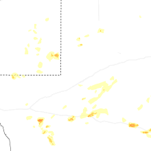
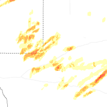
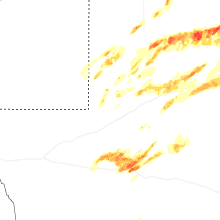
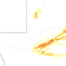
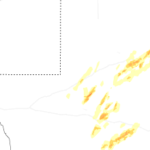


Connect with Interactive Hail Maps