

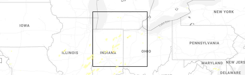
Hail Map for Jalapa, IN
The Jalapa, IN area has had 0 reports of on-the-ground hail by trained spotters, and has been under severe weather warnings 21 times during the past 12 months. Doppler radar has detected hail at or near Jalapa, IN on 45 occasions, including 3 occasions during the past year.
| Name: | Jalapa, IN |
| Where Located: | 45.8 miles SW of Fort Wayne, IN |
| Map: | Google Map for Jalapa, IN |
| Population: | 171 |
| Housing Units: | 72 |
| More Info: | Search Google for Jalapa, IN |
2
The Top Recent Hail Date for Jalapa, IN is Wednesday, June 18, 2025 (6th out of 45)
Hail and Wind Damage Spotted near Jalapa, IN
| Date / Time | Report Details |
|---|---|
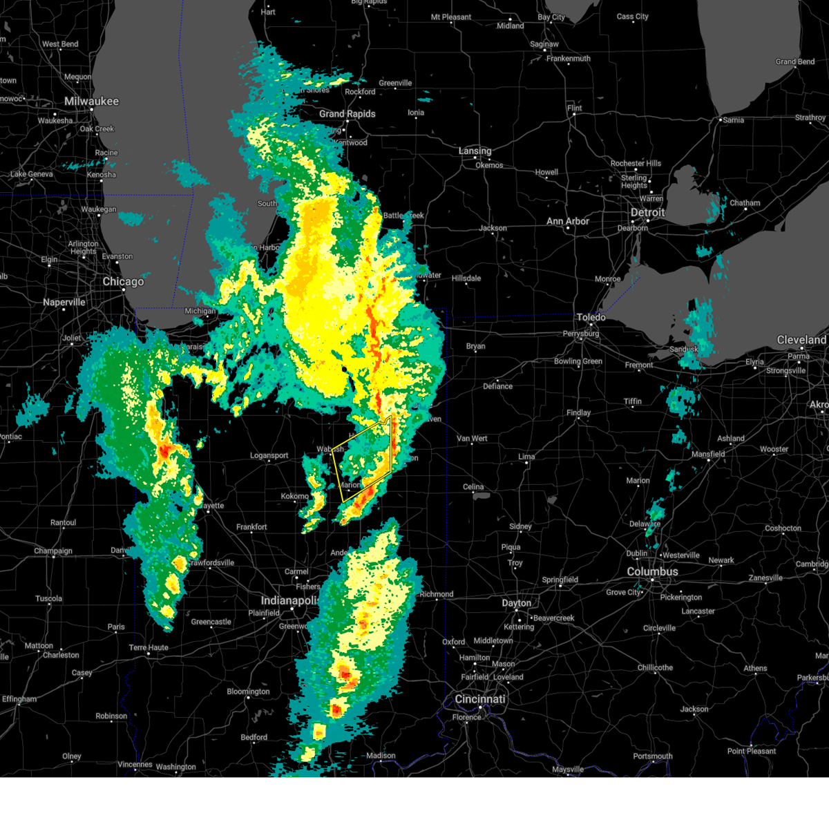
| 6/18/2025 4:55 PM EDT |
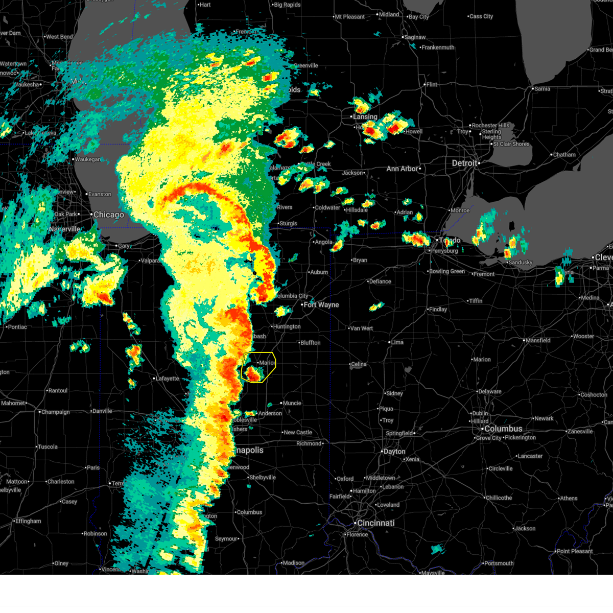 Svriwx the national weather service in northern indiana has issued a * severe thunderstorm warning for, grant county in central indiana, * until 515 pm edt. * at 455 pm edt, a severe thunderstorm was located near jonesboro, or near gas city, moving northeast at 65 mph (radar indicated). Hazards include 60 mph wind gusts and quarter size hail. Hail damage to vehicles is expected. Expect wind damage to roofs, siding, and trees. Svriwx the national weather service in northern indiana has issued a * severe thunderstorm warning for, grant county in central indiana, * until 515 pm edt. * at 455 pm edt, a severe thunderstorm was located near jonesboro, or near gas city, moving northeast at 65 mph (radar indicated). Hazards include 60 mph wind gusts and quarter size hail. Hail damage to vehicles is expected. Expect wind damage to roofs, siding, and trees.
|
| 5/16/2025 7:41 PM EDT | Svriwx the national weather service in northern indiana has issued a * severe thunderstorm warning for, grant county in central indiana, huntington county in northeastern indiana, blackford county in east central indiana, wells county in northeastern indiana, adams county in northeastern indiana, jay county in east central indiana, * until 845 pm edt. * at 741 pm edt, severe thunderstorms were located along a line extending from la fontaine to near muncie, moving northeast at 55 mph (radar indicated). Hazards include 60 mph wind gusts. expect damage to roofs, siding, and trees |
| 3/30/2025 5:41 PM EDT |
 The storms which prompted the warning have weakened below severe limits, and no longer pose an immediate threat to life or property. therefore, the warning will be allowed to expire. however, gusty winds and heavy rain are still possible with these thunderstorms. a tornado watch remains in effect until 800 pm edt for central, northeastern and east central indiana. The storms which prompted the warning have weakened below severe limits, and no longer pose an immediate threat to life or property. therefore, the warning will be allowed to expire. however, gusty winds and heavy rain are still possible with these thunderstorms. a tornado watch remains in effect until 800 pm edt for central, northeastern and east central indiana.
|
| 3/30/2025 5:26 PM EDT |
 At 526 pm edt, severe thunderstorms were located along a line extending from near van buren to near fairmount, moving east at 60 mph (radar indicated). Hazards include 60 mph wind gusts. Expect damage to roofs, siding, and trees. locations impacted include, nottingham, mcnatts, landess, wellsburg, liberty center, mill grove, herbst, buckeye, point isabel, swayzee, home corner, fowlerton, hartford city, dillman, petroleum, shamrock lakes, matthews, hanfield, sweetser, and sims. This includes interstate 69 in indiana between mile markers 252 and 272. At 526 pm edt, severe thunderstorms were located along a line extending from near van buren to near fairmount, moving east at 60 mph (radar indicated). Hazards include 60 mph wind gusts. Expect damage to roofs, siding, and trees. locations impacted include, nottingham, mcnatts, landess, wellsburg, liberty center, mill grove, herbst, buckeye, point isabel, swayzee, home corner, fowlerton, hartford city, dillman, petroleum, shamrock lakes, matthews, hanfield, sweetser, and sims. This includes interstate 69 in indiana between mile markers 252 and 272.
|
| 3/30/2025 5:21 PM EDT |
 The storms which prompted the warning have moved out of the area. therefore, the warning will be allowed to expire. however, gusty winds are still possible with these thunderstorms. a tornado watch remains in effect until 800 pm edt for central, north central and northeastern indiana. remember, a severe thunderstorm warning still remains in effect for whitley, huntington, and allen counties until 6 pm edt. The storms which prompted the warning have moved out of the area. therefore, the warning will be allowed to expire. however, gusty winds are still possible with these thunderstorms. a tornado watch remains in effect until 800 pm edt for central, north central and northeastern indiana. remember, a severe thunderstorm warning still remains in effect for whitley, huntington, and allen counties until 6 pm edt.
|
| 3/30/2025 5:12 PM EDT | the severe thunderstorm warning has been cancelled and is no longer in effect |
| 3/30/2025 5:12 PM EDT | At 511 pm edt, severe thunderstorms were located along a line extending from near middlebury to near andrews, moving east at 65 mph. damage was reported in etna green around 5 pm, including trees and powerlines down (public). Hazards include 70 mph wind gusts and nickel size hail. Expect considerable tree damage. damage is likely to mobile homes, roofs, and outbuildings. locations impacted include, mcnatts, topeka, honeyville, landess, blue lake, la fontaine, tri-lakes, buckeye, larwill, lake wawasee, bippus, luther, bowerstown, south whitley, servia, coesse, goose lake, knapp lake, jalapa, and loon lake. This includes interstate 69 in indiana between mile markers 266 and 293. |
| 3/30/2025 5:05 PM EDT |
 Svriwx the national weather service in northern indiana has issued a * severe thunderstorm warning for, southeastern elkhart county in north central indiana, wabash county in north central indiana, noble county in northeastern indiana, northern grant county in central indiana, whitley county in northeastern indiana, huntington county in northeastern indiana, eastern kosciusko county in north central indiana, southern lagrange county in northeastern indiana, steuben county in northeastern indiana, allen county in northeastern indiana, de kalb county in northeastern indiana, wells county in northeastern indiana, northern adams county in northeastern indiana, * until 600 pm edt. * at 504 pm edt, severe thunderstorms were located along a line extending from millersburg to 6 miles northwest of van buren, moving east at 115 mph (radar indicated). Hazards include 70 mph wind gusts and quarter size hail. Hail damage to vehicles is expected. expect considerable tree damage. Wind damage is also likely to mobile homes, roofs, and outbuildings. Svriwx the national weather service in northern indiana has issued a * severe thunderstorm warning for, southeastern elkhart county in north central indiana, wabash county in north central indiana, noble county in northeastern indiana, northern grant county in central indiana, whitley county in northeastern indiana, huntington county in northeastern indiana, eastern kosciusko county in north central indiana, southern lagrange county in northeastern indiana, steuben county in northeastern indiana, allen county in northeastern indiana, de kalb county in northeastern indiana, wells county in northeastern indiana, northern adams county in northeastern indiana, * until 600 pm edt. * at 504 pm edt, severe thunderstorms were located along a line extending from millersburg to 6 miles northwest of van buren, moving east at 115 mph (radar indicated). Hazards include 70 mph wind gusts and quarter size hail. Hail damage to vehicles is expected. expect considerable tree damage. Wind damage is also likely to mobile homes, roofs, and outbuildings.
|
| 3/30/2025 5:01 PM EDT |
 Svriwx the national weather service in northern indiana has issued a * severe thunderstorm warning for, grant county in central indiana, southeastern huntington county in northeastern indiana, blackford county in east central indiana, southern wells county in northeastern indiana, western jay county in east central indiana, * until 545 pm edt. * at 501 pm edt, severe thunderstorms were located along a line extending from 7 miles east of kokomo to near tipton, moving east at 60 mph (radar indicated). Hazards include 60 mph wind gusts. expect damage to roofs, siding, and trees Svriwx the national weather service in northern indiana has issued a * severe thunderstorm warning for, grant county in central indiana, southeastern huntington county in northeastern indiana, blackford county in east central indiana, southern wells county in northeastern indiana, western jay county in east central indiana, * until 545 pm edt. * at 501 pm edt, severe thunderstorms were located along a line extending from 7 miles east of kokomo to near tipton, moving east at 60 mph (radar indicated). Hazards include 60 mph wind gusts. expect damage to roofs, siding, and trees
|
| 3/30/2025 4:50 PM EDT | At 450 pm edt, severe thunderstorms were located along a line extending from near nappanee to near peru, moving northeast at 65 mph (radar indicated). Hazards include 70 mph wind gusts and nickel size hail. Expect considerable tree damage. damage is likely to mobile homes, roofs, and outbuildings. locations impacted include, mcnatts, honeyville, atwood, la fontaine, macy, tri-lakes, locke, syracuse, bippus, luther, nead, bowerstown, little chapman lake, warsaw, james lake, goose lake, knapp lake, jalapa, new paris, and loon lake. This includes interstate 69 in indiana between mile markers 266 and 293. |
| 3/30/2025 4:50 PM EDT | the severe thunderstorm warning has been cancelled and is no longer in effect |
| 3/30/2025 4:33 PM EDT |
 Svriwx the national weather service in northern indiana has issued a * severe thunderstorm warning for, southern elkhart county in north central indiana, wabash county in north central indiana, noble county in northeastern indiana, northern grant county in central indiana, whitley county in northeastern indiana, huntington county in northeastern indiana, kosciusko county in north central indiana, cass county in north central indiana, southwestern lagrange county in northeastern indiana, fulton county in north central indiana, western wells county in northeastern indiana, miami county in north central indiana, marshall county in north central indiana, * until 530 pm edt. * at 433 pm edt, severe thunderstorms were located along a line extending from plymouth to near walton, moving northeast at 65 mph (radar indicated). Hazards include 70 mph wind gusts and nickel size hail. Expect considerable tree damage. Damage is likely to mobile homes, roofs, and outbuildings. Svriwx the national weather service in northern indiana has issued a * severe thunderstorm warning for, southern elkhart county in north central indiana, wabash county in north central indiana, noble county in northeastern indiana, northern grant county in central indiana, whitley county in northeastern indiana, huntington county in northeastern indiana, kosciusko county in north central indiana, cass county in north central indiana, southwestern lagrange county in northeastern indiana, fulton county in north central indiana, western wells county in northeastern indiana, miami county in north central indiana, marshall county in north central indiana, * until 530 pm edt. * at 433 pm edt, severe thunderstorms were located along a line extending from plymouth to near walton, moving northeast at 65 mph (radar indicated). Hazards include 70 mph wind gusts and nickel size hail. Expect considerable tree damage. Damage is likely to mobile homes, roofs, and outbuildings.
|
| 3/19/2025 9:05 PM EDT |
 The storms which prompted the warning have weakened below severe limits, and have exited the warned area. therefore, the warning will be allowed to expire. a severe thunderstorm watch remains in effect until 100 am edt for central, north central and northeastern indiana. The storms which prompted the warning have weakened below severe limits, and have exited the warned area. therefore, the warning will be allowed to expire. a severe thunderstorm watch remains in effect until 100 am edt for central, north central and northeastern indiana.
|
| 3/19/2025 8:41 PM EDT |
 Svriwx the national weather service in northern indiana has issued a * severe thunderstorm warning for, southwestern allen county in northeastern indiana, southeastern wabash county in north central indiana, northeastern grant county in central indiana, huntington county in northeastern indiana, western wells county in northeastern indiana, * until 915 pm edt. * at 841 pm edt, severe thunderstorms were located along a line extending from near andrews to 6 miles south of huntington to near jonesboro, moving northeast at 60 mph (radar indicated). Hazards include 60 mph wind gusts and penny size hail. expect damage to roofs, siding, and trees Svriwx the national weather service in northern indiana has issued a * severe thunderstorm warning for, southwestern allen county in northeastern indiana, southeastern wabash county in north central indiana, northeastern grant county in central indiana, huntington county in northeastern indiana, western wells county in northeastern indiana, * until 915 pm edt. * at 841 pm edt, severe thunderstorms were located along a line extending from near andrews to 6 miles south of huntington to near jonesboro, moving northeast at 60 mph (radar indicated). Hazards include 60 mph wind gusts and penny size hail. expect damage to roofs, siding, and trees
|
| 3/15/2025 4:11 AM EDT | The storms which prompted the warning have weakened below severe limits, and no longer pose an immediate threat to life or property. therefore, the warning will be allowed to expire. however, gusty winds are still possible with these thunderstorms. a severe thunderstorm watch remains in effect until 900 am edt for central, north central and northeastern indiana. to report severe weather, contact your nearest law enforcement agency. they will relay your report to the national weather service northern indiana. |
| 3/15/2025 4:00 AM EDT | At 400 am edt, severe thunderstorms were located along a line extending from 6 miles east of akron to wabash to 8 miles northeast of kokomo, moving northeast at 55 mph (radar indicated). Hazards include 60 mph wind gusts. Expect damage to roofs, siding, and trees. Locations impacted include, richvalley, gas city, wabash, amboy, collamer, liberty mills, north manchester, la fontaine, mier, herbst, wawpecong, roann, point isabel, jonesboro, banquo, peoria, roseburg, bippus, swayzee, and luther. |
| 3/15/2025 3:48 AM EDT |
 Svriwx the national weather service in northern indiana has issued a * severe thunderstorm warning for, wabash county in north central indiana, grant county in central indiana, southwestern whitley county in northeastern indiana, western huntington county in northeastern indiana, southeastern kosciusko county in north central indiana, miami county in north central indiana, * until 415 am edt. * at 348 am edt, severe thunderstorms were located along a line extending from 8 miles south of akron to near peru to near kokomo, moving northeast at 60 mph (radar indicated). Hazards include 60 mph wind gusts. expect damage to roofs, siding, and trees Svriwx the national weather service in northern indiana has issued a * severe thunderstorm warning for, wabash county in north central indiana, grant county in central indiana, southwestern whitley county in northeastern indiana, western huntington county in northeastern indiana, southeastern kosciusko county in north central indiana, miami county in north central indiana, * until 415 am edt. * at 348 am edt, severe thunderstorms were located along a line extending from 8 miles south of akron to near peru to near kokomo, moving northeast at 60 mph (radar indicated). Hazards include 60 mph wind gusts. expect damage to roofs, siding, and trees
|
| 7/16/2024 12:52 AM EDT |
 The storms which prompted the warning have moved out of the area. therefore, the warning will be allowed to expire. however, gusty winds are still possible with these thunderstorms. a tornado watch remains in effect until 200 am edt for north central and northeastern indiana. a severe thunderstorm watch remains in effect until 500 am edt for central indiana. The storms which prompted the warning have moved out of the area. therefore, the warning will be allowed to expire. however, gusty winds are still possible with these thunderstorms. a tornado watch remains in effect until 200 am edt for north central and northeastern indiana. a severe thunderstorm watch remains in effect until 500 am edt for central indiana.
|
| 7/16/2024 12:50 AM EDT |
 Svriwx the national weather service in northern indiana has issued a * severe thunderstorm warning for, southeastern wabash county in north central indiana, northeastern grant county in central indiana, huntington county in northeastern indiana, wells county in northeastern indiana, adams county in northeastern indiana, * until 130 am edt. * at 1250 am edt, severe thunderstorms were located along a line extending from near huntington to near van buren, moving east at 70 mph (radar indicated). Hazards include 60 mph wind gusts. expect damage to roofs, siding, and trees Svriwx the national weather service in northern indiana has issued a * severe thunderstorm warning for, southeastern wabash county in north central indiana, northeastern grant county in central indiana, huntington county in northeastern indiana, wells county in northeastern indiana, adams county in northeastern indiana, * until 130 am edt. * at 1250 am edt, severe thunderstorms were located along a line extending from near huntington to near van buren, moving east at 70 mph (radar indicated). Hazards include 60 mph wind gusts. expect damage to roofs, siding, and trees
|
| 7/16/2024 12:39 AM EDT |
 At 1239 am edt, severe thunderstorms were located along a line extending from near wabash to 6 miles northeast of kokomo, moving east at 60 mph (radar indicated). Hazards include 60 mph wind gusts. Expect damage to roofs, siding, and trees. Locations impacted include, marion, peru, wabash, grissom afb, sweetser, swayzee, bunker hill, la fontaine, lincoln, wells, sims, galveston, miami, converse, erie, lagro, amboy, richvalley, bennetts switch, and mier. At 1239 am edt, severe thunderstorms were located along a line extending from near wabash to 6 miles northeast of kokomo, moving east at 60 mph (radar indicated). Hazards include 60 mph wind gusts. Expect damage to roofs, siding, and trees. Locations impacted include, marion, peru, wabash, grissom afb, sweetser, swayzee, bunker hill, la fontaine, lincoln, wells, sims, galveston, miami, converse, erie, lagro, amboy, richvalley, bennetts switch, and mier.
|
| 7/16/2024 12:10 AM EDT |
 Svriwx the national weather service in northern indiana has issued a * severe thunderstorm warning for, southern wabash county in north central indiana, western grant county in central indiana, cass county in north central indiana, miami county in north central indiana, * until 100 am edt. * at 1210 am edt, severe thunderstorms were located along a line extending from 6 miles east of royal center to 7 miles southeast of delphi, moving east at 55 mph (radar indicated). Hazards include 70 mph wind gusts. Expect considerable tree damage. Damage is likely to mobile homes, roofs, and outbuildings. Svriwx the national weather service in northern indiana has issued a * severe thunderstorm warning for, southern wabash county in north central indiana, western grant county in central indiana, cass county in north central indiana, miami county in north central indiana, * until 100 am edt. * at 1210 am edt, severe thunderstorms were located along a line extending from 6 miles east of royal center to 7 miles southeast of delphi, moving east at 55 mph (radar indicated). Hazards include 70 mph wind gusts. Expect considerable tree damage. Damage is likely to mobile homes, roofs, and outbuildings.
|
| 3/14/2024 6:49 PM EDT |
 Svriwx the national weather service in northern indiana has issued a * severe thunderstorm warning for, central grant county in central indiana, * until 715 pm edt. * at 648 pm edt, a severe thunderstorm was located near swayzee, or 11 miles southwest of marion, moving northeast at 50 mph (radar indicated). Hazards include golf ball size hail and 60 mph wind gusts. People and animals outdoors will be injured. expect hail damage to roofs, siding, windows, and vehicles. Expect wind damage to roofs, siding, and trees. Svriwx the national weather service in northern indiana has issued a * severe thunderstorm warning for, central grant county in central indiana, * until 715 pm edt. * at 648 pm edt, a severe thunderstorm was located near swayzee, or 11 miles southwest of marion, moving northeast at 50 mph (radar indicated). Hazards include golf ball size hail and 60 mph wind gusts. People and animals outdoors will be injured. expect hail damage to roofs, siding, windows, and vehicles. Expect wind damage to roofs, siding, and trees.
|
| 3/14/2024 6:07 PM EDT |
 Svriwx the national weather service in northern indiana has issued a * severe thunderstorm warning for, southeastern wabash county in north central indiana, northern grant county in central indiana, southwestern huntington county in northeastern indiana, * until 630 pm edt. * at 607 pm edt, a severe thunderstorm was located over la fontaine, or 7 miles north of marion, moving east at 50 mph (radar indicated). Hazards include 60 mph wind gusts and quarter size hail. Hail damage to vehicles is expected. Expect wind damage to roofs, siding, and trees. Svriwx the national weather service in northern indiana has issued a * severe thunderstorm warning for, southeastern wabash county in north central indiana, northern grant county in central indiana, southwestern huntington county in northeastern indiana, * until 630 pm edt. * at 607 pm edt, a severe thunderstorm was located over la fontaine, or 7 miles north of marion, moving east at 50 mph (radar indicated). Hazards include 60 mph wind gusts and quarter size hail. Hail damage to vehicles is expected. Expect wind damage to roofs, siding, and trees.
|
| 3/14/2024 5:57 PM EDT |
 The tornadic thunderstorm which prompted the warning has moved out of the warned area. therefore, the warning will be allowed to expire. a tornado watch remains in effect until midnight edt for central and north central indiana. The tornadic thunderstorm which prompted the warning has moved out of the warned area. therefore, the warning will be allowed to expire. a tornado watch remains in effect until midnight edt for central and north central indiana.
|
| 3/14/2024 5:42 PM EDT |
 the severe thunderstorm warning has been cancelled and is no longer in effect the severe thunderstorm warning has been cancelled and is no longer in effect
|
| 3/14/2024 5:42 PM EDT |
 At 541 pm edt, a severe thunderstorm was located near la fontaine, or 9 miles south of wabash, moving east at 50 mph (radar indicated). Hazards include ping pong ball size hail and 60 mph wind gusts. People and animals outdoors will be injured. expect hail damage to roofs, siding, windows, and vehicles. expect wind damage to roofs, siding, and trees. Locations impacted include, marion, sweetser, la fontaine, converse, treaty, lincolnville, mier, jalapa, and somerset. At 541 pm edt, a severe thunderstorm was located near la fontaine, or 9 miles south of wabash, moving east at 50 mph (radar indicated). Hazards include ping pong ball size hail and 60 mph wind gusts. People and animals outdoors will be injured. expect hail damage to roofs, siding, windows, and vehicles. expect wind damage to roofs, siding, and trees. Locations impacted include, marion, sweetser, la fontaine, converse, treaty, lincolnville, mier, jalapa, and somerset.
|
| 3/14/2024 5:35 PM EDT |
 Toriwx the national weather service in northern indiana has issued a * tornado warning for, southeastern wabash county in north central indiana, northwestern grant county in central indiana, * until 600 pm edt. * at 535 pm edt, a severe thunderstorm capable of producing a tornado was located over sweetser, or near marion, moving east at 40 mph (radar indicated rotation). Hazards include tornado and quarter size hail. Flying debris will be dangerous to those caught without shelter. mobile homes will be damaged or destroyed. damage to roofs, windows, and vehicles will occur. tree damage is likely. this dangerous storm will be near, marion and sweetser around 540 pm edt. Other locations impacted by this tornadic thunderstorm include hanfield, mier, jalapa, and converse. Toriwx the national weather service in northern indiana has issued a * tornado warning for, southeastern wabash county in north central indiana, northwestern grant county in central indiana, * until 600 pm edt. * at 535 pm edt, a severe thunderstorm capable of producing a tornado was located over sweetser, or near marion, moving east at 40 mph (radar indicated rotation). Hazards include tornado and quarter size hail. Flying debris will be dangerous to those caught without shelter. mobile homes will be damaged or destroyed. damage to roofs, windows, and vehicles will occur. tree damage is likely. this dangerous storm will be near, marion and sweetser around 540 pm edt. Other locations impacted by this tornadic thunderstorm include hanfield, mier, jalapa, and converse.
|
| 3/14/2024 5:31 PM EDT |
 Svriwx the national weather service in northern indiana has issued a * severe thunderstorm warning for, southern wabash county in north central indiana, northwestern grant county in central indiana, southeastern miami county in north central indiana, * until 600 pm edt. * at 531 pm edt, a severe thunderstorm was located 7 miles east of bunker hill, or 9 miles southeast of peru, moving east at 50 mph (radar indicated). Hazards include 60 mph wind gusts and quarter size hail. Hail damage to vehicles is expected. Expect wind damage to roofs, siding, and trees. Svriwx the national weather service in northern indiana has issued a * severe thunderstorm warning for, southern wabash county in north central indiana, northwestern grant county in central indiana, southeastern miami county in north central indiana, * until 600 pm edt. * at 531 pm edt, a severe thunderstorm was located 7 miles east of bunker hill, or 9 miles southeast of peru, moving east at 50 mph (radar indicated). Hazards include 60 mph wind gusts and quarter size hail. Hail damage to vehicles is expected. Expect wind damage to roofs, siding, and trees.
|
| 3/14/2024 5:21 PM EDT |
 Svriwx the national weather service in northern indiana has issued a * severe thunderstorm warning for, southeastern wabash county in north central indiana, northern grant county in central indiana, southern huntington county in northeastern indiana, wells county in northeastern indiana, * until 545 pm edt. * at 519 pm edt, a severe thunderstorm was located near la fontaine, or 8 miles north of marion, moving east at 65 mph (radar indicated). Hazards include 60 mph wind gusts and quarter size hail. Hail damage to vehicles is expected. Expect wind damage to roofs, siding, and trees. Svriwx the national weather service in northern indiana has issued a * severe thunderstorm warning for, southeastern wabash county in north central indiana, northern grant county in central indiana, southern huntington county in northeastern indiana, wells county in northeastern indiana, * until 545 pm edt. * at 519 pm edt, a severe thunderstorm was located near la fontaine, or 8 miles north of marion, moving east at 65 mph (radar indicated). Hazards include 60 mph wind gusts and quarter size hail. Hail damage to vehicles is expected. Expect wind damage to roofs, siding, and trees.
|
| 8/17/2023 6:26 PM EDT |
 At 626 pm edt, severe thunderstorms were located along a line extending from near van buren to near la fontaine, moving southeast at 25 mph (radar indicated). Hazards include 60 mph wind gusts and quarter size hail. Hail damage to vehicles is expected. Expect wind damage to roofs, siding, and trees. At 626 pm edt, severe thunderstorms were located along a line extending from near van buren to near la fontaine, moving southeast at 25 mph (radar indicated). Hazards include 60 mph wind gusts and quarter size hail. Hail damage to vehicles is expected. Expect wind damage to roofs, siding, and trees.
|
| 8/5/2023 8:51 PM EDT |
 The severe thunderstorm warning for central grant county will expire at 900 pm edt, the storm which prompted the warning has weakened below severe limits, and no longer poses an immediate threat to life or property. therefore, the warning will be allowed to expire. however, heavy rain is still possible with this thunderstorm. The severe thunderstorm warning for central grant county will expire at 900 pm edt, the storm which prompted the warning has weakened below severe limits, and no longer poses an immediate threat to life or property. therefore, the warning will be allowed to expire. however, heavy rain is still possible with this thunderstorm.
|
| 8/5/2023 8:42 PM EDT |
 At 841 pm edt, a severe thunderstorm was located over marion, moving north at 30 mph (radar indicated). Hazards include 60 mph wind gusts. Expect damage to roofs, siding, and trees. locations impacted include, marion, gas city, fairmount, jonesboro, sweetser, van buren, hanfield, home corner, landess, michaelsville, roseburg, and lake wood. This includes interstate 69 in indiana between mile markers 262 and 271. At 841 pm edt, a severe thunderstorm was located over marion, moving north at 30 mph (radar indicated). Hazards include 60 mph wind gusts. Expect damage to roofs, siding, and trees. locations impacted include, marion, gas city, fairmount, jonesboro, sweetser, van buren, hanfield, home corner, landess, michaelsville, roseburg, and lake wood. This includes interstate 69 in indiana between mile markers 262 and 271.
|
| 8/5/2023 8:30 PM EDT |
 At 829 pm edt, a severe thunderstorm was located over jonesboro, or near gas city, moving north at 30 mph (radar indicated). Hazards include 60 mph wind gusts. expect damage to roofs, siding, and trees At 829 pm edt, a severe thunderstorm was located over jonesboro, or near gas city, moving north at 30 mph (radar indicated). Hazards include 60 mph wind gusts. expect damage to roofs, siding, and trees
|
| 8/5/2023 8:21 PM EDT |
 The severe thunderstorm warning for southeastern wabash, central grant and southwestern huntington counties will expire at 830 pm edt, the storm which prompted the warning has weakened below severe limits, and no longer poses an immediate threat to life or property. therefore, the warning will be allowed to expire. however, heavy rain is still possible with this thunderstorm. The severe thunderstorm warning for southeastern wabash, central grant and southwestern huntington counties will expire at 830 pm edt, the storm which prompted the warning has weakened below severe limits, and no longer poses an immediate threat to life or property. therefore, the warning will be allowed to expire. however, heavy rain is still possible with this thunderstorm.
|
| 8/5/2023 8:20 PM EDT |
 At 820 pm edt, a severe thunderstorm was located over la fontaine, or near marion, moving north at 35 mph (radar indicated). Hazards include 60 mph wind gusts. Expect damage to roofs, siding, and trees. locations impacted include, marion, gas city, sweetser, swayzee, la fontaine, home corner, landess, michaelsville, normal, jalapa, herbst, hanfield, hackleman, banquo, radley, and roseburg. This includes interstate 69 in indiana between mile markers 267 and 272. At 820 pm edt, a severe thunderstorm was located over la fontaine, or near marion, moving north at 35 mph (radar indicated). Hazards include 60 mph wind gusts. Expect damage to roofs, siding, and trees. locations impacted include, marion, gas city, sweetser, swayzee, la fontaine, home corner, landess, michaelsville, normal, jalapa, herbst, hanfield, hackleman, banquo, radley, and roseburg. This includes interstate 69 in indiana between mile markers 267 and 272.
|
| 8/5/2023 8:02 PM EDT |
 At 802 pm edt, a severe thunderstorm was located near swayzee, or near marion, moving north at 35 mph (radar indicated). Hazards include 60 mph wind gusts. expect damage to roofs, siding, and trees At 802 pm edt, a severe thunderstorm was located near swayzee, or near marion, moving north at 35 mph (radar indicated). Hazards include 60 mph wind gusts. expect damage to roofs, siding, and trees
|
| 7/29/2023 2:49 AM EDT |
 At 248 am edt, severe thunderstorms were located along a line extending from near huntington to near windfall, moving east at 55 mph (radar indicated). Hazards include 60 mph wind gusts. Expect damage to roofs, siding, and trees. locations impacted include, marion, hartford city, gas city, upland, fairmount, montpelier, jonesboro, sweetser, swayzee, la fontaine, van buren, matthews, warren, fowlerton, shamrock lakes, poneto, mcnatts, landess, wellsburg, and liberty center. this includes interstate 69 in indiana between mile markers 252 and 278. hail threat, radar indicated max hail size, <. 75 in wind threat, radar indicated max wind gust, 60 mph. At 248 am edt, severe thunderstorms were located along a line extending from near huntington to near windfall, moving east at 55 mph (radar indicated). Hazards include 60 mph wind gusts. Expect damage to roofs, siding, and trees. locations impacted include, marion, hartford city, gas city, upland, fairmount, montpelier, jonesboro, sweetser, swayzee, la fontaine, van buren, matthews, warren, fowlerton, shamrock lakes, poneto, mcnatts, landess, wellsburg, and liberty center. this includes interstate 69 in indiana between mile markers 252 and 278. hail threat, radar indicated max hail size, <. 75 in wind threat, radar indicated max wind gust, 60 mph.
|
| 7/29/2023 2:27 AM EDT |
 At 226 am edt, severe thunderstorms were located along a line extending from near wabash to 11 miles southwest of kokomo, moving east at 55 mph (radar indicated). Hazards include 60 mph wind gusts. expect damage to roofs, siding, and trees At 226 am edt, severe thunderstorms were located along a line extending from near wabash to 11 miles southwest of kokomo, moving east at 55 mph (radar indicated). Hazards include 60 mph wind gusts. expect damage to roofs, siding, and trees
|
| 7/23/2022 9:04 AM EDT |
 At 904 am edt, severe thunderstorms were located along a line extending from near andrews to near la fontaine to near kokomo, moving south at 40 mph (radar indicated). Hazards include 70 mph wind gusts. Expect considerable tree damage. Damage is likely to mobile homes, roofs, and outbuildings. At 904 am edt, severe thunderstorms were located along a line extending from near andrews to near la fontaine to near kokomo, moving south at 40 mph (radar indicated). Hazards include 70 mph wind gusts. Expect considerable tree damage. Damage is likely to mobile homes, roofs, and outbuildings.
|
| 3/6/2022 3:28 AM EST |
 The severe thunderstorm warning for western allen, southeastern wabash, southeastern noble, northern grant, whitley, huntington and wells counties will expire at 330 am est, the storms which prompted the warning have moved out of the area. therefore, the warning will be allowed to expire. however gusty winds up to around 45 mph are still possible. a severe thunderstorm watch remains in effect until 500 am est for central, north central and northeastern indiana. there are other warnings still in effect. visit our website for more information. The severe thunderstorm warning for western allen, southeastern wabash, southeastern noble, northern grant, whitley, huntington and wells counties will expire at 330 am est, the storms which prompted the warning have moved out of the area. therefore, the warning will be allowed to expire. however gusty winds up to around 45 mph are still possible. a severe thunderstorm watch remains in effect until 500 am est for central, north central and northeastern indiana. there are other warnings still in effect. visit our website for more information.
|
| 3/6/2022 3:13 AM EST |
 At 312 am est, severe thunderstorms were located along a line extending from huntertown to near markle to van buren, moving east at 65 mph (radar indicated). Hazards include 60 mph wind gusts. Expect damage to roofs, siding, and trees. locations impacted include, fort wayne, marion, huntington, new haven, bluffton, columbia city, ossian, tri-lakes, huntertown, avilla, churubusco, south whitley, sweetser, andrews, markle, la fontaine, van buren, aboite, leo-cedarville and swan. this includes the following highways, interstate 469 between mile markers 0 and 15, and between mile markers 25 and 30. Interstate 69 in indiana between mile markers 266 and 322. At 312 am est, severe thunderstorms were located along a line extending from huntertown to near markle to van buren, moving east at 65 mph (radar indicated). Hazards include 60 mph wind gusts. Expect damage to roofs, siding, and trees. locations impacted include, fort wayne, marion, huntington, new haven, bluffton, columbia city, ossian, tri-lakes, huntertown, avilla, churubusco, south whitley, sweetser, andrews, markle, la fontaine, van buren, aboite, leo-cedarville and swan. this includes the following highways, interstate 469 between mile markers 0 and 15, and between mile markers 25 and 30. Interstate 69 in indiana between mile markers 266 and 322.
|
| 3/6/2022 3:07 AM EST |
 At 307 am est, severe thunderstorms were located along a line extending from near churubusco to near markle to near van buren, moving east at 65 mph (radar indicated). Hazards include 60 mph wind gusts. Expect damage to roofs, siding, and trees. locations impacted include, fort wayne, marion, huntington, new haven, bluffton, columbia city, ossian, tri-lakes, huntertown, avilla, churubusco, south whitley, sweetser, andrews, markle, la fontaine, van buren, aboite, leo-cedarville and swan. this includes the following highways, interstate 469 between mile markers 0 and 15, and between mile markers 25 and 30. interstate 69 in indiana between mile markers 266 and 322. hail threat, radar indicated max hail size, <. 75 in wind threat, observed max wind gust, 60 mph. At 307 am est, severe thunderstorms were located along a line extending from near churubusco to near markle to near van buren, moving east at 65 mph (radar indicated). Hazards include 60 mph wind gusts. Expect damage to roofs, siding, and trees. locations impacted include, fort wayne, marion, huntington, new haven, bluffton, columbia city, ossian, tri-lakes, huntertown, avilla, churubusco, south whitley, sweetser, andrews, markle, la fontaine, van buren, aboite, leo-cedarville and swan. this includes the following highways, interstate 469 between mile markers 0 and 15, and between mile markers 25 and 30. interstate 69 in indiana between mile markers 266 and 322. hail threat, radar indicated max hail size, <. 75 in wind threat, observed max wind gust, 60 mph.
|
| 3/6/2022 2:43 AM EST |
 At 243 am est, severe thunderstorms were located along a line extending from near winona lake to 6 miles northwest of wabash to 6 miles northeast of kokomo, moving east at 65 mph (radar indicated). Hazards include 60 mph wind gusts. expect damage to roofs, siding, and trees At 243 am est, severe thunderstorms were located along a line extending from near winona lake to 6 miles northwest of wabash to 6 miles northeast of kokomo, moving east at 65 mph (radar indicated). Hazards include 60 mph wind gusts. expect damage to roofs, siding, and trees
|
| 9/14/2021 9:09 PM EDT |
 At 909 pm edt, a severe thunderstorm was located near van buren, or near upland, moving east at 30 mph (radar indicated). Hazards include 60 mph wind gusts and penny size hail. Expect damage to roofs, siding, and trees. locations impacted include, marion, hartford city, gas city, upland, montpelier, jonesboro, sweetser, swayzee, van buren, sims, converse, poneto, mcnatts, landess, mount zion, mier, herbst, keystone, roseburg and home corner. this includes interstate 69 in indiana between mile markers 257 and 270. hail threat, radar indicated max hail size, 0. 75 in wind threat, radar indicated max wind gust, 60 mph. At 909 pm edt, a severe thunderstorm was located near van buren, or near upland, moving east at 30 mph (radar indicated). Hazards include 60 mph wind gusts and penny size hail. Expect damage to roofs, siding, and trees. locations impacted include, marion, hartford city, gas city, upland, montpelier, jonesboro, sweetser, swayzee, van buren, sims, converse, poneto, mcnatts, landess, mount zion, mier, herbst, keystone, roseburg and home corner. this includes interstate 69 in indiana between mile markers 257 and 270. hail threat, radar indicated max hail size, 0. 75 in wind threat, radar indicated max wind gust, 60 mph.
|
| 9/14/2021 8:46 PM EDT |
 At 846 pm edt, a severe thunderstorm was located over marion, moving east at 30 mph (law enforcement). Hazards include 60 mph wind gusts and penny size hail. expect damage to roofs, siding, and trees At 846 pm edt, a severe thunderstorm was located over marion, moving east at 30 mph (law enforcement). Hazards include 60 mph wind gusts and penny size hail. expect damage to roofs, siding, and trees
|
| 8/11/2021 2:05 PM EDT |
 At 204 pm edt, severe thunderstorms were located along a line extending from 9 miles southwest of bluffton to near van buren to windfall city, moving southeast at 40 mph (radar indicated). Hazards include 60 mph wind gusts and penny size hail. expect damage to roofs, siding, and trees At 204 pm edt, severe thunderstorms were located along a line extending from 9 miles southwest of bluffton to near van buren to windfall city, moving southeast at 40 mph (radar indicated). Hazards include 60 mph wind gusts and penny size hail. expect damage to roofs, siding, and trees
|
| 6/18/2021 3:28 PM EDT |
 At 327 pm edt, a severe thunderstorm was located near la fontaine, or near marion, moving east at 25 mph (radar indicated). Hazards include 70 mph wind gusts and half dollar size hail. Hail damage to vehicles is expected. expect considerable tree damage. Wind damage is also likely to mobile homes, roofs, and outbuildings. At 327 pm edt, a severe thunderstorm was located near la fontaine, or near marion, moving east at 25 mph (radar indicated). Hazards include 70 mph wind gusts and half dollar size hail. Hail damage to vehicles is expected. expect considerable tree damage. Wind damage is also likely to mobile homes, roofs, and outbuildings.
|
| 6/18/2021 3:18 PM EDT |
 At 313 pm edt, a severe thunderstorm was located over la fontaine, or 9 miles northwest of marion, moving southeast at 25 mph (radar indicated). Hazards include 70 mph wind gusts and half dollar size hail. Hail damage to vehicles is expected. expect considerable tree damage. wind damage is also likely to mobile homes, roofs, and outbuildings. This severe thunderstorm will remain over mainly rural areas of southern wabash, northeastern grant and southwestern huntington counties, including the following locations, hanfield, treaty, majenica, landess, banquo, lancaster, mount etna, lincolnville, lake wood and jalapa. At 313 pm edt, a severe thunderstorm was located over la fontaine, or 9 miles northwest of marion, moving southeast at 25 mph (radar indicated). Hazards include 70 mph wind gusts and half dollar size hail. Hail damage to vehicles is expected. expect considerable tree damage. wind damage is also likely to mobile homes, roofs, and outbuildings. This severe thunderstorm will remain over mainly rural areas of southern wabash, northeastern grant and southwestern huntington counties, including the following locations, hanfield, treaty, majenica, landess, banquo, lancaster, mount etna, lincolnville, lake wood and jalapa.
|
| 6/18/2021 2:52 PM EDT |
 At 252 pm edt, a severe thunderstorm was located near wabash, moving east at 30 mph (radar indicated). Hazards include 70 mph wind gusts and half dollar size hail. Hail damage to vehicles is expected. expect considerable tree damage. Wind damage is also likely to mobile homes, roofs, and outbuildings. At 252 pm edt, a severe thunderstorm was located near wabash, moving east at 30 mph (radar indicated). Hazards include 70 mph wind gusts and half dollar size hail. Hail damage to vehicles is expected. expect considerable tree damage. Wind damage is also likely to mobile homes, roofs, and outbuildings.
|
| 7/19/2020 2:22 PM EDT |
 At 222 pm edt, severe thunderstorms were located along a line extending from near south whitley to 8 miles south of huntington to 6 miles southwest of fairmount, moving east at 60 mph (radar indicated). Hazards include 60 mph wind gusts. Expect damage to roofs, siding, and trees. Locations impacted include, fort wayne, marion, huntington, new haven, bluffton, hartford city, north manchester, gas city, berne, upland, ossian, fairmount, dunkirk, montpelier, jonesboro, redkey, geneva, sweetser, andrews and markle. At 222 pm edt, severe thunderstorms were located along a line extending from near south whitley to 8 miles south of huntington to 6 miles southwest of fairmount, moving east at 60 mph (radar indicated). Hazards include 60 mph wind gusts. Expect damage to roofs, siding, and trees. Locations impacted include, fort wayne, marion, huntington, new haven, bluffton, hartford city, north manchester, gas city, berne, upland, ossian, fairmount, dunkirk, montpelier, jonesboro, redkey, geneva, sweetser, andrews and markle.
|
| 7/19/2020 2:12 PM EDT |
 At 212 pm edt, severe thunderstorms were located along a line extending from north manchester to 6 miles north of la fontaine to near windfall city, moving east at 60 mph (radar indicated). Hazards include 60 mph wind gusts. Expect damage to roofs, siding, and trees. Locations impacted include, fort wayne, marion, huntington, new haven, wabash, bluffton, hartford city, north manchester, gas city, berne, upland, ossian, fairmount, dunkirk, montpelier, jonesboro, redkey, geneva, sweetser and andrews. At 212 pm edt, severe thunderstorms were located along a line extending from north manchester to 6 miles north of la fontaine to near windfall city, moving east at 60 mph (radar indicated). Hazards include 60 mph wind gusts. Expect damage to roofs, siding, and trees. Locations impacted include, fort wayne, marion, huntington, new haven, wabash, bluffton, hartford city, north manchester, gas city, berne, upland, ossian, fairmount, dunkirk, montpelier, jonesboro, redkey, geneva, sweetser and andrews.
|
| 7/19/2020 1:58 PM EDT |
 At 158 pm edt, severe thunderstorms were located along a line extending from near akron to near wabash to 6 miles west of windfall city, moving east at 60 mph (radar indicated). Hazards include 60 mph wind gusts. expect damage to roofs, siding, and trees At 158 pm edt, severe thunderstorms were located along a line extending from near akron to near wabash to 6 miles west of windfall city, moving east at 60 mph (radar indicated). Hazards include 60 mph wind gusts. expect damage to roofs, siding, and trees
|
| 6/10/2020 2:13 PM EDT |
 At 213 pm edt, a severe thunderstorm was located near andrews, or 7 miles west of huntington, moving northeast at 70 mph (radar indicated). Hazards include golf ball size hail and 70 mph wind gusts. People and animals outdoors will be injured. expect hail damage to roofs, siding, windows, and vehicles. expect considerable tree damage. Wind damage is also likely to mobile homes, roofs, and outbuildings. At 213 pm edt, a severe thunderstorm was located near andrews, or 7 miles west of huntington, moving northeast at 70 mph (radar indicated). Hazards include golf ball size hail and 70 mph wind gusts. People and animals outdoors will be injured. expect hail damage to roofs, siding, windows, and vehicles. expect considerable tree damage. Wind damage is also likely to mobile homes, roofs, and outbuildings.
|
| 6/10/2020 1:55 PM EDT |
 At 154 pm edt, a severe thunderstorm was located 7 miles northwest of sweetser, or 10 miles south of wabash, moving northeast at 70 mph. golf ball size hail was reported with this storm near the miami and howard county line (trained weather spotters). Hazards include golf ball size hail and 70 mph wind gusts. People and animals outdoors will be injured. expect hail damage to roofs, siding, windows, and vehicles. expect considerable tree damage. wind damage is also likely to mobile homes, roofs, and outbuildings. Locations impacted include, marion, huntington, wabash, north manchester, gas city, sweetser, andrews, swayzee, la fontaine, sims, converse, lagro, amboy, mount etna, mier, herbst, point isabel, banquo, roseburg and bippus. At 154 pm edt, a severe thunderstorm was located 7 miles northwest of sweetser, or 10 miles south of wabash, moving northeast at 70 mph. golf ball size hail was reported with this storm near the miami and howard county line (trained weather spotters). Hazards include golf ball size hail and 70 mph wind gusts. People and animals outdoors will be injured. expect hail damage to roofs, siding, windows, and vehicles. expect considerable tree damage. wind damage is also likely to mobile homes, roofs, and outbuildings. Locations impacted include, marion, huntington, wabash, north manchester, gas city, sweetser, andrews, swayzee, la fontaine, sims, converse, lagro, amboy, mount etna, mier, herbst, point isabel, banquo, roseburg and bippus.
|
| 6/10/2020 1:47 PM EDT |
 At 146 pm edt, a severe thunderstorm was located near swayzee, or 12 miles northeast of kokomo, moving northeast at 75 mph (radar indicated). Hazards include 70 mph wind gusts and ping pong ball size hail. People and animals outdoors will be injured. expect hail damage to roofs, siding, windows, and vehicles. expect considerable tree damage. Wind damage is also likely to mobile homes, roofs, and outbuildings. At 146 pm edt, a severe thunderstorm was located near swayzee, or 12 miles northeast of kokomo, moving northeast at 75 mph (radar indicated). Hazards include 70 mph wind gusts and ping pong ball size hail. People and animals outdoors will be injured. expect hail damage to roofs, siding, windows, and vehicles. expect considerable tree damage. Wind damage is also likely to mobile homes, roofs, and outbuildings.
|
| 6/9/2020 6:29 PM EDT |
 At 627 pm edt, severe thunderstorms were located along a line extending from near wabash to near la fontaine to near sweetser, moving northeast at 40 mph (radar indicated). Hazards include 60 mph wind gusts. Expect damage to roofs, siding, and trees. severe thunderstorms will be near, wabash around 635 pm edt. north manchester and andrews around 655 pm edt. huntington and south whitley around 705 pm edt. Other locations impacted by these severe thunderstorms include laud, liberty mills, collamer, roanoke, banquo, bippus, luther, somerset, ijamsville and bowerstown. At 627 pm edt, severe thunderstorms were located along a line extending from near wabash to near la fontaine to near sweetser, moving northeast at 40 mph (radar indicated). Hazards include 60 mph wind gusts. Expect damage to roofs, siding, and trees. severe thunderstorms will be near, wabash around 635 pm edt. north manchester and andrews around 655 pm edt. huntington and south whitley around 705 pm edt. Other locations impacted by these severe thunderstorms include laud, liberty mills, collamer, roanoke, banquo, bippus, luther, somerset, ijamsville and bowerstown.
|
| 6/1/2019 10:51 PM EDT |
 The severe thunderstorm warning for southeastern wabash, northern grant, southern huntington and southwestern wells counties will expire at 1100 pm edt, the storm which prompted the warning has weakened below severe limits, and no longer poses an immediate threat to life or property. therefore, the warning will be allowed to expire. however, gusty winds to 50 mph and dime sized hail are possible through 1130 pm edt. The severe thunderstorm warning for southeastern wabash, northern grant, southern huntington and southwestern wells counties will expire at 1100 pm edt, the storm which prompted the warning has weakened below severe limits, and no longer poses an immediate threat to life or property. therefore, the warning will be allowed to expire. however, gusty winds to 50 mph and dime sized hail are possible through 1130 pm edt.
|
| 6/1/2019 10:40 PM EDT |
 At 1040 pm edt, a severe thunderstorm was located near la fontaine, or 8 miles south of wabash, moving southeast at 25 mph (radar indicated). Hazards include half dollar size hail. Damage to vehicles is expected. Locations impacted include, marion, sweetser, la fontaine, van buren, warren, lancaster, mount etna, mcnatts, landess, mount zion, jalapa, plum tree, hanfield, buckeye, treaty, banquo and pleasant plain. At 1040 pm edt, a severe thunderstorm was located near la fontaine, or 8 miles south of wabash, moving southeast at 25 mph (radar indicated). Hazards include half dollar size hail. Damage to vehicles is expected. Locations impacted include, marion, sweetser, la fontaine, van buren, warren, lancaster, mount etna, mcnatts, landess, mount zion, jalapa, plum tree, hanfield, buckeye, treaty, banquo and pleasant plain.
|
| 6/1/2019 10:31 PM EDT |
 At 1031 pm edt, severe thunderstorms were located along a line extending from 9 miles south of andrews to van buren to near gas city, moving east at 40 mph (radar indicated). Hazards include quarter size hail. Damage to vehicles is expected. Locations impacted include, marion, sweetser, la fontaine, van buren, warren, lancaster, mount etna, mcnatts, landess, mount zion, jalapa, plum tree, hanfield, buckeye, treaty, banquo and pleasant plain. At 1031 pm edt, severe thunderstorms were located along a line extending from 9 miles south of andrews to van buren to near gas city, moving east at 40 mph (radar indicated). Hazards include quarter size hail. Damage to vehicles is expected. Locations impacted include, marion, sweetser, la fontaine, van buren, warren, lancaster, mount etna, mcnatts, landess, mount zion, jalapa, plum tree, hanfield, buckeye, treaty, banquo and pleasant plain.
|
| 6/1/2019 10:16 PM EDT |
 At 1016 pm edt, severe thunderstorms were located along a line extending from near la fontaine to near marion to near sweetser, moving east at 35 mph (radar indicated). Hazards include quarter size hail. damage to vehicles is expected At 1016 pm edt, severe thunderstorms were located along a line extending from near la fontaine to near marion to near sweetser, moving east at 35 mph (radar indicated). Hazards include quarter size hail. damage to vehicles is expected
|
| 5/30/2019 4:36 PM EDT |
 The severe thunderstorm warning for western grant county will expire at 445 pm edt, the storm which prompted the warning has weakened below severe limits, and no longer poses an immediate threat to life or property. therefore, the warning will be allowed to expire. The severe thunderstorm warning for western grant county will expire at 445 pm edt, the storm which prompted the warning has weakened below severe limits, and no longer poses an immediate threat to life or property. therefore, the warning will be allowed to expire.
|
| 5/30/2019 4:30 PM EDT |
 At 430 pm edt, a severe thunderstorm was located over sweetser, or near marion, moving east at 30 mph (radar indicated). Hazards include 60 mph wind gusts and quarter size hail. Hail damage to vehicles is expected. expect wind damage to roofs, siding, and trees. Locations impacted include, marion, gas city, fairmount, jonesboro, sweetser, swayzee, sims, converse, home corner, michaelsville, normal, mier, herbst, hanfield, hackleman, radley and roseburg. At 430 pm edt, a severe thunderstorm was located over sweetser, or near marion, moving east at 30 mph (radar indicated). Hazards include 60 mph wind gusts and quarter size hail. Hail damage to vehicles is expected. expect wind damage to roofs, siding, and trees. Locations impacted include, marion, gas city, fairmount, jonesboro, sweetser, swayzee, sims, converse, home corner, michaelsville, normal, mier, herbst, hanfield, hackleman, radley and roseburg.
|
| 5/30/2019 4:20 PM EDT |
 At 419 pm edt, a severe thunderstorm was located near sweetser, or 9 miles west of marion, moving east at 30 mph (radar indicated). Hazards include 60 mph wind gusts and quarter size hail. Hail damage to vehicles is expected. expect wind damage to roofs, siding, and trees. Locations impacted include, marion, gas city, fairmount, jonesboro, sweetser, swayzee, sims, converse, amboy, home corner, michaelsville, normal, mier, jalapa, herbst, hanfield, hackleman, radley and roseburg. At 419 pm edt, a severe thunderstorm was located near sweetser, or 9 miles west of marion, moving east at 30 mph (radar indicated). Hazards include 60 mph wind gusts and quarter size hail. Hail damage to vehicles is expected. expect wind damage to roofs, siding, and trees. Locations impacted include, marion, gas city, fairmount, jonesboro, sweetser, swayzee, sims, converse, amboy, home corner, michaelsville, normal, mier, jalapa, herbst, hanfield, hackleman, radley and roseburg.
|
| 5/30/2019 4:04 PM EDT |
 At 404 pm edt, a severe thunderstorm was located 8 miles southeast of bunker hill, or 10 miles southeast of grissom afb, moving east at 30 mph (radar indicated). Hazards include 60 mph wind gusts and half dollar size hail. Hail damage to vehicles is expected. Expect wind damage to roofs, siding, and trees. At 404 pm edt, a severe thunderstorm was located 8 miles southeast of bunker hill, or 10 miles southeast of grissom afb, moving east at 30 mph (radar indicated). Hazards include 60 mph wind gusts and half dollar size hail. Hail damage to vehicles is expected. Expect wind damage to roofs, siding, and trees.
|
| 5/27/2019 8:49 PM EDT |
 At 849 pm edt, a severe thunderstorm was located near van buren, or 11 miles northeast of marion, moving east at 25 mph (radar indicated). Hazards include 70 mph wind gusts and nickel size hail. Expect considerable tree damage. damage is likely to mobile homes, roofs, and outbuildings. Locations impacted include, marion, bluffton, montpelier, van buren, warren, lancaster, poneto, mount etna, mcnatts, landess, wellsburg, liberty center, mount zion, buckeye, majenica, keystone, banquo, pleasant plain, travisville and dillman. At 849 pm edt, a severe thunderstorm was located near van buren, or 11 miles northeast of marion, moving east at 25 mph (radar indicated). Hazards include 70 mph wind gusts and nickel size hail. Expect considerable tree damage. damage is likely to mobile homes, roofs, and outbuildings. Locations impacted include, marion, bluffton, montpelier, van buren, warren, lancaster, poneto, mount etna, mcnatts, landess, wellsburg, liberty center, mount zion, buckeye, majenica, keystone, banquo, pleasant plain, travisville and dillman.
|
| 5/27/2019 8:37 PM EDT |
 At 837 pm edt, a severe thunderstorm was located near swayzee, or 11 miles west of marion, moving east at 35 mph (radar indicated). Hazards include 60 mph wind gusts and quarter size hail. Hail damage to vehicles is expected. Expect wind damage to roofs, siding, and trees. At 837 pm edt, a severe thunderstorm was located near swayzee, or 11 miles west of marion, moving east at 35 mph (radar indicated). Hazards include 60 mph wind gusts and quarter size hail. Hail damage to vehicles is expected. Expect wind damage to roofs, siding, and trees.
|
| 5/27/2019 8:30 PM EDT |
 At 830 pm edt, a severe thunderstorm was located near la fontaine, or 8 miles north of marion, moving east at 25 mph (radar indicated). Hazards include 60 mph wind gusts. expect damage to roofs, siding, and trees At 830 pm edt, a severe thunderstorm was located near la fontaine, or 8 miles north of marion, moving east at 25 mph (radar indicated). Hazards include 60 mph wind gusts. expect damage to roofs, siding, and trees
|
| 5/27/2019 8:23 PM EDT |
 At 822 pm edt, a confirmed tornado was located near la fontaine, or 10 miles north of marion, moving east at 40 mph (weather spotters confirmed tornado). Hazards include damaging tornado and quarter size hail. Flying debris will be dangerous to those caught without shelter. mobile homes will be damaged or destroyed. damage to roofs, windows, and vehicles will occur. tree damage is likely. Locations impacted include, la fontaine, jalapa and treaty. At 822 pm edt, a confirmed tornado was located near la fontaine, or 10 miles north of marion, moving east at 40 mph (weather spotters confirmed tornado). Hazards include damaging tornado and quarter size hail. Flying debris will be dangerous to those caught without shelter. mobile homes will be damaged or destroyed. damage to roofs, windows, and vehicles will occur. tree damage is likely. Locations impacted include, la fontaine, jalapa and treaty.
|
| 5/27/2019 8:15 PM EDT |
 At 815 pm edt, a confirmed tornado was located over la fontaine, or 9 miles southeast of wabash, moving east at 40 mph (weather spotters confirmed tornado). Hazards include damaging tornado and quarter size hail. Flying debris will be dangerous to those caught without shelter. mobile homes will be damaged or destroyed. damage to roofs, windows, and vehicles will occur. tree damage is likely. This tornadic thunderstorm will remain over mainly rural areas of southern wabash, northwestern grant and southeastern miami counties, including the following locations, jalapa, somerset and treaty. At 815 pm edt, a confirmed tornado was located over la fontaine, or 9 miles southeast of wabash, moving east at 40 mph (weather spotters confirmed tornado). Hazards include damaging tornado and quarter size hail. Flying debris will be dangerous to those caught without shelter. mobile homes will be damaged or destroyed. damage to roofs, windows, and vehicles will occur. tree damage is likely. This tornadic thunderstorm will remain over mainly rural areas of southern wabash, northwestern grant and southeastern miami counties, including the following locations, jalapa, somerset and treaty.
|
| 5/27/2019 8:11 PM EDT |
 A severe thunderstorm warning remains in effect until 830 pm edt for southern wabash. northwestern grant. southwestern huntington and southeastern miami counties. at 810 pm edt, a severe thunderstorm was located near la fontaine, or near wabash, moving east at 35 mph. hazard. Ping pong ball size hail and 60 mph wind gusts. A severe thunderstorm warning remains in effect until 830 pm edt for southern wabash. northwestern grant. southwestern huntington and southeastern miami counties. at 810 pm edt, a severe thunderstorm was located near la fontaine, or near wabash, moving east at 35 mph. hazard. Ping pong ball size hail and 60 mph wind gusts.
|
| 5/27/2019 8:05 PM EDT |
 At 804 pm edt, a severe thunderstorm capable of producing a tornado was located 8 miles west of la fontaine, or 10 miles south of wabash, moving east at 40 mph (weather spotters reported a funnel cloud 1.5 miles east of santa fe at 8:03 pm edt). Hazards include tornado and quarter size hail. Flying debris will be dangerous to those caught without shelter. mobile homes will be damaged or destroyed. damage to roofs, windows, and vehicles will occur. tree damage is likely. this dangerous storm will be near, la fontaine around 815 pm edt. Other locations impacted by this tornadic thunderstorm include jalapa, somerset and treaty. At 804 pm edt, a severe thunderstorm capable of producing a tornado was located 8 miles west of la fontaine, or 10 miles south of wabash, moving east at 40 mph (weather spotters reported a funnel cloud 1.5 miles east of santa fe at 8:03 pm edt). Hazards include tornado and quarter size hail. Flying debris will be dangerous to those caught without shelter. mobile homes will be damaged or destroyed. damage to roofs, windows, and vehicles will occur. tree damage is likely. this dangerous storm will be near, la fontaine around 815 pm edt. Other locations impacted by this tornadic thunderstorm include jalapa, somerset and treaty.
|
| 5/27/2019 7:59 PM EDT |
 At 759 pm edt, a severe thunderstorm capable of producing a tornado was located 7 miles east of bunker hill, or 9 miles southeast of peru, moving east at 40 mph (radar indicated rotation). Hazards include tornado and quarter size hail. Flying debris will be dangerous to those caught without shelter. mobile homes will be damaged or destroyed. damage to roofs, windows, and vehicles will occur. tree damage is likely. this dangerous storm will be near, la fontaine around 815 pm edt. Other locations impacted by this tornadic thunderstorm include santa fe, treaty, jalapa, somerset and amboy. At 759 pm edt, a severe thunderstorm capable of producing a tornado was located 7 miles east of bunker hill, or 9 miles southeast of peru, moving east at 40 mph (radar indicated rotation). Hazards include tornado and quarter size hail. Flying debris will be dangerous to those caught without shelter. mobile homes will be damaged or destroyed. damage to roofs, windows, and vehicles will occur. tree damage is likely. this dangerous storm will be near, la fontaine around 815 pm edt. Other locations impacted by this tornadic thunderstorm include santa fe, treaty, jalapa, somerset and amboy.
|
| 5/27/2019 7:44 PM EDT |
 At 743 pm edt, a severe thunderstorm was located over bunker hill, or near grissom afb, moving east at 35 mph (radar indicated). Hazards include ping pong ball size hail. People and animals outdoors will be injured. expect damage to roofs, siding, windows, and vehicles. this severe thunderstorm will be near, la fontaine around 815 pm edt. other locations impacted by this severe thunderstorm include bennetts switch, landess, amboy, servia, lincolnville, jalapa, miami, galveston, onward and santa fe. this includes interstate 69 in indiana near mile marker 268. A tornado watch remains in effect until 1000 pm edt for central, north central and northeastern indiana. At 743 pm edt, a severe thunderstorm was located over bunker hill, or near grissom afb, moving east at 35 mph (radar indicated). Hazards include ping pong ball size hail. People and animals outdoors will be injured. expect damage to roofs, siding, windows, and vehicles. this severe thunderstorm will be near, la fontaine around 815 pm edt. other locations impacted by this severe thunderstorm include bennetts switch, landess, amboy, servia, lincolnville, jalapa, miami, galveston, onward and santa fe. this includes interstate 69 in indiana near mile marker 268. A tornado watch remains in effect until 1000 pm edt for central, north central and northeastern indiana.
|
| 5/26/2019 5:01 AM EDT |
 At 450 am edt, severe thunderstorms were located along a line extending from near wabash to near la fontaine to near windfall city, moving east at 60 mph (radar indicated). Hazards include 60 mph wind gusts. expect damage to roofs, siding, and trees At 450 am edt, severe thunderstorms were located along a line extending from near wabash to near la fontaine to near windfall city, moving east at 60 mph (radar indicated). Hazards include 60 mph wind gusts. expect damage to roofs, siding, and trees
|
| 5/26/2019 4:51 AM EDT |
 At 450 am edt, severe thunderstorms were located along a line extending from near wabash to near la fontaine to near windfall city, moving east at 60 mph (radar indicated). Hazards include 60 mph wind gusts. expect damage to roofs, siding, and trees At 450 am edt, severe thunderstorms were located along a line extending from near wabash to near la fontaine to near windfall city, moving east at 60 mph (radar indicated). Hazards include 60 mph wind gusts. expect damage to roofs, siding, and trees
|
| 5/23/2019 5:03 AM EDT |
 At 503 am edt, severe thunderstorms were located along a line extending from 9 miles south of columbia city to 7 miles south of andrews to near windfall city, moving east at 65 mph (radar indicated). Hazards include 70 mph wind gusts and penny size hail. Expect considerable tree damage. Damage is likely to mobile homes, roofs, and outbuildings. At 503 am edt, severe thunderstorms were located along a line extending from 9 miles south of columbia city to 7 miles south of andrews to near windfall city, moving east at 65 mph (radar indicated). Hazards include 70 mph wind gusts and penny size hail. Expect considerable tree damage. Damage is likely to mobile homes, roofs, and outbuildings.
|
| 5/23/2019 4:56 AM EDT |
 At 456 am edt, severe thunderstorms were located along a line extending from near albion to near south whitley to 6 miles west of swayzee, moving east at 45 mph (radar indicated). Hazards include 70 mph wind gusts. Expect considerable tree damage. damage is likely to mobile homes, roofs, and outbuildings. locations impacted include, marion, huntington, warsaw, peru, wabash, columbia city, north manchester, winona lake, tri-lakes, grissom afb, south whitley, sweetser, andrews, pierceton, swayzee, bunker hill, la fontaine, sims, etna and miami. This is a dangerous line of storms with a history of producing wind gusts of 60 to 70 mph. At 456 am edt, severe thunderstorms were located along a line extending from near albion to near south whitley to 6 miles west of swayzee, moving east at 45 mph (radar indicated). Hazards include 70 mph wind gusts. Expect considerable tree damage. damage is likely to mobile homes, roofs, and outbuildings. locations impacted include, marion, huntington, warsaw, peru, wabash, columbia city, north manchester, winona lake, tri-lakes, grissom afb, south whitley, sweetser, andrews, pierceton, swayzee, bunker hill, la fontaine, sims, etna and miami. This is a dangerous line of storms with a history of producing wind gusts of 60 to 70 mph.
|
| 5/23/2019 4:37 AM EDT |
 At 436 am edt, severe thunderstorms were located along a line extending from near warsaw to 6 miles northwest of north manchester to 11 miles east of frankfort, moving east at 65 mph (radar indicated). Hazards include 60 mph wind gusts. Expect damage to roofs, siding, and trees. Locations impacted include, marion, logansport, huntington, warsaw, peru, wabash, columbia city, rochester, north manchester, winona lake, tri-lakes, grissom afb, south whitley, sweetser, akron, andrews, walton, pierceton, mentone and swayzee. At 436 am edt, severe thunderstorms were located along a line extending from near warsaw to 6 miles northwest of north manchester to 11 miles east of frankfort, moving east at 65 mph (radar indicated). Hazards include 60 mph wind gusts. Expect damage to roofs, siding, and trees. Locations impacted include, marion, logansport, huntington, warsaw, peru, wabash, columbia city, rochester, north manchester, winona lake, tri-lakes, grissom afb, south whitley, sweetser, akron, andrews, walton, pierceton, mentone and swayzee.
|
| 5/23/2019 4:09 AM EDT |
 At 407 am edt, severe thunderstorms were located along a line extending from near culver to 9 miles northeast of royal center to 8 miles north of crawfordsville, moving east at 65 mph (radar indicated). Hazards include 70 mph wind gusts. Expect considerable tree damage. Damage is likely to mobile homes, roofs, and outbuildings. At 407 am edt, severe thunderstorms were located along a line extending from near culver to 9 miles northeast of royal center to 8 miles north of crawfordsville, moving east at 65 mph (radar indicated). Hazards include 70 mph wind gusts. Expect considerable tree damage. Damage is likely to mobile homes, roofs, and outbuildings.
|
| 5/19/2019 6:07 PM EDT |
 At 607 pm edt, severe thunderstorms were located along a line extending from near kokomo to near windfall city to tipton, moving east at 50 mph (radar indicated). Hazards include 60 mph wind gusts and penny size hail. expect damage to roofs, siding, and trees At 607 pm edt, severe thunderstorms were located along a line extending from near kokomo to near windfall city to tipton, moving east at 50 mph (radar indicated). Hazards include 60 mph wind gusts and penny size hail. expect damage to roofs, siding, and trees
|
| 4/7/2019 11:22 PM EDT |
 The severe thunderstorm warning for grant county will expire at 1130 pm edt, the severe thunderstorm warning will be allowed to expire as the thunderstorms which prompted the warning will be exiting the warned area by 1130 pm edt. gusty winds to 60 mph will be possible through 1130 pm edt across northeast grant county. The severe thunderstorm warning for grant county will expire at 1130 pm edt, the severe thunderstorm warning will be allowed to expire as the thunderstorms which prompted the warning will be exiting the warned area by 1130 pm edt. gusty winds to 60 mph will be possible through 1130 pm edt across northeast grant county.
|
| 4/7/2019 11:08 PM EDT |
 At 1105 pm edt, severe thunderstorms were located along a line extending from la fontaine to sweetser to swayzee, moving southeast at 30 mph (radar indicated). Hazards include 60 mph wind gusts. Expect damage to roofs, siding, and trees. Locations impacted include, marion, gas city, upland, fairmount, jonesboro, sweetser, swayzee, van buren, sims, converse, fowlerton, landess, mier, herbst, point isabel, roseburg, home corner, michaelsville, normal and jalapa. At 1105 pm edt, severe thunderstorms were located along a line extending from la fontaine to sweetser to swayzee, moving southeast at 30 mph (radar indicated). Hazards include 60 mph wind gusts. Expect damage to roofs, siding, and trees. Locations impacted include, marion, gas city, upland, fairmount, jonesboro, sweetser, swayzee, van buren, sims, converse, fowlerton, landess, mier, herbst, point isabel, roseburg, home corner, michaelsville, normal and jalapa.
|
| 4/7/2019 10:50 PM EDT |
 At 1049 pm edt, severe thunderstorms were located along a line extending from 7 miles south of wabash to 6 miles northwest of swayzee to near kokomo, moving southeast at 30 mph (radar indicated). Hazards include 60 mph wind gusts. expect damage to roofs, siding, and trees At 1049 pm edt, severe thunderstorms were located along a line extending from 7 miles south of wabash to 6 miles northwest of swayzee to near kokomo, moving southeast at 30 mph (radar indicated). Hazards include 60 mph wind gusts. expect damage to roofs, siding, and trees
|
| 8/20/2018 2:58 PM EDT |
 At 258 pm edt, a severe thunderstorm was located 9 miles east of bunker hill, or 10 miles southeast of peru, moving northeast at 25 mph (radar indicated). Hazards include 60 mph wind gusts. Expect damage to roofs, siding, and trees. Locations impacted include, wabash, la fontaine, converse, amboy, santa fe, treaty, peoria, mier, jalapa and somerset. At 258 pm edt, a severe thunderstorm was located 9 miles east of bunker hill, or 10 miles southeast of peru, moving northeast at 25 mph (radar indicated). Hazards include 60 mph wind gusts. Expect damage to roofs, siding, and trees. Locations impacted include, wabash, la fontaine, converse, amboy, santa fe, treaty, peoria, mier, jalapa and somerset.
|
| 8/20/2018 2:38 PM EDT |
 At 238 pm edt, a severe thunderstorm was located near bunker hill, or 7 miles southeast of grissom afb, moving northeast at 25 mph (radar indicated). Hazards include 60 mph wind gusts. expect damage to roofs, siding, and trees At 238 pm edt, a severe thunderstorm was located near bunker hill, or 7 miles southeast of grissom afb, moving northeast at 25 mph (radar indicated). Hazards include 60 mph wind gusts. expect damage to roofs, siding, and trees
|
| 11/5/2017 2:10 PM EDT |
 The severe thunderstorm warning for grant, blackford, southern huntington and southwestern wells counties will expire at 115 pm est, the storms which prompted the warning have weakened below severe limits, and no longer pose an immediate threat to life or property. therefore the warning will be allowed to expire. a tornado watch remains in effect until 700 pm est for central, northeastern and east central indiana. a storm in northern madison county is currently being monitored. The severe thunderstorm warning for grant, blackford, southern huntington and southwestern wells counties will expire at 115 pm est, the storms which prompted the warning have weakened below severe limits, and no longer pose an immediate threat to life or property. therefore the warning will be allowed to expire. a tornado watch remains in effect until 700 pm est for central, northeastern and east central indiana. a storm in northern madison county is currently being monitored.
|
| 11/5/2017 1:35 PM EDT |
 At 1233 pm est, severe thunderstorms were located along a line extending from near sweetser to gas city to near elwood, moving northeast at 50 mph (trained weather spotters). Hazards include 60 mph wind gusts. expect damage to roofs, siding, and trees At 1233 pm est, severe thunderstorms were located along a line extending from near sweetser to gas city to near elwood, moving northeast at 50 mph (trained weather spotters). Hazards include 60 mph wind gusts. expect damage to roofs, siding, and trees
|
| 5/19/2017 12:27 AM EDT |
 The severe thunderstorm warning for southeastern wabash and northwestern grant counties will expire at 1230 am edt. the severe thunderstorm which prompted the warning has weakened. therefore, the warning will be allowed to expire. However gusty winds to 40 mph are still possible with this thunderstorm through 1245 am edt. The severe thunderstorm warning for southeastern wabash and northwestern grant counties will expire at 1230 am edt. the severe thunderstorm which prompted the warning has weakened. therefore, the warning will be allowed to expire. However gusty winds to 40 mph are still possible with this thunderstorm through 1245 am edt.
|
| 5/19/2017 12:17 AM EDT |
 At 1217 am edt, a severe thunderstorm was located near sweetser, or 9 miles northwest of marion, moving east at 30 mph (radar indicated). Hazards include 60 mph wind gusts. Expect damage to roofs, siding, and trees. Locations impacted include, marion, sweetser, la fontaine, converse, mier, jalapa and somerset. At 1217 am edt, a severe thunderstorm was located near sweetser, or 9 miles northwest of marion, moving east at 30 mph (radar indicated). Hazards include 60 mph wind gusts. Expect damage to roofs, siding, and trees. Locations impacted include, marion, sweetser, la fontaine, converse, mier, jalapa and somerset.
|
| 5/19/2017 12:00 AM EDT |
 At 1200 am edt, a severe thunderstorm was located 7 miles east of bunker hill, or 10 miles southeast of peru, moving east at 30 mph (radar indicated). Hazards include 60 mph wind gusts and quarter size hail. Hail damage to vehicles is expected. expect wind damage to roofs, siding, and trees. Locations impacted include, marion, sweetser, bunker hill, la fontaine, converse, amboy, santa fe, wawpecong, mier, jalapa and somerset. At 1200 am edt, a severe thunderstorm was located 7 miles east of bunker hill, or 10 miles southeast of peru, moving east at 30 mph (radar indicated). Hazards include 60 mph wind gusts and quarter size hail. Hail damage to vehicles is expected. expect wind damage to roofs, siding, and trees. Locations impacted include, marion, sweetser, bunker hill, la fontaine, converse, amboy, santa fe, wawpecong, mier, jalapa and somerset.
|
| 5/18/2017 11:52 PM EDT |
 At 1152 pm edt, a severe thunderstorm was located near bunker hill, or near grissom afb, moving east at 30 mph (radar indicated). Hazards include 60 mph wind gusts and penny size hail. expect damage to roofs, siding, and trees At 1152 pm edt, a severe thunderstorm was located near bunker hill, or near grissom afb, moving east at 30 mph (radar indicated). Hazards include 60 mph wind gusts and penny size hail. expect damage to roofs, siding, and trees
|
| 4/26/2017 8:17 PM EDT |
 At 816 pm edt, a severe thunderstorm was located naer la fontaine, moving northeast at 55 mph (radar indicated). Hazards include ping pong ball size hail and 60 mph wind gusts. People and animals outdoors will be injured. expect hail damage to roofs, siding, windows, and vehicles. expect wind damage to roofs, siding, and trees. Locations impacted include, marion, wabash, sweetser, swayzee, la fontaine, sims, converse, lagro, richvalley, servia, lincolnville, normal, mier, jalapa, herbst, treaty, roseburg and somerset. At 816 pm edt, a severe thunderstorm was located naer la fontaine, moving northeast at 55 mph (radar indicated). Hazards include ping pong ball size hail and 60 mph wind gusts. People and animals outdoors will be injured. expect hail damage to roofs, siding, windows, and vehicles. expect wind damage to roofs, siding, and trees. Locations impacted include, marion, wabash, sweetser, swayzee, la fontaine, sims, converse, lagro, richvalley, servia, lincolnville, normal, mier, jalapa, herbst, treaty, roseburg and somerset.
|
| 4/26/2017 7:46 PM EDT |
 At 746 pm edt, a severe thunderstorm was located over kokomo, moving northeast at 55 mph (radar indicated). Hazards include ping pong ball size hail. People and animals outdoors will be injured. Expect damage to roofs, siding, windows, and vehicles. At 746 pm edt, a severe thunderstorm was located over kokomo, moving northeast at 55 mph (radar indicated). Hazards include ping pong ball size hail. People and animals outdoors will be injured. Expect damage to roofs, siding, windows, and vehicles.
|
| 3/1/2017 2:59 AM EST |
 At 258 am est, a severe thunderstorm was located near la fontaine, or near marion, moving east at 75 mph (radar indicated). Hazards include 60 mph wind gusts and quarter size hail. Hail damage to vehicles is expected. Expect wind damage to roofs, siding, and trees. At 258 am est, a severe thunderstorm was located near la fontaine, or near marion, moving east at 75 mph (radar indicated). Hazards include 60 mph wind gusts and quarter size hail. Hail damage to vehicles is expected. Expect wind damage to roofs, siding, and trees.
|
| 11/18/2016 5:56 PM EST |
 The severe thunderstorm warning for miami, wabash and eastern cass counties will expire at 600 pm est, the storms which prompted the warning have weakened below severe limits, and no longer pose an immediate threat to life or property. therefore, the warning will be allowed to expire. The severe thunderstorm warning for miami, wabash and eastern cass counties will expire at 600 pm est, the storms which prompted the warning have weakened below severe limits, and no longer pose an immediate threat to life or property. therefore, the warning will be allowed to expire.
|
| 11/18/2016 5:24 PM EST |
 At 524 pm est, severe thunderstorms were located along a line extending from 10 miles northwest of mexico to 6 miles southwest of walton, moving northeast at 70 mph (radar indicated). Hazards include 60 mph wind gusts. Expect damage to roofs. siding. and trees. severe thunderstorms will be near, bunker hill around 535 pm est. peru and mexico around 540 pm est. wabash around 550 pm est. Other locations impacted by these severe thunderstorms include peoria, somerset, anoka, lagro, servia, new waverly, onward, urbana, lincoln and erie. At 524 pm est, severe thunderstorms were located along a line extending from 10 miles northwest of mexico to 6 miles southwest of walton, moving northeast at 70 mph (radar indicated). Hazards include 60 mph wind gusts. Expect damage to roofs. siding. and trees. severe thunderstorms will be near, bunker hill around 535 pm est. peru and mexico around 540 pm est. wabash around 550 pm est. Other locations impacted by these severe thunderstorms include peoria, somerset, anoka, lagro, servia, new waverly, onward, urbana, lincoln and erie.
|
| 8/28/2016 6:42 PM EDT |
 At 642 pm edt, a severe thunderstorm was located over marion, moving east at 25 mph (radar indicated). Hazards include 60 mph wind gusts and quarter size hail. Hail damage to vehicles is expected. Expect wind damage to roofs, siding, and trees. At 642 pm edt, a severe thunderstorm was located over marion, moving east at 25 mph (radar indicated). Hazards include 60 mph wind gusts and quarter size hail. Hail damage to vehicles is expected. Expect wind damage to roofs, siding, and trees.
|
| 8/24/2016 6:59 PM EDT |
 At 658 pm edt, a severe thunderstorm capable of producing a tornado was located over sweetser, or near marion, moving east at 25 mph (radar indicated rotation). Hazards include tornado. Flying debris will be dangerous to those caught without shelter. mobile homes will be damaged or destroyed. damage to roofs, windows, and vehicles will occur. tree damage is likely. this dangerous storm will be near, marion around 710 pm edt. Other locations impacted by this tornadic thunderstorm include roseburg, sims, home corner, jalapa, mier, herbst and converse. At 658 pm edt, a severe thunderstorm capable of producing a tornado was located over sweetser, or near marion, moving east at 25 mph (radar indicated rotation). Hazards include tornado. Flying debris will be dangerous to those caught without shelter. mobile homes will be damaged or destroyed. damage to roofs, windows, and vehicles will occur. tree damage is likely. this dangerous storm will be near, marion around 710 pm edt. Other locations impacted by this tornadic thunderstorm include roseburg, sims, home corner, jalapa, mier, herbst and converse.
|
| 8/24/2016 6:41 PM EDT |
 At 640 pm edt, a severe thunderstorm capable of producing a tornado was located 8 miles northwest of swayzee, or 11 miles northeast of kokomo, moving east at 25 mph (radar indicated rotation). Hazards include tornado. Flying debris will be dangerous to those caught without shelter. mobile homes will be damaged or destroyed. damage to roofs, windows, and vehicles will occur. tree damage is likely. this dangerous storm will be near, swayzee around 655 pm edt. sweetser around 705 pm edt. marion around 710 pm edt. Other locations impacted by this tornadic thunderstorm include roseburg, amboy, sims, home corner, jalapa, converse, mier and herbst. At 640 pm edt, a severe thunderstorm capable of producing a tornado was located 8 miles northwest of swayzee, or 11 miles northeast of kokomo, moving east at 25 mph (radar indicated rotation). Hazards include tornado. Flying debris will be dangerous to those caught without shelter. mobile homes will be damaged or destroyed. damage to roofs, windows, and vehicles will occur. tree damage is likely. this dangerous storm will be near, swayzee around 655 pm edt. sweetser around 705 pm edt. marion around 710 pm edt. Other locations impacted by this tornadic thunderstorm include roseburg, amboy, sims, home corner, jalapa, converse, mier and herbst.
|
| 8/24/2016 3:51 PM EDT |
 At 350 pm edt, a severe thunderstorm capable of producing a tornado was located near swayzee, or 12 miles west of marion, moving east at 25 mph (radar indicated rotation. this storm has a history of producing a damaging tornado in kokomo). Hazards include tornado. Flying debris will be dangerous to those caught without shelter. mobile homes will be damaged or destroyed. damage to roofs, windows, and vehicles will occur. tree damage is likely. this dangerous storm will be near, swayzee around 355 pm edt. sweetser around 400 pm edt. Other locations impacted by this tornadic thunderstorm include roseburg, michaelsville, amboy, sims, normal, home corner, jalapa, converse, mier and herbst. At 350 pm edt, a severe thunderstorm capable of producing a tornado was located near swayzee, or 12 miles west of marion, moving east at 25 mph (radar indicated rotation. this storm has a history of producing a damaging tornado in kokomo). Hazards include tornado. Flying debris will be dangerous to those caught without shelter. mobile homes will be damaged or destroyed. damage to roofs, windows, and vehicles will occur. tree damage is likely. this dangerous storm will be near, swayzee around 355 pm edt. sweetser around 400 pm edt. Other locations impacted by this tornadic thunderstorm include roseburg, michaelsville, amboy, sims, normal, home corner, jalapa, converse, mier and herbst.
|
| 8/24/2016 3:46 PM EDT |
 At 345 pm edt, a confirmed large and extremely dangerous tornado was located near greentown, or 11 miles east of kokomo, moving east at 25 mph. this is a particularly dangerous situation. take cover now! (weather spotters confirmed tornado). Hazards include damaging tornado. You are in a life-threatening situation. flying debris may be deadly to those caught without shelter. mobile homes will be destroyed. considerable damage to homes, businesses, and vehicles is likely and complete destruction is possible. the tornado will be near, swayzee around 355 pm edt. marion and sweetser around 400 pm edt. Other locations impacted by this tornadic thunderstorm include roseburg, michaelsville, amboy, sims, normal, home corner, jalapa, converse, mier and herbst. At 345 pm edt, a confirmed large and extremely dangerous tornado was located near greentown, or 11 miles east of kokomo, moving east at 25 mph. this is a particularly dangerous situation. take cover now! (weather spotters confirmed tornado). Hazards include damaging tornado. You are in a life-threatening situation. flying debris may be deadly to those caught without shelter. mobile homes will be destroyed. considerable damage to homes, businesses, and vehicles is likely and complete destruction is possible. the tornado will be near, swayzee around 355 pm edt. marion and sweetser around 400 pm edt. Other locations impacted by this tornadic thunderstorm include roseburg, michaelsville, amboy, sims, normal, home corner, jalapa, converse, mier and herbst.
|
| 8/24/2016 3:34 PM EDT |
 At 334 pm edt, a confirmed large and extremely dangerous tornado was located near kokomo, moving east at 30 mph. this is a particularly dangerous situation. take cover now! (radar and spotter confirmed tornado). Hazards include damaging tornado. You are in a life-threatening situation. flying debris may be deadly to those caught without shelter. mobile homes will be destroyed. considerable damage to homes, businesses, and vehicles is likely and complete destruction is possible. the tornado will be near, swayzee around 355 pm edt. marion and sweetser around 400 pm edt. Other locations impacted by this tornadic thunderstorm include roseburg, hackleman, michaelsville, sims, jalapa, herbst, radle y, amboy, home corner and normal. At 334 pm edt, a confirmed large and extremely dangerous tornado was located near kokomo, moving east at 30 mph. this is a particularly dangerous situation. take cover now! (radar and spotter confirmed tornado). Hazards include damaging tornado. You are in a life-threatening situation. flying debris may be deadly to those caught without shelter. mobile homes will be destroyed. considerable damage to homes, businesses, and vehicles is likely and complete destruction is possible. the tornado will be near, swayzee around 355 pm edt. marion and sweetser around 400 pm edt. Other locations impacted by this tornadic thunderstorm include roseburg, hackleman, michaelsville, sims, jalapa, herbst, radle y, amboy, home corner and normal.
|
| 8/15/2016 8:52 PM EDT |
 The tornado warning for southwestern huntington, southeastern wabash and northwestern grant counties will expire at 900 pm edt, the storm which prompted the warning has weakened below severe limits, and no longer appears capable of producing a tornado. therefore, the warning will be allowed to expire. The tornado warning for southwestern huntington, southeastern wabash and northwestern grant counties will expire at 900 pm edt, the storm which prompted the warning has weakened below severe limits, and no longer appears capable of producing a tornado. therefore, the warning will be allowed to expire.
|
| 8/15/2016 8:41 PM EDT |
 At 838 pm edt, a severe thunderstorm capable of producing a tornado was located near sweetser, or near marion, moving northeast at 25 mph (radar indicated rotation. storm has a history of producing tornadoes. at 837pm a spotter reported a funnel cloud northwest of sweetser). Hazards include tornado. Flying debris will be dangerous to those caught without shelter. mobile homes will be damaged or destroyed. damage to roofs, windows, and vehicles will occur. tree damage is likely. this dangerous storm will be near, la fontaine around 850 pm edt. Other locations impacted by this tornadic thunderstorm include jalapa, somerset and treaty. At 838 pm edt, a severe thunderstorm capable of producing a tornado was located near sweetser, or near marion, moving northeast at 25 mph (radar indicated rotation. storm has a history of producing tornadoes. at 837pm a spotter reported a funnel cloud northwest of sweetser). Hazards include tornado. Flying debris will be dangerous to those caught without shelter. mobile homes will be damaged or destroyed. damage to roofs, windows, and vehicles will occur. tree damage is likely. this dangerous storm will be near, la fontaine around 850 pm edt. Other locations impacted by this tornadic thunderstorm include jalapa, somerset and treaty.
|
| 8/15/2016 8:23 PM EDT |
 At 822 pm edt, a severe thunderstorm capable of producing a tornado was located over swayzee, or 8 miles west of marion, moving northeast at 25 mph (radar indicated rotation). Hazards include tornado. Flying debris will be dangerous to those caught without shelter. mobile homes will be damaged or destroyed. damage to roofs, windows, and vehicles will occur. tree damage is likely. this dangerous storm will be near, marion around 830 pm edt. sweetser around 835 pm edt. la fontaine around 850 pm edt. Other locations impacted by this tornadic thunderstorm include somerset, sims, jalapa, landess, mier, treaty, herbst, hanfiel d and converse. At 822 pm edt, a severe thunderstorm capable of producing a tornado was located over swayzee, or 8 miles west of marion, moving northeast at 25 mph (radar indicated rotation). Hazards include tornado. Flying debris will be dangerous to those caught without shelter. mobile homes will be damaged or destroyed. damage to roofs, windows, and vehicles will occur. tree damage is likely. this dangerous storm will be near, marion around 830 pm edt. sweetser around 835 pm edt. la fontaine around 850 pm edt. Other locations impacted by this tornadic thunderstorm include somerset, sims, jalapa, landess, mier, treaty, herbst, hanfiel d and converse.
|
| 5/10/2016 8:20 PM EDT |
 The severe thunderstorm warning for southwestern huntington, southeastern wabash and north central grant counties will expire at 830 pm edt, the storm which prompted the warning has weakened below severe limits, and no longer pose an immediate threat to life or property. therefore the warning will be allowed to expire. The severe thunderstorm warning for southwestern huntington, southeastern wabash and north central grant counties will expire at 830 pm edt, the storm which prompted the warning has weakened below severe limits, and no longer pose an immediate threat to life or property. therefore the warning will be allowed to expire.
|
| 5/10/2016 7:48 PM EDT |
 At 747 pm edt, a severe thunderstorm was located over la fontaine, moving north at 30 mph (radar indicated). Hazards include quarter size hail. damage to vehicles is expected At 747 pm edt, a severe thunderstorm was located over la fontaine, moving north at 30 mph (radar indicated). Hazards include quarter size hail. damage to vehicles is expected
|
| 3/27/2016 5:56 PM EDT |
 At 556 pm edt, a severe thunderstorm was located near marion, moving northeast at 45 mph (radar indicated). Hazards include quarter size hail. damage to vehicles is expected At 556 pm edt, a severe thunderstorm was located near marion, moving northeast at 45 mph (radar indicated). Hazards include quarter size hail. damage to vehicles is expected
|
| 5/30/2015 1:47 PM EDT | At 144 pm edt, a severe thunderstorm was located near swayzee, and moving northeast at 35 mph (radar indicated). Hazards include 60 mph wind gusts and penny size hail. Expect damage to roofs. Siding and trees. |
Hail Maps for Jalapa, IN

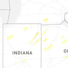


Connect with Interactive Hail Maps