

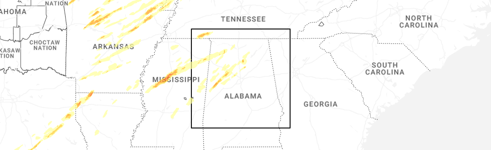
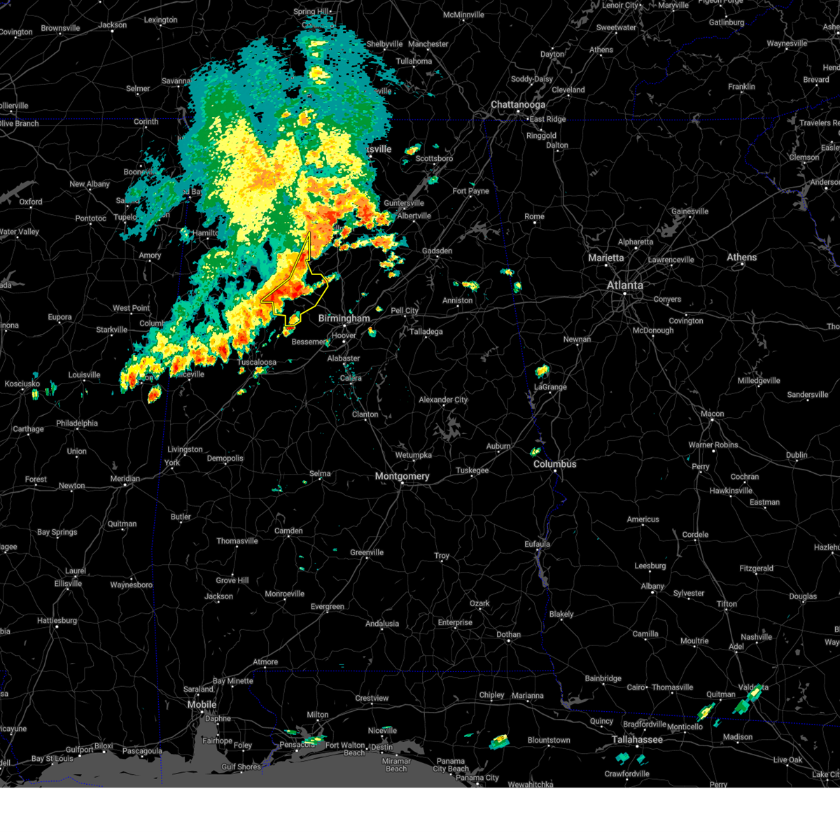
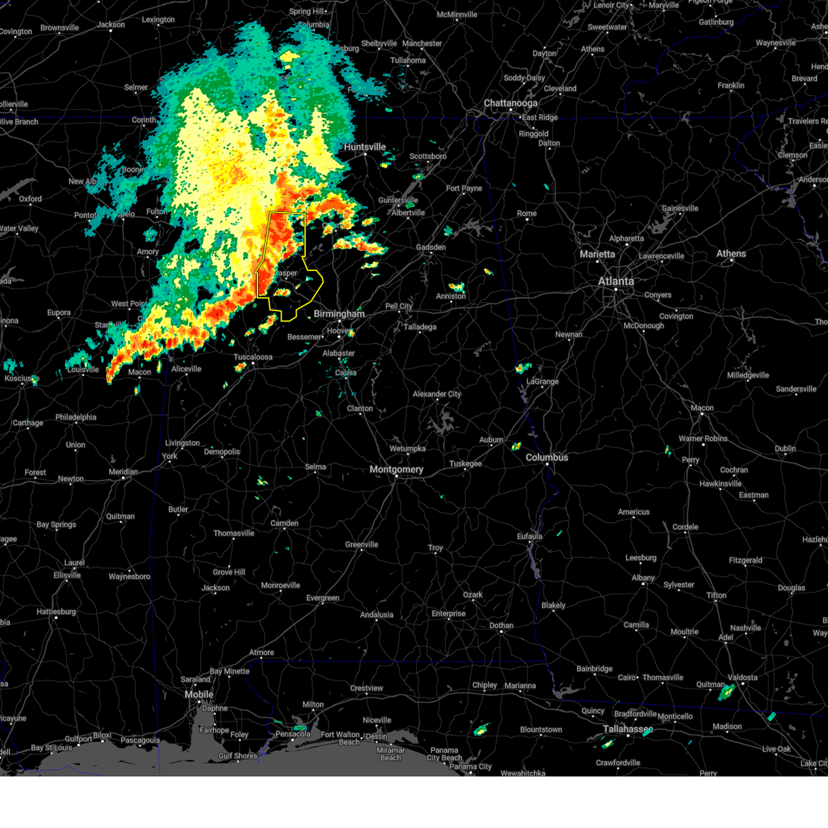
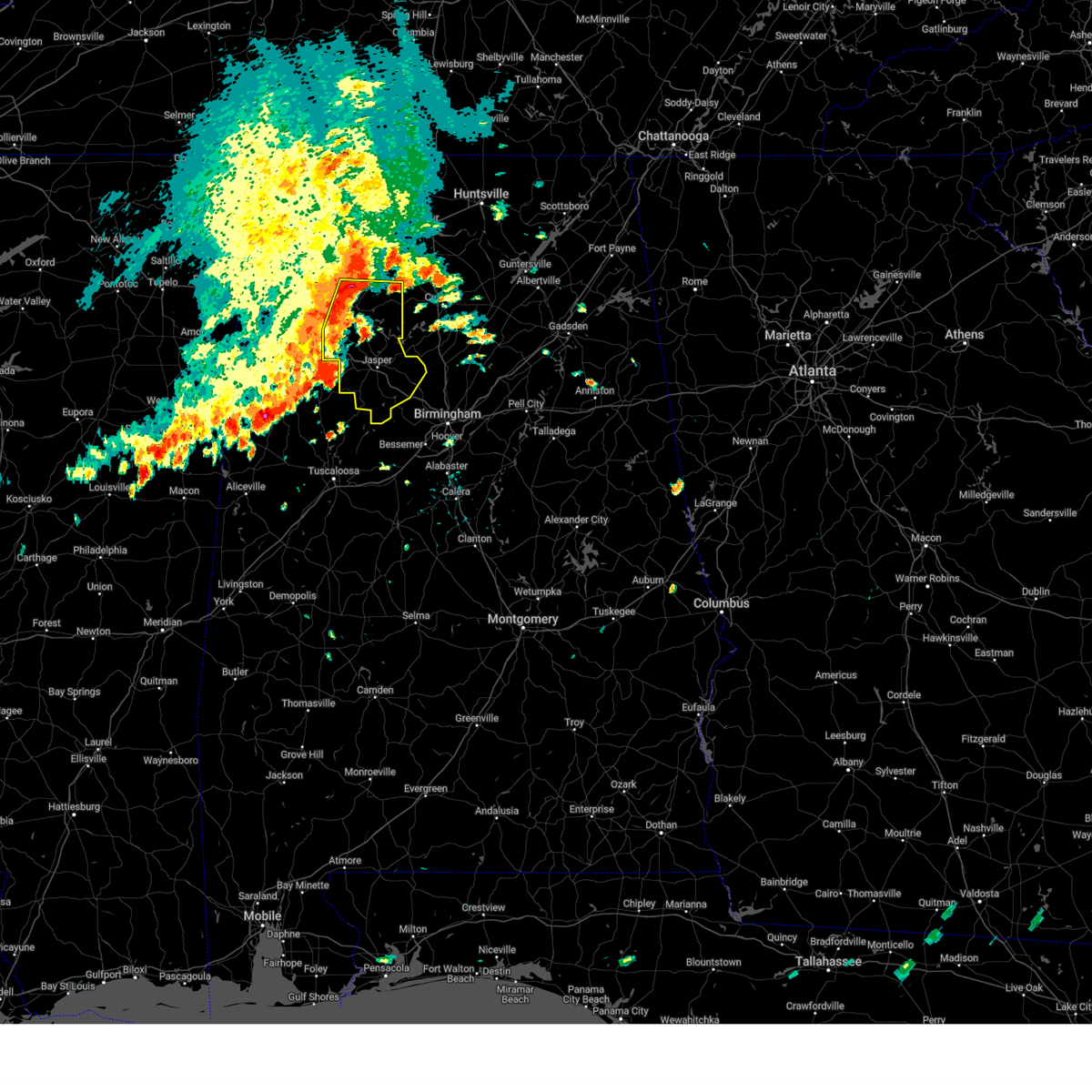
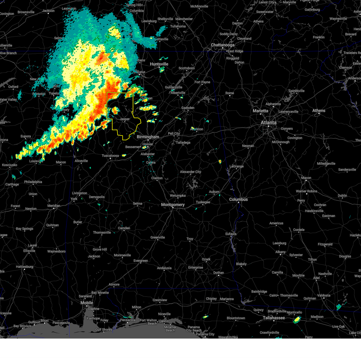
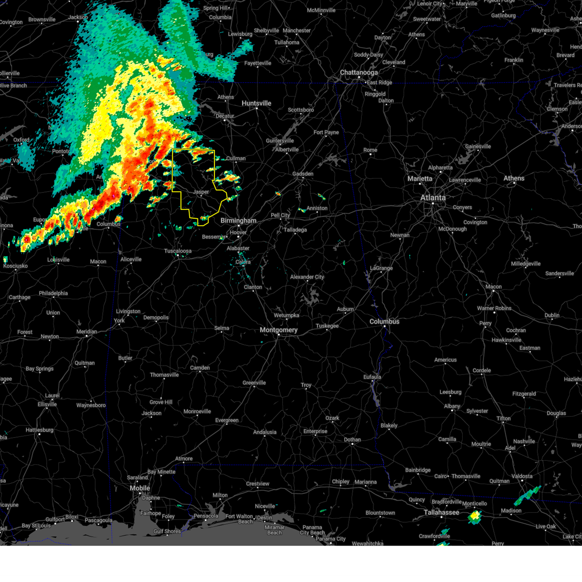
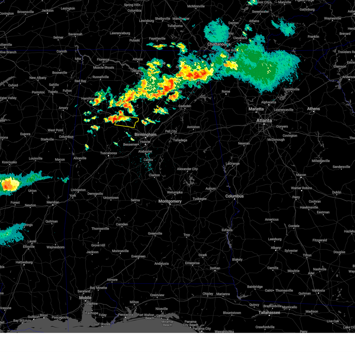
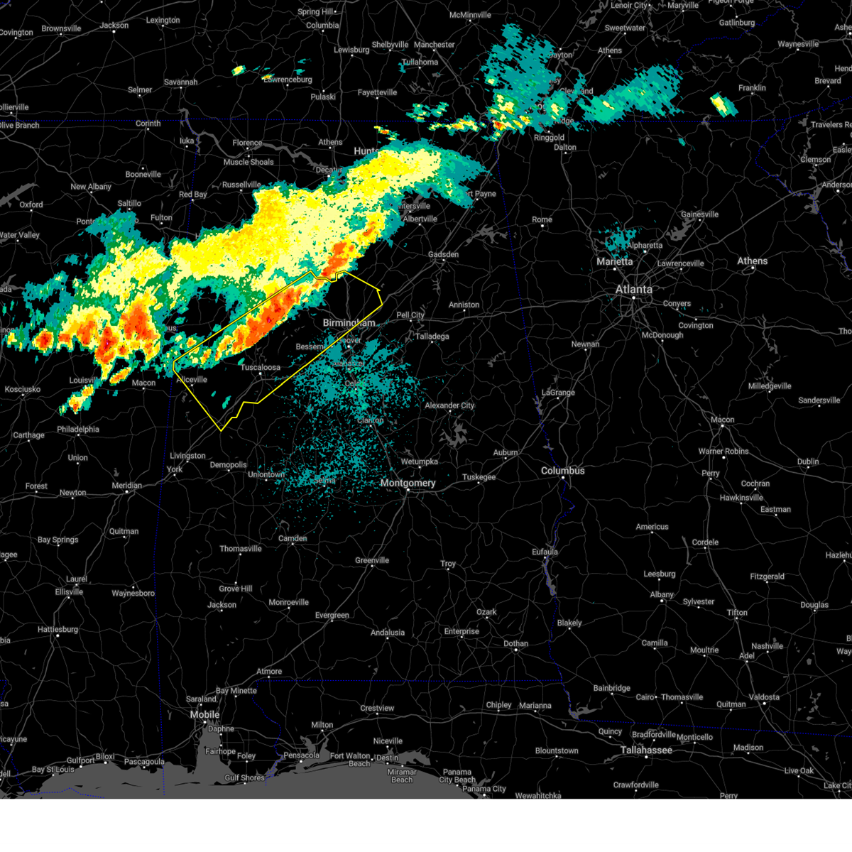
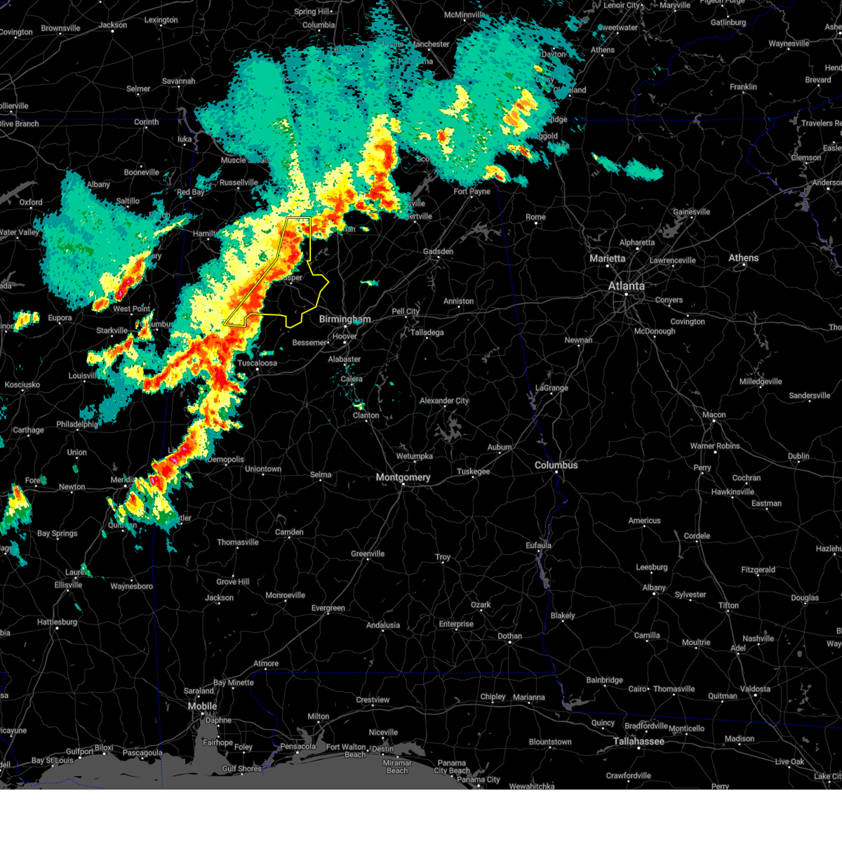
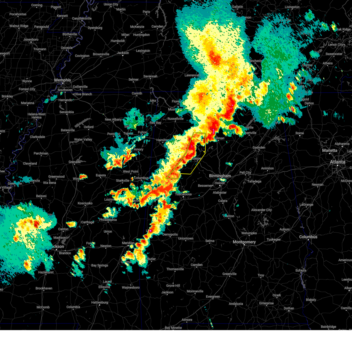
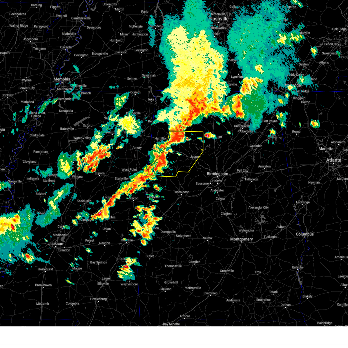
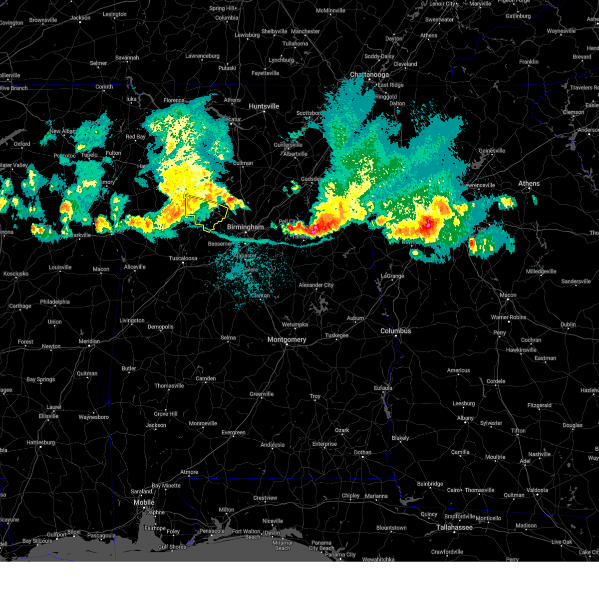
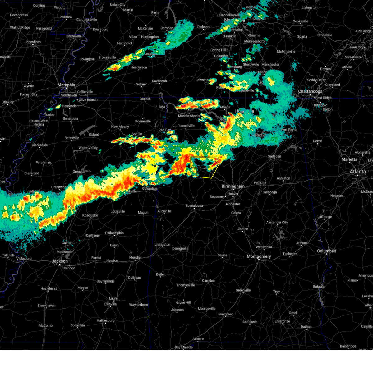
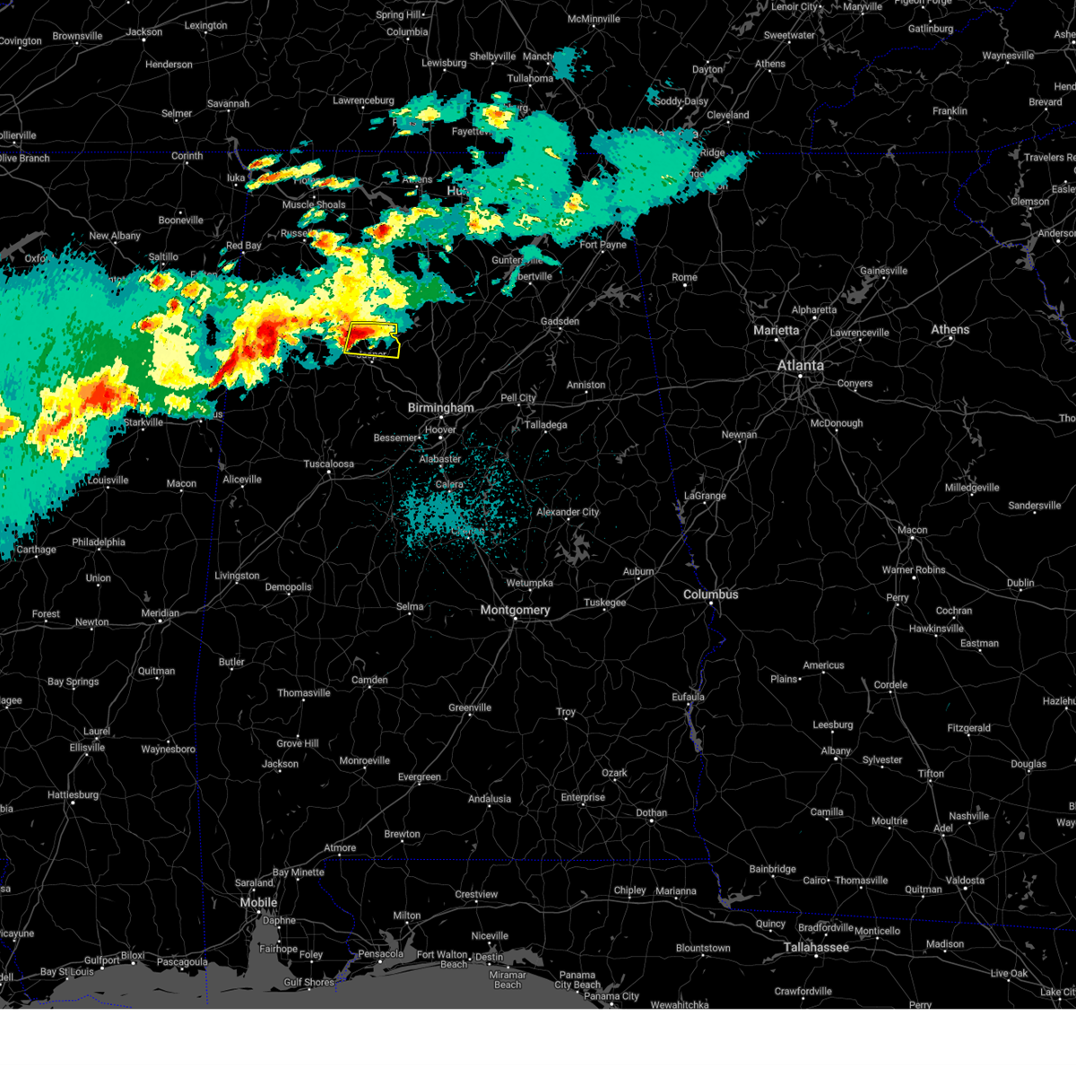
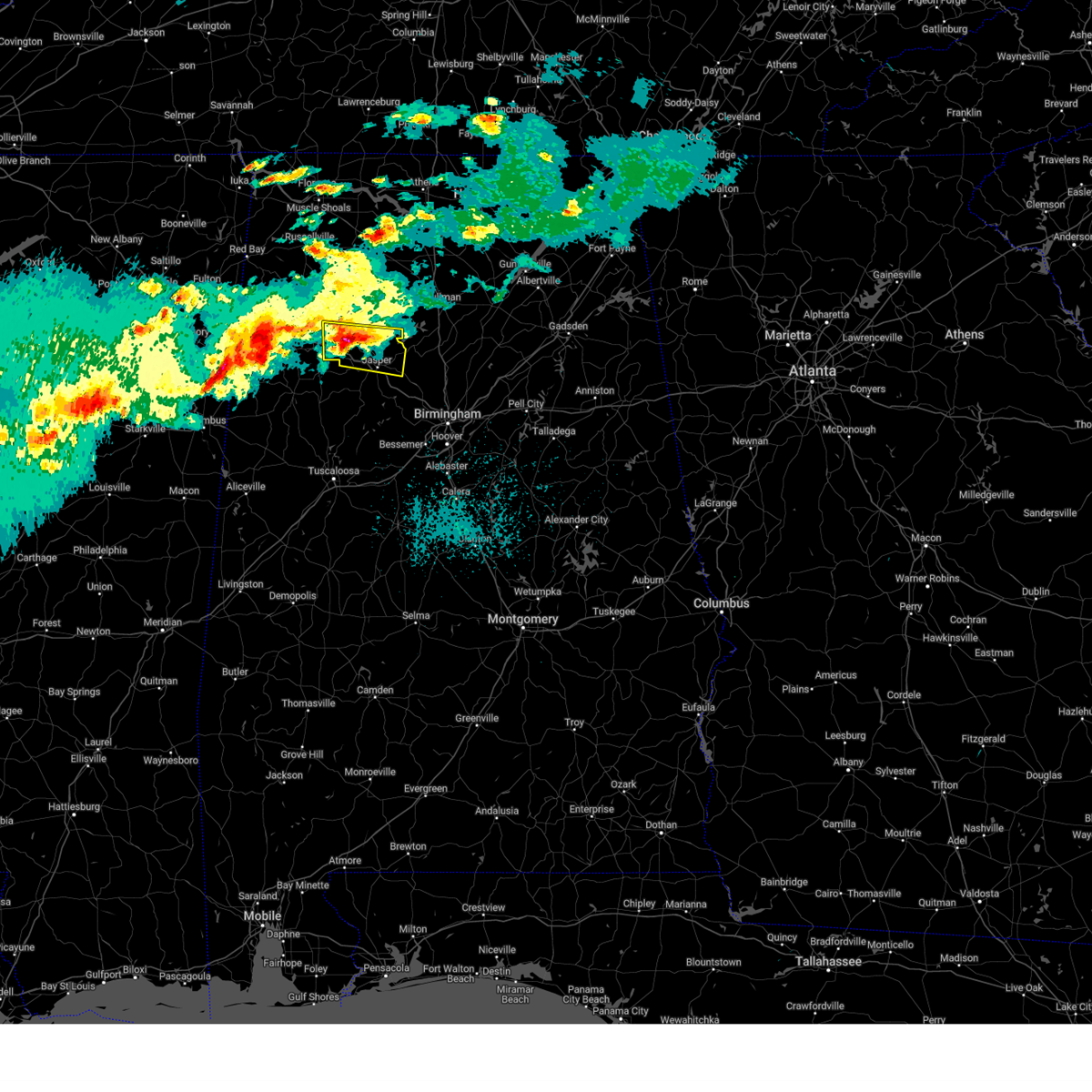
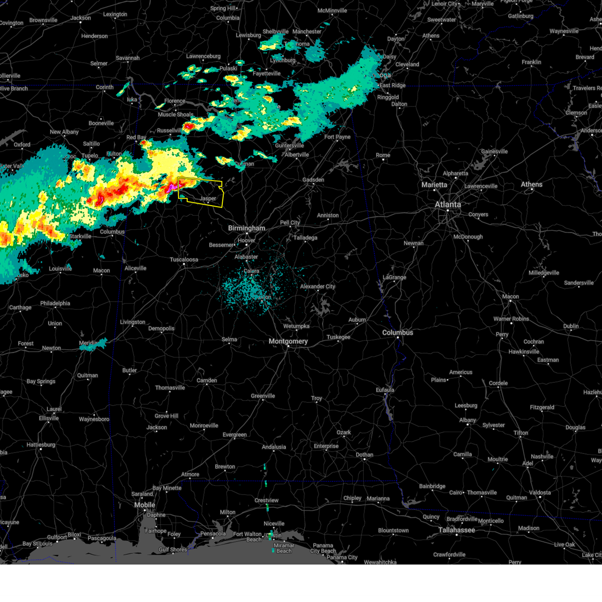
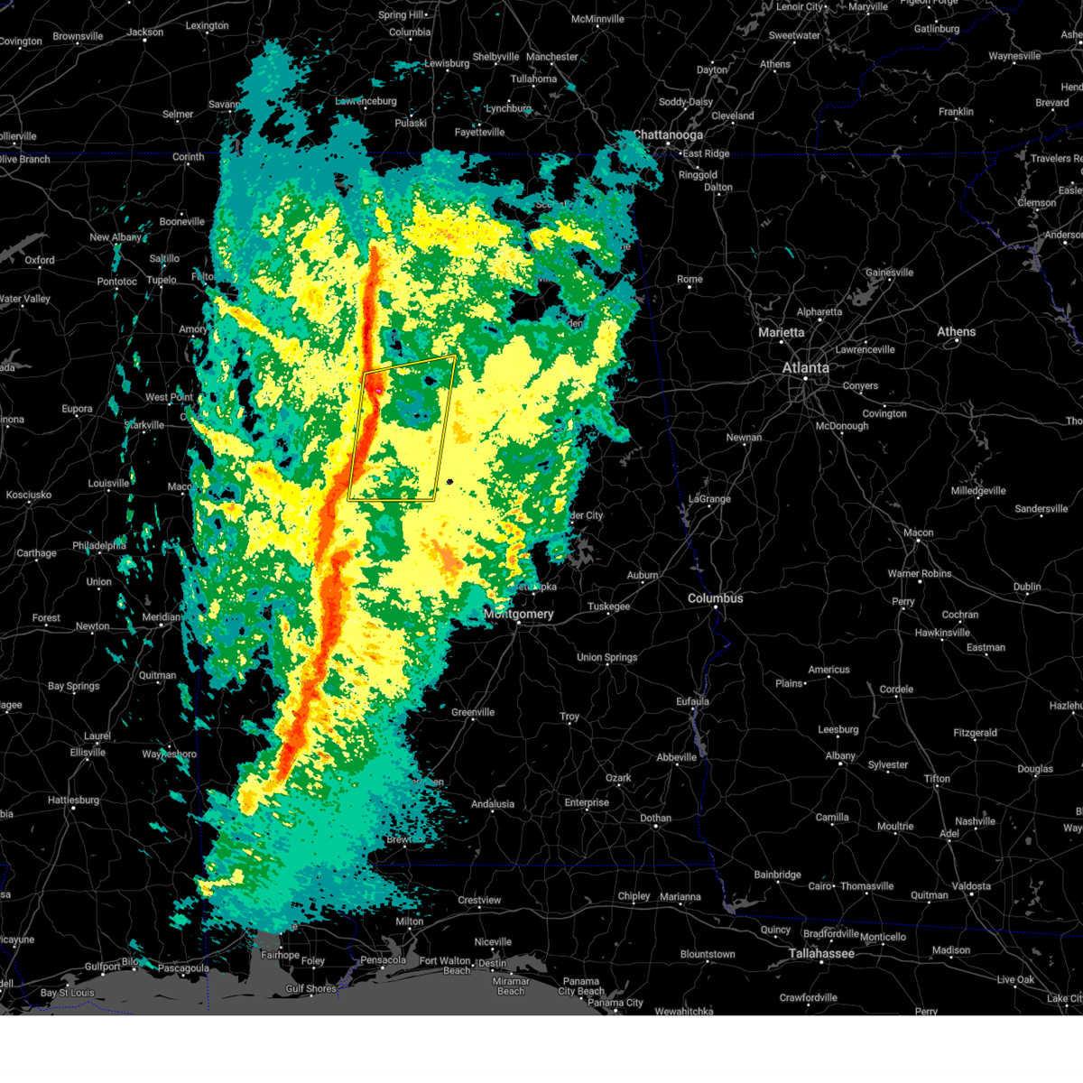
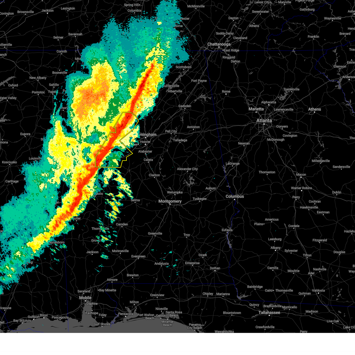
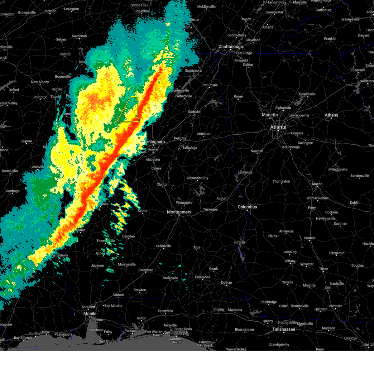
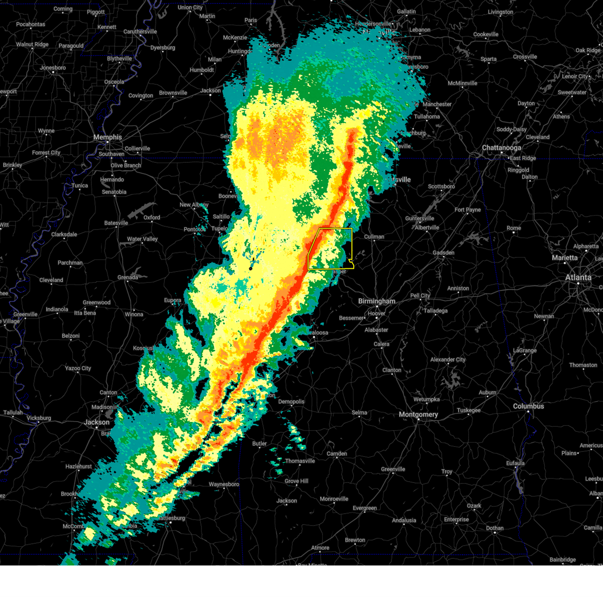
Hail Map for Jasper, AL
The Jasper, AL area has had 40 reports of on-the-ground hail by trained spotters, and has been under severe weather warnings 51 times during the past 12 months. Doppler radar has detected hail at or near Jasper, AL on 95 occasions, including 9 occasions during the past year.
| Name: | Jasper, AL |
| Where Located: | 35.5 miles NW of Birmingham, AL |
| Map: | Google Map for Jasper, AL |
| Population: | 14352 |
| Housing Units: | 6478 |
| More Info: | Search Google for Jasper, AL |
1
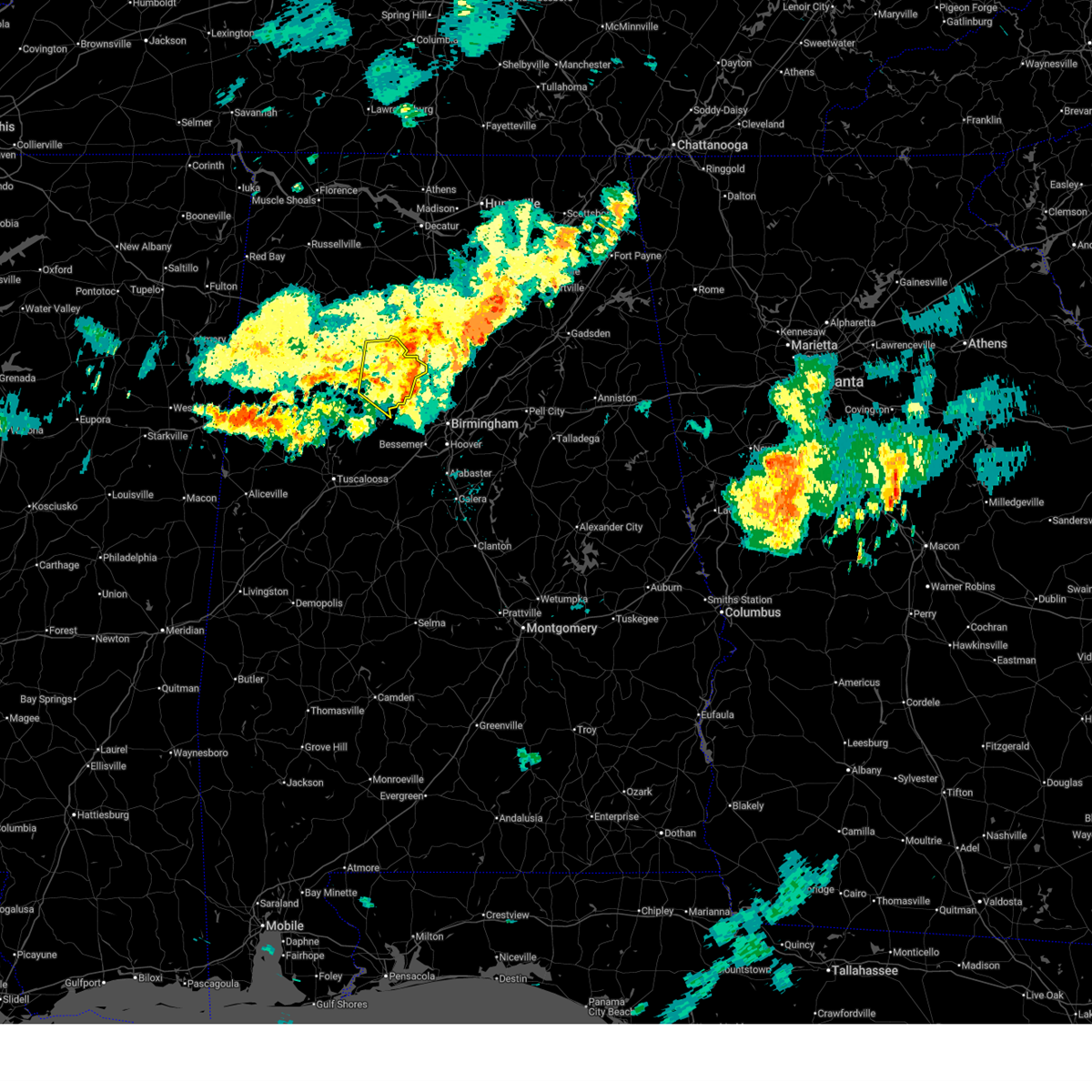
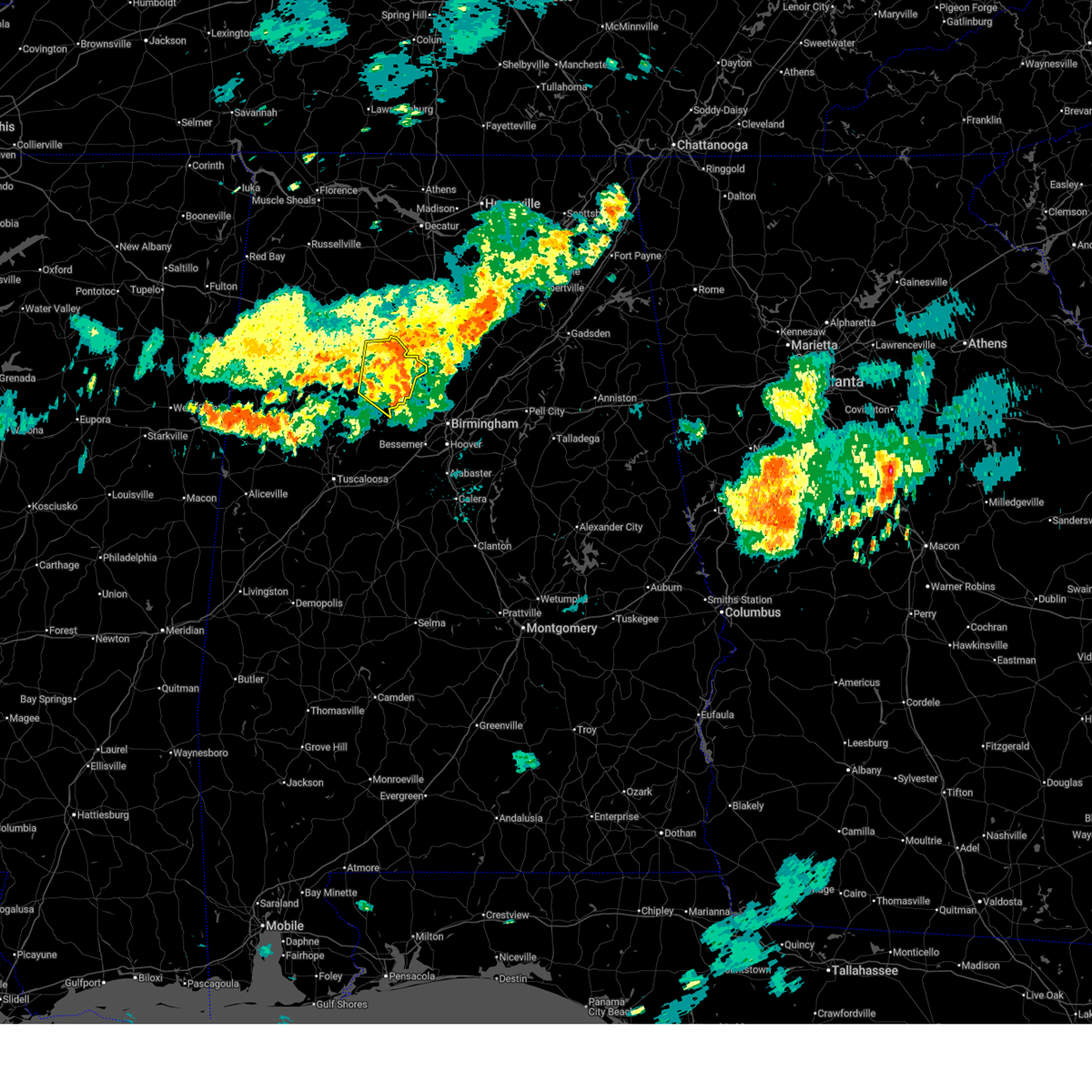
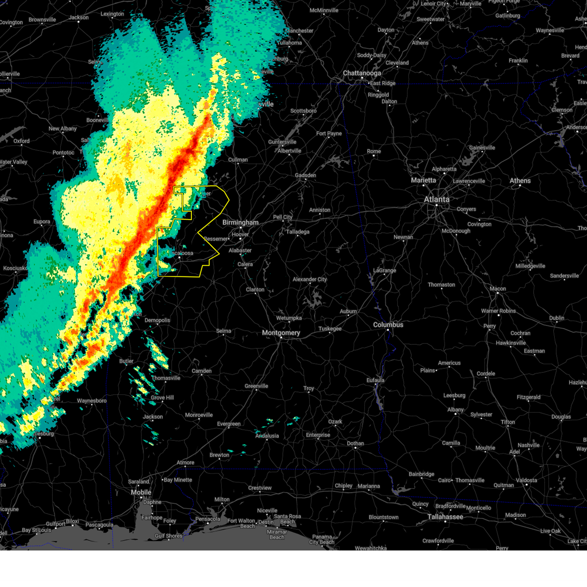
The Top Recent Hail Date for Jasper, AL is Friday, March 14, 2025 (8th out of 95)
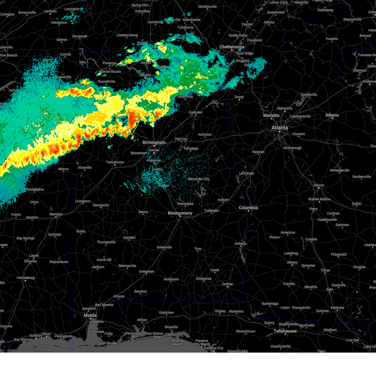
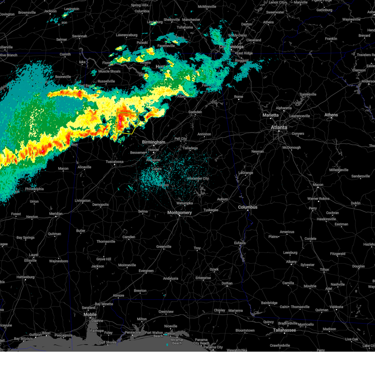
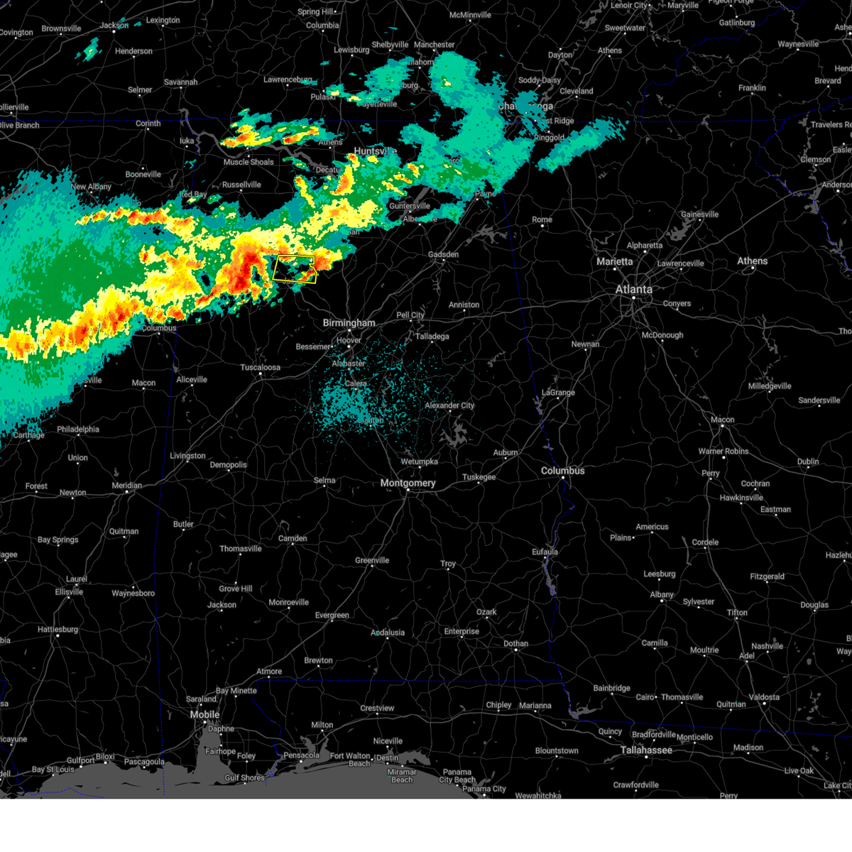
Hail and Wind Damage Spotted near Jasper, AL
| Date / Time | Report Details |
|---|---|
| 6/14/2025 8:34 PM CDT |
 the severe thunderstorm warning has been cancelled and is no longer in effect the severe thunderstorm warning has been cancelled and is no longer in effect
|
| 6/14/2025 8:27 PM CDT |
 At 827 pm cdt, a severe thunderstorm was located over beloit, or over cordova, moving southeast at 35 mph (radar indicated). Hazards include 60 mph wind gusts. Expect damage to roofs, siding, and trees. Locations impacted include, jasper, sumiton, cordova, dora, parrish, oakman, sipsey, curry, gorgas steam plant, smith dam, gorgas, rocky hollow, burnwell, beloit, quinton, lynns park, smith lake, empire, powellville, and goodsprings. At 827 pm cdt, a severe thunderstorm was located over beloit, or over cordova, moving southeast at 35 mph (radar indicated). Hazards include 60 mph wind gusts. Expect damage to roofs, siding, and trees. Locations impacted include, jasper, sumiton, cordova, dora, parrish, oakman, sipsey, curry, gorgas steam plant, smith dam, gorgas, rocky hollow, burnwell, beloit, quinton, lynns park, smith lake, empire, powellville, and goodsprings.
|
| 6/14/2025 8:05 PM CDT |
 Svrbmx the national weather service in birmingham has issued a * severe thunderstorm warning for, walker county in central alabama, * until 900 pm cdt. * at 805 pm cdt, a severe thunderstorm was located near jasper, moving southeast at 35 mph (radar indicated). Hazards include 60 mph wind gusts. expect damage to roofs, siding, and trees Svrbmx the national weather service in birmingham has issued a * severe thunderstorm warning for, walker county in central alabama, * until 900 pm cdt. * at 805 pm cdt, a severe thunderstorm was located near jasper, moving southeast at 35 mph (radar indicated). Hazards include 60 mph wind gusts. expect damage to roofs, siding, and trees
|
| 6/7/2025 1:58 PM CDT |
 At 158 pm cdt, severe thunderstorms were located along a line extending from 6 miles northwest of cullman to sipsey to 7 miles north of bankhead lock and dam, moving east at 55 mph (radar indicated). Hazards include 70 mph wind gusts and penny size hail. Expect considerable tree damage. damage is likely to mobile homes, roofs, and outbuildings. Locations impacted include, jasper, sumiton, cordova, dora, parrish, oakman, sipsey, west jefferson, curry, gorgas steam plant, helicon, gorgas, rocky hollow, burnwell, beloit, quinton, lynns park, nesmith, smith lake, and mill branch. At 158 pm cdt, severe thunderstorms were located along a line extending from 6 miles northwest of cullman to sipsey to 7 miles north of bankhead lock and dam, moving east at 55 mph (radar indicated). Hazards include 70 mph wind gusts and penny size hail. Expect considerable tree damage. damage is likely to mobile homes, roofs, and outbuildings. Locations impacted include, jasper, sumiton, cordova, dora, parrish, oakman, sipsey, west jefferson, curry, gorgas steam plant, helicon, gorgas, rocky hollow, burnwell, beloit, quinton, lynns park, nesmith, smith lake, and mill branch.
|
| 6/7/2025 1:50 PM CDT | Trees down in the area of highway 69 and arkadelphia roa in walker county AL, 5.4 miles W of Jasper, AL |
| 6/7/2025 1:45 PM CDT | Trees down in the jasper are in walker county AL, 2.2 miles N of Jasper, AL |
| 6/7/2025 1:40 PM CDT |
 At 140 pm cdt, severe thunderstorms were located along a line extending from near inmanfield to near jasper to near boley springs, moving east at 60 mph (radar indicated). Hazards include 70 mph wind gusts and penny size hail. Expect considerable tree damage. damage is likely to mobile homes, roofs, and outbuildings. Locations impacted include, jasper, sumiton, cordova, dora, carbon hill, arley, double springs, parrish, oakman, addison, sipsey, west jefferson, curry, houston recreational area, camp mcdowell, gorgas steam plant, nesmith, brushy lake, poplar springs, and burnwell. At 140 pm cdt, severe thunderstorms were located along a line extending from near inmanfield to near jasper to near boley springs, moving east at 60 mph (radar indicated). Hazards include 70 mph wind gusts and penny size hail. Expect considerable tree damage. damage is likely to mobile homes, roofs, and outbuildings. Locations impacted include, jasper, sumiton, cordova, dora, carbon hill, arley, double springs, parrish, oakman, addison, sipsey, west jefferson, curry, houston recreational area, camp mcdowell, gorgas steam plant, nesmith, brushy lake, poplar springs, and burnwell.
|
| 6/7/2025 1:29 PM CDT |
 At 129 pm cdt, severe thunderstorms were located along a line extending from near brushy lake to near carbon hill to near bankston, moving east at 60 mph (radar indicated). Hazards include 70 mph wind gusts and penny size hail. Expect considerable tree damage. damage is likely to mobile homes, roofs, and outbuildings. Locations impacted include, jasper, sumiton, cordova, dora, carbon hill, lynn, arley, double springs, parrish, oakman, addison, sipsey, west jefferson, kansas, nauvoo, eldridge, curry, houston recreational area, camp mcdowell, and gorgas steam plant. At 129 pm cdt, severe thunderstorms were located along a line extending from near brushy lake to near carbon hill to near bankston, moving east at 60 mph (radar indicated). Hazards include 70 mph wind gusts and penny size hail. Expect considerable tree damage. damage is likely to mobile homes, roofs, and outbuildings. Locations impacted include, jasper, sumiton, cordova, dora, carbon hill, lynn, arley, double springs, parrish, oakman, addison, sipsey, west jefferson, kansas, nauvoo, eldridge, curry, houston recreational area, camp mcdowell, and gorgas steam plant.
|
| 6/7/2025 1:17 PM CDT |
 At 117 pm cdt, severe thunderstorms were located along a line extending from near needmore to near eldridge to belk, moving east at 60 mph (radar indicated). Hazards include 70 mph wind gusts and penny size hail. Expect considerable tree damage. damage is likely to mobile homes, roofs, and outbuildings. Locations impacted include, jasper, haleyville, sumiton, cordova, dora, carbon hill, lynn, arley, double springs, parrish, oakman, addison, sipsey, west jefferson, kansas, nauvoo, eldridge, curry, houston recreational area, and camp mcdowell. At 117 pm cdt, severe thunderstorms were located along a line extending from near needmore to near eldridge to belk, moving east at 60 mph (radar indicated). Hazards include 70 mph wind gusts and penny size hail. Expect considerable tree damage. damage is likely to mobile homes, roofs, and outbuildings. Locations impacted include, jasper, haleyville, sumiton, cordova, dora, carbon hill, lynn, arley, double springs, parrish, oakman, addison, sipsey, west jefferson, kansas, nauvoo, eldridge, curry, houston recreational area, and camp mcdowell.
|
| 6/7/2025 1:01 PM CDT |
 Svrbmx the national weather service in birmingham has issued a * severe thunderstorm warning for, walker county in central alabama, winston county in northwestern alabama, * until 215 pm cdt. * at 101 pm cdt, severe thunderstorms were located along a line extending from near hackleburg to near gu-win to 7 miles east of caledonia, moving east at 60 mph (radar indicated). Hazards include 70 mph wind gusts and penny size hail. Expect considerable tree damage. Damage is likely to mobile homes, roofs, and outbuildings. Svrbmx the national weather service in birmingham has issued a * severe thunderstorm warning for, walker county in central alabama, winston county in northwestern alabama, * until 215 pm cdt. * at 101 pm cdt, severe thunderstorms were located along a line extending from near hackleburg to near gu-win to 7 miles east of caledonia, moving east at 60 mph (radar indicated). Hazards include 70 mph wind gusts and penny size hail. Expect considerable tree damage. Damage is likely to mobile homes, roofs, and outbuildings.
|
| 5/20/2025 9:18 PM CDT | Trees were downed in the mccollum area along highway 12 in walker county AL, 4.3 miles NE of Jasper, AL |
| 5/20/2025 9:17 PM CDT |
 Svrbmx the national weather service in birmingham has issued a * severe thunderstorm warning for, central walker county in central alabama, * until 1000 pm cdt. * at 916 pm cdt, a severe thunderstorm was located near oakman, or near jasper, moving east at 40 mph (radar indicated). Hazards include 60 mph wind gusts and quarter size hail. Hail damage to vehicles is expected. Expect wind damage to roofs, siding, and trees. Svrbmx the national weather service in birmingham has issued a * severe thunderstorm warning for, central walker county in central alabama, * until 1000 pm cdt. * at 916 pm cdt, a severe thunderstorm was located near oakman, or near jasper, moving east at 40 mph (radar indicated). Hazards include 60 mph wind gusts and quarter size hail. Hail damage to vehicles is expected. Expect wind damage to roofs, siding, and trees.
|
| 5/20/2025 9:09 PM CDT | Trees down in the townley are in walker county AL, 9.3 miles ENE of Jasper, AL |
| 5/17/2025 4:23 AM CDT |
 the severe thunderstorm warning has been cancelled and is no longer in effect the severe thunderstorm warning has been cancelled and is no longer in effect
|
| 5/17/2025 4:23 AM CDT |
 At 423 am cdt, severe thunderstorms were located along a line extending from near arkadelphia to near carrollton, moving southeast at 35 mph (radar indicated). Hazards include 60 mph wind gusts and quarter size hail. Hail damage to vehicles is expected. expect wind damage to roofs, siding, and trees. Locations impacted include, aliceville, lake tuscaloosa, palmerdale, carrollton, englewood, ralph, northport, smoke rise, samantha, brookwood, mulga, new castle, mcfarland mall, kirk, ensley, miller steam plant, pleasant ridge, wiley, lewiston, and benevola. At 423 am cdt, severe thunderstorms were located along a line extending from near arkadelphia to near carrollton, moving southeast at 35 mph (radar indicated). Hazards include 60 mph wind gusts and quarter size hail. Hail damage to vehicles is expected. expect wind damage to roofs, siding, and trees. Locations impacted include, aliceville, lake tuscaloosa, palmerdale, carrollton, englewood, ralph, northport, smoke rise, samantha, brookwood, mulga, new castle, mcfarland mall, kirk, ensley, miller steam plant, pleasant ridge, wiley, lewiston, and benevola.
|
| 5/17/2025 4:00 AM CDT |
 Svrbmx the national weather service in birmingham has issued a * severe thunderstorm warning for, walker county in central alabama, tuscaloosa county in west central alabama, pickens county in west central alabama, southwestern blount county in central alabama, northern greene county in west central alabama, jefferson county in central alabama, southeastern winston county in northwestern alabama, fayette county in west central alabama, southeastern lamar county in west central alabama, * until 500 am cdt. * at 400 am cdt, severe thunderstorms were located along a line extending from smith dam to near ethelsville, moving southeast at 35 mph (radar indicated). Hazards include 60 mph wind gusts and quarter size hail. Hail damage to vehicles is expected. Expect wind damage to roofs, siding, and trees. Svrbmx the national weather service in birmingham has issued a * severe thunderstorm warning for, walker county in central alabama, tuscaloosa county in west central alabama, pickens county in west central alabama, southwestern blount county in central alabama, northern greene county in west central alabama, jefferson county in central alabama, southeastern winston county in northwestern alabama, fayette county in west central alabama, southeastern lamar county in west central alabama, * until 500 am cdt. * at 400 am cdt, severe thunderstorms were located along a line extending from smith dam to near ethelsville, moving southeast at 35 mph (radar indicated). Hazards include 60 mph wind gusts and quarter size hail. Hail damage to vehicles is expected. Expect wind damage to roofs, siding, and trees.
|
| 5/2/2025 5:12 PM CDT | the severe thunderstorm warning has been cancelled and is no longer in effect |
| 5/2/2025 5:12 PM CDT | At 512 pm cdt, severe thunderstorms were located along a line extending from 7 miles southeast of falkville to near dodge city to near gorgas, moving east at 40 mph (radar indicated). Hazards include 60 mph wind gusts and quarter size hail. Hail damage to vehicles is expected. expect wind damage to roofs, siding, and trees. Locations impacted include, curry, gorgas steam plant, empire, sumiton, gorgas, powellville, goodsprings, barney, rocky hollow, burnwell, beloit, quinton, jasper, sipsey, the wye, manchester, tutwiler, parrish, dora, and gamble. |
| 5/2/2025 4:57 PM CDT | At 456 pm cdt, severe thunderstorms were located along a line extending from near falkville to near dodge city to 7 miles southeast of boley springs, moving east at 40 mph (radar indicated). Hazards include 60 mph wind gusts and quarter size hail. Hail damage to vehicles is expected. expect wind damage to roofs, siding, and trees. Locations impacted include, curry, gorgas steam plant, empire, sumiton, west corona, gorgas, powellville, oakman, corona, goodsprings, barney, boley springs, rocky hollow, burnwell, beloit, quinton, jasper, sipsey, the wye, and manchester. |
| 5/2/2025 4:57 PM CDT | the severe thunderstorm warning has been cancelled and is no longer in effect |
| 5/2/2025 4:42 PM CDT | At 442 pm cdt, severe thunderstorms were located along a line extending from 8 miles southwest of falkville to near smith dam to near boley springs, moving east at 40 mph (radar indicated). Hazards include 60 mph wind gusts and quarter size hail. Hail damage to vehicles is expected. expect wind damage to roofs, siding, and trees. Locations impacted include, curry, gorgas steam plant, mill branch, sumiton, nesmith, powellville, corona, battle branch, hidden cove campground, townley, boley springs, addison town hall, berry, wilson bend, devils branch, burnwell, duncan bridge, falls city, beloit, and quinton. |
| 5/2/2025 4:26 PM CDT |
 Svrbmx the national weather service in birmingham has issued a * severe thunderstorm warning for, walker county in central alabama, eastern winston county in northwestern alabama, eastern fayette county in west central alabama, * until 545 pm cdt. * at 426 pm cdt, severe thunderstorms were located along a line extending from near inmanfield to curry to 7 miles south of bankston, moving east at 40 mph (radar indicated). Hazards include 60 mph wind gusts and quarter size hail. Hail damage to vehicles is expected. Expect wind damage to roofs, siding, and trees. Svrbmx the national weather service in birmingham has issued a * severe thunderstorm warning for, walker county in central alabama, eastern winston county in northwestern alabama, eastern fayette county in west central alabama, * until 545 pm cdt. * at 426 pm cdt, severe thunderstorms were located along a line extending from near inmanfield to curry to 7 miles south of bankston, moving east at 40 mph (radar indicated). Hazards include 60 mph wind gusts and quarter size hail. Hail damage to vehicles is expected. Expect wind damage to roofs, siding, and trees.
|
| 5/2/2025 4:20 PM CDT |
 the severe thunderstorm warning has been cancelled and is no longer in effect the severe thunderstorm warning has been cancelled and is no longer in effect
|
| 5/2/2025 4:20 PM CDT |
 At 420 pm cdt, severe thunderstorms were located along a line extending from near falkville to near falls city to 6 miles northwest of oakman to 7 miles northwest of samantha, moving east at 35 mph (radar indicated). Hazards include 70 mph wind gusts and quarter size hail. Hail damage to vehicles is expected. expect considerable tree damage. wind damage is also likely to mobile homes, roofs, and outbuildings. Locations impacted include, curry, houston recreational area, camp mcdowell, mill branch, clear creek, nesmith, ashbank, winston county airport, cane creek, bull branch, brushy lake, coon creek, poplar springs, corona, battle branch, hidden cove campground, townley, black pond, boley springs, and addison town hall. At 420 pm cdt, severe thunderstorms were located along a line extending from near falkville to near falls city to 6 miles northwest of oakman to 7 miles northwest of samantha, moving east at 35 mph (radar indicated). Hazards include 70 mph wind gusts and quarter size hail. Hail damage to vehicles is expected. expect considerable tree damage. wind damage is also likely to mobile homes, roofs, and outbuildings. Locations impacted include, curry, houston recreational area, camp mcdowell, mill branch, clear creek, nesmith, ashbank, winston county airport, cane creek, bull branch, brushy lake, coon creek, poplar springs, corona, battle branch, hidden cove campground, townley, black pond, boley springs, and addison town hall.
|
| 5/2/2025 4:02 PM CDT | At 402 pm cdt, severe thunderstorms were located along a line extending from near inmanfield to near arley to 8 miles south of carbon hill to ashcraft corner, moving east at 35 mph (radar indicated). Hazards include 70 mph wind gusts and quarter size hail. Hail damage to vehicles is expected. expect considerable tree damage. wind damage is also likely to mobile homes, roofs, and outbuildings. Locations impacted include, curry, cody, houston recreational area, camp mcdowell, mill branch, richard arthur field, clear creek, lynn, nesmith, ashbank, winston county airport, cane creek, fayette, bull branch, brushy lake, coon creek, poplar springs, corona, battle branch, and hidden cove campground. |
| 5/2/2025 3:46 PM CDT | At 346 pm cdt, severe thunderstorms were located along a line extending from near brushy lake to near houston recreational area to bankston to near millport, moving east at 50 mph (radar indicated). Hazards include 60 mph wind gusts and quarter size hail. Hail damage to vehicles is expected. expect wind damage to roofs, siding, and trees. Locations impacted include, cody, camp mcdowell, wayside, clear creek, lynn, ashbank, fayette, pebble, bull branch, coon creek, hightogy, piney grove, natural bridge, black pond, weiss, bazemore, addison town hall, blooming grove, berry, and millport. |
| 5/2/2025 3:29 PM CDT |
 At 329 pm cdt, severe thunderstorms were located along a line extending from near needmore to 6 miles north of lynn to near belk to 6 miles southwest of millport, moving east at 45 mph (radar indicated). Hazards include 60 mph wind gusts and quarter size hail. Hail damage to vehicles is expected. expect wind damage to roofs, siding, and trees. Locations impacted include, cody, camp mcdowell, wayside, clear creek, lynn, ashbank, fayette, pebble, bull branch, coon creek, hightogy, piney grove, natural bridge, black pond, weiss, bazemore, addison town hall, blooming grove, tessner, and berry. At 329 pm cdt, severe thunderstorms were located along a line extending from near needmore to 6 miles north of lynn to near belk to 6 miles southwest of millport, moving east at 45 mph (radar indicated). Hazards include 60 mph wind gusts and quarter size hail. Hail damage to vehicles is expected. expect wind damage to roofs, siding, and trees. Locations impacted include, cody, camp mcdowell, wayside, clear creek, lynn, ashbank, fayette, pebble, bull branch, coon creek, hightogy, piney grove, natural bridge, black pond, weiss, bazemore, addison town hall, blooming grove, tessner, and berry.
|
| 5/2/2025 3:16 PM CDT | Svrbmx the national weather service in birmingham has issued a * severe thunderstorm warning for, western walker county in central alabama, eastern marion county in northwestern alabama, winston county in northwestern alabama, fayette county in west central alabama, southern lamar county in west central alabama, * until 430 pm cdt. * at 316 pm cdt, severe thunderstorms were located along a line extending from near hackleburg to near brilliant to near vernon to near steens, moving east at 35 mph (radar indicated). Hazards include 60 mph wind gusts and quarter size hail. Hail damage to vehicles is expected. Expect wind damage to roofs, siding, and trees. |
| 4/10/2025 8:52 PM CDT |
 The storm which prompted the warning has moved out of the area. therefore, the warning will be allowed to expire. a severe thunderstorm watch remains in effect until 1100 pm cdt for central and west central alabama. The storm which prompted the warning has moved out of the area. therefore, the warning will be allowed to expire. a severe thunderstorm watch remains in effect until 1100 pm cdt for central and west central alabama.
|
| 4/10/2025 8:34 PM CDT |
 At 834 pm cdt, a severe thunderstorm was located over gorgas steam plant, or 8 miles southwest of dora, moving southeast at 50 mph (radar indicated). Hazards include 60 mph wind gusts. Expect damage to roofs, siding, and trees. Locations impacted include, goodsprings, barney, gorgas steam plant, rocky hollow, sumiton, burnwell, beloit, quinton, gorgas, the wye, tutwiler, parrish, oakman, dora, cordova, and jasper. At 834 pm cdt, a severe thunderstorm was located over gorgas steam plant, or 8 miles southwest of dora, moving southeast at 50 mph (radar indicated). Hazards include 60 mph wind gusts. Expect damage to roofs, siding, and trees. Locations impacted include, goodsprings, barney, gorgas steam plant, rocky hollow, sumiton, burnwell, beloit, quinton, gorgas, the wye, tutwiler, parrish, oakman, dora, cordova, and jasper.
|
| 4/10/2025 8:30 PM CDT | Reports of numerous trees down across jaspe in walker county AL, 2.3 miles NNE of Jasper, AL |
| 4/10/2025 8:22 PM CDT |
 Svrbmx the national weather service in birmingham has issued a * severe thunderstorm warning for, central walker county in central alabama, * until 900 pm cdt. * at 822 pm cdt, a severe thunderstorm was located over oakman, or 9 miles southwest of jasper, moving southeast at 40 mph (radar indicated). Hazards include 60 mph wind gusts. expect damage to roofs, siding, and trees Svrbmx the national weather service in birmingham has issued a * severe thunderstorm warning for, central walker county in central alabama, * until 900 pm cdt. * at 822 pm cdt, a severe thunderstorm was located over oakman, or 9 miles southwest of jasper, moving southeast at 40 mph (radar indicated). Hazards include 60 mph wind gusts. expect damage to roofs, siding, and trees
|
| 3/23/2025 10:52 PM CDT |
 The storms which prompted the warning have weakened below severe limits, and have exited the warned area. therefore, the warning will be allowed to expire. a severe thunderstorm watch remains in effect until midnight cdt for central, northwestern and west central alabama. The storms which prompted the warning have weakened below severe limits, and have exited the warned area. therefore, the warning will be allowed to expire. a severe thunderstorm watch remains in effect until midnight cdt for central, northwestern and west central alabama.
|
| 3/23/2025 10:34 PM CDT |
 At 1034 pm cdt, severe thunderstorms were located along a line extending from poplar springs to near oakman, moving east at 40 mph (radar indicated). Hazards include 60 mph wind gusts and penny size hail. Expect damage to roofs, siding, and trees. Locations impacted include, curry, camp mcdowell, maple branch, smith dam, ashbank, little dismal creek, coon creek, poplar springs, cedrum area, holly grove, powellville, lupton, battle branch, townley, carbon hill, wilson bend, devils branch, seymour branch, duncan bridge, and bear branch. At 1034 pm cdt, severe thunderstorms were located along a line extending from poplar springs to near oakman, moving east at 40 mph (radar indicated). Hazards include 60 mph wind gusts and penny size hail. Expect damage to roofs, siding, and trees. Locations impacted include, curry, camp mcdowell, maple branch, smith dam, ashbank, little dismal creek, coon creek, poplar springs, cedrum area, holly grove, powellville, lupton, battle branch, townley, carbon hill, wilson bend, devils branch, seymour branch, duncan bridge, and bear branch.
|
| 3/23/2025 10:18 PM CDT |
 the severe thunderstorm warning has been cancelled and is no longer in effect the severe thunderstorm warning has been cancelled and is no longer in effect
|
| 3/23/2025 10:12 PM CDT |
 Svrbmx the national weather service in birmingham has issued a * severe thunderstorm warning for, northern walker county in central alabama, southern winston county in northwestern alabama, * until 1100 pm cdt. * at 1012 pm cdt, severe thunderstorms were located along a line extending from near lynn to 6 miles northeast of fayette, moving east at 35 mph (radar indicated). Hazards include 60 mph wind gusts and penny size hail. expect damage to roofs, siding, and trees Svrbmx the national weather service in birmingham has issued a * severe thunderstorm warning for, northern walker county in central alabama, southern winston county in northwestern alabama, * until 1100 pm cdt. * at 1012 pm cdt, severe thunderstorms were located along a line extending from near lynn to 6 miles northeast of fayette, moving east at 35 mph (radar indicated). Hazards include 60 mph wind gusts and penny size hail. expect damage to roofs, siding, and trees
|
| 3/23/2025 9:51 PM CDT |
 At 951 pm cdt, a severe thunderstorm was located near curry, or 7 miles north of jasper, moving east at 35 mph (radar indicated). Hazards include 60 mph wind gusts and quarter size hail. Hail damage to vehicles is expected. expect wind damage to roofs, siding, and trees. Locations impacted include, curry, camp mcdowell, maple branch, wilson bend, devils branch, smith dam, seymour branch, duncan bridge, little dismal creek, bear branch, coon creek, poplar springs, raccoon branch, powellville, manchester, lupton, gamble, battle branch, butler branch, and walker county airport. At 951 pm cdt, a severe thunderstorm was located near curry, or 7 miles north of jasper, moving east at 35 mph (radar indicated). Hazards include 60 mph wind gusts and quarter size hail. Hail damage to vehicles is expected. expect wind damage to roofs, siding, and trees. Locations impacted include, curry, camp mcdowell, maple branch, wilson bend, devils branch, smith dam, seymour branch, duncan bridge, little dismal creek, bear branch, coon creek, poplar springs, raccoon branch, powellville, manchester, lupton, gamble, battle branch, butler branch, and walker county airport.
|
| 3/23/2025 9:42 PM CDT |
 At 942 pm cdt, a severe thunderstorm was located near camp mcdowell, or 8 miles northeast of carbon hill, moving east at 35 mph (radar indicated). Hazards include 60 mph wind gusts and half dollar size hail. Hail damage to vehicles is expected. expect wind damage to roofs, siding, and trees. Locations impacted include, curry, camp mcdowell, maple branch, lynn, smith dam, ashbank, little dismal creek, coon creek, poplar springs, cedrum area, holly grove, powellville, lupton, battle branch, townley, carbon hill, eldridge, wilson bend, devils branch, and kansas. At 942 pm cdt, a severe thunderstorm was located near camp mcdowell, or 8 miles northeast of carbon hill, moving east at 35 mph (radar indicated). Hazards include 60 mph wind gusts and half dollar size hail. Hail damage to vehicles is expected. expect wind damage to roofs, siding, and trees. Locations impacted include, curry, camp mcdowell, maple branch, lynn, smith dam, ashbank, little dismal creek, coon creek, poplar springs, cedrum area, holly grove, powellville, lupton, battle branch, townley, carbon hill, eldridge, wilson bend, devils branch, and kansas.
|
| 3/23/2025 9:15 PM CDT |
 Svrbmx the national weather service in birmingham has issued a * severe thunderstorm warning for, northern walker county in central alabama, southern winston county in northwestern alabama, * until 1045 pm cdt. * at 915 pm cdt, a severe thunderstorm was located near eldridge, or 7 miles east of winfield, moving east at 35 mph (radar indicated). Hazards include 60 mph wind gusts and half dollar size hail. Hail damage to vehicles is expected. Expect wind damage to roofs, siding, and trees. Svrbmx the national weather service in birmingham has issued a * severe thunderstorm warning for, northern walker county in central alabama, southern winston county in northwestern alabama, * until 1045 pm cdt. * at 915 pm cdt, a severe thunderstorm was located near eldridge, or 7 miles east of winfield, moving east at 35 mph (radar indicated). Hazards include 60 mph wind gusts and half dollar size hail. Hail damage to vehicles is expected. Expect wind damage to roofs, siding, and trees.
|
| 3/15/2025 4:38 PM CDT | At 437 pm cdt, a confirmed tornado was located near cordova, moving northeast at 55 mph (radar confirmed tornado). Hazards include damaging tornado. Flying debris will be dangerous to those caught without shelter. mobile homes will be damaged or destroyed. damage to roofs, windows, and vehicles will occur. tree damage is likely. Locations impacted include, goodsprings, barney, empire, rocky hollow, sumiton, beloit, sipsey, gorgas, powellville, parrish, dora, boldo, cordova, lynns park, and jasper. |
| 3/15/2025 4:28 PM CDT | At 428 pm cdt, a confirmed tornado was located near gorgas, or 12 miles southwest of cordova, moving northeast at 45 mph (radar confirmed tornado). Hazards include damaging tornado. Flying debris will be dangerous to those caught without shelter. mobile homes will be damaged or destroyed. damage to roofs, windows, and vehicles will occur. tree damage is likely. Locations impacted include, goodsprings, barney, gorgas steam plant, empire, rocky hollow, sumiton, burnwell, beloit, sipsey, gorgas, the wye, powellville, tutwiler, parrish, dora, boldo, cordova, lynns park, and jasper. |
| 3/15/2025 4:27 PM CDT | At 427 pm cdt, a confirmed tornado was located near gorgas, or 12 miles southwest of cordova, moving northeast at 50 mph (radar confirmed tornado). Hazards include damaging tornado. Flying debris will be dangerous to those caught without shelter. mobile homes will be damaged or destroyed. damage to roofs, windows, and vehicles will occur. tree damage is likely. Locations impacted include, goodsprings, barney, gorgas steam plant, empire, rocky hollow, sumiton, burnwell, beloit, sipsey, gorgas, the wye, powellville, tutwiler, parrish, dora, boldo, cordova, lynns park, and jasper. |
| 3/15/2025 4:20 PM CDT | Torbmx the national weather service in birmingham has issued a * tornado warning for, eastern walker county in central alabama, * until 515 pm cdt. * at 420 pm cdt, a tornado producing storm was located near bankhead lock and dam, or 20 miles southwest of cordova, moving northeast at 45 mph (radar confirmed tornado). Hazards include damaging tornado. Flying debris will be dangerous to those caught without shelter. mobile homes will be damaged or destroyed. damage to roofs, windows, and vehicles will occur. Tree damage is likely. |
| 3/15/2025 4:19 AM CDT | Svrbmx the national weather service in birmingham has issued a * severe thunderstorm warning for, central walker county in central alabama, * until 445 am cdt. * at 419 am cdt, a severe thunderstorm was located over oakman, or 10 miles west of cordova, moving northeast at 80 mph (radar indicated). Hazards include 60 mph wind gusts and half dollar size hail. Hail damage to vehicles is expected. Expect wind damage to roofs, siding, and trees. |
| 3/4/2025 8:09 PM CST |
 Svrbmx the national weather service in birmingham has issued a * severe thunderstorm warning for, southeastern walker county in central alabama, eastern tuscaloosa county in west central alabama, southwestern blount county in central alabama, southwestern shelby county in central alabama, northern bibb county in central alabama, jefferson county in central alabama, * until 915 pm cst. * at 808 pm cst, severe thunderstorms were located along a line extending from 6 miles southwest of gorgas to near coaling, moving east at 35 mph (radar indicated). Hazards include 60 mph wind gusts. expect damage to roofs, siding, and trees Svrbmx the national weather service in birmingham has issued a * severe thunderstorm warning for, southeastern walker county in central alabama, eastern tuscaloosa county in west central alabama, southwestern blount county in central alabama, southwestern shelby county in central alabama, northern bibb county in central alabama, jefferson county in central alabama, * until 915 pm cst. * at 808 pm cst, severe thunderstorms were located along a line extending from 6 miles southwest of gorgas to near coaling, moving east at 35 mph (radar indicated). Hazards include 60 mph wind gusts. expect damage to roofs, siding, and trees
|
| 2/16/2025 12:26 AM CST |
 At 1226 am cst, severe thunderstorms were located along a line extending from near smith dam to 6 miles northwest of moundville, moving east at 55 mph (radar indicated). Hazards include 70 mph wind gusts. Expect considerable tree damage. damage is likely to mobile homes, roofs, and outbuildings. Locations impacted include, tuscaloosa, northport, jasper, sumiton, cordova, dora, holt, lake view, brookwood, coaling, vance, parrish, coker, oakman, sipsey, west jefferson, gorgas steam plant, samantha, smith dam, and mcfarland mall. At 1226 am cst, severe thunderstorms were located along a line extending from near smith dam to 6 miles northwest of moundville, moving east at 55 mph (radar indicated). Hazards include 70 mph wind gusts. Expect considerable tree damage. damage is likely to mobile homes, roofs, and outbuildings. Locations impacted include, tuscaloosa, northport, jasper, sumiton, cordova, dora, holt, lake view, brookwood, coaling, vance, parrish, coker, oakman, sipsey, west jefferson, gorgas steam plant, samantha, smith dam, and mcfarland mall.
|
| 2/16/2025 12:23 AM CST |
 the severe thunderstorm warning has been cancelled and is no longer in effect the severe thunderstorm warning has been cancelled and is no longer in effect
|
| 2/16/2025 12:11 AM CST | At 1211 am cst, severe thunderstorms were located along a line extending from near jasper to mantua, moving east at 55 mph (radar indicated). Hazards include 70 mph wind gusts. Expect considerable tree damage. damage is likely to mobile homes, roofs, and outbuildings. Locations impacted include, tuscaloosa, northport, jasper, sumiton, cordova, dora, carbon hill, holt, lake view, brookwood, coaling, vance, parrish, coker, oakman, sipsey, west jefferson, samantha, mcfarland mall, and tuscaloosa regional airport. |
| 2/16/2025 12:10 AM CST | At 1210 am cst, severe thunderstorms were located along a line extending from near inmanfield to 6 miles south of camp mcdowell, moving east at 45 mph (radar indicated). Hazards include 60 mph wind gusts. Expect damage to roofs, siding, and trees. Locations impacted include, jasper, carbon hill, arley, addison, curry, camp mcdowell, smith dam, nesmith, poplar springs, falls city, smith lake, helicon, inmanfield, sardis, corinth rec area, houston, mill branch, winston county airport, cane creek, and bull branch. |
| 2/15/2025 11:55 PM CST |
 the severe thunderstorm warning has been cancelled and is no longer in effect the severe thunderstorm warning has been cancelled and is no longer in effect
|
| 2/15/2025 11:55 PM CST |
 At 1155 pm cst, severe thunderstorms were located along a line extending from near moreland to kansas, moving east at 50 mph (radar indicated). Hazards include 60 mph wind gusts. Expect damage to roofs, siding, and trees. Locations impacted include, jasper, carbon hill, lynn, arley, double springs, addison, kansas, nauvoo, eldridge, curry, houston recreational area, camp mcdowell, smith dam, nesmith, ashbank, brushy lake, poplar springs, ashridge, falls city, and moreland. At 1155 pm cst, severe thunderstorms were located along a line extending from near moreland to kansas, moving east at 50 mph (radar indicated). Hazards include 60 mph wind gusts. Expect damage to roofs, siding, and trees. Locations impacted include, jasper, carbon hill, lynn, arley, double springs, addison, kansas, nauvoo, eldridge, curry, houston recreational area, camp mcdowell, smith dam, nesmith, ashbank, brushy lake, poplar springs, ashridge, falls city, and moreland.
|
| 2/15/2025 11:48 PM CST | At 1148 pm cst, severe thunderstorms were located along a line extending from near ashridge to near eldridge, moving east at 50 mph (radar indicated). Hazards include 60 mph wind gusts. Expect damage to roofs, siding, and trees. Locations impacted include, jasper, winfield, haleyville, carbon hill, lynn, arley, double springs, brilliant, addison, glen allen, kansas, nauvoo, eldridge, curry, houston recreational area, camp mcdowell, smith dam, nesmith, ashbank, and brushy lake. |
| 2/15/2025 11:46 PM CST |
 Svrbmx the national weather service in birmingham has issued a * severe thunderstorm warning for, walker county in central alabama, tuscaloosa county in west central alabama, * until 100 am cst. * at 1146 pm cst, severe thunderstorms were located along a line extending from near glen allen to near cooksville, moving east at 55 mph (radar indicated). Hazards include 60 mph wind gusts. expect damage to roofs, siding, and trees Svrbmx the national weather service in birmingham has issued a * severe thunderstorm warning for, walker county in central alabama, tuscaloosa county in west central alabama, * until 100 am cst. * at 1146 pm cst, severe thunderstorms were located along a line extending from near glen allen to near cooksville, moving east at 55 mph (radar indicated). Hazards include 60 mph wind gusts. expect damage to roofs, siding, and trees
|
| 2/15/2025 11:38 PM CST | Svrbmx the national weather service in birmingham has issued a * severe thunderstorm warning for, northern walker county in central alabama, eastern marion county in northwestern alabama, winston county in northwestern alabama, * until 1245 am cst. * at 1138 pm cst, severe thunderstorms were located along a line extending from near needmore to gu-win, moving east at 45 mph (radar indicated). Hazards include 60 mph wind gusts. expect damage to roofs, siding, and trees |
| 12/28/2024 11:05 PM CST |
 At 1104 pm cst, severe thunderstorms were located along a line extending from near moulton to near smith lake to near west jefferson, moving northeast at 60 mph (radar indicated). Hazards include 60 mph wind gusts. Expect damage to roofs, siding, and trees. Locations impacted include, jasper, sumiton, cordova, dora, arley, parrish, addison, sipsey, west jefferson, curry, gorgas steam plant, smith dam, nesmith, brushy lake, burnwell, falls city, beloit, quinton, moreland, and smith lake. At 1104 pm cst, severe thunderstorms were located along a line extending from near moulton to near smith lake to near west jefferson, moving northeast at 60 mph (radar indicated). Hazards include 60 mph wind gusts. Expect damage to roofs, siding, and trees. Locations impacted include, jasper, sumiton, cordova, dora, arley, parrish, addison, sipsey, west jefferson, curry, gorgas steam plant, smith dam, nesmith, brushy lake, burnwell, falls city, beloit, quinton, moreland, and smith lake.
|
| 12/28/2024 10:54 PM CST | Report of trees down in mancheste in walker county AL, 3.7 miles SSE of Jasper, AL |
| 12/28/2024 9:58 PM CST |
 Svrbmx the national weather service in birmingham has issued a * severe thunderstorm warning for, walker county in central alabama, winston county in northwestern alabama, * until 1115 pm cst. * at 957 pm cst, severe thunderstorms were located along a line extending from 8 miles southeast of red bay to near glen allen to near ashcraft corner, moving northeast at 60 mph (radar indicated). Hazards include 70 mph wind gusts. Expect considerable tree damage. Damage is likely to mobile homes, roofs, and outbuildings. Svrbmx the national weather service in birmingham has issued a * severe thunderstorm warning for, walker county in central alabama, winston county in northwestern alabama, * until 1115 pm cst. * at 957 pm cst, severe thunderstorms were located along a line extending from 8 miles southeast of red bay to near glen allen to near ashcraft corner, moving northeast at 60 mph (radar indicated). Hazards include 70 mph wind gusts. Expect considerable tree damage. Damage is likely to mobile homes, roofs, and outbuildings.
|
| 6/5/2024 8:22 PM CDT |
 The storm which prompted the warning has moved out of the area. therefore, the warning will be allowed to expire. to report severe weather, contact your nearest law enforcement agency. they will relay your report to the national weather service birmingham. The storm which prompted the warning has moved out of the area. therefore, the warning will be allowed to expire. to report severe weather, contact your nearest law enforcement agency. they will relay your report to the national weather service birmingham.
|
| 6/5/2024 8:01 PM CDT |
 At 801 pm cdt, a severe thunderstorm was located over gorgas, or 8 miles southwest of cordova, moving northeast at 45 mph (radar indicated). Hazards include 60 mph wind gusts and penny size hail. Expect damage to roofs, siding, and trees. Locations impacted include, jasper, cordova, dora, parrish, oakman, sipsey, gorgas steam plant, rocky hollow, burnwell, beloit, gorgas, lynns park, goodsprings, barney, the wye, and tutwiler. At 801 pm cdt, a severe thunderstorm was located over gorgas, or 8 miles southwest of cordova, moving northeast at 45 mph (radar indicated). Hazards include 60 mph wind gusts and penny size hail. Expect damage to roofs, siding, and trees. Locations impacted include, jasper, cordova, dora, parrish, oakman, sipsey, gorgas steam plant, rocky hollow, burnwell, beloit, gorgas, lynns park, goodsprings, barney, the wye, and tutwiler.
|
| 6/5/2024 8:01 PM CDT |
 the severe thunderstorm warning has been cancelled and is no longer in effect the severe thunderstorm warning has been cancelled and is no longer in effect
|
| 6/5/2024 7:59 PM CDT |
 Svrbmx the national weather service in birmingham has issued a * severe thunderstorm warning for, walker county in central alabama, southeastern winston county in northwestern alabama, * until 845 pm cdt. * at 758 pm cdt, severe thunderstorms were located along a line extending from camp mcdowell to near bankhead lock and dam, moving northeast at 50 mph (radar indicated). Hazards include 60 mph wind gusts. expect damage to roofs, siding, and trees Svrbmx the national weather service in birmingham has issued a * severe thunderstorm warning for, walker county in central alabama, southeastern winston county in northwestern alabama, * until 845 pm cdt. * at 758 pm cdt, severe thunderstorms were located along a line extending from camp mcdowell to near bankhead lock and dam, moving northeast at 50 mph (radar indicated). Hazards include 60 mph wind gusts. expect damage to roofs, siding, and trees
|
| 6/5/2024 7:50 PM CDT |
 At 750 pm cdt, severe thunderstorms were located along a line extending from 10 miles west of moulton to near brushy lake to 7 miles northwest of jasper, moving northeast at 35 mph (radar indicated). Hazards include 60 mph wind gusts. Expect damage to roofs, siding, and trees. Locations impacted include, jasper, carbon hill, arley, addison, nauvoo, curry, camp mcdowell, smith dam, nesmith, brushy lake, poplar springs, falls city, moreland, smith lake, helicon, inmanfield, sardis, corinth rec area, houston, and mill branch. At 750 pm cdt, severe thunderstorms were located along a line extending from 10 miles west of moulton to near brushy lake to 7 miles northwest of jasper, moving northeast at 35 mph (radar indicated). Hazards include 60 mph wind gusts. Expect damage to roofs, siding, and trees. Locations impacted include, jasper, carbon hill, arley, addison, nauvoo, curry, camp mcdowell, smith dam, nesmith, brushy lake, poplar springs, falls city, moreland, smith lake, helicon, inmanfield, sardis, corinth rec area, houston, and mill branch.
|
| 6/5/2024 7:32 PM CDT |
 At 732 pm cdt, severe thunderstorms were located along a line extending from near needmore to winston free state barn to 7 miles northwest of oakman, moving northeast at 35 mph (radar indicated). Hazards include 70 mph wind gusts. Expect considerable tree damage. damage is likely to mobile homes, roofs, and outbuildings. Locations impacted include, jasper, haleyville, carbon hill, lynn, arley, double springs, addison, kansas, nauvoo, eldridge, curry, houston recreational area, camp mcdowell, smith dam, nesmith, ashbank, brushy lake, poplar springs, ashridge, and falls city. At 732 pm cdt, severe thunderstorms were located along a line extending from near needmore to winston free state barn to 7 miles northwest of oakman, moving northeast at 35 mph (radar indicated). Hazards include 70 mph wind gusts. Expect considerable tree damage. damage is likely to mobile homes, roofs, and outbuildings. Locations impacted include, jasper, haleyville, carbon hill, lynn, arley, double springs, addison, kansas, nauvoo, eldridge, curry, houston recreational area, camp mcdowell, smith dam, nesmith, ashbank, brushy lake, poplar springs, ashridge, and falls city.
|
| 6/5/2024 7:32 PM CDT |
 Svrbmx the national weather service in birmingham has issued a * severe thunderstorm warning for, central walker county in central alabama, northeastern tuscaloosa county in west central alabama, southeastern fayette county in west central alabama, * until 830 pm cdt. * at 731 pm cdt, a severe thunderstorm was located near samantha, or 16 miles north of northport, moving northeast at 45 mph (radar indicated). Hazards include 60 mph wind gusts and penny size hail. expect damage to roofs, siding, and trees Svrbmx the national weather service in birmingham has issued a * severe thunderstorm warning for, central walker county in central alabama, northeastern tuscaloosa county in west central alabama, southeastern fayette county in west central alabama, * until 830 pm cdt. * at 731 pm cdt, a severe thunderstorm was located near samantha, or 16 miles north of northport, moving northeast at 45 mph (radar indicated). Hazards include 60 mph wind gusts and penny size hail. expect damage to roofs, siding, and trees
|
| 6/5/2024 7:05 PM CDT |
 Svrbmx the national weather service in birmingham has issued a * severe thunderstorm warning for, northern walker county in central alabama, winston county in northwestern alabama, * until 800 pm cdt. * at 705 pm cdt, severe thunderstorms were located along a line extending from 6 miles northwest of hackleburg to near brilliant to bankston, moving northeast at 50 mph (radar indicated). Hazards include 60 mph wind gusts. expect damage to roofs, siding, and trees Svrbmx the national weather service in birmingham has issued a * severe thunderstorm warning for, northern walker county in central alabama, winston county in northwestern alabama, * until 800 pm cdt. * at 705 pm cdt, severe thunderstorms were located along a line extending from 6 miles northwest of hackleburg to near brilliant to bankston, moving northeast at 50 mph (radar indicated). Hazards include 60 mph wind gusts. expect damage to roofs, siding, and trees
|
| 9/6/2023 3:35 PM CDT | Numerous trees down with powerlines and power poles down in jasper. time estimated by rada in walker county AL, 2.2 miles N of Jasper, AL |
| 8/7/2023 3:26 PM CDT |
 At 326 pm cdt, severe thunderstorms were located along a line extending from clay to near west jefferson to 6 miles north of samantha, moving southeast at 30 mph (radar indicated). Hazards include 60 mph wind gusts. Expect damage to roofs, siding, and trees. locations impacted include, northern birmingham, trussville, jasper, gardendale, fultondale, fayette, sumiton, cordova, dora, reform, center point, clay, pinson, tarrant, adamsville, warrior, kimberly, graysville, morris and brookside. hail threat, radar indicated max hail size, <. 75 in wind threat, radar indicated max wind gust, 60 mph. At 326 pm cdt, severe thunderstorms were located along a line extending from clay to near west jefferson to 6 miles north of samantha, moving southeast at 30 mph (radar indicated). Hazards include 60 mph wind gusts. Expect damage to roofs, siding, and trees. locations impacted include, northern birmingham, trussville, jasper, gardendale, fultondale, fayette, sumiton, cordova, dora, reform, center point, clay, pinson, tarrant, adamsville, warrior, kimberly, graysville, morris and brookside. hail threat, radar indicated max hail size, <. 75 in wind threat, radar indicated max wind gust, 60 mph.
|
| 8/7/2023 3:07 PM CDT |
 At 307 pm cdt, severe thunderstorms were located along a line extending from near county line to gorgas to 8 miles northeast of ashcraft corner, moving southeast at 30 mph (radar indicated). Hazards include 60 mph wind gusts. Expect damage to roofs, siding, and trees. locations impacted include, northern birmingham, trussville, jasper, gardendale, fultondale, fayette, sumiton, cordova, dora, carbon hill, vernon, reform, millport, center point, clay, pinson, tarrant, adamsville, warrior and kimberly. hail threat, radar indicated max hail size, <. 75 in wind threat, radar indicated max wind gust, 60 mph. At 307 pm cdt, severe thunderstorms were located along a line extending from near county line to gorgas to 8 miles northeast of ashcraft corner, moving southeast at 30 mph (radar indicated). Hazards include 60 mph wind gusts. Expect damage to roofs, siding, and trees. locations impacted include, northern birmingham, trussville, jasper, gardendale, fultondale, fayette, sumiton, cordova, dora, carbon hill, vernon, reform, millport, center point, clay, pinson, tarrant, adamsville, warrior and kimberly. hail threat, radar indicated max hail size, <. 75 in wind threat, radar indicated max wind gust, 60 mph.
|
| 8/7/2023 3:06 PM CDT |
 The severe thunderstorm warning for northern walker, southeastern winston and northeastern fayette counties will expire at 315 pm cdt, the storm which prompted the warning has weakened below severe limits, and has exited the warned area. therefore, the warning will be allowed to expire. a severe thunderstorm watch remains in effect until 700 pm cdt for central, northwestern and west central alabama. The severe thunderstorm warning for northern walker, southeastern winston and northeastern fayette counties will expire at 315 pm cdt, the storm which prompted the warning has weakened below severe limits, and has exited the warned area. therefore, the warning will be allowed to expire. a severe thunderstorm watch remains in effect until 700 pm cdt for central, northwestern and west central alabama.
|
| 8/7/2023 2:47 PM CDT |
 At 246 pm cdt, severe thunderstorms were located along a line extending from near arkadelphia to oakman to belk, moving southeast at 30 mph (radar indicated). Hazards include 60 mph wind gusts. expect damage to roofs, siding, and trees At 246 pm cdt, severe thunderstorms were located along a line extending from near arkadelphia to oakman to belk, moving southeast at 30 mph (radar indicated). Hazards include 60 mph wind gusts. expect damage to roofs, siding, and trees
|
| 8/7/2023 2:36 PM CDT | Trees down on highway 69 between jasper and cullman county line. time estimate in walker county AL, 6.6 miles WSW of Jasper, AL |
| 8/7/2023 2:32 PM CDT |
 At 232 pm cdt, a severe thunderstorm was located 7 miles south of camp mcdowell, or 7 miles northwest of jasper, moving east at 35 mph (radar indicated). Hazards include 60 mph wind gusts. Expect damage to roofs, siding, and trees. locations impacted include, jasper, carbon hill, sipsey, kansas, nauvoo, eldridge, curry, camp mcdowell, smith dam, ashbank, lynns park, smith lake, maple branch, empire, little dismal creek, coon creek, cedrum area, holly grove, powellville and lupton. hail threat, radar indicated max hail size, <. 75 in wind threat, radar indicated max wind gust, 60 mph. At 232 pm cdt, a severe thunderstorm was located 7 miles south of camp mcdowell, or 7 miles northwest of jasper, moving east at 35 mph (radar indicated). Hazards include 60 mph wind gusts. Expect damage to roofs, siding, and trees. locations impacted include, jasper, carbon hill, sipsey, kansas, nauvoo, eldridge, curry, camp mcdowell, smith dam, ashbank, lynns park, smith lake, maple branch, empire, little dismal creek, coon creek, cedrum area, holly grove, powellville and lupton. hail threat, radar indicated max hail size, <. 75 in wind threat, radar indicated max wind gust, 60 mph.
|
| 8/7/2023 2:15 PM CDT |
 At 214 pm cdt, a severe thunderstorm was located over kansas, or over carbon hill, moving east at 35 mph (radar indicated). Hazards include 60 mph wind gusts. expect damage to roofs, siding, and trees At 214 pm cdt, a severe thunderstorm was located over kansas, or over carbon hill, moving east at 35 mph (radar indicated). Hazards include 60 mph wind gusts. expect damage to roofs, siding, and trees
|
| 8/6/2023 2:50 PM CDT | Tree on a house on mccollum r in walker county AL, 4.4 miles NE of Jasper, AL |
| 8/6/2023 2:43 PM CDT |
 At 243 pm cdt, severe thunderstorms were located along a line extending from near camp mcdowell to near boley springs, moving east at 45 mph (radar indicated). Hazards include 60 mph wind gusts. Expect damage to roofs, siding, and trees. locations impacted include, jasper, sumiton, cordova, dora, carbon hill, parrish, oakman, sipsey, west jefferson, kansas, nauvoo, curry, gorgas steam plant, gorgas, rocky hollow, burnwell, beloit, lynns park, smith dam and smith lake. hail threat, radar indicated max hail size, <. 75 in wind threat, radar indicated max wind gust, 60 mph. At 243 pm cdt, severe thunderstorms were located along a line extending from near camp mcdowell to near boley springs, moving east at 45 mph (radar indicated). Hazards include 60 mph wind gusts. Expect damage to roofs, siding, and trees. locations impacted include, jasper, sumiton, cordova, dora, carbon hill, parrish, oakman, sipsey, west jefferson, kansas, nauvoo, curry, gorgas steam plant, gorgas, rocky hollow, burnwell, beloit, lynns park, smith dam and smith lake. hail threat, radar indicated max hail size, <. 75 in wind threat, radar indicated max wind gust, 60 mph.
|
| 8/6/2023 2:30 PM CDT |
 At 230 pm cdt, severe thunderstorms were located along a line extending from near poplar springs to near berry, moving east at 40 mph (radar indicated). Hazards include 60 mph wind gusts. Expect damage to roofs, siding, and trees. locations impacted include, jasper, sumiton, cordova, dora, carbon hill, parrish, oakman, sipsey, west jefferson, kansas, nauvoo, eldridge, curry, gorgas steam plant, gorgas, rocky hollow, burnwell, beloit, lynns park and smith dam. hail threat, radar indicated max hail size, <. 75 in wind threat, radar indicated max wind gust, 60 mph. At 230 pm cdt, severe thunderstorms were located along a line extending from near poplar springs to near berry, moving east at 40 mph (radar indicated). Hazards include 60 mph wind gusts. Expect damage to roofs, siding, and trees. locations impacted include, jasper, sumiton, cordova, dora, carbon hill, parrish, oakman, sipsey, west jefferson, kansas, nauvoo, eldridge, curry, gorgas steam plant, gorgas, rocky hollow, burnwell, beloit, lynns park and smith dam. hail threat, radar indicated max hail size, <. 75 in wind threat, radar indicated max wind gust, 60 mph.
|
| 8/6/2023 2:09 PM CDT |
 At 208 pm cdt, severe thunderstorms were located along a line extending from near lake buttahatchee to near ashcraft corner, moving east at 45 mph (radar indicated). Hazards include 70 mph wind gusts. Expect considerable tree damage. Damage is likely to mobile homes, roofs, and outbuildings. At 208 pm cdt, severe thunderstorms were located along a line extending from near lake buttahatchee to near ashcraft corner, moving east at 45 mph (radar indicated). Hazards include 70 mph wind gusts. Expect considerable tree damage. Damage is likely to mobile homes, roofs, and outbuildings.
|
| 8/5/2023 7:53 PM CDT |
 At 752 pm cdt, severe thunderstorms were located along a line extending from near ashridge to nauvoo, moving east at 35 mph (radar indicated). Hazards include 60 mph wind gusts and quarter size hail. Hail damage to vehicles is expected. Expect wind damage to roofs, siding, and trees. At 752 pm cdt, severe thunderstorms were located along a line extending from near ashridge to nauvoo, moving east at 35 mph (radar indicated). Hazards include 60 mph wind gusts and quarter size hail. Hail damage to vehicles is expected. Expect wind damage to roofs, siding, and trees.
|
| 8/3/2023 2:53 PM CDT |
 At 253 pm cdt, severe thunderstorms were located along a line extending from margaret to near oakman, moving southeast at 35 mph (radar indicated). Hazards include 60 mph wind gusts and quarter size hail. Hail damage to vehicles is expected. expect wind damage to roofs, siding, and trees. locations impacted include, jasper, sumiton, cordova, dora, carbon hill, clay, pinson, warrior, kimberly, morris, parrish, oakman, trafford, sipsey, county line, kansas, rocky hollow, beloit, lynns park and burnwell. hail threat, radar indicated max hail size, 1. 00 in wind threat, radar indicated max wind gust, 60 mph. At 253 pm cdt, severe thunderstorms were located along a line extending from margaret to near oakman, moving southeast at 35 mph (radar indicated). Hazards include 60 mph wind gusts and quarter size hail. Hail damage to vehicles is expected. expect wind damage to roofs, siding, and trees. locations impacted include, jasper, sumiton, cordova, dora, carbon hill, clay, pinson, warrior, kimberly, morris, parrish, oakman, trafford, sipsey, county line, kansas, rocky hollow, beloit, lynns park and burnwell. hail threat, radar indicated max hail size, 1. 00 in wind threat, radar indicated max wind gust, 60 mph.
|
| 8/3/2023 2:33 PM CDT | Trees down in various parts of the count in walker county AL, 2.2 miles N of Jasper, AL |
| 8/3/2023 2:29 PM CDT |
 At 229 pm cdt, severe thunderstorms were located along a line extending from near dallas to near carbon hill, moving southeast at 30 mph (radar indicated). Hazards include 60 mph wind gusts and quarter size hail. Hail damage to vehicles is expected. expect wind damage to roofs, siding, and trees. locations impacted include, jasper, sumiton, cordova, dora, carbon hill, clay, pinson, warrior, kimberly, morris, parrish, oakman, trafford, sipsey, county line, kansas, eldridge, rocky hollow, beloit and lynns park. hail threat, radar indicated max hail size, 1. 00 in wind threat, radar indicated max wind gust, 60 mph. At 229 pm cdt, severe thunderstorms were located along a line extending from near dallas to near carbon hill, moving southeast at 30 mph (radar indicated). Hazards include 60 mph wind gusts and quarter size hail. Hail damage to vehicles is expected. expect wind damage to roofs, siding, and trees. locations impacted include, jasper, sumiton, cordova, dora, carbon hill, clay, pinson, warrior, kimberly, morris, parrish, oakman, trafford, sipsey, county line, kansas, eldridge, rocky hollow, beloit and lynns park. hail threat, radar indicated max hail size, 1. 00 in wind threat, radar indicated max wind gust, 60 mph.
|
| 8/3/2023 2:08 PM CDT |
 At 207 pm cdt, severe thunderstorms were located along a line extending from hanceville to near lynn, moving southeast at 35 mph (radar indicated). Hazards include 60 mph wind gusts and quarter size hail. Hail damage to vehicles is expected. Expect wind damage to roofs, siding, and trees. At 207 pm cdt, severe thunderstorms were located along a line extending from hanceville to near lynn, moving southeast at 35 mph (radar indicated). Hazards include 60 mph wind gusts and quarter size hail. Hail damage to vehicles is expected. Expect wind damage to roofs, siding, and trees.
|
| 8/3/2023 1:57 PM CDT | Trees blown down in the curry are in walker county AL, 7.8 miles SSW of Jasper, AL |
| 6/29/2023 6:22 PM CDT |
 At 622 pm cdt, severe thunderstorms were located along a line extending from 7 miles northwest of oakman to 7 miles north of bankston, moving south at 60 mph (radar indicated). Hazards include ping pong ball size hail and 60 mph wind gusts. People and animals outdoors will be injured. expect hail damage to roofs, siding, windows, and vehicles. expect wind damage to roofs, siding, and trees. locations impacted include, jasper, carbon hill, berry, oakman, kansas, nauvoo, eldridge, west corona, cedrum area, fowlers crossroads, holly grove, lupton, gamble, corona and townley. hail threat, radar indicated max hail size, 1. 50 in wind threat, radar indicated max wind gust, 60 mph. At 622 pm cdt, severe thunderstorms were located along a line extending from 7 miles northwest of oakman to 7 miles north of bankston, moving south at 60 mph (radar indicated). Hazards include ping pong ball size hail and 60 mph wind gusts. People and animals outdoors will be injured. expect hail damage to roofs, siding, windows, and vehicles. expect wind damage to roofs, siding, and trees. locations impacted include, jasper, carbon hill, berry, oakman, kansas, nauvoo, eldridge, west corona, cedrum area, fowlers crossroads, holly grove, lupton, gamble, corona and townley. hail threat, radar indicated max hail size, 1. 50 in wind threat, radar indicated max wind gust, 60 mph.
|
| 6/29/2023 6:05 PM CDT |
 At 605 pm cdt, severe thunderstorms were located along a line extending from near falls city to near eldridge, moving south at 35 mph (radar indicated). Hazards include 60 mph wind gusts and quarter size hail. Hail damage to vehicles is expected. expect wind damage to roofs, siding, and trees. locations impacted include, jasper, cordova, carbon hill, lynn, arley, berry, parrish, oakman, kansas, nauvoo, eldridge, curry, camp mcdowell, ashbank, poplar springs, smith lake, west corona, yellow creek, coon creek and cedrum area. hail threat, radar indicated max hail size, 1. 00 in wind threat, radar indicated max wind gust, 60 mph. At 605 pm cdt, severe thunderstorms were located along a line extending from near falls city to near eldridge, moving south at 35 mph (radar indicated). Hazards include 60 mph wind gusts and quarter size hail. Hail damage to vehicles is expected. expect wind damage to roofs, siding, and trees. locations impacted include, jasper, cordova, carbon hill, lynn, arley, berry, parrish, oakman, kansas, nauvoo, eldridge, curry, camp mcdowell, ashbank, poplar springs, smith lake, west corona, yellow creek, coon creek and cedrum area. hail threat, radar indicated max hail size, 1. 00 in wind threat, radar indicated max wind gust, 60 mph.
|
| 6/29/2023 5:53 PM CDT |
 At 553 pm cdt, a severe thunderstorm was located over poplar springs, or 8 miles east of lynn, moving south at 55 mph (radar indicated). Hazards include 60 mph wind gusts and quarter size hail. Hail damage to vehicles is expected. Expect wind damage to roofs, siding, and trees. At 553 pm cdt, a severe thunderstorm was located over poplar springs, or 8 miles east of lynn, moving south at 55 mph (radar indicated). Hazards include 60 mph wind gusts and quarter size hail. Hail damage to vehicles is expected. Expect wind damage to roofs, siding, and trees.
|
| 6/25/2023 2:54 PM CDT |
 At 254 pm cdt, a severe thunderstorm was located near jasper, moving east at 30 mph (radar indicated). Hazards include 60 mph wind gusts and quarter size hail. Hail damage to vehicles is expected. expect wind damage to roofs, siding, and trees. locations impacted include, jasper, sipsey, curry, smith dam, smith lake, raccoon branch, powellville, manchester, gamble, boldo and walker county airport. hail threat, radar indicated max hail size, 1. 00 in wind threat, radar indicated max wind gust, 60 mph. At 254 pm cdt, a severe thunderstorm was located near jasper, moving east at 30 mph (radar indicated). Hazards include 60 mph wind gusts and quarter size hail. Hail damage to vehicles is expected. expect wind damage to roofs, siding, and trees. locations impacted include, jasper, sipsey, curry, smith dam, smith lake, raccoon branch, powellville, manchester, gamble, boldo and walker county airport. hail threat, radar indicated max hail size, 1. 00 in wind threat, radar indicated max wind gust, 60 mph.
|
| 6/25/2023 2:38 PM CDT |
 At 238 pm cdt, a severe thunderstorm was located near carbon hill, moving east at 25 mph (radar indicated). Hazards include 60 mph wind gusts and quarter size hail. Hail damage to vehicles is expected. expect wind damage to roofs, siding, and trees. locations impacted include, jasper, sipsey, curry, smith dam, smith lake, cedrum area, holly grove, raccoon branch, powellville, manchester, lupton, gamble, townley, boldo and walker county airport. hail threat, radar indicated max hail size, 1. 00 in wind threat, radar indicated max wind gust, 60 mph. At 238 pm cdt, a severe thunderstorm was located near carbon hill, moving east at 25 mph (radar indicated). Hazards include 60 mph wind gusts and quarter size hail. Hail damage to vehicles is expected. expect wind damage to roofs, siding, and trees. locations impacted include, jasper, sipsey, curry, smith dam, smith lake, cedrum area, holly grove, raccoon branch, powellville, manchester, lupton, gamble, townley, boldo and walker county airport. hail threat, radar indicated max hail size, 1. 00 in wind threat, radar indicated max wind gust, 60 mph.
|
| 6/25/2023 2:24 PM CDT |
 At 224 pm cdt, a severe thunderstorm was located over carbon hill, moving east at 25 mph (radar indicated). Hazards include 60 mph wind gusts and quarter size hail. Hail damage to vehicles is expected. Expect wind damage to roofs, siding, and trees. At 224 pm cdt, a severe thunderstorm was located over carbon hill, moving east at 25 mph (radar indicated). Hazards include 60 mph wind gusts and quarter size hail. Hail damage to vehicles is expected. Expect wind damage to roofs, siding, and trees.
|
| 6/14/2023 1:24 PM CDT | Trees down on walston bridge r in walker county AL, 1.5 miles WSW of Jasper, AL |
| 6/14/2023 1:09 PM CDT |
 At 109 pm cdt, a severe thunderstorm was located near camp mcdowell, or near arley, moving east at 65 mph (radar indicated). Hazards include 60 mph wind gusts and quarter size hail. Hail damage to vehicles is expected. Expect wind damage to roofs, siding, and trees. At 109 pm cdt, a severe thunderstorm was located near camp mcdowell, or near arley, moving east at 65 mph (radar indicated). Hazards include 60 mph wind gusts and quarter size hail. Hail damage to vehicles is expected. Expect wind damage to roofs, siding, and trees.
|
| 3/3/2023 11:35 AM CST |
 The severe thunderstorm warning for western walker, eastern winston and east central fayette counties will expire at 1145 am cst, the storms which prompted the warning have moved out of the area. therefore, the warning will be allowed to expire. a tornado watch remains in effect until 100 pm cst for central, northwestern and west central alabama. a tornado watch also remains in effect until 400 pm cst for west central alabama. The severe thunderstorm warning for western walker, eastern winston and east central fayette counties will expire at 1145 am cst, the storms which prompted the warning have moved out of the area. therefore, the warning will be allowed to expire. a tornado watch remains in effect until 100 pm cst for central, northwestern and west central alabama. a tornado watch also remains in effect until 400 pm cst for west central alabama.
|
| 3/3/2023 11:25 AM CST | Roof and sign damage at the bank of walker county in jasper. time estimated from radar. via social medi in walker county AL, 0.8 miles NNW of Jasper, AL |
| 3/3/2023 11:19 AM CST |
 At 1118 am cst, severe thunderstorms were located along a line extending from 6 miles west of huntsville international airport to 7 miles east of boley springs, moving east at 45 mph (radar indicated). Hazards include 60 mph wind gusts. Expect damage to roofs, siding, and trees. locations impacted include, jasper, arley, oakman, addison, curry, camp mcdowell, nesmith, smith lake, helicon, inmanfield, boley springs, sardis, corinth rec area, falls city, houston, mill branch, maple branch, hullett branch, west corona and little dismal creek. hail threat, radar indicated max hail size, <. 75 in wind threat, radar indicated max wind gust, 60 mph. At 1118 am cst, severe thunderstorms were located along a line extending from 6 miles west of huntsville international airport to 7 miles east of boley springs, moving east at 45 mph (radar indicated). Hazards include 60 mph wind gusts. Expect damage to roofs, siding, and trees. locations impacted include, jasper, arley, oakman, addison, curry, camp mcdowell, nesmith, smith lake, helicon, inmanfield, boley springs, sardis, corinth rec area, falls city, houston, mill branch, maple branch, hullett branch, west corona and little dismal creek. hail threat, radar indicated max hail size, <. 75 in wind threat, radar indicated max wind gust, 60 mph.
|
| 3/3/2023 11:16 AM CST |
 At 1116 am cst, severe thunderstorms were located along a line extending from near smith dam to near boley springs, moving east at 45 mph (radar indicated). Hazards include 60 mph wind gusts. expect damage to roofs, siding, and trees At 1116 am cst, severe thunderstorms were located along a line extending from near smith dam to near boley springs, moving east at 45 mph (radar indicated). Hazards include 60 mph wind gusts. expect damage to roofs, siding, and trees
|
| 3/3/2023 10:56 AM CST |
 At 1055 am cst, severe thunderstorms were located along a line extending from 7 miles east of courtland to near bankston, moving east at 50 mph (radar indicated). Hazards include 60 mph wind gusts. Expect damage to roofs, siding, and trees. locations impacted include, jasper, carbon hill, lynn, arley, berry, double springs, oakman, addison, kansas, nauvoo, eldridge, curry, houston recreational area, camp mcdowell, nesmith, ashbank, brushy lake, poplar springs, ashridge and boley springs. hail threat, radar indicated max hail size, <. 75 in wind threat, radar indicated max wind gust, 60 mph. At 1055 am cst, severe thunderstorms were located along a line extending from 7 miles east of courtland to near bankston, moving east at 50 mph (radar indicated). Hazards include 60 mph wind gusts. Expect damage to roofs, siding, and trees. locations impacted include, jasper, carbon hill, lynn, arley, berry, double springs, oakman, addison, kansas, nauvoo, eldridge, curry, houston recreational area, camp mcdowell, nesmith, ashbank, brushy lake, poplar springs, ashridge and boley springs. hail threat, radar indicated max hail size, <. 75 in wind threat, radar indicated max wind gust, 60 mph.
|
| 3/3/2023 10:30 AM CST |
 At 1028 am cst, severe thunderstorms were located along a line extending from near leighton to gu-win, moving east at 40 mph (radar indicated). Hazards include 60 mph wind gusts. expect damage to roofs, siding, and trees At 1028 am cst, severe thunderstorms were located along a line extending from near leighton to gu-win, moving east at 40 mph (radar indicated). Hazards include 60 mph wind gusts. expect damage to roofs, siding, and trees
|
| 1/12/2023 9:25 AM CST |
 At 925 am cst, severe thunderstorms were located along a line extending from near smith lake to near smith dam to near jasper, moving northeast at 60 mph (radar indicated). Hazards include 60 mph wind gusts. Expect damage to roofs, siding, and trees. locations impacted include, jasper, arley, sipsey, curry, smith dam, nesmith, smith lake, helicon, falls city, lynns park, mill branch, maple branch, little dismal creek, powellville, battle branch, hidden cove campground, panther branch, wilson bend, devils branch and duncan bridge. hail threat, radar indicated max hail size, <. 75 in wind threat, radar indicated max wind gust, 60 mph. At 925 am cst, severe thunderstorms were located along a line extending from near smith lake to near smith dam to near jasper, moving northeast at 60 mph (radar indicated). Hazards include 60 mph wind gusts. Expect damage to roofs, siding, and trees. locations impacted include, jasper, arley, sipsey, curry, smith dam, nesmith, smith lake, helicon, falls city, lynns park, mill branch, maple branch, little dismal creek, powellville, battle branch, hidden cove campground, panther branch, wilson bend, devils branch and duncan bridge. hail threat, radar indicated max hail size, <. 75 in wind threat, radar indicated max wind gust, 60 mph.
|
| 1/12/2023 9:08 AM CST |
 At 907 am cst, severe thunderstorms were located along a line extending from near nauvoo to 7 miles west of jasper to near oakman, moving northeast at 60 mph (radar indicated). Hazards include 60 mph wind gusts. expect damage to roofs, siding, and trees At 907 am cst, severe thunderstorms were located along a line extending from near nauvoo to 7 miles west of jasper to near oakman, moving northeast at 60 mph (radar indicated). Hazards include 60 mph wind gusts. expect damage to roofs, siding, and trees
|
| 1/3/2023 1:30 PM CST | Social media report of several boat houses and trees damaged along smith lake at sheltered cove road and lone oak roa in walker county AL, 11 miles SSW of Jasper, AL |
| 11/30/2022 12:28 AM CST |
 At 1227 am cst, severe thunderstorms were located along a line extending from near smith dam to 7 miles southeast of boley springs to near gordo, moving east at 60 mph (radar indicated). Hazards include 60 mph wind gusts. Expect damage to roofs, siding, and trees. locations impacted include, tuscaloosa, northport, jasper, sumiton, cordova, dora, gordo, carrollton, holt, brookwood, parrish, coker, oakman, sipsey, west jefferson, gorgas steam plant, samantha, lake lurleen state park, tuscaloosa amphitheater and tuscaloosa regional airport. hail threat, radar indicated max hail size, <. 75 in wind threat, radar indicated max wind gust, 60 mph. At 1227 am cst, severe thunderstorms were located along a line extending from near smith dam to 7 miles southeast of boley springs to near gordo, moving east at 60 mph (radar indicated). Hazards include 60 mph wind gusts. Expect damage to roofs, siding, and trees. locations impacted include, tuscaloosa, northport, jasper, sumiton, cordova, dora, gordo, carrollton, holt, brookwood, parrish, coker, oakman, sipsey, west jefferson, gorgas steam plant, samantha, lake lurleen state park, tuscaloosa amphitheater and tuscaloosa regional airport. hail threat, radar indicated max hail size, <. 75 in wind threat, radar indicated max wind gust, 60 mph.
|
| 11/30/2022 12:20 AM CST | Trees and power lines down in numerous locations around the county including boldo... sipsey... and piney wood in walker county AL, 5.4 miles W of Jasper, AL |
| 11/30/2022 12:14 AM CST |
 At 1213 am cst, severe thunderstorms were located along a line extending from near carbon hill to 7 miles south of bankston to near carrollton, moving east at 60 mph (radar indicated). Hazards include 60 mph wind gusts. Expect damage to roofs, siding, and trees. locations impacted include, tuscaloosa, northport, jasper, sumiton, cordova, dora, carbon hill, gordo, reform, carrollton, pickensville, holt, brookwood, berry, parrish, coker, oakman, sipsey, west jefferson and kansas. hail threat, radar indicated max hail size, <. 75 in wind threat, radar indicated max wind gust, 60 mph. At 1213 am cst, severe thunderstorms were located along a line extending from near carbon hill to 7 miles south of bankston to near carrollton, moving east at 60 mph (radar indicated). Hazards include 60 mph wind gusts. Expect damage to roofs, siding, and trees. locations impacted include, tuscaloosa, northport, jasper, sumiton, cordova, dora, carbon hill, gordo, reform, carrollton, pickensville, holt, brookwood, berry, parrish, coker, oakman, sipsey, west jefferson and kansas. hail threat, radar indicated max hail size, <. 75 in wind threat, radar indicated max wind gust, 60 mph.
|
| 11/30/2022 12:00 AM CST |
 At 1200 am cst, severe thunderstorms were located along a line extending from near glen allen to near ashcraft corner to near pickensville, moving east at 60 mph (radar indicated). Hazards include 60 mph wind gusts. expect damage to roofs, siding, and trees At 1200 am cst, severe thunderstorms were located along a line extending from near glen allen to near ashcraft corner to near pickensville, moving east at 60 mph (radar indicated). Hazards include 60 mph wind gusts. expect damage to roofs, siding, and trees
|
| 11/29/2022 7:07 PM CST |
 At 707 pm cst, a severe thunderstorm was located near jasper, moving east at 40 mph (radar indicated). Hazards include 60 mph wind gusts and quarter size hail. Hail damage to vehicles is expected. expect wind damage to roofs, siding, and trees. locations impacted include, jasper, sumiton, cordova, dora, parrish, sipsey, curry, rocky hollow, smith dam, beloit, lynns park, smith lake, barney, empire, powellville, manchester and boldo. hail threat, radar indicated max hail size, 1. 00 in wind threat, radar indicated max wind gust, 60 mph. At 707 pm cst, a severe thunderstorm was located near jasper, moving east at 40 mph (radar indicated). Hazards include 60 mph wind gusts and quarter size hail. Hail damage to vehicles is expected. expect wind damage to roofs, siding, and trees. locations impacted include, jasper, sumiton, cordova, dora, parrish, sipsey, curry, rocky hollow, smith dam, beloit, lynns park, smith lake, barney, empire, powellville, manchester and boldo. hail threat, radar indicated max hail size, 1. 00 in wind threat, radar indicated max wind gust, 60 mph.
|
| 11/29/2022 6:52 PM CST |
 At 649 pm cst, a severe thunderstorm was located near oakman, or 8 miles southeast of carbon hill, moving east at 40 mph (radar indicated). Hazards include 60 mph wind gusts and quarter size hail. Hail damage to vehicles is expected. Expect wind damage to roofs, siding, and trees. At 649 pm cst, a severe thunderstorm was located near oakman, or 8 miles southeast of carbon hill, moving east at 40 mph (radar indicated). Hazards include 60 mph wind gusts and quarter size hail. Hail damage to vehicles is expected. Expect wind damage to roofs, siding, and trees.
|
| 8/15/2022 3:59 PM CDT |
 At 358 pm cdt, a severe thunderstorm was located over camp mcdowell, or 7 miles southwest of arley, moving southeast at 20 mph (radar indicated). Hazards include 60 mph wind gusts. Expect damage to roofs, siding, and trees. locations impacted include, jasper, arley, double springs, curry, camp mcdowell, smith lake, poplar springs, corinth rec area, falls city, maple branch, clear creek, little dismal creek, yellow creek, coon creek, rockhouse creek, battle branch, hidden cove campground, black pond, wilson bend and devils branch. hail threat, radar indicated max hail size, <. 75 in wind threat, radar indicated max wind gust, 60 mph. At 358 pm cdt, a severe thunderstorm was located over camp mcdowell, or 7 miles southwest of arley, moving southeast at 20 mph (radar indicated). Hazards include 60 mph wind gusts. Expect damage to roofs, siding, and trees. locations impacted include, jasper, arley, double springs, curry, camp mcdowell, smith lake, poplar springs, corinth rec area, falls city, maple branch, clear creek, little dismal creek, yellow creek, coon creek, rockhouse creek, battle branch, hidden cove campground, black pond, wilson bend and devils branch. hail threat, radar indicated max hail size, <. 75 in wind threat, radar indicated max wind gust, 60 mph.
|
| 8/15/2022 3:46 PM CDT |
 At 346 pm cdt, a severe thunderstorm was located near corinth rec area, or 9 miles west of arley, moving southeast at 20 mph (radar indicated). Hazards include 60 mph wind gusts and nickel size hail. Expect damage to roofs, siding, and trees. locations impacted include, jasper, arley, double springs, curry, houston recreational area, camp mcdowell, smith lake, poplar springs, corinth rec area, falls city, maple branch, hullett branch, clear creek, winston county airport, cane creek, little dismal creek, yellow creek, coon creek, rockhouse creek and battle branch. hail threat, radar indicated max hail size, 0. 88 in wind threat, radar indicated max wind gust, 60 mph. At 346 pm cdt, a severe thunderstorm was located near corinth rec area, or 9 miles west of arley, moving southeast at 20 mph (radar indicated). Hazards include 60 mph wind gusts and nickel size hail. Expect damage to roofs, siding, and trees. locations impacted include, jasper, arley, double springs, curry, houston recreational area, camp mcdowell, smith lake, poplar springs, corinth rec area, falls city, maple branch, hullett branch, clear creek, winston county airport, cane creek, little dismal creek, yellow creek, coon creek, rockhouse creek and battle branch. hail threat, radar indicated max hail size, 0. 88 in wind threat, radar indicated max wind gust, 60 mph.
|
| 8/15/2022 3:31 PM CDT |
 At 331 pm cdt, a severe thunderstorm was located near poplar springs, or 8 miles east of lynn, moving southeast at 20 mph (radar indicated). Hazards include 60 mph wind gusts and nickel size hail. expect damage to roofs, siding, and trees At 331 pm cdt, a severe thunderstorm was located near poplar springs, or 8 miles east of lynn, moving southeast at 20 mph (radar indicated). Hazards include 60 mph wind gusts and nickel size hail. expect damage to roofs, siding, and trees
|
| 7/21/2022 4:39 PM CDT |
 At 438 pm cdt, severe thunderstorms were located along a line extending from near inland lake to near oakman, moving southeast at 25 mph (radar indicated). Hazards include 60 mph wind gusts. Expect damage to roofs, siding, and trees. locations impacted include, birmingham, hoover, vestavia hills, bessemer, homewood, mountain brook, trussville, hueytown, jasper, gardendale, irondale, leeds, moody, fairfield, fultondale, oneonta, springville, odenville, sumiton and cordova. hail threat, radar indicated max hail size, <. 75 in wind threat, radar indicated max wind gust, 60 mph. At 438 pm cdt, severe thunderstorms were located along a line extending from near inland lake to near oakman, moving southeast at 25 mph (radar indicated). Hazards include 60 mph wind gusts. Expect damage to roofs, siding, and trees. locations impacted include, birmingham, hoover, vestavia hills, bessemer, homewood, mountain brook, trussville, hueytown, jasper, gardendale, irondale, leeds, moody, fairfield, fultondale, oneonta, springville, odenville, sumiton and cordova. hail threat, radar indicated max hail size, <. 75 in wind threat, radar indicated max wind gust, 60 mph.
|
| 7/21/2022 4:29 PM CDT |
 At 429 pm cdt, severe thunderstorms were located along a line extending from near oneonta to near oakman, moving south at 25 mph (radar indicated). Hazards include 60 mph wind gusts. expect damage to roofs, siding, and trees At 429 pm cdt, severe thunderstorms were located along a line extending from near oneonta to near oakman, moving south at 25 mph (radar indicated). Hazards include 60 mph wind gusts. expect damage to roofs, siding, and trees
|
| 6/17/2022 3:47 PM CDT |
 At 346 pm cdt, severe thunderstorms were located along a line extending from 7 miles east of carbon hill to 7 miles northeast of berry to near bankston, moving southeast at 45 mph (radar indicated). Hazards include 60 mph wind gusts. expect damage to roofs, siding, and trees At 346 pm cdt, severe thunderstorms were located along a line extending from 7 miles east of carbon hill to 7 miles northeast of berry to near bankston, moving southeast at 45 mph (radar indicated). Hazards include 60 mph wind gusts. expect damage to roofs, siding, and trees
|
| 6/2/2022 12:26 PM CDT |
 At 1226 pm cdt, a severe thunderstorm was located over eldridge, or 7 miles west of carbon hill, moving east at 15 mph (radar indicated). Hazards include 60 mph wind gusts and quarter size hail. Hail damage to vehicles is expected. expect wind damage to roofs, siding, and trees. locations impacted include, winfield, carbon hill, lynn, brilliant, glen allen, kansas, nauvoo, eldridge, ashbank, natural bridge, tucker, bazemore, hubbertville, cedrum area, texas, holly grove and lupton. hail threat, radar indicated max hail size, 1. 00 in wind threat, radar indicated max wind gust, 60 mph. At 1226 pm cdt, a severe thunderstorm was located over eldridge, or 7 miles west of carbon hill, moving east at 15 mph (radar indicated). Hazards include 60 mph wind gusts and quarter size hail. Hail damage to vehicles is expected. expect wind damage to roofs, siding, and trees. locations impacted include, winfield, carbon hill, lynn, brilliant, glen allen, kansas, nauvoo, eldridge, ashbank, natural bridge, tucker, bazemore, hubbertville, cedrum area, texas, holly grove and lupton. hail threat, radar indicated max hail size, 1. 00 in wind threat, radar indicated max wind gust, 60 mph.
|
| 6/2/2022 12:11 PM CDT |
 At 1210 pm cdt, a severe thunderstorm was located over glen allen, or near winfield, moving east at 15 mph (radar indicated). Hazards include 60 mph wind gusts and quarter size hail. Hail damage to vehicles is expected. Expect wind damage to roofs, siding, and trees. At 1210 pm cdt, a severe thunderstorm was located over glen allen, or near winfield, moving east at 15 mph (radar indicated). Hazards include 60 mph wind gusts and quarter size hail. Hail damage to vehicles is expected. Expect wind damage to roofs, siding, and trees.
|
| 3/30/2022 9:38 PM CDT |
 At 938 pm cdt, a severe thunderstorm capable of producing a tornado was located over berry, or 14 miles east of fayette, moving north at 55 mph (radar indicated rotation). Hazards include tornado. Flying debris will be dangerous to those caught without shelter. mobile homes will be damaged or destroyed. damage to roofs, windows, and vehicles will occur. Tree damage is likely. At 938 pm cdt, a severe thunderstorm capable of producing a tornado was located over berry, or 14 miles east of fayette, moving north at 55 mph (radar indicated rotation). Hazards include tornado. Flying debris will be dangerous to those caught without shelter. mobile homes will be damaged or destroyed. damage to roofs, windows, and vehicles will occur. Tree damage is likely.
|
| 2/17/2022 4:26 PM CST |
 At 426 pm cst, a severe thunderstorm capable of producing a tornado was located near oakman, or 13 miles southwest of cordova, moving northeast at 55 mph (radar indicated rotation). Hazards include tornado. Flying debris will be dangerous to those caught without shelter. mobile homes will be damaged or destroyed. damage to roofs, windows, and vehicles will occur. tree damage is likely. Locations impacted include, jasper, sumiton, cordova, dora, parrish, oakman, sipsey, gorgas steam plant, rocky hollow, burnwell, beloit, quinton, gorgas, lynns park, goodsprings, barney, empire, the wye, powellville and boldo. At 426 pm cst, a severe thunderstorm capable of producing a tornado was located near oakman, or 13 miles southwest of cordova, moving northeast at 55 mph (radar indicated rotation). Hazards include tornado. Flying debris will be dangerous to those caught without shelter. mobile homes will be damaged or destroyed. damage to roofs, windows, and vehicles will occur. tree damage is likely. Locations impacted include, jasper, sumiton, cordova, dora, parrish, oakman, sipsey, gorgas steam plant, rocky hollow, burnwell, beloit, quinton, gorgas, lynns park, goodsprings, barney, empire, the wye, powellville and boldo.
|
| 2/17/2022 4:17 PM CST |
 At 416 pm cst, a confirmed large and extremely dangerous tornado was located over boley springs, or 19 miles east of fayette, moving northeast at 55 mph. this is a particularly dangerous situation. take cover now! (radar confirmed tornado). Hazards include damaging tornado. You are in a life-threatening situation. flying debris may be deadly to those caught without shelter. mobile homes will be destroyed. considerable damage to homes, businesses, and vehicles is likely and complete destruction is possible. Locations impacted include, jasper, sumiton, cordova, dora, berry, parrish, oakman, sipsey, gorgas steam plant, gorgas, boley springs, rocky hollow, burnwell, beloit, quinton, lynns park, whitson, empire, west corona and powellville. At 416 pm cst, a confirmed large and extremely dangerous tornado was located over boley springs, or 19 miles east of fayette, moving northeast at 55 mph. this is a particularly dangerous situation. take cover now! (radar confirmed tornado). Hazards include damaging tornado. You are in a life-threatening situation. flying debris may be deadly to those caught without shelter. mobile homes will be destroyed. considerable damage to homes, businesses, and vehicles is likely and complete destruction is possible. Locations impacted include, jasper, sumiton, cordova, dora, berry, parrish, oakman, sipsey, gorgas steam plant, gorgas, boley springs, rocky hollow, burnwell, beloit, quinton, lynns park, whitson, empire, west corona and powellville.
|
| 2/17/2022 4:07 PM CST |
 At 407 pm cst, a severe thunderstorm capable of producing a tornado was located 7 miles south of berry, or 13 miles southeast of fayette, moving northeast at 65 mph (radar indicated rotation). Hazards include tornado. Flying debris will be dangerous to those caught without shelter. mobile homes will be damaged or destroyed. damage to roofs, windows, and vehicles will occur. Tree damage is likely. At 407 pm cst, a severe thunderstorm capable of producing a tornado was located 7 miles south of berry, or 13 miles southeast of fayette, moving northeast at 65 mph (radar indicated rotation). Hazards include tornado. Flying debris will be dangerous to those caught without shelter. mobile homes will be damaged or destroyed. damage to roofs, windows, and vehicles will occur. Tree damage is likely.
|
| 12/29/2021 7:28 PM CST |
 At 728 pm cst, a severe thunderstorm was located near smith dam, or 9 miles northeast of jasper, moving east at 50 mph (radar indicated). Hazards include 60 mph wind gusts. Expect damage to roofs, siding, and trees. locations impacted include, jasper, arley, curry, camp mcdowell, smith dam, smith lake, falls city, maple branch, little dismal creek, coon creek, powellville, lupton, hidden cove campground, battle branch, wilson bend, devils branch, seymour branch, duncan bridge, bear branch and little bear branch. hail threat, radar indicated max hail size, <. 75 in wind threat, radar indicated max wind gust, 60 mph. At 728 pm cst, a severe thunderstorm was located near smith dam, or 9 miles northeast of jasper, moving east at 50 mph (radar indicated). Hazards include 60 mph wind gusts. Expect damage to roofs, siding, and trees. locations impacted include, jasper, arley, curry, camp mcdowell, smith dam, smith lake, falls city, maple branch, little dismal creek, coon creek, powellville, lupton, hidden cove campground, battle branch, wilson bend, devils branch, seymour branch, duncan bridge, bear branch and little bear branch. hail threat, radar indicated max hail size, <. 75 in wind threat, radar indicated max wind gust, 60 mph.
|
| 12/29/2021 7:20 PM CST | Trees were blown down along highway 195 in northern walker count in walker county AL, 10.2 miles SSE of Jasper, AL |
| 12/29/2021 7:13 PM CST |
 At 713 pm cst, a severe thunderstorm was located near camp mcdowell, or 8 miles northeast of carbon hill, moving east at 50 mph (radar indicated). Hazards include 60 mph wind gusts. expect damage to roofs, siding, and trees At 713 pm cst, a severe thunderstorm was located near camp mcdowell, or 8 miles northeast of carbon hill, moving east at 50 mph (radar indicated). Hazards include 60 mph wind gusts. expect damage to roofs, siding, and trees
|
| 6/13/2021 2:06 PM CDT |
 At 206 pm cdt, a severe thunderstorm was located 7 miles east of carbon hill, moving south at 15 mph (radar indicated). Hazards include 60 mph wind gusts and penny size hail. Expect damage to roofs, siding, and trees. Locations impacted include, jasper, carbon hill, nauvoo, cedrum area, holly grove, lupton, gamble, townley and walker county airport. At 206 pm cdt, a severe thunderstorm was located 7 miles east of carbon hill, moving south at 15 mph (radar indicated). Hazards include 60 mph wind gusts and penny size hail. Expect damage to roofs, siding, and trees. Locations impacted include, jasper, carbon hill, nauvoo, cedrum area, holly grove, lupton, gamble, townley and walker county airport.
|
| 6/13/2021 1:45 PM CDT |
 At 145 pm cdt, a severe thunderstorm was located near poplar springs, or 9 miles southeast of lynn, moving south at 15 mph (radar indicated). Hazards include 60 mph wind gusts and penny size hail. expect damage to roofs, siding, and trees At 145 pm cdt, a severe thunderstorm was located near poplar springs, or 9 miles southeast of lynn, moving south at 15 mph (radar indicated). Hazards include 60 mph wind gusts and penny size hail. expect damage to roofs, siding, and trees
|
| 6/12/2021 4:23 PM CDT | Trees and powerlines down along hwy in walker county AL, 5.7 miles ESE of Jasper, AL |
| 5/6/2021 7:11 PM CDT |
 At 710 pm cdt, severe thunderstorms were located along a line extending from near curry to near berry to near kennedy, moving southeast at 40 mph (radar indicated). Hazards include 60 mph wind gusts. Expect damage to roofs, siding, and trees. Locations impacted include, jasper, fayette, sumiton, cordova, dora, carbon hill, millport, berry, parrish, oakman, kennedy, sipsey, kansas, belk, eldridge, curry, smith dam, boley springs, burnwell and beloit. At 710 pm cdt, severe thunderstorms were located along a line extending from near curry to near berry to near kennedy, moving southeast at 40 mph (radar indicated). Hazards include 60 mph wind gusts. Expect damage to roofs, siding, and trees. Locations impacted include, jasper, fayette, sumiton, cordova, dora, carbon hill, millport, berry, parrish, oakman, kennedy, sipsey, kansas, belk, eldridge, curry, smith dam, boley springs, burnwell and beloit.
|
| 5/6/2021 6:27 PM CDT |
 At 626 pm cdt, severe thunderstorms were located along a line extending from near ashridge to near lake buttahatchee to near detroit, moving southeast at 50 mph (radar indicated). Hazards include 60 mph wind gusts. expect damage to roofs, siding, and trees At 626 pm cdt, severe thunderstorms were located along a line extending from near ashridge to near lake buttahatchee to near detroit, moving southeast at 50 mph (radar indicated). Hazards include 60 mph wind gusts. expect damage to roofs, siding, and trees
|
| 5/4/2021 11:25 AM CDT |
 At 1124 am cdt, severe thunderstorms were located along a line extending from near smith dam to near gorgas, moving east at 20 mph (radar indicated). Hazards include 60 mph wind gusts and quarter size hail. Hail damage to vehicles is expected. Expect wind damage to roofs, siding, and trees. At 1124 am cdt, severe thunderstorms were located along a line extending from near smith dam to near gorgas, moving east at 20 mph (radar indicated). Hazards include 60 mph wind gusts and quarter size hail. Hail damage to vehicles is expected. Expect wind damage to roofs, siding, and trees.
|
| 5/4/2021 11:11 AM CDT | Quarter sized hail reported 2.2 miles N of Jasper, AL |
| 4/24/2021 4:06 PM CDT |
 At 405 pm cdt, a severe thunderstorm was located near carbon hill, moving east at 35 mph (radar indicated). Hazards include 60 mph wind gusts and quarter size hail. Hail damage to vehicles is expected. expect wind damage to roofs, siding, and trees. Locations impacted include, jasper, carbon hill, cedrum area, holly grove, lupton, gamble, townley and walker county airport. At 405 pm cdt, a severe thunderstorm was located near carbon hill, moving east at 35 mph (radar indicated). Hazards include 60 mph wind gusts and quarter size hail. Hail damage to vehicles is expected. expect wind damage to roofs, siding, and trees. Locations impacted include, jasper, carbon hill, cedrum area, holly grove, lupton, gamble, townley and walker county airport.
|
| 4/24/2021 3:46 PM CDT |
 At 345 pm cdt, a severe thunderstorm was located near eldridge, or near carbon hill, moving east at 35 mph (radar indicated). Hazards include 60 mph wind gusts and quarter size hail. hail near the size of quarters has been reported. Hail damage to vehicles may occur. Locations impacted include, jasper, winfield, carbon hill, lynn, glen allen, kansas, nauvoo, eldridge, ashbank, bazemore, hubbertville, cedrum area, fowlers crossroads, holly grove, texas, lupton, gamble, townley and walker county airport. At 345 pm cdt, a severe thunderstorm was located near eldridge, or near carbon hill, moving east at 35 mph (radar indicated). Hazards include 60 mph wind gusts and quarter size hail. hail near the size of quarters has been reported. Hail damage to vehicles may occur. Locations impacted include, jasper, winfield, carbon hill, lynn, glen allen, kansas, nauvoo, eldridge, ashbank, bazemore, hubbertville, cedrum area, fowlers crossroads, holly grove, texas, lupton, gamble, townley and walker county airport.
|
| 4/24/2021 3:35 PM CDT |
 At 335 pm cdt, a severe thunderstorm was located near glen allen, or near winfield, moving east at 35 mph (radar indicated). Hazards include 60 mph wind gusts and quarter size hail. Hail damage to vehicles is expected. Expect wind damage to roofs, siding, and trees. At 335 pm cdt, a severe thunderstorm was located near glen allen, or near winfield, moving east at 35 mph (radar indicated). Hazards include 60 mph wind gusts and quarter size hail. Hail damage to vehicles is expected. Expect wind damage to roofs, siding, and trees.
|
| 4/9/2021 2:35 PM CDT |
 At 234 pm cdt, a severe thunderstorm was located near sipsey, or 9 miles north of sumiton, moving east at 20 mph (radar indicated). Hazards include two inch hail and 60 mph wind gusts. People and animals outdoors will be injured. expect hail damage to roofs, siding, windows, and vehicles. expect wind damage to roofs, siding, and trees. Locations impacted include, jasper, smith dam, smith lake, boldo and powellville. At 234 pm cdt, a severe thunderstorm was located near sipsey, or 9 miles north of sumiton, moving east at 20 mph (radar indicated). Hazards include two inch hail and 60 mph wind gusts. People and animals outdoors will be injured. expect hail damage to roofs, siding, windows, and vehicles. expect wind damage to roofs, siding, and trees. Locations impacted include, jasper, smith dam, smith lake, boldo and powellville.
|
| 4/9/2021 2:18 PM CDT | Quarter sized hail reported 5.5 miles S of Jasper, AL, quarter size hail reported between curry and manchester. some hail may have been larger. |
| 4/9/2021 2:17 PM CDT |
 At 217 pm cdt, a severe thunderstorm was located near curry, or near jasper, moving east at 15 mph (radar indicated). Hazards include ping pong ball size hail and 60 mph wind gusts. People and animals outdoors will be injured. expect hail damage to roofs, siding, windows, and vehicles. expect wind damage to roofs, siding, and trees. Locations impacted include, jasper, curry, smith dam, smith lake, raccoon branch, powellville, manchester, boldo and walker county airport. At 217 pm cdt, a severe thunderstorm was located near curry, or near jasper, moving east at 15 mph (radar indicated). Hazards include ping pong ball size hail and 60 mph wind gusts. People and animals outdoors will be injured. expect hail damage to roofs, siding, windows, and vehicles. expect wind damage to roofs, siding, and trees. Locations impacted include, jasper, curry, smith dam, smith lake, raccoon branch, powellville, manchester, boldo and walker county airport.
|
| 4/9/2021 2:05 PM CDT |
 At 205 pm cdt, a severe thunderstorm was located near jasper, moving east at 15 mph (radar indicated). Hazards include 60 mph wind gusts and quarter size hail. Hail damage to vehicles is expected. Expect wind damage to roofs, siding, and trees. At 205 pm cdt, a severe thunderstorm was located near jasper, moving east at 15 mph (radar indicated). Hazards include 60 mph wind gusts and quarter size hail. Hail damage to vehicles is expected. Expect wind damage to roofs, siding, and trees.
|
| 4/9/2021 1:29 PM CDT |
 At 129 pm cdt, a severe thunderstorm was located over curry, or near arley, moving northeast at 20 mph (radar indicated). Hazards include 60 mph wind gusts and quarter size hail. Hail damage to vehicles is expected. expect wind damage to roofs, siding, and trees. Locations impacted include, jasper, arley, curry, smith lake, falls city, mill branch, maple branch, wilson bend, devils branch, seymour branch, duncan bridge, little dismal creek, yellow creek, bear branch, little bear branch, coon creek, raccoon branch, big bear branch, hidden cove campground and battle branch. At 129 pm cdt, a severe thunderstorm was located over curry, or near arley, moving northeast at 20 mph (radar indicated). Hazards include 60 mph wind gusts and quarter size hail. Hail damage to vehicles is expected. expect wind damage to roofs, siding, and trees. Locations impacted include, jasper, arley, curry, smith lake, falls city, mill branch, maple branch, wilson bend, devils branch, seymour branch, duncan bridge, little dismal creek, yellow creek, bear branch, little bear branch, coon creek, raccoon branch, big bear branch, hidden cove campground and battle branch.
|
| 4/9/2021 1:00 PM CDT |
 At 1259 pm cdt, a severe thunderstorm was located near jasper, moving northeast at 20 mph (radar indicated). Hazards include ping pong ball size hail and 60 mph wind gusts. People and animals outdoors will be injured. expect hail damage to roofs, siding, windows, and vehicles. expect wind damage to roofs, siding, and trees. Locations impacted include, jasper, arley, curry, smith lake, falls city, houston, mill branch, maple branch, little dismal creek, yellow creek, coon creek, lupton, hidden cove campground, battle branch, wilson bend, devils branch, seymour branch, duncan bridge, bear branch and little bear branch. At 1259 pm cdt, a severe thunderstorm was located near jasper, moving northeast at 20 mph (radar indicated). Hazards include ping pong ball size hail and 60 mph wind gusts. People and animals outdoors will be injured. expect hail damage to roofs, siding, windows, and vehicles. expect wind damage to roofs, siding, and trees. Locations impacted include, jasper, arley, curry, smith lake, falls city, houston, mill branch, maple branch, little dismal creek, yellow creek, coon creek, lupton, hidden cove campground, battle branch, wilson bend, devils branch, seymour branch, duncan bridge, bear branch and little bear branch.
|
| 4/9/2021 12:51 PM CDT |
 At 1251 pm cdt, a severe thunderstorm was located near jasper, moving northeast at 20 mph (radar indicated). Hazards include ping pong ball size hail and 60 mph wind gusts. People and animals outdoors will be injured. expect hail damage to roofs, siding, windows, and vehicles. Expect wind damage to roofs, siding, and trees. At 1251 pm cdt, a severe thunderstorm was located near jasper, moving northeast at 20 mph (radar indicated). Hazards include ping pong ball size hail and 60 mph wind gusts. People and animals outdoors will be injured. expect hail damage to roofs, siding, windows, and vehicles. Expect wind damage to roofs, siding, and trees.
|
| 3/28/2021 6:13 AM CDT |
 At 613 am cdt, a severe thunderstorm was located over cordova, moving east at 50 mph (radar indicated). Hazards include 60 mph wind gusts. expect damage to roofs, siding, and trees At 613 am cdt, a severe thunderstorm was located over cordova, moving east at 50 mph (radar indicated). Hazards include 60 mph wind gusts. expect damage to roofs, siding, and trees
|
| 3/28/2021 5:13 AM CDT |
 At 513 am cdt, a severe thunderstorm was located near good hope, or near cullman, moving east at 65 mph (radar indicated). Hazards include 60 mph wind gusts and nickel size hail. Expect damage to roofs, siding, and trees. Locations impacted include, jasper, addison, curry, nesmith, smith lake, helicon, inmanfield, sardis, mill branch, maple branch, little dismal creek, powellville, hidden cove campground, battle branch, addison town hall, panther branch, wilson bend, devils branch, upshaw and duncan bridge. At 513 am cdt, a severe thunderstorm was located near good hope, or near cullman, moving east at 65 mph (radar indicated). Hazards include 60 mph wind gusts and nickel size hail. Expect damage to roofs, siding, and trees. Locations impacted include, jasper, addison, curry, nesmith, smith lake, helicon, inmanfield, sardis, mill branch, maple branch, little dismal creek, powellville, hidden cove campground, battle branch, addison town hall, panther branch, wilson bend, devils branch, upshaw and duncan bridge.
|
| 3/28/2021 5:06 AM CDT |
 At 506 am cdt, a severe thunderstorm was located near helicon, or 7 miles east of arley, moving east at 65 mph (radar indicated). Hazards include 60 mph wind gusts and nickel size hail. Expect damage to roofs, siding, and trees. Locations impacted include, jasper, arley, addison, curry, nesmith, smith lake, helicon, inmanfield, sardis, falls city, moreland, houston, mill branch, maple branch, hullett branch, little dismal creek, bull branch, yellow creek, coon creek and powellville. At 506 am cdt, a severe thunderstorm was located near helicon, or 7 miles east of arley, moving east at 65 mph (radar indicated). Hazards include 60 mph wind gusts and nickel size hail. Expect damage to roofs, siding, and trees. Locations impacted include, jasper, arley, addison, curry, nesmith, smith lake, helicon, inmanfield, sardis, falls city, moreland, houston, mill branch, maple branch, hullett branch, little dismal creek, bull branch, yellow creek, coon creek and powellville.
|
| 3/28/2021 4:56 AM CDT |
 At 456 am cdt, a severe thunderstorm was located over falls city, or near arley, moving east at 65 mph (radar indicated). Hazards include 60 mph wind gusts and nickel size hail. Expect damage to roofs, siding, and trees. Locations impacted include, jasper, carbon hill, arley, double springs, addison, curry, houston recreational area, camp mcdowell, nesmith, poplar springs, falls city, moreland, smith lake, helicon, inmanfield, sardis, corinth rec area, winston free state barn, houston and mill branch. At 456 am cdt, a severe thunderstorm was located over falls city, or near arley, moving east at 65 mph (radar indicated). Hazards include 60 mph wind gusts and nickel size hail. Expect damage to roofs, siding, and trees. Locations impacted include, jasper, carbon hill, arley, double springs, addison, curry, houston recreational area, camp mcdowell, nesmith, poplar springs, falls city, moreland, smith lake, helicon, inmanfield, sardis, corinth rec area, winston free state barn, houston and mill branch.
|
| 3/28/2021 4:45 AM CDT |
 At 445 am cdt, a severe thunderstorm was located over poplar springs, or near lynn, moving east at 65 mph (radar indicated). Hazards include 60 mph wind gusts and nickel size hail. Expect damage to roofs, siding, and trees. Locations impacted include, jasper, carbon hill, lynn, arley, double springs, addison, kansas, nauvoo, eldridge, curry, houston recreational area, camp mcdowell, nesmith, ashbank, poplar springs, falls city, moreland, smith lake, helicon and inmanfield. At 445 am cdt, a severe thunderstorm was located over poplar springs, or near lynn, moving east at 65 mph (radar indicated). Hazards include 60 mph wind gusts and nickel size hail. Expect damage to roofs, siding, and trees. Locations impacted include, jasper, carbon hill, lynn, arley, double springs, addison, kansas, nauvoo, eldridge, curry, houston recreational area, camp mcdowell, nesmith, ashbank, poplar springs, falls city, moreland, smith lake, helicon and inmanfield.
|
| 3/28/2021 4:32 AM CDT |
 At 431 am cdt, a severe thunderstorm was located near brilliant, or near winfield, moving east at 65 mph (radar indicated). Hazards include 70 mph wind gusts and nickel size hail. Expect considerable tree damage. Damage is likely to mobile homes, roofs, and outbuildings. At 431 am cdt, a severe thunderstorm was located near brilliant, or near winfield, moving east at 65 mph (radar indicated). Hazards include 70 mph wind gusts and nickel size hail. Expect considerable tree damage. Damage is likely to mobile homes, roofs, and outbuildings.
|
| 3/27/2021 4:25 PM CDT |
 At 425 pm cdt, severe thunderstorms were located along a line extending from near cordova to near gorgas steam plant, moving northeast at 35 mph (radar indicated). Hazards include 60 mph wind gusts and quarter size hail. Hail damage to vehicles is expected. Expect wind damage to roofs, siding, and trees. At 425 pm cdt, severe thunderstorms were located along a line extending from near cordova to near gorgas steam plant, moving northeast at 35 mph (radar indicated). Hazards include 60 mph wind gusts and quarter size hail. Hail damage to vehicles is expected. Expect wind damage to roofs, siding, and trees.
|
| 3/25/2021 2:55 PM CDT |
 At 254 pm cdt, a severe thunderstorm capable of producing a tornado was located near boley springs, or 17 miles southwest of cordova, moving northeast at 50 mph (radar indicated rotation). Hazards include tornado. Flying debris will be dangerous to those caught without shelter. mobile homes will be damaged or destroyed. damage to roofs, windows, and vehicles will occur. tree damage is likely. Locations impacted include, jasper, sumiton, cordova, dora, parrish, oakman, sipsey, boley springs, gorgas steam plant, rocky hollow, burnwell, smith dam, beloit, gorgas, lynns park, smith lake, goodsprings, barney, empire and the wye. At 254 pm cdt, a severe thunderstorm capable of producing a tornado was located near boley springs, or 17 miles southwest of cordova, moving northeast at 50 mph (radar indicated rotation). Hazards include tornado. Flying debris will be dangerous to those caught without shelter. mobile homes will be damaged or destroyed. damage to roofs, windows, and vehicles will occur. tree damage is likely. Locations impacted include, jasper, sumiton, cordova, dora, parrish, oakman, sipsey, boley springs, gorgas steam plant, rocky hollow, burnwell, smith dam, beloit, gorgas, lynns park, smith lake, goodsprings, barney, empire and the wye.
|
| 3/25/2021 2:45 PM CDT |
 At 244 pm cdt, a severe thunderstorm capable of producing a tornado was located 7 miles southwest of boley springs, or 17 miles southeast of fayette, moving northeast at 50 mph (radar indicated rotation). Hazards include tornado. Flying debris will be dangerous to those caught without shelter. mobile homes will be damaged or destroyed. damage to roofs, windows, and vehicles will occur. Tree damage is likely. At 244 pm cdt, a severe thunderstorm capable of producing a tornado was located 7 miles southwest of boley springs, or 17 miles southeast of fayette, moving northeast at 50 mph (radar indicated rotation). Hazards include tornado. Flying debris will be dangerous to those caught without shelter. mobile homes will be damaged or destroyed. damage to roofs, windows, and vehicles will occur. Tree damage is likely.
|
| 8/28/2020 6:09 PM CDT |
 The severe thunderstorm warning for northwestern walker and southern winston counties will expire at 615 pm cdt, the storm which prompted the warning has weakened below severe limits, and no longer poses an immediate threat to life or property. therefore, the warning will be allowed to expire. however small hail is still possible with this thunderstorm. a tornado watch remains in effect until 800 pm cdt for central, northwestern and west central alabama. to report severe weather, contact your nearest law enforcement agency. they will relay your report to the national weather service birmingham. The severe thunderstorm warning for northwestern walker and southern winston counties will expire at 615 pm cdt, the storm which prompted the warning has weakened below severe limits, and no longer poses an immediate threat to life or property. therefore, the warning will be allowed to expire. however small hail is still possible with this thunderstorm. a tornado watch remains in effect until 800 pm cdt for central, northwestern and west central alabama. to report severe weather, contact your nearest law enforcement agency. they will relay your report to the national weather service birmingham.
|
| 8/28/2020 5:58 PM CDT |
 At 558 pm cdt, severe thunderstorms were located along a line extending from near carbon hill to near berry, moving east at 50 mph (radar indicated). Hazards include 60 mph wind gusts and penny size hail. Expect damage to roofs, siding, and trees. Locations impacted include, jasper, carbon hill, hubbertville, cedrum area, fowlers crossroads, holly grove, gamble and townley. At 558 pm cdt, severe thunderstorms were located along a line extending from near carbon hill to near berry, moving east at 50 mph (radar indicated). Hazards include 60 mph wind gusts and penny size hail. Expect damage to roofs, siding, and trees. Locations impacted include, jasper, carbon hill, hubbertville, cedrum area, fowlers crossroads, holly grove, gamble and townley.
|
| 8/28/2020 5:57 PM CDT |
 A severe thunderstorm warning remains in effect until 615 pm cdt for northwestern walker and southern winston counties. at 557 pm cdt, a severe thunderstorm was located near nauvoo, or near carbon hill, moving east at 35 mph. hazard. 60 mph wind gusts and penny size hail. source. Radar indicated. A severe thunderstorm warning remains in effect until 615 pm cdt for northwestern walker and southern winston counties. at 557 pm cdt, a severe thunderstorm was located near nauvoo, or near carbon hill, moving east at 35 mph. hazard. 60 mph wind gusts and penny size hail. source. Radar indicated.
|
| 8/28/2020 5:44 PM CDT |
 At 544 pm cdt, severe thunderstorms were located along a line extending from near eldridge to belk, moving east at 45 mph (radar indicated). Hazards include 60 mph wind gusts and penny size hail. Expect damage to roofs, siding, and trees. Locations impacted include, jasper, fayette, carbon hill, berry, belk, bankston, richard arthur field, west corona, fayette county public lake, bevill state college fayette, hubbertville, cedrum area, fowlers crossroads, holly grove, gamble and townley. At 544 pm cdt, severe thunderstorms were located along a line extending from near eldridge to belk, moving east at 45 mph (radar indicated). Hazards include 60 mph wind gusts and penny size hail. Expect damage to roofs, siding, and trees. Locations impacted include, jasper, fayette, carbon hill, berry, belk, bankston, richard arthur field, west corona, fayette county public lake, bevill state college fayette, hubbertville, cedrum area, fowlers crossroads, holly grove, gamble and townley.
|
| 8/28/2020 5:42 PM CDT |
 At 542 pm cdt, a severe thunderstorm was located over camp mcdowell, or 8 miles southwest of arley, moving east at 45 mph (radar indicated). Hazards include 60 mph wind gusts and penny size hail. Expect damage to roofs, siding, and trees. Locations impacted include, jasper, carbon hill, lynn, arley, kansas, nauvoo, eldridge, curry, camp mcdowell, smith dam, ashbank, smith lake, poplar springs, helicon, corinth rec area, falls city, houston, mill branch, maple branch and hullett branch. At 542 pm cdt, a severe thunderstorm was located over camp mcdowell, or 8 miles southwest of arley, moving east at 45 mph (radar indicated). Hazards include 60 mph wind gusts and penny size hail. Expect damage to roofs, siding, and trees. Locations impacted include, jasper, carbon hill, lynn, arley, kansas, nauvoo, eldridge, curry, camp mcdowell, smith dam, ashbank, smith lake, poplar springs, helicon, corinth rec area, falls city, houston, mill branch, maple branch and hullett branch.
|
| 8/28/2020 5:27 PM CDT |
 At 527 pm cdt, severe thunderstorms were located along a line extending from near bluff to near millport, moving east at 40 mph (radar indicated). Hazards include 60 mph wind gusts and penny size hail. expect damage to roofs, siding, and trees At 527 pm cdt, severe thunderstorms were located along a line extending from near bluff to near millport, moving east at 40 mph (radar indicated). Hazards include 60 mph wind gusts and penny size hail. expect damage to roofs, siding, and trees
|
| 8/28/2020 5:21 PM CDT |
 At 521 pm cdt, a severe thunderstorm was located near lynn, moving east at 45 mph (radar indicated). Hazards include 60 mph wind gusts and penny size hail. expect damage to roofs, siding, and trees At 521 pm cdt, a severe thunderstorm was located near lynn, moving east at 45 mph (radar indicated). Hazards include 60 mph wind gusts and penny size hail. expect damage to roofs, siding, and trees
|
| 7/31/2020 1:50 PM CDT |
 At 150 pm cdt, a severe thunderstorm was located over sipsey, or near sumiton, moving east at 25 mph (radar indicated). Hazards include 60 mph wind gusts and penny size hail. Expect damage to roofs, siding, and trees. Locations impacted include, jasper, sumiton, cordova, dora, parrish, sipsey, rocky hollow, burnwell, beloit, quinton, lynns park, barney, empire, powellville and boldo. At 150 pm cdt, a severe thunderstorm was located over sipsey, or near sumiton, moving east at 25 mph (radar indicated). Hazards include 60 mph wind gusts and penny size hail. Expect damage to roofs, siding, and trees. Locations impacted include, jasper, sumiton, cordova, dora, parrish, sipsey, rocky hollow, burnwell, beloit, quinton, lynns park, barney, empire, powellville and boldo.
|
| 7/31/2020 1:36 PM CDT |
 At 135 pm cdt, a severe thunderstorm was located over lynns park, or near cordova, moving east at 30 mph (radar indicated). Hazards include 60 mph wind gusts and penny size hail. Expect damage to roofs, siding, and trees. Locations impacted include, jasper, sumiton, cordova, dora, parrish, oakman, sipsey, rocky hollow, burnwell, smith dam, beloit, quinton, lynns park, barney, empire, powellville, manchester, boldo and goodsprings. At 135 pm cdt, a severe thunderstorm was located over lynns park, or near cordova, moving east at 30 mph (radar indicated). Hazards include 60 mph wind gusts and penny size hail. Expect damage to roofs, siding, and trees. Locations impacted include, jasper, sumiton, cordova, dora, parrish, oakman, sipsey, rocky hollow, burnwell, smith dam, beloit, quinton, lynns park, barney, empire, powellville, manchester, boldo and goodsprings.
|
| 7/31/2020 1:22 PM CDT |
 At 122 pm cdt, a severe thunderstorm was located near jasper, moving east at 30 mph (radar indicated). Hazards include 60 mph wind gusts and penny size hail. expect damage to roofs, siding, and trees At 122 pm cdt, a severe thunderstorm was located near jasper, moving east at 30 mph (radar indicated). Hazards include 60 mph wind gusts and penny size hail. expect damage to roofs, siding, and trees
|
| 7/12/2020 12:38 PM CDT | Trees cleared from us78/al5 near buttermilk rd in jasper. time estimated by rada in walker county AL, 6.1 miles WNW of Jasper, AL |
| 7/12/2020 12:09 PM CDT |
 At 1208 pm cdt, severe thunderstorms were located along a line extending from near moreland to near glen allen, moving southeast at 35 mph (radar indicated). Hazards include 60 mph wind gusts and quarter size hail. Hail damage to vehicles is expected. Expect wind damage to roofs, siding, and trees. At 1208 pm cdt, severe thunderstorms were located along a line extending from near moreland to near glen allen, moving southeast at 35 mph (radar indicated). Hazards include 60 mph wind gusts and quarter size hail. Hail damage to vehicles is expected. Expect wind damage to roofs, siding, and trees.
|
| 6/30/2020 7:33 PM CDT |
 At 733 pm cdt, a severe thunderstorm was located over kansas, or near carbon hill, moving northeast at 20 mph (radar indicated). Hazards include 60 mph wind gusts and penny size hail. Expect damage to roofs, siding, and trees. Locations impacted include, jasper, carbon hill, kansas, nauvoo, eldridge, cedrum area, holly grove, lupton, gamble, townley and walker county airport. At 733 pm cdt, a severe thunderstorm was located over kansas, or near carbon hill, moving northeast at 20 mph (radar indicated). Hazards include 60 mph wind gusts and penny size hail. Expect damage to roofs, siding, and trees. Locations impacted include, jasper, carbon hill, kansas, nauvoo, eldridge, cedrum area, holly grove, lupton, gamble, townley and walker county airport.
|
| 6/30/2020 7:23 PM CDT |
 At 723 pm cdt, a severe thunderstorm was located near eldridge, or 7 miles southwest of carbon hill, moving northeast at 20 mph (radar indicated). Hazards include 60 mph wind gusts and quarter size hail. Hail damage to vehicles is expected. Expect wind damage to roofs, siding, and trees. At 723 pm cdt, a severe thunderstorm was located near eldridge, or 7 miles southwest of carbon hill, moving northeast at 20 mph (radar indicated). Hazards include 60 mph wind gusts and quarter size hail. Hail damage to vehicles is expected. Expect wind damage to roofs, siding, and trees.
|
| 6/21/2020 4:39 PM CDT |
 At 439 pm cdt, a severe thunderstorm was located over sipsey, or near sumiton, moving east at 30 mph (radar indicated). Hazards include 60 mph wind gusts. Expect damage to roofs, siding, and trees. Locations impacted include, jasper, sumiton, cordova, dora, parrish, sipsey, rocky hollow, burnwell, beloit, lynns park, barney, empire, powellville and boldo. At 439 pm cdt, a severe thunderstorm was located over sipsey, or near sumiton, moving east at 30 mph (radar indicated). Hazards include 60 mph wind gusts. Expect damage to roofs, siding, and trees. Locations impacted include, jasper, sumiton, cordova, dora, parrish, sipsey, rocky hollow, burnwell, beloit, lynns park, barney, empire, powellville and boldo.
|
| 6/21/2020 4:31 PM CDT | Trees and power lines downed along sipsey road. time of occurrence estimated from rada in walker county AL, 10.4 miles WNW of Jasper, AL |
| 6/21/2020 4:19 PM CDT |
 At 419 pm cdt, a severe thunderstorm was located over lynns park, or near cordova, moving east at 35 mph (radar indicated). Hazards include 60 mph wind gusts and quarter size hail. Hail damage to vehicles is expected. Expect wind damage to roofs, siding, and trees. At 419 pm cdt, a severe thunderstorm was located over lynns park, or near cordova, moving east at 35 mph (radar indicated). Hazards include 60 mph wind gusts and quarter size hail. Hail damage to vehicles is expected. Expect wind damage to roofs, siding, and trees.
|
| 6/21/2020 4:16 PM CDT | Multiple trees down... some of which have affected residences... along twin pines road. time of occurrence estimated from rada in walker county AL, 5.8 miles WNW of Jasper, AL |
| 4/12/2020 8:33 PM CDT |
 At 832 pm cdt, severe thunderstorms were located along a line extending from curry to rocky hollow to 8 miles northeast of bankhead lock and dam, moving east at 65 mph (radar indicated). Hazards include 70 mph wind gusts. Expect considerable tree damage. damage is likely to mobile homes, roofs, and outbuildings. Locations impacted include, jasper, sumiton, cordova, dora, parrish, oakman, sipsey, curry, gorgas steam plant, gorgas, rocky hollow, burnwell, beloit, quinton, lynns park, smith lake, empire, cedrum area, holly grove and lupton. At 832 pm cdt, severe thunderstorms were located along a line extending from curry to rocky hollow to 8 miles northeast of bankhead lock and dam, moving east at 65 mph (radar indicated). Hazards include 70 mph wind gusts. Expect considerable tree damage. damage is likely to mobile homes, roofs, and outbuildings. Locations impacted include, jasper, sumiton, cordova, dora, parrish, oakman, sipsey, curry, gorgas steam plant, gorgas, rocky hollow, burnwell, beloit, quinton, lynns park, smith lake, empire, cedrum area, holly grove and lupton.
|
| 4/12/2020 8:08 PM CDT |
 At 808 pm cdt, severe thunderstorms were located along a line extending from near eldridge to 7 miles south of carbon hill to 8 miles southwest of bankston, moving east at 65 mph (radar indicated). Hazards include 60 mph wind gusts. expect damage to roofs, siding, and trees At 808 pm cdt, severe thunderstorms were located along a line extending from near eldridge to 7 miles south of carbon hill to 8 miles southwest of bankston, moving east at 65 mph (radar indicated). Hazards include 60 mph wind gusts. expect damage to roofs, siding, and trees
|
| 4/12/2020 5:09 PM CDT |
 At 509 pm cdt, a confirmed tornado was located near burnwell, or near dora, moving northeast at 50 mph (radar confirmed tornado). Hazards include damaging tornado. Flying debris will be dangerous to those caught without shelter. mobile homes will be damaged or destroyed. damage to roofs, windows, and vehicles will occur. tree damage is likely. Locations impacted include, jasper, sumiton, cordova, dora, parrish, sipsey, west jefferson, curry, gorgas steam plant, gorgas, rocky hollow, burnwell, beloit, quinton, lynns park, smith dam, smith lake, empire, goodsprings and barney. At 509 pm cdt, a confirmed tornado was located near burnwell, or near dora, moving northeast at 50 mph (radar confirmed tornado). Hazards include damaging tornado. Flying debris will be dangerous to those caught without shelter. mobile homes will be damaged or destroyed. damage to roofs, windows, and vehicles will occur. tree damage is likely. Locations impacted include, jasper, sumiton, cordova, dora, parrish, sipsey, west jefferson, curry, gorgas steam plant, gorgas, rocky hollow, burnwell, beloit, quinton, lynns park, smith dam, smith lake, empire, goodsprings and barney.
|
| 4/12/2020 4:59 PM CDT |
 At 459 pm cdt, a severe thunderstorm capable of producing a tornado was located near jasper, moving northeast at 60 mph (radar indicated rotation). Hazards include tornado. Flying debris will be dangerous to those caught without shelter. mobile homes will be damaged or destroyed. damage to roofs, windows, and vehicles will occur. tree damage is likely. Locations impacted include, jasper, sumiton, cordova, dora, carbon hill, parrish, oakman, sipsey, west jefferson, curry, gorgas steam plant, gorgas, rocky hollow, burnwell, beloit, quinton, lynns park, smith dam, smith lake and empire. At 459 pm cdt, a severe thunderstorm capable of producing a tornado was located near jasper, moving northeast at 60 mph (radar indicated rotation). Hazards include tornado. Flying debris will be dangerous to those caught without shelter. mobile homes will be damaged or destroyed. damage to roofs, windows, and vehicles will occur. tree damage is likely. Locations impacted include, jasper, sumiton, cordova, dora, carbon hill, parrish, oakman, sipsey, west jefferson, curry, gorgas steam plant, gorgas, rocky hollow, burnwell, beloit, quinton, lynns park, smith dam, smith lake and empire.
|
| 4/12/2020 4:44 PM CDT |
 At 444 pm cdt, a confirmed tornado was located over boley springs, or 15 miles south of carbon hill, moving northeast at 50 mph (radar confirmed tornado). Hazards include damaging tornado. Flying debris will be dangerous to those caught without shelter. mobile homes will be damaged or destroyed. damage to roofs, windows, and vehicles will occur. tree damage is likely. Locations impacted include, jasper, sumiton, cordova, dora, carbon hill, parrish, oakman, sipsey, west jefferson, curry, gorgas steam plant, gorgas, rocky hollow, burnwell, beloit, quinton, lynns park, smith dam, smith lake and empire. At 444 pm cdt, a confirmed tornado was located over boley springs, or 15 miles south of carbon hill, moving northeast at 50 mph (radar confirmed tornado). Hazards include damaging tornado. Flying debris will be dangerous to those caught without shelter. mobile homes will be damaged or destroyed. damage to roofs, windows, and vehicles will occur. tree damage is likely. Locations impacted include, jasper, sumiton, cordova, dora, carbon hill, parrish, oakman, sipsey, west jefferson, curry, gorgas steam plant, gorgas, rocky hollow, burnwell, beloit, quinton, lynns park, smith dam, smith lake and empire.
|
| 4/12/2020 4:40 PM CDT |
 At 440 pm cdt, a severe thunderstorm capable of producing a tornado was located over berry, or 13 miles east of fayette, moving northeast at 60 mph (radar indicated rotation). Hazards include tornado. Flying debris will be dangerous to those caught without shelter. mobile homes will be damaged or destroyed. damage to roofs, windows, and vehicles will occur. Tree damage is likely. At 440 pm cdt, a severe thunderstorm capable of producing a tornado was located over berry, or 13 miles east of fayette, moving northeast at 60 mph (radar indicated rotation). Hazards include tornado. Flying debris will be dangerous to those caught without shelter. mobile homes will be damaged or destroyed. damage to roofs, windows, and vehicles will occur. Tree damage is likely.
|
| 3/29/2020 2:53 AM CDT |
 At 253 am cdt, severe thunderstorms were located along a line extending from near ashridge to arley to 6 miles west of jasper, moving northeast at 75 mph (radar indicated). Hazards include 60 mph wind gusts and quarter size hail. Hail damage to vehicles is expected. expect wind damage to roofs, siding, and trees. Locations impacted include, jasper, carbon hill, arley, double springs, addison, kansas, nauvoo, curry, houston recreational area, camp mcdowell, smith dam, nesmith, ashbank, brushy lake, poplar springs, falls city, moreland, smith lake, helicon and inmanfield. At 253 am cdt, severe thunderstorms were located along a line extending from near ashridge to arley to 6 miles west of jasper, moving northeast at 75 mph (radar indicated). Hazards include 60 mph wind gusts and quarter size hail. Hail damage to vehicles is expected. expect wind damage to roofs, siding, and trees. Locations impacted include, jasper, carbon hill, arley, double springs, addison, kansas, nauvoo, curry, houston recreational area, camp mcdowell, smith dam, nesmith, ashbank, brushy lake, poplar springs, falls city, moreland, smith lake, helicon and inmanfield.
|
| 3/29/2020 2:39 AM CDT |
 At 239 am cdt, severe thunderstorms were located along a line extending from near lake buttahatchee to nauvoo to 8 miles north of berry, moving northeast at 75 mph (radar indicated). Hazards include 60 mph wind gusts and quarter size hail. Hail damage to vehicles is expected. expect wind damage to roofs, siding, and trees. Locations impacted include, jasper, haleyville, carbon hill, lynn, arley, double springs, addison, kansas, nauvoo, eldridge, curry, houston recreational area, camp mcdowell, smith dam, nesmith, ashbank, brushy lake, poplar springs, ashridge and falls city. At 239 am cdt, severe thunderstorms were located along a line extending from near lake buttahatchee to nauvoo to 8 miles north of berry, moving northeast at 75 mph (radar indicated). Hazards include 60 mph wind gusts and quarter size hail. Hail damage to vehicles is expected. expect wind damage to roofs, siding, and trees. Locations impacted include, jasper, haleyville, carbon hill, lynn, arley, double springs, addison, kansas, nauvoo, eldridge, curry, houston recreational area, camp mcdowell, smith dam, nesmith, ashbank, brushy lake, poplar springs, ashridge and falls city.
|
| 3/29/2020 2:27 AM CDT |
 At 227 am cdt, severe thunderstorms were located along a line extending from near brilliant to near eldridge to near fayette, moving northeast at 75 mph (radar indicated). Hazards include ping pong ball size hail and 60 mph wind gusts. People and animals outdoors will be injured. expect hail damage to roofs, siding, windows, and vehicles. Expect wind damage to roofs, siding, and trees. At 227 am cdt, severe thunderstorms were located along a line extending from near brilliant to near eldridge to near fayette, moving northeast at 75 mph (radar indicated). Hazards include ping pong ball size hail and 60 mph wind gusts. People and animals outdoors will be injured. expect hail damage to roofs, siding, windows, and vehicles. Expect wind damage to roofs, siding, and trees.
|
| 3/23/2020 5:23 AM CDT |
 At 523 am cdt, severe thunderstorms were located along a line extending from near jasper to near boley springs to near bankston, moving east at 50 mph (radar indicated). Hazards include 60 mph wind gusts and quarter size hail. Hail damage to vehicles is expected. expect wind damage to roofs, siding, and trees. Locations impacted include, jasper, sumiton, cordova, dora, berry, parrish, oakman, sipsey, gorgas steam plant, gorgas, boley springs, rocky hollow, burnwell, beloit, quinton, lynns park, empire, west corona, holly grove and corona. At 523 am cdt, severe thunderstorms were located along a line extending from near jasper to near boley springs to near bankston, moving east at 50 mph (radar indicated). Hazards include 60 mph wind gusts and quarter size hail. Hail damage to vehicles is expected. expect wind damage to roofs, siding, and trees. Locations impacted include, jasper, sumiton, cordova, dora, berry, parrish, oakman, sipsey, gorgas steam plant, gorgas, boley springs, rocky hollow, burnwell, beloit, quinton, lynns park, empire, west corona, holly grove and corona.
|
| 3/23/2020 5:08 AM CDT |
 At 508 am cdt, severe thunderstorms were located along a line extending from 6 miles south of eldridge to bankston to near belk, moving east at 50 mph (radar indicated). Hazards include 60 mph wind gusts and quarter size hail. Hail damage to vehicles is expected. Expect wind damage to roofs, siding, and trees. At 508 am cdt, severe thunderstorms were located along a line extending from 6 miles south of eldridge to bankston to near belk, moving east at 50 mph (radar indicated). Hazards include 60 mph wind gusts and quarter size hail. Hail damage to vehicles is expected. Expect wind damage to roofs, siding, and trees.
|
| 1/11/2020 12:59 PM CST | Swath of trees snapped... 1800 bennett roa in walker county AL, 2.2 miles N of Jasper, AL |
| 1/11/2020 12:35 PM CST |
 At 1234 pm cst, severe thunderstorms were located along a line extending from near smith dam to mulga to near west blocton, moving northeast at 65 mph (radar indicated). Hazards include 70 mph wind gusts. Expect considerable tree damage. damage is likely to mobile homes, roofs, and outbuildings. Locations impacted include, birmingham, hoover, vestavia hills, alabaster, bessemer, homewood, pelham, mountain brook, helena, hueytown, jasper, gardendale, fairfield, fultondale, montevallo, sumiton, cordova, dora, pleasant grove and tarrant. At 1234 pm cst, severe thunderstorms were located along a line extending from near smith dam to mulga to near west blocton, moving northeast at 65 mph (radar indicated). Hazards include 70 mph wind gusts. Expect considerable tree damage. damage is likely to mobile homes, roofs, and outbuildings. Locations impacted include, birmingham, hoover, vestavia hills, alabaster, bessemer, homewood, pelham, mountain brook, helena, hueytown, jasper, gardendale, fairfield, fultondale, montevallo, sumiton, cordova, dora, pleasant grove and tarrant.
|
| 1/11/2020 12:19 PM CST |
 At 1219 pm cst, severe thunderstorms were located along a line extending from 6 miles south of camp mcdowell to near bull city to near low gap, moving northeast at 60 mph (radar indicated). Hazards include 70 mph wind gusts. Expect considerable tree damage. damage is likely to mobile homes, roofs, and outbuildings. Locations impacted include, birmingham, hoover, vestavia hills, alabaster, bessemer, homewood, pelham, mountain brook, helena, hueytown, jasper, gardendale, fairfield, fultondale, montevallo, sumiton, cordova, dora, pleasant grove and tarrant. At 1219 pm cst, severe thunderstorms were located along a line extending from 6 miles south of camp mcdowell to near bull city to near low gap, moving northeast at 60 mph (radar indicated). Hazards include 70 mph wind gusts. Expect considerable tree damage. damage is likely to mobile homes, roofs, and outbuildings. Locations impacted include, birmingham, hoover, vestavia hills, alabaster, bessemer, homewood, pelham, mountain brook, helena, hueytown, jasper, gardendale, fairfield, fultondale, montevallo, sumiton, cordova, dora, pleasant grove and tarrant.
|
| 1/11/2020 12:01 PM CST |
 At 1201 pm cst, severe thunderstorms were located along a line extending from near carbon hill to 6 miles southwest of bankhead lock and dam to 8 miles southeast of moundville, moving northeast at 65 mph (radar indicated). Hazards include 70 mph wind gusts. Expect considerable tree damage. Damage is likely to mobile homes, roofs, and outbuildings. At 1201 pm cst, severe thunderstorms were located along a line extending from near carbon hill to 6 miles southwest of bankhead lock and dam to 8 miles southeast of moundville, moving northeast at 65 mph (radar indicated). Hazards include 70 mph wind gusts. Expect considerable tree damage. Damage is likely to mobile homes, roofs, and outbuildings.
|
| 8/7/2019 7:54 PM CDT | A few trees were blown down near bold in walker county AL, 5.4 miles W of Jasper, AL |
| 8/7/2019 7:36 PM CDT | A few trees were blown down near curr in walker county AL, 7.8 miles SSW of Jasper, AL |
| 8/7/2019 7:09 PM CDT |
 At 651 pm cdt, severe thunderstorms were located along a line extending from near detroit to near haleyville, moving southeast at 35 mph (radar indicated). Hazards include 60 mph wind gusts. expect damage to roofs, siding, and trees At 651 pm cdt, severe thunderstorms were located along a line extending from near detroit to near haleyville, moving southeast at 35 mph (radar indicated). Hazards include 60 mph wind gusts. expect damage to roofs, siding, and trees
|
| 8/7/2019 6:51 PM CDT |
 At 651 pm cdt, severe thunderstorms were located along a line extending from near detroit to near haleyville, moving southeast at 35 mph (radar indicated). Hazards include 60 mph wind gusts. expect damage to roofs, siding, and trees At 651 pm cdt, severe thunderstorms were located along a line extending from near detroit to near haleyville, moving southeast at 35 mph (radar indicated). Hazards include 60 mph wind gusts. expect damage to roofs, siding, and trees
|
| 6/22/2019 2:53 PM CDT |
 At 253 pm cdt, severe thunderstorms were located along a line extending from near sipsey to near oakman, moving east at 25 mph (radar indicated). Hazards include 60 mph wind gusts and nickel size hail. Expect damage to roofs, siding, and trees. Locations impacted include, jasper, sumiton, cordova, dora, parrish, oakman, sipsey, gorgas steam plant, rocky hollow, burnwell, beloit, quinton, gorgas, lynns park, goodsprings, barney, empire, corona and boldo. At 253 pm cdt, severe thunderstorms were located along a line extending from near sipsey to near oakman, moving east at 25 mph (radar indicated). Hazards include 60 mph wind gusts and nickel size hail. Expect damage to roofs, siding, and trees. Locations impacted include, jasper, sumiton, cordova, dora, parrish, oakman, sipsey, gorgas steam plant, rocky hollow, burnwell, beloit, quinton, gorgas, lynns park, goodsprings, barney, empire, corona and boldo.
|
| 6/22/2019 2:45 PM CDT | Tree down near the intersection of hunt rd and river rd. time estimated from rada in walker county AL, 8.4 miles WNW of Jasper, AL |
| 6/22/2019 2:39 PM CDT |
 At 222 pm cdt, severe thunderstorms were located along a line extending from camp mcdowell to brushy lake, moving east at 25 mph (radar indicated). Hazards include 60 mph wind gusts and nickel size hail. expect damage to roofs, siding, and trees At 222 pm cdt, severe thunderstorms were located along a line extending from camp mcdowell to brushy lake, moving east at 25 mph (radar indicated). Hazards include 60 mph wind gusts and nickel size hail. expect damage to roofs, siding, and trees
|
| 6/22/2019 2:36 PM CDT |
 At 236 pm cdt, a severe thunderstorm was located over oakman, or 11 miles southwest of jasper, moving east at 25 mph (radar indicated). Hazards include 60 mph wind gusts and nickel size hail. expect damage to roofs, siding, and trees At 236 pm cdt, a severe thunderstorm was located over oakman, or 11 miles southwest of jasper, moving east at 25 mph (radar indicated). Hazards include 60 mph wind gusts and nickel size hail. expect damage to roofs, siding, and trees
|
| 6/22/2019 2:22 PM CDT |
 At 222 pm cdt, severe thunderstorms were located along a line extending from camp mcdowell to brushy lake, moving east at 25 mph (radar indicated). Hazards include 60 mph wind gusts and nickel size hail. expect damage to roofs, siding, and trees At 222 pm cdt, severe thunderstorms were located along a line extending from camp mcdowell to brushy lake, moving east at 25 mph (radar indicated). Hazards include 60 mph wind gusts and nickel size hail. expect damage to roofs, siding, and trees
|
| 6/20/2019 2:40 AM CDT |
 At 240 am cdt, severe thunderstorms were located along a line extending from 8 miles northeast of inmanfield to lynns park to coaling, moving east at 50 mph (radar indicated). Hazards include 60 mph wind gusts and penny size hail. Expect damage to roofs, siding, and trees. Locations impacted include, tuscaloosa, northport, jasper, sumiton, cordova, dora, arley, holt, lake view, brookwood, coaling, vance, double springs, parrish, oakman, addison, sipsey, west jefferson, camp mcdowell and mcfarland mall. At 240 am cdt, severe thunderstorms were located along a line extending from 8 miles northeast of inmanfield to lynns park to coaling, moving east at 50 mph (radar indicated). Hazards include 60 mph wind gusts and penny size hail. Expect damage to roofs, siding, and trees. Locations impacted include, tuscaloosa, northport, jasper, sumiton, cordova, dora, arley, holt, lake view, brookwood, coaling, vance, double springs, parrish, oakman, addison, sipsey, west jefferson, camp mcdowell and mcfarland mall.
|
| 6/20/2019 2:21 AM CDT |
 At 221 am cdt, severe thunderstorms were located along a line extending from 6 miles northwest of brushy lake to near oakman to shelton state community college, moving east at 50 mph (radar indicated). Hazards include 60 mph wind gusts and penny size hail. Expect damage to roofs, siding, and trees. Locations impacted include, tuscaloosa, northport, jasper, haleyville, sumiton, cordova, dora, carbon hill, lynn, arley, holt, lake view, brookwood, coaling, vance, berry, double springs, parrish, coker and oakman. At 221 am cdt, severe thunderstorms were located along a line extending from 6 miles northwest of brushy lake to near oakman to shelton state community college, moving east at 50 mph (radar indicated). Hazards include 60 mph wind gusts and penny size hail. Expect damage to roofs, siding, and trees. Locations impacted include, tuscaloosa, northport, jasper, haleyville, sumiton, cordova, dora, carbon hill, lynn, arley, holt, lake view, brookwood, coaling, vance, berry, double springs, parrish, coker and oakman.
|
| 6/20/2019 1:52 AM CDT |
 The national weather service in birmingham has issued a * severe thunderstorm warning for. walker county in central alabama. tuscaloosa county in west central alabama. eastern marion county in northwestern alabama. Winston county in northwestern alabama. The national weather service in birmingham has issued a * severe thunderstorm warning for. walker county in central alabama. tuscaloosa county in west central alabama. eastern marion county in northwestern alabama. Winston county in northwestern alabama.
|
| 5/9/2019 11:48 AM CDT |
 At 1135 am cdt, severe thunderstorms were located along a line extending from near curry to 7 miles southeast of boley springs, moving east at 30 mph (radar indicated). Hazards include 60 mph wind gusts. Expect damage to roofs, siding, and trees. Locations impacted include, jasper, sumiton, cordova, dora, parrish, oakman, sipsey, west jefferson, curry, gorgas steam plant, smith dam, gorgas, rocky hollow, burnwell, beloit, quinton, lynns park, smith lake, empire and powellville. At 1135 am cdt, severe thunderstorms were located along a line extending from near curry to 7 miles southeast of boley springs, moving east at 30 mph (radar indicated). Hazards include 60 mph wind gusts. Expect damage to roofs, siding, and trees. Locations impacted include, jasper, sumiton, cordova, dora, parrish, oakman, sipsey, west jefferson, curry, gorgas steam plant, smith dam, gorgas, rocky hollow, burnwell, beloit, quinton, lynns park, smith lake, empire and powellville.
|
| 5/9/2019 11:35 AM CDT |
 At 1135 am cdt, severe thunderstorms were located along a line extending from near curry to 7 miles southeast of boley springs, moving east at 30 mph (radar indicated). Hazards include 60 mph wind gusts. Expect damage to roofs, siding, and trees. Locations impacted include, jasper, sumiton, cordova, dora, parrish, oakman, sipsey, west jefferson, curry, gorgas steam plant, smith dam, gorgas, rocky hollow, burnwell, beloit, quinton, lynns park, smith lake, empire and powellville. At 1135 am cdt, severe thunderstorms were located along a line extending from near curry to 7 miles southeast of boley springs, moving east at 30 mph (radar indicated). Hazards include 60 mph wind gusts. Expect damage to roofs, siding, and trees. Locations impacted include, jasper, sumiton, cordova, dora, parrish, oakman, sipsey, west jefferson, curry, gorgas steam plant, smith dam, gorgas, rocky hollow, burnwell, beloit, quinton, lynns park, smith lake, empire and powellville.
|
| 5/9/2019 11:23 AM CDT |
 At 1123 am cdt, severe thunderstorms were located along a line extending from camp mcdowell to near boley springs, moving east at 30 mph (radar indicated). Hazards include 60 mph wind gusts. expect damage to roofs, siding, and trees At 1123 am cdt, severe thunderstorms were located along a line extending from camp mcdowell to near boley springs, moving east at 30 mph (radar indicated). Hazards include 60 mph wind gusts. expect damage to roofs, siding, and trees
|
| 4/18/2019 6:58 PM CDT |
 At 658 pm cdt, severe thunderstorms were located along a line extending from winfield to 6 miles south of bankston, moving east at 45 mph (radar indicated). Hazards include 70 mph wind gusts. Expect considerable tree damage. Damage is likely to mobile homes, roofs, and outbuildings. At 658 pm cdt, severe thunderstorms were located along a line extending from winfield to 6 miles south of bankston, moving east at 45 mph (radar indicated). Hazards include 70 mph wind gusts. Expect considerable tree damage. Damage is likely to mobile homes, roofs, and outbuildings.
|
| 4/14/2019 2:51 AM CDT |
 At 251 am cdt, severe thunderstorms were located along a line extending from brushy lake to near falls city to near jasper, moving northeast at 35 mph (radar indicated). Hazards include 60 mph wind gusts and penny size hail. Expect damage to roofs, siding, and trees. locations impacted include, jasper, arley, addison, curry, smith dam, nesmith, smith lake, brushy lake, helicon, inmanfield, sardis, falls city, moreland, camp mcdowell, houston, mill branch, maple branch, hullett branch, little dismal creek and bull branch. A tornado watch remains in effect until 300 am cdt for central and northwestern alabama. At 251 am cdt, severe thunderstorms were located along a line extending from brushy lake to near falls city to near jasper, moving northeast at 35 mph (radar indicated). Hazards include 60 mph wind gusts and penny size hail. Expect damage to roofs, siding, and trees. locations impacted include, jasper, arley, addison, curry, smith dam, nesmith, smith lake, brushy lake, helicon, inmanfield, sardis, falls city, moreland, camp mcdowell, houston, mill branch, maple branch, hullett branch, little dismal creek and bull branch. A tornado watch remains in effect until 300 am cdt for central and northwestern alabama.
|
| 4/14/2019 2:34 AM CDT |
 At 234 am cdt, severe thunderstorms were located along a line extending from near brushy lake to 6 miles west of jasper, moving northeast at 40 mph (radar indicated). Hazards include 60 mph wind gusts and penny size hail. expect damage to roofs, siding, and trees At 234 am cdt, severe thunderstorms were located along a line extending from near brushy lake to 6 miles west of jasper, moving northeast at 40 mph (radar indicated). Hazards include 60 mph wind gusts and penny size hail. expect damage to roofs, siding, and trees
|
| 3/14/2019 4:24 PM CDT |
 At 424 pm cdt, a severe thunderstorm was located near boley springs, or 15 miles southwest of cordova, moving northeast at 45 mph (radar indicated). Hazards include 60 mph wind gusts and quarter size hail. Hail damage to vehicles is expected. Expect wind damage to roofs, siding, and trees. At 424 pm cdt, a severe thunderstorm was located near boley springs, or 15 miles southwest of cordova, moving northeast at 45 mph (radar indicated). Hazards include 60 mph wind gusts and quarter size hail. Hail damage to vehicles is expected. Expect wind damage to roofs, siding, and trees.
|
| 3/14/2019 4:07 PM CDT | An outbuilding was damage in walker county AL, 6.9 miles WNW of Jasper, AL |
| 3/14/2019 4:03 PM CDT |
 At 402 pm cdt, a severe thunderstorm was located over jasper, moving northeast at 35 mph (radar indicated). Hazards include 60 mph wind gusts and quarter size hail. Hail damage to vehicles is expected. expect wind damage to roofs, siding, and trees. locations impacted include, jasper, smith dam, smith lake, powellville, manchester, gamble and boldo. A tornado watch remains in effect until 700 pm cdt for central alabama. At 402 pm cdt, a severe thunderstorm was located over jasper, moving northeast at 35 mph (radar indicated). Hazards include 60 mph wind gusts and quarter size hail. Hail damage to vehicles is expected. expect wind damage to roofs, siding, and trees. locations impacted include, jasper, smith dam, smith lake, powellville, manchester, gamble and boldo. A tornado watch remains in effect until 700 pm cdt for central alabama.
|
| 3/14/2019 4:00 PM CDT | Quarter sized hail reported 2.8 miles N of Jasper, AL |
| 3/14/2019 3:49 PM CDT |
 At 348 pm cdt, a severe thunderstorm was located near jasper, moving northeast at 35 mph (radar indicated). Hazards include 60 mph wind gusts and quarter size hail. Hail damage to vehicles is expected. expect wind damage to roofs, siding, and trees. locations impacted include, jasper, curry, smith dam, smith lake, cedrum area, holly grove, raccoon branch, powellville, manchester, gamble, townley, boldo and walker county airport. A tornado watch remains in effect until 700 pm cdt for central and northwestern alabama. At 348 pm cdt, a severe thunderstorm was located near jasper, moving northeast at 35 mph (radar indicated). Hazards include 60 mph wind gusts and quarter size hail. Hail damage to vehicles is expected. expect wind damage to roofs, siding, and trees. locations impacted include, jasper, curry, smith dam, smith lake, cedrum area, holly grove, raccoon branch, powellville, manchester, gamble, townley, boldo and walker county airport. A tornado watch remains in effect until 700 pm cdt for central and northwestern alabama.
|
| 3/14/2019 3:37 PM CDT |
 At 337 pm cdt, a severe thunderstorm was located near oakman, or 8 miles south of carbon hill, moving northeast at 35 mph (radar indicated). Hazards include 60 mph wind gusts and quarter size hail. Hail damage to vehicles is expected. Expect wind damage to roofs, siding, and trees. At 337 pm cdt, a severe thunderstorm was located near oakman, or 8 miles south of carbon hill, moving northeast at 35 mph (radar indicated). Hazards include 60 mph wind gusts and quarter size hail. Hail damage to vehicles is expected. Expect wind damage to roofs, siding, and trees.
|
| 2/23/2019 7:30 PM CST |
 At 730 pm cst, a severe thunderstorm capable of producing a tornado was located over cordova, moving northeast at 45 mph (radar indicated rotation). Hazards include tornado. Flying debris will be dangerous to those caught without shelter. mobile homes will be damaged or destroyed. damage to roofs, windows, and vehicles will occur. Tree damage is likely. At 730 pm cst, a severe thunderstorm capable of producing a tornado was located over cordova, moving northeast at 45 mph (radar indicated rotation). Hazards include tornado. Flying debris will be dangerous to those caught without shelter. mobile homes will be damaged or destroyed. damage to roofs, windows, and vehicles will occur. Tree damage is likely.
|
| 2/23/2019 3:14 PM CST |
 At 314 pm cst, a severe thunderstorm capable of producing a tornado was located near jasper, moving northeast at 40 mph (radar indicated rotation). Hazards include tornado. Flying debris will be dangerous to those caught without shelter. mobile homes will be damaged or destroyed. damage to roofs, windows, and vehicles will occur. tree damage is likely. Locations impacted include, curry, smith lake, lupton and walker county airport. At 314 pm cst, a severe thunderstorm capable of producing a tornado was located near jasper, moving northeast at 40 mph (radar indicated rotation). Hazards include tornado. Flying debris will be dangerous to those caught without shelter. mobile homes will be damaged or destroyed. damage to roofs, windows, and vehicles will occur. tree damage is likely. Locations impacted include, curry, smith lake, lupton and walker county airport.
|
| 2/23/2019 3:07 PM CST |
 At 307 pm cst, a severe thunderstorm capable of producing a tornado was located near carbon hill, moving northeast at 40 mph (radar indicated rotation). Hazards include tornado. Flying debris will be dangerous to those caught without shelter. mobile homes will be damaged or destroyed. damage to roofs, windows, and vehicles will occur. Tree damage is likely. At 307 pm cst, a severe thunderstorm capable of producing a tornado was located near carbon hill, moving northeast at 40 mph (radar indicated rotation). Hazards include tornado. Flying debris will be dangerous to those caught without shelter. mobile homes will be damaged or destroyed. damage to roofs, windows, and vehicles will occur. Tree damage is likely.
|
| 6/28/2018 3:16 PM CDT |
 At 315 pm cdt, severe thunderstorms were located along a line extending from near curry to near parrish to quinton, moving west at 25 mph (radar indicated). Hazards include 60 mph wind gusts and quarter size hail. Hail damage to vehicles is expected. Expect wind damage to roofs, siding, and trees. At 315 pm cdt, severe thunderstorms were located along a line extending from near curry to near parrish to quinton, moving west at 25 mph (radar indicated). Hazards include 60 mph wind gusts and quarter size hail. Hail damage to vehicles is expected. Expect wind damage to roofs, siding, and trees.
|
| 6/26/2018 9:43 PM CDT |
 At 943 pm cdt, a severe thunderstorm was located near oakman, or 9 miles southeast of carbon hill, moving northeast at 25 mph (radar indicated). Hazards include 60 mph wind gusts and quarter size hail. Hail damage to vehicles is expected. Expect wind damage to roofs, siding, and trees. At 943 pm cdt, a severe thunderstorm was located near oakman, or 9 miles southeast of carbon hill, moving northeast at 25 mph (radar indicated). Hazards include 60 mph wind gusts and quarter size hail. Hail damage to vehicles is expected. Expect wind damage to roofs, siding, and trees.
|
| 4/3/2018 10:34 PM CDT | Damage to sears building in parkland shopping center. time estimated by rada in walker county AL, 0.8 miles NNE of Jasper, AL |
| 4/3/2018 10:26 PM CDT |
 At 1026 pm cdt, severe thunderstorms were located along a line extending from near carbon hill to near inmanfield, moving east at 60 mph (radar indicated). Hazards include 70 mph wind gusts and penny size hail. Expect considerable tree damage. damage is likely to mobile homes, roofs, and outbuildings. Locations impacted include, jasper, carbon hill, lynn, arley, double springs, addison, sipsey, kansas, nauvoo, eldridge, curry, houston recreational area, camp mcdowell, smith dam, nesmith, ashbank, brushy lake, poplar springs, falls city and moreland. At 1026 pm cdt, severe thunderstorms were located along a line extending from near carbon hill to near inmanfield, moving east at 60 mph (radar indicated). Hazards include 70 mph wind gusts and penny size hail. Expect considerable tree damage. damage is likely to mobile homes, roofs, and outbuildings. Locations impacted include, jasper, carbon hill, lynn, arley, double springs, addison, sipsey, kansas, nauvoo, eldridge, curry, houston recreational area, camp mcdowell, smith dam, nesmith, ashbank, brushy lake, poplar springs, falls city and moreland.
|
| 4/3/2018 9:51 PM CDT |
 At 950 pm cdt, severe thunderstorms were located along a line extending from near guin to near phil campbell, moving east at 60 mph (radar indicated). Hazards include 70 mph wind gusts. Expect considerable tree damage. Damage is likely to mobile homes, roofs, and outbuildings. At 950 pm cdt, severe thunderstorms were located along a line extending from near guin to near phil campbell, moving east at 60 mph (radar indicated). Hazards include 70 mph wind gusts. Expect considerable tree damage. Damage is likely to mobile homes, roofs, and outbuildings.
|
| 2/28/2018 4:06 PM CST | Large bay doors on a building were blown out. one light pole was blown down and a few cars had windows broken ou in walker county AL, 3.4 miles NW of Jasper, AL |
| 7/6/2017 6:00 PM CDT |
 At 600 pm cdt, severe thunderstorms were located along a line extending from near jasper to near oakman to 7 miles east of ashcraft corner, moving east at 20 mph (radar indicated). Hazards include 60 mph wind gusts. expect damage to roofs, siding, and trees At 600 pm cdt, severe thunderstorms were located along a line extending from near jasper to near oakman to 7 miles east of ashcraft corner, moving east at 20 mph (radar indicated). Hazards include 60 mph wind gusts. expect damage to roofs, siding, and trees
|
| 7/6/2017 5:44 PM CDT |
 At 544 pm cdt, severe thunderstorms were located along a line extending from jasper to near oakman to near ashcraft corner, moving east at 25 mph (radar indicated). Hazards include 60 mph wind gusts. Expect damage to roofs, siding, and trees. Locations impacted include, jasper, sumiton, cordova, dora, berry, parrish, oakman, sipsey, bankston, gorgas steam plant, gorgas, boley springs, rocky hollow, burnwell, beloit, quinton, lynns park, stone wall, empire and west corona. At 544 pm cdt, severe thunderstorms were located along a line extending from jasper to near oakman to near ashcraft corner, moving east at 25 mph (radar indicated). Hazards include 60 mph wind gusts. Expect damage to roofs, siding, and trees. Locations impacted include, jasper, sumiton, cordova, dora, berry, parrish, oakman, sipsey, bankston, gorgas steam plant, gorgas, boley springs, rocky hollow, burnwell, beloit, quinton, lynns park, stone wall, empire and west corona.
|
| 7/6/2017 5:27 PM CDT |
 At 527 pm cdt, severe thunderstorms were located along a line extending from cordova to near bankston to near kennedy, moving east at 25 mph (radar indicated). Hazards include 60 mph wind gusts and penny size hail. Expect damage to roofs, siding, and trees. Locations impacted include, jasper, fayette, sumiton, cordova, dora, berry, parrish, oakman, sipsey, belk, bankston, gorgas steam plant, gorgas, boley springs, rocky hollow, burnwell, beloit, quinton, lynns park and stone wall. At 527 pm cdt, severe thunderstorms were located along a line extending from cordova to near bankston to near kennedy, moving east at 25 mph (radar indicated). Hazards include 60 mph wind gusts and penny size hail. Expect damage to roofs, siding, and trees. Locations impacted include, jasper, fayette, sumiton, cordova, dora, berry, parrish, oakman, sipsey, belk, bankston, gorgas steam plant, gorgas, boley springs, rocky hollow, burnwell, beloit, quinton, lynns park and stone wall.
|
| 7/6/2017 5:11 PM CDT |
 At 511 pm cdt, severe thunderstorms were located along a line extending from near parrish to near bankston to near kennedy, moving east at 20 mph (radar indicated). Hazards include 60 mph wind gusts and penny size hail. expect damage to roofs, siding, and trees At 511 pm cdt, severe thunderstorms were located along a line extending from near parrish to near bankston to near kennedy, moving east at 20 mph (radar indicated). Hazards include 60 mph wind gusts and penny size hail. expect damage to roofs, siding, and trees
|
| 7/3/2017 8:05 PM CDT |
 At 805 pm cdt, a severe thunderstorm was located over smith dam, or 9 miles northeast of jasper, moving east at 25 mph (radar indicated). Hazards include 60 mph wind gusts. expect damage to roofs, siding, and trees At 805 pm cdt, a severe thunderstorm was located over smith dam, or 9 miles northeast of jasper, moving east at 25 mph (radar indicated). Hazards include 60 mph wind gusts. expect damage to roofs, siding, and trees
|
| 5/28/2017 2:28 AM CDT |
 At 228 am cdt, severe thunderstorms were located along a line extending from near oakman to near smith dam, moving southeast at 40 mph (radar indicated). Hazards include 60 mph wind gusts. expect damage to roofs, siding, and trees At 228 am cdt, severe thunderstorms were located along a line extending from near oakman to near smith dam, moving southeast at 40 mph (radar indicated). Hazards include 60 mph wind gusts. expect damage to roofs, siding, and trees
|
| 5/28/2017 2:05 AM CDT |
 At 205 am cdt, severe thunderstorms were located along a line extending from 7 miles west of cullman to near kansas, moving southeast at 45 mph (radar indicated). Hazards include 70 mph wind gusts. Expect considerable tree damage. damage is likely to mobile homes, roofs, and outbuildings. Locations impacted include, jasper, sumiton, cordova, dora, carbon hill, lynn, arley, double springs, parrish, oakman, addison, sipsey, west jefferson, kansas, nauvoo, eldridge, curry, gorgas steam plant, houston recreational area and smith dam. At 205 am cdt, severe thunderstorms were located along a line extending from 7 miles west of cullman to near kansas, moving southeast at 45 mph (radar indicated). Hazards include 70 mph wind gusts. Expect considerable tree damage. damage is likely to mobile homes, roofs, and outbuildings. Locations impacted include, jasper, sumiton, cordova, dora, carbon hill, lynn, arley, double springs, parrish, oakman, addison, sipsey, west jefferson, kansas, nauvoo, eldridge, curry, gorgas steam plant, houston recreational area and smith dam.
|
| 5/28/2017 1:43 AM CDT |
 At 143 am cdt, severe thunderstorms were located along a line extending from near brushy lake to winfield, moving southeast at 60 mph (radar indicated). Hazards include 70 mph wind gusts. Expect considerable tree damage. damage is likely to mobile homes, roofs, and outbuildings. Locations impacted include, jasper, haleyville, sumiton, cordova, dora, carbon hill, lynn, arley, double springs, parrish, oakman, addison, sipsey, west jefferson, kansas, nauvoo, eldridge, curry, gorgas steam plant and houston recreational area. At 143 am cdt, severe thunderstorms were located along a line extending from near brushy lake to winfield, moving southeast at 60 mph (radar indicated). Hazards include 70 mph wind gusts. Expect considerable tree damage. damage is likely to mobile homes, roofs, and outbuildings. Locations impacted include, jasper, haleyville, sumiton, cordova, dora, carbon hill, lynn, arley, double springs, parrish, oakman, addison, sipsey, west jefferson, kansas, nauvoo, eldridge, curry, gorgas steam plant and houston recreational area.
|
| 5/28/2017 1:21 AM CDT |
 At 121 am cdt, severe thunderstorms were located along a line extending from 7 miles northeast of phil campbell to near detroit, moving southeast at 60 mph (radar indicated). Hazards include 70 mph wind gusts. Expect considerable tree damage. Damage is likely to mobile homes, roofs, and outbuildings. At 121 am cdt, severe thunderstorms were located along a line extending from 7 miles northeast of phil campbell to near detroit, moving southeast at 60 mph (radar indicated). Hazards include 70 mph wind gusts. Expect considerable tree damage. Damage is likely to mobile homes, roofs, and outbuildings.
|
| 4/30/2017 1:29 PM CDT | Trees down near curr in walker county AL, 7.8 miles SSW of Jasper, AL |
| 4/30/2017 1:24 PM CDT | A few trees and power lines down near bold in walker county AL, 5.4 miles W of Jasper, AL |
| 4/30/2017 1:20 PM CDT | Trees blown down on highway 5 north of jaspe in walker county AL, 3 miles ESE of Jasper, AL |
| 4/30/2017 1:20 PM CDT | Trees down on holly grove roa in walker county AL, 8 miles E of Jasper, AL |
| 4/30/2017 1:19 PM CDT | Trees down on russell dairy roa in walker county AL, 5.1 miles SE of Jasper, AL |
| 4/30/2017 1:18 PM CDT | Trees blown down on johnsey bridge roa in walker county AL, 7.3 miles E of Jasper, AL |
| 4/30/2017 1:14 PM CDT |
 At 113 pm cdt, severe thunderstorms were located along a line extending from near russellville to 10 miles north of ashridge to 6 miles west of jasper, moving northeast at 50 mph (radar indicated). Hazards include 70 mph wind gusts. Expect considerable tree damage. damage is likely to mobile homes, roofs, and outbuildings. locations impacted include, jasper, haleyville, sumiton, cordova, dora, carbon hill, lynn, arley, double springs, parrish, oakman, addison, sipsey, kansas, nauvoo, eldridge, curry, gorgas steam plant, houston recreational area and nesmith. A tornado watch remains in effect until 700 pm cdt for northwestern, west central alabama. At 113 pm cdt, severe thunderstorms were located along a line extending from near russellville to 10 miles north of ashridge to 6 miles west of jasper, moving northeast at 50 mph (radar indicated). Hazards include 70 mph wind gusts. Expect considerable tree damage. damage is likely to mobile homes, roofs, and outbuildings. locations impacted include, jasper, haleyville, sumiton, cordova, dora, carbon hill, lynn, arley, double springs, parrish, oakman, addison, sipsey, kansas, nauvoo, eldridge, curry, gorgas steam plant, houston recreational area and nesmith. A tornado watch remains in effect until 700 pm cdt for northwestern, west central alabama.
|
| 4/30/2017 1:12 PM CDT |
 At 112 pm cdt, severe thunderstorms were located along a line extending from nauvoo to near parrish to near low gap, moving east at 45 mph (radar indicated). Hazards include 70 mph wind gusts. Expect considerable tree damage. Damage is likely to mobile homes, roofs, and outbuildings. At 112 pm cdt, severe thunderstorms were located along a line extending from nauvoo to near parrish to near low gap, moving east at 45 mph (radar indicated). Hazards include 70 mph wind gusts. Expect considerable tree damage. Damage is likely to mobile homes, roofs, and outbuildings.
|
| 4/30/2017 1:09 PM CDT | Trees down and blocking the main intersection at highway 124 and highway 10 in walker county AL, 9.3 miles ENE of Jasper, AL |
| 4/30/2017 12:54 PM CDT |
 At 1254 pm cdt, severe thunderstorms were located along a line extending from near hackleburg to near haleyville to boley springs, moving northeast at 50 mph (radar indicated). Hazards include 70 mph wind gusts. Expect considerable tree damage. Damage is likely to mobile homes, roofs, and outbuildings. At 1254 pm cdt, severe thunderstorms were located along a line extending from near hackleburg to near haleyville to boley springs, moving northeast at 50 mph (radar indicated). Hazards include 70 mph wind gusts. Expect considerable tree damage. Damage is likely to mobile homes, roofs, and outbuildings.
|
| 3/27/2017 4:34 PM CDT | Golf Ball sized hail reported 7.1 miles SSW of Jasper, AL, . |
| 3/27/2017 4:34 PM CDT | Half Dollar sized hail reported 4.3 miles SSW of Jasper, AL, time corrected. |
| 3/27/2017 4:34 PM CDT | Golf Ball sized hail reported 7.5 miles SW of Jasper, AL, time corrected. |
| 3/27/2017 4:32 PM CDT |
 At 431 pm cdt, a severe thunderstorm was located over curry, or near jasper, moving east at 30 mph (radar indicated). Hazards include ping pong ball size hail and 60 mph wind gusts. People and animals outdoors will be injured. expect hail damage to roofs, siding, windows, and vehicles. expect wind damage to roofs, siding, and trees. Locations impacted include, jasper, curry, smith dam, smith lake, raccoon branch, powellville, manchester and walker county airport. At 431 pm cdt, a severe thunderstorm was located over curry, or near jasper, moving east at 30 mph (radar indicated). Hazards include ping pong ball size hail and 60 mph wind gusts. People and animals outdoors will be injured. expect hail damage to roofs, siding, windows, and vehicles. expect wind damage to roofs, siding, and trees. Locations impacted include, jasper, curry, smith dam, smith lake, raccoon branch, powellville, manchester and walker county airport.
|
| 3/27/2017 4:30 PM CDT | Golf Ball sized hail reported 7.5 miles SW of Jasper, AL, . |
| 3/27/2017 4:29 PM CDT |
 At 431 pm cdt, a severe thunderstorm was located over curry, or near jasper, moving east at 30 mph (radar indicated). Hazards include ping pong ball size hail and 60 mph wind gusts. People and animals outdoors will be injured. expect hail damage to roofs, siding, windows, and vehicles. expect wind damage to roofs, siding, and trees. Locations impacted include, jasper, curry, smith dam, smith lake, raccoon branch, powellville, manchester and walker county airport. At 431 pm cdt, a severe thunderstorm was located over curry, or near jasper, moving east at 30 mph (radar indicated). Hazards include ping pong ball size hail and 60 mph wind gusts. People and animals outdoors will be injured. expect hail damage to roofs, siding, windows, and vehicles. expect wind damage to roofs, siding, and trees. Locations impacted include, jasper, curry, smith dam, smith lake, raccoon branch, powellville, manchester and walker county airport.
|
| 3/27/2017 4:27 PM CDT | Half Dollar sized hail reported 4.3 miles SSW of Jasper, AL, time corrected. |
| 3/27/2017 4:22 PM CDT | Ping Pong Ball sized hail reported 3.7 miles SSE of Jasper, AL, . |
| 3/27/2017 4:22 PM CDT | Half Dollar sized hail reported 3.4 miles S of Jasper, AL, . |
| 3/27/2017 4:22 PM CDT | Half Dollar sized hail reported 3.7 miles SSE of Jasper, AL, . |
| 3/27/2017 4:20 PM CDT | Quarter sized hail reported 3.7 miles SSE of Jasper, AL, . |
| 3/27/2017 3:24 PM CDT | Half Dollar sized hail reported 4.3 miles SSW of Jasper, AL, . |
| 3/1/2017 3:05 PM CST |
 At 305 pm cst, severe thunderstorms were located along a line extending from near smith dam to cordova to near oakman, moving east at 50 mph (radar indicated). Hazards include 60 mph wind gusts and quarter size hail. Hail damage to vehicles is expected. expect wind damage to roofs, siding, and trees. locations impacted include, jasper, sumiton, cordova, dora, parrish, oakman, sipsey, gorgas steam plant, rocky hollow, burnwell, smith dam, beloit, quinton, gorgas, lynns park, goodsprings, barney, empire, the wye and powellville. A tornado watch remains in effect until 600 pm cst for alabama. At 305 pm cst, severe thunderstorms were located along a line extending from near smith dam to cordova to near oakman, moving east at 50 mph (radar indicated). Hazards include 60 mph wind gusts and quarter size hail. Hail damage to vehicles is expected. expect wind damage to roofs, siding, and trees. locations impacted include, jasper, sumiton, cordova, dora, parrish, oakman, sipsey, gorgas steam plant, rocky hollow, burnwell, smith dam, beloit, quinton, gorgas, lynns park, goodsprings, barney, empire, the wye and powellville. A tornado watch remains in effect until 600 pm cst for alabama.
|
| 3/1/2017 2:53 PM CST |
 At 253 pm cst, severe thunderstorms were located along a line extending from near carbon hill to near oakman to berry, moving east at 45 mph (radar indicated). Hazards include 60 mph wind gusts and quarter size hail. Hail damage to vehicles is expected. expect wind damage to roofs, siding, and trees. locations impacted include, jasper, sumiton, cordova, dora, berry, parrish, oakman, sipsey, gorgas steam plant, smith dam, gorgas, boley springs, rocky hollow, burnwell, beloit, quinton, lynns park, empire, west corona and cedrum area. A tornado watch remains in effect until 600 pm cst for west central alabama. At 253 pm cst, severe thunderstorms were located along a line extending from near carbon hill to near oakman to berry, moving east at 45 mph (radar indicated). Hazards include 60 mph wind gusts and quarter size hail. Hail damage to vehicles is expected. expect wind damage to roofs, siding, and trees. locations impacted include, jasper, sumiton, cordova, dora, berry, parrish, oakman, sipsey, gorgas steam plant, smith dam, gorgas, boley springs, rocky hollow, burnwell, beloit, quinton, lynns park, empire, west corona and cedrum area. A tornado watch remains in effect until 600 pm cst for west central alabama.
|
| 3/1/2017 2:41 PM CST |
 At 240 pm cst, a severe thunderstorm was located near curry, or 7 miles north of jasper, moving east at 50 mph (radar indicated). Hazards include 60 mph wind gusts and quarter size hail. Hail damage to vehicles is expected. expect wind damage to roofs, siding, and trees. locations impacted include, jasper, curry, camp mcdowell, smith dam, smith lake, falls city, poplar springs, maple branch, wilson bend, devils branch, seymour branch, duncan bridge, little dismal creek, bear branch, coon creek, raccoon branch, battle branch, hidden cove campground, butler branch and walker county airport. A tornado watch remains in effect until 600 pm cst for northwestern alabama. At 240 pm cst, a severe thunderstorm was located near curry, or 7 miles north of jasper, moving east at 50 mph (radar indicated). Hazards include 60 mph wind gusts and quarter size hail. Hail damage to vehicles is expected. expect wind damage to roofs, siding, and trees. locations impacted include, jasper, curry, camp mcdowell, smith dam, smith lake, falls city, poplar springs, maple branch, wilson bend, devils branch, seymour branch, duncan bridge, little dismal creek, bear branch, coon creek, raccoon branch, battle branch, hidden cove campground, butler branch and walker county airport. A tornado watch remains in effect until 600 pm cst for northwestern alabama.
|
| 3/1/2017 2:37 PM CST |
 At 237 pm cst, severe thunderstorms were located along a line extending from near kansas to near fayette, moving east at 45 mph (radar indicated). Hazards include 60 mph wind gusts and quarter size hail. Hail damage to vehicles is expected. Expect wind damage to roofs, siding, and trees. At 237 pm cst, severe thunderstorms were located along a line extending from near kansas to near fayette, moving east at 45 mph (radar indicated). Hazards include 60 mph wind gusts and quarter size hail. Hail damage to vehicles is expected. Expect wind damage to roofs, siding, and trees.
|
| 3/1/2017 2:26 PM CST |
 At 225 pm cst, a severe thunderstorm was located over nauvoo, or near carbon hill, moving east at 40 mph (radar indicated). Hazards include 60 mph wind gusts and quarter size hail. Hail damage to vehicles is expected. expect wind damage to roofs, siding, and trees. locations impacted include, jasper, carbon hill, arley, nauvoo, curry, camp mcdowell, smith dam, ashbank, smith lake, poplar springs, falls city, maple branch, little dismal creek, coon creek, lupton, battle branch, hidden cove campground, wilson bend, devils branch and seymour branch. A tornado watch remains in effect until 600 pm cst for northwestern alabama. At 225 pm cst, a severe thunderstorm was located over nauvoo, or near carbon hill, moving east at 40 mph (radar indicated). Hazards include 60 mph wind gusts and quarter size hail. Hail damage to vehicles is expected. expect wind damage to roofs, siding, and trees. locations impacted include, jasper, carbon hill, arley, nauvoo, curry, camp mcdowell, smith dam, ashbank, smith lake, poplar springs, falls city, maple branch, little dismal creek, coon creek, lupton, battle branch, hidden cove campground, wilson bend, devils branch and seymour branch. A tornado watch remains in effect until 600 pm cst for northwestern alabama.
|
| 3/1/2017 2:15 PM CST |
 At 215 pm cst, a severe thunderstorm was located near eldridge, or near carbon hill, moving east at 50 mph (radar indicated). Hazards include 60 mph wind gusts and quarter size hail. Hail damage to vehicles is expected. Expect wind damage to roofs, siding, and trees. At 215 pm cst, a severe thunderstorm was located near eldridge, or near carbon hill, moving east at 50 mph (radar indicated). Hazards include 60 mph wind gusts and quarter size hail. Hail damage to vehicles is expected. Expect wind damage to roofs, siding, and trees.
|
| 11/29/2016 8:39 PM CST |
 At 839 pm cst, a severe thunderstorm capable of producing a tornado was located over camp mcdowell, or 9 miles southwest of arley, moving northeast at 45 mph (radar indicated rotation). Hazards include tornado. Flying debris will be dangerous to those caught without shelter. mobile homes will be damaged or destroyed. damage to roofs, windows, and vehicles will occur. tree damage is likely. Locations impacted include, jasper, arley, addison, falls city, sardis, camp mcdowell, curry, corinth rec area, helicon, smith lake, inmanfield, nesmith, poplar springs, houston, raccoon branch, black pond, upshaw, hullett branch, bear branch and clear creek. At 839 pm cst, a severe thunderstorm capable of producing a tornado was located over camp mcdowell, or 9 miles southwest of arley, moving northeast at 45 mph (radar indicated rotation). Hazards include tornado. Flying debris will be dangerous to those caught without shelter. mobile homes will be damaged or destroyed. damage to roofs, windows, and vehicles will occur. tree damage is likely. Locations impacted include, jasper, arley, addison, falls city, sardis, camp mcdowell, curry, corinth rec area, helicon, smith lake, inmanfield, nesmith, poplar springs, houston, raccoon branch, black pond, upshaw, hullett branch, bear branch and clear creek.
|
| 11/29/2016 8:24 PM CST |
 At 823 pm cst, a severe thunderstorm capable of producing a tornado was located over carbon hill, moving northeast at 45 mph (radar indicated rotation). Hazards include tornado. Flying debris will be dangerous to those caught without shelter. mobile homes will be damaged or destroyed. damage to roofs, windows, and vehicles will occur. Tree damage is likely. At 823 pm cst, a severe thunderstorm capable of producing a tornado was located over carbon hill, moving northeast at 45 mph (radar indicated rotation). Hazards include tornado. Flying debris will be dangerous to those caught without shelter. mobile homes will be damaged or destroyed. damage to roofs, windows, and vehicles will occur. Tree damage is likely.
|
| 7/14/2016 3:08 PM CDT |
 At 307 pm cdt, a severe thunderstorm was located over gorgas, or near cordova, moving east at 20 mph (radar indicated). Hazards include 60 mph wind gusts and quarter size hail. Hail damage to vehicles is expected. Expect wind damage to roofs, siding, and trees. At 307 pm cdt, a severe thunderstorm was located over gorgas, or near cordova, moving east at 20 mph (radar indicated). Hazards include 60 mph wind gusts and quarter size hail. Hail damage to vehicles is expected. Expect wind damage to roofs, siding, and trees.
|
| 7/9/2016 5:42 PM CDT | Tree down on viking dr and 20th ave in walker county AL, 2 miles NW of Jasper, AL |
| 7/9/2016 5:24 PM CDT | Tree down on hwy 69n near boldo in walker county AL, 5.4 miles W of Jasper, AL |
| 6/17/2016 2:33 PM CDT |
 At 233 pm cdt, severe thunderstorms were located along a line extending from carbon hill to 7 miles northeast of bankhead lock and dam, moving southeast at 30 mph (radar indicated). Hazards include 60 mph wind gusts and quarter size hail. Hail damage to vehicles is expected. expect wind damage to roofs, siding, and trees. Locations impacted include, jasper, sumiton, cordova, dora, carbon hill, berry, parrish, oakman, west jefferson, kansas, eldridge, gorgas, boley springs, quinton, gorgas steam plant, rocky hollow, burnwell, beloit, lynns park and west corona. At 233 pm cdt, severe thunderstorms were located along a line extending from carbon hill to 7 miles northeast of bankhead lock and dam, moving southeast at 30 mph (radar indicated). Hazards include 60 mph wind gusts and quarter size hail. Hail damage to vehicles is expected. expect wind damage to roofs, siding, and trees. Locations impacted include, jasper, sumiton, cordova, dora, carbon hill, berry, parrish, oakman, west jefferson, kansas, eldridge, gorgas, boley springs, quinton, gorgas steam plant, rocky hollow, burnwell, beloit, lynns park and west corona.
|
| 6/17/2016 2:19 PM CDT |
 At 218 pm cdt, severe thunderstorms were located along a line extending from near lynn to 8 miles northeast of bankhead lock and dam, moving southeast at 30 mph (radar indicated). Hazards include 60 mph wind gusts and quarter size hail. Hail damage to vehicles is expected. expect wind damage to roofs, siding, and trees. Locations impacted include, jasper, sumiton, cordova, dora, carbon hill, lynn, berry, parrish, oakman, sipsey, west jefferson, kansas, nauvoo, eldridge, gorgas, boley springs, quinton, gorgas steam plant, rocky hollow and ashbank. At 218 pm cdt, severe thunderstorms were located along a line extending from near lynn to 8 miles northeast of bankhead lock and dam, moving southeast at 30 mph (radar indicated). Hazards include 60 mph wind gusts and quarter size hail. Hail damage to vehicles is expected. expect wind damage to roofs, siding, and trees. Locations impacted include, jasper, sumiton, cordova, dora, carbon hill, lynn, berry, parrish, oakman, sipsey, west jefferson, kansas, nauvoo, eldridge, gorgas, boley springs, quinton, gorgas steam plant, rocky hollow and ashbank.
|
| 6/17/2016 2:05 PM CDT |
 At 205 pm cdt, severe thunderstorms were located along a line extending from near guin to near smith dam, moving southeast at 30 mph (radar indicated). Hazards include 60 mph wind gusts and quarter size hail. Hail damage to vehicles is expected. expect wind damage to roofs, siding, and trees. Locations impacted include, jasper, hamilton, winfield, fayette, sumiton, cordova, dora, carbon hill, lynn, arley, guin, berry, double springs, parrish, brilliant, oakman, glen allen, sipsey, west jefferson and kansas. At 205 pm cdt, severe thunderstorms were located along a line extending from near guin to near smith dam, moving southeast at 30 mph (radar indicated). Hazards include 60 mph wind gusts and quarter size hail. Hail damage to vehicles is expected. expect wind damage to roofs, siding, and trees. Locations impacted include, jasper, hamilton, winfield, fayette, sumiton, cordova, dora, carbon hill, lynn, arley, guin, berry, double springs, parrish, brilliant, oakman, glen allen, sipsey, west jefferson and kansas.
|
| 6/17/2016 1:44 PM CDT |
 At 144 pm cdt, severe thunderstorms were located along a line extending from near beaverton to near smith lake, moving south at 25 mph (radar indicated). Hazards include 60 mph wind gusts and quarter size hail. Hail damage to vehicles is expected. Expect wind damage to roofs, siding, and trees. At 144 pm cdt, severe thunderstorms were located along a line extending from near beaverton to near smith lake, moving south at 25 mph (radar indicated). Hazards include 60 mph wind gusts and quarter size hail. Hail damage to vehicles is expected. Expect wind damage to roofs, siding, and trees.
|
| 5/31/2016 4:00 PM CDT | Thunderstorm wind gust 40-50 mph... blew off the roof of a parking bay... and the roof off of a butler building along hwy 195 and fall city r in walker county AL, 3 miles SSW of Jasper, AL |
| 3/31/2016 8:40 PM CDT |
 The tornado warning for central walker county will expire at 845 pm cdt, the storm which prompted the warning has weakened below severe limits, and no longer appears capable of producing a tornado. therefore the warning will be allowed to expire. a tornado watch remains in effect until 100 am cdt for central alabama. The tornado warning for central walker county will expire at 845 pm cdt, the storm which prompted the warning has weakened below severe limits, and no longer appears capable of producing a tornado. therefore the warning will be allowed to expire. a tornado watch remains in effect until 100 am cdt for central alabama.
|
| 3/31/2016 8:39 PM CDT | Quarter sized hail reported 0.8 miles NNW of Jasper, AL, quarter sized hail reported in jasper. |
| 3/31/2016 8:29 PM CDT |
 At 829 pm cdt, a severe thunderstorm capable of producing a tornado was located near parrish, or near jasper, moving northeast at 40 mph (radar indicated rotation). Hazards include tornado. Flying debris will be dangerous to those caught without shelter. mobile homes will be damaged or destroyed. damage to roofs, windows, and vehicles will occur. tree damage is likely. Locations impacted include, jasper, cordova, parrish, oakman, gamble and manchester. At 829 pm cdt, a severe thunderstorm capable of producing a tornado was located near parrish, or near jasper, moving northeast at 40 mph (radar indicated rotation). Hazards include tornado. Flying debris will be dangerous to those caught without shelter. mobile homes will be damaged or destroyed. damage to roofs, windows, and vehicles will occur. tree damage is likely. Locations impacted include, jasper, cordova, parrish, oakman, gamble and manchester.
|
| 3/31/2016 8:21 PM CDT |
 At 820 pm cdt, a severe thunderstorm capable of producing a tornado was located over oakman, or 10 miles southwest of jasper, moving northeast at 35 mph (radar indicated rotation). Hazards include tornado. Flying debris will be dangerous to those caught without shelter. mobile homes will be damaged or destroyed. damage to roofs, windows, and vehicles will occur. tree damage is likely. Locations impacted include, jasper, cordova, parrish, oakman, west corona, corona, gamble and manchester. At 820 pm cdt, a severe thunderstorm capable of producing a tornado was located over oakman, or 10 miles southwest of jasper, moving northeast at 35 mph (radar indicated rotation). Hazards include tornado. Flying debris will be dangerous to those caught without shelter. mobile homes will be damaged or destroyed. damage to roofs, windows, and vehicles will occur. tree damage is likely. Locations impacted include, jasper, cordova, parrish, oakman, west corona, corona, gamble and manchester.
|
| 3/31/2016 8:08 PM CDT |
 At 808 pm cdt, a confirmed tornado was located over boley springs, or 15 miles south of carbon hill, moving northeast at 40 mph (radar confirmed tornado). Hazards include damaging tornado. Flying debris will be dangerous to those caught without shelter. mobile homes will be damaged or destroyed. damage to roofs, windows, and vehicles will occur. tree damage is likely. this tornado will be near, oakman around 820 pm cdt. jasper and parrish around 830 pm cdt. cordova and beloit around 840 pm cdt. Other locations impacted by this tornadic thunderstorm include west corona, corona, gamble, barney, manchester and goodsprings. At 808 pm cdt, a confirmed tornado was located over boley springs, or 15 miles south of carbon hill, moving northeast at 40 mph (radar confirmed tornado). Hazards include damaging tornado. Flying debris will be dangerous to those caught without shelter. mobile homes will be damaged or destroyed. damage to roofs, windows, and vehicles will occur. tree damage is likely. this tornado will be near, oakman around 820 pm cdt. jasper and parrish around 830 pm cdt. cordova and beloit around 840 pm cdt. Other locations impacted by this tornadic thunderstorm include west corona, corona, gamble, barney, manchester and goodsprings.
|
| 3/31/2016 7:59 PM CDT |
 At 759 pm cdt, a severe thunderstorm capable of producing a tornado was located over berry, or 14 miles east of fayette, moving northeast at 40 mph (radar indicated rotation). Hazards include tornado. Flying debris will be dangerous to those caught without shelter. mobile homes will be damaged or destroyed. damage to roofs, windows, and vehicles will occur. tree damage is likely. this dangerous storm will be near, boley springs around 805 pm cdt. oakman around 820 pm cdt. jasper and parrish around 830 pm cdt. cordova around 840 pm cdt. Other locations impacted by this tornadic thunderstorm include west corona, corona, gamble, barney, manchester and goodsprings. At 759 pm cdt, a severe thunderstorm capable of producing a tornado was located over berry, or 14 miles east of fayette, moving northeast at 40 mph (radar indicated rotation). Hazards include tornado. Flying debris will be dangerous to those caught without shelter. mobile homes will be damaged or destroyed. damage to roofs, windows, and vehicles will occur. tree damage is likely. this dangerous storm will be near, boley springs around 805 pm cdt. oakman around 820 pm cdt. jasper and parrish around 830 pm cdt. cordova around 840 pm cdt. Other locations impacted by this tornadic thunderstorm include west corona, corona, gamble, barney, manchester and goodsprings.
|
| 8/15/2015 12:46 PM CDT | Localized damage around 9th ave in downtown jasper. tree down on a building with powrlines down. roof damage to a building in walker county AL, 0.8 miles NNW of Jasper, AL |
| 8/10/2015 8:11 PM CDT |
 At 810 pm cdt, a severe thunderstorm was located over parrish, or near cordova, moving south at 15 mph (radar indicated). Hazards include 60 mph wind gusts and quarter size hail. Hail damage to vehicles is expected. expect wind damage to roofs, siding and trees. Locations impacted include, jasper, sumiton, cordova, dora, carbon hill, parrish, sipsey, rocky hollow, beloit, lynns park, gamble, townley, boldo, holly grove, cedrum area and empire. At 810 pm cdt, a severe thunderstorm was located over parrish, or near cordova, moving south at 15 mph (radar indicated). Hazards include 60 mph wind gusts and quarter size hail. Hail damage to vehicles is expected. expect wind damage to roofs, siding and trees. Locations impacted include, jasper, sumiton, cordova, dora, carbon hill, parrish, sipsey, rocky hollow, beloit, lynns park, gamble, townley, boldo, holly grove, cedrum area and empire.
|
| 8/10/2015 7:48 PM CDT |
 At 747 pm cdt, a severe thunderstorm was located near smith dam, or 8 miles northeast of jasper, moving southeast at 10 mph (radar indicated). Hazards include 60 mph wind gusts and quarter size hail. Hail damage to vehicles is expected. expect wind damage to roofs, siding and trees. Locations impacted include, jasper, sumiton, cordova, dora, carbon hill, parrish, sipsey, kansas, smith dam, rocky hollow, beloit, lynns park, smith lake, gamble, townley, boldo, holly grove, walker county airport, cedrum area and powellville. At 747 pm cdt, a severe thunderstorm was located near smith dam, or 8 miles northeast of jasper, moving southeast at 10 mph (radar indicated). Hazards include 60 mph wind gusts and quarter size hail. Hail damage to vehicles is expected. expect wind damage to roofs, siding and trees. Locations impacted include, jasper, sumiton, cordova, dora, carbon hill, parrish, sipsey, kansas, smith dam, rocky hollow, beloit, lynns park, smith lake, gamble, townley, boldo, holly grove, walker county airport, cedrum area and powellville.
|
| 8/10/2015 7:27 PM CDT |
 At 727 pm cdt, a severe thunderstorm was located over curry, or 7 miles northeast of jasper, moving southeast at 10 mph (radar indicated). Hazards include 60 mph wind gusts and quarter size hail. Hail damage to vehicles is expected. Expect wind damage to roofs, siding and trees. At 727 pm cdt, a severe thunderstorm was located over curry, or 7 miles northeast of jasper, moving southeast at 10 mph (radar indicated). Hazards include 60 mph wind gusts and quarter size hail. Hail damage to vehicles is expected. Expect wind damage to roofs, siding and trees.
|
| 7/14/2015 8:01 PM CDT |
 At 800 pm cdt, severe thunderstorms were located along a line extending from near ashcraft corner to 8 miles south of fayette to 6 miles south of boley springs to 7 miles north of bankhead lock and dam to forestdale to birmingham to margaret, moving southeast at 50 mph (radar indicated). Hazards include 70 mph wind gusts and penny size hail. Expect considerable tree damage. damage is likely to mobile homes, roofs and outbuildings. Locations impacted include, jasper, fayette, sumiton, cordova, dora, vernon, millport, berry, parrish, oakman, kennedy, sipsey, west jefferson, belk, gorgas, boley springs, blooming grove, bankston, quinton and gorgas steam plant. At 800 pm cdt, severe thunderstorms were located along a line extending from near ashcraft corner to 8 miles south of fayette to 6 miles south of boley springs to 7 miles north of bankhead lock and dam to forestdale to birmingham to margaret, moving southeast at 50 mph (radar indicated). Hazards include 70 mph wind gusts and penny size hail. Expect considerable tree damage. damage is likely to mobile homes, roofs and outbuildings. Locations impacted include, jasper, fayette, sumiton, cordova, dora, vernon, millport, berry, parrish, oakman, kennedy, sipsey, west jefferson, belk, gorgas, boley springs, blooming grove, bankston, quinton and gorgas steam plant.
|
| 7/14/2015 7:34 PM CDT |
 At 734 pm cdt, severe thunderstorms were located along a line extending from near vernon to blooming grove to 8 miles north of bankston to 7 miles south of carbon hill to sipsey to near warrior to near nectar, moving southeast at 50 mph (radar indicated). Hazards include 70 mph wind gusts and penny size hail. Expect considerable tree damage. damage is likely to mobile homes, roofs and outbuildings. Locations impacted include, jasper, winfield, fayette, sumiton, cordova, dora, carbon hill, vernon, sulligent, millport, berry, parrish, oakman, glen allen, kennedy, sipsey, west jefferson, detroit, kansas and nauvoo. At 734 pm cdt, severe thunderstorms were located along a line extending from near vernon to blooming grove to 8 miles north of bankston to 7 miles south of carbon hill to sipsey to near warrior to near nectar, moving southeast at 50 mph (radar indicated). Hazards include 70 mph wind gusts and penny size hail. Expect considerable tree damage. damage is likely to mobile homes, roofs and outbuildings. Locations impacted include, jasper, winfield, fayette, sumiton, cordova, dora, carbon hill, vernon, sulligent, millport, berry, parrish, oakman, glen allen, kennedy, sipsey, west jefferson, detroit, kansas and nauvoo.
|
| 7/14/2015 7:20 PM CDT | Trees down on brakefield dairy rd with one tree down on a vehicl in walker county AL, 2 miles SE of Jasper, AL |
| 7/14/2015 7:10 PM CDT |
 At 709 pm cdt, severe thunderstorms were located along a line extending from 7 miles southeast of amory to near detroit to guin to near glen allen to camp mcdowell to 6 miles southeast of helicon to good hope, moving southeast at 55 mph (radar indicated). Hazards include 70 mph wind gusts and penny size hail. Expect considerable tree damage. Damage is likely to mobile homes, roofs and outbuildings. At 709 pm cdt, severe thunderstorms were located along a line extending from 7 miles southeast of amory to near detroit to guin to near glen allen to camp mcdowell to 6 miles southeast of helicon to good hope, moving southeast at 55 mph (radar indicated). Hazards include 70 mph wind gusts and penny size hail. Expect considerable tree damage. Damage is likely to mobile homes, roofs and outbuildings.
|
| 4/20/2015 1:49 AM CDT | At 148 am cdt, severe thunderstorms were located along a line extending from sardis to near kansas, moving east at 45 mph (radar indicated). Hazards include 60 mph wind gusts and quarter size hail. Tree damage is possible. locations impacted include, jasper, carbon hill, arley, addison, kansas, nauvoo, falls city, sardis, camp mcdowell, curry, corinth rec area, helicon, smith dam, smith lake, nesmith, poplar springs, houston, raccoon branch, black pond and gamble. 1. 00in. |
| 4/20/2015 1:36 AM CDT | At 135 am cdt, severe thunderstorms were located along a line extending from near moreland to 6 miles southeast of nauvoo, moving east at 60 mph (radar indicated). Hazards include 60 mph wind gusts and quarter size hail. Tree damage is possible. locations impacted include, jasper, carbon hill, arley, double springs, addison, kansas, nauvoo, sardis, camp mcdowell, curry, helicon, brushy lake, smith lake, ashbank, inmanfield, poplar springs, falls city, corinth rec area, smith dam and moreland. 1. 00in. |
| 4/20/2015 1:16 AM CDT | At 116 am cdt, severe thunderstorms were located along a line extending from 6 miles north of lynn to 6 miles south of glen allen, moving east at 50 mph (radar indicated). Hazards include 60 mph wind gusts and quarter size hail. Hail damage to vehicles is possible. Expect wind damage to roofs, siding and trees. |
| 3/31/2015 5:52 PM CST | Quarter sized hail reported 5.4 miles W of Jasper, AL, social media with photo |
| 3/31/2015 5:51 PM CST | Quarter sized hail reported 9.3 miles ENE of Jasper, AL, via social media with photo |
| 3/31/2015 6:44 PM CDT | The national weather service in birmingham has issued a * severe thunderstorm warning for. northeastern walker county in central alabama. until 730 pm cdt * at 644 pm cdt. a severe thunderstorm was located near jasper. Moving east at 35 mph. |
| 3/31/2015 5:35 PM CST | Quarter sized hail reported 3.5 miles ESE of Jasper, AL, dime to quarter size hail reported along highway 5 near jasper city limit |
| 3/31/2015 6:34 PM CDT | A severe thunderstorm warning remains in effect until 645 pm cdt for northeastern walker county. at 633 pm cdt. a severe thunderstorm was located over jasper. moving east at 35 mph. hazard. 60 mph wind gusts and quarter size hail. source. Radar indicated. |
| 3/31/2015 6:24 PM CDT | A severe thunderstorm warning remains in effect until 645 pm cdt for northern walker county. at 623 pm cdt. a severe thunderstorm was located 7 miles west of jasper. moving east at 40 mph. hazard. 60 mph wind gusts and quarter size hail. source. Radar indicated. |
| 3/31/2015 6:07 PM CDT | The national weather service in birmingham has issued a * severe thunderstorm warning for. northern walker county in central alabama. northeastern fayette county in west central alabama. until 645 pm cdt * at 605 pm cdt. a severe thunderstorm was located near kansas. Or. |
| 3/31/2015 4:18 PM CDT | A severe thunderstorm warning remains in effect until 430 pm cdt for northeastern walker and southeastern winston counties. at 417 pm cdt. a severe thunderstorm was located near smith dam. or 10 miles southeast of arley. moving east at 50 mph. hazard. 60 mph wind gusts and quarter size hail. source. Radar indicated. |
| 3/31/2015 4:05 PM CDT | A severe thunderstorm warning remains in effect until 430 pm cdt for northern walker and southern winston counties. at 404 pm cdt. a severe thunderstorm was located over curry. or near arley. moving east at 50 mph. hazard. 60 mph wind gusts and quarter size hail. source. Radar indicated. |
| 3/31/2015 3:47 PM CDT | A severe thunderstorm warning remains in effect until 430 pm cdt for northern walker and southern winston counties. at 346 pm cdt. a severe thunderstorm was located over nauvoo. or near carbon hill. moving east at 45 mph. hazard. 60 mph wind gusts and quarter size hail. source. Radar indicated. |
| 3/31/2015 3:30 PM CDT | The national weather service in birmingham has issued a * severe thunderstorm warning for. southeastern marion county in northwestern alabama. northern walker county in central alabama. southern winston county in northwestern alabama. Northeastern fayette county in west central alabama. |
| 10/13/2014 3:56 PM CDT | Tree down on occupied vehicl in walker county AL, 2.7 miles S of Jasper, AL |
| 10/12/2014 6:05 PM CDT | Updated...several trees down across west jasper including along airport rd. dime size hail also reported near the intersection of old hwy 78 and airport r in walker county AL, 0.8 miles NNW of Jasper, AL |
| 10/12/2014 5:45 PM CDT | One tree down along hwy 102 near turtle hole rd. hail was falling at the time of the report...size unknow in walker county AL, 9.3 miles ENE of Jasper, AL |
| 10/6/2014 4:54 PM CDT | Quarter sized hail reported 8.7 miles SSE of Jasper, AL, reported in the thatch community. time estimated from radar. |
| 6/7/2014 9:42 PM CDT | Trees were blown down in and around townle in walker county AL, 9.3 miles ENE of Jasper, AL |
| 6/7/2014 8:42 PM CDT | Trees were blown down in and near curr in walker county AL, 7.8 miles SSW of Jasper, AL |
| 4/28/2014 8:40 PM CDT | Damage along highway 69 near graves pate road in boldo. roof in the road. trees and powerlines down. possible tornad in walker county AL, 5.4 miles W of Jasper, AL |
| 2/20/2014 10:30 PM CST | A few trees were blown down near highway 78 and evans roa in walker county AL, 5.4 miles W of Jasper, AL |
| 2/20/2014 10:30 PM CST | Several trees down around curr in walker county AL, 7.8 miles SSW of Jasper, AL |
| 2/20/2014 10:18 PM CST | Several trees down near jaspe in walker county AL, 0.8 miles NNW of Jasper, AL |
| 8/1/2013 1:30 AM CDT | Several trees reported down sporadically across the county. winds estimated around 40 mp in walker county AL, 0.8 miles NNW of Jasper, AL |
| 3/18/2013 2:46 PM CDT | Trees and power lines down in walker county AL, 7.8 miles SSW of Jasper, AL |
| 3/18/2013 2:46 PM CDT | Trees down with roads blocked in numerous locations. 2 manufactured homes overturned in dogwood acre in walker county AL, 0.8 miles NNW of Jasper, AL |
| 3/18/2013 2:36 PM CDT | Several large trees snapped along al hwy 5 near the lupton school...with trees down and blocking prospect road near hwy 5 and damaging a hous in walker county AL, 8.7 miles ESE of Jasper, AL |
| 7/31/2012 4:05 AM CDT | Trees and powerlines down along hwy 124 in the townley community in walker county AL, 9.3 miles ENE of Jasper, AL |
| 7/31/2012 1:35 AM CDT | Trees down blocking kings mill road. time estimated from rada in walker county AL, 5.3 miles NE of Jasper, AL |
| 6/11/2012 7:15 PM CDT | Multiple trees down in jaspe in walker county AL, 0.8 miles NNW of Jasper, AL |
| 6/3/2012 3:17 PM CDT | Tree and power lines down on se 33rd street in jaspe in walker county AL, 2.8 miles N of Jasper, AL |
| 6/3/2012 3:12 PM CDT | Trees down on hwy 69 near dutton hill roa in walker county AL, 5.7 miles NE of Jasper, AL |
| 6/3/2012 3:05 PM CDT | Tree down in saragossa along langston roa in walker county AL, 8.5 miles E of Jasper, AL |
| 5/21/2012 11:13 PM CDT | Quarter sized hail reported 6.4 miles SE of Jasper, AL, along al hwy 5 nw of jasper. relayed from trained storm spotter. |
| 5/7/2012 3:25 PM CDT | Trees down at the intersection of tidwell cemetery road and old pineywoods road. time estimated from rada in walker county AL, 7.9 miles WSW of Jasper, AL |
| 5/7/2012 3:20 PM CDT | Trees down at the intersection of highway 69 and burrows crossing road. time estimated from rada in walker county AL, 7.6 miles WSW of Jasper, AL |
| 5/7/2012 3:17 PM CDT | Trees and power lines down on highway 69 north near boldo at the intersection of clayton road. time estimated from rada in walker county AL, 5.9 miles W of Jasper, AL |
| 4/5/2012 5:31 PM CDT | Quarter sized hail reported 5.4 miles W of Jasper, AL, picture sent in with hail covering the ground east of jasper. |
| 3/31/2012 7:37 PM CDT | Golf Ball sized hail reported 5.5 miles S of Jasper, AL, hail up to the size of golfballs was observed for a second time near curry or 6 miles north of jasper on curry highway. this report was from the second storm that moved |
| 3/31/2012 6:10 PM CDT | Hen Egg sized hail reported 9.3 miles WNW of Jasper, AL, hail slightly larger than golfballs just west of sipsey near u.s. highway 78. |
| 3/31/2012 5:59 PM CDT | Golf Ball sized hail reported 3 miles SSW of Jasper, AL, golf ball sized hail in manchester |
| 3/31/2012 5:58 PM CDT | Hen Egg sized hail reported 10.9 miles WNW of Jasper, AL |
| 3/31/2012 5:13 PM CDT | Half Dollar sized hail reported 7.8 miles SSW of Jasper, AL, half dollar size hail reported in curry. |
| 1/1/0001 12:00 AM | Half Dollar sized hail reported 5.4 miles W of Jasper, AL, large hail was observed east northeast of jasper. |
| 3/2/2012 6:45 PM CST | Quarter sized hail reported 0.8 miles NNW of Jasper, AL, hail up to one inch in downtown jasper. |
| 1/1/0001 12:00 AM | Half Dollar sized hail reported 5.4 miles W of Jasper, AL, large hail was observed east northeast of jasper. |
| 1/1/0001 12:00 AM | Quarter sized hail reported 10.9 miles WNW of Jasper, AL |
| 1/1/0001 12:00 AM | Quarter sized hail reported 10.9 miles WNW of Jasper, AL, quarter size hail near sipsey. |
| 3/2/2012 4:31 PM CST | Quarter sized hail reported 0.8 miles NNW of Jasper, AL, 1302 8th ave. |
| 3/2/2012 4:31 PM CST | Quarter sized hail reported 0.8 miles NNW of Jasper, AL, quarter size hail at 1302 8th ave in jasper. |
| 1/1/0001 12:00 AM | Sr 269 and 24th st - trees down in walker county AL, 0.8 miles NNW of Jasper, AL |
| 1/1/0001 12:00 AM | Trees were blown down at sr 269 and 24th s in walker county AL, 0.8 miles NNW of Jasper, AL |
| 1/1/0001 12:00 AM | A few trees and large limbs down at brakefield dairy road and highway in walker county AL, 3 miles ESE of Jasper, AL |
| 1/1/0001 12:00 AM | Trees down in saragoss in walker county AL, 7.8 miles ESE of Jasper, AL |
| 1/1/0001 12:00 AM | Canopy was ripped and destroyed from homeowners backyard in jaspe in walker county AL, 0.8 miles NNW of Jasper, AL |
| 1/1/0001 12:00 AM | Trees down in saragoss in walker county AL, 7.8 miles ESE of Jasper, AL |
| 1/1/0001 12:00 AM | Quarter sized hail reported 5.1 miles SE of Jasper, AL, public report of quarter size hail. |
| 1/1/0001 12:00 AM | Half Dollar sized hail reported 7.8 miles SSW of Jasper, AL, half dollar size hail fell knocking lots of leaves off trees from curry to smith lake. |
| 1/1/0001 12:00 AM | Half Dollar sized hail reported 7.8 miles SSW of Jasper, AL, half dollar size hail fell knocking lots of leaves off trees from curry to smith lake. |
| 1/1/0001 12:00 AM | Golf Ball sized hail reported 5.7 miles ESE of Jasper, AL, golfball size hail broke a few windows out of a mobile home near saragossa. |
| 1/1/0001 12:00 AM | Numerous trees down and strucutre damage in jaspe in walker county AL, 0.8 miles NNW of Jasper, AL |
| 1/1/0001 12:00 AM | Trees down and debris in the roa in walker county AL, 9.3 miles ENE of Jasper, AL |
| 1/1/0001 12:00 AM | Trees down in the communities of curry and thatc in walker county AL, 7.1 miles SSW of Jasper, AL |
| 1/1/0001 12:00 AM | Tree down across lyman chapel roa in walker county AL, 0.8 miles NNW of Jasper, AL |
| 1/1/0001 12:00 AM | Structural damage on hwy 257 in curry a in walker county AL, 7.8 miles SSW of Jasper, AL |
| 1/1/0001 12:00 AM | Structure damage and multiple trees dow in walker county AL, 6.2 miles S of Jasper, AL |
| 1/1/0001 12:00 AM | Trees down and some metal peeled back on roof of at least one structur in walker county AL, 0.4 miles E of Jasper, AL |
| 1/1/0001 12:00 AM | Quarter sized hail reported 0.8 miles NNW of Jasper, AL, farmstead |
| 1/1/0001 12:00 AM | Hen Egg sized hail reported 0.8 miles NNW of Jasper, AL, hail up to 2 inches in diameter reported. |
| 1/1/0001 12:00 AM | Quarter sized hail reported 0.8 miles NNW of Jasper, AL, quarter size hail reported. |
| 1/1/0001 12:00 AM | Ping Pong Ball sized hail reported 0.8 miles NNW of Jasper, AL, ping pong ball size in jasper. |
| 1/1/0001 12:00 AM | Trees dow in walker county AL, 0.8 miles NNW of Jasper, AL |
| 1/1/0001 12:00 AM | Trees down in several locations around jaspe in walker county AL, 0.8 miles NNW of Jasper, AL |
| 1/1/0001 12:00 AM | Damage to eastside baptist church on highway 118 next to the jasper mal in walker county AL, 2 miles NW of Jasper, AL |
| 1/1/0001 12:00 AM | Trees were blown down near christy lane and gaines road near highway 257 curry highwa in walker county AL, 3.4 miles S of Jasper, AL |
| 1/1/0001 12:00 AM | Trees were blown down on scott cemetary roa in walker county AL, 3.4 miles SE of Jasper, AL |
| 1/1/0001 12:00 AM | Barn damaged on duncan road between al 5 and al 19 in walker county AL, 7.4 miles SE of Jasper, AL |
Hail Maps for Jasper, AL
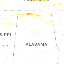
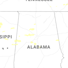
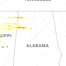
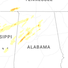


Connect with Interactive Hail Maps