

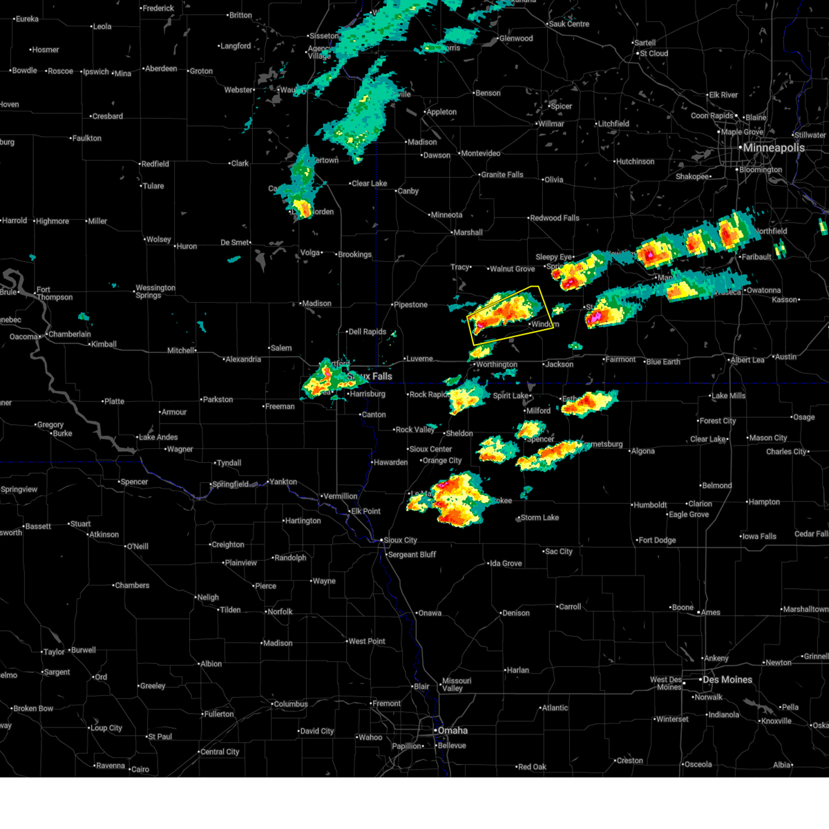
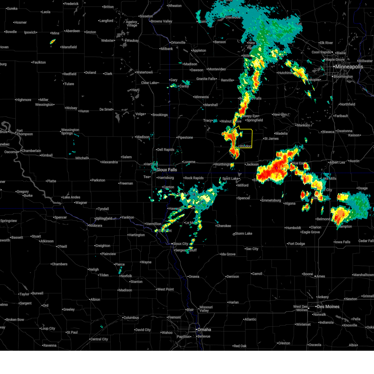
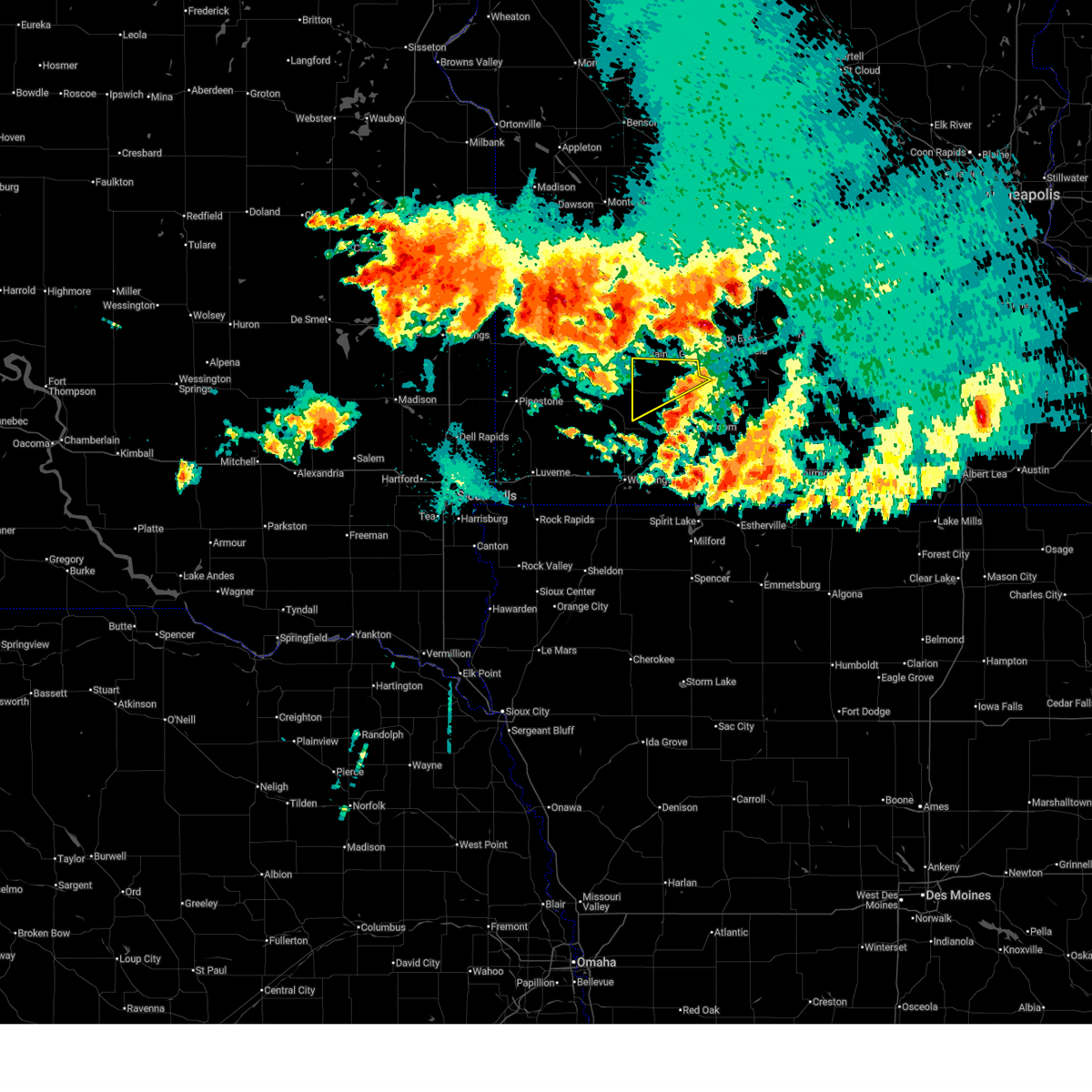
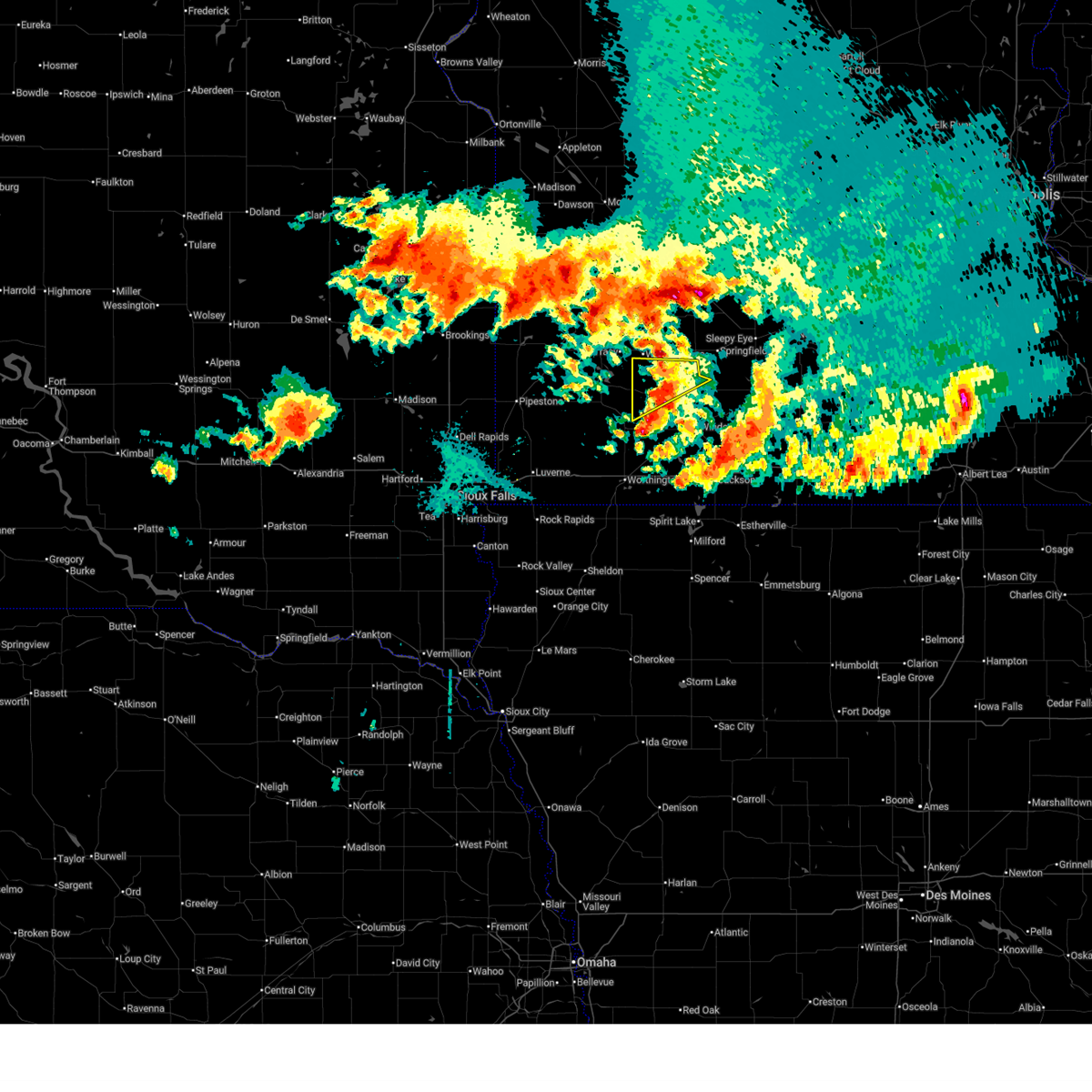
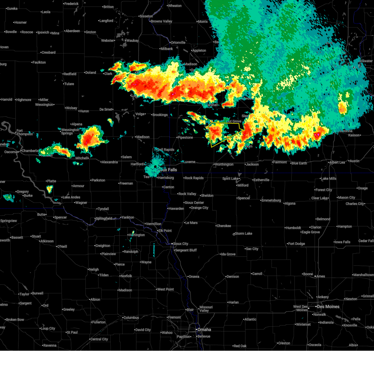
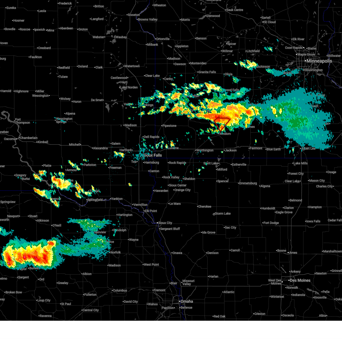
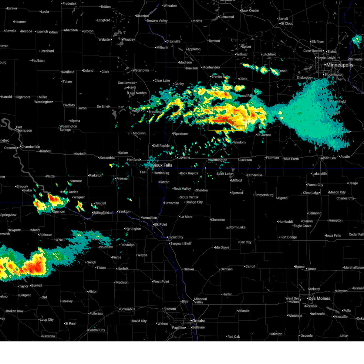
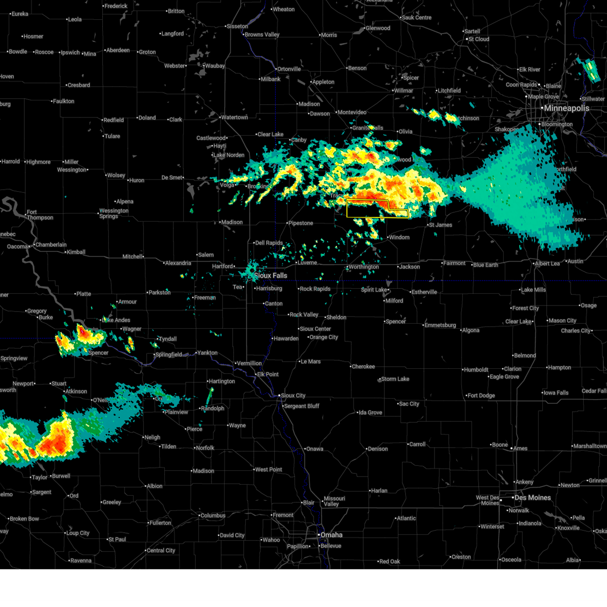
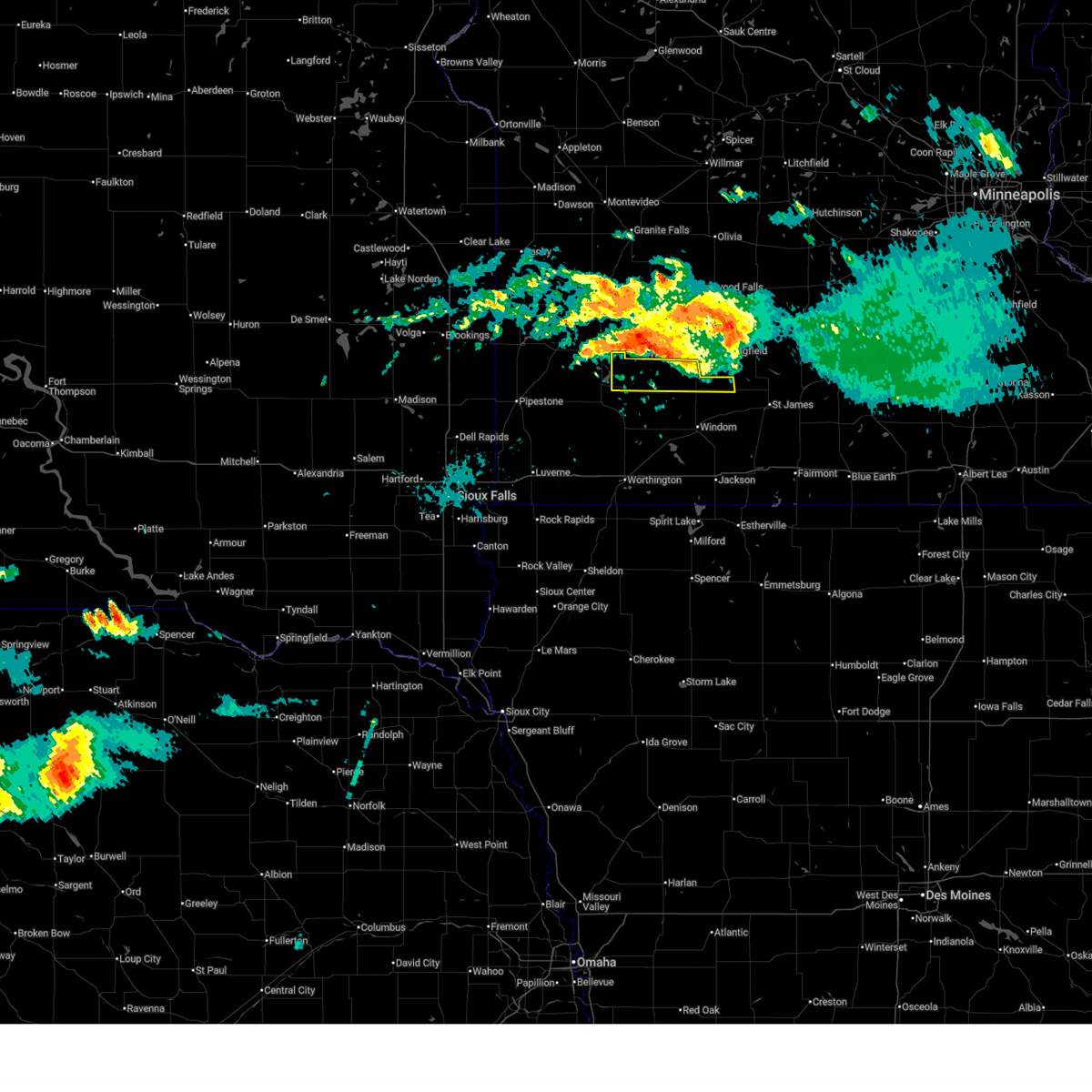
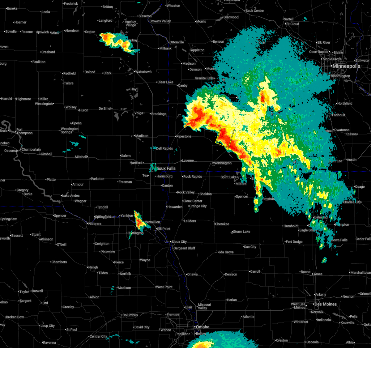
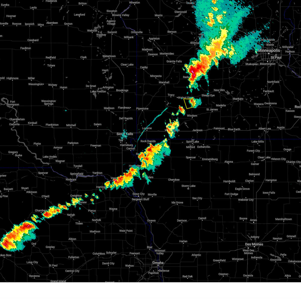
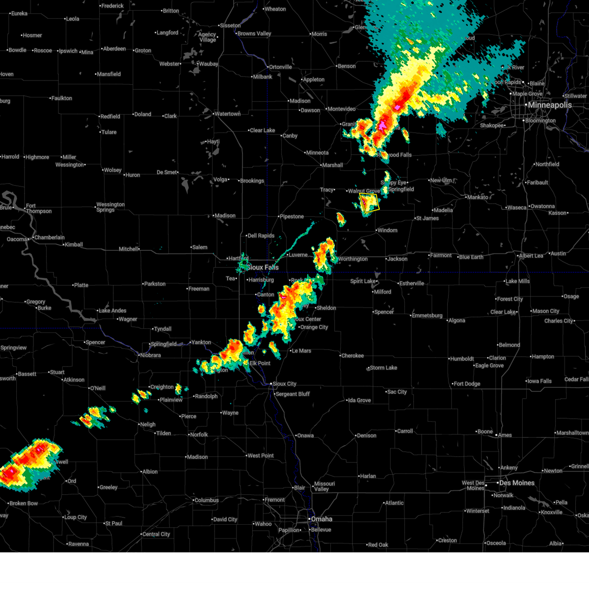
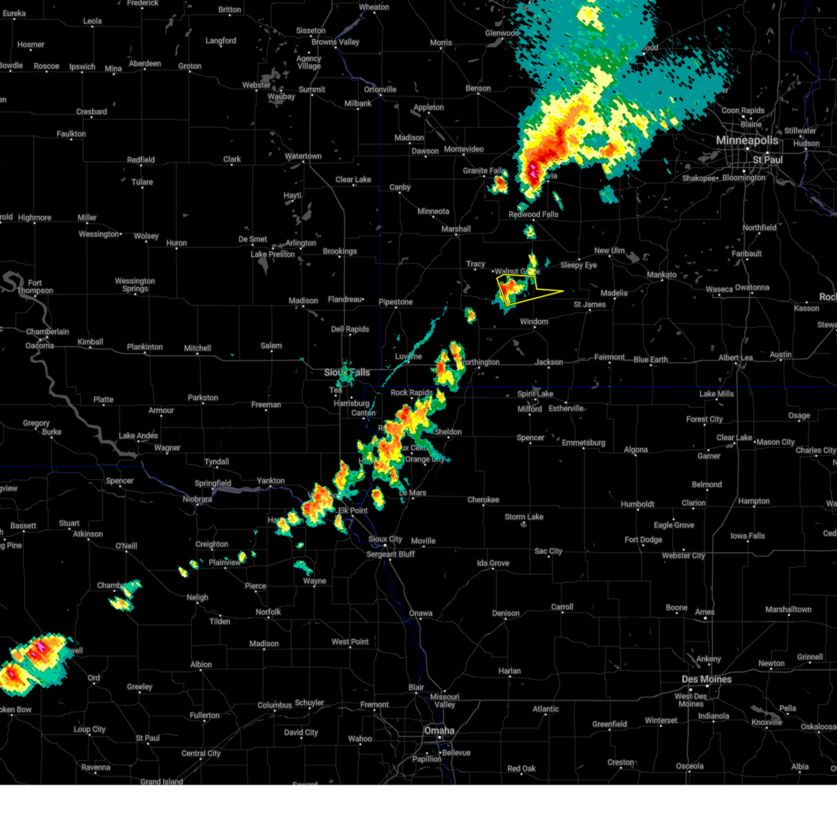
Hail Map for Jeffers, MN
The Jeffers, MN area has had 3 reports of on-the-ground hail by trained spotters, and has been under severe weather warnings 22 times during the past 12 months. Doppler radar has detected hail at or near Jeffers, MN on 49 occasions, including 2 occasions during the past year.
| Name: | Jeffers, MN |
| Where Located: | 67 miles SSE of Montevideo, MN |
| Map: | Google Map for Jeffers, MN |
| Population: | 369 |
| Housing Units: | 196 |
| More Info: | Search Google for Jeffers, MN |
0
The Top Recent Hail Date for Jeffers, MN is Friday, July 18, 2025 (32nd out of 49)
Hail and Wind Damage Spotted near Jeffers, MN
| Date / Time | Report Details |
|---|---|
| 6/28/2026 6:09 AM CDT |
 At 609 am cdt, severe thunderstorms were located along a line extending from near jeffers to near mountain lake to near jackson in jackson county, moving northeast at 50 mph (radar indicated). Hazards include 60 mph wind gusts and nickel size hail. Expect damage to roofs, siding, and trees. Locations impacted include, mountain lake and comfrey. At 609 am cdt, severe thunderstorms were located along a line extending from near jeffers to near mountain lake to near jackson in jackson county, moving northeast at 50 mph (radar indicated). Hazards include 60 mph wind gusts and nickel size hail. Expect damage to roofs, siding, and trees. Locations impacted include, mountain lake and comfrey.
|
| 6/28/2026 5:51 AM CDT |
 Svrfsd the national weather service in sioux falls has issued a * severe thunderstorm warning for, jackson county in southwestern minnesota, cottonwood county in southwestern minnesota, * until 630 am cdt. * at 550 am cdt, severe thunderstorms were located along a line extending from near storden to near heron lake to near lakefield, moving northeast at 50 mph (radar indicated). Hazards include 60 mph wind gusts and nickel size hail. Expect damage to roofs, siding, and trees. severe thunderstorms will be near, windom, lakefield, jeffers, bingham lake, and kilen woods state park around 555 am cdt. jackson in jackson county and bergen around 600 am cdt. mountain lake around 605 am cdt. Comfrey around 610 am cdt. Svrfsd the national weather service in sioux falls has issued a * severe thunderstorm warning for, jackson county in southwestern minnesota, cottonwood county in southwestern minnesota, * until 630 am cdt. * at 550 am cdt, severe thunderstorms were located along a line extending from near storden to near heron lake to near lakefield, moving northeast at 50 mph (radar indicated). Hazards include 60 mph wind gusts and nickel size hail. Expect damage to roofs, siding, and trees. severe thunderstorms will be near, windom, lakefield, jeffers, bingham lake, and kilen woods state park around 555 am cdt. jackson in jackson county and bergen around 600 am cdt. mountain lake around 605 am cdt. Comfrey around 610 am cdt.
|
| 4/13/2026 6:19 PM CDT |
 At 619 pm cdt, a severe thunderstorm was located near heron lake, or 9 miles west of windom, moving east at 25 mph (radar indicated). Hazards include 60 mph wind gusts and half dollar size hail. Hail damage to vehicles is expected. expect wind damage to roofs, siding, and trees. Locations impacted include, windom and bingham lake. At 619 pm cdt, a severe thunderstorm was located near heron lake, or 9 miles west of windom, moving east at 25 mph (radar indicated). Hazards include 60 mph wind gusts and half dollar size hail. Hail damage to vehicles is expected. expect wind damage to roofs, siding, and trees. Locations impacted include, windom and bingham lake.
|
| 4/13/2026 5:59 PM CDT |
 Svrfsd the national weather service in sioux falls has issued a * severe thunderstorm warning for, northwestern jackson county in southwestern minnesota, northeastern nobles county in southwestern minnesota, southern cottonwood county in southwestern minnesota, southeastern murray county in southwestern minnesota, * until 645 pm cdt. * at 559 pm cdt, a severe thunderstorm was located near fulda, or 15 miles southeast of slayton, moving east at 30 mph (radar indicated). Hazards include 60 mph wind gusts and half dollar size hail. Hail damage to vehicles is expected. expect wind damage to roofs, siding, and trees. this severe thunderstorm will be near, heron lake around 605 pm cdt. Other locations in the path of this severe thunderstorm include windom, storden and jeffers. Svrfsd the national weather service in sioux falls has issued a * severe thunderstorm warning for, northwestern jackson county in southwestern minnesota, northeastern nobles county in southwestern minnesota, southern cottonwood county in southwestern minnesota, southeastern murray county in southwestern minnesota, * until 645 pm cdt. * at 559 pm cdt, a severe thunderstorm was located near fulda, or 15 miles southeast of slayton, moving east at 30 mph (radar indicated). Hazards include 60 mph wind gusts and half dollar size hail. Hail damage to vehicles is expected. expect wind damage to roofs, siding, and trees. this severe thunderstorm will be near, heron lake around 605 pm cdt. Other locations in the path of this severe thunderstorm include windom, storden and jeffers.
|
| 9/4/2025 6:15 PM CDT |
 At 615 pm cdt, a severe thunderstorm was located near bingham lake, or 9 miles northeast of windom, moving east at 55 mph (radar indicated). Hazards include 60 mph wind gusts. Expect damage to roofs, siding, and trees. Locations impacted include, mountain lake and bingham lake. At 615 pm cdt, a severe thunderstorm was located near bingham lake, or 9 miles northeast of windom, moving east at 55 mph (radar indicated). Hazards include 60 mph wind gusts. Expect damage to roofs, siding, and trees. Locations impacted include, mountain lake and bingham lake.
|
| 9/4/2025 5:57 PM CDT |
 Svrfsd the national weather service in sioux falls has issued a * severe thunderstorm warning for, northeastern jackson county in southwestern minnesota, cottonwood county in southwestern minnesota, * until 645 pm cdt. * at 557 pm cdt, a severe thunderstorm was located over storden, or 17 miles northwest of windom, moving east at 60 mph (radar indicated). Hazards include 60 mph wind gusts. Expect damage to roofs, siding, and trees. this severe thunderstorm will be near, jeffers around 605 pm cdt. Mountain lake and bingham lake around 610 pm cdt. Svrfsd the national weather service in sioux falls has issued a * severe thunderstorm warning for, northeastern jackson county in southwestern minnesota, cottonwood county in southwestern minnesota, * until 645 pm cdt. * at 557 pm cdt, a severe thunderstorm was located over storden, or 17 miles northwest of windom, moving east at 60 mph (radar indicated). Hazards include 60 mph wind gusts. Expect damage to roofs, siding, and trees. this severe thunderstorm will be near, jeffers around 605 pm cdt. Mountain lake and bingham lake around 610 pm cdt.
|
| 8/17/2025 7:19 PM CDT |
 At 719 pm cdt, a severe thunderstorm was located near bingham lake, or 7 miles northeast of windom, moving east at 30 mph (radar indicated). Hazards include 70 mph wind gusts and penny size hail. Expect considerable tree damage. damage is likely to mobile homes, roofs, and outbuildings. This severe storm will be near, mountain lake around 725 pm cdt. At 719 pm cdt, a severe thunderstorm was located near bingham lake, or 7 miles northeast of windom, moving east at 30 mph (radar indicated). Hazards include 70 mph wind gusts and penny size hail. Expect considerable tree damage. damage is likely to mobile homes, roofs, and outbuildings. This severe storm will be near, mountain lake around 725 pm cdt.
|
| 8/17/2025 7:09 PM CDT |
 Svrfsd the national weather service in sioux falls has issued a * severe thunderstorm warning for, eastern cottonwood county in southwestern minnesota, * until 800 pm cdt. * at 708 pm cdt, a severe thunderstorm was located near jeffers, or 10 miles north of windom, moving east at 35 mph (radar indicated). Hazards include 60 mph wind gusts and penny size hail. Expect damage to roofs, siding, and trees. this severe thunderstorm will be near, delft and comfrey around 720 pm cdt. Bingham lake around 725 pm cdt. Svrfsd the national weather service in sioux falls has issued a * severe thunderstorm warning for, eastern cottonwood county in southwestern minnesota, * until 800 pm cdt. * at 708 pm cdt, a severe thunderstorm was located near jeffers, or 10 miles north of windom, moving east at 35 mph (radar indicated). Hazards include 60 mph wind gusts and penny size hail. Expect damage to roofs, siding, and trees. this severe thunderstorm will be near, delft and comfrey around 720 pm cdt. Bingham lake around 725 pm cdt.
|
| 8/16/2025 6:07 AM CDT |
 The storms which prompted the warning have weakened below severe limits, and have exited the warned area. therefore, the warning will be allowed to expire. a severe thunderstorm watch remains in effect until 900 am cdt for southwestern minnesota. The storms which prompted the warning have weakened below severe limits, and have exited the warned area. therefore, the warning will be allowed to expire. a severe thunderstorm watch remains in effect until 900 am cdt for southwestern minnesota.
|
| 8/16/2025 5:51 AM CDT |
 At 551 am cdt, severe thunderstorms were located along a line extending from wood lake to near walnut grove to near dovray, moving east at 30 mph (radar indicated). Hazards include 60 mph wind gusts and penny size hail. Expect damage to roofs, siding, and trees. Locations impacted include, westbrook, storden and jeffers. At 551 am cdt, severe thunderstorms were located along a line extending from wood lake to near walnut grove to near dovray, moving east at 30 mph (radar indicated). Hazards include 60 mph wind gusts and penny size hail. Expect damage to roofs, siding, and trees. Locations impacted include, westbrook, storden and jeffers.
|
| 8/16/2025 5:25 AM CDT |
 Svrfsd the national weather service in sioux falls has issued a * severe thunderstorm warning for, eastern lyon county in southwestern minnesota, northwestern cottonwood county in southwestern minnesota, eastern murray county in southwestern minnesota, * until 615 am cdt. * at 525 am cdt, severe thunderstorms were located along a line extending from 6 miles west of cottonwood to near balaton to near slayton, moving east at 30 mph (radar indicated). Hazards include 70 mph wind gusts and penny size hail. Expect considerable tree damage. damage is likely to mobile homes, roofs, and outbuildings. severe thunderstorms will be near, marshall, slayton, tracy, cottonwood, currie, and lake shetek state park around 530 am cdt. dovray around 540 am cdt. Other locations in the path of these severe thunderstorms include westbrook and storden. Svrfsd the national weather service in sioux falls has issued a * severe thunderstorm warning for, eastern lyon county in southwestern minnesota, northwestern cottonwood county in southwestern minnesota, eastern murray county in southwestern minnesota, * until 615 am cdt. * at 525 am cdt, severe thunderstorms were located along a line extending from 6 miles west of cottonwood to near balaton to near slayton, moving east at 30 mph (radar indicated). Hazards include 70 mph wind gusts and penny size hail. Expect considerable tree damage. damage is likely to mobile homes, roofs, and outbuildings. severe thunderstorms will be near, marshall, slayton, tracy, cottonwood, currie, and lake shetek state park around 530 am cdt. dovray around 540 am cdt. Other locations in the path of these severe thunderstorms include westbrook and storden.
|
| 7/27/2025 10:36 PM CDT |
 the severe thunderstorm warning has been cancelled and is no longer in effect the severe thunderstorm warning has been cancelled and is no longer in effect
|
| 7/27/2025 10:22 PM CDT |
 At 1022 pm cdt, a severe thunderstorm was located 7 miles southwest of lamberton, or 22 miles northeast of slayton, moving northeast at 30 mph (radar indicated). Hazards include 60 mph wind gusts and quarter size hail. Hail damage to vehicles is expected. expect wind damage to roofs, siding, and trees. This severe thunderstorm will remain over mainly rural areas of northwestern cottonwood and northeastern murray counties. At 1022 pm cdt, a severe thunderstorm was located 7 miles southwest of lamberton, or 22 miles northeast of slayton, moving northeast at 30 mph (radar indicated). Hazards include 60 mph wind gusts and quarter size hail. Hail damage to vehicles is expected. expect wind damage to roofs, siding, and trees. This severe thunderstorm will remain over mainly rural areas of northwestern cottonwood and northeastern murray counties.
|
| 7/27/2025 10:08 PM CDT |
 Svrfsd the national weather service in sioux falls has issued a * severe thunderstorm warning for, northwestern cottonwood county in southwestern minnesota, eastern murray county in southwestern minnesota, * until 1100 pm cdt. * at 1008 pm cdt, a severe thunderstorm was located near dovray, or 15 miles northeast of slayton, moving northeast at 30 mph (radar indicated). Hazards include 60 mph wind gusts and quarter size hail. Hail damage to vehicles is expected. expect wind damage to roofs, siding, and trees. This severe thunderstorm will be near, storden around 1015 pm cdt. Svrfsd the national weather service in sioux falls has issued a * severe thunderstorm warning for, northwestern cottonwood county in southwestern minnesota, eastern murray county in southwestern minnesota, * until 1100 pm cdt. * at 1008 pm cdt, a severe thunderstorm was located near dovray, or 15 miles northeast of slayton, moving northeast at 30 mph (radar indicated). Hazards include 60 mph wind gusts and quarter size hail. Hail damage to vehicles is expected. expect wind damage to roofs, siding, and trees. This severe thunderstorm will be near, storden around 1015 pm cdt.
|
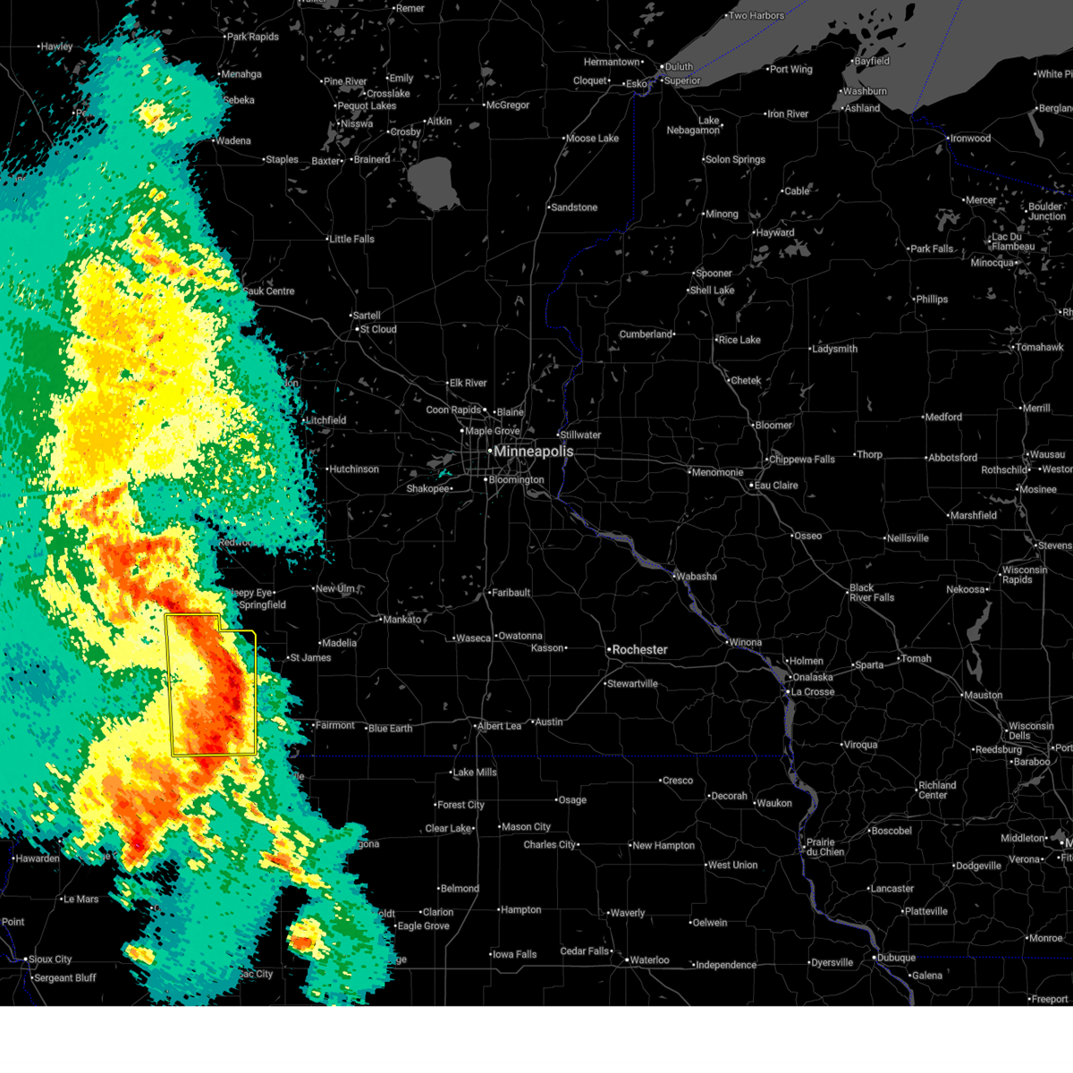
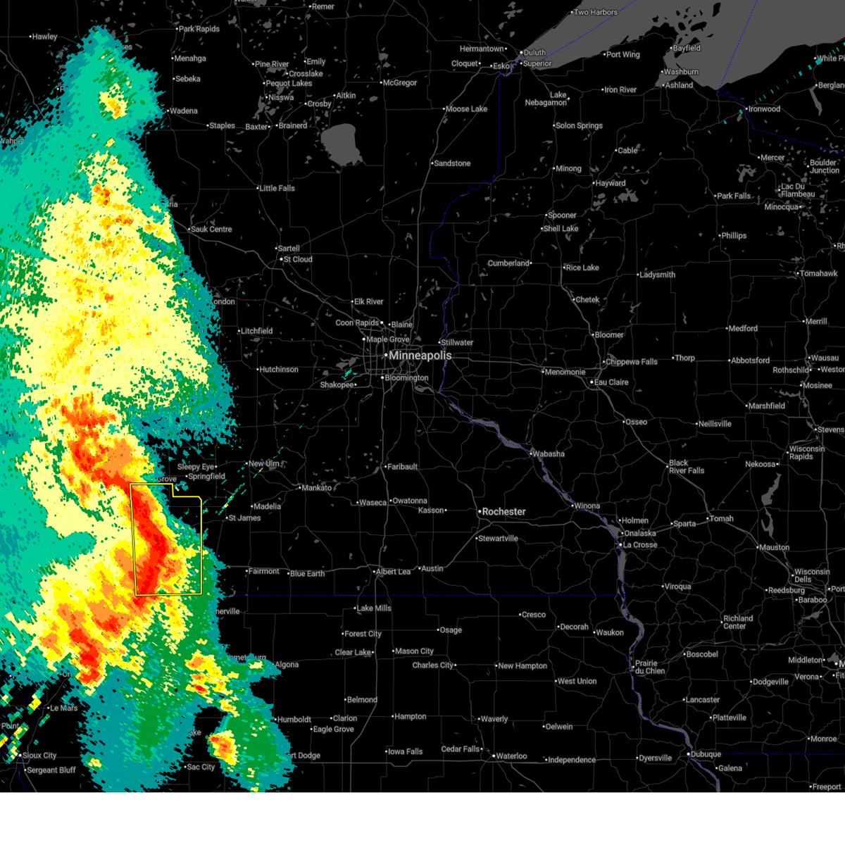
| 7/18/2025 11:31 PM CDT |
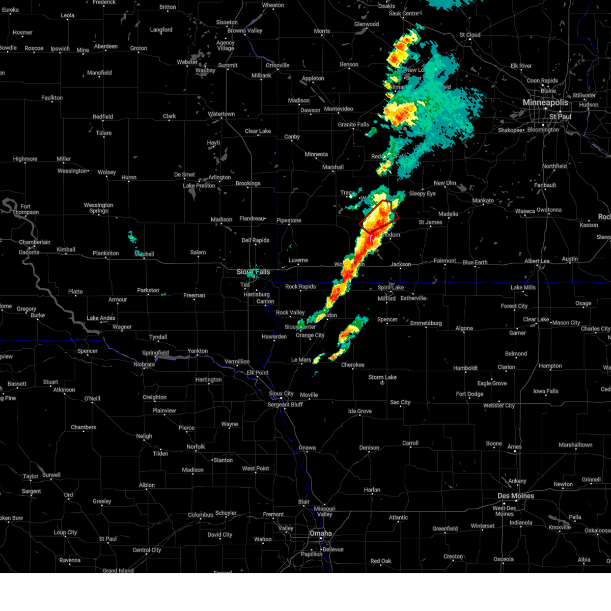
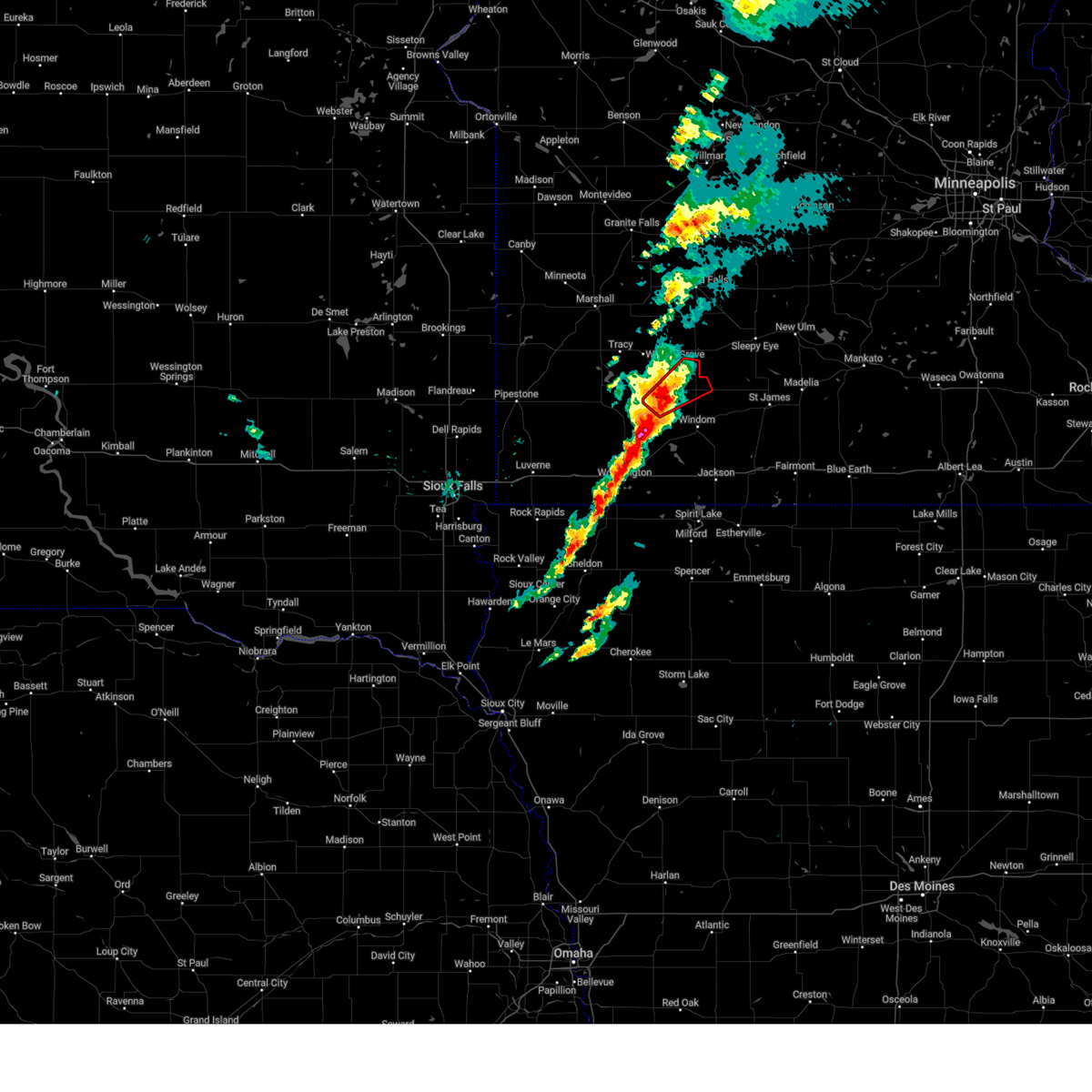
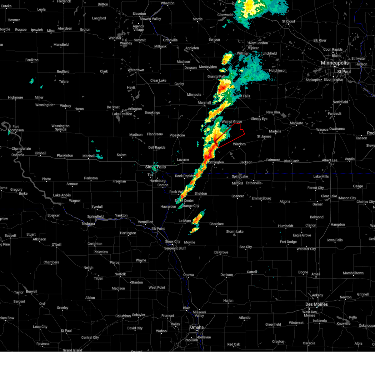
 At 1131 pm cdt, a severe thunderstorm capable of producing a tornado was located near jeffers, or 13 miles north of windom, moving southeast at 20 mph (radar indicated rotation). Hazards include tornado. Flying debris will be dangerous to those caught without shelter. mobile homes will be damaged or destroyed. damage to roofs, windows, and vehicles will occur. tree damage is likely. This tornadic thunderstorm will remain over mainly rural areas of eastern cottonwood county, including the following locations, delft. At 1131 pm cdt, a severe thunderstorm capable of producing a tornado was located near jeffers, or 13 miles north of windom, moving southeast at 20 mph (radar indicated rotation). Hazards include tornado. Flying debris will be dangerous to those caught without shelter. mobile homes will be damaged or destroyed. damage to roofs, windows, and vehicles will occur. tree damage is likely. This tornadic thunderstorm will remain over mainly rural areas of eastern cottonwood county, including the following locations, delft.
|
| 7/18/2025 11:15 PM CDT |
 The storms which prompted the warning have weakened below severe limits, and no longer pose an immediate threat to life or property. therefore, the warning will be allowed to expire. however, gusty winds and heavy rain are still possible with these thunderstorms. a severe thunderstorm watch remains in effect until 300 am cdt for southwestern minnesota. to report severe weather, contact your nearest law enforcement agency. they will relay your report to the national weather service sioux falls. remember, a tornado warning still remains in effect for portions of cottonwood county through 12 am. The storms which prompted the warning have weakened below severe limits, and no longer pose an immediate threat to life or property. therefore, the warning will be allowed to expire. however, gusty winds and heavy rain are still possible with these thunderstorms. a severe thunderstorm watch remains in effect until 300 am cdt for southwestern minnesota. to report severe weather, contact your nearest law enforcement agency. they will relay your report to the national weather service sioux falls. remember, a tornado warning still remains in effect for portions of cottonwood county through 12 am.
|
| 7/18/2025 11:11 PM CDT |
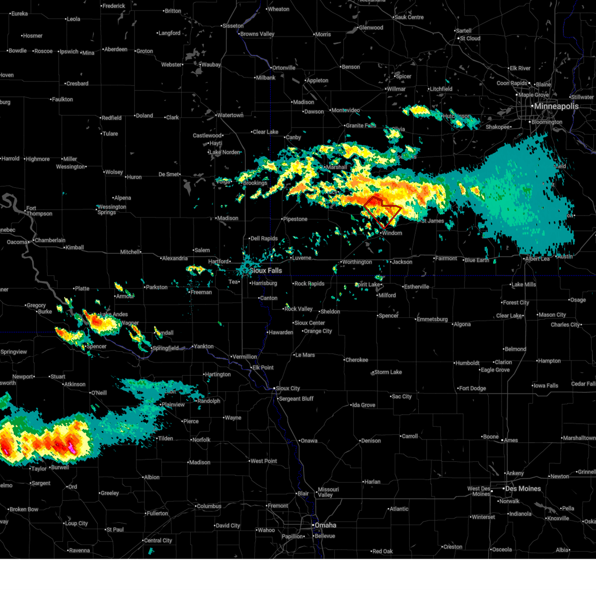 Torfsd the national weather service in sioux falls has issued a * tornado warning for, central cottonwood county in southwestern minnesota, * until midnight cdt. * at 1110 pm cdt, a severe thunderstorm capable of producing a tornado was located near jeffers, or 17 miles north of windom, moving southeast at 20 mph (radar indicated rotation). Hazards include tornado and half dollar size hail. Flying debris will be dangerous to those caught without shelter. mobile homes will be damaged or destroyed. damage to roofs, windows, and vehicles will occur. tree damage is likely. This dangerous storm will be near, jeffers around 1115 pm cdt. Torfsd the national weather service in sioux falls has issued a * tornado warning for, central cottonwood county in southwestern minnesota, * until midnight cdt. * at 1110 pm cdt, a severe thunderstorm capable of producing a tornado was located near jeffers, or 17 miles north of windom, moving southeast at 20 mph (radar indicated rotation). Hazards include tornado and half dollar size hail. Flying debris will be dangerous to those caught without shelter. mobile homes will be damaged or destroyed. damage to roofs, windows, and vehicles will occur. tree damage is likely. This dangerous storm will be near, jeffers around 1115 pm cdt.
|
| 7/18/2025 10:57 PM CDT |
 At 1057 pm cdt, severe thunderstorms were located along a line extending from 9 miles west of comfrey to near jeffers to 6 miles north of storden to 6 miles south of walnut grove, moving southeast at 25 mph (radar indicated). Hazards include golf ball size hail and 60 mph wind gusts. People and animals outdoors will be injured. expect hail damage to roofs, siding, windows, and vehicles. expect wind damage to roofs, siding, and trees. Locations impacted include, westbrook, comfrey, jeffers, and dovray. At 1057 pm cdt, severe thunderstorms were located along a line extending from 9 miles west of comfrey to near jeffers to 6 miles north of storden to 6 miles south of walnut grove, moving southeast at 25 mph (radar indicated). Hazards include golf ball size hail and 60 mph wind gusts. People and animals outdoors will be injured. expect hail damage to roofs, siding, windows, and vehicles. expect wind damage to roofs, siding, and trees. Locations impacted include, westbrook, comfrey, jeffers, and dovray.
|
| 7/18/2025 10:57 PM CDT |
 The storms which prompted the warning have moved out of the warned area. therefore, the warning has been cancelled. a severe thunderstorm watch remains in effect until 300 am cdt for southwestern minnesota. The storms which prompted the warning have moved out of the warned area. therefore, the warning has been cancelled. a severe thunderstorm watch remains in effect until 300 am cdt for southwestern minnesota.
|
| 7/18/2025 10:52 PM CDT |
 At 1052 pm cdt, severe thunderstorms were located along a line extending from 9 miles southwest of springfield to near jeffers to 7 miles north of storden to near walnut grove, moving southeast at 15 mph (radar indicated). Hazards include 60 mph wind gusts and quarter size hail. Hail damage to vehicles is expected. expect wind damage to roofs, siding, and trees. Locations impacted include, westbrook, comfrey, jeffers, and dovray. At 1052 pm cdt, severe thunderstorms were located along a line extending from 9 miles southwest of springfield to near jeffers to 7 miles north of storden to near walnut grove, moving southeast at 15 mph (radar indicated). Hazards include 60 mph wind gusts and quarter size hail. Hail damage to vehicles is expected. expect wind damage to roofs, siding, and trees. Locations impacted include, westbrook, comfrey, jeffers, and dovray.
|
| 7/18/2025 10:52 PM CDT |
 the severe thunderstorm warning has been cancelled and is no longer in effect the severe thunderstorm warning has been cancelled and is no longer in effect
|
| 7/18/2025 10:13 PM CDT |
 Svrfsd the national weather service in sioux falls has issued a * severe thunderstorm warning for, southeastern lyon county in southwestern minnesota, northern cottonwood county in southwestern minnesota, northeastern murray county in southwestern minnesota, * until 1115 pm cdt. * at 1013 pm cdt, severe thunderstorms were located along a line extending from lamberton to 11 miles north of storden to near walnut grove to tracy, moving southeast at 25 mph (radar indicated). Hazards include 60 mph wind gusts and quarter size hail. Hail damage to vehicles is expected. Expect wind damage to roofs, siding, and trees. Svrfsd the national weather service in sioux falls has issued a * severe thunderstorm warning for, southeastern lyon county in southwestern minnesota, northern cottonwood county in southwestern minnesota, northeastern murray county in southwestern minnesota, * until 1115 pm cdt. * at 1013 pm cdt, severe thunderstorms were located along a line extending from lamberton to 11 miles north of storden to near walnut grove to tracy, moving southeast at 25 mph (radar indicated). Hazards include 60 mph wind gusts and quarter size hail. Hail damage to vehicles is expected. Expect wind damage to roofs, siding, and trees.
|
| 6/20/2025 1:19 AM CDT |
 At 119 am cdt, a severe thunderstorm was located near westbrook, or 16 miles northwest of windom, moving east at 25 mph (radar indicated). Hazards include quarter size hail. Damage to vehicles is expected. Locations impacted include, storden and jeffers. At 119 am cdt, a severe thunderstorm was located near westbrook, or 16 miles northwest of windom, moving east at 25 mph (radar indicated). Hazards include quarter size hail. Damage to vehicles is expected. Locations impacted include, storden and jeffers.
|
| 6/20/2025 1:02 AM CDT |
 Svrfsd the national weather service in sioux falls has issued a * severe thunderstorm warning for, southwestern cottonwood county in southwestern minnesota, northeastern murray county in southwestern minnesota, * until 145 am cdt. * at 102 am cdt, a severe thunderstorm was located over dovray, or 10 miles east of slayton, moving east at 25 mph (radar indicated). Hazards include quarter size hail. Damage to vehicles is expected. this severe thunderstorm will be near, westbrook and storden around 110 am cdt. Other locations in the path of this severe thunderstorm include jeffers. Svrfsd the national weather service in sioux falls has issued a * severe thunderstorm warning for, southwestern cottonwood county in southwestern minnesota, northeastern murray county in southwestern minnesota, * until 145 am cdt. * at 102 am cdt, a severe thunderstorm was located over dovray, or 10 miles east of slayton, moving east at 25 mph (radar indicated). Hazards include quarter size hail. Damage to vehicles is expected. this severe thunderstorm will be near, westbrook and storden around 110 am cdt. Other locations in the path of this severe thunderstorm include jeffers.
|
| 6/2/2025 5:23 PM CDT |
 The storm which prompted the warning has moved out of the area. therefore, the warning will be allowed to expire. a severe thunderstorm watch remains in effect until 100 am cdt for southwestern minnesota. The storm which prompted the warning has moved out of the area. therefore, the warning will be allowed to expire. a severe thunderstorm watch remains in effect until 100 am cdt for southwestern minnesota.
|
| 6/2/2025 5:09 PM CDT |
 At 509 pm cdt, a severe thunderstorm was located near lamberton, or 20 miles north of windom, moving east at 35 mph (radar indicated). Hazards include 60 mph wind gusts and quarter size hail. Hail damage to vehicles is expected. expect wind damage to roofs, siding, and trees. This severe thunderstorm will remain over mainly rural areas of north central cottonwood county. At 509 pm cdt, a severe thunderstorm was located near lamberton, or 20 miles north of windom, moving east at 35 mph (radar indicated). Hazards include 60 mph wind gusts and quarter size hail. Hail damage to vehicles is expected. expect wind damage to roofs, siding, and trees. This severe thunderstorm will remain over mainly rural areas of north central cottonwood county.
|
| 6/2/2025 5:01 PM CDT |
 Svrfsd the national weather service in sioux falls has issued a * severe thunderstorm warning for, northern cottonwood county in southwestern minnesota, * until 530 pm cdt. * at 501 pm cdt, a severe thunderstorm was located near storden, or 20 miles northwest of windom, moving east at 35 mph (radar indicated). Hazards include 60 mph wind gusts and quarter size hail. Hail damage to vehicles is expected. expect wind damage to roofs, siding, and trees. This severe thunderstorm will be near, jeffers around 505 pm cdt. Svrfsd the national weather service in sioux falls has issued a * severe thunderstorm warning for, northern cottonwood county in southwestern minnesota, * until 530 pm cdt. * at 501 pm cdt, a severe thunderstorm was located near storden, or 20 miles northwest of windom, moving east at 35 mph (radar indicated). Hazards include 60 mph wind gusts and quarter size hail. Hail damage to vehicles is expected. expect wind damage to roofs, siding, and trees. This severe thunderstorm will be near, jeffers around 505 pm cdt.
|
| 4/28/2025 3:11 PM CDT |
 At 311 pm cdt, severe thunderstorms were located along a line extending from comfrey to near bingham lake to near lakefield, moving northeast at 60 mph (radar indicated). Hazards include ping pong ball size hail and 60 mph wind gusts. People and animals outdoors will be injured. expect hail damage to roofs, siding, windows, and vehicles. expect wind damage to roofs, siding, and trees. These severe storms will be near, comfrey, bergen, mountain lake, bingham lake, windom, and kilen woods state park around 315 pm cdt. At 311 pm cdt, severe thunderstorms were located along a line extending from comfrey to near bingham lake to near lakefield, moving northeast at 60 mph (radar indicated). Hazards include ping pong ball size hail and 60 mph wind gusts. People and animals outdoors will be injured. expect hail damage to roofs, siding, windows, and vehicles. expect wind damage to roofs, siding, and trees. These severe storms will be near, comfrey, bergen, mountain lake, bingham lake, windom, and kilen woods state park around 315 pm cdt.
|
| 4/28/2025 3:07 PM CDT |
 The tornado threat has diminished and the tornado warning has been cancelled. however, large hail and damaging winds remain likely and a severe thunderstorm warning remains in effect for the area. however, small hail, gusty winds and heavy rain are still possible with this thunderstorm. a tornado watch remains in effect until 800 pm cdt for southwestern minnesota. to report severe weather, contact your nearest law enforcement agency. they will relay your report to the national weather service sioux falls. remember, a severe thunderstorm warning still remains in effect for nobles, cottonwood, and jackson counties through 3:45 pm. The tornado threat has diminished and the tornado warning has been cancelled. however, large hail and damaging winds remain likely and a severe thunderstorm warning remains in effect for the area. however, small hail, gusty winds and heavy rain are still possible with this thunderstorm. a tornado watch remains in effect until 800 pm cdt for southwestern minnesota. to report severe weather, contact your nearest law enforcement agency. they will relay your report to the national weather service sioux falls. remember, a severe thunderstorm warning still remains in effect for nobles, cottonwood, and jackson counties through 3:45 pm.
|
| 4/28/2025 3:02 PM CDT |
 Svrfsd the national weather service in sioux falls has issued a * severe thunderstorm warning for, jackson county in southwestern minnesota, southeastern nobles county in southwestern minnesota, cottonwood county in southwestern minnesota, * until 345 pm cdt. * at 302 pm cdt, severe thunderstorms were located along a line extending from near springfield to 6 miles east of jeffers to near windom, moving northeast at 130 mph (radar indicated). Hazards include ping pong ball size hail and 60 mph wind gusts. People and animals outdoors will be injured. expect hail damage to roofs, siding, windows, and vehicles. expect wind damage to roofs, siding, and trees. Severe thunderstorms will be near, comfrey around 310 pm cdt. Svrfsd the national weather service in sioux falls has issued a * severe thunderstorm warning for, jackson county in southwestern minnesota, southeastern nobles county in southwestern minnesota, cottonwood county in southwestern minnesota, * until 345 pm cdt. * at 302 pm cdt, severe thunderstorms were located along a line extending from near springfield to 6 miles east of jeffers to near windom, moving northeast at 130 mph (radar indicated). Hazards include ping pong ball size hail and 60 mph wind gusts. People and animals outdoors will be injured. expect hail damage to roofs, siding, windows, and vehicles. expect wind damage to roofs, siding, and trees. Severe thunderstorms will be near, comfrey around 310 pm cdt.
|
| 4/28/2025 2:47 PM CDT |
 At 246 pm cdt, a severe squall line capable of producing both tornadoes and extensive straight line wind damage was located over storden, or 15 miles northwest of windom, moving northeast at 40 mph (radar indicated rotation). Hazards include tornado. Flying debris will be dangerous to those caught without shelter. mobile homes will be damaged or destroyed. damage to roofs, windows, and vehicles will occur. tree damage is likely. These dangerous storms will be near, jeffers and storden around 250 pm cdt. At 246 pm cdt, a severe squall line capable of producing both tornadoes and extensive straight line wind damage was located over storden, or 15 miles northwest of windom, moving northeast at 40 mph (radar indicated rotation). Hazards include tornado. Flying debris will be dangerous to those caught without shelter. mobile homes will be damaged or destroyed. damage to roofs, windows, and vehicles will occur. tree damage is likely. These dangerous storms will be near, jeffers and storden around 250 pm cdt.
|
| 4/28/2025 2:47 PM CDT |
 the tornado warning has been cancelled and is no longer in effect the tornado warning has been cancelled and is no longer in effect
|
| 4/28/2025 2:34 PM CDT |
 Torfsd the national weather service in sioux falls has issued a * tornado warning for, northwestern cottonwood county in southwestern minnesota, southeastern murray county in southwestern minnesota, * until 300 pm cdt. * at 234 pm cdt, severe thunderstorms capable of producing both tornadoes and extensive straight line wind damage were located near westbrook, or 14 miles east of slayton, moving northeast at 50 mph (radar indicated rotation). Hazards include tornado. Flying debris will be dangerous to those caught without shelter. mobile homes will be damaged or destroyed. damage to roofs, windows, and vehicles will occur. tree damage is likely. these dangerous storms will be near, storden and westbrook around 240 pm cdt. Jeffers around 245 pm cdt. Torfsd the national weather service in sioux falls has issued a * tornado warning for, northwestern cottonwood county in southwestern minnesota, southeastern murray county in southwestern minnesota, * until 300 pm cdt. * at 234 pm cdt, severe thunderstorms capable of producing both tornadoes and extensive straight line wind damage were located near westbrook, or 14 miles east of slayton, moving northeast at 50 mph (radar indicated rotation). Hazards include tornado. Flying debris will be dangerous to those caught without shelter. mobile homes will be damaged or destroyed. damage to roofs, windows, and vehicles will occur. tree damage is likely. these dangerous storms will be near, storden and westbrook around 240 pm cdt. Jeffers around 245 pm cdt.
|
| 10/24/2023 12:28 PM CDT |
 At 1228 pm cdt, a severe thunderstorm was located near dovray, or 15 miles northeast of slayton, moving east at 40 mph (public. at 1215 pm, quarter sized hail was reported in currie). Hazards include quarter size hail. Damage to vehicles is expected. this severe thunderstorm will be near, storden around 1235 pm cdt. jeffers around 1245 pm cdt. hail threat, observed max hail size, 1. 00 in wind threat, radar indicated max wind gust, <50 mph. At 1228 pm cdt, a severe thunderstorm was located near dovray, or 15 miles northeast of slayton, moving east at 40 mph (public. at 1215 pm, quarter sized hail was reported in currie). Hazards include quarter size hail. Damage to vehicles is expected. this severe thunderstorm will be near, storden around 1235 pm cdt. jeffers around 1245 pm cdt. hail threat, observed max hail size, 1. 00 in wind threat, radar indicated max wind gust, <50 mph.
|
| 8/11/2023 5:19 PM CDT |
 At 518 pm cdt, a severe thunderstorm was located over jeffers, or 12 miles north of windom, moving east at 40 mph (at 5:18 cdt, trained spotters reported pea to dime sized hail just north of storden mn). Hazards include 60 mph wind gusts and quarter size hail. Hail damage to vehicles is expected. expect wind damage to roofs, siding, and trees. locations impacted include, mountain lake and bingham lake. hail threat, radar indicated max hail size, 1. 00 in wind threat, radar indicated max wind gust, 60 mph. At 518 pm cdt, a severe thunderstorm was located over jeffers, or 12 miles north of windom, moving east at 40 mph (at 5:18 cdt, trained spotters reported pea to dime sized hail just north of storden mn). Hazards include 60 mph wind gusts and quarter size hail. Hail damage to vehicles is expected. expect wind damage to roofs, siding, and trees. locations impacted include, mountain lake and bingham lake. hail threat, radar indicated max hail size, 1. 00 in wind threat, radar indicated max wind gust, 60 mph.
|
| 8/11/2023 5:04 PM CDT |
 At 504 pm cdt, a severe thunderstorm was located near westbrook, or 19 miles northwest of windom, moving east at 40 mph (radar indicated). Hazards include 60 mph wind gusts and quarter size hail. Hail damage to vehicles is expected. expect wind damage to roofs, siding, and trees. this severe storm will be near, jeffers and storden around 510 pm cdt. other locations in the path of this severe thunderstorm include bingham lake and mountain lake. hail threat, radar indicated max hail size, 1. 00 in wind threat, radar indicated max wind gust, 60 mph. At 504 pm cdt, a severe thunderstorm was located near westbrook, or 19 miles northwest of windom, moving east at 40 mph (radar indicated). Hazards include 60 mph wind gusts and quarter size hail. Hail damage to vehicles is expected. expect wind damage to roofs, siding, and trees. this severe storm will be near, jeffers and storden around 510 pm cdt. other locations in the path of this severe thunderstorm include bingham lake and mountain lake. hail threat, radar indicated max hail size, 1. 00 in wind threat, radar indicated max wind gust, 60 mph.
|
| 8/11/2023 4:53 PM CDT |
 At 452 pm cdt, a severe thunderstorm was located near dovray, or 14 miles northeast of slayton, moving east at 40 mph (radar indicated). Hazards include 60 mph wind gusts and quarter size hail. Hail damage to vehicles is expected. expect wind damage to roofs, siding, and trees. this severe thunderstorm will be near, westbrook and storden around 500 pm cdt. jeffers around 505 pm cdt. other locations in the path of this severe thunderstorm include bingham lake and mountain lake. hail threat, radar indicated max hail size, 1. 00 in wind threat, radar indicated max wind gust, 60 mph. At 452 pm cdt, a severe thunderstorm was located near dovray, or 14 miles northeast of slayton, moving east at 40 mph (radar indicated). Hazards include 60 mph wind gusts and quarter size hail. Hail damage to vehicles is expected. expect wind damage to roofs, siding, and trees. this severe thunderstorm will be near, westbrook and storden around 500 pm cdt. jeffers around 505 pm cdt. other locations in the path of this severe thunderstorm include bingham lake and mountain lake. hail threat, radar indicated max hail size, 1. 00 in wind threat, radar indicated max wind gust, 60 mph.
|
| 6/24/2023 10:43 PM CDT | The severe thunderstorm warning for central cottonwood county will expire at 1045 pm cdt, the storm which prompted the warning has weakened below severe limits, and no longer poses an immediate threat to life or property. therefore, the warning will be allowed to expire. however small hail, gusty winds and heavy rain are still possible with this thunderstorm. a severe thunderstorm watch remains in effect until 300 am cdt for southwestern minnesota. |
| 6/24/2023 10:19 PM CDT | At 1018 pm cdt, a severe thunderstorm was located over jeffers, or 11 miles north of windom, moving northeast at 25 mph (radar indicated). Hazards include 60 mph wind gusts and half dollar size hail. Hail damage to vehicles is expected. expect wind damage to roofs, siding, and trees. this severe thunderstorm will remain over mainly rural areas of central cottonwood county, including the following locations, delft. hail threat, radar indicated max hail size, 1. 25 in wind threat, radar indicated max wind gust, 60 mph. |
| 6/24/2023 10:04 PM CDT | At 1004 pm cdt, a severe thunderstorm was located near storden, or 11 miles northwest of windom, moving east at 30 mph (radar indicated). Hazards include 60 mph wind gusts and half dollar size hail. Hail damage to vehicles is expected. expect wind damage to roofs, siding, and trees. this severe thunderstorm will be near, jeffers around 1015 pm cdt. hail threat, radar indicated max hail size, 1. 25 in wind threat, radar indicated max wind gust, 60 mph. |
| 6/24/2023 6:02 AM CDT |
 At 601 am cdt, severe thunderstorms were located along a line extending from near westbrook to 6 miles northwest of orleans to near everly, moving northeast at 50 mph (radar indicated). Hazards include 60 mph wind gusts. Expect damage to roofs, siding, and trees. locations impacted include, westbrook, orleans, storden, lakefield, jeffers, kilen woods state park, jackson in jackson county, bergen, terril and superior. hail threat, radar indicated max hail size, <. 75 in wind threat, radar indicated max wind gust, 60 mph. At 601 am cdt, severe thunderstorms were located along a line extending from near westbrook to 6 miles northwest of orleans to near everly, moving northeast at 50 mph (radar indicated). Hazards include 60 mph wind gusts. Expect damage to roofs, siding, and trees. locations impacted include, westbrook, orleans, storden, lakefield, jeffers, kilen woods state park, jackson in jackson county, bergen, terril and superior. hail threat, radar indicated max hail size, <. 75 in wind threat, radar indicated max wind gust, 60 mph.
|
| 6/24/2023 5:31 AM CDT |
 At 531 am cdt, severe thunderstorms were located along a line extending from near chandler to near ocheyedan to near paullina, moving northeast at 50 mph (radar indicated). Hazards include 60 mph wind gusts. Expect damage to roofs, siding, and trees. severe thunderstorms will be near, ocheyedan and current lake around 535 am cdt. slayton around 540 am cdt. fulda, round lake and harris around 545 am cdt. lake park, currie and lake shetek state park around 550 am cdt. other locations in the path of these severe thunderstorms include okoboji, everly, royal, wahpeton, dovray, spirit lake, westbrook, orleans, greenville, spencer in clay county, storden, lakefield, fostoria and superior. hail threat, radar indicated max hail size, <. 75 in wind threat, radar indicated max wind gust, 60 mph. At 531 am cdt, severe thunderstorms were located along a line extending from near chandler to near ocheyedan to near paullina, moving northeast at 50 mph (radar indicated). Hazards include 60 mph wind gusts. Expect damage to roofs, siding, and trees. severe thunderstorms will be near, ocheyedan and current lake around 535 am cdt. slayton around 540 am cdt. fulda, round lake and harris around 545 am cdt. lake park, currie and lake shetek state park around 550 am cdt. other locations in the path of these severe thunderstorms include okoboji, everly, royal, wahpeton, dovray, spirit lake, westbrook, orleans, greenville, spencer in clay county, storden, lakefield, fostoria and superior. hail threat, radar indicated max hail size, <. 75 in wind threat, radar indicated max wind gust, 60 mph.
|
| 10/23/2022 8:57 PM CDT |
 The severe thunderstorm warning for northern jackson, northeastern nobles, eastern murray and cottonwood counties will expire at 900 pm cdt, the storms which prompted the warning have weakened below severe limits, and have exited the warned area. therefore, the warning will be allowed to expire. however small hail and gusty winds are still possible with these thunderstorms. a severe thunderstorm watch remains in effect until 1000 pm cdt for southwestern minnesota. The severe thunderstorm warning for northern jackson, northeastern nobles, eastern murray and cottonwood counties will expire at 900 pm cdt, the storms which prompted the warning have weakened below severe limits, and have exited the warned area. therefore, the warning will be allowed to expire. however small hail and gusty winds are still possible with these thunderstorms. a severe thunderstorm watch remains in effect until 1000 pm cdt for southwestern minnesota.
|
| 10/23/2022 8:44 PM CDT |
 At 844 pm cdt, severe thunderstorms were located along a line extending from near walnut grove to near lamberton to near jeffers, moving east at 75 mph (radar indicated). Hazards include 60 mph wind gusts and penny size hail. Expect damage to roofs, siding, and trees. locations impacted include, windom, bergen, bingham lake, mountain lake and comfrey. hail threat, radar indicated max hail size, 0. 75 in wind threat, radar indicated max wind gust, 60 mph. At 844 pm cdt, severe thunderstorms were located along a line extending from near walnut grove to near lamberton to near jeffers, moving east at 75 mph (radar indicated). Hazards include 60 mph wind gusts and penny size hail. Expect damage to roofs, siding, and trees. locations impacted include, windom, bergen, bingham lake, mountain lake and comfrey. hail threat, radar indicated max hail size, 0. 75 in wind threat, radar indicated max wind gust, 60 mph.
|
| 10/23/2022 8:24 PM CDT |
 At 823 pm cdt, severe thunderstorms were located along a line extending from near slayton to near fulda to near brewster, moving northeast at 75 mph (trained weather spotter. estimated wind gust of 60 mph was reported in rushmore mn at approximately 8:02 pm cdt). Hazards include 60 mph wind gusts. Expect damage to roofs, siding, and trees. these severe storms will be near, westbrook and dovray around 830 pm cdt. lakefield, heron lake and storden around 835 pm cdt. windom around 840 pm cdt. other locations in the path of these severe thunderstorms include jeffers, bingham lake, mountain lake and comfrey. hail threat, radar indicated max hail size, <. 75 in wind threat, radar indicated max wind gust, 60 mph. At 823 pm cdt, severe thunderstorms were located along a line extending from near slayton to near fulda to near brewster, moving northeast at 75 mph (trained weather spotter. estimated wind gust of 60 mph was reported in rushmore mn at approximately 8:02 pm cdt). Hazards include 60 mph wind gusts. Expect damage to roofs, siding, and trees. these severe storms will be near, westbrook and dovray around 830 pm cdt. lakefield, heron lake and storden around 835 pm cdt. windom around 840 pm cdt. other locations in the path of these severe thunderstorms include jeffers, bingham lake, mountain lake and comfrey. hail threat, radar indicated max hail size, <. 75 in wind threat, radar indicated max wind gust, 60 mph.
|
| 10/23/2022 8:20 PM CDT |
 At 820 pm cdt, severe thunderstorms were located along a line extending from near chandler to fulda to near worthington, moving northeast at 75 mph (radar indicated). Hazards include 60 mph wind gusts. Expect damage to roofs, siding, and trees. severe thunderstorms will be near, lakefield, westbrook, currie and lake shetek state park around 830 pm cdt. heron lake, storden and dovray around 835 pm cdt. windom around 840 pm cdt. other locations in the path of these severe thunderstorms include jeffers, bingham lake, mountain lake and comfrey. hail threat, radar indicated max hail size, <. 75 in wind threat, radar indicated max wind gust, 60 mph. At 820 pm cdt, severe thunderstorms were located along a line extending from near chandler to fulda to near worthington, moving northeast at 75 mph (radar indicated). Hazards include 60 mph wind gusts. Expect damage to roofs, siding, and trees. severe thunderstorms will be near, lakefield, westbrook, currie and lake shetek state park around 830 pm cdt. heron lake, storden and dovray around 835 pm cdt. windom around 840 pm cdt. other locations in the path of these severe thunderstorms include jeffers, bingham lake, mountain lake and comfrey. hail threat, radar indicated max hail size, <. 75 in wind threat, radar indicated max wind gust, 60 mph.
|
| 8/18/2022 5:35 PM CDT |
 At 534 pm cdt, a cluster of severe thunderstorms was located near storden, or 10 miles northwest of windom, moving east at 30 mph (radar indicated). Hazards include 60 mph wind gusts and quarter size hail. Hail damage to vehicles is expected. expect wind damage to roofs, siding, and trees. this cluster of severe storms will be near, windom around 550 pm cdt. bingham lake around 600 pm cdt. mountain lake around 610 pm cdt. other locations impacted by this severe thunderstorm include kinbrae, wilder, dundee, delft and okabena. hail threat, radar indicated max hail size, 1. 00 in wind threat, radar indicated max wind gust, 60 mph. At 534 pm cdt, a cluster of severe thunderstorms was located near storden, or 10 miles northwest of windom, moving east at 30 mph (radar indicated). Hazards include 60 mph wind gusts and quarter size hail. Hail damage to vehicles is expected. expect wind damage to roofs, siding, and trees. this cluster of severe storms will be near, windom around 550 pm cdt. bingham lake around 600 pm cdt. mountain lake around 610 pm cdt. other locations impacted by this severe thunderstorm include kinbrae, wilder, dundee, delft and okabena. hail threat, radar indicated max hail size, 1. 00 in wind threat, radar indicated max wind gust, 60 mph.
|
| 8/18/2022 5:15 PM CDT |
 At 514 pm cdt, a cluster of severe thunderstorms was located over storden, or 12 miles northwest of windom, moving east at 40 mph (radar indicated). Hazards include 60 mph wind gusts and half dollar size hail. Hail damage to vehicles is expected. expect wind damage to roofs, siding, and trees. these severe thunderstorms will be near, jeffers around 520 pm cdt. windom around 530 pm cdt. bingham lake around 535 pm cdt. mountain lake around 545 pm cdt. other locations impacted by this severe thunderstorm include kinbrae, wilder, dundee, delft, okabena and avoca. hail threat, radar indicated max hail size, 1. 25 in wind threat, radar indicated max wind gust, 60 mph. At 514 pm cdt, a cluster of severe thunderstorms was located over storden, or 12 miles northwest of windom, moving east at 40 mph (radar indicated). Hazards include 60 mph wind gusts and half dollar size hail. Hail damage to vehicles is expected. expect wind damage to roofs, siding, and trees. these severe thunderstorms will be near, jeffers around 520 pm cdt. windom around 530 pm cdt. bingham lake around 535 pm cdt. mountain lake around 545 pm cdt. other locations impacted by this severe thunderstorm include kinbrae, wilder, dundee, delft, okabena and avoca. hail threat, radar indicated max hail size, 1. 25 in wind threat, radar indicated max wind gust, 60 mph.
|
| 8/2/2022 10:14 PM CDT |
 At 1013 pm cdt, severe thunderstorms were located along a line extending from 8 miles west of cottonwood to 7 miles north of tracy to 6 miles south of slayton, moving east at 55 mph (radar indicated). Hazards include 70 mph wind gusts. at 1008 pm cdt, automated equipment at marshall airport gusted to 74 mph. Expect considerable tree damage. damage is likely to mobile homes, roofs, and outbuildings. these severe storms will be near, dovray around 1030 pm cdt. westbrook around 1035 pm cdt. storden around 1040 pm cdt. jeffers around 1045 pm cdt. windom around 1050 pm cdt. bingham lake around 1055 pm cdt. mountain lake around 1100 pm cdt. comfrey around 1105 pm cdt. other locations impacted by these severe thunderstorms include avoca, delft, lynd, hadley, garvin, iona and hatfield. thunderstorm damage threat, considerable hail threat, radar indicated max hail size, <. 75 in wind threat, observed max wind gust, 70 mph. At 1013 pm cdt, severe thunderstorms were located along a line extending from 8 miles west of cottonwood to 7 miles north of tracy to 6 miles south of slayton, moving east at 55 mph (radar indicated). Hazards include 70 mph wind gusts. at 1008 pm cdt, automated equipment at marshall airport gusted to 74 mph. Expect considerable tree damage. damage is likely to mobile homes, roofs, and outbuildings. these severe storms will be near, dovray around 1030 pm cdt. westbrook around 1035 pm cdt. storden around 1040 pm cdt. jeffers around 1045 pm cdt. windom around 1050 pm cdt. bingham lake around 1055 pm cdt. mountain lake around 1100 pm cdt. comfrey around 1105 pm cdt. other locations impacted by these severe thunderstorms include avoca, delft, lynd, hadley, garvin, iona and hatfield. thunderstorm damage threat, considerable hail threat, radar indicated max hail size, <. 75 in wind threat, observed max wind gust, 70 mph.
|
| 8/2/2022 9:56 PM CDT |
 At 955 pm cdt, severe thunderstorms were located along a line extending from near taunton to near russell to near leota, moving east at 60 mph (radar indicated). Hazards include 60 mph wind gusts. strong gusts are also occurring with the outflow ahead of the rainfall and lightning. Expect damage to roofs, siding, and trees. severe thunderstorms will be near, marshall and balaton around 1000 pm cdt. ghent around 1005 pm cdt. slayton and tracy around 1010 pm cdt. fulda, cottonwood, currie and lake shetek state park around 1015 pm cdt. dovray around 1020 pm cdt. westbrook around 1030 pm cdt. storden around 1035 pm cdt. windom and jeffers around 1040 pm cdt. other locations impacted by these severe thunderstorms include ihlen, avoca, delft, lynd, hadley, garvin, iona and hatfield. hail threat, radar indicated max hail size, <. 75 in wind threat, radar indicated max wind gust, 60 mph. At 955 pm cdt, severe thunderstorms were located along a line extending from near taunton to near russell to near leota, moving east at 60 mph (radar indicated). Hazards include 60 mph wind gusts. strong gusts are also occurring with the outflow ahead of the rainfall and lightning. Expect damage to roofs, siding, and trees. severe thunderstorms will be near, marshall and balaton around 1000 pm cdt. ghent around 1005 pm cdt. slayton and tracy around 1010 pm cdt. fulda, cottonwood, currie and lake shetek state park around 1015 pm cdt. dovray around 1020 pm cdt. westbrook around 1030 pm cdt. storden around 1035 pm cdt. windom and jeffers around 1040 pm cdt. other locations impacted by these severe thunderstorms include ihlen, avoca, delft, lynd, hadley, garvin, iona and hatfield. hail threat, radar indicated max hail size, <. 75 in wind threat, radar indicated max wind gust, 60 mph.
|
| 7/5/2022 4:09 PM CDT |
 At 409 pm cdt, a severe thunderstorm was located near slayton, moving east at 15 mph (radar indicated). Hazards include golf ball size hail and 60 mph wind gusts. People and animals outdoors will be injured. expect hail damage to roofs, siding, windows, and vehicles. expect wind damage to roofs, siding, and trees. this severe thunderstorm will be near, slayton around 425 pm cdt. other locations in the path of this severe thunderstorm include lake shetek state park, currie, fulda, westbrook, storden and dovray. thunderstorm damage threat, considerable hail threat, radar indicated max hail size, 1. 75 in wind threat, radar indicated max wind gust, 60 mph. At 409 pm cdt, a severe thunderstorm was located near slayton, moving east at 15 mph (radar indicated). Hazards include golf ball size hail and 60 mph wind gusts. People and animals outdoors will be injured. expect hail damage to roofs, siding, windows, and vehicles. expect wind damage to roofs, siding, and trees. this severe thunderstorm will be near, slayton around 425 pm cdt. other locations in the path of this severe thunderstorm include lake shetek state park, currie, fulda, westbrook, storden and dovray. thunderstorm damage threat, considerable hail threat, radar indicated max hail size, 1. 75 in wind threat, radar indicated max wind gust, 60 mph.
|
| 6/13/2022 9:53 AM CDT |
 At 953 am cdt, a severe thunderstorm was located near bingham lake, or near windom, moving east at 30 mph (radar indicated). Hazards include 60 mph wind gusts and quarter size hail. Hail damage to vehicles is expected. expect wind damage to roofs, siding, and trees. this severe storm will be near, mountain lake around 1010 am cdt. other locations impacted by this severe thunderstorm include delft and wilder. hail threat, radar indicated max hail size, 1. 00 in wind threat, radar indicated max wind gust, 60 mph. At 953 am cdt, a severe thunderstorm was located near bingham lake, or near windom, moving east at 30 mph (radar indicated). Hazards include 60 mph wind gusts and quarter size hail. Hail damage to vehicles is expected. expect wind damage to roofs, siding, and trees. this severe storm will be near, mountain lake around 1010 am cdt. other locations impacted by this severe thunderstorm include delft and wilder. hail threat, radar indicated max hail size, 1. 00 in wind threat, radar indicated max wind gust, 60 mph.
|
| 6/13/2022 9:41 AM CDT |
 At 939 am cdt, severe thunderstorms was located near mountain lake, or 10 miles northeast of windom, moving east at 20 mph (trained weather spotters and automated equipment. at 915 am cdt, a 66 mph wind gust was reported at the windom airport. quarter sized hail was also reported in cottonwood county with these storms). Hazards include 60 mph wind gusts and quarter size hail. Hail damage to vehicles is expected. expect wind damage to roofs, siding, and trees. this severe thunderstorm will remain over mainly rural areas of northern jackson and cottonwood counties, including the following locations, delft and wilder. hail threat, observed max hail size, 1. 00 in wind threat, observed max wind gust, 60 mph. At 939 am cdt, severe thunderstorms was located near mountain lake, or 10 miles northeast of windom, moving east at 20 mph (trained weather spotters and automated equipment. at 915 am cdt, a 66 mph wind gust was reported at the windom airport. quarter sized hail was also reported in cottonwood county with these storms). Hazards include 60 mph wind gusts and quarter size hail. Hail damage to vehicles is expected. expect wind damage to roofs, siding, and trees. this severe thunderstorm will remain over mainly rural areas of northern jackson and cottonwood counties, including the following locations, delft and wilder. hail threat, observed max hail size, 1. 00 in wind threat, observed max wind gust, 60 mph.
|
| 6/13/2022 9:35 AM CDT |
 At 934 am cdt, a severe thunderstorm was located near bingham lake, or 9 miles northeast of windom, moving east at 25 mph (radar indicated). Hazards include 60 mph wind gusts and half dollar size hail. Hail damage to vehicles is expected. expect wind damage to roofs, siding, and trees. this severe storm will be near, mountain lake around 945 am cdt. other locations impacted by this severe thunderstorm include delft and wilder. hail threat, radar indicated max hail size, 1. 25 in wind threat, radar indicated max wind gust, 60 mph. At 934 am cdt, a severe thunderstorm was located near bingham lake, or 9 miles northeast of windom, moving east at 25 mph (radar indicated). Hazards include 60 mph wind gusts and half dollar size hail. Hail damage to vehicles is expected. expect wind damage to roofs, siding, and trees. this severe storm will be near, mountain lake around 945 am cdt. other locations impacted by this severe thunderstorm include delft and wilder. hail threat, radar indicated max hail size, 1. 25 in wind threat, radar indicated max wind gust, 60 mph.
|
| 6/13/2022 9:19 AM CDT |
 At 919 am cdt, two severe thunderstorms were located near jeffers and northeast of dundee, or 8 miles north of windom, moving northeast at 30 mph (radar indicated). Hazards include half dollar size hail. Damage to vehicles is expected. this severe storm will be near, mountain lake around 935 am cdt. other locations impacted by this severe thunderstorm include kinbrae, wilder, dundee and delft. hail threat, radar indicated max hail size, 1. 25 in wind threat, radar indicated max wind gust, <50 mph. At 919 am cdt, two severe thunderstorms were located near jeffers and northeast of dundee, or 8 miles north of windom, moving northeast at 30 mph (radar indicated). Hazards include half dollar size hail. Damage to vehicles is expected. this severe storm will be near, mountain lake around 935 am cdt. other locations impacted by this severe thunderstorm include kinbrae, wilder, dundee and delft. hail threat, radar indicated max hail size, 1. 25 in wind threat, radar indicated max wind gust, <50 mph.
|
| 6/13/2022 9:06 AM CDT |
 At 906 am cdt, a severe thunderstorm was located near jeffers, or 9 miles northwest of windom, moving northeast at 30 mph (radar indicated). Hazards include quarter size hail. Damage to vehicles is expected. this severe thunderstorm will be near, windom around 910 am cdt. jeffers around 915 am cdt. bingham lake around 920 am cdt. mountain lake around 930 am cdt. other locations impacted by this severe thunderstorm include kinbrae, wilder, dundee, avoca and delft. hail threat, radar indicated max hail size, 1. 00 in wind threat, radar indicated max wind gust, <50 mph. At 906 am cdt, a severe thunderstorm was located near jeffers, or 9 miles northwest of windom, moving northeast at 30 mph (radar indicated). Hazards include quarter size hail. Damage to vehicles is expected. this severe thunderstorm will be near, windom around 910 am cdt. jeffers around 915 am cdt. bingham lake around 920 am cdt. mountain lake around 930 am cdt. other locations impacted by this severe thunderstorm include kinbrae, wilder, dundee, avoca and delft. hail threat, radar indicated max hail size, 1. 00 in wind threat, radar indicated max wind gust, <50 mph.
|
| 5/30/2022 7:43 PM CDT |
 At 743 pm cdt, severe thunderstorms were located along a line extending from near lamberton to near bingham lake to kilen woods state park, moving northeast at 70 mph (radar indicated). Hazards include 60 mph wind gusts. Expect damage to roofs, siding, and trees. locations impacted include, mountain lake and comfrey. hail threat, radar indicated max hail size, <. 75 in wind threat, radar indicated max wind gust, 60 mph. At 743 pm cdt, severe thunderstorms were located along a line extending from near lamberton to near bingham lake to kilen woods state park, moving northeast at 70 mph (radar indicated). Hazards include 60 mph wind gusts. Expect damage to roofs, siding, and trees. locations impacted include, mountain lake and comfrey. hail threat, radar indicated max hail size, <. 75 in wind threat, radar indicated max wind gust, 60 mph.
|
| 5/30/2022 7:23 PM CDT |
 At 723 pm cdt, severe thunderstorms were located along a line extending from dovray to 6 miles north of lake park, moving northeast at 45 mph (radar indicated). Hazards include 60 mph wind gusts. Expect damage to roofs, siding, and trees. severe thunderstorms will be near, westbrook around 730 pm cdt. lakefield and storden around 740 pm cdt. other locations in the path of these severe thunderstorms include jeffers, kilen woods state park, jackson in jackson county, bergen and comfrey. hail threat, radar indicated max hail size, <. 75 in wind threat, radar indicated max wind gust, 60 mph. At 723 pm cdt, severe thunderstorms were located along a line extending from dovray to 6 miles north of lake park, moving northeast at 45 mph (radar indicated). Hazards include 60 mph wind gusts. Expect damage to roofs, siding, and trees. severe thunderstorms will be near, westbrook around 730 pm cdt. lakefield and storden around 740 pm cdt. other locations in the path of these severe thunderstorms include jeffers, kilen woods state park, jackson in jackson county, bergen and comfrey. hail threat, radar indicated max hail size, <. 75 in wind threat, radar indicated max wind gust, 60 mph.
|
| 5/30/2022 4:59 PM CDT |
 At 459 pm cdt, a severe thunderstorm capable of producing a tornado was located near jeffers, or 10 miles northwest of windom, moving north at 60 mph (radar indicated rotation). Hazards include tornado. Flying debris will be dangerous to those caught without shelter. mobile homes will be damaged or destroyed. damage to roofs, windows, and vehicles will occur. tree damage is likely. This tornadic thunderstorm will remain over mainly rural areas of central cottonwood county, including the following locations, delft. At 459 pm cdt, a severe thunderstorm capable of producing a tornado was located near jeffers, or 10 miles northwest of windom, moving north at 60 mph (radar indicated rotation). Hazards include tornado. Flying debris will be dangerous to those caught without shelter. mobile homes will be damaged or destroyed. damage to roofs, windows, and vehicles will occur. tree damage is likely. This tornadic thunderstorm will remain over mainly rural areas of central cottonwood county, including the following locations, delft.
|
| 5/30/2022 4:57 PM CDT | Storm damage reported in cottonwood county MN, 3.2 miles N of Jeffers, MN |
| 5/30/2022 4:54 PM CDT |
 The severe thunderstorm warning for eastern murray and cottonwood counties will expire at 500 pm cdt, the storms which prompted the warning are covered by the existing tornado warning. therefore, the severe thunderstorm warning will be allowed to expire. a tornado watch remains in effect until 600 pm cdt for southwestern minnesota. The severe thunderstorm warning for eastern murray and cottonwood counties will expire at 500 pm cdt, the storms which prompted the warning are covered by the existing tornado warning. therefore, the severe thunderstorm warning will be allowed to expire. a tornado watch remains in effect until 600 pm cdt for southwestern minnesota.
|
| 5/30/2022 4:52 PM CDT |
 At 451 pm cdt, a severe thunderstorm capable of producing a tornado was located near heron lake, or 7 miles west of windom, moving north at 60 mph (radar indicated rotation). Hazards include tornado. Flying debris will be dangerous to those caught without shelter. mobile homes will be damaged or destroyed. damage to roofs, windows, and vehicles will occur. tree damage is likely. this dangerous storm will be near, wilder, storden and bingham lake around 500 pm cdt. Other locations in the path of this tornadic thunderstorm include jeffers. At 451 pm cdt, a severe thunderstorm capable of producing a tornado was located near heron lake, or 7 miles west of windom, moving north at 60 mph (radar indicated rotation). Hazards include tornado. Flying debris will be dangerous to those caught without shelter. mobile homes will be damaged or destroyed. damage to roofs, windows, and vehicles will occur. tree damage is likely. this dangerous storm will be near, wilder, storden and bingham lake around 500 pm cdt. Other locations in the path of this tornadic thunderstorm include jeffers.
|
| 5/30/2022 4:44 PM CDT |
 At 443 pm cdt, a severe thunderstorm capable of producing a tornado was located over heron lake, or 12 miles southwest of windom, moving north at 60 mph. a rotating wall cloud has been reported with this storm (radar indicated rotation). Hazards include tornado. Flying debris will be dangerous to those caught without shelter. mobile homes will be damaged or destroyed. damage to roofs, windows, and vehicles will occur. tree damage is likely. this dangerous storm will be near, windom around 455 pm cdt. storden and bingham lake around 500 pm cdt. Other locations in the path of this tornadic thunderstorm include jeffers. At 443 pm cdt, a severe thunderstorm capable of producing a tornado was located over heron lake, or 12 miles southwest of windom, moving north at 60 mph. a rotating wall cloud has been reported with this storm (radar indicated rotation). Hazards include tornado. Flying debris will be dangerous to those caught without shelter. mobile homes will be damaged or destroyed. damage to roofs, windows, and vehicles will occur. tree damage is likely. this dangerous storm will be near, windom around 455 pm cdt. storden and bingham lake around 500 pm cdt. Other locations in the path of this tornadic thunderstorm include jeffers.
|
| 5/30/2022 4:30 PM CDT |
 At 429 pm cdt, severe thunderstorms were located along a line extending from near tracy to near dovray to fulda, moving east at 45 mph (radar indicated). Hazards include 60 mph wind gusts. Expect damage to roofs, siding, and trees. locations impacted include, westbrook, storden, jeffers and windom. hail threat, radar indicated max hail size, <. 75 in wind threat, radar indicated max wind gust, 60 mph. At 429 pm cdt, severe thunderstorms were located along a line extending from near tracy to near dovray to fulda, moving east at 45 mph (radar indicated). Hazards include 60 mph wind gusts. Expect damage to roofs, siding, and trees. locations impacted include, westbrook, storden, jeffers and windom. hail threat, radar indicated max hail size, <. 75 in wind threat, radar indicated max wind gust, 60 mph.
|
| 5/30/2022 4:11 PM CDT |
 At 411 pm cdt, severe thunderstorms were located along a line extending from 6 miles east of current lake to near slayton to near wilmont, moving east at 55 mph (radar indicated). Hazards include 60 mph wind gusts. Expect damage to roofs, siding, and trees. severe thunderstorms will be near, lake shetek state park around 415 pm cdt. currie around 420 pm cdt. fulda and dovray around 425 pm cdt. westbrook around 430 pm cdt. other locations in the path of these severe thunderstorms include storden, jeffers and windom. hail threat, radar indicated max hail size, <. 75 in wind threat, radar indicated max wind gust, 60 mph. At 411 pm cdt, severe thunderstorms were located along a line extending from 6 miles east of current lake to near slayton to near wilmont, moving east at 55 mph (radar indicated). Hazards include 60 mph wind gusts. Expect damage to roofs, siding, and trees. severe thunderstorms will be near, lake shetek state park around 415 pm cdt. currie around 420 pm cdt. fulda and dovray around 425 pm cdt. westbrook around 430 pm cdt. other locations in the path of these severe thunderstorms include storden, jeffers and windom. hail threat, radar indicated max hail size, <. 75 in wind threat, radar indicated max wind gust, 60 mph.
|
| 5/30/2022 3:43 AM CDT |
 The severe thunderstorm warning for osceola, dickinson, jackson, nobles, murray and cottonwood counties will expire at 345 am cdt, the storms which prompted the warning have weakened below severe limits, and have exited the warned area. therefore, the warning will be allowed to expire. however gusty winds are still possible with these thunderstorms. a severe thunderstorm watch remains in effect until 800 am cdt for northwestern iowa, and southwestern minnesota. The severe thunderstorm warning for osceola, dickinson, jackson, nobles, murray and cottonwood counties will expire at 345 am cdt, the storms which prompted the warning have weakened below severe limits, and have exited the warned area. therefore, the warning will be allowed to expire. however gusty winds are still possible with these thunderstorms. a severe thunderstorm watch remains in effect until 800 am cdt for northwestern iowa, and southwestern minnesota.
|
| 5/30/2022 3:15 AM CDT |
 At 313 am cdt, severe thunderstorms were located along a line extending from 6 miles north of westbrook to near lakefield to near hartley, moving east at 55 mph (instrumentation. observation site near worthington, minnesota recorded a gust 66 mph at 2:58 am). Hazards include 70 mph wind gusts and ping pong ball size hail. People and animals outdoors will be injured. expect hail damage to roofs, siding, windows, and vehicles. expect considerable tree damage. wind damage is also likely to mobile homes, roofs, and outbuildings. Locations impacted include, windom, lakefield, jackson in jackson county, jeffers, bingham lake, kilen woods state park, spirit lake, milford, arnolds park, bergen, okoboji, west okoboji, terril and superior. At 313 am cdt, severe thunderstorms were located along a line extending from 6 miles north of westbrook to near lakefield to near hartley, moving east at 55 mph (instrumentation. observation site near worthington, minnesota recorded a gust 66 mph at 2:58 am). Hazards include 70 mph wind gusts and ping pong ball size hail. People and animals outdoors will be injured. expect hail damage to roofs, siding, windows, and vehicles. expect considerable tree damage. wind damage is also likely to mobile homes, roofs, and outbuildings. Locations impacted include, windom, lakefield, jackson in jackson county, jeffers, bingham lake, kilen woods state park, spirit lake, milford, arnolds park, bergen, okoboji, west okoboji, terril and superior.
|
| 5/30/2022 2:57 AM CDT |
 At 255 am cdt, severe thunderstorms were located along a line extending from lake shetek state park to worthington to sanborn, moving east at 60 mph (instrumentation. an observation site at worthington, mn gusted to 59 mph at 2:53 am). Hazards include 70 mph wind gusts and quarter size hail. Hail damage to vehicles is expected. expect considerable tree damage. wind damage is also likely to mobile homes, roofs, and outbuildings. these severe storms will be near, round lake around 300 am cdt. Other locations in the path of these severe thunderstorms include brewster, harris, dovray, lake park, westbrook, heron lake, storden, lakefield, orleans, jeffers, spirit lake, milford, arnolds park, okoboji, wahpeton, west okoboji, kilen woods state park, jackson in jackson county, bergen, terril and superior. At 255 am cdt, severe thunderstorms were located along a line extending from lake shetek state park to worthington to sanborn, moving east at 60 mph (instrumentation. an observation site at worthington, mn gusted to 59 mph at 2:53 am). Hazards include 70 mph wind gusts and quarter size hail. Hail damage to vehicles is expected. expect considerable tree damage. wind damage is also likely to mobile homes, roofs, and outbuildings. these severe storms will be near, round lake around 300 am cdt. Other locations in the path of these severe thunderstorms include brewster, harris, dovray, lake park, westbrook, heron lake, storden, lakefield, orleans, jeffers, spirit lake, milford, arnolds park, okoboji, wahpeton, west okoboji, kilen woods state park, jackson in jackson county, bergen, terril and superior.
|
| 5/30/2022 2:40 AM CDT |
 At 240 am cdt, severe thunderstorms were located along a line extending from near current lake to near rushmore to near sheldon, moving east at 55 mph (radar indicated). Hazards include 70 mph wind gusts. Expect considerable tree damage. damage is likely to mobile homes, roofs, and outbuildings. severe thunderstorms will be near, sibley and rushmore around 245 am cdt. slayton around 250 am cdt. worthington, ocheyedan, currie, melvin and lake shetek state park around 255 am cdt. brewster, round lake, harris and dovray around 300 am cdt. Other locations in the path of these severe thunderstorms include lake park, westbrook, heron lake, storden, milford, lakefield, okoboji, orleans, jeffers, wahpeton and west okoboji. At 240 am cdt, severe thunderstorms were located along a line extending from near current lake to near rushmore to near sheldon, moving east at 55 mph (radar indicated). Hazards include 70 mph wind gusts. Expect considerable tree damage. damage is likely to mobile homes, roofs, and outbuildings. severe thunderstorms will be near, sibley and rushmore around 245 am cdt. slayton around 250 am cdt. worthington, ocheyedan, currie, melvin and lake shetek state park around 255 am cdt. brewster, round lake, harris and dovray around 300 am cdt. Other locations in the path of these severe thunderstorms include lake park, westbrook, heron lake, storden, milford, lakefield, okoboji, orleans, jeffers, wahpeton and west okoboji.
|
| 5/29/2022 5:58 AM CDT |
 At 558 am cdt, severe thunderstorms were located along a line extending from near springfield to near mountain lake to 8 miles north of lake park, moving northeast at 45 mph (radar indicated). Hazards include 70 mph wind gusts most likely in cottonwood county with ping pong ball size hail more likely in jackson county. People and animals outdoors will be injured. expect hail damage to roofs, siding, windows, and vehicles. expect considerable tree damage. wind damage is also likely to mobile homes, roofs, and outbuildings. locations impacted include, windom, jackson in jackson county, mountain lake, lakefield, bergen, heron lake, jeffers, storden, bingham lake, kilen woods state park, okabena, alpha, wilder and delft. thunderstorm damage threat, considerable hail threat, radar indicated max hail size, 1. 50 in wind threat, radar indicated max wind gust, 70 mph. At 558 am cdt, severe thunderstorms were located along a line extending from near springfield to near mountain lake to 8 miles north of lake park, moving northeast at 45 mph (radar indicated). Hazards include 70 mph wind gusts most likely in cottonwood county with ping pong ball size hail more likely in jackson county. People and animals outdoors will be injured. expect hail damage to roofs, siding, windows, and vehicles. expect considerable tree damage. wind damage is also likely to mobile homes, roofs, and outbuildings. locations impacted include, windom, jackson in jackson county, mountain lake, lakefield, bergen, heron lake, jeffers, storden, bingham lake, kilen woods state park, okabena, alpha, wilder and delft. thunderstorm damage threat, considerable hail threat, radar indicated max hail size, 1. 50 in wind threat, radar indicated max wind gust, 70 mph.
|
| 5/29/2022 5:47 AM CDT |
 At 547 am cdt, severe thunderstorms were located along a line extending from near lamberton to near windom to near round lake, moving northeast at 50 mph (radar indicated). Hazards include 70 mph wind gusts and half dollar size hail. Hail damage to vehicles is expected. expect considerable tree damage. wind damage is also likely to mobile homes, roofs, and outbuildings. locations impacted include, windom, jeffers, bingham lake, mountain lake, superior, jackson in jackson county, kilen woods state park and bergen. thunderstorm damage threat, considerable hail threat, radar indicated max hail size, 1. 25 in wind threat, radar indicated max wind gust, 70 mph. At 547 am cdt, severe thunderstorms were located along a line extending from near lamberton to near windom to near round lake, moving northeast at 50 mph (radar indicated). Hazards include 70 mph wind gusts and half dollar size hail. Hail damage to vehicles is expected. expect considerable tree damage. wind damage is also likely to mobile homes, roofs, and outbuildings. locations impacted include, windom, jeffers, bingham lake, mountain lake, superior, jackson in jackson county, kilen woods state park and bergen. thunderstorm damage threat, considerable hail threat, radar indicated max hail size, 1. 25 in wind threat, radar indicated max wind gust, 70 mph.
|
| 5/29/2022 5:21 AM CDT |
 At 520 am cdt, severe thunderstorms were located along a line extending from currie to near fulda to near sibley, moving northeast at 50 mph (radar indicated). Hazards include 70 mph wind gusts and half dollar size hail. Hail damage to vehicles is expected. expect considerable tree damage. wind damage is also likely to mobile homes, roofs, and outbuildings. severe thunderstorms will be near, brewster, currie and dovray around 525 am cdt. westbrook around 530 am cdt. heron lake and storden around 535 am cdt. other locations in the path of these severe thunderstorms include windom, lake park, jeffers, bergen, spirit lake, orleans, bingham lake, mountain lake, lakefield and superior. thunderstorm damage threat, considerable hail threat, radar indicated max hail size, 1. 25 in wind threat, radar indicated max wind gust, 70 mph. At 520 am cdt, severe thunderstorms were located along a line extending from currie to near fulda to near sibley, moving northeast at 50 mph (radar indicated). Hazards include 70 mph wind gusts and half dollar size hail. Hail damage to vehicles is expected. expect considerable tree damage. wind damage is also likely to mobile homes, roofs, and outbuildings. severe thunderstorms will be near, brewster, currie and dovray around 525 am cdt. westbrook around 530 am cdt. heron lake and storden around 535 am cdt. other locations in the path of these severe thunderstorms include windom, lake park, jeffers, bergen, spirit lake, orleans, bingham lake, mountain lake, lakefield and superior. thunderstorm damage threat, considerable hail threat, radar indicated max hail size, 1. 25 in wind threat, radar indicated max wind gust, 70 mph.
|
| 5/12/2022 8:49 PM CDT |
 At 849 pm cdt, severe thunderstorms were located along a line extending from near tracy to near superior, moving northeast at 65 mph (radar indicated). Hazards include 70 mph wind gusts and quarter size hail. Hail damage to vehicles is expected. expect considerable tree damage. wind damage is also likely to mobile homes, roofs, and outbuildings. these severe thunderstorms will remain over mainly rural areas of northeastern dickinson, eastern jackson, northeastern murray and cottonwood counties, including the following locations, alpha, delft and wilder. thunderstorm damage threat, considerable hail threat, radar indicated max hail size, 1. 00 in wind threat, radar indicated max wind gust, 70 mph. At 849 pm cdt, severe thunderstorms were located along a line extending from near tracy to near superior, moving northeast at 65 mph (radar indicated). Hazards include 70 mph wind gusts and quarter size hail. Hail damage to vehicles is expected. expect considerable tree damage. wind damage is also likely to mobile homes, roofs, and outbuildings. these severe thunderstorms will remain over mainly rural areas of northeastern dickinson, eastern jackson, northeastern murray and cottonwood counties, including the following locations, alpha, delft and wilder. thunderstorm damage threat, considerable hail threat, radar indicated max hail size, 1. 00 in wind threat, radar indicated max wind gust, 70 mph.
|
| 5/12/2022 6:53 PM CDT |
 The severe thunderstorm warning for jackson and cottonwood counties will expire at 700 pm cdt, the storms which prompted the warning have weakened below severe limits, and no longer pose an immediate threat to life or property. therefore, the warning will be allowed to expire. however gusty winds and heavy rain are still possible with these thunderstorms. a severe thunderstorm watch remains in effect until 1000 pm cdt for northwestern iowa, and southwestern minnesota. The severe thunderstorm warning for jackson and cottonwood counties will expire at 700 pm cdt, the storms which prompted the warning have weakened below severe limits, and no longer pose an immediate threat to life or property. therefore, the warning will be allowed to expire. however gusty winds and heavy rain are still possible with these thunderstorms. a severe thunderstorm watch remains in effect until 1000 pm cdt for northwestern iowa, and southwestern minnesota.
|
| 5/12/2022 6:41 PM CDT |
 At 640 pm cdt, severe thunderstorms were located along a line extending from wood lake to lamberton to lakefield, moving east at 75 mph (radar indicated). Hazards include 70 mph wind gusts. Expect considerable tree damage. damage is likely to mobile homes, roofs, and outbuildings. these severe storms will be near, windom and kilen woods state park around 645 pm cdt. jackson in jackson county and bergen around 650 pm cdt. other locations impacted by these severe thunderstorms include alpha, wilder, delft and okabena. thunderstorm damage threat, considerable hail threat, radar indicated max hail size, <. 75 in wind threat, radar indicated max wind gust, 70 mph. At 640 pm cdt, severe thunderstorms were located along a line extending from wood lake to lamberton to lakefield, moving east at 75 mph (radar indicated). Hazards include 70 mph wind gusts. Expect considerable tree damage. damage is likely to mobile homes, roofs, and outbuildings. these severe storms will be near, windom and kilen woods state park around 645 pm cdt. jackson in jackson county and bergen around 650 pm cdt. other locations impacted by these severe thunderstorms include alpha, wilder, delft and okabena. thunderstorm damage threat, considerable hail threat, radar indicated max hail size, <. 75 in wind threat, radar indicated max wind gust, 70 mph.
|
| 5/12/2022 6:28 PM CDT | Mesonet station mn071 mn-71 mile post 4 in cottonwood county MN, 4.1 miles WSW of Jeffers, MN |
| 5/12/2022 6:20 PM CDT |
 At 620 pm cdt, severe thunderstorms were located along a line extending from near minneota to tracy to 6 miles northwest of brewster, moving east at 80 mph (radar indicated). Hazards include 70 mph wind gusts. Expect considerable tree damage. damage is likely to mobile homes, roofs, and outbuildings. severe thunderstorms will be near, westbrook and brewster around 625 pm cdt. heron lake and storden around 630 pm cdt. windom, lakefield and jeffers around 635 pm cdt. jackson in jackson county, bergen, bingham lake and kilen woods state park around 640 pm cdt. mountain lake around 645 pm cdt. other locations impacted by these severe thunderstorms include avoca, delft, lynd, garvin, alpha, kinbrae, wilder, dundee and okabena. thunderstorm damage threat, considerable hail threat, radar indicated max hail size, <. 75 in wind threat, radar indicated max wind gust, 70 mph. At 620 pm cdt, severe thunderstorms were located along a line extending from near minneota to tracy to 6 miles northwest of brewster, moving east at 80 mph (radar indicated). Hazards include 70 mph wind gusts. Expect considerable tree damage. damage is likely to mobile homes, roofs, and outbuildings. severe thunderstorms will be near, westbrook and brewster around 625 pm cdt. heron lake and storden around 630 pm cdt. windom, lakefield and jeffers around 635 pm cdt. jackson in jackson county, bergen, bingham lake and kilen woods state park around 640 pm cdt. mountain lake around 645 pm cdt. other locations impacted by these severe thunderstorms include avoca, delft, lynd, garvin, alpha, kinbrae, wilder, dundee and okabena. thunderstorm damage threat, considerable hail threat, radar indicated max hail size, <. 75 in wind threat, radar indicated max wind gust, 70 mph.
|
| 5/12/2022 5:51 PM CDT |
 At 549 pm cdt, severe thunderstorms were located along a line extending from near rushmore to near melvin to near sutherland, moving east at 60 mph (radar indicated). Hazards include 70 mph wind gusts. Expect considerable tree damage. damage is likely to mobile homes, roofs, and outbuildings. severe thunderstorms will be near, fulda, round lake, peterson and harris around 600 pm cdt. lake park, everly, brewster, royal and linn grove around 605 pm cdt. milford, okoboji, sioux rapids, wahpeton, west okoboji, fostoria and greenville around 610 pm cdt. spencer in clay county, spirit lake, arnolds park, heron lake, orleans and webb around 615 pm cdt. lakefield and terril around 620 pm cdt. windom, jackson in jackson county, superior and kilen woods state park around 625 pm cdt. mountain lake, bergen and bingham lake around 630 pm cdt. other locations impacted by these severe thunderstorms include moneta, delft, dickens, calumet, rossie, alpha, kinbrae, wilder, gillett grove and dundee. thunderstorm damage threat, considerable hail threat, radar indicated max hail size, <. 75 in wind threat, radar indicated max wind gust, 70 mph. At 549 pm cdt, severe thunderstorms were located along a line extending from near rushmore to near melvin to near sutherland, moving east at 60 mph (radar indicated). Hazards include 70 mph wind gusts. Expect considerable tree damage. damage is likely to mobile homes, roofs, and outbuildings. severe thunderstorms will be near, fulda, round lake, peterson and harris around 600 pm cdt. lake park, everly, brewster, royal and linn grove around 605 pm cdt. milford, okoboji, sioux rapids, wahpeton, west okoboji, fostoria and greenville around 610 pm cdt. spencer in clay county, spirit lake, arnolds park, heron lake, orleans and webb around 615 pm cdt. lakefield and terril around 620 pm cdt. windom, jackson in jackson county, superior and kilen woods state park around 625 pm cdt. mountain lake, bergen and bingham lake around 630 pm cdt. other locations impacted by these severe thunderstorms include moneta, delft, dickens, calumet, rossie, alpha, kinbrae, wilder, gillett grove and dundee. thunderstorm damage threat, considerable hail threat, radar indicated max hail size, <. 75 in wind threat, radar indicated max wind gust, 70 mph.
|
| 5/12/2022 5:42 PM CDT |
 At 541 pm cdt, severe thunderstorms were located along a line extending from near hendricks to florence to near wilmont, moving northeast at 65 mph. these are destructive storms for ivanhoe, marshall, tracy, dovray, and surrounding areas (radar indicated). Hazards include 80 mph wind gusts. Flying debris will be dangerous to those caught without shelter. mobile homes will be heavily damaged. expect considerable damage to roofs, windows, and vehicles. extensive tree damage and power outages are likely. severe thunderstorms will be near, ivanhoe, arco, florence and current lake around 545 pm cdt. balaton and russell around 550 pm cdt. slayton and camden state park around 555 pm cdt. marshall, tracy, minneota, fulda, ghent and taunton around 600 pm cdt. currie and dovray around 605 pm cdt. cottonwood and westbrook around 610 pm cdt. jeffers and storden around 615 pm cdt. other locations impacted by these severe thunderstorms include kenneth, avoca, lynd, hadley, garvin, kinbrae, dundee, iona, magnolia and bushnell. thunderstorm damage threat, destructive hail threat, radar indicated max hail size, <. 75 in wind threat, radar indicated max wind gust, 80 mph. At 541 pm cdt, severe thunderstorms were located along a line extending from near hendricks to florence to near wilmont, moving northeast at 65 mph. these are destructive storms for ivanhoe, marshall, tracy, dovray, and surrounding areas (radar indicated). Hazards include 80 mph wind gusts. Flying debris will be dangerous to those caught without shelter. mobile homes will be heavily damaged. expect considerable damage to roofs, windows, and vehicles. extensive tree damage and power outages are likely. severe thunderstorms will be near, ivanhoe, arco, florence and current lake around 545 pm cdt. balaton and russell around 550 pm cdt. slayton and camden state park around 555 pm cdt. marshall, tracy, minneota, fulda, ghent and taunton around 600 pm cdt. currie and dovray around 605 pm cdt. cottonwood and westbrook around 610 pm cdt. jeffers and storden around 615 pm cdt. other locations impacted by these severe thunderstorms include kenneth, avoca, lynd, hadley, garvin, kinbrae, dundee, iona, magnolia and bushnell. thunderstorm damage threat, destructive hail threat, radar indicated max hail size, <. 75 in wind threat, radar indicated max wind gust, 80 mph.
|
| 5/11/2022 6:33 PM CDT |
 At 632 pm cdt, severe thunderstorms were located along a line extending from springfield to mountain lake to near milford, moving east at 30 mph (radar indicated). Hazards include 70 mph wind gusts. Expect considerable tree damage. damage is likely to mobile homes, roofs, and outbuildings. locations impacted include, mountain lake. thunderstorm damage threat, considerable hail threat, radar indicated max hail size, <. 75 in wind threat, radar indicated max wind gust, 70 mph. At 632 pm cdt, severe thunderstorms were located along a line extending from springfield to mountain lake to near milford, moving east at 30 mph (radar indicated). Hazards include 70 mph wind gusts. Expect considerable tree damage. damage is likely to mobile homes, roofs, and outbuildings. locations impacted include, mountain lake. thunderstorm damage threat, considerable hail threat, radar indicated max hail size, <. 75 in wind threat, radar indicated max wind gust, 70 mph.
|
| 5/11/2022 6:09 PM CDT |
 At 608 pm cdt, severe thunderstorms were located along a line extending from near lamberton to near windom to 7 miles north of everly, moving east at 30 mph (radar indicated). Hazards include 60 mph wind gusts. Expect damage to roofs, siding, and trees. severe thunderstorms will be near, windom, jeffers, bingham lake and kilen woods state park around 615 pm cdt. bergen around 620 pm cdt. other locations in the path of these severe thunderstorms include mountain lake, orleans, terril and superior. hail threat, radar indicated max hail size, <. 75 in wind threat, radar indicated max wind gust, 60 mph. At 608 pm cdt, severe thunderstorms were located along a line extending from near lamberton to near windom to 7 miles north of everly, moving east at 30 mph (radar indicated). Hazards include 60 mph wind gusts. Expect damage to roofs, siding, and trees. severe thunderstorms will be near, windom, jeffers, bingham lake and kilen woods state park around 615 pm cdt. bergen around 620 pm cdt. other locations in the path of these severe thunderstorms include mountain lake, orleans, terril and superior. hail threat, radar indicated max hail size, <. 75 in wind threat, radar indicated max wind gust, 60 mph.
|
| 5/11/2022 5:56 PM CDT |
 At 556 pm cdt, severe thunderstorms capable of producing both tornadoes and extensive straight line wind damage were located near storden, or 20 miles northwest of windom, moving northeast at 45 mph (radar indicated rotation). Hazards include tornado. Flying debris will be dangerous to those caught without shelter. mobile homes will be damaged or destroyed. damage to roofs, windows, and vehicles will occur. tree damage is likely. These dangerous storms will be near, jeffers around 600 pm cdt. At 556 pm cdt, severe thunderstorms capable of producing both tornadoes and extensive straight line wind damage were located near storden, or 20 miles northwest of windom, moving northeast at 45 mph (radar indicated rotation). Hazards include tornado. Flying debris will be dangerous to those caught without shelter. mobile homes will be damaged or destroyed. damage to roofs, windows, and vehicles will occur. tree damage is likely. These dangerous storms will be near, jeffers around 600 pm cdt.
|
| 5/11/2022 5:54 PM CDT |
 At 553 pm cdt, a confirmed tornado was located over jeffers, or 12 miles north of windom, moving northeast at 55 mph (law enforcement confirmed tornado). Hazards include damaging tornado. Flying debris will be dangerous to those caught without shelter. mobile homes will be damaged or destroyed. damage to roofs, windows, and vehicles will occur. tree damage is likely. this tornadic thunderstorm will remain over mainly rural areas of central cottonwood county, including the following locations, delft. at 536 pm cdt, a tornado was reported 3 miles north northeast of dundee. At 546 pm cdt, a tornado was reported 5 miles south and 1 mile east of storden. At 553 pm cdt, a confirmed tornado was located over jeffers, or 12 miles north of windom, moving northeast at 55 mph (law enforcement confirmed tornado). Hazards include damaging tornado. Flying debris will be dangerous to those caught without shelter. mobile homes will be damaged or destroyed. damage to roofs, windows, and vehicles will occur. tree damage is likely. this tornadic thunderstorm will remain over mainly rural areas of central cottonwood county, including the following locations, delft. at 536 pm cdt, a tornado was reported 3 miles north northeast of dundee. At 546 pm cdt, a tornado was reported 5 miles south and 1 mile east of storden.
|
| 5/11/2022 5:36 PM CDT |
 At 536 pm cdt, severe thunderstorms capable of producing both tornadoes and extensive straight line wind damage were located 7 miles northwest of heron lake, or 14 miles west of windom, moving northeast at 55 mph (radar indicated rotation). Hazards include tornado. Flying debris will be dangerous to those caught without shelter. mobile homes will be damaged or destroyed. damage to roofs, windows, and vehicles will occur. tree damage is likely. these dangerous storms will be near, storden around 550 pm cdt. Jeffers around 555 pm cdt. At 536 pm cdt, severe thunderstorms capable of producing both tornadoes and extensive straight line wind damage were located 7 miles northwest of heron lake, or 14 miles west of windom, moving northeast at 55 mph (radar indicated rotation). Hazards include tornado. Flying debris will be dangerous to those caught without shelter. mobile homes will be damaged or destroyed. damage to roofs, windows, and vehicles will occur. tree damage is likely. these dangerous storms will be near, storden around 550 pm cdt. Jeffers around 555 pm cdt.
|
| 5/11/2022 5:35 PM CDT |
 At 535 pm cdt, a severe thunderstorm was located near heron lake, or 13 miles west of windom, moving northeast at 50 mph (public). Hazards include 60 mph wind gusts. Expect damage to roofs, siding, and trees. this severe storm will be near, storden around 545 pm cdt. Other locations in the path of this severe thunderstorm include windom, kilen woods state park, bergen, jeffers and bingham lake. At 535 pm cdt, a severe thunderstorm was located near heron lake, or 13 miles west of windom, moving northeast at 50 mph (public). Hazards include 60 mph wind gusts. Expect damage to roofs, siding, and trees. this severe storm will be near, storden around 545 pm cdt. Other locations in the path of this severe thunderstorm include windom, kilen woods state park, bergen, jeffers and bingham lake.
|
| 5/11/2022 5:26 PM CDT |
 At 525 pm cdt, a severe thunderstorm was located near brewster, or 9 miles north of worthington, moving northeast at 50 mph (public). Hazards include estimated 60 mph wind gusts 5 miles north of worthington. Expect damage to roofs, siding, and trees. this severe thunderstorm will be near, heron lake around 540 pm cdt. other locations in the path of this severe thunderstorm include windom, storden, kilen woods state park, bergen, jeffers and bingham lake. hail threat, radar indicated max hail size, <. 75 in wind threat, radar indicated max wind gust, 60 mph. At 525 pm cdt, a severe thunderstorm was located near brewster, or 9 miles north of worthington, moving northeast at 50 mph (public). Hazards include estimated 60 mph wind gusts 5 miles north of worthington. Expect damage to roofs, siding, and trees. this severe thunderstorm will be near, heron lake around 540 pm cdt. other locations in the path of this severe thunderstorm include windom, storden, kilen woods state park, bergen, jeffers and bingham lake. hail threat, radar indicated max hail size, <. 75 in wind threat, radar indicated max wind gust, 60 mph.
|
| 9/17/2021 1:55 AM CDT |
 The severe thunderstorm warning for northern jackson, northeastern nobles, eastern murray and cottonwood counties will expire at 200 am cdt, the storms which prompted the warning have weakened below severe limits, and no longer pose an immediate threat to life or property. therefore, the warning will be allowed to expire. however gusty winds and heavy rain are still possible with these thunderstorms. remember, a severe thunderstorm warning still remains in effect for portions of jackson and nobles counties in southwestern minnesota until 230 am cdt. The severe thunderstorm warning for northern jackson, northeastern nobles, eastern murray and cottonwood counties will expire at 200 am cdt, the storms which prompted the warning have weakened below severe limits, and no longer pose an immediate threat to life or property. therefore, the warning will be allowed to expire. however gusty winds and heavy rain are still possible with these thunderstorms. remember, a severe thunderstorm warning still remains in effect for portions of jackson and nobles counties in southwestern minnesota until 230 am cdt.
|
| 9/17/2021 1:32 AM CDT |
 At 132 am cdt, severe thunderstorms were located along a line extending from 6 miles east of echo to near lamberton to near brewster, moving east at 55 mph (radar indicated). Hazards include 60 mph wind gusts. Expect damage to roofs, siding, and trees. these severe storms will be near, jeffers around 140 am cdt. other locations in the path of these severe thunderstorms include comfrey and bergen. hail threat, radar indicated max hail size, <. 75 in wind threat, observed max wind gust, 60 mph. At 132 am cdt, severe thunderstorms were located along a line extending from 6 miles east of echo to near lamberton to near brewster, moving east at 55 mph (radar indicated). Hazards include 60 mph wind gusts. Expect damage to roofs, siding, and trees. these severe storms will be near, jeffers around 140 am cdt. other locations in the path of these severe thunderstorms include comfrey and bergen. hail threat, radar indicated max hail size, <. 75 in wind threat, observed max wind gust, 60 mph.
|
| 9/17/2021 1:21 AM CDT |
 At 120 am cdt, severe thunderstorms were located along a line extending from near echo to near walnut grove to 7 miles northwest of worthington, moving east at 55 mph (radar indicated). Hazards include 60 mph wind gusts. Expect damage to roofs, siding, and trees. severe thunderstorms will be near, jeffers around 135 am cdt. heron lake around 140 am cdt. other locations in the path of these severe thunderstorms include comfrey and bergen. hail threat, radar indicated max hail size, <. 75 in wind threat, observed max wind gust, 60 mph. At 120 am cdt, severe thunderstorms were located along a line extending from near echo to near walnut grove to 7 miles northwest of worthington, moving east at 55 mph (radar indicated). Hazards include 60 mph wind gusts. Expect damage to roofs, siding, and trees. severe thunderstorms will be near, jeffers around 135 am cdt. heron lake around 140 am cdt. other locations in the path of these severe thunderstorms include comfrey and bergen. hail threat, radar indicated max hail size, <. 75 in wind threat, observed max wind gust, 60 mph.
|
| 9/17/2021 1:02 AM CDT |
 At 102 am cdt, severe thunderstorms were located along a line extending from cottonwood to lake shetek state park to 6 miles north of wilmont, moving east at 65 mph (radar indicated). Hazards include 60 mph wind gusts. Expect damage to roofs, siding, and trees. locations impacted include, dovray, fulda, westbrook, storden, heron lake, jeffers, windom, bingham lake and mountain lake. hail threat, radar indicated max hail size, <. 75 in wind threat, radar indicated max wind gust, 60 mph. At 102 am cdt, severe thunderstorms were located along a line extending from cottonwood to lake shetek state park to 6 miles north of wilmont, moving east at 65 mph (radar indicated). Hazards include 60 mph wind gusts. Expect damage to roofs, siding, and trees. locations impacted include, dovray, fulda, westbrook, storden, heron lake, jeffers, windom, bingham lake and mountain lake. hail threat, radar indicated max hail size, <. 75 in wind threat, radar indicated max wind gust, 60 mph.
|
| 9/17/2021 12:34 AM CDT |
 At 1234 am cdt, severe thunderstorms were located along a line extending from near porter to near holland to jasper, moving east at 65 mph (radar indicated). Hazards include 70 mph wind gusts. Expect considerable tree damage. damage is likely to mobile homes, roofs, and outbuildings. severe thunderstorms will be near, ruthton and woodstock around 1240 am cdt. minneota, edgerton and taunton around 1245 am cdt. ghent, lake wilson and current lake around 1250 am cdt. other locations in the path of these severe thunderstorms include slayton, leota, chandler, cottonwood, currie, lake shetek state park, dovray, fulda, westbrook and storden. thunderstorm damage threat, considerable hail threat, radar indicated max hail size, <. 75 in wind threat, radar indicated max wind gust, 70 mph. At 1234 am cdt, severe thunderstorms were located along a line extending from near porter to near holland to jasper, moving east at 65 mph (radar indicated). Hazards include 70 mph wind gusts. Expect considerable tree damage. damage is likely to mobile homes, roofs, and outbuildings. severe thunderstorms will be near, ruthton and woodstock around 1240 am cdt. minneota, edgerton and taunton around 1245 am cdt. ghent, lake wilson and current lake around 1250 am cdt. other locations in the path of these severe thunderstorms include slayton, leota, chandler, cottonwood, currie, lake shetek state park, dovray, fulda, westbrook and storden. thunderstorm damage threat, considerable hail threat, radar indicated max hail size, <. 75 in wind threat, radar indicated max wind gust, 70 mph.
|
| 8/28/2021 9:09 PM CDT |
 The severe thunderstorm warning for southeastern lyon, northeastern murray and northwestern cottonwood counties will expire at 915 pm cdt, the storm which prompted the warning has weakened below severe limits, and no longer poses an immediate threat to life or property. therefore, the warning will be allowed to expire. however gusty winds and heavy rain are still possible with this thunderstorm. a severe thunderstorm watch remains in effect until 1100 pm cdt for southwestern minnesota. The severe thunderstorm warning for southeastern lyon, northeastern murray and northwestern cottonwood counties will expire at 915 pm cdt, the storm which prompted the warning has weakened below severe limits, and no longer poses an immediate threat to life or property. therefore, the warning will be allowed to expire. however gusty winds and heavy rain are still possible with this thunderstorm. a severe thunderstorm watch remains in effect until 1100 pm cdt for southwestern minnesota.
|
| 8/28/2021 8:22 PM CDT |
 At 822 pm cdt, a severe thunderstorm was located near lake shetek state park, or 12 miles northeast of slayton, moving northeast at 20 mph (trained weather spotters reported golf ball size hail 4 miles north of currie at 820 pm). Hazards include golf ball size hail and 60 mph wind gusts. People and animals outdoors will be injured. expect hail damage to roofs, siding, windows, and vehicles. expect wind damage to roofs, siding, and trees. This severe storm will be near, tracy around 830 pm cdt. At 822 pm cdt, a severe thunderstorm was located near lake shetek state park, or 12 miles northeast of slayton, moving northeast at 20 mph (trained weather spotters reported golf ball size hail 4 miles north of currie at 820 pm). Hazards include golf ball size hail and 60 mph wind gusts. People and animals outdoors will be injured. expect hail damage to roofs, siding, windows, and vehicles. expect wind damage to roofs, siding, and trees. This severe storm will be near, tracy around 830 pm cdt.
|
| 8/28/2021 8:17 PM CDT |
 At 816 pm cdt, a severe thunderstorm was located near lake shetek state park, or 10 miles northeast of slayton, moving northeast at 20 mph (radar indicated). Hazards include golf ball size hail and 60 mph wind gusts. People and animals outdoors will be injured. expect hail damage to roofs, siding, windows, and vehicles. expect wind damage to roofs, siding, and trees. this severe thunderstorm will be near, dovray around 825 pm cdt. Tracy around 835 pm cdt. At 816 pm cdt, a severe thunderstorm was located near lake shetek state park, or 10 miles northeast of slayton, moving northeast at 20 mph (radar indicated). Hazards include golf ball size hail and 60 mph wind gusts. People and animals outdoors will be injured. expect hail damage to roofs, siding, windows, and vehicles. expect wind damage to roofs, siding, and trees. this severe thunderstorm will be near, dovray around 825 pm cdt. Tracy around 835 pm cdt.
|
| 8/28/2021 6:07 PM CDT |
 At 607 pm cdt, severe thunderstorms were located along a line extending from 6 miles southeast of lamberton to lakefield, moving east at 55 mph (radar indicated). Hazards include 70 mph wind gusts. Expect considerable tree damage. damage is likely to mobile homes, roofs, and outbuildings. these severe storms will be near, bergen and kilen woods state park around 615 pm cdt. comfrey around 620 pm cdt. Other locations impacted by these severe thunderstorms include kinbrae, wilder, dundee, avoca, delft and okabena. At 607 pm cdt, severe thunderstorms were located along a line extending from 6 miles southeast of lamberton to lakefield, moving east at 55 mph (radar indicated). Hazards include 70 mph wind gusts. Expect considerable tree damage. damage is likely to mobile homes, roofs, and outbuildings. these severe storms will be near, bergen and kilen woods state park around 615 pm cdt. comfrey around 620 pm cdt. Other locations impacted by these severe thunderstorms include kinbrae, wilder, dundee, avoca, delft and okabena.
|
| 8/28/2021 6:01 PM CDT |
 At 601 pm cdt, severe thunderstorms capable of producing both tornadoes and extensive straight line wind damage were located just north of storden, or 16 miles northwest of windom, moving northeast at 50 mph (radar indicated rotation). Hazards include tornado. Flying debris will be dangerous to those caught without shelter. mobile homes will be damaged or destroyed. damage to roofs, windows, and vehicles will occur. tree damage is likely. These dangerous storms will be near, jeffers around 605 pm cdt. At 601 pm cdt, severe thunderstorms capable of producing both tornadoes and extensive straight line wind damage were located just north of storden, or 16 miles northwest of windom, moving northeast at 50 mph (radar indicated rotation). Hazards include tornado. Flying debris will be dangerous to those caught without shelter. mobile homes will be damaged or destroyed. damage to roofs, windows, and vehicles will occur. tree damage is likely. These dangerous storms will be near, jeffers around 605 pm cdt.
|
| 8/28/2021 5:45 PM CDT |
 At 545 pm cdt, severe thunderstorms were located along a line extending from near dovray to near worthington, moving east at 55 mph (radar indicated). Hazards include 70 mph wind gusts. Expect considerable tree damage. damage is likely to mobile homes, roofs, and outbuildings. severe thunderstorms will be near, round lake and dovray around 550 pm cdt. westbrook around 555 pm cdt. storden around 600 pm cdt. jeffers around 605 pm cdt. lakefield around 610 pm cdt. kilen woods state park around 615 pm cdt. jackson in jackson county and comfrey around 620 pm cdt. Other locations impacted by these severe thunderstorms include avoca, delft, kinbrae, alpha, wilder, dundee and okabena. At 545 pm cdt, severe thunderstorms were located along a line extending from near dovray to near worthington, moving east at 55 mph (radar indicated). Hazards include 70 mph wind gusts. Expect considerable tree damage. damage is likely to mobile homes, roofs, and outbuildings. severe thunderstorms will be near, round lake and dovray around 550 pm cdt. westbrook around 555 pm cdt. storden around 600 pm cdt. jeffers around 605 pm cdt. lakefield around 610 pm cdt. kilen woods state park around 615 pm cdt. jackson in jackson county and comfrey around 620 pm cdt. Other locations impacted by these severe thunderstorms include avoca, delft, kinbrae, alpha, wilder, dundee and okabena.
|
| 8/24/2021 9:47 AM CDT |
 At 946 am cdt, severe thunderstorms were located along a line extending from near comfrey to near bingham lake to 6 miles northeast of heron lake, moving northeast at 40 mph (trained weather spotters reported dime to quarter sized hail and 60 mph winds near westbrook at 915 am). Hazards include 60 mph wind gusts and quarter size hail. Hail damage to vehicles is expected. expect wind damage to roofs, siding, and trees. locations impacted include, mountain lake and windom. hail threat, observed max hail size, 1. 00 in wind threat, observed max wind gust, 60 mph. At 946 am cdt, severe thunderstorms were located along a line extending from near comfrey to near bingham lake to 6 miles northeast of heron lake, moving northeast at 40 mph (trained weather spotters reported dime to quarter sized hail and 60 mph winds near westbrook at 915 am). Hazards include 60 mph wind gusts and quarter size hail. Hail damage to vehicles is expected. expect wind damage to roofs, siding, and trees. locations impacted include, mountain lake and windom. hail threat, observed max hail size, 1. 00 in wind threat, observed max wind gust, 60 mph.
|
| 8/24/2021 9:32 AM CDT |
 At 931 am cdt, severe thunderstorms were located along a line extending from near comfrey to near windom to near heron lake, moving east at 25 mph (trained weather spotters reported dime to quarter sized hail and estimated wind gusts up to 60 mph near westbrook around 915 am). Hazards include 60 mph wind gusts and quarter size hail. Hail damage to vehicles is expected. expect wind damage to roofs, siding, and trees. locations impacted include, windom, mountain lake, fulda, westbrook, jeffers, storden, bingham lake, dovray, avoca and delft. hail threat, observed max hail size, 1. 00 in wind threat, observed max wind gust, 60 mph. At 931 am cdt, severe thunderstorms were located along a line extending from near comfrey to near windom to near heron lake, moving east at 25 mph (trained weather spotters reported dime to quarter sized hail and estimated wind gusts up to 60 mph near westbrook around 915 am). Hazards include 60 mph wind gusts and quarter size hail. Hail damage to vehicles is expected. expect wind damage to roofs, siding, and trees. locations impacted include, windom, mountain lake, fulda, westbrook, jeffers, storden, bingham lake, dovray, avoca and delft. hail threat, observed max hail size, 1. 00 in wind threat, observed max wind gust, 60 mph.
|
| 8/24/2021 8:59 AM CDT |
 The national weather service in sioux falls has issued a * severe thunderstorm warning for. southeastern murray county in southwestern minnesota. cottonwood county in southwestern minnesota. until 1000 am cdt. At 859 am cdt, severe thunderstorms were located along a line. The national weather service in sioux falls has issued a * severe thunderstorm warning for. southeastern murray county in southwestern minnesota. cottonwood county in southwestern minnesota. until 1000 am cdt. At 859 am cdt, severe thunderstorms were located along a line.
|
| 8/24/2021 8:51 AM CDT |
 At 851 am cdt, severe thunderstorms were located along a line extending from 6 miles east of lamberton to near jeffers to near westbrook, moving east at 35 mph (a trained weather spotter reported quarter sized hail in avoca mn). Hazards include 60 mph wind gusts and quarter size hail. Hail damage to vehicles is expected. expect wind damage to roofs, siding, and trees. locations impacted include, slayton, fulda, westbrook, jeffers, chandler, currie, storden, dovray, avoca, iona and hadley. hail threat, observed max hail size, 1. 00 in wind threat, radar indicated max wind gust, 60 mph. At 851 am cdt, severe thunderstorms were located along a line extending from 6 miles east of lamberton to near jeffers to near westbrook, moving east at 35 mph (a trained weather spotter reported quarter sized hail in avoca mn). Hazards include 60 mph wind gusts and quarter size hail. Hail damage to vehicles is expected. expect wind damage to roofs, siding, and trees. locations impacted include, slayton, fulda, westbrook, jeffers, chandler, currie, storden, dovray, avoca, iona and hadley. hail threat, observed max hail size, 1. 00 in wind threat, radar indicated max wind gust, 60 mph.
|
| 8/24/2021 8:16 AM CDT |
 At 815 am cdt, severe thunderstorms were located along a line extending from near walnut grove to near dovray to slayton, moving east at 35 mph (radar indicated). Hazards include 60 mph wind gusts and quarter size hail. Hail damage to vehicles is expected. Expect wind damage to roofs, siding, and trees. At 815 am cdt, severe thunderstorms were located along a line extending from near walnut grove to near dovray to slayton, moving east at 35 mph (radar indicated). Hazards include 60 mph wind gusts and quarter size hail. Hail damage to vehicles is expected. Expect wind damage to roofs, siding, and trees.
|
| 10/11/2020 7:54 PM CDT |
 At 754 pm cdt, a severe thunderstorm was located near heron lake, or 8 miles west of windom, moving northeast at 45 mph (radar indicated). Hazards include 60 mph wind gusts. Expect damage to roofs, siding, and trees. this severe storm will be near, windom around 805 pm cdt. bingham lake around 810 pm cdt. jeffers around 815 pm cdt. Other locations impacted by this severe thunderstorm include okabena, delft and wilder. At 754 pm cdt, a severe thunderstorm was located near heron lake, or 8 miles west of windom, moving northeast at 45 mph (radar indicated). Hazards include 60 mph wind gusts. Expect damage to roofs, siding, and trees. this severe storm will be near, windom around 805 pm cdt. bingham lake around 810 pm cdt. jeffers around 815 pm cdt. Other locations impacted by this severe thunderstorm include okabena, delft and wilder.
|
| 10/11/2020 7:41 PM CDT |
 At 741 pm cdt, a severe thunderstorm was located near brewster, or 11 miles northeast of worthington, moving northeast at 50 mph (radar indicated). Hazards include 60 mph wind gusts. Expect damage to roofs, siding, and trees. this severe thunderstorm will be near, heron lake around 750 pm cdt. storden around 805 pm cdt. jeffers around 810 pm cdt. Other locations impacted by this severe thunderstorm include kinbrae, wilder, dundee, okabena and delft. At 741 pm cdt, a severe thunderstorm was located near brewster, or 11 miles northeast of worthington, moving northeast at 50 mph (radar indicated). Hazards include 60 mph wind gusts. Expect damage to roofs, siding, and trees. this severe thunderstorm will be near, heron lake around 750 pm cdt. storden around 805 pm cdt. jeffers around 810 pm cdt. Other locations impacted by this severe thunderstorm include kinbrae, wilder, dundee, okabena and delft.
|
| 7/11/2020 2:42 PM CDT | Half Dollar sized hail reported 4.2 miles WNW of Jeffers, MN |
| 7/11/2020 2:32 PM CDT | Quarter sized hail reported 1.8 miles W of Jeffers, MN, also estimated wing gusts to 60 mph. |
| 7/11/2020 2:28 PM CDT |
 At 228 pm cdt, a severe thunderstorm was located near comfrey, or 15 miles north of windom, moving southeast at 40 mph (radar indicated). Hazards include 60 mph wind gusts and half dollar size hail. Hail damage to vehicles is expected. expect wind damage to roofs, siding, and trees. this severe storm will be near, mountain lake around 240 pm cdt. Other locations impacted by this severe thunderstorm include delft. At 228 pm cdt, a severe thunderstorm was located near comfrey, or 15 miles north of windom, moving southeast at 40 mph (radar indicated). Hazards include 60 mph wind gusts and half dollar size hail. Hail damage to vehicles is expected. expect wind damage to roofs, siding, and trees. this severe storm will be near, mountain lake around 240 pm cdt. Other locations impacted by this severe thunderstorm include delft.
|
| 7/11/2020 2:07 PM CDT |
 At 207 pm cdt, a severe thunderstorm was located over lamberton, or 23 miles south of redwood falls, moving southeast at 40 mph (radar indicated). Hazards include 60 mph wind gusts and half dollar size hail. Hail damage to vehicles is expected. expect wind damage to roofs, siding, and trees. this severe thunderstorm will be near, jeffers around 220 pm cdt. mountain lake around 245 pm cdt. Other locations impacted by this severe thunderstorm include delft. At 207 pm cdt, a severe thunderstorm was located over lamberton, or 23 miles south of redwood falls, moving southeast at 40 mph (radar indicated). Hazards include 60 mph wind gusts and half dollar size hail. Hail damage to vehicles is expected. expect wind damage to roofs, siding, and trees. this severe thunderstorm will be near, jeffers around 220 pm cdt. mountain lake around 245 pm cdt. Other locations impacted by this severe thunderstorm include delft.
|
| 6/4/2020 11:32 PM CDT | Mesonet station mn071 mn-71 mile post 4 in cottonwood county MN, 4.1 miles WSW of Jeffers, MN |
| 6/4/2020 11:08 PM CDT |
 At 1108 pm cdt, a severe thunderstorm was located near fulda, or 13 miles southeast of slayton, moving southeast at 40 mph (radar indicated). Hazards include 60 mph wind gusts and nickel size hail. Expect damage to roofs, siding, and trees. This severe thunderstorm will remain over mainly rural areas of southeastern lyon, northeastern nobles, murray and western cottonwood counties, including the following locations, kinbrae, dundee, avoca, iona, hadley and garvin. At 1108 pm cdt, a severe thunderstorm was located near fulda, or 13 miles southeast of slayton, moving southeast at 40 mph (radar indicated). Hazards include 60 mph wind gusts and nickel size hail. Expect damage to roofs, siding, and trees. This severe thunderstorm will remain over mainly rural areas of southeastern lyon, northeastern nobles, murray and western cottonwood counties, including the following locations, kinbrae, dundee, avoca, iona, hadley and garvin.
|
| 6/4/2020 10:41 PM CDT |
 The national weather service in sioux falls has issued a * severe thunderstorm warning for. southeastern lyon county in southwestern minnesota. northeastern nobles county in southwestern minnesota. murray county in southwestern minnesota. Western cottonwood county in southwestern minnesota. The national weather service in sioux falls has issued a * severe thunderstorm warning for. southeastern lyon county in southwestern minnesota. northeastern nobles county in southwestern minnesota. murray county in southwestern minnesota. Western cottonwood county in southwestern minnesota.
|
| 6/2/2020 5:12 PM CDT |
 The severe thunderstorm warning for eastern murray and cottonwood counties will expire at 515 pm cdt, the storm which prompted the warning has weakened below severe limits, and no longer poses an immediate threat to life or property. therefore, the warning will be allowed to expire. a severe thunderstorm watch remains in effect until midnight cdt for southwestern minnesota. The severe thunderstorm warning for eastern murray and cottonwood counties will expire at 515 pm cdt, the storm which prompted the warning has weakened below severe limits, and no longer poses an immediate threat to life or property. therefore, the warning will be allowed to expire. a severe thunderstorm watch remains in effect until midnight cdt for southwestern minnesota.
|
| 6/2/2020 5:03 PM CDT |
 At 437 pm cdt, a severe thunderstorm was located over dovray, or 8 miles east of slayton, moving east at 30 mph (radar indicated). Hazards include 60 mph wind gusts and quarter size hail. Hail damage to vehicles is expected. expect wind damage to roofs, siding, and trees. this severe thunderstorm will be near, westbrook around 455 pm cdt. storden around 505 pm cdt. jeffers around 515 pm cdt. Other locations impacted by this severe thunderstorm include delft and avoca. At 437 pm cdt, a severe thunderstorm was located over dovray, or 8 miles east of slayton, moving east at 30 mph (radar indicated). Hazards include 60 mph wind gusts and quarter size hail. Hail damage to vehicles is expected. expect wind damage to roofs, siding, and trees. this severe thunderstorm will be near, westbrook around 455 pm cdt. storden around 505 pm cdt. jeffers around 515 pm cdt. Other locations impacted by this severe thunderstorm include delft and avoca.
|
| 6/2/2020 4:37 PM CDT |
 At 437 pm cdt, a severe thunderstorm was located over dovray, or 8 miles east of slayton, moving east at 30 mph (radar indicated). Hazards include 60 mph wind gusts and quarter size hail. Hail damage to vehicles is expected. expect wind damage to roofs, siding, and trees. this severe thunderstorm will be near, westbrook around 455 pm cdt. storden around 505 pm cdt. jeffers around 515 pm cdt. Other locations impacted by this severe thunderstorm include delft and avoca. At 437 pm cdt, a severe thunderstorm was located over dovray, or 8 miles east of slayton, moving east at 30 mph (radar indicated). Hazards include 60 mph wind gusts and quarter size hail. Hail damage to vehicles is expected. expect wind damage to roofs, siding, and trees. this severe thunderstorm will be near, westbrook around 455 pm cdt. storden around 505 pm cdt. jeffers around 515 pm cdt. Other locations impacted by this severe thunderstorm include delft and avoca.
|
| 9/11/2019 1:39 AM CDT |
 At 139 am cdt, severe thunderstorms were located along a line extending from lamberton to bingham lake to near lakefield, moving east at 40 mph (radar indicated). Hazards include 60 mph wind gusts and nickel size hail. Expect damage to roofs, siding, and trees. these severe storms will be near, bingham lake around 145 am cdt. jackson in jackson county and mountain lake around 150 am cdt. Other locations impacted by these severe thunderstorms include alpha, delft and wilder. At 139 am cdt, severe thunderstorms were located along a line extending from lamberton to bingham lake to near lakefield, moving east at 40 mph (radar indicated). Hazards include 60 mph wind gusts and nickel size hail. Expect damage to roofs, siding, and trees. these severe storms will be near, bingham lake around 145 am cdt. jackson in jackson county and mountain lake around 150 am cdt. Other locations impacted by these severe thunderstorms include alpha, delft and wilder.
|
| 9/11/2019 1:27 AM CDT |
 At 127 am cdt, severe thunderstorms were located along a line extending from near walnut grove to near windom to 8 miles east of round lake, moving east at 35 mph (radar indicated). Hazards include 60 mph wind gusts and nickel size hail. Expect damage to roofs, siding, and trees. severe thunderstorms will be near, windom around 135 am cdt. bergen and bingham lake around 145 am cdt. jackson in jackson county, mountain lake and kilen woods state park around 155 am cdt. Other locations impacted by these severe thunderstorms include alpha, wilder, delft and okabena. At 127 am cdt, severe thunderstorms were located along a line extending from near walnut grove to near windom to 8 miles east of round lake, moving east at 35 mph (radar indicated). Hazards include 60 mph wind gusts and nickel size hail. Expect damage to roofs, siding, and trees. severe thunderstorms will be near, windom around 135 am cdt. bergen and bingham lake around 145 am cdt. jackson in jackson county, mountain lake and kilen woods state park around 155 am cdt. Other locations impacted by these severe thunderstorms include alpha, wilder, delft and okabena.
|
| 9/11/2019 1:11 AM CDT |
 At 111 am cdt, severe thunderstorms were located along a line extending from 7 miles south of westbrook to heron lake to near round lake, moving east at 45 mph (radar indicated). Hazards include 60 mph wind gusts and quarter size hail. Hail damage to vehicles is expected. expect wind damage to roofs, siding, and trees. these severe storms will be near, lakefield and storden around 120 am cdt. windom, bergen and kilen woods state park around 130 am cdt. Other locations impacted by these severe thunderstorms include avoca, kinbrae, wilder, dundee, okabena, bigelow and iona. At 111 am cdt, severe thunderstorms were located along a line extending from 7 miles south of westbrook to heron lake to near round lake, moving east at 45 mph (radar indicated). Hazards include 60 mph wind gusts and quarter size hail. Hail damage to vehicles is expected. expect wind damage to roofs, siding, and trees. these severe storms will be near, lakefield and storden around 120 am cdt. windom, bergen and kilen woods state park around 130 am cdt. Other locations impacted by these severe thunderstorms include avoca, kinbrae, wilder, dundee, okabena, bigelow and iona.
|
| 9/11/2019 12:39 AM CDT |
 At 1239 am cdt, severe thunderstorms were located along a line extending from 6 miles south of slayton to 7 miles east of wilmont to 7 miles north of sibley, moving east at 45 mph (radar indicated). Hazards include 60 mph wind gusts and quarter size hail. Hail damage to vehicles is expected. expect wind damage to roofs, siding, and trees. severe thunderstorms will be near, worthington around 1245 am cdt. fulda around 1250 am cdt. brewster around 1255 am cdt. round lake around 100 am cdt. heron lake around 105 am cdt. storden around 110 am cdt. lakefield around 115 am cdt. kilen woods state park around 120 am cdt. Other locations impacted by these severe thunderstorms include avoca, kinbrae, wilder, dundee, iona, okabena and bigelow. At 1239 am cdt, severe thunderstorms were located along a line extending from 6 miles south of slayton to 7 miles east of wilmont to 7 miles north of sibley, moving east at 45 mph (radar indicated). Hazards include 60 mph wind gusts and quarter size hail. Hail damage to vehicles is expected. expect wind damage to roofs, siding, and trees. severe thunderstorms will be near, worthington around 1245 am cdt. fulda around 1250 am cdt. brewster around 1255 am cdt. round lake around 100 am cdt. heron lake around 105 am cdt. storden around 110 am cdt. lakefield around 115 am cdt. kilen woods state park around 120 am cdt. Other locations impacted by these severe thunderstorms include avoca, kinbrae, wilder, dundee, iona, okabena and bigelow.
|
| 8/17/2019 11:56 PM CDT |
 The severe thunderstorm warning for eastern osceola, dickinson, east central sioux, clay, o`brien, jackson, eastern nobles, southeastern murray and cottonwood counties will expire at midnight cdt, the storms which prompted the warning have moved out of the area. therefore, the warning will be allowed to expire. a severe thunderstorm watch remains in effect until 100 am cdt for northwestern iowa, and southwestern minnesota. a severe thunderstorm watch also remains in effect until 500 am cdt for northwestern iowa. The severe thunderstorm warning for eastern osceola, dickinson, east central sioux, clay, o`brien, jackson, eastern nobles, southeastern murray and cottonwood counties will expire at midnight cdt, the storms which prompted the warning have moved out of the area. therefore, the warning will be allowed to expire. a severe thunderstorm watch remains in effect until 100 am cdt for northwestern iowa, and southwestern minnesota. a severe thunderstorm watch also remains in effect until 500 am cdt for northwestern iowa.
|
| 8/17/2019 11:17 PM CDT |
 At 1117 pm cdt, severe thunderstorms were located along a line extending from near westbrook to near harris to near alton, moving east at 65 mph (radar indicated). Hazards include 60 mph wind gusts. Expect damage to roofs, siding, and trees. severe thunderstorms will be near, lake park and storden around 1125 pm cdt. spirit lake, primghar, okoboji, orleans, jeffers and wahpeton around 1130 pm cdt. sutherland and superior around 1140 pm cdt. comfrey around 1145 pm cdt. royal around 1150 pm cdt. greenville around 1155 pm cdt. webb around 1200 am cdt. Other locations impacted by these severe thunderstorms include moneta, delft, dickens, rossie, alpha, kinbrae, wilder, gillett grove, dundee and okabena. At 1117 pm cdt, severe thunderstorms were located along a line extending from near westbrook to near harris to near alton, moving east at 65 mph (radar indicated). Hazards include 60 mph wind gusts. Expect damage to roofs, siding, and trees. severe thunderstorms will be near, lake park and storden around 1125 pm cdt. spirit lake, primghar, okoboji, orleans, jeffers and wahpeton around 1130 pm cdt. sutherland and superior around 1140 pm cdt. comfrey around 1145 pm cdt. royal around 1150 pm cdt. greenville around 1155 pm cdt. webb around 1200 am cdt. Other locations impacted by these severe thunderstorms include moneta, delft, dickens, rossie, alpha, kinbrae, wilder, gillett grove, dundee and okabena.
|
| 7/20/2019 9:12 AM CDT |
 The severe thunderstorm warning for rock, northwestern jackson, nobles, pipestone, murray, western cottonwood and eastern minnehaha counties will expire at 915 am cdt, the storms which prompted the warning have moved out of the area. therefore, the warning will be allowed to expire. a severe thunderstorm watch remains in effect until 1100 am cdt for southwestern minnesota, and southeastern south dakota. remember, a severe thunderstorm warning still remains in effect for portions of nobles and jackson counties until 945 am cdt. The severe thunderstorm warning for rock, northwestern jackson, nobles, pipestone, murray, western cottonwood and eastern minnehaha counties will expire at 915 am cdt, the storms which prompted the warning have moved out of the area. therefore, the warning will be allowed to expire. a severe thunderstorm watch remains in effect until 1100 am cdt for southwestern minnesota, and southeastern south dakota. remember, a severe thunderstorm warning still remains in effect for portions of nobles and jackson counties until 945 am cdt.
|
| 7/20/2019 8:49 AM CDT |
 At 849 am cdt, severe thunderstorms were located along a line extending from 8 miles north of tracy to near slayton to near rock rapids, moving east at 60 mph (radar indicated). Hazards include 60 mph wind gusts. Expect damage to roofs, siding, and trees. these severe storms will be near, fulda around 855 am cdt. dovray around 900 am cdt. westbrook and rushmore around 905 am cdt. storden around 910 am cdt. jeffers around 915 am cdt. Other locations impacted by these severe thunderstorms include kenneth, ihlen, avoca, hadley, kinbrae, dundee, steen, iona, magnolia and bigelow. At 849 am cdt, severe thunderstorms were located along a line extending from 8 miles north of tracy to near slayton to near rock rapids, moving east at 60 mph (radar indicated). Hazards include 60 mph wind gusts. Expect damage to roofs, siding, and trees. these severe storms will be near, fulda around 855 am cdt. dovray around 900 am cdt. westbrook and rushmore around 905 am cdt. storden around 910 am cdt. jeffers around 915 am cdt. Other locations impacted by these severe thunderstorms include kenneth, ihlen, avoca, hadley, kinbrae, dundee, steen, iona, magnolia and bigelow.
|
| 7/20/2019 8:28 AM CDT |
 At 828 am cdt, severe thunderstorms were located along a line extending from near tyler to near edgerton to rowena, moving east at 60 mph (radar indicated). Hazards include 70 mph wind gusts. Expect considerable tree damage. damage is likely to mobile homes, roofs, and outbuildings. severe thunderstorms will be near, leota, russell, chandler, lake wilson, woodstock and camden state park around 835 am cdt. balaton around 840 am cdt. slayton around 845 am cdt. tracy around 850 am cdt. fulda and ellsworth around 855 am cdt. westbrook and rushmore around 905 am cdt. storden around 910 am cdt. jeffers around 915 am cdt. Other locations impacted by these severe thunderstorms include ihlen, lynd, dundee, steen, magnolia, bigelow, hatfield, kenneth, avoca and hadley. At 828 am cdt, severe thunderstorms were located along a line extending from near tyler to near edgerton to rowena, moving east at 60 mph (radar indicated). Hazards include 70 mph wind gusts. Expect considerable tree damage. damage is likely to mobile homes, roofs, and outbuildings. severe thunderstorms will be near, leota, russell, chandler, lake wilson, woodstock and camden state park around 835 am cdt. balaton around 840 am cdt. slayton around 845 am cdt. tracy around 850 am cdt. fulda and ellsworth around 855 am cdt. westbrook and rushmore around 905 am cdt. storden around 910 am cdt. jeffers around 915 am cdt. Other locations impacted by these severe thunderstorms include ihlen, lynd, dundee, steen, magnolia, bigelow, hatfield, kenneth, avoca and hadley.
|
| 7/20/2019 6:13 AM CDT |
 At 612 am cdt, a severe thunderstorm was located near westbrook, or 19 miles east of slayton, moving northeast at 25 mph (radar indicated). Hazards include quarter size hail. Damage to vehicles is expected. This severe storm will be near, jeffers around 635 am cdt. At 612 am cdt, a severe thunderstorm was located near westbrook, or 19 miles east of slayton, moving northeast at 25 mph (radar indicated). Hazards include quarter size hail. Damage to vehicles is expected. This severe storm will be near, jeffers around 635 am cdt.
|
| 7/20/2019 6:01 AM CDT |
 At 601 am cdt, a severe thunderstorm was located over westbrook, or 15 miles east of slayton, moving northeast at 25 mph (radar indicated). Hazards include quarter size hail. Damage to vehicles is expected. this severe thunderstorm will be near, storden around 615 am cdt. Jeffers around 630 am cdt. At 601 am cdt, a severe thunderstorm was located over westbrook, or 15 miles east of slayton, moving northeast at 25 mph (radar indicated). Hazards include quarter size hail. Damage to vehicles is expected. this severe thunderstorm will be near, storden around 615 am cdt. Jeffers around 630 am cdt.
|
| 7/1/2019 3:02 PM CDT |
 At 301 pm cdt, a severe thunderstorm was located near jeffers, or 8 miles north of windom, moving east at 35 mph (radar indicated). Hazards include 60 mph wind gusts and half dollar size hail. Hail damage to vehicles is expected. expect wind damage to roofs, siding, and trees. this severe thunderstorm will be near, bingham lake around 310 pm cdt. mountain lake around 320 pm cdt. Other locations impacted by this severe thunderstorm include delft. At 301 pm cdt, a severe thunderstorm was located near jeffers, or 8 miles north of windom, moving east at 35 mph (radar indicated). Hazards include 60 mph wind gusts and half dollar size hail. Hail damage to vehicles is expected. expect wind damage to roofs, siding, and trees. this severe thunderstorm will be near, bingham lake around 310 pm cdt. mountain lake around 320 pm cdt. Other locations impacted by this severe thunderstorm include delft.
|
| 6/27/2019 8:13 AM CDT |
 At 802 am cdt, severe thunderstorms were located along a line extending from near jeffers to near bergen to near jackson in jackson county, moving east at 40 mph (radar indicated. at 750 am cdt, a 68 mph wind gust was reported 4 miles east-northeast of jeffers). Hazards include 60 mph wind gusts. Expect damage to roofs, siding, and trees. these severe storms will be near, comfrey around 815 am cdt. Other locations impacted by these severe thunderstorms include alpha, wilder, delft and okabena. At 802 am cdt, severe thunderstorms were located along a line extending from near jeffers to near bergen to near jackson in jackson county, moving east at 40 mph (radar indicated. at 750 am cdt, a 68 mph wind gust was reported 4 miles east-northeast of jeffers). Hazards include 60 mph wind gusts. Expect damage to roofs, siding, and trees. these severe storms will be near, comfrey around 815 am cdt. Other locations impacted by these severe thunderstorms include alpha, wilder, delft and okabena.
|
| 6/27/2019 8:03 AM CDT |
 At 802 am cdt, severe thunderstorms were located along a line extending from near jeffers to near bergen to near jackson in jackson county, moving east at 40 mph (radar indicated. at 750 am cdt, a 68 mph wind gust was reported 4 miles east-northeast of jeffers). Hazards include 60 mph wind gusts. Expect damage to roofs, siding, and trees. these severe storms will be near, comfrey around 815 am cdt. Other locations impacted by these severe thunderstorms include alpha, wilder, delft and okabena. At 802 am cdt, severe thunderstorms were located along a line extending from near jeffers to near bergen to near jackson in jackson county, moving east at 40 mph (radar indicated. at 750 am cdt, a 68 mph wind gust was reported 4 miles east-northeast of jeffers). Hazards include 60 mph wind gusts. Expect damage to roofs, siding, and trees. these severe storms will be near, comfrey around 815 am cdt. Other locations impacted by these severe thunderstorms include alpha, wilder, delft and okabena.
|
| 6/27/2019 7:53 AM CDT |
 At 752 am cdt, severe thunderstorms were located along a line extending from near lamberton to near windom to lakefield, moving northeast at 50 mph (radar indicated). Hazards include 60 mph wind gusts. Expect damage to roofs, siding, and trees. these severe storms will be near, bingham lake around 755 am cdt. mountain lake and bergen around 805 am cdt. comfrey around 810 am cdt. Other locations impacted by these severe thunderstorms include alpha, wilder, delft and okabena. At 752 am cdt, severe thunderstorms were located along a line extending from near lamberton to near windom to lakefield, moving northeast at 50 mph (radar indicated). Hazards include 60 mph wind gusts. Expect damage to roofs, siding, and trees. these severe storms will be near, bingham lake around 755 am cdt. mountain lake and bergen around 805 am cdt. comfrey around 810 am cdt. Other locations impacted by these severe thunderstorms include alpha, wilder, delft and okabena.
|
| 6/27/2019 7:50 AM CDT | 67.7 mph wind gust... wind direction ws in cottonwood county MN, 4.1 miles WSW of Jeffers, MN |
| 6/27/2019 7:34 AM CDT |
 At 733 am cdt, severe thunderstorms were located along a line extending from near lake shetek state park to near heron lake to near round lake, moving northeast at 50 mph (radar indicated). Hazards include 60 mph wind gusts. Expect damage to roofs, siding, and trees. severe thunderstorms will be near, heron lake around 740 am cdt. windom and lakefield around 750 am cdt. bingham lake around 755 am cdt. jackson in jackson county and kilen woods state park around 800 am cdt. mountain lake and bergen around 805 am cdt. comfrey around 810 am cdt. Other locations impacted by these severe thunderstorms include avoca, delft, alpha, kinbrae, wilder, dundee, okabena and bigelow. At 733 am cdt, severe thunderstorms were located along a line extending from near lake shetek state park to near heron lake to near round lake, moving northeast at 50 mph (radar indicated). Hazards include 60 mph wind gusts. Expect damage to roofs, siding, and trees. severe thunderstorms will be near, heron lake around 740 am cdt. windom and lakefield around 750 am cdt. bingham lake around 755 am cdt. jackson in jackson county and kilen woods state park around 800 am cdt. mountain lake and bergen around 805 am cdt. comfrey around 810 am cdt. Other locations impacted by these severe thunderstorms include avoca, delft, alpha, kinbrae, wilder, dundee, okabena and bigelow.
|
| 8/5/2018 3:47 AM CDT |
 At 346 am cdt, a severe thunderstorm was located near jeffers, or 8 miles north of windom, moving east at 35 mph (radar indicated). Hazards include 60 mph wind gusts and quarter size hail. Hail damage to vehicles is expected. expect wind damage to roofs, siding, and trees. Locations impacted include, windom, mountain lake, comfrey, jeffers, bingham lake and delft. At 346 am cdt, a severe thunderstorm was located near jeffers, or 8 miles north of windom, moving east at 35 mph (radar indicated). Hazards include 60 mph wind gusts and quarter size hail. Hail damage to vehicles is expected. expect wind damage to roofs, siding, and trees. Locations impacted include, windom, mountain lake, comfrey, jeffers, bingham lake and delft.
|
| 8/5/2018 3:34 AM CDT |
 At 334 am cdt, a severe thunderstorm was located near storden, or 10 miles northwest of windom, moving east at 35 mph (radar indicated). Hazards include 70 mph wind gusts and quarter size hail. Hail damage to vehicles is expected. expect considerable tree damage. wind damage is also likely to mobile homes, roofs, and outbuildings. Locations impacted include, windom, mountain lake, westbrook, comfrey, jeffers, storden, bingham lake, wilder and delft. At 334 am cdt, a severe thunderstorm was located near storden, or 10 miles northwest of windom, moving east at 35 mph (radar indicated). Hazards include 70 mph wind gusts and quarter size hail. Hail damage to vehicles is expected. expect considerable tree damage. wind damage is also likely to mobile homes, roofs, and outbuildings. Locations impacted include, windom, mountain lake, westbrook, comfrey, jeffers, storden, bingham lake, wilder and delft.
|
| 8/5/2018 3:23 AM CDT |
 At 323 am cdt, a severe thunderstorm was located near westbrook, or 15 miles northwest of windom, moving east at 35 mph (radar indicated). Hazards include 70 mph wind gusts and quarter size hail. Hail damage to vehicles is expected. expect considerable tree damage. wind damage is also likely to mobile homes, roofs, and outbuildings. this severe thunderstorm will be near, storden around 330 am cdt. jeffers around 340 am cdt. windom around 345 am cdt. bingham lake around 355 am cdt. mountain lake and comfrey around 405 am cdt. Other locations impacted by this severe thunderstorm include delft and wilder. At 323 am cdt, a severe thunderstorm was located near westbrook, or 15 miles northwest of windom, moving east at 35 mph (radar indicated). Hazards include 70 mph wind gusts and quarter size hail. Hail damage to vehicles is expected. expect considerable tree damage. wind damage is also likely to mobile homes, roofs, and outbuildings. this severe thunderstorm will be near, storden around 330 am cdt. jeffers around 340 am cdt. windom around 345 am cdt. bingham lake around 355 am cdt. mountain lake and comfrey around 405 am cdt. Other locations impacted by this severe thunderstorm include delft and wilder.
|
| 8/5/2018 3:21 AM CDT |
 At 320 am cdt, a severe thunderstorm was located near westbrook, or 15 miles east of slayton, moving east at 35 mph (radar indicated). Hazards include 60 mph wind gusts and quarter size hail. Hail damage to vehicles is expected. expect wind damage to roofs, siding, and trees. this severe storm will be near, storden around 330 am cdt. Other locations impacted by this severe thunderstorm include wilder, dundee and kinbrae. At 320 am cdt, a severe thunderstorm was located near westbrook, or 15 miles east of slayton, moving east at 35 mph (radar indicated). Hazards include 60 mph wind gusts and quarter size hail. Hail damage to vehicles is expected. expect wind damage to roofs, siding, and trees. this severe storm will be near, storden around 330 am cdt. Other locations impacted by this severe thunderstorm include wilder, dundee and kinbrae.
|
| 8/5/2018 3:06 AM CDT |
 At 306 am cdt, a severe thunderstorm was located near fulda, or 7 miles east of slayton, moving east at 35 mph (radar indicated). Hazards include 60 mph wind gusts and quarter size hail. Hail damage to vehicles is expected. expect wind damage to roofs, siding, and trees. this severe thunderstorm will be near, dovray around 315 am cdt. westbrook around 325 am cdt. storden around 330 am cdt. Other locations impacted by this severe thunderstorm include wilder, dundee, avoca and kinbrae. At 306 am cdt, a severe thunderstorm was located near fulda, or 7 miles east of slayton, moving east at 35 mph (radar indicated). Hazards include 60 mph wind gusts and quarter size hail. Hail damage to vehicles is expected. expect wind damage to roofs, siding, and trees. this severe thunderstorm will be near, dovray around 315 am cdt. westbrook around 325 am cdt. storden around 330 am cdt. Other locations impacted by this severe thunderstorm include wilder, dundee, avoca and kinbrae.
|
| 4/13/2018 8:37 AM CDT |
 At 836 am cdt, severe thunderstorms were located along a line extending from near walnut grove to near bingham lake to near kilen woods state park, moving east at 55 mph (law enforcement). Hazards include 70 mph wind gusts. Expect considerable tree damage. damage is likely to mobile homes, roofs, and outbuildings. these severe storms will be near, bingham lake around 840 am cdt. mountain lake and bergen around 845 am cdt. comfrey around 850 am cdt. Other locations impacted by these severe thunderstorms include delft and wilder. At 836 am cdt, severe thunderstorms were located along a line extending from near walnut grove to near bingham lake to near kilen woods state park, moving east at 55 mph (law enforcement). Hazards include 70 mph wind gusts. Expect considerable tree damage. damage is likely to mobile homes, roofs, and outbuildings. these severe storms will be near, bingham lake around 840 am cdt. mountain lake and bergen around 845 am cdt. comfrey around 850 am cdt. Other locations impacted by these severe thunderstorms include delft and wilder.
|
| 4/13/2018 8:31 AM CDT |
 At 829 am cdt, severe thunderstorms were located along a line extending from near walnut grove to 7 miles west of windom to near lakefield, moving east at 50 mph (law enforcement). Hazards include 70 mph wind gusts. Expect considerable tree damage. damage is likely to mobile homes, roofs, and outbuildings. these severe storms will be near, windom and lakefield around 835 am cdt. bingham lake and kilen woods state park around 845 am cdt. mountain lake and bergen around 850 am cdt. comfrey around 855 am cdt. Other locations impacted by these severe thunderstorms include delft, wilder and okabena. At 829 am cdt, severe thunderstorms were located along a line extending from near walnut grove to 7 miles west of windom to near lakefield, moving east at 50 mph (law enforcement). Hazards include 70 mph wind gusts. Expect considerable tree damage. damage is likely to mobile homes, roofs, and outbuildings. these severe storms will be near, windom and lakefield around 835 am cdt. bingham lake and kilen woods state park around 845 am cdt. mountain lake and bergen around 850 am cdt. comfrey around 855 am cdt. Other locations impacted by these severe thunderstorms include delft, wilder and okabena.
|
| 4/13/2018 8:20 AM CDT |
 At 818 am cdt, severe thunderstorms were located along a line extending from near lake shetek state park to near fulda to near worthington, moving east at 25 mph (radar indicated. at 8 am cdt 70 mph winds were reported 2 miles east of wilmont). Hazards include 70 mph wind gusts. Expect considerable tree damage. damage is likely to mobile homes, roofs, and outbuildings. severe thunderstorms will be near, brewster around 830 am cdt. heron lake around 840 am cdt. windom, lakefield and bingham lake around 900 am cdt. Other locations impacted by these severe thunderstorms include delft, alpha, kinbrae, wilder, dundee, okabena and avoca. At 818 am cdt, severe thunderstorms were located along a line extending from near lake shetek state park to near fulda to near worthington, moving east at 25 mph (radar indicated. at 8 am cdt 70 mph winds were reported 2 miles east of wilmont). Hazards include 70 mph wind gusts. Expect considerable tree damage. damage is likely to mobile homes, roofs, and outbuildings. severe thunderstorms will be near, brewster around 830 am cdt. heron lake around 840 am cdt. windom, lakefield and bingham lake around 900 am cdt. Other locations impacted by these severe thunderstorms include delft, alpha, kinbrae, wilder, dundee, okabena and avoca.
|
| 8/18/2017 7:26 PM CDT |
 At 726 pm cdt, a severe thunderstorm was located near bingham lake, or 8 miles north of windom, moving east at 40 mph (radar indicated). Hazards include 60 mph wind gusts and quarter size hail. Hail damage to vehicles is expected. expect wind damage to roofs, siding, and trees. this severe storm will be near, bingham lake around 730 pm cdt. mountain lake around 740 pm cdt. Other locations impacted by this severe thunderstorm include delft. At 726 pm cdt, a severe thunderstorm was located near bingham lake, or 8 miles north of windom, moving east at 40 mph (radar indicated). Hazards include 60 mph wind gusts and quarter size hail. Hail damage to vehicles is expected. expect wind damage to roofs, siding, and trees. this severe storm will be near, bingham lake around 730 pm cdt. mountain lake around 740 pm cdt. Other locations impacted by this severe thunderstorm include delft.
|
| 8/18/2017 7:15 PM CDT |
 At 715 pm cdt, a severe thunderstorm was located near jeffers, or 11 miles northwest of windom, moving east at 40 mph (radar indicated). Hazards include 60 mph wind gusts and quarter size hail. Hail damage to vehicles is expected. expect wind damage to roofs, siding, and trees. this severe thunderstorm will be near, windom around 725 pm cdt. bingham lake around 730 pm cdt. mountain lake around 740 pm cdt. Other locations impacted by this severe thunderstorm include delft. At 715 pm cdt, a severe thunderstorm was located near jeffers, or 11 miles northwest of windom, moving east at 40 mph (radar indicated). Hazards include 60 mph wind gusts and quarter size hail. Hail damage to vehicles is expected. expect wind damage to roofs, siding, and trees. this severe thunderstorm will be near, windom around 725 pm cdt. bingham lake around 730 pm cdt. mountain lake around 740 pm cdt. Other locations impacted by this severe thunderstorm include delft.
|
| 7/20/2017 12:49 AM CDT |
 At 1248 am cdt, a severe thunderstorm was located near bergen, or 12 miles east of windom, moving southeast at 55 mph (radar indicated). Hazards include two inch hail and 60 mph wind gusts. People and animals outdoors will be injured. expect hail damage to roofs, siding, windows, and vehicles. expect wind damage to roofs, siding, and trees. This severe thunderstorm will remain over mainly rural areas of northeastern jackson and southeastern cottonwood counties, including the following locations: alpha, delft and wilder. At 1248 am cdt, a severe thunderstorm was located near bergen, or 12 miles east of windom, moving southeast at 55 mph (radar indicated). Hazards include two inch hail and 60 mph wind gusts. People and animals outdoors will be injured. expect hail damage to roofs, siding, windows, and vehicles. expect wind damage to roofs, siding, and trees. This severe thunderstorm will remain over mainly rural areas of northeastern jackson and southeastern cottonwood counties, including the following locations: alpha, delft and wilder.
|
| 7/20/2017 12:37 AM CDT |
 At 1237 am cdt, a severe thunderstorm was located over windom, moving southeast at 55 mph (radar indicated). Hazards include golf ball size hail and 60 mph wind gusts. People and animals outdoors will be injured. expect hail damage to roofs, siding, windows, and vehicles. expect wind damage to roofs, siding, and trees. this severe storm will be near, mountain lake around 1240 am cdt. bergen around 1245 am cdt. Other locations impacted by this severe thunderstorm include alpha, delft and wilder. At 1237 am cdt, a severe thunderstorm was located over windom, moving southeast at 55 mph (radar indicated). Hazards include golf ball size hail and 60 mph wind gusts. People and animals outdoors will be injured. expect hail damage to roofs, siding, windows, and vehicles. expect wind damage to roofs, siding, and trees. this severe storm will be near, mountain lake around 1240 am cdt. bergen around 1245 am cdt. Other locations impacted by this severe thunderstorm include alpha, delft and wilder.
|
| 7/20/2017 12:31 AM CDT |
 At 1230 am cdt, a severe thunderstorm was located near windom, moving southeast at 55 mph (radar indicated). Hazards include golf ball size hail and 60 mph wind gusts. People and animals outdoors will be injured. expect hail damage to roofs, siding, windows, and vehicles. expect wind damage to roofs, siding, and trees. this severe storm will be near, windom around 1235 am cdt. bingham lake around 1240 am cdt. bergen around 1245 am cdt. Other locations impacted by this severe thunderstorm include alpha, wilder, delft and avoca. At 1230 am cdt, a severe thunderstorm was located near windom, moving southeast at 55 mph (radar indicated). Hazards include golf ball size hail and 60 mph wind gusts. People and animals outdoors will be injured. expect hail damage to roofs, siding, windows, and vehicles. expect wind damage to roofs, siding, and trees. this severe storm will be near, windom around 1235 am cdt. bingham lake around 1240 am cdt. bergen around 1245 am cdt. Other locations impacted by this severe thunderstorm include alpha, wilder, delft and avoca.
|
| 7/20/2017 12:25 AM CDT |
 At 1225 am cdt, a severe thunderstorm was located near storden, or 11 miles northwest of windom, moving southeast at 55 mph (radar indicated). Hazards include 60 mph wind gusts and half dollar size hail. Hail damage to vehicles is expected. expect wind damage to roofs, siding, and trees. this severe thunderstorm will be near, windom around 1235 am cdt. bingham lake around 1240 am cdt. bergen around 1245 am cdt. Other locations impacted by this severe thunderstorm include alpha, wilder, delft and avoca. At 1225 am cdt, a severe thunderstorm was located near storden, or 11 miles northwest of windom, moving southeast at 55 mph (radar indicated). Hazards include 60 mph wind gusts and half dollar size hail. Hail damage to vehicles is expected. expect wind damage to roofs, siding, and trees. this severe thunderstorm will be near, windom around 1235 am cdt. bingham lake around 1240 am cdt. bergen around 1245 am cdt. Other locations impacted by this severe thunderstorm include alpha, wilder, delft and avoca.
|
| 7/19/2017 2:34 PM CDT |
 At 234 pm cdt, severe thunderstorms were located along a line extending from near lamberton to near jeffers to 7 miles southeast of storden, moving east at 65 mph (radar indicated). Hazards include 60 mph wind gusts. Expect damage to roofs, siding, and trees. severe thunderstorms will be near, comfrey around 245 pm cdt. mountain lake around 250 pm cdt. Other locations impacted by these severe thunderstorms include delft and sanborn. At 234 pm cdt, severe thunderstorms were located along a line extending from near lamberton to near jeffers to 7 miles southeast of storden, moving east at 65 mph (radar indicated). Hazards include 60 mph wind gusts. Expect damage to roofs, siding, and trees. severe thunderstorms will be near, comfrey around 245 pm cdt. mountain lake around 250 pm cdt. Other locations impacted by these severe thunderstorms include delft and sanborn.
|
| 6/13/2017 11:11 PM CDT |
 The severe thunderstorm warning for jackson and cottonwood counties will expire at 1115 pm cdt, the storms which prompted the warning have moved out of the area. therefore the warning will be allowed to expire. however gusty winds are still possible with these thunderstorms. a tornado watch remains in effect until 200 am cdt for northwestern iowa, and southwestern minnesota. The severe thunderstorm warning for jackson and cottonwood counties will expire at 1115 pm cdt, the storms which prompted the warning have moved out of the area. therefore the warning will be allowed to expire. however gusty winds are still possible with these thunderstorms. a tornado watch remains in effect until 200 am cdt for northwestern iowa, and southwestern minnesota.
|
| 6/13/2017 10:55 PM CDT | Measured via mndot rwi in cottonwood county MN, 4.1 miles WSW of Jeffers, MN |
| 6/13/2017 10:53 PM CDT |
 At 1053 pm cdt, severe thunderstorms were located along a line extending from 7 miles southwest of springfield to windom to 7 miles northwest of orleans, moving east at 50 mph (radar indicated). Hazards include 70 mph wind gusts and penny size hail. Expect considerable tree damage. damage is likely to mobile homes, roofs, and outbuildings. these severe storms will be near, bergen around 1100 pm cdt. mountain lake and comfrey around 1105 pm cdt. other locations impacted by these severe thunderstorms include alpha, wilder, delft, okabena and sanborn. A tornado watch remains in effect until 200 am cdt for northwestern iowa, and southwestern minnesota. At 1053 pm cdt, severe thunderstorms were located along a line extending from 7 miles southwest of springfield to windom to 7 miles northwest of orleans, moving east at 50 mph (radar indicated). Hazards include 70 mph wind gusts and penny size hail. Expect considerable tree damage. damage is likely to mobile homes, roofs, and outbuildings. these severe storms will be near, bergen around 1100 pm cdt. mountain lake and comfrey around 1105 pm cdt. other locations impacted by these severe thunderstorms include alpha, wilder, delft, okabena and sanborn. A tornado watch remains in effect until 200 am cdt for northwestern iowa, and southwestern minnesota.
|
| 6/13/2017 10:33 PM CDT |
 At 1033 pm cdt, severe thunderstorms were located along a line extending from near walnut grove to round lake, moving east at 50 mph (radar indicated). Hazards include 70 mph wind gusts and penny size hail. Expect considerable tree damage. damage is likely to mobile homes, roofs, and outbuildings. severe thunderstorms will be near, lakefield around 1055 pm cdt. kilen woods state park around 1100 pm cdt. jackson in jackson county around 1105 pm cdt. other locations impacted by these severe thunderstorms include alpha, wilder, delft, okabena and sanborn. A tornado watch remains in effect until 200 am cdt for northwestern iowa, and southwestern minnesota. At 1033 pm cdt, severe thunderstorms were located along a line extending from near walnut grove to round lake, moving east at 50 mph (radar indicated). Hazards include 70 mph wind gusts and penny size hail. Expect considerable tree damage. damage is likely to mobile homes, roofs, and outbuildings. severe thunderstorms will be near, lakefield around 1055 pm cdt. kilen woods state park around 1100 pm cdt. jackson in jackson county around 1105 pm cdt. other locations impacted by these severe thunderstorms include alpha, wilder, delft, okabena and sanborn. A tornado watch remains in effect until 200 am cdt for northwestern iowa, and southwestern minnesota.
|
| 6/11/2017 8:11 AM CDT |
 At 811 am cdt, severe thunderstorms were located along a line extending from near comfrey to near mountain lake, moving northeast at 45 mph (radar indicated). Hazards include ping pong ball size hail and 60 mph wind gusts. People and animals outdoors will be injured. expect hail damage to roofs, siding, windows, and vehicles. expect wind damage to roofs, siding, and trees. these severe storms will be near, comfrey around 815 am cdt. Other locations impacted by these severe thunderstorms include delft and sanborn. At 811 am cdt, severe thunderstorms were located along a line extending from near comfrey to near mountain lake, moving northeast at 45 mph (radar indicated). Hazards include ping pong ball size hail and 60 mph wind gusts. People and animals outdoors will be injured. expect hail damage to roofs, siding, windows, and vehicles. expect wind damage to roofs, siding, and trees. these severe storms will be near, comfrey around 815 am cdt. Other locations impacted by these severe thunderstorms include delft and sanborn.
|
| 6/11/2017 7:56 AM CDT |
 At 756 am cdt, severe thunderstorms were located along a line extending from near jeffers to near windom, moving northeast at 45 mph (radar indicated). Hazards include 60 mph wind gusts and half dollar size hail. Hail damage to vehicles is expected. expect wind damage to roofs, siding, and trees. these severe storms will be near, mountain lake and comfrey around 810 am cdt. Other locations impacted by these severe thunderstorms include delft and sanborn. At 756 am cdt, severe thunderstorms were located along a line extending from near jeffers to near windom, moving northeast at 45 mph (radar indicated). Hazards include 60 mph wind gusts and half dollar size hail. Hail damage to vehicles is expected. expect wind damage to roofs, siding, and trees. these severe storms will be near, mountain lake and comfrey around 810 am cdt. Other locations impacted by these severe thunderstorms include delft and sanborn.
|
| 6/11/2017 7:46 AM CDT |
 At 745 am cdt, a severe thunderstorm was located near westbrook, or 20 miles northeast of slayton, moving northeast at 45 mph (radar indicated). Hazards include 60 mph wind gusts and half dollar size hail. Hail damage to vehicles is expected. expect wind damage to roofs, siding, and trees. this severe storm will be near, jeffers around 755 am cdt. Other locations impacted by this severe thunderstorm include delft and sanborn. At 745 am cdt, a severe thunderstorm was located near westbrook, or 20 miles northeast of slayton, moving northeast at 45 mph (radar indicated). Hazards include 60 mph wind gusts and half dollar size hail. Hail damage to vehicles is expected. expect wind damage to roofs, siding, and trees. this severe storm will be near, jeffers around 755 am cdt. Other locations impacted by this severe thunderstorm include delft and sanborn.
|
| 6/11/2017 7:40 AM CDT |
 At 740 am cdt, a severe thunderstorm was located near westbrook, or 15 miles northeast of slayton, moving northeast at 40 mph (radar indicated). Hazards include 60 mph wind gusts and half dollar size hail. Hail damage to vehicles is expected. expect wind damage to roofs, siding, and trees. this severe thunderstorm will be near, storden around 750 am cdt. jeffers around 755 am cdt. Other locations impacted by this severe thunderstorm include delft and sanborn. At 740 am cdt, a severe thunderstorm was located near westbrook, or 15 miles northeast of slayton, moving northeast at 40 mph (radar indicated). Hazards include 60 mph wind gusts and half dollar size hail. Hail damage to vehicles is expected. expect wind damage to roofs, siding, and trees. this severe thunderstorm will be near, storden around 750 am cdt. jeffers around 755 am cdt. Other locations impacted by this severe thunderstorm include delft and sanborn.
|
| 6/11/2017 7:19 AM CDT |
 At 718 am cdt, severe thunderstorms were located along a line extending from near redwood falls to near dovray to near fulda, moving east at 45 mph (radar indicated). Hazards include ping pong ball size hail and 60 mph wind gusts. People and animals outdoors will be injured. expect hail damage to roofs, siding, windows, and vehicles. expect wind damage to roofs, siding, and trees. these severe storms will be near, storden around 730 am cdt. jeffers around 740 am cdt. other locations impacted by these severe thunderstorms include avoca, iona, delft, garvin, hadley and sanborn. The largest hail with this storm looks to be near slayton and avoca. At 718 am cdt, severe thunderstorms were located along a line extending from near redwood falls to near dovray to near fulda, moving east at 45 mph (radar indicated). Hazards include ping pong ball size hail and 60 mph wind gusts. People and animals outdoors will be injured. expect hail damage to roofs, siding, windows, and vehicles. expect wind damage to roofs, siding, and trees. these severe storms will be near, storden around 730 am cdt. jeffers around 740 am cdt. other locations impacted by these severe thunderstorms include avoca, iona, delft, garvin, hadley and sanborn. The largest hail with this storm looks to be near slayton and avoca.
|
| 6/11/2017 7:05 AM CDT |
 At 705 am cdt, severe thunderstorms were located along a line extending from 7 miles northwest of wabasso to currie to 6 miles southeast of chandler, moving east at 45 mph (radar indicated). Hazards include 60 mph wind gusts and quarter size hail. Hail damage to vehicles is expected. expect wind damage to roofs, siding, and trees. severe thunderstorms will be near, dovray around 715 am cdt. westbrook around 720 am cdt. fulda around 725 am cdt. storden around 730 am cdt. jeffers around 735 am cdt. Other locations impacted by these severe thunderstorms include avoca, iona, delft, garvin, hadley and sanborn. At 705 am cdt, severe thunderstorms were located along a line extending from 7 miles northwest of wabasso to currie to 6 miles southeast of chandler, moving east at 45 mph (radar indicated). Hazards include 60 mph wind gusts and quarter size hail. Hail damage to vehicles is expected. expect wind damage to roofs, siding, and trees. severe thunderstorms will be near, dovray around 715 am cdt. westbrook around 720 am cdt. fulda around 725 am cdt. storden around 730 am cdt. jeffers around 735 am cdt. Other locations impacted by these severe thunderstorms include avoca, iona, delft, garvin, hadley and sanborn.
|
| 7/17/2016 12:22 AM CDT |
 The severe thunderstorm warning for cottonwood and eastern jackson counties will expire at 1230 am cdt, the storm which prompted the warning has weakened below severe limits, and no longer pose an immediate threat to life or property. therefore, the warning will be allowed to expire. however gusty winds and heavy rain are still possible with this thunderstorm. a severe thunderstorm watch remains in effect until 200 am cdt for northwestern iowa, and southwestern minnesota. The severe thunderstorm warning for cottonwood and eastern jackson counties will expire at 1230 am cdt, the storm which prompted the warning has weakened below severe limits, and no longer pose an immediate threat to life or property. therefore, the warning will be allowed to expire. however gusty winds and heavy rain are still possible with this thunderstorm. a severe thunderstorm watch remains in effect until 200 am cdt for northwestern iowa, and southwestern minnesota.
|
| 7/17/2016 12:12 AM CDT |
 At 1211 am cdt, a severe thunderstorm was located over windom, moving southeast at 40 mph (radar indicated). Hazards include 60 mph wind gusts and nickel size hail. Expect damage to roofs. siding. and trees. this severe storm will be near, windom and bingham lake around 1215 am cdt. jackson in jackson county, bergen and kilen woods state park around 1230 am cdt. Other locations impacted by this severe thunderstorm include delft, wilder and alpha. At 1211 am cdt, a severe thunderstorm was located over windom, moving southeast at 40 mph (radar indicated). Hazards include 60 mph wind gusts and nickel size hail. Expect damage to roofs. siding. and trees. this severe storm will be near, windom and bingham lake around 1215 am cdt. jackson in jackson county, bergen and kilen woods state park around 1230 am cdt. Other locations impacted by this severe thunderstorm include delft, wilder and alpha.
|
| 7/16/2016 11:49 PM CDT |
 At 1149 pm cdt, a severe thunderstorm was located near storden, or 11 miles northwest of windom, moving southeast at 45 mph (radar indicated). Hazards include 70 mph wind gusts and quarter size hail. Hail damage to vehicles is expected. expect considerable tree damage. wind damage is also likely to mobile homes, roofs, and outbuildings. this severe thunderstorm will be near, windom around 1200 am cdt. bingham lake around 1205 am cdt. mountain lake around 1210 am cdt. bergen around 1215 am cdt. Other locations impacted by this severe thunderstorm include delft, wilder and alpha. At 1149 pm cdt, a severe thunderstorm was located near storden, or 11 miles northwest of windom, moving southeast at 45 mph (radar indicated). Hazards include 70 mph wind gusts and quarter size hail. Hail damage to vehicles is expected. expect considerable tree damage. wind damage is also likely to mobile homes, roofs, and outbuildings. this severe thunderstorm will be near, windom around 1200 am cdt. bingham lake around 1205 am cdt. mountain lake around 1210 am cdt. bergen around 1215 am cdt. Other locations impacted by this severe thunderstorm include delft, wilder and alpha.
|
| 7/16/2016 10:32 PM CDT |
 At 1032 pm cdt, severe thunderstorms were located along a line extending from near st. james to near jeffers to near westbrook, moving east at 25 mph (radar indicated). Hazards include 70 mph wind gusts and quarter size hail. Hail damage to vehicles is expected. expect considerable tree damage. wind damage is also likely to mobile homes, roofs, and outbuildings. these severe storms will be near, comfrey around 1055 pm cdt. mountain lake around 1100 pm cdt. Other locations impacted by these severe thunderstorms include delft and sanborn. At 1032 pm cdt, severe thunderstorms were located along a line extending from near st. james to near jeffers to near westbrook, moving east at 25 mph (radar indicated). Hazards include 70 mph wind gusts and quarter size hail. Hail damage to vehicles is expected. expect considerable tree damage. wind damage is also likely to mobile homes, roofs, and outbuildings. these severe storms will be near, comfrey around 1055 pm cdt. mountain lake around 1100 pm cdt. Other locations impacted by these severe thunderstorms include delft and sanborn.
|
| 7/16/2016 10:06 PM CDT |
 At 1006 pm cdt, severe thunderstorms were located along a line extending from 6 miles west of hanska to near springfield to near lamberton, moving southeast at 35 mph (radar indicated). Hazards include 60 mph wind gusts and quarter size hail. Hail damage to vehicles is expected. expect wind damage to roofs, siding, and trees. severe thunderstorms will be near, comfrey around 1015 pm cdt. bingham lake around 1040 pm cdt. mountain lake around 1050 pm cdt. Other locations impacted by these severe thunderstorms include delft and sanborn. At 1006 pm cdt, severe thunderstorms were located along a line extending from 6 miles west of hanska to near springfield to near lamberton, moving southeast at 35 mph (radar indicated). Hazards include 60 mph wind gusts and quarter size hail. Hail damage to vehicles is expected. expect wind damage to roofs, siding, and trees. severe thunderstorms will be near, comfrey around 1015 pm cdt. bingham lake around 1040 pm cdt. mountain lake around 1050 pm cdt. Other locations impacted by these severe thunderstorms include delft and sanborn.
|
| 6/28/2015 12:22 AM CDT |
 At 1221 am cdt, a severe thunderstorm was located near storden, or 10 miles northwest of windom, moving southeast at 40 mph (radar indicated). Hazards include 70 mph wind gusts and quarter size hail. Hail damage to vehicles is expected. expect considerable tree damage. wind damage is also likely to mobile homes, roofs and outbuildings. this severe storm will be near, windom around 1235 am cdt. bingham lake around 1240 am cdt. Other locations impacted by this severe thunderstorm include delft. At 1221 am cdt, a severe thunderstorm was located near storden, or 10 miles northwest of windom, moving southeast at 40 mph (radar indicated). Hazards include 70 mph wind gusts and quarter size hail. Hail damage to vehicles is expected. expect considerable tree damage. wind damage is also likely to mobile homes, roofs and outbuildings. this severe storm will be near, windom around 1235 am cdt. bingham lake around 1240 am cdt. Other locations impacted by this severe thunderstorm include delft.
|
| 6/28/2015 12:11 AM CDT |
 At 1210 am cdt, a severe thunderstorm was located near storden, or 18 miles northwest of windom, moving southeast at 30 mph (radar indicated). Hazards include 70 mph wind gusts and quarter size hail. Hail damage to vehicles is expected. expect considerable tree damage. wind damage is also likely to mobile homes, roofs and outbuildings. this severe thunderstorm will be near, storden around 1220 am cdt. jeffers around 1225 am cdt. windom and bingham lake around 1245 am cdt. Other locations impacted by this severe thunderstorm include delft. At 1210 am cdt, a severe thunderstorm was located near storden, or 18 miles northwest of windom, moving southeast at 30 mph (radar indicated). Hazards include 70 mph wind gusts and quarter size hail. Hail damage to vehicles is expected. expect considerable tree damage. wind damage is also likely to mobile homes, roofs and outbuildings. this severe thunderstorm will be near, storden around 1220 am cdt. jeffers around 1225 am cdt. windom and bingham lake around 1245 am cdt. Other locations impacted by this severe thunderstorm include delft.
|
| 6/22/2015 5:36 AM CDT |
 At 535 am cdt, severe thunderstorms were located along a line extending from near comfrey to near terril, moving east at 75 mph (radar indicated). Hazards include 70 mph wind gusts. Expect considerable tree damage. damage is likely to mobile homes, roofs and outbuildings. These severe thunderstorms will remain over mainly rural areas of dickinson, eastern osceola, northeastern o`brien, jackson and cottonwood counties, including the following locations, okabena, wilder, alpha, delft and sanborn. At 535 am cdt, severe thunderstorms were located along a line extending from near comfrey to near terril, moving east at 75 mph (radar indicated). Hazards include 70 mph wind gusts. Expect considerable tree damage. damage is likely to mobile homes, roofs and outbuildings. These severe thunderstorms will remain over mainly rural areas of dickinson, eastern osceola, northeastern o`brien, jackson and cottonwood counties, including the following locations, okabena, wilder, alpha, delft and sanborn.
|
| 6/22/2015 5:23 AM CDT |
 At 523 am cdt, severe thunderstorms were located along a line extending from 6 miles southwest of lamberton to 6 miles north of everly, moving east at 70 mph (radar indicated). Hazards include 60 mph wind gusts. Expect damage to roofs. siding and trees. severe thunderstorms will be near, jeffers around 530 am cdt. milford, arnolds park and west okoboji around 535 am cdt. comfrey and terril around 540 am cdt. Other locations impacted by these severe thunderstorms include okabena, wilder, alpha, delft and sanborn. At 523 am cdt, severe thunderstorms were located along a line extending from 6 miles southwest of lamberton to 6 miles north of everly, moving east at 70 mph (radar indicated). Hazards include 60 mph wind gusts. Expect damage to roofs. siding and trees. severe thunderstorms will be near, jeffers around 530 am cdt. milford, arnolds park and west okoboji around 535 am cdt. comfrey and terril around 540 am cdt. Other locations impacted by these severe thunderstorms include okabena, wilder, alpha, delft and sanborn.
|
| 6/20/2015 4:41 AM CDT | The severe thunderstorm warning for dickinson, northern clay, osceola, southeastern murray, jackson, cottonwood and eastern nobles counties will expire at 445 am cdt, the storms which prompted the warning have weakened below severe limits, and exited the warned area. therefore the warning will be allowed to expire. however gusty winds are still possible with these thunderstorms. a severe thunderstorm watch remains in effect until 600 am cdt for northwestern iowa and southwestern minnesota. |
| 6/20/2015 4:41 AM CDT | The severe thunderstorm warning for dickinson, northern clay, osceola, southeastern murray, jackson, cottonwood and eastern nobles counties will expire at 445 am cdt, the storms which prompted the warning have weakened below severe limits, and exited the warned area. therefore the warning will be allowed to expire. however gusty winds are still possible with these thunderstorms. a severe thunderstorm watch remains in effect until 600 am cdt for northwestern iowa and southwestern minnesota. |
| 6/20/2015 4:29 AM CDT |
 At 427 am cdt, severe thunderstorms were located along a line extending from near jeffers to near lakefield to near ocheyedan, moving east at 65 mph (radar indicated). Hazards include 60 mph wind gusts. Expect damage to roofs. siding and trees. these severe storms will be near, jackson in jackson county, bergen and kilen woods state park around 435 am cdt. comfrey around 440 am cdt. spirit lake, milford, arnolds park, okoboji, wahpeton and west okoboji around 445 am cdt. Other locations impacted by these severe thunderstorms include okabena, alpha, delft, dundee, bigelow, wilder, kinbrae and sanborn. At 427 am cdt, severe thunderstorms were located along a line extending from near jeffers to near lakefield to near ocheyedan, moving east at 65 mph (radar indicated). Hazards include 60 mph wind gusts. Expect damage to roofs. siding and trees. these severe storms will be near, jackson in jackson county, bergen and kilen woods state park around 435 am cdt. comfrey around 440 am cdt. spirit lake, milford, arnolds park, okoboji, wahpeton and west okoboji around 445 am cdt. Other locations impacted by these severe thunderstorms include okabena, alpha, delft, dundee, bigelow, wilder, kinbrae and sanborn.
|
| 6/20/2015 4:18 AM CDT |
 At 417 am cdt, severe thunderstorms were located along a line extending from near storden to near brewster to sibley, moving east at 65 mph (radar indicated). Hazards include 60 mph wind gusts. Expect damage to roofs. siding and trees. these severe storms will be near, jeffers around 425 am cdt. lakefield around 430 am cdt. jackson in jackson county, lake park, bergen, harris and kilen woods state park around 435 am cdt. comfrey around 440 am cdt. spirit lake, milford, arnolds park, okoboji, orleans, wahpeton and west okoboji around 445 am cdt. Other locations impacted by these severe thunderstorms include okabena, alpha, delft, dundee, avoca, bigelow, wilder, kinbrae and sanborn. At 417 am cdt, severe thunderstorms were located along a line extending from near storden to near brewster to sibley, moving east at 65 mph (radar indicated). Hazards include 60 mph wind gusts. Expect damage to roofs. siding and trees. these severe storms will be near, jeffers around 425 am cdt. lakefield around 430 am cdt. jackson in jackson county, lake park, bergen, harris and kilen woods state park around 435 am cdt. comfrey around 440 am cdt. spirit lake, milford, arnolds park, okoboji, orleans, wahpeton and west okoboji around 445 am cdt. Other locations impacted by these severe thunderstorms include okabena, alpha, delft, dundee, avoca, bigelow, wilder, kinbrae and sanborn.
|
| 6/20/2015 4:11 AM CDT |
 At 410 am cdt, severe thunderstorms were located along a line extending from dovray to near worthington to near george, moving east at 60 mph (radar indicated). Hazards include 60 mph wind gusts. Expect damage to roofs. siding and trees. these severe storms will be near, worthington, westbrook, brewster and dovray around 415 am cdt. storden around 420 am cdt. jeffers around 425 am cdt. lakefield, ocheyedan and melvin around 430 am cdt. bingham lake and kilen woods state park around 435 am cdt. jackson in jackson county, mountain lake and comfrey around 440 am cdt. milford, west okoboji and fostoria around 445 am cdt. Other locations impacted by these severe thunderstorms include okabena, alpha, delft, dundee, avoca, hadley, bigelow, wilder, kinbrae and iona. At 410 am cdt, severe thunderstorms were located along a line extending from dovray to near worthington to near george, moving east at 60 mph (radar indicated). Hazards include 60 mph wind gusts. Expect damage to roofs. siding and trees. these severe storms will be near, worthington, westbrook, brewster and dovray around 415 am cdt. storden around 420 am cdt. jeffers around 425 am cdt. lakefield, ocheyedan and melvin around 430 am cdt. bingham lake and kilen woods state park around 435 am cdt. jackson in jackson county, mountain lake and comfrey around 440 am cdt. milford, west okoboji and fostoria around 445 am cdt. Other locations impacted by these severe thunderstorms include okabena, alpha, delft, dundee, avoca, hadley, bigelow, wilder, kinbrae and iona.
|
| 6/20/2015 3:56 AM CDT |
 At 355 am cdt, severe thunderstorms were located along a line extending from 6 miles northwest of slayton to near lismore to near alvord, moving east at 65 mph (radar indicated). Hazards include 60 mph wind gusts. Expect damage to roofs. siding and trees. severe thunderstorms will be near, slayton, rushmore, wilmont and lake shetek state park around 400 am cdt. currie around 405 am cdt. worthington and dovray around 410 am cdt. westbrook and brewster around 415 am cdt. sibley, ashton and storden around 420 am cdt. jeffers and melvin around 425 am cdt. lakefield around 430 am cdt. bingham lake and kilen woods state park around 435 am cdt. Other locations impacted by these severe thunderstorms include okabena, alpha, delft, dundee, avoca, hadley, bigelow, wilder, kinbrae and iona. At 355 am cdt, severe thunderstorms were located along a line extending from 6 miles northwest of slayton to near lismore to near alvord, moving east at 65 mph (radar indicated). Hazards include 60 mph wind gusts. Expect damage to roofs. siding and trees. severe thunderstorms will be near, slayton, rushmore, wilmont and lake shetek state park around 400 am cdt. currie around 405 am cdt. worthington and dovray around 410 am cdt. westbrook and brewster around 415 am cdt. sibley, ashton and storden around 420 am cdt. jeffers and melvin around 425 am cdt. lakefield around 430 am cdt. bingham lake and kilen woods state park around 435 am cdt. Other locations impacted by these severe thunderstorms include okabena, alpha, delft, dundee, avoca, hadley, bigelow, wilder, kinbrae and iona.
|
| 8/31/2013 10:45 PM CDT | Quarter sized hail reported 0.3 miles SE of Jeffers, MN, hail completely covering the ground around town. |
Hail Maps for Jeffers, MN
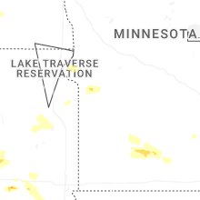


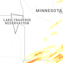


Connect with Interactive Hail Maps