

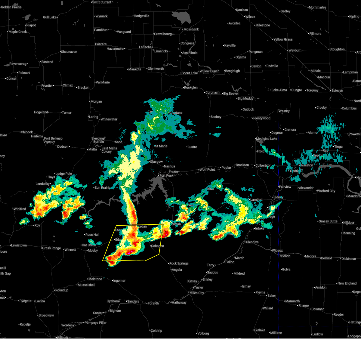
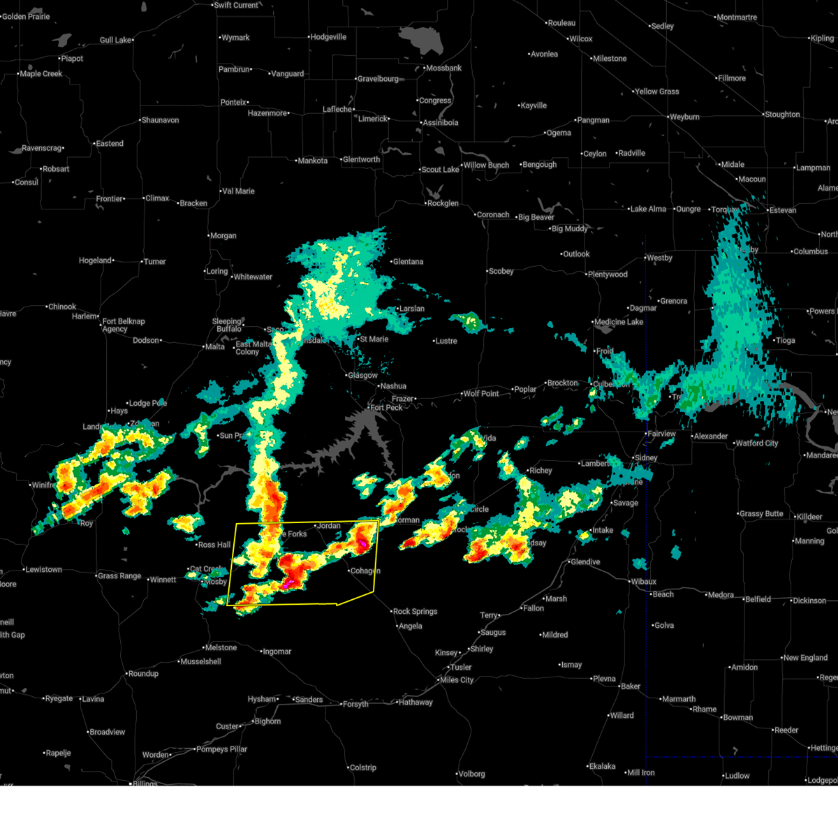
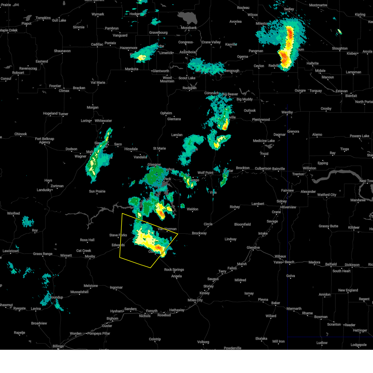
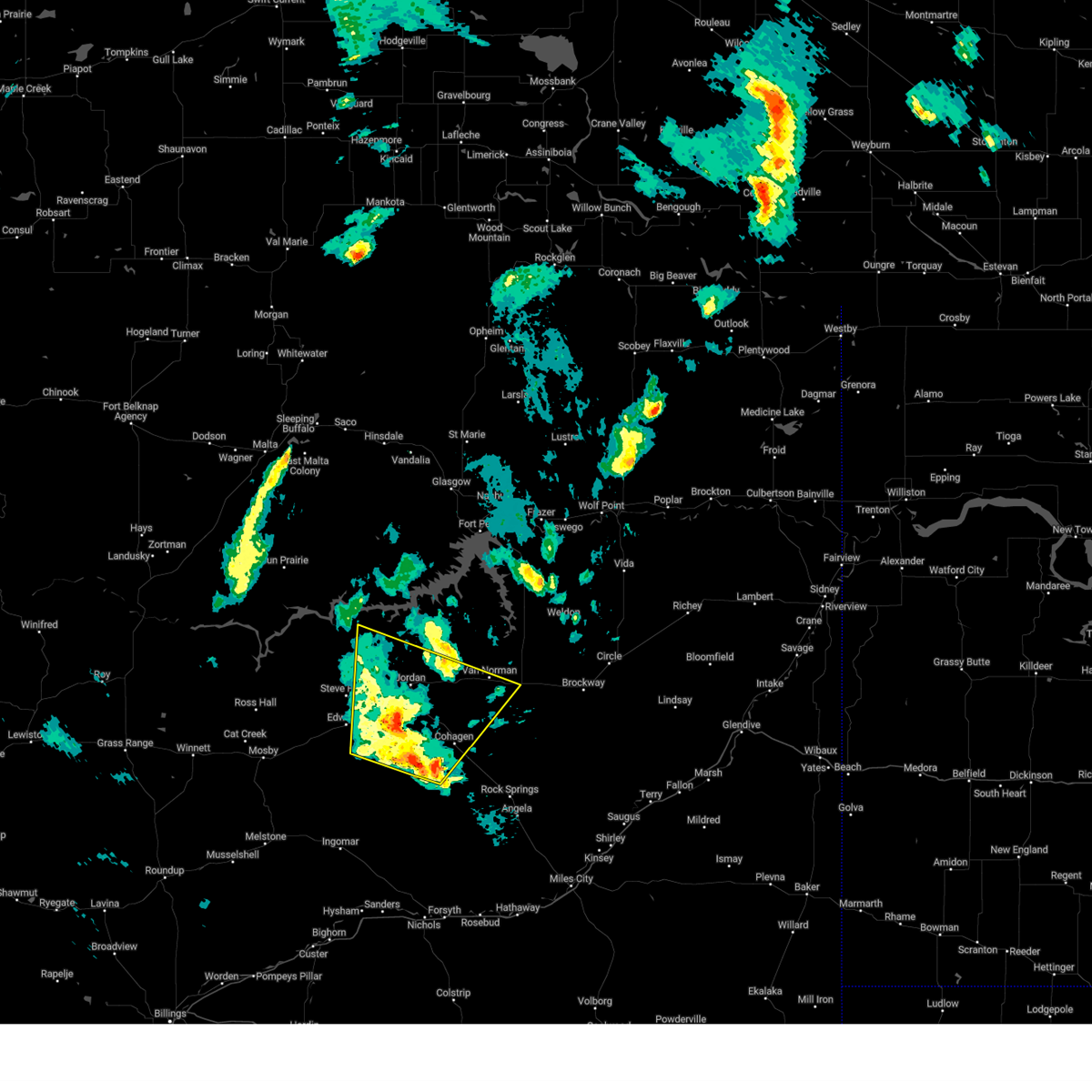
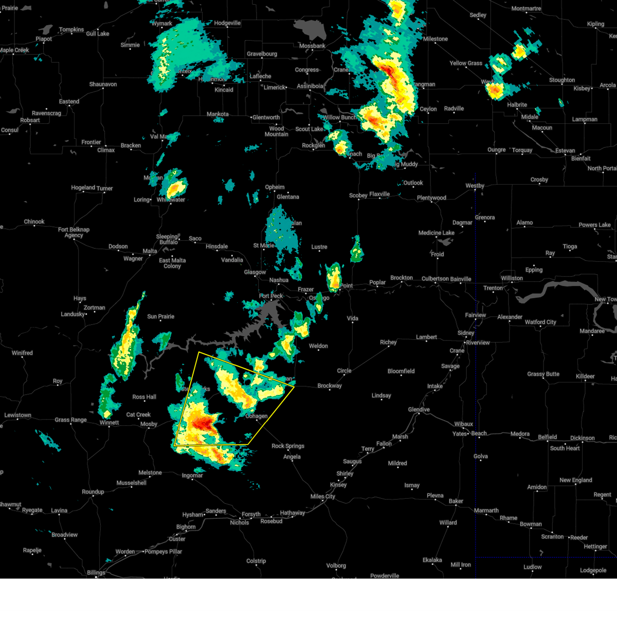
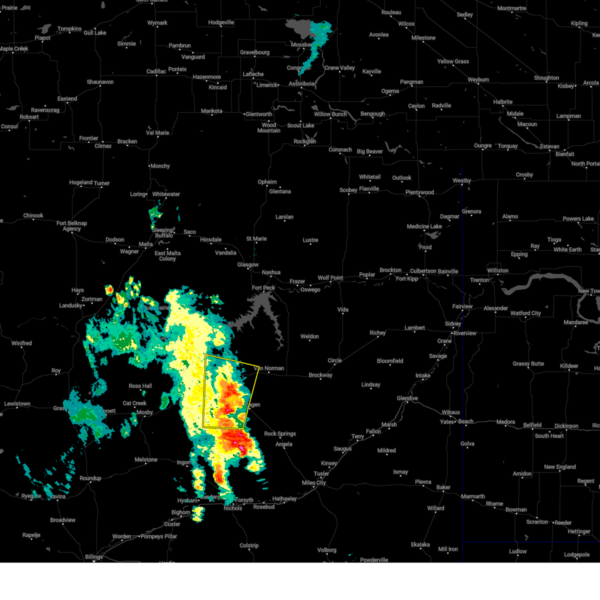
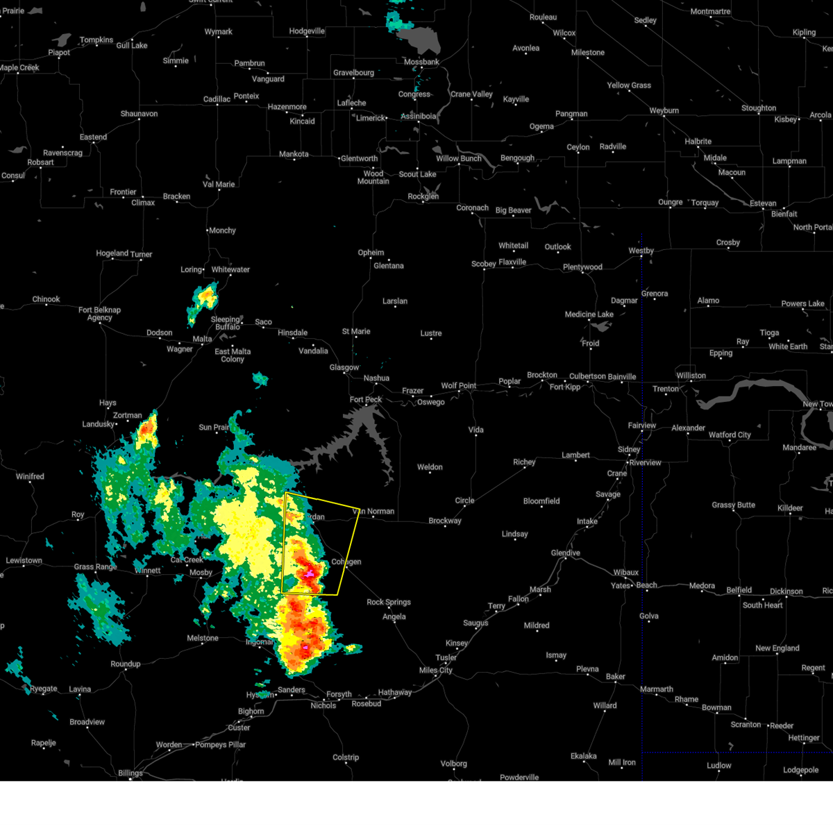
Hail Map for Jordan, MT
The Jordan, MT area has had 45 reports of on-the-ground hail by trained spotters, and has been under severe weather warnings 15 times during the past 12 months. Doppler radar has detected hail at or near Jordan, MT on 28 occasions, including 2 occasions during the past year.
| Name: | Jordan, MT |
| Where Located: | 61.7 miles SSW of Glasgow, MT |
| Map: | Google Map for Jordan, MT |
| Population: | 343 |
| Housing Units: | 206 |
| More Info: | Search Google for Jordan, MT |
0
The Top Recent Hail Date for Jordan, MT is Friday, August 16, 2024 (13th out of 28)

Hail and Wind Damage Spotted near Jordan, MT
| Date / Time | Report Details |
|---|---|
| 7/5/2025 3:42 PM MDT |
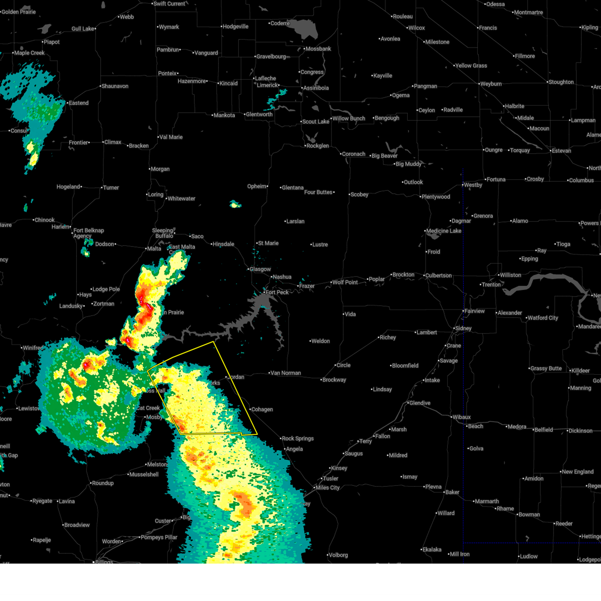
 At 341 pm mdt, severe thunderstorms were located along a line extending from 10 miles southeast of crooked creek rec area to 24 miles southeast of sand springs, moving east at 60 mph (radar indicated). Hazards include 60 mph wind gusts and penny size hail. Expect damage to roofs, siding, and trees. Locations impacted include, jordan, sand springs, edwards, brusett, and steve fork. At 341 pm mdt, severe thunderstorms were located along a line extending from 10 miles southeast of crooked creek rec area to 24 miles southeast of sand springs, moving east at 60 mph (radar indicated). Hazards include 60 mph wind gusts and penny size hail. Expect damage to roofs, siding, and trees. Locations impacted include, jordan, sand springs, edwards, brusett, and steve fork.
|
| 7/5/2025 3:42 PM MDT |
 the severe thunderstorm warning has been cancelled and is no longer in effect the severe thunderstorm warning has been cancelled and is no longer in effect
|
| 7/5/2025 2:57 PM MDT |
 Svrggw the national weather service in glasgow has issued a * severe thunderstorm warning for, southeastern petroleum county in northeastern montana, southwestern garfield county in northeastern montana, * until 400 pm mdt. * at 256 pm mdt, severe thunderstorms were located along a line extending from 7 miles north of winnett to near melstone, moving northeast at 55 mph (radar indicated). Hazards include 60 mph wind gusts and penny size hail. expect damage to roofs, siding, and trees Svrggw the national weather service in glasgow has issued a * severe thunderstorm warning for, southeastern petroleum county in northeastern montana, southwestern garfield county in northeastern montana, * until 400 pm mdt. * at 256 pm mdt, severe thunderstorms were located along a line extending from 7 miles north of winnett to near melstone, moving northeast at 55 mph (radar indicated). Hazards include 60 mph wind gusts and penny size hail. expect damage to roofs, siding, and trees
|
| 6/27/2025 6:14 PM MDT |
 Svrggw the national weather service in glasgow has issued a * severe thunderstorm warning for, southeastern phillips county in northeastern montana, garfield county in northeastern montana, southwestern valley county in northeastern montana, western mccone county in northeastern montana, * until 715 pm mdt. * at 614 pm mdt, severe thunderstorms were located along a line extending from 10 miles northeast of brusett to 6 miles west of jordan to 19 miles southeast of edwards, moving east at 45 mph (radar indicated). Hazards include 60 mph wind gusts. expect damage to roofs, siding, and trees Svrggw the national weather service in glasgow has issued a * severe thunderstorm warning for, southeastern phillips county in northeastern montana, garfield county in northeastern montana, southwestern valley county in northeastern montana, western mccone county in northeastern montana, * until 715 pm mdt. * at 614 pm mdt, severe thunderstorms were located along a line extending from 10 miles northeast of brusett to 6 miles west of jordan to 19 miles southeast of edwards, moving east at 45 mph (radar indicated). Hazards include 60 mph wind gusts. expect damage to roofs, siding, and trees
|
| 6/15/2025 7:41 AM MDT |
 The storm which prompted the warning has weakened below severe limits, and no longer poses an immediate threat to life or property. therefore, the warning will be allowed to expire. however, heavy rain is still possible with this thunderstorm. The storm which prompted the warning has weakened below severe limits, and no longer poses an immediate threat to life or property. therefore, the warning will be allowed to expire. however, heavy rain is still possible with this thunderstorm.
|
| 6/15/2025 7:11 AM MDT |
 At 711 am mdt, a severe thunderstorm was located near cohagen, or 19 miles southeast of jordan, moving east at 25 mph (radar indicated). Hazards include quarter size hail. Damage to vehicles is expected. Locations impacted include, cohagen, steve fork, jordan, and edwards. At 711 am mdt, a severe thunderstorm was located near cohagen, or 19 miles southeast of jordan, moving east at 25 mph (radar indicated). Hazards include quarter size hail. Damage to vehicles is expected. Locations impacted include, cohagen, steve fork, jordan, and edwards.
|
| 6/15/2025 6:49 AM MDT |
 Svrggw the national weather service in glasgow has issued a * severe thunderstorm warning for, southern garfield county in northeastern montana, * until 745 am mdt. * at 648 am mdt, a severe thunderstorm was located 10 miles west of cohagen, or 14 miles south of jordan, moving east at 25 mph (radar indicated). Hazards include half dollar size hail. damage to vehicles is expected Svrggw the national weather service in glasgow has issued a * severe thunderstorm warning for, southern garfield county in northeastern montana, * until 745 am mdt. * at 648 am mdt, a severe thunderstorm was located 10 miles west of cohagen, or 14 miles south of jordan, moving east at 25 mph (radar indicated). Hazards include half dollar size hail. damage to vehicles is expected
|
| 5/12/2025 9:28 PM MDT |
 The storm which prompted the warning has weakened below severe limits, and has exited the warned area. therefore, the warning will be allowed to expire. however, gusty winds are still possible with this thunderstorm. The storm which prompted the warning has weakened below severe limits, and has exited the warned area. therefore, the warning will be allowed to expire. however, gusty winds are still possible with this thunderstorm.
|
| 5/12/2025 8:56 PM MDT |
 At 855 pm mdt, a severe thunderstorm was located 8 miles south of jordan, moving northeast at 35 mph (radar indicated). Hazards include 60 mph wind gusts. Expect damage to roofs, siding, and trees. Locations impacted include, van norman, cohagen, jordan, and brusett. At 855 pm mdt, a severe thunderstorm was located 8 miles south of jordan, moving northeast at 35 mph (radar indicated). Hazards include 60 mph wind gusts. Expect damage to roofs, siding, and trees. Locations impacted include, van norman, cohagen, jordan, and brusett.
|
| 5/12/2025 8:27 PM MDT |
 Svrggw the national weather service in glasgow has issued a * severe thunderstorm warning for, southeastern garfield county in northeastern montana, * until 930 pm mdt. * at 827 pm mdt, a severe thunderstorm was located 9 miles southeast of edwards, or 22 miles southwest of jordan, moving northeast at 40 mph (radar indicated). Hazards include 60 mph wind gusts. expect damage to roofs, siding, and trees Svrggw the national weather service in glasgow has issued a * severe thunderstorm warning for, southeastern garfield county in northeastern montana, * until 930 pm mdt. * at 827 pm mdt, a severe thunderstorm was located 9 miles southeast of edwards, or 22 miles southwest of jordan, moving northeast at 40 mph (radar indicated). Hazards include 60 mph wind gusts. expect damage to roofs, siding, and trees
|
| 8/24/2024 10:45 PM MDT | Mesonet station mtm88 jordan in garfield county MT, 19.8 miles W of Jordan, MT |
| 8/24/2024 10:12 PM MDT | Asos station kjdn jorda in garfield county MT, 2 miles ESE of Jordan, MT |
| 8/24/2024 10:09 PM MDT | Thunderstorm outflow winds at the jordan airport asos sit in garfield county MT, 2 miles ESE of Jordan, MT |
| 8/19/2024 10:19 AM MDT |
 the severe thunderstorm warning has been cancelled and is no longer in effect the severe thunderstorm warning has been cancelled and is no longer in effect
|
| 8/19/2024 9:51 AM MDT |
 Svrggw the national weather service in glasgow has issued a * severe thunderstorm warning for, southeastern garfield county in northeastern montana, * until 1045 am mdt. * at 950 am mdt, a severe thunderstorm was located 13 miles west of cohagen, or 17 miles south of jordan, moving north at 25 mph (radar indicated). Hazards include quarter size hail. damage to vehicles is expected Svrggw the national weather service in glasgow has issued a * severe thunderstorm warning for, southeastern garfield county in northeastern montana, * until 1045 am mdt. * at 950 am mdt, a severe thunderstorm was located 13 miles west of cohagen, or 17 miles south of jordan, moving north at 25 mph (radar indicated). Hazards include quarter size hail. damage to vehicles is expected
|
| 7/13/2024 5:45 PM MDT | Quarter sized hail reported 19.8 miles NE of Jordan, MT, public report... via facebook. |
| 7/13/2024 5:44 PM MDT |
 Svrggw the national weather service in glasgow has issued a * severe thunderstorm warning for, northeastern petroleum county in northeastern montana, garfield county in northeastern montana, * until 645 pm mdt. * at 544 pm mdt, severe thunderstorms were located along a line extending from 8 miles south of flowing wells rest area to near brusett to 11 miles south of crooked creek rec area, moving southeast at 45 mph (radar indicated). Hazards include 70 mph wind gusts and quarter size hail. Hail damage to vehicles is expected. expect considerable tree damage. Wind damage is also likely to mobile homes, roofs, and outbuildings. Svrggw the national weather service in glasgow has issued a * severe thunderstorm warning for, northeastern petroleum county in northeastern montana, garfield county in northeastern montana, * until 645 pm mdt. * at 544 pm mdt, severe thunderstorms were located along a line extending from 8 miles south of flowing wells rest area to near brusett to 11 miles south of crooked creek rec area, moving southeast at 45 mph (radar indicated). Hazards include 70 mph wind gusts and quarter size hail. Hail damage to vehicles is expected. expect considerable tree damage. Wind damage is also likely to mobile homes, roofs, and outbuildings.
|
| 7/13/2024 5:16 PM MDT |
 At 516 pm mdt, a severe thunderstorm was located 9 miles southwest of jordan, moving southeast at 50 mph (radar indicated). Hazards include ping pong ball size hail and 60 mph wind gusts. People and animals outdoors will be injured. expect hail damage to roofs, siding, windows, and vehicles. expect wind damage to roofs, siding, and trees. Locations impacted include, jordan, sand springs, u l bend rec area, edwards, cohagen, crooked creek rec area, brusett, and steve fork. At 516 pm mdt, a severe thunderstorm was located 9 miles southwest of jordan, moving southeast at 50 mph (radar indicated). Hazards include ping pong ball size hail and 60 mph wind gusts. People and animals outdoors will be injured. expect hail damage to roofs, siding, windows, and vehicles. expect wind damage to roofs, siding, and trees. Locations impacted include, jordan, sand springs, u l bend rec area, edwards, cohagen, crooked creek rec area, brusett, and steve fork.
|
| 7/13/2024 4:45 PM MDT |
 Svrggw the national weather service in glasgow has issued a * severe thunderstorm warning for, southern phillips county in northeastern montana, northeastern petroleum county in northeastern montana, garfield county in northeastern montana, * until 545 pm mdt. * at 445 pm mdt, a severe thunderstorm was located 13 miles south of devils creek rec area, or 31 miles west of jordan, moving southeast at 50 mph (radar indicated). Hazards include 60 mph wind gusts and quarter size hail. Hail damage to vehicles is expected. Expect wind damage to roofs, siding, and trees. Svrggw the national weather service in glasgow has issued a * severe thunderstorm warning for, southern phillips county in northeastern montana, northeastern petroleum county in northeastern montana, garfield county in northeastern montana, * until 545 pm mdt. * at 445 pm mdt, a severe thunderstorm was located 13 miles south of devils creek rec area, or 31 miles west of jordan, moving southeast at 50 mph (radar indicated). Hazards include 60 mph wind gusts and quarter size hail. Hail damage to vehicles is expected. Expect wind damage to roofs, siding, and trees.
|
| 7/5/2024 4:15 PM MDT |
 The storms which prompted the warning have weakened below severe limits, and have exited the warned area. therefore, the warning will be allowed to expire. however, gusty winds are still possible with these thunderstorms. The storms which prompted the warning have weakened below severe limits, and have exited the warned area. therefore, the warning will be allowed to expire. however, gusty winds are still possible with these thunderstorms.
|
| 7/5/2024 3:40 PM MDT |
 At 339 pm mdt, severe thunderstorms were located along a line extending from 11 miles north of wolf point to near nelson creek rec area to near jordan, moving southeast at 40 mph (radar indicated). Hazards include 60 mph wind gusts. Expect damage to roofs, siding, and trees. Locations impacted include, wolf point, jordan, frazer, flowing wells rest area, vida, cohagen, nelson creek rec area, rock creek rec area, oswego, weldon, and van norman. At 339 pm mdt, severe thunderstorms were located along a line extending from 11 miles north of wolf point to near nelson creek rec area to near jordan, moving southeast at 40 mph (radar indicated). Hazards include 60 mph wind gusts. Expect damage to roofs, siding, and trees. Locations impacted include, wolf point, jordan, frazer, flowing wells rest area, vida, cohagen, nelson creek rec area, rock creek rec area, oswego, weldon, and van norman.
|
| 7/5/2024 3:09 PM MDT |
 Svrggw the national weather service in glasgow has issued a * severe thunderstorm warning for, eastern garfield county in northeastern montana, southwestern roosevelt county in northeastern montana, southeastern valley county in northeastern montana, mccone county in northeastern montana, * until 415 pm mdt. * at 307 pm mdt, severe thunderstorms were located along a line extending from 7 miles west of lustre to 7 miles east of the pines rec area to 9 miles east of brusett, moving southeast at 50 mph (radar indicated). Hazards include 60 mph wind gusts. expect damage to roofs, siding, and trees Svrggw the national weather service in glasgow has issued a * severe thunderstorm warning for, eastern garfield county in northeastern montana, southwestern roosevelt county in northeastern montana, southeastern valley county in northeastern montana, mccone county in northeastern montana, * until 415 pm mdt. * at 307 pm mdt, severe thunderstorms were located along a line extending from 7 miles west of lustre to 7 miles east of the pines rec area to 9 miles east of brusett, moving southeast at 50 mph (radar indicated). Hazards include 60 mph wind gusts. expect damage to roofs, siding, and trees
|
| 6/30/2024 8:45 PM MDT | Mesonet station mtm88 jordan in garfield county MT, 19.8 miles W of Jordan, MT |
| 6/15/2024 6:30 PM MDT | Meso net site recorded a thunderstorm wind gust of 67 mp in garfield county MT, 19.7 miles WSW of Jordan, MT |
| 6/3/2024 6:46 PM MDT | Asos station kjdn jorda in garfield county MT, 2 miles ESE of Jordan, MT |
| 5/17/2024 4:10 PM MDT |
 Svrggw the national weather service in glasgow has issued a * severe thunderstorm warning for, southeastern garfield county in northeastern montana, southwestern mccone county in northeastern montana, western prairie county in northeastern montana, * until 515 pm mdt. * at 409 pm mdt, a severe thunderstorm was located near jordan, moving east at 55 mph (radar indicated). Hazards include 70 mph wind gusts and nickel size hail. Expect considerable tree damage. Damage is likely to mobile homes, roofs, and outbuildings. Svrggw the national weather service in glasgow has issued a * severe thunderstorm warning for, southeastern garfield county in northeastern montana, southwestern mccone county in northeastern montana, western prairie county in northeastern montana, * until 515 pm mdt. * at 409 pm mdt, a severe thunderstorm was located near jordan, moving east at 55 mph (radar indicated). Hazards include 70 mph wind gusts and nickel size hail. Expect considerable tree damage. Damage is likely to mobile homes, roofs, and outbuildings.
|
| 5/17/2024 4:05 PM MDT | Dialed into the jordan asos and confirmed a wind observation of 40 kts gusting 64 kts (46 mph gusting 74 mph in garfield county MT, 2 miles ESE of Jordan, MT |
| 8/30/2023 6:15 PM MDT | Mesonet station mtm88 jordan in garfield county MT, 19.8 miles W of Jordan, MT |
| 8/22/2023 12:32 AM MDT |
 At 1231 am mdt, a severe thunderstorm was 25 miles south of jordan, moving north at 40 mph (radar indicated). Hazards include 60 mph wind gusts. Expect damage to roofs, siding, and trees. locations impacted include, jordan, sand springs, edwards, cohagen, brusett, van norman, and steve fork. hail threat, radar indicated max hail size, <. 75 in wind threat, radar indicated max wind gust, 60 mph. At 1231 am mdt, a severe thunderstorm was 25 miles south of jordan, moving north at 40 mph (radar indicated). Hazards include 60 mph wind gusts. Expect damage to roofs, siding, and trees. locations impacted include, jordan, sand springs, edwards, cohagen, brusett, van norman, and steve fork. hail threat, radar indicated max hail size, <. 75 in wind threat, radar indicated max wind gust, 60 mph.
|
| 8/22/2023 12:03 AM MDT |
 At 1201 am mdt, a severe thunderstorm was located 15 miles southeast of edwards, or 30 miles southwest of jordan, moving north at 45 mph (radar indicated). Hazards include 60 mph wind gusts. expect damage to roofs, siding, and trees At 1201 am mdt, a severe thunderstorm was located 15 miles southeast of edwards, or 30 miles southwest of jordan, moving north at 45 mph (radar indicated). Hazards include 60 mph wind gusts. expect damage to roofs, siding, and trees
|
| 8/18/2023 8:02 PM MDT |
 At 800 pm mdt, severe thunderstorms were located along a line extending from 17 miles northwest of hell creek rec area to 11 miles south of jordan, moving northeast at 45 mph (radar indicated and measured at the jordan airport). Hazards include 70 mph wind gusts. Expect considerable tree damage. Damage is likely to mobile homes, roofs, and outbuildings. At 800 pm mdt, severe thunderstorms were located along a line extending from 17 miles northwest of hell creek rec area to 11 miles south of jordan, moving northeast at 45 mph (radar indicated and measured at the jordan airport). Hazards include 70 mph wind gusts. Expect considerable tree damage. Damage is likely to mobile homes, roofs, and outbuildings.
|
| 8/18/2023 7:48 PM MDT | Asos reported wind gust of 70 mph between 6:48 pm and 7:48 pm... associated with thunderstorm in garfield county MT, 2 miles ESE of Jordan, MT |
| 1/1/0001 12:00 AM | Recorded at the jordan airport aso in garfield county MT, 2 miles ESE of Jordan, MT |
| 6/7/2023 6:16 PM MDT |
 At 616 pm mdt, a severe thunderstorm was located near jordan, moving northwest at 15 mph (radar indicated). Hazards include 60 mph wind gusts and quarter size hail. Hail damage to vehicles is expected. Expect wind damage to roofs, siding, and trees. At 616 pm mdt, a severe thunderstorm was located near jordan, moving northwest at 15 mph (radar indicated). Hazards include 60 mph wind gusts and quarter size hail. Hail damage to vehicles is expected. Expect wind damage to roofs, siding, and trees.
|
| 5/24/2023 6:32 PM MDT | Quarter sized hail reported 24.3 miles NE of Jordan, MT, estimated one inch of rain in 30 minutes. |
| 8/15/2022 9:36 PM MDT | Asos station kjdn jordan. likely outflow from dying storm to the wes in garfield county MT, 2 miles ESE of Jordan, MT |
| 8/4/2022 5:51 PM MDT | The severe thunderstorm warning for southern phillips, central petroleum, garfield and southwestern valley counties will expire at 600 pm mdt, the storms which prompted the warning have weakened below severe limits and have exited the warned area. therefore, the warning will be allowed to expire. |
| 8/4/2022 5:48 PM MDT | Storm damage reported in garfield county MT, 2 miles ESE of Jordan, MT |
| 8/4/2022 4:55 PM MDT | At 454 pm mdt, severe thunderstorms were located along a line extending from 8 miles north of fourchette to 12 miles northwest of sand springs, moving east at 55 mph (public surface observations). Hazards include 60 mph wind gusts. expect damage to roofs, siding, and trees |
| 7/13/2022 8:35 PM MDT | Storm damage reported in garfield county MT, 22.5 miles SW of Jordan, MT |
| 7/13/2022 8:30 PM MDT | Storm damage reported in garfield county MT, 8.3 miles S of Jordan, MT |
| 7/13/2022 8:26 PM MDT |
 At 824 pm mdt, a severe thunderstorm was located 10 miles northwest of jordan, moving northeast at 20 mph (radar indicated). Hazards include 70 mph wind gusts and penny size hail. Expect considerable tree damage. Damage is likely to mobile homes, roofs, and outbuildings. At 824 pm mdt, a severe thunderstorm was located 10 miles northwest of jordan, moving northeast at 20 mph (radar indicated). Hazards include 70 mph wind gusts and penny size hail. Expect considerable tree damage. Damage is likely to mobile homes, roofs, and outbuildings.
|
| 7/13/2022 8:12 PM MDT | Storm damage reported in garfield county MT, 0.9 miles NNE of Jordan, MT |
| 7/13/2022 8:10 PM MDT | Storm damage reported in garfield county MT, 0.1 miles NNW of Jordan, MT |
| 7/13/2022 7:59 PM MDT |
 At 758 pm mdt, severe thunderstorms were located along a line extending from 6 miles west of brusett to 9 miles southwest of cohagen, moving northeast at 35 mph (radar indicated). Hazards include 70 mph wind gusts and quarter size hail. Hail damage to vehicles is expected. expect considerable tree damage. wind damage is also likely to mobile homes, roofs, and outbuildings. locations impacted include, jordan, cohagen, hell creek rec area, edwards, brusett and steve fork. thunderstorm damage threat, considerable hail threat, radar indicated max hail size, 1. 00 in wind threat, radar indicated max wind gust, 70 mph. At 758 pm mdt, severe thunderstorms were located along a line extending from 6 miles west of brusett to 9 miles southwest of cohagen, moving northeast at 35 mph (radar indicated). Hazards include 70 mph wind gusts and quarter size hail. Hail damage to vehicles is expected. expect considerable tree damage. wind damage is also likely to mobile homes, roofs, and outbuildings. locations impacted include, jordan, cohagen, hell creek rec area, edwards, brusett and steve fork. thunderstorm damage threat, considerable hail threat, radar indicated max hail size, 1. 00 in wind threat, radar indicated max wind gust, 70 mph.
|
| 7/13/2022 7:35 PM MDT |
 At 734 pm mdt, severe thunderstorms were located along a line extending from 11 miles north of sand springs to 20 miles southwest of cohagen, moving northeast at 35 mph (radar indicated). Hazards include 70 mph wind gusts and quarter size hail. Hail damage to vehicles is expected. expect considerable tree damage. Wind damage is also likely to mobile homes, roofs, and outbuildings. At 734 pm mdt, severe thunderstorms were located along a line extending from 11 miles north of sand springs to 20 miles southwest of cohagen, moving northeast at 35 mph (radar indicated). Hazards include 70 mph wind gusts and quarter size hail. Hail damage to vehicles is expected. expect considerable tree damage. Wind damage is also likely to mobile homes, roofs, and outbuildings.
|
| 7/9/2022 9:54 PM MDT |
 At 954 pm mdt, severe thunderstorms were located along a line extending from 10 miles south of jordan to 12 miles south of cohagen, moving northeast at 45 mph (radar indicated). Hazards include 70 mph wind gusts and quarter size hail. Hail damage to vehicles is expected. expect considerable tree damage. Wind damage is also likely to mobile homes, roofs, and outbuildings. At 954 pm mdt, severe thunderstorms were located along a line extending from 10 miles south of jordan to 12 miles south of cohagen, moving northeast at 45 mph (radar indicated). Hazards include 70 mph wind gusts and quarter size hail. Hail damage to vehicles is expected. expect considerable tree damage. Wind damage is also likely to mobile homes, roofs, and outbuildings.
|
| 7/9/2022 9:07 PM MDT |
 At 907 pm mdt, severe thunderstorms were located along a line extending from 8 miles northeast of mosby to 7 miles southeast of sand springs to 25 miles south of edwards, moving east at 40 mph (trained weather spotters). Hazards include 60 mph wind gusts and quarter size hail. Hail damage to vehicles is expected. Expect wind damage to roofs, siding, and trees. At 907 pm mdt, severe thunderstorms were located along a line extending from 8 miles northeast of mosby to 7 miles southeast of sand springs to 25 miles south of edwards, moving east at 40 mph (trained weather spotters). Hazards include 60 mph wind gusts and quarter size hail. Hail damage to vehicles is expected. Expect wind damage to roofs, siding, and trees.
|
| 7/8/2022 10:41 PM MDT |
 At 1040 pm mdt, severe thunderstorms were located along a line extending from 12 miles east of hell creek rec area to 6 miles southeast of cohagen, moving east at 55 mph (radar indicated). Hazards include 70 mph wind gusts and penny size hail. Expect considerable tree damage. Damage is likely to mobile homes, roofs, and outbuildings. At 1040 pm mdt, severe thunderstorms were located along a line extending from 12 miles east of hell creek rec area to 6 miles southeast of cohagen, moving east at 55 mph (radar indicated). Hazards include 70 mph wind gusts and penny size hail. Expect considerable tree damage. Damage is likely to mobile homes, roofs, and outbuildings.
|
| 7/8/2022 10:29 PM MDT | Observed at asos sit in garfield county MT, 2 miles ESE of Jordan, MT |
| 7/8/2022 10:29 PM MDT |
 At 1028 pm mdt, severe thunderstorms were located along a line extending from 9 miles northeast of brusett to 8 miles south of edwards, moving east at 25 mph (trained weather spotters). Hazards include 60 mph wind gusts and quarter size hail. Hail damage to vehicles is expected. expect wind damage to roofs, siding, and trees. locations impacted include, jordan and hell creek rec area. hail threat, radar indicated max hail size, 1. 00 in wind threat, radar indicated max wind gust, 60 mph. At 1028 pm mdt, severe thunderstorms were located along a line extending from 9 miles northeast of brusett to 8 miles south of edwards, moving east at 25 mph (trained weather spotters). Hazards include 60 mph wind gusts and quarter size hail. Hail damage to vehicles is expected. expect wind damage to roofs, siding, and trees. locations impacted include, jordan and hell creek rec area. hail threat, radar indicated max hail size, 1. 00 in wind threat, radar indicated max wind gust, 60 mph.
|
| 7/8/2022 9:52 PM MDT |
 At 951 pm mdt, severe thunderstorms were located along a line extending from near brusett to 12 miles southwest of sand springs, moving east at 25 mph (trained weather spotters). Hazards include 60 mph wind gusts and penny size hail. expect damage to roofs, siding, and trees At 951 pm mdt, severe thunderstorms were located along a line extending from near brusett to 12 miles southwest of sand springs, moving east at 25 mph (trained weather spotters). Hazards include 60 mph wind gusts and penny size hail. expect damage to roofs, siding, and trees
|
| 7/6/2022 7:01 PM MDT | Quarter sized hail reported 32.8 miles SW of Jordan, MT, also reported 1 in of rainfall in 15 min. |
| 7/5/2022 7:41 PM MDT |
 The severe thunderstorm warning for southern garfield county will expire at 745 pm mdt, the storm which prompted the warning has weakened below severe limits, and no longer poses an immediate threat to life or property. therefore, the warning will be allowed to expire. however small hail and heavy rain are still possible with this thunderstorm. a severe thunderstorm watch remains in effect until 1000 pm mdt for northeastern montana. The severe thunderstorm warning for southern garfield county will expire at 745 pm mdt, the storm which prompted the warning has weakened below severe limits, and no longer poses an immediate threat to life or property. therefore, the warning will be allowed to expire. however small hail and heavy rain are still possible with this thunderstorm. a severe thunderstorm watch remains in effect until 1000 pm mdt for northeastern montana.
|
| 7/5/2022 7:12 PM MDT |
 At 712 pm mdt, a severe thunderstorm was located 8 miles northeast of cohagen, or 22 miles southeast of jordan, moving east at 45 mph (radar indicated). Hazards include 60 mph wind gusts and quarter size hail. Hail damage to vehicles is expected. expect wind damage to roofs, siding, and trees. locations impacted include, jordan, sand springs, cohagen, edwards, van norman and steve fork. hail threat, radar indicated max hail size, 1. 00 in wind threat, radar indicated max wind gust, 60 mph. At 712 pm mdt, a severe thunderstorm was located 8 miles northeast of cohagen, or 22 miles southeast of jordan, moving east at 45 mph (radar indicated). Hazards include 60 mph wind gusts and quarter size hail. Hail damage to vehicles is expected. expect wind damage to roofs, siding, and trees. locations impacted include, jordan, sand springs, cohagen, edwards, van norman and steve fork. hail threat, radar indicated max hail size, 1. 00 in wind threat, radar indicated max wind gust, 60 mph.
|
| 7/5/2022 7:00 PM MDT | Quarter sized hail reported 17.9 miles NW of Jordan, MT |
| 7/5/2022 6:45 PM MDT |
 At 644 pm mdt, a severe thunderstorm was located 9 miles southeast of mosby, or 29 miles east of winnett, moving east at 45 mph (radar indicated). Hazards include 60 mph wind gusts and quarter size hail. Hail damage to vehicles is expected. Expect wind damage to roofs, siding, and trees. At 644 pm mdt, a severe thunderstorm was located 9 miles southeast of mosby, or 29 miles east of winnett, moving east at 45 mph (radar indicated). Hazards include 60 mph wind gusts and quarter size hail. Hail damage to vehicles is expected. Expect wind damage to roofs, siding, and trees.
|
| 7/5/2022 6:07 PM MDT |
 At 607 pm mdt, severe thunderstorms were located along a line extending from 14 miles south of jordan to 16 miles south of edwards, moving east at 40 mph (radar indicated). Hazards include 60 mph wind gusts and quarter size hail. Hail damage to vehicles is expected. expect wind damage to roofs, siding, and trees. locations impacted include, jordan, edwards, brusett and steve fork. hail threat, radar indicated max hail size, 1. 00 in wind threat, radar indicated max wind gust, 60 mph. At 607 pm mdt, severe thunderstorms were located along a line extending from 14 miles south of jordan to 16 miles south of edwards, moving east at 40 mph (radar indicated). Hazards include 60 mph wind gusts and quarter size hail. Hail damage to vehicles is expected. expect wind damage to roofs, siding, and trees. locations impacted include, jordan, edwards, brusett and steve fork. hail threat, radar indicated max hail size, 1. 00 in wind threat, radar indicated max wind gust, 60 mph.
|
| 7/5/2022 5:48 PM MDT |
 At 548 pm mdt, severe thunderstorms were located along a line extending from 6 miles east of edwards to 10 miles south of sand springs, moving east at 40 mph (radar indicated). Hazards include 60 mph wind gusts and quarter size hail. Hail damage to vehicles is expected. expect wind damage to roofs, siding, and trees. Locations impacted include, jordan, sand springs, edwards, brusett and steve fork. At 548 pm mdt, severe thunderstorms were located along a line extending from 6 miles east of edwards to 10 miles south of sand springs, moving east at 40 mph (radar indicated). Hazards include 60 mph wind gusts and quarter size hail. Hail damage to vehicles is expected. expect wind damage to roofs, siding, and trees. Locations impacted include, jordan, sand springs, edwards, brusett and steve fork.
|
| 7/5/2022 5:24 PM MDT |
 At 523 pm mdt, severe thunderstorms were located along a line extending from 9 miles north of sand springs to near mosby, moving east at 40 mph (radar indicated). Hazards include 60 mph wind gusts and quarter size hail. Hail damage to vehicles is expected. Expect wind damage to roofs, siding, and trees. At 523 pm mdt, severe thunderstorms were located along a line extending from 9 miles north of sand springs to near mosby, moving east at 40 mph (radar indicated). Hazards include 60 mph wind gusts and quarter size hail. Hail damage to vehicles is expected. Expect wind damage to roofs, siding, and trees.
|
| 7/3/2022 5:50 PM MDT | Quarter sized hail reported 28.3 miles WNW of Jordan, MT, report relayed from facebook. mostly dime but some quarters mixed in. |
| 7/3/2022 5:25 PM MDT |
 At 525 pm mdt, severe thunderstorms were located along a line extending from 25 miles northeast of devils creek rec area to near hell creek rec area to near jordan, moving northeast at 30 mph (radar indicated). Hazards include 70 mph wind gusts and quarter size hail. Hail damage to vehicles is expected. expect considerable tree damage. Wind damage is also likely to mobile homes, roofs, and outbuildings. At 525 pm mdt, severe thunderstorms were located along a line extending from 25 miles northeast of devils creek rec area to near hell creek rec area to near jordan, moving northeast at 30 mph (radar indicated). Hazards include 70 mph wind gusts and quarter size hail. Hail damage to vehicles is expected. expect considerable tree damage. Wind damage is also likely to mobile homes, roofs, and outbuildings.
|
| 7/3/2022 5:17 PM MDT |
 At 517 pm mdt, severe thunderstorms were located along a line extending from 21 miles northeast of devils creek rec area to near hell creek rec area to near jordan, moving east at 30 mph (radar indicated). Hazards include 70 mph wind gusts and quarter size hail. Hail damage to vehicles is expected. expect considerable tree damage. wind damage is also likely to mobile homes, roofs, and outbuildings. Locations impacted include, jordan, cohagen, hell creek rec area and hillside. At 517 pm mdt, severe thunderstorms were located along a line extending from 21 miles northeast of devils creek rec area to near hell creek rec area to near jordan, moving east at 30 mph (radar indicated). Hazards include 70 mph wind gusts and quarter size hail. Hail damage to vehicles is expected. expect considerable tree damage. wind damage is also likely to mobile homes, roofs, and outbuildings. Locations impacted include, jordan, cohagen, hell creek rec area and hillside.
|
| 7/3/2022 4:58 PM MDT |
 At 457 pm mdt, severe thunderstorms were located along a line extending from 15 miles northeast of devils creek rec area to 10 miles northeast of brusett to 9 miles west of jordan, moving northeast at 30 mph. these are destructive storms for garfield county (trained weather spotters). Hazards include 80 mph wind gusts and quarter size hail. Flying debris will be dangerous to those caught without shelter. mobile homes will be heavily damaged. expect considerable damage to roofs, windows, and vehicles. extensive tree damage and power outages are likely. Locations impacted include, jordan, cohagen, hell creek rec area, brusett and hillside. At 457 pm mdt, severe thunderstorms were located along a line extending from 15 miles northeast of devils creek rec area to 10 miles northeast of brusett to 9 miles west of jordan, moving northeast at 30 mph. these are destructive storms for garfield county (trained weather spotters). Hazards include 80 mph wind gusts and quarter size hail. Flying debris will be dangerous to those caught without shelter. mobile homes will be heavily damaged. expect considerable damage to roofs, windows, and vehicles. extensive tree damage and power outages are likely. Locations impacted include, jordan, cohagen, hell creek rec area, brusett and hillside.
|
| 7/3/2022 4:42 PM MDT |
 At 441 pm mdt, severe thunderstorms were located along a line extending from 10 miles north of devils creek rec area to near brusett to 6 miles northeast of edwards, moving east at 30 mph. these are destructive storms for garfield county (trained weather spotters). Hazards include 80 mph wind gusts and quarter size hail. Flying debris will be dangerous to those caught without shelter. mobile homes will be heavily damaged. expect considerable damage to roofs, windows, and vehicles. extensive tree damage and power outages are likely. Locations impacted include, jordan, devils creek rec area, hell creek rec area, edwards, cohagen, brusett, hillside and steve fork. At 441 pm mdt, severe thunderstorms were located along a line extending from 10 miles north of devils creek rec area to near brusett to 6 miles northeast of edwards, moving east at 30 mph. these are destructive storms for garfield county (trained weather spotters). Hazards include 80 mph wind gusts and quarter size hail. Flying debris will be dangerous to those caught without shelter. mobile homes will be heavily damaged. expect considerable damage to roofs, windows, and vehicles. extensive tree damage and power outages are likely. Locations impacted include, jordan, devils creek rec area, hell creek rec area, edwards, cohagen, brusett, hillside and steve fork.
|
| 7/3/2022 4:25 PM MDT |
 At 425 pm mdt, severe thunderstorms were located along a line extending from 8 miles northwest of devils creek rec area to 8 miles west of brusett to near edwards, moving northeast at 30 mph. these are destructive storms for garfield county (trained weather spotters). Hazards include 80 mph wind gusts and quarter size hail. Flying debris will be dangerous to those caught without shelter. mobile homes will be heavily damaged. expect considerable damage to roofs, windows, and vehicles. Extensive tree damage and power outages are likely. At 425 pm mdt, severe thunderstorms were located along a line extending from 8 miles northwest of devils creek rec area to 8 miles west of brusett to near edwards, moving northeast at 30 mph. these are destructive storms for garfield county (trained weather spotters). Hazards include 80 mph wind gusts and quarter size hail. Flying debris will be dangerous to those caught without shelter. mobile homes will be heavily damaged. expect considerable damage to roofs, windows, and vehicles. Extensive tree damage and power outages are likely.
|
| 6/28/2022 7:50 PM MDT |
 At 747 pm mdt, a severe thunderstorm was located 12 miles east of edwards, or 18 miles southwest of jordan, moving east at 50 mph. law enforcement reported a history of wind damage in winnett with this storm (law enforcement). Hazards include 60 mph wind gusts. Expect damage to roofs, siding, and trees. locations impacted include, jordan, sand springs, edwards and steve fork. hail threat, radar indicated max hail size, <. 75 in wind threat, radar indicated max wind gust, 60 mph. At 747 pm mdt, a severe thunderstorm was located 12 miles east of edwards, or 18 miles southwest of jordan, moving east at 50 mph. law enforcement reported a history of wind damage in winnett with this storm (law enforcement). Hazards include 60 mph wind gusts. Expect damage to roofs, siding, and trees. locations impacted include, jordan, sand springs, edwards and steve fork. hail threat, radar indicated max hail size, <. 75 in wind threat, radar indicated max wind gust, 60 mph.
|
| 6/28/2022 7:13 PM MDT |
 At 712 pm mdt, a severe thunderstorm was located 7 miles east of mosby, or 29 miles east of winnett, moving east at 50 mph (radar indicated). Hazards include 60 mph wind gusts. expect damage to roofs, siding, and trees At 712 pm mdt, a severe thunderstorm was located 7 miles east of mosby, or 29 miles east of winnett, moving east at 50 mph (radar indicated). Hazards include 60 mph wind gusts. expect damage to roofs, siding, and trees
|
| 5/19/2022 6:15 PM MDT | Mesonet station mtm88 jordan in garfield county MT, 19.8 miles W of Jordan, MT |
| 5/19/2022 5:48 PM MDT | Asos station kjdn jorda in garfield county MT, 2 miles ESE of Jordan, MT |
| 8/18/2021 1:08 AM MDT |
 The severe thunderstorm warning for northeastern garfield, central valley and western mccone counties will expire at 115 am mdt, the winds which prompted the warning have weakened below severe limits, and no longer pose an immediate threat to life or property. therefore, the warning will be allowed to expire. however gusty winds over 50 mph are still possible with these thunderstorm outflow winds. to report severe weather, contact your nearest law enforcement agency. they will relay your report to the national weather service glasgow. The severe thunderstorm warning for northeastern garfield, central valley and western mccone counties will expire at 115 am mdt, the winds which prompted the warning have weakened below severe limits, and no longer pose an immediate threat to life or property. therefore, the warning will be allowed to expire. however gusty winds over 50 mph are still possible with these thunderstorm outflow winds. to report severe weather, contact your nearest law enforcement agency. they will relay your report to the national weather service glasgow.
|
| 8/18/2021 12:48 AM MDT |
 At 1244 am mdt, severe thunderstorm outflow winds were located across the warned area (radar indicated. at 1222 am mdt, a wind gust of 61 mph was recorded at the glasgow airport). Hazards include 60 mph wind gusts. Expect damage to roofs, siding, and trees. locations impacted include, glasgow, jordan, nashua, fort peck, the pines rec area, tampico, duck creek rec area, fort peck marina, hell creek rec area, frazer, flowing wells rest area, nelson creek rec area, st. marie, rock creek rec area, oswego, vandalia, park grove, van norman, haxby and weldon. hail threat, radar indicated max hail size, <. 75 in wind threat, observed max wind gust, 60 mph. At 1244 am mdt, severe thunderstorm outflow winds were located across the warned area (radar indicated. at 1222 am mdt, a wind gust of 61 mph was recorded at the glasgow airport). Hazards include 60 mph wind gusts. Expect damage to roofs, siding, and trees. locations impacted include, glasgow, jordan, nashua, fort peck, the pines rec area, tampico, duck creek rec area, fort peck marina, hell creek rec area, frazer, flowing wells rest area, nelson creek rec area, st. marie, rock creek rec area, oswego, vandalia, park grove, van norman, haxby and weldon. hail threat, radar indicated max hail size, <. 75 in wind threat, observed max wind gust, 60 mph.
|
| 8/18/2021 12:14 AM MDT |
 At 1212 am mdt, severe thunderstorm outflow wind gusts were located along a line extending from 11 miles north of hinsdale to 7 miles west of tampico to 19 miles southwest of glasgow to 9 miles northwest of hell creek rec area to 8 miles east of brusett, moving east at 50 mph (radar indicated). Hazards include 60 mph wind gusts. expect damage to roofs, siding, and trees At 1212 am mdt, severe thunderstorm outflow wind gusts were located along a line extending from 11 miles north of hinsdale to 7 miles west of tampico to 19 miles southwest of glasgow to 9 miles northwest of hell creek rec area to 8 miles east of brusett, moving east at 50 mph (radar indicated). Hazards include 60 mph wind gusts. expect damage to roofs, siding, and trees
|
| 6/10/2021 6:35 PM MDT |
 At 634 pm mdt, a severe thunderstorm was located 25 miles north of hysham, moving north at 55 mph (radar indicated). Hazards include 60 mph wind gusts and penny size hail. Expect damage to roofs, siding, and trees. Locations impacted include, jordan, sand springs, edwards and steve fork. At 634 pm mdt, a severe thunderstorm was located 25 miles north of hysham, moving north at 55 mph (radar indicated). Hazards include 60 mph wind gusts and penny size hail. Expect damage to roofs, siding, and trees. Locations impacted include, jordan, sand springs, edwards and steve fork.
|
| 6/10/2021 5:54 PM MDT |
 At 553 pm mdt, a severe thunderstorm was located 13 miles southeast of sand springs, or 35 miles southwest of jordan, moving northeast at 40 mph (radar indicated). Hazards include quarter size hail. damage to vehicles is expected At 553 pm mdt, a severe thunderstorm was located 13 miles southeast of sand springs, or 35 miles southwest of jordan, moving northeast at 40 mph (radar indicated). Hazards include quarter size hail. damage to vehicles is expected
|
| 8/25/2020 9:32 PM MDT | Asos station kjdn jorda in garfield county MT, 2 miles ESE of Jordan, MT |
| 8/20/2020 9:12 PM MDT |
 At 911 pm mdt, severe thunderstorms were located along a line extending from 12 miles east of jordan to 14 miles southwest of cohagen, moving east at 40 mph (a 68 mph wind gust was reported at the jordan airport at 853 pm). Hazards include 70 mph wind gusts. Expect considerable tree damage. Damage is likely to mobile homes, roofs, and outbuildings. At 911 pm mdt, severe thunderstorms were located along a line extending from 12 miles east of jordan to 14 miles southwest of cohagen, moving east at 40 mph (a 68 mph wind gust was reported at the jordan airport at 853 pm). Hazards include 70 mph wind gusts. Expect considerable tree damage. Damage is likely to mobile homes, roofs, and outbuildings.
|
| 8/20/2020 9:05 PM MDT | Jordan airport in garfield county MT, 0.1 miles NNW of Jordan, MT |
| 8/20/2020 9:05 PM MDT | Storm damage reported in garfield county MT, 2 miles ESE of Jordan, MT |
| 8/20/2020 7:53 PM MDT | Asos station kjdn jorda in garfield county MT, 2 miles ESE of Jordan, MT |
| 7/7/2020 6:05 PM MDT |
 At 604 pm mdt, severe thunderstorms were located along a line extending from 7 miles northeast of nashua to 11 miles southeast of fort peck to 11 miles southwest of cohagen, moving east at 70 mph (radar indicated). Hazards include 70 mph wind gusts and quarter size hail. Hail damage to vehicles is expected. expect considerable tree damage. wind damage is also likely to mobile homes, roofs, and outbuildings. Locations impacted include, glasgow, wolf point, circle, jordan, nashua, fort peck, duck creek rec area, brockway, hillside, hell creek rec area, flowing wells rest area, the pines rec area, fort peck marina, frazer, vida, cohagen, nelson creek rec area, rock creek rec area, park grove and van norman. At 604 pm mdt, severe thunderstorms were located along a line extending from 7 miles northeast of nashua to 11 miles southeast of fort peck to 11 miles southwest of cohagen, moving east at 70 mph (radar indicated). Hazards include 70 mph wind gusts and quarter size hail. Hail damage to vehicles is expected. expect considerable tree damage. wind damage is also likely to mobile homes, roofs, and outbuildings. Locations impacted include, glasgow, wolf point, circle, jordan, nashua, fort peck, duck creek rec area, brockway, hillside, hell creek rec area, flowing wells rest area, the pines rec area, fort peck marina, frazer, vida, cohagen, nelson creek rec area, rock creek rec area, park grove and van norman.
|
| 7/7/2020 5:25 PM MDT |
 At 524 pm mdt, severe thunderstorms were located along a line extending from 23 miles south of hinsdale to 17 miles northwest of hell creek rec area to 14 miles northeast of melstone, moving east at 60 mph. these are very dangerous storms (mesonet reported wind gust). Hazards include 85 mph wind gusts and quarter size hail. Flying debris will be dangerous to those caught without shelter. mobile homes will be heavily damaged. expect considerable damage to roofs, windows, and vehicles. Extensive tree damage and power outages are likely. At 524 pm mdt, severe thunderstorms were located along a line extending from 23 miles south of hinsdale to 17 miles northwest of hell creek rec area to 14 miles northeast of melstone, moving east at 60 mph. these are very dangerous storms (mesonet reported wind gust). Hazards include 85 mph wind gusts and quarter size hail. Flying debris will be dangerous to those caught without shelter. mobile homes will be heavily damaged. expect considerable damage to roofs, windows, and vehicles. Extensive tree damage and power outages are likely.
|
| 7/7/2020 5:19 PM MDT |
 At 518 pm mdt, severe thunderstorms were located along a line extending from 17 miles south of hinsdale to 9 miles north of brusett to near sand springs, moving east at 45 mph. these are very dangerous storms (mesonet reported wind gust). Hazards include 85 mph wind gusts and half dollar size hail. Flying debris will be dangerous to those caught without shelter. mobile homes will be heavily damaged. expect considerable damage to roofs, windows, and vehicles. extensive tree damage and power outages are likely. Locations impacted include, glasgow, jordan, the pines rec area, sand springs, tampico, devils creek rec area, hell creek rec area, edwards, brusett, the bentonite plant, steve fork, content and sun prairie. At 518 pm mdt, severe thunderstorms were located along a line extending from 17 miles south of hinsdale to 9 miles north of brusett to near sand springs, moving east at 45 mph. these are very dangerous storms (mesonet reported wind gust). Hazards include 85 mph wind gusts and half dollar size hail. Flying debris will be dangerous to those caught without shelter. mobile homes will be heavily damaged. expect considerable damage to roofs, windows, and vehicles. extensive tree damage and power outages are likely. Locations impacted include, glasgow, jordan, the pines rec area, sand springs, tampico, devils creek rec area, hell creek rec area, edwards, brusett, the bentonite plant, steve fork, content and sun prairie.
|
| 7/7/2020 4:46 PM MDT |
 At 446 pm mdt, severe thunderstorms were located along a line extending from 22 miles southeast of malta to 6 miles east of u l bend rec area to 6 miles northwest of mosby, moving east at 45 mph (radar indicated). Hazards include 70 mph wind gusts and half dollar size hail. Hail damage to vehicles is expected. expect considerable tree damage. Wind damage is also likely to mobile homes, roofs, and outbuildings. At 446 pm mdt, severe thunderstorms were located along a line extending from 22 miles southeast of malta to 6 miles east of u l bend rec area to 6 miles northwest of mosby, moving east at 45 mph (radar indicated). Hazards include 70 mph wind gusts and half dollar size hail. Hail damage to vehicles is expected. expect considerable tree damage. Wind damage is also likely to mobile homes, roofs, and outbuildings.
|
| 7/4/2020 8:15 PM MDT | Ping Pong Ball sized hail reported 42.5 miles SW of Jordan, MT, report relayed with photos from social media. |
| 6/13/2020 5:53 PM MDT |
 The national weather service in glasgow has issued a * severe thunderstorm warning for. central garfield county in northeastern montana. southwestern valley county in northeastern montana. until 700 pm mdt. At 552 pm mdt, a severe thunderstorm was located near hell creek. The national weather service in glasgow has issued a * severe thunderstorm warning for. central garfield county in northeastern montana. southwestern valley county in northeastern montana. until 700 pm mdt. At 552 pm mdt, a severe thunderstorm was located near hell creek.
|
| 5/20/2020 8:53 PM MDT |
 At 852 pm mdt, severe thunderstorms were located along a line extending from 6 miles east of devils creek rec area to 10 miles northeast of jordan to 14 miles northwest of circle to 13 miles south of vida, moving north at 45 mph. these are very dangerous storms (trained weather spotters). Hazards include 80 mph wind gusts and penny size hail. Flying debris will be dangerous to those caught without shelter. mobile homes will be heavily damaged. expect considerable damage to roofs, windows, and vehicles. extensive tree damage and power outages are likely. Locations impacted include, jordan, the pines rec area, hell creek rec area, vida, nelson creek rec area, rock creek rec area, brusett, haxby, weldon and van norman. At 852 pm mdt, severe thunderstorms were located along a line extending from 6 miles east of devils creek rec area to 10 miles northeast of jordan to 14 miles northwest of circle to 13 miles south of vida, moving north at 45 mph. these are very dangerous storms (trained weather spotters). Hazards include 80 mph wind gusts and penny size hail. Flying debris will be dangerous to those caught without shelter. mobile homes will be heavily damaged. expect considerable damage to roofs, windows, and vehicles. extensive tree damage and power outages are likely. Locations impacted include, jordan, the pines rec area, hell creek rec area, vida, nelson creek rec area, rock creek rec area, brusett, haxby, weldon and van norman.
|
| 5/20/2020 8:32 PM MDT |
 At 832 pm mdt, severe thunderstorms were located along a line extending from 14 miles south of devils creek rec area to near jordan to 8 miles west of brockway to near circle, moving north at 45 mph. these are very dangerous storms (trained weather spotters). Hazards include 80 mph wind gusts and quarter size hail. Flying debris will be dangerous to those caught without shelter. mobile homes will be heavily damaged. expect considerable damage to roofs, windows, and vehicles. extensive tree damage and power outages are likely. Locations impacted include, circle, jordan, the pines rec area, brockway, hell creek rec area, flowing wells rest area, vida, nelson creek rec area, rock creek rec area, brusett, van norman, steve fork, haxby, weldon and watkins. At 832 pm mdt, severe thunderstorms were located along a line extending from 14 miles south of devils creek rec area to near jordan to 8 miles west of brockway to near circle, moving north at 45 mph. these are very dangerous storms (trained weather spotters). Hazards include 80 mph wind gusts and quarter size hail. Flying debris will be dangerous to those caught without shelter. mobile homes will be heavily damaged. expect considerable damage to roofs, windows, and vehicles. extensive tree damage and power outages are likely. Locations impacted include, circle, jordan, the pines rec area, brockway, hell creek rec area, flowing wells rest area, vida, nelson creek rec area, rock creek rec area, brusett, van norman, steve fork, haxby, weldon and watkins.
|
| 5/20/2020 8:25 PM MDT | Asos station kjdn jordan. time estimate in garfield county MT, 2 miles ESE of Jordan, MT |
| 5/20/2020 8:18 PM MDT |
 At 817 pm mdt, severe thunderstorms were located along a line extending from 14 miles northwest of sand springs to 13 miles south of jordan to 11 miles southwest of brockway to 7 miles south of circle, moving north at 45 mph (radar indicated). Hazards include 70 mph wind gusts and quarter size hail. Hail damage to vehicles is expected. expect considerable tree damage. Wind damage is also likely to mobile homes, roofs, and outbuildings. At 817 pm mdt, severe thunderstorms were located along a line extending from 14 miles northwest of sand springs to 13 miles south of jordan to 11 miles southwest of brockway to 7 miles south of circle, moving north at 45 mph (radar indicated). Hazards include 70 mph wind gusts and quarter size hail. Hail damage to vehicles is expected. expect considerable tree damage. Wind damage is also likely to mobile homes, roofs, and outbuildings.
|
| 5/20/2020 8:01 PM MDT |
 At 800 pm mdt, severe thunderstorms were located along a line extending from 8 miles north of mosby to 14 miles west of cohagen, moving north at 35 mph (radar indicated). Hazards include 70 mph wind gusts and penny size hail. Expect considerable tree damage. damage is likely to mobile homes, roofs, and outbuildings. Locations impacted include, jordan, sand springs, mosby, edwards, brusett and steve fork. At 800 pm mdt, severe thunderstorms were located along a line extending from 8 miles north of mosby to 14 miles west of cohagen, moving north at 35 mph (radar indicated). Hazards include 70 mph wind gusts and penny size hail. Expect considerable tree damage. damage is likely to mobile homes, roofs, and outbuildings. Locations impacted include, jordan, sand springs, mosby, edwards, brusett and steve fork.
|
| 5/20/2020 7:35 PM MDT |
 At 734 pm mdt, severe thunderstorms were located along a line extending from 9 miles southwest of mosby to 24 miles southwest of cohagen, moving north at 35 mph (radar indicated). Hazards include 70 mph wind gusts and penny size hail. Expect considerable tree damage. Damage is likely to mobile homes, roofs, and outbuildings. At 734 pm mdt, severe thunderstorms were located along a line extending from 9 miles southwest of mosby to 24 miles southwest of cohagen, moving north at 35 mph (radar indicated). Hazards include 70 mph wind gusts and penny size hail. Expect considerable tree damage. Damage is likely to mobile homes, roofs, and outbuildings.
|
| 7/14/2019 8:24 PM MDT |
 At 823 pm mdt, severe thunderstorms were located along a line extending from 21 miles northeast of devils creek rec area to 8 miles east of brusett to 18 miles southeast of edwards, moving east at 55 mph (trained weather spotters). Hazards include 70 mph wind gusts and penny size hail. Expect considerable tree damage. Damage is likely to mobile homes, roofs, and outbuildings. At 823 pm mdt, severe thunderstorms were located along a line extending from 21 miles northeast of devils creek rec area to 8 miles east of brusett to 18 miles southeast of edwards, moving east at 55 mph (trained weather spotters). Hazards include 70 mph wind gusts and penny size hail. Expect considerable tree damage. Damage is likely to mobile homes, roofs, and outbuildings.
|
| 7/14/2019 8:10 PM MDT |
 At 809 pm mdt, severe thunderstorms were located along a line extending from 13 miles north of devils creek rec area to 8 miles west of brusett to 17 miles south of sand springs, moving east at 45 mph (radar indicated). Hazards include 60 mph wind gusts and penny size hail. Expect damage to roofs, siding, and trees. Locations impacted include, jordan, hell creek rec area, edwards, brusett, steve fork and content. At 809 pm mdt, severe thunderstorms were located along a line extending from 13 miles north of devils creek rec area to 8 miles west of brusett to 17 miles south of sand springs, moving east at 45 mph (radar indicated). Hazards include 60 mph wind gusts and penny size hail. Expect damage to roofs, siding, and trees. Locations impacted include, jordan, hell creek rec area, edwards, brusett, steve fork and content.
|
| 7/14/2019 7:28 PM MDT |
 At 728 pm mdt, severe thunderstorms were located along a line extending from 13 miles southeast of zortman to near crooked creek rec area to 12 miles east of flatwillow, moving east at 40 mph (radar indicated). Hazards include 60 mph wind gusts and penny size hail. expect damage to roofs, siding, and trees At 728 pm mdt, severe thunderstorms were located along a line extending from 13 miles southeast of zortman to near crooked creek rec area to 12 miles east of flatwillow, moving east at 40 mph (radar indicated). Hazards include 60 mph wind gusts and penny size hail. expect damage to roofs, siding, and trees
|
| 5/13/2019 5:24 PM MDT | Quarter sized hail reported 15.9 miles N of Jordan, MT, hail between dime to quarter sized. 0.3 inches of rain. wind gust estimated at 30 mph. time estimated from radar. |
| 7/3/2018 8:41 PM MDT | Measured with a weather station at rock creek recreation are in garfield county MT, 42.5 miles SW of Jordan, MT |
| 7/3/2018 8:31 PM MDT |
 At 831 pm mdt, severe thunderstorms were located along a line extending from 7 miles southeast of nashua to 13 miles northeast of cohagen, moving east at 40 mph (trained weather spotters). Hazards include 60 mph wind gusts. Expect damage to roofs, siding, and trees. Locations impacted include, jordan, fort peck, the pines rec area, duck creek rec area, fort peck marina, frazer, flowing wells rest area, cohagen, nelson creek rec area, rock creek rec area, park grove, van norman and haxby. At 831 pm mdt, severe thunderstorms were located along a line extending from 7 miles southeast of nashua to 13 miles northeast of cohagen, moving east at 40 mph (trained weather spotters). Hazards include 60 mph wind gusts. Expect damage to roofs, siding, and trees. Locations impacted include, jordan, fort peck, the pines rec area, duck creek rec area, fort peck marina, frazer, flowing wells rest area, cohagen, nelson creek rec area, rock creek rec area, park grove, van norman and haxby.
|
| 7/3/2018 7:54 PM MDT |
 At 753 pm mdt, severe thunderstorms were located along a line extending from 7 miles west of duck creek rec area to 10 miles west of cohagen, moving east at 40 mph (trained weather spotters and automated systems). Hazards include 80 mph wind gusts. Expect considerable tree damage. Damage is likely to mobile homes, roofs, and outbuildings. At 753 pm mdt, severe thunderstorms were located along a line extending from 7 miles west of duck creek rec area to 10 miles west of cohagen, moving east at 40 mph (trained weather spotters and automated systems). Hazards include 80 mph wind gusts. Expect considerable tree damage. Damage is likely to mobile homes, roofs, and outbuildings.
|
| 7/3/2018 7:41 PM MDT | Jordan arpt wind nw 44g94 mph in garfield county MT, 0.1 miles NNW of Jordan, MT |
| 7/3/2018 7:40 PM MDT | Reports of damage to aircraft at the jordan airport with the 94 mph wind gust earlier this evening. one plane with a bent tailwing and a plane through the fence at the in garfield county MT, 2 miles S of Jordan, MT |
| 5/30/2018 9:49 PM MDT | Jdn asos in garfield county MT, 0.1 miles NNW of Jordan, MT |
| 5/23/2018 7:17 PM MDT |
 At 715 pm mdt, a severe thunderstorm was located over jordan, moving northeast at 15 mph (radar indicated). Hazards include 60 mph wind gusts and quarter size hail. Hail damage to vehicles is expected. expect wind damage to roofs, siding, and trees. Locations impacted include, jordan. At 715 pm mdt, a severe thunderstorm was located over jordan, moving northeast at 15 mph (radar indicated). Hazards include 60 mph wind gusts and quarter size hail. Hail damage to vehicles is expected. expect wind damage to roofs, siding, and trees. Locations impacted include, jordan.
|
| 5/23/2018 6:57 PM MDT | Quarter sized hail reported 0.7 miles N of Jordan, MT, also heavy rain was falling. |
| 5/23/2018 6:44 PM MDT |
 At 643 pm mdt, a severe thunderstorm was located near jordan, moving northeast at 15 mph (radar indicated). Hazards include 60 mph wind gusts and quarter size hail. Hail damage to vehicles is expected. Expect wind damage to roofs, siding, and trees. At 643 pm mdt, a severe thunderstorm was located near jordan, moving northeast at 15 mph (radar indicated). Hazards include 60 mph wind gusts and quarter size hail. Hail damage to vehicles is expected. Expect wind damage to roofs, siding, and trees.
|
| 7/11/2017 6:54 PM MDT |
 At 653 pm mdt, severe thunderstorms were located along a line extending from 10 miles east of rock creek rec area to near brusett, moving southeast at 40 mph (radar indicated). Hazards include 60 mph wind gusts. Expect blowing dust, damage to roofs, siding, and trees. Locations impacted include, jordan, hell creek rec area, flowing wells rest area, nelson creek rec area, rock creek rec area, brusett, haxby, weldon, van norman and steve fork. At 653 pm mdt, severe thunderstorms were located along a line extending from 10 miles east of rock creek rec area to near brusett, moving southeast at 40 mph (radar indicated). Hazards include 60 mph wind gusts. Expect blowing dust, damage to roofs, siding, and trees. Locations impacted include, jordan, hell creek rec area, flowing wells rest area, nelson creek rec area, rock creek rec area, brusett, haxby, weldon, van norman and steve fork.
|
| 7/11/2017 6:22 PM MDT |
 At 619 pm mdt, severe thunderstorms were located along a line extending from 7 miles north of nashua to devils creek rec area, moving south at 50 mph (radar indicated). Hazards include 60 mph wind gusts with blowing dust. expect damage to roofs, siding, and trees At 619 pm mdt, severe thunderstorms were located along a line extending from 7 miles north of nashua to devils creek rec area, moving south at 50 mph (radar indicated). Hazards include 60 mph wind gusts with blowing dust. expect damage to roofs, siding, and trees
|
| 7/10/2017 5:00 PM MDT | Strong wind gusts to 60 mph sustained around 40 mph. dust reducing visibility to less than 1/2 mile at time in garfield county MT, 30.1 miles WSW of Jordan, MT |
| 7/10/2017 4:42 PM MDT | Jordan nws asos reported 60 mph wind gust in garfield county MT, 1.9 miles E of Jordan, MT |
| 7/27/2016 6:59 PM MDT |
 At 657 pm mdt, a severe thunderstorm was located 8 miles northwest of jordan, moving southeast at 20 mph (radar indicated). Hazards include 60 mph wind gusts and quarter size hail. Hail damage to vehicles is expected. expect wind damage to roofs, siding, and trees. Locations impacted include, jordan. At 657 pm mdt, a severe thunderstorm was located 8 miles northwest of jordan, moving southeast at 20 mph (radar indicated). Hazards include 60 mph wind gusts and quarter size hail. Hail damage to vehicles is expected. expect wind damage to roofs, siding, and trees. Locations impacted include, jordan.
|
| 7/27/2016 6:36 PM MDT |
 At 636 pm mdt, a severe thunderstorm was located 8 miles east of brusett, or 11 miles northwest of jordan, moving southeast at 20 mph (radar indicated). Hazards include 60 mph wind gusts and quarter size hail. Hail damage to vehicles is expected. Expect wind damage to roofs, siding, and trees. At 636 pm mdt, a severe thunderstorm was located 8 miles east of brusett, or 11 miles northwest of jordan, moving southeast at 20 mph (radar indicated). Hazards include 60 mph wind gusts and quarter size hail. Hail damage to vehicles is expected. Expect wind damage to roofs, siding, and trees.
|
| 7/27/2016 6:05 PM MDT | Hen Egg sized hail reported 24.3 miles NE of Jordan, MT, numerous windows broken |
| 7/18/2016 11:40 PM MDT |
 At 1139 pm mdt, severe thunderstorms were located along a line extending from 8 miles southwest of the pines rec area to near jordan, moving east at 40 mph (radar indicated). Hazards include 60 mph wind gusts. Expect damage to roofs. siding. And trees. At 1139 pm mdt, severe thunderstorms were located along a line extending from 8 miles southwest of the pines rec area to near jordan, moving east at 40 mph (radar indicated). Hazards include 60 mph wind gusts. Expect damage to roofs. siding. And trees.
|
| 6/24/2016 6:11 PM MDT | Storm damage reported in garfield county MT, 0.1 miles NNW of Jordan, MT |
| 6/24/2016 6:10 PM MDT | Quarter sized hail reported 18.9 miles NNW of Jordan, MT |
| 6/24/2016 6:05 PM MDT | Quarter sized hail reported 11.8 miles N of Jordan, MT |
| 6/24/2016 6:05 PM MDT | Branches broken off trees in garfield county MT, 11.8 miles N of Jordan, MT |
| 6/24/2016 6:02 PM MDT |
 At 601 pm mdt, a severe thunderstorm was located 10 miles south of jordan, moving east at 40 mph (radar indicated). Hazards include 60 mph wind gusts and quarter size hail. Hail damage to vehicles is expected. Expect wind damage to roofs, siding, and trees. At 601 pm mdt, a severe thunderstorm was located 10 miles south of jordan, moving east at 40 mph (radar indicated). Hazards include 60 mph wind gusts and quarter size hail. Hail damage to vehicles is expected. Expect wind damage to roofs, siding, and trees.
|
| 6/24/2016 5:45 PM MDT | Quarter sized hail reported 24.3 miles NE of Jordan, MT |
| 6/16/2016 1:24 AM MDT |
 At 123 am mdt, a severe thunderstorm was located 8 miles south of brusett, or 18 miles west of jordan, moving northeast at 45 mph (radar indicated). Hazards include 60 mph wind gusts and quarter size hail. Hail damage to vehicles is expected. Expect wind damage to roofs, siding, and trees. At 123 am mdt, a severe thunderstorm was located 8 miles south of brusett, or 18 miles west of jordan, moving northeast at 45 mph (radar indicated). Hazards include 60 mph wind gusts and quarter size hail. Hail damage to vehicles is expected. Expect wind damage to roofs, siding, and trees.
|
| 6/16/2016 1:10 AM MDT |
 At 109 am mdt, a severe thunderstorm was located near brusett, or 24 miles west of jordan, moving northeast at 50 mph (radar indicated). Hazards include 60 mph wind gusts and quarter size hail. Hail damage to vehicles is expected. expect wind damage to roofs, siding, and trees. Locations impacted include, jordan, brusett, sand springs, devils creek rec area, edwards and steve fork. At 109 am mdt, a severe thunderstorm was located near brusett, or 24 miles west of jordan, moving northeast at 50 mph (radar indicated). Hazards include 60 mph wind gusts and quarter size hail. Hail damage to vehicles is expected. expect wind damage to roofs, siding, and trees. Locations impacted include, jordan, brusett, sand springs, devils creek rec area, edwards and steve fork.
|
| 6/16/2016 12:32 AM MDT |
 At 1231 am mdt, a severe thunderstorm was located near mosby, or 27 miles east of winnett, moving northeast at 50 mph (radar indicated). Hazards include 60 mph wind gusts and quarter size hail. Hail damage to vehicles is expected. Expect wind damage to roofs, siding, and trees. At 1231 am mdt, a severe thunderstorm was located near mosby, or 27 miles east of winnett, moving northeast at 50 mph (radar indicated). Hazards include 60 mph wind gusts and quarter size hail. Hail damage to vehicles is expected. Expect wind damage to roofs, siding, and trees.
|
| 6/15/2016 11:44 PM MDT |
 At 1144 pm mdt, a severe thunderstorm was located near jordan, moving northeast at 65 mph (radar indicated). Hazards include 60 mph wind gusts and quarter size hail. Hail damage to vehicles is expected. Expect wind damage to roofs, siding, and trees. At 1144 pm mdt, a severe thunderstorm was located near jordan, moving northeast at 65 mph (radar indicated). Hazards include 60 mph wind gusts and quarter size hail. Hail damage to vehicles is expected. Expect wind damage to roofs, siding, and trees.
|
| 6/10/2016 10:26 PM MDT | Wind gust estimated at 70 mph by storm chaser in garfield county MT, 2.9 miles WSW of Jordan, MT |
| 6/10/2016 10:26 PM MDT | Wind gust estimated at 70 mph by storm chaser in garfield county MT, 2.9 miles WSW of Jordan, MT |
| 6/10/2016 10:15 PM MDT | Storm chaser estimates wind gusts to 60 mp in garfield county MT, 2.9 miles WSW of Jordan, MT |
| 6/10/2016 10:04 PM MDT | Storm chasers had sustained 50 mph gusting to 60 mp in garfield county MT, 0.1 miles NNW of Jordan, MT |
| 6/10/2016 10:01 PM MDT |
 At 959 pm mdt, severe thunderstorms were located along a line extending from 20 miles northeast of devils creek rec area to near hell creek rec area to near jordan, moving east at 55 mph. these are very dangerous storms (airport observation...91 mph wind at jordan airport at 955 pm). Hazards include 90 mph wind gusts and tennis ball size hail. You are in a life-threatening situation. flying debris may be deadly to those caught without shelter. mobile homes will be heavily damaged or destroyed. homes and businesses will have substantial roof and window damage. expect extensive tree damage and power outages. Locations impacted include, jordan, fort peck marina, the pines rec area, duck creek rec area, hell creek rec area, van norman and haxby. At 959 pm mdt, severe thunderstorms were located along a line extending from 20 miles northeast of devils creek rec area to near hell creek rec area to near jordan, moving east at 55 mph. these are very dangerous storms (airport observation...91 mph wind at jordan airport at 955 pm). Hazards include 90 mph wind gusts and tennis ball size hail. You are in a life-threatening situation. flying debris may be deadly to those caught without shelter. mobile homes will be heavily damaged or destroyed. homes and businesses will have substantial roof and window damage. expect extensive tree damage and power outages. Locations impacted include, jordan, fort peck marina, the pines rec area, duck creek rec area, hell creek rec area, van norman and haxby.
|
| 6/10/2016 9:56 PM MDT | Storm damage reported in garfield county MT, 0.1 miles NNW of Jordan, MT |
| 6/10/2016 9:56 PM MDT | Storm damage reported in garfield county MT, 0.1 miles NNW of Jordan, MT |
| 6/10/2016 9:28 PM MDT |
 At 926 pm mdt, severe thunderstorms were located along a line extending from near fourchette to near devils creek rec area to 10 miles northwest of edwards, moving east at 55 mph (radar indicated). Hazards include tennis ball size hail and 70 mph wind gusts. People and animals outdoors will be injured. expect hail damage to roofs, siding, windows, and vehicles. expect considerable tree damage. Wind damage is also likely to mobile homes, roofs, and outbuildings. At 926 pm mdt, severe thunderstorms were located along a line extending from near fourchette to near devils creek rec area to 10 miles northwest of edwards, moving east at 55 mph (radar indicated). Hazards include tennis ball size hail and 70 mph wind gusts. People and animals outdoors will be injured. expect hail damage to roofs, siding, windows, and vehicles. expect considerable tree damage. Wind damage is also likely to mobile homes, roofs, and outbuildings.
|
| 6/9/2016 7:08 PM MDT | Knocked trees dow in garfield county MT, 19.7 miles NNE of Jordan, MT |
| 6/9/2016 6:55 PM MDT | Quarter sized hail reported 24.3 miles NE of Jordan, MT |
| 6/9/2016 6:00 PM MDT | Golf Ball sized hail reported 21.9 miles WNW of Jordan, MT, off duty nws employee storm chasing reported 1 to 1.75 hail and 60 mph wind. |
| 6/9/2016 5:29 PM MDT |
 At 528 pm mdt, a severe thunderstorm was located 11 miles east of jordan, moving east at 40 mph (radar indicated). Hazards include two inch hail and 60 mph wind gusts. People and animals outdoors will be injured. expect hail damage to roofs, siding, windows, and vehicles. expect wind damage to roofs, siding, and trees. Locations impacted include, jordan and van norman. At 528 pm mdt, a severe thunderstorm was located 11 miles east of jordan, moving east at 40 mph (radar indicated). Hazards include two inch hail and 60 mph wind gusts. People and animals outdoors will be injured. expect hail damage to roofs, siding, windows, and vehicles. expect wind damage to roofs, siding, and trees. Locations impacted include, jordan and van norman.
|
| 6/9/2016 5:25 PM MDT | Tennis Ball sized hail reported 17.9 miles NW of Jordan, MT |
| 6/9/2016 5:00 PM MDT | Baseball sized hail reported 20.2 miles E of Jordan, MT, storm chaser reports baseball sized hail... which broke several vehicle winshields and windows along highway 200 approximately 20 miles west of jordan. |
| 6/9/2016 5:00 PM MDT | Report of approximately 70 mph wind gust along highway 200 about 20 miles west of jorda in garfield county MT, 20.2 miles E of Jordan, MT |
| 6/9/2016 4:55 PM MDT |
 At 455 pm mdt, a severe thunderstorm was located 10 miles west of jordan, moving east at 40 mph (radar indicated). Hazards include two inch hail and 60 mph wind gusts. People and animals outdoors will be injured. expect hail damage to roofs, siding, windows, and vehicles. Expect wind damage to roofs, siding, and trees. At 455 pm mdt, a severe thunderstorm was located 10 miles west of jordan, moving east at 40 mph (radar indicated). Hazards include two inch hail and 60 mph wind gusts. People and animals outdoors will be injured. expect hail damage to roofs, siding, windows, and vehicles. Expect wind damage to roofs, siding, and trees.
|
| 6/9/2016 4:45 PM MDT | Quarter sized hail reported 16.7 miles ENE of Jordan, MT |
| 6/9/2016 4:23 PM MDT |
 At 422 pm mdt, a severe thunderstorm was located 15 miles west of brusett, or 31 miles west of jordan, moving east at 45 mph (trained weather spotters). Hazards include two inch hail and 60 mph wind gusts. People and animals outdoors will be injured. expect hail damage to roofs, siding, windows, and vehicles. expect wind damage to roofs, siding, and trees. Locations impacted include, jordan, brusett, edwards and steve fork. At 422 pm mdt, a severe thunderstorm was located 15 miles west of brusett, or 31 miles west of jordan, moving east at 45 mph (trained weather spotters). Hazards include two inch hail and 60 mph wind gusts. People and animals outdoors will be injured. expect hail damage to roofs, siding, windows, and vehicles. expect wind damage to roofs, siding, and trees. Locations impacted include, jordan, brusett, edwards and steve fork.
|
| 6/9/2016 3:58 PM MDT |
 At 357 pm mdt, a severe thunderstorm was located 9 miles south of crooked creek rec area, or 26 miles northeast of winnett, moving east at 45 mph (radar indicated). Hazards include golf ball size hail and 60 mph wind gusts. People and animals outdoors will be injured. expect hail damage to roofs, siding, windows, and vehicles. Expect wind damage to roofs, siding, and trees. At 357 pm mdt, a severe thunderstorm was located 9 miles south of crooked creek rec area, or 26 miles northeast of winnett, moving east at 45 mph (radar indicated). Hazards include golf ball size hail and 60 mph wind gusts. People and animals outdoors will be injured. expect hail damage to roofs, siding, windows, and vehicles. Expect wind damage to roofs, siding, and trees.
|
| 5/21/2016 6:24 PM MDT | Golf Ball sized hail reported 11 miles S of Jordan, MT |
| 5/21/2016 6:05 PM MDT | 70 mph estimated wind gust with golf ball sized hail. windows broken out of west side of ranch hom in garfield county MT, 11 miles S of Jordan, MT |
| 5/21/2016 5:49 PM MDT | 64 mph wind gusts record at the jordan airport asos in garfield county MT, 0.1 miles NNW of Jordan, MT |
| 5/21/2016 5:30 PM MDT | 70-80 mph wind gust in garfield county MT, 0.1 miles NNW of Jordan, MT |
| 5/21/2016 4:30 PM MDT | Quarter sized hail reported 29.8 miles NE of Jordan, MT, quarter sized hail fell between 430pm-500pm |
| 8/30/2015 7:32 PM MDT | Metal grain building blown down and scattered about the prairie. windows broke in garfield county MT, 17.3 miles SSE of Jordan, MT |
| 8/30/2015 7:30 PM MDT | Very windy. estimated wind gusting to 60 mp in garfield county MT, 10.2 miles ESE of Jordan, MT |
| 7/5/2015 3:23 AM MDT |
 The severe thunderstorm warning for extreme southwestern valley, northwestern prairie, western mccone and central garfield counties will expire at 330 am mdt, the line of storms which prompted the warning has weakened below severe limits, and no longer poses an immediate threat to life or property. however, gusty winds and heavy rain are still possible with these thunderstorms. in addition, strong thunderstorms may redevelop, and a severe thunderstorm watch remains in effect until 5am. The severe thunderstorm warning for extreme southwestern valley, northwestern prairie, western mccone and central garfield counties will expire at 330 am mdt, the line of storms which prompted the warning has weakened below severe limits, and no longer poses an immediate threat to life or property. however, gusty winds and heavy rain are still possible with these thunderstorms. in addition, strong thunderstorms may redevelop, and a severe thunderstorm watch remains in effect until 5am.
|
| 7/5/2015 3:06 AM MDT |
 At 303 am mdt, severe thunderstorms were located along a line extending from 7 miles southeast of fort peck to 7 miles west of flowing wells rest area, and moving east at 45 mph (radar indicated). Hazards include 60 mph wind gusts and quarter size hail. Hail damage to crops and plants is expected. some damage to vehicles is possible. expect wind damage to roofs, siding and trees. severe thunderstorms will be near, nelson creek rec area around 310 am mdt. flowing wells rest area around 315 am mdt. Other locations in the warning include watkins and weldon. At 303 am mdt, severe thunderstorms were located along a line extending from 7 miles southeast of fort peck to 7 miles west of flowing wells rest area, and moving east at 45 mph (radar indicated). Hazards include 60 mph wind gusts and quarter size hail. Hail damage to crops and plants is expected. some damage to vehicles is possible. expect wind damage to roofs, siding and trees. severe thunderstorms will be near, nelson creek rec area around 310 am mdt. flowing wells rest area around 315 am mdt. Other locations in the warning include watkins and weldon.
|
| 7/5/2015 2:28 AM MDT |
 At 225 am mdt, severe thunderstorms were located along a line extending from 17 miles west of the pines recreation area to jordan, and moving east at 45 mph (radar indicated). Hazards include 60 mph wind gusts and quarter size hail. Hail damage to crops and plants is expected. some damage to vehicles is possible. expect wind damage to roofs, siding and trees. severe thunderstorms will be near, the pines recreation area and the pines rec area around 245 am mdt. duck creek fishing and duck creek rec area around 255 am mdt. fort peck around 300 am mdt. rock creek rec area around 305 am mdt. nelson creek rec area around 310 am mdt. flowing wells rest area around 315 am mdt. Other locations in the warning include van norman, haxby, watkins and weldon. At 225 am mdt, severe thunderstorms were located along a line extending from 17 miles west of the pines recreation area to jordan, and moving east at 45 mph (radar indicated). Hazards include 60 mph wind gusts and quarter size hail. Hail damage to crops and plants is expected. some damage to vehicles is possible. expect wind damage to roofs, siding and trees. severe thunderstorms will be near, the pines recreation area and the pines rec area around 245 am mdt. duck creek fishing and duck creek rec area around 255 am mdt. fort peck around 300 am mdt. rock creek rec area around 305 am mdt. nelson creek rec area around 310 am mdt. flowing wells rest area around 315 am mdt. Other locations in the warning include van norman, haxby, watkins and weldon.
|
| 7/5/2015 2:00 AM MDT |
 At 157 am mdt, a severe thunderstorm was located 8 miles east of devils creek rec area, and moving east at 45 mph (radar indicated). Hazards include 60 mph wind gusts and quarter size hail. Hail damage to crops and plants is expected. some damage to vehicles is possible. expect wind damage to roofs, siding and trees. The severe thunderstorm will be near, brusett around 215 am mdt. At 157 am mdt, a severe thunderstorm was located 8 miles east of devils creek rec area, and moving east at 45 mph (radar indicated). Hazards include 60 mph wind gusts and quarter size hail. Hail damage to crops and plants is expected. some damage to vehicles is possible. expect wind damage to roofs, siding and trees. The severe thunderstorm will be near, brusett around 215 am mdt.
|
| 7/5/2015 1:26 AM MDT |
 At 124 am mdt, a severe thunderstorm was located near fourchette, and moving east at 40 mph (radar indicated). Hazards include 60 mph wind gusts and quarter size hail. Hail damage to crops and plants is expected. some damage to vehicles is possible. expect wind damage to roofs, siding and trees. the severe thunderstorm will be near, devils creek rec area around 145 am mdt. Brusett around 215 am mdt. At 124 am mdt, a severe thunderstorm was located near fourchette, and moving east at 40 mph (radar indicated). Hazards include 60 mph wind gusts and quarter size hail. Hail damage to crops and plants is expected. some damage to vehicles is possible. expect wind damage to roofs, siding and trees. the severe thunderstorm will be near, devils creek rec area around 145 am mdt. Brusett around 215 am mdt.
|
| 8/15/2014 9:48 PM MDT | Storm damage reported in garfield county MT, 2 miles ESE of Jordan, MT |
| 7/24/2014 1:30 AM MDT | Half Dollar sized hail reported 17.2 miles ESE of Jordan, MT, mostly quarters with half dollar sized mixed in |
| 5/31/2014 5:34 PM MDT | Quarter sized hail reported 22.7 miles W of Jordan, MT |
| 8/28/2013 4:45 PM MDT | Dead cottonwood tree blown down. grain auger blown over. this is a correction to the tim in garfield county MT, 17.2 miles S of Jordan, MT |
| 8/28/2013 4:00 PM MDT | Quarter sized hail reported 17.2 miles S of Jordan, MT, hail size unknown. crop damage from hail. heavy rain. |
| 8/28/2013 4:00 PM MDT | Dead cottonwood tree blown down. grain auger blown ove in garfield county MT, 17.2 miles S of Jordan, MT |
| 8/3/2013 5:30 PM MDT | Half Dollar sized hail reported 20.7 miles S of Jordan, MT |
| 7/22/2013 6:04 PM MDT | Hen Egg sized hail reported 17.9 miles NW of Jordan, MT, ping pong ball to hen egg sized hail. |
| 7/22/2013 5:44 PM MDT | Golf Ball sized hail reported 7.4 miles WNW of Jordan, MT, quarter and golf ball sized hail with heavy rain and wind gust estimated at 30 to 35 mph. |
| 7/22/2013 5:32 PM MDT | Golf Ball sized hail reported 0.1 miles NNW of Jordan, MT, mostly nickel with some half dollar and golf ball sized hail...not much rain or wind. |
| 7/8/2013 6:20 PM MDT | The drive-in screen only has a 3 foot section left standing. roof damage to tin structures. road signs riped of their pole in garfield county MT, 0.1 miles NNW of Jordan, MT |
| 7/8/2013 4:30 PM MDT | Tea Cup sized hail reported 22.7 miles W of Jordan, MT, hail broke the car windows and windows in the house. the tops of trees had shredded leaves. |
| 7/8/2013 4:00 PM MDT | Tennis Ball sized hail reported 30.1 miles W of Jordan, MT, hail fell over 10 minutes. several windows and skylight are broken. grass and crops are damaged but extent not known at this time. |
| 7/8/2013 3:57 PM MDT | Ping Pong Ball sized hail reported 30.2 miles W of Jordan, MT |
| 7/8/2013 3:30 PM MDT | Quarter sized hail reported 27.1 miles WSW of Jordan, MT, hail just started with heavy rain...estimated wind gust of 40 to 50 mph. |
| 7/8/2013 2:35 PM MDT | Golf Ball sized hail reported 16.3 miles SSW of Jordan, MT, hail covered the haxby road. |
| 6/13/2013 8:58 PM MDT | Quarter sized hail reported 6 miles NW of Jordan, MT |
| 5/25/2013 7:13 PM MDT | Half Dollar sized hail reported 22.5 miles SW of Jordan, MT |
| 5/25/2013 7:00 PM MDT | Golf Ball sized hail reported 35.1 miles SW of Jordan, MT |
| 8/13/2012 1:14 PM MDT | Quarter sized hail reported 8.7 miles SW of Jordan, MT, hail covering the ground...also reported wind gusts up to 40 mph |
| 7/28/2012 7:59 PM MDT | Storm damage reported in garfield county MT, 0.1 miles NNW of Jordan, MT |
| 1/1/0001 12:00 AM | Quarter sized hail reported 9.9 miles NW of Jordan, MT |
| 1/1/0001 12:00 AM | Quarter sized hail reported 9.9 miles NW of Jordan, MT |
| 1/1/0001 12:00 AM | Half Dollar sized hail reported 8.9 miles S of Jordan, MT, also reported 60 mph wind gusts |
| 1/1/0001 12:00 AM | Quarter sized hail reported 16.1 miles SE of Jordan, MT, also reported 60 mph winds |
| 1/1/0001 12:00 AM | Golf Ball sized hail reported 18.5 miles ESE of Jordan, MT, also estimated 50-60 mph winds. |
| 1/1/0001 12:00 AM | Hen Egg sized hail reported 3.2 miles NW of Jordan, MT |
| 1/1/0001 12:00 AM | Quarter sized hail reported 0.1 miles NNW of Jordan, MT |
| 1/1/0001 12:00 AM | Quarter sized hail reported 0.1 miles NNW of Jordan, MT, and estimated 60 mph wind |
| 1/1/0001 12:00 AM | Golf Ball sized hail reported 0.9 miles NNE of Jordan, MT, some quarter size hail mixed in along with heavy rain |
| 1/1/0001 12:00 AM | Ping Pong Ball sized hail reported 33.4 miles SW of Jordan, MT, estimated 1 1/2 inch hail. |
| 1/1/0001 12:00 AM | Winds sustained 50-60 mp in garfield county MT, 15.1 miles W of Jordan, MT |
Hail Maps for Jordan, MT


Connect with Interactive Hail Maps