

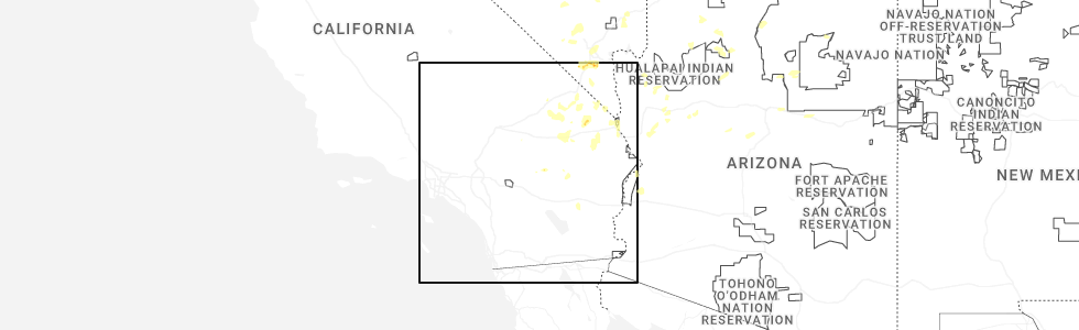
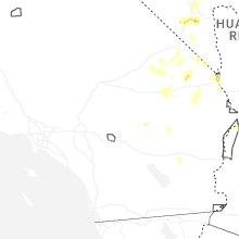
Hail Map for Joshua Tree, CA
The Joshua Tree, CA area has had 2 reports of on-the-ground hail by trained spotters, and has been under severe weather warnings 1 time during the past 12 months. Doppler radar has detected hail at or near Joshua Tree, CA on 14 occasions, including 1 occasion during the past year.
| Name: | Joshua Tree, CA |
| Where Located: | 5.5 miles E of Yucca Valley, CA |
| Map: | Google Map for Joshua Tree, CA |
| Population: | 7414 |
| Housing Units: | 3808 |
| More Info: | Search Google for Joshua Tree, CA |
1
The Top Recent Hail Date for Joshua Tree, CA is Tuesday, June 3, 2025 (2nd out of 14)
Hail and Wind Damage Spotted near Joshua Tree, CA
| Date / Time | Report Details |
|---|---|
| 6/3/2025 2:30 PM PDT | Svrvef the national weather service in las vegas has issued a * severe thunderstorm warning for, southern san bernardino county in southern california, * until 315 pm pdt. * at 230 pm pdt, a severe thunderstorm was located over joshua tree lake campground, or 10 miles west of twentynine palms, moving northeast at 10 mph (radar indicated). Hazards include 60 mph wind gusts and quarter size hail. Hail damage to vehicles is expected. Expect wind damage to roofs and trees. |
| 8/20/2022 3:57 PM PDT |
 At 357 pm pdt, a severe thunderstorm was located 8 miles southwest of twentynine palms, moving east at 5 mph (radar indicated). Hazards include 60 mph wind gusts and quarter size hail. Hail damage to vehicles is expected. expect wind damage to roofs, siding, and trees. locations impacted include, lost horse-keys village. hail threat, radar indicated max hail size, 1. 00 in wind threat, radar indicated max wind gust, 60 mph. At 357 pm pdt, a severe thunderstorm was located 8 miles southwest of twentynine palms, moving east at 5 mph (radar indicated). Hazards include 60 mph wind gusts and quarter size hail. Hail damage to vehicles is expected. expect wind damage to roofs, siding, and trees. locations impacted include, lost horse-keys village. hail threat, radar indicated max hail size, 1. 00 in wind threat, radar indicated max wind gust, 60 mph.
|
| 8/20/2022 3:54 PM PDT |
 The severe thunderstorm warning for south central san bernardino county will expire at 400 pm pdt, the storm which prompted the warning has weakened below severe limits, and no longer poses an immediate threat to life or property. therefore, the warning will be allowed to expire. however gusty winds are still possible with this thunderstorm especially south of highway 62. The severe thunderstorm warning for south central san bernardino county will expire at 400 pm pdt, the storm which prompted the warning has weakened below severe limits, and no longer poses an immediate threat to life or property. therefore, the warning will be allowed to expire. however gusty winds are still possible with this thunderstorm especially south of highway 62.
|
| 8/20/2022 3:44 PM PDT |
 At 344 pm pdt, a severe thunderstorm was located 7 miles southeast of joshua tree, or 9 miles southwest of twentynine palms, moving southeast at 5 mph (radar indicated). Hazards include 60 mph wind gusts and quarter size hail. Hail damage to vehicles is expected. Expect wind damage to roofs, siding, and trees. At 344 pm pdt, a severe thunderstorm was located 7 miles southeast of joshua tree, or 9 miles southwest of twentynine palms, moving southeast at 5 mph (radar indicated). Hazards include 60 mph wind gusts and quarter size hail. Hail damage to vehicles is expected. Expect wind damage to roofs, siding, and trees.
|
| 8/20/2022 3:28 PM PDT |
 At 320 pm pdt, wind gusts near 50 mph were recorded in surprise valley north of joshua tree. wind gusts to 60 mph remain possible (radar indicated). Hazards include 60 mph wind gusts. Expect damage to roofs and trees. locations impacted include, twentynine palms, twentynine palms base, joshua tree lake campground and joshua tree. hail threat, radar indicated max hail size, <. 75 in wind threat, radar indicated max wind gust, 60 mph. At 320 pm pdt, wind gusts near 50 mph were recorded in surprise valley north of joshua tree. wind gusts to 60 mph remain possible (radar indicated). Hazards include 60 mph wind gusts. Expect damage to roofs and trees. locations impacted include, twentynine palms, twentynine palms base, joshua tree lake campground and joshua tree. hail threat, radar indicated max hail size, <. 75 in wind threat, radar indicated max wind gust, 60 mph.
|
| 8/20/2022 3:15 PM PDT |
 At 315 pm pdt, a severe thunderstorm was located over joshua tree lake campground, or 13 miles west of twentynine palms, moving northeast at 15 mph (radar indicated). Hazards include 60 mph wind gusts. expect damage to roofs and trees At 315 pm pdt, a severe thunderstorm was located over joshua tree lake campground, or 13 miles west of twentynine palms, moving northeast at 15 mph (radar indicated). Hazards include 60 mph wind gusts. expect damage to roofs and trees
|
| 8/13/2022 2:10 PM PDT |
 At 210 pm pdt, a severe thunderstorm was located 11 miles southeast of joshua tree, or 12 miles southwest of twentynine palms, and is nearly stationary (radar indicated). Hazards include 60 mph wind gusts and nickel size hail. expect damage to roofs, siding, and trees At 210 pm pdt, a severe thunderstorm was located 11 miles southeast of joshua tree, or 12 miles southwest of twentynine palms, and is nearly stationary (radar indicated). Hazards include 60 mph wind gusts and nickel size hail. expect damage to roofs, siding, and trees
|
| 9/24/2021 2:11 PM PDT |
 At 211 pm pdt, a severe thunderstorm was located over yucca valley, or 18 miles east of onyx summit, moving north at 10 mph (radar indicated). Hazards include 60 mph wind gusts and quarter size hail. Hail damage to vehicles is expected. Expect wind damage to roofs and trees. At 211 pm pdt, a severe thunderstorm was located over yucca valley, or 18 miles east of onyx summit, moving north at 10 mph (radar indicated). Hazards include 60 mph wind gusts and quarter size hail. Hail damage to vehicles is expected. Expect wind damage to roofs and trees.
|
| 9/9/2021 3:25 PM PDT |
 The severe thunderstorm warning for south central san bernardino county will expire at 330 pm pdt, the storm which prompted the warning has weakened below severe limits, and no longer poses an immediate threat to life or property. therefore, the warning will be allowed to expire. The severe thunderstorm warning for south central san bernardino county will expire at 330 pm pdt, the storm which prompted the warning has weakened below severe limits, and no longer poses an immediate threat to life or property. therefore, the warning will be allowed to expire.
|
| 9/9/2021 3:00 PM PDT |
 At 259 pm pdt, a severe thunderstorm was located near joshua tree lake campground, or 14 miles northwest of twentynine palms, moving northwest at 20 mph (radar indicated). Hazards include 60 mph wind gusts. Expect damage to roofs and trees. locations impacted include, twentynine palms, twentynine palms base, twentynine palms airport, ludlow, joshua tree lake campground, joshua tree, pioneertown and johnson valley. this includes interstate 40 in california between mile markers 45 and 49. hail threat, radar indicated max hail size, <. 75 in wind threat, radar indicated max wind gust, 60 mph. At 259 pm pdt, a severe thunderstorm was located near joshua tree lake campground, or 14 miles northwest of twentynine palms, moving northwest at 20 mph (radar indicated). Hazards include 60 mph wind gusts. Expect damage to roofs and trees. locations impacted include, twentynine palms, twentynine palms base, twentynine palms airport, ludlow, joshua tree lake campground, joshua tree, pioneertown and johnson valley. this includes interstate 40 in california between mile markers 45 and 49. hail threat, radar indicated max hail size, <. 75 in wind threat, radar indicated max wind gust, 60 mph.
|
| 9/9/2021 2:31 PM PDT |
 At 231 pm pdt, a severe thunderstorm was located near joshua tree lake campground, or near twentynine palms, moving northwest at 25 mph (radar indicated). Hazards include 60 mph wind gusts. expect damage to roofs and trees At 231 pm pdt, a severe thunderstorm was located near joshua tree lake campground, or near twentynine palms, moving northwest at 25 mph (radar indicated). Hazards include 60 mph wind gusts. expect damage to roofs and trees
|
| 7/22/2019 2:53 PM PDT |
 At 253 pm pdt, a severe thunderstorm was located near joshua tree, or 7 miles west of twentynine palms, moving north at 20 mph (radar indicated). Hazards include 60 mph wind gusts and quarter size hail. Hail damage to vehicles is expected. expect wind damage to roofs, siding, and trees. This severe thunderstorm will remain over mainly rural areas of san bernardino and riverside counties. At 253 pm pdt, a severe thunderstorm was located near joshua tree, or 7 miles west of twentynine palms, moving north at 20 mph (radar indicated). Hazards include 60 mph wind gusts and quarter size hail. Hail damage to vehicles is expected. expect wind damage to roofs, siding, and trees. This severe thunderstorm will remain over mainly rural areas of san bernardino and riverside counties.
|
| 10/12/2018 11:35 PM PDT | Quarter sized hail reported 0.6 miles W of Joshua Tree, CA, excessive hail reported. 1 inch in diameter via social media post. |
| 8/11/2017 2:42 PM PDT |
 At 241 pm pdt, a severe thunderstorm was located near joshua tree lake campground, or 16 miles northwest of twentynine palms, moving northeast at 5 mph (radar indicated). Hazards include 60 mph wind gusts. expect damage to roofs, siding, and trees At 241 pm pdt, a severe thunderstorm was located near joshua tree lake campground, or 16 miles northwest of twentynine palms, moving northeast at 5 mph (radar indicated). Hazards include 60 mph wind gusts. expect damage to roofs, siding, and trees
|
| 8/26/2015 2:01 PM PDT |
 At 200 pm pdt, doppler radar indicated a severe thunderstorm capable of producing damaging winds in excess of 60 mph. this storm was located near twentynine palms. this storm was nearly stationary. At 200 pm pdt, doppler radar indicated a severe thunderstorm capable of producing damaging winds in excess of 60 mph. this storm was located near twentynine palms. this storm was nearly stationary.
|
| 9/16/2014 3:33 PM PDT | Quarter sized hail reported 2.2 miles N of Joshua Tree, CA, spotter reports quarter size hail with very high wind gusts estimated at 40 mph |
| 1/1/0001 12:00 AM | California highway patrol reported a wire down on highway 6 in san bernardino county CA, 0.6 miles W of Joshua Tree, CA |
| 1/1/0001 12:00 AM | Thunderstorm winds stripped roofs and siding of aluminum sheds...blew of sections of the joshua tree library roof...blew over a landmark 36 foot wide billboard sign...t in san bernardino county CA, 0.8 miles SW of Joshua Tree, CA |
| 1/1/0001 12:00 AM | California highway patrol reported a tree down blocking the northbound lanes of sunset and oleander in joshua tree. a report of a shed in the roadway with metal debris in san bernardino county CA, 0.6 miles S of Joshua Tree, CA |
| 1/1/0001 12:00 AM | Fire department reported a roof and a porch off of a mobile home. the event time is an estimate off of rada in san bernardino county CA, 0.8 miles SW of Joshua Tree, CA |
| 1/1/0001 12:00 AM | California highway patrol reported a wire down and sparking on morningside road at sunset roa in san bernardino county CA, 0.6 miles S of Joshua Tree, CA |
| 1/1/0001 12:00 AM | Spotter reports damage to awning in joshua tree from tstm wind gust at 215 p in san bernardino county CA, 3.2 miles WSW of Joshua Tree, CA |
Hail Maps for Joshua Tree, CA


Connect with Interactive Hail Maps