

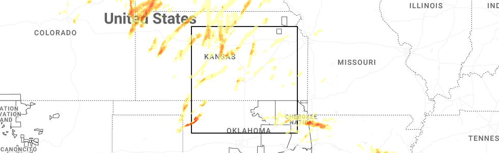
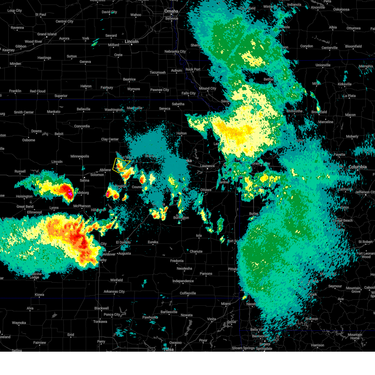
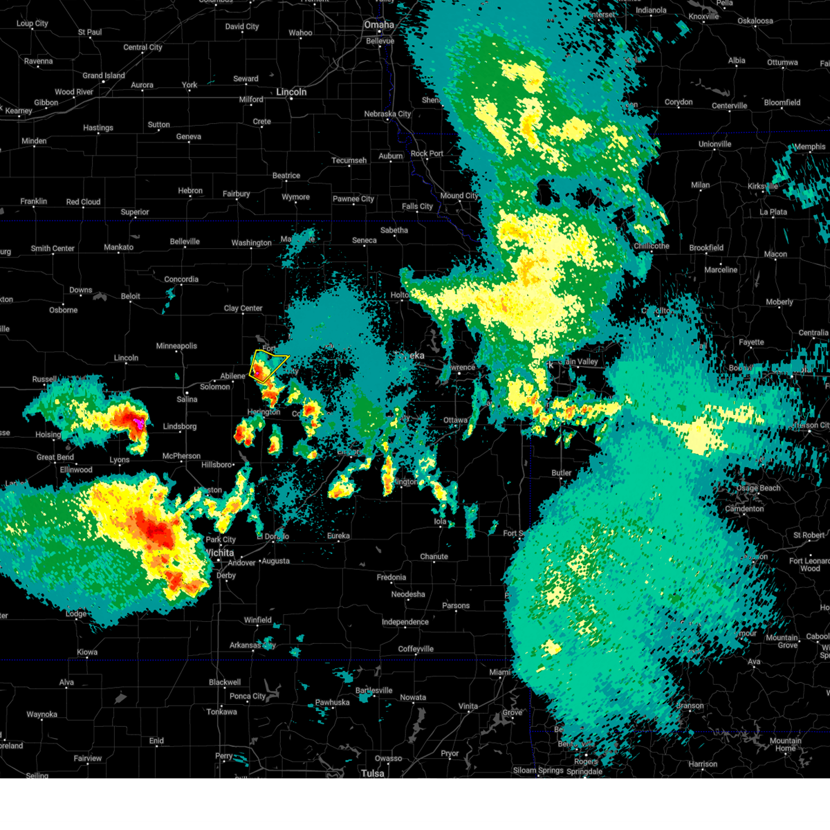
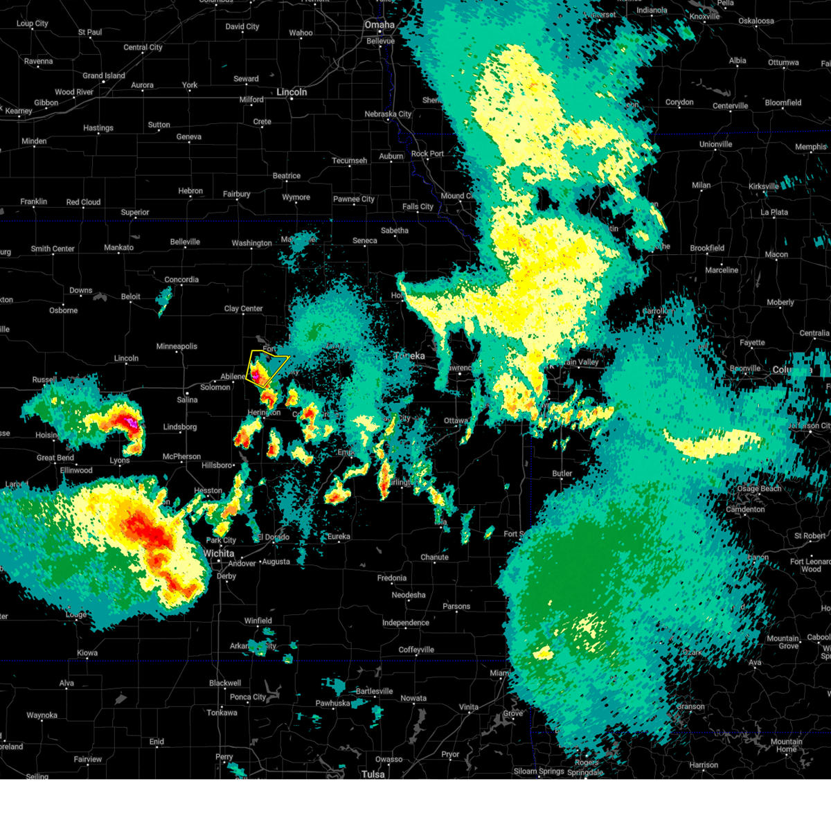
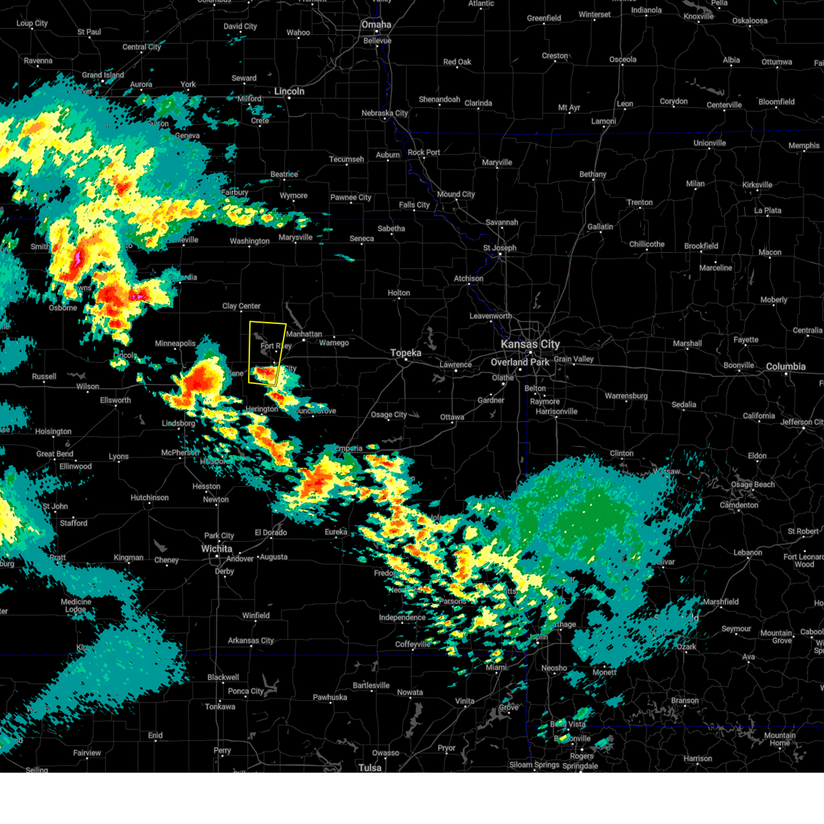
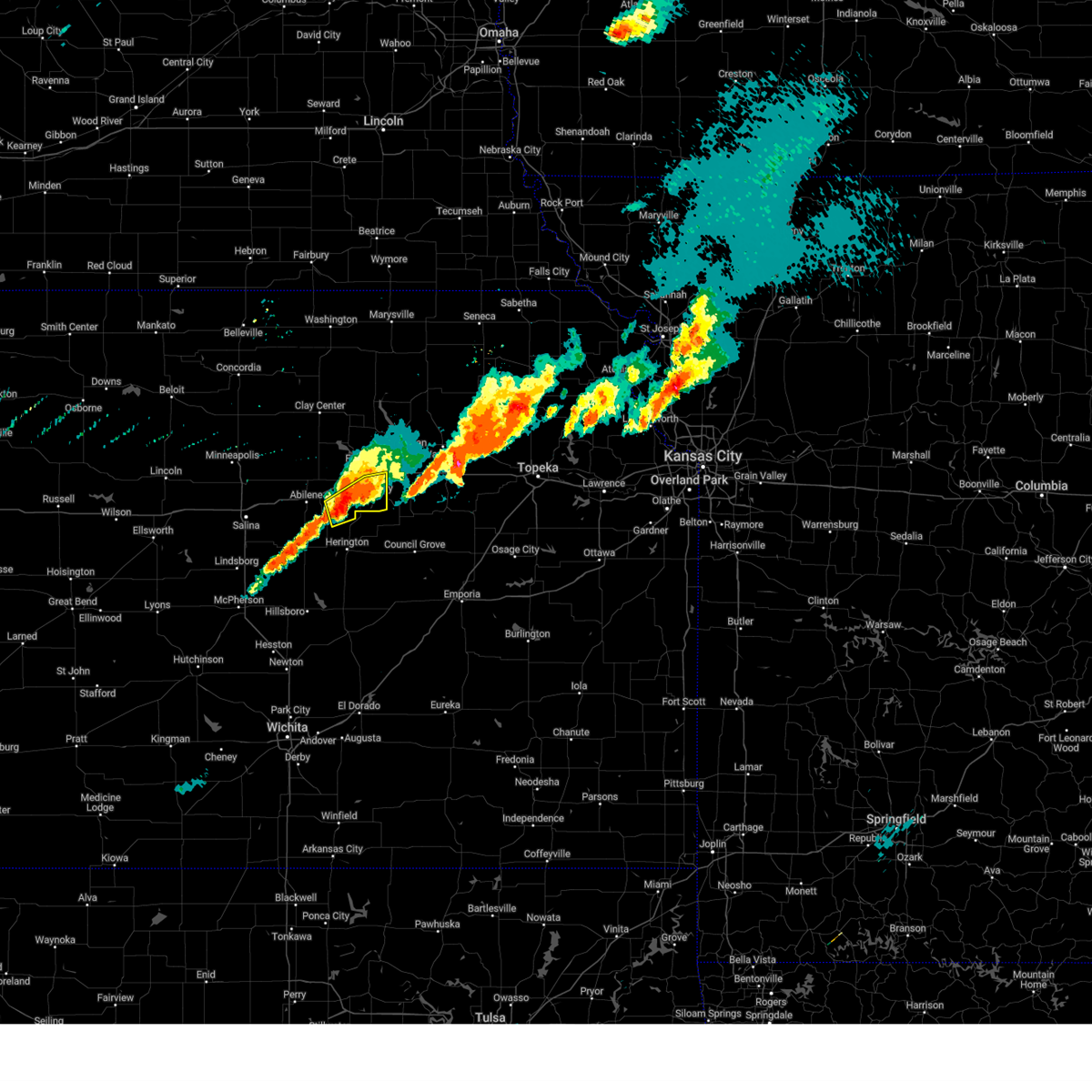
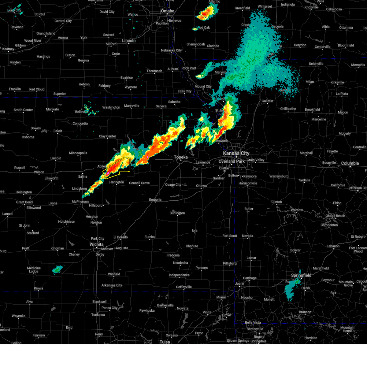
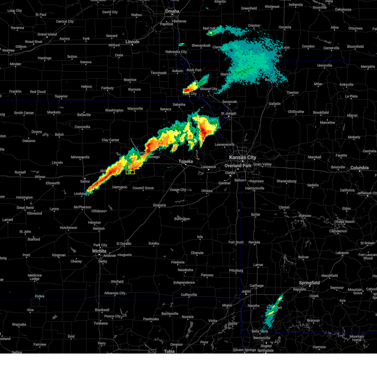
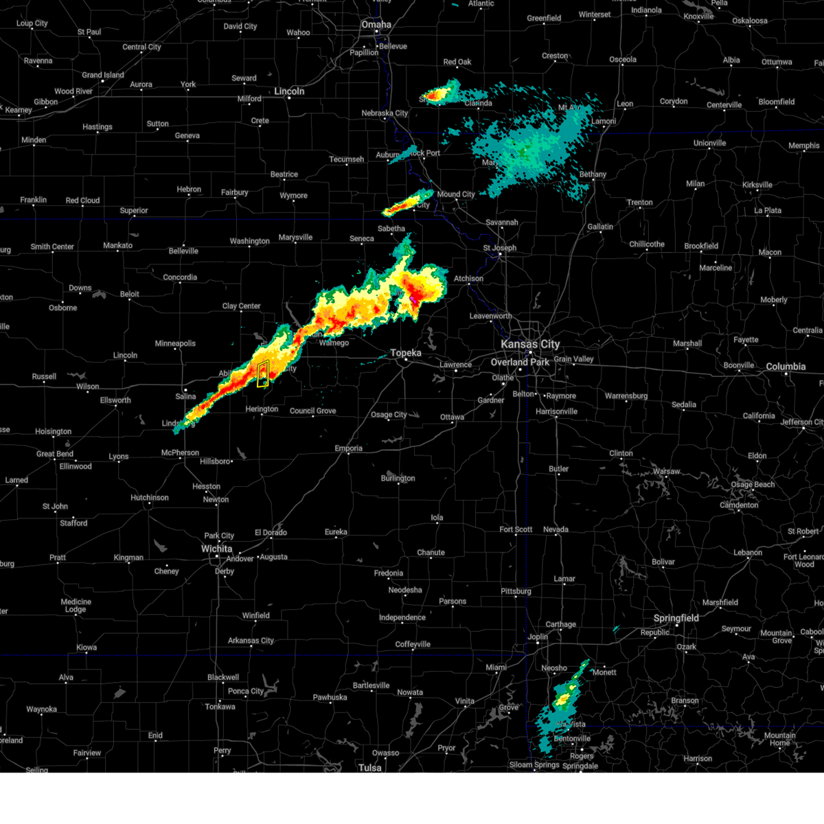
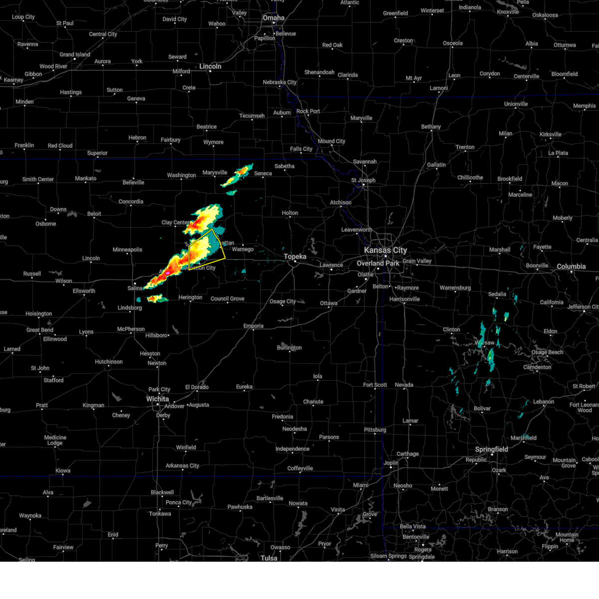
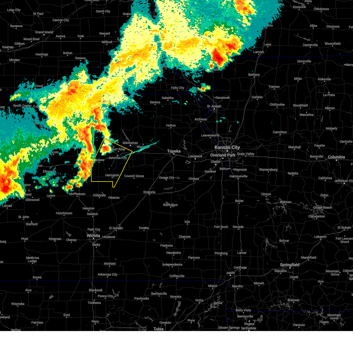
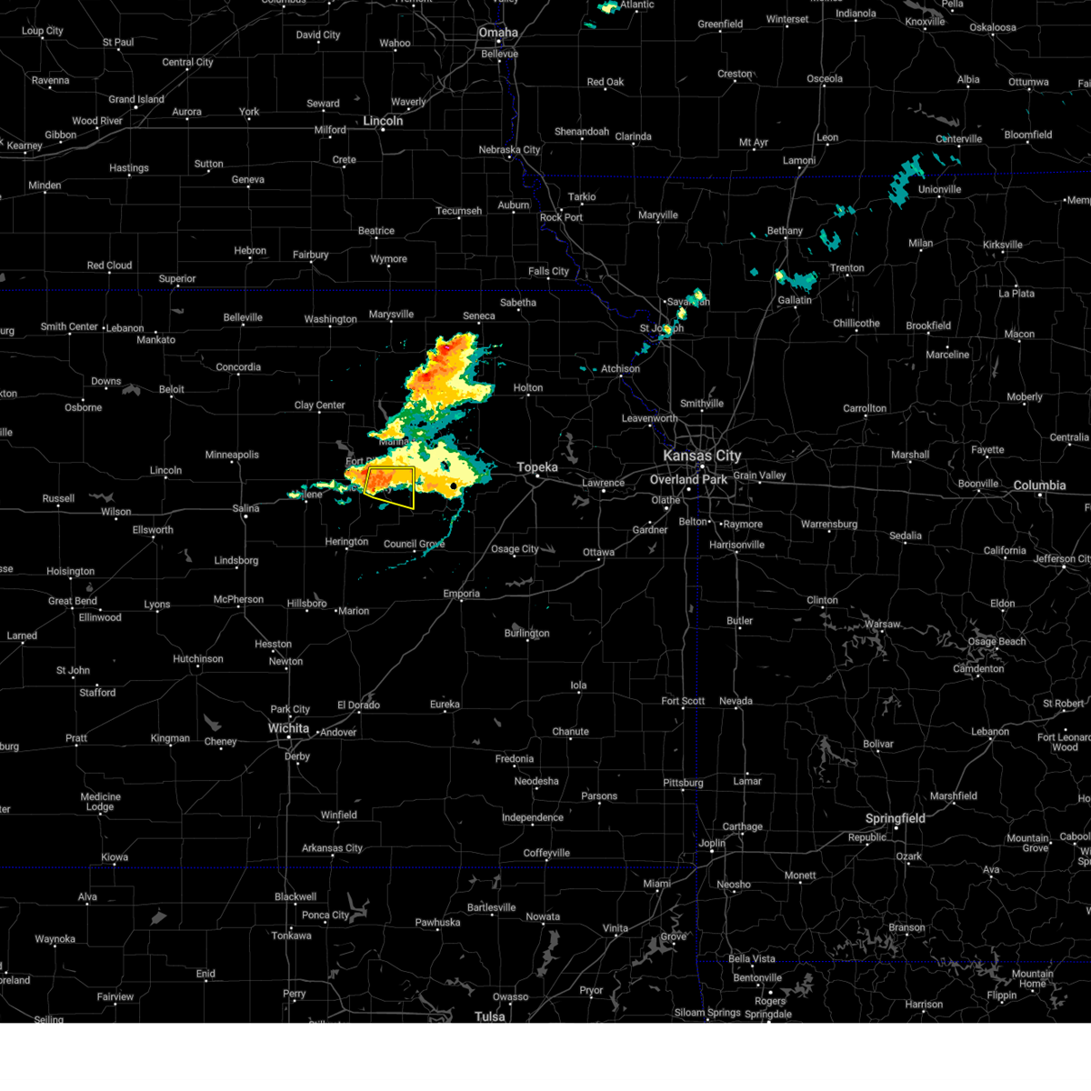
Hail Map for Junction City, KS
The Junction City, KS area has had 57 reports of on-the-ground hail by trained spotters, and has been under severe weather warnings 45 times during the past 12 months. Doppler radar has detected hail at or near Junction City, KS on 107 occasions, including 5 occasions during the past year.
| Name: | Junction City, KS |
| Where Located: | 18.2 miles SW of Manhattan, KS |
| Map: | Google Map for Junction City, KS |
| Population: | 23353 |
| Housing Units: | 10480 |
| More Info: | Search Google for Junction City, KS |
1
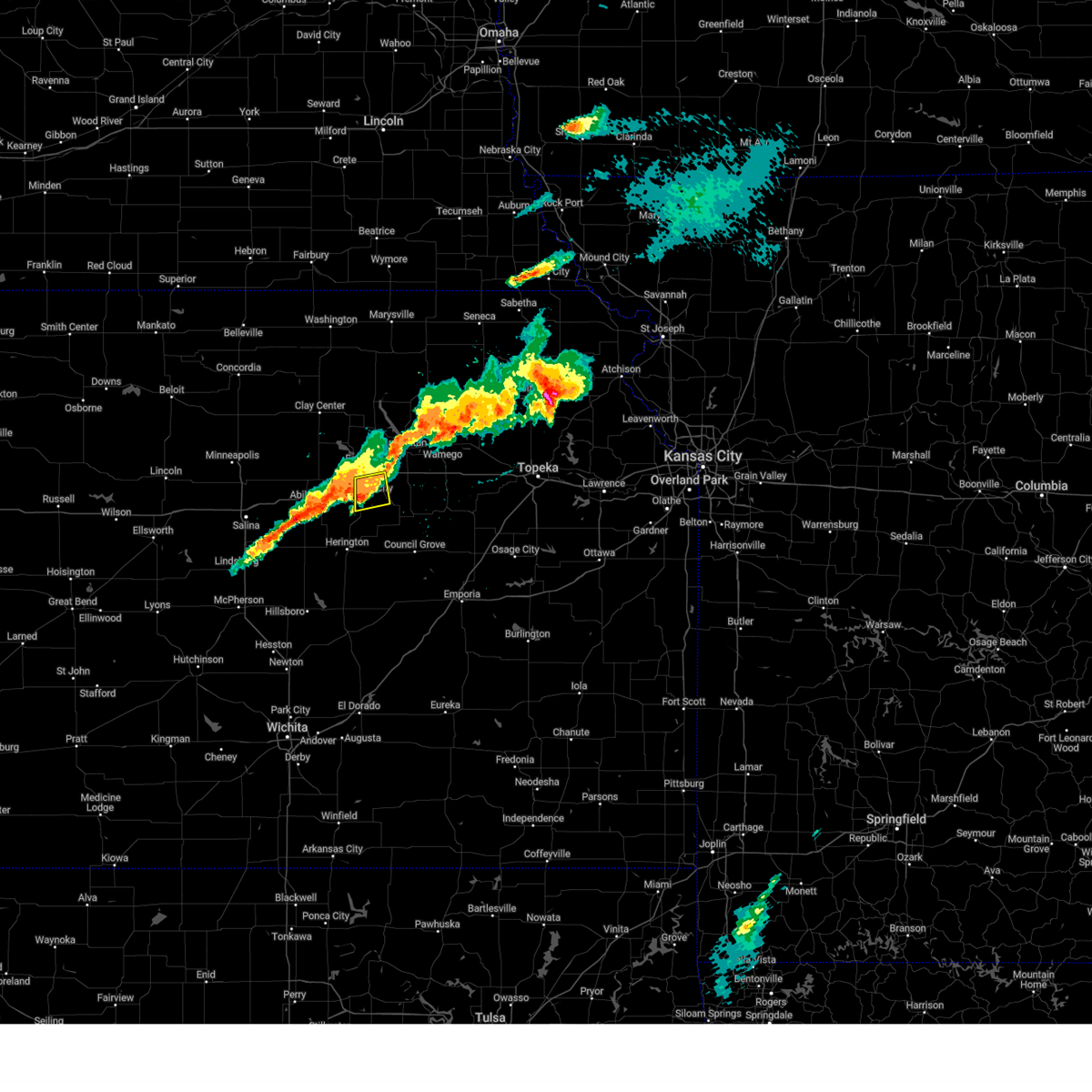
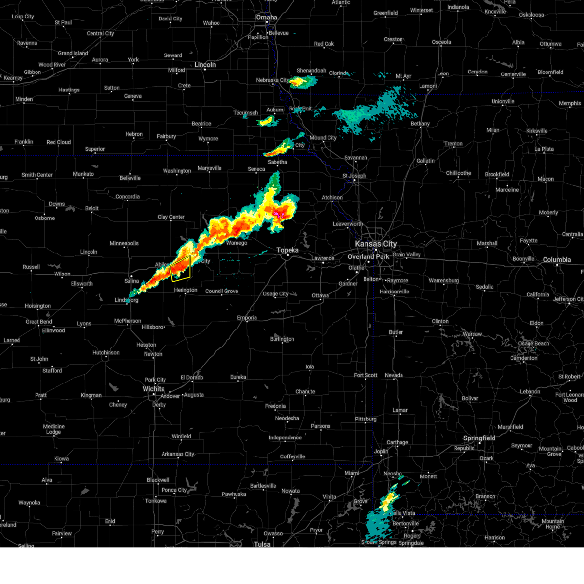
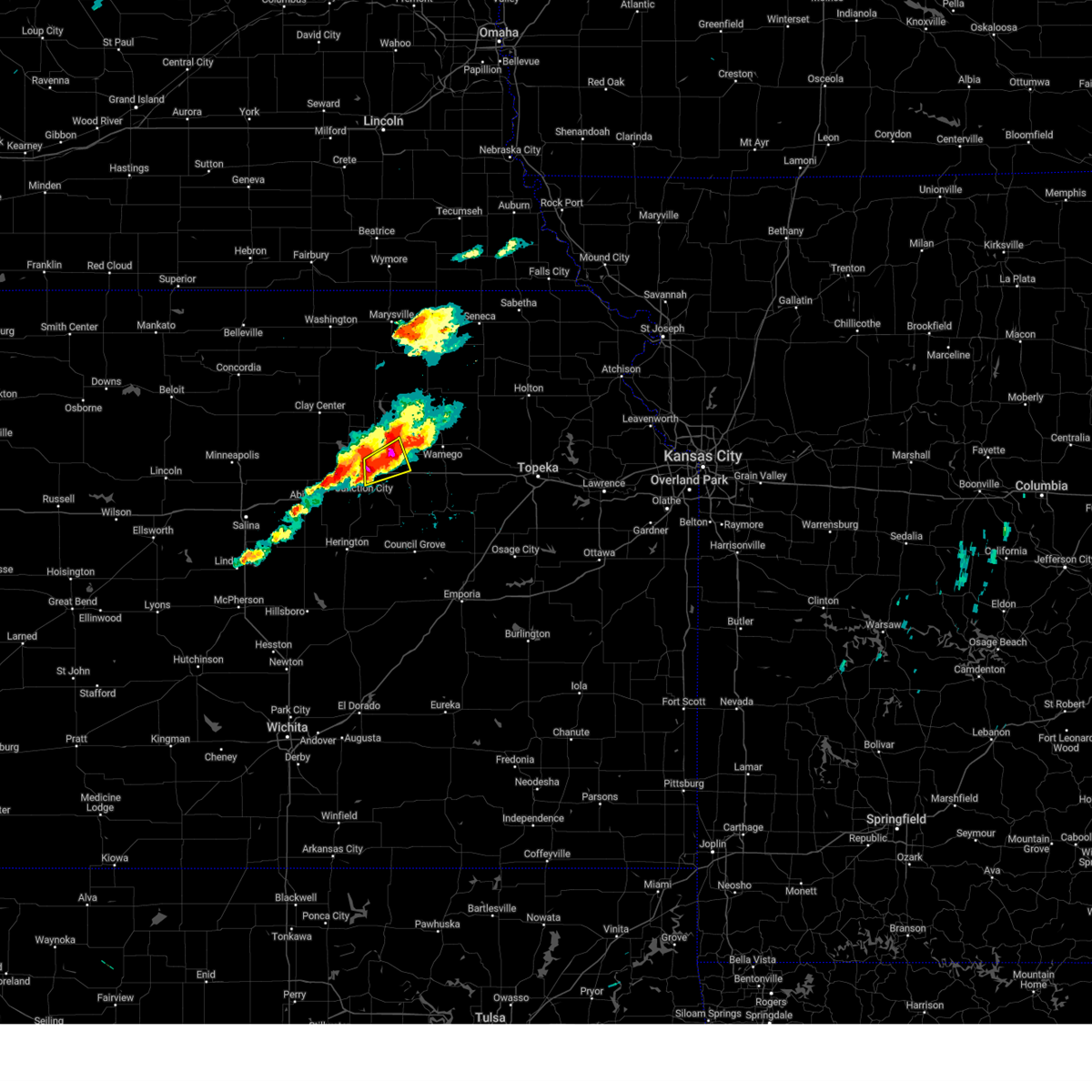
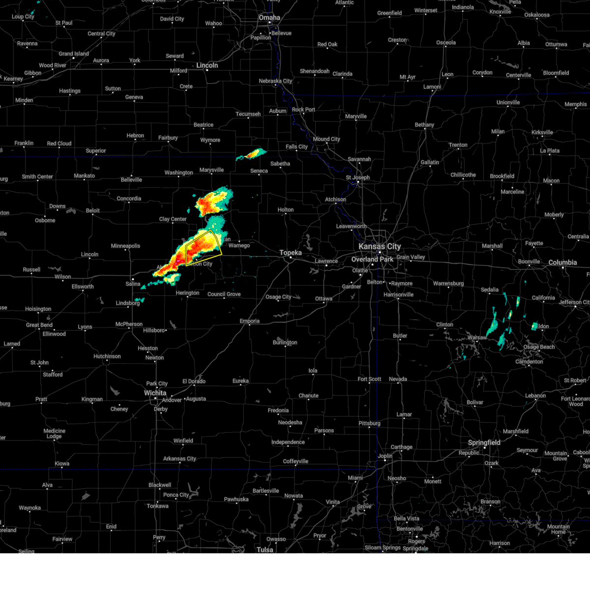
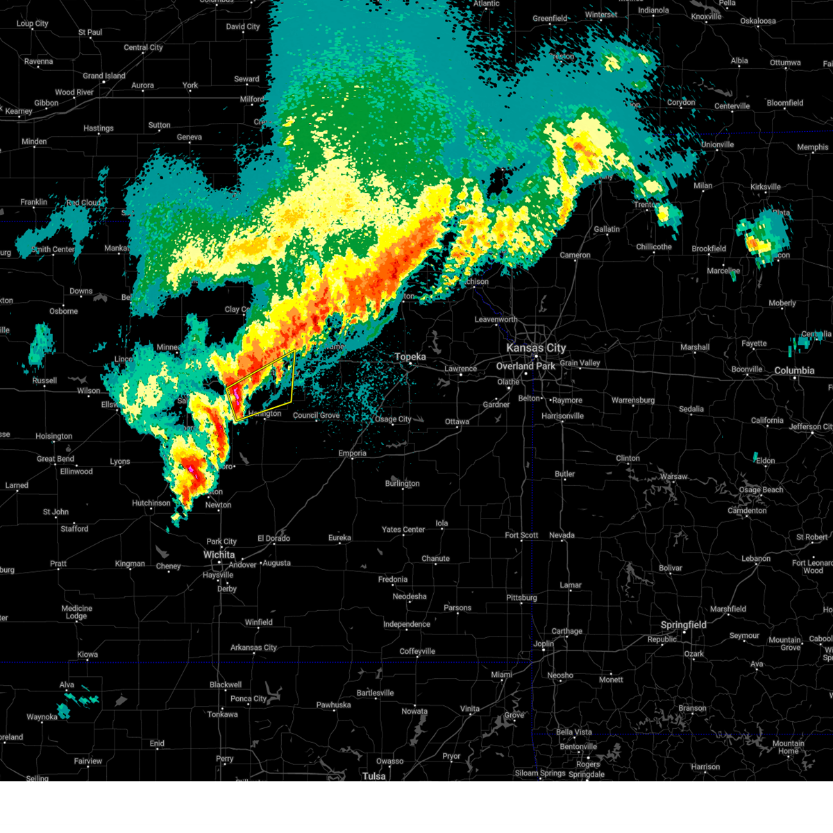
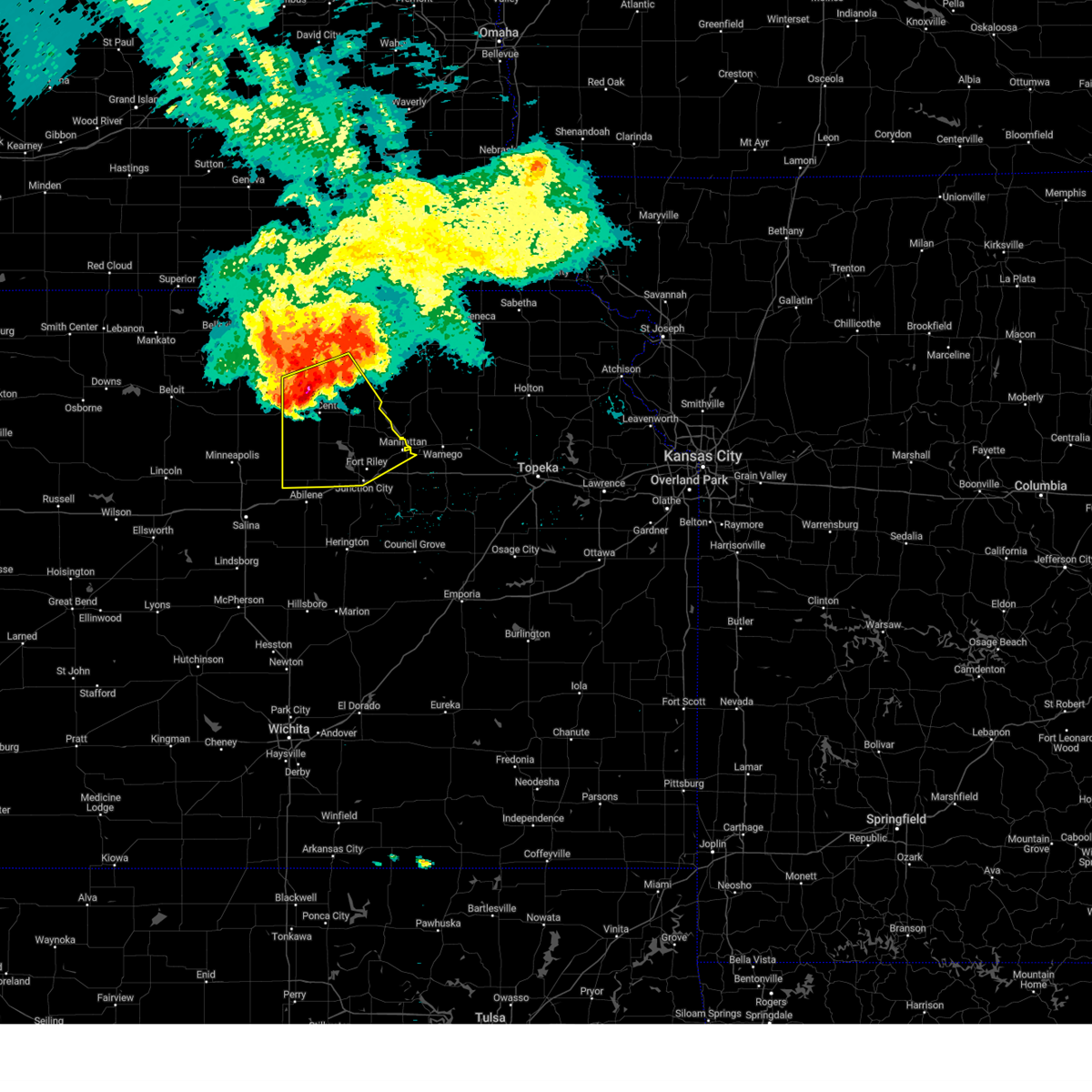
The Top Recent Hail Date for Junction City, KS is Sunday, May 18, 2025 (26th out of 107)
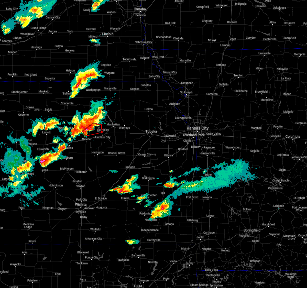
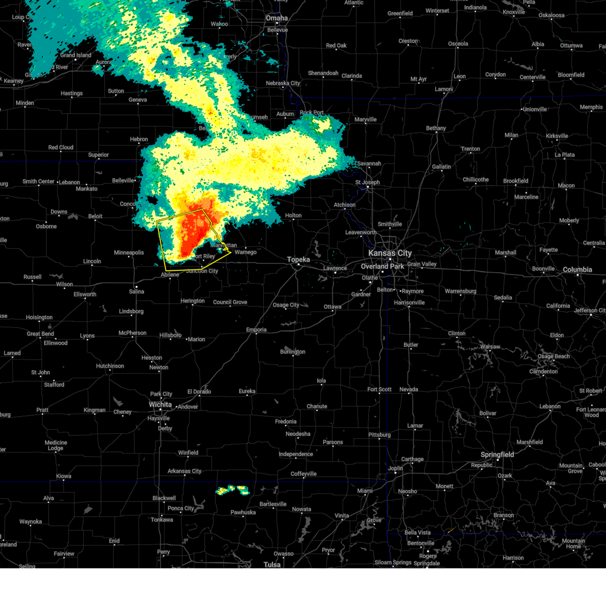
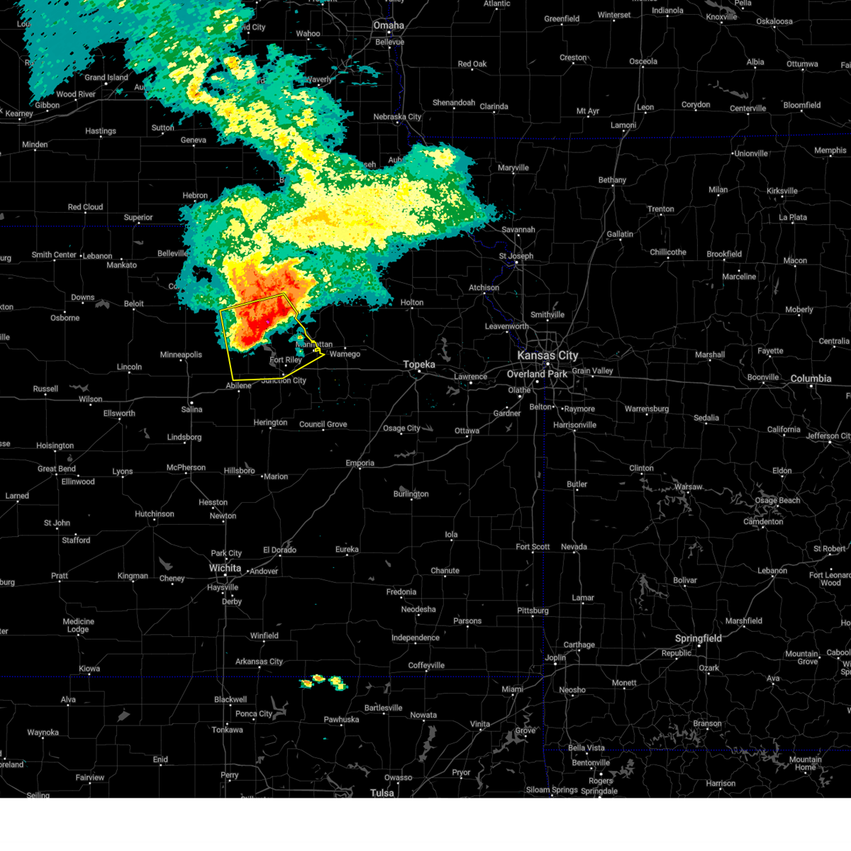
Hail and Wind Damage Spotted near Junction City, KS
| Date / Time | Report Details |
|---|---|
| 6/17/2025 3:48 AM CDT |
 the severe thunderstorm warning has been cancelled and is no longer in effect the severe thunderstorm warning has been cancelled and is no longer in effect
|
| 6/17/2025 3:27 AM CDT |
 At 327 am cdt, a severe thunderstorm was located 7 miles south of junction city, moving east at 30 mph (radar indicated). Hazards include 60 mph wind gusts. Expect damage to roofs, siding, and trees. locations impacted include, southwestern manhattan, junction city, herington, ogden, grandview plaza, chapman, white city, woodbine, wilsey, parkerville, latimer, milford lake, and burdick. This includes interstate 70 between mile markers 286 and 312. At 327 am cdt, a severe thunderstorm was located 7 miles south of junction city, moving east at 30 mph (radar indicated). Hazards include 60 mph wind gusts. Expect damage to roofs, siding, and trees. locations impacted include, southwestern manhattan, junction city, herington, ogden, grandview plaza, chapman, white city, woodbine, wilsey, parkerville, latimer, milford lake, and burdick. This includes interstate 70 between mile markers 286 and 312.
|
| 6/17/2025 3:06 AM CDT |
 Svrtop the national weather service in topeka has issued a * severe thunderstorm warning for, eastern dickinson county in central kansas, geary county in east central kansas, southwestern riley county in northeastern kansas, western morris county in east central kansas, * until 415 am cdt. * at 306 am cdt, a severe thunderstorm was located near moonlight, or 11 miles west of junction city, moving east at 30 mph (radar indicated). Hazards include 70 mph wind gusts. Expect considerable tree damage. Damage is likely to mobile homes, roofs, and outbuildings. Svrtop the national weather service in topeka has issued a * severe thunderstorm warning for, eastern dickinson county in central kansas, geary county in east central kansas, southwestern riley county in northeastern kansas, western morris county in east central kansas, * until 415 am cdt. * at 306 am cdt, a severe thunderstorm was located near moonlight, or 11 miles west of junction city, moving east at 30 mph (radar indicated). Hazards include 70 mph wind gusts. Expect considerable tree damage. Damage is likely to mobile homes, roofs, and outbuildings.
|
| 5/19/2025 11:13 PM CDT |
 The storm which prompted the warning has weakened below severe limits, and no longer poses an immediate threat to life or property. therefore, the warning will be allowed to expire. however, heavy rain is still possible with this thunderstorm. The storm which prompted the warning has weakened below severe limits, and no longer poses an immediate threat to life or property. therefore, the warning will be allowed to expire. however, heavy rain is still possible with this thunderstorm.
|
| 5/19/2025 11:06 PM CDT |
 At 1105 pm cdt, a severe thunderstorm was located near chapman, moving northeast at 15 mph (trained weather spotters. at 1104 pm cdt, spotters reported hail up to the size of quarters 1 mile east of chapman). Hazards include 60 mph wind gusts and quarter size hail. Hail damage to vehicles is expected. expect wind damage to roofs, siding, and trees. locations impacted include, junction city, grandview plaza, and chapman. This includes interstate 70 between mile markers 284 and 298. At 1105 pm cdt, a severe thunderstorm was located near chapman, moving northeast at 15 mph (trained weather spotters. at 1104 pm cdt, spotters reported hail up to the size of quarters 1 mile east of chapman). Hazards include 60 mph wind gusts and quarter size hail. Hail damage to vehicles is expected. expect wind damage to roofs, siding, and trees. locations impacted include, junction city, grandview plaza, and chapman. This includes interstate 70 between mile markers 284 and 298.
|
| 5/19/2025 10:53 PM CDT |
 Svrtop the national weather service in topeka has issued a * severe thunderstorm warning for, northeastern dickinson county in central kansas, west central geary county in east central kansas, * until 1115 pm cdt. * at 1052 pm cdt, a severe thunderstorm was located over chapman, moving northeast at 15 mph (trained weather spotters. at 1050 pm cdt, spotters reported hail up to the size of half dollars 1 mile south of chapman). Hazards include 60 mph wind gusts and quarter size hail. Hail damage to vehicles is expected. Expect wind damage to roofs, siding, and trees. Svrtop the national weather service in topeka has issued a * severe thunderstorm warning for, northeastern dickinson county in central kansas, west central geary county in east central kansas, * until 1115 pm cdt. * at 1052 pm cdt, a severe thunderstorm was located over chapman, moving northeast at 15 mph (trained weather spotters. at 1050 pm cdt, spotters reported hail up to the size of half dollars 1 mile south of chapman). Hazards include 60 mph wind gusts and quarter size hail. Hail damage to vehicles is expected. Expect wind damage to roofs, siding, and trees.
|
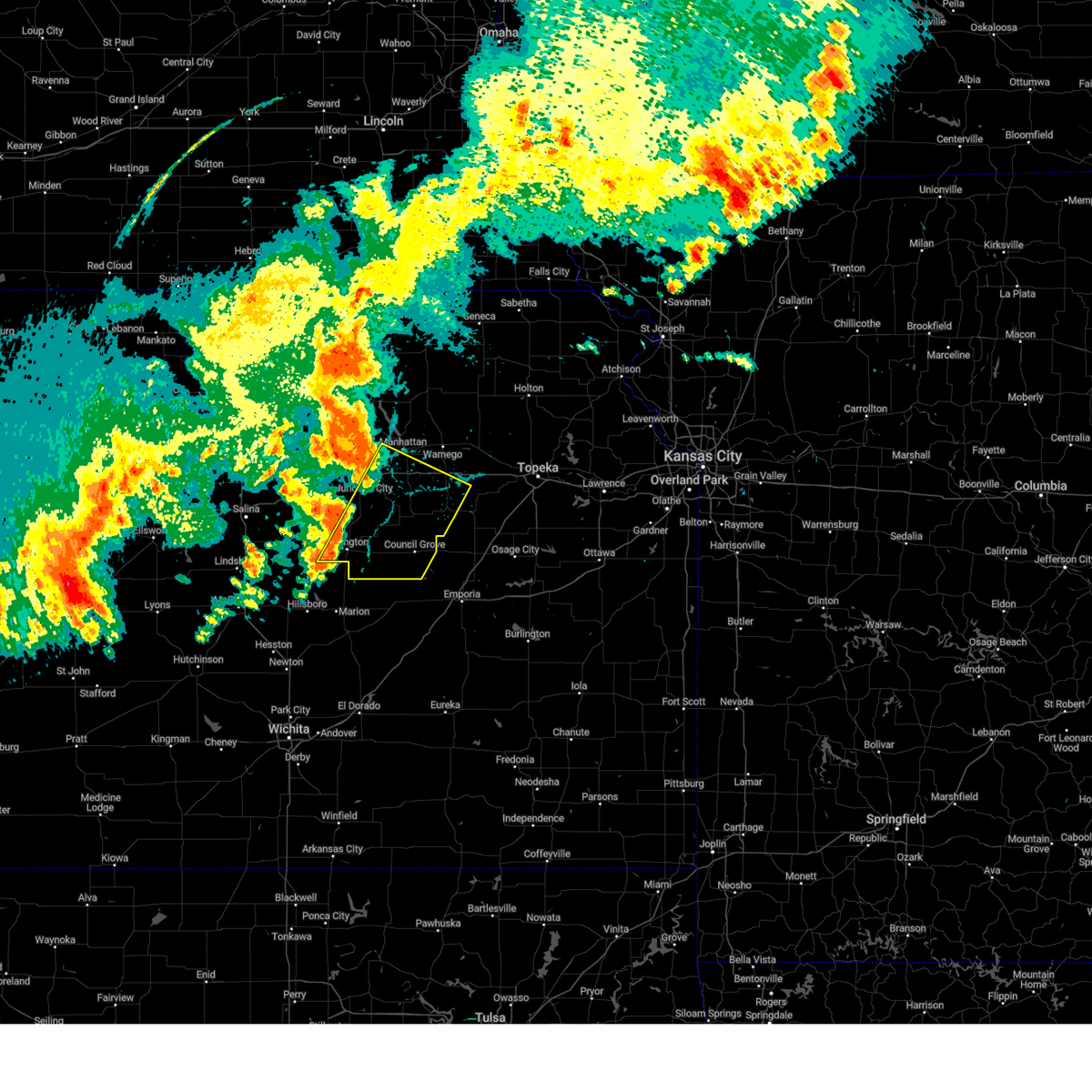
| 5/19/2025 4:15 PM CDT | At 415 pm cdt, a severe thunderstorm was located 4 miles southeast of milford lake, moving northeast at 30 mph (radar indicated). Hazards include 60 mph wind gusts and quarter size hail. Hail damage to vehicles is expected. expect wind damage to roofs, siding, and trees. locations impacted include, manhattan, junction city, ogden, grandview plaza, and keats. This includes interstate 70 between mile markers 300 and 304. |
| 5/19/2025 4:08 PM CDT | the severe thunderstorm warning has been cancelled and is no longer in effect |
| 5/19/2025 4:08 PM CDT | At 408 pm cdt, a severe thunderstorm was located near junction city, moving northeast at 30 mph (radar indicated). Hazards include 60 mph wind gusts and quarter size hail. Hail damage to vehicles is expected. expect wind damage to roofs, siding, and trees. locations impacted include, manhattan, junction city, ogden, grandview plaza, milford, milford lake, and keats. This includes interstate 70 between mile markers 291 and 303. |
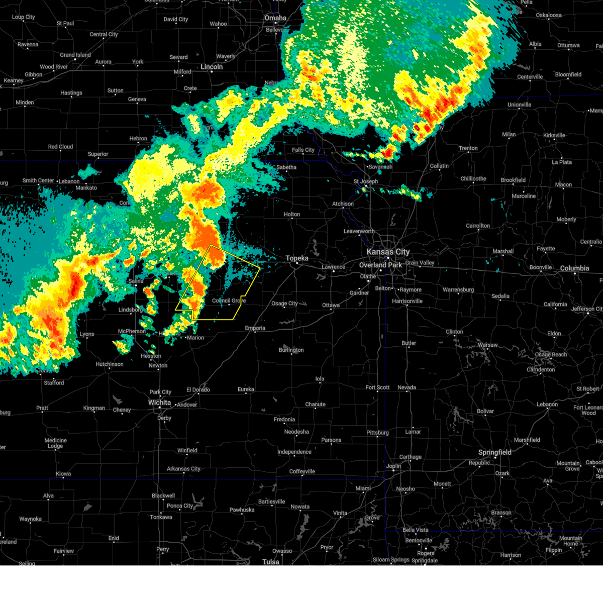
| 5/19/2025 3:57 PM CDT | Svrtop the national weather service in topeka has issued a * severe thunderstorm warning for, northeastern dickinson county in central kansas, western geary county in east central kansas, southwestern riley county in northeastern kansas, * until 445 pm cdt. * at 357 pm cdt, a severe thunderstorm was located 4 miles east of chapman, moving northeast at 30 mph (radar indicated). Hazards include 60 mph wind gusts and quarter size hail. Hail damage to vehicles is expected. Expect wind damage to roofs, siding, and trees. |
| 5/18/2025 7:00 PM CDT |
 the severe thunderstorm warning has been cancelled and is no longer in effect the severe thunderstorm warning has been cancelled and is no longer in effect
|
| 5/18/2025 6:55 PM CDT | Quarter sized hail reported 2.7 miles NNE of Junction City, KS |
| 5/18/2025 6:51 PM CDT | the severe thunderstorm warning has been cancelled and is no longer in effect |
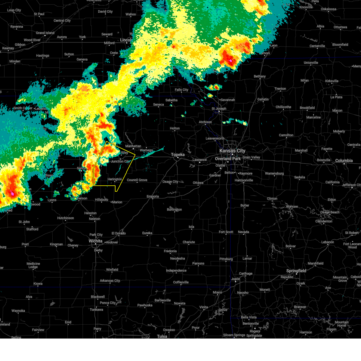
| 5/18/2025 6:51 PM CDT | At 650 pm cdt, a severe thunderstorm was located near chapman, moving north at 60 mph (trained weather spotters. at 643 pm a trained spotter reported ping pong ball size hail 4 miles nnw of woodbine). Hazards include ping pong ball size hail and 60 mph wind gusts. People and animals outdoors will be injured. expect hail damage to roofs, siding, windows, and vehicles. expect wind damage to roofs, siding, and trees. locations impacted include, junction city, grandview plaza, chapman, wakefield, riley, milford, and milford lake. This includes interstate 70 between mile markers 285 and 299. |
| 5/18/2025 6:43 PM CDT | Svrtop the national weather service in topeka has issued a * severe thunderstorm warning for, northeastern dickinson county in central kansas, western geary county in east central kansas, southwestern riley county in northeastern kansas, northwestern morris county in east central kansas, southeastern clay county in north central kansas, * until 715 pm cdt. * at 643 pm cdt, a severe thunderstorm was located 4 miles north of woodbine, moving north at 60 mph (radar indicated). Hazards include 60 mph wind gusts and half dollar size hail. Hail damage to vehicles is expected. Expect wind damage to roofs, siding, and trees. |
| 4/28/2025 8:39 PM CDT |
 At 839 pm cdt, a severe thunderstorm was located 5 miles south of junction city, moving northeast at 45 mph (radar indicated). Hazards include 60 mph wind gusts and quarter size hail. Hail damage to vehicles is expected. expect wind damage to roofs, siding, and trees. locations impacted include, junction city. This includes interstate 70 between mile markers 294 and 298. At 839 pm cdt, a severe thunderstorm was located 5 miles south of junction city, moving northeast at 45 mph (radar indicated). Hazards include 60 mph wind gusts and quarter size hail. Hail damage to vehicles is expected. expect wind damage to roofs, siding, and trees. locations impacted include, junction city. This includes interstate 70 between mile markers 294 and 298.
|
| 4/28/2025 8:39 PM CDT |
 the severe thunderstorm warning has been cancelled and is no longer in effect the severe thunderstorm warning has been cancelled and is no longer in effect
|
| 4/28/2025 8:29 PM CDT |
 At 829 pm cdt, a severe thunderstorm was located 7 miles north of woodbine, moving northeast at 45 mph (radar indicated). Hazards include ping pong ball size hail and 60 mph wind gusts. People and animals outdoors will be injured. expect hail damage to roofs, siding, windows, and vehicles. expect wind damage to roofs, siding, and trees. locations impacted include, junction city and grandview plaza. This includes interstate 70 between mile markers 292 and 306. At 829 pm cdt, a severe thunderstorm was located 7 miles north of woodbine, moving northeast at 45 mph (radar indicated). Hazards include ping pong ball size hail and 60 mph wind gusts. People and animals outdoors will be injured. expect hail damage to roofs, siding, windows, and vehicles. expect wind damage to roofs, siding, and trees. locations impacted include, junction city and grandview plaza. This includes interstate 70 between mile markers 292 and 306.
|
| 4/28/2025 8:17 PM CDT |
 Svrtop the national weather service in topeka has issued a * severe thunderstorm warning for, east central dickinson county in central kansas, southwestern geary county in east central kansas, * until 900 pm cdt. * at 817 pm cdt, a severe thunderstorm was located 4 miles southeast of enterprise, moving northeast at 45 mph (radar indicated). Hazards include ping pong ball size hail and 60 mph wind gusts. People and animals outdoors will be injured. expect hail damage to roofs, siding, windows, and vehicles. Expect wind damage to roofs, siding, and trees. Svrtop the national weather service in topeka has issued a * severe thunderstorm warning for, east central dickinson county in central kansas, southwestern geary county in east central kansas, * until 900 pm cdt. * at 817 pm cdt, a severe thunderstorm was located 4 miles southeast of enterprise, moving northeast at 45 mph (radar indicated). Hazards include ping pong ball size hail and 60 mph wind gusts. People and animals outdoors will be injured. expect hail damage to roofs, siding, windows, and vehicles. Expect wind damage to roofs, siding, and trees.
|
| 4/28/2025 7:35 PM CDT |
 At 735 pm cdt, a severe thunderstorm was located 5 miles south of grandview plaza, moving east at 25 mph (radar indicated). Hazards include 60 mph wind gusts and quarter size hail. Hail damage to vehicles is expected. expect wind damage to roofs, siding, and trees. locations impacted include, grandview plaza and junction city. This includes interstate 70 between mile markers 298 and 305. At 735 pm cdt, a severe thunderstorm was located 5 miles south of grandview plaza, moving east at 25 mph (radar indicated). Hazards include 60 mph wind gusts and quarter size hail. Hail damage to vehicles is expected. expect wind damage to roofs, siding, and trees. locations impacted include, grandview plaza and junction city. This includes interstate 70 between mile markers 298 and 305.
|
| 4/28/2025 7:21 PM CDT |
 At 721 pm cdt, a severe thunderstorm was located 6 miles east of chapman, moving east at 25 mph (radar indicated). Hazards include 60 mph wind gusts and quarter size hail. Hail damage to vehicles is expected. expect wind damage to roofs, siding, and trees. this severe thunderstorm will remain over mainly rural areas of east central dickinson and southwestern geary counties. This includes interstate 70 between mile markers 290 and 293. At 721 pm cdt, a severe thunderstorm was located 6 miles east of chapman, moving east at 25 mph (radar indicated). Hazards include 60 mph wind gusts and quarter size hail. Hail damage to vehicles is expected. expect wind damage to roofs, siding, and trees. this severe thunderstorm will remain over mainly rural areas of east central dickinson and southwestern geary counties. This includes interstate 70 between mile markers 290 and 293.
|
| 4/28/2025 7:19 PM CDT |
 Svrtop the national weather service in topeka has issued a * severe thunderstorm warning for, southwestern geary county in east central kansas, * until 745 pm cdt. * at 719 pm cdt, a severe thunderstorm was located 7 miles south of junction city, moving east at 25 mph (radar indicated). Hazards include 60 mph wind gusts and quarter size hail. Hail damage to vehicles is expected. Expect wind damage to roofs, siding, and trees. Svrtop the national weather service in topeka has issued a * severe thunderstorm warning for, southwestern geary county in east central kansas, * until 745 pm cdt. * at 719 pm cdt, a severe thunderstorm was located 7 miles south of junction city, moving east at 25 mph (radar indicated). Hazards include 60 mph wind gusts and quarter size hail. Hail damage to vehicles is expected. Expect wind damage to roofs, siding, and trees.
|
| 4/28/2025 7:07 PM CDT |
 Svrtop the national weather service in topeka has issued a * severe thunderstorm warning for, east central dickinson county in central kansas, southwestern geary county in east central kansas, * until 730 pm cdt. * at 707 pm cdt, a severe thunderstorm was located near enterprise, moving east at 30 mph (radar indicated). Hazards include 60 mph wind gusts and half dollar size hail. Hail damage to vehicles is expected. Expect wind damage to roofs, siding, and trees. Svrtop the national weather service in topeka has issued a * severe thunderstorm warning for, east central dickinson county in central kansas, southwestern geary county in east central kansas, * until 730 pm cdt. * at 707 pm cdt, a severe thunderstorm was located near enterprise, moving east at 30 mph (radar indicated). Hazards include 60 mph wind gusts and half dollar size hail. Hail damage to vehicles is expected. Expect wind damage to roofs, siding, and trees.
|
| 4/28/2025 6:16 PM CDT |
 At 615 pm cdt, a severe thunderstorm was located near ogden, moving east at 50 mph (trained weather spotters. at 6:11 pm cdt, a spotter near the manhattan airport reported hail up to the size of ping pong balls). Hazards include ping pong ball size hail and 60 mph wind gusts. People and animals outdoors will be injured. expect hail damage to roofs, siding, windows, and vehicles. expect wind damage to roofs, siding, and trees. this severe storm will be near, manhattan around 620 pm cdt. This includes interstate 70 between mile markers 298 and 311. At 615 pm cdt, a severe thunderstorm was located near ogden, moving east at 50 mph (trained weather spotters. at 6:11 pm cdt, a spotter near the manhattan airport reported hail up to the size of ping pong balls). Hazards include ping pong ball size hail and 60 mph wind gusts. People and animals outdoors will be injured. expect hail damage to roofs, siding, windows, and vehicles. expect wind damage to roofs, siding, and trees. this severe storm will be near, manhattan around 620 pm cdt. This includes interstate 70 between mile markers 298 and 311.
|
| 4/28/2025 5:54 PM CDT |
 At 554 pm cdt, a severe thunderstorm was located near junction city, moving east at 40 mph (radar indicated). Hazards include tennis ball size hail and 60 mph wind gusts. People and animals outdoors will be injured. expect hail damage to roofs, siding, windows, and vehicles. expect wind damage to roofs, siding, and trees. this severe storm will be near, ogden and manhattan around 600 pm cdt. keats around 605 pm cdt. This includes interstate 70 between mile markers 290 and 311. At 554 pm cdt, a severe thunderstorm was located near junction city, moving east at 40 mph (radar indicated). Hazards include tennis ball size hail and 60 mph wind gusts. People and animals outdoors will be injured. expect hail damage to roofs, siding, windows, and vehicles. expect wind damage to roofs, siding, and trees. this severe storm will be near, ogden and manhattan around 600 pm cdt. keats around 605 pm cdt. This includes interstate 70 between mile markers 290 and 311.
|
| 4/28/2025 5:39 PM CDT |
 Svrtop the national weather service in topeka has issued a * severe thunderstorm warning for, northern geary county in east central kansas, southwestern riley county in northeastern kansas, * until 630 pm cdt. * at 539 pm cdt, a severe thunderstorm was located 4 miles north of chapman, moving northeast at 35 mph (radar indicated). Hazards include golf ball size hail and 60 mph wind gusts. People and animals outdoors will be injured. expect hail damage to roofs, siding, windows, and vehicles. Expect wind damage to roofs, siding, and trees. Svrtop the national weather service in topeka has issued a * severe thunderstorm warning for, northern geary county in east central kansas, southwestern riley county in northeastern kansas, * until 630 pm cdt. * at 539 pm cdt, a severe thunderstorm was located 4 miles north of chapman, moving northeast at 35 mph (radar indicated). Hazards include golf ball size hail and 60 mph wind gusts. People and animals outdoors will be injured. expect hail damage to roofs, siding, windows, and vehicles. Expect wind damage to roofs, siding, and trees.
|
| 4/17/2025 2:53 AM CDT |
 At 253 am cdt, a severe thunderstorm was located 4 miles southeast of grandview plaza, moving east at 35 mph (radar indicated). Hazards include ping pong ball size hail and 60 mph wind gusts. People and animals outdoors will be injured. expect hail damage to roofs, siding, windows, and vehicles. expect wind damage to roofs, siding, and trees. locations impacted include, volland, junction city, grandview plaza, ogden, and manhattan. This includes interstate 70 between mile markers 296 and 321. At 253 am cdt, a severe thunderstorm was located 4 miles southeast of grandview plaza, moving east at 35 mph (radar indicated). Hazards include ping pong ball size hail and 60 mph wind gusts. People and animals outdoors will be injured. expect hail damage to roofs, siding, windows, and vehicles. expect wind damage to roofs, siding, and trees. locations impacted include, volland, junction city, grandview plaza, ogden, and manhattan. This includes interstate 70 between mile markers 296 and 321.
|
| 4/17/2025 2:45 AM CDT |
 Svrtop the national weather service in topeka has issued a * severe thunderstorm warning for, geary county in east central kansas, southeastern riley county in northeastern kansas, west central wabaunsee county in east central kansas, * until 315 am cdt. * at 244 am cdt, a severe thunderstorm was located 4 miles south of grandview plaza, moving east at 50 mph (radar indicated). Hazards include 60 mph wind gusts and quarter size hail. Hail damage to vehicles is expected. Expect wind damage to roofs, siding, and trees. Svrtop the national weather service in topeka has issued a * severe thunderstorm warning for, geary county in east central kansas, southeastern riley county in northeastern kansas, west central wabaunsee county in east central kansas, * until 315 am cdt. * at 244 am cdt, a severe thunderstorm was located 4 miles south of grandview plaza, moving east at 50 mph (radar indicated). Hazards include 60 mph wind gusts and quarter size hail. Hail damage to vehicles is expected. Expect wind damage to roofs, siding, and trees.
|
| 4/2/2025 1:50 AM CDT |
 The storm which prompted the warning has weakened below severe limits, and no longer poses an immediate threat to life or property. therefore, the warning will be allowed to expire. a tornado watch remains in effect until 700 am cdt for east central kansas. a severe thunderstorm watch remains in effect until 300 am cdt for central, northeastern and east central kansas. The storm which prompted the warning has weakened below severe limits, and no longer poses an immediate threat to life or property. therefore, the warning will be allowed to expire. a tornado watch remains in effect until 700 am cdt for east central kansas. a severe thunderstorm watch remains in effect until 300 am cdt for central, northeastern and east central kansas.
|
| 4/2/2025 1:32 AM CDT |
 Svrtop the national weather service in topeka has issued a * severe thunderstorm warning for, central dickinson county in central kansas, southwestern geary county in east central kansas, southern riley county in northeastern kansas, northwestern morris county in east central kansas, * until 200 am cdt. * at 132 am cdt, a severe thunderstorm was located 7 miles northwest of hope, moving northeast at 55 mph (radar indicated). Hazards include quarter size hail. damage to vehicles is expected Svrtop the national weather service in topeka has issued a * severe thunderstorm warning for, central dickinson county in central kansas, southwestern geary county in east central kansas, southern riley county in northeastern kansas, northwestern morris county in east central kansas, * until 200 am cdt. * at 132 am cdt, a severe thunderstorm was located 7 miles northwest of hope, moving northeast at 55 mph (radar indicated). Hazards include quarter size hail. damage to vehicles is expected
|
| 4/1/2025 9:50 PM CDT | Storm damage reported in geary county KS, 4.4 miles SE of Junction City, KS |
| 4/1/2025 9:27 PM CDT |
 Tortop the national weather service in topeka has issued a * tornado warning for, northeastern dickinson county in central kansas, northwestern geary county in east central kansas, southeastern clay county in north central kansas, * until 1000 pm cdt. * at 926 pm cdt, a severe thunderstorm capable of producing a tornado was located 4 miles northeast of talmage, moving east at 40 mph (weather spotters reported funnel cloud. at 920 pm an emergency manager reported a funnel cloud 6 miles west of talmage). Hazards include tornado and hail up to two inches in diameter. Flying debris will be dangerous to those caught without shelter. mobile homes will be damaged or destroyed. damage to roofs, windows, and vehicles will occur. Tree damage is likely. Tortop the national weather service in topeka has issued a * tornado warning for, northeastern dickinson county in central kansas, northwestern geary county in east central kansas, southeastern clay county in north central kansas, * until 1000 pm cdt. * at 926 pm cdt, a severe thunderstorm capable of producing a tornado was located 4 miles northeast of talmage, moving east at 40 mph (weather spotters reported funnel cloud. at 920 pm an emergency manager reported a funnel cloud 6 miles west of talmage). Hazards include tornado and hail up to two inches in diameter. Flying debris will be dangerous to those caught without shelter. mobile homes will be damaged or destroyed. damage to roofs, windows, and vehicles will occur. Tree damage is likely.
|
| 8/18/2024 12:57 PM CDT |
 The storms which prompted the warning have weakened below severe limits, and no longer pose an immediate threat to life or property. therefore, the warning will be allowed to expire. however, gusty winds up to 55 mph are still possible with these thunderstorms. The storms which prompted the warning have weakened below severe limits, and no longer pose an immediate threat to life or property. therefore, the warning will be allowed to expire. however, gusty winds up to 55 mph are still possible with these thunderstorms.
|
| 8/18/2024 12:45 PM CDT |
 the severe thunderstorm warning has been cancelled and is no longer in effect the severe thunderstorm warning has been cancelled and is no longer in effect
|
| 8/18/2024 12:45 PM CDT |
 At 1244 pm cdt, severe thunderstorms were located along a line extending from near randolph to 4 miles northeast of wakefield to 3 miles northeast of longford, moving southeast at 40 mph (radar indicated). Hazards include 60 mph wind gusts and nickel size hail. Expect damage to roofs, siding, and trees. locations impacted include, manhattan, junction city, clay center, ogden, grandview plaza, wakefield, riley, milford, leonardville, morganville, randolph, green, talmage, idana, milford lake, moonlight, keats, and tuttle creek lake. This includes interstate 70 between mile markers 291 and 294, and between mile markers 296 and 305. At 1244 pm cdt, severe thunderstorms were located along a line extending from near randolph to 4 miles northeast of wakefield to 3 miles northeast of longford, moving southeast at 40 mph (radar indicated). Hazards include 60 mph wind gusts and nickel size hail. Expect damage to roofs, siding, and trees. locations impacted include, manhattan, junction city, clay center, ogden, grandview plaza, wakefield, riley, milford, leonardville, morganville, randolph, green, talmage, idana, milford lake, moonlight, keats, and tuttle creek lake. This includes interstate 70 between mile markers 291 and 294, and between mile markers 296 and 305.
|
| 8/18/2024 12:26 PM CDT |
 Svrtop the national weather service in topeka has issued a * severe thunderstorm warning for, northern dickinson county in central kansas, northwestern geary county in east central kansas, riley county in northeastern kansas, southeastern washington county in north central kansas, clay county in north central kansas, * until 100 pm cdt. * at 1226 pm cdt, severe thunderstorms were located along a line extending from 10 miles northwest of randolph to near clay center to near miltonvale, moving southeast at 40 mph (radar indicated). Hazards include 60 mph wind gusts and nickel size hail. expect damage to roofs, siding, and trees Svrtop the national weather service in topeka has issued a * severe thunderstorm warning for, northern dickinson county in central kansas, northwestern geary county in east central kansas, riley county in northeastern kansas, southeastern washington county in north central kansas, clay county in north central kansas, * until 100 pm cdt. * at 1226 pm cdt, severe thunderstorms were located along a line extending from 10 miles northwest of randolph to near clay center to near miltonvale, moving southeast at 40 mph (radar indicated). Hazards include 60 mph wind gusts and nickel size hail. expect damage to roofs, siding, and trees
|
| 7/31/2024 8:35 PM CDT |
 At 833 pm cdt, severe thunderstorms were located along a line extending from 10 miles northwest of volland to near lincolnville, moving southeast at 45 mph (public. at 8:06pm, a weather station measured a 74 mph wind gust 1 mile south southeast of herington). Hazards include 70 mph wind gusts and nickel size hail. Expect considerable tree damage. damage is likely to mobile homes, roofs, and outbuildings. locations impacted include, manhattan, junction city, herington, council grove, alma, ogden, grandview plaza, white city, alta vista, hope, dwight, woodbine, wilsey, parkerville, latimer, council grove lake, volland, and burdick. This includes interstate 70 between mile markers 295 and 327. At 833 pm cdt, severe thunderstorms were located along a line extending from 10 miles northwest of volland to near lincolnville, moving southeast at 45 mph (public. at 8:06pm, a weather station measured a 74 mph wind gust 1 mile south southeast of herington). Hazards include 70 mph wind gusts and nickel size hail. Expect considerable tree damage. damage is likely to mobile homes, roofs, and outbuildings. locations impacted include, manhattan, junction city, herington, council grove, alma, ogden, grandview plaza, white city, alta vista, hope, dwight, woodbine, wilsey, parkerville, latimer, council grove lake, volland, and burdick. This includes interstate 70 between mile markers 295 and 327.
|
| 7/31/2024 8:19 PM CDT |
 Svrtop the national weather service in topeka has issued a * severe thunderstorm warning for, southeastern dickinson county in central kansas, geary county in east central kansas, southeastern riley county in northeastern kansas, morris county in east central kansas, southwestern wabaunsee county in east central kansas, * until 900 pm cdt. * at 817 pm cdt, severe thunderstorms were located along a line extending from near ogden to ramona, moving southeast at 45 mph (radar indicated). Hazards include 60 mph wind gusts and nickel size hail. 60 mph wind gusts have been reported along this line of storms from law enforcement and trained spotters. expect damage to roofs, siding, and trees Svrtop the national weather service in topeka has issued a * severe thunderstorm warning for, southeastern dickinson county in central kansas, geary county in east central kansas, southeastern riley county in northeastern kansas, morris county in east central kansas, southwestern wabaunsee county in east central kansas, * until 900 pm cdt. * at 817 pm cdt, severe thunderstorms were located along a line extending from near ogden to ramona, moving southeast at 45 mph (radar indicated). Hazards include 60 mph wind gusts and nickel size hail. 60 mph wind gusts have been reported along this line of storms from law enforcement and trained spotters. expect damage to roofs, siding, and trees
|
| 7/31/2024 8:11 PM CDT | Storm damage reported in geary county KS, 5 miles SE of Junction City, KS |
| 7/31/2024 8:00 PM CDT |
 At 800 pm cdt, severe thunderstorms were located along a line extending from near milford lake to 3 miles southwest of carlton, moving east at 40 mph (radar indicated). Hazards include 60 mph wind gusts and quarter size hail. Hail damage to vehicles is expected. expect wind damage to roofs, siding, and trees. locations impacted include, southwestern manhattan, junction city, abilene, herington, ogden, grandview plaza, chapman, wakefield, enterprise, white city, milford, hope, woodbine, carlton, latimer, talmage, milford lake, and moonlight. This includes interstate 70 between mile markers 269 and 313. At 800 pm cdt, severe thunderstorms were located along a line extending from near milford lake to 3 miles southwest of carlton, moving east at 40 mph (radar indicated). Hazards include 60 mph wind gusts and quarter size hail. Hail damage to vehicles is expected. expect wind damage to roofs, siding, and trees. locations impacted include, southwestern manhattan, junction city, abilene, herington, ogden, grandview plaza, chapman, wakefield, enterprise, white city, milford, hope, woodbine, carlton, latimer, talmage, milford lake, and moonlight. This includes interstate 70 between mile markers 269 and 313.
|
| 7/31/2024 7:46 PM CDT |
 Svrtop the national weather service in topeka has issued a * severe thunderstorm warning for, dickinson county in central kansas, geary county in east central kansas, southwestern riley county in northeastern kansas, western morris county in east central kansas, southeastern clay county in north central kansas, * until 830 pm cdt. * at 744 pm cdt, severe thunderstorms were located along a line extending from 4 miles southwest of wakefield to 6 miles southeast of assaria, moving east at 45 mph (radar indicated). Hazards include 60 mph wind gusts and quarter size hail. Hail damage to vehicles is expected. Expect wind damage to roofs, siding, and trees. Svrtop the national weather service in topeka has issued a * severe thunderstorm warning for, dickinson county in central kansas, geary county in east central kansas, southwestern riley county in northeastern kansas, western morris county in east central kansas, southeastern clay county in north central kansas, * until 830 pm cdt. * at 744 pm cdt, severe thunderstorms were located along a line extending from 4 miles southwest of wakefield to 6 miles southeast of assaria, moving east at 45 mph (radar indicated). Hazards include 60 mph wind gusts and quarter size hail. Hail damage to vehicles is expected. Expect wind damage to roofs, siding, and trees.
|
| 7/16/2024 6:30 AM CDT |
 At 630 am cdt, severe thunderstorms were located along a line extending from 8 miles south of barnes to near tuttle creek lake to 6 miles northwest of dwight, moving east at 45 mph (trained weather spotters. at 615 am, trained spotters observed 70 mph wind gusts 6 miles nne of chapman). Hazards include 70 mph wind gusts and nickel size hail. Expect considerable tree damage. damage is likely to mobile homes, roofs, and outbuildings. locations impacted include, manhattan, junction city, wamego, alma, westmoreland, blaine, ogden, grandview plaza, riley, st. george, milford, leonardville, mcfarland, olsburg, louisville, randolph, wheaton, milford lake, keats, and tuttle creek lake. This includes interstate 70 between mile markers 290 and 331. At 630 am cdt, severe thunderstorms were located along a line extending from 8 miles south of barnes to near tuttle creek lake to 6 miles northwest of dwight, moving east at 45 mph (trained weather spotters. at 615 am, trained spotters observed 70 mph wind gusts 6 miles nne of chapman). Hazards include 70 mph wind gusts and nickel size hail. Expect considerable tree damage. damage is likely to mobile homes, roofs, and outbuildings. locations impacted include, manhattan, junction city, wamego, alma, westmoreland, blaine, ogden, grandview plaza, riley, st. george, milford, leonardville, mcfarland, olsburg, louisville, randolph, wheaton, milford lake, keats, and tuttle creek lake. This includes interstate 70 between mile markers 290 and 331.
|
| 7/16/2024 6:30 AM CDT |
 the severe thunderstorm warning has been cancelled and is no longer in effect the severe thunderstorm warning has been cancelled and is no longer in effect
|
| 7/16/2024 6:18 AM CDT |
 At 618 am cdt, severe thunderstorms were located along a line extending from 8 miles southeast of palmer to 3 miles northeast of riley to 7 miles northwest of white city, moving east at 45 mph (trained weather spotters. at 614 am, trained spotters reported winds of 70 mph at milford). Hazards include 70 mph wind gusts and penny size hail. Expect considerable tree damage. damage is likely to mobile homes, roofs, and outbuildings. locations impacted include, manhattan, junction city, wamego, alma, westmoreland, blaine, ogden, grandview plaza, chapman, wakefield, riley, st. george, milford, leonardville, mcfarland, olsburg, louisville, randolph, wheaton, and milford lake. This includes interstate 70 between mile markers 287 and 331. At 618 am cdt, severe thunderstorms were located along a line extending from 8 miles southeast of palmer to 3 miles northeast of riley to 7 miles northwest of white city, moving east at 45 mph (trained weather spotters. at 614 am, trained spotters reported winds of 70 mph at milford). Hazards include 70 mph wind gusts and penny size hail. Expect considerable tree damage. damage is likely to mobile homes, roofs, and outbuildings. locations impacted include, manhattan, junction city, wamego, alma, westmoreland, blaine, ogden, grandview plaza, chapman, wakefield, riley, st. george, milford, leonardville, mcfarland, olsburg, louisville, randolph, wheaton, and milford lake. This includes interstate 70 between mile markers 287 and 331.
|
| 7/16/2024 6:15 AM CDT | Storm damage reported in dickinson county KS, 7.4 miles E of Junction City, KS |
| 7/16/2024 6:15 AM CDT | 60-70 mph wind gust in dickinson county KS, 7.6 miles ESE of Junction City, KS |
| 7/16/2024 6:13 AM CDT |
 Svrtop the national weather service in topeka has issued a * severe thunderstorm warning for, northeastern dickinson county in central kansas, geary county in east central kansas, riley county in northeastern kansas, northwestern wabaunsee county in east central kansas, pottawatomie county in northeastern kansas, southeastern clay county in north central kansas, * until 700 am cdt. * at 612 am cdt, severe thunderstorms were located along a line extending from 6 miles southeast of palmer to near riley to 8 miles northwest of white city, moving east at 45 mph (radar indicated. at 609 am, a trained spotter reported 60 mph wind gusts at milford). Hazards include 70 mph wind gusts and penny size hail. Expect considerable tree damage. Damage is likely to mobile homes, roofs, and outbuildings. Svrtop the national weather service in topeka has issued a * severe thunderstorm warning for, northeastern dickinson county in central kansas, geary county in east central kansas, riley county in northeastern kansas, northwestern wabaunsee county in east central kansas, pottawatomie county in northeastern kansas, southeastern clay county in north central kansas, * until 700 am cdt. * at 612 am cdt, severe thunderstorms were located along a line extending from 6 miles southeast of palmer to near riley to 8 miles northwest of white city, moving east at 45 mph (radar indicated. at 609 am, a trained spotter reported 60 mph wind gusts at milford). Hazards include 70 mph wind gusts and penny size hail. Expect considerable tree damage. Damage is likely to mobile homes, roofs, and outbuildings.
|
| 7/16/2024 5:51 AM CDT |
 Svrtop the national weather service in topeka has issued a * severe thunderstorm warning for, northeastern dickinson county in central kansas, geary county in east central kansas, riley county in northeastern kansas, northwestern morris county in east central kansas, west central wabaunsee county in east central kansas, southwestern pottawatomie county in northeastern kansas, southeastern washington county in north central kansas, eastern clay county in north central kansas, southwestern marshall county in northeastern kansas, * until 615 am cdt. * at 551 am cdt, severe thunderstorms were located along a line extending from 3 miles north of vining to 3 miles north of wakefield to 4 miles northwest of woodbine, moving east at 60 mph (radar indicated). Hazards include 70 mph wind gusts and nickel size hail. Expect considerable tree damage. Damage is likely to mobile homes, roofs, and outbuildings. Svrtop the national weather service in topeka has issued a * severe thunderstorm warning for, northeastern dickinson county in central kansas, geary county in east central kansas, riley county in northeastern kansas, northwestern morris county in east central kansas, west central wabaunsee county in east central kansas, southwestern pottawatomie county in northeastern kansas, southeastern washington county in north central kansas, eastern clay county in north central kansas, southwestern marshall county in northeastern kansas, * until 615 am cdt. * at 551 am cdt, severe thunderstorms were located along a line extending from 3 miles north of vining to 3 miles north of wakefield to 4 miles northwest of woodbine, moving east at 60 mph (radar indicated). Hazards include 70 mph wind gusts and nickel size hail. Expect considerable tree damage. Damage is likely to mobile homes, roofs, and outbuildings.
|
| 7/16/2024 5:38 AM CDT |
 At 538 am cdt, severe thunderstorms were located along a line extending from 4 miles northwest of idana to 7 miles east of longford to 3 miles south of enterprise, moving east at 60 mph (radar indicated). Hazards include 70 mph wind gusts and quarter size hail. Hail damage to vehicles is expected. expect considerable tree damage. wind damage is also likely to mobile homes, roofs, and outbuildings. locations impacted include, junction city, abilene, clay center, minneapolis, chapman, solomon, wakefield, enterprise, bennington, miltonvale, milford, delphos, morganville, wells, manchester, longford, oak hill, niles, talmage, and idana. This includes interstate 70 between mile markers 267 and 297. At 538 am cdt, severe thunderstorms were located along a line extending from 4 miles northwest of idana to 7 miles east of longford to 3 miles south of enterprise, moving east at 60 mph (radar indicated). Hazards include 70 mph wind gusts and quarter size hail. Hail damage to vehicles is expected. expect considerable tree damage. wind damage is also likely to mobile homes, roofs, and outbuildings. locations impacted include, junction city, abilene, clay center, minneapolis, chapman, solomon, wakefield, enterprise, bennington, miltonvale, milford, delphos, morganville, wells, manchester, longford, oak hill, niles, talmage, and idana. This includes interstate 70 between mile markers 267 and 297.
|
| 7/16/2024 5:27 AM CDT |
 Svrtop the national weather service in topeka has issued a * severe thunderstorm warning for, dickinson county in central kansas, western geary county in east central kansas, southwestern riley county in northeastern kansas, northwestern morris county in east central kansas, ottawa county in north central kansas, clay county in north central kansas, southeastern cloud county in north central kansas, * until 600 am cdt. * at 525 am cdt, severe thunderstorms were located along a line extending from 4 miles west of miltonvale to 3 miles west of longford to 6 miles southeast of solomon, moving east at 60 mph (radar indicated. at 517 am, a 79 mph wind gust was observed at a local weather station 5 miles west of niles). Hazards include 70 mph wind gusts and penny size hail. Expect considerable tree damage. Damage is likely to mobile homes, roofs, and outbuildings. Svrtop the national weather service in topeka has issued a * severe thunderstorm warning for, dickinson county in central kansas, western geary county in east central kansas, southwestern riley county in northeastern kansas, northwestern morris county in east central kansas, ottawa county in north central kansas, clay county in north central kansas, southeastern cloud county in north central kansas, * until 600 am cdt. * at 525 am cdt, severe thunderstorms were located along a line extending from 4 miles west of miltonvale to 3 miles west of longford to 6 miles southeast of solomon, moving east at 60 mph (radar indicated. at 517 am, a 79 mph wind gust was observed at a local weather station 5 miles west of niles). Hazards include 70 mph wind gusts and penny size hail. Expect considerable tree damage. Damage is likely to mobile homes, roofs, and outbuildings.
|
| 7/4/2024 1:30 AM CDT |
 At 130 am cdt, severe thunderstorms were located along a line extending from tuttle creek lake to 5 miles southeast of ogden to 5 miles west of wilsey, moving east at 50 mph (radar indicated). Hazards include 60 mph wind gusts. Expect damage to roofs, siding, and trees. locations impacted include, manhattan, junction city, herington, ogden, grandview plaza, riley, white city, hope, dwight, woodbine, wilsey, parkerville, latimer, keats, and tuttle creek lake. This includes interstate 70 between mile markers 290 and 317. At 130 am cdt, severe thunderstorms were located along a line extending from tuttle creek lake to 5 miles southeast of ogden to 5 miles west of wilsey, moving east at 50 mph (radar indicated). Hazards include 60 mph wind gusts. Expect damage to roofs, siding, and trees. locations impacted include, manhattan, junction city, herington, ogden, grandview plaza, riley, white city, hope, dwight, woodbine, wilsey, parkerville, latimer, keats, and tuttle creek lake. This includes interstate 70 between mile markers 290 and 317.
|
| 7/4/2024 1:17 AM CDT |
 At 117 am cdt, severe thunderstorms were located along a line extending from 3 miles northeast of riley to junction city to near herington, moving east at 45 mph (radar indicated). Hazards include 60 mph wind gusts. Expect damage to roofs, siding, and trees. locations impacted include, manhattan, junction city, herington, ogden, grandview plaza, riley, white city, milford, leonardville, hope, dwight, woodbine, wilsey, parkerville, latimer, milford lake, keats, and tuttle creek lake. This includes interstate 70 between mile markers 290 and 317. At 117 am cdt, severe thunderstorms were located along a line extending from 3 miles northeast of riley to junction city to near herington, moving east at 45 mph (radar indicated). Hazards include 60 mph wind gusts. Expect damage to roofs, siding, and trees. locations impacted include, manhattan, junction city, herington, ogden, grandview plaza, riley, white city, milford, leonardville, hope, dwight, woodbine, wilsey, parkerville, latimer, milford lake, keats, and tuttle creek lake. This includes interstate 70 between mile markers 290 and 317.
|
| 7/4/2024 1:09 AM CDT |
 Svrtop the national weather service in topeka has issued a * severe thunderstorm warning for, southeastern dickinson county in central kansas, geary county in east central kansas, riley county in northeastern kansas, western morris county in east central kansas, southwestern pottawatomie county in northeastern kansas, * until 145 am cdt. * at 108 am cdt, severe thunderstorms were located along a line extending from 4 miles west of riley to 5 miles west of junction city to near hope, moving east at 45 mph (radar indicated). Hazards include 60 mph wind gusts. expect damage to roofs, siding, and trees Svrtop the national weather service in topeka has issued a * severe thunderstorm warning for, southeastern dickinson county in central kansas, geary county in east central kansas, riley county in northeastern kansas, western morris county in east central kansas, southwestern pottawatomie county in northeastern kansas, * until 145 am cdt. * at 108 am cdt, severe thunderstorms were located along a line extending from 4 miles west of riley to 5 miles west of junction city to near hope, moving east at 45 mph (radar indicated). Hazards include 60 mph wind gusts. expect damage to roofs, siding, and trees
|
| 7/4/2024 1:02 AM CDT |
 the severe thunderstorm warning has been cancelled and is no longer in effect the severe thunderstorm warning has been cancelled and is no longer in effect
|
| 7/4/2024 1:02 AM CDT |
 At 101 am cdt, severe thunderstorms were located along a line extending from 4 miles north of wakefield to 3 miles northeast of moonlight to near carlton, moving east at 50 mph (radar indicated). Hazards include 60 mph wind gusts. Expect damage to roofs, siding, and trees. locations impacted include, junction city, abilene, herington, grandview plaza, chapman, wakefield, riley, enterprise, milford, hope, woodbine, carlton, talmage, milford lake, and moonlight. This includes interstate 70 between mile markers 269 and 300. At 101 am cdt, severe thunderstorms were located along a line extending from 4 miles north of wakefield to 3 miles northeast of moonlight to near carlton, moving east at 50 mph (radar indicated). Hazards include 60 mph wind gusts. Expect damage to roofs, siding, and trees. locations impacted include, junction city, abilene, herington, grandview plaza, chapman, wakefield, riley, enterprise, milford, hope, woodbine, carlton, talmage, milford lake, and moonlight. This includes interstate 70 between mile markers 269 and 300.
|
| 7/4/2024 12:48 AM CDT |
 At 1248 am cdt, severe thunderstorms were located along a line extending from 7 miles southeast of idana to near talmage to near gypsum, moving east at 45 mph (radar indicated). Hazards include 70 mph wind gusts. Expect considerable tree damage. damage is likely to mobile homes, roofs, and outbuildings. locations impacted include, junction city, abilene, herington, grandview plaza, chapman, solomon, wakefield, riley, enterprise, milford, hope, woodbine, manchester, longford, carlton, oak hill, talmage, milford lake, and moonlight. This includes interstate 70 between mile markers 267 and 300. At 1248 am cdt, severe thunderstorms were located along a line extending from 7 miles southeast of idana to near talmage to near gypsum, moving east at 45 mph (radar indicated). Hazards include 70 mph wind gusts. Expect considerable tree damage. damage is likely to mobile homes, roofs, and outbuildings. locations impacted include, junction city, abilene, herington, grandview plaza, chapman, solomon, wakefield, riley, enterprise, milford, hope, woodbine, manchester, longford, carlton, oak hill, talmage, milford lake, and moonlight. This includes interstate 70 between mile markers 267 and 300.
|
| 7/4/2024 12:35 AM CDT |
 Svrtop the national weather service in topeka has issued a * severe thunderstorm warning for, dickinson county in central kansas, western geary county in east central kansas, southwestern riley county in northeastern kansas, eastern ottawa county in north central kansas, southern clay county in north central kansas, * until 115 am cdt. * at 1234 am cdt, severe thunderstorms were located along a line extending from 3 miles west of oak hill to 4 miles northeast of niles to 4 miles south of salina, moving east at 45 mph (at 12:28am, law enforcement reported 55 to 65mph winds in culver). Hazards include 70 mph wind gusts. Expect considerable tree damage. Damage is likely to mobile homes, roofs, and outbuildings. Svrtop the national weather service in topeka has issued a * severe thunderstorm warning for, dickinson county in central kansas, western geary county in east central kansas, southwestern riley county in northeastern kansas, eastern ottawa county in north central kansas, southern clay county in north central kansas, * until 115 am cdt. * at 1234 am cdt, severe thunderstorms were located along a line extending from 3 miles west of oak hill to 4 miles northeast of niles to 4 miles south of salina, moving east at 45 mph (at 12:28am, law enforcement reported 55 to 65mph winds in culver). Hazards include 70 mph wind gusts. Expect considerable tree damage. Damage is likely to mobile homes, roofs, and outbuildings.
|
| 6/28/2024 7:13 PM CDT |
 Svrtop the national weather service in topeka has issued a * severe thunderstorm warning for, southeastern geary county in east central kansas, south central riley county in northeastern kansas, * until 745 pm cdt. * at 711 pm cdt, a severe thunderstorm was located near grandview plaza, moving east at 25 mph (trained weather spotters. at 706 pm cdt the fort riley asos measured a 75 mph wind gust). Hazards include 70 mph wind gusts and quarter size hail. Hail damage to vehicles is expected. expect considerable tree damage. Wind damage is also likely to mobile homes, roofs, and outbuildings. Svrtop the national weather service in topeka has issued a * severe thunderstorm warning for, southeastern geary county in east central kansas, south central riley county in northeastern kansas, * until 745 pm cdt. * at 711 pm cdt, a severe thunderstorm was located near grandview plaza, moving east at 25 mph (trained weather spotters. at 706 pm cdt the fort riley asos measured a 75 mph wind gust). Hazards include 70 mph wind gusts and quarter size hail. Hail damage to vehicles is expected. expect considerable tree damage. Wind damage is also likely to mobile homes, roofs, and outbuildings.
|
| 6/28/2024 6:59 PM CDT |
 At 658 pm cdt, a severe thunderstorm was located over junction city, moving east at 20 mph (radar indicated). Hazards include 70 mph wind gusts and quarter size hail. Hail damage to vehicles is expected. expect considerable tree damage. wind damage is also likely to mobile homes, roofs, and outbuildings. locations impacted include, junction city, ogden, and grandview plaza. This includes interstate 70 between mile markers 291 and 313. At 658 pm cdt, a severe thunderstorm was located over junction city, moving east at 20 mph (radar indicated). Hazards include 70 mph wind gusts and quarter size hail. Hail damage to vehicles is expected. expect considerable tree damage. wind damage is also likely to mobile homes, roofs, and outbuildings. locations impacted include, junction city, ogden, and grandview plaza. This includes interstate 70 between mile markers 291 and 313.
|
| 6/28/2024 6:47 PM CDT |
 At 647 pm cdt, a severe thunderstorm was located near grandview plaza, moving east at 20 mph (radar indicated). Hazards include 70 mph wind gusts and quarter size hail. Hail damage to vehicles is expected. expect considerable tree damage. wind damage is also likely to mobile homes, roofs, and outbuildings. locations impacted include, southwestern manhattan, junction city, ogden, and grandview plaza. This includes interstate 70 between mile markers 290 and 313. At 647 pm cdt, a severe thunderstorm was located near grandview plaza, moving east at 20 mph (radar indicated). Hazards include 70 mph wind gusts and quarter size hail. Hail damage to vehicles is expected. expect considerable tree damage. wind damage is also likely to mobile homes, roofs, and outbuildings. locations impacted include, southwestern manhattan, junction city, ogden, and grandview plaza. This includes interstate 70 between mile markers 290 and 313.
|
| 6/28/2024 6:40 PM CDT | Trained spotter estimating 80 mph winds. 8 inch tree limbs dow in geary county KS, 10.3 miles WNW of Junction City, KS |
| 6/28/2024 6:30 PM CDT | Delayed social media report that shows a small shed turned on its side. time estimated from rada in geary county KS, 2 miles E of Junction City, KS |
| 6/28/2024 6:30 PM CDT |
 Svrtop the national weather service in topeka has issued a * severe thunderstorm warning for, central geary county in east central kansas, south central riley county in northeastern kansas, * until 715 pm cdt. * at 628 pm cdt, a severe thunderstorm was located near grandview plaza, moving northeast at 20 mph (trained weather spotters. at 620 pm cdt trained spotters reported ping pong ball to golf ball size hail around junction city). Hazards include golf ball size hail and 70 mph wind gusts. People and animals outdoors will be injured. expect hail damage to roofs, siding, windows, and vehicles. expect considerable tree damage. Wind damage is also likely to mobile homes, roofs, and outbuildings. Svrtop the national weather service in topeka has issued a * severe thunderstorm warning for, central geary county in east central kansas, south central riley county in northeastern kansas, * until 715 pm cdt. * at 628 pm cdt, a severe thunderstorm was located near grandview plaza, moving northeast at 20 mph (trained weather spotters. at 620 pm cdt trained spotters reported ping pong ball to golf ball size hail around junction city). Hazards include golf ball size hail and 70 mph wind gusts. People and animals outdoors will be injured. expect hail damage to roofs, siding, windows, and vehicles. expect considerable tree damage. Wind damage is also likely to mobile homes, roofs, and outbuildings.
|
| 6/28/2024 6:28 PM CDT | Report from mping. 1 inch tree limbs broken and shingles blown of in geary county KS, 4.6 miles NE of Junction City, KS |
| 6/28/2024 6:26 PM CDT | Em also reports trees down in grandview plaz in geary county KS, 2.9 miles W of Junction City, KS |
| 6/28/2024 6:23 PM CDT |
 the severe thunderstorm warning has been cancelled and is no longer in effect the severe thunderstorm warning has been cancelled and is no longer in effect
|
| 6/28/2024 6:23 PM CDT |
 At 622 pm cdt, a severe thunderstorm was located over grandview plaza, moving east at 10 mph (trained weather spotters. at 617 pm cdt, a trained spotter reported golf ball size hail 2 miles wnw of junction city). Hazards include golf ball size hail and 70 mph wind gusts. People and animals outdoors will be injured. expect hail damage to roofs, siding, windows, and vehicles. expect considerable tree damage. wind damage is also likely to mobile homes, roofs, and outbuildings. locations impacted include, junction city, ogden, and grandview plaza. This includes interstate 70 between mile markers 290 and 306. At 622 pm cdt, a severe thunderstorm was located over grandview plaza, moving east at 10 mph (trained weather spotters. at 617 pm cdt, a trained spotter reported golf ball size hail 2 miles wnw of junction city). Hazards include golf ball size hail and 70 mph wind gusts. People and animals outdoors will be injured. expect hail damage to roofs, siding, windows, and vehicles. expect considerable tree damage. wind damage is also likely to mobile homes, roofs, and outbuildings. locations impacted include, junction city, ogden, and grandview plaza. This includes interstate 70 between mile markers 290 and 306.
|
| 6/28/2024 6:21 PM CDT | Quarter sized hail reported 1.5 miles SE of Junction City, KS, report from mping: quarter (1.00 in.). |
| 6/28/2024 6:20 PM CDT | Ping Pong Ball sized hail reported 0.8 miles WNW of Junction City, KS, trained spotter reporting quarter to ping pong ball size hail in junction city. |
| 6/28/2024 6:19 PM CDT | Quarter sized hail reported 1 miles ESE of Junction City, KS, public report of hail between 0.5 and 1 inch. |
| 6/28/2024 6:17 PM CDT | Golf Ball sized hail reported 1.4 miles E of Junction City, KS, quarter to golf ball size hail. |
| 6/28/2024 6:11 PM CDT |
 At 610 pm cdt, a severe thunderstorm was located over junction city, moving east at 20 mph (trained weather spotters. at 609 pm cdt a trained spotter reported quarter size hail in junction city). Hazards include golf ball size hail and 70 mph wind gusts. People and animals outdoors will be injured. expect hail damage to roofs, siding, windows, and vehicles. expect considerable tree damage. wind damage is also likely to mobile homes, roofs, and outbuildings. locations impacted include, junction city, ogden, grandview plaza, and chapman. This includes interstate 70 between mile markers 286 and 306. At 610 pm cdt, a severe thunderstorm was located over junction city, moving east at 20 mph (trained weather spotters. at 609 pm cdt a trained spotter reported quarter size hail in junction city). Hazards include golf ball size hail and 70 mph wind gusts. People and animals outdoors will be injured. expect hail damage to roofs, siding, windows, and vehicles. expect considerable tree damage. wind damage is also likely to mobile homes, roofs, and outbuildings. locations impacted include, junction city, ogden, grandview plaza, and chapman. This includes interstate 70 between mile markers 286 and 306.
|
| 6/28/2024 6:08 PM CDT | Quarter sized hail reported 1.8 miles NNE of Junction City, KS, trained spotter reporting quarter sized hail. |
| 6/28/2024 6:06 PM CDT |
 At 605 pm cdt, a severe thunderstorm was located near junction city, moving east at 20 mph (radar indicated). Hazards include golf ball size hail and 70 mph wind gusts. People and animals outdoors will be injured. expect hail damage to roofs, siding, windows, and vehicles. expect considerable tree damage. wind damage is also likely to mobile homes, roofs, and outbuildings. locations impacted include, junction city, ogden, grandview plaza, and chapman. This includes interstate 70 between mile markers 286 and 306. At 605 pm cdt, a severe thunderstorm was located near junction city, moving east at 20 mph (radar indicated). Hazards include golf ball size hail and 70 mph wind gusts. People and animals outdoors will be injured. expect hail damage to roofs, siding, windows, and vehicles. expect considerable tree damage. wind damage is also likely to mobile homes, roofs, and outbuildings. locations impacted include, junction city, ogden, grandview plaza, and chapman. This includes interstate 70 between mile markers 286 and 306.
|
| 6/28/2024 5:54 PM CDT |
 At 551 pm cdt, a severe thunderstorm was located 4 miles southwest of junction city, moving east at 20 mph (trained weather spotters. at 550 pm cdt trained spotters reported 60 to 70 mph winds 3 miles northwest of junction city). Hazards include golf ball size hail and 70 mph wind gusts. People and animals outdoors will be injured. expect hail damage to roofs, siding, windows, and vehicles. expect considerable tree damage. wind damage is also likely to mobile homes, roofs, and outbuildings. locations impacted include, junction city, ogden, grandview plaza, and chapman. This includes interstate 70 between mile markers 286 and 306. At 551 pm cdt, a severe thunderstorm was located 4 miles southwest of junction city, moving east at 20 mph (trained weather spotters. at 550 pm cdt trained spotters reported 60 to 70 mph winds 3 miles northwest of junction city). Hazards include golf ball size hail and 70 mph wind gusts. People and animals outdoors will be injured. expect hail damage to roofs, siding, windows, and vehicles. expect considerable tree damage. wind damage is also likely to mobile homes, roofs, and outbuildings. locations impacted include, junction city, ogden, grandview plaza, and chapman. This includes interstate 70 between mile markers 286 and 306.
|
| 6/28/2024 5:48 PM CDT | Spotter estimate of 60-70 mph winds with penny size hai in geary county KS, 2.3 miles SE of Junction City, KS |
| 6/28/2024 5:43 PM CDT |
 Svrtop the national weather service in topeka has issued a * severe thunderstorm warning for, northeastern dickinson county in central kansas, southwestern geary county in east central kansas, south central riley county in northeastern kansas, * until 630 pm cdt. * at 542 pm cdt, a severe thunderstorm was located near chapman, moving east at 20 mph (radar indicated). Hazards include 60 mph wind gusts and half dollar size hail. Hail damage to vehicles is expected. Expect wind damage to roofs, siding, and trees. Svrtop the national weather service in topeka has issued a * severe thunderstorm warning for, northeastern dickinson county in central kansas, southwestern geary county in east central kansas, south central riley county in northeastern kansas, * until 630 pm cdt. * at 542 pm cdt, a severe thunderstorm was located near chapman, moving east at 20 mph (radar indicated). Hazards include 60 mph wind gusts and half dollar size hail. Hail damage to vehicles is expected. Expect wind damage to roofs, siding, and trees.
|
| 6/28/2024 5:35 PM CDT |
 the severe thunderstorm warning has been cancelled and is no longer in effect the severe thunderstorm warning has been cancelled and is no longer in effect
|
| 6/28/2024 5:35 PM CDT |
 At 535 pm cdt, a severe thunderstorm was located near chapman, moving east at 20 mph (radar indicated). Hazards include 60 mph wind gusts and half dollar size hail. Hail damage to vehicles is expected. expect wind damage to roofs, siding, and trees. locations impacted include, junction city, grandview plaza, and chapman. This includes interstate 70 between mile markers 283 and 304. At 535 pm cdt, a severe thunderstorm was located near chapman, moving east at 20 mph (radar indicated). Hazards include 60 mph wind gusts and half dollar size hail. Hail damage to vehicles is expected. expect wind damage to roofs, siding, and trees. locations impacted include, junction city, grandview plaza, and chapman. This includes interstate 70 between mile markers 283 and 304.
|
| 6/28/2024 5:23 PM CDT |
 At 522 pm cdt, a severe thunderstorm was located over chapman, moving east at 20 mph (radar indicated). Hazards include 60 mph wind gusts and half dollar size hail. Hail damage to vehicles is expected. expect wind damage to roofs, siding, and trees. locations impacted include, junction city, grandview plaza, and chapman. This includes interstate 70 between mile markers 283 and 307. At 522 pm cdt, a severe thunderstorm was located over chapman, moving east at 20 mph (radar indicated). Hazards include 60 mph wind gusts and half dollar size hail. Hail damage to vehicles is expected. expect wind damage to roofs, siding, and trees. locations impacted include, junction city, grandview plaza, and chapman. This includes interstate 70 between mile markers 283 and 307.
|
| 6/28/2024 5:17 PM CDT | Up824 measured 61 mph wind gus in geary county KS, 6.3 miles NE of Junction City, KS |
| 6/28/2024 5:10 PM CDT |
 At 509 pm cdt, a severe thunderstorm was located near chapman, moving east at 20 mph (radar indicated). Hazards include ping pong ball size hail and 60 mph wind gusts. People and animals outdoors will be injured. expect hail damage to roofs, siding, windows, and vehicles. expect wind damage to roofs, siding, and trees. locations impacted include, junction city, grandview plaza, chapman, and dwight. This includes interstate 70 between mile markers 283 and 316. At 509 pm cdt, a severe thunderstorm was located near chapman, moving east at 20 mph (radar indicated). Hazards include ping pong ball size hail and 60 mph wind gusts. People and animals outdoors will be injured. expect hail damage to roofs, siding, windows, and vehicles. expect wind damage to roofs, siding, and trees. locations impacted include, junction city, grandview plaza, chapman, and dwight. This includes interstate 70 between mile markers 283 and 316.
|
| 6/28/2024 5:02 PM CDT |
 Svrtop the national weather service in topeka has issued a * severe thunderstorm warning for, northeastern dickinson county in central kansas, geary county in east central kansas, northwestern morris county in east central kansas, * until 545 pm cdt. * at 502 pm cdt, a severe thunderstorm was located 4 miles southeast of chapman, moving east at 30 mph (radar indicated). Hazards include 60 mph wind gusts and half dollar size hail. Hail damage to vehicles is expected. Expect wind damage to roofs, siding, and trees. Svrtop the national weather service in topeka has issued a * severe thunderstorm warning for, northeastern dickinson county in central kansas, geary county in east central kansas, northwestern morris county in east central kansas, * until 545 pm cdt. * at 502 pm cdt, a severe thunderstorm was located 4 miles southeast of chapman, moving east at 30 mph (radar indicated). Hazards include 60 mph wind gusts and half dollar size hail. Hail damage to vehicles is expected. Expect wind damage to roofs, siding, and trees.
|
| 6/26/2024 3:00 AM CDT |
 Svrtop the national weather service in topeka has issued a * severe thunderstorm warning for, geary county in east central kansas, southern riley county in northeastern kansas, shawnee county in east central kansas, wabaunsee county in east central kansas, southern pottawatomie county in northeastern kansas, southern jackson county in northeastern kansas, * until 345 am cdt. * at 300 am cdt, severe thunderstorms were located along a line extending from near holton to 3 miles northwest of st. marys to near milford lake, moving southeast at 50 mph (radar indicated). Hazards include 70 mph wind gusts. Expect considerable tree damage. Damage is likely to mobile homes, roofs, and outbuildings. Svrtop the national weather service in topeka has issued a * severe thunderstorm warning for, geary county in east central kansas, southern riley county in northeastern kansas, shawnee county in east central kansas, wabaunsee county in east central kansas, southern pottawatomie county in northeastern kansas, southern jackson county in northeastern kansas, * until 345 am cdt. * at 300 am cdt, severe thunderstorms were located along a line extending from near holton to 3 miles northwest of st. marys to near milford lake, moving southeast at 50 mph (radar indicated). Hazards include 70 mph wind gusts. Expect considerable tree damage. Damage is likely to mobile homes, roofs, and outbuildings.
|
| 6/15/2024 5:47 PM CDT |
 At 547 pm cdt, severe thunderstorms were located along a line extending from 7 miles south of barnes to 3 miles southeast of randolph to 3 miles northeast of ogden, moving northeast at 45 mph (radar indicated). Hazards include 60 mph wind gusts and quarter size hail. Hail damage to vehicles is expected. expect wind damage to roofs, siding, and trees. locations impacted include, manhattan, junction city, blue rapids, ogden, grandview plaza, riley, waterville, leonardville, olsburg, randolph, green, keats, and tuttle creek lake. This includes interstate 70 between mile markers 295 and 306. At 547 pm cdt, severe thunderstorms were located along a line extending from 7 miles south of barnes to 3 miles southeast of randolph to 3 miles northeast of ogden, moving northeast at 45 mph (radar indicated). Hazards include 60 mph wind gusts and quarter size hail. Hail damage to vehicles is expected. expect wind damage to roofs, siding, and trees. locations impacted include, manhattan, junction city, blue rapids, ogden, grandview plaza, riley, waterville, leonardville, olsburg, randolph, green, keats, and tuttle creek lake. This includes interstate 70 between mile markers 295 and 306.
|
| 6/15/2024 5:40 PM CDT |
 At 540 pm cdt, severe thunderstorms were located along a line extending from 8 miles north of green to 4 miles northeast of riley to near ogden, moving northeast at 50 mph (radar indicated). Hazards include 70 mph wind gusts and quarter size hail. Hail damage to vehicles is expected. expect considerable tree damage. wind damage is also likely to mobile homes, roofs, and outbuildings. locations impacted include, manhattan, junction city, blue rapids, ogden, grandview plaza, riley, waterville, milford, leonardville, olsburg, randolph, green, keats, and tuttle creek lake. This includes interstate 70 between mile markers 295 and 306. At 540 pm cdt, severe thunderstorms were located along a line extending from 8 miles north of green to 4 miles northeast of riley to near ogden, moving northeast at 50 mph (radar indicated). Hazards include 70 mph wind gusts and quarter size hail. Hail damage to vehicles is expected. expect considerable tree damage. wind damage is also likely to mobile homes, roofs, and outbuildings. locations impacted include, manhattan, junction city, blue rapids, ogden, grandview plaza, riley, waterville, milford, leonardville, olsburg, randolph, green, keats, and tuttle creek lake. This includes interstate 70 between mile markers 295 and 306.
|
| 6/15/2024 5:36 PM CDT |
 At 536 pm cdt, severe thunderstorms were located along a line extending from 6 miles north of wakefield to near milford to 4 miles south of junction city, moving northeast at 30 mph (radar indicated). Hazards include 60 mph wind gusts and quarter size hail. Hail damage to vehicles is expected. expect wind damage to roofs, siding, and trees. locations impacted include, junction city, grandview plaza, wakefield, milford, and milford lake. This includes interstate 70 between mile markers 288 and 299. At 536 pm cdt, severe thunderstorms were located along a line extending from 6 miles north of wakefield to near milford to 4 miles south of junction city, moving northeast at 30 mph (radar indicated). Hazards include 60 mph wind gusts and quarter size hail. Hail damage to vehicles is expected. expect wind damage to roofs, siding, and trees. locations impacted include, junction city, grandview plaza, wakefield, milford, and milford lake. This includes interstate 70 between mile markers 288 and 299.
|
| 6/15/2024 5:31 PM CDT |
 At 530 pm cdt, severe thunderstorms were located along a line extending from near green to 3 miles south of riley to near grandview plaza, moving northeast at 45 mph (law enforcement reported 70mph winds at 5:25pm 3 miles east of clay center). Hazards include 70 mph wind gusts and quarter size hail. Hail damage to vehicles is expected. expect considerable tree damage. wind damage is also likely to mobile homes, roofs, and outbuildings. locations impacted include, manhattan, junction city, clay center, blue rapids, ogden, grandview plaza, riley, waterville, milford, leonardville, olsburg, randolph, green, milford lake, keats, and tuttle creek lake. This includes interstate 70 between mile markers 294 and 306. At 530 pm cdt, severe thunderstorms were located along a line extending from near green to 3 miles south of riley to near grandview plaza, moving northeast at 45 mph (law enforcement reported 70mph winds at 5:25pm 3 miles east of clay center). Hazards include 70 mph wind gusts and quarter size hail. Hail damage to vehicles is expected. expect considerable tree damage. wind damage is also likely to mobile homes, roofs, and outbuildings. locations impacted include, manhattan, junction city, clay center, blue rapids, ogden, grandview plaza, riley, waterville, milford, leonardville, olsburg, randolph, green, milford lake, keats, and tuttle creek lake. This includes interstate 70 between mile markers 294 and 306.
|
| 6/15/2024 5:27 PM CDT |
 At 527 pm cdt, severe thunderstorms were located along a line extending from near wakefield to near milford lake to 7 miles southeast of chapman, moving northeast at 50 mph (radar indicated). Hazards include 60 mph wind gusts and quarter size hail. Hail damage to vehicles is expected. expect wind damage to roofs, siding, and trees. locations impacted include, junction city, grandview plaza, chapman, wakefield, milford, and milford lake. This includes interstate 70 between mile markers 285 and 299. At 527 pm cdt, severe thunderstorms were located along a line extending from near wakefield to near milford lake to 7 miles southeast of chapman, moving northeast at 50 mph (radar indicated). Hazards include 60 mph wind gusts and quarter size hail. Hail damage to vehicles is expected. expect wind damage to roofs, siding, and trees. locations impacted include, junction city, grandview plaza, chapman, wakefield, milford, and milford lake. This includes interstate 70 between mile markers 285 and 299.
|
| 6/15/2024 5:26 PM CDT |
 At 525 pm cdt, severe thunderstorms were located along a line extending from near green to 4 miles south of riley to near grandview plaza, moving northeast at 45 mph (trained weather spotters reported 60mph winds along the gust front at 5:17pm). Hazards include 60 mph wind gusts and quarter size hail. Hail damage to vehicles is expected. expect wind damage to roofs, siding, and trees. locations impacted include, manhattan, junction city, clay center, blue rapids, ogden, grandview plaza, riley, waterville, milford, leonardville, olsburg, randolph, green, milford lake, keats, and tuttle creek lake. This includes interstate 70 between mile markers 294 and 306. At 525 pm cdt, severe thunderstorms were located along a line extending from near green to 4 miles south of riley to near grandview plaza, moving northeast at 45 mph (trained weather spotters reported 60mph winds along the gust front at 5:17pm). Hazards include 60 mph wind gusts and quarter size hail. Hail damage to vehicles is expected. expect wind damage to roofs, siding, and trees. locations impacted include, manhattan, junction city, clay center, blue rapids, ogden, grandview plaza, riley, waterville, milford, leonardville, olsburg, randolph, green, milford lake, keats, and tuttle creek lake. This includes interstate 70 between mile markers 294 and 306.
|
| 6/15/2024 5:21 PM CDT |
 Svrtop the national weather service in topeka has issued a * severe thunderstorm warning for, western geary county in east central kansas, riley county in northeastern kansas, western pottawatomie county in northeastern kansas, southeastern washington county in north central kansas, east central clay county in north central kansas, southwestern marshall county in northeastern kansas, * until 600 pm cdt. * at 520 pm cdt, severe thunderstorms were located along a line extending from 5 miles southeast of clay center to near milford to 3 miles south of junction city, moving northeast at 45 mph (radar indicated). Hazards include 60 mph wind gusts and quarter size hail. Hail damage to vehicles is expected. Expect wind damage to roofs, siding, and trees. Svrtop the national weather service in topeka has issued a * severe thunderstorm warning for, western geary county in east central kansas, riley county in northeastern kansas, western pottawatomie county in northeastern kansas, southeastern washington county in north central kansas, east central clay county in north central kansas, southwestern marshall county in northeastern kansas, * until 600 pm cdt. * at 520 pm cdt, severe thunderstorms were located along a line extending from 5 miles southeast of clay center to near milford to 3 miles south of junction city, moving northeast at 45 mph (radar indicated). Hazards include 60 mph wind gusts and quarter size hail. Hail damage to vehicles is expected. Expect wind damage to roofs, siding, and trees.
|
| 6/15/2024 5:15 PM CDT |
 At 515 pm cdt, severe thunderstorms were located along a line extending from 8 miles southwest of wakefield to 3 miles east of moonlight to 3 miles west of woodbine, moving northeast at 30 mph (radar indicated). Hazards include 70 mph wind gusts and quarter size hail. Hail damage to vehicles is expected. expect considerable tree damage. wind damage is also likely to mobile homes, roofs, and outbuildings. locations impacted include, junction city, grandview plaza, chapman, wakefield, enterprise, milford, milford lake, and moonlight. This includes interstate 70 between mile markers 280 and 299. At 515 pm cdt, severe thunderstorms were located along a line extending from 8 miles southwest of wakefield to 3 miles east of moonlight to 3 miles west of woodbine, moving northeast at 30 mph (radar indicated). Hazards include 70 mph wind gusts and quarter size hail. Hail damage to vehicles is expected. expect considerable tree damage. wind damage is also likely to mobile homes, roofs, and outbuildings. locations impacted include, junction city, grandview plaza, chapman, wakefield, enterprise, milford, milford lake, and moonlight. This includes interstate 70 between mile markers 280 and 299.
|
| 6/15/2024 5:08 PM CDT |
 At 508 pm cdt, severe thunderstorms were located along a line extending from 7 miles east of manchester to near moonlight to 5 miles north of hope, moving northeast at 30 mph (radar indicated). Hazards include 70 mph wind gusts and quarter size hail. Hail damage to vehicles is expected. expect considerable tree damage. wind damage is also likely to mobile homes, roofs, and outbuildings. locations impacted include, junction city, grandview plaza, chapman, wakefield, enterprise, milford, milford lake, and moonlight. This includes interstate 70 between mile markers 277 and 299. At 508 pm cdt, severe thunderstorms were located along a line extending from 7 miles east of manchester to near moonlight to 5 miles north of hope, moving northeast at 30 mph (radar indicated). Hazards include 70 mph wind gusts and quarter size hail. Hail damage to vehicles is expected. expect considerable tree damage. wind damage is also likely to mobile homes, roofs, and outbuildings. locations impacted include, junction city, grandview plaza, chapman, wakefield, enterprise, milford, milford lake, and moonlight. This includes interstate 70 between mile markers 277 and 299.
|
| 6/15/2024 5:01 PM CDT |
 Svrtop the national weather service in topeka has issued a * severe thunderstorm warning for, eastern dickinson county in central kansas, western geary county in east central kansas, southwestern riley county in northeastern kansas, southeastern clay county in north central kansas, * until 545 pm cdt. * at 501 pm cdt, severe thunderstorms were located along a line extending from 4 miles northeast of talmage to 3 miles south of moonlight to 6 miles north of hope, moving northeast at 30 mph (radar indicated). Hazards include 70 mph wind gusts. Expect considerable tree damage. Damage is likely to mobile homes, roofs, and outbuildings. Svrtop the national weather service in topeka has issued a * severe thunderstorm warning for, eastern dickinson county in central kansas, western geary county in east central kansas, southwestern riley county in northeastern kansas, southeastern clay county in north central kansas, * until 545 pm cdt. * at 501 pm cdt, severe thunderstorms were located along a line extending from 4 miles northeast of talmage to 3 miles south of moonlight to 6 miles north of hope, moving northeast at 30 mph (radar indicated). Hazards include 70 mph wind gusts. Expect considerable tree damage. Damage is likely to mobile homes, roofs, and outbuildings.
|
| 6/13/2024 8:20 PM CDT |
 the severe thunderstorm warning has been cancelled and is no longer in effect the severe thunderstorm warning has been cancelled and is no longer in effect
|
| 6/13/2024 8:13 PM CDT |
 At 813 pm cdt, a severe thunderstorm was located near milford, moving east at 25 mph (radar indicated). Hazards include 60 mph wind gusts and quarter size hail. Hail damage to vehicles is expected. expect wind damage to roofs, siding, and trees. locations impacted include, western manhattan, junction city, ogden, grandview plaza, milford, milford lake, and keats. This includes interstate 70 between mile markers 297 and 305. At 813 pm cdt, a severe thunderstorm was located near milford, moving east at 25 mph (radar indicated). Hazards include 60 mph wind gusts and quarter size hail. Hail damage to vehicles is expected. expect wind damage to roofs, siding, and trees. locations impacted include, western manhattan, junction city, ogden, grandview plaza, milford, milford lake, and keats. This includes interstate 70 between mile markers 297 and 305.
|
| 6/13/2024 8:13 PM CDT |
 the severe thunderstorm warning has been cancelled and is no longer in effect the severe thunderstorm warning has been cancelled and is no longer in effect
|
| 6/13/2024 8:06 PM CDT |
 the severe thunderstorm warning has been cancelled and is no longer in effect the severe thunderstorm warning has been cancelled and is no longer in effect
|
| 6/13/2024 8:06 PM CDT |
 At 805 pm cdt, a severe thunderstorm was located over milford, moving east at 25 mph (radar indicated). Hazards include 60 mph wind gusts and quarter size hail. Hail damage to vehicles is expected. expect wind damage to roofs, siding, and trees. locations impacted include, western manhattan, junction city, ogden, grandview plaza, wakefield, milford, milford lake, and keats. This includes interstate 70 between mile markers 297 and 305. At 805 pm cdt, a severe thunderstorm was located over milford, moving east at 25 mph (radar indicated). Hazards include 60 mph wind gusts and quarter size hail. Hail damage to vehicles is expected. expect wind damage to roofs, siding, and trees. locations impacted include, western manhattan, junction city, ogden, grandview plaza, wakefield, milford, milford lake, and keats. This includes interstate 70 between mile markers 297 and 305.
|
| 6/13/2024 7:56 PM CDT |
 Svrtop the national weather service in topeka has issued a * severe thunderstorm warning for, northeastern dickinson county in central kansas, northwestern geary county in east central kansas, southwestern riley county in northeastern kansas, southeastern clay county in north central kansas, * until 845 pm cdt. * at 756 pm cdt, a severe thunderstorm was located over wakefield, moving east at 25 mph (radar indicated). Hazards include 60 mph wind gusts and quarter size hail. Hail damage to vehicles is expected. Expect wind damage to roofs, siding, and trees. Svrtop the national weather service in topeka has issued a * severe thunderstorm warning for, northeastern dickinson county in central kansas, northwestern geary county in east central kansas, southwestern riley county in northeastern kansas, southeastern clay county in north central kansas, * until 845 pm cdt. * at 756 pm cdt, a severe thunderstorm was located over wakefield, moving east at 25 mph (radar indicated). Hazards include 60 mph wind gusts and quarter size hail. Hail damage to vehicles is expected. Expect wind damage to roofs, siding, and trees.
|
| 6/13/2024 7:22 PM CDT |
 The storm which prompted the warning has weakened below severe limits, and has exited the warned area. therefore, the warning will be allowed to expire. however, gusty winds are still possible with this thunderstorm. a severe thunderstorm watch remains in effect until 1100 pm cdt for central, north central, northeastern and east central kansas. remember, a severe thunderstorm warning still remains in effect for southwestern clay county and southeastern riley county until 745 pm!. The storm which prompted the warning has weakened below severe limits, and has exited the warned area. therefore, the warning will be allowed to expire. however, gusty winds are still possible with this thunderstorm. a severe thunderstorm watch remains in effect until 1100 pm cdt for central, north central, northeastern and east central kansas. remember, a severe thunderstorm warning still remains in effect for southwestern clay county and southeastern riley county until 745 pm!.
|
| 6/13/2024 6:59 PM CDT |
 At 658 pm cdt, a severe thunderstorm was located 4 miles southwest of keats, moving east at 30 mph (radar indicated). Hazards include ping pong ball size hail and 60 mph wind gusts. People and animals outdoors will be injured. expect hail damage to roofs, siding, windows, and vehicles. expect wind damage to roofs, siding, and trees. Locations impacted include, wakefield, riley, milford, and milford lake. At 658 pm cdt, a severe thunderstorm was located 4 miles southwest of keats, moving east at 30 mph (radar indicated). Hazards include ping pong ball size hail and 60 mph wind gusts. People and animals outdoors will be injured. expect hail damage to roofs, siding, windows, and vehicles. expect wind damage to roofs, siding, and trees. Locations impacted include, wakefield, riley, milford, and milford lake.
|
| 6/13/2024 6:47 PM CDT |
 At 646 pm cdt, a severe thunderstorm was located near milford, moving east at 15 mph (emergency management reported ping pong size hail 4 miles west northwest of wakefield). Hazards include ping pong ball size hail and 60 mph wind gusts. People and animals outdoors will be injured. expect hail damage to roofs, siding, windows, and vehicles. expect wind damage to roofs, siding, and trees. Locations impacted include, wakefield, riley, milford, and milford lake. At 646 pm cdt, a severe thunderstorm was located near milford, moving east at 15 mph (emergency management reported ping pong size hail 4 miles west northwest of wakefield). Hazards include ping pong ball size hail and 60 mph wind gusts. People and animals outdoors will be injured. expect hail damage to roofs, siding, windows, and vehicles. expect wind damage to roofs, siding, and trees. Locations impacted include, wakefield, riley, milford, and milford lake.
|
| 6/13/2024 6:41 PM CDT |
 Svrtop the national weather service in topeka has issued a * severe thunderstorm warning for, north central dickinson county in central kansas, northwestern geary county in east central kansas, southwestern riley county in northeastern kansas, southeastern clay county in north central kansas, * until 730 pm cdt. * at 641 pm cdt, a severe thunderstorm was located near milford, moving east at 15 mph (radar indicated). Hazards include ping pong ball size hail and 60 mph wind gusts. People and animals outdoors will be injured. expect hail damage to roofs, siding, windows, and vehicles. Expect wind damage to roofs, siding, and trees. Svrtop the national weather service in topeka has issued a * severe thunderstorm warning for, north central dickinson county in central kansas, northwestern geary county in east central kansas, southwestern riley county in northeastern kansas, southeastern clay county in north central kansas, * until 730 pm cdt. * at 641 pm cdt, a severe thunderstorm was located near milford, moving east at 15 mph (radar indicated). Hazards include ping pong ball size hail and 60 mph wind gusts. People and animals outdoors will be injured. expect hail damage to roofs, siding, windows, and vehicles. Expect wind damage to roofs, siding, and trees.
|
| 6/7/2024 11:53 PM CDT |
 Svrtop the national weather service in topeka has issued a * severe thunderstorm warning for, southeastern geary county in east central kansas, eastern morris county in east central kansas, southern wabaunsee county in east central kansas, northern lyon county in east central kansas, * until 1230 am cdt. * at 1152 pm cdt, severe thunderstorms were located along a line extending from 7 miles north of dwight to 5 miles north of council grove lake to near strong city, moving east at 50 mph (radar indicated). Hazards include 60 mph wind gusts and nickel size hail. expect damage to roofs, siding, and trees Svrtop the national weather service in topeka has issued a * severe thunderstorm warning for, southeastern geary county in east central kansas, eastern morris county in east central kansas, southern wabaunsee county in east central kansas, northern lyon county in east central kansas, * until 1230 am cdt. * at 1152 pm cdt, severe thunderstorms were located along a line extending from 7 miles north of dwight to 5 miles north of council grove lake to near strong city, moving east at 50 mph (radar indicated). Hazards include 60 mph wind gusts and nickel size hail. expect damage to roofs, siding, and trees
|
| 6/7/2024 11:39 PM CDT |
 At 1139 pm cdt, severe thunderstorms were located along a line extending from near grandview plaza to near white city to 6 miles south of wilsey, moving east at 60 mph (radar indicated). Hazards include 60 mph wind gusts and quarter size hail. Hail damage to vehicles is expected. expect wind damage to roofs, siding, and trees. locations impacted include, junction city, council grove, grandview plaza, white city, dwight, wilsey, parkerville, latimer, council grove lake, and burdick. This includes interstate 70 between mile markers 291 and 313. At 1139 pm cdt, severe thunderstorms were located along a line extending from near grandview plaza to near white city to 6 miles south of wilsey, moving east at 60 mph (radar indicated). Hazards include 60 mph wind gusts and quarter size hail. Hail damage to vehicles is expected. expect wind damage to roofs, siding, and trees. locations impacted include, junction city, council grove, grandview plaza, white city, dwight, wilsey, parkerville, latimer, council grove lake, and burdick. This includes interstate 70 between mile markers 291 and 313.
|
| 6/7/2024 11:39 PM CDT |
 the severe thunderstorm warning has been cancelled and is no longer in effect the severe thunderstorm warning has been cancelled and is no longer in effect
|
| 6/7/2024 11:22 PM CDT |
 Svrtop the national weather service in topeka has issued a * severe thunderstorm warning for, eastern dickinson county in central kansas, geary county in east central kansas, morris county in east central kansas, * until midnight cdt. * at 1122 pm cdt, severe thunderstorms were located along a line extending from 3 miles north of moonlight to 3 miles west of woodbine to 4 miles southeast of ramona, moving east at 50 mph (radar indicated). Hazards include 60 mph wind gusts and penny size hail. expect damage to roofs, siding, and trees Svrtop the national weather service in topeka has issued a * severe thunderstorm warning for, eastern dickinson county in central kansas, geary county in east central kansas, morris county in east central kansas, * until midnight cdt. * at 1122 pm cdt, severe thunderstorms were located along a line extending from 3 miles north of moonlight to 3 miles west of woodbine to 4 miles southeast of ramona, moving east at 50 mph (radar indicated). Hazards include 60 mph wind gusts and penny size hail. expect damage to roofs, siding, and trees
|
| 6/2/2024 4:48 AM CDT | Quarter sized hail reported 1.3 miles W of Junction City, KS, social media photo. delayed report. |
| 6/2/2024 4:31 AM CDT |
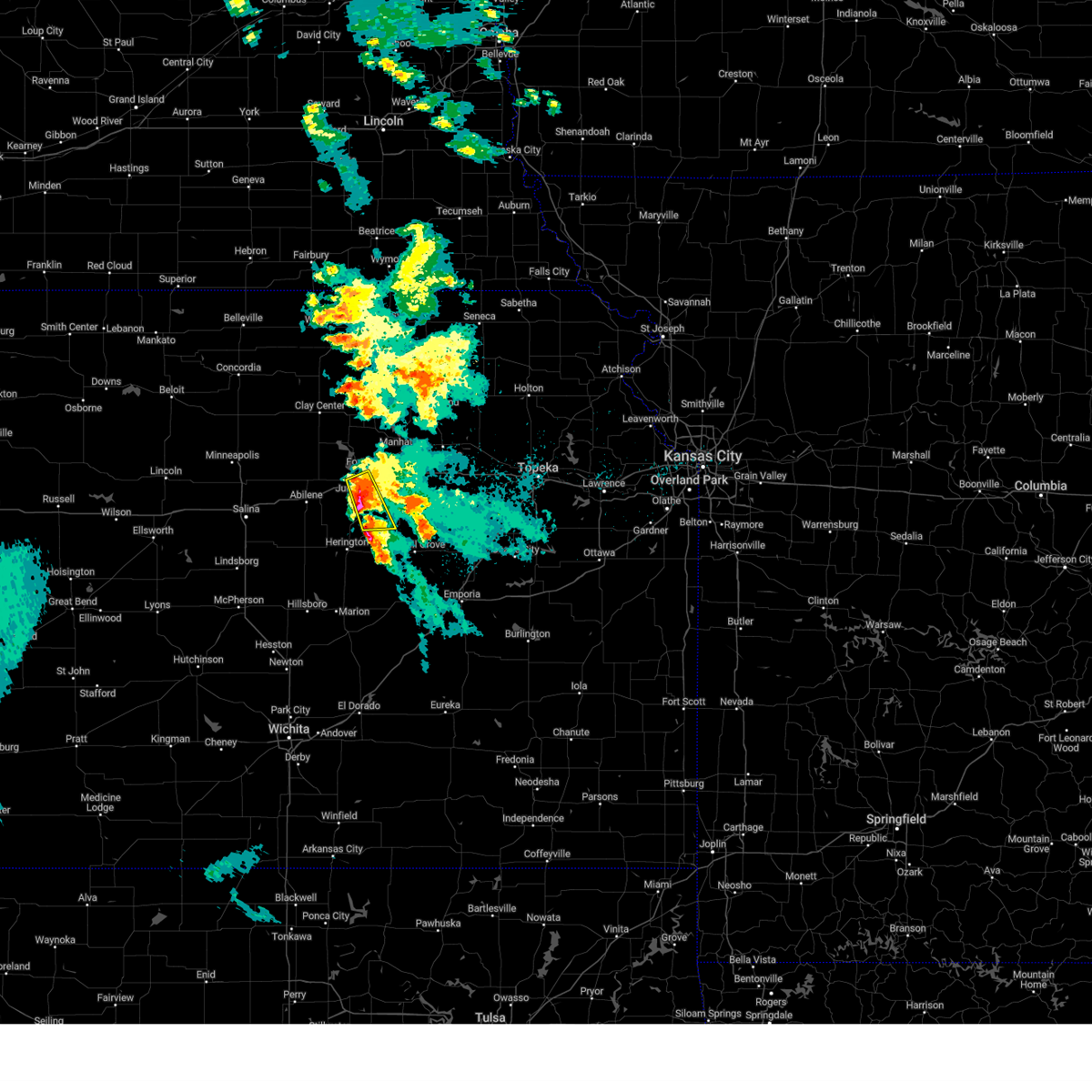 The storms which prompted the warning have moved out of the warned area. therefore, the warning has been allowed to expire. remember, a severe thunderstorm warning still remains in effect for southern geary and northern morris county. The storms which prompted the warning have moved out of the warned area. therefore, the warning has been allowed to expire. remember, a severe thunderstorm warning still remains in effect for southern geary and northern morris county.
|
| 6/2/2024 4:27 AM CDT |
 Svrtop the national weather service in topeka has issued a * severe thunderstorm warning for, southern geary county in east central kansas, northwestern morris county in east central kansas, * until 500 am cdt. * at 427 am cdt, a severe thunderstorm was located 8 miles northwest of white city, moving east at 20 mph (radar indicated). Hazards include 60 mph wind gusts and quarter size hail. Hail damage to vehicles is expected. Expect wind damage to roofs, siding, and trees. Svrtop the national weather service in topeka has issued a * severe thunderstorm warning for, southern geary county in east central kansas, northwestern morris county in east central kansas, * until 500 am cdt. * at 427 am cdt, a severe thunderstorm was located 8 miles northwest of white city, moving east at 20 mph (radar indicated). Hazards include 60 mph wind gusts and quarter size hail. Hail damage to vehicles is expected. Expect wind damage to roofs, siding, and trees.
|
| 6/2/2024 4:23 AM CDT |
 At 423 am cdt, severe thunderstorms were located along a line extending from near junction city to 3 miles west of dwight, moving northeast at 15 mph (radar indicated). Hazards include 60 mph wind gusts and quarter size hail. Hail damage to vehicles is expected. expect wind damage to roofs, siding, and trees. locations impacted include, junction city, grandview plaza, and white city. This includes interstate 70 between mile markers 291 and 300. At 423 am cdt, severe thunderstorms were located along a line extending from near junction city to 3 miles west of dwight, moving northeast at 15 mph (radar indicated). Hazards include 60 mph wind gusts and quarter size hail. Hail damage to vehicles is expected. expect wind damage to roofs, siding, and trees. locations impacted include, junction city, grandview plaza, and white city. This includes interstate 70 between mile markers 291 and 300.
|
| 6/2/2024 4:23 AM CDT |
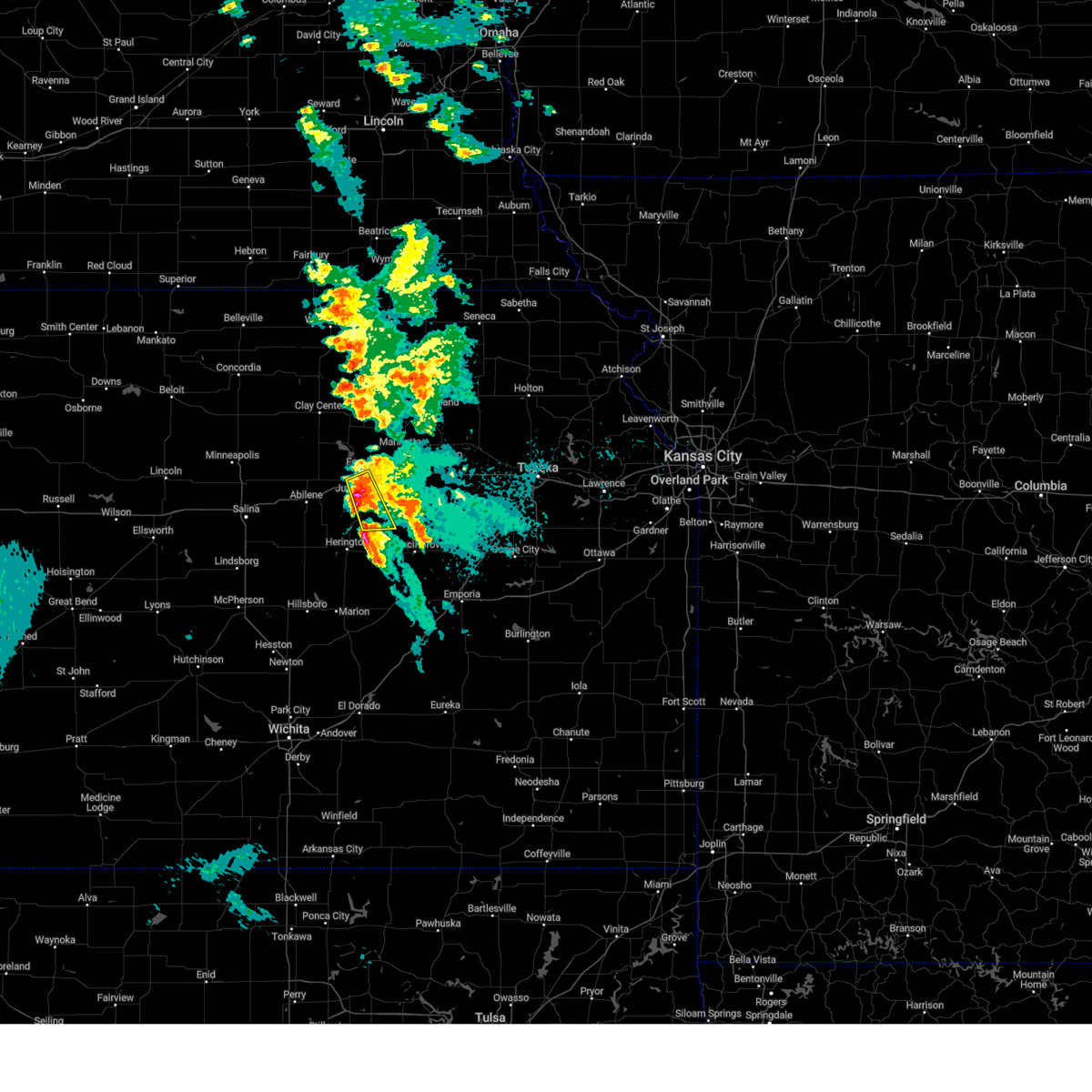 the severe thunderstorm warning has been cancelled and is no longer in effect the severe thunderstorm warning has been cancelled and is no longer in effect
|
| 6/2/2024 3:59 AM CDT |
 Svrtop the national weather service in topeka has issued a * severe thunderstorm warning for, east central dickinson county in central kansas, geary county in east central kansas, southwestern riley county in northeastern kansas, northwestern morris county in east central kansas, * until 430 am cdt. * at 359 am cdt, severe thunderstorms were located along a line extending from 4 miles west of junction city to near white city, moving northeast at 15 mph (radar indicated). Hazards include 60 mph wind gusts and quarter size hail. Hail damage to vehicles is expected. Expect wind damage to roofs, siding, and trees. Svrtop the national weather service in topeka has issued a * severe thunderstorm warning for, east central dickinson county in central kansas, geary county in east central kansas, southwestern riley county in northeastern kansas, northwestern morris county in east central kansas, * until 430 am cdt. * at 359 am cdt, severe thunderstorms were located along a line extending from 4 miles west of junction city to near white city, moving northeast at 15 mph (radar indicated). Hazards include 60 mph wind gusts and quarter size hail. Hail damage to vehicles is expected. Expect wind damage to roofs, siding, and trees.
|
| 6/2/2024 3:28 AM CDT |
 Svrtop the national weather service in topeka has issued a * severe thunderstorm warning for, northeastern dickinson county in central kansas, geary county in east central kansas, southwestern riley county in northeastern kansas, northwestern morris county in east central kansas, * until 400 am cdt. * at 328 am cdt, severe thunderstorms were located along a line extending from 6 miles south of milford lake to 3 miles southwest of junction city to 4 miles northeast of latimer, moving northeast at 20 mph (radar indicated). Hazards include 60 mph wind gusts and half dollar size hail. Hail damage to vehicles is expected. Expect wind damage to roofs, siding, and trees. Svrtop the national weather service in topeka has issued a * severe thunderstorm warning for, northeastern dickinson county in central kansas, geary county in east central kansas, southwestern riley county in northeastern kansas, northwestern morris county in east central kansas, * until 400 am cdt. * at 328 am cdt, severe thunderstorms were located along a line extending from 6 miles south of milford lake to 3 miles southwest of junction city to 4 miles northeast of latimer, moving northeast at 20 mph (radar indicated). Hazards include 60 mph wind gusts and half dollar size hail. Hail damage to vehicles is expected. Expect wind damage to roofs, siding, and trees.
|
| 6/2/2024 3:07 AM CDT |
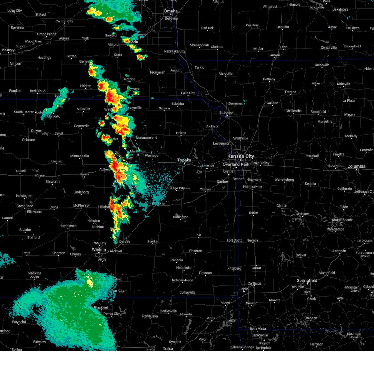 Svrtop the national weather service in topeka has issued a * severe thunderstorm warning for, northeastern dickinson county in central kansas, west central geary county in east central kansas, southeastern clay county in north central kansas, * until 330 am cdt. * at 307 am cdt, a severe thunderstorm was located near chapman, moving northeast at 15 mph (radar indicated). Hazards include 60 mph wind gusts and half dollar size hail. Hail damage to vehicles is expected. Expect wind damage to roofs, siding, and trees. Svrtop the national weather service in topeka has issued a * severe thunderstorm warning for, northeastern dickinson county in central kansas, west central geary county in east central kansas, southeastern clay county in north central kansas, * until 330 am cdt. * at 307 am cdt, a severe thunderstorm was located near chapman, moving northeast at 15 mph (radar indicated). Hazards include 60 mph wind gusts and half dollar size hail. Hail damage to vehicles is expected. Expect wind damage to roofs, siding, and trees.
|
| 5/19/2024 7:31 PM CDT |
 At 731 pm cdt, severe thunderstorms were located along a line extending from 3 miles northwest of junction city to 6 miles northwest of white city to 3 miles south of latimer, moving east at 30 mph (radar indicated). Hazards include ping pong ball size hail and 60 mph wind gusts. People and animals outdoors will be injured. expect hail damage to roofs, siding, windows, and vehicles. expect wind damage to roofs, siding, and trees. locations impacted include, junction city, herington, grandview plaza, chapman, white city, woodbine, wilsey, parkerville, and latimer. This includes interstate 70 between mile markers 287 and 304. At 731 pm cdt, severe thunderstorms were located along a line extending from 3 miles northwest of junction city to 6 miles northwest of white city to 3 miles south of latimer, moving east at 30 mph (radar indicated). Hazards include ping pong ball size hail and 60 mph wind gusts. People and animals outdoors will be injured. expect hail damage to roofs, siding, windows, and vehicles. expect wind damage to roofs, siding, and trees. locations impacted include, junction city, herington, grandview plaza, chapman, white city, woodbine, wilsey, parkerville, and latimer. This includes interstate 70 between mile markers 287 and 304.
|
| 5/19/2024 7:22 PM CDT |
 At 722 pm cdt, severe thunderstorms were located along a line extending from 5 miles south of milford lake to 7 miles northeast of woodbine to 3 miles east of herington, moving east at 30 mph (radar indicated). Hazards include ping pong ball size hail and 60 mph wind gusts. People and animals outdoors will be injured. expect hail damage to roofs, siding, windows, and vehicles. expect wind damage to roofs, siding, and trees. locations impacted include, junction city, herington, grandview plaza, chapman, white city, hope, woodbine, wilsey, parkerville, and latimer. This includes interstate 70 between mile markers 283 and 304. At 722 pm cdt, severe thunderstorms were located along a line extending from 5 miles south of milford lake to 7 miles northeast of woodbine to 3 miles east of herington, moving east at 30 mph (radar indicated). Hazards include ping pong ball size hail and 60 mph wind gusts. People and animals outdoors will be injured. expect hail damage to roofs, siding, windows, and vehicles. expect wind damage to roofs, siding, and trees. locations impacted include, junction city, herington, grandview plaza, chapman, white city, hope, woodbine, wilsey, parkerville, and latimer. This includes interstate 70 between mile markers 283 and 304.
|
| 5/19/2024 7:15 PM CDT |
 At 714 pm cdt, severe thunderstorms were located along a line extending from 6 miles north of chapman to 5 miles northeast of woodbine to herington, moving east at 30 mph (radar indicated). Hazards include ping pong ball size hail and 60 mph wind gusts. People and animals outdoors will be injured. expect hail damage to roofs, siding, windows, and vehicles. expect wind damage to roofs, siding, and trees. locations impacted include, junction city, herington, grandview plaza, chapman, enterprise, white city, hope, woodbine, wilsey, parkerville, latimer, and moonlight. This includes interstate 70 between mile markers 280 and 304. At 714 pm cdt, severe thunderstorms were located along a line extending from 6 miles north of chapman to 5 miles northeast of woodbine to herington, moving east at 30 mph (radar indicated). Hazards include ping pong ball size hail and 60 mph wind gusts. People and animals outdoors will be injured. expect hail damage to roofs, siding, windows, and vehicles. expect wind damage to roofs, siding, and trees. locations impacted include, junction city, herington, grandview plaza, chapman, enterprise, white city, hope, woodbine, wilsey, parkerville, latimer, and moonlight. This includes interstate 70 between mile markers 280 and 304.
|
| 5/19/2024 7:05 PM CDT |
 At 704 pm cdt, severe thunderstorms were located along a line extending from 4 miles north of moonlight to 5 miles north of woodbine to near hope, moving east at 30 mph (trained weather spotters reported ping pong ball size hail in hope at 7:03pm). Hazards include ping pong ball size hail and 60 mph wind gusts. People and animals outdoors will be injured. expect hail damage to roofs, siding, windows, and vehicles. expect wind damage to roofs, siding, and trees. locations impacted include, junction city, herington, grandview plaza, chapman, enterprise, white city, hope, woodbine, wilsey, parkerville, latimer, and moonlight. This includes interstate 70 between mile markers 276 and 304. At 704 pm cdt, severe thunderstorms were located along a line extending from 4 miles north of moonlight to 5 miles north of woodbine to near hope, moving east at 30 mph (trained weather spotters reported ping pong ball size hail in hope at 7:03pm). Hazards include ping pong ball size hail and 60 mph wind gusts. People and animals outdoors will be injured. expect hail damage to roofs, siding, windows, and vehicles. expect wind damage to roofs, siding, and trees. locations impacted include, junction city, herington, grandview plaza, chapman, enterprise, white city, hope, woodbine, wilsey, parkerville, latimer, and moonlight. This includes interstate 70 between mile markers 276 and 304.
|
| 5/19/2024 6:56 PM CDT |
 Svrtop the national weather service in topeka has issued a * severe thunderstorm warning for, eastern dickinson county in central kansas, southwestern geary county in east central kansas, western morris county in east central kansas, * until 745 pm cdt. * at 655 pm cdt, severe thunderstorms were located along a line extending from 4 miles northwest of moonlight to 4 miles southeast of enterprise to near hope, moving east at 30 mph (radar indicated). Hazards include ping pong ball size hail and 60 mph wind gusts. People and animals outdoors will be injured. expect hail damage to roofs, siding, windows, and vehicles. Expect wind damage to roofs, siding, and trees. Svrtop the national weather service in topeka has issued a * severe thunderstorm warning for, eastern dickinson county in central kansas, southwestern geary county in east central kansas, western morris county in east central kansas, * until 745 pm cdt. * at 655 pm cdt, severe thunderstorms were located along a line extending from 4 miles northwest of moonlight to 4 miles southeast of enterprise to near hope, moving east at 30 mph (radar indicated). Hazards include ping pong ball size hail and 60 mph wind gusts. People and animals outdoors will be injured. expect hail damage to roofs, siding, windows, and vehicles. Expect wind damage to roofs, siding, and trees.
|
| 5/6/2024 8:26 PM CDT |
 At 826 pm cdt, a severe thunderstorm capable of producing a tornado was located over milford lake, moving northeast at 45 mph (radar indicated rotation). Hazards include tornado and half dollar size hail. Flying debris will be dangerous to those caught without shelter. mobile homes will be damaged or destroyed. damage to roofs, windows, and vehicles will occur. tree damage is likely. Locations impacted include, junction city, wakefield, milford, and milford lake. At 826 pm cdt, a severe thunderstorm capable of producing a tornado was located over milford lake, moving northeast at 45 mph (radar indicated rotation). Hazards include tornado and half dollar size hail. Flying debris will be dangerous to those caught without shelter. mobile homes will be damaged or destroyed. damage to roofs, windows, and vehicles will occur. tree damage is likely. Locations impacted include, junction city, wakefield, milford, and milford lake.
|
| 5/6/2024 8:17 PM CDT |
 At 816 pm cdt, a severe thunderstorm capable of producing a tornado was located 4 miles northeast of moonlight, moving northeast at 50 mph (radar indicated rotation. spotters report a persistant rotating wall cloud northeast of moonlight). Hazards include tornado and half dollar size hail. Flying debris will be dangerous to those caught without shelter. mobile homes will be damaged or destroyed. damage to roofs, windows, and vehicles will occur. tree damage is likely. locations impacted include, junction city, chapman, wakefield, milford, milford lake, and moonlight. This includes interstate 70 between mile markers 283 and 287. At 816 pm cdt, a severe thunderstorm capable of producing a tornado was located 4 miles northeast of moonlight, moving northeast at 50 mph (radar indicated rotation. spotters report a persistant rotating wall cloud northeast of moonlight). Hazards include tornado and half dollar size hail. Flying debris will be dangerous to those caught without shelter. mobile homes will be damaged or destroyed. damage to roofs, windows, and vehicles will occur. tree damage is likely. locations impacted include, junction city, chapman, wakefield, milford, milford lake, and moonlight. This includes interstate 70 between mile markers 283 and 287.
|
| 5/6/2024 8:09 PM CDT |
 Tortop the national weather service in topeka has issued a * tornado warning for, northeastern dickinson county in central kansas, northwestern geary county in east central kansas, southwestern riley county in northeastern kansas, southeastern clay county in north central kansas, * until 845 pm cdt. * at 808 pm cdt, a severe thunderstorm capable of producing a tornado was located near moonlight, moving northeast at 45 mph (weather spotters reported funnel cloud. at 806 pm, trained spotters reported a funnel cloud 1 mile east of abilene). Hazards include tornado and half dollar size hail. Flying debris will be dangerous to those caught without shelter. mobile homes will be damaged or destroyed. damage to roofs, windows, and vehicles will occur. Tree damage is likely. Tortop the national weather service in topeka has issued a * tornado warning for, northeastern dickinson county in central kansas, northwestern geary county in east central kansas, southwestern riley county in northeastern kansas, southeastern clay county in north central kansas, * until 845 pm cdt. * at 808 pm cdt, a severe thunderstorm capable of producing a tornado was located near moonlight, moving northeast at 45 mph (weather spotters reported funnel cloud. at 806 pm, trained spotters reported a funnel cloud 1 mile east of abilene). Hazards include tornado and half dollar size hail. Flying debris will be dangerous to those caught without shelter. mobile homes will be damaged or destroyed. damage to roofs, windows, and vehicles will occur. Tree damage is likely.
|
| 5/6/2024 7:42 PM CDT |
 Svrtop the national weather service in topeka has issued a * severe thunderstorm warning for, central geary county in east central kansas, riley county in northeastern kansas, northwestern wabaunsee county in east central kansas, western pottawatomie county in northeastern kansas, southeastern washington county in north central kansas, western marshall county in northeastern kansas, * until 815 pm cdt. * at 741 pm cdt, severe thunderstorms were located along a line extending from 3 miles north of waterville to 7 miles southeast of ogden, moving northeast at 50 mph (radar indicated hail. a wind gust of 69 mph was reported at the manhattan airport at 0740 pm). Hazards include 70 mph wind gusts and quarter size hail. Hail damage to vehicles is expected. expect considerable tree damage. Wind damage is also likely to mobile homes, roofs, and outbuildings. Svrtop the national weather service in topeka has issued a * severe thunderstorm warning for, central geary county in east central kansas, riley county in northeastern kansas, northwestern wabaunsee county in east central kansas, western pottawatomie county in northeastern kansas, southeastern washington county in north central kansas, western marshall county in northeastern kansas, * until 815 pm cdt. * at 741 pm cdt, severe thunderstorms were located along a line extending from 3 miles north of waterville to 7 miles southeast of ogden, moving northeast at 50 mph (radar indicated hail. a wind gust of 69 mph was reported at the manhattan airport at 0740 pm). Hazards include 70 mph wind gusts and quarter size hail. Hail damage to vehicles is expected. expect considerable tree damage. Wind damage is also likely to mobile homes, roofs, and outbuildings.
|
| 5/6/2024 7:25 PM CDT |
 At 724 pm cdt, severe thunderstorms were located along a line extending from 6 miles north of green to 5 miles southwest of keats to 6 miles north of white city, moving east at 50 mph (trained weather spotters. at 720 pm, a trained spotter reported wind gusts of 70 mph 5nw of junction city). Hazards include 70 mph wind gusts and quarter size hail. Hail damage to vehicles is expected. expect considerable tree damage. wind damage is also likely to mobile homes, roofs, and outbuildings. locations impacted include, manhattan, junction city, ogden, grandview plaza, riley, waterville, milford, leonardville, olsburg, randolph, green, milford lake, keats, and tuttle creek lake. This includes interstate 70 between mile markers 294 and 319. At 724 pm cdt, severe thunderstorms were located along a line extending from 6 miles north of green to 5 miles southwest of keats to 6 miles north of white city, moving east at 50 mph (trained weather spotters. at 720 pm, a trained spotter reported wind gusts of 70 mph 5nw of junction city). Hazards include 70 mph wind gusts and quarter size hail. Hail damage to vehicles is expected. expect considerable tree damage. wind damage is also likely to mobile homes, roofs, and outbuildings. locations impacted include, manhattan, junction city, ogden, grandview plaza, riley, waterville, milford, leonardville, olsburg, randolph, green, milford lake, keats, and tuttle creek lake. This includes interstate 70 between mile markers 294 and 319.
|
| 5/6/2024 7:23 PM CDT |
 The storms which prompted the warning have moved out of the warned area. therefore, the warning will be allowed to expire. a tornado watch remains in effect until 1100 pm cdt for central and east central kansas. remember, a severe thunderstorm warning still remains in effect for portions of geary and riley county until 745 pm. The storms which prompted the warning have moved out of the warned area. therefore, the warning will be allowed to expire. a tornado watch remains in effect until 1100 pm cdt for central and east central kansas. remember, a severe thunderstorm warning still remains in effect for portions of geary and riley county until 745 pm.
|
| 5/6/2024 7:21 PM CDT | Public posted video on social media. also small hai in geary county KS, 0.8 miles WNW of Junction City, KS |
| 5/6/2024 7:20 PM CDT | Also 3/4 inch hai in geary county KS, 5 miles SE of Junction City, KS |
| 5/6/2024 7:19 PM CDT |
 Svrtop the national weather service in topeka has issued a * severe thunderstorm warning for, geary county in east central kansas, riley county in northeastern kansas, northwestern morris county in east central kansas, west central wabaunsee county in east central kansas, western pottawatomie county in northeastern kansas, southeastern washington county in north central kansas, northeastern clay county in north central kansas, southwestern marshall county in northeastern kansas, * until 745 pm cdt. * at 718 pm cdt, severe thunderstorms were located along a line extending from 5 miles east of morganville to near milford lake to 6 miles northwest of white city, moving northeast at 50 mph. this warning is replacing previous thunderstorm warnings in the area (radar indicated). Hazards include 70 mph wind gusts and quarter size hail. Hail damage to vehicles is expected. expect considerable tree damage. Wind damage is also likely to mobile homes, roofs, and outbuildings. Svrtop the national weather service in topeka has issued a * severe thunderstorm warning for, geary county in east central kansas, riley county in northeastern kansas, northwestern morris county in east central kansas, west central wabaunsee county in east central kansas, western pottawatomie county in northeastern kansas, southeastern washington county in north central kansas, northeastern clay county in north central kansas, southwestern marshall county in northeastern kansas, * until 745 pm cdt. * at 718 pm cdt, severe thunderstorms were located along a line extending from 5 miles east of morganville to near milford lake to 6 miles northwest of white city, moving northeast at 50 mph. this warning is replacing previous thunderstorm warnings in the area (radar indicated). Hazards include 70 mph wind gusts and quarter size hail. Hail damage to vehicles is expected. expect considerable tree damage. Wind damage is also likely to mobile homes, roofs, and outbuildings.
|
| 5/6/2024 7:16 PM CDT |
 At 716 pm cdt, severe thunderstorms were located along a line extending from 3 miles west of milford lake to 3 miles southwest of junction city to 3 miles west of latimer, moving northeast at 55 mph (radar indicated). Hazards include 70 mph wind gusts and half dollar size hail. Hail damage to vehicles is expected. expect considerable tree damage. wind damage is also likely to mobile homes, roofs, and outbuildings. locations impacted include, junction city, grandview plaza, chapman, enterprise, and moonlight. This includes interstate 70 between mile markers 279 and 305. At 716 pm cdt, severe thunderstorms were located along a line extending from 3 miles west of milford lake to 3 miles southwest of junction city to 3 miles west of latimer, moving northeast at 55 mph (radar indicated). Hazards include 70 mph wind gusts and half dollar size hail. Hail damage to vehicles is expected. expect considerable tree damage. wind damage is also likely to mobile homes, roofs, and outbuildings. locations impacted include, junction city, grandview plaza, chapman, enterprise, and moonlight. This includes interstate 70 between mile markers 279 and 305.
|
| 5/6/2024 7:15 PM CDT | Quarter sized hail reported 5.7 miles E of Junction City, KS |
| 5/6/2024 7:12 PM CDT | Quarter sized hail reported 7.8 miles ESE of Junction City, KS |
| 5/6/2024 7:10 PM CDT |
 At 709 pm cdt, severe thunderstorms were located along a line extending from 6 miles north of moonlight to 3 miles southeast of chapman to 3 miles west of herington, moving northeast at 55 mph (trained weather spotters. at 705 pm, trained spotters reported quarter-sized hail). Hazards include 70 mph wind gusts and half dollar size hail. Hail damage to vehicles is expected. expect considerable tree damage. wind damage is also likely to mobile homes, roofs, and outbuildings. locations impacted include, junction city, grandview plaza, chapman, enterprise, woodbine, and moonlight. This includes interstate 70 between mile markers 278 and 305. At 709 pm cdt, severe thunderstorms were located along a line extending from 6 miles north of moonlight to 3 miles southeast of chapman to 3 miles west of herington, moving northeast at 55 mph (trained weather spotters. at 705 pm, trained spotters reported quarter-sized hail). Hazards include 70 mph wind gusts and half dollar size hail. Hail damage to vehicles is expected. expect considerable tree damage. wind damage is also likely to mobile homes, roofs, and outbuildings. locations impacted include, junction city, grandview plaza, chapman, enterprise, woodbine, and moonlight. This includes interstate 70 between mile markers 278 and 305.
|
| 5/6/2024 7:01 PM CDT |
 At 700 pm cdt, severe thunderstorms were located along a line extending from 3 miles east of talmage to near enterprise to 3 miles west of ramona, moving northeast at 55 mph (trained weather spotters. at 657 pm, a trained spotter reported wind gusts of 60 mph in abilene). Hazards include 60 mph wind gusts and half dollar size hail. Hail damage to vehicles is expected. expect wind damage to roofs, siding, and trees. locations impacted include, junction city, abilene, herington, grandview plaza, chapman, enterprise, white city, hope, woodbine, latimer, and moonlight. This includes interstate 70 between mile markers 274 and 305. At 700 pm cdt, severe thunderstorms were located along a line extending from 3 miles east of talmage to near enterprise to 3 miles west of ramona, moving northeast at 55 mph (trained weather spotters. at 657 pm, a trained spotter reported wind gusts of 60 mph in abilene). Hazards include 60 mph wind gusts and half dollar size hail. Hail damage to vehicles is expected. expect wind damage to roofs, siding, and trees. locations impacted include, junction city, abilene, herington, grandview plaza, chapman, enterprise, white city, hope, woodbine, latimer, and moonlight. This includes interstate 70 between mile markers 274 and 305.
|
| 5/6/2024 6:56 PM CDT |
 Svrtop the national weather service in topeka has issued a * severe thunderstorm warning for, central dickinson county in central kansas, southwestern geary county in east central kansas, northwestern morris county in east central kansas, * until 730 pm cdt. * at 655 pm cdt, severe thunderstorms were located along a line extending from near talmage to 4 miles south of enterprise to near tampa, moving northeast at 55 mph (radar indicated). Hazards include 70 mph wind gusts and half dollar size hail. Hail damage to vehicles is expected. expect considerable tree damage. Wind damage is also likely to mobile homes, roofs, and outbuildings. Svrtop the national weather service in topeka has issued a * severe thunderstorm warning for, central dickinson county in central kansas, southwestern geary county in east central kansas, northwestern morris county in east central kansas, * until 730 pm cdt. * at 655 pm cdt, severe thunderstorms were located along a line extending from near talmage to 4 miles south of enterprise to near tampa, moving northeast at 55 mph (radar indicated). Hazards include 70 mph wind gusts and half dollar size hail. Hail damage to vehicles is expected. expect considerable tree damage. Wind damage is also likely to mobile homes, roofs, and outbuildings.
|
| 4/25/2024 11:57 AM CDT |
 Svrtop the national weather service in topeka has issued a * severe thunderstorm warning for, central geary county in east central kansas, southeastern riley county in northeastern kansas, northwestern wabaunsee county in east central kansas, * until 1230 pm cdt. * at 1157 am cdt, a severe thunderstorm was located near grandview plaza, moving east at 50 mph (radar indicated). Hazards include 60 mph wind gusts and quarter size hail. Hail damage to vehicles is expected. Expect wind damage to roofs, siding, and trees. Svrtop the national weather service in topeka has issued a * severe thunderstorm warning for, central geary county in east central kansas, southeastern riley county in northeastern kansas, northwestern wabaunsee county in east central kansas, * until 1230 pm cdt. * at 1157 am cdt, a severe thunderstorm was located near grandview plaza, moving east at 50 mph (radar indicated). Hazards include 60 mph wind gusts and quarter size hail. Hail damage to vehicles is expected. Expect wind damage to roofs, siding, and trees.
|
| 4/25/2024 11:44 AM CDT |
 At 1143 am cdt, a severe thunderstorm was located 5 miles west of ogden, moving northeast at 30 mph (trained weather spotters. at 1137 am, a trained spotter reported quarter size hail near milford lake dam). Hazards include 60 mph wind gusts and quarter size hail. Hail damage to vehicles is expected. expect wind damage to roofs, siding, and trees. locations impacted include, manhattan, junction city, ogden, grandview plaza, milford, milford lake, and keats. This includes interstate 70 between mile markers 299 and 312. At 1143 am cdt, a severe thunderstorm was located 5 miles west of ogden, moving northeast at 30 mph (trained weather spotters. at 1137 am, a trained spotter reported quarter size hail near milford lake dam). Hazards include 60 mph wind gusts and quarter size hail. Hail damage to vehicles is expected. expect wind damage to roofs, siding, and trees. locations impacted include, manhattan, junction city, ogden, grandview plaza, milford, milford lake, and keats. This includes interstate 70 between mile markers 299 and 312.
|
| 4/25/2024 11:26 AM CDT |
 Svrtop the national weather service in topeka has issued a * severe thunderstorm warning for, northern geary county in east central kansas, southwestern riley county in northeastern kansas, * until noon cdt. * at 1125 am cdt, a severe thunderstorm was located near milford lake, moving east at 40 mph (radar indicated). Hazards include 60 mph wind gusts and quarter size hail. Hail damage to vehicles is expected. Expect wind damage to roofs, siding, and trees. Svrtop the national weather service in topeka has issued a * severe thunderstorm warning for, northern geary county in east central kansas, southwestern riley county in northeastern kansas, * until noon cdt. * at 1125 am cdt, a severe thunderstorm was located near milford lake, moving east at 40 mph (radar indicated). Hazards include 60 mph wind gusts and quarter size hail. Hail damage to vehicles is expected. Expect wind damage to roofs, siding, and trees.
|
| 4/16/2024 4:53 AM CDT |
 The storm which prompted the warning has weakened below severe limits, and no longer poses an immediate threat to life or property. therefore, the warning will be allowed to expire. however, small hail and gusty winds are still possible with this thunderstorm. a tornado watch remains in effect until 900 am cdt for northeastern and east central kansas. The storm which prompted the warning has weakened below severe limits, and no longer poses an immediate threat to life or property. therefore, the warning will be allowed to expire. however, small hail and gusty winds are still possible with this thunderstorm. a tornado watch remains in effect until 900 am cdt for northeastern and east central kansas.
|
| 4/16/2024 4:46 AM CDT |
 the severe thunderstorm warning has been cancelled and is no longer in effect the severe thunderstorm warning has been cancelled and is no longer in effect
|
| 4/16/2024 4:46 AM CDT |
 At 445 am cdt, a severe thunderstorm was located 8 miles northwest of dwight, moving northeast at 60 mph (radar indicated). Hazards include 60 mph wind gusts and penny size hail. Expect damage to roofs, siding, and trees. locations impacted include, junction city, herington, grandview plaza, white city, dwight, parkerville, and latimer. This includes interstate 70 between mile markers 296 and 321. At 445 am cdt, a severe thunderstorm was located 8 miles northwest of dwight, moving northeast at 60 mph (radar indicated). Hazards include 60 mph wind gusts and penny size hail. Expect damage to roofs, siding, and trees. locations impacted include, junction city, herington, grandview plaza, white city, dwight, parkerville, and latimer. This includes interstate 70 between mile markers 296 and 321.
|
| 4/16/2024 4:37 AM CDT |
 At 437 am cdt, a severe thunderstorm was located near white city, moving northeast at 50 mph (radar indicated). Hazards include 60 mph wind gusts and quarter size hail. Hail damage to vehicles is expected. expect wind damage to roofs, siding, and trees. locations impacted include, junction city, herington, grandview plaza, white city, dwight, parkerville, and latimer. This includes interstate 70 between mile markers 295 and 321. At 437 am cdt, a severe thunderstorm was located near white city, moving northeast at 50 mph (radar indicated). Hazards include 60 mph wind gusts and quarter size hail. Hail damage to vehicles is expected. expect wind damage to roofs, siding, and trees. locations impacted include, junction city, herington, grandview plaza, white city, dwight, parkerville, and latimer. This includes interstate 70 between mile markers 295 and 321.
|
| 4/16/2024 4:28 AM CDT |
 Svrtop the national weather service in topeka has issued a * severe thunderstorm warning for, southeastern dickinson county in central kansas, geary county in east central kansas, southeastern riley county in northeastern kansas, western morris county in east central kansas, west central wabaunsee county in east central kansas, * until 500 am cdt. * at 427 am cdt, a severe thunderstorm was located over latimer, moving northeast at 50 mph (radar indicated). Hazards include 60 mph wind gusts and nickel size hail. expect damage to roofs, siding, and trees Svrtop the national weather service in topeka has issued a * severe thunderstorm warning for, southeastern dickinson county in central kansas, geary county in east central kansas, southeastern riley county in northeastern kansas, western morris county in east central kansas, west central wabaunsee county in east central kansas, * until 500 am cdt. * at 427 am cdt, a severe thunderstorm was located over latimer, moving northeast at 50 mph (radar indicated). Hazards include 60 mph wind gusts and nickel size hail. expect damage to roofs, siding, and trees
|
| 3/13/2024 8:30 PM CDT | Tea Cup sized hail reported 5.5 miles WNW of Junction City, KS, baseball size hail reported via emergency management. |
| 3/13/2024 8:24 PM CDT | Hen Egg sized hail reported 2.4 miles W of Junction City, KS, 2 inch hail at the grandview plaza exit on i-70. time estimated from radar. |
| 3/13/2024 8:23 PM CDT |
 At 823 pm cdt, a severe thunderstorm was located near ogden, moving northeast at 20 mph (radar indicated). Hazards include golf ball size hail and 60 mph wind gusts. People and animals outdoors will be injured. expect hail damage to roofs, siding, windows, and vehicles. expect wind damage to roofs, siding, and trees. locations impacted include, southwestern manhattan, junction city, ogden, grandview plaza, milford, and milford lake. This includes interstate 70 between mile markers 293 and 310. At 823 pm cdt, a severe thunderstorm was located near ogden, moving northeast at 20 mph (radar indicated). Hazards include golf ball size hail and 60 mph wind gusts. People and animals outdoors will be injured. expect hail damage to roofs, siding, windows, and vehicles. expect wind damage to roofs, siding, and trees. locations impacted include, southwestern manhattan, junction city, ogden, grandview plaza, milford, and milford lake. This includes interstate 70 between mile markers 293 and 310.
|
| 3/13/2024 8:17 PM CDT | Ping Pong Ball sized hail reported 3.4 miles W of Junction City, KS |
| 3/13/2024 8:13 PM CDT |
 the severe thunderstorm warning has been cancelled and is no longer in effect the severe thunderstorm warning has been cancelled and is no longer in effect
|
| 3/13/2024 8:13 PM CDT |
 At 812 pm cdt, a severe thunderstorm was located over grandview plaza, moving northeast at 20 mph (radar indicated). Hazards include ping pong ball size hail and 60 mph wind gusts. People and animals outdoors will be injured. expect hail damage to roofs, siding, windows, and vehicles. expect wind damage to roofs, siding, and trees. locations impacted include, southwestern manhattan, junction city, ogden, grandview plaza, milford, and milford lake. This includes interstate 70 between mile markers 293 and 310. At 812 pm cdt, a severe thunderstorm was located over grandview plaza, moving northeast at 20 mph (radar indicated). Hazards include ping pong ball size hail and 60 mph wind gusts. People and animals outdoors will be injured. expect hail damage to roofs, siding, windows, and vehicles. expect wind damage to roofs, siding, and trees. locations impacted include, southwestern manhattan, junction city, ogden, grandview plaza, milford, and milford lake. This includes interstate 70 between mile markers 293 and 310.
|
| 3/13/2024 8:07 PM CDT | Half Dollar sized hail reported 2.4 miles NNE of Junction City, KS, report from mping: half dollar (1.25 in.). |
| 3/13/2024 8:03 PM CDT | Ping Pong Ball sized hail reported 2.4 miles NNE of Junction City, KS |
| 3/13/2024 8:02 PM CDT | Quarter sized hail reported 0.8 miles WNW of Junction City, KS |
| 3/13/2024 7:58 PM CDT |
 Svrtop the national weather service in topeka has issued a * severe thunderstorm warning for, northeastern dickinson county in central kansas, geary county in east central kansas, southwestern riley county in northeastern kansas, * until 845 pm cdt. * at 758 pm cdt, a severe thunderstorm was located near junction city, moving northeast at 20 mph (radar indicated). Hazards include ping pong ball size hail and 60 mph wind gusts. People and animals outdoors will be injured. expect hail damage to roofs, siding, windows, and vehicles. Expect wind damage to roofs, siding, and trees. Svrtop the national weather service in topeka has issued a * severe thunderstorm warning for, northeastern dickinson county in central kansas, geary county in east central kansas, southwestern riley county in northeastern kansas, * until 845 pm cdt. * at 758 pm cdt, a severe thunderstorm was located near junction city, moving northeast at 20 mph (radar indicated). Hazards include ping pong ball size hail and 60 mph wind gusts. People and animals outdoors will be injured. expect hail damage to roofs, siding, windows, and vehicles. Expect wind damage to roofs, siding, and trees.
|
| 3/13/2024 7:42 PM CDT |
 At 742 pm cdt, a severe thunderstorm was located over chapman, moving northeast at 25 mph (radar indicated). Hazards include 60 mph wind gusts and quarter size hail. Hail damage to vehicles is expected. expect wind damage to roofs, siding, and trees. locations impacted include, junction city, chapman, and moonlight. This includes interstate 70 between mile markers 280 and 297. At 742 pm cdt, a severe thunderstorm was located over chapman, moving northeast at 25 mph (radar indicated). Hazards include 60 mph wind gusts and quarter size hail. Hail damage to vehicles is expected. expect wind damage to roofs, siding, and trees. locations impacted include, junction city, chapman, and moonlight. This includes interstate 70 between mile markers 280 and 297.
|
| 3/13/2024 7:29 PM CDT |
 Svrtop the national weather service in topeka has issued a * severe thunderstorm warning for, northeastern dickinson county in central kansas, southwestern geary county in east central kansas, * until 800 pm cdt. * at 728 pm cdt, a severe thunderstorm was located near enterprise, moving northeast at 25 mph (at 7:25pm, trained weather spotters reported quarter-size hail in enterprise). Hazards include 60 mph wind gusts and quarter size hail. Hail damage to vehicles is expected. Expect wind damage to roofs, siding, and trees. Svrtop the national weather service in topeka has issued a * severe thunderstorm warning for, northeastern dickinson county in central kansas, southwestern geary county in east central kansas, * until 800 pm cdt. * at 728 pm cdt, a severe thunderstorm was located near enterprise, moving northeast at 25 mph (at 7:25pm, trained weather spotters reported quarter-size hail in enterprise). Hazards include 60 mph wind gusts and quarter size hail. Hail damage to vehicles is expected. Expect wind damage to roofs, siding, and trees.
|
| 7/14/2023 2:39 PM CDT | Personal weather station... delayed repor in geary county KS, 0.9 miles WSW of Junction City, KS |
| 7/14/2023 2:25 PM CDT |
 At 224 pm cdt, a severe thunderstorm was located 5 miles south of chapman, moving east at 15 mph (radar indicated). Hazards include 60 mph wind gusts and penny size hail. Expect damage to roofs, siding, and trees. locations impacted include, junction city, abilene, chapman, enterprise, white city, woodbine, parkerville, latimer, moonlight and talmage. this includes interstate 70 between mile markers 270 and 299. hail threat, radar indicated max hail size, 0. 75 in wind threat, radar indicated max wind gust, 60 mph. At 224 pm cdt, a severe thunderstorm was located 5 miles south of chapman, moving east at 15 mph (radar indicated). Hazards include 60 mph wind gusts and penny size hail. Expect damage to roofs, siding, and trees. locations impacted include, junction city, abilene, chapman, enterprise, white city, woodbine, parkerville, latimer, moonlight and talmage. this includes interstate 70 between mile markers 270 and 299. hail threat, radar indicated max hail size, 0. 75 in wind threat, radar indicated max wind gust, 60 mph.
|
| 7/14/2023 2:10 PM CDT |
 At 209 pm cdt, a severe thunderstorm was located 5 miles east of enterprise, moving east at 20 mph (radar indicated). Hazards include 60 mph wind gusts and quarter size hail. Hail damage to vehicles is expected. expect wind damage to roofs, siding, and trees. locations impacted include, junction city, abilene, grandview plaza, chapman, solomon, enterprise, white city, dwight, woodbine, parkerville, latimer, talmage and moonlight. this includes interstate 70 between mile markers 267 and 299. hail threat, radar indicated max hail size, 1. 00 in wind threat, radar indicated max wind gust, 60 mph. At 209 pm cdt, a severe thunderstorm was located 5 miles east of enterprise, moving east at 20 mph (radar indicated). Hazards include 60 mph wind gusts and quarter size hail. Hail damage to vehicles is expected. expect wind damage to roofs, siding, and trees. locations impacted include, junction city, abilene, grandview plaza, chapman, solomon, enterprise, white city, dwight, woodbine, parkerville, latimer, talmage and moonlight. this includes interstate 70 between mile markers 267 and 299. hail threat, radar indicated max hail size, 1. 00 in wind threat, radar indicated max wind gust, 60 mph.
|
| 7/14/2023 1:54 PM CDT |
 At 154 pm cdt, a severe thunderstorm was located near enterprise, moving east at 20 mph (radar indicated). Hazards include 60 mph wind gusts and quarter size hail. Hail damage to vehicles is expected. Expect wind damage to roofs, siding, and trees. At 154 pm cdt, a severe thunderstorm was located near enterprise, moving east at 20 mph (radar indicated). Hazards include 60 mph wind gusts and quarter size hail. Hail damage to vehicles is expected. Expect wind damage to roofs, siding, and trees.
|
| 7/4/2023 11:18 PM CDT | Report from mping: 1-inch tree limbs broken; shingles blown of in geary county KS, 2 miles E of Junction City, KS |
| 7/4/2023 10:45 PM CDT |
 At 1045 pm cdt, severe thunderstorms were located along a line extending from 4 miles southwest of st. marys to 5 miles south of volland to near burdick, moving east at 65 mph (radar indicated). Hazards include 60 mph wind gusts and penny size hail. Expect damage to roofs, siding, and trees. locations impacted include, junction city, herington, council grove, eskridge, grandview plaza, chapman, enterprise, white city, alta vista, hope, dwight, allen, woodbine, wilsey, parkerville, carlton, bushong, dunlap, latimer and council grove lake. this includes interstate 70 between mile markers 282 and 301. hail threat, radar indicated max hail size, 0. 75 in wind threat, radar indicated max wind gust, 60 mph. At 1045 pm cdt, severe thunderstorms were located along a line extending from 4 miles southwest of st. marys to 5 miles south of volland to near burdick, moving east at 65 mph (radar indicated). Hazards include 60 mph wind gusts and penny size hail. Expect damage to roofs, siding, and trees. locations impacted include, junction city, herington, council grove, eskridge, grandview plaza, chapman, enterprise, white city, alta vista, hope, dwight, allen, woodbine, wilsey, parkerville, carlton, bushong, dunlap, latimer and council grove lake. this includes interstate 70 between mile markers 282 and 301. hail threat, radar indicated max hail size, 0. 75 in wind threat, radar indicated max wind gust, 60 mph.
|
| 7/4/2023 10:42 PM CDT |
 At 1042 pm cdt, severe thunderstorms were located along a line extending from 3 miles southeast of oregon to near muscotah to near alma, moving east at 55 mph (radar indicated). Hazards include 70 mph wind gusts and penny size hail. Expect considerable tree damage. Damage is likely to mobile homes, roofs, and outbuildings. At 1042 pm cdt, severe thunderstorms were located along a line extending from 3 miles southeast of oregon to near muscotah to near alma, moving east at 55 mph (radar indicated). Hazards include 70 mph wind gusts and penny size hail. Expect considerable tree damage. Damage is likely to mobile homes, roofs, and outbuildings.
|
| 7/4/2023 10:36 PM CDT |
 At 1035 pm cdt, severe thunderstorms were located along a line extending from wamego to 4 miles northwest of alta vista to near ramona, moving east at 60 mph (radar indicated). Hazards include 60 mph wind gusts and penny size hail. Expect damage to roofs, siding, and trees. locations impacted include, northwestern topeka, manhattan, junction city, abilene, wamego, herington, council grove, rossville, alma, eskridge, st. marys, ogden, grandview plaza, dover, silver lake, chapman, enterprise, st. george, maple hill and white city. this includes interstate 70 between mile markers 277 and 355. hail threat, radar indicated max hail size, 0. 75 in wind threat, radar indicated max wind gust, 60 mph. At 1035 pm cdt, severe thunderstorms were located along a line extending from wamego to 4 miles northwest of alta vista to near ramona, moving east at 60 mph (radar indicated). Hazards include 60 mph wind gusts and penny size hail. Expect damage to roofs, siding, and trees. locations impacted include, northwestern topeka, manhattan, junction city, abilene, wamego, herington, council grove, rossville, alma, eskridge, st. marys, ogden, grandview plaza, dover, silver lake, chapman, enterprise, st. george, maple hill and white city. this includes interstate 70 between mile markers 277 and 355. hail threat, radar indicated max hail size, 0. 75 in wind threat, radar indicated max wind gust, 60 mph.
|
| 7/4/2023 10:34 PM CDT | Quarter sized hail reported 2 miles E of Junction City, KS, report from mping: quarter (1.00 in.). |
| 7/4/2023 10:24 PM CDT |
 At 1024 pm cdt, severe thunderstorms were located along a line extending from near st. george to 8 miles northwest of dwight to 5 miles west of ramona, moving east at 65 mph (radar indicated). Hazards include 60 mph wind gusts and penny size hail. expect damage to roofs, siding, and trees At 1024 pm cdt, severe thunderstorms were located along a line extending from near st. george to 8 miles northwest of dwight to 5 miles west of ramona, moving east at 65 mph (radar indicated). Hazards include 60 mph wind gusts and penny size hail. expect damage to roofs, siding, and trees
|
| 7/4/2023 10:06 PM CDT |
 At 1006 pm cdt, a severe thunderstorm was located near talmage, moving east at 35 mph (radar indicated). Hazards include 60 mph wind gusts. expect damage to roofs, siding, and trees At 1006 pm cdt, a severe thunderstorm was located near talmage, moving east at 35 mph (radar indicated). Hazards include 60 mph wind gusts. expect damage to roofs, siding, and trees
|
| 6/30/2023 6:12 PM CDT |
 The severe thunderstorm warning for northeastern dickinson, northwestern geary, southwestern riley and southeastern clay counties will expire at 615 pm cdt, the storm which prompted the warning has weakened below severe limits, and no longer poses an immediate threat to life or property. therefore, the warning will be allowed to expire. however small hail and gusty winds are still possible with this thunderstorm. a severe thunderstorm watch remains in effect until 1100 pm cdt for central, north central, northeastern and east central kansas. The severe thunderstorm warning for northeastern dickinson, northwestern geary, southwestern riley and southeastern clay counties will expire at 615 pm cdt, the storm which prompted the warning has weakened below severe limits, and no longer poses an immediate threat to life or property. therefore, the warning will be allowed to expire. however small hail and gusty winds are still possible with this thunderstorm. a severe thunderstorm watch remains in effect until 1100 pm cdt for central, north central, northeastern and east central kansas.
|
| 6/30/2023 6:00 PM CDT |
 At 558 pm cdt, a severe thunderstorm was located near milford lake, moving northeast at 30 mph (trained weather spotters. at 554 pm cdt...trained spotters reported golfball size hail north of milford lake dam). Hazards include golf ball size hail and 60 mph wind gusts. People and animals outdoors will be injured. expect hail damage to roofs, siding, windows, and vehicles. expect wind damage to roofs, siding, and trees. locations impacted include, junction city, ogden, wakefield, riley, milford and milford lake. thunderstorm damage threat, considerable hail threat, observed max hail size, 1. 75 in wind threat, radar indicated max wind gust, 60 mph. At 558 pm cdt, a severe thunderstorm was located near milford lake, moving northeast at 30 mph (trained weather spotters. at 554 pm cdt...trained spotters reported golfball size hail north of milford lake dam). Hazards include golf ball size hail and 60 mph wind gusts. People and animals outdoors will be injured. expect hail damage to roofs, siding, windows, and vehicles. expect wind damage to roofs, siding, and trees. locations impacted include, junction city, ogden, wakefield, riley, milford and milford lake. thunderstorm damage threat, considerable hail threat, observed max hail size, 1. 75 in wind threat, radar indicated max wind gust, 60 mph.
|
| 6/30/2023 5:52 PM CDT |
 At 550 pm cdt, a severe thunderstorm was located over milford, moving northeast at 15 mph (trained weather spotters. at 545 pm cdt...trained spotters reported 60 mph wind gust on the east side of milford lake, north side of milford lake dam). Hazards include 60 mph wind gusts and quarter size hail. Hail damage to vehicles is expected. expect wind damage to roofs, siding, and trees. locations impacted include, junction city, ogden, wakefield, riley, milford and milford lake. hail threat, observed max hail size, 1. 00 in wind threat, observed max wind gust, 60 mph. At 550 pm cdt, a severe thunderstorm was located over milford, moving northeast at 15 mph (trained weather spotters. at 545 pm cdt...trained spotters reported 60 mph wind gust on the east side of milford lake, north side of milford lake dam). Hazards include 60 mph wind gusts and quarter size hail. Hail damage to vehicles is expected. expect wind damage to roofs, siding, and trees. locations impacted include, junction city, ogden, wakefield, riley, milford and milford lake. hail threat, observed max hail size, 1. 00 in wind threat, observed max wind gust, 60 mph.
|
| 6/30/2023 5:44 PM CDT |
 At 543 pm cdt, a severe thunderstorm was located near milford, moving northeast at 15 mph (trained weather spotters. at 543 pm cdt...trained spotter reported quarter size hail 4 miles south of wakefield). Hazards include 60 mph wind gusts and quarter size hail. Hail damage to vehicles is expected. Expect wind damage to roofs, siding, and trees. At 543 pm cdt, a severe thunderstorm was located near milford, moving northeast at 15 mph (trained weather spotters. at 543 pm cdt...trained spotter reported quarter size hail 4 miles south of wakefield). Hazards include 60 mph wind gusts and quarter size hail. Hail damage to vehicles is expected. Expect wind damage to roofs, siding, and trees.
|
| 6/30/2023 5:36 PM CDT |
 At 536 pm cdt, a severe thunderstorm was located 4 miles west of milford lake, moving northeast at 10 mph (radar indicated). Hazards include 60 mph wind gusts and quarter size hail. Hail damage to vehicles is expected. expect wind damage to roofs, siding, and trees. locations impacted include, junction city, wakefield, milford and milford lake. hail threat, radar indicated max hail size, 1. 00 in wind threat, radar indicated max wind gust, 60 mph. At 536 pm cdt, a severe thunderstorm was located 4 miles west of milford lake, moving northeast at 10 mph (radar indicated). Hazards include 60 mph wind gusts and quarter size hail. Hail damage to vehicles is expected. expect wind damage to roofs, siding, and trees. locations impacted include, junction city, wakefield, milford and milford lake. hail threat, radar indicated max hail size, 1. 00 in wind threat, radar indicated max wind gust, 60 mph.
|
| 6/30/2023 5:26 PM CDT |
 At 525 pm cdt, a severe thunderstorm was located 5 miles west of milford lake, moving northeast at 15 mph (radar indicated). Hazards include 60 mph wind gusts and quarter size hail. Hail damage to vehicles is expected. expect wind damage to roofs, siding, and trees. locations impacted include, junction city, chapman, wakefield, milford and milford lake. this includes interstate 70 between mile markers 285 and 287. hail threat, radar indicated max hail size, 1. 00 in wind threat, radar indicated max wind gust, 60 mph. At 525 pm cdt, a severe thunderstorm was located 5 miles west of milford lake, moving northeast at 15 mph (radar indicated). Hazards include 60 mph wind gusts and quarter size hail. Hail damage to vehicles is expected. expect wind damage to roofs, siding, and trees. locations impacted include, junction city, chapman, wakefield, milford and milford lake. this includes interstate 70 between mile markers 285 and 287. hail threat, radar indicated max hail size, 1. 00 in wind threat, radar indicated max wind gust, 60 mph.
|
| 6/30/2023 5:10 PM CDT |
 At 510 pm cdt, a severe thunderstorm was located 7 miles north of moonlight, moving northeast at 10 mph (radar indicated). Hazards include 60 mph wind gusts and quarter size hail. Hail damage to vehicles is expected. Expect wind damage to roofs, siding, and trees. At 510 pm cdt, a severe thunderstorm was located 7 miles north of moonlight, moving northeast at 10 mph (radar indicated). Hazards include 60 mph wind gusts and quarter size hail. Hail damage to vehicles is expected. Expect wind damage to roofs, siding, and trees.
|
| 5/31/2023 4:10 PM CDT |
 The severe thunderstorm warning for northwestern geary and southwestern riley counties will expire at 415 pm cdt, the storm which prompted the warning has weakened below severe limits, and no longer poses an immediate threat to life or property. therefore, the warning will be allowed to expire. however gusty winds and heavy rain are still possible with this thunderstorm. The severe thunderstorm warning for northwestern geary and southwestern riley counties will expire at 415 pm cdt, the storm which prompted the warning has weakened below severe limits, and no longer poses an immediate threat to life or property. therefore, the warning will be allowed to expire. however gusty winds and heavy rain are still possible with this thunderstorm.
|
| 5/31/2023 4:02 PM CDT |
 At 402 pm cdt, a severe thunderstorm was located near milford lake, moving north at 15 mph (radar indicated). Hazards include 60 mph wind gusts and quarter size hail. Hail damage to vehicles is expected. expect wind damage to roofs, siding, and trees. locations impacted include, junction city, milford and milford lake. hail threat, radar indicated max hail size, 1. 00 in wind threat, radar indicated max wind gust, 60 mph. At 402 pm cdt, a severe thunderstorm was located near milford lake, moving north at 15 mph (radar indicated). Hazards include 60 mph wind gusts and quarter size hail. Hail damage to vehicles is expected. expect wind damage to roofs, siding, and trees. locations impacted include, junction city, milford and milford lake. hail threat, radar indicated max hail size, 1. 00 in wind threat, radar indicated max wind gust, 60 mph.
|
| 5/31/2023 3:48 PM CDT |
 At 348 pm cdt, a severe thunderstorm was located near junction city, moving north at 15 mph (radar indicated). Hazards include 60 mph wind gusts and quarter size hail. Hail damage to vehicles is expected. Expect wind damage to roofs, siding, and trees. At 348 pm cdt, a severe thunderstorm was located near junction city, moving north at 15 mph (radar indicated). Hazards include 60 mph wind gusts and quarter size hail. Hail damage to vehicles is expected. Expect wind damage to roofs, siding, and trees.
|
| 5/9/2023 2:26 PM CDT |
 At 225 pm cdt, severe thunderstorms were located along a line extending from 8 miles south of barnes to 4 miles southwest of manhattan to near hope, moving east at 35 mph (radar indicated). Hazards include 70 mph wind gusts and half dollar size hail. Hail damage to vehicles is expected. expect considerable tree damage. wind damage is also likely to mobile homes, roofs, and outbuildings. locations impacted include, manhattan, junction city, clay center, ogden, grandview plaza, chapman, wakefield, riley, white city, milford, leonardville, dwight, olsburg, woodbine, randolph, green, palmer, parkerville, latimer and milford lake. this includes interstate 70 between mile markers 284 and 317. thunderstorm damage threat, considerable hail threat, radar indicated max hail size, 1. 25 in wind threat, radar indicated max wind gust, 70 mph. At 225 pm cdt, severe thunderstorms were located along a line extending from 8 miles south of barnes to 4 miles southwest of manhattan to near hope, moving east at 35 mph (radar indicated). Hazards include 70 mph wind gusts and half dollar size hail. Hail damage to vehicles is expected. expect considerable tree damage. wind damage is also likely to mobile homes, roofs, and outbuildings. locations impacted include, manhattan, junction city, clay center, ogden, grandview plaza, chapman, wakefield, riley, white city, milford, leonardville, dwight, olsburg, woodbine, randolph, green, palmer, parkerville, latimer and milford lake. this includes interstate 70 between mile markers 284 and 317. thunderstorm damage threat, considerable hail threat, radar indicated max hail size, 1. 25 in wind threat, radar indicated max wind gust, 70 mph.
|
| 5/9/2023 2:19 PM CDT |
 At 218 pm cdt, severe thunderstorms were located along a line extending from 9 miles southeast of linn to near ogden to 3 miles northwest of hope, moving east at 35 mph (radar indicated. at 215 pm, 60 mph wind was reported near ft. riley). Hazards include 70 mph wind gusts and half dollar size hail. Hail damage to vehicles is expected. expect considerable tree damage. wind damage is also likely to mobile homes, roofs, and outbuildings. locations impacted include, manhattan, junction city, abilene, clay center, blue rapids, ogden, grandview plaza, chapman, wakefield, riley, enterprise, waterville, white city, milford, leonardville, linn, greenleaf, dwight, olsburg and morganville. this includes interstate 70 between mile markers 268 and 317. thunderstorm damage threat, considerable hail threat, radar indicated max hail size, 1. 25 in wind threat, radar indicated max wind gust, 70 mph. At 218 pm cdt, severe thunderstorms were located along a line extending from 9 miles southeast of linn to near ogden to 3 miles northwest of hope, moving east at 35 mph (radar indicated. at 215 pm, 60 mph wind was reported near ft. riley). Hazards include 70 mph wind gusts and half dollar size hail. Hail damage to vehicles is expected. expect considerable tree damage. wind damage is also likely to mobile homes, roofs, and outbuildings. locations impacted include, manhattan, junction city, abilene, clay center, blue rapids, ogden, grandview plaza, chapman, wakefield, riley, enterprise, waterville, white city, milford, leonardville, linn, greenleaf, dwight, olsburg and morganville. this includes interstate 70 between mile markers 268 and 317. thunderstorm damage threat, considerable hail threat, radar indicated max hail size, 1. 25 in wind threat, radar indicated max wind gust, 70 mph.
|
| 5/9/2023 2:10 PM CDT | Large tree with trunk about 18 to 24 inches in diameter snapped of in geary county KS, 0.3 miles NW of Junction City, KS |
| 5/9/2023 2:02 PM CDT |
 At 201 pm cdt, severe thunderstorms were located along a line extending from 8 miles south of barnes to near junction city, moving east at 35 mph (trained weather spotters. at 159 pm cdt, 60 to 70 mph wind was reported at the milford lake dam). Hazards include 70 mph wind gusts and ping pong ball size hail. People and animals outdoors will be injured. expect hail damage to roofs, siding, windows, and vehicles. expect considerable tree damage. wind damage is also likely to mobile homes, roofs, and outbuildings. locations impacted include, manhattan, junction city, abilene, clay center, blue rapids, ogden, grandview plaza, chapman, wakefield, riley, enterprise, waterville, white city, milford, leonardville, linn, greenleaf, dwight, olsburg and morganville. this includes interstate 70 between mile markers 268 and 317. thunderstorm damage threat, considerable hail threat, radar indicated max hail size, 1. 50 in wind threat, observed max wind gust, 70 mph. At 201 pm cdt, severe thunderstorms were located along a line extending from 8 miles south of barnes to near junction city, moving east at 35 mph (trained weather spotters. at 159 pm cdt, 60 to 70 mph wind was reported at the milford lake dam). Hazards include 70 mph wind gusts and ping pong ball size hail. People and animals outdoors will be injured. expect hail damage to roofs, siding, windows, and vehicles. expect considerable tree damage. wind damage is also likely to mobile homes, roofs, and outbuildings. locations impacted include, manhattan, junction city, abilene, clay center, blue rapids, ogden, grandview plaza, chapman, wakefield, riley, enterprise, waterville, white city, milford, leonardville, linn, greenleaf, dwight, olsburg and morganville. this includes interstate 70 between mile markers 268 and 317. thunderstorm damage threat, considerable hail threat, radar indicated max hail size, 1. 50 in wind threat, observed max wind gust, 70 mph.
|
| 5/9/2023 1:52 PM CDT |
 At 152 pm cdt, severe thunderstorms were located along a line extending from 8 miles southwest of barnes to 5 miles northeast of chapman, moving east at 35 mph (radar indicated). Hazards include 70 mph wind gusts and ping pong ball size hail. People and animals outdoors will be injured. expect hail damage to roofs, siding, windows, and vehicles. expect considerable tree damage. Wind damage is also likely to mobile homes, roofs, and outbuildings. At 152 pm cdt, severe thunderstorms were located along a line extending from 8 miles southwest of barnes to 5 miles northeast of chapman, moving east at 35 mph (radar indicated). Hazards include 70 mph wind gusts and ping pong ball size hail. People and animals outdoors will be injured. expect hail damage to roofs, siding, windows, and vehicles. expect considerable tree damage. Wind damage is also likely to mobile homes, roofs, and outbuildings.
|
| 4/20/2023 3:12 AM CDT |
 At 311 am cdt, severe thunderstorms were located along a line extending from near summerfield to near lillis to near st. george, moving east at 50 mph (trained weather spotters reported 60 to 70 mph winds in riley and nemaha counties). Hazards include 70 mph wind gusts and quarter size hail. Hail damage to vehicles is expected. expect considerable tree damage. wind damage is also likely to mobile homes, roofs, and outbuildings. locations impacted include, manhattan, junction city, wamego, marysville, seneca, blue rapids, westmoreland, blaine, ogden, riley, frankfort, onaga, waterville, st. George, centralia, axtell, olsburg, belvue, beattie and emmett. At 311 am cdt, severe thunderstorms were located along a line extending from near summerfield to near lillis to near st. george, moving east at 50 mph (trained weather spotters reported 60 to 70 mph winds in riley and nemaha counties). Hazards include 70 mph wind gusts and quarter size hail. Hail damage to vehicles is expected. expect considerable tree damage. wind damage is also likely to mobile homes, roofs, and outbuildings. locations impacted include, manhattan, junction city, wamego, marysville, seneca, blue rapids, westmoreland, blaine, ogden, riley, frankfort, onaga, waterville, st. George, centralia, axtell, olsburg, belvue, beattie and emmett.
|
| 4/20/2023 3:01 AM CDT |
 At 301 am cdt, severe thunderstorms were located along a line extending from 6 miles east of oketo to 6 miles northwest of blaine to manhattan, moving east at 55 mph (radar indicated). Hazards include 70 mph wind gusts and quarter size hail. Hail damage to vehicles is expected. expect considerable tree damage. Wind damage is also likely to mobile homes, roofs, and outbuildings. At 301 am cdt, severe thunderstorms were located along a line extending from 6 miles east of oketo to 6 miles northwest of blaine to manhattan, moving east at 55 mph (radar indicated). Hazards include 70 mph wind gusts and quarter size hail. Hail damage to vehicles is expected. expect considerable tree damage. Wind damage is also likely to mobile homes, roofs, and outbuildings.
|
| 4/20/2023 2:36 AM CDT |
 At 236 am cdt, severe thunderstorms were located along a line extending from 7 miles south of barnes to near leonardville to 4 miles southwest of milford lake, moving east at 50 mph (radar indicated). Hazards include 70 mph wind gusts and quarter size hail. Hail damage to vehicles is expected. expect considerable tree damage. wind damage is also likely to mobile homes, roofs, and outbuildings. locations impacted include, manhattan, junction city, ogden, wakefield, riley, milford, leonardville, olsburg, randolph, green, milford lake, keats and tuttle creek lake. This includes interstate 70 between mile markers 303 and 306. At 236 am cdt, severe thunderstorms were located along a line extending from 7 miles south of barnes to near leonardville to 4 miles southwest of milford lake, moving east at 50 mph (radar indicated). Hazards include 70 mph wind gusts and quarter size hail. Hail damage to vehicles is expected. expect considerable tree damage. wind damage is also likely to mobile homes, roofs, and outbuildings. locations impacted include, manhattan, junction city, ogden, wakefield, riley, milford, leonardville, olsburg, randolph, green, milford lake, keats and tuttle creek lake. This includes interstate 70 between mile markers 303 and 306.
|
| 4/20/2023 2:29 AM CDT |
 At 228 am cdt, severe thunderstorms were located along a line extending from 9 miles south of barnes to 3 miles west of leonardville to 5 miles north of moonlight, moving east at 50 mph (radar indicated). Hazards include 60 mph wind gusts and quarter size hail. Hail damage to vehicles is expected. Expect wind damage to roofs, siding, and trees. At 228 am cdt, severe thunderstorms were located along a line extending from 9 miles south of barnes to 3 miles west of leonardville to 5 miles north of moonlight, moving east at 50 mph (radar indicated). Hazards include 60 mph wind gusts and quarter size hail. Hail damage to vehicles is expected. Expect wind damage to roofs, siding, and trees.
|
| 4/19/2023 6:58 PM CDT |
 At 658 pm cdt, a severe thunderstorm was located near tuttle creek lake, moving northeast at 50 mph (law enforcement. at 657 pm, law enforcement reported ping pong sized hail near olsburg). Hazards include ping pong ball size hail and 60 mph wind gusts. People and animals outdoors will be injured. expect hail damage to roofs, siding, windows, and vehicles. expect wind damage to roofs, siding, and trees. locations impacted include, manhattan, junction city, westmoreland, ogden, grandview plaza, olsburg, milford lake, keats and tuttle creek lake. this includes interstate 70 between mile markers 295 and 305. hail threat, observed max hail size, 1. 50 in wind threat, radar indicated max wind gust, 60 mph. At 658 pm cdt, a severe thunderstorm was located near tuttle creek lake, moving northeast at 50 mph (law enforcement. at 657 pm, law enforcement reported ping pong sized hail near olsburg). Hazards include ping pong ball size hail and 60 mph wind gusts. People and animals outdoors will be injured. expect hail damage to roofs, siding, windows, and vehicles. expect wind damage to roofs, siding, and trees. locations impacted include, manhattan, junction city, westmoreland, ogden, grandview plaza, olsburg, milford lake, keats and tuttle creek lake. this includes interstate 70 between mile markers 295 and 305. hail threat, observed max hail size, 1. 50 in wind threat, radar indicated max wind gust, 60 mph.
|
| 4/19/2023 6:39 PM CDT |
 At 638 pm cdt, a severe thunderstorm was located 5 miles east of milford lake, moving northeast at 50 mph (trained weather spotters. at 634 pm, trained weather spotters reported golf ball sized hail 5 miles nnw of junction city). Hazards include golf ball size hail and 60 mph wind gusts. People and animals outdoors will be injured. expect hail damage to roofs, siding, windows, and vehicles. expect wind damage to roofs, siding, and trees. locations impacted include, manhattan, junction city, westmoreland, ogden, grandview plaza, olsburg, milford lake, keats and tuttle creek lake. this includes interstate 70 between mile markers 295 and 305. thunderstorm damage threat, considerable hail threat, observed max hail size, 1. 75 in wind threat, radar indicated max wind gust, 60 mph. At 638 pm cdt, a severe thunderstorm was located 5 miles east of milford lake, moving northeast at 50 mph (trained weather spotters. at 634 pm, trained weather spotters reported golf ball sized hail 5 miles nnw of junction city). Hazards include golf ball size hail and 60 mph wind gusts. People and animals outdoors will be injured. expect hail damage to roofs, siding, windows, and vehicles. expect wind damage to roofs, siding, and trees. locations impacted include, manhattan, junction city, westmoreland, ogden, grandview plaza, olsburg, milford lake, keats and tuttle creek lake. this includes interstate 70 between mile markers 295 and 305. thunderstorm damage threat, considerable hail threat, observed max hail size, 1. 75 in wind threat, radar indicated max wind gust, 60 mph.
|
| 4/19/2023 6:34 PM CDT | Golf Ball sized hail reported 2.3 miles SE of Junction City, KS |
| 4/19/2023 6:28 PM CDT |
 At 628 pm cdt, a severe thunderstorm was located 5 miles west of junction city, moving northeast at 50 mph (radar indicated). Hazards include 60 mph wind gusts and half dollar size hail. Hail damage to vehicles is expected. Expect wind damage to roofs, siding, and trees. At 628 pm cdt, a severe thunderstorm was located 5 miles west of junction city, moving northeast at 50 mph (radar indicated). Hazards include 60 mph wind gusts and half dollar size hail. Hail damage to vehicles is expected. Expect wind damage to roofs, siding, and trees.
|
| 4/19/2023 6:26 PM CDT | Hen Egg sized hail reported 5.7 miles ENE of Junction City, KS, delayed report. |
| 4/19/2023 6:25 PM CDT |
 At 624 pm cdt, a severe thunderstorm was located 6 miles northeast of burdick, moving northeast at 60 mph (radar indicated). Hazards include 60 mph wind gusts and half dollar size hail. Hail damage to vehicles is expected. Expect wind damage to roofs, siding, and trees. At 624 pm cdt, a severe thunderstorm was located 6 miles northeast of burdick, moving northeast at 60 mph (radar indicated). Hazards include 60 mph wind gusts and half dollar size hail. Hail damage to vehicles is expected. Expect wind damage to roofs, siding, and trees.
|
| 4/14/2023 10:34 PM CDT | Social media repor in geary county KS, 0.3 miles NW of Junction City, KS |
| 4/14/2023 10:33 PM CDT |
 At 1032 pm cdt, a severe thunderstorm was located near junction city, moving northeast at 30 mph (trained weather spotters. at 1031 pm cdt, a spotter in junction city reported hail up to the size of quarters). Hazards include 60 mph wind gusts and quarter size hail. Hail damage to vehicles is expected. expect wind damage to roofs, siding, and trees. locations impacted include, southwestern manhattan, junction city, ogden, grandview plaza, milford and milford lake. this includes interstate 70 between mile markers 291 and 304. hail threat, observed max hail size, 1. 00 in wind threat, radar indicated max wind gust, 60 mph. At 1032 pm cdt, a severe thunderstorm was located near junction city, moving northeast at 30 mph (trained weather spotters. at 1031 pm cdt, a spotter in junction city reported hail up to the size of quarters). Hazards include 60 mph wind gusts and quarter size hail. Hail damage to vehicles is expected. expect wind damage to roofs, siding, and trees. locations impacted include, southwestern manhattan, junction city, ogden, grandview plaza, milford and milford lake. this includes interstate 70 between mile markers 291 and 304. hail threat, observed max hail size, 1. 00 in wind threat, radar indicated max wind gust, 60 mph.
|
| 4/14/2023 10:31 PM CDT | Quarter sized hail reported 0.9 miles WSW of Junction City, KS |
| 4/14/2023 10:26 PM CDT |
 At 1026 pm cdt, a severe thunderstorm was located near junction city, moving northeast at 30 mph (radar indicated). Hazards include 60 mph wind gusts and quarter size hail. Hail damage to vehicles is expected. Expect wind damage to roofs, siding, and trees. At 1026 pm cdt, a severe thunderstorm was located near junction city, moving northeast at 30 mph (radar indicated). Hazards include 60 mph wind gusts and quarter size hail. Hail damage to vehicles is expected. Expect wind damage to roofs, siding, and trees.
|
| 9/17/2022 9:40 PM CDT | Storm damage reported in geary county KS, 4.5 miles NW of Junction City, KS |
| 9/17/2022 9:39 PM CDT | Sign blown down on us highway 7 in geary county KS, 5.1 miles N of Junction City, KS |
| 6/21/2022 8:31 PM CDT |
 At 830 pm cdt, severe thunderstorms were located along a line extending from 5 miles east of milford to near ogden to 5 miles northeast of grandview plaza, moving northeast at 40 mph (fort riley airfield reported a gust of 67 mph at 823 pm cdt). Hazards include 70 mph wind gusts and quarter size hail. Hail damage to vehicles is expected. expect considerable tree damage. wind damage is also likely to mobile homes, roofs, and outbuildings. locations impacted include, manhattan, junction city, ogden and grandview plaza. this includes interstate 70 between mile markers 292 and 312. thunderstorm damage threat, considerable hail threat, radar indicated max hail size, 1. 00 in wind threat, observed max wind gust, 70 mph. At 830 pm cdt, severe thunderstorms were located along a line extending from 5 miles east of milford to near ogden to 5 miles northeast of grandview plaza, moving northeast at 40 mph (fort riley airfield reported a gust of 67 mph at 823 pm cdt). Hazards include 70 mph wind gusts and quarter size hail. Hail damage to vehicles is expected. expect considerable tree damage. wind damage is also likely to mobile homes, roofs, and outbuildings. locations impacted include, manhattan, junction city, ogden and grandview plaza. this includes interstate 70 between mile markers 292 and 312. thunderstorm damage threat, considerable hail threat, radar indicated max hail size, 1. 00 in wind threat, observed max wind gust, 70 mph.
|
| 6/21/2022 8:27 PM CDT |
 At 827 pm cdt, severe thunderstorms were located along a line extending from 3 miles north of wakefield to 5 miles south of ogden to near council grove lake, moving east at 40 mph (radar indicated). Hazards include 60 mph wind gusts and nickel size hail. Expect damage to roofs, siding, and trees. locations impacted include, junction city, herington, ogden, grandview plaza, wakefield, white city, milford, dwight, wilsey, parkerville, latimer and milford lake. this includes interstate 70 between mile markers 287 and 308. hail threat, radar indicated max hail size, 0. 88 in wind threat, radar indicated max wind gust, 60 mph. At 827 pm cdt, severe thunderstorms were located along a line extending from 3 miles north of wakefield to 5 miles south of ogden to near council grove lake, moving east at 40 mph (radar indicated). Hazards include 60 mph wind gusts and nickel size hail. Expect damage to roofs, siding, and trees. locations impacted include, junction city, herington, ogden, grandview plaza, wakefield, white city, milford, dwight, wilsey, parkerville, latimer and milford lake. this includes interstate 70 between mile markers 287 and 308. hail threat, radar indicated max hail size, 0. 88 in wind threat, radar indicated max wind gust, 60 mph.
|
| 6/21/2022 8:22 PM CDT |
 At 822 pm cdt, severe thunderstorms were located along a line extending from near milford lake to 5 miles north of junction city to near grandview plaza, moving northeast at 40 mph (radar indicated). Hazards include 70 mph wind gusts and quarter size hail. Hail damage to vehicles is expected. expect considerable tree damage. Wind damage is also likely to mobile homes, roofs, and outbuildings. At 822 pm cdt, severe thunderstorms were located along a line extending from near milford lake to 5 miles north of junction city to near grandview plaza, moving northeast at 40 mph (radar indicated). Hazards include 70 mph wind gusts and quarter size hail. Hail damage to vehicles is expected. expect considerable tree damage. Wind damage is also likely to mobile homes, roofs, and outbuildings.
|
| 6/21/2022 8:21 PM CDT | Quarter sized hail reported 5.7 miles ENE of Junction City, KS |
| 6/21/2022 8:20 PM CDT | Two healthy trees two to three feet in diameter blown down. winds estimated between 70 and 80 mp in geary county KS, 1 miles NNE of Junction City, KS |
| 6/21/2022 8:18 PM CDT |
 At 817 pm cdt, severe thunderstorms were located along a line extending from 8 miles west of wakefield to 3 miles east of grandview plaza to 3 miles north of wilsey, moving east at 40 mph (radar indicated). Hazards include 60 mph wind gusts and nickel size hail. expect damage to roofs, siding, and trees At 817 pm cdt, severe thunderstorms were located along a line extending from 8 miles west of wakefield to 3 miles east of grandview plaza to 3 miles north of wilsey, moving east at 40 mph (radar indicated). Hazards include 60 mph wind gusts and nickel size hail. expect damage to roofs, siding, and trees
|
| 6/21/2022 7:57 PM CDT |
 At 757 pm cdt, severe thunderstorms were located along a line extending from near oak hill to 3 miles southwest of chapman to 3 miles southeast of herington, moving east at 35 mph (radar indicated). Hazards include 70 mph wind gusts and nickel size hail. Expect considerable tree damage. Damage is likely to mobile homes, roofs, and outbuildings. At 757 pm cdt, severe thunderstorms were located along a line extending from near oak hill to 3 miles southwest of chapman to 3 miles southeast of herington, moving east at 35 mph (radar indicated). Hazards include 70 mph wind gusts and nickel size hail. Expect considerable tree damage. Damage is likely to mobile homes, roofs, and outbuildings.
|
| 6/11/2022 8:21 PM CDT |
 The severe thunderstorm warning for northeastern dickinson, northwestern geary and southwestern riley counties will expire at 830 pm cdt, the storm which prompted the warning has weakened below severe limits, and has exited the warned area. therefore, the warning will be allowed to expire. however small hail, gusty winds and heavy rain are still possible with this thunderstorm. a severe thunderstorm watch remains in effect until midnight cdt for central, northeastern and east central kansas. The severe thunderstorm warning for northeastern dickinson, northwestern geary and southwestern riley counties will expire at 830 pm cdt, the storm which prompted the warning has weakened below severe limits, and has exited the warned area. therefore, the warning will be allowed to expire. however small hail, gusty winds and heavy rain are still possible with this thunderstorm. a severe thunderstorm watch remains in effect until midnight cdt for central, northeastern and east central kansas.
|
| 6/11/2022 8:16 PM CDT | Quarter sized hail reported 1.5 miles SE of Junction City, KS, report from mping: quarter (1.00 in.). |
| 6/11/2022 8:10 PM CDT |
 At 809 pm cdt, a severe thunderstorm was located 4 miles south of milford lake, moving south at 30 mph (emergency management reported 1 mile south of milford at 8 pm cdt). Hazards include quarter size hail. Damage to vehicles is expected. locations impacted include, southwestern manhattan, junction city, ogden and milford lake. hail threat, radar indicated max hail size, 1. 00 in wind threat, radar indicated max wind gust, <50 mph. At 809 pm cdt, a severe thunderstorm was located 4 miles south of milford lake, moving south at 30 mph (emergency management reported 1 mile south of milford at 8 pm cdt). Hazards include quarter size hail. Damage to vehicles is expected. locations impacted include, southwestern manhattan, junction city, ogden and milford lake. hail threat, radar indicated max hail size, 1. 00 in wind threat, radar indicated max wind gust, <50 mph.
|
| 6/11/2022 8:06 PM CDT |
 At 806 pm cdt, a severe thunderstorm was located near milford lake, moving southeast at 40 mph (radar indicated). Hazards include golf ball size hail and 60 mph wind gusts. People and animals outdoors will be injured. expect hail damage to roofs, siding, windows, and vehicles. expect wind damage to roofs, siding, and trees. locations impacted include, southwestern manhattan, junction city, ogden, milford and milford lake. thunderstorm damage threat, considerable hail threat, radar indicated max hail size, 1. 75 in wind threat, radar indicated max wind gust, 60 mph. At 806 pm cdt, a severe thunderstorm was located near milford lake, moving southeast at 40 mph (radar indicated). Hazards include golf ball size hail and 60 mph wind gusts. People and animals outdoors will be injured. expect hail damage to roofs, siding, windows, and vehicles. expect wind damage to roofs, siding, and trees. locations impacted include, southwestern manhattan, junction city, ogden, milford and milford lake. thunderstorm damage threat, considerable hail threat, radar indicated max hail size, 1. 75 in wind threat, radar indicated max wind gust, 60 mph.
|
| 6/11/2022 8:01 PM CDT |
 At 801 pm cdt, a severe thunderstorm was located near milford lake, moving southeast at 35 mph (radar indicated). Hazards include golf ball size hail and 60 mph wind gusts. People and animals outdoors will be injured. expect hail damage to roofs, siding, windows, and vehicles. expect wind damage to roofs, siding, and trees. locations impacted include, southwestern manhattan, junction city, ogden, wakefield, riley, milford and milford lake. thunderstorm damage threat, considerable hail threat, radar indicated max hail size, 1. 75 in wind threat, radar indicated max wind gust, 60 mph. At 801 pm cdt, a severe thunderstorm was located near milford lake, moving southeast at 35 mph (radar indicated). Hazards include golf ball size hail and 60 mph wind gusts. People and animals outdoors will be injured. expect hail damage to roofs, siding, windows, and vehicles. expect wind damage to roofs, siding, and trees. locations impacted include, southwestern manhattan, junction city, ogden, wakefield, riley, milford and milford lake. thunderstorm damage threat, considerable hail threat, radar indicated max hail size, 1. 75 in wind threat, radar indicated max wind gust, 60 mph.
|
| 6/11/2022 7:53 PM CDT | Delayed report. time estimated from radar. numerous trees and power lines dow in geary county KS, 6.8 miles W of Junction City, KS |
| 6/11/2022 7:53 PM CDT |
 At 753 pm cdt, a severe thunderstorm was located over wakefield, moving south at 30 mph (radar indicated). Hazards include ping pong ball size hail and 60 mph wind gusts. People and animals outdoors will be injured. expect hail damage to roofs, siding, windows, and vehicles. Expect wind damage to roofs, siding, and trees. At 753 pm cdt, a severe thunderstorm was located over wakefield, moving south at 30 mph (radar indicated). Hazards include ping pong ball size hail and 60 mph wind gusts. People and animals outdoors will be injured. expect hail damage to roofs, siding, windows, and vehicles. Expect wind damage to roofs, siding, and trees.
|
| 6/11/2022 7:47 PM CDT | Awos station kfri ft riley marsha in geary county KS, 4 miles W of Junction City, KS |
| 6/11/2022 7:03 PM CDT |
 At 702 pm cdt, severe thunderstorms were located along a line extending from 3 miles east of leonardville to 4 miles east of olsburg, moving south at 35 mph (law enforcement. at 701 pm law enforcement reported golf ball size hail in olsburg). Hazards include two inch hail and 70 mph wind gusts. People and animals outdoors will be injured. expect hail damage to roofs, siding, windows, and vehicles. expect considerable tree damage. wind damage is also likely to mobile homes, roofs, and outbuildings. locations impacted include, manhattan, junction city, wamego, westmoreland, ogden, grandview plaza, riley, st. george, milford, leonardville, olsburg, louisville, randolph, milford lake, keats and tuttle creek lake. this includes interstate 70 between mile markers 290 and 326. thunderstorm damage threat, considerable hail threat, observed max hail size, 2. 00 in wind threat, radar indicated max wind gust, 70 mph. At 702 pm cdt, severe thunderstorms were located along a line extending from 3 miles east of leonardville to 4 miles east of olsburg, moving south at 35 mph (law enforcement. at 701 pm law enforcement reported golf ball size hail in olsburg). Hazards include two inch hail and 70 mph wind gusts. People and animals outdoors will be injured. expect hail damage to roofs, siding, windows, and vehicles. expect considerable tree damage. wind damage is also likely to mobile homes, roofs, and outbuildings. locations impacted include, manhattan, junction city, wamego, westmoreland, ogden, grandview plaza, riley, st. george, milford, leonardville, olsburg, louisville, randolph, milford lake, keats and tuttle creek lake. this includes interstate 70 between mile markers 290 and 326. thunderstorm damage threat, considerable hail threat, observed max hail size, 2. 00 in wind threat, radar indicated max wind gust, 70 mph.
|
| 6/11/2022 6:59 PM CDT |
 At 659 pm cdt, severe thunderstorms were located along a line extending from 3 miles east of leonardville to 4 miles east of olsburg, moving south at 35 mph (radar indicated). Hazards include two inch hail and 70 mph wind gusts. People and animals outdoors will be injured. expect hail damage to roofs, siding, windows, and vehicles. expect considerable tree damage. Wind damage is also likely to mobile homes, roofs, and outbuildings. At 659 pm cdt, severe thunderstorms were located along a line extending from 3 miles east of leonardville to 4 miles east of olsburg, moving south at 35 mph (radar indicated). Hazards include two inch hail and 70 mph wind gusts. People and animals outdoors will be injured. expect hail damage to roofs, siding, windows, and vehicles. expect considerable tree damage. Wind damage is also likely to mobile homes, roofs, and outbuildings.
|
| 6/7/2022 11:56 PM CDT |
 The severe thunderstorm warning for central geary, southern riley, northwestern shawnee, central wabaunsee, southern pottawatomie and southwestern jackson counties will expire at midnight cdt, the storms which prompted the warning have weakened below severe limits, and have exited the warned area. therefore, the warning will be allowed to expire. however gusty winds and heavy rain are still possible with these thunderstorms. a severe thunderstorm watch remains in effect until 500 am cdt for northeastern and east central kansas. The severe thunderstorm warning for central geary, southern riley, northwestern shawnee, central wabaunsee, southern pottawatomie and southwestern jackson counties will expire at midnight cdt, the storms which prompted the warning have weakened below severe limits, and have exited the warned area. therefore, the warning will be allowed to expire. however gusty winds and heavy rain are still possible with these thunderstorms. a severe thunderstorm watch remains in effect until 500 am cdt for northeastern and east central kansas.
|
| 6/7/2022 11:43 PM CDT |
 At 1143 pm cdt, severe thunderstorms were located along a line extending from 4 miles north of emmett to near grandview plaza, moving east at 60 mph (radar indicated). Hazards include 60 mph wind gusts. Expect damage to roofs, siding, and trees. locations impacted include, manhattan, junction city, wamego, alma, westmoreland, st. marys, ogden, grandview plaza, st. george, mcfarland, paxico, belvue, emmett, louisville, delia, potawatomi reservation, keats and volland. this includes interstate 70 between mile markers 297 and 338. hail threat, radar indicated max hail size, <. 75 in wind threat, radar indicated max wind gust, 60 mph. At 1143 pm cdt, severe thunderstorms were located along a line extending from 4 miles north of emmett to near grandview plaza, moving east at 60 mph (radar indicated). Hazards include 60 mph wind gusts. Expect damage to roofs, siding, and trees. locations impacted include, manhattan, junction city, wamego, alma, westmoreland, st. marys, ogden, grandview plaza, st. george, mcfarland, paxico, belvue, emmett, louisville, delia, potawatomi reservation, keats and volland. this includes interstate 70 between mile markers 297 and 338. hail threat, radar indicated max hail size, <. 75 in wind threat, radar indicated max wind gust, 60 mph.
|
| 6/7/2022 11:28 PM CDT |
 At 1127 pm cdt, severe thunderstorms were located along a line extending from 4 miles southwest of westmoreland to 5 miles southwest of milford lake, moving southeast at 50 mph (radar indicated). Hazards include 60 mph wind gusts. expect damage to roofs, siding, and trees At 1127 pm cdt, severe thunderstorms were located along a line extending from 4 miles southwest of westmoreland to 5 miles southwest of milford lake, moving southeast at 50 mph (radar indicated). Hazards include 60 mph wind gusts. expect damage to roofs, siding, and trees
|
| 5/30/2022 11:11 PM CDT |
 The severe thunderstorm warning for northeastern dickinson, northwestern geary, southern riley and southwestern pottawatomie counties will expire at 1115 pm cdt, the storms which prompted the warning have weakened below severe limits, and no longer pose an immediate threat to life or property. therefore, the warning will be allowed to expire. however gusty winds are still possible with these thunderstorms. a severe thunderstorm watch remains in effect until 400 am cdt for central, northeastern and east central kansas. The severe thunderstorm warning for northeastern dickinson, northwestern geary, southern riley and southwestern pottawatomie counties will expire at 1115 pm cdt, the storms which prompted the warning have weakened below severe limits, and no longer pose an immediate threat to life or property. therefore, the warning will be allowed to expire. however gusty winds are still possible with these thunderstorms. a severe thunderstorm watch remains in effect until 400 am cdt for central, northeastern and east central kansas.
|
| 5/30/2022 10:44 PM CDT |
 At 1044 pm cdt, severe thunderstorms were located along a line extending from 5 miles west of keats to 3 miles southwest of chapman, moving east at 50 mph (radar indicated). Hazards include 60 mph wind gusts and quarter size hail. Hail damage to vehicles is expected. Expect wind damage to roofs, siding, and trees. At 1044 pm cdt, severe thunderstorms were located along a line extending from 5 miles west of keats to 3 miles southwest of chapman, moving east at 50 mph (radar indicated). Hazards include 60 mph wind gusts and quarter size hail. Hail damage to vehicles is expected. Expect wind damage to roofs, siding, and trees.
|
| 5/30/2022 10:28 PM CDT |
 At 1028 pm cdt, severe thunderstorms were located along a line extending from near riley to near abilene, moving east at 40 mph (radar indicated). Hazards include 60 mph wind gusts and quarter size hail. Hail damage to vehicles is expected. expect wind damage to roofs, siding, and trees. locations impacted include, junction city, abilene, ogden, grandview plaza, chapman, solomon, wakefield, riley, enterprise, milford, talmage, milford lake, moonlight, keats and tuttle creek lake. this includes interstate 70 between mile markers 267 and 303. hail threat, radar indicated max hail size, 1. 00 in wind threat, radar indicated max wind gust, 60 mph. At 1028 pm cdt, severe thunderstorms were located along a line extending from near riley to near abilene, moving east at 40 mph (radar indicated). Hazards include 60 mph wind gusts and quarter size hail. Hail damage to vehicles is expected. expect wind damage to roofs, siding, and trees. locations impacted include, junction city, abilene, ogden, grandview plaza, chapman, solomon, wakefield, riley, enterprise, milford, talmage, milford lake, moonlight, keats and tuttle creek lake. this includes interstate 70 between mile markers 267 and 303. hail threat, radar indicated max hail size, 1. 00 in wind threat, radar indicated max wind gust, 60 mph.
|
| 5/30/2022 10:12 PM CDT |
 At 1012 pm cdt, severe thunderstorms were located along a line extending from 4 miles northeast of wakefield to 3 miles southeast of solomon, moving east at 40 mph (radar indicated). Hazards include 60 mph wind gusts and quarter size hail. Hail damage to vehicles is expected. Expect wind damage to roofs, siding, and trees. At 1012 pm cdt, severe thunderstorms were located along a line extending from 4 miles northeast of wakefield to 3 miles southeast of solomon, moving east at 40 mph (radar indicated). Hazards include 60 mph wind gusts and quarter size hail. Hail damage to vehicles is expected. Expect wind damage to roofs, siding, and trees.
|
| 5/17/2022 9:59 PM CDT |
 At 958 pm cdt, severe thunderstorms were located along a line extending from near dover to 3 miles west of dunlap, moving southeast at 30 mph. other severe thunderstorms were located near woodbine and were moving northeast at 30 mph (radar indicated). Hazards include 60 mph wind gusts and quarter size hail. Hail damage to vehicles is expected. Expect wind damage to roofs, siding, and trees. At 958 pm cdt, severe thunderstorms were located along a line extending from near dover to 3 miles west of dunlap, moving southeast at 30 mph. other severe thunderstorms were located near woodbine and were moving northeast at 30 mph (radar indicated). Hazards include 60 mph wind gusts and quarter size hail. Hail damage to vehicles is expected. Expect wind damage to roofs, siding, and trees.
|
| 5/17/2022 9:14 PM CDT | Half Dollar sized hail reported 0.4 miles ENE of Junction City, KS |
| 5/17/2022 9:14 PM CDT |
 At 914 pm cdt, a severe thunderstorm was located 4 miles northwest of alma, moving east at 35 mph (radar indicated). Hazards include 60 mph wind gusts and quarter size hail. Hail damage to vehicles is expected. Expect wind damage to roofs, siding, and trees. At 914 pm cdt, a severe thunderstorm was located 4 miles northwest of alma, moving east at 35 mph (radar indicated). Hazards include 60 mph wind gusts and quarter size hail. Hail damage to vehicles is expected. Expect wind damage to roofs, siding, and trees.
|
| 5/17/2022 9:02 PM CDT | Quarter sized hail reported 1.5 miles SE of Junction City, KS, report from mping: quarter (1.00 in.). |
| 5/17/2022 8:59 PM CDT |
 At 858 pm cdt, a severe thunderstorm was located 7 miles southeast of manhattan, moving east at 40 mph (radar indicated). Hazards include 70 mph wind gusts and half dollar size hail. Hail damage to vehicles is expected. expect considerable tree damage. wind damage is also likely to mobile homes, roofs, and outbuildings. locations impacted include, manhattan, junction city, wamego, alma, ogden, grandview plaza, chapman, st. george, milford, louisville, milford lake, keats and volland. this includes interstate 70 between mile markers 285 and 328. thunderstorm damage threat, considerable hail threat, radar indicated max hail size, 1. 25 in wind threat, radar indicated max wind gust, 70 mph. At 858 pm cdt, a severe thunderstorm was located 7 miles southeast of manhattan, moving east at 40 mph (radar indicated). Hazards include 70 mph wind gusts and half dollar size hail. Hail damage to vehicles is expected. expect considerable tree damage. wind damage is also likely to mobile homes, roofs, and outbuildings. locations impacted include, manhattan, junction city, wamego, alma, ogden, grandview plaza, chapman, st. george, milford, louisville, milford lake, keats and volland. this includes interstate 70 between mile markers 285 and 328. thunderstorm damage threat, considerable hail threat, radar indicated max hail size, 1. 25 in wind threat, radar indicated max wind gust, 70 mph.
|
| 5/17/2022 8:41 PM CDT |
 At 840 pm cdt, a severe thunderstorm was located near ogden, moving east at 20 mph (radar indicated). Hazards include golf ball size hail and 70 mph wind gusts. People and animals outdoors will be injured. expect hail damage to roofs, siding, windows, and vehicles. expect considerable tree damage. Wind damage is also likely to mobile homes, roofs, and outbuildings. At 840 pm cdt, a severe thunderstorm was located near ogden, moving east at 20 mph (radar indicated). Hazards include golf ball size hail and 70 mph wind gusts. People and animals outdoors will be injured. expect hail damage to roofs, siding, windows, and vehicles. expect considerable tree damage. Wind damage is also likely to mobile homes, roofs, and outbuildings.
|
| 5/17/2022 8:29 PM CDT |
 At 828 pm cdt, a severe thunderstorm was located over milford, moving east at 25 mph (public). Hazards include 70 mph wind gusts and ping pong ball size hail. People and animals outdoors will be injured. expect hail damage to roofs, siding, windows, and vehicles. expect considerable tree damage. wind damage is also likely to mobile homes, roofs, and outbuildings. at 822 pm, the public reported a wind gust of 74 mph and half dollar size hail. locations impacted include, manhattan, junction city, wamego, ogden, wakefield, st. george, milford, louisville, milford lake and keats. this includes interstate 70 between mile markers 305 and 327. thunderstorm damage threat, considerable hail threat, radar indicated max hail size, 1. 50 in wind threat, radar indicated max wind gust, 70 mph. At 828 pm cdt, a severe thunderstorm was located over milford, moving east at 25 mph (public). Hazards include 70 mph wind gusts and ping pong ball size hail. People and animals outdoors will be injured. expect hail damage to roofs, siding, windows, and vehicles. expect considerable tree damage. wind damage is also likely to mobile homes, roofs, and outbuildings. at 822 pm, the public reported a wind gust of 74 mph and half dollar size hail. locations impacted include, manhattan, junction city, wamego, ogden, wakefield, st. george, milford, louisville, milford lake and keats. this includes interstate 70 between mile markers 305 and 327. thunderstorm damage threat, considerable hail threat, radar indicated max hail size, 1. 50 in wind threat, radar indicated max wind gust, 70 mph.
|
| 5/17/2022 8:07 PM CDT |
 At 806 pm cdt, a severe thunderstorm was located near wakefield, moving east at 15 mph. another severe thunderstorm was located 3 miles north of manhattan, and was also moving east at 15 mph (radar indicated). Hazards include ping pong ball size hail and 60 mph wind gusts. People and animals outdoors will be injured. expect hail damage to roofs, siding, windows, and vehicles. expect wind damage to roofs, siding, and trees. locations impacted include, manhattan, junction city, wamego, ogden, wakefield, st. george, milford, louisville, milford lake and keats. this includes interstate 70 between mile markers 305 and 327. hail threat, radar indicated max hail size, 1. 50 in wind threat, radar indicated max wind gust, 60 mph. At 806 pm cdt, a severe thunderstorm was located near wakefield, moving east at 15 mph. another severe thunderstorm was located 3 miles north of manhattan, and was also moving east at 15 mph (radar indicated). Hazards include ping pong ball size hail and 60 mph wind gusts. People and animals outdoors will be injured. expect hail damage to roofs, siding, windows, and vehicles. expect wind damage to roofs, siding, and trees. locations impacted include, manhattan, junction city, wamego, ogden, wakefield, st. george, milford, louisville, milford lake and keats. this includes interstate 70 between mile markers 305 and 327. hail threat, radar indicated max hail size, 1. 50 in wind threat, radar indicated max wind gust, 60 mph.
|
| 5/17/2022 7:57 PM CDT |
 At 757 pm cdt, a severe thunderstorm was located near wakefield, moving east at 25 mph. another severe thunderstorm was located near manhattan, and was also moving east at 25 mph (radar indicated). Hazards include ping pong ball size hail and 60 mph wind gusts. People and animals outdoors will be injured. expect hail damage to roofs, siding, windows, and vehicles. Expect wind damage to roofs, siding, and trees. At 757 pm cdt, a severe thunderstorm was located near wakefield, moving east at 25 mph. another severe thunderstorm was located near manhattan, and was also moving east at 25 mph (radar indicated). Hazards include ping pong ball size hail and 60 mph wind gusts. People and animals outdoors will be injured. expect hail damage to roofs, siding, windows, and vehicles. Expect wind damage to roofs, siding, and trees.
|
| 5/15/2022 9:47 AM CDT | Emergency management reported tree damage over a four block area with one home damaged from falling tree limb in geary county KS, 0.3 miles NW of Junction City, KS |
| 4/29/2022 8:02 PM CDT |
 At 802 pm cdt, severe thunderstorms were located along a line extending from 5 miles northeast of chapman to 4 miles northwest of tampa, moving east at 25 mph (trained weather spotters. at 800 pm trained spotters reported ping pong ball size hail 2 miles south of chapman). Hazards include 70 mph wind gusts and ping pong ball size hail. People and animals outdoors will be injured. expect hail damage to roofs, siding, windows, and vehicles. expect considerable tree damage. Wind damage is also likely to mobile homes, roofs, and outbuildings. At 802 pm cdt, severe thunderstorms were located along a line extending from 5 miles northeast of chapman to 4 miles northwest of tampa, moving east at 25 mph (trained weather spotters. at 800 pm trained spotters reported ping pong ball size hail 2 miles south of chapman). Hazards include 70 mph wind gusts and ping pong ball size hail. People and animals outdoors will be injured. expect hail damage to roofs, siding, windows, and vehicles. expect considerable tree damage. Wind damage is also likely to mobile homes, roofs, and outbuildings.
|
| 4/29/2022 7:42 PM CDT | Storm damage reported in geary county KS, 5 miles SE of Junction City, KS |
| 4/29/2022 7:41 PM CDT |
 At 740 pm cdt, severe thunderstorms were located along a line extending from near keats to near enterprise, moving east at 35 mph (trained weather spotters. at 733 pm trained spotters reported two inch hail 6 miles northwest of junction city near milford lake). Hazards include two inch hail and 70 mph wind gusts. People and animals outdoors will be injured. expect hail damage to roofs, siding, windows, and vehicles. expect considerable tree damage. Wind damage is also likely to mobile homes, roofs, and outbuildings. At 740 pm cdt, severe thunderstorms were located along a line extending from near keats to near enterprise, moving east at 35 mph (trained weather spotters. at 733 pm trained spotters reported two inch hail 6 miles northwest of junction city near milford lake). Hazards include two inch hail and 70 mph wind gusts. People and animals outdoors will be injured. expect hail damage to roofs, siding, windows, and vehicles. expect considerable tree damage. Wind damage is also likely to mobile homes, roofs, and outbuildings.
|
| 4/29/2022 7:25 PM CDT |
 At 725 pm cdt, severe thunderstorms were located along a line extending from 5 miles east of green to near moonlight, moving east at 30 mph (radar indicated). Hazards include 70 mph wind gusts and ping pong ball size hail. People and animals outdoors will be injured. expect hail damage to roofs, siding, windows, and vehicles. expect considerable tree damage. wind damage is also likely to mobile homes, roofs, and outbuildings. locations impacted include, junction city, wakefield, riley, milford, leonardville and milford lake. thunderstorm damage threat, considerable hail threat, radar indicated max hail size, 1. 50 in wind threat, radar indicated max wind gust, 70 mph. At 725 pm cdt, severe thunderstorms were located along a line extending from 5 miles east of green to near moonlight, moving east at 30 mph (radar indicated). Hazards include 70 mph wind gusts and ping pong ball size hail. People and animals outdoors will be injured. expect hail damage to roofs, siding, windows, and vehicles. expect considerable tree damage. wind damage is also likely to mobile homes, roofs, and outbuildings. locations impacted include, junction city, wakefield, riley, milford, leonardville and milford lake. thunderstorm damage threat, considerable hail threat, radar indicated max hail size, 1. 50 in wind threat, radar indicated max wind gust, 70 mph.
|
| 4/29/2022 7:24 PM CDT |
 At 724 pm cdt, a severe thunderstorm capable of producing a tornado was located 5 miles northeast of chapman, moving northeast at 30 mph (radar indicated rotation). Hazards include tornado and two inch hail. Flying debris will be dangerous to those caught without shelter. mobile homes will be damaged or destroyed. damage to roofs, windows, and vehicles will occur. tree damage is likely. locations impacted include, junction city. This includes interstate 70 between mile markers 289 and 291. At 724 pm cdt, a severe thunderstorm capable of producing a tornado was located 5 miles northeast of chapman, moving northeast at 30 mph (radar indicated rotation). Hazards include tornado and two inch hail. Flying debris will be dangerous to those caught without shelter. mobile homes will be damaged or destroyed. damage to roofs, windows, and vehicles will occur. tree damage is likely. locations impacted include, junction city. This includes interstate 70 between mile markers 289 and 291.
|
| 4/29/2022 7:23 PM CDT |
 At 723 pm cdt, severe thunderstorms were located along a line extending from 4 miles north of chapman to 5 miles southwest of enterprise, moving southeast at 35 mph (radar indicated). Hazards include ping pong ball size hail and 60 mph wind gusts. People and animals outdoors will be injured. expect hail damage to roofs, siding, windows, and vehicles. Expect wind damage to roofs, siding, and trees. At 723 pm cdt, severe thunderstorms were located along a line extending from 4 miles north of chapman to 5 miles southwest of enterprise, moving southeast at 35 mph (radar indicated). Hazards include ping pong ball size hail and 60 mph wind gusts. People and animals outdoors will be injured. expect hail damage to roofs, siding, windows, and vehicles. Expect wind damage to roofs, siding, and trees.
|
| 4/29/2022 7:20 PM CDT | Ping Pong Ball sized hail reported 7.4 miles E of Junction City, KS |
| 4/29/2022 7:11 PM CDT |
 At 709 pm cdt, a severe thunderstorm capable of producing a tornado was located over chapman, moving northeast at 30 mph (radar indicated rotation. at 709 pm trained spotters reported a rotating wall cloud between enterprise and interstate 70). Hazards include tornado and baseball size hail. Flying debris will be dangerous to those caught without shelter. mobile homes will be damaged or destroyed. damage to roofs, windows, and vehicles will occur. Tree damage is likely. At 709 pm cdt, a severe thunderstorm capable of producing a tornado was located over chapman, moving northeast at 30 mph (radar indicated rotation. at 709 pm trained spotters reported a rotating wall cloud between enterprise and interstate 70). Hazards include tornado and baseball size hail. Flying debris will be dangerous to those caught without shelter. mobile homes will be damaged or destroyed. damage to roofs, windows, and vehicles will occur. Tree damage is likely.
|
| 4/29/2022 7:08 PM CDT |
 At 707 pm cdt, severe thunderstorms were located along a line extending from near green to 3 miles southeast of talmage, moving east at 30 mph (radar indicated). Hazards include 70 mph wind gusts and ping pong ball size hail. People and animals outdoors will be injured. expect hail damage to roofs, siding, windows, and vehicles. expect considerable tree damage. Wind damage is also likely to mobile homes, roofs, and outbuildings. At 707 pm cdt, severe thunderstorms were located along a line extending from near green to 3 miles southeast of talmage, moving east at 30 mph (radar indicated). Hazards include 70 mph wind gusts and ping pong ball size hail. People and animals outdoors will be injured. expect hail damage to roofs, siding, windows, and vehicles. expect considerable tree damage. Wind damage is also likely to mobile homes, roofs, and outbuildings.
|
| 4/29/2022 6:22 PM CDT |
 The severe thunderstorm warning for northwestern geary and southwestern riley counties will expire at 630 pm cdt, the storm which prompted the warning has weakened below severe limits, and no longer poses an immediate threat to life or property. therefore, the warning will be allowed to expire. however small hail and gusty winds are still possible with this thunderstorm. a tornado watch remains in effect until 1100 pm cdt for northeastern and east central kansas. The severe thunderstorm warning for northwestern geary and southwestern riley counties will expire at 630 pm cdt, the storm which prompted the warning has weakened below severe limits, and no longer poses an immediate threat to life or property. therefore, the warning will be allowed to expire. however small hail and gusty winds are still possible with this thunderstorm. a tornado watch remains in effect until 1100 pm cdt for northeastern and east central kansas.
|
| 4/29/2022 6:14 PM CDT |
 At 613 pm cdt, a severe thunderstorm was located near junction city, moving northeast at 45 mph (radar indicated). Hazards include 60 mph wind gusts and half dollar size hail. Hail damage to vehicles is expected. expect wind damage to roofs, siding, and trees. locations impacted include, southwestern manhattan, junction city, ogden and grandview plaza. this includes interstate 70 between mile markers 292 and 305. hail threat, radar indicated max hail size, 1. 25 in wind threat, radar indicated max wind gust, 60 mph. At 613 pm cdt, a severe thunderstorm was located near junction city, moving northeast at 45 mph (radar indicated). Hazards include 60 mph wind gusts and half dollar size hail. Hail damage to vehicles is expected. expect wind damage to roofs, siding, and trees. locations impacted include, southwestern manhattan, junction city, ogden and grandview plaza. this includes interstate 70 between mile markers 292 and 305. hail threat, radar indicated max hail size, 1. 25 in wind threat, radar indicated max wind gust, 60 mph.
|
| 4/29/2022 5:59 PM CDT |
 At 558 pm cdt, a severe thunderstorm was located 4 miles southeast of chapman, moving northeast at 40 mph (radar indicated). Hazards include 60 mph wind gusts and half dollar size hail. Hail damage to vehicles is expected. Expect wind damage to roofs, siding, and trees. At 558 pm cdt, a severe thunderstorm was located 4 miles southeast of chapman, moving northeast at 40 mph (radar indicated). Hazards include 60 mph wind gusts and half dollar size hail. Hail damage to vehicles is expected. Expect wind damage to roofs, siding, and trees.
|
| 4/29/2022 4:24 AM CDT |
 At 424 am cdt, a severe thunderstorm was located near wakefield, moving northeast at 40 mph (radar indicated). Hazards include quarter size hail. Damage to vehicles is expected. locations impacted include, junction city, wakefield, riley, milford, milford lake and keats. hail threat, radar indicated max hail size, 1. 00 in wind threat, radar indicated max wind gust, <50 mph. At 424 am cdt, a severe thunderstorm was located near wakefield, moving northeast at 40 mph (radar indicated). Hazards include quarter size hail. Damage to vehicles is expected. locations impacted include, junction city, wakefield, riley, milford, milford lake and keats. hail threat, radar indicated max hail size, 1. 00 in wind threat, radar indicated max wind gust, <50 mph.
|
| 4/29/2022 4:16 AM CDT |
 At 416 am cdt, a severe thunderstorm was located 6 miles south of wakefield, moving northeast at 40 mph (radar indicated). Hazards include half dollar size hail. damage to vehicles is expected At 416 am cdt, a severe thunderstorm was located 6 miles south of wakefield, moving northeast at 40 mph (radar indicated). Hazards include half dollar size hail. damage to vehicles is expected
|
| 12/15/2021 3:49 PM CST | Em reports severe damage. motel roof blown off and into other buildings... power outages. time estimated from rada in geary county KS, 2.9 miles W of Junction City, KS |
| 12/15/2021 3:47 PM CST | Metal signs bent... siding off buildings... damage to hangers at junction city airpor in geary county KS, 0.5 miles SSW of Junction City, KS |
| 12/15/2021 3:39 PM CST | Awos station kfri ft riley marsha in geary county KS, 4 miles W of Junction City, KS |
| 12/15/2021 3:19 PM CST |
 At 318 pm cst, severe thunderstorms were located along a line extending from near odell to chapman, moving east at 55 mph. these are destructive storms for the warned area (radar indicated). Hazards include 80 mph wind gusts and nickel size hail. Flying debris will be dangerous to those caught without shelter. mobile homes will be heavily damaged. expect considerable damage to roofs, windows, and vehicles. Extensive tree damage and power outages are likely. At 318 pm cst, severe thunderstorms were located along a line extending from near odell to chapman, moving east at 55 mph. these are destructive storms for the warned area (radar indicated). Hazards include 80 mph wind gusts and nickel size hail. Flying debris will be dangerous to those caught without shelter. mobile homes will be heavily damaged. expect considerable damage to roofs, windows, and vehicles. Extensive tree damage and power outages are likely.
|
| 12/15/2021 3:00 PM CST |
 At 259 pm cst, severe thunderstorms were located along a line extending from 3 miles northeast of niles to near gypsum to 7 miles east of lindsborg, moving northeast at 45 mph. these are destructive storms! (trained weather spotters. winds around salina have gusted over 80 mph). Hazards include 80 mph wind gusts. Flying debris will be dangerous to those caught without shelter. mobile homes will be heavily damaged. expect considerable damage to roofs, windows, and vehicles. Extensive tree damage and power outages are likely. At 259 pm cst, severe thunderstorms were located along a line extending from 3 miles northeast of niles to near gypsum to 7 miles east of lindsborg, moving northeast at 45 mph. these are destructive storms! (trained weather spotters. winds around salina have gusted over 80 mph). Hazards include 80 mph wind gusts. Flying debris will be dangerous to those caught without shelter. mobile homes will be heavily damaged. expect considerable damage to roofs, windows, and vehicles. Extensive tree damage and power outages are likely.
|
| 8/20/2021 7:36 PM CDT |
 The severe thunderstorm warning for northeastern dickinson, western geary, southwestern riley and southeastern clay counties will expire at 745 pm cdt, the storm which prompted the warning has moved out of the area. therefore, the warning will be allowed to expire. a new warning has been issued for southwestern riley county. a severe thunderstorm watch remains in effect until 1100 pm cdt for central, north central, northeastern and east central kansas. The severe thunderstorm warning for northeastern dickinson, western geary, southwestern riley and southeastern clay counties will expire at 745 pm cdt, the storm which prompted the warning has moved out of the area. therefore, the warning will be allowed to expire. a new warning has been issued for southwestern riley county. a severe thunderstorm watch remains in effect until 1100 pm cdt for central, north central, northeastern and east central kansas.
|
| 8/20/2021 7:32 PM CDT |
 At 731 pm cdt, a severe thunderstorm was located 4 miles west of manhattan, moving northeast at 60 mph (trained weather spotters). Hazards include 70 mph wind gusts and quarter size hail. Hail damage to vehicles is expected. expect considerable tree damage. wind damage is also likely to mobile homes, roofs, and outbuildings. locations impacted include, manhattan, junction city, ogden, st. george and keats. this includes interstate 70 between mile markers 303 and 308. thunderstorm damage threat, considerable hail threat, radar indicated max hail size, 1. 00 in wind threat, observed max wind gust, 70 mph. At 731 pm cdt, a severe thunderstorm was located 4 miles west of manhattan, moving northeast at 60 mph (trained weather spotters). Hazards include 70 mph wind gusts and quarter size hail. Hail damage to vehicles is expected. expect considerable tree damage. wind damage is also likely to mobile homes, roofs, and outbuildings. locations impacted include, manhattan, junction city, ogden, st. george and keats. this includes interstate 70 between mile markers 303 and 308. thunderstorm damage threat, considerable hail threat, radar indicated max hail size, 1. 00 in wind threat, observed max wind gust, 70 mph.
|
| 8/20/2021 7:27 PM CDT |
 At 727 pm cdt, a severe thunderstorm was located near ogden, moving northeast at 55 mph (radar indicated). Hazards include 60 mph wind gusts and quarter size hail. Hail damage to vehicles is expected. Expect wind damage to roofs, siding, and trees. At 727 pm cdt, a severe thunderstorm was located near ogden, moving northeast at 55 mph (radar indicated). Hazards include 60 mph wind gusts and quarter size hail. Hail damage to vehicles is expected. Expect wind damage to roofs, siding, and trees.
|
| 8/20/2021 7:25 PM CDT | 2 foot diameter healthy tree down... estimated wind speed 60 to 70 mp in geary county KS, 0.8 miles WNW of Junction City, KS |
| 8/20/2021 7:07 PM CDT |
 At 707 pm cdt, a severe thunderstorm was located over moonlight, moving east at 50 mph (trained weather spotters). Hazards include 60 mph wind gusts and quarter size hail. Hail damage to vehicles is expected. Expect wind damage to roofs, siding, and trees. At 707 pm cdt, a severe thunderstorm was located over moonlight, moving east at 50 mph (trained weather spotters). Hazards include 60 mph wind gusts and quarter size hail. Hail damage to vehicles is expected. Expect wind damage to roofs, siding, and trees.
|
| 8/7/2021 10:24 PM CDT |
 The severe thunderstorm warning for geary, southern riley, morris, western wabaunsee, southern pottawatomie and northwestern lyon counties will expire at 1030 pm cdt, the storms which prompted the warning have weakened below severe limits, and no longer pose an immediate threat to life or property. therefore, the warning will be allowed to expire. however gusty winds are still possible with these thunderstorms. a severe thunderstorm watch remains in effect until 100 am cdt for central, northeastern and east central kansas. The severe thunderstorm warning for geary, southern riley, morris, western wabaunsee, southern pottawatomie and northwestern lyon counties will expire at 1030 pm cdt, the storms which prompted the warning have weakened below severe limits, and no longer pose an immediate threat to life or property. therefore, the warning will be allowed to expire. however gusty winds are still possible with these thunderstorms. a severe thunderstorm watch remains in effect until 100 am cdt for central, northeastern and east central kansas.
|
| 8/7/2021 10:11 PM CDT |
 At 1010 pm cdt, severe thunderstorms were located along a line extending from 7 miles east of tuttle creek lake to 4 miles northeast of burdick, moving east at 45 mph (radar indicated). Hazards include 60 mph wind gusts. Expect damage to roofs, siding, and trees. locations impacted include, manhattan, junction city, wamego, herington, council grove, alma, ogden, grandview plaza, riley, st. george, white city, milford, alta vista, dwight, mcfarland, paxico, belvue, louisville, wilsey and parkerville. this includes interstate 70 between mile markers 291 and 334. hail threat, radar indicated max hail size, <. 75 in wind threat, radar indicated max wind gust, 60 mph. At 1010 pm cdt, severe thunderstorms were located along a line extending from 7 miles east of tuttle creek lake to 4 miles northeast of burdick, moving east at 45 mph (radar indicated). Hazards include 60 mph wind gusts. Expect damage to roofs, siding, and trees. locations impacted include, manhattan, junction city, wamego, herington, council grove, alma, ogden, grandview plaza, riley, st. george, white city, milford, alta vista, dwight, mcfarland, paxico, belvue, louisville, wilsey and parkerville. this includes interstate 70 between mile markers 291 and 334. hail threat, radar indicated max hail size, <. 75 in wind threat, radar indicated max wind gust, 60 mph.
|
| 8/7/2021 9:53 PM CDT |
 The severe thunderstorm warning for dickinson, western geary, southwestern riley, western morris and southeastern clay counties will expire at 1000 pm cdt, the storms which prompted the warning have moved out of the area. therefore, the warning will be allowed to expire. a severe thunderstorm watch remains in effect until 100 am cdt for central, north central, northeastern and east central kansas. remember, a severe thunderstorm warning still remains in effect for riley, geary, and morris counties until 1030 pm cdt. The severe thunderstorm warning for dickinson, western geary, southwestern riley, western morris and southeastern clay counties will expire at 1000 pm cdt, the storms which prompted the warning have moved out of the area. therefore, the warning will be allowed to expire. a severe thunderstorm watch remains in effect until 100 am cdt for central, north central, northeastern and east central kansas. remember, a severe thunderstorm warning still remains in effect for riley, geary, and morris counties until 1030 pm cdt.
|
| 8/7/2021 9:49 PM CDT |
 At 949 pm cdt, severe thunderstorms were located along a line extending from near riley to 3 miles northwest of burdick, moving east at 50 mph (radar indicated). Hazards include 70 mph wind gusts. Expect considerable tree damage. Damage is likely to mobile homes, roofs, and outbuildings. At 949 pm cdt, severe thunderstorms were located along a line extending from near riley to 3 miles northwest of burdick, moving east at 50 mph (radar indicated). Hazards include 70 mph wind gusts. Expect considerable tree damage. Damage is likely to mobile homes, roofs, and outbuildings.
|
| 8/7/2021 9:37 PM CDT |
 At 935 pm cdt, severe thunderstorms were located along a line extending from 4 miles northeast of wakefield to 3 miles northwest of ramona, moving east at 50 mph (radar indicated). Hazards include 70 mph wind gusts. Expect considerable tree damage. damage is likely to mobile homes, roofs, and outbuildings. locations impacted include, junction city, abilene, herington, ogden, grandview plaza, chapman, wakefield, riley, enterprise, milford, hope, woodbine, carlton, latimer, talmage, milford lake, moonlight, keats and burdick. this includes interstate 70 between mile markers 270 and 304. thunderstorm damage threat, considerable hail threat, radar indicated max hail size, <. 75 in wind threat, radar indicated max wind gust, 70 mph. At 935 pm cdt, severe thunderstorms were located along a line extending from 4 miles northeast of wakefield to 3 miles northwest of ramona, moving east at 50 mph (radar indicated). Hazards include 70 mph wind gusts. Expect considerable tree damage. damage is likely to mobile homes, roofs, and outbuildings. locations impacted include, junction city, abilene, herington, ogden, grandview plaza, chapman, wakefield, riley, enterprise, milford, hope, woodbine, carlton, latimer, talmage, milford lake, moonlight, keats and burdick. this includes interstate 70 between mile markers 270 and 304. thunderstorm damage threat, considerable hail threat, radar indicated max hail size, <. 75 in wind threat, radar indicated max wind gust, 70 mph.
|
| 8/7/2021 9:22 PM CDT |
 At 922 pm cdt, severe thunderstorms were located along a line extending from 6 miles south of clay center to 3 miles south of carlton, moving east at 50 mph (radar indicated). Hazards include 70 mph wind gusts. Expect considerable tree damage. damage is likely to mobile homes, roofs, and outbuildings. locations impacted include, junction city, abilene, herington, ogden, grandview plaza, chapman, solomon, wakefield, riley, enterprise, milford, hope, woodbine, manchester, longford, carlton, oak hill, latimer, niles and talmage. this includes interstate 70 between mile markers 267 and 304. thunderstorm damage threat, considerable hail threat, radar indicated max hail size, <. 75 in wind threat, radar indicated max wind gust, 70 mph. At 922 pm cdt, severe thunderstorms were located along a line extending from 6 miles south of clay center to 3 miles south of carlton, moving east at 50 mph (radar indicated). Hazards include 70 mph wind gusts. Expect considerable tree damage. damage is likely to mobile homes, roofs, and outbuildings. locations impacted include, junction city, abilene, herington, ogden, grandview plaza, chapman, solomon, wakefield, riley, enterprise, milford, hope, woodbine, manchester, longford, carlton, oak hill, latimer, niles and talmage. this includes interstate 70 between mile markers 267 and 304. thunderstorm damage threat, considerable hail threat, radar indicated max hail size, <. 75 in wind threat, radar indicated max wind gust, 70 mph.
|
| 8/7/2021 9:08 PM CDT |
 At 907 pm cdt, severe thunderstorms were located along a line extending from 3 miles northeast of oak hill to 5 miles southwest of gypsum, moving east at 50 mph (radar indicated). Hazards include 60 mph wind gusts. expect damage to roofs, siding, and trees At 907 pm cdt, severe thunderstorms were located along a line extending from 3 miles northeast of oak hill to 5 miles southwest of gypsum, moving east at 50 mph (radar indicated). Hazards include 60 mph wind gusts. expect damage to roofs, siding, and trees
|
| 7/10/2021 1:10 AM CDT |
 At 109 am cdt, severe thunderstorms were located along a line extending from 4 miles southwest of centralia to 4 miles south of westmoreland to near riley to 3 miles north of oak hill, moving southeast at 50 mph (radar indicated). Hazards include 70 mph wind gusts. Expect considerable tree damage. damage is likely to mobile homes, roofs, and outbuildings. locations impacted include, manhattan, junction city, wamego, westmoreland, blaine, st. marys, ogden, grandview plaza, chapman, wakefield, riley, onaga, st. george, milford, centralia, axtell, belvue, emmett, louisville and havensville. This includes interstate 70 between mile markers 285 and 321. At 109 am cdt, severe thunderstorms were located along a line extending from 4 miles southwest of centralia to 4 miles south of westmoreland to near riley to 3 miles north of oak hill, moving southeast at 50 mph (radar indicated). Hazards include 70 mph wind gusts. Expect considerable tree damage. damage is likely to mobile homes, roofs, and outbuildings. locations impacted include, manhattan, junction city, wamego, westmoreland, blaine, st. marys, ogden, grandview plaza, chapman, wakefield, riley, onaga, st. george, milford, centralia, axtell, belvue, emmett, louisville and havensville. This includes interstate 70 between mile markers 285 and 321.
|
| 7/10/2021 12:57 AM CDT |
 At 1257 am cdt, severe thunderstorms were located along a line extending from 4 miles southwest of axtell to 3 miles northeast of olsburg to 3 miles south of idana, moving southeast at 50 mph (radar indicated). Hazards include 70 mph wind gusts. Expect considerable tree damage. Damage is likely to mobile homes, roofs, and outbuildings. At 1257 am cdt, severe thunderstorms were located along a line extending from 4 miles southwest of axtell to 3 miles northeast of olsburg to 3 miles south of idana, moving southeast at 50 mph (radar indicated). Hazards include 70 mph wind gusts. Expect considerable tree damage. Damage is likely to mobile homes, roofs, and outbuildings.
|
| 6/25/2021 5:31 PM CDT |
 At 531 pm cdt, a severe thunderstorm was located near ogden, moving northeast at 30 mph (radar indicated). Hazards include 60 mph wind gusts and quarter size hail. Hail damage to vehicles is expected. expect wind damage to roofs, siding, and trees. locations impacted include, manhattan, junction city, ogden, grandview plaza and st. george. This includes interstate 70 between mile markers 301 and 323. At 531 pm cdt, a severe thunderstorm was located near ogden, moving northeast at 30 mph (radar indicated). Hazards include 60 mph wind gusts and quarter size hail. Hail damage to vehicles is expected. expect wind damage to roofs, siding, and trees. locations impacted include, manhattan, junction city, ogden, grandview plaza and st. george. This includes interstate 70 between mile markers 301 and 323.
|
| 6/25/2021 5:20 PM CDT |
 At 519 pm cdt, a severe thunderstorm was located over grandview plaza, moving northeast at 30 mph (radar indicated). Hazards include ping pong ball size hail and 60 mph wind gusts. People and animals outdoors will be injured. expect hail damage to roofs, siding, windows, and vehicles. Expect wind damage to roofs, siding, and trees. At 519 pm cdt, a severe thunderstorm was located over grandview plaza, moving northeast at 30 mph (radar indicated). Hazards include ping pong ball size hail and 60 mph wind gusts. People and animals outdoors will be injured. expect hail damage to roofs, siding, windows, and vehicles. Expect wind damage to roofs, siding, and trees.
|
| 6/25/2021 5:05 PM CDT |
 At 505 pm cdt, a severe thunderstorm was located 5 miles southwest of junction city, moving northeast at 30 mph (radar indicated). Hazards include ping pong ball size hail and 60 mph wind gusts. People and animals outdoors will be injured. expect hail damage to roofs, siding, windows, and vehicles. expect wind damage to roofs, siding, and trees. locations impacted include, junction city, grandview plaza, chapman, enterprise, milford, woodbine and milford lake. This includes interstate 70 between mile markers 281 and 306. At 505 pm cdt, a severe thunderstorm was located 5 miles southwest of junction city, moving northeast at 30 mph (radar indicated). Hazards include ping pong ball size hail and 60 mph wind gusts. People and animals outdoors will be injured. expect hail damage to roofs, siding, windows, and vehicles. expect wind damage to roofs, siding, and trees. locations impacted include, junction city, grandview plaza, chapman, enterprise, milford, woodbine and milford lake. This includes interstate 70 between mile markers 281 and 306.
|
| 6/25/2021 4:47 PM CDT |
 At 447 pm cdt, a severe thunderstorm was located 5 miles southeast of enterprise, moving northeast at 30 mph (radar indicated). Hazards include golf ball size hail and 60 mph wind gusts. People and animals outdoors will be injured. expect hail damage to roofs, siding, windows, and vehicles. Expect wind damage to roofs, siding, and trees. At 447 pm cdt, a severe thunderstorm was located 5 miles southeast of enterprise, moving northeast at 30 mph (radar indicated). Hazards include golf ball size hail and 60 mph wind gusts. People and animals outdoors will be injured. expect hail damage to roofs, siding, windows, and vehicles. Expect wind damage to roofs, siding, and trees.
|
| 5/8/2021 9:53 PM CDT |
 At 941 pm cdt, severe thunderstorms were located along a line extending from near junction city to 3 miles northeast of woodbine, moving northeast at 40 mph (emergency management. at 940 pm cdt, emergency management reported wind gusts of 60 to 70 mph 4 miles west of junction city on k18). Hazards include ping pong ball size hail and 60 mph wind gusts. People and animals outdoors will be injured. expect hail damage to roofs, siding, windows, and vehicles. expect wind damage to roofs, siding, and trees. these severe storms will be near, junction city and grandview plaza around 945 pm cdt. ogden and white city around 955 pm cdt. manhattan and dwight around 1005 pm cdt. This includes interstate 70 between mile markers 290 and 315. At 941 pm cdt, severe thunderstorms were located along a line extending from near junction city to 3 miles northeast of woodbine, moving northeast at 40 mph (emergency management. at 940 pm cdt, emergency management reported wind gusts of 60 to 70 mph 4 miles west of junction city on k18). Hazards include ping pong ball size hail and 60 mph wind gusts. People and animals outdoors will be injured. expect hail damage to roofs, siding, windows, and vehicles. expect wind damage to roofs, siding, and trees. these severe storms will be near, junction city and grandview plaza around 945 pm cdt. ogden and white city around 955 pm cdt. manhattan and dwight around 1005 pm cdt. This includes interstate 70 between mile markers 290 and 315.
|
| 5/8/2021 9:42 PM CDT |
 At 941 pm cdt, severe thunderstorms were located along a line extending from near junction city to 3 miles northeast of woodbine, moving northeast at 40 mph (emergency management. at 940 pm cdt, emergency management reported wind gusts of 60 to 70 mph 4 miles west of junction city on k18). Hazards include ping pong ball size hail and 60 mph wind gusts. People and animals outdoors will be injured. expect hail damage to roofs, siding, windows, and vehicles. expect wind damage to roofs, siding, and trees. these severe storms will be near, junction city and grandview plaza around 945 pm cdt. ogden and white city around 955 pm cdt. manhattan and dwight around 1005 pm cdt. This includes interstate 70 between mile markers 290 and 315. At 941 pm cdt, severe thunderstorms were located along a line extending from near junction city to 3 miles northeast of woodbine, moving northeast at 40 mph (emergency management. at 940 pm cdt, emergency management reported wind gusts of 60 to 70 mph 4 miles west of junction city on k18). Hazards include ping pong ball size hail and 60 mph wind gusts. People and animals outdoors will be injured. expect hail damage to roofs, siding, windows, and vehicles. expect wind damage to roofs, siding, and trees. these severe storms will be near, junction city and grandview plaza around 945 pm cdt. ogden and white city around 955 pm cdt. manhattan and dwight around 1005 pm cdt. This includes interstate 70 between mile markers 290 and 315.
|
| 5/8/2021 9:40 PM CDT | Storm damage reported in geary county KS, 3.6 miles E of Junction City, KS |
| 5/8/2021 9:34 PM CDT | Quarter sized hail reported 6.9 miles ENE of Junction City, KS, report from mping: quarter (1.00 in.). |
| 5/8/2021 9:24 PM CDT |
 At 924 pm cdt, a severe thunderstorm was located over chapman, moving east at 45 mph (trained weather spotters. this storm produced quarter sized hail in abilene). Hazards include ping pong ball size hail and 60 mph wind gusts. People and animals outdoors will be injured. expect hail damage to roofs, siding, windows, and vehicles. expect wind damage to roofs, siding, and trees. this severe thunderstorm will be near, junction city around 935 pm cdt. grandview plaza around 945 pm cdt. ogden around 950 pm cdt. southwestern manhattan around 1000 pm cdt. This includes interstate 70 between mile markers 290 and 315. At 924 pm cdt, a severe thunderstorm was located over chapman, moving east at 45 mph (trained weather spotters. this storm produced quarter sized hail in abilene). Hazards include ping pong ball size hail and 60 mph wind gusts. People and animals outdoors will be injured. expect hail damage to roofs, siding, windows, and vehicles. expect wind damage to roofs, siding, and trees. this severe thunderstorm will be near, junction city around 935 pm cdt. grandview plaza around 945 pm cdt. ogden around 950 pm cdt. southwestern manhattan around 1000 pm cdt. This includes interstate 70 between mile markers 290 and 315.
|
| 3/26/2021 7:32 PM CDT | Awos station kfri ft riley marsha in geary county KS, 4 miles W of Junction City, KS |
| 9/27/2020 12:26 PM CDT |
 The severe thunderstorm warning for northeastern dickinson, western geary and southwestern riley counties will expire at 1230 pm cdt, the storm which prompted the warning has weakened below severe limits, and no longer poses an immediate threat to life or property. therefore, the warning will be allowed to expire. however small hail is still possible with this thunderstorm. The severe thunderstorm warning for northeastern dickinson, western geary and southwestern riley counties will expire at 1230 pm cdt, the storm which prompted the warning has weakened below severe limits, and no longer poses an immediate threat to life or property. therefore, the warning will be allowed to expire. however small hail is still possible with this thunderstorm.
|
| 9/27/2020 12:09 PM CDT | Half Dollar sized hail reported 7.6 miles ESE of Junction City, KS, via emailed photo. delayed report. radar estimated time. |
| 9/27/2020 12:02 PM CDT |
 At 1201 pm cdt, a severe thunderstorm was located near chapman, moving east at 30 mph (radar indicated). Hazards include 60 mph wind gusts and quarter size hail. Hail damage to vehicles is expected. expect wind damage to roofs, siding, and trees. locations impacted include, junction city, ogden, grandview plaza, chapman, milford lake, moonlight and keats. This includes interstate 70 between mile markers 283 and 304. At 1201 pm cdt, a severe thunderstorm was located near chapman, moving east at 30 mph (radar indicated). Hazards include 60 mph wind gusts and quarter size hail. Hail damage to vehicles is expected. expect wind damage to roofs, siding, and trees. locations impacted include, junction city, ogden, grandview plaza, chapman, milford lake, moonlight and keats. This includes interstate 70 between mile markers 283 and 304.
|
| 9/27/2020 11:38 AM CDT |
 At 1138 am cdt, a severe thunderstorm was located near abilene, moving northeast at 40 mph (radar indicated). Hazards include 60 mph wind gusts and quarter size hail. Hail damage to vehicles is expected. Expect wind damage to roofs, siding, and trees. At 1138 am cdt, a severe thunderstorm was located near abilene, moving northeast at 40 mph (radar indicated). Hazards include 60 mph wind gusts and quarter size hail. Hail damage to vehicles is expected. Expect wind damage to roofs, siding, and trees.
|
| 8/16/2020 10:06 PM CDT |
 The severe thunderstorm warning for geary and south central riley counties will expire at 1015 pm cdt, the storms which prompted the warning have weakened below severe limits, and no longer pose an immediate threat to life or property. therefore, the warning will be allowed to expire. however gusty winds and heavy rain are still possible with these thunderstorms. a severe thunderstorm watch remains in effect until midnight cdt for central, northeastern and east central kansas. The severe thunderstorm warning for geary and south central riley counties will expire at 1015 pm cdt, the storms which prompted the warning have weakened below severe limits, and no longer pose an immediate threat to life or property. therefore, the warning will be allowed to expire. however gusty winds and heavy rain are still possible with these thunderstorms. a severe thunderstorm watch remains in effect until midnight cdt for central, northeastern and east central kansas.
|
| 8/16/2020 9:46 PM CDT |
 At 945 pm cdt, severe thunderstorms were located along a line extending from 4 miles south of manhattan to 7 miles south of grandview plaza to 4 miles southeast of chapman, moving south at 50 mph (radar indicated). Hazards include 60 mph wind gusts. Expect damage to roofs, siding, and trees. locations impacted include, manhattan, junction city, ogden and grandview plaza. This includes interstate 70 between mile markers 290 and 315. At 945 pm cdt, severe thunderstorms were located along a line extending from 4 miles south of manhattan to 7 miles south of grandview plaza to 4 miles southeast of chapman, moving south at 50 mph (radar indicated). Hazards include 60 mph wind gusts. Expect damage to roofs, siding, and trees. locations impacted include, manhattan, junction city, ogden and grandview plaza. This includes interstate 70 between mile markers 290 and 315.
|
| 8/16/2020 9:36 PM CDT |
 At 934 pm cdt, severe thunderstorms were located along a line extending from 3 miles north of manhattan to 5 miles southwest of junction city to 3 miles east of manchester, moving south at 45 mph (trained weather spotters 5 miles southeast of milford, at 923 pm cdt). Hazards include 60 mph wind gusts. Expect damage to roofs, siding, and trees. locations impacted include, manhattan, junction city, ogden, grandview plaza, chapman, wakefield, milford, manchester, longford, talmage, milford lake, moonlight, keats and tuttle creek lake. This includes interstate 70 between mile markers 280 and 315. At 934 pm cdt, severe thunderstorms were located along a line extending from 3 miles north of manhattan to 5 miles southwest of junction city to 3 miles east of manchester, moving south at 45 mph (trained weather spotters 5 miles southeast of milford, at 923 pm cdt). Hazards include 60 mph wind gusts. Expect damage to roofs, siding, and trees. locations impacted include, manhattan, junction city, ogden, grandview plaza, chapman, wakefield, milford, manchester, longford, talmage, milford lake, moonlight, keats and tuttle creek lake. This includes interstate 70 between mile markers 280 and 315.
|
| 8/16/2020 9:35 PM CDT | Trees broken in half. time estimated from radar dat in geary county KS, 0.3 miles NW of Junction City, KS |
| 8/16/2020 9:30 PM CDT |
 At 929 pm cdt, severe thunderstorms were located along a line extending from 4 miles north of manhattan to 4 miles southwest of junction city to near manchester, moving south at 50 mph (trained weather spotters in milford, at 920 pm cdt). Hazards include 60 mph wind gusts. Expect damage to roofs, siding, and trees. locations impacted include, manhattan, junction city, ogden, grandview plaza, chapman, wakefield, riley, milford, olsburg, manchester, longford, oak hill, talmage, milford lake, moonlight, keats and tuttle creek lake. This includes interstate 70 between mile markers 280 and 315. At 929 pm cdt, severe thunderstorms were located along a line extending from 4 miles north of manhattan to 4 miles southwest of junction city to near manchester, moving south at 50 mph (trained weather spotters in milford, at 920 pm cdt). Hazards include 60 mph wind gusts. Expect damage to roofs, siding, and trees. locations impacted include, manhattan, junction city, ogden, grandview plaza, chapman, wakefield, riley, milford, olsburg, manchester, longford, oak hill, talmage, milford lake, moonlight, keats and tuttle creek lake. This includes interstate 70 between mile markers 280 and 315.
|
| 8/16/2020 9:18 PM CDT |
 At 917 pm cdt, severe thunderstorms were located along a line extending from 3 miles northeast of tuttle creek lake to 3 miles west of milford lake to near oak hill, moving south at 50 mph (radar indicated). Hazards include 60 mph wind gusts and penny size hail. Expect damage to roofs, siding, and trees. locations impacted include, manhattan, junction city, abilene, ogden, grandview plaza, chapman, wakefield, riley, enterprise, milford, leonardville, olsburg, randolph, manchester, longford, oak hill, talmage, idana, milford lake and moonlight. This includes interstate 70 between mile markers 268 and 315. At 917 pm cdt, severe thunderstorms were located along a line extending from 3 miles northeast of tuttle creek lake to 3 miles west of milford lake to near oak hill, moving south at 50 mph (radar indicated). Hazards include 60 mph wind gusts and penny size hail. Expect damage to roofs, siding, and trees. locations impacted include, manhattan, junction city, abilene, ogden, grandview plaza, chapman, wakefield, riley, enterprise, milford, leonardville, olsburg, randolph, manchester, longford, oak hill, talmage, idana, milford lake and moonlight. This includes interstate 70 between mile markers 268 and 315.
|
| 8/16/2020 9:12 PM CDT |
 At 911 pm cdt, severe thunderstorms were located along a line extending from near olsburg to 5 miles west of wakefield to 4 miles north of oak hill, moving south at 50 mph (radar indicated). Hazards include 60 mph wind gusts and quarter size hail. Hail damage to vehicles is expected. Expect wind damage to roofs, siding, and trees. At 911 pm cdt, severe thunderstorms were located along a line extending from near olsburg to 5 miles west of wakefield to 4 miles north of oak hill, moving south at 50 mph (radar indicated). Hazards include 60 mph wind gusts and quarter size hail. Hail damage to vehicles is expected. Expect wind damage to roofs, siding, and trees.
|
| 7/9/2020 2:22 AM CDT |
 At 222 am cdt, severe thunderstorms were located along a line extending from near morrill to near maple hill to 6 miles northwest of hope, moving southeast at 55 mph (radar indicated). Hazards include 60 mph wind gusts. Expect damage to roofs, siding, and trees. locations impacted include, manhattan, junction city, wamego, hiawatha, sabetha, seneca, alma, westmoreland, blaine, st. marys, ogden, grandview plaza, onaga, st. george, milford, centralia, wetmore, fairview, mcfarland and morrill. This includes interstate 70 between mile markers 292 and 337. At 222 am cdt, severe thunderstorms were located along a line extending from near morrill to near maple hill to 6 miles northwest of hope, moving southeast at 55 mph (radar indicated). Hazards include 60 mph wind gusts. Expect damage to roofs, siding, and trees. locations impacted include, manhattan, junction city, wamego, hiawatha, sabetha, seneca, alma, westmoreland, blaine, st. marys, ogden, grandview plaza, onaga, st. george, milford, centralia, wetmore, fairview, mcfarland and morrill. This includes interstate 70 between mile markers 292 and 337.
|
| 7/9/2020 2:13 AM CDT |
 At 212 am cdt, severe thunderstorms were located along a line extending from 5 miles northeast of bern to 4 miles southwest of st. marys to 7 miles north of carlton, moving southeast at 50 mph (radar indicated). Hazards include 60 mph wind gusts. Expect damage to roofs, siding, and trees. locations impacted include, manhattan, junction city, abilene, wamego, hiawatha, sabetha, seneca, alma, westmoreland, blaine, st. marys, ogden, grandview plaza, chapman, solomon, enterprise, onaga, st. george, milford and centralia. This includes interstate 70 between mile markers 267 and 337. At 212 am cdt, severe thunderstorms were located along a line extending from 5 miles northeast of bern to 4 miles southwest of st. marys to 7 miles north of carlton, moving southeast at 50 mph (radar indicated). Hazards include 60 mph wind gusts. Expect damage to roofs, siding, and trees. locations impacted include, manhattan, junction city, abilene, wamego, hiawatha, sabetha, seneca, alma, westmoreland, blaine, st. marys, ogden, grandview plaza, chapman, solomon, enterprise, onaga, st. george, milford and centralia. This includes interstate 70 between mile markers 267 and 337.
|
| 7/9/2020 1:56 AM CDT |
 At 155 am cdt, severe thunderstorms were located along a line extending from 5 miles northwest of bern to near louisville to 3 miles southwest of new cambria, moving southeast at 50 mph (radar indicated). Hazards include 60 mph wind gusts and penny size hail. Expect damage to roofs, siding, and trees. locations impacted include, manhattan, junction city, abilene, wamego, hiawatha, sabetha, minneapolis, seneca, alma, westmoreland, blaine, st. marys, ogden, grandview plaza, chapman, solomon, enterprise, onaga, bennington and st. george. This includes interstate 70 between mile markers 267 and 337. At 155 am cdt, severe thunderstorms were located along a line extending from 5 miles northwest of bern to near louisville to 3 miles southwest of new cambria, moving southeast at 50 mph (radar indicated). Hazards include 60 mph wind gusts and penny size hail. Expect damage to roofs, siding, and trees. locations impacted include, manhattan, junction city, abilene, wamego, hiawatha, sabetha, minneapolis, seneca, alma, westmoreland, blaine, st. marys, ogden, grandview plaza, chapman, solomon, enterprise, onaga, bennington and st. george. This includes interstate 70 between mile markers 267 and 337.
|
| 7/9/2020 1:35 AM CDT |
 At 135 am cdt, severe thunderstorms were located along a line extending from 3 miles southeast of summerfield to near tuttle creek lake to 4 miles south of tescott, moving southeast at 55 mph (radar indicated). Hazards include 60 mph wind gusts and penny size hail. expect damage to roofs, siding, and trees At 135 am cdt, severe thunderstorms were located along a line extending from 3 miles southeast of summerfield to near tuttle creek lake to 4 miles south of tescott, moving southeast at 55 mph (radar indicated). Hazards include 60 mph wind gusts and penny size hail. expect damage to roofs, siding, and trees
|
| 6/4/2020 1:23 AM CDT |
 The severe thunderstorm warning for northern dickinson, geary, southern riley, western shawnee, wabaunsee, southern pottawatomie, jackson and southeastern brown counties will expire at 130 am cdt, the storms which prompted the warning have weakened below severe limits, and no longer pose an immediate threat to life or property. therefore, the warning will be allowed to expire. however gusty winds and heavy rain are still possible with these thunderstorms. a severe thunderstorm watch remains in effect until 300 am cdt for central, northeastern and east central kansas. The severe thunderstorm warning for northern dickinson, geary, southern riley, western shawnee, wabaunsee, southern pottawatomie, jackson and southeastern brown counties will expire at 130 am cdt, the storms which prompted the warning have weakened below severe limits, and no longer pose an immediate threat to life or property. therefore, the warning will be allowed to expire. however gusty winds and heavy rain are still possible with these thunderstorms. a severe thunderstorm watch remains in effect until 300 am cdt for central, northeastern and east central kansas.
|
| 6/4/2020 1:09 AM CDT |
 At 108 am cdt, severe thunderstorms were located along a line extending from near st. joseph to topeka to 3 miles east of woodbine, moving southeast at 60 mph (radar indicated). Hazards include 60 mph wind gusts and nickel size hail. Expect damage to roofs, siding, and trees. locations impacted include, northwestern topeka, manhattan, junction city, abilene, wamego, holton, horton, rossville, alma, st. marys, ogden, grandview plaza, dover, silver lake, chapman, enterprise, hoyt, st. george, maple hill and milford. This includes interstate 70 between mile markers 268 and 355. At 108 am cdt, severe thunderstorms were located along a line extending from near st. joseph to topeka to 3 miles east of woodbine, moving southeast at 60 mph (radar indicated). Hazards include 60 mph wind gusts and nickel size hail. Expect damage to roofs, siding, and trees. locations impacted include, northwestern topeka, manhattan, junction city, abilene, wamego, holton, horton, rossville, alma, st. marys, ogden, grandview plaza, dover, silver lake, chapman, enterprise, hoyt, st. george, maple hill and milford. This includes interstate 70 between mile markers 268 and 355.
|
| 6/4/2020 12:56 AM CDT |
 At 1255 am cdt, severe thunderstorms were located along a line extending from 5 miles north of troy to 5 miles northeast of rossville to 5 miles southeast of enterprise, moving southeast at 55 mph (radar indicated). Hazards include 60 mph wind gusts and nickel size hail. Expect damage to roofs, siding, and trees. locations impacted include, northwestern topeka, manhattan, junction city, abilene, wamego, holton, hiawatha, sabetha, horton, rossville, alma, westmoreland, blaine, st. marys, ogden, grandview plaza, dover, silver lake, chapman and solomon. This includes interstate 70 between mile markers 267 and 355. At 1255 am cdt, severe thunderstorms were located along a line extending from 5 miles north of troy to 5 miles northeast of rossville to 5 miles southeast of enterprise, moving southeast at 55 mph (radar indicated). Hazards include 60 mph wind gusts and nickel size hail. Expect damage to roofs, siding, and trees. locations impacted include, northwestern topeka, manhattan, junction city, abilene, wamego, holton, hiawatha, sabetha, horton, rossville, alma, westmoreland, blaine, st. marys, ogden, grandview plaza, dover, silver lake, chapman and solomon. This includes interstate 70 between mile markers 267 and 355.
|
| 6/4/2020 12:31 AM CDT |
 At 1230 am cdt, severe thunderstorms were located along a line extending from 5 miles northeast of reserve to near havensville to near moonlight, moving east at 55 mph (radar indicated). Hazards include 60 mph wind gusts and nickel size hail. Expect damage to roofs, siding, and trees. locations impacted include, northwestern topeka, manhattan, junction city, abilene, wamego, holton, hiawatha, sabetha, seneca, horton, rossville, alma, westmoreland, blaine, st. marys, ogden, grandview plaza, dover, silver lake and chapman. This includes interstate 70 between mile markers 267 and 355. At 1230 am cdt, severe thunderstorms were located along a line extending from 5 miles northeast of reserve to near havensville to near moonlight, moving east at 55 mph (radar indicated). Hazards include 60 mph wind gusts and nickel size hail. Expect damage to roofs, siding, and trees. locations impacted include, northwestern topeka, manhattan, junction city, abilene, wamego, holton, hiawatha, sabetha, seneca, horton, rossville, alma, westmoreland, blaine, st. marys, ogden, grandview plaza, dover, silver lake and chapman. This includes interstate 70 between mile markers 267 and 355.
|
| 6/4/2020 12:25 AM CDT |
 At 1224 am cdt, severe thunderstorms were located along a line extending from 3 miles north of reserve to onaga to 4 miles northeast of talmage, moving east at 55 mph (radar indicated). Hazards include 60 mph wind gusts and nickel size hail. expect damage to roofs, siding, and trees At 1224 am cdt, severe thunderstorms were located along a line extending from 3 miles north of reserve to onaga to 4 miles northeast of talmage, moving east at 55 mph (radar indicated). Hazards include 60 mph wind gusts and nickel size hail. expect damage to roofs, siding, and trees
|
| 5/24/2020 9:30 PM CDT | Half Dollar sized hail reported 7.6 miles WNW of Junction City, KS |
| 5/14/2020 7:38 PM CDT |
 At 738 pm cdt, a severe thunderstorm was located 6 miles southeast of grandview plaza, moving east at 25 mph (radar indicated). Hazards include golf ball size hail and 60 mph wind gusts. People and animals outdoors will be injured. expect hail damage to roofs, siding, windows, and vehicles. Expect wind damage to roofs, siding, and trees. At 738 pm cdt, a severe thunderstorm was located 6 miles southeast of grandview plaza, moving east at 25 mph (radar indicated). Hazards include golf ball size hail and 60 mph wind gusts. People and animals outdoors will be injured. expect hail damage to roofs, siding, windows, and vehicles. Expect wind damage to roofs, siding, and trees.
|
| 5/4/2020 9:34 AM CDT | Estimated 80 mph outflow wind... lots of trees dow in geary county KS, 2.8 miles NW of Junction City, KS |
| 5/4/2020 9:27 AM CDT | Small tree limbs down... estimated about 30 seconds of 70 mph wind in geary county KS, 10.3 miles WNW of Junction City, KS |
| 5/4/2020 9:17 AM CDT |
 At 917 am cdt, severe thunderstorms were located along a line extending from 3 miles north of junction city to 7 miles north of white city to near latimer, moving east at 55 mph (radar indicated). Hazards include 70 mph wind gusts and ping pong ball size hail. People and animals outdoors will be injured. expect hail damage to roofs, siding, windows, and vehicles. expect considerable tree damage. Wind damage is also likely to mobile homes, roofs, and outbuildings. At 917 am cdt, severe thunderstorms were located along a line extending from 3 miles north of junction city to 7 miles north of white city to near latimer, moving east at 55 mph (radar indicated). Hazards include 70 mph wind gusts and ping pong ball size hail. People and animals outdoors will be injured. expect hail damage to roofs, siding, windows, and vehicles. expect considerable tree damage. Wind damage is also likely to mobile homes, roofs, and outbuildings.
|
| 5/4/2020 9:16 AM CDT | Corrects previous tstm wnd gst report from 2 ssw grandview plaza. estimated 80 mph outflow wind... lots of trees dow in geary county KS, 2.8 miles NW of Junction City, KS |
| 5/4/2020 9:15 AM CDT | Power line and poles dow in geary county KS, 6.7 miles NW of Junction City, KS |
| 5/4/2020 9:11 AM CDT |
 At 911 am cdt, a severe thunderstorm was located over junction city, moving east at 50 mph (radar indicated). Hazards include golf ball size hail and 60 mph wind gusts. People and animals outdoors will be injured. expect hail damage to roofs, siding, windows, and vehicles. expect wind damage to roofs, siding, and trees. Locations impacted include, western manhattan, junction city, ogden, grandview plaza, chapman, wakefield, milford, milford lake and keats. At 911 am cdt, a severe thunderstorm was located over junction city, moving east at 50 mph (radar indicated). Hazards include golf ball size hail and 60 mph wind gusts. People and animals outdoors will be injured. expect hail damage to roofs, siding, windows, and vehicles. expect wind damage to roofs, siding, and trees. Locations impacted include, western manhattan, junction city, ogden, grandview plaza, chapman, wakefield, milford, milford lake and keats.
|
| 5/4/2020 9:10 AM CDT | Several outbuildings blown over and/or collapsed at residence 1 mile e and 1 mile s of us77 and k-15 in morris county KS, 11.3 miles N of Junction City, KS |
| 5/4/2020 8:51 AM CDT |
 At 851 am cdt, a severe thunderstorm was located 5 miles northwest of moonlight, moving east at 50 mph (radar indicated). Hazards include two inch hail and 60 mph wind gusts. People and animals outdoors will be injured. expect hail damage to roofs, siding, windows, and vehicles. Expect wind damage to roofs, siding, and trees. At 851 am cdt, a severe thunderstorm was located 5 miles northwest of moonlight, moving east at 50 mph (radar indicated). Hazards include two inch hail and 60 mph wind gusts. People and animals outdoors will be injured. expect hail damage to roofs, siding, windows, and vehicles. Expect wind damage to roofs, siding, and trees.
|
| 5/4/2020 8:28 AM CDT |
 At 827 am cdt, a severe thunderstorm was located near chapman, moving east at 35 mph (trained weather spotters). Hazards include golf ball size hail. quarter to golf ball size hail has been reported with this storm. People and animals outdoors will be injured. expect damage to roofs, siding, windows, and vehicles. Locations impacted include, junction city, ogden, grandview plaza, chapman, enterprise and moonlight. At 827 am cdt, a severe thunderstorm was located near chapman, moving east at 35 mph (trained weather spotters). Hazards include golf ball size hail. quarter to golf ball size hail has been reported with this storm. People and animals outdoors will be injured. expect damage to roofs, siding, windows, and vehicles. Locations impacted include, junction city, ogden, grandview plaza, chapman, enterprise and moonlight.
|
| 5/4/2020 8:15 AM CDT | Storm damage reported in geary county KS, 8.6 miles N of Junction City, KS |
| 5/4/2020 8:15 AM CDT |
 At 815 am cdt, a severe thunderstorm was located near enterprise, moving east at 35 mph (trained weather spotters). Hazards include golf ball size hail. People and animals outdoors will be injured. Expect damage to roofs, siding, windows, and vehicles. At 815 am cdt, a severe thunderstorm was located near enterprise, moving east at 35 mph (trained weather spotters). Hazards include golf ball size hail. People and animals outdoors will be injured. Expect damage to roofs, siding, windows, and vehicles.
|
| 5/4/2020 7:50 AM CDT | Quarter sized hail reported 10.3 miles WNW of Junction City, KS |
| 5/4/2020 7:49 AM CDT | Quarter sized hail reported 0.8 miles WNW of Junction City, KS, report from social media. |
| 5/4/2020 7:43 AM CDT |
 At 742 am cdt, a severe thunderstorm was located 6 miles southeast of grandview plaza, moving east at 35 mph (radar indicated). Hazards include golf ball size hail. People and animals outdoors will be injured. Expect damage to roofs, siding, windows, and vehicles. At 742 am cdt, a severe thunderstorm was located 6 miles southeast of grandview plaza, moving east at 35 mph (radar indicated). Hazards include golf ball size hail. People and animals outdoors will be injured. Expect damage to roofs, siding, windows, and vehicles.
|
| 5/4/2020 7:40 AM CDT | Quarter sized hail reported 0.3 miles NW of Junction City, KS |
| 5/4/2020 7:27 AM CDT |
 At 726 am cdt, a severe thunderstorm was located 5 miles southwest of junction city, moving northeast at 30 mph (trained weather spotters). Hazards include golf ball size hail. People and animals outdoors will be injured. expect damage to roofs, siding, windows, and vehicles. Locations impacted include, junction city, ogden, grandview plaza and chapman. At 726 am cdt, a severe thunderstorm was located 5 miles southwest of junction city, moving northeast at 30 mph (trained weather spotters). Hazards include golf ball size hail. People and animals outdoors will be injured. expect damage to roofs, siding, windows, and vehicles. Locations impacted include, junction city, ogden, grandview plaza and chapman.
|
| 5/4/2020 7:13 AM CDT |
 At 712 am cdt, a severe thunderstorm was located 5 miles southwest of junction city, moving northeast at 35 mph (trained weather spotters. golf ball sized hail was reported in enterprise at 6:52 am). Hazards include golf ball size hail. People and animals outdoors will be injured. expect damage to roofs, siding, windows, and vehicles. Locations impacted include, junction city, ogden, grandview plaza, chapman, milford, milford lake and moonlight. At 712 am cdt, a severe thunderstorm was located 5 miles southwest of junction city, moving northeast at 35 mph (trained weather spotters. golf ball sized hail was reported in enterprise at 6:52 am). Hazards include golf ball size hail. People and animals outdoors will be injured. expect damage to roofs, siding, windows, and vehicles. Locations impacted include, junction city, ogden, grandview plaza, chapman, milford, milford lake and moonlight.
|
| 5/4/2020 6:57 AM CDT |
 At 656 am cdt, a severe thunderstorm was located near enterprise, moving northeast at 35 mph (trained weather spotters. golf ball sized hail was reported in enterprise at 6:52 am). Hazards include golf ball size hail. People and animals outdoors will be injured. Expect damage to roofs, siding, windows, and vehicles. At 656 am cdt, a severe thunderstorm was located near enterprise, moving northeast at 35 mph (trained weather spotters. golf ball sized hail was reported in enterprise at 6:52 am). Hazards include golf ball size hail. People and animals outdoors will be injured. Expect damage to roofs, siding, windows, and vehicles.
|
| 10/1/2019 6:02 PM CDT |
 At 602 pm cdt, a severe thunderstorm capable of producing a tornado was located 5 miles east of milford lake, moving northeast at 45 mph (radar indicated rotation). Hazards include tornado. in addition, 70 mph wind gusts have been reported with this storm. Flying debris will be dangerous to those caught without shelter. mobile homes will be damaged or destroyed. damage to roofs, windows, and vehicles will occur. tree damage is likely. this dangerous storm will be near, ogden around 605 pm cdt. Manhattan and keats around 615 pm cdt. At 602 pm cdt, a severe thunderstorm capable of producing a tornado was located 5 miles east of milford lake, moving northeast at 45 mph (radar indicated rotation). Hazards include tornado. in addition, 70 mph wind gusts have been reported with this storm. Flying debris will be dangerous to those caught without shelter. mobile homes will be damaged or destroyed. damage to roofs, windows, and vehicles will occur. tree damage is likely. this dangerous storm will be near, ogden around 605 pm cdt. Manhattan and keats around 615 pm cdt.
|
| 10/1/2019 5:56 PM CDT |
 The tornado warning for northeastern dickinson, west central geary and southeastern clay counties will expire at 600 pm cdt, the storm which prompted the warning has moved out of the area. therefore, the warning will be allowed to expire. a tornado watch remains in effect until 1000 pm cdt for central, north central and east central kansas. remember, a tornado warning still remains in effect for northern geary and riley county until 6:30pm. The tornado warning for northeastern dickinson, west central geary and southeastern clay counties will expire at 600 pm cdt, the storm which prompted the warning has moved out of the area. therefore, the warning will be allowed to expire. a tornado watch remains in effect until 1000 pm cdt for central, north central and east central kansas. remember, a tornado warning still remains in effect for northern geary and riley county until 6:30pm.
|
| 10/1/2019 5:54 PM CDT | 70 mph wind gust estimat in geary county KS, 5 miles SE of Junction City, KS |
| 10/1/2019 5:54 PM CDT |
 At 553 pm cdt, a severe thunderstorm capable of producing a tornado was located near milford lake, moving northeast at 40 mph (radar indicated rotation). Hazards include tornado. Flying debris will be dangerous to those caught without shelter. mobile homes will be damaged or destroyed. damage to roofs, windows, and vehicles will occur. tree damage is likely. this dangerous storm will be near, ogden around 610 pm cdt. keats around 615 pm cdt. manhattan around 620 pm cdt. This includes interstate 70 between mile markers 302 and 317. At 553 pm cdt, a severe thunderstorm capable of producing a tornado was located near milford lake, moving northeast at 40 mph (radar indicated rotation). Hazards include tornado. Flying debris will be dangerous to those caught without shelter. mobile homes will be damaged or destroyed. damage to roofs, windows, and vehicles will occur. tree damage is likely. this dangerous storm will be near, ogden around 610 pm cdt. keats around 615 pm cdt. manhattan around 620 pm cdt. This includes interstate 70 between mile markers 302 and 317.
|
| 10/1/2019 5:50 PM CDT |
 At 550 pm cdt, a severe thunderstorm capable of producing a tornado was located 4 miles west of milford lake, moving northeast at 45 mph (radar indicated rotation). Hazards include tornado. Flying debris will be dangerous to those caught without shelter. mobile homes will be damaged or destroyed. damage to roofs, windows, and vehicles will occur. tree damage is likely. This tornadic thunderstorm will remain over mainly rural areas of northeastern dickinson, west central geary and southeastern clay counties. At 550 pm cdt, a severe thunderstorm capable of producing a tornado was located 4 miles west of milford lake, moving northeast at 45 mph (radar indicated rotation). Hazards include tornado. Flying debris will be dangerous to those caught without shelter. mobile homes will be damaged or destroyed. damage to roofs, windows, and vehicles will occur. tree damage is likely. This tornadic thunderstorm will remain over mainly rural areas of northeastern dickinson, west central geary and southeastern clay counties.
|
| 10/1/2019 5:41 PM CDT |
 At 531 pm cdt, a severe thunderstorm capable of producing a tornado was located near talmage, moving northeast at 45 mph (radar indicated rotation). Hazards include tornado. Flying debris will be dangerous to those caught without shelter. mobile homes will be damaged or destroyed. damage to roofs, windows, and vehicles will occur. tree damage is likely. this dangerous storm will be near, moonlight around 535 pm cdt. chapman around 540 pm cdt. wakefield around 555 pm cdt. This includes interstate 70 near mile marker 276, and between mile markers 283 and 291. At 531 pm cdt, a severe thunderstorm capable of producing a tornado was located near talmage, moving northeast at 45 mph (radar indicated rotation). Hazards include tornado. Flying debris will be dangerous to those caught without shelter. mobile homes will be damaged or destroyed. damage to roofs, windows, and vehicles will occur. tree damage is likely. this dangerous storm will be near, moonlight around 535 pm cdt. chapman around 540 pm cdt. wakefield around 555 pm cdt. This includes interstate 70 near mile marker 276, and between mile markers 283 and 291.
|
| 10/1/2019 5:31 PM CDT |
 At 531 pm cdt, a severe thunderstorm capable of producing a tornado was located near talmage, moving northeast at 45 mph (radar indicated rotation). Hazards include tornado. Flying debris will be dangerous to those caught without shelter. mobile homes will be damaged or destroyed. damage to roofs, windows, and vehicles will occur. tree damage is likely. this dangerous storm will be near, moonlight around 535 pm cdt. chapman around 540 pm cdt. wakefield around 555 pm cdt. This includes interstate 70 near mile marker 276, and between mile markers 283 and 291. At 531 pm cdt, a severe thunderstorm capable of producing a tornado was located near talmage, moving northeast at 45 mph (radar indicated rotation). Hazards include tornado. Flying debris will be dangerous to those caught without shelter. mobile homes will be damaged or destroyed. damage to roofs, windows, and vehicles will occur. tree damage is likely. this dangerous storm will be near, moonlight around 535 pm cdt. chapman around 540 pm cdt. wakefield around 555 pm cdt. This includes interstate 70 near mile marker 276, and between mile markers 283 and 291.
|
| 8/15/2019 10:08 PM CDT |
 At 1008 pm cdt, severe thunderstorms were located along a line extending from 4 miles southwest of maple hill to near alta vista to 7 miles south of grandview plaza, moving south at 25 mph (radar indicated). Hazards include 60 mph wind gusts and half dollar size hail. Hail damage to vehicles is expected. expect wind damage to roofs, siding, and trees. locations impacted include, junction city, alma, grandview plaza, maple hill, white city, alta vista, dwight, mcfarland, paxico, belvue, keene and volland. This includes interstate 70 between mile markers 296 and 344. At 1008 pm cdt, severe thunderstorms were located along a line extending from 4 miles southwest of maple hill to near alta vista to 7 miles south of grandview plaza, moving south at 25 mph (radar indicated). Hazards include 60 mph wind gusts and half dollar size hail. Hail damage to vehicles is expected. expect wind damage to roofs, siding, and trees. locations impacted include, junction city, alma, grandview plaza, maple hill, white city, alta vista, dwight, mcfarland, paxico, belvue, keene and volland. This includes interstate 70 between mile markers 296 and 344.
|
| 8/15/2019 9:41 PM CDT |
 The national weather service in topeka has issued a * severe thunderstorm warning for. geary county in east central kansas. southern riley county in northeastern kansas. north central morris county in east central kansas. Wabaunsee county in east central kansas. The national weather service in topeka has issued a * severe thunderstorm warning for. geary county in east central kansas. southern riley county in northeastern kansas. north central morris county in east central kansas. Wabaunsee county in east central kansas.
|
| 8/11/2019 5:12 AM CDT |
 The severe thunderstorm warning for northeastern dickinson, geary and southwestern riley counties will expire at 515 am cdt, the storms which prompted the warning have weakened below severe limits, and no longer pose an immediate threat to life or property. therefore, the warning will be allowed to expire. however gusty winds are still possible with these thunderstorms. The severe thunderstorm warning for northeastern dickinson, geary and southwestern riley counties will expire at 515 am cdt, the storms which prompted the warning have weakened below severe limits, and no longer pose an immediate threat to life or property. therefore, the warning will be allowed to expire. however gusty winds are still possible with these thunderstorms.
|
| 8/11/2019 4:56 AM CDT |
 At 456 am cdt, severe thunderstorms were located along a line extending from near keats to 4 miles southeast of grandview plaza to 8 miles northeast of woodbine, moving east at 60 mph (radar indicated). Hazards include 60 mph wind gusts. Expect damage to roofs, siding, and trees. locations impacted include, manhattan, junction city, ogden, grandview plaza, chapman, milford, milford lake, keats and moonlight. This includes interstate 70 between mile markers 278 and 314. At 456 am cdt, severe thunderstorms were located along a line extending from near keats to 4 miles southeast of grandview plaza to 8 miles northeast of woodbine, moving east at 60 mph (radar indicated). Hazards include 60 mph wind gusts. Expect damage to roofs, siding, and trees. locations impacted include, manhattan, junction city, ogden, grandview plaza, chapman, milford, milford lake, keats and moonlight. This includes interstate 70 between mile markers 278 and 314.
|
| 8/11/2019 4:46 AM CDT |
 At 445 am cdt, severe thunderstorms were located along a line extending from 4 miles northeast of wakefield to near milford lake to 3 miles south of chapman, moving east at 55 mph (radar indicated). Hazards include 60 mph wind gusts. Expect damage to roofs, siding, and trees. locations impacted include, manhattan, junction city, abilene, ogden, grandview plaza, chapman, wakefield, riley, milford, milford lake, moonlight and keats. This includes interstate 70 between mile markers 274 and 314. At 445 am cdt, severe thunderstorms were located along a line extending from 4 miles northeast of wakefield to near milford lake to 3 miles south of chapman, moving east at 55 mph (radar indicated). Hazards include 60 mph wind gusts. Expect damage to roofs, siding, and trees. locations impacted include, manhattan, junction city, abilene, ogden, grandview plaza, chapman, wakefield, riley, milford, milford lake, moonlight and keats. This includes interstate 70 between mile markers 274 and 314.
|
| 8/11/2019 4:30 AM CDT |
 At 430 am cdt, severe thunderstorms were located along a line extending from 4 miles east of oak hill to 8 miles northeast of talmage to 3 miles east of solomon, moving east at 50 mph (radar indicated). Hazards include 60 mph wind gusts. expect damage to roofs, siding, and trees At 430 am cdt, severe thunderstorms were located along a line extending from 4 miles east of oak hill to 8 miles northeast of talmage to 3 miles east of solomon, moving east at 50 mph (radar indicated). Hazards include 60 mph wind gusts. expect damage to roofs, siding, and trees
|
| 8/7/2019 6:26 AM CDT |
 The severe thunderstorm warning for northern geary, riley, western pottawatomie and southeastern clay counties will expire at 630 am cdt, , a severe thunderstorm warning remains in effect until 7 am for southeastern pottawatomie county. the storms which prompted the warning have moved out of the area. therefore, the warning will be allowed to expire. however gusty winds and heavy rain are still possible with these thunderstorms. a severe thunderstorm watch remains in effect until 1100 am cdt for central, north central, northeastern and east central kansas. to report severe weather, contact your nearest law enforcement agency. they will relay your report to the national weather service topeka. The severe thunderstorm warning for northern geary, riley, western pottawatomie and southeastern clay counties will expire at 630 am cdt, , a severe thunderstorm warning remains in effect until 7 am for southeastern pottawatomie county. the storms which prompted the warning have moved out of the area. therefore, the warning will be allowed to expire. however gusty winds and heavy rain are still possible with these thunderstorms. a severe thunderstorm watch remains in effect until 1100 am cdt for central, north central, northeastern and east central kansas. to report severe weather, contact your nearest law enforcement agency. they will relay your report to the national weather service topeka.
|
| 8/7/2019 6:14 AM CDT |
 At 614 am cdt, severe thunderstorms were located along a line extending from 5 miles east of westmoreland to 6 miles northwest of volland to 3 miles north of white city, moving southeast at 50 mph (radar indicated). Hazards include 60 mph wind gusts and penny size hail. Expect damage to roofs, siding, and trees. locations impacted include, southeastern manhattan, junction city, wamego, council grove, alma, grandview plaza, st. george, white city, alta vista, dwight, mcfarland, paxico, louisville, parkerville, council grove lake and volland. This includes interstate 70 between mile markers 294 and 300, and between mile markers 308 and 334. At 614 am cdt, severe thunderstorms were located along a line extending from 5 miles east of westmoreland to 6 miles northwest of volland to 3 miles north of white city, moving southeast at 50 mph (radar indicated). Hazards include 60 mph wind gusts and penny size hail. Expect damage to roofs, siding, and trees. locations impacted include, southeastern manhattan, junction city, wamego, council grove, alma, grandview plaza, st. george, white city, alta vista, dwight, mcfarland, paxico, louisville, parkerville, council grove lake and volland. This includes interstate 70 between mile markers 294 and 300, and between mile markers 308 and 334.
|
| 8/7/2019 5:58 AM CDT |
 At 558 am cdt, severe thunderstorms were located along a line extending from near blaine to 3 miles southwest of manhattan to 4 miles south of junction city, moving southeast at 50 mph (trained weather spotter 5 miles north of junction city). Hazards include 60 mph wind gusts. expect damage to roofs, siding, and trees At 558 am cdt, severe thunderstorms were located along a line extending from near blaine to 3 miles southwest of manhattan to 4 miles south of junction city, moving southeast at 50 mph (trained weather spotter 5 miles north of junction city). Hazards include 60 mph wind gusts. expect damage to roofs, siding, and trees
|
| 8/7/2019 5:55 AM CDT |
 At 554 am cdt, severe thunderstorms were located along a line extending from 6 miles northwest of blaine to 3 miles southeast of keats to near junction city, moving southeast at 50 mph (trained weather spotter reported 5 miles north of junction city). Hazards include 60 mph wind gusts and penny size hail. Expect damage to roofs, siding, and trees. locations impacted include, manhattan, junction city, wamego, ogden, grandview plaza, wakefield, riley, st. george, milford, leonardville, olsburg, louisville, randolph, milford lake, keats and tuttle creek lake. This includes interstate 70 between mile markers 292 and 315. At 554 am cdt, severe thunderstorms were located along a line extending from 6 miles northwest of blaine to 3 miles southeast of keats to near junction city, moving southeast at 50 mph (trained weather spotter reported 5 miles north of junction city). Hazards include 60 mph wind gusts and penny size hail. Expect damage to roofs, siding, and trees. locations impacted include, manhattan, junction city, wamego, ogden, grandview plaza, wakefield, riley, st. george, milford, leonardville, olsburg, louisville, randolph, milford lake, keats and tuttle creek lake. This includes interstate 70 between mile markers 292 and 315.
|
| 8/7/2019 5:38 AM CDT |
 At 537 am cdt, severe thunderstorms were located along a line extending from 6 miles north of olsburg to 3 miles northeast of riley to near milford, moving southeast at 55 mph (radar indicated). Hazards include 60 mph wind gusts and penny size hail. expect damage to roofs, siding, and trees At 537 am cdt, severe thunderstorms were located along a line extending from 6 miles north of olsburg to 3 miles northeast of riley to near milford, moving southeast at 55 mph (radar indicated). Hazards include 60 mph wind gusts and penny size hail. expect damage to roofs, siding, and trees
|
| 6/25/2019 9:39 PM CDT |
 At 938 pm cdt, severe thunderstorms were located along a line extending from 5 miles southeast of olsburg to 3 miles north of ogden to 5 miles south of milford lake, moving southeast at 40 mph (radar indicated). Hazards include 60 mph wind gusts. Expect damage to roofs, siding, and trees. locations impacted include, manhattan, junction city, abilene, clay center, ogden, grandview plaza, chapman, wakefield, riley, enterprise, milford, leonardville, olsburg, morganville, randolph, green, manchester, longford, talmage and idana. This includes interstate 70 between mile markers 276 and 313. At 938 pm cdt, severe thunderstorms were located along a line extending from 5 miles southeast of olsburg to 3 miles north of ogden to 5 miles south of milford lake, moving southeast at 40 mph (radar indicated). Hazards include 60 mph wind gusts. Expect damage to roofs, siding, and trees. locations impacted include, manhattan, junction city, abilene, clay center, ogden, grandview plaza, chapman, wakefield, riley, enterprise, milford, leonardville, olsburg, morganville, randolph, green, manchester, longford, talmage and idana. This includes interstate 70 between mile markers 276 and 313.
|
| 6/25/2019 8:59 PM CDT |
 At 858 pm cdt, severe thunderstorms were located along a line extending from 4 miles south of greenleaf to 4 miles east of morganville to 4 miles east of miltonvale, moving southeast at 40 mph (radar indicated). Hazards include 60 mph wind gusts. expect damage to roofs, siding, and trees At 858 pm cdt, severe thunderstorms were located along a line extending from 4 miles south of greenleaf to 4 miles east of morganville to 4 miles east of miltonvale, moving southeast at 40 mph (radar indicated). Hazards include 60 mph wind gusts. expect damage to roofs, siding, and trees
|
| 6/23/2019 3:20 AM CDT | Storm damage reported in geary county KS, 7.7 miles W of Junction City, KS |
| 6/21/2019 8:05 AM CDT |
 At 804 am cdt, severe thunderstorms were located along a line extending from 5 miles northeast of olsburg to near manhattan to 5 miles south of grandview plaza, moving east at 55 mph (radar indicated). Hazards include 60 mph wind gusts and penny size hail. Expect damage to roofs, siding, and trees. locations impacted include, manhattan, junction city, wamego, alma, westmoreland, blaine, ogden, grandview plaza, chapman, riley, onaga, st. george, milford, leonardville, mcfarland, olsburg, belvue, louisville, randolph and wheaton. This includes interstate 70 between mile markers 286 and 331. At 804 am cdt, severe thunderstorms were located along a line extending from 5 miles northeast of olsburg to near manhattan to 5 miles south of grandview plaza, moving east at 55 mph (radar indicated). Hazards include 60 mph wind gusts and penny size hail. Expect damage to roofs, siding, and trees. locations impacted include, manhattan, junction city, wamego, alma, westmoreland, blaine, ogden, grandview plaza, chapman, riley, onaga, st. george, milford, leonardville, mcfarland, olsburg, belvue, louisville, randolph and wheaton. This includes interstate 70 between mile markers 286 and 331.
|
| 6/21/2019 7:58 AM CDT |
 At 755 am cdt, severe thunderstorms were located along a line extending from 5 miles northeast of randolph to near keats to 4 miles southwest of junction city, moving east at 50 mph (trained weather spotters 4 miles northwest of junction city). Hazards include 65 mph wind gusts. Expect considerable tree damage. damage is likely to mobile homes, roofs, and outbuildings. locations impacted include, manhattan, junction city, wamego, alma, westmoreland, blaine, ogden, grandview plaza, chapman, wakefield, riley, onaga, st. george, milford, leonardville, mcfarland, olsburg, belvue, louisville and randolph. This includes interstate 70 between mile markers 285 and 331. At 755 am cdt, severe thunderstorms were located along a line extending from 5 miles northeast of randolph to near keats to 4 miles southwest of junction city, moving east at 50 mph (trained weather spotters 4 miles northwest of junction city). Hazards include 65 mph wind gusts. Expect considerable tree damage. damage is likely to mobile homes, roofs, and outbuildings. locations impacted include, manhattan, junction city, wamego, alma, westmoreland, blaine, ogden, grandview plaza, chapman, wakefield, riley, onaga, st. george, milford, leonardville, mcfarland, olsburg, belvue, louisville and randolph. This includes interstate 70 between mile markers 285 and 331.
|
| 6/21/2019 7:55 AM CDT | Esimated 55-60 mph gust in geary county KS, 0.4 miles ENE of Junction City, KS |
| 6/21/2019 7:48 AM CDT |
 At 748 am cdt, severe thunderstorms were located along a line extending from 5 miles northwest of randolph to 3 miles northeast of milford to near chapman, moving east at 55 mph (radar indicated). Hazards include 60 mph wind gusts and penny size hail. expect damage to roofs, siding, and trees At 748 am cdt, severe thunderstorms were located along a line extending from 5 miles northwest of randolph to 3 miles northeast of milford to near chapman, moving east at 55 mph (radar indicated). Hazards include 60 mph wind gusts and penny size hail. expect damage to roofs, siding, and trees
|
| 6/18/2019 2:50 PM CDT |
 At 249 pm cdt, severe thunderstorms were located along a line extending from 4 miles west of milford lake to near parkerville, moving northeast at 25 mph (radar indicated). Hazards include 60 mph wind gusts. Expect damage to roofs, siding, and trees. locations impacted include, junction city, grandview plaza, milford, dwight and council grove lake. This includes interstate 70 between mile markers 298 and 305. At 249 pm cdt, severe thunderstorms were located along a line extending from 4 miles west of milford lake to near parkerville, moving northeast at 25 mph (radar indicated). Hazards include 60 mph wind gusts. Expect damage to roofs, siding, and trees. locations impacted include, junction city, grandview plaza, milford, dwight and council grove lake. This includes interstate 70 between mile markers 298 and 305.
|
| 6/18/2019 2:15 PM CDT |
 The national weather service in topeka has issued a * severe thunderstorm warning for. eastern dickinson county in central kansas. geary county in east central kansas. southwestern riley county in northeastern kansas. Northwestern morris county in east central kansas. The national weather service in topeka has issued a * severe thunderstorm warning for. eastern dickinson county in central kansas. geary county in east central kansas. southwestern riley county in northeastern kansas. Northwestern morris county in east central kansas.
|
| 5/28/2019 8:58 PM CDT |
 The severe thunderstorm warning for east central dickinson, geary, southeastern riley, northwestern morris and northwestern wabaunsee counties will expire at 900 pm cdt, the storm which prompted the warning has weakened below severe limits, and no longer poses an immediate threat to life or property. therefore, the warning will be allowed to expire. however gusty winds are still possible with this thunderstorm. a tornado watch remains in effect until 1000 pm cdt for central, northeastern and east central kansas. The severe thunderstorm warning for east central dickinson, geary, southeastern riley, northwestern morris and northwestern wabaunsee counties will expire at 900 pm cdt, the storm which prompted the warning has weakened below severe limits, and no longer poses an immediate threat to life or property. therefore, the warning will be allowed to expire. however gusty winds are still possible with this thunderstorm. a tornado watch remains in effect until 1000 pm cdt for central, northeastern and east central kansas.
|
| 5/28/2019 8:37 PM CDT |
 At 837 pm cdt, a severe thunderstorm was located 7 miles southeast of grandview plaza, moving northeast at 45 mph (emergency management). Hazards include 60 mph wind gusts and quarter size hail. Hail damage to vehicles is expected. Expect wind damage to roofs, siding, and trees. At 837 pm cdt, a severe thunderstorm was located 7 miles southeast of grandview plaza, moving northeast at 45 mph (emergency management). Hazards include 60 mph wind gusts and quarter size hail. Hail damage to vehicles is expected. Expect wind damage to roofs, siding, and trees.
|
| 5/28/2019 8:30 PM CDT | Storm damage reported in geary county KS, 9.2 miles N of Junction City, KS |
| 5/28/2019 7:46 PM CDT |
 At 746 pm cdt, a severe thunderstorm was located 5 miles northeast of moonlight, moving northeast at 45 mph (radar indicated). Hazards include 60 mph wind gusts and quarter size hail. Hail damage to vehicles is expected. Expect wind damage to roofs, siding, and trees. At 746 pm cdt, a severe thunderstorm was located 5 miles northeast of moonlight, moving northeast at 45 mph (radar indicated). Hazards include 60 mph wind gusts and quarter size hail. Hail damage to vehicles is expected. Expect wind damage to roofs, siding, and trees.
|
| 5/28/2019 7:45 PM CDT |
 At 745 pm cdt, a severe thunderstorm was located 4 miles west of hope, moving northeast at 40 mph (radar indicated). Hazards include 60 mph wind gusts and quarter size hail. Hail damage to vehicles is expected. Expect wind damage to roofs, siding, and trees. At 745 pm cdt, a severe thunderstorm was located 4 miles west of hope, moving northeast at 40 mph (radar indicated). Hazards include 60 mph wind gusts and quarter size hail. Hail damage to vehicles is expected. Expect wind damage to roofs, siding, and trees.
|
| 5/27/2019 2:28 AM CDT | Storm damage reported in geary county KS, 5.3 miles E of Junction City, KS |
| 5/27/2019 2:28 AM CDT | Storm damage reported in geary county KS, 2.4 miles NNE of Junction City, KS |
| 5/27/2019 2:20 AM CDT |
 At 220 am cdt, severe thunderstorms were located along a line extending from 5 miles south of haddam to near leonardville to 4 miles southeast of herington, moving northeast at 50 mph (radar indicated). Hazards include 70 mph wind gusts and penny size hail. Expect considerable tree damage. damage is likely to mobile homes, roofs, and outbuildings. locations impacted include, junction city, clay center, herington, belleville, grandview plaza, chapman, wakefield, riley, enterprise, white city, clifton, milford, leonardville, linn, hope, morganville, woodbine, cuba, green and palmer. This includes interstate 70 between mile markers 279 and 302. At 220 am cdt, severe thunderstorms were located along a line extending from 5 miles south of haddam to near leonardville to 4 miles southeast of herington, moving northeast at 50 mph (radar indicated). Hazards include 70 mph wind gusts and penny size hail. Expect considerable tree damage. damage is likely to mobile homes, roofs, and outbuildings. locations impacted include, junction city, clay center, herington, belleville, grandview plaza, chapman, wakefield, riley, enterprise, white city, clifton, milford, leonardville, linn, hope, morganville, woodbine, cuba, green and palmer. This includes interstate 70 between mile markers 279 and 302.
|
| 5/27/2019 2:01 AM CDT |
 At 201 am cdt, severe thunderstorms were located along a line extending from 6 miles northeast of concordia to 6 miles west of wakefield to 3 miles southeast of tampa, moving northeast at 60 mph (radar indicated). Hazards include 70 mph wind gusts and penny size hail. Expect considerable tree damage. damage is likely to mobile homes, roofs, and outbuildings. locations impacted include, junction city, clay center, herington, belleville, grandview plaza, chapman, wakefield, riley, enterprise, white city, clifton, milford, leonardville, linn, scandia, hope, courtland, morganville, woodbine and cuba. This includes interstate 70 between mile markers 279 and 302. At 201 am cdt, severe thunderstorms were located along a line extending from 6 miles northeast of concordia to 6 miles west of wakefield to 3 miles southeast of tampa, moving northeast at 60 mph (radar indicated). Hazards include 70 mph wind gusts and penny size hail. Expect considerable tree damage. damage is likely to mobile homes, roofs, and outbuildings. locations impacted include, junction city, clay center, herington, belleville, grandview plaza, chapman, wakefield, riley, enterprise, white city, clifton, milford, leonardville, linn, scandia, hope, courtland, morganville, woodbine and cuba. This includes interstate 70 between mile markers 279 and 302.
|
| 5/27/2019 1:42 AM CDT |
 At 141 am cdt, severe thunderstorms were located along a line extending from 5 miles southeast of scottsville to 5 miles north of niles to 3 miles south of canton, moving northeast at 65 mph. these are very dangerous storms (radar indicated. these storms have the history of producing 70 to 80 mph winds). Hazards include 80 mph wind gusts and penny size hail. Flying debris will be dangerous to those caught without shelter. mobile homes will be heavily damaged. expect considerable damage to roofs, windows, and vehicles. extensive tree damage and power outages are likely. locations impacted include, junction city, clay center, herington, belleville, grandview plaza, chapman, wakefield, riley, enterprise, white city, clifton, milford, leonardville, linn, scandia, hope, courtland, morganville, woodbine and cuba. This includes interstate 70 between mile markers 279 and 302. At 141 am cdt, severe thunderstorms were located along a line extending from 5 miles southeast of scottsville to 5 miles north of niles to 3 miles south of canton, moving northeast at 65 mph. these are very dangerous storms (radar indicated. these storms have the history of producing 70 to 80 mph winds). Hazards include 80 mph wind gusts and penny size hail. Flying debris will be dangerous to those caught without shelter. mobile homes will be heavily damaged. expect considerable damage to roofs, windows, and vehicles. extensive tree damage and power outages are likely. locations impacted include, junction city, clay center, herington, belleville, grandview plaza, chapman, wakefield, riley, enterprise, white city, clifton, milford, leonardville, linn, scandia, hope, courtland, morganville, woodbine and cuba. This includes interstate 70 between mile markers 279 and 302.
|
| 5/27/2019 1:34 AM CDT |
 At 134 am cdt, severe thunderstorms were located along a line extending from near asherville to near bennington to 6 miles north of moundridge, moving northeast at 65 mph. these are very dangerous storms (radar indicated). Hazards include 80 mph wind gusts and penny size hail. Flying debris will be dangerous to those caught without shelter. mobile homes will be heavily damaged. expect considerable damage to roofs, windows, and vehicles. Extensive tree damage and power outages are likely. At 134 am cdt, severe thunderstorms were located along a line extending from near asherville to near bennington to 6 miles north of moundridge, moving northeast at 65 mph. these are very dangerous storms (radar indicated). Hazards include 80 mph wind gusts and penny size hail. Flying debris will be dangerous to those caught without shelter. mobile homes will be heavily damaged. expect considerable damage to roofs, windows, and vehicles. Extensive tree damage and power outages are likely.
|
| 5/25/2019 9:36 PM CDT |
 The severe thunderstorm warning for northeastern dickinson, northwestern geary, western riley and southeastern clay counties will expire at 945 pm cdt, the storm which prompted the warning has weakened below severe limits, and no longer poses an immediate threat to life or property. therefore, the warning will be allowed to expire. however gusty winds and heavy rain are still possible with this thunderstorm. a severe thunderstorm watch remains in effect until 300 am cdt for central, northeastern and east central kansas. The severe thunderstorm warning for northeastern dickinson, northwestern geary, western riley and southeastern clay counties will expire at 945 pm cdt, the storm which prompted the warning has weakened below severe limits, and no longer poses an immediate threat to life or property. therefore, the warning will be allowed to expire. however gusty winds and heavy rain are still possible with this thunderstorm. a severe thunderstorm watch remains in effect until 300 am cdt for central, northeastern and east central kansas.
|
| 5/25/2019 9:24 PM CDT |
 At 924 pm cdt, a severe thunderstorm was located over milford lake, moving northeast at 30 mph (radar indicated). Hazards include 60 mph wind gusts and nickel size hail. Expect damage to roofs, siding, and trees. Locations impacted include, western manhattan, junction city, ogden, wakefield, riley, milford, leonardville, randolph, milford lake, keats and tuttle creek lake. At 924 pm cdt, a severe thunderstorm was located over milford lake, moving northeast at 30 mph (radar indicated). Hazards include 60 mph wind gusts and nickel size hail. Expect damage to roofs, siding, and trees. Locations impacted include, western manhattan, junction city, ogden, wakefield, riley, milford, leonardville, randolph, milford lake, keats and tuttle creek lake.
|
| 5/25/2019 9:12 PM CDT |
 At 911 pm cdt, a severe thunderstorm was located 6 miles southwest of milford lake, moving northeast at 35 mph (radar indicated). Hazards include 60 mph wind gusts and quarter size hail. Hail damage to vehicles is expected. Expect wind damage to roofs, siding, and trees. At 911 pm cdt, a severe thunderstorm was located 6 miles southwest of milford lake, moving northeast at 35 mph (radar indicated). Hazards include 60 mph wind gusts and quarter size hail. Hail damage to vehicles is expected. Expect wind damage to roofs, siding, and trees.
|
| 5/21/2019 5:15 PM CDT |
 A tornado warning remains in effect until 530 pm cdt for northwestern geary and southwestern riley counties. at 515 pm cdt, a confirmed tornado was located near milford lake, moving northeast at 30 mph. hazard. damaging tornado and half dollar size hail. source. Weather spotters confirmed tornado. A tornado warning remains in effect until 530 pm cdt for northwestern geary and southwestern riley counties. at 515 pm cdt, a confirmed tornado was located near milford lake, moving northeast at 30 mph. hazard. damaging tornado and half dollar size hail. source. Weather spotters confirmed tornado.
|
| 5/21/2019 5:06 PM CDT |
 A tornado warning remains in effect until 530 pm cdt for northeastern dickinson. northwestern geary. southwestern riley and southeastern clay counties. at 506 pm cdt, a confirmed tornado was located near milford lake, moving northeast at 30 mph. hazard. Damaging tornado and half dollar size hail. A tornado warning remains in effect until 530 pm cdt for northeastern dickinson. northwestern geary. southwestern riley and southeastern clay counties. at 506 pm cdt, a confirmed tornado was located near milford lake, moving northeast at 30 mph. hazard. Damaging tornado and half dollar size hail.
|
| 5/21/2019 5:04 PM CDT |
 A tornado warning remains in effect until 530 pm cdt for northeastern dickinson. northwestern geary. southwestern riley and southeastern clay counties. At 504 pm cdt, a severe thunderstorm capable of producing a tornado was located 4 miles south of milford lake, moving northeast at 35 mph. A tornado warning remains in effect until 530 pm cdt for northeastern dickinson. northwestern geary. southwestern riley and southeastern clay counties. At 504 pm cdt, a severe thunderstorm capable of producing a tornado was located 4 miles south of milford lake, moving northeast at 35 mph.
|
| 5/21/2019 5:03 PM CDT | Quarter sized hail reported 7.4 miles E of Junction City, KS, couldnt see the tornado but had quarter size hail. |
| 5/21/2019 4:56 PM CDT |
 The national weather service in topeka has issued a * tornado warning for. northeastern dickinson county in central kansas. northwestern geary county in east central kansas. southwestern riley county in northeastern kansas. Southeastern clay county in north central kansas. The national weather service in topeka has issued a * tornado warning for. northeastern dickinson county in central kansas. northwestern geary county in east central kansas. southwestern riley county in northeastern kansas. Southeastern clay county in north central kansas.
|
| 5/21/2019 4:45 PM CDT |
 At 432 pm cdt, a severe thunderstorm capable of producing a tornado was located 4 miles south of enterprise, moving northeast at 35 mph (radar indicated rotation). Hazards include tornado and half dollar size hail. a funnel cloud has been reported with this storm. Flying debris will be dangerous to those caught without shelter. mobile homes will be damaged or destroyed. damage to roofs, windows, and vehicles will occur. tree damage is likely. this dangerous storm will be near, enterprise around 435 pm cdt. chapman around 450 pm cdt. junction city around 500 pm cdt. This includes interstate 70 between mile markers 283 and 297. At 432 pm cdt, a severe thunderstorm capable of producing a tornado was located 4 miles south of enterprise, moving northeast at 35 mph (radar indicated rotation). Hazards include tornado and half dollar size hail. a funnel cloud has been reported with this storm. Flying debris will be dangerous to those caught without shelter. mobile homes will be damaged or destroyed. damage to roofs, windows, and vehicles will occur. tree damage is likely. this dangerous storm will be near, enterprise around 435 pm cdt. chapman around 450 pm cdt. junction city around 500 pm cdt. This includes interstate 70 between mile markers 283 and 297.
|
| 5/21/2019 4:43 PM CDT |
 At 436 pm cdt, a confirmed tornado was located near enterprise, moving northeast at 30 mph (weather spotters confirmed tornado). Hazards include damaging tornado and half dollar size hail. Flying debris will be dangerous to those caught without shelter. mobile homes will be damaged or destroyed. damage to roofs, windows, and vehicles will occur. tree damage is likely. this tornado will be near, chapman around 450 pm cdt. junction city around 500 pm cdt. This includes interstate 70 between mile markers 282 and 297. At 436 pm cdt, a confirmed tornado was located near enterprise, moving northeast at 30 mph (weather spotters confirmed tornado). Hazards include damaging tornado and half dollar size hail. Flying debris will be dangerous to those caught without shelter. mobile homes will be damaged or destroyed. damage to roofs, windows, and vehicles will occur. tree damage is likely. this tornado will be near, chapman around 450 pm cdt. junction city around 500 pm cdt. This includes interstate 70 between mile markers 282 and 297.
|
| 5/21/2019 4:36 PM CDT |
 At 427 pm cdt, a severe thunderstorm capable of producing a tornado was located 7 miles north of hope, moving northeast at 30 mph (radar indicated rotation). Hazards include tornado. Flying debris will be dangerous to those caught without shelter. mobile homes will be damaged or destroyed. damage to roofs, windows, and vehicles will occur. tree damage is likely. this dangerous storm will be near, enterprise around 440 pm cdt. chapman around 455 pm cdt. junction city around 500 pm cdt. This includes interstate 70 between mile markers 283 and 297. At 427 pm cdt, a severe thunderstorm capable of producing a tornado was located 7 miles north of hope, moving northeast at 30 mph (radar indicated rotation). Hazards include tornado. Flying debris will be dangerous to those caught without shelter. mobile homes will be damaged or destroyed. damage to roofs, windows, and vehicles will occur. tree damage is likely. this dangerous storm will be near, enterprise around 440 pm cdt. chapman around 455 pm cdt. junction city around 500 pm cdt. This includes interstate 70 between mile markers 283 and 297.
|
| 5/21/2019 4:32 PM CDT |
 At 432 pm cdt, a severe thunderstorm capable of producing a tornado was located 4 miles south of enterprise, moving northeast at 35 mph (radar indicated rotation). Hazards include tornado and half dollar size hail. a funnel cloud has been reported with this storm. Flying debris will be dangerous to those caught without shelter. mobile homes will be damaged or destroyed. damage to roofs, windows, and vehicles will occur. tree damage is likely. this dangerous storm will be near, enterprise around 435 pm cdt. chapman around 450 pm cdt. junction city around 500 pm cdt. This includes interstate 70 between mile markers 283 and 297. At 432 pm cdt, a severe thunderstorm capable of producing a tornado was located 4 miles south of enterprise, moving northeast at 35 mph (radar indicated rotation). Hazards include tornado and half dollar size hail. a funnel cloud has been reported with this storm. Flying debris will be dangerous to those caught without shelter. mobile homes will be damaged or destroyed. damage to roofs, windows, and vehicles will occur. tree damage is likely. this dangerous storm will be near, enterprise around 435 pm cdt. chapman around 450 pm cdt. junction city around 500 pm cdt. This includes interstate 70 between mile markers 283 and 297.
|
| 5/21/2019 4:28 PM CDT |
 At 427 pm cdt, a severe thunderstorm capable of producing a tornado was located 7 miles north of hope, moving northeast at 30 mph (radar indicated rotation). Hazards include tornado. Flying debris will be dangerous to those caught without shelter. mobile homes will be damaged or destroyed. damage to roofs, windows, and vehicles will occur. tree damage is likely. this dangerous storm will be near, enterprise around 440 pm cdt. chapman around 455 pm cdt. junction city around 500 pm cdt. This includes interstate 70 between mile markers 283 and 297. At 427 pm cdt, a severe thunderstorm capable of producing a tornado was located 7 miles north of hope, moving northeast at 30 mph (radar indicated rotation). Hazards include tornado. Flying debris will be dangerous to those caught without shelter. mobile homes will be damaged or destroyed. damage to roofs, windows, and vehicles will occur. tree damage is likely. this dangerous storm will be near, enterprise around 440 pm cdt. chapman around 455 pm cdt. junction city around 500 pm cdt. This includes interstate 70 between mile markers 283 and 297.
|
| 5/18/2019 10:23 PM CDT |
 At 1021 pm cdt, severe thunderstorms were located along a line extending from 4 miles northwest of ogden to 8 miles northwest of volland to 3 miles southeast of dwight, moving east at 40 mph (trained spotters. at 1019 pm cdt...trained spotters reported 60 mph wind gust 5 miles southeast of milford). Hazards include 60 mph wind gusts and quarter size hail. Hail damage to vehicles is expected. expect wind damage to roofs, siding, and trees. locations impacted include, southwestern manhattan, junction city, ogden, grandview plaza, white city, dwight, parkerville, latimer and milford lake. This includes interstate 70 between mile markers 291 and 312. At 1021 pm cdt, severe thunderstorms were located along a line extending from 4 miles northwest of ogden to 8 miles northwest of volland to 3 miles southeast of dwight, moving east at 40 mph (trained spotters. at 1019 pm cdt...trained spotters reported 60 mph wind gust 5 miles southeast of milford). Hazards include 60 mph wind gusts and quarter size hail. Hail damage to vehicles is expected. expect wind damage to roofs, siding, and trees. locations impacted include, southwestern manhattan, junction city, ogden, grandview plaza, white city, dwight, parkerville, latimer and milford lake. This includes interstate 70 between mile markers 291 and 312.
|
| 5/18/2019 10:03 PM CDT | Storm damage reported in geary county KS, 5.2 miles ENE of Junction City, KS |
| 5/18/2019 10:03 PM CDT |
 At 1002 pm cdt, severe thunderstorms were located along a line extending from 4 miles southwest of milford lake to 6 miles south of grandview plaza to 3 miles southwest of white city, moving east at 40 mph (emergency management. at 10 pm cdt...emergency manager reported 60 to 65 mph wind gusts 6 miles west southwest of junction city at interstate 70 and milford lake road). Hazards include 60 mph wind gusts and quarter size hail. Hail damage to vehicles is expected. expect wind damage to roofs, siding, and trees. locations impacted include, southwestern manhattan, junction city, herington, ogden, grandview plaza, chapman, enterprise, white city, dwight, woodbine, parkerville, latimer, milford lake and moonlight. This includes interstate 70 between mile markers 280 and 312. At 1002 pm cdt, severe thunderstorms were located along a line extending from 4 miles southwest of milford lake to 6 miles south of grandview plaza to 3 miles southwest of white city, moving east at 40 mph (emergency management. at 10 pm cdt...emergency manager reported 60 to 65 mph wind gusts 6 miles west southwest of junction city at interstate 70 and milford lake road). Hazards include 60 mph wind gusts and quarter size hail. Hail damage to vehicles is expected. expect wind damage to roofs, siding, and trees. locations impacted include, southwestern manhattan, junction city, herington, ogden, grandview plaza, chapman, enterprise, white city, dwight, woodbine, parkerville, latimer, milford lake and moonlight. This includes interstate 70 between mile markers 280 and 312.
|
| 5/18/2019 9:51 PM CDT |
 At 950 pm cdt, severe thunderstorms were located along a line extending from 6 miles southwest of milford lake to 6 miles northeast of woodbine to 3 miles southwest of latimer, moving east at 40 mph (radar indicated). Hazards include 60 mph wind gusts and quarter size hail. Hail damage to vehicles is expected. Expect wind damage to roofs, siding, and trees. At 950 pm cdt, severe thunderstorms were located along a line extending from 6 miles southwest of milford lake to 6 miles northeast of woodbine to 3 miles southwest of latimer, moving east at 40 mph (radar indicated). Hazards include 60 mph wind gusts and quarter size hail. Hail damage to vehicles is expected. Expect wind damage to roofs, siding, and trees.
|
| 5/6/2019 5:41 PM CDT | Quarter sized hail reported 10.3 miles WNW of Junction City, KS |
| 5/6/2019 5:39 PM CDT | Storm damage reported in geary county KS, 10.3 miles WNW of Junction City, KS |
| 5/6/2019 5:28 PM CDT |
 At 528 pm cdt, a severe thunderstorm was located near grandview plaza, moving southeast at 35 mph (radar indicated). Hazards include golf ball size hail and 60 mph wind gusts. People and animals outdoors will be injured. expect hail damage to roofs, siding, windows, and vehicles. expect wind damage to roofs, siding, and trees. this severe thunderstorm will be near, dwight around 550 pm cdt. alta vista around 555 pm cdt. volland around 600 pm cdt. This includes interstate 70 between mile markers 298 and 325. At 528 pm cdt, a severe thunderstorm was located near grandview plaza, moving southeast at 35 mph (radar indicated). Hazards include golf ball size hail and 60 mph wind gusts. People and animals outdoors will be injured. expect hail damage to roofs, siding, windows, and vehicles. expect wind damage to roofs, siding, and trees. this severe thunderstorm will be near, dwight around 550 pm cdt. alta vista around 555 pm cdt. volland around 600 pm cdt. This includes interstate 70 between mile markers 298 and 325.
|
| 5/6/2019 5:23 PM CDT | Quarter sized hail reported 0.8 miles WNW of Junction City, KS |
| 5/6/2019 5:21 PM CDT | Ping Pong Ball sized hail reported 1.2 miles NE of Junction City, KS, delayed report. |
| 5/6/2019 5:21 PM CDT | Quarter sized hail reported 0.3 miles NW of Junction City, KS, junction city. |
| 5/6/2019 5:16 PM CDT |
 At 515 pm cdt, a severe thunderstorm was located over grandview plaza, moving southeast at 35 mph (emergency management). Hazards include golf ball size hail and 60 mph wind gusts. People and animals outdoors will be injured. expect hail damage to roofs, siding, windows, and vehicles. expect wind damage to roofs, siding, and trees. this severe storm will be near, ogden around 520 pm cdt. This includes interstate 70 between mile markers 292 and 316. At 515 pm cdt, a severe thunderstorm was located over grandview plaza, moving southeast at 35 mph (emergency management). Hazards include golf ball size hail and 60 mph wind gusts. People and animals outdoors will be injured. expect hail damage to roofs, siding, windows, and vehicles. expect wind damage to roofs, siding, and trees. this severe storm will be near, ogden around 520 pm cdt. This includes interstate 70 between mile markers 292 and 316.
|
| 5/6/2019 5:12 PM CDT |
 At 512 pm cdt, a severe thunderstorm was located over junction city, moving southeast at 35 mph (emergency management). Hazards include golf ball size hail and 60 mph wind gusts. People and animals outdoors will be injured. expect hail damage to roofs, siding, windows, and vehicles. expect wind damage to roofs, siding, and trees. this severe storm will be near, ogden around 520 pm cdt. This includes interstate 70 between mile markers 289 and 316. At 512 pm cdt, a severe thunderstorm was located over junction city, moving southeast at 35 mph (emergency management). Hazards include golf ball size hail and 60 mph wind gusts. People and animals outdoors will be injured. expect hail damage to roofs, siding, windows, and vehicles. expect wind damage to roofs, siding, and trees. this severe storm will be near, ogden around 520 pm cdt. This includes interstate 70 between mile markers 289 and 316.
|
| 5/6/2019 5:09 PM CDT | 60 mph winds with dime size hail north of milford da in geary county KS, 5.7 miles SE of Junction City, KS |
| 5/6/2019 4:53 PM CDT |
 At 451 pm cdt, a severe thunderstorm was located 7 miles west of milford lake, moving southeast at 35 mph (radar indicated). Hazards include golf ball size hail. People and animals outdoors will be injured. expect damage to roofs, siding, windows, and vehicles. this severe thunderstorm will be near, chapman, milford and milford lake around 500 pm cdt. junction city around 515 pm cdt. grandview plaza around 520 pm cdt. ogden around 525 pm cdt. This includes interstate 70 between mile markers 285 and 316. At 451 pm cdt, a severe thunderstorm was located 7 miles west of milford lake, moving southeast at 35 mph (radar indicated). Hazards include golf ball size hail. People and animals outdoors will be injured. expect damage to roofs, siding, windows, and vehicles. this severe thunderstorm will be near, chapman, milford and milford lake around 500 pm cdt. junction city around 515 pm cdt. grandview plaza around 520 pm cdt. ogden around 525 pm cdt. This includes interstate 70 between mile markers 285 and 316.
|
| 4/29/2019 12:56 AM CDT |
 At 1256 am cdt, severe thunderstorms were located along a line extending from 4 miles north of junction city to 7 miles southeast of grandview plaza to 3 miles southwest of white city, moving east at 45 mph (radar indicated). Hazards include 60 mph wind gusts. Expect damage to roofs, siding, and trees. severe thunderstorms will be near, ogden around 105 am cdt. dwight around 110 am cdt. manhattan and volland around 115 am cdt. alta vista around 120 am cdt. alma around 125 am cdt. st. george and mcfarland around 130 am cdt. wamego, paxico and louisville around 135 am cdt. belvue around 145 am cdt. This includes interstate 70 between mile markers 298 and 336. At 1256 am cdt, severe thunderstorms were located along a line extending from 4 miles north of junction city to 7 miles southeast of grandview plaza to 3 miles southwest of white city, moving east at 45 mph (radar indicated). Hazards include 60 mph wind gusts. Expect damage to roofs, siding, and trees. severe thunderstorms will be near, ogden around 105 am cdt. dwight around 110 am cdt. manhattan and volland around 115 am cdt. alta vista around 120 am cdt. alma around 125 am cdt. st. george and mcfarland around 130 am cdt. wamego, paxico and louisville around 135 am cdt. belvue around 145 am cdt. This includes interstate 70 between mile markers 298 and 336.
|
| 3/28/2019 9:49 AM CDT |
 At 948 am cdt, severe thunderstorms were located along a line extending from near enterprise to near ramona, moving north to northeast at 30 mph (radar indicated). Hazards include quarter size hail. Damage to vehicles is expected. locations impacted include, junction city, abilene, herington, chapman, enterprise, white city, hope, woodbine, latimer and burdick. This includes interstate 70 between mile markers 274 and 295. At 948 am cdt, severe thunderstorms were located along a line extending from near enterprise to near ramona, moving north to northeast at 30 mph (radar indicated). Hazards include quarter size hail. Damage to vehicles is expected. locations impacted include, junction city, abilene, herington, chapman, enterprise, white city, hope, woodbine, latimer and burdick. This includes interstate 70 between mile markers 274 and 295.
|
| 3/28/2019 9:28 AM CDT |
 At 928 am cdt, a severe thunderstorm was located 6 miles northwest of hope, moving northeast at 25 mph (radar indicated). Hazards include quarter size hail. damage to vehicles is expected At 928 am cdt, a severe thunderstorm was located 6 miles northwest of hope, moving northeast at 25 mph (radar indicated). Hazards include quarter size hail. damage to vehicles is expected
|
| 7/19/2018 2:10 PM CDT |
 At 209 pm cdt, severe thunderstorms were located along a line extending from 3 miles northeast of riley to near keats to near grandview plaza, moving east at 55 mph. these are very dangerous storms (trained weather spotters. winds of 80 mph have been estimated with these storms. these storms have a history of producing damaging winds). Hazards include 80 mph wind gusts and quarter size hail. Flying debris will be dangerous to those caught without shelter. mobile homes will be heavily damaged. expect considerable damage to roofs, windows, and vehicles. extensive tree damage and power outages are likely. these severe storms will be near, manhattan around 220 pm cdt. This includes interstate 70 between mile markers 291 and 318. At 209 pm cdt, severe thunderstorms were located along a line extending from 3 miles northeast of riley to near keats to near grandview plaza, moving east at 55 mph. these are very dangerous storms (trained weather spotters. winds of 80 mph have been estimated with these storms. these storms have a history of producing damaging winds). Hazards include 80 mph wind gusts and quarter size hail. Flying debris will be dangerous to those caught without shelter. mobile homes will be heavily damaged. expect considerable damage to roofs, windows, and vehicles. extensive tree damage and power outages are likely. these severe storms will be near, manhattan around 220 pm cdt. This includes interstate 70 between mile markers 291 and 318.
|
| 7/19/2018 1:47 PM CDT |
 At 146 pm cdt, severe thunderstorms were located along a line extending from 3 miles west of clay center to 4 miles west of wakefield to 5 miles north of moonlight, moving east at 45 mph (trained weather spotters. these storms have a history of producing damaging winds). Hazards include 60 mph wind gusts and quarter size hail. Hail damage to vehicles is expected. expect wind damage to roofs, siding, and trees. severe thunderstorms will be near, milford and milford lake around 200 pm cdt. junction city around 205 pm cdt. grandview plaza, riley and leonardville around 210 pm cdt. ogden and keats around 215 pm cdt. manhattan and tuttle creek lake around 225 pm cdt. This includes interstate 70 between mile markers 291 and 318. At 146 pm cdt, severe thunderstorms were located along a line extending from 3 miles west of clay center to 4 miles west of wakefield to 5 miles north of moonlight, moving east at 45 mph (trained weather spotters. these storms have a history of producing damaging winds). Hazards include 60 mph wind gusts and quarter size hail. Hail damage to vehicles is expected. expect wind damage to roofs, siding, and trees. severe thunderstorms will be near, milford and milford lake around 200 pm cdt. junction city around 205 pm cdt. grandview plaza, riley and leonardville around 210 pm cdt. ogden and keats around 215 pm cdt. manhattan and tuttle creek lake around 225 pm cdt. This includes interstate 70 between mile markers 291 and 318.
|
| 6/18/2018 8:29 PM CDT |
 At 829 pm cdt, severe thunderstorms were located along a line extending from 6 miles southwest of junction city to 4 miles northeast of woodbine to 3 miles northeast of hope, moving east at 15 mph (radar indicated). Hazards include 60 mph wind gusts. Expect damage to roofs, siding, and trees. locations impacted include, junction city, woodbine and latimer. This includes interstate 70 between mile markers 291 and 297. At 829 pm cdt, severe thunderstorms were located along a line extending from 6 miles southwest of junction city to 4 miles northeast of woodbine to 3 miles northeast of hope, moving east at 15 mph (radar indicated). Hazards include 60 mph wind gusts. Expect damage to roofs, siding, and trees. locations impacted include, junction city, woodbine and latimer. This includes interstate 70 between mile markers 291 and 297.
|
| 6/18/2018 8:14 PM CDT |
 At 814 pm cdt, severe thunderstorms were located along a line extending from near chapman to near woodbine to 5 miles north of hope, moving northeast at 20 mph (radar indicated). Hazards include 60 mph wind gusts. Expect damage to roofs, siding, and trees. locations impacted include, junction city, woodbine and latimer. This includes interstate 70 between mile markers 291 and 297. At 814 pm cdt, severe thunderstorms were located along a line extending from near chapman to near woodbine to 5 miles north of hope, moving northeast at 20 mph (radar indicated). Hazards include 60 mph wind gusts. Expect damage to roofs, siding, and trees. locations impacted include, junction city, woodbine and latimer. This includes interstate 70 between mile markers 291 and 297.
|
| 6/18/2018 8:11 PM CDT |
 At 810 pm cdt, severe thunderstorms were located along a line extending from near chapman to near woodbine to 4 miles north of hope, moving northeast at 25 mph (radar indicated). Hazards include 60 mph wind gusts. Expect damage to roofs, siding, and trees. locations impacted include, junction city, chapman, enterprise, woodbine and latimer. This includes interstate 70 between mile markers 287 and 297. At 810 pm cdt, severe thunderstorms were located along a line extending from near chapman to near woodbine to 4 miles north of hope, moving northeast at 25 mph (radar indicated). Hazards include 60 mph wind gusts. Expect damage to roofs, siding, and trees. locations impacted include, junction city, chapman, enterprise, woodbine and latimer. This includes interstate 70 between mile markers 287 and 297.
|
| 6/18/2018 7:57 PM CDT |
 At 757 pm cdt, severe thunderstorms were located along a line extending from near enterprise to 5 miles west of woodbine to 3 miles north of hope, moving northeast at 20 mph (radar indicated). Hazards include 60 mph wind gusts. expect damage to roofs, siding, and trees At 757 pm cdt, severe thunderstorms were located along a line extending from near enterprise to 5 miles west of woodbine to 3 miles north of hope, moving northeast at 20 mph (radar indicated). Hazards include 60 mph wind gusts. expect damage to roofs, siding, and trees
|
| 6/18/2018 7:36 PM CDT |
 At 735 pm cdt, a severe thunderstorm was located 6 miles east of chapman, moving northeast at 20 mph. additional strong to severe thunderstorms will move into the area from the west (trained weather spotters). Hazards include 60 mph wind gusts. Expect damage to roofs, siding, and trees. locations impacted include, junction city, chapman and enterprise. This includes interstate 70 between mile markers 277 and 295. At 735 pm cdt, a severe thunderstorm was located 6 miles east of chapman, moving northeast at 20 mph. additional strong to severe thunderstorms will move into the area from the west (trained weather spotters). Hazards include 60 mph wind gusts. Expect damage to roofs, siding, and trees. locations impacted include, junction city, chapman and enterprise. This includes interstate 70 between mile markers 277 and 295.
|
| 6/18/2018 7:23 PM CDT |
 At 723 pm cdt, a severe thunderstorm was located 4 miles south of chapman, moving east at 15 mph (trained weather spotters). Hazards include 60 mph wind gusts. Expect damage to roofs, siding, and trees. locations impacted include, junction city, chapman and enterprise. This includes interstate 70 between mile markers 277 and 295. At 723 pm cdt, a severe thunderstorm was located 4 miles south of chapman, moving east at 15 mph (trained weather spotters). Hazards include 60 mph wind gusts. Expect damage to roofs, siding, and trees. locations impacted include, junction city, chapman and enterprise. This includes interstate 70 between mile markers 277 and 295.
|
| 6/18/2018 6:58 PM CDT |
 The national weather service in topeka has issued a * severe thunderstorm warning for. northeastern dickinson county in central kansas. southwestern geary county in east central kansas. northwestern morris county in east central kansas. Until 745 pm cdt. The national weather service in topeka has issued a * severe thunderstorm warning for. northeastern dickinson county in central kansas. southwestern geary county in east central kansas. northwestern morris county in east central kansas. Until 745 pm cdt.
|
| 6/11/2018 10:26 PM CDT |
 The severe thunderstorm warning for geary and southern riley counties will expire at 1030 pm cdt. the storms which prompted the warning have weakened below severe limits, and no longer pose an immediate threat to life or property. therefore the warning will be allowed to expire. However gusty winds and heavy rain are still possible with these thunderstorms. The severe thunderstorm warning for geary and southern riley counties will expire at 1030 pm cdt. the storms which prompted the warning have weakened below severe limits, and no longer pose an immediate threat to life or property. therefore the warning will be allowed to expire. However gusty winds and heavy rain are still possible with these thunderstorms.
|
| 6/11/2018 9:50 PM CDT |
 At 949 pm cdt, severe thunderstorms were located along a line extending from near keats to 5 miles southwest of junction city, moving east at 25 mph (radar indicated). Hazards include 60 mph wind gusts and half dollar size hail. Hail damage to vehicles is expected. expect wind damage to roofs, siding, and trees. locations impacted include, manhattan, junction city, ogden, grandview plaza and keats. This includes interstate 70 between mile markers 290 and 318. At 949 pm cdt, severe thunderstorms were located along a line extending from near keats to 5 miles southwest of junction city, moving east at 25 mph (radar indicated). Hazards include 60 mph wind gusts and half dollar size hail. Hail damage to vehicles is expected. expect wind damage to roofs, siding, and trees. locations impacted include, manhattan, junction city, ogden, grandview plaza and keats. This includes interstate 70 between mile markers 290 and 318.
|
| 6/11/2018 9:36 PM CDT |
 At 936 pm cdt, severe thunderstorms were located along a line extending from 4 miles south of riley to 3 miles north of chapman, moving east at 25 mph (radar indicated). Hazards include 60 mph wind gusts and half dollar size hail. Hail damage to vehicles is expected. Expect wind damage to roofs, siding, and trees. At 936 pm cdt, severe thunderstorms were located along a line extending from 4 miles south of riley to 3 miles north of chapman, moving east at 25 mph (radar indicated). Hazards include 60 mph wind gusts and half dollar size hail. Hail damage to vehicles is expected. Expect wind damage to roofs, siding, and trees.
|
| 5/14/2018 3:06 PM CDT | Golf Ball sized hail reported 8 miles NW of Junction City, KS |
| 5/14/2018 3:05 PM CDT | Golf Ball sized hail reported 10.6 miles N of Junction City, KS, nickel to golf ball size hail. |
| 5/14/2018 12:43 AM CDT |
 The severe thunderstorm warning for northern dickinson, northwestern geary, southwestern riley and southern clay counties will expire at 1245 am cdt, the storms which prompted the warning have weakened below severe limits, and no longer pose an immediate threat to life or property. therefore the warning will be allowed to expire. The severe thunderstorm warning for northern dickinson, northwestern geary, southwestern riley and southern clay counties will expire at 1245 am cdt, the storms which prompted the warning have weakened below severe limits, and no longer pose an immediate threat to life or property. therefore the warning will be allowed to expire.
|
| 5/14/2018 12:31 AM CDT |
 At 1230 am cdt, severe thunderstorms were located along a line extending from near morganville to 3 miles south of clay center to near wakefield to 4 miles southwest of milford lake to near chapman, moving east at 45 mph (radar indicated). Hazards include 70 mph wind gusts and nickel size hail. Expect considerable tree damage. damage is likely to mobile homes, roofs, and outbuildings. locations impacted include, junction city, ogden, grandview plaza, chapman, wakefield, riley, milford, leonardville, manchester, longford, oak hill, talmage, milford lake, moonlight and keats. This includes interstate 70 between mile markers 285 and 306. At 1230 am cdt, severe thunderstorms were located along a line extending from near morganville to 3 miles south of clay center to near wakefield to 4 miles southwest of milford lake to near chapman, moving east at 45 mph (radar indicated). Hazards include 70 mph wind gusts and nickel size hail. Expect considerable tree damage. damage is likely to mobile homes, roofs, and outbuildings. locations impacted include, junction city, ogden, grandview plaza, chapman, wakefield, riley, milford, leonardville, manchester, longford, oak hill, talmage, milford lake, moonlight and keats. This includes interstate 70 between mile markers 285 and 306.
|
| 5/14/2018 12:24 AM CDT |
 At 1223 am cdt, severe thunderstorms were located along a line extending from 5 miles southwest of morganville to 3 miles southeast of idana to 7 miles west of wakefield to near moonlight, moving northeast at 50 mph (radar indicated). Hazards include 70 mph wind gusts and nickel size hail. Expect considerable tree damage. damage is likely to mobile homes, roofs, and outbuildings. locations impacted include, junction city, ogden, grandview plaza, chapman, wakefield, riley, milford, leonardville, manchester, longford, oak hill, talmage, milford lake, moonlight and keats. This includes interstate 70 between mile markers 285 and 306. At 1223 am cdt, severe thunderstorms were located along a line extending from 5 miles southwest of morganville to 3 miles southeast of idana to 7 miles west of wakefield to near moonlight, moving northeast at 50 mph (radar indicated). Hazards include 70 mph wind gusts and nickel size hail. Expect considerable tree damage. damage is likely to mobile homes, roofs, and outbuildings. locations impacted include, junction city, ogden, grandview plaza, chapman, wakefield, riley, milford, leonardville, manchester, longford, oak hill, talmage, milford lake, moonlight and keats. This includes interstate 70 between mile markers 285 and 306.
|
| 5/14/2018 12:01 AM CDT |
 At 1156 pm cdt, severe thunderstorms were located along a line extending from 6 miles north of wells to near new cambria to near lindsborg, moving east at 45 mph (radar indicated). Hazards include 70 mph wind gusts and nickel size hail. Expect considerable tree damage. Damage is likely to mobile homes, roofs, and outbuildings. At 1156 pm cdt, severe thunderstorms were located along a line extending from 6 miles north of wells to near new cambria to near lindsborg, moving east at 45 mph (radar indicated). Hazards include 70 mph wind gusts and nickel size hail. Expect considerable tree damage. Damage is likely to mobile homes, roofs, and outbuildings.
|
| 5/13/2018 11:56 PM CDT |
 At 1156 pm cdt, severe thunderstorms were located along a line extending from 6 miles north of wells to near new cambria to near lindsborg, moving east at 45 mph (radar indicated). Hazards include 70 mph wind gusts and nickel size hail. Expect considerable tree damage. Damage is likely to mobile homes, roofs, and outbuildings. At 1156 pm cdt, severe thunderstorms were located along a line extending from 6 miles north of wells to near new cambria to near lindsborg, moving east at 45 mph (radar indicated). Hazards include 70 mph wind gusts and nickel size hail. Expect considerable tree damage. Damage is likely to mobile homes, roofs, and outbuildings.
|
| 5/3/2018 9:23 PM CDT | Storm damage reported in geary county KS, 10.3 miles WNW of Junction City, KS |
| 5/3/2018 8:32 PM CDT |
 At 832 pm cdt, a severe thunderstorm was located near abilene, moving east at 45 mph (emergency management). Hazards include 60 mph wind gusts and quarter size hail. Hail damage to vehicles is expected. expect wind damage to roofs, siding, and trees. this severe storm will be near, chapman around 845 pm cdt. This includes interstate 70 between mile markers 272 and 296. At 832 pm cdt, a severe thunderstorm was located near abilene, moving east at 45 mph (emergency management). Hazards include 60 mph wind gusts and quarter size hail. Hail damage to vehicles is expected. expect wind damage to roofs, siding, and trees. this severe storm will be near, chapman around 845 pm cdt. This includes interstate 70 between mile markers 272 and 296.
|
| 5/3/2018 8:26 PM CDT |
 At 826 pm cdt, a severe thunderstorm was located near abilene, moving east at 40 mph (emergency management). Hazards include ping pong ball size hail and 60 mph wind gusts. People and animals outdoors will be injured. expect hail damage to roofs, siding, windows, and vehicles. expect wind damage to roofs, siding, and trees. this severe storm will be near, enterprise and moonlight around 835 pm cdt. chapman around 845 pm cdt. This includes interstate 70 between mile markers 267 and 296. At 826 pm cdt, a severe thunderstorm was located near abilene, moving east at 40 mph (emergency management). Hazards include ping pong ball size hail and 60 mph wind gusts. People and animals outdoors will be injured. expect hail damage to roofs, siding, windows, and vehicles. expect wind damage to roofs, siding, and trees. this severe storm will be near, enterprise and moonlight around 835 pm cdt. chapman around 845 pm cdt. This includes interstate 70 between mile markers 267 and 296.
|
| 5/3/2018 8:11 PM CDT |
 At 811 pm cdt, a severe thunderstorm was located near niles, moving east at 45 mph (trained weather spotters). Hazards include ping pong ball size hail and 60 mph wind gusts. People and animals outdoors will be injured. expect hail damage to roofs, siding, windows, and vehicles. expect wind damage to roofs, siding, and trees. this severe thunderstorm will be near, solomon around 815 pm cdt. abilene around 825 pm cdt. enterprise and moonlight around 835 pm cdt. chapman around 840 pm cdt. junction city around 845 pm cdt. This includes interstate 70 between mile markers 267 and 296. At 811 pm cdt, a severe thunderstorm was located near niles, moving east at 45 mph (trained weather spotters). Hazards include ping pong ball size hail and 60 mph wind gusts. People and animals outdoors will be injured. expect hail damage to roofs, siding, windows, and vehicles. expect wind damage to roofs, siding, and trees. this severe thunderstorm will be near, solomon around 815 pm cdt. abilene around 825 pm cdt. enterprise and moonlight around 835 pm cdt. chapman around 840 pm cdt. junction city around 845 pm cdt. This includes interstate 70 between mile markers 267 and 296.
|
| 10/14/2017 4:47 PM CDT |
 At 446 pm cdt, a severe thunderstorm was located 5 miles southeast of ogden, moving east at 50 mph (radar indicated). Hazards include 60 mph wind gusts and penny size hail. Expect damage to roofs, siding, and trees. this severe storm will be near, southern manhattan around 455 pm cdt. st. george around 505 pm cdt. This severe storm will also impact interstate 70. At 446 pm cdt, a severe thunderstorm was located 5 miles southeast of ogden, moving east at 50 mph (radar indicated). Hazards include 60 mph wind gusts and penny size hail. Expect damage to roofs, siding, and trees. this severe storm will be near, southern manhattan around 455 pm cdt. st. george around 505 pm cdt. This severe storm will also impact interstate 70.
|
| 10/14/2017 4:30 PM CDT |
 At 429 pm cdt, a severe thunderstorm was located 5 miles southwest of junction city, moving east at 50 mph (radar indicated). Hazards include 60 mph wind gusts and penny size hail. Expect damage to roofs, siding, and trees. this severe thunderstorm will be near, junction city around 435 pm cdt. grandview plaza around 440 pm cdt. ogden around 445 pm cdt. southern manhattan around 455 pm cdt. st. george around 505 pm cdt. This severe thunderstorm will also impact interstate 70. At 429 pm cdt, a severe thunderstorm was located 5 miles southwest of junction city, moving east at 50 mph (radar indicated). Hazards include 60 mph wind gusts and penny size hail. Expect damage to roofs, siding, and trees. this severe thunderstorm will be near, junction city around 435 pm cdt. grandview plaza around 440 pm cdt. ogden around 445 pm cdt. southern manhattan around 455 pm cdt. st. george around 505 pm cdt. This severe thunderstorm will also impact interstate 70.
|
| 10/6/2017 9:55 PM CDT |
 At 955 pm cdt, severe thunderstorms were located along a line extending from 3 miles northeast of riley to near keats to near ogden, moving east at 50 mph (trained weather spotters). Hazards include 60 mph wind gusts. Expect damage to roofs, siding, and trees. severe thunderstorms will be near, manhattan and tuttle creek lake around 1005 pm cdt. olsburg around 1010 pm cdt. westmoreland, blaine, st. george and louisville around 1020 pm cdt. wamego around 1025 pm cdt. Wheaton around 1030 pm cdt. At 955 pm cdt, severe thunderstorms were located along a line extending from 3 miles northeast of riley to near keats to near ogden, moving east at 50 mph (trained weather spotters). Hazards include 60 mph wind gusts. Expect damage to roofs, siding, and trees. severe thunderstorms will be near, manhattan and tuttle creek lake around 1005 pm cdt. olsburg around 1010 pm cdt. westmoreland, blaine, st. george and louisville around 1020 pm cdt. wamego around 1025 pm cdt. Wheaton around 1030 pm cdt.
|
| 7/22/2017 5:28 PM CDT |
 At 527 pm cdt, a severe thunderstorm was located near moonlight, moving southeast at 5 mph (radar indicated). Hazards include 60 mph wind gusts and quarter size hail. Hail damage to vehicles is expected. Expect wind damage to roofs, siding, and trees. At 527 pm cdt, a severe thunderstorm was located near moonlight, moving southeast at 5 mph (radar indicated). Hazards include 60 mph wind gusts and quarter size hail. Hail damage to vehicles is expected. Expect wind damage to roofs, siding, and trees.
|
| 6/29/2017 7:44 PM CDT |
 At 1244 am cdt, a severe thunderstorm was located near enterprise, moving east at 40 mph (radar indicated). Hazards include 60 mph wind gusts and quarter size hail. Hail damage to vehicles is expected. expect wind damage to roofs, siding, and trees. this severe thunderstorm will be near, chapman and woodbine around 100 am cdt. junction city around 115 am cdt. grandview plaza around 120 am cdt. dwight around 130 am cdt. This includes interstate 70 between mile markers 269 and 310. At 1244 am cdt, a severe thunderstorm was located near enterprise, moving east at 40 mph (radar indicated). Hazards include 60 mph wind gusts and quarter size hail. Hail damage to vehicles is expected. expect wind damage to roofs, siding, and trees. this severe thunderstorm will be near, chapman and woodbine around 100 am cdt. junction city around 115 am cdt. grandview plaza around 120 am cdt. dwight around 130 am cdt. This includes interstate 70 between mile markers 269 and 310.
|
| 6/27/2017 1:12 PM CDT | Hen Egg sized hail reported 5 miles SE of Junction City, KS, report of 1 to 2 inch sized hailstones on highway 57 on the north side of the dam. |
| 6/27/2017 8:16 AM CDT |
 At 115 pm cdt, a severe thunderstorm was located near milford lake, moving east at 10 mph (law enforcement reported 2 inch hail on the north side of the milford lake dam). Hazards include two inch hail. People and animals outdoors will be injured. expect damage to roofs, siding, windows, and vehicles. locations impacted include, junction city and grandview plaza. This includes interstate 70 between mile markers 293 and 302. At 115 pm cdt, a severe thunderstorm was located near milford lake, moving east at 10 mph (law enforcement reported 2 inch hail on the north side of the milford lake dam). Hazards include two inch hail. People and animals outdoors will be injured. expect damage to roofs, siding, windows, and vehicles. locations impacted include, junction city and grandview plaza. This includes interstate 70 between mile markers 293 and 302.
|
| 6/27/2017 8:01 AM CDT |
 At 100 pm cdt, a severe thunderstorm was located near milford lake, moving east at 10 mph (radar indicated). Hazards include golf ball size hail. People and animals outdoors will be injured. expect damage to roofs, siding, windows, and vehicles. locations impacted include, junction city and grandview plaza. This includes interstate 70 between mile markers 291 and 302. At 100 pm cdt, a severe thunderstorm was located near milford lake, moving east at 10 mph (radar indicated). Hazards include golf ball size hail. People and animals outdoors will be injured. expect damage to roofs, siding, windows, and vehicles. locations impacted include, junction city and grandview plaza. This includes interstate 70 between mile markers 291 and 302.
|
| 6/27/2017 7:52 AM CDT |
 At 1251 pm cdt, a severe thunderstorm was located 4 miles southwest of milford lake, moving east at 10 mph (radar indicated). Hazards include quarter size hail. damage to vehicles is expected At 1251 pm cdt, a severe thunderstorm was located 4 miles southwest of milford lake, moving east at 10 mph (radar indicated). Hazards include quarter size hail. damage to vehicles is expected
|
| 6/17/2017 6:43 PM CDT | Golf Ball sized hail reported 11 miles NNE of Junction City, KS |
| 6/17/2017 6:31 PM CDT |
 At 630 pm cdt, a severe thunderstorm was located 6 miles north of woodbine, moving east at 30 mph (radar indicated). Hazards include two inch hail and 60 mph wind gusts. People and animals outdoors will be injured. expect hail damage to roofs, siding, windows, and vehicles. expect wind damage to roofs, siding, and trees. this severe storm will be near, white city around 655 pm cdt. Dwight around 700 pm cdt. At 630 pm cdt, a severe thunderstorm was located 6 miles north of woodbine, moving east at 30 mph (radar indicated). Hazards include two inch hail and 60 mph wind gusts. People and animals outdoors will be injured. expect hail damage to roofs, siding, windows, and vehicles. expect wind damage to roofs, siding, and trees. this severe storm will be near, white city around 655 pm cdt. Dwight around 700 pm cdt.
|
| 6/17/2017 6:19 PM CDT |
 At 618 pm cdt, a severe thunderstorm was located 4 miles southeast of chapman, moving east at 35 mph (radar indicated). Hazards include ping pong ball size hail and 60 mph wind gusts. People and animals outdoors will be injured. expect hail damage to roofs, siding, windows, and vehicles. expect wind damage to roofs, siding, and trees. this severe thunderstorm will be near, white city around 645 pm cdt. dwight around 655 pm cdt. Alta vista and volland around 700 pm cdt. At 618 pm cdt, a severe thunderstorm was located 4 miles southeast of chapman, moving east at 35 mph (radar indicated). Hazards include ping pong ball size hail and 60 mph wind gusts. People and animals outdoors will be injured. expect hail damage to roofs, siding, windows, and vehicles. expect wind damage to roofs, siding, and trees. this severe thunderstorm will be near, white city around 645 pm cdt. dwight around 655 pm cdt. Alta vista and volland around 700 pm cdt.
|
| 6/15/2017 6:18 PM CDT |
 At 618 pm cdt, severe thunderstorms were located along a line extending from 8 miles southeast of grandview plaza to 4 miles east of parkerville to 11 miles southeast of burdick, moving east at 50 mph (radar indicated). Hazards include golf ball size hail and 60 mph wind gusts. People and animals outdoors will be injured. expect hail damage to roofs, siding, windows, and vehicles. expect wind damage to roofs, siding, and trees. locations impacted include, junction city, herington, council grove, chapman, white city, alta vista, hope, dwight, woodbine, wilsey, parkerville, dunlap, latimer, council grove lake, volland and burdick. This includes interstate 70 between mile markers 285 and 296. At 618 pm cdt, severe thunderstorms were located along a line extending from 8 miles southeast of grandview plaza to 4 miles east of parkerville to 11 miles southeast of burdick, moving east at 50 mph (radar indicated). Hazards include golf ball size hail and 60 mph wind gusts. People and animals outdoors will be injured. expect hail damage to roofs, siding, windows, and vehicles. expect wind damage to roofs, siding, and trees. locations impacted include, junction city, herington, council grove, chapman, white city, alta vista, hope, dwight, woodbine, wilsey, parkerville, dunlap, latimer, council grove lake, volland and burdick. This includes interstate 70 between mile markers 285 and 296.
|
| 6/15/2017 5:45 PM CDT |
 At 545 pm cdt, severe thunderstorms were located along a line extending from 7 miles south of clay center to near moonlight to 5 miles west of tampa, moving west at 25 mph. these are very dangerous storms (radar indicated). Hazards include 80 mph wind gusts and golf ball size hail. Flying debris will be dangerous to those caught without shelter. mobile homes will be heavily damaged. expect considerable damage to roofs, windows, and vehicles. Extensive tree damage and power outages are likely. At 545 pm cdt, severe thunderstorms were located along a line extending from 7 miles south of clay center to near moonlight to 5 miles west of tampa, moving west at 25 mph. these are very dangerous storms (radar indicated). Hazards include 80 mph wind gusts and golf ball size hail. Flying debris will be dangerous to those caught without shelter. mobile homes will be heavily damaged. expect considerable damage to roofs, windows, and vehicles. Extensive tree damage and power outages are likely.
|
| 6/15/2017 5:25 PM CDT |
 At 524 pm cdt, a severe thunderstorm was located near talmage, moving east at 25 mph (trained weather spotters reported a 60 mph wind gust 4 miles northwest of solomon at 525 pm). Hazards include golf ball size hail and 60 mph wind gusts. People and animals outdoors will be injured. expect hail damage to roofs, siding, windows, and vehicles. expect wind damage to roofs, siding, and trees. locations impacted include, junction city, grandview plaza, chapman, wakefield, riley, bennington, milford, wells, manchester, longford, oak hill, niles, talmage, milford lake and moonlight. This includes interstate 70 between mile markers 282 and 300. At 524 pm cdt, a severe thunderstorm was located near talmage, moving east at 25 mph (trained weather spotters reported a 60 mph wind gust 4 miles northwest of solomon at 525 pm). Hazards include golf ball size hail and 60 mph wind gusts. People and animals outdoors will be injured. expect hail damage to roofs, siding, windows, and vehicles. expect wind damage to roofs, siding, and trees. locations impacted include, junction city, grandview plaza, chapman, wakefield, riley, bennington, milford, wells, manchester, longford, oak hill, niles, talmage, milford lake and moonlight. This includes interstate 70 between mile markers 282 and 300.
|
| 6/15/2017 4:59 PM CDT |
 At 458 pm cdt, a severe thunderstorm was located near niles, moving east at 25 mph (radar indicated). Hazards include golf ball size hail and 60 mph wind gusts. People and animals outdoors will be injured. expect hail damage to roofs, siding, windows, and vehicles. Expect wind damage to roofs, siding, and trees. At 458 pm cdt, a severe thunderstorm was located near niles, moving east at 25 mph (radar indicated). Hazards include golf ball size hail and 60 mph wind gusts. People and animals outdoors will be injured. expect hail damage to roofs, siding, windows, and vehicles. Expect wind damage to roofs, siding, and trees.
|
| 6/15/2017 4:54 PM CDT |
 At 454 pm cdt, a severe thunderstorm was located 5 miles north of hope, moving east at 25 mph (radar indicated). Hazards include golf ball size hail and 60 mph wind gusts. People and animals outdoors will be injured. expect hail damage to roofs, siding, windows, and vehicles. Expect wind damage to roofs, siding, and trees. At 454 pm cdt, a severe thunderstorm was located 5 miles north of hope, moving east at 25 mph (radar indicated). Hazards include golf ball size hail and 60 mph wind gusts. People and animals outdoors will be injured. expect hail damage to roofs, siding, windows, and vehicles. Expect wind damage to roofs, siding, and trees.
|
| 5/27/2017 5:57 AM CDT |
 At 557 am cdt, severe thunderstorms were located along a line extending from 9 miles north of olsburg to 7 miles southeast of ogden, moving east at 45 mph (radar indicated). Hazards include 60 mph wind gusts and nickel size hail. Expect damage to roofs, siding, and trees. locations impacted include, manhattan, junction city, westmoreland, blaine, ogden, grandview plaza, riley, st. george, milford, leonardville, olsburg, randolph, milford lake, keats and tuttle creek lake. This includes interstate 70 between mile markers 298 and 321. At 557 am cdt, severe thunderstorms were located along a line extending from 9 miles north of olsburg to 7 miles southeast of ogden, moving east at 45 mph (radar indicated). Hazards include 60 mph wind gusts and nickel size hail. Expect damage to roofs, siding, and trees. locations impacted include, manhattan, junction city, westmoreland, blaine, ogden, grandview plaza, riley, st. george, milford, leonardville, olsburg, randolph, milford lake, keats and tuttle creek lake. This includes interstate 70 between mile markers 298 and 321.
|
| 5/27/2017 5:43 AM CDT |
 At 526 am cdt, severe thunderstorms were located along a line extending from 4 miles north of green to near chapman, moving east at 50 mph (radar indicated). Hazards include 60 mph wind gusts and nickel size hail. expect damage to roofs, siding, and trees At 526 am cdt, severe thunderstorms were located along a line extending from 4 miles north of green to near chapman, moving east at 50 mph (radar indicated). Hazards include 60 mph wind gusts and nickel size hail. expect damage to roofs, siding, and trees
|
| 5/27/2017 5:27 AM CDT |
 At 526 am cdt, severe thunderstorms were located along a line extending from 4 miles north of green to near chapman, moving east at 50 mph (radar indicated). Hazards include 60 mph wind gusts and nickel size hail. expect damage to roofs, siding, and trees At 526 am cdt, severe thunderstorms were located along a line extending from 4 miles north of green to near chapman, moving east at 50 mph (radar indicated). Hazards include 60 mph wind gusts and nickel size hail. expect damage to roofs, siding, and trees
|
| 5/18/2017 6:58 PM CDT |
 At 657 pm cdt, a severe thunderstorm capable of producing a tornado was located 5 miles east of milford lake, moving northeast at 30 mph (weather spotters reported funnel cloud). Hazards include tornado. Flying debris will be dangerous to those caught without shelter. mobile homes will be damaged or destroyed. damage to roofs, windows, and vehicles will occur. tree damage is likely. This dangerous storm will be near, ogden around 705 pm cdt. At 657 pm cdt, a severe thunderstorm capable of producing a tornado was located 5 miles east of milford lake, moving northeast at 30 mph (weather spotters reported funnel cloud). Hazards include tornado. Flying debris will be dangerous to those caught without shelter. mobile homes will be damaged or destroyed. damage to roofs, windows, and vehicles will occur. tree damage is likely. This dangerous storm will be near, ogden around 705 pm cdt.
|
| 5/18/2017 6:37 PM CDT |
 At 636 pm cdt, a confirmed tornado was located 5 miles north of chapman, moving northeast at 30 mph (public confirmed tornado). Hazards include damaging tornado and golf ball size hail. Flying debris will be dangerous to those caught without shelter. mobile homes will be damaged or destroyed. damage to roofs, windows, and vehicles will occur. tree damage is likely. the tornado will be near, milford lake around 650 pm cdt. milford around 655 pm cdt. This includes interstate 70 between mile markers 283 and 295, and between mile markers 297 and 304. At 636 pm cdt, a confirmed tornado was located 5 miles north of chapman, moving northeast at 30 mph (public confirmed tornado). Hazards include damaging tornado and golf ball size hail. Flying debris will be dangerous to those caught without shelter. mobile homes will be damaged or destroyed. damage to roofs, windows, and vehicles will occur. tree damage is likely. the tornado will be near, milford lake around 650 pm cdt. milford around 655 pm cdt. This includes interstate 70 between mile markers 283 and 295, and between mile markers 297 and 304.
|
| 5/18/2017 6:29 PM CDT |
 At 629 pm cdt, a severe thunderstorm was located near chapman, moving northeast at 35 mph (radar indicated). Hazards include ping pong ball size hail and 60 mph wind gusts. People and animals outdoors will be injured. expect hail damage to roofs, siding, windows, and vehicles. Expect wind damage to roofs, siding, and trees. At 629 pm cdt, a severe thunderstorm was located near chapman, moving northeast at 35 mph (radar indicated). Hazards include ping pong ball size hail and 60 mph wind gusts. People and animals outdoors will be injured. expect hail damage to roofs, siding, windows, and vehicles. Expect wind damage to roofs, siding, and trees.
|
| 5/18/2017 6:22 PM CDT |
 At 621 pm cdt, a severe thunderstorm was located over moonlight, moving northeast at 20 mph (radar indicated). Hazards include 60 mph wind gusts and quarter size hail. Hail damage to vehicles is expected. expect wind damage to roofs, siding, and trees. locations impacted include, abilene, chapman, wakefield, enterprise, milford, milford lake, moonlight and talmage. this includes interstate 70 between mile markers 274 and 293. A tornado watch remains in effect until 1000 pm cdt for central, north central, northeastern and east central kansas. At 621 pm cdt, a severe thunderstorm was located over moonlight, moving northeast at 20 mph (radar indicated). Hazards include 60 mph wind gusts and quarter size hail. Hail damage to vehicles is expected. expect wind damage to roofs, siding, and trees. locations impacted include, abilene, chapman, wakefield, enterprise, milford, milford lake, moonlight and talmage. this includes interstate 70 between mile markers 274 and 293. A tornado watch remains in effect until 1000 pm cdt for central, north central, northeastern and east central kansas.
|
| 5/18/2017 6:06 PM CDT |
 At 605 pm cdt, a severe thunderstorm was located near talmage, moving northeast at 30 mph (radar indicated). Hazards include half dollar size hail. Damage to vehicles is expected. locations impacted include, abilene, chapman, solomon, wakefield, enterprise, milford, manchester, longford, oak hill, milford lake, moonlight and talmage. this includes interstate 70 between mile markers 267 and 293. A tornado watch remains in effect until 1000 pm cdt for central, north central, northeastern and east central kansas. At 605 pm cdt, a severe thunderstorm was located near talmage, moving northeast at 30 mph (radar indicated). Hazards include half dollar size hail. Damage to vehicles is expected. locations impacted include, abilene, chapman, solomon, wakefield, enterprise, milford, manchester, longford, oak hill, milford lake, moonlight and talmage. this includes interstate 70 between mile markers 267 and 293. A tornado watch remains in effect until 1000 pm cdt for central, north central, northeastern and east central kansas.
|
| 5/18/2017 5:45 PM CDT |
 At 544 pm cdt, a severe thunderstorm was located near abilene, moving northeast at 45 mph (radar indicated). Hazards include 60 mph wind gusts and quarter size hail. Hail damage to vehicles is expected. Expect wind damage to roofs, siding, and trees. At 544 pm cdt, a severe thunderstorm was located near abilene, moving northeast at 45 mph (radar indicated). Hazards include 60 mph wind gusts and quarter size hail. Hail damage to vehicles is expected. Expect wind damage to roofs, siding, and trees.
|
| 5/18/2017 5:11 PM CDT |
 At 511 pm cdt, a severe thunderstorm was located over grandview plaza, moving north at 35 mph (trained weather spotters reported golf ball size hail 4 miles southeast of junction city at 505 pm). Hazards include golf ball size hail. People and animals outdoors will be injured. expect damage to roofs, siding, windows, and vehicles. locations impacted include, junction city and grandview plaza. this includes interstate 70 between mile markers 295 and 306. A tornado watch remains in effect until 1000 pm cdt for northeastern and east central kansas. At 511 pm cdt, a severe thunderstorm was located over grandview plaza, moving north at 35 mph (trained weather spotters reported golf ball size hail 4 miles southeast of junction city at 505 pm). Hazards include golf ball size hail. People and animals outdoors will be injured. expect damage to roofs, siding, windows, and vehicles. locations impacted include, junction city and grandview plaza. this includes interstate 70 between mile markers 295 and 306. A tornado watch remains in effect until 1000 pm cdt for northeastern and east central kansas.
|
| 5/18/2017 5:07 PM CDT | Golf Ball sized hail reported 4.5 miles NW of Junction City, KS |
| 5/18/2017 5:06 PM CDT | Quarter sized hail reported 7.8 miles N of Junction City, KS |
| 5/18/2017 4:57 PM CDT |
 At 455 pm cdt, a severe thunderstorm was located 8 miles south of junction city, moving north at 30 mph (radar indicated). Hazards include quarter size hail. damage to vehicles is expected At 455 pm cdt, a severe thunderstorm was located 8 miles south of junction city, moving north at 30 mph (radar indicated). Hazards include quarter size hail. damage to vehicles is expected
|
| 4/19/2017 7:53 PM CDT |
 At 753 pm cdt, severe thunderstorms were located along a line extending from 5 miles north of moonlight to near abilene, moving east at 35 mph (radar indicated). Hazards include 60 mph wind gusts and quarter size hail. Hail damage to vehicles is expected. expect wind damage to roofs, siding, and trees. locations impacted include, junction city, abilene, chapman, solomon, enterprise, moonlight and talmage. This includes interstate 70 between mile markers 267 and 295. At 753 pm cdt, severe thunderstorms were located along a line extending from 5 miles north of moonlight to near abilene, moving east at 35 mph (radar indicated). Hazards include 60 mph wind gusts and quarter size hail. Hail damage to vehicles is expected. expect wind damage to roofs, siding, and trees. locations impacted include, junction city, abilene, chapman, solomon, enterprise, moonlight and talmage. This includes interstate 70 between mile markers 267 and 295.
|
| 4/19/2017 7:24 PM CDT |
 At 724 pm cdt, severe thunderstorms were located along a line extending from near manchester to 3 miles northeast of new cambria, moving east at 40 mph (radar indicated). Hazards include 60 mph wind gusts and quarter size hail. Hail damage to vehicles is expected. Expect wind damage to roofs, siding, and trees. At 724 pm cdt, severe thunderstorms were located along a line extending from near manchester to 3 miles northeast of new cambria, moving east at 40 mph (radar indicated). Hazards include 60 mph wind gusts and quarter size hail. Hail damage to vehicles is expected. Expect wind damage to roofs, siding, and trees.
|
| 10/4/2016 3:30 PM CDT |
 At 329 pm cdt, a severe thunderstorm was located near abilene, moving northeast at 50 mph (radar indicated). Hazards include ping pong ball size hail and 60 mph wind gusts. People and animals outdoors will be injured. expect hail damage to roofs, siding, windows, and vehicles. Expect wind damage to roofs, siding, and trees. At 329 pm cdt, a severe thunderstorm was located near abilene, moving northeast at 50 mph (radar indicated). Hazards include ping pong ball size hail and 60 mph wind gusts. People and animals outdoors will be injured. expect hail damage to roofs, siding, windows, and vehicles. Expect wind damage to roofs, siding, and trees.
|
| 7/28/2016 7:57 PM CDT |
 The severe thunderstorm warning for western morris, geary, eastern clay, riley, southeastern dickinson and western pottawatomie counties will expire at 800 pm cdt, the storms which prompted the warning have weakened below severe limits, and no longer pose an immediate threat to life or property. therefore the warning will be allowed to expire. however small hail, gusty winds and heavy rain are still possible with these thunderstorms. a severe thunderstorm watch remains in effect until 1100 pm cdt for north central, northeastern, east central and central kansas. The severe thunderstorm warning for western morris, geary, eastern clay, riley, southeastern dickinson and western pottawatomie counties will expire at 800 pm cdt, the storms which prompted the warning have weakened below severe limits, and no longer pose an immediate threat to life or property. therefore the warning will be allowed to expire. however small hail, gusty winds and heavy rain are still possible with these thunderstorms. a severe thunderstorm watch remains in effect until 1100 pm cdt for north central, northeastern, east central and central kansas.
|
| 7/28/2016 7:45 PM CDT |
 At 744 pm cdt, severe thunderstorms were located along a line extending from near randolph to 8 miles north of dwight to herington, moving east at 45 mph (radar indicated). Hazards include 60 mph wind gusts. Expect damage to roofs. siding. and trees. locations impacted include, manhattan, junction city, herington, ogden, grandview plaza, chapman, riley, enterprise, white city, milford, leonardville, hope, dwight, olsburg, woodbine, randolph, green, parkerville, carlton and latimer. This includes interstate 70 between mile markers 282 and 316. At 744 pm cdt, severe thunderstorms were located along a line extending from near randolph to 8 miles north of dwight to herington, moving east at 45 mph (radar indicated). Hazards include 60 mph wind gusts. Expect damage to roofs. siding. and trees. locations impacted include, manhattan, junction city, herington, ogden, grandview plaza, chapman, riley, enterprise, white city, milford, leonardville, hope, dwight, olsburg, woodbine, randolph, green, parkerville, carlton and latimer. This includes interstate 70 between mile markers 282 and 316.
|
| 7/28/2016 7:34 PM CDT |
 At 731 pm cdt, severe thunderstorms were located along a line extending from 7 miles northwest of randolph to junction city to near carlton, moving southeast at 40 mph (trained weather spotters estimated wind gusts of 60 mph on the northwest side of junction city). Hazards include 60 mph wind gusts. Expect damage to roofs. siding. and trees. locations impacted include, manhattan, junction city, abilene, herington, ogden, grandview plaza, chapman, wakefield, riley, enterprise, white city, milford, leonardville, hope, dwight, olsburg, woodbine, randolph, green and parkerville. This includes interstate 70 between mile markers 273 and 316. At 731 pm cdt, severe thunderstorms were located along a line extending from 7 miles northwest of randolph to junction city to near carlton, moving southeast at 40 mph (trained weather spotters estimated wind gusts of 60 mph on the northwest side of junction city). Hazards include 60 mph wind gusts. Expect damage to roofs. siding. and trees. locations impacted include, manhattan, junction city, abilene, herington, ogden, grandview plaza, chapman, wakefield, riley, enterprise, white city, milford, leonardville, hope, dwight, olsburg, woodbine, randolph, green and parkerville. This includes interstate 70 between mile markers 273 and 316.
|
| 7/28/2016 7:30 PM CDT | Storm damage reported in geary county KS, 0.3 miles NW of Junction City, KS |
| 7/28/2016 7:28 PM CDT |
 At 727 pm cdt, severe thunderstorms were located along a line extending from 8 miles northwest of randolph to junction city to near carlton, moving southeast at 35 mph (radar indicated). Hazards include 60 mph wind gusts and penny size hail. Expect damage to roofs. siding. and trees. locations impacted include, manhattan, junction city, abilene, herington, ogden, grandview plaza, chapman, wakefield, riley, enterprise, white city, milford, leonardville, hope, dwight, olsburg, woodbine, randolph, green and parkerville. This includes interstate 70 between mile markers 273 and 316. At 727 pm cdt, severe thunderstorms were located along a line extending from 8 miles northwest of randolph to junction city to near carlton, moving southeast at 35 mph (radar indicated). Hazards include 60 mph wind gusts and penny size hail. Expect damage to roofs. siding. and trees. locations impacted include, manhattan, junction city, abilene, herington, ogden, grandview plaza, chapman, wakefield, riley, enterprise, white city, milford, leonardville, hope, dwight, olsburg, woodbine, randolph, green and parkerville. This includes interstate 70 between mile markers 273 and 316.
|
| 7/28/2016 7:19 PM CDT |
 At 719 pm cdt, severe thunderstorms were located along a line extending from 8 miles north of green to near junction city to near carlton, moving southeast at 35 mph (radar indicated). Hazards include 60 mph wind gusts and penny size hail. Expect damage to roofs. siding. And trees. At 719 pm cdt, severe thunderstorms were located along a line extending from 8 miles north of green to near junction city to near carlton, moving southeast at 35 mph (radar indicated). Hazards include 60 mph wind gusts and penny size hail. Expect damage to roofs. siding. And trees.
|
| 7/13/2016 8:41 AM CDT |
 At 840 am cdt, severe thunderstorms were located along a line extending from near olsburg to 8 miles northwest of volland, moving east at 40 mph (emergency management. at 838 am cdt...tree limb damage and power outages were reported in the town of riley). Hazards include 70 mph wind gusts and quarter size hail. Hail damage to vehicles is expected. expect considerable tree damage. wind damage is also likely to mobile homes, roofs, and outbuildings. locations impacted include, manhattan, junction city, wamego, alma, westmoreland, blaine, st. marys, ogden, grandview plaza, riley, onaga, st. george, leonardville, mcfarland, paxico, olsburg, belvue, emmett, louisville and randolph. This includes interstate 70 between mile markers 300 and 341. At 840 am cdt, severe thunderstorms were located along a line extending from near olsburg to 8 miles northwest of volland, moving east at 40 mph (emergency management. at 838 am cdt...tree limb damage and power outages were reported in the town of riley). Hazards include 70 mph wind gusts and quarter size hail. Hail damage to vehicles is expected. expect considerable tree damage. wind damage is also likely to mobile homes, roofs, and outbuildings. locations impacted include, manhattan, junction city, wamego, alma, westmoreland, blaine, st. marys, ogden, grandview plaza, riley, onaga, st. george, leonardville, mcfarland, paxico, olsburg, belvue, emmett, louisville and randolph. This includes interstate 70 between mile markers 300 and 341.
|
| 7/13/2016 8:32 AM CDT |
 At 830 am cdt, severe thunderstorms were located along a line extending from 9 miles northwest of randolph to 5 miles southeast of tuttle creek lake to 5 miles southeast of ogden, moving northeast at 55 mph (trained spotter. this storm has a history of producing damaging winds as strong as 70 mph). Hazards include 70 mph wind gusts and quarter size hail. Hail damage to vehicles is expected. expect considerable tree damage. wind damage is also likely to mobile homes, roofs, and outbuildings. locations impacted include, manhattan, junction city, wamego, alma, westmoreland, blaine, st. marys, ogden, grandview plaza, riley, onaga, st. george, milford, leonardville, mcfarland, paxico, olsburg, belvue, emmett and louisville. This includes interstate 70 between mile markers 298 and 341. At 830 am cdt, severe thunderstorms were located along a line extending from 9 miles northwest of randolph to 5 miles southeast of tuttle creek lake to 5 miles southeast of ogden, moving northeast at 55 mph (trained spotter. this storm has a history of producing damaging winds as strong as 70 mph). Hazards include 70 mph wind gusts and quarter size hail. Hail damage to vehicles is expected. expect considerable tree damage. wind damage is also likely to mobile homes, roofs, and outbuildings. locations impacted include, manhattan, junction city, wamego, alma, westmoreland, blaine, st. marys, ogden, grandview plaza, riley, onaga, st. george, milford, leonardville, mcfarland, paxico, olsburg, belvue, emmett and louisville. This includes interstate 70 between mile markers 298 and 341.
|
| 7/13/2016 8:15 AM CDT |
 At 813 am cdt, severe thunderstorms were located along a line extending from near morganville to near milford to near chapman, moving east at 70 mph (trained weather spotters. at 813 am cdt...spotters estimated winds up to 70 mph 5 miles northwest of wakefield). Hazards include 70 mph wind gusts and quarter size hail. Hail damage to vehicles is expected. expect considerable tree damage. wind damage is also likely to mobile homes, roofs, and outbuildings. locations impacted include, manhattan, junction city, wamego, clay center, alma, westmoreland, blaine, st. marys, ogden, grandview plaza, chapman, wakefield, riley, onaga, st. george, milford, leonardville, mcfarland, paxico and olsburg. This includes interstate 70 between mile markers 282 and 341. At 813 am cdt, severe thunderstorms were located along a line extending from near morganville to near milford to near chapman, moving east at 70 mph (trained weather spotters. at 813 am cdt...spotters estimated winds up to 70 mph 5 miles northwest of wakefield). Hazards include 70 mph wind gusts and quarter size hail. Hail damage to vehicles is expected. expect considerable tree damage. wind damage is also likely to mobile homes, roofs, and outbuildings. locations impacted include, manhattan, junction city, wamego, clay center, alma, westmoreland, blaine, st. marys, ogden, grandview plaza, chapman, wakefield, riley, onaga, st. george, milford, leonardville, mcfarland, paxico and olsburg. This includes interstate 70 between mile markers 282 and 341.
|
| 7/13/2016 8:10 AM CDT |
 At 809 am cdt, severe thunderstorms were located along a line extending from morganville to milford to near chapman, moving east at 50 mph (radar indicated). Hazards include 60 mph wind gusts and penny size hail. Expect damage to roofs. siding. And trees. At 809 am cdt, severe thunderstorms were located along a line extending from morganville to milford to near chapman, moving east at 50 mph (radar indicated). Hazards include 60 mph wind gusts and penny size hail. Expect damage to roofs. siding. And trees.
|
| 7/12/2016 3:42 AM CDT | The severe thunderstorm warning for northwestern wabaunsee, northwestern morris, geary, southern riley, southeastern dickinson and central pottawatomie counties will expire at 345 am cdt, the storms which prompted the warning have moved out of the area. therefore the warning will be allowed to expire. however small. |
| 7/12/2016 3:18 AM CDT |
 At 317 am cdt, severe thunderstorms were located along a line extending from near olsburg to 5 miles southeast of ogden to hope, moving east at 45 mph (radar indicated). Hazards include 60 mph wind gusts and penny size hail. Expect damage to roofs. siding. and trees. locations impacted include, manhattan, junction city, wamego, herington, westmoreland, ogden, grandview plaza, st. george, white city, hope, dwight, olsburg, louisville, woodbine, parkerville, latimer, keats and tuttle creek lake. This includes interstate 70 between mile markers 293 and 321. At 317 am cdt, severe thunderstorms were located along a line extending from near olsburg to 5 miles southeast of ogden to hope, moving east at 45 mph (radar indicated). Hazards include 60 mph wind gusts and penny size hail. Expect damage to roofs. siding. and trees. locations impacted include, manhattan, junction city, wamego, herington, westmoreland, ogden, grandview plaza, st. george, white city, hope, dwight, olsburg, louisville, woodbine, parkerville, latimer, keats and tuttle creek lake. This includes interstate 70 between mile markers 293 and 321.
|
| 7/12/2016 3:07 AM CDT |
 At 306 am cdt, severe thunderstorms were located along a line extending from near tuttle creek lake to junction city to near hope, moving east at 35 mph (radar indicated). Hazards include 60 mph wind gusts and penny size hail. Expect damage to roofs. siding. And trees. At 306 am cdt, severe thunderstorms were located along a line extending from near tuttle creek lake to junction city to near hope, moving east at 35 mph (radar indicated). Hazards include 60 mph wind gusts and penny size hail. Expect damage to roofs. siding. And trees.
|
| 6/28/2016 5:09 AM CDT | At 508 am cdt, a severe thunderstorm was located over grandview plaza, moving southeast at 45 mph (radar indicated). Hazards include 60 mph wind gusts. Expect damage to roofs. siding. and trees. locations impacted include, junction city, grandview plaza and milford lake. This includes interstate 70 between mile markers 291 and 309. |
| 6/28/2016 4:59 AM CDT |
 At 458 am cdt, a severe thunderstorm was located over grandview plaza, moving southeast at 50 mph (radar indicated). Hazards include 60 mph wind gusts. Expect damage to roofs. siding. and trees. locations impacted include, junction city, grandview plaza, chapman, enterprise, milford lake and moonlight. This includes interstate 70 between mile markers 279 and 309. At 458 am cdt, a severe thunderstorm was located over grandview plaza, moving southeast at 50 mph (radar indicated). Hazards include 60 mph wind gusts. Expect damage to roofs. siding. and trees. locations impacted include, junction city, grandview plaza, chapman, enterprise, milford lake and moonlight. This includes interstate 70 between mile markers 279 and 309.
|
| 6/28/2016 4:37 AM CDT |
 At 437 am cdt, a severe thunderstorm was located 6 miles southwest of wakefield, moving southeast at 50 mph (radar indicated). Hazards include 60 mph wind gusts. Expect damage to roofs. siding. And trees. At 437 am cdt, a severe thunderstorm was located 6 miles southwest of wakefield, moving southeast at 50 mph (radar indicated). Hazards include 60 mph wind gusts. Expect damage to roofs. siding. And trees.
|
| 5/29/2016 4:30 PM CDT |
 At 430 pm cdt, a severe thunderstorm was located near grandview plaza, moving north at 15 mph (radar indicated). Hazards include 60 mph wind gusts and quarter size hail. Hail damage to vehicles is expected. expect wind damage to roofs, siding, and trees. locations impacted include, southwestern manhattan, junction city, ogden and grandview plaza. This includes interstate 70 between mile markers 297 and 307. At 430 pm cdt, a severe thunderstorm was located near grandview plaza, moving north at 15 mph (radar indicated). Hazards include 60 mph wind gusts and quarter size hail. Hail damage to vehicles is expected. expect wind damage to roofs, siding, and trees. locations impacted include, southwestern manhattan, junction city, ogden and grandview plaza. This includes interstate 70 between mile markers 297 and 307.
|
| 5/29/2016 4:16 PM CDT |
 At 415 pm cdt, a severe thunderstorm was located over junction city, moving north at 15 mph (radar indicated). Hazards include 60 mph wind gusts and half dollar size hail. Hail damage to vehicles is expected. Expect wind damage to roofs, siding, and trees. At 415 pm cdt, a severe thunderstorm was located over junction city, moving north at 15 mph (radar indicated). Hazards include 60 mph wind gusts and half dollar size hail. Hail damage to vehicles is expected. Expect wind damage to roofs, siding, and trees.
|
| 5/29/2016 4:08 PM CDT | Hen Egg sized hail reported 0.8 miles WNW of Junction City, KS, delayed report. hail up to 2 inches reported at the rock springs 4-h center. |
| 5/29/2016 4:07 PM CDT | Quarter sized hail reported 0.8 miles WNW of Junction City, KS |
| 5/29/2016 4:07 PM CDT |
 At 406 pm cdt, a severe thunderstorm was located over grandview plaza, moving northeast at 25 mph (radar indicated). Hazards include 60 mph wind gusts and quarter size hail. Hail damage to vehicles is expected. expect wind damage to roofs, siding, and trees. locations impacted include, junction city and grandview plaza. This includes interstate 70 between mile markers 292 and 310. At 406 pm cdt, a severe thunderstorm was located over grandview plaza, moving northeast at 25 mph (radar indicated). Hazards include 60 mph wind gusts and quarter size hail. Hail damage to vehicles is expected. expect wind damage to roofs, siding, and trees. locations impacted include, junction city and grandview plaza. This includes interstate 70 between mile markers 292 and 310.
|
| 5/29/2016 3:47 PM CDT |
 At 346 pm cdt, a severe thunderstorm was located near junction city, moving northeast at 25 mph (radar indicated. at 3:33pm...a spotter reported 2 inch hail 11 miles south southwest of junction city). Hazards include two inch hail and 60 mph wind gusts. People and animals outdoors will be injured. expect hail damage to roofs, siding, windows, and vehicles. expect wind damage to roofs, siding, and trees. locations impacted include, southern milford lake, junction city and grandview plaza. This includes interstate 70 between mile markers 290 and 310. At 346 pm cdt, a severe thunderstorm was located near junction city, moving northeast at 25 mph (radar indicated. at 3:33pm...a spotter reported 2 inch hail 11 miles south southwest of junction city). Hazards include two inch hail and 60 mph wind gusts. People and animals outdoors will be injured. expect hail damage to roofs, siding, windows, and vehicles. expect wind damage to roofs, siding, and trees. locations impacted include, southern milford lake, junction city and grandview plaza. This includes interstate 70 between mile markers 290 and 310.
|
| 5/29/2016 3:41 PM CDT |
 At 340 pm cdt, a severe thunderstorm was located 8 miles south of junction city, moving northeast at 25 mph (radar indicated). Hazards include 60 mph wind gusts and half dollar size hail. Hail damage to vehicles is expected. Expect wind damage to roofs, siding, and trees. At 340 pm cdt, a severe thunderstorm was located 8 miles south of junction city, moving northeast at 25 mph (radar indicated). Hazards include 60 mph wind gusts and half dollar size hail. Hail damage to vehicles is expected. Expect wind damage to roofs, siding, and trees.
|
| 5/29/2016 3:33 PM CDT | Hen Egg sized hail reported 11 miles NNE of Junction City, KS |
| 5/29/2016 3:32 PM CDT |
 At 331 pm cdt, a severe thunderstorm was located 7 miles southeast of chapman, moving north at 35 mph (radar indicated. at 330pm...quarter sized hail was reported 4 miles northeast of woodbine. this storm has a history of producing half dollar sized hail). Hazards include 60 mph wind gusts and half dollar size hail. Hail damage to vehicles is expected. expect wind damage to roofs, siding, and trees. locations impacted include, southern milford lake, junction city, grandview plaza, chapman, woodbine and latimer. This includes interstate 70 between mile markers 287 and 303. At 331 pm cdt, a severe thunderstorm was located 7 miles southeast of chapman, moving north at 35 mph (radar indicated. at 330pm...quarter sized hail was reported 4 miles northeast of woodbine. this storm has a history of producing half dollar sized hail). Hazards include 60 mph wind gusts and half dollar size hail. Hail damage to vehicles is expected. expect wind damage to roofs, siding, and trees. locations impacted include, southern milford lake, junction city, grandview plaza, chapman, woodbine and latimer. This includes interstate 70 between mile markers 287 and 303.
|
| 5/29/2016 3:28 PM CDT | Quarter sized hail reported 12.4 miles NNE of Junction City, KS |
| 5/29/2016 3:25 PM CDT | Ping Pong Ball sized hail reported 12.6 miles NNE of Junction City, KS, delayed report. hail up to the size of ping pong balls. some damage to vehicles and crop fields. |
| 5/29/2016 3:21 PM CDT |
 At 321 pm cdt, a severe thunderstorm was located over woodbine, moving north at 35 mph (radar indicated). Hazards include 60 mph wind gusts and half dollar size hail. Hail damage to vehicles is expected. Expect wind damage to roofs, siding, and trees. At 321 pm cdt, a severe thunderstorm was located over woodbine, moving north at 35 mph (radar indicated). Hazards include 60 mph wind gusts and half dollar size hail. Hail damage to vehicles is expected. Expect wind damage to roofs, siding, and trees.
|
| 5/26/2016 10:19 PM CDT |
 At 1018 pm cdt, a severe thunderstorm was located over milford lake, moving east at 35 mph (radar indicated). Hazards include 60 mph wind gusts. Expect damage to roofs. siding. and trees. locations impacted include, junction city, grandview plaza, chapman, wakefield, riley, milford and milford lake. This includes interstate 70 between mile markers 284 and 301. At 1018 pm cdt, a severe thunderstorm was located over milford lake, moving east at 35 mph (radar indicated). Hazards include 60 mph wind gusts. Expect damage to roofs. siding. and trees. locations impacted include, junction city, grandview plaza, chapman, wakefield, riley, milford and milford lake. This includes interstate 70 between mile markers 284 and 301.
|
| 5/26/2016 9:43 PM CDT |
 At 942 pm cdt, a line of severe thunderstorm was located just west of manchester, moving east at 40 mph (radar indicated). Hazards include 60 mph wind gusts. Expect damage to roofs. siding. And trees. At 942 pm cdt, a line of severe thunderstorm was located just west of manchester, moving east at 40 mph (radar indicated). Hazards include 60 mph wind gusts. Expect damage to roofs. siding. And trees.
|
| 5/26/2016 3:05 PM CDT |
 At 303 pm cdt, a severe thunderstorm was located 6 miles north of dwight, moving northeast at 50 mph. at 300 pm geary county emergency management reported 60 mph winds and nickel sized 6 miles south of junction city (geary county emergency management). Hazards include 60 mph wind gusts and quarter size hail. Hail damage to vehicles is expected. expect wind damage to roofs, siding, and trees. locations impacted include, southeastern manhattan, junction city, alma, ogden, grandview plaza, white city, alta vista, dwight, mcfarland, parkerville and volland. this includes interstate 70 between mile markers 293 and 331. A tornado watch remains in effect until 1000 pm cdt for northeastern kansas. At 303 pm cdt, a severe thunderstorm was located 6 miles north of dwight, moving northeast at 50 mph. at 300 pm geary county emergency management reported 60 mph winds and nickel sized 6 miles south of junction city (geary county emergency management). Hazards include 60 mph wind gusts and quarter size hail. Hail damage to vehicles is expected. expect wind damage to roofs, siding, and trees. locations impacted include, southeastern manhattan, junction city, alma, ogden, grandview plaza, white city, alta vista, dwight, mcfarland, parkerville and volland. this includes interstate 70 between mile markers 293 and 331. A tornado watch remains in effect until 1000 pm cdt for northeastern kansas.
|
| 5/26/2016 3:00 PM CDT | 60-70 mph and zero visibility in geary county KS, 6.4 miles N of Junction City, KS |
| 5/26/2016 2:58 PM CDT |
 At 257 pm cdt, a severe thunderstorm was located 6 miles northwest of dwight, moving northeast at 55 mph (radar indicated). Hazards include 60 mph wind gusts and quarter size hail. Hail damage to vehicles is expected. Expect wind damage to roofs, siding, and trees. At 257 pm cdt, a severe thunderstorm was located 6 miles northwest of dwight, moving northeast at 55 mph (radar indicated). Hazards include 60 mph wind gusts and quarter size hail. Hail damage to vehicles is expected. Expect wind damage to roofs, siding, and trees.
|
| 5/26/2016 2:18 PM CDT |
 At 216 pm cdt, a severe thunderstorm was located over enterprise, moving northeast at 45 mph (at 215 pm trained weather spotters have reported quarter sized hail 9 mile sse of abilene). Hazards include 60 mph wind gusts and half dollar size hail. Hail damage to vehicles is expected. expect wind damage to roofs, siding, and trees. locations impacted include, southwestern manhattan, junction city, abilene, ogden, grandview plaza, chapman, wakefield, enterprise, milford, hope, woodbine, milford lake and moonlight. this includes interstate 70 between mile markers 276 and 303. A tornado watch remains in effect until 1000 pm cdt for northeastern kansas. At 216 pm cdt, a severe thunderstorm was located over enterprise, moving northeast at 45 mph (at 215 pm trained weather spotters have reported quarter sized hail 9 mile sse of abilene). Hazards include 60 mph wind gusts and half dollar size hail. Hail damage to vehicles is expected. expect wind damage to roofs, siding, and trees. locations impacted include, southwestern manhattan, junction city, abilene, ogden, grandview plaza, chapman, wakefield, enterprise, milford, hope, woodbine, milford lake and moonlight. this includes interstate 70 between mile markers 276 and 303. A tornado watch remains in effect until 1000 pm cdt for northeastern kansas.
|
| 5/26/2016 2:09 PM CDT |
 At 209 pm cdt, a severe thunderstorm was located near enterprise, moving northeast at 45 mph (radar indicated). Hazards include 60 mph wind gusts and half dollar size hail. Hail damage to vehicles is expected. Expect wind damage to roofs, siding, and trees. At 209 pm cdt, a severe thunderstorm was located near enterprise, moving northeast at 45 mph (radar indicated). Hazards include 60 mph wind gusts and half dollar size hail. Hail damage to vehicles is expected. Expect wind damage to roofs, siding, and trees.
|
| 5/25/2016 9:02 PM CDT |
 At 902 pm cdt, a severe thunderstorm was located 6 miles south of grandview plaza, moving east at 20 mph (radar indicated). Hazards include two inch hail and 60 mph wind gusts. People and animals outdoors will be injured. expect hail damage to roofs, siding, windows, and vehicles. expect wind damage to roofs, siding, and trees. locations impacted include, dwight. this includes interstate 70 between mile markers 292 and 313. A tornado watch remains in effect until 1100 pm cdt for east central kansas. At 902 pm cdt, a severe thunderstorm was located 6 miles south of grandview plaza, moving east at 20 mph (radar indicated). Hazards include two inch hail and 60 mph wind gusts. People and animals outdoors will be injured. expect hail damage to roofs, siding, windows, and vehicles. expect wind damage to roofs, siding, and trees. locations impacted include, dwight. this includes interstate 70 between mile markers 292 and 313. A tornado watch remains in effect until 1100 pm cdt for east central kansas.
|
| 5/25/2016 8:47 PM CDT |
 At 846 pm cdt, a severe thunderstorm was located near junction city, moving east at 20 mph (radar indicated). Hazards include two inch hail and 60 mph wind gusts. People and animals outdoors will be injured. expect hail damage to roofs, siding, windows, and vehicles. Expect wind damage to roofs, siding, and trees. At 846 pm cdt, a severe thunderstorm was located near junction city, moving east at 20 mph (radar indicated). Hazards include two inch hail and 60 mph wind gusts. People and animals outdoors will be injured. expect hail damage to roofs, siding, windows, and vehicles. Expect wind damage to roofs, siding, and trees.
|
| 5/25/2016 8:44 PM CDT |
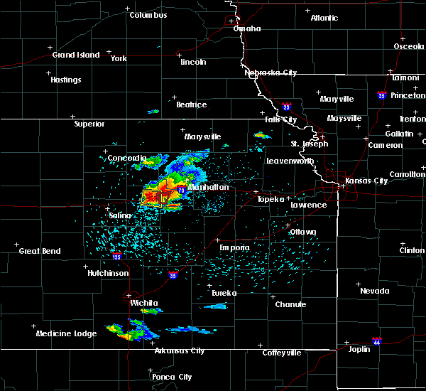 At 843 pm cdt, a severe thunderstorm capable of producing a tornado was located 6 miles southwest of junction city, moving east at 25 mph (radar indicated rotation). Hazards include tornado and half dollar size hail. Flying debris will be dangerous to those caught without shelter. mobile homes will be damaged or destroyed. damage to roofs, windows, and vehicles will occur. tree damage is likely. Locations impacted include, areas south of junction city. At 843 pm cdt, a severe thunderstorm capable of producing a tornado was located 6 miles southwest of junction city, moving east at 25 mph (radar indicated rotation). Hazards include tornado and half dollar size hail. Flying debris will be dangerous to those caught without shelter. mobile homes will be damaged or destroyed. damage to roofs, windows, and vehicles will occur. tree damage is likely. Locations impacted include, areas south of junction city.
|
| 5/25/2016 8:37 PM CDT |
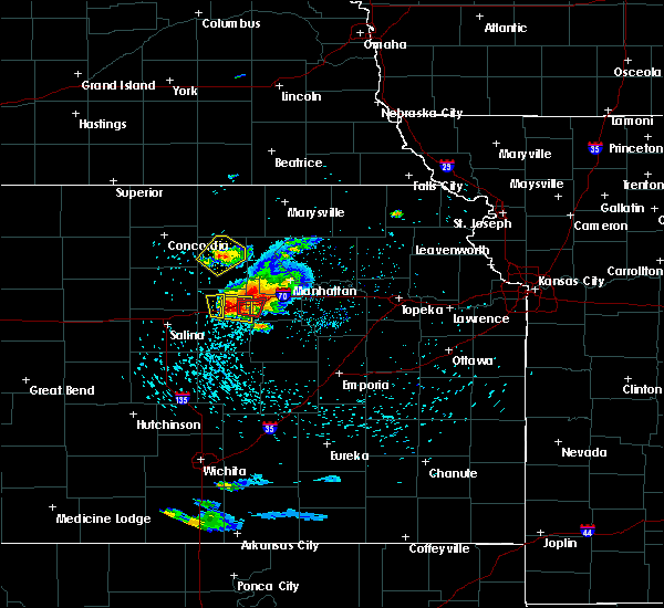 At 836 pm cdt, a confirmed large and extremely dangerous tornado was located about 4 miles east southeast of chapman, moving east at 25 mph. this is a particularly dangerous situation. take cover now! (weather spotters confirmed tornado). Hazards include damaging tornado. You are in a life-threatening situation. flying debris may be deadly to those caught without shelter. mobile homes will be destroyed. considerable damage to homes, businesses, and vehicles is likely and complete destruction is possible. locations impacted include, far southern parts of junction city and areas to the south. This includes interstate 70 between mile markers 287 and 299. At 836 pm cdt, a confirmed large and extremely dangerous tornado was located about 4 miles east southeast of chapman, moving east at 25 mph. this is a particularly dangerous situation. take cover now! (weather spotters confirmed tornado). Hazards include damaging tornado. You are in a life-threatening situation. flying debris may be deadly to those caught without shelter. mobile homes will be destroyed. considerable damage to homes, businesses, and vehicles is likely and complete destruction is possible. locations impacted include, far southern parts of junction city and areas to the south. This includes interstate 70 between mile markers 287 and 299.
|
| 5/25/2016 8:36 PM CDT |
 At 835 pm cdt, a severe thunderstorm was located over enterprise, moving east at 25 mph (radar indicated). Hazards include two inch hail. People and animals outdoors will be injured. Expect damage to roofs, siding, windows, and vehicles. At 835 pm cdt, a severe thunderstorm was located over enterprise, moving east at 25 mph (radar indicated). Hazards include two inch hail. People and animals outdoors will be injured. Expect damage to roofs, siding, windows, and vehicles.
|
| 5/25/2016 8:27 PM CDT |
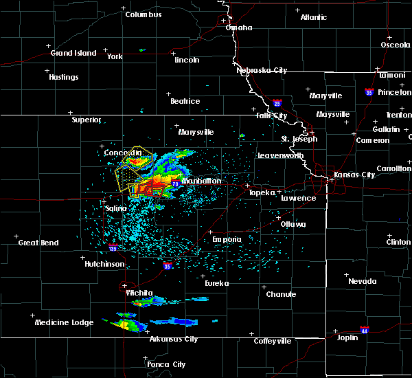 At 827 pm cdt, a confirmed large and extremely dangerous tornado was located 1 mile south of chapman, moving east at 15 mph. this is a particularly dangerous situation. take cover now! (weather spotters confirmed tornado). Hazards include damaging tornado. You are in a life-threatening situation. flying debris may be deadly to those caught without shelter. mobile homes will be destroyed. considerable damage to homes, businesses, and vehicles is likely and complete destruction is possible. the tornado will be near, junction city around 900 pm cdt. This includes interstate 70 between mile markers 286 and 299. At 827 pm cdt, a confirmed large and extremely dangerous tornado was located 1 mile south of chapman, moving east at 15 mph. this is a particularly dangerous situation. take cover now! (weather spotters confirmed tornado). Hazards include damaging tornado. You are in a life-threatening situation. flying debris may be deadly to those caught without shelter. mobile homes will be destroyed. considerable damage to homes, businesses, and vehicles is likely and complete destruction is possible. the tornado will be near, junction city around 900 pm cdt. This includes interstate 70 between mile markers 286 and 299.
|
| 5/24/2016 11:19 PM CDT | A severe thunderstorm warning remains in effect until 1145 pm cdt for west central wabaunsee. northern morris. geary. eastern clay. riley. eastern dickinson and western pottawatomie counties. at 1117 pm cdt. a line of severe thunderstorms was located from near randolph. southward to near ogden. moving east at 40 mph. hazard. 60 mph wind gusts. |
| 5/24/2016 10:23 PM CDT | The national weather service in topeka has issued a * severe thunderstorm warning for. western geary county in east central kansas. southeastern clay county in north central kansas. dickinson county in central kansas. Until 1100 pm cdt. |
| 5/11/2016 4:29 AM CDT |
 At 429 am cdt, a severe thunderstorm was located near keats and riley, moving east at 45 mph (radar indicated). Hazards include 60 mph wind gusts and penny size hail. Expect damage to roofs. siding. and trees. locations impacted include, southwestern manhattan, junction city, abilene, clay center, ogden, grandview plaza, chapman, wakefield, riley, enterprise, milford, leonardville, milford lake, moonlight, keats and tuttle creek lake. This includes interstate 70 between mile markers 274 and 305. At 429 am cdt, a severe thunderstorm was located near keats and riley, moving east at 45 mph (radar indicated). Hazards include 60 mph wind gusts and penny size hail. Expect damage to roofs. siding. and trees. locations impacted include, southwestern manhattan, junction city, abilene, clay center, ogden, grandview plaza, chapman, wakefield, riley, enterprise, milford, leonardville, milford lake, moonlight, keats and tuttle creek lake. This includes interstate 70 between mile markers 274 and 305.
|
| 5/11/2016 4:14 AM CDT |
 At 414 am cdt, a severe thunderstorm was located over chapman, moving east at 35 mph (radar indicated). Hazards include 60 mph wind gusts and penny size hail. Expect damage to roofs. siding. And trees. At 414 am cdt, a severe thunderstorm was located over chapman, moving east at 35 mph (radar indicated). Hazards include 60 mph wind gusts and penny size hail. Expect damage to roofs. siding. And trees.
|
| 5/11/2016 3:52 AM CDT |
 At 352 am cdt, a severe thunderstorm was located over longford, moving east at 45 mph (radar indicated). Hazards include 60 mph wind gusts and quarter size hail. Hail damage to vehicles is expected. Expect wind damage to roofs, siding, and trees. At 352 am cdt, a severe thunderstorm was located over longford, moving east at 45 mph (radar indicated). Hazards include 60 mph wind gusts and quarter size hail. Hail damage to vehicles is expected. Expect wind damage to roofs, siding, and trees.
|
| 4/26/2016 5:43 PM CDT |
 At 542 pm cdt, a severe thunderstorm was located near chapman, moving northeast at 45 mph (radar indicated). Hazards include 60 mph wind gusts and half dollar size hail. Hail damage to vehicles is expected. Expect wind damage to roofs, siding, and trees. At 542 pm cdt, a severe thunderstorm was located near chapman, moving northeast at 45 mph (radar indicated). Hazards include 60 mph wind gusts and half dollar size hail. Hail damage to vehicles is expected. Expect wind damage to roofs, siding, and trees.
|
| 4/24/2016 9:08 PM CDT |
 At 907 pm cdt, a severe thunderstorm was located over grandview plaza, moving east at 25 mph (trained weather spotters reported ping pong ball size hail in junction city at at 902 pm). Hazards include ping pong ball size hail and 60 mph wind gusts. People and animals outdoors will be injured. expect hail damage to roofs, siding, windows, and vehicles. expect wind damage to roofs, siding, and trees. locations impacted include, junction city, ogden and grandview plaza. this includes interstate 70 between mile markers 291 and 306. A tornado watch remains in effect until 1100 pm cdt for northeastern kansas. At 907 pm cdt, a severe thunderstorm was located over grandview plaza, moving east at 25 mph (trained weather spotters reported ping pong ball size hail in junction city at at 902 pm). Hazards include ping pong ball size hail and 60 mph wind gusts. People and animals outdoors will be injured. expect hail damage to roofs, siding, windows, and vehicles. expect wind damage to roofs, siding, and trees. locations impacted include, junction city, ogden and grandview plaza. this includes interstate 70 between mile markers 291 and 306. A tornado watch remains in effect until 1100 pm cdt for northeastern kansas.
|
| 4/24/2016 9:04 PM CDT | Golf Ball sized hail reported 2.2 miles WSW of Junction City, KS |
| 4/24/2016 9:02 PM CDT | Ping Pong Ball sized hail reported 0.8 miles WNW of Junction City, KS |
| 4/24/2016 9:00 PM CDT |
 At 858 pm cdt, a severe thunderstorm was located over junction city, moving east at 40 mph (emergency management reported ping pong ball sized hail 5 miles east northreast of chapman at 855 pm). Hazards include ping pong ball size hail and 60 mph wind gusts. People and animals outdoors will be injured. expect hail damage to roofs, siding, windows, and vehicles. expect wind damage to roofs, siding, and trees. locations impacted include, junction city, ogden and grandview plaza. this includes interstate 70 between mile markers 291 and 306. A tornado watch remains in effect until 1100 pm cdt for northeastern kansas. At 858 pm cdt, a severe thunderstorm was located over junction city, moving east at 40 mph (emergency management reported ping pong ball sized hail 5 miles east northreast of chapman at 855 pm). Hazards include ping pong ball size hail and 60 mph wind gusts. People and animals outdoors will be injured. expect hail damage to roofs, siding, windows, and vehicles. expect wind damage to roofs, siding, and trees. locations impacted include, junction city, ogden and grandview plaza. this includes interstate 70 between mile markers 291 and 306. A tornado watch remains in effect until 1100 pm cdt for northeastern kansas.
|
| 4/24/2016 8:55 PM CDT | Ping Pong Ball sized hail reported 5.7 miles ENE of Junction City, KS |
| 4/24/2016 8:44 PM CDT |
 At 843 pm cdt, a severe thunderstorm was located near milford lake, moving east at 25 mph (radar indicated). Hazards include 60 mph wind gusts and quarter size hail. Hail damage to vehicles is expected. Expect wind damage to roofs, siding, and trees. At 843 pm cdt, a severe thunderstorm was located near milford lake, moving east at 25 mph (radar indicated). Hazards include 60 mph wind gusts and quarter size hail. Hail damage to vehicles is expected. Expect wind damage to roofs, siding, and trees.
|
| 4/24/2016 7:45 PM CDT | Golf Ball sized hail reported 2.3 miles SE of Junction City, KS |
| 4/24/2016 7:41 PM CDT | Quarter sized hail reported 2.3 miles SE of Junction City, KS |
| 4/24/2016 7:35 PM CDT |
 At 734 pm cdt, a confirmed tornado was located over southern milford lake, moving northeast at 30 mph (law enforcement confirmed tornado). Hazards include damaging tornado and baseball size hail. Flying debris will be dangerous to those caught without shelter. mobile homes will be damaged or destroyed. damage to roofs, windows, and vehicles will occur. tree damage is likely. the tornado will be near, milford around 740 pm cdt. ogden around 755 pm cdt. Southwestern manhattan around 800 pm cdt. At 734 pm cdt, a confirmed tornado was located over southern milford lake, moving northeast at 30 mph (law enforcement confirmed tornado). Hazards include damaging tornado and baseball size hail. Flying debris will be dangerous to those caught without shelter. mobile homes will be damaged or destroyed. damage to roofs, windows, and vehicles will occur. tree damage is likely. the tornado will be near, milford around 740 pm cdt. ogden around 755 pm cdt. Southwestern manhattan around 800 pm cdt.
|
| 4/24/2016 7:16 PM CDT |
 At 715 pm cdt, a severe thunderstorm was located near wakefield, moving northeast at 30 mph. a second severe thunderstorm was located 3 miles southwest of chapman moving northeast at 30 mph (radar indicated). Hazards include two inch hail. People and animals outdoors will be injured. Expect damage to roofs, siding, windows, and vehicles. At 715 pm cdt, a severe thunderstorm was located near wakefield, moving northeast at 30 mph. a second severe thunderstorm was located 3 miles southwest of chapman moving northeast at 30 mph (radar indicated). Hazards include two inch hail. People and animals outdoors will be injured. Expect damage to roofs, siding, windows, and vehicles.
|
| 9/10/2015 8:50 PM CDT |
 At 848 pm cdt, severe thunderstorms were located along a line extending from near randolph to near keats to 7 miles south of grandview plaza, moving southeast at 50 mph (radar indicated). Hazards include 70 mph wind gusts and penny size hail. Expect considerable tree damage. Damage is likely to mobile homes, roofs and outbuildings. At 848 pm cdt, severe thunderstorms were located along a line extending from near randolph to near keats to 7 miles south of grandview plaza, moving southeast at 50 mph (radar indicated). Hazards include 70 mph wind gusts and penny size hail. Expect considerable tree damage. Damage is likely to mobile homes, roofs and outbuildings.
|
| 9/10/2015 8:16 PM CDT |
 At 814 pm cdt, a severe thunderstorm was located 6 miles northwest of dwight, moving southeast at 35 mph (radar indicated). Hazards include 60 mph wind gusts and quarter size hail. Hail damage to vehicles is expected. expect wind damage to roofs, siding and trees. locations impacted include, junction city, grandview plaza, white city, alta vista, dwight and parkerville. this includes interstate 70 between mile markers 299 and 309. At 808 pm cdt, a wind gust of 59 mph was recorded at an automated weather station at the fort riley airfield. At 814 pm cdt, a severe thunderstorm was located 6 miles northwest of dwight, moving southeast at 35 mph (radar indicated). Hazards include 60 mph wind gusts and quarter size hail. Hail damage to vehicles is expected. expect wind damage to roofs, siding and trees. locations impacted include, junction city, grandview plaza, white city, alta vista, dwight and parkerville. this includes interstate 70 between mile markers 299 and 309. At 808 pm cdt, a wind gust of 59 mph was recorded at an automated weather station at the fort riley airfield.
|
| 9/10/2015 7:56 PM CDT |
 At 755 pm cdt, a severe thunderstorm was located over junction city, moving southeast at 35 mph (radar indicated). Hazards include 60 mph wind gusts and quarter size hail. Hail damage to vehicles is expected. Expect wind damage to roofs, siding and trees. At 755 pm cdt, a severe thunderstorm was located over junction city, moving southeast at 35 mph (radar indicated). Hazards include 60 mph wind gusts and quarter size hail. Hail damage to vehicles is expected. Expect wind damage to roofs, siding and trees.
|
| 9/10/2015 7:53 PM CDT | Storm damage reported in geary county KS, 5 miles SSE of Junction City, KS |
| 9/10/2015 7:53 PM CDT |
 At 752 pm cdt, a severe thunderstorm was located near junction city, moving southeast at 35 mph (trained weather spotters). Hazards include 60 mph wind gusts and quarter size hail. Hail damage to vehicles is expected. expect wind damage to roofs, siding and trees. locations impacted include, junction city and milford lake. This includes interstate 70 between mile markers 291 and 295. At 752 pm cdt, a severe thunderstorm was located near junction city, moving southeast at 35 mph (trained weather spotters). Hazards include 60 mph wind gusts and quarter size hail. Hail damage to vehicles is expected. expect wind damage to roofs, siding and trees. locations impacted include, junction city and milford lake. This includes interstate 70 between mile markers 291 and 295.
|
| 9/10/2015 7:39 PM CDT |
 At 738 pm cdt, a severe thunderstorm was located near chapman, moving southeast at 35 mph (trained weather spotters). Hazards include 60 mph wind gusts and quarter size hail. Hail damage to vehicles is expected. expect wind damage to roofs, siding and trees. locations impacted include, junction city, chapman and milford lake. This includes interstate 70 between mile markers 286 and 295. At 738 pm cdt, a severe thunderstorm was located near chapman, moving southeast at 35 mph (trained weather spotters). Hazards include 60 mph wind gusts and quarter size hail. Hail damage to vehicles is expected. expect wind damage to roofs, siding and trees. locations impacted include, junction city, chapman and milford lake. This includes interstate 70 between mile markers 286 and 295.
|
| 9/10/2015 7:31 PM CDT |
 At 730 pm cdt, a severe thunderstorm was located 7 miles north of moonlight, moving southeast at 35 mph (trained weather spotters. spotter reported golf ball hail 6 miles east of longford at 720 pm cdt). Hazards include golf ball size hail and 60 mph wind gusts. People and animals outdoors will be injured. expect hail damage to roofs, siding, windows and vehicles. expect wind damage to roofs, siding and trees. locations impacted include, junction city, chapman, milford lake and moonlight. This includes interstate 70 between mile markers 281 and 295. At 730 pm cdt, a severe thunderstorm was located 7 miles north of moonlight, moving southeast at 35 mph (trained weather spotters. spotter reported golf ball hail 6 miles east of longford at 720 pm cdt). Hazards include golf ball size hail and 60 mph wind gusts. People and animals outdoors will be injured. expect hail damage to roofs, siding, windows and vehicles. expect wind damage to roofs, siding and trees. locations impacted include, junction city, chapman, milford lake and moonlight. This includes interstate 70 between mile markers 281 and 295.
|
| 9/10/2015 7:17 PM CDT |
 At 716 pm cdt, a severe thunderstorm was located near longford, moving southeast at 35 mph (radar indicated). Hazards include ping pong ball size hail and 60 mph wind gusts. People and animals outdoors will be injured. expect hail damage to roofs, siding, windows and vehicles. Expect wind damage to roofs, siding and trees. At 716 pm cdt, a severe thunderstorm was located near longford, moving southeast at 35 mph (radar indicated). Hazards include ping pong ball size hail and 60 mph wind gusts. People and animals outdoors will be injured. expect hail damage to roofs, siding, windows and vehicles. Expect wind damage to roofs, siding and trees.
|
| 9/7/2015 9:22 PM CDT |
 At 920 pm cdt, a severe thunderstorm was located near white city, moving east at 25 mph (emergency management. at 905 pm cdt...60 mph wind gusts were reported on us highway 77, 4 miles south of interstate 70). Hazards include 60 mph wind gusts and quarter size hail. Hail damage to vehicles is expected. expect wind damage to roofs, siding and trees. locations impacted include, junction city, white city, dwight, parkerville and latimer. This includes interstate 70 between mile markers 291 and 296. At 920 pm cdt, a severe thunderstorm was located near white city, moving east at 25 mph (emergency management. at 905 pm cdt...60 mph wind gusts were reported on us highway 77, 4 miles south of interstate 70). Hazards include 60 mph wind gusts and quarter size hail. Hail damage to vehicles is expected. expect wind damage to roofs, siding and trees. locations impacted include, junction city, white city, dwight, parkerville and latimer. This includes interstate 70 between mile markers 291 and 296.
|
| 9/7/2015 9:13 PM CDT |
 At 912 pm cdt, a severe thunderstorm was located 7 miles northwest of white city, moving east at 25 mph (radar indicated). Hazards include 70 mph wind gusts and penny size hail. Expect considerable tree damage. damage is likely to mobile homes, roofs and outbuildings. locations impacted include, junction city, white city, dwight, woodbine, parkerville and latimer. This includes interstate 70 between mile markers 288 and 297. At 912 pm cdt, a severe thunderstorm was located 7 miles northwest of white city, moving east at 25 mph (radar indicated). Hazards include 70 mph wind gusts and penny size hail. Expect considerable tree damage. damage is likely to mobile homes, roofs and outbuildings. locations impacted include, junction city, white city, dwight, woodbine, parkerville and latimer. This includes interstate 70 between mile markers 288 and 297.
|
| 9/7/2015 9:06 PM CDT |
 At 905 pm cdt, a severe thunderstorm was located 6 miles northeast of woodbine, moving east at 25 mph (emergency management. at 8:20 pm cdt...widespread power outages reported in abilene. possible house damaged 8 miles south southwest of abilene). Hazards include 70 mph wind gusts and penny size hail. Expect considerable tree damage. damage is likely to mobile homes, roofs and outbuildings. locations impacted include, junction city, chapman, white city, dwight, woodbine, parkerville and latimer. This includes interstate 70 between mile markers 284 and 297. At 905 pm cdt, a severe thunderstorm was located 6 miles northeast of woodbine, moving east at 25 mph (emergency management. at 8:20 pm cdt...widespread power outages reported in abilene. possible house damaged 8 miles south southwest of abilene). Hazards include 70 mph wind gusts and penny size hail. Expect considerable tree damage. damage is likely to mobile homes, roofs and outbuildings. locations impacted include, junction city, chapman, white city, dwight, woodbine, parkerville and latimer. This includes interstate 70 between mile markers 284 and 297.
|
| 9/7/2015 9:05 PM CDT | Storm damage reported in geary county KS, 3.8 miles NNE of Junction City, KS |
| 9/7/2015 8:54 PM CDT |
 At 854 pm cdt, a severe thunderstorm was located near woodbine, moving east at 25 mph (law enforcement. power lines reported down in the abilene area. report came in at 854 pm cdt). Hazards include 60 mph wind gusts and penny size hail. Expect damage to roofs. Siding and trees. At 854 pm cdt, a severe thunderstorm was located near woodbine, moving east at 25 mph (law enforcement. power lines reported down in the abilene area. report came in at 854 pm cdt). Hazards include 60 mph wind gusts and penny size hail. Expect damage to roofs. Siding and trees.
|
| 7/25/2015 4:01 PM CDT |
 At 400 pm cdt, a severe thunderstorm was located near junction city, and is nearly stationary (radar indicated). Hazards include 60 mph wind gusts and quarter size hail. Hail damage to vehicles is expected. expect wind damage to roofs, siding and trees. locations impacted include, junction city and grandview plaza. This includes interstate 70 between mile markers 290 and 300. At 400 pm cdt, a severe thunderstorm was located near junction city, and is nearly stationary (radar indicated). Hazards include 60 mph wind gusts and quarter size hail. Hail damage to vehicles is expected. expect wind damage to roofs, siding and trees. locations impacted include, junction city and grandview plaza. This includes interstate 70 between mile markers 290 and 300.
|
| 7/25/2015 3:41 PM CDT |
 At 340 pm cdt, a severe thunderstorm was located near chapman, moving east at 15 mph (radar indicated). Hazards include 60 mph wind gusts and quarter size hail. Hail damage to vehicles is expected. Expect wind damage to roofs, siding and trees. At 340 pm cdt, a severe thunderstorm was located near chapman, moving east at 15 mph (radar indicated). Hazards include 60 mph wind gusts and quarter size hail. Hail damage to vehicles is expected. Expect wind damage to roofs, siding and trees.
|
| 7/6/2015 3:01 PM CDT |
 At 300 pm cdt, a severe thunderstorm was located 6 miles southeast of grandview plaza, moving east at 30 mph (trained weather spotters reported 70 mph winds 4 miles southwest of grandview plaza). Hazards include 70 mph wind gusts. Expect considerable tree damage. damage is likely to mobile homes, roofs and outbuildings. locations impacted include, junction city, ogden, grandview plaza, chapman and dwight. This includes interstate 70 between mile markers 286 and 311. At 300 pm cdt, a severe thunderstorm was located 6 miles southeast of grandview plaza, moving east at 30 mph (trained weather spotters reported 70 mph winds 4 miles southwest of grandview plaza). Hazards include 70 mph wind gusts. Expect considerable tree damage. damage is likely to mobile homes, roofs and outbuildings. locations impacted include, junction city, ogden, grandview plaza, chapman and dwight. This includes interstate 70 between mile markers 286 and 311.
|
| 7/6/2015 2:59 PM CDT | Storm damage reported in geary county KS, 4.7 miles NNW of Junction City, KS |
| 7/6/2015 2:39 PM CDT |
 At 238 pm cdt, a severe thunderstorm was located near chapman, moving east at 30 mph (trained weather spotters reported 50 to 60 mph wind gust south of chapman at 235 pm. ). Hazards include 60 mph wind gusts. Expect damage to roofs. Siding and trees. At 238 pm cdt, a severe thunderstorm was located near chapman, moving east at 30 mph (trained weather spotters reported 50 to 60 mph wind gust south of chapman at 235 pm. ). Hazards include 60 mph wind gusts. Expect damage to roofs. Siding and trees.
|
| 6/7/2015 7:56 PM CDT | The severe thunderstorm warning for southwestern geary and northeastern dickinson counties will expire at 800 pm cdt, the storm which prompted the warning has weakened below severe limits, and no longer poses an immediate threat to life or property. however, small hail, gusty winds and heavy rain are still possible with this thunderstorm. in addition, strong thunderstorms may redevelop, and a severe thunderstorm watch remains in effect until 300 am cdt. |
| 6/7/2015 7:53 PM CDT | At 751 pm cdt, a severe thunderstorm was located near chapman, and moving east at 35 mph (radar indicated). Hazards include 60 mph wind gusts and quarter size hail. Hail damage to vehicles is expected. expect wind damage to roofs, siding and trees. locations impacted include, mainly rural areas of eastern dickinson and extreme western geary counties. the storm has been weakening. This includes interstate 70 between mile markers 281 and 293. |
| 6/7/2015 7:45 PM CDT | At 743 pm cdt, a severe thunderstorm was located near moonlight, and moving southeast at 30 mph (radar indicated). Hazards include 60 mph wind gusts and quarter size hail. Hail damage to vehicles is expected. expect wind damage to roofs, siding and trees. locations impacted include, chapman. This includes interstate 70 between mile markers 280 and 293. |
| 6/7/2015 7:36 PM CDT | At 733 pm cdt, a severe thunderstorm was located near moonlight, and moving southeast at 30 mph (radar indicated). Hazards include hen egg size hail and 60 mph wind gusts. spotter reported hen egg size hail. People and animals outdoors will be injured. expect hail damage to roofs, siding, windows and vehicles. expect wind damage to roofs, siding and trees. locations impacted include, moonlight and chapman. This includes interstate 70 between mile markers 280 and 293. |
| 6/7/2015 7:31 PM CDT | At 727 pm cdt, a severe thunderstorm was located near talmage, and moving southeast at 35 mph (radar indicated). Hazards include 60 mph wind gusts and half dollar size hail. Hail damage to vehicles is expected. expect wind damage to roofs, siding and trees. locations impacted include, moonlight and chapman. This includes interstate 70 between mile markers 279 and 293. |
| 6/7/2015 7:22 PM CDT | At 720 pm cdt, a severe thunderstorm was located near talmage, and moving southeast at 35 mph (radar indicated). Hazards include golf ball size hail and 60 mph wind gusts. People and animals outdoors will be injured. expect hail damage to roofs, siding, windows and vehicles. Expect wind damage to roofs, siding and trees. |
| 6/5/2015 2:14 AM CDT | At 211 am cdt, severe thunderstorms were located along a line extending from 5 miles north of harveyville to 5 miles northwest of bushong to herington, and moving south at 35 mph (radar indicated). Hazards include isolated 60 mph wind gusts. Expect damage to roofs. siding and trees. locations impacted include, harveyville, bushong, burdick, allen, dunlap and admire. this includes the kansas turnpike between mile markers 149 and 154. This includes interstate 70 between mile markers 292 and 345. |
| 6/5/2015 1:44 AM CDT | At 141 am cdt, severe thunderstorms were located along a line extending from maple hill to 6 miles southeast of alta vista to 8 miles northeast of woodbine, and moving south at 30 mph (radar indicated). Hazards include 60 mph wind gusts and penny size hail. Expect damage to roofs. Siding and trees. |
| 6/5/2015 1:28 AM CDT | At 125 am cdt, severe thunderstorms were located along a line extending from manchester to 5 miles north of woodbine, and moving south at 25 mph (radar indicated). Hazards include 60 mph wind gusts and penny size hail. Expect damage to roofs. siding and trees. locations impacted include, herington, solomon, woodbine, hope and carlton. This includes interstate 70 between mile markers 267 and 292. |
| 6/5/2015 1:20 AM CDT | At 111 am cdt, severe thunderstorms were located along a line extending from moonlight to alta vista to willard, and moving south at 45 mph (emergency management. 1 mile east of wamego). Hazards include 65 mph wind gusts. Expect damage to roofs. siding and trees. locations impacted include, eskridge, council grove, dwight, keene, white city, parkerville, council grove lake, latimer, harveyville, bushong, wilsey, allen, dunlap, admire and burdick. this includes the kansas turnpike between mile markers 149 and 154. This includes interstate 70 between mile markers 290 and 344. |
| 6/5/2015 1:09 AM CDT | At 106 am cdt, severe thunderstorms were located along a line extending from moonlight to 7 miles northwest of volland to rossville, and moving south at 45 mph (radar indicated). Hazards include 70 mph wind gusts and penny size hail. Expect considerable tree damage. Damage is likely to mobile homes, roofs and outbuildings. |
| 6/5/2015 1:04 AM CDT | At 101 am cdt, severe thunderstorms were located along a line extending from scottsville to 5 miles west of manchester to 5 miles northeast of chapman, and moving south at 25 mph (radar indicated). Hazards include 60 mph wind gusts and penny size hail. Expect damage to roofs. Siding and trees. |
| 6/5/2015 1:02 AM CDT | At 1258 am cdt, severe thunderstorms were located along a line extending from belvue to 5 miles southwest of st. george to wakefield, and moving southeast at 25 mph (radar indicated). Hazards include 70 mph wind gusts and penny size hail. Expect considerable tree damage. damage is likely to mobile homes, roofs and outbuildings. locations impacted include, alma, junction city, belvue, milford, milford lake, st. marys, ogden, mcfarland, paxico, maple hill, grandview plaza and volland. This includes interstate 70 between mile markers 290 and 342. |
| 6/5/2015 12:54 AM CDT | At 1253 am cdt, severe thunderstorms were located along a line extending from belvue to manhattan to wakefield, and moving southeast at 25 mph (automated weather instrument). Hazards include 70 mph wind gusts and penny size hail. Expect considerable tree damage. Damage is likely to mobile homes, roofs and outbuildings. |
| 4/2/2015 1:19 AM CST | Measured on davis weather station on top of a she in geary county KS, 0.8 miles WNW of Junction City, KS |
| 8/31/2014 8:40 PM CDT | Riley county em had citizen report estimated 60 mph wind gust near milford lake da in geary county KS, 4.7 miles SSE of Junction City, KS |
| 7/7/2014 10:30 PM CDT | 70 mph wind gust with stor in geary county KS, 2.2 miles WSW of Junction City, KS |
| 6/15/2014 1:22 AM CDT | Storm damage reported in geary county KS, 2.2 miles WSW of Junction City, KS |
| 6/1/2014 8:40 PM CDT | Measured on home weather statio in geary county KS, 2.2 miles WSW of Junction City, KS |
| 4/13/2014 12:30 PM CDT | Quarter sized hail reported 11.3 miles N of Junction City, KS |
| 4/2/2014 3:22 AM CDT | Quarter sized hail reported 0.8 miles WNW of Junction City, KS, mostly nickel sized. |
| 8/15/2013 4:58 PM CDT | Storm damage reported in geary county KS, 0.8 miles WNW of Junction City, KS |
| 6/27/2013 8:43 PM CDT | Storm damage reported in geary county KS, 0.8 miles WNW of Junction City, KS |
| 6/27/2013 8:38 PM CDT | Golf Ball sized hail reported 9.9 miles W of Junction City, KS, quarter hail and up to the size of golfballs. estimated winds of 55 mph. |
| 6/25/2013 2:39 AM CDT | 50 to 60 mph winds with tree limb damage at intersection of highways 77 and 15 in geary county KS, 10.3 miles NNE of Junction City, KS |
| 5/31/2013 1:56 AM CDT | Half Dollar sized hail reported 8.5 miles N of Junction City, KS |
| 5/18/2013 10:35 PM CDT | Storm damage reported in geary county KS, 2.5 miles E of Junction City, KS |
| 5/18/2013 10:35 PM CDT | Wind gusts estimated 60 to 70 mph. power lines down in junction cit in geary county KS, 0.8 miles WNW of Junction City, KS |
| 7/18/2012 6:30 PM CDT | 2 foot diameter tree broken at base...tree height 30 ft tall in geary county KS, 4.3 miles SW of Junction City, KS |
| 7/7/2012 11:55 PM CDT | Delayed report...public estimated 55-58 mph winds...small limbs up to 2 inches in diameter broken...pea sized hail...wind blew umbrella into trees in dickinson county KS, 10.3 miles ESE of Junction City, KS |
| 4/27/2012 5:22 PM CDT | Quarter sized hail reported 0.8 miles WNW of Junction City, KS |
| 1/1/0001 12:00 AM | Power lines down in junction city in geary county KS, 0.8 miles WNW of Junction City, KS |
| 1/1/0001 12:00 AM | Relayed by media. weather stationa at junction city middle schoo in geary county KS, 0.8 miles WNW of Junction City, KS |
| 1/1/0001 12:00 AM | Storm damage reported in geary county KS, 2.7 miles SSW of Junction City, KS |
| 1/1/0001 12:00 AM | 4 inch diameter limb blown dow in dickinson county KS, 7.4 miles E of Junction City, KS |
| 1/1/0001 12:00 AM | Golf Ball sized hail reported 11.7 miles NW of Junction City, KS, lasted 10 mins. |
| 1/1/0001 12:00 AM | Small tree downed near i-70 and washington street in geary county KS, 1.7 miles NNW of Junction City, KS |
| 1/1/0001 12:00 AM | Estimated 60 to 65 mph with zero visibilit in geary county KS, 2.6 miles S of Junction City, KS |
| 1/1/0001 12:00 AM | Storm damage reported in dickinson county KS, 10.6 miles ESE of Junction City, KS |
Hail Maps for Junction City, KS
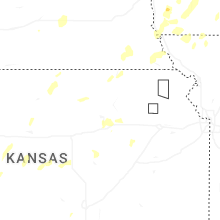


Connect with Interactive Hail Maps