

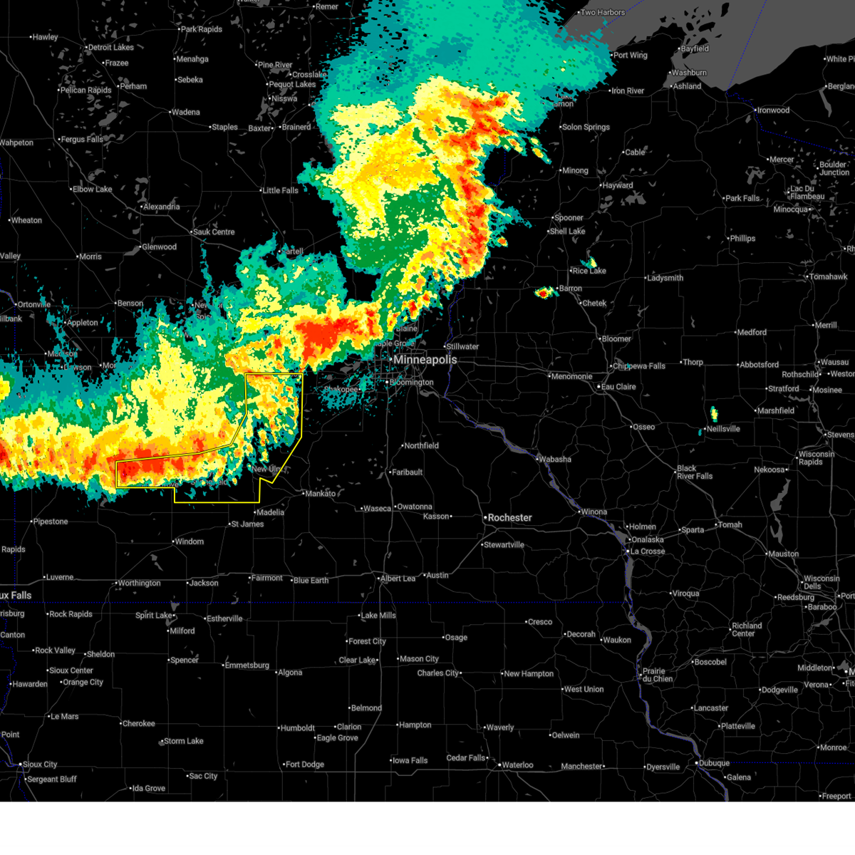
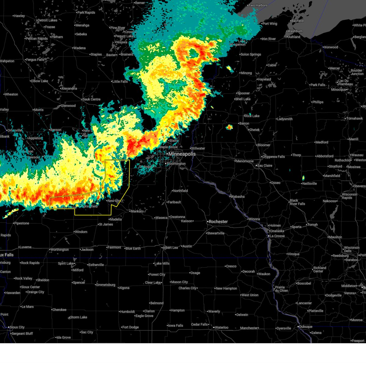
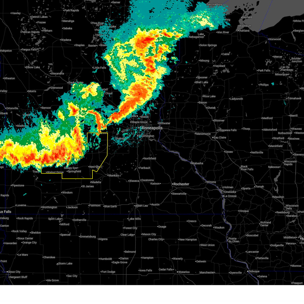
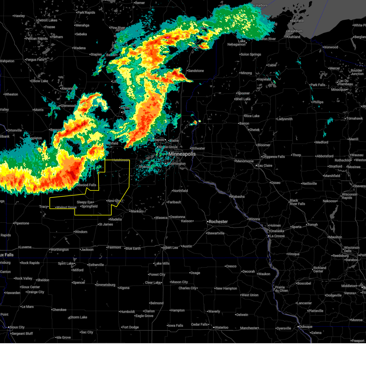
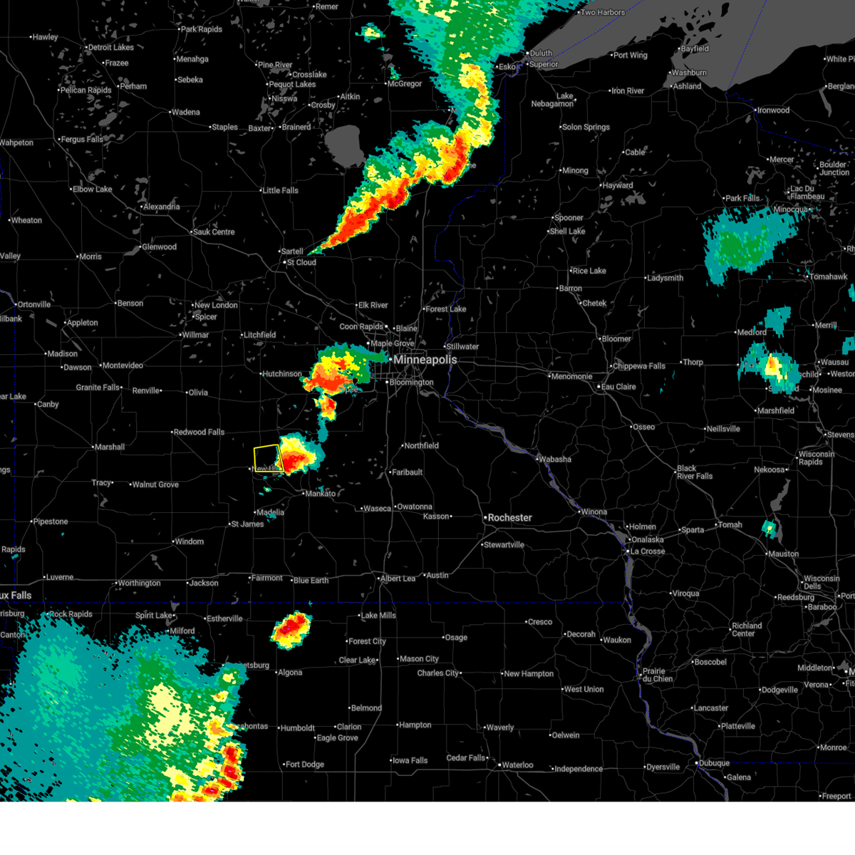
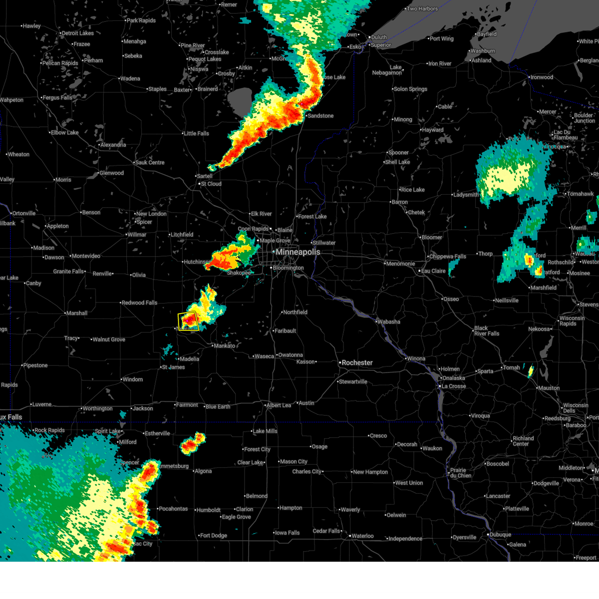
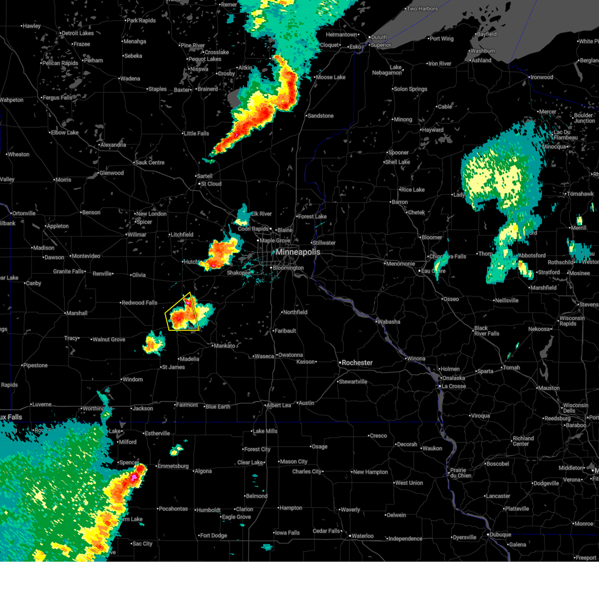
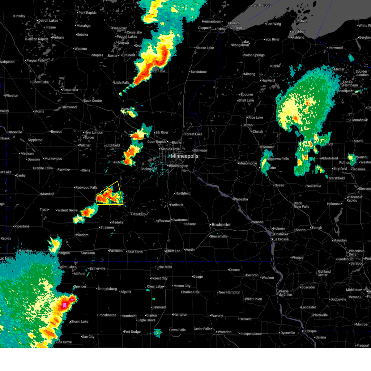
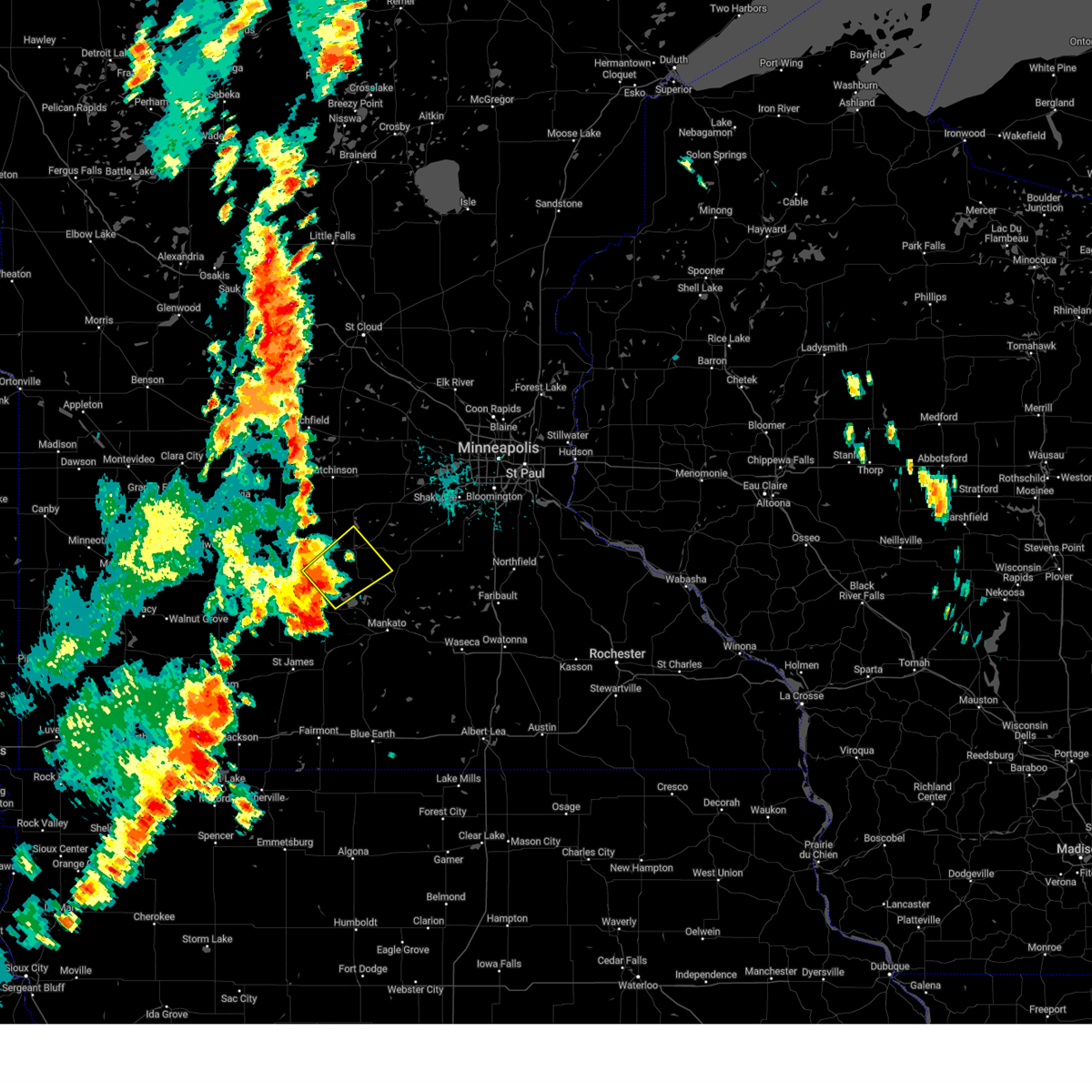
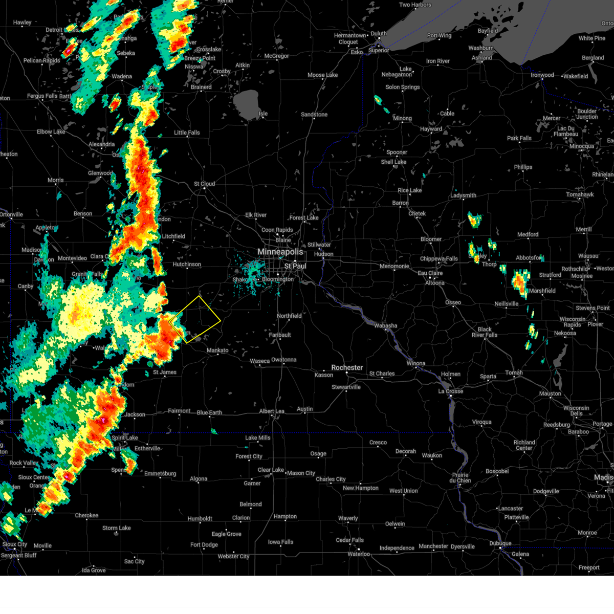
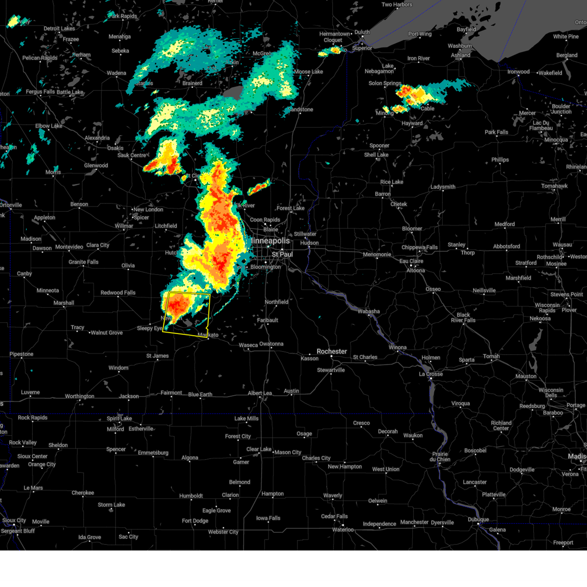
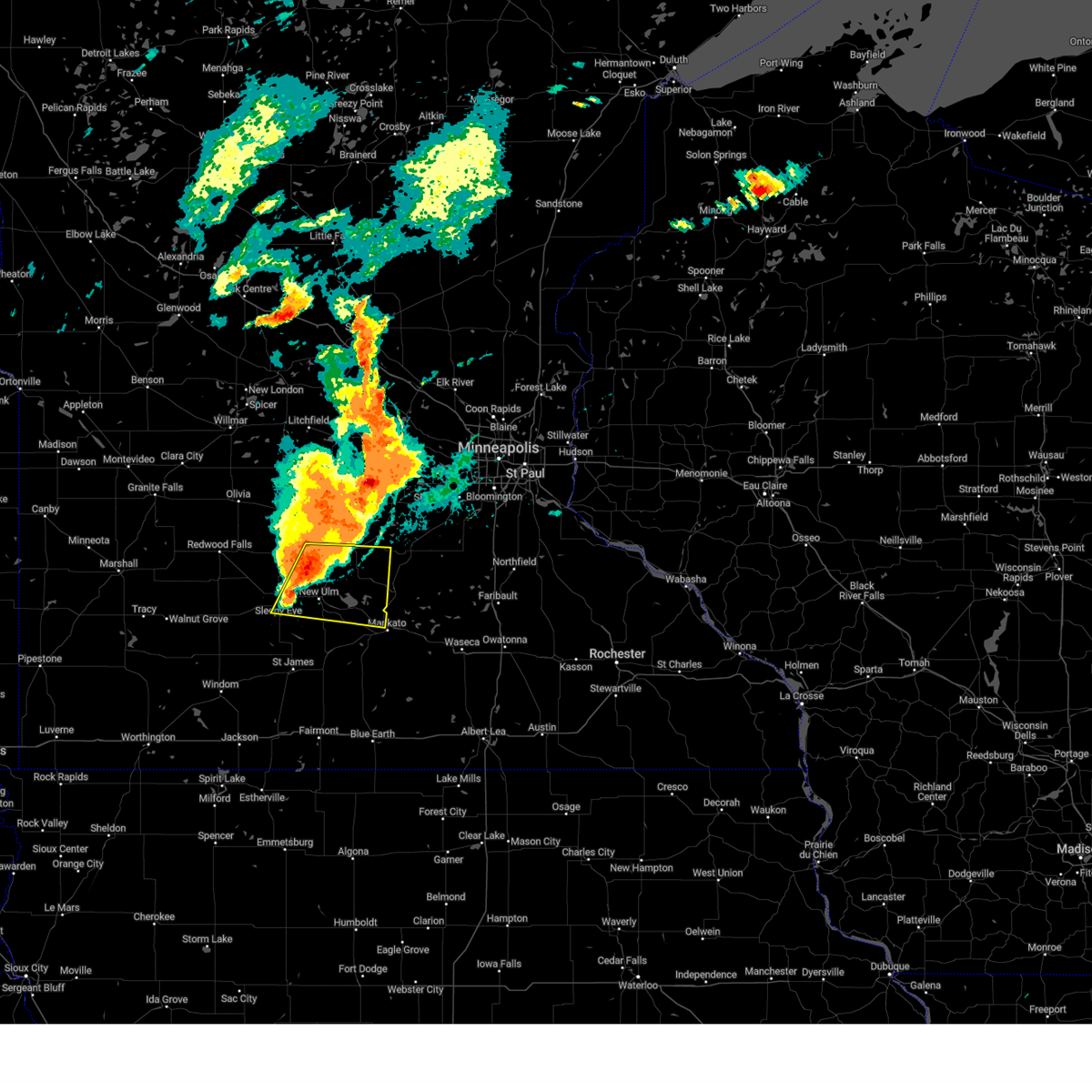
Hail Map for Lafayette, MN
The Lafayette, MN area has had 6 reports of on-the-ground hail by trained spotters, and has been under severe weather warnings 20 times during the past 12 months. Doppler radar has detected hail at or near Lafayette, MN on 60 occasions, including 6 occasions during the past year.
| Name: | Lafayette, MN |
| Where Located: | 66.5 miles SW of Minneapolis, MN |
| Map: | Google Map for Lafayette, MN |
| Population: | 504 |
| Housing Units: | 244 |
| More Info: | Search Google for Lafayette, MN |
1
The Top Recent Hail Date for Lafayette, MN is Monday, August 26, 2024 (14th out of 60)

Hail and Wind Damage Spotted near Lafayette, MN
| Date / Time | Report Details |
|---|---|
| 6/28/2025 11:57 PM CDT |
 The storms which prompted the warning have weakened below severe limits, and no longer pose an immediate threat to life or property. therefore, the warning will be allowed to expire. however, heavy rain is still possible with these thunderstorms. a tornado watch remains in effect until 100 am cdt for portions of central, south central, and southwest minnesota. The storms which prompted the warning have weakened below severe limits, and no longer pose an immediate threat to life or property. therefore, the warning will be allowed to expire. however, heavy rain is still possible with these thunderstorms. a tornado watch remains in effect until 100 am cdt for portions of central, south central, and southwest minnesota.
|
| 6/28/2025 11:48 PM CDT |
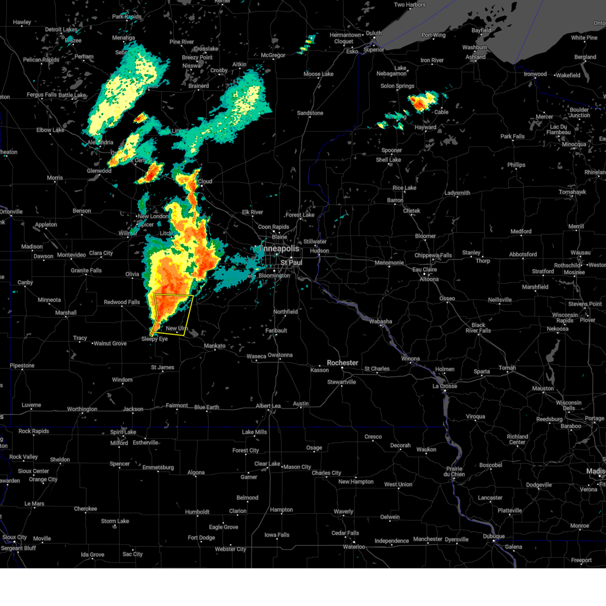
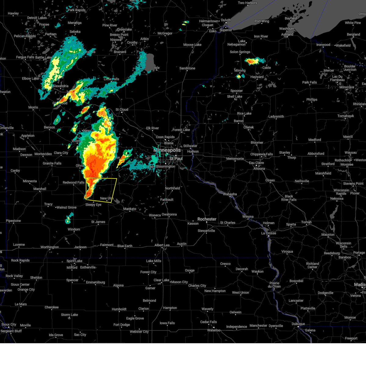
 At 1148 pm cdt, severe thunderstorms were located along a line from near brownton to near springfield, or along a line from 15 miles south of hutchinson to 23 miles south of redwood falls, moving southeast at 30 mph (radar indicated). Hazards include 60 mph wind gusts and small hail. Expect damage to roofs, siding, and trees. Locations impacted include, hutchinson, new ulm, glencoe, sleepy eye, gaylord, arlington, springfield, lester prairie, winthrop, morgan, walnut grove, lamberton, gibbon, brownton, courtland, stewart, lafayette, hanska, comfrey and sumter. At 1148 pm cdt, severe thunderstorms were located along a line from near brownton to near springfield, or along a line from 15 miles south of hutchinson to 23 miles south of redwood falls, moving southeast at 30 mph (radar indicated). Hazards include 60 mph wind gusts and small hail. Expect damage to roofs, siding, and trees. Locations impacted include, hutchinson, new ulm, glencoe, sleepy eye, gaylord, arlington, springfield, lester prairie, winthrop, morgan, walnut grove, lamberton, gibbon, brownton, courtland, stewart, lafayette, hanska, comfrey and sumter.
|
| 6/28/2025 11:25 PM CDT |
 At 1125 pm cdt, severe thunderstorms were located along a line from over stewart to near lamberton, or along a line from 15 miles south of hutchinson to 20 miles south of redwood falls, moving east at 45 mph (radar indicated). Hazards include 60 mph wind gusts and small hail. Expect damage to roofs, siding, and trees. Locations impacted include, hutchinson, new ulm, glencoe, sleepy eye, gaylord, arlington, springfield, lester prairie, winthrop, morgan, walnut grove, lamberton, gibbon, brownton, courtland, stewart, lafayette, hanska, comfrey and sumter. At 1125 pm cdt, severe thunderstorms were located along a line from over stewart to near lamberton, or along a line from 15 miles south of hutchinson to 20 miles south of redwood falls, moving east at 45 mph (radar indicated). Hazards include 60 mph wind gusts and small hail. Expect damage to roofs, siding, and trees. Locations impacted include, hutchinson, new ulm, glencoe, sleepy eye, gaylord, arlington, springfield, lester prairie, winthrop, morgan, walnut grove, lamberton, gibbon, brownton, courtland, stewart, lafayette, hanska, comfrey and sumter.
|
| 6/28/2025 11:07 PM CDT |
 Svrmpx the national weather service in the twin cities has issued a * severe thunderstorm warning for, mcleod county in central minnesota, sibley county in central minnesota, brown county in south central minnesota, northwestern nicollet county in south central minnesota, southern redwood county in southwestern minnesota, * until midnight cdt. * at 1107 pm cdt, severe thunderstorms were located along a line from over hector to 12 miles north of walnut grove, or along a line from 21 miles southwest of hutchinson to 23 miles southwest of redwood falls, moving east at 45 mph (radar indicated). Hazards include 60 mph wind gusts and small hail. expect damage to roofs, siding, and trees Svrmpx the national weather service in the twin cities has issued a * severe thunderstorm warning for, mcleod county in central minnesota, sibley county in central minnesota, brown county in south central minnesota, northwestern nicollet county in south central minnesota, southern redwood county in southwestern minnesota, * until midnight cdt. * at 1107 pm cdt, severe thunderstorms were located along a line from over hector to 12 miles north of walnut grove, or along a line from 21 miles southwest of hutchinson to 23 miles southwest of redwood falls, moving east at 45 mph (radar indicated). Hazards include 60 mph wind gusts and small hail. expect damage to roofs, siding, and trees
|
| 6/16/2025 6:54 PM CDT |
 The storm which prompted the warning has moved out of the area. therefore, the warning will be allowed to expire. The storm which prompted the warning has moved out of the area. therefore, the warning will be allowed to expire.
|
| 6/16/2025 6:31 PM CDT |
 At 631 pm cdt, a severe thunderstorm was located near lafayette, or 10 miles north of new ulm, moving northeast at 20 mph (radar indicated). Hazards include half dollar size hail. Damage to vehicles is expected. Locations impacted include, lafayette. At 631 pm cdt, a severe thunderstorm was located near lafayette, or 10 miles north of new ulm, moving northeast at 20 mph (radar indicated). Hazards include half dollar size hail. Damage to vehicles is expected. Locations impacted include, lafayette.
|
| 6/16/2025 6:31 PM CDT |
 the severe thunderstorm warning has been cancelled and is no longer in effect the severe thunderstorm warning has been cancelled and is no longer in effect
|
| 6/16/2025 6:16 PM CDT |
 At 616 pm cdt, a severe thunderstorm was located 8 miles south of gibbon, or 9 miles northwest of new ulm, moving northeast at 20 mph (radar indicated). Hazards include quarter size hail. Damage to vehicles is expected. Locations impacted include, new ulm, winthrop, lafayette, klossner, new ulm airport, flandrau state park and st george. At 616 pm cdt, a severe thunderstorm was located 8 miles south of gibbon, or 9 miles northwest of new ulm, moving northeast at 20 mph (radar indicated). Hazards include quarter size hail. Damage to vehicles is expected. Locations impacted include, new ulm, winthrop, lafayette, klossner, new ulm airport, flandrau state park and st george.
|
| 6/16/2025 6:05 PM CDT |
 Svrmpx the national weather service in the twin cities has issued a * severe thunderstorm warning for, southwestern sibley county in central minnesota, northeastern brown county in south central minnesota, northwestern nicollet county in south central minnesota, * until 700 pm cdt. * at 605 pm cdt, a severe thunderstorm was located 9 miles northeast of sleepy eye, or 10 miles northwest of new ulm, moving northeast at 20 mph (radar indicated). Hazards include quarter size hail. damage to vehicles is expected Svrmpx the national weather service in the twin cities has issued a * severe thunderstorm warning for, southwestern sibley county in central minnesota, northeastern brown county in south central minnesota, northwestern nicollet county in south central minnesota, * until 700 pm cdt. * at 605 pm cdt, a severe thunderstorm was located 9 miles northeast of sleepy eye, or 10 miles northwest of new ulm, moving northeast at 20 mph (radar indicated). Hazards include quarter size hail. damage to vehicles is expected
|
| 8/29/2024 2:59 PM CDT |
 At 259 pm cdt, a severe thunderstorm was located near lafayette, or 14 miles northeast of new ulm, moving northeast at 35 mph. the public has reported trees down in the city of new ulm (public). Hazards include 60 mph wind gusts and quarter size hail. Hail damage to vehicles is expected. expect wind damage to roofs, siding, and trees. Locations impacted include, gaylord, winthrop, courtland, lafayette, new sweden, klossner, rush river, new rome, and norseland. At 259 pm cdt, a severe thunderstorm was located near lafayette, or 14 miles northeast of new ulm, moving northeast at 35 mph. the public has reported trees down in the city of new ulm (public). Hazards include 60 mph wind gusts and quarter size hail. Hail damage to vehicles is expected. expect wind damage to roofs, siding, and trees. Locations impacted include, gaylord, winthrop, courtland, lafayette, new sweden, klossner, rush river, new rome, and norseland.
|
| 8/29/2024 2:44 PM CDT |
 Svrmpx the national weather service in the twin cities has issued a * severe thunderstorm warning for, southwestern sibley county in central minnesota, northeastern nicollet county in south central minnesota, * until 330 pm cdt. * at 244 pm cdt, a severe thunderstorm was located near lafayette, or 6 miles north of new ulm, moving northeast at 35 mph (radar indicated). Hazards include 60 mph wind gusts and quarter size hail. Hail damage to vehicles is expected. Expect wind damage to roofs, siding, and trees. Svrmpx the national weather service in the twin cities has issued a * severe thunderstorm warning for, southwestern sibley county in central minnesota, northeastern nicollet county in south central minnesota, * until 330 pm cdt. * at 244 pm cdt, a severe thunderstorm was located near lafayette, or 6 miles north of new ulm, moving northeast at 35 mph (radar indicated). Hazards include 60 mph wind gusts and quarter size hail. Hail damage to vehicles is expected. Expect wind damage to roofs, siding, and trees.
|
| 8/26/2024 6:51 PM CDT |
 At 651 pm cdt, a severe thunderstorm was located 7 miles northwest of nicollet, or 11 miles northeast of new ulm, moving east at 25 mph (radar indicated). Hazards include 60 mph wind gusts and quarter size hail. Hail damage to vehicles is expected. expect wind damage to roofs, siding, and trees. Locations impacted include, new ulm, north mankato, gaylord, winthrop, nicollet, courtland, lafayette, judson, oshawa, new sweden, klossner, and rush river. At 651 pm cdt, a severe thunderstorm was located 7 miles northwest of nicollet, or 11 miles northeast of new ulm, moving east at 25 mph (radar indicated). Hazards include 60 mph wind gusts and quarter size hail. Hail damage to vehicles is expected. expect wind damage to roofs, siding, and trees. Locations impacted include, new ulm, north mankato, gaylord, winthrop, nicollet, courtland, lafayette, judson, oshawa, new sweden, klossner, and rush river.
|
| 8/26/2024 6:29 PM CDT |
 Svrmpx the national weather service in the twin cities has issued a * severe thunderstorm warning for, southwestern sibley county in central minnesota, east central brown county in south central minnesota, northwestern blue earth county in south central minnesota, nicollet county in south central minnesota, * until 715 pm cdt. * at 628 pm cdt, a severe thunderstorm was located near lafayette, or 7 miles northeast of new ulm, moving east at 25 mph (radar indicated). Hazards include 60 mph wind gusts and quarter size hail. Hail damage to vehicles is expected. Expect wind damage to roofs, siding, and trees. Svrmpx the national weather service in the twin cities has issued a * severe thunderstorm warning for, southwestern sibley county in central minnesota, east central brown county in south central minnesota, northwestern blue earth county in south central minnesota, nicollet county in south central minnesota, * until 715 pm cdt. * at 628 pm cdt, a severe thunderstorm was located near lafayette, or 7 miles northeast of new ulm, moving east at 25 mph (radar indicated). Hazards include 60 mph wind gusts and quarter size hail. Hail damage to vehicles is expected. Expect wind damage to roofs, siding, and trees.
|
| 8/26/2024 6:14 PM CDT |
 At 614 pm cdt, a severe thunderstorm was located near lafayette, or 11 miles north of new ulm, moving east at 35 mph (radar indicated). Hazards include 60 mph wind gusts and quarter size hail. Hail damage to vehicles is expected. expect wind damage to roofs, siding, and trees. Locations impacted include, new ulm, winthrop, gibbon, lafayette, klossner, essig, st george, new ulm airport, and flandrau state park. At 614 pm cdt, a severe thunderstorm was located near lafayette, or 11 miles north of new ulm, moving east at 35 mph (radar indicated). Hazards include 60 mph wind gusts and quarter size hail. Hail damage to vehicles is expected. expect wind damage to roofs, siding, and trees. Locations impacted include, new ulm, winthrop, gibbon, lafayette, klossner, essig, st george, new ulm airport, and flandrau state park.
|
| 8/26/2024 5:52 PM CDT |
 Svrmpx the national weather service in the twin cities has issued a * severe thunderstorm warning for, southwestern sibley county in central minnesota, northeastern brown county in south central minnesota, southeastern renville county in central minnesota, northwestern nicollet county in south central minnesota, * until 630 pm cdt. * at 552 pm cdt, a severe thunderstorm was located over fairfax, or 16 miles east of redwood falls, moving east at 30 mph (radar indicated). Hazards include 60 mph wind gusts and quarter size hail. Hail damage to vehicles is expected. Expect wind damage to roofs, siding, and trees. Svrmpx the national weather service in the twin cities has issued a * severe thunderstorm warning for, southwestern sibley county in central minnesota, northeastern brown county in south central minnesota, southeastern renville county in central minnesota, northwestern nicollet county in south central minnesota, * until 630 pm cdt. * at 552 pm cdt, a severe thunderstorm was located over fairfax, or 16 miles east of redwood falls, moving east at 30 mph (radar indicated). Hazards include 60 mph wind gusts and quarter size hail. Hail damage to vehicles is expected. Expect wind damage to roofs, siding, and trees.
|
| 8/3/2024 11:57 PM CDT | the severe thunderstorm warning has been cancelled and is no longer in effect |
| 8/3/2024 11:53 PM CDT | At 1153 pm cdt, a severe thunderstorm was located over lafayette, or 8 miles north of new ulm, moving southeast at 35 mph (radar indicated). Hazards include 60 mph wind gusts and quarter size hail. Hail damage to vehicles is expected. expect wind damage to roofs, siding, and trees. Locations impacted include, new ulm, nicollet, courtland, lafayette, judson, oshawa, klossner, st george, new ulm airport, searles, flandrau state park, and minneopa state park. |
| 8/3/2024 11:53 PM CDT | the severe thunderstorm warning has been cancelled and is no longer in effect |
| 8/3/2024 11:44 PM CDT | Svrmpx the national weather service in the twin cities has issued a * severe thunderstorm warning for, southwestern sibley county in central minnesota, east central brown county in south central minnesota, northwestern blue earth county in south central minnesota, nicollet county in south central minnesota, * until 1230 am cdt. * at 1143 pm cdt, a severe thunderstorm was located near gibbon where the public reported quarter sized hail, or 13 miles north of new ulm, moving southeast at 35 mph (public). Hazards include 60 mph wind gusts and quarter size hail. Hail damage to vehicles is expected. Expect wind damage to roofs, siding, and trees. |
| 8/3/2024 11:14 PM CDT | Svrmpx the national weather service in the twin cities has issued a * severe thunderstorm warning for, western sibley county in central minnesota, southwestern mcleod county in central minnesota, southeastern renville county in central minnesota, northwestern nicollet county in south central minnesota, * until 1145 pm cdt. * at 1111 pm cdt, a severe thunderstorm was located near buffalo lake, or 18 miles southwest of hutchinson, moving southeast at 30 mph (radar indicated). Hazards include 60 mph wind gusts and half dollar size hail. Hail damage to vehicles is expected. Expect wind damage to roofs, siding, and trees. |
| 10/24/2023 1:53 PM CDT |
 The severe thunderstorm warning for south central sibley, east central brown and nicollet counties will expire at 200 pm cdt, the storm which prompted the warning has weakened below severe limits, and no longer poses an immediate threat to life or property. therefore, the warning will be allowed to expire. however, small hail is still possible with this thunderstorm. The severe thunderstorm warning for south central sibley, east central brown and nicollet counties will expire at 200 pm cdt, the storm which prompted the warning has weakened below severe limits, and no longer poses an immediate threat to life or property. therefore, the warning will be allowed to expire. however, small hail is still possible with this thunderstorm.
|
| 10/24/2023 1:32 PM CDT |
 At 132 pm cdt, a severe thunderstorm was located near new ulm, moving east at 45 mph (radar indicated). Hazards include quarter size hail. damage to vehicles is expected At 132 pm cdt, a severe thunderstorm was located near new ulm, moving east at 45 mph (radar indicated). Hazards include quarter size hail. damage to vehicles is expected
|
| 7/27/2023 11:35 PM CDT |
 At 1134 pm cdt, severe thunderstorms were located along a line extending from winthrop to lafayette to near new ulm, moving east at 30 mph (radar indicated). Hazards include 60 mph wind gusts and quarter size hail. Hail damage to vehicles is expected. expect wind damage to roofs, siding, and trees. these severe storms will be near, gaylord and courtland around 1150 pm cdt. other locations impacted by these severe thunderstorms include klossner and st george. hail threat, radar indicated max hail size, 1. 00 in wind threat, radar indicated max wind gust, 60 mph. At 1134 pm cdt, severe thunderstorms were located along a line extending from winthrop to lafayette to near new ulm, moving east at 30 mph (radar indicated). Hazards include 60 mph wind gusts and quarter size hail. Hail damage to vehicles is expected. expect wind damage to roofs, siding, and trees. these severe storms will be near, gaylord and courtland around 1150 pm cdt. other locations impacted by these severe thunderstorms include klossner and st george. hail threat, radar indicated max hail size, 1. 00 in wind threat, radar indicated max wind gust, 60 mph.
|
| 7/27/2023 11:25 PM CDT |
 At 1125 pm cdt, a severe thunderstorm was located near gibbon, or 12 miles north of new ulm, moving southeast at 30 mph (radar indicated). Hazards include 60 mph wind gusts and half dollar size hail. Hail damage to vehicles is expected. expect wind damage to roofs, siding, and trees. this severe storm will be near, winthrop around 1135 pm cdt. lafayette around 1140 pm cdt. other locations impacted by this severe thunderstorm include klossner, st george and new sweden. hail threat, radar indicated max hail size, 1. 25 in wind threat, radar indicated max wind gust, 60 mph. At 1125 pm cdt, a severe thunderstorm was located near gibbon, or 12 miles north of new ulm, moving southeast at 30 mph (radar indicated). Hazards include 60 mph wind gusts and half dollar size hail. Hail damage to vehicles is expected. expect wind damage to roofs, siding, and trees. this severe storm will be near, winthrop around 1135 pm cdt. lafayette around 1140 pm cdt. other locations impacted by this severe thunderstorm include klossner, st george and new sweden. hail threat, radar indicated max hail size, 1. 25 in wind threat, radar indicated max wind gust, 60 mph.
|
| 7/27/2023 11:13 PM CDT |
 At 1113 pm cdt, a severe thunderstorm was located near gibbon, or 16 miles northwest of new ulm, moving southeast at 30 mph (radar indicated). Hazards include 60 mph wind gusts and half dollar size hail. Hail damage to vehicles is expected. expect wind damage to roofs, siding, and trees. this severe thunderstorm will be near, gibbon around 1120 pm cdt. winthrop around 1135 pm cdt. lafayette around 1140 pm cdt. other locations impacted by this severe thunderstorm include klossner, st george, fort ridgely state park and new sweden. hail threat, radar indicated max hail size, 1. 25 in wind threat, radar indicated max wind gust, 60 mph. At 1113 pm cdt, a severe thunderstorm was located near gibbon, or 16 miles northwest of new ulm, moving southeast at 30 mph (radar indicated). Hazards include 60 mph wind gusts and half dollar size hail. Hail damage to vehicles is expected. expect wind damage to roofs, siding, and trees. this severe thunderstorm will be near, gibbon around 1120 pm cdt. winthrop around 1135 pm cdt. lafayette around 1140 pm cdt. other locations impacted by this severe thunderstorm include klossner, st george, fort ridgely state park and new sweden. hail threat, radar indicated max hail size, 1. 25 in wind threat, radar indicated max wind gust, 60 mph.
|
| 7/13/2023 6:17 PM CDT |
 At 617 pm cdt, a severe thunderstorm was located 8 miles east of lafayette, or 14 miles northeast of new ulm, moving southeast at 35 mph (radar indicated). Hazards include 60 mph wind gusts and quarter size hail. Hail damage to vehicles is expected. expect wind damage to roofs, siding, and trees. locations impacted include, lafayette, new sweden, rush river and norseland. hail threat, radar indicated max hail size, 1. 00 in wind threat, radar indicated max wind gust, 60 mph. At 617 pm cdt, a severe thunderstorm was located 8 miles east of lafayette, or 14 miles northeast of new ulm, moving southeast at 35 mph (radar indicated). Hazards include 60 mph wind gusts and quarter size hail. Hail damage to vehicles is expected. expect wind damage to roofs, siding, and trees. locations impacted include, lafayette, new sweden, rush river and norseland. hail threat, radar indicated max hail size, 1. 00 in wind threat, radar indicated max wind gust, 60 mph.
|
| 7/13/2023 6:03 PM CDT |
 At 603 pm cdt, a severe thunderstorm was located over lafayette, or 13 miles north of new ulm, moving southeast at 35 mph (radar indicated). Hazards include 60 mph wind gusts and half dollar size hail. Hail damage to vehicles is expected. expect wind damage to roofs, siding, and trees. this severe thunderstorm will remain over mainly rural areas of southwestern sibley and northeastern nicollet counties, including the following locations, rush river, new sweden and norseland. hail threat, radar indicated max hail size, 1. 25 in wind threat, radar indicated max wind gust, 60 mph. At 603 pm cdt, a severe thunderstorm was located over lafayette, or 13 miles north of new ulm, moving southeast at 35 mph (radar indicated). Hazards include 60 mph wind gusts and half dollar size hail. Hail damage to vehicles is expected. expect wind damage to roofs, siding, and trees. this severe thunderstorm will remain over mainly rural areas of southwestern sibley and northeastern nicollet counties, including the following locations, rush river, new sweden and norseland. hail threat, radar indicated max hail size, 1. 25 in wind threat, radar indicated max wind gust, 60 mph.
|
| 7/13/2023 5:58 PM CDT |
 The severe thunderstorm warning for southwestern sibley and north central nicollet counties will expire at 600 pm cdt, the storm which prompted the warning has weakened below severe limits, and no longer poses an immediate threat to life or property. therefore, the warning will be allowed to expire. however small hail and gusty winds are still possible with this thunderstorm. a severe thunderstorm watch remains in effect until midnight cdt for south central and central minnesota. The severe thunderstorm warning for southwestern sibley and north central nicollet counties will expire at 600 pm cdt, the storm which prompted the warning has weakened below severe limits, and no longer poses an immediate threat to life or property. therefore, the warning will be allowed to expire. however small hail and gusty winds are still possible with this thunderstorm. a severe thunderstorm watch remains in effect until midnight cdt for south central and central minnesota.
|
| 7/13/2023 5:50 PM CDT |
 At 549 pm cdt, a severe thunderstorm was located near gibbon, or 15 miles north of new ulm, moving southeast at 40 mph (radar indicated). Hazards include 60 mph wind gusts and quarter size hail. Hail damage to vehicles is expected. expect wind damage to roofs, siding, and trees. this severe storm will be near, winthrop around 555 pm cdt. other locations in the path of this severe thunderstorm include lafayette and gaylord. hail threat, radar indicated max hail size, 1. 00 in wind threat, radar indicated max wind gust, 60 mph. At 549 pm cdt, a severe thunderstorm was located near gibbon, or 15 miles north of new ulm, moving southeast at 40 mph (radar indicated). Hazards include 60 mph wind gusts and quarter size hail. Hail damage to vehicles is expected. expect wind damage to roofs, siding, and trees. this severe storm will be near, winthrop around 555 pm cdt. other locations in the path of this severe thunderstorm include lafayette and gaylord. hail threat, radar indicated max hail size, 1. 00 in wind threat, radar indicated max wind gust, 60 mph.
|
| 7/13/2023 5:37 PM CDT |
 At 536 pm cdt, a severe thunderstorm was located 6 miles northwest of gibbon, or 21 miles north of new ulm, moving southeast at 40 mph (radar indicated). Hazards include 60 mph wind gusts and quarter size hail. Hail damage to vehicles is expected. expect wind damage to roofs, siding, and trees. this severe thunderstorm will be near, gibbon around 545 pm cdt. winthrop around 555 pm cdt. other locations in the path of this severe thunderstorm include gaylord and lafayette. hail threat, radar indicated max hail size, 1. 00 in wind threat, radar indicated max wind gust, 60 mph. At 536 pm cdt, a severe thunderstorm was located 6 miles northwest of gibbon, or 21 miles north of new ulm, moving southeast at 40 mph (radar indicated). Hazards include 60 mph wind gusts and quarter size hail. Hail damage to vehicles is expected. expect wind damage to roofs, siding, and trees. this severe thunderstorm will be near, gibbon around 545 pm cdt. winthrop around 555 pm cdt. other locations in the path of this severe thunderstorm include gaylord and lafayette. hail threat, radar indicated max hail size, 1. 00 in wind threat, radar indicated max wind gust, 60 mph.
|
| 7/23/2022 10:24 AM CDT |
 At 1022 am cdt, a severe thunderstorm was located near winthrop, or 14 miles north of new ulm, moving east at 40 mph (trained weather spotter reported 1.5 inch hail with this cell). Hazards include two inch hail and 60 mph wind gusts. People and animals outdoors will be injured. expect hail damage to roofs, siding, windows, and vehicles. expect wind damage to roofs, siding, and trees. this severe storm will be near, winthrop around 1025 am cdt. other locations in the path of this severe thunderstorm include gaylord. thunderstorm damage threat, considerable hail threat, observed max hail size, 2. 00 in wind threat, radar indicated max wind gust, 60 mph. At 1022 am cdt, a severe thunderstorm was located near winthrop, or 14 miles north of new ulm, moving east at 40 mph (trained weather spotter reported 1.5 inch hail with this cell). Hazards include two inch hail and 60 mph wind gusts. People and animals outdoors will be injured. expect hail damage to roofs, siding, windows, and vehicles. expect wind damage to roofs, siding, and trees. this severe storm will be near, winthrop around 1025 am cdt. other locations in the path of this severe thunderstorm include gaylord. thunderstorm damage threat, considerable hail threat, observed max hail size, 2. 00 in wind threat, radar indicated max wind gust, 60 mph.
|
| 7/23/2022 10:13 AM CDT |
 At 1012 am cdt, a severe thunderstorm was located over gibbon, or 15 miles north of new ulm, moving east at 40 mph (trained spotter reported 2 inch hail 1 e of fairfax at 10:05am). Hazards include two inch hail and 60 mph wind gusts. People and animals outdoors will be injured. expect hail damage to roofs, siding, windows, and vehicles. expect wind damage to roofs, siding, and trees. this severe storm will be near, winthrop and lafayette around 1025 am cdt. other locations in the path of this severe thunderstorm include gaylord. thunderstorm damage threat, considerable hail threat, observed max hail size, 2. 00 in wind threat, radar indicated max wind gust, 60 mph. At 1012 am cdt, a severe thunderstorm was located over gibbon, or 15 miles north of new ulm, moving east at 40 mph (trained spotter reported 2 inch hail 1 e of fairfax at 10:05am). Hazards include two inch hail and 60 mph wind gusts. People and animals outdoors will be injured. expect hail damage to roofs, siding, windows, and vehicles. expect wind damage to roofs, siding, and trees. this severe storm will be near, winthrop and lafayette around 1025 am cdt. other locations in the path of this severe thunderstorm include gaylord. thunderstorm damage threat, considerable hail threat, observed max hail size, 2. 00 in wind threat, radar indicated max wind gust, 60 mph.
|
| 7/23/2022 10:07 AM CDT |
 At 1007 am cdt, a severe thunderstorm was located near gibbon, or 16 miles northwest of new ulm, moving east at 40 mph (radar indicated). Hazards include 60 mph wind gusts and half dollar size hail. Hail damage to vehicles is expected. expect wind damage to roofs, siding, and trees. this severe thunderstorm will be near, winthrop and lafayette around 1025 am cdt. other locations in the path of this severe thunderstorm include gaylord. hail threat, observed max hail size, 1. 25 in wind threat, radar indicated max wind gust, 60 mph. At 1007 am cdt, a severe thunderstorm was located near gibbon, or 16 miles northwest of new ulm, moving east at 40 mph (radar indicated). Hazards include 60 mph wind gusts and half dollar size hail. Hail damage to vehicles is expected. expect wind damage to roofs, siding, and trees. this severe thunderstorm will be near, winthrop and lafayette around 1025 am cdt. other locations in the path of this severe thunderstorm include gaylord. hail threat, observed max hail size, 1. 25 in wind threat, radar indicated max wind gust, 60 mph.
|
| 5/30/2022 5:59 PM CDT |
 At 558 pm cdt, severe thunderstorms were located along a line extending from stewart to winthrop to near new ulm, moving northeast at 60 mph (airport observation. at 545pm a 61 mph wind gust was reported at new ulm). Hazards include 60 mph wind gusts and quarter size hail. Hail damage to vehicles is expected. expect wind damage to roofs, siding, and trees. Locations impacted include, brownton, stewart, hutchinson, silver lake, glencoe and gaylord. At 558 pm cdt, severe thunderstorms were located along a line extending from stewart to winthrop to near new ulm, moving northeast at 60 mph (airport observation. at 545pm a 61 mph wind gust was reported at new ulm). Hazards include 60 mph wind gusts and quarter size hail. Hail damage to vehicles is expected. expect wind damage to roofs, siding, and trees. Locations impacted include, brownton, stewart, hutchinson, silver lake, glencoe and gaylord.
|
| 5/30/2022 5:43 PM CDT |
 At 542 pm cdt, severe thunderstorms were located along a line extending from near fairfax to near new ulm to 6 miles north of st. james, moving northeast at 60 mph (radar indicated). Hazards include 60 mph wind gusts and quarter size hail. Hail damage to vehicles is expected. expect wind damage to roofs, siding, and trees. severe thunderstorms will be near, gibbon and lafayette around 550 pm cdt. winthrop and stewart around 555 pm cdt. new ulm, brownton and courtland around 600 pm cdt. other locations in the path of these severe thunderstorms include hutchinson, glencoe, silver lake and gaylord. hail threat, radar indicated max hail size, 1. 00 in wind threat, radar indicated max wind gust, 60 mph. At 542 pm cdt, severe thunderstorms were located along a line extending from near fairfax to near new ulm to 6 miles north of st. james, moving northeast at 60 mph (radar indicated). Hazards include 60 mph wind gusts and quarter size hail. Hail damage to vehicles is expected. expect wind damage to roofs, siding, and trees. severe thunderstorms will be near, gibbon and lafayette around 550 pm cdt. winthrop and stewart around 555 pm cdt. new ulm, brownton and courtland around 600 pm cdt. other locations in the path of these severe thunderstorms include hutchinson, glencoe, silver lake and gaylord. hail threat, radar indicated max hail size, 1. 00 in wind threat, radar indicated max wind gust, 60 mph.
|
| 5/30/2022 5:21 PM CDT |
 At 521 pm cdt, severe thunderstorms were located along a line extending from near morgan to 8 miles east of comfrey to 6 miles northwest of trimont, moving northeast at 70 mph (radar indicated). Hazards include 70 mph wind gusts and ping pong ball size hail. People and animals outdoors will be injured. expect hail damage to roofs, siding, windows, and vehicles. expect considerable tree damage. wind damage is also likely to mobile homes, roofs, and outbuildings. these severe storms will be near, morgan around 525 pm cdt. other locations in the path of these severe thunderstorms include sleepy eye, st. James, fairfax, hector, gibbon, buffalo lake, hanska, winthrop, new ulm and lafayette. At 521 pm cdt, severe thunderstorms were located along a line extending from near morgan to 8 miles east of comfrey to 6 miles northwest of trimont, moving northeast at 70 mph (radar indicated). Hazards include 70 mph wind gusts and ping pong ball size hail. People and animals outdoors will be injured. expect hail damage to roofs, siding, windows, and vehicles. expect considerable tree damage. wind damage is also likely to mobile homes, roofs, and outbuildings. these severe storms will be near, morgan around 525 pm cdt. other locations in the path of these severe thunderstorms include sleepy eye, st. James, fairfax, hector, gibbon, buffalo lake, hanska, winthrop, new ulm and lafayette.
|
| 5/30/2022 5:06 PM CDT |
 At 505 pm cdt, severe thunderstorms were located along a line extending from 7 miles northeast of jeffers to mountain lake to near jackson in jackson county, moving northeast at 70 mph (radar indicated). Hazards include 70 mph wind gusts and half dollar size hail. Hail damage to vehicles is expected. expect considerable tree damage. wind damage is also likely to mobile homes, roofs, and outbuildings. severe thunderstorms will be near, springfield and comfrey around 515 pm cdt. trimont around 520 pm cdt. sleepy eye and morgan around 525 pm cdt. other locations in the path of these severe thunderstorms include butterfield, franklin, new ulm, st. James, fairfax, lafayette, winthrop, hector, gibbon, buffalo lake and hanska. At 505 pm cdt, severe thunderstorms were located along a line extending from 7 miles northeast of jeffers to mountain lake to near jackson in jackson county, moving northeast at 70 mph (radar indicated). Hazards include 70 mph wind gusts and half dollar size hail. Hail damage to vehicles is expected. expect considerable tree damage. wind damage is also likely to mobile homes, roofs, and outbuildings. severe thunderstorms will be near, springfield and comfrey around 515 pm cdt. trimont around 520 pm cdt. sleepy eye and morgan around 525 pm cdt. other locations in the path of these severe thunderstorms include butterfield, franklin, new ulm, st. James, fairfax, lafayette, winthrop, hector, gibbon, buffalo lake and hanska.
|
| 5/12/2022 7:45 PM CDT |
 At 744 pm cdt, severe thunderstorms were located along a line extending from near montrose to green isle to near le sueur, moving east at 50 mph (radar indicated). Hazards include 60 mph wind gusts. Expect damage to roofs, siding, and trees. severe thunderstorms will be near, buffalo around 750 pm cdt. delano around 755 pm cdt. belle plaine, rockford and cologne around 800 pm cdt. new prague, jordan, medina, independence and maple plain around 805 pm cdt. maple grove, st. michael, otsego, rogers and corcoran around 810 pm cdt. plymouth around 815 pm cdt. minneapolis, brooklyn park, shakopee, brooklyn center and savage around 820 pm cdt. coon rapids, burnsville, fridley, columbia heights and spring lake park around 825 pm cdt. hail threat, radar indicated max hail size, <. 75 in wind threat, radar indicated max wind gust, 60 mph. At 744 pm cdt, severe thunderstorms were located along a line extending from near montrose to green isle to near le sueur, moving east at 50 mph (radar indicated). Hazards include 60 mph wind gusts. Expect damage to roofs, siding, and trees. severe thunderstorms will be near, buffalo around 750 pm cdt. delano around 755 pm cdt. belle plaine, rockford and cologne around 800 pm cdt. new prague, jordan, medina, independence and maple plain around 805 pm cdt. maple grove, st. michael, otsego, rogers and corcoran around 810 pm cdt. plymouth around 815 pm cdt. minneapolis, brooklyn park, shakopee, brooklyn center and savage around 820 pm cdt. coon rapids, burnsville, fridley, columbia heights and spring lake park around 825 pm cdt. hail threat, radar indicated max hail size, <. 75 in wind threat, radar indicated max wind gust, 60 mph.
|
| 5/12/2022 7:23 PM CDT |
 At 723 pm cdt, severe thunderstorms were located along a line extending from near hutchinson to winthrop to lake crystal, moving northeast at 55 mph (radar indicated). Hazards include 70 mph wind gusts. Expect considerable tree damage. damage is likely to mobile homes, roofs, and outbuildings. these severe storms will be near, hutchinson and silver lake around 730 pm cdt. arlington around 735 pm cdt. winsted around 740 pm cdt. st. peter and green isle around 745 pm cdt. thunderstorm damage threat, considerable hail threat, radar indicated max hail size, <. 75 in wind threat, radar indicated max wind gust, 70 mph. At 723 pm cdt, severe thunderstorms were located along a line extending from near hutchinson to winthrop to lake crystal, moving northeast at 55 mph (radar indicated). Hazards include 70 mph wind gusts. Expect considerable tree damage. damage is likely to mobile homes, roofs, and outbuildings. these severe storms will be near, hutchinson and silver lake around 730 pm cdt. arlington around 735 pm cdt. winsted around 740 pm cdt. st. peter and green isle around 745 pm cdt. thunderstorm damage threat, considerable hail threat, radar indicated max hail size, <. 75 in wind threat, radar indicated max wind gust, 70 mph.
|
| 5/12/2022 6:52 PM CDT |
 At 651 pm cdt, severe thunderstorms were located along a line extending from near bird island to near sleepy eye to near st. james, moving east at 55 mph (radar indicated). Hazards include 70 mph wind gusts. Expect considerable tree damage. damage is likely to mobile homes, roofs, and outbuildings. severe thunderstorms will be near, hector around 700 pm cdt. new ulm and buffalo lake around 705 pm cdt. courtland and lafayette around 715 pm cdt. hutchinson and nicollet around 720 pm cdt. thunderstorm damage threat, considerable hail threat, radar indicated max hail size, <. 75 in wind threat, observed max wind gust, 70 mph. At 651 pm cdt, severe thunderstorms were located along a line extending from near bird island to near sleepy eye to near st. james, moving east at 55 mph (radar indicated). Hazards include 70 mph wind gusts. Expect considerable tree damage. damage is likely to mobile homes, roofs, and outbuildings. severe thunderstorms will be near, hector around 700 pm cdt. new ulm and buffalo lake around 705 pm cdt. courtland and lafayette around 715 pm cdt. hutchinson and nicollet around 720 pm cdt. thunderstorm damage threat, considerable hail threat, radar indicated max hail size, <. 75 in wind threat, observed max wind gust, 70 mph.
|
| 5/11/2022 7:15 PM CDT |
 At 715 pm cdt, a severe thunderstorm capable of producing a tornado was located over gaylord, or 20 miles northeast of new ulm, moving northeast at 45 mph (radar indicated rotation). Hazards include tornado and quarter size hail. Flying debris will be dangerous to those caught without shelter. mobile homes will be damaged or destroyed. damage to roofs, windows, and vehicles will occur. tree damage is likely. Locations impacted include, gaylord, winthrop and new sweden. At 715 pm cdt, a severe thunderstorm capable of producing a tornado was located over gaylord, or 20 miles northeast of new ulm, moving northeast at 45 mph (radar indicated rotation). Hazards include tornado and quarter size hail. Flying debris will be dangerous to those caught without shelter. mobile homes will be damaged or destroyed. damage to roofs, windows, and vehicles will occur. tree damage is likely. Locations impacted include, gaylord, winthrop and new sweden.
|
| 5/11/2022 7:14 PM CDT |
 At 714 pm cdt, a severe thunderstorm was located 6 miles south of stewart, or 18 miles south of hutchinson, moving northeast at 35 mph (radar indicated). Hazards include 70 mph wind gusts and quarter size hail. Hail damage to vehicles is expected. expect considerable tree damage. wind damage is also likely to mobile homes, roofs, and outbuildings. This severe thunderstorm will remain over mainly rural areas of western sibley, east central renville and north central nicollet counties. At 714 pm cdt, a severe thunderstorm was located 6 miles south of stewart, or 18 miles south of hutchinson, moving northeast at 35 mph (radar indicated). Hazards include 70 mph wind gusts and quarter size hail. Hail damage to vehicles is expected. expect considerable tree damage. wind damage is also likely to mobile homes, roofs, and outbuildings. This severe thunderstorm will remain over mainly rural areas of western sibley, east central renville and north central nicollet counties.
|
| 5/11/2022 6:55 PM CDT |
 At 654 pm cdt, a confirmed tornado was located 6 miles southwest of lafayette, or 7 miles north of new ulm, moving northeast at 45 mph (weather spotters confirmed tornado near new ulm). Hazards include damaging tornado and quarter size hail. Flying debris will be dangerous to those caught without shelter. mobile homes will be damaged or destroyed. damage to roofs, windows, and vehicles will occur. tree damage is likely. Locations impacted include, lafayette, winthrop and gaylord. At 654 pm cdt, a confirmed tornado was located 6 miles southwest of lafayette, or 7 miles north of new ulm, moving northeast at 45 mph (weather spotters confirmed tornado near new ulm). Hazards include damaging tornado and quarter size hail. Flying debris will be dangerous to those caught without shelter. mobile homes will be damaged or destroyed. damage to roofs, windows, and vehicles will occur. tree damage is likely. Locations impacted include, lafayette, winthrop and gaylord.
|
| 5/11/2022 6:40 PM CDT |
 At 640 pm cdt, a severe thunderstorm capable of producing a tornado was located near sleepy eye, or 12 miles west of new ulm, moving northeast at 45 mph (radar indicated rotation). Hazards include tornado and quarter size hail. Flying debris will be dangerous to those caught without shelter. mobile homes will be damaged or destroyed. damage to roofs, windows, and vehicles will occur. tree damage is likely. this dangerous storm will be near, gibbon and lafayette around 700 pm cdt. Other locations in the path of this tornadic thunderstorm include winthrop and gaylord. At 640 pm cdt, a severe thunderstorm capable of producing a tornado was located near sleepy eye, or 12 miles west of new ulm, moving northeast at 45 mph (radar indicated rotation). Hazards include tornado and quarter size hail. Flying debris will be dangerous to those caught without shelter. mobile homes will be damaged or destroyed. damage to roofs, windows, and vehicles will occur. tree damage is likely. this dangerous storm will be near, gibbon and lafayette around 700 pm cdt. Other locations in the path of this tornadic thunderstorm include winthrop and gaylord.
|
| 5/11/2022 6:31 PM CDT |
 At 630 pm cdt, a severe thunderstorm was located over morgan, or 12 miles southeast of redwood falls, moving northeast at 35 mph (radar indicated). Hazards include 70 mph wind gusts and quarter size hail. Hail damage to vehicles is expected. expect considerable tree damage. wind damage is also likely to mobile homes, roofs, and outbuildings. this severe thunderstorm will be near, franklin around 640 pm cdt. fairfax around 650 pm cdt. Other locations in the path of this severe thunderstorm include gibbon and stewart. At 630 pm cdt, a severe thunderstorm was located over morgan, or 12 miles southeast of redwood falls, moving northeast at 35 mph (radar indicated). Hazards include 70 mph wind gusts and quarter size hail. Hail damage to vehicles is expected. expect considerable tree damage. wind damage is also likely to mobile homes, roofs, and outbuildings. this severe thunderstorm will be near, franklin around 640 pm cdt. fairfax around 650 pm cdt. Other locations in the path of this severe thunderstorm include gibbon and stewart.
|
| 8/28/2021 7:35 PM CDT |
 The severe thunderstorm warning for sibley, eastern brown, northern blue earth, northeastern watonwan and nicollet counties will expire at 745 pm cdt, the storms which prompted the warning have weakened below severe limits, and no longer pose an immediate threat to life or property. therefore, the warning will be allowed to expire. however gusty winds and heavy rain are still possible with these thunderstorms. a severe thunderstorm watch remains in effect until 1100 pm cdt for south central, central and east central minnesota. The severe thunderstorm warning for sibley, eastern brown, northern blue earth, northeastern watonwan and nicollet counties will expire at 745 pm cdt, the storms which prompted the warning have weakened below severe limits, and no longer pose an immediate threat to life or property. therefore, the warning will be allowed to expire. however gusty winds and heavy rain are still possible with these thunderstorms. a severe thunderstorm watch remains in effect until 1100 pm cdt for south central, central and east central minnesota.
|
| 8/28/2021 7:17 PM CDT |
 At 716 pm cdt, severe thunderstorms were located along a line extending from 5 miles west of kasota to 7 miles south of gaylord to near gibbon, moving northeast at 50 mph (radar indicated). Hazards include 60 mph wind gusts. Expect damage to roofs, siding, and trees. locations impacted include, st. Peter, winthrop, le sueur, henderson and gaylord. At 716 pm cdt, severe thunderstorms were located along a line extending from 5 miles west of kasota to 7 miles south of gaylord to near gibbon, moving northeast at 50 mph (radar indicated). Hazards include 60 mph wind gusts. Expect damage to roofs, siding, and trees. locations impacted include, st. Peter, winthrop, le sueur, henderson and gaylord.
|
| 8/28/2021 7:09 PM CDT |
 The tornado warning for east central brown and north central nicollet counties will expire at 715 pm cdt, the storm which prompted the warning has weakened below severe limits, and no longer appears capable of producing a tornado. therefore, the warning will be allowed to expire. a severe thunderstorm watch remains in effect until 1100 pm cdt for south central minnesota. remember, a severe thunderstorm warning still remains in effect until 745 pm. The tornado warning for east central brown and north central nicollet counties will expire at 715 pm cdt, the storm which prompted the warning has weakened below severe limits, and no longer appears capable of producing a tornado. therefore, the warning will be allowed to expire. a severe thunderstorm watch remains in effect until 1100 pm cdt for south central minnesota. remember, a severe thunderstorm warning still remains in effect until 745 pm.
|
| 8/28/2021 6:51 PM CDT |
 At 650 pm cdt, a severe thunderstorm capable of producing a tornado was located 6 miles east of sleepy eye, or 7 miles west of new ulm, moving northeast at 45 mph (radar indicated rotation. trained spotters have reported a funnel cloud). Hazards include tornado. Flying debris will be dangerous to those caught without shelter. mobile homes will be damaged or destroyed. damage to roofs, windows, and vehicles will occur. tree damage is likely. this dangerous storm will be near, new ulm around 655 pm cdt. Lafayette around 710 pm cdt. At 650 pm cdt, a severe thunderstorm capable of producing a tornado was located 6 miles east of sleepy eye, or 7 miles west of new ulm, moving northeast at 45 mph (radar indicated rotation. trained spotters have reported a funnel cloud). Hazards include tornado. Flying debris will be dangerous to those caught without shelter. mobile homes will be damaged or destroyed. damage to roofs, windows, and vehicles will occur. tree damage is likely. this dangerous storm will be near, new ulm around 655 pm cdt. Lafayette around 710 pm cdt.
|
| 8/28/2021 6:43 PM CDT |
 At 642 pm cdt, severe thunderstorms were located along a line extending from near hanska to sleepy eye to 8 miles northwest of springfield, moving northeast at 50 mph (radar indicated). Hazards include 60 mph wind gusts. Expect damage to roofs, siding, and trees. severe thunderstorms will be near, hanska around 650 pm cdt. new ulm around 655 pm cdt. courtland and franklin around 700 pm cdt. other locations in the path of these severe thunderstorms include lafayette, fairfax, nicollet, north mankato, gibbon and st. Peter. At 642 pm cdt, severe thunderstorms were located along a line extending from near hanska to sleepy eye to 8 miles northwest of springfield, moving northeast at 50 mph (radar indicated). Hazards include 60 mph wind gusts. Expect damage to roofs, siding, and trees. severe thunderstorms will be near, hanska around 650 pm cdt. new ulm around 655 pm cdt. courtland and franklin around 700 pm cdt. other locations in the path of these severe thunderstorms include lafayette, fairfax, nicollet, north mankato, gibbon and st. Peter.
|
| 8/24/2021 8:13 AM CDT | Quarter sized hail reported 0.1 miles SSW of Lafayette, MN, received photo of quarter sized hail. |
| 6/17/2021 7:48 PM CDT |
 At 748 pm cdt, a severe thunderstorm was located near lafayette, or 12 miles northeast of new ulm, moving east at 35 mph (radar indicated). Hazards include 60 mph wind gusts and half dollar size hail. Hail damage to vehicles is expected. expect wind damage to roofs, siding, and trees. locations impacted include, st. Peter, nicollet, lafayette, oshawa, new sweden, klossner, rush river and norseland. At 748 pm cdt, a severe thunderstorm was located near lafayette, or 12 miles northeast of new ulm, moving east at 35 mph (radar indicated). Hazards include 60 mph wind gusts and half dollar size hail. Hail damage to vehicles is expected. expect wind damage to roofs, siding, and trees. locations impacted include, st. Peter, nicollet, lafayette, oshawa, new sweden, klossner, rush river and norseland.
|
| 6/17/2021 7:41 PM CDT |
 At 741 pm cdt, a severe thunderstorm was located over lafayette, or 9 miles northeast of new ulm, moving east at 35 mph (radar indicated). Hazards include 60 mph wind gusts and half dollar size hail. Hail damage to vehicles is expected. expect wind damage to roofs, siding, and trees. This severe thunderstorm will remain over mainly rural areas of southeastern sibley and nicollet counties, including the following locations, klossner, rush river, oshawa, new sweden and norseland. At 741 pm cdt, a severe thunderstorm was located over lafayette, or 9 miles northeast of new ulm, moving east at 35 mph (radar indicated). Hazards include 60 mph wind gusts and half dollar size hail. Hail damage to vehicles is expected. expect wind damage to roofs, siding, and trees. This severe thunderstorm will remain over mainly rural areas of southeastern sibley and nicollet counties, including the following locations, klossner, rush river, oshawa, new sweden and norseland.
|
| 9/6/2020 1:33 AM CDT |
 At 133 am cdt, a severe thunderstorm was located 8 miles south of fairfax, or 12 miles northwest of new ulm, moving east at 45 mph (radar indicated). Hazards include quarter size hail. Damage to vehicles is expected. this severe storm will be near, new ulm and lafayette around 150 am cdt. Other locations impacted by this severe thunderstorm include essig, st george and evan. At 133 am cdt, a severe thunderstorm was located 8 miles south of fairfax, or 12 miles northwest of new ulm, moving east at 45 mph (radar indicated). Hazards include quarter size hail. Damage to vehicles is expected. this severe storm will be near, new ulm and lafayette around 150 am cdt. Other locations impacted by this severe thunderstorm include essig, st george and evan.
|
| 9/6/2020 1:22 AM CDT |
 At 122 am cdt, severe thunderstorms were located along a line extending from near new ulm to near franklin, moving southeast at 35 mph (radar indicated). Hazards include 60 mph wind gusts and half dollar size hail. Hail damage to vehicles is expected. expect wind damage to roofs, siding, and trees. Locations impacted include, new ulm, sleepy eye, fairfax, franklin, lafayette, evan, essig, st george and new ulm airport. At 122 am cdt, severe thunderstorms were located along a line extending from near new ulm to near franklin, moving southeast at 35 mph (radar indicated). Hazards include 60 mph wind gusts and half dollar size hail. Hail damage to vehicles is expected. expect wind damage to roofs, siding, and trees. Locations impacted include, new ulm, sleepy eye, fairfax, franklin, lafayette, evan, essig, st george and new ulm airport.
|
| 9/6/2020 12:43 AM CDT |
 At 1243 am cdt, a severe thunderstorm was located near franklin, or 14 miles east of redwood falls, moving southeast at 20 mph (radar indicated). Hazards include golf ball size hail and 60 mph wind gusts. People and animals outdoors will be injured. expect hail damage to roofs, siding, windows, and vehicles. expect wind damage to roofs, siding, and trees. this severe thunderstorm will be near, sleepy eye around 115 am cdt. new ulm around 140 am cdt. Other locations impacted by this severe thunderstorm include essig, st george, new ulm airport and evan. At 1243 am cdt, a severe thunderstorm was located near franklin, or 14 miles east of redwood falls, moving southeast at 20 mph (radar indicated). Hazards include golf ball size hail and 60 mph wind gusts. People and animals outdoors will be injured. expect hail damage to roofs, siding, windows, and vehicles. expect wind damage to roofs, siding, and trees. this severe thunderstorm will be near, sleepy eye around 115 am cdt. new ulm around 140 am cdt. Other locations impacted by this severe thunderstorm include essig, st george, new ulm airport and evan.
|
| 9/6/2020 12:28 AM CDT |
 At 1227 am cdt, a severe thunderstorm was located over gibbon, or 17 miles north of new ulm, moving east at 40 mph (radar indicated). Hazards include quarter size hail. Damage to vehicles is expected. this severe storm will be near, winthrop and lafayette around 1240 am cdt. gaylord around 1255 am cdt. Other locations impacted by this severe thunderstorm include new sweden. At 1227 am cdt, a severe thunderstorm was located over gibbon, or 17 miles north of new ulm, moving east at 40 mph (radar indicated). Hazards include quarter size hail. Damage to vehicles is expected. this severe storm will be near, winthrop and lafayette around 1240 am cdt. gaylord around 1255 am cdt. Other locations impacted by this severe thunderstorm include new sweden.
|
| 9/5/2020 11:58 PM CDT |
 At 1158 pm cdt, severe thunderstorms were located along a line extending from near glencoe to 6 miles northeast of fairfax, moving southeast at 30 mph (radar indicated). Hazards include 60 mph wind gusts and quarter size hail. Hail damage to vehicles is expected. expect wind damage to roofs, siding, and trees. severe thunderstorms will be near, glencoe around 1205 am cdt. arlington around 1220 am cdt. winthrop, green isle and lafayette around 1225 am cdt. gaylord around 1235 am cdt. Other locations impacted by these severe thunderstorms include sumter, fernando, rush river, glencoe airport, new sweden, new rome and new auburn. At 1158 pm cdt, severe thunderstorms were located along a line extending from near glencoe to 6 miles northeast of fairfax, moving southeast at 30 mph (radar indicated). Hazards include 60 mph wind gusts and quarter size hail. Hail damage to vehicles is expected. expect wind damage to roofs, siding, and trees. severe thunderstorms will be near, glencoe around 1205 am cdt. arlington around 1220 am cdt. winthrop, green isle and lafayette around 1225 am cdt. gaylord around 1235 am cdt. Other locations impacted by these severe thunderstorms include sumter, fernando, rush river, glencoe airport, new sweden, new rome and new auburn.
|
| 8/28/2020 4:22 AM CDT |
 The severe thunderstorm warning for sibley, southern mcleod, brown, eastern renville and northwestern nicollet counties will expire at 430 am cdt, the storms which prompted the warning have weakened below severe limits, and no longer pose an immediate threat to life or property. therefore, the warning will be allowed to expire. however gusty winds are still possible with these thunderstorms. a severe thunderstorm watch remains in effect until 900 am cdt for south central, central and southwestern minnesota. to report severe weather, contact your nearest law enforcement agency. they will relay your report to the national weather service the twin cities. The severe thunderstorm warning for sibley, southern mcleod, brown, eastern renville and northwestern nicollet counties will expire at 430 am cdt, the storms which prompted the warning have weakened below severe limits, and no longer pose an immediate threat to life or property. therefore, the warning will be allowed to expire. however gusty winds are still possible with these thunderstorms. a severe thunderstorm watch remains in effect until 900 am cdt for south central, central and southwestern minnesota. to report severe weather, contact your nearest law enforcement agency. they will relay your report to the national weather service the twin cities.
|
| 8/28/2020 4:10 AM CDT |
 At 410 am cdt, severe thunderstorms were located along a line extending from near cosmos to near gibbon to springfield, moving east at 45 mph (radar indicated). Hazards include 60 mph wind gusts and quarter size hail. Hail damage to vehicles is expected. expect wind damage to roofs, siding, and trees. these severe storms will be near, gibbon around 415 am cdt. winthrop around 425 am cdt. hutchinson and sleepy eye around 430 am cdt. gaylord around 435 am cdt. arlington around 440 am cdt. new ulm around 445 am cdt. Other locations impacted by these severe thunderstorms include klossner, essig, new ulm airport, cobden, hutchinson airport, sumter, biscay, st george, lakeside and fernando. At 410 am cdt, severe thunderstorms were located along a line extending from near cosmos to near gibbon to springfield, moving east at 45 mph (radar indicated). Hazards include 60 mph wind gusts and quarter size hail. Hail damage to vehicles is expected. expect wind damage to roofs, siding, and trees. these severe storms will be near, gibbon around 415 am cdt. winthrop around 425 am cdt. hutchinson and sleepy eye around 430 am cdt. gaylord around 435 am cdt. arlington around 440 am cdt. new ulm around 445 am cdt. Other locations impacted by these severe thunderstorms include klossner, essig, new ulm airport, cobden, hutchinson airport, sumter, biscay, st george, lakeside and fernando.
|
| 8/28/2020 3:44 AM CDT |
 At 343 am cdt, severe thunderstorms were located along a line extending from 7 miles north of olivia to morton to near walnut grove, moving east at 50 mph (radar indicated). Hazards include 60 mph wind gusts and quarter size hail. Hail damage to vehicles is expected. expect wind damage to roofs, siding, and trees. severe thunderstorms will be near, franklin and morton around 350 am cdt. fairfax around 400 am cdt. springfield and gibbon around 410 am cdt. winthrop around 420 am cdt. hutchinson and sleepy eye around 425 am cdt. gaylord and arlington around 430 am cdt. other locations impacted by these severe thunderstorms include bechyn, klossner, essig, clements, revere, redwood falls airport, new ulm airport, cobden, hutchinson airport and sanborn. This includes jackpot junction casino. At 343 am cdt, severe thunderstorms were located along a line extending from 7 miles north of olivia to morton to near walnut grove, moving east at 50 mph (radar indicated). Hazards include 60 mph wind gusts and quarter size hail. Hail damage to vehicles is expected. expect wind damage to roofs, siding, and trees. severe thunderstorms will be near, franklin and morton around 350 am cdt. fairfax around 400 am cdt. springfield and gibbon around 410 am cdt. winthrop around 420 am cdt. hutchinson and sleepy eye around 425 am cdt. gaylord and arlington around 430 am cdt. other locations impacted by these severe thunderstorms include bechyn, klossner, essig, clements, revere, redwood falls airport, new ulm airport, cobden, hutchinson airport and sanborn. This includes jackpot junction casino.
|
| 8/14/2020 5:15 PM CDT |
 At 514 pm cdt, a severe thunderstorm was located over lafayette, or 8 miles northeast of new ulm, moving northeast at 35 mph (radar indicated). Hazards include 60 mph wind gusts and quarter size hail. Hail damage to vehicles is expected. expect wind damage to roofs, siding, and trees. this severe thunderstorm will be near, winthrop around 525 pm cdt. gaylord around 535 pm cdt. Other locations impacted by this severe thunderstorm include klossner, rush river, new sweden, new rome and norseland. At 514 pm cdt, a severe thunderstorm was located over lafayette, or 8 miles northeast of new ulm, moving northeast at 35 mph (radar indicated). Hazards include 60 mph wind gusts and quarter size hail. Hail damage to vehicles is expected. expect wind damage to roofs, siding, and trees. this severe thunderstorm will be near, winthrop around 525 pm cdt. gaylord around 535 pm cdt. Other locations impacted by this severe thunderstorm include klossner, rush river, new sweden, new rome and norseland.
|
| 8/8/2020 2:57 PM CDT |
 At 257 pm cdt, severe thunderstorms were located along a line extending from near silver lake to 6 miles west of henderson to 8 miles northwest of st. peter, moving east at 50 mph (trained weather spotters). Hazards include 60 mph wind gusts. Expect damage to roofs, siding, and trees. locations impacted include, hutchinson, st. Peter, glencoe, le sueur, norwood young america, winsted, gaylord, arlington, lester prairie, winthrop, henderson and silver lake. At 257 pm cdt, severe thunderstorms were located along a line extending from near silver lake to 6 miles west of henderson to 8 miles northwest of st. peter, moving east at 50 mph (trained weather spotters). Hazards include 60 mph wind gusts. Expect damage to roofs, siding, and trees. locations impacted include, hutchinson, st. Peter, glencoe, le sueur, norwood young america, winsted, gaylord, arlington, lester prairie, winthrop, henderson and silver lake.
|
| 8/8/2020 2:28 PM CDT |
 At 227 pm cdt, severe thunderstorms were located along a line extending from near cosmos to gibbon to 9 miles west of lafayette, moving east at 50 mph. these thunderstorms have a history of producing widespread wind damage (trained weather spotters). Hazards include 70 mph wind gusts. Expect considerable tree damage. Damage is likely to mobile homes, roofs, and outbuildings. At 227 pm cdt, severe thunderstorms were located along a line extending from near cosmos to gibbon to 9 miles west of lafayette, moving east at 50 mph. these thunderstorms have a history of producing widespread wind damage (trained weather spotters). Hazards include 70 mph wind gusts. Expect considerable tree damage. Damage is likely to mobile homes, roofs, and outbuildings.
|
| 7/25/2020 7:32 PM CDT |
 At 731 pm cdt, a severe thunderstorm capable of producing a tornado was located over lafayette, or 11 miles northeast of new ulm, moving east at 25 mph (weather spotters reported a funnel cloud). Hazards include tornado. Flying debris will be dangerous to those caught without shelter. mobile homes will be damaged or destroyed. damage to roofs, windows, and vehicles will occur. tree damage is likely. This tornadic thunderstorm will remain over mainly rural areas of south central sibley and north central nicollet counties. At 731 pm cdt, a severe thunderstorm capable of producing a tornado was located over lafayette, or 11 miles northeast of new ulm, moving east at 25 mph (weather spotters reported a funnel cloud). Hazards include tornado. Flying debris will be dangerous to those caught without shelter. mobile homes will be damaged or destroyed. damage to roofs, windows, and vehicles will occur. tree damage is likely. This tornadic thunderstorm will remain over mainly rural areas of south central sibley and north central nicollet counties.
|
| 7/25/2020 7:23 PM CDT |
 At 723 pm cdt, a severe thunderstorm capable of producing a tornado was located over lafayette, or 9 miles north of new ulm, moving east at 25 mph (weather spotters reported a funnel cloud). Hazards include tornado. Flying debris will be dangerous to those caught without shelter. mobile homes will be damaged or destroyed. damage to roofs, windows, and vehicles will occur. tree damage is likely. This tornadic thunderstorm will remain over mainly rural areas of south central sibley and north central nicollet counties. At 723 pm cdt, a severe thunderstorm capable of producing a tornado was located over lafayette, or 9 miles north of new ulm, moving east at 25 mph (weather spotters reported a funnel cloud). Hazards include tornado. Flying debris will be dangerous to those caught without shelter. mobile homes will be damaged or destroyed. damage to roofs, windows, and vehicles will occur. tree damage is likely. This tornadic thunderstorm will remain over mainly rural areas of south central sibley and north central nicollet counties.
|
| 7/25/2020 7:20 PM CDT |
 At 720 pm cdt, a severe thunderstorm capable of producing a tornado was located over lafayette, or 8 miles north of new ulm, moving east at 25 mph (radar indicated rotation). Hazards include tornado. Flying debris will be dangerous to those caught without shelter. mobile homes will be damaged or destroyed. damage to roofs, windows, and vehicles will occur. tree damage is likely. this dangerous storm will be near, lafayette around 725 pm cdt. At 720 pm cdt, a severe thunderstorm capable of producing a tornado was located over lafayette, or 8 miles north of new ulm, moving east at 25 mph (radar indicated rotation). Hazards include tornado. Flying debris will be dangerous to those caught without shelter. mobile homes will be damaged or destroyed. damage to roofs, windows, and vehicles will occur. tree damage is likely. this dangerous storm will be near, lafayette around 725 pm cdt.
|
| 7/11/2020 2:38 PM CDT | Golf Ball sized hail reported 2.2 miles SW of Lafayette, MN |
| 7/11/2020 2:23 PM CDT |
 At 223 pm cdt, a severe thunderstorm was located over winthrop, or 15 miles north of new ulm, moving southeast at 30 mph (trained weather spotters). Hazards include tennis ball size hail and 70 mph wind gusts. People and animals outdoors will be injured. expect hail damage to roofs, siding, windows, and vehicles. expect considerable tree damage. Wind damage is also likely to mobile homes, roofs, and outbuildings. At 223 pm cdt, a severe thunderstorm was located over winthrop, or 15 miles north of new ulm, moving southeast at 30 mph (trained weather spotters). Hazards include tennis ball size hail and 70 mph wind gusts. People and animals outdoors will be injured. expect hail damage to roofs, siding, windows, and vehicles. expect considerable tree damage. Wind damage is also likely to mobile homes, roofs, and outbuildings.
|
| 7/11/2020 2:17 PM CDT |
 At 216 pm cdt, a severe thunderstorm was located near winthrop, or 20 miles north of new ulm, moving southeast at 30 mph (trained weather spotters reported tennis ball size hail 3 miles south-southwest of stewart at 206 pm cdt). Hazards include tennis ball size hail and 70 mph wind gusts. People and animals outdoors will be injured. expect hail damage to roofs, siding, windows, and vehicles. expect considerable tree damage. wind damage is also likely to mobile homes, roofs, and outbuildings. Locations impacted include, gaylord, winthrop, gibbon, brownton, lafayette, sumter, new auburn and fernando. At 216 pm cdt, a severe thunderstorm was located near winthrop, or 20 miles north of new ulm, moving southeast at 30 mph (trained weather spotters reported tennis ball size hail 3 miles south-southwest of stewart at 206 pm cdt). Hazards include tennis ball size hail and 70 mph wind gusts. People and animals outdoors will be injured. expect hail damage to roofs, siding, windows, and vehicles. expect considerable tree damage. wind damage is also likely to mobile homes, roofs, and outbuildings. Locations impacted include, gaylord, winthrop, gibbon, brownton, lafayette, sumter, new auburn and fernando.
|
| 7/11/2020 1:57 PM CDT |
 At 156 pm cdt, a severe thunderstorm was located near stewart, or 15 miles south of hutchinson, moving southeast at 30 mph. this is a very dangerous storm (radar indicated). Hazards include baseball size hail and 70 mph wind gusts. People and animals outdoors will be severely injured. expect shattered windows, extensive damage to roofs, siding, and vehicles. Locations impacted include, gaylord, winthrop, gibbon, brownton, stewart, lafayette, sumter, new auburn, fernando and lake marion regional park. At 156 pm cdt, a severe thunderstorm was located near stewart, or 15 miles south of hutchinson, moving southeast at 30 mph. this is a very dangerous storm (radar indicated). Hazards include baseball size hail and 70 mph wind gusts. People and animals outdoors will be severely injured. expect shattered windows, extensive damage to roofs, siding, and vehicles. Locations impacted include, gaylord, winthrop, gibbon, brownton, stewart, lafayette, sumter, new auburn, fernando and lake marion regional park.
|
| 7/11/2020 1:48 PM CDT |
 At 148 pm cdt, a severe thunderstorm was located over buffalo lake, or 14 miles southwest of hutchinson, moving southeast at 30 mph (radar indicated). Hazards include two inch hail and 70 mph wind gusts. People and animals outdoors will be injured. expect hail damage to roofs, siding, windows, and vehicles. expect considerable tree damage. Wind damage is also likely to mobile homes, roofs, and outbuildings. At 148 pm cdt, a severe thunderstorm was located over buffalo lake, or 14 miles southwest of hutchinson, moving southeast at 30 mph (radar indicated). Hazards include two inch hail and 70 mph wind gusts. People and animals outdoors will be injured. expect hail damage to roofs, siding, windows, and vehicles. expect considerable tree damage. Wind damage is also likely to mobile homes, roofs, and outbuildings.
|
| 6/28/2020 11:52 PM CDT |
 At 1152 pm cdt, a severe thunderstorm was located near winthrop, or 17 miles northeast of new ulm, moving north at 15 mph (radar indicated). Hazards include 60 mph wind gusts and quarter size hail. Hail damage to vehicles is expected. expect wind damage to roofs, siding, and trees. Locations impacted include, gaylord, winthrop, lafayette and new sweden. At 1152 pm cdt, a severe thunderstorm was located near winthrop, or 17 miles northeast of new ulm, moving north at 15 mph (radar indicated). Hazards include 60 mph wind gusts and quarter size hail. Hail damage to vehicles is expected. expect wind damage to roofs, siding, and trees. Locations impacted include, gaylord, winthrop, lafayette and new sweden.
|
| 6/28/2020 11:30 PM CDT |
 At 1130 pm cdt, a severe thunderstorm was located over lafayette, or 11 miles northeast of new ulm, moving north at 20 mph (radar indicated). Hazards include 60 mph wind gusts and half dollar size hail. Hail damage to vehicles is expected. Expect wind damage to roofs, siding, and trees. At 1130 pm cdt, a severe thunderstorm was located over lafayette, or 11 miles northeast of new ulm, moving north at 20 mph (radar indicated). Hazards include 60 mph wind gusts and half dollar size hail. Hail damage to vehicles is expected. Expect wind damage to roofs, siding, and trees.
|
| 6/18/2020 5:10 PM CDT |
 The severe thunderstorm warning for western sibley and southwestern mcleod counties will expire at 515 pm cdt, the storm which prompted the warning has weakened below severe limits, and no longer poses an immediate threat to life or property. therefore, the warning will be allowed to expire. however gusty winds are still possible with this thunderstorm. The severe thunderstorm warning for western sibley and southwestern mcleod counties will expire at 515 pm cdt, the storm which prompted the warning has weakened below severe limits, and no longer poses an immediate threat to life or property. therefore, the warning will be allowed to expire. however gusty winds are still possible with this thunderstorm.
|
| 6/18/2020 5:02 PM CDT |
 A severe thunderstorm warning remains in effect until 515 pm cdt for western sibley and southwestern mcleod counties. at 501 pm cdt, a severe thunderstorm was located over brownton, or 11 miles south of hutchinson, moving north at 25 mph. hazard. 60 mph wind gusts and quarter size hail. source. Radar indicated. A severe thunderstorm warning remains in effect until 515 pm cdt for western sibley and southwestern mcleod counties. at 501 pm cdt, a severe thunderstorm was located over brownton, or 11 miles south of hutchinson, moving north at 25 mph. hazard. 60 mph wind gusts and quarter size hail. source. Radar indicated.
|
| 6/18/2020 4:36 PM CDT |
 The severe thunderstorm warning for southwestern sibley, north central brown, southeastern renville and northwestern nicollet counties will expire at 445 pm cdt, the storm which prompted the warning has moved out of the area. therefore, the warning will be allowed to expire. The severe thunderstorm warning for southwestern sibley, north central brown, southeastern renville and northwestern nicollet counties will expire at 445 pm cdt, the storm which prompted the warning has moved out of the area. therefore, the warning will be allowed to expire.
|
| 6/18/2020 4:30 PM CDT |
 At 430 pm cdt, a severe thunderstorm was located over winthrop, or 17 miles north of new ulm, moving north at 25 mph (radar indicated). Hazards include 60 mph wind gusts and quarter size hail. Hail damage to vehicles is expected. Expect wind damage to roofs, siding, and trees. At 430 pm cdt, a severe thunderstorm was located over winthrop, or 17 miles north of new ulm, moving north at 25 mph (radar indicated). Hazards include 60 mph wind gusts and quarter size hail. Hail damage to vehicles is expected. Expect wind damage to roofs, siding, and trees.
|
| 6/18/2020 4:07 PM CDT |
 At 406 pm cdt, a severe thunderstorm was located 7 miles north of sleepy eye, or 16 miles northwest of new ulm, moving northeast at 25 mph (radar indicated). Hazards include 60 mph wind gusts and penny size hail. expect damage to roofs, siding, and trees At 406 pm cdt, a severe thunderstorm was located 7 miles north of sleepy eye, or 16 miles northwest of new ulm, moving northeast at 25 mph (radar indicated). Hazards include 60 mph wind gusts and penny size hail. expect damage to roofs, siding, and trees
|
| 6/30/2019 11:15 PM CDT |
 At 1115 pm cdt, severe thunderstorms were located along a line extending from near stewart to near lafayette to near new ulm, moving east at 55 mph (radar indicated). Hazards include 60 mph wind gusts. Expect damage to roofs, siding, and trees. these severe storms will be near, gaylord around 1125 pm cdt. glencoe around 1130 pm cdt. Other locations impacted by these severe thunderstorms include klossner, sumter, essig, st george, fernando, new ulm airport, new auburn, lake marion regional park and biscay. At 1115 pm cdt, severe thunderstorms were located along a line extending from near stewart to near lafayette to near new ulm, moving east at 55 mph (radar indicated). Hazards include 60 mph wind gusts. Expect damage to roofs, siding, and trees. these severe storms will be near, gaylord around 1125 pm cdt. glencoe around 1130 pm cdt. Other locations impacted by these severe thunderstorms include klossner, sumter, essig, st george, fernando, new ulm airport, new auburn, lake marion regional park and biscay.
|
| 6/30/2019 11:08 PM CDT |
 At 1108 pm cdt, severe thunderstorms were located along a line extending from near stewart to near gibbon to 6 miles northeast of sleepy eye, moving east at 55 mph. these are very dangerous storms (radar indicated). Hazards include 80 mph wind gusts. Flying debris will be dangerous to those caught without shelter. mobile homes will be heavily damaged. expect considerable damage to roofs, windows, and vehicles. extensive tree damage and power outages are likely. these severe storms will be near, winthrop and lafayette around 1115 pm cdt. new ulm and brownton around 1120 pm cdt. gaylord around 1125 pm cdt. Glencoe around 1130 pm cdt. At 1108 pm cdt, severe thunderstorms were located along a line extending from near stewart to near gibbon to 6 miles northeast of sleepy eye, moving east at 55 mph. these are very dangerous storms (radar indicated). Hazards include 80 mph wind gusts. Flying debris will be dangerous to those caught without shelter. mobile homes will be heavily damaged. expect considerable damage to roofs, windows, and vehicles. extensive tree damage and power outages are likely. these severe storms will be near, winthrop and lafayette around 1115 pm cdt. new ulm and brownton around 1120 pm cdt. gaylord around 1125 pm cdt. Glencoe around 1130 pm cdt.
|
| 6/30/2019 10:50 PM CDT |
 At 1049 pm cdt, severe thunderstorms were located along a line extending from near hector to franklin to near morgan, moving east at 55 mph. these are very dangerous storms (radar indicated). Hazards include 80 mph wind gusts. redwood falls airport gusted to 78 mph at 1045 pm. Flying debris will be dangerous to those caught without shelter. mobile homes will be heavily damaged. expect considerable damage to roofs, windows, and vehicles. extensive tree damage and power outages are likely. severe thunderstorms will be near, fairfax and buffalo lake around 1100 pm cdt. stewart around 1105 pm cdt. gibbon around 1110 pm cdt. winthrop, brownton and lafayette around 1115 pm cdt. new ulm around 1120 pm cdt. glencoe and gaylord around 1125 pm cdt. Other locations impacted by these severe thunderstorms include klossner, sumter, essig, biscay, st george, fernando, new ulm airport, new auburn, lake marion regional park and evan. At 1049 pm cdt, severe thunderstorms were located along a line extending from near hector to franklin to near morgan, moving east at 55 mph. these are very dangerous storms (radar indicated). Hazards include 80 mph wind gusts. redwood falls airport gusted to 78 mph at 1045 pm. Flying debris will be dangerous to those caught without shelter. mobile homes will be heavily damaged. expect considerable damage to roofs, windows, and vehicles. extensive tree damage and power outages are likely. severe thunderstorms will be near, fairfax and buffalo lake around 1100 pm cdt. stewart around 1105 pm cdt. gibbon around 1110 pm cdt. winthrop, brownton and lafayette around 1115 pm cdt. new ulm around 1120 pm cdt. glencoe and gaylord around 1125 pm cdt. Other locations impacted by these severe thunderstorms include klossner, sumter, essig, biscay, st george, fernando, new ulm airport, new auburn, lake marion regional park and evan.
|
| 6/27/2019 8:47 AM CDT |
 At 847 am cdt, a severe thunderstorm was located over gaylord, or 22 miles southeast of hutchinson, moving northeast at 60 mph (radar indicated). Hazards include 60 mph wind gusts and quarter size hail. Hail damage to vehicles is expected. expect wind damage to roofs, siding, and trees. Locations impacted include, new ulm, le sueur, gaylord, arlington, winthrop, henderson, gibbon, brownton, buffalo lake, stewart, lafayette and sumter. At 847 am cdt, a severe thunderstorm was located over gaylord, or 22 miles southeast of hutchinson, moving northeast at 60 mph (radar indicated). Hazards include 60 mph wind gusts and quarter size hail. Hail damage to vehicles is expected. expect wind damage to roofs, siding, and trees. Locations impacted include, new ulm, le sueur, gaylord, arlington, winthrop, henderson, gibbon, brownton, buffalo lake, stewart, lafayette and sumter.
|
| 6/27/2019 8:17 AM CDT |
 At 817 am cdt, a severe thunderstorm was located 7 miles south of fairfax, or 15 miles northwest of new ulm, moving northeast at 60 mph (radar indicated). Hazards include 60 mph wind gusts and quarter size hail. Hail damage to vehicles is expected. Expect wind damage to roofs, siding, and trees. At 817 am cdt, a severe thunderstorm was located 7 miles south of fairfax, or 15 miles northwest of new ulm, moving northeast at 60 mph (radar indicated). Hazards include 60 mph wind gusts and quarter size hail. Hail damage to vehicles is expected. Expect wind damage to roofs, siding, and trees.
|
| 6/4/2019 3:58 PM CDT |
 At 357 pm cdt, a severe thunderstorm was located 8 miles southeast of lafayette, or 12 miles northeast of new ulm, moving east at 55 mph (radar indicated). Hazards include ping pong ball size hail and 60 mph wind gusts. People and animals outdoors will be injured. expect hail damage to roofs, siding, windows, and vehicles. Expect wind damage to roofs, siding, and trees. At 357 pm cdt, a severe thunderstorm was located 8 miles southeast of lafayette, or 12 miles northeast of new ulm, moving east at 55 mph (radar indicated). Hazards include ping pong ball size hail and 60 mph wind gusts. People and animals outdoors will be injured. expect hail damage to roofs, siding, windows, and vehicles. Expect wind damage to roofs, siding, and trees.
|
| 9/17/2018 4:13 PM CDT |
 At 411 pm cdt, a severe thunderstorm was located near nicollet, or 13 miles east of new ulm, moving east at 60 mph (wind gust of 59 mph observed at new ulm. otherwise, radar indicated). Hazards include 60 mph wind gusts. Expect damage to roofs, siding, and trees. locations impacted include, mankato, new ulm, north mankato, st. peter, st. James, lake crystal, madelia, gaylord, arlington, mapleton, winthrop and nicollet. At 411 pm cdt, a severe thunderstorm was located near nicollet, or 13 miles east of new ulm, moving east at 60 mph (wind gust of 59 mph observed at new ulm. otherwise, radar indicated). Hazards include 60 mph wind gusts. Expect damage to roofs, siding, and trees. locations impacted include, mankato, new ulm, north mankato, st. peter, st. James, lake crystal, madelia, gaylord, arlington, mapleton, winthrop and nicollet.
|
| 9/17/2018 4:03 PM CDT |
 At 403 pm cdt, a severe thunderstorm was located near courtland, or near new ulm, moving east at 55 mph (radar indicated). Hazards include 60 mph wind gusts. expect damage to roofs, siding, and trees At 403 pm cdt, a severe thunderstorm was located near courtland, or near new ulm, moving east at 55 mph (radar indicated). Hazards include 60 mph wind gusts. expect damage to roofs, siding, and trees
|
| 6/6/2018 4:34 AM CDT |
 At 433 am cdt, severe thunderstorms were located along a line extending from near winthrop to near new ulm to near st. james, moving east at 50 mph (radar indicated). Hazards include 60 mph wind gusts and penny size hail. Expect damage to roofs, siding, and trees. severe thunderstorms will be near, gaylord around 440 am cdt. arlington and nicollet around 445 am cdt. lewisville around 450 am cdt. le sueur and henderson around 455 am cdt. mankato, st. peter and kasota around 500 am cdt. Other locations impacted by these severe thunderstorms include klossner, skyline, st thomas, rush river, lake jefferson, garden city, st henry and norseland. At 433 am cdt, severe thunderstorms were located along a line extending from near winthrop to near new ulm to near st. james, moving east at 50 mph (radar indicated). Hazards include 60 mph wind gusts and penny size hail. Expect damage to roofs, siding, and trees. severe thunderstorms will be near, gaylord around 440 am cdt. arlington and nicollet around 445 am cdt. lewisville around 450 am cdt. le sueur and henderson around 455 am cdt. mankato, st. peter and kasota around 500 am cdt. Other locations impacted by these severe thunderstorms include klossner, skyline, st thomas, rush river, lake jefferson, garden city, st henry and norseland.
|
| 8/16/2017 5:18 PM CDT |
 At 518 pm cdt, a severe thunderstorm capable of producing a tornado was located 7 miles southwest of new sweden, or 10 miles northeast of new ulm, moving north at 20 mph (radar indicated rotation). Hazards include tornado. Flying debris will be dangerous to those caught without shelter. mobile homes will be damaged or destroyed. damage to roofs, windows, and vehicles will occur. tree damage is likely. this dangerous storm will be near, lafayette around 535 pm cdt. Other locations impacted by this tornadic thunderstorm include new sweden. At 518 pm cdt, a severe thunderstorm capable of producing a tornado was located 7 miles southwest of new sweden, or 10 miles northeast of new ulm, moving north at 20 mph (radar indicated rotation). Hazards include tornado. Flying debris will be dangerous to those caught without shelter. mobile homes will be damaged or destroyed. damage to roofs, windows, and vehicles will occur. tree damage is likely. this dangerous storm will be near, lafayette around 535 pm cdt. Other locations impacted by this tornadic thunderstorm include new sweden.
|
| 8/16/2017 5:09 PM CDT |
 At 508 pm cdt, a severe thunderstorm capable of producing a tornado was located near nicollet, or 10 miles east of new ulm, moving north at 25 mph (radar indicated rotation). Hazards include tornado. Flying debris will be dangerous to those caught without shelter. mobile homes will be damaged or destroyed. damage to roofs, windows, and vehicles will occur. tree damage is likely. this dangerous storm will be near, lafayette around 525 pm cdt. Other locations impacted by this tornadic thunderstorm include new sweden. At 508 pm cdt, a severe thunderstorm capable of producing a tornado was located near nicollet, or 10 miles east of new ulm, moving north at 25 mph (radar indicated rotation). Hazards include tornado. Flying debris will be dangerous to those caught without shelter. mobile homes will be damaged or destroyed. damage to roofs, windows, and vehicles will occur. tree damage is likely. this dangerous storm will be near, lafayette around 525 pm cdt. Other locations impacted by this tornadic thunderstorm include new sweden.
|
| 7/10/2017 12:47 AM CDT |
 At 1246 am cdt, a severe thunderstorm was located over klossner, or near new ulm, moving east at 25 mph (radar indicated). Hazards include ping pong ball size hail and 60 mph wind gusts. People and animals outdoors will be injured. expect hail damage to roofs, siding, windows, and vehicles. expect wind damage to roofs, siding, and trees. this severe thunderstorm will be near, courtland around 100 am cdt. nicollet around 115 am cdt. other locations impacted by this severe thunderstorm include klossner and oshawa. this includes u. s. highway 14 between mile markers 107 and 124. A tornado watch remains in effect until 100 am cdt for south central minnesota. At 1246 am cdt, a severe thunderstorm was located over klossner, or near new ulm, moving east at 25 mph (radar indicated). Hazards include ping pong ball size hail and 60 mph wind gusts. People and animals outdoors will be injured. expect hail damage to roofs, siding, windows, and vehicles. expect wind damage to roofs, siding, and trees. this severe thunderstorm will be near, courtland around 100 am cdt. nicollet around 115 am cdt. other locations impacted by this severe thunderstorm include klossner and oshawa. this includes u. s. highway 14 between mile markers 107 and 124. A tornado watch remains in effect until 100 am cdt for south central minnesota.
|
| 7/9/2017 10:51 PM CDT |
 At 1050 pm cdt, a severe thunderstorm was located near stewart, or 10 miles south of hutchinson, moving southeast at 35 mph (radar indicated). Hazards include 60 mph wind gusts and half dollar size hail. Hail damage to vehicles is expected. expect wind damage to roofs, siding, and trees. this severe thunderstorm will be near, brownton around 1055 pm cdt. winthrop around 1115 pm cdt. gaylord around 1120 pm cdt. other locations impacted by this severe thunderstorm include fernando, rush river, new sweden, new rome, new auburn and lake marion regional park. A tornado watch remains in effect until 100 am cdt for central and south central minnesota. At 1050 pm cdt, a severe thunderstorm was located near stewart, or 10 miles south of hutchinson, moving southeast at 35 mph (radar indicated). Hazards include 60 mph wind gusts and half dollar size hail. Hail damage to vehicles is expected. expect wind damage to roofs, siding, and trees. this severe thunderstorm will be near, brownton around 1055 pm cdt. winthrop around 1115 pm cdt. gaylord around 1120 pm cdt. other locations impacted by this severe thunderstorm include fernando, rush river, new sweden, new rome, new auburn and lake marion regional park. A tornado watch remains in effect until 100 am cdt for central and south central minnesota.
|
| 7/9/2017 10:30 PM CDT | Baseball sized hail reported 0.6 miles N of Lafayette, MN |
| 7/9/2017 9:15 PM CDT | Grapefruit sized hail reported 0.1 miles SSW of Lafayette, MN |
| 7/9/2017 9:15 PM CDT | Multiple trees of 12" to 18" in diamter snapped. numerous powerlines dow in nicollet county MN, 0.6 miles N of Lafayette, MN |
| 7/9/2017 9:15 PM CDT | Baseball sized hail reported 0.6 miles N of Lafayette, MN |
| 7/9/2017 9:03 PM CDT |
 At 903 pm cdt, a severe thunderstorm was located near winthrop, or 13 miles north of new ulm, moving south at 30 mph (trained weather spotters). Hazards include tennis ball size hail and 60 mph wind gusts. People and animals outdoors will be injured. expect hail damage to roofs, siding, windows, and vehicles. expect wind damage to roofs, siding, and trees. this severe thunderstorm will be near, lafayette around 910 pm cdt. courtland around 935 pm cdt. nicollet around 940 pm cdt. other locations impacted by this severe thunderstorm include klossner. this includes u. s. highway 14 between mile markers 104 and 120. A tornado watch remains in effect until 100 am cdt for south central and central minnesota. At 903 pm cdt, a severe thunderstorm was located near winthrop, or 13 miles north of new ulm, moving south at 30 mph (trained weather spotters). Hazards include tennis ball size hail and 60 mph wind gusts. People and animals outdoors will be injured. expect hail damage to roofs, siding, windows, and vehicles. expect wind damage to roofs, siding, and trees. this severe thunderstorm will be near, lafayette around 910 pm cdt. courtland around 935 pm cdt. nicollet around 940 pm cdt. other locations impacted by this severe thunderstorm include klossner. this includes u. s. highway 14 between mile markers 104 and 120. A tornado watch remains in effect until 100 am cdt for south central and central minnesota.
|
| 7/9/2017 8:33 PM CDT |
 At 833 pm cdt, a severe thunderstorm was located near lakeside, or 9 miles southwest of hutchinson, moving south at 35 mph (radar indicated). Hazards include ping pong ball size hail and 60 mph wind gusts. People and animals outdoors will be injured. expect hail damage to roofs, siding, windows, and vehicles. expect wind damage to roofs, siding, and trees. this severe thunderstorm will be near, stewart around 840 pm cdt. brownton around 845 pm cdt. gibbon around 900 pm cdt. winthrop around 905 pm cdt. gaylord around 910 pm cdt. lafayette around 915 pm cdt. other locations impacted by this severe thunderstorm include fernando, sumter, new sweden and new auburn. this includes u. s. highway 212 between mile markers 96 and 114. A tornado watch remains in effect until 100 am cdt for central and south central minnesota. At 833 pm cdt, a severe thunderstorm was located near lakeside, or 9 miles southwest of hutchinson, moving south at 35 mph (radar indicated). Hazards include ping pong ball size hail and 60 mph wind gusts. People and animals outdoors will be injured. expect hail damage to roofs, siding, windows, and vehicles. expect wind damage to roofs, siding, and trees. this severe thunderstorm will be near, stewart around 840 pm cdt. brownton around 845 pm cdt. gibbon around 900 pm cdt. winthrop around 905 pm cdt. gaylord around 910 pm cdt. lafayette around 915 pm cdt. other locations impacted by this severe thunderstorm include fernando, sumter, new sweden and new auburn. this includes u. s. highway 212 between mile markers 96 and 114. A tornado watch remains in effect until 100 am cdt for central and south central minnesota.
|
| 5/17/2017 4:22 PM CDT |
 At 422 pm cdt, a severe thunderstorm was located over klossner, or near new ulm, moving north at 35 mph (radar indicated). Hazards include 60 mph wind gusts and quarter size hail. Hail damage to vehicles is expected. expect wind damage to roofs, siding, and trees. this severe thunderstorm will remain over mainly rural areas of north central nicollet county, including the following locations: klossner. A tornado watch remains in effect until 1000 pm cdt for south central and central minnesota. At 422 pm cdt, a severe thunderstorm was located over klossner, or near new ulm, moving north at 35 mph (radar indicated). Hazards include 60 mph wind gusts and quarter size hail. Hail damage to vehicles is expected. expect wind damage to roofs, siding, and trees. this severe thunderstorm will remain over mainly rural areas of north central nicollet county, including the following locations: klossner. A tornado watch remains in effect until 1000 pm cdt for south central and central minnesota.
|
| 5/17/2017 4:03 PM CDT |
 At 403 pm cdt, a severe thunderstorm was located over searles, or 7 miles southeast of new ulm, moving north at 35 mph (radar indicated). Hazards include 60 mph wind gusts and half dollar size hail. Hail damage to vehicles is expected. expect wind damage to roofs, siding, and trees. this severe thunderstorm will be near, new ulm around 415 pm cdt. lafayette around 430 pm cdt. other locations impacted by this severe thunderstorm include searles, klossner and new ulm airport. this includes u. s. highway 14 between mile markers 100 and 115. A tornado watch remains in effect until 1000 pm cdt for south central and central minnesota. At 403 pm cdt, a severe thunderstorm was located over searles, or 7 miles southeast of new ulm, moving north at 35 mph (radar indicated). Hazards include 60 mph wind gusts and half dollar size hail. Hail damage to vehicles is expected. expect wind damage to roofs, siding, and trees. this severe thunderstorm will be near, new ulm around 415 pm cdt. lafayette around 430 pm cdt. other locations impacted by this severe thunderstorm include searles, klossner and new ulm airport. this includes u. s. highway 14 between mile markers 100 and 115. A tornado watch remains in effect until 1000 pm cdt for south central and central minnesota.
|
| 9/5/2016 3:04 AM CDT |
 At 304 am cdt, severe thunderstorms were located along a line extending from near glencoe airport to near oshawa, moving east at 60 mph (radar indicated). Hazards include 60 mph wind gusts. Expect damage to roofs. siding. and trees. these severe storms will be near, le sueur around 315 am cdt. Other locations impacted by these severe thunderstorms include norseland, rush river, klossner, new rome, new auburn, oshawa and new sweden. At 304 am cdt, severe thunderstorms were located along a line extending from near glencoe airport to near oshawa, moving east at 60 mph (radar indicated). Hazards include 60 mph wind gusts. Expect damage to roofs. siding. and trees. these severe storms will be near, le sueur around 315 am cdt. Other locations impacted by these severe thunderstorms include norseland, rush river, klossner, new rome, new auburn, oshawa and new sweden.
|
| 9/5/2016 2:54 AM CDT |
 At 253 am cdt, severe thunderstorms were located along a line extending from near new auburn to near courtland, moving northeast at 60 mph (radar indicated). Hazards include 60 mph wind gusts. Expect damage to roofs. siding. and trees. these severe storms will be near, arlington around 300 am cdt. st. peter and green isle around 310 am cdt. le sueur around 315 am cdt. Other locations impacted by these severe thunderstorms include norseland, rush river, klossner, new rome, new auburn, oshawa, st george and new sweden. At 253 am cdt, severe thunderstorms were located along a line extending from near new auburn to near courtland, moving northeast at 60 mph (radar indicated). Hazards include 60 mph wind gusts. Expect damage to roofs. siding. and trees. these severe storms will be near, arlington around 300 am cdt. st. peter and green isle around 310 am cdt. le sueur around 315 am cdt. Other locations impacted by these severe thunderstorms include norseland, rush river, klossner, new rome, new auburn, oshawa, st george and new sweden.
|
| 9/5/2016 2:46 AM CDT |
 At 246 am cdt, severe thunderstorms were located along a line extending from near winthrop to near searles, moving east at 65 mph (radar indicated). Hazards include 70 mph wind gusts. Expect considerable tree damage. damage is likely to mobile homes, roofs, and outbuildings. these severe storms will be near, winthrop around 250 am cdt. gaylord around 255 am cdt. arlington and nicollet around 300 am cdt. north mankato and green isle around 305 am cdt. st. peter around 310 am cdt. Other locations impacted by these severe thunderstorms include norseland, rush river, klossner, new rome, new auburn, oshawa, st george and new sweden. At 246 am cdt, severe thunderstorms were located along a line extending from near winthrop to near searles, moving east at 65 mph (radar indicated). Hazards include 70 mph wind gusts. Expect considerable tree damage. damage is likely to mobile homes, roofs, and outbuildings. these severe storms will be near, winthrop around 250 am cdt. gaylord around 255 am cdt. arlington and nicollet around 300 am cdt. north mankato and green isle around 305 am cdt. st. peter around 310 am cdt. Other locations impacted by these severe thunderstorms include norseland, rush river, klossner, new rome, new auburn, oshawa, st george and new sweden.
|
| 9/5/2016 2:34 AM CDT |
 At 234 am cdt, severe thunderstorms were located along a line extending from near fairfax to near sveadahl, moving east at 55 mph (radar indicated). Hazards include 70 mph wind gusts. Expect considerable tree damage. damage is likely to mobile homes, roofs, and outbuildings. severe thunderstorms will be near, fairfax around 240 am cdt. gibbon around 250 am cdt. lafayette around 255 am cdt. winthrop and courtland around 300 am cdt. gaylord around 305 am cdt. nicollet around 310 am cdt. north mankato and arlington around 315 am cdt. st. peter and green isle around 320 am cdt. other locations impacted by these severe thunderstorms include norseland, rush river, klossner, new rome, new auburn, oshawa, st george and new sweden. this includes the following highways, u. s. highway 14 between mile markers 104 and 130. u. s. Highway 169 between mile markers 56 and 58, and between mile markers 61 and 79. At 234 am cdt, severe thunderstorms were located along a line extending from near fairfax to near sveadahl, moving east at 55 mph (radar indicated). Hazards include 70 mph wind gusts. Expect considerable tree damage. damage is likely to mobile homes, roofs, and outbuildings. severe thunderstorms will be near, fairfax around 240 am cdt. gibbon around 250 am cdt. lafayette around 255 am cdt. winthrop and courtland around 300 am cdt. gaylord around 305 am cdt. nicollet around 310 am cdt. north mankato and arlington around 315 am cdt. st. peter and green isle around 320 am cdt. other locations impacted by these severe thunderstorms include norseland, rush river, klossner, new rome, new auburn, oshawa, st george and new sweden. this includes the following highways, u. s. highway 14 between mile markers 104 and 130. u. s. Highway 169 between mile markers 56 and 58, and between mile markers 61 and 79.
|
| 7/16/2016 9:53 PM CDT |
 At 952 pm cdt, severe thunderstorms were located along a line extending from milroy to near wabasso to new ulm airport to near lafayette, moving southeast at 35 mph (radar indicated). Hazards include 60 mph wind gusts and half dollar size hail. Hail damage to vehicles is expected. expect wind damage to roofs, siding, and trees. these severe storms will be near, new ulm and lafayette around 1000 pm cdt. Other locations impacted by these severe thunderstorms include wanda, clements, cobden, new ulm airport, klossner, essig, evan, st george, milroy and lucan. At 952 pm cdt, severe thunderstorms were located along a line extending from milroy to near wabasso to new ulm airport to near lafayette, moving southeast at 35 mph (radar indicated). Hazards include 60 mph wind gusts and half dollar size hail. Hail damage to vehicles is expected. expect wind damage to roofs, siding, and trees. these severe storms will be near, new ulm and lafayette around 1000 pm cdt. Other locations impacted by these severe thunderstorms include wanda, clements, cobden, new ulm airport, klossner, essig, evan, st george, milroy and lucan.
|
| 7/16/2016 9:47 PM CDT |
 At 947 pm cdt, severe thunderstorms were located along a line extending from near fernando to near lafayette to klossner, moving southeast at 30 mph (radar indicated). Hazards include 60 mph wind gusts and quarter size hail. Hail damage to vehicles is expected. expect wind damage to roofs, siding, and trees. these severe storms will be near, new ulm and lafayette around 950 pm cdt. gaylord and courtland around 1005 pm cdt. arlington and nicollet around 1015 pm cdt. st. peter, le sueur and henderson around 1030 pm cdt. Other locations impacted by these severe thunderstorms include norseland, rush river, klossner, new rome, fernando, new auburn, oshawa, st george and new sweden. At 947 pm cdt, severe thunderstorms were located along a line extending from near fernando to near lafayette to klossner, moving southeast at 30 mph (radar indicated). Hazards include 60 mph wind gusts and quarter size hail. Hail damage to vehicles is expected. expect wind damage to roofs, siding, and trees. these severe storms will be near, new ulm and lafayette around 950 pm cdt. gaylord and courtland around 1005 pm cdt. arlington and nicollet around 1015 pm cdt. st. peter, le sueur and henderson around 1030 pm cdt. Other locations impacted by these severe thunderstorms include norseland, rush river, klossner, new rome, fernando, new auburn, oshawa, st george and new sweden.
|
| 7/16/2016 9:40 PM CDT |
 At 940 pm cdt, severe thunderstorms were located along a line extending from near marshall to near wabasso to near essig to near st george, moving southeast at 30 mph (radar indicated). Hazards include 60 mph wind gusts and half dollar size hail. Hail damage to vehicles is expected. expect wind damage to roofs, siding, and trees. these severe storms will be near, lafayette around 950 pm cdt. new ulm around 955 pm cdt. Other locations impacted by these severe thunderstorms include wanda, cobden, new ulm airport, vesta, klossner, essig, evan, milroy, seaforth and clements. At 940 pm cdt, severe thunderstorms were located along a line extending from near marshall to near wabasso to near essig to near st george, moving southeast at 30 mph (radar indicated). Hazards include 60 mph wind gusts and half dollar size hail. Hail damage to vehicles is expected. expect wind damage to roofs, siding, and trees. these severe storms will be near, lafayette around 950 pm cdt. new ulm around 955 pm cdt. Other locations impacted by these severe thunderstorms include wanda, cobden, new ulm airport, vesta, klossner, essig, evan, milroy, seaforth and clements.
|
| 7/16/2016 9:30 PM CDT |
 At 930 pm cdt, severe thunderstorms were located along a line extending from fernando to gibbon to near fairfax, moving east at 35 mph (radar indicated). Hazards include 60 mph wind gusts. Expect damage to roofs. siding. and trees. severe thunderstorms will be near, brownton around 935 pm cdt. winthrop around 940 pm cdt. gaylord and lafayette around 955 pm cdt. arlington around 1000 pm cdt. Le sueur, nicollet and henderson around 1020 pm cdt. At 930 pm cdt, severe thunderstorms were located along a line extending from fernando to gibbon to near fairfax, moving east at 35 mph (radar indicated). Hazards include 60 mph wind gusts. Expect damage to roofs. siding. and trees. severe thunderstorms will be near, brownton around 935 pm cdt. winthrop around 940 pm cdt. gaylord and lafayette around 955 pm cdt. arlington around 1000 pm cdt. Le sueur, nicollet and henderson around 1020 pm cdt.
|
| 7/16/2016 9:12 PM CDT |
 At 911 pm cdt, severe thunderstorms were located along a line extending from near milroy to near morgan to near fairfax, moving east at 40 mph (radar indicated). Hazards include 60 mph wind gusts and quarter size hail. Hail damage to vehicles is expected. expect wind damage to roofs, siding, and trees. severe thunderstorms will be near, morgan around 915 pm cdt. wabasso around 935 pm cdt. lafayette around 940 pm cdt. new ulm around 945 pm cdt. sleepy eye around 1010 pm cdt. Other locations impacted by these severe thunderstorms include wanda, cobden, new ulm airport, vesta, klossner, essig, evan, milroy, seaforth and clements. At 911 pm cdt, severe thunderstorms were located along a line extending from near milroy to near morgan to near fairfax, moving east at 40 mph (radar indicated). Hazards include 60 mph wind gusts and quarter size hail. Hail damage to vehicles is expected. expect wind damage to roofs, siding, and trees. severe thunderstorms will be near, morgan around 915 pm cdt. wabasso around 935 pm cdt. lafayette around 940 pm cdt. new ulm around 945 pm cdt. sleepy eye around 1010 pm cdt. Other locations impacted by these severe thunderstorms include wanda, cobden, new ulm airport, vesta, klossner, essig, evan, milroy, seaforth and clements.
|
| 6/19/2016 11:58 PM CDT |
 The severe thunderstorm warning for southwestern sibley and north central nicollet counties will expire at midnight cdt, the storms which prompted the warning have weakened below severe limits, and have exited the warned area. therefore the warning will be allowed to expire. to report severe weather, contact your nearest law enforcement agency. they will relay your report to the national weather service the twin cities. The severe thunderstorm warning for southwestern sibley and north central nicollet counties will expire at midnight cdt, the storms which prompted the warning have weakened below severe limits, and have exited the warned area. therefore the warning will be allowed to expire. to report severe weather, contact your nearest law enforcement agency. they will relay your report to the national weather service the twin cities.
|
| 6/19/2016 11:37 PM CDT |
 At 1136 pm cdt, severe thunderstorms were located along a line extending from near fernando to near lafayette, moving east at 50 mph (radar indicated). Hazards include 60 mph wind gusts and half dollar size hail. Hail damage to vehicles is expected. expect wind damage to roofs, siding, and trees. these severe storms will be near, winthrop and lafayette around 1140 pm cdt. gaylord around 1150 pm cdt. Other locations impacted by these severe thunderstorms include new sweden and st george. At 1136 pm cdt, severe thunderstorms were located along a line extending from near fernando to near lafayette, moving east at 50 mph (radar indicated). Hazards include 60 mph wind gusts and half dollar size hail. Hail damage to vehicles is expected. expect wind damage to roofs, siding, and trees. these severe storms will be near, winthrop and lafayette around 1140 pm cdt. gaylord around 1150 pm cdt. Other locations impacted by these severe thunderstorms include new sweden and st george.
|
| 6/19/2016 11:16 PM CDT |
 At 1116 pm cdt, severe thunderstorms were located along a line extending from 6 miles south of hector to near fairfax, moving east at 50 mph (radar indicated). Hazards include 60 mph wind gusts and half dollar size hail. Hail damage to vehicles is expected. expect wind damage to roofs, siding, and trees. severe thunderstorms will be near, gibbon around 1130 pm cdt. winthrop and lafayette around 1140 pm cdt. gaylord around 1150 pm cdt. Other locations impacted by these severe thunderstorms include new auburn, st george, new sweden and fernando. At 1116 pm cdt, severe thunderstorms were located along a line extending from 6 miles south of hector to near fairfax, moving east at 50 mph (radar indicated). Hazards include 60 mph wind gusts and half dollar size hail. Hail damage to vehicles is expected. expect wind damage to roofs, siding, and trees. severe thunderstorms will be near, gibbon around 1130 pm cdt. winthrop and lafayette around 1140 pm cdt. gaylord around 1150 pm cdt. Other locations impacted by these severe thunderstorms include new auburn, st george, new sweden and fernando.
|
| 6/17/2016 5:41 PM CDT |
 The severe thunderstorm warning for southwestern sibley and northwest nicollet counties will expire at 545 pm cdt. the storm which prompted the warning has weakened below severe limits. and no longer pose an immediate threat to life or property. therefore the warning will be allowed to expire. However gusty winds and heavy rain are still possible with this thunderstorm. The severe thunderstorm warning for southwestern sibley and northwest nicollet counties will expire at 545 pm cdt. the storm which prompted the warning has weakened below severe limits. and no longer pose an immediate threat to life or property. therefore the warning will be allowed to expire. However gusty winds and heavy rain are still possible with this thunderstorm.
|
| 6/17/2016 5:08 PM CDT |
 At 508 pm cdt, a severe thunderstorm was located over gibbon, or 15 miles north of new ulm, moving south at 20 mph (radar indicated). Hazards include 60 mph wind gusts and half dollar size hail. Hail damage to vehicles is expected. expect wind damage to roofs, siding, and trees. this severe thunderstorm will be near, lafayette around 530 pm cdt. Other locations impacted by this severe thunderstorm include st george. At 508 pm cdt, a severe thunderstorm was located over gibbon, or 15 miles north of new ulm, moving south at 20 mph (radar indicated). Hazards include 60 mph wind gusts and half dollar size hail. Hail damage to vehicles is expected. expect wind damage to roofs, siding, and trees. this severe thunderstorm will be near, lafayette around 530 pm cdt. Other locations impacted by this severe thunderstorm include st george.
|
| 6/10/2016 3:05 PM CDT |
 At 304 pm cdt, severe thunderstorms were located along a line extending from new sweden to near hanska, moving east at 40 mph. the strongest storm is northwest of mankato which will likely produce the two inch hail. all of the storms are moving to the east at 40 mph (radar indicated). Hazards include two inch hail and 60 mph wind gusts. People and animals outdoors will be injured. expect hail damage to roofs, siding, windows, and vehicles. expect wind damage to roofs, siding, and trees. Locations impacted include, mankato, new ulm, north mankato, sleepy eye, lake crystal, nicollet, courtland, lafayette, hanska, judson, oshawa and new sweden. At 304 pm cdt, severe thunderstorms were located along a line extending from new sweden to near hanska, moving east at 40 mph. the strongest storm is northwest of mankato which will likely produce the two inch hail. all of the storms are moving to the east at 40 mph (radar indicated). Hazards include two inch hail and 60 mph wind gusts. People and animals outdoors will be injured. expect hail damage to roofs, siding, windows, and vehicles. expect wind damage to roofs, siding, and trees. Locations impacted include, mankato, new ulm, north mankato, sleepy eye, lake crystal, nicollet, courtland, lafayette, hanska, judson, oshawa and new sweden.
|
| 6/10/2016 3:01 PM CDT |
 At 301 pm cdt, severe thunderstorms were located along a line extending from near lafayette to near sveadahl, moving east at 40 mph (radar indicated). Hazards include 60 mph wind gusts and quarter size hail. Hail damage to vehicles is expected. expect wind damage to roofs, siding, and trees. Locations impacted include, mankato, new ulm, north mankato, sleepy eye, lake crystal, nicollet, courtland, lafayette, hanska, judson, oshawa and new sweden. At 301 pm cdt, severe thunderstorms were located along a line extending from near lafayette to near sveadahl, moving east at 40 mph (radar indicated). Hazards include 60 mph wind gusts and quarter size hail. Hail damage to vehicles is expected. expect wind damage to roofs, siding, and trees. Locations impacted include, mankato, new ulm, north mankato, sleepy eye, lake crystal, nicollet, courtland, lafayette, hanska, judson, oshawa and new sweden.
|
| 6/10/2016 2:50 PM CDT |
 At 249 pm cdt, severe thunderstorms were located along a line extending from near lafayette to 7 miles north of sveadahl, moving east at 20 mph (radar indicated). Hazards include 60 mph wind gusts and quarter size hail. Hail damage to vehicles is expected. expect wind damage to roofs, siding, and trees. Locations impacted include, mankato, new ulm, north mankato, sleepy eye, lake crystal, nicollet, courtland, lafayette, hanska, judson, oshawa and new sweden. At 249 pm cdt, severe thunderstorms were located along a line extending from near lafayette to 7 miles north of sveadahl, moving east at 20 mph (radar indicated). Hazards include 60 mph wind gusts and quarter size hail. Hail damage to vehicles is expected. expect wind damage to roofs, siding, and trees. Locations impacted include, mankato, new ulm, north mankato, sleepy eye, lake crystal, nicollet, courtland, lafayette, hanska, judson, oshawa and new sweden.
|
| 6/10/2016 2:41 PM CDT |
 At 239 pm cdt, a severe thunderstorm was located over sleepy eye, or 14 miles west of new ulm, moving east at 35 mph. additional strong storms were developing in nicollet county near new ulm moving to the east-northeast at 35 mph (radar indicated). Hazards include 60 mph wind gusts and quarter size hail. Hail damage to vehicles is expected. Expect wind damage to roofs, siding, and trees. At 239 pm cdt, a severe thunderstorm was located over sleepy eye, or 14 miles west of new ulm, moving east at 35 mph. additional strong storms were developing in nicollet county near new ulm moving to the east-northeast at 35 mph (radar indicated). Hazards include 60 mph wind gusts and quarter size hail. Hail damage to vehicles is expected. Expect wind damage to roofs, siding, and trees.
|
| 5/25/2016 11:51 PM CDT |
 At 1150 pm cdt, a severe thunderstorm was located near new ulm airport, or near new ulm, moving east at 20 mph (radar indicated). Hazards include half dollar size hail. Damage to vehicles is expected. this severe thunderstorm will be near, new ulm around 1200 am cdt. courtland around 1220 am cdt. other locations impacted by this severe thunderstorm include new ulm airport, searles and klossner. this includes u. s. Highway 14 between mile markers 97 and 115. At 1150 pm cdt, a severe thunderstorm was located near new ulm airport, or near new ulm, moving east at 20 mph (radar indicated). Hazards include half dollar size hail. Damage to vehicles is expected. this severe thunderstorm will be near, new ulm around 1200 am cdt. courtland around 1220 am cdt. other locations impacted by this severe thunderstorm include new ulm airport, searles and klossner. this includes u. s. Highway 14 between mile markers 97 and 115.
|
| 5/25/2016 3:27 PM CDT |
 At 326 pm cdt, a severe thunderstorm was located over st george, or 12 miles north of new ulm, moving northeast at 10 mph (radar indicated). Hazards include 60 mph wind gusts and half dollar size hail. Hail damage to vehicles is expected. expect wind damage to roofs, siding, and trees. Locations impacted include, gibbon, lafayette and st george. At 326 pm cdt, a severe thunderstorm was located over st george, or 12 miles north of new ulm, moving northeast at 10 mph (radar indicated). Hazards include 60 mph wind gusts and half dollar size hail. Hail damage to vehicles is expected. expect wind damage to roofs, siding, and trees. Locations impacted include, gibbon, lafayette and st george.
|
| 5/25/2016 2:58 PM CDT |
 At 258 pm cdt, a severe thunderstorm was located near st george, or 13 miles northwest of new ulm, moving northeast at 15 mph (radar indicated). Hazards include half dollar size hail. damage to vehicles is expected At 258 pm cdt, a severe thunderstorm was located near st george, or 13 miles northwest of new ulm, moving northeast at 15 mph (radar indicated). Hazards include half dollar size hail. damage to vehicles is expected
|
| 5/25/2016 8:58 AM CDT | At 258 pm cdt, a severe thunderstorm was located near st george, or 13 miles northwest of new ulm, moving northeast at 15 mph (radar indicated). Hazards include half dollar size hail. damage to vehicles is expected |
| 7/17/2015 11:44 PM CDT |
 At 1144 pm cdt, severe thunderstorms were located along a line extending from silver lake to near new auburn to near evan, moving east at 45 mph (radar indicated). Hazards include 60 mph wind gusts and penny size hail. Expect damage to roofs. siding and trees. severe thunderstorms will be near, winsted, gaylord and silver lake around 1150 pm cdt. arlington and lester prairie around 1155 pm cdt. green isle around 1200 am cdt. new ulm, watertown, norwood young america and mayer around 1205 am cdt. waconia, henderson and lafayette around 1210 am cdt. belle plaine and cologne around 1215 am cdt. chaska, chanhassen, victoria and courtland around 1220 am cdt. jordan and carver around 1225 am cdt. other locations impacted by these severe thunderstorms include norseland, marystown, klossner, st benedict, new germany, new rome, essig, evan, hamburg and lake waconia. this includes the following highways, u. s. highway 14 between mile markers 93 and 125. u. s. highway 169 between mile markers 58 and 116. u. s. Highway 212 between mile markers 110 and 154. At 1144 pm cdt, severe thunderstorms were located along a line extending from silver lake to near new auburn to near evan, moving east at 45 mph (radar indicated). Hazards include 60 mph wind gusts and penny size hail. Expect damage to roofs. siding and trees. severe thunderstorms will be near, winsted, gaylord and silver lake around 1150 pm cdt. arlington and lester prairie around 1155 pm cdt. green isle around 1200 am cdt. new ulm, watertown, norwood young america and mayer around 1205 am cdt. waconia, henderson and lafayette around 1210 am cdt. belle plaine and cologne around 1215 am cdt. chaska, chanhassen, victoria and courtland around 1220 am cdt. jordan and carver around 1225 am cdt. other locations impacted by these severe thunderstorms include norseland, marystown, klossner, st benedict, new germany, new rome, essig, evan, hamburg and lake waconia. this includes the following highways, u. s. highway 14 between mile markers 93 and 125. u. s. highway 169 between mile markers 58 and 116. u. s. Highway 212 between mile markers 110 and 154.
|
| 7/17/2015 11:29 PM CDT |
 At 1129 pm cdt, severe thunderstorms were located along a line extending from hutchinson airport to near fernando to near clements, moving east at 45 mph (radar indicated). Hazards include 60 mph wind gusts and penny size hail. Expect damage to roofs. siding and trees. these severe storms will be near, hutchinson, gibbon and stewart around 1135 pm cdt. glencoe, sleepy eye, gaylord, lester prairie and winthrop around 1145 pm cdt. other locations impacted by these severe thunderstorms include cobden, lake marion regional park, vesta, fernando, evan, delhi, seaforth, clements, sumter and biscay. this includes the following highways, u. s. highway 14 between mile markers 81 and 85. u. s. highway 212 between mile markers 81 and 127. u. s. Highway 71 between mile markers 62 and 91. At 1129 pm cdt, severe thunderstorms were located along a line extending from hutchinson airport to near fernando to near clements, moving east at 45 mph (radar indicated). Hazards include 60 mph wind gusts and penny size hail. Expect damage to roofs. siding and trees. these severe storms will be near, hutchinson, gibbon and stewart around 1135 pm cdt. glencoe, sleepy eye, gaylord, lester prairie and winthrop around 1145 pm cdt. other locations impacted by these severe thunderstorms include cobden, lake marion regional park, vesta, fernando, evan, delhi, seaforth, clements, sumter and biscay. this includes the following highways, u. s. highway 14 between mile markers 81 and 85. u. s. highway 212 between mile markers 81 and 127. u. s. Highway 71 between mile markers 62 and 91.
|
| 7/17/2015 11:03 PM CDT |
 At 1102 pm cdt, severe thunderstorms were located along a line extending from near bird island to near bechyn to vesta, moving east at 40 mph (radar indicated). Hazards include 60 mph wind gusts and penny size hail. Expect damage to roofs. siding and trees. severe thunderstorms will be near, morton around 1110 pm cdt. hector and franklin around 1115 pm cdt. buffalo lake around 1120 pm cdt. redwood falls around 1125 pm cdt. fairfax and stewart around 1130 pm cdt. morgan, gibbon and brownton around 1140 pm cdt. glencoe, winthrop and lafayette around 1145 pm cdt. other locations impacted by these severe thunderstorms include cobden, lake marion regional park, vesta, fernando, evan, delhi, seaforth, clements, sumter and biscay. this includes the following highways, u. s. highway 14 between mile markers 81 and 85. u. s. highway 212 between mile markers 76 and 127. u. s. Highway 71 between mile markers 62 and 97. At 1102 pm cdt, severe thunderstorms were located along a line extending from near bird island to near bechyn to vesta, moving east at 40 mph (radar indicated). Hazards include 60 mph wind gusts and penny size hail. Expect damage to roofs. siding and trees. severe thunderstorms will be near, morton around 1110 pm cdt. hector and franklin around 1115 pm cdt. buffalo lake around 1120 pm cdt. redwood falls around 1125 pm cdt. fairfax and stewart around 1130 pm cdt. morgan, gibbon and brownton around 1140 pm cdt. glencoe, winthrop and lafayette around 1145 pm cdt. other locations impacted by these severe thunderstorms include cobden, lake marion regional park, vesta, fernando, evan, delhi, seaforth, clements, sumter and biscay. this includes the following highways, u. s. highway 14 between mile markers 81 and 85. u. s. highway 212 between mile markers 76 and 127. u. s. Highway 71 between mile markers 62 and 97.
|
| 6/22/2015 6:21 AM CDT |
 At 620 am cdt, severe thunderstorms were located along a line extending from near rush river to near mapleton to frost, moving east at 70 mph (radar indicated). Hazards include 70 mph wind gusts and quarter size hail. Hail damage to vehicles is expected. expect considerable tree damage. wind damage is also likely to mobile homes, roofs and outbuildings. locations impacted include, mankato, albert lea, new ulm, north mankato, st. peter, waseca, blue earth, montgomery, lake crystal, le center, eagle lake and wells. This includes interstate 90 between mile markers 108 and 156. At 620 am cdt, severe thunderstorms were located along a line extending from near rush river to near mapleton to frost, moving east at 70 mph (radar indicated). Hazards include 70 mph wind gusts and quarter size hail. Hail damage to vehicles is expected. expect considerable tree damage. wind damage is also likely to mobile homes, roofs and outbuildings. locations impacted include, mankato, albert lea, new ulm, north mankato, st. peter, waseca, blue earth, montgomery, lake crystal, le center, eagle lake and wells. This includes interstate 90 between mile markers 108 and 156.
|
| 6/22/2015 6:00 AM CDT |
 At 559 am cdt, severe thunderstorms were located along a line extending from near lafayette to near lewisville to near east chain, moving east at 70 mph (radar indicated). Hazards include 70 mph wind gusts and quarter size hail. Hail damage to vehicles is expected. expect considerable tree damage. wind damage is also likely to mobile homes, roofs and outbuildings. severe thunderstorms will be near, amboy and vernon center around 605 am cdt. blue earth, elmore and good thunder around 610 am cdt. mapleton and frost around 615 am cdt. minnesota lake and bricelyn around 620 am cdt. pemberton around 625 am cdt. le center, mansfield and waldorf around 630 am cdt. waseca, montgomery, new richland, alden and emmons around 635 am cdt. albert lea and twin lakes around 640 am cdt. other locations impacted by these severe thunderstorms include norseland, klossner, matawan, alma city, kilkenny, brush creek, guckeen, greenland, east chain and lake jefferson. This includes interstate 90 between mile markers 108 and 156. At 559 am cdt, severe thunderstorms were located along a line extending from near lafayette to near lewisville to near east chain, moving east at 70 mph (radar indicated). Hazards include 70 mph wind gusts and quarter size hail. Hail damage to vehicles is expected. expect considerable tree damage. wind damage is also likely to mobile homes, roofs and outbuildings. severe thunderstorms will be near, amboy and vernon center around 605 am cdt. blue earth, elmore and good thunder around 610 am cdt. mapleton and frost around 615 am cdt. minnesota lake and bricelyn around 620 am cdt. pemberton around 625 am cdt. le center, mansfield and waldorf around 630 am cdt. waseca, montgomery, new richland, alden and emmons around 635 am cdt. albert lea and twin lakes around 640 am cdt. other locations impacted by these severe thunderstorms include norseland, klossner, matawan, alma city, kilkenny, brush creek, guckeen, greenland, east chain and lake jefferson. This includes interstate 90 between mile markers 108 and 156.
|
| 6/20/2015 4:47 AM CDT |
 At 446 am cdt, severe thunderstorms were located along a line extending from st george to st. james, moving east at 60 mph (radar indicated). Hazards include 60 mph wind gusts. Expect damage to roofs. siding and trees. these severe storms will be near, lafayette and lewisville around 455 am cdt. madelia around 500 am cdt. Other locations impacted by these severe thunderstorms include new ulm airport, ormsby, grogan, klossner, darfur, essig, st james airport, la salle, odin and south branch. At 446 am cdt, severe thunderstorms were located along a line extending from st george to st. james, moving east at 60 mph (radar indicated). Hazards include 60 mph wind gusts. Expect damage to roofs. siding and trees. these severe storms will be near, lafayette and lewisville around 455 am cdt. madelia around 500 am cdt. Other locations impacted by these severe thunderstorms include new ulm airport, ormsby, grogan, klossner, darfur, essig, st james airport, la salle, odin and south branch.
|
| 6/20/2015 4:26 AM CDT |
 At 424 am cdt, severe thunderstorms were located along a line extending from near clements to bingham lake, moving east at 60 mph (radar indicated). Hazards include 60 mph wind gusts. Expect damage to roofs. siding and trees. severe thunderstorms will be near, butterfield around 435 am cdt. st. james around 445 am cdt. madelia, lafayette and lewisville around 455 am cdt. Other locations impacted by these severe thunderstorms include cobden, new ulm airport, ormsby, grogan, klossner, darfur, essig, st james airport, la salle and evan. At 424 am cdt, severe thunderstorms were located along a line extending from near clements to bingham lake, moving east at 60 mph (radar indicated). Hazards include 60 mph wind gusts. Expect damage to roofs. siding and trees. severe thunderstorms will be near, butterfield around 435 am cdt. st. james around 445 am cdt. madelia, lafayette and lewisville around 455 am cdt. Other locations impacted by these severe thunderstorms include cobden, new ulm airport, ormsby, grogan, klossner, darfur, essig, st james airport, la salle and evan.
|
| 7/1/2012 3:05 PM CDT | Ping Pong Ball sized hail reported 12.3 miles E of Lafayette, MN, lasted five minutes. |
| 5/23/2012 4:58 PM CDT | Power lines down near county road in nicollet county MN, 1.9 miles E of Lafayette, MN |
Hail Maps for Lafayette, MN

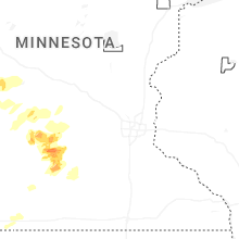
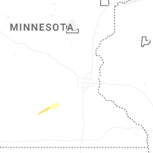


Connect with Interactive Hail Maps