

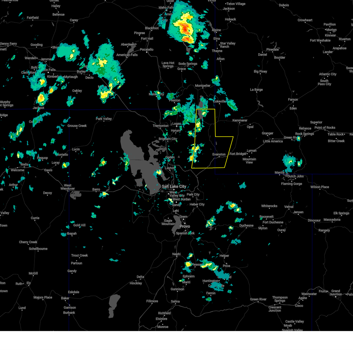
Hail Map for Laketown, UT
The Laketown, UT area has had 0 reports of on-the-ground hail by trained spotters, and has been under severe weather warnings 1 time during the past 12 months. Doppler radar has detected hail at or near Laketown, UT on 6 occasions.
| Name: | Laketown, UT |
| Where Located: | 79.3 miles NNE of Salt Lake City, UT |
| Map: | Google Map for Laketown, UT |
| Population: | 248 |
| Housing Units: | 124 |
| More Info: | Search Google for Laketown, UT |
5
The Top Recent Hail Date for Laketown, UT is Wednesday, August 2, 2023 (2nd out of 6)

Hail and Wind Damage Spotted near Laketown, UT
| Date / Time | Report Details |
|---|---|
| 5/11/2025 2:45 PM MDT |
 Svrslc the national weather service in salt lake city has issued a * severe thunderstorm warning for, east central weber county in northern utah, east central cache county in northern utah, rich county in northern utah, northeastern morgan county in northern utah, northwestern summit county in northern utah, western uinta county in southwestern wyoming, * until 315 pm mdt. * at 244 pm mdt, severe thunderstorms were located along a line extending from 10 miles east of franklin to 8 miles southwest of woodruff to near wanship, moving northeast at 55 mph (radar indicated). Hazards include 70 mph wind gusts. Expect considerable tree damage. Damage is likely to mobile homes, roofs, and outbuildings. Svrslc the national weather service in salt lake city has issued a * severe thunderstorm warning for, east central weber county in northern utah, east central cache county in northern utah, rich county in northern utah, northeastern morgan county in northern utah, northwestern summit county in northern utah, western uinta county in southwestern wyoming, * until 315 pm mdt. * at 244 pm mdt, severe thunderstorms were located along a line extending from 10 miles east of franklin to 8 miles southwest of woodruff to near wanship, moving northeast at 55 mph (radar indicated). Hazards include 70 mph wind gusts. Expect considerable tree damage. Damage is likely to mobile homes, roofs, and outbuildings.
|
| 8/19/2024 11:45 PM MDT | Mesonet station otru1 otter cree in rich county UT, 6.1 miles NNW of Laketown, UT |
| 8/10/2024 4:30 PM MDT | Mesonet station pc367 e bearlak in rich county UT, 4.8 miles SW of Laketown, UT |
| 3/2/2024 12:52 PM MST |
 The storms which prompted the warning have weakened below severe limits, and no longer pose an immediate threat to life or property. therefore, the warning will be allowed to expire. however gusty winds are still possible with these thunderstorms. The storms which prompted the warning have weakened below severe limits, and no longer pose an immediate threat to life or property. therefore, the warning will be allowed to expire. however gusty winds are still possible with these thunderstorms.
|
| 3/2/2024 12:34 PM MST |
 At 1233 pm mst, severe thunderstorms were located along a line extending from 10 miles east of utah state university to 9 miles east of north ogden, moving east at 50 mph (weather station reported. at 1220 pm mst ogden canyon reported a wind gust of 63 mph). Hazards include 60 mph wind gusts. Expect damage to roofs, siding, and trees. locations impacted include, laketown, hyrum, huntsville, nordic valley, causey reservoir, pineview reservoir, eden, powder mountain, avon, snowbasin, and liberty. This includes utah route 30 between mile markers 122 and 124. At 1233 pm mst, severe thunderstorms were located along a line extending from 10 miles east of utah state university to 9 miles east of north ogden, moving east at 50 mph (weather station reported. at 1220 pm mst ogden canyon reported a wind gust of 63 mph). Hazards include 60 mph wind gusts. Expect damage to roofs, siding, and trees. locations impacted include, laketown, hyrum, huntsville, nordic valley, causey reservoir, pineview reservoir, eden, powder mountain, avon, snowbasin, and liberty. This includes utah route 30 between mile markers 122 and 124.
|
| 3/2/2024 12:19 PM MST |
 At 1217 pm mst, a severe thunderstorm was located near saint charles, or 8 miles northwest of bear lake idaho portion, moving northeast at 65 mph (weather station reported. at 1207 pm logan airport gusted to 55 mph and crow mountain, and at 1210 pm crow mountain gusted to 77 mph). Hazards include 70 mph wind gusts. Expect considerable tree damage. damage is likely to mobile homes, roofs, and outbuildings. locations impacted include, logan, laketown, bear lake idaho portion, cache, smithfield, hyrum, wellsville, lewiston, garden city, trenton, bear lake, garden, utah state university, benson, peter, north logan, providence, nibley, hyde park, and richmond. this includes the following highways, us route 89 between mile markers 459 and 502. Utah route 30 between mile markers 110 and 122. At 1217 pm mst, a severe thunderstorm was located near saint charles, or 8 miles northwest of bear lake idaho portion, moving northeast at 65 mph (weather station reported. at 1207 pm logan airport gusted to 55 mph and crow mountain, and at 1210 pm crow mountain gusted to 77 mph). Hazards include 70 mph wind gusts. Expect considerable tree damage. damage is likely to mobile homes, roofs, and outbuildings. locations impacted include, logan, laketown, bear lake idaho portion, cache, smithfield, hyrum, wellsville, lewiston, garden city, trenton, bear lake, garden, utah state university, benson, peter, north logan, providence, nibley, hyde park, and richmond. this includes the following highways, us route 89 between mile markers 459 and 502. Utah route 30 between mile markers 110 and 122.
|
| 3/2/2024 12:09 PM MST |
 Svrslc the national weather service in salt lake city has issued a * severe thunderstorm warning for, weber county in northern utah, southern cache county in northern utah, east central box elder county in northern utah, northwestern rich county in northern utah, * until 100 pm mst. * at 1208 pm mst, severe thunderstorms were located along a line extending from wellsville to near hooper, moving east at 50 mph (weather station observed. at 1155 am mst the brigham city airport reported a wind gust to 70 mph). Hazards include 70 mph wind gusts. Expect considerable tree damage. Damage is likely to mobile homes, roofs, and outbuildings. Svrslc the national weather service in salt lake city has issued a * severe thunderstorm warning for, weber county in northern utah, southern cache county in northern utah, east central box elder county in northern utah, northwestern rich county in northern utah, * until 100 pm mst. * at 1208 pm mst, severe thunderstorms were located along a line extending from wellsville to near hooper, moving east at 50 mph (weather station observed. at 1155 am mst the brigham city airport reported a wind gust to 70 mph). Hazards include 70 mph wind gusts. Expect considerable tree damage. Damage is likely to mobile homes, roofs, and outbuildings.
|
| 3/2/2024 11:51 AM MST |
 Svrslc the national weather service in salt lake city has issued a * severe thunderstorm warning for, cache county in northern utah, northeastern box elder county in northern utah, northwestern rich county in northern utah, * until 1230 pm mst. * at 1150 am mst, a severe thunderstorm was located over trenton, or 12 miles northwest of logan, moving northeast at 60 mph (radar indicated). Hazards include 60 mph wind gusts. expect damage to roofs, siding, and trees Svrslc the national weather service in salt lake city has issued a * severe thunderstorm warning for, cache county in northern utah, northeastern box elder county in northern utah, northwestern rich county in northern utah, * until 1230 pm mst. * at 1150 am mst, a severe thunderstorm was located over trenton, or 12 miles northwest of logan, moving northeast at 60 mph (radar indicated). Hazards include 60 mph wind gusts. expect damage to roofs, siding, and trees
|
| 8/21/2021 7:21 PM MDT |
 The severe thunderstorm warning for northeastern cache and northern rich counties will expire at 730 pm mdt, the storm which prompted the warning has weakened below severe limits, and has exited the warned area. therefore, the warning will be allowed to expire. The severe thunderstorm warning for northeastern cache and northern rich counties will expire at 730 pm mdt, the storm which prompted the warning has weakened below severe limits, and has exited the warned area. therefore, the warning will be allowed to expire.
|
| 8/21/2021 6:57 PM MDT | Measured at the otter creek raws site. time estimated by rada in rich county UT, 6.1 miles NNW of Laketown, UT |
| 8/21/2021 6:48 PM MDT |
 At 647 pm mdt, a severe thunderstorm was located near laketown, moving northeast at 45 mph (radar indicated). Hazards include 60 mph wind gusts and quarter size hail. Hail damage to vehicles is expected. expect wind damage to roofs, siding, and trees. locations impacted include, laketown, garden city, garden, bear lake, meadowville, pickelville, beaver mountain and lakota. this includes the following highways, us route 89 between mile markers 478 and 502. utah route 30 between mile markers 110 and 135. hail threat, radar indicated max hail size, 1. 00 in wind threat, radar indicated max wind gust, 60 mph. At 647 pm mdt, a severe thunderstorm was located near laketown, moving northeast at 45 mph (radar indicated). Hazards include 60 mph wind gusts and quarter size hail. Hail damage to vehicles is expected. expect wind damage to roofs, siding, and trees. locations impacted include, laketown, garden city, garden, bear lake, meadowville, pickelville, beaver mountain and lakota. this includes the following highways, us route 89 between mile markers 478 and 502. utah route 30 between mile markers 110 and 135. hail threat, radar indicated max hail size, 1. 00 in wind threat, radar indicated max wind gust, 60 mph.
|
| 8/21/2021 6:43 PM MDT |
 At 640 pm mdt, severe thunderstorms were located along a line extending from 7 miles east of franklin to 11 miles southwest of laketown, moving east at 50 mph (radar indicated). Hazards include 60 mph wind gusts and quarter size hail. the greatest threat for hail exists in eastern cache county and northern rich county. Hail damage to vehicles is expected. expect wind damage to roofs, siding, and trees. locations impacted include, logan, laketown, smithfield, lewiston, garden city, trenton, garden, utah state university, bear lake, benson, north logan, providence, hyde park, richmond, millville, river heights, amalga, cornish, beaver mountain and meadowville. this includes the following highways, us route 89 between mile markers 459 and 502. utah route 30 between mile markers 110 and 135. hail threat, radar indicated max hail size, 1. 00 in wind threat, radar indicated max wind gust, 60 mph. At 640 pm mdt, severe thunderstorms were located along a line extending from 7 miles east of franklin to 11 miles southwest of laketown, moving east at 50 mph (radar indicated). Hazards include 60 mph wind gusts and quarter size hail. the greatest threat for hail exists in eastern cache county and northern rich county. Hail damage to vehicles is expected. expect wind damage to roofs, siding, and trees. locations impacted include, logan, laketown, smithfield, lewiston, garden city, trenton, garden, utah state university, bear lake, benson, north logan, providence, hyde park, richmond, millville, river heights, amalga, cornish, beaver mountain and meadowville. this includes the following highways, us route 89 between mile markers 459 and 502. utah route 30 between mile markers 110 and 135. hail threat, radar indicated max hail size, 1. 00 in wind threat, radar indicated max wind gust, 60 mph.
|
| 8/21/2021 6:29 PM MDT |
 At 629 pm mdt, severe thunderstorms were located along a line extending from near franklin to 12 miles east of hyrum, moving northeast at 50 mph (radar indicated). Hazards include 60 mph wind gusts. expect damage to roofs, siding, and trees At 629 pm mdt, severe thunderstorms were located along a line extending from near franklin to 12 miles east of hyrum, moving northeast at 50 mph (radar indicated). Hazards include 60 mph wind gusts. expect damage to roofs, siding, and trees
|
| 5/30/2020 4:34 PM MDT |
 At 433 pm mdt, a severe thunderstorm was located over laketown, moving north at 25 mph (radar indicated). Hazards include 60 mph wind gusts. Expect damage to roofs, siding, and trees. locations impacted include, laketown, garden city, bear lake, meadowville and lakota. this includes the following highways, us route 89 between mile markers 490 and 502. Utah route 30 between mile markers 110 and 124. At 433 pm mdt, a severe thunderstorm was located over laketown, moving north at 25 mph (radar indicated). Hazards include 60 mph wind gusts. Expect damage to roofs, siding, and trees. locations impacted include, laketown, garden city, bear lake, meadowville and lakota. this includes the following highways, us route 89 between mile markers 490 and 502. Utah route 30 between mile markers 110 and 124.
|
| 5/30/2020 4:22 PM MDT |
 At 421 pm mdt, a severe thunderstorm was located near laketown, moving northeast at 25 mph (radar indicated). Hazards include 60 mph wind gusts. expect damage to roofs, siding, and trees At 421 pm mdt, a severe thunderstorm was located near laketown, moving northeast at 25 mph (radar indicated). Hazards include 60 mph wind gusts. expect damage to roofs, siding, and trees
|
| 6/2/2019 1:42 PM MDT |
 The severe thunderstorm warning for north central rich county will expire at 145 pm mdt, the storm which prompted the warning has weakened below severe limits, and no longer poses an immediate threat to life or property. therefore, the warning will be allowed to expire. however gusty winds are still possible with this thunderstorm. The severe thunderstorm warning for north central rich county will expire at 145 pm mdt, the storm which prompted the warning has weakened below severe limits, and no longer poses an immediate threat to life or property. therefore, the warning will be allowed to expire. however gusty winds are still possible with this thunderstorm.
|
| 6/2/2019 1:33 PM MDT |
 At 133 pm mdt, a severe thunderstorm was located near laketown, moving north at 15 mph (radar indicated). Hazards include 60 mph wind gusts and quarter size hail. Hail damage to vehicles is expected. expect wind damage to roofs, siding, and trees. Locations impacted include, laketown, garden city, garden, pickelville and lakota. At 133 pm mdt, a severe thunderstorm was located near laketown, moving north at 15 mph (radar indicated). Hazards include 60 mph wind gusts and quarter size hail. Hail damage to vehicles is expected. expect wind damage to roofs, siding, and trees. Locations impacted include, laketown, garden city, garden, pickelville and lakota.
|
| 6/2/2019 1:20 PM MDT |
 At 119 pm mdt, a severe thunderstorm was located over laketown, moving north at 15 mph (radar indicated). Hazards include 60 mph wind gusts and quarter size hail. Hail damage to vehicles is expected. Expect wind damage to roofs, siding, and trees. At 119 pm mdt, a severe thunderstorm was located over laketown, moving north at 15 mph (radar indicated). Hazards include 60 mph wind gusts and quarter size hail. Hail damage to vehicles is expected. Expect wind damage to roofs, siding, and trees.
|
| 8/7/2017 3:55 PM MDT |
 At 354 pm mdt, a severe thunderstorm was located over laketown, moving northeast at 5 mph (radar indicated). Hazards include 60 mph wind gusts and quarter size hail. Hail damage to vehicles is expected. expect wind damage to roofs, siding, and trees. Locations impacted include, laketown, garden city, garden, meadowville and pickelville. At 354 pm mdt, a severe thunderstorm was located over laketown, moving northeast at 5 mph (radar indicated). Hazards include 60 mph wind gusts and quarter size hail. Hail damage to vehicles is expected. expect wind damage to roofs, siding, and trees. Locations impacted include, laketown, garden city, garden, meadowville and pickelville.
|
| 8/7/2017 3:38 PM MDT |
 At 338 pm mdt, doppler radar indicated a severe thunderstorm capable of producing quarter size hail and damaging winds in excess of 60 mph. this storm was located over laketown, and moving northeast at 15 mph. At 338 pm mdt, doppler radar indicated a severe thunderstorm capable of producing quarter size hail and damaging winds in excess of 60 mph. this storm was located over laketown, and moving northeast at 15 mph.
|
| 9/22/2016 4:52 PM MDT |
 At 449 pm mdt, doppler radar indicated severe thunderstorms capable of producing damaging winds in excess of 60 mph. these storms were located along a line extending from 6 miles northwest of saint charles to near woodruff, moving northeast at 40 mph. locations impacted include, laketown, garden city, garden, richmond, beaver mtn, pickelville, meadowville and lakota. At 449 pm mdt, doppler radar indicated severe thunderstorms capable of producing damaging winds in excess of 60 mph. these storms were located along a line extending from 6 miles northwest of saint charles to near woodruff, moving northeast at 40 mph. locations impacted include, laketown, garden city, garden, richmond, beaver mtn, pickelville, meadowville and lakota.
|
| 9/22/2016 4:22 PM MDT |
 At 420 pm mdt, doppler radar indicated a line of severe thunderstorms capable of producing destructive winds in excess of 70 mph. these storms were located along a line extending from near lewiston to 20 miles west of woodruff, and moving northeast at 40 mph. penny size hail may also accompany the damaging winds. At 420 pm mdt, doppler radar indicated a line of severe thunderstorms capable of producing destructive winds in excess of 70 mph. these storms were located along a line extending from near lewiston to 20 miles west of woodruff, and moving northeast at 40 mph. penny size hail may also accompany the damaging winds.
|
| 6/10/2015 8:45 PM MDT | Otter creek sensor otru1 in rich county UT, 6.1 miles NNW of Laketown, UT |
| 6/3/2015 9:43 PM MDT | The severe thunderstorm warning for northeastern cache and rich counties will expire at 945 pm mdt, the storm which prompted the warning has weakened below severe limits. wind gusts to 50 mph are still possible with this storm. this includes bear lake. |
| 6/3/2015 9:12 PM MDT | At 912 pm mdt, trained weather spotters reported a severe thunderstorm producing damaging winds in excess of 60 mph. this storm was located 8 miles southwest of garden, or 10 miles west of laketown, and moving northeast at 30 mph. |
| 1/1/0001 12:00 AM | Otter creek raw in rich county UT, 6.1 miles NNW of Laketown, UT |
Hail Maps for Laketown, UT


Connect with Interactive Hail Maps