

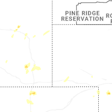
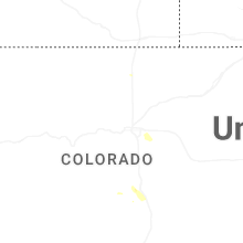
Hail Map for Laporte, CO
The Laporte, CO area has had 3 reports of on-the-ground hail by trained spotters, and has been under severe weather warnings 0 times during the past 12 months. Doppler radar has detected hail at or near Laporte, CO on 53 occasions, including 6 occasions during the past year.
| Name: | Laporte, CO |
| Where Located: | 51.8 miles SSE of Laramie, WY |
| Map: | Google Map for Laporte, CO |
| Population: | 2450 |
| Housing Units: | 1126 |
| More Info: | Search Google for Laporte, CO |
2
The Top Recent Hail Date for Laporte, CO is Saturday, July 20, 2024 (10th out of 53)

Hail and Wind Damage Spotted near Laporte, CO
| Date / Time | Report Details |
|---|---|
| 6/8/2024 1:55 PM MDT |
 The storm which prompted the warning has weakened below severe limits, and no longer poses an immediate threat to life or property. therefore, the warning will be allowed to expire. however, gusty winds up to 40 mph are still possible with this thunderstorm. a severe thunderstorm watch remains in effect until 700 pm mdt for north central colorado. The storm which prompted the warning has weakened below severe limits, and no longer poses an immediate threat to life or property. therefore, the warning will be allowed to expire. however, gusty winds up to 40 mph are still possible with this thunderstorm. a severe thunderstorm watch remains in effect until 700 pm mdt for north central colorado.
|
| 6/8/2024 1:30 PM MDT |
 At 130 pm mdt, a severe thunderstorm was located near poudre park, or 18 miles northwest of fort collins, moving east at 40 mph (radar indicated). Hazards include 60 mph wind gusts and quarter size hail. Expect damage to roofs, siding, and trees. hail damage to vehicles is expected. Locations impacted include, wellington, mishawaka, poudre park, livermore, and teds place. At 130 pm mdt, a severe thunderstorm was located near poudre park, or 18 miles northwest of fort collins, moving east at 40 mph (radar indicated). Hazards include 60 mph wind gusts and quarter size hail. Expect damage to roofs, siding, and trees. hail damage to vehicles is expected. Locations impacted include, wellington, mishawaka, poudre park, livermore, and teds place.
|
| 6/8/2024 1:15 PM MDT |
 Svrbou the national weather service in denver colorado has issued a * severe thunderstorm warning for, northeastern larimer county in north central colorado, * until 200 pm mdt. * at 114 pm mdt, a severe thunderstorm was located 4 miles northeast of rustic, or 26 miles northwest of fort collins, moving east at 40 mph (radar indicated). Hazards include 60 mph wind gusts and quarter size hail. Expect damage to roofs, siding, and trees. hail damage to vehicles is expected. this severe thunderstorm will be near, red feather lakes around 120 pm mdt. mishawaka around 125 pm mdt. poudre park around 130 pm mdt. Other locations in the path of this severe thunderstorm include livermore and wellington. Svrbou the national weather service in denver colorado has issued a * severe thunderstorm warning for, northeastern larimer county in north central colorado, * until 200 pm mdt. * at 114 pm mdt, a severe thunderstorm was located 4 miles northeast of rustic, or 26 miles northwest of fort collins, moving east at 40 mph (radar indicated). Hazards include 60 mph wind gusts and quarter size hail. Expect damage to roofs, siding, and trees. hail damage to vehicles is expected. this severe thunderstorm will be near, red feather lakes around 120 pm mdt. mishawaka around 125 pm mdt. poudre park around 130 pm mdt. Other locations in the path of this severe thunderstorm include livermore and wellington.
|
| 8/3/2023 5:11 PM MDT |
 At 511 pm mdt, a severe thunderstorm was located 4 miles west of masonville, or 11 miles west of fort collins, moving northeast at 15 mph (radar indicated). Hazards include 60 mph wind gusts and quarter size hail. Expect damage to roofs, siding, and trees. hail damage to vehicles is expected. this severe thunderstorm will be near, masonville around 525 pm mdt. other locations in the path of this severe thunderstorm include fort collins and bellvue. hail threat, radar indicated max hail size, 1. 00 in wind threat, radar indicated max wind gust, 60 mph. At 511 pm mdt, a severe thunderstorm was located 4 miles west of masonville, or 11 miles west of fort collins, moving northeast at 15 mph (radar indicated). Hazards include 60 mph wind gusts and quarter size hail. Expect damage to roofs, siding, and trees. hail damage to vehicles is expected. this severe thunderstorm will be near, masonville around 525 pm mdt. other locations in the path of this severe thunderstorm include fort collins and bellvue. hail threat, radar indicated max hail size, 1. 00 in wind threat, radar indicated max wind gust, 60 mph.
|
| 8/3/2023 4:34 PM MDT |
 At 434 pm mdt, a severe thunderstorm was located near teds place, or 11 miles northwest of fort collins, moving east at 15 mph (radar indicated). Hazards include 60 mph wind gusts and quarter size hail. Expect damage to roofs, siding, and trees. hail damage to vehicles is expected. locations impacted include, bellvue. hail threat, radar indicated max hail size, 1. 00 in wind threat, radar indicated max wind gust, 60 mph. At 434 pm mdt, a severe thunderstorm was located near teds place, or 11 miles northwest of fort collins, moving east at 15 mph (radar indicated). Hazards include 60 mph wind gusts and quarter size hail. Expect damage to roofs, siding, and trees. hail damage to vehicles is expected. locations impacted include, bellvue. hail threat, radar indicated max hail size, 1. 00 in wind threat, radar indicated max wind gust, 60 mph.
|
| 8/3/2023 3:59 PM MDT |
 At 358 pm mdt, a severe thunderstorm was located 5 miles west of livermore, or 20 miles northwest of fort collins, moving east at 5 mph (radar indicated). Hazards include 60 mph wind gusts and quarter size hail. Expect damage to roofs, siding, and trees. hail damage to vehicles is expected. this severe thunderstorm will be near, poudre park around 410 pm mdt. other locations in the path of this severe thunderstorm include livermore. hail threat, radar indicated max hail size, 1. 00 in wind threat, radar indicated max wind gust, 60 mph. At 358 pm mdt, a severe thunderstorm was located 5 miles west of livermore, or 20 miles northwest of fort collins, moving east at 5 mph (radar indicated). Hazards include 60 mph wind gusts and quarter size hail. Expect damage to roofs, siding, and trees. hail damage to vehicles is expected. this severe thunderstorm will be near, poudre park around 410 pm mdt. other locations in the path of this severe thunderstorm include livermore. hail threat, radar indicated max hail size, 1. 00 in wind threat, radar indicated max wind gust, 60 mph.
|
| 7/31/2023 8:03 PM MDT |
 At 802 pm mdt, a severe thunderstorm was located over northern fort collins, and is nearly stationary. a second storm was located east of wellington, and is also nearly stationary (radar indicated). Hazards include 60 mph wind gusts and quarter size hail. Expect damage to roofs, siding, and trees. hail damage to vehicles is expected. Locations impacted include, northern fort collins, windsor, wellington, timnath, nunn and teds place. At 802 pm mdt, a severe thunderstorm was located over northern fort collins, and is nearly stationary. a second storm was located east of wellington, and is also nearly stationary (radar indicated). Hazards include 60 mph wind gusts and quarter size hail. Expect damage to roofs, siding, and trees. hail damage to vehicles is expected. Locations impacted include, northern fort collins, windsor, wellington, timnath, nunn and teds place.
|
| 7/31/2023 7:30 PM MDT |
 At 729 pm mdt, a severe thunderstorm was located over wellington, or 9 miles northeast of fort collins, moving southwest at 5 mph (radar indicated). Hazards include 60 mph wind gusts and quarter size hail. Expect damage to roofs, siding, and trees. Hail damage to vehicles is expected. At 729 pm mdt, a severe thunderstorm was located over wellington, or 9 miles northeast of fort collins, moving southwest at 5 mph (radar indicated). Hazards include 60 mph wind gusts and quarter size hail. Expect damage to roofs, siding, and trees. Hail damage to vehicles is expected.
|
| 6/21/2023 7:36 PM MDT |
 At 736 pm mdt, a severe thunderstorm was located near fort collins, moving northeast at 15 mph (radar indicated). Hazards include half dollar size hail. Damage to vehicles is expected. this severe thunderstorm will be near, timnath around 740 pm mdt. windsor around 750 pm mdt. other locations in the path of this severe thunderstorm include wellington and severance. hail threat, radar indicated max hail size, 1. 25 in wind threat, radar indicated max wind gust, <50 mph. At 736 pm mdt, a severe thunderstorm was located near fort collins, moving northeast at 15 mph (radar indicated). Hazards include half dollar size hail. Damage to vehicles is expected. this severe thunderstorm will be near, timnath around 740 pm mdt. windsor around 750 pm mdt. other locations in the path of this severe thunderstorm include wellington and severance. hail threat, radar indicated max hail size, 1. 25 in wind threat, radar indicated max wind gust, <50 mph.
|
| 5/31/2023 4:43 PM MDT |
 The severe thunderstorm warning for west central weld and southeastern larimer counties will expire at 445 pm mdt, the storm which prompted the warning has weakened below severe limits, and has exited the warned area. therefore, the warning will be allowed to expire. The severe thunderstorm warning for west central weld and southeastern larimer counties will expire at 445 pm mdt, the storm which prompted the warning has weakened below severe limits, and has exited the warned area. therefore, the warning will be allowed to expire.
|
| 5/31/2023 4:32 PM MDT |
 At 431 pm mdt, a severe thunderstorm was located near timnath, or 5 miles southeast of fort collins, moving north at 35 mph (radar indicated). Hazards include 60 mph wind gusts and penny size hail. Expect damage to roofs, siding, and trees. locations impacted include, fort collins, western greeley, loveland, windsor, severance and timnath. hail threat, radar indicated max hail size, 0. 75 in wind threat, observed max wind gust, 60 mph. At 431 pm mdt, a severe thunderstorm was located near timnath, or 5 miles southeast of fort collins, moving north at 35 mph (radar indicated). Hazards include 60 mph wind gusts and penny size hail. Expect damage to roofs, siding, and trees. locations impacted include, fort collins, western greeley, loveland, windsor, severance and timnath. hail threat, radar indicated max hail size, 0. 75 in wind threat, observed max wind gust, 60 mph.
|
| 5/31/2023 4:19 PM MDT |
 At 416 pm mdt, a severe thunderstorm was located near johnstown, or 12 miles west of greeley, moving north at 25 mph (media reported large tree limb down and winds around 64 mph in milliken before 4 pm). Hazards include 60 mph wind gusts and quarter size hail. Expect damage to roofs, siding, and trees. hail damage to vehicles is expected. locations impacted include, fort collins, western greeley, loveland, windsor, johnstown, milliken, berthoud, mead, severance and timnath. hail threat, radar indicated max hail size, 1. 00 in wind threat, observed max wind gust, 60 mph. At 416 pm mdt, a severe thunderstorm was located near johnstown, or 12 miles west of greeley, moving north at 25 mph (media reported large tree limb down and winds around 64 mph in milliken before 4 pm). Hazards include 60 mph wind gusts and quarter size hail. Expect damage to roofs, siding, and trees. hail damage to vehicles is expected. locations impacted include, fort collins, western greeley, loveland, windsor, johnstown, milliken, berthoud, mead, severance and timnath. hail threat, radar indicated max hail size, 1. 00 in wind threat, observed max wind gust, 60 mph.
|
| 5/31/2023 4:04 PM MDT |
 At 404 pm mdt, a severe thunderstorm was located near johnstown, or 14 miles southwest of greeley, moving north at 35 mph (radar indicated). Hazards include quarter size hail. damage to vehicles is expected At 404 pm mdt, a severe thunderstorm was located near johnstown, or 14 miles southwest of greeley, moving north at 35 mph (radar indicated). Hazards include quarter size hail. damage to vehicles is expected
|
| 7/13/2020 4:08 PM MDT |
 At 407 pm mdt, severe thunderstorms were located along a line extending from 5 miles east of pumpkin vine to fort collins to 4 miles south of carter lake, or along a line extending from 22 miles southeast of laramie to 21 miles northwest of greeley to 40 miles north of denver, moving east at 45 mph (radar indicated). Hazards include 60 mph wind gusts. Expect damage to roofs, siding, and trees. Locations impacted include, fort collins, greeley, loveland, windsor, evans, johnstown, wellington, milliken, berthoud, eaton, mead, severance, platteville, lyons, lasalle, ault, gilcrest, pierce, timnath and nunn. At 407 pm mdt, severe thunderstorms were located along a line extending from 5 miles east of pumpkin vine to fort collins to 4 miles south of carter lake, or along a line extending from 22 miles southeast of laramie to 21 miles northwest of greeley to 40 miles north of denver, moving east at 45 mph (radar indicated). Hazards include 60 mph wind gusts. Expect damage to roofs, siding, and trees. Locations impacted include, fort collins, greeley, loveland, windsor, evans, johnstown, wellington, milliken, berthoud, eaton, mead, severance, platteville, lyons, lasalle, ault, gilcrest, pierce, timnath and nunn.
|
| 7/13/2020 3:36 PM MDT |
 At 335 pm mdt, severe thunderstorms were located along a line extending from 11 miles south of hutton lake to 6 miles west of buckhorn mountain to near allenspark, or along a line extending from 22 miles south of laramie to 20 miles west of fort collins to 43 miles northwest of denver, moving east at 45 mph (radar indicated). Hazards include 60 mph wind gusts. expect damage to roofs, siding, and trees At 335 pm mdt, severe thunderstorms were located along a line extending from 11 miles south of hutton lake to 6 miles west of buckhorn mountain to near allenspark, or along a line extending from 22 miles south of laramie to 20 miles west of fort collins to 43 miles northwest of denver, moving east at 45 mph (radar indicated). Hazards include 60 mph wind gusts. expect damage to roofs, siding, and trees
|
| 6/6/2020 3:46 PM MDT |
 At 342 pm mdt, severe thunderstorms were located along a line extending from 3 miles north of drake to near aspen springs to 7 miles west of elevenmile canyon reservoir, or along a line extending from 15 miles west of fort collins to 28 miles west of denver to 39 miles north of hayden pass burn scar, the storms are moving northeast at 60 mph. these are very dangerous storms (an automated weather station in lakewood recorded a peak wind gust to 70 mph at bear creek golf club in southwest lakewood). Hazards include 75 mph wind gusts. Flying debris will be dangerous to those caught without shelter. mobile homes will be heavily damaged. expect considerable damage to roofs, windows, and vehicles. extensive tree damage and power outages are likely. Locations impacted include, denver, fort collins, greeley, aurora, lakewood, thornton, arvada, westminster, centennial, boulder, longmont, loveland, broomfield, highlands ranch, castle rock, commerce city, parker, littleton, northglenn and brighton. At 342 pm mdt, severe thunderstorms were located along a line extending from 3 miles north of drake to near aspen springs to 7 miles west of elevenmile canyon reservoir, or along a line extending from 15 miles west of fort collins to 28 miles west of denver to 39 miles north of hayden pass burn scar, the storms are moving northeast at 60 mph. these are very dangerous storms (an automated weather station in lakewood recorded a peak wind gust to 70 mph at bear creek golf club in southwest lakewood). Hazards include 75 mph wind gusts. Flying debris will be dangerous to those caught without shelter. mobile homes will be heavily damaged. expect considerable damage to roofs, windows, and vehicles. extensive tree damage and power outages are likely. Locations impacted include, denver, fort collins, greeley, aurora, lakewood, thornton, arvada, westminster, centennial, boulder, longmont, loveland, broomfield, highlands ranch, castle rock, commerce city, parker, littleton, northglenn and brighton.
|
| 6/6/2020 3:03 PM MDT |
 At 303 pm mdt, severe thunderstorms were located along a line extending from 3 miles north of drake to near aspen springs to 8 miles west of elevenmile canyon reservoir, or along a line extending from 15 miles west of fort collins to 28 miles west of denver to 39 miles north of hayden pass burn scar, moving northeast at 65 mph. these are very dangerous storms (radar indicated). Hazards include 80 mph wind gusts. Flying debris will be dangerous to those caught without shelter. mobile homes will be heavily damaged. expect considerable damage to roofs, windows, and vehicles. Extensive tree damage and power outages are likely. At 303 pm mdt, severe thunderstorms were located along a line extending from 3 miles north of drake to near aspen springs to 8 miles west of elevenmile canyon reservoir, or along a line extending from 15 miles west of fort collins to 28 miles west of denver to 39 miles north of hayden pass burn scar, moving northeast at 65 mph. these are very dangerous storms (radar indicated). Hazards include 80 mph wind gusts. Flying debris will be dangerous to those caught without shelter. mobile homes will be heavily damaged. expect considerable damage to roofs, windows, and vehicles. Extensive tree damage and power outages are likely.
|
| 6/20/2019 5:01 PM MDT |
 At 500 pm mdt, a severe thunderstorm was located over eastern fort collins, moving east at 20 mph. nickel size hail was reported on the south side of fort collins at 543 pm (radar indicated). Hazards include quarter size hail. damage to vehicles is expected At 500 pm mdt, a severe thunderstorm was located over eastern fort collins, moving east at 20 mph. nickel size hail was reported on the south side of fort collins at 543 pm (radar indicated). Hazards include quarter size hail. damage to vehicles is expected
|
| 11/2/2018 11:36 PM MDT |
 The severe thunderstorm warning for west central weld and southeastern larimer counties will expire at 1145 pm mdt, the storm which prompted the warning has weakened below severe limits, and no longer poses an immediate threat to life or property. therefore, the warning will be allowed to expire. however gusty winds up to 45 mph are still possible with these weakening showers. The severe thunderstorm warning for west central weld and southeastern larimer counties will expire at 1145 pm mdt, the storm which prompted the warning has weakened below severe limits, and no longer poses an immediate threat to life or property. therefore, the warning will be allowed to expire. however gusty winds up to 45 mph are still possible with these weakening showers.
|
| 11/2/2018 11:02 PM MDT |
 At 1101 pm mdt, a strong storm was located over eastern loveland, or 10 miles south of fort collins, moving southeast at 35 mph (radar indicated). Hazards include 60 mph wind gusts. expect damage to roofs, siding, and trees At 1101 pm mdt, a strong storm was located over eastern loveland, or 10 miles south of fort collins, moving southeast at 35 mph (radar indicated). Hazards include 60 mph wind gusts. expect damage to roofs, siding, and trees
|
| 7/29/2018 7:00 PM MDT |
 At 659 pm mdt, a severe thunderstorm was located over western fort collins, moving southeast at 50 mph (radar indicated). Hazards include two inch hail and 70 mph wind gusts. Expect considerable tree damage. damage is likely to mobile homes, roofs, and outbuildings. people and animals outdoors will be injured. expect hail damage to roofs, siding, windows, and vehicles. locations impacted include, fort collins, loveland, windsor, johnstown, wellington, milliken, berthoud, timnath, masonville and bellvue. A tornado watch remains in effect until 900 pm mdt for northeastern colorado. At 659 pm mdt, a severe thunderstorm was located over western fort collins, moving southeast at 50 mph (radar indicated). Hazards include two inch hail and 70 mph wind gusts. Expect considerable tree damage. damage is likely to mobile homes, roofs, and outbuildings. people and animals outdoors will be injured. expect hail damage to roofs, siding, windows, and vehicles. locations impacted include, fort collins, loveland, windsor, johnstown, wellington, milliken, berthoud, timnath, masonville and bellvue. A tornado watch remains in effect until 900 pm mdt for northeastern colorado.
|
| 7/29/2018 6:49 PM MDT | Quarter sized hail reported 11.9 miles SSE of Laporte, CO |
| 7/29/2018 6:43 PM MDT |
 At 643 pm mdt, a severe thunderstorm was located over poudre park, or 15 miles northwest of fort collins, moving southeast at 50 mph (radar indicated). Hazards include two inch hail and 70 mph wind gusts. Expect considerable tree damage. damage is likely to mobile homes, roofs, and outbuildings. people and animals outdoors will be injured. Expect hail damage to roofs, siding, windows, and vehicles. At 643 pm mdt, a severe thunderstorm was located over poudre park, or 15 miles northwest of fort collins, moving southeast at 50 mph (radar indicated). Hazards include two inch hail and 70 mph wind gusts. Expect considerable tree damage. damage is likely to mobile homes, roofs, and outbuildings. people and animals outdoors will be injured. Expect hail damage to roofs, siding, windows, and vehicles.
|
| 7/4/2018 6:19 PM MDT |
 At 540 pm mdt, a severe thunderstorm was located near bellvue, or 8 miles west of fort collins, moving north at 15 mph (radar indicated). Hazards include 60 mph wind gusts and quarter size hail. Expect damage to roofs, siding, and trees. Hail damage to vehicles is expected. At 540 pm mdt, a severe thunderstorm was located near bellvue, or 8 miles west of fort collins, moving north at 15 mph (radar indicated). Hazards include 60 mph wind gusts and quarter size hail. Expect damage to roofs, siding, and trees. Hail damage to vehicles is expected.
|
| 7/4/2018 5:41 PM MDT |
 At 540 pm mdt, a severe thunderstorm was located near bellvue, or 8 miles west of fort collins, moving north at 15 mph (radar indicated). Hazards include 60 mph wind gusts and quarter size hail. Expect damage to roofs, siding, and trees. Hail damage to vehicles is expected. At 540 pm mdt, a severe thunderstorm was located near bellvue, or 8 miles west of fort collins, moving north at 15 mph (radar indicated). Hazards include 60 mph wind gusts and quarter size hail. Expect damage to roofs, siding, and trees. Hail damage to vehicles is expected.
|
| 6/30/2018 4:54 PM MDT | Quarter sized hail reported 7.2 miles E of Laporte, CO |
| 6/19/2018 4:28 PM MDT |
 At 427 pm mdt, a severe thunderstorm was located near fort collins, moving east at 25 mph (trained weather spotters). Hazards include golf ball size hail was reported north in fort collins. People and animals outdoors will be injured. expect damage to roofs, siding, windows, and vehicles. locations impacted include, fort collins, windsor, wellington and timnath. A tornado watch remains in effect until 700 pm mdt for north central and northeastern colorado. At 427 pm mdt, a severe thunderstorm was located near fort collins, moving east at 25 mph (trained weather spotters). Hazards include golf ball size hail was reported north in fort collins. People and animals outdoors will be injured. expect damage to roofs, siding, windows, and vehicles. locations impacted include, fort collins, windsor, wellington and timnath. A tornado watch remains in effect until 700 pm mdt for north central and northeastern colorado.
|
| 6/19/2018 4:24 PM MDT |
 At 414 pm mdt, a severe thunderstorm was located near bellvue, or 5 miles northwest of fort collins, moving east at 25 mph (radar indicated). Hazards include 60 mph wind gusts and quarter size hail. Expect damage to roofs, siding, and trees. Hail damage to vehicles is expected. At 414 pm mdt, a severe thunderstorm was located near bellvue, or 5 miles northwest of fort collins, moving east at 25 mph (radar indicated). Hazards include 60 mph wind gusts and quarter size hail. Expect damage to roofs, siding, and trees. Hail damage to vehicles is expected.
|
| 6/19/2018 4:15 PM MDT |
 At 414 pm mdt, a severe thunderstorm was located near bellvue, or 5 miles northwest of fort collins, moving east at 25 mph (radar indicated). Hazards include 60 mph wind gusts and quarter size hail. Expect damage to roofs, siding, and trees. Hail damage to vehicles is expected. At 414 pm mdt, a severe thunderstorm was located near bellvue, or 5 miles northwest of fort collins, moving east at 25 mph (radar indicated). Hazards include 60 mph wind gusts and quarter size hail. Expect damage to roofs, siding, and trees. Hail damage to vehicles is expected.
|
| 6/19/2018 2:02 PM MDT |
 At 202 pm mdt, a severe thunderstorm was located over wellington, or 11 miles north of fort collins, moving southeast at 20 mph (radar indicated). Hazards include ping pong ball size hail and 60 mph wind gusts. Expect damage to roofs, siding, and trees. people and animals outdoors will be injured. Expect hail damage to roofs, siding, windows, and vehicles. At 202 pm mdt, a severe thunderstorm was located over wellington, or 11 miles north of fort collins, moving southeast at 20 mph (radar indicated). Hazards include ping pong ball size hail and 60 mph wind gusts. Expect damage to roofs, siding, and trees. people and animals outdoors will be injured. Expect hail damage to roofs, siding, windows, and vehicles.
|
| 6/19/2018 1:51 PM MDT |
 At 150 pm mdt, a severe thunderstorm was located 7 miles north of wellington, or 17 miles north of fort collins, moving east at 20 mph (radar indicated). Hazards include two inch hail and 60 mph wind gusts. Expect damage to roofs, siding, and trees. people and animals outdoors will be injured. expect hail damage to roofs, siding, windows, and vehicles. locations impacted include, northeastern fort collins, wellington and teds place. A tornado watch remains in effect until 700 pm mdt for north central and northeastern colorado. At 150 pm mdt, a severe thunderstorm was located 7 miles north of wellington, or 17 miles north of fort collins, moving east at 20 mph (radar indicated). Hazards include two inch hail and 60 mph wind gusts. Expect damage to roofs, siding, and trees. people and animals outdoors will be injured. expect hail damage to roofs, siding, windows, and vehicles. locations impacted include, northeastern fort collins, wellington and teds place. A tornado watch remains in effect until 700 pm mdt for north central and northeastern colorado.
|
| 6/19/2018 1:18 PM MDT |
 At 118 pm mdt, a severe thunderstorm was located 4 miles north of livermore, or 22 miles northwest of fort collins, moving east at 20 mph (trained weather spotters). Hazards include two inch hail and 60 mph wind gusts. Expect damage to roofs, siding, and trees. people and animals outdoors will be injured. Expect hail damage to roofs, siding, windows, and vehicles. At 118 pm mdt, a severe thunderstorm was located 4 miles north of livermore, or 22 miles northwest of fort collins, moving east at 20 mph (trained weather spotters). Hazards include two inch hail and 60 mph wind gusts. Expect damage to roofs, siding, and trees. people and animals outdoors will be injured. Expect hail damage to roofs, siding, windows, and vehicles.
|
| 5/22/2018 6:12 PM MDT |
 At 612 pm mdt, a severe thunderstorm was located near fort collins, moving north at 20 mph (trained weather spotters). Hazards include 60 mph wind gusts and quarter size hail. Hail damage to vehicles is expected. expect wind damage to roofs, siding, and trees. Locations impacted include, fort collins, wellington, timnath, bellvue, livermore and teds place. At 612 pm mdt, a severe thunderstorm was located near fort collins, moving north at 20 mph (trained weather spotters). Hazards include 60 mph wind gusts and quarter size hail. Hail damage to vehicles is expected. expect wind damage to roofs, siding, and trees. Locations impacted include, fort collins, wellington, timnath, bellvue, livermore and teds place.
|
| 5/22/2018 6:01 PM MDT |
 At 601 pm mdt, a severe thunderstorm was located over southwestern fort collins, moving north at 20 mph (trained weather spotters). Hazards include quarter size hail. damage to vehicles is expected At 601 pm mdt, a severe thunderstorm was located over southwestern fort collins, moving north at 20 mph (trained weather spotters). Hazards include quarter size hail. damage to vehicles is expected
|
| 8/10/2017 3:02 PM MDT |
 At 301 pm mdt, a severe thunderstorm was located near bellvue, or 5 miles northwest of fort collins, moving southeast at 35 mph (radar indicated). Hazards include half dollar size hail. damage to vehicles is expected At 301 pm mdt, a severe thunderstorm was located near bellvue, or 5 miles northwest of fort collins, moving southeast at 35 mph (radar indicated). Hazards include half dollar size hail. damage to vehicles is expected
|
| 8/10/2017 2:28 PM MDT |
 At 227 pm mdt, a severe thunderstorm was located 5 miles east of rustic, or 23 miles northwest of fort collins, moving southeast at 25 mph (radar indicated). Hazards include ping pong ball size hail. People and animals outdoors will be injured. Expect damage to roofs, siding, windows, and vehicles. At 227 pm mdt, a severe thunderstorm was located 5 miles east of rustic, or 23 miles northwest of fort collins, moving southeast at 25 mph (radar indicated). Hazards include ping pong ball size hail. People and animals outdoors will be injured. Expect damage to roofs, siding, windows, and vehicles.
|
| 7/6/2017 3:12 PM MDT |
 At 312 pm mdt, a severe thunderstorm was located over northwestern fort collins, moving southeast at 15 mph (radar indicated). Hazards include 60 mph wind gusts and quarter size hail. Hail damage to vehicles is expected. Expect wind damage to roofs, siding, and trees. At 312 pm mdt, a severe thunderstorm was located over northwestern fort collins, moving southeast at 15 mph (radar indicated). Hazards include 60 mph wind gusts and quarter size hail. Hail damage to vehicles is expected. Expect wind damage to roofs, siding, and trees.
|
| 6/17/2016 3:47 PM MDT | Golf Ball sized hail reported 12.5 miles E of Laporte, CO |
| 6/17/2016 3:33 PM MDT |
 At 332 pm mdt, a severe thunderstorm was located near mishawaka, or 20 miles west of fort collins, moving southeast at 15 mph (radar indicated). Hazards include 60 mph wind gusts and quarter size hail. Hail damage to vehicles is expected. Expect wind damage to roofs, siding, and trees. At 332 pm mdt, a severe thunderstorm was located near mishawaka, or 20 miles west of fort collins, moving southeast at 15 mph (radar indicated). Hazards include 60 mph wind gusts and quarter size hail. Hail damage to vehicles is expected. Expect wind damage to roofs, siding, and trees.
|
| 6/16/2015 4:40 PM MDT |
 The severe thunderstorm warning for east central larimer and west central weld counties will expire at 445 pm mdt, the storm which prompted the warning has weakened below severe limits, and no longer poses an immediate threat to life or property. therefore the warning will be allowed to expire. however, hail and gusty winds are still possible with this thunderstorm. a severe thunderstorm watch remains in effect until 1000 pm mdt for northeastern colorado. The severe thunderstorm warning for east central larimer and west central weld counties will expire at 445 pm mdt, the storm which prompted the warning has weakened below severe limits, and no longer poses an immediate threat to life or property. therefore the warning will be allowed to expire. however, hail and gusty winds are still possible with this thunderstorm. a severe thunderstorm watch remains in effect until 1000 pm mdt for northeastern colorado.
|
| 6/16/2015 4:19 PM MDT |
 At 418 pm mdt, a severe thunderstorm was located near wellington, or 8 miles north of fort collins, moving southeast at 20 mph (radar indicated). Hazards include half dollar size hail and 60 mph wind gusts. Hail damage to vehicles is expected. expect wind damage to roofs, siding and trees. Locations impacted include, fort collins, northeastern loveland, windsor, wellington, severance, ault, pierce, timnath and teds place. At 418 pm mdt, a severe thunderstorm was located near wellington, or 8 miles north of fort collins, moving southeast at 20 mph (radar indicated). Hazards include half dollar size hail and 60 mph wind gusts. Hail damage to vehicles is expected. expect wind damage to roofs, siding and trees. Locations impacted include, fort collins, northeastern loveland, windsor, wellington, severance, ault, pierce, timnath and teds place.
|
| 6/16/2015 4:00 PM MDT |
 At 359 pm mdt, a severe thunderstorm was located near teds place, or 11 miles north of fort collins, moving southeast at 25 mph (radar indicated). Hazards include 60 mph wind gusts and half dollar size hail. Hail damage to vehicles is expected. Expect wind damage to roofs, siding and trees. At 359 pm mdt, a severe thunderstorm was located near teds place, or 11 miles north of fort collins, moving southeast at 25 mph (radar indicated). Hazards include 60 mph wind gusts and half dollar size hail. Hail damage to vehicles is expected. Expect wind damage to roofs, siding and trees.
|
| 6/4/2015 6:20 PM MDT | At 618 pm mdt, a severe thunderstorm was located near wellington, or 13 miles north of fort collins, moving north at 25 mph (trained weather spotters in fort collins and wellington have reported hail one inch to one-and-a-half inches since 600 pm mdt). Hazards include half dollar size hail. Damage to vehicles is expected. locations impacted include, fort collins, northeastern loveland, windsor, wellington, timnath and bellvue. A tornado watch remains in effect until 1000 pm mdt for northeastern colorado. |
| 6/4/2015 5:54 PM MDT | At 553 pm mdt, a severe thunderstorm was located over northeastern fort collins, moving north at 25 mph (trained weather spotters on the north side of fort collins reported half-dollar size hail at 552 pm mdt). Hazards include half dollar size hail. damage to vehicles is expected |
| 6/3/2015 7:18 PM MDT | At 718 pm mdt, a severe thunderstorm was located over loveland, or 8 miles south of fort collins, moving north at 35 mph (radar indicated). Hazards include ping pong ball size hail and 60 mph wind gusts. People and animals outdoors will be injured. expect hail damage to roofs, siding, windows and vehicles. Expect wind damage to roofs, siding and trees. |
Hail Maps for Laporte, CO


Connect with Interactive Hail Maps