

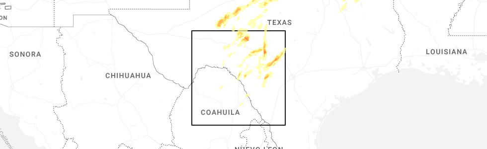
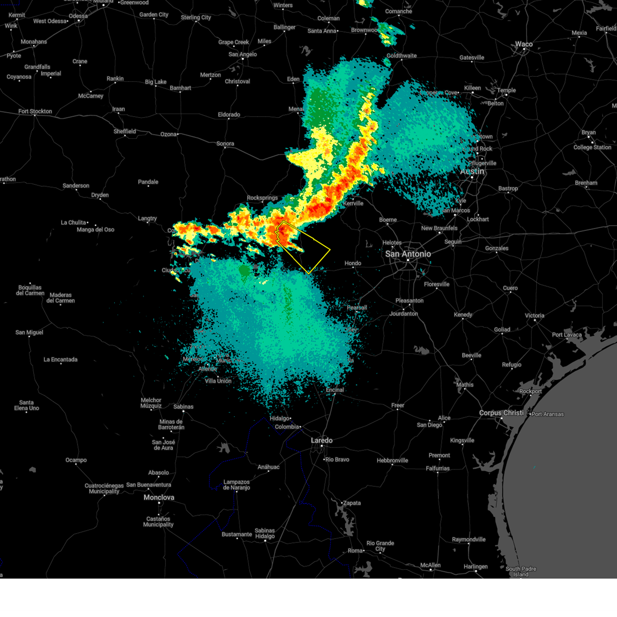
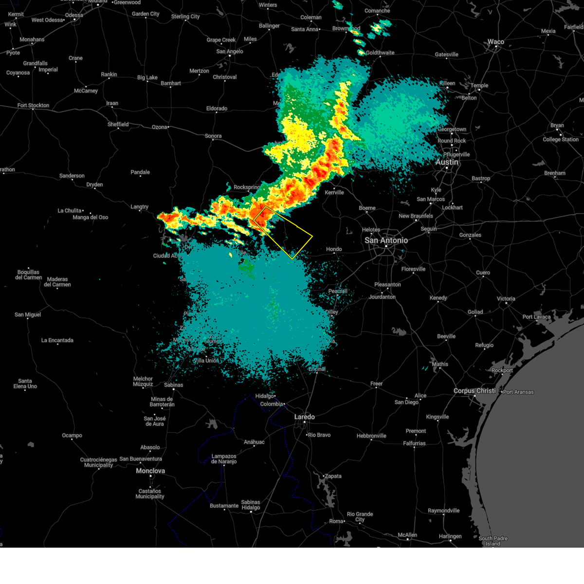
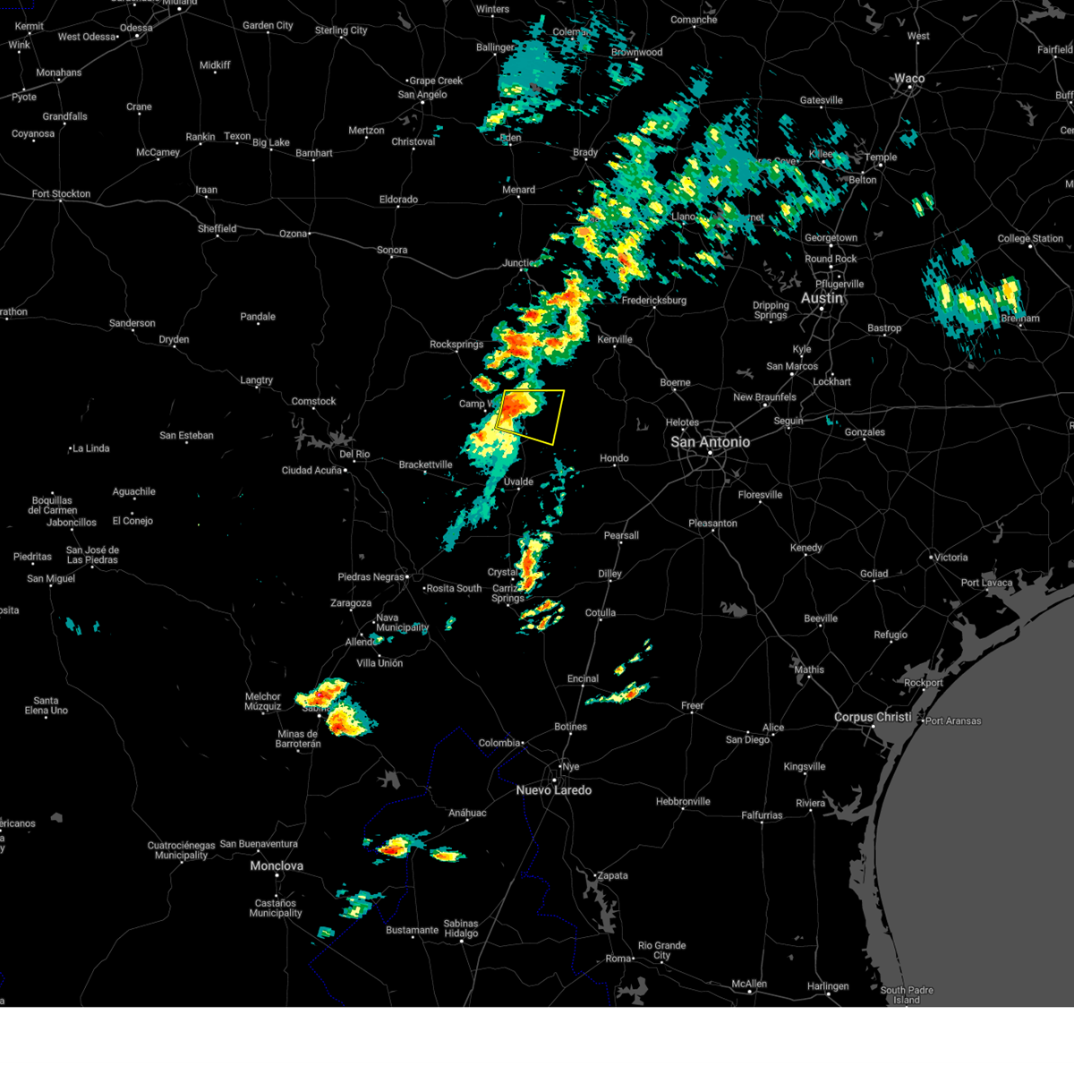
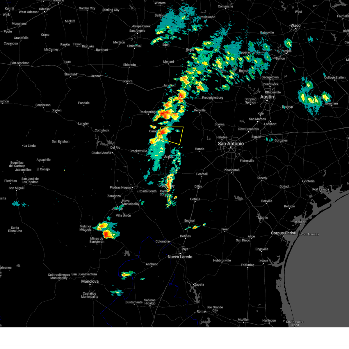
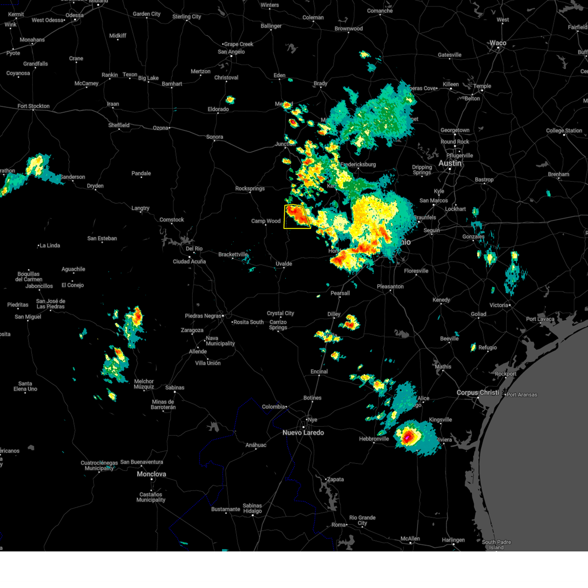
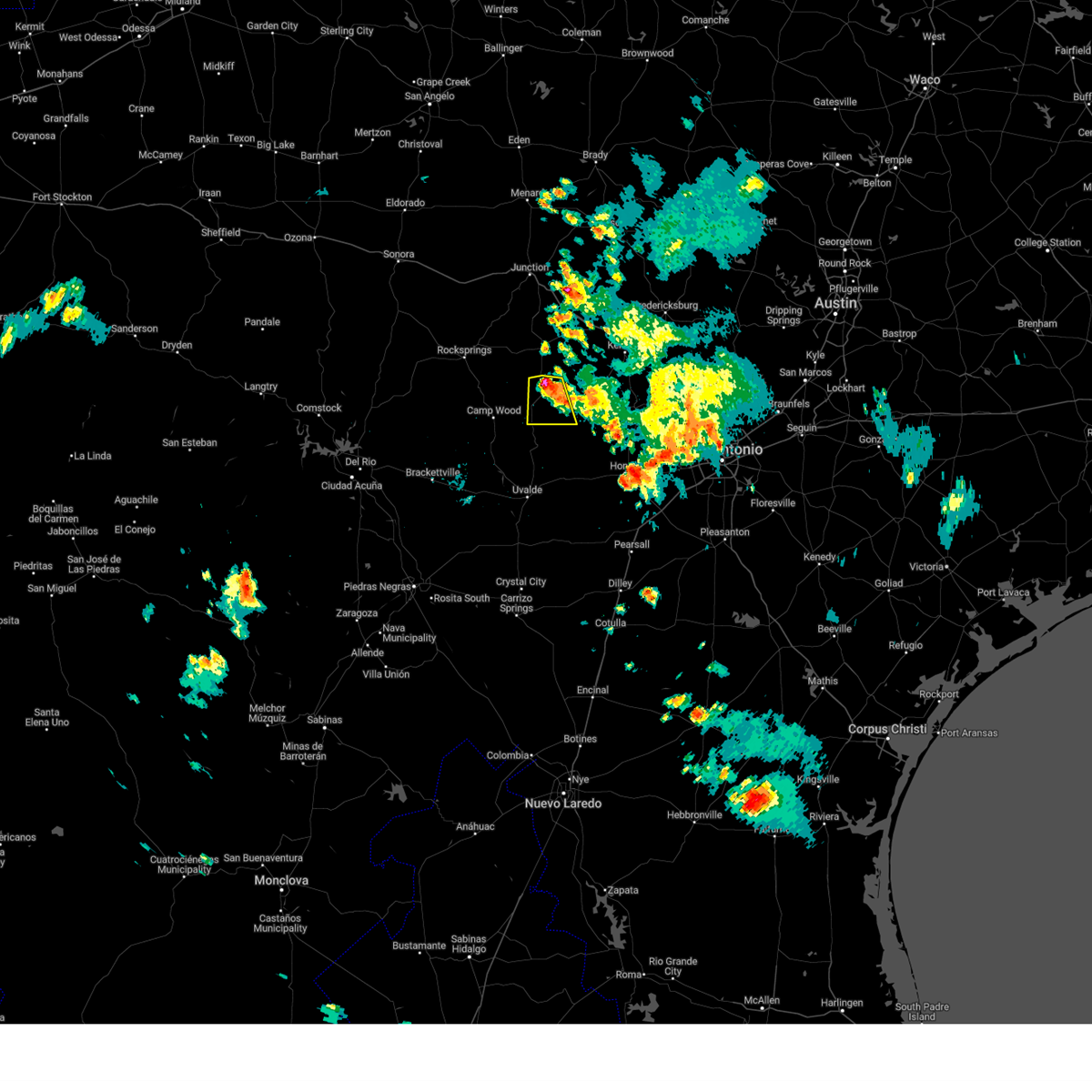
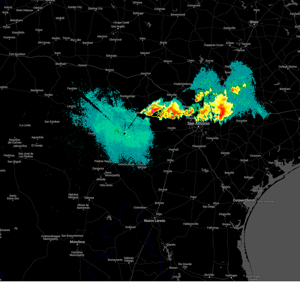
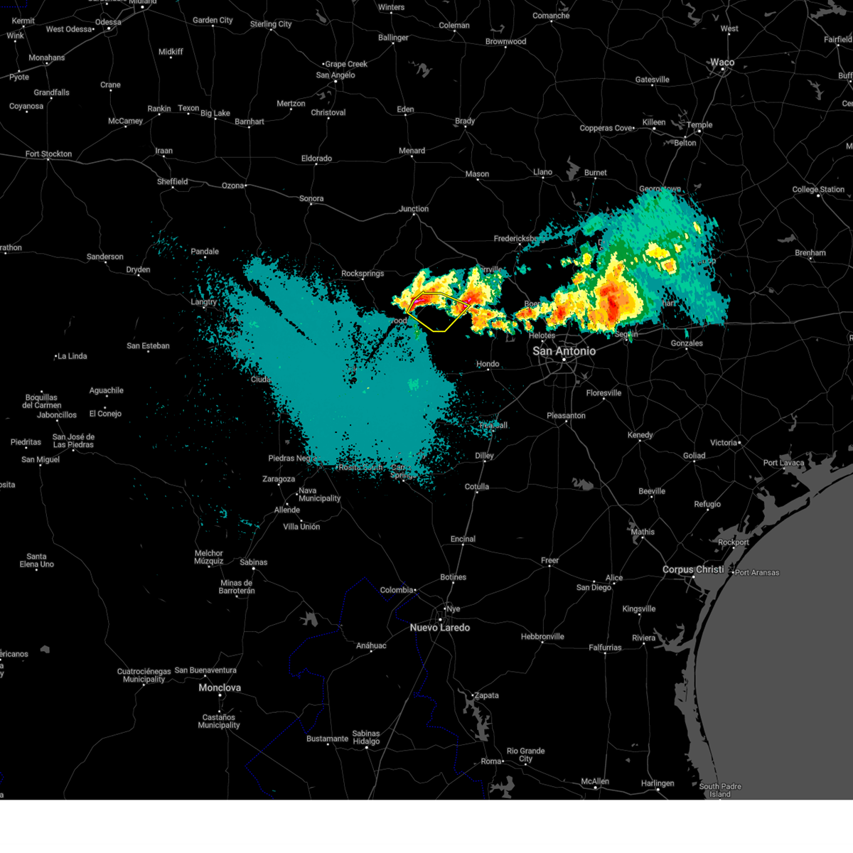
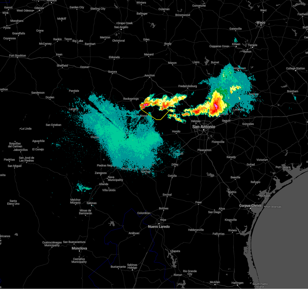
Hail Map for Leakey, TX
The Leakey, TX area has had 34 reports of on-the-ground hail by trained spotters, and has been under severe weather warnings 11 times during the past 12 months. Doppler radar has detected hail at or near Leakey, TX on 53 occasions, including 4 occasions during the past year.
| Name: | Leakey, TX |
| Where Located: | 72.7 miles ENE of Del Rio, TX |
| Map: | Google Map for Leakey, TX |
| Population: | 425 |
| Housing Units: | 237 |
| More Info: | Search Google for Leakey, TX |
1
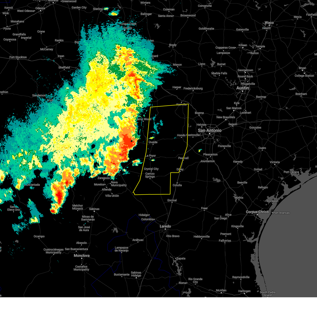
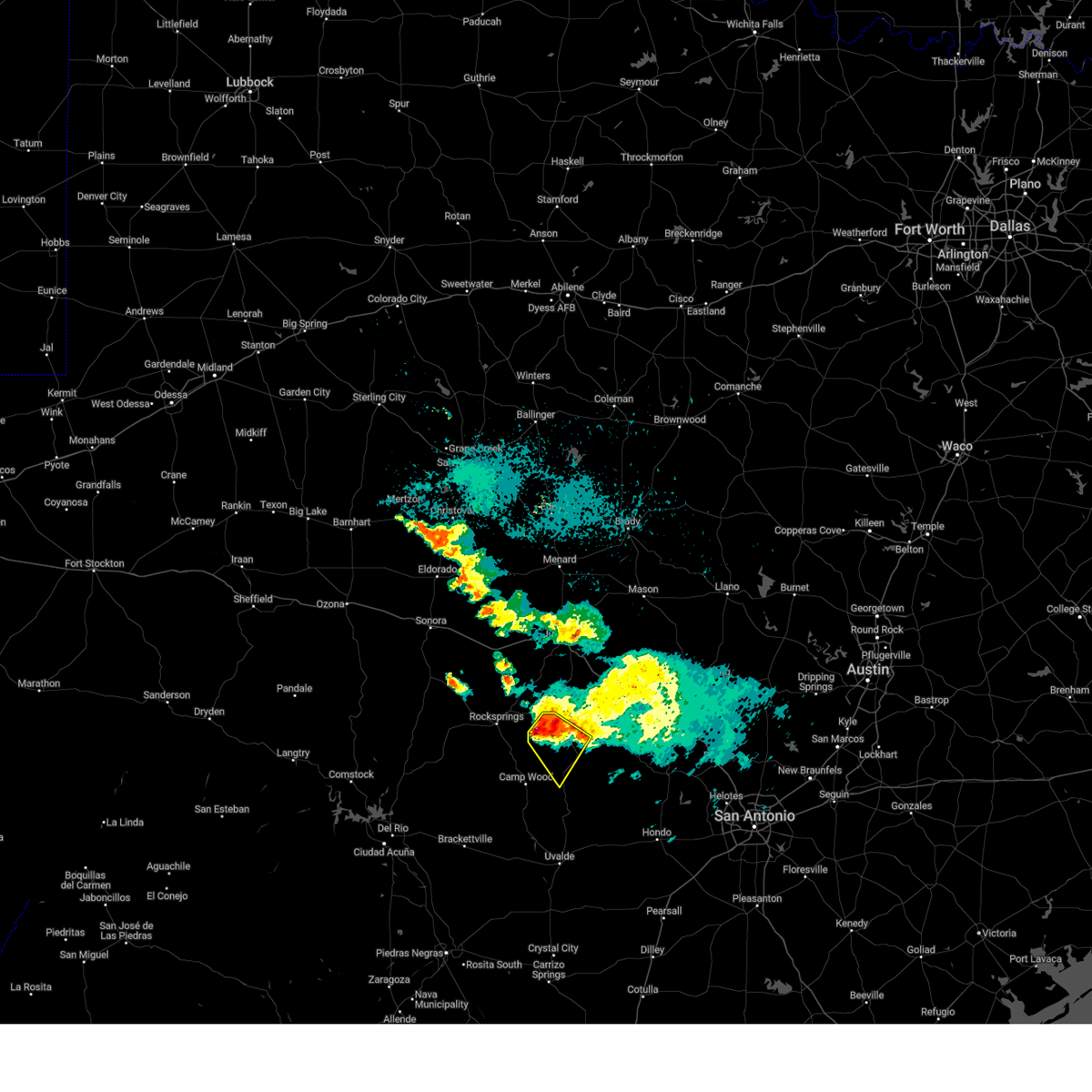
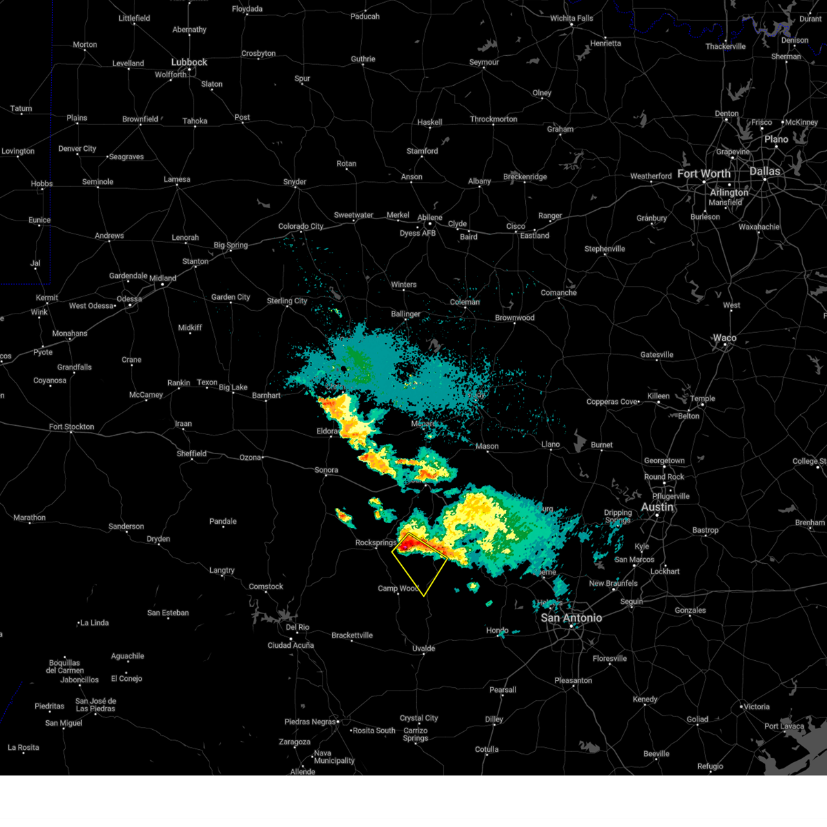
The Top Recent Hail Date for Leakey, TX is Friday, April 4, 2025 (15th out of 53)
Hail and Wind Damage Spotted near Leakey, TX
| Date / Time | Report Details |
|---|---|
| 6/10/2025 11:00 PM CDT |
 At 1100 pm cdt, severe thunderstorms were located along a line extending from 8 miles west of medina to 8 miles south of sabinal to near asherton, moving east at 35 mph (radar indicated). Hazards include 60 mph wind gusts and half dollar size hail. Hail damage to vehicles is expected. expect wind damage to roofs, siding, and trees. Locations impacted include, medina, kerrville, uvalde, pearsall, hondo, crystal city, carrizo springs, dilley, bandera, big wells, leakey, la pryor, tarpley, vanderpool, batesville, sabinal, asherton, north pearsall, chula vista-river spur, and d'hanis. At 1100 pm cdt, severe thunderstorms were located along a line extending from 8 miles west of medina to 8 miles south of sabinal to near asherton, moving east at 35 mph (radar indicated). Hazards include 60 mph wind gusts and half dollar size hail. Hail damage to vehicles is expected. expect wind damage to roofs, siding, and trees. Locations impacted include, medina, kerrville, uvalde, pearsall, hondo, crystal city, carrizo springs, dilley, bandera, big wells, leakey, la pryor, tarpley, vanderpool, batesville, sabinal, asherton, north pearsall, chula vista-river spur, and d'hanis.
|
| 6/10/2025 10:40 PM CDT |
 Svrewx the national weather service in austin san antonio has issued a * severe thunderstorm warning for, medina county in south central texas, bandera county in south central texas, southern kerr county in south central texas, eastern maverick county in south central texas, dimmit county in south central texas, uvalde county in south central texas, zavala county in south central texas, western frio county in south central texas, real county in south central texas, * until 1130 pm cdt. * at 1039 pm cdt, severe thunderstorms were located along a line extending from lost maples state natural area to 6 miles southeast of knippa to 6 miles southwest of carrizo hill, moving east at 35 mph (radar indicated). Hazards include ping pong ball size hail and 60 mph wind gusts. People and animals outdoors will be injured. expect hail damage to roofs, siding, windows, and vehicles. Expect wind damage to roofs, siding, and trees. Svrewx the national weather service in austin san antonio has issued a * severe thunderstorm warning for, medina county in south central texas, bandera county in south central texas, southern kerr county in south central texas, eastern maverick county in south central texas, dimmit county in south central texas, uvalde county in south central texas, zavala county in south central texas, western frio county in south central texas, real county in south central texas, * until 1130 pm cdt. * at 1039 pm cdt, severe thunderstorms were located along a line extending from lost maples state natural area to 6 miles southeast of knippa to 6 miles southwest of carrizo hill, moving east at 35 mph (radar indicated). Hazards include ping pong ball size hail and 60 mph wind gusts. People and animals outdoors will be injured. expect hail damage to roofs, siding, windows, and vehicles. Expect wind damage to roofs, siding, and trees.
|
| 5/26/2025 10:07 PM CDT |
 the severe thunderstorm warning has been cancelled and is no longer in effect the severe thunderstorm warning has been cancelled and is no longer in effect
|
| 5/26/2025 9:47 PM CDT |
 At 947 pm cdt, a severe thunderstorm was located near vance, or 11 miles northwest of leakey, moving east at 30 mph (radar indicated). Hazards include 60 mph wind gusts and quarter size hail. Hail damage to vehicles is expected. expect wind damage to roofs, siding, and trees. Locations impacted include, leakey, vanderpool, vance, lost maples state natural area, tuff, and barksdale. At 947 pm cdt, a severe thunderstorm was located near vance, or 11 miles northwest of leakey, moving east at 30 mph (radar indicated). Hazards include 60 mph wind gusts and quarter size hail. Hail damage to vehicles is expected. expect wind damage to roofs, siding, and trees. Locations impacted include, leakey, vanderpool, vance, lost maples state natural area, tuff, and barksdale.
|
| 5/26/2025 9:45 PM CDT |
 Svrewx the national weather service in austin san antonio has issued a * severe thunderstorm warning for, western bandera county in south central texas, real county in south central texas, * until 1045 pm cdt. * at 945 pm cdt, a severe thunderstorm was located near vance, or 13 miles northwest of leakey, moving east at 35 mph (radar indicated). Hazards include 60 mph wind gusts and quarter size hail. Hail damage to vehicles is expected. Expect wind damage to roofs, siding, and trees. Svrewx the national weather service in austin san antonio has issued a * severe thunderstorm warning for, western bandera county in south central texas, real county in south central texas, * until 1045 pm cdt. * at 945 pm cdt, a severe thunderstorm was located near vance, or 13 miles northwest of leakey, moving east at 35 mph (radar indicated). Hazards include 60 mph wind gusts and quarter size hail. Hail damage to vehicles is expected. Expect wind damage to roofs, siding, and trees.
|
| 4/23/2025 1:06 AM CDT |
 the severe thunderstorm warning has been cancelled and is no longer in effect the severe thunderstorm warning has been cancelled and is no longer in effect
|
| 4/23/2025 1:06 AM CDT |
 At 105 am cdt, a severe thunderstorm was located near camp wood, or 9 miles west of leakey, moving southeast at 35 mph (radar indicated). Hazards include 60 mph wind gusts and half dollar size hail. Hail damage to vehicles is expected. expect wind damage to roofs, siding, and trees. Locations impacted include, knippa, camp wood, garner state park, rio frio, reagan wells, concan, and leakey. At 105 am cdt, a severe thunderstorm was located near camp wood, or 9 miles west of leakey, moving southeast at 35 mph (radar indicated). Hazards include 60 mph wind gusts and half dollar size hail. Hail damage to vehicles is expected. expect wind damage to roofs, siding, and trees. Locations impacted include, knippa, camp wood, garner state park, rio frio, reagan wells, concan, and leakey.
|
| 4/23/2025 12:55 AM CDT |
 Svrewx the national weather service in austin san antonio has issued a * severe thunderstorm warning for, northeastern uvalde county in south central texas, south central edwards county in south central texas, southern real county in south central texas, * until 200 am cdt. * at 1255 am cdt, a severe thunderstorm was located over barksdale, or 13 miles west of leakey, moving southeast at 35 mph (radar indicated). Hazards include 60 mph wind gusts and half dollar size hail. Hail damage to vehicles is expected. Expect wind damage to roofs, siding, and trees. Svrewx the national weather service in austin san antonio has issued a * severe thunderstorm warning for, northeastern uvalde county in south central texas, south central edwards county in south central texas, southern real county in south central texas, * until 200 am cdt. * at 1255 am cdt, a severe thunderstorm was located over barksdale, or 13 miles west of leakey, moving southeast at 35 mph (radar indicated). Hazards include 60 mph wind gusts and half dollar size hail. Hail damage to vehicles is expected. Expect wind damage to roofs, siding, and trees.
|
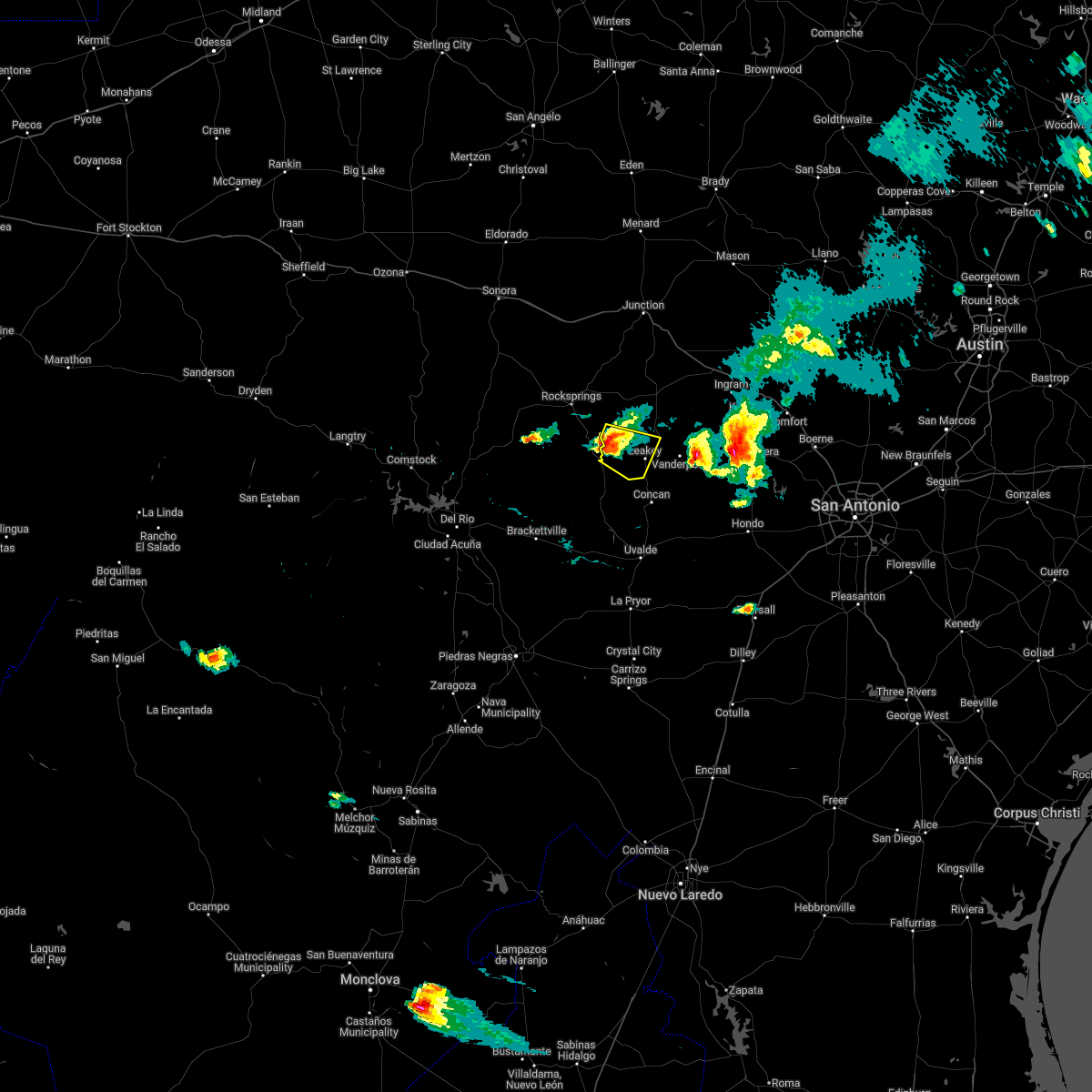
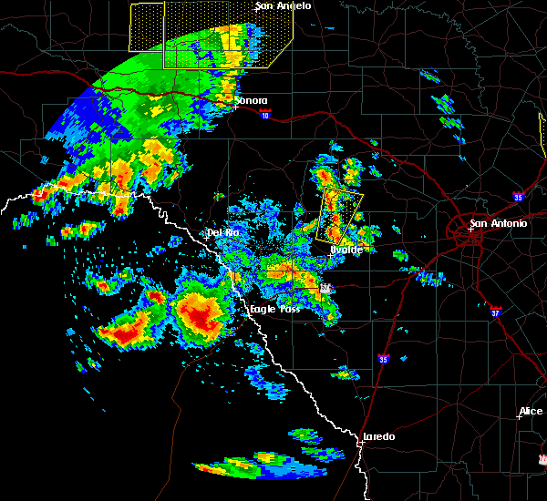
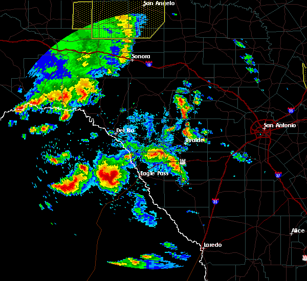
| 4/4/2025 11:30 PM CDT | At 1129 pm cdt, a severe thunderstorm was located near concan, or 16 miles northeast of uvalde, moving northeast at 35 mph (radar indicated). Hazards include quarter size hail. Damage to vehicles is expected. Locations impacted include, knippa, uvalde estates, vanderpool, uvalde, tuff, garner state park, rio frio, reagan wells, utopia, leakey, concan, and lost maples state natural area. |
| 4/4/2025 11:03 PM CDT | At 1102 pm cdt, a severe thunderstorm was located near uvalde, moving north at 55 mph (radar indicated). Hazards include half dollar size hail. Damage to vehicles is expected. Locations impacted include, knippa, uvalde estates, vanderpool, uvalde, tuff, garner state park, rio frio, reagan wells, utopia, leakey, concan, and lost maples state natural area. |
| 4/4/2025 10:49 PM CDT | Svrewx the national weather service in austin san antonio has issued a * severe thunderstorm warning for, western bandera county in south central texas, central uvalde county in south central texas, southern real county in south central texas, * until 1145 pm cdt. * at 1049 pm cdt, a severe thunderstorm was located near uvalde estates, or near uvalde, moving north at 55 mph (radar indicated). Hazards include quarter size hail. damage to vehicles is expected |
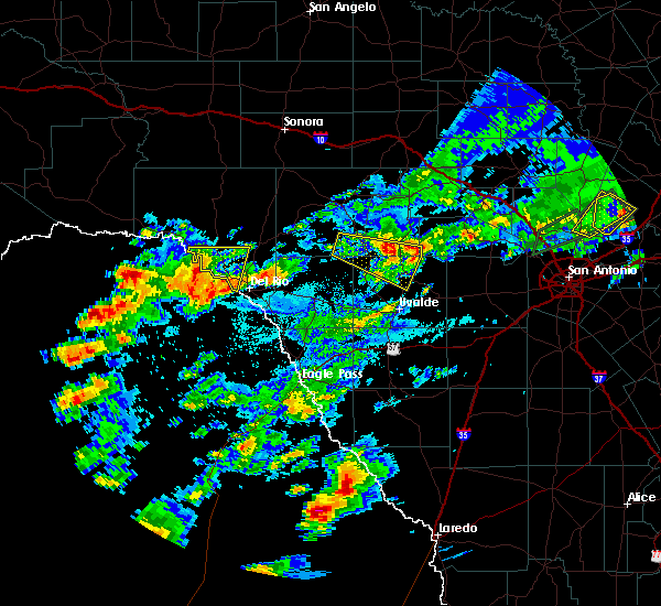
| 3/23/2025 8:54 PM CDT | Quarter sized hail reported 13 miles WSW of Leakey, TX, time estimated by radar. |
| 5/27/2024 5:34 PM CDT |
 the severe thunderstorm warning has been cancelled and is no longer in effect the severe thunderstorm warning has been cancelled and is no longer in effect
|
| 5/27/2024 5:27 PM CDT |
 At 527 pm cdt, a severe thunderstorm was located near vance, or 11 miles west of leakey, moving east at 15 mph (radar indicated). Hazards include 60 mph wind gusts and half dollar size hail. Hail damage to vehicles is expected. expect wind damage to roofs, siding, and trees. Locations impacted include, leakey, camp wood, vance, and tuff. At 527 pm cdt, a severe thunderstorm was located near vance, or 11 miles west of leakey, moving east at 15 mph (radar indicated). Hazards include 60 mph wind gusts and half dollar size hail. Hail damage to vehicles is expected. expect wind damage to roofs, siding, and trees. Locations impacted include, leakey, camp wood, vance, and tuff.
|
| 5/27/2024 5:27 PM CDT |
 the severe thunderstorm warning has been cancelled and is no longer in effect the severe thunderstorm warning has been cancelled and is no longer in effect
|
| 5/27/2024 5:10 PM CDT |
 At 510 pm cdt, a severe thunderstorm was located over barksdale, or 15 miles west of leakey, moving east at 15 mph (radar indicated). Hazards include 60 mph wind gusts and half dollar size hail. Hail damage to vehicles is expected. expect wind damage to roofs, siding, and trees. Locations impacted include, leakey, camp wood, vance, barksdale, and tuff. At 510 pm cdt, a severe thunderstorm was located over barksdale, or 15 miles west of leakey, moving east at 15 mph (radar indicated). Hazards include 60 mph wind gusts and half dollar size hail. Hail damage to vehicles is expected. expect wind damage to roofs, siding, and trees. Locations impacted include, leakey, camp wood, vance, barksdale, and tuff.
|
| 5/27/2024 4:48 PM CDT |
 Svrewx the national weather service in austin san antonio has issued a * severe thunderstorm warning for, south central edwards county in south central texas, southwestern real county in south central texas, * until 545 pm cdt. * at 448 pm cdt, a severe thunderstorm was located near barksdale, or 20 miles west of leakey, moving east at 15 mph (radar indicated). Hazards include 60 mph wind gusts and half dollar size hail. Hail damage to vehicles is expected. Expect wind damage to roofs, siding, and trees. Svrewx the national weather service in austin san antonio has issued a * severe thunderstorm warning for, south central edwards county in south central texas, southwestern real county in south central texas, * until 545 pm cdt. * at 448 pm cdt, a severe thunderstorm was located near barksdale, or 20 miles west of leakey, moving east at 15 mph (radar indicated). Hazards include 60 mph wind gusts and half dollar size hail. Hail damage to vehicles is expected. Expect wind damage to roofs, siding, and trees.
|
| 4/20/2024 7:25 PM CDT |
 At 724 pm cdt, a severe thunderstorm was located near leakey, moving east at 25 mph (radar indicated). Hazards include quarter size hail. Damage to vehicles is expected. locations impacted include, leakey, vanderpool, garner state park, tuff, rio frio, reagan wells, utopia and u. s. Highway 83. At 724 pm cdt, a severe thunderstorm was located near leakey, moving east at 25 mph (radar indicated). Hazards include quarter size hail. Damage to vehicles is expected. locations impacted include, leakey, vanderpool, garner state park, tuff, rio frio, reagan wells, utopia and u. s. Highway 83.
|
| 4/20/2024 7:16 PM CDT |
 At 715 pm cdt, a severe thunderstorm was located 7 miles southwest of leakey, moving east at 30 mph (radar indicated). Hazards include ping pong ball size hail. People and animals outdoors will be injured. expect damage to roofs, siding, windows, and vehicles. locations impacted include, leakey, vanderpool, garner state park, tuff, rio frio, reagan wells, utopia and u. s. Highway 83. At 715 pm cdt, a severe thunderstorm was located 7 miles southwest of leakey, moving east at 30 mph (radar indicated). Hazards include ping pong ball size hail. People and animals outdoors will be injured. expect damage to roofs, siding, windows, and vehicles. locations impacted include, leakey, vanderpool, garner state park, tuff, rio frio, reagan wells, utopia and u. s. Highway 83.
|
| 4/20/2024 7:01 PM CDT |
 Svrewx the national weather service in austin san antonio has issued a * severe thunderstorm warning for, west central bandera county in south central texas, northeastern uvalde county in south central texas, southern real county in south central texas, * until 800 pm cdt. * at 701 pm cdt, a severe thunderstorm was located over camp wood, or 13 miles west of leakey, moving east at 30 mph (radar indicated). Hazards include quarter size hail. damage to vehicles is expected Svrewx the national weather service in austin san antonio has issued a * severe thunderstorm warning for, west central bandera county in south central texas, northeastern uvalde county in south central texas, southern real county in south central texas, * until 800 pm cdt. * at 701 pm cdt, a severe thunderstorm was located over camp wood, or 13 miles west of leakey, moving east at 30 mph (radar indicated). Hazards include quarter size hail. damage to vehicles is expected
|
| 9/25/2023 7:34 AM CDT |
 At 733 am cdt, a severe thunderstorm was located 7 miles north of tuff, or 10 miles north of leakey, moving southeast at 30 mph (radar indicated). Hazards include 60 mph wind gusts and quarter size hail. Hail damage to vehicles is expected. expect wind damage to roofs, siding, and trees. locations impacted include, leakey, tuff, and prade ranch. hail threat, radar indicated max hail size, 1. 00 in wind threat, radar indicated max wind gust, 60 mph. At 733 am cdt, a severe thunderstorm was located 7 miles north of tuff, or 10 miles north of leakey, moving southeast at 30 mph (radar indicated). Hazards include 60 mph wind gusts and quarter size hail. Hail damage to vehicles is expected. expect wind damage to roofs, siding, and trees. locations impacted include, leakey, tuff, and prade ranch. hail threat, radar indicated max hail size, 1. 00 in wind threat, radar indicated max wind gust, 60 mph.
|
| 9/25/2023 7:19 AM CDT |
 At 719 am cdt, a severe thunderstorm was located 12 miles northeast of vance, or 16 miles north of leakey, moving southeast at 30 mph (radar indicated). Hazards include 60 mph wind gusts and quarter size hail. Hail damage to vehicles is expected. expect wind damage to roofs, siding, and trees. locations impacted include, leakey, tuff, and prade ranch. hail threat, radar indicated max hail size, 1. 00 in wind threat, radar indicated max wind gust, 60 mph. At 719 am cdt, a severe thunderstorm was located 12 miles northeast of vance, or 16 miles north of leakey, moving southeast at 30 mph (radar indicated). Hazards include 60 mph wind gusts and quarter size hail. Hail damage to vehicles is expected. expect wind damage to roofs, siding, and trees. locations impacted include, leakey, tuff, and prade ranch. hail threat, radar indicated max hail size, 1. 00 in wind threat, radar indicated max wind gust, 60 mph.
|
| 9/25/2023 7:06 AM CDT |
 At 706 am cdt, a severe thunderstorm was located 14 miles north of vance, or 16 miles east of rocksprings, moving southeast at 30 mph (radar indicated). Hazards include 60 mph wind gusts and quarter size hail. Hail damage to vehicles is expected. Expect wind damage to roofs, siding, and trees. At 706 am cdt, a severe thunderstorm was located 14 miles north of vance, or 16 miles east of rocksprings, moving southeast at 30 mph (radar indicated). Hazards include 60 mph wind gusts and quarter size hail. Hail damage to vehicles is expected. Expect wind damage to roofs, siding, and trees.
|
| 6/21/2023 6:39 PM CDT |
 The severe thunderstorm warning for east central kinney, northwestern uvalde and southeastern real counties will expire at 645 pm cdt, the storms which prompted the warning have weakened below severe limits, and no longer pose an immediate threat to life or property. therefore, the warning will be allowed to expire. however small hail and gusty winds are still possible with these thunderstorms. a severe thunderstorm watch remains in effect until 1100 pm cdt for south central texas. The severe thunderstorm warning for east central kinney, northwestern uvalde and southeastern real counties will expire at 645 pm cdt, the storms which prompted the warning have weakened below severe limits, and no longer pose an immediate threat to life or property. therefore, the warning will be allowed to expire. however small hail and gusty winds are still possible with these thunderstorms. a severe thunderstorm watch remains in effect until 1100 pm cdt for south central texas.
|
| 6/21/2023 6:29 PM CDT |
 At 627 pm cdt, winds associated with severe thunderstorms were located along a line extending from near knippa to near laguna to 8 miles east of alamo village, moving south at 30 mph. a severe storm with large hail was also located north of reagan wells moving southeast at 20 mph (radar indicated). Hazards include 60 mph wind gusts and quarter size hail. Hail damage to vehicles is expected. expect wind damage to roofs, siding, and trees. locations impacted include, leakey, laguna, montell, cline, garner state park, rio frio, reagan wells, concan, knippa and turkey mountain. hail threat, radar indicated max hail size, 1. 00 in wind threat, radar indicated max wind gust, 60 mph. At 627 pm cdt, winds associated with severe thunderstorms were located along a line extending from near knippa to near laguna to 8 miles east of alamo village, moving south at 30 mph. a severe storm with large hail was also located north of reagan wells moving southeast at 20 mph (radar indicated). Hazards include 60 mph wind gusts and quarter size hail. Hail damage to vehicles is expected. expect wind damage to roofs, siding, and trees. locations impacted include, leakey, laguna, montell, cline, garner state park, rio frio, reagan wells, concan, knippa and turkey mountain. hail threat, radar indicated max hail size, 1. 00 in wind threat, radar indicated max wind gust, 60 mph.
|
| 6/21/2023 5:55 PM CDT |
 At 555 pm cdt, severe thunderstorms were located along a line extending from near rio frio to near camp wood to 10 miles west of barksdale, moving south at 35 mph (radar indicated). Hazards include 60 mph wind gusts and nickel size hail. expect damage to roofs, siding, and trees At 555 pm cdt, severe thunderstorms were located along a line extending from near rio frio to near camp wood to 10 miles west of barksdale, moving south at 35 mph (radar indicated). Hazards include 60 mph wind gusts and nickel size hail. expect damage to roofs, siding, and trees
|
| 6/2/2023 10:44 PM CDT |
 At 1044 pm cdt, a severe thunderstorm was located near waltonia, or 10 miles west of kerrville, moving east at 50 mph (radar indicated). Hazards include 60 mph wind gusts and quarter size hail. Hail damage to vehicles is expected. expect wind damage to roofs, siding, and trees. locations impacted include, medina, kerrville, leakey, vanderpool, ingram, hunt, camp verde, kerrville-schreiner park, lost maples state natural area, waltonia, center point and kerr wildlife management area. hail threat, radar indicated max hail size, 1. 00 in wind threat, radar indicated max wind gust, 60 mph. At 1044 pm cdt, a severe thunderstorm was located near waltonia, or 10 miles west of kerrville, moving east at 50 mph (radar indicated). Hazards include 60 mph wind gusts and quarter size hail. Hail damage to vehicles is expected. expect wind damage to roofs, siding, and trees. locations impacted include, medina, kerrville, leakey, vanderpool, ingram, hunt, camp verde, kerrville-schreiner park, lost maples state natural area, waltonia, center point and kerr wildlife management area. hail threat, radar indicated max hail size, 1. 00 in wind threat, radar indicated max wind gust, 60 mph.
|
| 6/2/2023 10:43 PM CDT |
 At 1042 pm cdt, severe thunderstorms were located along a line extending from near vanderpool to near concan to blewett, moving east at 45 mph (radar indicated). Hazards include two inch hail and 70 mph wind gusts. People and animals outdoors will be injured. expect hail damage to roofs, siding, windows, and vehicles. expect considerable tree damage. wind damage is also likely to mobile homes, roofs, and outbuildings. locations impacted include, uvalde, hondo, bandera, leakey, vanderpool, tarpley, sabinal, laguna, knippa, blewett, d`hanis, bandera falls, rio frio, concan, uvalde estates, pipe creek, cline, garner state park, reagan wells and utopia. thunderstorm damage threat, considerable hail threat, radar indicated max hail size, 2. 00 in wind threat, radar indicated max wind gust, 70 mph. At 1042 pm cdt, severe thunderstorms were located along a line extending from near vanderpool to near concan to blewett, moving east at 45 mph (radar indicated). Hazards include two inch hail and 70 mph wind gusts. People and animals outdoors will be injured. expect hail damage to roofs, siding, windows, and vehicles. expect considerable tree damage. wind damage is also likely to mobile homes, roofs, and outbuildings. locations impacted include, uvalde, hondo, bandera, leakey, vanderpool, tarpley, sabinal, laguna, knippa, blewett, d`hanis, bandera falls, rio frio, concan, uvalde estates, pipe creek, cline, garner state park, reagan wells and utopia. thunderstorm damage threat, considerable hail threat, radar indicated max hail size, 2. 00 in wind threat, radar indicated max wind gust, 70 mph.
|
| 6/2/2023 10:41 PM CDT |
 At 1041 pm cdt, severe thunderstorms were located along a line extending from near vanderpool to near concan to blewett, moving east at 45 mph (radar indicated). Hazards include golf ball size hail and 70 mph wind gusts. People and animals outdoors will be injured. expect hail damage to roofs, siding, windows, and vehicles. expect considerable tree damage. Wind damage is also likely to mobile homes, roofs, and outbuildings. At 1041 pm cdt, severe thunderstorms were located along a line extending from near vanderpool to near concan to blewett, moving east at 45 mph (radar indicated). Hazards include golf ball size hail and 70 mph wind gusts. People and animals outdoors will be injured. expect hail damage to roofs, siding, windows, and vehicles. expect considerable tree damage. Wind damage is also likely to mobile homes, roofs, and outbuildings.
|
| 6/2/2023 10:24 PM CDT |
 At 1024 pm cdt, a severe thunderstorm was located 7 miles north of lost maples state natural area, or 13 miles north of vanderpool, moving east at 50 mph (radar indicated). Hazards include 60 mph wind gusts and quarter size hail. Hail damage to vehicles is expected. Expect wind damage to roofs, siding, and trees. At 1024 pm cdt, a severe thunderstorm was located 7 miles north of lost maples state natural area, or 13 miles north of vanderpool, moving east at 50 mph (radar indicated). Hazards include 60 mph wind gusts and quarter size hail. Hail damage to vehicles is expected. Expect wind damage to roofs, siding, and trees.
|
| 5/29/2023 5:48 PM CDT |
 At 548 pm cdt, a severe thunderstorm was located near lost maples state natural area, or near vanderpool, moving south at 20 mph (radar indicated). Hazards include 60 mph wind gusts and quarter size hail. Hail damage to vehicles is expected. expect wind damage to roofs, siding, and trees. locations impacted include, leakey, vanderpool, lost maples state natural area, tuff and rio frio. hail threat, radar indicated max hail size, 1. 00 in wind threat, radar indicated max wind gust, 60 mph. At 548 pm cdt, a severe thunderstorm was located near lost maples state natural area, or near vanderpool, moving south at 20 mph (radar indicated). Hazards include 60 mph wind gusts and quarter size hail. Hail damage to vehicles is expected. expect wind damage to roofs, siding, and trees. locations impacted include, leakey, vanderpool, lost maples state natural area, tuff and rio frio. hail threat, radar indicated max hail size, 1. 00 in wind threat, radar indicated max wind gust, 60 mph.
|
| 5/29/2023 5:34 PM CDT |
 At 534 pm cdt, a severe thunderstorm was located near lost maples state natural area, or 9 miles northwest of vanderpool, moving south at 20 mph (radar indicated). Hazards include 60 mph wind gusts and quarter size hail. Hail damage to vehicles is expected. Expect wind damage to roofs, siding, and trees. At 534 pm cdt, a severe thunderstorm was located near lost maples state natural area, or 9 miles northwest of vanderpool, moving south at 20 mph (radar indicated). Hazards include 60 mph wind gusts and quarter size hail. Hail damage to vehicles is expected. Expect wind damage to roofs, siding, and trees.
|
| 5/12/2023 9:21 PM CDT |
 At 921 pm cdt, severe thunderstorms were located along a line extending from near kerr wildlife management area to near utopia to 10 miles southeast of uvalde, moving east at 25 mph (radar indicated). Hazards include 60 mph wind gusts and penny size hail. Expect damage to roofs, siding, and trees. locations impacted include, medina, uvalde, leakey, vanderpool, tarpley, sabinal, hunt, knippa, d`hanis, tuff, rio frio, concan, kerr wildlife management area, washer, uvalde estates, garner state park, reagan wells, utopia, hill country state natural area and lost maples state natural area. hail threat, radar indicated max hail size, 0. 75 in wind threat, radar indicated max wind gust, 60 mph. At 921 pm cdt, severe thunderstorms were located along a line extending from near kerr wildlife management area to near utopia to 10 miles southeast of uvalde, moving east at 25 mph (radar indicated). Hazards include 60 mph wind gusts and penny size hail. Expect damage to roofs, siding, and trees. locations impacted include, medina, uvalde, leakey, vanderpool, tarpley, sabinal, hunt, knippa, d`hanis, tuff, rio frio, concan, kerr wildlife management area, washer, uvalde estates, garner state park, reagan wells, utopia, hill country state natural area and lost maples state natural area. hail threat, radar indicated max hail size, 0. 75 in wind threat, radar indicated max wind gust, 60 mph.
|
| 5/12/2023 9:07 PM CDT |
 At 907 pm cdt, severe thunderstorms were located along a line extending from 9 miles west of kerr wildlife management area to near utopia to 7 miles southeast of uvalde estates, moving east at 25 mph (radar indicated). Hazards include 60 mph wind gusts and penny size hail. expect damage to roofs, siding, and trees At 907 pm cdt, severe thunderstorms were located along a line extending from 9 miles west of kerr wildlife management area to near utopia to 7 miles southeast of uvalde estates, moving east at 25 mph (radar indicated). Hazards include 60 mph wind gusts and penny size hail. expect damage to roofs, siding, and trees
|
| 5/12/2023 8:50 PM CDT |
 At 850 pm cdt, severe thunderstorms were located along a line extending from 16 miles west of kerr wildlife management area to 6 miles east of leakey to uvalde, moving east at 35 mph (radar indicated). Hazards include 60 mph wind gusts and penny size hail. Expect damage to roofs, siding, and trees. locations impacted include, uvalde, leakey, vanderpool, sabinal, camp wood, laguna, knippa, blewett, barksdale, tuff, rio frio, concan, vance, uvalde estates, montell, dabney, cline, garner state park, reagan wells and utopia. hail threat, radar indicated max hail size, 0. 75 in wind threat, radar indicated max wind gust, 60 mph. At 850 pm cdt, severe thunderstorms were located along a line extending from 16 miles west of kerr wildlife management area to 6 miles east of leakey to uvalde, moving east at 35 mph (radar indicated). Hazards include 60 mph wind gusts and penny size hail. Expect damage to roofs, siding, and trees. locations impacted include, uvalde, leakey, vanderpool, sabinal, camp wood, laguna, knippa, blewett, barksdale, tuff, rio frio, concan, vance, uvalde estates, montell, dabney, cline, garner state park, reagan wells and utopia. hail threat, radar indicated max hail size, 0. 75 in wind threat, radar indicated max wind gust, 60 mph.
|
| 5/12/2023 8:17 PM CDT |
 At 817 pm cdt, severe thunderstorms were located along a line extending from 8 miles east of rocksprings to near camp wood to near blewett, moving east at 35 mph (radar indicated). Hazards include 70 mph wind gusts and penny size hail. Expect considerable tree damage. Damage is likely to mobile homes, roofs, and outbuildings. At 817 pm cdt, severe thunderstorms were located along a line extending from 8 miles east of rocksprings to near camp wood to near blewett, moving east at 35 mph (radar indicated). Hazards include 70 mph wind gusts and penny size hail. Expect considerable tree damage. Damage is likely to mobile homes, roofs, and outbuildings.
|
| 5/12/2023 7:59 PM CDT |
 At 758 pm cdt, severe thunderstorms were located along a line extending from 15 miles west of barksdale to 7 miles northwest of montell to near cline, moving northeast at 35 mph (radar indicated). Hazards include 70 mph wind gusts and penny size hail. Expect considerable tree damage. damage is likely to mobile homes, roofs, and outbuildings. locations impacted include, leakey, camp wood, laguna, montell, barksdale, garner state park, reagan wells, alamo village, vance, turkey mountain and kickapoo cavern state park. thunderstorm damage threat, considerable hail threat, radar indicated max hail size, 0. 75 in wind threat, radar indicated max wind gust, 70 mph. At 758 pm cdt, severe thunderstorms were located along a line extending from 15 miles west of barksdale to 7 miles northwest of montell to near cline, moving northeast at 35 mph (radar indicated). Hazards include 70 mph wind gusts and penny size hail. Expect considerable tree damage. damage is likely to mobile homes, roofs, and outbuildings. locations impacted include, leakey, camp wood, laguna, montell, barksdale, garner state park, reagan wells, alamo village, vance, turkey mountain and kickapoo cavern state park. thunderstorm damage threat, considerable hail threat, radar indicated max hail size, 0. 75 in wind threat, radar indicated max wind gust, 70 mph.
|
| 5/12/2023 7:30 PM CDT |
 At 729 pm cdt, severe thunderstorms were located along a line extending from 14 miles southeast of carta valley to near alamo village to 6 miles north of anacacho, moving northeast at 35 mph (radar indicated). Hazards include 70 mph wind gusts and penny size hail. Expect considerable tree damage. Damage is likely to mobile homes, roofs, and outbuildings. At 729 pm cdt, severe thunderstorms were located along a line extending from 14 miles southeast of carta valley to near alamo village to 6 miles north of anacacho, moving northeast at 35 mph (radar indicated). Hazards include 70 mph wind gusts and penny size hail. Expect considerable tree damage. Damage is likely to mobile homes, roofs, and outbuildings.
|
| 5/9/2023 12:42 AM CDT |
 The severe thunderstorm warning for south central edwards and southern real counties will expire at 1245 am cdt, the storm which prompted the warning has weakened below severe limits, and no longer poses an immediate threat to life or property. therefore, the warning will be allowed to expire. The severe thunderstorm warning for south central edwards and southern real counties will expire at 1245 am cdt, the storm which prompted the warning has weakened below severe limits, and no longer poses an immediate threat to life or property. therefore, the warning will be allowed to expire.
|
| 5/9/2023 12:24 AM CDT |
 At 1223 am cdt, a severe thunderstorm was located near vance, or 10 miles west of leakey, moving west at 15 mph (radar indicated). Hazards include quarter size hail. Damage to vehicles is expected. locations impacted include, leakey, camp wood, vance, barksdale, tuff and rio frio. hail threat, radar indicated max hail size, 1. 00 in wind threat, radar indicated max wind gust, <50 mph. At 1223 am cdt, a severe thunderstorm was located near vance, or 10 miles west of leakey, moving west at 15 mph (radar indicated). Hazards include quarter size hail. Damage to vehicles is expected. locations impacted include, leakey, camp wood, vance, barksdale, tuff and rio frio. hail threat, radar indicated max hail size, 1. 00 in wind threat, radar indicated max wind gust, <50 mph.
|
| 5/8/2023 11:51 PM CDT |
 At 1150 pm cdt, a severe thunderstorm was located over tuff, or over leakey, moving west at 20 mph (radar indicated). Hazards include quarter size hail. damage to vehicles is expected At 1150 pm cdt, a severe thunderstorm was located over tuff, or over leakey, moving west at 20 mph (radar indicated). Hazards include quarter size hail. damage to vehicles is expected
|
| 4/20/2023 11:33 PM CDT |
 At 1132 pm cdt, a severe thunderstorm was located over vanderpool, moving southeast at 30 mph (radar indicated). Hazards include two inch hail and 60 mph wind gusts. People and animals outdoors will be injured. expect hail damage to roofs, siding, windows, and vehicles. expect wind damage to roofs, siding, and trees. locations impacted include, leakey, vanderpool and lost maples state natural area. thunderstorm damage threat, considerable hail threat, radar indicated max hail size, 2. 00 in wind threat, radar indicated max wind gust, 60 mph. At 1132 pm cdt, a severe thunderstorm was located over vanderpool, moving southeast at 30 mph (radar indicated). Hazards include two inch hail and 60 mph wind gusts. People and animals outdoors will be injured. expect hail damage to roofs, siding, windows, and vehicles. expect wind damage to roofs, siding, and trees. locations impacted include, leakey, vanderpool and lost maples state natural area. thunderstorm damage threat, considerable hail threat, radar indicated max hail size, 2. 00 in wind threat, radar indicated max wind gust, 60 mph.
|
| 4/20/2023 11:13 PM CDT |
 At 1113 pm cdt, a severe thunderstorm was located near tuff, or 7 miles north of leakey, moving southeast at 30 mph (radar indicated). Hazards include two inch hail and 60 mph wind gusts. People and animals outdoors will be injured. expect hail damage to roofs, siding, windows, and vehicles. expect wind damage to roofs, siding, and trees. locations impacted include, leakey, vanderpool, lost maples state natural area and tuff. thunderstorm damage threat, considerable hail threat, radar indicated max hail size, 2. 00 in wind threat, radar indicated max wind gust, 60 mph. At 1113 pm cdt, a severe thunderstorm was located near tuff, or 7 miles north of leakey, moving southeast at 30 mph (radar indicated). Hazards include two inch hail and 60 mph wind gusts. People and animals outdoors will be injured. expect hail damage to roofs, siding, windows, and vehicles. expect wind damage to roofs, siding, and trees. locations impacted include, leakey, vanderpool, lost maples state natural area and tuff. thunderstorm damage threat, considerable hail threat, radar indicated max hail size, 2. 00 in wind threat, radar indicated max wind gust, 60 mph.
|
| 4/20/2023 11:09 PM CDT | Quarter sized hail reported 13.6 miles S of Leakey, TX, coop observer reports quarter size hail with numerous pea to dime size hail stones as well. |
| 4/20/2023 11:05 PM CDT | Golf Ball sized hail reported 10.1 miles S of Leakey, TX, via twitter photo of several ping pong to golf ball size hail. time estimated via radar imagery. |
| 4/20/2023 10:56 PM CDT |
 At 1056 pm cdt, a severe thunderstorm was located 10 miles northeast of vance, or 13 miles northwest of leakey, moving southeast at 30 mph (radar indicated). Hazards include two inch hail and 60 mph wind gusts. People and animals outdoors will be injured. expect hail damage to roofs, siding, windows, and vehicles. Expect wind damage to roofs, siding, and trees. At 1056 pm cdt, a severe thunderstorm was located 10 miles northeast of vance, or 13 miles northwest of leakey, moving southeast at 30 mph (radar indicated). Hazards include two inch hail and 60 mph wind gusts. People and animals outdoors will be injured. expect hail damage to roofs, siding, windows, and vehicles. Expect wind damage to roofs, siding, and trees.
|
| 5/24/2022 11:27 PM CDT |
 At 1127 pm cdt, severe thunderstorms were located along a line extending from near buda to near canyon lake dam to 8 miles north of sabinal, moving east at 60 mph (radar indicated). Hazards include 60 mph wind gusts and quarter size hail. Hail damage to vehicles is expected. expect wind damage to roofs, siding, and trees. locations impacted include, san antonio, new braunfels, san marcos, boerne, hondo, wimberley, bandera, leakey, tarpley, vanderpool, canyon lake dam, canyon lake, helotes, fair oaks ranch, bulverde, garden ridge, shavano park, hollywood park, cross mountain and sabinal. hail threat, radar indicated max hail size, 1. 00 in wind threat, radar indicated max wind gust, 60 mph. At 1127 pm cdt, severe thunderstorms were located along a line extending from near buda to near canyon lake dam to 8 miles north of sabinal, moving east at 60 mph (radar indicated). Hazards include 60 mph wind gusts and quarter size hail. Hail damage to vehicles is expected. expect wind damage to roofs, siding, and trees. locations impacted include, san antonio, new braunfels, san marcos, boerne, hondo, wimberley, bandera, leakey, tarpley, vanderpool, canyon lake dam, canyon lake, helotes, fair oaks ranch, bulverde, garden ridge, shavano park, hollywood park, cross mountain and sabinal. hail threat, radar indicated max hail size, 1. 00 in wind threat, radar indicated max wind gust, 60 mph.
|
| 5/24/2022 11:01 PM CDT |
 At 1100 pm cdt, severe thunderstorms were located along a line extending from 6 miles north of woodcreek to near kendalia to near vanderpool, moving east at 50 mph (radar indicated). Hazards include 60 mph wind gusts and quarter size hail. Hail damage to vehicles is expected. Expect wind damage to roofs, siding, and trees. At 1100 pm cdt, severe thunderstorms were located along a line extending from 6 miles north of woodcreek to near kendalia to near vanderpool, moving east at 50 mph (radar indicated). Hazards include 60 mph wind gusts and quarter size hail. Hail damage to vehicles is expected. Expect wind damage to roofs, siding, and trees.
|
| 5/21/2022 8:28 PM CDT |
 At 828 pm cdt, a severe thunderstorm was located near tuff, or near leakey, moving east at 15 mph (radar indicated). Hazards include 60 mph wind gusts and quarter size hail. Hail damage to vehicles is expected. expect wind damage to roofs, siding, and trees. locations impacted include, leakey and tuff. hail threat, radar indicated max hail size, 1. 00 in wind threat, radar indicated max wind gust, 60 mph. At 828 pm cdt, a severe thunderstorm was located near tuff, or near leakey, moving east at 15 mph (radar indicated). Hazards include 60 mph wind gusts and quarter size hail. Hail damage to vehicles is expected. expect wind damage to roofs, siding, and trees. locations impacted include, leakey and tuff. hail threat, radar indicated max hail size, 1. 00 in wind threat, radar indicated max wind gust, 60 mph.
|
| 5/21/2022 8:01 PM CDT |
 At 801 pm cdt, a severe thunderstorm was located near vance, or 12 miles west of leakey, moving southeast at 10 mph (radar indicated). Hazards include 60 mph wind gusts and quarter size hail. Hail damage to vehicles is expected. Expect wind damage to roofs, siding, and trees. At 801 pm cdt, a severe thunderstorm was located near vance, or 12 miles west of leakey, moving southeast at 10 mph (radar indicated). Hazards include 60 mph wind gusts and quarter size hail. Hail damage to vehicles is expected. Expect wind damage to roofs, siding, and trees.
|
| 10/13/2021 5:25 PM CDT |
 At 524 pm cdt, severe thunderstorms were located along a line extending from 11 miles northeast of tuff to near lost maples state natural area to near utopia, moving northeast at 50 mph (radar indicated). Hazards include 60 mph wind gusts. Expect damage to roofs, siding, and trees. locations impacted include, leakey, vanderpool, lost maples state natural area and tuff. hail threat, radar indicated max hail size, <. 75 in wind threat, radar indicated max wind gust, 60 mph. At 524 pm cdt, severe thunderstorms were located along a line extending from 11 miles northeast of tuff to near lost maples state natural area to near utopia, moving northeast at 50 mph (radar indicated). Hazards include 60 mph wind gusts. Expect damage to roofs, siding, and trees. locations impacted include, leakey, vanderpool, lost maples state natural area and tuff. hail threat, radar indicated max hail size, <. 75 in wind threat, radar indicated max wind gust, 60 mph.
|
| 10/13/2021 5:07 PM CDT |
 At 506 pm cdt, severe thunderstorms were located along a line extending from tuff to near rio frio to near concan, moving northeast at 45 mph (radar indicated). Hazards include 60 mph wind gusts. Expect damage to roofs, siding, and trees. locations impacted include, uvalde, leakey, vanderpool, sabinal, camp wood, knippa, tuff, rio frio, concan, garner state park, reagan wells, utopia, lost maples state natural area and uvalde estates. hail threat, radar indicated max hail size, <. 75 in wind threat, radar indicated max wind gust, 60 mph. At 506 pm cdt, severe thunderstorms were located along a line extending from tuff to near rio frio to near concan, moving northeast at 45 mph (radar indicated). Hazards include 60 mph wind gusts. Expect damage to roofs, siding, and trees. locations impacted include, uvalde, leakey, vanderpool, sabinal, camp wood, knippa, tuff, rio frio, concan, garner state park, reagan wells, utopia, lost maples state natural area and uvalde estates. hail threat, radar indicated max hail size, <. 75 in wind threat, radar indicated max wind gust, 60 mph.
|
| 10/13/2021 4:48 PM CDT |
 At 448 pm cdt, severe thunderstorms were located along a line extending from 6 miles northwest of reagan wells to 6 miles southwest of concan to near uvalde estates, moving northeast at 40 mph (radar indicated). Hazards include 60 mph wind gusts. expect damage to roofs, siding, and trees At 448 pm cdt, severe thunderstorms were located along a line extending from 6 miles northwest of reagan wells to 6 miles southwest of concan to near uvalde estates, moving northeast at 40 mph (radar indicated). Hazards include 60 mph wind gusts. expect damage to roofs, siding, and trees
|
| 5/29/2021 4:46 AM CDT |
 At 445 am cdt, a severe thunderstorm was located over rio frio, or 7 miles south of leakey, moving southeast at 35 mph (radar indicated). Hazards include 60 mph wind gusts and quarter size hail. Hail damage to vehicles is expected. Expect wind damage to roofs, siding, and trees. At 445 am cdt, a severe thunderstorm was located over rio frio, or 7 miles south of leakey, moving southeast at 35 mph (radar indicated). Hazards include 60 mph wind gusts and quarter size hail. Hail damage to vehicles is expected. Expect wind damage to roofs, siding, and trees.
|
| 5/28/2021 8:44 PM CDT |
 At 844 pm cdt, severe thunderstorms were located along a line extending from near center point to near pipe creek to near hill country state natural area to near tuff, moving southeast at 40 mph (radar indicated). Hazards include 60 mph wind gusts and quarter size hail. Hail damage to vehicles is expected. Expect wind damage to roofs, siding, and trees. At 844 pm cdt, severe thunderstorms were located along a line extending from near center point to near pipe creek to near hill country state natural area to near tuff, moving southeast at 40 mph (radar indicated). Hazards include 60 mph wind gusts and quarter size hail. Hail damage to vehicles is expected. Expect wind damage to roofs, siding, and trees.
|
| 5/28/2021 8:04 PM CDT |
 At 803 pm cdt, severe thunderstorms were located along a line extending from near camp verde to near hunt to near lost maples state natural area to 10 miles north of tuff to 8 miles northeast of vance, moving southeast at 30 mph (radar indicated). Hazards include 70 mph wind gusts and ping pong ball size hail. People and animals outdoors will be injured. expect hail damage to roofs, siding, windows, and vehicles. expect considerable tree damage. wind damage is also likely to mobile homes, roofs, and outbuildings. Locations impacted include, medina, kerrville, bandera, leakey, vanderpool, tarpley, ingram, hunt, camp wood, camp verde, barksdale, tuff, bandera falls, tivydale, kerrville-schreiner park, vance, kerr wildlife management area, waltonia, pipe creek and center point. At 803 pm cdt, severe thunderstorms were located along a line extending from near camp verde to near hunt to near lost maples state natural area to 10 miles north of tuff to 8 miles northeast of vance, moving southeast at 30 mph (radar indicated). Hazards include 70 mph wind gusts and ping pong ball size hail. People and animals outdoors will be injured. expect hail damage to roofs, siding, windows, and vehicles. expect considerable tree damage. wind damage is also likely to mobile homes, roofs, and outbuildings. Locations impacted include, medina, kerrville, bandera, leakey, vanderpool, tarpley, ingram, hunt, camp wood, camp verde, barksdale, tuff, bandera falls, tivydale, kerrville-schreiner park, vance, kerr wildlife management area, waltonia, pipe creek and center point.
|
| 5/28/2021 7:49 PM CDT |
 At 749 pm cdt, severe thunderstorms were located along a line extending from near kerrville-schreiner park to kerr wildlife management area to 12 miles north of tuff to 9 miles north of vance, moving southeast at 20 mph (radar indicated). Hazards include ping pong ball size hail and 60 mph wind gusts. People and animals outdoors will be injured. expect hail damage to roofs, siding, windows, and vehicles. Expect wind damage to roofs, siding, and trees. At 749 pm cdt, severe thunderstorms were located along a line extending from near kerrville-schreiner park to kerr wildlife management area to 12 miles north of tuff to 9 miles north of vance, moving southeast at 20 mph (radar indicated). Hazards include ping pong ball size hail and 60 mph wind gusts. People and animals outdoors will be injured. expect hail damage to roofs, siding, windows, and vehicles. Expect wind damage to roofs, siding, and trees.
|
| 5/10/2021 9:17 PM CDT |
 At 917 pm cdt, severe thunderstorms were located along a line extending from reagan wells to near knippa, moving northeast at 35 mph (radar indicated). Hazards include 60 mph wind gusts and nickel size hail. Expect damage to roofs, siding, and trees. Locations impacted include, medina, uvalde, bandera, leakey, vanderpool, tarpley, sabinal, knippa, tuff, rio frio, concan, montell, garner state park, reagan wells, utopia, hill country state natural area, lost maples state natural area and prade ranch. At 917 pm cdt, severe thunderstorms were located along a line extending from reagan wells to near knippa, moving northeast at 35 mph (radar indicated). Hazards include 60 mph wind gusts and nickel size hail. Expect damage to roofs, siding, and trees. Locations impacted include, medina, uvalde, bandera, leakey, vanderpool, tarpley, sabinal, knippa, tuff, rio frio, concan, montell, garner state park, reagan wells, utopia, hill country state natural area, lost maples state natural area and prade ranch.
|
| 5/10/2021 8:58 PM CDT |
 At 858 pm cdt, severe thunderstorms were located along a line extending from 6 miles northwest of laguna to near uvalde, moving northeast at 55 mph (radar indicated). Hazards include 60 mph wind gusts and nickel size hail. expect damage to roofs, siding, and trees At 858 pm cdt, severe thunderstorms were located along a line extending from 6 miles northwest of laguna to near uvalde, moving northeast at 55 mph (radar indicated). Hazards include 60 mph wind gusts and nickel size hail. expect damage to roofs, siding, and trees
|
| 5/10/2021 8:43 PM CDT |
 A severe thunderstorm warning remains in effect until 900 pm cdt for eastern kinney. uvalde. northwestern zavala. south central edwards and southern real counties. At 842 pm cdt, severe thunderstorms were located along a line extending from 11 miles northwest of cline to uvalde, moving northeast at 45 mph. A severe thunderstorm warning remains in effect until 900 pm cdt for eastern kinney. uvalde. northwestern zavala. south central edwards and southern real counties. At 842 pm cdt, severe thunderstorms were located along a line extending from 11 miles northwest of cline to uvalde, moving northeast at 45 mph.
|
| 5/10/2021 8:06 PM CDT |
 At 806 pm cdt, severe thunderstorms were located along a line extending from near darling to 14 miles northwest of cometa, moving northeast at 50 mph (radar indicated). Hazards include 60 mph wind gusts and quarter size hail. Hail damage to vehicles is expected. Expect wind damage to roofs, siding, and trees. At 806 pm cdt, severe thunderstorms were located along a line extending from near darling to 14 miles northwest of cometa, moving northeast at 50 mph (radar indicated). Hazards include 60 mph wind gusts and quarter size hail. Hail damage to vehicles is expected. Expect wind damage to roofs, siding, and trees.
|
| 5/10/2021 4:52 PM CDT | Ping Pong Ball sized hail reported 9.2 miles SW of Leakey, TX, time estimated by radar. |
| 4/28/2021 11:50 PM CDT |
 At 1150 pm cdt, a severe thunderstorm was located over reagan wells, or 13 miles southwest of leakey, moving northeast at 35 mph (radar indicated). Hazards include two inch hail and 60 mph wind gusts. People and animals outdoors will be injured. expect hail damage to roofs, siding, windows, and vehicles. expect wind damage to roofs, siding, and trees. Locations impacted include, leakey, vanderpool, garner state park, tuff, rio frio, reagan wells, utopia, concan and lost maples state natural area. At 1150 pm cdt, a severe thunderstorm was located over reagan wells, or 13 miles southwest of leakey, moving northeast at 35 mph (radar indicated). Hazards include two inch hail and 60 mph wind gusts. People and animals outdoors will be injured. expect hail damage to roofs, siding, windows, and vehicles. expect wind damage to roofs, siding, and trees. Locations impacted include, leakey, vanderpool, garner state park, tuff, rio frio, reagan wells, utopia, concan and lost maples state natural area.
|
| 4/28/2021 11:36 PM CDT |
 At 1136 pm cdt, a severe thunderstorm was located over montell, or 20 miles southwest of leakey, moving northeast at 35 mph (radar indicated). Hazards include ping pong ball size hail. People and animals outdoors will be injured. Expect damage to roofs, siding, windows, and vehicles. At 1136 pm cdt, a severe thunderstorm was located over montell, or 20 miles southwest of leakey, moving northeast at 35 mph (radar indicated). Hazards include ping pong ball size hail. People and animals outdoors will be injured. Expect damage to roofs, siding, windows, and vehicles.
|
| 4/28/2021 11:10 PM CDT |
 The severe thunderstorm warning for northwestern bandera, west central kerr, northeastern kinney, northwestern uvalde, southeastern edwards and real counties will expire at 1115 pm cdt, the storms which prompted the warning have weakened below severe limits, and no longer pose an immediate threat to life or property. therefore, the warning will be allowed to expire. a tornado watch remains in effect until 500 am cdt for south central texas. remember, a severe thunderstorm warning still remains in effect for storms at the north and south end of this expired warning area. The severe thunderstorm warning for northwestern bandera, west central kerr, northeastern kinney, northwestern uvalde, southeastern edwards and real counties will expire at 1115 pm cdt, the storms which prompted the warning have weakened below severe limits, and no longer pose an immediate threat to life or property. therefore, the warning will be allowed to expire. a tornado watch remains in effect until 500 am cdt for south central texas. remember, a severe thunderstorm warning still remains in effect for storms at the north and south end of this expired warning area.
|
| 4/28/2021 10:40 PM CDT | Ping Pong Ball sized hail reported 8 miles S of Leakey, TX |
| 4/28/2021 10:39 PM CDT |
 At 1039 pm cdt, severe thunderstorms were located along a line extending from 11 miles west of kerr wildlife management area to 7 miles northeast of alamo village, moving east at 35 mph (radar indicated). Hazards include 60 mph wind gusts and quarter size hail. Hail damage to vehicles is expected. expect wind damage to roofs, siding, and trees. Locations impacted include, leakey, ingram, hunt, camp wood, laguna, barksdale, tuff, rio frio, vance, kerr wildlife management area, waltonia, montell, garner state park, reagan wells, lost maples state natural area and prade ranch. At 1039 pm cdt, severe thunderstorms were located along a line extending from 11 miles west of kerr wildlife management area to 7 miles northeast of alamo village, moving east at 35 mph (radar indicated). Hazards include 60 mph wind gusts and quarter size hail. Hail damage to vehicles is expected. expect wind damage to roofs, siding, and trees. Locations impacted include, leakey, ingram, hunt, camp wood, laguna, barksdale, tuff, rio frio, vance, kerr wildlife management area, waltonia, montell, garner state park, reagan wells, lost maples state natural area and prade ranch.
|
| 4/28/2021 10:12 PM CDT |
 At 1012 pm cdt, severe thunderstorms were located along a line extending from 16 miles east of rocksprings to 8 miles west of alamo village, moving east at 35 mph (radar indicated). Hazards include 60 mph wind gusts and quarter size hail. Hail damage to vehicles is expected. Expect wind damage to roofs, siding, and trees. At 1012 pm cdt, severe thunderstorms were located along a line extending from 16 miles east of rocksprings to 8 miles west of alamo village, moving east at 35 mph (radar indicated). Hazards include 60 mph wind gusts and quarter size hail. Hail damage to vehicles is expected. Expect wind damage to roofs, siding, and trees.
|
| 3/25/2021 1:45 AM CDT | Hen Egg sized hail reported 0.5 miles SSW of Leakey, TX, photos of several hail stones of 2 inches in diameter via social media. |
| 3/25/2021 1:44 AM CDT |
 At 144 am cdt, severe thunderstorms were located along a line extending from vanderpool to near laguna, moving east at 40 mph (radar indicated). Hazards include 60 mph wind gusts and quarter size hail. Hail damage to vehicles is expected. Expect wind damage to roofs, siding, and trees. At 144 am cdt, severe thunderstorms were located along a line extending from vanderpool to near laguna, moving east at 40 mph (radar indicated). Hazards include 60 mph wind gusts and quarter size hail. Hail damage to vehicles is expected. Expect wind damage to roofs, siding, and trees.
|
| 3/25/2021 1:30 AM CDT | Quarter sized hail reported 0.5 miles SSW of Leakey, TX, quarter size hail falling in leakey. |
| 3/25/2021 1:30 AM CDT |
 At 130 am cdt, a severe thunderstorm was located near montell, or 15 miles southwest of leakey, moving east at 40 mph (public). Hazards include 60 mph wind gusts and quarter size hail. Hail damage to vehicles is expected. expect wind damage to roofs, siding, and trees. Locations impacted include, leakey, vanderpool, camp wood, laguna, tuff, rio frio, concan, vance, montell, cline, garner state park, reagan wells, utopia and lost maples state natural area. At 130 am cdt, a severe thunderstorm was located near montell, or 15 miles southwest of leakey, moving east at 40 mph (public). Hazards include 60 mph wind gusts and quarter size hail. Hail damage to vehicles is expected. expect wind damage to roofs, siding, and trees. Locations impacted include, leakey, vanderpool, camp wood, laguna, tuff, rio frio, concan, vance, montell, cline, garner state park, reagan wells, utopia and lost maples state natural area.
|
| 3/25/2021 1:27 AM CDT | Ping Pong Ball sized hail reported 0.3 miles NW of Leakey, TX, mostly quarter size hail in leakey with a few ping pong sized hail mixed in. |
| 3/25/2021 1:23 AM CDT | Golf Ball sized hail reported 0.5 miles SSW of Leakey, TX, a few golf ball size hail stones reported in leakey. |
| 3/25/2021 1:15 AM CDT |
 At 115 am cdt, a severe thunderstorm was located near montell, or 23 miles northeast of brackettville, moving east at 40 mph (radar indicated). Hazards include 60 mph wind gusts and quarter size hail. Hail damage to vehicles is expected. expect wind damage to roofs, siding, and trees. Locations impacted include, brackettville, leakey, vanderpool, camp wood, laguna, barksdale, tuff, rio frio, concan, vance, montell, cline, garner state park, reagan wells, utopia, alamo village, lost maples state natural area, turkey mountain and fort clark springs. At 115 am cdt, a severe thunderstorm was located near montell, or 23 miles northeast of brackettville, moving east at 40 mph (radar indicated). Hazards include 60 mph wind gusts and quarter size hail. Hail damage to vehicles is expected. expect wind damage to roofs, siding, and trees. Locations impacted include, brackettville, leakey, vanderpool, camp wood, laguna, barksdale, tuff, rio frio, concan, vance, montell, cline, garner state park, reagan wells, utopia, alamo village, lost maples state natural area, turkey mountain and fort clark springs.
|
| 3/25/2021 12:54 AM CDT |
 At 1253 am cdt, a severe thunderstorm was located near alamo village, or 11 miles northeast of brackettville, moving east at 40 mph (radar indicated). Hazards include 60 mph wind gusts and quarter size hail. Hail damage to vehicles is expected. expect wind damage to roofs, siding, and trees. Locations impacted include, brackettville, leakey, vanderpool, camp wood, laguna, barksdale, tuff, rio frio, concan, vance, montell, cline, garner state park, reagan wells, standart, utopia, alamo village, lost maples state natural area, kickapoo cavern state park and turkey mountain. At 1253 am cdt, a severe thunderstorm was located near alamo village, or 11 miles northeast of brackettville, moving east at 40 mph (radar indicated). Hazards include 60 mph wind gusts and quarter size hail. Hail damage to vehicles is expected. expect wind damage to roofs, siding, and trees. Locations impacted include, brackettville, leakey, vanderpool, camp wood, laguna, barksdale, tuff, rio frio, concan, vance, montell, cline, garner state park, reagan wells, standart, utopia, alamo village, lost maples state natural area, kickapoo cavern state park and turkey mountain.
|
| 3/25/2021 12:44 AM CDT |
 At 1243 am cdt, a severe thunderstorm was located near barksdale, or 21 miles west of leakey, moving east at 40 mph (radar indicated). Hazards include 60 mph wind gusts and quarter size hail. Hail damage to vehicles is expected. Expect wind damage to roofs, siding, and trees. At 1243 am cdt, a severe thunderstorm was located near barksdale, or 21 miles west of leakey, moving east at 40 mph (radar indicated). Hazards include 60 mph wind gusts and quarter size hail. Hail damage to vehicles is expected. Expect wind damage to roofs, siding, and trees.
|
| 3/22/2021 11:57 PM CDT |
 A severe thunderstorm warning remains in effect until 1230 am cdt for northwestern medina. southwestern bandera. northeastern uvalde and southeastern real counties. at 1156 pm cdt, a severe thunderstorm was located near tuff, or near leakey, moving southeast at 35 mph. hazard. 60 mph wind gusts and half dollar size hail. A severe thunderstorm warning remains in effect until 1230 am cdt for northwestern medina. southwestern bandera. northeastern uvalde and southeastern real counties. at 1156 pm cdt, a severe thunderstorm was located near tuff, or near leakey, moving southeast at 35 mph. hazard. 60 mph wind gusts and half dollar size hail.
|
| 3/22/2021 11:55 PM CDT | Quarter sized hail reported 5 miles SW of Leakey, TX, report via social media of hail 5 miles ne of leakey. picture shows 1/2 inch to 1 inch hail. |
| 3/22/2021 11:50 PM CDT | Hen Egg sized hail reported 1.2 miles S of Leakey, TX, public report with pictures of approximately 2 inch hail that occurred just north of leakey. time estimated via radar. |
| 3/22/2021 11:50 PM CDT | Tea Cup sized hail reported 1.2 miles S of Leakey, TX, new measurement of a 3 inch hailstone. corrects previous hail report from 1 n leakey. public report with pictures of approximately 2 inch hail that occurred just north |
| 3/22/2021 11:31 PM CDT |
 At 1131 pm cdt, a severe thunderstorm was located near vance, or 12 miles northwest of leakey, moving southeast at 35 mph (radar indicated). Hazards include 60 mph wind gusts and half dollar size hail. Hail damage to vehicles is expected. Expect wind damage to roofs, siding, and trees. At 1131 pm cdt, a severe thunderstorm was located near vance, or 12 miles northwest of leakey, moving southeast at 35 mph (radar indicated). Hazards include 60 mph wind gusts and half dollar size hail. Hail damage to vehicles is expected. Expect wind damage to roofs, siding, and trees.
|
| 2/11/2021 7:09 AM CST |
 At 708 am cst, a severe thunderstorm was located 7 miles southwest of concan, or 13 miles north of uvalde, moving north at 25 mph (radar indicated). Hazards include quarter size hail. Damage to vehicles is expected. Locations impacted include, leakey, concan, garner state park, rio frio and reagan wells. At 708 am cst, a severe thunderstorm was located 7 miles southwest of concan, or 13 miles north of uvalde, moving north at 25 mph (radar indicated). Hazards include quarter size hail. Damage to vehicles is expected. Locations impacted include, leakey, concan, garner state park, rio frio and reagan wells.
|
| 2/11/2021 6:55 AM CST |
 At 655 am cst, a severe thunderstorm was located 7 miles north of uvalde, moving north at 25 mph (radar indicated). Hazards include quarter size hail. damage to vehicles is expected At 655 am cst, a severe thunderstorm was located 7 miles north of uvalde, moving north at 25 mph (radar indicated). Hazards include quarter size hail. damage to vehicles is expected
|
| 5/28/2020 4:28 PM CDT |
 At 428 pm cdt, a severe thunderstorm was located near rio frio, or near leakey, moving south at 25 mph (radar indicated). Hazards include 60 mph wind gusts and quarter size hail. Hail damage to vehicles is expected. Expect wind damage to roofs, siding, and trees. At 428 pm cdt, a severe thunderstorm was located near rio frio, or near leakey, moving south at 25 mph (radar indicated). Hazards include 60 mph wind gusts and quarter size hail. Hail damage to vehicles is expected. Expect wind damage to roofs, siding, and trees.
|
| 5/28/2020 12:14 AM CDT |
 At 1214 am cdt, a severe thunderstorm was located near vance, or 13 miles west of leakey, moving south at 20 mph (radar indicated). Hazards include quarter size hail. damage to vehicles is expected At 1214 am cdt, a severe thunderstorm was located near vance, or 13 miles west of leakey, moving south at 20 mph (radar indicated). Hazards include quarter size hail. damage to vehicles is expected
|
| 5/27/2020 11:46 PM CDT |
 At 1145 pm cdt, a severe thunderstorm was located near vance, or 16 miles southeast of rocksprings, moving south at 30 mph (radar indicated). Hazards include 60 mph wind gusts and quarter size hail. Hail damage to vehicles is expected. expect wind damage to roofs, siding, and trees. Locations impacted include, leakey, camp wood, vance, barksdale and tuff. At 1145 pm cdt, a severe thunderstorm was located near vance, or 16 miles southeast of rocksprings, moving south at 30 mph (radar indicated). Hazards include 60 mph wind gusts and quarter size hail. Hail damage to vehicles is expected. expect wind damage to roofs, siding, and trees. Locations impacted include, leakey, camp wood, vance, barksdale and tuff.
|
| 5/27/2020 11:14 PM CDT |
 At 1113 pm cdt, a severe thunderstorm was located 10 miles northeast of rocksprings, moving southeast at 25 mph (radar indicated). Hazards include 60 mph wind gusts and quarter size hail. Hail damage to vehicles is expected. Expect wind damage to roofs, siding, and trees. At 1113 pm cdt, a severe thunderstorm was located 10 miles northeast of rocksprings, moving southeast at 25 mph (radar indicated). Hazards include 60 mph wind gusts and quarter size hail. Hail damage to vehicles is expected. Expect wind damage to roofs, siding, and trees.
|
| 5/27/2020 10:15 PM CDT |
 At 1015 pm cdt, a severe thunderstorm was located 8 miles southwest of telegraph, or 20 miles northeast of rocksprings, moving southeast at 25 mph (radar indicated). Hazards include 60 mph wind gusts and quarter size hail. Hail damage to vehicles is expected. Expect wind damage to roofs, siding, and trees. At 1015 pm cdt, a severe thunderstorm was located 8 miles southwest of telegraph, or 20 miles northeast of rocksprings, moving southeast at 25 mph (radar indicated). Hazards include 60 mph wind gusts and quarter size hail. Hail damage to vehicles is expected. Expect wind damage to roofs, siding, and trees.
|
| 5/26/2020 8:27 AM CDT |
 At 827 am cdt, a severe thunderstorm was located 12 miles northeast of vance, or 17 miles northwest of leakey, moving southeast at 30 mph (radar indicated). Hazards include quarter size hail. Damage to vehicles is expected. Locations impacted include, leakey, tuff, lost maples state natural area and prade ranch. At 827 am cdt, a severe thunderstorm was located 12 miles northeast of vance, or 17 miles northwest of leakey, moving southeast at 30 mph (radar indicated). Hazards include quarter size hail. Damage to vehicles is expected. Locations impacted include, leakey, tuff, lost maples state natural area and prade ranch.
|
| 5/26/2020 8:12 AM CDT |
 At 812 am cdt, a severe thunderstorm was located 14 miles east of rocksprings, moving southeast at 30 mph (trained weather spotters). Hazards include golf ball size hail. People and animals outdoors will be injured. expect damage to roofs, siding, windows, and vehicles. Locations impacted include, leakey, tuff, rio frio, lost maples state natural area and prade ranch. At 812 am cdt, a severe thunderstorm was located 14 miles east of rocksprings, moving southeast at 30 mph (trained weather spotters). Hazards include golf ball size hail. People and animals outdoors will be injured. expect damage to roofs, siding, windows, and vehicles. Locations impacted include, leakey, tuff, rio frio, lost maples state natural area and prade ranch.
|
| 5/26/2020 7:56 AM CDT |
 At 756 am cdt, a severe thunderstorm was located 10 miles northeast of rocksprings, moving southeast at 35 mph (radar indicated). Hazards include quarter size hail. damage to vehicles is expected At 756 am cdt, a severe thunderstorm was located 10 miles northeast of rocksprings, moving southeast at 35 mph (radar indicated). Hazards include quarter size hail. damage to vehicles is expected
|
| 5/24/2020 6:42 PM CDT |
 At 642 pm cdt, a severe thunderstorm was located over rio frio, or 7 miles south of leakey, moving north at 30 mph (radar indicated). Hazards include 60 mph wind gusts and half dollar size hail. Hail damage to vehicles is expected. expect wind damage to roofs, siding, and trees. Locations impacted include, leakey, vanderpool, tuff, garner state park, rio frio, reagan wells and concan. At 642 pm cdt, a severe thunderstorm was located over rio frio, or 7 miles south of leakey, moving north at 30 mph (radar indicated). Hazards include 60 mph wind gusts and half dollar size hail. Hail damage to vehicles is expected. expect wind damage to roofs, siding, and trees. Locations impacted include, leakey, vanderpool, tuff, garner state park, rio frio, reagan wells and concan.
|
| 5/24/2020 6:32 PM CDT |
 At 631 pm cdt, a severe thunderstorm was located near garner state park, or 12 miles south of leakey, moving north at 30 mph (radar indicated). Hazards include half dollar size hail. Damage to vehicles is expected. Locations impacted include, leakey, vanderpool, tuff, garner state park, rio frio, reagan wells and concan. At 631 pm cdt, a severe thunderstorm was located near garner state park, or 12 miles south of leakey, moving north at 30 mph (radar indicated). Hazards include half dollar size hail. Damage to vehicles is expected. Locations impacted include, leakey, vanderpool, tuff, garner state park, rio frio, reagan wells and concan.
|
| 5/24/2020 6:30 PM CDT | Half Dollar sized hail reported 9.3 miles N of Leakey, TX, half dollar size hail reported at garner state pack. |
| 5/24/2020 6:17 PM CDT |
 At 616 pm cdt, a severe thunderstorm was located near concan, or 15 miles north of uvalde, moving north at 25 mph (radar indicated). Hazards include half dollar size hail. damage to vehicles is expected At 616 pm cdt, a severe thunderstorm was located near concan, or 15 miles north of uvalde, moving north at 25 mph (radar indicated). Hazards include half dollar size hail. damage to vehicles is expected
|
| 5/15/2020 8:43 PM CDT |
 At 842 pm cdt, a severe thunderstorm was located near lost maples state natural area, or 9 miles northwest of vanderpool, moving east at 40 mph (radar indicated). Hazards include 60 mph wind gusts and nickel size hail. Expect damage to roofs, siding, and trees. Locations impacted include, leakey, vanderpool, camp wood, tuff, garner state park, rio frio, utopia, lost maples state natural area, vance, kerr wildlife management area, and prade ranch. At 842 pm cdt, a severe thunderstorm was located near lost maples state natural area, or 9 miles northwest of vanderpool, moving east at 40 mph (radar indicated). Hazards include 60 mph wind gusts and nickel size hail. Expect damage to roofs, siding, and trees. Locations impacted include, leakey, vanderpool, camp wood, tuff, garner state park, rio frio, utopia, lost maples state natural area, vance, kerr wildlife management area, and prade ranch.
|
| 5/15/2020 8:13 PM CDT |
 At 813 pm cdt, a severe thunderstorm was located near vance, or 16 miles northwest of leakey, moving east at 40 mph (radar indicated). Hazards include 60 mph wind gusts and nickel size hail. expect damage to roofs, siding, and trees At 813 pm cdt, a severe thunderstorm was located near vance, or 16 miles northwest of leakey, moving east at 40 mph (radar indicated). Hazards include 60 mph wind gusts and nickel size hail. expect damage to roofs, siding, and trees
|
| 3/4/2020 3:40 AM CST |
 At 340 am cst, severe thunderstorms were located along a line extending from 9 miles west of kerr wildlife management area to near lost maples state natural area to near concan to near uvalde, moving east at 50 mph (radar indicated). Hazards include 60 mph wind gusts and penny size hail. Expect damage to roofs, siding, and trees. Locations impacted include, uvalde, leakey, vanderpool, knippa, tuff, garner state park, rio frio, reagan wells, concan, utopia, lost maples state natural area and kerr wildlife management area. At 340 am cst, severe thunderstorms were located along a line extending from 9 miles west of kerr wildlife management area to near lost maples state natural area to near concan to near uvalde, moving east at 50 mph (radar indicated). Hazards include 60 mph wind gusts and penny size hail. Expect damage to roofs, siding, and trees. Locations impacted include, uvalde, leakey, vanderpool, knippa, tuff, garner state park, rio frio, reagan wells, concan, utopia, lost maples state natural area and kerr wildlife management area.
|
| 3/4/2020 3:13 AM CST |
 At 312 am cst, severe thunderstorms were located along a line extending from 13 miles east of rocksprings to 6 miles southeast of vance to near cline to near dabney, moving east at 40 mph (radar indicated). Hazards include 60 mph wind gusts and penny size hail. expect damage to roofs, siding, and trees At 312 am cst, severe thunderstorms were located along a line extending from 13 miles east of rocksprings to 6 miles southeast of vance to near cline to near dabney, moving east at 40 mph (radar indicated). Hazards include 60 mph wind gusts and penny size hail. expect damage to roofs, siding, and trees
|
| 6/9/2019 9:01 PM CDT |
 At 901 pm cdt, severe thunderstorms were located along a line extending from near fair oaks ranch to medina to 13 miles north of vance, moving south at 15 mph (radar indicated). Hazards include 60 mph wind gusts and quarter size hail. Hail damage to vehicles is expected. expect wind damage to roofs, siding, and trees. Locations impacted include, san antonio, medina, boerne, hondo, castroville, bandera, leakey, stinson municipal airport, tarpley, san antonio int airport, vanderpool, leon valley, helotes, fair oaks ranch, alamo heights, terrell hills, shavano park, hollywood park, cross mountain and lytle. At 901 pm cdt, severe thunderstorms were located along a line extending from near fair oaks ranch to medina to 13 miles north of vance, moving south at 15 mph (radar indicated). Hazards include 60 mph wind gusts and quarter size hail. Hail damage to vehicles is expected. expect wind damage to roofs, siding, and trees. Locations impacted include, san antonio, medina, boerne, hondo, castroville, bandera, leakey, stinson municipal airport, tarpley, san antonio int airport, vanderpool, leon valley, helotes, fair oaks ranch, alamo heights, terrell hills, shavano park, hollywood park, cross mountain and lytle.
|
| 6/9/2019 8:35 PM CDT |
 At 835 pm cdt, severe thunderstorms were located along a line extending from fair oaks ranch to medina to 15 miles north of vance, moving southwest at 40 mph (radar indicated). Hazards include 60 mph wind gusts and quarter size hail. Hail damage to vehicles is expected. Expect wind damage to roofs, siding, and trees. At 835 pm cdt, severe thunderstorms were located along a line extending from fair oaks ranch to medina to 15 miles north of vance, moving southwest at 40 mph (radar indicated). Hazards include 60 mph wind gusts and quarter size hail. Hail damage to vehicles is expected. Expect wind damage to roofs, siding, and trees.
|
| 5/9/2019 4:56 PM CDT |
 At 456 pm cdt, a severe thunderstorm was located near leakey, moving east at 25 mph (radar indicated). Hazards include 60 mph wind gusts and quarter size hail. Hail damage to vehicles is expected. Expect wind damage to roofs, siding, and trees. At 456 pm cdt, a severe thunderstorm was located near leakey, moving east at 25 mph (radar indicated). Hazards include 60 mph wind gusts and quarter size hail. Hail damage to vehicles is expected. Expect wind damage to roofs, siding, and trees.
|
| 5/9/2019 4:12 PM CDT |
 At 339 pm cdt, a severe thunderstorm was located 11 miles west of barksdale, or 21 miles south of rocksprings, moving east at 30 mph (radar indicated). Hazards include tennis ball size hail and 70 mph wind gusts. People and animals outdoors will be injured. expect hail damage to roofs, siding, windows, and vehicles. expect considerable tree damage. Wind damage is also likely to mobile homes, roofs, and outbuildings. At 339 pm cdt, a severe thunderstorm was located 11 miles west of barksdale, or 21 miles south of rocksprings, moving east at 30 mph (radar indicated). Hazards include tennis ball size hail and 70 mph wind gusts. People and animals outdoors will be injured. expect hail damage to roofs, siding, windows, and vehicles. expect considerable tree damage. Wind damage is also likely to mobile homes, roofs, and outbuildings.
|
| 5/9/2019 3:40 PM CDT |
 The national weather service in austin san antonio has issued a * severe thunderstorm warning for. northeastern kinney county in south central texas. northwestern uvalde county in south central texas. south central edwards county in south central texas. Southern real county in south central texas. The national weather service in austin san antonio has issued a * severe thunderstorm warning for. northeastern kinney county in south central texas. northwestern uvalde county in south central texas. south central edwards county in south central texas. Southern real county in south central texas.
|
| 5/9/2019 12:44 PM CDT | Quarter sized hail reported 10.1 miles S of Leakey, TX |
| 5/3/2019 7:27 PM CDT |
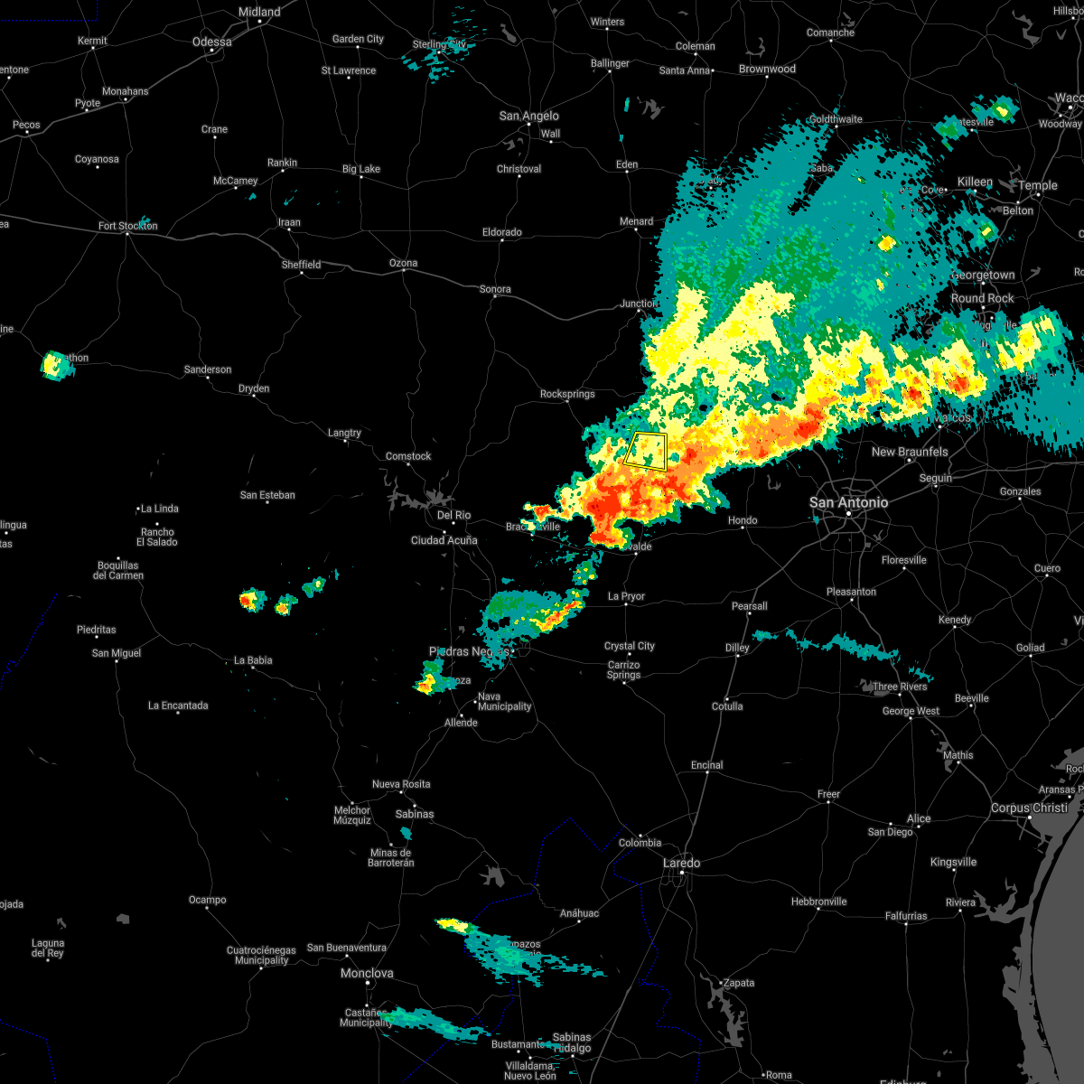 The severe thunderstorm warning for southeastern real county will expire at 730 pm cdt, the storm which prompted the warning has weakened below severe limits, and has exited the warned area. therefore, the warning will be allowed to expire. a severe thunderstorm watch remains in effect until 1100 pm cdt for south central texas. The severe thunderstorm warning for southeastern real county will expire at 730 pm cdt, the storm which prompted the warning has weakened below severe limits, and has exited the warned area. therefore, the warning will be allowed to expire. a severe thunderstorm watch remains in effect until 1100 pm cdt for south central texas.
|
| 5/3/2019 7:01 PM CDT |
 At 642 pm cdt, a severe thunderstorm was located near tuff, or near leakey, moving east at 20 mph (radar indicated). Hazards include 60 mph wind gusts and half dollar size hail. Hail damage to vehicles is expected. expect wind damage to roofs, siding, and trees. Locations impacted include, leakey, tuff, lost maples state natural area and state highway 83. At 642 pm cdt, a severe thunderstorm was located near tuff, or near leakey, moving east at 20 mph (radar indicated). Hazards include 60 mph wind gusts and half dollar size hail. Hail damage to vehicles is expected. expect wind damage to roofs, siding, and trees. Locations impacted include, leakey, tuff, lost maples state natural area and state highway 83.
|
| 5/3/2019 6:57 PM CDT | Quarter sized hail reported 0.5 miles SSW of Leakey, TX, sheriffs dept reported quarter sized hail in leakey. |
| 5/3/2019 6:43 PM CDT |
 At 642 pm cdt, a severe thunderstorm was located near tuff, or near leakey, moving east at 20 mph (radar indicated). Hazards include 60 mph wind gusts and half dollar size hail. Hail damage to vehicles is expected. expect wind damage to roofs, siding, and trees. Locations impacted include, leakey, tuff, lost maples state natural area and state highway 83. At 642 pm cdt, a severe thunderstorm was located near tuff, or near leakey, moving east at 20 mph (radar indicated). Hazards include 60 mph wind gusts and half dollar size hail. Hail damage to vehicles is expected. expect wind damage to roofs, siding, and trees. Locations impacted include, leakey, tuff, lost maples state natural area and state highway 83.
|
| 5/3/2019 6:27 PM CDT |
 At 627 pm cdt, a severe thunderstorm was located 7 miles east of vance, or 9 miles northwest of leakey, moving east at 20 mph (radar indicated). Hazards include 60 mph wind gusts and half dollar size hail. Hail damage to vehicles is expected. Expect wind damage to roofs, siding, and trees. At 627 pm cdt, a severe thunderstorm was located 7 miles east of vance, or 9 miles northwest of leakey, moving east at 20 mph (radar indicated). Hazards include 60 mph wind gusts and half dollar size hail. Hail damage to vehicles is expected. Expect wind damage to roofs, siding, and trees.
|
| 4/17/2019 10:18 PM CDT |
 At 1018 pm cdt, severe thunderstorms were located along a line extending from vance to 10 miles east of alamo village to near standart to 8 miles north of quemado, moving east at 20 mph (radar indicated). Hazards include 70 mph wind gusts and quarter size hail. Hail damage to vehicles is expected. expect considerable tree damage. wind damage is also likely to mobile homes, roofs, and outbuildings. Locations impacted include, brackettville, leakey, spofford, quemado, camp wood, laguna, barksdale, tuff, vance, darling, dabney, cline, anacacho, reagan wells, alamo village, paloma, rio frio, amanda, montell and garner state park. At 1018 pm cdt, severe thunderstorms were located along a line extending from vance to 10 miles east of alamo village to near standart to 8 miles north of quemado, moving east at 20 mph (radar indicated). Hazards include 70 mph wind gusts and quarter size hail. Hail damage to vehicles is expected. expect considerable tree damage. wind damage is also likely to mobile homes, roofs, and outbuildings. Locations impacted include, brackettville, leakey, spofford, quemado, camp wood, laguna, barksdale, tuff, vance, darling, dabney, cline, anacacho, reagan wells, alamo village, paloma, rio frio, amanda, montell and garner state park.
|
| 4/17/2019 9:55 PM CDT |
 At 954 pm cdt, severe thunderstorms were located along a line extending from 11 miles west of barksdale to 17 miles north of brackettville to 7 miles northwest of alamo village to 16 miles northwest of quemado, moving east at 25 mph (radar indicated). Hazards include 70 mph wind gusts and quarter size hail. Hail damage to vehicles is expected. expect considerable tree damage. Wind damage is also likely to mobile homes, roofs, and outbuildings. At 954 pm cdt, severe thunderstorms were located along a line extending from 11 miles west of barksdale to 17 miles north of brackettville to 7 miles northwest of alamo village to 16 miles northwest of quemado, moving east at 25 mph (radar indicated). Hazards include 70 mph wind gusts and quarter size hail. Hail damage to vehicles is expected. expect considerable tree damage. Wind damage is also likely to mobile homes, roofs, and outbuildings.
|
| 4/7/2019 5:00 AM CDT |
 At 459 am cdt, severe thunderstorms were located along a line extending from garner state park to near yancey, moving east northeast at 35 mph (radar indicated). Hazards include 60 mph wind gusts and penny size hail. Expect damage to roofs, siding, and trees. Locations impacted include, uvalde, hondo, leakey, tarpley, vanderpool, sabinal, knippa, d`hanis, rio frio, concan, garner state park, reagan wells, utopia and hill country state natural area. At 459 am cdt, severe thunderstorms were located along a line extending from garner state park to near yancey, moving east northeast at 35 mph (radar indicated). Hazards include 60 mph wind gusts and penny size hail. Expect damage to roofs, siding, and trees. Locations impacted include, uvalde, hondo, leakey, tarpley, vanderpool, sabinal, knippa, d`hanis, rio frio, concan, garner state park, reagan wells, utopia and hill country state natural area.
|
| 4/7/2019 4:32 AM CDT |
 At 432 am cdt, severe thunderstorms were located along a line extending from montell to 11 miles northwest of frio town, moving northeast at 50 mph (radar indicated). Hazards include 60 mph wind gusts and nickel size hail. expect damage to roofs, siding, and trees At 432 am cdt, severe thunderstorms were located along a line extending from montell to 11 miles northwest of frio town, moving northeast at 50 mph (radar indicated). Hazards include 60 mph wind gusts and nickel size hail. expect damage to roofs, siding, and trees
|
| 12/26/2018 9:09 PM CST |
 At 909 pm cst, severe thunderstorms were located along a line extending from 6 miles northeast of lost maples state natural area to 8 miles southeast of laguna, moving southeast at 10 mph (radar indicated). Hazards include 60 mph wind gusts and quarter size hail. Hail damage to vehicles is expected. expect wind damage to roofs, siding, and trees. locations impacted include, leakey, vanderpool, hunt, mountain home, garner state park, tuff, rio frio, reagan wells, lost maples state natural area, waltonia and kerr wildlife management area. A tornado watch remains in effect until 200 am cst for south central texas. At 909 pm cst, severe thunderstorms were located along a line extending from 6 miles northeast of lost maples state natural area to 8 miles southeast of laguna, moving southeast at 10 mph (radar indicated). Hazards include 60 mph wind gusts and quarter size hail. Hail damage to vehicles is expected. expect wind damage to roofs, siding, and trees. locations impacted include, leakey, vanderpool, hunt, mountain home, garner state park, tuff, rio frio, reagan wells, lost maples state natural area, waltonia and kerr wildlife management area. A tornado watch remains in effect until 200 am cst for south central texas.
|
| 12/26/2018 8:53 PM CST |
 At 852 pm cst, severe thunderstorms were located along a line extending from near harper to laguna, moving northeast at 40 mph (radar indicated). Hazards include 60 mph wind gusts and quarter size hail. Hail damage to vehicles is expected. expect wind damage to roofs, siding, and trees. locations impacted include, leakey, vanderpool, hunt, camp wood, laguna, tuff, rio frio, waltonia, kerr wildlife management area, mountain home, montell, cline, garner state park, reagan wells and lost maples state natural area. A tornado watch remains in effect until 200 am cst for south central texas. At 852 pm cst, severe thunderstorms were located along a line extending from near harper to laguna, moving northeast at 40 mph (radar indicated). Hazards include 60 mph wind gusts and quarter size hail. Hail damage to vehicles is expected. expect wind damage to roofs, siding, and trees. locations impacted include, leakey, vanderpool, hunt, camp wood, laguna, tuff, rio frio, waltonia, kerr wildlife management area, mountain home, montell, cline, garner state park, reagan wells and lost maples state natural area. A tornado watch remains in effect until 200 am cst for south central texas.
|
| 12/26/2018 8:33 PM CST |
 At 832 pm cst, severe thunderstorms were located along a line extending from near mountain home to 7 miles northwest of cline, moving northeast at 40 mph. these storms have a history of producing hail up to the size of half dollars (radar indicated). Hazards include 60 mph wind gusts and quarter size hail. Hail damage to vehicles is expected. expect wind damage to roofs, siding, and trees. locations impacted include, leakey, vanderpool, hunt, camp wood, laguna, blewett, barksdale, tuff, rio frio, vance, waltonia, kerr wildlife management area, mountain home, montell, dabney, cline, garner state park, anacacho, reagan wells and alamo village. A tornado watch remains in effect until 200 am cst for south central texas. At 832 pm cst, severe thunderstorms were located along a line extending from near mountain home to 7 miles northwest of cline, moving northeast at 40 mph. these storms have a history of producing hail up to the size of half dollars (radar indicated). Hazards include 60 mph wind gusts and quarter size hail. Hail damage to vehicles is expected. expect wind damage to roofs, siding, and trees. locations impacted include, leakey, vanderpool, hunt, camp wood, laguna, blewett, barksdale, tuff, rio frio, vance, waltonia, kerr wildlife management area, mountain home, montell, dabney, cline, garner state park, anacacho, reagan wells and alamo village. A tornado watch remains in effect until 200 am cst for south central texas.
|
| 12/26/2018 8:16 PM CST |
 At 815 pm cst, severe thunderstorms were located along a line extending from near kerr wildlife management area to near brackettville, moving northeast at 60 mph. within, the line of storms, the strongest cells were located over brackettville and 5 miles southwest of barksdale at 815 pm (radar indicated). Hazards include 60 mph wind gusts and quarter size hail. Hail damage to vehicles is expected. expect wind damage to roofs, siding, and trees. locations impacted include, brackettville, leakey, spofford, vanderpool, hunt, camp wood, laguna, barksdale, tuff, vance, waltonia, kerr wildlife management area, dabney, cline, anacacho, reagan wells, alamo village, blewett, rio frio and mountain home. A tornado watch remains in effect until 200 am cst for south central texas. At 815 pm cst, severe thunderstorms were located along a line extending from near kerr wildlife management area to near brackettville, moving northeast at 60 mph. within, the line of storms, the strongest cells were located over brackettville and 5 miles southwest of barksdale at 815 pm (radar indicated). Hazards include 60 mph wind gusts and quarter size hail. Hail damage to vehicles is expected. expect wind damage to roofs, siding, and trees. locations impacted include, brackettville, leakey, spofford, vanderpool, hunt, camp wood, laguna, barksdale, tuff, vance, waltonia, kerr wildlife management area, dabney, cline, anacacho, reagan wells, alamo village, blewett, rio frio and mountain home. A tornado watch remains in effect until 200 am cst for south central texas.
|
| 12/26/2018 8:01 PM CST |
 At 801 pm cst, severe thunderstorms were located along a line extending from 7 miles northwest of barksdale to 8 miles west of spofford, moving northeast at 35 mph (radar indicated). Hazards include 60 mph wind gusts and quarter size hail. Hail damage to vehicles is expected. Expect wind damage to roofs, siding, and trees. At 801 pm cst, severe thunderstorms were located along a line extending from 7 miles northwest of barksdale to 8 miles west of spofford, moving northeast at 35 mph (radar indicated). Hazards include 60 mph wind gusts and quarter size hail. Hail damage to vehicles is expected. Expect wind damage to roofs, siding, and trees.
|
| 10/9/2018 7:49 AM CDT |
 At 749 am cdt, a severe thunderstorm was located near vanderpool, moving northeast at 20 mph (radar indicated). Hazards include 60 mph wind gusts and quarter size hail. Hail damage to vehicles is expected. expect wind damage to roofs, siding, and trees. Locations impacted include, leakey, vanderpool, tuff, garner state park, rio frio, utopia, concan and lost maples state natural area. At 749 am cdt, a severe thunderstorm was located near vanderpool, moving northeast at 20 mph (radar indicated). Hazards include 60 mph wind gusts and quarter size hail. Hail damage to vehicles is expected. expect wind damage to roofs, siding, and trees. Locations impacted include, leakey, vanderpool, tuff, garner state park, rio frio, utopia, concan and lost maples state natural area.
|
| 10/9/2018 7:28 AM CDT |
 At 727 am cdt, a severe thunderstorm was located over rio frio, or 7 miles south of leakey, moving northeast at 20 mph (radar indicated). Hazards include 60 mph wind gusts and quarter size hail. Hail damage to vehicles is expected. Expect wind damage to roofs, siding, and trees. At 727 am cdt, a severe thunderstorm was located over rio frio, or 7 miles south of leakey, moving northeast at 20 mph (radar indicated). Hazards include 60 mph wind gusts and quarter size hail. Hail damage to vehicles is expected. Expect wind damage to roofs, siding, and trees.
|
| 5/4/2018 7:20 AM CDT | Large tree down on highway 83 roughly 1 mile north of leakey. hail also reported... unknown siz in real county TX, 1.4 miles SW of Leakey, TX |
| 5/4/2018 7:16 AM CDT |
 At 716 am cdt, severe thunderstorms were located along a line extending from 12 miles north of leakey to near tuff to garner state park, moving east at 30 mph (radar indicated). Hazards include 70 mph wind gusts and half dollar size hail. Hail damage to vehicles is expected. expect considerable tree damage. wind damage is also likely to mobile homes, roofs, and outbuildings. Locations impacted include, leakey, vanderpool, tuff, garner state park, rio frio, reagan wells, utopia, concan, lost maples state natural area and prade ranch. At 716 am cdt, severe thunderstorms were located along a line extending from 12 miles north of leakey to near tuff to garner state park, moving east at 30 mph (radar indicated). Hazards include 70 mph wind gusts and half dollar size hail. Hail damage to vehicles is expected. expect considerable tree damage. wind damage is also likely to mobile homes, roofs, and outbuildings. Locations impacted include, leakey, vanderpool, tuff, garner state park, rio frio, reagan wells, utopia, concan, lost maples state natural area and prade ranch.
|
| 5/4/2018 7:12 AM CDT | Half Dollar sized hail reported 4.7 miles SSE of Leakey, TX |
| 5/4/2018 7:10 AM CDT | Half Dollar sized hail reported 4.6 miles S of Leakey, TX |
| 5/4/2018 7:03 AM CDT |
 A severe thunderstorm warning remains in effect until 745 am cdt for western bandera. west central kerr. northeastern uvalde and real counties. At 702 am cdt, severe thunderstorms were located along a line extending from 12 miles north of tuff to near leakey to near reagan wells, moving east at 35 mph. A severe thunderstorm warning remains in effect until 745 am cdt for western bandera. west central kerr. northeastern uvalde and real counties. At 702 am cdt, severe thunderstorms were located along a line extending from 12 miles north of tuff to near leakey to near reagan wells, moving east at 35 mph.
|
| 5/4/2018 6:40 AM CDT |
 At 639 am cdt, severe thunderstorms were located along a line extending from 14 miles east of rocksprings to vance to 7 miles west of camp wood, moving east at 45 mph (radar indicated). Hazards include 70 mph wind gusts and penny size hail. Expect considerable tree damage. Damage is likely to mobile homes, roofs, and outbuildings. At 639 am cdt, severe thunderstorms were located along a line extending from 14 miles east of rocksprings to vance to 7 miles west of camp wood, moving east at 45 mph (radar indicated). Hazards include 70 mph wind gusts and penny size hail. Expect considerable tree damage. Damage is likely to mobile homes, roofs, and outbuildings.
|
| 4/25/2018 2:11 PM CDT |
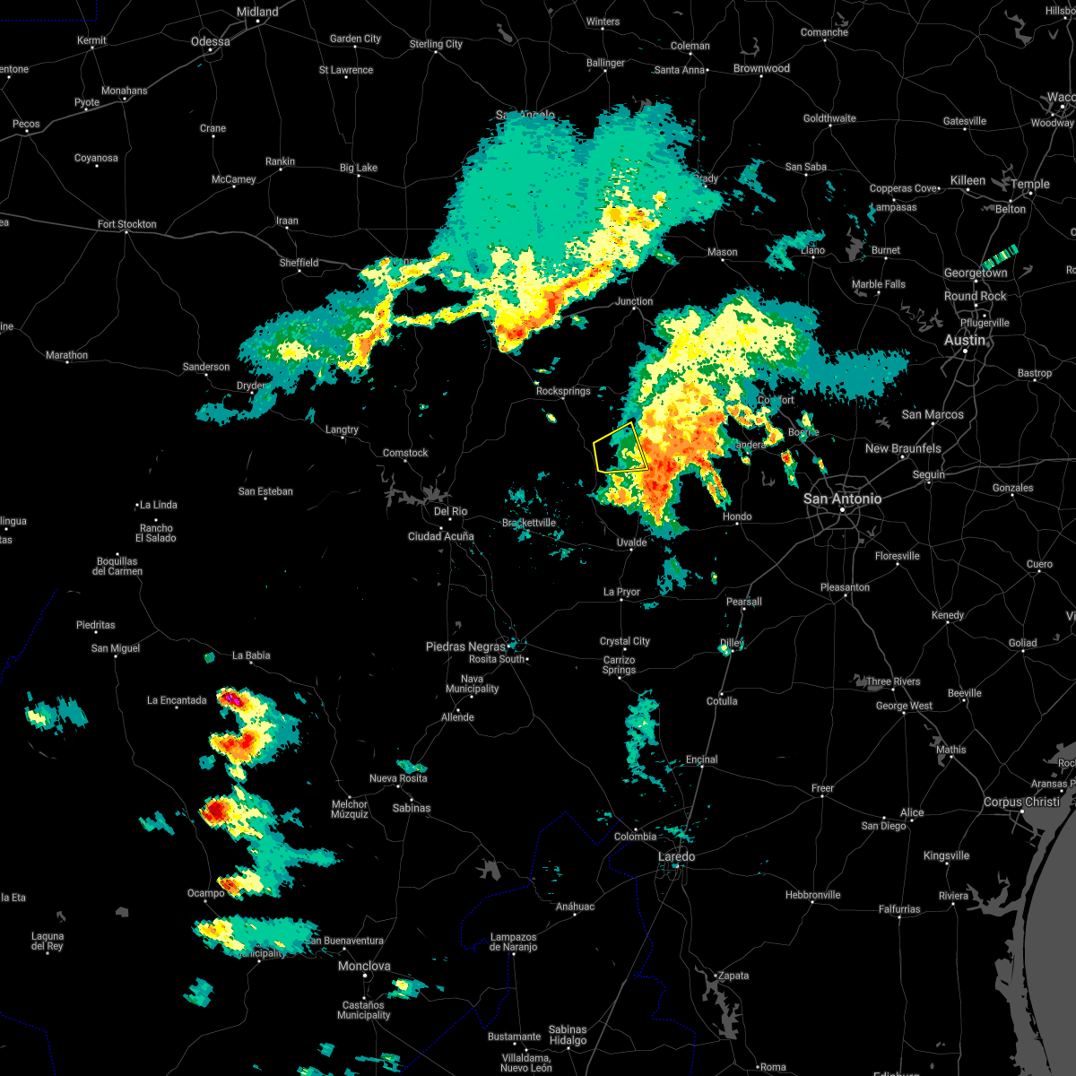 The severe thunderstorm warning for southwestern real county will expire at 215 pm cdt, the storm which prompted the warning has weakened below severe limits, and no longer poses an immediate threat to life or property. therefore, the warning will be allowed to expire. The severe thunderstorm warning for southwestern real county will expire at 215 pm cdt, the storm which prompted the warning has weakened below severe limits, and no longer poses an immediate threat to life or property. therefore, the warning will be allowed to expire.
|
| 4/25/2018 1:52 PM CDT |
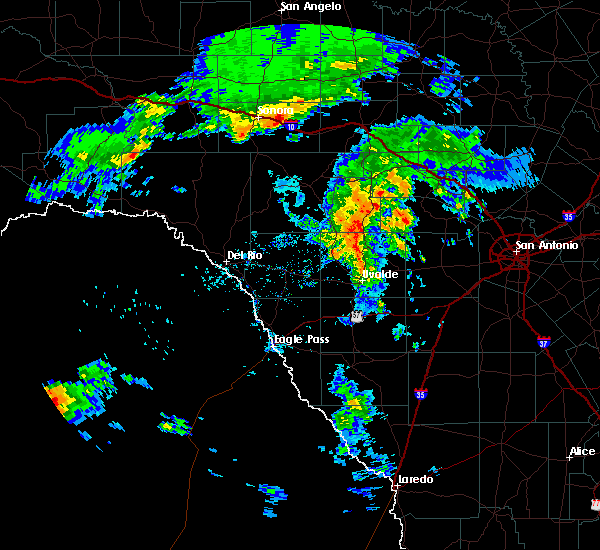 At 150 pm cdt, a severe thunderstorm was located near camp wood, or 13 miles west of leakey, moving east at 25 mph (radar indicated). Hazards include 60 mph wind gusts and quarter size hail. Hail damage to vehicles is expected. expect wind damage to roofs, siding, and trees. Locations impacted include, leakey and tuff. At 150 pm cdt, a severe thunderstorm was located near camp wood, or 13 miles west of leakey, moving east at 25 mph (radar indicated). Hazards include 60 mph wind gusts and quarter size hail. Hail damage to vehicles is expected. expect wind damage to roofs, siding, and trees. Locations impacted include, leakey and tuff.
|
| 4/25/2018 1:35 PM CDT |
 At 135 pm cdt, a severe thunderstorm was located near camp wood, or 19 miles west of leakey, moving east at 20 mph (radar indicated). Hazards include 60 mph wind gusts and quarter size hail. Hail damage to vehicles is expected. Expect wind damage to roofs, siding, and trees. At 135 pm cdt, a severe thunderstorm was located near camp wood, or 19 miles west of leakey, moving east at 20 mph (radar indicated). Hazards include 60 mph wind gusts and quarter size hail. Hail damage to vehicles is expected. Expect wind damage to roofs, siding, and trees.
|
| 5/28/2017 5:54 PM CDT |
 At 554 pm cdt, a severe thunderstorm was located near leakey, moving east at 10 mph (radar indicated). Hazards include 60 mph wind gusts and quarter size hail. Hail damage to vehicles is expected. expect wind damage to roofs, siding, and trees. Locations impacted include, leakey, vanderpool, lost maples state park, tuff and rio frio. At 554 pm cdt, a severe thunderstorm was located near leakey, moving east at 10 mph (radar indicated). Hazards include 60 mph wind gusts and quarter size hail. Hail damage to vehicles is expected. expect wind damage to roofs, siding, and trees. Locations impacted include, leakey, vanderpool, lost maples state park, tuff and rio frio.
|
| 5/28/2017 5:29 PM CDT |
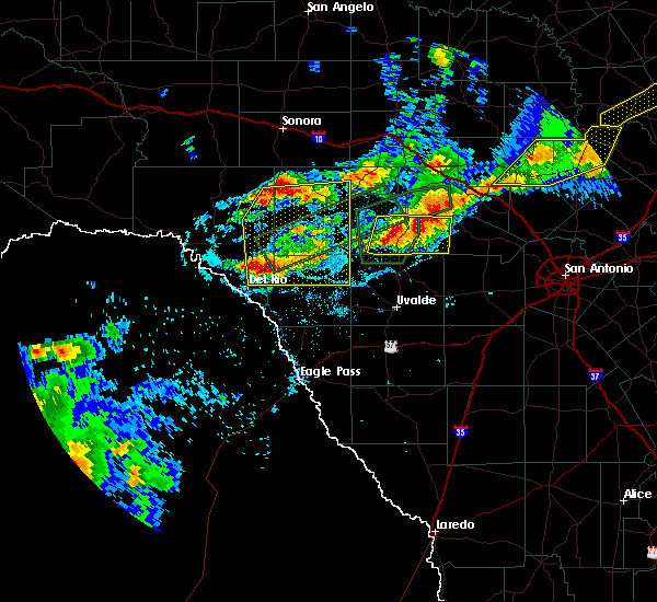 At 529 pm cdt, a severe thunderstorm was located 7 miles northeast of camp wood, or 8 miles west of leakey, moving east at 10 mph (radar indicated). Hazards include ping pong ball size hail and 60 mph wind gusts. People and animals outdoors will be injured. expect hail damage to roofs, siding, windows, and vehicles. Expect wind damage to roofs, siding, and trees. At 529 pm cdt, a severe thunderstorm was located 7 miles northeast of camp wood, or 8 miles west of leakey, moving east at 10 mph (radar indicated). Hazards include ping pong ball size hail and 60 mph wind gusts. People and animals outdoors will be injured. expect hail damage to roofs, siding, windows, and vehicles. Expect wind damage to roofs, siding, and trees.
|
| 5/28/2017 4:41 PM CDT |
 At 441 pm cdt, a severe thunderstorm was located 7 miles east of vance, or 9 miles northwest of leakey, moving northeast at 10 mph (radar indicated). Hazards include two inch hail and 60 mph wind gusts. People and animals outdoors will be injured. expect hail damage to roofs, siding, windows, and vehicles. expect wind damage to roofs, siding, and trees. Locations impacted include, leakey, camp wood, tuff, barksdale, rio frio, vance, prade ranch and devils sinkhole state natural area. At 441 pm cdt, a severe thunderstorm was located 7 miles east of vance, or 9 miles northwest of leakey, moving northeast at 10 mph (radar indicated). Hazards include two inch hail and 60 mph wind gusts. People and animals outdoors will be injured. expect hail damage to roofs, siding, windows, and vehicles. expect wind damage to roofs, siding, and trees. Locations impacted include, leakey, camp wood, tuff, barksdale, rio frio, vance, prade ranch and devils sinkhole state natural area.
|
| 5/28/2017 4:12 PM CDT |
 At 412 pm cdt, a severe thunderstorm was located near tuff, or 8 miles northwest of leakey, moving east at 10 mph (radar indicated). Hazards include ping pong ball size hail and 60 mph wind gusts. People and animals outdoors will be injured. expect hail damage to roofs, siding, windows, and vehicles. Expect wind damage to roofs, siding, and trees. At 412 pm cdt, a severe thunderstorm was located near tuff, or 8 miles northwest of leakey, moving east at 10 mph (radar indicated). Hazards include ping pong ball size hail and 60 mph wind gusts. People and animals outdoors will be injured. expect hail damage to roofs, siding, windows, and vehicles. Expect wind damage to roofs, siding, and trees.
|
| 5/28/2017 3:58 PM CDT | Golf Ball sized hail reported 14.2 miles SE of Leakey, TX, cocorahs observer reported golf ball sized hail. |
| 5/28/2017 3:42 PM CDT |
 At 342 pm cdt, a severe thunderstorm was located 8 miles northeast of vance, or 15 miles northwest of leakey, moving east at 10 mph (radar indicated). Hazards include golf ball size hail and 60 mph wind gusts. People and animals outdoors will be injured. expect hail damage to roofs, siding, windows, and vehicles. expect wind damage to roofs, siding, and trees. Locations impacted include, leakey, camp wood, tuff, barksdale, rio frio, vance, prade ranch and devils sinkhole state natural area. At 342 pm cdt, a severe thunderstorm was located 8 miles northeast of vance, or 15 miles northwest of leakey, moving east at 10 mph (radar indicated). Hazards include golf ball size hail and 60 mph wind gusts. People and animals outdoors will be injured. expect hail damage to roofs, siding, windows, and vehicles. expect wind damage to roofs, siding, and trees. Locations impacted include, leakey, camp wood, tuff, barksdale, rio frio, vance, prade ranch and devils sinkhole state natural area.
|
| 5/28/2017 3:20 PM CDT |
 At 320 pm cdt, a severe thunderstorm was located 8 miles north of vance, or 15 miles southeast of rocksprings, and is nearly stationary (radar indicated). Hazards include ping pong ball size hail and 60 mph wind gusts. People and animals outdoors will be injured. expect hail damage to roofs, siding, windows, and vehicles. expect wind damage to roofs, siding, and trees. Locations impacted include, leakey, camp wood, tuff, barksdale, rio frio, vance, prade ranch and devils sinkhole state natural area. At 320 pm cdt, a severe thunderstorm was located 8 miles north of vance, or 15 miles southeast of rocksprings, and is nearly stationary (radar indicated). Hazards include ping pong ball size hail and 60 mph wind gusts. People and animals outdoors will be injured. expect hail damage to roofs, siding, windows, and vehicles. expect wind damage to roofs, siding, and trees. Locations impacted include, leakey, camp wood, tuff, barksdale, rio frio, vance, prade ranch and devils sinkhole state natural area.
|
| 5/28/2017 2:53 PM CDT |
 At 253 pm cdt, a severe thunderstorm was located 7 miles north of vance, or 14 miles southeast of rocksprings, and is nearly stationary (radar indicated). Hazards include 60 mph wind gusts and half dollar size hail. Hail damage to vehicles is expected. Expect wind damage to roofs, siding, and trees. At 253 pm cdt, a severe thunderstorm was located 7 miles north of vance, or 14 miles southeast of rocksprings, and is nearly stationary (radar indicated). Hazards include 60 mph wind gusts and half dollar size hail. Hail damage to vehicles is expected. Expect wind damage to roofs, siding, and trees.
|
| 4/2/2017 7:30 AM CDT | Trained spotter reported large pecan trees blown down south of leakey in real county TX, 1.6 miles N of Leakey, TX |
| 4/2/2017 6:23 AM CDT | Hen Egg sized hail reported 0.3 miles NW of Leakey, TX |
| 4/2/2017 6:09 AM CDT |
 At 608 am cdt, a severe thunderstorm capable of producing a tornado was located 1 mile northeast of leakey, moving northeast at 20 mph (radar indicated rotation). Hazards include tornado. Flying debris will be dangerous to those caught without shelter. mobile homes will be damaged or destroyed. damage to roofs, windows, and vehicles will occur. tree damage is likely. Locations impacted include, leakey, tuff and lost maples state park. At 608 am cdt, a severe thunderstorm capable of producing a tornado was located 1 mile northeast of leakey, moving northeast at 20 mph (radar indicated rotation). Hazards include tornado. Flying debris will be dangerous to those caught without shelter. mobile homes will be damaged or destroyed. damage to roofs, windows, and vehicles will occur. tree damage is likely. Locations impacted include, leakey, tuff and lost maples state park.
|
| 4/2/2017 5:54 AM CDT |
 At 554 am cdt, a severe thunderstorm capable of producing a tornado was located near leakey, moving northeast at 25 mph (radar indicated rotation). Hazards include tornado. Flying debris will be dangerous to those caught without shelter. mobile homes will be damaged or destroyed. damage to roofs, windows, and vehicles will occur. Tree damage is likely. At 554 am cdt, a severe thunderstorm capable of producing a tornado was located near leakey, moving northeast at 25 mph (radar indicated rotation). Hazards include tornado. Flying debris will be dangerous to those caught without shelter. mobile homes will be damaged or destroyed. damage to roofs, windows, and vehicles will occur. Tree damage is likely.
|
| 4/2/2017 4:28 AM CDT |
 At 428 am cdt, a severe thunderstorm was located over rocksprings, moving northeast at 20 mph (radar indicated). Hazards include 60 mph wind gusts and quarter size hail. Hail damage to vehicles is expected. expect wind damage to roofs, siding, and trees. locations impacted include, rocksprings, leakey, camp wood, tuff, barksdale, vance, prade ranch and devils sinkhole state natural area. A tornado watch remains in effect until 600 am cdt for south central texas. At 428 am cdt, a severe thunderstorm was located over rocksprings, moving northeast at 20 mph (radar indicated). Hazards include 60 mph wind gusts and quarter size hail. Hail damage to vehicles is expected. expect wind damage to roofs, siding, and trees. locations impacted include, rocksprings, leakey, camp wood, tuff, barksdale, vance, prade ranch and devils sinkhole state natural area. A tornado watch remains in effect until 600 am cdt for south central texas.
|
| 4/2/2017 4:04 AM CDT |
 At 403 am cdt, a severe thunderstorm was located 8 miles south of rocksprings, moving northeast at 20 mph (radar indicated). Hazards include 60 mph wind gusts and quarter size hail. Hail damage to vehicles is expected. Expect wind damage to roofs, siding, and trees. At 403 am cdt, a severe thunderstorm was located 8 miles south of rocksprings, moving northeast at 20 mph (radar indicated). Hazards include 60 mph wind gusts and quarter size hail. Hail damage to vehicles is expected. Expect wind damage to roofs, siding, and trees.
|
| 3/29/2017 12:16 AM CDT |
 At 1215 am cdt, severe thunderstorms were located along a line extending from near art to near tivydale to near vanderpool, moving east at 50 mph (radar indicated). Hazards include 60 mph wind gusts and penny size hail. Expect damage to roofs, siding, and trees. Locations impacted include, medina, kerrville, fredericksburg, leakey, vanderpool, hunt, ingram, cherry spring, camp verde, tuff, tivydale, doss, kerr wildlife management area, waltonia, harper, mountain home, kerrville state park, center point, crabapple and lost maples state park. At 1215 am cdt, severe thunderstorms were located along a line extending from near art to near tivydale to near vanderpool, moving east at 50 mph (radar indicated). Hazards include 60 mph wind gusts and penny size hail. Expect damage to roofs, siding, and trees. Locations impacted include, medina, kerrville, fredericksburg, leakey, vanderpool, hunt, ingram, cherry spring, camp verde, tuff, tivydale, doss, kerr wildlife management area, waltonia, harper, mountain home, kerrville state park, center point, crabapple and lost maples state park.
|
| 3/28/2017 11:32 PM CDT |
 At 1132 pm cdt, severe thunderstorms were located along a line extending from near saline to 10 miles north of kerr wildlife management area to near camp wood, moving east at 25 mph (radar indicated). Hazards include 60 mph wind gusts and nickel size hail. expect damage to roofs, siding, and trees At 1132 pm cdt, severe thunderstorms were located along a line extending from near saline to 10 miles north of kerr wildlife management area to near camp wood, moving east at 25 mph (radar indicated). Hazards include 60 mph wind gusts and nickel size hail. expect damage to roofs, siding, and trees
|
| 1/15/2017 7:02 PM CST |
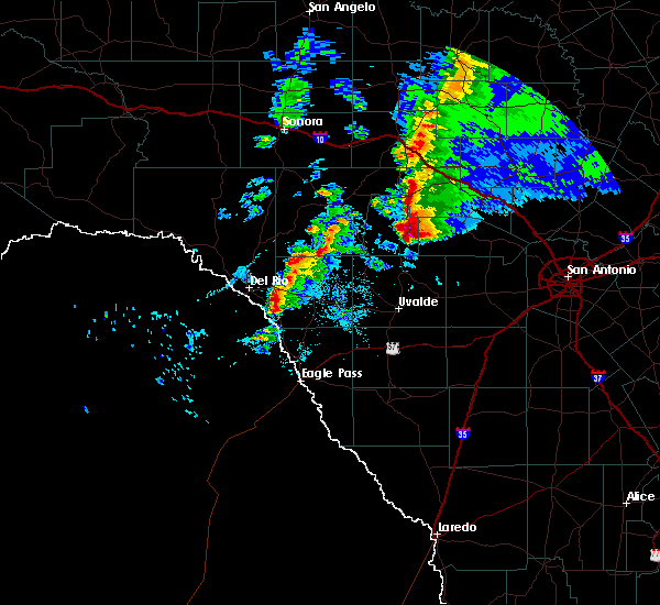 At 702 pm cst, a severe thunderstorm was located near vanderpool, moving east at 40 mph (trained weather spotters). Hazards include two inch hail and 70 mph wind gusts. People and animals outdoors will be injured. expect hail damage to roofs, siding, windows, and vehicles. expect considerable tree damage. wind damage is also likely to mobile homes, roofs, and outbuildings. locations impacted include, leakey and tuff. A tornado watch remains in effect until midnight cst for south central texas. At 702 pm cst, a severe thunderstorm was located near vanderpool, moving east at 40 mph (trained weather spotters). Hazards include two inch hail and 70 mph wind gusts. People and animals outdoors will be injured. expect hail damage to roofs, siding, windows, and vehicles. expect considerable tree damage. wind damage is also likely to mobile homes, roofs, and outbuildings. locations impacted include, leakey and tuff. A tornado watch remains in effect until midnight cst for south central texas.
|
| 1/15/2017 6:58 PM CST | Tea Cup sized hail reported 0.3 miles NW of Leakey, TX |
| 1/15/2017 6:58 PM CST | Tea Cup sized hail reported 6 miles S of Leakey, TX |
| 1/15/2017 6:55 PM CST | Hen Egg sized hail reported 5.3 miles S of Leakey, TX |
| 1/15/2017 6:51 PM CST |
 At 649 pm cst, a severe thunderstorm was located over tuff, or near leakey, moving east at 40 mph. this storm has a history of producing hail up to the size of baseballs (trained weather spotters). Hazards include two inch hail and 60 mph wind gusts. People and animals outdoors will be injured. expect hail damage to roofs, siding, windows, and vehicles. expect wind damage to roofs, siding, and trees. locations impacted include, leakey and tuff. A tornado watch remains in effect until midnight cst for south central texas. At 649 pm cst, a severe thunderstorm was located over tuff, or near leakey, moving east at 40 mph. this storm has a history of producing hail up to the size of baseballs (trained weather spotters). Hazards include two inch hail and 60 mph wind gusts. People and animals outdoors will be injured. expect hail damage to roofs, siding, windows, and vehicles. expect wind damage to roofs, siding, and trees. locations impacted include, leakey and tuff. A tornado watch remains in effect until midnight cst for south central texas.
|
| 1/15/2017 6:24 PM CST |
 At 623 pm cst, a severe thunderstorm was located near vance, or 17 miles west of leakey, moving east at 40 mph (trained weather spotters). Hazards include two inch hail and 60 mph wind gusts. People and animals outdoors will be injured. expect hail damage to roofs, siding, windows, and vehicles. Expect wind damage to roofs, siding, and trees. At 623 pm cst, a severe thunderstorm was located near vance, or 17 miles west of leakey, moving east at 40 mph (trained weather spotters). Hazards include two inch hail and 60 mph wind gusts. People and animals outdoors will be injured. expect hail damage to roofs, siding, windows, and vehicles. Expect wind damage to roofs, siding, and trees.
|
| 5/29/2016 12:11 AM CDT |
 At 1210 am cdt, severe thunderstorms were located along a line extending from welfare to bandera falls to near utopia to 7 miles west of montell, moving south at 15 mph. this incluses garner state park where ongoing camping is high for the holiday weekend (radar indicated). Hazards include 60 mph wind gusts and quarter size hail. Hail damage to vehicles is expected. expect wind damage to roofs, siding, and trees. Locations impacted include, medina, kerrville, boerne, comfort, bandera, leakey, vanderpool, tarpley, camp wood, montell, lost maples state park, waring, concan, pipe creek, walnut grove, utopia, welfare, sisterdale, bandera falls and mico. At 1210 am cdt, severe thunderstorms were located along a line extending from welfare to bandera falls to near utopia to 7 miles west of montell, moving south at 15 mph. this incluses garner state park where ongoing camping is high for the holiday weekend (radar indicated). Hazards include 60 mph wind gusts and quarter size hail. Hail damage to vehicles is expected. expect wind damage to roofs, siding, and trees. Locations impacted include, medina, kerrville, boerne, comfort, bandera, leakey, vanderpool, tarpley, camp wood, montell, lost maples state park, waring, concan, pipe creek, walnut grove, utopia, welfare, sisterdale, bandera falls and mico.
|
| 5/28/2016 11:59 PM CDT |
 At 1158 pm cdt, severe thunderstorms were located along a line extending from comfort to pipe creek to near utopia to 7 miles west of montell, moving south to south-southeast at 15 mph (radar indicated). Hazards include 60 mph wind gusts and quarter size hail. Hail damage to vehicles is expected. Expect wind damage to roofs, siding, and trees. At 1158 pm cdt, severe thunderstorms were located along a line extending from comfort to pipe creek to near utopia to 7 miles west of montell, moving south to south-southeast at 15 mph (radar indicated). Hazards include 60 mph wind gusts and quarter size hail. Hail damage to vehicles is expected. Expect wind damage to roofs, siding, and trees.
|
| 5/28/2016 11:27 PM CDT |
 At 1127 pm cdt, a severe thunderstorm was located near camp wood, or 10 miles west of leakey, moving northeast at 20 mph (radar indicated). Hazards include 60 mph wind gusts and quarter size hail. Hail damage to vehicles is expected. Expect wind damage to roofs, siding, and trees. At 1127 pm cdt, a severe thunderstorm was located near camp wood, or 10 miles west of leakey, moving northeast at 20 mph (radar indicated). Hazards include 60 mph wind gusts and quarter size hail. Hail damage to vehicles is expected. Expect wind damage to roofs, siding, and trees.
|
| 5/28/2016 11:22 PM CDT |
 At 1122 pm cdt, a severe thunderstorm was located near camp wood, or 10 miles west of leakey, moving northeast at 20 mph (radar indicated). Hazards include 60 mph wind gusts and quarter size hail. Hail damage to vehicles is expected. expect wind damage to roofs, siding, and trees. Locations impacted include, leakey, camp wood, vance, rio frio, tuff, barksdale and prade ranch. At 1122 pm cdt, a severe thunderstorm was located near camp wood, or 10 miles west of leakey, moving northeast at 20 mph (radar indicated). Hazards include 60 mph wind gusts and quarter size hail. Hail damage to vehicles is expected. expect wind damage to roofs, siding, and trees. Locations impacted include, leakey, camp wood, vance, rio frio, tuff, barksdale and prade ranch.
|
| 5/28/2016 10:52 PM CDT |
 At 1052 pm cdt, a severe thunderstorm was located near vance, or 11 miles west of leakey, moving east at 15 mph (radar indicated). Hazards include 60 mph wind gusts and quarter size hail. Hail damage to vehicles is expected. Expect wind damage to roofs, siding, and trees. At 1052 pm cdt, a severe thunderstorm was located near vance, or 11 miles west of leakey, moving east at 15 mph (radar indicated). Hazards include 60 mph wind gusts and quarter size hail. Hail damage to vehicles is expected. Expect wind damage to roofs, siding, and trees.
|
| 5/17/2016 10:14 PM CDT |
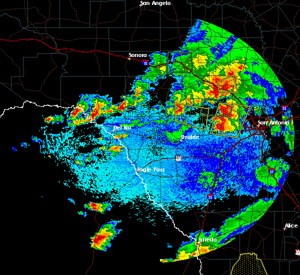 At 1014 pm cdt, a severe thunderstorm was located over leakey, moving east at 30 mph (radar indicated). Hazards include ping pong ball size hail and 60 mph wind gusts. People and animals outdoors will be injured. expect hail damage to roofs, siding, windows, and vehicles. Expect wind damage to roofs, siding, and trees. At 1014 pm cdt, a severe thunderstorm was located over leakey, moving east at 30 mph (radar indicated). Hazards include ping pong ball size hail and 60 mph wind gusts. People and animals outdoors will be injured. expect hail damage to roofs, siding, windows, and vehicles. Expect wind damage to roofs, siding, and trees.
|
| 3/18/2016 7:15 PM CDT | Quarter sized hail reported 2 miles W of Leakey, TX |
| 3/18/2016 7:14 PM CDT |
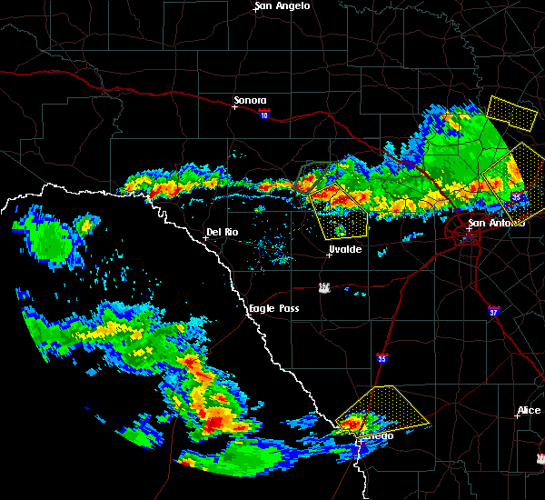 At 714 pm cdt, a severe thunderstorm was located near leakey, moving southeast at 10 mph (radar indicated). Hazards include 60 mph wind gusts and quarter size hail. Hail damage to vehicles is expected. Expect wind damage to roofs, siding, and trees. At 714 pm cdt, a severe thunderstorm was located near leakey, moving southeast at 10 mph (radar indicated). Hazards include 60 mph wind gusts and quarter size hail. Hail damage to vehicles is expected. Expect wind damage to roofs, siding, and trees.
|
| 3/18/2016 6:56 PM CDT |
 At 655 pm cdt, severe thunderstorms were located along a line extending from near vance to near tarpley to near pipe creek, moving south at 10 mph (radar indicated). Hazards include 60 mph wind gusts and quarter size hail. Hail damage to vehicles is expected. expect wind damage to roofs, siding, and trees. Locations impacted include, medina, kerrville, bandera, leakey, vanderpool, hunt, ingram, camp wood, waltonia, kerr wildlife management area, vance, lost maples state park, tuff, kerrville state park, barksdale, pipe creek, cypress creek, center point, bandera falls and camp verde. At 655 pm cdt, severe thunderstorms were located along a line extending from near vance to near tarpley to near pipe creek, moving south at 10 mph (radar indicated). Hazards include 60 mph wind gusts and quarter size hail. Hail damage to vehicles is expected. expect wind damage to roofs, siding, and trees. Locations impacted include, medina, kerrville, bandera, leakey, vanderpool, hunt, ingram, camp wood, waltonia, kerr wildlife management area, vance, lost maples state park, tuff, kerrville state park, barksdale, pipe creek, cypress creek, center point, bandera falls and camp verde.
|
| 3/18/2016 6:13 PM CDT |
 At 612 pm cdt, severe thunderstorms were located along a line extending from vance to near pipe creek, moving south at 10 mph. these storms have a history of quarter to ping pong ball sized hail over the last two hours (radar indicated). Hazards include 60 mph wind gusts and half dollar size hail. Hail damage to vehicles is expected. Expect wind damage to roofs, siding, and trees. At 612 pm cdt, severe thunderstorms were located along a line extending from vance to near pipe creek, moving south at 10 mph. these storms have a history of quarter to ping pong ball sized hail over the last two hours (radar indicated). Hazards include 60 mph wind gusts and half dollar size hail. Hail damage to vehicles is expected. Expect wind damage to roofs, siding, and trees.
|
| 3/8/2016 8:20 PM CST | Quarter sized hail reported 0.3 miles NW of Leakey, TX |
| 3/8/2016 8:12 PM CST |
 At 811 pm cst, a severe thunderstorm was located 13 miles west of kerr wildlife management area, or 23 miles north of leakey, moving north at 20 to 25 mph. in addition, there are multiple storms developing in south real county as well as eastern edwards county that could also produce quarter to half dollar sized hail (radar indicated). Hazards include 60 mph wind gusts and half dollar size hail. Hail damage to vehicles is expected. Expect wind damage to roofs, siding, and trees. At 811 pm cst, a severe thunderstorm was located 13 miles west of kerr wildlife management area, or 23 miles north of leakey, moving north at 20 to 25 mph. in addition, there are multiple storms developing in south real county as well as eastern edwards county that could also produce quarter to half dollar sized hail (radar indicated). Hazards include 60 mph wind gusts and half dollar size hail. Hail damage to vehicles is expected. Expect wind damage to roofs, siding, and trees.
|
| 3/8/2016 8:10 PM CST | Quarter sized hail reported 0.3 miles NW of Leakey, TX |
| 3/8/2016 8:05 PM CST |
 At 805 pm cst, a severe thunderstorm was located 13 miles west of kerr wildlife management area, or 23 miles north of leakey, moving north at 35 mph (radar indicated). Hazards include golf ball size hail and 60 mph wind gusts. People and animals outdoors will be injured. expect hail damage to roofs, siding, windows, and vehicles. expect wind damage to roofs, siding, and trees. Locations impacted include, leakey, rio frio, tuff, prade ranch and us-377 near the kimble- edwards county line. At 805 pm cst, a severe thunderstorm was located 13 miles west of kerr wildlife management area, or 23 miles north of leakey, moving north at 35 mph (radar indicated). Hazards include golf ball size hail and 60 mph wind gusts. People and animals outdoors will be injured. expect hail damage to roofs, siding, windows, and vehicles. expect wind damage to roofs, siding, and trees. Locations impacted include, leakey, rio frio, tuff, prade ranch and us-377 near the kimble- edwards county line.
|
| 3/8/2016 7:16 PM CST |
 At 715 pm cst, a severe thunderstorm was located 7 miles northwest of tuff, or 10 miles northwest of leakey, moving north at 40 mph (radar indicated). Hazards include 60 mph wind gusts and quarter size hail. Hail damage to vehicles is expected. Expect wind damage to roofs, siding, and trees. At 715 pm cst, a severe thunderstorm was located 7 miles northwest of tuff, or 10 miles northwest of leakey, moving north at 40 mph (radar indicated). Hazards include 60 mph wind gusts and quarter size hail. Hail damage to vehicles is expected. Expect wind damage to roofs, siding, and trees.
|
| 12/12/2015 11:49 PM CST |
 At 1149 pm cst, severe thunderstorms were located along a line extending from 17 miles south of telegraph to 6 miles west of leakey to 7 miles northeast of blewett, moving east at 35 mph (radar indicated). Hazards include 60 mph wind gusts and nickel size hail. Expect damage to roofs. siding and trees. Locations impacted include, leakey, camp wood, laguna, concan, garner state park, vance, montell, rio frio, reagan wells, tuff, barksdale, cline and prade ranch. At 1149 pm cst, severe thunderstorms were located along a line extending from 17 miles south of telegraph to 6 miles west of leakey to 7 miles northeast of blewett, moving east at 35 mph (radar indicated). Hazards include 60 mph wind gusts and nickel size hail. Expect damage to roofs. siding and trees. Locations impacted include, leakey, camp wood, laguna, concan, garner state park, vance, montell, rio frio, reagan wells, tuff, barksdale, cline and prade ranch.
|
| 12/12/2015 11:38 PM CST |
 At 1134 pm cst, severe thunderstorms were located along a line extending from 16 miles east of rocksprings to barksdale to near cline, moving east at 25 mph (radar indicated). Hazards include 60 mph wind gusts. Expect damage to roofs. siding and trees. Locations impacted include, leakey, camp wood, laguna, concan, garner state park, vance, montell, rio frio, reagan wells, tuff, barksdale, cline and prade ranch. At 1134 pm cst, severe thunderstorms were located along a line extending from 16 miles east of rocksprings to barksdale to near cline, moving east at 25 mph (radar indicated). Hazards include 60 mph wind gusts. Expect damage to roofs. siding and trees. Locations impacted include, leakey, camp wood, laguna, concan, garner state park, vance, montell, rio frio, reagan wells, tuff, barksdale, cline and prade ranch.
|
| 12/12/2015 10:59 PM CST |
 At 1059 pm cst, severe thunderstorms were located along a line extending from 16 miles north of rocksprings to 13 miles west of vance to near brackettville, moving east at 35 mph (radar indicated). Hazards include 60 mph wind gusts. Expect damage to roofs. Siding and trees. At 1059 pm cst, severe thunderstorms were located along a line extending from 16 miles north of rocksprings to 13 miles west of vance to near brackettville, moving east at 35 mph (radar indicated). Hazards include 60 mph wind gusts. Expect damage to roofs. Siding and trees.
|
| 10/30/2015 11:56 PM CDT |
 At 1155 pm cdt, severe thunderstorms were located along a line extending from telegraph to 15 miles south of south llano river state park to 18 miles west of kerr wildlife management area to 10 miles northeast of vance to camp wood, moving east at 40 mph (radar indicated). Hazards include 60 mph wind gusts. Expect damage to roofs. siding and trees. Locations impacted include, leakey, vanderpool, hunt, camp wood, kerr wildlife management area, vance, lost maples state park, mountain home, tuff, barksdale, prade ranch and devils sinkhole state natural area. At 1155 pm cdt, severe thunderstorms were located along a line extending from telegraph to 15 miles south of south llano river state park to 18 miles west of kerr wildlife management area to 10 miles northeast of vance to camp wood, moving east at 40 mph (radar indicated). Hazards include 60 mph wind gusts. Expect damage to roofs. siding and trees. Locations impacted include, leakey, vanderpool, hunt, camp wood, kerr wildlife management area, vance, lost maples state park, mountain home, tuff, barksdale, prade ranch and devils sinkhole state natural area.
|
| 10/30/2015 11:39 PM CDT |
 At 1138 pm cdt, severe thunderstorms were located along a line extending from 10 miles west of telegraph to 16 miles northeast of rocksprings to vance to near barksdale, moving east at 40 mph (radar indicated). Hazards include 60 mph wind gusts and penny size hail. Expect damage to roofs. siding and trees. Locations impacted include, rocksprings, leakey, vanderpool, hunt, camp wood, kerr wildlife management area, vance, lost maples state park, tuff, mountain home, barksdale, rio frio, prade ranch and devils sinkhole state natural area. At 1138 pm cdt, severe thunderstorms were located along a line extending from 10 miles west of telegraph to 16 miles northeast of rocksprings to vance to near barksdale, moving east at 40 mph (radar indicated). Hazards include 60 mph wind gusts and penny size hail. Expect damage to roofs. siding and trees. Locations impacted include, rocksprings, leakey, vanderpool, hunt, camp wood, kerr wildlife management area, vance, lost maples state park, tuff, mountain home, barksdale, rio frio, prade ranch and devils sinkhole state natural area.
|
| 10/30/2015 11:13 PM CDT |
 At 1112 pm cdt, severe thunderstorms were located along a line extending from 23 miles southwest of roosevelt to near rocksprings to 16 miles west of barksdale to 16 miles north of alamo village, moving east at 45 mph (radar indicated). Hazards include 70 mph wind gusts and penny size hail. Expect considerable tree damage. Damage is likely to mobile homes, roofs and outbuildings. At 1112 pm cdt, severe thunderstorms were located along a line extending from 23 miles southwest of roosevelt to near rocksprings to 16 miles west of barksdale to 16 miles north of alamo village, moving east at 45 mph (radar indicated). Hazards include 70 mph wind gusts and penny size hail. Expect considerable tree damage. Damage is likely to mobile homes, roofs and outbuildings.
|
| 10/30/2015 9:29 PM CDT |
 At 929 pm cdt, a severe thunderstorm was located near leakey, moving east at 25 mph (radar indicated). Hazards include 60 mph wind gusts and quarter size hail. Hail damage to vehicles is expected. Expect wind damage to roofs, siding and trees. At 929 pm cdt, a severe thunderstorm was located near leakey, moving east at 25 mph (radar indicated). Hazards include 60 mph wind gusts and quarter size hail. Hail damage to vehicles is expected. Expect wind damage to roofs, siding and trees.
|
| 5/28/2015 11:05 PM CDT | At 1104 pm cdt, severe thunderstorms were located along a line extending from 7 miles northwest of lost maples state park to near barksdale to 15 miles north of alamo village to 11 miles northeast of lake view to near box canyon-amistad, moving southeast at 40 mph (radar indicated). Hazards include 60 mph wind gusts and penny size hail. Expect damage to roofs. siding and trees. Locations impacted include, del rio, brackettville, leakey, langtry, loma alta, comstock, camp wood, laguna, montell, alamo village, concan, standart, lake view, amanda, val verde park, seminole canyon state park, box canyon-amistad, osman, garner state park and vance. |
| 5/28/2015 10:35 PM CDT | At 1035 pm cdt, severe thunderstorms were located along a line extending from 10 miles northwest of lost maples state park to near vance to 20 miles north of alamo village to 12 miles southwest of carta valley to near comstock, moving southeast at 40 mph (radar indicated). Hazards include 60 mph wind gusts and penny size hail. Expect damage to roofs. siding and trees. Locations impacted include, del rio, brackettville, leakey, langtry, loma alta, comstock, juno, camp wood, laguna, montell, alamo village, concan, standart, lake view, amanda, pumpville, val verde park, seminole canyon state park, box canyon-amistad and osman. |
| 5/28/2015 9:57 PM CDT | At 954 pm cdt, severe thunderstorms were located along a line extending from near telegraph to 7 miles northwest of rocksprings to near flour mills to 14 miles south of juno to 11 miles north of shumla, moving southeast at 40 mph. * the strongest winds near 70 mph will be in northwest val verde and crossing into west, southwest and south central edwards county over the next half hour. these strong winds will likely be in northern uvalde and kinney country within the next hour (radar indicated). Hazards include 70 mph wind gusts and nickel size hail. Expect considerable tree damage. Damage is likely to mobile homes, roofs and outbuildings. |
| 5/14/2015 8:44 PM CDT | At 843 pm cdt, a severe thunderstorm was located 7 miles southwest of concan, or 15 miles north of uvalde, moving north at 20 mph (radar indicated). Hazards include 60 mph wind gusts and quarter size hail. Hail damage to vehicles is expected. Expect wind damage to roofs, siding and trees. |
| 5/11/2015 6:35 AM CDT | At 635 am cdt, a severe thunderstorm was located over rio frio, or 9 miles southeast of leakey, moving east at 30 mph (radar indicated). Hazards include 60 mph wind gusts and quarter size hail. Hail damage to vehicles is expected. expect wind damage to roofs, siding and trees. locations impacted include, leakey, rio frio, concan, reagan wells, tuff and garner state park. 1. 00in. |
| 5/11/2015 6:24 AM CDT | At 624 am cdt, a severe thunderstorm was located near rio frio, or 7 miles south of leakey, moving east at 20 mph (radar indicated). Hazards include 60 mph wind gusts and quarter size hail. Hail damage to vehicles is expected. expect wind damage to roofs, siding and trees. locations impacted include, leakey, camp wood, concan, garner state park, rio frio, reagan wells and tuff. 1. 00in. |
| 5/11/2015 6:13 AM CDT | Public report via facebook of winds gusting over 60 mp in real county TX, 6.2 miles NNE of Leakey, TX |
| 5/11/2015 5:55 AM CDT | At 555 am cdt, a severe thunderstorm was located near camp wood, or 13 miles southwest of leakey, moving east at 25 mph (radar indicated). Hazards include 60 mph wind gusts and quarter size hail. Hail damage to vehicles is expected. Expect wind damage to roofs, siding and trees. |
| 5/11/2015 5:52 AM CDT | At 551 am cdt, a severe thunderstorm was located over camp wood, or 14 miles west of leakey, moving east at 25 mph (radar indicated). Hazards include 60 mph wind gusts and quarter size hail. Hail damage to vehicles is expected. expect wind damage to roofs, siding and trees. locations impacted include, leakey, camp wood, concan, garner state park, vance, montell, rio frio, reagan wells and tuff. 1. 00in. |
| 5/11/2015 5:38 AM CDT | At 537 am cdt, a severe thunderstorm was located over barksdale, or 16 miles west of leakey, moving southeast at 15 to 20 mph (radar indicated). Hazards include 60 mph wind gusts and half dollar size hail. Hail damage to vehicles is expected. expect wind damage to roofs, siding and trees. locations impacted include, leakey, camp wood, concan, garner state park, vance, montell, rio frio, reagan wells, tuff and barksdale. 1. 25in. |
| 5/11/2015 5:07 AM CDT | At 507 am cdt, a severe thunderstorm was located near barksdale, or 19 miles west of leakey, moving east at 35 mph (radar indicated). Hazards include ping pong ball size hail and 60 mph wind gusts. People and animals outdoors will be injured. expect hail damage to roofs, siding, windows and vehicles. Expect wind damage to roofs, siding and trees. |
| 4/27/2015 12:14 AM CDT | At 1214 am cdt, severe thunderstorms were located along a line extending from near medina to 6 miles north of knippa to 7 miles east of washer, moving east at 70 mph (radar indicated). Hazards include 60 mph wind gusts and penny size hail. Expect damage to roofs. Siding and trees. |
| 4/26/2015 11:40 PM CDT | At 1139 pm cdt, severe thunderstorms were located along a line extending from 7 miles northwest of tuff to 7 miles northwest of darling, moving southeast at 60 mph (radar indicated). Hazards include 70 mph wind gusts and quarter size hail. Hail damage to vehicles is expected. expect considerable tree damage. Wind damage is also likely to mobile homes, roofs and outbuildings. |
| 4/17/2015 1:48 PM CDT | At 147 pm cdt, a severe thunderstorm was located over leakey, moving east at 20 mph (radar indicated). Hazards include 60 mph wind gusts. Expect damage to roofs. siding and trees. locations impacted include, leakey, camp wood, concan, garner state park, rio frio, reagan wells and tuff. 75in. |
| 4/17/2015 1:28 PM CDT | At 127 pm cdt, a severe thunderstorm was located 7 miles west of leakey, moving southeast at 20 mph (radar indicated). Hazards include 60 mph wind gusts and quarter size hail. Hail damage to vehicles is expected. Expect wind damage to roofs, siding and trees. |
| 6/12/2014 7:59 PM CDT | Hen Egg sized hail reported 6.7 miles NNW of Leakey, TX, large hail reported. |
| 6/12/2014 7:53 PM CDT | Several good size trees down with several limbs of 6 inches in diameter dow in real county TX, 1.6 miles N of Leakey, TX |
| 6/12/2014 7:53 PM CDT | Ping Pong Ball sized hail reported 1.6 miles N of Leakey, TX, large hail just ended at the time of the report. |
| 5/10/2013 5:00 PM CDT | Wind gust to 60 mph with brief one quarter inch hail in uvalde county TX, 12.2 miles N of Leakey, TX |
| 3/31/2013 4:25 PM CDT | Quarter sized hail reported 5.6 miles W of Leakey, TX |
| 3/19/2012 10:00 PM CDT | Golf Ball sized hail reported 16.7 miles SW of Leakey, TX, 2.04 inches of rainfall also |
| 3/19/2012 8:00 PM CDT | Golf Ball sized hail reported 1.8 miles S of Leakey, TX, pea to golfball size hail with some damage. |
| 3/19/2012 7:12 PM CDT | Golf Ball sized hail reported 13.1 miles SW of Leakey, TX |
| 3/19/2012 7:00 PM CDT | Golf Ball sized hail reported 1.8 miles S of Leakey, TX, golfball size hail along with 2 inches of rainfall in less than an hour. |
| 3/19/2012 6:35 PM CDT | Golf Ball sized hail reported 1.8 miles S of Leakey, TX |
| 1/1/0001 12:00 AM | Large tree blown onto roof knocking down chimney in bandera county TX, 13 miles WSW of Leakey, TX |
| 1/1/0001 12:00 AM | Quarter sized hail reported 0.3 miles NW of Leakey, TX, the public reported hail ranging from the size of marbles up to the size of quarters. |
Hail Maps for Leakey, TX
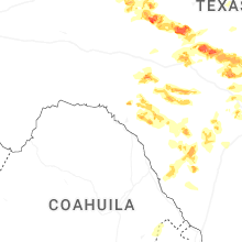

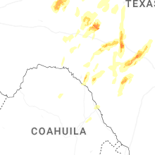


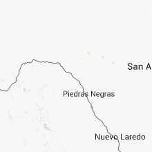


Connect with Interactive Hail Maps