

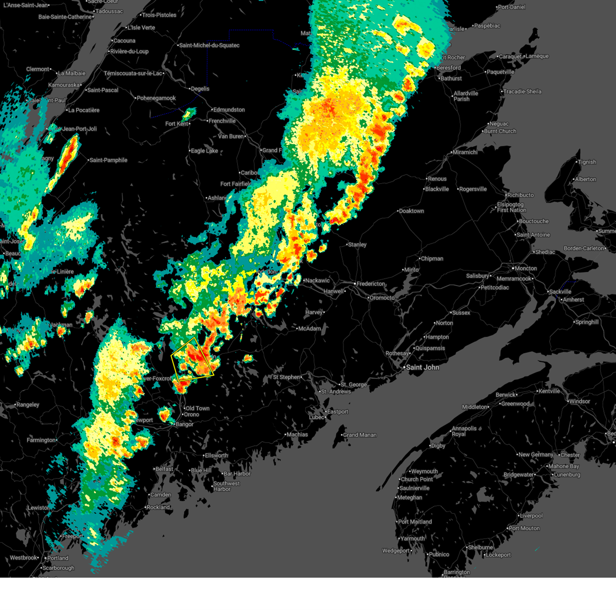
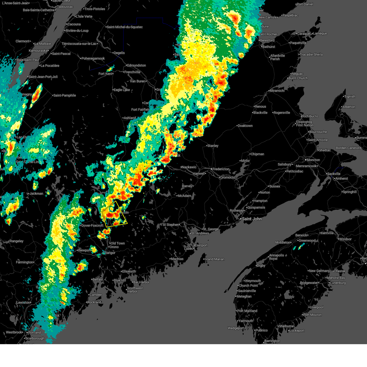
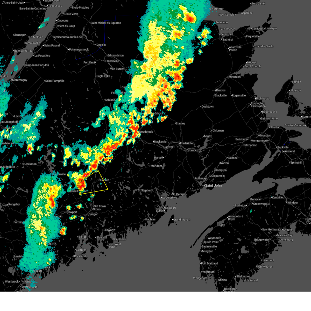
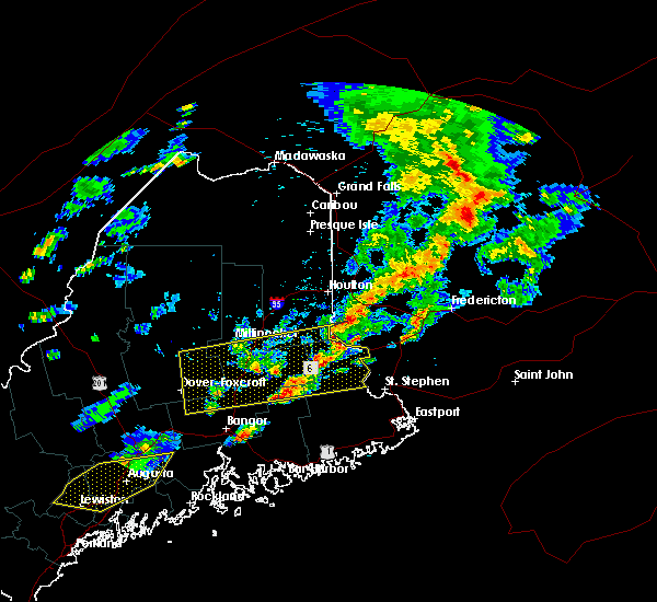
Hail Map for Lincoln, ME
The Lincoln, ME area has had 22 reports of on-the-ground hail by trained spotters, and has been under severe weather warnings 4 times during the past 12 months. Doppler radar has detected hail at or near Lincoln, ME on 15 occasions.
| Name: | Lincoln, ME |
| Where Located: | 40.8 miles NNE of Bangor, ME |
| Map: | Google Map for Lincoln, ME |
| Population: | 2884 |
| Housing Units: | 1332 |
| More Info: | Search Google for Lincoln, ME |
3
The Top Recent Hail Date for Lincoln, ME is Friday, June 14, 2024 (4th out of 15)

Hail and Wind Damage Spotted near Lincoln, ME
| Date / Time | Report Details |
|---|---|
| 7/3/2025 2:37 PM EDT |
 The storm which prompted the warning has weakened below severe limits, and no longer poses an immediate threat to life or property. therefore, the warning will be allowed to expire. a severe thunderstorm watch remains in effect until 600 pm edt for southeastern and east central maine. The storm which prompted the warning has weakened below severe limits, and no longer poses an immediate threat to life or property. therefore, the warning will be allowed to expire. a severe thunderstorm watch remains in effect until 600 pm edt for southeastern and east central maine.
|
| 7/3/2025 2:23 PM EDT |
 At 223 pm edt, a severe thunderstorm was located near howland, moving northeast at 35 mph (radar indicated). Hazards include 60 mph wind gusts. Expect damage to trees and power lines. locations impacted include, howland, lincoln, enfield, chester, passadumkeag, burlington, lowell, woodville, maxfield, and seboeis. This includes interstate 95 between mile markers 212 and 236. At 223 pm edt, a severe thunderstorm was located near howland, moving northeast at 35 mph (radar indicated). Hazards include 60 mph wind gusts. Expect damage to trees and power lines. locations impacted include, howland, lincoln, enfield, chester, passadumkeag, burlington, lowell, woodville, maxfield, and seboeis. This includes interstate 95 between mile markers 212 and 236.
|
| 7/3/2025 2:23 PM EDT |
 the severe thunderstorm warning has been cancelled and is no longer in effect the severe thunderstorm warning has been cancelled and is no longer in effect
|
| 7/3/2025 2:02 PM EDT |
 Svrcar the national weather service in caribou maine has issued a * severe thunderstorm warning for, southeastern piscataquis county in north central maine, central penobscot county in east central maine, * until 245 pm edt. * at 202 pm edt, a severe thunderstorm was located near milo, or 9 miles west of howland, moving northeast at 25 mph (radar indicated). Hazards include 60 mph wind gusts and quarter size hail. Minor hail damage to vehicles is possible. Expect wind damage to trees and power lines. Svrcar the national weather service in caribou maine has issued a * severe thunderstorm warning for, southeastern piscataquis county in north central maine, central penobscot county in east central maine, * until 245 pm edt. * at 202 pm edt, a severe thunderstorm was located near milo, or 9 miles west of howland, moving northeast at 25 mph (radar indicated). Hazards include 60 mph wind gusts and quarter size hail. Minor hail damage to vehicles is possible. Expect wind damage to trees and power lines.
|
| 7/9/2024 5:23 PM EDT | Quarter sized hail reported 13.6 miles W of Lincoln, ME |
| 7/9/2024 5:23 PM EDT |
 The storm which prompted the warning has moved out of the area. therefore, the warning will be allowed to expire. a severe thunderstorm warning still remains in effect for portions of east central penobscot and northern washington counties until 6:15 pm. to report severe weather, contact your nearest law enforcement agency. they will relay your report to the national weather service caribou maine. The storm which prompted the warning has moved out of the area. therefore, the warning will be allowed to expire. a severe thunderstorm warning still remains in effect for portions of east central penobscot and northern washington counties until 6:15 pm. to report severe weather, contact your nearest law enforcement agency. they will relay your report to the national weather service caribou maine.
|
| 7/9/2024 5:15 PM EDT | Quarter sized hail reported 10.7 miles W of Lincoln, ME |
| 7/9/2024 5:07 PM EDT |
 At 507 pm edt, a severe thunderstorm was located near licoln township, or 8 miles east of lincoln, moving northeast at 45 mph (radar indicated). Hazards include 60 mph wind gusts and quarter size hail. Minor hail damage to vehicles is possible. expect wind damage to trees and power lines. Locations impacted include, licoln township, lee, winn, burlington, and lowell. At 507 pm edt, a severe thunderstorm was located near licoln township, or 8 miles east of lincoln, moving northeast at 45 mph (radar indicated). Hazards include 60 mph wind gusts and quarter size hail. Minor hail damage to vehicles is possible. expect wind damage to trees and power lines. Locations impacted include, licoln township, lee, winn, burlington, and lowell.
|
| 7/9/2024 4:55 PM EDT |
 At 455 pm edt, a severe thunderstorm was located 7 miles south of licoln township, or 7 miles south of lincoln, moving northeast at 25 mph (radar indicated). Hazards include 60 mph wind gusts. Expect damage to trees and power lines. Locations impacted include, lincoln, howland, licoln township, enfield, greenbush, lee, chester, winn, passadumkeag, burlington, lowell, woodville, and maxfield. At 455 pm edt, a severe thunderstorm was located 7 miles south of licoln township, or 7 miles south of lincoln, moving northeast at 25 mph (radar indicated). Hazards include 60 mph wind gusts. Expect damage to trees and power lines. Locations impacted include, lincoln, howland, licoln township, enfield, greenbush, lee, chester, winn, passadumkeag, burlington, lowell, woodville, and maxfield.
|
| 7/9/2024 4:29 PM EDT |
 Svrcar the national weather service in caribou maine has issued a * severe thunderstorm warning for, east central penobscot county in east central maine, * until 530 pm edt. * at 429 pm edt, a severe thunderstorm was located near howland, moving northeast at 25 mph (radar indicated). Hazards include 60 mph wind gusts and penny size hail. expect damage to trees and power lines Svrcar the national weather service in caribou maine has issued a * severe thunderstorm warning for, east central penobscot county in east central maine, * until 530 pm edt. * at 429 pm edt, a severe thunderstorm was located near howland, moving northeast at 25 mph (radar indicated). Hazards include 60 mph wind gusts and penny size hail. expect damage to trees and power lines
|
| 6/30/2024 3:11 PM EDT |
 the severe thunderstorm warning has been cancelled and is no longer in effect the severe thunderstorm warning has been cancelled and is no longer in effect
|
| 6/30/2024 3:11 PM EDT |
 At 310 pm edt, severe thunderstorms were located along a line extending from near danforth to near springfield to 8 miles southeast of orneville, moving east at 45 mph (radar indicated). Hazards include 70 mph wind gusts and quarter size hail. Minor hail damage to vehicles is possible. expect considerable tree damage. wind damage is also likely to mobile homes, roofs, and outbuildings. Locations impacted include, old town, dexter, howland, danforth, vanceboro, orono, corinth, springfield, topsfield, grand lake stream, lakeville, indian island, licoln township, fowler township, dyer township, grand falls, codyville plantation, east corinth, glenburn, and milford. At 310 pm edt, severe thunderstorms were located along a line extending from near danforth to near springfield to 8 miles southeast of orneville, moving east at 45 mph (radar indicated). Hazards include 70 mph wind gusts and quarter size hail. Minor hail damage to vehicles is possible. expect considerable tree damage. wind damage is also likely to mobile homes, roofs, and outbuildings. Locations impacted include, old town, dexter, howland, danforth, vanceboro, orono, corinth, springfield, topsfield, grand lake stream, lakeville, indian island, licoln township, fowler township, dyer township, grand falls, codyville plantation, east corinth, glenburn, and milford.
|
| 6/30/2024 2:59 PM EDT | Numerous trees and wires down in carroll plantatio in penobscot county ME, 18.6 miles W of Lincoln, ME |
| 6/30/2024 2:57 PM EDT | Numerous trees and wires down in springfiel in penobscot county ME, 17.7 miles W of Lincoln, ME |
| 6/30/2024 2:50 PM EDT | Trees and wires down in webster plantatio in penobscot county ME, 20.8 miles WSW of Lincoln, ME |
| 6/30/2024 2:50 PM EDT |
 Svrcar the national weather service in caribou maine has issued a * severe thunderstorm warning for, northwestern washington county in southeastern maine, northeastern hancock county in southeastern maine, southeastern piscataquis county in north central maine, southeastern aroostook county in northern maine, southern penobscot county in east central maine, * until 330 pm edt. * at 250 pm edt, severe thunderstorms were located along a line extending from wytopitlock to near licoln township to 6 miles southeast of dover-foxcroft, moving east at 45 mph (radar indicated). Hazards include 70 mph wind gusts and quarter size hail. Minor hail damage to vehicles is possible. expect considerable tree damage. Wind damage is also likely to mobile homes, roofs, and outbuildings. Svrcar the national weather service in caribou maine has issued a * severe thunderstorm warning for, northwestern washington county in southeastern maine, northeastern hancock county in southeastern maine, southeastern piscataquis county in north central maine, southeastern aroostook county in northern maine, southern penobscot county in east central maine, * until 330 pm edt. * at 250 pm edt, severe thunderstorms were located along a line extending from wytopitlock to near licoln township to 6 miles southeast of dover-foxcroft, moving east at 45 mph (radar indicated). Hazards include 70 mph wind gusts and quarter size hail. Minor hail damage to vehicles is possible. expect considerable tree damage. Wind damage is also likely to mobile homes, roofs, and outbuildings.
|
| 6/30/2024 2:39 PM EDT | Numerous trees and wires down in win in penobscot county ME, 10.9 miles SW of Lincoln, ME |
| 6/30/2024 2:37 PM EDT | A couple large trees dow in penobscot county ME, 0.5 miles E of Lincoln, ME |
| 6/30/2024 2:35 PM EDT | A couple trees snapped along with a partially filled inflatable pool flipped ove in penobscot county ME, 3.4 miles S of Lincoln, ME |
| 6/30/2024 2:32 PM EDT |
 At 232 pm edt, severe thunderstorms were located along a line extending from 7 miles northeast of medway to near brownville junction, moving east at 30 mph (radar indicated). Hazards include 70 mph wind gusts and half dollar size hail. Minor hail damage to vehicles is possible. expect considerable tree damage. wind damage is also likely to mobile homes, roofs, and outbuildings. Locations impacted include, lincoln, dover-foxcroft, guilford, howland, brownville junction, milo, east millinocket, medway, haynesville, licoln township, wytopitlock, lake view plantation, reed plantation, orneville, ebeemee, enfield, hudson, charleston, bradford, and brownville. At 232 pm edt, severe thunderstorms were located along a line extending from 7 miles northeast of medway to near brownville junction, moving east at 30 mph (radar indicated). Hazards include 70 mph wind gusts and half dollar size hail. Minor hail damage to vehicles is possible. expect considerable tree damage. wind damage is also likely to mobile homes, roofs, and outbuildings. Locations impacted include, lincoln, dover-foxcroft, guilford, howland, brownville junction, milo, east millinocket, medway, haynesville, licoln township, wytopitlock, lake view plantation, reed plantation, orneville, ebeemee, enfield, hudson, charleston, bradford, and brownville.
|
| 6/30/2024 2:07 PM EDT |
 Svrcar the national weather service in caribou maine has issued a * severe thunderstorm warning for, southeastern piscataquis county in north central maine, southeastern aroostook county in northern maine, central penobscot county in east central maine, * until 300 pm edt. * at 207 pm edt, severe thunderstorms were located along a line extending from near millinocket to 6 miles southeast of elliottsville, moving east at 30 mph (radar indicated). Hazards include 70 mph wind gusts and half dollar size hail. Minor hail damage to vehicles is possible. expect considerable tree damage. Wind damage is also likely to mobile homes, roofs, and outbuildings. Svrcar the national weather service in caribou maine has issued a * severe thunderstorm warning for, southeastern piscataquis county in north central maine, southeastern aroostook county in northern maine, central penobscot county in east central maine, * until 300 pm edt. * at 207 pm edt, severe thunderstorms were located along a line extending from near millinocket to 6 miles southeast of elliottsville, moving east at 30 mph (radar indicated). Hazards include 70 mph wind gusts and half dollar size hail. Minor hail damage to vehicles is possible. expect considerable tree damage. Wind damage is also likely to mobile homes, roofs, and outbuildings.
|
| 6/14/2024 3:53 PM EDT |
 Svrcar the national weather service in caribou maine has issued a * severe thunderstorm warning for, east central penobscot county in east central maine, * until 430 pm edt. * at 353 pm edt, a severe thunderstorm was located near licoln township, or near lincoln, moving east at 45 mph (radar indicated). Hazards include 60 mph wind gusts and quarter size hail. Minor hail damage to vehicles is possible. Expect wind damage to trees and power lines. Svrcar the national weather service in caribou maine has issued a * severe thunderstorm warning for, east central penobscot county in east central maine, * until 430 pm edt. * at 353 pm edt, a severe thunderstorm was located near licoln township, or near lincoln, moving east at 45 mph (radar indicated). Hazards include 60 mph wind gusts and quarter size hail. Minor hail damage to vehicles is possible. Expect wind damage to trees and power lines.
|
| 6/14/2024 3:49 PM EDT | Reports of trees down in cheste in penobscot county ME, 3.4 miles S of Lincoln, ME |
| 6/14/2024 3:49 PM EDT | Update to previous report from penobscot county sheriff of one tree down on south chester road in chester. they said that it was one tree down and not multiple tree in penobscot county ME, 4.1 miles S of Lincoln, ME |
| 6/14/2024 3:46 PM EDT | Half Dollar sized hail reported 1.4 miles S of Lincoln, ME, delayed report. photos via social media show hail up to half dollar sized in lincoln. time estimated via radar. |
| 6/5/2024 6:40 PM EDT | Golf Ball sized hail reported 19.9 miles WSW of Lincoln, ME |
| 6/5/2024 6:19 PM EDT | Trees and wires down in lee reported from penobscot rc in penobscot county ME, 10.2 miles W of Lincoln, ME |
| 8/5/2023 3:00 PM EDT | Quarter sized hail reported 10.9 miles NNW of Lincoln, ME, estimated hail size from facebook photo. |
| 8/5/2023 2:58 PM EDT |
 The severe thunderstorm warning for east central penobscot county will expire at 300 pm edt, the storms which prompted the warning have weakened below severe limits, but frequent cloud to ground lightning and heavy downpours are still likely. therefore, the warning will be allowed to expire. however small hail and gusty winds are still possible with this thunderstorm. to report severe weather, contact your nearest law enforcement agency. they will relay your report to the national weather service caribou maine. The severe thunderstorm warning for east central penobscot county will expire at 300 pm edt, the storms which prompted the warning have weakened below severe limits, but frequent cloud to ground lightning and heavy downpours are still likely. therefore, the warning will be allowed to expire. however small hail and gusty winds are still possible with this thunderstorm. to report severe weather, contact your nearest law enforcement agency. they will relay your report to the national weather service caribou maine.
|
| 8/5/2023 2:37 PM EDT |
 At 236 pm edt, a severe thunderstorm was located near licoln township, or near lincoln, moving southeast at 25 mph (radar indicated). Hazards include 60 mph wind gusts and quarter size hail. Minor hail damage to vehicles is possible. expect wind damage to trees and power lines. locations impacted include, lincoln, springfield, licoln township, enfield, lee, chester, winn, burlington, lowell and carroll. hail threat, radar indicated max hail size, 1. 00 in wind threat, radar indicated max wind gust, 60 mph. At 236 pm edt, a severe thunderstorm was located near licoln township, or near lincoln, moving southeast at 25 mph (radar indicated). Hazards include 60 mph wind gusts and quarter size hail. Minor hail damage to vehicles is possible. expect wind damage to trees and power lines. locations impacted include, lincoln, springfield, licoln township, enfield, lee, chester, winn, burlington, lowell and carroll. hail threat, radar indicated max hail size, 1. 00 in wind threat, radar indicated max wind gust, 60 mph.
|
| 8/5/2023 2:17 PM EDT |
 At 217 pm edt, a severe thunderstorm was located over lincoln, moving southeast at 25 mph (radar indicated). Hazards include 60 mph wind gusts and quarter size hail. Minor hail damage to vehicles is possible. Expect wind damage to trees and power lines. At 217 pm edt, a severe thunderstorm was located over lincoln, moving southeast at 25 mph (radar indicated). Hazards include 60 mph wind gusts and quarter size hail. Minor hail damage to vehicles is possible. Expect wind damage to trees and power lines.
|
| 7/12/2022 8:07 PM EDT |
 At 807 pm edt, severe thunderstorms were located along a line extending from 7 miles east of sherman to near lake view plantation, moving northeast at 45 mph (radar indicated). Hazards include 60 mph wind gusts and quarter size hail. Minor hail damage to vehicles is possible. expect wind damage to trees and power lines. locations impacted include, millinocket, dover-foxcroft, howland, brownville junction, milo, east millinocket, medway, sherman, ebeemee, lake view plantation, licoln township, southeastern katahdin woods and waters national monument, enfield, brownville, lagrange, sebec, chester, stacyville, medford and woodville. hail threat, radar indicated max hail size, 1. 00 in wind threat, radar indicated max wind gust, 60 mph. At 807 pm edt, severe thunderstorms were located along a line extending from 7 miles east of sherman to near lake view plantation, moving northeast at 45 mph (radar indicated). Hazards include 60 mph wind gusts and quarter size hail. Minor hail damage to vehicles is possible. expect wind damage to trees and power lines. locations impacted include, millinocket, dover-foxcroft, howland, brownville junction, milo, east millinocket, medway, sherman, ebeemee, lake view plantation, licoln township, southeastern katahdin woods and waters national monument, enfield, brownville, lagrange, sebec, chester, stacyville, medford and woodville. hail threat, radar indicated max hail size, 1. 00 in wind threat, radar indicated max wind gust, 60 mph.
|
| 7/12/2022 7:45 PM EDT |
 At 744 pm edt, severe thunderstorms were located along a line extending from 8 miles northeast of east millinocket to 6 miles southwest of brownville junction, moving northeast at 45 mph (radar indicated). Hazards include 60 mph wind gusts and quarter size hail. Minor hail damage to vehicles is possible. Expect wind damage to trees and power lines. At 744 pm edt, severe thunderstorms were located along a line extending from 8 miles northeast of east millinocket to 6 miles southwest of brownville junction, moving northeast at 45 mph (radar indicated). Hazards include 60 mph wind gusts and quarter size hail. Minor hail damage to vehicles is possible. Expect wind damage to trees and power lines.
|
| 7/8/2022 4:53 PM EDT |
 At 453 pm edt, a severe thunderstorm was located over licoln township, or over lincoln, moving east at 30 mph (radar indicated). Hazards include 60 mph wind gusts and quarter size hail. Minor hail damage to vehicles is possible. Expect wind damage to trees and power lines. At 453 pm edt, a severe thunderstorm was located over licoln township, or over lincoln, moving east at 30 mph (radar indicated). Hazards include 60 mph wind gusts and quarter size hail. Minor hail damage to vehicles is possible. Expect wind damage to trees and power lines.
|
| 6/19/2021 4:29 PM EDT |
 At 428 pm edt, a severe thunderstorm was located 9 miles northwest of springfield, or 12 miles northeast of lincoln, moving east at 35 mph (radar indicated). Hazards include 60 mph wind gusts and quarter size hail. Minor hail damage to vehicles is possible. expect wind damage to trees and power lines. Locations impacted include, lincoln, springfield, lakeville, lincoln township, wytopitlock, reed plantation, enfield, lee, mattawamkeag, chester, winn, burlington, woodville, prentiss, kingman, reed, carroll, macwahoc, bancroft and drew plantation. At 428 pm edt, a severe thunderstorm was located 9 miles northwest of springfield, or 12 miles northeast of lincoln, moving east at 35 mph (radar indicated). Hazards include 60 mph wind gusts and quarter size hail. Minor hail damage to vehicles is possible. expect wind damage to trees and power lines. Locations impacted include, lincoln, springfield, lakeville, lincoln township, wytopitlock, reed plantation, enfield, lee, mattawamkeag, chester, winn, burlington, woodville, prentiss, kingman, reed, carroll, macwahoc, bancroft and drew plantation.
|
| 6/19/2021 4:06 PM EDT |
 At 406 pm edt, a severe thunderstorm was located 7 miles north of lincoln, moving east at 40 mph (radar indicated). Hazards include 60 mph wind gusts and quarter size hail. Minor hail damage to vehicles is possible. expect wind damage to trees and power lines. Locations impacted include, lincoln, millinocket, howland, east millinocket, medway, springfield, lakeville, lincoln township, wytopitlock, reed plantation, enfield, lee, mattawamkeag, chester, winn, burlington, lowell, woodville, prentiss and kingman. At 406 pm edt, a severe thunderstorm was located 7 miles north of lincoln, moving east at 40 mph (radar indicated). Hazards include 60 mph wind gusts and quarter size hail. Minor hail damage to vehicles is possible. expect wind damage to trees and power lines. Locations impacted include, lincoln, millinocket, howland, east millinocket, medway, springfield, lakeville, lincoln township, wytopitlock, reed plantation, enfield, lee, mattawamkeag, chester, winn, burlington, lowell, woodville, prentiss and kingman.
|
| 6/19/2021 3:41 PM EDT |
 At 341 pm edt, severe thunderstorms were located along a line extending from 6 miles west of millinocket to lake view plantation, moving east at 40 mph (radar indicated). Hazards include 60 mph wind gusts and quarter size hail. Minor hail damage to vehicles is possible. Expect wind damage to trees and power lines. At 341 pm edt, severe thunderstorms were located along a line extending from 6 miles west of millinocket to lake view plantation, moving east at 40 mph (radar indicated). Hazards include 60 mph wind gusts and quarter size hail. Minor hail damage to vehicles is possible. Expect wind damage to trees and power lines.
|
| 7/13/2020 3:30 PM EDT |
 At 329 pm edt, a severe thunderstorm was located over ebeemee, or near brownville junction, moving east at 35 mph (radar indicated). Hazards include 60 mph wind gusts and nickel size hail. expect damage to trees and power lines At 329 pm edt, a severe thunderstorm was located over ebeemee, or near brownville junction, moving east at 35 mph (radar indicated). Hazards include 60 mph wind gusts and nickel size hail. expect damage to trees and power lines
|
| 7/4/2020 4:17 PM EDT |
 At 417 pm edt, a severe thunderstorm was located 7 miles north of lincoln, moving south at 20 mph (radar indicated). Hazards include 60 mph wind gusts and quarter size hail. Minor hail damage to vehicles is possible. Expect wind damage to trees and power lines. At 417 pm edt, a severe thunderstorm was located 7 miles north of lincoln, moving south at 20 mph (radar indicated). Hazards include 60 mph wind gusts and quarter size hail. Minor hail damage to vehicles is possible. Expect wind damage to trees and power lines.
|
| 7/21/2019 9:48 AM EDT | Golf Ball sized hail reported 19 miles WSW of Lincoln, ME, hail up to size of golf ball causing vehicle damage. |
| 7/21/2019 8:57 AM EDT |
 At 856 am edt, a severe thunderstorm was located 10 miles southwest of medway, or 11 miles northwest of lincoln, moving east at 30 mph (radar indicated). Hazards include 60 mph wind gusts and quarter size hail. Minor hail damage to vehicles is possible. Expect wind damage to trees and power lines. At 856 am edt, a severe thunderstorm was located 10 miles southwest of medway, or 11 miles northwest of lincoln, moving east at 30 mph (radar indicated). Hazards include 60 mph wind gusts and quarter size hail. Minor hail damage to vehicles is possible. Expect wind damage to trees and power lines.
|
| 7/6/2019 2:55 PM EDT |
 The severe thunderstorm warning for southeastern piscataquis and east central penobscot counties will expire at 300 pm edt, the storm which prompted the warning has weakened below severe limits, but frequent cloud to ground lightning and heavy downpours are still likely. therefore, the warning will be allowed to expire. however heavy rain is still possible with this thunderstorm. a severe thunderstorm watch remains in effect until 800 pm edt for southeastern, north central and east central maine. The severe thunderstorm warning for southeastern piscataquis and east central penobscot counties will expire at 300 pm edt, the storm which prompted the warning has weakened below severe limits, but frequent cloud to ground lightning and heavy downpours are still likely. therefore, the warning will be allowed to expire. however heavy rain is still possible with this thunderstorm. a severe thunderstorm watch remains in effect until 800 pm edt for southeastern, north central and east central maine.
|
| 7/6/2019 2:40 PM EDT | Wires down on mcgreggor r in penobscot county ME, 5.1 miles NW of Lincoln, ME |
| 7/6/2019 2:37 PM EDT |
 At 236 pm edt, a severe thunderstorm was located near howland, moving east at 35 mph (radar indicated). Hazards include 70 mph wind gusts and half dollar size hail. Minor hail damage to vehicles is possible. expect considerable tree damage. wind damage is also likely to mobile homes, roofs, and outbuildings. Locations impacted include, lincoln, howland, milo, lincoln township, orneville, grand falls, lake view plantation, enfield, greenbush, brownville, lee, lagrange, chester, winn, passadumkeag, burlington, lowell, medford, maxfield and lake view. At 236 pm edt, a severe thunderstorm was located near howland, moving east at 35 mph (radar indicated). Hazards include 70 mph wind gusts and half dollar size hail. Minor hail damage to vehicles is possible. expect considerable tree damage. wind damage is also likely to mobile homes, roofs, and outbuildings. Locations impacted include, lincoln, howland, milo, lincoln township, orneville, grand falls, lake view plantation, enfield, greenbush, brownville, lee, lagrange, chester, winn, passadumkeag, burlington, lowell, medford, maxfield and lake view.
|
| 7/6/2019 2:30 PM EDT | Trees and wires down. reported by penobscot county sherif in penobscot county ME, 0.9 miles SE of Lincoln, ME |
| 7/6/2019 2:22 PM EDT |
 At 221 pm edt, a severe thunderstorm was located near lake view plantation, or 9 miles northwest of howland, moving east at 35 mph (radar indicated). Hazards include 60 mph wind gusts and quarter size hail. Minor hail damage to vehicles is possible. Expect wind damage to trees and power lines. At 221 pm edt, a severe thunderstorm was located near lake view plantation, or 9 miles northwest of howland, moving east at 35 mph (radar indicated). Hazards include 60 mph wind gusts and quarter size hail. Minor hail damage to vehicles is possible. Expect wind damage to trees and power lines.
|
| 7/6/2019 2:06 PM EDT |
 The severe thunderstorm warning for eastern piscataquis and east central penobscot counties will expire at 215 pm edt, the storm which prompted the warning has weakened below severe limits, and has exited the warned area. therefore, the warning will be allowed to expire. however heavy rain is still possible with this thunderstorm. a severe thunderstorm watch remains in effect until 800 pm edt for southeastern, north central and east central maine. The severe thunderstorm warning for eastern piscataquis and east central penobscot counties will expire at 215 pm edt, the storm which prompted the warning has weakened below severe limits, and has exited the warned area. therefore, the warning will be allowed to expire. however heavy rain is still possible with this thunderstorm. a severe thunderstorm watch remains in effect until 800 pm edt for southeastern, north central and east central maine.
|
| 7/6/2019 1:40 PM EDT | Tree across roadway near intersection of transalpine and collins point r in penobscot county ME, 4.6 miles NNW of Lincoln, ME |
| 7/6/2019 1:40 PM EDT | Wires down on stanhope r in penobscot county ME, 4.3 miles NNW of Lincoln, ME |
| 7/6/2019 1:37 PM EDT |
 At 136 pm edt, a severe thunderstorm was located near lincoln, moving east at 20 mph (radar indicated). Hazards include 60 mph wind gusts and quarter size hail. Minor hail damage to vehicles is possible. expect wind damage to trees and power lines. Locations impacted include, lincoln, howland, springfield, lakeville, lincoln township, lake view plantation, enfield, lee, lagrange, mattawamkeag, chester, winn, burlington, lowell, medford, woodville, prentiss, kingman, carroll and maxfield. At 136 pm edt, a severe thunderstorm was located near lincoln, moving east at 20 mph (radar indicated). Hazards include 60 mph wind gusts and quarter size hail. Minor hail damage to vehicles is possible. expect wind damage to trees and power lines. Locations impacted include, lincoln, howland, springfield, lakeville, lincoln township, lake view plantation, enfield, lee, lagrange, mattawamkeag, chester, winn, burlington, lowell, medford, woodville, prentiss, kingman, carroll and maxfield.
|
| 7/6/2019 1:13 PM EDT |
 At 113 pm edt, a severe thunderstorm was located near lake view plantation, or 10 miles northwest of howland, moving east at 20 mph (radar indicated). Hazards include 60 mph wind gusts and quarter size hail. Minor hail damage to vehicles is possible. Expect wind damage to trees and power lines. At 113 pm edt, a severe thunderstorm was located near lake view plantation, or 10 miles northwest of howland, moving east at 20 mph (radar indicated). Hazards include 60 mph wind gusts and quarter size hail. Minor hail damage to vehicles is possible. Expect wind damage to trees and power lines.
|
| 7/2/2019 12:55 PM EDT |
 At 1255 pm edt, a severe thunderstorm was located 9 miles southeast of licoln township, or 11 miles southeast of lincoln, moving southeast at 25 mph (radar indicated). Hazards include 60 mph wind gusts and quarter size hail. Minor hail damage to vehicles is possible. Expect wind damage to trees and power lines. At 1255 pm edt, a severe thunderstorm was located 9 miles southeast of licoln township, or 11 miles southeast of lincoln, moving southeast at 25 mph (radar indicated). Hazards include 60 mph wind gusts and quarter size hail. Minor hail damage to vehicles is possible. Expect wind damage to trees and power lines.
|
| 7/2/2019 12:46 PM EDT |
 At 1245 pm edt, a severe thunderstorm was located near springfield, or 15 miles east of lincoln, moving southeast at 35 mph (radar indicated). Hazards include 60 mph wind gusts and penny size hail. Expect damage to trees and power lines. Locations impacted include, springfield, lakeville, licoln township, lee, chester, winn, burlington and carroll. At 1245 pm edt, a severe thunderstorm was located near springfield, or 15 miles east of lincoln, moving southeast at 35 mph (radar indicated). Hazards include 60 mph wind gusts and penny size hail. Expect damage to trees and power lines. Locations impacted include, springfield, lakeville, licoln township, lee, chester, winn, burlington and carroll.
|
| 7/2/2019 12:45 PM EDT | Half Dollar sized hail reported 4.9 miles N of Lincoln, ME, at upper cold stream pond. |
| 7/2/2019 12:45 PM EDT | Quarter sized hail reported 8.5 miles WSW of Lincoln, ME |
| 7/2/2019 12:40 PM EDT | Quarter sized hail reported 1.4 miles S of Lincoln, ME |
| 7/2/2019 12:40 PM EDT | Quarter sized hail reported 0.7 miles S of Lincoln, ME |
| 7/2/2019 12:40 PM EDT | Tree down on power lin in penobscot county ME, 1.7 miles ESE of Lincoln, ME |
| 7/2/2019 12:40 PM EDT | Golf Ball sized hail reported 0.7 miles S of Lincoln, ME |
| 7/2/2019 12:39 PM EDT |
 At 1239 pm edt, a severe thunderstorm was located over licoln township, or over lincoln, moving southeast at 35 mph (radar indicated). Hazards include 60 mph wind gusts and quarter size hail. Minor hail damage to vehicles is possible. Expect wind damage to trees and power lines. At 1239 pm edt, a severe thunderstorm was located over licoln township, or over lincoln, moving southeast at 35 mph (radar indicated). Hazards include 60 mph wind gusts and quarter size hail. Minor hail damage to vehicles is possible. Expect wind damage to trees and power lines.
|
| 7/2/2019 12:15 PM EDT |
 At 1215 pm edt, a severe thunderstorm was located near medway, or 11 miles north of lincoln, moving southeast at 35 mph (radar indicated). Hazards include 60 mph wind gusts and quarter size hail. Minor hail damage to vehicles is possible. Expect wind damage to trees and power lines. At 1215 pm edt, a severe thunderstorm was located near medway, or 11 miles north of lincoln, moving southeast at 35 mph (radar indicated). Hazards include 60 mph wind gusts and quarter size hail. Minor hail damage to vehicles is possible. Expect wind damage to trees and power lines.
|
| 7/10/2018 4:10 PM EDT | Reported at nicatous lake. lots of trees down along the shore line and on the 32-00-0 road. also docks were flipped and pushed into shore. time estimated and based on r in hancock county ME, 21.6 miles NW of Lincoln, ME |
| 6/12/2017 6:04 PM EDT |
 At 602 pm edt, a severe thunderstorm was located 10 miles northwest of springfield, or 14 miles northeast of lincoln, moving southeast at 45 mph (public. over 3000 power outages currently exist in the millinocket and medway areas, along with several trees blown down). Hazards include 60 mph wind gusts and quarter size hail. Minor hail damage to vehicles is possible. expect wind damage to trees and power lines. locations impacted include, lincoln, danforth, east millinocket, medway, springfield, topsfield, lakeville, licoln township, wytopitlock, reed plantation, codyville plantation, lee, mattawamkeag, chester, winn, burlington, woodville, weston, prentiss and kingman. this includes the following highways, interstate 95 between mile makers 228 and 253. us highway 1 between brookton and danforth. State highway 11 near medway. At 602 pm edt, a severe thunderstorm was located 10 miles northwest of springfield, or 14 miles northeast of lincoln, moving southeast at 45 mph (public. over 3000 power outages currently exist in the millinocket and medway areas, along with several trees blown down). Hazards include 60 mph wind gusts and quarter size hail. Minor hail damage to vehicles is possible. expect wind damage to trees and power lines. locations impacted include, lincoln, danforth, east millinocket, medway, springfield, topsfield, lakeville, licoln township, wytopitlock, reed plantation, codyville plantation, lee, mattawamkeag, chester, winn, burlington, woodville, weston, prentiss and kingman. this includes the following highways, interstate 95 between mile makers 228 and 253. us highway 1 between brookton and danforth. State highway 11 near medway.
|
| 6/12/2017 5:43 PM EDT |
 At 542 pm edt, a severe thunderstorm was located over east millinocket, or near millinocket, moving east at 45 mph (radar indicated). Hazards include 60 mph wind gusts and quarter size hail. Minor hail damage to vehicles is possible. Expect wind damage to trees and power lines. At 542 pm edt, a severe thunderstorm was located over east millinocket, or near millinocket, moving east at 45 mph (radar indicated). Hazards include 60 mph wind gusts and quarter size hail. Minor hail damage to vehicles is possible. Expect wind damage to trees and power lines.
|
| 8/6/2016 2:17 PM EDT | Multiple trees down... relayed by penobscot dispatc in penobscot county ME, 10.7 miles W of Lincoln, ME |
| 8/6/2016 2:15 PM EDT | Trees reported down on arab road south of lee in penobscot county ME, 9.7 miles W of Lincoln, ME |
| 8/6/2016 2:10 PM EDT |
 At 209 pm edt, a severe thunderstorm was located near licoln township, or 7 miles east of lincoln, moving east at 45 mph (radar indicated). Hazards include 60 mph wind gusts and quarter size hail. Hail damage to vehicles is expected. Expect wind damage to roofs, siding, and trees. At 209 pm edt, a severe thunderstorm was located near licoln township, or 7 miles east of lincoln, moving east at 45 mph (radar indicated). Hazards include 60 mph wind gusts and quarter size hail. Hail damage to vehicles is expected. Expect wind damage to roofs, siding, and trees.
|
| 8/6/2016 1:58 PM EDT | Spotter reports 3 to 4 trees down in lincoln. time estimated from rada in penobscot county ME, 0.5 miles E of Lincoln, ME |
| 8/6/2016 1:55 PM EDT | Multiple trees down reported by penobscot county dispatch in penobscot county ME, 0.5 miles E of Lincoln, ME |
| 8/6/2016 1:49 PM EDT |
 At 148 pm edt, a severe thunderstorm was located 9 miles northeast of lake view plantation, or 12 miles northwest of lincoln, moving east at 30 mph (radar indicated). Hazards include 60 mph wind gusts and quarter size hail. Hail damage to vehicles is expected. expect wind damage to roofs, siding, and trees. Locations impacted include, lincoln, licoln township, lee, mattawamkeag, chester, winn, woodville, seboeis and cedar lake. At 148 pm edt, a severe thunderstorm was located 9 miles northeast of lake view plantation, or 12 miles northwest of lincoln, moving east at 30 mph (radar indicated). Hazards include 60 mph wind gusts and quarter size hail. Hail damage to vehicles is expected. expect wind damage to roofs, siding, and trees. Locations impacted include, lincoln, licoln township, lee, mattawamkeag, chester, winn, woodville, seboeis and cedar lake.
|
| 7/28/2016 3:27 PM EDT |
 The severe thunderstorm warning for northwestern washington, north central hancock, southern aroostook and east central penobscot counties will expire at 330 pm edt, the severe thunderstorm which prompted the warning has weakened. therefore, the warning will be allowed to expire. The severe thunderstorm warning for northwestern washington, north central hancock, southern aroostook and east central penobscot counties will expire at 330 pm edt, the severe thunderstorm which prompted the warning has weakened. therefore, the warning will be allowed to expire.
|
| 7/28/2016 2:50 PM EDT | Trees down on curtis farm road. time estimated from the rada in penobscot county ME, 0.5 miles E of Lincoln, ME |
| 7/28/2016 2:48 PM EDT |
 At 248 pm edt, a severe thunderstorm was located near licoln township, or near lincoln, moving northeast at 45 mph (radar indicated). Hazards include 60 mph wind gusts and quarter size hail. Hail damage to vehicles is expected. Expect wind damage to roofs, siding, and trees. At 248 pm edt, a severe thunderstorm was located near licoln township, or near lincoln, moving northeast at 45 mph (radar indicated). Hazards include 60 mph wind gusts and quarter size hail. Hail damage to vehicles is expected. Expect wind damage to roofs, siding, and trees.
|
| 7/28/2016 2:40 PM EDT | Multiple trees down in town. time estimated from the rada in penobscot county ME, 12.4 miles SSW of Lincoln, ME |
| 7/28/2016 2:40 PM EDT | Trees down on curtis farm roa in penobscot county ME, 0.5 miles E of Lincoln, ME |
| 7/28/2016 2:40 PM EDT | Multiple trees down along route 16 in penobscot county ME, 10.9 miles SW of Lincoln, ME |
| 7/28/2016 2:24 PM EDT |
 At 224 pm edt, a severe thunderstorm was located 7 miles south of medway, or 9 miles north of lincoln, moving east at 30 mph (radar indicated). Hazards include 60 mph wind gusts and half dollar size hail. Hail damage to vehicles is expected. expect wind damage to roofs, siding, and trees. Locations impacted include, east millinocket, medway, lake view plantation, licoln township, ebeemee, brownville, mattawamkeag, chester, winn, woodville, seboeis, ebeemee lake, cedar lake, williamsburg and molunkus. At 224 pm edt, a severe thunderstorm was located 7 miles south of medway, or 9 miles north of lincoln, moving east at 30 mph (radar indicated). Hazards include 60 mph wind gusts and half dollar size hail. Hail damage to vehicles is expected. expect wind damage to roofs, siding, and trees. Locations impacted include, east millinocket, medway, lake view plantation, licoln township, ebeemee, brownville, mattawamkeag, chester, winn, woodville, seboeis, ebeemee lake, cedar lake, williamsburg and molunkus.
|
| 7/28/2016 2:20 PM EDT | Quarter sized hail reported 10.2 miles W of Lincoln, ME |
| 7/28/2016 2:20 PM EDT | Ping Pong Ball sized hail reported 10.2 miles W of Lincoln, ME |
| 7/28/2016 2:20 PM EDT | A number of trees down along route in penobscot county ME, 10.2 miles W of Lincoln, ME |
| 7/28/2016 2:20 PM EDT | A number of trees down along route in penobscot county ME, 10.2 miles W of Lincoln, ME |
| 7/28/2016 2:02 PM EDT |
 At 201 pm edt, a severe thunderstorm was located 9 miles northeast of lake view plantation, or 11 miles south of millinocket, moving east at 35 mph (radar indicated). Hazards include 60 mph wind gusts and half dollar size hail. Hail damage to vehicles is expected. Expect wind damage to roofs, siding, and trees. At 201 pm edt, a severe thunderstorm was located 9 miles northeast of lake view plantation, or 11 miles south of millinocket, moving east at 35 mph (radar indicated). Hazards include 60 mph wind gusts and half dollar size hail. Hail damage to vehicles is expected. Expect wind damage to roofs, siding, and trees.
|
| 7/18/2016 3:31 PM EDT |
 At 330 pm edt, severe thunderstorms were located along a line extending from 6 miles northeast of lakeville to near indian island, moving east at 50 mph (radar indicated). Hazards include 60 mph wind gusts and quarter size hail. Hail damage to vehicles is expected. expect wind damage to roofs, siding, and trees. Locations impacted include, old town, springfield, topsfield, lakeville, grand falls, licoln township, milford, enfield, greenbush, lee, alton, mattawamkeag, winn, passadumkeag, burlington, lowell, argyle, prentiss, carroll and aurora. At 330 pm edt, severe thunderstorms were located along a line extending from 6 miles northeast of lakeville to near indian island, moving east at 50 mph (radar indicated). Hazards include 60 mph wind gusts and quarter size hail. Hail damage to vehicles is expected. expect wind damage to roofs, siding, and trees. Locations impacted include, old town, springfield, topsfield, lakeville, grand falls, licoln township, milford, enfield, greenbush, lee, alton, mattawamkeag, winn, passadumkeag, burlington, lowell, argyle, prentiss, carroll and aurora.
|
| 7/18/2016 3:18 PM EDT | Trees down on wires. report from social media. time estimated from rada in penobscot county ME, 10.2 miles W of Lincoln, ME |
| 7/18/2016 3:03 PM EDT |
 At 302 pm edt, severe thunderstorms were located along a line extending from near medway to near east corinth, moving southeast at 40 mph (radar indicated). Hazards include 60 mph wind gusts and quarter size hail. Expect wind damage to roofs. siding. And trees. At 302 pm edt, severe thunderstorms were located along a line extending from near medway to near east corinth, moving southeast at 40 mph (radar indicated). Hazards include 60 mph wind gusts and quarter size hail. Expect wind damage to roofs. siding. And trees.
|
| 2/25/2016 5:26 AM EST |
 The severe thunderstorm warning for southwestern washington, hancock, southern aroostook and southeastern penobscot counties will expire at 530 am est, the storms which prompted the warning have moved out of the warned area. therefore the warning will be allowed to expire. The severe thunderstorm warning for southwestern washington, hancock, southern aroostook and southeastern penobscot counties will expire at 530 am est, the storms which prompted the warning have moved out of the warned area. therefore the warning will be allowed to expire.
|
| 2/25/2016 4:37 AM EST |
 At 436 am est, severe thunderstorms were located along a line extending from 6 miles north of lincoln to near bar harbor, moving east at 30 mph (radar indicated). Hazards include 60 mph wind gusts. Expect damage to roofs. siding and trees. locations impacted include, lincoln, ellsworth, howland, cherryfield, steuben, columbia, springfield, lakeville, deblois, millbridge, grand falls, licoln township, reed plantation, hancock, franklin, milford, gouldsboro, enfield, lamoine and tremont. This includes interstate 95 between mile markers 222 and 236. At 436 am est, severe thunderstorms were located along a line extending from 6 miles north of lincoln to near bar harbor, moving east at 30 mph (radar indicated). Hazards include 60 mph wind gusts. Expect damage to roofs. siding and trees. locations impacted include, lincoln, ellsworth, howland, cherryfield, steuben, columbia, springfield, lakeville, deblois, millbridge, grand falls, licoln township, reed plantation, hancock, franklin, milford, gouldsboro, enfield, lamoine and tremont. This includes interstate 95 between mile markers 222 and 236.
|
| 2/25/2016 4:03 AM EST |
 At 402 am est, severe thunderstorms were located along a line extending from near milo to near stonington, moving northeast at 45 mph (radar indicated). Hazards include 60 mph wind gusts. Expect damage to roofs. Siding and trees. At 402 am est, severe thunderstorms were located along a line extending from near milo to near stonington, moving northeast at 45 mph (radar indicated). Hazards include 60 mph wind gusts. Expect damage to roofs. Siding and trees.
|
| 10/29/2015 5:08 PM EDT |
 At 508 pm edt, a severe thunderstorm was located 7 miles northwest of east corinth, or 8 miles northeast of dexter, moving northeast at 35 mph (radar indicated). Hazards include 60 mph wind gusts. Expect damage to roofs. Siding and trees. At 508 pm edt, a severe thunderstorm was located 7 miles northwest of east corinth, or 8 miles northeast of dexter, moving northeast at 35 mph (radar indicated). Hazards include 60 mph wind gusts. Expect damage to roofs. Siding and trees.
|
| 8/4/2015 6:12 PM EDT | The severe thunderstorm warning for northern hancock, southeastern piscataquis, southern penobscot and west central washington counties will expire at 615 pm edt, the storm which prompted the warning has weakened below severe limits, and no longer poses an immediate threat to life or property. therefore the warning will be allowed to expire. a severe thunderstorm watch remains in effect until 800 pm edt for eastern maine. |
| 8/4/2015 5:48 PM EDT |
 At 545 pm edt, a severe thunderstorm was located near old town, moving east at 45 mph (radar indicated). Hazards include 60 mph wind gusts and quarter size hail. Hail damage to vehicles is expected. expect wind damage to roofs, siding and trees. Locations impacted include, bangor, old town, howland, orono, brewer, hampden, hermon, corinth, veazie, dedham, kenduskeag, springfield, east corinth, indian island, grand falls, licoln township, orneville, winterport, glenburn and orrington. At 545 pm edt, a severe thunderstorm was located near old town, moving east at 45 mph (radar indicated). Hazards include 60 mph wind gusts and quarter size hail. Hail damage to vehicles is expected. expect wind damage to roofs, siding and trees. Locations impacted include, bangor, old town, howland, orono, brewer, hampden, hermon, corinth, veazie, dedham, kenduskeag, springfield, east corinth, indian island, grand falls, licoln township, orneville, winterport, glenburn and orrington.
|
| 8/4/2015 5:09 PM EDT |
 At 507 pm edt, a severe thunderstorm was located over hermon, or 8 miles west of bangor, moving east at 45 mph (radar indicated). Hazards include 60 mph wind gusts and quarter size hail. Hail damage to vehicles is expected. Expect wind damage to roofs, siding and trees. At 507 pm edt, a severe thunderstorm was located over hermon, or 8 miles west of bangor, moving east at 45 mph (radar indicated). Hazards include 60 mph wind gusts and quarter size hail. Hail damage to vehicles is expected. Expect wind damage to roofs, siding and trees.
|
| 8/4/2015 4:55 PM EDT | Tree down in town in penobscot county ME, 3.4 miles S of Lincoln, ME |
| 8/4/2015 4:45 PM EDT |
 At 442 pm edt, a severe thunderstorm was located 8 miles east of medway, or 17 miles east of millinocket, moving east at 45 mph (radar indicated). Hazards include 60 mph wind gusts and quarter size hail. Hail damage to vehicles is expected. expect wind damage to roofs, siding and trees. Locations impacted include, lincoln, millinocket, howland, danforth, east millinocket, medway, sherman, island falls, springfield, haynesville, lake view plantation, licoln township, reed plantation, wytopitlock, ebeemee, enfield, brownville, lee, mattawamkeag and chester. At 442 pm edt, a severe thunderstorm was located 8 miles east of medway, or 17 miles east of millinocket, moving east at 45 mph (radar indicated). Hazards include 60 mph wind gusts and quarter size hail. Hail damage to vehicles is expected. expect wind damage to roofs, siding and trees. Locations impacted include, lincoln, millinocket, howland, danforth, east millinocket, medway, sherman, island falls, springfield, haynesville, lake view plantation, licoln township, reed plantation, wytopitlock, ebeemee, enfield, brownville, lee, mattawamkeag and chester.
|
| 8/4/2015 4:30 PM EDT | Tree down in town... time estimate from radar in penobscot county ME, 3.4 miles S of Lincoln, ME |
| 8/4/2015 4:12 PM EDT |
 At 411 pm edt, a severe thunderstorm was located 10 miles northeast of lake view plantation, or 11 miles south of millinocket, moving east at 45 mph (radar indicated). Hazards include 60 mph wind gusts and quarter size hail. Hail damage to vehicles is expected. Expect wind damage to roofs, siding and trees. At 411 pm edt, a severe thunderstorm was located 10 miles northeast of lake view plantation, or 11 miles south of millinocket, moving east at 45 mph (radar indicated). Hazards include 60 mph wind gusts and quarter size hail. Hail damage to vehicles is expected. Expect wind damage to roofs, siding and trees.
|
| 8/1/2015 4:33 PM EDT | Tree down in penobscot county ME, 17.7 miles W of Lincoln, ME |
| 8/1/2015 4:33 PM EDT | Tree down in penobscot county ME, 10.9 miles SW of Lincoln, ME |
| 8/1/2015 4:33 PM EDT | Tree down in penobscot county ME, 10.7 miles SSW of Lincoln, ME |
| 8/1/2015 3:32 PM EDT |
 At 330 pm edt, a severe thunderstorm was located 7 miles northwest of codyville plantation, or 10 miles southeast of danforth, moving east at 50 mph (radar indicated). Hazards include ping pong ball size hail and 60 mph wind gusts. People and animals outdoors will be injured. expect hail damage to roofs, siding, windows and vehicles. expect wind damage to roofs, siding and trees. Locations impacted include, lincoln, millinocket, dover-foxcroft, howland, danforth, vanceboro, brownville junction, corinth, milo, east millinocket, medway, princeton, springfield, topsfield, haynesville, grand lake stream, lakeville, east corinth, lake view plantation and ebeemee. At 330 pm edt, a severe thunderstorm was located 7 miles northwest of codyville plantation, or 10 miles southeast of danforth, moving east at 50 mph (radar indicated). Hazards include ping pong ball size hail and 60 mph wind gusts. People and animals outdoors will be injured. expect hail damage to roofs, siding, windows and vehicles. expect wind damage to roofs, siding and trees. Locations impacted include, lincoln, millinocket, dover-foxcroft, howland, danforth, vanceboro, brownville junction, corinth, milo, east millinocket, medway, princeton, springfield, topsfield, haynesville, grand lake stream, lakeville, east corinth, lake view plantation and ebeemee.
|
| 8/1/2015 3:01 PM EDT |
 At 300 pm edt, a severe thunderstorm was located near lake view plantation, or 10 miles northwest of howland, moving east at 50 mph (radar indicated). Hazards include 60 mph wind gusts and quarter size hail. Hail damage to vehicles is expected. Expect wind damage to roofs, siding and trees. At 300 pm edt, a severe thunderstorm was located near lake view plantation, or 10 miles northwest of howland, moving east at 50 mph (radar indicated). Hazards include 60 mph wind gusts and quarter size hail. Hail damage to vehicles is expected. Expect wind damage to roofs, siding and trees.
|
| 8/1/2015 3:00 PM EDT | Quarter sized hail reported 19.6 miles SW of Lincoln, ME |
| 8/1/2015 3:00 PM EDT | Quarter sized hail reported 12.4 miles SSW of Lincoln, ME |
| 8/1/2015 3:00 PM EDT | Golf Ball sized hail reported 3.4 miles S of Lincoln, ME |
| 8/1/2015 3:00 PM EDT | Golf Ball sized hail reported 12.4 miles SSW of Lincoln, ME |
| 8/1/2015 3:00 PM EDT | Golf Ball sized hail reported 10.9 miles SW of Lincoln, ME |
| 8/1/2015 2:50 PM EDT | Golf Ball sized hail reported 12.4 miles SSW of Lincoln, ME |
| 8/1/2015 2:45 PM EDT | Golf Ball sized hail reported 10.9 miles SW of Lincoln, ME |
| 8/1/2015 2:39 PM EDT |
 At 238 pm edt, a severe thunderstorm was located over lake view plantation, or 7 miles east of brownville junction, moving east at 50 mph (radar indicated). Hazards include 60 mph wind gusts and quarter size hail. Hail damage to vehicles is expected. expect wind damage to roofs, siding and trees. Locations impacted include, millinocket, dover-foxcroft, dexter, greenville, guilford, howland, brownville junction, milo, east millinocket, monson, blanchard, lake view plantation, ebeemee, kingsbury plantation, frenchtown, elliottsville, white cap mountain, orneville, licoln township and enfield. At 238 pm edt, a severe thunderstorm was located over lake view plantation, or 7 miles east of brownville junction, moving east at 50 mph (radar indicated). Hazards include 60 mph wind gusts and quarter size hail. Hail damage to vehicles is expected. expect wind damage to roofs, siding and trees. Locations impacted include, millinocket, dover-foxcroft, dexter, greenville, guilford, howland, brownville junction, milo, east millinocket, monson, blanchard, lake view plantation, ebeemee, kingsbury plantation, frenchtown, elliottsville, white cap mountain, orneville, licoln township and enfield.
|
| 8/1/2015 2:35 PM EDT | Golf Ball sized hail reported 3.4 miles S of Lincoln, ME |
| 8/1/2015 2:34 PM EDT |
 At 232 pm edt, a severe thunderstorm was located 8 miles southeast of medway, or 9 miles north of lincoln, moving east at 50 mph (radar indicated). Hazards include 60 mph wind gusts and quarter size hail. Hail damage to vehicles is expected. Expect wind damage to roofs, siding and trees. At 232 pm edt, a severe thunderstorm was located 8 miles southeast of medway, or 9 miles north of lincoln, moving east at 50 mph (radar indicated). Hazards include 60 mph wind gusts and quarter size hail. Hail damage to vehicles is expected. Expect wind damage to roofs, siding and trees.
|
| 8/1/2015 2:06 PM EDT |
 At 204 pm edt, a severe thunderstorm was located over monson, or 8 miles northwest of guilford, moving east at 50 mph (radar indicated). Hazards include 60 mph wind gusts and quarter size hail. Hail damage to vehicles is expected. Expect wind damage to roofs, siding and trees. At 204 pm edt, a severe thunderstorm was located over monson, or 8 miles northwest of guilford, moving east at 50 mph (radar indicated). Hazards include 60 mph wind gusts and quarter size hail. Hail damage to vehicles is expected. Expect wind damage to roofs, siding and trees.
|
| 6/23/2015 8:22 PM EDT |
 At 821 pm edt, a severe thunderstorm was located near medway, or 10 miles north of lincoln, moving east at 35 mph (radar indicated). Hazards include 60 mph wind gusts. Damage to siding and trees is possible. Locations impacted include, lincoln, medway, lake view plantation, licoln township, lee, mattawamkeag, chester, winn, woodville, kingman, macwahoc, seboeis, molunkus and cedar lake. At 821 pm edt, a severe thunderstorm was located near medway, or 10 miles north of lincoln, moving east at 35 mph (radar indicated). Hazards include 60 mph wind gusts. Damage to siding and trees is possible. Locations impacted include, lincoln, medway, lake view plantation, licoln township, lee, mattawamkeag, chester, winn, woodville, kingman, macwahoc, seboeis, molunkus and cedar lake.
|
| 6/23/2015 8:01 PM EDT |
 At 759 pm edt, a severe thunderstorm was located near lake view plantation, or 12 miles northeast of brownville junction, moving east at 35 mph (radar indicated). Hazards include 60 mph wind gusts. damage to siding and trees is possible At 759 pm edt, a severe thunderstorm was located near lake view plantation, or 12 miles northeast of brownville junction, moving east at 35 mph (radar indicated). Hazards include 60 mph wind gusts. damage to siding and trees is possible
|
| 6/11/2015 5:47 AM EDT |
 At 545 am edt, a severe thunderstorm was located near springfield, or 15 miles east of lincoln, and is nearly stationary (radar indicated). Hazards include 60 mph wind gusts. Expect damage to trees. Locations impacted include, lincoln, bangor, old town, howland, orono, brewer, hampden, hermon, corinth, veazie, medway, kenduskeag, springfield, lakeville, reed plantation, indian island, wytopitlock, grand falls, licoln township and orneville. At 545 am edt, a severe thunderstorm was located near springfield, or 15 miles east of lincoln, and is nearly stationary (radar indicated). Hazards include 60 mph wind gusts. Expect damage to trees. Locations impacted include, lincoln, bangor, old town, howland, orono, brewer, hampden, hermon, corinth, veazie, medway, kenduskeag, springfield, lakeville, reed plantation, indian island, wytopitlock, grand falls, licoln township and orneville.
|
| 6/11/2015 5:10 AM EDT |
 At 510 am edt, a severe thunderstorm was located near howland, moving northeast at 55 mph (radar indicated). Hazards include 60 mph wind gusts. Expect damage to roofs. Siding and trees. At 510 am edt, a severe thunderstorm was located near howland, moving northeast at 55 mph (radar indicated). Hazards include 60 mph wind gusts. Expect damage to roofs. Siding and trees.
|
| 5/28/2015 2:30 PM EDT | At 230 pm edt, a severe thunderstorm was located near lincoln, moving northeast at 30 mph (radar indicated). Hazards include 60 mph wind gusts and quarter size hail. Hail damage to vehicles is expected. Expect wind damage to roofs, siding and trees. |
| 9/11/2013 7:25 PM EDT | Trees down in penobscot county ME, 17.6 miles WSW of Lincoln, ME |
| 9/11/2013 7:05 PM EDT | Trees down in penobscot county ME, 12.4 miles SSW of Lincoln, ME |
| 7/19/2013 7:40 PM EDT | Trees down in penobscot county ME, 0.5 miles E of Lincoln, ME |
| 7/19/2013 7:35 PM EDT | Trees down in penobscot county ME, 11.4 miles SSW of Lincoln, ME |
| 6/25/2013 3:55 PM EDT | A few trees down along rt 6 east of lincoln. time estimate in penobscot county ME, 4.5 miles WSW of Lincoln, ME |
| 6/2/2013 4:00 PM EDT | Trees down across the lake road. time is estimated based on rada in penobscot county ME, 10.9 miles SW of Lincoln, ME |
| 6/29/2012 7:45 PM EDT | Tree and power lines dow in penobscot county ME, 5.9 miles SW of Lincoln, ME |
| 1/1/0001 12:00 AM | Quarter sized hail reported 0.5 miles E of Lincoln, ME |
| 1/1/0001 12:00 AM | Large tree down on a house in lincol in penobscot county ME, 0.5 miles E of Lincoln, ME |
| 1/1/0001 12:00 AM | Numerous trees down in lincol in penobscot county ME, 0.5 miles E of Lincoln, ME |
| 1/1/0001 12:00 AM | Numerous trees down. two garage doors blown off a metal storage building in penobscot county ME, 0.5 miles E of Lincoln, ME |
| 1/1/0001 12:00 AM | Two garage doors blown off a metal storage building in penobscot county ME, 0.5 miles E of Lincoln, ME |
Hail Maps for Lincoln, ME


Connect with Interactive Hail Maps