

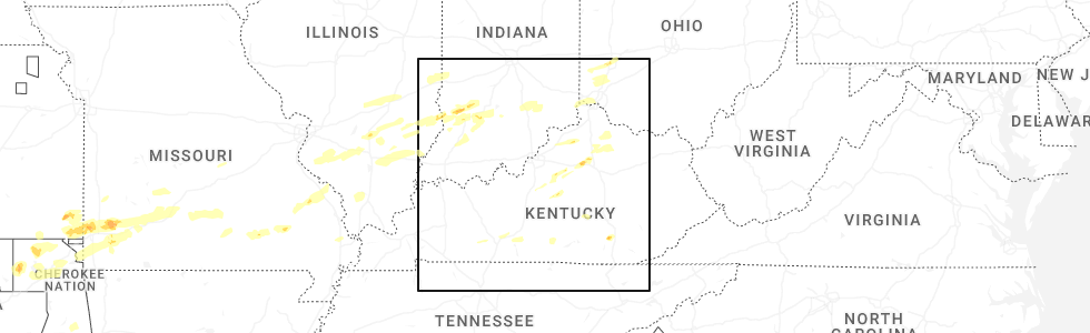
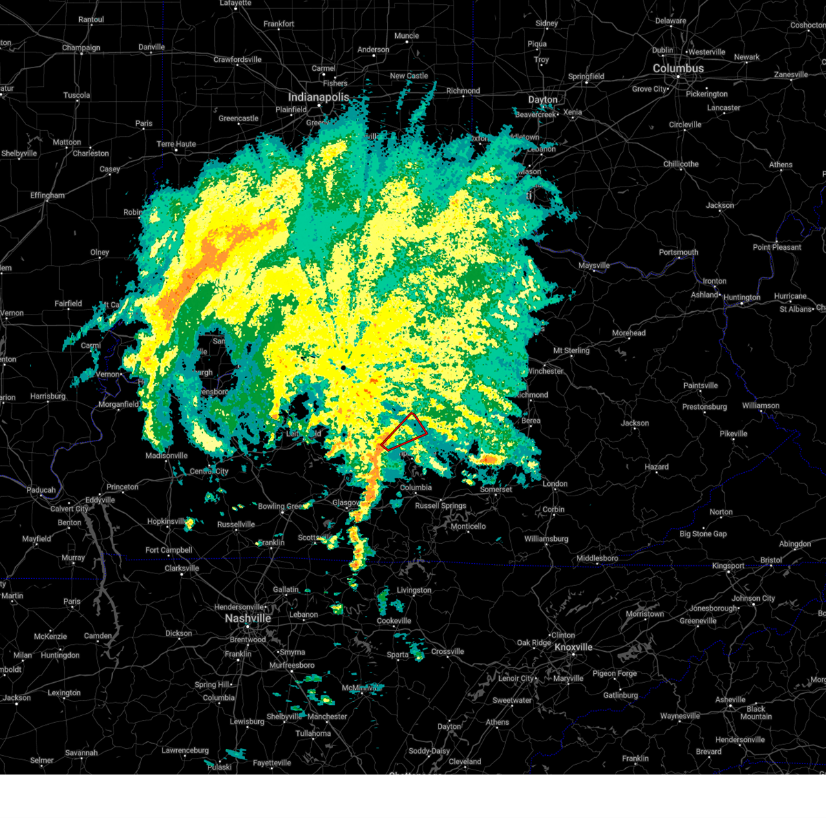
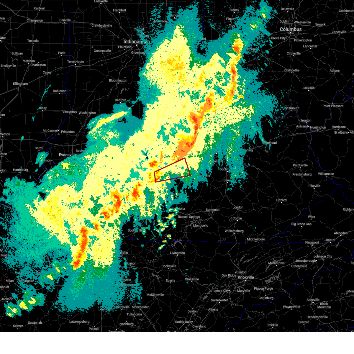
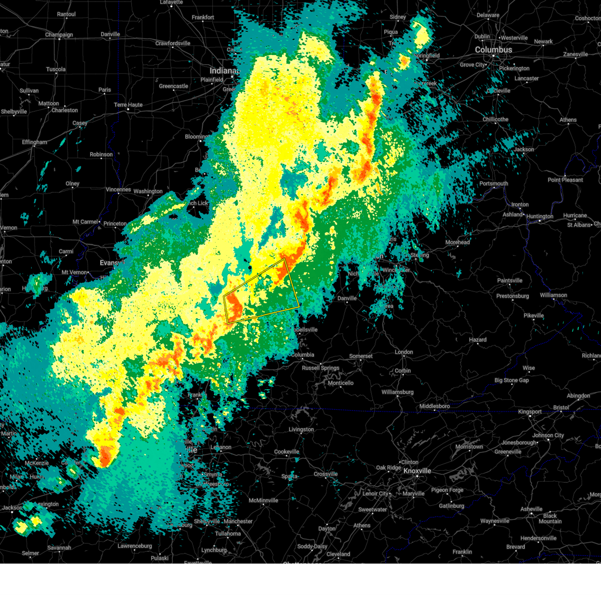
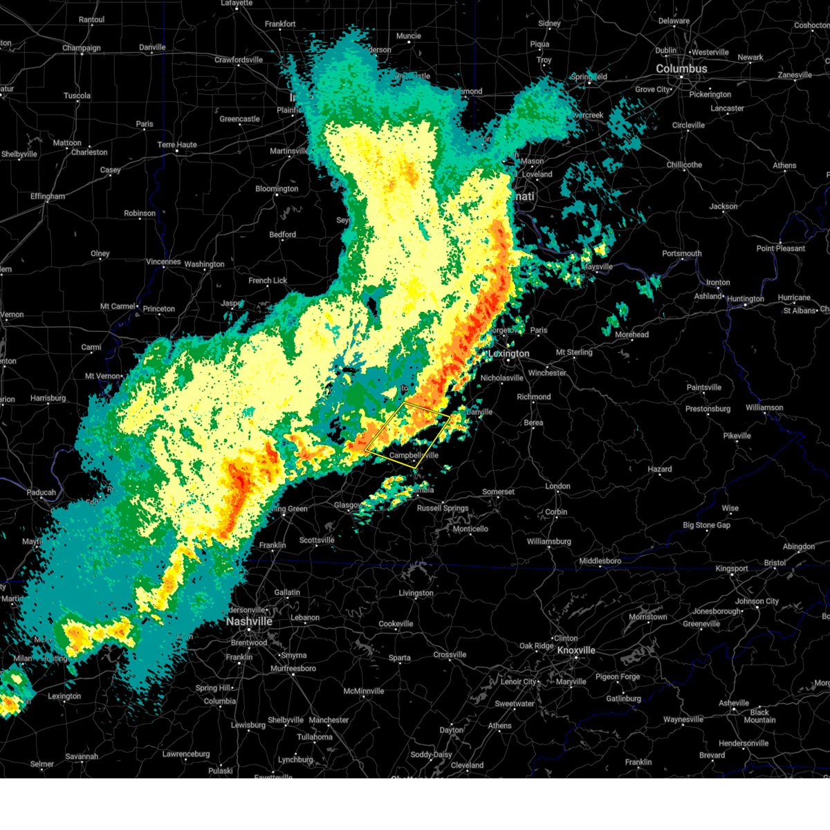
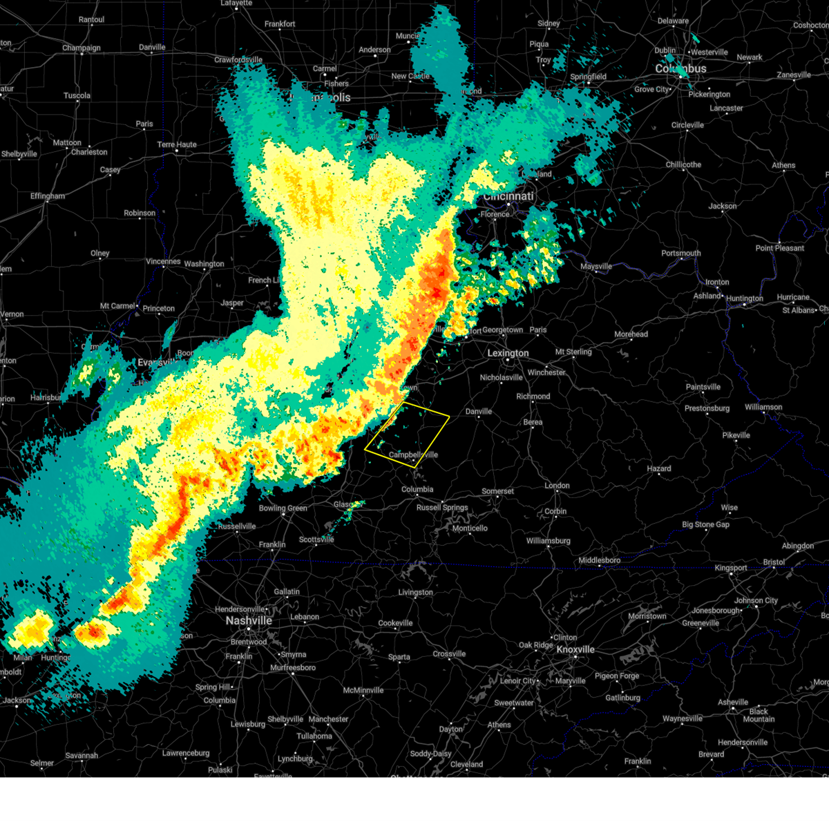
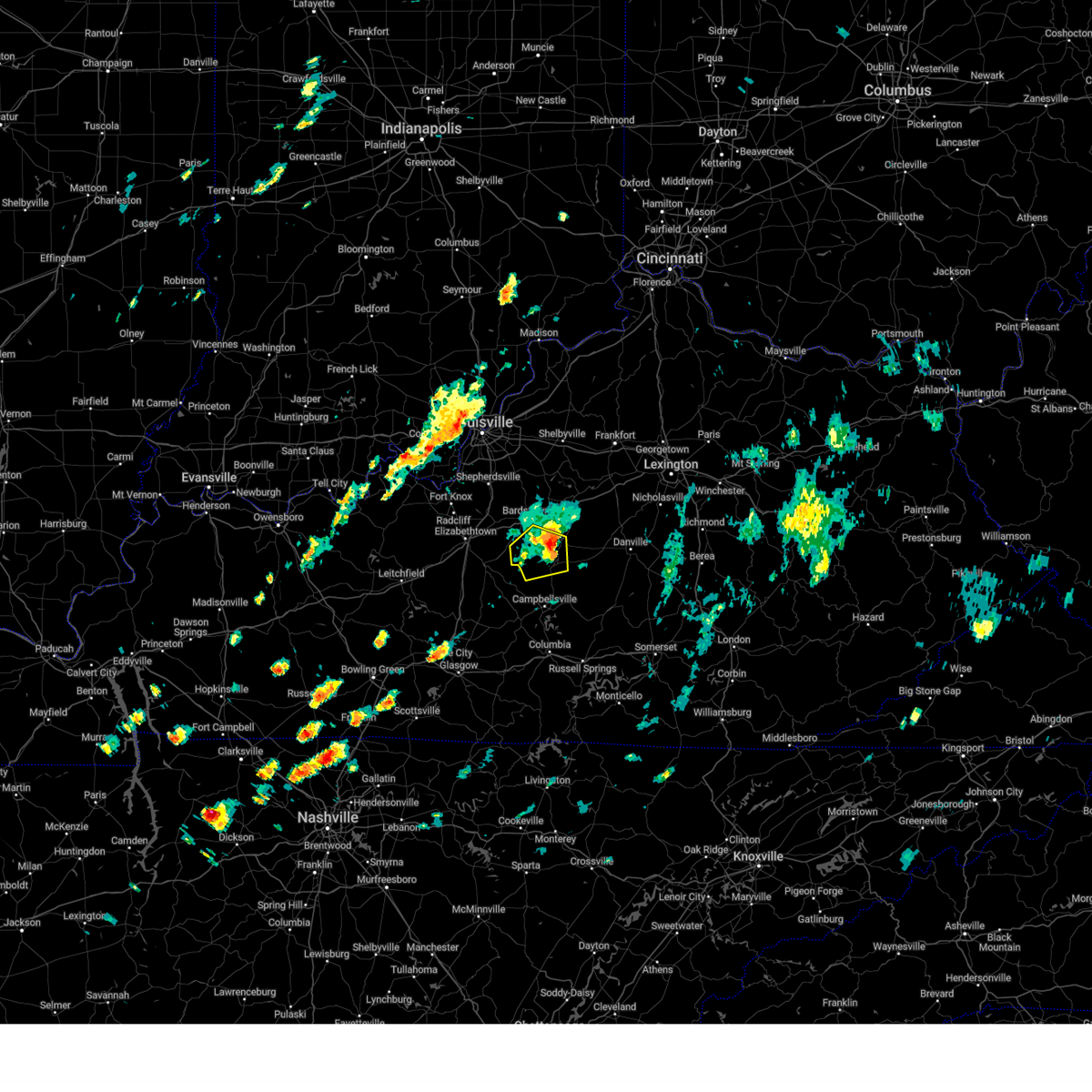
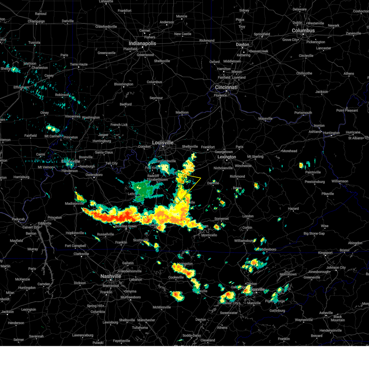
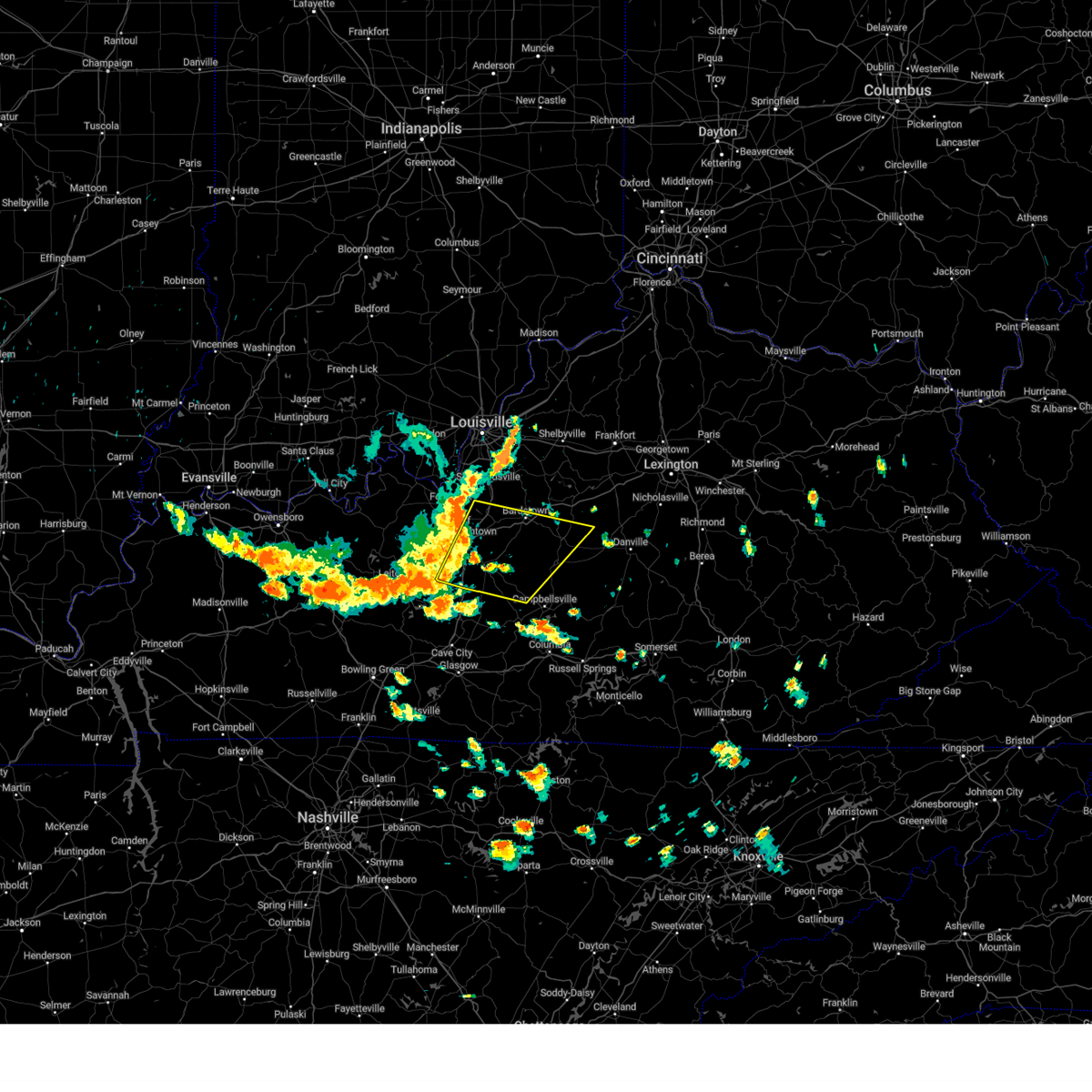
Hail Map for Loretto, KY
The Loretto, KY area has had 2 reports of on-the-ground hail by trained spotters, and has been under severe weather warnings 26 times during the past 12 months. Doppler radar has detected hail at or near Loretto, KY on 56 occasions, including 1 occasion during the past year.
| Name: | Loretto, KY |
| Where Located: | 30.3 miles SE of Louisville, KY |
| Map: | Google Map for Loretto, KY |
| Population: | 713 |
| Housing Units: | 315 |
| More Info: | Search Google for Loretto, KY |
1
The Top Recent Hail Date for Loretto, KY is Tuesday, April 29, 2025 (14th out of 56)
Hail and Wind Damage Spotted near Loretto, KY
| Date / Time | Report Details |
|---|---|
| 6/6/2025 1:58 PM EDT |
 The storms which prompted the warning have moved out of the area. therefore, the warning will be allowed to expire. however, gusty winds are still possible with these thunderstorms. to report severe weather, contact your nearest law enforcement agency. they will relay your report to the national weather service louisville. The storms which prompted the warning have moved out of the area. therefore, the warning will be allowed to expire. however, gusty winds are still possible with these thunderstorms. to report severe weather, contact your nearest law enforcement agency. they will relay your report to the national weather service louisville.
|
| 6/6/2025 1:27 PM EDT |
 Svrlmk the national weather service in louisville has issued a * severe thunderstorm warning for, spencer county in central kentucky, nelson county in central kentucky, north central larue county in central kentucky, northwestern marion county in central kentucky, central washington county in central kentucky, central bullitt county in central kentucky, * until 200 pm edt. * at 127 pm edt, severe thunderstorms were located along a line extending from near shepherdsville to 9 miles southwest of bardstown to 7 miles northeast of hodgenville, moving east at 45 mph (radar indicated). Hazards include 60 mph wind gusts and penny size hail. expect damage to roofs, siding, and trees Svrlmk the national weather service in louisville has issued a * severe thunderstorm warning for, spencer county in central kentucky, nelson county in central kentucky, north central larue county in central kentucky, northwestern marion county in central kentucky, central washington county in central kentucky, central bullitt county in central kentucky, * until 200 pm edt. * at 127 pm edt, severe thunderstorms were located along a line extending from near shepherdsville to 9 miles southwest of bardstown to 7 miles northeast of hodgenville, moving east at 45 mph (radar indicated). Hazards include 60 mph wind gusts and penny size hail. expect damage to roofs, siding, and trees
|
| 5/30/2025 6:07 AM EDT |
 the tornado warning has been cancelled and is no longer in effect the tornado warning has been cancelled and is no longer in effect
|
| 5/30/2025 6:07 AM EDT |
 At 607 am edt, a severe thunderstorm capable of producing a tornado was located 11 miles northwest of campbellsville, moving northeast at 35 mph (radar indicated rotation). Hazards include tornado. Flying debris will be dangerous to those caught without shelter. mobile homes will be damaged or destroyed. damage to roofs, windows, and vehicles will occur. tree damage is likely. Locations impacted include, lebanon, loretto, raywick, saint joseph, burkes spring, attilla, belltown, badger, calvary, and new market. At 607 am edt, a severe thunderstorm capable of producing a tornado was located 11 miles northwest of campbellsville, moving northeast at 35 mph (radar indicated rotation). Hazards include tornado. Flying debris will be dangerous to those caught without shelter. mobile homes will be damaged or destroyed. damage to roofs, windows, and vehicles will occur. tree damage is likely. Locations impacted include, lebanon, loretto, raywick, saint joseph, burkes spring, attilla, belltown, badger, calvary, and new market.
|
| 5/30/2025 6:03 AM EDT |
 Torlmk the national weather service in louisville has issued a * tornado warning for, north central green county in central kentucky, southeastern larue county in central kentucky, southwestern marion county in central kentucky, northwestern taylor county in central kentucky, * until 630 am edt/530 am cdt/. * at 603 am edt/503 am cdt/, a severe thunderstorm capable of producing a tornado was located 12 miles northwest of campbellsville, moving northeast at 35 mph (radar indicated rotation). Hazards include tornado. Flying debris will be dangerous to those caught without shelter. mobile homes will be damaged or destroyed. damage to roofs, windows, and vehicles will occur. tree damage is likely. This tornadic thunderstorm will remain over mainly rural areas of north central green, southeastern larue, southwestern marion and northwestern taylor counties, including the following locations, saint joseph, burkes spring, raywick, attilla, belltown, jessietown, badger, calvary, willowtown, and new market. Torlmk the national weather service in louisville has issued a * tornado warning for, north central green county in central kentucky, southeastern larue county in central kentucky, southwestern marion county in central kentucky, northwestern taylor county in central kentucky, * until 630 am edt/530 am cdt/. * at 603 am edt/503 am cdt/, a severe thunderstorm capable of producing a tornado was located 12 miles northwest of campbellsville, moving northeast at 35 mph (radar indicated rotation). Hazards include tornado. Flying debris will be dangerous to those caught without shelter. mobile homes will be damaged or destroyed. damage to roofs, windows, and vehicles will occur. tree damage is likely. This tornadic thunderstorm will remain over mainly rural areas of north central green, southeastern larue, southwestern marion and northwestern taylor counties, including the following locations, saint joseph, burkes spring, raywick, attilla, belltown, jessietown, badger, calvary, willowtown, and new market.
|
| 5/16/2025 11:33 PM EDT | The storms which prompted the warning have moved out of the area. therefore, the warning has been allowed to expire. however, gusty winds and heavy rain are still possible with these thunderstorms. a tornado watch remains in effect until 100 am edt/midnight cdt/ for south central kentucky. a tornado watch also remains in effect until 300 am edt/200 am cdt/ for south central and central kentucky. |
| 5/16/2025 10:55 PM EDT | Storm damage reported in marion county KY, 2 miles SW of Loretto, KY |
| 5/16/2025 10:40 PM EDT | Svrlmk the national weather service in louisville has issued a * severe thunderstorm warning for, central nelson county in central kentucky, eastern larue county in central kentucky, marion county in central kentucky, eastern hart county in central kentucky, taylor county in central kentucky, west central jessamine county in central kentucky, northwestern casey county in central kentucky, central adair county in south central kentucky, southeastern edmonson county in south central kentucky, mercer county in central kentucky, green county in central kentucky, central warren county in south central kentucky, washington county in central kentucky, boyle county in central kentucky, barren county in south central kentucky, metcalfe county in south central kentucky, * until 1130 pm edt/1030 pm cdt/. * at 1040 pm edt/940 pm cdt/, severe thunderstorms were located along a line extending from 9 miles west of bardstown to 9 miles west of munfordville to near memphis junction, moving east at 65 mph (radar indicated). Hazards include 70 mph wind gusts and penny size hail. Expect considerable tree damage. Damage is likely to mobile homes, roofs, and outbuildings. |
| 5/16/2025 7:13 AM EDT |
 The storm which prompted the warning has weakened below severe limits, and no longer poses an immediate threat to life or property. therefore, the warning will be allowed to expire. however, small hail and heavy rain are still possible with this thunderstorm. a severe thunderstorm watch remains in effect until 1000 am edt for central kentucky. The storm which prompted the warning has weakened below severe limits, and no longer poses an immediate threat to life or property. therefore, the warning will be allowed to expire. however, small hail and heavy rain are still possible with this thunderstorm. a severe thunderstorm watch remains in effect until 1000 am edt for central kentucky.
|
| 5/16/2025 7:03 AM EDT |
 the severe thunderstorm warning has been cancelled and is no longer in effect the severe thunderstorm warning has been cancelled and is no longer in effect
|
| 5/16/2025 7:03 AM EDT |
 At 703 am edt, a severe thunderstorm was located near lebanon, moving east at 75 mph (radar indicated). Hazards include 60 mph wind gusts and quarter size hail. Hail damage to vehicles is expected. expect wind damage to roofs, siding, and trees. Locations impacted include, lebanon, springfield, loretto, bradfordsville, mackville, raywick, burkes spring, saint joseph, dant, and rineltown. At 703 am edt, a severe thunderstorm was located near lebanon, moving east at 75 mph (radar indicated). Hazards include 60 mph wind gusts and quarter size hail. Hail damage to vehicles is expected. expect wind damage to roofs, siding, and trees. Locations impacted include, lebanon, springfield, loretto, bradfordsville, mackville, raywick, burkes spring, saint joseph, dant, and rineltown.
|
| 5/16/2025 6:45 AM EDT |
 Svrlmk the national weather service in louisville has issued a * severe thunderstorm warning for, south central nelson county in central kentucky, southeastern larue county in central kentucky, marion county in central kentucky, northwestern taylor county in central kentucky, southern washington county in central kentucky, * until 715 am edt. * at 645 am edt, a severe thunderstorm was located near hodgenville, moving east at 75 mph (radar indicated). Hazards include 60 mph wind gusts and quarter size hail. Hail damage to vehicles is expected. Expect wind damage to roofs, siding, and trees. Svrlmk the national weather service in louisville has issued a * severe thunderstorm warning for, south central nelson county in central kentucky, southeastern larue county in central kentucky, marion county in central kentucky, northwestern taylor county in central kentucky, southern washington county in central kentucky, * until 715 am edt. * at 645 am edt, a severe thunderstorm was located near hodgenville, moving east at 75 mph (radar indicated). Hazards include 60 mph wind gusts and quarter size hail. Hail damage to vehicles is expected. Expect wind damage to roofs, siding, and trees.
|
| 4/3/2025 1:27 AM EDT | The storm which prompted the warning has moved out of the area. therefore, the warning will be allowed to expire. however, heavy rain is still possible with this thunderstorm. a tornado watch remains in effect until 200 am edt/100 am cdt/ for central kentucky. a tornado watch also remains in effect until 700 am edt/600 am cdt/ for central kentucky. |
| 4/3/2025 1:03 AM EDT |
 Torlmk the national weather service in louisville has issued a * tornado warning for, nelson county in central kentucky, north central larue county in central kentucky, northwestern marion county in central kentucky, washington county in central kentucky, east central hardin county in central kentucky, * until 130 am edt. * at 103 am edt, a severe thunderstorm capable of producing a tornado was located 8 miles northeast of hodgenville, moving northeast at 70 mph (radar indicated rotation). Hazards include tornado. Flying debris will be dangerous to those caught without shelter. mobile homes will be damaged or destroyed. damage to roofs, windows, and vehicles will occur. tree damage is likely. this dangerous storm will be near, bardstown around 110 am edt. Other locations impacted by this tornadic thunderstorm include burkes spring, dant, booker, bellwood, polin, croakes, balltown, nelsonville, pleasant grove, and bourbon springs. Torlmk the national weather service in louisville has issued a * tornado warning for, nelson county in central kentucky, north central larue county in central kentucky, northwestern marion county in central kentucky, washington county in central kentucky, east central hardin county in central kentucky, * until 130 am edt. * at 103 am edt, a severe thunderstorm capable of producing a tornado was located 8 miles northeast of hodgenville, moving northeast at 70 mph (radar indicated rotation). Hazards include tornado. Flying debris will be dangerous to those caught without shelter. mobile homes will be damaged or destroyed. damage to roofs, windows, and vehicles will occur. tree damage is likely. this dangerous storm will be near, bardstown around 110 am edt. Other locations impacted by this tornadic thunderstorm include burkes spring, dant, booker, bellwood, polin, croakes, balltown, nelsonville, pleasant grove, and bourbon springs.
|
| 4/3/2025 12:47 AM EDT |
 Svrlmk the national weather service in louisville has issued a * severe thunderstorm warning for, nelson county in central kentucky, central larue county in central kentucky, northwestern marion county in central kentucky, northeastern grayson county in central kentucky, southeastern bullitt county in central kentucky, southeastern breckinridge county in central kentucky, hardin county in central kentucky, * until 130 am edt/1230 am cdt/. * at 1247 am edt/1147 pm cdt/, a severe thunderstorm was located over leitchfield, moving northeast at 75 mph (radar indicated). Hazards include 60 mph wind gusts and penny size hail. expect damage to roofs, siding, and trees Svrlmk the national weather service in louisville has issued a * severe thunderstorm warning for, nelson county in central kentucky, central larue county in central kentucky, northwestern marion county in central kentucky, northeastern grayson county in central kentucky, southeastern bullitt county in central kentucky, southeastern breckinridge county in central kentucky, hardin county in central kentucky, * until 130 am edt/1230 am cdt/. * at 1247 am edt/1147 pm cdt/, a severe thunderstorm was located over leitchfield, moving northeast at 75 mph (radar indicated). Hazards include 60 mph wind gusts and penny size hail. expect damage to roofs, siding, and trees
|
| 3/30/2025 10:48 PM EDT |
 The storms which prompted the warning have weakened below severe limits, and no longer pose an immediate threat to life or property. therefore, the warning has been allowed to expire. however, gusty winds are still possible with these thunderstorms, and a severe thunderstorm warning remains in effect for portions of washington county until 1115 pm edt. a tornado watch remains in effect until 100 am edt/midnight cdt/ for central kentucky. a tornado watch also remains in effect until 400 am edt/300 am cdt/ for central kentucky. The storms which prompted the warning have weakened below severe limits, and no longer pose an immediate threat to life or property. therefore, the warning has been allowed to expire. however, gusty winds are still possible with these thunderstorms, and a severe thunderstorm warning remains in effect for portions of washington county until 1115 pm edt. a tornado watch remains in effect until 100 am edt/midnight cdt/ for central kentucky. a tornado watch also remains in effect until 400 am edt/300 am cdt/ for central kentucky.
|
| 3/30/2025 10:22 PM EDT |
 Svrlmk the national weather service in louisville has issued a * severe thunderstorm warning for, south central nelson county in central kentucky, northwestern green county in central kentucky, southeastern larue county in central kentucky, marion county in central kentucky, northeastern hart county in central kentucky, northwestern taylor county in central kentucky, southwestern washington county in central kentucky, * until 1045 pm edt/945 pm cdt/. * at 1022 pm edt/922 pm cdt/, severe thunderstorms were located along a line extending from 6 miles south of bardstown to 6 miles southeast of hodgenville, moving east at 45 mph (radar indicated). Hazards include 60 mph wind gusts and nickel size hail. expect damage to roofs, siding, and trees Svrlmk the national weather service in louisville has issued a * severe thunderstorm warning for, south central nelson county in central kentucky, northwestern green county in central kentucky, southeastern larue county in central kentucky, marion county in central kentucky, northeastern hart county in central kentucky, northwestern taylor county in central kentucky, southwestern washington county in central kentucky, * until 1045 pm edt/945 pm cdt/. * at 1022 pm edt/922 pm cdt/, severe thunderstorms were located along a line extending from 6 miles south of bardstown to 6 miles southeast of hodgenville, moving east at 45 mph (radar indicated). Hazards include 60 mph wind gusts and nickel size hail. expect damage to roofs, siding, and trees
|
| 9/24/2024 1:31 PM EDT |
 The storm which prompted the warning has moved out of the area. therefore, the warning has been allowed to expire. however, gusty winds are still possible with this thunderstorm. to report severe weather, contact your nearest law enforcement agency. they will relay your report to the national weather service louisville. remember, a severe thunderstorm warning still remains in effect for portions of washington and marion counties. refer to that product for additional details. The storm which prompted the warning has moved out of the area. therefore, the warning has been allowed to expire. however, gusty winds are still possible with this thunderstorm. to report severe weather, contact your nearest law enforcement agency. they will relay your report to the national weather service louisville. remember, a severe thunderstorm warning still remains in effect for portions of washington and marion counties. refer to that product for additional details.
|
| 9/24/2024 1:12 PM EDT |
 the severe thunderstorm warning has been cancelled and is no longer in effect the severe thunderstorm warning has been cancelled and is no longer in effect
|
| 9/24/2024 1:12 PM EDT |
 At 111 pm edt, a severe thunderstorm was located 8 miles west of lebanon, moving east northeast at 50 mph (radar indicated). Hazards include 60 mph wind gusts and quarter size hail. Hail damage to vehicles is expected. expect wind damage to roofs, siding, and trees. Locations impacted include, lebanon, springfield, loretto, raywick, saint francis, burkes spring, saint joseph, gethsemane, belltown, and dant. At 111 pm edt, a severe thunderstorm was located 8 miles west of lebanon, moving east northeast at 50 mph (radar indicated). Hazards include 60 mph wind gusts and quarter size hail. Hail damage to vehicles is expected. expect wind damage to roofs, siding, and trees. Locations impacted include, lebanon, springfield, loretto, raywick, saint francis, burkes spring, saint joseph, gethsemane, belltown, and dant.
|
| 9/24/2024 12:52 PM EDT |
 Svrlmk the national weather service in louisville has issued a * severe thunderstorm warning for, south central nelson county in central kentucky, eastern larue county in central kentucky, northwestern marion county in central kentucky, southwestern washington county in central kentucky, * until 130 pm edt. * at 1252 pm edt, a severe thunderstorm was located near hodgenville, moving east at 55 mph (radar indicated). Hazards include 60 mph wind gusts and quarter size hail. Hail damage to vehicles is expected. expect wind damage to roofs, siding, and trees. this severe thunderstorm will be near, springfield around 120 pm edt. Other locations impacted by this severe thunderstorm include burkes spring, saint joseph, boundary oak, howardstown, dant, nerinx, greenbrier, holy cross, cisselville, and saint mary. Svrlmk the national weather service in louisville has issued a * severe thunderstorm warning for, south central nelson county in central kentucky, eastern larue county in central kentucky, northwestern marion county in central kentucky, southwestern washington county in central kentucky, * until 130 pm edt. * at 1252 pm edt, a severe thunderstorm was located near hodgenville, moving east at 55 mph (radar indicated). Hazards include 60 mph wind gusts and quarter size hail. Hail damage to vehicles is expected. expect wind damage to roofs, siding, and trees. this severe thunderstorm will be near, springfield around 120 pm edt. Other locations impacted by this severe thunderstorm include burkes spring, saint joseph, boundary oak, howardstown, dant, nerinx, greenbrier, holy cross, cisselville, and saint mary.
|
| 8/17/2024 4:52 PM EDT | Svrlmk the national weather service in louisville has issued a * severe thunderstorm warning for, northern lincoln county in central kentucky, southern garrard county in central kentucky, central marion county in central kentucky, southeastern washington county in central kentucky, boyle county in central kentucky, north central casey county in central kentucky, * until 545 pm edt. * at 452 pm edt, a severe thunderstorm was located near lebanon, moving east at 40 mph (radar indicated). Hazards include 60 mph wind gusts and nickel size hail. expect damage to roofs, siding, and trees |
| 7/30/2024 2:50 PM EDT |
 the severe thunderstorm warning has been cancelled and is no longer in effect the severe thunderstorm warning has been cancelled and is no longer in effect
|
| 7/30/2024 2:50 PM EDT |
 At 250 pm edt/150 pm cdt/, a severe thunderstorm was located near lebanon, moving east at 35 mph (radar indicated). Hazards include 60 mph wind gusts. Expect damage to roofs, siding, and trees. Locations impacted include, lebanon, springfield, loretto, mackville, raywick, burkes spring, saint joseph, rineltown, booker, and nerinx. At 250 pm edt/150 pm cdt/, a severe thunderstorm was located near lebanon, moving east at 35 mph (radar indicated). Hazards include 60 mph wind gusts. Expect damage to roofs, siding, and trees. Locations impacted include, lebanon, springfield, loretto, mackville, raywick, burkes spring, saint joseph, rineltown, booker, and nerinx.
|
| 7/30/2024 2:09 PM EDT |
 Svrlmk the national weather service in louisville has issued a * severe thunderstorm warning for, southwestern nelson county in central kentucky, northwestern green county in central kentucky, larue county in central kentucky, western marion county in central kentucky, northeastern hart county in central kentucky, northwestern taylor county in central kentucky, southern washington county in central kentucky, southwestern bullitt county in central kentucky, eastern hardin county in central kentucky, * until 300 pm edt/200 pm cdt/. * at 209 pm edt/109 pm cdt/, a severe thunderstorm was located over elizabethtown, moving east at 25 mph (radar indicated). Hazards include 60 mph wind gusts. expect damage to roofs, siding, and trees Svrlmk the national weather service in louisville has issued a * severe thunderstorm warning for, southwestern nelson county in central kentucky, northwestern green county in central kentucky, larue county in central kentucky, western marion county in central kentucky, northeastern hart county in central kentucky, northwestern taylor county in central kentucky, southern washington county in central kentucky, southwestern bullitt county in central kentucky, eastern hardin county in central kentucky, * until 300 pm edt/200 pm cdt/. * at 209 pm edt/109 pm cdt/, a severe thunderstorm was located over elizabethtown, moving east at 25 mph (radar indicated). Hazards include 60 mph wind gusts. expect damage to roofs, siding, and trees
|
| 7/16/2024 11:40 PM EDT |
 At 1139 pm edt, a severe thunderstorm was located near bardstown, moving east at 30 mph (radar indicated). Hazards include 60 mph wind gusts. Expect damage to roofs, siding, and trees. Locations impacted include, bardstown, lebanon, springfield, loretto, burkes spring, samuels field airport, booker, nerinx, botland, and mooresville. At 1139 pm edt, a severe thunderstorm was located near bardstown, moving east at 30 mph (radar indicated). Hazards include 60 mph wind gusts. Expect damage to roofs, siding, and trees. Locations impacted include, bardstown, lebanon, springfield, loretto, burkes spring, samuels field airport, booker, nerinx, botland, and mooresville.
|
| 7/16/2024 11:24 PM EDT |
 Svrlmk the national weather service in louisville has issued a * severe thunderstorm warning for, central nelson county in central kentucky, northwestern marion county in central kentucky, southwestern washington county in central kentucky, * until 1215 am edt. * at 1123 pm edt, a severe thunderstorm was located 7 miles southwest of bardstown, moving east at 35 mph (radar indicated). Hazards include 70 mph wind gusts and penny size hail. Expect considerable tree damage. Damage is likely to mobile homes, roofs, and outbuildings. Svrlmk the national weather service in louisville has issued a * severe thunderstorm warning for, central nelson county in central kentucky, northwestern marion county in central kentucky, southwestern washington county in central kentucky, * until 1215 am edt. * at 1123 pm edt, a severe thunderstorm was located 7 miles southwest of bardstown, moving east at 35 mph (radar indicated). Hazards include 70 mph wind gusts and penny size hail. Expect considerable tree damage. Damage is likely to mobile homes, roofs, and outbuildings.
|
| 6/30/2024 1:41 PM EDT |
 At 141 pm edt, a severe thunderstorm was located 8 miles southwest of lebanon, moving east at 35 mph (radar indicated). Hazards include 60 mph wind gusts and penny size hail. Expect damage to roofs, siding, and trees. Locations impacted include, campbellsville, lebanon, springfield, new haven, loretto, raywick, burkes spring, dant, arista, and south campbellsville. At 141 pm edt, a severe thunderstorm was located 8 miles southwest of lebanon, moving east at 35 mph (radar indicated). Hazards include 60 mph wind gusts and penny size hail. Expect damage to roofs, siding, and trees. Locations impacted include, campbellsville, lebanon, springfield, new haven, loretto, raywick, burkes spring, dant, arista, and south campbellsville.
|
| 6/30/2024 1:41 PM EDT |
 the severe thunderstorm warning has been cancelled and is no longer in effect the severe thunderstorm warning has been cancelled and is no longer in effect
|
| 6/30/2024 1:24 PM EDT |
 Svrlmk the national weather service in louisville has issued a * severe thunderstorm warning for, southwestern nelson county in central kentucky, northern green county in central kentucky, larue county in central kentucky, marion county in central kentucky, taylor county in central kentucky, southwestern washington county in central kentucky, southeastern hardin county in central kentucky, * until 200 pm edt/100 pm cdt/. * at 123 pm edt/1223 pm cdt/, a severe thunderstorm was located 9 miles east of hodgenville, moving southeast at 40 mph (radar indicated). Hazards include 60 mph wind gusts and penny size hail. expect damage to roofs, siding, and trees Svrlmk the national weather service in louisville has issued a * severe thunderstorm warning for, southwestern nelson county in central kentucky, northern green county in central kentucky, larue county in central kentucky, marion county in central kentucky, taylor county in central kentucky, southwestern washington county in central kentucky, southeastern hardin county in central kentucky, * until 200 pm edt/100 pm cdt/. * at 123 pm edt/1223 pm cdt/, a severe thunderstorm was located 9 miles east of hodgenville, moving southeast at 40 mph (radar indicated). Hazards include 60 mph wind gusts and penny size hail. expect damage to roofs, siding, and trees
|
| 5/27/2024 12:04 AM EDT |
 Svrlmk the national weather service in louisville has issued a * severe thunderstorm warning for, central nelson county in central kentucky, northwestern green county in central kentucky, southeastern larue county in central kentucky, marion county in central kentucky, taylor county in central kentucky, washington county in central kentucky, * until 1245 am edt/1145 pm cdt/. * at 1204 am edt/1104 pm cdt/, severe thunderstorms were located along a line extending from near bardstown to 9 miles northeast of munfordville, moving east at 45 mph (radar indicated). Hazards include 60 mph wind gusts. expect damage to roofs, siding, and trees Svrlmk the national weather service in louisville has issued a * severe thunderstorm warning for, central nelson county in central kentucky, northwestern green county in central kentucky, southeastern larue county in central kentucky, marion county in central kentucky, taylor county in central kentucky, washington county in central kentucky, * until 1245 am edt/1145 pm cdt/. * at 1204 am edt/1104 pm cdt/, severe thunderstorms were located along a line extending from near bardstown to 9 miles northeast of munfordville, moving east at 45 mph (radar indicated). Hazards include 60 mph wind gusts. expect damage to roofs, siding, and trees
|
| 5/26/2024 12:14 PM EDT |
 At 1213 pm edt, a severe thunderstorm was located near taylorsville, moving east at 60 mph (radar indicated). Hazards include 75 mph wind gusts. Expect considerable tree damage. damage is likely to mobile homes, roofs, and outbuildings. locations impacted include, louisville, jeffersontown, st. Matthews, shelbyville, bardstown, lyndon, middletown, lebanon, douglass hills, and hurstbourne. At 1213 pm edt, a severe thunderstorm was located near taylorsville, moving east at 60 mph (radar indicated). Hazards include 75 mph wind gusts. Expect considerable tree damage. damage is likely to mobile homes, roofs, and outbuildings. locations impacted include, louisville, jeffersontown, st. Matthews, shelbyville, bardstown, lyndon, middletown, lebanon, douglass hills, and hurstbourne.
|
| 5/26/2024 12:14 PM EDT |
 the severe thunderstorm warning has been cancelled and is no longer in effect the severe thunderstorm warning has been cancelled and is no longer in effect
|
| 5/26/2024 12:06 PM EDT |
 At 1205 pm edt/1105 am cdt/, a severe thunderstorm was located near fern creek, moving northeast at 65 mph. this is a destructive storm for louisville metro area (radar indicated). Hazards include 80 mph wind gusts. Flying debris will be dangerous to those caught without shelter. mobile homes will be heavily damaged. expect considerable damage to roofs, windows, and vehicles. extensive tree damage and power outages are likely. locations impacted include, louisville, jeffersontown, st. Matthews, shively, shelbyville, bardstown, shepherdsville, lyndon, middletown, and lebanon. At 1205 pm edt/1105 am cdt/, a severe thunderstorm was located near fern creek, moving northeast at 65 mph. this is a destructive storm for louisville metro area (radar indicated). Hazards include 80 mph wind gusts. Flying debris will be dangerous to those caught without shelter. mobile homes will be heavily damaged. expect considerable damage to roofs, windows, and vehicles. extensive tree damage and power outages are likely. locations impacted include, louisville, jeffersontown, st. Matthews, shively, shelbyville, bardstown, shepherdsville, lyndon, middletown, and lebanon.
|
| 5/26/2024 11:58 AM EDT |
 Svrlmk the national weather service in louisville has issued a * severe thunderstorm warning for, southeastern floyd county in south central indiana, shelby county in central kentucky, nelson county in central kentucky, western anderson county in central kentucky, eastern larue county in central kentucky, marion county in central kentucky, northern taylor county in central kentucky, jefferson county in central kentucky, bullitt county in central kentucky, north central casey county in central kentucky, northwestern franklin county in central kentucky, spencer county in central kentucky, southwestern mercer county in central kentucky, northern green county in central kentucky, washington county in central kentucky, west central boyle county in central kentucky, * until 1230 pm edt/1130 am cdt/. * at 1157 am edt/1057 am cdt/, a severe thunderstorm was located over pioneer village, moving northeast at 65 mph (radar indicated). Hazards include 70 mph wind gusts. Expect considerable tree damage. Damage is likely to mobile homes, roofs, and outbuildings. Svrlmk the national weather service in louisville has issued a * severe thunderstorm warning for, southeastern floyd county in south central indiana, shelby county in central kentucky, nelson county in central kentucky, western anderson county in central kentucky, eastern larue county in central kentucky, marion county in central kentucky, northern taylor county in central kentucky, jefferson county in central kentucky, bullitt county in central kentucky, north central casey county in central kentucky, northwestern franklin county in central kentucky, spencer county in central kentucky, southwestern mercer county in central kentucky, northern green county in central kentucky, washington county in central kentucky, west central boyle county in central kentucky, * until 1230 pm edt/1130 am cdt/. * at 1157 am edt/1057 am cdt/, a severe thunderstorm was located over pioneer village, moving northeast at 65 mph (radar indicated). Hazards include 70 mph wind gusts. Expect considerable tree damage. Damage is likely to mobile homes, roofs, and outbuildings.
|
| 5/23/2024 8:42 AM EDT |
 the severe thunderstorm warning has been cancelled and is no longer in effect the severe thunderstorm warning has been cancelled and is no longer in effect
|
| 5/23/2024 8:37 AM EDT |
 the severe thunderstorm warning has been cancelled and is no longer in effect the severe thunderstorm warning has been cancelled and is no longer in effect
|
| 5/23/2024 8:37 AM EDT |
 At 837 am edt, a severe thunderstorm was located 11 miles south of bardstown, moving east at 30 mph (radar indicated). Hazards include quarter size hail. Damage to vehicles is expected. Locations impacted include, loretto, raywick, greenbrier, saint francis, holy cross, dant, nerinx, saint mary, new hope, and gandertown. At 837 am edt, a severe thunderstorm was located 11 miles south of bardstown, moving east at 30 mph (radar indicated). Hazards include quarter size hail. Damage to vehicles is expected. Locations impacted include, loretto, raywick, greenbrier, saint francis, holy cross, dant, nerinx, saint mary, new hope, and gandertown.
|
| 5/23/2024 8:09 AM EDT |
 Svrlmk the national weather service in louisville has issued a * severe thunderstorm warning for, southwestern nelson county in central kentucky, northwestern larue county in central kentucky, northwestern marion county in central kentucky, east central hardin county in central kentucky, * until 900 am edt. * at 809 am edt, a severe thunderstorm was located near hodgenville, moving east at 30 mph (radar indicated). Hazards include 60 mph wind gusts and quarter size hail. Hail damage to vehicles is expected. Expect wind damage to roofs, siding, and trees. Svrlmk the national weather service in louisville has issued a * severe thunderstorm warning for, southwestern nelson county in central kentucky, northwestern larue county in central kentucky, northwestern marion county in central kentucky, east central hardin county in central kentucky, * until 900 am edt. * at 809 am edt, a severe thunderstorm was located near hodgenville, moving east at 30 mph (radar indicated). Hazards include 60 mph wind gusts and quarter size hail. Hail damage to vehicles is expected. Expect wind damage to roofs, siding, and trees.
|
| 3/6/2024 10:06 AM EST |
 Torlmk the national weather service in louisville has issued a * this is a test message. tornado warning for, meade county in central kentucky, larue county in central kentucky, jessamine county in central kentucky, nicholas county in central kentucky, adair county in south central kentucky, bourbon county in central kentucky, warren county in south central kentucky, cumberland county in south central kentucky, henry county in central kentucky, russell county in south central kentucky, taylor county in central kentucky, jefferson county in central kentucky, hardin county in central kentucky, spencer county in central kentucky, scott county in central kentucky, hancock county in central kentucky, trimble county in central kentucky, monroe county in south central kentucky, metcalfe county in south central kentucky, shelby county in central kentucky, logan county in south central kentucky, nelson county in central kentucky, anderson county in central kentucky, clark county in central kentucky, marion county in central kentucky, simpson county in south central kentucky, grayson county in central kentucky, casey county in central kentucky, franklin county in central kentucky, edmonson county in south central kentucky, lincoln county in central kentucky, woodford county in central kentucky, butler county in south central kentucky, madison county in central kentucky, barren county in south central kentucky, ohio county in central kentucky, oldham county in central kentucky, garrard county in central kentucky, hart county in central kentucky, bullitt county in central kentucky, harrison county in central kentucky, mercer county in central kentucky, clinton county in south central kentucky, green county in central kentucky, allen county in south central kentucky, washington county in central kentucky, boyle county in central kentucky, breckinridge county in central kentucky, fayette county in central kentucky, * this is a test message. until 1030 am est/930 am cst/. * this is a test message. Torlmk the national weather service in louisville has issued a * this is a test message. tornado warning for, meade county in central kentucky, larue county in central kentucky, jessamine county in central kentucky, nicholas county in central kentucky, adair county in south central kentucky, bourbon county in central kentucky, warren county in south central kentucky, cumberland county in south central kentucky, henry county in central kentucky, russell county in south central kentucky, taylor county in central kentucky, jefferson county in central kentucky, hardin county in central kentucky, spencer county in central kentucky, scott county in central kentucky, hancock county in central kentucky, trimble county in central kentucky, monroe county in south central kentucky, metcalfe county in south central kentucky, shelby county in central kentucky, logan county in south central kentucky, nelson county in central kentucky, anderson county in central kentucky, clark county in central kentucky, marion county in central kentucky, simpson county in south central kentucky, grayson county in central kentucky, casey county in central kentucky, franklin county in central kentucky, edmonson county in south central kentucky, lincoln county in central kentucky, woodford county in central kentucky, butler county in south central kentucky, madison county in central kentucky, barren county in south central kentucky, ohio county in central kentucky, oldham county in central kentucky, garrard county in central kentucky, hart county in central kentucky, bullitt county in central kentucky, harrison county in central kentucky, mercer county in central kentucky, clinton county in south central kentucky, green county in central kentucky, allen county in south central kentucky, washington county in central kentucky, boyle county in central kentucky, breckinridge county in central kentucky, fayette county in central kentucky, * this is a test message. until 1030 am est/930 am cst/. * this is a test message.
|
| 2/28/2024 7:12 AM EST |
 The storms which prompted the warning have weakened below severe limits, and no longer pose an immediate threat to life or property. therefore, the warning will be allowed to expire. however, small hail and gusty winds are still possible with these thunderstorms. a tornado watch remains in effect until 900 am est/800 am cst/ for central and south central kentucky. The storms which prompted the warning have weakened below severe limits, and no longer pose an immediate threat to life or property. therefore, the warning will be allowed to expire. however, small hail and gusty winds are still possible with these thunderstorms. a tornado watch remains in effect until 900 am est/800 am cst/ for central and south central kentucky.
|
| 2/28/2024 6:45 AM EST |
 Svrlmk the national weather service in louisville has issued a * severe thunderstorm warning for, south central nelson county in central kentucky, northwestern green county in central kentucky, southeastern larue county in central kentucky, marion county in central kentucky, hart county in central kentucky, northwestern taylor county in central kentucky, southwestern washington county in central kentucky, west central boyle county in central kentucky, northeastern edmonson county in south central kentucky, * until 715 am est/615 am cst/. * at 644 am est/544 am cst/, severe thunderstorms were located along a line extending from 6 miles west of springfield to near brownsville, moving east at 45 mph (radar indicated). Hazards include 60 mph wind gusts. expect damage to roofs, siding, and trees Svrlmk the national weather service in louisville has issued a * severe thunderstorm warning for, south central nelson county in central kentucky, northwestern green county in central kentucky, southeastern larue county in central kentucky, marion county in central kentucky, hart county in central kentucky, northwestern taylor county in central kentucky, southwestern washington county in central kentucky, west central boyle county in central kentucky, northeastern edmonson county in south central kentucky, * until 715 am est/615 am cst/. * at 644 am est/544 am cst/, severe thunderstorms were located along a line extending from 6 miles west of springfield to near brownsville, moving east at 45 mph (radar indicated). Hazards include 60 mph wind gusts. expect damage to roofs, siding, and trees
|
| 2/28/2024 6:17 AM EST |
 Svrlmk the national weather service in louisville has issued a * severe thunderstorm warning for, southwestern nelson county in central kentucky, northwestern green county in central kentucky, larue county in central kentucky, northwestern marion county in central kentucky, hart county in central kentucky, northwestern taylor county in central kentucky, southeastern grayson county in central kentucky, southeastern hardin county in central kentucky, northern edmonson county in south central kentucky, * until 645 am est/545 am cst/. * at 616 am est/516 am cst/, severe thunderstorms were located along a line extending from 10 miles northeast of hodgenville to 9 miles north of brownsville, moving east at 40 mph (radar indicated). Hazards include 60 mph wind gusts. expect damage to roofs, siding, and trees Svrlmk the national weather service in louisville has issued a * severe thunderstorm warning for, southwestern nelson county in central kentucky, northwestern green county in central kentucky, larue county in central kentucky, northwestern marion county in central kentucky, hart county in central kentucky, northwestern taylor county in central kentucky, southeastern grayson county in central kentucky, southeastern hardin county in central kentucky, northern edmonson county in south central kentucky, * until 645 am est/545 am cst/. * at 616 am est/516 am cst/, severe thunderstorms were located along a line extending from 10 miles northeast of hodgenville to 9 miles north of brownsville, moving east at 40 mph (radar indicated). Hazards include 60 mph wind gusts. expect damage to roofs, siding, and trees
|
| 7/18/2023 5:42 PM EDT |
 At 542 pm edt, a severe thunderstorm was located near lebanon, moving southeast at 25 mph (radar indicated). Hazards include 60 mph wind gusts and quarter size hail. Hail damage to vehicles is expected. Expect wind damage to roofs, siding, and trees. At 542 pm edt, a severe thunderstorm was located near lebanon, moving southeast at 25 mph (radar indicated). Hazards include 60 mph wind gusts and quarter size hail. Hail damage to vehicles is expected. Expect wind damage to roofs, siding, and trees.
|
| 7/18/2023 3:28 AM EDT |
 At 328 am edt, a severe thunderstorm was located 8 miles southeast of bardstown, moving southeast at 40 mph (radar indicated). Hazards include 60 mph wind gusts and quarter size hail. Hail damage to vehicles is expected. Expect wind damage to roofs, siding, and trees. At 328 am edt, a severe thunderstorm was located 8 miles southeast of bardstown, moving southeast at 40 mph (radar indicated). Hazards include 60 mph wind gusts and quarter size hail. Hail damage to vehicles is expected. Expect wind damage to roofs, siding, and trees.
|
| 6/25/2023 7:31 PM EDT |
 At 730 pm edt, a severe thunderstorm was located over bardstown, moving southeast at 35 mph (radar indicated). Hazards include 70 mph wind gusts and quarter size hail. Hail damage to vehicles is expected. expect considerable tree damage. wind damage is also likely to mobile homes, roofs, and outbuildings. locations impacted include, bardstown, springfield, taylorsville, bloomfield, loretto, burkes spring, yoder, wayside, booker and bellwood. thunderstorm damage threat, considerable hail threat, radar indicated max hail size, 1. 00 in wind threat, radar indicated max wind gust, 70 mph. At 730 pm edt, a severe thunderstorm was located over bardstown, moving southeast at 35 mph (radar indicated). Hazards include 70 mph wind gusts and quarter size hail. Hail damage to vehicles is expected. expect considerable tree damage. wind damage is also likely to mobile homes, roofs, and outbuildings. locations impacted include, bardstown, springfield, taylorsville, bloomfield, loretto, burkes spring, yoder, wayside, booker and bellwood. thunderstorm damage threat, considerable hail threat, radar indicated max hail size, 1. 00 in wind threat, radar indicated max wind gust, 70 mph.
|
| 6/25/2023 7:26 PM EDT |
 At 725 pm edt, a severe thunderstorm was located over bardstown, moving southeast at 35 mph (radar indicated). Hazards include 70 mph wind gusts and quarter size hail. Hail damage to vehicles is expected. expect considerable tree damage. wind damage is also likely to mobile homes, roofs, and outbuildings. locations impacted include, bardstown, springfield, taylorsville, lebanon junction, new haven, bloomfield, loretto, burkes spring, yoder and dant. thunderstorm damage threat, considerable hail threat, radar indicated max hail size, 1. 00 in wind threat, radar indicated max wind gust, 70 mph. At 725 pm edt, a severe thunderstorm was located over bardstown, moving southeast at 35 mph (radar indicated). Hazards include 70 mph wind gusts and quarter size hail. Hail damage to vehicles is expected. expect considerable tree damage. wind damage is also likely to mobile homes, roofs, and outbuildings. locations impacted include, bardstown, springfield, taylorsville, lebanon junction, new haven, bloomfield, loretto, burkes spring, yoder and dant. thunderstorm damage threat, considerable hail threat, radar indicated max hail size, 1. 00 in wind threat, radar indicated max wind gust, 70 mph.
|
| 6/25/2023 7:13 PM EDT |
 At 712 pm edt, a severe thunderstorm was located 9 miles southeast of shepherdsville, moving southeast at 35 mph (radar indicated). Hazards include 70 mph wind gusts and quarter size hail. Hail damage to vehicles is expected. expect considerable tree damage. Wind damage is also likely to mobile homes, roofs, and outbuildings. At 712 pm edt, a severe thunderstorm was located 9 miles southeast of shepherdsville, moving southeast at 35 mph (radar indicated). Hazards include 70 mph wind gusts and quarter size hail. Hail damage to vehicles is expected. expect considerable tree damage. Wind damage is also likely to mobile homes, roofs, and outbuildings.
|
| 5/16/2023 2:20 PM EDT |
 The severe thunderstorm warning for central nelson, east central larue, marion and washington counties will expire at 230 pm edt, the storms which prompted the warning have moved out of the area. therefore, the warning will be allowed to expire. however gusty winds and heavy rain are still possible with these thunderstorms. a severe thunderstorm watch remains in effect until 800 pm edt for central kentucky. remember, a tornado warning still remains in effect for eastern marion county. The severe thunderstorm warning for central nelson, east central larue, marion and washington counties will expire at 230 pm edt, the storms which prompted the warning have moved out of the area. therefore, the warning will be allowed to expire. however gusty winds and heavy rain are still possible with these thunderstorms. a severe thunderstorm watch remains in effect until 800 pm edt for central kentucky. remember, a tornado warning still remains in effect for eastern marion county.
|
| 5/16/2023 2:06 PM EDT |
 The tornado warning for south central nelson, northwestern marion and southwestern washington counties will expire at 215 pm edt, the tornado threat has diminished and the tornado warning has been cancelled. however, damaging winds remain likely and a severe thunderstorm warning remains in effect for the area. however gusty winds are still possible with this thunderstorm. a severe thunderstorm watch remains in effect until 800 pm edt for central kentucky. to report severe weather, contact your nearest law enforcement agency. they will relay your report to the national weather service louisville. The tornado warning for south central nelson, northwestern marion and southwestern washington counties will expire at 215 pm edt, the tornado threat has diminished and the tornado warning has been cancelled. however, damaging winds remain likely and a severe thunderstorm warning remains in effect for the area. however gusty winds are still possible with this thunderstorm. a severe thunderstorm watch remains in effect until 800 pm edt for central kentucky. to report severe weather, contact your nearest law enforcement agency. they will relay your report to the national weather service louisville.
|
| 5/16/2023 1:46 PM EDT |
 At 146 pm edt, a severe squall line capable of producing both tornadoes and extensive straight line wind damage was located 8 miles south of bardstown, moving east at 35 mph (radar indicated rotation). Hazards include tornado. Flying debris will be dangerous to those caught without shelter. mobile homes will be damaged or destroyed. damage to roofs, windows, and vehicles will occur. tree damage is likely. Locations impacted include, loretto, saint francis, burkes spring, gethsemane, dant, blue gap, nerinx, bearwallow, culvertown and holy cross. At 146 pm edt, a severe squall line capable of producing both tornadoes and extensive straight line wind damage was located 8 miles south of bardstown, moving east at 35 mph (radar indicated rotation). Hazards include tornado. Flying debris will be dangerous to those caught without shelter. mobile homes will be damaged or destroyed. damage to roofs, windows, and vehicles will occur. tree damage is likely. Locations impacted include, loretto, saint francis, burkes spring, gethsemane, dant, blue gap, nerinx, bearwallow, culvertown and holy cross.
|
| 5/16/2023 1:44 PM EDT |
 At 144 pm edt, severe thunderstorms were located along a line extending from near bardstown to near hodgenville, moving east at 35 mph (radar indicated). Hazards include 60 mph wind gusts and penny size hail. expect damage to roofs, siding, and trees At 144 pm edt, severe thunderstorms were located along a line extending from near bardstown to near hodgenville, moving east at 35 mph (radar indicated). Hazards include 60 mph wind gusts and penny size hail. expect damage to roofs, siding, and trees
|
| 5/16/2023 1:27 PM EDT |
 At 127 pm edt, a severe thunderstorm capable of producing a tornado was located 8 miles north of hodgenville, moving east at 35 mph (radar indicated rotation). Hazards include tornado. Flying debris will be dangerous to those caught without shelter. mobile homes will be damaged or destroyed. damage to roofs, windows, and vehicles will occur. Tree damage is likely. At 127 pm edt, a severe thunderstorm capable of producing a tornado was located 8 miles north of hodgenville, moving east at 35 mph (radar indicated rotation). Hazards include tornado. Flying debris will be dangerous to those caught without shelter. mobile homes will be damaged or destroyed. damage to roofs, windows, and vehicles will occur. Tree damage is likely.
|
| 4/5/2023 6:01 PM EDT |
 At 601 pm edt/501 pm cdt/, severe thunderstorms were located along a line extending from near lawrenceburg to 12 miles north of red boiling springs, moving east at 40 mph (radar indicated). Hazards include 60 mph wind gusts. Expect damage to roofs, siding, and trees. locations impacted include, lawrenceburg, tompkinsville, versailles and burkesville. hail threat, radar indicated max hail size, <. 75 in wind threat, radar indicated max wind gust, 60 mph. At 601 pm edt/501 pm cdt/, severe thunderstorms were located along a line extending from near lawrenceburg to 12 miles north of red boiling springs, moving east at 40 mph (radar indicated). Hazards include 60 mph wind gusts. Expect damage to roofs, siding, and trees. locations impacted include, lawrenceburg, tompkinsville, versailles and burkesville. hail threat, radar indicated max hail size, <. 75 in wind threat, radar indicated max wind gust, 60 mph.
|
| 4/5/2023 5:38 PM EDT |
 At 538 pm edt/438 pm cdt/, severe thunderstorms were located along a line extending from 8 miles southeast of taylorsville to 9 miles north of lafayette, moving east at 60 mph (radar indicated). Hazards include 60 mph wind gusts. Expect damage to roofs, siding, and trees. severe thunderstorms will be near, tompkinsville around 455 pm cdt. lawrenceburg around 555 pm edt. other locations in the path of these severe thunderstorms include versailles and burkesville. hail threat, radar indicated max hail size, <. 75 in wind threat, radar indicated max wind gust, 60 mph. At 538 pm edt/438 pm cdt/, severe thunderstorms were located along a line extending from 8 miles southeast of taylorsville to 9 miles north of lafayette, moving east at 60 mph (radar indicated). Hazards include 60 mph wind gusts. Expect damage to roofs, siding, and trees. severe thunderstorms will be near, tompkinsville around 455 pm cdt. lawrenceburg around 555 pm edt. other locations in the path of these severe thunderstorms include versailles and burkesville. hail threat, radar indicated max hail size, <. 75 in wind threat, radar indicated max wind gust, 60 mph.
|
| 1/12/2023 8:24 AM EST |
 At 823 am est, a severe thunderstorm capable of producing a tornado was located 10 miles south of bardstown, moving east at 55 mph (radar indicated rotation). Hazards include tornado. Flying debris will be dangerous to those caught without shelter. mobile homes will be damaged or destroyed. damage to roofs, windows, and vehicles will occur. tree damage is likely. Locations impacted include, bardstown, lebanon, springfield, new haven, loretto, raywick, burkes spring, howardstown, dant and booker. At 823 am est, a severe thunderstorm capable of producing a tornado was located 10 miles south of bardstown, moving east at 55 mph (radar indicated rotation). Hazards include tornado. Flying debris will be dangerous to those caught without shelter. mobile homes will be damaged or destroyed. damage to roofs, windows, and vehicles will occur. tree damage is likely. Locations impacted include, bardstown, lebanon, springfield, new haven, loretto, raywick, burkes spring, howardstown, dant and booker.
|
| 1/12/2023 8:14 AM EST |
 At 814 am est, a severe thunderstorm capable of producing a tornado was located near hodgenville, moving east at 60 mph (radar indicated rotation). Hazards include tornado. Flying debris will be dangerous to those caught without shelter. mobile homes will be damaged or destroyed. damage to roofs, windows, and vehicles will occur. Tree damage is likely. At 814 am est, a severe thunderstorm capable of producing a tornado was located near hodgenville, moving east at 60 mph (radar indicated rotation). Hazards include tornado. Flying debris will be dangerous to those caught without shelter. mobile homes will be damaged or destroyed. damage to roofs, windows, and vehicles will occur. Tree damage is likely.
|
| 1/12/2023 8:08 AM EST |
 At 807 am est, a severe thunderstorm was located over hodgenville, moving east at 60 mph (radar indicated). Hazards include 60 mph wind gusts and quarter size hail. Hail damage to vehicles is expected. expect wind damage to roofs, siding, and trees. This severe thunderstorm will remain over mainly rural areas of central nelson, central larue, northwestern marion, southwestern washington and east central hardin counties, including the following locations, lyons, burkes spring, boundary oak, howardstown, dant, booker, nerinx, botland, croakes and roanoke. At 807 am est, a severe thunderstorm was located over hodgenville, moving east at 60 mph (radar indicated). Hazards include 60 mph wind gusts and quarter size hail. Hail damage to vehicles is expected. expect wind damage to roofs, siding, and trees. This severe thunderstorm will remain over mainly rural areas of central nelson, central larue, northwestern marion, southwestern washington and east central hardin counties, including the following locations, lyons, burkes spring, boundary oak, howardstown, dant, booker, nerinx, botland, croakes and roanoke.
|
| 5/18/2022 5:23 PM EDT |
 At 522 pm edt, a severe thunderstorm was located 11 miles west of lebanon, moving east at 40 mph (radar indicated). Hazards include 60 mph wind gusts and quarter size hail. Hail damage to vehicles is expected. expect wind damage to roofs, siding, and trees. this severe thunderstorm will be near, lebanon around 540 pm edt. hail threat, radar indicated max hail size, 1. 00 in wind threat, radar indicated max wind gust, 60 mph. At 522 pm edt, a severe thunderstorm was located 11 miles west of lebanon, moving east at 40 mph (radar indicated). Hazards include 60 mph wind gusts and quarter size hail. Hail damage to vehicles is expected. expect wind damage to roofs, siding, and trees. this severe thunderstorm will be near, lebanon around 540 pm edt. hail threat, radar indicated max hail size, 1. 00 in wind threat, radar indicated max wind gust, 60 mph.
|
| 5/6/2022 6:33 PM EDT |
 At 632 pm edt, a severe thunderstorm was located 7 miles northwest of lebanon, moving east at 15 mph (radar indicated). Hazards include 60 mph wind gusts and quarter size hail. Hail damage to vehicles is expected. expect wind damage to roofs, siding, and trees. locations impacted include, loretto, saint francis, burkes spring, holy cross, cisselville, nerinx and gandertown. hail threat, radar indicated max hail size, 1. 00 in wind threat, radar indicated max wind gust, 60 mph. At 632 pm edt, a severe thunderstorm was located 7 miles northwest of lebanon, moving east at 15 mph (radar indicated). Hazards include 60 mph wind gusts and quarter size hail. Hail damage to vehicles is expected. expect wind damage to roofs, siding, and trees. locations impacted include, loretto, saint francis, burkes spring, holy cross, cisselville, nerinx and gandertown. hail threat, radar indicated max hail size, 1. 00 in wind threat, radar indicated max wind gust, 60 mph.
|
| 5/6/2022 6:23 PM EDT |
 At 622 pm edt, a severe thunderstorm was located 10 miles northwest of lebanon, moving east at 15 mph (radar indicated). Hazards include 60 mph wind gusts and quarter size hail. Hail damage to vehicles is expected. expect wind damage to roofs, siding, and trees. this severe thunderstorm will remain over mainly rural areas of southern nelson, northwestern marion and southwestern washington counties, including the following locations, loretto, saint francis, burkes spring, holy cross, dant, cisselville, nerinx, saint mary, new hope and gandertown. hail threat, radar indicated max hail size, 1. 00 in wind threat, radar indicated max wind gust, 60 mph. At 622 pm edt, a severe thunderstorm was located 10 miles northwest of lebanon, moving east at 15 mph (radar indicated). Hazards include 60 mph wind gusts and quarter size hail. Hail damage to vehicles is expected. expect wind damage to roofs, siding, and trees. this severe thunderstorm will remain over mainly rural areas of southern nelson, northwestern marion and southwestern washington counties, including the following locations, loretto, saint francis, burkes spring, holy cross, dant, cisselville, nerinx, saint mary, new hope and gandertown. hail threat, radar indicated max hail size, 1. 00 in wind threat, radar indicated max wind gust, 60 mph.
|
| 5/3/2022 4:48 PM EDT |
 At 447 pm edt, a severe thunderstorm was located 12 miles west of lebanon, moving east at 35 mph (radar indicated). Hazards include 60 mph wind gusts and nickel size hail. Expect damage to roofs, siding, and trees. locations impacted include, loretto, raywick, saint francis, attilla, howardstown, stiles, leafdale, gleanings and ginseng. hail threat, radar indicated max hail size, 0. 88 in wind threat, radar indicated max wind gust, 60 mph. At 447 pm edt, a severe thunderstorm was located 12 miles west of lebanon, moving east at 35 mph (radar indicated). Hazards include 60 mph wind gusts and nickel size hail. Expect damage to roofs, siding, and trees. locations impacted include, loretto, raywick, saint francis, attilla, howardstown, stiles, leafdale, gleanings and ginseng. hail threat, radar indicated max hail size, 0. 88 in wind threat, radar indicated max wind gust, 60 mph.
|
| 5/3/2022 4:28 PM EDT |
 At 428 pm edt, a severe thunderstorm was located near hodgenville, moving east at 35 mph (radar indicated). Hazards include 60 mph wind gusts and quarter size hail. Hail damage to vehicles is expected. expect wind damage to roofs, siding, and trees. This severe thunderstorm will remain over mainly rural areas of south central nelson, southeastern larue and southwestern marion counties, including the following locations, loretto, saint francis, raywick, attilla, howardstown, stiles, leafdale, gleanings and ginseng. At 428 pm edt, a severe thunderstorm was located near hodgenville, moving east at 35 mph (radar indicated). Hazards include 60 mph wind gusts and quarter size hail. Hail damage to vehicles is expected. expect wind damage to roofs, siding, and trees. This severe thunderstorm will remain over mainly rural areas of south central nelson, southeastern larue and southwestern marion counties, including the following locations, loretto, saint francis, raywick, attilla, howardstown, stiles, leafdale, gleanings and ginseng.
|
| 4/13/2022 8:43 PM EDT |
 The tornado warning for central nelson, northeastern larue, northwestern marion and west central washington counties will expire at 845 pm edt, the storm which prompted the warning has moved out of the area. therefore, the warning will be allowed to expire. a tornado watch remains in effect until 1100 pm edt for central kentucky. The tornado warning for central nelson, northeastern larue, northwestern marion and west central washington counties will expire at 845 pm edt, the storm which prompted the warning has moved out of the area. therefore, the warning will be allowed to expire. a tornado watch remains in effect until 1100 pm edt for central kentucky.
|
| 4/13/2022 8:42 PM EDT |
 At 842 pm edt/742 pm cdt/, severe thunderstorms were located along a line extending from 12 miles northwest of campbellsville to 8 miles south of edmonton, moving east at 60 mph (radar indicated). Hazards include 70 mph wind gusts and quarter size hail. Hail damage to vehicles is expected. expect considerable tree damage. wind damage is also likely to mobile homes, roofs, and outbuildings. Severe thunderstorms will be near, lebanon around 855 pm edt. At 842 pm edt/742 pm cdt/, severe thunderstorms were located along a line extending from 12 miles northwest of campbellsville to 8 miles south of edmonton, moving east at 60 mph (radar indicated). Hazards include 70 mph wind gusts and quarter size hail. Hail damage to vehicles is expected. expect considerable tree damage. wind damage is also likely to mobile homes, roofs, and outbuildings. Severe thunderstorms will be near, lebanon around 855 pm edt.
|
| 4/13/2022 8:42 PM EDT |
 At 842 pm edt, a severe thunderstorm capable of producing a tornado was located near lebanon, moving northeast at 65 mph (radar indicated rotation). Hazards include tornado. Flying debris will be dangerous to those caught without shelter. mobile homes will be damaged or destroyed. damage to roofs, windows, and vehicles will occur. tree damage is likely. this dangerous storm will be near, lebanon around 845 pm edt. Springfield around 850 pm edt. At 842 pm edt, a severe thunderstorm capable of producing a tornado was located near lebanon, moving northeast at 65 mph (radar indicated rotation). Hazards include tornado. Flying debris will be dangerous to those caught without shelter. mobile homes will be damaged or destroyed. damage to roofs, windows, and vehicles will occur. tree damage is likely. this dangerous storm will be near, lebanon around 845 pm edt. Springfield around 850 pm edt.
|
| 4/13/2022 8:38 PM EDT |
 At 837 pm edt, a severe thunderstorm capable of producing a tornado was located near bardstown, moving northeast at 65 mph (radar indicated rotation). Hazards include tornado and quarter size hail. Flying debris will be dangerous to those caught without shelter. mobile homes will be damaged or destroyed. damage to roofs, windows, and vehicles will occur. tree damage is likely. Locations impacted include, bardstown, new haven, loretto, dant, booker, nerinx, botland, mooresville, croakes and balltown. At 837 pm edt, a severe thunderstorm capable of producing a tornado was located near bardstown, moving northeast at 65 mph (radar indicated rotation). Hazards include tornado and quarter size hail. Flying debris will be dangerous to those caught without shelter. mobile homes will be damaged or destroyed. damage to roofs, windows, and vehicles will occur. tree damage is likely. Locations impacted include, bardstown, new haven, loretto, dant, booker, nerinx, botland, mooresville, croakes and balltown.
|
| 4/13/2022 8:20 PM EDT |
 At 820 pm edt/720 pm cdt/, a severe thunderstorm capable of producing a tornado was located near hodgenville, moving northeast at 65 mph (radar indicated rotation). Hazards include tornado and quarter size hail. Flying debris will be dangerous to those caught without shelter. mobile homes will be damaged or destroyed. damage to roofs, windows, and vehicles will occur. Tree damage is likely. At 820 pm edt/720 pm cdt/, a severe thunderstorm capable of producing a tornado was located near hodgenville, moving northeast at 65 mph (radar indicated rotation). Hazards include tornado and quarter size hail. Flying debris will be dangerous to those caught without shelter. mobile homes will be damaged or destroyed. damage to roofs, windows, and vehicles will occur. Tree damage is likely.
|
| 2/17/2022 5:49 PM EST |
 At 549 pm est, a severe thunderstorm was located 9 miles west of lebanon, moving east at 55 mph (radar indicated). Hazards include 60 mph wind gusts. Expect damage to roofs, siding, and trees. Locations impacted include, loretto, saint francis, burkes spring, holy cross, dant, nerinx and gandertown. At 549 pm est, a severe thunderstorm was located 9 miles west of lebanon, moving east at 55 mph (radar indicated). Hazards include 60 mph wind gusts. Expect damage to roofs, siding, and trees. Locations impacted include, loretto, saint francis, burkes spring, holy cross, dant, nerinx and gandertown.
|
| 2/17/2022 5:42 PM EST |
 At 542 pm est, a severe thunderstorm was located 10 miles east of hodgenville, moving east at 55 mph (radar indicated). Hazards include 60 mph wind gusts. Expect damage to roofs, siding, and trees. This severe thunderstorm will remain over mainly rural areas of south central nelson, central larue and northwestern marion counties, including the following locations, loretto, saint francis, burkes spring, holy cross, gethsemane, howardstown, dant, nerinx, new hope and gandertown. At 542 pm est, a severe thunderstorm was located 10 miles east of hodgenville, moving east at 55 mph (radar indicated). Hazards include 60 mph wind gusts. Expect damage to roofs, siding, and trees. This severe thunderstorm will remain over mainly rural areas of south central nelson, central larue and northwestern marion counties, including the following locations, loretto, saint francis, burkes spring, holy cross, gethsemane, howardstown, dant, nerinx, new hope and gandertown.
|
| 2/17/2022 4:31 PM CST |
 At 530 pm est/430 pm cst/, severe thunderstorms were located along a line extending from 11 miles south of hodgenville to 10 miles southwest of munfordville, moving northeast at 50 mph (radar indicated). Hazards include 60 mph wind gusts. Expect damage to roofs, siding, and trees. severe thunderstorms will be near, munfordville around 440 pm cst. hail threat, radar indicated max hail size, <. 75 in wind threat, radar indicated max wind gust, 60 mph. At 530 pm est/430 pm cst/, severe thunderstorms were located along a line extending from 11 miles south of hodgenville to 10 miles southwest of munfordville, moving northeast at 50 mph (radar indicated). Hazards include 60 mph wind gusts. Expect damage to roofs, siding, and trees. severe thunderstorms will be near, munfordville around 440 pm cst. hail threat, radar indicated max hail size, <. 75 in wind threat, radar indicated max wind gust, 60 mph.
|
| 6/21/2021 1:58 PM EDT |
 At 157 pm edt, a severe thunderstorm was located near springfield, moving east at 35 mph (radar indicated). Hazards include 60 mph wind gusts. Expect damage to roofs, siding, and trees. Locations impacted include, springfield, loretto, mackville, burkes spring, rineltown, nerinx, bearwallow, briartown, jenkinsville and pleasant grove. At 157 pm edt, a severe thunderstorm was located near springfield, moving east at 35 mph (radar indicated). Hazards include 60 mph wind gusts. Expect damage to roofs, siding, and trees. Locations impacted include, springfield, loretto, mackville, burkes spring, rineltown, nerinx, bearwallow, briartown, jenkinsville and pleasant grove.
|
| 6/21/2021 1:48 PM EDT |
 At 147 pm edt, a severe thunderstorm was located 9 miles south of bardstown, moving east at 35 mph (radar indicated). Hazards include 60 mph wind gusts. expect damage to roofs, siding, and trees At 147 pm edt, a severe thunderstorm was located 9 miles south of bardstown, moving east at 35 mph (radar indicated). Hazards include 60 mph wind gusts. expect damage to roofs, siding, and trees
|
| 5/4/2021 9:31 PM EDT |
 At 930 pm edt, a severe thunderstorm was located 9 miles west of lebanon, moving northeast at 25 mph (radar indicated). Hazards include 60 mph wind gusts. Expect damage to roofs, siding, and trees. Locations impacted include, lebanon, loretto, raywick, saint francis, burkes spring, saint joseph, belltown and saint mary. At 930 pm edt, a severe thunderstorm was located 9 miles west of lebanon, moving northeast at 25 mph (radar indicated). Hazards include 60 mph wind gusts. Expect damage to roofs, siding, and trees. Locations impacted include, lebanon, loretto, raywick, saint francis, burkes spring, saint joseph, belltown and saint mary.
|
| 5/4/2021 9:18 PM EDT |
 At 918 pm edt, a severe thunderstorm was located 13 miles east of hodgenville, moving northeast at 25 mph (radar indicated). Hazards include 70 mph wind gusts. Expect considerable tree damage. Damage is likely to mobile homes, roofs, and outbuildings. At 918 pm edt, a severe thunderstorm was located 13 miles east of hodgenville, moving northeast at 25 mph (radar indicated). Hazards include 70 mph wind gusts. Expect considerable tree damage. Damage is likely to mobile homes, roofs, and outbuildings.
|
| 5/4/2021 8:24 PM EDT | Report of lots of trees down near makers mark distillery. time based on rada in marion county KY, 2.4 miles WSW of Loretto, KY |
| 5/4/2021 8:18 PM EDT | First responders responded to trees down on nerinx road at the county line. roads have been cleared. time based on rada in marion county KY, 2.7 miles SSW of Loretto, KY |
| 5/4/2021 8:14 PM EDT |
 At 814 pm edt, a severe thunderstorm capable of producing a tornado was located 9 miles south of bardstown, moving east at 25 mph (radar indicated rotation). Hazards include tornado. Flying debris will be dangerous to those caught without shelter. mobile homes will be damaged or destroyed. damage to roofs, windows, and vehicles will occur. Tree damage is likely. At 814 pm edt, a severe thunderstorm capable of producing a tornado was located 9 miles south of bardstown, moving east at 25 mph (radar indicated rotation). Hazards include tornado. Flying debris will be dangerous to those caught without shelter. mobile homes will be damaged or destroyed. damage to roofs, windows, and vehicles will occur. Tree damage is likely.
|
| 3/25/2021 11:24 PM EDT |
 The severe thunderstorm warning for central nelson, southwestern mercer, northern green, southeastern larue, marion, northwestern taylor, washington and western boyle counties will expire at 1130 pm edt/1030 pm cdt/, the storms which prompted the warning have weakened below severe limits, and no longer pose an immediate threat to life or property. therefore, the warning will be allowed to expire. a tornado watch remains in effect until midnight edt/1100 pm cdt/ for central kentucky. a tornado watch also remains in effect until 200 am edt/100 am cdt/ for central kentucky. The severe thunderstorm warning for central nelson, southwestern mercer, northern green, southeastern larue, marion, northwestern taylor, washington and western boyle counties will expire at 1130 pm edt/1030 pm cdt/, the storms which prompted the warning have weakened below severe limits, and no longer pose an immediate threat to life or property. therefore, the warning will be allowed to expire. a tornado watch remains in effect until midnight edt/1100 pm cdt/ for central kentucky. a tornado watch also remains in effect until 200 am edt/100 am cdt/ for central kentucky.
|
| 3/25/2021 11:03 PM EDT |
 At 1102 pm edt, a severe thunderstorm capable of producing a tornado was located 12 miles south of bardstown, moving east at 40 mph (radar indicated rotation). Hazards include tornado. Flying debris will be dangerous to those caught without shelter. mobile homes will be damaged or destroyed. damage to roofs, windows, and vehicles will occur. Tree damage is likely. At 1102 pm edt, a severe thunderstorm capable of producing a tornado was located 12 miles south of bardstown, moving east at 40 mph (radar indicated rotation). Hazards include tornado. Flying debris will be dangerous to those caught without shelter. mobile homes will be damaged or destroyed. damage to roofs, windows, and vehicles will occur. Tree damage is likely.
|
| 3/25/2021 11:01 PM EDT |
 At 1100 pm edt/1000 pm cdt/, severe thunderstorms were located along a line extending from near bardstown to 13 miles north of greensburg, moving east at 70 mph (radar indicated). Hazards include 60 mph wind gusts. expect damage to roofs, siding, and trees At 1100 pm edt/1000 pm cdt/, severe thunderstorms were located along a line extending from near bardstown to 13 miles north of greensburg, moving east at 70 mph (radar indicated). Hazards include 60 mph wind gusts. expect damage to roofs, siding, and trees
|
| 4/8/2020 11:29 PM EDT |
 At 1128 pm edt, severe thunderstorms were located along a line extending from near lawrenceburg to 10 miles southwest of bardstown, moving east at 80 mph (radar indicated). Hazards include 60 mph wind gusts. expect damage to roofs, siding, and trees At 1128 pm edt, severe thunderstorms were located along a line extending from near lawrenceburg to 10 miles southwest of bardstown, moving east at 80 mph (radar indicated). Hazards include 60 mph wind gusts. expect damage to roofs, siding, and trees
|
| 1/11/2020 12:04 PM EST |
 At 1204 pm est, severe thunderstorms were from 11 miles east of hodgenville to 8 miles northwest of campbellsville, moving northeast at 70 mph (radar indicated). Hazards include 60 mph wind gusts. Expect damage to roofs, siding, and trees. Locations impacted include, bardstown, lebanon, springfield, bloomfield, loretto, raywick, burkes spring, saint joseph, howardstown, and dant. At 1204 pm est, severe thunderstorms were from 11 miles east of hodgenville to 8 miles northwest of campbellsville, moving northeast at 70 mph (radar indicated). Hazards include 60 mph wind gusts. Expect damage to roofs, siding, and trees. Locations impacted include, bardstown, lebanon, springfield, bloomfield, loretto, raywick, burkes spring, saint joseph, howardstown, and dant.
|
| 1/11/2020 11:56 AM EST |
 At 1155 am est, severe thunderstorms were from 6 miles east of hodgenville to 6 miles north of greensburg, moving northeast at 70 mph (radar indicated). Hazards include 60 mph wind gusts. expect damage to roofs, siding, and trees At 1155 am est, severe thunderstorms were from 6 miles east of hodgenville to 6 miles north of greensburg, moving northeast at 70 mph (radar indicated). Hazards include 60 mph wind gusts. expect damage to roofs, siding, and trees
|
| 8/7/2018 8:23 PM EDT |
 At 823 pm edt, a severe thunderstorm was located near lebanon, moving east at 30 mph (radar indicated). Hazards include 60 mph wind gusts. Expect damage to roofs, siding, and trees. Locations impacted include, lebanon, springfield, loretto, raywick, burkes spring, saint joseph, belltown, simstown and saint mary. At 823 pm edt, a severe thunderstorm was located near lebanon, moving east at 30 mph (radar indicated). Hazards include 60 mph wind gusts. Expect damage to roofs, siding, and trees. Locations impacted include, lebanon, springfield, loretto, raywick, burkes spring, saint joseph, belltown, simstown and saint mary.
|
| 8/7/2018 8:13 PM EDT |
 At 812 pm edt, a severe thunderstorm was located near lebanon, moving east at 30 mph (radar indicated). Hazards include 60 mph wind gusts. Expect damage to roofs, siding, and trees. Locations impacted include, lebanon, springfield, loretto, raywick, saint francis, burkes spring, saint joseph, belltown, dant and nerinx. At 812 pm edt, a severe thunderstorm was located near lebanon, moving east at 30 mph (radar indicated). Hazards include 60 mph wind gusts. Expect damage to roofs, siding, and trees. Locations impacted include, lebanon, springfield, loretto, raywick, saint francis, burkes spring, saint joseph, belltown, dant and nerinx.
|
| 8/7/2018 8:05 PM EDT |
 At 805 pm edt, doppler radar indicated a severe thunderstorm capable of producing damaging winds in excess of 60 mph. this storm was located 9 miles west of lebanon, and moving east at 30 mph. At 805 pm edt, doppler radar indicated a severe thunderstorm capable of producing damaging winds in excess of 60 mph. this storm was located 9 miles west of lebanon, and moving east at 30 mph.
|
| 7/20/2018 6:16 PM EDT |
 At 615 pm edt, a severe thunderstorm was located 7 miles northwest of lebanon, moving east at 30 mph (trained weather spotters). Hazards include 60 mph wind gusts and half dollar size hail. Hail damage to vehicles is expected. expect wind damage to roofs, siding, and trees. locations impacted include, lebanon, springfield, loretto, saint francis, burkes spring, belltown, rineltown, nerinx, bearwallow and briartown. A tornado watch remains in effect until 900 pm edt for central kentucky. At 615 pm edt, a severe thunderstorm was located 7 miles northwest of lebanon, moving east at 30 mph (trained weather spotters). Hazards include 60 mph wind gusts and half dollar size hail. Hail damage to vehicles is expected. expect wind damage to roofs, siding, and trees. locations impacted include, lebanon, springfield, loretto, saint francis, burkes spring, belltown, rineltown, nerinx, bearwallow and briartown. A tornado watch remains in effect until 900 pm edt for central kentucky.
|
| 7/20/2018 6:15 PM EDT | Half Dollar sized hail reported 0.7 miles SE of Loretto, KY |
| 7/20/2018 6:05 PM EDT |
 At 605 pm edt, a severe thunderstorm was located 12 miles west of lebanon, moving east at 30 mph (radar indicated). Hazards include 60 mph wind gusts and half dollar size hail. Hail damage to vehicles is expected. Expect wind damage to roofs, siding, and trees. At 605 pm edt, a severe thunderstorm was located 12 miles west of lebanon, moving east at 30 mph (radar indicated). Hazards include 60 mph wind gusts and half dollar size hail. Hail damage to vehicles is expected. Expect wind damage to roofs, siding, and trees.
|
| 7/20/2018 4:44 PM EDT |
 At 443 pm edt, a severe thunderstorm was located 7 miles southwest of bardstown, moving east at 35 mph (radar indicated). Hazards include 60 mph wind gusts and half dollar size hail. Hail damage to vehicles is expected. Expect wind damage to roofs, siding, and trees. At 443 pm edt, a severe thunderstorm was located 7 miles southwest of bardstown, moving east at 35 mph (radar indicated). Hazards include 60 mph wind gusts and half dollar size hail. Hail damage to vehicles is expected. Expect wind damage to roofs, siding, and trees.
|
| 6/26/2018 1:32 PM EDT |
 At 131 pm edt, severe thunderstorms were located along a line extending from 7 miles southeast of shepherdsville to 10 miles south of bardstown to 9 miles northwest of campbellsville, moving northeast at 45 mph (radar indicated). Hazards include 60 mph wind gusts. expect damage to roofs, siding, and trees At 131 pm edt, severe thunderstorms were located along a line extending from 7 miles southeast of shepherdsville to 10 miles south of bardstown to 9 miles northwest of campbellsville, moving northeast at 45 mph (radar indicated). Hazards include 60 mph wind gusts. expect damage to roofs, siding, and trees
|
| 6/26/2018 12:09 PM EDT |
 At 1209 pm edt, severe thunderstorms were located along a line extending from 8 miles west of springfield to near danville, moving east at 30 mph (radar indicated). Hazards include 60 mph wind gusts. Expect damage to roofs, siding, and trees. Locations impacted include, danville, harrodsburg, springfield, burgin, mackville, burkes spring, caldwell manor, rineltown, booker and faulconer. At 1209 pm edt, severe thunderstorms were located along a line extending from 8 miles west of springfield to near danville, moving east at 30 mph (radar indicated). Hazards include 60 mph wind gusts. Expect damage to roofs, siding, and trees. Locations impacted include, danville, harrodsburg, springfield, burgin, mackville, burkes spring, caldwell manor, rineltown, booker and faulconer.
|
| 6/26/2018 11:52 AM EDT |
 At 1152 am edt, severe thunderstorms were located along a line extending from 9 miles south of bardstown to 10 miles southwest of harrodsburg, moving east at 30 mph (radar indicated). Hazards include 60 mph wind gusts. expect damage to roofs, siding, and trees At 1152 am edt, severe thunderstorms were located along a line extending from 9 miles south of bardstown to 10 miles southwest of harrodsburg, moving east at 30 mph (radar indicated). Hazards include 60 mph wind gusts. expect damage to roofs, siding, and trees
|
| 5/31/2018 3:30 PM EDT | Trees downed on loretto roa in marion county KY, 1.4 miles NW of Loretto, KY |
| 5/31/2018 2:54 PM EDT |
 At 253 pm edt, severe thunderstorms were located along a line extending from 7 miles west of springfield to 14 miles east of lebanon, moving east at 20 mph (radar indicated). Hazards include 60 mph wind gusts. expect damage to roofs, siding, and trees At 253 pm edt, severe thunderstorms were located along a line extending from 7 miles west of springfield to 14 miles east of lebanon, moving east at 20 mph (radar indicated). Hazards include 60 mph wind gusts. expect damage to roofs, siding, and trees
|
| 4/3/2018 8:55 PM EDT | 1 downed power pole. time estimated from rada in marion county KY, 0.7 miles SE of Loretto, KY |
| 4/3/2018 8:46 PM EDT |
 At 845 pm edt, a severe thunderstorm was located 11 miles west of lebanon, moving east at 60 mph (radar indicated). Hazards include 60 mph wind gusts and quarter size hail. Hail damage to vehicles is expected. expect wind damage to roofs, siding, and trees. locations impacted include, lebanon, loretto, raywick, saint francis, burkes spring, saint joseph, attilla, howardstown, belltown and stiles. A tornado watch remains in effect until 100 am edt for central kentucky. At 845 pm edt, a severe thunderstorm was located 11 miles west of lebanon, moving east at 60 mph (radar indicated). Hazards include 60 mph wind gusts and quarter size hail. Hail damage to vehicles is expected. expect wind damage to roofs, siding, and trees. locations impacted include, lebanon, loretto, raywick, saint francis, burkes spring, saint joseph, attilla, howardstown, belltown and stiles. A tornado watch remains in effect until 100 am edt for central kentucky.
|
| 4/3/2018 8:35 PM EDT |
 At 835 pm edt, a severe thunderstorm capable of producing a tornado was located near hodgenville, moving east at 50 mph (radar indicated rotation). Hazards include tornado. Flying debris will be dangerous to those caught without shelter. mobile homes will be damaged or destroyed. damage to roofs, windows, and vehicles will occur. Tree damage is likely. At 835 pm edt, a severe thunderstorm capable of producing a tornado was located near hodgenville, moving east at 50 mph (radar indicated rotation). Hazards include tornado. Flying debris will be dangerous to those caught without shelter. mobile homes will be damaged or destroyed. damage to roofs, windows, and vehicles will occur. Tree damage is likely.
|
| 4/3/2018 8:31 PM EDT |
 At 831 pm edt, a severe thunderstorm was located near hodgenville, moving east at 60 mph (radar indicated). Hazards include 60 mph wind gusts and quarter size hail. Hail damage to vehicles is expected. Expect wind damage to roofs, siding, and trees. At 831 pm edt, a severe thunderstorm was located near hodgenville, moving east at 60 mph (radar indicated). Hazards include 60 mph wind gusts and quarter size hail. Hail damage to vehicles is expected. Expect wind damage to roofs, siding, and trees.
|
| 3/17/2018 4:21 PM EDT |
 At 420 pm edt, a severe thunderstorm was located 8 miles northwest of lebanon, moving east at 40 mph (radar indicated). Hazards include 60 mph wind gusts and half dollar size hail. Hail damage to vehicles is expected. expect wind damage to roofs, siding, and trees. Locations impacted include, lebanon, springfield, loretto, saint francis, burkes spring, dant, nerinx, bearwallow, briartown and holy cross. At 420 pm edt, a severe thunderstorm was located 8 miles northwest of lebanon, moving east at 40 mph (radar indicated). Hazards include 60 mph wind gusts and half dollar size hail. Hail damage to vehicles is expected. expect wind damage to roofs, siding, and trees. Locations impacted include, lebanon, springfield, loretto, saint francis, burkes spring, dant, nerinx, bearwallow, briartown and holy cross.
|
| 3/17/2018 4:11 PM EDT |
 At 410 pm edt, a severe thunderstorm was located 11 miles northeast of hodgenville, moving east at 35 mph (radar indicated). Hazards include 60 mph wind gusts and half dollar size hail. Hail damage to vehicles is expected. Expect wind damage to roofs, siding, and trees. At 410 pm edt, a severe thunderstorm was located 11 miles northeast of hodgenville, moving east at 35 mph (radar indicated). Hazards include 60 mph wind gusts and half dollar size hail. Hail damage to vehicles is expected. Expect wind damage to roofs, siding, and trees.
|
| 11/18/2017 5:37 PM EST |
 At 537 pm est, a severe thunderstorm was located 12 miles south of bardstown, moving east at 50 mph (radar indicated). Hazards include 60 mph wind gusts and penny size hail. Expect damage to roofs, siding, and trees. Locations impacted include, loretto, raywick, saint francis, holy cross, dant, nerinx, saint mary, new hope, gandertown and gethsemane. At 537 pm est, a severe thunderstorm was located 12 miles south of bardstown, moving east at 50 mph (radar indicated). Hazards include 60 mph wind gusts and penny size hail. Expect damage to roofs, siding, and trees. Locations impacted include, loretto, raywick, saint francis, holy cross, dant, nerinx, saint mary, new hope, gandertown and gethsemane.
|
| 11/18/2017 5:28 PM EST |
 At 528 pm est, a severe thunderstorm was located near hodgenville, moving east at 50 mph (radar indicated). Hazards include 70 mph wind gusts and penny size hail. Expect considerable tree damage. Damage is likely to mobile homes, roofs, and outbuildings. At 528 pm est, a severe thunderstorm was located near hodgenville, moving east at 50 mph (radar indicated). Hazards include 70 mph wind gusts and penny size hail. Expect considerable tree damage. Damage is likely to mobile homes, roofs, and outbuildings.
|
| 6/23/2017 6:15 PM EDT | Kentucky mesonet sit in marion county KY, 1.1 miles WNW of Loretto, KY |
| 6/23/2017 6:15 PM EDT | Trees dow in marion county KY, 0.7 miles SE of Loretto, KY |
| 6/23/2017 6:10 PM EDT |
 At 610 pm edt, severe thunderstorms were located along a line extending from 8 miles west of springfield to 11 miles northwest of campbellsville, moving east at 35 mph (radar indicated). Hazards include 60 mph wind gusts. expect damage to roofs, siding, and trees At 610 pm edt, severe thunderstorms were located along a line extending from 8 miles west of springfield to 11 miles northwest of campbellsville, moving east at 35 mph (radar indicated). Hazards include 60 mph wind gusts. expect damage to roofs, siding, and trees
|
| 6/23/2017 6:01 PM EDT | Lewis mattingly road impassable due to downed tree in marion county KY, 2.4 miles NE of Loretto, KY |
| 6/23/2017 6:00 PM EDT | Trees down and parts of highway 527 are impassable due to debris. damage to a building in st. franci in marion county KY, 2.4 miles ENE of Loretto, KY |
| 6/23/2017 6:00 PM EDT | Stringtown road impassable due to downed tree in marion county KY, 4 miles ENE of Loretto, KY |
| 5/11/2017 3:42 PM EDT |
 At 341 pm edt, a severe thunderstorm was located near springfield, moving east at 35 mph (radar indicated). Hazards include 60 mph wind gusts and quarter size hail. Hail damage to vehicles is expected. Expect wind damage to roofs, siding, and trees. At 341 pm edt, a severe thunderstorm was located near springfield, moving east at 35 mph (radar indicated). Hazards include 60 mph wind gusts and quarter size hail. Hail damage to vehicles is expected. Expect wind damage to roofs, siding, and trees.
|
| 5/11/2017 3:32 PM EDT |
 At 331 pm edt, a severe thunderstorm was located 7 miles southeast of bardstown, moving east at 35 mph (radar indicated). Hazards include 60 mph wind gusts and quarter size hail. Hail damage to vehicles is expected. expect wind damage to roofs, siding, and trees. Locations impacted include, bardstown, springfield, loretto, burkes spring, east bardstown, booker, nerinx, bearwallow, briartown and botland. At 331 pm edt, a severe thunderstorm was located 7 miles southeast of bardstown, moving east at 35 mph (radar indicated). Hazards include 60 mph wind gusts and quarter size hail. Hail damage to vehicles is expected. expect wind damage to roofs, siding, and trees. Locations impacted include, bardstown, springfield, loretto, burkes spring, east bardstown, booker, nerinx, bearwallow, briartown and botland.
|
| 5/11/2017 3:21 PM EDT |
 At 320 pm edt, a severe thunderstorm was located near bardstown, moving east at 35 mph (radar indicated). Hazards include 60 mph wind gusts and quarter size hail. Hail damage to vehicles is expected. expect wind damage to roofs, siding, and trees. Locations impacted include, bardstown, springfield, loretto, burkes spring, samuels field airport, booker, nerinx, bellwood, botland and mooresville. At 320 pm edt, a severe thunderstorm was located near bardstown, moving east at 35 mph (radar indicated). Hazards include 60 mph wind gusts and quarter size hail. Hail damage to vehicles is expected. expect wind damage to roofs, siding, and trees. Locations impacted include, bardstown, springfield, loretto, burkes spring, samuels field airport, booker, nerinx, bellwood, botland and mooresville.
|
| 5/11/2017 3:11 PM EDT |
 At 311 pm edt, a severe thunderstorm was located near bardstown, moving east at 35 mph (radar indicated). Hazards include 60 mph wind gusts. expect damage to roofs, siding, and trees At 311 pm edt, a severe thunderstorm was located near bardstown, moving east at 35 mph (radar indicated). Hazards include 60 mph wind gusts. expect damage to roofs, siding, and trees
|
| 4/30/2017 6:30 PM EDT |
 At 630 pm edt, severe thunderstorms were located along a line extending from near bardstown to near springfield to 8 miles northeast of campbellsville, moving northeast at 50 mph (radar indicated). Hazards include 60 mph wind gusts. Expect damage to roofs, siding, and trees. Locations impacted include, bardstown, lebanon, springfield, bloomfield, loretto, bradfordsville, raywick, burkes spring, dant, and booker. At 630 pm edt, severe thunderstorms were located along a line extending from near bardstown to near springfield to 8 miles northeast of campbellsville, moving northeast at 50 mph (radar indicated). Hazards include 60 mph wind gusts. Expect damage to roofs, siding, and trees. Locations impacted include, bardstown, lebanon, springfield, bloomfield, loretto, bradfordsville, raywick, burkes spring, dant, and booker.
|
| 4/30/2017 6:14 PM EDT |
 At 613 pm edt, severe thunderstorms were located along a line extending from 10 miles north of hodgenville to 12 miles west of lebanon to near campbellsville, moving northeast at 50 mph (law enforcement. at 556 pm a tree was reported blown down in central larue county). Hazards include 60 mph wind gusts. expect damage to roofs, siding, and trees At 613 pm edt, severe thunderstorms were located along a line extending from 10 miles north of hodgenville to 12 miles west of lebanon to near campbellsville, moving northeast at 50 mph (law enforcement. at 556 pm a tree was reported blown down in central larue county). Hazards include 60 mph wind gusts. expect damage to roofs, siding, and trees
|
| 4/5/2017 6:37 PM EDT |
 At 637 pm edt, a severe thunderstorm was located over lebanon, moving northeast at 55 mph (radar indicated). Hazards include 60 mph wind gusts and quarter size hail. Hail damage to vehicles is expected. expect wind damage to roofs, siding, and trees. locations impacted include, lebanon, springfield, loretto, burkes spring, belltown, rineltown, briartown, poplar corner, calvary and pleasant grove. A tornado watch remains in effect until 1000 pm edt for central kentucky. At 637 pm edt, a severe thunderstorm was located over lebanon, moving northeast at 55 mph (radar indicated). Hazards include 60 mph wind gusts and quarter size hail. Hail damage to vehicles is expected. expect wind damage to roofs, siding, and trees. locations impacted include, lebanon, springfield, loretto, burkes spring, belltown, rineltown, briartown, poplar corner, calvary and pleasant grove. A tornado watch remains in effect until 1000 pm edt for central kentucky.
|
| 4/5/2017 6:24 PM EDT |
 At 624 pm edt, a severe thunderstorm was located 11 miles northwest of campbellsville, moving northeast at 55 mph (radar indicated). Hazards include 60 mph wind gusts and quarter size hail. Hail damage to vehicles is expected. Expect wind damage to roofs, siding, and trees. At 624 pm edt, a severe thunderstorm was located 11 miles northwest of campbellsville, moving northeast at 55 mph (radar indicated). Hazards include 60 mph wind gusts and quarter size hail. Hail damage to vehicles is expected. Expect wind damage to roofs, siding, and trees.
|
| 3/30/2017 10:40 PM EDT |
 At 1040 pm edt, a severe thunderstorm was located near springfield, moving northeast at 50 mph (radar indicated). Hazards include 60 mph wind gusts and quarter size hail. Hail damage to vehicles is expected. expect wind damage to roofs, siding, and trees. Locations impacted include, lebanon, springfield, loretto, mackville, burkes spring, rineltown, bearwallow, briartown, pleasant grove and simstown. At 1040 pm edt, a severe thunderstorm was located near springfield, moving northeast at 50 mph (radar indicated). Hazards include 60 mph wind gusts and quarter size hail. Hail damage to vehicles is expected. expect wind damage to roofs, siding, and trees. Locations impacted include, lebanon, springfield, loretto, mackville, burkes spring, rineltown, bearwallow, briartown, pleasant grove and simstown.
|
| 3/30/2017 10:31 PM EDT |
 At 1030 pm edt, a severe thunderstorm was located near lebanon, moving northeast at 50 mph (radar indicated). Hazards include 60 mph wind gusts and quarter size hail. Hail damage to vehicles is expected. Expect wind damage to roofs, siding, and trees. At 1030 pm edt, a severe thunderstorm was located near lebanon, moving northeast at 50 mph (radar indicated). Hazards include 60 mph wind gusts and quarter size hail. Hail damage to vehicles is expected. Expect wind damage to roofs, siding, and trees.
|
| 3/1/2017 7:58 AM EST |
 The severe thunderstorm warning for southeastern spencer, southeastern shelby, central nelson, mercer, southern woodford, anderson, marion, west central jessamine, washington and northwestern boyle counties will expire at 800 am est, the storms which prompted the warning have moved out of the area. therefore the warning will be allowed to expire. a tornado watch remains in effect until 900 am est for central kentucky. a tornado watch also remains in effect until 1100 am est for central kentucky. report severe weather to local law enforcement, post your report to the national weather service louisville facebook page, or tweet your report using hashtag l, m, k, spotter. remember, a severe thunderstorm warning still remains in effect for portions of marion, washington, mercer, and woodford counties. The severe thunderstorm warning for southeastern spencer, southeastern shelby, central nelson, mercer, southern woodford, anderson, marion, west central jessamine, washington and northwestern boyle counties will expire at 800 am est, the storms which prompted the warning have moved out of the area. therefore the warning will be allowed to expire. a tornado watch remains in effect until 900 am est for central kentucky. a tornado watch also remains in effect until 1100 am est for central kentucky. report severe weather to local law enforcement, post your report to the national weather service louisville facebook page, or tweet your report using hashtag l, m, k, spotter. remember, a severe thunderstorm warning still remains in effect for portions of marion, washington, mercer, and woodford counties.
|
| 3/1/2017 7:20 AM EST |
 At 719 am est, severe thunderstorms were located along a line extending from 9 miles southeast of shelbyville to 9 miles north of hodgenville, moving southeast at 40 mph (radar indicated). Hazards include 60 mph wind gusts and penny size hail. expect damage to roofs, siding, and trees At 719 am est, severe thunderstorms were located along a line extending from 9 miles southeast of shelbyville to 9 miles north of hodgenville, moving southeast at 40 mph (radar indicated). Hazards include 60 mph wind gusts and penny size hail. expect damage to roofs, siding, and trees
|
| 6/23/2016 6:34 PM EDT |
 At 634 pm edt, severe thunderstorms were located along a line extending from 6 miles west of harrodsburg to near springfield to 9 miles northeast of hodgenville, moving southeast at 35 mph (radar indicated). Hazards include 60 mph wind gusts. Expect damage to roofs. siding. And trees. At 634 pm edt, severe thunderstorms were located along a line extending from 6 miles west of harrodsburg to near springfield to 9 miles northeast of hodgenville, moving southeast at 35 mph (radar indicated). Hazards include 60 mph wind gusts. Expect damage to roofs. siding. And trees.
|
| 6/23/2016 6:11 PM EDT |
 At 611 pm edt, severe thunderstorms were located along a line extending from 8 miles north of springfield to 7 miles southeast of bardstown to 10 miles northeast of elizabethtown, moving southeast at 40 mph (radar indicated). Hazards include 60 mph wind gusts. Expect damage to roofs. siding. And trees. At 611 pm edt, severe thunderstorms were located along a line extending from 8 miles north of springfield to 7 miles southeast of bardstown to 10 miles northeast of elizabethtown, moving southeast at 40 mph (radar indicated). Hazards include 60 mph wind gusts. Expect damage to roofs. siding. And trees.
|
| 5/11/2016 9:43 PM EDT |
 At 943 pm edt, a severe thunderstorm was located near loretto, moving east at 50 mph (radar indicated). Hazards include 60 mph wind gusts and quarter size hail. Hail damage to vehicles is expected. Expect wind damage to roofs, siding, and trees. At 943 pm edt, a severe thunderstorm was located near loretto, moving east at 50 mph (radar indicated). Hazards include 60 mph wind gusts and quarter size hail. Hail damage to vehicles is expected. Expect wind damage to roofs, siding, and trees.
|
| 5/11/2016 9:17 PM EDT |
 At 916 pm edt, a severe thunderstorm was located near hodgenville, moving east at 60 mph (radar indicated). Hazards include 60 mph wind gusts and quarter size hail. Hail damage to vehicles is expected. Expect wind damage to roofs, siding, and trees. At 916 pm edt, a severe thunderstorm was located near hodgenville, moving east at 60 mph (radar indicated). Hazards include 60 mph wind gusts and quarter size hail. Hail damage to vehicles is expected. Expect wind damage to roofs, siding, and trees.
|
| 5/10/2016 5:46 PM EDT |
 At 546 pm edt/446 pm cdt/, a severe thunderstorm was located 9 miles southwest of lebanon, moving east at 40 mph (radar indicated). Hazards include 60 mph wind gusts and half dollar size hail. Hail damage to vehicles is expected. expect wind damage to roofs, siding, and trees. Locations impacted include, lebanon, loretto, bradfordsville, raywick, white rose, riley, wards, gravel switch, new market and attilla. At 546 pm edt/446 pm cdt/, a severe thunderstorm was located 9 miles southwest of lebanon, moving east at 40 mph (radar indicated). Hazards include 60 mph wind gusts and half dollar size hail. Hail damage to vehicles is expected. expect wind damage to roofs, siding, and trees. Locations impacted include, lebanon, loretto, bradfordsville, raywick, white rose, riley, wards, gravel switch, new market and attilla.
|
| 5/10/2016 5:33 PM EDT |
 At 533 pm edt/433 pm cdt/, a severe thunderstorm was located 11 miles southeast of hodgenville, moving east at 40 mph (radar indicated). Hazards include 60 mph wind gusts and quarter size hail. Hail damage to vehicles is expected. Expect wind damage to roofs, siding, and trees. At 533 pm edt/433 pm cdt/, a severe thunderstorm was located 11 miles southeast of hodgenville, moving east at 40 mph (radar indicated). Hazards include 60 mph wind gusts and quarter size hail. Hail damage to vehicles is expected. Expect wind damage to roofs, siding, and trees.
|
| 5/10/2016 4:55 PM EDT |
 At 455 pm edt, a severe thunderstorm was located near springfield, moving east at 40 mph (radar indicated). Hazards include 60 mph wind gusts and penny size hail. Expect damage to roofs. siding. And trees. At 455 pm edt, a severe thunderstorm was located near springfield, moving east at 40 mph (radar indicated). Hazards include 60 mph wind gusts and penny size hail. Expect damage to roofs. siding. And trees.
|
| 5/10/2016 4:25 PM EDT |
 At 425 pm edt, a severe thunderstorm was located near elizabethtown, moving east at 35 mph (radar indicated). Hazards include 60 mph wind gusts and quarter size hail. Hail damage to vehicles is expected. Expect wind damage to roofs, siding, and trees. At 425 pm edt, a severe thunderstorm was located near elizabethtown, moving east at 35 mph (radar indicated). Hazards include 60 mph wind gusts and quarter size hail. Hail damage to vehicles is expected. Expect wind damage to roofs, siding, and trees.
|
| 3/31/2016 4:31 PM EDT |
 At 430 pm edt, a severe thunderstorm was located near bardstown, moving east at 55 mph (radar indicated). Hazards include 60 mph wind gusts. Expect damage to roofs. siding. and trees. locations impacted include, bardstown, springfield, lebanon junction, new haven, bloomfield, loretto, willisburg, mackville, polin and botland. Time, mot, loc 2030z 265deg 133kt 3786 8541. At 430 pm edt, a severe thunderstorm was located near bardstown, moving east at 55 mph (radar indicated). Hazards include 60 mph wind gusts. Expect damage to roofs. siding. and trees. locations impacted include, bardstown, springfield, lebanon junction, new haven, bloomfield, loretto, willisburg, mackville, polin and botland. Time, mot, loc 2030z 265deg 133kt 3786 8541.
|
| 3/31/2016 4:15 PM EDT |
 At 415 pm edt, a severe thunderstorm was located 9 miles north of elizabethtown, moving east at 55 mph (radar indicated). Hazards include 60 mph wind gusts. Expect damage to roofs. siding. and trees. locations impacted include, elizabethtown, bardstown, hodgenville, springfield, radcliff, vine grove, lebanon junction, new haven, bloomfield and loretto. Time, mot, loc 2015z 258deg 102kt 3782 8585. At 415 pm edt, a severe thunderstorm was located 9 miles north of elizabethtown, moving east at 55 mph (radar indicated). Hazards include 60 mph wind gusts. Expect damage to roofs. siding. and trees. locations impacted include, elizabethtown, bardstown, hodgenville, springfield, radcliff, vine grove, lebanon junction, new haven, bloomfield and loretto. Time, mot, loc 2015z 258deg 102kt 3782 8585.
|
| 3/31/2016 4:12 PM EDT |
 At 411 pm edt, a severe thunderstorm was located 10 miles northwest of elizabethtown, moving east at 100 mph (radar indicated). Hazards include 60 mph wind gusts. Expect damage to roofs. siding. And trees. At 411 pm edt, a severe thunderstorm was located 10 miles northwest of elizabethtown, moving east at 100 mph (radar indicated). Hazards include 60 mph wind gusts. Expect damage to roofs. siding. And trees.
|
| 7/14/2015 7:35 PM EDT |
 At 734 pm edt, a severe thunderstorm was located 11 miles west of lebanon, and moving southeast at 35 mph (radar indicated). Hazards include 60 mph wind gusts. Expect damage to roofs. Siding and trees. At 734 pm edt, a severe thunderstorm was located 11 miles west of lebanon, and moving southeast at 35 mph (radar indicated). Hazards include 60 mph wind gusts. Expect damage to roofs. Siding and trees.
|
| 7/14/2015 7:33 PM EDT |
 At 732 pm edt, a severe thunderstorm was located 13 miles west of lebanon, and moving southeast at 40 mph (radar indicated). Hazards include 60 mph wind gusts. Expect damage to roofs. siding and trees. Locations impacted include, burkes spring, raywick, frogtown and saint mary. At 732 pm edt, a severe thunderstorm was located 13 miles west of lebanon, and moving southeast at 40 mph (radar indicated). Hazards include 60 mph wind gusts. Expect damage to roofs. siding and trees. Locations impacted include, burkes spring, raywick, frogtown and saint mary.
|
| 7/14/2015 7:29 PM EDT |
 At 727 pm edt, a severe thunderstorm was located 12 miles east of hodgenville, and moving southeast at 40 mph (radar indicated). Hazards include 60 mph wind gusts. Expect damage to roofs. siding and trees. Locations impacted include, nerinx, saint francis, loretto, burkes spring, raywick, frogtown and saint mary. At 727 pm edt, a severe thunderstorm was located 12 miles east of hodgenville, and moving southeast at 40 mph (radar indicated). Hazards include 60 mph wind gusts. Expect damage to roofs. siding and trees. Locations impacted include, nerinx, saint francis, loretto, burkes spring, raywick, frogtown and saint mary.
|
| 7/14/2015 7:11 PM EDT |
 At 710 pm edt, a severe thunderstorm was located 11 miles east of elizabethtown, and moving southeast at 40 mph (radar indicated). Hazards include 60 mph wind gusts. Expect damage to roofs. Siding and trees. At 710 pm edt, a severe thunderstorm was located 11 miles east of elizabethtown, and moving southeast at 40 mph (radar indicated). Hazards include 60 mph wind gusts. Expect damage to roofs. Siding and trees.
|
| 7/13/2015 5:11 PM EDT |
 The national weather service in louisville has issued a * severe thunderstorm warning for. marion county in south central kentucky. south central nelson county in north central kentucky. north central taylor county in south central kentucky. Until 540 pm edt. The national weather service in louisville has issued a * severe thunderstorm warning for. marion county in south central kentucky. south central nelson county in north central kentucky. north central taylor county in south central kentucky. Until 540 pm edt.
|
| 7/13/2015 4:22 PM EDT | The severe thunderstorm warning for garrard, boyle, washington, southern nelson, mercer, northern marion, madison, northwestern lincoln and southern jessamine counties will expire at 425 pm edt/325 pm cdt/, the line of storms which prompted the warning has weakened below severe limits, and no longer poses an immediate threat to life or property. to report severe weather, contact your nearest law enforcement agency. they will relay your report to the national weather service in louisville. |
| 7/13/2015 4:06 PM EDT |
 At 403 pm edt, severe thunderstorms were located along a line extending from 8 miles east of ravenna to 10 miles northeast of danville to 7 miles southwest of bardstown, and moving southeast at 25 mph (radar indicated). Hazards include 60 mph wind gusts. Expect damage to roofs. siding and trees. Locations impacted include, springfield, danville, lancaster, lebanon, toddville, stone, manton, culvertown, bearwallow, saint catharine, blue gap, buckeye, dixville, faulconer, cisselville, bryantsville, briartown, bourne, nevada and teatersville. At 403 pm edt, severe thunderstorms were located along a line extending from 8 miles east of ravenna to 10 miles northeast of danville to 7 miles southwest of bardstown, and moving southeast at 25 mph (radar indicated). Hazards include 60 mph wind gusts. Expect damage to roofs. siding and trees. Locations impacted include, springfield, danville, lancaster, lebanon, toddville, stone, manton, culvertown, bearwallow, saint catharine, blue gap, buckeye, dixville, faulconer, cisselville, bryantsville, briartown, bourne, nevada and teatersville.
|
| 7/13/2015 3:26 PM EDT |
 At 323 pm edt, severe thunderstorms were located along a line extending from 6 miles southwest of camargo to 7 miles southwest of versailles to shepherdsville, and moving southeast at 25 mph (radar indicated). Hazards include 60 mph wind gusts. Expect damage to roofs. Siding and trees. At 323 pm edt, severe thunderstorms were located along a line extending from 6 miles southwest of camargo to 7 miles southwest of versailles to shepherdsville, and moving southeast at 25 mph (radar indicated). Hazards include 60 mph wind gusts. Expect damage to roofs. Siding and trees.
|
| 4/7/2015 6:21 PM EDT | The national weather service in louisville has issued a * severe thunderstorm warning for. western boyle county in east central kentucky. north central casey county in south central kentucky. marion county in south central kentucky. Southwestern mercer county in east central kentucky. |
| 4/7/2015 6:11 PM EDT | A severe thunderstorm warning remains in effect for washington and marion counties until 620 pm edt. at 609 pm edt. severe thunderstorms were located along a line extending from 11 miles north of springfield to 6 miles west of lebanon. and moving east at 40 mph. hazard. 60 mph wind gusts and quarter size hail. |
| 4/7/2015 5:51 PM EDT | The national weather service in louisville has issued a * severe thunderstorm warning for. eastern larue county in north central kentucky. marion county in south central kentucky. nelson county in north central kentucky. Washington county in north central kentucky. |
| 7/13/2013 3:50 PM EDT | Half Dollar sized hail reported 4.6 miles S of Loretto, KY |
| 7/13/2013 3:40 PM EDT | One tree down highway 4 in marion county KY, 2.4 miles ENE of Loretto, KY |
| 7/13/2013 3:40 PM EDT | One tree down highway 4 in marion county KY, 2.4 miles ENE of Loretto, KY |
| 1/1/0001 12:00 AM | Dispatch reports tree down on state highway 327 just outside of lebanon in marion county KY, 4 miles NW of Loretto, KY |
Hail Maps for Loretto, KY
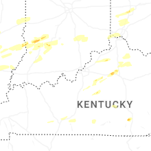


Connect with Interactive Hail Maps