

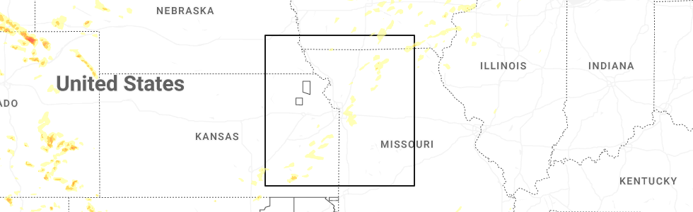
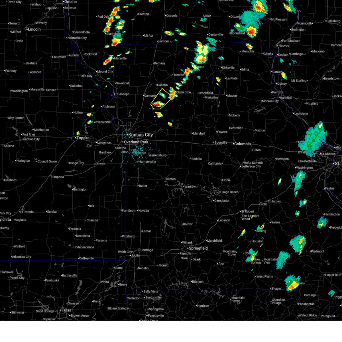
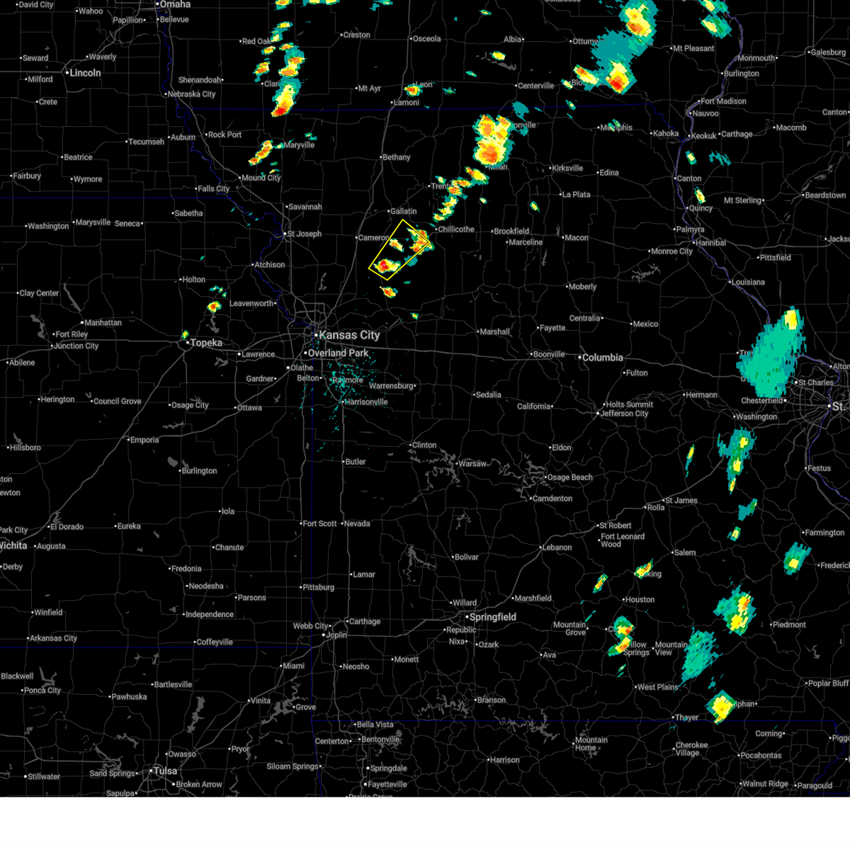
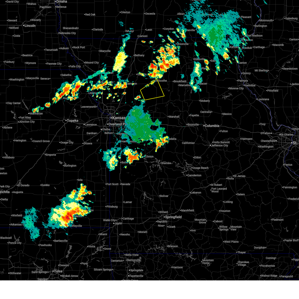
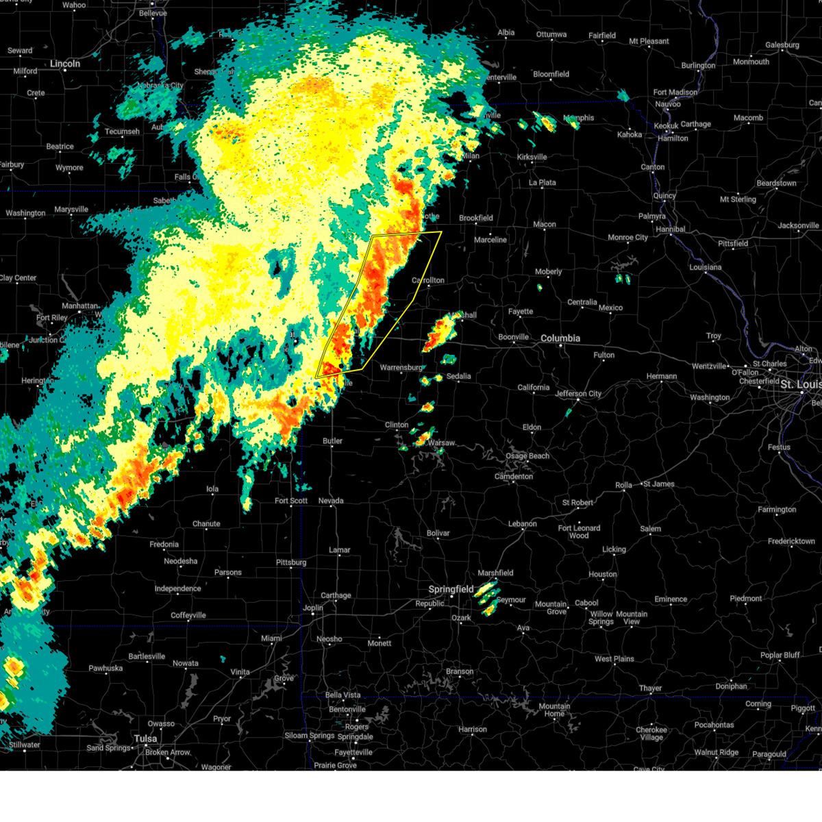
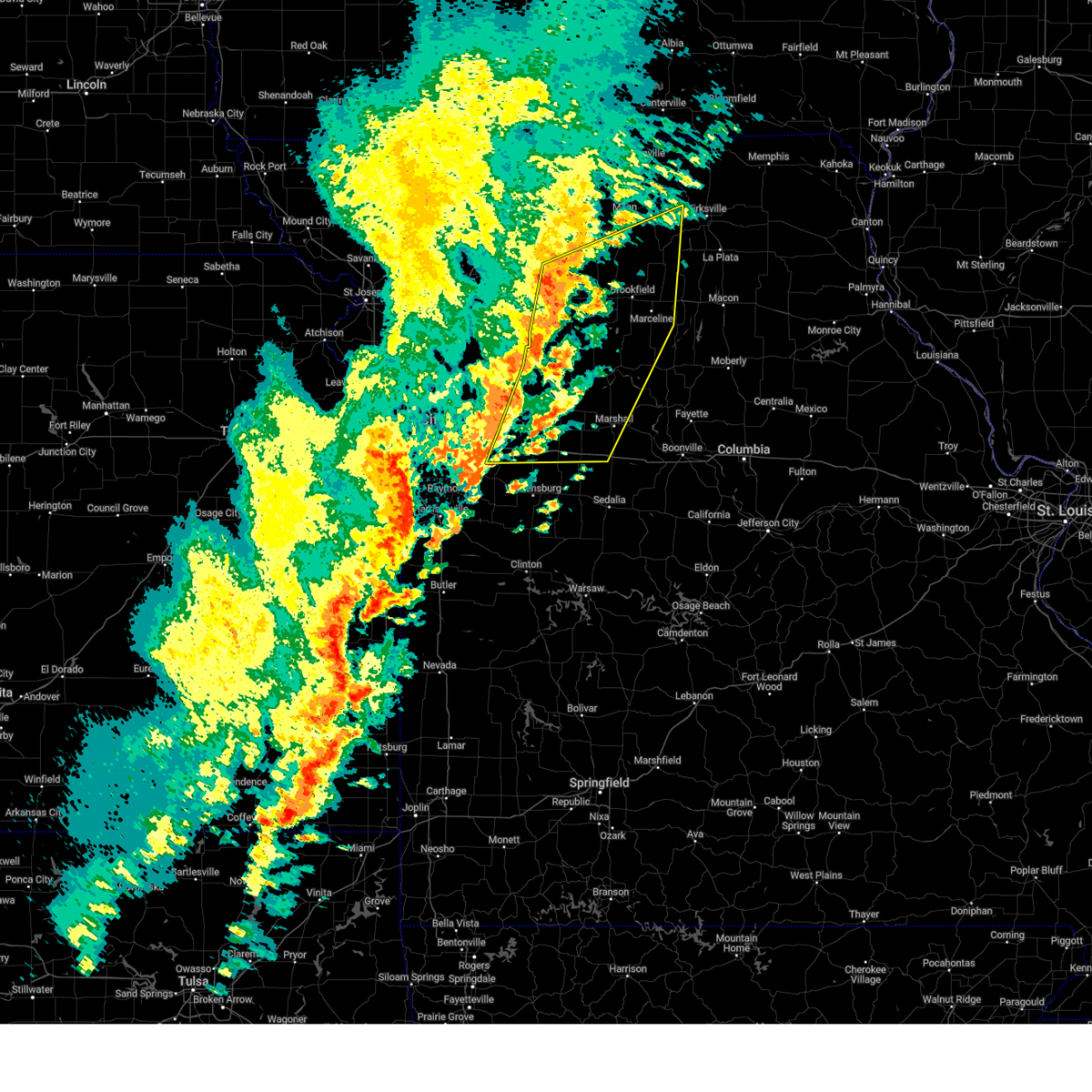
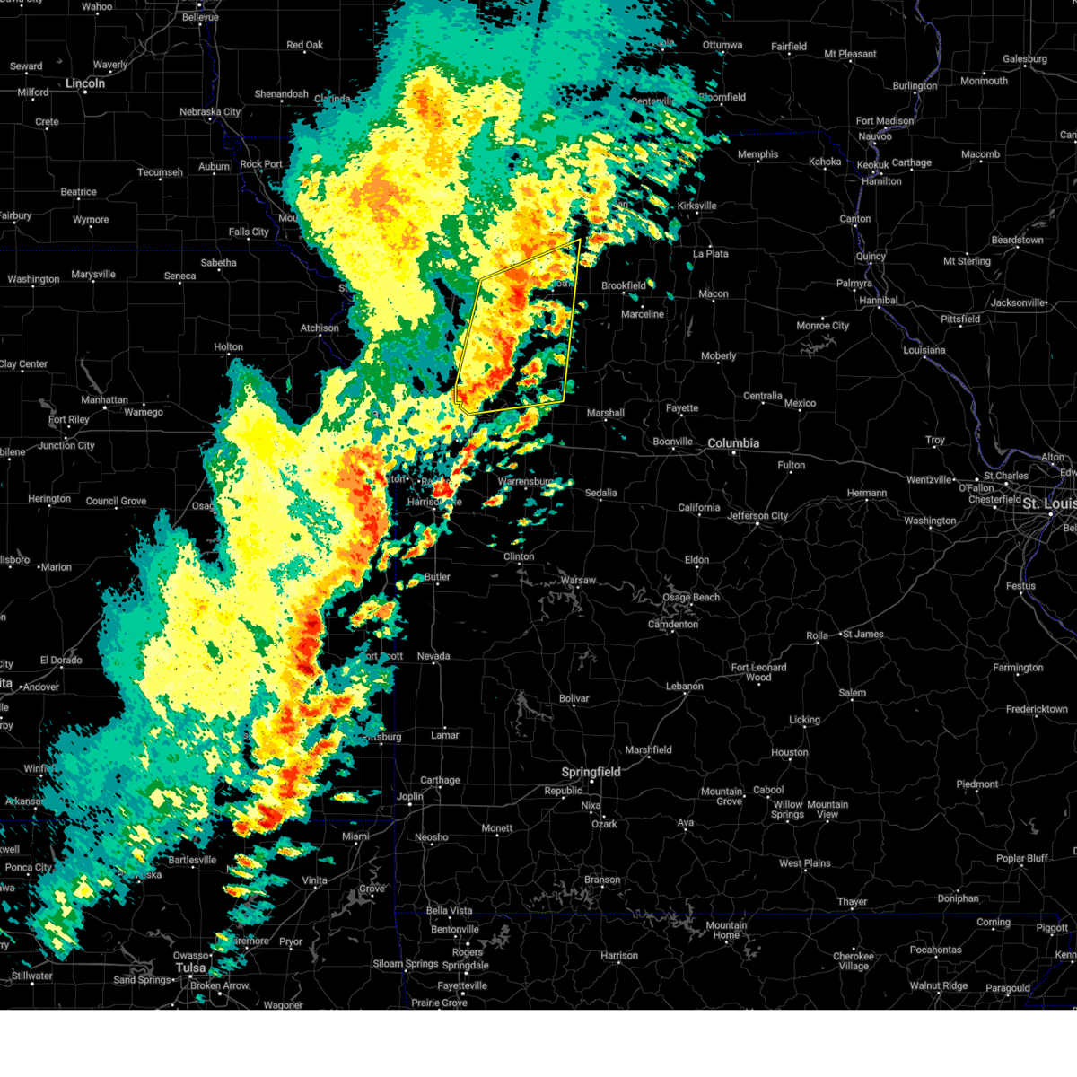
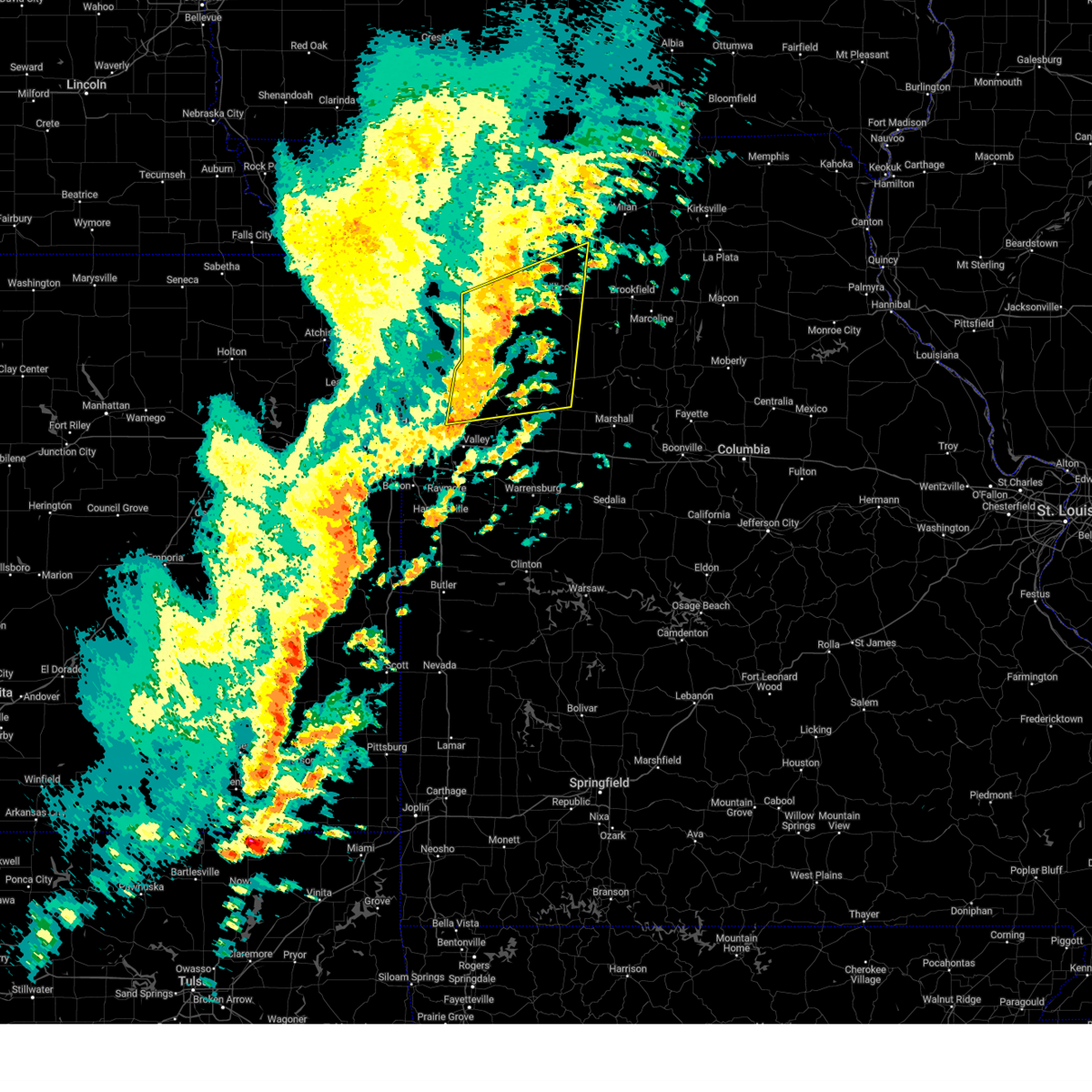
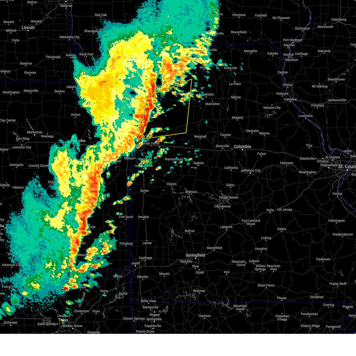
Hail Map for Ludlow, MO
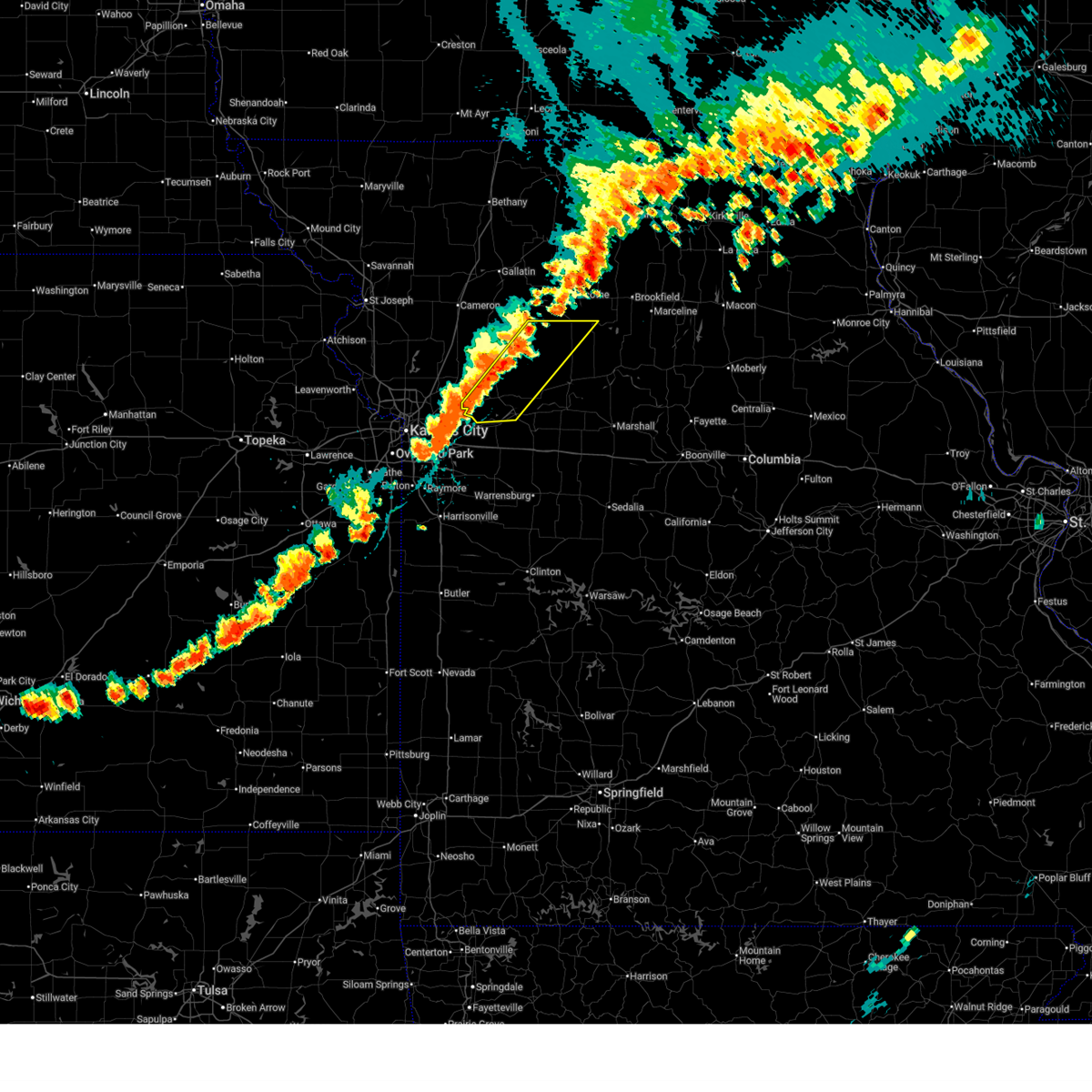
The Ludlow, MO area has had 1 report of on-the-ground hail by trained spotters, and has been under severe weather warnings 26 times during the past 12 months. Doppler radar has detected hail at or near Ludlow, MO on 50 occasions, including 2 occasions during the past year.
| Name: | Ludlow, MO |
| Where Located: | 60.5 miles NE of Kansas City, MO |
| Map: | Google Map for Ludlow, MO |
| Population: | 137 |
| Housing Units: | 96 |
| More Info: | Search Google for Ludlow, MO |
0
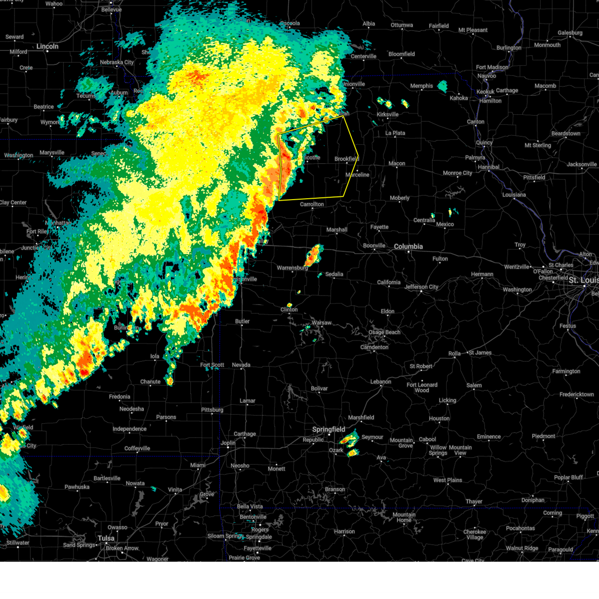
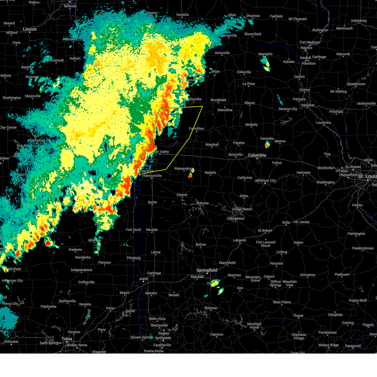
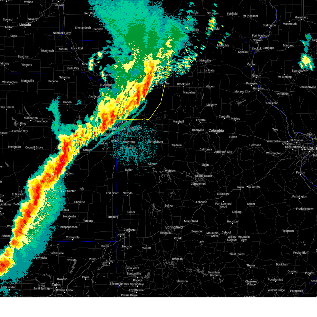
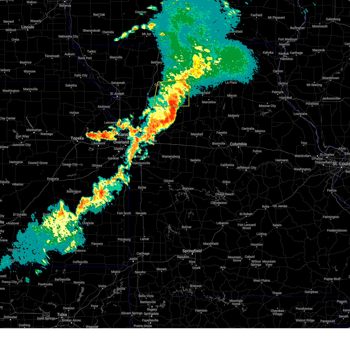
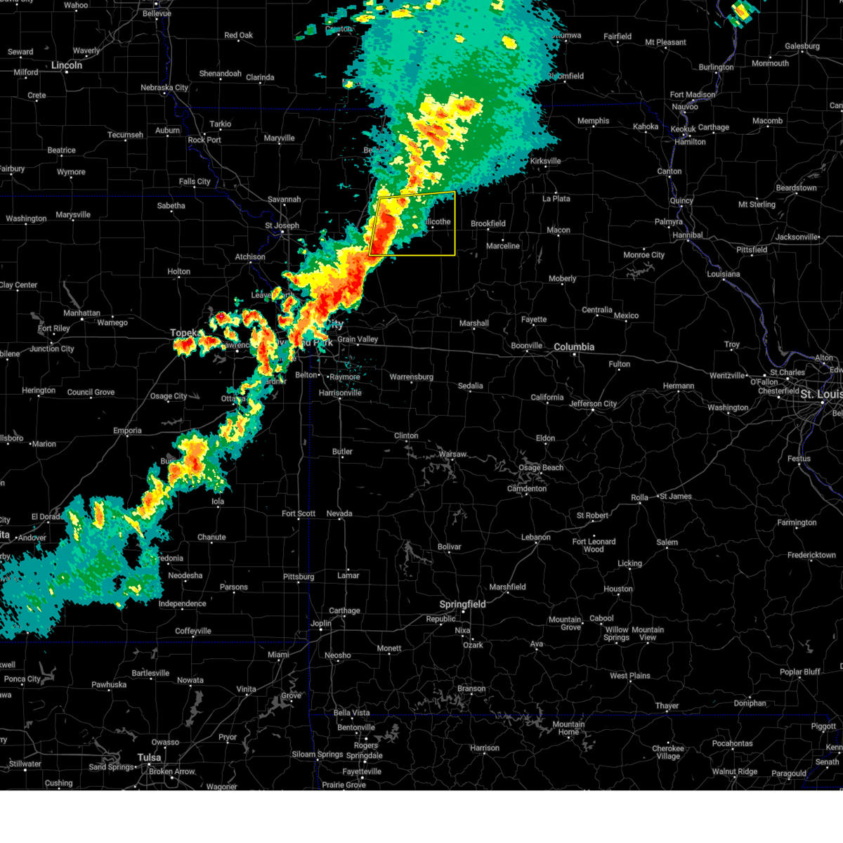
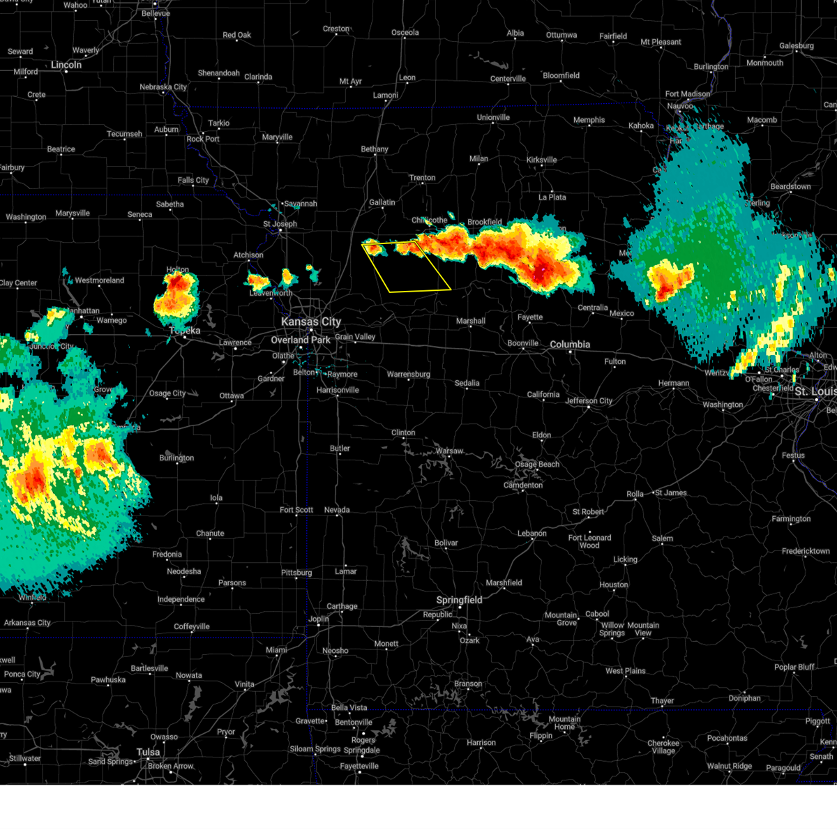
The Top Recent Hail Date for Ludlow, MO is Friday, July 11, 2025 (28th out of 50)
Hail and Wind Damage Spotted near Ludlow, MO
| Date / Time | Report Details |
|---|---|
| 7/11/2025 7:26 PM CDT |
 Svreax the national weather service in pleasant hill has issued a * severe thunderstorm warning for, ray county in west central missouri, northwestern carroll county in north central missouri, southeastern caldwell county in north central missouri, northwestern lafayette county in west central missouri, southern livingston county in north central missouri, * until 815 pm cdt. * at 726 pm cdt, severe thunderstorms were located along a line extending from near braymer to sibley, moving east at 25 mph (radar indicated). Hazards include 60 mph wind gusts. expect damage to roofs, siding, and trees Svreax the national weather service in pleasant hill has issued a * severe thunderstorm warning for, ray county in west central missouri, northwestern carroll county in north central missouri, southeastern caldwell county in north central missouri, northwestern lafayette county in west central missouri, southern livingston county in north central missouri, * until 815 pm cdt. * at 726 pm cdt, severe thunderstorms were located along a line extending from near braymer to sibley, moving east at 25 mph (radar indicated). Hazards include 60 mph wind gusts. expect damage to roofs, siding, and trees
|
| 7/11/2025 3:43 PM CDT |
 the severe thunderstorm warning has been cancelled and is no longer in effect the severe thunderstorm warning has been cancelled and is no longer in effect
|
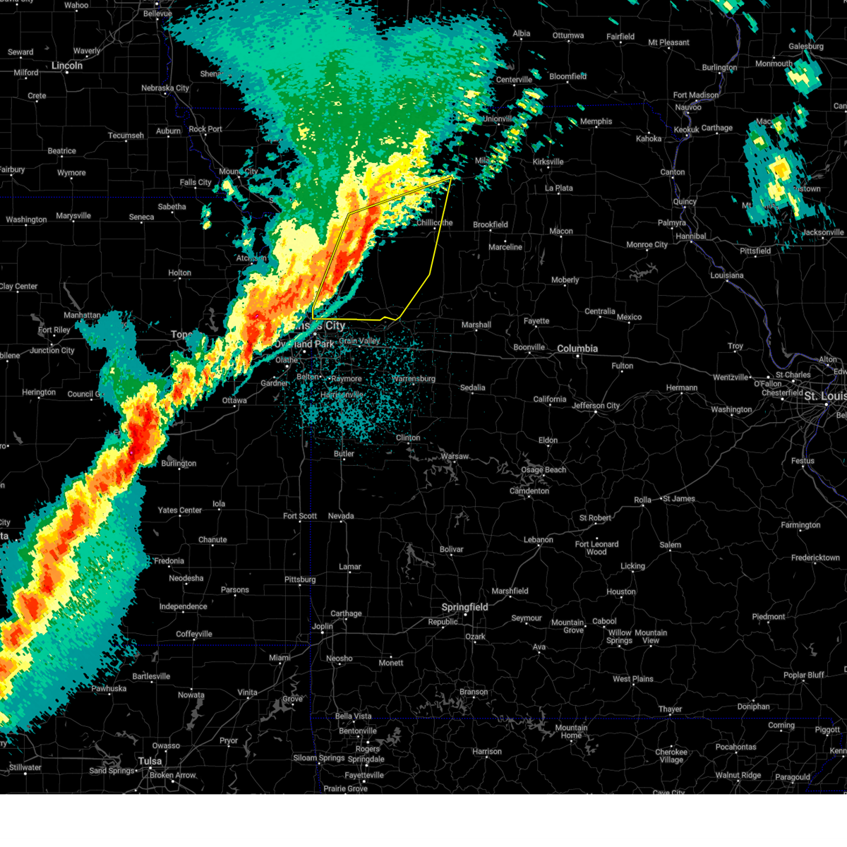
| 7/11/2025 3:28 PM CDT |
 At 328 pm cdt, a severe thunderstorm was located near cowgill, or 9 miles southeast of hamilton, moving northeast at 30 mph (radar indicated). Hazards include 60 mph wind gusts and nickel size hail. Expect damage to roofs, siding, and trees. Locations impacted include, braymer, polo, breckenridge, kingston, cowgill, ludlow, and mooresville. At 328 pm cdt, a severe thunderstorm was located near cowgill, or 9 miles southeast of hamilton, moving northeast at 30 mph (radar indicated). Hazards include 60 mph wind gusts and nickel size hail. Expect damage to roofs, siding, and trees. Locations impacted include, braymer, polo, breckenridge, kingston, cowgill, ludlow, and mooresville.
|
| 7/11/2025 3:28 PM CDT |
 the severe thunderstorm warning has been cancelled and is no longer in effect the severe thunderstorm warning has been cancelled and is no longer in effect
|
| 7/11/2025 3:17 PM CDT |
 Svreax the national weather service in pleasant hill has issued a * severe thunderstorm warning for, southeastern daviess county in north central missouri, north central ray county in west central missouri, eastern caldwell county in north central missouri, southwestern livingston county in north central missouri, * until 400 pm cdt. * at 316 pm cdt, a severe thunderstorm was located over polo, or 12 miles south of hamilton, moving northeast at 30 mph (radar indicated). Hazards include 60 mph wind gusts and quarter size hail. Hail damage to vehicles is expected. Expect wind damage to roofs, siding, and trees. Svreax the national weather service in pleasant hill has issued a * severe thunderstorm warning for, southeastern daviess county in north central missouri, north central ray county in west central missouri, eastern caldwell county in north central missouri, southwestern livingston county in north central missouri, * until 400 pm cdt. * at 316 pm cdt, a severe thunderstorm was located over polo, or 12 miles south of hamilton, moving northeast at 30 mph (radar indicated). Hazards include 60 mph wind gusts and quarter size hail. Hail damage to vehicles is expected. Expect wind damage to roofs, siding, and trees.
|
| 6/26/2025 10:39 PM CDT |
 Svreax the national weather service in pleasant hill has issued a * severe thunderstorm warning for, northeastern ray county in west central missouri, northwestern carroll county in north central missouri, southeastern caldwell county in north central missouri, southwestern livingston county in north central missouri, * until 1115 pm cdt. * at 1038 pm cdt, a severe thunderstorm was located near braymer, or 17 miles northwest of carrollton, moving northeast at 25 mph (radar indicated). Hazards include 60 mph wind gusts. expect damage to roofs, siding, and trees Svreax the national weather service in pleasant hill has issued a * severe thunderstorm warning for, northeastern ray county in west central missouri, northwestern carroll county in north central missouri, southeastern caldwell county in north central missouri, southwestern livingston county in north central missouri, * until 1115 pm cdt. * at 1038 pm cdt, a severe thunderstorm was located near braymer, or 17 miles northwest of carrollton, moving northeast at 25 mph (radar indicated). Hazards include 60 mph wind gusts. expect damage to roofs, siding, and trees
|
| 6/3/2025 3:23 PM CDT |
 At 322 pm cdt, severe thunderstorms were located along a line extending from 6 miles northeast of braymer to near henrietta to near pleasant hill, moving east at 35 mph (radar indicated). Hazards include 60 mph wind gusts and penny size hail. Expect damage to roofs, siding, and trees. locations impacted include, independence, lee's summit, blue springs, raymore, grain valley, pleasant hill, oak grove, richmond, odessa, greenwood, lexington, peculiar, buckner, lake lotawana, lake winnebago, lone jack, braymer, orrick, wellington, and lake tapawingo. this includes the following highways, interstate 70 in missouri between mile markers 17 and 41. interstate 470 between mile markers 8 and 14. Interstate 49 near mile marker 169. At 322 pm cdt, severe thunderstorms were located along a line extending from 6 miles northeast of braymer to near henrietta to near pleasant hill, moving east at 35 mph (radar indicated). Hazards include 60 mph wind gusts and penny size hail. Expect damage to roofs, siding, and trees. locations impacted include, independence, lee's summit, blue springs, raymore, grain valley, pleasant hill, oak grove, richmond, odessa, greenwood, lexington, peculiar, buckner, lake lotawana, lake winnebago, lone jack, braymer, orrick, wellington, and lake tapawingo. this includes the following highways, interstate 70 in missouri between mile markers 17 and 41. interstate 470 between mile markers 8 and 14. Interstate 49 near mile marker 169.
|
| 6/3/2025 3:23 PM CDT |
 the severe thunderstorm warning has been cancelled and is no longer in effect the severe thunderstorm warning has been cancelled and is no longer in effect
|
| 6/3/2025 3:13 PM CDT |
 Svreax the national weather service in pleasant hill has issued a * severe thunderstorm warning for, northwestern chariton county in north central missouri, eastern daviess county in north central missouri, linn county in north central missouri, southern grundy county in north central missouri, southwestern sullivan county in north central missouri, northeastern ray county in west central missouri, northern carroll county in north central missouri, eastern caldwell county in north central missouri, livingston county in north central missouri, * until 415 pm cdt. * at 312 pm cdt, severe thunderstorms were located along a line extending from jamesport to near utica to near braymer, moving east at 40 mph (radar indicated). Hazards include 60 mph wind gusts and penny size hail. expect damage to roofs, siding, and trees Svreax the national weather service in pleasant hill has issued a * severe thunderstorm warning for, northwestern chariton county in north central missouri, eastern daviess county in north central missouri, linn county in north central missouri, southern grundy county in north central missouri, southwestern sullivan county in north central missouri, northeastern ray county in west central missouri, northern carroll county in north central missouri, eastern caldwell county in north central missouri, livingston county in north central missouri, * until 415 pm cdt. * at 312 pm cdt, severe thunderstorms were located along a line extending from jamesport to near utica to near braymer, moving east at 40 mph (radar indicated). Hazards include 60 mph wind gusts and penny size hail. expect damage to roofs, siding, and trees
|
| 6/3/2025 2:53 PM CDT |
 Svreax the national weather service in pleasant hill has issued a * severe thunderstorm warning for, northern cass county in west central missouri, southeastern clinton county in northwestern missouri, eastern clay county in west central missouri, ray county in west central missouri, western carroll county in north central missouri, caldwell county in north central missouri, western lafayette county in west central missouri, jackson county in west central missouri, northwestern johnson county in west central missouri, southwestern livingston county in north central missouri, * until 345 pm cdt. * at 252 pm cdt, severe thunderstorms were located along a line extending from near polo to near buckner to near belton, moving east at 35 mph (public. several reports of wind damage have been received from the kc metro with these storms). Hazards include 70 mph wind gusts and penny size hail. Expect considerable tree damage. Damage is likely to mobile homes, roofs, and outbuildings. Svreax the national weather service in pleasant hill has issued a * severe thunderstorm warning for, northern cass county in west central missouri, southeastern clinton county in northwestern missouri, eastern clay county in west central missouri, ray county in west central missouri, western carroll county in north central missouri, caldwell county in north central missouri, western lafayette county in west central missouri, jackson county in west central missouri, northwestern johnson county in west central missouri, southwestern livingston county in north central missouri, * until 345 pm cdt. * at 252 pm cdt, severe thunderstorms were located along a line extending from near polo to near buckner to near belton, moving east at 35 mph (public. several reports of wind damage have been received from the kc metro with these storms). Hazards include 70 mph wind gusts and penny size hail. Expect considerable tree damage. Damage is likely to mobile homes, roofs, and outbuildings.
|
| 5/19/2025 5:53 PM CDT |
 At 553 pm cdt, severe thunderstorms were located along a line extending from near gallatin to near breckenridge to 9 miles southeast of cowgill, moving northeast at 35 mph (radar indicated). Hazards include 60 mph wind gusts and penny size hail. Expect damage to roofs, siding, and trees. Locations impacted include, chillicothe, trenton, gallatin, braymer, jamesport, breckenridge, gilman city, wheeling, utica, chula, laredo, tina, ludlow, jameson, mooresville, tindall, brimson, lock springs, spring hill, and avalon. At 553 pm cdt, severe thunderstorms were located along a line extending from near gallatin to near breckenridge to 9 miles southeast of cowgill, moving northeast at 35 mph (radar indicated). Hazards include 60 mph wind gusts and penny size hail. Expect damage to roofs, siding, and trees. Locations impacted include, chillicothe, trenton, gallatin, braymer, jamesport, breckenridge, gilman city, wheeling, utica, chula, laredo, tina, ludlow, jameson, mooresville, tindall, brimson, lock springs, spring hill, and avalon.
|
| 5/19/2025 5:38 PM CDT | Svreax the national weather service in pleasant hill has issued a * severe thunderstorm warning for, daviess county in north central missouri, southwestern grundy county in north central missouri, northeastern ray county in west central missouri, northwestern carroll county in north central missouri, eastern caldwell county in north central missouri, livingston county in north central missouri, * until 630 pm cdt. * at 538 pm cdt, severe thunderstorms were located along a line extending from near gallatin to near breckenridge to near richmond, moving northeast at 35 mph (radar indicated). Hazards include 60 mph wind gusts and penny size hail. expect damage to roofs, siding, and trees |
| 5/19/2025 4:34 PM CDT | At 433 pm cdt, severe thunderstorms were located along a line extending from near trenton to pleasant valley, moving northeast at 35 mph (public). Hazards include 60 mph wind gusts and quarter size hail. Hail damage to vehicles is expected. expect wind damage to roofs, siding, and trees. locations impacted include, kansas city, independence, liberty, gladstone, excelsior springs, cameron, chillicothe, kearney, trenton, richmond, north kansas city, sugar creek, buckner, lawson, lathrop, hamilton, gallatin, claycomo, courtney, and pleasant valley. this includes the following highways, interstate 35 in missouri between mile markers 5 and 53, and between mile markers 56 and 73. interstate 29 between mile markers 0 and 1. Interstate 435 between mile markers 46 and 57. |
| 5/19/2025 4:10 PM CDT |
 Svreax the national weather service in pleasant hill has issued a * severe thunderstorm warning for, daviess county in north central missouri, southern grundy county in north central missouri, eastern clinton county in northwestern missouri, clay county in west central missouri, ray county in west central missouri, northwestern carroll county in north central missouri, caldwell county in north central missouri, northern jackson county in west central missouri, livingston county in north central missouri, * until 500 pm cdt. * at 409 pm cdt, severe thunderstorms were located along a line extending from near jamesport to liberty, moving northeast at 35 mph (public. several reports of quarter to half dollar size hail have been received from kearney and holt with these storms). Hazards include ping pong ball size hail and 60 mph wind gusts. People and animals outdoors will be injured. expect hail damage to roofs, siding, windows, and vehicles. Expect wind damage to roofs, siding, and trees. Svreax the national weather service in pleasant hill has issued a * severe thunderstorm warning for, daviess county in north central missouri, southern grundy county in north central missouri, eastern clinton county in northwestern missouri, clay county in west central missouri, ray county in west central missouri, northwestern carroll county in north central missouri, caldwell county in north central missouri, northern jackson county in west central missouri, livingston county in north central missouri, * until 500 pm cdt. * at 409 pm cdt, severe thunderstorms were located along a line extending from near jamesport to liberty, moving northeast at 35 mph (public. several reports of quarter to half dollar size hail have been received from kearney and holt with these storms). Hazards include ping pong ball size hail and 60 mph wind gusts. People and animals outdoors will be injured. expect hail damage to roofs, siding, windows, and vehicles. Expect wind damage to roofs, siding, and trees.
|
| 4/2/2025 4:23 AM CDT |
 At 423 am cdt, severe thunderstorms were located along a line extending from hamilton to near excelsior estates to near missouri city, moving east at 45 mph (radar indicated). Hazards include 60 mph wind gusts. Expect damage to roofs, siding, and trees. locations impacted include, excelsior estates, excelsior springs, gallatin, cameron, utica, rayville, winston, dawn, fleming, gladstone, lathrop, hardin, camden, cowgill, jamesport, orrick, altamont, laredo, knoxville, and missouri city. this includes the following highways, interstate 35 in missouri between mile markers 12 and 61. Interstate 435 between mile markers 41 and 52. At 423 am cdt, severe thunderstorms were located along a line extending from hamilton to near excelsior estates to near missouri city, moving east at 45 mph (radar indicated). Hazards include 60 mph wind gusts. Expect damage to roofs, siding, and trees. locations impacted include, excelsior estates, excelsior springs, gallatin, cameron, utica, rayville, winston, dawn, fleming, gladstone, lathrop, hardin, camden, cowgill, jamesport, orrick, altamont, laredo, knoxville, and missouri city. this includes the following highways, interstate 35 in missouri between mile markers 12 and 61. Interstate 435 between mile markers 41 and 52.
|
| 4/2/2025 4:04 AM CDT |
 Svreax the national weather service in pleasant hill has issued a * severe thunderstorm warning for, southern daviess county in north central missouri, southern grundy county in north central missouri, eastern clinton county in northwestern missouri, clay county in west central missouri, ray county in west central missouri, northwestern carroll county in north central missouri, caldwell county in north central missouri, southeastern dekalb county in northwestern missouri, north central jackson county in west central missouri, western livingston county in north central missouri, * until 445 am cdt. * at 404 am cdt, severe thunderstorms were located along a line extending from cameron to kearney to gladstone, moving east at 50 mph (radar indicated). Hazards include 60 mph wind gusts. expect damage to roofs, siding, and trees Svreax the national weather service in pleasant hill has issued a * severe thunderstorm warning for, southern daviess county in north central missouri, southern grundy county in north central missouri, eastern clinton county in northwestern missouri, clay county in west central missouri, ray county in west central missouri, northwestern carroll county in north central missouri, caldwell county in north central missouri, southeastern dekalb county in northwestern missouri, north central jackson county in west central missouri, western livingston county in north central missouri, * until 445 am cdt. * at 404 am cdt, severe thunderstorms were located along a line extending from cameron to kearney to gladstone, moving east at 50 mph (radar indicated). Hazards include 60 mph wind gusts. expect damage to roofs, siding, and trees
|
| 3/14/2025 4:43 PM CDT |
 At 443 pm cdt, a severe thunderstorm was located near galt, or 9 miles east of trenton, moving north at 65 mph (radio station in trenton reported a 70 mph wind gust). Hazards include 70 mph wind gusts and penny size hail. Expect considerable tree damage. damage is likely to mobile homes, roofs, and outbuildings. Locations impacted include, carrollton, tindall, spring hill, avalon, mooresville, ludlow, utica, spickard, dawn, bogard, stet, brimson, galt, chula, wheeling, laredo, tina, wakenda, hale, and chillicothe. At 443 pm cdt, a severe thunderstorm was located near galt, or 9 miles east of trenton, moving north at 65 mph (radio station in trenton reported a 70 mph wind gust). Hazards include 70 mph wind gusts and penny size hail. Expect considerable tree damage. damage is likely to mobile homes, roofs, and outbuildings. Locations impacted include, carrollton, tindall, spring hill, avalon, mooresville, ludlow, utica, spickard, dawn, bogard, stet, brimson, galt, chula, wheeling, laredo, tina, wakenda, hale, and chillicothe.
|
| 3/14/2025 4:19 PM CDT |
 Svreax the national weather service in pleasant hill has issued a * severe thunderstorm warning for, grundy county in north central missouri, carroll county in north central missouri, livingston county in north central missouri, * until 500 pm cdt. * at 419 pm cdt, a cluster of severe thunderstorms were located 8 miles west of hale, or 10 miles south of chillicothe, moving north at 65 mph (radar indicated). Hazards include 70 mph wind gusts and penny size hail. Expect considerable tree damage. Damage is likely to mobile homes, roofs, and outbuildings. Svreax the national weather service in pleasant hill has issued a * severe thunderstorm warning for, grundy county in north central missouri, carroll county in north central missouri, livingston county in north central missouri, * until 500 pm cdt. * at 419 pm cdt, a cluster of severe thunderstorms were located 8 miles west of hale, or 10 miles south of chillicothe, moving north at 65 mph (radar indicated). Hazards include 70 mph wind gusts and penny size hail. Expect considerable tree damage. Damage is likely to mobile homes, roofs, and outbuildings.
|
| 10/30/2024 8:41 PM CDT |
 Svreax the national weather service in pleasant hill has issued a * severe thunderstorm warning for, southwestern adair county in northeastern missouri, chariton county in north central missouri, linn county in north central missouri, southeastern grundy county in north central missouri, southern sullivan county in north central missouri, eastern ray county in west central missouri, carroll county in north central missouri, saline county in central missouri, northwestern macon county in north central missouri, lafayette county in west central missouri, livingston county in north central missouri, * until 930 pm cdt. * at 840 pm cdt, severe thunderstorms were located along a line extending from 9 miles north of wheeling to near carrollton to near mayview, moving east at 55 mph (radar indicated). Hazards include 60 mph wind gusts. expect damage to roofs, siding, and trees Svreax the national weather service in pleasant hill has issued a * severe thunderstorm warning for, southwestern adair county in northeastern missouri, chariton county in north central missouri, linn county in north central missouri, southeastern grundy county in north central missouri, southern sullivan county in north central missouri, eastern ray county in west central missouri, carroll county in north central missouri, saline county in central missouri, northwestern macon county in north central missouri, lafayette county in west central missouri, livingston county in north central missouri, * until 930 pm cdt. * at 840 pm cdt, severe thunderstorms were located along a line extending from 9 miles north of wheeling to near carrollton to near mayview, moving east at 55 mph (radar indicated). Hazards include 60 mph wind gusts. expect damage to roofs, siding, and trees
|
| 10/30/2024 8:27 PM CDT |
 At 827 pm cdt, severe thunderstorms were located along a line extending from 9 miles south of trenton to near utica to hardin, moving east at 60 mph (radar indicated). Hazards include 60 mph wind gusts and penny size hail. Expect damage to roofs, siding, and trees. Locations impacted include, excelsior springs, chillicothe, richmond, lexington, carrollton, hamilton, braymer, orrick, norborne, polo, hardin, breckenridge, henrietta, crystal lakes, kingston, utica, cowgill, woods heights, rayville, and chula. At 827 pm cdt, severe thunderstorms were located along a line extending from 9 miles south of trenton to near utica to hardin, moving east at 60 mph (radar indicated). Hazards include 60 mph wind gusts and penny size hail. Expect damage to roofs, siding, and trees. Locations impacted include, excelsior springs, chillicothe, richmond, lexington, carrollton, hamilton, braymer, orrick, norborne, polo, hardin, breckenridge, henrietta, crystal lakes, kingston, utica, cowgill, woods heights, rayville, and chula.
|
| 10/30/2024 8:27 PM CDT |
 the severe thunderstorm warning has been cancelled and is no longer in effect the severe thunderstorm warning has been cancelled and is no longer in effect
|
| 10/30/2024 8:16 PM CDT |
 the severe thunderstorm warning has been cancelled and is no longer in effect the severe thunderstorm warning has been cancelled and is no longer in effect
|
| 10/30/2024 8:16 PM CDT |
 At 815 pm cdt, severe thunderstorms were located along a line extending from 6 miles northwest of breckenridge to near cowgill to 6 miles northeast of woods heights, moving east at 45 mph (radar indicated). Hazards include 60 mph wind gusts and penny size hail. Expect damage to roofs, siding, and trees. locations impacted include, independence, excelsior springs, cameron, chillicothe, richmond, lexington, carrollton, buckner, lawson, hamilton, braymer, orrick, norborne, polo, hardin, breckenridge, henrietta, crystal lakes, sibley, and kingston. This includes interstate 35 in missouri between mile markers 56 and 57. At 815 pm cdt, severe thunderstorms were located along a line extending from 6 miles northwest of breckenridge to near cowgill to 6 miles northeast of woods heights, moving east at 45 mph (radar indicated). Hazards include 60 mph wind gusts and penny size hail. Expect damage to roofs, siding, and trees. locations impacted include, independence, excelsior springs, cameron, chillicothe, richmond, lexington, carrollton, buckner, lawson, hamilton, braymer, orrick, norborne, polo, hardin, breckenridge, henrietta, crystal lakes, sibley, and kingston. This includes interstate 35 in missouri between mile markers 56 and 57.
|
| 10/30/2024 7:55 PM CDT |
 Svreax the national weather service in pleasant hill has issued a * severe thunderstorm warning for, southern daviess county in north central missouri, southeastern grundy county in north central missouri, eastern clinton county in northwestern missouri, eastern clay county in west central missouri, ray county in west central missouri, carroll county in north central missouri, caldwell county in north central missouri, northern lafayette county in west central missouri, southeastern dekalb county in northwestern missouri, northeastern jackson county in west central missouri, livingston county in north central missouri, * until 845 pm cdt. * at 755 pm cdt, severe thunderstorms were located along a line extending from near hamilton to near lawson to near excelsior springs, moving east at 45 mph (radar indicated). Hazards include 60 mph wind gusts and penny size hail. expect damage to roofs, siding, and trees Svreax the national weather service in pleasant hill has issued a * severe thunderstorm warning for, southern daviess county in north central missouri, southeastern grundy county in north central missouri, eastern clinton county in northwestern missouri, eastern clay county in west central missouri, ray county in west central missouri, carroll county in north central missouri, caldwell county in north central missouri, northern lafayette county in west central missouri, southeastern dekalb county in northwestern missouri, northeastern jackson county in west central missouri, livingston county in north central missouri, * until 845 pm cdt. * at 755 pm cdt, severe thunderstorms were located along a line extending from near hamilton to near lawson to near excelsior springs, moving east at 45 mph (radar indicated). Hazards include 60 mph wind gusts and penny size hail. expect damage to roofs, siding, and trees
|
| 10/24/2024 9:55 PM CDT |
 The storms which prompted the warning have weakened below severe limits, and no longer pose an immediate threat to life or property. therefore, the warning will be allowed to expire. however, gusty winds are still possible with these thunderstorms. The storms which prompted the warning have weakened below severe limits, and no longer pose an immediate threat to life or property. therefore, the warning will be allowed to expire. however, gusty winds are still possible with these thunderstorms.
|
| 10/24/2024 9:21 PM CDT |
 Svreax the national weather service in pleasant hill has issued a * severe thunderstorm warning for, southeastern daviess county in north central missouri, southern grundy county in north central missouri, northeastern caldwell county in north central missouri, livingston county in north central missouri, * until 1000 pm cdt. * at 920 pm cdt, severe thunderstorms were located along a line extending from near jamesport to near hamilton to near cowgill, moving east at 40 mph (radar indicated). Hazards include 60 mph wind gusts and nickel size hail. expect damage to roofs, siding, and trees Svreax the national weather service in pleasant hill has issued a * severe thunderstorm warning for, southeastern daviess county in north central missouri, southern grundy county in north central missouri, northeastern caldwell county in north central missouri, livingston county in north central missouri, * until 1000 pm cdt. * at 920 pm cdt, severe thunderstorms were located along a line extending from near jamesport to near hamilton to near cowgill, moving east at 40 mph (radar indicated). Hazards include 60 mph wind gusts and nickel size hail. expect damage to roofs, siding, and trees
|
| 7/2/2024 8:45 PM CDT |
 Svreax the national weather service in pleasant hill has issued a * severe thunderstorm warning for, northwestern chariton county in north central missouri, southern linn county in north central missouri, northeastern ray county in west central missouri, northwestern carroll county in north central missouri, southeastern caldwell county in north central missouri, southern livingston county in north central missouri, * until 930 pm cdt. * at 845 pm cdt, severe thunderstorms were located along a line extending from near bucklin to near hale, moving east at 45 mph (radar indicated). Hazards include 60 mph wind gusts and penny size hail. expect damage to roofs, siding, and trees Svreax the national weather service in pleasant hill has issued a * severe thunderstorm warning for, northwestern chariton county in north central missouri, southern linn county in north central missouri, northeastern ray county in west central missouri, northwestern carroll county in north central missouri, southeastern caldwell county in north central missouri, southern livingston county in north central missouri, * until 930 pm cdt. * at 845 pm cdt, severe thunderstorms were located along a line extending from near bucklin to near hale, moving east at 45 mph (radar indicated). Hazards include 60 mph wind gusts and penny size hail. expect damage to roofs, siding, and trees
|
| 7/2/2024 8:18 PM CDT |
 At 818 pm cdt, severe thunderstorms were located along a line extending from near laclede to 6 miles southeast of braymer, moving east at 55 mph (radar indicated). Hazards include 60 mph wind gusts and penny size hail. Expect damage to roofs, siding, and trees. Locations impacted include, chillicothe, brookfield, marceline, braymer, bucklin, meadville, hale, laclede, wheeling, tina, ludlow, sumner, avalon, dawn, and saint catherine. At 818 pm cdt, severe thunderstorms were located along a line extending from near laclede to 6 miles southeast of braymer, moving east at 55 mph (radar indicated). Hazards include 60 mph wind gusts and penny size hail. Expect damage to roofs, siding, and trees. Locations impacted include, chillicothe, brookfield, marceline, braymer, bucklin, meadville, hale, laclede, wheeling, tina, ludlow, sumner, avalon, dawn, and saint catherine.
|
| 7/2/2024 8:18 PM CDT |
 the severe thunderstorm warning has been cancelled and is no longer in effect the severe thunderstorm warning has been cancelled and is no longer in effect
|
| 7/2/2024 7:56 PM CDT |
 Svreax the national weather service in pleasant hill has issued a * severe thunderstorm warning for, northwestern chariton county in north central missouri, southern linn county in north central missouri, southeastern clinton county in northwestern missouri, northern ray county in west central missouri, northwestern carroll county in north central missouri, southeastern caldwell county in north central missouri, livingston county in north central missouri, * until 845 pm cdt. * at 755 pm cdt, severe thunderstorms were located along a line extending from near chillicothe to near polo, moving east at 40 mph (radar indicated). Hazards include 60 mph wind gusts and penny size hail. expect damage to roofs, siding, and trees Svreax the national weather service in pleasant hill has issued a * severe thunderstorm warning for, northwestern chariton county in north central missouri, southern linn county in north central missouri, southeastern clinton county in northwestern missouri, northern ray county in west central missouri, northwestern carroll county in north central missouri, southeastern caldwell county in north central missouri, livingston county in north central missouri, * until 845 pm cdt. * at 755 pm cdt, severe thunderstorms were located along a line extending from near chillicothe to near polo, moving east at 40 mph (radar indicated). Hazards include 60 mph wind gusts and penny size hail. expect damage to roofs, siding, and trees
|
| 7/2/2024 7:18 PM CDT |
 Svreax the national weather service in pleasant hill has issued a * severe thunderstorm warning for, west central adair county in northeastern missouri, northwestern chariton county in north central missouri, linn county in north central missouri, southeastern grundy county in north central missouri, southern sullivan county in north central missouri, east central caldwell county in north central missouri, livingston county in north central missouri, * until 800 pm cdt. * at 718 pm cdt, severe thunderstorms were located along a line extending from near galt to 6 miles southeast of breckenridge, moving east at 25 mph (radar indicated). Hazards include 60 mph wind gusts and penny size hail. expect damage to roofs, siding, and trees Svreax the national weather service in pleasant hill has issued a * severe thunderstorm warning for, west central adair county in northeastern missouri, northwestern chariton county in north central missouri, linn county in north central missouri, southeastern grundy county in north central missouri, southern sullivan county in north central missouri, east central caldwell county in north central missouri, livingston county in north central missouri, * until 800 pm cdt. * at 718 pm cdt, severe thunderstorms were located along a line extending from near galt to 6 miles southeast of breckenridge, moving east at 25 mph (radar indicated). Hazards include 60 mph wind gusts and penny size hail. expect damage to roofs, siding, and trees
|
| 6/26/2024 1:12 AM CDT |
 At 111 am cdt, severe thunderstorms were located along a line extending from 14 miles east of browning to near brookfield to 7 miles west of hale, moving southeast at 45 mph (radar indicated). Hazards include 60 mph wind gusts and nickel size hail. Expect damage to roofs, siding, and trees. Locations impacted include, chillicothe, brookfield, carrollton, marceline, bucklin, meadville, hale, atlanta, laclede, bosworth, callao, linneus, wheeling, utica, browning, chula, new cambria, purdin, mendon, and bogard. At 111 am cdt, severe thunderstorms were located along a line extending from 14 miles east of browning to near brookfield to 7 miles west of hale, moving southeast at 45 mph (radar indicated). Hazards include 60 mph wind gusts and nickel size hail. Expect damage to roofs, siding, and trees. Locations impacted include, chillicothe, brookfield, carrollton, marceline, bucklin, meadville, hale, atlanta, laclede, bosworth, callao, linneus, wheeling, utica, browning, chula, new cambria, purdin, mendon, and bogard.
|
| 6/26/2024 1:12 AM CDT |
 the severe thunderstorm warning has been cancelled and is no longer in effect the severe thunderstorm warning has been cancelled and is no longer in effect
|
| 6/26/2024 1:03 AM CDT |
 At 101 am cdt, severe thunderstorms were located along a line extending from 8 miles south of green city to near linneus to near utica, moving southeast at 45 mph. emergency management reported several large tree limbs down in trenton when these storms moved through that area (emergency management). Hazards include 70 mph wind gusts and nickel size hail. Expect considerable tree damage. damage is likely to mobile homes, roofs, and outbuildings. Locations impacted include, chillicothe, brookfield, carrollton, marceline, bucklin, meadville, hale, atlanta, laclede, bosworth, callao, linneus, wheeling, utica, browning, chula, new cambria, purdin, mendon, and bogard. At 101 am cdt, severe thunderstorms were located along a line extending from 8 miles south of green city to near linneus to near utica, moving southeast at 45 mph. emergency management reported several large tree limbs down in trenton when these storms moved through that area (emergency management). Hazards include 70 mph wind gusts and nickel size hail. Expect considerable tree damage. damage is likely to mobile homes, roofs, and outbuildings. Locations impacted include, chillicothe, brookfield, carrollton, marceline, bucklin, meadville, hale, atlanta, laclede, bosworth, callao, linneus, wheeling, utica, browning, chula, new cambria, purdin, mendon, and bogard.
|
| 6/26/2024 12:46 AM CDT |
 Svreax the national weather service in pleasant hill has issued a * severe thunderstorm warning for, southwestern adair county in northeastern missouri, northwestern chariton county in north central missouri, linn county in north central missouri, southeastern sullivan county in north central missouri, northern carroll county in north central missouri, northwestern macon county in north central missouri, livingston county in north central missouri, * until 130 am cdt. * at 1246 am cdt, severe thunderstorms were located along a line extending from near milan to 10 miles north of wheeling to breckenridge, moving southeast at 50 mph (radar indicated). Hazards include 70 mph wind gusts and nickel size hail. Expect considerable tree damage. Damage is likely to mobile homes, roofs, and outbuildings. Svreax the national weather service in pleasant hill has issued a * severe thunderstorm warning for, southwestern adair county in northeastern missouri, northwestern chariton county in north central missouri, linn county in north central missouri, southeastern sullivan county in north central missouri, northern carroll county in north central missouri, northwestern macon county in north central missouri, livingston county in north central missouri, * until 130 am cdt. * at 1246 am cdt, severe thunderstorms were located along a line extending from near milan to 10 miles north of wheeling to breckenridge, moving southeast at 50 mph (radar indicated). Hazards include 70 mph wind gusts and nickel size hail. Expect considerable tree damage. Damage is likely to mobile homes, roofs, and outbuildings.
|
| 6/13/2024 8:46 PM CDT |
 Svreax the national weather service in pleasant hill has issued a * severe thunderstorm warning for, northeastern ray county in west central missouri, northwestern carroll county in north central missouri, southern caldwell county in north central missouri, southwestern livingston county in north central missouri, * until 930 pm cdt. * at 846 pm cdt, severe thunderstorms were located along a line extending from near braymer to kingston, moving southeast at 30 mph (radar indicated). Hazards include ping pong ball size hail and 60 mph wind gusts. People and animals outdoors will be injured. expect hail damage to roofs, siding, windows, and vehicles. Expect wind damage to roofs, siding, and trees. Svreax the national weather service in pleasant hill has issued a * severe thunderstorm warning for, northeastern ray county in west central missouri, northwestern carroll county in north central missouri, southern caldwell county in north central missouri, southwestern livingston county in north central missouri, * until 930 pm cdt. * at 846 pm cdt, severe thunderstorms were located along a line extending from near braymer to kingston, moving southeast at 30 mph (radar indicated). Hazards include ping pong ball size hail and 60 mph wind gusts. People and animals outdoors will be injured. expect hail damage to roofs, siding, windows, and vehicles. Expect wind damage to roofs, siding, and trees.
|
| 5/21/2024 4:19 PM CDT |
 Svreax the national weather service in pleasant hill has issued a * severe thunderstorm warning for, west central linn county in north central missouri, southeastern grundy county in north central missouri, northeastern ray county in west central missouri, northwestern carroll county in north central missouri, eastern caldwell county in north central missouri, livingston county in north central missouri, * until 500 pm cdt. * at 419 pm cdt, a severe thunderstorm was located over cowgill, or 14 miles south of hamilton, moving northeast at 75 mph (radar indicated). Hazards include 60 mph wind gusts and quarter size hail. Hail damage to vehicles is expected. Expect wind damage to roofs, siding, and trees. Svreax the national weather service in pleasant hill has issued a * severe thunderstorm warning for, west central linn county in north central missouri, southeastern grundy county in north central missouri, northeastern ray county in west central missouri, northwestern carroll county in north central missouri, eastern caldwell county in north central missouri, livingston county in north central missouri, * until 500 pm cdt. * at 419 pm cdt, a severe thunderstorm was located over cowgill, or 14 miles south of hamilton, moving northeast at 75 mph (radar indicated). Hazards include 60 mph wind gusts and quarter size hail. Hail damage to vehicles is expected. Expect wind damage to roofs, siding, and trees.
|
| 5/7/2024 12:21 AM CDT |
 Svreax the national weather service in pleasant hill has issued a * severe thunderstorm warning for, northwestern chariton county in north central missouri, eastern daviess county in north central missouri, linn county in north central missouri, grundy county in north central missouri, sullivan county in north central missouri, mercer county in north central missouri, western putnam county in north central missouri, harrison county in north central missouri, northeastern caldwell county in north central missouri, livingston county in north central missouri, * until 115 am cdt. * at 1220 am cdt, severe thunderstorms were located along a line extending from near eagleville to near braymer, moving northeast at 45 mph (radar indicated). Hazards include 60 mph wind gusts. expect damage to roofs, siding, and trees Svreax the national weather service in pleasant hill has issued a * severe thunderstorm warning for, northwestern chariton county in north central missouri, eastern daviess county in north central missouri, linn county in north central missouri, grundy county in north central missouri, sullivan county in north central missouri, mercer county in north central missouri, western putnam county in north central missouri, harrison county in north central missouri, northeastern caldwell county in north central missouri, livingston county in north central missouri, * until 115 am cdt. * at 1220 am cdt, severe thunderstorms were located along a line extending from near eagleville to near braymer, moving northeast at 45 mph (radar indicated). Hazards include 60 mph wind gusts. expect damage to roofs, siding, and trees
|
| 5/7/2024 12:04 AM CDT |
 At 1203 am cdt, severe thunderstorms were located along a line extending from 6 miles south of bethany to near mayview, moving northeast at 50 mph (public. several reports of wind damage have been received from these storms). Hazards include 60 mph wind gusts and penny size hail. Expect damage to roofs, siding, and trees. locations impacted include, chillicothe, trenton, richmond, odessa, higginsville, lexington, carrollton, concordia, hamilton, gallatin, braymer, waverly, wellington, norborne, polo, hardin, jamesport, corder, alma, and breckenridge. this includes the following highways, interstate 70 in missouri between mile markers 31 and 62. Interstate 35 in missouri between mile markers 58 and 78. At 1203 am cdt, severe thunderstorms were located along a line extending from 6 miles south of bethany to near mayview, moving northeast at 50 mph (public. several reports of wind damage have been received from these storms). Hazards include 60 mph wind gusts and penny size hail. Expect damage to roofs, siding, and trees. locations impacted include, chillicothe, trenton, richmond, odessa, higginsville, lexington, carrollton, concordia, hamilton, gallatin, braymer, waverly, wellington, norborne, polo, hardin, jamesport, corder, alma, and breckenridge. this includes the following highways, interstate 70 in missouri between mile markers 31 and 62. Interstate 35 in missouri between mile markers 58 and 78.
|
| 5/7/2024 12:04 AM CDT |
 the severe thunderstorm warning has been cancelled and is no longer in effect the severe thunderstorm warning has been cancelled and is no longer in effect
|
| 5/6/2024 11:37 PM CDT |
 Svreax the national weather service in pleasant hill has issued a * severe thunderstorm warning for, daviess county in north central missouri, southwestern grundy county in north central missouri, eastern clinton county in northwestern missouri, northeastern clay county in west central missouri, ray county in west central missouri, carroll county in north central missouri, caldwell county in north central missouri, lafayette county in west central missouri, eastern dekalb county in northwestern missouri, livingston county in north central missouri, * until 1230 am cdt. * at 1136 pm cdt, severe thunderstorms were located along a line extending from 7 miles north of maysville to lone jack, moving northeast at 50 mph (public). Hazards include 60 mph wind gusts and penny size hail. expect damage to roofs, siding, and trees Svreax the national weather service in pleasant hill has issued a * severe thunderstorm warning for, daviess county in north central missouri, southwestern grundy county in north central missouri, eastern clinton county in northwestern missouri, northeastern clay county in west central missouri, ray county in west central missouri, carroll county in north central missouri, caldwell county in north central missouri, lafayette county in west central missouri, eastern dekalb county in northwestern missouri, livingston county in north central missouri, * until 1230 am cdt. * at 1136 pm cdt, severe thunderstorms were located along a line extending from 7 miles north of maysville to lone jack, moving northeast at 50 mph (public). Hazards include 60 mph wind gusts and penny size hail. expect damage to roofs, siding, and trees
|
| 4/16/2024 1:15 PM CDT |
 Svreax the national weather service in pleasant hill has issued a * severe thunderstorm warning for, ray county in west central missouri, western carroll county in north central missouri, eastern caldwell county in north central missouri, western lafayette county in west central missouri, southeastern jackson county in west central missouri, northwestern johnson county in west central missouri, southwestern livingston county in north central missouri, * until 200 pm cdt. * at 115 pm cdt, a severe thunderstorm was located near grain valley, moving north at 65 mph (radar indicated). Hazards include 60 mph wind gusts and quarter size hail. Hail damage to vehicles is expected. Expect wind damage to roofs, siding, and trees. Svreax the national weather service in pleasant hill has issued a * severe thunderstorm warning for, ray county in west central missouri, western carroll county in north central missouri, eastern caldwell county in north central missouri, western lafayette county in west central missouri, southeastern jackson county in west central missouri, northwestern johnson county in west central missouri, southwestern livingston county in north central missouri, * until 200 pm cdt. * at 115 pm cdt, a severe thunderstorm was located near grain valley, moving north at 65 mph (radar indicated). Hazards include 60 mph wind gusts and quarter size hail. Hail damage to vehicles is expected. Expect wind damage to roofs, siding, and trees.
|
| 4/16/2024 11:11 AM CDT |
 At 1111 am cdt, severe thunderstorms were located along a line extending from near pattonsburg to near cowgill, moving northeast at 45 mph (radar indicated). Hazards include 60 mph wind gusts. Expect damage to roofs, siding, and trees. locations impacted include, hamilton, gallatin, polo, jamesport, breckenridge, gilman city, pattonsburg, kingston, kidder, altamont, coffey, ludlow, jameson, mooresville, mount moriah, and lock springs. This includes interstate 35 in missouri between mile markers 68 and 87. At 1111 am cdt, severe thunderstorms were located along a line extending from near pattonsburg to near cowgill, moving northeast at 45 mph (radar indicated). Hazards include 60 mph wind gusts. Expect damage to roofs, siding, and trees. locations impacted include, hamilton, gallatin, polo, jamesport, breckenridge, gilman city, pattonsburg, kingston, kidder, altamont, coffey, ludlow, jameson, mooresville, mount moriah, and lock springs. This includes interstate 35 in missouri between mile markers 68 and 87.
|
| 4/16/2024 11:11 AM CDT |
 the severe thunderstorm warning has been cancelled and is no longer in effect the severe thunderstorm warning has been cancelled and is no longer in effect
|
| 4/16/2024 11:04 AM CDT |
 the severe thunderstorm warning has been cancelled and is no longer in effect the severe thunderstorm warning has been cancelled and is no longer in effect
|
| 4/16/2024 11:04 AM CDT |
 At 1104 am cdt, severe thunderstorms were located along a line extending from 8 miles west of gallatin to 7 miles northeast of woods heights, moving northeast at 35 mph (radar indicated). Hazards include 60 mph wind gusts. Expect damage to roofs, siding, and trees. locations impacted include, hamilton, gallatin, braymer, polo, jamesport, breckenridge, gilman city, pattonsburg, kingston, cowgill, kidder, winston, altamont, coffey, ludlow, jameson, mooresville, mount moriah, lock springs, and elmira. This includes interstate 35 in missouri between mile markers 61 and 89. At 1104 am cdt, severe thunderstorms were located along a line extending from 8 miles west of gallatin to 7 miles northeast of woods heights, moving northeast at 35 mph (radar indicated). Hazards include 60 mph wind gusts. Expect damage to roofs, siding, and trees. locations impacted include, hamilton, gallatin, braymer, polo, jamesport, breckenridge, gilman city, pattonsburg, kingston, cowgill, kidder, winston, altamont, coffey, ludlow, jameson, mooresville, mount moriah, lock springs, and elmira. This includes interstate 35 in missouri between mile markers 61 and 89.
|
| 4/16/2024 10:59 AM CDT |
 Svreax the national weather service in pleasant hill has issued a * severe thunderstorm warning for, daviess county in north central missouri, southwestern grundy county in north central missouri, eastern clinton county in northwestern missouri, northern ray county in west central missouri, northwestern carroll county in north central missouri, southeastern harrison county in north central missouri, caldwell county in north central missouri, eastern dekalb county in northwestern missouri, western livingston county in north central missouri, * until 1145 am cdt. * at 1058 am cdt, severe thunderstorms were located along a line extending from 9 miles west of gallatin to 6 miles northeast of woods heights, moving northeast at 35 mph (radar indicated). Hazards include 60 mph wind gusts. expect damage to roofs, siding, and trees Svreax the national weather service in pleasant hill has issued a * severe thunderstorm warning for, daviess county in north central missouri, southwestern grundy county in north central missouri, eastern clinton county in northwestern missouri, northern ray county in west central missouri, northwestern carroll county in north central missouri, southeastern harrison county in north central missouri, caldwell county in north central missouri, eastern dekalb county in northwestern missouri, western livingston county in north central missouri, * until 1145 am cdt. * at 1058 am cdt, severe thunderstorms were located along a line extending from 9 miles west of gallatin to 6 miles northeast of woods heights, moving northeast at 35 mph (radar indicated). Hazards include 60 mph wind gusts. expect damage to roofs, siding, and trees
|
| 3/14/2024 12:43 AM CDT |
 At 1242 am cdt, a severe thunderstorm was located 9 miles southeast of utica, or 12 miles south of chillicothe, moving east at 45 mph (radar indicated). Hazards include 60 mph wind gusts and quarter size hail. Hail damage to vehicles is expected. expect wind damage to roofs, siding, and trees. Locations impacted include, bosworth, bogard, tina, ludlow, avalon, and dawn. At 1242 am cdt, a severe thunderstorm was located 9 miles southeast of utica, or 12 miles south of chillicothe, moving east at 45 mph (radar indicated). Hazards include 60 mph wind gusts and quarter size hail. Hail damage to vehicles is expected. expect wind damage to roofs, siding, and trees. Locations impacted include, bosworth, bogard, tina, ludlow, avalon, and dawn.
|
| 3/14/2024 12:43 AM CDT |
 the severe thunderstorm warning has been cancelled and is no longer in effect the severe thunderstorm warning has been cancelled and is no longer in effect
|
| 3/14/2024 12:37 AM CDT |
 At 1237 am cdt, a severe thunderstorm was located 10 miles east of braymer, or 13 miles south of chillicothe, moving east at 50 mph (radar indicated). Hazards include 60 mph wind gusts and quarter size hail. Hail damage to vehicles is expected. expect wind damage to roofs, siding, and trees. Locations impacted include, bosworth, bogard, tina, ludlow, dawn, stet, and avalon. At 1237 am cdt, a severe thunderstorm was located 10 miles east of braymer, or 13 miles south of chillicothe, moving east at 50 mph (radar indicated). Hazards include 60 mph wind gusts and quarter size hail. Hail damage to vehicles is expected. expect wind damage to roofs, siding, and trees. Locations impacted include, bosworth, bogard, tina, ludlow, dawn, stet, and avalon.
|
| 3/14/2024 12:17 AM CDT |
 Svreax the national weather service in pleasant hill has issued a * severe thunderstorm warning for, northeastern ray county in west central missouri, northwestern carroll county in north central missouri, southeastern caldwell county in north central missouri, southern livingston county in north central missouri, * until 100 am cdt. * at 1217 am cdt, a severe thunderstorm was located over cowgill, or 15 miles south of hamilton, moving east at 45 mph (radar indicated). Hazards include 60 mph wind gusts and quarter size hail. Hail damage to vehicles is expected. Expect wind damage to roofs, siding, and trees. Svreax the national weather service in pleasant hill has issued a * severe thunderstorm warning for, northeastern ray county in west central missouri, northwestern carroll county in north central missouri, southeastern caldwell county in north central missouri, southern livingston county in north central missouri, * until 100 am cdt. * at 1217 am cdt, a severe thunderstorm was located over cowgill, or 15 miles south of hamilton, moving east at 45 mph (radar indicated). Hazards include 60 mph wind gusts and quarter size hail. Hail damage to vehicles is expected. Expect wind damage to roofs, siding, and trees.
|
| 3/12/2024 7:39 PM CDT |
 Svreax the national weather service in pleasant hill has issued a * severe thunderstorm warning for, southeastern clinton county in northwestern missouri, northeastern clay county in west central missouri, northern ray county in west central missouri, northwestern carroll county in north central missouri, southern caldwell county in north central missouri, southwestern livingston county in north central missouri, * until 815 pm cdt. * at 738 pm cdt, severe thunderstorms were located along a line extending from 7 miles southeast of cowgill to near excelsior estates, moving northeast at 15 mph (radar indicated). Hazards include 60 mph wind gusts and quarter size hail. Hail damage to vehicles is expected. Expect wind damage to roofs, siding, and trees. Svreax the national weather service in pleasant hill has issued a * severe thunderstorm warning for, southeastern clinton county in northwestern missouri, northeastern clay county in west central missouri, northern ray county in west central missouri, northwestern carroll county in north central missouri, southern caldwell county in north central missouri, southwestern livingston county in north central missouri, * until 815 pm cdt. * at 738 pm cdt, severe thunderstorms were located along a line extending from 7 miles southeast of cowgill to near excelsior estates, moving northeast at 15 mph (radar indicated). Hazards include 60 mph wind gusts and quarter size hail. Hail damage to vehicles is expected. Expect wind damage to roofs, siding, and trees.
|
| 9/23/2023 1:58 PM CDT |
 The severe thunderstorm warning for northeastern clay, ray, western carroll, southeastern caldwell, north central jackson and southwestern livingston counties will expire at 200 pm cdt, the storm which prompted the warning has weakened below severe limits, and no longer poses an immediate threat to life or property. therefore, the warning will be allowed to expire. however gusty winds are still possible with this thunderstorm. a severe thunderstorm watch remains in effect until 900 pm cdt for north central and west central missouri. The severe thunderstorm warning for northeastern clay, ray, western carroll, southeastern caldwell, north central jackson and southwestern livingston counties will expire at 200 pm cdt, the storm which prompted the warning has weakened below severe limits, and no longer poses an immediate threat to life or property. therefore, the warning will be allowed to expire. however gusty winds are still possible with this thunderstorm. a severe thunderstorm watch remains in effect until 900 pm cdt for north central and west central missouri.
|
| 9/23/2023 1:24 PM CDT |
 At 123 pm cdt, a severe thunderstorm was located near hardin, or 9 miles northeast of richmond, moving northeast at 45 mph (radar indicated). Hazards include 60 mph wind gusts and quarter size hail. Hail damage to vehicles is expected. Expect wind damage to roofs, siding, and trees. At 123 pm cdt, a severe thunderstorm was located near hardin, or 9 miles northeast of richmond, moving northeast at 45 mph (radar indicated). Hazards include 60 mph wind gusts and quarter size hail. Hail damage to vehicles is expected. Expect wind damage to roofs, siding, and trees.
|
| 7/29/2023 11:42 AM CDT |
 At 1142 am cdt, severe thunderstorms were located along a line extending from near gilman city to near utica to near norborne, moving east at 50 mph (trained weather spotters). Hazards include 70 mph wind gusts. Expect considerable tree damage. Damage is likely to mobile homes, roofs, and outbuildings. At 1142 am cdt, severe thunderstorms were located along a line extending from near gilman city to near utica to near norborne, moving east at 50 mph (trained weather spotters). Hazards include 70 mph wind gusts. Expect considerable tree damage. Damage is likely to mobile homes, roofs, and outbuildings.
|
| 7/29/2023 11:37 AM CDT |
 At 1137 am cdt, severe thunderstorms were located along a line extending from 6 miles north of gallatin to 7 miles south of utica to near wellington, moving southeast at 45 mph (radar indicated). Hazards include 60 mph wind gusts and penny size hail. Expect damage to roofs, siding, and trees. locations impacted include, richmond, lawson, hamilton, gallatin, braymer, norborne, polo, hardin, jamesport, breckenridge, gilman city, crystal lakes, kingston, pattonsburg, utica, cowgill, woods heights, kidder, winston and rayville. this includes interstate 35 in missouri between mile markers 58 and 82. hail threat, radar indicated max hail size, 0. 75 in wind threat, observed max wind gust, 60 mph. At 1137 am cdt, severe thunderstorms were located along a line extending from 6 miles north of gallatin to 7 miles south of utica to near wellington, moving southeast at 45 mph (radar indicated). Hazards include 60 mph wind gusts and penny size hail. Expect damage to roofs, siding, and trees. locations impacted include, richmond, lawson, hamilton, gallatin, braymer, norborne, polo, hardin, jamesport, breckenridge, gilman city, crystal lakes, kingston, pattonsburg, utica, cowgill, woods heights, kidder, winston and rayville. this includes interstate 35 in missouri between mile markers 58 and 82. hail threat, radar indicated max hail size, 0. 75 in wind threat, observed max wind gust, 60 mph.
|
| 7/29/2023 11:26 AM CDT |
 At 1126 am cdt, severe thunderstorms were located along a line extending from near pattonsburg to 6 miles northeast of braymer to near orrick, moving east at 50 mph (radar indicated). Hazards include 60 mph wind gusts and penny size hail. Expect damage to roofs, siding, and trees. locations impacted include, liberty, excelsior springs, cameron, kearney, richmond, lexington, lawson, hamilton, gallatin, braymer, orrick, norborne, polo, hardin, jamesport, holt, breckenridge, gilman city, henrietta and crystal lakes. this includes interstate 35 in missouri between mile markers 19 and 32, between mile markers 38 and 53, and between mile markers 56 and 82. hail threat, radar indicated max hail size, 0. 75 in wind threat, observed max wind gust, 60 mph. At 1126 am cdt, severe thunderstorms were located along a line extending from near pattonsburg to 6 miles northeast of braymer to near orrick, moving east at 50 mph (radar indicated). Hazards include 60 mph wind gusts and penny size hail. Expect damage to roofs, siding, and trees. locations impacted include, liberty, excelsior springs, cameron, kearney, richmond, lexington, lawson, hamilton, gallatin, braymer, orrick, norborne, polo, hardin, jamesport, holt, breckenridge, gilman city, henrietta and crystal lakes. this includes interstate 35 in missouri between mile markers 19 and 32, between mile markers 38 and 53, and between mile markers 56 and 82. hail threat, radar indicated max hail size, 0. 75 in wind threat, observed max wind gust, 60 mph.
|
| 7/29/2023 10:54 AM CDT |
 At 1053 am cdt, severe thunderstorms were located along a line extending from near stanberry to near cameron to near smithville, moving southeast at 60 mph (trained weather spotters). Hazards include 70 mph wind gusts. Expect considerable tree damage. Damage is likely to mobile homes, roofs, and outbuildings. At 1053 am cdt, severe thunderstorms were located along a line extending from near stanberry to near cameron to near smithville, moving southeast at 60 mph (trained weather spotters). Hazards include 70 mph wind gusts. Expect considerable tree damage. Damage is likely to mobile homes, roofs, and outbuildings.
|
| 7/24/2023 8:20 AM CDT |
 The severe thunderstorm warning for southern daviess, eastern clinton, northwestern ray, caldwell and southwestern livingston counties will expire at 830 am cdt, the storms which prompted the warning have weakened below severe limits, and no longer pose an immediate threat to life or property. therefore, the warning will be allowed to expire. however gusty winds and heavy rain are still possible with these thunderstorms. a severe thunderstorm watch remains in effect until noon cdt for north central, northwestern and west central missouri. The severe thunderstorm warning for southern daviess, eastern clinton, northwestern ray, caldwell and southwestern livingston counties will expire at 830 am cdt, the storms which prompted the warning have weakened below severe limits, and no longer pose an immediate threat to life or property. therefore, the warning will be allowed to expire. however gusty winds and heavy rain are still possible with these thunderstorms. a severe thunderstorm watch remains in effect until noon cdt for north central, northwestern and west central missouri.
|
| 7/24/2023 8:00 AM CDT |
 At 800 am cdt, severe thunderstorms were located along a line extending from near gallatin to kingston to near holt, moving southeast at 50 mph (radar indicated). Hazards include 60 mph wind gusts. Expect damage to roofs, siding, and trees. locations impacted include, cameron, lawson, lathrop, hamilton, gallatin, braymer, polo, breckenridge, kingston, cowgill, kidder, winston, rayville, altamont, turney, ludlow, mooresville, lock springs, elmira and knoxville. this includes interstate 35 in missouri between mile markers 35 and 53, and between mile markers 57 and 71. hail threat, radar indicated max hail size, <. 75 in wind threat, radar indicated max wind gust, 60 mph. At 800 am cdt, severe thunderstorms were located along a line extending from near gallatin to kingston to near holt, moving southeast at 50 mph (radar indicated). Hazards include 60 mph wind gusts. Expect damage to roofs, siding, and trees. locations impacted include, cameron, lawson, lathrop, hamilton, gallatin, braymer, polo, breckenridge, kingston, cowgill, kidder, winston, rayville, altamont, turney, ludlow, mooresville, lock springs, elmira and knoxville. this includes interstate 35 in missouri between mile markers 35 and 53, and between mile markers 57 and 71. hail threat, radar indicated max hail size, <. 75 in wind threat, radar indicated max wind gust, 60 mph.
|
| 7/24/2023 7:42 AM CDT |
 At 742 am cdt, severe thunderstorms were located along a line extending from near pattonsburg to near cameron to plattsburg, moving southeast at 45 mph (radar indicated). Hazards include 60 mph wind gusts. expect damage to roofs, siding, and trees At 742 am cdt, severe thunderstorms were located along a line extending from near pattonsburg to near cameron to plattsburg, moving southeast at 45 mph (radar indicated). Hazards include 60 mph wind gusts. expect damage to roofs, siding, and trees
|
| 6/30/2023 11:45 PM CDT |
 At 1145 pm cdt, severe thunderstorms were located along a line extending from near spickard to 11 miles southeast of trenton to near chillicothe, moving east at 35 mph (emergency management). Hazards include 60 mph wind gusts. Expect damage to roofs, siding, and trees. locations impacted include, chillicothe, trenton, bethany, gilman city, wheeling, utica, spickard, galt, chula, laredo, ludlow, mooresville, mount moriah, tindall, brimson, spring hill, modena, avalon, mill grove and dawn. this includes interstate 35 in missouri between mile markers 86 and 93. hail threat, radar indicated max hail size, <. 75 in wind threat, observed max wind gust, 60 mph. At 1145 pm cdt, severe thunderstorms were located along a line extending from near spickard to 11 miles southeast of trenton to near chillicothe, moving east at 35 mph (emergency management). Hazards include 60 mph wind gusts. Expect damage to roofs, siding, and trees. locations impacted include, chillicothe, trenton, bethany, gilman city, wheeling, utica, spickard, galt, chula, laredo, ludlow, mooresville, mount moriah, tindall, brimson, spring hill, modena, avalon, mill grove and dawn. this includes interstate 35 in missouri between mile markers 86 and 93. hail threat, radar indicated max hail size, <. 75 in wind threat, observed max wind gust, 60 mph.
|
| 6/30/2023 11:13 PM CDT |
 At 1113 pm cdt, severe thunderstorms were located along a line extending from 7 miles west of gilman city to near breckenridge to near braymer, moving east at 35 mph (radar indicated). Hazards include 60 mph wind gusts. expect damage to roofs, siding, and trees At 1113 pm cdt, severe thunderstorms were located along a line extending from 7 miles west of gilman city to near breckenridge to near braymer, moving east at 35 mph (radar indicated). Hazards include 60 mph wind gusts. expect damage to roofs, siding, and trees
|
| 6/29/2023 9:58 AM CDT |
 At 958 am cdt, severe thunderstorms were located along a line extending from browning to near brookfield to 9 miles north of brunswick, moving east at 65 mph (radar indicated). Hazards include 70 mph wind gusts. Expect considerable tree damage. damage is likely to mobile homes, roofs, and outbuildings. locations impacted include, chillicothe, brookfield, marceline, bucklin, meadville, hale, laclede, linneus, wheeling, utica, browning, chula, laredo, purdin, mendon, tina, ludlow, sumner, rothville and mooresville. thunderstorm damage threat, considerable hail threat, radar indicated max hail size, <. 75 in wind threat, radar indicated max wind gust, 70 mph. At 958 am cdt, severe thunderstorms were located along a line extending from browning to near brookfield to 9 miles north of brunswick, moving east at 65 mph (radar indicated). Hazards include 70 mph wind gusts. Expect considerable tree damage. damage is likely to mobile homes, roofs, and outbuildings. locations impacted include, chillicothe, brookfield, marceline, bucklin, meadville, hale, laclede, linneus, wheeling, utica, browning, chula, laredo, purdin, mendon, tina, ludlow, sumner, rothville and mooresville. thunderstorm damage threat, considerable hail threat, radar indicated max hail size, <. 75 in wind threat, radar indicated max wind gust, 70 mph.
|
| 6/29/2023 9:37 AM CDT |
 At 937 am cdt, severe thunderstorms were located along a line extending from near trenton to near wheeling to 8 miles west of hale, moving east at 65 mph (radar indicated). Hazards include 70 mph wind gusts. Expect considerable tree damage. damage is likely to mobile homes, roofs, and outbuildings. locations impacted include, chillicothe, trenton, brookfield, marceline, braymer, polo, jamesport, bucklin, meadville, hale, breckenridge, gilman city, laclede, linneus, wheeling, utica, browning, galt, cowgill and chula. thunderstorm damage threat, considerable hail threat, radar indicated max hail size, <. 75 in wind threat, radar indicated max wind gust, 70 mph. At 937 am cdt, severe thunderstorms were located along a line extending from near trenton to near wheeling to 8 miles west of hale, moving east at 65 mph (radar indicated). Hazards include 70 mph wind gusts. Expect considerable tree damage. damage is likely to mobile homes, roofs, and outbuildings. locations impacted include, chillicothe, trenton, brookfield, marceline, braymer, polo, jamesport, bucklin, meadville, hale, breckenridge, gilman city, laclede, linneus, wheeling, utica, browning, galt, cowgill and chula. thunderstorm damage threat, considerable hail threat, radar indicated max hail size, <. 75 in wind threat, radar indicated max wind gust, 70 mph.
|
| 6/29/2023 9:20 AM CDT |
 At 919 am cdt, severe thunderstorms were located along a line extending from 7 miles southwest of gilman city to near breckenridge to near cowgill, moving east at 65 mph (radar indicated). Hazards include 70 mph wind gusts. Expect considerable tree damage. Damage is likely to mobile homes, roofs, and outbuildings. At 919 am cdt, severe thunderstorms were located along a line extending from 7 miles southwest of gilman city to near breckenridge to near cowgill, moving east at 65 mph (radar indicated). Hazards include 70 mph wind gusts. Expect considerable tree damage. Damage is likely to mobile homes, roofs, and outbuildings.
|
| 7/8/2022 1:27 AM CDT |
 The severe thunderstorm warning for daviess, southern grundy, northern caldwell and livingston counties will expire at 130 am cdt, the storms which prompted the warning have weakened below severe limits, and no longer pose an immediate threat to life or property. therefore, the warning will be allowed to expire. however gusty winds are still possible with these thunderstorms. The severe thunderstorm warning for daviess, southern grundy, northern caldwell and livingston counties will expire at 130 am cdt, the storms which prompted the warning have weakened below severe limits, and no longer pose an immediate threat to life or property. therefore, the warning will be allowed to expire. however gusty winds are still possible with these thunderstorms.
|
| 7/8/2022 1:08 AM CDT |
 At 107 am cdt, severe thunderstorms were located along a line extending from jamesport to 7 miles northwest of utica to near breckenridge, moving east at 45 mph (radar indicated). Hazards include 60 mph wind gusts and penny size hail. Expect damage to roofs, siding, and trees. locations impacted include, chillicothe, trenton, hamilton, gallatin, jamesport, breckenridge, kingston, pattonsburg, wheeling, utica, kidder, winston, chula, altamont, laredo, ludlow, jameson, mooresville, lock springs and spring hill. this includes interstate 35 in missouri between mile markers 56 and 76. hail threat, radar indicated max hail size, 0. 75 in wind threat, observed max wind gust, 60 mph. At 107 am cdt, severe thunderstorms were located along a line extending from jamesport to 7 miles northwest of utica to near breckenridge, moving east at 45 mph (radar indicated). Hazards include 60 mph wind gusts and penny size hail. Expect damage to roofs, siding, and trees. locations impacted include, chillicothe, trenton, hamilton, gallatin, jamesport, breckenridge, kingston, pattonsburg, wheeling, utica, kidder, winston, chula, altamont, laredo, ludlow, jameson, mooresville, lock springs and spring hill. this includes interstate 35 in missouri between mile markers 56 and 76. hail threat, radar indicated max hail size, 0. 75 in wind threat, observed max wind gust, 60 mph.
|
| 7/8/2022 12:38 AM CDT |
 At 1238 am cdt, severe thunderstorms were located along a line extending from 6 miles south of pattonsburg to 7 miles southwest of gallatin to near cameron, moving east at 45 mph (law enforcement). Hazards include 60 mph wind gusts and nickel size hail. expect damage to roofs, siding, and trees At 1238 am cdt, severe thunderstorms were located along a line extending from 6 miles south of pattonsburg to 7 miles southwest of gallatin to near cameron, moving east at 45 mph (law enforcement). Hazards include 60 mph wind gusts and nickel size hail. expect damage to roofs, siding, and trees
|
| 6/21/2022 11:05 PM CDT |
 At 1104 pm cdt, a severe thunderstorm was located near braymer, or 15 miles southwest of chillicothe, moving east at 40 mph (radar indicated). Hazards include 60 mph wind gusts and penny size hail. expect damage to roofs, siding, and trees At 1104 pm cdt, a severe thunderstorm was located near braymer, or 15 miles southwest of chillicothe, moving east at 40 mph (radar indicated). Hazards include 60 mph wind gusts and penny size hail. expect damage to roofs, siding, and trees
|
| 3/5/2022 6:26 PM CST |
 At 626 pm cst, severe thunderstorms were located along a line extending from trenton to near utica to near braymer to 6 miles north of hardin, moving east at 40 mph (radar indicated). Hazards include 60 mph wind gusts and quarter size hail. Hail damage to vehicles is expected. Expect wind damage to roofs, siding, and trees. At 626 pm cst, severe thunderstorms were located along a line extending from trenton to near utica to near braymer to 6 miles north of hardin, moving east at 40 mph (radar indicated). Hazards include 60 mph wind gusts and quarter size hail. Hail damage to vehicles is expected. Expect wind damage to roofs, siding, and trees.
|
| 10/24/2021 3:50 PM CDT |
 At 350 pm cdt, a severe thunderstorm capable of producing a tornado was located over hamilton, moving east at 35 mph (radar indicated rotation). Hazards include tornado and quarter size hail. Flying debris will be dangerous to those caught without shelter. mobile homes will be damaged or destroyed. damage to roofs, windows, and vehicles will occur. Tree damage is likely. At 350 pm cdt, a severe thunderstorm capable of producing a tornado was located over hamilton, moving east at 35 mph (radar indicated rotation). Hazards include tornado and quarter size hail. Flying debris will be dangerous to those caught without shelter. mobile homes will be damaged or destroyed. damage to roofs, windows, and vehicles will occur. Tree damage is likely.
|
| 8/12/2021 2:49 PM CDT |
 At 249 pm cdt, a severe thunderstorm was located 11 miles west of hale, or 13 miles north of carrollton, moving east at 45 mph (radar indicated). Hazards include 60 mph wind gusts and quarter size hail. Hail damage to vehicles is expected. Expect wind damage to roofs, siding, and trees. At 249 pm cdt, a severe thunderstorm was located 11 miles west of hale, or 13 miles north of carrollton, moving east at 45 mph (radar indicated). Hazards include 60 mph wind gusts and quarter size hail. Hail damage to vehicles is expected. Expect wind damage to roofs, siding, and trees.
|
| 8/12/2021 2:31 PM CDT |
 At 231 pm cdt, a severe thunderstorm was located near breckenridge, or 10 miles west of chillicothe, moving east at 30 mph (radar indicated). Hazards include 60 mph wind gusts and quarter size hail. Hail damage to vehicles is expected. Expect wind damage to roofs, siding, and trees. At 231 pm cdt, a severe thunderstorm was located near breckenridge, or 10 miles west of chillicothe, moving east at 30 mph (radar indicated). Hazards include 60 mph wind gusts and quarter size hail. Hail damage to vehicles is expected. Expect wind damage to roofs, siding, and trees.
|
| 6/24/2021 10:03 PM CDT |
 At 1003 pm cdt, severe thunderstorms were located along a line extending from near unionville to near greencastle to 14 miles east of browning to near brookfield to near meadville to 7 miles east of braymer, moving east at 45 mph (radar indicated). Hazards include 60 mph wind gusts. Expect damage to roofs, siding, and trees. Locations impacted include, kirksville, chillicothe, brookfield, marceline, unionville, la plata, lancaster, braymer, green city, queen city, bucklin, meadville, novinger, greentop, hale, atlanta, breckenridge, laclede, callao and linneus. At 1003 pm cdt, severe thunderstorms were located along a line extending from near unionville to near greencastle to 14 miles east of browning to near brookfield to near meadville to 7 miles east of braymer, moving east at 45 mph (radar indicated). Hazards include 60 mph wind gusts. Expect damage to roofs, siding, and trees. Locations impacted include, kirksville, chillicothe, brookfield, marceline, unionville, la plata, lancaster, braymer, green city, queen city, bucklin, meadville, novinger, greentop, hale, atlanta, breckenridge, laclede, callao and linneus.
|
| 6/24/2021 9:45 PM CDT |
 At 945 pm cdt, severe thunderstorms were located along a line extending from 8 miles west of unionville to milan to near browning to near linneus to near chillicothe to near breckenridge, moving east at 45 mph (radar indicated). Hazards include 70 mph wind gusts and penny size hail. Expect considerable tree damage. damage is likely to mobile homes, roofs, and outbuildings. Locations impacted include, kirksville, chillicothe, brookfield, marceline, milan, unionville, hamilton, la plata, lancaster, braymer, green city, queen city, bucklin, meadville, novinger, greentop, hale, atlanta, breckenridge and laclede. At 945 pm cdt, severe thunderstorms were located along a line extending from 8 miles west of unionville to milan to near browning to near linneus to near chillicothe to near breckenridge, moving east at 45 mph (radar indicated). Hazards include 70 mph wind gusts and penny size hail. Expect considerable tree damage. damage is likely to mobile homes, roofs, and outbuildings. Locations impacted include, kirksville, chillicothe, brookfield, marceline, milan, unionville, hamilton, la plata, lancaster, braymer, green city, queen city, bucklin, meadville, novinger, greentop, hale, atlanta, breckenridge and laclede.
|
| 6/24/2021 9:29 PM CDT |
 At 929 pm cdt, severe thunderstorms were located along a line extending from 10 miles southeast of mercer to 6 miles northeast of galt to 7 miles west of browning to 6 miles north of wheeling to near utica to near hamilton, moving east at 45 mph (radar indicated). Hazards include 70 mph wind gusts and penny size hail. Expect considerable tree damage. Damage is likely to mobile homes, roofs, and outbuildings. At 929 pm cdt, severe thunderstorms were located along a line extending from 10 miles southeast of mercer to 6 miles northeast of galt to 7 miles west of browning to 6 miles north of wheeling to near utica to near hamilton, moving east at 45 mph (radar indicated). Hazards include 70 mph wind gusts and penny size hail. Expect considerable tree damage. Damage is likely to mobile homes, roofs, and outbuildings.
|
| 6/5/2020 4:15 AM CDT |
 At 415 am cdt, severe thunderstorms were located along a line extending from 9 miles north of chillicothe to 9 miles north of hardin to near orrick, moving southeast at 40 mph (radar indicated). Hazards include 60 mph wind gusts and nickel size hail. Expect damage to roofs, siding, and trees. Locations impacted include, excelsior springs, chillicothe, richmond, braymer, polo, jamesport, breckenridge, henrietta, crystal lakes, utica, cowgill, excelsior estates, woods heights, rayville, chula, laredo, homestead, ludlow, mooresville and lock springs. At 415 am cdt, severe thunderstorms were located along a line extending from 9 miles north of chillicothe to 9 miles north of hardin to near orrick, moving southeast at 40 mph (radar indicated). Hazards include 60 mph wind gusts and nickel size hail. Expect damage to roofs, siding, and trees. Locations impacted include, excelsior springs, chillicothe, richmond, braymer, polo, jamesport, breckenridge, henrietta, crystal lakes, utica, cowgill, excelsior estates, woods heights, rayville, chula, laredo, homestead, ludlow, mooresville and lock springs.
|
| 6/5/2020 3:40 AM CDT |
 At 340 am cdt, severe thunderstorms were located along a line extending from 6 miles west of gilman city to 7 miles northeast of lathrop to near trimble, moving southeast at 45 mph (radar indicated). Hazards include 60 mph wind gusts and nickel size hail. expect damage to roofs, siding, and trees At 340 am cdt, severe thunderstorms were located along a line extending from 6 miles west of gilman city to 7 miles northeast of lathrop to near trimble, moving southeast at 45 mph (radar indicated). Hazards include 60 mph wind gusts and nickel size hail. expect damage to roofs, siding, and trees
|
| 6/5/2020 3:05 AM CDT |
 At 305 am cdt, severe thunderstorms were located along a line extending from near new hampton to near clarksdale to 7 miles east of rushville, moving east at 65 mph (radar indicated). Hazards include 70 mph wind gusts and quarter size hail. Hail damage to vehicles is expected. expect considerable tree damage. Wind damage is also likely to mobile homes, roofs, and outbuildings. At 305 am cdt, severe thunderstorms were located along a line extending from near new hampton to near clarksdale to 7 miles east of rushville, moving east at 65 mph (radar indicated). Hazards include 70 mph wind gusts and quarter size hail. Hail damage to vehicles is expected. expect considerable tree damage. Wind damage is also likely to mobile homes, roofs, and outbuildings.
|
| 6/4/2020 2:26 AM CDT |
 At 226 am cdt, severe thunderstorms were located along a line extending from near braymer to levasy to peculiar, moving southeast at 45 mph (radar indicated). Hazards include 60 mph wind gusts and quarter size hail. Hail damage to vehicles is expected. Expect wind damage to roofs, siding, and trees. At 226 am cdt, severe thunderstorms were located along a line extending from near braymer to levasy to peculiar, moving southeast at 45 mph (radar indicated). Hazards include 60 mph wind gusts and quarter size hail. Hail damage to vehicles is expected. Expect wind damage to roofs, siding, and trees.
|
| 6/4/2020 1:52 AM CDT |
 At 152 am cdt, severe thunderstorms were located along a line extending from 9 miles southwest of gallatin to near liberty to near de soto, moving east at 45 mph (radar indicated). Hazards include 60 mph wind gusts and quarter size hail. Hail damage to vehicles is expected. Expect wind damage to roofs, siding, and trees. At 152 am cdt, severe thunderstorms were located along a line extending from 9 miles southwest of gallatin to near liberty to near de soto, moving east at 45 mph (radar indicated). Hazards include 60 mph wind gusts and quarter size hail. Hail damage to vehicles is expected. Expect wind damage to roofs, siding, and trees.
|
| 5/14/2020 11:09 PM CDT |
 At 1109 pm cdt, severe thunderstorms were located along a line extending from near linneus to near hamilton, moving southeast at 35 mph (emergency management). Hazards include 60 mph wind gusts and quarter size hail. Hail damage to vehicles is expected. Expect wind damage to roofs, siding, and trees. At 1109 pm cdt, severe thunderstorms were located along a line extending from near linneus to near hamilton, moving southeast at 35 mph (emergency management). Hazards include 60 mph wind gusts and quarter size hail. Hail damage to vehicles is expected. Expect wind damage to roofs, siding, and trees.
|
| 9/27/2019 7:06 PM CDT |
 At 706 pm cdt, a severe thunderstorm was located near kingston, or 7 miles southeast of hamilton, moving northeast at 20 mph (radar indicated). Hazards include 60 mph wind gusts and half dollar size hail. Hail damage to vehicles is expected. Expect wind damage to roofs, siding, and trees. At 706 pm cdt, a severe thunderstorm was located near kingston, or 7 miles southeast of hamilton, moving northeast at 20 mph (radar indicated). Hazards include 60 mph wind gusts and half dollar size hail. Hail damage to vehicles is expected. Expect wind damage to roofs, siding, and trees.
|
| 8/29/2019 9:13 PM CDT |
 At 831 pm cdt, severe thunderstorms were located along a line extending from near breckenridge to 6 miles east of king city, moving south at 10 mph (emergency management). Hazards include ping pong ball size hail and 60 mph wind gusts. People and animals outdoors will be injured. expect hail damage to roofs, siding, windows, and vehicles. Expect wind damage to roofs, siding, and trees. At 831 pm cdt, severe thunderstorms were located along a line extending from near breckenridge to 6 miles east of king city, moving south at 10 mph (emergency management). Hazards include ping pong ball size hail and 60 mph wind gusts. People and animals outdoors will be injured. expect hail damage to roofs, siding, windows, and vehicles. Expect wind damage to roofs, siding, and trees.
|
| 8/29/2019 8:32 PM CDT |
 At 831 pm cdt, severe thunderstorms were located along a line extending from near breckenridge to 6 miles east of king city, moving south at 10 mph (emergency management). Hazards include ping pong ball size hail and 60 mph wind gusts. People and animals outdoors will be injured. expect hail damage to roofs, siding, windows, and vehicles. Expect wind damage to roofs, siding, and trees. At 831 pm cdt, severe thunderstorms were located along a line extending from near breckenridge to 6 miles east of king city, moving south at 10 mph (emergency management). Hazards include ping pong ball size hail and 60 mph wind gusts. People and animals outdoors will be injured. expect hail damage to roofs, siding, windows, and vehicles. Expect wind damage to roofs, siding, and trees.
|
| 8/21/2019 5:19 AM CDT |
 At 519 am cdt, a severe thunderstorm was located near hamilton, moving east at 15 mph (radar indicated). Hazards include 60 mph wind gusts and quarter size hail. Hail damage to vehicles is expected. Expect wind damage to roofs, siding, and trees. At 519 am cdt, a severe thunderstorm was located near hamilton, moving east at 15 mph (radar indicated). Hazards include 60 mph wind gusts and quarter size hail. Hail damage to vehicles is expected. Expect wind damage to roofs, siding, and trees.
|
| 6/22/2019 7:43 PM CDT |
 At 742 pm cdt, severe thunderstorms were located along a line extending from 8 miles northwest of mercer to near braymer, moving east at 40 mph (radar indicated). Hazards include 70 mph wind gusts and quarter size hail. Hail damage to vehicles is expected. expect considerable tree damage. Wind damage is also likely to mobile homes, roofs, and outbuildings. At 742 pm cdt, severe thunderstorms were located along a line extending from 8 miles northwest of mercer to near braymer, moving east at 40 mph (radar indicated). Hazards include 70 mph wind gusts and quarter size hail. Hail damage to vehicles is expected. expect considerable tree damage. Wind damage is also likely to mobile homes, roofs, and outbuildings.
|
| 6/22/2019 7:30 PM CDT |
 At 729 pm cdt, severe thunderstorms were located along a line extending from 9 miles west of spickard to near lawson, moving east at 40 mph (radar indicated). Hazards include 70 mph wind gusts and quarter size hail. Hail damage to vehicles is expected. expect considerable tree damage. wind damage is also likely to mobile homes, roofs, and outbuildings. Locations impacted include, excelsior springs, trenton, bethany, lawson, hamilton, gallatin, princeton, braymer, polo, jamesport, breckenridge, gilman city, crystal lakes, kingston, spickard, cowgill, excelsior estates, woods heights, kidder and winston. At 729 pm cdt, severe thunderstorms were located along a line extending from 9 miles west of spickard to near lawson, moving east at 40 mph (radar indicated). Hazards include 70 mph wind gusts and quarter size hail. Hail damage to vehicles is expected. expect considerable tree damage. wind damage is also likely to mobile homes, roofs, and outbuildings. Locations impacted include, excelsior springs, trenton, bethany, lawson, hamilton, gallatin, princeton, braymer, polo, jamesport, breckenridge, gilman city, crystal lakes, kingston, spickard, cowgill, excelsior estates, woods heights, kidder and winston.
|
| 6/22/2019 7:07 PM CDT |
 At 706 pm cdt, severe thunderstorms were located along a line extending from bethany to near holt, moving east at 40 mph (radar indicated). Hazards include 70 mph wind gusts and quarter size hail. Hail damage to vehicles is expected. expect considerable tree damage. Wind damage is also likely to mobile homes, roofs, and outbuildings. At 706 pm cdt, severe thunderstorms were located along a line extending from bethany to near holt, moving east at 40 mph (radar indicated). Hazards include 70 mph wind gusts and quarter size hail. Hail damage to vehicles is expected. expect considerable tree damage. Wind damage is also likely to mobile homes, roofs, and outbuildings.
|
| 6/21/2019 7:40 AM CDT |
 At 739 am cdt, severe thunderstorms were located along a line extending from near utica to 8 miles north of norborne to near lexington, moving east at 60 mph (radar indicated). Hazards include 60 mph wind gusts and quarter size hail. Hail damage to vehicles is expected. expect wind damage to roofs, siding, and trees. Locations impacted include, excelsior springs, chillicothe, richmond, lexington, carrollton, braymer, waverly, norborne, polo, hardin, hale, corder, breckenridge, henrietta, crystal lakes, bosworth, utica, cowgill, woods heights and wakenda. At 739 am cdt, severe thunderstorms were located along a line extending from near utica to 8 miles north of norborne to near lexington, moving east at 60 mph (radar indicated). Hazards include 60 mph wind gusts and quarter size hail. Hail damage to vehicles is expected. expect wind damage to roofs, siding, and trees. Locations impacted include, excelsior springs, chillicothe, richmond, lexington, carrollton, braymer, waverly, norborne, polo, hardin, hale, corder, breckenridge, henrietta, crystal lakes, bosworth, utica, cowgill, woods heights and wakenda.
|
| 6/21/2019 7:13 AM CDT |
 The national weather service in pleasant hill has issued a * severe thunderstorm warning for. northwestern chariton county in north central missouri. southeastern daviess county in north central missouri. northeastern clay county in west central missouri. Ray county in west central missouri. The national weather service in pleasant hill has issued a * severe thunderstorm warning for. northwestern chariton county in north central missouri. southeastern daviess county in north central missouri. northeastern clay county in west central missouri. Ray county in west central missouri.
|
| 6/15/2019 8:18 PM CDT |
 At 818 pm cdt, a severe thunderstorm was located over utica, or near chillicothe, moving east at 30 mph (radar indicated). Hazards include 60 mph wind gusts and quarter size hail. Hail damage to vehicles is expected. Expect wind damage to roofs, siding, and trees. At 818 pm cdt, a severe thunderstorm was located over utica, or near chillicothe, moving east at 30 mph (radar indicated). Hazards include 60 mph wind gusts and quarter size hail. Hail damage to vehicles is expected. Expect wind damage to roofs, siding, and trees.
|
| 6/15/2019 7:54 PM CDT |
 At 753 pm cdt, a severe thunderstorm was located over breckenridge, or 11 miles west of chillicothe, moving east at 25 mph (radar indicated). Hazards include 60 mph wind gusts and quarter size hail. Hail damage to vehicles is expected. expect wind damage to roofs, siding, and trees. Locations impacted include, chillicothe, breckenridge, utica, ludlow, mooresville and dawn. At 753 pm cdt, a severe thunderstorm was located over breckenridge, or 11 miles west of chillicothe, moving east at 25 mph (radar indicated). Hazards include 60 mph wind gusts and quarter size hail. Hail damage to vehicles is expected. expect wind damage to roofs, siding, and trees. Locations impacted include, chillicothe, breckenridge, utica, ludlow, mooresville and dawn.
|
| 6/15/2019 7:38 PM CDT |
 At 738 pm cdt, a severe thunderstorm was located near breckenridge, or 7 miles east of hamilton, moving east at 20 mph (radar indicated). Hazards include 60 mph wind gusts and quarter size hail. Hail damage to vehicles is expected. Expect wind damage to roofs, siding, and trees. At 738 pm cdt, a severe thunderstorm was located near breckenridge, or 7 miles east of hamilton, moving east at 20 mph (radar indicated). Hazards include 60 mph wind gusts and quarter size hail. Hail damage to vehicles is expected. Expect wind damage to roofs, siding, and trees.
|
| 5/14/2019 9:30 PM CDT |
 At 930 pm cdt, a severe thunderstorm was located 10 miles south of utica, or 13 miles south of chillicothe, moving southeast at 25 mph (trained weather spotters). Hazards include golf ball size hail and 60 mph wind gusts. People and animals outdoors will be injured. expect hail damage to roofs, siding, windows, and vehicles. expect wind damage to roofs, siding, and trees. Locations impacted include, tina, ludlow and dawn. At 930 pm cdt, a severe thunderstorm was located 10 miles south of utica, or 13 miles south of chillicothe, moving southeast at 25 mph (trained weather spotters). Hazards include golf ball size hail and 60 mph wind gusts. People and animals outdoors will be injured. expect hail damage to roofs, siding, windows, and vehicles. expect wind damage to roofs, siding, and trees. Locations impacted include, tina, ludlow and dawn.
|
| 5/14/2019 9:20 PM CDT | Hen Egg sized hail reported 1.7 miles SW of Ludlow, MO, measured hail just under 2 inches. time estimated from radar. |
| 5/14/2019 9:19 PM CDT |
 At 919 pm cdt, a severe thunderstorm was located near utica, or 10 miles south of chillicothe, moving southeast at 25 mph (radar indicated). Hazards include 60 mph wind gusts and half dollar size hail. Hail damage to vehicles is expected. Expect wind damage to roofs, siding, and trees. At 919 pm cdt, a severe thunderstorm was located near utica, or 10 miles south of chillicothe, moving southeast at 25 mph (radar indicated). Hazards include 60 mph wind gusts and half dollar size hail. Hail damage to vehicles is expected. Expect wind damage to roofs, siding, and trees.
|
| 8/28/2018 6:23 PM CDT |
 The severe thunderstorm warning for ray, western carroll, southeastern caldwell, lafayette, eastern jackson and southwestern livingston counties will expire at 630 pm cdt, the storms which prompted the warning have weakened below severe limits, and no longer pose an immediate threat to life or property. therefore, the warning will be allowed to expire. a severe thunderstorm watch remains in effect until 1100 pm cdt for north central and west central missouri. The severe thunderstorm warning for ray, western carroll, southeastern caldwell, lafayette, eastern jackson and southwestern livingston counties will expire at 630 pm cdt, the storms which prompted the warning have weakened below severe limits, and no longer pose an immediate threat to life or property. therefore, the warning will be allowed to expire. a severe thunderstorm watch remains in effect until 1100 pm cdt for north central and west central missouri.
|
| 8/28/2018 6:06 PM CDT |
 At 606 pm cdt, severe thunderstorms were located along a line extending from near cowgill to henrietta to near lake winnebago, moving east at 45 mph (radar indicated). Hazards include 60 mph wind gusts and quarter size hail. Hail damage to vehicles is expected. expect wind damage to roofs, siding, and trees. locations impacted include, blue springs, grain valley, excelsior springs, oak grove, richmond, odessa, higginsville, lexington, buckner, lawson, lake lotawana, braymer, orrick, wellington, norborne, hardin, henrietta, crystal lakes, sibley and mayview. This includes interstate 70 in missouri between mile markers 22 and 47. At 606 pm cdt, severe thunderstorms were located along a line extending from near cowgill to henrietta to near lake winnebago, moving east at 45 mph (radar indicated). Hazards include 60 mph wind gusts and quarter size hail. Hail damage to vehicles is expected. expect wind damage to roofs, siding, and trees. locations impacted include, blue springs, grain valley, excelsior springs, oak grove, richmond, odessa, higginsville, lexington, buckner, lawson, lake lotawana, braymer, orrick, wellington, norborne, hardin, henrietta, crystal lakes, sibley and mayview. This includes interstate 70 in missouri between mile markers 22 and 47.
|
| 8/28/2018 5:41 PM CDT |
 At 541 pm cdt, severe thunderstorms were located along a line extending from lawson to buckner to near cleveland, moving east at 40 mph (trained weather spotters). Hazards include 70 mph wind gusts and half dollar size hail. Hail damage to vehicles is expected. expect considerable tree damage. Wind damage is also likely to mobile homes, roofs, and outbuildings. At 541 pm cdt, severe thunderstorms were located along a line extending from lawson to buckner to near cleveland, moving east at 40 mph (trained weather spotters). Hazards include 70 mph wind gusts and half dollar size hail. Hail damage to vehicles is expected. expect considerable tree damage. Wind damage is also likely to mobile homes, roofs, and outbuildings.
|
| 6/2/2018 6:25 AM CDT |
 At 624 am cdt, a severe thunderstorm was located 9 miles west of bosworth, or 11 miles north of carrollton, moving east at 50 mph (radar indicated). Hazards include 60 mph wind gusts. expect damage to roofs, siding, and trees At 624 am cdt, a severe thunderstorm was located 9 miles west of bosworth, or 11 miles north of carrollton, moving east at 50 mph (radar indicated). Hazards include 60 mph wind gusts. expect damage to roofs, siding, and trees
|
| 6/2/2018 5:41 AM CDT |
 At 541 am cdt, a severe thunderstorm was located near woods heights, or 7 miles east of lawson, moving northeast at 45 mph (law enforcement). Hazards include 70 mph wind gusts. Expect considerable tree damage. Damage is likely to mobile homes, roofs, and outbuildings. At 541 am cdt, a severe thunderstorm was located near woods heights, or 7 miles east of lawson, moving northeast at 45 mph (law enforcement). Hazards include 70 mph wind gusts. Expect considerable tree damage. Damage is likely to mobile homes, roofs, and outbuildings.
|
| 6/2/2018 4:29 AM CDT |
 At 429 am cdt, a severe thunderstorm was located over kingston, or near hamilton, moving east at 45 mph (radar indicated). Hazards include 60 mph wind gusts and quarter size hail. Hail damage to vehicles is expected. Expect wind damage to roofs, siding, and trees. At 429 am cdt, a severe thunderstorm was located over kingston, or near hamilton, moving east at 45 mph (radar indicated). Hazards include 60 mph wind gusts and quarter size hail. Hail damage to vehicles is expected. Expect wind damage to roofs, siding, and trees.
|
| 5/26/2018 5:50 PM CDT |
 The severe thunderstorm warning for northwestern carroll, east central caldwell and southwestern livingston counties will expire at 600 pm cdt, the storm which prompted the warning has weakened below severe limits, and no longer poses an immediate threat to life or property. therefore, the warning will be allowed to expire. The severe thunderstorm warning for northwestern carroll, east central caldwell and southwestern livingston counties will expire at 600 pm cdt, the storm which prompted the warning has weakened below severe limits, and no longer poses an immediate threat to life or property. therefore, the warning will be allowed to expire.
|
| 5/26/2018 5:10 PM CDT |
 At 509 pm cdt, a severe thunderstorm was located 8 miles south of utica, or 12 miles south of chillicothe, moving west at 10 mph (radar indicated). Hazards include 60 mph wind gusts and quarter size hail. Hail damage to vehicles is expected. Expect wind damage to roofs, siding, and trees. At 509 pm cdt, a severe thunderstorm was located 8 miles south of utica, or 12 miles south of chillicothe, moving west at 10 mph (radar indicated). Hazards include 60 mph wind gusts and quarter size hail. Hail damage to vehicles is expected. Expect wind damage to roofs, siding, and trees.
|
| 5/26/2018 4:43 PM CDT |
 At 442 pm cdt, a severe thunderstorm was located 8 miles south of utica, or 11 miles south of chillicothe, moving southeast at 5 mph (radar indicated). Hazards include 60 mph wind gusts and quarter size hail. Hail damage to vehicles is expected. Expect wind damage to roofs, siding, and trees. At 442 pm cdt, a severe thunderstorm was located 8 miles south of utica, or 11 miles south of chillicothe, moving southeast at 5 mph (radar indicated). Hazards include 60 mph wind gusts and quarter size hail. Hail damage to vehicles is expected. Expect wind damage to roofs, siding, and trees.
|
| 7/12/2017 8:57 PM CDT |
 The severe thunderstorm warning for south central grundy and livingston counties will expire at 900 pm cdt. the storm which prompted the warning has weakened below severe limits, and no longer poses an immediate threat to life or property. therefore the warning will be allowed to expire. However small hail and gusty winds are still possible with this thunderstorm. The severe thunderstorm warning for south central grundy and livingston counties will expire at 900 pm cdt. the storm which prompted the warning has weakened below severe limits, and no longer poses an immediate threat to life or property. therefore the warning will be allowed to expire. However small hail and gusty winds are still possible with this thunderstorm.
|
| 7/12/2017 8:46 PM CDT |
 At 846 pm cdt, a severe thunderstorm was located over chillicothe, moving east at 30 mph (radar indicated). Hazards include 60 mph wind gusts and quarter size hail. Hail damage to vehicles is expected. expect wind damage to roofs, siding, and trees. Locations impacted include, chillicothe, utica, chula, ludlow, mooresville, dawn and spring hill. At 846 pm cdt, a severe thunderstorm was located over chillicothe, moving east at 30 mph (radar indicated). Hazards include 60 mph wind gusts and quarter size hail. Hail damage to vehicles is expected. expect wind damage to roofs, siding, and trees. Locations impacted include, chillicothe, utica, chula, ludlow, mooresville, dawn and spring hill.
|
| 7/12/2017 8:29 PM CDT |
 At 828 pm cdt, a severe thunderstorm was located 7 miles northwest of utica, or 8 miles northwest of chillicothe, moving southeast at 30 mph (radar indicated). Hazards include 60 mph wind gusts and quarter size hail. Hail damage to vehicles is expected. Expect wind damage to roofs, siding, and trees. At 828 pm cdt, a severe thunderstorm was located 7 miles northwest of utica, or 8 miles northwest of chillicothe, moving southeast at 30 mph (radar indicated). Hazards include 60 mph wind gusts and quarter size hail. Hail damage to vehicles is expected. Expect wind damage to roofs, siding, and trees.
|
| 6/16/2017 11:53 PM CDT |
 The severe thunderstorm warning for northwestern chariton, southwestern linn, carroll and southern livingston counties will expire at midnight cdt, the storms which prompted the warning have weakened. therefore, the warning will be allowed to expire. however gusty winds to 45 mph are still possible with these thunderstorms. The severe thunderstorm warning for northwestern chariton, southwestern linn, carroll and southern livingston counties will expire at midnight cdt, the storms which prompted the warning have weakened. therefore, the warning will be allowed to expire. however gusty winds to 45 mph are still possible with these thunderstorms.
|
| 6/16/2017 11:47 PM CDT |
 At 1147 pm cdt, severe thunderstorms were located along a line extending from laclede to near hale to 8 miles northwest of carrollton, moving southeast at 55 mph (radar indicated). Hazards include 60 mph wind gusts. Expect damage to roofs, siding, and trees. Locations impacted include, carrollton, brunswick, norborne, hale, bosworth, wheeling, mendon, bogard, tina, ludlow, de witt, sumner, rothville, triplett, avalon and dawn. At 1147 pm cdt, severe thunderstorms were located along a line extending from laclede to near hale to 8 miles northwest of carrollton, moving southeast at 55 mph (radar indicated). Hazards include 60 mph wind gusts. Expect damage to roofs, siding, and trees. Locations impacted include, carrollton, brunswick, norborne, hale, bosworth, wheeling, mendon, bogard, tina, ludlow, de witt, sumner, rothville, triplett, avalon and dawn.
|
| 6/16/2017 11:26 PM CDT |
 At 1125 pm cdt, severe thunderstorms were located along a line extending from camden point to near holt to kingston, moving southeast at 55 mph (radar indicated). Hazards include 70 mph wind gusts. Expect considerable tree damage. damage is likely to mobile homes, roofs, and outbuildings. locations impacted include, st. joseph, leavenworth, liberty, gladstone, excelsior springs, cameron, smithville, kearney, richmond, parkville, platte city, north kansas city, sugar creek, riverside, lawson, plattsburg, lathrop, hamilton, weatherby lake and weston. this includes the following highways, interstate 35 in missouri between mile markers 7 and 66. Interstate 29 between mile markers 0 and 47. At 1125 pm cdt, severe thunderstorms were located along a line extending from camden point to near holt to kingston, moving southeast at 55 mph (radar indicated). Hazards include 70 mph wind gusts. Expect considerable tree damage. damage is likely to mobile homes, roofs, and outbuildings. locations impacted include, st. joseph, leavenworth, liberty, gladstone, excelsior springs, cameron, smithville, kearney, richmond, parkville, platte city, north kansas city, sugar creek, riverside, lawson, plattsburg, lathrop, hamilton, weatherby lake and weston. this includes the following highways, interstate 35 in missouri between mile markers 7 and 66. Interstate 29 between mile markers 0 and 47.
|
| 6/16/2017 11:18 PM CDT |
 At 1118 pm cdt, severe thunderstorms were located along a line extending from 6 miles southeast of galt to 9 miles north of wheeling to near breckenridge, moving east at 50 mph (radar indicated). Hazards include 60 mph wind gusts. expect damage to roofs, siding, and trees At 1118 pm cdt, severe thunderstorms were located along a line extending from 6 miles southeast of galt to 9 miles north of wheeling to near breckenridge, moving east at 50 mph (radar indicated). Hazards include 60 mph wind gusts. expect damage to roofs, siding, and trees
|
| 6/16/2017 11:13 PM CDT |
 At 1112 pm cdt, severe thunderstorms were located along a line extending from near dearborn to near plattsburg to near cameron, moving southeast at 50 mph. these are very dangerous storms (radar indicated). Hazards include 80 mph wind gusts. Flying debris will be dangerous to those caught without shelter. mobile homes will be heavily damaged. expect considerable damage to roofs, windows, and vehicles. extensive tree damage and power outages are likely. locations impacted include, st. joseph, leavenworth, liberty, gladstone, excelsior springs, cameron, smithville, kearney, richmond, parkville, platte city, north kansas city, sugar creek, riverside, lawson, plattsburg, lathrop, hamilton, weatherby lake and weston. this includes the following highways, interstate 35 in missouri between mile markers 7 and 66. Interstate 29 between mile markers 0 and 58. At 1112 pm cdt, severe thunderstorms were located along a line extending from near dearborn to near plattsburg to near cameron, moving southeast at 50 mph. these are very dangerous storms (radar indicated). Hazards include 80 mph wind gusts. Flying debris will be dangerous to those caught without shelter. mobile homes will be heavily damaged. expect considerable damage to roofs, windows, and vehicles. extensive tree damage and power outages are likely. locations impacted include, st. joseph, leavenworth, liberty, gladstone, excelsior springs, cameron, smithville, kearney, richmond, parkville, platte city, north kansas city, sugar creek, riverside, lawson, plattsburg, lathrop, hamilton, weatherby lake and weston. this includes the following highways, interstate 35 in missouri between mile markers 7 and 66. Interstate 29 between mile markers 0 and 58.
|
| 6/16/2017 10:56 PM CDT |
 At 1056 pm cdt, severe thunderstorms were located along a line extending from near elwood to near clarksdale to 6 miles northeast of maysville, moving southeast at 70 mph. these are very dangerous storms (radar indicated). Hazards include 80 mph wind gusts. Flying debris will be dangerous to those caught without shelter. mobile homes will be heavily damaged. expect considerable damage to roofs, windows, and vehicles. Extensive tree damage and power outages are likely. At 1056 pm cdt, severe thunderstorms were located along a line extending from near elwood to near clarksdale to 6 miles northeast of maysville, moving southeast at 70 mph. these are very dangerous storms (radar indicated). Hazards include 80 mph wind gusts. Flying debris will be dangerous to those caught without shelter. mobile homes will be heavily damaged. expect considerable damage to roofs, windows, and vehicles. Extensive tree damage and power outages are likely.
|
| 5/27/2017 10:09 AM CDT |
 The severe thunderstorm warning for southeastern daviess, southwestern grundy and livingston counties will expire at 1015 am cdt, the storms which prompted the warning have weakened below severe limits, and no longer pose an immediate threat to life or property. therefore the warning will be allowed to expire. however gusty winds and heavy rain are still possible with these thunderstorms. The severe thunderstorm warning for southeastern daviess, southwestern grundy and livingston counties will expire at 1015 am cdt, the storms which prompted the warning have weakened below severe limits, and no longer pose an immediate threat to life or property. therefore the warning will be allowed to expire. however gusty winds and heavy rain are still possible with these thunderstorms.
|
| 5/27/2017 10:04 AM CDT |
 At 1004 am cdt, severe thunderstorms were located along a line extending from jamesport to 7 miles south of utica, moving northeast at 50 mph (radar indicated). Hazards include 60 mph wind gusts and quarter size hail. Hail damage to vehicles is expected. expect wind damage to roofs, siding, and trees. Locations impacted include, chillicothe, jamesport, utica, ludlow, mooresville, lock springs, dawn and spring hill. At 1004 am cdt, severe thunderstorms were located along a line extending from jamesport to 7 miles south of utica, moving northeast at 50 mph (radar indicated). Hazards include 60 mph wind gusts and quarter size hail. Hail damage to vehicles is expected. expect wind damage to roofs, siding, and trees. Locations impacted include, chillicothe, jamesport, utica, ludlow, mooresville, lock springs, dawn and spring hill.
|
| 5/27/2017 10:01 AM CDT |
 At 1000 am cdt, severe thunderstorms were located along a line extending from jamesport to near braymer, moving northeast at 55 mph (radar indicated). Hazards include 60 mph wind gusts and quarter size hail. Hail damage to vehicles is expected. expect wind damage to roofs, siding, and trees. Locations impacted include, chillicothe, braymer, jamesport, breckenridge, utica, ludlow, mooresville, lock springs, dawn and spring hill. At 1000 am cdt, severe thunderstorms were located along a line extending from jamesport to near braymer, moving northeast at 55 mph (radar indicated). Hazards include 60 mph wind gusts and quarter size hail. Hail damage to vehicles is expected. expect wind damage to roofs, siding, and trees. Locations impacted include, chillicothe, braymer, jamesport, breckenridge, utica, ludlow, mooresville, lock springs, dawn and spring hill.
|
| 5/27/2017 9:54 AM CDT |
 At 954 am cdt, severe thunderstorms were located along a line extending from near jamesport to near braymer, moving northeast at 50 mph (radar indicated). Hazards include 60 mph wind gusts and quarter size hail. Hail damage to vehicles is expected. expect wind damage to roofs, siding, and trees. Locations impacted include, chillicothe, gallatin, braymer, jamesport, breckenridge, utica, ludlow, mooresville, lock springs, dawn and spring hill. At 954 am cdt, severe thunderstorms were located along a line extending from near jamesport to near braymer, moving northeast at 50 mph (radar indicated). Hazards include 60 mph wind gusts and quarter size hail. Hail damage to vehicles is expected. expect wind damage to roofs, siding, and trees. Locations impacted include, chillicothe, gallatin, braymer, jamesport, breckenridge, utica, ludlow, mooresville, lock springs, dawn and spring hill.
|
| 5/27/2017 9:47 AM CDT |
 At 947 am cdt, severe thunderstorms were located along a line extending from near gallatin to near braymer, moving northeast at 55 mph (radar indicated). Hazards include 60 mph wind gusts and quarter size hail. Hail damage to vehicles is expected. expect wind damage to roofs, siding, and trees. Locations impacted include, chillicothe, hamilton, gallatin, braymer, jamesport, breckenridge, utica, cowgill, ludlow, mooresville, lock springs, spring hill and dawn. At 947 am cdt, severe thunderstorms were located along a line extending from near gallatin to near braymer, moving northeast at 55 mph (radar indicated). Hazards include 60 mph wind gusts and quarter size hail. Hail damage to vehicles is expected. expect wind damage to roofs, siding, and trees. Locations impacted include, chillicothe, hamilton, gallatin, braymer, jamesport, breckenridge, utica, cowgill, ludlow, mooresville, lock springs, spring hill and dawn.
|
| 5/27/2017 9:41 AM CDT |
 At 940 am cdt, severe thunderstorms were located along a line extending from near gallatin to 6 miles southeast of cowgill, moving northeast at 65 mph (radar indicated). Hazards include 60 mph wind gusts and quarter size hail. Hail damage to vehicles is expected. Expect wind damage to roofs, siding, and trees. At 940 am cdt, severe thunderstorms were located along a line extending from near gallatin to 6 miles southeast of cowgill, moving northeast at 65 mph (radar indicated). Hazards include 60 mph wind gusts and quarter size hail. Hail damage to vehicles is expected. Expect wind damage to roofs, siding, and trees.
|
| 3/6/2017 8:11 PM CST |
 At 810 pm cst, a severe thunderstorm capable of producing a tornado was located near breckenridge, or 10 miles southeast of hamilton, moving east at 50 mph (radar indicated rotation). Hazards include tornado. Flying debris will be dangerous to those caught without shelter. mobile homes will be damaged or destroyed. damage to roofs, windows, and vehicles will occur. Tree damage is likely. At 810 pm cst, a severe thunderstorm capable of producing a tornado was located near breckenridge, or 10 miles southeast of hamilton, moving east at 50 mph (radar indicated rotation). Hazards include tornado. Flying debris will be dangerous to those caught without shelter. mobile homes will be damaged or destroyed. damage to roofs, windows, and vehicles will occur. Tree damage is likely.
|
| 3/6/2017 8:06 PM CST |
 At 806 pm cst, severe thunderstorms were located along a line extending from 12 miles south of corydon to near missouri city, moving east at 105 mph (radar indicated). Hazards include 60 mph wind gusts and quarter size hail. Hail damage to vehicles is expected. Expect wind damage to roofs, siding, and trees. At 806 pm cst, severe thunderstorms were located along a line extending from 12 miles south of corydon to near missouri city, moving east at 105 mph (radar indicated). Hazards include 60 mph wind gusts and quarter size hail. Hail damage to vehicles is expected. Expect wind damage to roofs, siding, and trees.
|
| 8/26/2016 9:07 PM CDT |
 The severe thunderstorm warning for livingston, southwestern grundy, eastern daviess and caldwell counties will expire at 915 pm cdt, the storms which prompted the warning have weakened below severe limits, and no longer pose an immediate threat to life or property. therefore the warning will be allowed to expire. however gusty winds are still possible with these thunderstorms. a tornado watch remains in effect until 1000 pm cdt for north central missouri. The severe thunderstorm warning for livingston, southwestern grundy, eastern daviess and caldwell counties will expire at 915 pm cdt, the storms which prompted the warning have weakened below severe limits, and no longer pose an immediate threat to life or property. therefore the warning will be allowed to expire. however gusty winds are still possible with these thunderstorms. a tornado watch remains in effect until 1000 pm cdt for north central missouri.
|
| 8/26/2016 8:54 PM CDT |
 At 854 pm cdt, severe thunderstorms were located along a line extending from 7 miles north of gallatin to 7 miles southeast of jamesport to near utica to 7 miles south of braymer, moving east at 20 mph (radar indicated). Hazards include 60 mph wind gusts and nickel size hail. Expect damage to roofs. siding. and trees. locations impacted include, chillicothe, hamilton, gallatin, braymer, polo, jamesport, breckenridge, kingston, utica, cowgill, chula, ludlow, jameson, mooresville, lock springs, spring hill and dawn. A tornado watch remains in effect until 1000 pm cdt for north central missouri. At 854 pm cdt, severe thunderstorms were located along a line extending from 7 miles north of gallatin to 7 miles southeast of jamesport to near utica to 7 miles south of braymer, moving east at 20 mph (radar indicated). Hazards include 60 mph wind gusts and nickel size hail. Expect damage to roofs. siding. and trees. locations impacted include, chillicothe, hamilton, gallatin, braymer, polo, jamesport, breckenridge, kingston, utica, cowgill, chula, ludlow, jameson, mooresville, lock springs, spring hill and dawn. A tornado watch remains in effect until 1000 pm cdt for north central missouri.
|
| 8/26/2016 8:33 PM CDT |
 At 833 pm cdt, severe thunderstorms were located along a line extending from near pattonsburg to near gallatin to near breckenridge to near cowgill, moving east at 20 mph (radar indicated). Hazards include 60 mph wind gusts and nickel size hail. Expect damage to roofs. siding. And trees. At 833 pm cdt, severe thunderstorms were located along a line extending from near pattonsburg to near gallatin to near breckenridge to near cowgill, moving east at 20 mph (radar indicated). Hazards include 60 mph wind gusts and nickel size hail. Expect damage to roofs. siding. And trees.
|
| 7/12/2016 3:04 AM CDT |
 At 304 am cdt, severe thunderstorms were located along a line extending from near utica to near lathrop to lewis and clark village, moving southeast at 45 mph (radar indicated). Hazards include 60 mph wind gusts. Expect damage to roofs. siding. And trees. At 304 am cdt, severe thunderstorms were located along a line extending from near utica to near lathrop to lewis and clark village, moving southeast at 45 mph (radar indicated). Hazards include 60 mph wind gusts. Expect damage to roofs. siding. And trees.
|
| 7/7/2016 5:19 AM CDT |
 At 518 am cdt, severe thunderstorms were located along a line extending from near chillicothe to 6 miles east of braymer to 6 miles north of richmond, moving east at 50 mph (radar indicated). Hazards include 60 mph wind gusts. Expect damage to roofs. siding. and trees. Locations impacted include, excelsior springs, chillicothe, richmond, lawson, hamilton, braymer, orrick, polo, breckenridge, crystal lakes, kingston, utica, cowgill, excelsior estates, woods heights, rayville, napoleon, camden, homestead and ludlow. At 518 am cdt, severe thunderstorms were located along a line extending from near chillicothe to 6 miles east of braymer to 6 miles north of richmond, moving east at 50 mph (radar indicated). Hazards include 60 mph wind gusts. Expect damage to roofs. siding. and trees. Locations impacted include, excelsior springs, chillicothe, richmond, lawson, hamilton, braymer, orrick, polo, breckenridge, crystal lakes, kingston, utica, cowgill, excelsior estates, woods heights, rayville, napoleon, camden, homestead and ludlow.
|
| 7/7/2016 4:50 AM CDT |
 At 449 am cdt, severe thunderstorms were located along a line extending from near gallatin to near kingston to kearney, moving east at 55 mph (public). Hazards include 60 mph wind gusts. Expect damage to roofs. siding. and trees. locations impacted include, excelsior springs, cameron, chillicothe, kearney, richmond, lawson, plattsburg, lathrop, hamilton, braymer, orrick, trimble, polo, holt, breckenridge, crystal lakes, kingston, utica, cowgill and excelsior estates. This includes interstate 35 in missouri between mile markers 24 and 63. At 449 am cdt, severe thunderstorms were located along a line extending from near gallatin to near kingston to kearney, moving east at 55 mph (public). Hazards include 60 mph wind gusts. Expect damage to roofs. siding. and trees. locations impacted include, excelsior springs, cameron, chillicothe, kearney, richmond, lawson, plattsburg, lathrop, hamilton, braymer, orrick, trimble, polo, holt, breckenridge, crystal lakes, kingston, utica, cowgill and excelsior estates. This includes interstate 35 in missouri between mile markers 24 and 63.
|
| 7/7/2016 4:38 AM CDT |
 At 438 am cdt, severe thunderstorms were located along a line extending from 10 miles east of maysville to near cameron to trimble, moving east at 50 mph. 50 to 60 mph winds were reported in the town of maysville (public). Hazards include 60 mph wind gusts. Expect damage to roofs. siding. And trees. At 438 am cdt, severe thunderstorms were located along a line extending from 10 miles east of maysville to near cameron to trimble, moving east at 50 mph. 50 to 60 mph winds were reported in the town of maysville (public). Hazards include 60 mph wind gusts. Expect damage to roofs. siding. And trees.
|
| 4/27/2016 5:53 PM CDT |
 At 553 pm cdt, severe thunderstorms were located along a line extending from 6 miles east of jamesport to 9 miles east of braymer to near norborne, moving east at 35 mph (radar indicated). Hazards include 60 mph wind gusts and half dollar size hail. Hail damage to vehicles is expected. Expect wind damage to roofs, siding, and trees. At 553 pm cdt, severe thunderstorms were located along a line extending from 6 miles east of jamesport to 9 miles east of braymer to near norborne, moving east at 35 mph (radar indicated). Hazards include 60 mph wind gusts and half dollar size hail. Hail damage to vehicles is expected. Expect wind damage to roofs, siding, and trees.
|
| 4/27/2016 5:30 PM CDT |
 At 529 pm cdt, severe thunderstorms were located along a line extending from gallatin to near braymer to near lexington, moving east at 35 mph (radar indicated). Hazards include 60 mph wind gusts and half dollar size hail. Hail damage to vehicles is expected. expect wind damage to roofs, siding, and trees. locations impacted include, richmond, higginsville, lexington, hamilton, gallatin, braymer, waverly, wellington, norborne, polo, hardin, jamesport, breckenridge, henrietta, kingston, utica, cowgill, kidder, altamont and ludlow. this includes interstate 35 in missouri near mile marker 69. A tornado watch remains in effect until 900 pm cdt for northwestern missouri. At 529 pm cdt, severe thunderstorms were located along a line extending from gallatin to near braymer to near lexington, moving east at 35 mph (radar indicated). Hazards include 60 mph wind gusts and half dollar size hail. Hail damage to vehicles is expected. expect wind damage to roofs, siding, and trees. locations impacted include, richmond, higginsville, lexington, hamilton, gallatin, braymer, waverly, wellington, norborne, polo, hardin, jamesport, breckenridge, henrietta, kingston, utica, cowgill, kidder, altamont and ludlow. this includes interstate 35 in missouri near mile marker 69. A tornado watch remains in effect until 900 pm cdt for northwestern missouri.
|
| 4/27/2016 5:14 PM CDT |
 At 514 pm cdt, severe thunderstorms were located along a line extending from 8 miles south of pattonsburg to polo to near wellington, moving northeast at 35 mph (radar indicated). Hazards include 60 mph wind gusts and half dollar size hail. Hail damage to vehicles is expected. Expect wind damage to roofs, siding, and trees. At 514 pm cdt, severe thunderstorms were located along a line extending from 8 miles south of pattonsburg to polo to near wellington, moving northeast at 35 mph (radar indicated). Hazards include 60 mph wind gusts and half dollar size hail. Hail damage to vehicles is expected. Expect wind damage to roofs, siding, and trees.
|
| 4/26/2016 8:44 AM CDT |
 At 843 am cdt, severe thunderstorms were located along a line extending from 6 miles north of lathrop to near sugar creek, moving east at 60 mph (trained weather spotters). Hazards include 70 mph wind gusts and ping pong ball size hail. People and animals outdoors will be injured. expect hail damage to roofs, siding, windows, and vehicles. expect considerable tree damage. Wind damage is also likely to mobile homes, roofs, and outbuildings. At 843 am cdt, severe thunderstorms were located along a line extending from 6 miles north of lathrop to near sugar creek, moving east at 60 mph (trained weather spotters). Hazards include 70 mph wind gusts and ping pong ball size hail. People and animals outdoors will be injured. expect hail damage to roofs, siding, windows, and vehicles. expect considerable tree damage. Wind damage is also likely to mobile homes, roofs, and outbuildings.
|
| 11/11/2015 2:43 PM CST |
 At 242 pm cst, severe thunderstorms were located along a line extending from near mercer to 9 miles northwest of norborne, moving northeast at 55 mph (radar indicated). Hazards include 60 mph wind gusts. Expect damage to roofs. Siding and trees. At 242 pm cst, severe thunderstorms were located along a line extending from near mercer to 9 miles northwest of norborne, moving northeast at 55 mph (radar indicated). Hazards include 60 mph wind gusts. Expect damage to roofs. Siding and trees.
|
| 11/11/2015 2:30 PM CST |
 At 230 pm cst, severe thunderstorms were located along a line extending from near braymer to 8 miles south of cowgill, moving northeast at 60 mph (radar indicated). Hazards include 60 mph wind gusts. Expect damage to roofs. siding and trees. locations impacted include, chillicothe, braymer, utica, ludlow and dawn. A tornado watch remains in effect until 600 pm cst for northwestern missouri. At 230 pm cst, severe thunderstorms were located along a line extending from near braymer to 8 miles south of cowgill, moving northeast at 60 mph (radar indicated). Hazards include 60 mph wind gusts. Expect damage to roofs. siding and trees. locations impacted include, chillicothe, braymer, utica, ludlow and dawn. A tornado watch remains in effect until 600 pm cst for northwestern missouri.
|
| 11/11/2015 2:11 PM CST |
 At 210 pm cst, severe thunderstorms were located along a line extending from near kingston to near polo, moving northeast at 50 mph (radar indicated). Hazards include 60 mph wind gusts. Expect damage to roofs. Siding and trees. At 210 pm cst, severe thunderstorms were located along a line extending from near kingston to near polo, moving northeast at 50 mph (radar indicated). Hazards include 60 mph wind gusts. Expect damage to roofs. Siding and trees.
|
| 8/2/2015 10:15 PM CDT |
 At 1014 pm cdt, a severe thunderstorm was located near chillicothe, moving southeast at 35 mph (radar indicated). Hazards include 60 mph wind gusts and nickel size hail. Expect damage to roofs. Siding and trees. At 1014 pm cdt, a severe thunderstorm was located near chillicothe, moving southeast at 35 mph (radar indicated). Hazards include 60 mph wind gusts and nickel size hail. Expect damage to roofs. Siding and trees.
|
| 8/2/2015 9:54 PM CDT |
 At 952 pm cdt, a severe thunderstorm was located 8 miles north of chillicothe, moving southeast at 45 mph (emergency management. at 947 pm...60 mph estimated wind gusts were reported near jamesport). Hazards include 60 mph wind gusts and nickel size hail. Expect damage to roofs. siding and trees. Locations impacted include, chillicothe, trenton, gallatin, braymer, jamesport, meadville, breckenridge, laclede, linneus, wheeling, utica, chula, laredo, ludlow, mooresville, lock springs, avalon, spring hill and dawn. At 952 pm cdt, a severe thunderstorm was located 8 miles north of chillicothe, moving southeast at 45 mph (emergency management. at 947 pm...60 mph estimated wind gusts were reported near jamesport). Hazards include 60 mph wind gusts and nickel size hail. Expect damage to roofs. siding and trees. Locations impacted include, chillicothe, trenton, gallatin, braymer, jamesport, meadville, breckenridge, laclede, linneus, wheeling, utica, chula, laredo, ludlow, mooresville, lock springs, avalon, spring hill and dawn.
|
| 8/2/2015 9:32 PM CDT |
 At 932 pm cdt, a severe thunderstorm was located near trenton, moving southeast at 45 mph (radar indicated). Hazards include 70 mph wind gusts and nickel size hail. Expect considerable tree damage. Damage is likely to mobile homes, roofs and outbuildings. At 932 pm cdt, a severe thunderstorm was located near trenton, moving southeast at 45 mph (radar indicated). Hazards include 70 mph wind gusts and nickel size hail. Expect considerable tree damage. Damage is likely to mobile homes, roofs and outbuildings.
|
| 6/11/2015 10:21 PM CDT |
 The severe thunderstorm warning for southern livingston and northern carroll counties has been reissued. Please refer to that bulletin for the latest severe weather information. The severe thunderstorm warning for southern livingston and northern carroll counties has been reissued. Please refer to that bulletin for the latest severe weather information.
|
| 6/11/2015 10:02 PM CDT |
 At 1000 pm cdt, a severe thunderstorm was located 9 miles south of utica, and moving east at 50 mph (radar indicated). Hazards include 60 mph wind gusts and penny size hail. Expect damage to roofs. siding and trees. Locations impacted include, wheeling, tina and avalon. At 1000 pm cdt, a severe thunderstorm was located 9 miles south of utica, and moving east at 50 mph (radar indicated). Hazards include 60 mph wind gusts and penny size hail. Expect damage to roofs. siding and trees. Locations impacted include, wheeling, tina and avalon.
|
| 6/11/2015 9:52 PM CDT |
 At 949 pm cdt, a severe thunderstorm was located near braymer, and moving east at 40 mph (radar indicated). Hazards include 60 mph wind gusts and penny size hail. Expect damage to roofs. Siding and trees. At 949 pm cdt, a severe thunderstorm was located near braymer, and moving east at 40 mph (radar indicated). Hazards include 60 mph wind gusts and penny size hail. Expect damage to roofs. Siding and trees.
|
| 6/11/2015 8:07 PM CDT |
 At 800 pm, the public reported an estimated 60 mph wind gust 2 miles north northeast of winston. at 805 pm cdt, a severe thunderstorm was located 5 miles north of breckenridge, and moving east at 50 mph. Hazards include 60 mph wind gusts and quarter size hail. Hail damage to vehicles is expected. expect wind damage to roofs, siding and trees. locations impacted include, trenton, utica, lock springs, mooresville, spring hill and dawn. This will impact i-35 between mile markers 60 and 82. At 800 pm, the public reported an estimated 60 mph wind gust 2 miles north northeast of winston. at 805 pm cdt, a severe thunderstorm was located 5 miles north of breckenridge, and moving east at 50 mph. Hazards include 60 mph wind gusts and quarter size hail. Hail damage to vehicles is expected. expect wind damage to roofs, siding and trees. locations impacted include, trenton, utica, lock springs, mooresville, spring hill and dawn. This will impact i-35 between mile markers 60 and 82.
|
| 6/11/2015 7:42 PM CDT |
 At 740 pm cdt, a severe thunderstorm was located 8 miles east of maysville, and moving east at 50 mph (radar indicated). Hazards include 60 mph wind gusts and quarter size hail. Hail damage to vehicles is expected. Expect wind damage to roofs, siding and trees. At 740 pm cdt, a severe thunderstorm was located 8 miles east of maysville, and moving east at 50 mph (radar indicated). Hazards include 60 mph wind gusts and quarter size hail. Hail damage to vehicles is expected. Expect wind damage to roofs, siding and trees.
|
| 5/17/2015 1:15 AM CDT | At 1244 am, the public reported a 60 mph wind gust in jamesport. at 1250 am, amateur radio operators reported a 60 mph wind gust 1 mile southwest of gilman city. at 112 am cdt, severe thunderstorms were located along a line extending from 9 miles southeast of trenton to alma, and moving east at 30 mph (trained weather spotters). Hazards include 60 mph wind gusts. Expect damage to roofs. siding and trees. locations impacted include, carrollton, waverly, wheeling, galt, chula, laredo, avalon and tina. 75in. |
| 5/17/2015 12:59 AM CDT | At 1234 am, trained weather spotters reported a 70 mph wind gust 1 mile south of hamilton. at 1244 am, the public reported a 60 mph wind gust in jamesport. at 1255 am cdt, severe thunderstorms were located along a line extending from 7 miles east of jamesport to higginsville, and moving east at 30 mph (radar indicated). Hazards include 60 mph wind gusts. Expect damage to roofs. siding and trees. locations impacted include, trenton, chillicothe, carrollton, utica, corder, alma, waverly, wheeling, galt, dawn, bogard, chula, avalon, laredo and tina. winds up to 80 mph are possible in aullville and higginsville. 75in. |
| 5/17/2015 12:39 AM CDT | At 1237 am cdt, severe thunderstorms were located along a line extending from jamesport to mayview, and moving east at 30 mph (radar indicated). Hazards include 60 mph wind gusts. Expect damage to roofs. Siding and trees. |
| 4/8/2015 9:10 AM CDT | The severe thunderstorm warning for southern livingston. northwestern carroll and southeastern caldwell counties will expire at 915 am cdt. the storm which prompted the warning has weakened below severe limits. and no longer poses an immediate threat to life or property. however. Small hail and heavy rain are still possible with this. |
| 4/8/2015 9:04 AM CDT | A severe thunderstorm warning remains in effect for southern livingston. northwestern carroll and southeastern caldwell counties until 915 am cdt. at 843 am. local law enforcement reported quarter size hail in braymer. at 902 am cdt. A severe thunderstorm was located 6 miles southeast. |
| 4/8/2015 8:37 AM CDT | The national weather service in pleasant hill has issued a * severe thunderstorm warning for. southeastern caldwell county in north central missouri. northwestern carroll county in north central missouri. livingston county in north central missouri. Until 915 am cdt. |
Hail Maps for Ludlow, MO


Connect with Interactive Hail Maps