

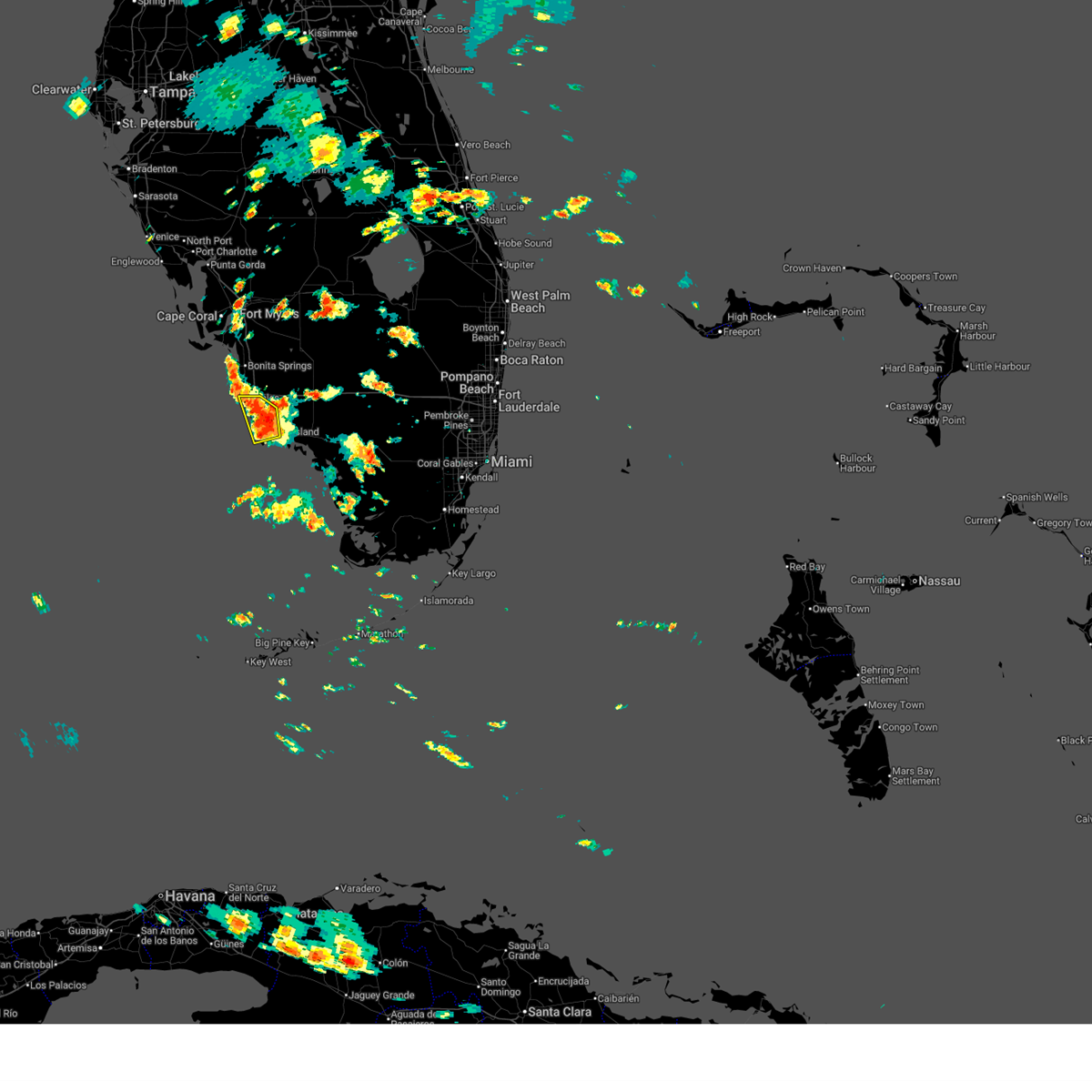
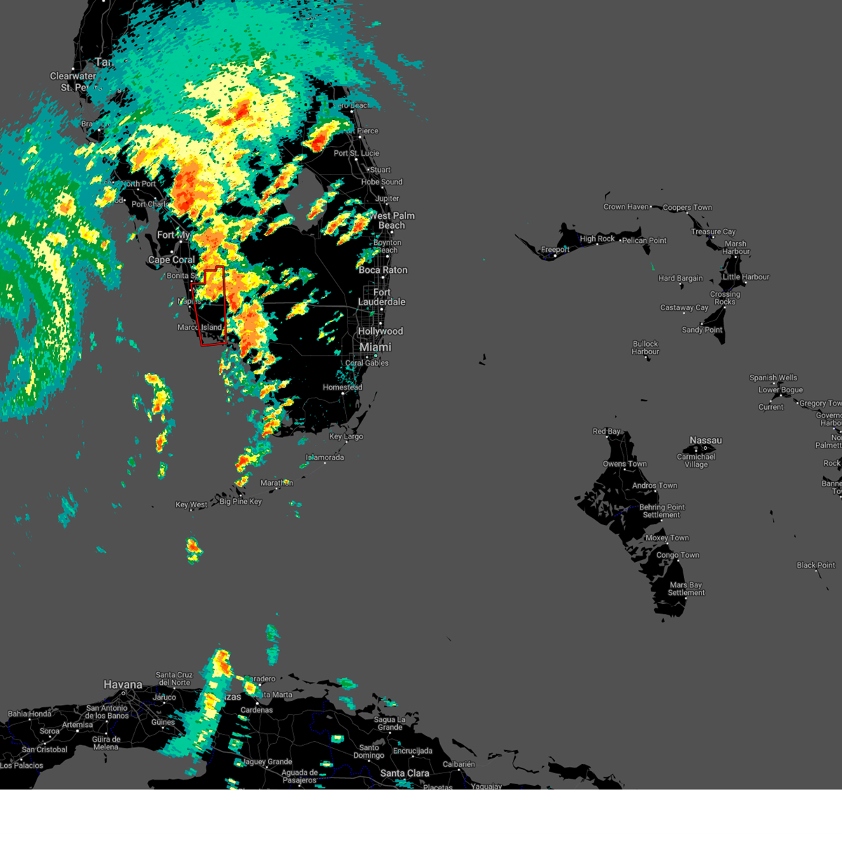
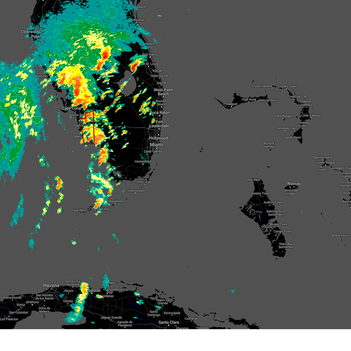
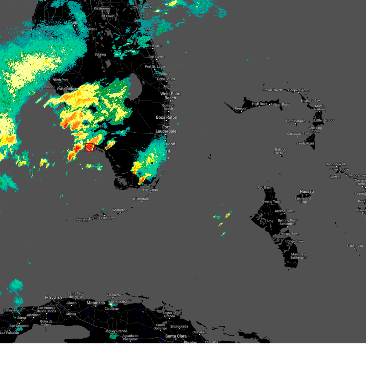
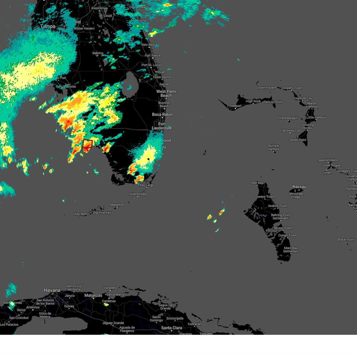
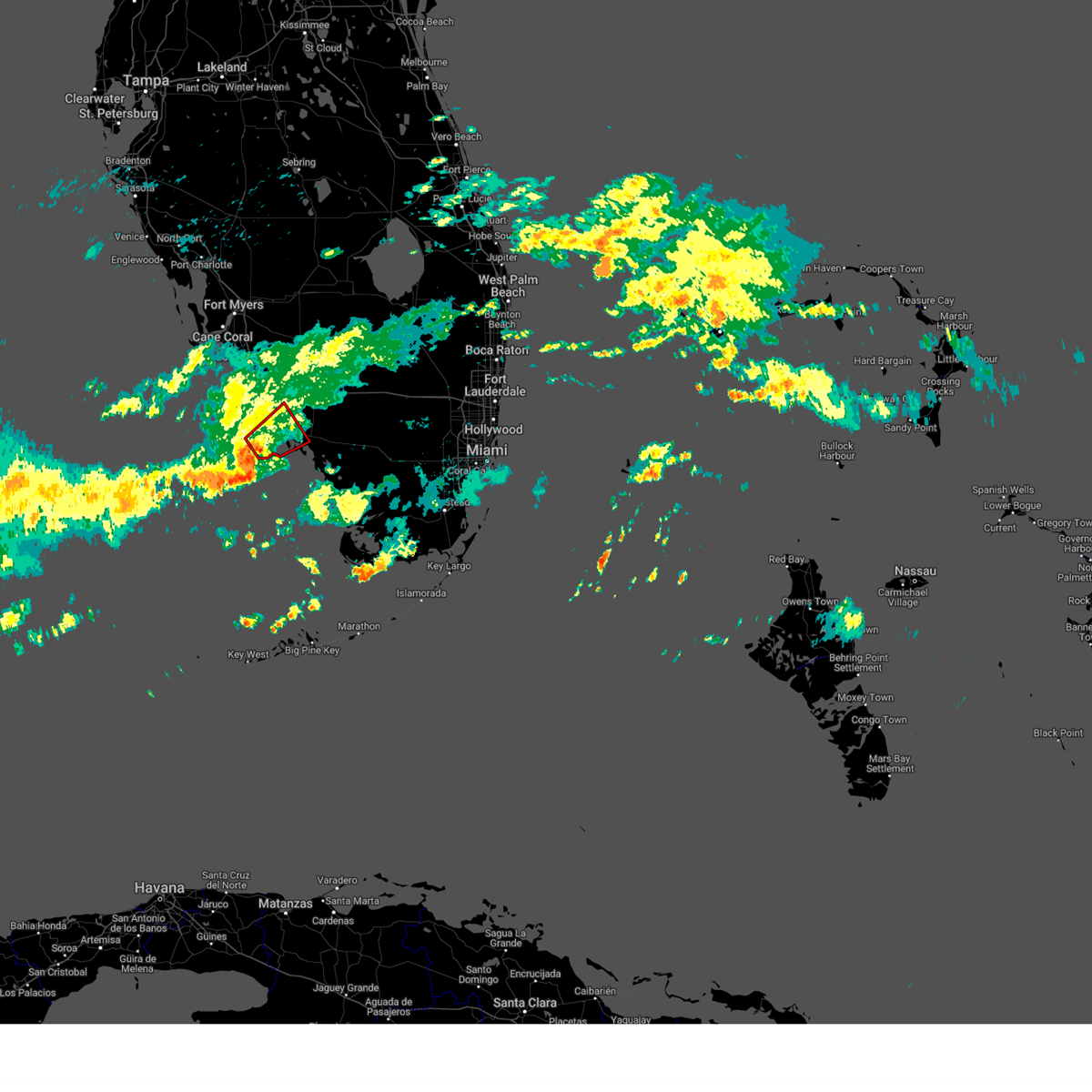
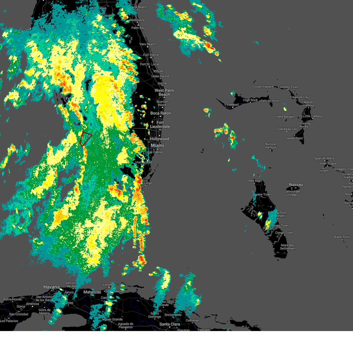
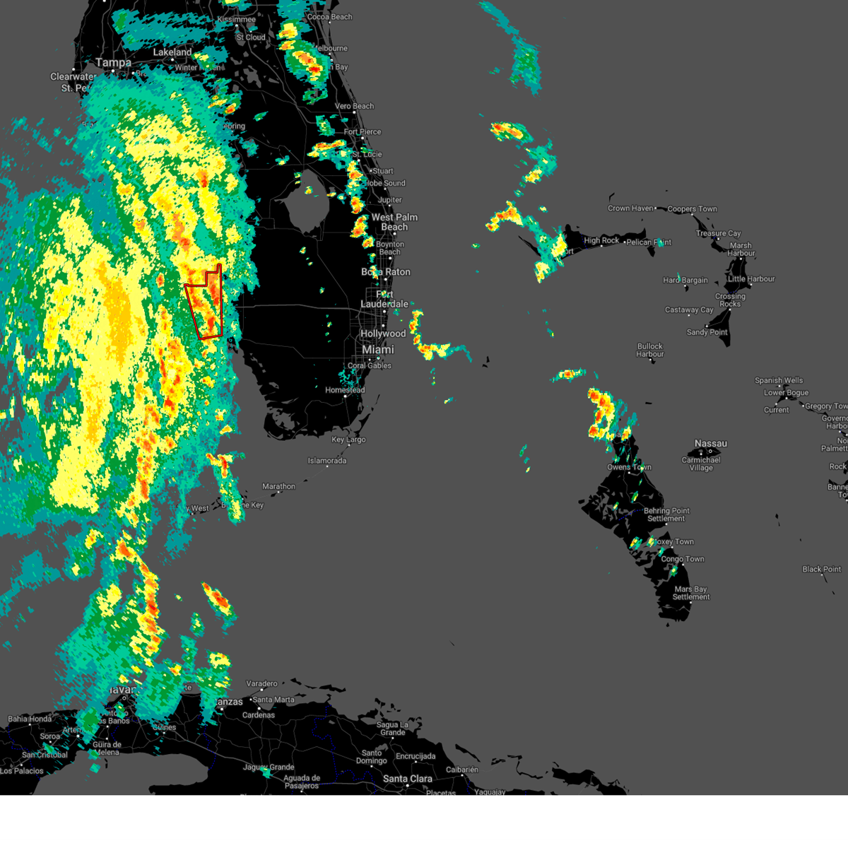
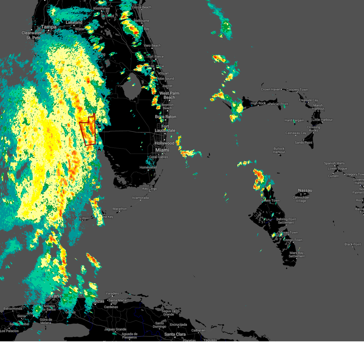
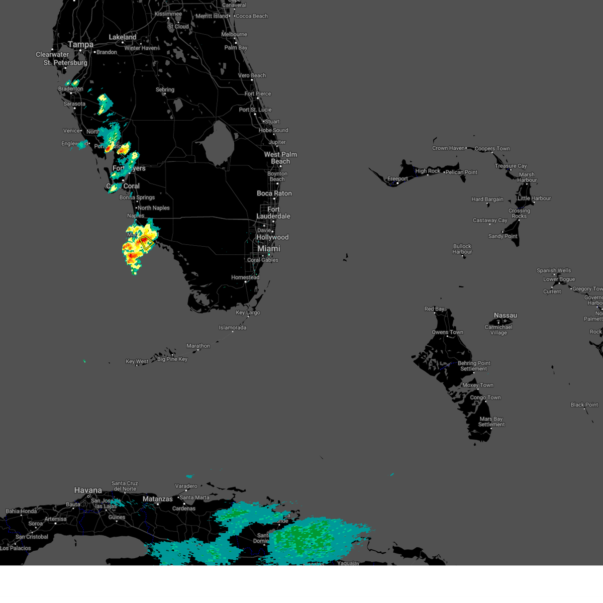
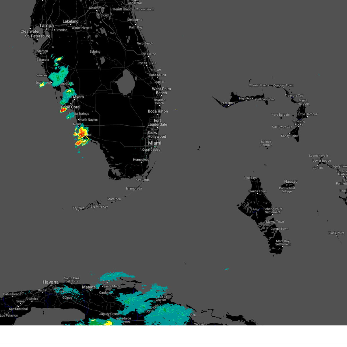
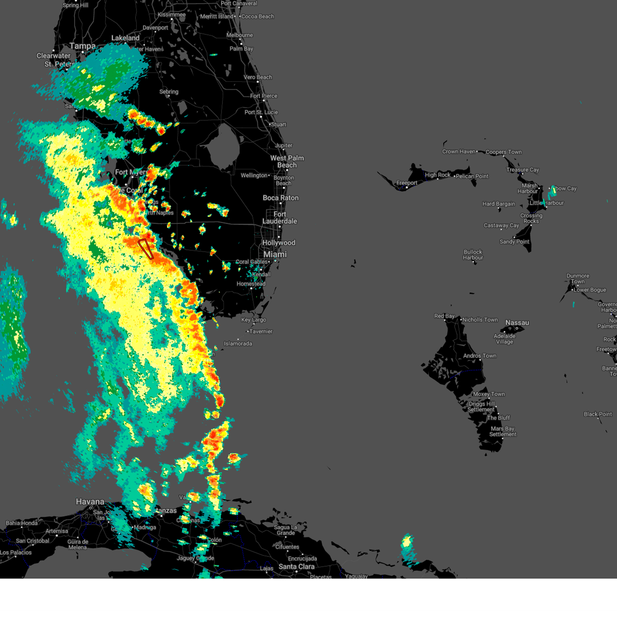
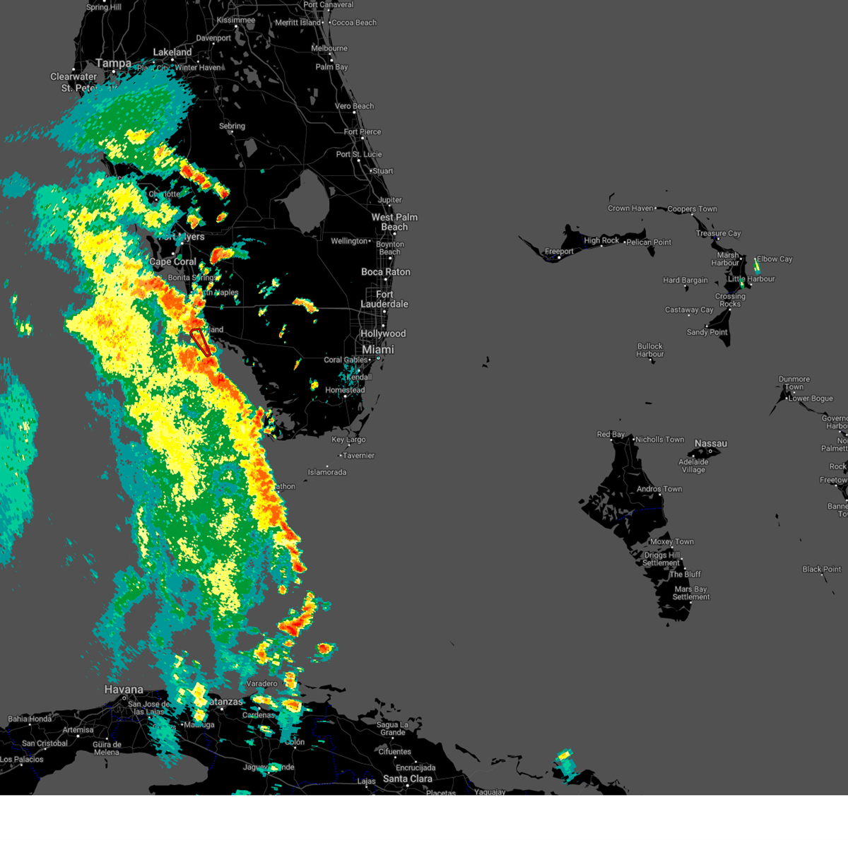
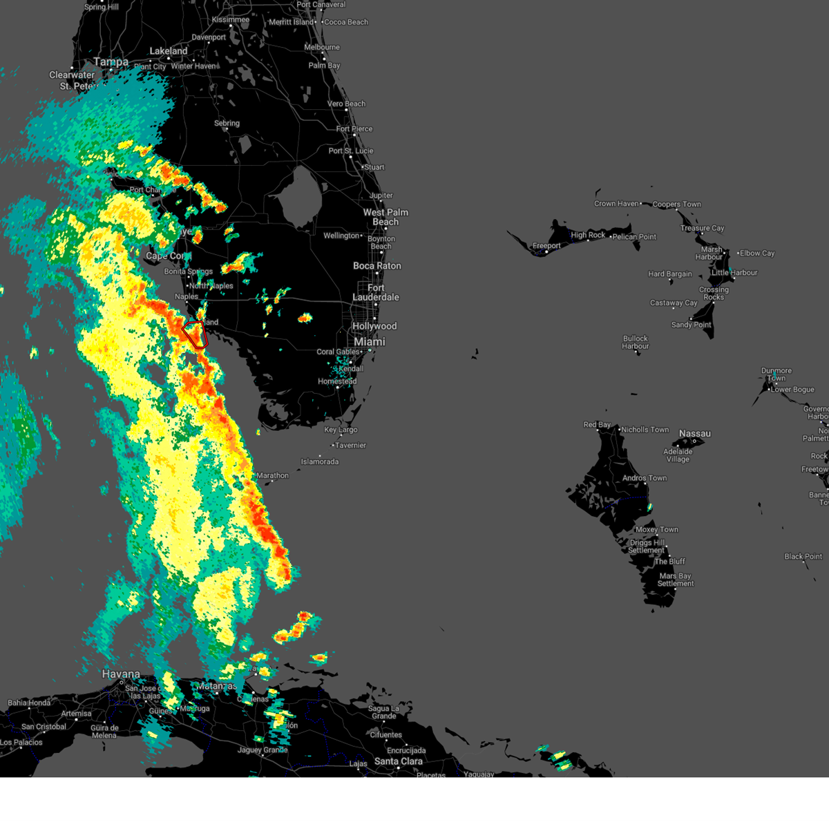
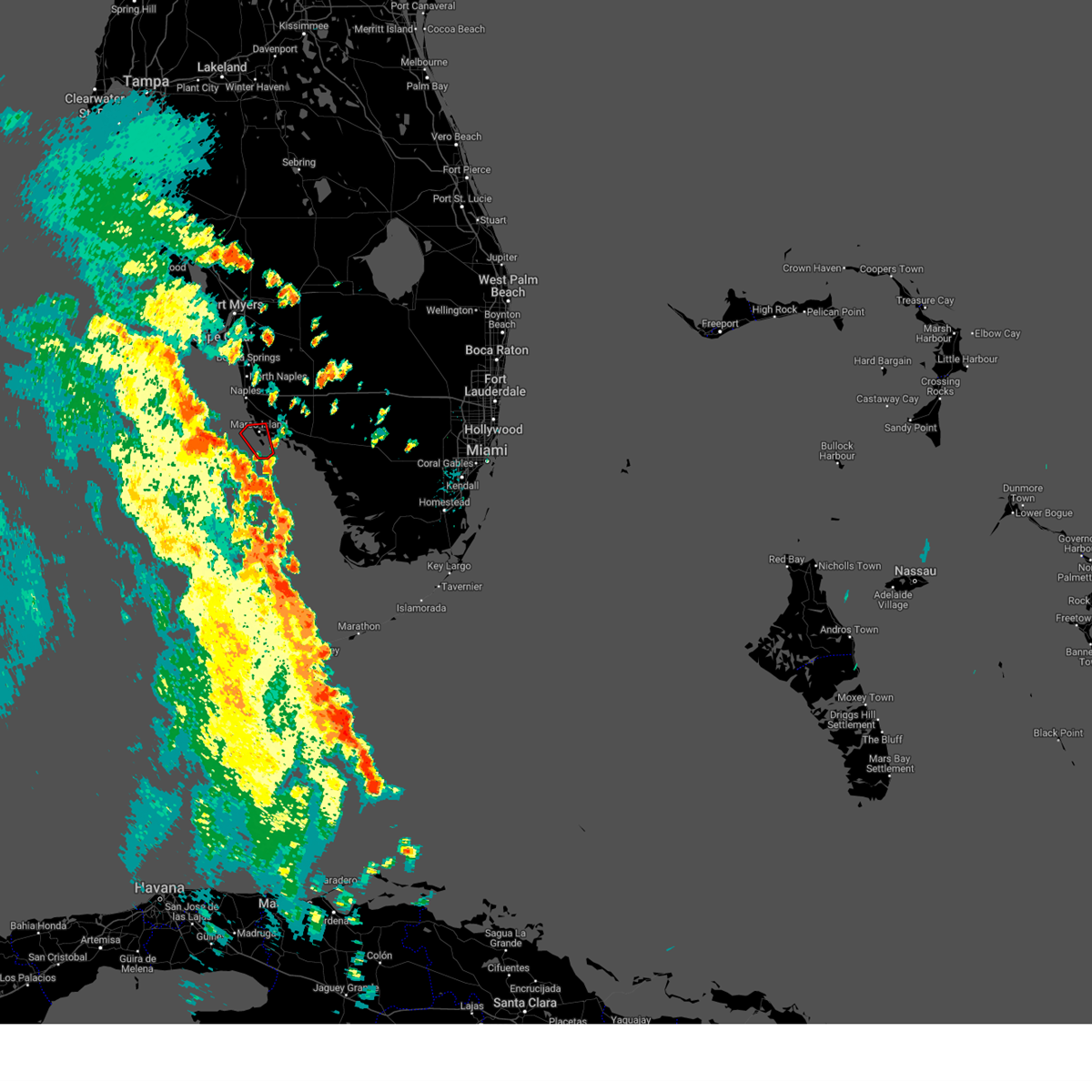
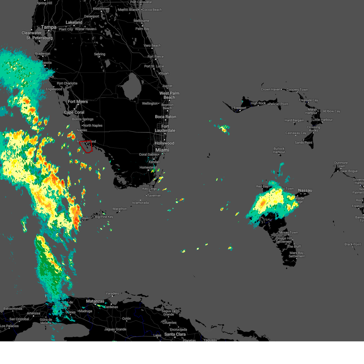
Hail Map for Marco Island, FL
The Marco Island, FL area has had 0 reports of on-the-ground hail by trained spotters, and has been under severe weather warnings 11 times during the past 12 months. Doppler radar has detected hail at or near Marco Island, FL on 13 occasions, including 1 occasion during the past year.
| Name: | Marco Island, FL |
| Where Located: | 17.4 miles SSE of Naples, FL |
| Map: | Google Map for Marco Island, FL |
| Population: | 16413 |
| Housing Units: | 17134 |
| More Info: | Search Google for Marco Island, FL |
3
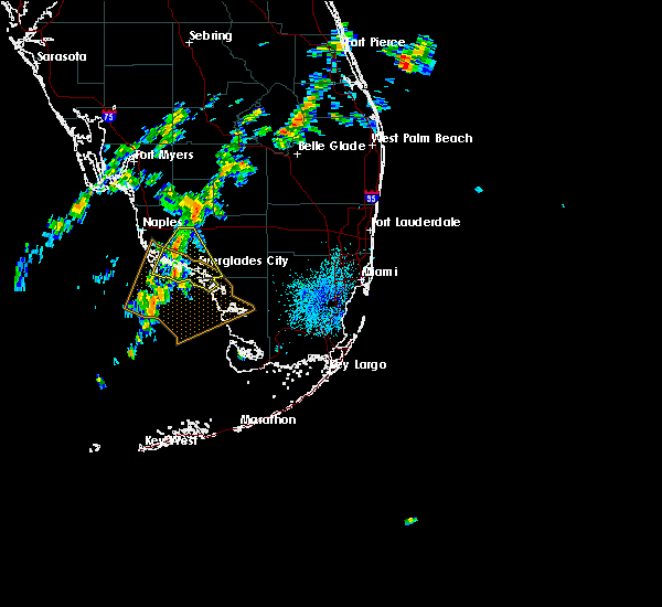
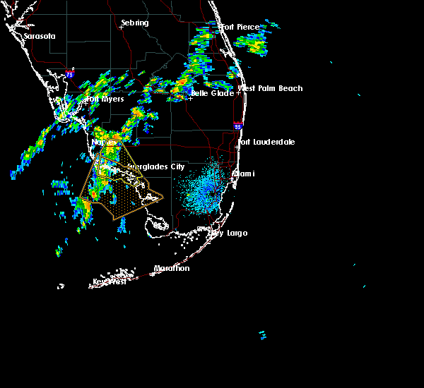
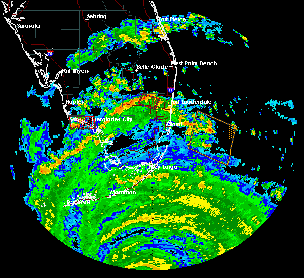
The Top Recent Hail Date for Marco Island, FL is Monday, June 23, 2025 (3rd out of 13)

Hail and Wind Damage Spotted near Marco Island, FL
| Date / Time | Report Details |
|---|---|
| 6/22/2025 3:52 PM EDT |
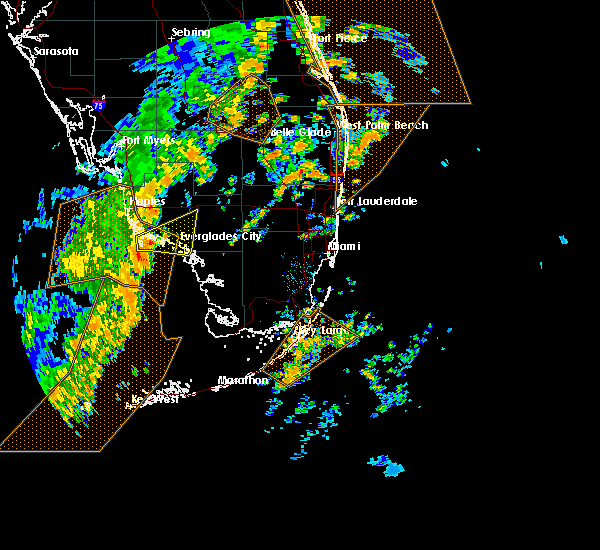
 Svrmfl the national weather service in miami has issued a * severe thunderstorm warning for, southwestern collier county in southwestern florida, * until 415 pm edt. * at 352 pm edt, a severe thunderstorm was located over marco island airport, or near marco island, and is nearly stationary (radar indicated). Hazards include 60 mph wind gusts and penny size hail. expect damage to roofs, siding, and trees Svrmfl the national weather service in miami has issued a * severe thunderstorm warning for, southwestern collier county in southwestern florida, * until 415 pm edt. * at 352 pm edt, a severe thunderstorm was located over marco island airport, or near marco island, and is nearly stationary (radar indicated). Hazards include 60 mph wind gusts and penny size hail. expect damage to roofs, siding, and trees
|
| 10/9/2024 1:14 PM EDT |
 The storm which prompted the warning has weakened below severe limits, and is about to exit the warned area. therefore, the warning will be allowed to expire. a tornado watch remains in effect until 900 pm edt for southwestern florida. The storm which prompted the warning has weakened below severe limits, and is about to exit the warned area. therefore, the warning will be allowed to expire. a tornado watch remains in effect until 900 pm edt for southwestern florida.
|
| 10/9/2024 12:49 PM EDT |
 Tormfl the national weather service in miami has issued a * tornado warning for, western collier county in southwestern florida, * until 115 pm edt. * at 1249 pm edt, a severe thunderstorm capable of producing a tornado was located near royal palm hammock, or near marco island, moving north at 60 mph (radar indicated rotation). Hazards include tornado. Flying debris will be dangerous to those caught without shelter. mobile homes will be damaged or destroyed. damage to roofs, windows, and vehicles will occur. Tree damage is likely. Tormfl the national weather service in miami has issued a * tornado warning for, western collier county in southwestern florida, * until 115 pm edt. * at 1249 pm edt, a severe thunderstorm capable of producing a tornado was located near royal palm hammock, or near marco island, moving north at 60 mph (radar indicated rotation). Hazards include tornado. Flying debris will be dangerous to those caught without shelter. mobile homes will be damaged or destroyed. damage to roofs, windows, and vehicles will occur. Tree damage is likely.
|
| 10/9/2024 3:36 AM EDT |
 The storm which prompted the warning has weakened below severe limits, and no longer appears capable of producing a tornado. therefore, the warning will be allowed to expire. The storm which prompted the warning has weakened below severe limits, and no longer appears capable of producing a tornado. therefore, the warning will be allowed to expire.
|
| 10/9/2024 3:14 AM EDT |
 Tormfl the national weather service in miami has issued a * tornado warning for, southwestern collier county in southwestern florida, * until 345 am edt. * at 312 am edt, a severe thunderstorm capable of producing a tornado was located near cape romano, or 10 miles south of marco island, moving north at 20 mph (radar indicated rotation). Hazards include tornado. Flying debris will be dangerous to those caught without shelter. mobile homes will be damaged or destroyed. damage to roofs, windows, and vehicles will occur. Tree damage is likely. Tormfl the national weather service in miami has issued a * tornado warning for, southwestern collier county in southwestern florida, * until 345 am edt. * at 312 am edt, a severe thunderstorm capable of producing a tornado was located near cape romano, or 10 miles south of marco island, moving north at 20 mph (radar indicated rotation). Hazards include tornado. Flying debris will be dangerous to those caught without shelter. mobile homes will be damaged or destroyed. damage to roofs, windows, and vehicles will occur. Tree damage is likely.
|
| 10/8/2024 12:55 PM EDT |
 Tormfl the national weather service in miami has issued a * tornado warning for, southwestern collier county in southwestern florida, * until 130 pm edt. * at 1255 pm edt, a reported waterspout was located just offshore near cape romano, or 8 miles south of marco island, moving northeast at 20 mph (weather spotters reported waterspout moving onshore). Hazards include tornado. Expect damage to mobile homes, roofs, and vehicles. Tree damage is likely. Tormfl the national weather service in miami has issued a * tornado warning for, southwestern collier county in southwestern florida, * until 130 pm edt. * at 1255 pm edt, a reported waterspout was located just offshore near cape romano, or 8 miles south of marco island, moving northeast at 20 mph (weather spotters reported waterspout moving onshore). Hazards include tornado. Expect damage to mobile homes, roofs, and vehicles. Tree damage is likely.
|
| 8/4/2024 5:09 PM EDT |
 The storm which prompted the warning has weakened below severe limits, and no longer appears capable of producing a tornado. therefore, the warning will be allowed to expire. a tornado watch remains in effect until 800 pm edt for southwestern florida. The storm which prompted the warning has weakened below severe limits, and no longer appears capable of producing a tornado. therefore, the warning will be allowed to expire. a tornado watch remains in effect until 800 pm edt for southwestern florida.
|
| 8/4/2024 4:59 PM EDT |
 Tormfl the national weather service in miami has issued a * tornado warning for, southwestern collier county in southwestern florida, * until 515 pm edt. * at 459 pm edt, a severe thunderstorm capable of producing a tornado was located near cape romano, or near marco island, moving northeast at 40 mph (radar indicated rotation). Hazards include tornado. Expect damage to mobile homes, roofs, and vehicles. Tree damage is likely. Tormfl the national weather service in miami has issued a * tornado warning for, southwestern collier county in southwestern florida, * until 515 pm edt. * at 459 pm edt, a severe thunderstorm capable of producing a tornado was located near cape romano, or near marco island, moving northeast at 40 mph (radar indicated rotation). Hazards include tornado. Expect damage to mobile homes, roofs, and vehicles. Tree damage is likely.
|
| 8/4/2024 12:45 PM EDT |
 At 1245 pm edt, severe thunderstorms capable of producing tornadoes were located along a line extending from near west toll gate on alligator alley to orangetree, moving north at 20 mph (radar indicated rotation). Hazards include tornado. Expect damage to mobile homes, roofs, and vehicles. tree damage is likely. Locations impacted include, naples, marco island, golden gate estates, belle meade, orangetree, golden gate, east naples, lely resort, big corkscrew island, vineyards, royal palm hammock, naples park, marco island airport, naples manor, west toll gate on alligator alley, north naples, pelican bay, corkscrew swamp sanctuary, lely, and rookery bay aquatic preserve. At 1245 pm edt, severe thunderstorms capable of producing tornadoes were located along a line extending from near west toll gate on alligator alley to orangetree, moving north at 20 mph (radar indicated rotation). Hazards include tornado. Expect damage to mobile homes, roofs, and vehicles. tree damage is likely. Locations impacted include, naples, marco island, golden gate estates, belle meade, orangetree, golden gate, east naples, lely resort, big corkscrew island, vineyards, royal palm hammock, naples park, marco island airport, naples manor, west toll gate on alligator alley, north naples, pelican bay, corkscrew swamp sanctuary, lely, and rookery bay aquatic preserve.
|
| 8/4/2024 12:37 PM EDT |
 At 1237 pm edt, severe thunderstorms capable of producing tornadoes were located along a line extending from near marco island airport to near golden gate estates, moving north at 40 mph (radar indicated rotation). Hazards include tornado. Expect damage to mobile homes, roofs, and vehicles. tree damage is likely. Locations impacted include, naples, marco island, golden gate estates, belle meade, orangetree, golden gate, east naples, lely resort, big corkscrew island, vineyards, royal palm hammock, naples park, marco island airport, naples manor, west toll gate on alligator alley, north naples, pelican bay, corkscrew swamp sanctuary, lely, and rookery bay aquatic preserve. At 1237 pm edt, severe thunderstorms capable of producing tornadoes were located along a line extending from near marco island airport to near golden gate estates, moving north at 40 mph (radar indicated rotation). Hazards include tornado. Expect damage to mobile homes, roofs, and vehicles. tree damage is likely. Locations impacted include, naples, marco island, golden gate estates, belle meade, orangetree, golden gate, east naples, lely resort, big corkscrew island, vineyards, royal palm hammock, naples park, marco island airport, naples manor, west toll gate on alligator alley, north naples, pelican bay, corkscrew swamp sanctuary, lely, and rookery bay aquatic preserve.
|
| 8/4/2024 12:34 PM EDT |
 Tormfl the national weather service in miami has issued a * tornado warning for, western collier county in southwestern florida, * until 100 pm edt. * at 1234 pm edt, a severe thunderstorm capable of producing a tornado was located over marco island airport, or near marco island, moving north at 50 mph (radar indicated rotation). Hazards include tornado. Expect damage to mobile homes, roofs, and vehicles. Tree damage is likely. Tormfl the national weather service in miami has issued a * tornado warning for, western collier county in southwestern florida, * until 100 pm edt. * at 1234 pm edt, a severe thunderstorm capable of producing a tornado was located over marco island airport, or near marco island, moving north at 50 mph (radar indicated rotation). Hazards include tornado. Expect damage to mobile homes, roofs, and vehicles. Tree damage is likely.
|
| 5/31/2024 7:30 PM EDT | Local broadcast media reported marco island residents received damage from strong winds. report and pictures of flag poles snapped and laying on the ground in two yards in collier county FL, 3.7 miles SE of Marco Island, FL |
| 5/31/2024 5:57 PM EDT |
 The storm which prompted the warning has weakened below severe limits, and has exited the warned area. therefore, the warning will be allowed to expire. to report severe weather, contact your nearest law enforcement agency. they will relay your report to the national weather service miami. you can also share your report with nws miami on facebook and twitter. The storm which prompted the warning has weakened below severe limits, and has exited the warned area. therefore, the warning will be allowed to expire. to report severe weather, contact your nearest law enforcement agency. they will relay your report to the national weather service miami. you can also share your report with nws miami on facebook and twitter.
|
| 5/31/2024 5:50 PM EDT | Corrects previous tstm wnd gst report from 1 se marco island. lamplighter ct weatherflow station reported a 59 mph wind gust on marco island at 550 pm related to a seve in collier county FL, 2.7 miles SE of Marco Island, FL |
| 5/31/2024 5:50 PM EDT | Corrects previous tstm wnd gst report from 1 se marco island. lamplighter ct weatherflow station reported a 59 mph wind gust on marco island at 550 pm related to a seve in collier county FL, 2.7 miles SE of Marco Island, FL |
| 5/31/2024 5:50 PM EDT |
 At 549 pm edt, a severe thunderstorm was located near marco island, moving southeast at 10 mph (radar indicated). Hazards include 60 mph wind gusts and quarter size hail. Hail damage to vehicles is expected. expect wind damage to roofs, siding, and trees. Locations impacted include, marco island, cape romano, key marco, and goodland. At 549 pm edt, a severe thunderstorm was located near marco island, moving southeast at 10 mph (radar indicated). Hazards include 60 mph wind gusts and quarter size hail. Hail damage to vehicles is expected. expect wind damage to roofs, siding, and trees. Locations impacted include, marco island, cape romano, key marco, and goodland.
|
| 5/31/2024 5:28 PM EDT |
 Svrmfl the national weather service in miami has issued a * severe thunderstorm warning for, southwestern collier county in southwestern florida, * until 600 pm edt. * at 528 pm edt, a severe thunderstorm was located over marco island, moving southeast at 10 mph (radar indicated). Hazards include 60 mph wind gusts and quarter size hail. Hail damage to vehicles is expected. Expect wind damage to roofs, siding, and trees. Svrmfl the national weather service in miami has issued a * severe thunderstorm warning for, southwestern collier county in southwestern florida, * until 600 pm edt. * at 528 pm edt, a severe thunderstorm was located over marco island, moving southeast at 10 mph (radar indicated). Hazards include 60 mph wind gusts and quarter size hail. Hail damage to vehicles is expected. Expect wind damage to roofs, siding, and trees.
|
| 5/31/2024 5:25 PM EDT | Rockport ct weatherflow station reported a 67 mph wind gust on marco island at 525 pm related to a severe thunderstorm in the are in collier county FL, 4.6 miles SE of Marco Island, FL |
| 5/31/2024 5:08 PM EDT |
 At 507 pm edt, a severe thunderstorm was located near belle meade, or near marco island, and is nearly stationary (radar indicated). Hazards include 60 mph wind gusts and quarter size hail. Hail damage to vehicles is expected. expect wind damage to roofs, siding, and trees. Locations impacted include, marco island, belle meade, marco island airport, lely resort, key marco, fiddlers creek, rookery bay aquatic preserve, and goodland. At 507 pm edt, a severe thunderstorm was located near belle meade, or near marco island, and is nearly stationary (radar indicated). Hazards include 60 mph wind gusts and quarter size hail. Hail damage to vehicles is expected. expect wind damage to roofs, siding, and trees. Locations impacted include, marco island, belle meade, marco island airport, lely resort, key marco, fiddlers creek, rookery bay aquatic preserve, and goodland.
|
| 5/31/2024 5:00 PM EDT |
 Svrmfl the national weather service in miami has issued a * severe thunderstorm warning for, southwestern collier county in southwestern florida, * until 530 pm edt. * at 500 pm edt, a severe thunderstorm was located near belle meade, or near marco island, and is nearly stationary (radar indicated). Hazards include 60 mph wind gusts and quarter size hail. Hail damage to vehicles is expected. Expect wind damage to roofs, siding, and trees. Svrmfl the national weather service in miami has issued a * severe thunderstorm warning for, southwestern collier county in southwestern florida, * until 530 pm edt. * at 500 pm edt, a severe thunderstorm was located near belle meade, or near marco island, and is nearly stationary (radar indicated). Hazards include 60 mph wind gusts and quarter size hail. Hail damage to vehicles is expected. Expect wind damage to roofs, siding, and trees.
|
| 8/29/2023 2:11 PM EDT |
 The tornado warning for southwestern collier county will expire at 215 pm edt, the tornado warning that was previously in effect has been reissued for collier county and is in effect until 2:45pm. please refer to that bulletin for the latest severe weather information. remember, a tornado warning still remains in effect for portions of southwestern collier county. The tornado warning for southwestern collier county will expire at 215 pm edt, the tornado warning that was previously in effect has been reissued for collier county and is in effect until 2:45pm. please refer to that bulletin for the latest severe weather information. remember, a tornado warning still remains in effect for portions of southwestern collier county.
|
| 8/29/2023 1:52 PM EDT |
 The tornado warning for southwestern collier county will expire at 200 pm edt, the storms which prompted the warning have moved out of the area. therefore, the warning will be allowed to expire. The tornado warning for southwestern collier county will expire at 200 pm edt, the storms which prompted the warning have moved out of the area. therefore, the warning will be allowed to expire.
|
| 8/29/2023 1:50 PM EDT |
 At 149 pm edt, a severe thunderstorm capable of producing a tornado was located near marco island airport, or near marco island, moving north at 40 mph (radar indicated rotation). Hazards include tornado. Expect damage to mobile homes, roofs, and vehicles. Tree damage is likely. At 149 pm edt, a severe thunderstorm capable of producing a tornado was located near marco island airport, or near marco island, moving north at 40 mph (radar indicated rotation). Hazards include tornado. Expect damage to mobile homes, roofs, and vehicles. Tree damage is likely.
|
| 8/29/2023 1:38 PM EDT |
 At 135 pm edt, a line of strong thunderstorms capable of producing waterspouts located along a line extending from near marco island to near cape romano to 17 miles southwest of chokoloskee, moving north at 50 mph. these strong storms will be moving through marco island and cape romano through 2 pm edt and be capable of producing waterspouts that move onshore as tornadoes. therefore, the tornado warning will remain in effect through 2 pm edt for southwestern collier county (radar indicated rotation). Hazards include tornado. Expect damage to mobile homes, roofs, and vehicles. tree damage is likely. Locations impacted include, marco island and cape romano. At 135 pm edt, a line of strong thunderstorms capable of producing waterspouts located along a line extending from near marco island to near cape romano to 17 miles southwest of chokoloskee, moving north at 50 mph. these strong storms will be moving through marco island and cape romano through 2 pm edt and be capable of producing waterspouts that move onshore as tornadoes. therefore, the tornado warning will remain in effect through 2 pm edt for southwestern collier county (radar indicated rotation). Hazards include tornado. Expect damage to mobile homes, roofs, and vehicles. tree damage is likely. Locations impacted include, marco island and cape romano.
|
| 8/29/2023 1:21 PM EDT |
 At 120 pm edt, doppler radar indicated waterspouts located just offshore along a line extending from near marco island to near cape romano, moving north at 40 mph (weather spotters reported waterspouts moving onshore). Hazards include tornado. Expect damage to mobile homes, roofs, and vehicles. Tree damage is likely. At 120 pm edt, doppler radar indicated waterspouts located just offshore along a line extending from near marco island to near cape romano, moving north at 40 mph (weather spotters reported waterspouts moving onshore). Hazards include tornado. Expect damage to mobile homes, roofs, and vehicles. Tree damage is likely.
|
| 8/29/2023 1:05 PM EDT |
 At 105 pm edt, a severe thunderstorm capable of producing a waterspout was located 9 miles south of cape romano, or 15 miles south of marco island, moving northwest at 25 mph (radar indicated rotation). Hazards include tornado. Expect damage to mobile homes, roofs, and vehicles. Tree damage is likely. At 105 pm edt, a severe thunderstorm capable of producing a waterspout was located 9 miles south of cape romano, or 15 miles south of marco island, moving northwest at 25 mph (radar indicated rotation). Hazards include tornado. Expect damage to mobile homes, roofs, and vehicles. Tree damage is likely.
|
| 8/29/2023 12:08 PM EDT |
 The tornado warning for southwestern collier county will expire at 1215 pm edt, the storm which prompted the warning has weakened below severe limits, and no longer appears capable of producing a tornado. therefore, the warning will be allowed to expire. The tornado warning for southwestern collier county will expire at 1215 pm edt, the storm which prompted the warning has weakened below severe limits, and no longer appears capable of producing a tornado. therefore, the warning will be allowed to expire.
|
| 8/29/2023 11:47 AM EDT |
 At 1146 am edt, a severe thunderstorm capable of producing a waterspout located 11 miles south of cape romano, or 17 miles south of marco island, moving north at 40 to 45 mph (radar indicated rotation). Hazards include tornado. Expect damage to mobile homes, roofs, and vehicles. Tree damage is likely. At 1146 am edt, a severe thunderstorm capable of producing a waterspout located 11 miles south of cape romano, or 17 miles south of marco island, moving north at 40 to 45 mph (radar indicated rotation). Hazards include tornado. Expect damage to mobile homes, roofs, and vehicles. Tree damage is likely.
|
| 1/16/2022 10:33 AM EST |
 At 1033 am est, severe thunderstorms capable of producing both tornadoes and extensive straight line wind damage were located along a line extending from 8 miles southwest of cape romano to 11 miles southwest of chokoloskee, moving northeast at 35 mph (radar indicated rotation). Hazards include tornado. Flying debris will be dangerous to those caught without shelter. mobile homes will be damaged or destroyed. damage to roofs, windows, and vehicles will occur. tree damage is likely. these dangerous storms will be near, chokoloskee and plantation island around 1050 am est. everglades city and big cypress national preserve around 1055 am est. carnestown, everglades national park and copeland around 1100 am est. Other locations impacted by these tornadic storms include key marco, cape romano aquatic preserve, fakahatchee strand state preserve, jerome, deep lake, port of the island and goodland. At 1033 am est, severe thunderstorms capable of producing both tornadoes and extensive straight line wind damage were located along a line extending from 8 miles southwest of cape romano to 11 miles southwest of chokoloskee, moving northeast at 35 mph (radar indicated rotation). Hazards include tornado. Flying debris will be dangerous to those caught without shelter. mobile homes will be damaged or destroyed. damage to roofs, windows, and vehicles will occur. tree damage is likely. these dangerous storms will be near, chokoloskee and plantation island around 1050 am est. everglades city and big cypress national preserve around 1055 am est. carnestown, everglades national park and copeland around 1100 am est. Other locations impacted by these tornadic storms include key marco, cape romano aquatic preserve, fakahatchee strand state preserve, jerome, deep lake, port of the island and goodland.
|
| 1/16/2022 10:13 AM EST |
 At 1012 am est, severe thunderstorms were located along a line extending from near ave maria to 13 miles south of cape romano, moving northeast at 35 mph (radar indicated). Hazards include 60 mph wind gusts. expect damage to roofs, siding, and trees At 1012 am est, severe thunderstorms were located along a line extending from near ave maria to 13 miles south of cape romano, moving northeast at 35 mph (radar indicated). Hazards include 60 mph wind gusts. expect damage to roofs, siding, and trees
|
| 1/16/2022 9:29 AM EST |
 At 928 am est, severe thunderstorms were located along a line extending from west toll gate on alligator alley to royal palm hammock, moving northeast at 35 mph (radar indicated). Hazards include 60 mph wind gusts. expect damage to roofs, siding, and trees At 928 am est, severe thunderstorms were located along a line extending from west toll gate on alligator alley to royal palm hammock, moving northeast at 35 mph (radar indicated). Hazards include 60 mph wind gusts. expect damage to roofs, siding, and trees
|
| 1/16/2022 9:19 AM EST |
 At 919 am est, a confirmed tornado was located over belle meade, or 8 miles north of marco island, moving northeast at 25 mph (radar confirmed tornado). Hazards include damaging tornado. Flying debris will be dangerous to those caught without shelter. mobile homes will be damaged or destroyed. damage to roofs, windows, and vehicles will occur. tree damage is likely. Locations impacted include, naples, marco island, golden gate estates, belle meade and marco island airport. At 919 am est, a confirmed tornado was located over belle meade, or 8 miles north of marco island, moving northeast at 25 mph (radar confirmed tornado). Hazards include damaging tornado. Flying debris will be dangerous to those caught without shelter. mobile homes will be damaged or destroyed. damage to roofs, windows, and vehicles will occur. tree damage is likely. Locations impacted include, naples, marco island, golden gate estates, belle meade and marco island airport.
|
| 1/16/2022 9:06 AM EST |
 At 905 am est, a severe thunderstorm capable of producing a tornado was located near marco island, moving northeast at 25 mph (radar indicated rotation). Hazards include tornado. Flying debris will be dangerous to those caught without shelter. mobile homes will be damaged or destroyed. damage to roofs, windows, and vehicles will occur. Tree damage is likely. At 905 am est, a severe thunderstorm capable of producing a tornado was located near marco island, moving northeast at 25 mph (radar indicated rotation). Hazards include tornado. Flying debris will be dangerous to those caught without shelter. mobile homes will be damaged or destroyed. damage to roofs, windows, and vehicles will occur. Tree damage is likely.
|
| 1/16/2022 8:54 AM EST |
 At 853 am est, severe thunderstorms were located along a line extending from near naples to near marco island, moving northeast at 40 mph (radar indicated). Hazards include 60 mph wind gusts. expect damage to roofs, siding, and trees At 853 am est, severe thunderstorms were located along a line extending from near naples to near marco island, moving northeast at 40 mph (radar indicated). Hazards include 60 mph wind gusts. expect damage to roofs, siding, and trees
|
| 10/28/2021 9:06 PM EDT |
 The severe thunderstorm warning for northwestern collier county will expire at 915 pm edt, the storm which prompted the warning has weakened below severe limits, and has exited the warned area. therefore, the warning will be allowed to expire. The severe thunderstorm warning for northwestern collier county will expire at 915 pm edt, the storm which prompted the warning has weakened below severe limits, and has exited the warned area. therefore, the warning will be allowed to expire.
|
| 10/28/2021 8:36 PM EDT |
 At 835 pm edt, a severe thunderstorm was located near naples, moving northeast at 35 mph (radar indicated). Hazards include 60 mph wind gusts. expect damage to roofs, siding, and trees At 835 pm edt, a severe thunderstorm was located near naples, moving northeast at 35 mph (radar indicated). Hazards include 60 mph wind gusts. expect damage to roofs, siding, and trees
|
| 6/26/2021 3:03 PM EDT |
 At 302 pm edt, a severe thunderstorm was located over east naples, or near naples, moving west at 20 mph (radar indicated). Hazards include 60 mph wind gusts and quarter size hail. Hail damage to vehicles is expected. Expect wind damage to roofs, siding, and trees. At 302 pm edt, a severe thunderstorm was located over east naples, or near naples, moving west at 20 mph (radar indicated). Hazards include 60 mph wind gusts and quarter size hail. Hail damage to vehicles is expected. Expect wind damage to roofs, siding, and trees.
|
| 6/16/2021 8:38 PM EDT |
 The severe thunderstorm warning for southwestern collier county will expire at 845 pm edt, the storm which prompted the warning has weakened below severe limits, and no longer poses an immediate threat to life or property. therefore, the warning will be allowed to expire. however gusty winds and heavy rain are still possible with this thunderstorm. to report severe weather, contact your nearest law enforcement agency. they will relay your report to the national weather service miami. The severe thunderstorm warning for southwestern collier county will expire at 845 pm edt, the storm which prompted the warning has weakened below severe limits, and no longer poses an immediate threat to life or property. therefore, the warning will be allowed to expire. however gusty winds and heavy rain are still possible with this thunderstorm. to report severe weather, contact your nearest law enforcement agency. they will relay your report to the national weather service miami.
|
| 6/16/2021 8:06 PM EDT |
 At 806 pm edt, a severe thunderstorm was located over marco island, moving north at 30 mph (radar indicated). Hazards include 60 mph wind gusts. expect damage to roofs, siding, and trees At 806 pm edt, a severe thunderstorm was located over marco island, moving north at 30 mph (radar indicated). Hazards include 60 mph wind gusts. expect damage to roofs, siding, and trees
|
| 5/31/2021 5:15 PM EDT |
 At 513 pm edt, severe thunderstorms were located along a line extending from near naples park to marco island airport, moving northwest at 10 mph (radar indicated). Hazards include 60 mph wind gusts and quarter size hail. Hail damage to vehicles is expected. expect wind damage to roofs, siding, and trees. Locations impacted include, naples, marco island, golden gate estates, cape romano and belle meade. At 513 pm edt, severe thunderstorms were located along a line extending from near naples park to marco island airport, moving northwest at 10 mph (radar indicated). Hazards include 60 mph wind gusts and quarter size hail. Hail damage to vehicles is expected. expect wind damage to roofs, siding, and trees. Locations impacted include, naples, marco island, golden gate estates, cape romano and belle meade.
|
| 5/31/2021 4:59 PM EDT |
 At 459 pm edt, severe thunderstorms were located along a line extending from near naples park to near royal palm hammock, moving northwest at 20 mph (radar indicated). Hazards include 60 mph wind gusts and quarter size hail. Hail damage to vehicles is expected. Expect wind damage to roofs, siding, and trees. At 459 pm edt, severe thunderstorms were located along a line extending from near naples park to near royal palm hammock, moving northwest at 20 mph (radar indicated). Hazards include 60 mph wind gusts and quarter size hail. Hail damage to vehicles is expected. Expect wind damage to roofs, siding, and trees.
|
| 5/31/2021 4:29 PM EDT |
 At 429 pm edt, severe thunderstorms were located along a line extending from golden gate to near royal palm hammock, moving west at 20 mph (radar indicated). Hazards include 60 mph wind gusts and quarter size hail. Hail damage to vehicles is expected. Expect wind damage to roofs, siding, and trees. At 429 pm edt, severe thunderstorms were located along a line extending from golden gate to near royal palm hammock, moving west at 20 mph (radar indicated). Hazards include 60 mph wind gusts and quarter size hail. Hail damage to vehicles is expected. Expect wind damage to roofs, siding, and trees.
|
| 5/18/2020 6:39 PM EDT |
 The severe thunderstorm warning for southwestern collier and northern mainland monroe counties will expire at 645 pm edt, the severe thunderstorm which prompted the warning is currently moving out of the warned area and has slightly weakened. by 645 pm edt, the storm should have exited the warned area, though gusty winds may continue for the next half hour. the warning will be allowed to expire. a significant weather advisory remains in effect. The severe thunderstorm warning for southwestern collier and northern mainland monroe counties will expire at 645 pm edt, the severe thunderstorm which prompted the warning is currently moving out of the warned area and has slightly weakened. by 645 pm edt, the storm should have exited the warned area, though gusty winds may continue for the next half hour. the warning will be allowed to expire. a significant weather advisory remains in effect.
|
| 5/18/2020 6:01 PM EDT |
 At 600 pm edt, a severe thunderstorm was located over royal palm hammock, or 9 miles northeast of marco island, moving east at 30 mph (radar indicated). Hazards include 60 mph wind gusts and penny size hail. expect damage to roofs, siding, and trees At 600 pm edt, a severe thunderstorm was located over royal palm hammock, or 9 miles northeast of marco island, moving east at 30 mph (radar indicated). Hazards include 60 mph wind gusts and penny size hail. expect damage to roofs, siding, and trees
|
| 4/26/2020 1:57 PM EDT |
 At 156 pm edt, severe thunderstorms were located along a line extending from 6 miles east of chokoloskee to 14 miles southeast of cape romano, moving southeast at 35 mph (radar indicated). Hazards include 60 mph wind gusts and penny size hail. Expect damage to roofs, siding, and trees. Locations impacted include, marco island, chokoloskee, everglades city, plantation island and carnestown. At 156 pm edt, severe thunderstorms were located along a line extending from 6 miles east of chokoloskee to 14 miles southeast of cape romano, moving southeast at 35 mph (radar indicated). Hazards include 60 mph wind gusts and penny size hail. Expect damage to roofs, siding, and trees. Locations impacted include, marco island, chokoloskee, everglades city, plantation island and carnestown.
|
| 4/26/2020 1:24 PM EDT |
 At 123 pm edt, severe thunderstorms were located along a line extending from 7 miles west of copeland to 7 miles west of cape romano, moving southeast at 35 mph (radar indicated). Hazards include 60 mph wind gusts and nickel size hail. expect damage to roofs, siding, and trees At 123 pm edt, severe thunderstorms were located along a line extending from 7 miles west of copeland to 7 miles west of cape romano, moving southeast at 35 mph (radar indicated). Hazards include 60 mph wind gusts and nickel size hail. expect damage to roofs, siding, and trees
|
| 4/26/2020 12:53 PM EDT |
 At 1252 pm edt, a severe thunderstorm was located over naples, moving east at 25 mph. trained weather spotters reported large tree limbs down in the naples from this storm (trained weather spotters). Hazards include 60 mph wind gusts and quarter size hail. Hail damage to vehicles is expected. expect wind damage to roofs, siding, and trees. Locations impacted include, naples, marco island, golden gate estates, cape romano and belle meade. At 1252 pm edt, a severe thunderstorm was located over naples, moving east at 25 mph. trained weather spotters reported large tree limbs down in the naples from this storm (trained weather spotters). Hazards include 60 mph wind gusts and quarter size hail. Hail damage to vehicles is expected. expect wind damage to roofs, siding, and trees. Locations impacted include, naples, marco island, golden gate estates, cape romano and belle meade.
|
| 4/26/2020 12:40 PM EDT |
 At 1239 pm edt, a severe thunderstorm was located near naples, moving east at 25 mph (radar indicated). Hazards include 60 mph wind gusts and quarter size hail. Hail damage to vehicles is expected. Expect wind damage to roofs, siding, and trees. At 1239 pm edt, a severe thunderstorm was located near naples, moving east at 25 mph (radar indicated). Hazards include 60 mph wind gusts and quarter size hail. Hail damage to vehicles is expected. Expect wind damage to roofs, siding, and trees.
|
| 4/25/2020 8:52 AM EDT |
 The severe thunderstorm warning for southwestern collier county will expire at 900 am edt, the storm which prompted the warning has weakened below severe limits, and no longer poses an immediate threat to life or property. therefore, the warning will be allowed to expire. however gusty winds and heavy rain are still possible with this thunderstorm. to report severe weather, contact your nearest law enforcement agency. they will relay your report to the national weather service miami. The severe thunderstorm warning for southwestern collier county will expire at 900 am edt, the storm which prompted the warning has weakened below severe limits, and no longer poses an immediate threat to life or property. therefore, the warning will be allowed to expire. however gusty winds and heavy rain are still possible with this thunderstorm. to report severe weather, contact your nearest law enforcement agency. they will relay your report to the national weather service miami.
|
| 4/25/2020 8:19 AM EDT |
 At 757 am edt, a severe thunderstorm was located 8 miles west of naples, moving east at 25 mph (radar indicated). Hazards include 60 mph wind gusts and quarter size hail. Hail damage to vehicles is expected. Expect wind damage to roofs, siding, and trees. At 757 am edt, a severe thunderstorm was located 8 miles west of naples, moving east at 25 mph (radar indicated). Hazards include 60 mph wind gusts and quarter size hail. Hail damage to vehicles is expected. Expect wind damage to roofs, siding, and trees.
|
| 10/20/2019 2:21 AM EDT |
 At 221 am edt, severe thunderstorms were located along a line extending from 9 miles southeast of west toll gate on alligator alley to near royal palm hammock to 8 miles east of cape romano, moving northeast at 25 mph (radar indicated). Hazards include 60 mph wind gusts. Expect damage to roofs, siding, and trees. Locations impacted include, marco island, chokoloskee, everglades city, plantation island and carnestown. At 221 am edt, severe thunderstorms were located along a line extending from 9 miles southeast of west toll gate on alligator alley to near royal palm hammock to 8 miles east of cape romano, moving northeast at 25 mph (radar indicated). Hazards include 60 mph wind gusts. Expect damage to roofs, siding, and trees. Locations impacted include, marco island, chokoloskee, everglades city, plantation island and carnestown.
|
| 10/20/2019 2:02 AM EDT |
 At 202 am edt, severe thunderstorms were located along a line extending from near golden gate estates to near royal palm hammock to near cape romano, moving northeast at 20 mph (radar indicated). Hazards include 60 mph wind gusts. Expect damage to roofs, siding, and trees. Locations impacted include, marco island, chokoloskee, everglades city, golden gate estates and plantation island. At 202 am edt, severe thunderstorms were located along a line extending from near golden gate estates to near royal palm hammock to near cape romano, moving northeast at 20 mph (radar indicated). Hazards include 60 mph wind gusts. Expect damage to roofs, siding, and trees. Locations impacted include, marco island, chokoloskee, everglades city, golden gate estates and plantation island.
|
| 10/20/2019 1:52 AM EDT |
 At 152 am edt, severe thunderstorms were located along a line extending from golden gate to near royal palm hammock to 12 miles south of cape romano, moving northeast at 20 mph (radar indicated). Hazards include 60 mph wind gusts. Expect damage to roofs, siding, and trees. Locations impacted include, naples, marco island, chokoloskee, golden gate estates and everglades city. At 152 am edt, severe thunderstorms were located along a line extending from golden gate to near royal palm hammock to 12 miles south of cape romano, moving northeast at 20 mph (radar indicated). Hazards include 60 mph wind gusts. Expect damage to roofs, siding, and trees. Locations impacted include, naples, marco island, chokoloskee, golden gate estates and everglades city.
|
| 10/20/2019 1:40 AM EDT |
 At 140 am edt, severe thunderstorms were located along a line extending from near east naples to marco island airport to 15 miles south of cape romano, moving northeast at 25 mph (radar indicated). Hazards include 60 mph wind gusts. Expect damage to roofs, siding, and trees. Locations impacted include, naples, marco island, chokoloskee, golden gate estates and everglades city. At 140 am edt, severe thunderstorms were located along a line extending from near east naples to marco island airport to 15 miles south of cape romano, moving northeast at 25 mph (radar indicated). Hazards include 60 mph wind gusts. Expect damage to roofs, siding, and trees. Locations impacted include, naples, marco island, chokoloskee, golden gate estates and everglades city.
|
| 10/20/2019 1:22 AM EDT |
 At 122 am edt, severe thunderstorms were located along a line extending from 6 miles south of naples to 21 miles southwest of cape romano, moving northeast at 20 mph (radar indicated). Hazards include 60 mph wind gusts. expect damage to roofs, siding, and trees At 122 am edt, severe thunderstorms were located along a line extending from 6 miles south of naples to 21 miles southwest of cape romano, moving northeast at 20 mph (radar indicated). Hazards include 60 mph wind gusts. expect damage to roofs, siding, and trees
|
| 9/1/2019 6:22 PM EDT |
 At 622 pm edt, severe thunderstorms were located along a line extending from near west toll gate on alligator alley to near naples manor to near marco island, moving west at 15 mph (radar indicated). Hazards include 60 mph wind gusts. Expect damage to roofs, siding, and trees. Locations impacted include, naples, marco island, golden gate estates, cape romano and belle meade. At 622 pm edt, severe thunderstorms were located along a line extending from near west toll gate on alligator alley to near naples manor to near marco island, moving west at 15 mph (radar indicated). Hazards include 60 mph wind gusts. Expect damage to roofs, siding, and trees. Locations impacted include, naples, marco island, golden gate estates, cape romano and belle meade.
|
| 9/1/2019 6:04 PM EDT |
 At 603 pm edt, severe thunderstorms were located along a line extending from golden gate estates to lely resort to near marco island airport, moving southwest at 15 mph (radar indicated). Hazards include 60 mph wind gusts. expect damage to roofs, siding, and trees At 603 pm edt, severe thunderstorms were located along a line extending from golden gate estates to lely resort to near marco island airport, moving southwest at 15 mph (radar indicated). Hazards include 60 mph wind gusts. expect damage to roofs, siding, and trees
|
| 6/26/2019 7:17 PM EDT | A wind gust of 62 mph was recorded at the charter club of marco beach. sensor is elevated above the standard elevation of 33 fee in collier county FL, 3 miles ESE of Marco Island, FL |
| 12/20/2018 1:46 PM EST |
 At 146 pm est, a severe thunderstorm was located over golden gate, or near golden gate estates, moving northeast at 65 mph (radar indicated). Hazards include 60 mph wind gusts. Expect damage to roofs, siding, and trees. locations impacted include, naples, marco island, ave maria, golden gate estates and belle meade. A tornado watch remains in effect until 400 pm est for southwestern florida. At 146 pm est, a severe thunderstorm was located over golden gate, or near golden gate estates, moving northeast at 65 mph (radar indicated). Hazards include 60 mph wind gusts. Expect damage to roofs, siding, and trees. locations impacted include, naples, marco island, ave maria, golden gate estates and belle meade. A tornado watch remains in effect until 400 pm est for southwestern florida.
|
| 12/20/2018 1:45 PM EST |
 At 146 pm est, a severe thunderstorm was located over golden gate, or near golden gate estates, moving northeast at 65 mph (radar indicated). Hazards include 60 mph wind gusts. Expect damage to roofs, siding, and trees. locations impacted include, naples, marco island, ave maria, golden gate estates and belle meade. A tornado watch remains in effect until 400 pm est for southwestern florida. At 146 pm est, a severe thunderstorm was located over golden gate, or near golden gate estates, moving northeast at 65 mph (radar indicated). Hazards include 60 mph wind gusts. Expect damage to roofs, siding, and trees. locations impacted include, naples, marco island, ave maria, golden gate estates and belle meade. A tornado watch remains in effect until 400 pm est for southwestern florida.
|
| 3/20/2018 8:24 PM EDT | 61mph gust recorded at mesonet mrcsc in marco island in collier county FL, 3 miles ESE of Marco Island, FL |
| 3/20/2018 8:24 PM EDT | 61mph marine wind gust reported at mesonet mrcsc elevation 7 feet at 824pm in gmz656 county FL, 4.2 miles ESE of Marco Island, FL |
| 3/20/2018 8:22 PM EDT |
 At 821 pm edt, a severe thunderstorm was located near belle meade, or near marco island, moving east at 50 mph (radar indicated). Hazards include 60 mph wind gusts and penny size hail. expect damage to roofs, siding, and trees At 821 pm edt, a severe thunderstorm was located near belle meade, or near marco island, moving east at 50 mph (radar indicated). Hazards include 60 mph wind gusts and penny size hail. expect damage to roofs, siding, and trees
|
| 12/9/2017 5:39 AM EST |
 At 539 am est, severe thunderstorms were located along a line extending from near charleston park to naples, moving northeast at 40 mph (radar indicated). Hazards include 60 mph wind gusts. expect damage to roofs, siding, and trees At 539 am est, severe thunderstorms were located along a line extending from near charleston park to naples, moving northeast at 40 mph (radar indicated). Hazards include 60 mph wind gusts. expect damage to roofs, siding, and trees
|
| 9/9/2017 5:08 PM EDT |
 At 508 pm edt, a severe thunderstorm capable of producing a tornado was located near cape romano, or 9 miles southeast of marco island, moving west at 35 mph (radar indicated rotation). Hazards include tornado. Flying debris will be dangerous to those caught without shelter. mobile homes will be damaged or destroyed. damage to roofs, windows, and vehicles will occur. tree damage is likely. This tornadic thunderstorm will remain over mainly rural areas of southwestern collier county, including the following locations: goodland, cape romano aquatic preserve and key marco. At 508 pm edt, a severe thunderstorm capable of producing a tornado was located near cape romano, or 9 miles southeast of marco island, moving west at 35 mph (radar indicated rotation). Hazards include tornado. Flying debris will be dangerous to those caught without shelter. mobile homes will be damaged or destroyed. damage to roofs, windows, and vehicles will occur. tree damage is likely. This tornadic thunderstorm will remain over mainly rural areas of southwestern collier county, including the following locations: goodland, cape romano aquatic preserve and key marco.
|
| 9/9/2017 4:48 PM EDT |
 At 448 pm edt, a severe thunderstorm capable of producing a tornado was located over everglades city, moving west at 35 mph (radar indicated rotation). Hazards include tornado. Flying debris will be dangerous to those caught without shelter. mobile homes will be damaged or destroyed. damage to roofs, windows, and vehicles will occur. tree damage is likely. this dangerous storm will be near, cape romano around 515 pm edt. Other locations impacted by this tornadic thunderstorm include key marco, goodland, port of the island and cape romano aquatic preserve. At 448 pm edt, a severe thunderstorm capable of producing a tornado was located over everglades city, moving west at 35 mph (radar indicated rotation). Hazards include tornado. Flying debris will be dangerous to those caught without shelter. mobile homes will be damaged or destroyed. damage to roofs, windows, and vehicles will occur. tree damage is likely. this dangerous storm will be near, cape romano around 515 pm edt. Other locations impacted by this tornadic thunderstorm include key marco, goodland, port of the island and cape romano aquatic preserve.
|
| 8/18/2017 7:36 PM EDT |
 At 735 pm edt, a severe thunderstorm was located near royal palm hammock, or 11 miles southeast of golden gate estates, moving northwest at 15 mph (radar indicated). Hazards include 60 mph wind gusts and quarter size hail. Hail damage to vehicles is expected. Expect wind damage to roofs, siding, and trees. At 735 pm edt, a severe thunderstorm was located near royal palm hammock, or 11 miles southeast of golden gate estates, moving northwest at 15 mph (radar indicated). Hazards include 60 mph wind gusts and quarter size hail. Hail damage to vehicles is expected. Expect wind damage to roofs, siding, and trees.
|
| 6/7/2017 3:02 PM EDT |
 At 302 pm edt, a line of severe thunderstorms was located over west toll gate on alligator alley, or 7 miles south of golden gate estates, moving northeast at 50 mph (radar indicated). Hazards include 60 mph wind gusts and penny size hail. Expect damage to roofs, siding, and trees. Locations impacted include, naples, marco island, chokoloskee, ave maria and golden gate estates. At 302 pm edt, a line of severe thunderstorms was located over west toll gate on alligator alley, or 7 miles south of golden gate estates, moving northeast at 50 mph (radar indicated). Hazards include 60 mph wind gusts and penny size hail. Expect damage to roofs, siding, and trees. Locations impacted include, naples, marco island, chokoloskee, ave maria and golden gate estates.
|
| 6/7/2017 2:50 PM EDT |
 At 249 pm edt, a line of severe thunderstorms was located near naples manor, or near naples, moving northeast at 50 mph (radar indicated). Hazards include 60 mph wind gusts and penny size hail. Expect damage to roofs, siding, and trees. Locations impacted include, naples, marco island, chokoloskee, ave maria and golden gate estates. At 249 pm edt, a line of severe thunderstorms was located near naples manor, or near naples, moving northeast at 50 mph (radar indicated). Hazards include 60 mph wind gusts and penny size hail. Expect damage to roofs, siding, and trees. Locations impacted include, naples, marco island, chokoloskee, ave maria and golden gate estates.
|
| 6/7/2017 2:33 PM EDT |
 At 233 pm edt, a line of severe thunderstorms was located 16 miles southwest of naples, moving northeast at 50 mph (radar indicated). Hazards include 60 mph wind gusts and penny size hail. expect damage to roofs, siding, and trees At 233 pm edt, a line of severe thunderstorms was located 16 miles southwest of naples, moving northeast at 50 mph (radar indicated). Hazards include 60 mph wind gusts and penny size hail. expect damage to roofs, siding, and trees
|
| 5/24/2017 6:24 PM EDT |
 At 624 pm edt, severe thunderstorms were located along a line extending from near cape romano to 20 miles south of marco island, moving east at 25 mph (radar indicated). Hazards include 60 mph wind gusts. expect damage to roofs, siding, and trees At 624 pm edt, severe thunderstorms were located along a line extending from near cape romano to 20 miles south of marco island, moving east at 25 mph (radar indicated). Hazards include 60 mph wind gusts. expect damage to roofs, siding, and trees
|
| 1/23/2017 1:03 AM EST |
 At 102 am est, a severe thunderstorm was located over cape romano, or 7 miles southeast of marco island, moving northeast at 55 mph (radar indicated). Hazards include 60 mph wind gusts. expect damage to roofs, siding, and trees At 102 am est, a severe thunderstorm was located over cape romano, or 7 miles southeast of marco island, moving northeast at 55 mph (radar indicated). Hazards include 60 mph wind gusts. expect damage to roofs, siding, and trees
|
| 1/23/2017 12:36 AM EST |
 At 1236 am est, a severe thunderstorm was located over marco island airport, or 7 miles northeast of marco island, moving northeast at 55 mph (radar indicated). Hazards include 60 mph wind gusts. expect damage to roofs, siding, and trees At 1236 am est, a severe thunderstorm was located over marco island airport, or 7 miles northeast of marco island, moving northeast at 55 mph (radar indicated). Hazards include 60 mph wind gusts. expect damage to roofs, siding, and trees
|
| 1/15/2016 12:34 PM EST |
 At 1233 pm est, severe thunderstorms were located along a line extending from 10 miles east of felda to east naples, moving east at 30 mph (radar indicated. a gust to 51 mph was reported at 1220 pm in immokalee). Hazards include 60 mph wind gusts. Expect damage to roofs. siding and trees. locations impacted include, naples, marco island, immokalee, golden gate estates and ave maria. A tornado watch remains in effect until 500 pm est for southwestern florida. At 1233 pm est, severe thunderstorms were located along a line extending from 10 miles east of felda to east naples, moving east at 30 mph (radar indicated. a gust to 51 mph was reported at 1220 pm in immokalee). Hazards include 60 mph wind gusts. Expect damage to roofs. siding and trees. locations impacted include, naples, marco island, immokalee, golden gate estates and ave maria. A tornado watch remains in effect until 500 pm est for southwestern florida.
|
| 1/15/2016 12:19 PM EST |
 At 1218 pm est, a severe thunderstorm was located over marco island, or over golden gate estates, moving east at 25 mph (radar indicated). Hazards include 60 mph wind gusts. Expect damage to roofs. Siding and trees. At 1218 pm est, a severe thunderstorm was located over marco island, or over golden gate estates, moving east at 25 mph (radar indicated). Hazards include 60 mph wind gusts. Expect damage to roofs. Siding and trees.
|
| 8/1/2015 3:56 AM EDT | Earth networks site at marco island reported 58 mph wind gust. the site is elevated on top of a 12-story buildin in collier county FL, 3.3 miles ESE of Marco Island, FL |
| 7/1/2015 5:21 PM EDT |
 The severe thunderstorm warning for southwestern collier county will expire at 530 pm edt, the thunderstorms which prompted the warning have weakened below severe limits, and no longer poses an immediate threat to life or property. therefore the warning will be allowed to expire. however gusty winds are still possible with these thunderstorms. The severe thunderstorm warning for southwestern collier county will expire at 530 pm edt, the thunderstorms which prompted the warning have weakened below severe limits, and no longer poses an immediate threat to life or property. therefore the warning will be allowed to expire. however gusty winds are still possible with these thunderstorms.
|
| 7/1/2015 5:15 PM EDT |
 At 514 pm edt, doppler radar indicated a line of severe thunderstorms capable of producing damaging winds to near 60 mph. these storms were located along a line extending from near marco island airport to west toll gate on alligator alley, moving west at 20 mph. locations impacted include, marco island, golden gate estates, golden gate, west toll gate on alligator alley and lely resort. At 514 pm edt, doppler radar indicated a line of severe thunderstorms capable of producing damaging winds to near 60 mph. these storms were located along a line extending from near marco island airport to west toll gate on alligator alley, moving west at 20 mph. locations impacted include, marco island, golden gate estates, golden gate, west toll gate on alligator alley and lely resort.
|
| 7/1/2015 4:48 PM EDT |
 At 448 pm edt, doppler radar indicated a severe thunderstorm capable of producing quarter size hail and damaging winds in excess of 60 mph. this storm was located near royal palm hammock, or 14 miles south of golden gate estates, and moving west at 10 mph. At 448 pm edt, doppler radar indicated a severe thunderstorm capable of producing quarter size hail and damaging winds in excess of 60 mph. this storm was located near royal palm hammock, or 14 miles south of golden gate estates, and moving west at 10 mph.
|
| 1/1/0001 12:00 AM | Measured at isle of capri fire statio in collier county FL, 5.8 miles SSE of Marco Island, FL |
Hail Maps for Marco Island, FL


Connect with Interactive Hail Maps