

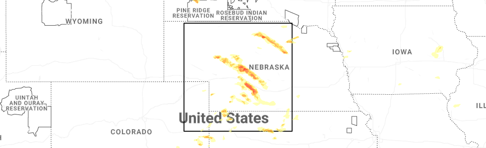
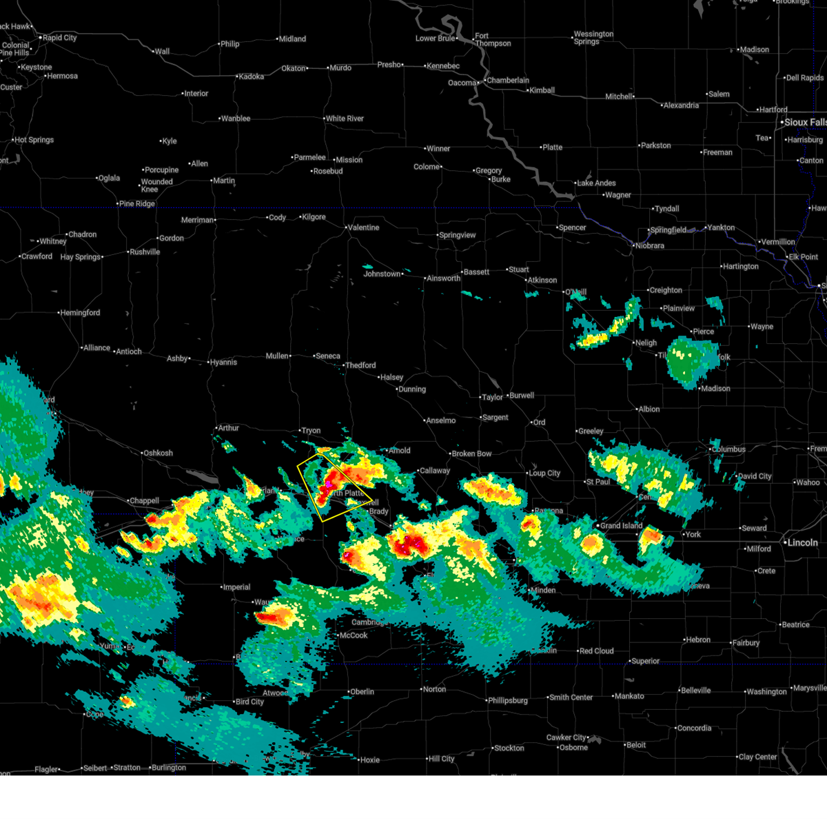
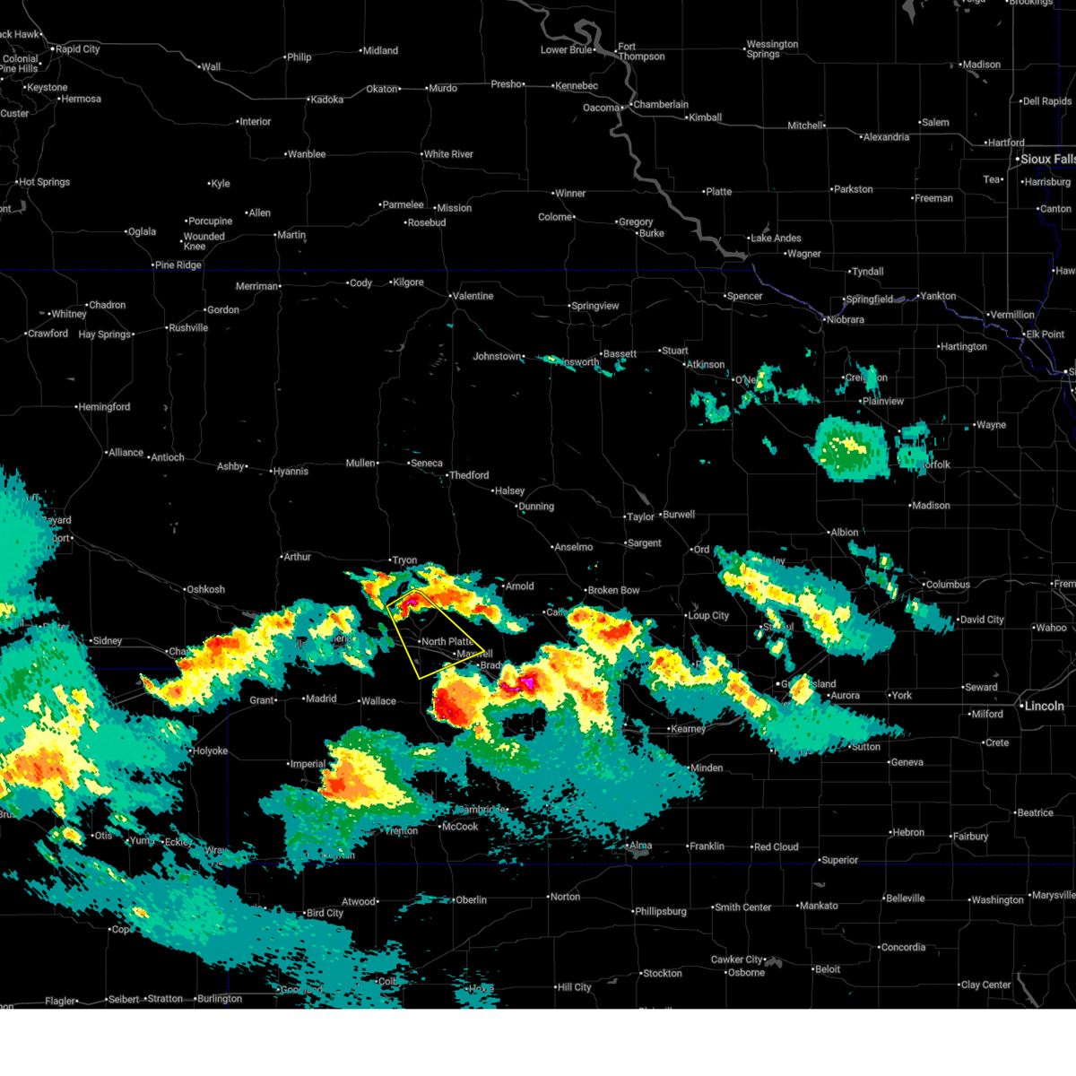
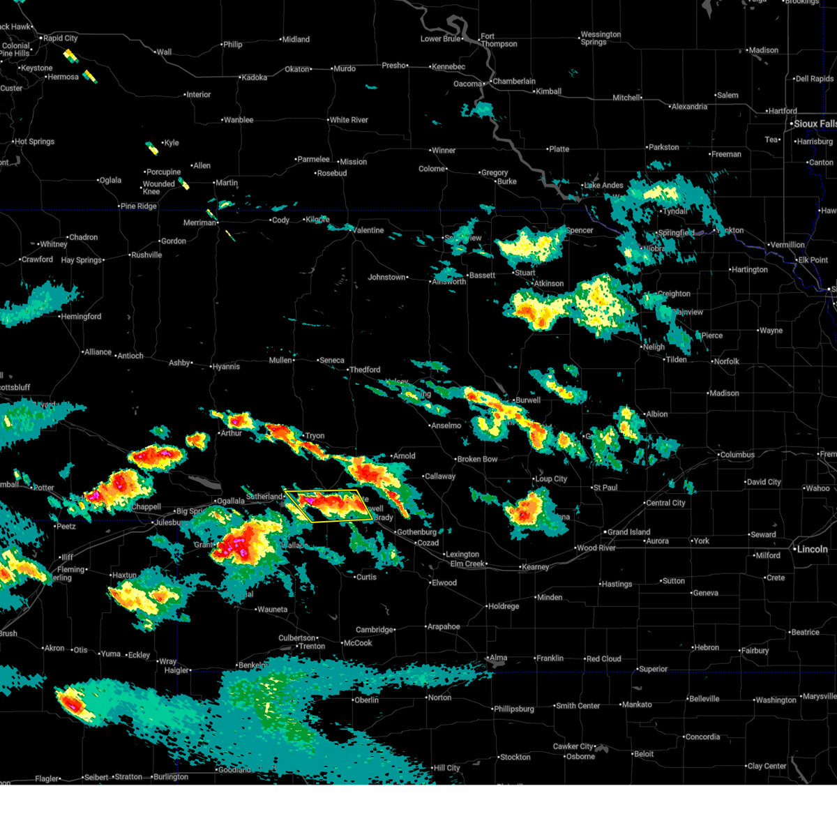
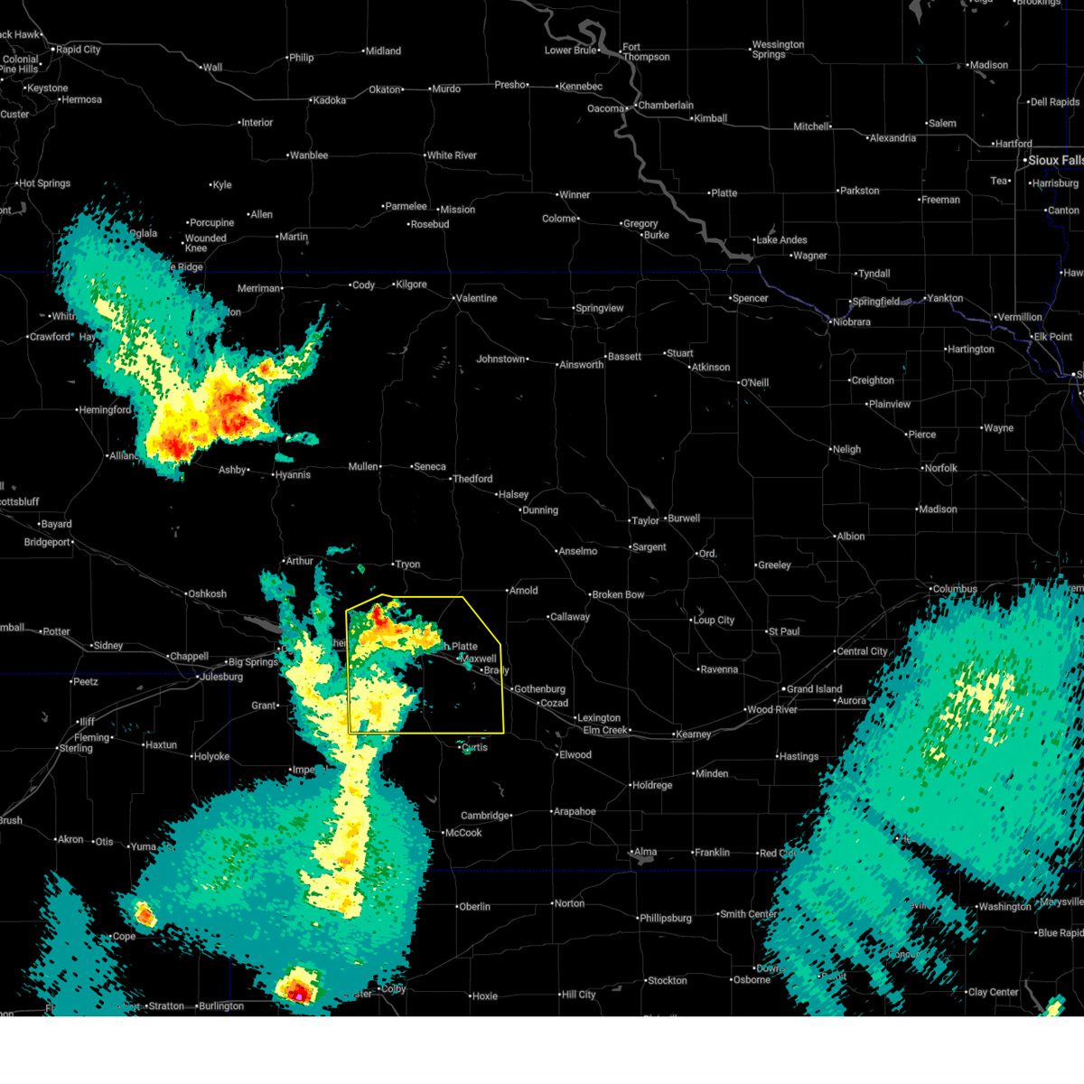
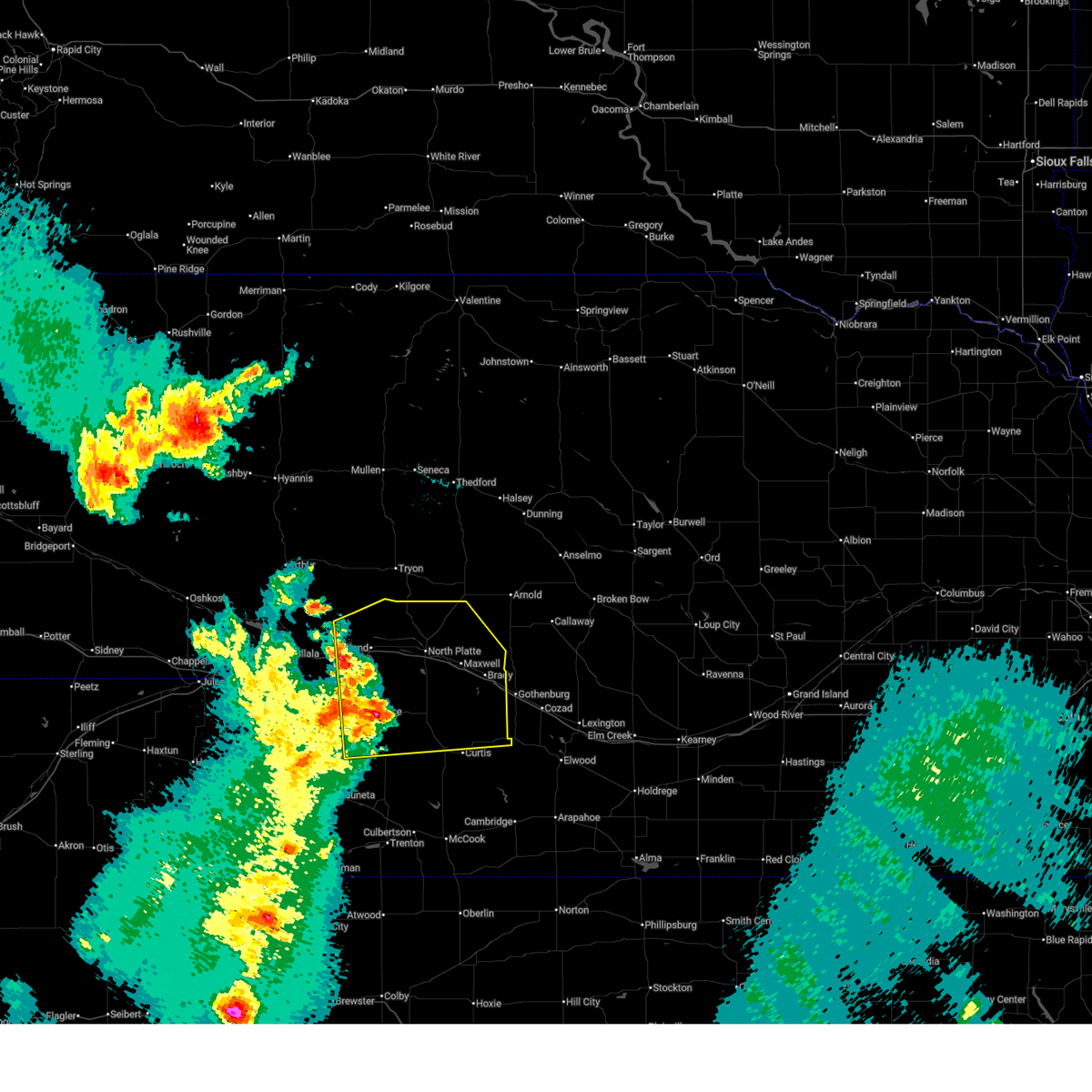
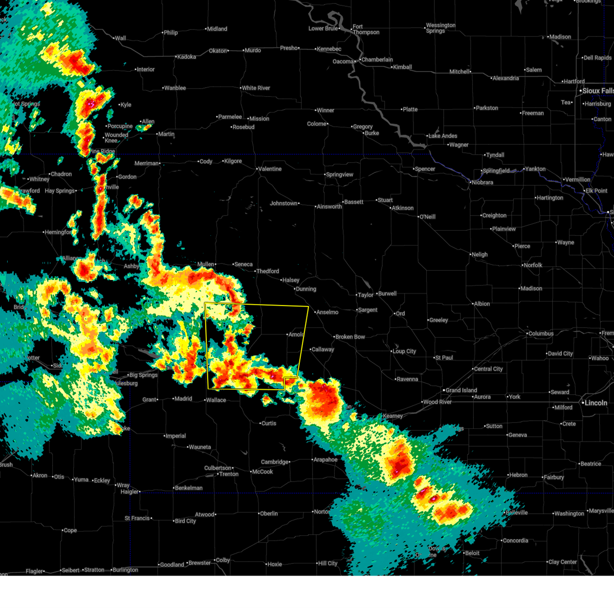
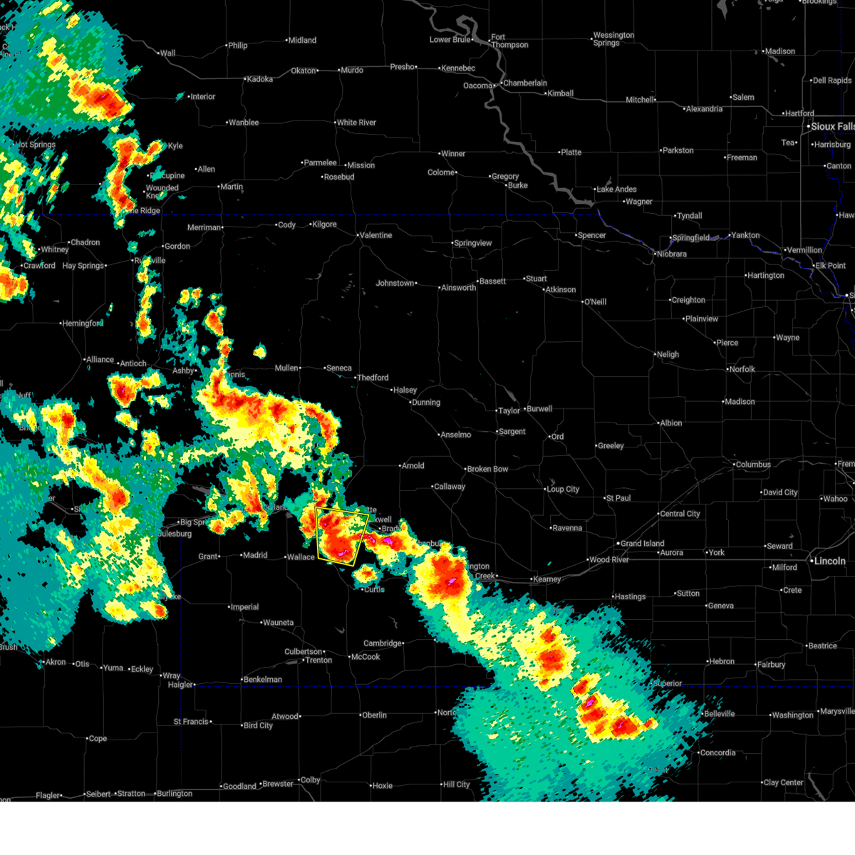
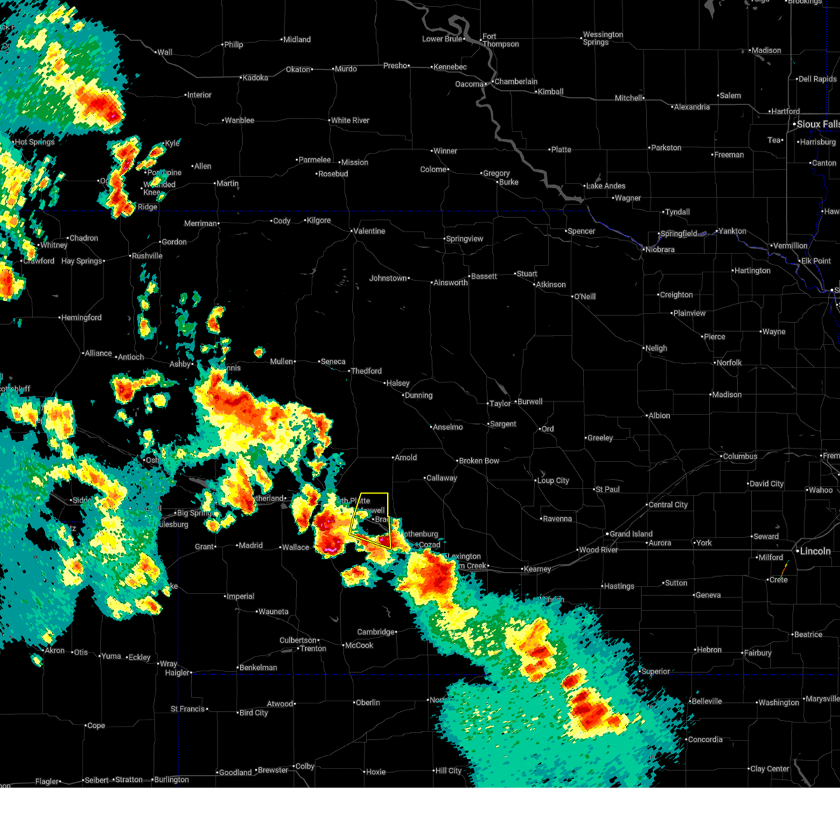
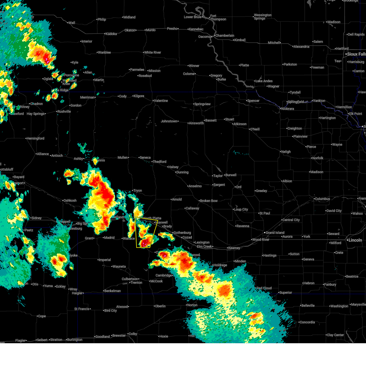
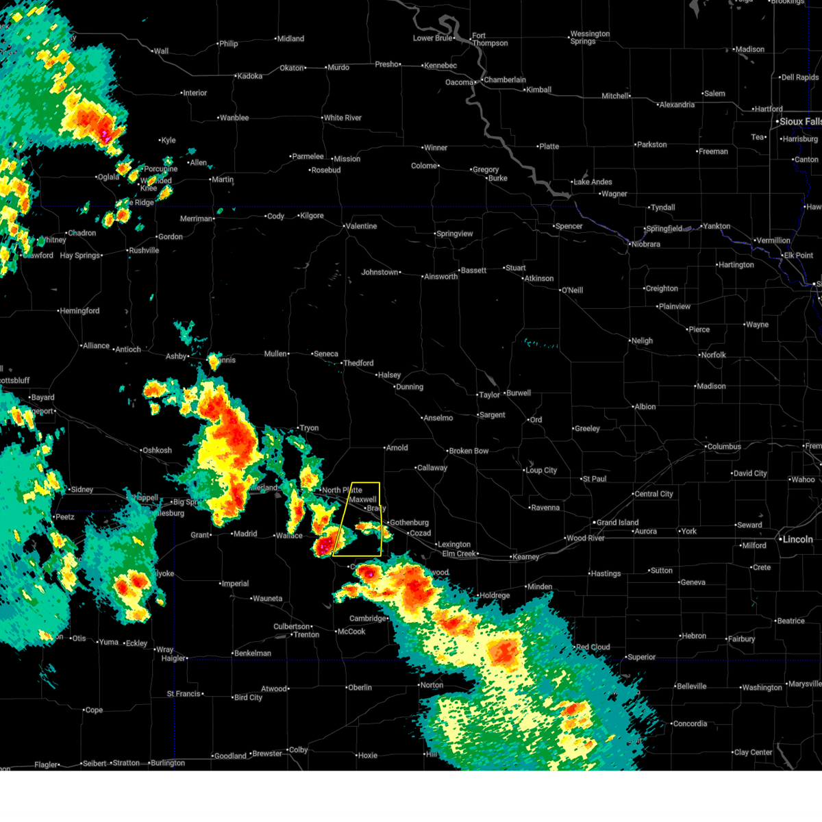
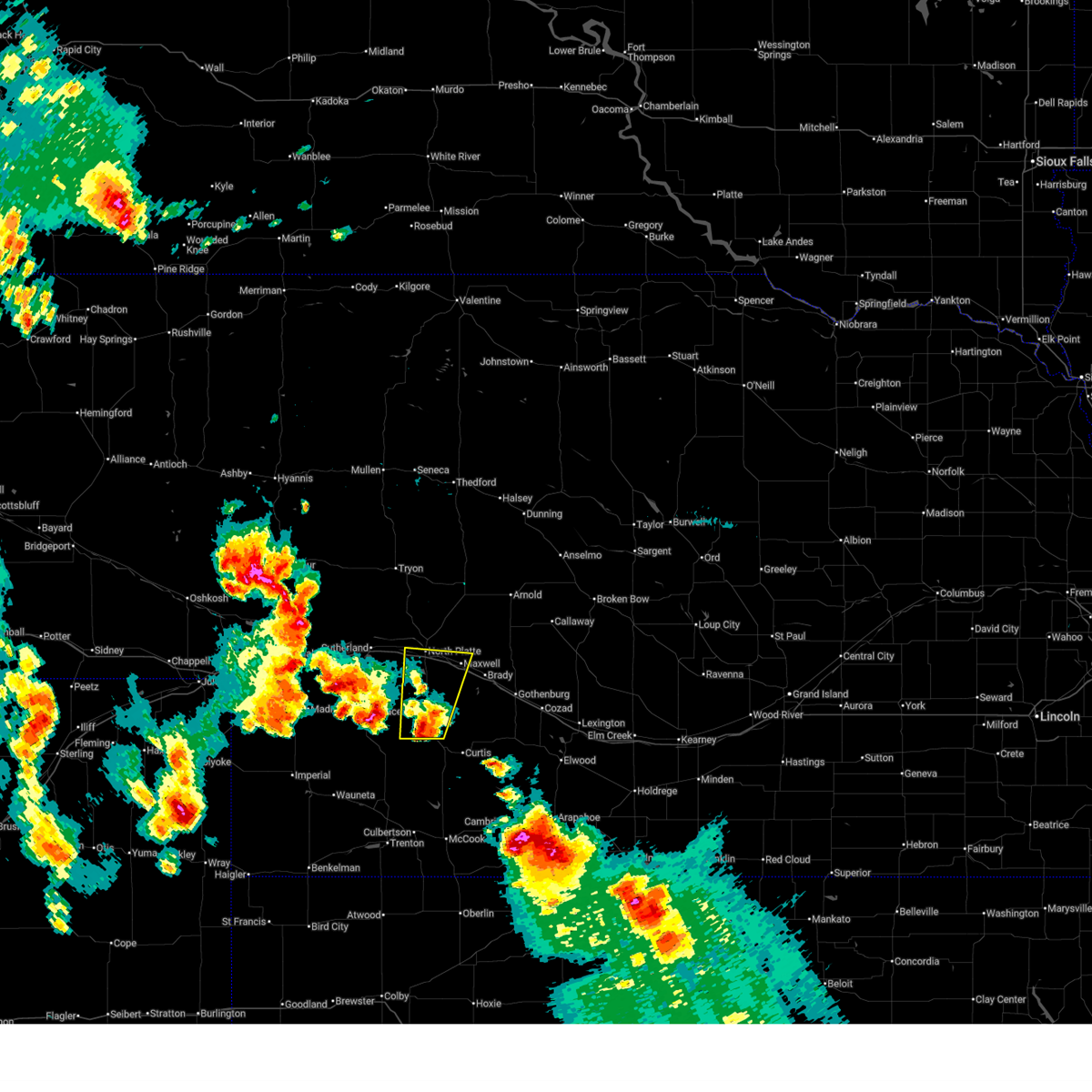
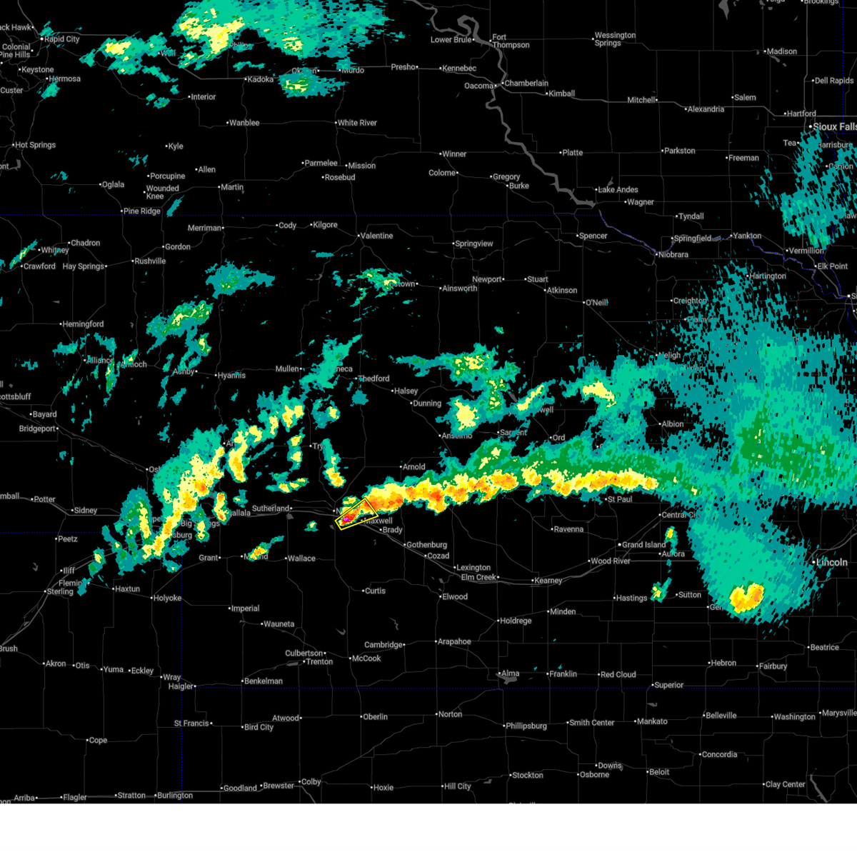
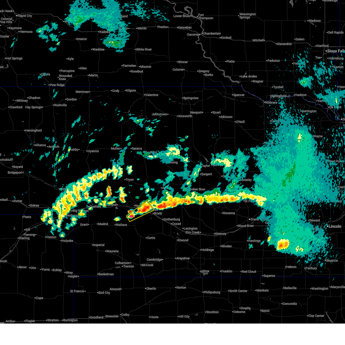
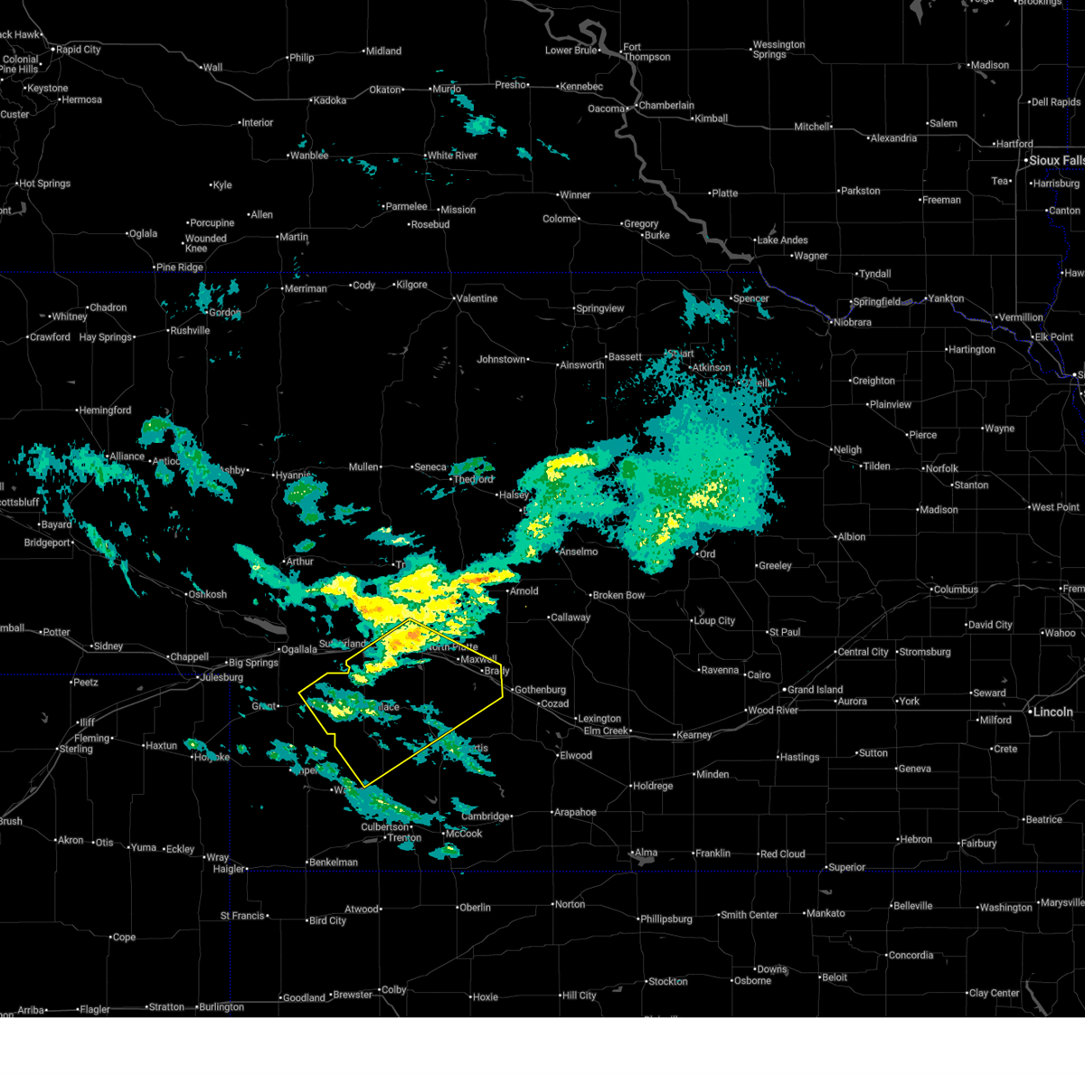
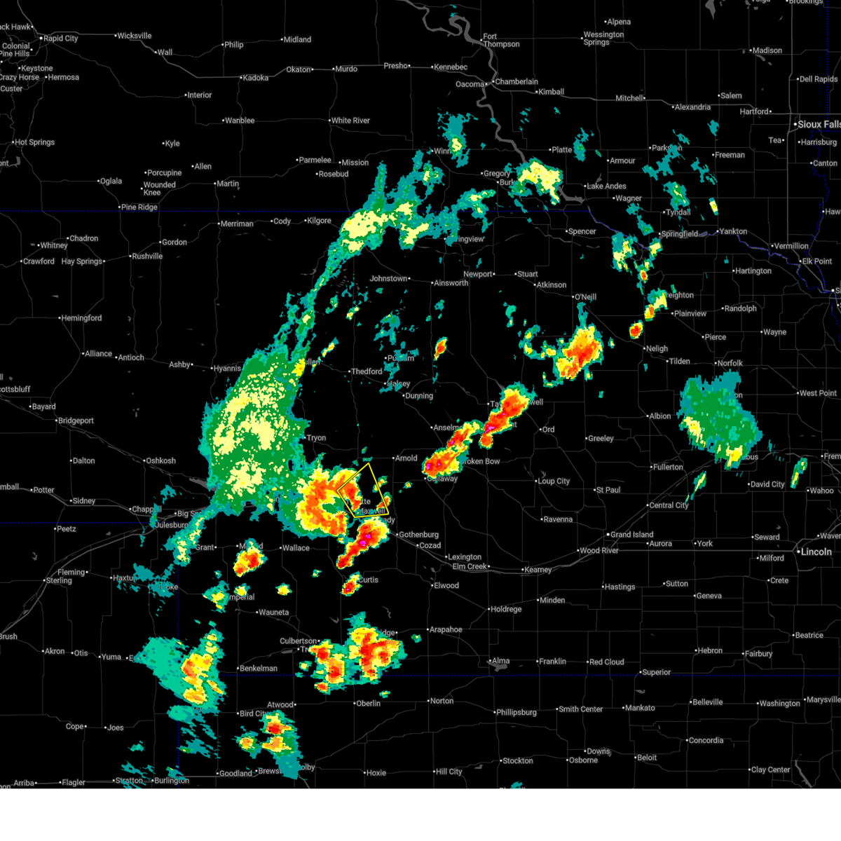
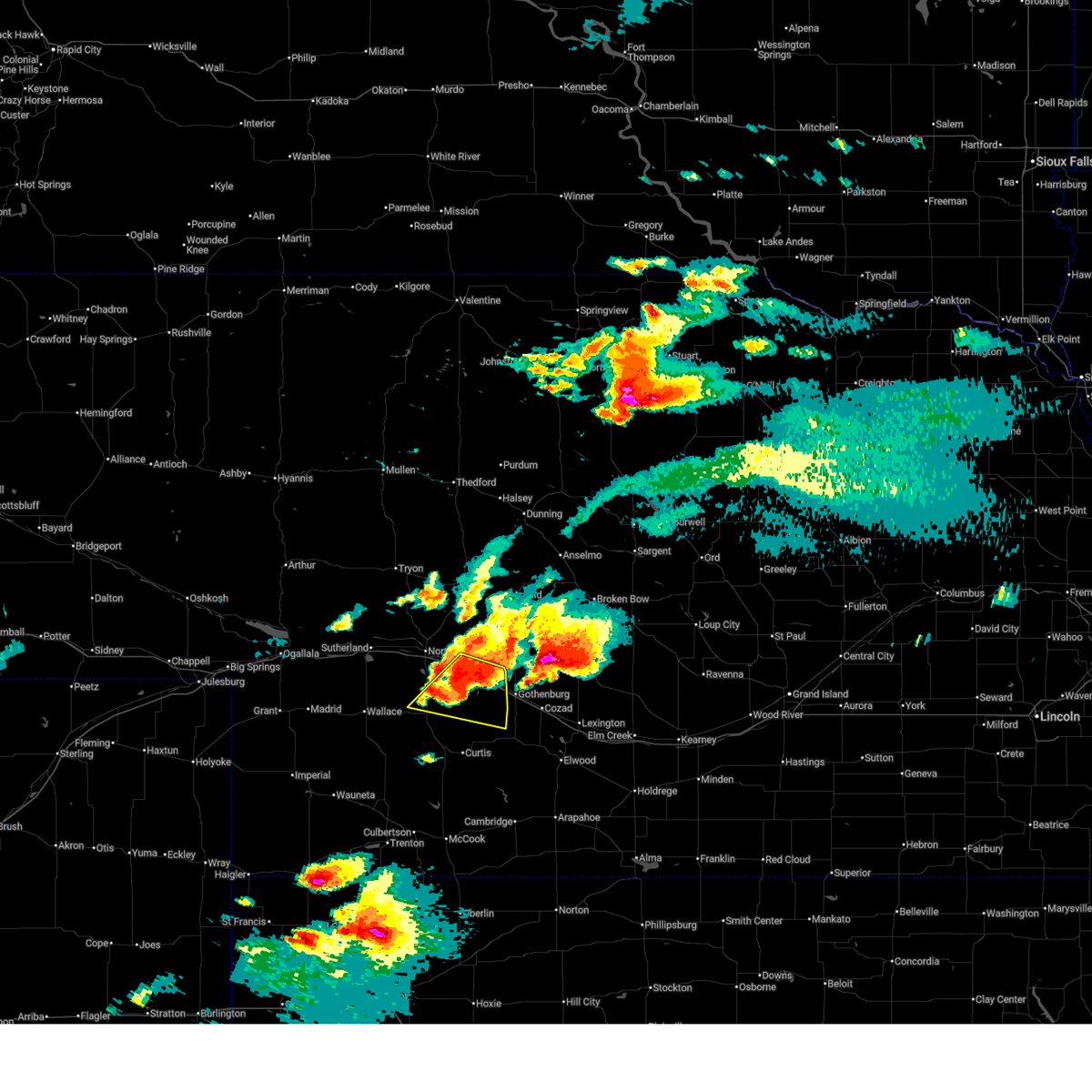
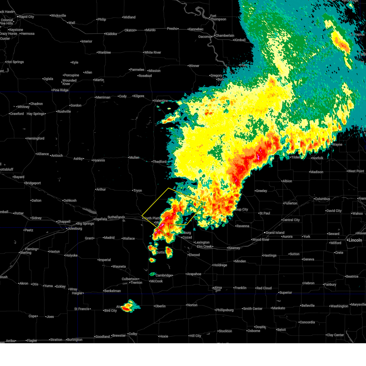
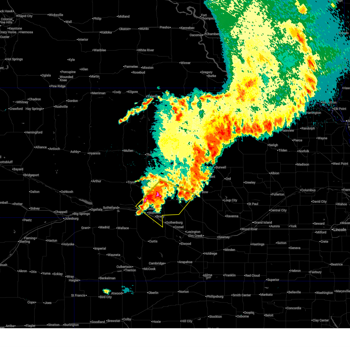
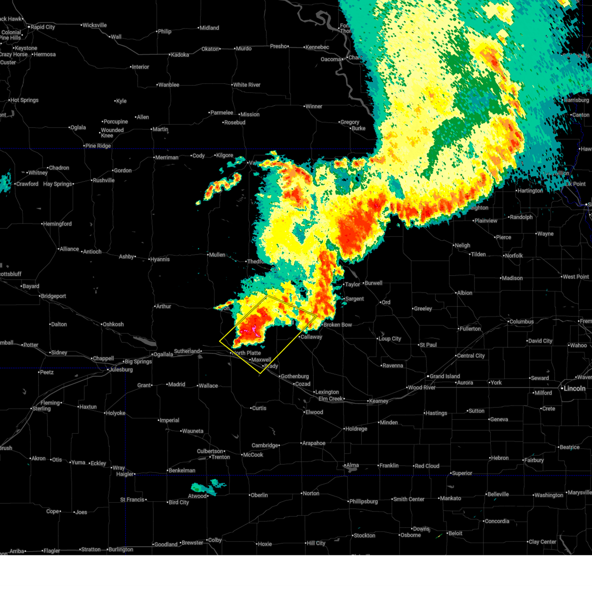
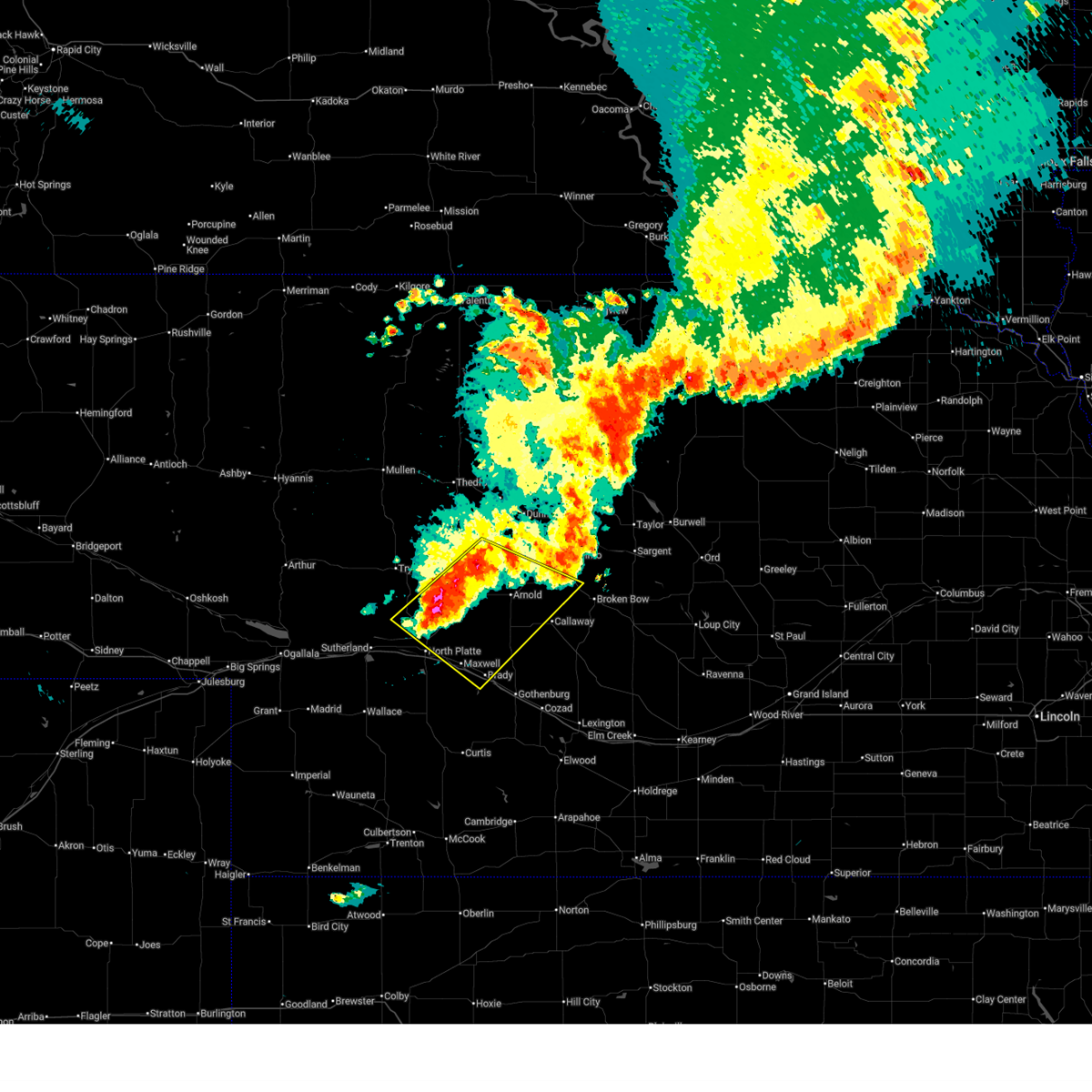
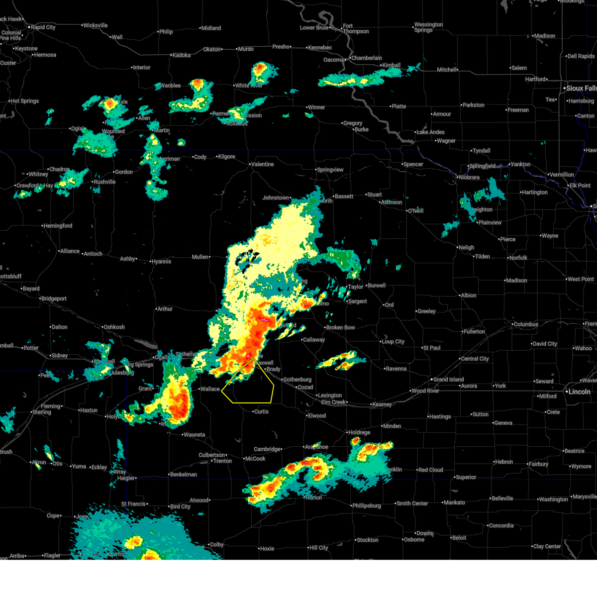
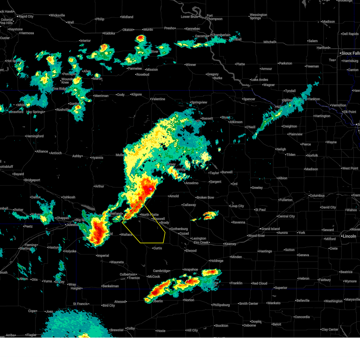
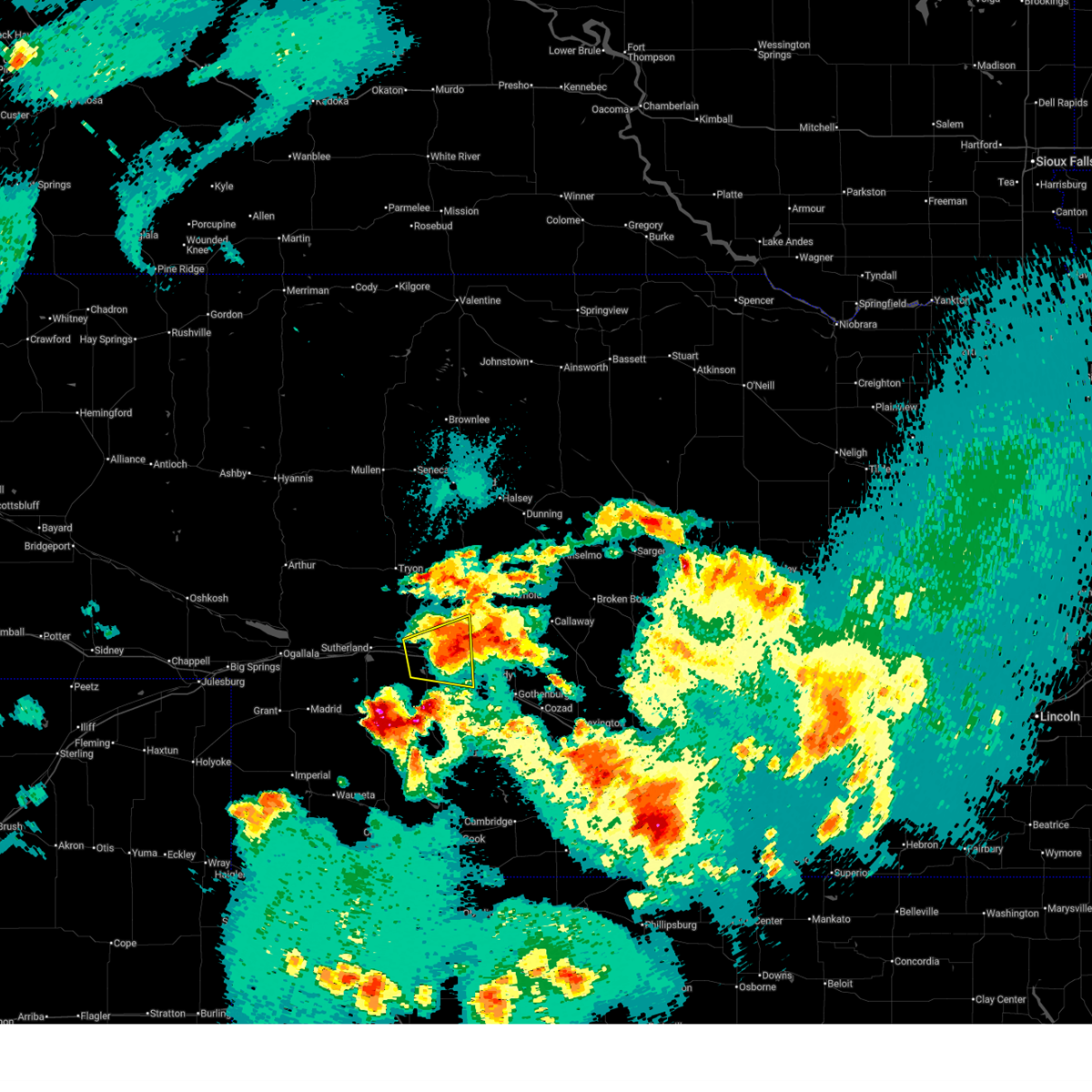
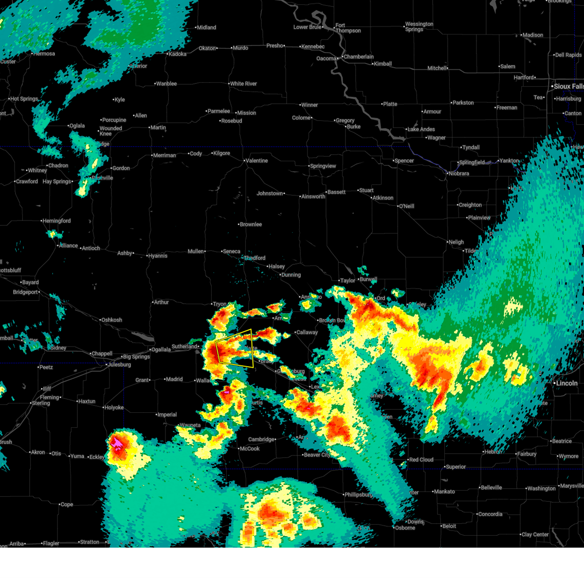
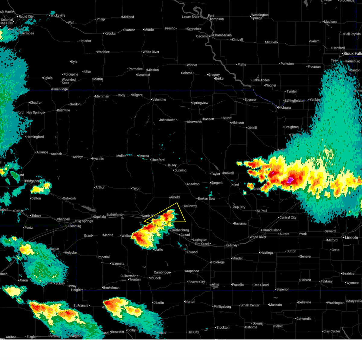
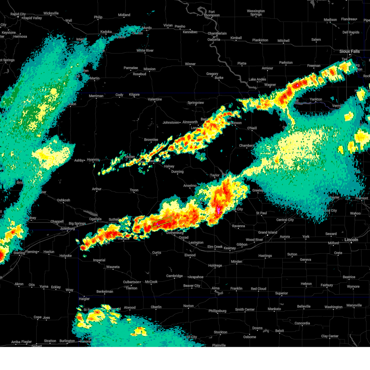
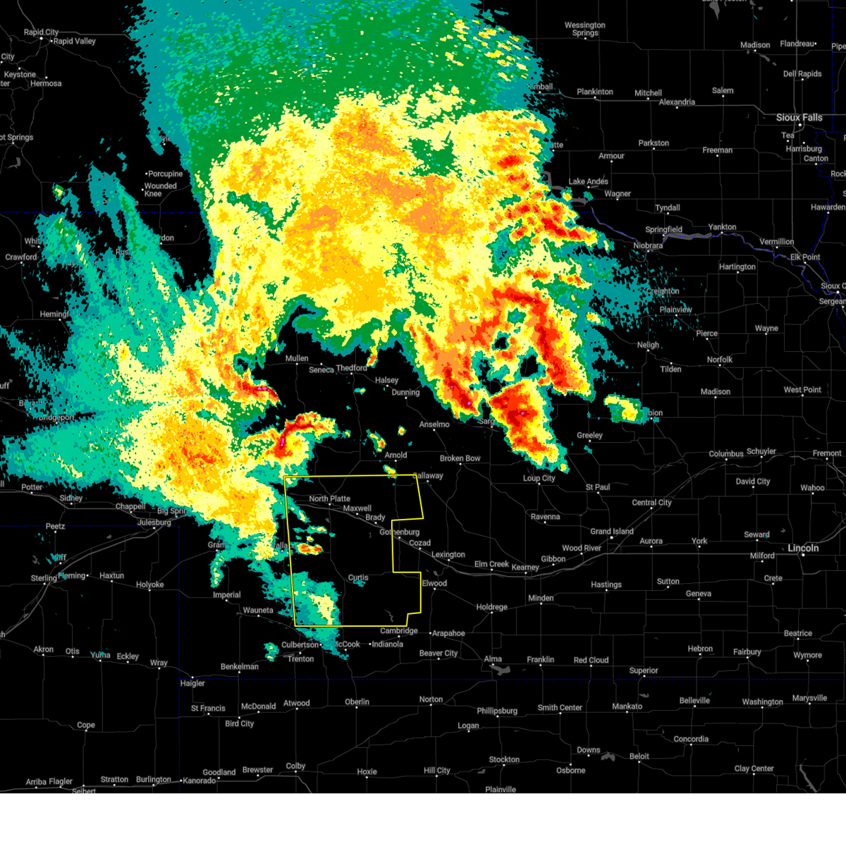
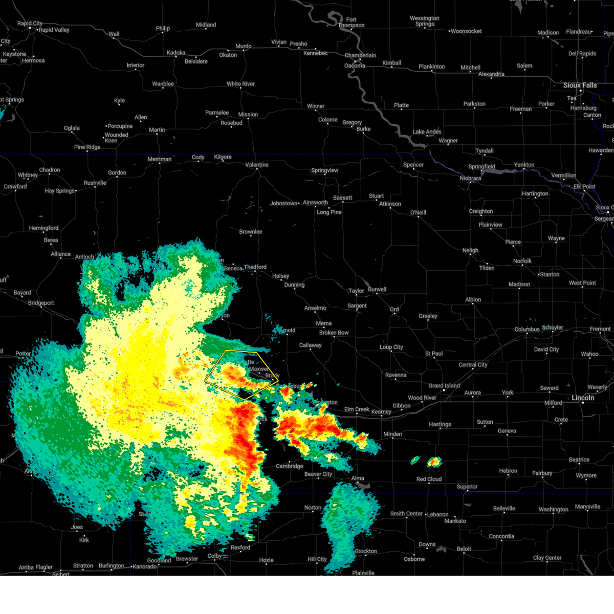
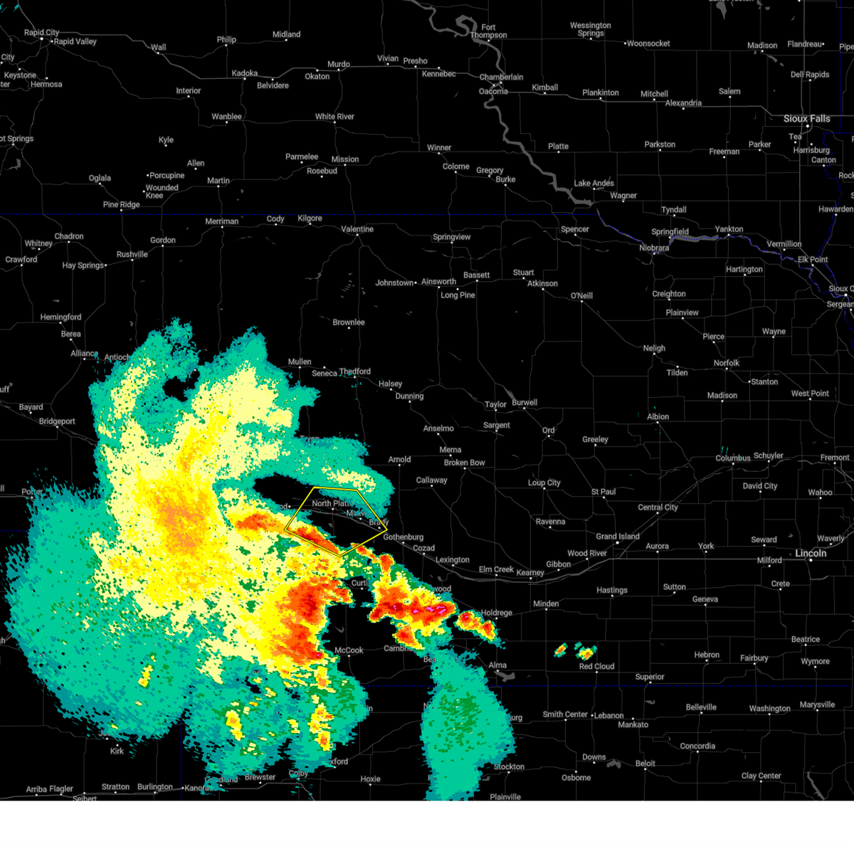
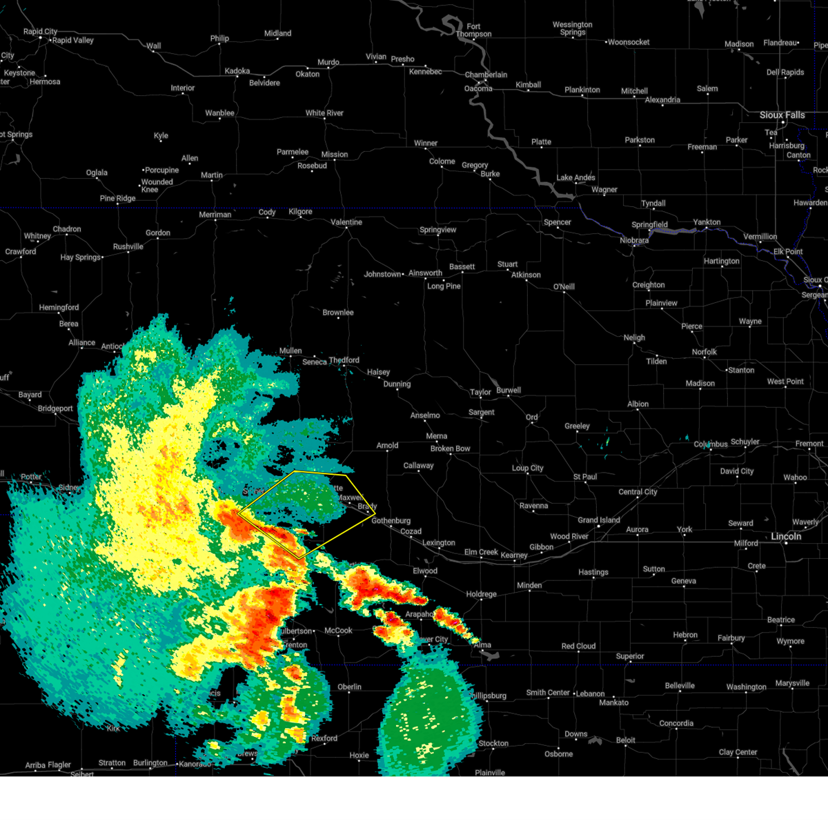
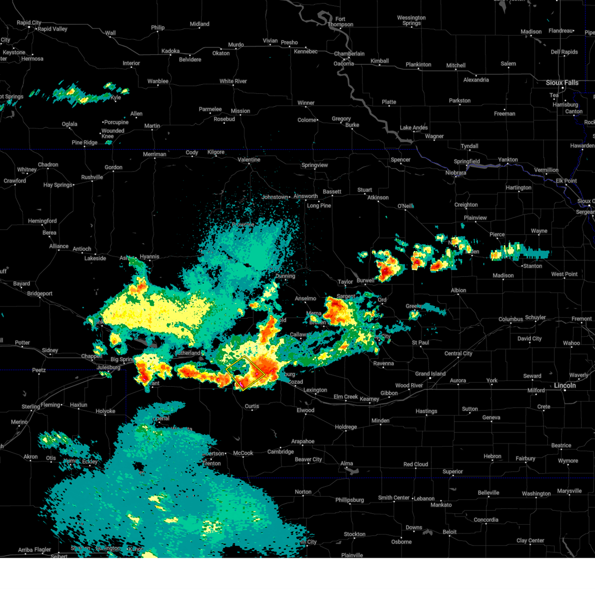
Hail Map for Maxwell, NE
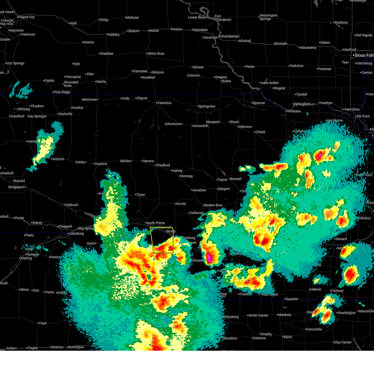
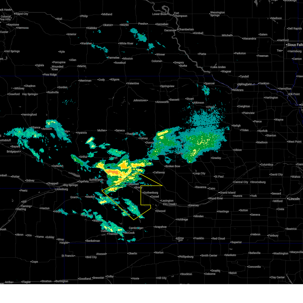
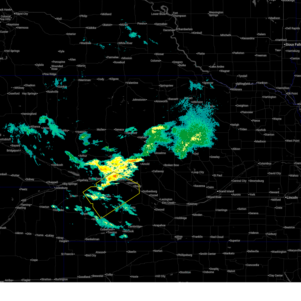
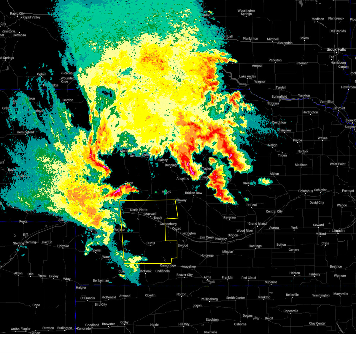
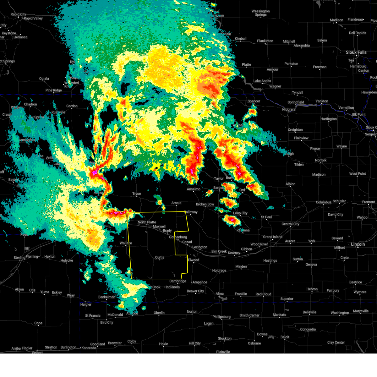
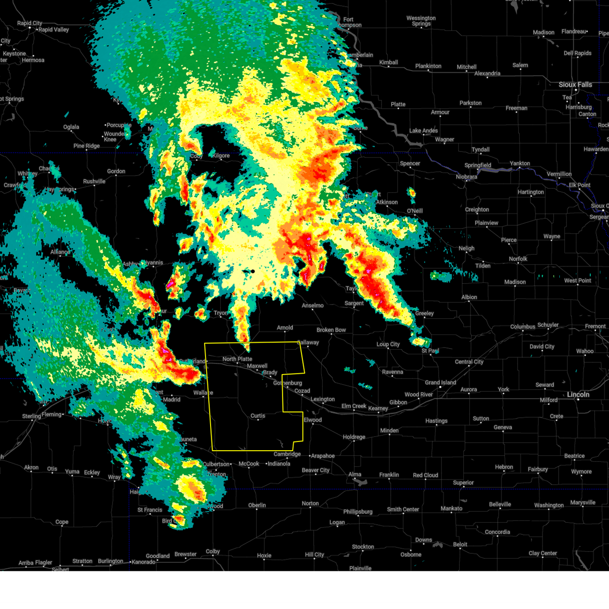
The Maxwell, NE area has had 33 reports of on-the-ground hail by trained spotters, and has been under severe weather warnings 31 times during the past 12 months. Doppler radar has detected hail at or near Maxwell, NE on 102 occasions, including 8 occasions during the past year.
| Name: | Maxwell, NE |
| Where Located: | 13.2 miles ESE of North Platte, NE |
| Map: | Google Map for Maxwell, NE |
| Population: | 312 |
| Housing Units: | 133 |
| More Info: | Search Google for Maxwell, NE |
2
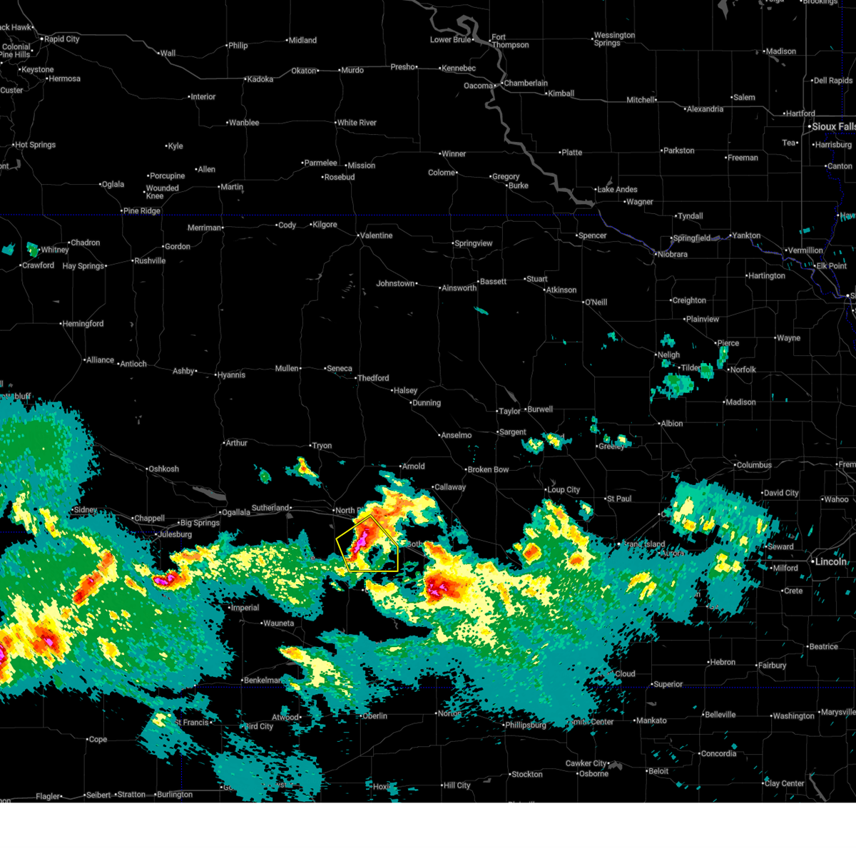
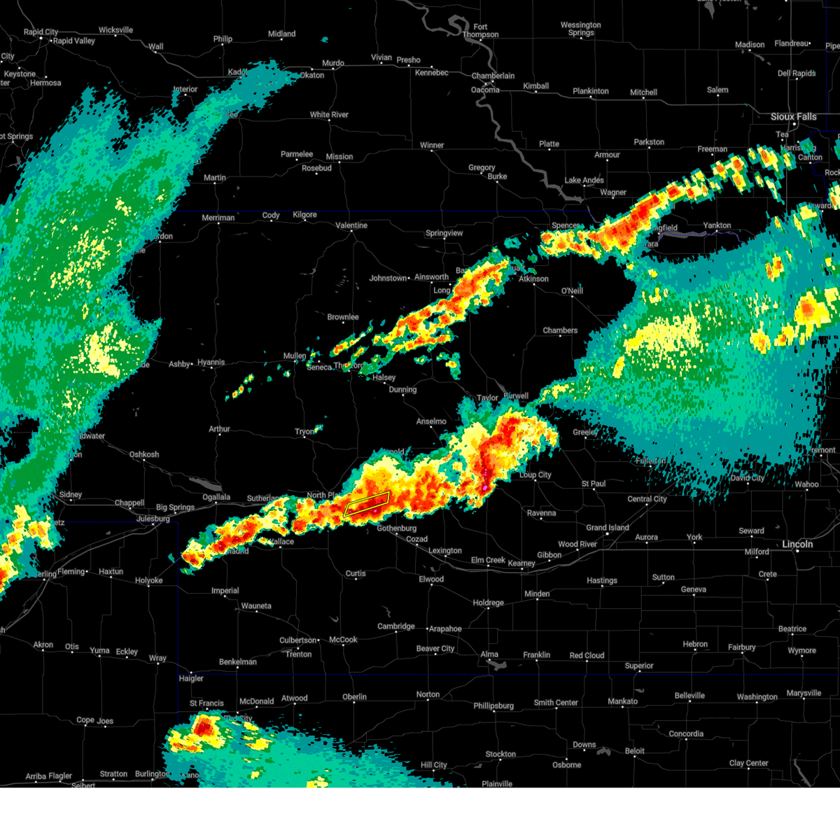
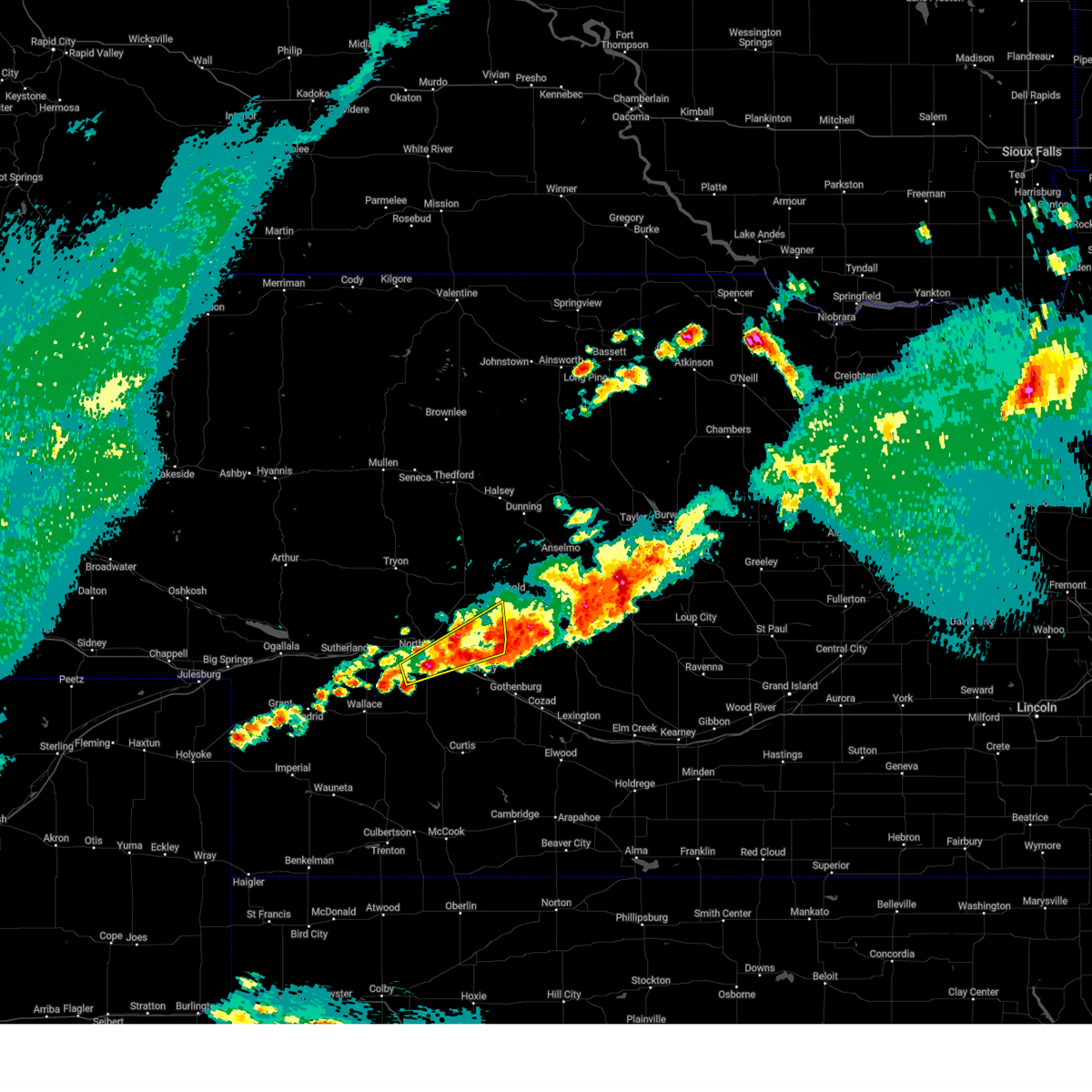
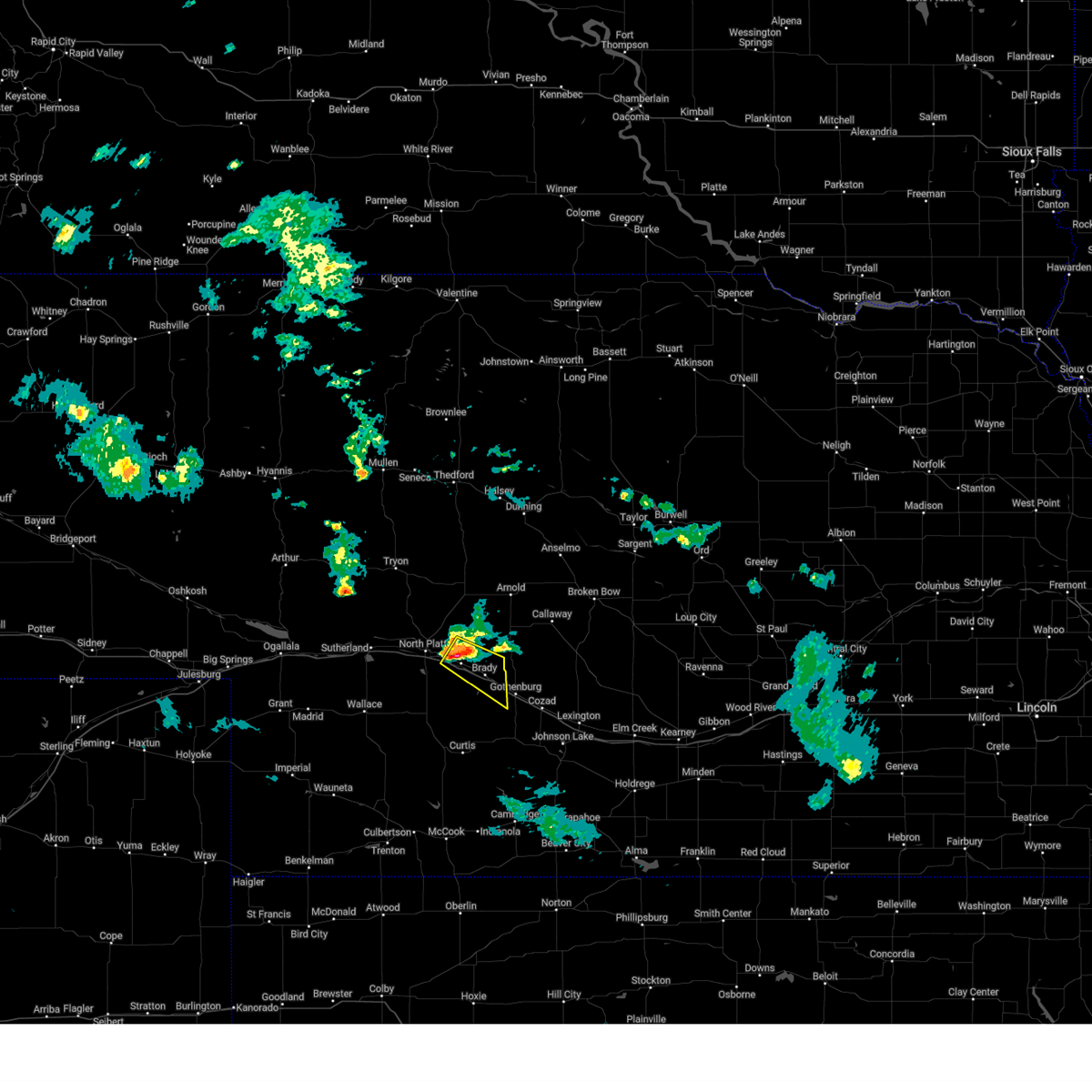
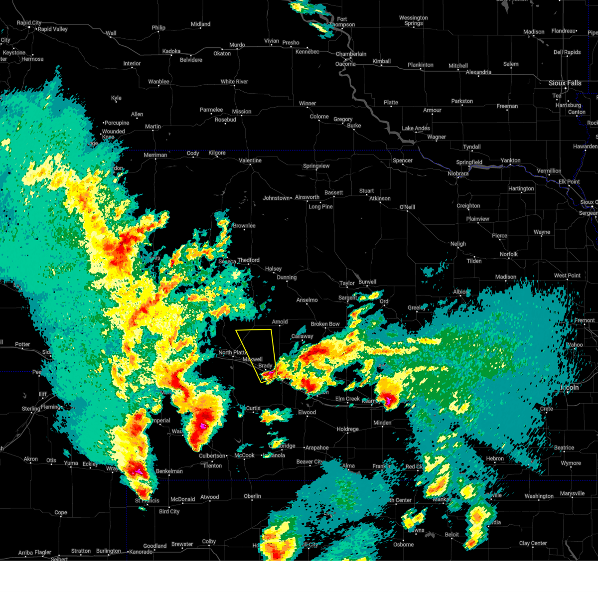
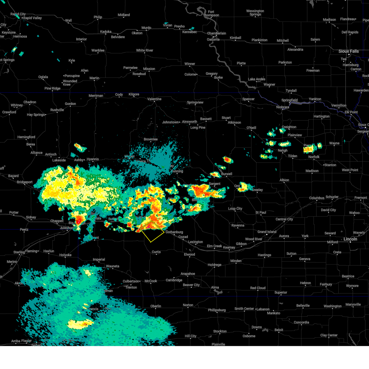
The Top Recent Hail Date for Maxwell, NE is Saturday, July 19, 2025 (12th out of 102)
Hail and Wind Damage Spotted near Maxwell, NE
| Date / Time | Report Details |
|---|---|
| 6/24/2026 9:55 PM CDT |
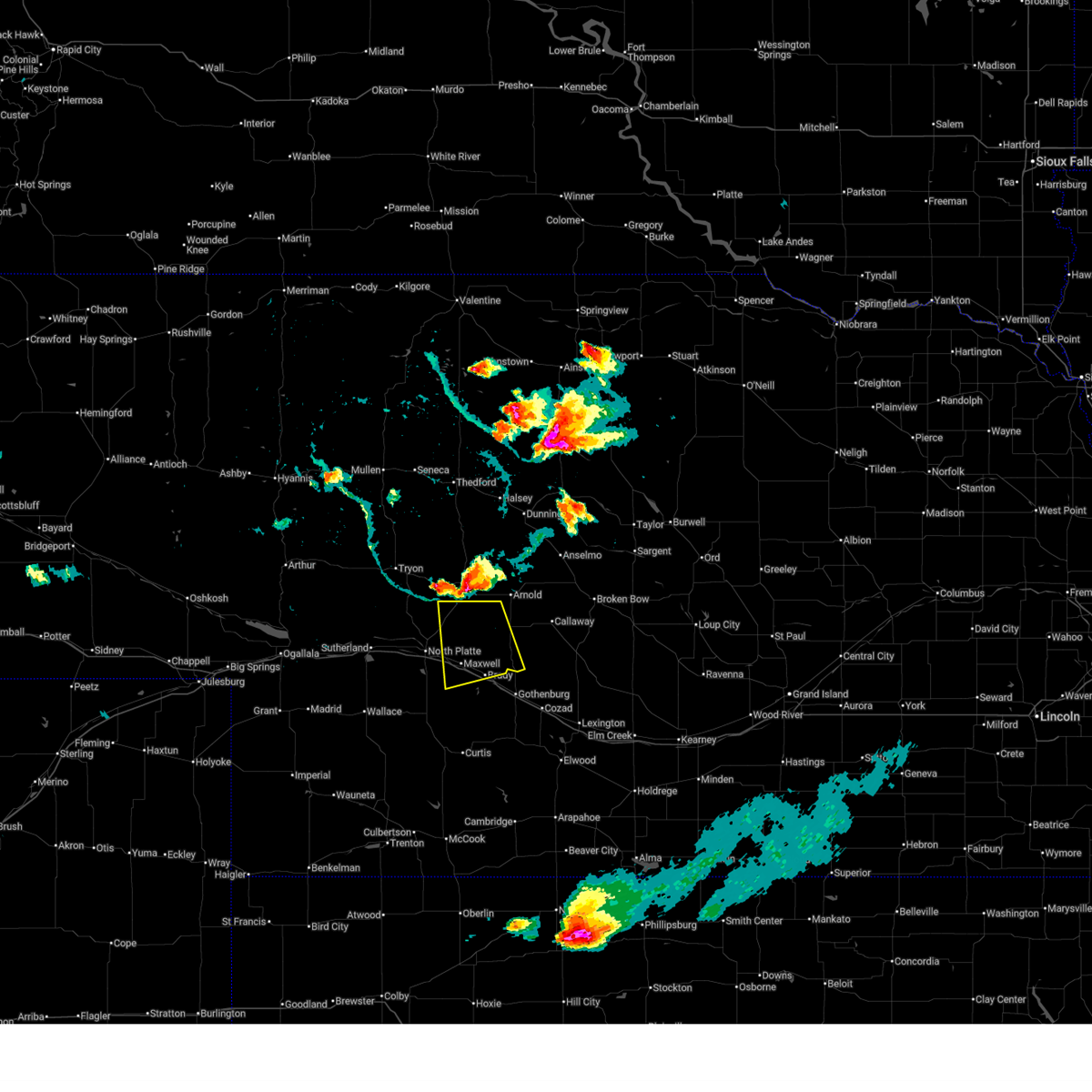
 At 955 pm cdt, a severe thunderstorm was located 8 miles southwest of brady, or 18 miles southeast of north platte, moving southeast at 35 mph (radar indicated). Hazards include golf ball size hail and 60 mph wind gusts. People and animals outdoors will be injured. expect hail damage to roofs, siding, windows, and vehicles. expect wind damage to roofs, siding, and trees. locations impacted include, brady, jeffrey canyon state wildlife management area, and cottonwood canyon state wildlife management area. This includes interstate 80 in nebraska between mile markers 189 and 202. At 955 pm cdt, a severe thunderstorm was located 8 miles southwest of brady, or 18 miles southeast of north platte, moving southeast at 35 mph (radar indicated). Hazards include golf ball size hail and 60 mph wind gusts. People and animals outdoors will be injured. expect hail damage to roofs, siding, windows, and vehicles. expect wind damage to roofs, siding, and trees. locations impacted include, brady, jeffrey canyon state wildlife management area, and cottonwood canyon state wildlife management area. This includes interstate 80 in nebraska between mile markers 189 and 202.
|
| 6/24/2026 9:50 PM CDT |
 The storm which prompted the warning has moved out of the area. therefore, the warning will be allowed to expire. a severe thunderstorm watch remains in effect until 200 am cdt for southwestern and west central nebraska. The storm which prompted the warning has moved out of the area. therefore, the warning will be allowed to expire. a severe thunderstorm watch remains in effect until 200 am cdt for southwestern and west central nebraska.
|
| 6/24/2026 9:40 PM CDT |
 Svrlbf the national weather service in north platte has issued a * severe thunderstorm warning for, southeastern lincoln county in southwestern nebraska, * until 1030 pm cdt. * at 940 pm cdt, a severe thunderstorm was located near maxwell, or 9 miles southeast of north platte, moving southeast at 35 mph (radar indicated). Hazards include 60 mph wind gusts and quarter size hail. Hail damage to vehicles is expected. Expect wind damage to roofs, siding, and trees. Svrlbf the national weather service in north platte has issued a * severe thunderstorm warning for, southeastern lincoln county in southwestern nebraska, * until 1030 pm cdt. * at 940 pm cdt, a severe thunderstorm was located near maxwell, or 9 miles southeast of north platte, moving southeast at 35 mph (radar indicated). Hazards include 60 mph wind gusts and quarter size hail. Hail damage to vehicles is expected. Expect wind damage to roofs, siding, and trees.
|
| 6/24/2026 9:33 PM CDT |
 At 932 pm cdt, a severe thunderstorm was located near north platte airport, moving southeast at 40 mph (radar indicated). Hazards include 60 mph wind gusts and half dollar size hail. Hail damage to vehicles is expected. expect wind damage to roofs, siding, and trees. this severe storm will be near, maxwell and north platte airport around 940 pm cdt. other locations impacted by this severe thunderstorm include keith. this includes the following highways, highway 97 between mile markers 1 and 14. interstate 80 in nebraska between mile markers 173 and 192. Highway 83 between mile markers 71 and 97. At 932 pm cdt, a severe thunderstorm was located near north platte airport, moving southeast at 40 mph (radar indicated). Hazards include 60 mph wind gusts and half dollar size hail. Hail damage to vehicles is expected. expect wind damage to roofs, siding, and trees. this severe storm will be near, maxwell and north platte airport around 940 pm cdt. other locations impacted by this severe thunderstorm include keith. this includes the following highways, highway 97 between mile markers 1 and 14. interstate 80 in nebraska between mile markers 173 and 192. Highway 83 between mile markers 71 and 97.
|
| 6/24/2026 9:10 PM CDT |
 Svrlbf the national weather service in north platte has issued a * severe thunderstorm warning for, northeastern lincoln county in southwestern nebraska, * until 1000 pm cdt. * at 909 pm cdt, a severe thunderstorm was located 12 miles south of ringgold, or 14 miles north of north platte, moving southeast at 30 mph (radar indicated). Hazards include 60 mph wind gusts and half dollar size hail. Hail damage to vehicles is expected. expect wind damage to roofs, siding, and trees. this severe thunderstorm will be near, north platte airport around 940 pm cdt. other locations impacted by this severe thunderstorm include keith. this includes the following highways, highway 97 between mile markers 1 and 14. interstate 80 in nebraska between mile markers 173 and 192. Highway 83 between mile markers 71 and 97. Svrlbf the national weather service in north platte has issued a * severe thunderstorm warning for, northeastern lincoln county in southwestern nebraska, * until 1000 pm cdt. * at 909 pm cdt, a severe thunderstorm was located 12 miles south of ringgold, or 14 miles north of north platte, moving southeast at 30 mph (radar indicated). Hazards include 60 mph wind gusts and half dollar size hail. Hail damage to vehicles is expected. expect wind damage to roofs, siding, and trees. this severe thunderstorm will be near, north platte airport around 940 pm cdt. other locations impacted by this severe thunderstorm include keith. this includes the following highways, highway 97 between mile markers 1 and 14. interstate 80 in nebraska between mile markers 173 and 192. Highway 83 between mile markers 71 and 97.
|
| 6/24/2026 8:09 PM CDT |
 Svrlbf the national weather service in north platte has issued a * severe thunderstorm warning for, central lincoln county in southwestern nebraska, * until 900 pm cdt. * at 809 pm cdt, severe thunderstorms were located along a line extending from hershey to near maxwell, moving southeast at 25 mph (radar indicated). Hazards include quarter size hail. damage to vehicles is expected Svrlbf the national weather service in north platte has issued a * severe thunderstorm warning for, central lincoln county in southwestern nebraska, * until 900 pm cdt. * at 809 pm cdt, severe thunderstorms were located along a line extending from hershey to near maxwell, moving southeast at 25 mph (radar indicated). Hazards include quarter size hail. damage to vehicles is expected
|
| 6/8/2026 10:50 PM CDT |
 At 1049 pm cdt, outflow from severe thunderstorms was located along a line extending from 10 miles south of ringgold to 7 miles north of brady to 10 miles southwest of gothenburg, moving east at 45 mph (radar indicated). Hazards include 60 mph wind gusts. Expect damage to roofs, siding, and trees. locations impacted include, north platte, sutherland, hershey, brady, wallace, maxwell, wellfleet, dickens, sutherland reservoir state recreation area, lake maloney state recreation area, north platte airport, keith, cottonwood canyon state wildlife management area, coker, hansen memorial reserve state wildlife management area, jeffrey canyon state wildlife management area, o'fallons, birdwood, and somerset. this includes the following highways, highway 97 between mile markers 1 and 16. interstate 80 in nebraska between mile markers 151 and 207. Highway 83 between mile markers 52 and 105. At 1049 pm cdt, outflow from severe thunderstorms was located along a line extending from 10 miles south of ringgold to 7 miles north of brady to 10 miles southwest of gothenburg, moving east at 45 mph (radar indicated). Hazards include 60 mph wind gusts. Expect damage to roofs, siding, and trees. locations impacted include, north platte, sutherland, hershey, brady, wallace, maxwell, wellfleet, dickens, sutherland reservoir state recreation area, lake maloney state recreation area, north platte airport, keith, cottonwood canyon state wildlife management area, coker, hansen memorial reserve state wildlife management area, jeffrey canyon state wildlife management area, o'fallons, birdwood, and somerset. this includes the following highways, highway 97 between mile markers 1 and 16. interstate 80 in nebraska between mile markers 151 and 207. Highway 83 between mile markers 52 and 105.
|
| 6/8/2026 10:10 PM CDT |
 Svrlbf the national weather service in north platte has issued a * severe thunderstorm warning for, northwestern frontier county in southwestern nebraska, eastern perkins county in southwestern nebraska, southeastern keith county in southwestern nebraska, lincoln county in southwestern nebraska, northern hayes county in southwestern nebraska, * until 1115 pm cdt/1015 pm mdt/. * at 1010 pm cdt/910 pm mdt/, severe thunderstorms were located along a line extending from near sutherland to near dickens to 10 miles north of hayes center, moving northeast at 40 mph (radar indicated). Hazards include 60 mph wind gusts. expect damage to roofs, siding, and trees Svrlbf the national weather service in north platte has issued a * severe thunderstorm warning for, northwestern frontier county in southwestern nebraska, eastern perkins county in southwestern nebraska, southeastern keith county in southwestern nebraska, lincoln county in southwestern nebraska, northern hayes county in southwestern nebraska, * until 1115 pm cdt/1015 pm mdt/. * at 1010 pm cdt/910 pm mdt/, severe thunderstorms were located along a line extending from near sutherland to near dickens to 10 miles north of hayes center, moving northeast at 40 mph (radar indicated). Hazards include 60 mph wind gusts. expect damage to roofs, siding, and trees
|
| 5/30/2026 7:59 PM CDT |
 Svrlbf the national weather service in north platte has issued a * severe thunderstorm warning for, northern lincoln county in southwestern nebraska, logan county in west central nebraska, eastern mcpherson county in west central nebraska, western custer county in central nebraska, * until 845 pm cdt. * at 759 pm cdt, severe thunderstorms were located along a line extending from near hershey to 7 miles northeast of brady, moving north at 40 mph (radar indicated). Hazards include ping pong ball size hail and 60 mph wind gusts. People and animals outdoors will be injured. expect hail damage to roofs, siding, windows, and vehicles. Expect wind damage to roofs, siding, and trees. Svrlbf the national weather service in north platte has issued a * severe thunderstorm warning for, northern lincoln county in southwestern nebraska, logan county in west central nebraska, eastern mcpherson county in west central nebraska, western custer county in central nebraska, * until 845 pm cdt. * at 759 pm cdt, severe thunderstorms were located along a line extending from near hershey to 7 miles northeast of brady, moving north at 40 mph (radar indicated). Hazards include ping pong ball size hail and 60 mph wind gusts. People and animals outdoors will be injured. expect hail damage to roofs, siding, windows, and vehicles. Expect wind damage to roofs, siding, and trees.
|
| 5/30/2026 7:55 PM CDT | Quarter sized hail reported 0.4 miles ESE of Maxwell, NE |
| 5/30/2026 7:49 PM CDT |
 At 748 pm cdt, a severe thunderstorm was located 10 miles north of wellfleet, or 16 miles south of north platte, moving north at 25 mph (radar indicated. at 735 pm cdt, two inch hail was reported five miles north of wellfleet). Hazards include tennis ball size hail and 60 mph wind gusts. People and animals outdoors will be injured. expect hail damage to roofs, siding, windows, and vehicles. expect wind damage to roofs, siding, and trees. locations impacted include, north platte, maxwell, lake maloney state recreation area, north platte airport, keith, cottonwood canyon state wildlife management area, birdwood, and somerset. this includes the following highways, interstate 80 in nebraska between mile markers 170 and 192. Highway 83 between mile markers 61 and 83. At 748 pm cdt, a severe thunderstorm was located 10 miles north of wellfleet, or 16 miles south of north platte, moving north at 25 mph (radar indicated. at 735 pm cdt, two inch hail was reported five miles north of wellfleet). Hazards include tennis ball size hail and 60 mph wind gusts. People and animals outdoors will be injured. expect hail damage to roofs, siding, windows, and vehicles. expect wind damage to roofs, siding, and trees. locations impacted include, north platte, maxwell, lake maloney state recreation area, north platte airport, keith, cottonwood canyon state wildlife management area, birdwood, and somerset. this includes the following highways, interstate 80 in nebraska between mile markers 170 and 192. Highway 83 between mile markers 61 and 83.
|
| 5/30/2026 7:41 PM CDT |
 At 740 pm cdt, a severe thunderstorm was located 7 miles south of brady, or 21 miles northeast of curtis, moving north at 35 mph (radar indicated). Hazards include 60 mph wind gusts and quarter size hail. Hail damage to vehicles is expected. expect wind damage to roofs, siding, and trees. locations impacted include, brady, maxwell, jeffrey canyon state wildlife management area, cottonwood canyon state wildlife management area, and vroman. This includes interstate 80 in nebraska between mile markers 191 and 208. At 740 pm cdt, a severe thunderstorm was located 7 miles south of brady, or 21 miles northeast of curtis, moving north at 35 mph (radar indicated). Hazards include 60 mph wind gusts and quarter size hail. Hail damage to vehicles is expected. expect wind damage to roofs, siding, and trees. locations impacted include, brady, maxwell, jeffrey canyon state wildlife management area, cottonwood canyon state wildlife management area, and vroman. This includes interstate 80 in nebraska between mile markers 191 and 208.
|
| 5/30/2026 7:24 PM CDT |
 Svrlbf the national weather service in north platte has issued a * severe thunderstorm warning for, southeastern lincoln county in southwestern nebraska, * until 815 pm cdt. * at 723 pm cdt, a severe thunderstorm was located over wellfleet, or 14 miles northwest of curtis, moving north at 25 mph (radar indicated). Hazards include two inch hail and 60 mph wind gusts. People and animals outdoors will be injured. expect hail damage to roofs, siding, windows, and vehicles. Expect wind damage to roofs, siding, and trees. Svrlbf the national weather service in north platte has issued a * severe thunderstorm warning for, southeastern lincoln county in southwestern nebraska, * until 815 pm cdt. * at 723 pm cdt, a severe thunderstorm was located over wellfleet, or 14 miles northwest of curtis, moving north at 25 mph (radar indicated). Hazards include two inch hail and 60 mph wind gusts. People and animals outdoors will be injured. expect hail damage to roofs, siding, windows, and vehicles. Expect wind damage to roofs, siding, and trees.
|
| 5/30/2026 7:20 PM CDT |
 Svrlbf the national weather service in north platte has issued a * severe thunderstorm warning for, southeastern lincoln county in southwestern nebraska, * until 800 pm cdt. * at 720 pm cdt, a severe thunderstorm was located near moorefield, or 8 miles east of curtis, moving north at 45 mph (radar indicated). Hazards include 60 mph wind gusts and quarter size hail. Hail damage to vehicles is expected. Expect wind damage to roofs, siding, and trees. Svrlbf the national weather service in north platte has issued a * severe thunderstorm warning for, southeastern lincoln county in southwestern nebraska, * until 800 pm cdt. * at 720 pm cdt, a severe thunderstorm was located near moorefield, or 8 miles east of curtis, moving north at 45 mph (radar indicated). Hazards include 60 mph wind gusts and quarter size hail. Hail damage to vehicles is expected. Expect wind damage to roofs, siding, and trees.
|
| 5/30/2026 6:44 PM CDT |
 Svrlbf the national weather service in north platte has issued a * severe thunderstorm warning for, southeastern lincoln county in southwestern nebraska, * until 730 pm cdt. * at 643 pm cdt, a severe thunderstorm was located near wellfleet, or 17 miles northwest of curtis, moving north at 30 mph (radar indicated). Hazards include golf ball size hail and 60 mph wind gusts. People and animals outdoors will be injured. expect hail damage to roofs, siding, windows, and vehicles. Expect wind damage to roofs, siding, and trees. Svrlbf the national weather service in north platte has issued a * severe thunderstorm warning for, southeastern lincoln county in southwestern nebraska, * until 730 pm cdt. * at 643 pm cdt, a severe thunderstorm was located near wellfleet, or 17 miles northwest of curtis, moving north at 30 mph (radar indicated). Hazards include golf ball size hail and 60 mph wind gusts. People and animals outdoors will be injured. expect hail damage to roofs, siding, windows, and vehicles. Expect wind damage to roofs, siding, and trees.
|
| 5/17/2026 2:37 AM CDT |
 At 236 am cdt, a severe thunderstorm was located immediately southeast of north platte airport, or 7 miles east of north platte, moving northeast at 40 mph (radar indicated). Hazards include quarter size hail. Damage to vehicles is expected. locations impacted include, maxwell, north platte airport, and keith. This includes interstate 80 in nebraska between mile markers 180 and 188. At 236 am cdt, a severe thunderstorm was located immediately southeast of north platte airport, or 7 miles east of north platte, moving northeast at 40 mph (radar indicated). Hazards include quarter size hail. Damage to vehicles is expected. locations impacted include, maxwell, north platte airport, and keith. This includes interstate 80 in nebraska between mile markers 180 and 188.
|
| 5/17/2026 2:16 AM CDT |
 Svrlbf the national weather service in north platte has issued a * severe thunderstorm warning for, central lincoln county in southwestern nebraska, * until 300 am cdt. * at 216 am cdt, a severe thunderstorm was located near lake maloney state recreation area, or 10 miles south of north platte, moving northeast at 40 mph (radar indicated). Hazards include quarter size hail. damage to vehicles is expected Svrlbf the national weather service in north platte has issued a * severe thunderstorm warning for, central lincoln county in southwestern nebraska, * until 300 am cdt. * at 216 am cdt, a severe thunderstorm was located near lake maloney state recreation area, or 10 miles south of north platte, moving northeast at 40 mph (radar indicated). Hazards include quarter size hail. damage to vehicles is expected
|
| 5/16/2026 8:20 PM CDT |
 Svrlbf the national weather service in north platte has issued a * severe thunderstorm warning for, southeastern lincoln county in southwestern nebraska, * until 900 pm cdt. * at 820 pm cdt, a severe thunderstorm was located 7 miles northeast of moorefield, or 14 miles northeast of curtis, moving north at 20 mph (radar indicated). Hazards include 60 mph wind gusts and quarter size hail. Hail damage to vehicles is expected. Expect wind damage to roofs, siding, and trees. Svrlbf the national weather service in north platte has issued a * severe thunderstorm warning for, southeastern lincoln county in southwestern nebraska, * until 900 pm cdt. * at 820 pm cdt, a severe thunderstorm was located 7 miles northeast of moorefield, or 14 miles northeast of curtis, moving north at 20 mph (radar indicated). Hazards include 60 mph wind gusts and quarter size hail. Hail damage to vehicles is expected. Expect wind damage to roofs, siding, and trees.
|
| 2/25/2026 3:11 PM CST |
 Svrlbf the national weather service in north platte has issued a * severe thunderstorm warning for, northern frontier county in southwestern nebraska, southern lincoln county in southwestern nebraska, southwestern custer county in central nebraska, * until 400 pm cst. * at 310 pm cst, severe thunderstorms were located along a line extending from 9 miles northeast of brady to near dickens, moving southeast at 40 mph (radar indicated). Hazards include 60 mph wind gusts. expect damage to roofs, siding, and trees Svrlbf the national weather service in north platte has issued a * severe thunderstorm warning for, northern frontier county in southwestern nebraska, southern lincoln county in southwestern nebraska, southwestern custer county in central nebraska, * until 400 pm cst. * at 310 pm cst, severe thunderstorms were located along a line extending from 9 miles northeast of brady to near dickens, moving southeast at 40 mph (radar indicated). Hazards include 60 mph wind gusts. expect damage to roofs, siding, and trees
|
| 2/25/2026 3:01 PM CST |
 At 301 pm cst/201 pm mst/, severe thunderstorms were located along a line extending from north platte airport to near wallace, moving southeast at 50 mph (radar indicated). Hazards include 60 mph wind gusts. Expect damage to roofs, siding, and trees. locations impacted include, north platte, hayes center, sutherland, hershey, brady, wallace, maxwell, madrid, elsie, wellfleet, dickens, sutherland reservoir state recreation area, lake maloney state recreation area, north platte airport, keith, cottonwood canyon state wildlife management area, grainton, jeffrey canyon state wildlife management area, o'fallons, and hayes center state wildlife management area. this includes the following highways, highway 97 between mile markers 1 and 7. interstate 80 in nebraska between mile markers 158 and 207. Highway 83 between mile markers 50 and 90. At 301 pm cst/201 pm mst/, severe thunderstorms were located along a line extending from north platte airport to near wallace, moving southeast at 50 mph (radar indicated). Hazards include 60 mph wind gusts. Expect damage to roofs, siding, and trees. locations impacted include, north platte, hayes center, sutherland, hershey, brady, wallace, maxwell, madrid, elsie, wellfleet, dickens, sutherland reservoir state recreation area, lake maloney state recreation area, north platte airport, keith, cottonwood canyon state wildlife management area, grainton, jeffrey canyon state wildlife management area, o'fallons, and hayes center state wildlife management area. this includes the following highways, highway 97 between mile markers 1 and 7. interstate 80 in nebraska between mile markers 158 and 207. Highway 83 between mile markers 50 and 90.
|
| 2/25/2026 3:01 PM CST |
 the severe thunderstorm warning has been cancelled and is no longer in effect the severe thunderstorm warning has been cancelled and is no longer in effect
|
| 2/25/2026 2:34 PM CST |
 Svrlbf the national weather service in north platte has issued a * severe thunderstorm warning for, northwestern frontier county in southwestern nebraska, eastern perkins county in southwestern nebraska, southeastern keith county in southwestern nebraska, lincoln county in southwestern nebraska, northern hayes county in southwestern nebraska, * until 315 pm cst/215 pm mst/. * at 233 pm cst/133 pm mst/, severe thunderstorms were located along a line extending from 11 miles north of sutherland to near ogallala, moving southeast at 60 mph (radar indicated). Hazards include 60 mph wind gusts. expect damage to roofs, siding, and trees Svrlbf the national weather service in north platte has issued a * severe thunderstorm warning for, northwestern frontier county in southwestern nebraska, eastern perkins county in southwestern nebraska, southeastern keith county in southwestern nebraska, lincoln county in southwestern nebraska, northern hayes county in southwestern nebraska, * until 315 pm cst/215 pm mst/. * at 233 pm cst/133 pm mst/, severe thunderstorms were located along a line extending from 11 miles north of sutherland to near ogallala, moving southeast at 60 mph (radar indicated). Hazards include 60 mph wind gusts. expect damage to roofs, siding, and trees
|
| 7/23/2025 5:12 PM CDT |
 the severe thunderstorm warning has been cancelled and is no longer in effect the severe thunderstorm warning has been cancelled and is no longer in effect
|
| 7/23/2025 5:00 PM CDT |
 At 500 pm cdt, a severe thunderstorm was located 8 miles northeast of maxwell, or 17 miles east of north platte, moving east at 20 mph (radar indicated). Hazards include 60 mph wind gusts and quarter size hail. Hail damage to vehicles is expected. expect wind damage to roofs, siding, and trees. locations impacted include, maxwell and keith. This includes interstate 80 in nebraska between mile markers 190 and 192. At 500 pm cdt, a severe thunderstorm was located 8 miles northeast of maxwell, or 17 miles east of north platte, moving east at 20 mph (radar indicated). Hazards include 60 mph wind gusts and quarter size hail. Hail damage to vehicles is expected. expect wind damage to roofs, siding, and trees. locations impacted include, maxwell and keith. This includes interstate 80 in nebraska between mile markers 190 and 192.
|
| 7/23/2025 4:42 PM CDT |
 Svrlbf the national weather service in north platte has issued a * severe thunderstorm warning for, northeastern lincoln county in southwestern nebraska, * until 530 pm cdt. * at 442 pm cdt, a severe thunderstorm was located near maxwell, or 12 miles east of north platte, moving northeast at 5 mph (radar indicated). Hazards include 60 mph wind gusts and half dollar size hail. Hail damage to vehicles is expected. Expect wind damage to roofs, siding, and trees. Svrlbf the national weather service in north platte has issued a * severe thunderstorm warning for, northeastern lincoln county in southwestern nebraska, * until 530 pm cdt. * at 442 pm cdt, a severe thunderstorm was located near maxwell, or 12 miles east of north platte, moving northeast at 5 mph (radar indicated). Hazards include 60 mph wind gusts and half dollar size hail. Hail damage to vehicles is expected. Expect wind damage to roofs, siding, and trees.
|
| 7/19/2025 5:52 PM CDT | Quarter sized hail reported 1.3 miles NNE of Maxwell, NE, delayed report via social media. time estimated by radar. |
| 7/19/2025 5:51 PM CDT |
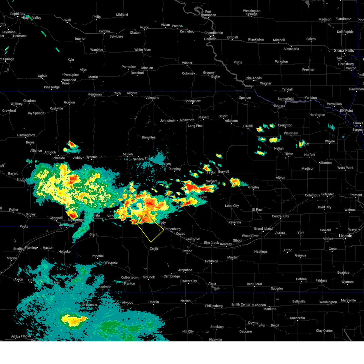
 Svrlbf the national weather service in north platte has issued a * severe thunderstorm warning for, southeastern lincoln county in southwestern nebraska, * until 630 pm cdt. * at 550 pm cdt, severe thunderstorms were located along a line extending from maxwell to 8 miles south of lake maloney state recreation area, moving east at 35 mph (radar indicated). Hazards include ping pong ball size hail and 60 mph wind gusts. People and animals outdoors will be injured. expect hail damage to roofs, siding, windows, and vehicles. Expect wind damage to roofs, siding, and trees. Svrlbf the national weather service in north platte has issued a * severe thunderstorm warning for, southeastern lincoln county in southwestern nebraska, * until 630 pm cdt. * at 550 pm cdt, severe thunderstorms were located along a line extending from maxwell to 8 miles south of lake maloney state recreation area, moving east at 35 mph (radar indicated). Hazards include ping pong ball size hail and 60 mph wind gusts. People and animals outdoors will be injured. expect hail damage to roofs, siding, windows, and vehicles. Expect wind damage to roofs, siding, and trees.
|
| 7/15/2025 8:56 PM CDT |
 The storms which prompted the warning have weakened below severe limits, and no longer pose an immediate threat to life or property. therefore, the warning will be allowed to expire. a severe thunderstorm watch remains in effect until 1100 pm cdt for central and southwestern nebraska. to report severe weather, contact your nearest law enforcement agency. they will relay your report to the national weather service north platte. The storms which prompted the warning have weakened below severe limits, and no longer pose an immediate threat to life or property. therefore, the warning will be allowed to expire. a severe thunderstorm watch remains in effect until 1100 pm cdt for central and southwestern nebraska. to report severe weather, contact your nearest law enforcement agency. they will relay your report to the national weather service north platte.
|
| 7/15/2025 8:37 PM CDT |
 At 837 pm cdt, severe thunderstorms were located along a line extending from 7 miles northwest of callaway to brady, moving east at 30 mph (radar indicated). Hazards include 60 mph wind gusts and quarter size hail. Hail damage to vehicles is expected. expect wind damage to roofs, siding, and trees. locations impacted include, arnold, callaway, brady, maxwell, north platte airport, keith, logan, etna, milldale, lodi, pleasant hill, finchville, and vroman. this includes the following highways, highway 2 near mile marker 277, and between mile markers 283 and 284. highway 92 between mile markers 235 and 265. interstate 80 in nebraska between mile markers 186 and 208. Highway 83 between mile markers 86 and 96. At 837 pm cdt, severe thunderstorms were located along a line extending from 7 miles northwest of callaway to brady, moving east at 30 mph (radar indicated). Hazards include 60 mph wind gusts and quarter size hail. Hail damage to vehicles is expected. expect wind damage to roofs, siding, and trees. locations impacted include, arnold, callaway, brady, maxwell, north platte airport, keith, logan, etna, milldale, lodi, pleasant hill, finchville, and vroman. this includes the following highways, highway 2 near mile marker 277, and between mile markers 283 and 284. highway 92 between mile markers 235 and 265. interstate 80 in nebraska between mile markers 186 and 208. Highway 83 between mile markers 86 and 96.
|
| 7/15/2025 8:07 PM CDT |
 Svrlbf the national weather service in north platte has issued a * severe thunderstorm warning for, northeastern lincoln county in southwestern nebraska, southeastern logan county in west central nebraska, southwestern custer county in central nebraska, * until 900 pm cdt. * at 807 pm cdt, severe thunderstorms were located along a line extending from near arnold to near maxwell, moving southeast at 30 mph (radar indicated). Hazards include 60 mph wind gusts and quarter size hail. Hail damage to vehicles is expected. Expect wind damage to roofs, siding, and trees. Svrlbf the national weather service in north platte has issued a * severe thunderstorm warning for, northeastern lincoln county in southwestern nebraska, southeastern logan county in west central nebraska, southwestern custer county in central nebraska, * until 900 pm cdt. * at 807 pm cdt, severe thunderstorms were located along a line extending from near arnold to near maxwell, moving southeast at 30 mph (radar indicated). Hazards include 60 mph wind gusts and quarter size hail. Hail damage to vehicles is expected. Expect wind damage to roofs, siding, and trees.
|
| 7/15/2025 7:59 PM CDT |
 At 759 pm cdt, severe thunderstorms were located along a line extending from near arnold to 6 miles northeast of north platte airport, moving east at 20 mph (trained weather spotters). Hazards include 60 mph wind gusts and quarter size hail. Hail damage to vehicles is expected. expect wind damage to roofs, siding, and trees. locations impacted include, stapleton, arnold, brady, merna, maxwell, gandy, north platte airport, keith, logan, etna, milldale, tarboz lake, shanklin bluff, pleasant hill, hoagland, finchville, and jeffrey canyon state wildlife management area. this includes the following highways, highway 2 between mile markers 268 and 271. highway 92 between mile markers 225 and 273. highway 97 between mile markers 1 and 8. interstate 80 in nebraska between mile markers 185 and 200. Highway 83 between mile markers 86 and 115. At 759 pm cdt, severe thunderstorms were located along a line extending from near arnold to 6 miles northeast of north platte airport, moving east at 20 mph (trained weather spotters). Hazards include 60 mph wind gusts and quarter size hail. Hail damage to vehicles is expected. expect wind damage to roofs, siding, and trees. locations impacted include, stapleton, arnold, brady, merna, maxwell, gandy, north platte airport, keith, logan, etna, milldale, tarboz lake, shanklin bluff, pleasant hill, hoagland, finchville, and jeffrey canyon state wildlife management area. this includes the following highways, highway 2 between mile markers 268 and 271. highway 92 between mile markers 225 and 273. highway 97 between mile markers 1 and 8. interstate 80 in nebraska between mile markers 185 and 200. Highway 83 between mile markers 86 and 115.
|
| 7/15/2025 7:59 PM CDT |
 the severe thunderstorm warning has been cancelled and is no longer in effect the severe thunderstorm warning has been cancelled and is no longer in effect
|
| 7/15/2025 7:37 PM CDT |
 Svrlbf the national weather service in north platte has issued a * severe thunderstorm warning for, northeastern lincoln county in southwestern nebraska, logan county in west central nebraska, southeastern mcpherson county in west central nebraska, west central custer county in central nebraska, * until 815 pm cdt. * at 736 pm cdt, severe thunderstorms were located along a line extending from 10 miles northwest of arnold to 7 miles north of north platte, moving southeast at 20 mph (trained weather spotters. at 734 pm cdt, a 64 mph gust was reported in stapleton). Hazards include 60 mph wind gusts and nickel size hail. expect damage to roofs, siding, and trees Svrlbf the national weather service in north platte has issued a * severe thunderstorm warning for, northeastern lincoln county in southwestern nebraska, logan county in west central nebraska, southeastern mcpherson county in west central nebraska, west central custer county in central nebraska, * until 815 pm cdt. * at 736 pm cdt, severe thunderstorms were located along a line extending from 10 miles northwest of arnold to 7 miles north of north platte, moving southeast at 20 mph (trained weather spotters. at 734 pm cdt, a 64 mph gust was reported in stapleton). Hazards include 60 mph wind gusts and nickel size hail. expect damage to roofs, siding, and trees
|
| 6/30/2025 1:02 AM CDT |
 At 102 am cdt, severe thunderstorms were located along a line extending from near maxwell to 9 miles southeast of lake maloney state recreation area to 7 miles north of wellfleet, moving southeast at 35 mph (radar indicated). Hazards include 60 mph wind gusts and quarter size hail. Hail damage to vehicles is expected. expect wind damage to roofs, siding, and trees. these severe storms will be near, wellfleet around 110 am cdt. other locations impacted by these severe thunderstorms include hansen memorial reserve state wildlife management area, jeffrey canyon state wildlife management area, cottonwood canyon state wildlife management area, and somerset. this includes the following highways, interstate 80 in nebraska between mile markers 187 and 197. Highway 83 between mile markers 53 and 70. At 102 am cdt, severe thunderstorms were located along a line extending from near maxwell to 9 miles southeast of lake maloney state recreation area to 7 miles north of wellfleet, moving southeast at 35 mph (radar indicated). Hazards include 60 mph wind gusts and quarter size hail. Hail damage to vehicles is expected. expect wind damage to roofs, siding, and trees. these severe storms will be near, wellfleet around 110 am cdt. other locations impacted by these severe thunderstorms include hansen memorial reserve state wildlife management area, jeffrey canyon state wildlife management area, cottonwood canyon state wildlife management area, and somerset. this includes the following highways, interstate 80 in nebraska between mile markers 187 and 197. Highway 83 between mile markers 53 and 70.
|
| 6/30/2025 12:31 AM CDT |
 Svrlbf the national weather service in north platte has issued a * severe thunderstorm warning for, central lincoln county in southwestern nebraska, * until 115 am cdt. * at 1231 am cdt, severe thunderstorms were located along a line extending from 11 miles north of north platte airport to near north platte to 8 miles southeast of sutherland reservoir state recreation area, moving southeast at 45 mph (radar indicated). Hazards include 60 mph wind gusts and quarter size hail. Hail damage to vehicles is expected. expect wind damage to roofs, siding, and trees. severe thunderstorms will be near, north platte and north platte airport around 1235 am cdt. lake maloney state recreation area around 1240 am cdt. maxwell around 1250 am cdt. wellfleet around 100 am cdt. other locations impacted by these severe thunderstorms include hansen memorial reserve state wildlife management area, jeffrey canyon state wildlife management area, cottonwood canyon state wildlife management area, birdwood, keith, and somerset. this includes the following highways, highway 97 between mile markers 1 and 7. interstate 80 in nebraska between mile markers 166 and 197. Highway 83 between mile markers 53 and 94. Svrlbf the national weather service in north platte has issued a * severe thunderstorm warning for, central lincoln county in southwestern nebraska, * until 115 am cdt. * at 1231 am cdt, severe thunderstorms were located along a line extending from 11 miles north of north platte airport to near north platte to 8 miles southeast of sutherland reservoir state recreation area, moving southeast at 45 mph (radar indicated). Hazards include 60 mph wind gusts and quarter size hail. Hail damage to vehicles is expected. expect wind damage to roofs, siding, and trees. severe thunderstorms will be near, north platte and north platte airport around 1235 am cdt. lake maloney state recreation area around 1240 am cdt. maxwell around 1250 am cdt. wellfleet around 100 am cdt. other locations impacted by these severe thunderstorms include hansen memorial reserve state wildlife management area, jeffrey canyon state wildlife management area, cottonwood canyon state wildlife management area, birdwood, keith, and somerset. this includes the following highways, highway 97 between mile markers 1 and 7. interstate 80 in nebraska between mile markers 166 and 197. Highway 83 between mile markers 53 and 94.
|
| 6/16/2025 10:41 PM CDT |
 The storm which prompted the warning has weakened below severe limits, and no longer poses an immediate threat to life or property. therefore, the warning will be allowed to expire. a severe thunderstorm watch remains in effect until midnight cdt for southwestern nebraska. The storm which prompted the warning has weakened below severe limits, and no longer poses an immediate threat to life or property. therefore, the warning will be allowed to expire. a severe thunderstorm watch remains in effect until midnight cdt for southwestern nebraska.
|
| 6/16/2025 10:23 PM CDT |
 At 1023 pm cdt, a severe thunderstorm was located over north platte, moving east at 25 mph (radar indicated). Hazards include 60 mph wind gusts and quarter size hail. Hail damage to vehicles is expected. expect wind damage to roofs, siding, and trees. locations impacted include, north platte, maxwell, lake maloney state recreation area, north platte airport, keith, cottonwood canyon state wildlife management area, and birdwood. this includes the following highways, highway 97 between mile markers 1 and 3. interstate 80 in nebraska between mile markers 171 and 194. Highway 83 between mile markers 74 and 94. At 1023 pm cdt, a severe thunderstorm was located over north platte, moving east at 25 mph (radar indicated). Hazards include 60 mph wind gusts and quarter size hail. Hail damage to vehicles is expected. expect wind damage to roofs, siding, and trees. locations impacted include, north platte, maxwell, lake maloney state recreation area, north platte airport, keith, cottonwood canyon state wildlife management area, and birdwood. this includes the following highways, highway 97 between mile markers 1 and 3. interstate 80 in nebraska between mile markers 171 and 194. Highway 83 between mile markers 74 and 94.
|
| 6/16/2025 10:04 PM CDT |
 Svrlbf the national weather service in north platte has issued a * severe thunderstorm warning for, central lincoln county in southwestern nebraska, * until 1045 pm cdt. * at 1004 pm cdt, a severe thunderstorm was located near hershey, or 8 miles west of north platte, moving east at 25 mph (radar indicated). Hazards include golf ball size hail and 60 mph wind gusts. People and animals outdoors will be injured. expect hail damage to roofs, siding, windows, and vehicles. Expect wind damage to roofs, siding, and trees. Svrlbf the national weather service in north platte has issued a * severe thunderstorm warning for, central lincoln county in southwestern nebraska, * until 1045 pm cdt. * at 1004 pm cdt, a severe thunderstorm was located near hershey, or 8 miles west of north platte, moving east at 25 mph (radar indicated). Hazards include golf ball size hail and 60 mph wind gusts. People and animals outdoors will be injured. expect hail damage to roofs, siding, windows, and vehicles. Expect wind damage to roofs, siding, and trees.
|
| 6/16/2025 8:43 PM CDT | Quarter sized hail reported 1.9 miles NE of Maxwell, NE |
| 6/16/2025 8:09 PM CDT | Quarter sized hail reported 1.9 miles NE of Maxwell, NE, corrects previous hail report from 2 sw maxwell. |
| 6/16/2025 7:43 PM CDT |
 Svrlbf the national weather service in north platte has issued a * severe thunderstorm warning for, east central lincoln county in southwestern nebraska, southwestern custer county in central nebraska, * until 845 pm cdt. * at 743 pm cdt, a severe thunderstorm was located 9 miles northeast of brady, or 27 miles east of north platte, moving east-northeast at 15 mph (radar indicated). Hazards include ping pong ball size hail and 60 mph wind gusts. People and animals outdoors will be injured. expect hail damage to roofs, siding, windows, and vehicles. Expect wind damage to roofs, siding, and trees. Svrlbf the national weather service in north platte has issued a * severe thunderstorm warning for, east central lincoln county in southwestern nebraska, southwestern custer county in central nebraska, * until 845 pm cdt. * at 743 pm cdt, a severe thunderstorm was located 9 miles northeast of brady, or 27 miles east of north platte, moving east-northeast at 15 mph (radar indicated). Hazards include ping pong ball size hail and 60 mph wind gusts. People and animals outdoors will be injured. expect hail damage to roofs, siding, windows, and vehicles. Expect wind damage to roofs, siding, and trees.
|
| 6/2/2025 8:11 PM CDT |
 The storm which prompted the warning has weakened below severe limits, and no longer poses an immediate threat to life or property. therefore, the warning will be allowed to expire. however, gusty winds and heavy rain are still possible with this thunderstorm. a severe thunderstorm watch remains in effect until 100 am cdt for central and southwestern nebraska. The storm which prompted the warning has weakened below severe limits, and no longer poses an immediate threat to life or property. therefore, the warning will be allowed to expire. however, gusty winds and heavy rain are still possible with this thunderstorm. a severe thunderstorm watch remains in effect until 100 am cdt for central and southwestern nebraska.
|
| 6/2/2025 7:56 PM CDT |
 At 756 pm cdt, a severe thunderstorm was located 7 miles north of brady, or 23 miles east of north platte, moving east at 30 mph (radar indicated). Hazards include 60 mph wind gusts and quarter size hail. Hail damage to vehicles is expected. expect wind damage to roofs, siding, and trees. locations impacted include, maxwell and keith. This includes interstate 80 in nebraska between mile markers 187 and 189. At 756 pm cdt, a severe thunderstorm was located 7 miles north of brady, or 23 miles east of north platte, moving east at 30 mph (radar indicated). Hazards include 60 mph wind gusts and quarter size hail. Hail damage to vehicles is expected. expect wind damage to roofs, siding, and trees. locations impacted include, maxwell and keith. This includes interstate 80 in nebraska between mile markers 187 and 189.
|
| 6/2/2025 7:26 PM CDT |
 Svrlbf the national weather service in north platte has issued a * severe thunderstorm warning for, northeastern lincoln county in southwestern nebraska, * until 815 pm cdt. * at 726 pm cdt, a severe thunderstorm was located near lake maloney state recreation area, or near north platte, moving northeast at 20 mph (radar indicated). Hazards include 60 mph wind gusts and half dollar size hail. Hail damage to vehicles is expected. Expect wind damage to roofs, siding, and trees. Svrlbf the national weather service in north platte has issued a * severe thunderstorm warning for, northeastern lincoln county in southwestern nebraska, * until 815 pm cdt. * at 726 pm cdt, a severe thunderstorm was located near lake maloney state recreation area, or near north platte, moving northeast at 20 mph (radar indicated). Hazards include 60 mph wind gusts and half dollar size hail. Hail damage to vehicles is expected. Expect wind damage to roofs, siding, and trees.
|
| 5/21/2025 4:06 PM CDT | Quarter sized hail reported 3 miles WNW of Maxwell, NE |
| 5/21/2025 4:00 PM CDT |
 Svrlbf the national weather service in north platte has issued a * severe thunderstorm warning for, east central lincoln county in southwestern nebraska, * until 430 pm cdt. * at 359 pm cdt, a severe thunderstorm was located over maxwell, or 14 miles east of north platte, moving southeast at 40 mph (radar indicated). Hazards include 60 mph wind gusts and quarter size hail. Hail damage to vehicles is expected. Expect wind damage to roofs, siding, and trees. Svrlbf the national weather service in north platte has issued a * severe thunderstorm warning for, east central lincoln county in southwestern nebraska, * until 430 pm cdt. * at 359 pm cdt, a severe thunderstorm was located over maxwell, or 14 miles east of north platte, moving southeast at 40 mph (radar indicated). Hazards include 60 mph wind gusts and quarter size hail. Hail damage to vehicles is expected. Expect wind damage to roofs, siding, and trees.
|
| 5/18/2025 7:42 PM CDT |
 Svrlbf the national weather service in north platte has issued a * severe thunderstorm warning for, northeastern lincoln county in southwestern nebraska, * until 830 pm cdt. * at 742 pm cdt, a severe thunderstorm was located over brady, or 25 miles east of north platte, moving north at 50 mph (radar indicated). Hazards include 60 mph wind gusts and quarter size hail. Hail damage to vehicles is expected. Expect wind damage to roofs, siding, and trees. Svrlbf the national weather service in north platte has issued a * severe thunderstorm warning for, northeastern lincoln county in southwestern nebraska, * until 830 pm cdt. * at 742 pm cdt, a severe thunderstorm was located over brady, or 25 miles east of north platte, moving north at 50 mph (radar indicated). Hazards include 60 mph wind gusts and quarter size hail. Hail damage to vehicles is expected. Expect wind damage to roofs, siding, and trees.
|
| 5/14/2025 9:56 PM CDT |
 The storms which prompted the warning have weakened below severe limits, and no longer pose an immediate threat to life or property. therefore, the warning will be allowed to expire. however, gusty winds to around 50 mph are still possible. a severe thunderstorm watch remains in effect until 1100 pm cdt for central and southwestern nebraska. The storms which prompted the warning have weakened below severe limits, and no longer pose an immediate threat to life or property. therefore, the warning will be allowed to expire. however, gusty winds to around 50 mph are still possible. a severe thunderstorm watch remains in effect until 1100 pm cdt for central and southwestern nebraska.
|
| 5/14/2025 9:39 PM CDT |
 At 938 pm cdt, the leading edge of damaging winds were located along a line extending from 8 miles southwest of stapleton to 11 miles northeast of brady to 7 miles southwest of elwood, moving east at 60 mph (radar indicated). Hazards include 70 mph wind gusts. Expect considerable tree damage. damage is likely to mobile homes, roofs, and outbuildings. locations impacted include, north platte, curtis, hayes center, sutherland, hershey, brady, eustis, maxwell, wellfleet, moorefield, stockville, dickens, lake maloney state recreation area, medicine creek reservoir state recreation area, sutherland reservoir state recreation area, north platte airport. this includes the following highways, highway 97 between mile markers 1 and 11. interstate 80 in nebraska between mile markers 158 and 207. Highway 83 between mile markers 27 and 99. At 938 pm cdt, the leading edge of damaging winds were located along a line extending from 8 miles southwest of stapleton to 11 miles northeast of brady to 7 miles southwest of elwood, moving east at 60 mph (radar indicated). Hazards include 70 mph wind gusts. Expect considerable tree damage. damage is likely to mobile homes, roofs, and outbuildings. locations impacted include, north platte, curtis, hayes center, sutherland, hershey, brady, eustis, maxwell, wellfleet, moorefield, stockville, dickens, lake maloney state recreation area, medicine creek reservoir state recreation area, sutherland reservoir state recreation area, north platte airport. this includes the following highways, highway 97 between mile markers 1 and 11. interstate 80 in nebraska between mile markers 158 and 207. Highway 83 between mile markers 27 and 99.
|
| 5/14/2025 9:25 PM CDT |
 At 923 pm cdt, damaging winds were located along a line extending from 13 miles north of north platte to maxwell to near medicine creek reservoir state recreation area, moving east at 60 mph (radar indicated). Hazards include 80 mph wind gusts and blowing dust. Flying debris will be dangerous to those caught without shelter. mobile homes will be heavily damaged. expect considerable damage to roofs, windows, and vehicles. extensive tree damage and power outages are likely. locations impacted include, north platte, curtis, hayes center, sutherland, hershey, brady, eustis, maxwell, wellfleet, moorefield, stockville, dickens, lake maloney state recreation area, medicine creek reservoir state recreation area, sutherland reservoir state recreation area, north platte airport, keith, maywood, cottonwood canyon state wildlife management area, and o'fallons. this includes the following highways, highway 97 between mile markers 1 and 11. interstate 80 in nebraska between mile markers 158 and 207. Highway 83 between mile markers 27 and 99. At 923 pm cdt, damaging winds were located along a line extending from 13 miles north of north platte to maxwell to near medicine creek reservoir state recreation area, moving east at 60 mph (radar indicated). Hazards include 80 mph wind gusts and blowing dust. Flying debris will be dangerous to those caught without shelter. mobile homes will be heavily damaged. expect considerable damage to roofs, windows, and vehicles. extensive tree damage and power outages are likely. locations impacted include, north platte, curtis, hayes center, sutherland, hershey, brady, eustis, maxwell, wellfleet, moorefield, stockville, dickens, lake maloney state recreation area, medicine creek reservoir state recreation area, sutherland reservoir state recreation area, north platte airport, keith, maywood, cottonwood canyon state wildlife management area, and o'fallons. this includes the following highways, highway 97 between mile markers 1 and 11. interstate 80 in nebraska between mile markers 158 and 207. Highway 83 between mile markers 27 and 99.
|
| 5/14/2025 9:08 PM CDT |
 Svrlbf the national weather service in north platte has issued a * severe thunderstorm warning for, frontier county in southwestern nebraska, lincoln county in southwestern nebraska, southwestern custer county in central nebraska, eastern hayes county in southwestern nebraska, * until 1000 pm cdt. * at 906 pm cdt, severe thunderstorms were located along a line extending from 9 miles north of hershey to north platte to 14 miles southwest of stockville, moving east at 55 mph (radar indicated). Hazards include 80 mph wind gusts. Flying debris will be dangerous to those caught without shelter. mobile homes will be heavily damaged. expect considerable damage to roofs, windows, and vehicles. Extensive tree damage and power outages are likely. Svrlbf the national weather service in north platte has issued a * severe thunderstorm warning for, frontier county in southwestern nebraska, lincoln county in southwestern nebraska, southwestern custer county in central nebraska, eastern hayes county in southwestern nebraska, * until 1000 pm cdt. * at 906 pm cdt, severe thunderstorms were located along a line extending from 9 miles north of hershey to north platte to 14 miles southwest of stockville, moving east at 55 mph (radar indicated). Hazards include 80 mph wind gusts. Flying debris will be dangerous to those caught without shelter. mobile homes will be heavily damaged. expect considerable damage to roofs, windows, and vehicles. Extensive tree damage and power outages are likely.
|
| 8/13/2024 11:10 PM CDT |
 The storms which prompted the warning have weakened below severe limits, and no longer pose an immediate threat to life or property. therefore, the warning will be allowed to expire. however, gusty winds are still possible with these thunderstorms. a severe thunderstorm watch remains in effect until 200 am cdt for southwestern nebraska. The storms which prompted the warning have weakened below severe limits, and no longer pose an immediate threat to life or property. therefore, the warning will be allowed to expire. however, gusty winds are still possible with these thunderstorms. a severe thunderstorm watch remains in effect until 200 am cdt for southwestern nebraska.
|
| 8/13/2024 11:00 PM CDT |
 At 1100 pm cdt, severe thunderstorms were located along a line extending from near hershey to near north platte to 10 miles southeast of lake maloney state recreation area, moving northeast at 45 mph (radar indicated). Hazards include 60 mph wind gusts and penny size hail. Expect damage to roofs, siding, and trees. locations impacted include, north platte, hershey, brady, maxwell, lake maloney state recreation area, north platte airport, keith, cottonwood canyon state wildlife management area, and birdwood. this includes the following highways, highway 97 between mile markers 1 and 7. interstate 80 in nebraska between mile markers 162 and 201. Highway 83 between mile markers 64 and 94. At 1100 pm cdt, severe thunderstorms were located along a line extending from near hershey to near north platte to 10 miles southeast of lake maloney state recreation area, moving northeast at 45 mph (radar indicated). Hazards include 60 mph wind gusts and penny size hail. Expect damage to roofs, siding, and trees. locations impacted include, north platte, hershey, brady, maxwell, lake maloney state recreation area, north platte airport, keith, cottonwood canyon state wildlife management area, and birdwood. this includes the following highways, highway 97 between mile markers 1 and 7. interstate 80 in nebraska between mile markers 162 and 201. Highway 83 between mile markers 64 and 94.
|
| 8/13/2024 11:00 PM CDT |
 the severe thunderstorm warning has been cancelled and is no longer in effect the severe thunderstorm warning has been cancelled and is no longer in effect
|
| 8/13/2024 10:53 PM CDT |
 the severe thunderstorm warning has been cancelled and is no longer in effect the severe thunderstorm warning has been cancelled and is no longer in effect
|
| 8/13/2024 10:53 PM CDT |
 At 1053 pm cdt/953 pm mdt/, severe thunderstorms were located along a line extending from near sarben to 6 miles west of lake maloney state recreation area to 10 miles north of wellfleet, moving northeast at 45 mph (radar indicated). Hazards include 60 mph wind gusts and penny size hail. Expect damage to roofs, siding, and trees. locations impacted include, north platte, sutherland, hershey, brady, maxwell, sutherland reservoir state recreation area, lake maloney state recreation area, north platte airport, keith, cottonwood canyon state wildlife management area, coker, o'fallons, and birdwood. this includes the following highways, highway 97 between mile markers 1 and 7. interstate 80 in nebraska between mile markers 148 and 201. Highway 83 between mile markers 61 and 94. At 1053 pm cdt/953 pm mdt/, severe thunderstorms were located along a line extending from near sarben to 6 miles west of lake maloney state recreation area to 10 miles north of wellfleet, moving northeast at 45 mph (radar indicated). Hazards include 60 mph wind gusts and penny size hail. Expect damage to roofs, siding, and trees. locations impacted include, north platte, sutherland, hershey, brady, maxwell, sutherland reservoir state recreation area, lake maloney state recreation area, north platte airport, keith, cottonwood canyon state wildlife management area, coker, o'fallons, and birdwood. this includes the following highways, highway 97 between mile markers 1 and 7. interstate 80 in nebraska between mile markers 148 and 201. Highway 83 between mile markers 61 and 94.
|
| 8/13/2024 10:36 PM CDT |
 Svrlbf the national weather service in north platte has issued a * severe thunderstorm warning for, northeastern perkins county in southwestern nebraska, southeastern keith county in southwestern nebraska, central lincoln county in southwestern nebraska, * until 1115 pm cdt/1015 pm mdt/. * at 1036 pm cdt/936 pm mdt/, severe thunderstorms were located along a line extending from 7 miles southwest of paxton to 8 miles northeast of wallace to near dickens, moving northeast at 45 mph (radar indicated). Hazards include 60 mph wind gusts and penny size hail. expect damage to roofs, siding, and trees Svrlbf the national weather service in north platte has issued a * severe thunderstorm warning for, northeastern perkins county in southwestern nebraska, southeastern keith county in southwestern nebraska, central lincoln county in southwestern nebraska, * until 1115 pm cdt/1015 pm mdt/. * at 1036 pm cdt/936 pm mdt/, severe thunderstorms were located along a line extending from 7 miles southwest of paxton to 8 miles northeast of wallace to near dickens, moving northeast at 45 mph (radar indicated). Hazards include 60 mph wind gusts and penny size hail. expect damage to roofs, siding, and trees
|
| 8/7/2024 10:10 PM CDT |
 The storms which prompted the warning has weakened below severe limits and exited the warned area. therefore, the warning will be allowed to expire. i a severe thunderstorm watch remains in effect until 1100 pm cdt for southwestern nebraska. The storms which prompted the warning has weakened below severe limits and exited the warned area. therefore, the warning will be allowed to expire. i a severe thunderstorm watch remains in effect until 1100 pm cdt for southwestern nebraska.
|
| 8/7/2024 9:41 PM CDT |
 At 940 pm cdt, a severe thunderstorm was located near lake maloney state recreation area, or 10 miles southeast of north platte, moving southeast at 20 mph (radar indicated). Hazards include 60 mph wind gusts and quarter size hail. Hail damage to vehicles is expected. expect wind damage to roofs, siding, and trees. locations impacted include, maxwell, lake maloney state recreation area, keith, jeffrey canyon state wildlife management area, and cottonwood canyon state wildlife management area. this includes the following highways, interstate 80 in nebraska between mile markers 183 and 193. Highway 83 between mile markers 70 and 77. At 940 pm cdt, a severe thunderstorm was located near lake maloney state recreation area, or 10 miles southeast of north platte, moving southeast at 20 mph (radar indicated). Hazards include 60 mph wind gusts and quarter size hail. Hail damage to vehicles is expected. expect wind damage to roofs, siding, and trees. locations impacted include, maxwell, lake maloney state recreation area, keith, jeffrey canyon state wildlife management area, and cottonwood canyon state wildlife management area. this includes the following highways, interstate 80 in nebraska between mile markers 183 and 193. Highway 83 between mile markers 70 and 77.
|
| 8/7/2024 9:23 PM CDT |
 Svrlbf the national weather service in north platte has issued a * severe thunderstorm warning for, central lincoln county in southwestern nebraska, * until 1015 pm cdt. * at 923 pm cdt, a severe thunderstorm was located over lake maloney state recreation area, or near north platte, moving southeast at 20 mph (radar indicated). Hazards include 60 mph wind gusts and half dollar size hail. Hail damage to vehicles is expected. Expect wind damage to roofs, siding, and trees. Svrlbf the national weather service in north platte has issued a * severe thunderstorm warning for, central lincoln county in southwestern nebraska, * until 1015 pm cdt. * at 923 pm cdt, a severe thunderstorm was located over lake maloney state recreation area, or near north platte, moving southeast at 20 mph (radar indicated). Hazards include 60 mph wind gusts and half dollar size hail. Hail damage to vehicles is expected. Expect wind damage to roofs, siding, and trees.
|
| 7/16/2024 6:18 PM CDT | Quarter sized hail reported 0.4 miles ESE of Maxwell, NE, quarter size hail covering the ground. |
| 7/16/2024 6:18 PM CDT | Half Dollar sized hail reported 0.7 miles W of Maxwell, NE |
| 7/16/2024 6:13 PM CDT |
 Svrlbf the national weather service in north platte has issued a * severe thunderstorm warning for, southeastern lincoln county in southwestern nebraska, * until 715 pm cdt. * at 613 pm cdt, a severe thunderstorm was located over maxwell, or 12 miles east of north platte, moving south at 25 mph (radar indicated). Hazards include 60 mph wind gusts and quarter size hail. Hail damage to vehicles is expected. Expect wind damage to roofs, siding, and trees. Svrlbf the national weather service in north platte has issued a * severe thunderstorm warning for, southeastern lincoln county in southwestern nebraska, * until 715 pm cdt. * at 613 pm cdt, a severe thunderstorm was located over maxwell, or 12 miles east of north platte, moving south at 25 mph (radar indicated). Hazards include 60 mph wind gusts and quarter size hail. Hail damage to vehicles is expected. Expect wind damage to roofs, siding, and trees.
|
| 7/16/2024 5:42 PM CDT |
 At 541 pm cdt, a severe thunderstorm was located 10 miles south of gandy, or 11 miles south of stapleton, moving south at 20 mph (radar indicated). Hazards include 60 mph wind gusts and quarter size hail. Hail damage to vehicles is expected. expect wind damage to roofs, siding, and trees. locations impacted include, brady, maxwell, keith, cottonwood canyon state wildlife management area, and etna. this includes the following highways, interstate 80 in nebraska between mile markers 184 and 199. Highway 83 between mile markers 94 and 105. At 541 pm cdt, a severe thunderstorm was located 10 miles south of gandy, or 11 miles south of stapleton, moving south at 20 mph (radar indicated). Hazards include 60 mph wind gusts and quarter size hail. Hail damage to vehicles is expected. expect wind damage to roofs, siding, and trees. locations impacted include, brady, maxwell, keith, cottonwood canyon state wildlife management area, and etna. this includes the following highways, interstate 80 in nebraska between mile markers 184 and 199. Highway 83 between mile markers 94 and 105.
|
| 7/16/2024 5:19 PM CDT |
 Svrlbf the national weather service in north platte has issued a * severe thunderstorm warning for, northeastern lincoln county in southwestern nebraska, southwestern custer county in central nebraska, * until 615 pm cdt. * at 518 pm cdt, a severe thunderstorm was located over stapleton, moving south at 30 mph (radar indicated). Hazards include two inch hail and 60 mph wind gusts. People and animals outdoors will be injured. expect hail damage to roofs, siding, windows, and vehicles. Expect wind damage to roofs, siding, and trees. Svrlbf the national weather service in north platte has issued a * severe thunderstorm warning for, northeastern lincoln county in southwestern nebraska, southwestern custer county in central nebraska, * until 615 pm cdt. * at 518 pm cdt, a severe thunderstorm was located over stapleton, moving south at 30 mph (radar indicated). Hazards include two inch hail and 60 mph wind gusts. People and animals outdoors will be injured. expect hail damage to roofs, siding, windows, and vehicles. Expect wind damage to roofs, siding, and trees.
|
| 7/6/2024 11:30 AM CDT |
 Svrlbf the national weather service in north platte has issued a * severe thunderstorm warning for, east central lincoln county in southwestern nebraska, southwestern custer county in central nebraska, * until 1215 pm cdt. * at 1130 am cdt, a severe thunderstorm was located near maxwell, or 17 miles southeast of north platte, moving east at 40 mph (radar indicated). Hazards include 60 mph wind gusts and quarter size hail. Hail damage to vehicles is expected. Expect wind damage to roofs, siding, and trees. Svrlbf the national weather service in north platte has issued a * severe thunderstorm warning for, east central lincoln county in southwestern nebraska, southwestern custer county in central nebraska, * until 1215 pm cdt. * at 1130 am cdt, a severe thunderstorm was located near maxwell, or 17 miles southeast of north platte, moving east at 40 mph (radar indicated). Hazards include 60 mph wind gusts and quarter size hail. Hail damage to vehicles is expected. Expect wind damage to roofs, siding, and trees.
|
| 7/3/2024 6:03 PM CDT |
 the severe thunderstorm warning has been cancelled and is no longer in effect the severe thunderstorm warning has been cancelled and is no longer in effect
|
| 7/3/2024 6:03 PM CDT |
 At 602 pm cdt/502 pm mdt/, severe thunderstorms were located along a line extending from 11 miles north of maxwell to north platte to 7 miles south of sutherland reservoir state recreation area, moving east at 45 mph (radar indicated). Hazards include 60 mph wind gusts and penny size hail. Expect damage to roofs, siding, and trees. these severe storms will be near, north platte, lake maloney state recreation area, and north platte airport around 610 pm cdt. maxwell around 620 pm cdt. other locations impacted by these severe thunderstorms include o'fallons, keith, and birdwood. this includes the following highways, highway 97 between mile markers 1 and 10. interstate 80 in nebraska between mile markers 158 and 190. Highway 83 between mile markers 70 and 97. At 602 pm cdt/502 pm mdt/, severe thunderstorms were located along a line extending from 11 miles north of maxwell to north platte to 7 miles south of sutherland reservoir state recreation area, moving east at 45 mph (radar indicated). Hazards include 60 mph wind gusts and penny size hail. Expect damage to roofs, siding, and trees. these severe storms will be near, north platte, lake maloney state recreation area, and north platte airport around 610 pm cdt. maxwell around 620 pm cdt. other locations impacted by these severe thunderstorms include o'fallons, keith, and birdwood. this includes the following highways, highway 97 between mile markers 1 and 10. interstate 80 in nebraska between mile markers 158 and 190. Highway 83 between mile markers 70 and 97.
|
| 7/3/2024 5:44 PM CDT |
 Svrlbf the national weather service in north platte has issued a * severe thunderstorm warning for, northeastern perkins county in southwestern nebraska, southeastern keith county in southwestern nebraska, central lincoln county in southwestern nebraska, * until 630 pm cdt/530 pm mdt/. * at 544 pm cdt/444 pm mdt/, severe thunderstorms were located along a line extending from 12 miles south of ringgold to near hershey to near paxton, moving southeast at 45 mph (radar indicated). Hazards include 60 mph wind gusts and penny size hail. Expect damage to roofs, siding, and trees. severe thunderstorms will be near, sutherland, hershey, and sutherland reservoir state recreation area around 550 pm cdt. north platte around 555 pm cdt. north platte airport around 600 pm cdt. lake maloney state recreation area around 605 pm cdt. maxwell around 610 pm cdt. other locations impacted by these severe thunderstorms include coker, o'fallons, keith, and birdwood. this includes the following highways, highway 97 between mile markers 1 and 16. interstate 80 in nebraska between mile markers 141 and 190. Highway 83 between mile markers 70 and 97. Svrlbf the national weather service in north platte has issued a * severe thunderstorm warning for, northeastern perkins county in southwestern nebraska, southeastern keith county in southwestern nebraska, central lincoln county in southwestern nebraska, * until 630 pm cdt/530 pm mdt/. * at 544 pm cdt/444 pm mdt/, severe thunderstorms were located along a line extending from 12 miles south of ringgold to near hershey to near paxton, moving southeast at 45 mph (radar indicated). Hazards include 60 mph wind gusts and penny size hail. Expect damage to roofs, siding, and trees. severe thunderstorms will be near, sutherland, hershey, and sutherland reservoir state recreation area around 550 pm cdt. north platte around 555 pm cdt. north platte airport around 600 pm cdt. lake maloney state recreation area around 605 pm cdt. maxwell around 610 pm cdt. other locations impacted by these severe thunderstorms include coker, o'fallons, keith, and birdwood. this includes the following highways, highway 97 between mile markers 1 and 16. interstate 80 in nebraska between mile markers 141 and 190. Highway 83 between mile markers 70 and 97.
|
| 6/29/2024 1:41 AM CDT |
 The storm which prompted the warning has moved out of the area. therefore, the warning will be allowed to expire. The storm which prompted the warning has moved out of the area. therefore, the warning will be allowed to expire.
|
| 6/29/2024 1:21 AM CDT |
 At 121 am cdt, a severe thunderstorm was located 9 miles northeast of brady, or 29 miles east of north platte, moving east at 20 mph (radar indicated). Hazards include two inch hail and 60 mph wind gusts. People and animals outdoors will be injured. expect hail damage to roofs, siding, windows, and vehicles. expect wind damage to roofs, siding, and trees. locations impacted include, callaway, brady, maxwell, etna, and vroman. This includes interstate 80 in nebraska between mile markers 189 and 207. At 121 am cdt, a severe thunderstorm was located 9 miles northeast of brady, or 29 miles east of north platte, moving east at 20 mph (radar indicated). Hazards include two inch hail and 60 mph wind gusts. People and animals outdoors will be injured. expect hail damage to roofs, siding, windows, and vehicles. expect wind damage to roofs, siding, and trees. locations impacted include, callaway, brady, maxwell, etna, and vroman. This includes interstate 80 in nebraska between mile markers 189 and 207.
|
| 6/29/2024 1:06 AM CDT |
 At 105 am cdt, a severe thunderstorm was located near brady, or 23 miles east of north platte, moving east at 20 mph (radar indicated). Hazards include golf ball size hail and 60 mph wind gusts. People and animals outdoors will be injured. expect hail damage to roofs, siding, windows, and vehicles. expect wind damage to roofs, siding, and trees. locations impacted include, callaway, brady, maxwell, etna, and vroman. This includes interstate 80 in nebraska between mile markers 189 and 207. At 105 am cdt, a severe thunderstorm was located near brady, or 23 miles east of north platte, moving east at 20 mph (radar indicated). Hazards include golf ball size hail and 60 mph wind gusts. People and animals outdoors will be injured. expect hail damage to roofs, siding, windows, and vehicles. expect wind damage to roofs, siding, and trees. locations impacted include, callaway, brady, maxwell, etna, and vroman. This includes interstate 80 in nebraska between mile markers 189 and 207.
|
| 6/29/2024 12:54 AM CDT |
 Svrlbf the national weather service in north platte has issued a * severe thunderstorm warning for, east central lincoln county in southwestern nebraska, southwestern custer county in central nebraska, * until 145 am cdt. * at 1254 am cdt, a severe thunderstorm was located 7 miles northeast of maxwell, or 19 miles east of north platte, moving east at 25 mph (radar indicated). Hazards include 60 mph wind gusts and quarter size hail. Hail damage to vehicles is expected. Expect wind damage to roofs, siding, and trees. Svrlbf the national weather service in north platte has issued a * severe thunderstorm warning for, east central lincoln county in southwestern nebraska, southwestern custer county in central nebraska, * until 145 am cdt. * at 1254 am cdt, a severe thunderstorm was located 7 miles northeast of maxwell, or 19 miles east of north platte, moving east at 25 mph (radar indicated). Hazards include 60 mph wind gusts and quarter size hail. Hail damage to vehicles is expected. Expect wind damage to roofs, siding, and trees.
|
| 6/22/2024 3:17 AM CDT |
 At 317 am cdt, a severe thunderstorm was located 8 miles north of maxwell, or 15 miles east of north platte, moving east at 40 mph (radar indicated). Hazards include golf ball size hail and 70 mph wind gusts. People and animals outdoors will be injured. expect hail damage to roofs, siding, windows, and vehicles. expect considerable tree damage. wind damage is also likely to mobile homes, roofs, and outbuildings. locations impacted include, north platte, brady, maxwell, north platte airport, keith, vroman, and jeffrey canyon state wildlife management area. this includes the following highways, interstate 80 in nebraska between mile markers 180 and 207. Highway 83 between mile markers 82 and 105. At 317 am cdt, a severe thunderstorm was located 8 miles north of maxwell, or 15 miles east of north platte, moving east at 40 mph (radar indicated). Hazards include golf ball size hail and 70 mph wind gusts. People and animals outdoors will be injured. expect hail damage to roofs, siding, windows, and vehicles. expect considerable tree damage. wind damage is also likely to mobile homes, roofs, and outbuildings. locations impacted include, north platte, brady, maxwell, north platte airport, keith, vroman, and jeffrey canyon state wildlife management area. this includes the following highways, interstate 80 in nebraska between mile markers 180 and 207. Highway 83 between mile markers 82 and 105.
|
| 6/22/2024 3:04 AM CDT |
 Svrlbf the national weather service in north platte has issued a * severe thunderstorm warning for, northeastern lincoln county in southwestern nebraska, southwestern custer county in central nebraska, * until 345 am cdt. * at 304 am cdt, a severe thunderstorm was located 8 miles north of north platte airport, or 9 miles northeast of north platte, moving east at 40 mph (radar indicated). Hazards include 60 mph wind gusts and nickel size hail. expect damage to roofs, siding, and trees Svrlbf the national weather service in north platte has issued a * severe thunderstorm warning for, northeastern lincoln county in southwestern nebraska, southwestern custer county in central nebraska, * until 345 am cdt. * at 304 am cdt, a severe thunderstorm was located 8 miles north of north platte airport, or 9 miles northeast of north platte, moving east at 40 mph (radar indicated). Hazards include 60 mph wind gusts and nickel size hail. expect damage to roofs, siding, and trees
|
| 6/21/2024 4:55 PM CDT |
 The storms which prompted the warning have moved out of the area. therefore, the warning will be allowed to expire. however, heavy rain is still possible with these thunderstorms. a severe thunderstorm watch remains in effect until 1100 pm cdt for southwestern nebraska. to report severe weather, contact your nearest law enforcement agency. they will relay your report to the national weather service north platte. The storms which prompted the warning have moved out of the area. therefore, the warning will be allowed to expire. however, heavy rain is still possible with these thunderstorms. a severe thunderstorm watch remains in effect until 1100 pm cdt for southwestern nebraska. to report severe weather, contact your nearest law enforcement agency. they will relay your report to the national weather service north platte.
|
| 6/21/2024 4:33 PM CDT |
 At 433 pm cdt, severe thunderstorms were located along a line extending from 8 miles southwest of stapleton to near maxwell, moving northeast at 45 mph (radar indicated). Hazards include 60 mph wind gusts. Expect damage to roofs, siding, and trees. locations impacted include, north platte, maxwell, north platte airport, keith, and birdwood. this includes the following highways, highway 97 between mile markers 1 and 16. interstate 80 in nebraska between mile markers 168 and 188. Highway 83 between mile markers 81 and 105. At 433 pm cdt, severe thunderstorms were located along a line extending from 8 miles southwest of stapleton to near maxwell, moving northeast at 45 mph (radar indicated). Hazards include 60 mph wind gusts. Expect damage to roofs, siding, and trees. locations impacted include, north platte, maxwell, north platte airport, keith, and birdwood. this includes the following highways, highway 97 between mile markers 1 and 16. interstate 80 in nebraska between mile markers 168 and 188. Highway 83 between mile markers 81 and 105.
|
| 6/21/2024 4:04 PM CDT |
 Svrlbf the national weather service in north platte has issued a * severe thunderstorm warning for, northeastern lincoln county in southwestern nebraska, * until 500 pm cdt. * at 404 pm cdt, a severe thunderstorm was located near north platte airport, or 8 miles east of north platte, moving northeast at 25 mph (radar indicated). Hazards include 60 mph wind gusts. expect damage to roofs, siding, and trees Svrlbf the national weather service in north platte has issued a * severe thunderstorm warning for, northeastern lincoln county in southwestern nebraska, * until 500 pm cdt. * at 404 pm cdt, a severe thunderstorm was located near north platte airport, or 8 miles east of north platte, moving northeast at 25 mph (radar indicated). Hazards include 60 mph wind gusts. expect damage to roofs, siding, and trees
|
| 6/2/2024 8:13 PM CDT |
 The storms which prompted the warning are moving east but remain severe so a new warning has been issued. a severe thunderstorm watch remains in effect until 1100 pm cdt for central and southwestern nebraska. The storms which prompted the warning are moving east but remain severe so a new warning has been issued. a severe thunderstorm watch remains in effect until 1100 pm cdt for central and southwestern nebraska.
|
| 6/2/2024 7:45 PM CDT |
 the severe thunderstorm warning has been cancelled and is no longer in effect the severe thunderstorm warning has been cancelled and is no longer in effect
|
| 6/2/2024 7:34 PM CDT |
 Svrlbf the national weather service in north platte has issued a * severe thunderstorm warning for, north central frontier county in southwestern nebraska, southeastern lincoln county in southwestern nebraska, southwestern custer county in central nebraska, * until 815 pm cdt. * at 733 pm cdt, severe thunderstorms were located along a line extending from 7 miles northeast of maxwell to near brady to near moorefield, moving east at 40 mph. these are destructive storms for eastern lincoln and southwestern custer counties (radar indicated). Hazards include 80 mph wind gusts and penny size hail. Flying debris will be dangerous to those caught without shelter. mobile homes will be heavily damaged. expect considerable damage to roofs, windows, and vehicles. Extensive tree damage and power outages are likely. Svrlbf the national weather service in north platte has issued a * severe thunderstorm warning for, north central frontier county in southwestern nebraska, southeastern lincoln county in southwestern nebraska, southwestern custer county in central nebraska, * until 815 pm cdt. * at 733 pm cdt, severe thunderstorms were located along a line extending from 7 miles northeast of maxwell to near brady to near moorefield, moving east at 40 mph. these are destructive storms for eastern lincoln and southwestern custer counties (radar indicated). Hazards include 80 mph wind gusts and penny size hail. Flying debris will be dangerous to those caught without shelter. mobile homes will be heavily damaged. expect considerable damage to roofs, windows, and vehicles. Extensive tree damage and power outages are likely.
|
| 6/2/2024 7:12 PM CDT |
 Svrlbf the national weather service in north platte has issued a * severe thunderstorm warning for, central lincoln county in southwestern nebraska, * until 800 pm cdt. * at 712 pm cdt, severe thunderstorms were located along a line extending from 8 miles south of ringgold to 7 miles west of wellfleet, moving east at 40 mph. these are destructive storms for central lincoln county including north platte! (radar indicated). Hazards include 80 mph wind gusts and penny size hail. Flying debris will be dangerous to those caught without shelter. mobile homes will be heavily damaged. expect considerable damage to roofs, windows, and vehicles. Extensive tree damage and power outages are likely. Svrlbf the national weather service in north platte has issued a * severe thunderstorm warning for, central lincoln county in southwestern nebraska, * until 800 pm cdt. * at 712 pm cdt, severe thunderstorms were located along a line extending from 8 miles south of ringgold to 7 miles west of wellfleet, moving east at 40 mph. these are destructive storms for central lincoln county including north platte! (radar indicated). Hazards include 80 mph wind gusts and penny size hail. Flying debris will be dangerous to those caught without shelter. mobile homes will be heavily damaged. expect considerable damage to roofs, windows, and vehicles. Extensive tree damage and power outages are likely.
|
| 6/2/2024 6:49 PM CDT |
 Svrlbf the national weather service in north platte has issued a * severe thunderstorm warning for, lincoln county in southwestern nebraska, northeastern hayes county in southwestern nebraska, * until 730 pm cdt. * at 648 pm cdt, severe thunderstorms were located along a line extending from 14 miles southwest of tryon to 6 miles south of wallace, moving east at 40 mph (radar indicated). Hazards include 70 mph wind gusts and penny size hail. Expect considerable tree damage. Damage is likely to mobile homes, roofs, and outbuildings. Svrlbf the national weather service in north platte has issued a * severe thunderstorm warning for, lincoln county in southwestern nebraska, northeastern hayes county in southwestern nebraska, * until 730 pm cdt. * at 648 pm cdt, severe thunderstorms were located along a line extending from 14 miles southwest of tryon to 6 miles south of wallace, moving east at 40 mph (radar indicated). Hazards include 70 mph wind gusts and penny size hail. Expect considerable tree damage. Damage is likely to mobile homes, roofs, and outbuildings.
|
| 6/1/2024 7:41 AM CDT |
 The storm which prompted the warning has weakened below severe limits, and no longer poses an immediate threat to life or property. therefore, the warning will be allowed to expire. however, small hail is still possible with this thunderstorm. a severe thunderstorm watch remains in effect until 800 am cdt for southwestern nebraska. The storm which prompted the warning has weakened below severe limits, and no longer poses an immediate threat to life or property. therefore, the warning will be allowed to expire. however, small hail is still possible with this thunderstorm. a severe thunderstorm watch remains in effect until 800 am cdt for southwestern nebraska.
|
| 6/1/2024 7:31 AM CDT |
 At 730 am cdt, a severe thunderstorm was located over north platte airport, or near north platte, moving east at 30 mph (radar indicated). Hazards include 60 mph wind gusts and quarter size hail. Hail damage to vehicles is expected. expect wind damage to roofs, siding, and trees. locations impacted include, north platte, brady, maxwell, lake maloney state recreation area, north platte airport, keith, cottonwood canyon state wildlife management area, and jeffrey canyon state wildlife management area. this includes the following highways, highway 97 between mile markers 1 and 5. interstate 80 in nebraska between mile markers 174 and 199. Highway 83 between mile markers 76 and 98. At 730 am cdt, a severe thunderstorm was located over north platte airport, or near north platte, moving east at 30 mph (radar indicated). Hazards include 60 mph wind gusts and quarter size hail. Hail damage to vehicles is expected. expect wind damage to roofs, siding, and trees. locations impacted include, north platte, brady, maxwell, lake maloney state recreation area, north platte airport, keith, cottonwood canyon state wildlife management area, and jeffrey canyon state wildlife management area. this includes the following highways, highway 97 between mile markers 1 and 5. interstate 80 in nebraska between mile markers 174 and 199. Highway 83 between mile markers 76 and 98.
|
| 6/1/2024 7:21 AM CDT |
 At 721 am cdt, a severe thunderstorm was located near north platte, moving east at 25 mph (radar indicated). Hazards include 60 mph wind gusts and half dollar size hail. Hail damage to vehicles is expected. expect wind damage to roofs, siding, and trees. locations impacted include, north platte, brady, maxwell, lake maloney state recreation area, north platte airport, keith, cottonwood canyon state wildlife management area, jeffrey canyon state wildlife management area, and birdwood. this includes the following highways, highway 97 between mile markers 1 and 12. interstate 80 in nebraska between mile markers 170 and 199. Highway 83 between mile markers 73 and 98. At 721 am cdt, a severe thunderstorm was located near north platte, moving east at 25 mph (radar indicated). Hazards include 60 mph wind gusts and half dollar size hail. Hail damage to vehicles is expected. expect wind damage to roofs, siding, and trees. locations impacted include, north platte, brady, maxwell, lake maloney state recreation area, north platte airport, keith, cottonwood canyon state wildlife management area, jeffrey canyon state wildlife management area, and birdwood. this includes the following highways, highway 97 between mile markers 1 and 12. interstate 80 in nebraska between mile markers 170 and 199. Highway 83 between mile markers 73 and 98.
|
| 6/1/2024 7:01 AM CDT | Svrlbf the national weather service in north platte has issued a * severe thunderstorm warning for, central lincoln county in southwestern nebraska, * until 745 am cdt. * at 700 am cdt, a severe thunderstorm was located near hershey, or 7 miles northwest of north platte, moving southeast at 35 mph (radar indicated). Hazards include ping pong ball size hail and 60 mph wind gusts. People and animals outdoors will be injured. expect hail damage to roofs, siding, windows, and vehicles. Expect wind damage to roofs, siding, and trees. |
| 5/23/2024 9:50 PM CDT |
 At 950 pm cdt, severe thunderstorms were located along a line extending from 13 miles south of gandy to 7 miles northeast of maxwell to near brady, moving east at 35 mph (radar indicated). Hazards include 60 mph wind gusts and quarter size hail. Hail damage to vehicles is expected. expect wind damage to roofs, siding, and trees. locations impacted include, brady, maxwell, keith, and cottonwood canyon state wildlife management area. this includes the following highways, interstate 80 in nebraska between mile markers 186 and 199. Highway 83 between mile markers 103 and 104. At 950 pm cdt, severe thunderstorms were located along a line extending from 13 miles south of gandy to 7 miles northeast of maxwell to near brady, moving east at 35 mph (radar indicated). Hazards include 60 mph wind gusts and quarter size hail. Hail damage to vehicles is expected. expect wind damage to roofs, siding, and trees. locations impacted include, brady, maxwell, keith, and cottonwood canyon state wildlife management area. this includes the following highways, interstate 80 in nebraska between mile markers 186 and 199. Highway 83 between mile markers 103 and 104.
|
| 5/23/2024 9:27 PM CDT |
 At 926 pm cdt, severe thunderstorms were located along a line extending from 10 miles northeast of north platte airport to near maxwell to 7 miles southeast of lake maloney state recreation area, moving east at 25 mph (radar indicated). Hazards include 60 mph wind gusts and quarter size hail. Hail damage to vehicles is expected. expect wind damage to roofs, siding, and trees. locations impacted include, north platte, brady, maxwell, lake maloney state recreation area, north platte airport, keith, cottonwood canyon state wildlife management area, and jeffrey canyon state wildlife management area. this includes the following highways, interstate 80 in nebraska between mile markers 179 and 199. Highway 83 between mile markers 70 and 78, and between mile markers 100 and 104. At 926 pm cdt, severe thunderstorms were located along a line extending from 10 miles northeast of north platte airport to near maxwell to 7 miles southeast of lake maloney state recreation area, moving east at 25 mph (radar indicated). Hazards include 60 mph wind gusts and quarter size hail. Hail damage to vehicles is expected. expect wind damage to roofs, siding, and trees. locations impacted include, north platte, brady, maxwell, lake maloney state recreation area, north platte airport, keith, cottonwood canyon state wildlife management area, and jeffrey canyon state wildlife management area. this includes the following highways, interstate 80 in nebraska between mile markers 179 and 199. Highway 83 between mile markers 70 and 78, and between mile markers 100 and 104.
|
| 5/23/2024 9:10 PM CDT |
 Svrlbf the national weather service in north platte has issued a * severe thunderstorm warning for, eastern lincoln county in southwestern nebraska, * until 1015 pm cdt. * at 909 pm cdt, severe thunderstorms were located along a line extending from 9 miles southwest of stapleton to near north platte airport to 7 miles south of lake maloney state recreation area, moving east at 25 mph (radar indicated). Hazards include 60 mph wind gusts and quarter size hail. Hail damage to vehicles is expected. Expect wind damage to roofs, siding, and trees. Svrlbf the national weather service in north platte has issued a * severe thunderstorm warning for, eastern lincoln county in southwestern nebraska, * until 1015 pm cdt. * at 909 pm cdt, severe thunderstorms were located along a line extending from 9 miles southwest of stapleton to near north platte airport to 7 miles south of lake maloney state recreation area, moving east at 25 mph (radar indicated). Hazards include 60 mph wind gusts and quarter size hail. Hail damage to vehicles is expected. Expect wind damage to roofs, siding, and trees.
|
| 5/14/2024 9:56 PM CDT |
 The storm which prompted the warning has weakened below severe limits, and no longer poses an immediate threat to life or property. therefore, the warning will be allowed to expire. The storm which prompted the warning has weakened below severe limits, and no longer poses an immediate threat to life or property. therefore, the warning will be allowed to expire.
|
| 5/14/2024 9:40 PM CDT |
 At 939 pm cdt, a severe thunderstorm was located near maxwell, or 16 miles east of north platte, moving east at 40 mph (radar indicated). Hazards include 60 mph wind gusts and quarter size hail. Hail damage to vehicles is expected. expect wind damage to roofs, siding, and trees. locations impacted include, north platte, brady, maxwell, north platte airport, keith, and cottonwood canyon state wildlife management area. This includes interstate 80 in nebraska between mile markers 179 and 205. At 939 pm cdt, a severe thunderstorm was located near maxwell, or 16 miles east of north platte, moving east at 40 mph (radar indicated). Hazards include 60 mph wind gusts and quarter size hail. Hail damage to vehicles is expected. expect wind damage to roofs, siding, and trees. locations impacted include, north platte, brady, maxwell, north platte airport, keith, and cottonwood canyon state wildlife management area. This includes interstate 80 in nebraska between mile markers 179 and 205.
|
| 5/14/2024 9:31 PM CDT |
 At 930 pm cdt, a severe thunderstorm was located near maxwell, or 10 miles east of north platte, moving east at 45 mph (radar indicated). Hazards include 60 mph wind gusts and quarter size hail. Hail damage to vehicles is expected. expect wind damage to roofs, siding, and trees. locations impacted include, north platte, brady, maxwell, lake maloney state recreation area, north platte airport, keith, cottonwood canyon state wildlife management area, and jeffrey canyon state wildlife management area. this includes the following highways, interstate 80 in nebraska between mile markers 177 and 205. Highway 83 between mile markers 69 and 81. At 930 pm cdt, a severe thunderstorm was located near maxwell, or 10 miles east of north platte, moving east at 45 mph (radar indicated). Hazards include 60 mph wind gusts and quarter size hail. Hail damage to vehicles is expected. expect wind damage to roofs, siding, and trees. locations impacted include, north platte, brady, maxwell, lake maloney state recreation area, north platte airport, keith, cottonwood canyon state wildlife management area, and jeffrey canyon state wildlife management area. this includes the following highways, interstate 80 in nebraska between mile markers 177 and 205. Highway 83 between mile markers 69 and 81.
|
| 5/14/2024 9:16 PM CDT |
 Svrlbf the national weather service in north platte has issued a * severe thunderstorm warning for, northeastern lincoln county in southwestern nebraska, * until 1000 pm cdt. * at 916 pm cdt, a severe thunderstorm was located near north platte airport, or 8 miles east of north platte, moving east at 30 mph (radar indicated). Hazards include 60 mph wind gusts and quarter size hail. Hail damage to vehicles is expected. Expect wind damage to roofs, siding, and trees. Svrlbf the national weather service in north platte has issued a * severe thunderstorm warning for, northeastern lincoln county in southwestern nebraska, * until 1000 pm cdt. * at 916 pm cdt, a severe thunderstorm was located near north platte airport, or 8 miles east of north platte, moving east at 30 mph (radar indicated). Hazards include 60 mph wind gusts and quarter size hail. Hail damage to vehicles is expected. Expect wind damage to roofs, siding, and trees.
|
| 5/3/2024 7:13 PM CDT |
 At 713 pm cdt, severe thunderstorms were located along a line extending from 6 miles south of brady to moorefield to 10 miles northeast of culbertson, moving east at 45 mph (radar indicated). Hazards include 60 mph wind gusts and quarter size hail. Hail damage to vehicles is expected. expect wind damage to roofs, siding, and trees. locations impacted include, north platte, curtis, hayes center, brady, maxwell, wellfleet, moorefield, stockville, lake maloney state recreation area, north platte airport, keith, maywood, quick, cottonwood canyon state wildlife management area, hansen memorial reserve state wildlife management area, jeffrey canyon state wildlife management area, willow view campground, hayes center state wildlife management area, bluegill haven campground, and vroman. this includes the following highways, interstate 80 in nebraska between mile markers 178 and 208. Highway 83 between mile markers 27 and 81, and near mile marker 87. At 713 pm cdt, severe thunderstorms were located along a line extending from 6 miles south of brady to moorefield to 10 miles northeast of culbertson, moving east at 45 mph (radar indicated). Hazards include 60 mph wind gusts and quarter size hail. Hail damage to vehicles is expected. expect wind damage to roofs, siding, and trees. locations impacted include, north platte, curtis, hayes center, brady, maxwell, wellfleet, moorefield, stockville, lake maloney state recreation area, north platte airport, keith, maywood, quick, cottonwood canyon state wildlife management area, hansen memorial reserve state wildlife management area, jeffrey canyon state wildlife management area, willow view campground, hayes center state wildlife management area, bluegill haven campground, and vroman. this includes the following highways, interstate 80 in nebraska between mile markers 178 and 208. Highway 83 between mile markers 27 and 81, and near mile marker 87.
|
| 5/3/2024 6:49 PM CDT |
 Svrlbf the national weather service in north platte has issued a * severe thunderstorm warning for, frontier county in southwestern nebraska, southeastern lincoln county in southwestern nebraska, eastern hayes county in southwestern nebraska, * until 730 pm cdt. * at 649 pm cdt, severe thunderstorms were located along a line extending from near lake maloney state recreation area to near wellfleet to near palisade, moving east at 45 mph (radar indicated). Hazards include 60 mph wind gusts and quarter size hail. Hail damage to vehicles is expected. Expect wind damage to roofs, siding, and trees. Svrlbf the national weather service in north platte has issued a * severe thunderstorm warning for, frontier county in southwestern nebraska, southeastern lincoln county in southwestern nebraska, eastern hayes county in southwestern nebraska, * until 730 pm cdt. * at 649 pm cdt, severe thunderstorms were located along a line extending from near lake maloney state recreation area to near wellfleet to near palisade, moving east at 45 mph (radar indicated). Hazards include 60 mph wind gusts and quarter size hail. Hail damage to vehicles is expected. Expect wind damage to roofs, siding, and trees.
|
| 4/6/2024 2:46 PM CDT |
 Svrlbf the national weather service in north platte has issued a * severe thunderstorm warning for, northeastern lincoln county in southwestern nebraska, southwestern logan county in west central nebraska, southeastern mcpherson county in west central nebraska, * until 330 pm cdt. * at 246 pm cdt, a severe thunderstorm was located 7 miles southwest of brady, or 18 miles southeast of north platte, moving north at 55 mph (radar indicated). Hazards include 70 mph wind gusts. Expect considerable tree damage. Damage is likely to mobile homes, roofs, and outbuildings. Svrlbf the national weather service in north platte has issued a * severe thunderstorm warning for, northeastern lincoln county in southwestern nebraska, southwestern logan county in west central nebraska, southeastern mcpherson county in west central nebraska, * until 330 pm cdt. * at 246 pm cdt, a severe thunderstorm was located 7 miles southwest of brady, or 18 miles southeast of north platte, moving north at 55 mph (radar indicated). Hazards include 70 mph wind gusts. Expect considerable tree damage. Damage is likely to mobile homes, roofs, and outbuildings.
|
| 9/21/2023 4:13 PM CDT |
 At 412 pm cdt, a severe thunderstorm was located 13 miles southwest of brady, or 16 miles north of curtis, moving north at 15 mph (radar indicated). Hazards include golf ball size hail and 60 mph wind gusts. People and animals outdoors will be injured. expect hail damage to roofs, siding, windows, and vehicles. Expect wind damage to roofs, siding, and trees. At 412 pm cdt, a severe thunderstorm was located 13 miles southwest of brady, or 16 miles north of curtis, moving north at 15 mph (radar indicated). Hazards include golf ball size hail and 60 mph wind gusts. People and animals outdoors will be injured. expect hail damage to roofs, siding, windows, and vehicles. Expect wind damage to roofs, siding, and trees.
|
| 9/9/2023 5:40 PM CDT |
 At 540 pm cdt, severe thunderstorms were located along a line extending from near brady to near maxwell to near lake maloney state recreation area, moving southeast at 15 mph (radar indicated). Hazards include ping pong ball size hail and 60 mph wind gusts. People and animals outdoors will be injured. expect hail damage to roofs, siding, windows, and vehicles. expect wind damage to roofs, siding, and trees. locations impacted include, brady, maxwell, lake maloney state recreation area, jeffrey canyon state wildlife management area, and cottonwood canyon state wildlife management area. this includes the following highways, interstate 80 in nebraska between mile markers 187 and 206. highway 83 between mile markers 69 and 76. hail threat, radar indicated max hail size, 1. 50 in wind threat, radar indicated max wind gust, 60 mph. At 540 pm cdt, severe thunderstorms were located along a line extending from near brady to near maxwell to near lake maloney state recreation area, moving southeast at 15 mph (radar indicated). Hazards include ping pong ball size hail and 60 mph wind gusts. People and animals outdoors will be injured. expect hail damage to roofs, siding, windows, and vehicles. expect wind damage to roofs, siding, and trees. locations impacted include, brady, maxwell, lake maloney state recreation area, jeffrey canyon state wildlife management area, and cottonwood canyon state wildlife management area. this includes the following highways, interstate 80 in nebraska between mile markers 187 and 206. highway 83 between mile markers 69 and 76. hail threat, radar indicated max hail size, 1. 50 in wind threat, radar indicated max wind gust, 60 mph.
|
| 9/9/2023 5:23 PM CDT |
 At 523 pm cdt, severe thunderstorms were located along a line extending from 6 miles northwest of brady to near maxwell to lake maloney state recreation area, moving southeast at 15 mph (radar indicated). Hazards include 60 mph wind gusts and half dollar size hail. Hail damage to vehicles is expected. Expect wind damage to roofs, siding, and trees. At 523 pm cdt, severe thunderstorms were located along a line extending from 6 miles northwest of brady to near maxwell to lake maloney state recreation area, moving southeast at 15 mph (radar indicated). Hazards include 60 mph wind gusts and half dollar size hail. Hail damage to vehicles is expected. Expect wind damage to roofs, siding, and trees.
|
| 9/4/2023 9:40 PM CDT |
 The severe thunderstorm warning for eastern lincoln, southeastern logan and southwestern custer counties will expire at 945 pm cdt, the storms which prompted the warning have weakened below severe limits, and have exited the warned area. therefore, the warning will be allowed to expire. however, gusty winds are still possible with these thunderstorms. to report severe weather, contact your nearest law enforcement agency. they will relay your report to the national weather service north platte. The severe thunderstorm warning for eastern lincoln, southeastern logan and southwestern custer counties will expire at 945 pm cdt, the storms which prompted the warning have weakened below severe limits, and have exited the warned area. therefore, the warning will be allowed to expire. however, gusty winds are still possible with these thunderstorms. to report severe weather, contact your nearest law enforcement agency. they will relay your report to the national weather service north platte.
|
| 9/4/2023 9:27 PM CDT |
 At 927 pm cdt, severe thunderstorms were located along a line extending from 7 miles southwest of arnold to brady to 10 miles northeast of wellfleet, moving east-southeast at 30 mph (radar indicated). Hazards include 60 mph wind gusts. Expect damage to roofs, siding, and trees. these severe storms will be near, brady around 930 pm cdt. other locations impacted by these severe thunderstorms include cottonwood canyon state wildlife management area, keith, etna, milldale, jeffrey canyon state wildlife management area, finchville and vroman. this includes the following highways, highway 92 between mile markers 233 and 237. interstate 80 in nebraska between mile markers 184 and 207. highway 83 between mile markers 104 and 109. hail threat, radar indicated max hail size, <. 75 in wind threat, radar indicated max wind gust, 60 mph. At 927 pm cdt, severe thunderstorms were located along a line extending from 7 miles southwest of arnold to brady to 10 miles northeast of wellfleet, moving east-southeast at 30 mph (radar indicated). Hazards include 60 mph wind gusts. Expect damage to roofs, siding, and trees. these severe storms will be near, brady around 930 pm cdt. other locations impacted by these severe thunderstorms include cottonwood canyon state wildlife management area, keith, etna, milldale, jeffrey canyon state wildlife management area, finchville and vroman. this includes the following highways, highway 92 between mile markers 233 and 237. interstate 80 in nebraska between mile markers 184 and 207. highway 83 between mile markers 104 and 109. hail threat, radar indicated max hail size, <. 75 in wind threat, radar indicated max wind gust, 60 mph.
|
| 9/4/2023 9:06 PM CDT |
 At 906 pm cdt, severe thunderstorms were located along a line extending from near stapleton to near north platte airport to 8 miles north of wellfleet, moving east at 35 mph (radar indicated). Hazards include 70 mph wind gusts. Expect considerable tree damage. damage is likely to mobile homes, roofs, and outbuildings. severe thunderstorms will be near, maxwell around 910 pm cdt. brady around 925 pm cdt. other locations impacted by these severe thunderstorms include cottonwood canyon state wildlife management area, keith, etna, milldale, jeffrey canyon state wildlife management area, finchville and vroman. this includes the following highways, highway 92 between mile markers 233 and 237. interstate 80 in nebraska between mile markers 184 and 207. highway 83 between mile markers 104 and 109. thunderstorm damage threat, considerable hail threat, radar indicated max hail size, <. 75 in wind threat, radar indicated max wind gust, 70 mph. At 906 pm cdt, severe thunderstorms were located along a line extending from near stapleton to near north platte airport to 8 miles north of wellfleet, moving east at 35 mph (radar indicated). Hazards include 70 mph wind gusts. Expect considerable tree damage. damage is likely to mobile homes, roofs, and outbuildings. severe thunderstorms will be near, maxwell around 910 pm cdt. brady around 925 pm cdt. other locations impacted by these severe thunderstorms include cottonwood canyon state wildlife management area, keith, etna, milldale, jeffrey canyon state wildlife management area, finchville and vroman. this includes the following highways, highway 92 between mile markers 233 and 237. interstate 80 in nebraska between mile markers 184 and 207. highway 83 between mile markers 104 and 109. thunderstorm damage threat, considerable hail threat, radar indicated max hail size, <. 75 in wind threat, radar indicated max wind gust, 70 mph.
|
| 8/10/2023 9:43 PM CDT |
 The severe thunderstorm warning for central lincoln county will expire at 945 pm cdt, the storms which prompted the warning have weakened below severe limits, and no longer pose an immediate threat to life or property. therefore, the warning will be allowed to expire. to report severe weather, contact your nearest law enforcement agency. they will relay your report to the national weather service north platte. The severe thunderstorm warning for central lincoln county will expire at 945 pm cdt, the storms which prompted the warning have weakened below severe limits, and no longer pose an immediate threat to life or property. therefore, the warning will be allowed to expire. to report severe weather, contact your nearest law enforcement agency. they will relay your report to the national weather service north platte.
|
| 8/10/2023 9:25 PM CDT |
 At 924 pm cdt, severe thunderstorms were located along a line extending from near hershey to 9 miles west of lake maloney state recreation area to 10 miles north of dickens, moving southeast at 50 mph (radar indicated). Hazards include 70 mph wind gusts. Expect considerable tree damage. damage is likely to mobile homes, roofs, and outbuildings. locations impacted include, north platte, sutherland, hershey, maxwell, sutherland reservoir state recreation area, lake maloney state recreation area, north platte airport, keith, coker, o`fallons and birdwood. this includes the following highways, highway 97 between mile markers 1 and 9. interstate 80 in nebraska between mile markers 153 and 189. highway 83 between mile markers 63 and 93. thunderstorm damage threat, considerable hail threat, radar indicated max hail size, <. 75 in wind threat, radar indicated max wind gust, 70 mph. At 924 pm cdt, severe thunderstorms were located along a line extending from near hershey to 9 miles west of lake maloney state recreation area to 10 miles north of dickens, moving southeast at 50 mph (radar indicated). Hazards include 70 mph wind gusts. Expect considerable tree damage. damage is likely to mobile homes, roofs, and outbuildings. locations impacted include, north platte, sutherland, hershey, maxwell, sutherland reservoir state recreation area, lake maloney state recreation area, north platte airport, keith, coker, o`fallons and birdwood. this includes the following highways, highway 97 between mile markers 1 and 9. interstate 80 in nebraska between mile markers 153 and 189. highway 83 between mile markers 63 and 93. thunderstorm damage threat, considerable hail threat, radar indicated max hail size, <. 75 in wind threat, radar indicated max wind gust, 70 mph.
|
| 8/10/2023 9:16 PM CDT |
 At 915 pm cdt/815 pm mdt/, a severe thunderstorm was located over sutherland, or 17 miles west of north platte, moving southeast at 55 mph. at 910 pm cdt, a 67 mph wind gust occurred at sutherland (radar indicated). Hazards include 70 mph wind gusts. Expect considerable tree damage. damage is likely to mobile homes, roofs, and outbuildings. locations impacted include, north platte, sutherland, hershey, maxwell, sutherland reservoir state recreation area, lake maloney state recreation area, north platte airport, sarben, keith, coker, o`fallons and birdwood. this includes the following highways, highway 97 between mile markers 1 and 10. interstate 80 in nebraska between mile markers 147 and 189. highway 83 between mile markers 63 and 93. thunderstorm damage threat, considerable hail threat, radar indicated max hail size, <. 75 in wind threat, radar indicated max wind gust, 70 mph. At 915 pm cdt/815 pm mdt/, a severe thunderstorm was located over sutherland, or 17 miles west of north platte, moving southeast at 55 mph. at 910 pm cdt, a 67 mph wind gust occurred at sutherland (radar indicated). Hazards include 70 mph wind gusts. Expect considerable tree damage. damage is likely to mobile homes, roofs, and outbuildings. locations impacted include, north platte, sutherland, hershey, maxwell, sutherland reservoir state recreation area, lake maloney state recreation area, north platte airport, sarben, keith, coker, o`fallons and birdwood. this includes the following highways, highway 97 between mile markers 1 and 10. interstate 80 in nebraska between mile markers 147 and 189. highway 83 between mile markers 63 and 93. thunderstorm damage threat, considerable hail threat, radar indicated max hail size, <. 75 in wind threat, radar indicated max wind gust, 70 mph.
|
| 8/10/2023 9:03 PM CDT |
 At 902 pm cdt/802 pm mdt/, a severe thunderstorm was located near sarben, or 23 miles east of ogallala, moving east-southeast at 50 mph (radar indicated). Hazards include 60 mph wind gusts and penny size hail. expect damage to roofs, siding, and trees At 902 pm cdt/802 pm mdt/, a severe thunderstorm was located near sarben, or 23 miles east of ogallala, moving east-southeast at 50 mph (radar indicated). Hazards include 60 mph wind gusts and penny size hail. expect damage to roofs, siding, and trees
|
| 8/7/2023 9:25 PM CDT |
 The severe thunderstorm warning for east central lincoln county will expire at 930 pm cdt, the storm which prompted the warning has weakened below severe limits, and has exited the warned area. therefore, the warning will be allowed to expire. a severe thunderstorm watch remains in effect until 1000 pm cdt for southwestern nebraska. The severe thunderstorm warning for east central lincoln county will expire at 930 pm cdt, the storm which prompted the warning has weakened below severe limits, and has exited the warned area. therefore, the warning will be allowed to expire. a severe thunderstorm watch remains in effect until 1000 pm cdt for southwestern nebraska.
|
| 8/7/2023 9:18 PM CDT |
 At 918 pm cdt, a severe thunderstorm was located near maxwell, or 11 miles southeast of north platte, moving southeast at 30 mph (radar indicated). Hazards include 60 mph wind gusts and quarter size hail. Hail damage to vehicles is expected. expect wind damage to roofs, siding, and trees. locations impacted include, brady, maxwell, lake maloney state recreation area, north platte airport, keith, cottonwood canyon state wildlife management area and jeffrey canyon state wildlife management area. this includes the following highways, interstate 80 in nebraska between mile markers 180 and 201. highway 83 between mile markers 70 and 78. hail threat, radar indicated max hail size, 1. 00 in wind threat, radar indicated max wind gust, 60 mph. At 918 pm cdt, a severe thunderstorm was located near maxwell, or 11 miles southeast of north platte, moving southeast at 30 mph (radar indicated). Hazards include 60 mph wind gusts and quarter size hail. Hail damage to vehicles is expected. expect wind damage to roofs, siding, and trees. locations impacted include, brady, maxwell, lake maloney state recreation area, north platte airport, keith, cottonwood canyon state wildlife management area and jeffrey canyon state wildlife management area. this includes the following highways, interstate 80 in nebraska between mile markers 180 and 201. highway 83 between mile markers 70 and 78. hail threat, radar indicated max hail size, 1. 00 in wind threat, radar indicated max wind gust, 60 mph.
|
| 8/7/2023 8:59 PM CDT |
 At 859 pm cdt, a severe thunderstorm was located over north platte airport, or near north platte, moving southeast at 20 mph (radar indicated). Hazards include 60 mph wind gusts and quarter size hail. Hail damage to vehicles is expected. expect wind damage to roofs, siding, and trees. locations impacted include, north platte, brady, maxwell, lake maloney state recreation area, north platte airport, keith, cottonwood canyon state wildlife management area and jeffrey canyon state wildlife management area. this includes the following highways, highway 97 between mile markers 1 and 4. interstate 80 in nebraska between mile markers 175 and 201. highway 83 between mile markers 70 and 93. hail threat, radar indicated max hail size, 1. 00 in wind threat, radar indicated max wind gust, 60 mph. At 859 pm cdt, a severe thunderstorm was located over north platte airport, or near north platte, moving southeast at 20 mph (radar indicated). Hazards include 60 mph wind gusts and quarter size hail. Hail damage to vehicles is expected. expect wind damage to roofs, siding, and trees. locations impacted include, north platte, brady, maxwell, lake maloney state recreation area, north platte airport, keith, cottonwood canyon state wildlife management area and jeffrey canyon state wildlife management area. this includes the following highways, highway 97 between mile markers 1 and 4. interstate 80 in nebraska between mile markers 175 and 201. highway 83 between mile markers 70 and 93. hail threat, radar indicated max hail size, 1. 00 in wind threat, radar indicated max wind gust, 60 mph.
|
| 8/7/2023 8:40 PM CDT |
 At 839 pm cdt, a severe thunderstorm was located near north platte, moving southeast at 30 mph (radar indicated). Hazards include 60 mph wind gusts and half dollar size hail. Hail damage to vehicles is expected. Expect wind damage to roofs, siding, and trees. At 839 pm cdt, a severe thunderstorm was located near north platte, moving southeast at 30 mph (radar indicated). Hazards include 60 mph wind gusts and half dollar size hail. Hail damage to vehicles is expected. Expect wind damage to roofs, siding, and trees.
|
| 8/4/2023 8:31 PM CDT |
 At 830 pm cdt, severe thunderstorms were located along a line extending from near maxwell to near curtis to 9 miles northeast of hayes center, moving east at 30 mph. at 826 pm cdt a 74 mph wind gust was reported by the public 10 miles south southeast of north platte (public). Hazards include 70 mph wind gusts and penny size hail. Expect considerable tree damage. damage is likely to mobile homes, roofs, and outbuildings. locations impacted include, curtis, brady, eustis, maxwell, moorefield, stockville, medicine creek reservoir state recreation area, keith, maywood, quick, cottonwood canyon state wildlife management area, hansen memorial reserve state wildlife management area, jeffrey canyon state wildlife management area, freedom, orafino, bluegill haven campground, vroman and dancing leaf earth lodge. this includes the following highways, interstate 80 in nebraska between mile markers 184 and 207. highway 83 between mile markers 29 and 51. thunderstorm damage threat, considerable hail threat, radar indicated max hail size, 0. 75 in wind threat, radar indicated max wind gust, 70 mph. At 830 pm cdt, severe thunderstorms were located along a line extending from near maxwell to near curtis to 9 miles northeast of hayes center, moving east at 30 mph. at 826 pm cdt a 74 mph wind gust was reported by the public 10 miles south southeast of north platte (public). Hazards include 70 mph wind gusts and penny size hail. Expect considerable tree damage. damage is likely to mobile homes, roofs, and outbuildings. locations impacted include, curtis, brady, eustis, maxwell, moorefield, stockville, medicine creek reservoir state recreation area, keith, maywood, quick, cottonwood canyon state wildlife management area, hansen memorial reserve state wildlife management area, jeffrey canyon state wildlife management area, freedom, orafino, bluegill haven campground, vroman and dancing leaf earth lodge. this includes the following highways, interstate 80 in nebraska between mile markers 184 and 207. highway 83 between mile markers 29 and 51. thunderstorm damage threat, considerable hail threat, radar indicated max hail size, 0. 75 in wind threat, radar indicated max wind gust, 70 mph.
|
| 8/4/2023 8:24 PM CDT |
 At 824 pm cdt, severe thunderstorms were located along a line extending from 6 miles east of lake maloney state recreation area to 7 miles northwest of curtis to 7 miles northeast of hayes center, moving east at 35 mph (radar indicated). Hazards include 60 mph wind gusts and penny size hail. expect damage to roofs, siding, and trees At 824 pm cdt, severe thunderstorms were located along a line extending from 6 miles east of lake maloney state recreation area to 7 miles northwest of curtis to 7 miles northeast of hayes center, moving east at 35 mph (radar indicated). Hazards include 60 mph wind gusts and penny size hail. expect damage to roofs, siding, and trees
|
| 7/26/2023 4:27 PM CDT |
 At 427 pm cdt, a severe thunderstorm was located near brady, or 18 miles southeast of north platte, moving northeast at 20 mph (radar indicated). Hazards include golf ball size hail and 70 mph wind gusts. People and animals outdoors will be injured. expect hail damage to roofs, siding, windows, and vehicles. expect considerable tree damage. wind damage is also likely to mobile homes, roofs, and outbuildings. locations impacted include, brady, maxwell, jeffrey canyon state wildlife management area and cottonwood canyon state wildlife management area. this includes interstate 80 in nebraska between mile markers 189 and 204. thunderstorm damage threat, considerable hail threat, radar indicated max hail size, 1. 75 in wind threat, radar indicated max wind gust, 70 mph. At 427 pm cdt, a severe thunderstorm was located near brady, or 18 miles southeast of north platte, moving northeast at 20 mph (radar indicated). Hazards include golf ball size hail and 70 mph wind gusts. People and animals outdoors will be injured. expect hail damage to roofs, siding, windows, and vehicles. expect considerable tree damage. wind damage is also likely to mobile homes, roofs, and outbuildings. locations impacted include, brady, maxwell, jeffrey canyon state wildlife management area and cottonwood canyon state wildlife management area. this includes interstate 80 in nebraska between mile markers 189 and 204. thunderstorm damage threat, considerable hail threat, radar indicated max hail size, 1. 75 in wind threat, radar indicated max wind gust, 70 mph.
|
| 7/26/2023 4:12 PM CDT |
 At 412 pm cdt, a severe thunderstorm was located 9 miles south of maxwell, or 15 miles southeast of north platte, moving northeast at 10 mph (radar indicated). Hazards include golf ball size hail and 60 mph wind gusts. People and animals outdoors will be injured. expect hail damage to roofs, siding, windows, and vehicles. Expect wind damage to roofs, siding, and trees. At 412 pm cdt, a severe thunderstorm was located 9 miles south of maxwell, or 15 miles southeast of north platte, moving northeast at 10 mph (radar indicated). Hazards include golf ball size hail and 60 mph wind gusts. People and animals outdoors will be injured. expect hail damage to roofs, siding, windows, and vehicles. Expect wind damage to roofs, siding, and trees.
|
| 7/22/2023 7:41 PM CDT |
 At 741 pm cdt, severe thunderstorms were located along a line extending from near maxwell to near north platte, moving south at 35 mph (radar indicated). Hazards include 70 mph wind gusts and quarter size hail. Hail damage to vehicles is expected. expect considerable tree damage. wind damage is also likely to mobile homes, roofs, and outbuildings. locations impacted include, north platte, brady, maxwell, north platte airport and keith. this includes the following highways, highway 97 near mile marker 1. interstate 80 in nebraska between mile markers 178 and 202. highway 83 between mile markers 85 and 91. thunderstorm damage threat, considerable hail threat, radar indicated max hail size, 1. 00 in wind threat, radar indicated max wind gust, 70 mph. At 741 pm cdt, severe thunderstorms were located along a line extending from near maxwell to near north platte, moving south at 35 mph (radar indicated). Hazards include 70 mph wind gusts and quarter size hail. Hail damage to vehicles is expected. expect considerable tree damage. wind damage is also likely to mobile homes, roofs, and outbuildings. locations impacted include, north platte, brady, maxwell, north platte airport and keith. this includes the following highways, highway 97 near mile marker 1. interstate 80 in nebraska between mile markers 178 and 202. highway 83 between mile markers 85 and 91. thunderstorm damage threat, considerable hail threat, radar indicated max hail size, 1. 00 in wind threat, radar indicated max wind gust, 70 mph.
|
| 7/22/2023 7:27 PM CDT |
 At 726 pm cdt, severe thunderstorms were located along a line extending from 7 miles southeast of gandy to 10 miles northeast of north platte airport to 10 miles southeast of ringgold, moving south at 40 mph (radar indicated). Hazards include 70 mph wind gusts and penny size hail. Expect considerable tree damage. damage is likely to mobile homes, roofs, and outbuildings. locations impacted include, north platte, brady, maxwell, north platte airport, keith and etna. this includes the following highways, interstate 80 in nebraska between mile markers 178 and 202. highway 83 between mile markers 85 and 105. thunderstorm damage threat, considerable hail threat, radar indicated max hail size, 0. 75 in wind threat, radar indicated max wind gust, 70 mph. At 726 pm cdt, severe thunderstorms were located along a line extending from 7 miles southeast of gandy to 10 miles northeast of north platte airport to 10 miles southeast of ringgold, moving south at 40 mph (radar indicated). Hazards include 70 mph wind gusts and penny size hail. Expect considerable tree damage. damage is likely to mobile homes, roofs, and outbuildings. locations impacted include, north platte, brady, maxwell, north platte airport, keith and etna. this includes the following highways, interstate 80 in nebraska between mile markers 178 and 202. highway 83 between mile markers 85 and 105. thunderstorm damage threat, considerable hail threat, radar indicated max hail size, 0. 75 in wind threat, radar indicated max wind gust, 70 mph.
|
| 7/22/2023 7:08 PM CDT |
 At 708 pm cdt, severe thunderstorms were located along a line extending from near stapleton to 8 miles west of gandy to ringgold, moving south at 40 mph (radar indicated). Hazards include 60 mph wind gusts and quarter size hail. Hail damage to vehicles is expected. Expect wind damage to roofs, siding, and trees. At 708 pm cdt, severe thunderstorms were located along a line extending from near stapleton to 8 miles west of gandy to ringgold, moving south at 40 mph (radar indicated). Hazards include 60 mph wind gusts and quarter size hail. Hail damage to vehicles is expected. Expect wind damage to roofs, siding, and trees.
|
| 7/14/2023 9:38 AM CDT | Quarter sized hail reported 4.9 miles NNW of Maxwell, NE |
| 7/14/2023 9:34 AM CDT |
 At 933 am cdt, a severe thunderstorm was located 13 miles southwest of callaway, or 28 miles southeast of stapleton, moving east at 30 mph (radar indicated). Hazards include half dollar size hail. Damage to vehicles is expected. locations impacted include, brady, maxwell, keith, etna, lodi and vroman. this includes interstate 80 in nebraska between mile markers 186 and 207. hail threat, radar indicated max hail size, 1. 25 in wind threat, radar indicated max wind gust, <50 mph. At 933 am cdt, a severe thunderstorm was located 13 miles southwest of callaway, or 28 miles southeast of stapleton, moving east at 30 mph (radar indicated). Hazards include half dollar size hail. Damage to vehicles is expected. locations impacted include, brady, maxwell, keith, etna, lodi and vroman. this includes interstate 80 in nebraska between mile markers 186 and 207. hail threat, radar indicated max hail size, 1. 25 in wind threat, radar indicated max wind gust, <50 mph.
|
| 7/14/2023 9:22 AM CDT |
 At 921 am cdt, severe thunderstorms were located along a line extending from near lake maloney state recreation area to 8 miles south of dickens, moving southeast at 25 mph (radar indicated). Hazards include 60 mph wind gusts and quarter size hail. Hail damage to vehicles is expected. expect wind damage to roofs, siding, and trees. locations impacted include, north platte, sutherland, hershey, wallace, maxwell, wellfleet, dickens, sutherland reservoir state recreation area, lake maloney state recreation area, north platte airport, keith, o`fallons, birdwood and somerset. this includes the following highways, interstate 80 in nebraska between mile markers 159 and 191. highway 83 between mile markers 57 and 83. hail threat, observed max hail size, 1. 00 in wind threat, radar indicated max wind gust, 60 mph. At 921 am cdt, severe thunderstorms were located along a line extending from near lake maloney state recreation area to 8 miles south of dickens, moving southeast at 25 mph (radar indicated). Hazards include 60 mph wind gusts and quarter size hail. Hail damage to vehicles is expected. expect wind damage to roofs, siding, and trees. locations impacted include, north platte, sutherland, hershey, wallace, maxwell, wellfleet, dickens, sutherland reservoir state recreation area, lake maloney state recreation area, north platte airport, keith, o`fallons, birdwood and somerset. this includes the following highways, interstate 80 in nebraska between mile markers 159 and 191. highway 83 between mile markers 57 and 83. hail threat, observed max hail size, 1. 00 in wind threat, radar indicated max wind gust, 60 mph.
|
| 7/14/2023 9:11 AM CDT |
 At 911 am cdt, a severe thunderstorm was located 14 miles north of brady, or 19 miles southeast of stapleton, moving east at 30 mph (radar indicated). Hazards include 60 mph wind gusts and half dollar size hail. Hail damage to vehicles is expected. Expect wind damage to roofs, siding, and trees. At 911 am cdt, a severe thunderstorm was located 14 miles north of brady, or 19 miles southeast of stapleton, moving east at 30 mph (radar indicated). Hazards include 60 mph wind gusts and half dollar size hail. Hail damage to vehicles is expected. Expect wind damage to roofs, siding, and trees.
|
| 7/14/2023 9:07 AM CDT |
 At 907 am cdt, a severe thunderstorm was located near sutherland reservoir state recreation area, or 14 miles west of north platte, moving east at 30 mph (public). Hazards include ping pong ball size hail and 60 mph wind gusts. People and animals outdoors will be injured. expect hail damage to roofs, siding, windows, and vehicles. Expect wind damage to roofs, siding, and trees. At 907 am cdt, a severe thunderstorm was located near sutherland reservoir state recreation area, or 14 miles west of north platte, moving east at 30 mph (public). Hazards include ping pong ball size hail and 60 mph wind gusts. People and animals outdoors will be injured. expect hail damage to roofs, siding, windows, and vehicles. Expect wind damage to roofs, siding, and trees.
|
| 7/10/2023 7:56 PM CDT |
 The severe thunderstorm warning for southeastern lincoln county will expire at 800 pm cdt, the storm which prompted the warning has weakened below severe limits, and no longer poses an immediate threat to life or property. therefore, the warning will be allowed to expire. however small hail and gusty winds are still possible with this thunderstorm. a severe thunderstorm watch remains in effect until 1000 pm cdt for southwestern nebraska. The severe thunderstorm warning for southeastern lincoln county will expire at 800 pm cdt, the storm which prompted the warning has weakened below severe limits, and no longer poses an immediate threat to life or property. therefore, the warning will be allowed to expire. however small hail and gusty winds are still possible with this thunderstorm. a severe thunderstorm watch remains in effect until 1000 pm cdt for southwestern nebraska.
|
| 7/10/2023 7:43 PM CDT |
 At 743 pm cdt, a severe thunderstorm was located near maxwell, or 12 miles southeast of north platte, moving southeast at 10 mph (radar indicated). Hazards include ping pong ball size hail and 60 mph wind gusts. People and animals outdoors will be injured. expect hail damage to roofs, siding, windows, and vehicles. expect wind damage to roofs, siding, and trees. locations impacted include, maxwell, keith and cottonwood canyon state wildlife management area. this includes interstate 80 in nebraska between mile markers 187 and 191. hail threat, radar indicated max hail size, 1. 50 in wind threat, radar indicated max wind gust, 60 mph. At 743 pm cdt, a severe thunderstorm was located near maxwell, or 12 miles southeast of north platte, moving southeast at 10 mph (radar indicated). Hazards include ping pong ball size hail and 60 mph wind gusts. People and animals outdoors will be injured. expect hail damage to roofs, siding, windows, and vehicles. expect wind damage to roofs, siding, and trees. locations impacted include, maxwell, keith and cottonwood canyon state wildlife management area. this includes interstate 80 in nebraska between mile markers 187 and 191. hail threat, radar indicated max hail size, 1. 50 in wind threat, radar indicated max wind gust, 60 mph.
|
| 7/10/2023 7:09 PM CDT |
 At 709 pm cdt, a severe thunderstorm was located over north platte airport, or near north platte, moving south at 25 mph (radar indicated). Hazards include tennis ball size hail and 60 mph wind gusts. People and animals outdoors will be injured. expect hail damage to roofs, siding, windows, and vehicles. Expect wind damage to roofs, siding, and trees. At 709 pm cdt, a severe thunderstorm was located over north platte airport, or near north platte, moving south at 25 mph (radar indicated). Hazards include tennis ball size hail and 60 mph wind gusts. People and animals outdoors will be injured. expect hail damage to roofs, siding, windows, and vehicles. Expect wind damage to roofs, siding, and trees.
|
| 6/24/2023 12:19 AM CDT |
 At 1217 am cdt/1117 pm mdt/, severe thunderstorms were located along a line extending from 12 miles north of tryon to near ringgold to 10 miles north of north platte to near dickens, moving east at 50 mph. these are destructive storms for mcpherson county, logan county, and lincoln county to include much of the interstate 80 corridor east of sutherland (public. at 1155 pm cdt, a mesonet station reported an 82 mph gust at sutherland). Hazards include 80 mph wind gusts. Flying debris will be dangerous to those caught without shelter. mobile homes will be heavily damaged. expect considerable damage to roofs, windows, and vehicles. extensive tree damage and power outages are likely. locations impacted include, north platte, stapleton, tryon, sutherland, hershey, brady, maxwell, gandy, lake maloney state recreation area, ringgold, sutherland reservoir state recreation area, north platte airport, keith, logan, highway 83 crossing the dismal river, cottonwood canyon state wildlife management area, o`fallons, tarboz lake, shanklin bluff and brown lake. this includes the following highways, highway 92 between mile markers 193 and 246. highway 97 between mile markers 1 and 51. interstate 80 in nebraska between mile markers 157 and 206. highway 83 between mile markers 65 and 140. thunderstorm damage threat, destructive hail threat, radar indicated max hail size, <. 75 in wind threat, observed max wind gust, 80 mph. At 1217 am cdt/1117 pm mdt/, severe thunderstorms were located along a line extending from 12 miles north of tryon to near ringgold to 10 miles north of north platte to near dickens, moving east at 50 mph. these are destructive storms for mcpherson county, logan county, and lincoln county to include much of the interstate 80 corridor east of sutherland (public. at 1155 pm cdt, a mesonet station reported an 82 mph gust at sutherland). Hazards include 80 mph wind gusts. Flying debris will be dangerous to those caught without shelter. mobile homes will be heavily damaged. expect considerable damage to roofs, windows, and vehicles. extensive tree damage and power outages are likely. locations impacted include, north platte, stapleton, tryon, sutherland, hershey, brady, maxwell, gandy, lake maloney state recreation area, ringgold, sutherland reservoir state recreation area, north platte airport, keith, logan, highway 83 crossing the dismal river, cottonwood canyon state wildlife management area, o`fallons, tarboz lake, shanklin bluff and brown lake. this includes the following highways, highway 92 between mile markers 193 and 246. highway 97 between mile markers 1 and 51. interstate 80 in nebraska between mile markers 157 and 206. highway 83 between mile markers 65 and 140. thunderstorm damage threat, destructive hail threat, radar indicated max hail size, <. 75 in wind threat, observed max wind gust, 80 mph.
|
| 6/23/2023 11:57 PM CDT |
 At 1156 pm cdt/1056 pm mdt/, severe thunderstorms were located along a line extending from 14 miles east of swan lake to 10 miles southwest of ringgold to near wallace, moving northeast at 65 mph. these are destructive storms for the sutherland to north platte areas (public). Hazards include 80 mph wind gusts. Flying debris will be dangerous to those caught without shelter. mobile homes will be heavily damaged. expect considerable damage to roofs, windows, and vehicles. Extensive tree damage and power outages are likely. At 1156 pm cdt/1056 pm mdt/, severe thunderstorms were located along a line extending from 14 miles east of swan lake to 10 miles southwest of ringgold to near wallace, moving northeast at 65 mph. these are destructive storms for the sutherland to north platte areas (public). Hazards include 80 mph wind gusts. Flying debris will be dangerous to those caught without shelter. mobile homes will be heavily damaged. expect considerable damage to roofs, windows, and vehicles. Extensive tree damage and power outages are likely.
|
| 6/23/2023 11:43 PM CDT |
 At 1143 pm cdt/1043 pm mdt/, severe thunderstorms were located along a line extending from near swan lake to 14 miles north of sarben to 9 miles northeast of elsie, moving east at 60 mph (radar indicated). Hazards include 70 mph wind gusts and quarter size hail. Hail damage to vehicles is expected. expect considerable tree damage. Wind damage is also likely to mobile homes, roofs, and outbuildings. At 1143 pm cdt/1043 pm mdt/, severe thunderstorms were located along a line extending from near swan lake to 14 miles north of sarben to 9 miles northeast of elsie, moving east at 60 mph (radar indicated). Hazards include 70 mph wind gusts and quarter size hail. Hail damage to vehicles is expected. expect considerable tree damage. Wind damage is also likely to mobile homes, roofs, and outbuildings.
|
| 5/30/2023 11:51 PM CDT |
 The severe thunderstorm warning for northeastern lincoln, logan, southeastern mcpherson and northwestern custer counties will expire at midnight cdt, the storms which prompted the warning have moved out of the area. therefore, the warning will be allowed to expire. however gusty winds are still possible with these thunderstorms. The severe thunderstorm warning for northeastern lincoln, logan, southeastern mcpherson and northwestern custer counties will expire at midnight cdt, the storms which prompted the warning have moved out of the area. therefore, the warning will be allowed to expire. however gusty winds are still possible with these thunderstorms.
|
| 5/30/2023 11:33 PM CDT |
 At 1133 pm cdt, severe thunderstorms were located along a line extending from 12 miles northeast of gandy to 9 miles southwest of maxwell, moving east at 35 mph (radar indicated). Hazards include 60 mph wind gusts. Expect damage to roofs, siding, and trees. locations impacted include, north platte, stapleton, arnold, brady, maxwell, gandy, ringgold, lake maloney state recreation area, north platte airport, keith, logan, cottonwood canyon state wildlife management area, jeffrey canyon state wildlife management area, tarboz lake, shanklin bluff, hoagland, brown lake and birdwood. this includes the following highways, highway 92 between mile markers 214 and 250. highway 97 between mile markers 1 and 10. interstate 80 in nebraska between mile markers 169 and 201. highway 83 between mile markers 71 and 127. hail threat, radar indicated max hail size, <. 75 in wind threat, radar indicated max wind gust, 60 mph. At 1133 pm cdt, severe thunderstorms were located along a line extending from 12 miles northeast of gandy to 9 miles southwest of maxwell, moving east at 35 mph (radar indicated). Hazards include 60 mph wind gusts. Expect damage to roofs, siding, and trees. locations impacted include, north platte, stapleton, arnold, brady, maxwell, gandy, ringgold, lake maloney state recreation area, north platte airport, keith, logan, cottonwood canyon state wildlife management area, jeffrey canyon state wildlife management area, tarboz lake, shanklin bluff, hoagland, brown lake and birdwood. this includes the following highways, highway 92 between mile markers 214 and 250. highway 97 between mile markers 1 and 10. interstate 80 in nebraska between mile markers 169 and 201. highway 83 between mile markers 71 and 127. hail threat, radar indicated max hail size, <. 75 in wind threat, radar indicated max wind gust, 60 mph.
|
| 5/30/2023 11:33 PM CDT |
 At 1133 pm cdt, severe thunderstorms were located along a line extending from 14 miles north of gandy to near lake maloney state recreation area, moving east at 25 mph (radar indicated). Hazards include 60 mph wind gusts. Expect damage to roofs, siding, and trees. locations impacted include, north platte, stapleton, arnold, brady, maxwell, gandy, ringgold, lake maloney state recreation area, north platte airport, keith, logan, cottonwood canyon state wildlife management area, jeffrey canyon state wildlife management area, tarboz lake, shanklin bluff, hoagland, brown lake and birdwood. this includes the following highways, highway 92 between mile markers 214 and 250. highway 97 between mile markers 1 and 10. interstate 80 in nebraska between mile markers 169 and 201. highway 83 between mile markers 71 and 127. hail threat, radar indicated max hail size, <. 75 in wind threat, radar indicated max wind gust, 60 mph. At 1133 pm cdt, severe thunderstorms were located along a line extending from 14 miles north of gandy to near lake maloney state recreation area, moving east at 25 mph (radar indicated). Hazards include 60 mph wind gusts. Expect damage to roofs, siding, and trees. locations impacted include, north platte, stapleton, arnold, brady, maxwell, gandy, ringgold, lake maloney state recreation area, north platte airport, keith, logan, cottonwood canyon state wildlife management area, jeffrey canyon state wildlife management area, tarboz lake, shanklin bluff, hoagland, brown lake and birdwood. this includes the following highways, highway 92 between mile markers 214 and 250. highway 97 between mile markers 1 and 10. interstate 80 in nebraska between mile markers 169 and 201. highway 83 between mile markers 71 and 127. hail threat, radar indicated max hail size, <. 75 in wind threat, radar indicated max wind gust, 60 mph.
|
| 5/30/2023 10:59 PM CDT |
 At 1058 pm cdt, severe thunderstorms were located along a line extending from 12 miles north of ringgold to 9 miles north of dickens, moving east at 25 mph (radar indicated). Hazards include 70 mph wind gusts and penny size hail. Expect considerable tree damage. Damage is likely to mobile homes, roofs, and outbuildings. At 1058 pm cdt, severe thunderstorms were located along a line extending from 12 miles north of ringgold to 9 miles north of dickens, moving east at 25 mph (radar indicated). Hazards include 70 mph wind gusts and penny size hail. Expect considerable tree damage. Damage is likely to mobile homes, roofs, and outbuildings.
|
| 5/30/2023 10:56 PM CDT |
 At 1055 pm cdt, severe thunderstorms were located along a line extending from 6 miles north of ringgold to 7 miles north of dickens, moving east at 35 mph (radar indicated). Hazards include 70 mph wind gusts and penny size hail. Expect considerable tree damage. Damage is likely to mobile homes, roofs, and outbuildings. At 1055 pm cdt, severe thunderstorms were located along a line extending from 6 miles north of ringgold to 7 miles north of dickens, moving east at 35 mph (radar indicated). Hazards include 70 mph wind gusts and penny size hail. Expect considerable tree damage. Damage is likely to mobile homes, roofs, and outbuildings.
|
| 5/29/2023 8:56 PM CDT |
 The severe thunderstorm warning for eastern lincoln and logan counties will expire at 900 pm cdt, the storms which prompted the warning have moved out of the area. therefore, the warning will be allowed to expire. however hail and gusty winds are still possible with these thunderstorms. a severe thunderstorm watch remains in effect until 1000 pm cdt for central, southwestern and west central nebraska. The severe thunderstorm warning for eastern lincoln and logan counties will expire at 900 pm cdt, the storms which prompted the warning have moved out of the area. therefore, the warning will be allowed to expire. however hail and gusty winds are still possible with these thunderstorms. a severe thunderstorm watch remains in effect until 1000 pm cdt for central, southwestern and west central nebraska.
|
| 5/29/2023 8:17 PM CDT |
 At 816 pm cdt, severe thunderstorms were located along a line extending from near stapleton to 6 miles southwest of wellfleet, moving east at 35 mph (radar indicated). Hazards include 60 mph wind gusts and quarter size hail. Hail damage to vehicles is expected. Expect wind damage to roofs, siding, and trees. At 816 pm cdt, severe thunderstorms were located along a line extending from near stapleton to 6 miles southwest of wellfleet, moving east at 35 mph (radar indicated). Hazards include 60 mph wind gusts and quarter size hail. Hail damage to vehicles is expected. Expect wind damage to roofs, siding, and trees.
|
| 4/13/2023 7:27 PM CDT |
 The severe thunderstorm warning for northern lincoln county will expire at 730 pm cdt, the storms which prompted the warning have weakened below severe limits, and no longer pose an immediate threat to life or property. therefore, the warning will be allowed to expire. however gusty winds are still possible with these thunderstorms. The severe thunderstorm warning for northern lincoln county will expire at 730 pm cdt, the storms which prompted the warning have weakened below severe limits, and no longer pose an immediate threat to life or property. therefore, the warning will be allowed to expire. however gusty winds are still possible with these thunderstorms.
|
| 4/13/2023 6:43 PM CDT |
 At 643 pm cdt, severe thunderstorms were located along a line extending from 6 miles south of sutherland reservoir state recreation area to near lake maloney state recreation area to near maxwell, moving northeast at 40 mph (radar indicated). Hazards include 60 mph wind gusts. areas of blowing dust. expect damage to roofs, siding, and trees At 643 pm cdt, severe thunderstorms were located along a line extending from 6 miles south of sutherland reservoir state recreation area to near lake maloney state recreation area to near maxwell, moving northeast at 40 mph (radar indicated). Hazards include 60 mph wind gusts. areas of blowing dust. expect damage to roofs, siding, and trees
|
| 9/17/2022 12:14 AM CDT |
 At 1214 am cdt, a severe thunderstorm was located near maxwell, or 14 miles east of north platte, moving east at 25 mph (radar indicated). Hazards include golf ball size hail and 60 mph wind gusts. People and animals outdoors will be injured. expect hail damage to roofs, siding, windows, and vehicles. expect wind damage to roofs, siding, and trees. locations impacted include, maxwell and keith. thunderstorm damage threat, considerable hail threat, radar indicated max hail size, 1. 75 in wind threat, radar indicated max wind gust, 60 mph. At 1214 am cdt, a severe thunderstorm was located near maxwell, or 14 miles east of north platte, moving east at 25 mph (radar indicated). Hazards include golf ball size hail and 60 mph wind gusts. People and animals outdoors will be injured. expect hail damage to roofs, siding, windows, and vehicles. expect wind damage to roofs, siding, and trees. locations impacted include, maxwell and keith. thunderstorm damage threat, considerable hail threat, radar indicated max hail size, 1. 75 in wind threat, radar indicated max wind gust, 60 mph.
|
| 9/16/2022 11:51 PM CDT |
 At 1151 pm cdt, a severe thunderstorm was located near north platte airport, or near north platte, moving east at 30 mph (radar indicated). Hazards include quarter size hail. damage to vehicles is expected At 1151 pm cdt, a severe thunderstorm was located near north platte airport, or near north platte, moving east at 30 mph (radar indicated). Hazards include quarter size hail. damage to vehicles is expected
|
| 9/16/2022 9:14 PM CDT |
 At 914 pm cdt, a severe thunderstorm was located near north platte airport, or near north platte, moving northeast at 35 mph (radar indicated). Hazards include 60 mph wind gusts and quarter size hail. Hail damage to vehicles is expected. Expect wind damage to roofs, siding, and trees. At 914 pm cdt, a severe thunderstorm was located near north platte airport, or near north platte, moving northeast at 35 mph (radar indicated). Hazards include 60 mph wind gusts and quarter size hail. Hail damage to vehicles is expected. Expect wind damage to roofs, siding, and trees.
|
| 9/16/2022 9:04 PM CDT |
 At 903 pm cdt, a severe thunderstorm was located over north platte airport, or over north platte, moving east at 40 mph (radar indicated). Hazards include 60 mph wind gusts and quarter size hail. Hail damage to vehicles is expected. expect wind damage to roofs, siding, and trees. locations impacted include, north platte, maxwell, north platte airport, lake maloney state recreation area, keith and birdwood. this includes the following highways, highway 97 between mile markers 1 and 6. interstate 80 in nebraska between mile markers 168 and 192. highway 83 between mile markers 75 and 94. hail threat, radar indicated max hail size, 1. 00 in wind threat, radar indicated max wind gust, 60 mph. At 903 pm cdt, a severe thunderstorm was located over north platte airport, or over north platte, moving east at 40 mph (radar indicated). Hazards include 60 mph wind gusts and quarter size hail. Hail damage to vehicles is expected. expect wind damage to roofs, siding, and trees. locations impacted include, north platte, maxwell, north platte airport, lake maloney state recreation area, keith and birdwood. this includes the following highways, highway 97 between mile markers 1 and 6. interstate 80 in nebraska between mile markers 168 and 192. highway 83 between mile markers 75 and 94. hail threat, radar indicated max hail size, 1. 00 in wind threat, radar indicated max wind gust, 60 mph.
|
| 9/16/2022 8:50 PM CDT |
 At 850 pm cdt, a severe thunderstorm was located near north platte, moving east at 35 mph (radar indicated). Hazards include 60 mph wind gusts and quarter size hail. Hail damage to vehicles is expected. expect wind damage to roofs, siding, and trees. locations impacted include, north platte, hershey, maxwell, lake maloney state recreation area, north platte airport, keith and birdwood. this includes the following highways, highway 97 between mile markers 1 and 7. interstate 80 in nebraska between mile markers 161 and 192. highway 83 between mile markers 73 and 94. hail threat, radar indicated max hail size, 1. 00 in wind threat, radar indicated max wind gust, 60 mph. At 850 pm cdt, a severe thunderstorm was located near north platte, moving east at 35 mph (radar indicated). Hazards include 60 mph wind gusts and quarter size hail. Hail damage to vehicles is expected. expect wind damage to roofs, siding, and trees. locations impacted include, north platte, hershey, maxwell, lake maloney state recreation area, north platte airport, keith and birdwood. this includes the following highways, highway 97 between mile markers 1 and 7. interstate 80 in nebraska between mile markers 161 and 192. highway 83 between mile markers 73 and 94. hail threat, radar indicated max hail size, 1. 00 in wind threat, radar indicated max wind gust, 60 mph.
|
| 9/16/2022 8:31 PM CDT |
 At 831 pm cdt, a severe thunderstorm was located near sutherland reservoir state recreation area, or 15 miles southwest of north platte, moving northeast at 40 mph (radar indicated). Hazards include 60 mph wind gusts and quarter size hail. Hail damage to vehicles is expected. Expect wind damage to roofs, siding, and trees. At 831 pm cdt, a severe thunderstorm was located near sutherland reservoir state recreation area, or 15 miles southwest of north platte, moving northeast at 40 mph (radar indicated). Hazards include 60 mph wind gusts and quarter size hail. Hail damage to vehicles is expected. Expect wind damage to roofs, siding, and trees.
|
| 7/28/2022 12:03 AM CDT |
 At 1203 am cdt, severe thunderstorms were located along a line extending from 10 miles southwest of oconto to 8 miles south of lake maloney state recreation area, moving south at 45 mph (radar indicated). Hazards include 70 mph wind gusts and quarter size hail. Hail damage to vehicles is expected. expect considerable tree damage. wind damage is also likely to mobile homes, roofs, and outbuildings. locations impacted include, brady, maxwell, wellfleet, lake maloney state recreation area, keith, cottonwood canyon state wildlife management area, etna, hansen memorial reserve state wildlife management area, jeffrey canyon state wildlife management area, vroman and somerset. this includes the following highways, interstate 80 in nebraska between mile markers 182 and 208. Highway 83 between mile markers 52 and 79. At 1203 am cdt, severe thunderstorms were located along a line extending from 10 miles southwest of oconto to 8 miles south of lake maloney state recreation area, moving south at 45 mph (radar indicated). Hazards include 70 mph wind gusts and quarter size hail. Hail damage to vehicles is expected. expect considerable tree damage. wind damage is also likely to mobile homes, roofs, and outbuildings. locations impacted include, brady, maxwell, wellfleet, lake maloney state recreation area, keith, cottonwood canyon state wildlife management area, etna, hansen memorial reserve state wildlife management area, jeffrey canyon state wildlife management area, vroman and somerset. this includes the following highways, interstate 80 in nebraska between mile markers 182 and 208. Highway 83 between mile markers 52 and 79.
|
| 7/27/2022 11:52 PM CDT |
 At 1151 pm cdt, severe thunderstorms were located along a line extending from 8 miles southwest of callaway to near lake maloney state recreation area, moving south at 45 mph (radar indicated). Hazards include 70 mph wind gusts and quarter size hail. Hail damage to vehicles is expected. expect considerable tree damage. wind damage is also likely to mobile homes, roofs, and outbuildings. locations impacted include, north platte, hershey, brady, maxwell, wellfleet, lake maloney state recreation area, north platte airport, keith, cottonwood canyon state wildlife management area, etna, milldale, hansen memorial reserve state wildlife management area, jeffrey canyon state wildlife management area, finchville, birdwood, vroman and somerset. this includes the following highways, highway 97 between mile markers 1 and 5. interstate 80 in nebraska between mile markers 162 and 208. Highway 83 between mile markers 52 and 96. At 1151 pm cdt, severe thunderstorms were located along a line extending from 8 miles southwest of callaway to near lake maloney state recreation area, moving south at 45 mph (radar indicated). Hazards include 70 mph wind gusts and quarter size hail. Hail damage to vehicles is expected. expect considerable tree damage. wind damage is also likely to mobile homes, roofs, and outbuildings. locations impacted include, north platte, hershey, brady, maxwell, wellfleet, lake maloney state recreation area, north platte airport, keith, cottonwood canyon state wildlife management area, etna, milldale, hansen memorial reserve state wildlife management area, jeffrey canyon state wildlife management area, finchville, birdwood, vroman and somerset. this includes the following highways, highway 97 between mile markers 1 and 5. interstate 80 in nebraska between mile markers 162 and 208. Highway 83 between mile markers 52 and 96.
|
| 7/27/2022 11:29 PM CDT |
 At 1129 pm cdt, severe thunderstorms were located along a line extending from near arnold to 6 miles northeast of hershey, moving south at 40 mph (radar indicated). Hazards include 60 mph wind gusts and quarter size hail. Hail damage to vehicles is expected. Expect wind damage to roofs, siding, and trees. At 1129 pm cdt, severe thunderstorms were located along a line extending from near arnold to 6 miles northeast of hershey, moving south at 40 mph (radar indicated). Hazards include 60 mph wind gusts and quarter size hail. Hail damage to vehicles is expected. Expect wind damage to roofs, siding, and trees.
|
| 7/21/2022 8:16 PM CDT |
 At 815 pm cdt, severe thunderstorms were located along a line extending from 9 miles southwest of arnold to 6 miles west of lake maloney state recreation area, moving southeast at 35 mph (radar indicated). Hazards include 60 mph wind gusts. expect damage to roofs, siding, and trees At 815 pm cdt, severe thunderstorms were located along a line extending from 9 miles southwest of arnold to 6 miles west of lake maloney state recreation area, moving southeast at 35 mph (radar indicated). Hazards include 60 mph wind gusts. expect damage to roofs, siding, and trees
|
| 6/24/2022 9:25 PM CDT |
 At 925 pm cdt, severe thunderstorms were located along a line extending from near lake maloney state recreation area to 7 miles northwest of wellfleet to 6 miles south of dickens, moving east at 35 mph (radar indicated). Hazards include 60 mph wind gusts and nickel size hail. Expect damage to roofs, siding, and trees. locations impacted include, north platte, brady, wallace, maxwell, wellfleet, dickens, lake maloney state recreation area, north platte airport, keith, cottonwood canyon state wildlife management area, hansen memorial reserve state wildlife management area, jeffrey canyon state wildlife management area, birdwood and somerset. this includes the following highways, interstate 80 in nebraska between mile markers 164 and 202. highway 83 between mile markers 53 and 86. hail threat, radar indicated max hail size, 0. 88 in wind threat, radar indicated max wind gust, 60 mph. At 925 pm cdt, severe thunderstorms were located along a line extending from near lake maloney state recreation area to 7 miles northwest of wellfleet to 6 miles south of dickens, moving east at 35 mph (radar indicated). Hazards include 60 mph wind gusts and nickel size hail. Expect damage to roofs, siding, and trees. locations impacted include, north platte, brady, wallace, maxwell, wellfleet, dickens, lake maloney state recreation area, north platte airport, keith, cottonwood canyon state wildlife management area, hansen memorial reserve state wildlife management area, jeffrey canyon state wildlife management area, birdwood and somerset. this includes the following highways, interstate 80 in nebraska between mile markers 164 and 202. highway 83 between mile markers 53 and 86. hail threat, radar indicated max hail size, 0. 88 in wind threat, radar indicated max wind gust, 60 mph.
|
| 6/24/2022 9:08 PM CDT |
 At 908 pm cdt, severe thunderstorms were located along a line extending from near hershey to 7 miles southwest of lake maloney state recreation area to near wallace, moving east at 40 mph (trained weather spotters). Hazards include 60 mph wind gusts and nickel size hail. Expect damage to roofs, siding, and trees. severe thunderstorms will be near, north platte and lake maloney state recreation area around 915 pm cdt. north platte airport around 920 pm cdt. maxwell and wellfleet around 930 pm cdt. brady around 940 pm cdt. other locations impacted by these severe thunderstorms include cottonwood canyon state wildlife management area, keith, hansen memorial reserve state wildlife management area, jeffrey canyon state wildlife management area, o`fallons, birdwood and somerset. this includes the following highways, highway 97 between mile markers 1 and 2. interstate 80 in nebraska between mile markers 159 and 202. highway 83 between mile markers 53 and 90. hail threat, radar indicated max hail size, 0. 88 in wind threat, observed max wind gust, 60 mph. At 908 pm cdt, severe thunderstorms were located along a line extending from near hershey to 7 miles southwest of lake maloney state recreation area to near wallace, moving east at 40 mph (trained weather spotters). Hazards include 60 mph wind gusts and nickel size hail. Expect damage to roofs, siding, and trees. severe thunderstorms will be near, north platte and lake maloney state recreation area around 915 pm cdt. north platte airport around 920 pm cdt. maxwell and wellfleet around 930 pm cdt. brady around 940 pm cdt. other locations impacted by these severe thunderstorms include cottonwood canyon state wildlife management area, keith, hansen memorial reserve state wildlife management area, jeffrey canyon state wildlife management area, o`fallons, birdwood and somerset. this includes the following highways, highway 97 between mile markers 1 and 2. interstate 80 in nebraska between mile markers 159 and 202. highway 83 between mile markers 53 and 90. hail threat, radar indicated max hail size, 0. 88 in wind threat, observed max wind gust, 60 mph.
|
| 6/9/2022 7:51 PM CDT |
 At 751 pm cdt, severe thunderstorms were located along a line extending from 12 miles north of brady to 8 miles south of maxwell to 8 miles northwest of wellfleet, moving east at 50 mph (radar indicated). Hazards include ping pong ball size hail and 60 mph wind gusts. People and animals outdoors will be injured. expect hail damage to roofs, siding, windows, and vehicles. expect wind damage to roofs, siding, and trees. locations impacted include, north platte, curtis, brady, eustis, wallace, maxwell, oconto, wellfleet, moorefield, stockville, dickens, lake maloney state recreation area, medicine creek reservoir state recreation area, north platte airport, keith, maywood, cottonwood canyon state wildlife management area, lodi, willow view campground and freedom. this includes the following highways, interstate 80 in nebraska between mile markers 177 and 207. highway 83 between mile markers 27 and 86, and between mile markers 88 and 93. hail threat, radar indicated max hail size, 1. 50 in wind threat, radar indicated max wind gust, 60 mph. At 751 pm cdt, severe thunderstorms were located along a line extending from 12 miles north of brady to 8 miles south of maxwell to 8 miles northwest of wellfleet, moving east at 50 mph (radar indicated). Hazards include ping pong ball size hail and 60 mph wind gusts. People and animals outdoors will be injured. expect hail damage to roofs, siding, windows, and vehicles. expect wind damage to roofs, siding, and trees. locations impacted include, north platte, curtis, brady, eustis, wallace, maxwell, oconto, wellfleet, moorefield, stockville, dickens, lake maloney state recreation area, medicine creek reservoir state recreation area, north platte airport, keith, maywood, cottonwood canyon state wildlife management area, lodi, willow view campground and freedom. this includes the following highways, interstate 80 in nebraska between mile markers 177 and 207. highway 83 between mile markers 27 and 86, and between mile markers 88 and 93. hail threat, radar indicated max hail size, 1. 50 in wind threat, radar indicated max wind gust, 60 mph.
|
| 6/9/2022 7:45 PM CDT | Golf Ball sized hail reported 14.8 miles S of Maxwell, NE |
| 6/9/2022 7:23 PM CDT |
 At 722 pm cdt, severe thunderstorms were located along a line extending from near north platte to 7 miles west of lake maloney state recreation area to near wallace, moving southeast at 35 mph (radar indicated). Hazards include ping pong ball size hail and 60 mph wind gusts. People and animals outdoors will be injured. expect hail damage to roofs, siding, windows, and vehicles. Expect wind damage to roofs, siding, and trees. At 722 pm cdt, severe thunderstorms were located along a line extending from near north platte to 7 miles west of lake maloney state recreation area to near wallace, moving southeast at 35 mph (radar indicated). Hazards include ping pong ball size hail and 60 mph wind gusts. People and animals outdoors will be injured. expect hail damage to roofs, siding, windows, and vehicles. Expect wind damage to roofs, siding, and trees.
|
| 6/4/2022 6:09 PM CDT |
 The severe thunderstorm warning for southeastern lincoln county will expire at 615 pm cdt, the storms which prompted the warning remain severe but have moved out of the warned area. therefore, this warning will be allowed to expire and a new warning has been issued. a severe thunderstorm watch remains in effect until midnight cdt for southwestern nebraska. The severe thunderstorm warning for southeastern lincoln county will expire at 615 pm cdt, the storms which prompted the warning remain severe but have moved out of the warned area. therefore, this warning will be allowed to expire and a new warning has been issued. a severe thunderstorm watch remains in effect until midnight cdt for southwestern nebraska.
|
| 6/4/2022 5:45 PM CDT |
 At 544 pm cdt, severe thunderstorms were located along a line extending from near brady to 8 miles south of maxwell, moving east at 15 mph (radar indicated). Hazards include two inch hail and 60 mph wind gusts. People and animals outdoors will be injured. expect hail damage to roofs, siding, windows, and vehicles. expect wind damage to roofs, siding, and trees. locations impacted include, brady, maxwell, jeffrey canyon state wildlife management area and cottonwood canyon state wildlife management area. this includes interstate 80 in nebraska between mile markers 188 and 204. thunderstorm damage threat, considerable hail threat, radar indicated max hail size, 2. 00 in wind threat, radar indicated max wind gust, 60 mph. At 544 pm cdt, severe thunderstorms were located along a line extending from near brady to 8 miles south of maxwell, moving east at 15 mph (radar indicated). Hazards include two inch hail and 60 mph wind gusts. People and animals outdoors will be injured. expect hail damage to roofs, siding, windows, and vehicles. expect wind damage to roofs, siding, and trees. locations impacted include, brady, maxwell, jeffrey canyon state wildlife management area and cottonwood canyon state wildlife management area. this includes interstate 80 in nebraska between mile markers 188 and 204. thunderstorm damage threat, considerable hail threat, radar indicated max hail size, 2. 00 in wind threat, radar indicated max wind gust, 60 mph.
|
| 6/4/2022 5:24 PM CDT |
 At 524 pm cdt, severe thunderstorms were located along a line extending from near brady to 8 miles southeast of lake maloney state recreation area, moving east at 15 mph (radar indicated). Hazards include golf ball size hail and 60 mph wind gusts. People and animals outdoors will be injured. expect hail damage to roofs, siding, windows, and vehicles. Expect wind damage to roofs, siding, and trees. At 524 pm cdt, severe thunderstorms were located along a line extending from near brady to 8 miles southeast of lake maloney state recreation area, moving east at 15 mph (radar indicated). Hazards include golf ball size hail and 60 mph wind gusts. People and animals outdoors will be injured. expect hail damage to roofs, siding, windows, and vehicles. Expect wind damage to roofs, siding, and trees.
|
| 5/7/2022 10:39 PM CDT |
 The severe thunderstorm warning for northeastern lincoln and southwestern custer counties will expire at 1045 pm cdt, the storms which prompted the warning have weakened below severe limits, and no longer pose an immediate threat to life or property. therefore, the warning will be allowed to expire. however gusty winds are still possible with these thunderstorms. a severe thunderstorm watch remains in effect until 1100 pm cdt for southwestern nebraska. The severe thunderstorm warning for northeastern lincoln and southwestern custer counties will expire at 1045 pm cdt, the storms which prompted the warning have weakened below severe limits, and no longer pose an immediate threat to life or property. therefore, the warning will be allowed to expire. however gusty winds are still possible with these thunderstorms. a severe thunderstorm watch remains in effect until 1100 pm cdt for southwestern nebraska.
|
| 5/7/2022 10:23 PM CDT |
 At 1022 pm cdt, severe thunderstorms were located along a line extending from 7 miles west of callaway to 11 miles north of gothenburg to 6 miles south of brady, moving east at 45 mph (radar indicated). Hazards include 60 mph wind gusts and nickel size hail. Expect damage to roofs, siding, and trees. locations impacted include, callaway, brady, maxwell, oconto, cottonwood canyon state wildlife management area, etna, pressey state wildlife management area, jeffrey canyon state wildlife management area, lodi and vroman. this includes interstate 80 in nebraska between mile markers 190 and 208. hail threat, radar indicated max hail size, 0. 88 in wind threat, radar indicated max wind gust, 60 mph. At 1022 pm cdt, severe thunderstorms were located along a line extending from 7 miles west of callaway to 11 miles north of gothenburg to 6 miles south of brady, moving east at 45 mph (radar indicated). Hazards include 60 mph wind gusts and nickel size hail. Expect damage to roofs, siding, and trees. locations impacted include, callaway, brady, maxwell, oconto, cottonwood canyon state wildlife management area, etna, pressey state wildlife management area, jeffrey canyon state wildlife management area, lodi and vroman. this includes interstate 80 in nebraska between mile markers 190 and 208. hail threat, radar indicated max hail size, 0. 88 in wind threat, radar indicated max wind gust, 60 mph.
|
| 5/7/2022 9:59 PM CDT |
 At 959 pm cdt, severe thunderstorms were located along a line extending from 14 miles northeast of north platte airport to near maxwell to 10 miles southeast of lake maloney state recreation area, moving east at 40 mph (radar indicated). Hazards include 60 mph wind gusts and nickel size hail. expect damage to roofs, siding, and trees At 959 pm cdt, severe thunderstorms were located along a line extending from 14 miles northeast of north platte airport to near maxwell to 10 miles southeast of lake maloney state recreation area, moving east at 40 mph (radar indicated). Hazards include 60 mph wind gusts and nickel size hail. expect damage to roofs, siding, and trees
|
| 4/29/2022 5:51 PM CDT |
 At 551 pm cdt, a severe thunderstorm was located over north platte, moving east at 20 mph (radar indicated). Hazards include 60 mph wind gusts. expect damage to roofs, siding, and trees At 551 pm cdt, a severe thunderstorm was located over north platte, moving east at 20 mph (radar indicated). Hazards include 60 mph wind gusts. expect damage to roofs, siding, and trees
|
| 9/16/2021 9:20 PM CDT |
 The severe thunderstorm warning for northern lincoln, logan, eastern mcpherson, northwestern custer, southwestern blaine and southern thomas counties will expire at 930 pm cdt, the storms which prompted the warning have weakened below severe limits, and no longer pose an immediate threat to life or property. therefore, the warning will be allowed to expire. however gusty winds are still possible with these thunderstorms. a severe thunderstorm watch remains in effect until 300 am cdt for central, southwestern, north central and west central nebraska. The severe thunderstorm warning for northern lincoln, logan, eastern mcpherson, northwestern custer, southwestern blaine and southern thomas counties will expire at 930 pm cdt, the storms which prompted the warning have weakened below severe limits, and no longer pose an immediate threat to life or property. therefore, the warning will be allowed to expire. however gusty winds are still possible with these thunderstorms. a severe thunderstorm watch remains in effect until 300 am cdt for central, southwestern, north central and west central nebraska.
|
| 9/16/2021 9:03 PM CDT |
 At 902 pm cdt, severe thunderstorms were located along a line extending from 14 miles south of thedford to 10 miles south of ringgold, moving east at 40 mph (radar indicated). Hazards include 60 mph wind gusts. Expect damage to roofs, siding, and trees. locations impacted include, north platte, stapleton, hershey, arnold, brady, maxwell, dunning, gandy, ringgold, sutherland reservoir state recreation area, north platte airport, keith, logan, highway 83 crossing the dismal river, o`fallons, shanklin bluff, tarboz lake, hoagland, brown lake and birdwood. this includes the following highways, highway 2 between mile markers 229 and 243. highway 92 between mile markers 207 and 249. highway 97 between mile markers 1 and 26. interstate 80 in nebraska between mile markers 160 and 196. highway 83 between mile markers 78 and 139. hail threat, radar indicated max hail size, <. 75 in wind threat, radar indicated max wind gust, 60 mph. At 902 pm cdt, severe thunderstorms were located along a line extending from 14 miles south of thedford to 10 miles south of ringgold, moving east at 40 mph (radar indicated). Hazards include 60 mph wind gusts. Expect damage to roofs, siding, and trees. locations impacted include, north platte, stapleton, hershey, arnold, brady, maxwell, dunning, gandy, ringgold, sutherland reservoir state recreation area, north platte airport, keith, logan, highway 83 crossing the dismal river, o`fallons, shanklin bluff, tarboz lake, hoagland, brown lake and birdwood. this includes the following highways, highway 2 between mile markers 229 and 243. highway 92 between mile markers 207 and 249. highway 97 between mile markers 1 and 26. interstate 80 in nebraska between mile markers 160 and 196. highway 83 between mile markers 78 and 139. hail threat, radar indicated max hail size, <. 75 in wind threat, radar indicated max wind gust, 60 mph.
|
| 9/16/2021 8:35 PM CDT |
 At 835 pm cdt/735 pm mdt/, severe thunderstorms were located along a line extending from 9 miles north of tryon to 9 miles north of hershey, moving east at 40 mph (radar indicated). Hazards include 60 mph wind gusts. expect damage to roofs, siding, and trees At 835 pm cdt/735 pm mdt/, severe thunderstorms were located along a line extending from 9 miles north of tryon to 9 miles north of hershey, moving east at 40 mph (radar indicated). Hazards include 60 mph wind gusts. expect damage to roofs, siding, and trees
|
| 8/19/2021 10:42 PM CDT |
 The severe thunderstorm warning for northeastern lincoln county will expire at 1045 pm cdt, the storms which prompted the warning have weakened below severe limits, and no longer pose an immediate threat to life or property. therefore, the warning will be allowed to expire. however small hail, gusty winds and heavy rain are still possible with these thunderstorms. a tornado watch remains in effect until midnight cdt for southwestern nebraska. to report severe weather, contact your nearest law enforcement agency. they will relay your report to the national weather service north platte. The severe thunderstorm warning for northeastern lincoln county will expire at 1045 pm cdt, the storms which prompted the warning have weakened below severe limits, and no longer pose an immediate threat to life or property. therefore, the warning will be allowed to expire. however small hail, gusty winds and heavy rain are still possible with these thunderstorms. a tornado watch remains in effect until midnight cdt for southwestern nebraska. to report severe weather, contact your nearest law enforcement agency. they will relay your report to the national weather service north platte.
|
| 8/19/2021 9:56 PM CDT |
 At 955 pm cdt, severe thunderstorms were located along a line extending from 12 miles south of ringgold to 6 miles east of hershey to 8 miles southeast of sutherland reservoir state recreation area, moving east at 30 mph (radar indicated). Hazards include 60 mph wind gusts and nickel size hail. expect damage to roofs, siding, and trees At 955 pm cdt, severe thunderstorms were located along a line extending from 12 miles south of ringgold to 6 miles east of hershey to 8 miles southeast of sutherland reservoir state recreation area, moving east at 30 mph (radar indicated). Hazards include 60 mph wind gusts and nickel size hail. expect damage to roofs, siding, and trees
|
| 7/10/2021 2:53 AM CDT |
 At 252 am cdt, a severe thunderstorm was located near brady, or 24 miles north of curtis, moving southeast at 35 mph (radar indicated). Hazards include 70 mph wind gusts. Expect considerable tree damage. damage is likely to mobile homes, roofs, and outbuildings. locations impacted include, north platte, brady, maxwell, lake maloney state recreation area, north platte airport, keith, cottonwood canyon state wildlife management area, jeffrey canyon state wildlife management area and birdwood. this includes the following highways, highway 97 between mile markers 1 and 5. interstate 80 in nebraska between mile markers 170 and 207. Highway 83 between mile markers 74 and 91. At 252 am cdt, a severe thunderstorm was located near brady, or 24 miles north of curtis, moving southeast at 35 mph (radar indicated). Hazards include 70 mph wind gusts. Expect considerable tree damage. damage is likely to mobile homes, roofs, and outbuildings. locations impacted include, north platte, brady, maxwell, lake maloney state recreation area, north platte airport, keith, cottonwood canyon state wildlife management area, jeffrey canyon state wildlife management area and birdwood. this includes the following highways, highway 97 between mile markers 1 and 5. interstate 80 in nebraska between mile markers 170 and 207. Highway 83 between mile markers 74 and 91.
|
| 7/10/2021 2:38 AM CDT |
 At 238 am cdt, a severe thunderstorm was located near maxwell, or 16 miles southeast of north platte, moving southeast at 35 mph (radar indicated). Hazards include 70 mph wind gusts. Expect considerable tree damage. damage is likely to mobile homes, roofs, and outbuildings. locations impacted include, north platte, brady, maxwell, lake maloney state recreation area, north platte airport, keith, cottonwood canyon state wildlife management area, jeffrey canyon state wildlife management area and birdwood. this includes the following highways, highway 97 between mile markers 1 and 5. interstate 80 in nebraska between mile markers 170 and 207. Highway 83 between mile markers 74 and 91. At 238 am cdt, a severe thunderstorm was located near maxwell, or 16 miles southeast of north platte, moving southeast at 35 mph (radar indicated). Hazards include 70 mph wind gusts. Expect considerable tree damage. damage is likely to mobile homes, roofs, and outbuildings. locations impacted include, north platte, brady, maxwell, lake maloney state recreation area, north platte airport, keith, cottonwood canyon state wildlife management area, jeffrey canyon state wildlife management area and birdwood. this includes the following highways, highway 97 between mile markers 1 and 5. interstate 80 in nebraska between mile markers 170 and 207. Highway 83 between mile markers 74 and 91.
|
| 7/10/2021 2:22 AM CDT |
 At 222 am cdt, a severe thunderstorm was located over north platte, moving southeast at 40 mph (radar indicated). Hazards include 70 mph wind gusts. Expect considerable tree damage. Damage is likely to mobile homes, roofs, and outbuildings. At 222 am cdt, a severe thunderstorm was located over north platte, moving southeast at 40 mph (radar indicated). Hazards include 70 mph wind gusts. Expect considerable tree damage. Damage is likely to mobile homes, roofs, and outbuildings.
|
| 7/9/2021 9:20 PM CDT | Large tree limbs downed... shingles torn off... outdoor furniture displaced in lincoln county NE, 2.1 miles NNW of Maxwell, NE |
| 7/9/2021 8:59 PM CDT |
 The national weather service in north platte has issued a * severe thunderstorm warning for. eastern lincoln county in southwestern nebraska. southeastern logan county in west central nebraska. southwestern custer county in central nebraska. Until 945 pm cdt. The national weather service in north platte has issued a * severe thunderstorm warning for. eastern lincoln county in southwestern nebraska. southeastern logan county in west central nebraska. southwestern custer county in central nebraska. Until 945 pm cdt.
|
| 5/15/2021 10:12 PM CDT |
 The severe thunderstorm warning for northeastern lincoln county will expire at 1015 pm cdt, the storm which prompted the warning has weakened below severe limits, and no longer poses an immediate threat to life or property. therefore, the warning will be allowed to expire. however small hail, gusty winds and heavy rain are still possible with this thunderstorm. to report severe weather, contact your nearest law enforcement agency. they will relay your report to the national weather service north platte. The severe thunderstorm warning for northeastern lincoln county will expire at 1015 pm cdt, the storm which prompted the warning has weakened below severe limits, and no longer poses an immediate threat to life or property. therefore, the warning will be allowed to expire. however small hail, gusty winds and heavy rain are still possible with this thunderstorm. to report severe weather, contact your nearest law enforcement agency. they will relay your report to the national weather service north platte.
|
| 5/15/2021 9:44 PM CDT |
 At 944 pm cdt, a severe thunderstorm was located near maxwell, or 10 miles east of north platte, moving southeast at 15 mph (radar indicated). Hazards include 70 mph wind gusts and quarter size hail. Hail damage to vehicles is expected. expect considerable tree damage. wind damage is also likely to mobile homes, roofs, and outbuildings. locations impacted include, north platte, maxwell, north platte airport, keith and cottonwood canyon state wildlife management area. this includes the following highways, interstate 80 in nebraska between mile markers 181 and 198. Highway 83 between mile markers 91 and 95. At 944 pm cdt, a severe thunderstorm was located near maxwell, or 10 miles east of north platte, moving southeast at 15 mph (radar indicated). Hazards include 70 mph wind gusts and quarter size hail. Hail damage to vehicles is expected. expect considerable tree damage. wind damage is also likely to mobile homes, roofs, and outbuildings. locations impacted include, north platte, maxwell, north platte airport, keith and cottonwood canyon state wildlife management area. this includes the following highways, interstate 80 in nebraska between mile markers 181 and 198. Highway 83 between mile markers 91 and 95.
|
| 5/15/2021 9:23 PM CDT |
 The national weather service in north platte has issued a * severe thunderstorm warning for. northeastern lincoln county in southwestern nebraska. until 1015 pm cdt. At 923 pm cdt, a severe thunderstorm was located near north platte airport, or 7 miles east of north platte, moving southeast at 15. The national weather service in north platte has issued a * severe thunderstorm warning for. northeastern lincoln county in southwestern nebraska. until 1015 pm cdt. At 923 pm cdt, a severe thunderstorm was located near north platte airport, or 7 miles east of north platte, moving southeast at 15.
|
| 7/25/2020 8:22 PM CDT |
 At 822 pm cdt, a severe thunderstorm was located over north platte, moving northeast at 40 mph (public). Hazards include 70 mph wind gusts and nickel size hail. Expect considerable tree damage. Damage is likely to mobile homes, roofs, and outbuildings. At 822 pm cdt, a severe thunderstorm was located over north platte, moving northeast at 40 mph (public). Hazards include 70 mph wind gusts and nickel size hail. Expect considerable tree damage. Damage is likely to mobile homes, roofs, and outbuildings.
|
| 7/13/2020 9:30 PM CDT |
 At 930 pm cdt, a severe thunderstorm was located 9 miles north of brady, or 22 miles east of north platte, moving east at 30 mph (radar indicated). Hazards include 60 mph wind gusts and penny size hail. Expect damage to roofs, siding, and trees. locations impacted include, maxwell and etna. This includes interstate 80 in nebraska between mile markers 191 and 192. At 930 pm cdt, a severe thunderstorm was located 9 miles north of brady, or 22 miles east of north platte, moving east at 30 mph (radar indicated). Hazards include 60 mph wind gusts and penny size hail. Expect damage to roofs, siding, and trees. locations impacted include, maxwell and etna. This includes interstate 80 in nebraska between mile markers 191 and 192.
|
| 7/13/2020 9:30 PM CDT |
 At 929 pm cdt, severe thunderstorms were located along a line extending from 7 miles north of gothenburg to near willow island to 6 miles east of stockville, moving east at 35 mph (radar indicated). Hazards include 70 mph wind gusts and nickel size hail. Expect considerable tree damage. damage is likely to mobile homes, roofs, and outbuildings. locations impacted include, curtis, brady, eustis, maxwell, moorefield, stockville, medicine creek reservoir state recreation area, jeffrey canyon state wildlife management area, orafino, freedom and dancing leaf earth lodge. this includes the following highways, interstate 80 in nebraska between mile markers 191 and 207. Highway 83 between mile markers 28 and 29. At 929 pm cdt, severe thunderstorms were located along a line extending from 7 miles north of gothenburg to near willow island to 6 miles east of stockville, moving east at 35 mph (radar indicated). Hazards include 70 mph wind gusts and nickel size hail. Expect considerable tree damage. damage is likely to mobile homes, roofs, and outbuildings. locations impacted include, curtis, brady, eustis, maxwell, moorefield, stockville, medicine creek reservoir state recreation area, jeffrey canyon state wildlife management area, orafino, freedom and dancing leaf earth lodge. this includes the following highways, interstate 80 in nebraska between mile markers 191 and 207. Highway 83 between mile markers 28 and 29.
|
| 7/13/2020 9:05 PM CDT |
 At 905 pm cdt, severe thunderstorms were located along a line extending from near brady to 7 miles north of moorefield to 7 miles west of stockville, moving east at 35 mph (radar indicated). Hazards include 70 mph wind gusts and nickel size hail. Expect considerable tree damage. Damage is likely to mobile homes, roofs, and outbuildings. At 905 pm cdt, severe thunderstorms were located along a line extending from near brady to 7 miles north of moorefield to 7 miles west of stockville, moving east at 35 mph (radar indicated). Hazards include 70 mph wind gusts and nickel size hail. Expect considerable tree damage. Damage is likely to mobile homes, roofs, and outbuildings.
|
| 7/13/2020 9:00 PM CDT |
 At 859 pm cdt, a severe thunderstorm was located near north platte airport, or 7 miles east of north platte, moving east at 25 mph (radar indicated). Hazards include 70 mph wind gusts and penny size hail. Expect considerable tree damage. Damage is likely to mobile homes, roofs, and outbuildings. At 859 pm cdt, a severe thunderstorm was located near north platte airport, or 7 miles east of north platte, moving east at 25 mph (radar indicated). Hazards include 70 mph wind gusts and penny size hail. Expect considerable tree damage. Damage is likely to mobile homes, roofs, and outbuildings.
|
| 7/13/2020 8:56 PM CDT | Storm damage reported in lincoln county NE, 0.4 miles ESE of Maxwell, NE |
| 7/13/2020 8:43 PM CDT |
 At 843 pm cdt, a severe thunderstorm was located over north platte airport, or near north platte, moving east at 35 mph. this is a very dangerous storm (radar indicated). Hazards include 90 mph wind gusts and penny size hail. You are in a life-threatening situation. flying debris may be deadly to those caught without shelter. mobile homes will be heavily damaged or destroyed. homes and businesses will have substantial roof and window damage. expect extensive tree damage and power outages. locations impacted include, north platte, sutherland, hershey, maxwell, sutherland reservoir state recreation area, lake maloney state recreation area, north platte airport, keith, coker, o`fallons and birdwood. this includes the following highways, highway 97 between mile markers 1 and 5. interstate 80 in nebraska between mile markers 156 and 194. Highway 83 between mile markers 77 and 94. At 843 pm cdt, a severe thunderstorm was located over north platte airport, or near north platte, moving east at 35 mph. this is a very dangerous storm (radar indicated). Hazards include 90 mph wind gusts and penny size hail. You are in a life-threatening situation. flying debris may be deadly to those caught without shelter. mobile homes will be heavily damaged or destroyed. homes and businesses will have substantial roof and window damage. expect extensive tree damage and power outages. locations impacted include, north platte, sutherland, hershey, maxwell, sutherland reservoir state recreation area, lake maloney state recreation area, north platte airport, keith, coker, o`fallons and birdwood. this includes the following highways, highway 97 between mile markers 1 and 5. interstate 80 in nebraska between mile markers 156 and 194. Highway 83 between mile markers 77 and 94.
|
| 7/13/2020 8:37 PM CDT |
 At 836 pm cdt, a severe thunderstorm was located near lake maloney state recreation area, or near north platte, moving east at 35 mph. this is a very dangerous storm (radar indicated). Hazards include 80 mph wind gusts and quarter size hail. Flying debris will be dangerous to those caught without shelter. mobile homes will be heavily damaged. expect considerable damage to roofs, windows, and vehicles. extensive tree damage and power outages are likely. locations impacted include, north platte, sutherland, hershey, maxwell, sutherland reservoir state recreation area, lake maloney state recreation area, north platte airport, keith, coker, o`fallons and birdwood. this includes the following highways, highway 97 between mile markers 1 and 5. interstate 80 in nebraska between mile markers 156 and 194. Highway 83 between mile markers 77 and 94. At 836 pm cdt, a severe thunderstorm was located near lake maloney state recreation area, or near north platte, moving east at 35 mph. this is a very dangerous storm (radar indicated). Hazards include 80 mph wind gusts and quarter size hail. Flying debris will be dangerous to those caught without shelter. mobile homes will be heavily damaged. expect considerable damage to roofs, windows, and vehicles. extensive tree damage and power outages are likely. locations impacted include, north platte, sutherland, hershey, maxwell, sutherland reservoir state recreation area, lake maloney state recreation area, north platte airport, keith, coker, o`fallons and birdwood. this includes the following highways, highway 97 between mile markers 1 and 5. interstate 80 in nebraska between mile markers 156 and 194. Highway 83 between mile markers 77 and 94.
|
| 7/13/2020 8:29 PM CDT |
 At 828 pm cdt, a severe thunderstorm was located near north platte, moving east at 25 mph (public report). Hazards include 70 mph wind gusts and quarter size hail. Hail damage to vehicles is expected. expect considerable tree damage. wind damage is also likely to mobile homes, roofs, and outbuildings. locations impacted include, north platte, sutherland, hershey, maxwell, sutherland reservoir state recreation area, lake maloney state recreation area, north platte airport, keith, coker, o`fallons and birdwood. this includes the following highways, highway 97 between mile markers 1 and 5. interstate 80 in nebraska between mile markers 156 and 194. highway 83 between mile markers 77 and 94. At 825 pm cdt, 70 mph winds were reported at bailey yard west of north platte. At 828 pm cdt, a severe thunderstorm was located near north platte, moving east at 25 mph (public report). Hazards include 70 mph wind gusts and quarter size hail. Hail damage to vehicles is expected. expect considerable tree damage. wind damage is also likely to mobile homes, roofs, and outbuildings. locations impacted include, north platte, sutherland, hershey, maxwell, sutherland reservoir state recreation area, lake maloney state recreation area, north platte airport, keith, coker, o`fallons and birdwood. this includes the following highways, highway 97 between mile markers 1 and 5. interstate 80 in nebraska between mile markers 156 and 194. highway 83 between mile markers 77 and 94. At 825 pm cdt, 70 mph winds were reported at bailey yard west of north platte.
|
| 7/13/2020 8:17 PM CDT |
 At 817 pm cdt, a severe thunderstorm was located near hershey, or 8 miles west of north platte, moving east at 25 mph (radar indicated). Hazards include 60 mph wind gusts and quarter size hail. Hail damage to vehicles is expected. Expect wind damage to roofs, siding, and trees. At 817 pm cdt, a severe thunderstorm was located near hershey, or 8 miles west of north platte, moving east at 25 mph (radar indicated). Hazards include 60 mph wind gusts and quarter size hail. Hail damage to vehicles is expected. Expect wind damage to roofs, siding, and trees.
|
| 7/13/2020 7:33 PM CDT |
 At 733 pm cdt, severe thunderstorms were located along a line extending from 12 miles north of north platte to near hershey to near sutherland, moving southeast at 30 mph (radar indicated). Hazards include 60 mph wind gusts and quarter size hail. Hail damage to vehicles is expected. expect wind damage to roofs, siding, and trees. locations impacted include, north platte, sutherland, hershey, maxwell, sutherland reservoir state recreation area, lake maloney state recreation area, north platte airport, keith, coker, o`fallons and birdwood. this includes the following highways, highway 97 between mile markers 1 and 15. interstate 80 in nebraska between mile markers 151 and 190. Highway 83 between mile markers 72 and 104. At 733 pm cdt, severe thunderstorms were located along a line extending from 12 miles north of north platte to near hershey to near sutherland, moving southeast at 30 mph (radar indicated). Hazards include 60 mph wind gusts and quarter size hail. Hail damage to vehicles is expected. expect wind damage to roofs, siding, and trees. locations impacted include, north platte, sutherland, hershey, maxwell, sutherland reservoir state recreation area, lake maloney state recreation area, north platte airport, keith, coker, o`fallons and birdwood. this includes the following highways, highway 97 between mile markers 1 and 15. interstate 80 in nebraska between mile markers 151 and 190. Highway 83 between mile markers 72 and 104.
|
| 7/13/2020 7:16 PM CDT |
 At 716 pm cdt, severe thunderstorms were located along a line extending from 6 miles southeast of tryon to 11 miles north of hershey to near sutherland, moving southeast at 30 mph (radar indicated). Hazards include golf ball size hail and 70 mph wind gusts. People and animals outdoors will be injured. expect hail damage to roofs, siding, windows, and vehicles. expect considerable tree damage. Wind damage is also likely to mobile homes, roofs, and outbuildings. At 716 pm cdt, severe thunderstorms were located along a line extending from 6 miles southeast of tryon to 11 miles north of hershey to near sutherland, moving southeast at 30 mph (radar indicated). Hazards include golf ball size hail and 70 mph wind gusts. People and animals outdoors will be injured. expect hail damage to roofs, siding, windows, and vehicles. expect considerable tree damage. Wind damage is also likely to mobile homes, roofs, and outbuildings.
|
| 7/10/2020 12:26 AM CDT |
 At 1225 am cdt, a severe thunderstorm was located near north platte, moving southeast at 35 mph. this is a very dangerous storm (trained weather spotters. at 1224 am cdt a wind gust to 87 mph was measured at north platte airport). Hazards include 90 mph wind gusts and quarter size hail. You are in a life-threatening situation. flying debris may be deadly to those caught without shelter. mobile homes will be heavily damaged or destroyed. homes and businesses will have substantial roof and window damage. expect extensive tree damage and power outages. locations impacted include, north platte, sutherland, hershey, maxwell, sutherland reservoir state recreation area, lake maloney state recreation area, north platte airport, keith, coker, o`fallons and birdwood. this includes the following highways, highway 97 between mile markers 1 and 9. interstate 80 in nebraska between mile markers 152 and 192. Highway 83 between mile markers 75 and 102. At 1225 am cdt, a severe thunderstorm was located near north platte, moving southeast at 35 mph. this is a very dangerous storm (trained weather spotters. at 1224 am cdt a wind gust to 87 mph was measured at north platte airport). Hazards include 90 mph wind gusts and quarter size hail. You are in a life-threatening situation. flying debris may be deadly to those caught without shelter. mobile homes will be heavily damaged or destroyed. homes and businesses will have substantial roof and window damage. expect extensive tree damage and power outages. locations impacted include, north platte, sutherland, hershey, maxwell, sutherland reservoir state recreation area, lake maloney state recreation area, north platte airport, keith, coker, o`fallons and birdwood. this includes the following highways, highway 97 between mile markers 1 and 9. interstate 80 in nebraska between mile markers 152 and 192. Highway 83 between mile markers 75 and 102.
|
| 7/10/2020 12:03 AM CDT |
 At 1201 am cdt, a severe thunderstorm was located 12 miles south of tryon, moving southeast at 25 mph (trained weather spotters. at midnight cdt, a power outage was reported sutherland). Hazards include 70 mph wind gusts and quarter size hail. Hail damage to vehicles is expected. expect considerable tree damage. wind damage is also likely to mobile homes, roofs, and outbuildings. locations impacted include, north platte, sutherland, hershey, maxwell, sutherland reservoir state recreation area, lake maloney state recreation area, north platte airport, keith, coker, o`fallons and birdwood. this includes the following highways, highway 97 between mile markers 1 and 16. interstate 80 in nebraska between mile markers 152 and 192. Highway 83 between mile markers 75 and 105. At 1201 am cdt, a severe thunderstorm was located 12 miles south of tryon, moving southeast at 25 mph (trained weather spotters. at midnight cdt, a power outage was reported sutherland). Hazards include 70 mph wind gusts and quarter size hail. Hail damage to vehicles is expected. expect considerable tree damage. wind damage is also likely to mobile homes, roofs, and outbuildings. locations impacted include, north platte, sutherland, hershey, maxwell, sutherland reservoir state recreation area, lake maloney state recreation area, north platte airport, keith, coker, o`fallons and birdwood. this includes the following highways, highway 97 between mile markers 1 and 16. interstate 80 in nebraska between mile markers 152 and 192. Highway 83 between mile markers 75 and 105.
|
| 7/9/2020 11:46 PM CDT |
 At 1146 pm cdt, a severe thunderstorm was located 10 miles southwest of tryon, moving southeast at 25 mph (radar indicated). Hazards include 60 mph wind gusts and quarter size hail. Hail damage to vehicles is expected. Expect wind damage to roofs, siding, and trees. At 1146 pm cdt, a severe thunderstorm was located 10 miles southwest of tryon, moving southeast at 25 mph (radar indicated). Hazards include 60 mph wind gusts and quarter size hail. Hail damage to vehicles is expected. Expect wind damage to roofs, siding, and trees.
|
| 7/8/2020 9:16 PM CDT |
 At 915 pm cdt, severe thunderstorms were located along a line extending from 11 miles south of brady to near curtis to 8 miles north of culbertson, moving southeast at 40 mph (radar indicated). Hazards include 70 mph wind gusts. Expect considerable tree damage. damage is likely to mobile homes, roofs, and outbuildings. these severe storms will be near, curtis around 920 pm cdt. moorefield and stockville around 930 pm cdt. medicine creek reservoir state recreation area around 950 pm cdt. eustis around 955 pm cdt. other locations impacted by these severe thunderstorms include quick, cottonwood canyon state wildlife management area, hansen memorial reserve state wildlife management area, jeffrey canyon state wildlife management area, willow view campground, freedom, hayes center state wildlife management area, maywood, orafino and bluegill haven campground. this includes the following highways, interstate 80 in nebraska between mile markers 186 and 207. Highway 83 between mile markers 27 and 73. At 915 pm cdt, severe thunderstorms were located along a line extending from 11 miles south of brady to near curtis to 8 miles north of culbertson, moving southeast at 40 mph (radar indicated). Hazards include 70 mph wind gusts. Expect considerable tree damage. damage is likely to mobile homes, roofs, and outbuildings. these severe storms will be near, curtis around 920 pm cdt. moorefield and stockville around 930 pm cdt. medicine creek reservoir state recreation area around 950 pm cdt. eustis around 955 pm cdt. other locations impacted by these severe thunderstorms include quick, cottonwood canyon state wildlife management area, hansen memorial reserve state wildlife management area, jeffrey canyon state wildlife management area, willow view campground, freedom, hayes center state wildlife management area, maywood, orafino and bluegill haven campground. this includes the following highways, interstate 80 in nebraska between mile markers 186 and 207. Highway 83 between mile markers 27 and 73.
|
| 7/8/2020 8:54 PM CDT |
 At 854 pm cdt, severe thunderstorms were located along a line extending from 7 miles southeast of lake maloney state recreation area to near wellfleet to near hayes center, moving southeast at 40 mph (radar indicated). Hazards include 70 mph wind gusts and nickel size hail. Expect considerable tree damage. damage is likely to mobile homes, roofs, and outbuildings. severe thunderstorms will be near, curtis around 915 pm cdt. moorefield and stockville around 930 pm cdt. eustis and medicine creek reservoir state recreation area around 945 pm cdt. other locations impacted by these severe thunderstorms include quick, cottonwood canyon state wildlife management area, hansen memorial reserve state wildlife management area, jeffrey canyon state wildlife management area, willow view campground, freedom, hayes center state wildlife management area, maywood, orafino and bluegill haven campground. this includes the following highways, interstate 80 in nebraska between mile markers 186 and 207. Highway 83 between mile markers 27 and 73. At 854 pm cdt, severe thunderstorms were located along a line extending from 7 miles southeast of lake maloney state recreation area to near wellfleet to near hayes center, moving southeast at 40 mph (radar indicated). Hazards include 70 mph wind gusts and nickel size hail. Expect considerable tree damage. damage is likely to mobile homes, roofs, and outbuildings. severe thunderstorms will be near, curtis around 915 pm cdt. moorefield and stockville around 930 pm cdt. eustis and medicine creek reservoir state recreation area around 945 pm cdt. other locations impacted by these severe thunderstorms include quick, cottonwood canyon state wildlife management area, hansen memorial reserve state wildlife management area, jeffrey canyon state wildlife management area, willow view campground, freedom, hayes center state wildlife management area, maywood, orafino and bluegill haven campground. this includes the following highways, interstate 80 in nebraska between mile markers 186 and 207. Highway 83 between mile markers 27 and 73.
|
| 6/21/2020 9:58 PM CDT |
 The severe thunderstorm warning for east central lincoln and southwestern custer counties will expire at 1000 pm cdt, the storm which prompted the warning has weakened below severe limits, and no longer poses an immediate threat to life or property. therefore, the warning will be allowed to expire. however small hail and gusty winds are still possible with this thunderstorm. The severe thunderstorm warning for east central lincoln and southwestern custer counties will expire at 1000 pm cdt, the storm which prompted the warning has weakened below severe limits, and no longer poses an immediate threat to life or property. therefore, the warning will be allowed to expire. however small hail and gusty winds are still possible with this thunderstorm.
|
| 6/21/2020 9:24 PM CDT |
 At 923 pm cdt, a severe thunderstorm was located near maxwell, or 9 miles southeast of north platte, moving southeast at 30 mph (radar indicated). Hazards include 60 mph wind gusts and quarter size hail. Hail damage to vehicles is expected. expect wind damage to roofs, siding, and trees. locations impacted include, north platte, brady, maxwell, north platte airport, keith, cottonwood canyon state wildlife management area, jeffrey canyon state wildlife management area and vroman. this includes the following highways, interstate 80 in nebraska between mile markers 180 and 207. Highway 83 near mile marker 77. At 923 pm cdt, a severe thunderstorm was located near maxwell, or 9 miles southeast of north platte, moving southeast at 30 mph (radar indicated). Hazards include 60 mph wind gusts and quarter size hail. Hail damage to vehicles is expected. expect wind damage to roofs, siding, and trees. locations impacted include, north platte, brady, maxwell, north platte airport, keith, cottonwood canyon state wildlife management area, jeffrey canyon state wildlife management area and vroman. this includes the following highways, interstate 80 in nebraska between mile markers 180 and 207. Highway 83 near mile marker 77.
|
| 6/21/2020 9:11 PM CDT |
 At 910 pm cdt, a severe thunderstorm was located over north platte airport, or near north platte, moving southeast at 30 mph (radar indicated). Hazards include 60 mph wind gusts and nickel size hail. expect damage to roofs, siding, and trees At 910 pm cdt, a severe thunderstorm was located over north platte airport, or near north platte, moving southeast at 30 mph (radar indicated). Hazards include 60 mph wind gusts and nickel size hail. expect damage to roofs, siding, and trees
|
| 6/8/2020 8:00 PM CDT |
 At 759 pm cdt, a severe thunderstorm was located over north platte airport, or near north platte, moving north at 25 mph (radar indicated). Hazards include half dollar size hail. damage to vehicles is expected At 759 pm cdt, a severe thunderstorm was located over north platte airport, or near north platte, moving north at 25 mph (radar indicated). Hazards include half dollar size hail. damage to vehicles is expected
|
| 6/8/2020 7:22 PM CDT |
 At 722 pm cdt, a severe thunderstorm capable of producing a tornado was located near maxwell, or 16 miles east of north platte, moving northeast at 25 mph (radar indicated rotation). Hazards include tornado and half dollar size hail. Flying debris will be dangerous to those caught without shelter. mobile homes will be damaged or destroyed. damage to roofs, windows, and vehicles will occur. tree damage is likely. locations impacted include, brady, maxwell and keith. This includes interstate 80 in nebraska between mile markers 187 and 198. At 722 pm cdt, a severe thunderstorm capable of producing a tornado was located near maxwell, or 16 miles east of north platte, moving northeast at 25 mph (radar indicated rotation). Hazards include tornado and half dollar size hail. Flying debris will be dangerous to those caught without shelter. mobile homes will be damaged or destroyed. damage to roofs, windows, and vehicles will occur. tree damage is likely. locations impacted include, brady, maxwell and keith. This includes interstate 80 in nebraska between mile markers 187 and 198.
|
| 6/8/2020 7:04 PM CDT |
 At 704 pm cdt, a severe thunderstorm capable of producing a tornado was located near maxwell, or 15 miles east of north platte, moving northeast at 20 mph (radar indicated rotation). Hazards include tornado and ping pong ball size hail. Flying debris will be dangerous to those caught without shelter. mobile homes will be damaged or destroyed. damage to roofs, windows, and vehicles will occur. tree damage is likely. locations impacted include, brady, maxwell and keith. This includes interstate 80 in nebraska between mile markers 187 and 198. At 704 pm cdt, a severe thunderstorm capable of producing a tornado was located near maxwell, or 15 miles east of north platte, moving northeast at 20 mph (radar indicated rotation). Hazards include tornado and ping pong ball size hail. Flying debris will be dangerous to those caught without shelter. mobile homes will be damaged or destroyed. damage to roofs, windows, and vehicles will occur. tree damage is likely. locations impacted include, brady, maxwell and keith. This includes interstate 80 in nebraska between mile markers 187 and 198.
|
| 6/8/2020 6:56 PM CDT |
 At 656 pm cdt, a severe thunderstorm capable of producing a tornado was located near maxwell, or 16 miles east of north platte, moving northeast at 25 mph (radar indicated rotation). Hazards include tornado and ping pong ball size hail. Flying debris will be dangerous to those caught without shelter. mobile homes will be damaged or destroyed. damage to roofs, windows, and vehicles will occur. tree damage is likely. this tornadic thunderstorm will remain over mainly rural areas of northeastern lincoln county, including the following locations, keith. This includes interstate 80 in nebraska between mile markers 187 and 198. At 656 pm cdt, a severe thunderstorm capable of producing a tornado was located near maxwell, or 16 miles east of north platte, moving northeast at 25 mph (radar indicated rotation). Hazards include tornado and ping pong ball size hail. Flying debris will be dangerous to those caught without shelter. mobile homes will be damaged or destroyed. damage to roofs, windows, and vehicles will occur. tree damage is likely. this tornadic thunderstorm will remain over mainly rural areas of northeastern lincoln county, including the following locations, keith. This includes interstate 80 in nebraska between mile markers 187 and 198.
|
| 6/8/2020 6:55 PM CDT | Golf Ball sized hail reported 0.4 miles ESE of Maxwell, NE |
| 6/8/2020 6:53 PM CDT |
 At 652 pm cdt, a severe thunderstorm was located near maxwell, or 14 miles east of north platte, moving north at 30 mph (radar indicated). Hazards include ping pong ball size hail. People and animals outdoors will be injured. expect damage to roofs, siding, windows, and vehicles. locations impacted include, brady, maxwell, north platte airport, keith, jeffrey canyon state wildlife management area and cottonwood canyon state wildlife management area. this includes the following highways, interstate 80 in nebraska between mile markers 181 and 205. Highway 83 between mile markers 91 and 104. At 652 pm cdt, a severe thunderstorm was located near maxwell, or 14 miles east of north platte, moving north at 30 mph (radar indicated). Hazards include ping pong ball size hail. People and animals outdoors will be injured. expect damage to roofs, siding, windows, and vehicles. locations impacted include, brady, maxwell, north platte airport, keith, jeffrey canyon state wildlife management area and cottonwood canyon state wildlife management area. this includes the following highways, interstate 80 in nebraska between mile markers 181 and 205. Highway 83 between mile markers 91 and 104.
|
| 6/8/2020 6:38 PM CDT |
 At 638 pm cdt, a severe thunderstorm was located near maxwell, or 13 miles southeast of north platte, moving north at 35 mph (radar indicated). Hazards include ping pong ball size hail. People and animals outdoors will be injured. Expect damage to roofs, siding, windows, and vehicles. At 638 pm cdt, a severe thunderstorm was located near maxwell, or 13 miles southeast of north platte, moving north at 35 mph (radar indicated). Hazards include ping pong ball size hail. People and animals outdoors will be injured. Expect damage to roofs, siding, windows, and vehicles.
|
| 6/4/2020 6:06 PM CDT |
 At 605 pm cdt, a severe thunderstorm was located 9 miles northeast of dickens, or 14 miles southwest of north platte, moving east at 45 mph (radar indicated). Hazards include 60 mph wind gusts and a large cloud of blinding dust. expect damage to roofs, siding, and trees At 605 pm cdt, a severe thunderstorm was located 9 miles northeast of dickens, or 14 miles southwest of north platte, moving east at 45 mph (radar indicated). Hazards include 60 mph wind gusts and a large cloud of blinding dust. expect damage to roofs, siding, and trees
|
| 9/11/2019 10:36 PM CDT |
 At 1036 pm cdt, severe thunderstorms were located along a line extending from near north platte airport to 8 miles south of maxwell to near curtis to 11 miles north of culbertson, moving east at 55 mph (radar indicated). Hazards include 70 mph wind gusts and penny size hail. Expect considerable tree damage. Damage is likely to mobile homes, roofs, and outbuildings. At 1036 pm cdt, severe thunderstorms were located along a line extending from near north platte airport to 8 miles south of maxwell to near curtis to 11 miles north of culbertson, moving east at 55 mph (radar indicated). Hazards include 70 mph wind gusts and penny size hail. Expect considerable tree damage. Damage is likely to mobile homes, roofs, and outbuildings.
|
| 7/12/2019 11:27 PM CDT |
 The severe thunderstorm warning for eastern lincoln, southwestern logan, southeastern mcpherson and southwestern custer counties will expire at 1130 pm cdt, the storms which prompted the warning have moved out of the area. therefore, the warning will be allowed to expire. however gusty winds are still possible with these thunderstorms. a severe thunderstorm watch remains in effect until 200 am cdt for central, southwestern and west central nebraska. to report severe weather, contact your nearest law enforcement agency. they will relay your report to the national weather service north platte. The severe thunderstorm warning for eastern lincoln, southwestern logan, southeastern mcpherson and southwestern custer counties will expire at 1130 pm cdt, the storms which prompted the warning have moved out of the area. therefore, the warning will be allowed to expire. however gusty winds are still possible with these thunderstorms. a severe thunderstorm watch remains in effect until 200 am cdt for central, southwestern and west central nebraska. to report severe weather, contact your nearest law enforcement agency. they will relay your report to the national weather service north platte.
|
| 7/12/2019 11:14 PM CDT |
 At 1114 pm cdt, severe thunderstorms were located along a line extending from near stapleton to 11 miles southwest of arnold to near brady to near moorefield, moving east at 40 mph (radar indicated). Hazards include 70 mph wind gusts and penny size hail. Expect considerable tree damage. damage is likely to mobile homes, roofs, and outbuildings. locations impacted include, north platte, brady, maxwell, wellfleet, lake maloney state recreation area, north platte airport, keith, cottonwood canyon state wildlife management area, etna, hansen memorial reserve state wildlife management area, jeffrey canyon state wildlife management area and vroman. this includes the following highways, highway 92 between mile markers 233 and 236. highway 97 between mile markers 1 and 24. interstate 80 in nebraska between mile markers 174 and 207. Highway 83 between mile markers 56 and 110. At 1114 pm cdt, severe thunderstorms were located along a line extending from near stapleton to 11 miles southwest of arnold to near brady to near moorefield, moving east at 40 mph (radar indicated). Hazards include 70 mph wind gusts and penny size hail. Expect considerable tree damage. damage is likely to mobile homes, roofs, and outbuildings. locations impacted include, north platte, brady, maxwell, wellfleet, lake maloney state recreation area, north platte airport, keith, cottonwood canyon state wildlife management area, etna, hansen memorial reserve state wildlife management area, jeffrey canyon state wildlife management area and vroman. this includes the following highways, highway 92 between mile markers 233 and 236. highway 97 between mile markers 1 and 24. interstate 80 in nebraska between mile markers 174 and 207. Highway 83 between mile markers 56 and 110.
|
| 7/12/2019 10:54 PM CDT |
 At 1053 pm cdt, severe thunderstorms were located along a line extending from 7 miles southeast of ringgold to 9 miles south of gandy to brady to near moorefield, moving east at 45 mph (radar indicated). Hazards include 70 mph wind gusts and penny size hail. Expect considerable tree damage. damage is likely to mobile homes, roofs, and outbuildings. locations impacted include, north platte, sutherland, hershey, brady, eustis, maxwell, wellfleet, moorefield, dickens, lake maloney state recreation area, north platte airport, keith, cottonwood canyon state wildlife management area, etna, hansen memorial reserve state wildlife management area, jeffrey canyon state wildlife management area, o`fallons, birdwood, vroman and somerset. this includes the following highways, highway 92 between mile markers 233 and 236. highway 97 between mile markers 1 and 24. interstate 80 in nebraska between mile markers 161 and 207. Highway 83 between mile markers 51 and 110. At 1053 pm cdt, severe thunderstorms were located along a line extending from 7 miles southeast of ringgold to 9 miles south of gandy to brady to near moorefield, moving east at 45 mph (radar indicated). Hazards include 70 mph wind gusts and penny size hail. Expect considerable tree damage. damage is likely to mobile homes, roofs, and outbuildings. locations impacted include, north platte, sutherland, hershey, brady, eustis, maxwell, wellfleet, moorefield, dickens, lake maloney state recreation area, north platte airport, keith, cottonwood canyon state wildlife management area, etna, hansen memorial reserve state wildlife management area, jeffrey canyon state wildlife management area, o`fallons, birdwood, vroman and somerset. this includes the following highways, highway 92 between mile markers 233 and 236. highway 97 between mile markers 1 and 24. interstate 80 in nebraska between mile markers 161 and 207. Highway 83 between mile markers 51 and 110.
|
| 7/12/2019 10:34 PM CDT |
 At 1032 pm cdt, severe thunderstorms were located along a line extending from near tryon to 12 miles south of ringgold to near north platte airport to near wellfleet, moving east at 30 mph (radar indicated). Hazards include 70 mph wind gusts and penny size hail. Expect considerable tree damage. Damage is likely to mobile homes, roofs, and outbuildings. At 1032 pm cdt, severe thunderstorms were located along a line extending from near tryon to 12 miles south of ringgold to near north platte airport to near wellfleet, moving east at 30 mph (radar indicated). Hazards include 70 mph wind gusts and penny size hail. Expect considerable tree damage. Damage is likely to mobile homes, roofs, and outbuildings.
|
| 7/7/2019 2:54 AM CDT |
 The severe thunderstorm warning for western frontier, lincoln and hayes counties will expire at 300 am cdt, the storms which prompted the warning have weakened below severe limits, and no longer pose an immediate threat to life or property. therefore, the warning will be allowed to expire. however gusty winds and heavy rain are still possible with these thunderstorms. a severe thunderstorm watch remains in effect until 500 am cdt for southwestern nebraska. The severe thunderstorm warning for western frontier, lincoln and hayes counties will expire at 300 am cdt, the storms which prompted the warning have weakened below severe limits, and no longer pose an immediate threat to life or property. therefore, the warning will be allowed to expire. however gusty winds and heavy rain are still possible with these thunderstorms. a severe thunderstorm watch remains in effect until 500 am cdt for southwestern nebraska.
|
| 7/7/2019 2:30 AM CDT |
 At 229 am cdt, severe thunderstorms were located along a line extending from 6 miles north of north platte to near hayes center to near wauneta, moving southeast at 35 mph (radar indicated). Hazards include 60 mph wind gusts and penny size hail. Expect damage to roofs, siding, and trees. locations impacted include, north platte, curtis, hayes center, sutherland, hershey, brady, wallace, maxwell, wellfleet, dickens, lake maloney, maywood, hamlet, o`fallons, willow view campground and red willow reservoir. this includes the following highways, highway 97 between mile markers 1 and 9. interstate 80 in nebraska between mile markers 160 and 202. Highway 83 between mile markers 27 and 93. At 229 am cdt, severe thunderstorms were located along a line extending from 6 miles north of north platte to near hayes center to near wauneta, moving southeast at 35 mph (radar indicated). Hazards include 60 mph wind gusts and penny size hail. Expect damage to roofs, siding, and trees. locations impacted include, north platte, curtis, hayes center, sutherland, hershey, brady, wallace, maxwell, wellfleet, dickens, lake maloney, maywood, hamlet, o`fallons, willow view campground and red willow reservoir. this includes the following highways, highway 97 between mile markers 1 and 9. interstate 80 in nebraska between mile markers 160 and 202. Highway 83 between mile markers 27 and 93.
|
| 7/7/2019 2:05 AM CDT |
 At 204 am cdt/104 am mdt/, severe thunderstorms were located along a line extending from 12 miles north of hershey to 12 miles south of wallace to near imperial, moving southeast at 35 mph (radar indicated). Hazards include 60 mph wind gusts and penny size hail. expect damage to roofs, siding, and trees At 204 am cdt/104 am mdt/, severe thunderstorms were located along a line extending from 12 miles north of hershey to 12 miles south of wallace to near imperial, moving southeast at 35 mph (radar indicated). Hazards include 60 mph wind gusts and penny size hail. expect damage to roofs, siding, and trees
|
| 7/5/2019 2:18 AM CDT |
 A severe thunderstorm warning remains in effect until 245 am cdt/145 am mdt/ for southeastern hooker. central lincoln. logan. eastern mcpherson. northwestern custer and southern thomas counties. At 217 am cdt/117 am mdt/, severe thunderstorms were located along a line extending from 16 miles south of thedford to 13 miles north of. A severe thunderstorm warning remains in effect until 245 am cdt/145 am mdt/ for southeastern hooker. central lincoln. logan. eastern mcpherson. northwestern custer and southern thomas counties. At 217 am cdt/117 am mdt/, severe thunderstorms were located along a line extending from 16 miles south of thedford to 13 miles north of.
|
| 7/5/2019 1:40 AM CDT |
 At 139 am cdt/1239 am mdt/, severe thunderstorms were located along a line extending from 13 miles west of tryon to 11 miles north of north platte to 10 miles north of hayes center, moving northeast at 50 mph (radar indicated). Hazards include 60 mph wind gusts and quarter size hail. Hail damage to vehicles is expected. Expect wind damage to roofs, siding, and trees. At 139 am cdt/1239 am mdt/, severe thunderstorms were located along a line extending from 13 miles west of tryon to 11 miles north of north platte to 10 miles north of hayes center, moving northeast at 50 mph (radar indicated). Hazards include 60 mph wind gusts and quarter size hail. Hail damage to vehicles is expected. Expect wind damage to roofs, siding, and trees.
|
| 6/8/2019 5:44 PM CDT |
 A severe thunderstorm warning remains in effect until 615 pm cdt for eastern lincoln and southwestern custer counties. at 544 pm cdt, severe thunderstorms were located along a line extending from 12 miles southwest of arnold to near lake maloney state recreation area, moving southeast at 20 mph. hazard. Ping pong ball size hail and 60 mph wind gusts. A severe thunderstorm warning remains in effect until 615 pm cdt for eastern lincoln and southwestern custer counties. at 544 pm cdt, severe thunderstorms were located along a line extending from 12 miles southwest of arnold to near lake maloney state recreation area, moving southeast at 20 mph. hazard. Ping pong ball size hail and 60 mph wind gusts.
|
| 6/8/2019 5:17 PM CDT |
 At 516 pm cdt, severe thunderstorms were located along a line extending from near gandy to near hershey, moving southeast at 20 mph (radar indicated). Hazards include ping pong ball size hail and 60 mph wind gusts. People and animals outdoors will be injured. expect hail damage to roofs, siding, windows, and vehicles. Expect wind damage to roofs, siding, and trees. At 516 pm cdt, severe thunderstorms were located along a line extending from near gandy to near hershey, moving southeast at 20 mph (radar indicated). Hazards include ping pong ball size hail and 60 mph wind gusts. People and animals outdoors will be injured. expect hail damage to roofs, siding, windows, and vehicles. Expect wind damage to roofs, siding, and trees.
|
| 5/27/2019 9:39 PM CDT |
 At 939 pm cdt, severe thunderstorms were located along a line extending from 7 miles southwest of ringgold to 12 miles north of north platte airport to near north platte, moving northeast at 35 mph (radar indicated). Hazards include 60 mph wind gusts and quarter size hail. Hail damage to vehicles is expected. expect wind damage to roofs, siding, and trees. locations impacted include, north platte, maxwell, north platte airport, lake maloney state recreation area, keith and cottonwood canyon state wildlife management area. this includes the following highways, highway 92 between mile markers 216 and 225, and near mile marker 233. highway 97 between mile markers 1 and 22. interstate 80 in nebraska between mile markers 171 and 190. Highway 83 between mile markers 74 and 109. At 939 pm cdt, severe thunderstorms were located along a line extending from 7 miles southwest of ringgold to 12 miles north of north platte airport to near north platte, moving northeast at 35 mph (radar indicated). Hazards include 60 mph wind gusts and quarter size hail. Hail damage to vehicles is expected. expect wind damage to roofs, siding, and trees. locations impacted include, north platte, maxwell, north platte airport, lake maloney state recreation area, keith and cottonwood canyon state wildlife management area. this includes the following highways, highway 92 between mile markers 216 and 225, and near mile marker 233. highway 97 between mile markers 1 and 22. interstate 80 in nebraska between mile markers 171 and 190. Highway 83 between mile markers 74 and 109.
|
| 5/27/2019 9:20 PM CDT |
 At 919 pm cdt, severe thunderstorms were located along a line extending from 11 miles southwest of ringgold to 6 miles northwest of north platte to 7 miles south of hershey, moving northeast at 30 mph (radar indicated). Hazards include ping pong ball size hail and 60 mph wind gusts. People and animals outdoors will be injured. expect hail damage to roofs, siding, windows, and vehicles. Expect wind damage to roofs, siding, and trees. At 919 pm cdt, severe thunderstorms were located along a line extending from 11 miles southwest of ringgold to 6 miles northwest of north platte to 7 miles south of hershey, moving northeast at 30 mph (radar indicated). Hazards include ping pong ball size hail and 60 mph wind gusts. People and animals outdoors will be injured. expect hail damage to roofs, siding, windows, and vehicles. Expect wind damage to roofs, siding, and trees.
|
| 5/17/2019 9:13 PM CDT |
 At 913 pm cdt, a severe thunderstorm was located 11 miles southwest of brady, or 18 miles north of curtis, moving northeast at 35 mph (radar indicated). Hazards include 60 mph wind gusts and half dollar size hail. Hail damage to vehicles is expected. Expect wind damage to roofs, siding, and trees. At 913 pm cdt, a severe thunderstorm was located 11 miles southwest of brady, or 18 miles north of curtis, moving northeast at 35 mph (radar indicated). Hazards include 60 mph wind gusts and half dollar size hail. Hail damage to vehicles is expected. Expect wind damage to roofs, siding, and trees.
|
| 5/16/2019 9:26 PM CDT |
 The severe thunderstorm warning for central lincoln county will expire at 930 pm cdt, the storms which prompted the warning have weakened below severe limits, and have exited the warned area. therefore, the warning will be allowed to expire. The severe thunderstorm warning for central lincoln county will expire at 930 pm cdt, the storms which prompted the warning have weakened below severe limits, and have exited the warned area. therefore, the warning will be allowed to expire.
|
| 5/16/2019 9:06 PM CDT |
 At 905 pm cdt, severe thunderstorms were located along a line extending from near hershey to near lake maloney state recreation area, moving northeast at 35 mph (radar indicated). Hazards include 60 mph wind gusts and quarter size hail. Hail damage to vehicles is expected. expect wind damage to roofs, siding, and trees. locations impacted include, north platte, hershey, maxwell, sutherland reservoir state recreation area, lake maloney state recreation area, north platte airport, keith, cottonwood canyon state wildlife management area, o`fallons and birdwood. this includes the following highways, highway 97 between mile markers 1 and 11. interstate 80 in nebraska between mile markers 159 and 197. Highway 83 between mile markers 60 and 93. At 905 pm cdt, severe thunderstorms were located along a line extending from near hershey to near lake maloney state recreation area, moving northeast at 35 mph (radar indicated). Hazards include 60 mph wind gusts and quarter size hail. Hail damage to vehicles is expected. expect wind damage to roofs, siding, and trees. locations impacted include, north platte, hershey, maxwell, sutherland reservoir state recreation area, lake maloney state recreation area, north platte airport, keith, cottonwood canyon state wildlife management area, o`fallons and birdwood. this includes the following highways, highway 97 between mile markers 1 and 11. interstate 80 in nebraska between mile markers 159 and 197. Highway 83 between mile markers 60 and 93.
|
| 5/16/2019 8:38 PM CDT |
 At 838 pm cdt, severe thunderstorms were located along a line extending from 7 miles southwest of sutherland reservoir state recreation area to near dickens, moving northeast at 35 mph (radar indicated). Hazards include 60 mph wind gusts and quarter size hail. Hail damage to vehicles is expected. Expect wind damage to roofs, siding, and trees. At 838 pm cdt, severe thunderstorms were located along a line extending from 7 miles southwest of sutherland reservoir state recreation area to near dickens, moving northeast at 35 mph (radar indicated). Hazards include 60 mph wind gusts and quarter size hail. Hail damage to vehicles is expected. Expect wind damage to roofs, siding, and trees.
|
| 4/26/2019 8:33 PM CDT |
 At 833 pm cdt, a severe thunderstorm was located 8 miles northeast of brady, or 24 miles east of north platte, moving east at 30 mph (radar indicated). Hazards include 60 mph wind gusts and penny size hail. Expect damage to roofs, siding, and trees. locations impacted include, brady, maxwell, etna and vroman. This includes interstate 80 in nebraska between mile markers 190 and 207. At 833 pm cdt, a severe thunderstorm was located 8 miles northeast of brady, or 24 miles east of north platte, moving east at 30 mph (radar indicated). Hazards include 60 mph wind gusts and penny size hail. Expect damage to roofs, siding, and trees. locations impacted include, brady, maxwell, etna and vroman. This includes interstate 80 in nebraska between mile markers 190 and 207.
|
| 4/26/2019 8:02 PM CDT |
 At 802 pm cdt, a severe thunderstorm was located near north platte airport, or 7 miles east of north platte, moving east at 45 mph (radar indicated). Hazards include 60 mph wind gusts. expect damage to roofs, siding, and trees At 802 pm cdt, a severe thunderstorm was located near north platte airport, or 7 miles east of north platte, moving east at 45 mph (radar indicated). Hazards include 60 mph wind gusts. expect damage to roofs, siding, and trees
|
| 8/15/2018 7:39 PM CDT | Quarter sized hail reported 4.7 miles N of Maxwell, NE, accumulating hail with largest being quarter size. up to 2 inches deep in places. time estimate from radar. |
| 8/15/2018 7:39 PM CDT |
 At 739 pm cdt, a severe thunderstorm was located 7 miles south of maxwell, or 17 miles southeast of north platte, moving southeast at 40 mph. this is a very dangerous storm (radar indicated). Hazards include baseball size hail and 60 mph wind gusts. People and animals outdoors will be severely injured. expect shattered windows, extensive damage to roofs, siding, and vehicles. locations impacted include, brady, maxwell, lake maloney state recreation area, keith, jeffrey canyon state wildlife management area and cottonwood canyon state wildlife management area. this includes the following highways, interstate 80 in nebraska between mile markers 183 and 202. Highway 83 between mile markers 75 and 76. At 739 pm cdt, a severe thunderstorm was located 7 miles south of maxwell, or 17 miles southeast of north platte, moving southeast at 40 mph. this is a very dangerous storm (radar indicated). Hazards include baseball size hail and 60 mph wind gusts. People and animals outdoors will be severely injured. expect shattered windows, extensive damage to roofs, siding, and vehicles. locations impacted include, brady, maxwell, lake maloney state recreation area, keith, jeffrey canyon state wildlife management area and cottonwood canyon state wildlife management area. this includes the following highways, interstate 80 in nebraska between mile markers 183 and 202. Highway 83 between mile markers 75 and 76.
|
| 8/15/2018 7:36 PM CDT | Quarter sized hail reported 5.3 miles NNE of Maxwell, NE, hail accumulations covering the ground. measured 1 inch plus rain in 15 to 20 minutes. time estimated from radar. |
| 8/15/2018 7:34 PM CDT |
 At 734 pm cdt, a severe thunderstorm was located near maxwell, or 15 miles southeast of north platte, moving southeast at 40 mph (radar indicated). Hazards include two inch hail and 60 mph wind gusts. People and animals outdoors will be injured. expect hail damage to roofs, siding, windows, and vehicles. expect wind damage to roofs, siding, and trees. locations impacted include, brady, maxwell, lake maloney state recreation area, keith, jeffrey canyon state wildlife management area and cottonwood canyon state wildlife management area. this includes the following highways, interstate 80 in nebraska between mile markers 183 and 202. Highway 83 between mile markers 75 and 76. At 734 pm cdt, a severe thunderstorm was located near maxwell, or 15 miles southeast of north platte, moving southeast at 40 mph (radar indicated). Hazards include two inch hail and 60 mph wind gusts. People and animals outdoors will be injured. expect hail damage to roofs, siding, windows, and vehicles. expect wind damage to roofs, siding, and trees. locations impacted include, brady, maxwell, lake maloney state recreation area, keith, jeffrey canyon state wildlife management area and cottonwood canyon state wildlife management area. this includes the following highways, interstate 80 in nebraska between mile markers 183 and 202. Highway 83 between mile markers 75 and 76.
|
| 8/15/2018 7:24 PM CDT |
 At 724 pm cdt, a severe thunderstorm was located near maxwell, or 9 miles southeast of north platte, moving southeast at 35 mph (radar indicated). Hazards include 70 mph wind gusts and half dollar size hail. Hail damage to vehicles is expected. expect considerable tree damage. wind damage is also likely to mobile homes, roofs, and outbuildings. locations impacted include, north platte, brady, maxwell, lake maloney state recreation area, north platte airport, keith, cottonwood canyon state wildlife management area and jeffrey canyon state wildlife management area. this includes the following highways, highway 97 between mile markers 1 and 2. interstate 80 in nebraska between mile markers 172 and 202. Highway 83 between mile markers 70 and 94. At 724 pm cdt, a severe thunderstorm was located near maxwell, or 9 miles southeast of north platte, moving southeast at 35 mph (radar indicated). Hazards include 70 mph wind gusts and half dollar size hail. Hail damage to vehicles is expected. expect considerable tree damage. wind damage is also likely to mobile homes, roofs, and outbuildings. locations impacted include, north platte, brady, maxwell, lake maloney state recreation area, north platte airport, keith, cottonwood canyon state wildlife management area and jeffrey canyon state wildlife management area. this includes the following highways, highway 97 between mile markers 1 and 2. interstate 80 in nebraska between mile markers 172 and 202. Highway 83 between mile markers 70 and 94.
|
| 8/15/2018 7:11 PM CDT |
 At 711 pm cdt, a severe thunderstorm was located over north platte airport, or near north platte, moving southeast at 35 mph. this is a very dangerous storm (radar indicated). Hazards include 80 mph wind gusts and half dollar size hail. Flying debris will be dangerous to those caught without shelter. mobile homes will be heavily damaged. expect considerable damage to roofs, windows, and vehicles. Extensive tree damage and power outages are likely. At 711 pm cdt, a severe thunderstorm was located over north platte airport, or near north platte, moving southeast at 35 mph. this is a very dangerous storm (radar indicated). Hazards include 80 mph wind gusts and half dollar size hail. Flying debris will be dangerous to those caught without shelter. mobile homes will be heavily damaged. expect considerable damage to roofs, windows, and vehicles. Extensive tree damage and power outages are likely.
|
| 6/30/2018 8:00 PM CDT |
 At 759 pm cdt, severe thunderstorms were located along a line extending from 7 miles northeast of north platte airport to near lake maloney state recreation area to 9 miles south of dickens, moving east at 45 mph (radar indicated). Hazards include 60 mph wind gusts and penny size hail. Expect damage to roofs, siding, and trees. locations impacted include, north platte, sutherland, hershey, wallace, maxwell, wellfleet, dickens, sutherland reservoir state recreation area, lake maloney state recreation area, north platte airport, keith, cottonwood canyon state wildlife management area, coker, o`fallons, birdwood and somerset. this includes the following highways, highway 97 between mile markers 1 and 7. interstate 80 in nebraska between mile markers 153 and 197. Highway 83 between mile markers 55 and 96. At 759 pm cdt, severe thunderstorms were located along a line extending from 7 miles northeast of north platte airport to near lake maloney state recreation area to 9 miles south of dickens, moving east at 45 mph (radar indicated). Hazards include 60 mph wind gusts and penny size hail. Expect damage to roofs, siding, and trees. locations impacted include, north platte, sutherland, hershey, wallace, maxwell, wellfleet, dickens, sutherland reservoir state recreation area, lake maloney state recreation area, north platte airport, keith, cottonwood canyon state wildlife management area, coker, o`fallons, birdwood and somerset. this includes the following highways, highway 97 between mile markers 1 and 7. interstate 80 in nebraska between mile markers 153 and 197. Highway 83 between mile markers 55 and 96.
|
| 6/30/2018 7:33 PM CDT |
 At 733 pm cdt/633 pm mdt/, severe thunderstorms were located along a line extending from near hershey to 8 miles north of dickens to 14 miles south of elsie, moving east at 50 mph (radar indicated). Hazards include 60 mph wind gusts and penny size hail. expect damage to roofs, siding, and trees At 733 pm cdt/633 pm mdt/, severe thunderstorms were located along a line extending from near hershey to 8 miles north of dickens to 14 miles south of elsie, moving east at 50 mph (radar indicated). Hazards include 60 mph wind gusts and penny size hail. expect damage to roofs, siding, and trees
|
| 5/10/2018 11:25 PM CDT |
 At 1124 pm cdt, severe thunderstorms were located along a line extending from 6 miles southeast of ravenna to near elm creek, moving east at 45 mph (radar indicated). Hazards include 70 mph wind gusts. Expect considerable tree damage. Damage is likely to mobile homes, roofs, and outbuildings. At 1124 pm cdt, severe thunderstorms were located along a line extending from 6 miles southeast of ravenna to near elm creek, moving east at 45 mph (radar indicated). Hazards include 70 mph wind gusts. Expect considerable tree damage. Damage is likely to mobile homes, roofs, and outbuildings.
|
| 5/10/2018 11:19 PM CDT |
 At 1118 pm cdt, severe thunderstorms were located along a line extending from near ravenna to near overton, moving east at 45 mph (radar indicated). Hazards include 70 mph wind gusts. Expect considerable tree damage. damage is likely to mobile homes, roofs, and outbuildings. locations impacted include, brady, maxwell, hansen memorial reserve state wildlife management area, jeffrey canyon state wildlife management area and cottonwood canyon state wildlife management area. This includes interstate 80 in nebraska between mile markers 187 and 207. At 1118 pm cdt, severe thunderstorms were located along a line extending from near ravenna to near overton, moving east at 45 mph (radar indicated). Hazards include 70 mph wind gusts. Expect considerable tree damage. damage is likely to mobile homes, roofs, and outbuildings. locations impacted include, brady, maxwell, hansen memorial reserve state wildlife management area, jeffrey canyon state wildlife management area and cottonwood canyon state wildlife management area. This includes interstate 80 in nebraska between mile markers 187 and 207.
|
| 5/10/2018 11:01 PM CDT |
 At 1100 pm cdt, severe thunderstorms were located along a line extending from near pleasanton to near johnson lake, moving east at 45 mph (radar indicated). Hazards include 70 mph wind gusts. Expect considerable tree damage. Damage is likely to mobile homes, roofs, and outbuildings. At 1100 pm cdt, severe thunderstorms were located along a line extending from near pleasanton to near johnson lake, moving east at 45 mph (radar indicated). Hazards include 70 mph wind gusts. Expect considerable tree damage. Damage is likely to mobile homes, roofs, and outbuildings.
|
| 5/10/2018 10:10 PM CDT | Storm damage reported in lincoln county NE, 7 miles ENE of Maxwell, NE |
| 5/10/2018 10:03 PM CDT |
 At 1003 pm cdt, severe thunderstorms were located along a line extending from near arnold to 9 miles south of gandy to north platte, moving northeast at 35 mph (radar indicated). Hazards include 70 mph wind gusts and penny size hail. Expect considerable tree damage. damage is likely to mobile homes, roofs, and outbuildings. locations impacted include, north platte, hershey, brady, maxwell, lake maloney state recreation area, north platte airport, keith, cottonwood canyon state wildlife management area and birdwood. this includes the following highways, highway 97 between mile markers 1 and 14. interstate 80 in nebraska between mile markers 165 and 197. Highway 83 between mile markers 70 and 103. At 1003 pm cdt, severe thunderstorms were located along a line extending from near arnold to 9 miles south of gandy to north platte, moving northeast at 35 mph (radar indicated). Hazards include 70 mph wind gusts and penny size hail. Expect considerable tree damage. damage is likely to mobile homes, roofs, and outbuildings. locations impacted include, north platte, hershey, brady, maxwell, lake maloney state recreation area, north platte airport, keith, cottonwood canyon state wildlife management area and birdwood. this includes the following highways, highway 97 between mile markers 1 and 14. interstate 80 in nebraska between mile markers 165 and 197. Highway 83 between mile markers 70 and 103.
|
| 5/10/2018 9:41 PM CDT |
 At 940 pm cdt, severe thunderstorms were located along a line extending from 8 miles south of gandy to near lake maloney state recreation area, moving northeast at 40 mph (radar indicated). Hazards include 60 mph wind gusts and penny size hail. expect damage to roofs, siding, and trees At 940 pm cdt, severe thunderstorms were located along a line extending from 8 miles south of gandy to near lake maloney state recreation area, moving northeast at 40 mph (radar indicated). Hazards include 60 mph wind gusts and penny size hail. expect damage to roofs, siding, and trees
|
| 10/1/2017 7:40 PM CDT |
 At 740 pm cdt, severe thunderstorms were located along a line extending from near maxwell to moorefield to 11 miles west of curtis, moving northeast at 30 mph (radar indicated). Hazards include ping pong ball size hail and 60 mph wind gusts. People and animals outdoors will be injured. expect hail damage to roofs, siding, windows, and vehicles. Expect wind damage to roofs, siding, and trees. At 740 pm cdt, severe thunderstorms were located along a line extending from near maxwell to moorefield to 11 miles west of curtis, moving northeast at 30 mph (radar indicated). Hazards include ping pong ball size hail and 60 mph wind gusts. People and animals outdoors will be injured. expect hail damage to roofs, siding, windows, and vehicles. Expect wind damage to roofs, siding, and trees.
|
| 10/1/2017 7:30 PM CDT |
 At 730 pm cdt, severe thunderstorms were located along a line extending from near north platte airport to near maxwell to curtis, moving northeast at 20 mph (radar indicated). Hazards include ping pong ball size hail and 60 mph wind gusts. People and animals outdoors will be injured. expect hail damage to roofs, siding, windows, and vehicles. expect wind damage to roofs, siding, and trees. locations impacted include, north platte, curtis, brady, maxwell, wellfleet, moorefield, stockville, lake maloney state recreation area, north platte airport, keith, maywood, cottonwood canyon state wildlife management area, hansen memorial reserve state wildlife management area, jeffrey canyon state wildlife management area and dancing leaf earth lodge. this includes the following highways, highway 97 between mile markers 1 and 4. interstate 80 in nebraska between mile markers 174 and 205. highway 83 between mile markers 33 and 102. A tornado watch remains in effect until 1100 pm cdt for southwestern nebraska. At 730 pm cdt, severe thunderstorms were located along a line extending from near north platte airport to near maxwell to curtis, moving northeast at 20 mph (radar indicated). Hazards include ping pong ball size hail and 60 mph wind gusts. People and animals outdoors will be injured. expect hail damage to roofs, siding, windows, and vehicles. expect wind damage to roofs, siding, and trees. locations impacted include, north platte, curtis, brady, maxwell, wellfleet, moorefield, stockville, lake maloney state recreation area, north platte airport, keith, maywood, cottonwood canyon state wildlife management area, hansen memorial reserve state wildlife management area, jeffrey canyon state wildlife management area and dancing leaf earth lodge. this includes the following highways, highway 97 between mile markers 1 and 4. interstate 80 in nebraska between mile markers 174 and 205. highway 83 between mile markers 33 and 102. A tornado watch remains in effect until 1100 pm cdt for southwestern nebraska.
|
| 10/1/2017 6:56 PM CDT |
 At 656 pm cdt, severe thunderstorms were located along a line extending from 6 miles southeast of sutherland reservoir state recreation area to near wellfleet to 10 miles west of curtis, moving northeast at 40 mph (radar indicated). Hazards include ping pong ball size hail and 60 mph wind gusts. People and animals outdoors will be injured. expect hail damage to roofs, siding, windows, and vehicles. Expect wind damage to roofs, siding, and trees. At 656 pm cdt, severe thunderstorms were located along a line extending from 6 miles southeast of sutherland reservoir state recreation area to near wellfleet to 10 miles west of curtis, moving northeast at 40 mph (radar indicated). Hazards include ping pong ball size hail and 60 mph wind gusts. People and animals outdoors will be injured. expect hail damage to roofs, siding, windows, and vehicles. Expect wind damage to roofs, siding, and trees.
|
| 8/12/2017 8:55 PM CDT |
 The severe thunderstorm warning for central lincoln county will expire at 900 pm cdt, the storms which prompted the warning have weakened below severe limits, and no longer pose an immediate threat to life or property. therefore the warning will be allowed to expire. however gusty winds and heavy rain are still possible with these thunderstorms. a severe thunderstorm watch remains in effect until midnight cdt for southwestern nebraska. The severe thunderstorm warning for central lincoln county will expire at 900 pm cdt, the storms which prompted the warning have weakened below severe limits, and no longer pose an immediate threat to life or property. therefore the warning will be allowed to expire. however gusty winds and heavy rain are still possible with these thunderstorms. a severe thunderstorm watch remains in effect until midnight cdt for southwestern nebraska.
|
| 8/12/2017 8:33 PM CDT |
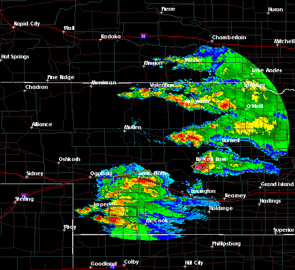 At 833 pm cdt, severe thunderstorms were located along a line extending from near maxwell to 9 miles southeast of sutherland reservoir state recreation area, moving southeast at 20 mph (radar indicated). Hazards include 60 mph wind gusts and penny size hail. Expect damage to roofs, siding, and trees. locations impacted include, north platte, brady, maxwell, sutherland reservoir state recreation area, lake maloney state recreation area, north platte airport, keith and cottonwood canyon state wildlife management area. this includes the following highways, interstate 80 in nebraska between mile markers 167 and 202. Highway 83 between mile markers 68 and 84. At 833 pm cdt, severe thunderstorms were located along a line extending from near maxwell to 9 miles southeast of sutherland reservoir state recreation area, moving southeast at 20 mph (radar indicated). Hazards include 60 mph wind gusts and penny size hail. Expect damage to roofs, siding, and trees. locations impacted include, north platte, brady, maxwell, sutherland reservoir state recreation area, lake maloney state recreation area, north platte airport, keith and cottonwood canyon state wildlife management area. this includes the following highways, interstate 80 in nebraska between mile markers 167 and 202. Highway 83 between mile markers 68 and 84.
|
| 8/12/2017 8:08 PM CDT |
 At 807 pm cdt, severe thunderstorms were located along a line extending from 6 miles northeast of north platte airport to 6 miles southwest of sutherland reservoir state recreation area, moving southeast at 20 mph (radar indicated). Hazards include 70 mph wind gusts. Expect considerable tree damage. Damage is likely to mobile homes, roofs, and outbuildings. At 807 pm cdt, severe thunderstorms were located along a line extending from 6 miles northeast of north platte airport to 6 miles southwest of sutherland reservoir state recreation area, moving southeast at 20 mph (radar indicated). Hazards include 70 mph wind gusts. Expect considerable tree damage. Damage is likely to mobile homes, roofs, and outbuildings.
|
| 7/2/2017 8:08 PM CDT |
 The severe thunderstorm warning for central lincoln county will expire at 815 pm cdt, the storms which prompted the warning have moved out of the area. therefore the warning will be allowed to expire. however gusty winds and heavy rain are still possible with these thunderstorms. a severe thunderstorm watch remains in effect until midnight cdt for central and southwestern nebraska. remember, a severe thunderstorm warning still remains in effect for east central lincoln county in southwestern nebraska until 830 pm cdt. The severe thunderstorm warning for central lincoln county will expire at 815 pm cdt, the storms which prompted the warning have moved out of the area. therefore the warning will be allowed to expire. however gusty winds and heavy rain are still possible with these thunderstorms. a severe thunderstorm watch remains in effect until midnight cdt for central and southwestern nebraska. remember, a severe thunderstorm warning still remains in effect for east central lincoln county in southwestern nebraska until 830 pm cdt.
|
| 7/2/2017 8:00 PM CDT |
 At 800 pm cdt, severe thunderstorms were located along a line extending from north platte to near maxwell to near brady, moving south at 5 mph (radar indicated). Hazards include 60 mph wind gusts and quarter size hail. Hail damage to vehicles is expected. expect wind damage to roofs, siding, and trees. locations impacted include, north platte, brady, maxwell, lake maloney state recreation area, north platte airport, keith, cottonwood canyon state wildlife management area, jeffrey canyon state wildlife management area and birdwood. This includes interstate 80 in nebraska between mile markers 170 and 204. At 800 pm cdt, severe thunderstorms were located along a line extending from north platte to near maxwell to near brady, moving south at 5 mph (radar indicated). Hazards include 60 mph wind gusts and quarter size hail. Hail damage to vehicles is expected. expect wind damage to roofs, siding, and trees. locations impacted include, north platte, brady, maxwell, lake maloney state recreation area, north platte airport, keith, cottonwood canyon state wildlife management area, jeffrey canyon state wildlife management area and birdwood. This includes interstate 80 in nebraska between mile markers 170 and 204.
|
| 7/2/2017 7:34 PM CDT |
 At 734 pm cdt, severe thunderstorms were located along a line extending from near north platte to 14 miles northeast of maxwell, moving south at 20 mph (radar indicated). Hazards include golf ball size hail and 60 mph wind gusts. People and animals outdoors will be injured. expect hail damage to roofs, siding, windows, and vehicles. Expect wind damage to roofs, siding, and trees. At 734 pm cdt, severe thunderstorms were located along a line extending from near north platte to 14 miles northeast of maxwell, moving south at 20 mph (radar indicated). Hazards include golf ball size hail and 60 mph wind gusts. People and animals outdoors will be injured. expect hail damage to roofs, siding, windows, and vehicles. Expect wind damage to roofs, siding, and trees.
|
| 6/27/2017 3:37 PM CDT |
 At 837 pm cdt, severe thunderstorms were located along a line extending from 6 miles south of gandy to 11 miles north of brady to near maxwell to 11 miles northeast of wellfleet, moving east at 30 mph (radar indicated). Hazards include 70 mph wind gusts. Expect considerable tree damage. Damage is likely to mobile homes, roofs, and outbuildings. At 837 pm cdt, severe thunderstorms were located along a line extending from 6 miles south of gandy to 11 miles north of brady to near maxwell to 11 miles northeast of wellfleet, moving east at 30 mph (radar indicated). Hazards include 70 mph wind gusts. Expect considerable tree damage. Damage is likely to mobile homes, roofs, and outbuildings.
|
| 6/27/2017 3:22 PM CDT |
 At 821 pm cdt, severe thunderstorms were located along a line extending from 12 miles north of north platte airport to near north platte to lake maloney state recreation area to 13 miles north of wellfleet, moving east at 25 mph. wind gusts of 70 mph have been observed with this line (radar indicated). Hazards include 70 mph wind gusts. Expect considerable tree damage. damage is likely to mobile homes, roofs, and outbuildings. locations impacted include, north platte, maxwell, lake maloney state recreation area, north platte airport, keith, cottonwood canyon state wildlife management area and birdwood. this includes the following highways, highway 97 between mile markers 1 and 16. Interstate 80 in nebraska between mile markers 168 and 194. At 821 pm cdt, severe thunderstorms were located along a line extending from 12 miles north of north platte airport to near north platte to lake maloney state recreation area to 13 miles north of wellfleet, moving east at 25 mph. wind gusts of 70 mph have been observed with this line (radar indicated). Hazards include 70 mph wind gusts. Expect considerable tree damage. damage is likely to mobile homes, roofs, and outbuildings. locations impacted include, north platte, maxwell, lake maloney state recreation area, north platte airport, keith, cottonwood canyon state wildlife management area and birdwood. this includes the following highways, highway 97 between mile markers 1 and 16. Interstate 80 in nebraska between mile markers 168 and 194.
|
| 6/27/2017 3:18 PM CDT |
 At 817 pm cdt, severe thunderstorms were located along a line extending from 13 miles north of north platte to near north platte to near lake maloney state recreation area to 12 miles northeast of dickens, moving east at 25 mph. confirmed gusts of 60 mph are occurring with this line of storms (radar indicated). Hazards include 60 mph wind gusts. Expect damage to roofs, siding, and trees. locations impacted include, north platte, maxwell, lake maloney state recreation area, north platte airport, keith, cottonwood canyon state wildlife management area and birdwood. this includes the following highways, highway 97 between mile markers 1 and 16. Interstate 80 in nebraska between mile markers 168 and 194. At 817 pm cdt, severe thunderstorms were located along a line extending from 13 miles north of north platte to near north platte to near lake maloney state recreation area to 12 miles northeast of dickens, moving east at 25 mph. confirmed gusts of 60 mph are occurring with this line of storms (radar indicated). Hazards include 60 mph wind gusts. Expect damage to roofs, siding, and trees. locations impacted include, north platte, maxwell, lake maloney state recreation area, north platte airport, keith, cottonwood canyon state wildlife management area and birdwood. this includes the following highways, highway 97 between mile markers 1 and 16. Interstate 80 in nebraska between mile markers 168 and 194.
|
| 6/27/2017 3:10 PM CDT |
 At 810 pm cdt, severe thunderstorms were located along a line extending from 13 miles northeast of hershey to near north platte to near lake maloney state recreation area to 10 miles northeast of dickens, moving east at 25 mph (radar indicated). Hazards include 60 mph wind gusts. expect damage to roofs, siding, and trees At 810 pm cdt, severe thunderstorms were located along a line extending from 13 miles northeast of hershey to near north platte to near lake maloney state recreation area to 10 miles northeast of dickens, moving east at 25 mph (radar indicated). Hazards include 60 mph wind gusts. expect damage to roofs, siding, and trees
|
| 9/5/2016 9:16 PM CDT |
 At 916 pm cdt, a severe thunderstorm was located 11 miles northeast of maxwell, or 17 miles south of stapleton, moving northeast at 45 mph (public). Hazards include 60 mph wind gusts and quarter size hail. Hail damage to vehicles is expected. expect wind damage to roofs, siding, and trees. locations impacted include, maxwell and keith. This includes interstate 80 in nebraska between mile markers 182 and 191. At 916 pm cdt, a severe thunderstorm was located 11 miles northeast of maxwell, or 17 miles south of stapleton, moving northeast at 45 mph (public). Hazards include 60 mph wind gusts and quarter size hail. Hail damage to vehicles is expected. expect wind damage to roofs, siding, and trees. locations impacted include, maxwell and keith. This includes interstate 80 in nebraska between mile markers 182 and 191.
|
| 9/5/2016 9:03 PM CDT |
 At 902 pm cdt, a severe thunderstorm was located over maxwell, or 12 miles east of north platte, moving northeast at 45 mph (public). Hazards include 60 mph wind gusts and quarter size hail. Hail damage to vehicles is expected. expect wind damage to roofs, siding, and trees. locations impacted include, brady, maxwell, keith, cottonwood canyon state wildlife management area and etna. This includes interstate 80 in nebraska between mile markers 182 and 203. At 902 pm cdt, a severe thunderstorm was located over maxwell, or 12 miles east of north platte, moving northeast at 45 mph (public). Hazards include 60 mph wind gusts and quarter size hail. Hail damage to vehicles is expected. expect wind damage to roofs, siding, and trees. locations impacted include, brady, maxwell, keith, cottonwood canyon state wildlife management area and etna. This includes interstate 80 in nebraska between mile markers 182 and 203.
|
| 9/5/2016 9:02 PM CDT | Quarter sized hail reported 3 miles E of Maxwell, NE |
| 9/5/2016 8:47 PM CDT |
 At 847 pm cdt, a severe thunderstorm was located 7 miles southeast of lake maloney state recreation area, or 13 miles south of north platte, moving northeast at 45 mph (radar indicated). Hazards include 60 mph wind gusts and half dollar size hail. Hail damage to vehicles is expected. Expect wind damage to roofs, siding, and trees. At 847 pm cdt, a severe thunderstorm was located 7 miles southeast of lake maloney state recreation area, or 13 miles south of north platte, moving northeast at 45 mph (radar indicated). Hazards include 60 mph wind gusts and half dollar size hail. Hail damage to vehicles is expected. Expect wind damage to roofs, siding, and trees.
|
| 8/12/2016 12:49 AM CDT |
 At 1248 am cdt, severe thunderstorms were located along a line extending from 10 miles northeast of maxwell to 8 miles south of brady to 8 miles southwest of curtis, moving southeast at 45 mph (radar indicated). Hazards include 70 mph wind gusts and penny size hail. Expect considerable tree damage. damage is likely to mobile homes, roofs, and outbuildings. locations impacted include, north platte, curtis, brady, maxwell, wellfleet, moorefield, stockville, lake maloney state recreation area, north platte airport, maywood, somerset, hansen memorial reserve state wildlife management area, marengo, etna, hayes center state wildlife management area, orafino, jeffrey canyon state wildlife management area, vroman, dancing leaf earth lodge and cottonwood canyon state wildlife management area. this includes the following highways, interstate 80 in nebraska between mile markers 178 and 207. Highway 83 between mile markers 37 and 81, and between mile markers 90 and 102. At 1248 am cdt, severe thunderstorms were located along a line extending from 10 miles northeast of maxwell to 8 miles south of brady to 8 miles southwest of curtis, moving southeast at 45 mph (radar indicated). Hazards include 70 mph wind gusts and penny size hail. Expect considerable tree damage. damage is likely to mobile homes, roofs, and outbuildings. locations impacted include, north platte, curtis, brady, maxwell, wellfleet, moorefield, stockville, lake maloney state recreation area, north platte airport, maywood, somerset, hansen memorial reserve state wildlife management area, marengo, etna, hayes center state wildlife management area, orafino, jeffrey canyon state wildlife management area, vroman, dancing leaf earth lodge and cottonwood canyon state wildlife management area. this includes the following highways, interstate 80 in nebraska between mile markers 178 and 207. Highway 83 between mile markers 37 and 81, and between mile markers 90 and 102.
|
| 8/12/2016 12:29 AM CDT |
 At 1229 am cdt, severe thunderstorms were located along a line extending from 9 miles north of north platte airport to 8 miles south of maxwell to 13 miles south of wellfleet, moving southeast at 35 mph (radar indicated). Hazards include 70 mph wind gusts and penny size hail. Expect considerable tree damage. Damage is likely to mobile homes, roofs, and outbuildings. At 1229 am cdt, severe thunderstorms were located along a line extending from 9 miles north of north platte airport to 8 miles south of maxwell to 13 miles south of wellfleet, moving southeast at 35 mph (radar indicated). Hazards include 70 mph wind gusts and penny size hail. Expect considerable tree damage. Damage is likely to mobile homes, roofs, and outbuildings.
|
| 7/27/2016 12:09 AM CDT |
 At 1208 am cdt, severe thunderstorms were located along a line extending from near north platte airport to near brady to 8 miles east of callaway to near sargent, moving southeast at 60 mph (radar indicated). Hazards include 70 mph wind gusts. Expect considerable tree damage. damage is likely to mobile homes, roofs, and outbuildings. locations impacted include, north platte, broken bow, stapleton, taylor, arnold, callaway, sargent, ansley, brady, merna, maxwell, mason city, oconto, anselmo, comstock, berwyn, gandy, calamus reservoir state recreation area, ringgold and north platte airport. this includes the following highways, highway 183 between mile markers 81 and 130. highway 2 between mile markers 254 and 302. highway 92 between mile markers 208 and 308. highway 97 between mile markers 1 and 26. interstate 80 in nebraska between mile markers 177 and 208. Highway 83 between mile markers 78 and 113. At 1208 am cdt, severe thunderstorms were located along a line extending from near north platte airport to near brady to 8 miles east of callaway to near sargent, moving southeast at 60 mph (radar indicated). Hazards include 70 mph wind gusts. Expect considerable tree damage. damage is likely to mobile homes, roofs, and outbuildings. locations impacted include, north platte, broken bow, stapleton, taylor, arnold, callaway, sargent, ansley, brady, merna, maxwell, mason city, oconto, anselmo, comstock, berwyn, gandy, calamus reservoir state recreation area, ringgold and north platte airport. this includes the following highways, highway 183 between mile markers 81 and 130. highway 2 between mile markers 254 and 302. highway 92 between mile markers 208 and 308. highway 97 between mile markers 1 and 26. interstate 80 in nebraska between mile markers 177 and 208. Highway 83 between mile markers 78 and 113.
|
| 7/26/2016 11:58 PM CDT |
 At 1157 pm cdt, severe thunderstorms were located along a line extending from near north platte to 7 miles north of brady to near taylor, moving southeast at 50 mph (radar indicated). Hazards include 70 mph wind gusts. Expect considerable tree damage. damage is likely to mobile homes, roofs, and outbuildings. locations impacted include, north platte, broken bow, stapleton, taylor, arnold, callaway, sargent, ansley, brady, merna, maxwell, mason city, oconto, anselmo, comstock, berwyn, gandy, calamus reservoir state recreation area, ringgold and north platte airport. this includes the following highways, highway 183 between mile markers 81 and 130. highway 2 between mile markers 254 and 302. highway 92 between mile markers 208 and 308. highway 97 between mile markers 1 and 26. interstate 80 in nebraska between mile markers 177 and 208. Highway 83 between mile markers 78 and 113. At 1157 pm cdt, severe thunderstorms were located along a line extending from near north platte to 7 miles north of brady to near taylor, moving southeast at 50 mph (radar indicated). Hazards include 70 mph wind gusts. Expect considerable tree damage. damage is likely to mobile homes, roofs, and outbuildings. locations impacted include, north platte, broken bow, stapleton, taylor, arnold, callaway, sargent, ansley, brady, merna, maxwell, mason city, oconto, anselmo, comstock, berwyn, gandy, calamus reservoir state recreation area, ringgold and north platte airport. this includes the following highways, highway 183 between mile markers 81 and 130. highway 2 between mile markers 254 and 302. highway 92 between mile markers 208 and 308. highway 97 between mile markers 1 and 26. interstate 80 in nebraska between mile markers 177 and 208. Highway 83 between mile markers 78 and 113.
|
| 7/26/2016 11:36 PM CDT |
 At 1136 pm cdt, severe thunderstorms were located along a line extending from 8 miles southwest of ringgold to near gandy to 7 miles northwest of calamus reservoir state recreation area, moving southeast at 45 mph (radar indicated). Hazards include 60 mph wind gusts. Expect damage to roofs. siding. And trees. At 1136 pm cdt, severe thunderstorms were located along a line extending from 8 miles southwest of ringgold to near gandy to 7 miles northwest of calamus reservoir state recreation area, moving southeast at 45 mph (radar indicated). Hazards include 60 mph wind gusts. Expect damage to roofs. siding. And trees.
|
| 7/15/2016 9:13 AM CDT |
 At 912 am cdt, severe thunderstorms were located along a line extending from 7 miles northeast of north platte airport to near dickens, moving southeast at 35 mph (radar indicated). Hazards include 60 mph wind gusts and quarter size hail. Hail damage to vehicles is expected. expect wind damage to roofs, siding, and trees. locations impacted include, north platte, maxwell, wellfleet, lake maloney state recreation area, north platte airport, somerset, cottonwood canyon state wildlife management area and keith. this includes the following highways, interstate 80 in nebraska between mile markers 173 and 195. Highway 83 between mile markers 57 and 87, and between mile markers 89 and 92. At 912 am cdt, severe thunderstorms were located along a line extending from 7 miles northeast of north platte airport to near dickens, moving southeast at 35 mph (radar indicated). Hazards include 60 mph wind gusts and quarter size hail. Hail damage to vehicles is expected. expect wind damage to roofs, siding, and trees. locations impacted include, north platte, maxwell, wellfleet, lake maloney state recreation area, north platte airport, somerset, cottonwood canyon state wildlife management area and keith. this includes the following highways, interstate 80 in nebraska between mile markers 173 and 195. Highway 83 between mile markers 57 and 87, and between mile markers 89 and 92.
|
| 7/15/2016 8:52 AM CDT |
 At 851 am cdt, severe thunderstorms were located along a line extending from 7 miles north of north platte to 6 miles southeast of sutherland reservoir state recreation area, moving southeast at 35 mph (public and radar indicated). Hazards include ping pong ball size hail and 60 mph wind gusts. People and animals outdoors will be injured. expect hail damage to roofs, siding, windows, and vehicles. expect wind damage to roofs, siding, and trees. locations impacted include, north platte, sutherland, hershey, maxwell, wellfleet, lake maloney state recreation area, sutherland reservoir state recreation area, north platte airport, somerset, cottonwood canyon state wildlife management area, keith, o`fallons and birdwood. this includes the following highways, highway 97 between mile markers 1 and 15. interstate 80 in nebraska between mile markers 159 and 195. Highway 83 between mile markers 57 and 95. At 851 am cdt, severe thunderstorms were located along a line extending from 7 miles north of north platte to 6 miles southeast of sutherland reservoir state recreation area, moving southeast at 35 mph (public and radar indicated). Hazards include ping pong ball size hail and 60 mph wind gusts. People and animals outdoors will be injured. expect hail damage to roofs, siding, windows, and vehicles. expect wind damage to roofs, siding, and trees. locations impacted include, north platte, sutherland, hershey, maxwell, wellfleet, lake maloney state recreation area, sutherland reservoir state recreation area, north platte airport, somerset, cottonwood canyon state wildlife management area, keith, o`fallons and birdwood. this includes the following highways, highway 97 between mile markers 1 and 15. interstate 80 in nebraska between mile markers 159 and 195. Highway 83 between mile markers 57 and 95.
|
| 7/15/2016 8:39 AM CDT |
 At 839 am cdt, severe thunderstorms were located along a line extending from 12 miles northeast of hershey to sutherland reservoir state recreation area, moving southeast at 35 mph (public). Hazards include 60 mph wind gusts and quarter size hail. Hail damage to vehicles is expected. Expect wind damage to roofs, siding, and trees. At 839 am cdt, severe thunderstorms were located along a line extending from 12 miles northeast of hershey to sutherland reservoir state recreation area, moving southeast at 35 mph (public). Hazards include 60 mph wind gusts and quarter size hail. Hail damage to vehicles is expected. Expect wind damage to roofs, siding, and trees.
|
| 7/6/2016 10:30 PM CDT | Golf Ball sized hail reported 14.8 miles S of Maxwell, NE |
| 7/6/2016 9:36 PM CDT |
 At 935 pm cdt, a severe thunderstorm was located 8 miles northeast of maxwell, or 19 miles east of north platte, moving east at 45 mph (radar indicated). Hazards include 60 mph wind gusts and quarter size hail. Hail damage to vehicles is expected. Expect wind damage to roofs, siding, and trees. At 935 pm cdt, a severe thunderstorm was located 8 miles northeast of maxwell, or 19 miles east of north platte, moving east at 45 mph (radar indicated). Hazards include 60 mph wind gusts and quarter size hail. Hail damage to vehicles is expected. Expect wind damage to roofs, siding, and trees.
|
| 7/6/2016 9:19 PM CDT |
 At 919 pm cdt, a severe thunderstorm capable of producing a tornado was located near maxwell, or 11 miles east of north platte, moving east at 40 mph (radar indicated rotation). Hazards include tornado and quarter size hail. Flying debris will be dangerous to those caught without shelter. mobile homes will be damaged or destroyed. damage to roofs, windows, and vehicles will occur. tree damage is likely. this tornadic thunderstorm will remain over mainly rural areas of northeastern lincoln county, including the following locations: keith. this includes the following highways, interstate 80 in nebraska between mile markers 179 and 186. Highway 83 between mile markers 90 and 94. At 919 pm cdt, a severe thunderstorm capable of producing a tornado was located near maxwell, or 11 miles east of north platte, moving east at 40 mph (radar indicated rotation). Hazards include tornado and quarter size hail. Flying debris will be dangerous to those caught without shelter. mobile homes will be damaged or destroyed. damage to roofs, windows, and vehicles will occur. tree damage is likely. this tornadic thunderstorm will remain over mainly rural areas of northeastern lincoln county, including the following locations: keith. this includes the following highways, interstate 80 in nebraska between mile markers 179 and 186. Highway 83 between mile markers 90 and 94.
|
| 7/6/2016 9:01 PM CDT |
 At 901 pm cdt, a severe thunderstorm capable of producing a tornado was located near north platte, moving east at 40 mph (weather spotters reported funnel cloud). Hazards include tornado and quarter size hail. Flying debris will be dangerous to those caught without shelter. mobile homes will be damaged or destroyed. damage to roofs, windows, and vehicles will occur. tree damage is likely. this dangerous storm will be near, north platte airport around 910 pm cdt. maxwell around 925 pm cdt. Other locations impacted by this tornadic thunderstorm include cottonwood canyon state wildlife management area, keith and birdwood. At 901 pm cdt, a severe thunderstorm capable of producing a tornado was located near north platte, moving east at 40 mph (weather spotters reported funnel cloud). Hazards include tornado and quarter size hail. Flying debris will be dangerous to those caught without shelter. mobile homes will be damaged or destroyed. damage to roofs, windows, and vehicles will occur. tree damage is likely. this dangerous storm will be near, north platte airport around 910 pm cdt. maxwell around 925 pm cdt. Other locations impacted by this tornadic thunderstorm include cottonwood canyon state wildlife management area, keith and birdwood.
|
| 6/28/2016 10:43 PM CDT |
 At 1043 pm cdt, severe thunderstorms were located along a line extending from near merna to near brady, moving east at 30 mph (radar indicated). Hazards include 60 mph wind gusts. Expect damage to roofs. siding. And trees. At 1043 pm cdt, severe thunderstorms were located along a line extending from near merna to near brady, moving east at 30 mph (radar indicated). Hazards include 60 mph wind gusts. Expect damage to roofs. siding. And trees.
|
| 6/28/2016 10:32 PM CDT |
 At 1031 pm cdt, severe thunderstorms were located along a line extending from 7 miles northeast of arnold to 11 miles south of maxwell, moving east at 45 mph (radar indicated). Hazards include 70 mph wind gusts. Expect considerable tree damage. damage is likely to mobile homes, roofs, and outbuildings. locations impacted include, north platte, arnold, callaway, brady, maxwell, lake maloney state recreation area, north platte airport, keith, logan, etna, pleasant hill, cottonwood canyon state wildlife management area, milldale and finchville. this includes the following highways, highway 92 between mile markers 236 and 268. interstate 80 in nebraska between mile markers 176 and 202. Highway 83 between mile markers 73 and 83. At 1031 pm cdt, severe thunderstorms were located along a line extending from 7 miles northeast of arnold to 11 miles south of maxwell, moving east at 45 mph (radar indicated). Hazards include 70 mph wind gusts. Expect considerable tree damage. damage is likely to mobile homes, roofs, and outbuildings. locations impacted include, north platte, arnold, callaway, brady, maxwell, lake maloney state recreation area, north platte airport, keith, logan, etna, pleasant hill, cottonwood canyon state wildlife management area, milldale and finchville. this includes the following highways, highway 92 between mile markers 236 and 268. interstate 80 in nebraska between mile markers 176 and 202. Highway 83 between mile markers 73 and 83.
|
| 6/28/2016 10:04 PM CDT |
 At 1003 pm cdt, severe thunderstorms were located along a line extending from 6 miles north of stapleton to 10 miles west of lake maloney state recreation area, moving east at 45 mph (trained weather spotters). Hazards include 70 mph wind gusts. Expect considerable tree damage. damage is likely to mobile homes, roofs, and outbuildings. locations impacted include, north platte, stapleton, hershey, arnold, callaway, brady, maxwell, gandy, lake maloney state recreation area, north platte airport, keith, logan, etna, pleasant hill, cottonwood canyon state wildlife management area, shanklin bluff, milldale, hoagland, tarboz lake and birdwood. this includes the following highways, highway 92 between mile markers 219 and 268. highway 97 between mile markers 1 and 11. interstate 80 in nebraska between mile markers 162 and 202. Highway 83 between mile markers 73 and 122. At 1003 pm cdt, severe thunderstorms were located along a line extending from 6 miles north of stapleton to 10 miles west of lake maloney state recreation area, moving east at 45 mph (trained weather spotters). Hazards include 70 mph wind gusts. Expect considerable tree damage. damage is likely to mobile homes, roofs, and outbuildings. locations impacted include, north platte, stapleton, hershey, arnold, callaway, brady, maxwell, gandy, lake maloney state recreation area, north platte airport, keith, logan, etna, pleasant hill, cottonwood canyon state wildlife management area, shanklin bluff, milldale, hoagland, tarboz lake and birdwood. this includes the following highways, highway 92 between mile markers 219 and 268. highway 97 between mile markers 1 and 11. interstate 80 in nebraska between mile markers 162 and 202. Highway 83 between mile markers 73 and 122.
|
| 6/28/2016 9:59 PM CDT |
 At 959 pm cdt, severe thunderstorms were located along a line extending from 7 miles north of stapleton to 9 miles southeast of sutherland reservoir state recreation area, moving east at 45 mph (radar indicated). Hazards include 60 mph wind gusts. Expect damage to roofs. siding. And trees. At 959 pm cdt, severe thunderstorms were located along a line extending from 7 miles north of stapleton to 9 miles southeast of sutherland reservoir state recreation area, moving east at 45 mph (radar indicated). Hazards include 60 mph wind gusts. Expect damage to roofs. siding. And trees.
|
| 6/28/2016 9:25 PM CDT |
 At 925 pm cdt/825 pm mdt/, severe thunderstorms were located along a line extending from near stapleton to 6 miles north of sarben to near madrid, moving southeast at 55 mph (radar indicated). Hazards include 70 mph wind gusts and nickel size hail. Expect considerable tree damage. Damage is likely to mobile homes, roofs, and outbuildings. At 925 pm cdt/825 pm mdt/, severe thunderstorms were located along a line extending from near stapleton to 6 miles north of sarben to near madrid, moving southeast at 55 mph (radar indicated). Hazards include 70 mph wind gusts and nickel size hail. Expect considerable tree damage. Damage is likely to mobile homes, roofs, and outbuildings.
|
| 5/30/2016 7:41 PM CDT |
 At 740 pm cdt, a severe thunderstorm was located 9 miles north of brady, or 24 miles east of north platte, moving east at 45 mph (trained weather spotters). Hazards include 70 mph wind gusts. Expect considerable tree damage. damage is likely to mobile homes, roofs, and outbuildings. locations impacted include, north platte, brady, maxwell, lake maloney state recreation area, north platte airport, keith, cottonwood canyon state wildlife management area, birdwood and vroman. this includes the following highways, highway 97 between mile markers 1 and 15. interstate 80 in nebraska between mile markers 171 and 206. Highway 83 between mile markers 73 and 105. At 740 pm cdt, a severe thunderstorm was located 9 miles north of brady, or 24 miles east of north platte, moving east at 45 mph (trained weather spotters). Hazards include 70 mph wind gusts. Expect considerable tree damage. damage is likely to mobile homes, roofs, and outbuildings. locations impacted include, north platte, brady, maxwell, lake maloney state recreation area, north platte airport, keith, cottonwood canyon state wildlife management area, birdwood and vroman. this includes the following highways, highway 97 between mile markers 1 and 15. interstate 80 in nebraska between mile markers 171 and 206. Highway 83 between mile markers 73 and 105.
|
| 5/30/2016 7:29 PM CDT |
 At 728 pm cdt, a severe thunderstorm was located near maxwell, or 14 miles east of north platte, moving east at 35 mph (trained weather spotters). Hazards include 70 mph wind gusts. Expect considerable tree damage. damage is likely to mobile homes, roofs, and outbuildings. locations impacted include, north platte, hershey, brady, maxwell, lake maloney state recreation area, north platte airport, keith, cottonwood canyon state wildlife management area, o`fallons, birdwood and vroman. this includes the following highways, highway 97 between mile markers 1 and 15. interstate 80 in nebraska between mile markers 161 and 206. Highway 83 between mile markers 73 and 105. At 728 pm cdt, a severe thunderstorm was located near maxwell, or 14 miles east of north platte, moving east at 35 mph (trained weather spotters). Hazards include 70 mph wind gusts. Expect considerable tree damage. damage is likely to mobile homes, roofs, and outbuildings. locations impacted include, north platte, hershey, brady, maxwell, lake maloney state recreation area, north platte airport, keith, cottonwood canyon state wildlife management area, o`fallons, birdwood and vroman. this includes the following highways, highway 97 between mile markers 1 and 15. interstate 80 in nebraska between mile markers 161 and 206. Highway 83 between mile markers 73 and 105.
|
| 5/30/2016 7:12 PM CDT |
 At 711 pm cdt, a severe thunderstorm was located over north platte airport, moving east at 45 mph (trained weather spotters). Hazards include 70 mph wind gusts. Expect considerable tree damage. Damage is likely to mobile homes, roofs, and outbuildings. At 711 pm cdt, a severe thunderstorm was located over north platte airport, moving east at 45 mph (trained weather spotters). Hazards include 70 mph wind gusts. Expect considerable tree damage. Damage is likely to mobile homes, roofs, and outbuildings.
|
| 5/29/2016 7:51 PM CDT |
 At 750 pm cdt, a severe thunderstorm was located near north platte airport, or 9 miles east of north platte, moving northeast at 15 mph (trained weather spotters). Hazards include quarter size hail. Damage to vehicles is expected. locations impacted include, maxwell and keith. this includes the following highways, interstate 80 in nebraska between mile markers 190 and 191. Highway 83 between mile markers 87 and 99. At 750 pm cdt, a severe thunderstorm was located near north platte airport, or 9 miles east of north platte, moving northeast at 15 mph (trained weather spotters). Hazards include quarter size hail. Damage to vehicles is expected. locations impacted include, maxwell and keith. this includes the following highways, interstate 80 in nebraska between mile markers 190 and 191. Highway 83 between mile markers 87 and 99.
|
| 5/29/2016 7:28 PM CDT | Quarter sized hail reported 0.4 miles ESE of Maxwell, NE |
| 5/29/2016 7:26 PM CDT |
 At 726 pm cdt, a severe thunderstorm was located over north platte airport, or near north platte, moving northeast at 15 mph (trained weather spotters). Hazards include golf ball size hail. People and animals outdoors will be injured. Expect damage to roofs, siding, windows, and vehicles. At 726 pm cdt, a severe thunderstorm was located over north platte airport, or near north platte, moving northeast at 15 mph (trained weather spotters). Hazards include golf ball size hail. People and animals outdoors will be injured. Expect damage to roofs, siding, windows, and vehicles.
|
| 5/29/2016 7:10 PM CDT |
 At 709 pm cdt, a severe thunderstorm was located 8 miles southwest of brady, or 19 miles north of curtis, moving northeast at 30 mph (trained weather spotters). Hazards include quarter size hail. damage to vehicles is expected At 709 pm cdt, a severe thunderstorm was located 8 miles southwest of brady, or 19 miles north of curtis, moving northeast at 30 mph (trained weather spotters). Hazards include quarter size hail. damage to vehicles is expected
|
| 5/25/2016 8:18 PM CDT |
 At 817 pm cdt, severe thunderstorms were located along a line extending from 12 miles north of brady to near moorefield, moving east at 50 mph (trained weather spotters). Hazards include 60 mph wind gusts and quarter size hail. Hail damage to vehicles is expected. expect wind damage to roofs, siding, and trees. locations impacted include, north platte, callaway, brady, maxwell, wellfleet, lake maloney state recreation area, north platte airport, keith, hansen memorial reserve state wildlife management area, etna, jeffrey canyon state wildlife management area, lodi, vroman and cottonwood canyon state wildlife management area. this includes the following highways, highway 97 between mile markers 1 and 3. interstate 80 in nebraska between mile markers 176 and 208. Highway 83 between mile markers 53 and 92. At 817 pm cdt, severe thunderstorms were located along a line extending from 12 miles north of brady to near moorefield, moving east at 50 mph (trained weather spotters). Hazards include 60 mph wind gusts and quarter size hail. Hail damage to vehicles is expected. expect wind damage to roofs, siding, and trees. locations impacted include, north platte, callaway, brady, maxwell, wellfleet, lake maloney state recreation area, north platte airport, keith, hansen memorial reserve state wildlife management area, etna, jeffrey canyon state wildlife management area, lodi, vroman and cottonwood canyon state wildlife management area. this includes the following highways, highway 97 between mile markers 1 and 3. interstate 80 in nebraska between mile markers 176 and 208. Highway 83 between mile markers 53 and 92.
|
| 5/25/2016 7:51 PM CDT |
 At 751 pm cdt, severe thunderstorms were located along a line extending from near north platte airport to wellfleet, moving east at 50 mph (radar indicated). Hazards include 60 mph wind gusts and quarter size hail. Hail damage to vehicles is expected. Expect wind damage to roofs, siding, and trees. At 751 pm cdt, severe thunderstorms were located along a line extending from near north platte airport to wellfleet, moving east at 50 mph (radar indicated). Hazards include 60 mph wind gusts and quarter size hail. Hail damage to vehicles is expected. Expect wind damage to roofs, siding, and trees.
|
| 5/8/2016 8:32 PM CDT |
 At 831 pm cdt, a severe thunderstorm was located near brady, or 27 miles east of north platte, moving north at 25 mph (radar indicated). Hazards include quarter size hail. Damage to vehicles is expected. locations impacted include, brady, maxwell, jeffrey canyon state wildlife management area, hansen memorial reserve state wildlife management area, cottonwood canyon state wildlife management area and etna. This includes interstate 80 in nebraska between mile markers 189 and 206. At 831 pm cdt, a severe thunderstorm was located near brady, or 27 miles east of north platte, moving north at 25 mph (radar indicated). Hazards include quarter size hail. Damage to vehicles is expected. locations impacted include, brady, maxwell, jeffrey canyon state wildlife management area, hansen memorial reserve state wildlife management area, cottonwood canyon state wildlife management area and etna. This includes interstate 80 in nebraska between mile markers 189 and 206.
|
| 5/8/2016 8:08 PM CDT |
 At 807 pm cdt, a severe thunderstorm was located near gothenburg, or 24 miles northeast of curtis, moving northwest at 15 mph (radar indicated). Hazards include ping pong ball size hail. People and animals outdoors will be injured. Expect damage to roofs, siding, windows, and vehicles. At 807 pm cdt, a severe thunderstorm was located near gothenburg, or 24 miles northeast of curtis, moving northwest at 15 mph (radar indicated). Hazards include ping pong ball size hail. People and animals outdoors will be injured. Expect damage to roofs, siding, windows, and vehicles.
|
| 5/8/2016 6:47 PM CDT |
 At 647 pm cdt, a severe thunderstorm was located near brady, or 20 miles southeast of north platte, moving northwest at 15 mph (radar indicated). Hazards include quarter size hail. Damage to vehicles is expected. locations impacted include, brady, maxwell, keith, jeffrey canyon state wildlife management area and cottonwood canyon state wildlife management area. This includes interstate 80 in nebraska between mile markers 186 and 203. At 647 pm cdt, a severe thunderstorm was located near brady, or 20 miles southeast of north platte, moving northwest at 15 mph (radar indicated). Hazards include quarter size hail. Damage to vehicles is expected. locations impacted include, brady, maxwell, keith, jeffrey canyon state wildlife management area and cottonwood canyon state wildlife management area. This includes interstate 80 in nebraska between mile markers 186 and 203.
|
| 5/8/2016 6:31 PM CDT |
 At 630 pm cdt, a severe thunderstorm was located near brady, or 22 miles north of curtis, moving north at 30 mph (radar indicated). Hazards include ping pong ball size hail. People and animals outdoors will be injured. Expect damage to roofs, siding, windows, and vehicles. At 630 pm cdt, a severe thunderstorm was located near brady, or 22 miles north of curtis, moving north at 30 mph (radar indicated). Hazards include ping pong ball size hail. People and animals outdoors will be injured. Expect damage to roofs, siding, windows, and vehicles.
|
| 8/13/2015 8:54 PM CDT |
 At 854 pm cdt, severe thunderstorms were located along a line extending from near callaway to 10 miles northeast of gothenburg to near brady to 8 miles northeast of dickens, moving southeast at 30 mph (radar indicated). Hazards include 60 mph wind gusts and quarter size hail. Hail damage to vehicles is expected. expect wind damage to roofs, siding and trees. this includes the following highways, highway 97 between mile markers 1 and 10. interstate 80 in nebraska between mile markers 167 and 208. highway 83 between mile markers 55 and 95. Locations impacted include, somerset, hansen memorial reserve state wildlife management area, etna, jeffrey canyon state wildlife management area, lodi, vroman, brady, lake maloney state recreation area, callaway, cottonwood canyon state wildlife management area, maxwell, north platte, milldale, north platte airport, keith, wellfleet, birdwood and finchville. At 854 pm cdt, severe thunderstorms were located along a line extending from near callaway to 10 miles northeast of gothenburg to near brady to 8 miles northeast of dickens, moving southeast at 30 mph (radar indicated). Hazards include 60 mph wind gusts and quarter size hail. Hail damage to vehicles is expected. expect wind damage to roofs, siding and trees. this includes the following highways, highway 97 between mile markers 1 and 10. interstate 80 in nebraska between mile markers 167 and 208. highway 83 between mile markers 55 and 95. Locations impacted include, somerset, hansen memorial reserve state wildlife management area, etna, jeffrey canyon state wildlife management area, lodi, vroman, brady, lake maloney state recreation area, callaway, cottonwood canyon state wildlife management area, maxwell, north platte, milldale, north platte airport, keith, wellfleet, birdwood and finchville.
|
| 8/13/2015 8:47 PM CDT |
 At 847 pm cdt, severe thunderstorms were located along a line extending from 6 miles south of callaway to 10 miles north of gothenburg to near brady to near lake maloney state recreation area, moving southeast at 35 mph (radar indicated). Hazards include 60 mph wind gusts and quarter size hail. Hail damage to vehicles is expected. expect wind damage to roofs, siding and trees. this includes the following highways, highway 97 between mile markers 1 and 10. interstate 80 in nebraska between mile markers 167 and 208. highway 83 between mile markers 55 and 95. Locations impacted include, somerset, hansen memorial reserve state wildlife management area, etna, jeffrey canyon state wildlife management area, lodi, vroman, brady, lake maloney state recreation area, callaway, cottonwood canyon state wildlife management area, maxwell, north platte, milldale, north platte airport, keith, wellfleet, birdwood and finchville. At 847 pm cdt, severe thunderstorms were located along a line extending from 6 miles south of callaway to 10 miles north of gothenburg to near brady to near lake maloney state recreation area, moving southeast at 35 mph (radar indicated). Hazards include 60 mph wind gusts and quarter size hail. Hail damage to vehicles is expected. expect wind damage to roofs, siding and trees. this includes the following highways, highway 97 between mile markers 1 and 10. interstate 80 in nebraska between mile markers 167 and 208. highway 83 between mile markers 55 and 95. Locations impacted include, somerset, hansen memorial reserve state wildlife management area, etna, jeffrey canyon state wildlife management area, lodi, vroman, brady, lake maloney state recreation area, callaway, cottonwood canyon state wildlife management area, maxwell, north platte, milldale, north platte airport, keith, wellfleet, birdwood and finchville.
|
| 8/13/2015 8:33 PM CDT |
 At 832 pm cdt, severe thunderstorms were located along a line extending from near callaway to 10 miles northeast of gothenburg to near brady to near north platte, moving southeast at 40 mph (radar indicated). Hazards include golf ball size hail and 70 mph wind gusts. People and animals outdoors will be injured. expect hail damage to roofs, siding, windows and vehicles. expect considerable tree damage. wind damage is also likely to mobile homes, roofs and outbuildings. this includes the following highways, highway 97 between mile markers 1 and 10. interstate 80 in nebraska between mile markers 167 and 208. highway 83 between mile markers 55 and 95. Locations impacted include, somerset, hansen memorial reserve state wildlife management area, etna, jeffrey canyon state wildlife management area, lodi, vroman, brady, lake maloney state recreation area, callaway, cottonwood canyon state wildlife management area, maxwell, north platte, milldale, north platte airport, keith, wellfleet, birdwood and finchville. At 832 pm cdt, severe thunderstorms were located along a line extending from near callaway to 10 miles northeast of gothenburg to near brady to near north platte, moving southeast at 40 mph (radar indicated). Hazards include golf ball size hail and 70 mph wind gusts. People and animals outdoors will be injured. expect hail damage to roofs, siding, windows and vehicles. expect considerable tree damage. wind damage is also likely to mobile homes, roofs and outbuildings. this includes the following highways, highway 97 between mile markers 1 and 10. interstate 80 in nebraska between mile markers 167 and 208. highway 83 between mile markers 55 and 95. Locations impacted include, somerset, hansen memorial reserve state wildlife management area, etna, jeffrey canyon state wildlife management area, lodi, vroman, brady, lake maloney state recreation area, callaway, cottonwood canyon state wildlife management area, maxwell, north platte, milldale, north platte airport, keith, wellfleet, birdwood and finchville.
|
| 8/13/2015 8:27 PM CDT |
 At 826 pm cdt, severe thunderstorms were located along a line extending from near callaway to 15 miles north of gothenburg to near maxwell to 6 miles west of north platte, moving southeast at 35 mph (radar indicated). Hazards include golf ball size hail and 60 mph wind gusts. People and animals outdoors will be injured. expect hail damage to roofs, siding, windows and vehicles. Expect wind damage to roofs, siding and trees. At 826 pm cdt, severe thunderstorms were located along a line extending from near callaway to 15 miles north of gothenburg to near maxwell to 6 miles west of north platte, moving southeast at 35 mph (radar indicated). Hazards include golf ball size hail and 60 mph wind gusts. People and animals outdoors will be injured. expect hail damage to roofs, siding, windows and vehicles. Expect wind damage to roofs, siding and trees.
|
| 8/13/2015 8:15 PM CDT |
 At 814 pm cdt, severe thunderstorms were located along a line extending from near arnold to 16 miles west of callaway to near maxwell to near north platte, moving south at 35 mph (radar indicated). Hazards include golf ball size hail and 70 mph wind gusts. People and animals outdoors will be injured. expect hail damage to roofs, siding, windows and vehicles. expect considerable tree damage. wind damage is also likely to mobile homes, roofs and outbuildings. this includes the following highways, highway 92 between mile markers 217 and 254. highway 97 between mile markers 1 and 25. interstate 80 in nebraska between mile markers 166 and 199. highway 83 between mile markers 77 and 113. Locations impacted include, etna, logan, brady, gandy, maxwell, north platte, stapleton, north platte airport, hoagland, keith, arnold, birdwood, finchville and lake maloney state recreation area. At 814 pm cdt, severe thunderstorms were located along a line extending from near arnold to 16 miles west of callaway to near maxwell to near north platte, moving south at 35 mph (radar indicated). Hazards include golf ball size hail and 70 mph wind gusts. People and animals outdoors will be injured. expect hail damage to roofs, siding, windows and vehicles. expect considerable tree damage. wind damage is also likely to mobile homes, roofs and outbuildings. this includes the following highways, highway 92 between mile markers 217 and 254. highway 97 between mile markers 1 and 25. interstate 80 in nebraska between mile markers 166 and 199. highway 83 between mile markers 77 and 113. Locations impacted include, etna, logan, brady, gandy, maxwell, north platte, stapleton, north platte airport, hoagland, keith, arnold, birdwood, finchville and lake maloney state recreation area.
|
| 8/13/2015 8:08 PM CDT |
 At 808 pm cdt, severe thunderstorms were located along a line extending from arnold to 15 miles west of callaway to 7 miles north of maxwell to 8 miles northwest of north platte, moving south at 30 mph (radar indicated). Hazards include golf ball size hail and 60 mph wind gusts. People and animals outdoors will be injured. expect hail damage to roofs, siding, windows and vehicles. expect wind damage to roofs, siding and trees. this includes the following highways, highway 92 between mile markers 217 and 254. highway 97 between mile markers 1 and 25. interstate 80 in nebraska between mile markers 166 and 199. highway 83 between mile markers 77 and 113. Locations impacted include, etna, logan, brady, gandy, maxwell, north platte, stapleton, north platte airport, hoagland, keith, arnold, birdwood, finchville and lake maloney state recreation area. At 808 pm cdt, severe thunderstorms were located along a line extending from arnold to 15 miles west of callaway to 7 miles north of maxwell to 8 miles northwest of north platte, moving south at 30 mph (radar indicated). Hazards include golf ball size hail and 60 mph wind gusts. People and animals outdoors will be injured. expect hail damage to roofs, siding, windows and vehicles. expect wind damage to roofs, siding and trees. this includes the following highways, highway 92 between mile markers 217 and 254. highway 97 between mile markers 1 and 25. interstate 80 in nebraska between mile markers 166 and 199. highway 83 between mile markers 77 and 113. Locations impacted include, etna, logan, brady, gandy, maxwell, north platte, stapleton, north platte airport, hoagland, keith, arnold, birdwood, finchville and lake maloney state recreation area.
|
| 8/13/2015 7:58 PM CDT |
 At 757 pm cdt, severe thunderstorms were located along a line extending from 13 miles east of gandy to near arnold to 12 miles north of north platte airport to 13 miles southwest of ringgold, moving southeast at 30 mph (radar indicated). Hazards include golf ball size hail and 60 mph wind gusts. People and animals outdoors will be injured. expect hail damage to roofs, siding, windows and vehicles. expect wind damage to roofs, siding and trees. this includes the following highways, highway 92 between mile markers 217 and 254. highway 97 between mile markers 1 and 25. interstate 80 in nebraska between mile markers 166 and 199. highway 83 between mile markers 77 and 113. locations impacted include, etna, logan, brady, gandy, maxwell, north platte, stapleton, north platte airport, hoagland, keith, arnold, birdwood, finchville and lake maloney state recreation area. At 755 pm cdt, 2 inch hail was reported 15 miles north northeast of north platte. At 757 pm cdt, severe thunderstorms were located along a line extending from 13 miles east of gandy to near arnold to 12 miles north of north platte airport to 13 miles southwest of ringgold, moving southeast at 30 mph (radar indicated). Hazards include golf ball size hail and 60 mph wind gusts. People and animals outdoors will be injured. expect hail damage to roofs, siding, windows and vehicles. expect wind damage to roofs, siding and trees. this includes the following highways, highway 92 between mile markers 217 and 254. highway 97 between mile markers 1 and 25. interstate 80 in nebraska between mile markers 166 and 199. highway 83 between mile markers 77 and 113. locations impacted include, etna, logan, brady, gandy, maxwell, north platte, stapleton, north platte airport, hoagland, keith, arnold, birdwood, finchville and lake maloney state recreation area. At 755 pm cdt, 2 inch hail was reported 15 miles north northeast of north platte.
|
| 8/13/2015 7:41 PM CDT |
 At 740 pm cdt, severe thunderstorms were located along a line extending from 13 miles north of arnold to 6 miles east of gandy to 7 miles southwest of stapleton to 6 miles south of tryon, moving southeast at 30 mph (radar indicated). Hazards include 60 mph wind gusts and quarter size hail. Hail damage to vehicles is expected. Expect wind damage to roofs, siding and trees. At 740 pm cdt, severe thunderstorms were located along a line extending from 13 miles north of arnold to 6 miles east of gandy to 7 miles southwest of stapleton to 6 miles south of tryon, moving southeast at 30 mph (radar indicated). Hazards include 60 mph wind gusts and quarter size hail. Hail damage to vehicles is expected. Expect wind damage to roofs, siding and trees.
|
| 8/2/2015 3:43 PM CDT |
 At 343 pm cdt, a severe thunderstorm was located near brady, or 19 miles southeast of north platte, moving southeast at 30 mph (radar indicated). Hazards include golf ball size hail and 60 mph wind gusts. People and animals outdoors will be injured. expect hail damage to roofs, siding, windows and vehicles. expect wind damage to roofs, siding and trees. this includes interstate 80 in nebraska between mile markers 187 and 207. Locations impacted include, brady, jeffrey canyon state wildlife management area, cottonwood canyon state wildlife management area and maxwell. At 343 pm cdt, a severe thunderstorm was located near brady, or 19 miles southeast of north platte, moving southeast at 30 mph (radar indicated). Hazards include golf ball size hail and 60 mph wind gusts. People and animals outdoors will be injured. expect hail damage to roofs, siding, windows and vehicles. expect wind damage to roofs, siding and trees. this includes interstate 80 in nebraska between mile markers 187 and 207. Locations impacted include, brady, jeffrey canyon state wildlife management area, cottonwood canyon state wildlife management area and maxwell.
|
| 8/2/2015 3:35 PM CDT | Large branch downed...approx 9 inch in diameter in lincoln county NE, 1.7 miles NW of Maxwell, NE |
| 7/17/2015 5:40 PM CDT |
 At 537 pm cdt, a severe thunderstorm was located 8 miles northeast of maxwell, and moving northeast at 35 mph (radar indicated). Hazards include quarter size hail. damage to vehicles is expected At 537 pm cdt, a severe thunderstorm was located 8 miles northeast of maxwell, and moving northeast at 35 mph (radar indicated). Hazards include quarter size hail. damage to vehicles is expected
|
| 7/17/2015 4:46 PM CDT |
 At 444 pm cdt, a severe thunderstorm was located 9 miles north of maxwell, and moving northeast at 30 mph (radar indicated). Hazards include golf ball size hail and 60 mph wind gusts. People and animals outdoors will be injured. expect hail damage to roofs, siding, windows and vehicles. expect wind damage to roofs, siding and trees. locations impacted include, mainly rural areas of northern lincoln county. this includes interstate 80 between mile markers 180 and 197. This includes highway 83 between mile markers 90 and 104. At 444 pm cdt, a severe thunderstorm was located 9 miles north of maxwell, and moving northeast at 30 mph (radar indicated). Hazards include golf ball size hail and 60 mph wind gusts. People and animals outdoors will be injured. expect hail damage to roofs, siding, windows and vehicles. expect wind damage to roofs, siding and trees. locations impacted include, mainly rural areas of northern lincoln county. this includes interstate 80 between mile markers 180 and 197. This includes highway 83 between mile markers 90 and 104.
|
| 7/17/2015 4:45 PM CDT | Tea Cup sized hail reported 7.7 miles S of Maxwell, NE |
| 7/17/2015 4:31 PM CDT |
 At 429 pm cdt, a severe thunderstorm was located 7 miles west of maxwell, and moving north at 35 mph (radar indicated). Hazards include 60 mph wind gusts and half dollar size hail. Hail damage to vehicles is expected. Expect wind damage to roofs, siding and trees. At 429 pm cdt, a severe thunderstorm was located 7 miles west of maxwell, and moving north at 35 mph (radar indicated). Hazards include 60 mph wind gusts and half dollar size hail. Hail damage to vehicles is expected. Expect wind damage to roofs, siding and trees.
|
| 8/20/2014 8:18 PM CDT | Ping Pong Ball sized hail reported 17.1 miles N of Maxwell, NE |
| 6/20/2014 7:45 PM CDT | Quarter sized hail reported 0.4 miles ESE of Maxwell, NE |
| 6/20/2014 6:50 PM CDT | Storm damage reported in lincoln county NE, 12.1 miles SW of Maxwell, NE |
| 6/20/2014 6:00 PM CDT | Golf Ball sized hail reported 9.8 miles S of Maxwell, NE |
| 5/7/2014 7:34 PM CDT | Quarter sized hail reported 6.8 miles N of Maxwell, NE |
| 5/29/2013 3:32 PM CDT | Ping Pong Ball sized hail reported 10.7 miles SW of Maxwell, NE |
| 5/29/2013 3:08 PM CDT | Quarter sized hail reported 10.2 miles SW of Maxwell, NE |
| 5/29/2013 1:49 PM CDT | Quarter sized hail reported 0.4 miles ESE of Maxwell, NE |
| 5/25/2013 8:27 PM CDT | Quarter sized hail reported 2.8 miles W of Maxwell, NE, stones ranged in size from pea to quarter size. |
| 8/3/2012 10:45 PM CDT | Quarter sized hail reported 14.8 miles S of Maxwell, NE |
| 7/4/2012 8:00 PM CDT | Small metal horse shelter flipped over a barbed wire fence and across a gravel road. also several tree limbs of varing sizes broken. exact time is unknown at this tim in lincoln county NE, 0.7 miles NNE of Maxwell, NE |
| 5/19/2012 2:36 PM CDT | Quarter sized hail reported 22.7 miles N of Maxwell, NE, mostly pea to nickel size hail but a few stones were as large as a quarter. |
| 4/14/2012 7:22 PM CDT | Quarter sized hail reported 1.9 miles SW of Maxwell, NE, hail was covering the ground. |
| 4/14/2012 7:15 PM CDT | Ping Pong Ball sized hail reported 2 miles N of Maxwell, NE |
| 1/1/0001 12:00 AM | Telephone poles down...large tree damage and roof damag in lincoln county NE, 2 miles N of Maxwell, NE |
| 1/1/0001 12:00 AM | Golf Ball sized hail reported 2 miles N of Maxwell, NE, golfball size hail and 80 mph winds reported at exit 190 on interstate 80. |
| 1/1/0001 12:00 AM | Public reported 70 mph winds 3 miles north of maxwel in lincoln county NE, 2.9 miles S of Maxwell, NE |
| 1/1/0001 12:00 AM | Quarter sized hail reported 22.7 miles N of Maxwell, NE |
| 1/1/0001 12:00 AM | Golf Ball sized hail reported 7.8 miles NE of Maxwell, NE, quarter to golf ball sized hail occurring at time report. |
| 1/1/0001 12:00 AM | Golf Ball sized hail reported 24 miles N of Maxwell, NE |
| 1/1/0001 12:00 AM | Golf Ball sized hail reported 24 miles N of Maxwell, NE |
Hail Maps for Maxwell, NE
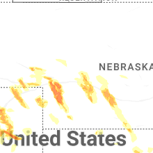
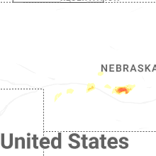
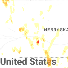
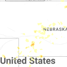
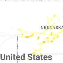
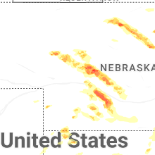
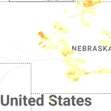
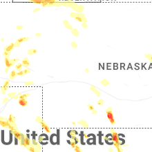
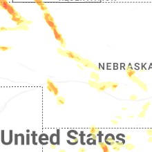
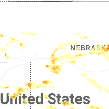

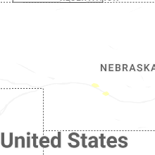

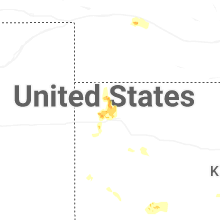


Connect with Interactive Hail Maps