

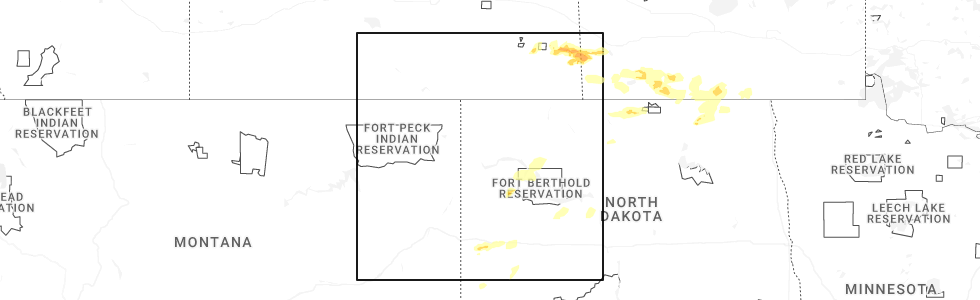
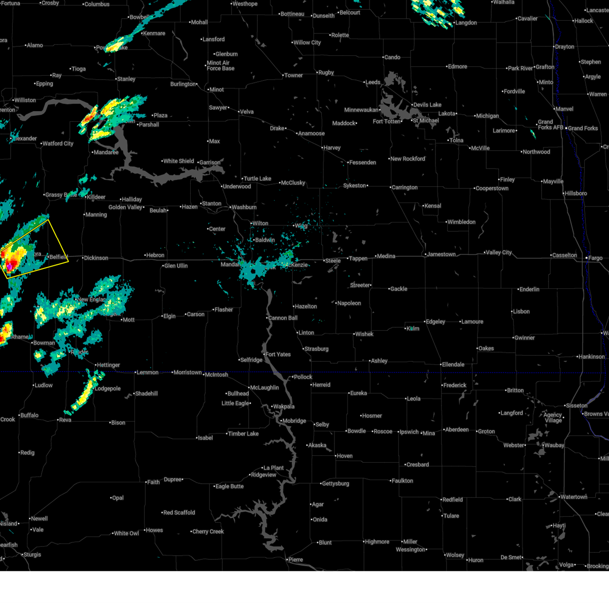
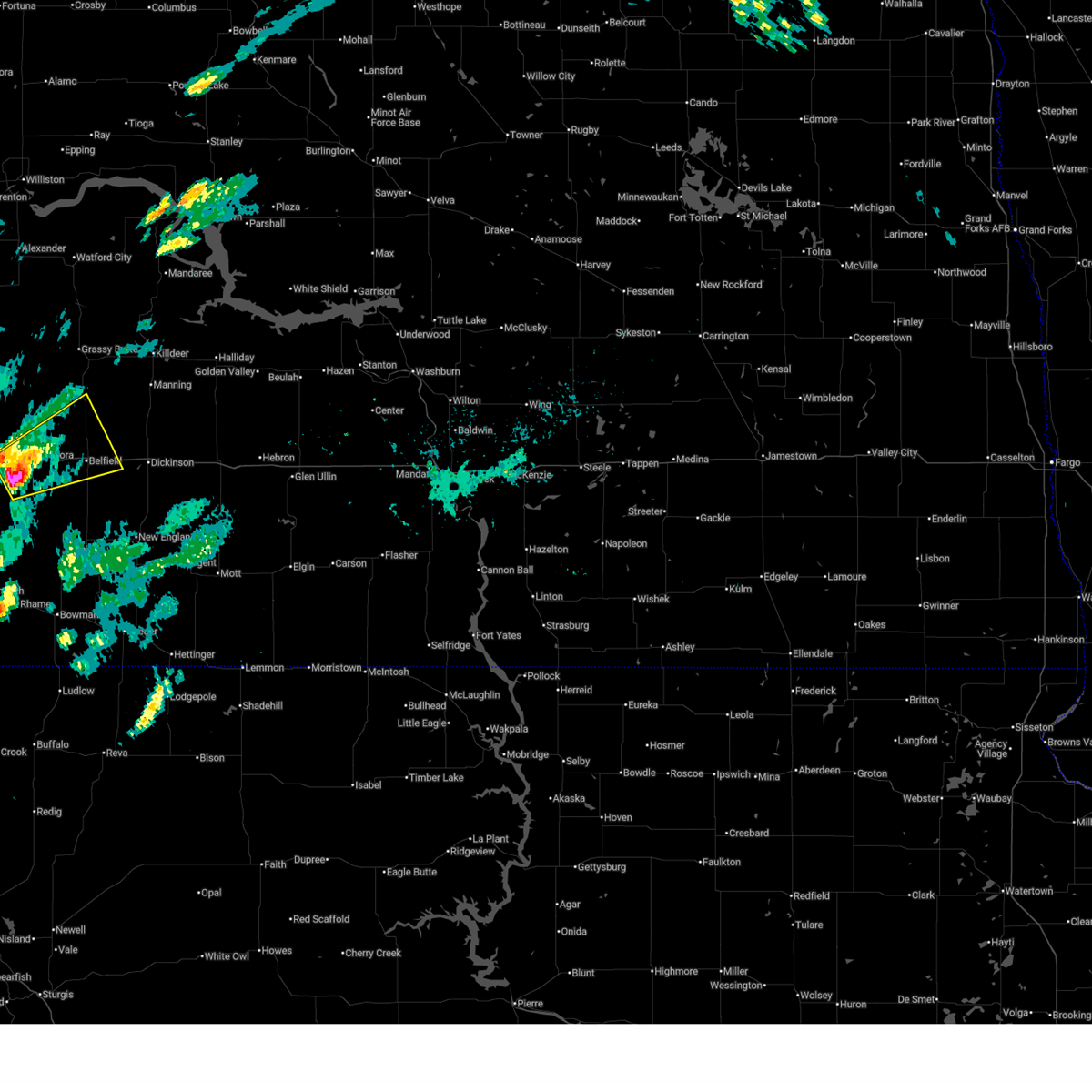
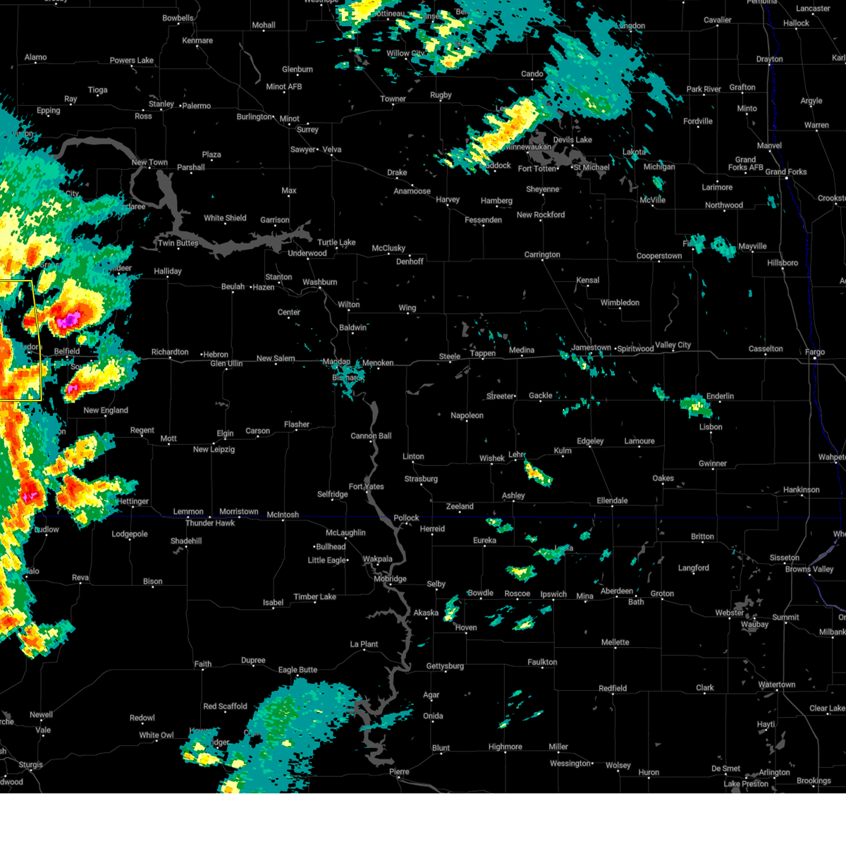
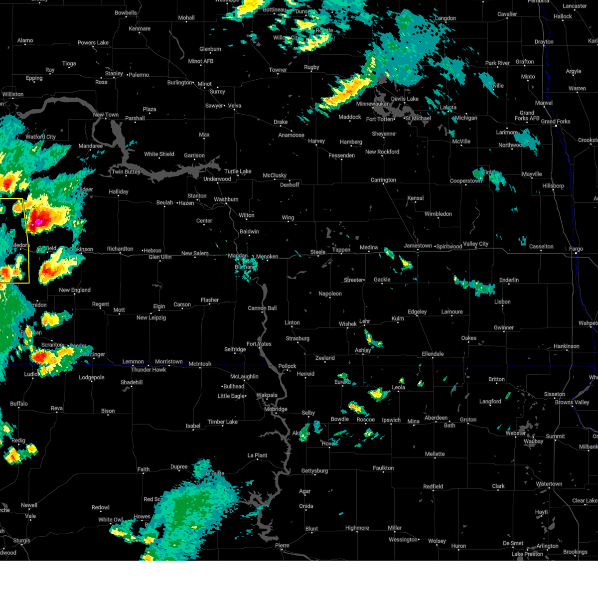
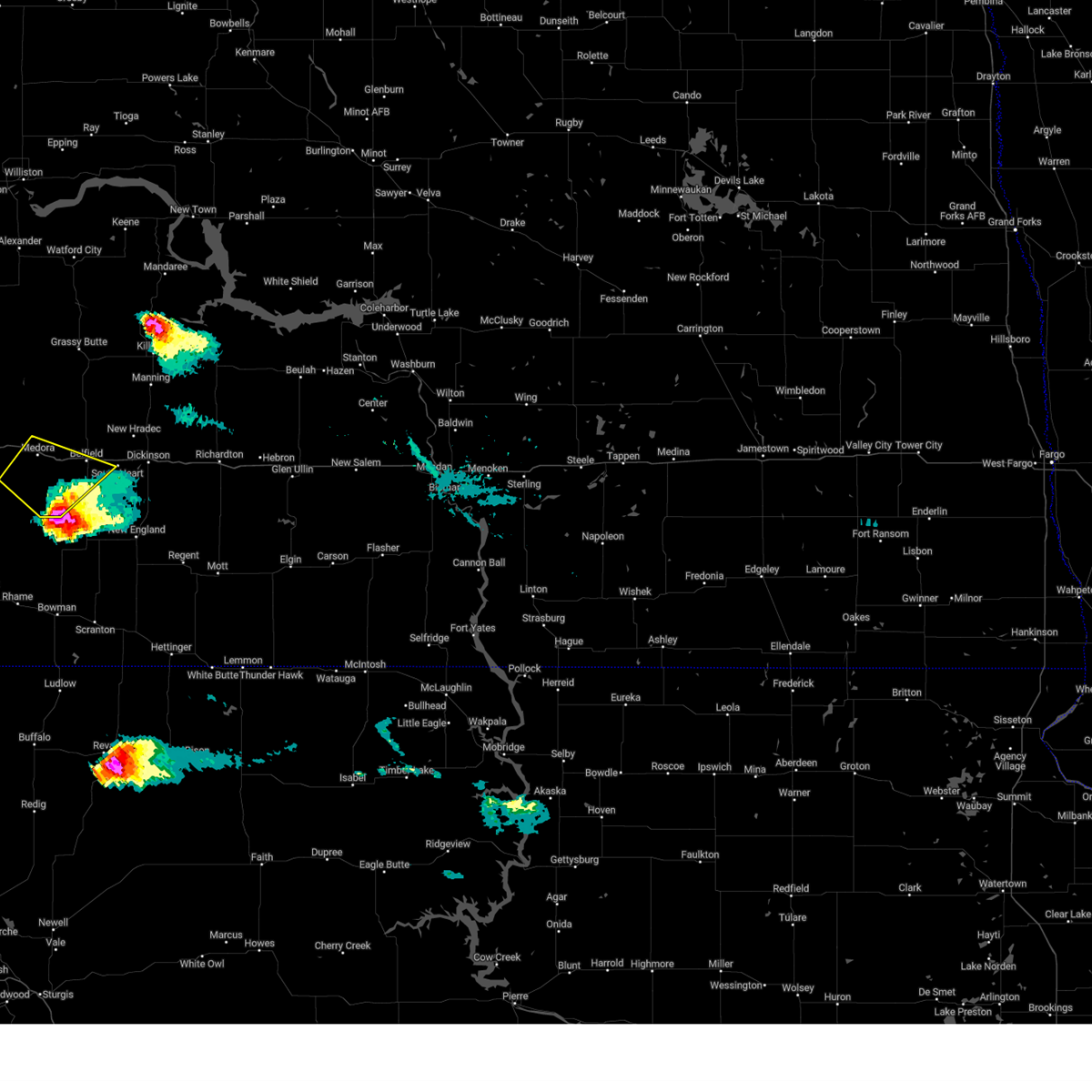
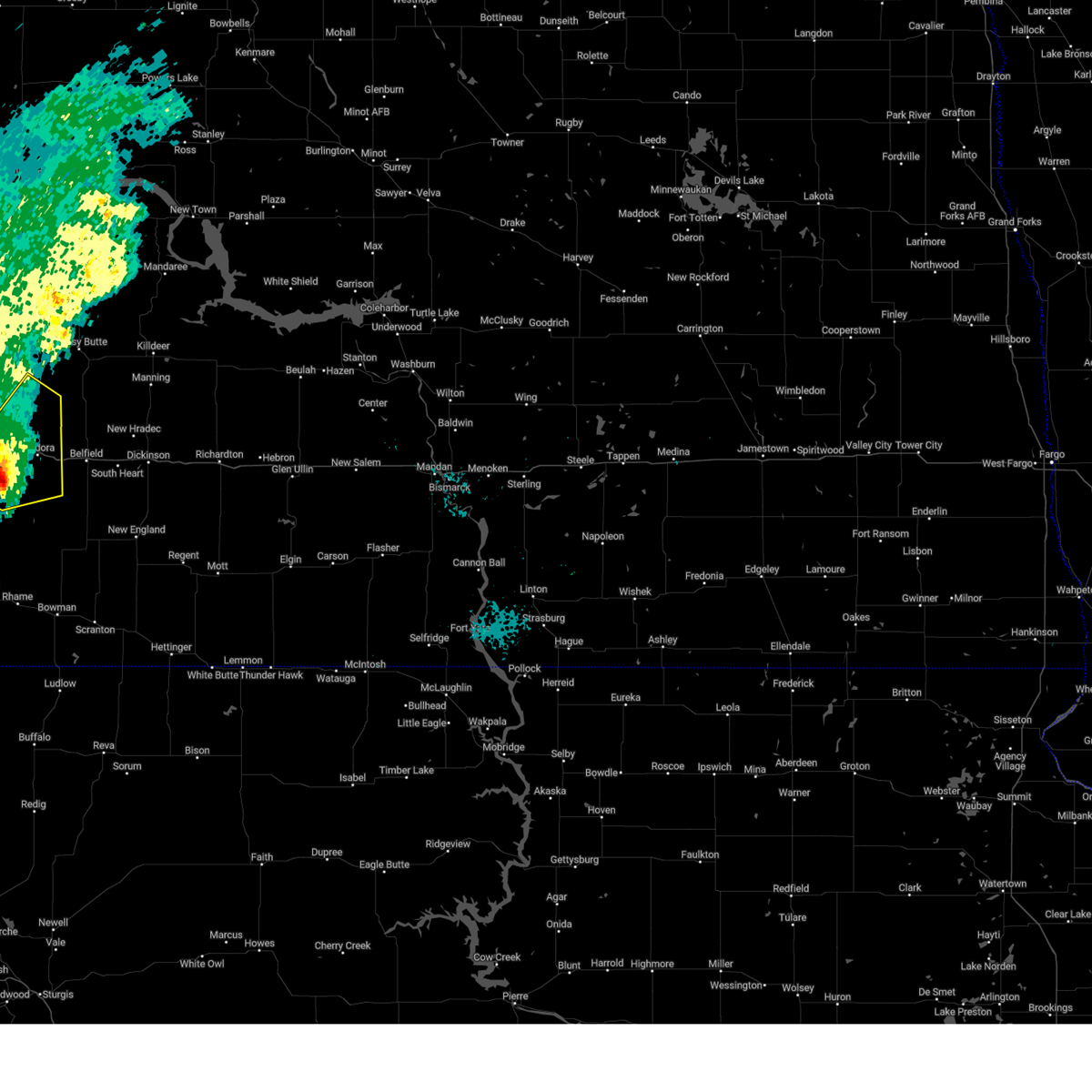
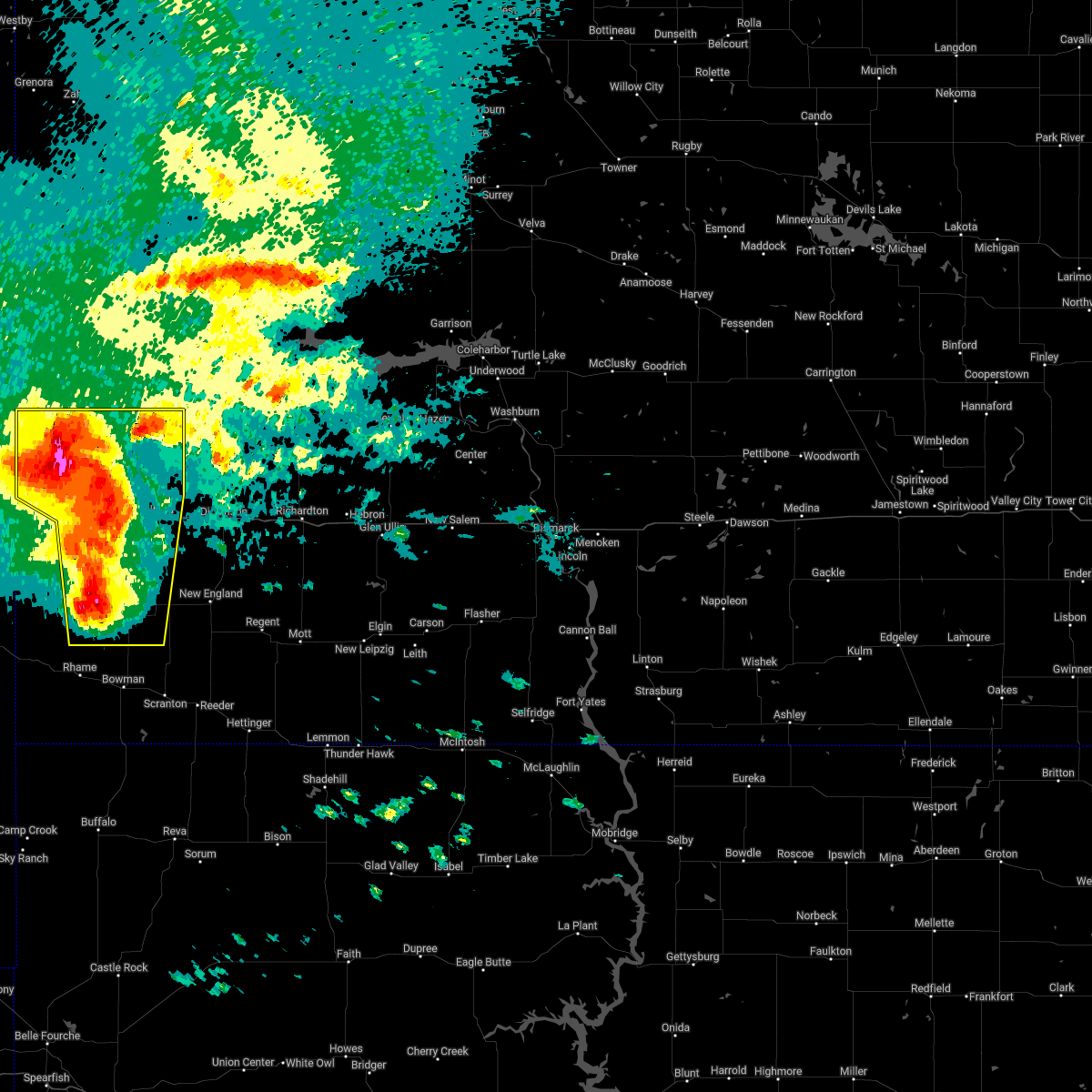
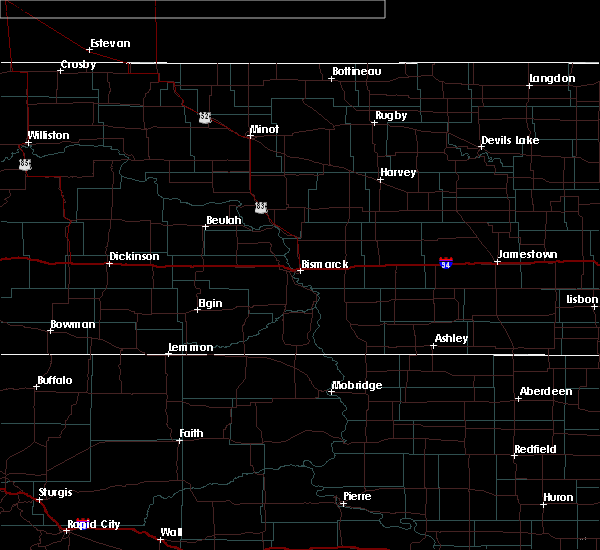
Hail Map for Medora, ND
The Medora, ND area has had 6 reports of on-the-ground hail by trained spotters, and has been under severe weather warnings 6 times during the past 12 months. Doppler radar has detected hail at or near Medora, ND on 23 occasions, including 1 occasion during the past year.
| Name: | Medora, ND |
| Where Located: | 85.4 miles S of Williston, ND |
| Map: | Google Map for Medora, ND |
| Population: | 112 |
| Housing Units: | 102 |
| More Info: | Search Google for Medora, ND |
0
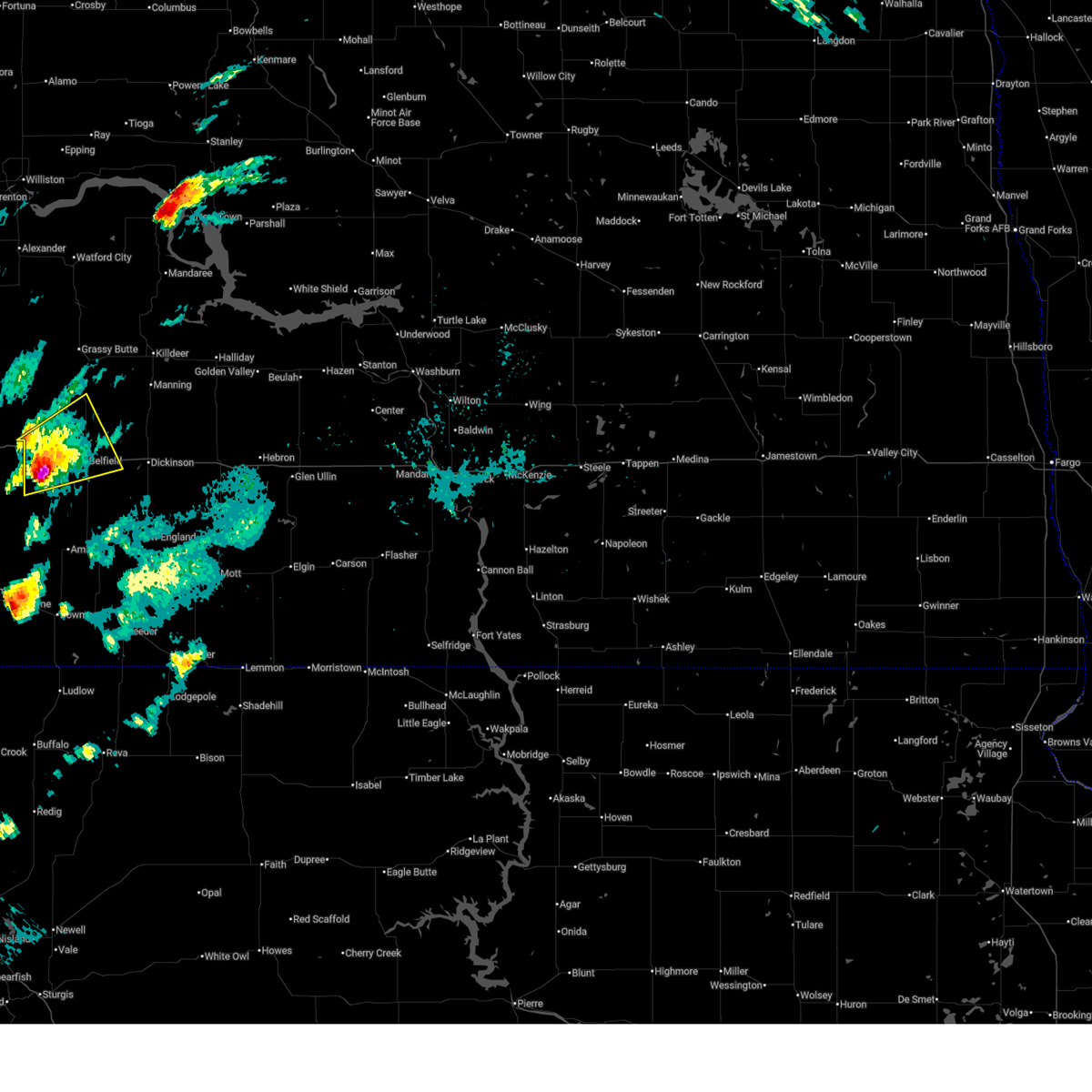
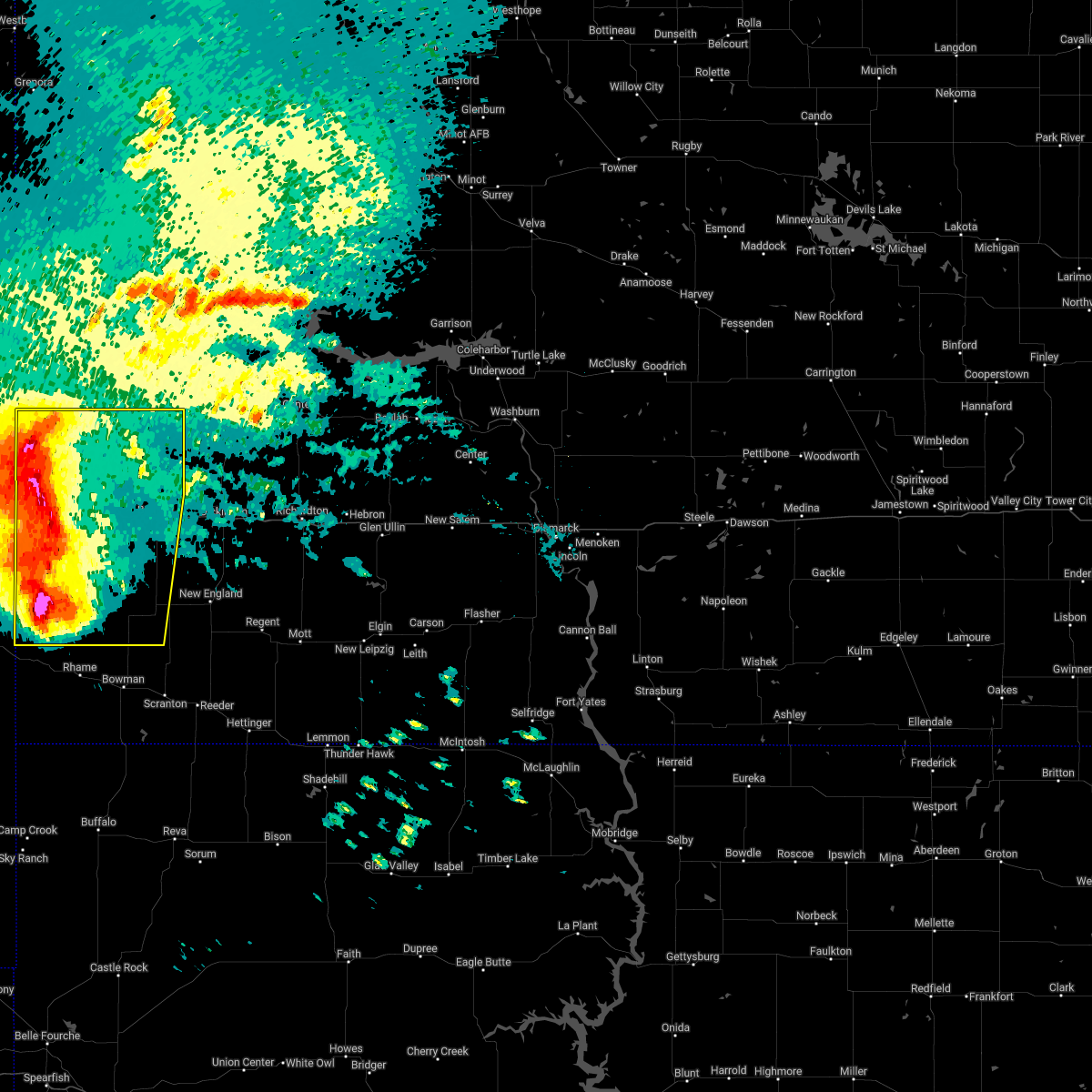
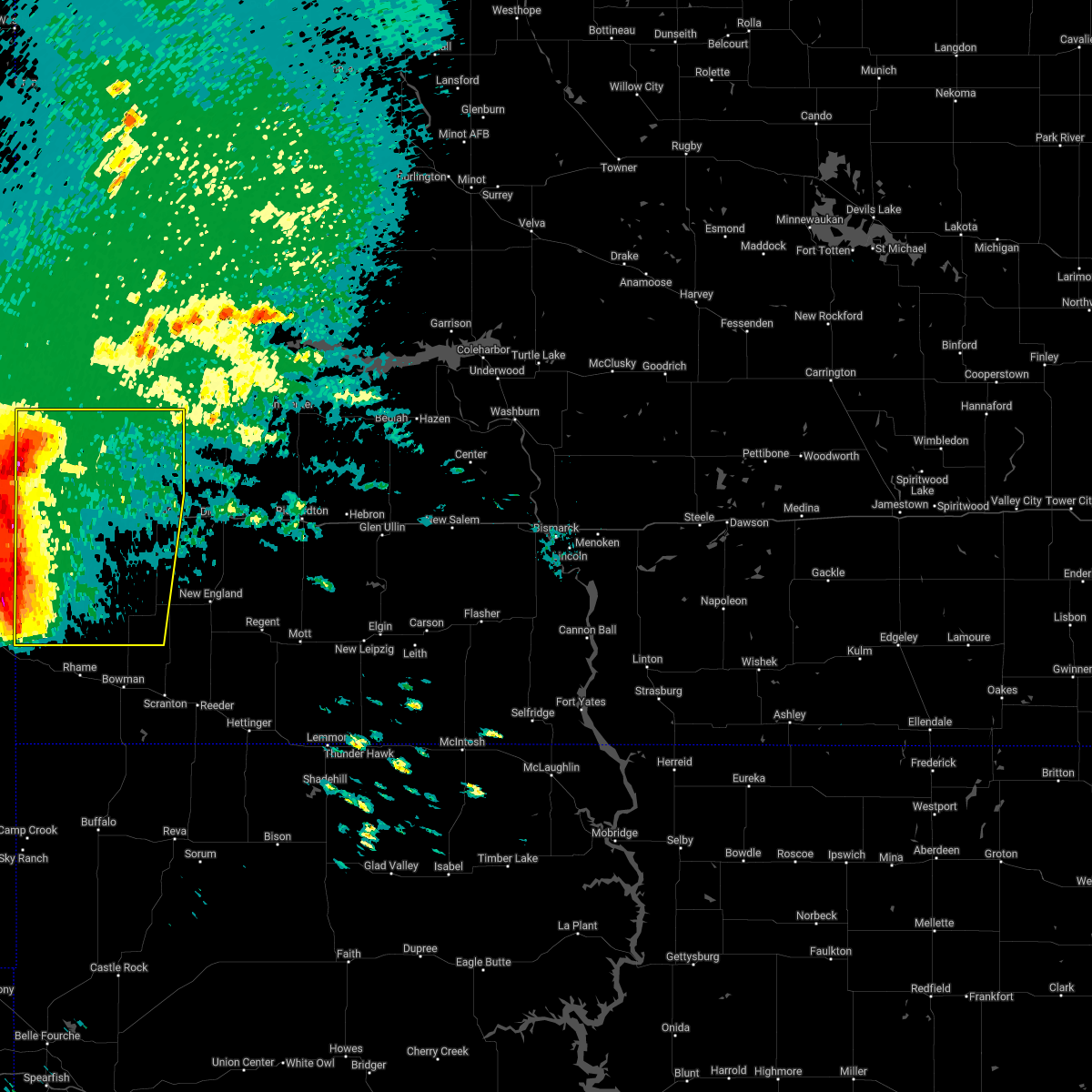
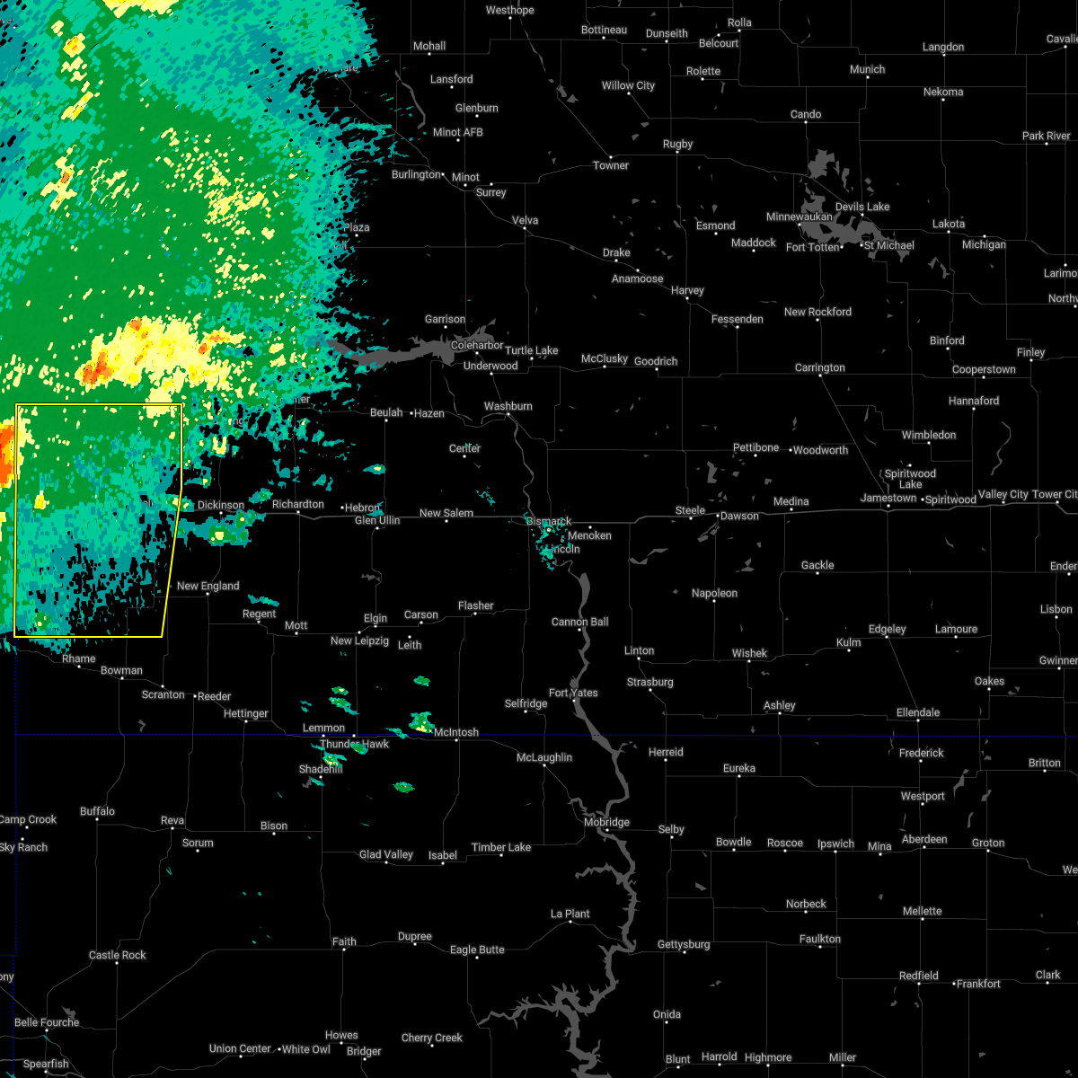
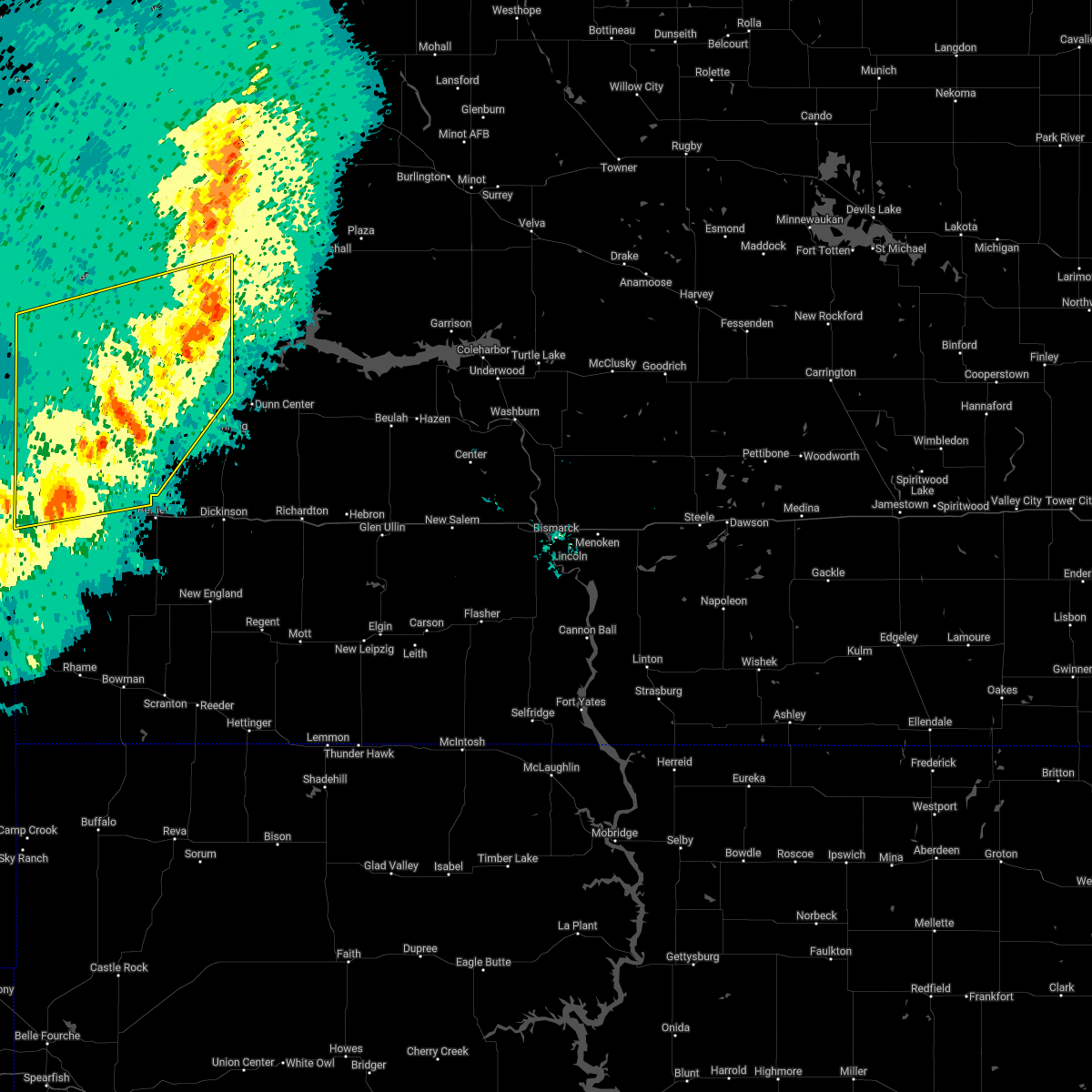
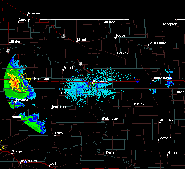
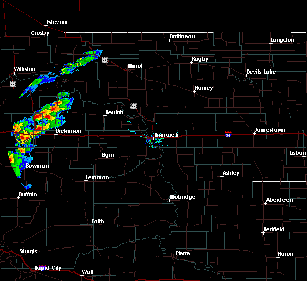
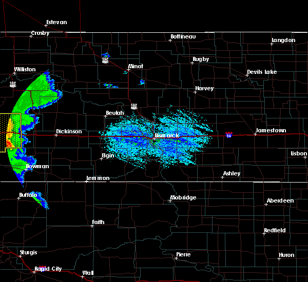
The Top Recent Hail Date for Medora, ND is Thursday, July 3, 2025 (23rd out of 23)
Hail and Wind Damage Spotted near Medora, ND
| Date / Time | Report Details |
|---|---|
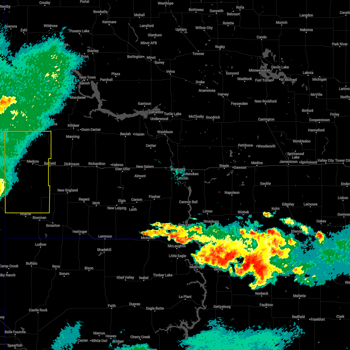
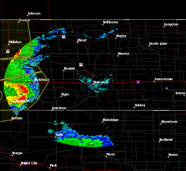
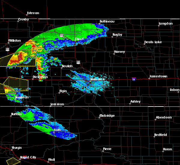
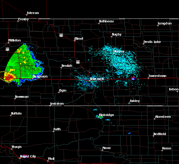
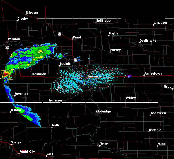
| 7/3/2025 8:06 PM MDT |
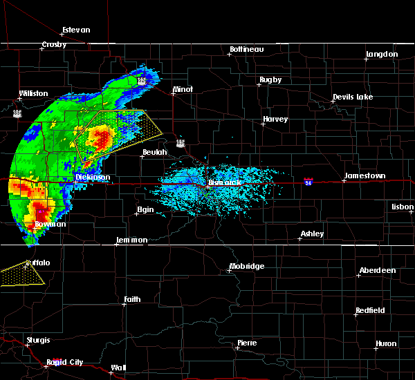
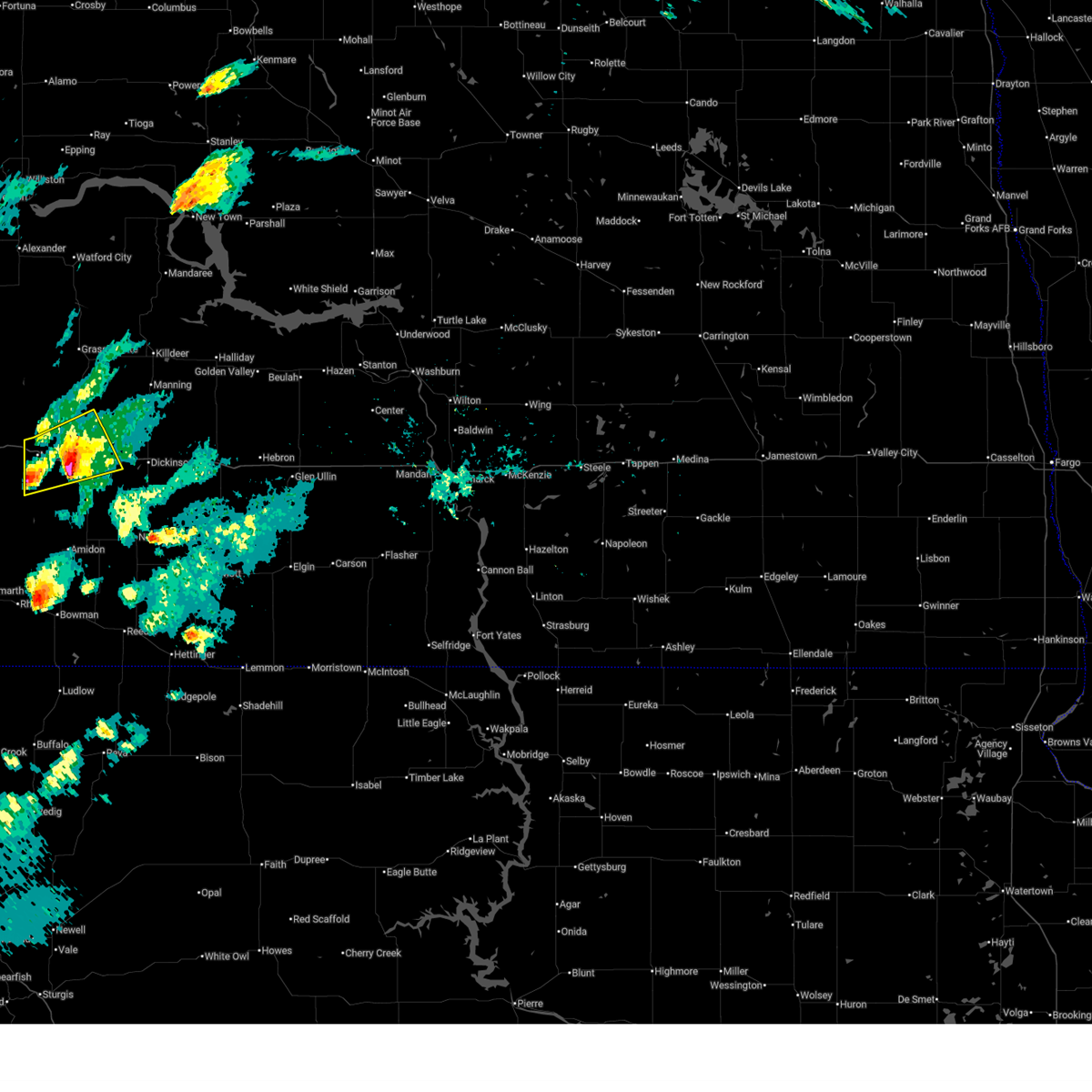 At 806 pm mdt, a severe thunderstorm was located 6 miles northwest of belfield, or 23 miles west of dickinson, moving northeast at 25 mph (radar indicated). Hazards include ping pong ball size hail and 60 mph wind gusts. People and animals outdoors will be injured. expect hail damage to roofs, siding, windows, and vehicles. expect wind damage to roofs, siding, and trees. Locations impacted include, belfield, south heart, medora, fryburg, and sully creek state park. At 806 pm mdt, a severe thunderstorm was located 6 miles northwest of belfield, or 23 miles west of dickinson, moving northeast at 25 mph (radar indicated). Hazards include ping pong ball size hail and 60 mph wind gusts. People and animals outdoors will be injured. expect hail damage to roofs, siding, windows, and vehicles. expect wind damage to roofs, siding, and trees. Locations impacted include, belfield, south heart, medora, fryburg, and sully creek state park.
|
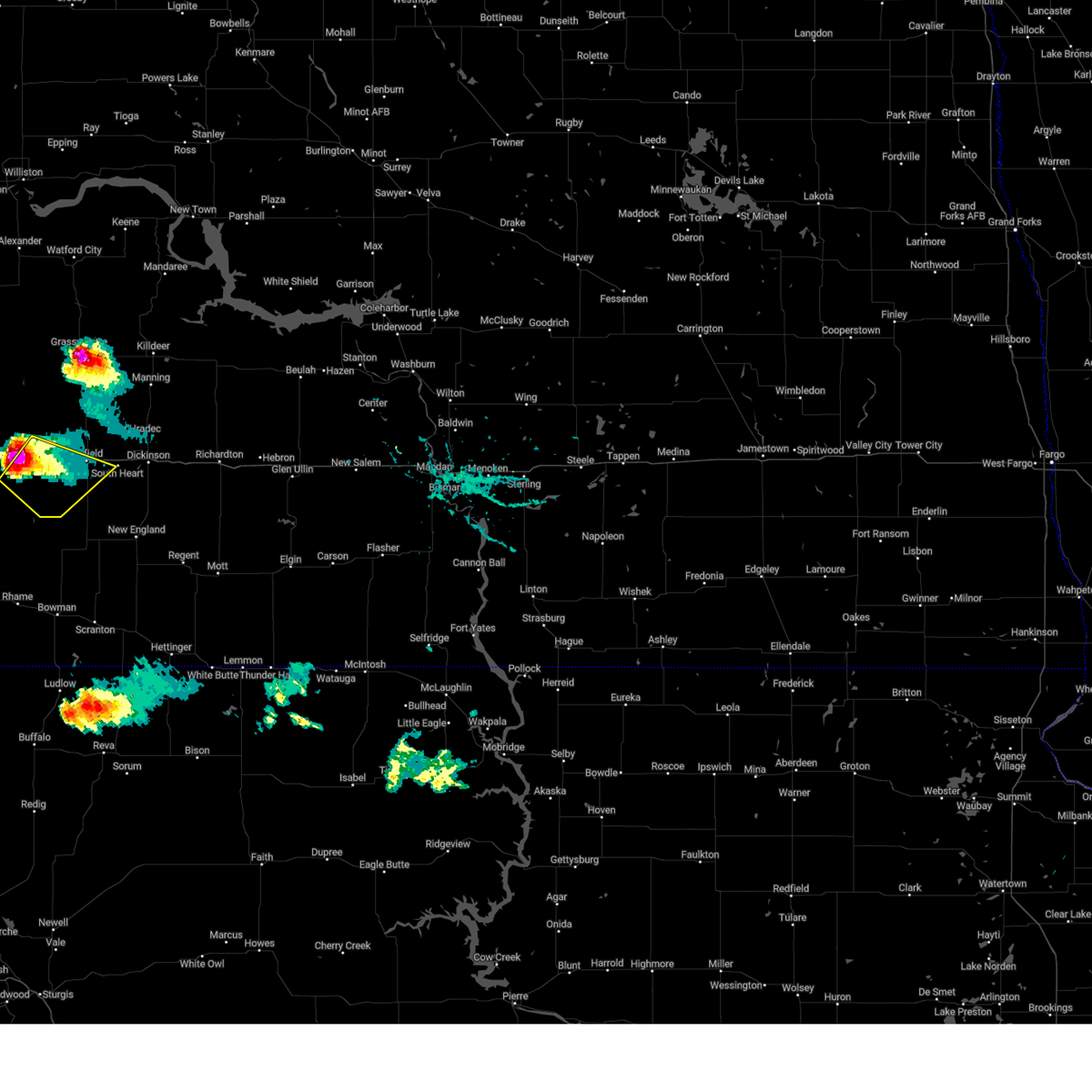
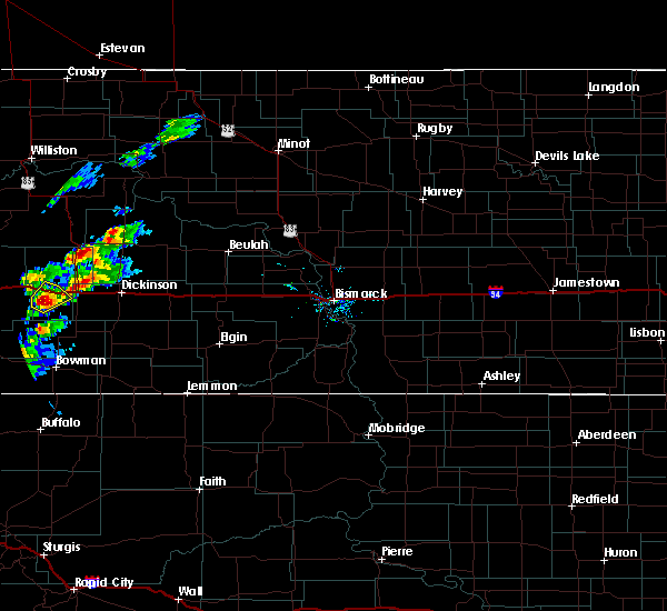
| 7/3/2025 7:56 PM MDT |
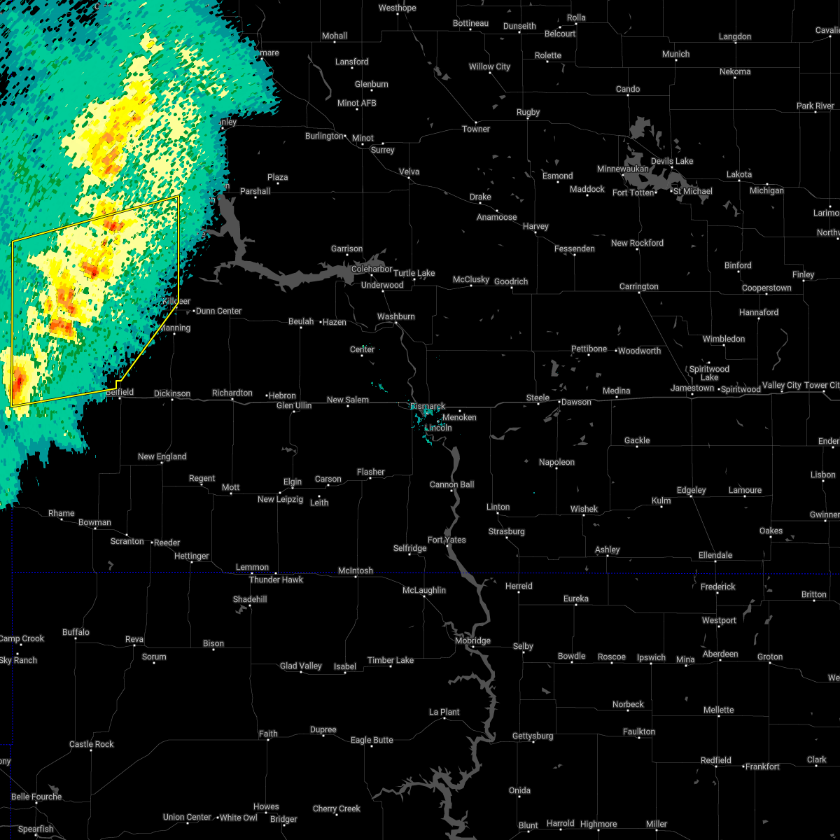
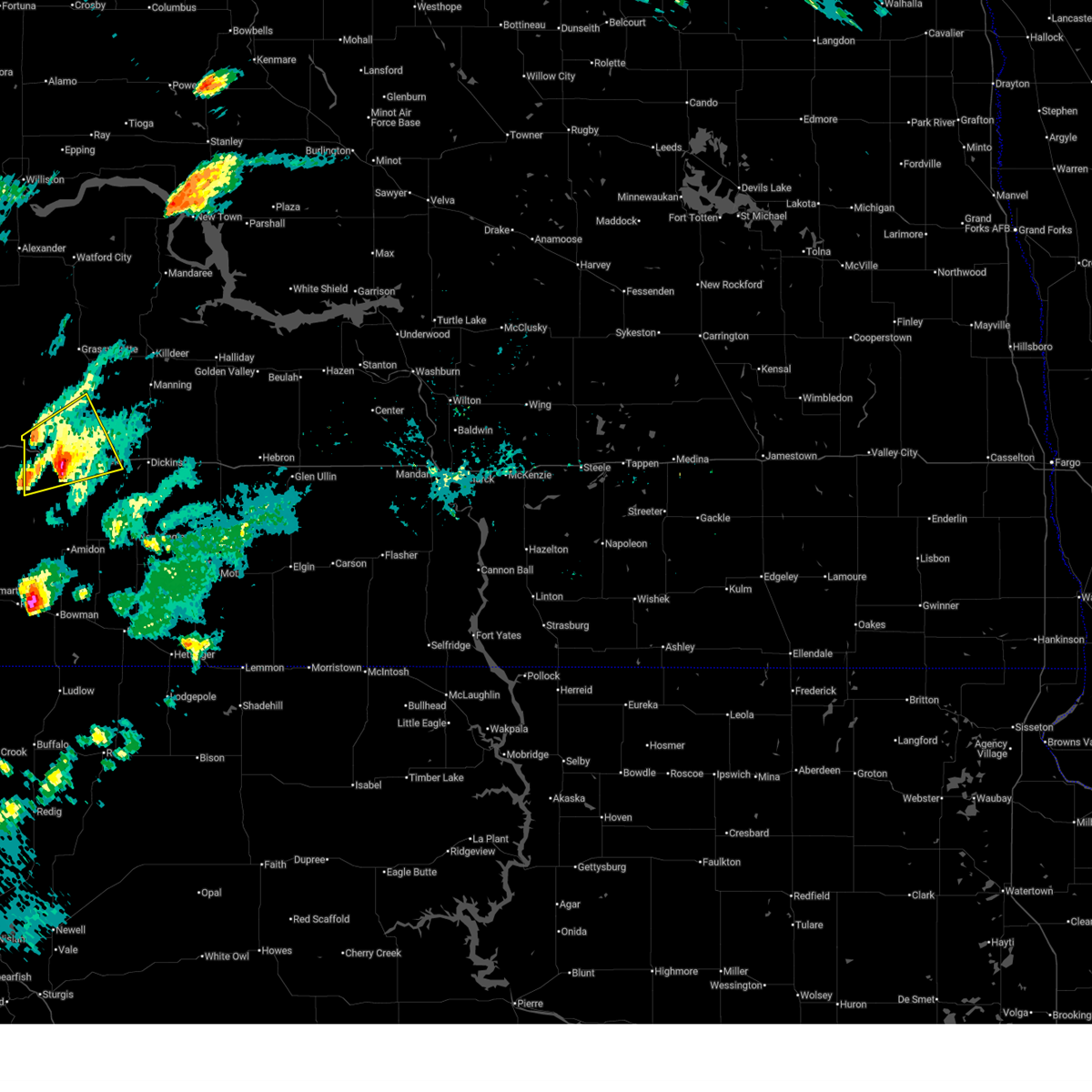 At 756 pm mdt, a severe thunderstorm was located 8 miles northwest of belfield, or 27 miles west of dickinson, moving northeast at 25 mph (radar indicated). Hazards include ping pong ball size hail and 60 mph wind gusts. People and animals outdoors will be injured. expect hail damage to roofs, siding, windows, and vehicles. expect wind damage to roofs, siding, and trees. Locations impacted include, belfield, south heart, medora, south fairfield, fryburg, and sully creek state park. At 756 pm mdt, a severe thunderstorm was located 8 miles northwest of belfield, or 27 miles west of dickinson, moving northeast at 25 mph (radar indicated). Hazards include ping pong ball size hail and 60 mph wind gusts. People and animals outdoors will be injured. expect hail damage to roofs, siding, windows, and vehicles. expect wind damage to roofs, siding, and trees. Locations impacted include, belfield, south heart, medora, south fairfield, fryburg, and sully creek state park.
|
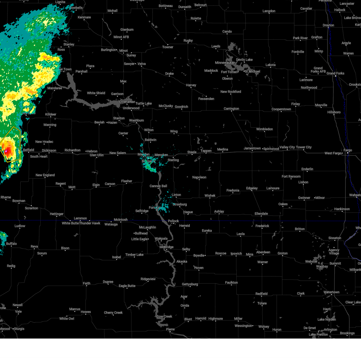
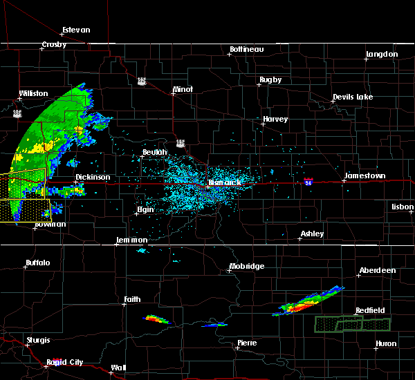
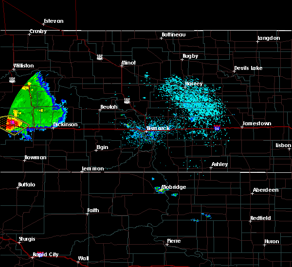
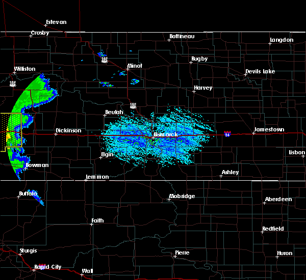
| 7/3/2025 7:40 PM MDT |
 At 740 pm mdt, a severe thunderstorm was located over medora, or 25 miles east of beach, moving northeast at 25 mph (radar indicated). Hazards include golf ball size hail and 60 mph wind gusts. People and animals outdoors will be injured. expect hail damage to roofs, siding, windows, and vehicles. expect wind damage to roofs, siding, and trees. Locations impacted include, belfield, south heart, medora, south fairfield, fryburg, and sully creek state park. At 740 pm mdt, a severe thunderstorm was located over medora, or 25 miles east of beach, moving northeast at 25 mph (radar indicated). Hazards include golf ball size hail and 60 mph wind gusts. People and animals outdoors will be injured. expect hail damage to roofs, siding, windows, and vehicles. expect wind damage to roofs, siding, and trees. Locations impacted include, belfield, south heart, medora, south fairfield, fryburg, and sully creek state park.
|
| 7/3/2025 7:40 PM MDT |
 the severe thunderstorm warning has been cancelled and is no longer in effect the severe thunderstorm warning has been cancelled and is no longer in effect
|
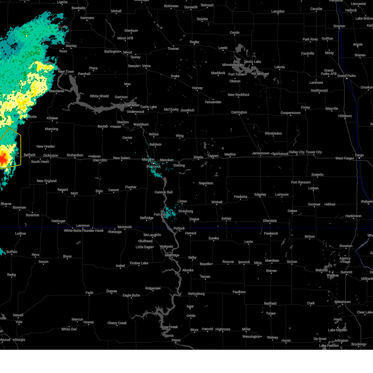
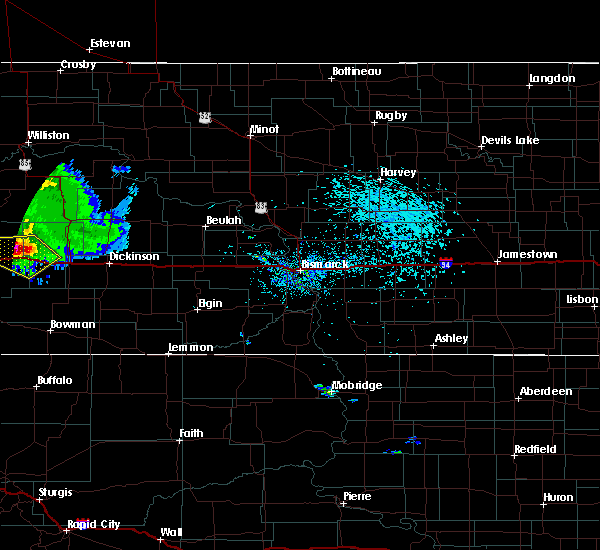
| 7/3/2025 7:21 PM MDT |
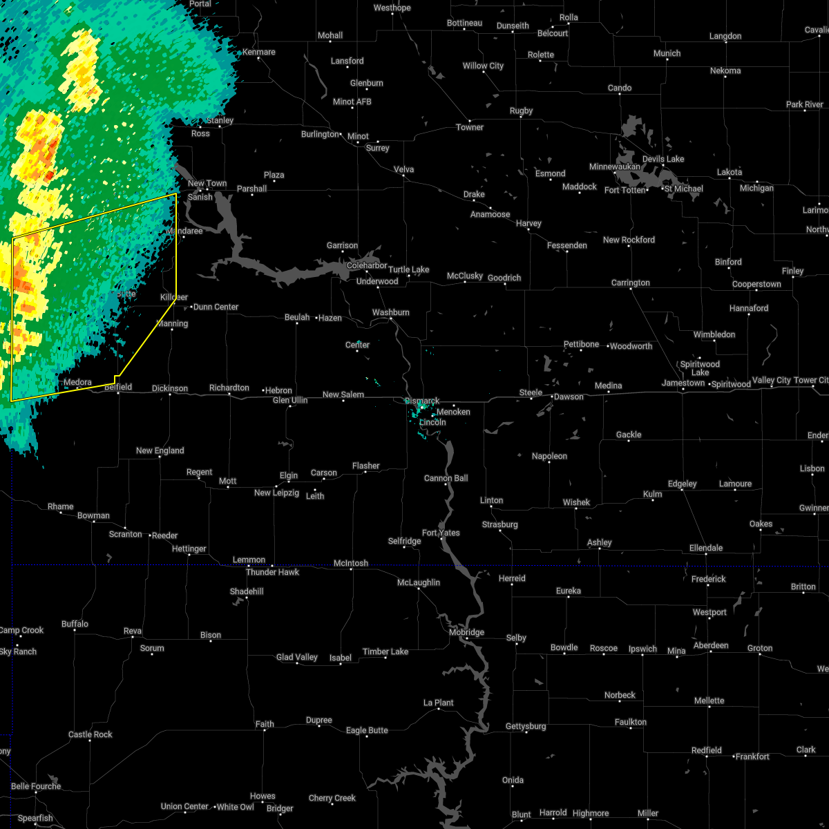
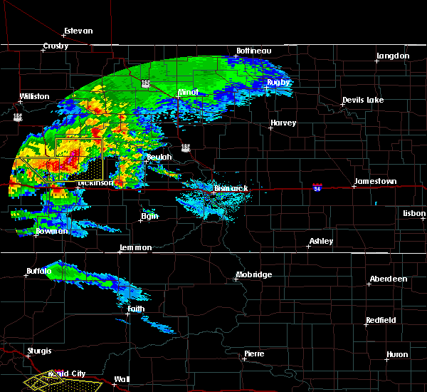
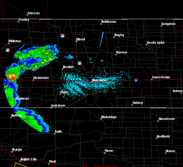
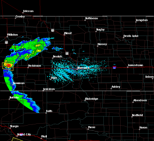
 At 721 pm mdt, a severe thunderstorm was located 6 miles southwest of medora, or 18 miles east of beach, moving northeast at 25 mph (radar indicated). Hazards include golf ball size hail and 60 mph wind gusts. People and animals outdoors will be injured. expect hail damage to roofs, siding, windows, and vehicles. expect wind damage to roofs, siding, and trees. Locations impacted include, belfield, south heart, medora, south fairfield, fryburg, and sully creek state park. At 721 pm mdt, a severe thunderstorm was located 6 miles southwest of medora, or 18 miles east of beach, moving northeast at 25 mph (radar indicated). Hazards include golf ball size hail and 60 mph wind gusts. People and animals outdoors will be injured. expect hail damage to roofs, siding, windows, and vehicles. expect wind damage to roofs, siding, and trees. Locations impacted include, belfield, south heart, medora, south fairfield, fryburg, and sully creek state park.
|
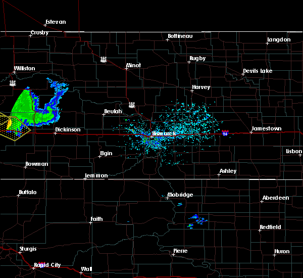
| 7/3/2025 7:17 PM MDT |
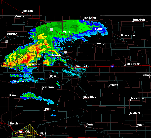
 Svrbis the national weather service in bismarck has issued a * severe thunderstorm warning for, east central golden valley county in southwestern north dakota, central billings county in southwestern north dakota, northwestern stark county in southwestern north dakota, * until 815 pm mdt. * at 717 pm mdt, a severe thunderstorm was located 8 miles southwest of medora, or 17 miles east of beach, moving northeast at 25 mph (radar indicated). Hazards include 60 mph wind gusts and quarter size hail. Hail damage to vehicles is expected. Expect wind damage to roofs, siding, and trees. Svrbis the national weather service in bismarck has issued a * severe thunderstorm warning for, east central golden valley county in southwestern north dakota, central billings county in southwestern north dakota, northwestern stark county in southwestern north dakota, * until 815 pm mdt. * at 717 pm mdt, a severe thunderstorm was located 8 miles southwest of medora, or 17 miles east of beach, moving northeast at 25 mph (radar indicated). Hazards include 60 mph wind gusts and quarter size hail. Hail damage to vehicles is expected. Expect wind damage to roofs, siding, and trees.
|
| 6/27/2024 6:13 PM MDT |
 Svrbis the national weather service in bismarck has issued a * severe thunderstorm warning for, southern dunn county in southwestern north dakota, billings county in southwestern north dakota, stark county in southwestern north dakota, * until 730 pm mdt. * at 612 pm mdt, severe thunderstorms were located along a line extending from 15 miles east of trotters to 7 miles northeast of medora to 9 miles north of amidon, moving east at 55 mph (radar indicated). Hazards include 70 mph wind gusts. Expect considerable tree damage. Damage is likely to mobile homes, roofs, and outbuildings. Svrbis the national weather service in bismarck has issued a * severe thunderstorm warning for, southern dunn county in southwestern north dakota, billings county in southwestern north dakota, stark county in southwestern north dakota, * until 730 pm mdt. * at 612 pm mdt, severe thunderstorms were located along a line extending from 15 miles east of trotters to 7 miles northeast of medora to 9 miles north of amidon, moving east at 55 mph (radar indicated). Hazards include 70 mph wind gusts. Expect considerable tree damage. Damage is likely to mobile homes, roofs, and outbuildings.
|
| 6/27/2024 6:03 PM MDT |
 At 603 pm mdt, severe thunderstorms were located along a line extending from near trotters to near medora to 16 miles northwest of amidon, moving east at 45 mph (radar indicated). Hazards include 70 mph wind gusts. Expect considerable tree damage. damage is likely to mobile homes, roofs, and outbuildings. Locations impacted include, medora, sentinel butte, trotters, sentinel butte state nature preserve, sully creek state park, and elkhorn state natural area. At 603 pm mdt, severe thunderstorms were located along a line extending from near trotters to near medora to 16 miles northwest of amidon, moving east at 45 mph (radar indicated). Hazards include 70 mph wind gusts. Expect considerable tree damage. damage is likely to mobile homes, roofs, and outbuildings. Locations impacted include, medora, sentinel butte, trotters, sentinel butte state nature preserve, sully creek state park, and elkhorn state natural area.
|
| 6/27/2024 5:44 PM MDT |
 Svrbis the national weather service in bismarck has issued a * severe thunderstorm warning for, golden valley county in southwestern north dakota, western billings county in southwestern north dakota, * until 630 pm mdt. * at 543 pm mdt, severe thunderstorms were located along a line extending from 7 miles west of skaar to near sentinel butte to 4 miles southeast of golva, moving east at 40 mph (radar indicated). Hazards include 70 mph wind gusts. Expect considerable tree damage. Damage is likely to mobile homes, roofs, and outbuildings. Svrbis the national weather service in bismarck has issued a * severe thunderstorm warning for, golden valley county in southwestern north dakota, western billings county in southwestern north dakota, * until 630 pm mdt. * at 543 pm mdt, severe thunderstorms were located along a line extending from 7 miles west of skaar to near sentinel butte to 4 miles southeast of golva, moving east at 40 mph (radar indicated). Hazards include 70 mph wind gusts. Expect considerable tree damage. Damage is likely to mobile homes, roofs, and outbuildings.
|
| 7/29/2023 7:42 PM MDT |
 The severe thunderstorm warning for east central golden valley, southwestern billings and west central stark counties will expire at 745 pm mdt, the storm which prompted the warning has moved out of the area. therefore, the warning will be allowed to expire. The severe thunderstorm warning for east central golden valley, southwestern billings and west central stark counties will expire at 745 pm mdt, the storm which prompted the warning has moved out of the area. therefore, the warning will be allowed to expire.
|
| 7/29/2023 6:50 PM MDT |
 At 650 pm mdt, a severe thunderstorm was located near medora, or 20 miles east of beach, moving southeast at 20 mph (radar indicated). Hazards include golf ball size hail. People and animals outdoors will be injured. expect damage to roofs, siding, windows, and vehicles. this severe thunderstorm will remain over mainly rural areas of east central golden valley, southwestern billings and west central stark counties, including the following locations, fryburg and sully creek state park. thunderstorm damage threat, considerable hail threat, radar indicated max hail size, 1. 75 in wind threat, radar indicated max wind gust, <50 mph. At 650 pm mdt, a severe thunderstorm was located near medora, or 20 miles east of beach, moving southeast at 20 mph (radar indicated). Hazards include golf ball size hail. People and animals outdoors will be injured. expect damage to roofs, siding, windows, and vehicles. this severe thunderstorm will remain over mainly rural areas of east central golden valley, southwestern billings and west central stark counties, including the following locations, fryburg and sully creek state park. thunderstorm damage threat, considerable hail threat, radar indicated max hail size, 1. 75 in wind threat, radar indicated max wind gust, <50 mph.
|
| 6/19/2023 9:33 PM MDT |
 At 933 pm mdt, a severe thunderstorm was located near medora, or 23 miles east of beach, moving northeast at 45 mph (radar indicated). Hazards include 60 mph wind gusts and quarter size hail. Hail damage to vehicles is expected. expect wind damage to roofs, siding, and trees. this severe thunderstorm will remain over mainly rural areas of east central golden valley and western billings counties, including the following locations, sully creek state park. hail threat, radar indicated max hail size, 1. 00 in wind threat, radar indicated max wind gust, 60 mph. At 933 pm mdt, a severe thunderstorm was located near medora, or 23 miles east of beach, moving northeast at 45 mph (radar indicated). Hazards include 60 mph wind gusts and quarter size hail. Hail damage to vehicles is expected. expect wind damage to roofs, siding, and trees. this severe thunderstorm will remain over mainly rural areas of east central golden valley and western billings counties, including the following locations, sully creek state park. hail threat, radar indicated max hail size, 1. 00 in wind threat, radar indicated max wind gust, 60 mph.
|
| 6/19/2023 9:23 PM MDT |
 At 923 pm mdt, a severe thunderstorm was located 5 miles west of medora, or 17 miles east of beach, moving northeast at 50 mph (radar indicated). Hazards include 60 mph wind gusts and quarter size hail. Hail damage to vehicles is expected. expect wind damage to roofs, siding, and trees. this severe storm will be near, medora around 930 pm mdt. other locations impacted by this severe thunderstorm include sentinel butte state nature preserve, sully creek state park and elkhorn state natural area. hail threat, radar indicated max hail size, 1. 00 in wind threat, radar indicated max wind gust, 60 mph. At 923 pm mdt, a severe thunderstorm was located 5 miles west of medora, or 17 miles east of beach, moving northeast at 50 mph (radar indicated). Hazards include 60 mph wind gusts and quarter size hail. Hail damage to vehicles is expected. expect wind damage to roofs, siding, and trees. this severe storm will be near, medora around 930 pm mdt. other locations impacted by this severe thunderstorm include sentinel butte state nature preserve, sully creek state park and elkhorn state natural area. hail threat, radar indicated max hail size, 1. 00 in wind threat, radar indicated max wind gust, 60 mph.
|
| 6/19/2023 9:17 PM MDT |
 At 917 pm mdt, a severe thunderstorm was located 8 miles southeast of sentinel butte, or 15 miles east of beach, moving northeast at 50 mph (radar indicated). Hazards include 70 mph wind gusts and ping pong ball size hail. People and animals outdoors will be injured. expect hail damage to roofs, siding, windows, and vehicles. expect considerable tree damage. wind damage is also likely to mobile homes, roofs, and outbuildings. this severe storm will be near, medora around 930 pm mdt. other locations impacted by this severe thunderstorm include sentinel butte state nature preserve, sully creek state park and elkhorn state natural area. thunderstorm damage threat, considerable hail threat, radar indicated max hail size, 1. 50 in wind threat, radar indicated max wind gust, 70 mph. At 917 pm mdt, a severe thunderstorm was located 8 miles southeast of sentinel butte, or 15 miles east of beach, moving northeast at 50 mph (radar indicated). Hazards include 70 mph wind gusts and ping pong ball size hail. People and animals outdoors will be injured. expect hail damage to roofs, siding, windows, and vehicles. expect considerable tree damage. wind damage is also likely to mobile homes, roofs, and outbuildings. this severe storm will be near, medora around 930 pm mdt. other locations impacted by this severe thunderstorm include sentinel butte state nature preserve, sully creek state park and elkhorn state natural area. thunderstorm damage threat, considerable hail threat, radar indicated max hail size, 1. 50 in wind threat, radar indicated max wind gust, 70 mph.
|
| 6/19/2023 9:06 PM MDT |
 At 906 pm mdt, a severe thunderstorm was located 6 miles northeast of golva, or 11 miles southeast of beach, moving northeast at 45 mph (radar indicated). Hazards include 70 mph wind gusts and ping pong ball size hail. People and animals outdoors will be injured. expect hail damage to roofs, siding, windows, and vehicles. expect considerable tree damage. wind damage is also likely to mobile homes, roofs, and outbuildings. this severe storm will be near, medora around 930 pm mdt. other locations impacted by this severe thunderstorm include alpha, sentinel butte state nature preserve, sully creek state park and elkhorn state natural area. thunderstorm damage threat, considerable hail threat, radar indicated max hail size, 1. 50 in wind threat, radar indicated max wind gust, 70 mph. At 906 pm mdt, a severe thunderstorm was located 6 miles northeast of golva, or 11 miles southeast of beach, moving northeast at 45 mph (radar indicated). Hazards include 70 mph wind gusts and ping pong ball size hail. People and animals outdoors will be injured. expect hail damage to roofs, siding, windows, and vehicles. expect considerable tree damage. wind damage is also likely to mobile homes, roofs, and outbuildings. this severe storm will be near, medora around 930 pm mdt. other locations impacted by this severe thunderstorm include alpha, sentinel butte state nature preserve, sully creek state park and elkhorn state natural area. thunderstorm damage threat, considerable hail threat, radar indicated max hail size, 1. 50 in wind threat, radar indicated max wind gust, 70 mph.
|
| 6/19/2023 8:47 PM MDT |
 At 846 pm mdt, a severe thunderstorm was located 5 miles north of carlyle, or 13 miles south of beach, moving northeast at 50 mph (radar indicated). Hazards include 70 mph wind gusts and ping pong ball size hail. People and animals outdoors will be injured. expect hail damage to roofs, siding, windows, and vehicles. expect considerable tree damage. wind damage is also likely to mobile homes, roofs, and outbuildings. this severe thunderstorm will be near, golva around 850 pm mdt. sentinel butte around 910 pm mdt. medora around 925 pm mdt. other locations impacted by this severe thunderstorm include alpha, sentinel butte state nature preserve, sully creek state park and elkhorn state natural area. thunderstorm damage threat, considerable hail threat, radar indicated max hail size, 1. 50 in wind threat, radar indicated max wind gust, 70 mph. At 846 pm mdt, a severe thunderstorm was located 5 miles north of carlyle, or 13 miles south of beach, moving northeast at 50 mph (radar indicated). Hazards include 70 mph wind gusts and ping pong ball size hail. People and animals outdoors will be injured. expect hail damage to roofs, siding, windows, and vehicles. expect considerable tree damage. wind damage is also likely to mobile homes, roofs, and outbuildings. this severe thunderstorm will be near, golva around 850 pm mdt. sentinel butte around 910 pm mdt. medora around 925 pm mdt. other locations impacted by this severe thunderstorm include alpha, sentinel butte state nature preserve, sully creek state park and elkhorn state natural area. thunderstorm damage threat, considerable hail threat, radar indicated max hail size, 1. 50 in wind threat, radar indicated max wind gust, 70 mph.
|
| 5/25/2023 5:00 PM MDT |
 At 459 pm mdt, a severe thunderstorm was located 13 miles east of golva, or 21 miles southeast of beach, moving north at 20 mph (radar indicated). Hazards include 60 mph wind gusts and quarter size hail. Hail damage to vehicles is expected. expect wind damage to roofs, siding, and trees. this severe thunderstorm will be near, sentinel butte around 545 pm mdt. other locations impacted by this severe thunderstorm include alpha, sentinel butte state nature preserve and sully creek state park. hail threat, radar indicated max hail size, 1. 00 in wind threat, radar indicated max wind gust, 60 mph. At 459 pm mdt, a severe thunderstorm was located 13 miles east of golva, or 21 miles southeast of beach, moving north at 20 mph (radar indicated). Hazards include 60 mph wind gusts and quarter size hail. Hail damage to vehicles is expected. expect wind damage to roofs, siding, and trees. this severe thunderstorm will be near, sentinel butte around 545 pm mdt. other locations impacted by this severe thunderstorm include alpha, sentinel butte state nature preserve and sully creek state park. hail threat, radar indicated max hail size, 1. 00 in wind threat, radar indicated max wind gust, 60 mph.
|
| 7/10/2022 1:30 AM MDT |
 At 129 am mdt, severe thunderstorms were located along a line extending from 15 miles southeast of trotters to 6 miles northeast of medora to 8 miles northwest of amidon, moving east at 60 mph. these are destructive storms for golden valley, billings, and slope counties (radar indicated). Hazards include 80 mph wind gusts and ping pong ball size hail. Flying debris will be dangerous to those caught without shelter. mobile homes will be heavily damaged. expect considerable damage to roofs, windows, and vehicles. extensive tree damage and power outages are likely. these severe storms will be near, south fairfield around 145 am mdt. other locations impacted by these severe thunderstorms include fryburg and fairfield. thunderstorm damage threat, destructive hail threat, radar indicated max hail size, 1. 50 in wind threat, observed max wind gust, 80 mph. At 129 am mdt, severe thunderstorms were located along a line extending from 15 miles southeast of trotters to 6 miles northeast of medora to 8 miles northwest of amidon, moving east at 60 mph. these are destructive storms for golden valley, billings, and slope counties (radar indicated). Hazards include 80 mph wind gusts and ping pong ball size hail. Flying debris will be dangerous to those caught without shelter. mobile homes will be heavily damaged. expect considerable damage to roofs, windows, and vehicles. extensive tree damage and power outages are likely. these severe storms will be near, south fairfield around 145 am mdt. other locations impacted by these severe thunderstorms include fryburg and fairfield. thunderstorm damage threat, destructive hail threat, radar indicated max hail size, 1. 50 in wind threat, observed max wind gust, 80 mph.
|
| 7/10/2022 1:28 AM MDT | Social media repor in billings county ND, 3.9 miles NE of Medora, ND |
| 7/10/2022 1:14 AM MDT |
 At 113 am mdt, severe thunderstorms were located along a line extending from 11 miles southeast of trotters to 6 miles east of sentinel butte to 16 miles northeast of marmarth, moving east at 60 mph. these are destructive storms for golden valley, billings, and slope counties (radar indicated). Hazards include 80 mph wind gusts and ping pong ball size hail. Flying debris will be dangerous to those caught without shelter. mobile homes will be heavily damaged. expect considerable damage to roofs, windows, and vehicles. extensive tree damage and power outages are likely. these severe storms will be near, medora around 120 am mdt. amidon around 135 am mdt. south fairfield around 140 am mdt. other locations impacted by these severe thunderstorms include alpha, fryburg, fairfield, three v crossing, and pretty butte. thunderstorm damage threat, destructive hail threat, radar indicated max hail size, 1. 50 in wind threat, observed max wind gust, 80 mph. At 113 am mdt, severe thunderstorms were located along a line extending from 11 miles southeast of trotters to 6 miles east of sentinel butte to 16 miles northeast of marmarth, moving east at 60 mph. these are destructive storms for golden valley, billings, and slope counties (radar indicated). Hazards include 80 mph wind gusts and ping pong ball size hail. Flying debris will be dangerous to those caught without shelter. mobile homes will be heavily damaged. expect considerable damage to roofs, windows, and vehicles. extensive tree damage and power outages are likely. these severe storms will be near, medora around 120 am mdt. amidon around 135 am mdt. south fairfield around 140 am mdt. other locations impacted by these severe thunderstorms include alpha, fryburg, fairfield, three v crossing, and pretty butte. thunderstorm damage threat, destructive hail threat, radar indicated max hail size, 1. 50 in wind threat, observed max wind gust, 80 mph.
|
| 7/10/2022 1:03 AM MDT |
 At 102 am mdt, severe thunderstorms were located along a line extending from 11 miles south of trotters to near beach to 12 miles north of marmarth, moving northeast at 50 mph (radar indicated). Hazards include 70 mph wind gusts and ping pong ball size hail. People and animals outdoors will be injured. expect hail damage to roofs, siding, windows, and vehicles. expect considerable tree damage. wind damage is also likely to mobile homes, roofs, and outbuildings. these severe storms will be near, sentinel butte around 110 am mdt. medora around 125 am mdt. south fairfield around 145 am mdt. other locations impacted by these severe thunderstorms include alpha, fryburg, fairfield, three v crossing, and pretty butte. thunderstorm damage threat, considerable hail threat, radar indicated max hail size, 1. 50 in wind threat, radar indicated max wind gust, 70 mph. At 102 am mdt, severe thunderstorms were located along a line extending from 11 miles south of trotters to near beach to 12 miles north of marmarth, moving northeast at 50 mph (radar indicated). Hazards include 70 mph wind gusts and ping pong ball size hail. People and animals outdoors will be injured. expect hail damage to roofs, siding, windows, and vehicles. expect considerable tree damage. wind damage is also likely to mobile homes, roofs, and outbuildings. these severe storms will be near, sentinel butte around 110 am mdt. medora around 125 am mdt. south fairfield around 145 am mdt. other locations impacted by these severe thunderstorms include alpha, fryburg, fairfield, three v crossing, and pretty butte. thunderstorm damage threat, considerable hail threat, radar indicated max hail size, 1. 50 in wind threat, radar indicated max wind gust, 70 mph.
|
| 7/10/2022 12:45 AM MDT |
 At 1245 am mdt, severe thunderstorms were located along a line extending from 10 miles northwest of wibaux to 9 miles northwest of golva to 7 miles north of baker, moving east at 60 mph (radar indicated). Hazards include 70 mph wind gusts and ping pong ball size hail. People and animals outdoors will be injured. expect hail damage to roofs, siding, windows, and vehicles. expect considerable tree damage. wind damage is also likely to mobile homes, roofs, and outbuildings. severe thunderstorms will be near, golva around 1250 am mdt. beach around 1255 am mdt. sentinel butte around 100 am mdt. medora around 115 am mdt. belfield around 130 am mdt. other locations impacted by these severe thunderstorms include alpha, fryburg, fairfield, three v crossing, and pretty butte. thunderstorm damage threat, considerable hail threat, radar indicated max hail size, 1. 50 in wind threat, radar indicated max wind gust, 70 mph. At 1245 am mdt, severe thunderstorms were located along a line extending from 10 miles northwest of wibaux to 9 miles northwest of golva to 7 miles north of baker, moving east at 60 mph (radar indicated). Hazards include 70 mph wind gusts and ping pong ball size hail. People and animals outdoors will be injured. expect hail damage to roofs, siding, windows, and vehicles. expect considerable tree damage. wind damage is also likely to mobile homes, roofs, and outbuildings. severe thunderstorms will be near, golva around 1250 am mdt. beach around 1255 am mdt. sentinel butte around 100 am mdt. medora around 115 am mdt. belfield around 130 am mdt. other locations impacted by these severe thunderstorms include alpha, fryburg, fairfield, three v crossing, and pretty butte. thunderstorm damage threat, considerable hail threat, radar indicated max hail size, 1. 50 in wind threat, radar indicated max wind gust, 70 mph.
|
| 7/9/2022 2:26 AM MDT |
 The severe thunderstorm warning for northern golden valley, northwestern dunn, billings and mckenzie counties will expire at 330 am cdt/230 am mdt/, the storms which prompted the warning have weakened below severe limits, and no longer pose an immediate threat to life or property. therefore, the warning will be allowed to expire. however gusty winds are still possible with these thunderstorms. a severe thunderstorm watch remains in effect until 400 am cdt/300 am mdt/ for southwestern and northwestern north dakota. a severe thunderstorm watch also remains in effect until 800 am cdt/700 am mdt/ for southwestern north dakota. The severe thunderstorm warning for northern golden valley, northwestern dunn, billings and mckenzie counties will expire at 330 am cdt/230 am mdt/, the storms which prompted the warning have weakened below severe limits, and no longer pose an immediate threat to life or property. therefore, the warning will be allowed to expire. however gusty winds are still possible with these thunderstorms. a severe thunderstorm watch remains in effect until 400 am cdt/300 am mdt/ for southwestern and northwestern north dakota. a severe thunderstorm watch also remains in effect until 800 am cdt/700 am mdt/ for southwestern north dakota.
|
| 7/9/2022 2:04 AM MDT |
 At 304 am cdt/204 am mdt/, severe thunderstorms were located along a line extending from 7 miles east of watford city to 4 miles south of grassy butte to 6 miles southwest of beach, moving east at 50 mph (radar indicated). Hazards include 60 mph wind gusts and penny size hail. Expect damage to roofs, siding, and trees. these severe storms will be near, grassy butte around 210 am mdt. sentinel butte around 220 am mdt. medora around 235 am mdt. other locations impacted by these severe thunderstorms include oakdale, sather dam, fairfield and johnsons corner. hail threat, radar indicated max hail size, 0. 75 in wind threat, radar indicated max wind gust, 60 mph. At 304 am cdt/204 am mdt/, severe thunderstorms were located along a line extending from 7 miles east of watford city to 4 miles south of grassy butte to 6 miles southwest of beach, moving east at 50 mph (radar indicated). Hazards include 60 mph wind gusts and penny size hail. Expect damage to roofs, siding, and trees. these severe storms will be near, grassy butte around 210 am mdt. sentinel butte around 220 am mdt. medora around 235 am mdt. other locations impacted by these severe thunderstorms include oakdale, sather dam, fairfield and johnsons corner. hail threat, radar indicated max hail size, 0. 75 in wind threat, radar indicated max wind gust, 60 mph.
|
| 7/9/2022 1:37 AM MDT |
 At 237 am cdt/137 am mdt/, severe thunderstorms were located along a line extending from 11 miles east of sidney to 10 miles southeast of trotters to 4 miles southwest of beach, moving east at 35 mph (radar indicated). Hazards include 60 mph wind gusts and nickel size hail. expect damage to roofs, siding, and trees At 237 am cdt/137 am mdt/, severe thunderstorms were located along a line extending from 11 miles east of sidney to 10 miles southeast of trotters to 4 miles southwest of beach, moving east at 35 mph (radar indicated). Hazards include 60 mph wind gusts and nickel size hail. expect damage to roofs, siding, and trees
|
| 7/3/2022 9:09 PM MDT |
 At 909 pm mdt, severe thunderstorms were located along a line extending from near trotters to 9 miles northeast of marmarth, moving east at 35 mph (radar indicated). Hazards include 70 mph wind gusts and half dollar size hail. Hail damage to vehicles is expected. expect considerable tree damage. wind damage is also likely to mobile homes, roofs, and outbuildings. locations impacted include, amidon. thunderstorm damage threat, considerable hail threat, radar indicated max hail size, 1. 25 in wind threat, radar indicated max wind gust, 70 mph. At 909 pm mdt, severe thunderstorms were located along a line extending from near trotters to 9 miles northeast of marmarth, moving east at 35 mph (radar indicated). Hazards include 70 mph wind gusts and half dollar size hail. Hail damage to vehicles is expected. expect considerable tree damage. wind damage is also likely to mobile homes, roofs, and outbuildings. locations impacted include, amidon. thunderstorm damage threat, considerable hail threat, radar indicated max hail size, 1. 25 in wind threat, radar indicated max wind gust, 70 mph.
|
| 7/3/2022 8:40 PM MDT |
 At 838 pm mdt, severe thunderstorms were located along a line extending from 5 miles west of skaar to 10 miles northeast of baker, moving east at 45 mph (radar indicated). Hazards include 70 mph wind gusts and half dollar size hail. Hail damage to vehicles is expected. expect considerable tree damage. wind damage is also likely to mobile homes, roofs, and outbuildings. severe thunderstorms will be near, trotters around 855 pm mdt. other locations in the path of these severe thunderstorms include amidon. thunderstorm damage threat, considerable hail threat, radar indicated max hail size, 1. 25 in wind threat, radar indicated max wind gust, 70 mph. At 838 pm mdt, severe thunderstorms were located along a line extending from 5 miles west of skaar to 10 miles northeast of baker, moving east at 45 mph (radar indicated). Hazards include 70 mph wind gusts and half dollar size hail. Hail damage to vehicles is expected. expect considerable tree damage. wind damage is also likely to mobile homes, roofs, and outbuildings. severe thunderstorms will be near, trotters around 855 pm mdt. other locations in the path of these severe thunderstorms include amidon. thunderstorm damage threat, considerable hail threat, radar indicated max hail size, 1. 25 in wind threat, radar indicated max wind gust, 70 mph.
|
| 7/12/2020 11:53 PM MDT |
 At 1152 pm mdt, a severe thunderstorm was located near sentinel butte, or near beach, moving northeast at 35 mph (radar indicated). Hazards include 60 mph wind gusts and quarter size hail. Hail damage to vehicles is expected. Expect wind damage to roofs, siding, and trees. At 1152 pm mdt, a severe thunderstorm was located near sentinel butte, or near beach, moving northeast at 35 mph (radar indicated). Hazards include 60 mph wind gusts and quarter size hail. Hail damage to vehicles is expected. Expect wind damage to roofs, siding, and trees.
|
| 7/12/2020 11:14 PM MDT | Ping Pong Ball sized hail reported 0.6 miles SSW of Medora, ND, ping pong ball size hail. |
| 7/12/2020 11:05 PM MDT |
 At 1105 pm mdt, a severe thunderstorm was located over medora, or 22 miles east of beach, moving east at 30 mph. this is a very dangerous storm (radar indicated). Hazards include baseball size hail and 70 mph wind gusts. People and animals outdoors will be severely injured. Expect shattered windows, extensive damage to roofs, siding, and vehicles. At 1105 pm mdt, a severe thunderstorm was located over medora, or 22 miles east of beach, moving east at 30 mph. this is a very dangerous storm (radar indicated). Hazards include baseball size hail and 70 mph wind gusts. People and animals outdoors will be severely injured. Expect shattered windows, extensive damage to roofs, siding, and vehicles.
|
| 7/10/2020 3:06 PM MDT |
 At 306 pm mdt, severe thunderstorms were located along a line extending from near medora to 6 miles north of amidon, moving northeast at 40 mph (radar indicated). Hazards include 60 mph wind gusts and quarter size hail. Hail damage to vehicles is expected. expect wind damage to roofs, siding, and trees. These severe thunderstorms will remain over mainly rural areas of southern billings, northeastern slope and western stark counties, including the following locations, fryburg. At 306 pm mdt, severe thunderstorms were located along a line extending from near medora to 6 miles north of amidon, moving northeast at 40 mph (radar indicated). Hazards include 60 mph wind gusts and quarter size hail. Hail damage to vehicles is expected. expect wind damage to roofs, siding, and trees. These severe thunderstorms will remain over mainly rural areas of southern billings, northeastern slope and western stark counties, including the following locations, fryburg.
|
| 7/10/2020 2:48 PM MDT |
 At 248 pm mdt, a severe thunderstorm was located 16 miles northwest of amidon, moving northeast at 40 mph (radar indicated). Hazards include 60 mph wind gusts and half dollar size hail. Hail damage to vehicles is expected. expect wind damage to roofs, siding, and trees. this severe thunderstorm will be near, belfield around 325 pm mdt. south heart around 335 pm mdt. Other locations impacted by this severe thunderstorm include fryburg. At 248 pm mdt, a severe thunderstorm was located 16 miles northwest of amidon, moving northeast at 40 mph (radar indicated). Hazards include 60 mph wind gusts and half dollar size hail. Hail damage to vehicles is expected. expect wind damage to roofs, siding, and trees. this severe thunderstorm will be near, belfield around 325 pm mdt. south heart around 335 pm mdt. Other locations impacted by this severe thunderstorm include fryburg.
|
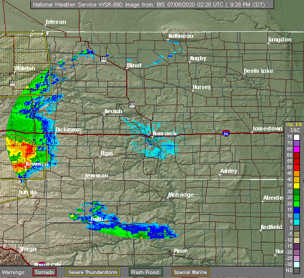
| 7/7/2020 8:49 PM MDT |
 At 849 pm mdt, severe thunderstorms were located along a line extending from 5 miles east of medora to 7 miles southwest of dickinson to new england to 5 miles southwest of scranton, moving northeast at 55 mph. these are very dangerous storms (radar indicated). Hazards include 80 mph wind gusts and half dollar size hail. Flying debris will be dangerous to those caught without shelter. mobile homes will be heavily damaged. expect considerable damage to roofs, windows, and vehicles. extensive tree damage and power outages are likely. these severe storms will be near, new england around 855 pm mdt. dickinson around 900 pm mdt. gladstone around 905 pm mdt. taylor around 915 pm mdt. richardton around 925 pm mdt. regent around 930 pm mdt. Other locations impacted by these severe thunderstorms include sunset butte, bowman haley dam, fryburg, hirschville, buffalo springs, three v crossing, lefor, new hradec, alpha and schefield. At 849 pm mdt, severe thunderstorms were located along a line extending from 5 miles east of medora to 7 miles southwest of dickinson to new england to 5 miles southwest of scranton, moving northeast at 55 mph. these are very dangerous storms (radar indicated). Hazards include 80 mph wind gusts and half dollar size hail. Flying debris will be dangerous to those caught without shelter. mobile homes will be heavily damaged. expect considerable damage to roofs, windows, and vehicles. extensive tree damage and power outages are likely. these severe storms will be near, new england around 855 pm mdt. dickinson around 900 pm mdt. gladstone around 905 pm mdt. taylor around 915 pm mdt. richardton around 925 pm mdt. regent around 930 pm mdt. Other locations impacted by these severe thunderstorms include sunset butte, bowman haley dam, fryburg, hirschville, buffalo springs, three v crossing, lefor, new hradec, alpha and schefield.
|
| 7/7/2020 8:29 PM MDT |
 At 828 pm mdt, severe thunderstorms were located along a line extending from 11 miles southeast of sentinel butte to 10 miles northeast of amidon to 11 miles northeast of table mountain, moving northeast at 50 mph (emergency management). Hazards include 70 mph wind gusts and half dollar size hail. Hail damage to vehicles is expected. expect considerable tree damage. wind damage is also likely to mobile homes, roofs, and outbuildings. severe thunderstorms will be near, bowman around 840 pm mdt. medora around 845 pm mdt. scranton around 855 pm mdt. belfield around 900 pm mdt. dickinson around 900 pm mdt. gladstone around 910 pm mdt. taylor around 920 pm mdt. richardton around 925 pm mdt. regent around 930 pm mdt. Other locations impacted by these severe thunderstorms include sunset butte, bowman haley dam, fryburg, hirschville, buffalo springs, three v crossing, lefor, new hradec, alpha and schefield. At 828 pm mdt, severe thunderstorms were located along a line extending from 11 miles southeast of sentinel butte to 10 miles northeast of amidon to 11 miles northeast of table mountain, moving northeast at 50 mph (emergency management). Hazards include 70 mph wind gusts and half dollar size hail. Hail damage to vehicles is expected. expect considerable tree damage. wind damage is also likely to mobile homes, roofs, and outbuildings. severe thunderstorms will be near, bowman around 840 pm mdt. medora around 845 pm mdt. scranton around 855 pm mdt. belfield around 900 pm mdt. dickinson around 900 pm mdt. gladstone around 910 pm mdt. taylor around 920 pm mdt. richardton around 925 pm mdt. regent around 930 pm mdt. Other locations impacted by these severe thunderstorms include sunset butte, bowman haley dam, fryburg, hirschville, buffalo springs, three v crossing, lefor, new hradec, alpha and schefield.
|
| 7/14/2019 11:41 PM MDT |
 At 1141 pm mdt, severe thunderstorms were located along a line extending from 7 miles southwest of grassy butte to 12 miles north of amidon, moving east at 50 mph (radar indicated). Hazards include 70 mph wind gusts. Expect considerable tree damage. damage is likely to mobile homes, roofs, and outbuildings. Locations impacted include, beach, belfield, south heart, medora, golva, sentinel butte, south fairfield, trotters, fairfield, fryburg and alpha. At 1141 pm mdt, severe thunderstorms were located along a line extending from 7 miles southwest of grassy butte to 12 miles north of amidon, moving east at 50 mph (radar indicated). Hazards include 70 mph wind gusts. Expect considerable tree damage. damage is likely to mobile homes, roofs, and outbuildings. Locations impacted include, beach, belfield, south heart, medora, golva, sentinel butte, south fairfield, trotters, fairfield, fryburg and alpha.
|
| 7/14/2019 11:21 PM MDT |
 At 1120 pm mdt, severe thunderstorms were located along a line extending from 7 miles east of trotters to 11 miles east of golva, moving east at 45 mph (radar indicated). Hazards include 70 mph wind gusts. Expect considerable tree damage. damage is likely to mobile homes, roofs, and outbuildings. These severe thunderstorms will remain over mainly rural areas of golden valley, billings and western stark counties, including the following locations, alpha, fryburg and fairfield. At 1120 pm mdt, severe thunderstorms were located along a line extending from 7 miles east of trotters to 11 miles east of golva, moving east at 45 mph (radar indicated). Hazards include 70 mph wind gusts. Expect considerable tree damage. damage is likely to mobile homes, roofs, and outbuildings. These severe thunderstorms will remain over mainly rural areas of golden valley, billings and western stark counties, including the following locations, alpha, fryburg and fairfield.
|
| 6/2/2019 4:08 PM MDT |
 At 406 pm mdt, a severe thunderstorm was located 5 miles south of medora, or 21 miles east of beach, moving southeast at 15 mph (radar indicated). Hazards include 60 mph wind gusts and half dollar size hail. Hail damage to vehicles is expected. expect wind damage to roofs, siding, and trees. Locations impacted include, medora. At 406 pm mdt, a severe thunderstorm was located 5 miles south of medora, or 21 miles east of beach, moving southeast at 15 mph (radar indicated). Hazards include 60 mph wind gusts and half dollar size hail. Hail damage to vehicles is expected. expect wind damage to roofs, siding, and trees. Locations impacted include, medora.
|
| 6/2/2019 3:48 PM MDT |
 At 348 pm mdt, a severe thunderstorm was located 6 miles southwest of medora, or 19 miles east of beach, moving southeast at 10 mph (radar indicated). Hazards include 60 mph wind gusts and quarter size hail. Hail damage to vehicles is expected. Expect wind damage to roofs, siding, and trees. At 348 pm mdt, a severe thunderstorm was located 6 miles southwest of medora, or 19 miles east of beach, moving southeast at 10 mph (radar indicated). Hazards include 60 mph wind gusts and quarter size hail. Hail damage to vehicles is expected. Expect wind damage to roofs, siding, and trees.
|
| 9/3/2018 6:35 PM MDT |
 At 634 pm mdt, a cluster of severe thunderstorms were located 7 miles east of medora, or 27 miles west of dickinson, moving northeast at 15 mph (radar indicated). Hazards include 60 mph wind gusts and half dollar size hail. Hail damage to vehicles is expected. expect wind damage to roofs, siding, and trees. Locations impacted include, medora and fryburg. At 634 pm mdt, a cluster of severe thunderstorms were located 7 miles east of medora, or 27 miles west of dickinson, moving northeast at 15 mph (radar indicated). Hazards include 60 mph wind gusts and half dollar size hail. Hail damage to vehicles is expected. expect wind damage to roofs, siding, and trees. Locations impacted include, medora and fryburg.
|
| 9/3/2018 6:17 PM MDT |
 At 616 pm mdt, a severe thunderstorm was located 6 miles southeast of medora, or 26 miles north of amidon, moving northeast at 15 mph (radar indicated). Hazards include 60 mph wind gusts and quarter size hail. Hail damage to vehicles is expected. expect wind damage to roofs, siding, and trees. Locations impacted include, medora and fryburg. At 616 pm mdt, a severe thunderstorm was located 6 miles southeast of medora, or 26 miles north of amidon, moving northeast at 15 mph (radar indicated). Hazards include 60 mph wind gusts and quarter size hail. Hail damage to vehicles is expected. expect wind damage to roofs, siding, and trees. Locations impacted include, medora and fryburg.
|
| 9/3/2018 6:06 PM MDT |
 At 605 pm mdt, a severe thunderstorm was located 6 miles southeast of medora, or 25 miles north of amidon, moving northeast at 15 mph (radar indicated). Hazards include 60 mph wind gusts and quarter size hail. Hail damage to vehicles is expected. expect wind damage to roofs, siding, and trees. Locations impacted include, medora and fryburg. At 605 pm mdt, a severe thunderstorm was located 6 miles southeast of medora, or 25 miles north of amidon, moving northeast at 15 mph (radar indicated). Hazards include 60 mph wind gusts and quarter size hail. Hail damage to vehicles is expected. expect wind damage to roofs, siding, and trees. Locations impacted include, medora and fryburg.
|
| 9/3/2018 5:55 PM MDT |
 At 554 pm mdt, a severe thunderstorm was located 7 miles south of medora, or 23 miles north of amidon, moving northeast at 15 mph (radar indicated). Hazards include 60 mph wind gusts and quarter size hail. Hail damage to vehicles is expected. Expect wind damage to roofs, siding, and trees. At 554 pm mdt, a severe thunderstorm was located 7 miles south of medora, or 23 miles north of amidon, moving northeast at 15 mph (radar indicated). Hazards include 60 mph wind gusts and quarter size hail. Hail damage to vehicles is expected. Expect wind damage to roofs, siding, and trees.
|
| 7/21/2018 7:31 PM MDT |
 At 731 pm mdt, a severe thunderstorm was located 5 miles northeast of medora, or 26 miles east of beach, moving east at 40 mph (radar indicated). Hazards include quarter size hail. Damage to vehicles is expected. Locations impacted include, medora and sentinel butte. At 731 pm mdt, a severe thunderstorm was located 5 miles northeast of medora, or 26 miles east of beach, moving east at 40 mph (radar indicated). Hazards include quarter size hail. Damage to vehicles is expected. Locations impacted include, medora and sentinel butte.
|
| 7/21/2018 7:14 PM MDT |
 At 714 pm mdt, a severe thunderstorm was located 7 miles northeast of sentinel butte, or 13 miles northeast of beach, moving east at 25 mph (radar indicated). Hazards include quarter size hail. Damage to vehicles is expected. This severe thunderstorm will remain over mainly rural areas of east central golden valley and northwestern billings counties. At 714 pm mdt, a severe thunderstorm was located 7 miles northeast of sentinel butte, or 13 miles northeast of beach, moving east at 25 mph (radar indicated). Hazards include quarter size hail. Damage to vehicles is expected. This severe thunderstorm will remain over mainly rural areas of east central golden valley and northwestern billings counties.
|
| 7/21/2018 6:50 PM MDT | Golf Ball sized hail reported 11.2 miles N of Medora, ND, quarter to golfball sized hail. |
| 7/21/2018 6:34 PM MDT |
 At 634 pm mdt, a severe thunderstorm was located 17 miles northwest of amidon, moving northeast at 45 mph (radar indicated). Hazards include quarter size hail. Damage to vehicles is expected. this severe thunderstorm will be near, belfield around 710 pm mdt. south heart around 720 pm mdt. Other locations impacted by this severe thunderstorm include fryburg. At 634 pm mdt, a severe thunderstorm was located 17 miles northwest of amidon, moving northeast at 45 mph (radar indicated). Hazards include quarter size hail. Damage to vehicles is expected. this severe thunderstorm will be near, belfield around 710 pm mdt. south heart around 720 pm mdt. Other locations impacted by this severe thunderstorm include fryburg.
|
| 7/3/2018 1:07 AM MDT |
 At 107 am mdt, a severe thunderstorm was located 10 miles northwest of amidon, moving east at 40 mph (radar indicated). Hazards include 70 mph wind gusts and quarter size hail. Hail damage to vehicles is expected. expect considerable tree damage. wind damage is also likely to mobile homes, roofs, and outbuildings. This severe thunderstorm will remain over mainly rural areas of southern golden valley and southwestern billings counties, including the following locations, alpha and fryburg. At 107 am mdt, a severe thunderstorm was located 10 miles northwest of amidon, moving east at 40 mph (radar indicated). Hazards include 70 mph wind gusts and quarter size hail. Hail damage to vehicles is expected. expect considerable tree damage. wind damage is also likely to mobile homes, roofs, and outbuildings. This severe thunderstorm will remain over mainly rural areas of southern golden valley and southwestern billings counties, including the following locations, alpha and fryburg.
|
| 7/3/2018 12:29 AM MDT |
 At 1227 am mdt, a severe thunderstorm was located 7 miles northeast of golva, or 11 miles southeast of beach, moving east at 45 mph (automated system. at 1215 am mdt, a 60 mph wind gust was reported at the beach airport). Hazards include 60 mph wind gusts and quarter size hail. Hail damage to vehicles is expected. expect wind damage to roofs, siding, and trees. this severe storm will be near, medora around 1250 am mdt. Other locations impacted by this severe thunderstorm include alpha and fryburg. At 1227 am mdt, a severe thunderstorm was located 7 miles northeast of golva, or 11 miles southeast of beach, moving east at 45 mph (automated system. at 1215 am mdt, a 60 mph wind gust was reported at the beach airport). Hazards include 60 mph wind gusts and quarter size hail. Hail damage to vehicles is expected. expect wind damage to roofs, siding, and trees. this severe storm will be near, medora around 1250 am mdt. Other locations impacted by this severe thunderstorm include alpha and fryburg.
|
| 7/3/2018 12:10 AM MDT |
 At 1209 am mdt, a severe thunderstorm was located 8 miles west of golva, or 12 miles southwest of beach, moving east at 45 mph (radar indicated). Hazards include 60 mph wind gusts and quarter size hail. Hail damage to vehicles is expected. expect wind damage to roofs, siding, and trees. this severe thunderstorm will be near, golva around 1220 am mdt. medora around 1250 am mdt. Other locations impacted by this severe thunderstorm include alpha and fryburg. At 1209 am mdt, a severe thunderstorm was located 8 miles west of golva, or 12 miles southwest of beach, moving east at 45 mph (radar indicated). Hazards include 60 mph wind gusts and quarter size hail. Hail damage to vehicles is expected. expect wind damage to roofs, siding, and trees. this severe thunderstorm will be near, golva around 1220 am mdt. medora around 1250 am mdt. Other locations impacted by this severe thunderstorm include alpha and fryburg.
|
| 8/11/2017 10:50 PM MDT |
 At 1049 pm mdt, a severe thunderstorm was located 13 miles south of belfield, or 16 miles northeast of amidon, moving southeast at 25 mph (radar indicated). Hazards include 60 mph wind gusts and quarter size hail. Hail damage to vehicles is expected. expect wind damage to roofs, siding, and trees. This severe thunderstorm will remain over mainly rural areas of southwestern billings, north central slope and southwestern stark counties, including the following locations: fryburg. At 1049 pm mdt, a severe thunderstorm was located 13 miles south of belfield, or 16 miles northeast of amidon, moving southeast at 25 mph (radar indicated). Hazards include 60 mph wind gusts and quarter size hail. Hail damage to vehicles is expected. expect wind damage to roofs, siding, and trees. This severe thunderstorm will remain over mainly rural areas of southwestern billings, north central slope and southwestern stark counties, including the following locations: fryburg.
|
| 8/11/2017 10:32 PM MDT |
 At 1031 pm mdt, a severe thunderstorm was located 10 miles south of belfield, or 18 miles north of amidon, moving southeast at 25 mph (radar indicated). Hazards include 60 mph wind gusts and quarter size hail. Hail damage to vehicles is expected. expect wind damage to roofs, siding, and trees. This severe thunderstorm will remain over mainly rural areas of southwestern billings, north central slope and southwestern stark counties, including the following locations: fryburg. At 1031 pm mdt, a severe thunderstorm was located 10 miles south of belfield, or 18 miles north of amidon, moving southeast at 25 mph (radar indicated). Hazards include 60 mph wind gusts and quarter size hail. Hail damage to vehicles is expected. expect wind damage to roofs, siding, and trees. This severe thunderstorm will remain over mainly rural areas of southwestern billings, north central slope and southwestern stark counties, including the following locations: fryburg.
|
| 8/11/2017 10:14 PM MDT |
 At 1013 pm mdt, a severe thunderstorm was located 9 miles southeast of medora, or 23 miles north of amidon, moving southeast at 25 mph (radar indicated). Hazards include 60 mph wind gusts and quarter size hail. Hail damage to vehicles is expected. expect wind damage to roofs, siding, and trees. This severe thunderstorm will remain over mainly rural areas of east central golden valley, southwestern billings, north central slope and southwestern stark counties, including the following locations: fryburg. At 1013 pm mdt, a severe thunderstorm was located 9 miles southeast of medora, or 23 miles north of amidon, moving southeast at 25 mph (radar indicated). Hazards include 60 mph wind gusts and quarter size hail. Hail damage to vehicles is expected. expect wind damage to roofs, siding, and trees. This severe thunderstorm will remain over mainly rural areas of east central golden valley, southwestern billings, north central slope and southwestern stark counties, including the following locations: fryburg.
|
| 8/11/2017 9:57 PM MDT |
 At 957 pm mdt, a severe thunderstorm was located over medora, or 24 miles east of beach, moving southeast at 25 mph (radar indicated). Hazards include 60 mph wind gusts and half dollar size hail. Hail damage to vehicles is expected. expect wind damage to roofs, siding, and trees. This severe thunderstorm will remain over mainly rural areas of east central golden valley, southwestern billings, north central slope and southwestern stark counties, including the following locations: fryburg. At 957 pm mdt, a severe thunderstorm was located over medora, or 24 miles east of beach, moving southeast at 25 mph (radar indicated). Hazards include 60 mph wind gusts and half dollar size hail. Hail damage to vehicles is expected. expect wind damage to roofs, siding, and trees. This severe thunderstorm will remain over mainly rural areas of east central golden valley, southwestern billings, north central slope and southwestern stark counties, including the following locations: fryburg.
|
| 8/11/2017 9:49 PM MDT |
 At 949 pm mdt, a severe thunderstorm was located over medora, or 22 miles east of beach, moving southeast at 25 mph (radar indicated). Hazards include ping pong ball size hail and 60 mph wind gusts. People and animals outdoors will be injured. expect hail damage to roofs, siding, windows, and vehicles. expect wind damage to roofs, siding, and trees. This severe thunderstorm will remain over mainly rural areas of central golden valley and west central billings counties. At 949 pm mdt, a severe thunderstorm was located over medora, or 22 miles east of beach, moving southeast at 25 mph (radar indicated). Hazards include ping pong ball size hail and 60 mph wind gusts. People and animals outdoors will be injured. expect hail damage to roofs, siding, windows, and vehicles. expect wind damage to roofs, siding, and trees. This severe thunderstorm will remain over mainly rural areas of central golden valley and west central billings counties.
|
| 8/11/2017 9:33 PM MDT |
 At 933 pm mdt, a severe thunderstorm was located 6 miles northwest of medora, or 16 miles east of beach, moving southeast at 25 mph (radar indicated). Hazards include ping pong ball size hail and 60 mph wind gusts. People and animals outdoors will be injured. expect hail damage to roofs, siding, windows, and vehicles. expect wind damage to roofs, siding, and trees. This severe storm will be near, medora around 950 pm mdt. At 933 pm mdt, a severe thunderstorm was located 6 miles northwest of medora, or 16 miles east of beach, moving southeast at 25 mph (radar indicated). Hazards include ping pong ball size hail and 60 mph wind gusts. People and animals outdoors will be injured. expect hail damage to roofs, siding, windows, and vehicles. expect wind damage to roofs, siding, and trees. This severe storm will be near, medora around 950 pm mdt.
|
| 8/11/2017 9:19 PM MDT |
 At 918 pm mdt, a severe thunderstorm was located 6 miles north of sentinel butte, or 10 miles northeast of beach, moving southeast at 25 mph (radar indicated). Hazards include 60 mph wind gusts and quarter size hail. Hail damage to vehicles is expected. expect wind damage to roofs, siding, and trees. This severe storm will be near, medora around 955 pm mdt. At 918 pm mdt, a severe thunderstorm was located 6 miles north of sentinel butte, or 10 miles northeast of beach, moving southeast at 25 mph (radar indicated). Hazards include 60 mph wind gusts and quarter size hail. Hail damage to vehicles is expected. expect wind damage to roofs, siding, and trees. This severe storm will be near, medora around 955 pm mdt.
|
| 8/11/2017 8:54 PM MDT |
 At 854 pm mdt, a severe thunderstorm was located 11 miles northeast of wibaux, moving southeast at 20 mph (radar indicated). Hazards include quarter size hail. Damage to vehicles is expected. this severe thunderstorm will be near, sentinel butte around 930 pm mdt. Medora around 1000 pm mdt. At 854 pm mdt, a severe thunderstorm was located 11 miles northeast of wibaux, moving southeast at 20 mph (radar indicated). Hazards include quarter size hail. Damage to vehicles is expected. this severe thunderstorm will be near, sentinel butte around 930 pm mdt. Medora around 1000 pm mdt.
|
| 7/2/2017 5:52 PM MDT |
 At 551 pm mdt, severe thunderstorms were located along a line extending from 11 miles northeast of skaar to 10 miles east of carlyle, moving east at 15 mph (radar indicated). Hazards include 60 mph wind gusts. Expect damage to roofs, siding, and trees. Locations impacted include, beach, medora, golva, sentinel butte, trotters and alpha. At 551 pm mdt, severe thunderstorms were located along a line extending from 11 miles northeast of skaar to 10 miles east of carlyle, moving east at 15 mph (radar indicated). Hazards include 60 mph wind gusts. Expect damage to roofs, siding, and trees. Locations impacted include, beach, medora, golva, sentinel butte, trotters and alpha.
|
| 7/2/2017 5:37 PM MDT |
 At 536 pm mdt, severe thunderstorms were located along a line extending from 10 miles northeast of skaar to 7 miles southeast of carlyle, moving east at 15 mph (radar indicated). Hazards include 60 mph wind gusts. Expect damage to roofs, siding, and trees. These severe thunderstorms will remain over mainly rural areas of golden valley and western billings counties, including the following locations: alpha. At 536 pm mdt, severe thunderstorms were located along a line extending from 10 miles northeast of skaar to 7 miles southeast of carlyle, moving east at 15 mph (radar indicated). Hazards include 60 mph wind gusts. Expect damage to roofs, siding, and trees. These severe thunderstorms will remain over mainly rural areas of golden valley and western billings counties, including the following locations: alpha.
|
| 7/22/2016 7:06 PM MDT |
 At 704 pm mdt, severe thunderstorms were located along a line extending from 14 miles north of sentinel butte to near south heart, moving north at 45 mph (radar indicated. a funnel cloud was reported at 656 pm mdt 6 miles south of belfield. these thunderstorms also produced 60 mph winds in southeastern billings county). Hazards include 60 mph wind gusts and quarter size hail. Hail damage to vehicles is expected. expect wind damage to roofs, siding, and trees. Locations impacted include, belfield, medora, south fairfield and fryburg. At 704 pm mdt, severe thunderstorms were located along a line extending from 14 miles north of sentinel butte to near south heart, moving north at 45 mph (radar indicated. a funnel cloud was reported at 656 pm mdt 6 miles south of belfield. these thunderstorms also produced 60 mph winds in southeastern billings county). Hazards include 60 mph wind gusts and quarter size hail. Hail damage to vehicles is expected. expect wind damage to roofs, siding, and trees. Locations impacted include, belfield, medora, south fairfield and fryburg.
|
| 7/22/2016 6:46 PM MDT |
 At 646 pm mdt, severe thunderstorms were located along a line extending from sentinel butte to 12 miles southwest of south heart, moving north at 30 mph (radar indicated). Hazards include 60 mph wind gusts and quarter size hail. Hail damage to vehicles is expected. expect wind damage to roofs, siding, and trees. Locations impacted include, belfield, medora, sentinel butte, south fairfield and fryburg. At 646 pm mdt, severe thunderstorms were located along a line extending from sentinel butte to 12 miles southwest of south heart, moving north at 30 mph (radar indicated). Hazards include 60 mph wind gusts and quarter size hail. Hail damage to vehicles is expected. expect wind damage to roofs, siding, and trees. Locations impacted include, belfield, medora, sentinel butte, south fairfield and fryburg.
|
| 7/22/2016 6:34 PM MDT |
 At 634 pm mdt, severe thunderstorms were located along a line extending from 4 miles south of sentinel butte to 13 miles northeast of amidon, moving north at 30 mph (radar indicated). Hazards include 60 mph wind gusts and quarter size hail. Hail damage to vehicles is expected. Expect wind damage to roofs, siding, and trees. At 634 pm mdt, severe thunderstorms were located along a line extending from 4 miles south of sentinel butte to 13 miles northeast of amidon, moving north at 30 mph (radar indicated). Hazards include 60 mph wind gusts and quarter size hail. Hail damage to vehicles is expected. Expect wind damage to roofs, siding, and trees.
|
| 7/10/2016 5:21 PM MDT |
 At 515 pm mdt, severe thunderstorms were located along a line extending from 7 miles north of medora to 6 miles south of south heart to 7 miles northwest of scranton, moving northeast at 30 mph. these are very dangerous storms with damaging wind as high as 75 mph and baseball size hail. there was a lot of lightning and heavy rain. the rain will cause minor flooding of streets, culverts, ditches, and creeks. if you are in the path of the storms, get to safe shelter now (public). Hazards include baseball size hail and 70 mph wind gusts. People and animals outdoors will be severely injured. expect shattered windows, extensive damage to roofs, siding, and vehicles. Cities in the path of the storms are scranton, new england, regent and south heart. At 515 pm mdt, severe thunderstorms were located along a line extending from 7 miles north of medora to 6 miles south of south heart to 7 miles northwest of scranton, moving northeast at 30 mph. these are very dangerous storms with damaging wind as high as 75 mph and baseball size hail. there was a lot of lightning and heavy rain. the rain will cause minor flooding of streets, culverts, ditches, and creeks. if you are in the path of the storms, get to safe shelter now (public). Hazards include baseball size hail and 70 mph wind gusts. People and animals outdoors will be severely injured. expect shattered windows, extensive damage to roofs, siding, and vehicles. Cities in the path of the storms are scranton, new england, regent and south heart.
|
| 7/10/2016 4:54 PM MDT |
 At 449 pm mdt, severe thunderstorms were located along a line extending from 7 miles southwest of medora to 13 miles northeast of amidon to 5 miles south of bowman, moving northeast at 30 mph (radar indicated). Hazards include golf ball size hail and 70 mph wind gusts. People and animals outdoors will be injured. expect hail damage to roofs, siding, windows, and vehicles. expect considerable tree damage. wind damage is also likely to mobile homes, roofs, and outbuildings. medora, belfield, amidon, new england, south heart and scranton are in the path of this line of storms. Interstate 94 from medora to belfield, and highway 85 in that area, will also be impacted. At 449 pm mdt, severe thunderstorms were located along a line extending from 7 miles southwest of medora to 13 miles northeast of amidon to 5 miles south of bowman, moving northeast at 30 mph (radar indicated). Hazards include golf ball size hail and 70 mph wind gusts. People and animals outdoors will be injured. expect hail damage to roofs, siding, windows, and vehicles. expect considerable tree damage. wind damage is also likely to mobile homes, roofs, and outbuildings. medora, belfield, amidon, new england, south heart and scranton are in the path of this line of storms. Interstate 94 from medora to belfield, and highway 85 in that area, will also be impacted.
|
| 7/10/2016 2:49 PM MDT |
 At 248 pm mdt, a severe thunderstorm was located 11 miles west of south fairfield, or 30 miles northeast of beach, moving northeast at 25 mph (radar indicated). Hazards include ping pong ball size hail and 60 mph wind gusts. People and animals outdoors will be injured. expect hail damage to roofs, siding, windows, and vehicles. Expect wind damage to roofs, siding, and trees. At 248 pm mdt, a severe thunderstorm was located 11 miles west of south fairfield, or 30 miles northeast of beach, moving northeast at 25 mph (radar indicated). Hazards include ping pong ball size hail and 60 mph wind gusts. People and animals outdoors will be injured. expect hail damage to roofs, siding, windows, and vehicles. Expect wind damage to roofs, siding, and trees.
|
| 6/21/2016 5:41 PM MDT | Quarter sized hail reported 0.9 miles NNW of Medora, ND, hail was dime size at 639 pm and quarter size at 641 pm...and ongoing. |
| 6/21/2016 5:41 PM MDT | Quarter sized hail reported 0.9 miles N of Medora, ND, . the duration of the hail event was 6 minutes. |
| 6/21/2016 5:36 PM MDT |
 At 536 pm mdt, a severe thunderstorm was located over medora, or 24 miles east of beach, moving northeast at 20 mph (radar indicated). Hazards include 60 mph wind gusts and quarter size hail. Hail damage to vehicles is expected. expect wind damage to roofs, siding, and trees. This severe thunderstorm will remain over mainly rural areas of northwestern stark and central billings counties, including the following locations: fryburg. At 536 pm mdt, a severe thunderstorm was located over medora, or 24 miles east of beach, moving northeast at 20 mph (radar indicated). Hazards include 60 mph wind gusts and quarter size hail. Hail damage to vehicles is expected. expect wind damage to roofs, siding, and trees. This severe thunderstorm will remain over mainly rural areas of northwestern stark and central billings counties, including the following locations: fryburg.
|
| 6/17/2016 12:34 AM MDT |
 At 1234 am mdt, severe thunderstorms were located along a line extending from 12 miles south of medora to 11 miles northwest of amidon, moving east at 50 mph (radar indicated). Hazards include 70 mph wind gusts and ping pong ball size hail. People and animals outdoors will be injured. expect hail damage to roofs, siding, windows, and vehicles. expect considerable tree damage. wind damage is also likely to mobile homes, roofs, and outbuildings. These severe thunderstorms will remain over mainly rural areas of northeastern slope, southeastern golden valley and southwestern billings counties. At 1234 am mdt, severe thunderstorms were located along a line extending from 12 miles south of medora to 11 miles northwest of amidon, moving east at 50 mph (radar indicated). Hazards include 70 mph wind gusts and ping pong ball size hail. People and animals outdoors will be injured. expect hail damage to roofs, siding, windows, and vehicles. expect considerable tree damage. wind damage is also likely to mobile homes, roofs, and outbuildings. These severe thunderstorms will remain over mainly rural areas of northeastern slope, southeastern golden valley and southwestern billings counties.
|
| 6/17/2016 12:25 AM MDT |
 At 1224 am mdt, a severe thunderstorm was located 16 miles southeast of golva, or 19 miles northwest of amidon, moving east at 50 mph (radar indicated). Hazards include ping pong ball size hail and 60 mph wind gusts. People and animals outdoors will be injured. expect hail damage to roofs, siding, windows, and vehicles. expect wind damage to roofs, siding, and trees. This severe thunderstorm will remain over mainly rural areas of northern slope, southern golden valley and southwestern billings counties, including the following locations: alpha and three v crossing. At 1224 am mdt, a severe thunderstorm was located 16 miles southeast of golva, or 19 miles northwest of amidon, moving east at 50 mph (radar indicated). Hazards include ping pong ball size hail and 60 mph wind gusts. People and animals outdoors will be injured. expect hail damage to roofs, siding, windows, and vehicles. expect wind damage to roofs, siding, and trees. This severe thunderstorm will remain over mainly rural areas of northern slope, southern golden valley and southwestern billings counties, including the following locations: alpha and three v crossing.
|
| 6/17/2016 12:10 AM MDT |
 At 1210 am mdt, a severe thunderstorm was located 9 miles southeast of carlyle, or 22 miles northeast of baker, moving east at 45 mph (radar indicated). Hazards include ping pong ball size hail and 60 mph wind gusts. People and animals outdoors will be injured. expect hail damage to roofs, siding, windows, and vehicles. expect wind damage to roofs, siding, and trees. This severe thunderstorm will remain over mainly rural areas of northern slope, southern golden valley and southwestern billings counties, including the following locations: pretty butte, alpha and three v crossing. At 1210 am mdt, a severe thunderstorm was located 9 miles southeast of carlyle, or 22 miles northeast of baker, moving east at 45 mph (radar indicated). Hazards include ping pong ball size hail and 60 mph wind gusts. People and animals outdoors will be injured. expect hail damage to roofs, siding, windows, and vehicles. expect wind damage to roofs, siding, and trees. This severe thunderstorm will remain over mainly rural areas of northern slope, southern golden valley and southwestern billings counties, including the following locations: pretty butte, alpha and three v crossing.
|
| 6/16/2016 11:55 PM MDT |
 At 1155 pm mdt, a severe thunderstorm was located 10 miles south of carlyle, or 11 miles northeast of baker, moving east at 50 mph (radar indicated). Hazards include ping pong ball size hail and 60 mph wind gusts. People and animals outdoors will be injured. expect hail damage to roofs, siding, windows, and vehicles. expect wind damage to roofs, siding, and trees. This severe thunderstorm will remain over mainly rural areas of northern slope, southern golden valley and southwestern billings counties, including the following locations: pretty butte, alpha and three v crossing. At 1155 pm mdt, a severe thunderstorm was located 10 miles south of carlyle, or 11 miles northeast of baker, moving east at 50 mph (radar indicated). Hazards include ping pong ball size hail and 60 mph wind gusts. People and animals outdoors will be injured. expect hail damage to roofs, siding, windows, and vehicles. expect wind damage to roofs, siding, and trees. This severe thunderstorm will remain over mainly rural areas of northern slope, southern golden valley and southwestern billings counties, including the following locations: pretty butte, alpha and three v crossing.
|
| 6/13/2016 4:37 PM MDT | The severe thunderstorm warning for west central billings county will expire at 445 pm mdt, the storm which prompted the warning has weakened below severe limits, and has exited the warned area. therefore the warning will be allowed to expire. a severe thunderstorm watch remains in effect until 1100 pm mdt for southwestern north dakota. |
| 6/13/2016 4:23 PM MDT |
 At 422 pm mdt, a severe thunderstorm was located over medora, or 22 miles east of beach, moving east at 20 mph (radar indicated). Hazards include 60 mph wind gusts. Expect damage to roofs. siding. and trees. This severe thunderstorm will remain over mainly rural areas of west central billings county. At 422 pm mdt, a severe thunderstorm was located over medora, or 22 miles east of beach, moving east at 20 mph (radar indicated). Hazards include 60 mph wind gusts. Expect damage to roofs. siding. and trees. This severe thunderstorm will remain over mainly rural areas of west central billings county.
|
| 6/13/2016 4:11 PM MDT |
 At 411 pm mdt, a severe thunderstorm was located near medora, or 18 miles east of beach, moving east at 20 mph (radar indicated). Hazards include 60 mph wind gusts and nickel size hail. Expect damage to roofs. siding. and trees. this severe storm will be near, medora around 425 pm mdt. This storm has a history of producing wind gusts of 60 to 70 mph. At 411 pm mdt, a severe thunderstorm was located near medora, or 18 miles east of beach, moving east at 20 mph (radar indicated). Hazards include 60 mph wind gusts and nickel size hail. Expect damage to roofs. siding. and trees. this severe storm will be near, medora around 425 pm mdt. This storm has a history of producing wind gusts of 60 to 70 mph.
|
| 6/13/2016 3:58 PM MDT |
 At 357 pm mdt, a severe thunderstorm was located 7 miles east of sentinel butte, or 14 miles east of beach, moving east at 25 mph (radar indicated). Hazards include 60 mph wind gusts and quarter size hail. Hail damage to vehicles is expected. expect wind damage to roofs, siding, and trees. This severe storm will be near, medora around 415 pm mdt. At 357 pm mdt, a severe thunderstorm was located 7 miles east of sentinel butte, or 14 miles east of beach, moving east at 25 mph (radar indicated). Hazards include 60 mph wind gusts and quarter size hail. Hail damage to vehicles is expected. expect wind damage to roofs, siding, and trees. This severe storm will be near, medora around 415 pm mdt.
|
| 6/13/2016 3:42 PM MDT |
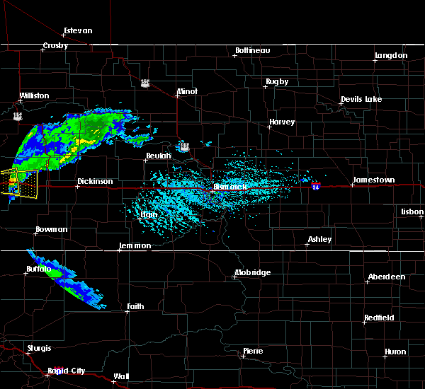 At 342 pm mdt, a severe thunderstorm was located over sentinel butte, or 8 miles east of beach, moving east at 20 mph (radar indicated). Hazards include 60 mph wind gusts and quarter size hail. Hail damage to vehicles is expected. expect wind damage to roofs, siding, and trees. This severe thunderstorm will be near, medora around 430 pm mdt. At 342 pm mdt, a severe thunderstorm was located over sentinel butte, or 8 miles east of beach, moving east at 20 mph (radar indicated). Hazards include 60 mph wind gusts and quarter size hail. Hail damage to vehicles is expected. expect wind damage to roofs, siding, and trees. This severe thunderstorm will be near, medora around 430 pm mdt.
|
| 6/11/2016 1:27 AM MDT |
 At 126 am mdt, a severe thunderstorm was located near belfield, or 22 miles west of dickinson, moving east at 50 mph (radar indicated). Hazards include 60 mph wind gusts and quarter size hail. Hail damage to vehicles is expected. expect wind damage to roofs, siding, and trees. this severe thunderstorm will be near, belfield around 130 am mdt. south heart around 140 am mdt. dickinson around 155 am mdt. gladstone around 210 am mdt. taylor around 215 am mdt. richardton around 220 am mdt. Other locations impacted by this severe thunderstorm include dickinson regional airport, fryburg, hirschville and new hradec. At 126 am mdt, a severe thunderstorm was located near belfield, or 22 miles west of dickinson, moving east at 50 mph (radar indicated). Hazards include 60 mph wind gusts and quarter size hail. Hail damage to vehicles is expected. expect wind damage to roofs, siding, and trees. this severe thunderstorm will be near, belfield around 130 am mdt. south heart around 140 am mdt. dickinson around 155 am mdt. gladstone around 210 am mdt. taylor around 215 am mdt. richardton around 220 am mdt. Other locations impacted by this severe thunderstorm include dickinson regional airport, fryburg, hirschville and new hradec.
|
| 6/11/2016 1:05 AM MDT |
 At 104 am mdt, severe thunderstorms were located along a line extending from 14 miles west of grassy butte to 10 miles west of south fairfield to near medora, moving east at 45 mph (radar indicated). Hazards include 60 mph wind gusts and penny size hail. Expect damage to roofs. siding. and trees. these severe storms will be near, south fairfield around 120 am mdt. grassy butte around 125 am mdt. belfield around 130 am mdt. Other locations impacted by these severe thunderstorms include fryburg, fairfield, oakdale and new hradec. At 104 am mdt, severe thunderstorms were located along a line extending from 14 miles west of grassy butte to 10 miles west of south fairfield to near medora, moving east at 45 mph (radar indicated). Hazards include 60 mph wind gusts and penny size hail. Expect damage to roofs. siding. and trees. these severe storms will be near, south fairfield around 120 am mdt. grassy butte around 125 am mdt. belfield around 130 am mdt. Other locations impacted by these severe thunderstorms include fryburg, fairfield, oakdale and new hradec.
|
| 6/11/2016 12:47 AM MDT |
 At 146 am cdt/1246 am mdt/, severe thunderstorms were located along a line extending from 7 miles northeast of trotters to 20 miles northwest of medora to near sentinel butte, moving east at 50 mph (radar indicated). Hazards include 60 mph wind gusts and penny size hail. Expect damage to roofs. siding. and trees. these severe storms will be near, medora around 105 am mdt. south fairfield around 115 am mdt. grassy butte around 120 am mdt. belfield around 125 am mdt. south heart around 130 am mdt. Other locations impacted by these severe thunderstorms include fryburg, fairfield, oakdale and new hradec. At 146 am cdt/1246 am mdt/, severe thunderstorms were located along a line extending from 7 miles northeast of trotters to 20 miles northwest of medora to near sentinel butte, moving east at 50 mph (radar indicated). Hazards include 60 mph wind gusts and penny size hail. Expect damage to roofs. siding. and trees. these severe storms will be near, medora around 105 am mdt. south fairfield around 115 am mdt. grassy butte around 120 am mdt. belfield around 125 am mdt. south heart around 130 am mdt. Other locations impacted by these severe thunderstorms include fryburg, fairfield, oakdale and new hradec.
|
| 6/11/2016 12:33 AM MDT |
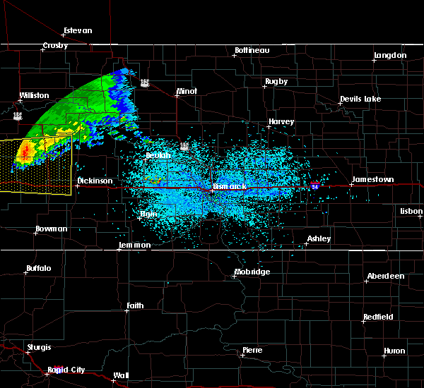 At 132 am cdt/1232 am mdt/, a severe thunderstorm was located 12 miles south of trotters, or 16 miles north of beach, moving east at 55 mph (radar indicated). Hazards include 60 mph wind gusts and penny size hail. Expect damage to roofs. siding. and trees. this severe thunderstorm will be near, south fairfield around 110 am mdt. Other locations impacted by this severe thunderstorm include fryburg, fairfield, oakdale and new hradec. At 132 am cdt/1232 am mdt/, a severe thunderstorm was located 12 miles south of trotters, or 16 miles north of beach, moving east at 55 mph (radar indicated). Hazards include 60 mph wind gusts and penny size hail. Expect damage to roofs. siding. and trees. this severe thunderstorm will be near, south fairfield around 110 am mdt. Other locations impacted by this severe thunderstorm include fryburg, fairfield, oakdale and new hradec.
|
| 6/9/2016 8:56 PM MDT |
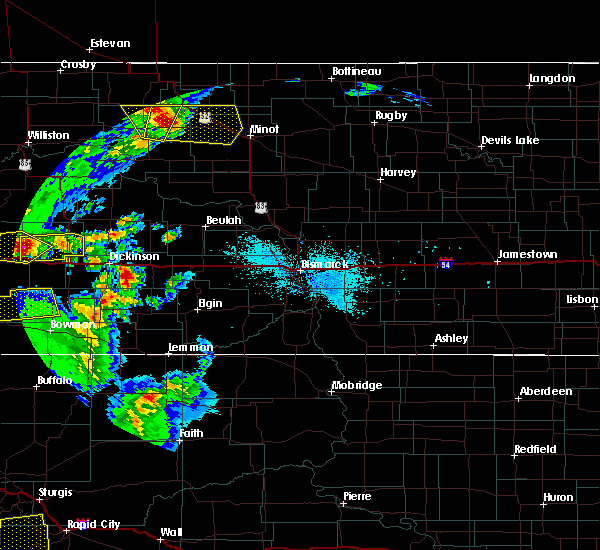 At 856 pm mdt, a severe thunderstorm was located 9 miles north of medora, or 23 miles northeast of beach, moving east at 40 mph (radar indicated). Hazards include 60 mph wind gusts and quarter size hail. Hail damage to vehicles is expected. expect wind damage to roofs, siding, and trees. this severe thunderstorm will be near, south fairfield around 920 pm mdt. Other locations impacted by this severe thunderstorm include fairfield. At 856 pm mdt, a severe thunderstorm was located 9 miles north of medora, or 23 miles northeast of beach, moving east at 40 mph (radar indicated). Hazards include 60 mph wind gusts and quarter size hail. Hail damage to vehicles is expected. expect wind damage to roofs, siding, and trees. this severe thunderstorm will be near, south fairfield around 920 pm mdt. Other locations impacted by this severe thunderstorm include fairfield.
|
| 6/9/2016 7:56 PM MDT |
 At 756 pm mdt, a severe thunderstorm was located 5 miles north of wibaux, moving east at 40 mph (radar indicated). Hazards include ping pong ball size hail and 60 mph wind gusts. People and animals outdoors will be injured. expect hail damage to roofs, siding, windows, and vehicles. expect wind damage to roofs, siding, and trees. This severe thunderstorm will remain over mainly rural areas of central golden valley and west central billings counties. At 756 pm mdt, a severe thunderstorm was located 5 miles north of wibaux, moving east at 40 mph (radar indicated). Hazards include ping pong ball size hail and 60 mph wind gusts. People and animals outdoors will be injured. expect hail damage to roofs, siding, windows, and vehicles. expect wind damage to roofs, siding, and trees. This severe thunderstorm will remain over mainly rural areas of central golden valley and west central billings counties.
|
| 7/27/2015 9:31 PM MDT |
 At 1030 pm cdt /930 pm mdt/, severe thunderstorms were located along a line extending from 6 miles north of skaar to 5 miles north of medora, moving northeast at 40 mph (public. at 900 pm mdt 70 mph wind gusts were reported at beach). Hazards include 60 mph wind gusts. Expect damage to roofs. siding and trees. severe thunderstorms will be near, south fairfield around 955 pm mdt. arnegard and manning around 1025 pm mdt. watford city, killdeer and dunn center around 1030 pm mdt. Other locations impacted by these severe thunderstorms include keene, rawson, oakdale, sather dam, fairfield, charbonneau, johnsons corner, cartwright and new hradec. At 1030 pm cdt /930 pm mdt/, severe thunderstorms were located along a line extending from 6 miles north of skaar to 5 miles north of medora, moving northeast at 40 mph (public. at 900 pm mdt 70 mph wind gusts were reported at beach). Hazards include 60 mph wind gusts. Expect damage to roofs. siding and trees. severe thunderstorms will be near, south fairfield around 955 pm mdt. arnegard and manning around 1025 pm mdt. watford city, killdeer and dunn center around 1030 pm mdt. Other locations impacted by these severe thunderstorms include keene, rawson, oakdale, sather dam, fairfield, charbonneau, johnsons corner, cartwright and new hradec.
|
| 7/27/2015 8:52 PM MDT |
 At 852 pm mdt, severe thunderstorms were located along a line extending from 4 miles northwest of beach to near carlyle, moving northeast at 45 mph (radar indicated). Hazards include 70 mph wind gusts. Expect considerable tree damage. damage is likely to mobile homes, roofs and outbuildings. severe thunderstorms will be near, beach around 955 pm cdt. golva around 1005 pm cdt. sentinel butte around 1025 pm cdt. medora around 1030 pm cdt. Other locations impacted by these severe thunderstorms include fairfield. At 852 pm mdt, severe thunderstorms were located along a line extending from 4 miles northwest of beach to near carlyle, moving northeast at 45 mph (radar indicated). Hazards include 70 mph wind gusts. Expect considerable tree damage. damage is likely to mobile homes, roofs and outbuildings. severe thunderstorms will be near, beach around 955 pm cdt. golva around 1005 pm cdt. sentinel butte around 1025 pm cdt. medora around 1030 pm cdt. Other locations impacted by these severe thunderstorms include fairfield.
|
| 6/30/2015 6:50 PM MDT |
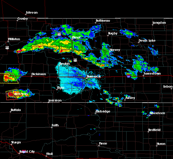 At 649 pm mdt, a severe thunderstorm was located 9 miles southeast of sentinel butte, or 16 miles east of beach, moving south at 25 mph (radar indicated). Hazards include 60 mph wind gusts and half dollar size hail. Hail damage to vehicles is expected. expect wind damage to roofs, siding and trees. this severe thunderstorm will remain over mainly rural areas of southwestern billings and southern golden valley counties, including the following locations, alpha. A tornado watch remains in effect until 100 am mdt for southwestern north dakota. At 649 pm mdt, a severe thunderstorm was located 9 miles southeast of sentinel butte, or 16 miles east of beach, moving south at 25 mph (radar indicated). Hazards include 60 mph wind gusts and half dollar size hail. Hail damage to vehicles is expected. expect wind damage to roofs, siding and trees. this severe thunderstorm will remain over mainly rural areas of southwestern billings and southern golden valley counties, including the following locations, alpha. A tornado watch remains in effect until 100 am mdt for southwestern north dakota.
|
| 6/30/2015 6:30 PM MDT |
 At 630 pm mdt, a severe thunderstorm was located 5 miles northeast of sentinel butte, or 12 miles east of beach, moving southeast at 25 mph (trained weather spotters 60 mph wind 12 miles north of beach). Hazards include 60 mph wind gusts and quarter size hail. Hail damage to vehicles is expected. expect wind damage to roofs, siding and trees. this severe thunderstorm will be near, medora around 650 pm mdt. other locations impacted by this severe thunderstorm include alpha. A tornado watch remains in effect until 100 am mdt for southwestern north dakota. At 630 pm mdt, a severe thunderstorm was located 5 miles northeast of sentinel butte, or 12 miles east of beach, moving southeast at 25 mph (trained weather spotters 60 mph wind 12 miles north of beach). Hazards include 60 mph wind gusts and quarter size hail. Hail damage to vehicles is expected. expect wind damage to roofs, siding and trees. this severe thunderstorm will be near, medora around 650 pm mdt. other locations impacted by this severe thunderstorm include alpha. A tornado watch remains in effect until 100 am mdt for southwestern north dakota.
|
| 6/30/2015 6:17 PM MDT |
 At 616 pm mdt, a severe thunderstorm was located 8 miles north of sentinel butte, or 11 miles northeast of beach, moving south at 25 mph (trained weather spotters). Hazards include tennis ball size hail and 60 mph wind gusts. People and animals outdoors will be injured. expect hail damage to roofs, siding, windows and vehicles. expect wind damage to roofs, siding and trees. this severe storm will be near, sentinel butte around 630 pm mdt. A tornado watch remains in effect until 100 am mdt for southwestern north dakota. At 616 pm mdt, a severe thunderstorm was located 8 miles north of sentinel butte, or 11 miles northeast of beach, moving south at 25 mph (trained weather spotters). Hazards include tennis ball size hail and 60 mph wind gusts. People and animals outdoors will be injured. expect hail damage to roofs, siding, windows and vehicles. expect wind damage to roofs, siding and trees. this severe storm will be near, sentinel butte around 630 pm mdt. A tornado watch remains in effect until 100 am mdt for southwestern north dakota.
|
| 6/30/2015 5:59 PM MDT |
 At 557 pm mdt, a severe thunderstorm was located 12 miles south of trotters, or 17 miles north of beach, moving southeast at 35 mph (trained weather spotters report funnel clouds and large damaging hail with this storm). Hazards include tennis ball size hail and 60 mph wind gusts. People and animals outdoors will be injured. expect hail damage to roofs, siding, windows and vehicles. expect wind damage to roofs, siding and trees. this severe storm will be near, sentinel butte around 620 pm mdt. medora around 630 pm mdt. A tornado watch remains in effect until 100 am mdt for southwestern north dakota. At 557 pm mdt, a severe thunderstorm was located 12 miles south of trotters, or 17 miles north of beach, moving southeast at 35 mph (trained weather spotters report funnel clouds and large damaging hail with this storm). Hazards include tennis ball size hail and 60 mph wind gusts. People and animals outdoors will be injured. expect hail damage to roofs, siding, windows and vehicles. expect wind damage to roofs, siding and trees. this severe storm will be near, sentinel butte around 620 pm mdt. medora around 630 pm mdt. A tornado watch remains in effect until 100 am mdt for southwestern north dakota.
|
| 6/30/2015 5:46 PM MDT |
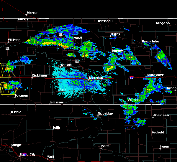 At 546 pm mdt, a severe thunderstorm was located 6 miles south of trotters, or 20 miles northeast of wibaux, moving south at 25 mph (trained weather spotters reported golf ball size hail northwest of trotters). Hazards include tennis ball size hail and 60 mph wind gusts. People and animals outdoors will be injured. expect hail damage to roofs, siding, windows and vehicles. expect wind damage to roofs, siding and trees. this severe storm will be near, beach and sentinel butte around 630 pm mdt. A tornado watch remains in effect until 100 am mdt for western north dakota. At 546 pm mdt, a severe thunderstorm was located 6 miles south of trotters, or 20 miles northeast of wibaux, moving south at 25 mph (trained weather spotters reported golf ball size hail northwest of trotters). Hazards include tennis ball size hail and 60 mph wind gusts. People and animals outdoors will be injured. expect hail damage to roofs, siding, windows and vehicles. expect wind damage to roofs, siding and trees. this severe storm will be near, beach and sentinel butte around 630 pm mdt. A tornado watch remains in effect until 100 am mdt for western north dakota.
|
| 6/30/2015 5:25 PM MDT |
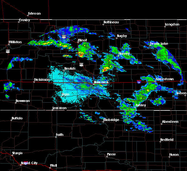 At 524 pm mdt, a severe thunderstorm was located over trotters, or 26 miles southeast of sidney, moving southeast at 35 mph (trained spotters report this storm is producing large hail and funnel clouds). Hazards include tennis ball size hail and 60 mph wind gusts. People and animals outdoors will be injured. expect hail damage to roofs, siding, windows and vehicles. expect wind damage to roofs, siding and trees. this severe thunderstorm will be near, medora around 625 pm mdt. A tornado watch remains in effect until 100 am mdt for western north dakota. At 524 pm mdt, a severe thunderstorm was located over trotters, or 26 miles southeast of sidney, moving southeast at 35 mph (trained spotters report this storm is producing large hail and funnel clouds). Hazards include tennis ball size hail and 60 mph wind gusts. People and animals outdoors will be injured. expect hail damage to roofs, siding, windows and vehicles. expect wind damage to roofs, siding and trees. this severe thunderstorm will be near, medora around 625 pm mdt. A tornado watch remains in effect until 100 am mdt for western north dakota.
|
| 6/19/2015 6:02 PM MDT |
 At 602 pm mdt, severe thunderstorms were located along a line extending from 7 miles northeast of medora to 17 miles southeast of sentinel butte, moving east at 55 mph (radar indicated). Hazards include 60 mph wind gusts and quarter size hail. Hail damage to vehicles is expected. expect wind damage to roofs, siding and trees. These severe thunderstorms will remain over mainly rural areas of southwestern billings county, including the following locations, fryburg. At 602 pm mdt, severe thunderstorms were located along a line extending from 7 miles northeast of medora to 17 miles southeast of sentinel butte, moving east at 55 mph (radar indicated). Hazards include 60 mph wind gusts and quarter size hail. Hail damage to vehicles is expected. expect wind damage to roofs, siding and trees. These severe thunderstorms will remain over mainly rural areas of southwestern billings county, including the following locations, fryburg.
|
| 6/19/2015 5:45 PM MDT |
 At 544 pm mdt, severe thunderstorms were located along a line extending from 8 miles northeast of sentinel butte to 6 miles southeast of beach, moving east at 45 mph (beach airport reported gusts to 61 mph with this storm). Hazards include 60 mph wind gusts and quarter size hail. Hail damage to vehicles is expected. expect wind damage to roofs, siding and trees. these severe storms will be near, medora around 555 pm mdt. Other locations impacted by these severe thunderstorms include fryburg. At 544 pm mdt, severe thunderstorms were located along a line extending from 8 miles northeast of sentinel butte to 6 miles southeast of beach, moving east at 45 mph (beach airport reported gusts to 61 mph with this storm). Hazards include 60 mph wind gusts and quarter size hail. Hail damage to vehicles is expected. expect wind damage to roofs, siding and trees. these severe storms will be near, medora around 555 pm mdt. Other locations impacted by these severe thunderstorms include fryburg.
|
| 6/19/2015 5:31 PM MDT |
 At 531 pm mdt, a severe thunderstorm was located near beach, moving east at 40 mph (radar indicated). Hazards include 60 mph wind gusts and quarter size hail. Hail damage to vehicles is expected. expect wind damage to roofs, siding and trees. this severe thunderstorm will be near, beach around 535 pm mdt. sentinel butte around 545 pm mdt. medora around 610 pm mdt. Other locations impacted by this severe thunderstorm include fryburg. At 531 pm mdt, a severe thunderstorm was located near beach, moving east at 40 mph (radar indicated). Hazards include 60 mph wind gusts and quarter size hail. Hail damage to vehicles is expected. expect wind damage to roofs, siding and trees. this severe thunderstorm will be near, beach around 535 pm mdt. sentinel butte around 545 pm mdt. medora around 610 pm mdt. Other locations impacted by this severe thunderstorm include fryburg.
|
| 5/16/2015 7:13 PM MDT | Quarter sized hail reported 7.8 miles NE of Medora, ND, 1inch hail and heavy rain |
| 5/16/2015 7:03 PM MDT | At 702 pm mdt, a severe thunderstorm was located 6 miles south of medora, or 21 miles east of beach, moving southeast at 15 mph (trained weather spotters). Hazards include quarter size hail. Damage to vehicles is expected. this severe thunderstorm will remain over mainly rural areas of southwestern billings and east central golden valley counties. Possible. |
| 5/16/2015 6:58 PM MDT | Quarter sized hail reported 7.8 miles NE of Medora, ND, 1inch hail and heavy rain |
| 5/16/2015 6:42 PM MDT | At 640 pm mdt, a severe thunderstorm was located 5 miles west of medora, or 17 miles east of beach, moving southeast at 15 mph (trained weather spotters). Hazards include quarter size hail. Damage to vehicles is expected. this severe storm will be near, medora around 655 pm mdt. Possible. |
| 5/16/2015 6:23 PM MDT | At 622 pm mdt, a severe thunderstorm was located 6 miles east of sentinel butte, or 14 miles east of beach, moving southeast at 15 mph (trained weather spotters). Hazards include quarter size hail. Damage to vehicles is expected. this severe thunderstorm will be near, medora around 650 pm mdt. Possible. |
Hail Maps for Medora, ND


Connect with Interactive Hail Maps