

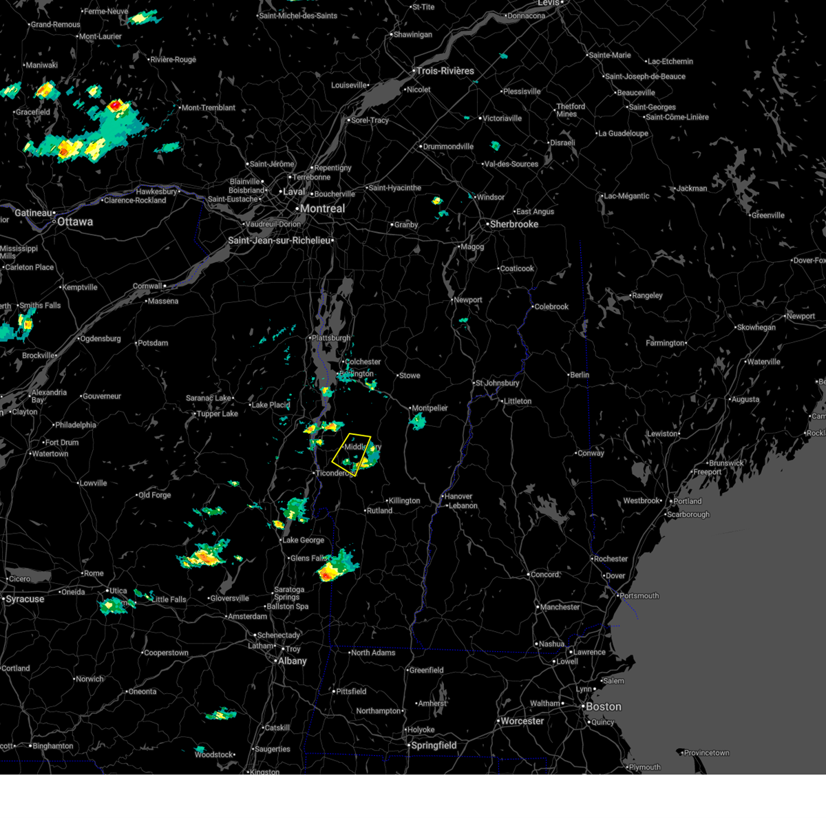
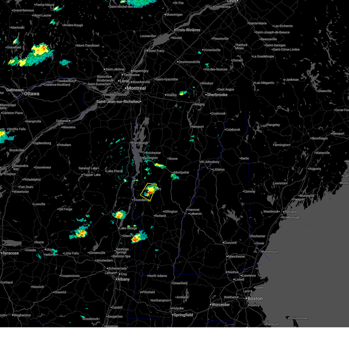
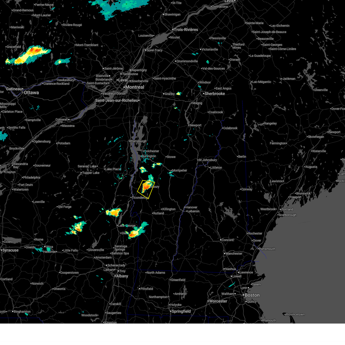
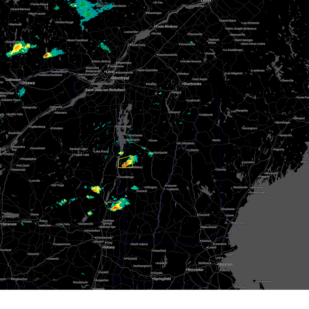
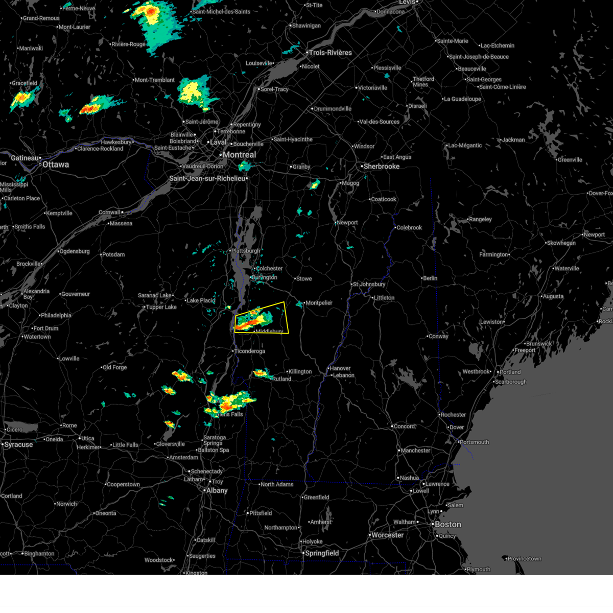
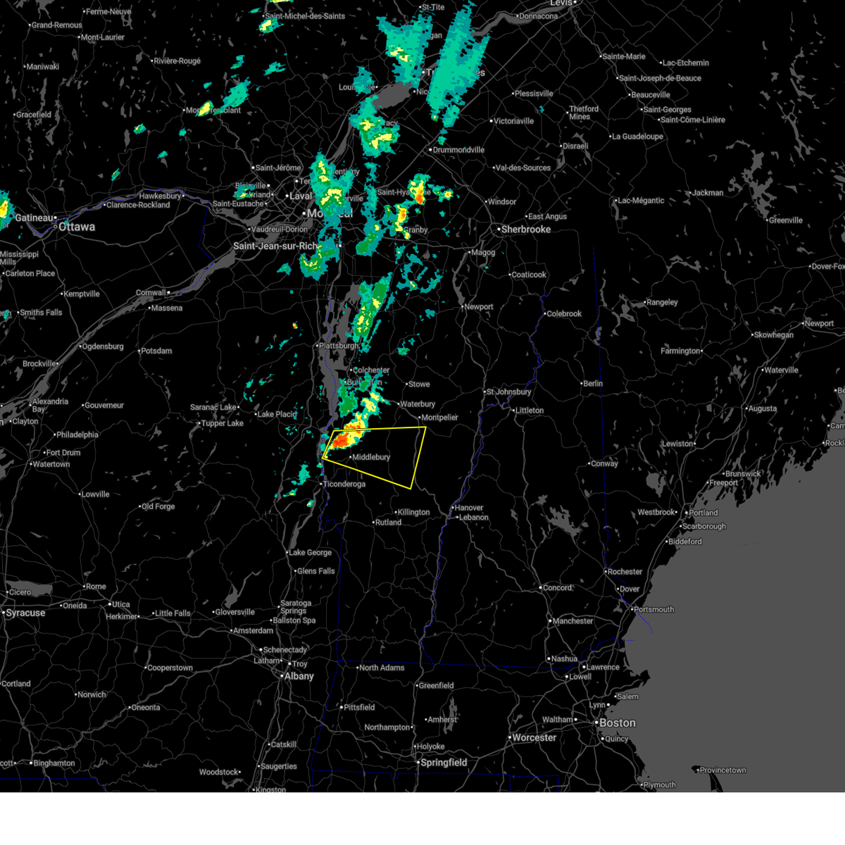
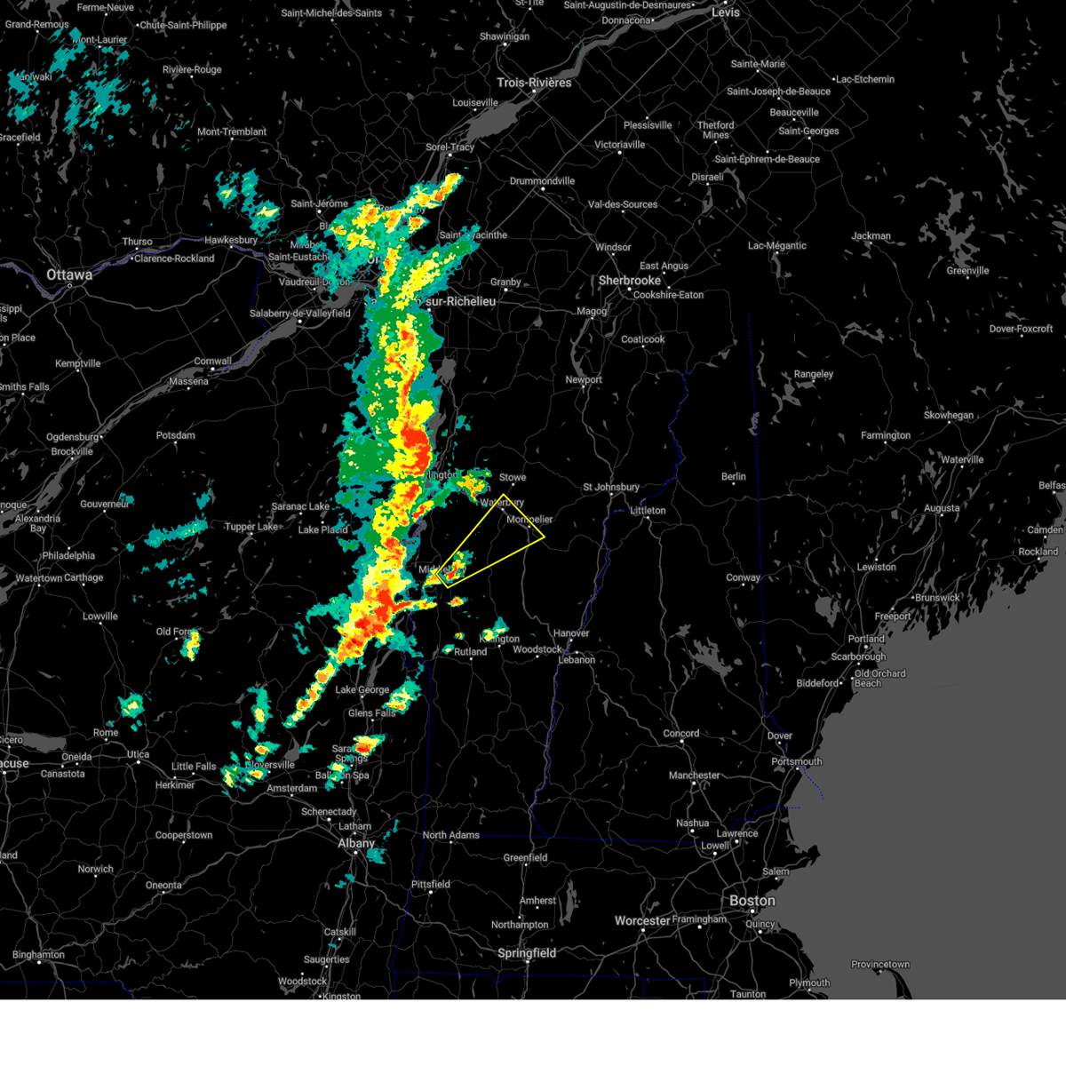
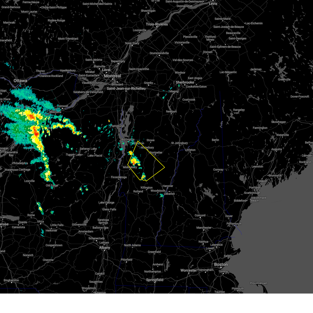
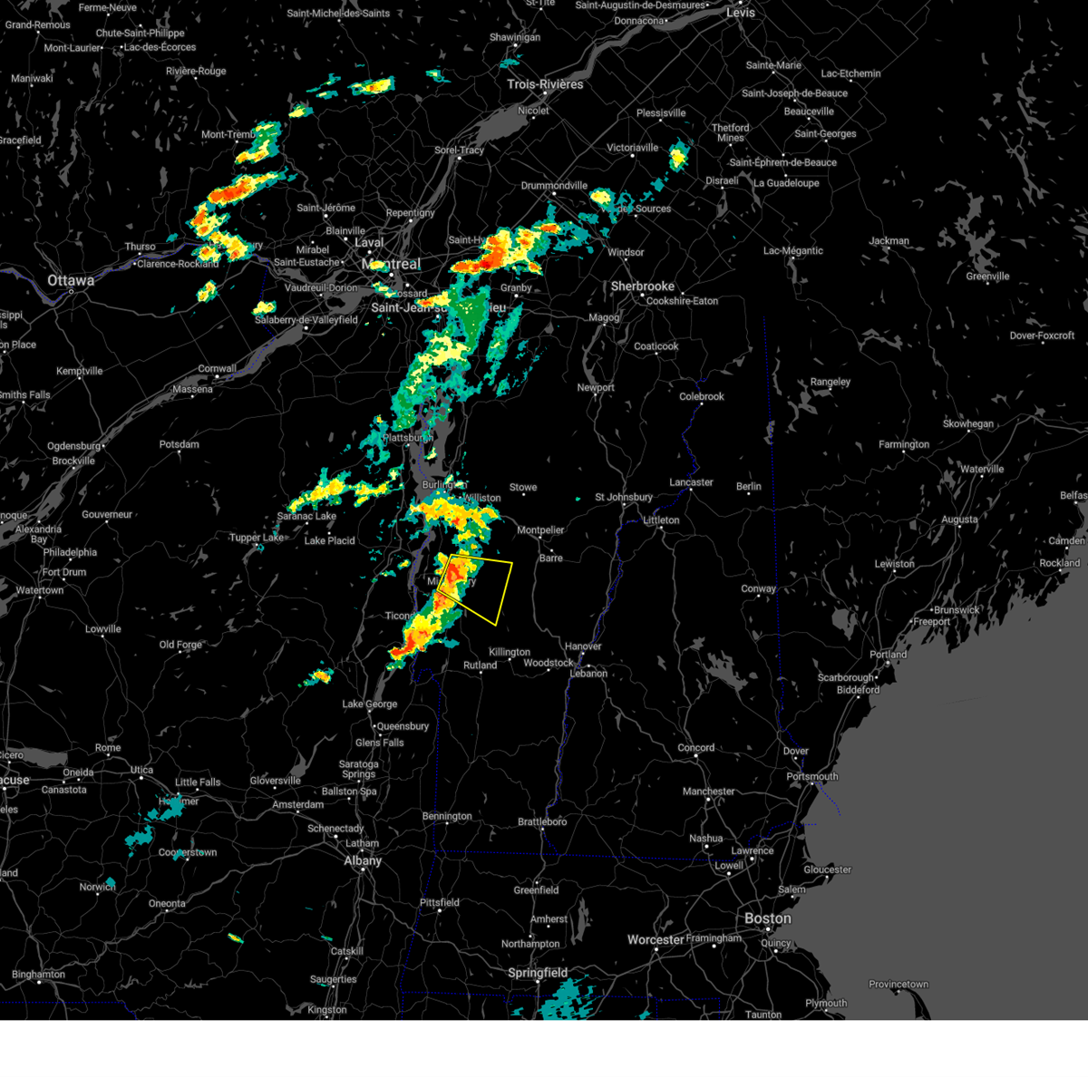
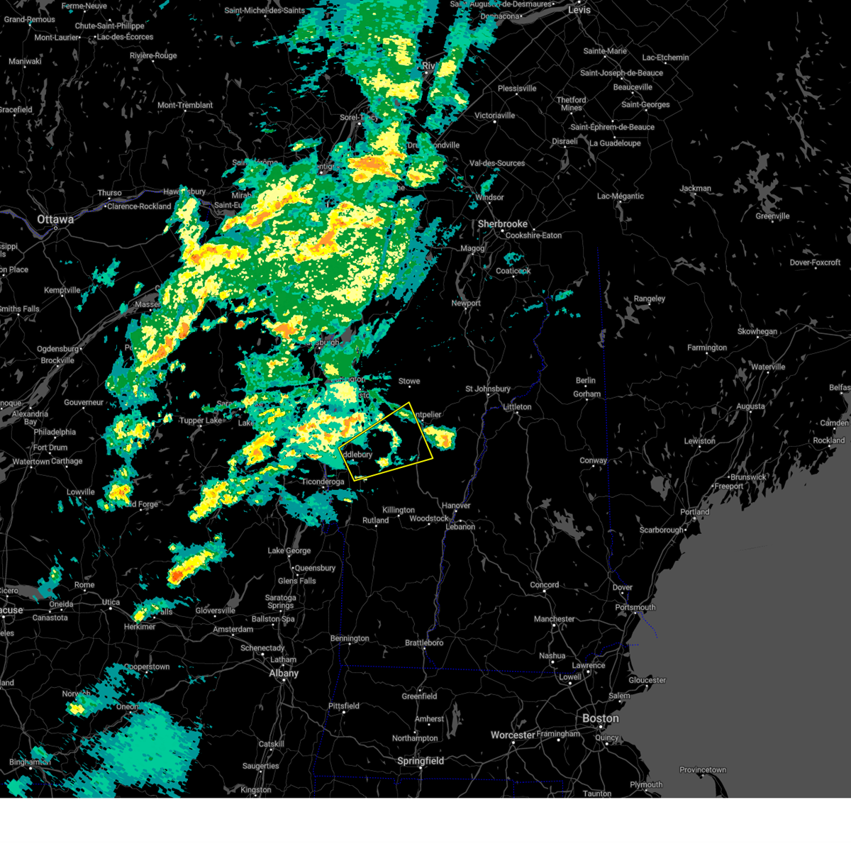
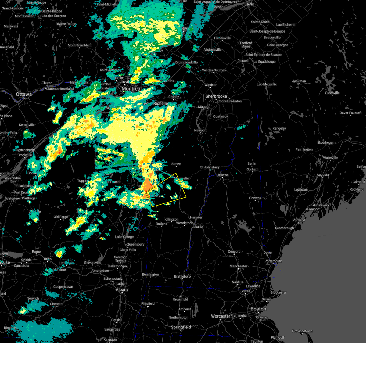
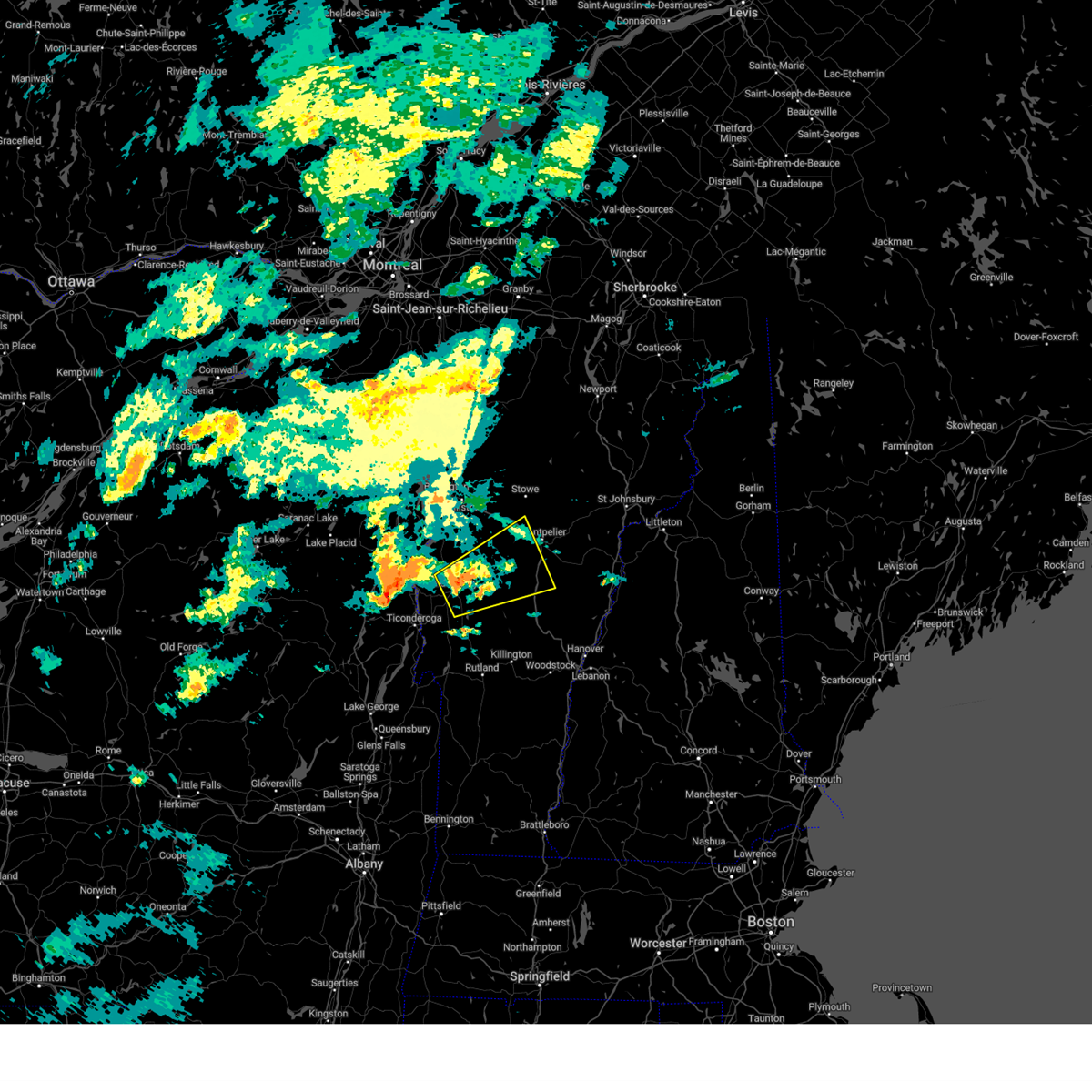
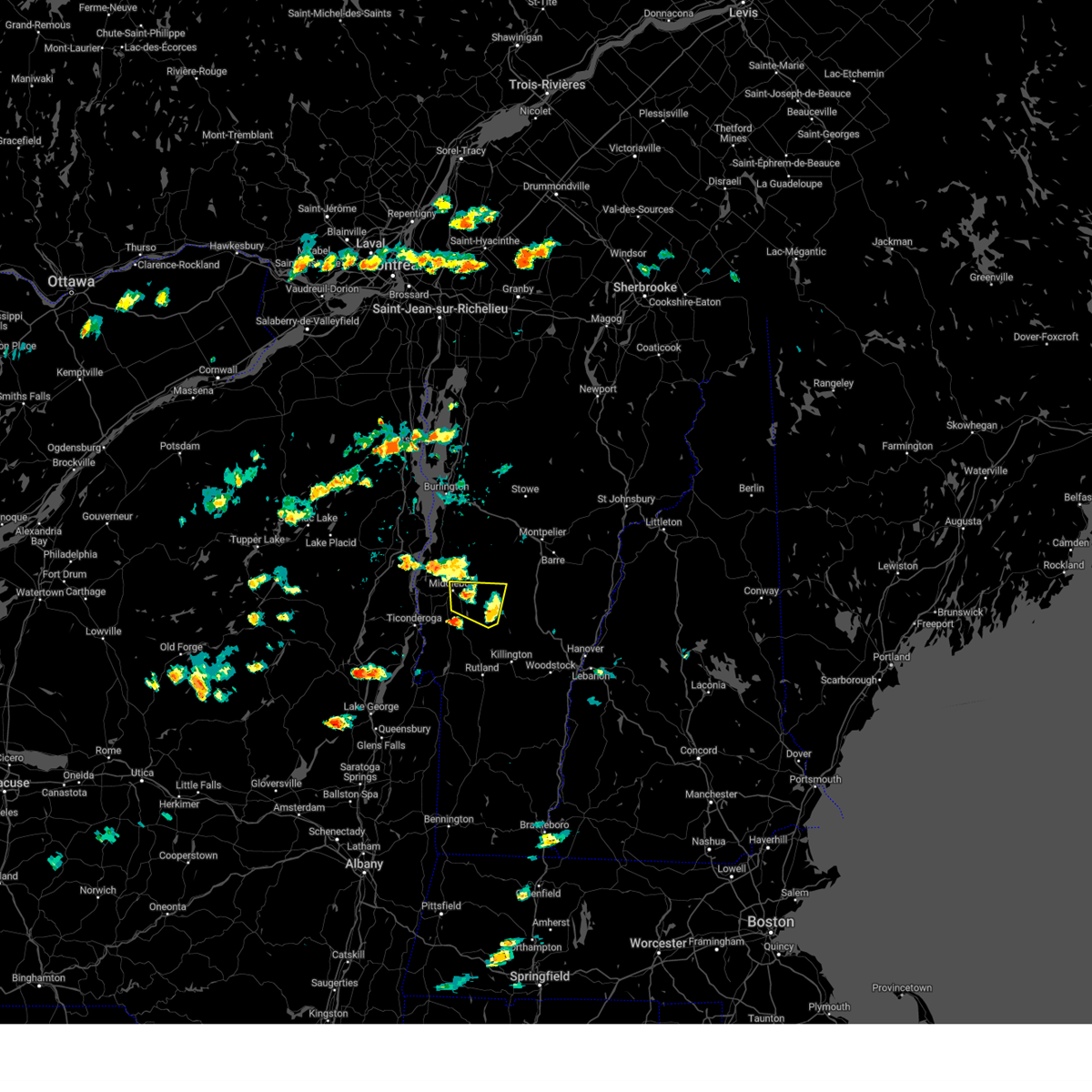
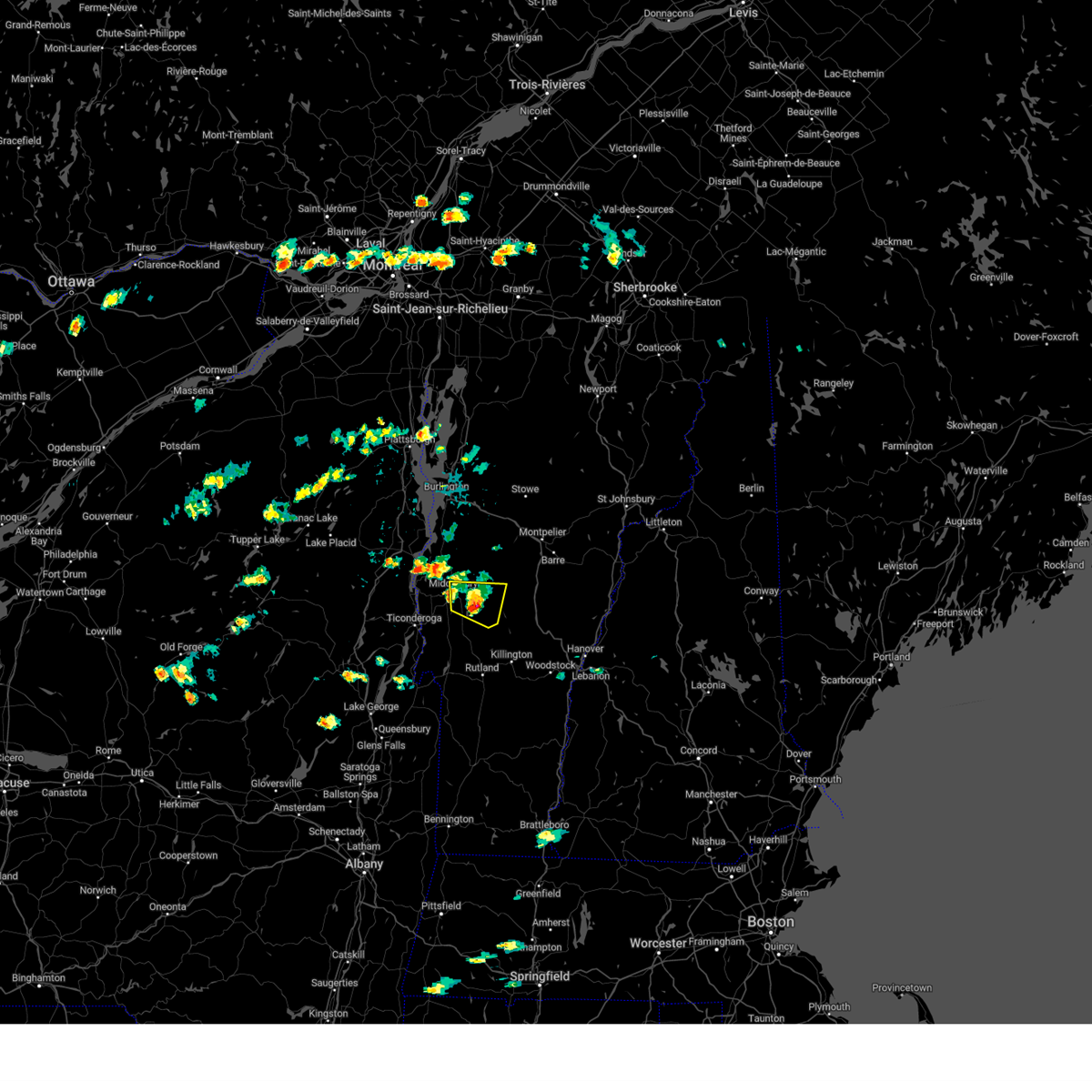
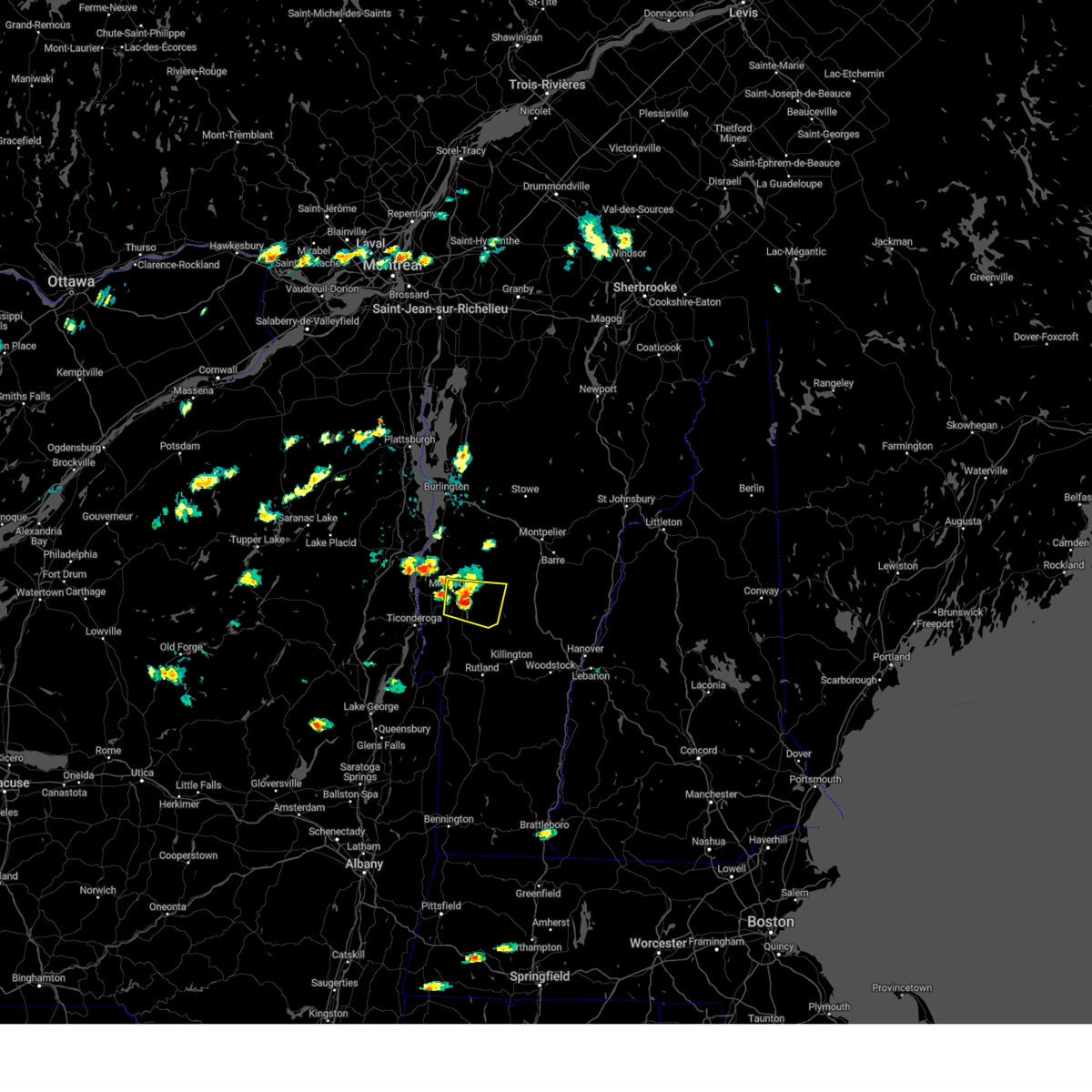
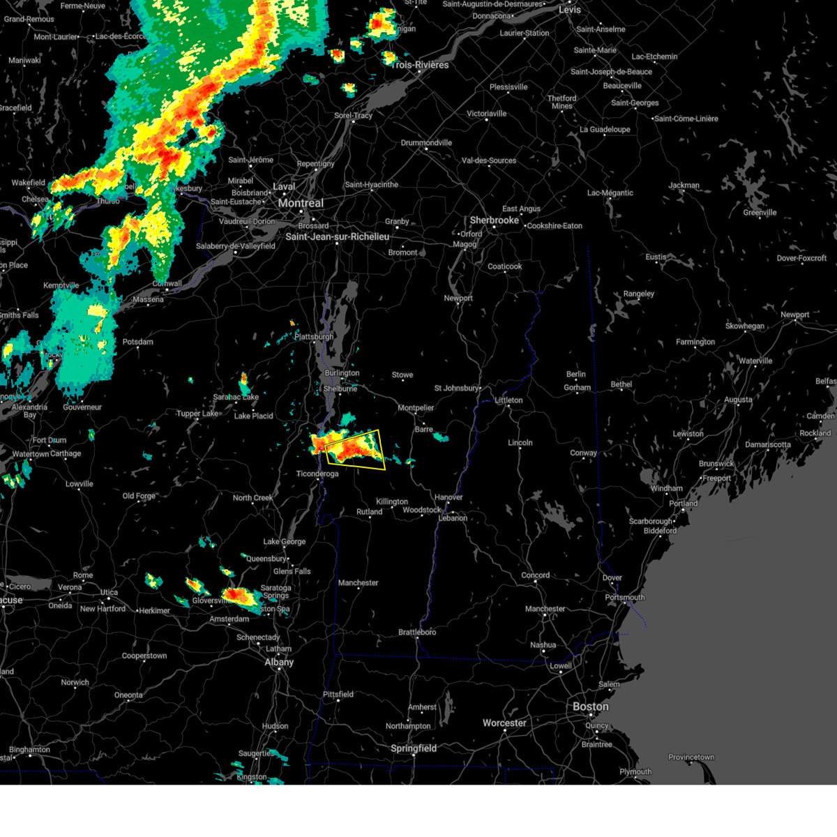
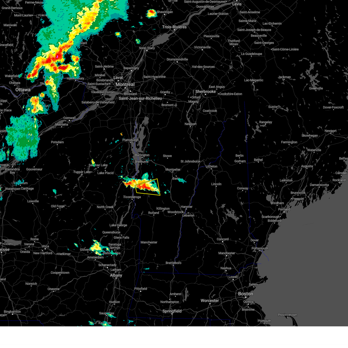
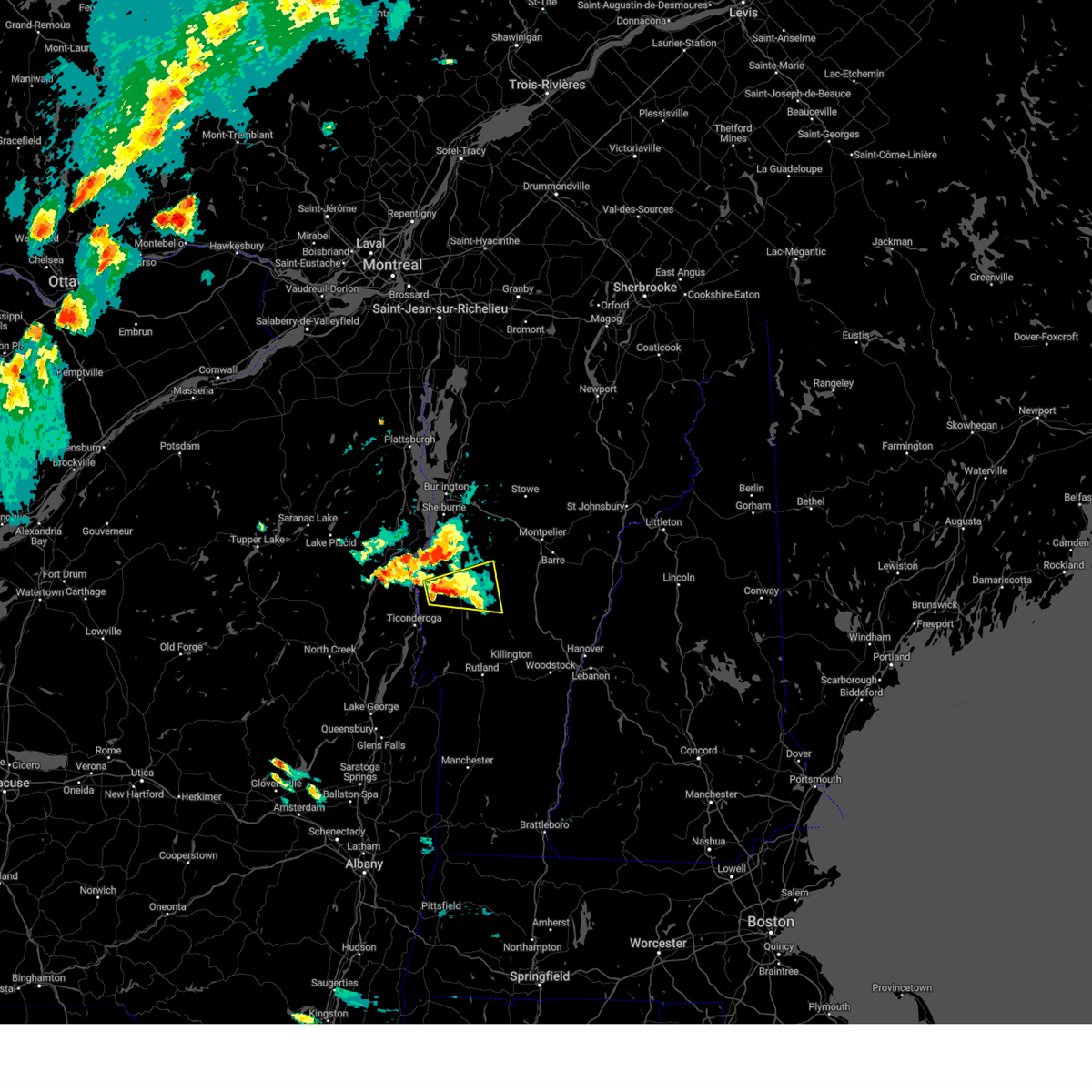
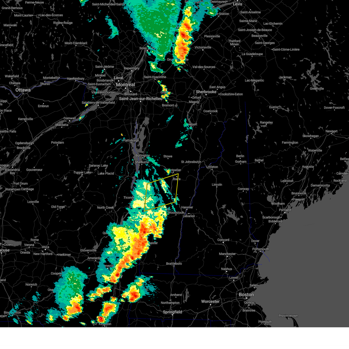
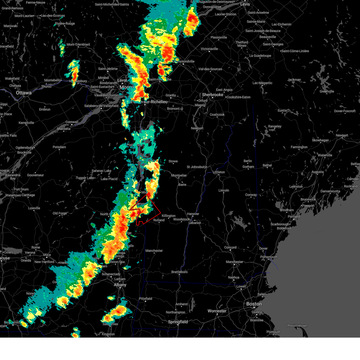
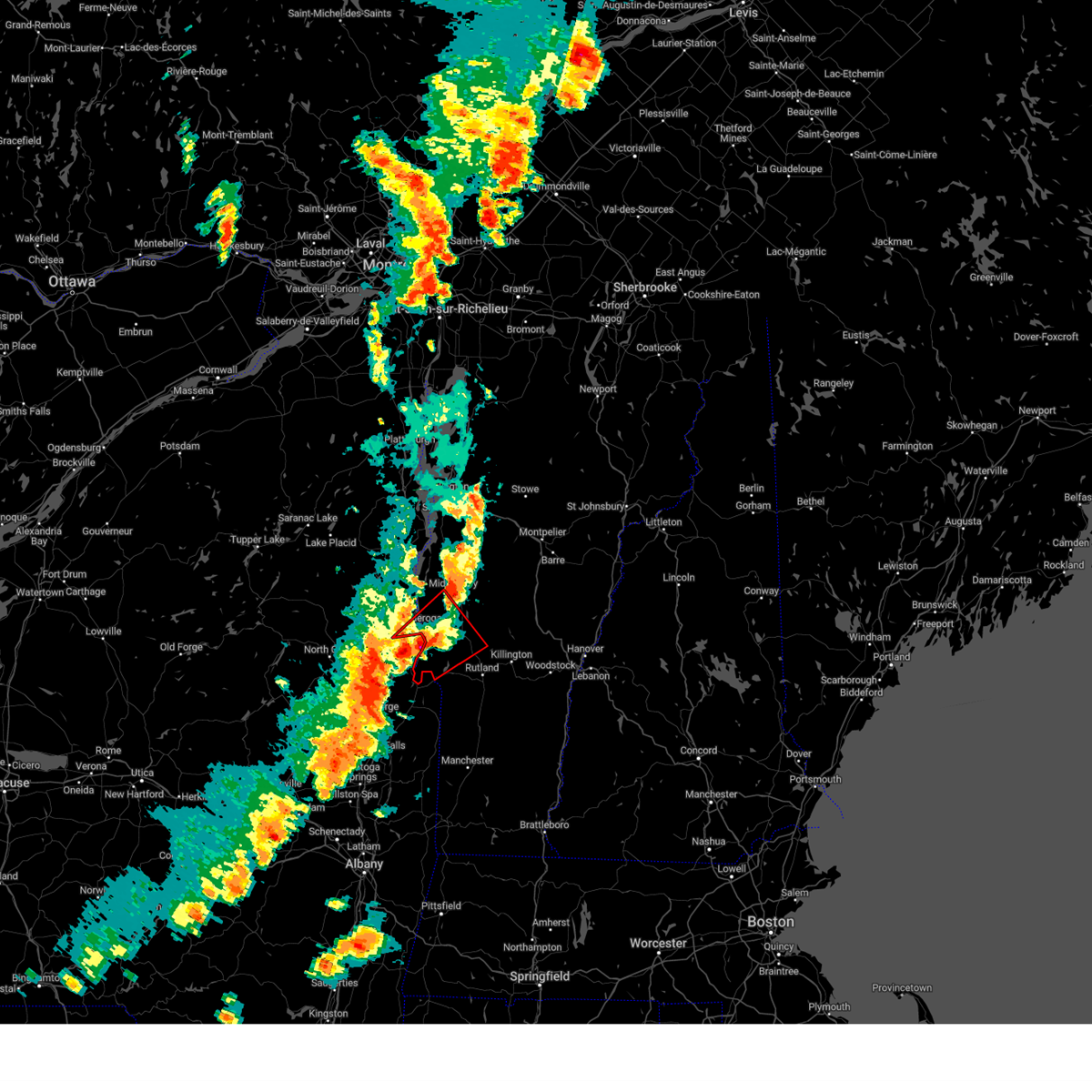
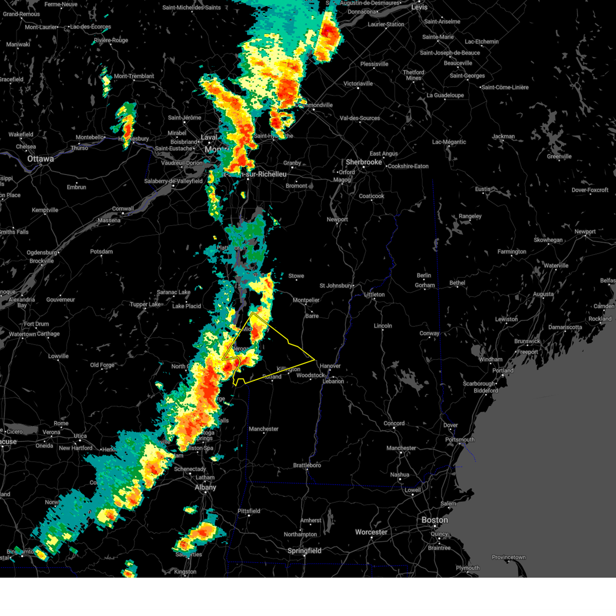
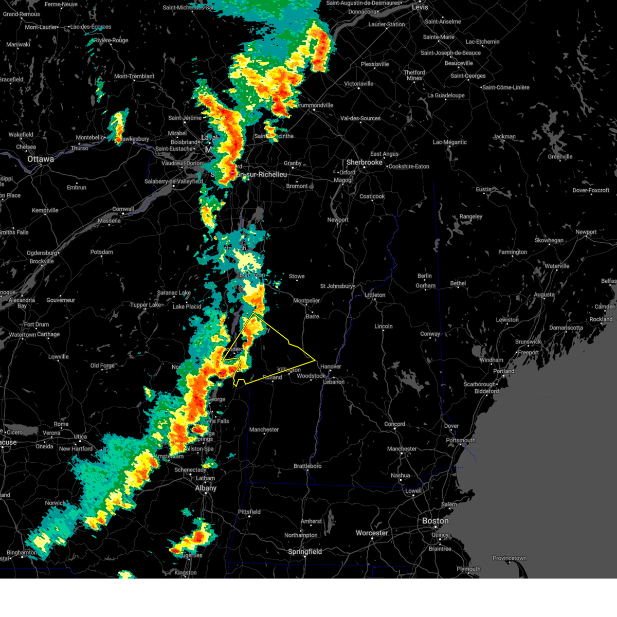
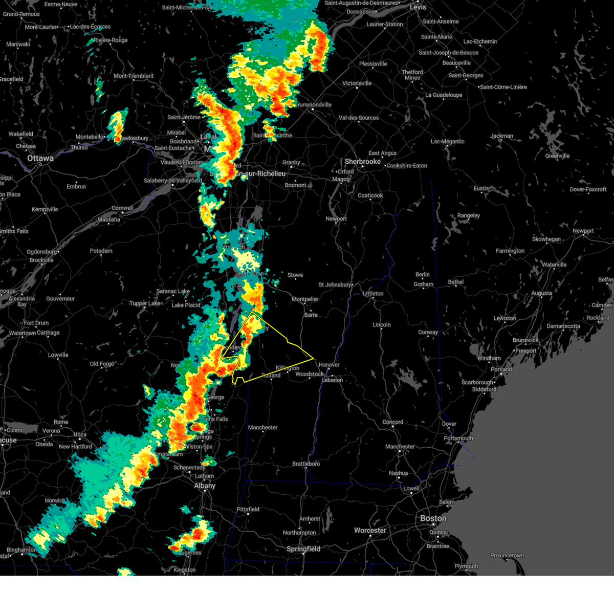
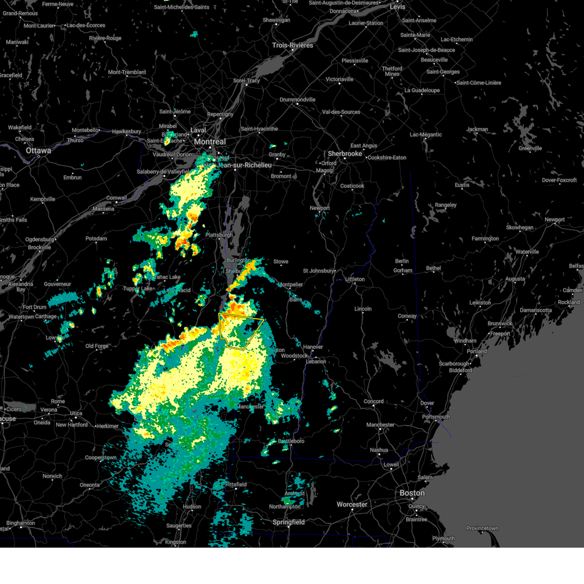
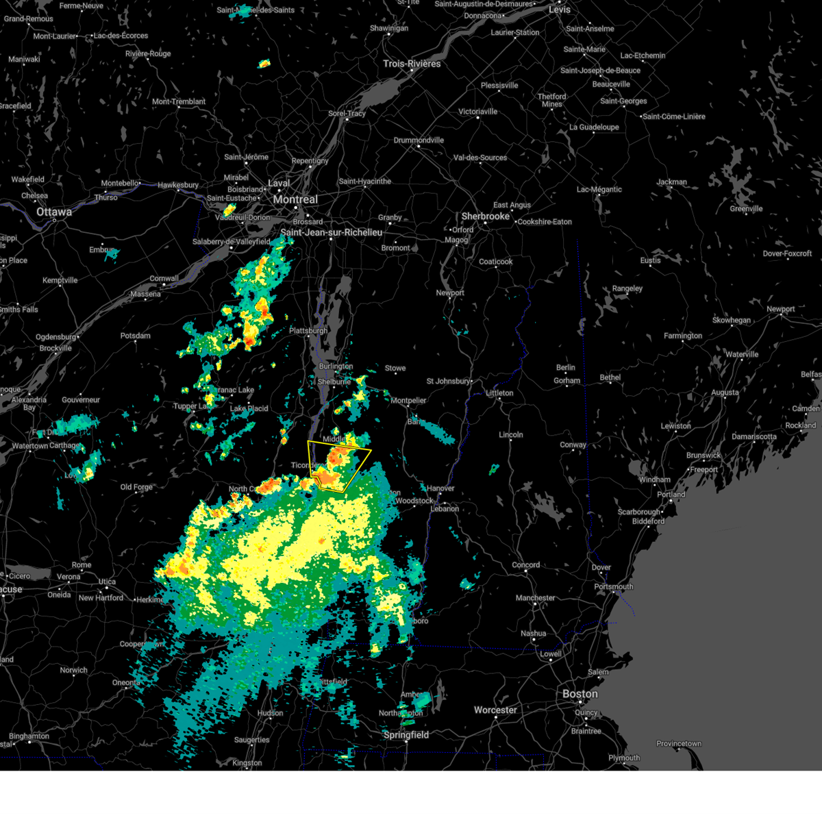
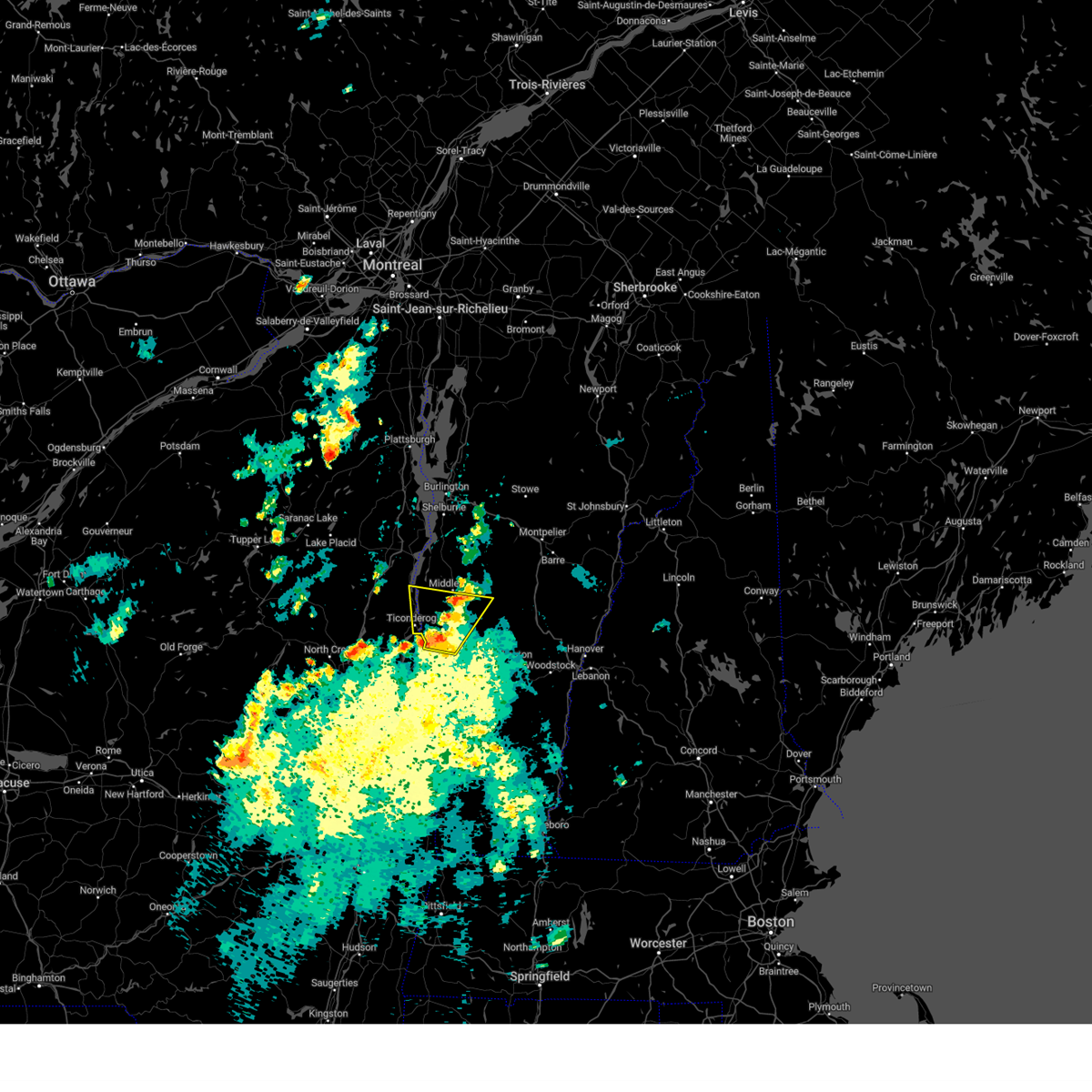
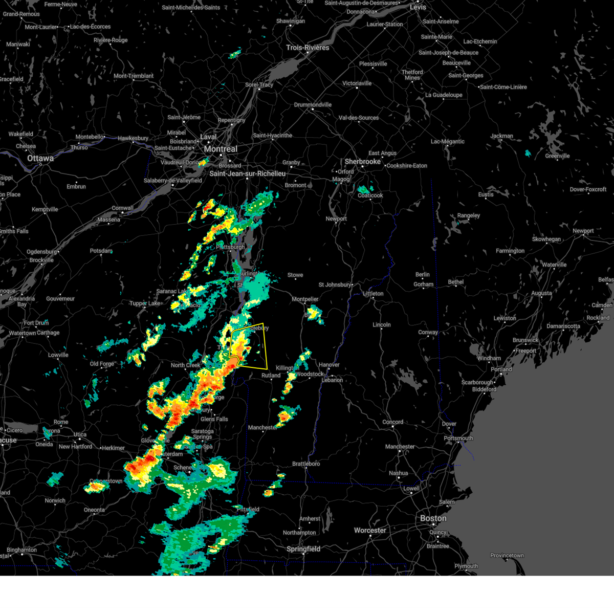
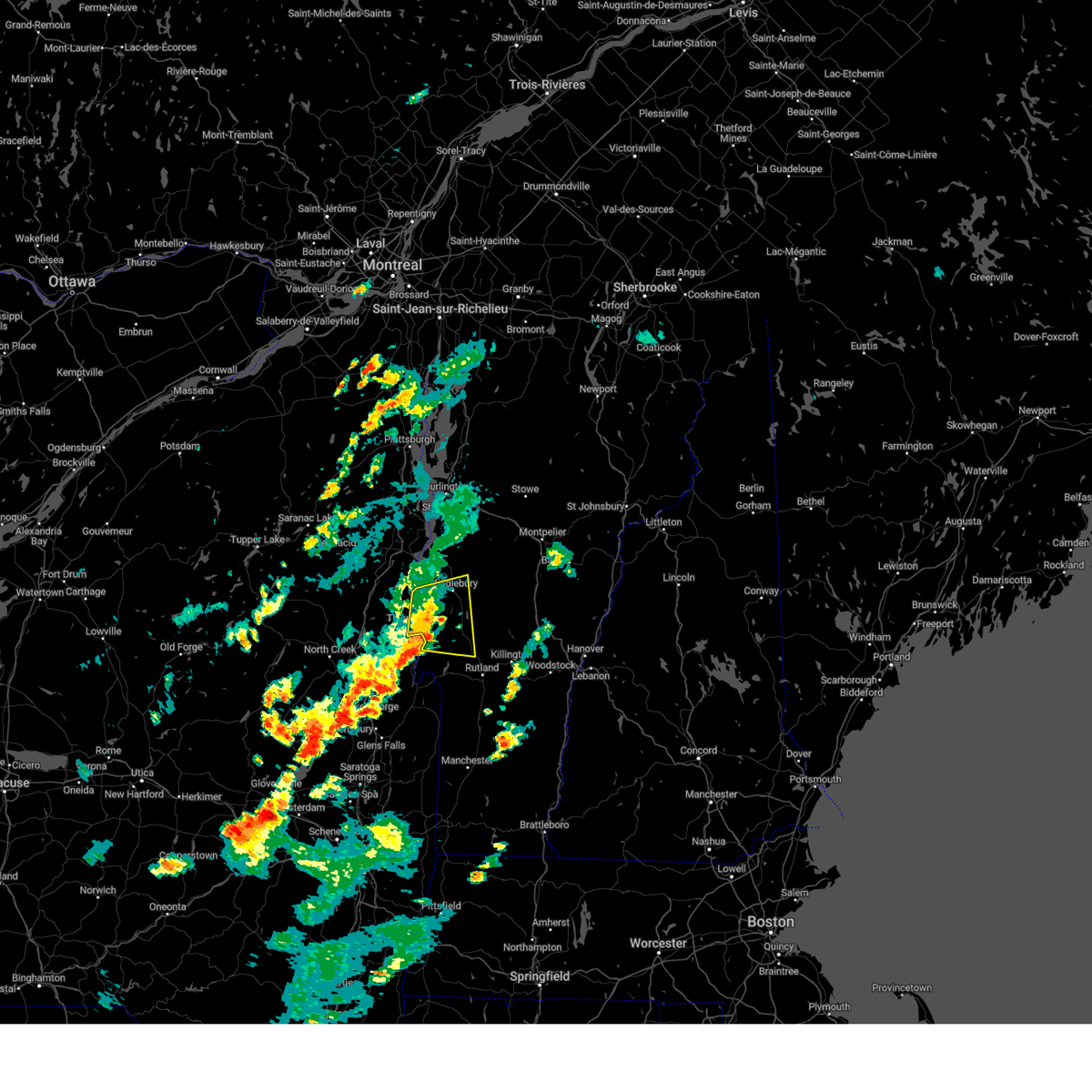
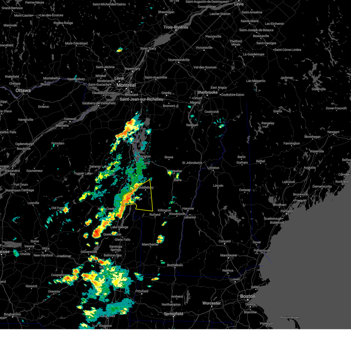
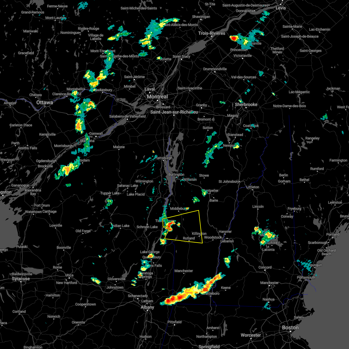
Hail Map for Middlebury, VT
The Middlebury, VT area has had 13 reports of on-the-ground hail by trained spotters, and has been under severe weather warnings 23 times during the past 12 months. Doppler radar has detected hail at or near Middlebury, VT on 29 occasions, including 2 occasions during the past year.
| Name: | Middlebury, VT |
| Where Located: | 32.8 miles S of Burlington, VT |
| Map: | Google Map for Middlebury, VT |
| Population: | 6588 |
| Housing Units: | 2227 |
| More Info: | Search Google for Middlebury, VT |
4
The Top Recent Hail Date for Middlebury, VT is Thursday, July 10, 2025 (4th out of 29)

Hail and Wind Damage Spotted near Middlebury, VT
| Date / Time | Report Details |
|---|---|
| 7/10/2025 5:17 PM EDT |
 the severe thunderstorm warning has been cancelled and is no longer in effect the severe thunderstorm warning has been cancelled and is no longer in effect
|
| 7/10/2025 5:00 PM EDT |
 At 459 pm edt, a severe thunderstorm was located over east middlebury, moving southeast at 25 mph (law enforcement reported several trees and powerlines down in middlebury). Hazards include 60 mph wind gusts and quarter size hail. Minor hail damage to vehicles is possible. expect wind damage to trees and powerlines. Locations impacted include, middlebury, cornwall, leicester, salisbury, ripton, lincoln, whiting, goshen, bristol, brandon, new haven, east middlebury, south lincoln, huntley island, branbury state park, new haven mills, lake dunmore, hollands pasture island, west salisbury, and bread loaf. At 459 pm edt, a severe thunderstorm was located over east middlebury, moving southeast at 25 mph (law enforcement reported several trees and powerlines down in middlebury). Hazards include 60 mph wind gusts and quarter size hail. Minor hail damage to vehicles is possible. expect wind damage to trees and powerlines. Locations impacted include, middlebury, cornwall, leicester, salisbury, ripton, lincoln, whiting, goshen, bristol, brandon, new haven, east middlebury, south lincoln, huntley island, branbury state park, new haven mills, lake dunmore, hollands pasture island, west salisbury, and bread loaf.
|
| 7/10/2025 4:44 PM EDT |
 At 444 pm edt, a severe thunderstorm was located over middlebury, moving east at 10 mph (radar indicated). Hazards include 60 mph wind gusts and quarter size hail. Minor hail damage to vehicles is possible. expect wind damage to trees and powerlines. Locations impacted include, middlebury, cornwall, salisbury, ripton, leicester, new haven, weybridge, lincoln, whiting, goshen, bristol, brandon, bridport, shoreham, east middlebury, branbury state park, lake dunmore, hollands pasture island, bread loaf, and bradbury state park. At 444 pm edt, a severe thunderstorm was located over middlebury, moving east at 10 mph (radar indicated). Hazards include 60 mph wind gusts and quarter size hail. Minor hail damage to vehicles is possible. expect wind damage to trees and powerlines. Locations impacted include, middlebury, cornwall, salisbury, ripton, leicester, new haven, weybridge, lincoln, whiting, goshen, bristol, brandon, bridport, shoreham, east middlebury, branbury state park, lake dunmore, hollands pasture island, bread loaf, and bradbury state park.
|
| 7/10/2025 4:36 PM EDT | Roof damage to middlebury high school and a tree dow in addison county VT, 0.8 miles SE of Middlebury, VT |
| 7/10/2025 4:32 PM EDT | Trees and wires down in middlebur in addison county VT, 0.8 miles SE of Middlebury, VT |
| 7/10/2025 4:28 PM EDT | The storm which prompted the warning has moved out of the area. therefore, the warning will be allowed to expire. however, heavy rain is still possible with this thunderstorm. to report severe weather, contact your nearest law enforcement agency. they will relay your report to the national weather service burlington. |
| 7/10/2025 4:27 PM EDT | Multiple trees down on route 125 in addison county VT, 2.7 miles E of Middlebury, VT |
| 7/10/2025 4:26 PM EDT | Svrbtv the national weather service in burlington has issued a * severe thunderstorm warning for, central addison county in central vermont, north central rutland county in southern vermont, * until 530 pm edt. * at 425 pm edt, a severe thunderstorm was located over weybridge, moving east at 5 mph (radar indicated). Hazards include 60 mph wind gusts and quarter size hail. Minor hail damage to vehicles is possible. Expect wind damage to trees and powerlines. |
| 7/10/2025 4:18 PM EDT |
 At 417 pm edt, a severe thunderstorm was located over new haven, moving east at 15 mph (radar indicated). Hazards include 60 mph wind gusts and quarter size hail. Minor hail damage to vehicles is possible. expect wind damage to trees and powerlines. Locations impacted include, vergennes, middlebury, addison, weybridge, waltham, new haven, panton, bristol, monkton, bridport, ferrisburgh, cornwall, mud island, new haven mills, spaulding bay, new haven junction, potash bay, west addison, arnold bay, and white bay. At 417 pm edt, a severe thunderstorm was located over new haven, moving east at 15 mph (radar indicated). Hazards include 60 mph wind gusts and quarter size hail. Minor hail damage to vehicles is possible. expect wind damage to trees and powerlines. Locations impacted include, vergennes, middlebury, addison, weybridge, waltham, new haven, panton, bristol, monkton, bridport, ferrisburgh, cornwall, mud island, new haven mills, spaulding bay, new haven junction, potash bay, west addison, arnold bay, and white bay.
|
| 7/10/2025 4:18 PM EDT |
 the severe thunderstorm warning has been cancelled and is no longer in effect the severe thunderstorm warning has been cancelled and is no longer in effect
|
| 7/10/2025 4:03 PM EDT |
 At 403 pm edt, a severe thunderstorm was located over new haven junction, and is nearly stationary (radar indicated). Hazards include 60 mph wind gusts and quarter size hail. Minor hail damage to vehicles is possible. expect wind damage to trees and powerlines. Locations impacted include, vergennes, middlebury, addison, weybridge, waltham, warren, bristol, lincoln, fayston, starksboro, buels gore, new haven, panton, granville, waitsfield, ripton, monkton, bridport, ferrisburgh, and roxbury. At 403 pm edt, a severe thunderstorm was located over new haven junction, and is nearly stationary (radar indicated). Hazards include 60 mph wind gusts and quarter size hail. Minor hail damage to vehicles is possible. expect wind damage to trees and powerlines. Locations impacted include, vergennes, middlebury, addison, weybridge, waltham, warren, bristol, lincoln, fayston, starksboro, buels gore, new haven, panton, granville, waitsfield, ripton, monkton, bridport, ferrisburgh, and roxbury.
|
| 7/10/2025 3:35 PM EDT | Broken pole with wires dow in addison county VT, 6.4 miles SE of Middlebury, VT |
| 7/10/2025 3:24 PM EDT |
 Svrbtv the national weather service in burlington has issued a * severe thunderstorm warning for, western orange county in central vermont, central addison county in central vermont, southeastern chittenden county in northwestern vermont, southwestern washington county in central vermont, * until 430 pm edt. * at 324 pm edt, a severe thunderstorm was located over weybridge, moving east at 15 mph (radar indicated). Hazards include 60 mph wind gusts and quarter size hail. Minor hail damage to vehicles is possible. Expect wind damage to trees and powerlines. Svrbtv the national weather service in burlington has issued a * severe thunderstorm warning for, western orange county in central vermont, central addison county in central vermont, southeastern chittenden county in northwestern vermont, southwestern washington county in central vermont, * until 430 pm edt. * at 324 pm edt, a severe thunderstorm was located over weybridge, moving east at 15 mph (radar indicated). Hazards include 60 mph wind gusts and quarter size hail. Minor hail damage to vehicles is possible. Expect wind damage to trees and powerlines.
|
| 7/3/2025 2:08 PM EDT |
 the severe thunderstorm warning has been cancelled and is no longer in effect the severe thunderstorm warning has been cancelled and is no longer in effect
|
| 7/3/2025 1:50 PM EDT | Tree down on river road in addison county VT, 5.4 miles S of Middlebury, VT |
| 7/3/2025 1:49 PM EDT |
 the severe thunderstorm warning has been cancelled and is no longer in effect the severe thunderstorm warning has been cancelled and is no longer in effect
|
| 7/3/2025 1:49 PM EDT |
 At 148 pm edt, a severe thunderstorm was located near south lincoln, moving east at 25 mph (radar indicated). Hazards include 60 mph wind gusts and quarter size hail. Minor hail damage to vehicles is possible. expect wind damage to trees and powerlines. Locations impacted include, middlebury, cornwall, braintree hill, weybridge, bristol, bethel, lincoln, waitsfield, rochester, new haven, granville, northfield village, hancock, warren, ripton, northfield, roxbury, braintree, brookfield, and randolph. At 148 pm edt, a severe thunderstorm was located near south lincoln, moving east at 25 mph (radar indicated). Hazards include 60 mph wind gusts and quarter size hail. Minor hail damage to vehicles is possible. expect wind damage to trees and powerlines. Locations impacted include, middlebury, cornwall, braintree hill, weybridge, bristol, bethel, lincoln, waitsfield, rochester, new haven, granville, northfield village, hancock, warren, ripton, northfield, roxbury, braintree, brookfield, and randolph.
|
| 7/3/2025 1:24 PM EDT |
 Svrbtv the national weather service in burlington has issued a * severe thunderstorm warning for, southeastern essex county in northern new york, northwestern orange county in central vermont, central addison county in central vermont, southeastern chittenden county in northwestern vermont, northwestern windsor county in southern vermont, southwestern washington county in central vermont, * until 230 pm edt. * at 124 pm edt, a severe thunderstorm was located over waltham, moving east at 30 mph (radar indicated). Hazards include 60 mph wind gusts and quarter size hail. Minor hail damage to vehicles is possible. Expect wind damage to trees and powerlines. Svrbtv the national weather service in burlington has issued a * severe thunderstorm warning for, southeastern essex county in northern new york, northwestern orange county in central vermont, central addison county in central vermont, southeastern chittenden county in northwestern vermont, northwestern windsor county in southern vermont, southwestern washington county in central vermont, * until 230 pm edt. * at 124 pm edt, a severe thunderstorm was located over waltham, moving east at 30 mph (radar indicated). Hazards include 60 mph wind gusts and quarter size hail. Minor hail damage to vehicles is possible. Expect wind damage to trees and powerlines.
|
| 5/17/2025 3:24 PM EDT | Tree down on powerlines on gorham ln in addison county VT, 2 miles SE of Middlebury, VT |
| 5/17/2025 3:15 PM EDT |
 Svrbtv the national weather service in burlington has issued a * severe thunderstorm warning for, central addison county in central vermont, southeastern chittenden county in northwestern vermont, western washington county in central vermont, * until 415 pm edt. * at 314 pm edt, a severe thunderstorm was located near new haven mills, moving northeast at 25 mph (radar indicated). Hazards include 60 mph wind gusts and quarter size hail. Minor hail damage to vehicles is possible. Expect wind damage to trees and powerlines. Svrbtv the national weather service in burlington has issued a * severe thunderstorm warning for, central addison county in central vermont, southeastern chittenden county in northwestern vermont, western washington county in central vermont, * until 415 pm edt. * at 314 pm edt, a severe thunderstorm was located near new haven mills, moving northeast at 25 mph (radar indicated). Hazards include 60 mph wind gusts and quarter size hail. Minor hail damage to vehicles is possible. Expect wind damage to trees and powerlines.
|
| 5/17/2025 8:30 AM EDT |
 Svrbtv the national weather service in burlington has issued a * severe thunderstorm warning for, northwestern orange county in central vermont, central addison county in central vermont, southeastern chittenden county in northwestern vermont, northwestern windsor county in southern vermont, southwestern washington county in central vermont, * until 915 am edt. * at 829 am edt, a severe thunderstorm was located over bristol, moving northeast at 25 mph (radar indicated). Hazards include 60 mph wind gusts and quarter size hail. Minor hail damage to vehicles is possible. Expect wind damage to trees and powerlines. Svrbtv the national weather service in burlington has issued a * severe thunderstorm warning for, northwestern orange county in central vermont, central addison county in central vermont, southeastern chittenden county in northwestern vermont, northwestern windsor county in southern vermont, southwestern washington county in central vermont, * until 915 am edt. * at 829 am edt, a severe thunderstorm was located over bristol, moving northeast at 25 mph (radar indicated). Hazards include 60 mph wind gusts and quarter size hail. Minor hail damage to vehicles is possible. Expect wind damage to trees and powerlines.
|
| 8/4/2024 5:46 PM EDT |
 A new severe thunderstorm warning has been issued to replace this warning. the threat for gusty winds, hail, frequent lightning, and torrential rainfall continues. A new severe thunderstorm warning has been issued to replace this warning. the threat for gusty winds, hail, frequent lightning, and torrential rainfall continues.
|
| 8/4/2024 5:40 PM EDT |
 Svrbtv the national weather service in burlington has issued a * severe thunderstorm warning for, central addison county in central vermont, northeastern rutland county in southern vermont, northwestern windsor county in southern vermont, southwestern washington county in central vermont, * until 645 pm edt. * at 540 pm edt, a severe thunderstorm was located over brooksville, moving east at 20 mph (radar indicated). Hazards include 60 mph wind gusts and penny size hail. expect damage to trees and powerlines Svrbtv the national weather service in burlington has issued a * severe thunderstorm warning for, central addison county in central vermont, northeastern rutland county in southern vermont, northwestern windsor county in southern vermont, southwestern washington county in central vermont, * until 645 pm edt. * at 540 pm edt, a severe thunderstorm was located over brooksville, moving east at 20 mph (radar indicated). Hazards include 60 mph wind gusts and penny size hail. expect damage to trees and powerlines
|
| 8/4/2024 5:29 PM EDT |
 At 529 pm edt, a severe thunderstorm was located over weybridge, moving east at 20 mph (radar indicated). Hazards include 60 mph wind gusts and penny size hail. Expect damage to trees and powerlines. Locations impacted include, vergennes, middlebury, addison, weybridge, waltham, new haven, bristol, panton, ferrisburgh, lincoln, cornwall, bridport, ripton, starksboro, east middlebury, new haven mills, west lincoln, new haven junction, south starksboro, and brooksville. At 529 pm edt, a severe thunderstorm was located over weybridge, moving east at 20 mph (radar indicated). Hazards include 60 mph wind gusts and penny size hail. Expect damage to trees and powerlines. Locations impacted include, vergennes, middlebury, addison, weybridge, waltham, new haven, bristol, panton, ferrisburgh, lincoln, cornwall, bridport, ripton, starksboro, east middlebury, new haven mills, west lincoln, new haven junction, south starksboro, and brooksville.
|
| 8/4/2024 5:29 PM EDT |
 the severe thunderstorm warning has been cancelled and is no longer in effect the severe thunderstorm warning has been cancelled and is no longer in effect
|
| 8/4/2024 5:28 PM EDT | Trees down in weybridge near route 2 in addison county VT, 5.9 miles SE of Middlebury, VT |
| 8/4/2024 5:05 PM EDT |
 Svrbtv the national weather service in burlington has issued a * severe thunderstorm warning for, east central essex county in northern new york, northwestern addison county in central vermont, * until 545 pm edt. * at 505 pm edt, a severe thunderstorm was located over potash point, moving east at 20 mph (radar indicated). Hazards include 60 mph wind gusts and penny size hail. expect damage to trees and powerlines Svrbtv the national weather service in burlington has issued a * severe thunderstorm warning for, east central essex county in northern new york, northwestern addison county in central vermont, * until 545 pm edt. * at 505 pm edt, a severe thunderstorm was located over potash point, moving east at 20 mph (radar indicated). Hazards include 60 mph wind gusts and penny size hail. expect damage to trees and powerlines
|
| 7/30/2024 5:39 PM EDT | The storm which prompted the warning has weakened below severe limits, and no longer poses an immediate threat to life or property. therefore, the warning will be allowed to expire. |
| 7/30/2024 5:18 PM EDT |
 At 517 pm edt, a severe thunderstorm was located over button bay, moving east at 10 mph (law enforcement. at 357 pm, a tree was reported down on moriah road). Hazards include 60 mph wind gusts and penny size hail. Expect damage to trees and powerlines. locations impacted include, vergennes, middlebury, essex, westport, ferrisburg, charlotte, weybridge, waltham, new haven, panton, mt. Philo state park, addison, kingsland bay state park, ferrisburgh, monkton, fort cassin point, mcneil cove, owls head bay, sloop island, and wings point. At 517 pm edt, a severe thunderstorm was located over button bay, moving east at 10 mph (law enforcement. at 357 pm, a tree was reported down on moriah road). Hazards include 60 mph wind gusts and penny size hail. Expect damage to trees and powerlines. locations impacted include, vergennes, middlebury, essex, westport, ferrisburg, charlotte, weybridge, waltham, new haven, panton, mt. Philo state park, addison, kingsland bay state park, ferrisburgh, monkton, fort cassin point, mcneil cove, owls head bay, sloop island, and wings point.
|
| 7/30/2024 4:50 PM EDT | Svrbtv the national weather service in burlington has issued a * severe thunderstorm warning for, east central essex county in northern new york, northwestern addison county in central vermont, southwestern chittenden county in northwestern vermont, * until 545 pm edt. * at 449 pm edt, a severe thunderstorm was located over cole bay, moving east at 10 mph (radar indicated). Hazards include 60 mph wind gusts and penny size hail. expect damage to trees and powerlines |
| 7/10/2024 7:28 PM EDT |
 The storm which prompted the warning has weakened below severe limits, and has exited the warned area. therefore, the warning will be allowed to expire. however, heavy rain is still possible with this thunderstorm. a tornado watch remains in effect until 900 pm edt for central and northwestern vermont. The storm which prompted the warning has weakened below severe limits, and has exited the warned area. therefore, the warning will be allowed to expire. however, heavy rain is still possible with this thunderstorm. a tornado watch remains in effect until 900 pm edt for central and northwestern vermont.
|
| 7/10/2024 7:08 PM EDT |
 The storm which prompted the warning has moved out of the area. therefore, the warning will be allowed to expire. a tornado watch remains in effect until 900 pm edt for northern new york, and central and northwestern vermont. to report severe weather, contact your nearest law enforcement agency. they will relay your report to the national weather service burlington. remember, a severe thunderstorm warning still remains in effect for addison and chittenden counties!. The storm which prompted the warning has moved out of the area. therefore, the warning will be allowed to expire. a tornado watch remains in effect until 900 pm edt for northern new york, and central and northwestern vermont. to report severe weather, contact your nearest law enforcement agency. they will relay your report to the national weather service burlington. remember, a severe thunderstorm warning still remains in effect for addison and chittenden counties!.
|
| 7/10/2024 6:58 PM EDT |
 At 658 pm edt, a severe thunderstorm was located over northfield falls, moving northeast at 45 mph (radar indicated). Hazards include 60 mph wind gusts. Expect damage to trees and powerlines. Locations impacted include, middlebury, weybridge, salisbury, bristol, waterbury village, lincoln, waitsfield, berlin, fayston, new haven, granville, northfield village, warren, ripton, duxbury, northfield, moretown, roxbury, williamstown, and buels gore. At 658 pm edt, a severe thunderstorm was located over northfield falls, moving northeast at 45 mph (radar indicated). Hazards include 60 mph wind gusts. Expect damage to trees and powerlines. Locations impacted include, middlebury, weybridge, salisbury, bristol, waterbury village, lincoln, waitsfield, berlin, fayston, new haven, granville, northfield village, warren, ripton, duxbury, northfield, moretown, roxbury, williamstown, and buels gore.
|
| 7/10/2024 6:56 PM EDT |
 At 656 pm edt, a severe thunderstorm was located over waltham, moving east at 30 mph (radar indicated). Hazards include 60 mph wind gusts. Expect damage to trees and powerlines. locations impacted include, vergennes, middlebury, westport, ferrisburg, weybridge, waltham, bristol, monkton ridge, monkton, monkton boro, new haven, panton, mt. Philo state park, port henry, addison, kingsland bay state park, d a r state park, bridport, ferrisburgh, and hinesburg. At 656 pm edt, a severe thunderstorm was located over waltham, moving east at 30 mph (radar indicated). Hazards include 60 mph wind gusts. Expect damage to trees and powerlines. locations impacted include, vergennes, middlebury, westport, ferrisburg, weybridge, waltham, bristol, monkton ridge, monkton, monkton boro, new haven, panton, mt. Philo state park, port henry, addison, kingsland bay state park, d a r state park, bridport, ferrisburgh, and hinesburg.
|
| 7/10/2024 6:33 PM EDT |
 Svrbtv the national weather service in burlington has issued a * severe thunderstorm warning for, southeastern essex county in northern new york, northwestern addison county in central vermont, southwestern chittenden county in northwestern vermont, * until 715 pm edt. * at 632 pm edt, a severe thunderstorm was located over craig harbor, moving east at 30 mph (radar indicated). Hazards include 60 mph wind gusts. expect damage to trees and powerlines Svrbtv the national weather service in burlington has issued a * severe thunderstorm warning for, southeastern essex county in northern new york, northwestern addison county in central vermont, southwestern chittenden county in northwestern vermont, * until 715 pm edt. * at 632 pm edt, a severe thunderstorm was located over craig harbor, moving east at 30 mph (radar indicated). Hazards include 60 mph wind gusts. expect damage to trees and powerlines
|
| 7/10/2024 6:24 PM EDT |
 The storm which prompted the warning has moved out of the area. therefore, the warning will be allowed to expire. a tornado watch remains in effect until 900 pm edt for northern new york, and central, southern and northwestern vermont. remember, a new severe thunderstorm warning still remains in effect!. The storm which prompted the warning has moved out of the area. therefore, the warning will be allowed to expire. a tornado watch remains in effect until 900 pm edt for northern new york, and central, southern and northwestern vermont. remember, a new severe thunderstorm warning still remains in effect!.
|
| 7/10/2024 6:23 PM EDT |
 Svrbtv the national weather service in burlington has issued a * severe thunderstorm warning for, northwestern orange county in central vermont, central addison county in central vermont, southeastern chittenden county in northwestern vermont, southwestern washington county in central vermont, * until 730 pm edt. * at 623 pm edt, a severe thunderstorm was located over middlebury, moving northeast at 25 mph (radar indicated). Hazards include 60 mph wind gusts. expect damage to trees and powerlines Svrbtv the national weather service in burlington has issued a * severe thunderstorm warning for, northwestern orange county in central vermont, central addison county in central vermont, southeastern chittenden county in northwestern vermont, southwestern washington county in central vermont, * until 730 pm edt. * at 623 pm edt, a severe thunderstorm was located over middlebury, moving northeast at 25 mph (radar indicated). Hazards include 60 mph wind gusts. expect damage to trees and powerlines
|
| 7/10/2024 6:09 PM EDT |
 At 609 pm edt, a severe thunderstorm was located over new haven mills, moving northeast at 40 mph (radar indicated). Hazards include 60 mph wind gusts. Expect damage to trees and powerlines. Locations impacted include, middlebury, vergennes, moriah, crown point, cornwall, weybridge, waltham, salisbury, bristol, lincoln, orwell, whiting, new haven, granville, port henry, addison, hancock, shoreham, warren, and d a r state park. At 609 pm edt, a severe thunderstorm was located over new haven mills, moving northeast at 40 mph (radar indicated). Hazards include 60 mph wind gusts. Expect damage to trees and powerlines. Locations impacted include, middlebury, vergennes, moriah, crown point, cornwall, weybridge, waltham, salisbury, bristol, lincoln, orwell, whiting, new haven, granville, port henry, addison, hancock, shoreham, warren, and d a r state park.
|
| 7/10/2024 5:49 PM EDT | Numerous trees down near 2504 route 22a in bridpor in addison county VT, 8.1 miles E of Middlebury, VT |
| 7/10/2024 5:38 PM EDT |
 Svrbtv the national weather service in burlington has issued a * severe thunderstorm warning for, southeastern essex county in northern new york, western orange county in central vermont, addison county in central vermont, southeastern chittenden county in northwestern vermont, northern windsor county in southern vermont, southwestern washington county in central vermont, * until 630 pm edt. * at 538 pm edt, a severe thunderstorm was located over crown point, moving northeast at 40 mph (radar indicated). Hazards include 60 mph wind gusts. expect damage to trees and powerlines Svrbtv the national weather service in burlington has issued a * severe thunderstorm warning for, southeastern essex county in northern new york, western orange county in central vermont, addison county in central vermont, southeastern chittenden county in northwestern vermont, northern windsor county in southern vermont, southwestern washington county in central vermont, * until 630 pm edt. * at 538 pm edt, a severe thunderstorm was located over crown point, moving northeast at 40 mph (radar indicated). Hazards include 60 mph wind gusts. expect damage to trees and powerlines
|
| 6/20/2024 2:13 PM EDT |
 The storm which prompted the warning has weakened below severe limits. therefore, the warning will be allowed to expire and a special weather statement has been issued. a severe thunderstorm watch remains in effect until 800 pm edt for central and southern vermont. The storm which prompted the warning has weakened below severe limits. therefore, the warning will be allowed to expire and a special weather statement has been issued. a severe thunderstorm watch remains in effect until 800 pm edt for central and southern vermont.
|
| 6/20/2024 2:04 PM EDT |
 At 204 pm edt, a severe thunderstorm was located over cornwall, moving east at 20 mph (public). Hazards include 60 mph wind gusts and quarter size hail. Minor hail damage to vehicles is possible. expect wind damage to trees and powerlines. Locations impacted include, middlebury, hancock, salisbury, ripton, granville, goshen, leicester, cornwall, rochester, weybridge, lincoln, new haven, bristol, east middlebury, branbury state park, lake dunmore, lower granville, hollands pasture island, west salisbury, and bread loaf. At 204 pm edt, a severe thunderstorm was located over cornwall, moving east at 20 mph (public). Hazards include 60 mph wind gusts and quarter size hail. Minor hail damage to vehicles is possible. expect wind damage to trees and powerlines. Locations impacted include, middlebury, hancock, salisbury, ripton, granville, goshen, leicester, cornwall, rochester, weybridge, lincoln, new haven, bristol, east middlebury, branbury state park, lake dunmore, lower granville, hollands pasture island, west salisbury, and bread loaf.
|
| 6/20/2024 1:48 PM EDT |
 the severe thunderstorm warning has been cancelled and is no longer in effect the severe thunderstorm warning has been cancelled and is no longer in effect
|
| 6/20/2024 1:47 PM EDT |
 Svrbtv the national weather service in burlington has issued a * severe thunderstorm warning for, central addison county in central vermont, northwestern windsor county in southern vermont, southwestern washington county in central vermont, * until 215 pm edt. * at 145 pm edt, a severe thunderstorm was located over lapstone point, moving east at 20 mph (public. at 1250 was reported near port henry). Hazards include 60 mph wind gusts and quarter size hail. Minor hail damage to vehicles is possible. Expect wind damage to trees and powerlines. Svrbtv the national weather service in burlington has issued a * severe thunderstorm warning for, central addison county in central vermont, northwestern windsor county in southern vermont, southwestern washington county in central vermont, * until 215 pm edt. * at 145 pm edt, a severe thunderstorm was located over lapstone point, moving east at 20 mph (public. at 1250 was reported near port henry). Hazards include 60 mph wind gusts and quarter size hail. Minor hail damage to vehicles is possible. Expect wind damage to trees and powerlines.
|
| 6/20/2024 1:45 PM EDT | Half Dollar sized hail reported 3 miles NW of Middlebury, VT |
| 6/20/2024 1:35 PM EDT | Tree down on seminary street extension in addison county VT, 0.5 miles SSE of Middlebury, VT |
| 6/20/2024 1:15 PM EDT |
 The severe thunderstorm which prompted the warning has been reissued. therefore, this warning will be allowed to expire. a severe thunderstorm watch remains in effect until 800 pm edt for northern new york, and central vermont. remember, a severe thunderstorm warning still remains in effect for essex and addison counties until 200 pm edt. The severe thunderstorm which prompted the warning has been reissued. therefore, this warning will be allowed to expire. a severe thunderstorm watch remains in effect until 800 pm edt for northern new york, and central vermont. remember, a severe thunderstorm warning still remains in effect for essex and addison counties until 200 pm edt.
|
| 6/20/2024 1:13 PM EDT |
 Svrbtv the national weather service in burlington has issued a * severe thunderstorm warning for, eastern essex county in northern new york, northwestern addison county in central vermont, * until 200 pm edt. * at 112 pm edt, a severe thunderstorm was located over addison, moving east at 10 mph (radar indicated). Hazards include 60 mph wind gusts and penny size hail. expect damage to trees and powerlines Svrbtv the national weather service in burlington has issued a * severe thunderstorm warning for, eastern essex county in northern new york, northwestern addison county in central vermont, * until 200 pm edt. * at 112 pm edt, a severe thunderstorm was located over addison, moving east at 10 mph (radar indicated). Hazards include 60 mph wind gusts and penny size hail. expect damage to trees and powerlines
|
| 6/20/2024 1:03 PM EDT |
 At 103 pm edt, a severe thunderstorm was located over addison, moving east at 15 mph (radar indicated). Hazards include 60 mph wind gusts and penny size hail. Expect damage to trees and powerlines. Locations impacted include, middlebury, vergennes, port henry, ferrisburg, addison, weybridge, waltham, d a r state park, monkton, monkton boro, new haven, panton, bristol, bridport, ferrisburgh, cornwall, ripton, owls head bay, mud island, and plumies point. At 103 pm edt, a severe thunderstorm was located over addison, moving east at 15 mph (radar indicated). Hazards include 60 mph wind gusts and penny size hail. Expect damage to trees and powerlines. Locations impacted include, middlebury, vergennes, port henry, ferrisburg, addison, weybridge, waltham, d a r state park, monkton, monkton boro, new haven, panton, bristol, bridport, ferrisburgh, cornwall, ripton, owls head bay, mud island, and plumies point.
|
| 6/20/2024 12:38 PM EDT |
 Svrbtv the national weather service in burlington has issued a * severe thunderstorm warning for, east central essex county in northern new york, northwestern addison county in central vermont, * until 115 pm edt. * at 1237 pm edt, a severe thunderstorm was located over craig harbor, moving east at 15 mph (radar indicated). Hazards include 60 mph wind gusts and penny size hail. expect damage to trees and powerlines Svrbtv the national weather service in burlington has issued a * severe thunderstorm warning for, east central essex county in northern new york, northwestern addison county in central vermont, * until 115 pm edt. * at 1237 pm edt, a severe thunderstorm was located over craig harbor, moving east at 15 mph (radar indicated). Hazards include 60 mph wind gusts and penny size hail. expect damage to trees and powerlines
|
| 6/7/2024 3:55 PM EDT |
 Svrbtv the national weather service in burlington has issued a * severe thunderstorm warning for, east central essex county in northern new york, central addison county in central vermont, southern chittenden county in northwestern vermont, west central washington county in central vermont, * until 445 pm edt. * at 354 pm edt, a severe thunderstorm was located over waltham, moving east at 20 mph (radar indicated). Hazards include 60 mph wind gusts and quarter size hail. Minor hail damage to vehicles is possible. Expect wind damage to trees and powerlines. Svrbtv the national weather service in burlington has issued a * severe thunderstorm warning for, east central essex county in northern new york, central addison county in central vermont, southern chittenden county in northwestern vermont, west central washington county in central vermont, * until 445 pm edt. * at 354 pm edt, a severe thunderstorm was located over waltham, moving east at 20 mph (radar indicated). Hazards include 60 mph wind gusts and quarter size hail. Minor hail damage to vehicles is possible. Expect wind damage to trees and powerlines.
|
| 4/12/2024 4:08 PM EDT |
 Svrbtv the national weather service in burlington has issued a * severe thunderstorm warning for, southeastern clinton county in northern new york, northeastern essex county in northern new york, northwestern addison county in central vermont, southern grand isle county in northwestern vermont, chittenden county in northwestern vermont, * until 500 pm edt. * at 408 pm edt, severe thunderstorms were located along a line extending from lewis to louis clearing bay to near weybridge, moving north at 45 mph (radar indicated). Hazards include 60 mph wind gusts and quarter size hail. Minor hail damage to vehicles is possible. Expect wind damage to trees and powerlines. Svrbtv the national weather service in burlington has issued a * severe thunderstorm warning for, southeastern clinton county in northern new york, northeastern essex county in northern new york, northwestern addison county in central vermont, southern grand isle county in northwestern vermont, chittenden county in northwestern vermont, * until 500 pm edt. * at 408 pm edt, severe thunderstorms were located along a line extending from lewis to louis clearing bay to near weybridge, moving north at 45 mph (radar indicated). Hazards include 60 mph wind gusts and quarter size hail. Minor hail damage to vehicles is possible. Expect wind damage to trees and powerlines.
|
| 9/7/2023 4:36 PM EDT |
 The severe thunderstorm warning for northeastern clinton, lamoille, northern addison, grand isle, chittenden, western washington and franklin counties will expire at 445 pm edt, the storms which prompted the warning have moved out of the warned area. therefore, the warning will be allowed to expire. The severe thunderstorm warning for northeastern clinton, lamoille, northern addison, grand isle, chittenden, western washington and franklin counties will expire at 445 pm edt, the storms which prompted the warning have moved out of the warned area. therefore, the warning will be allowed to expire.
|
| 9/7/2023 3:40 PM EDT | At 340 pm edt, severe thunderstorms were located along a line extending from near shad island to jericho village to near weybridge, moving east at 25 mph (radar indicated). Hazards include 60 mph wind gusts and quarter size hail. Minor hail damage to vehicles is possible. Expect wind damage to trees and powerlines. |
| 9/7/2023 3:40 PM EDT | At 340 pm edt, severe thunderstorms were located along a line extending from near shad island to jericho village to near weybridge, moving east at 25 mph (radar indicated). Hazards include 60 mph wind gusts and quarter size hail. Minor hail damage to vehicles is possible. Expect wind damage to trees and powerlines. |
| 9/7/2023 3:30 PM EDT |
 At 329 pm edt, severe thunderstorms were located along a line extending from grand isle to south burlington to weybridge, moving east at 25 mph (radar indicated). Hazards include 60 mph wind gusts and quarter size hail. Minor hail damage to vehicles is possible. expect wind damage to trees and powerlines. locations impacted include, essex junction, south burlington, burlington international airport, burlington, vergennes, middlebury, weybridge, winooski, monkton ridge, monkton, westford, monkton boro, colchester, essex junction village, fairfax, williston, new haven, georgia, hinesburg, and st. george. hail threat, radar indicated max hail size, 1. 00 in wind threat, radar indicated max wind gust, 60 mph. At 329 pm edt, severe thunderstorms were located along a line extending from grand isle to south burlington to weybridge, moving east at 25 mph (radar indicated). Hazards include 60 mph wind gusts and quarter size hail. Minor hail damage to vehicles is possible. expect wind damage to trees and powerlines. locations impacted include, essex junction, south burlington, burlington international airport, burlington, vergennes, middlebury, weybridge, winooski, monkton ridge, monkton, westford, monkton boro, colchester, essex junction village, fairfax, williston, new haven, georgia, hinesburg, and st. george. hail threat, radar indicated max hail size, 1. 00 in wind threat, radar indicated max wind gust, 60 mph.
|
| 9/7/2023 2:48 PM EDT |
 At 248 pm edt, severe thunderstorms were located along a line extending from morrisonville to near willsboro bay to moriah, moving east at 25 mph (radar indicated). Hazards include 60 mph wind gusts and quarter size hail. Minor hail damage to vehicles is possible. Expect wind damage to trees and powerlines. At 248 pm edt, severe thunderstorms were located along a line extending from morrisonville to near willsboro bay to moriah, moving east at 25 mph (radar indicated). Hazards include 60 mph wind gusts and quarter size hail. Minor hail damage to vehicles is possible. Expect wind damage to trees and powerlines.
|
| 8/12/2023 11:12 PM EDT | Several trees down at the intersection of richville road and shoreham depot road. power outages being reported due to tree and utility damag in addison county VT, 10.5 miles NNE of Middlebury, VT |
| 8/4/2023 1:54 PM EDT |
 At 154 pm edt, a severe thunderstorm was located over waltham, moving east at 15 mph (law enforcement reported one inch hail in basin harbor and trees down in button bay state park). Hazards include 60 mph wind gusts and quarter size hail. Minor hail damage to vehicles is possible. expect wind damage to trees and powerlines. locations impacted include, vergennes, middlebury, ferrisburg, waltham, new haven, panton, ferrisburgh, weybridge, bristol, monkton, starksboro, addison, east monkton, mud island, spaulding bay, new haven junction, arnold bay, white bay, brooksville, and rock island. hail threat, observed max hail size, 1. 00 in wind threat, observed max wind gust, 60 mph. At 154 pm edt, a severe thunderstorm was located over waltham, moving east at 15 mph (law enforcement reported one inch hail in basin harbor and trees down in button bay state park). Hazards include 60 mph wind gusts and quarter size hail. Minor hail damage to vehicles is possible. expect wind damage to trees and powerlines. locations impacted include, vergennes, middlebury, ferrisburg, waltham, new haven, panton, ferrisburgh, weybridge, bristol, monkton, starksboro, addison, east monkton, mud island, spaulding bay, new haven junction, arnold bay, white bay, brooksville, and rock island. hail threat, observed max hail size, 1. 00 in wind threat, observed max wind gust, 60 mph.
|
| 8/4/2023 1:26 PM EDT |
 At 126 pm edt, a severe thunderstorm was located over button bay, moving east at 15 mph (radar indicated). Hazards include 60 mph wind gusts and quarter size hail. Minor hail damage to vehicles is possible. Expect wind damage to trees and powerlines. At 126 pm edt, a severe thunderstorm was located over button bay, moving east at 15 mph (radar indicated). Hazards include 60 mph wind gusts and quarter size hail. Minor hail damage to vehicles is possible. Expect wind damage to trees and powerlines.
|
| 8/3/2023 7:27 PM EDT |
 The severe thunderstorm warning for central addison and western washington counties will expire at 730 pm edt, the storm which prompted the warning has weakened below severe limits, and no longer poses an immediate threat to life or property. therefore, the warning will be allowed to expire. to report severe weather, contact your nearest law enforcement agency. they will relay your report to the national weather service burlington. The severe thunderstorm warning for central addison and western washington counties will expire at 730 pm edt, the storm which prompted the warning has weakened below severe limits, and no longer poses an immediate threat to life or property. therefore, the warning will be allowed to expire. to report severe weather, contact your nearest law enforcement agency. they will relay your report to the national weather service burlington.
|
| 8/3/2023 7:25 PM EDT | Vt-125 in ripton closed between upper plains rd and n branch rd due to a tree down on powerline in addison county VT, 4.1 miles NW of Middlebury, VT |
| 8/3/2023 7:01 PM EDT |
 At 701 pm edt, a severe thunderstorm was located near south lincoln, moving east at 15 mph (radar indicated). Hazards include 60 mph wind gusts and quarter size hail. Minor hail damage to vehicles is possible. expect wind damage to trees and powerlines. locations impacted include, middlebury, cornwall, weybridge, hancock, ripton, bridport, lincoln, bristol, new haven, addison, salisbury, granville, warren, east middlebury, south lincoln, new haven mills, west lincoln, hollands pasture island, bread loaf, and brooksville. hail threat, radar indicated max hail size, 1. 00 in wind threat, radar indicated max wind gust, 60 mph. At 701 pm edt, a severe thunderstorm was located near south lincoln, moving east at 15 mph (radar indicated). Hazards include 60 mph wind gusts and quarter size hail. Minor hail damage to vehicles is possible. expect wind damage to trees and powerlines. locations impacted include, middlebury, cornwall, weybridge, hancock, ripton, bridport, lincoln, bristol, new haven, addison, salisbury, granville, warren, east middlebury, south lincoln, new haven mills, west lincoln, hollands pasture island, bread loaf, and brooksville. hail threat, radar indicated max hail size, 1. 00 in wind threat, radar indicated max wind gust, 60 mph.
|
| 8/3/2023 6:25 PM EDT |
 At 625 pm edt, a severe thunderstorm was located over weybridge, moving east at 10 mph (radar indicated). Hazards include 60 mph wind gusts and quarter size hail. Minor hail damage to vehicles is possible. Expect wind damage to trees and powerlines. At 625 pm edt, a severe thunderstorm was located over weybridge, moving east at 10 mph (radar indicated). Hazards include 60 mph wind gusts and quarter size hail. Minor hail damage to vehicles is possible. Expect wind damage to trees and powerlines.
|
| 7/24/2023 2:25 PM EDT | Trees down on lines on jersey s in addison county VT, 7.7 miles SE of Middlebury, VT |
| 7/24/2023 1:52 PM EDT |
 At 152 pm edt, a severe thunderstorm was located over mineville, moving northeast at 20 mph (radar indicated). Hazards include 60 mph wind gusts and quarter size hail. Minor hail damage to vehicles is possible. Expect wind damage to trees and powerlines. At 152 pm edt, a severe thunderstorm was located over mineville, moving northeast at 20 mph (radar indicated). Hazards include 60 mph wind gusts and quarter size hail. Minor hail damage to vehicles is possible. Expect wind damage to trees and powerlines.
|
| 7/13/2023 7:26 PM EDT |
 The severe thunderstorm warning for western orange, southeastern addison, northeastern rutland, northwestern windsor and southwestern washington counties will expire at 730 pm edt, the storms which prompted the warning have weakened and moved out of the warned area. therefore, the warning will be allowed to expire. a severe thunderstorm watch remains in effect until 800 pm edt for central and southern vermont. The severe thunderstorm warning for western orange, southeastern addison, northeastern rutland, northwestern windsor and southwestern washington counties will expire at 730 pm edt, the storms which prompted the warning have weakened and moved out of the warned area. therefore, the warning will be allowed to expire. a severe thunderstorm watch remains in effect until 800 pm edt for central and southern vermont.
|
| 7/13/2023 6:42 PM EDT |
 At 642 pm edt, severe thunderstorms were located along a line extending from near granville to east pittsford, moving east at 80 mph (radar indicated). Hazards include 60 mph wind gusts and quarter size hail. Minor hail damage to vehicles is possible. Expect wind damage to trees and powerlines. At 642 pm edt, severe thunderstorms were located along a line extending from near granville to east pittsford, moving east at 80 mph (radar indicated). Hazards include 60 mph wind gusts and quarter size hail. Minor hail damage to vehicles is possible. Expect wind damage to trees and powerlines.
|
| 7/13/2023 6:10 PM EDT |
 At 610 pm edt, a severe thunderstorm capable of producing a tornado was located over stevens bay, moving northeast at 30 mph (radar indicated rotation). Hazards include tornado and hail up to two inches in diameter. Flying debris will be dangerous to those caught without shelter. mobile homes will be damaged or destroyed. damage to roofs, windows, and vehicles will occur. tree damage is likely. this dangerous storm will be near, hubbardton, sudbury, cornwall, salisbury, shoreham, benson, orwell, leicester, whiting, and brandon around 615 pm edt. chittenden and goshen around 630 pm edt. Other locations impacted by this tornadic thunderstorm include benson bay, bomoseen state park, florence, coates point, black point, beadles cove, half moon state park, larrabees point, beartrap island, and hollands pasture island. At 610 pm edt, a severe thunderstorm capable of producing a tornado was located over stevens bay, moving northeast at 30 mph (radar indicated rotation). Hazards include tornado and hail up to two inches in diameter. Flying debris will be dangerous to those caught without shelter. mobile homes will be damaged or destroyed. damage to roofs, windows, and vehicles will occur. tree damage is likely. this dangerous storm will be near, hubbardton, sudbury, cornwall, salisbury, shoreham, benson, orwell, leicester, whiting, and brandon around 615 pm edt. chittenden and goshen around 630 pm edt. Other locations impacted by this tornadic thunderstorm include benson bay, bomoseen state park, florence, coates point, black point, beadles cove, half moon state park, larrabees point, beartrap island, and hollands pasture island.
|
| 7/13/2023 6:07 PM EDT |
 At 607 pm edt, a severe thunderstorm was located over benson bay, moving northeast at 30 mph (radar indicated). Hazards include two inch hail and 60 mph wind gusts. People and animals outdoors will be injured. expect hail damage to roofs, siding, windows, and vehicles. expect wind damage to trees and powerlines. Locations impacted include, middlebury, rutland, castleton, cornwall, sudbury, weybridge, waltham, salisbury, bethel, orwell, rochester, benson, chittenden, fair haven, whiting, new haven, goshen, west castleton, hancock, and hubbardton. At 607 pm edt, a severe thunderstorm was located over benson bay, moving northeast at 30 mph (radar indicated). Hazards include two inch hail and 60 mph wind gusts. People and animals outdoors will be injured. expect hail damage to roofs, siding, windows, and vehicles. expect wind damage to trees and powerlines. Locations impacted include, middlebury, rutland, castleton, cornwall, sudbury, weybridge, waltham, salisbury, bethel, orwell, rochester, benson, chittenden, fair haven, whiting, new haven, goshen, west castleton, hancock, and hubbardton.
|
| 1/1/0001 12:00 AM | Numerous power lines down. time estimated from radar in addison county VT, 0.8 miles SE of Middlebury, VT |
| 7/13/2023 6:01 PM EDT |
 At 601 pm edt, a severe thunderstorm was located over benson landing, moving northeast at 30 mph (radar indicated). Hazards include 60 mph wind gusts and quarter size hail. Minor hail damage to vehicles is possible. Expect wind damage to trees and powerlines. At 601 pm edt, a severe thunderstorm was located over benson landing, moving northeast at 30 mph (radar indicated). Hazards include 60 mph wind gusts and quarter size hail. Minor hail damage to vehicles is possible. Expect wind damage to trees and powerlines.
|
| 1/1/0001 12:00 AM | Measured by a cwo in addison county VT, 0.8 miles SE of Middlebury, VT |
| 1/1/0001 12:00 AM | Spotter reported a large tree limb down in addison county VT, 8.7 miles E of Middlebury, VT |
| 7/13/2023 5:14 PM EDT |
 At 514 pm edt, a severe thunderstorm was located over pharoah mountain, moving northeast at 40 mph (radar indicated). Hazards include 60 mph wind gusts and quarter size hail. Minor hail damage to vehicles is possible. Expect wind damage to trees and powerlines. At 514 pm edt, a severe thunderstorm was located over pharoah mountain, moving northeast at 40 mph (radar indicated). Hazards include 60 mph wind gusts and quarter size hail. Minor hail damage to vehicles is possible. Expect wind damage to trees and powerlines.
|
| 7/9/2023 6:08 PM EDT |
 The severe thunderstorm warning for southeastern essex, southern addison and northwestern rutland counties will expire at 615 pm edt, the storm which prompted the warning has weakened below severe limits, and has exited the warned area. therefore, the warning will be allowed to expire. The severe thunderstorm warning for southeastern essex, southern addison and northwestern rutland counties will expire at 615 pm edt, the storm which prompted the warning has weakened below severe limits, and has exited the warned area. therefore, the warning will be allowed to expire.
|
| 7/9/2023 5:46 PM EDT |
 At 545 pm edt, a severe thunderstorm was located over catfish bay in addison county, moving northwest at 25 mph (radar indicated). Hazards include 60 mph wind gusts and quarter size hail. Minor hail damage to vehicles is possible. expect wind damage to trees and powerlines. locations impacted include, middlebury, crown point, cornwall, sudbury, salisbury, orwell, whiting, shoreham, ripton, brandon, leicester, bridport, hubbardton, goshen, port henry, benson, hancock, weybridge, addison, and pittsford. hail threat, radar indicated max hail size, 1. 00 in wind threat, radar indicated max wind gust, 60 mph. At 545 pm edt, a severe thunderstorm was located over catfish bay in addison county, moving northwest at 25 mph (radar indicated). Hazards include 60 mph wind gusts and quarter size hail. Minor hail damage to vehicles is possible. expect wind damage to trees and powerlines. locations impacted include, middlebury, crown point, cornwall, sudbury, salisbury, orwell, whiting, shoreham, ripton, brandon, leicester, bridport, hubbardton, goshen, port henry, benson, hancock, weybridge, addison, and pittsford. hail threat, radar indicated max hail size, 1. 00 in wind threat, radar indicated max wind gust, 60 mph.
|
| 7/9/2023 5:08 PM EDT |
 At 507 pm edt, a severe thunderstorm was located over hydeville, moving north at 20 mph (radar indicated). Hazards include 60 mph wind gusts and quarter size hail. Minor hail damage to vehicles is possible. Expect wind damage to trees and powerlines. At 507 pm edt, a severe thunderstorm was located over hydeville, moving north at 20 mph (radar indicated). Hazards include 60 mph wind gusts and quarter size hail. Minor hail damage to vehicles is possible. Expect wind damage to trees and powerlines.
|
| 7/7/2023 2:56 PM EDT |
 At 255 pm edt, a severe thunderstorm was located over shoreham, moving east at 10 mph (radar indicated). Hazards include 60 mph wind gusts and quarter size hail. Minor hail damage to vehicles is possible. expect wind damage to trees and powerlines. locations impacted include, middlebury, crown point, cornwall, sudbury, weybridge, salisbury, orwell, whiting, shoreham, brandon, leicester, pittsford, bridport, hubbardton, benson, addison, new haven, bristol, benson bay, and florence. hail threat, radar indicated max hail size, 1. 00 in wind threat, radar indicated max wind gust, 60 mph. At 255 pm edt, a severe thunderstorm was located over shoreham, moving east at 10 mph (radar indicated). Hazards include 60 mph wind gusts and quarter size hail. Minor hail damage to vehicles is possible. expect wind damage to trees and powerlines. locations impacted include, middlebury, crown point, cornwall, sudbury, weybridge, salisbury, orwell, whiting, shoreham, brandon, leicester, pittsford, bridport, hubbardton, benson, addison, new haven, bristol, benson bay, and florence. hail threat, radar indicated max hail size, 1. 00 in wind threat, radar indicated max wind gust, 60 mph.
|
| 7/7/2023 2:18 PM EDT |
 At 218 pm edt, a severe thunderstorm was located near chilson, moving east at 15 mph (radar indicated). Hazards include 60 mph wind gusts and quarter size hail. Minor hail damage to vehicles is possible. Expect wind damage to trees and powerlines. At 218 pm edt, a severe thunderstorm was located near chilson, moving east at 15 mph (radar indicated). Hazards include 60 mph wind gusts and quarter size hail. Minor hail damage to vehicles is possible. Expect wind damage to trees and powerlines.
|
| 7/7/2023 12:15 PM EDT |
 At 1214 pm edt, a severe thunderstorm was located over hunter bay, moving east at 10 mph (radar indicated). Hazards include 60 mph wind gusts and quarter size hail. Minor hail damage to vehicles is possible. Expect wind damage to trees and powerlines. At 1214 pm edt, a severe thunderstorm was located over hunter bay, moving east at 10 mph (radar indicated). Hazards include 60 mph wind gusts and quarter size hail. Minor hail damage to vehicles is possible. Expect wind damage to trees and powerlines.
|
| 8/30/2022 4:58 PM EDT |
 The severe thunderstorm warning for southern addison, northwestern rutland and northwestern windsor counties will expire at 500 pm edt, the storm which prompted the warning has moved out of the area. therefore, the warning will be allowed to expire. however heavy rain is still possible with additional thunderstorms. The severe thunderstorm warning for southern addison, northwestern rutland and northwestern windsor counties will expire at 500 pm edt, the storm which prompted the warning has moved out of the area. therefore, the warning will be allowed to expire. however heavy rain is still possible with additional thunderstorms.
|
| 8/30/2022 4:33 PM EDT |
 At 433 pm edt, a severe thunderstorm was located over north chittenden, moving northeast at 40 mph (radar indicated). Hazards include 60 mph wind gusts and penny size hail. Expect damage to trees and powerlines. locations impacted include, middlebury, rutland, castleton, cornwall, sudbury, salisbury, orwell, rochester, benson, chittenden, west rutland, whiting, goshen, west castleton, hancock, hubbardton, proctor, brandon, leicester and pittsford. hail threat, radar indicated max hail size, 0. 75 in wind threat, radar indicated max wind gust, 60 mph. At 433 pm edt, a severe thunderstorm was located over north chittenden, moving northeast at 40 mph (radar indicated). Hazards include 60 mph wind gusts and penny size hail. Expect damage to trees and powerlines. locations impacted include, middlebury, rutland, castleton, cornwall, sudbury, salisbury, orwell, rochester, benson, chittenden, west rutland, whiting, goshen, west castleton, hancock, hubbardton, proctor, brandon, leicester and pittsford. hail threat, radar indicated max hail size, 0. 75 in wind threat, radar indicated max wind gust, 60 mph.
|
| 8/30/2022 4:09 PM EDT |
 At 407 pm edt, a severe thunderstorm was located near fair haven, moving northeast at 35 mph (radar indicated). Hazards include 60 mph wind gusts and penny size hail. expect damage to trees and powerlines At 407 pm edt, a severe thunderstorm was located near fair haven, moving northeast at 35 mph (radar indicated). Hazards include 60 mph wind gusts and penny size hail. expect damage to trees and powerlines
|
| 7/21/2022 5:23 PM EDT |
 The severe thunderstorm warning for western orange, southeastern addison, northern rutland and northwestern windsor counties will expire at 530 pm edt, the storm which prompted the warning has moved out of the area. therefore, the warning will be allowed to expire. a severe thunderstorm watch remains in effect until 800 pm edt for central and southern vermont. remember, a new severe thunderstorm warning has been issued for central and northern windsor county into orange county vermont. The severe thunderstorm warning for western orange, southeastern addison, northern rutland and northwestern windsor counties will expire at 530 pm edt, the storm which prompted the warning has moved out of the area. therefore, the warning will be allowed to expire. a severe thunderstorm watch remains in effect until 800 pm edt for central and southern vermont. remember, a new severe thunderstorm warning has been issued for central and northern windsor county into orange county vermont.
|
| 7/21/2022 5:02 PM EDT |
 At 502 pm edt, a severe thunderstorm was located over bradbury state park, moving east at 35 mph (radar indicated). Hazards include 60 mph wind gusts and quarter size hail. Minor hail damage to vehicles is possible. expect wind damage to trees and powerlines. locations impacted include, rutland, middlebury, castleton, sudbury, killington, salisbury, rutland city, rochester, chittenden, west rutland, granville, goshen, west castleton, hancock, hubbardton, ripton, proctor, brandon, mendon and leicester. hail threat, radar indicated max hail size, 1. 00 in wind threat, radar indicated max wind gust, 60 mph. At 502 pm edt, a severe thunderstorm was located over bradbury state park, moving east at 35 mph (radar indicated). Hazards include 60 mph wind gusts and quarter size hail. Minor hail damage to vehicles is possible. expect wind damage to trees and powerlines. locations impacted include, rutland, middlebury, castleton, sudbury, killington, salisbury, rutland city, rochester, chittenden, west rutland, granville, goshen, west castleton, hancock, hubbardton, ripton, proctor, brandon, mendon and leicester. hail threat, radar indicated max hail size, 1. 00 in wind threat, radar indicated max wind gust, 60 mph.
|
| 7/21/2022 4:55 PM EDT |
 At 454 pm edt, a severe thunderstorm was located over leicester junction, moving east at 35 mph (radar indicated). Hazards include 60 mph wind gusts and quarter size hail. Minor hail damage to vehicles is possible. expect wind damage to trees and powerlines. Locations impacted include, rutland, middlebury, castleton, sudbury, killington, salisbury, rutland city, orwell, rochester, benson, chittenden, west rutland, whiting, granville, goshen, west castleton, hancock, hubbardton, shoreham and ripton. At 454 pm edt, a severe thunderstorm was located over leicester junction, moving east at 35 mph (radar indicated). Hazards include 60 mph wind gusts and quarter size hail. Minor hail damage to vehicles is possible. expect wind damage to trees and powerlines. Locations impacted include, rutland, middlebury, castleton, sudbury, killington, salisbury, rutland city, orwell, rochester, benson, chittenden, west rutland, whiting, granville, goshen, west castleton, hancock, hubbardton, shoreham and ripton.
|
| 7/21/2022 4:43 PM EDT |
 At 443 pm edt, a severe thunderstorm was located over east shoreham, moving east at 35 mph (radar indicated). Hazards include 60 mph wind gusts and quarter size hail. Minor hail damage to vehicles is possible. expect wind damage to trees and powerlines. Locations impacted include, rutland, middlebury, castleton, sudbury, killington, salisbury, rutland city, orwell, rochester, benson, chittenden, west rutland, whiting, granville, goshen, west castleton, hancock, hubbardton, shoreham and ripton. At 443 pm edt, a severe thunderstorm was located over east shoreham, moving east at 35 mph (radar indicated). Hazards include 60 mph wind gusts and quarter size hail. Minor hail damage to vehicles is possible. expect wind damage to trees and powerlines. Locations impacted include, rutland, middlebury, castleton, sudbury, killington, salisbury, rutland city, orwell, rochester, benson, chittenden, west rutland, whiting, granville, goshen, west castleton, hancock, hubbardton, shoreham and ripton.
|
| 7/21/2022 4:27 PM EDT |
 At 427 pm edt, a severe thunderstorm was located over black point, moving east at 35 mph (radar indicated). Hazards include 60 mph wind gusts and quarter size hail. Minor hail damage to vehicles is possible. Expect wind damage to trees and powerlines. At 427 pm edt, a severe thunderstorm was located over black point, moving east at 35 mph (radar indicated). Hazards include 60 mph wind gusts and quarter size hail. Minor hail damage to vehicles is possible. Expect wind damage to trees and powerlines.
|
| 5/16/2022 3:42 PM EDT | Trees and powerlines down along 22 in addison county VT, 7.2 miles SSE of Middlebury, VT |
| 10/16/2021 3:03 PM EDT |
 At 302 pm edt, severe thunderstorms were located along a line extending from williston to near cornwall to shoreham, moving east at 45 mph. multiple reports of trees down have been reported with these storms (emergency management). Hazards include 60 mph wind gusts. Expect damage to trees and powerlines. Locations impacted include, essex junction, middlebury, vergennes, montpelier, south burlington, morrisville, johnson village, cornwall, braintree hill, weybridge, cambridge, salisbury, monkton ridge, waterbury village, lincoln, orwell, monkton, westford, monkton boro and hyde park. At 302 pm edt, severe thunderstorms were located along a line extending from williston to near cornwall to shoreham, moving east at 45 mph. multiple reports of trees down have been reported with these storms (emergency management). Hazards include 60 mph wind gusts. Expect damage to trees and powerlines. Locations impacted include, essex junction, middlebury, vergennes, montpelier, south burlington, morrisville, johnson village, cornwall, braintree hill, weybridge, cambridge, salisbury, monkton ridge, waterbury village, lincoln, orwell, monkton, westford, monkton boro and hyde park.
|
| 10/16/2021 2:40 PM EDT |
 At 239 pm edt, severe thunderstorms were located along a line extending from boquet river point to ironville to near pharoah mountain, moving east at 45 mph. there have been reports of downed trees near schroon lake in association with these storms (emergency management). Hazards include 60 mph wind gusts. expect damage to trees and powerlines At 239 pm edt, severe thunderstorms were located along a line extending from boquet river point to ironville to near pharoah mountain, moving east at 45 mph. there have been reports of downed trees near schroon lake in association with these storms (emergency management). Hazards include 60 mph wind gusts. expect damage to trees and powerlines
|
| 9/6/2021 1:57 PM EDT |
 The severe thunderstorm warning for southwestern caledonia, western orange, east central addison, southeastern chittenden, north central windsor and southern washington counties will expire at 200 pm edt, the storm which prompted the warning has weakened below severe limits, and no longer poses an immediate threat to life or property. therefore, the warning will be allowed to expire. however, additional showers and thunderstorms will continue across the area through this afternoon. gusty winds and heavy rain will be possible with this additional activity. The severe thunderstorm warning for southwestern caledonia, western orange, east central addison, southeastern chittenden, north central windsor and southern washington counties will expire at 200 pm edt, the storm which prompted the warning has weakened below severe limits, and no longer poses an immediate threat to life or property. therefore, the warning will be allowed to expire. however, additional showers and thunderstorms will continue across the area through this afternoon. gusty winds and heavy rain will be possible with this additional activity.
|
| 9/6/2021 1:36 PM EDT |
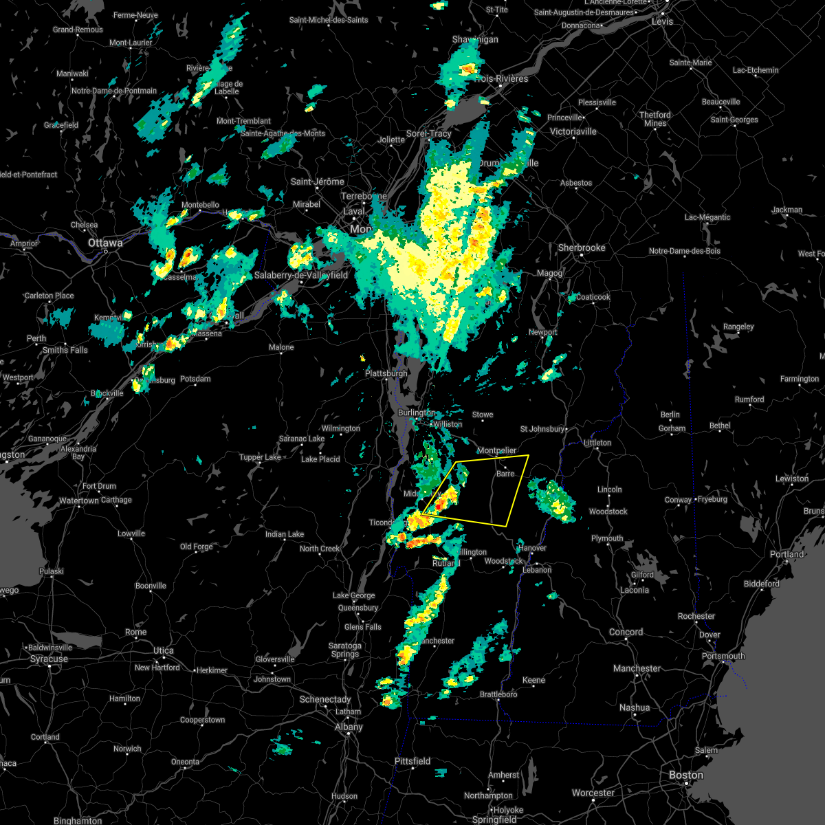 At 136 pm edt, a severe thunderstorm was located over east warren, moving east at 45 mph (radar indicated). Hazards include 60 mph wind gusts and quarter size hail. Minor hail damage to vehicles is possible. Expect wind damage to trees and powerlines. At 136 pm edt, a severe thunderstorm was located over east warren, moving east at 45 mph (radar indicated). Hazards include 60 mph wind gusts and quarter size hail. Minor hail damage to vehicles is possible. Expect wind damage to trees and powerlines.
|
| 8/11/2021 5:11 PM EDT |
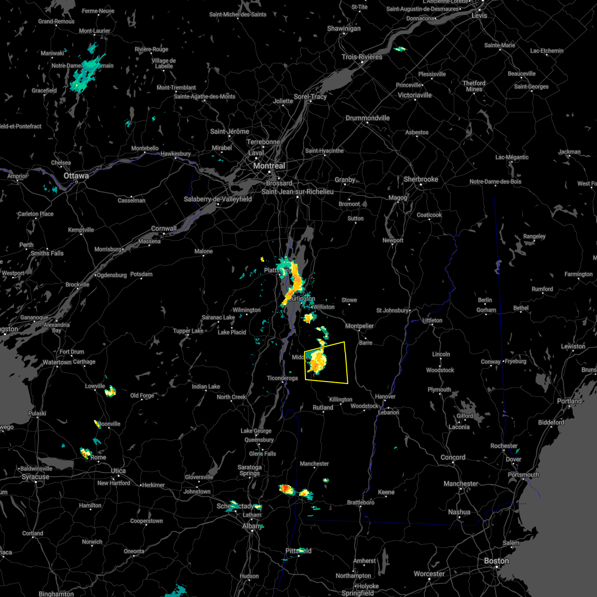 At 511 pm edt, a severe thunderstorm was located over ripton, moving east at 30 mph (radar indicated). Hazards include 60 mph wind gusts. Expect damage to trees and powerlines. locations impacted include, middlebury, hancock, salisbury, warren, ripton, lincoln, rochester, leicester, braintree, granville, goshen, roxbury, new haven, bristol, bethel, waitsfield, cornwall, northfield, east middlebury and branbury state park. hail threat, radar indicated max hail size, <. 75 in wind threat, observed max wind gust, 60 mph. At 511 pm edt, a severe thunderstorm was located over ripton, moving east at 30 mph (radar indicated). Hazards include 60 mph wind gusts. Expect damage to trees and powerlines. locations impacted include, middlebury, hancock, salisbury, warren, ripton, lincoln, rochester, leicester, braintree, granville, goshen, roxbury, new haven, bristol, bethel, waitsfield, cornwall, northfield, east middlebury and branbury state park. hail threat, radar indicated max hail size, <. 75 in wind threat, observed max wind gust, 60 mph.
|
| 8/11/2021 4:47 PM EDT | Tree down on powerlin in addison county VT, 5.7 miles NE of Middlebury, VT |
| 8/11/2021 4:47 PM EDT |
 At 446 pm edt, a severe thunderstorm was located over cornwall, moving east at 30 mph (radar indicated). Hazards include 60 mph wind gusts. expect damage to trees and powerlines At 446 pm edt, a severe thunderstorm was located over cornwall, moving east at 30 mph (radar indicated). Hazards include 60 mph wind gusts. expect damage to trees and powerlines
|
| 7/20/2021 8:11 PM EDT |
 At 808 pm edt, a line of severe thunderstorms over northern and central vermont was located along a line extending from near east richford to near wolcott to ainsworth state park to near pittsfield, moving east at 30 mph (radar indicated). Hazards include 60 mph wind gusts and quarter size hail. Expect wind damage to trees and powerlines. minor hail damage to vehicles is possible. these storms have a history of producing wind damage and power outages. locations impacted include, barre, montpelier, island pond, lyndon, st. Johnsbury, middlebury, newport city, vergennes, crown point, morrisville, enosburg falls, orleans, derby center, charleston, braintree hill, glover, waterbury village, montgomery center, websterville and orwell. At 808 pm edt, a line of severe thunderstorms over northern and central vermont was located along a line extending from near east richford to near wolcott to ainsworth state park to near pittsfield, moving east at 30 mph (radar indicated). Hazards include 60 mph wind gusts and quarter size hail. Expect wind damage to trees and powerlines. minor hail damage to vehicles is possible. these storms have a history of producing wind damage and power outages. locations impacted include, barre, montpelier, island pond, lyndon, st. Johnsbury, middlebury, newport city, vergennes, crown point, morrisville, enosburg falls, orleans, derby center, charleston, braintree hill, glover, waterbury village, montgomery center, websterville and orwell.
|
| 7/20/2021 7:32 PM EDT |
 At 730 pm edt, a line of severe thunderstorms over western vermont was located along a line extending from near east franklin to stowe to east warren to mossy point, moving east at 40 mph (radar indicated). Hazards include 60 mph wind gusts and quarter size hail. Expect wind damage to trees and powerlines. minor hail damage to vehicles is possible. This line of storms has a history of producing wind damage and power outages. At 730 pm edt, a line of severe thunderstorms over western vermont was located along a line extending from near east franklin to stowe to east warren to mossy point, moving east at 40 mph (radar indicated). Hazards include 60 mph wind gusts and quarter size hail. Expect wind damage to trees and powerlines. minor hail damage to vehicles is possible. This line of storms has a history of producing wind damage and power outages.
|
| 7/20/2021 7:06 PM EDT |
 At 704 pm edt, a line of severe thunderstorms over northwest vermont and essex county new york was located along a line extending from shad island to south burlington to near chilson, new york moving east at 35 mph (radar indicated). Hazards include 60 mph wind gusts and quarter size hail. Expect wind damage to trees and powerlines. minor hail damage to vehicles is possible. Locations impacted include, essex junction, plattsburgh international airport, burlington, burlington international airport, plattsburgh, middlebury, south burlington, vergennes, peru, beekmantown, moriah, chazy, willsboro, crown point, morrisville, enosburg falls, westport, elizabethtown, champlain and waterbury village. At 704 pm edt, a line of severe thunderstorms over northwest vermont and essex county new york was located along a line extending from shad island to south burlington to near chilson, new york moving east at 35 mph (radar indicated). Hazards include 60 mph wind gusts and quarter size hail. Expect wind damage to trees and powerlines. minor hail damage to vehicles is possible. Locations impacted include, essex junction, plattsburgh international airport, burlington, burlington international airport, plattsburgh, middlebury, south burlington, vergennes, peru, beekmantown, moriah, chazy, willsboro, crown point, morrisville, enosburg falls, westport, elizabethtown, champlain and waterbury village.
|
| 7/20/2021 6:31 PM EDT |
 At 630 pm edt, a line of severe thunderstorms over northeast new york was located along a line extending from near perry mills to near harkness to 9 miles west of schroon falls, moving east at 40 mph (radar indicated). Hazards include 60 mph wind gusts and quarter size hail. Expect wind damage to trees and powerlines. Minor hail damage to vehicles is possible. At 630 pm edt, a line of severe thunderstorms over northeast new york was located along a line extending from near perry mills to near harkness to 9 miles west of schroon falls, moving east at 40 mph (radar indicated). Hazards include 60 mph wind gusts and quarter size hail. Expect wind damage to trees and powerlines. Minor hail damage to vehicles is possible.
|
| 6/30/2021 1:18 PM EDT |
 At 118 pm edt, a severe thunderstorm was located over paradox, moving east at 45 mph (radar indicated). Hazards include 60 mph wind gusts and quarter size hail. Minor hail damage to vehicles is possible. expect wind damage to trees and powerlines. Locations impacted include, middlebury, crown point, cornwall, sudbury, salisbury, orwell, whiting, goshen, shoreham, ripton, crown point center, brandon, leicester, bridport, benson, hubbardton, pittsford, chittenden, hancock and north hudson. At 118 pm edt, a severe thunderstorm was located over paradox, moving east at 45 mph (radar indicated). Hazards include 60 mph wind gusts and quarter size hail. Minor hail damage to vehicles is possible. expect wind damage to trees and powerlines. Locations impacted include, middlebury, crown point, cornwall, sudbury, salisbury, orwell, whiting, goshen, shoreham, ripton, crown point center, brandon, leicester, bridport, benson, hubbardton, pittsford, chittenden, hancock and north hudson.
|
| 6/30/2021 1:18 PM EDT |
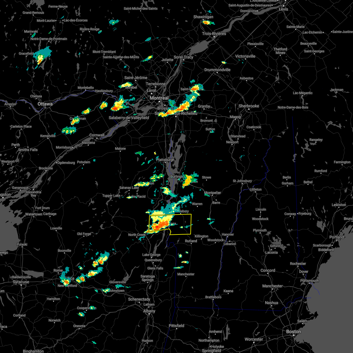 At 118 pm edt, a severe thunderstorm was located over paradox, moving east at 45 mph (radar indicated). Hazards include 60 mph wind gusts and quarter size hail. Minor hail damage to vehicles is possible. expect wind damage to trees and powerlines. Locations impacted include, middlebury, crown point, cornwall, sudbury, salisbury, orwell, whiting, goshen, shoreham, ripton, crown point center, brandon, leicester, bridport, benson, hubbardton, pittsford, chittenden, hancock and north hudson. At 118 pm edt, a severe thunderstorm was located over paradox, moving east at 45 mph (radar indicated). Hazards include 60 mph wind gusts and quarter size hail. Minor hail damage to vehicles is possible. expect wind damage to trees and powerlines. Locations impacted include, middlebury, crown point, cornwall, sudbury, salisbury, orwell, whiting, goshen, shoreham, ripton, crown point center, brandon, leicester, bridport, benson, hubbardton, pittsford, chittenden, hancock and north hudson.
|
| 6/30/2021 1:00 PM EDT |
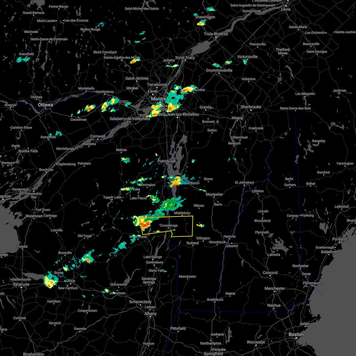 At 1259 pm edt, a severe thunderstorm was located near schroon falls, moving east at 45 mph (radar indicated). Hazards include 60 mph wind gusts and quarter size hail. Minor hail damage to vehicles is possible. expect wind damage to trees and powerlines. Locations impacted include, middlebury, crown point, cornwall, sudbury, salisbury, schroon lake, orwell, whiting, goshen, shoreham, ripton, crown point center, brandon, leicester, bridport, benson, hubbardton, pittsford, chittenden and hancock. At 1259 pm edt, a severe thunderstorm was located near schroon falls, moving east at 45 mph (radar indicated). Hazards include 60 mph wind gusts and quarter size hail. Minor hail damage to vehicles is possible. expect wind damage to trees and powerlines. Locations impacted include, middlebury, crown point, cornwall, sudbury, salisbury, schroon lake, orwell, whiting, goshen, shoreham, ripton, crown point center, brandon, leicester, bridport, benson, hubbardton, pittsford, chittenden and hancock.
|
| 6/30/2021 12:46 PM EDT |
 At 1245 pm edt, a severe thunderstorm was located 7 miles north of minerva, moving east at 45 mph (radar indicated). Hazards include 60 mph wind gusts and quarter size hail. Minor hail damage to vehicles is possible. Expect wind damage to trees and powerlines. At 1245 pm edt, a severe thunderstorm was located 7 miles north of minerva, moving east at 45 mph (radar indicated). Hazards include 60 mph wind gusts and quarter size hail. Minor hail damage to vehicles is possible. Expect wind damage to trees and powerlines.
|
| 6/21/2021 5:39 PM EDT |
 The severe thunderstorm warning for southeastern essex, addison, northwestern rutland, northwestern windsor and southwestern washington counties will expire at 545 pm edt, the storm which prompted the warning has moved out of the area. therefore, the warning will be allowed to expire. a severe thunderstorm watch remains in effect until 900 pm edt for northern new york, and central and southern vermont. to report severe weather, contact your nearest law enforcement agency. they will relay your report to the national weather service burlington. remember, a severe thunderstorm warning still remains in effect for rutland county. The severe thunderstorm warning for southeastern essex, addison, northwestern rutland, northwestern windsor and southwestern washington counties will expire at 545 pm edt, the storm which prompted the warning has moved out of the area. therefore, the warning will be allowed to expire. a severe thunderstorm watch remains in effect until 900 pm edt for northern new york, and central and southern vermont. to report severe weather, contact your nearest law enforcement agency. they will relay your report to the national weather service burlington. remember, a severe thunderstorm warning still remains in effect for rutland county.
|
| 6/21/2021 5:17 PM EDT |
 At 516 pm edt, severe thunderstorms were located along a line extending from underhill center to south starksboro, moving east at 40 mph (radar indicated). Hazards include 60 mph wind gusts and quarter size hail. Minor hail damage to vehicles is possible. Expect wind damage to trees and powerlines. At 516 pm edt, severe thunderstorms were located along a line extending from underhill center to south starksboro, moving east at 40 mph (radar indicated). Hazards include 60 mph wind gusts and quarter size hail. Minor hail damage to vehicles is possible. Expect wind damage to trees and powerlines.
|
| 6/21/2021 4:40 PM EDT |
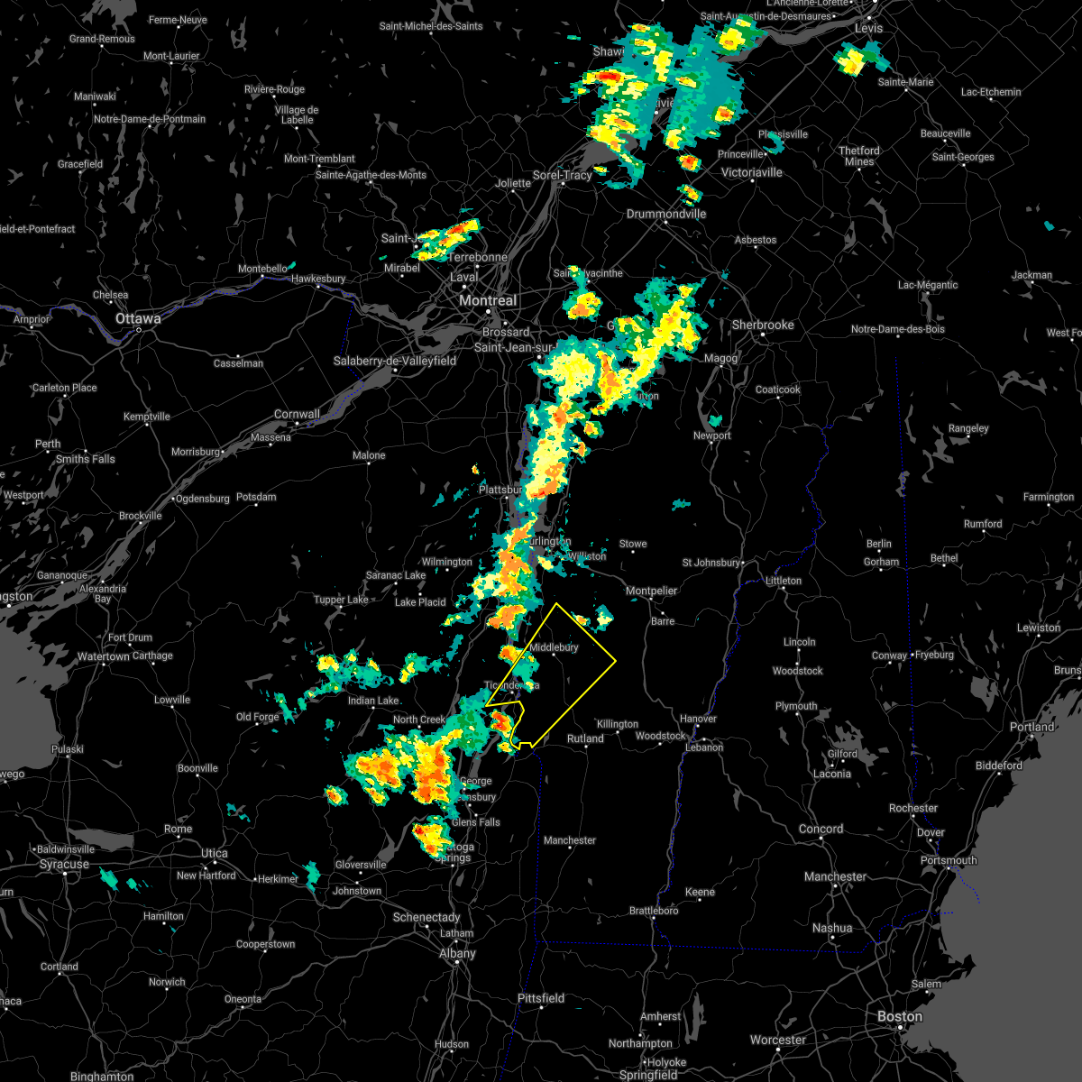 At 439 pm edt, a severe thunderstorm was located near benson landing, moving northeast at 35 mph (radar indicated). Hazards include 60 mph wind gusts and quarter size hail. Minor hail damage to vehicles is possible. Expect wind damage to trees and powerlines. At 439 pm edt, a severe thunderstorm was located near benson landing, moving northeast at 35 mph (radar indicated). Hazards include 60 mph wind gusts and quarter size hail. Minor hail damage to vehicles is possible. Expect wind damage to trees and powerlines.
|
| 6/21/2021 4:15 PM EDT |
 At 415 pm edt, a severe thunderstorm was located over south starksboro, moving northeast at 30 mph (radar indicated). Hazards include 60 mph wind gusts and quarter size hail. Minor hail damage to vehicles is possible. Expect wind damage to trees and powerlines. At 415 pm edt, a severe thunderstorm was located over south starksboro, moving northeast at 30 mph (radar indicated). Hazards include 60 mph wind gusts and quarter size hail. Minor hail damage to vehicles is possible. Expect wind damage to trees and powerlines.
|
| 6/21/2021 3:54 PM EDT |
 At 353 pm edt, a severe thunderstorm was located over new haven junction, moving northeast at 35 mph (radar indicated). Hazards include 60 mph wind gusts and quarter size hail. Minor hail damage to vehicles is possible. expect wind damage to trees and powerlines. locations impacted include, middlebury, vergennes, crown point, cornwall, weybridge, monkton ridge, lincoln, monkton, monkton boro, williston, new haven, port henry, addison, hinesburg, st. George, starksboro, ferrisburg, charlotte, waltham and bristol. At 353 pm edt, a severe thunderstorm was located over new haven junction, moving northeast at 35 mph (radar indicated). Hazards include 60 mph wind gusts and quarter size hail. Minor hail damage to vehicles is possible. expect wind damage to trees and powerlines. locations impacted include, middlebury, vergennes, crown point, cornwall, weybridge, monkton ridge, lincoln, monkton, monkton boro, williston, new haven, port henry, addison, hinesburg, st. George, starksboro, ferrisburg, charlotte, waltham and bristol.
|
| 6/21/2021 3:33 PM EDT |
 At 333 pm edt, a severe thunderstorm was located over d a r state park, moving northeast at 35 mph (radar indicated). Hazards include 60 mph wind gusts and quarter size hail. Minor hail damage to vehicles is possible. expect wind damage to trees and powerlines. locations impacted include, middlebury, vergennes, south burlington, moriah, crown point, westport, cornwall, weybridge, monkton ridge, lincoln, monkton, monkton boro, williston, new haven, port henry, addison, hinesburg, st. George, starksboro and ferrisburg. At 333 pm edt, a severe thunderstorm was located over d a r state park, moving northeast at 35 mph (radar indicated). Hazards include 60 mph wind gusts and quarter size hail. Minor hail damage to vehicles is possible. expect wind damage to trees and powerlines. locations impacted include, middlebury, vergennes, south burlington, moriah, crown point, westport, cornwall, weybridge, monkton ridge, lincoln, monkton, monkton boro, williston, new haven, port henry, addison, hinesburg, st. George, starksboro and ferrisburg.
|
| 6/21/2021 3:13 PM EDT |
 At 312 pm edt, a severe thunderstorm was located near ironville, moving northeast at 35 mph (radar indicated). Hazards include 60 mph wind gusts and quarter size hail. Minor hail damage to vehicles is possible. Expect wind damage to trees and powerlines. At 312 pm edt, a severe thunderstorm was located near ironville, moving northeast at 35 mph (radar indicated). Hazards include 60 mph wind gusts and quarter size hail. Minor hail damage to vehicles is possible. Expect wind damage to trees and powerlines.
|
| 5/26/2021 3:52 PM EDT |
 At 352 pm edt, a severe thunderstorm was located over bristol, moving east at 50 mph (radar indicated). Hazards include 60 mph wind gusts and quarter size hail. Minor hail damage to vehicles is possible. Expect wind damage to trees and powerlines. At 352 pm edt, a severe thunderstorm was located over bristol, moving east at 50 mph (radar indicated). Hazards include 60 mph wind gusts and quarter size hail. Minor hail damage to vehicles is possible. Expect wind damage to trees and powerlines.
|
| 5/26/2021 3:50 PM EDT | Several reports of scattered trees and powerlines down in most sections of middlebury... including court street and route 116 in addison county VT, 0.8 miles SE of Middlebury, VT |
| 3/26/2021 1:58 PM EDT |
 The severe thunderstorm warning for eastern essex, southwestern lamoille, northwestern orange, addison, northern rutland, chittenden, northwestern windsor and western washington counties will expire at 200 pm edt, the storms which prompted the warning have moved east of the area and are now covered by another warning. therefore, the original warning will be allowed to expire. a severe thunderstorm watch remains in effect until 400 pm edt for northern new york, and central, southern and northwestern vermont. The severe thunderstorm warning for eastern essex, southwestern lamoille, northwestern orange, addison, northern rutland, chittenden, northwestern windsor and western washington counties will expire at 200 pm edt, the storms which prompted the warning have moved east of the area and are now covered by another warning. therefore, the original warning will be allowed to expire. a severe thunderstorm watch remains in effect until 400 pm edt for northern new york, and central, southern and northwestern vermont.
|
| 3/26/2021 1:40 PM EDT | *** 1 inj *** reports of structural damage on painter road in middlebury. lots of downed trees are also being reporte in addison county VT, 2.1 miles SSW of Middlebury, VT |
| 3/26/2021 1:37 PM EDT |
 At 137 pm edt, severe thunderstorms were located along a line extending from near st. george to east middlebury to hortonia, moving east at 50 mph (radar indicated). Hazards include 60 mph wind gusts. Expect damage to trees and powerlines. Locations impacted include, essex junction, burlington international airport, middlebury, south burlington, burlington, vergennes, rutland, braintree hill, killington, salisbury, waterbury village, orwell, essex junction village, middlesex, addison, shoreham, ripton, shelburne, charlotte and waltham. At 137 pm edt, severe thunderstorms were located along a line extending from near st. george to east middlebury to hortonia, moving east at 50 mph (radar indicated). Hazards include 60 mph wind gusts. Expect damage to trees and powerlines. Locations impacted include, essex junction, burlington international airport, middlebury, south burlington, burlington, vergennes, rutland, braintree hill, killington, salisbury, waterbury village, orwell, essex junction village, middlesex, addison, shoreham, ripton, shelburne, charlotte and waltham.
|
| 3/26/2021 1:11 PM EDT |
 At 110 pm edt, severe thunderstorms were located along a line extending from deerhead to near ironville to near pharoah mountain, moving east at 50 mph (radar indicated). Hazards include 60 mph wind gusts. expect damage to trees and powerlines At 110 pm edt, severe thunderstorms were located along a line extending from deerhead to near ironville to near pharoah mountain, moving east at 50 mph (radar indicated). Hazards include 60 mph wind gusts. expect damage to trees and powerlines
|
| 3/20/2020 4:04 PM EDT |
 At 404 pm edt, severe thunderstorms were located along a line extending from williston to port henry, moving east at 55 mph (radar indicated). Hazards include 60 mph wind gusts. Expect damage to trees and powerlines. Locations impacted include, middlebury, vergennes, essex, moriah, crown point, westport, salisbury, orwell, addison, shoreham, ripton, charlotte, waltham, bristol, waitsfield, fayston, warren, d a r state park, brandon and buels gore. At 404 pm edt, severe thunderstorms were located along a line extending from williston to port henry, moving east at 55 mph (radar indicated). Hazards include 60 mph wind gusts. Expect damage to trees and powerlines. Locations impacted include, middlebury, vergennes, essex, moriah, crown point, westport, salisbury, orwell, addison, shoreham, ripton, charlotte, waltham, bristol, waitsfield, fayston, warren, d a r state park, brandon and buels gore.
|
| 3/20/2020 3:43 PM EDT |
 At 343 pm edt, severe thunderstorms were located along a line extending from bluff point to mount marcy, moving east at 65 mph (radar indicated). Hazards include 60 mph wind gusts. expect damage to trees and powerlines At 343 pm edt, severe thunderstorms were located along a line extending from bluff point to mount marcy, moving east at 65 mph (radar indicated). Hazards include 60 mph wind gusts. expect damage to trees and powerlines
|
| 8/7/2019 7:32 PM EDT |
 At 732 pm edt, a severe thunderstorm was located over north ferrisburgh, moving north at 25 mph (radar indicated). Hazards include 60 mph wind gusts and quarter size hail. Minor hail damage to vehicles is possible. expect wind damage to trees and powerlines. locations impacted include, south burlington, vergennes, burlington, middlebury, weybridge, monkton ridge, waterbury village, monkton, monkton boro, williston, new haven, addison, hinesburg, st. George, starksboro, shelburne, ferrisburg, charlotte, waltham and bristol. At 732 pm edt, a severe thunderstorm was located over north ferrisburgh, moving north at 25 mph (radar indicated). Hazards include 60 mph wind gusts and quarter size hail. Minor hail damage to vehicles is possible. expect wind damage to trees and powerlines. locations impacted include, south burlington, vergennes, burlington, middlebury, weybridge, monkton ridge, waterbury village, monkton, monkton boro, williston, new haven, addison, hinesburg, st. George, starksboro, shelburne, ferrisburg, charlotte, waltham and bristol.
|
| 8/7/2019 7:04 PM EDT |
 At 704 pm edt, a severe thunderstorm was located over addison, moving northeast at 25 mph (radar indicated). Hazards include 60 mph wind gusts and quarter size hail. Minor hail damage to vehicles is possible. Expect wind damage to trees and powerlines. At 704 pm edt, a severe thunderstorm was located over addison, moving northeast at 25 mph (radar indicated). Hazards include 60 mph wind gusts and quarter size hail. Minor hail damage to vehicles is possible. Expect wind damage to trees and powerlines.
|
| 7/30/2019 5:53 PM EDT |
 At 553 pm edt, a severe thunderstorm was located over jerusalem, moving northeast at 35 mph (law enforcement reports trees down on power lines). Hazards include 60 mph wind gusts and quarter size hail. Minor hail damage to vehicles is possible. expect wind damage to trees and powerlines. Locations impacted include, middlebury, montpelier, morrisville, braintree hill, salisbury, stowe, bristol, waterbury village, lincoln, monkton, waitsfield, hyde park, berlin, fayston, new haven, worcester, middlesex, granville, bolton and northfield village. At 553 pm edt, a severe thunderstorm was located over jerusalem, moving northeast at 35 mph (law enforcement reports trees down on power lines). Hazards include 60 mph wind gusts and quarter size hail. Minor hail damage to vehicles is possible. expect wind damage to trees and powerlines. Locations impacted include, middlebury, montpelier, morrisville, braintree hill, salisbury, stowe, bristol, waterbury village, lincoln, monkton, waitsfield, hyde park, berlin, fayston, new haven, worcester, middlesex, granville, bolton and northfield village.
|
| 7/30/2019 5:37 PM EDT |
 At 536 pm edt, a severe thunderstorm was located over new haven mills, moving northeast at 35 mph (radar indicated). Hazards include 60 mph wind gusts and quarter size hail. Minor hail damage to vehicles is possible. Expect wind damage to trees and powerlines. At 536 pm edt, a severe thunderstorm was located over new haven mills, moving northeast at 35 mph (radar indicated). Hazards include 60 mph wind gusts and quarter size hail. Minor hail damage to vehicles is possible. Expect wind damage to trees and powerlines.
|
| 7/30/2019 5:24 PM EDT | Trees down on cider mill rd and rt-125w in addison county VT, 3.1 miles E of Middlebury, VT |
| 6/26/2019 6:58 PM EDT |
 At 658 pm edt, a severe thunderstorm was located over weybridge, moving east at 25 mph (radar indicated). Hazards include 60 mph wind gusts and penny size hail. Expect damage to trees and powerlines. Locations impacted include, middlebury, cornwall, weybridge, shoreham, salisbury, whiting, leicester, bridport, ripton, goshen, lincoln, new haven, bristol, addison, east middlebury, branbury state park, lake dunmore, hollands pasture island, bond island and stony cove. At 658 pm edt, a severe thunderstorm was located over weybridge, moving east at 25 mph (radar indicated). Hazards include 60 mph wind gusts and penny size hail. Expect damage to trees and powerlines. Locations impacted include, middlebury, cornwall, weybridge, shoreham, salisbury, whiting, leicester, bridport, ripton, goshen, lincoln, new haven, bristol, addison, east middlebury, branbury state park, lake dunmore, hollands pasture island, bond island and stony cove.
|
| 6/26/2019 6:58 PM EDT |
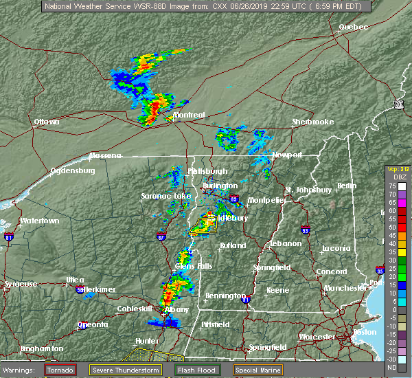 At 658 pm edt, a severe thunderstorm was located over weybridge, moving east at 25 mph (radar indicated). Hazards include 60 mph wind gusts and penny size hail. Expect damage to trees and powerlines. Locations impacted include, middlebury, cornwall, weybridge, shoreham, salisbury, whiting, leicester, bridport, ripton, goshen, lincoln, new haven, bristol, addison, east middlebury, branbury state park, lake dunmore, hollands pasture island, bond island and stony cove. At 658 pm edt, a severe thunderstorm was located over weybridge, moving east at 25 mph (radar indicated). Hazards include 60 mph wind gusts and penny size hail. Expect damage to trees and powerlines. Locations impacted include, middlebury, cornwall, weybridge, shoreham, salisbury, whiting, leicester, bridport, ripton, goshen, lincoln, new haven, bristol, addison, east middlebury, branbury state park, lake dunmore, hollands pasture island, bond island and stony cove.
|
| 6/26/2019 6:27 PM EDT |
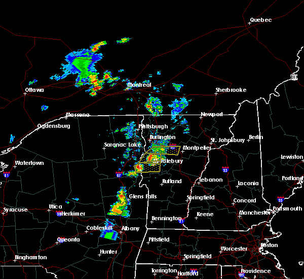 At 627 pm edt, a severe thunderstorm was located over schoolhouse bay, moving east at 25 mph (radar indicated). Hazards include 60 mph wind gusts and quarter size hail. Minor hail damage to vehicles is possible. Expect wind damage to trees and powerlines. At 627 pm edt, a severe thunderstorm was located over schoolhouse bay, moving east at 25 mph (radar indicated). Hazards include 60 mph wind gusts and quarter size hail. Minor hail damage to vehicles is possible. Expect wind damage to trees and powerlines.
|
| 6/26/2019 6:17 PM EDT |
 At 616 pm edt, a severe thunderstorm was located over bristol, moving east at 80 mph (radar indicated). Hazards include 60 mph wind gusts and penny size hail. Expect damage to trees and powerlines. Locations impacted include, vergennes, middlebury, ferrisburg, addison, weybridge, waltham, kingsland bay state park, bristol, monkton, starksboro, new haven, panton, ferrisburgh, lincoln, ripton, owls head bay, mud island, west lincoln, potash bay and white bay. At 616 pm edt, a severe thunderstorm was located over bristol, moving east at 80 mph (radar indicated). Hazards include 60 mph wind gusts and penny size hail. Expect damage to trees and powerlines. Locations impacted include, vergennes, middlebury, ferrisburg, addison, weybridge, waltham, kingsland bay state park, bristol, monkton, starksboro, new haven, panton, ferrisburgh, lincoln, ripton, owls head bay, mud island, west lincoln, potash bay and white bay.
|
| 6/26/2019 5:40 PM EDT |
 At 539 pm edt, a severe thunderstorm was located over spaulding bay, moving east at 25 mph (radar indicated). Hazards include 60 mph wind gusts and quarter size hail. Minor hail damage to vehicles is possible. Expect wind damage to trees and powerlines. At 539 pm edt, a severe thunderstorm was located over spaulding bay, moving east at 25 mph (radar indicated). Hazards include 60 mph wind gusts and quarter size hail. Minor hail damage to vehicles is possible. Expect wind damage to trees and powerlines.
|
| 7/28/2018 12:02 AM EDT |
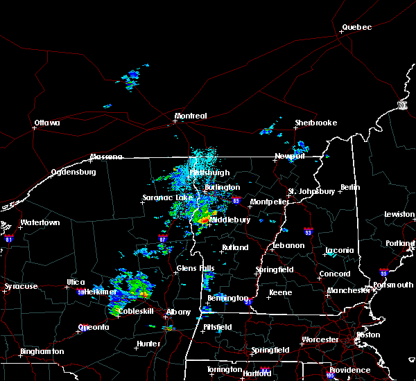 At 1202 am edt, a severe thunderstorm was located over weybridge, vermont in addison county moving northeast at 30 mph (radar indicated). Hazards include 60 mph wind gusts and quarter size hail. Minor hail damage to vehicles is possible. Expect wind damage to trees and powerlines. At 1202 am edt, a severe thunderstorm was located over weybridge, vermont in addison county moving northeast at 30 mph (radar indicated). Hazards include 60 mph wind gusts and quarter size hail. Minor hail damage to vehicles is possible. Expect wind damage to trees and powerlines.
|
| 6/18/2018 4:31 PM EDT |
 At 430 pm edt, severe thunderstorms were located along a line extending from near huntington to near east monkton to westport, moving east at 45 mph (radar indicated). Hazards include 60 mph wind gusts and penny size hail. expect damage to trees and powerlines At 430 pm edt, severe thunderstorms were located along a line extending from near huntington to near east monkton to westport, moving east at 45 mph (radar indicated). Hazards include 60 mph wind gusts and penny size hail. expect damage to trees and powerlines
|
| 6/18/2018 3:37 PM EDT |
 At 336 pm edt, severe thunderstorms were located along a line extending from near willsboro bay to lake placid, moving east at 45 mph (radar indicated). Hazards include 60 mph wind gusts and penny size hail. expect damage to trees and powerlines At 336 pm edt, severe thunderstorms were located along a line extending from near willsboro bay to lake placid, moving east at 45 mph (radar indicated). Hazards include 60 mph wind gusts and penny size hail. expect damage to trees and powerlines
|
| 5/4/2018 8:17 PM EDT |
 At 815 pm edt, severe thunderstorms were located along a line extending from near hinesburg to bristol to near brooksville, moving northeast at 50 mph (public reported 1" hail 5 miles southeast of essex junction at 735 pm and multiple trees down in shelburne). Hazards include 60 mph wind gusts and quarter size hail. Minor hail damage to vehicles is possible. expect wind damage to trees and powerlines. locations impacted include, essex junction, barre, burlington international airport, montpelier, middlebury, south burlington, burlington, morrisville, calais, weybridge, orange, monkton ridge, waterbury village, websterville, lincoln, monkton, monkton boro, essex junction village, williston and new haven. A tornado watch remains in effect until 1000 pm edt for central, northeastern and northwestern vermont. At 815 pm edt, severe thunderstorms were located along a line extending from near hinesburg to bristol to near brooksville, moving northeast at 50 mph (public reported 1" hail 5 miles southeast of essex junction at 735 pm and multiple trees down in shelburne). Hazards include 60 mph wind gusts and quarter size hail. Minor hail damage to vehicles is possible. expect wind damage to trees and powerlines. locations impacted include, essex junction, barre, burlington international airport, montpelier, middlebury, south burlington, burlington, morrisville, calais, weybridge, orange, monkton ridge, waterbury village, websterville, lincoln, monkton, monkton boro, essex junction village, williston and new haven. A tornado watch remains in effect until 1000 pm edt for central, northeastern and northwestern vermont.
|
| 5/4/2018 7:47 PM EDT |
 At 744 pm edt, severe thunderstorms were located along a line extending from jericho to richmond to mineville, moving east at 40 mph (public reported 1" hail 5 miles southeast of essex junction at 735 pm and multiple trees down in shelburne). Hazards include 60 mph wind gusts and quarter size hail. Minor hail damage to vehicles is possible. expect wind damage to trees and powerlines. locations impacted include, essex junction, barre, burlington international airport, montpelier, south burlington, burlington, vergennes, middlebury, essex, moriah, willsboro, morrisville, westport, elizabethtown, waterbury village, websterville, essex junction village, worcester, middlesex and marshfield. A tornado watch remains in effect until 1000 pm edt for northern new york, and central, northeastern and northwestern vermont. At 744 pm edt, severe thunderstorms were located along a line extending from jericho to richmond to mineville, moving east at 40 mph (public reported 1" hail 5 miles southeast of essex junction at 735 pm and multiple trees down in shelburne). Hazards include 60 mph wind gusts and quarter size hail. Minor hail damage to vehicles is possible. expect wind damage to trees and powerlines. locations impacted include, essex junction, barre, burlington international airport, montpelier, south burlington, burlington, vergennes, middlebury, essex, moriah, willsboro, morrisville, westport, elizabethtown, waterbury village, websterville, essex junction village, worcester, middlesex and marshfield. A tornado watch remains in effect until 1000 pm edt for northern new york, and central, northeastern and northwestern vermont.
|
| 5/4/2018 7:41 PM EDT |
 At 741 pm edt, a severe thunderstorm was located over severance, moving east at 45 mph (radar indicated). Hazards include 60 mph wind gusts and quarter size hail. Minor hail damage to vehicles is possible. Expect wind damage to trees and powerlines. At 741 pm edt, a severe thunderstorm was located over severance, moving east at 45 mph (radar indicated). Hazards include 60 mph wind gusts and quarter size hail. Minor hail damage to vehicles is possible. Expect wind damage to trees and powerlines.
|
| 5/4/2018 7:29 PM EDT |
 At 729 pm edt, a severe thunderstorm was located over shelburne falls, moving east at 40 mph (radar indicated). Hazards include 60 mph wind gusts and quarter size hail. Minor hail damage to vehicles is possible. Expect wind damage to trees and powerlines. At 729 pm edt, a severe thunderstorm was located over shelburne falls, moving east at 40 mph (radar indicated). Hazards include 60 mph wind gusts and quarter size hail. Minor hail damage to vehicles is possible. Expect wind damage to trees and powerlines.
|
| 5/4/2018 6:44 PM EDT |
 At 643 pm edt, a severe thunderstorm was located over barney point, moving east at 60 mph. this is a very dangerous storm (radar indicated). Hazards include 80 mph wind gusts and ping pong ball size hail. Flying debris will be dangerous to those caught without shelter. mobile homes will be heavily damaged. expect considerable damage to roofs, windows, and vehicles. extensive tree damage and power outages are likely. locations impacted include, essex junction, burlington international airport, south burlington, burlington, vergennes, middlebury, willsboro, westport, elizabethtown, keene, westford, colchester, essex junction village, au sable forks, addison, jay in essex county, shelburne, charlotte, waltham and cambridge village. A tornado watch remains in effect until 1000 pm edt for northern new york, and central and northwestern vermont. At 643 pm edt, a severe thunderstorm was located over barney point, moving east at 60 mph. this is a very dangerous storm (radar indicated). Hazards include 80 mph wind gusts and ping pong ball size hail. Flying debris will be dangerous to those caught without shelter. mobile homes will be heavily damaged. expect considerable damage to roofs, windows, and vehicles. extensive tree damage and power outages are likely. locations impacted include, essex junction, burlington international airport, south burlington, burlington, vergennes, middlebury, willsboro, westport, elizabethtown, keene, westford, colchester, essex junction village, au sable forks, addison, jay in essex county, shelburne, charlotte, waltham and cambridge village. A tornado watch remains in effect until 1000 pm edt for northern new york, and central and northwestern vermont.
|
| 5/4/2018 6:24 PM EDT |
 At 623 pm edt, a severe thunderstorm was located near keene, moving east at 50 mph (radar indicated). Hazards include 60 mph wind gusts and quarter size hail. Minor hail damage to vehicles is possible. Expect wind damage to trees and powerlines. At 623 pm edt, a severe thunderstorm was located near keene, moving east at 50 mph (radar indicated). Hazards include 60 mph wind gusts and quarter size hail. Minor hail damage to vehicles is possible. Expect wind damage to trees and powerlines.
|
| 8/22/2017 6:28 PM EDT |
 At 628 pm edt, severe thunderstorms were located along a line extending from south cambridge to near northfield to east hubbardton, moving east at 50 mph (radar indicated). Hazards include 70 mph wind gusts and penny size hail. Expect considerable tree damage. Damage is likely to mobile homes, roofs, and outbuildings. At 628 pm edt, severe thunderstorms were located along a line extending from south cambridge to near northfield to east hubbardton, moving east at 50 mph (radar indicated). Hazards include 70 mph wind gusts and penny size hail. Expect considerable tree damage. Damage is likely to mobile homes, roofs, and outbuildings.
|
| 8/22/2017 5:43 PM EDT |
 At 542 pm edt, a severe thunderstorm was located over chilson, moving east at 40 mph (radar indicated). Hazards include 60 mph wind gusts. expect damage to trees and powerlines At 542 pm edt, a severe thunderstorm was located over chilson, moving east at 40 mph (radar indicated). Hazards include 60 mph wind gusts. expect damage to trees and powerlines
|
| 8/22/2017 5:43 PM EDT |
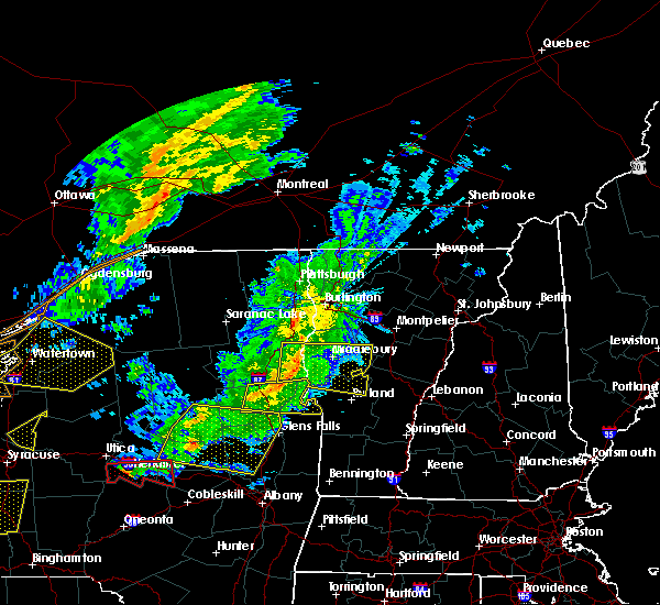 At 542 pm edt, a severe thunderstorm was located over chilson, moving east at 40 mph (radar indicated). Hazards include 60 mph wind gusts. expect damage to trees and powerlines At 542 pm edt, a severe thunderstorm was located over chilson, moving east at 40 mph (radar indicated). Hazards include 60 mph wind gusts. expect damage to trees and powerlines
|
| 8/12/2017 6:16 PM EDT |
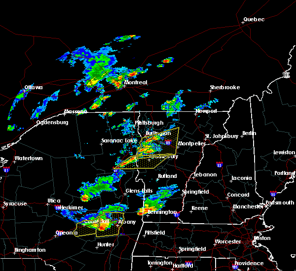 At 615 pm edt, severe thunderstorms were located along a line extending from moriah to schroon lake, moving east at 25 mph (radar indicated). Hazards include 60 mph wind gusts and quarter size hail. Minor hail damage to vehicles is possible. Expect wind damage to trees and powerlines. At 615 pm edt, severe thunderstorms were located along a line extending from moriah to schroon lake, moving east at 25 mph (radar indicated). Hazards include 60 mph wind gusts and quarter size hail. Minor hail damage to vehicles is possible. Expect wind damage to trees and powerlines.
|
| 6/30/2017 5:26 PM EDT |
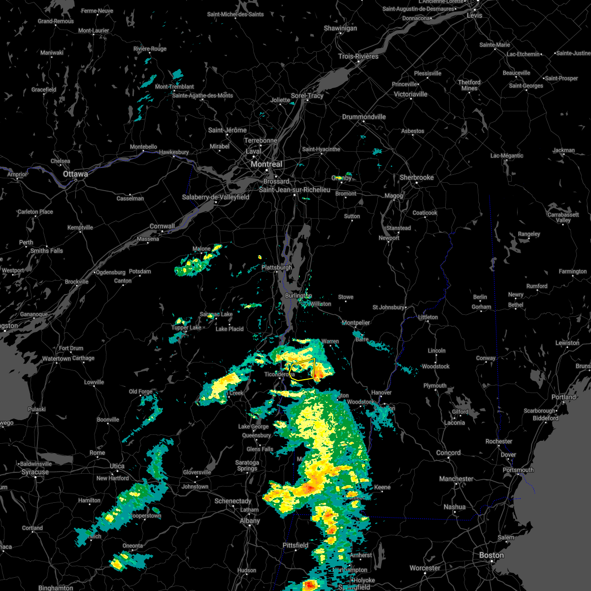 The severe thunderstorm warning for southwestern addison county will expire at 530 pm edt. the storm which prompted the warning has moved out of the area. therefore the warning will be allowed to expire. A severe thunderstorm watch remains in effect until 900 pm edt for southern vermont. The severe thunderstorm warning for southwestern addison county will expire at 530 pm edt. the storm which prompted the warning has moved out of the area. therefore the warning will be allowed to expire. A severe thunderstorm watch remains in effect until 900 pm edt for southern vermont.
|
| 6/30/2017 5:05 PM EDT | 2 trees downed on morgan rd in addison county VT, 5.9 miles NNW of Middlebury, VT |
| 6/30/2017 4:58 PM EDT |
 At 458 pm edt, a severe thunderstorm was located over shoreham, moving east at 20 mph (radar indicated). Hazards include 60 mph wind gusts and quarter size hail. Minor hail damage to vehicles is possible. expect wind damage to trees and powerlines. Locations impacted include, middlebury, cornwall, leicester, shoreham, salisbury, whiting, ripton, orwell, sudbury, bridport, east middlebury, huntley island, branbury state park, lake dunmore, beartrap island, hollands pasture island, east shoreham, west salisbury, bond island and west cornwall. At 458 pm edt, a severe thunderstorm was located over shoreham, moving east at 20 mph (radar indicated). Hazards include 60 mph wind gusts and quarter size hail. Minor hail damage to vehicles is possible. expect wind damage to trees and powerlines. Locations impacted include, middlebury, cornwall, leicester, shoreham, salisbury, whiting, ripton, orwell, sudbury, bridport, east middlebury, huntley island, branbury state park, lake dunmore, beartrap island, hollands pasture island, east shoreham, west salisbury, bond island and west cornwall.
|
| 6/30/2017 4:39 PM EDT |
 At 438 pm edt, a severe thunderstorm was located over fivemile point, moving east at 20 mph (radar indicated). Hazards include 60 mph wind gusts and quarter size hail. Minor hail damage to vehicles is possible. Expect wind damage to trees and powerlines. At 438 pm edt, a severe thunderstorm was located over fivemile point, moving east at 20 mph (radar indicated). Hazards include 60 mph wind gusts and quarter size hail. Minor hail damage to vehicles is possible. Expect wind damage to trees and powerlines.
|
| 6/27/2017 2:02 PM EDT |
 At 602 pm edt, severe thunderstorms were located along a line extending from near bridport to bond island to west castleton, moving east at 25 mph (radar indicated). Hazards include 60 mph wind gusts and quarter size hail. Minor hail damage to vehicles is possible. expect wind damage to trees and powerlines. Locations impacted include, middlebury, rutland, castleton, cornwall, sudbury, salisbury, orwell, chittenden, west rutland, whiting, goshen, west castleton, hancock, hubbardton, shoreham, ripton, proctor, brandon, mendon and leicester. At 602 pm edt, severe thunderstorms were located along a line extending from near bridport to bond island to west castleton, moving east at 25 mph (radar indicated). Hazards include 60 mph wind gusts and quarter size hail. Minor hail damage to vehicles is possible. expect wind damage to trees and powerlines. Locations impacted include, middlebury, rutland, castleton, cornwall, sudbury, salisbury, orwell, chittenden, west rutland, whiting, goshen, west castleton, hancock, hubbardton, shoreham, ripton, proctor, brandon, mendon and leicester.
|
| 6/27/2017 1:53 PM EDT |
 At 551 pm edt, a severe thunderstorm was located over barber point, moving east at 25 mph (public reported golf ball hail 3 miles east of elizabethtown at 535 pm). Hazards include 60 mph wind gusts and half dollar size hail. Minor hail damage to vehicles is possible. expect wind damage to trees and powerlines. locations impacted include, vergennes, middlebury, essex, moriah, westport, weybridge, monkton ridge, lincoln, monkton, monkton boro, new haven, port henry, addison, hinesburg, st. George, starksboro, ferrisburg, charlotte, waltham and bristol. At 551 pm edt, a severe thunderstorm was located over barber point, moving east at 25 mph (public reported golf ball hail 3 miles east of elizabethtown at 535 pm). Hazards include 60 mph wind gusts and half dollar size hail. Minor hail damage to vehicles is possible. expect wind damage to trees and powerlines. locations impacted include, vergennes, middlebury, essex, moriah, westport, weybridge, monkton ridge, lincoln, monkton, monkton boro, new haven, port henry, addison, hinesburg, st. George, starksboro, ferrisburg, charlotte, waltham and bristol.
|
| 6/27/2017 1:38 PM EDT |
 At 537 pm edt, a severe thunderstorm was located over cole bay, moving east at 25 mph (radar indicated). Hazards include 60 mph wind gusts and quarter size hail. Minor hail damage to vehicles is possible. expect wind damage to trees and powerlines. locations impacted include, vergennes, middlebury, essex, moriah, westport, elizabethtown, weybridge, monkton ridge, lincoln, monkton, monkton boro, new haven, port henry, addison, hinesburg, st. George, starksboro, ferrisburg, charlotte and waltham. At 537 pm edt, a severe thunderstorm was located over cole bay, moving east at 25 mph (radar indicated). Hazards include 60 mph wind gusts and quarter size hail. Minor hail damage to vehicles is possible. expect wind damage to trees and powerlines. locations impacted include, vergennes, middlebury, essex, moriah, westport, elizabethtown, weybridge, monkton ridge, lincoln, monkton, monkton boro, new haven, port henry, addison, hinesburg, st. George, starksboro, ferrisburg, charlotte and waltham.
|
| 6/27/2017 1:24 PM EDT |
 At 524 pm edt, severe thunderstorms were located along a line extending from near ironville to chilson to 7 miles west of west haven, moving east at 25 mph (radar indicated). Hazards include 60 mph wind gusts and quarter size hail. Minor hail damage to vehicles is possible. Expect wind damage to trees and powerlines. At 524 pm edt, severe thunderstorms were located along a line extending from near ironville to chilson to 7 miles west of west haven, moving east at 25 mph (radar indicated). Hazards include 60 mph wind gusts and quarter size hail. Minor hail damage to vehicles is possible. Expect wind damage to trees and powerlines.
|
| 6/27/2017 1:10 PM EDT |
 At 510 pm edt, a severe thunderstorm was located over underwood, moving east at 25 mph (radar indicated). Hazards include 60 mph wind gusts and quarter size hail. Minor hail damage to vehicles is possible. Expect wind damage to trees and powerlines. At 510 pm edt, a severe thunderstorm was located over underwood, moving east at 25 mph (radar indicated). Hazards include 60 mph wind gusts and quarter size hail. Minor hail damage to vehicles is possible. Expect wind damage to trees and powerlines.
|
| 5/31/2017 3:56 PM EDT |
 The severe thunderstorm warning for lamoille, central addison, southeastern chittenden and washington counties will expire at 400 pm edt, the storms which prompted the warning have weakened below severe limits, and no longer pose an immediate threat to life or property. therefore the warning will be allowed to expire. a severe thunderstorm watch remains in effect until 900 pm edt for central, southern, northeastern and northwestern vermont. The severe thunderstorm warning for lamoille, central addison, southeastern chittenden and washington counties will expire at 400 pm edt, the storms which prompted the warning have weakened below severe limits, and no longer pose an immediate threat to life or property. therefore the warning will be allowed to expire. a severe thunderstorm watch remains in effect until 900 pm edt for central, southern, northeastern and northwestern vermont.
|
| 5/31/2017 3:44 PM EDT |
 At 343 pm edt, a broken line of strong to locally severe thunderstorms were located along a line extending from north wolcott to northfield to near ripton, moving east at 35 mph (radar indicated). Hazards include 60 mph wind gusts and nickel size hail. Expect damage to trees and powerlines. Locations impacted include, barre, middlebury, montpelier, morrisville, johnson village, calais, weybridge, waterbury village, websterville, lincoln, hyde park, new haven, worcester, middlesex, granville, marshfield, cabot village, hancock, ripton and morrisville village. At 343 pm edt, a broken line of strong to locally severe thunderstorms were located along a line extending from north wolcott to northfield to near ripton, moving east at 35 mph (radar indicated). Hazards include 60 mph wind gusts and nickel size hail. Expect damage to trees and powerlines. Locations impacted include, barre, middlebury, montpelier, morrisville, johnson village, calais, weybridge, waterbury village, websterville, lincoln, hyde park, new haven, worcester, middlesex, granville, marshfield, cabot village, hancock, ripton and morrisville village.
|
| 5/31/2017 3:14 PM EDT |
 At 314 pm edt, severe thunderstorms were located along a line extending from near waterville to starksboro to near waltham, moving east at 35 mph (radar indicated). Hazards include 60 mph wind gusts and quarter size hail. Minor hail damage to vehicles is possible. Expect wind damage to trees and powerlines. At 314 pm edt, severe thunderstorms were located along a line extending from near waterville to starksboro to near waltham, moving east at 35 mph (radar indicated). Hazards include 60 mph wind gusts and quarter size hail. Minor hail damage to vehicles is possible. Expect wind damage to trees and powerlines.
|
| 5/18/2017 6:35 PM EDT |
 At 634 pm edt, a severe thunderstorm was located over waltham, moving east at 45 mph (radar indicated). Hazards include ping pong ball size hail and 60 mph wind gusts. People and animals outdoors will be injured. expect hail damage to roofs, siding, windows, and vehicles. expect wind damage to trees and powerlines. Locations impacted include, middlebury, vergennes, ferrisburg, weybridge, waltham, bristol, monkton ridge, lincoln, monkton, waitsfield, monkton boro, fayston, new haven, granville, huntington, kingsland bay state park, warren, ripton, duxbury and starksboro. At 634 pm edt, a severe thunderstorm was located over waltham, moving east at 45 mph (radar indicated). Hazards include ping pong ball size hail and 60 mph wind gusts. People and animals outdoors will be injured. expect hail damage to roofs, siding, windows, and vehicles. expect wind damage to trees and powerlines. Locations impacted include, middlebury, vergennes, ferrisburg, weybridge, waltham, bristol, monkton ridge, lincoln, monkton, waitsfield, monkton boro, fayston, new haven, granville, huntington, kingsland bay state park, warren, ripton, duxbury and starksboro.
|
| 5/18/2017 6:26 PM EDT |
 At 625 pm edt, a severe thunderstorm was located over potash bay, moving east at 40 mph (radar indicated). Hazards include ping pong ball size hail and 60 mph wind gusts. People and animals outdoors will be injured. expect hail damage to roofs, siding, windows, and vehicles. expect wind damage to trees and powerlines. Locations impacted include, middlebury, vergennes, westport, cornwall, weybridge, monkton ridge, lincoln, monkton, monkton boro, new haven, granville, port henry, addison, hancock, ripton, starksboro, ferrisburg, waltham, bristol and waitsfield. At 625 pm edt, a severe thunderstorm was located over potash bay, moving east at 40 mph (radar indicated). Hazards include ping pong ball size hail and 60 mph wind gusts. People and animals outdoors will be injured. expect hail damage to roofs, siding, windows, and vehicles. expect wind damage to trees and powerlines. Locations impacted include, middlebury, vergennes, westport, cornwall, weybridge, monkton ridge, lincoln, monkton, monkton boro, new haven, granville, port henry, addison, hancock, ripton, starksboro, ferrisburg, waltham, bristol and waitsfield.
|
| 5/18/2017 6:07 PM EDT |
 At 606 pm edt, a severe thunderstorm was located over underwood, moving east at 45 mph (radar indicated). Hazards include 60 mph wind gusts and quarter size hail. Minor hail damage to vehicles is possible. Expect wind damage to trees and powerlines. At 606 pm edt, a severe thunderstorm was located over underwood, moving east at 45 mph (radar indicated). Hazards include 60 mph wind gusts and quarter size hail. Minor hail damage to vehicles is possible. Expect wind damage to trees and powerlines.
|
| 5/1/2017 8:49 PM EDT |
 At 848 pm edt, severe thunderstorms were located along a line extending from near harkness to st. huberts to near south schroon, moving east at 50 mph (radar indicated). Hazards include 60 mph wind gusts. Expect damage to roofs, siding, and trees. Locations impacted include, plattsburgh international airport, essex, peru, willsboro, crown point, westport, wilmington, elizabethtown, minerva, schroon lake, au sable forks, mount marcy, jay in essex county, ferrisburg, clayburg, keene valley, port kent, kingsland bay state park, d a r state park and crown point center. At 848 pm edt, severe thunderstorms were located along a line extending from near harkness to st. huberts to near south schroon, moving east at 50 mph (radar indicated). Hazards include 60 mph wind gusts. Expect damage to roofs, siding, and trees. Locations impacted include, plattsburgh international airport, essex, peru, willsboro, crown point, westport, wilmington, elizabethtown, minerva, schroon lake, au sable forks, mount marcy, jay in essex county, ferrisburg, clayburg, keene valley, port kent, kingsland bay state park, d a r state park and crown point center.
|
| 5/1/2017 8:22 PM EDT |
 At 821 pm edt, severe thunderstorms were located along a line extending from near loon lake to near coreys to near long lake, moving east at 50 mph (radar indicated). Hazards include 60 mph wind gusts. expect damage to roofs, siding, and trees At 821 pm edt, severe thunderstorms were located along a line extending from near loon lake to near coreys to near long lake, moving east at 50 mph (radar indicated). Hazards include 60 mph wind gusts. expect damage to roofs, siding, and trees
|
| 9/11/2016 6:31 AM EDT |
 At 631 am edt, a severe thunderstorm was located over orwell, moving northeast at 50 mph (radar indicated). Hazards include 60 mph wind gusts. Expect damage to roofs. siding. And trees. At 631 am edt, a severe thunderstorm was located over orwell, moving northeast at 50 mph (radar indicated). Hazards include 60 mph wind gusts. Expect damage to roofs. siding. And trees.
|
| 8/16/2016 11:02 PM EDT |
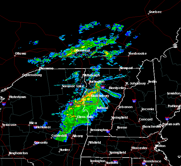 At 1101 pm edt, severe thunderstorms were located along a line extending from monkton ridge to near weybridge to near pharoah mountain, moving southeast at 15 mph (radar indicated). Hazards include 60 mph wind gusts. Expect damage to roofs. siding. and trees. Locations impacted include, bristol, fayston, lincoln, shoreham, orwell, bridport, cornwall, salisbury, leicester, weybridge, ripton, whiting, goshen, east middlebury, east shoreham, leonard bay, bread loaf, camels hump state park, huntington center and chilson. At 1101 pm edt, severe thunderstorms were located along a line extending from monkton ridge to near weybridge to near pharoah mountain, moving southeast at 15 mph (radar indicated). Hazards include 60 mph wind gusts. Expect damage to roofs. siding. and trees. Locations impacted include, bristol, fayston, lincoln, shoreham, orwell, bridport, cornwall, salisbury, leicester, weybridge, ripton, whiting, goshen, east middlebury, east shoreham, leonard bay, bread loaf, camels hump state park, huntington center and chilson.
|
| 8/16/2016 10:45 PM EDT |
 At 1045 pm edt, severe thunderstorms were located along a line extending from east charlotte to weybridge to near steep bay, moving southeast at 15 mph (radar indicated). Hazards include 60 mph wind gusts. Expect damage to roofs. siding. And trees. At 1045 pm edt, severe thunderstorms were located along a line extending from east charlotte to weybridge to near steep bay, moving southeast at 15 mph (radar indicated). Hazards include 60 mph wind gusts. Expect damage to roofs. siding. And trees.
|
| 8/16/2016 10:40 PM EDT |
 At 1039 pm edt, severe thunderstorms were located along a line extending from north ferrisburgh to bridport to pharoah mountain, moving east at 40 mph (radar indicated). Hazards include 60 mph wind gusts. Expect damage to roofs. siding. And trees. At 1039 pm edt, severe thunderstorms were located along a line extending from north ferrisburgh to bridport to pharoah mountain, moving east at 40 mph (radar indicated). Hazards include 60 mph wind gusts. Expect damage to roofs. siding. And trees.
|
| 8/13/2016 7:51 PM EDT |
 At 750 pm edt, severe thunderstorms were located along a line extending from new haven mills to east poultney, moving east at 35 mph (radar indicated). Hazards include 60 mph wind gusts and quarter size hail. Hail damage to vehicles is expected. Expect wind damage to roofs, siding, and trees. At 750 pm edt, severe thunderstorms were located along a line extending from new haven mills to east poultney, moving east at 35 mph (radar indicated). Hazards include 60 mph wind gusts and quarter size hail. Hail damage to vehicles is expected. Expect wind damage to roofs, siding, and trees.
|
| 7/23/2016 4:05 PM EDT |
 At 405 pm edt, a severe thunderstorm was located near ripton, moving south at 40 mph (radar indicated). Hazards include 60 mph wind gusts and quarter size hail. Hail damage to vehicles is expected. expect wind damage to roofs, siding, and trees. Locations impacted include, brandon, bristol, essex, addison, randolph, hinesburg, richmond, charlotte, ferrisburgh, bethel, monkton, huntington, starksboro, new haven, waitsfield, warren, moretown, fayston, brookfield and tunbridge. At 405 pm edt, a severe thunderstorm was located near ripton, moving south at 40 mph (radar indicated). Hazards include 60 mph wind gusts and quarter size hail. Hail damage to vehicles is expected. expect wind damage to roofs, siding, and trees. Locations impacted include, brandon, bristol, essex, addison, randolph, hinesburg, richmond, charlotte, ferrisburgh, bethel, monkton, huntington, starksboro, new haven, waitsfield, warren, moretown, fayston, brookfield and tunbridge.
|
| 7/23/2016 4:00 PM EDT | Numerous trees down in addison county VT, 1.6 miles SE of Middlebury, VT |
| 7/23/2016 3:35 PM EDT |
 At 335 pm edt, a severe thunderstorm was located over east charlotte, moving south at 40 mph (radar indicated). Hazards include 60 mph wind gusts and quarter size hail. Hail damage to vehicles is expected. Expect wind damage to roofs, siding, and trees. At 335 pm edt, a severe thunderstorm was located over east charlotte, moving south at 40 mph (radar indicated). Hazards include 60 mph wind gusts and quarter size hail. Hail damage to vehicles is expected. Expect wind damage to roofs, siding, and trees.
|
| 7/23/2016 12:26 AM EDT |
 The severe thunderstorm warning for east central essex, northern windsor, orange, south central lamoille, southeastern chittenden, washington, addison, southern caledonia and northern rutland counties will expire at 1230 am edt, the storms which prompted the warning have weakened below severe limits, and will exit the warned area by 1230 am. therefore the warning will be allowed to expire. The severe thunderstorm warning for east central essex, northern windsor, orange, south central lamoille, southeastern chittenden, washington, addison, southern caledonia and northern rutland counties will expire at 1230 am edt, the storms which prompted the warning have weakened below severe limits, and will exit the warned area by 1230 am. therefore the warning will be allowed to expire.
|
| 7/22/2016 11:40 PM EDT |
 At 1139 pm edt, severe thunderstorms were located along a line extending from marshfield to east middlebury, moving east at 35 mph (radar indicated). Hazards include 60 mph wind gusts and quarter size hail. Hail damage to vehicles is expected. expect wind damage to roofs, siding, and trees. Locations impacted include, barre, montpelier, bristol, chelsea, addison, orange, randolph, stowe, norwich, williamstown, berlin, bradford, royalton, east montpelier, bethel, monkton, huntington, starksboro, middlesex and new haven. At 1139 pm edt, severe thunderstorms were located along a line extending from marshfield to east middlebury, moving east at 35 mph (radar indicated). Hazards include 60 mph wind gusts and quarter size hail. Hail damage to vehicles is expected. expect wind damage to roofs, siding, and trees. Locations impacted include, barre, montpelier, bristol, chelsea, addison, orange, randolph, stowe, norwich, williamstown, berlin, bradford, royalton, east montpelier, bethel, monkton, huntington, starksboro, middlesex and new haven.
|
| 7/22/2016 10:56 PM EDT |
 At 1054 pm edt, severe thunderstorms were located along a line extending from burlington to near lake placid, moving east at 40 mph. other isolated severe thunderstorms are ahead of this line across central vermont also moving east at 40 mph (radar indicated). Hazards include 60 mph wind gusts and quarter size hail. Hail damage to vehicles is expected. Expect wind damage to roofs, siding, and trees. At 1054 pm edt, severe thunderstorms were located along a line extending from burlington to near lake placid, moving east at 40 mph. other isolated severe thunderstorms are ahead of this line across central vermont also moving east at 40 mph (radar indicated). Hazards include 60 mph wind gusts and quarter size hail. Hail damage to vehicles is expected. Expect wind damage to roofs, siding, and trees.
|
| 7/14/2016 3:17 PM EDT |
 At 316 pm edt, a severe thunderstorm was located over south hinesburg, moving northeast at 40 mph (radar indicated). Hazards include 60 mph wind gusts and penny size hail. Expect damage to roofs. siding. And trees. At 316 pm edt, a severe thunderstorm was located over south hinesburg, moving northeast at 40 mph (radar indicated). Hazards include 60 mph wind gusts and penny size hail. Expect damage to roofs. siding. And trees.
|
| 7/7/2016 1:42 PM EDT |
 At 141 pm edt, a severe thunderstorm was located over panton, moving east at 5 mph (radar indicated). Hazards include quarter size hail. Damage to vehicles is expected. locations impacted include, addison, ferrisburgh, monkton, new haven, westport, weybridge, panton, ferrisburg, monkton boro, kingsland bay state park, waltham, partridge harbor, louis clearing bay, moore point, potash bay, mile point, arnold bay, button bay, cold spring bay and furnace point. At 141 pm edt, a severe thunderstorm was located over panton, moving east at 5 mph (radar indicated). Hazards include quarter size hail. Damage to vehicles is expected. locations impacted include, addison, ferrisburgh, monkton, new haven, westport, weybridge, panton, ferrisburg, monkton boro, kingsland bay state park, waltham, partridge harbor, louis clearing bay, moore point, potash bay, mile point, arnold bay, button bay, cold spring bay and furnace point.
|
| 7/7/2016 1:18 PM EDT |
 At 118 pm edt, a severe thunderstorm was located over westport, moving east at 5 mph (radar indicated). Hazards include quarter size hail. damage to vehicles is expected At 118 pm edt, a severe thunderstorm was located over westport, moving east at 5 mph (radar indicated). Hazards include quarter size hail. damage to vehicles is expected
|
| 8/4/2015 12:31 PM EDT |
 At 1230 pm edt, doppler radar indicated a severe thunderstorm capable of producing quarter size hail and damaging winds in excess of 60 mph. this storm was located over weybridge, moving northeast at 35 mph. locations impacted include, bristol, starksboro, new haven, lincoln, ripton, south starksboro, west lincoln, bread loaf, south lincoln and new haven mills. At 1230 pm edt, doppler radar indicated a severe thunderstorm capable of producing quarter size hail and damaging winds in excess of 60 mph. this storm was located over weybridge, moving northeast at 35 mph. locations impacted include, bristol, starksboro, new haven, lincoln, ripton, south starksboro, west lincoln, bread loaf, south lincoln and new haven mills.
|
| 8/4/2015 12:13 PM EDT |
 At 1212 pm edt, doppler radar indicated a severe thunderstorm capable of producing quarter size hail and damaging winds in excess of 60 mph. this storm was located over weybridge, and moving east at 25 mph. * locations to be impacted include, bristol, addison, starksboro, new haven, lincoln, cornwall, weybridge, ripton, waltham, east middlebury, west lincoln, bread loaf, hollands pasture island, east monkton, new haven junction, south starksboro, south lincoln, new haven mills and brooksville. At 1212 pm edt, doppler radar indicated a severe thunderstorm capable of producing quarter size hail and damaging winds in excess of 60 mph. this storm was located over weybridge, and moving east at 25 mph. * locations to be impacted include, bristol, addison, starksboro, new haven, lincoln, cornwall, weybridge, ripton, waltham, east middlebury, west lincoln, bread loaf, hollands pasture island, east monkton, new haven junction, south starksboro, south lincoln, new haven mills and brooksville.
|
| 8/3/2015 2:52 PM EDT |
 At 252 pm edt, doppler radar indicated a severe thunderstorm capable of producing quarter size hail and damaging winds in excess of 60 mph. this storm was located over bristol, moving northeast at 30 mph. this severe thunderstorm will remain over mainly rural areas of central addison county, including the following locations, new haven mills, south lincoln and west lincoln. At 252 pm edt, doppler radar indicated a severe thunderstorm capable of producing quarter size hail and damaging winds in excess of 60 mph. this storm was located over bristol, moving northeast at 30 mph. this severe thunderstorm will remain over mainly rural areas of central addison county, including the following locations, new haven mills, south lincoln and west lincoln.
|
| 8/3/2015 2:43 PM EDT |
 At 242 pm edt, doppler radar indicated a severe thunderstorm capable of producing quarter size hail and damaging winds in excess of 60 mph. this storm was located near weybridge, or 8 miles southwest of bristol. this storm was nearly stationary. this severe storm will be near, new haven around 255 pm edt. bristol and lincoln around 300 pm edt. other locations impacted by this severe thunderstorm include east middlebury, new haven junction, west lincoln, bread loaf, south lincoln, hollands pasture island, new haven mills and brooksville. At 242 pm edt, doppler radar indicated a severe thunderstorm capable of producing quarter size hail and damaging winds in excess of 60 mph. this storm was located near weybridge, or 8 miles southwest of bristol. this storm was nearly stationary. this severe storm will be near, new haven around 255 pm edt. bristol and lincoln around 300 pm edt. other locations impacted by this severe thunderstorm include east middlebury, new haven junction, west lincoln, bread loaf, south lincoln, hollands pasture island, new haven mills and brooksville.
|
| 8/3/2015 2:36 PM EDT |
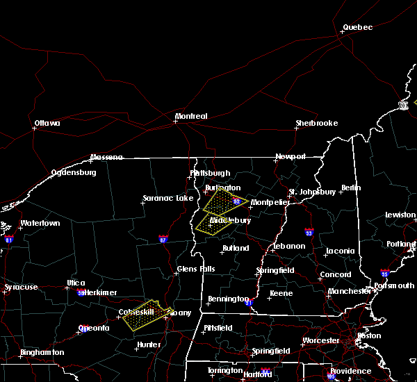 At 236 pm edt, doppler radar indicated a severe thunderstorm capable of producing quarter size hail and damaging winds in excess of 60 mph. this storm was located over cornwall, or 11 miles southwest of bristol, and moving northeast at 30 mph. * this severe thunderstorm will be near, weybridge around 240 pm edt. ripton around 245 pm edt. new haven around 250 pm edt. bristol around 255 pm edt. lincoln around 300 pm edt. other locations impacted by this severe thunderstorm include east middlebury, new haven junction, west lincoln, lake dunmore, west salisbury, bread loaf, south lincoln, hollands pasture island, branbury state park and new haven mills. At 236 pm edt, doppler radar indicated a severe thunderstorm capable of producing quarter size hail and damaging winds in excess of 60 mph. this storm was located over cornwall, or 11 miles southwest of bristol, and moving northeast at 30 mph. * this severe thunderstorm will be near, weybridge around 240 pm edt. ripton around 245 pm edt. new haven around 250 pm edt. bristol around 255 pm edt. lincoln around 300 pm edt. other locations impacted by this severe thunderstorm include east middlebury, new haven junction, west lincoln, lake dunmore, west salisbury, bread loaf, south lincoln, hollands pasture island, branbury state park and new haven mills.
|
| 7/20/2015 1:24 AM EDT |
 At 123 am edt, doppler radar indicated a severe thunderstorm capable of producing quarter size hail and damaging winds in excess of 60 mph. this storm was located over starksboro, and moving east at 30 mph. * locations to be impacted include, barre, montpelier, bristol, addison, orange, hinesburg, williamstown, berlin, ferrisburgh, east montpelier, monkton, huntington, starksboro, middlesex, new haven, waitsfield, warren, moretown, fayston and brookfield. At 123 am edt, doppler radar indicated a severe thunderstorm capable of producing quarter size hail and damaging winds in excess of 60 mph. this storm was located over starksboro, and moving east at 30 mph. * locations to be impacted include, barre, montpelier, bristol, addison, orange, hinesburg, williamstown, berlin, ferrisburgh, east montpelier, monkton, huntington, starksboro, middlesex, new haven, waitsfield, warren, moretown, fayston and brookfield.
|
| 5/19/2015 3:32 PM EDT | At 331 pm edt, doppler radar indicated a line of severe thunderstorms capable of producing damaging winds in excess of 60 mph. these storms were located along a line extending from waitsfield to near ripton, moving east at 25 mph. nickel size hail may also accompany the damaging winds. locations impacted include, barre, berlin, waitsfield, warren, moretown, fayston, lincoln, roxbury, ripton, hancock, granville, websterville, berlin corners, south starksboro, bread loaf, east middlebury, north fayston, irasville, west lincoln and lower granville. |
| 5/19/2015 3:15 PM EDT | At 314 pm edt, doppler radar indicated a line of severe thunderstorms capable of producing damaging winds in excess of 60 mph. these storms were located along a line extending from near fayston to cornwall, moving east at 25 mph. nickel size hail may also accompany the damaging winds. locations impacted include, barre, bristol, berlin, new haven, waitsfield, warren, moretown, fayston, lincoln, cornwall, salisbury, leicester, weybridge, roxbury, ripton, hancock, granville, goshen, websterville and berlin corners. |
| 5/19/2015 2:54 PM EDT | At 253 pm edt, doppler radar indicated a line of severe thunderstorms capable of producing damaging winds in excess of 60 mph. these storms were located along a line extending from starksboro to bridport, and moving east at 25 mph. nickel size hail may also accompany the damaging winds. * locations to be impacted include, barre, bristol, addison, berlin, ferrisburgh, monkton, starksboro, new haven, waitsfield, warren, moretown, fayston, lincoln, bridport, cornwall, salisbury, leicester, weybridge, roxbury and panton. |
| 7/8/2014 9:45 PM EDT | 1.5 ft diameter pine tree snapped half way up in addison county VT, 5.9 miles NNE of Middlebury, VT |
| 7/8/2014 9:42 PM EDT | Trees and wires down in addison county VT, 1.6 miles SE of Middlebury, VT |
| 5/27/2014 4:08 PM EDT | Numerous trees down along route 22a in bridport in addison county VT, 8.1 miles E of Middlebury, VT |
| 5/27/2014 3:48 PM EDT | Numerous trees down along route 30 in cornwall in addison county VT, 3.1 miles ENE of Middlebury, VT |
| 5/27/2014 3:42 PM EDT | Numerous trees down along route 22a in bridport in addison county VT, 8.1 miles E of Middlebury, VT |
| 5/27/2014 3:42 PM EDT | Golf Ball sized hail reported 9.1 miles E of Middlebury, VT, golf ball sized hail |
| 7/19/2013 7:57 PM EDT | Trees down in addison county VT, 5.9 miles NNW of Middlebury, VT |
| 7/19/2013 7:45 PM EDT | Numerous power lines down...trees down and uprooted in addison county VT, 4.3 miles NE of Middlebury, VT |
| 9/8/2012 4:24 PM EDT | Trees down on foote street in addison county VT, 0.9 miles WNW of Middlebury, VT |
| 7/23/2012 6:58 PM EDT | Ping Pong Ball sized hail reported 5.3 miles SE of Middlebury, VT, ping pong ball size hail. estimated 40-50 mph gusts. |
| 7/23/2012 6:20 PM EDT | Hen Egg sized hail reported 6 miles S of Middlebury, VT |
| 7/23/2012 6:20 PM EDT | Golf Ball sized hail reported 5.9 miles SE of Middlebury, VT, hail sizes ranging from large marble to golf ball size. relayed by wcax. |
| 7/23/2012 6:15 PM EDT | Ping Pong Ball sized hail reported 5.3 miles SE of Middlebury, VT, ping pong ball size hail. estimated 40-50 mph gusts. |
| 7/23/2012 6:05 PM EDT | Quarter sized hail reported 8.1 miles E of Middlebury, VT, quarter size hail in bridport. also estimated 40-50mph winds. |
| 7/23/2012 5:54 PM EDT | Half Dollar sized hail reported 8.1 miles E of Middlebury, VT |
| 7/17/2012 5:12 PM EDT | Tree down in addison county VT, 1.6 miles SE of Middlebury, VT |
| 7/17/2012 5:00 PM EDT | Tree down on river road near rte 7 in addison county VT, 4.1 miles SSE of Middlebury, VT |
| 5/29/2012 2:44 PM EDT | Quarter sized hail reported 1.6 miles SE of Middlebury, VT |
| 1/1/0001 12:00 AM | Half Dollar sized hail reported 2.9 miles NW of Middlebury, VT, middlebury state airport |
| 1/1/0001 12:00 AM | Quarter sized hail reported 4.7 miles WNW of Middlebury, VT, hail lasted 15 minutes |
| 1/1/0001 12:00 AM | Quarter sized hail reported 3 miles NW of Middlebury, VT |
| 1/1/0001 12:00 AM | Quarter sized hail reported 0.8 miles SE of Middlebury, VT, quarter-sized hail |
| 1/1/0001 12:00 AM | 3 inch diameter branches down in addison county VT, 4.3 miles NE of Middlebury, VT |
| 1/1/0001 12:00 AM | Trees and power lines down in addison county VT, 2.5 miles NNE of Middlebury, VT |
Hail Maps for Middlebury, VT
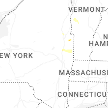


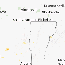

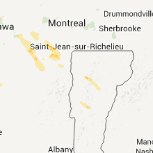


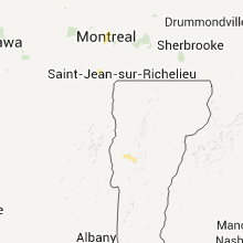


Connect with Interactive Hail Maps