

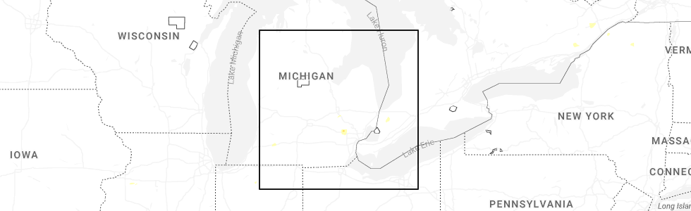
Hail Map for Milford, MI
The Milford, MI area has had 13 reports of on-the-ground hail by trained spotters, and has been under severe weather warnings 26 times during the past 12 months. Doppler radar has detected hail at or near Milford, MI on 18 occasions, including 2 occasions during the past year.
| Name: | Milford, MI |
| Where Located: | 29.6 miles S of Flint, MI |
| Map: | Google Map for Milford, MI |
| Population: | 6175 |
| Housing Units: | 2777 |
| More Info: | Search Google for Milford, MI |
0
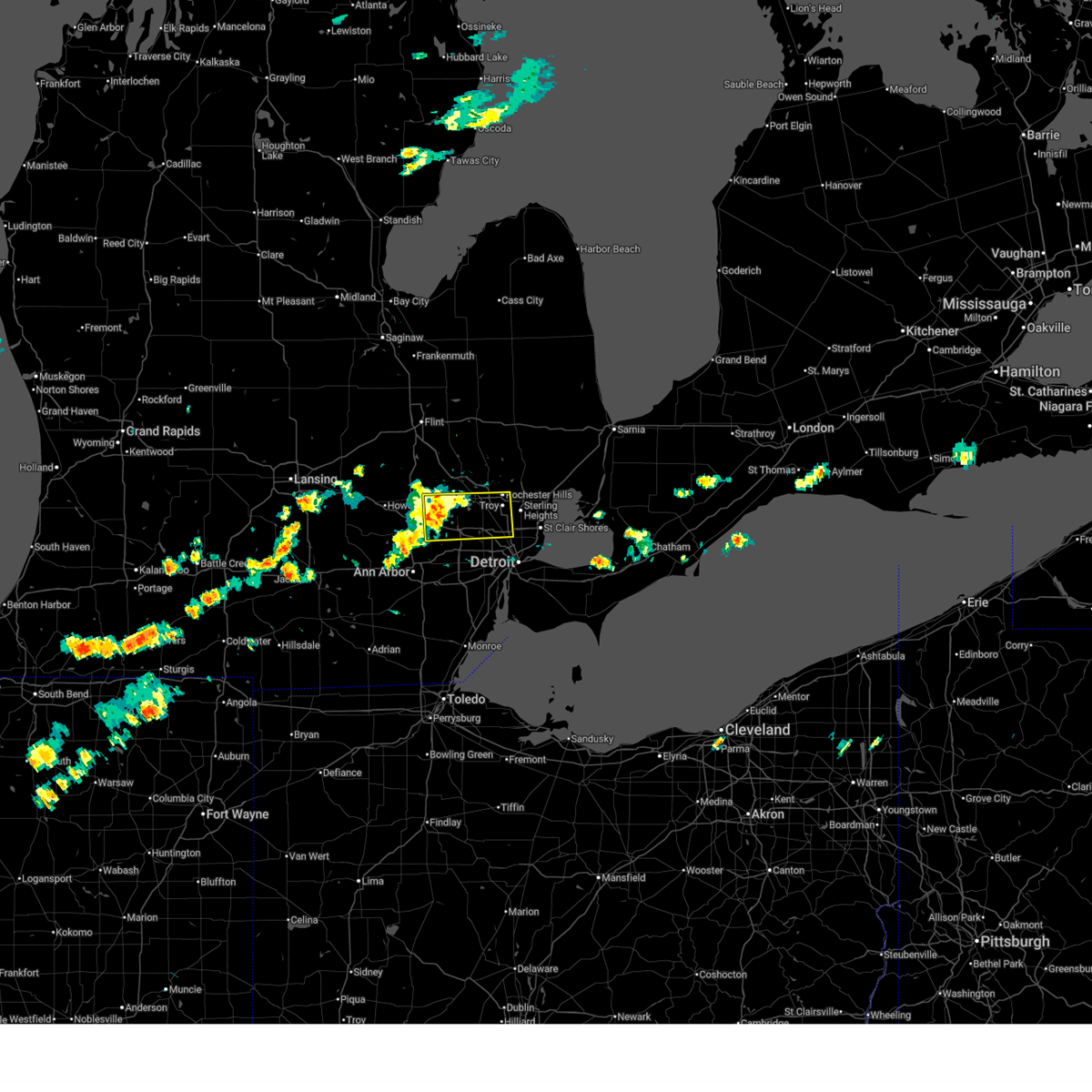
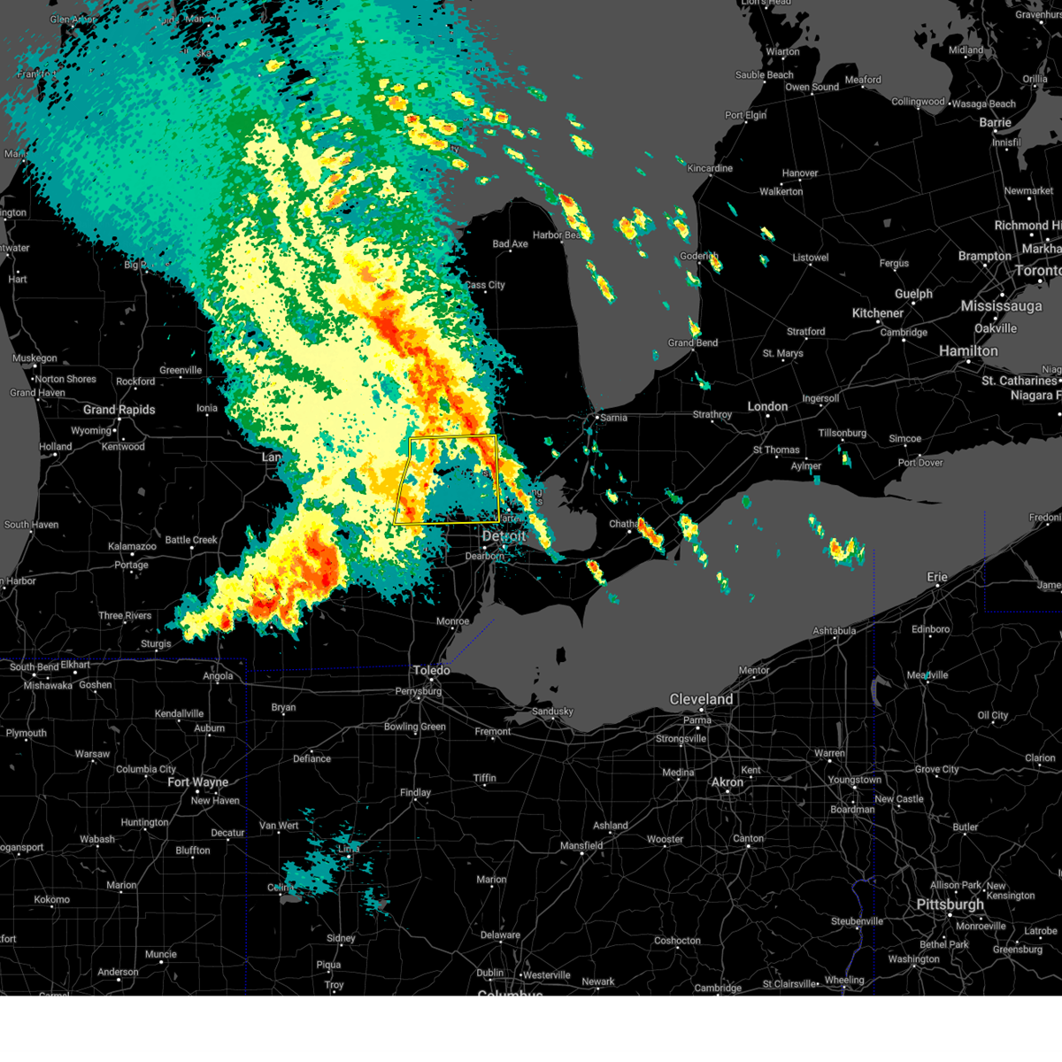
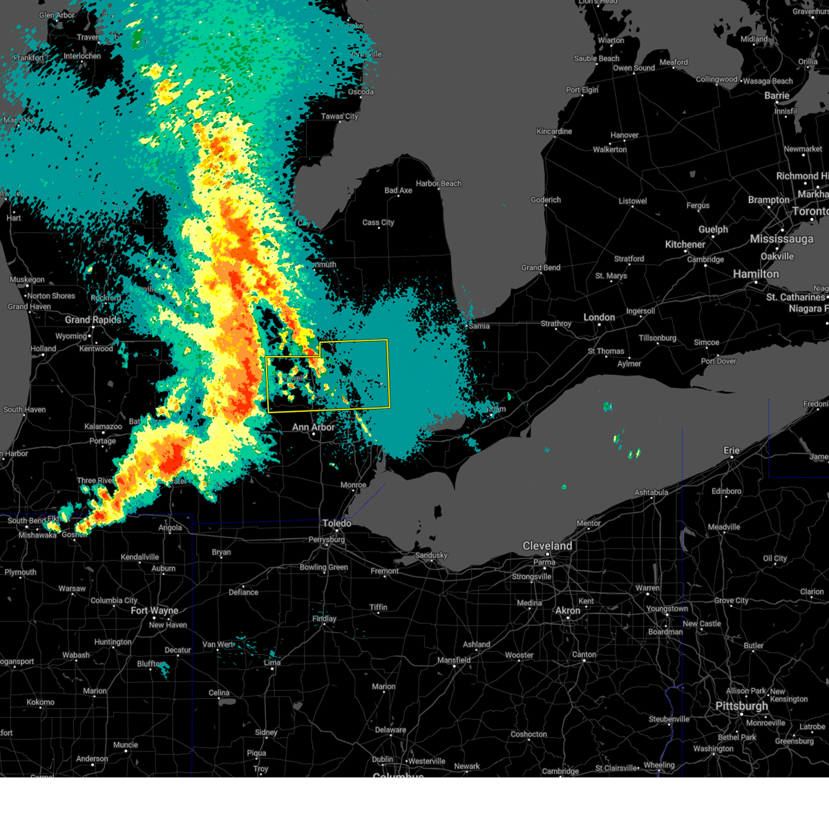
The Top Recent Hail Date for Milford, MI is Tuesday, June 24, 2025 (12th out of 18)
Hail and Wind Damage Spotted near Milford, MI
| Date / Time | Report Details |
|---|---|
| 6/24/2025 3:04 PM EDT |
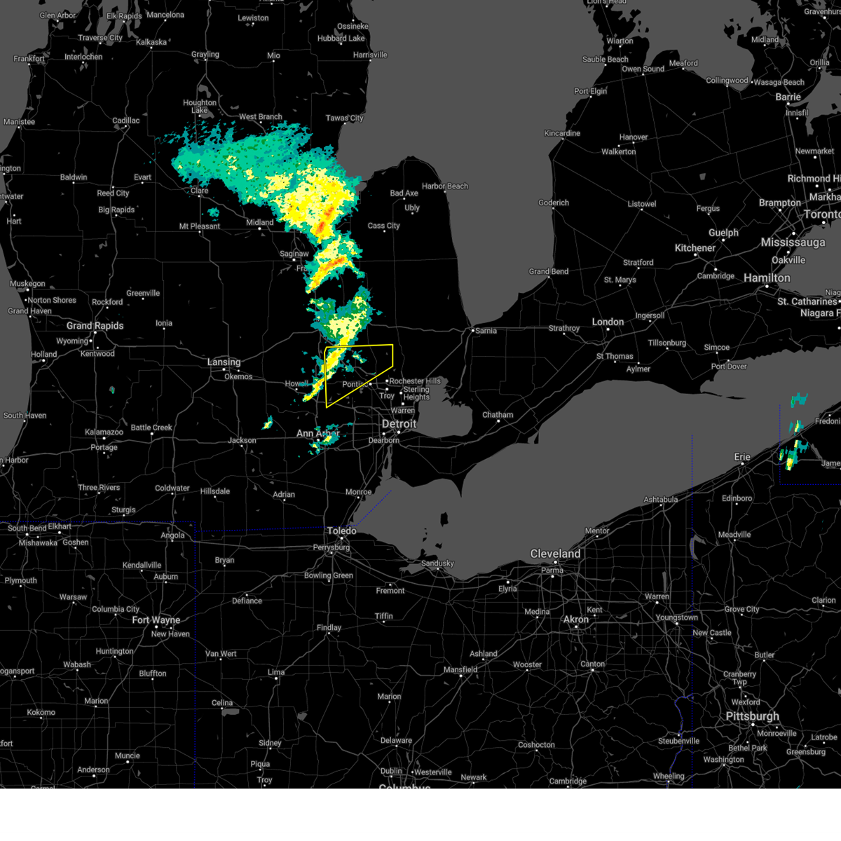
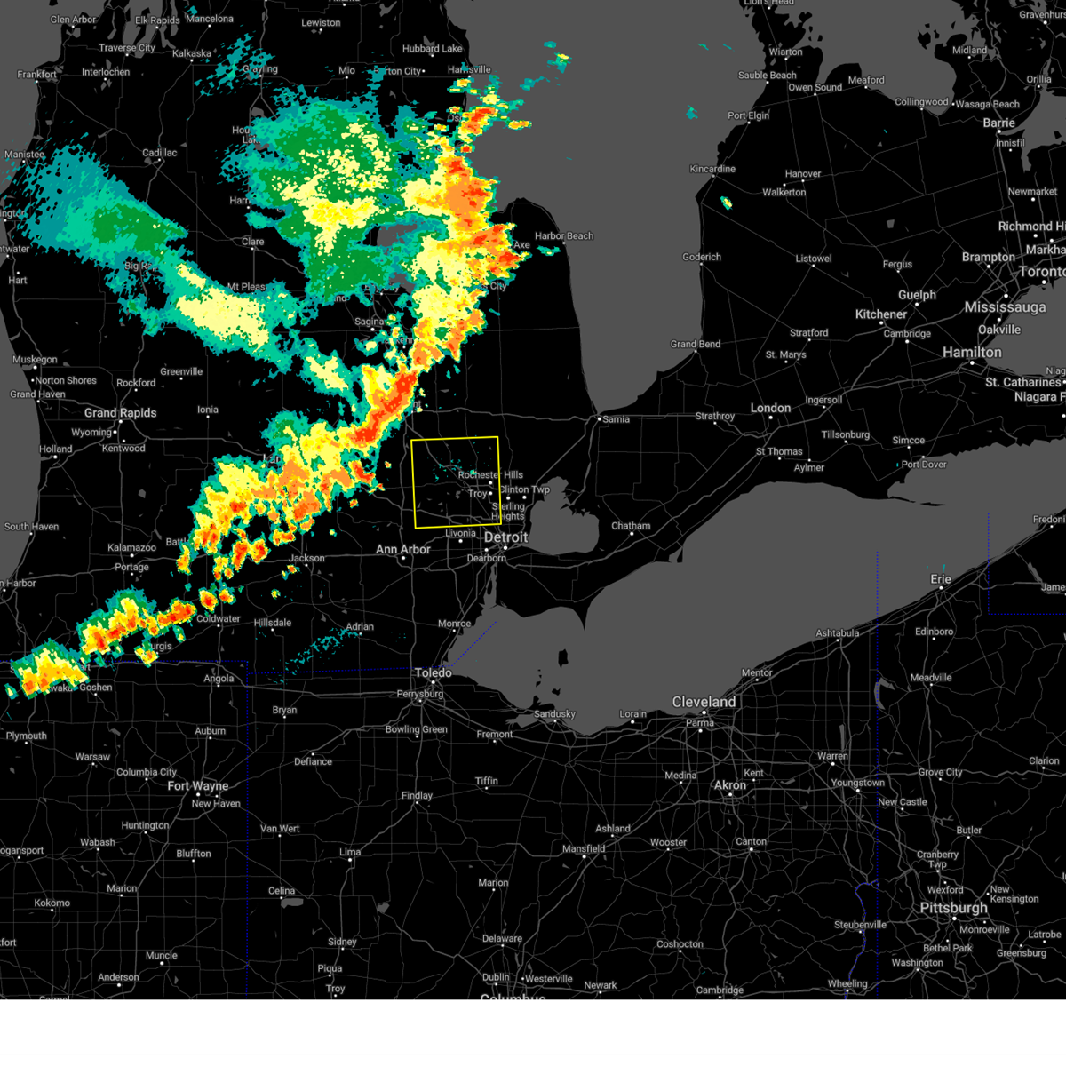
 At 303 pm edt, a severe thunderstorm was located over west bloomfield, or near southfield, moving east at 35 mph (trained spotter confirmed damaging wind in novi). Hazards include 60 mph wind gusts and nickel size hail. Expect damage to roofs, siding, and trees. this severe storm will be near, troy, southfield, royal oak, and birmingham around 310 pm edt. Other locations impacted by this severe thunderstorm include franklin, keego harbor, waterford, orchard lake, commerce, lathrup village, bingham farms, farmington hills, pleasant ridge, and white lake. At 303 pm edt, a severe thunderstorm was located over west bloomfield, or near southfield, moving east at 35 mph (trained spotter confirmed damaging wind in novi). Hazards include 60 mph wind gusts and nickel size hail. Expect damage to roofs, siding, and trees. this severe storm will be near, troy, southfield, royal oak, and birmingham around 310 pm edt. Other locations impacted by this severe thunderstorm include franklin, keego harbor, waterford, orchard lake, commerce, lathrup village, bingham farms, farmington hills, pleasant ridge, and white lake.
|
| 6/24/2025 2:53 PM EDT |
 At 252 pm edt, a severe thunderstorm was located near novi, moving east at 35 mph (radar indicated). Hazards include 60 mph wind gusts and quarter size hail. Hail damage to vehicles is expected. expect wind damage to roofs, siding, and trees. this severe storm will be near, southfield and west bloomfield around 300 pm edt. birmingham around 305 pm edt. troy and royal oak around 310 pm edt. Other locations impacted by this severe thunderstorm include franklin, keego harbor, waterford, orchard lake, commerce, lathrup village, bingham farms, farmington hills, pleasant ridge, and white lake. At 252 pm edt, a severe thunderstorm was located near novi, moving east at 35 mph (radar indicated). Hazards include 60 mph wind gusts and quarter size hail. Hail damage to vehicles is expected. expect wind damage to roofs, siding, and trees. this severe storm will be near, southfield and west bloomfield around 300 pm edt. birmingham around 305 pm edt. troy and royal oak around 310 pm edt. Other locations impacted by this severe thunderstorm include franklin, keego harbor, waterford, orchard lake, commerce, lathrup village, bingham farms, farmington hills, pleasant ridge, and white lake.
|
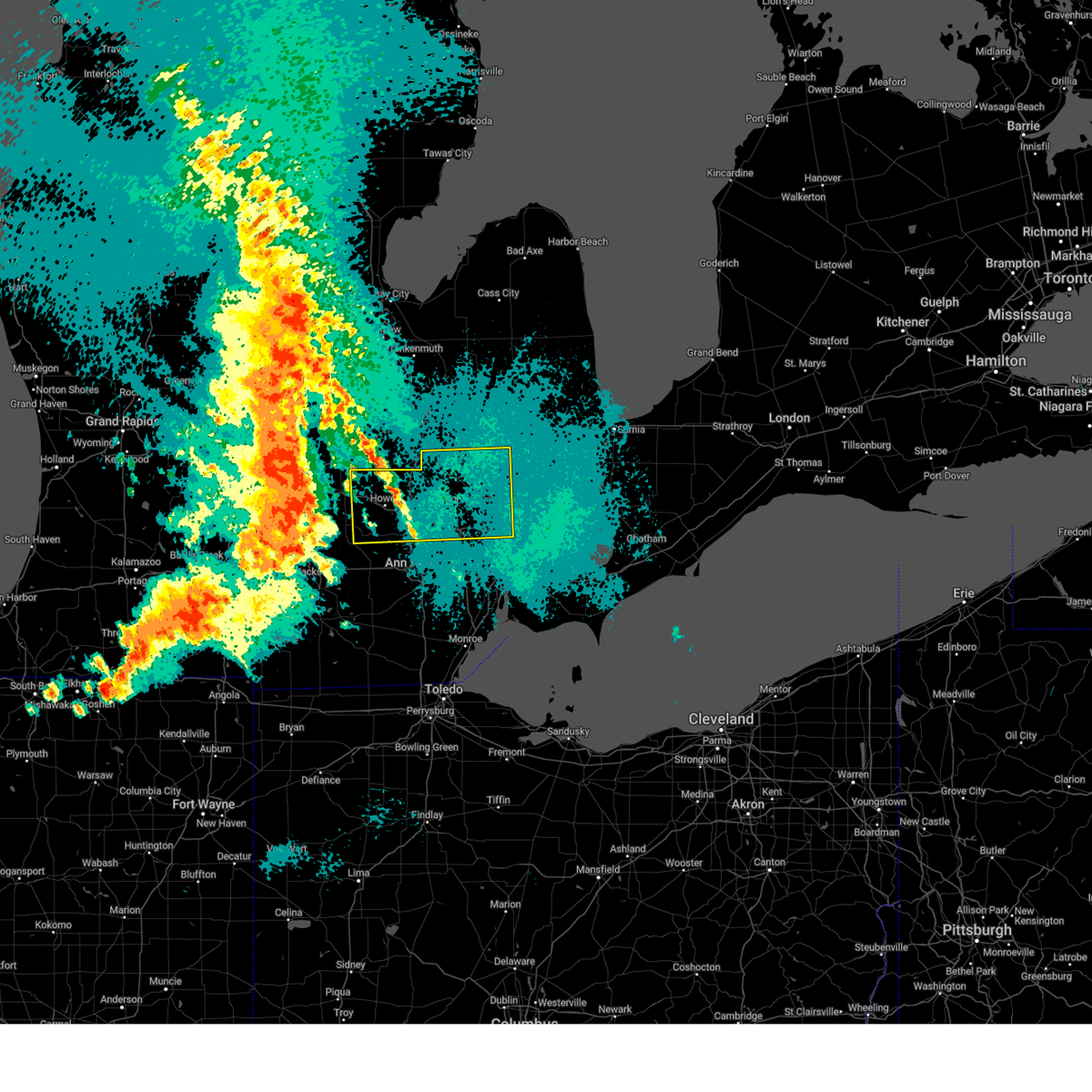
| 6/24/2025 2:46 PM EDT |
 Svrdtx the national weather service in detroit/pontiac has issued a * severe thunderstorm warning for, southern oakland county in southeastern michigan, * until 345 pm edt. * at 246 pm edt, a severe thunderstorm was located near milford, moving east at 30 mph (radar indicated). Hazards include 60 mph wind gusts. Expect damage to roofs, siding, and trees. this severe thunderstorm will be near, novi and milford around 250 pm edt. west bloomfield around 300 pm edt. southfield around 310 pm edt. pontiac and birmingham around 315 pm edt. troy and royal oak around 320 pm edt. Other locations impacted by this severe thunderstorm include franklin, keego harbor, waterford, orchard lake, commerce, lathrup village, bingham farms, farmington hills, pleasant ridge, and white lake. Svrdtx the national weather service in detroit/pontiac has issued a * severe thunderstorm warning for, southern oakland county in southeastern michigan, * until 345 pm edt. * at 246 pm edt, a severe thunderstorm was located near milford, moving east at 30 mph (radar indicated). Hazards include 60 mph wind gusts. Expect damage to roofs, siding, and trees. this severe thunderstorm will be near, novi and milford around 250 pm edt. west bloomfield around 300 pm edt. southfield around 310 pm edt. pontiac and birmingham around 315 pm edt. troy and royal oak around 320 pm edt. Other locations impacted by this severe thunderstorm include franklin, keego harbor, waterford, orchard lake, commerce, lathrup village, bingham farms, farmington hills, pleasant ridge, and white lake.
|
| 5/16/2025 12:37 AM EDT |
 At 1236 am edt, severe thunderstorms were located along a line extending from near otisville to near clarkston to near salem, moving east at 65 mph (radar indicated). Hazards include 70 mph wind gusts and quarter size hail. Hail damage to vehicles is expected. expect considerable tree damage. wind damage is also likely to mobile homes, roofs, and outbuildings. these severe storms will be near, pontiac, novi, ortonville, west bloomfield, and clarkston around 1240 am edt. southfield and oxford around 1245 am edt. troy, royal oak, birmingham, and rochester around 1250 am edt. sterling heights and detroit zoo around 1255 am edt. warren around 100 am edt. Other locations impacted by these severe thunderstorms include franklin, keego harbor, waterford, orchard lake, holly state recreation area, commerce, rose center, lathrup village, auburn hills, and bingham farms. At 1236 am edt, severe thunderstorms were located along a line extending from near otisville to near clarkston to near salem, moving east at 65 mph (radar indicated). Hazards include 70 mph wind gusts and quarter size hail. Hail damage to vehicles is expected. expect considerable tree damage. wind damage is also likely to mobile homes, roofs, and outbuildings. these severe storms will be near, pontiac, novi, ortonville, west bloomfield, and clarkston around 1240 am edt. southfield and oxford around 1245 am edt. troy, royal oak, birmingham, and rochester around 1250 am edt. sterling heights and detroit zoo around 1255 am edt. warren around 100 am edt. Other locations impacted by these severe thunderstorms include franklin, keego harbor, waterford, orchard lake, holly state recreation area, commerce, rose center, lathrup village, auburn hills, and bingham farms.
|
| 5/16/2025 12:10 AM EDT |
 At 1209 am edt, severe thunderstorms were located along a line extending from near new lothrop to oak grove to near chelsea, moving east at 65 mph (radar indicated). Hazards include 70 mph wind gusts and penny size hail. Expect considerable tree damage. damage is likely to mobile homes, roofs, and outbuildings. these severe storms will be near, hartland, howell, brighton, and pinckney around 1215 am edt. fenton, holly, hamburg, lake fenton, and whitmore lake around 1220 am edt. milford and south lyon around 1225 am edt. novi, ortonville, and clarkston around 1230 am edt. northville around 1235 am edt. southfield, pontiac, oxford, and west bloomfield around 1240 am edt. troy, birmingham, and rochester around 1245 am edt. sterling heights, royal oak, and detroit zoo around 1250 am edt. Other locations impacted by these severe thunderstorms include franklin, keego harbor, waterford, orchard lake, plainfield, holly state recreation area, commerce, rose center, pinckney state recreation area, and conway township. At 1209 am edt, severe thunderstorms were located along a line extending from near new lothrop to oak grove to near chelsea, moving east at 65 mph (radar indicated). Hazards include 70 mph wind gusts and penny size hail. Expect considerable tree damage. damage is likely to mobile homes, roofs, and outbuildings. these severe storms will be near, hartland, howell, brighton, and pinckney around 1215 am edt. fenton, holly, hamburg, lake fenton, and whitmore lake around 1220 am edt. milford and south lyon around 1225 am edt. novi, ortonville, and clarkston around 1230 am edt. northville around 1235 am edt. southfield, pontiac, oxford, and west bloomfield around 1240 am edt. troy, birmingham, and rochester around 1245 am edt. sterling heights, royal oak, and detroit zoo around 1250 am edt. Other locations impacted by these severe thunderstorms include franklin, keego harbor, waterford, orchard lake, plainfield, holly state recreation area, commerce, rose center, pinckney state recreation area, and conway township.
|
| 5/15/2025 11:45 PM EDT |
 Svrdtx the national weather service in detroit/pontiac has issued a * severe thunderstorm warning for, oakland county in southeastern michigan, livingston county in southeastern michigan, * until 115 am edt. * at 1144 pm edt, severe thunderstorms were located along a line extending from 8 miles west of elsie to near lansing to near albion, moving east at 65 mph (radar indicated). Hazards include 70 mph wind gusts. Expect considerable tree damage. damage is likely to mobile homes, roofs, and outbuildings. severe thunderstorms will be near, fowlerville around 1200 am edt. cohoctah, gregory, and oak grove around 1205 am edt. howell around 1210 am edt. hartland and pinckney around 1215 am edt. fenton, brighton, holly, hamburg, and lake fenton around 1220 am edt. milford and whitmore lake around 1225 am edt. south lyon, ortonville, and clarkston around 1230 am edt. novi and northville around 1235 am edt. Other locations impacted by these severe thunderstorms include franklin, keego harbor, waterford, orchard lake, plainfield, holly state recreation area, commerce, rose center, pinckney state recreation area, and conway township. Svrdtx the national weather service in detroit/pontiac has issued a * severe thunderstorm warning for, oakland county in southeastern michigan, livingston county in southeastern michigan, * until 115 am edt. * at 1144 pm edt, severe thunderstorms were located along a line extending from 8 miles west of elsie to near lansing to near albion, moving east at 65 mph (radar indicated). Hazards include 70 mph wind gusts. Expect considerable tree damage. damage is likely to mobile homes, roofs, and outbuildings. severe thunderstorms will be near, fowlerville around 1200 am edt. cohoctah, gregory, and oak grove around 1205 am edt. howell around 1210 am edt. hartland and pinckney around 1215 am edt. fenton, brighton, holly, hamburg, and lake fenton around 1220 am edt. milford and whitmore lake around 1225 am edt. south lyon, ortonville, and clarkston around 1230 am edt. novi and northville around 1235 am edt. Other locations impacted by these severe thunderstorms include franklin, keego harbor, waterford, orchard lake, plainfield, holly state recreation area, commerce, rose center, pinckney state recreation area, and conway township.
|
| 3/30/2025 7:03 PM EDT |
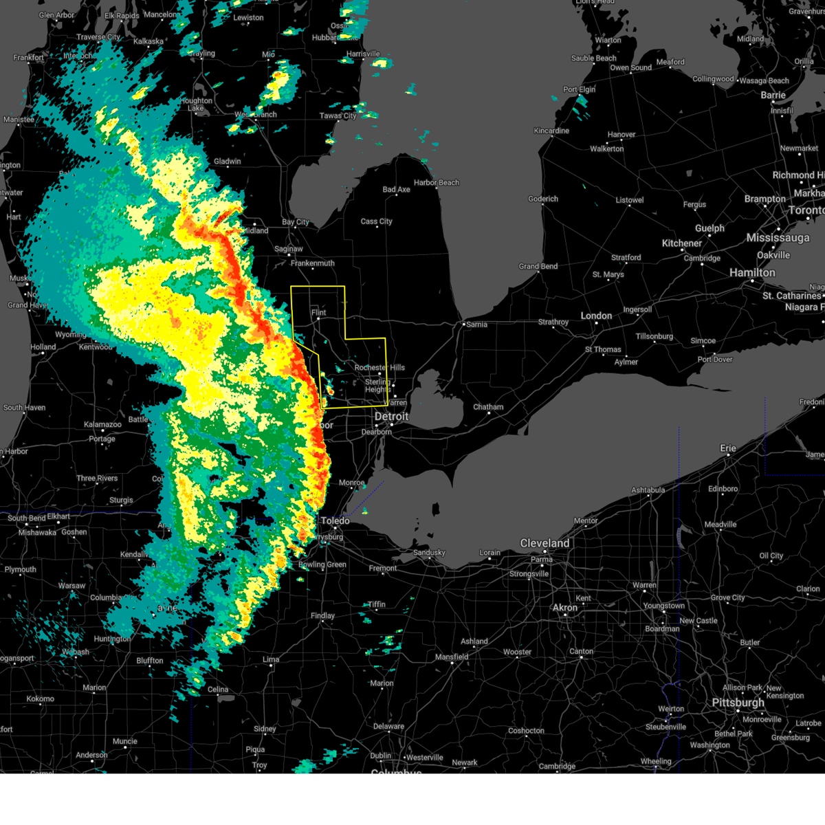 At 703 pm edt, severe thunderstorms were located along a line extending from near swartz creek to fenton to near holly to near salem, moving northeast at 65 mph (radar indicated). Hazards include 80 mph wind gusts and penny size hail. Flying debris will be dangerous to those caught without shelter. mobile homes will be heavily damaged. expect considerable damage to roofs, windows, and vehicles. extensive tree damage and power outages are likely. these severe storms will be near, mount morris, burton, goodrich, grand blanc, ortonville, west bloomfield, flint, beecher, clarkston, and novi around 710 pm edt. davison, birmingham, pontiac, and southfield around 715 pm edt. oxford, otisville, and troy around 720 pm edt. rochester, otter lake, and sterling heights around 725 pm edt. other locations impacted by these severe thunderstorms include franklin, keego harbor, waterford, orchard lake, rankin, holly state recreation area, commerce, rose center, lathrup village, and auburn hills. this includes the following highways, i-75 between mile markers 60 and 133. i-475 between mile markers 1 and 16. i-96 between mile markers 154 and 167. i-696 between mile markers 1 and 19. i-69 between mile markers 124 and 148. m-10 between mile markers 13 and 18. m-59 between mile markers 38 and 48. Us-23 between mile markers 80 and 90. At 703 pm edt, severe thunderstorms were located along a line extending from near swartz creek to fenton to near holly to near salem, moving northeast at 65 mph (radar indicated). Hazards include 80 mph wind gusts and penny size hail. Flying debris will be dangerous to those caught without shelter. mobile homes will be heavily damaged. expect considerable damage to roofs, windows, and vehicles. extensive tree damage and power outages are likely. these severe storms will be near, mount morris, burton, goodrich, grand blanc, ortonville, west bloomfield, flint, beecher, clarkston, and novi around 710 pm edt. davison, birmingham, pontiac, and southfield around 715 pm edt. oxford, otisville, and troy around 720 pm edt. rochester, otter lake, and sterling heights around 725 pm edt. other locations impacted by these severe thunderstorms include franklin, keego harbor, waterford, orchard lake, rankin, holly state recreation area, commerce, rose center, lathrup village, and auburn hills. this includes the following highways, i-75 between mile markers 60 and 133. i-475 between mile markers 1 and 16. i-96 between mile markers 154 and 167. i-696 between mile markers 1 and 19. i-69 between mile markers 124 and 148. m-10 between mile markers 13 and 18. m-59 between mile markers 38 and 48. Us-23 between mile markers 80 and 90.
|
| 3/30/2025 6:53 PM EDT |
 At 653 pm edt, severe thunderstorms were located along a line extending from 6 miles north of laingsburg to oak grove to near whitmore lake, moving northeast at 60 mph (radar indicated). Hazards include 70 mph wind gusts and penny size hail. Expect considerable tree damage. damage is likely to mobile homes, roofs, and outbuildings. these severe storms will be near, south lyon, milford, linden, gaines, fenton, and novi around 700 pm edt. lake fenton, lennon, swartz creek, and holly around 705 pm edt. burton, grand blanc, flint, and flushing around 710 pm edt. goodrich, ortonville, montrose, beecher, clarkston, and pontiac around 715 pm edt. mount morris, clio, davison, and crossroads village around 720 pm edt. oxford and otisville around 725 pm edt. otter lake around 730 pm edt. other locations impacted by these severe thunderstorms include franklin, keego harbor, waterford, orchard lake, rankin, holly state recreation area, commerce, rose center, lathrup village, and auburn hills. this includes the following highways, i-75 between mile markers 60 and 133. i-475 between mile markers 1 and 16. i-96 between mile markers 154 and 167. i-696 between mile markers 1 and 19. i-69 between mile markers 124 and 148. m-10 between mile markers 13 and 18. m-59 between mile markers 38 and 48. Us-23 between mile markers 78 and 90. At 653 pm edt, severe thunderstorms were located along a line extending from 6 miles north of laingsburg to oak grove to near whitmore lake, moving northeast at 60 mph (radar indicated). Hazards include 70 mph wind gusts and penny size hail. Expect considerable tree damage. damage is likely to mobile homes, roofs, and outbuildings. these severe storms will be near, south lyon, milford, linden, gaines, fenton, and novi around 700 pm edt. lake fenton, lennon, swartz creek, and holly around 705 pm edt. burton, grand blanc, flint, and flushing around 710 pm edt. goodrich, ortonville, montrose, beecher, clarkston, and pontiac around 715 pm edt. mount morris, clio, davison, and crossroads village around 720 pm edt. oxford and otisville around 725 pm edt. otter lake around 730 pm edt. other locations impacted by these severe thunderstorms include franklin, keego harbor, waterford, orchard lake, rankin, holly state recreation area, commerce, rose center, lathrup village, and auburn hills. this includes the following highways, i-75 between mile markers 60 and 133. i-475 between mile markers 1 and 16. i-96 between mile markers 154 and 167. i-696 between mile markers 1 and 19. i-69 between mile markers 124 and 148. m-10 between mile markers 13 and 18. m-59 between mile markers 38 and 48. Us-23 between mile markers 78 and 90.
|
| 3/30/2025 6:52 PM EDT |
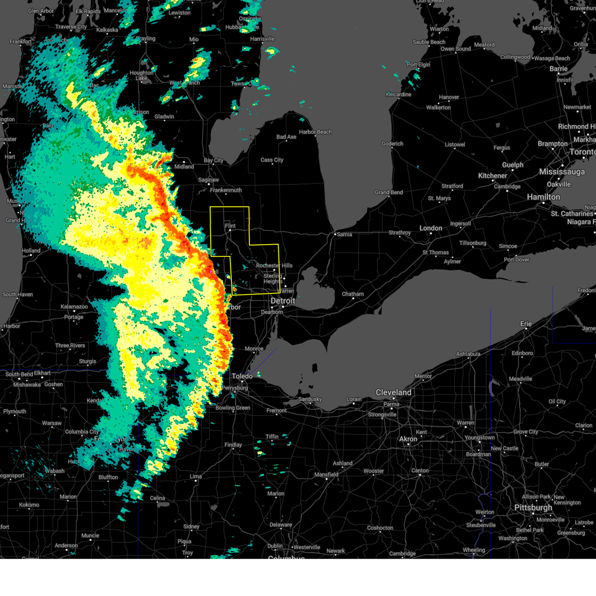 Svrdtx the national weather service in detroit/pontiac has issued a * severe thunderstorm warning for, oakland county in southeastern michigan, genesee county in southeastern michigan, * until 745 pm edt. * at 651 pm edt, severe thunderstorms were located along a line extending from near laingsburg to oak grove to near whitmore lake, moving northeast at 60 mph (radar indicated). Hazards include 70 mph wind gusts and penny size hail. Expect considerable tree damage. damage is likely to mobile homes, roofs, and outbuildings. severe thunderstorms will be near, south lyon around 655 pm edt. milford, linden, gaines, fenton, and novi around 700 pm edt. lake fenton, flint, lennon, swartz creek, and holly around 705 pm edt. burton, grand blanc, west bloomfield, and flushing around 710 pm edt. mount morris, goodrich, ortonville, montrose, beecher, clarkston, and pontiac around 715 pm edt. clio, davison, and crossroads village around 720 pm edt. oxford and otisville around 725 pm edt. otter lake around 730 pm edt. other locations impacted by these severe thunderstorms include franklin, keego harbor, waterford, orchard lake, rankin, holly state recreation area, commerce, rose center, lathrup village, and auburn hills. this includes the following highways, i-75 between mile markers 60 and 133. i-475 between mile markers 1 and 16. i-96 between mile markers 154 and 167. i-696 between mile markers 1 and 19. i-69 between mile markers 124 and 148. m-10 between mile markers 13 and 18. m-59 between mile markers 38 and 48. Us-23 between mile markers 78 and 90. Svrdtx the national weather service in detroit/pontiac has issued a * severe thunderstorm warning for, oakland county in southeastern michigan, genesee county in southeastern michigan, * until 745 pm edt. * at 651 pm edt, severe thunderstorms were located along a line extending from near laingsburg to oak grove to near whitmore lake, moving northeast at 60 mph (radar indicated). Hazards include 70 mph wind gusts and penny size hail. Expect considerable tree damage. damage is likely to mobile homes, roofs, and outbuildings. severe thunderstorms will be near, south lyon around 655 pm edt. milford, linden, gaines, fenton, and novi around 700 pm edt. lake fenton, flint, lennon, swartz creek, and holly around 705 pm edt. burton, grand blanc, west bloomfield, and flushing around 710 pm edt. mount morris, goodrich, ortonville, montrose, beecher, clarkston, and pontiac around 715 pm edt. clio, davison, and crossroads village around 720 pm edt. oxford and otisville around 725 pm edt. otter lake around 730 pm edt. other locations impacted by these severe thunderstorms include franklin, keego harbor, waterford, orchard lake, rankin, holly state recreation area, commerce, rose center, lathrup village, and auburn hills. this includes the following highways, i-75 between mile markers 60 and 133. i-475 between mile markers 1 and 16. i-96 between mile markers 154 and 167. i-696 between mile markers 1 and 19. i-69 between mile markers 124 and 148. m-10 between mile markers 13 and 18. m-59 between mile markers 38 and 48. Us-23 between mile markers 78 and 90.
|
| 3/15/2025 6:16 PM EDT | the severe thunderstorm warning has been cancelled and is no longer in effect |
| 3/15/2025 6:00 PM EDT | At 559 pm edt, severe thunderstorms were located along a line extending from near holly to near clarkston to pontiac, moving northeast at 65 mph (radar indicated). Hazards include 60 mph wind gusts. Expect damage to roofs, siding, and trees. these severe storms will be near, rochester, ortonville, and oxford around 605 pm edt. other locations impacted by these severe thunderstorms include franklin, keego harbor, waterford, orchard lake, holly state recreation area, commerce, rose center, lathrup village, auburn hills, and bingham farms. this includes the following highways, i-75 between mile markers 60 and 105. i-96 between mile markers 160 and 166. i-696 between mile markers 1 and 18. m-10 between mile markers 13 and 18. M-59 between mile markers 38 and 48. |
| 3/15/2025 6:00 PM EDT | the severe thunderstorm warning has been cancelled and is no longer in effect |
| 3/15/2025 5:46 PM EDT |
 At 545 pm edt, severe thunderstorms were located along a line extending from hartland to milford to near novi, moving northeast at 65 mph (radar indicated). Hazards include 60 mph wind gusts. Expect damage to roofs, siding, and trees. these severe storms will be near, fenton, west bloomfield, novi, and holly around 550 pm edt. clarkston and pontiac around 555 pm edt. ortonville, oxford, and troy around 600 pm edt. rochester around 605 pm edt. other locations impacted by these severe thunderstorms include franklin, keego harbor, waterford, orchard lake, holly state recreation area, commerce, rose center, lathrup village, auburn hills, and bingham farms. this includes the following highways, i-75 between mile markers 58 and 105. i-275 between mile markers 26 and 29. i-96 between mile markers 139 and 184. i-696 between mile markers 1 and 18. Us-23 between mile markers 54 and 77. At 545 pm edt, severe thunderstorms were located along a line extending from hartland to milford to near novi, moving northeast at 65 mph (radar indicated). Hazards include 60 mph wind gusts. Expect damage to roofs, siding, and trees. these severe storms will be near, fenton, west bloomfield, novi, and holly around 550 pm edt. clarkston and pontiac around 555 pm edt. ortonville, oxford, and troy around 600 pm edt. rochester around 605 pm edt. other locations impacted by these severe thunderstorms include franklin, keego harbor, waterford, orchard lake, holly state recreation area, commerce, rose center, lathrup village, auburn hills, and bingham farms. this includes the following highways, i-75 between mile markers 58 and 105. i-275 between mile markers 26 and 29. i-96 between mile markers 139 and 184. i-696 between mile markers 1 and 18. Us-23 between mile markers 54 and 77.
|
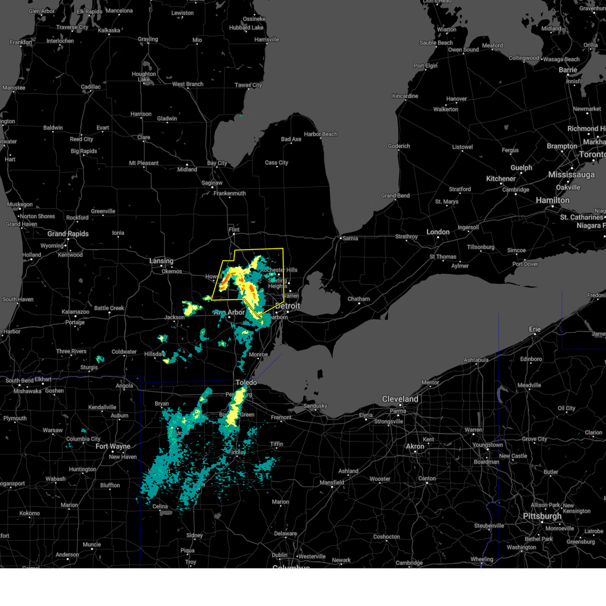
| 3/15/2025 5:30 PM EDT | Svrdtx the national weather service in detroit/pontiac has issued a * severe thunderstorm warning for, northwestern wayne county in southeastern michigan, oakland county in southeastern michigan, livingston county in southeastern michigan, * until 630 pm edt. * at 529 pm edt, severe thunderstorms were located along a line extending from near pinckney to whitmore lake to dixboro, moving northeast at 65 mph (radar indicated). Hazards include 60 mph wind gusts. Expect damage to roofs, siding, and trees. severe thunderstorms will be near, canton, south lyon, howell, brighton, northville, and novi around 535 pm edt. milford, hartland, and livonia around 540 pm edt. fenton around 545 pm edt. west bloomfield, clarkston, pontiac, and holly around 550 pm edt. ortonville around 555 pm edt. oxford around 600 pm edt. rochester around 605 pm edt. other locations impacted by these severe thunderstorms include franklin, keego harbor, waterford, holly state recreation area, commerce, auburn hills, lake angelus, pleasant ridge, westland, and huntington woods. this includes the following highways, i-75 between mile markers 58 and 105. i-275 between mile markers 22 and 29. i-96 between mile markers 132 and 184. i-696 between mile markers 1 and 18. m-10 between mile markers 8 and 18. m-14 between mile markers 16 and 21. m-59 between mile markers 38 and 48. Us-23 between mile markers 54 and 77. |
| 11/10/2024 7:03 PM EST |
 Svrdtx the national weather service in detroit/pontiac has issued a * severe thunderstorm warning for, northern oakland county in southeastern michigan, * until 800 pm est. * at 702 pm est, a severe thunderstorm was located near ortonville, or near holly, moving east at 40 mph (radar indicated). Hazards include 60 mph wind gusts. Expect damage to roofs, siding, and trees. this severe thunderstorm will be near, ortonville around 710 pm est. oxford around 720 pm est. other locations impacted by this severe thunderstorm include lakeville, waterford, davisburg, holly state recreation area, commerce, rose center, lake orion, lake angelus, white lake, and leonard. this includes the following highways, i-75 between mile markers 81 and 105. I-96 near mile marker 154. Svrdtx the national weather service in detroit/pontiac has issued a * severe thunderstorm warning for, northern oakland county in southeastern michigan, * until 800 pm est. * at 702 pm est, a severe thunderstorm was located near ortonville, or near holly, moving east at 40 mph (radar indicated). Hazards include 60 mph wind gusts. Expect damage to roofs, siding, and trees. this severe thunderstorm will be near, ortonville around 710 pm est. oxford around 720 pm est. other locations impacted by this severe thunderstorm include lakeville, waterford, davisburg, holly state recreation area, commerce, rose center, lake orion, lake angelus, white lake, and leonard. this includes the following highways, i-75 between mile markers 81 and 105. I-96 near mile marker 154.
|
| 8/27/2024 5:44 PM EDT |
 At 544 pm edt, severe thunderstorms were located along a line extending from near romeo to near pontiac to near salem, moving southeast at 45 mph (radar indicated). Hazards include 70 mph wind gusts and penny size hail. Expect considerable tree damage. damage is likely to mobile homes, roofs, and outbuildings. these severe storms will be near, troy, southfield, sterling heights, royal oak, birmingham, and rochester around 550 pm edt. warren and detroit zoo around 555 pm edt. other locations impacted by these severe thunderstorms include franklin, keego harbor, waterford, orchard lake, commerce, rose center, lathrup village, auburn hills, bingham farms, and lake angelus. this includes the following highways, i-75 between mile markers 60 and 98. i-96 between mile markers 154 and 167. i-696 between mile markers 1 and 19. m-10 between mile markers 13 and 18. M-59 between mile markers 38 and 48. At 544 pm edt, severe thunderstorms were located along a line extending from near romeo to near pontiac to near salem, moving southeast at 45 mph (radar indicated). Hazards include 70 mph wind gusts and penny size hail. Expect considerable tree damage. damage is likely to mobile homes, roofs, and outbuildings. these severe storms will be near, troy, southfield, sterling heights, royal oak, birmingham, and rochester around 550 pm edt. warren and detroit zoo around 555 pm edt. other locations impacted by these severe thunderstorms include franklin, keego harbor, waterford, orchard lake, commerce, rose center, lathrup village, auburn hills, bingham farms, and lake angelus. this includes the following highways, i-75 between mile markers 60 and 98. i-96 between mile markers 154 and 167. i-696 between mile markers 1 and 19. m-10 between mile markers 13 and 18. M-59 between mile markers 38 and 48.
|
| 8/27/2024 5:25 PM EDT |
 At 525 pm edt, severe thunderstorms were located along a line extending from metamora to near clarkston to hamburg, moving southeast at 45 mph (radar indicated). Hazards include 70 mph wind gusts and penny size hail. Expect considerable tree damage. damage is likely to mobile homes, roofs, and outbuildings. these severe storms will be near, pontiac, novi, milford, oxford, south lyon, and clarkston around 530 pm edt. northville and west bloomfield around 535 pm edt. troy, southfield, birmingham, and rochester around 540 pm edt. royal oak around 545 pm edt. sterling heights and detroit zoo around 550 pm edt. warren around 555 pm edt. other locations impacted by these severe thunderstorms include franklin, keego harbor, waterford, orchard lake, holly state recreation area, commerce, rose center, lathrup village, auburn hills, and bingham farms. this includes the following highways, i-75 between mile markers 60 and 105. i-96 between mile markers 154 and 167. i-696 between mile markers 1 and 19. m-10 between mile markers 13 and 18. M-59 between mile markers 38 and 48. At 525 pm edt, severe thunderstorms were located along a line extending from metamora to near clarkston to hamburg, moving southeast at 45 mph (radar indicated). Hazards include 70 mph wind gusts and penny size hail. Expect considerable tree damage. damage is likely to mobile homes, roofs, and outbuildings. these severe storms will be near, pontiac, novi, milford, oxford, south lyon, and clarkston around 530 pm edt. northville and west bloomfield around 535 pm edt. troy, southfield, birmingham, and rochester around 540 pm edt. royal oak around 545 pm edt. sterling heights and detroit zoo around 550 pm edt. warren around 555 pm edt. other locations impacted by these severe thunderstorms include franklin, keego harbor, waterford, orchard lake, holly state recreation area, commerce, rose center, lathrup village, auburn hills, and bingham farms. this includes the following highways, i-75 between mile markers 60 and 105. i-96 between mile markers 154 and 167. i-696 between mile markers 1 and 19. m-10 between mile markers 13 and 18. M-59 between mile markers 38 and 48.
|
| 8/27/2024 5:15 PM EDT |
 At 515 pm edt, severe thunderstorms were located along a line extending from hadley to near holly to near pinckney, moving east at 45 mph (radar indicated). Hazards include 60 mph wind gusts and penny size hail. Expect damage to roofs, siding, and trees. these severe storms will be near, milford, ortonville, and clarkston around 520 pm edt. oxford and south lyon around 525 pm edt. pontiac and novi around 530 pm edt. northville and west bloomfield around 535 pm edt. troy, southfield, and rochester around 540 pm edt. sterling heights, royal oak, and birmingham around 545 pm edt. warren and detroit zoo around 555 pm edt. other locations impacted by these severe thunderstorms include franklin, keego harbor, waterford, orchard lake, holly state recreation area, commerce, rose center, lathrup village, auburn hills, and bingham farms. this includes the following highways, i-75 between mile markers 60 and 105. i-96 between mile markers 154 and 167. i-696 between mile markers 1 and 19. m-10 between mile markers 13 and 18. M-59 between mile markers 38 and 48. At 515 pm edt, severe thunderstorms were located along a line extending from hadley to near holly to near pinckney, moving east at 45 mph (radar indicated). Hazards include 60 mph wind gusts and penny size hail. Expect damage to roofs, siding, and trees. these severe storms will be near, milford, ortonville, and clarkston around 520 pm edt. oxford and south lyon around 525 pm edt. pontiac and novi around 530 pm edt. northville and west bloomfield around 535 pm edt. troy, southfield, and rochester around 540 pm edt. sterling heights, royal oak, and birmingham around 545 pm edt. warren and detroit zoo around 555 pm edt. other locations impacted by these severe thunderstorms include franklin, keego harbor, waterford, orchard lake, holly state recreation area, commerce, rose center, lathrup village, auburn hills, and bingham farms. this includes the following highways, i-75 between mile markers 60 and 105. i-96 between mile markers 154 and 167. i-696 between mile markers 1 and 19. m-10 between mile markers 13 and 18. M-59 between mile markers 38 and 48.
|
| 8/27/2024 5:02 PM EDT |
 Svrdtx the national weather service in detroit/pontiac has issued a * severe thunderstorm warning for, oakland county in southeastern michigan, * until 630 pm edt. * at 502 pm edt, severe thunderstorms were located along a line extending from near clio to near gaines to near fowlerville, moving southeast at 45 mph (radar indicated). Hazards include 60 mph wind gusts and penny size hail. Expect damage to roofs, siding, and trees. severe thunderstorms will be near, holly around 515 pm edt. milford, south lyon, and ortonville around 525 pm edt. novi and clarkston around 530 pm edt. northville around 535 pm edt. pontiac, oxford, and west bloomfield around 540 pm edt. southfield around 545 pm edt. troy, birmingham, and rochester around 550 pm edt. sterling heights and royal oak around 555 pm edt. other locations impacted by these severe thunderstorms include franklin, keego harbor, waterford, orchard lake, holly state recreation area, commerce, rose center, lathrup village, auburn hills, and bingham farms. this includes the following highways, i-75 between mile markers 60 and 105. i-96 between mile markers 154 and 167. i-696 between mile markers 1 and 19. m-10 between mile markers 13 and 18. M-59 between mile markers 38 and 48. Svrdtx the national weather service in detroit/pontiac has issued a * severe thunderstorm warning for, oakland county in southeastern michigan, * until 630 pm edt. * at 502 pm edt, severe thunderstorms were located along a line extending from near clio to near gaines to near fowlerville, moving southeast at 45 mph (radar indicated). Hazards include 60 mph wind gusts and penny size hail. Expect damage to roofs, siding, and trees. severe thunderstorms will be near, holly around 515 pm edt. milford, south lyon, and ortonville around 525 pm edt. novi and clarkston around 530 pm edt. northville around 535 pm edt. pontiac, oxford, and west bloomfield around 540 pm edt. southfield around 545 pm edt. troy, birmingham, and rochester around 550 pm edt. sterling heights and royal oak around 555 pm edt. other locations impacted by these severe thunderstorms include franklin, keego harbor, waterford, orchard lake, holly state recreation area, commerce, rose center, lathrup village, auburn hills, and bingham farms. this includes the following highways, i-75 between mile markers 60 and 105. i-96 between mile markers 154 and 167. i-696 between mile markers 1 and 19. m-10 between mile markers 13 and 18. M-59 between mile markers 38 and 48.
|
| 7/23/2024 8:42 PM EDT |
 the severe thunderstorm warning has been cancelled and is no longer in effect the severe thunderstorm warning has been cancelled and is no longer in effect
|
| 7/23/2024 8:36 PM EDT |
 the severe thunderstorm warning has been cancelled and is no longer in effect the severe thunderstorm warning has been cancelled and is no longer in effect
|
| 7/23/2024 8:36 PM EDT |
 At 836 pm edt, a severe thunderstorm was located over novi, moving east at 30 mph (radar indicated). Hazards include 60 mph wind gusts and quarter size hail. Hail damage to vehicles is expected. expect wind damage to roofs, siding, and trees. this severe storm will be near, novi around 840 pm edt. west bloomfield around 845 pm edt. other locations impacted by this severe thunderstorm include orchard lake, white lake, commerce, wolverine lake, new hudson, farmington, walled lake, wixom, farmington hills, and waterford. this includes the following highways, i-96 between mile markers 154 and 167. I-696 between mile markers 1 and 4. At 836 pm edt, a severe thunderstorm was located over novi, moving east at 30 mph (radar indicated). Hazards include 60 mph wind gusts and quarter size hail. Hail damage to vehicles is expected. expect wind damage to roofs, siding, and trees. this severe storm will be near, novi around 840 pm edt. west bloomfield around 845 pm edt. other locations impacted by this severe thunderstorm include orchard lake, white lake, commerce, wolverine lake, new hudson, farmington, walled lake, wixom, farmington hills, and waterford. this includes the following highways, i-96 between mile markers 154 and 167. I-696 between mile markers 1 and 4.
|
| 7/23/2024 8:21 PM EDT |
 At 821 pm edt, a severe thunderstorm was located near south lyon, or near milford, moving east at 30 mph (radar indicated). Hazards include 60 mph wind gusts and quarter size hail. Hail damage to vehicles is expected. expect wind damage to roofs, siding, and trees. this severe storm will be near, novi around 825 pm edt. west bloomfield around 845 pm edt. other locations impacted by this severe thunderstorm include orchard lake, white lake, island lake state recreation area, commerce, wolverine lake, new hudson, farmington, walled lake, wixom, and farmington hills. this includes the following highways, i-96 between mile markers 148 and 167. i-696 between mile markers 1 and 4. Us-23 between mile markers 59 and 66. At 821 pm edt, a severe thunderstorm was located near south lyon, or near milford, moving east at 30 mph (radar indicated). Hazards include 60 mph wind gusts and quarter size hail. Hail damage to vehicles is expected. expect wind damage to roofs, siding, and trees. this severe storm will be near, novi around 825 pm edt. west bloomfield around 845 pm edt. other locations impacted by this severe thunderstorm include orchard lake, white lake, island lake state recreation area, commerce, wolverine lake, new hudson, farmington, walled lake, wixom, and farmington hills. this includes the following highways, i-96 between mile markers 148 and 167. i-696 between mile markers 1 and 4. Us-23 between mile markers 59 and 66.
|
| 7/23/2024 7:56 PM EDT |
 Svrdtx the national weather service in detroit/pontiac has issued a * severe thunderstorm warning for, southwestern oakland county in southeastern michigan, southeastern livingston county in southeastern michigan, * until 900 pm edt. * at 756 pm edt, a severe thunderstorm was located near brighton, moving east at 30 mph (radar indicated). Hazards include 60 mph wind gusts and quarter size hail. Hail damage to vehicles is expected. expect wind damage to roofs, siding, and trees. this severe thunderstorm will be near, brighton around 800 pm edt. south lyon around 810 pm edt. milford around 815 pm edt. novi around 820 pm edt. west bloomfield around 840 pm edt. other locations impacted by this severe thunderstorm include orchard lake, island lake state recreation area, commerce, new hudson, walled lake, farmington hills, lakeland, white lake, chilson, and wolverine lake. this includes the following highways, i-96 between mile markers 138 and 167. i-696 between mile markers 1 and 4. Us-23 between mile markers 53 and 67. Svrdtx the national weather service in detroit/pontiac has issued a * severe thunderstorm warning for, southwestern oakland county in southeastern michigan, southeastern livingston county in southeastern michigan, * until 900 pm edt. * at 756 pm edt, a severe thunderstorm was located near brighton, moving east at 30 mph (radar indicated). Hazards include 60 mph wind gusts and quarter size hail. Hail damage to vehicles is expected. expect wind damage to roofs, siding, and trees. this severe thunderstorm will be near, brighton around 800 pm edt. south lyon around 810 pm edt. milford around 815 pm edt. novi around 820 pm edt. west bloomfield around 840 pm edt. other locations impacted by this severe thunderstorm include orchard lake, island lake state recreation area, commerce, new hudson, walled lake, farmington hills, lakeland, white lake, chilson, and wolverine lake. this includes the following highways, i-96 between mile markers 138 and 167. i-696 between mile markers 1 and 4. Us-23 between mile markers 53 and 67.
|
| 7/16/2024 3:08 AM EDT |
 At 308 am edt, severe thunderstorms were located along a line extending from near clarkston to near birmingham to near detroit zoo, moving northeast at 40 mph (radar indicated). Hazards include 60 mph wind gusts. Expect damage to roofs, siding, and trees. these severe storms will be near, troy, pontiac, sterling heights, rochester, and clarkston around 315 am edt. oxford around 325 am edt. other locations impacted by these severe thunderstorms include franklin, keego harbor, waterford, orchard lake, commerce, rose center, lathrup village, auburn hills, bingham farms, and lake angelus. this includes the following highways, i-75 between mile markers 60 and 100. i-96 between mile markers 160 and 167. i-696 between mile markers 1 and 19. m-10 between mile markers 13 and 18. M-59 between mile markers 38 and 48. At 308 am edt, severe thunderstorms were located along a line extending from near clarkston to near birmingham to near detroit zoo, moving northeast at 40 mph (radar indicated). Hazards include 60 mph wind gusts. Expect damage to roofs, siding, and trees. these severe storms will be near, troy, pontiac, sterling heights, rochester, and clarkston around 315 am edt. oxford around 325 am edt. other locations impacted by these severe thunderstorms include franklin, keego harbor, waterford, orchard lake, commerce, rose center, lathrup village, auburn hills, bingham farms, and lake angelus. this includes the following highways, i-75 between mile markers 60 and 100. i-96 between mile markers 160 and 167. i-696 between mile markers 1 and 19. m-10 between mile markers 13 and 18. M-59 between mile markers 38 and 48.
|
| 7/16/2024 2:48 AM EDT |
 Svrdtx the national weather service in detroit/pontiac has issued a * severe thunderstorm warning for, oakland county in southeastern michigan, * until 345 am edt. * at 247 am edt, severe thunderstorms were located along a line extending from hartland to near brighton to south lyon, moving northeast at 50 mph (radar indicated). Hazards include 60 mph wind gusts. Expect damage to roofs, siding, and trees. severe thunderstorms will be near, novi, milford, and south lyon around 250 am edt. west bloomfield around 300 am edt. pontiac and clarkston around 305 am edt. troy and oxford around 315 am edt. rochester around 320 am edt. other locations impacted by these severe thunderstorms include franklin, keego harbor, waterford, orchard lake, commerce, rose center, lathrup village, auburn hills, bingham farms, and lake angelus. this includes the following highways, i-75 between mile markers 60 and 100. i-96 between mile markers 154 and 167. i-696 between mile markers 1 and 19. m-10 between mile markers 13 and 18. M-59 between mile markers 38 and 48. Svrdtx the national weather service in detroit/pontiac has issued a * severe thunderstorm warning for, oakland county in southeastern michigan, * until 345 am edt. * at 247 am edt, severe thunderstorms were located along a line extending from hartland to near brighton to south lyon, moving northeast at 50 mph (radar indicated). Hazards include 60 mph wind gusts. Expect damage to roofs, siding, and trees. severe thunderstorms will be near, novi, milford, and south lyon around 250 am edt. west bloomfield around 300 am edt. pontiac and clarkston around 305 am edt. troy and oxford around 315 am edt. rochester around 320 am edt. other locations impacted by these severe thunderstorms include franklin, keego harbor, waterford, orchard lake, commerce, rose center, lathrup village, auburn hills, bingham farms, and lake angelus. this includes the following highways, i-75 between mile markers 60 and 100. i-96 between mile markers 154 and 167. i-696 between mile markers 1 and 19. m-10 between mile markers 13 and 18. M-59 between mile markers 38 and 48.
|
| 6/19/2024 9:02 PM EDT |
 Svrdtx the national weather service in detroit/pontiac has issued a * severe thunderstorm warning for, northwestern wayne county in southeastern michigan, southwestern oakland county in southeastern michigan, * until 1015 pm edt. * at 901 pm edt, a severe thunderstorm was located near salem, or near canton, moving northeast at 20 mph (radar indicated). Hazards include 60 mph wind gusts and nickel size hail. Expect damage to roofs, siding, and trees. this severe thunderstorm will be near, canton around 905 pm edt. novi and northville around 910 pm edt. other locations impacted by this severe thunderstorm include franklin, plymouth, commerce, wolverine lake, new hudson, farmington, walled lake, wixom, farmington hills, and bingham farms. this includes the following highways, i-275 near mile marker 29. i-96 between mile markers 157 and 171. i-696 between mile markers 1 and 7. M-14 between mile markers 16 and 21. Svrdtx the national weather service in detroit/pontiac has issued a * severe thunderstorm warning for, northwestern wayne county in southeastern michigan, southwestern oakland county in southeastern michigan, * until 1015 pm edt. * at 901 pm edt, a severe thunderstorm was located near salem, or near canton, moving northeast at 20 mph (radar indicated). Hazards include 60 mph wind gusts and nickel size hail. Expect damage to roofs, siding, and trees. this severe thunderstorm will be near, canton around 905 pm edt. novi and northville around 910 pm edt. other locations impacted by this severe thunderstorm include franklin, plymouth, commerce, wolverine lake, new hudson, farmington, walled lake, wixom, farmington hills, and bingham farms. this includes the following highways, i-275 near mile marker 29. i-96 between mile markers 157 and 171. i-696 between mile markers 1 and 7. M-14 between mile markers 16 and 21.
|
| 6/17/2024 11:09 PM EDT |
 Svrdtx the national weather service in detroit/pontiac has issued a * severe thunderstorm warning for, northwestern wayne county in southeastern michigan, southwestern oakland county in southeastern michigan, northeastern washtenaw county in southeastern michigan, * until midnight edt. * at 1109 pm edt, a severe thunderstorm was located over dixboro, or near ypsilanti, moving northeast at 25 mph (radar indicated). Hazards include 60 mph wind gusts and penny size hail. Expect damage to roofs, siding, and trees. this severe thunderstorm will be near, canton and salem around 1115 pm edt. novi and northville around 1120 pm edt. livonia around 1130 pm edt. other locations impacted by this severe thunderstorm include redford, plymouth, new hudson, farmington, walled lake, wixom, farmington hills, wolverine lake, and westland. this includes the following highways, i-275 between mile markers 24 and 29. i-94 between mile markers 183 and 185. i-96 between mile markers 154 and 178. i-696 between mile markers 1 and 3. m-14 between mile markers 10 and 21. Us-23 between mile markers 38 and 43. Svrdtx the national weather service in detroit/pontiac has issued a * severe thunderstorm warning for, northwestern wayne county in southeastern michigan, southwestern oakland county in southeastern michigan, northeastern washtenaw county in southeastern michigan, * until midnight edt. * at 1109 pm edt, a severe thunderstorm was located over dixboro, or near ypsilanti, moving northeast at 25 mph (radar indicated). Hazards include 60 mph wind gusts and penny size hail. Expect damage to roofs, siding, and trees. this severe thunderstorm will be near, canton and salem around 1115 pm edt. novi and northville around 1120 pm edt. livonia around 1130 pm edt. other locations impacted by this severe thunderstorm include redford, plymouth, new hudson, farmington, walled lake, wixom, farmington hills, wolverine lake, and westland. this includes the following highways, i-275 between mile markers 24 and 29. i-94 between mile markers 183 and 185. i-96 between mile markers 154 and 178. i-696 between mile markers 1 and 3. m-14 between mile markers 10 and 21. Us-23 between mile markers 38 and 43.
|
| 6/5/2024 3:46 PM EDT |
 the severe thunderstorm warning has been cancelled and is no longer in effect the severe thunderstorm warning has been cancelled and is no longer in effect
|
| 6/5/2024 3:34 PM EDT |
 At 333 pm edt, a severe thunderstorm was located near oxford, moving northeast at 40 mph. additional strong storms are moving in behind this storm along a line from milford to novi (radar indicated). Hazards include 60 mph wind gusts and penny size hail. Expect damage to roofs, siding, and trees. this severe thunderstorm will remain over mainly rural areas of western oakland county, including the following locations, davisburg, white lake, holly state recreation area, commerce, leonard, rose center, lake orion, waterford, and wixom. This includes i-75 between mile markers 86 and 102. At 333 pm edt, a severe thunderstorm was located near oxford, moving northeast at 40 mph. additional strong storms are moving in behind this storm along a line from milford to novi (radar indicated). Hazards include 60 mph wind gusts and penny size hail. Expect damage to roofs, siding, and trees. this severe thunderstorm will remain over mainly rural areas of western oakland county, including the following locations, davisburg, white lake, holly state recreation area, commerce, leonard, rose center, lake orion, waterford, and wixom. This includes i-75 between mile markers 86 and 102.
|
| 6/5/2024 3:15 PM EDT |
 At 314 pm edt, a severe thunderstorm was located over clarkston, or 9 miles northwest of pontiac, moving northeast at 30 mph (radar indicated). Hazards include 60 mph wind gusts and penny size hail. Expect damage to roofs, siding, and trees. this severe storm will be near, clarkston around 320 pm edt. oxford around 330 pm edt. other locations impacted by this severe thunderstorm include davisburg, white lake, holly state recreation area, commerce, leonard, rose center, lake orion, waterford, and wixom. This includes i-75 between mile markers 86 and 102. At 314 pm edt, a severe thunderstorm was located over clarkston, or 9 miles northwest of pontiac, moving northeast at 30 mph (radar indicated). Hazards include 60 mph wind gusts and penny size hail. Expect damage to roofs, siding, and trees. this severe storm will be near, clarkston around 320 pm edt. oxford around 330 pm edt. other locations impacted by this severe thunderstorm include davisburg, white lake, holly state recreation area, commerce, leonard, rose center, lake orion, waterford, and wixom. This includes i-75 between mile markers 86 and 102.
|
| 6/5/2024 2:57 PM EDT |
 Svrdtx the national weather service in detroit/pontiac has issued a * severe thunderstorm warning for, western oakland county in southeastern michigan, * until 400 pm edt. * at 256 pm edt, a severe thunderstorm was located near milford, moving northeast at 35 mph (radar indicated). Hazards include 60 mph wind gusts and penny size hail. Expect damage to roofs, siding, and trees. this severe thunderstorm will be near, clarkston around 305 pm edt. oxford around 320 pm edt. other locations impacted by this severe thunderstorm include davisburg, white lake, holly state recreation area, commerce, leonard, rose center, lake orion, waterford, and wixom. This includes i-75 between mile markers 86 and 102. Svrdtx the national weather service in detroit/pontiac has issued a * severe thunderstorm warning for, western oakland county in southeastern michigan, * until 400 pm edt. * at 256 pm edt, a severe thunderstorm was located near milford, moving northeast at 35 mph (radar indicated). Hazards include 60 mph wind gusts and penny size hail. Expect damage to roofs, siding, and trees. this severe thunderstorm will be near, clarkston around 305 pm edt. oxford around 320 pm edt. other locations impacted by this severe thunderstorm include davisburg, white lake, holly state recreation area, commerce, leonard, rose center, lake orion, waterford, and wixom. This includes i-75 between mile markers 86 and 102.
|
| 2/28/2024 2:05 AM EST |
 At 204 am est, a severe thunderstorm was located near clarkston, or 8 miles northeast of milford, moving east at 65 mph (radar indicated). Hazards include 60 mph wind gusts and quarter size hail. Hail damage to vehicles is expected. expect wind damage to roofs, siding, and trees. this severe storm will be near, pontiac around 210 am est. rochester around 215 am est. Other locations impacted by this severe thunderstorm include rochester hills, keego harbor, waterford, orchard lake, commerce, sylvan lake, walled lake, auburn hills, lake angelus, and bloomfield hills. At 204 am est, a severe thunderstorm was located near clarkston, or 8 miles northeast of milford, moving east at 65 mph (radar indicated). Hazards include 60 mph wind gusts and quarter size hail. Hail damage to vehicles is expected. expect wind damage to roofs, siding, and trees. this severe storm will be near, pontiac around 210 am est. rochester around 215 am est. Other locations impacted by this severe thunderstorm include rochester hills, keego harbor, waterford, orchard lake, commerce, sylvan lake, walled lake, auburn hills, lake angelus, and bloomfield hills.
|
| 2/28/2024 1:54 AM EST |
 Svrdtx the national weather service in detroit/pontiac has issued a * severe thunderstorm warning for, central oakland county in southeastern michigan, * until 300 am est. * at 154 am est, a severe thunderstorm was located 5 miles west of milford, moving east at 45 mph (radar indicated). Hazards include 60 mph wind gusts and quarter size hail. Hail damage to vehicles is expected. expect wind damage to roofs, siding, and trees. this severe thunderstorm will be near, milford around 200 am est. pontiac around 210 am est. rochester around 225 am est. Other locations impacted by this severe thunderstorm include rochester hills, keego harbor, waterford, orchard lake, commerce, new hudson, sylvan lake, walled lake, auburn hills, and lake angelus. Svrdtx the national weather service in detroit/pontiac has issued a * severe thunderstorm warning for, central oakland county in southeastern michigan, * until 300 am est. * at 154 am est, a severe thunderstorm was located 5 miles west of milford, moving east at 45 mph (radar indicated). Hazards include 60 mph wind gusts and quarter size hail. Hail damage to vehicles is expected. expect wind damage to roofs, siding, and trees. this severe thunderstorm will be near, milford around 200 am est. pontiac around 210 am est. rochester around 225 am est. Other locations impacted by this severe thunderstorm include rochester hills, keego harbor, waterford, orchard lake, commerce, new hudson, sylvan lake, walled lake, auburn hills, and lake angelus.
|
| 8/24/2023 10:30 PM EDT |
 At 1029 pm edt, severe thunderstorms were located along a line extending from near detroit to near dearborn to near romulus, moving southeast at 40 mph (radar indicated). Hazards include 60 mph wind gusts. Expect damage to roofs, siding, and trees. these severe thunderstorms will remain over mainly rural areas of southern oakland county, including the following locations, franklin, keego harbor, waterford, orchard lake, commerce, lathrup village, auburn hills, bingham farms, farmington hills and pleasant ridge. hail threat, radar indicated max hail size, <. 75 in wind threat, radar indicated max wind gust, 60 mph. At 1029 pm edt, severe thunderstorms were located along a line extending from near detroit to near dearborn to near romulus, moving southeast at 40 mph (radar indicated). Hazards include 60 mph wind gusts. Expect damage to roofs, siding, and trees. these severe thunderstorms will remain over mainly rural areas of southern oakland county, including the following locations, franklin, keego harbor, waterford, orchard lake, commerce, lathrup village, auburn hills, bingham farms, farmington hills and pleasant ridge. hail threat, radar indicated max hail size, <. 75 in wind threat, radar indicated max wind gust, 60 mph.
|
| 8/24/2023 10:16 PM EDT |
 At 1016 pm edt, severe thunderstorms were located along a line extending from birmingham to near southfield to northville, moving south at 35 mph (radar indicated). Hazards include 60 mph wind gusts. Expect damage to roofs, siding, and trees. these severe storms will be near, warren, southfield and royal oak around 1020 pm edt. detroit zoo around 1025 pm edt. other locations impacted by these severe thunderstorms include franklin, keego harbor, waterford, orchard lake, commerce, rose center, lathrup village, auburn hills, bingham farms and lake angelus. hail threat, radar indicated max hail size, <. 75 in wind threat, radar indicated max wind gust, 60 mph. At 1016 pm edt, severe thunderstorms were located along a line extending from birmingham to near southfield to northville, moving south at 35 mph (radar indicated). Hazards include 60 mph wind gusts. Expect damage to roofs, siding, and trees. these severe storms will be near, warren, southfield and royal oak around 1020 pm edt. detroit zoo around 1025 pm edt. other locations impacted by these severe thunderstorms include franklin, keego harbor, waterford, orchard lake, commerce, rose center, lathrup village, auburn hills, bingham farms and lake angelus. hail threat, radar indicated max hail size, <. 75 in wind threat, radar indicated max wind gust, 60 mph.
|
| 8/24/2023 9:52 PM EDT |
 At 952 pm edt, severe thunderstorms were located along a line extending from near pontiac to near west bloomfield to milford, moving southeast at 35 mph (radar indicated). Hazards include 60 mph wind gusts. Expect damage to roofs, siding, and trees. these severe storms will be near, pontiac and west bloomfield around 1000 pm edt. novi around 1005 pm edt. troy and birmingham around 1010 pm edt. southfield, royal oak and northville around 1015 pm edt. warren and detroit zoo around 1020 pm edt. other locations impacted by these severe thunderstorms include franklin, keego harbor, waterford, orchard lake, holly state recreation area, commerce, rose center, lathrup village, auburn hills and bingham farms. hail threat, radar indicated max hail size, <. 75 in wind threat, radar indicated max wind gust, 60 mph. At 952 pm edt, severe thunderstorms were located along a line extending from near pontiac to near west bloomfield to milford, moving southeast at 35 mph (radar indicated). Hazards include 60 mph wind gusts. Expect damage to roofs, siding, and trees. these severe storms will be near, pontiac and west bloomfield around 1000 pm edt. novi around 1005 pm edt. troy and birmingham around 1010 pm edt. southfield, royal oak and northville around 1015 pm edt. warren and detroit zoo around 1020 pm edt. other locations impacted by these severe thunderstorms include franklin, keego harbor, waterford, orchard lake, holly state recreation area, commerce, rose center, lathrup village, auburn hills and bingham farms. hail threat, radar indicated max hail size, <. 75 in wind threat, radar indicated max wind gust, 60 mph.
|
| 8/24/2023 9:33 PM EDT |
 At 932 pm edt, a severe thunderstorm was located near grand blanc, moving southeast at 25 mph (radar indicated). Hazards include 60 mph wind gusts. Expect damage to roofs, siding, and trees. this severe thunderstorm will be near, holly and ortonville around 940 pm edt. clarkston around 1000 pm edt. milford around 1010 pm edt. west bloomfield around 1025 pm edt. novi around 1030 pm edt. northville around 1040 pm edt. southfield around 1045 pm edt. other locations impacted by this severe thunderstorm include franklin, keego harbor, waterford, orchard lake, holly state recreation area, commerce, rose center, lathrup village, auburn hills and bingham farms. hail threat, radar indicated max hail size, <. 75 in wind threat, radar indicated max wind gust, 60 mph. At 932 pm edt, a severe thunderstorm was located near grand blanc, moving southeast at 25 mph (radar indicated). Hazards include 60 mph wind gusts. Expect damage to roofs, siding, and trees. this severe thunderstorm will be near, holly and ortonville around 940 pm edt. clarkston around 1000 pm edt. milford around 1010 pm edt. west bloomfield around 1025 pm edt. novi around 1030 pm edt. northville around 1040 pm edt. southfield around 1045 pm edt. other locations impacted by this severe thunderstorm include franklin, keego harbor, waterford, orchard lake, holly state recreation area, commerce, rose center, lathrup village, auburn hills and bingham farms. hail threat, radar indicated max hail size, <. 75 in wind threat, radar indicated max wind gust, 60 mph.
|
| 8/24/2023 3:31 AM EDT |
 At 330 am edt, a severe thunderstorm was located near greenfield village, or near livonia, moving southeast at 35 mph (radar indicated). Hazards include 60 mph wind gusts. Expect damage to roofs, siding, and trees. this severe storm will be near, romulus around 335 am edt. taylor, detroit, dearborn and greenfield village around 340 am edt. downtown detroit around 345 am edt. wyandotte around 350 am edt. trenton around 355 am edt. grosse ile around 400 am edt. other locations impacted by this severe thunderstorm include franklin, keego harbor, melvindale, gibraltar, commerce, pleasant ridge, westland, huntington woods, wolverine lake and woodhaven. hail threat, radar indicated max hail size, <. 75 in wind threat, radar indicated max wind gust, 60 mph. At 330 am edt, a severe thunderstorm was located near greenfield village, or near livonia, moving southeast at 35 mph (radar indicated). Hazards include 60 mph wind gusts. Expect damage to roofs, siding, and trees. this severe storm will be near, romulus around 335 am edt. taylor, detroit, dearborn and greenfield village around 340 am edt. downtown detroit around 345 am edt. wyandotte around 350 am edt. trenton around 355 am edt. grosse ile around 400 am edt. other locations impacted by this severe thunderstorm include franklin, keego harbor, melvindale, gibraltar, commerce, pleasant ridge, westland, huntington woods, wolverine lake and woodhaven. hail threat, radar indicated max hail size, <. 75 in wind threat, radar indicated max wind gust, 60 mph.
|
| 8/24/2023 3:06 AM EDT |
 At 305 am edt, severe thunderstorms were located along a line extending from novi to near livonia to near detroit, moving southeast at 25 mph (radar indicated). Hazards include 60 mph wind gusts. Expect damage to roofs, siding, and trees. severe thunderstorms will be near, detroit and dearborn around 310 am edt. downtown detroit around 315 am edt. belle isle around 320 am edt. wyandotte and greenfield village around 325 am edt. taylor and canton around 330 am edt. romulus and trenton around 350 am edt. grosse ile around 355 am edt. flat rock around 400 am edt. other locations impacted by these severe thunderstorms include franklin, keego harbor, melvindale, gibraltar, commerce, pleasant ridge, westland, huntington woods, wolverine lake and woodhaven. hail threat, radar indicated max hail size, <. 75 in wind threat, radar indicated max wind gust, 60 mph. At 305 am edt, severe thunderstorms were located along a line extending from novi to near livonia to near detroit, moving southeast at 25 mph (radar indicated). Hazards include 60 mph wind gusts. Expect damage to roofs, siding, and trees. severe thunderstorms will be near, detroit and dearborn around 310 am edt. downtown detroit around 315 am edt. belle isle around 320 am edt. wyandotte and greenfield village around 325 am edt. taylor and canton around 330 am edt. romulus and trenton around 350 am edt. grosse ile around 355 am edt. flat rock around 400 am edt. other locations impacted by these severe thunderstorms include franklin, keego harbor, melvindale, gibraltar, commerce, pleasant ridge, westland, huntington woods, wolverine lake and woodhaven. hail threat, radar indicated max hail size, <. 75 in wind threat, radar indicated max wind gust, 60 mph.
|
| 8/11/2023 9:56 PM EDT | Large tree down across roadway near the intersection of ford road and cooley lake road. approximately 12 to 15 inches in diamete in oakland county MI, 3.1 miles WSW of Milford, MI |
| 8/11/2023 9:28 PM EDT |
 At 928 pm edt, a severe thunderstorm was located near novi, moving east at 20 mph (radar indicated). Hazards include 60 mph wind gusts and quarter size hail. Hail damage to vehicles is expected. expect wind damage to roofs, siding, and trees. this severe storm will be near, novi around 950 pm edt. west bloomfield around 1000 pm edt. southfield and birmingham around 1025 pm edt. detroit zoo around 1030 pm edt. royal oak around 1035 pm edt. troy around 1045 pm edt. other locations impacted by this severe thunderstorm include franklin, keego harbor, orchard lake, commerce, lathrup village, bingham farms, farmington hills, pleasant ridge, huntington woods and wolverine lake. People attending milford memories summer festival should seek safe shelter immediately!. At 928 pm edt, a severe thunderstorm was located near novi, moving east at 20 mph (radar indicated). Hazards include 60 mph wind gusts and quarter size hail. Hail damage to vehicles is expected. expect wind damage to roofs, siding, and trees. this severe storm will be near, novi around 950 pm edt. west bloomfield around 1000 pm edt. southfield and birmingham around 1025 pm edt. detroit zoo around 1030 pm edt. royal oak around 1035 pm edt. troy around 1045 pm edt. other locations impacted by this severe thunderstorm include franklin, keego harbor, orchard lake, commerce, lathrup village, bingham farms, farmington hills, pleasant ridge, huntington woods and wolverine lake. People attending milford memories summer festival should seek safe shelter immediately!.
|
| 8/11/2023 9:08 PM EDT |
 At 908 pm edt, a severe thunderstorm was located over south lyon, or 7 miles south of milford, moving east at 25 mph (radar indicated). Hazards include 60 mph wind gusts and quarter size hail. Hail damage to vehicles is expected. expect wind damage to roofs, siding, and trees. this severe thunderstorm will be near, milford around 915 pm edt. novi around 935 pm edt. west bloomfield around 945 pm edt. birmingham around 1000 pm edt. southfield around 1005 pm edt. royal oak and detroit zoo around 1010 pm edt. troy around 1015 pm edt. other locations impacted by this severe thunderstorm include franklin, keego harbor, orchard lake, commerce, lathrup village, bingham farms, farmington hills, pleasant ridge, huntington woods and wolverine lake. People attending milford memories summer festival should seek safe shelter immediately!. At 908 pm edt, a severe thunderstorm was located over south lyon, or 7 miles south of milford, moving east at 25 mph (radar indicated). Hazards include 60 mph wind gusts and quarter size hail. Hail damage to vehicles is expected. expect wind damage to roofs, siding, and trees. this severe thunderstorm will be near, milford around 915 pm edt. novi around 935 pm edt. west bloomfield around 945 pm edt. birmingham around 1000 pm edt. southfield around 1005 pm edt. royal oak and detroit zoo around 1010 pm edt. troy around 1015 pm edt. other locations impacted by this severe thunderstorm include franklin, keego harbor, orchard lake, commerce, lathrup village, bingham farms, farmington hills, pleasant ridge, huntington woods and wolverine lake. People attending milford memories summer festival should seek safe shelter immediately!.
|
| 7/26/2023 3:43 PM EDT |
 At 343 pm edt, severe thunderstorms were located along a line extending from near grand blanc to near pontiac to detroit zoo, moving northeast at 45 mph (radar indicated). Hazards include 60 mph wind gusts. Expect damage to roofs, siding, and trees. these severe storms will be near, oxford around 355 pm edt. other locations impacted by these severe thunderstorms include franklin, keego harbor, waterford, orchard lake, holly state recreation area, commerce, rose center, lathrup village, auburn hills and bingham farms. people attending festival of the hills , and pine knob music theatre should seek safe shelter immediately! hail threat, radar indicated max hail size, <. 75 in wind threat, radar indicated max wind gust, 60 mph. At 343 pm edt, severe thunderstorms were located along a line extending from near grand blanc to near pontiac to detroit zoo, moving northeast at 45 mph (radar indicated). Hazards include 60 mph wind gusts. Expect damage to roofs, siding, and trees. these severe storms will be near, oxford around 355 pm edt. other locations impacted by these severe thunderstorms include franklin, keego harbor, waterford, orchard lake, holly state recreation area, commerce, rose center, lathrup village, auburn hills and bingham farms. people attending festival of the hills , and pine knob music theatre should seek safe shelter immediately! hail threat, radar indicated max hail size, <. 75 in wind threat, radar indicated max wind gust, 60 mph.
|
| 7/26/2023 3:25 PM EDT |
 At 324 pm edt, severe thunderstorms were located along a line extending from near hartland to near novi to livonia, moving northeast at 55 mph (radar indicated). Hazards include 60 mph wind gusts. Expect damage to roofs, siding, and trees. these severe storms will be near, west bloomfield around 330 pm edt. holly around 335 pm edt. southfield, royal oak, birmingham, detroit zoo and clarkston around 340 pm edt. troy, pontiac and ortonville around 345 pm edt. oxford and rochester around 350 pm edt. other locations impacted by these severe thunderstorms include franklin, keego harbor, waterford, orchard lake, holly state recreation area, commerce, rose center, lathrup village, auburn hills and bingham farms. people attending festival of the hills , and pine knob music theatre should seek safe shelter immediately! hail threat, radar indicated max hail size, <. 75 in wind threat, radar indicated max wind gust, 60 mph. At 324 pm edt, severe thunderstorms were located along a line extending from near hartland to near novi to livonia, moving northeast at 55 mph (radar indicated). Hazards include 60 mph wind gusts. Expect damage to roofs, siding, and trees. these severe storms will be near, west bloomfield around 330 pm edt. holly around 335 pm edt. southfield, royal oak, birmingham, detroit zoo and clarkston around 340 pm edt. troy, pontiac and ortonville around 345 pm edt. oxford and rochester around 350 pm edt. other locations impacted by these severe thunderstorms include franklin, keego harbor, waterford, orchard lake, holly state recreation area, commerce, rose center, lathrup village, auburn hills and bingham farms. people attending festival of the hills , and pine knob music theatre should seek safe shelter immediately! hail threat, radar indicated max hail size, <. 75 in wind threat, radar indicated max wind gust, 60 mph.
|
| 7/26/2023 3:09 PM EDT |
 At 309 pm edt, severe thunderstorms were located along a line extending from near pinckney to near whitmore lake to near ypsilanti, moving northeast at 55 mph (radar indicated). Hazards include 60 mph wind gusts. Expect damage to roofs, siding, and trees. severe thunderstorms will be near, south lyon around 320 pm edt. milford and northville around 325 pm edt. novi around 330 pm edt. holly and west bloomfield around 335 pm edt. southfield, royal oak, birmingham, detroit zoo and clarkston around 340 pm edt. troy, pontiac and ortonville around 345 pm edt. oxford and rochester around 350 pm edt. other locations impacted by these severe thunderstorms include franklin, keego harbor, waterford, orchard lake, holly state recreation area, commerce, rose center, lathrup village, auburn hills and bingham farms. people attending festival of the hills , and pine knob music theatre should seek safe shelter immediately! hail threat, radar indicated max hail size, <. 75 in wind threat, radar indicated max wind gust, 60 mph. At 309 pm edt, severe thunderstorms were located along a line extending from near pinckney to near whitmore lake to near ypsilanti, moving northeast at 55 mph (radar indicated). Hazards include 60 mph wind gusts. Expect damage to roofs, siding, and trees. severe thunderstorms will be near, south lyon around 320 pm edt. milford and northville around 325 pm edt. novi around 330 pm edt. holly and west bloomfield around 335 pm edt. southfield, royal oak, birmingham, detroit zoo and clarkston around 340 pm edt. troy, pontiac and ortonville around 345 pm edt. oxford and rochester around 350 pm edt. other locations impacted by these severe thunderstorms include franklin, keego harbor, waterford, orchard lake, holly state recreation area, commerce, rose center, lathrup village, auburn hills and bingham farms. people attending festival of the hills , and pine knob music theatre should seek safe shelter immediately! hail threat, radar indicated max hail size, <. 75 in wind threat, radar indicated max wind gust, 60 mph.
|
| 7/20/2023 3:56 PM EDT |
 At 356 pm edt, severe thunderstorms were located along a line extending from near royal oak to near livonia to near ann arbor, moving east at 40 mph (radar indicated). Hazards include 60 mph wind gusts and half dollar size hail. Hail damage to vehicles is expected. expect wind damage to roofs, siding, and trees. these severe storms will be near, warren, troy, southfield, royal oak and detroit zoo around 400 pm edt. sterling heights around 405 pm edt. other locations impacted by these severe thunderstorms include franklin, keego harbor, orchard lake, commerce, lathrup village, auburn hills, bingham farms, farmington hills, pleasant ridge and huntington woods. people attending founders festival should seek safe shelter immediately! hail threat, radar indicated max hail size, 1. 25 in wind threat, radar indicated max wind gust, 60 mph. At 356 pm edt, severe thunderstorms were located along a line extending from near royal oak to near livonia to near ann arbor, moving east at 40 mph (radar indicated). Hazards include 60 mph wind gusts and half dollar size hail. Hail damage to vehicles is expected. expect wind damage to roofs, siding, and trees. these severe storms will be near, warren, troy, southfield, royal oak and detroit zoo around 400 pm edt. sterling heights around 405 pm edt. other locations impacted by these severe thunderstorms include franklin, keego harbor, orchard lake, commerce, lathrup village, auburn hills, bingham farms, farmington hills, pleasant ridge and huntington woods. people attending founders festival should seek safe shelter immediately! hail threat, radar indicated max hail size, 1. 25 in wind threat, radar indicated max wind gust, 60 mph.
|
| 7/20/2023 3:50 PM EDT |
 At 350 pm edt, severe thunderstorms were located along a line extending from near romeo to birmingham to near salem, moving southeast at 40 mph (radar indicated). Hazards include 60 mph wind gusts and half dollar size hail. Hail damage to vehicles is expected. expect wind damage to roofs, siding, and trees. these severe storms will be near, troy, sterling heights, royal oak and detroit zoo around 355 pm edt. warren around 400 pm edt. other locations impacted by these severe thunderstorms include franklin, keego harbor, orchard lake, commerce, lathrup village, auburn hills, bingham farms, farmington hills, pleasant ridge and huntington woods. people attending founders festival should seek safe shelter immediately! hail threat, radar indicated max hail size, 1. 25 in wind threat, radar indicated max wind gust, 60 mph. At 350 pm edt, severe thunderstorms were located along a line extending from near romeo to birmingham to near salem, moving southeast at 40 mph (radar indicated). Hazards include 60 mph wind gusts and half dollar size hail. Hail damage to vehicles is expected. expect wind damage to roofs, siding, and trees. these severe storms will be near, troy, sterling heights, royal oak and detroit zoo around 355 pm edt. warren around 400 pm edt. other locations impacted by these severe thunderstorms include franklin, keego harbor, orchard lake, commerce, lathrup village, auburn hills, bingham farms, farmington hills, pleasant ridge and huntington woods. people attending founders festival should seek safe shelter immediately! hail threat, radar indicated max hail size, 1. 25 in wind threat, radar indicated max wind gust, 60 mph.
|
| 7/20/2023 3:38 PM EDT |
 At 337 pm edt, severe thunderstorms were located along a line extending from 6 miles west of romeo to near pontiac to whitmore lake, moving southeast at 40 mph (radar indicated). Hazards include 60 mph wind gusts and half dollar size hail. Hail damage to vehicles is expected. expect wind damage to roofs, siding, and trees. these severe storms will be near, pontiac, birmingham and rochester around 345 pm edt. troy, southfield and royal oak around 350 pm edt. warren, northville and detroit zoo around 355 pm edt. sterling heights around 400 pm edt. other locations impacted by these severe thunderstorms include franklin, keego harbor, waterford, orchard lake, commerce, lathrup village, auburn hills, bingham farms, lake angelus and farmington hills. people attending founders festival should seek safe shelter immediately! hail threat, radar indicated max hail size, 1. 25 in wind threat, radar indicated max wind gust, 60 mph. At 337 pm edt, severe thunderstorms were located along a line extending from 6 miles west of romeo to near pontiac to whitmore lake, moving southeast at 40 mph (radar indicated). Hazards include 60 mph wind gusts and half dollar size hail. Hail damage to vehicles is expected. expect wind damage to roofs, siding, and trees. these severe storms will be near, pontiac, birmingham and rochester around 345 pm edt. troy, southfield and royal oak around 350 pm edt. warren, northville and detroit zoo around 355 pm edt. sterling heights around 400 pm edt. other locations impacted by these severe thunderstorms include franklin, keego harbor, waterford, orchard lake, commerce, lathrup village, auburn hills, bingham farms, lake angelus and farmington hills. people attending founders festival should seek safe shelter immediately! hail threat, radar indicated max hail size, 1. 25 in wind threat, radar indicated max wind gust, 60 mph.
|
| 7/20/2023 3:26 PM EDT |
 At 326 pm edt, severe thunderstorms were located along a line extending from near dryden to near clarkston to near pinckney, moving east at 40 mph (radar indicated). Hazards include 60 mph wind gusts and half dollar size hail. Hail damage to vehicles is expected. expect wind damage to roofs, siding, and trees. these severe storms will be near, west bloomfield around 335 pm edt. pontiac and south lyon around 340 pm edt. birmingham around 345 pm edt. troy, southfield, royal oak and rochester around 350 pm edt. warren and northville around 355 pm edt. sterling heights around 400 pm edt. other locations impacted by these severe thunderstorms include franklin, keego harbor, waterford, orchard lake, holly state recreation area, commerce, rose center, lathrup village, auburn hills and bingham farms. people attending founders festival should seek safe shelter immediately! hail threat, radar indicated max hail size, 1. 25 in wind threat, radar indicated max wind gust, 60 mph. At 326 pm edt, severe thunderstorms were located along a line extending from near dryden to near clarkston to near pinckney, moving east at 40 mph (radar indicated). Hazards include 60 mph wind gusts and half dollar size hail. Hail damage to vehicles is expected. expect wind damage to roofs, siding, and trees. these severe storms will be near, west bloomfield around 335 pm edt. pontiac and south lyon around 340 pm edt. birmingham around 345 pm edt. troy, southfield, royal oak and rochester around 350 pm edt. warren and northville around 355 pm edt. sterling heights around 400 pm edt. other locations impacted by these severe thunderstorms include franklin, keego harbor, waterford, orchard lake, holly state recreation area, commerce, rose center, lathrup village, auburn hills and bingham farms. people attending founders festival should seek safe shelter immediately! hail threat, radar indicated max hail size, 1. 25 in wind threat, radar indicated max wind gust, 60 mph.
|
| 7/20/2023 3:13 PM EDT |
 At 313 pm edt, severe thunderstorms were located along a line extending from metamora to near holly to near howell, moving southeast at 45 mph (radar indicated). Hazards include 60 mph wind gusts and half dollar size hail. Hail damage to vehicles is expected. expect wind damage to roofs, siding, and trees. these severe storms will be near, clarkston around 325 pm edt. pontiac and west bloomfield around 335 pm edt. south lyon around 340 pm edt. birmingham around 345 pm edt. troy, southfield, royal oak and northville around 350 pm edt. warren, sterling heights and detroit zoo around 355 pm edt. other locations impacted by these severe thunderstorms include franklin, keego harbor, waterford, orchard lake, holly state recreation area, commerce, rose center, lathrup village, auburn hills and bingham farms. people attending founders festival should seek safe shelter immediately! hail threat, radar indicated max hail size, 1. 25 in wind threat, radar indicated max wind gust, 60 mph. At 313 pm edt, severe thunderstorms were located along a line extending from metamora to near holly to near howell, moving southeast at 45 mph (radar indicated). Hazards include 60 mph wind gusts and half dollar size hail. Hail damage to vehicles is expected. expect wind damage to roofs, siding, and trees. these severe storms will be near, clarkston around 325 pm edt. pontiac and west bloomfield around 335 pm edt. south lyon around 340 pm edt. birmingham around 345 pm edt. troy, southfield, royal oak and northville around 350 pm edt. warren, sterling heights and detroit zoo around 355 pm edt. other locations impacted by these severe thunderstorms include franklin, keego harbor, waterford, orchard lake, holly state recreation area, commerce, rose center, lathrup village, auburn hills and bingham farms. people attending founders festival should seek safe shelter immediately! hail threat, radar indicated max hail size, 1. 25 in wind threat, radar indicated max wind gust, 60 mph.
|
| 7/20/2023 2:52 PM EDT |
 At 250 pm edt, severe thunderstorms were located along a line extending from near davison to near gaines to near williamston, moving southeast at 45 mph (radar indicated). Hazards include 60 mph wind gusts and half dollar size hail. Hail damage to vehicles is expected. expect wind damage to roofs, siding, and trees. severe thunderstorms will be near, holly around 305 pm edt. clarkston around 320 pm edt. west bloomfield around 330 pm edt. pontiac and south lyon around 335 pm edt. birmingham around 340 pm edt. troy, southfield and royal oak around 345 pm edt. warren and detroit zoo around 350 pm edt. other locations impacted by these severe thunderstorms include franklin, keego harbor, waterford, orchard lake, holly state recreation area, commerce, rose center, lathrup village, auburn hills and bingham farms. people attending founders festival should seek safe shelter immediately! hail threat, radar indicated max hail size, 1. 25 in wind threat, radar indicated max wind gust, 60 mph. At 250 pm edt, severe thunderstorms were located along a line extending from near davison to near gaines to near williamston, moving southeast at 45 mph (radar indicated). Hazards include 60 mph wind gusts and half dollar size hail. Hail damage to vehicles is expected. expect wind damage to roofs, siding, and trees. severe thunderstorms will be near, holly around 305 pm edt. clarkston around 320 pm edt. west bloomfield around 330 pm edt. pontiac and south lyon around 335 pm edt. birmingham around 340 pm edt. troy, southfield and royal oak around 345 pm edt. warren and detroit zoo around 350 pm edt. other locations impacted by these severe thunderstorms include franklin, keego harbor, waterford, orchard lake, holly state recreation area, commerce, rose center, lathrup village, auburn hills and bingham farms. people attending founders festival should seek safe shelter immediately! hail threat, radar indicated max hail size, 1. 25 in wind threat, radar indicated max wind gust, 60 mph.
|
| 6/25/2023 6:55 PM EDT |
 At 654 pm edt, a severe thunderstorm was located over pontiac, moving northeast at 40 mph (radar indicated). Hazards include 60 mph wind gusts. Expect damage to roofs, siding, and trees. this severe storm will be near, oxford and rochester around 705 pm edt. other locations impacted by this severe thunderstorm include franklin, keego harbor, waterford, orchard lake, holly state recreation area, commerce, rose center, lathrup village, auburn hills and bingham farms. people attending m1 concourse , and pine knob music theatre should seek safe shelter immediately! hail threat, radar indicated max hail size, <. 75 in wind threat, radar indicated max wind gust, 60 mph. At 654 pm edt, a severe thunderstorm was located over pontiac, moving northeast at 40 mph (radar indicated). Hazards include 60 mph wind gusts. Expect damage to roofs, siding, and trees. this severe storm will be near, oxford and rochester around 705 pm edt. other locations impacted by this severe thunderstorm include franklin, keego harbor, waterford, orchard lake, holly state recreation area, commerce, rose center, lathrup village, auburn hills and bingham farms. people attending m1 concourse , and pine knob music theatre should seek safe shelter immediately! hail threat, radar indicated max hail size, <. 75 in wind threat, radar indicated max wind gust, 60 mph.
|
| 6/25/2023 6:36 PM EDT |
 At 636 pm edt, a severe thunderstorm was located near novi, moving northeast at 45 mph (radar indicated). Hazards include 60 mph wind gusts and penny size hail. Expect damage to roofs, siding, and trees. this severe storm will be near, west bloomfield around 645 pm edt. clarkston around 655 pm edt. pontiac around 700 pm edt. oxford around 705 pm edt. rochester around 710 pm edt. other locations impacted by this severe thunderstorm include franklin, keego harbor, waterford, orchard lake, holly state recreation area, commerce, rose center, lathrup village, auburn hills and bingham farms. people attending m1 concourse , and pine knob music theatre should seek safe shelter immediately! hail threat, radar indicated max hail size, 0. 75 in wind threat, radar indicated max wind gust, 60 mph. At 636 pm edt, a severe thunderstorm was located near novi, moving northeast at 45 mph (radar indicated). Hazards include 60 mph wind gusts and penny size hail. Expect damage to roofs, siding, and trees. this severe storm will be near, west bloomfield around 645 pm edt. clarkston around 655 pm edt. pontiac around 700 pm edt. oxford around 705 pm edt. rochester around 710 pm edt. other locations impacted by this severe thunderstorm include franklin, keego harbor, waterford, orchard lake, holly state recreation area, commerce, rose center, lathrup village, auburn hills and bingham farms. people attending m1 concourse , and pine knob music theatre should seek safe shelter immediately! hail threat, radar indicated max hail size, 0. 75 in wind threat, radar indicated max wind gust, 60 mph.
|
| 6/25/2023 6:19 PM EDT |
 At 619 pm edt, a severe thunderstorm was located near whitmore lake, or 8 miles north of ann arbor, moving northeast at 55 mph (radar indicated). Hazards include 60 mph wind gusts. Expect damage to roofs, siding, and trees. this severe thunderstorm will be near, northville around 630 pm edt. novi and milford around 635 pm edt. west bloomfield around 640 pm edt. birmingham around 650 pm edt. troy and pontiac around 655 pm edt. rochester around 700 pm edt. other locations impacted by this severe thunderstorm include franklin, keego harbor, waterford, orchard lake, holly state recreation area, commerce, rose center, lathrup village, auburn hills and bingham farms. people attending m1 concourse , and pine knob music theatre should seek safe shelter immediately! hail threat, radar indicated max hail size, <. 75 in wind threat, radar indicated max wind gust, 60 mph. At 619 pm edt, a severe thunderstorm was located near whitmore lake, or 8 miles north of ann arbor, moving northeast at 55 mph (radar indicated). Hazards include 60 mph wind gusts. Expect damage to roofs, siding, and trees. this severe thunderstorm will be near, northville around 630 pm edt. novi and milford around 635 pm edt. west bloomfield around 640 pm edt. birmingham around 650 pm edt. troy and pontiac around 655 pm edt. rochester around 700 pm edt. other locations impacted by this severe thunderstorm include franklin, keego harbor, waterford, orchard lake, holly state recreation area, commerce, rose center, lathrup village, auburn hills and bingham farms. people attending m1 concourse , and pine knob music theatre should seek safe shelter immediately! hail threat, radar indicated max hail size, <. 75 in wind threat, radar indicated max wind gust, 60 mph.
|
| 8/29/2022 5:50 PM EDT |
 At 550 pm edt, severe thunderstorms were located along a line extending from near metamora to near west bloomfield to ypsilanti, moving east at 50 mph (radar indicated). Hazards include 60 mph wind gusts and penny size hail. Expect damage to roofs, siding, and trees. these severe storms will be near, pontiac and birmingham around 600 pm edt. canton around 605 pm edt. troy, romulus and rochester around 610 pm edt. taylor, sterling heights, clinton and greenfield village around 615 pm edt. romeo, dearborn, wyandotte and macomb township around 620 pm edt. downtown detroit, detroit and armada around 625 pm edt. new baltimore, richmond and grosse pointe around 635 pm edt. other locations impacted by these severe thunderstorms include franklin, keego harbor, melvindale, gibraltar, waterford, shelby township, holly state recreation area, commerce, ray center and utica. hail threat, radar indicated max hail size, 0. 75 in wind threat, radar indicated max wind gust, 60 mph. At 550 pm edt, severe thunderstorms were located along a line extending from near metamora to near west bloomfield to ypsilanti, moving east at 50 mph (radar indicated). Hazards include 60 mph wind gusts and penny size hail. Expect damage to roofs, siding, and trees. these severe storms will be near, pontiac and birmingham around 600 pm edt. canton around 605 pm edt. troy, romulus and rochester around 610 pm edt. taylor, sterling heights, clinton and greenfield village around 615 pm edt. romeo, dearborn, wyandotte and macomb township around 620 pm edt. downtown detroit, detroit and armada around 625 pm edt. new baltimore, richmond and grosse pointe around 635 pm edt. other locations impacted by these severe thunderstorms include franklin, keego harbor, melvindale, gibraltar, waterford, shelby township, holly state recreation area, commerce, ray center and utica. hail threat, radar indicated max hail size, 0. 75 in wind threat, radar indicated max wind gust, 60 mph.
|
| 8/29/2022 5:45 PM EDT | Several large trees down across wardlow r in oakland county MI, 5.1 miles S of Milford, MI |
| 8/29/2022 5:31 PM EDT |
 At 530 pm edt, severe thunderstorms were located along a line extending from grand blanc to near brighton to near manchester, moving east at 60 mph (radar indicated). Hazards include 60 mph wind gusts and penny size hail. Expect damage to roofs, siding, and trees. severe thunderstorms will be near, south lyon around 535 pm edt. milford and ortonville around 540 pm edt. novi around 545 pm edt. west bloomfield around 550 pm edt. pontiac and belleville around 555 pm edt. southfield, royal oak and birmingham around 600 pm edt. warren, troy and rochester around 605 pm edt. flat rock, sterling heights and clinton around 610 pm edt. other locations impacted by these severe thunderstorms include franklin, keego harbor, melvindale, gibraltar, waterford, shelby township, holly state recreation area, commerce, ray center and utica. scattered thunderstorms ahead of this line will also be capable of 60 mph wind gusts and penny size hail. hail threat, radar indicated max hail size, 0. 75 in wind threat, radar indicated max wind gust, 60 mph. At 530 pm edt, severe thunderstorms were located along a line extending from grand blanc to near brighton to near manchester, moving east at 60 mph (radar indicated). Hazards include 60 mph wind gusts and penny size hail. Expect damage to roofs, siding, and trees. severe thunderstorms will be near, south lyon around 535 pm edt. milford and ortonville around 540 pm edt. novi around 545 pm edt. west bloomfield around 550 pm edt. pontiac and belleville around 555 pm edt. southfield, royal oak and birmingham around 600 pm edt. warren, troy and rochester around 605 pm edt. flat rock, sterling heights and clinton around 610 pm edt. other locations impacted by these severe thunderstorms include franklin, keego harbor, melvindale, gibraltar, waterford, shelby township, holly state recreation area, commerce, ray center and utica. scattered thunderstorms ahead of this line will also be capable of 60 mph wind gusts and penny size hail. hail threat, radar indicated max hail size, 0. 75 in wind threat, radar indicated max wind gust, 60 mph.
|
| 8/3/2022 7:11 PM EDT |
 The severe thunderstorm warning for southern oakland and southern macomb counties will expire at 715 pm edt, the storm which prompted the warning has moved out of the area. therefore, the warning will be allowed to expire. however gusty winds and heavy rain are still possible with additional thunderstorms in the area. a severe thunderstorm watch remains in effect until 900 pm edt for southeastern michigan. The severe thunderstorm warning for southern oakland and southern macomb counties will expire at 715 pm edt, the storm which prompted the warning has moved out of the area. therefore, the warning will be allowed to expire. however gusty winds and heavy rain are still possible with additional thunderstorms in the area. a severe thunderstorm watch remains in effect until 900 pm edt for southeastern michigan.
|
| 8/3/2022 6:45 PM EDT |
 At 644 pm edt, a severe thunderstorm was located near st. clair shores, moving east at 25 mph (radar indicated). Hazards include 60 mph wind gusts. Expect damage to roofs, siding, and trees. this severe storm will be near, st. clair shores and mount clemens around 655 pm edt. other locations impacted by this severe thunderstorm include franklin, keego harbor, orchard lake, roseville, shelby township, commerce, utica, lathrup village, bingham farms and farmington hills. hail threat, radar indicated max hail size, <. 75 in wind threat, radar indicated max wind gust, 60 mph. At 644 pm edt, a severe thunderstorm was located near st. clair shores, moving east at 25 mph (radar indicated). Hazards include 60 mph wind gusts. Expect damage to roofs, siding, and trees. this severe storm will be near, st. clair shores and mount clemens around 655 pm edt. other locations impacted by this severe thunderstorm include franklin, keego harbor, orchard lake, roseville, shelby township, commerce, utica, lathrup village, bingham farms and farmington hills. hail threat, radar indicated max hail size, <. 75 in wind threat, radar indicated max wind gust, 60 mph.
|
| 8/3/2022 6:25 PM EDT |
 At 625 pm edt, a severe thunderstorm was located over clinton, or near warren, moving east at 30 mph (radar indicated). Hazards include 70 mph wind gusts. Expect considerable tree damage. damage is likely to mobile homes, roofs, and outbuildings. this severe storm will be near, st. clair shores and mount clemens around 635 pm edt. other locations impacted by this severe thunderstorm include franklin, keego harbor, waterford, orchard lake, roseville, shelby township, commerce, ray center, utica and washington. thunderstorm damage threat, considerable hail threat, radar indicated max hail size, <. 75 in wind threat, radar indicated max wind gust, 70 mph. At 625 pm edt, a severe thunderstorm was located over clinton, or near warren, moving east at 30 mph (radar indicated). Hazards include 70 mph wind gusts. Expect considerable tree damage. damage is likely to mobile homes, roofs, and outbuildings. this severe storm will be near, st. clair shores and mount clemens around 635 pm edt. other locations impacted by this severe thunderstorm include franklin, keego harbor, waterford, orchard lake, roseville, shelby township, commerce, ray center, utica and washington. thunderstorm damage threat, considerable hail threat, radar indicated max hail size, <. 75 in wind threat, radar indicated max wind gust, 70 mph.
|
| 8/3/2022 6:09 PM EDT |
 At 608 pm edt, a severe thunderstorm was located over southfield, moving east at 50 mph (radar indicated). Hazards include 60 mph wind gusts. Expect damage to roofs, siding, and trees. this severe thunderstorm will be near, warren around 620 pm edt. sterling heights and clinton around 625 pm edt. mount clemens around 630 pm edt. st. clair shores around 635 pm edt. other locations impacted by this severe thunderstorm include franklin, keego harbor, waterford, orchard lake, roseville, shelby township, commerce, ray center, utica and washington. hail threat, radar indicated max hail size, <. 75 in wind threat, radar indicated max wind gust, 60 mph. At 608 pm edt, a severe thunderstorm was located over southfield, moving east at 50 mph (radar indicated). Hazards include 60 mph wind gusts. Expect damage to roofs, siding, and trees. this severe thunderstorm will be near, warren around 620 pm edt. sterling heights and clinton around 625 pm edt. mount clemens around 630 pm edt. st. clair shores around 635 pm edt. other locations impacted by this severe thunderstorm include franklin, keego harbor, waterford, orchard lake, roseville, shelby township, commerce, ray center, utica and washington. hail threat, radar indicated max hail size, <. 75 in wind threat, radar indicated max wind gust, 60 mph.
|
| 8/3/2022 5:01 PM EDT |
 At 500 pm edt, severe thunderstorms were located along a line extending from near rochester to near pontiac to near milford, moving southeast at 45 mph (radar indicated). Hazards include 60 mph wind gusts and penny size hail. Expect damage to roofs, siding, and trees. these severe storms will be near, rochester around 505 pm edt. troy, southfield and birmingham around 510 pm edt. warren, sterling heights, royal oak and detroit zoo around 515 pm edt. other locations impacted by these severe thunderstorms include franklin, keego harbor, waterford, orchard lake, commerce, lathrup village, auburn hills, bingham farms, lake angelus and farmington hills. people attending pine knob music theatre should seek safe shelter immediately! hail threat, radar indicated max hail size, 0. 75 in wind threat, radar indicated max wind gust, 60 mph. At 500 pm edt, severe thunderstorms were located along a line extending from near rochester to near pontiac to near milford, moving southeast at 45 mph (radar indicated). Hazards include 60 mph wind gusts and penny size hail. Expect damage to roofs, siding, and trees. these severe storms will be near, rochester around 505 pm edt. troy, southfield and birmingham around 510 pm edt. warren, sterling heights, royal oak and detroit zoo around 515 pm edt. other locations impacted by these severe thunderstorms include franklin, keego harbor, waterford, orchard lake, commerce, lathrup village, auburn hills, bingham farms, lake angelus and farmington hills. people attending pine knob music theatre should seek safe shelter immediately! hail threat, radar indicated max hail size, 0. 75 in wind threat, radar indicated max wind gust, 60 mph.
|
| 8/3/2022 4:39 PM EDT |
 At 439 pm edt, severe thunderstorms were located along a line extending from ortonville to near holly to near oak grove, moving southeast at 35 mph (radar indicated). Hazards include 60 mph wind gusts and penny size hail. Expect damage to roofs, siding, and trees. these severe storms will be near, ortonville around 445 pm edt. oxford and clarkston around 450 pm edt. milford around 500 pm edt. pontiac and south lyon around 505 pm edt. rochester around 510 pm edt. troy, southfield and birmingham around 515 pm edt. novi, royal oak, northville and west bloomfield around 520 pm edt. warren, sterling heights and detroit zoo around 525 pm edt. other locations impacted by these severe thunderstorms include franklin, keego harbor, waterford, orchard lake, rankin, holly state recreation area, commerce, rose center, conway township and lathrup village. people attending pine knob music theatre should seek safe shelter immediately! hail threat, radar indicated max hail size, 0. 75 in wind threat, radar indicated max wind gust, 60 mph. At 439 pm edt, severe thunderstorms were located along a line extending from ortonville to near holly to near oak grove, moving southeast at 35 mph (radar indicated). Hazards include 60 mph wind gusts and penny size hail. Expect damage to roofs, siding, and trees. these severe storms will be near, ortonville around 445 pm edt. oxford and clarkston around 450 pm edt. milford around 500 pm edt. pontiac and south lyon around 505 pm edt. rochester around 510 pm edt. troy, southfield and birmingham around 515 pm edt. novi, royal oak, northville and west bloomfield around 520 pm edt. warren, sterling heights and detroit zoo around 525 pm edt. other locations impacted by these severe thunderstorms include franklin, keego harbor, waterford, orchard lake, rankin, holly state recreation area, commerce, rose center, conway township and lathrup village. people attending pine knob music theatre should seek safe shelter immediately! hail threat, radar indicated max hail size, 0. 75 in wind threat, radar indicated max wind gust, 60 mph.
|
| 8/3/2022 4:23 PM EDT |
 At 422 pm edt, severe thunderstorms were located along a line extending from near flint to near linden to near fowlerville, moving southeast at 35 mph (radar indicated). Hazards include 60 mph wind gusts and penny size hail. Expect damage to roofs, siding, and trees. severe thunderstorms will be near, linden around 425 pm edt. fenton, grand blanc and lake fenton around 430 pm edt. goodrich and oak grove around 435 pm edt. howell and holly around 440 pm edt. ortonville around 445 pm edt. hartland around 450 pm edt. brighton and clarkston around 455 pm edt. oxford around 500 pm edt. other locations impacted by these severe thunderstorms include franklin, keego harbor, waterford, orchard lake, rankin, holly state recreation area, commerce, rose center, conway township and lathrup village. people attending pine knob music theatre should seek safe shelter immediately! hail threat, radar indicated max hail size, 0. 75 in wind threat, radar indicated max wind gust, 60 mph. At 422 pm edt, severe thunderstorms were located along a line extending from near flint to near linden to near fowlerville, moving southeast at 35 mph (radar indicated). Hazards include 60 mph wind gusts and penny size hail. Expect damage to roofs, siding, and trees. severe thunderstorms will be near, linden around 425 pm edt. fenton, grand blanc and lake fenton around 430 pm edt. goodrich and oak grove around 435 pm edt. howell and holly around 440 pm edt. ortonville around 445 pm edt. hartland around 450 pm edt. brighton and clarkston around 455 pm edt. oxford around 500 pm edt. other locations impacted by these severe thunderstorms include franklin, keego harbor, waterford, orchard lake, rankin, holly state recreation area, commerce, rose center, conway township and lathrup village. people attending pine knob music theatre should seek safe shelter immediately! hail threat, radar indicated max hail size, 0. 75 in wind threat, radar indicated max wind gust, 60 mph.
|
| 9/14/2021 6:33 PM EDT |
 At 633 pm edt, a severe thunderstorm was located near oxford, moving east at 50 mph (radar indicated). Hazards include 60 mph wind gusts. Expect damage to roofs, siding, and trees. this severe thunderstorm will remain over mainly rural areas of northern oakland county, including the following locations, rochester hills, lakeville, waterford, davisburg, holly state recreation area, rose center, lake orion, sylvan lake, auburn hills and lake angelus. people attending dte energy music theatre should seek safe shelter immediately! hail threat, radar indicated max hail size, <. 75 in wind threat, radar indicated max wind gust, 60 mph. At 633 pm edt, a severe thunderstorm was located near oxford, moving east at 50 mph (radar indicated). Hazards include 60 mph wind gusts. Expect damage to roofs, siding, and trees. this severe thunderstorm will remain over mainly rural areas of northern oakland county, including the following locations, rochester hills, lakeville, waterford, davisburg, holly state recreation area, rose center, lake orion, sylvan lake, auburn hills and lake angelus. people attending dte energy music theatre should seek safe shelter immediately! hail threat, radar indicated max hail size, <. 75 in wind threat, radar indicated max wind gust, 60 mph.
|
| 9/14/2021 6:15 PM EDT |
 At 615 pm edt, a severe thunderstorm was located near holly, moving east at 50 mph (radar indicated). Hazards include 60 mph wind gusts and quarter size hail. Hail damage to vehicles is expected. expect wind damage to roofs, siding, and trees. this severe storm will be near, ortonville and clarkston around 625 pm edt. pontiac around 630 pm edt. oxford around 635 pm edt. rochester around 640 pm edt. other locations impacted by this severe thunderstorm include rochester hills, lakeville, waterford, davisburg, holly state recreation area, rose center, lake orion, sylvan lake, auburn hills and lake angelus. people attending dte energy music theatre should seek safe shelter immediately! hail threat, radar indicated max hail size, 1. 00 in wind threat, radar indicated max wind gust, 60 mph. At 615 pm edt, a severe thunderstorm was located near holly, moving east at 50 mph (radar indicated). Hazards include 60 mph wind gusts and quarter size hail. Hail damage to vehicles is expected. expect wind damage to roofs, siding, and trees. this severe storm will be near, ortonville and clarkston around 625 pm edt. pontiac around 630 pm edt. oxford around 635 pm edt. rochester around 640 pm edt. other locations impacted by this severe thunderstorm include rochester hills, lakeville, waterford, davisburg, holly state recreation area, rose center, lake orion, sylvan lake, auburn hills and lake angelus. people attending dte energy music theatre should seek safe shelter immediately! hail threat, radar indicated max hail size, 1. 00 in wind threat, radar indicated max wind gust, 60 mph.
|
| 9/14/2021 6:01 PM EDT |
 At 601 pm edt, a severe thunderstorm was located over hartland, moving east at 50 mph (radar indicated). Hazards include 70 mph wind gusts and quarter size hail. Hail damage to vehicles is expected. expect considerable tree damage. wind damage is also likely to mobile homes, roofs, and outbuildings. this severe thunderstorm will be near, milford around 610 pm edt. holly around 615 pm edt. ortonville and clarkston around 625 pm edt. pontiac around 630 pm edt. oxford around 635 pm edt. rochester around 640 pm edt. other locations impacted by this severe thunderstorm include rochester hills, keego harbor, lakeville, waterford, davisburg, holly state recreation area, commerce, rose center, lake orion and sylvan lake. people attending dte energy music theatre should seek safe shelter immediately! thunderstorm damage threat, considerable hail threat, radar indicated max hail size, 1. 00 in wind threat, radar indicated max wind gust, 70 mph. At 601 pm edt, a severe thunderstorm was located over hartland, moving east at 50 mph (radar indicated). Hazards include 70 mph wind gusts and quarter size hail. Hail damage to vehicles is expected. expect considerable tree damage. wind damage is also likely to mobile homes, roofs, and outbuildings. this severe thunderstorm will be near, milford around 610 pm edt. holly around 615 pm edt. ortonville and clarkston around 625 pm edt. pontiac around 630 pm edt. oxford around 635 pm edt. rochester around 640 pm edt. other locations impacted by this severe thunderstorm include rochester hills, keego harbor, lakeville, waterford, davisburg, holly state recreation area, commerce, rose center, lake orion and sylvan lake. people attending dte energy music theatre should seek safe shelter immediately! thunderstorm damage threat, considerable hail threat, radar indicated max hail size, 1. 00 in wind threat, radar indicated max wind gust, 70 mph.
|
| 9/14/2021 4:16 PM EDT |
 At 415 pm edt, a severe thunderstorm was located near whitmore lake, or near brighton, moving northeast at 45 mph (radar indicated). Hazards include 60 mph wind gusts and penny size hail. Expect damage to roofs, siding, and trees. this severe storm will be near, salem around 420 pm edt. milford around 430 pm edt. novi around 435 pm edt. other locations impacted by this severe thunderstorm include lakeland, island lake state recreation area, new hudson, walled lake, wixom, wolverine lake, farmington and farmington hills. hail threat, radar indicated max hail size, 0. 75 in wind threat, radar indicated max wind gust, 60 mph. At 415 pm edt, a severe thunderstorm was located near whitmore lake, or near brighton, moving northeast at 45 mph (radar indicated). Hazards include 60 mph wind gusts and penny size hail. Expect damage to roofs, siding, and trees. this severe storm will be near, salem around 420 pm edt. milford around 430 pm edt. novi around 435 pm edt. other locations impacted by this severe thunderstorm include lakeland, island lake state recreation area, new hudson, walled lake, wixom, wolverine lake, farmington and farmington hills. hail threat, radar indicated max hail size, 0. 75 in wind threat, radar indicated max wind gust, 60 mph.
|
| 9/14/2021 4:03 PM EDT |
 At 403 pm edt, a severe thunderstorm was located near dexter, moving northeast at 35 mph (radar indicated). Hazards include 60 mph wind gusts and quarter size hail. Hail damage to vehicles is expected. expect wind damage to roofs, siding, and trees. this severe thunderstorm will be near, hamburg around 415 pm edt. brighton and whitmore lake around 420 pm edt. south lyon and salem around 430 pm edt. milford and northville around 440 pm edt. novi around 445 pm edt. other locations impacted by this severe thunderstorm include hudson mills metropark, island lake state recreation area, delhi mills, new hudson, barton hills, walled lake, pinckney state recreation area, hudson mills, lakeland and hell. hail threat, radar indicated max hail size, 1. 00 in wind threat, radar indicated max wind gust, 60 mph. At 403 pm edt, a severe thunderstorm was located near dexter, moving northeast at 35 mph (radar indicated). Hazards include 60 mph wind gusts and quarter size hail. Hail damage to vehicles is expected. expect wind damage to roofs, siding, and trees. this severe thunderstorm will be near, hamburg around 415 pm edt. brighton and whitmore lake around 420 pm edt. south lyon and salem around 430 pm edt. milford and northville around 440 pm edt. novi around 445 pm edt. other locations impacted by this severe thunderstorm include hudson mills metropark, island lake state recreation area, delhi mills, new hudson, barton hills, walled lake, pinckney state recreation area, hudson mills, lakeland and hell. hail threat, radar indicated max hail size, 1. 00 in wind threat, radar indicated max wind gust, 60 mph.
|
| 9/14/2021 3:41 PM EDT |
 At 341 pm edt, a severe thunderstorm was located near west bloomfield, or near novi, moving northeast at 40 mph (radar indicated). Hazards include 60 mph wind gusts and quarter size hail. Hail damage to vehicles is expected. expect wind damage to roofs, siding, and trees. this severe thunderstorm will be near, west bloomfield around 345 pm edt. birmingham around 355 pm edt. pontiac around 400 pm edt. troy around 405 pm edt. rochester around 410 pm edt. macomb township around 420 pm edt. romeo around 425 pm edt. other locations impacted by this severe thunderstorm include franklin, keego harbor, waterford, orchard lake, shelby township, commerce, utica, washington, auburn hills and bingham farms. hail threat, radar indicated max hail size, 1. 00 in wind threat, radar indicated max wind gust, 60 mph. At 341 pm edt, a severe thunderstorm was located near west bloomfield, or near novi, moving northeast at 40 mph (radar indicated). Hazards include 60 mph wind gusts and quarter size hail. Hail damage to vehicles is expected. expect wind damage to roofs, siding, and trees. this severe thunderstorm will be near, west bloomfield around 345 pm edt. birmingham around 355 pm edt. pontiac around 400 pm edt. troy around 405 pm edt. rochester around 410 pm edt. macomb township around 420 pm edt. romeo around 425 pm edt. other locations impacted by this severe thunderstorm include franklin, keego harbor, waterford, orchard lake, shelby township, commerce, utica, washington, auburn hills and bingham farms. hail threat, radar indicated max hail size, 1. 00 in wind threat, radar indicated max wind gust, 60 mph.
|
| 9/13/2021 2:01 PM EDT |
 At 200 pm edt, a severe thunderstorm was located near milford, moving east at 45 mph (radar indicated). Hazards include 60 mph wind gusts and quarter size hail. Hail damage to vehicles is expected. expect wind damage to roofs, siding, and trees. this severe thunderstorm will remain over mainly rural areas of southwestern oakland and eastern livingston counties, including the following locations, white lake, island lake state recreation area, commerce, wolverine lake, new hudson, rose center, walled lake, wixom, tyrone township and farmington hills. hail threat, radar indicated max hail size, 1. 00 in wind threat, radar indicated max wind gust, 60 mph. At 200 pm edt, a severe thunderstorm was located near milford, moving east at 45 mph (radar indicated). Hazards include 60 mph wind gusts and quarter size hail. Hail damage to vehicles is expected. expect wind damage to roofs, siding, and trees. this severe thunderstorm will remain over mainly rural areas of southwestern oakland and eastern livingston counties, including the following locations, white lake, island lake state recreation area, commerce, wolverine lake, new hudson, rose center, walled lake, wixom, tyrone township and farmington hills. hail threat, radar indicated max hail size, 1. 00 in wind threat, radar indicated max wind gust, 60 mph.
|
| 9/13/2021 1:51 PM EDT |
 At 150 pm edt, a severe thunderstorm was located over milford, moving east at 50 mph (radar indicated). Hazards include 60 mph wind gusts and quarter size hail. Hail damage to vehicles is expected. expect wind damage to roofs, siding, and trees. this severe storm will be near, novi around 205 pm edt. other locations impacted by this severe thunderstorm include island lake state recreation area, commerce, new hudson, rose center, walled lake, lakeland, white lake, chilson, wolverine lake and wixom. hail threat, radar indicated max hail size, 1. 00 in wind threat, radar indicated max wind gust, 60 mph. At 150 pm edt, a severe thunderstorm was located over milford, moving east at 50 mph (radar indicated). Hazards include 60 mph wind gusts and quarter size hail. Hail damage to vehicles is expected. expect wind damage to roofs, siding, and trees. this severe storm will be near, novi around 205 pm edt. other locations impacted by this severe thunderstorm include island lake state recreation area, commerce, new hudson, rose center, walled lake, lakeland, white lake, chilson, wolverine lake and wixom. hail threat, radar indicated max hail size, 1. 00 in wind threat, radar indicated max wind gust, 60 mph.
|
| 9/13/2021 1:36 PM EDT |
 At 135 pm edt, a severe thunderstorm was located over howell, moving east at 45 mph (radar indicated). Hazards include 60 mph wind gusts and quarter size hail. Hail damage to vehicles is expected. expect wind damage to roofs, siding, and trees. this severe storm will be near, hartland and brighton around 150 pm edt. milford around 200 pm edt. novi around 215 pm edt. other locations impacted by this severe thunderstorm include plainfield, island lake state recreation area, commerce, new hudson, rose center, walled lake, conway township, parkers corners, lakeland and white lake. hail threat, radar indicated max hail size, 1. 00 in wind threat, radar indicated max wind gust, 60 mph. At 135 pm edt, a severe thunderstorm was located over howell, moving east at 45 mph (radar indicated). Hazards include 60 mph wind gusts and quarter size hail. Hail damage to vehicles is expected. expect wind damage to roofs, siding, and trees. this severe storm will be near, hartland and brighton around 150 pm edt. milford around 200 pm edt. novi around 215 pm edt. other locations impacted by this severe thunderstorm include plainfield, island lake state recreation area, commerce, new hudson, rose center, walled lake, conway township, parkers corners, lakeland and white lake. hail threat, radar indicated max hail size, 1. 00 in wind threat, radar indicated max wind gust, 60 mph.
|
| 9/13/2021 1:19 PM EDT |
 At 119 pm edt, a severe thunderstorm was located near fowlerville, moving east at 40 mph (radar indicated). Hazards include 60 mph wind gusts and quarter size hail. Hail damage to vehicles is expected. expect wind damage to roofs, siding, and trees. this severe thunderstorm will be near, fowlerville around 125 pm edt. howell, cohoctah and oak grove around 135 pm edt. hartland and brighton around 150 pm edt. milford and south lyon around 200 pm edt. novi around 215 pm edt. other locations impacted by this severe thunderstorm include plainfield, island lake state recreation area, commerce, new hudson, rose center, walled lake, conway township, parkers corners, lakeland and white lake. hail threat, radar indicated max hail size, 1. 00 in wind threat, radar indicated max wind gust, 60 mph. At 119 pm edt, a severe thunderstorm was located near fowlerville, moving east at 40 mph (radar indicated). Hazards include 60 mph wind gusts and quarter size hail. Hail damage to vehicles is expected. expect wind damage to roofs, siding, and trees. this severe thunderstorm will be near, fowlerville around 125 pm edt. howell, cohoctah and oak grove around 135 pm edt. hartland and brighton around 150 pm edt. milford and south lyon around 200 pm edt. novi around 215 pm edt. other locations impacted by this severe thunderstorm include plainfield, island lake state recreation area, commerce, new hudson, rose center, walled lake, conway township, parkers corners, lakeland and white lake. hail threat, radar indicated max hail size, 1. 00 in wind threat, radar indicated max wind gust, 60 mph.
|
| 8/29/2021 6:38 PM EDT |
 At 638 pm edt, severe thunderstorms were located along a line extending from near dryden to near pontiac to near novi, moving east at 35 mph (radar indicated). Hazards include 60 mph wind gusts. Expect damage to roofs, siding, and trees. these severe storms will be near, rochester around 655 pm edt. southfield and birmingham around 700 pm edt. royal oak around 705 pm edt. troy around 710 pm edt. other locations impacted by these severe thunderstorms include franklin, keego harbor, waterford, orchard lake, commerce, lathrup village, auburn hills, bingham farms, lake angelus and white lake. people attending meadow brook amphitheatre should seek safe shelter immediately! hail threat, radar indicated max hail size, <. 75 in wind threat, radar indicated max wind gust, 60 mph. At 638 pm edt, severe thunderstorms were located along a line extending from near dryden to near pontiac to near novi, moving east at 35 mph (radar indicated). Hazards include 60 mph wind gusts. Expect damage to roofs, siding, and trees. these severe storms will be near, rochester around 655 pm edt. southfield and birmingham around 700 pm edt. royal oak around 705 pm edt. troy around 710 pm edt. other locations impacted by these severe thunderstorms include franklin, keego harbor, waterford, orchard lake, commerce, lathrup village, auburn hills, bingham farms, lake angelus and white lake. people attending meadow brook amphitheatre should seek safe shelter immediately! hail threat, radar indicated max hail size, <. 75 in wind threat, radar indicated max wind gust, 60 mph.
|
| 8/29/2021 6:36 PM EDT | Several trees reported down across milford and highland twp via central dispatc in oakland county MI, 3.9 miles SSW of Milford, MI |
| 8/29/2021 6:24 PM EDT |
 At 624 pm edt, severe thunderstorms were located along a line extending from near ortonville to near clarkston to near south lyon, moving east at 35 mph (radar indicated). Hazards include 60 mph wind gusts. Expect damage to roofs, siding, and trees. these severe storms will be near, oxford and clarkston around 630 pm edt. pontiac around 645 pm edt. west bloomfield around 650 pm edt. southfield, birmingham and rochester around 700 pm edt. royal oak around 705 pm edt. troy around 710 pm edt. other locations impacted by these severe thunderstorms include franklin, keego harbor, waterford, orchard lake, holly state recreation area, commerce, rose center, lathrup village, auburn hills and bingham farms. people attending meadow brook amphitheatre should seek safe shelter immediately! hail threat, radar indicated max hail size, <. 75 in wind threat, radar indicated max wind gust, 60 mph. At 624 pm edt, severe thunderstorms were located along a line extending from near ortonville to near clarkston to near south lyon, moving east at 35 mph (radar indicated). Hazards include 60 mph wind gusts. Expect damage to roofs, siding, and trees. these severe storms will be near, oxford and clarkston around 630 pm edt. pontiac around 645 pm edt. west bloomfield around 650 pm edt. southfield, birmingham and rochester around 700 pm edt. royal oak around 705 pm edt. troy around 710 pm edt. other locations impacted by these severe thunderstorms include franklin, keego harbor, waterford, orchard lake, holly state recreation area, commerce, rose center, lathrup village, auburn hills and bingham farms. people attending meadow brook amphitheatre should seek safe shelter immediately! hail threat, radar indicated max hail size, <. 75 in wind threat, radar indicated max wind gust, 60 mph.
|
| 8/29/2021 6:08 PM EDT |
 At 608 pm edt, severe thunderstorms were located along a line extending from near holly to near hartland to near hamburg, moving east at 35 mph (radar indicated). Hazards include 60 mph wind gusts. Expect damage to roofs, siding, and trees. these severe storms will be near, milford and holly around 615 pm edt. ortonville around 620 pm edt. oxford and clarkston around 635 pm edt. pontiac and novi around 645 pm edt. west bloomfield around 650 pm edt. rochester around 700 pm edt. southfield and birmingham around 705 pm edt. troy and royal oak around 710 pm edt. other locations impacted by these severe thunderstorms include franklin, keego harbor, waterford, orchard lake, holly state recreation area, commerce, rose center, lathrup village, auburn hills and bingham farms. people attending meadow brook amphitheatre should seek safe shelter immediately! hail threat, radar indicated max hail size, <. 75 in wind threat, radar indicated max wind gust, 60 mph. At 608 pm edt, severe thunderstorms were located along a line extending from near holly to near hartland to near hamburg, moving east at 35 mph (radar indicated). Hazards include 60 mph wind gusts. Expect damage to roofs, siding, and trees. these severe storms will be near, milford and holly around 615 pm edt. ortonville around 620 pm edt. oxford and clarkston around 635 pm edt. pontiac and novi around 645 pm edt. west bloomfield around 650 pm edt. rochester around 700 pm edt. southfield and birmingham around 705 pm edt. troy and royal oak around 710 pm edt. other locations impacted by these severe thunderstorms include franklin, keego harbor, waterford, orchard lake, holly state recreation area, commerce, rose center, lathrup village, auburn hills and bingham farms. people attending meadow brook amphitheatre should seek safe shelter immediately! hail threat, radar indicated max hail size, <. 75 in wind threat, radar indicated max wind gust, 60 mph.
|
| 8/29/2021 5:56 PM EDT |
 At 556 pm edt, severe thunderstorms were located along a line extending from lake fenton to near hartland to near pinckney, moving east at 35 mph (radar indicated). Hazards include 60 mph wind gusts. Expect damage to roofs, siding, and trees. severe thunderstorms will be near, holly around 600 pm edt. milford and ortonville around 615 pm edt. oxford around 630 pm edt. clarkston around 635 pm edt. pontiac and novi around 645 pm edt. west bloomfield around 650 pm edt. troy around 655 pm edt. southfield, royal oak, birmingham and rochester around 700 pm edt. other locations impacted by these severe thunderstorms include franklin, keego harbor, waterford, orchard lake, holly state recreation area, commerce, rose center, lathrup village, auburn hills and bingham farms. people attending meadow brook amphitheatre should seek safe shelter immediately! hail threat, radar indicated max hail size, <. 75 in wind threat, radar indicated max wind gust, 60 mph. At 556 pm edt, severe thunderstorms were located along a line extending from lake fenton to near hartland to near pinckney, moving east at 35 mph (radar indicated). Hazards include 60 mph wind gusts. Expect damage to roofs, siding, and trees. severe thunderstorms will be near, holly around 600 pm edt. milford and ortonville around 615 pm edt. oxford around 630 pm edt. clarkston around 635 pm edt. pontiac and novi around 645 pm edt. west bloomfield around 650 pm edt. troy around 655 pm edt. southfield, royal oak, birmingham and rochester around 700 pm edt. other locations impacted by these severe thunderstorms include franklin, keego harbor, waterford, orchard lake, holly state recreation area, commerce, rose center, lathrup village, auburn hills and bingham farms. people attending meadow brook amphitheatre should seek safe shelter immediately! hail threat, radar indicated max hail size, <. 75 in wind threat, radar indicated max wind gust, 60 mph.
|
| 8/11/2021 3:36 PM EDT |
 At 335 pm edt, severe thunderstorms were located along a line extending from near metamora to near clarkston to southfield, moving east at 50 mph (radar indicated). Hazards include 60 mph wind gusts. Expect damage to roofs, siding, and trees. these severe storms will be near, oxford around 340 pm edt. royal oak and detroit zoo around 345 pm edt. warren and rochester around 350 pm edt. sterling heights around 355 pm edt. other locations impacted by these severe thunderstorms include franklin, keego harbor, waterford, orchard lake, holly state recreation area, commerce, rose center, lathrup village, auburn hills and bingham farms. people attending dte energy music theatre, and festival of the hills should seek safe shelter immediately! hail threat, radar indicated max hail size, <. 75 in wind threat, radar indicated max wind gust, 60 mph. At 335 pm edt, severe thunderstorms were located along a line extending from near metamora to near clarkston to southfield, moving east at 50 mph (radar indicated). Hazards include 60 mph wind gusts. Expect damage to roofs, siding, and trees. these severe storms will be near, oxford around 340 pm edt. royal oak and detroit zoo around 345 pm edt. warren and rochester around 350 pm edt. sterling heights around 355 pm edt. other locations impacted by these severe thunderstorms include franklin, keego harbor, waterford, orchard lake, holly state recreation area, commerce, rose center, lathrup village, auburn hills and bingham farms. people attending dte energy music theatre, and festival of the hills should seek safe shelter immediately! hail threat, radar indicated max hail size, <. 75 in wind threat, radar indicated max wind gust, 60 mph.
|
| 8/11/2021 3:30 PM EDT | Report of multiple wires and trees down throughout highland townshi in oakland county MI, 3.8 miles SSE of Milford, MI |
| 8/11/2021 3:21 PM EDT |
 At 320 pm edt, severe thunderstorms were located along a line extending from near goodrich to near salem, moving east at 50 mph (radar indicated). Hazards include 60 mph wind gusts. Expect damage to roofs, siding, and trees. these severe storms will be near, ortonville around 325 pm edt. oxford and west bloomfield around 335 pm edt. southfield and birmingham around 340 pm edt. royal oak and detroit zoo around 345 pm edt. warren and troy around 350 pm edt. sterling heights around 355 pm edt. other locations impacted by these severe thunderstorms include franklin, keego harbor, waterford, orchard lake, holly state recreation area, commerce, rose center, lathrup village, auburn hills and bingham farms. people attending dte energy music theatre, and festival of the hills should seek safe shelter immediately! hail threat, radar indicated max hail size, <. 75 in wind threat, radar indicated max wind gust, 60 mph. At 320 pm edt, severe thunderstorms were located along a line extending from near goodrich to near salem, moving east at 50 mph (radar indicated). Hazards include 60 mph wind gusts. Expect damage to roofs, siding, and trees. these severe storms will be near, ortonville around 325 pm edt. oxford and west bloomfield around 335 pm edt. southfield and birmingham around 340 pm edt. royal oak and detroit zoo around 345 pm edt. warren and troy around 350 pm edt. sterling heights around 355 pm edt. other locations impacted by these severe thunderstorms include franklin, keego harbor, waterford, orchard lake, holly state recreation area, commerce, rose center, lathrup village, auburn hills and bingham farms. people attending dte energy music theatre, and festival of the hills should seek safe shelter immediately! hail threat, radar indicated max hail size, <. 75 in wind threat, radar indicated max wind gust, 60 mph.
|
| 8/11/2021 3:17 PM EDT | Report of large tree down on milford rd near entrance to kensington metropar in oakland county MI, 2.1 miles NNE of Milford, MI |
| 8/11/2021 3:09 PM EDT |
 At 309 pm edt, a severe thunderstorm was located near brighton, moving east at 45 mph (radar indicated). Hazards include 60 mph wind gusts. Expect damage to roofs, siding, and trees. this severe thunderstorm will be near, milford around 320 pm edt. novi around 325 pm edt. west bloomfield around 330 pm edt. pontiac and birmingham around 340 pm edt. troy and rochester around 350 pm edt. sterling heights around 355 pm edt. other locations impacted by this severe thunderstorm include franklin, keego harbor, waterford, orchard lake, holly state recreation area, commerce, rose center, lathrup village, auburn hills and bingham farms. people attending dte energy music theatre, and festival of the hills should seek safe shelter immediately! hail threat, radar indicated max hail size, <. 75 in wind threat, radar indicated max wind gust, 60 mph. At 309 pm edt, a severe thunderstorm was located near brighton, moving east at 45 mph (radar indicated). Hazards include 60 mph wind gusts. Expect damage to roofs, siding, and trees. this severe thunderstorm will be near, milford around 320 pm edt. novi around 325 pm edt. west bloomfield around 330 pm edt. pontiac and birmingham around 340 pm edt. troy and rochester around 350 pm edt. sterling heights around 355 pm edt. other locations impacted by this severe thunderstorm include franklin, keego harbor, waterford, orchard lake, holly state recreation area, commerce, rose center, lathrup village, auburn hills and bingham farms. people attending dte energy music theatre, and festival of the hills should seek safe shelter immediately! hail threat, radar indicated max hail size, <. 75 in wind threat, radar indicated max wind gust, 60 mph.
|
| 8/11/2021 12:21 AM EDT |
 At 1217 am edt, a gusty outflow boundary was located along a line extending from near new lothrop to near howell to near grass lake, moving east at 50 mph (radar indicated). Hazards include 60 mph wind gusts. Expect damage to roofs, siding, and trees. this gusty boundary will be near, montrose around 1225 am edt. flushing and brighton around 1230 am edt. hartland, clio, mount morris and beecher around 1235 am edt. ann arbor, flint, saline, milford, burton and crossroads village around 1240 am edt. milan, davison and otisville around 1245 am edt. novi, ypsilanti and otter lake around 1250 am edt. willis around 1255 am edt. other locations impacted by these gusty winds include whittaker, plainfield, rankin, hudson mills metropark, holly state recreation area, commerce, delhi mills, pleasant lake, rose center and pinckney state recreation area. this outflow boundary has a history of producing 60 mph winds and tree damage in ingham county. hail threat, radar indicated max hail size, <. 75 in wind threat, observed max wind gust, 60 mph. At 1217 am edt, a gusty outflow boundary was located along a line extending from near new lothrop to near howell to near grass lake, moving east at 50 mph (radar indicated). Hazards include 60 mph wind gusts. Expect damage to roofs, siding, and trees. this gusty boundary will be near, montrose around 1225 am edt. flushing and brighton around 1230 am edt. hartland, clio, mount morris and beecher around 1235 am edt. ann arbor, flint, saline, milford, burton and crossroads village around 1240 am edt. milan, davison and otisville around 1245 am edt. novi, ypsilanti and otter lake around 1250 am edt. willis around 1255 am edt. other locations impacted by these gusty winds include whittaker, plainfield, rankin, hudson mills metropark, holly state recreation area, commerce, delhi mills, pleasant lake, rose center and pinckney state recreation area. this outflow boundary has a history of producing 60 mph winds and tree damage in ingham county. hail threat, radar indicated max hail size, <. 75 in wind threat, observed max wind gust, 60 mph.
|
| 8/11/2021 12:02 AM EDT |
 At 1202 am edt, severe thunderstorms were located along a line extending from 6 miles northeast of elsie to near williamston to near vandercook lake, moving east at 45 mph (radar indicated). Hazards include 60 mph wind gusts. Expect damage to roofs, siding, and trees. severe thunderstorms will be near, henderson around 1210 am edt. fowlerville around 1215 am edt. howell, new lothrop and oak grove around 1225 am edt. manchester and montrose around 1230 am edt. flushing and brighton around 1235 am edt. hartland, clio, mount morris and beecher around 1240 am edt. ann arbor, flint, saline and crossroads village around 1245 am edt. milford and burton around 1250 am edt. other locations impacted by these severe thunderstorms include whittaker, plainfield, rankin, hudson mills metropark, holly state recreation area, commerce, delhi mills, pleasant lake, rose center and pinckney state recreation area. hail threat, radar indicated max hail size, <. 75 in wind threat, radar indicated max wind gust, 60 mph. At 1202 am edt, severe thunderstorms were located along a line extending from 6 miles northeast of elsie to near williamston to near vandercook lake, moving east at 45 mph (radar indicated). Hazards include 60 mph wind gusts. Expect damage to roofs, siding, and trees. severe thunderstorms will be near, henderson around 1210 am edt. fowlerville around 1215 am edt. howell, new lothrop and oak grove around 1225 am edt. manchester and montrose around 1230 am edt. flushing and brighton around 1235 am edt. hartland, clio, mount morris and beecher around 1240 am edt. ann arbor, flint, saline and crossroads village around 1245 am edt. milford and burton around 1250 am edt. other locations impacted by these severe thunderstorms include whittaker, plainfield, rankin, hudson mills metropark, holly state recreation area, commerce, delhi mills, pleasant lake, rose center and pinckney state recreation area. hail threat, radar indicated max hail size, <. 75 in wind threat, radar indicated max wind gust, 60 mph.
|
| 8/9/2021 2:10 PM EDT |
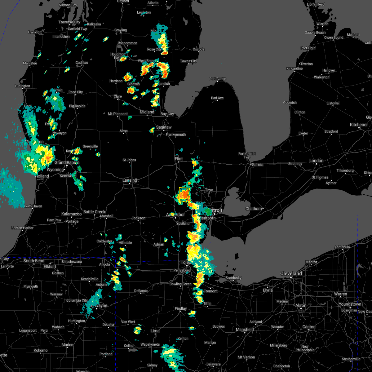 At 210 pm edt, a severe thunderstorm was located over milford, moving northeast at 35 mph (radar indicated). Hazards include 60 mph wind gusts. Expect damage to roofs, siding, and trees. this severe thunderstorm will remain over mainly rural areas of southwestern oakland county, including the following locations, new hudson, white lake and wixom. hail threat, radar indicated max hail size, <. 75 in wind threat, radar indicated max wind gust, 60 mph. At 210 pm edt, a severe thunderstorm was located over milford, moving northeast at 35 mph (radar indicated). Hazards include 60 mph wind gusts. Expect damage to roofs, siding, and trees. this severe thunderstorm will remain over mainly rural areas of southwestern oakland county, including the following locations, new hudson, white lake and wixom. hail threat, radar indicated max hail size, <. 75 in wind threat, radar indicated max wind gust, 60 mph.
|
| 8/9/2021 2:01 PM EDT |
 At 201 pm edt, a severe thunderstorm was located near south lyon, or near milford, moving north at 30 mph (radar indicated). Hazards include 60 mph wind gusts and penny size hail. Expect damage to roofs, siding, and trees. this severe storm will be near, milford around 215 pm edt. other locations impacted by this severe thunderstorm include island lake state recreation area, new hudson, white lake and wixom. hail threat, radar indicated max hail size, 0. 75 in wind threat, radar indicated max wind gust, 60 mph. At 201 pm edt, a severe thunderstorm was located near south lyon, or near milford, moving north at 30 mph (radar indicated). Hazards include 60 mph wind gusts and penny size hail. Expect damage to roofs, siding, and trees. this severe storm will be near, milford around 215 pm edt. other locations impacted by this severe thunderstorm include island lake state recreation area, new hudson, white lake and wixom. hail threat, radar indicated max hail size, 0. 75 in wind threat, radar indicated max wind gust, 60 mph.
|
| 8/9/2021 1:55 PM EDT |
 At 155 pm edt, a severe thunderstorm was located near south lyon, or near brighton, moving north at 30 mph (radar indicated). Hazards include 60 mph wind gusts and penny size hail. Expect damage to roofs, siding, and trees. this severe storm will be near, brighton around 205 pm edt. milford around 215 pm edt. hartland around 220 pm edt. other locations impacted by this severe thunderstorm include island lake state recreation area, chilson, new hudson, lakeland, white lake and wixom. hail threat, radar indicated max hail size, 0. 75 in wind threat, radar indicated max wind gust, 60 mph. At 155 pm edt, a severe thunderstorm was located near south lyon, or near brighton, moving north at 30 mph (radar indicated). Hazards include 60 mph wind gusts and penny size hail. Expect damage to roofs, siding, and trees. this severe storm will be near, brighton around 205 pm edt. milford around 215 pm edt. hartland around 220 pm edt. other locations impacted by this severe thunderstorm include island lake state recreation area, chilson, new hudson, lakeland, white lake and wixom. hail threat, radar indicated max hail size, 0. 75 in wind threat, radar indicated max wind gust, 60 mph.
|
| 8/9/2021 1:49 PM EDT |
 At 149 pm edt, a severe thunderstorm was located over whitmore lake, or 7 miles south of brighton, moving north at 30 mph (radar indicated). Hazards include 60 mph wind gusts and penny size hail. Expect damage to roofs, siding, and trees. this severe thunderstorm will be near, south lyon around 200 pm edt. brighton around 205 pm edt. milford around 215 pm edt. hartland around 220 pm edt. other locations impacted by this severe thunderstorm include lakeland, white lake, island lake state recreation area, chilson, delhi mills, new hudson, barton hills and wixom. hail threat, radar indicated max hail size, 0. 75 in wind threat, radar indicated max wind gust, 60 mph. At 149 pm edt, a severe thunderstorm was located over whitmore lake, or 7 miles south of brighton, moving north at 30 mph (radar indicated). Hazards include 60 mph wind gusts and penny size hail. Expect damage to roofs, siding, and trees. this severe thunderstorm will be near, south lyon around 200 pm edt. brighton around 205 pm edt. milford around 215 pm edt. hartland around 220 pm edt. other locations impacted by this severe thunderstorm include lakeland, white lake, island lake state recreation area, chilson, delhi mills, new hudson, barton hills and wixom. hail threat, radar indicated max hail size, 0. 75 in wind threat, radar indicated max wind gust, 60 mph.
|
| 7/24/2021 8:27 PM EDT |
 At 826 pm edt, severe thunderstorms were located along a line extending from near mount clemens to near livonia to near south lyon, moving southeast at 30 mph (radar indicated). Hazards include 60 mph wind gusts. Expect damage to roofs, siding, and trees. these severe thunderstorms will remain over mainly rural areas of southern oakland county, including the following locations, franklin, keego harbor, waterford, orchard lake, commerce, lathrup village, auburn hills, bingham farms, lake angelus and farmington hills. People attending eddies christmas in july fireworks show, orchard lake fine art show, and kensington marathon should seek safe shelter immediately!. At 826 pm edt, severe thunderstorms were located along a line extending from near mount clemens to near livonia to near south lyon, moving southeast at 30 mph (radar indicated). Hazards include 60 mph wind gusts. Expect damage to roofs, siding, and trees. these severe thunderstorms will remain over mainly rural areas of southern oakland county, including the following locations, franklin, keego harbor, waterford, orchard lake, commerce, lathrup village, auburn hills, bingham farms, lake angelus and farmington hills. People attending eddies christmas in july fireworks show, orchard lake fine art show, and kensington marathon should seek safe shelter immediately!.
|
| 7/24/2021 8:12 PM EDT |
 At 811 pm edt, severe thunderstorms were located along a line extending from near rochester to near west bloomfield to near howell, moving southeast at 20 mph (radar indicated). Hazards include 60 mph wind gusts. Expect damage to roofs, siding, and trees. these severe storms will be near, troy and rochester around 815 pm edt. novi and west bloomfield around 820 pm edt. warren and northville around 830 pm edt. hamburg around 840 pm edt. whitmore lake around 845 pm edt. other locations impacted by these severe thunderstorms include franklin, keego harbor, waterford, orchard lake, plainfield, commerce, pinckney state recreation area, lathrup village, auburn hills and bingham farms. People attending eddies christmas in july fireworks show, orchard lake fine art show, and kensington marathon should seek safe shelter immediately!. At 811 pm edt, severe thunderstorms were located along a line extending from near rochester to near west bloomfield to near howell, moving southeast at 20 mph (radar indicated). Hazards include 60 mph wind gusts. Expect damage to roofs, siding, and trees. these severe storms will be near, troy and rochester around 815 pm edt. novi and west bloomfield around 820 pm edt. warren and northville around 830 pm edt. hamburg around 840 pm edt. whitmore lake around 845 pm edt. other locations impacted by these severe thunderstorms include franklin, keego harbor, waterford, orchard lake, plainfield, commerce, pinckney state recreation area, lathrup village, auburn hills and bingham farms. People attending eddies christmas in july fireworks show, orchard lake fine art show, and kensington marathon should seek safe shelter immediately!.
|
| 7/24/2021 7:58 PM EDT |
 At 757 pm edt, severe thunderstorms were located along a line extending from rochester to near milford to near howell, moving southeast at 40 mph (radar indicated). Hazards include 60 mph wind gusts. Expect damage to roofs, siding, and trees. these severe storms will be near, troy and rochester around 805 pm edt. novi, sterling heights and west bloomfield around 810 pm edt. hamburg and birmingham around 820 pm edt. southfield, royal oak and whitmore lake around 825 pm edt. south lyon and detroit zoo around 830 pm edt. northville around 840 pm edt. other locations impacted by these severe thunderstorms include franklin, keego harbor, waterford, orchard lake, plainfield, commerce, rose center, pinckney state recreation area, lathrup village and auburn hills. People attending eddies christmas in july fireworks show should seek safe shelter immediately!. At 757 pm edt, severe thunderstorms were located along a line extending from rochester to near milford to near howell, moving southeast at 40 mph (radar indicated). Hazards include 60 mph wind gusts. Expect damage to roofs, siding, and trees. these severe storms will be near, troy and rochester around 805 pm edt. novi, sterling heights and west bloomfield around 810 pm edt. hamburg and birmingham around 820 pm edt. southfield, royal oak and whitmore lake around 825 pm edt. south lyon and detroit zoo around 830 pm edt. northville around 840 pm edt. other locations impacted by these severe thunderstorms include franklin, keego harbor, waterford, orchard lake, plainfield, commerce, rose center, pinckney state recreation area, lathrup village and auburn hills. People attending eddies christmas in july fireworks show should seek safe shelter immediately!.
|
| 7/24/2021 7:40 PM EDT |
 At 739 pm edt, a line of severe thunderstorms were located from webberville to lake orion moving southeast at 25 mph (radar indicated). Hazards include 60 mph wind gusts. expect damage to roofs, siding, and trees At 739 pm edt, a line of severe thunderstorms were located from webberville to lake orion moving southeast at 25 mph (radar indicated). Hazards include 60 mph wind gusts. expect damage to roofs, siding, and trees
|
| 7/20/2021 7:28 PM EDT |
 At 727 pm edt, severe thunderstorms were located along a line extending from near south lyon to near west bloomfield to near detroit zoo, moving south at 30 mph (radar indicated). Hazards include 60 mph wind gusts. Expect damage to roofs, siding, and trees. severe thunderstorms will be near, livonia around 735 pm edt. detroit around 740 pm edt. dearborn around 745 pm edt. downtown detroit, canton and belle isle around 750 pm edt. romulus, wyandotte and greenfield village around 800 pm edt. taylor around 805 pm edt. trenton and belleville around 820 pm edt. flat rock and grosse ile around 825 pm edt. Other locations impacted by these severe thunderstorms include franklin, melvindale, gibraltar, new boston, rockwood, farmington hills, harper woods, westland, grosse pointe shores and ecorse. At 727 pm edt, severe thunderstorms were located along a line extending from near south lyon to near west bloomfield to near detroit zoo, moving south at 30 mph (radar indicated). Hazards include 60 mph wind gusts. Expect damage to roofs, siding, and trees. severe thunderstorms will be near, livonia around 735 pm edt. detroit around 740 pm edt. dearborn around 745 pm edt. downtown detroit, canton and belle isle around 750 pm edt. romulus, wyandotte and greenfield village around 800 pm edt. taylor around 805 pm edt. trenton and belleville around 820 pm edt. flat rock and grosse ile around 825 pm edt. Other locations impacted by these severe thunderstorms include franklin, melvindale, gibraltar, new boston, rockwood, farmington hills, harper woods, westland, grosse pointe shores and ecorse.
|
| 7/7/2021 4:40 PM EDT |
 At 440 pm edt, a severe thunderstorm was located near novi, moving east at 30 mph (radar indicated). Hazards include 60 mph wind gusts and quarter size hail. Hail damage to vehicles is expected. expect wind damage to roofs, siding, and trees. this severe storm will be near, west bloomfield around 450 pm edt. birmingham around 505 pm edt. southfield, royal oak and detroit zoo around 510 pm edt. troy around 515 pm edt. Other locations impacted by this severe thunderstorm include franklin, keego harbor, waterford, orchard lake, commerce, lathrup village, auburn hills, bingham farms, lake angelus and farmington hills. At 440 pm edt, a severe thunderstorm was located near novi, moving east at 30 mph (radar indicated). Hazards include 60 mph wind gusts and quarter size hail. Hail damage to vehicles is expected. expect wind damage to roofs, siding, and trees. this severe storm will be near, west bloomfield around 450 pm edt. birmingham around 505 pm edt. southfield, royal oak and detroit zoo around 510 pm edt. troy around 515 pm edt. Other locations impacted by this severe thunderstorm include franklin, keego harbor, waterford, orchard lake, commerce, lathrup village, auburn hills, bingham farms, lake angelus and farmington hills.
|
| 7/7/2021 4:18 PM EDT |
 At 417 pm edt, a severe thunderstorm was located near brighton, moving east at 35 mph (radar indicated). Hazards include 60 mph wind gusts and quarter size hail. Hail damage to vehicles is expected. expect wind damage to roofs, siding, and trees. this severe thunderstorm will be near, south lyon around 425 pm edt. milford around 430 pm edt. northville around 440 pm edt. novi around 445 pm edt. west bloomfield around 450 pm edt. southfield and birmingham around 505 pm edt. troy, royal oak and detroit zoo around 510 pm edt. warren around 515 pm edt. Other locations impacted by this severe thunderstorm include franklin, keego harbor, waterford, orchard lake, commerce, lathrup village, auburn hills, bingham farms, lake angelus and farmington hills. At 417 pm edt, a severe thunderstorm was located near brighton, moving east at 35 mph (radar indicated). Hazards include 60 mph wind gusts and quarter size hail. Hail damage to vehicles is expected. expect wind damage to roofs, siding, and trees. this severe thunderstorm will be near, south lyon around 425 pm edt. milford around 430 pm edt. northville around 440 pm edt. novi around 445 pm edt. west bloomfield around 450 pm edt. southfield and birmingham around 505 pm edt. troy, royal oak and detroit zoo around 510 pm edt. warren around 515 pm edt. Other locations impacted by this severe thunderstorm include franklin, keego harbor, waterford, orchard lake, commerce, lathrup village, auburn hills, bingham farms, lake angelus and farmington hills.
|
| 6/20/2021 10:37 PM EDT |
 At 1037 pm edt, severe thunderstorms were located along a line extending from 6 miles southwest of clarkston to near west bloomfield to detroit zoo, moving northeast at 45 mph (radar indicated). Hazards include 60 mph wind gusts. Expect damage to roofs, siding, and trees. these severe storms will be near, royal oak, birmingham and detroit zoo around 1040 pm edt. warren, troy and clarkston around 1045 pm edt. ortonville around 1050 pm edt. pontiac, oxford and around 1055 pm edt. rochester around 1105 pm edt. Other locations impacted by these severe thunderstorms include franklin, keego harbor, waterford, orchard lake, holly state recreation area, commerce, rose center, lathrup village, auburn hills and bingham farms. At 1037 pm edt, severe thunderstorms were located along a line extending from 6 miles southwest of clarkston to near west bloomfield to detroit zoo, moving northeast at 45 mph (radar indicated). Hazards include 60 mph wind gusts. Expect damage to roofs, siding, and trees. these severe storms will be near, royal oak, birmingham and detroit zoo around 1040 pm edt. warren, troy and clarkston around 1045 pm edt. ortonville around 1050 pm edt. pontiac, oxford and around 1055 pm edt. rochester around 1105 pm edt. Other locations impacted by these severe thunderstorms include franklin, keego harbor, waterford, orchard lake, holly state recreation area, commerce, rose center, lathrup village, auburn hills and bingham farms.
|
| 6/20/2021 10:25 PM EDT |
 At 1024 pm edt, severe thunderstorms were located along a line extending from near whitmore lake to near canton to near greenfield village, moving northeast at 40 mph (radar indicated). Hazards include 60 mph wind gusts. Expect damage to roofs, siding, and trees. severe thunderstorms will be near, detroit zoo around 1040 pm edt. novi around 1045 pm edt. southfield and west bloomfield around 1050 pm edt. royal oak and birmingham around 1055 pm edt. clarkston around 1100 pm edt. troy and pontiac around 1105 pm edt. rochester around 1110 pm edt. oxford around 1115 pm edt. Other locations impacted by these severe thunderstorms include franklin, keego harbor, waterford, orchard lake, holly state recreation area, commerce, rose center, lathrup village, auburn hills and bingham farms. At 1024 pm edt, severe thunderstorms were located along a line extending from near whitmore lake to near canton to near greenfield village, moving northeast at 40 mph (radar indicated). Hazards include 60 mph wind gusts. Expect damage to roofs, siding, and trees. severe thunderstorms will be near, detroit zoo around 1040 pm edt. novi around 1045 pm edt. southfield and west bloomfield around 1050 pm edt. royal oak and birmingham around 1055 pm edt. clarkston around 1100 pm edt. troy and pontiac around 1105 pm edt. rochester around 1110 pm edt. oxford around 1115 pm edt. Other locations impacted by these severe thunderstorms include franklin, keego harbor, waterford, orchard lake, holly state recreation area, commerce, rose center, lathrup village, auburn hills and bingham farms.
|
| 6/26/2020 11:51 PM EDT |
 At 1150 pm edt, severe thunderstorms were located along a line extending from near milford to near canton to milan, moving east at 60 mph (radar indicated). Hazards include 60 mph wind gusts and penny size hail. Expect damage to roofs, siding, and trees. these severe storms will be near, livonia around 1155 pm edt. taylor, romulus, west bloomfield and greenfield village around 1200 am edt. dearborn and birmingham around 1205 am edt. troy, southfield, downtown detroit, detroit, royal oak and detroit zoo around 1210 am edt. warren, flat rock and belle isle around 1215 am edt. grosse pointe, sterling heights, trenton, grosse ile and clinton around 1220 am edt. st. clair shores and mount clemens around 1225 am edt. Other locations impacted by these severe thunderstorms include franklin, melvindale, gibraltar, harper woods, pleasant ridge, westland, grosse pointe shores, huntington woods, wolverine lake and woodhaven. At 1150 pm edt, severe thunderstorms were located along a line extending from near milford to near canton to milan, moving east at 60 mph (radar indicated). Hazards include 60 mph wind gusts and penny size hail. Expect damage to roofs, siding, and trees. these severe storms will be near, livonia around 1155 pm edt. taylor, romulus, west bloomfield and greenfield village around 1200 am edt. dearborn and birmingham around 1205 am edt. troy, southfield, downtown detroit, detroit, royal oak and detroit zoo around 1210 am edt. warren, flat rock and belle isle around 1215 am edt. grosse pointe, sterling heights, trenton, grosse ile and clinton around 1220 am edt. st. clair shores and mount clemens around 1225 am edt. Other locations impacted by these severe thunderstorms include franklin, melvindale, gibraltar, harper woods, pleasant ridge, westland, grosse pointe shores, huntington woods, wolverine lake and woodhaven.
|
| 6/26/2020 11:39 PM EDT |
 The national weather service in detroit/pontiac has issued a * severe thunderstorm warning for. wayne county in southeastern michigan. southern oakland county in southeastern michigan. southern macomb county in southeastern michigan. Until 100 am edt. The national weather service in detroit/pontiac has issued a * severe thunderstorm warning for. wayne county in southeastern michigan. southern oakland county in southeastern michigan. southern macomb county in southeastern michigan. Until 100 am edt.
|
| 6/10/2020 4:52 PM EDT |
 The severe thunderstorm warning for oakland and southeastern genesee counties will expire at 500 pm edt, the storms which prompted the warning have weakened below severe limits. therefore, the warning will be allowed to expire. however gusty winds and heavy rain are still possible with these thunderstorms. a severe thunderstorm watch remains in effect until 800 pm edt for southeastern michigan. remember, a severe thunderstorm warning still remains in effect for central and eastern oakland county. The severe thunderstorm warning for oakland and southeastern genesee counties will expire at 500 pm edt, the storms which prompted the warning have weakened below severe limits. therefore, the warning will be allowed to expire. however gusty winds and heavy rain are still possible with these thunderstorms. a severe thunderstorm watch remains in effect until 800 pm edt for southeastern michigan. remember, a severe thunderstorm warning still remains in effect for central and eastern oakland county.
|
| 6/10/2020 4:38 PM EDT |
 At 437 pm edt, severe thunderstorms were located along a line extending from near hadley to near west bloomfield, moving northeast at 40 mph (radar indicated). Hazards include 70 mph wind gusts. Expect considerable tree damage. damage is likely to mobile homes, roofs, and outbuildings. These severe thunderstorms will remain over mainly rural areas of oakland and southeastern genesee counties, including the following locations, atlas, waterford, davisburg, holly state recreation area, commerce, new hudson, rose center, lake orion, walled lake and lake angelus. At 437 pm edt, severe thunderstorms were located along a line extending from near hadley to near west bloomfield, moving northeast at 40 mph (radar indicated). Hazards include 70 mph wind gusts. Expect considerable tree damage. damage is likely to mobile homes, roofs, and outbuildings. These severe thunderstorms will remain over mainly rural areas of oakland and southeastern genesee counties, including the following locations, atlas, waterford, davisburg, holly state recreation area, commerce, new hudson, rose center, lake orion, walled lake and lake angelus.
|
| 6/10/2020 4:20 PM EDT |
 At 419 pm edt, severe thunderstorms were located along a line extending from lake fenton to south lyon, moving northeast at 40 mph (radar indicated). Hazards include 70 mph wind gusts. Expect considerable tree damage. damage is likely to mobile homes, roofs, and outbuildings. these severe storms will be near, holly and lake fenton around 425 pm edt. grand blanc and goodrich around 430 pm edt. milford and ortonville around 435 pm edt. novi around 440 pm edt. pontiac around 500 pm edt. Other locations impacted by these severe thunderstorms include atlas, waterford, davisburg, holly state recreation area, commerce, new hudson, rose center, lake orion, walled lake and lake angelus. At 419 pm edt, severe thunderstorms were located along a line extending from lake fenton to south lyon, moving northeast at 40 mph (radar indicated). Hazards include 70 mph wind gusts. Expect considerable tree damage. damage is likely to mobile homes, roofs, and outbuildings. these severe storms will be near, holly and lake fenton around 425 pm edt. grand blanc and goodrich around 430 pm edt. milford and ortonville around 435 pm edt. novi around 440 pm edt. pontiac around 500 pm edt. Other locations impacted by these severe thunderstorms include atlas, waterford, davisburg, holly state recreation area, commerce, new hudson, rose center, lake orion, walled lake and lake angelus.
|
| 6/10/2020 4:08 PM EDT |
 At 408 pm edt, severe thunderstorms were located along a line extending from lake fenton to near dexter, moving east at 40 mph (radar indicated). Hazards include 70 mph wind gusts. Expect considerable tree damage. damage is likely to mobile homes, roofs, and outbuildings. these severe storms will be near, holly and lake fenton around 415 pm edt. grand blanc around 420 pm edt. goodrich around 425 pm edt. ortonville around 430 pm edt. novi and oxford around 440 pm edt. Other locations impacted by these severe thunderstorms include atlas, waterford, davisburg, holly state recreation area, commerce, new hudson, rose center, lake orion, walled lake and lake angelus. At 408 pm edt, severe thunderstorms were located along a line extending from lake fenton to near dexter, moving east at 40 mph (radar indicated). Hazards include 70 mph wind gusts. Expect considerable tree damage. damage is likely to mobile homes, roofs, and outbuildings. these severe storms will be near, holly and lake fenton around 415 pm edt. grand blanc around 420 pm edt. goodrich around 425 pm edt. ortonville around 430 pm edt. novi and oxford around 440 pm edt. Other locations impacted by these severe thunderstorms include atlas, waterford, davisburg, holly state recreation area, commerce, new hudson, rose center, lake orion, walled lake and lake angelus.
|
| 6/10/2020 3:46 PM EDT |
 At 346 pm edt, severe thunderstorms were located along a line extending from flint to near hartland to pinckney, moving northeast at 55 mph (radar indicated). Hazards include 70 mph wind gusts. Expect considerable tree damage. damage is likely to mobile homes, roofs, and outbuildings. severe thunderstorms will be near, linden around 350 pm edt. fenton around 355 pm edt. holly and south lyon around 400 pm edt. milford, goodrich and clarkston around 405 pm edt. ortonville around 410 pm edt. novi and oxford around 415 pm edt. pontiac around 425 pm edt. Other locations impacted by these severe thunderstorms include atlas, waterford, davisburg, holly state recreation area, commerce, new hudson, rose center, lake orion, walled lake and lake angelus. At 346 pm edt, severe thunderstorms were located along a line extending from flint to near hartland to pinckney, moving northeast at 55 mph (radar indicated). Hazards include 70 mph wind gusts. Expect considerable tree damage. damage is likely to mobile homes, roofs, and outbuildings. severe thunderstorms will be near, linden around 350 pm edt. fenton around 355 pm edt. holly and south lyon around 400 pm edt. milford, goodrich and clarkston around 405 pm edt. ortonville around 410 pm edt. novi and oxford around 415 pm edt. pontiac around 425 pm edt. Other locations impacted by these severe thunderstorms include atlas, waterford, davisburg, holly state recreation area, commerce, new hudson, rose center, lake orion, walled lake and lake angelus.
|
| 9/13/2019 3:34 PM EDT | Ping Pong Ball sized hail reported 2.8 miles NW of Milford, MI, reported near charms and wixom rds. |
| 9/13/2019 3:27 PM EDT |
 At 327 pm edt, a severe thunderstorm was located near novi, moving northeast at 50 mph (radar indicated). Hazards include 60 mph wind gusts and quarter size hail. Hail damage to vehicles is expected. expect wind damage to roofs, siding, and trees. this severe storm will be near, milford around 330 pm edt. novi around 335 pm edt. west bloomfield around 340 pm edt. pontiac and clarkston around 350 pm edt. oxford and rochester around 400 pm edt. other locations impacted by this severe thunderstorm include franklin, keego harbor, waterford, orchard lake, commerce, lathrup village, auburn hills, bingham farms, lake angelus and farmington hills. People attending troy family daze festival should seek safe shelter immediately!. At 327 pm edt, a severe thunderstorm was located near novi, moving northeast at 50 mph (radar indicated). Hazards include 60 mph wind gusts and quarter size hail. Hail damage to vehicles is expected. expect wind damage to roofs, siding, and trees. this severe storm will be near, milford around 330 pm edt. novi around 335 pm edt. west bloomfield around 340 pm edt. pontiac and clarkston around 350 pm edt. oxford and rochester around 400 pm edt. other locations impacted by this severe thunderstorm include franklin, keego harbor, waterford, orchard lake, commerce, lathrup village, auburn hills, bingham farms, lake angelus and farmington hills. People attending troy family daze festival should seek safe shelter immediately!.
|
| 9/13/2019 3:16 PM EDT |
 The national weather service in detroit/pontiac has issued a * severe thunderstorm warning for. oakland county in southeastern michigan. southeastern livingston county in southeastern michigan. until 415 pm edt. At 316 pm edt, a severe thunderstorm was located near whitmore. The national weather service in detroit/pontiac has issued a * severe thunderstorm warning for. oakland county in southeastern michigan. southeastern livingston county in southeastern michigan. until 415 pm edt. At 316 pm edt, a severe thunderstorm was located near whitmore.
|
| 9/11/2019 2:28 PM EDT |
 At 228 pm edt, a severe thunderstorm was located over salem, or 7 miles southwest of novi, moving northeast at 15 mph (radar indicated). Hazards include 60 mph wind gusts and quarter size hail. Hail damage to vehicles is expected. expect wind damage to roofs, siding, and trees. this severe storm will be near, northville around 255 pm edt. novi around 300 pm edt. Other locations impacted by this severe thunderstorm include plymouth, island lake state recreation area, new hudson, farmington, wixom, farmington hills, walled lake and redford. At 228 pm edt, a severe thunderstorm was located over salem, or 7 miles southwest of novi, moving northeast at 15 mph (radar indicated). Hazards include 60 mph wind gusts and quarter size hail. Hail damage to vehicles is expected. expect wind damage to roofs, siding, and trees. this severe storm will be near, northville around 255 pm edt. novi around 300 pm edt. Other locations impacted by this severe thunderstorm include plymouth, island lake state recreation area, new hudson, farmington, wixom, farmington hills, walled lake and redford.
|
| 9/11/2019 2:13 PM EDT |
 At 213 pm edt, a severe thunderstorm was located near dixboro, or near ann arbor, moving northeast at 15 mph (radar indicated). Hazards include 60 mph wind gusts and quarter size hail. Hail damage to vehicles is expected. expect wind damage to roofs, siding, and trees. this severe thunderstorm will be near, salem around 240 pm edt. south lyon around 250 pm edt. novi and northville around 300 pm edt. Other locations impacted by this severe thunderstorm include plymouth, island lake state recreation area, wolverine lake, new hudson, barton hills, farmington, walled lake, wixom, farmington hills and redford. At 213 pm edt, a severe thunderstorm was located near dixboro, or near ann arbor, moving northeast at 15 mph (radar indicated). Hazards include 60 mph wind gusts and quarter size hail. Hail damage to vehicles is expected. expect wind damage to roofs, siding, and trees. this severe thunderstorm will be near, salem around 240 pm edt. south lyon around 250 pm edt. novi and northville around 300 pm edt. Other locations impacted by this severe thunderstorm include plymouth, island lake state recreation area, wolverine lake, new hudson, barton hills, farmington, walled lake, wixom, farmington hills and redford.
|
| 8/18/2019 7:55 PM EDT |
 A severe thunderstorm warning remains in effect until 845 pm edt for oakland county. at 755 pm edt, a severe thunderstorm was located near milford, moving east at 45 mph. hazard. 60 mph wind gusts. source. Radar indicated. A severe thunderstorm warning remains in effect until 845 pm edt for oakland county. at 755 pm edt, a severe thunderstorm was located near milford, moving east at 45 mph. hazard. 60 mph wind gusts. source. Radar indicated.
|
| 8/18/2019 7:44 PM EDT |
 At 744 pm edt, a severe thunderstorm was located over milford, moving east at 40 mph (radar indicated). Hazards include 60 mph wind gusts. Expect damage to roofs, siding, and trees. this severe thunderstorm will be near, novi around 800 pm edt. west bloomfield around 805 pm edt. southfield, pontiac and birmingham around 815 pm edt. royal oak around 820 pm edt. troy and rochester around 825 pm edt. sterling heights around 835 pm edt. Other locations impacted by this severe thunderstorm include franklin, keego harbor, waterford, orchard lake, commerce, lathrup village, auburn hills, bingham farms, lake angelus and farmington hills. At 744 pm edt, a severe thunderstorm was located over milford, moving east at 40 mph (radar indicated). Hazards include 60 mph wind gusts. Expect damage to roofs, siding, and trees. this severe thunderstorm will be near, novi around 800 pm edt. west bloomfield around 805 pm edt. southfield, pontiac and birmingham around 815 pm edt. royal oak around 820 pm edt. troy and rochester around 825 pm edt. sterling heights around 835 pm edt. Other locations impacted by this severe thunderstorm include franklin, keego harbor, waterford, orchard lake, commerce, lathrup village, auburn hills, bingham farms, lake angelus and farmington hills.
|
| 7/29/2019 3:16 PM EDT |
 At 315 pm edt, severe thunderstorms were located along a line extending from milford to oxford, moving northeast at 35 mph (radar indicated). Hazards include 60 mph wind gusts. Expect damage to roofs, siding, and trees. these severe storms will be near, oxford around 320 pm edt. clarkston around 340 pm edt. pontiac and ortonville around 345 pm edt. Other locations impacted by these severe thunderstorms include lakeville, waterford, davisburg, white lake, holly state recreation area, commerce, leonard, rose center, lake orion and lake angelus. At 315 pm edt, severe thunderstorms were located along a line extending from milford to oxford, moving northeast at 35 mph (radar indicated). Hazards include 60 mph wind gusts. Expect damage to roofs, siding, and trees. these severe storms will be near, oxford around 320 pm edt. clarkston around 340 pm edt. pontiac and ortonville around 345 pm edt. Other locations impacted by these severe thunderstorms include lakeville, waterford, davisburg, white lake, holly state recreation area, commerce, leonard, rose center, lake orion and lake angelus.
|
| 7/29/2019 3:00 PM EDT |
 At 300 pm edt, a severe thunderstorm was located near clarkston, or 9 miles west of pontiac, moving east at 40 mph (radar indicated). Hazards include 60 mph wind gusts and penny size hail. Expect damage to roofs, siding, and trees. this severe storm will be near, pontiac around 310 pm edt. oxford around 320 pm edt. Other locations impacted by this severe thunderstorm include lakeville, waterford, davisburg, white lake, holly state recreation area, commerce, leonard, rose center, lake orion and lake angelus. At 300 pm edt, a severe thunderstorm was located near clarkston, or 9 miles west of pontiac, moving east at 40 mph (radar indicated). Hazards include 60 mph wind gusts and penny size hail. Expect damage to roofs, siding, and trees. this severe storm will be near, pontiac around 310 pm edt. oxford around 320 pm edt. Other locations impacted by this severe thunderstorm include lakeville, waterford, davisburg, white lake, holly state recreation area, commerce, leonard, rose center, lake orion and lake angelus.
|
| 7/29/2019 2:44 PM EDT |
 The national weather service in detroit/pontiac has issued a * severe thunderstorm warning for. oakland county in southeastern michigan. until 345 pm edt. At 244 pm edt, a severe thunderstorm was located near milford, moving east at 20 mph. The national weather service in detroit/pontiac has issued a * severe thunderstorm warning for. oakland county in southeastern michigan. until 345 pm edt. At 244 pm edt, a severe thunderstorm was located near milford, moving east at 20 mph.
|
| 7/28/2019 6:05 PM EDT | Power outages and large branches down in oakland county MI, 5.8 miles S of Milford, MI |
| 7/28/2019 6:03 PM EDT | Large tree down on a house with numerous trees down in the are in oakland county MI, 6.9 miles SW of Milford, MI |
| 7/28/2019 6:00 PM EDT | Large tree about a foot in diameter snapped in oakland county MI, 6.5 miles S of Milford, MI |
| 7/28/2019 5:52 PM EDT |
 At 551 pm edt, a severe thunderstorm was located near holly, moving east at 30 mph (radar indicated). Hazards include 60 mph wind gusts and penny size hail. Expect damage to roofs, siding, and trees. this severe thunderstorm will be near, milford around 600 pm edt. clarkston around 615 pm edt. west bloomfield around 620 pm edt. pontiac around 630 pm edt. birmingham around 640 pm edt. troy, sterling heights, royal oak and rochester around 645 pm edt. other locations impacted by this severe thunderstorm include franklin, keego harbor, waterford, orchard lake, commerce, rose center, lathrup village, auburn hills, bingham farms and lake angelus. People attending hot works orchard lake fine art show should seek safe shelter immediately!. At 551 pm edt, a severe thunderstorm was located near holly, moving east at 30 mph (radar indicated). Hazards include 60 mph wind gusts and penny size hail. Expect damage to roofs, siding, and trees. this severe thunderstorm will be near, milford around 600 pm edt. clarkston around 615 pm edt. west bloomfield around 620 pm edt. pontiac around 630 pm edt. birmingham around 640 pm edt. troy, sterling heights, royal oak and rochester around 645 pm edt. other locations impacted by this severe thunderstorm include franklin, keego harbor, waterford, orchard lake, commerce, rose center, lathrup village, auburn hills, bingham farms and lake angelus. People attending hot works orchard lake fine art show should seek safe shelter immediately!.
|
| 7/20/2019 6:33 PM EDT |
 At 611 pm edt, a severe thunderstorm was located over clarkston, or 9 miles northwest of pontiac, moving east at 35 mph (radar indicated). Hazards include 60 mph wind gusts. Expect damage to roofs, siding, and trees. this severe storm will be near, pontiac around 620 pm edt. oxford around 625 pm edt. rochester around 640 pm edt. other locations impacted by this severe thunderstorm include rochester hills, keego harbor, lakeville, waterford, davisburg, orchard lake, holly state recreation area, commerce, rose center and lake orion. People attending dte energy music theatre should seek safe shelter immediately!. At 611 pm edt, a severe thunderstorm was located over clarkston, or 9 miles northwest of pontiac, moving east at 35 mph (radar indicated). Hazards include 60 mph wind gusts. Expect damage to roofs, siding, and trees. this severe storm will be near, pontiac around 620 pm edt. oxford around 625 pm edt. rochester around 640 pm edt. other locations impacted by this severe thunderstorm include rochester hills, keego harbor, lakeville, waterford, davisburg, orchard lake, holly state recreation area, commerce, rose center and lake orion. People attending dte energy music theatre should seek safe shelter immediately!.
|
| 7/20/2019 6:11 PM EDT |
 At 611 pm edt, a severe thunderstorm was located over clarkston, or 9 miles northwest of pontiac, moving east at 35 mph (radar indicated). Hazards include 60 mph wind gusts. Expect damage to roofs, siding, and trees. this severe storm will be near, pontiac around 620 pm edt. oxford around 625 pm edt. rochester around 640 pm edt. other locations impacted by this severe thunderstorm include rochester hills, keego harbor, lakeville, waterford, davisburg, orchard lake, holly state recreation area, commerce, rose center and lake orion. People attending dte energy music theatre should seek safe shelter immediately!. At 611 pm edt, a severe thunderstorm was located over clarkston, or 9 miles northwest of pontiac, moving east at 35 mph (radar indicated). Hazards include 60 mph wind gusts. Expect damage to roofs, siding, and trees. this severe storm will be near, pontiac around 620 pm edt. oxford around 625 pm edt. rochester around 640 pm edt. other locations impacted by this severe thunderstorm include rochester hills, keego harbor, lakeville, waterford, davisburg, orchard lake, holly state recreation area, commerce, rose center and lake orion. People attending dte energy music theatre should seek safe shelter immediately!.
|
| 7/20/2019 5:57 PM EDT |
 The national weather service in detroit/pontiac has issued a * severe thunderstorm warning for. oakland county in southeastern michigan. until 700 pm edt. At 557 pm edt, a severe thunderstorm was located over holly, moving east at 35 mph. The national weather service in detroit/pontiac has issued a * severe thunderstorm warning for. oakland county in southeastern michigan. until 700 pm edt. At 557 pm edt, a severe thunderstorm was located over holly, moving east at 35 mph.
|
| 7/19/2019 8:07 PM EDT |
 The severe thunderstorm warning for southwestern oakland and southern livingston counties will expire at 815 pm edt, the storm which prompted the warning has weakened, and has exited the warned area. therefore, the warning will be allowed to expire. however gusty winds and heavy rain are still possible with this thunderstorm. The severe thunderstorm warning for southwestern oakland and southern livingston counties will expire at 815 pm edt, the storm which prompted the warning has weakened, and has exited the warned area. therefore, the warning will be allowed to expire. however gusty winds and heavy rain are still possible with this thunderstorm.
|
| 7/19/2019 7:44 PM EDT |
 At 744 pm edt, a severe thunderstorm was located over whitmore lake, or near brighton, moving southeast at 20 mph (public). Hazards include 70 mph wind gusts and penny size hail. Expect considerable tree damage. damage is likely to mobile homes, roofs, and outbuildings. this severe storm will be near, south lyon around 750 pm edt. other locations impacted by this severe thunderstorm include plainfield, island lake state recreation area, commerce, new hudson, walled lake, pinckney state recreation area, farmington hills, lakeland, white lake and chilson. People attending farmington founders festival should seek safe shelter immediately!. At 744 pm edt, a severe thunderstorm was located over whitmore lake, or near brighton, moving southeast at 20 mph (public). Hazards include 70 mph wind gusts and penny size hail. Expect considerable tree damage. damage is likely to mobile homes, roofs, and outbuildings. this severe storm will be near, south lyon around 750 pm edt. other locations impacted by this severe thunderstorm include plainfield, island lake state recreation area, commerce, new hudson, walled lake, pinckney state recreation area, farmington hills, lakeland, white lake and chilson. People attending farmington founders festival should seek safe shelter immediately!.
|
| 7/19/2019 7:40 PM EDT |
 At 734 pm edt, a severe thunderstorm was located near brighton, moving southeast at 30 mph (public). Hazards include 60 mph wind gusts. Expect damage to roofs, siding, and trees. this severe storm will be near, south lyon and whitmore lake around 740 pm edt. other locations impacted by this severe thunderstorm include plainfield, island lake state recreation area, commerce, new hudson, walled lake, pinckney state recreation area, farmington hills, parkers corners, lakeland and white lake. People attending farmington founders festival should seek safe shelter immediately!. At 734 pm edt, a severe thunderstorm was located near brighton, moving southeast at 30 mph (public). Hazards include 60 mph wind gusts. Expect damage to roofs, siding, and trees. this severe storm will be near, south lyon and whitmore lake around 740 pm edt. other locations impacted by this severe thunderstorm include plainfield, island lake state recreation area, commerce, new hudson, walled lake, pinckney state recreation area, farmington hills, parkers corners, lakeland and white lake. People attending farmington founders festival should seek safe shelter immediately!.
|
| 7/19/2019 7:20 PM EDT |
 At 658 pm edt, a severe thunderstorm was located over hartland, moving southeast at 25 mph (radar indicated). Hazards include 60 mph wind gusts and penny size hail. Expect damage to roofs, siding, and trees. this severe thunderstorm will be near, milford around 720 pm edt. south lyon around 725 pm edt. novi and west bloomfield around 745 pm edt. northville around 750 pm edt. southfield around 810 pm edt. detroit zoo around 815 pm edt. other locations impacted by this severe thunderstorm include franklin, keego harbor, orchard lake, plainfield, commerce, rose center, pinckney state recreation area, conway township, lathrup village and bingham farms. People attending farmington founders festival, and festival of hope should seek safe shelter immediately!. At 658 pm edt, a severe thunderstorm was located over hartland, moving southeast at 25 mph (radar indicated). Hazards include 60 mph wind gusts and penny size hail. Expect damage to roofs, siding, and trees. this severe thunderstorm will be near, milford around 720 pm edt. south lyon around 725 pm edt. novi and west bloomfield around 745 pm edt. northville around 750 pm edt. southfield around 810 pm edt. detroit zoo around 815 pm edt. other locations impacted by this severe thunderstorm include franklin, keego harbor, orchard lake, plainfield, commerce, rose center, pinckney state recreation area, conway township, lathrup village and bingham farms. People attending farmington founders festival, and festival of hope should seek safe shelter immediately!.
|
| 7/19/2019 6:58 PM EDT |
 At 658 pm edt, a severe thunderstorm was located over hartland, moving southeast at 25 mph (radar indicated). Hazards include 60 mph wind gusts and penny size hail. Expect damage to roofs, siding, and trees. this severe thunderstorm will be near, milford around 720 pm edt. south lyon around 725 pm edt. novi and west bloomfield around 745 pm edt. northville around 750 pm edt. southfield around 810 pm edt. detroit zoo around 815 pm edt. other locations impacted by this severe thunderstorm include franklin, keego harbor, orchard lake, plainfield, commerce, rose center, pinckney state recreation area, conway township, lathrup village and bingham farms. People attending farmington founders festival, and festival of hope should seek safe shelter immediately!. At 658 pm edt, a severe thunderstorm was located over hartland, moving southeast at 25 mph (radar indicated). Hazards include 60 mph wind gusts and penny size hail. Expect damage to roofs, siding, and trees. this severe thunderstorm will be near, milford around 720 pm edt. south lyon around 725 pm edt. novi and west bloomfield around 745 pm edt. northville around 750 pm edt. southfield around 810 pm edt. detroit zoo around 815 pm edt. other locations impacted by this severe thunderstorm include franklin, keego harbor, orchard lake, plainfield, commerce, rose center, pinckney state recreation area, conway township, lathrup village and bingham farms. People attending farmington founders festival, and festival of hope should seek safe shelter immediately!.
|
| 6/1/2019 2:09 PM EDT |
 At 159 pm edt, a severe thunderstorm was located near brighton, moving east at 35 mph (radar indicated). Hazards include 60 mph wind gusts and quarter size hail. Hail damage to vehicles is expected. expect wind damage to roofs, siding, and trees. this severe storm will be near, milford around 210 pm edt. novi around 220 pm edt. other locations impacted by this severe thunderstorm include davisburg, white lake, island lake state recreation area, commerce, wolverine lake, new hudson, rose center, walled lake, wixom and farmington. People attending lyon township kite festival should seek safe shelter immediately!. At 159 pm edt, a severe thunderstorm was located near brighton, moving east at 35 mph (radar indicated). Hazards include 60 mph wind gusts and quarter size hail. Hail damage to vehicles is expected. expect wind damage to roofs, siding, and trees. this severe storm will be near, milford around 210 pm edt. novi around 220 pm edt. other locations impacted by this severe thunderstorm include davisburg, white lake, island lake state recreation area, commerce, wolverine lake, new hudson, rose center, walled lake, wixom and farmington. People attending lyon township kite festival should seek safe shelter immediately!.
|
| 6/1/2019 1:59 PM EDT |
 At 159 pm edt, a severe thunderstorm was located near brighton, moving east at 35 mph (radar indicated). Hazards include 60 mph wind gusts and quarter size hail. Hail damage to vehicles is expected. expect wind damage to roofs, siding, and trees. this severe storm will be near, milford around 210 pm edt. novi around 220 pm edt. other locations impacted by this severe thunderstorm include davisburg, white lake, island lake state recreation area, commerce, wolverine lake, new hudson, rose center, walled lake, wixom and farmington. People attending lyon township kite festival should seek safe shelter immediately!. At 159 pm edt, a severe thunderstorm was located near brighton, moving east at 35 mph (radar indicated). Hazards include 60 mph wind gusts and quarter size hail. Hail damage to vehicles is expected. expect wind damage to roofs, siding, and trees. this severe storm will be near, milford around 210 pm edt. novi around 220 pm edt. other locations impacted by this severe thunderstorm include davisburg, white lake, island lake state recreation area, commerce, wolverine lake, new hudson, rose center, walled lake, wixom and farmington. People attending lyon township kite festival should seek safe shelter immediately!.
|
| 6/1/2019 1:45 PM EDT |
 At 144 pm edt, a severe thunderstorm was located near pinckney, moving east at 35 mph (radar indicated). Hazards include 60 mph wind gusts and quarter size hail. Hail damage to vehicles is expected. expect wind damage to roofs, siding, and trees. this severe thunderstorm will be near, hamburg around 150 pm edt. brighton and whitmore lake around 155 pm edt. hartland around 200 pm edt. south lyon around 205 pm edt. milford around 210 pm edt. novi around 225 pm edt. other locations impacted by this severe thunderstorm include davisburg, island lake state recreation area, commerce, new hudson, rose center, walled lake, lakeland, white lake, chilson and wolverine lake. People attending pinckney art in the park, and lyon township kite festival should seek safe shelter immediately!. At 144 pm edt, a severe thunderstorm was located near pinckney, moving east at 35 mph (radar indicated). Hazards include 60 mph wind gusts and quarter size hail. Hail damage to vehicles is expected. expect wind damage to roofs, siding, and trees. this severe thunderstorm will be near, hamburg around 150 pm edt. brighton and whitmore lake around 155 pm edt. hartland around 200 pm edt. south lyon around 205 pm edt. milford around 210 pm edt. novi around 225 pm edt. other locations impacted by this severe thunderstorm include davisburg, island lake state recreation area, commerce, new hudson, rose center, walled lake, lakeland, white lake, chilson and wolverine lake. People attending pinckney art in the park, and lyon township kite festival should seek safe shelter immediately!.
|
| 3/14/2019 8:45 PM EDT |
 At 845 pm edt, a severe thunderstorm was located over novi, moving northeast at 40 mph (radar indicated). Hazards include 60 mph wind gusts. Expect damage to roofs, siding, and trees. this severe storm will be near, southfield, birmingham and west bloomfield around 900 pm edt. Other locations impacted by this severe thunderstorm include franklin, keego harbor, orchard lake, commerce, lathrup village, bingham farms, farmington hills, pleasant ridge, huntington woods and wolverine lake. At 845 pm edt, a severe thunderstorm was located over novi, moving northeast at 40 mph (radar indicated). Hazards include 60 mph wind gusts. Expect damage to roofs, siding, and trees. this severe storm will be near, southfield, birmingham and west bloomfield around 900 pm edt. Other locations impacted by this severe thunderstorm include franklin, keego harbor, orchard lake, commerce, lathrup village, bingham farms, farmington hills, pleasant ridge, huntington woods and wolverine lake.
|
| 3/14/2019 8:33 PM EDT | Quarter sized hail reported 0.3 miles SSW of Milford, MI |
| 3/14/2019 8:11 PM EDT |
 At 810 pm edt, a severe thunderstorm was located near novi, moving northeast at 50 mph (radar indicated). Hazards include 60 mph wind gusts and quarter size hail. Hail damage to vehicles is expected. expect wind damage to roofs, siding, and trees. this severe thunderstorm will be near, west bloomfield around 820 pm edt. troy and pontiac around 830 pm edt. Other locations impacted by this severe thunderstorm include franklin, keego harbor, orchard lake, commerce, lathrup village, bingham farms, farmington hills, pleasant ridge, huntington woods and wolverine lake. At 810 pm edt, a severe thunderstorm was located near novi, moving northeast at 50 mph (radar indicated). Hazards include 60 mph wind gusts and quarter size hail. Hail damage to vehicles is expected. expect wind damage to roofs, siding, and trees. this severe thunderstorm will be near, west bloomfield around 820 pm edt. troy and pontiac around 830 pm edt. Other locations impacted by this severe thunderstorm include franklin, keego harbor, orchard lake, commerce, lathrup village, bingham farms, farmington hills, pleasant ridge, huntington woods and wolverine lake.
|
| 10/20/2018 2:19 PM EDT |
 At 218 pm edt, a severe thunderstorm was located near rochester, or near romeo, moving east at 40 mph (radar indicated). Hazards include 60 mph wind gusts. Expect damage to roofs, siding, and trees. This severe thunderstorm will remain over mainly rural areas of southern lapeer, oakland, northwestern macomb and southeastern genesee counties, including the following locations, franklin, keego harbor, waterford, orchard lake, holly state recreation area, commerce, rose center, lathrup village, auburn hills and bingham farms. At 218 pm edt, a severe thunderstorm was located near rochester, or near romeo, moving east at 40 mph (radar indicated). Hazards include 60 mph wind gusts. Expect damage to roofs, siding, and trees. This severe thunderstorm will remain over mainly rural areas of southern lapeer, oakland, northwestern macomb and southeastern genesee counties, including the following locations, franklin, keego harbor, waterford, orchard lake, holly state recreation area, commerce, rose center, lathrup village, auburn hills and bingham farms.
|
| 10/20/2018 1:56 PM EDT |
 At 156 pm edt, a severe thunderstorm was located near west bloomfield, or near pontiac, moving east at 45 mph (radar indicated). Hazards include 60 mph wind gusts. Expect damage to roofs, siding, and trees. this severe storm will be near, pontiac around 205 pm edt. birmingham around 210 pm edt. troy, southfield, royal oak and rochester around 215 pm edt. Other locations impacted by this severe thunderstorm include franklin, keego harbor, waterford, orchard lake, rankin, holly state recreation area, commerce, rose center, lathrup village and auburn hills. At 156 pm edt, a severe thunderstorm was located near west bloomfield, or near pontiac, moving east at 45 mph (radar indicated). Hazards include 60 mph wind gusts. Expect damage to roofs, siding, and trees. this severe storm will be near, pontiac around 205 pm edt. birmingham around 210 pm edt. troy, southfield, royal oak and rochester around 215 pm edt. Other locations impacted by this severe thunderstorm include franklin, keego harbor, waterford, orchard lake, rankin, holly state recreation area, commerce, rose center, lathrup village and auburn hills.
|
| 10/20/2018 1:39 PM EDT |
 At 139 pm edt, a severe thunderstorm was located near hartland, moving east at 45 mph (radar indicated). Hazards include 60 mph wind gusts. Expect damage to roofs, siding, and trees. this severe thunderstorm will be near, clarkston around 155 pm edt. west bloomfield around 200 pm edt. pontiac around 205 pm edt. birmingham around 210 pm edt. troy, southfield, royal oak and rochester around 215 pm edt. Other locations impacted by this severe thunderstorm include franklin, keego harbor, waterford, orchard lake, rankin, holly state recreation area, commerce, rose center, lathrup village and auburn hills. At 139 pm edt, a severe thunderstorm was located near hartland, moving east at 45 mph (radar indicated). Hazards include 60 mph wind gusts. Expect damage to roofs, siding, and trees. this severe thunderstorm will be near, clarkston around 155 pm edt. west bloomfield around 200 pm edt. pontiac around 205 pm edt. birmingham around 210 pm edt. troy, southfield, royal oak and rochester around 215 pm edt. Other locations impacted by this severe thunderstorm include franklin, keego harbor, waterford, orchard lake, rankin, holly state recreation area, commerce, rose center, lathrup village and auburn hills.
|
| 9/5/2018 8:14 PM EDT |
 At 814 pm edt, a severe thunderstorm was located near holly, moving east at 40 mph (radar indicated). Hazards include 60 mph wind gusts and nickel size hail. Expect damage to roofs, siding, and trees. this severe storm will be near, ortonville and clarkston around 825 pm edt. Other locations impacted by this severe thunderstorm include keego harbor, waterford, davisburg, white lake, holly state recreation area, rose center, sylvan lake, lake angelus, auburn hills and bloomfield township. At 814 pm edt, a severe thunderstorm was located near holly, moving east at 40 mph (radar indicated). Hazards include 60 mph wind gusts and nickel size hail. Expect damage to roofs, siding, and trees. this severe storm will be near, ortonville and clarkston around 825 pm edt. Other locations impacted by this severe thunderstorm include keego harbor, waterford, davisburg, white lake, holly state recreation area, rose center, sylvan lake, lake angelus, auburn hills and bloomfield township.
|
| 9/5/2018 8:03 PM EDT |
 At 803 pm edt, a severe thunderstorm was located near hartland, moving east at 40 mph (radar indicated). Hazards include 60 mph wind gusts and nickel size hail. Expect damage to roofs, siding, and trees. this severe storm will be near, holly around 815 pm edt. ortonville and clarkston around 825 pm edt. pontiac around 835 pm edt. Other locations impacted by this severe thunderstorm include keego harbor, waterford, davisburg, holly state recreation area, rose center, sylvan lake, argentine, lake angelus, white lake and tyrone township. At 803 pm edt, a severe thunderstorm was located near hartland, moving east at 40 mph (radar indicated). Hazards include 60 mph wind gusts and nickel size hail. Expect damage to roofs, siding, and trees. this severe storm will be near, holly around 815 pm edt. ortonville and clarkston around 825 pm edt. pontiac around 835 pm edt. Other locations impacted by this severe thunderstorm include keego harbor, waterford, davisburg, holly state recreation area, rose center, sylvan lake, argentine, lake angelus, white lake and tyrone township.
|
| 9/5/2018 7:57 PM EDT |
 At 757 pm edt, a severe thunderstorm was located over hartland, moving east at 40 mph (radar indicated). Hazards include 60 mph wind gusts. Expect damage to roofs, siding, and trees. this severe thunderstorm will be near, holly around 815 pm edt. ortonville and clarkston around 825 pm edt. pontiac around 835 pm edt. Other locations impacted by this severe thunderstorm include keego harbor, waterford, davisburg, holly state recreation area, rose center, sylvan lake, argentine, lake angelus, white lake and tyrone township. At 757 pm edt, a severe thunderstorm was located over hartland, moving east at 40 mph (radar indicated). Hazards include 60 mph wind gusts. Expect damage to roofs, siding, and trees. this severe thunderstorm will be near, holly around 815 pm edt. ortonville and clarkston around 825 pm edt. pontiac around 835 pm edt. Other locations impacted by this severe thunderstorm include keego harbor, waterford, davisburg, holly state recreation area, rose center, sylvan lake, argentine, lake angelus, white lake and tyrone township.
|
| 7/16/2018 9:42 PM EDT |
 At 942 pm edt, severe thunderstorms were located along a line extending from near pontiac to northville, moving southeast at 25 mph (radar indicated). Hazards include 60 mph wind gusts. Expect damage to roofs, siding, and trees. these severe storms will be near, birmingham around 950 pm edt. troy around 955 pm edt. southfield and royal oak around 1000 pm edt. warren and detroit zoo around 1005 pm edt. Other locations impacted by these severe thunderstorms include franklin, keego harbor, waterford, orchard lake, commerce, lathrup village, auburn hills, bingham farms, farmington hills and pleasant ridge. At 942 pm edt, severe thunderstorms were located along a line extending from near pontiac to northville, moving southeast at 25 mph (radar indicated). Hazards include 60 mph wind gusts. Expect damage to roofs, siding, and trees. these severe storms will be near, birmingham around 950 pm edt. troy around 955 pm edt. southfield and royal oak around 1000 pm edt. warren and detroit zoo around 1005 pm edt. Other locations impacted by these severe thunderstorms include franklin, keego harbor, waterford, orchard lake, commerce, lathrup village, auburn hills, bingham farms, farmington hills and pleasant ridge.
|
| 7/16/2018 9:29 PM EDT |
 At 929 pm edt, severe thunderstorms were located along a line extending from near pontiac to near south lyon, moving southeast at 25 mph (radar indicated). Hazards include 60 mph wind gusts. Expect damage to roofs, siding, and trees. these severe storms will be near, pontiac and west bloomfield around 935 pm edt. novi around 940 pm edt. birmingham around 950 pm edt. troy and southfield around 955 pm edt. royal oak around 1000 pm edt. warren and detroit zoo around 1005 pm edt. Other locations impacted by these severe thunderstorms include franklin, keego harbor, waterford, orchard lake, commerce, lathrup village, auburn hills, bingham farms, lake angelus and farmington hills. At 929 pm edt, severe thunderstorms were located along a line extending from near pontiac to near south lyon, moving southeast at 25 mph (radar indicated). Hazards include 60 mph wind gusts. Expect damage to roofs, siding, and trees. these severe storms will be near, pontiac and west bloomfield around 935 pm edt. novi around 940 pm edt. birmingham around 950 pm edt. troy and southfield around 955 pm edt. royal oak around 1000 pm edt. warren and detroit zoo around 1005 pm edt. Other locations impacted by these severe thunderstorms include franklin, keego harbor, waterford, orchard lake, commerce, lathrup village, auburn hills, bingham farms, lake angelus and farmington hills.
|
| 7/16/2018 9:24 PM EDT |
 At 924 pm edt, severe thunderstorms were located along a line extending from near clarkston to near milford, moving southeast at 25 mph (radar indicated). Hazards include 60 mph wind gusts. Expect damage to roofs, siding, and trees. these severe storms will be near, pontiac around 935 pm edt. novi around 940 pm edt. rochester around 950 pm edt. troy and birmingham around 955 pm edt. southfield and royal oak around 1000 pm edt. warren and detroit zoo around 1010 pm edt. Other locations impacted by these severe thunderstorms include franklin, keego harbor, waterford, orchard lake, holly state recreation area, commerce, rose center, lathrup village, auburn hills and bingham farms. At 924 pm edt, severe thunderstorms were located along a line extending from near clarkston to near milford, moving southeast at 25 mph (radar indicated). Hazards include 60 mph wind gusts. Expect damage to roofs, siding, and trees. these severe storms will be near, pontiac around 935 pm edt. novi around 940 pm edt. rochester around 950 pm edt. troy and birmingham around 955 pm edt. southfield and royal oak around 1000 pm edt. warren and detroit zoo around 1010 pm edt. Other locations impacted by these severe thunderstorms include franklin, keego harbor, waterford, orchard lake, holly state recreation area, commerce, rose center, lathrup village, auburn hills and bingham farms.
|
| 7/16/2018 9:20 PM EDT | Estimated 50-60 mph wind gus in oakland county MI, 5.2 miles SW of Milford, MI |
| 7/16/2018 9:13 PM EDT |
 At 913 pm edt, severe thunderstorms were located along a line extending from clarkston to near milford, moving southeast at 25 mph (radar indicated). Hazards include 60 mph wind gusts. Expect damage to roofs, siding, and trees. severe thunderstorms will be near, pontiac around 935 pm edt. novi around 940 pm edt. birmingham around 950 pm edt. troy around 955 pm edt. southfield and royal oak around 1000 pm edt. warren and detroit zoo around 1005 pm edt. Other locations impacted by these severe thunderstorms include franklin, keego harbor, waterford, orchard lake, holly state recreation area, commerce, rose center, lathrup village, auburn hills and bingham farms. At 913 pm edt, severe thunderstorms were located along a line extending from clarkston to near milford, moving southeast at 25 mph (radar indicated). Hazards include 60 mph wind gusts. Expect damage to roofs, siding, and trees. severe thunderstorms will be near, pontiac around 935 pm edt. novi around 940 pm edt. birmingham around 950 pm edt. troy around 955 pm edt. southfield and royal oak around 1000 pm edt. warren and detroit zoo around 1005 pm edt. Other locations impacted by these severe thunderstorms include franklin, keego harbor, waterford, orchard lake, holly state recreation area, commerce, rose center, lathrup village, auburn hills and bingham farms.
|
| 7/16/2018 4:22 PM EDT |
 At 421 pm edt, severe thunderstorms were located along a line extending from near rochester to near milford, moving east at 25 mph (radar indicated). Hazards include 60 mph wind gusts and nickel size hail. Expect damage to roofs, siding, and trees. these severe storms will be near, rochester around 425 pm edt. sterling heights around 440 pm edt. west bloomfield around 450 pm edt. troy, royal oak and birmingham around 515 pm edt. other locations impacted by these severe thunderstorms include keego harbor, waterford, orchard lake, commerce, rose center, auburn hills, lake angelus, white lake, leonard and wolverine lake. Another strong thunderstorm near hartland may become severe as well as it tracks east. At 421 pm edt, severe thunderstorms were located along a line extending from near rochester to near milford, moving east at 25 mph (radar indicated). Hazards include 60 mph wind gusts and nickel size hail. Expect damage to roofs, siding, and trees. these severe storms will be near, rochester around 425 pm edt. sterling heights around 440 pm edt. west bloomfield around 450 pm edt. troy, royal oak and birmingham around 515 pm edt. other locations impacted by these severe thunderstorms include keego harbor, waterford, orchard lake, commerce, rose center, auburn hills, lake angelus, white lake, leonard and wolverine lake. Another strong thunderstorm near hartland may become severe as well as it tracks east.
|
| 7/16/2018 4:01 PM EDT |
 At 400 pm edt, a severe thunderstorm was located near hartland, moving east at 25 mph (radar indicated). Hazards include 60 mph wind gusts and penny size hail. Expect damage to roofs, siding, and trees. this severe thunderstorm will be near, holly around 410 pm edt. milford around 415 pm edt. clarkston around 435 pm edt. west bloomfield around 445 pm edt. pontiac around 455 pm edt. birmingham around 505 pm edt. troy, sterling heights and rochester around 515 pm edt. other locations impacted by this severe thunderstorm include keego harbor, waterford, orchard lake, commerce, rose center, auburn hills, lake angelus, white lake, leonard and wolverine lake. Another strong storm north of rochester may also become severe. At 400 pm edt, a severe thunderstorm was located near hartland, moving east at 25 mph (radar indicated). Hazards include 60 mph wind gusts and penny size hail. Expect damage to roofs, siding, and trees. this severe thunderstorm will be near, holly around 410 pm edt. milford around 415 pm edt. clarkston around 435 pm edt. west bloomfield around 445 pm edt. pontiac around 455 pm edt. birmingham around 505 pm edt. troy, sterling heights and rochester around 515 pm edt. other locations impacted by this severe thunderstorm include keego harbor, waterford, orchard lake, commerce, rose center, auburn hills, lake angelus, white lake, leonard and wolverine lake. Another strong storm north of rochester may also become severe.
|
| 9/4/2017 5:33 PM EDT |
 At 533 pm edt, severe thunderstorms were located along a line extending from near west bloomfield to near whitmore lake to near manchester, moving east at 50 mph (radar indicated). Hazards include 60 mph wind gusts and quarter size hail. Hail damage to vehicles is expected. expect wind damage to roofs, siding, and trees. these severe storms will be near, salem around 540 pm edt. ann arbor and saline around 550 pm edt. ypsilanti and dixboro around 600 pm edt. other locations impacted by these severe thunderstorms include ann arbor, saline, chelsea, dexter, milford, ypsilanti, manchester, south lyon, hamburg and salem. People attending arts, beats and eats, washtenaw farm council grounds, and michigan state fair should seek safe shelter immediately!. At 533 pm edt, severe thunderstorms were located along a line extending from near west bloomfield to near whitmore lake to near manchester, moving east at 50 mph (radar indicated). Hazards include 60 mph wind gusts and quarter size hail. Hail damage to vehicles is expected. expect wind damage to roofs, siding, and trees. these severe storms will be near, salem around 540 pm edt. ann arbor and saline around 550 pm edt. ypsilanti and dixboro around 600 pm edt. other locations impacted by these severe thunderstorms include ann arbor, saline, chelsea, dexter, milford, ypsilanti, manchester, south lyon, hamburg and salem. People attending arts, beats and eats, washtenaw farm council grounds, and michigan state fair should seek safe shelter immediately!.
|
| 9/4/2017 5:30 PM EDT | Report of power pole blown over and 3 inch tree limbs down in oakland county MI, 2.8 miles NW of Milford, MI |
| 9/4/2017 5:23 PM EDT |
 At 522 pm edt, severe thunderstorms were located along a line extending from near pinckney to near grass lake to 7 miles northeast of hillsdale, moving east at 45 mph (radar indicated). Hazards include 60 mph wind gusts and penny size hail. Expect damage to roofs, siding, and trees. severe thunderstorms will be near, dexter and pinckney around 530 pm edt. manchester and hamburg around 535 pm edt. whitmore lake around 540 pm edt. south lyon around 545 pm edt. ann arbor, saline and salem around 550 pm edt. novi around 600 pm edt. ypsilanti and willis around 605 pm edt. milan around 620 pm edt. other locations impacted by these severe thunderstorms include pinckney, ann arbor, saline, chelsea, dexter, brighton, milford, ypsilanti, manchester and south lyon. People attending arts, beats and eats, washtenaw farm council grounds, and michigan state fair should seek safe shelter immediately!. At 522 pm edt, severe thunderstorms were located along a line extending from near pinckney to near grass lake to 7 miles northeast of hillsdale, moving east at 45 mph (radar indicated). Hazards include 60 mph wind gusts and penny size hail. Expect damage to roofs, siding, and trees. severe thunderstorms will be near, dexter and pinckney around 530 pm edt. manchester and hamburg around 535 pm edt. whitmore lake around 540 pm edt. south lyon around 545 pm edt. ann arbor, saline and salem around 550 pm edt. novi around 600 pm edt. ypsilanti and willis around 605 pm edt. milan around 620 pm edt. other locations impacted by these severe thunderstorms include pinckney, ann arbor, saline, chelsea, dexter, brighton, milford, ypsilanti, manchester and south lyon. People attending arts, beats and eats, washtenaw farm council grounds, and michigan state fair should seek safe shelter immediately!.
|
| 8/11/2017 2:12 PM EDT |
 At 211 pm edt, severe thunderstorms were located along a line extending from near rochester to 6 miles north of milford, moving east at 20 mph (radar indicated). Hazards include 60 mph wind gusts and quarter size hail. Hail damage to vehicles is expected. expect wind damage to roofs, siding, and trees. severe thunderstorms will be near, romeo and clarkston around 230 pm edt. pontiac around 250 pm edt. richmond around 305 pm edt. new baltimore around 310 pm edt. troy around 315 pm edt. rochester around 320 pm edt. sterling heights, clinton and macomb township around 330 pm edt. other locations impacted by these severe thunderstorms include mount clemens, new baltimore, holly, oxford, milford, pontiac, romeo, troy, richmond and armada. People attending milford memories should seek safe shelter immediately!. At 211 pm edt, severe thunderstorms were located along a line extending from near rochester to 6 miles north of milford, moving east at 20 mph (radar indicated). Hazards include 60 mph wind gusts and quarter size hail. Hail damage to vehicles is expected. expect wind damage to roofs, siding, and trees. severe thunderstorms will be near, romeo and clarkston around 230 pm edt. pontiac around 250 pm edt. richmond around 305 pm edt. new baltimore around 310 pm edt. troy around 315 pm edt. rochester around 320 pm edt. sterling heights, clinton and macomb township around 330 pm edt. other locations impacted by these severe thunderstorms include mount clemens, new baltimore, holly, oxford, milford, pontiac, romeo, troy, richmond and armada. People attending milford memories should seek safe shelter immediately!.
|
| 7/7/2017 1:43 AM EDT |
 At 143 am edt, a severe thunderstorm was located near oxford, moving southeast at 40 mph (radar indicated). Hazards include 60 mph wind gusts and penny size hail. Expect damage to roofs, siding, and trees. this severe storm will be near, pontiac around 150 am edt. rochester around 200 am edt. troy around 205 am edt. Other locations impacted by this severe thunderstorm include southfield, holly, oxford, pontiac, troy, ortonville, rochester, royal oak, birmingham and clarkston. At 143 am edt, a severe thunderstorm was located near oxford, moving southeast at 40 mph (radar indicated). Hazards include 60 mph wind gusts and penny size hail. Expect damage to roofs, siding, and trees. this severe storm will be near, pontiac around 150 am edt. rochester around 200 am edt. troy around 205 am edt. Other locations impacted by this severe thunderstorm include southfield, holly, oxford, pontiac, troy, ortonville, rochester, royal oak, birmingham and clarkston.
|
| 7/7/2017 1:24 AM EDT |
 At 123 am edt, a severe thunderstorm was located over goodrich, or near grand blanc, moving southeast at 40 mph (radar indicated). Hazards include 60 mph wind gusts and penny size hail. Expect damage to roofs, siding, and trees. this severe thunderstorm will be near, ortonville around 130 am edt. oxford around 140 am edt. pontiac around 150 am edt. rochester around 200 am edt. troy around 205 am edt. Other locations impacted by this severe thunderstorm include southfield, pontiac, troy, grand blanc, holly, oxford, milford, ortonville, rochester and hadley. At 123 am edt, a severe thunderstorm was located over goodrich, or near grand blanc, moving southeast at 40 mph (radar indicated). Hazards include 60 mph wind gusts and penny size hail. Expect damage to roofs, siding, and trees. this severe thunderstorm will be near, ortonville around 130 am edt. oxford around 140 am edt. pontiac around 150 am edt. rochester around 200 am edt. troy around 205 am edt. Other locations impacted by this severe thunderstorm include southfield, pontiac, troy, grand blanc, holly, oxford, milford, ortonville, rochester and hadley.
|
| 6/22/2017 8:35 PM EDT |
 At 834 pm edt, a severe thunderstorm was located near west bloomfield, or near novi, moving northeast at 35 mph (radar indicated). Hazards include 60 mph wind gusts. Expect damage to roofs, siding, and trees. this severe thunderstorm will be near, pontiac around 900 pm edt. rochester around 910 pm edt. Other locations impacted by this severe thunderstorm include southfield, oxford, pontiac, troy, novi, ortonville, rochester, royal oak, birmingham and clarkston. At 834 pm edt, a severe thunderstorm was located near west bloomfield, or near novi, moving northeast at 35 mph (radar indicated). Hazards include 60 mph wind gusts. Expect damage to roofs, siding, and trees. this severe thunderstorm will be near, pontiac around 900 pm edt. rochester around 910 pm edt. Other locations impacted by this severe thunderstorm include southfield, oxford, pontiac, troy, novi, ortonville, rochester, royal oak, birmingham and clarkston.
|
| 11/18/2016 7:58 PM EST |
 At 757 pm est, severe thunderstorms were located along a line extending from beecher to near holly to near south lyon, moving northeast at 70 mph (radar indicated). Hazards include 60 mph wind gusts. Expect damage to roofs. siding. and trees. these severe storms will be near, hadley and otisville around 805 pm est. pontiac, metamora, otter lake and clarkston around 810 pm est. lapeer and oxford around 815 pm est. lum around 820 pm est. dryden around 825 pm est. Other locations impacted by these severe thunderstorms include clio, new lothrop, holly, lapeer, grand blanc, milford, flushing, north branch, flint and columbiaville. At 757 pm est, severe thunderstorms were located along a line extending from beecher to near holly to near south lyon, moving northeast at 70 mph (radar indicated). Hazards include 60 mph wind gusts. Expect damage to roofs. siding. and trees. these severe storms will be near, hadley and otisville around 805 pm est. pontiac, metamora, otter lake and clarkston around 810 pm est. lapeer and oxford around 815 pm est. lum around 820 pm est. dryden around 825 pm est. Other locations impacted by these severe thunderstorms include clio, new lothrop, holly, lapeer, grand blanc, milford, flushing, north branch, flint and columbiaville.
|
| 11/18/2016 7:45 PM EST |
 At 744 pm est, severe thunderstorms were located along a line extending from byron to near brighton to near ann arbor, moving northeast at 75 mph (radar indicated). Hazards include 60 mph wind gusts. Expect damage to roofs. siding. and trees. severe thunderstorms will be near, linden around 750 pm est. milford and lake fenton around 755 pm est. grand blanc around 800 pm est. davison, burton, goodrich and clarkston around 805 pm est. pontiac and hadley around 810 pm est. lapeer around 815 pm est. lum around 825 pm est. Other locations impacted by these severe thunderstorms include clio, new lothrop, holly, lapeer, grand blanc, owosso, milford, flushing, north branch and flint. At 744 pm est, severe thunderstorms were located along a line extending from byron to near brighton to near ann arbor, moving northeast at 75 mph (radar indicated). Hazards include 60 mph wind gusts. Expect damage to roofs. siding. and trees. severe thunderstorms will be near, linden around 750 pm est. milford and lake fenton around 755 pm est. grand blanc around 800 pm est. davison, burton, goodrich and clarkston around 805 pm est. pontiac and hadley around 810 pm est. lapeer around 815 pm est. lum around 825 pm est. Other locations impacted by these severe thunderstorms include clio, new lothrop, holly, lapeer, grand blanc, owosso, milford, flushing, north branch and flint.
|
| 5/29/2016 4:32 PM EDT |
 At 431 pm edt, a severe thunderstorm was located over west bloomfield, or 7 miles northwest of southfield, moving northeast at 30 mph (radar indicated). Hazards include 60 mph wind gusts and quarter size hail. Hail damage to vehicles is expected. expect wind damage to roofs, siding, and trees. this severe thunderstorm will be near, southfield and birmingham around 445 pm edt. royal oak around 450 pm edt. troy around 500 pm edt. rochester around 505 pm edt. Other locations impacted by this severe thunderstorm include rochester, oak park, hazel park, waterford, northville, walled lake, keego harbor, wolverine lake, troy and pleasant ridge. At 431 pm edt, a severe thunderstorm was located over west bloomfield, or 7 miles northwest of southfield, moving northeast at 30 mph (radar indicated). Hazards include 60 mph wind gusts and quarter size hail. Hail damage to vehicles is expected. expect wind damage to roofs, siding, and trees. this severe thunderstorm will be near, southfield and birmingham around 445 pm edt. royal oak around 450 pm edt. troy around 500 pm edt. rochester around 505 pm edt. Other locations impacted by this severe thunderstorm include rochester, oak park, hazel park, waterford, northville, walled lake, keego harbor, wolverine lake, troy and pleasant ridge.
|
| 3/16/2016 1:45 PM EDT |
 At 144 pm edt, severe thunderstorms were located along a line extending from ortonville to near milford to salem, moving northeast at 50 mph (radar indicated). Hazards include 60 mph wind gusts. Expect damage to roofs. siding and trees. severe thunderstorms will be near, ortonville around 150 pm edt. oxford, metamora and clarkston around 155 pm edt. pontiac and novi around 200 pm edt. dryden and west bloomfield around 205 pm edt. southfield, imlay city, almont and birmingham around 210 pm edt. royal oak around 215 pm edt. troy and romeo around 220 pm edt. sterling heights, rochester, clinton and armada around 225 pm edt. Other locations impacted by these severe thunderstorms include clinton township, davisburg, waterford, ray center, walled lake, shelby township, lakeville, keego harbor, wolverine lake and lake orion. At 144 pm edt, severe thunderstorms were located along a line extending from ortonville to near milford to salem, moving northeast at 50 mph (radar indicated). Hazards include 60 mph wind gusts. Expect damage to roofs. siding and trees. severe thunderstorms will be near, ortonville around 150 pm edt. oxford, metamora and clarkston around 155 pm edt. pontiac and novi around 200 pm edt. dryden and west bloomfield around 205 pm edt. southfield, imlay city, almont and birmingham around 210 pm edt. royal oak around 215 pm edt. troy and romeo around 220 pm edt. sterling heights, rochester, clinton and armada around 225 pm edt. Other locations impacted by these severe thunderstorms include clinton township, davisburg, waterford, ray center, walled lake, shelby township, lakeville, keego harbor, wolverine lake and lake orion.
|
| 3/16/2016 1:40 PM EDT | Large pine tree uprooted in oakland county MI, 2.8 miles WSW of Milford, MI |
| 9/3/2015 1:29 PM EDT |
 At 129 pm edt, severe thunderstorms were located along a line extending from near imlay city to near clarkston to northville, moving east at 15 mph (radar indicated). Hazards include 60 mph wind gusts and penny size hail. Expect damage to roofs. siding and trees. severe thunderstorms will be near, imlay city and dryden around 135 pm edt. oxford around 145 pm edt. pontiac around 150 pm edt. southfield and rochester around 220 pm edt. Other locations impacted by these severe thunderstorms include oak park, davisburg, hazel park, waterford, walled lake, lakeville, keego harbor, wolverine lake, lake orion and pleasant ridge. At 129 pm edt, severe thunderstorms were located along a line extending from near imlay city to near clarkston to northville, moving east at 15 mph (radar indicated). Hazards include 60 mph wind gusts and penny size hail. Expect damage to roofs. siding and trees. severe thunderstorms will be near, imlay city and dryden around 135 pm edt. oxford around 145 pm edt. pontiac around 150 pm edt. southfield and rochester around 220 pm edt. Other locations impacted by these severe thunderstorms include oak park, davisburg, hazel park, waterford, walled lake, lakeville, keego harbor, wolverine lake, lake orion and pleasant ridge.
|
| 8/14/2015 7:38 PM EDT |
 At 737 pm edt, severe thunderstorms were located along a line extending from near romeo to near west bloomfield to near milford, moving south at 35 mph (radar indicated). Hazards include 60 mph wind gusts. Expect damage to roofs. siding and trees. these severe storms will be near, birmingham and south lyon around 745 pm edt. southfield around 750 pm edt. livonia, troy and sterling heights around 755 pm edt. warren around 805 pm edt. Other locations impacted by these severe thunderstorms include oak park, hazel park, waterford, walled lake, keego harbor, wolverine lake, pleasant ridge, clawson, commerce and lake angelus. At 737 pm edt, severe thunderstorms were located along a line extending from near romeo to near west bloomfield to near milford, moving south at 35 mph (radar indicated). Hazards include 60 mph wind gusts. Expect damage to roofs. siding and trees. these severe storms will be near, birmingham and south lyon around 745 pm edt. southfield around 750 pm edt. livonia, troy and sterling heights around 755 pm edt. warren around 805 pm edt. Other locations impacted by these severe thunderstorms include oak park, hazel park, waterford, walled lake, keego harbor, wolverine lake, pleasant ridge, clawson, commerce and lake angelus.
|
| 8/14/2015 7:23 PM EDT |
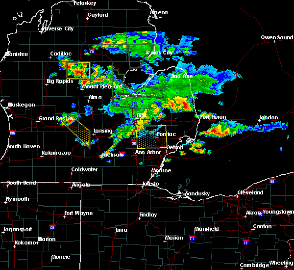 At 723 pm edt, a severe thunderstorm was located over clarkston, or 9 miles northwest of pontiac, moving southeast at 50 mph (trained weather spotters). Hazards include 60 mph wind gusts. Expect damage to roofs. siding and trees. this severe storm will be near, pontiac around 730 pm edt. west bloomfield around 735 pm edt. birmingham around 740 pm edt. southfield and royal oak around 745 pm edt. Other locations impacted by this severe thunderstorm include oak park, davisburg, rose center, hazel park, waterford, walled lake, lakeville, keego harbor, wolverine lake and lake orion. At 723 pm edt, a severe thunderstorm was located over clarkston, or 9 miles northwest of pontiac, moving southeast at 50 mph (trained weather spotters). Hazards include 60 mph wind gusts. Expect damage to roofs. siding and trees. this severe storm will be near, pontiac around 730 pm edt. west bloomfield around 735 pm edt. birmingham around 740 pm edt. southfield and royal oak around 745 pm edt. Other locations impacted by this severe thunderstorm include oak park, davisburg, rose center, hazel park, waterford, walled lake, lakeville, keego harbor, wolverine lake and lake orion.
|
| 8/14/2015 7:12 PM EDT |
 At 712 pm edt, a severe thunderstorm was located near goodrich, or near grand blanc, moving southeast at 45 mph (emergency management). Hazards include 60 mph wind gusts. Expect damage to roofs. siding and trees. this severe thunderstorm will be near, ortonville around 715 pm edt. clarkston around 725 pm edt. pontiac around 735 pm edt. west bloomfield around 740 pm edt. southfield, royal oak and birmingham around 750 pm edt. warren around 755 pm edt. other locations impacted by this severe thunderstorm include oak park, davisburg, rose center, hazel park, waterford, walled lake, lakeville, keego harbor, wolverine lake and lake orion. People attending a concert at dte energy music theatre should seek safe shelter immediately!. At 712 pm edt, a severe thunderstorm was located near goodrich, or near grand blanc, moving southeast at 45 mph (emergency management). Hazards include 60 mph wind gusts. Expect damage to roofs. siding and trees. this severe thunderstorm will be near, ortonville around 715 pm edt. clarkston around 725 pm edt. pontiac around 735 pm edt. west bloomfield around 740 pm edt. southfield, royal oak and birmingham around 750 pm edt. warren around 755 pm edt. other locations impacted by this severe thunderstorm include oak park, davisburg, rose center, hazel park, waterford, walled lake, lakeville, keego harbor, wolverine lake and lake orion. People attending a concert at dte energy music theatre should seek safe shelter immediately!.
|
| 8/2/2015 11:05 PM EDT |
 At 1105 pm edt, severe thunderstorms were located along a line extending from near st. clair shores to near south lyon, moving southeast at 25 mph (radar indicated). Hazards include 60 mph wind gusts. Expect damage to roofs. siding and trees. severe thunderstorms will be near, st. clair shores around 1110 pm edt. northville around 1125 pm edt. canton around 1140 pm edt. romulus and belleville around 1155 pm edt. flat rock around 1220 am edt. Other locations impacted by these severe thunderstorms include clinton township, willow, hazel park, wolverine lake, allen park, pleasant ridge, lincoln park, commerce, berkley and redford. At 1105 pm edt, severe thunderstorms were located along a line extending from near st. clair shores to near south lyon, moving southeast at 25 mph (radar indicated). Hazards include 60 mph wind gusts. Expect damage to roofs. siding and trees. severe thunderstorms will be near, st. clair shores around 1110 pm edt. northville around 1125 pm edt. canton around 1140 pm edt. romulus and belleville around 1155 pm edt. flat rock around 1220 am edt. Other locations impacted by these severe thunderstorms include clinton township, willow, hazel park, wolverine lake, allen park, pleasant ridge, lincoln park, commerce, berkley and redford.
|
| 6/11/2015 9:24 PM EDT | Large tree branch down in livingston county MI, 8.3 miles ESE of Milford, MI |
| 5/27/2015 3:26 PM EDT | At 326 pm edt, a severe thunderstorm was located over novi, moving east at 40 mph (radar indicated). Hazards include 60 mph wind gusts and penny size hail. Expect damage to roofs. siding and trees. this severe storm will be near, west bloomfield around 335 pm edt. livonia around 340 pm edt. southfield, royal oak and birmingham around 345 pm edt. Other locations impacted by this severe thunderstorm include oak park, hazel park, walled lake, keego harbor, wolverine lake, pleasant ridge, clawson, commerce, berkley and auburn hills. |
| 5/27/2015 3:10 PM EDT | At 309 pm edt, a severe thunderstorm was located near troy, moving east at 45 mph (radar indicated). Hazards include 60 mph wind gusts and quarter size hail. Hail damage to vehicles is expected. expect wind damage to roofs, siding and trees. this severe storm will remain near rochester and troy through 330 pm edt. a second severe storm was located just west of brighton and will move into south lyon and milford by 330 pm edt. Other locations impacted by this severe thunderstorm include oak park, hazel park, waterford, walled lake, keego harbor, wolverine lake, pleasant ridge, clawson, commerce and lake angelus. |
| 5/27/2015 2:52 PM EDT | At 252 pm edt, a severe thunderstorm was located near west bloomfield, or 7 miles north of novi, moving east at 45 mph (radar indicated). Hazards include 60 mph wind gusts and quarter size hail. Hail damage to vehicles is expected. expect wind damage to roofs, siding and trees. this severe storm will be near, southfield, pontiac and birmingham around 305 pm edt. royal oak around 310 pm edt. troy around 315 pm edt. rochester around 320 pm edt. Other locations impacted by this severe thunderstorm include oak park, hazel park, waterford, walled lake, keego harbor, wolverine lake, pleasant ridge, clawson, commerce and lake angelus. |
| 5/27/2015 2:40 PM EDT | At 239 pm edt, a severe thunderstorm was located near south lyon, or near milford, moving east at 45 mph (radar indicated). Hazards include 60 mph wind gusts and quarter size hail. Hail damage to vehicles is expected. expect wind damage to roofs, siding and trees. this severe thunderstorm will be near, northville around 250 pm edt. novi around 255 pm edt. west bloomfield around 300 pm edt. pontiac around 305 pm edt. southfield, royal oak and birmingham around 310 pm edt. troy around 315 pm edt. rochester around 320 pm edt. Other locations impacted by this severe thunderstorm include oak park, hazel park, waterford, walled lake, keego harbor, wolverine lake, pleasant ridge, clawson, commerce and lake angelus. |
| 7/27/2014 4:42 PM EDT | Golf Ball sized hail reported 6.8 miles SW of Milford, MI |
| 7/27/2014 4:40 PM EDT | Golf Ball sized hail reported 5.1 miles SW of Milford, MI, measured in white lake twp |
| 7/27/2014 4:40 PM EDT | Golf Ball sized hail reported 7.3 miles SSW of Milford, MI |
| 7/27/2014 4:38 PM EDT | Quarter sized hail reported 5.5 miles SSW of Milford, MI, measured in white lake twp |
| 7/27/2014 4:35 PM EDT | Half Dollar sized hail reported 7.2 miles S of Milford, MI, at duck lake rd and m-59 |
| 7/27/2014 4:35 PM EDT | At mobile home park at milford and middle roads. 80 percent of mobile homes damaged with broken window in oakland county MI, 5.8 miles S of Milford, MI |
| 7/27/2014 4:31 PM EDT | Golf Ball sized hail reported 3.8 miles SSE of Milford, MI |
| 7/27/2014 4:30 PM EDT | Golf Ball sized hail reported 6.5 miles S of Milford, MI, harvey lake rd and milford rd |
| 7/27/2014 4:15 PM EDT | Quarter sized hail reported 7.3 miles SE of Milford, MI |
| 7/1/2014 3:10 AM EDT | Numerous large tree limbs downed in oakland county MI, 0.3 miles SSW of Milford, MI |
| 4/29/2014 9:23 PM EDT | Wires downed on mobile home causing it to catch fire in oakland county MI, 3.8 miles SSE of Milford, MI |
| 4/29/2014 9:21 PM EDT | Tree reported down on a car at davista and orchard near duck lake in oakland county MI, 5.9 miles S of Milford, MI |
| 11/17/2013 6:22 PM EST | Storm damage reported in oakland county MI, 5.9 miles S of Milford, MI |
| 9/2/2013 12:08 AM EDT | Estimated 60 mph thunderstorm wind gus in oakland county MI, 5.8 miles S of Milford, MI |
| 7/19/2013 6:45 PM EDT | Large oak tree snapped. 15 inch diameter dead tree dow in oakland county MI, 0.3 miles SSW of Milford, MI |
| 7/19/2013 6:45 PM EDT | Large oak tree snapped. 15 inch diameter dead tree dow in oakland county MI, 4 miles WSW of Milford, MI |
| 7/19/2013 6:00 PM EDT | Quarter sized hail reported 6.8 miles SW of Milford, MI, ellinwood and bogie lake rd |
| 4/18/2013 5:28 PM EDT | 4 trees down between nws office and andersonville r in oakland county MI, 6.8 miles SW of Milford, MI |
| 4/18/2013 3:00 PM EDT | One 2 inch diameter tree down on highland roa in oakland county MI, 3.8 miles SSE of Milford, MI |
| 4/18/2013 2:08 PM EDT | One 2 inch diameter tree down on highland roa in oakland county MI, 3.8 miles SSE of Milford, MI |
| 4/18/2013 2:06 PM EDT | Large tree down white lake rd north of ormon in oakland county MI, 6.8 miles SW of Milford, MI |
| 7/5/2012 4:30 AM EDT | 16 inch diameter tree fell on 2 cars and a house on biscayne stree in oakland county MI, 5.5 miles WSW of Milford, MI |
| 7/4/2012 6:07 PM EDT | Quarter sized hail reported 6.8 miles SW of Milford, MI |
| 1/1/0001 12:00 AM | Wires downed by the wind gus in oakland county MI, 1.3 miles NNW of Milford, MI |
| 1/1/0001 12:00 AM | Recorded at nws statio in oakland county MI, 6.8 miles SW of Milford, MI |
| 1/1/0001 12:00 AM | Quarter sized hail reported 4.6 miles N of Milford, MI, several dime sized hail stones with some 1 inch. |
Hail Maps for Milford, MI


Connect with Interactive Hail Maps