

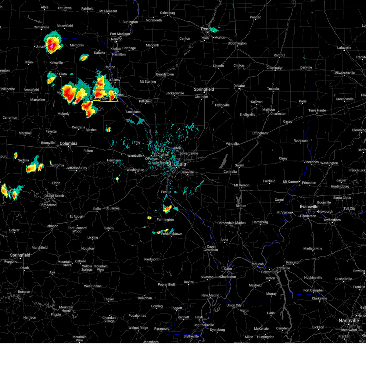
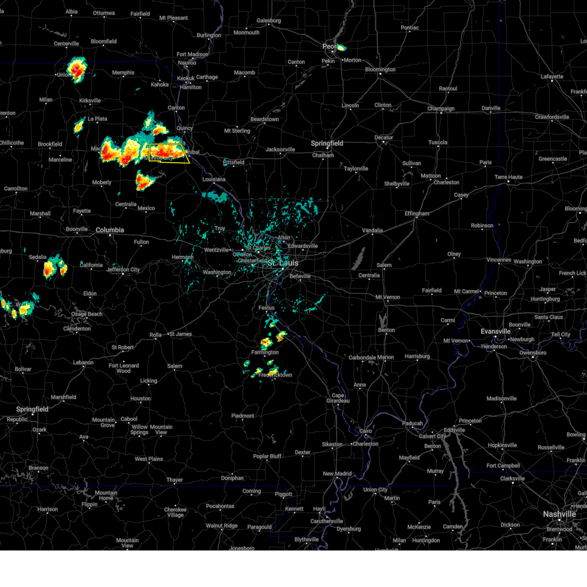
Hail Map for Monroe City, MO
The Monroe City, MO area has had 8 reports of on-the-ground hail by trained spotters, and has been under severe weather warnings 44 times during the past 12 months. Doppler radar has detected hail at or near Monroe City, MO on 58 occasions, including 1 occasion during the past year.
| Name: | Monroe City, MO |
| Where Located: | 52.7 miles S of Kahoka, MO |
| Map: | Google Map for Monroe City, MO |
| Population: | 2531 |
| Housing Units: | 1189 |
| More Info: | Search Google for Monroe City, MO |
0
The Top Recent Hail Date for Monroe City, MO is Tuesday, August 27, 2024 (55th out of 58)

Hail and Wind Damage Spotted near Monroe City, MO
| Date / Time | Report Details |
|---|---|
| 6/3/2025 6:22 PM CDT | The storms which prompted the warning have weakened below severe limits, and no longer pose an immediate threat to life or property. therefore, the warning will be allowed to expire. however, gusty winds are still possible with these thunderstorms. a severe thunderstorm watch remains in effect until 1100 pm cdt tuesday for a portion of northeast missouri. a tornado watch remains in effect until 800 pm cdt for a portion of northeast missouri. |
| 6/3/2025 6:17 PM CDT |
 At 617 pm cdt, severe thunderstorms were located along a line from 23 miles north of mendon to near perry, or along a line from 22 miles northeast of canton to 10 miles northwest of vandalia, moving east at 35 mph (radar indicated). Hazards include 60 mph wind gusts and small hail. Expect damage to roofs, siding, and trees. other locations impacted by the severe thunderstorm include florida, taylor, the landing and ilasco. This includes the following state parks, wakonda state park and mark twain lake recreational area. At 617 pm cdt, severe thunderstorms were located along a line from 23 miles north of mendon to near perry, or along a line from 22 miles northeast of canton to 10 miles northwest of vandalia, moving east at 35 mph (radar indicated). Hazards include 60 mph wind gusts and small hail. Expect damage to roofs, siding, and trees. other locations impacted by the severe thunderstorm include florida, taylor, the landing and ilasco. This includes the following state parks, wakonda state park and mark twain lake recreational area.
|
| 6/3/2025 5:56 PM CDT |
 the severe thunderstorm warning has been cancelled and is no longer in effect the severe thunderstorm warning has been cancelled and is no longer in effect
|
| 6/3/2025 5:56 PM CDT |
 At 556 pm cdt, severe thunderstorms were located along a line from 15 miles north of canton to over santa fe, moving northeast at 35 mph (radar indicated). Hazards include 60 mph wind gusts and quarter size hail. Hail damage to vehicles is expected. expect wind damage to roofs, siding, and trees. this severe thunderstorm will be near, lewistown around 530 pm cdt. other locations impacted by the severe thunderstorm include stoutsville, monticello, indian creek, florida, taylor, the landing and ilasco. This includes the following state parks, wakonda state park and mark twain lake recreational area. At 556 pm cdt, severe thunderstorms were located along a line from 15 miles north of canton to over santa fe, moving northeast at 35 mph (radar indicated). Hazards include 60 mph wind gusts and quarter size hail. Hail damage to vehicles is expected. expect wind damage to roofs, siding, and trees. this severe thunderstorm will be near, lewistown around 530 pm cdt. other locations impacted by the severe thunderstorm include stoutsville, monticello, indian creek, florida, taylor, the landing and ilasco. This includes the following state parks, wakonda state park and mark twain lake recreational area.
|
| 6/3/2025 5:34 PM CDT |
 At 534 pm cdt, severe thunderstorms were located along a line from 13 miles north of lewistown to near paris, or along a line from 17 miles northwest of canton to near paris, moving northeast at 35 mph (radar indicated). Hazards include 60 mph wind gusts and quarter size hail. Hail damage to vehicles is expected. expect wind damage to roofs, siding, and trees. this severe thunderstorm will be near, la belle, shelbina, granville and shelbyville around 525 pm cdt. paris, steffenville and lewistown around 530 pm cdt. other locations impacted by the severe thunderstorm include holliday, bethel, hunnewell, stoutsville, monticello, indian creek, florida, taylor, the landing and ilasco. This includes the following state parks, wakonda state park, union covered bridge historic site and mark twain lake recreational area. At 534 pm cdt, severe thunderstorms were located along a line from 13 miles north of lewistown to near paris, or along a line from 17 miles northwest of canton to near paris, moving northeast at 35 mph (radar indicated). Hazards include 60 mph wind gusts and quarter size hail. Hail damage to vehicles is expected. expect wind damage to roofs, siding, and trees. this severe thunderstorm will be near, la belle, shelbina, granville and shelbyville around 525 pm cdt. paris, steffenville and lewistown around 530 pm cdt. other locations impacted by the severe thunderstorm include holliday, bethel, hunnewell, stoutsville, monticello, indian creek, florida, taylor, the landing and ilasco. This includes the following state parks, wakonda state park, union covered bridge historic site and mark twain lake recreational area.
|
| 6/3/2025 5:31 PM CDT |
 At 531 pm cdt, severe thunderstorms were located along a line from 8 miles east of colony to 6 miles south of paris, or along a line from 18 miles northwest of canton to 6 miles south of paris, moving northeast at 35 mph (radar indicated). Hazards include 60 mph wind gusts and quarter size hail. Hail damage to vehicles is expected. expect wind damage to roofs, siding, and trees. this severe thunderstorm will be near, la belle, shelbina, granville and shelbyville around 525 pm cdt. paris, steffenville and lewistown around 530 pm cdt. other locations impacted by the severe thunderstorm include holliday, bethel, hunnewell, stoutsville, monticello, indian creek, florida, taylor, the landing and ilasco. This includes the following state parks, wakonda state park, union covered bridge historic site and mark twain lake recreational area. At 531 pm cdt, severe thunderstorms were located along a line from 8 miles east of colony to 6 miles south of paris, or along a line from 18 miles northwest of canton to 6 miles south of paris, moving northeast at 35 mph (radar indicated). Hazards include 60 mph wind gusts and quarter size hail. Hail damage to vehicles is expected. expect wind damage to roofs, siding, and trees. this severe thunderstorm will be near, la belle, shelbina, granville and shelbyville around 525 pm cdt. paris, steffenville and lewistown around 530 pm cdt. other locations impacted by the severe thunderstorm include holliday, bethel, hunnewell, stoutsville, monticello, indian creek, florida, taylor, the landing and ilasco. This includes the following state parks, wakonda state park, union covered bridge historic site and mark twain lake recreational area.
|
| 6/3/2025 5:31 PM CDT |
 the severe thunderstorm warning has been cancelled and is no longer in effect the severe thunderstorm warning has been cancelled and is no longer in effect
|
| 6/3/2025 5:23 PM CDT |
 Svrlsx the national weather service in st louis has issued a * severe thunderstorm warning for, eastern knox county in northeastern missouri, lewis county in northeastern missouri, marion county in northeastern missouri, monroe county in northeastern missouri, ralls county in northeastern missouri, eastern shelby county in northeastern missouri, * until 630 pm cdt. * at 523 pm cdt, severe thunderstorms were located along a line from near colony to 9 miles southeast of madison, or along a line from 15 miles east of edina to 9 miles southwest of paris, moving northeast at 35 mph (radar indicated). Hazards include 60 mph wind gusts and small hail. Expect damage to roofs, siding, and trees. this severe thunderstorm will be near, la belle, shelbina, granville, shelbyville, colony and knox city around 525 pm cdt. paris, steffenville and lewistown around 530 pm cdt. other locations impacted by the severe thunderstorm include newark, holliday, bethel, hunnewell, stoutsville, monticello, indian creek, florida, taylor and the landing. This includes the following state parks, wakonda state park, union covered bridge historic site and mark twain lake recreational area. Svrlsx the national weather service in st louis has issued a * severe thunderstorm warning for, eastern knox county in northeastern missouri, lewis county in northeastern missouri, marion county in northeastern missouri, monroe county in northeastern missouri, ralls county in northeastern missouri, eastern shelby county in northeastern missouri, * until 630 pm cdt. * at 523 pm cdt, severe thunderstorms were located along a line from near colony to 9 miles southeast of madison, or along a line from 15 miles east of edina to 9 miles southwest of paris, moving northeast at 35 mph (radar indicated). Hazards include 60 mph wind gusts and small hail. Expect damage to roofs, siding, and trees. this severe thunderstorm will be near, la belle, shelbina, granville, shelbyville, colony and knox city around 525 pm cdt. paris, steffenville and lewistown around 530 pm cdt. other locations impacted by the severe thunderstorm include newark, holliday, bethel, hunnewell, stoutsville, monticello, indian creek, florida, taylor and the landing. This includes the following state parks, wakonda state park, union covered bridge historic site and mark twain lake recreational area.
|
| 4/20/2025 6:16 PM CDT |
 At 616 pm cdt, severe thunderstorms were located along a line from near spaulding to near bellflower, or along a line from 10 miles southeast of monroe city to 11 miles northeast of montgomery city, moving northeast at 60 mph (trained spotters reported. at 6:10 pm a 63 mph wind gust was reported at vandalia, mo). Hazards include 70 mph wind gusts. Expect considerable tree damage. damage is likely to mobile homes, roofs, and outbuildings. this severe thunderstorm will be near, vandalia around 610 pm cdt. other locations impacted by the severe thunderstorm include the landing, st. Clement, ashley, cyrene, saverton, ilasco, edgewood and ashburn. At 616 pm cdt, severe thunderstorms were located along a line from near spaulding to near bellflower, or along a line from 10 miles southeast of monroe city to 11 miles northeast of montgomery city, moving northeast at 60 mph (trained spotters reported. at 6:10 pm a 63 mph wind gust was reported at vandalia, mo). Hazards include 70 mph wind gusts. Expect considerable tree damage. damage is likely to mobile homes, roofs, and outbuildings. this severe thunderstorm will be near, vandalia around 610 pm cdt. other locations impacted by the severe thunderstorm include the landing, st. Clement, ashley, cyrene, saverton, ilasco, edgewood and ashburn.
|
| 4/20/2025 6:15 PM CDT |
 Svrlsx the national weather service in st louis has issued a * severe thunderstorm warning for, adams county in west central illinois, southeastern lewis county in northeastern missouri, marion county in northeastern missouri, * until 715 pm cdt. * at 615 pm cdt, severe thunderstorms were located along a line from near steffenville to over monroe city, or along a line from 17 miles southeast of edina to over monroe city, moving east at 50 mph (radar indicated). Hazards include 60 mph wind gusts and small hail. Expect damage to roofs, siding, and trees. this severe thunderstorm will be near, monroe city, steffenville and warren around 615 pm cdt. philadelphia around 620 pm cdt. other locations impacted by the severe thunderstorm include monticello, taylor, meyer, marblehead, burton, lima, ursa, adams, paloma and fowler. this includes the following state parks, wakonda state park and siloam springs state park. this includes the following highways, interstate 72 near exit 4. Interstate 172 between exits 2 and 19. Svrlsx the national weather service in st louis has issued a * severe thunderstorm warning for, adams county in west central illinois, southeastern lewis county in northeastern missouri, marion county in northeastern missouri, * until 715 pm cdt. * at 615 pm cdt, severe thunderstorms were located along a line from near steffenville to over monroe city, or along a line from 17 miles southeast of edina to over monroe city, moving east at 50 mph (radar indicated). Hazards include 60 mph wind gusts and small hail. Expect damage to roofs, siding, and trees. this severe thunderstorm will be near, monroe city, steffenville and warren around 615 pm cdt. philadelphia around 620 pm cdt. other locations impacted by the severe thunderstorm include monticello, taylor, meyer, marblehead, burton, lima, ursa, adams, paloma and fowler. this includes the following state parks, wakonda state park and siloam springs state park. this includes the following highways, interstate 72 near exit 4. Interstate 172 between exits 2 and 19.
|
| 4/20/2025 6:10 PM CDT | Estimated with near-zero visibilit in monroe county MO, 0.7 miles NW of Monroe City, MO |
| 4/20/2025 6:03 PM CDT |
 Svrlsx the national weather service in st louis has issued a * severe thunderstorm warning for, pike county in northeastern missouri, ralls county in northeastern missouri, * until 645 pm cdt. * at 603 pm cdt, severe thunderstorms were located along a line from over perry to over new florence, or along a line from 8 miles northeast of santa fe to 5 miles southeast of montgomery city, moving northeast at 60 mph (radar indicated). Hazards include 70 mph wind gusts. Expect considerable tree damage. damage is likely to mobile homes, roofs, and outbuildings. this severe thunderstorm will be near, vandalia around 610 pm cdt. other locations impacted by the severe thunderstorm include the landing, st. Clement, ashley, cyrene, saverton, ilasco, edgewood and ashburn. Svrlsx the national weather service in st louis has issued a * severe thunderstorm warning for, pike county in northeastern missouri, ralls county in northeastern missouri, * until 645 pm cdt. * at 603 pm cdt, severe thunderstorms were located along a line from over perry to over new florence, or along a line from 8 miles northeast of santa fe to 5 miles southeast of montgomery city, moving northeast at 60 mph (radar indicated). Hazards include 70 mph wind gusts. Expect considerable tree damage. damage is likely to mobile homes, roofs, and outbuildings. this severe thunderstorm will be near, vandalia around 610 pm cdt. other locations impacted by the severe thunderstorm include the landing, st. Clement, ashley, cyrene, saverton, ilasco, edgewood and ashburn.
|
| 4/20/2025 5:59 PM CDT |
 the severe thunderstorm warning has been cancelled and is no longer in effect the severe thunderstorm warning has been cancelled and is no longer in effect
|
| 4/20/2025 5:59 PM CDT |
 At 559 pm cdt, severe thunderstorms were located along a line from 5 miles east of paris to over mineola, or along a line from 5 miles east of paris to 7 miles south of montgomery city, moving northeast at 60 mph (radar indicated). Hazards include 70 mph wind gusts. Expect considerable tree damage. damage is likely to mobile homes, roofs, and outbuildings. this severe thunderstorm will be near, mexico around 535 pm cdt. other locations impacted by the severe thunderstorm include rush hill, americus, danville, florida, stoutsville, high hill, middletown, the landing and indian creek. this includes the following state parks, graham cave state park and mark twain lake recreational area. This includes interstate 70 in missouri between exits 170 and 183. At 559 pm cdt, severe thunderstorms were located along a line from 5 miles east of paris to over mineola, or along a line from 5 miles east of paris to 7 miles south of montgomery city, moving northeast at 60 mph (radar indicated). Hazards include 70 mph wind gusts. Expect considerable tree damage. damage is likely to mobile homes, roofs, and outbuildings. this severe thunderstorm will be near, mexico around 535 pm cdt. other locations impacted by the severe thunderstorm include rush hill, americus, danville, florida, stoutsville, high hill, middletown, the landing and indian creek. this includes the following state parks, graham cave state park and mark twain lake recreational area. This includes interstate 70 in missouri between exits 170 and 183.
|
| 4/20/2025 5:47 PM CDT |
 the severe thunderstorm warning has been cancelled and is no longer in effect the severe thunderstorm warning has been cancelled and is no longer in effect
|
| 4/20/2025 5:47 PM CDT |
 At 547 pm cdt, severe thunderstorms were located along a line from 9 miles southwest of paris to 6 miles northeast of chamois, or along a line from 9 miles southwest of paris to 14 miles southeast of fulton, moving northeast at 60 mph (radar indicated). Hazards include 70 mph wind gusts. Expect considerable tree damage. damage is likely to mobile homes, roofs, and outbuildings. this severe thunderstorm will be near, mexico around 535 pm cdt. chamois around 540 pm cdt. other locations impacted by the severe thunderstorm include thompson, reform, vandiver, portland, rush hill, benton city, americus, danville, florida and stoutsville. this includes the following state parks, graham cave state park and mark twain lake recreational area. This includes interstate 70 in missouri between exits 155 and 183. At 547 pm cdt, severe thunderstorms were located along a line from 9 miles southwest of paris to 6 miles northeast of chamois, or along a line from 9 miles southwest of paris to 14 miles southeast of fulton, moving northeast at 60 mph (radar indicated). Hazards include 70 mph wind gusts. Expect considerable tree damage. damage is likely to mobile homes, roofs, and outbuildings. this severe thunderstorm will be near, mexico around 535 pm cdt. chamois around 540 pm cdt. other locations impacted by the severe thunderstorm include thompson, reform, vandiver, portland, rush hill, benton city, americus, danville, florida and stoutsville. this includes the following state parks, graham cave state park and mark twain lake recreational area. This includes interstate 70 in missouri between exits 155 and 183.
|
| 4/20/2025 5:30 PM CDT | Svrlsx the national weather service in st louis has issued a * severe thunderstorm warning for, audrain county in central missouri, northeastern boone county in central missouri, eastern callaway county in central missouri, montgomery county in east central missouri, eastern monroe county in northeastern missouri, southwestern ralls county in northeastern missouri, * until 615 pm cdt. * at 530 pm cdt, severe thunderstorms were located along a line from near sturgeon to 10 miles northwest of linn, or along a line from 10 miles west of centralia to 10 miles northwest of linn, moving northeast at 60 mph (trained spotters reported. at 5:26 pm a 66 mph wind gust was observed at jefferson city). Hazards include 70 mph wind gusts. Expect considerable tree damage. damage is likely to mobile homes, roofs, and outbuildings. this severe thunderstorm will be near, centralia and mexico around 535 pm cdt. auxvasse and chamois around 540 pm cdt. other locations impacted by the severe thunderstorm include mokane, steedman, thompson, reform, vandiver, portland, rush hill, benton city, americus and danville. this includes the following state parks, graham cave state park and mark twain lake recreational area. This includes interstate 70 in missouri between exits 155 and 183. |
| 3/30/2025 6:37 AM CDT |
 The storm which prompted the warning has moved out of the area. therefore, the warning will be allowed to expire. however, gusty winds are still possible with this thunderstorm. The storm which prompted the warning has moved out of the area. therefore, the warning will be allowed to expire. however, gusty winds are still possible with this thunderstorm.
|
| 3/30/2025 6:28 AM CDT |
 At 628 am cdt, a severe thunderstorm was located near philadelphia, or 15 miles northwest of palmyra, moving northeast at 55 mph (radar indicated). Hazards include 60 mph wind gusts and small hail. Expect damage to roofs, siding, and trees. Locations impacted include, monroe city, warren and philadelphia. At 628 am cdt, a severe thunderstorm was located near philadelphia, or 15 miles northwest of palmyra, moving northeast at 55 mph (radar indicated). Hazards include 60 mph wind gusts and small hail. Expect damage to roofs, siding, and trees. Locations impacted include, monroe city, warren and philadelphia.
|
| 3/30/2025 6:28 AM CDT |
 the severe thunderstorm warning has been cancelled and is no longer in effect the severe thunderstorm warning has been cancelled and is no longer in effect
|
| 3/30/2025 6:20 AM CDT |
 the severe thunderstorm warning has been cancelled and is no longer in effect the severe thunderstorm warning has been cancelled and is no longer in effect
|
| 3/30/2025 6:20 AM CDT |
 At 620 am cdt, a severe thunderstorm was located over emden, or 12 miles northeast of shelbina, moving northeast at 55 mph (radar indicated). Hazards include 60 mph wind gusts and quarter size hail. Hail damage to vehicles is expected. expect wind damage to roofs, siding, and trees. Locations impacted include, monroe city, shelbina, warren, shelbyville, emden, philadelphia, hunnewell and bethel. At 620 am cdt, a severe thunderstorm was located over emden, or 12 miles northeast of shelbina, moving northeast at 55 mph (radar indicated). Hazards include 60 mph wind gusts and quarter size hail. Hail damage to vehicles is expected. expect wind damage to roofs, siding, and trees. Locations impacted include, monroe city, shelbina, warren, shelbyville, emden, philadelphia, hunnewell and bethel.
|
| 3/30/2025 6:04 AM CDT |
 Svrlsx the national weather service in st louis has issued a * severe thunderstorm warning for, western marion county in northeastern missouri, northeastern monroe county in northeastern missouri, eastern shelby county in northeastern missouri, * until 645 am cdt. * at 604 am cdt, a severe thunderstorm was located near granville, or 7 miles south of shelbina, moving northeast at 55 mph (radar indicated). Hazards include 60 mph wind gusts and quarter size hail. Hail damage to vehicles is expected. Expect wind damage to roofs, siding, and trees. Svrlsx the national weather service in st louis has issued a * severe thunderstorm warning for, western marion county in northeastern missouri, northeastern monroe county in northeastern missouri, eastern shelby county in northeastern missouri, * until 645 am cdt. * at 604 am cdt, a severe thunderstorm was located near granville, or 7 miles south of shelbina, moving northeast at 55 mph (radar indicated). Hazards include 60 mph wind gusts and quarter size hail. Hail damage to vehicles is expected. Expect wind damage to roofs, siding, and trees.
|
| 3/14/2025 7:37 PM CDT |
 the severe thunderstorm warning has been cancelled and is no longer in effect the severe thunderstorm warning has been cancelled and is no longer in effect
|
| 3/14/2025 7:37 PM CDT |
 At 737 pm cdt, severe thunderstorms were located along a line from 6 miles southwest of mendon to near center, or along a line from 7 miles north of quincy to 13 miles north of vandalia, moving northeast at 70 mph (trained spotters reported. quarter sized hail was reported near mexico, mo at 7:03 pm). Hazards include 70 mph wind gusts and quarter size hail. Hail damage to vehicles is expected. expect considerable tree damage. wind damage is also likely to mobile homes, roofs, and outbuildings. Other locations impacted by the severe thunderstorm include the landing, taylor, ilasco and saverton. At 737 pm cdt, severe thunderstorms were located along a line from 6 miles southwest of mendon to near center, or along a line from 7 miles north of quincy to 13 miles north of vandalia, moving northeast at 70 mph (trained spotters reported. quarter sized hail was reported near mexico, mo at 7:03 pm). Hazards include 70 mph wind gusts and quarter size hail. Hail damage to vehicles is expected. expect considerable tree damage. wind damage is also likely to mobile homes, roofs, and outbuildings. Other locations impacted by the severe thunderstorm include the landing, taylor, ilasco and saverton.
|
| 3/14/2025 7:20 PM CDT | At 720 pm cdt, severe thunderstorms were located along a line from near palmyra to over laddonia, or along a line from near palmyra to 10 miles west of vandalia, moving northeast at 70 mph (trained spotters reported. quarter sized hail was reported near mexico, mo at 7:03 pm). Hazards include 70 mph wind gusts and quarter size hail. Hail damage to vehicles is expected. expect considerable tree damage. wind damage is also likely to mobile homes, roofs, and outbuildings. other locations impacted by the severe thunderstorm include stoutsville, indian creek, florida, the landing, taylor, ilasco and saverton. This includes the following state parks, mark twain lake recreational area. |
| 3/14/2025 7:20 PM CDT | the severe thunderstorm warning has been cancelled and is no longer in effect |
| 3/14/2025 6:58 PM CDT |
 At 658 pm cdt, severe thunderstorms were located along a line from 7 miles west of monroe city to over santa fe, moving northeast at 65 mph (radar indicated). Hazards include 70 mph wind gusts and small hail. Expect considerable tree damage. damage is likely to mobile homes, roofs, and outbuildings. this severe thunderstorm will be near, paris around 645 pm cdt. other locations impacted by the severe thunderstorm include stoutsville, florida, hunnewell, indian creek, the landing, taylor and ilasco. This includes the following state parks, mark twain lake recreational area. At 658 pm cdt, severe thunderstorms were located along a line from 7 miles west of monroe city to over santa fe, moving northeast at 65 mph (radar indicated). Hazards include 70 mph wind gusts and small hail. Expect considerable tree damage. damage is likely to mobile homes, roofs, and outbuildings. this severe thunderstorm will be near, paris around 645 pm cdt. other locations impacted by the severe thunderstorm include stoutsville, florida, hunnewell, indian creek, the landing, taylor and ilasco. This includes the following state parks, mark twain lake recreational area.
|
| 3/14/2025 6:38 PM CDT |
 Svrlsx the national weather service in st louis has issued a * severe thunderstorm warning for, marion county in northeastern missouri, monroe county in northeastern missouri, ralls county in northeastern missouri, southeastern shelby county in northeastern missouri, * until 745 pm cdt. * at 638 pm cdt, severe thunderstorms were located along a line from 7 miles southeast of madison to 5 miles northeast of murry, or along a line from 8 miles southwest of paris to 9 miles south of centralia, moving northeast at 70 mph (radar indicated). Hazards include 70 mph wind gusts and small hail. Expect considerable tree damage. damage is likely to mobile homes, roofs, and outbuildings. this severe thunderstorm will be near, madison around 640 pm cdt. paris and granville around 645 pm cdt. other locations impacted by the severe thunderstorm include holliday, stoutsville, indian creek, florida, hunnewell, the landing and taylor. This includes the following state parks, union covered bridge historic site and mark twain lake recreational area. Svrlsx the national weather service in st louis has issued a * severe thunderstorm warning for, marion county in northeastern missouri, monroe county in northeastern missouri, ralls county in northeastern missouri, southeastern shelby county in northeastern missouri, * until 745 pm cdt. * at 638 pm cdt, severe thunderstorms were located along a line from 7 miles southeast of madison to 5 miles northeast of murry, or along a line from 8 miles southwest of paris to 9 miles south of centralia, moving northeast at 70 mph (radar indicated). Hazards include 70 mph wind gusts and small hail. Expect considerable tree damage. damage is likely to mobile homes, roofs, and outbuildings. this severe thunderstorm will be near, madison around 640 pm cdt. paris and granville around 645 pm cdt. other locations impacted by the severe thunderstorm include holliday, stoutsville, indian creek, florida, hunnewell, the landing and taylor. This includes the following state parks, union covered bridge historic site and mark twain lake recreational area.
|
| 10/30/2024 11:26 PM CDT |
 At 1126 pm cdt, severe thunderstorms were located along a line from over canton to over rensselaer, or along a line from over canton to 9 miles west of hannibal, moving northeast at 60 mph (radar indicated). Hazards include 60 mph wind gusts and small hail. Expect damage to roofs, siding, and trees. locations impacted include, hannibal, palmyra, monroe city, la grange, rensselaer, spaulding, taylor and ilasco. This includes the following state parks, wakonda state park. At 1126 pm cdt, severe thunderstorms were located along a line from over canton to over rensselaer, or along a line from over canton to 9 miles west of hannibal, moving northeast at 60 mph (radar indicated). Hazards include 60 mph wind gusts and small hail. Expect damage to roofs, siding, and trees. locations impacted include, hannibal, palmyra, monroe city, la grange, rensselaer, spaulding, taylor and ilasco. This includes the following state parks, wakonda state park.
|
| 10/30/2024 11:19 PM CDT |
 At 1119 pm cdt, severe thunderstorms were located along a line from 6 miles northeast of ewing to near monroe city, or along a line from 7 miles southwest of canton to near monroe city, moving northeast at 60 mph (radar indicated). Hazards include 60 mph wind gusts and small hail. Expect damage to roofs, siding, and trees. locations impacted include, hannibal, palmyra, monroe city, la grange, ewing, rensselaer, maywood, spaulding, taylor and ilasco. This includes the following state parks, wakonda state park. At 1119 pm cdt, severe thunderstorms were located along a line from 6 miles northeast of ewing to near monroe city, or along a line from 7 miles southwest of canton to near monroe city, moving northeast at 60 mph (radar indicated). Hazards include 60 mph wind gusts and small hail. Expect damage to roofs, siding, and trees. locations impacted include, hannibal, palmyra, monroe city, la grange, ewing, rensselaer, maywood, spaulding, taylor and ilasco. This includes the following state parks, wakonda state park.
|
| 10/30/2024 11:16 PM CDT |
 The storms which prompted the warning have moved out of the area. therefore, the warning has been allowed to expire. to report severe weather, contact your nearest law enforcement agency. they will send your report to the national weather service office. a severe thunderstorm watch remains in effect until 400 am cdt thursday for a portion of northeast missouri. The storms which prompted the warning have moved out of the area. therefore, the warning has been allowed to expire. to report severe weather, contact your nearest law enforcement agency. they will send your report to the national weather service office. a severe thunderstorm watch remains in effect until 400 am cdt thursday for a portion of northeast missouri.
|
| 10/30/2024 11:08 PM CDT |
 At 1108 pm cdt, severe thunderstorms were located along a line from over steffenville to 9 miles northeast of paris, or along a line from 20 miles northeast of shelbina to 9 miles northeast of paris, moving east at 55 mph (radar indicated). Hazards include 60 mph wind gusts and small hail. Expect damage to roofs, siding, and trees. locations impacted include, monroe city, paris, emden, hunnewell, stoutsville, indian creek and florida. This includes the following state parks, mark twain lake recreational area. At 1108 pm cdt, severe thunderstorms were located along a line from over steffenville to 9 miles northeast of paris, or along a line from 20 miles northeast of shelbina to 9 miles northeast of paris, moving east at 55 mph (radar indicated). Hazards include 60 mph wind gusts and small hail. Expect damage to roofs, siding, and trees. locations impacted include, monroe city, paris, emden, hunnewell, stoutsville, indian creek and florida. This includes the following state parks, mark twain lake recreational area.
|
| 10/30/2024 11:07 PM CDT |
 Svrlsx the national weather service in st louis has issued a * severe thunderstorm warning for, southern lewis county in northeastern missouri, marion county in northeastern missouri, northwestern ralls county in northeastern missouri, * until midnight cdt. * at 1107 pm cdt, severe thunderstorms were located along a line from over steffenville to 8 miles northeast of paris, or along a line from 20 miles northeast of shelbina to 8 miles northeast of paris, moving east at 40 mph (radar indicated). Hazards include 60 mph wind gusts and small hail. expect damage to roofs, siding, and trees Svrlsx the national weather service in st louis has issued a * severe thunderstorm warning for, southern lewis county in northeastern missouri, marion county in northeastern missouri, northwestern ralls county in northeastern missouri, * until midnight cdt. * at 1107 pm cdt, severe thunderstorms were located along a line from over steffenville to 8 miles northeast of paris, or along a line from 20 miles northeast of shelbina to 8 miles northeast of paris, moving east at 40 mph (radar indicated). Hazards include 60 mph wind gusts and small hail. expect damage to roofs, siding, and trees
|
| 10/30/2024 10:53 PM CDT |
 At 1053 pm cdt, severe thunderstorms were located along a line from 6 miles south of plevna to 5 miles south of granville, or along a line from 14 miles north of shelbina to 6 miles west of paris, moving east at 55 mph (trained spotters reported a 72 mph wind gust in granville). Hazards include 70 mph wind gusts and small hail. Expect considerable tree damage. damage is likely to mobile homes, roofs, and outbuildings. locations impacted include, monroe city, shelbina, paris, madison, shelbyville, granville, emden, maud, woodlawn, hunnewell, holliday, bethel, leonard, stoutsville, indian creek and florida. This includes the following state parks, mark twain lake recreational area. At 1053 pm cdt, severe thunderstorms were located along a line from 6 miles south of plevna to 5 miles south of granville, or along a line from 14 miles north of shelbina to 6 miles west of paris, moving east at 55 mph (trained spotters reported a 72 mph wind gust in granville). Hazards include 70 mph wind gusts and small hail. Expect considerable tree damage. damage is likely to mobile homes, roofs, and outbuildings. locations impacted include, monroe city, shelbina, paris, madison, shelbyville, granville, emden, maud, woodlawn, hunnewell, holliday, bethel, leonard, stoutsville, indian creek and florida. This includes the following state parks, mark twain lake recreational area.
|
| 10/30/2024 10:47 PM CDT |
 At 1047 pm cdt, severe thunderstorms were located along a line from 8 miles north of clarence to over madison, or along a line from 15 miles northwest of shelbina to 12 miles west of paris, moving east at 55 mph (radar indicated). Hazards include 60 mph wind gusts and small hail. Expect damage to roofs, siding, and trees. locations impacted include, monroe city, shelbina, paris, clarence, madison, shelbyville, granville, maud, woodlawn, emden, hunnewell, holliday, bethel, leonard, stoutsville, duncans bridge, indian creek and florida. This includes the following state parks, mark twain lake recreational area. At 1047 pm cdt, severe thunderstorms were located along a line from 8 miles north of clarence to over madison, or along a line from 15 miles northwest of shelbina to 12 miles west of paris, moving east at 55 mph (radar indicated). Hazards include 60 mph wind gusts and small hail. Expect damage to roofs, siding, and trees. locations impacted include, monroe city, shelbina, paris, clarence, madison, shelbyville, granville, maud, woodlawn, emden, hunnewell, holliday, bethel, leonard, stoutsville, duncans bridge, indian creek and florida. This includes the following state parks, mark twain lake recreational area.
|
| 10/30/2024 10:32 PM CDT |
 Svrlsx the national weather service in st louis has issued a * severe thunderstorm warning for, monroe county in northeastern missouri, shelby county in northeastern missouri, * until 1115 pm cdt. * at 1032 pm cdt, severe thunderstorms were located along a line from 12 miles west of clarence to 13 miles northwest of sturgeon, or along a line from 24 miles west of shelbina to 20 miles northwest of centralia, moving east at 55 mph (radar indicated). Hazards include 60 mph wind gusts and small hail. expect damage to roofs, siding, and trees Svrlsx the national weather service in st louis has issued a * severe thunderstorm warning for, monroe county in northeastern missouri, shelby county in northeastern missouri, * until 1115 pm cdt. * at 1032 pm cdt, severe thunderstorms were located along a line from 12 miles west of clarence to 13 miles northwest of sturgeon, or along a line from 24 miles west of shelbina to 20 miles northwest of centralia, moving east at 55 mph (radar indicated). Hazards include 60 mph wind gusts and small hail. expect damage to roofs, siding, and trees
|
| 8/27/2024 5:40 PM CDT |
 The storm which prompted the warning has weakened below severe limits, and no longer poses an immediate threat to life or property. therefore, the warning will be allowed to expire. however, small hail and gusty winds are still possible with this thunderstorm. to report severe weather, contact your nearest law enforcement agency. they will send your report to the national weather service office. The storm which prompted the warning has weakened below severe limits, and no longer poses an immediate threat to life or property. therefore, the warning will be allowed to expire. however, small hail and gusty winds are still possible with this thunderstorm. to report severe weather, contact your nearest law enforcement agency. they will send your report to the national weather service office.
|
| 8/27/2024 5:18 PM CDT |
 At 518 pm cdt, a severe thunderstorm was located over warren, or 7 miles northwest of monroe city, moving northwest at 5 mph (radar indicated). Hazards include 60 mph wind gusts and small hail. Expect damage to roofs, siding, and trees. Locations impacted include, hannibal, palmyra, monroe city, warren and rensselaer. At 518 pm cdt, a severe thunderstorm was located over warren, or 7 miles northwest of monroe city, moving northwest at 5 mph (radar indicated). Hazards include 60 mph wind gusts and small hail. Expect damage to roofs, siding, and trees. Locations impacted include, hannibal, palmyra, monroe city, warren and rensselaer.
|
| 8/27/2024 5:02 PM CDT |
 Svrlsx the national weather service in st louis has issued a * severe thunderstorm warning for, southern marion county in northeastern missouri, northwestern ralls county in northeastern missouri, * until 545 pm cdt. * at 502 pm cdt, a severe thunderstorm was located near warren, or 5 miles north of monroe city. this storm was stationary (radar indicated). Hazards include 60 mph wind gusts and small hail. expect damage to roofs, siding, and trees Svrlsx the national weather service in st louis has issued a * severe thunderstorm warning for, southern marion county in northeastern missouri, northwestern ralls county in northeastern missouri, * until 545 pm cdt. * at 502 pm cdt, a severe thunderstorm was located near warren, or 5 miles north of monroe city. this storm was stationary (radar indicated). Hazards include 60 mph wind gusts and small hail. expect damage to roofs, siding, and trees
|
| 7/16/2024 10:03 AM CDT |
 the severe thunderstorm warning has been cancelled and is no longer in effect the severe thunderstorm warning has been cancelled and is no longer in effect
|
| 7/16/2024 9:54 AM CDT |
 At 954 am cdt, a severe thunderstorm was located 9 miles southwest of monroe city, moving east at 35 mph (radar indicated). Hazards include 60 mph wind gusts and quarter size hail. Hail damage to vehicles is expected. expect wind damage to roofs, siding, and trees. locations impacted include, monroe city, paris, santa fe, granville, holliday, stoutsville, florida and indian creek. This includes the following state parks, union covered bridge historic site and mark twain lake recreational area. At 954 am cdt, a severe thunderstorm was located 9 miles southwest of monroe city, moving east at 35 mph (radar indicated). Hazards include 60 mph wind gusts and quarter size hail. Hail damage to vehicles is expected. expect wind damage to roofs, siding, and trees. locations impacted include, monroe city, paris, santa fe, granville, holliday, stoutsville, florida and indian creek. This includes the following state parks, union covered bridge historic site and mark twain lake recreational area.
|
| 7/16/2024 9:54 AM CDT |
 the severe thunderstorm warning has been cancelled and is no longer in effect the severe thunderstorm warning has been cancelled and is no longer in effect
|
| 7/16/2024 9:43 AM CDT |
 At 943 am cdt, a severe thunderstorm was located 6 miles northeast of paris, moving east at 35 mph (radar indicated). Hazards include 60 mph wind gusts and quarter size hail. Hail damage to vehicles is expected. expect wind damage to roofs, siding, and trees. locations impacted include, monroe city, shelbina, paris, santa fe, madison, granville, woodlawn, maud, hunnewell, holliday, stoutsville, florida, indian creek and duncans bridge. This includes the following state parks, union covered bridge historic site and mark twain lake recreational area. At 943 am cdt, a severe thunderstorm was located 6 miles northeast of paris, moving east at 35 mph (radar indicated). Hazards include 60 mph wind gusts and quarter size hail. Hail damage to vehicles is expected. expect wind damage to roofs, siding, and trees. locations impacted include, monroe city, shelbina, paris, santa fe, madison, granville, woodlawn, maud, hunnewell, holliday, stoutsville, florida, indian creek and duncans bridge. This includes the following state parks, union covered bridge historic site and mark twain lake recreational area.
|
| 7/16/2024 9:14 AM CDT |
 Svrlsx the national weather service in st louis has issued a * severe thunderstorm warning for, northwestern audrain county in central missouri, monroe county in northeastern missouri, southern shelby county in northeastern missouri, * until 1015 am cdt. * at 914 am cdt, a cluster of severe thunderstorms were located across western monroe county moving east at 50 mph (radar indicated). Hazards include 60 mph wind gusts and quarter size hail. Hail damage to vehicles is expected. Expect wind damage to roofs, siding, and trees. Svrlsx the national weather service in st louis has issued a * severe thunderstorm warning for, northwestern audrain county in central missouri, monroe county in northeastern missouri, southern shelby county in northeastern missouri, * until 1015 am cdt. * at 914 am cdt, a cluster of severe thunderstorms were located across western monroe county moving east at 50 mph (radar indicated). Hazards include 60 mph wind gusts and quarter size hail. Hail damage to vehicles is expected. Expect wind damage to roofs, siding, and trees.
|
| 6/23/2024 12:27 AM CDT |
 the severe thunderstorm warning has been cancelled and is no longer in effect the severe thunderstorm warning has been cancelled and is no longer in effect
|
| 6/23/2024 12:00 AM CDT |
 Svrlsx the national weather service in st louis has issued a * severe thunderstorm warning for, southeastern shelby county in northeastern missouri, southwestern marion county in northeastern missouri, northeastern monroe county in northeastern missouri, * until 1245 am cdt. * at 1200 am cdt, a severe thunderstorm was located over shelbina, moving east at 30 mph (radar indicated). Hazards include 60 mph wind gusts. expect damage to roofs, siding, and trees Svrlsx the national weather service in st louis has issued a * severe thunderstorm warning for, southeastern shelby county in northeastern missouri, southwestern marion county in northeastern missouri, northeastern monroe county in northeastern missouri, * until 1245 am cdt. * at 1200 am cdt, a severe thunderstorm was located over shelbina, moving east at 30 mph (radar indicated). Hazards include 60 mph wind gusts. expect damage to roofs, siding, and trees
|
| 6/13/2024 7:54 PM CDT |
 Svrlsx the national weather service in st louis has issued a * severe thunderstorm warning for, ralls county in northeastern missouri, eastern monroe county in northeastern missouri, * until 900 pm cdt. * at 754 pm cdt, severe thunderstorms were located along a line extending from near monroe city to 11 miles south of warren to near granville, moving southeast at 30 mph (radar indicated). Hazards include 60 mph wind gusts and quarter size hail. Hail damage to vehicles is expected. Expect wind damage to roofs, siding, and trees. Svrlsx the national weather service in st louis has issued a * severe thunderstorm warning for, ralls county in northeastern missouri, eastern monroe county in northeastern missouri, * until 900 pm cdt. * at 754 pm cdt, severe thunderstorms were located along a line extending from near monroe city to 11 miles south of warren to near granville, moving southeast at 30 mph (radar indicated). Hazards include 60 mph wind gusts and quarter size hail. Hail damage to vehicles is expected. Expect wind damage to roofs, siding, and trees.
|
| 6/13/2024 7:40 PM CDT |
 At 740 pm cdt, severe thunderstorms were located along a line extending from near warren to shelbina to 6 miles south of bevier, moving southeast at 30 mph (radar indicated). Hazards include 70 mph wind gusts and quarter size hail. Hail damage to vehicles is expected. expect considerable tree damage. wind damage is also likely to mobile homes, roofs, and outbuildings. Locations impacted include, monroe city, shelbina, warren, clarence, maud, woodlawn, granville, emden, philadelphia, hunnewell, holliday, stoutsville, duncans bridge, and indian creek. At 740 pm cdt, severe thunderstorms were located along a line extending from near warren to shelbina to 6 miles south of bevier, moving southeast at 30 mph (radar indicated). Hazards include 70 mph wind gusts and quarter size hail. Hail damage to vehicles is expected. expect considerable tree damage. wind damage is also likely to mobile homes, roofs, and outbuildings. Locations impacted include, monroe city, shelbina, warren, clarence, maud, woodlawn, granville, emden, philadelphia, hunnewell, holliday, stoutsville, duncans bridge, and indian creek.
|
| 6/13/2024 7:22 PM CDT |
 Svrlsx the national weather service in st louis has issued a * severe thunderstorm warning for, shelby county in northeastern missouri, southwestern marion county in northeastern missouri, northern monroe county in northeastern missouri, * until 800 pm cdt. * at 722 pm cdt, severe thunderstorms were located along a line extending from near steffenville to near shelbyville to callao, moving southeast at 30 mph (radar indicated). Hazards include 60 mph wind gusts and quarter size hail. Hail damage to vehicles is expected. Expect wind damage to roofs, siding, and trees. Svrlsx the national weather service in st louis has issued a * severe thunderstorm warning for, shelby county in northeastern missouri, southwestern marion county in northeastern missouri, northern monroe county in northeastern missouri, * until 800 pm cdt. * at 722 pm cdt, severe thunderstorms were located along a line extending from near steffenville to near shelbyville to callao, moving southeast at 30 mph (radar indicated). Hazards include 60 mph wind gusts and quarter size hail. Hail damage to vehicles is expected. Expect wind damage to roofs, siding, and trees.
|
| 5/7/2024 2:53 AM CDT |
 The storm which prompted the warning has weakened below severe limits, and has exited the warned area. therefore, the warning will be allowed to expire. however, gusty winds and heavy rain are still possible with this thunderstorm. a tornado watch remains in effect until 800 am cdt for central and northeastern missouri. The storm which prompted the warning has weakened below severe limits, and has exited the warned area. therefore, the warning will be allowed to expire. however, gusty winds and heavy rain are still possible with this thunderstorm. a tornado watch remains in effect until 800 am cdt for central and northeastern missouri.
|
| 5/7/2024 2:19 AM CDT |
 Svrlsx the national weather service in st louis has issued a * severe thunderstorm warning for, monroe county in northeastern missouri, * until 300 am cdt. * at 219 am cdt, a severe thunderstorm was located over paris, moving east at 45 mph (radar indicated). Hazards include 60 mph wind gusts. expect damage to roofs, siding, and trees Svrlsx the national weather service in st louis has issued a * severe thunderstorm warning for, monroe county in northeastern missouri, * until 300 am cdt. * at 219 am cdt, a severe thunderstorm was located over paris, moving east at 45 mph (radar indicated). Hazards include 60 mph wind gusts. expect damage to roofs, siding, and trees
|
| 3/14/2024 2:59 AM CDT |
 The storms which prompted the warning have moved out of the area. therefore, the warning will be allowed to expire. a severe thunderstorm watch remains in effect until 600 am cdt for northeastern missouri. to report severe weather, contact your nearest law enforcement agency. they will relay your report to the national weather service st louis. The storms which prompted the warning have moved out of the area. therefore, the warning will be allowed to expire. a severe thunderstorm watch remains in effect until 600 am cdt for northeastern missouri. to report severe weather, contact your nearest law enforcement agency. they will relay your report to the national weather service st louis.
|
| 3/14/2024 2:42 AM CDT |
 At 242 am cdt, severe thunderstorms were located along a line extending from near luray to near steffenville to near paris, moving east at 60 mph (radar indicated). Hazards include 60 mph wind gusts. Expect damage to roofs, siding, and trees. Locations impacted include, monroe city, shelbina, paris, warren, la belle, madison, shelbyville, lewistown, ewing, knox city, steffenville, granville, colony, emden, philadelphia, hunnewell, holliday, monticello, newark, and stoutsville. At 242 am cdt, severe thunderstorms were located along a line extending from near luray to near steffenville to near paris, moving east at 60 mph (radar indicated). Hazards include 60 mph wind gusts. Expect damage to roofs, siding, and trees. Locations impacted include, monroe city, shelbina, paris, warren, la belle, madison, shelbyville, lewistown, ewing, knox city, steffenville, granville, colony, emden, philadelphia, hunnewell, holliday, monticello, newark, and stoutsville.
|
| 3/14/2024 2:22 AM CDT |
 Svrlsx the national weather service in st louis has issued a * severe thunderstorm warning for, knox county in northeastern missouri, shelby county in northeastern missouri, western marion county in northeastern missouri, western lewis county in northeastern missouri, monroe county in northeastern missouri, * until 300 am cdt. * at 220 am cdt, severe thunderstorms were located along a line extending from 7 miles southwest of memphis to 8 miles southwest of plevna to near moberly, moving east at 55 mph (radar indicated. at 215 am, 63 mph wind gusts were measured at kirksville and moberly by automated weather stations). Hazards include 60 mph wind gusts. expect damage to roofs, siding, and trees Svrlsx the national weather service in st louis has issued a * severe thunderstorm warning for, knox county in northeastern missouri, shelby county in northeastern missouri, western marion county in northeastern missouri, western lewis county in northeastern missouri, monroe county in northeastern missouri, * until 300 am cdt. * at 220 am cdt, severe thunderstorms were located along a line extending from 7 miles southwest of memphis to 8 miles southwest of plevna to near moberly, moving east at 55 mph (radar indicated. at 215 am, 63 mph wind gusts were measured at kirksville and moberly by automated weather stations). Hazards include 60 mph wind gusts. expect damage to roofs, siding, and trees
|
| 8/12/2023 1:21 AM CDT |
 At 120 am cdt, a severe thunderstorm was located near spaulding, moving southeast at 40 mph (radar indicated). Hazards include 60 mph wind gusts and penny size hail. Expect damage to roofs, siding, and trees. Locations impacted include, hannibal, monroe city, new london, center, rensselaer, spaulding, ilasco, saverton, and the landing. At 120 am cdt, a severe thunderstorm was located near spaulding, moving southeast at 40 mph (radar indicated). Hazards include 60 mph wind gusts and penny size hail. Expect damage to roofs, siding, and trees. Locations impacted include, hannibal, monroe city, new london, center, rensselaer, spaulding, ilasco, saverton, and the landing.
|
| 8/12/2023 1:13 AM CDT |
 At 113 am cdt, a severe thunderstorm was located near monroe city, moving southeast at 50 mph (radar indicated). Hazards include 60 mph wind gusts and penny size hail. expect damage to roofs, siding, and trees At 113 am cdt, a severe thunderstorm was located near monroe city, moving southeast at 50 mph (radar indicated). Hazards include 60 mph wind gusts and penny size hail. expect damage to roofs, siding, and trees
|
| 7/29/2023 2:25 PM CDT |
 The severe thunderstorm warning for western ralls, shelby, western marion and monroe counties will expire at 230 pm cdt, the storms which prompted the warning have weakened below severe limits, and no longer pose an immediate threat to life or property. therefore, the warning will be allowed to expire. however, gusty winds are still possible with these thunderstorms. a severe thunderstorm watch remains in effect until 700 pm cdt for central and northeastern missouri. The severe thunderstorm warning for western ralls, shelby, western marion and monroe counties will expire at 230 pm cdt, the storms which prompted the warning have weakened below severe limits, and no longer pose an immediate threat to life or property. therefore, the warning will be allowed to expire. however, gusty winds are still possible with these thunderstorms. a severe thunderstorm watch remains in effect until 700 pm cdt for central and northeastern missouri.
|
| 7/29/2023 2:08 PM CDT |
 At 207 pm cdt, severe thunderstorms were located along a line extending from near atlanta to near santa fe, moving east at 30 mph (radar indicated). Hazards include 60 mph wind gusts. Expect damage to roofs, siding, and trees. locations impacted include, shelbina, paris, santa fe and shelbyville. this also includes union covered bridge historic site and mark twain lake recreational area. hail threat, radar indicated max hail size, <. 75 in wind threat, radar indicated max wind gust, 60 mph. At 207 pm cdt, severe thunderstorms were located along a line extending from near atlanta to near santa fe, moving east at 30 mph (radar indicated). Hazards include 60 mph wind gusts. Expect damage to roofs, siding, and trees. locations impacted include, shelbina, paris, santa fe and shelbyville. this also includes union covered bridge historic site and mark twain lake recreational area. hail threat, radar indicated max hail size, <. 75 in wind threat, radar indicated max wind gust, 60 mph.
|
| 7/29/2023 1:46 PM CDT |
 At 145 pm cdt, severe thunderstorms were located along a line extending from 6 miles northwest of atlanta to 9 miles southwest of paris, moving east at 30 mph (radar indicated). Hazards include 60 mph wind gusts. Expect damage to roofs, siding, and trees. severe thunderstorms will be near, clarence, woodlawn, and maud around 150 pm cdt. paris and granville around 155 pm cdt. other locations in the path of these severe thunderstorms include santa fe and shelbina. this also includes union covered bridge historic site and mark twain lake recreational area. hail threat, radar indicated max hail size, <. 75 in wind threat, radar indicated max wind gust, 60 mph. At 145 pm cdt, severe thunderstorms were located along a line extending from 6 miles northwest of atlanta to 9 miles southwest of paris, moving east at 30 mph (radar indicated). Hazards include 60 mph wind gusts. Expect damage to roofs, siding, and trees. severe thunderstorms will be near, clarence, woodlawn, and maud around 150 pm cdt. paris and granville around 155 pm cdt. other locations in the path of these severe thunderstorms include santa fe and shelbina. this also includes union covered bridge historic site and mark twain lake recreational area. hail threat, radar indicated max hail size, <. 75 in wind threat, radar indicated max wind gust, 60 mph.
|
| 6/29/2023 11:05 AM CDT |
 The severe thunderstorm warning for eastern shelby, western marion and monroe counties will expire at 1115 am cdt, the storms which prompted the warning have moved out of the area. therefore, the warning will be allowed to expire. a severe thunderstorm watch remains in effect until 100 pm cdt for northeastern missouri. The severe thunderstorm warning for eastern shelby, western marion and monroe counties will expire at 1115 am cdt, the storms which prompted the warning have moved out of the area. therefore, the warning will be allowed to expire. a severe thunderstorm watch remains in effect until 100 pm cdt for northeastern missouri.
|
| 6/29/2023 10:46 AM CDT |
 At 1045 am cdt, severe thunderstorms were located along a line extending from near steffenville to 7 miles southeast of shelbina to near paris, moving east at 50 mph (radar indicated). Hazards include 60 mph wind gusts and quarter size hail. Hail damage to vehicles is expected. expect wind damage to roofs, siding, and trees. locations impacted include, monroe city, paris, warren, philadelphia, emden and santa fe. this also includes union covered bridge historic site and mark twain lake recreational area. hail threat, radar indicated max hail size, 1. 00 in wind threat, radar indicated max wind gust, 60 mph. At 1045 am cdt, severe thunderstorms were located along a line extending from near steffenville to 7 miles southeast of shelbina to near paris, moving east at 50 mph (radar indicated). Hazards include 60 mph wind gusts and quarter size hail. Hail damage to vehicles is expected. expect wind damage to roofs, siding, and trees. locations impacted include, monroe city, paris, warren, philadelphia, emden and santa fe. this also includes union covered bridge historic site and mark twain lake recreational area. hail threat, radar indicated max hail size, 1. 00 in wind threat, radar indicated max wind gust, 60 mph.
|
| 6/29/2023 10:20 AM CDT |
 At 1019 am cdt, severe thunderstorms were located along a line extending from near la plata to near macon to 9 miles northwest of cairo, moving east at 55 mph (radar indicated). Hazards include 60 mph wind gusts and quarter size hail. Hail damage to vehicles is expected. expect wind damage to roofs, siding, and trees. severe thunderstorms will be near, clarence around 1025 am cdt. woodlawn, maud, and plevna around 1035 am cdt. other locations in the path of these severe thunderstorms include shelbina, madison, shelbyville, granville, steffenville, paris, emden, monroe city, warren and philadelphia. this also includes union covered bridge historic site and mark twain lake recreational area. hail threat, radar indicated max hail size, 1. 00 in wind threat, radar indicated max wind gust, 60 mph. At 1019 am cdt, severe thunderstorms were located along a line extending from near la plata to near macon to 9 miles northwest of cairo, moving east at 55 mph (radar indicated). Hazards include 60 mph wind gusts and quarter size hail. Hail damage to vehicles is expected. expect wind damage to roofs, siding, and trees. severe thunderstorms will be near, clarence around 1025 am cdt. woodlawn, maud, and plevna around 1035 am cdt. other locations in the path of these severe thunderstorms include shelbina, madison, shelbyville, granville, steffenville, paris, emden, monroe city, warren and philadelphia. this also includes union covered bridge historic site and mark twain lake recreational area. hail threat, radar indicated max hail size, 1. 00 in wind threat, radar indicated max wind gust, 60 mph.
|
| 5/6/2023 9:55 AM CDT |
 At 955 am cdt, a severe thunderstorm was located near monroe city, moving east at 30 mph (radar indicated). Hazards include quarter size hail. Damage to vehicles is expected. locations impacted include, monroe city, center, stoutsville, the landing, florida, and indian creek. this also includes mark twain lake recreational area. hail threat, radar indicated max hail size, 1. 00 in wind threat, radar indicated max wind gust, <50 mph. At 955 am cdt, a severe thunderstorm was located near monroe city, moving east at 30 mph (radar indicated). Hazards include quarter size hail. Damage to vehicles is expected. locations impacted include, monroe city, center, stoutsville, the landing, florida, and indian creek. this also includes mark twain lake recreational area. hail threat, radar indicated max hail size, 1. 00 in wind threat, radar indicated max wind gust, <50 mph.
|
| 5/6/2023 9:38 AM CDT |
 At 938 am cdt, a severe thunderstorm was located near paris, moving east at 30 mph (radar indicated). Hazards include quarter size hail. damage to vehicles is expected At 938 am cdt, a severe thunderstorm was located near paris, moving east at 30 mph (radar indicated). Hazards include quarter size hail. damage to vehicles is expected
|
| 4/20/2023 1:13 PM CDT |
 At 112 pm cdt, a severe thunderstorm was located near shelbyville, moving northeast at 55 mph (radar indicated). Hazards include 60 mph wind gusts and quarter size hail. Hail damage to vehicles is expected. expect wind damage to roofs, siding, and trees. this severe thunderstorm will be near, emden around 115 pm cdt. philadelphia around 125 pm cdt. other locations in the path of this severe thunderstorm include maywood. this also includes wakonda state park. hail threat, radar indicated max hail size, 1. 00 in wind threat, radar indicated max wind gust, 60 mph. At 112 pm cdt, a severe thunderstorm was located near shelbyville, moving northeast at 55 mph (radar indicated). Hazards include 60 mph wind gusts and quarter size hail. Hail damage to vehicles is expected. expect wind damage to roofs, siding, and trees. this severe thunderstorm will be near, emden around 115 pm cdt. philadelphia around 125 pm cdt. other locations in the path of this severe thunderstorm include maywood. this also includes wakonda state park. hail threat, radar indicated max hail size, 1. 00 in wind threat, radar indicated max wind gust, 60 mph.
|
| 3/31/2023 3:45 PM CDT | Quarter sized hail reported 5.4 miles NW of Monroe City, MO |
| 6/17/2022 3:31 AM CDT |
 At 331 am cdt, severe thunderstorms were located along a line extending from 7 miles south of monroe city to near santa fe to near sturgeon, moving east at 45 mph (radar indicated). Hazards include 60 mph wind gusts and nickel size hail. Expect damage to roofs, siding, and trees. locations impacted include, mexico, vandalia, monroe city, paris, santa fe, perry, laddonia, center, farber, martinsburg, rensselaer, spaulding, hunnewell, rush hill, benton city, vandiver, stoutsville, the landing, florida and indian creek. this also includes union covered bridge historic site and mark twain lake recreational area. hail threat, radar indicated max hail size, 0. 88 in wind threat, radar indicated max wind gust, 60 mph. At 331 am cdt, severe thunderstorms were located along a line extending from 7 miles south of monroe city to near santa fe to near sturgeon, moving east at 45 mph (radar indicated). Hazards include 60 mph wind gusts and nickel size hail. Expect damage to roofs, siding, and trees. locations impacted include, mexico, vandalia, monroe city, paris, santa fe, perry, laddonia, center, farber, martinsburg, rensselaer, spaulding, hunnewell, rush hill, benton city, vandiver, stoutsville, the landing, florida and indian creek. this also includes union covered bridge historic site and mark twain lake recreational area. hail threat, radar indicated max hail size, 0. 88 in wind threat, radar indicated max wind gust, 60 mph.
|
| 6/17/2022 3:21 AM CDT | Missouri mesone in monroe county MO, 1.5 miles NW of Monroe City, MO |
| 6/17/2022 3:21 AM CDT |
 At 321 am cdt, severe thunderstorms were located along a line extending from 8 miles southwest of monroe city to near paris to near clark, moving east at 45 mph (radar indicated). Hazards include 60 mph wind gusts and nickel size hail. Expect damage to roofs, siding, and trees. locations impacted include, paris, monroe city, santa fe, perry, center, rensselaer, spaulding, mexico and vandalia. this also includes union covered bridge historic site and mark twain lake recreational area. hail threat, radar indicated max hail size, 0. 88 in wind threat, radar indicated max wind gust, 60 mph. At 321 am cdt, severe thunderstorms were located along a line extending from 8 miles southwest of monroe city to near paris to near clark, moving east at 45 mph (radar indicated). Hazards include 60 mph wind gusts and nickel size hail. Expect damage to roofs, siding, and trees. locations impacted include, paris, monroe city, santa fe, perry, center, rensselaer, spaulding, mexico and vandalia. this also includes union covered bridge historic site and mark twain lake recreational area. hail threat, radar indicated max hail size, 0. 88 in wind threat, radar indicated max wind gust, 60 mph.
|
| 6/17/2022 3:02 AM CDT |
 At 301 am cdt, severe thunderstorms were located along a line extending from near shelbina to near madison to near higbee, moving southeast at 45 mph (the moberly asos reported a 58 mph wind gust). Hazards include 60 mph wind gusts and penny size hail. Expect damage to roofs, siding, and trees. severe thunderstorms will be near, shelbina, madison, woodlawn and maud around 305 am cdt. granville around 310 am cdt. paris around 320 am cdt. other locations in the path of these severe thunderstorms include santa fe, mexico, perry, laddonia and center. this also includes union covered bridge historic site and mark twain lake recreational area. hail threat, radar indicated max hail size, 0. 75 in wind threat, radar indicated max wind gust, 60 mph. At 301 am cdt, severe thunderstorms were located along a line extending from near shelbina to near madison to near higbee, moving southeast at 45 mph (the moberly asos reported a 58 mph wind gust). Hazards include 60 mph wind gusts and penny size hail. Expect damage to roofs, siding, and trees. severe thunderstorms will be near, shelbina, madison, woodlawn and maud around 305 am cdt. granville around 310 am cdt. paris around 320 am cdt. other locations in the path of these severe thunderstorms include santa fe, mexico, perry, laddonia and center. this also includes union covered bridge historic site and mark twain lake recreational area. hail threat, radar indicated max hail size, 0. 75 in wind threat, radar indicated max wind gust, 60 mph.
|
| 6/8/2022 4:25 AM CDT |
 The severe thunderstorm warning for ralls, audrain and eastern monroe counties will expire at 430 am cdt, the storm which prompted the warning has weakened below severe limits, and no longer poses an immediate threat to life or property. therefore, the warning will be allowed to expire. a severe thunderstorm watch remains in effect until 500 am cdt for central and east central missouri. The severe thunderstorm warning for ralls, audrain and eastern monroe counties will expire at 430 am cdt, the storm which prompted the warning has weakened below severe limits, and no longer poses an immediate threat to life or property. therefore, the warning will be allowed to expire. a severe thunderstorm watch remains in effect until 500 am cdt for central and east central missouri.
|
| 6/8/2022 4:17 AM CDT |
 At 417 am cdt, severe thunderstorms were located along a line extending from near paris to near mexico, moving northeast at 45 mph (radar indicated). Hazards include 60 mph wind gusts. Expect damage to roofs, siding, and trees. locations impacted include, mexico, vandalia, monroe city, paris, santa fe, perry, laddonia, center, farber, rush hill, benton city, vandiver, stoutsville, the landing, florida, indian creek and thompson. This also includes mark twain lake recreational area. At 417 am cdt, severe thunderstorms were located along a line extending from near paris to near mexico, moving northeast at 45 mph (radar indicated). Hazards include 60 mph wind gusts. Expect damage to roofs, siding, and trees. locations impacted include, mexico, vandalia, monroe city, paris, santa fe, perry, laddonia, center, farber, rush hill, benton city, vandiver, stoutsville, the landing, florida, indian creek and thompson. This also includes mark twain lake recreational area.
|
| 6/8/2022 4:02 AM CDT |
 At 401 am cdt, severe thunderstorms were located along a line extending from 8 miles southeast of madison to 6 miles northwest of auxvasse, moving northeast at 60 mph (radar indicated). Hazards include 60 mph wind gusts. Expect damage to roofs, siding, and trees. locations impacted include, mexico, paris, santa fe, perry, laddonia, farber, vandalia and center. This also includes union covered bridge historic site and mark twain lake recreational area. At 401 am cdt, severe thunderstorms were located along a line extending from 8 miles southeast of madison to 6 miles northwest of auxvasse, moving northeast at 60 mph (radar indicated). Hazards include 60 mph wind gusts. Expect damage to roofs, siding, and trees. locations impacted include, mexico, paris, santa fe, perry, laddonia, farber, vandalia and center. This also includes union covered bridge historic site and mark twain lake recreational area.
|
| 6/8/2022 3:47 AM CDT |
 At 347 am cdt, severe thunderstorms were located along a line extending from clark to near murry, moving northeast at 60 mph (radar indicated). Hazards include 60 mph wind gusts. Expect damage to roofs, siding, and trees. severe thunderstorms will be near, madison around 400 am cdt. other locations in the path of these severe thunderstorms include mexico, paris, laddonia, farber, vandalia and monroe city. this includes interstate 70 in missouri between exits 133 and 137. This also includes union covered bridge historic site and mark twain lake recreational area. At 347 am cdt, severe thunderstorms were located along a line extending from clark to near murry, moving northeast at 60 mph (radar indicated). Hazards include 60 mph wind gusts. Expect damage to roofs, siding, and trees. severe thunderstorms will be near, madison around 400 am cdt. other locations in the path of these severe thunderstorms include mexico, paris, laddonia, farber, vandalia and monroe city. this includes interstate 70 in missouri between exits 133 and 137. This also includes union covered bridge historic site and mark twain lake recreational area.
|
| 5/17/2022 8:35 PM CDT |
 At 833 pm cdt, a severe thunderstorm was located near monroe city, moving east at 50 mph (radar indicated). Hazards include 60 mph wind gusts and quarter size hail. Hail damage to vehicles is expected. expect wind damage to roofs, siding, and trees. this severe thunderstorm will remain over mainly rural areas of northern monroe county, including the following locations, duncans bridge, holliday, florida, indian creek and stoutsville. this also includes mark twain lake recreational area. hail threat, radar indicated max hail size, 1. 00 in wind threat, radar indicated max wind gust, 60 mph. At 833 pm cdt, a severe thunderstorm was located near monroe city, moving east at 50 mph (radar indicated). Hazards include 60 mph wind gusts and quarter size hail. Hail damage to vehicles is expected. expect wind damage to roofs, siding, and trees. this severe thunderstorm will remain over mainly rural areas of northern monroe county, including the following locations, duncans bridge, holliday, florida, indian creek and stoutsville. this also includes mark twain lake recreational area. hail threat, radar indicated max hail size, 1. 00 in wind threat, radar indicated max wind gust, 60 mph.
|
| 5/17/2022 8:21 PM CDT |
 At 820 pm cdt, a severe thunderstorm was located near shelbina, moving east at 50 mph (radar indicated). Hazards include 60 mph wind gusts and quarter size hail. Hail damage to vehicles is expected. expect wind damage to roofs, siding, and trees. locations impacted include, monroe city. this also includes mark twain lake recreational area. hail threat, radar indicated max hail size, 1. 00 in wind threat, radar indicated max wind gust, 60 mph. At 820 pm cdt, a severe thunderstorm was located near shelbina, moving east at 50 mph (radar indicated). Hazards include 60 mph wind gusts and quarter size hail. Hail damage to vehicles is expected. expect wind damage to roofs, siding, and trees. locations impacted include, monroe city. this also includes mark twain lake recreational area. hail threat, radar indicated max hail size, 1. 00 in wind threat, radar indicated max wind gust, 60 mph.
|
| 5/17/2022 8:08 PM CDT |
 At 808 pm cdt, a severe thunderstorm was located near maud, moving east at 45 mph (radar indicated). Hazards include 60 mph wind gusts and quarter size hail. Hail damage to vehicles is expected. expect wind damage to roofs, siding, and trees. this severe thunderstorm will be near, shelbina around 815 pm cdt. other locations in the path of this severe thunderstorm include monroe city. this also includes mark twain lake recreational area. hail threat, radar indicated max hail size, 1. 00 in wind threat, radar indicated max wind gust, 60 mph. At 808 pm cdt, a severe thunderstorm was located near maud, moving east at 45 mph (radar indicated). Hazards include 60 mph wind gusts and quarter size hail. Hail damage to vehicles is expected. expect wind damage to roofs, siding, and trees. this severe thunderstorm will be near, shelbina around 815 pm cdt. other locations in the path of this severe thunderstorm include monroe city. this also includes mark twain lake recreational area. hail threat, radar indicated max hail size, 1. 00 in wind threat, radar indicated max wind gust, 60 mph.
|
| 9/20/2021 10:35 PM CDT |
 At 1035 pm cdt, severe thunderstorms were located along a line extending from near monroe city to near center to near vandalia, moving east at 45 mph (radar indicated). Hazards include 60 mph wind gusts. Expect damage to roofs, siding, and trees. severe thunderstorms will be near, curryville and spencerburg around 1045 pm cdt. new london, frankford, rensselaer and spaulding around 1050 pm cdt. tarrants around 1055 pm cdt. other locations in the path of these severe thunderstorms include hannibal, fall creek, louisiana, payson, pike, barry, pleasant hill and atlas. this includes the following highways, interstate 172 near exit 2. interstate 72 between exits 4 and 35. hail threat, radar indicated max hail size, <. 75 in wind threat, radar indicated max wind gust, 60 mph. At 1035 pm cdt, severe thunderstorms were located along a line extending from near monroe city to near center to near vandalia, moving east at 45 mph (radar indicated). Hazards include 60 mph wind gusts. Expect damage to roofs, siding, and trees. severe thunderstorms will be near, curryville and spencerburg around 1045 pm cdt. new london, frankford, rensselaer and spaulding around 1050 pm cdt. tarrants around 1055 pm cdt. other locations in the path of these severe thunderstorms include hannibal, fall creek, louisiana, payson, pike, barry, pleasant hill and atlas. this includes the following highways, interstate 172 near exit 2. interstate 72 between exits 4 and 35. hail threat, radar indicated max hail size, <. 75 in wind threat, radar indicated max wind gust, 60 mph.
|
| 9/20/2021 10:27 PM CDT |
 At 1027 pm cdt, severe thunderstorms were located along a line extending from 6 miles south of monroe city to near perry to 7 miles north of farber, moving east at 45 mph (radar indicated). Hazards include 60 mph wind gusts and penny size hail. Expect damage to roofs, siding, and trees. locations impacted include, vandalia, monroe city, santa fe, perry, center, farber, stoutsville, the landing, florida and indian creek. this also includes mark twain lake recreational area. hail threat, radar indicated max hail size, 0. 75 in wind threat, radar indicated max wind gust, 60 mph. At 1027 pm cdt, severe thunderstorms were located along a line extending from 6 miles south of monroe city to near perry to 7 miles north of farber, moving east at 45 mph (radar indicated). Hazards include 60 mph wind gusts and penny size hail. Expect damage to roofs, siding, and trees. locations impacted include, vandalia, monroe city, santa fe, perry, center, farber, stoutsville, the landing, florida and indian creek. this also includes mark twain lake recreational area. hail threat, radar indicated max hail size, 0. 75 in wind threat, radar indicated max wind gust, 60 mph.
|
| 9/20/2021 10:12 PM CDT |
 At 1012 pm cdt, severe thunderstorms were located along a line extending from near paris to near santa fe, moving east at 50 mph (radar indicated). Hazards include 60 mph wind gusts and penny size hail. Expect damage to roofs, siding, and trees. locations impacted include, perry, farber, monroe city, vandalia and center. this also includes union covered bridge historic site and mark twain lake recreational area. hail threat, radar indicated max hail size, 0. 75 in wind threat, radar indicated max wind gust, 60 mph. At 1012 pm cdt, severe thunderstorms were located along a line extending from near paris to near santa fe, moving east at 50 mph (radar indicated). Hazards include 60 mph wind gusts and penny size hail. Expect damage to roofs, siding, and trees. locations impacted include, perry, farber, monroe city, vandalia and center. this also includes union covered bridge historic site and mark twain lake recreational area. hail threat, radar indicated max hail size, 0. 75 in wind threat, radar indicated max wind gust, 60 mph.
|
| 9/20/2021 9:56 PM CDT |
 At 956 pm cdt, severe thunderstorms were located along a line extending from near madison to 10 miles south of paris to near centralia, moving east at 50 mph (radar indicated). Hazards include 60 mph wind gusts and penny size hail. Expect damage to roofs, siding, and trees. severe thunderstorms will be near, paris and santa fe around 1010 pm cdt. other locations in the path of these severe thunderstorms include perry, farber, vandalia and center. this also includes union covered bridge historic site and mark twain lake recreational area. hail threat, radar indicated max hail size, 0. 75 in wind threat, radar indicated max wind gust, 60 mph. At 956 pm cdt, severe thunderstorms were located along a line extending from near madison to 10 miles south of paris to near centralia, moving east at 50 mph (radar indicated). Hazards include 60 mph wind gusts and penny size hail. Expect damage to roofs, siding, and trees. severe thunderstorms will be near, paris and santa fe around 1010 pm cdt. other locations in the path of these severe thunderstorms include perry, farber, vandalia and center. this also includes union covered bridge historic site and mark twain lake recreational area. hail threat, radar indicated max hail size, 0. 75 in wind threat, radar indicated max wind gust, 60 mph.
|
| 8/12/2021 4:45 PM CDT |
 At 444 pm cdt, severe thunderstorms were located along a line extending from near quincy regional airport to near hannibal to near warren, moving southeast at 25 mph (radar indicated). Hazards include 60 mph wind gusts and penny size hail. Expect damage to roofs, siding, and trees. severe thunderstorms will be near, hannibal and quincy regional airport around 450 pm cdt. payson and fall creek around 455 pm cdt. other locations in the path of these severe thunderstorms include rensselaer, beverly, spaulding, barry, new london and center. this includes the following highways, interstate 172 between exits 2 and 14. interstate 72 between exits 4 and 31. this also includes siloam springs state park. hail threat, radar indicated max hail size, 0. 75 in wind threat, radar indicated max wind gust, 60 mph. At 444 pm cdt, severe thunderstorms were located along a line extending from near quincy regional airport to near hannibal to near warren, moving southeast at 25 mph (radar indicated). Hazards include 60 mph wind gusts and penny size hail. Expect damage to roofs, siding, and trees. severe thunderstorms will be near, hannibal and quincy regional airport around 450 pm cdt. payson and fall creek around 455 pm cdt. other locations in the path of these severe thunderstorms include rensselaer, beverly, spaulding, barry, new london and center. this includes the following highways, interstate 172 between exits 2 and 14. interstate 72 between exits 4 and 31. this also includes siloam springs state park. hail threat, radar indicated max hail size, 0. 75 in wind threat, radar indicated max wind gust, 60 mph.
|
| 8/12/2021 4:11 PM CDT |
 A severe thunderstorm warning remains in effect until 500 pm cdt for northeastern boone. central audrain. southern shelby and monroe counties. at 410 pm cdt, a severe thunderstorm was located over madison, moving east at 30 mph. hazard. 60 mph wind gusts and penny size hail. A severe thunderstorm warning remains in effect until 500 pm cdt for northeastern boone. central audrain. southern shelby and monroe counties. at 410 pm cdt, a severe thunderstorm was located over madison, moving east at 30 mph. hazard. 60 mph wind gusts and penny size hail.
|
| 8/12/2021 3:58 PM CDT |
 At 358 pm cdt, a severe thunderstorm was located near cairo, moving east at 30 mph (radar indicated). Hazards include 60 mph wind gusts and penny size hail. Expect damage to roofs, siding, and trees. this severe thunderstorm will be near, woodlawn around 410 pm cdt. madison around 415 pm cdt. other locations in the path of this severe thunderstorm include granville, paris and santa fe. this also includes union covered bridge historic site and mark twain lake recreational area. hail threat, radar indicated max hail size, 0. 75 in wind threat, radar indicated max wind gust, 60 mph. At 358 pm cdt, a severe thunderstorm was located near cairo, moving east at 30 mph (radar indicated). Hazards include 60 mph wind gusts and penny size hail. Expect damage to roofs, siding, and trees. this severe thunderstorm will be near, woodlawn around 410 pm cdt. madison around 415 pm cdt. other locations in the path of this severe thunderstorm include granville, paris and santa fe. this also includes union covered bridge historic site and mark twain lake recreational area. hail threat, radar indicated max hail size, 0. 75 in wind threat, radar indicated max wind gust, 60 mph.
|
| 7/9/2021 10:17 PM CDT |
 At 1016 pm cdt, a severe thunderstorm was located near spaulding, moving southeast at 20 mph (radar indicated). Hazards include 60 mph wind gusts and half dollar size hail. Hail damage to vehicles is expected. expect wind damage to roofs, siding, and trees. Locations impacted include, hannibal, monroe city, new london, center, rensselaer, spaulding, woodlawn, granville, stoutsville, saverton, the landing, ilasco, duncans bridge, indian creek and ashburn. At 1016 pm cdt, a severe thunderstorm was located near spaulding, moving southeast at 20 mph (radar indicated). Hazards include 60 mph wind gusts and half dollar size hail. Hail damage to vehicles is expected. expect wind damage to roofs, siding, and trees. Locations impacted include, hannibal, monroe city, new london, center, rensselaer, spaulding, woodlawn, granville, stoutsville, saverton, the landing, ilasco, duncans bridge, indian creek and ashburn.
|
| 7/9/2021 10:13 PM CDT | Thunderstorm winds blew trees down near mark twain lake jellystone park. trained spotter estimated wind speeds of 60-70 mp in ralls county MO, 7.9 miles NNW of Monroe City, MO |
| 7/9/2021 10:01 PM CDT | Powerlines down along hwy w in standing water. report relayed courtesy of wgem-t in monroe county MO, 1.2 miles NNW of Monroe City, MO |
| 7/9/2021 9:56 PM CDT |
 At 936 pm cdt, a severe thunderstorm was located near monroe city, moving southeast at 20 mph (radar indicated). Hazards include 60 mph wind gusts and half dollar size hail. Hail damage to vehicles is expected. expect wind damage to roofs, siding, and trees. this severe thunderstorm will be near, monroe city around 940 pm cdt. rensselaer around 955 pm cdt. Other locations in the path of this severe thunderstorm include spaulding and center. At 936 pm cdt, a severe thunderstorm was located near monroe city, moving southeast at 20 mph (radar indicated). Hazards include 60 mph wind gusts and half dollar size hail. Hail damage to vehicles is expected. expect wind damage to roofs, siding, and trees. this severe thunderstorm will be near, monroe city around 940 pm cdt. rensselaer around 955 pm cdt. Other locations in the path of this severe thunderstorm include spaulding and center.
|
| 7/9/2021 9:36 PM CDT |
 At 936 pm cdt, a severe thunderstorm was located near monroe city, moving southeast at 20 mph (radar indicated). Hazards include 60 mph wind gusts and half dollar size hail. Hail damage to vehicles is expected. expect wind damage to roofs, siding, and trees. this severe thunderstorm will be near, monroe city around 940 pm cdt. rensselaer around 955 pm cdt. Other locations in the path of this severe thunderstorm include spaulding and center. At 936 pm cdt, a severe thunderstorm was located near monroe city, moving southeast at 20 mph (radar indicated). Hazards include 60 mph wind gusts and half dollar size hail. Hail damage to vehicles is expected. expect wind damage to roofs, siding, and trees. this severe thunderstorm will be near, monroe city around 940 pm cdt. rensselaer around 955 pm cdt. Other locations in the path of this severe thunderstorm include spaulding and center.
|
| 7/9/2021 8:44 PM CDT |
 At 844 pm cdt, a severe thunderstorm was located near maywood, moving southeast at 25 mph (radar indicated). Hazards include 60 mph wind gusts and half dollar size hail. Hail damage to vehicles is expected. expect wind damage to roofs, siding, and trees. Locations impacted include, philadelphia, palmyra and hannibal. At 844 pm cdt, a severe thunderstorm was located near maywood, moving southeast at 25 mph (radar indicated). Hazards include 60 mph wind gusts and half dollar size hail. Hail damage to vehicles is expected. expect wind damage to roofs, siding, and trees. Locations impacted include, philadelphia, palmyra and hannibal.
|
| 7/9/2021 8:21 PM CDT |
 At 821 pm cdt, a severe thunderstorm was located near ewing, moving southeast at 40 mph (radar indicated). Hazards include golf ball size hail and 60 mph wind gusts. People and animals outdoors will be injured. expect hail damage to roofs, siding, windows, and vehicles. expect wind damage to roofs, siding, and trees. this severe thunderstorm will be near, philadelphia around 830 pm cdt. palmyra around 840 pm cdt. Other locations in the path of this severe thunderstorm include hannibal. At 821 pm cdt, a severe thunderstorm was located near ewing, moving southeast at 40 mph (radar indicated). Hazards include golf ball size hail and 60 mph wind gusts. People and animals outdoors will be injured. expect hail damage to roofs, siding, windows, and vehicles. expect wind damage to roofs, siding, and trees. this severe thunderstorm will be near, philadelphia around 830 pm cdt. palmyra around 840 pm cdt. Other locations in the path of this severe thunderstorm include hannibal.
|
| 6/24/2021 11:52 PM CDT |
 At 1151 pm cdt, severe thunderstorms were located along a line extending from canton to near maywood to near rensselaer to 7 miles northeast of mexico, moving east at 45 mph (radar indicated). Hazards include 60 mph wind gusts. Expect damage to roofs, siding, and trees. locations impacted include, palmyra, canton, la grange, rensselaer, quincy, spaulding, new london, laddonia, mendon, fall creek, farber, vandalia, quincy regional airport, payson, camp point, golden, barry, beverly and clayton. this also includes wakonda state park, mark twain lake recreational area, and siloam springs state park. this includes the following highways, interstate 172 between exits 2 and 19. Interstate 72 between exits 4 and 20. At 1151 pm cdt, severe thunderstorms were located along a line extending from canton to near maywood to near rensselaer to 7 miles northeast of mexico, moving east at 45 mph (radar indicated). Hazards include 60 mph wind gusts. Expect damage to roofs, siding, and trees. locations impacted include, palmyra, canton, la grange, rensselaer, quincy, spaulding, new london, laddonia, mendon, fall creek, farber, vandalia, quincy regional airport, payson, camp point, golden, barry, beverly and clayton. this also includes wakonda state park, mark twain lake recreational area, and siloam springs state park. this includes the following highways, interstate 172 between exits 2 and 19. Interstate 72 between exits 4 and 20.
|
| 6/24/2021 11:48 PM CDT |
 At 1148 pm cdt, a severe thunderstorm capable of producing a tornado was located over monroe city, moving east at 45 mph (radar indicated rotation). Hazards include tornado. Flying debris will be dangerous to those caught without shelter. mobile homes will be damaged or destroyed. damage to roofs, windows, and vehicles will occur. tree damage is likely. this dangerous storm will be near, rensselaer and spaulding around 1200 am cdt. Other locations in the path of this tornadic thunderstorm include palmyra and hannibal. At 1148 pm cdt, a severe thunderstorm capable of producing a tornado was located over monroe city, moving east at 45 mph (radar indicated rotation). Hazards include tornado. Flying debris will be dangerous to those caught without shelter. mobile homes will be damaged or destroyed. damage to roofs, windows, and vehicles will occur. tree damage is likely. this dangerous storm will be near, rensselaer and spaulding around 1200 am cdt. Other locations in the path of this tornadic thunderstorm include palmyra and hannibal.
|
| 6/24/2021 11:40 PM CDT |
 At 1140 pm cdt, a severe thunderstorm capable of producing a tornado was located near monroe city, moving east at 50 mph (radar indicated rotation). Hazards include tornado. Flying debris will be dangerous to those caught without shelter. mobile homes will be damaged or destroyed. damage to roofs, windows, and vehicles will occur. tree damage is likely. this dangerous storm will be near, warren around 1145 pm cdt. monroe city around 1150 pm cdt. rensselaer and spaulding around 1200 am cdt. Other locations in the path of this tornadic thunderstorm include palmyra and hannibal. At 1140 pm cdt, a severe thunderstorm capable of producing a tornado was located near monroe city, moving east at 50 mph (radar indicated rotation). Hazards include tornado. Flying debris will be dangerous to those caught without shelter. mobile homes will be damaged or destroyed. damage to roofs, windows, and vehicles will occur. tree damage is likely. this dangerous storm will be near, warren around 1145 pm cdt. monroe city around 1150 pm cdt. rensselaer and spaulding around 1200 am cdt. Other locations in the path of this tornadic thunderstorm include palmyra and hannibal.
|
| 6/24/2021 11:29 PM CDT |
 At 1129 pm cdt, severe thunderstorms were located along a line extending from near la belle to near steffenville to near shelbina to near centralia, moving east at 45 mph (radar indicated). Hazards include 60 mph wind gusts. Expect damage to roofs, siding, and trees. severe thunderstorms will be near, lewistown around 1135 pm cdt. warren, ewing and philadelphia around 1140 pm cdt. monroe city and maywood around 1145 pm cdt. other locations in the path of these severe thunderstorms include mexico, santa fe, palmyra, canton, la grange, rensselaer, spaulding, quincy, new london, laddonia, farber, mendon and fall creek. this includes the following highways, interstate 172 between exits 2 and 19. interstate 72 between exits 4 and 20. This also includes wakonda state park, union covered bridge historic site, mark twain lake recreational area, and siloam springs state park. At 1129 pm cdt, severe thunderstorms were located along a line extending from near la belle to near steffenville to near shelbina to near centralia, moving east at 45 mph (radar indicated). Hazards include 60 mph wind gusts. Expect damage to roofs, siding, and trees. severe thunderstorms will be near, lewistown around 1135 pm cdt. warren, ewing and philadelphia around 1140 pm cdt. monroe city and maywood around 1145 pm cdt. other locations in the path of these severe thunderstorms include mexico, santa fe, palmyra, canton, la grange, rensselaer, spaulding, quincy, new london, laddonia, farber, mendon and fall creek. this includes the following highways, interstate 172 between exits 2 and 19. interstate 72 between exits 4 and 20. This also includes wakonda state park, union covered bridge historic site, mark twain lake recreational area, and siloam springs state park.
|
| 6/20/2021 9:59 PM CDT |
 At 959 pm cdt, severe thunderstorms were located along a line extending from 8 miles southeast of hannibal to near perry, moving east at 60 mph (radar indicated). Hazards include 70 mph wind gusts and quarter size hail. Hail damage to vehicles is expected. expect considerable tree damage. wind damage is also likely to mobile homes, roofs, and outbuildings. severe thunderstorms will be near, spencerburg around 1015 pm cdt. other locations in the path of these severe thunderstorms include curryville, bowling green and tarrants. This also includes mark twain lake recreational area. At 959 pm cdt, severe thunderstorms were located along a line extending from 8 miles southeast of hannibal to near perry, moving east at 60 mph (radar indicated). Hazards include 70 mph wind gusts and quarter size hail. Hail damage to vehicles is expected. expect considerable tree damage. wind damage is also likely to mobile homes, roofs, and outbuildings. severe thunderstorms will be near, spencerburg around 1015 pm cdt. other locations in the path of these severe thunderstorms include curryville, bowling green and tarrants. This also includes mark twain lake recreational area.
|
| 6/20/2021 9:47 PM CDT |
 At 946 pm cdt, severe thunderstorms were located along a line extending from rensselaer to paris, moving east at 50 mph (radar indicated). Hazards include 70 mph wind gusts and quarter size hail. Hail damage to vehicles is expected. expect considerable tree damage. wind damage is also likely to mobile homes, roofs, and outbuildings. locations impacted include, hannibal, palmyra, monroe city, shelbina, paris, warren, perry, madison, center, rensselaer, spaulding, maud, woodlawn, granville, philadelphia, hunnewell, holliday, stoutsville, the landing and florida. This also includes mark twain lake recreational area. At 946 pm cdt, severe thunderstorms were located along a line extending from rensselaer to paris, moving east at 50 mph (radar indicated). Hazards include 70 mph wind gusts and quarter size hail. Hail damage to vehicles is expected. expect considerable tree damage. wind damage is also likely to mobile homes, roofs, and outbuildings. locations impacted include, hannibal, palmyra, monroe city, shelbina, paris, warren, perry, madison, center, rensselaer, spaulding, maud, woodlawn, granville, philadelphia, hunnewell, holliday, stoutsville, the landing and florida. This also includes mark twain lake recreational area.
|
| 6/20/2021 9:44 PM CDT | Trees down in monroe cit in monroe county MO, 0.7 miles NW of Monroe City, MO |
| 6/20/2021 9:35 PM CDT |
 At 934 pm cdt, severe thunderstorms were located along a line extending from near monroe city to madison, moving east at 30 mph (radar indicated). Hazards include 70 mph wind gusts and quarter size hail. Hail damage to vehicles is expected. expect considerable tree damage. wind damage is also likely to mobile homes, roofs, and outbuildings. locations impacted include, monroe city, rensselaer, spaulding and hannibal. This also includes mark twain lake recreational area. At 934 pm cdt, severe thunderstorms were located along a line extending from near monroe city to madison, moving east at 30 mph (radar indicated). Hazards include 70 mph wind gusts and quarter size hail. Hail damage to vehicles is expected. expect considerable tree damage. wind damage is also likely to mobile homes, roofs, and outbuildings. locations impacted include, monroe city, rensselaer, spaulding and hannibal. This also includes mark twain lake recreational area.
|
| 6/20/2021 9:17 PM CDT |
 At 917 pm cdt, severe thunderstorms were located along a line extending from near ewing to near paris, moving east at 50 mph (radar indicated). Hazards include 70 mph wind gusts and quarter size hail. Hail damage to vehicles is expected. expect considerable tree damage. wind damage is also likely to mobile homes, roofs, and outbuildings. severe thunderstorms will be near, lewistown and ewing around 920 pm cdt. maywood around 930 pm cdt. la grange around 935 pm cdt. other locations in the path of these severe thunderstorms include quincy, perry and center. this includes interstate 172 between exits 10 and 19. This also includes wakonda state park and mark twain lake recreational area. At 917 pm cdt, severe thunderstorms were located along a line extending from near ewing to near paris, moving east at 50 mph (radar indicated). Hazards include 70 mph wind gusts and quarter size hail. Hail damage to vehicles is expected. expect considerable tree damage. wind damage is also likely to mobile homes, roofs, and outbuildings. severe thunderstorms will be near, lewistown and ewing around 920 pm cdt. maywood around 930 pm cdt. la grange around 935 pm cdt. other locations in the path of these severe thunderstorms include quincy, perry and center. this includes interstate 172 between exits 10 and 19. This also includes wakonda state park and mark twain lake recreational area.
|
| 6/19/2021 6:54 PM CDT |
 At 654 pm cdt, a severe thunderstorm was located 8 miles south of monroe city, moving east at 25 mph (radar indicated). Hazards include 60 mph wind gusts and quarter size hail. Hail damage to vehicles is expected. expect wind damage to roofs, siding, and trees. this severe thunderstorm will be near, perry around 710 pm cdt. other locations in the path of this severe thunderstorm include spaulding, center and new london. This also includes mark twain lake recreational area. At 654 pm cdt, a severe thunderstorm was located 8 miles south of monroe city, moving east at 25 mph (radar indicated). Hazards include 60 mph wind gusts and quarter size hail. Hail damage to vehicles is expected. expect wind damage to roofs, siding, and trees. this severe thunderstorm will be near, perry around 710 pm cdt. other locations in the path of this severe thunderstorm include spaulding, center and new london. This also includes mark twain lake recreational area.
|
| 6/19/2021 5:53 PM CDT |
 At 553 pm cdt, a severe thunderstorm was located near rensselaer, moving southeast at 25 mph (radar indicated). Hazards include 60 mph wind gusts and quarter size hail. Hail damage to vehicles is expected. expect wind damage to roofs, siding, and trees. Locations impacted include, rensselaer, spaulding and new london. At 553 pm cdt, a severe thunderstorm was located near rensselaer, moving southeast at 25 mph (radar indicated). Hazards include 60 mph wind gusts and quarter size hail. Hail damage to vehicles is expected. expect wind damage to roofs, siding, and trees. Locations impacted include, rensselaer, spaulding and new london.
|
| 6/19/2021 5:31 PM CDT |
 At 530 pm cdt, a severe thunderstorm was located over philadelphia, moving southeast at 30 mph (radar indicated). Hazards include 60 mph wind gusts and quarter size hail. Hail damage to vehicles is expected. expect wind damage to roofs, siding, and trees. this severe thunderstorm will be near, warren around 540 pm cdt. Other locations in the path of this severe thunderstorm include monroe city, rensselaer and spaulding. At 530 pm cdt, a severe thunderstorm was located over philadelphia, moving southeast at 30 mph (radar indicated). Hazards include 60 mph wind gusts and quarter size hail. Hail damage to vehicles is expected. expect wind damage to roofs, siding, and trees. this severe thunderstorm will be near, warren around 540 pm cdt. Other locations in the path of this severe thunderstorm include monroe city, rensselaer and spaulding.
|
| 4/7/2021 5:20 PM CDT |
 At 520 pm cdt, severe thunderstorms were located along a line extending from near plevna to near steffenville to near monroe city, moving northeast at 50 mph (radar indicated). Hazards include 60 mph wind gusts and nickel size hail. Expect damage to roofs, siding, and trees. locations impacted include, hannibal, palmyra, monroe city, canton, warren, la grange, la belle, lewistown, ewing, rensselaer, knox city, maywood, spaulding, plevna, steffenville, colony, emden, philadelphia, hunnewell and taylor. this also includes wakonda state park and mark twain lake recreational area. This includes interstate 72 near exit 4. At 520 pm cdt, severe thunderstorms were located along a line extending from near plevna to near steffenville to near monroe city, moving northeast at 50 mph (radar indicated). Hazards include 60 mph wind gusts and nickel size hail. Expect damage to roofs, siding, and trees. locations impacted include, hannibal, palmyra, monroe city, canton, warren, la grange, la belle, lewistown, ewing, rensselaer, knox city, maywood, spaulding, plevna, steffenville, colony, emden, philadelphia, hunnewell and taylor. this also includes wakonda state park and mark twain lake recreational area. This includes interstate 72 near exit 4.
|
| 4/7/2021 5:09 PM CDT |
 At 509 pm cdt, severe thunderstorms were located along a line extending from 6 miles northeast of clarence to emden to near perry, moving northeast at 40 mph (radar indicated). Hazards include 60 mph wind gusts and nickel size hail. expect damage to roofs, siding, and trees At 509 pm cdt, severe thunderstorms were located along a line extending from 6 miles northeast of clarence to emden to near perry, moving northeast at 40 mph (radar indicated). Hazards include 60 mph wind gusts and nickel size hail. expect damage to roofs, siding, and trees
|
| 11/10/2020 1:08 PM CST |
 At 108 pm cst, severe thunderstorms were located along a line extending from near maywood to near monroe city to near santa fe, moving east at 30 mph (radar indicated). Hazards include 60 mph wind gusts. Expect damage to roofs, siding, and trees. locations impacted include, hannibal, vandalia, palmyra, monroe city, santa fe, new london, perry, center, farber, rensselaer, spaulding, taylor, saverton, the landing, florida and ilasco. This also includes mark twain lake recreational area. At 108 pm cst, severe thunderstorms were located along a line extending from near maywood to near monroe city to near santa fe, moving east at 30 mph (radar indicated). Hazards include 60 mph wind gusts. Expect damage to roofs, siding, and trees. locations impacted include, hannibal, vandalia, palmyra, monroe city, santa fe, new london, perry, center, farber, rensselaer, spaulding, taylor, saverton, the landing, florida and ilasco. This also includes mark twain lake recreational area.
|
| 11/10/2020 12:55 PM CST |
 At 1254 pm cst, severe thunderstorms were located along a line extending from near maywood to near monroe city to 8 miles southwest of santa fe, moving east at 35 mph (radar indicated). Hazards include 60 mph wind gusts. expect damage to roofs, siding, and trees At 1254 pm cst, severe thunderstorms were located along a line extending from near maywood to near monroe city to 8 miles southwest of santa fe, moving east at 35 mph (radar indicated). Hazards include 60 mph wind gusts. expect damage to roofs, siding, and trees
|
| 11/10/2020 12:41 PM CST |
 At 1241 pm cst, severe thunderstorms were located along a line extending from near emden to near columbia, moving northeast at 55 mph (radar indicated). Hazards include 60 mph wind gusts. expect damage to roofs, siding, and trees At 1241 pm cst, severe thunderstorms were located along a line extending from near emden to near columbia, moving northeast at 55 mph (radar indicated). Hazards include 60 mph wind gusts. expect damage to roofs, siding, and trees
|
| 6/5/2020 7:12 AM CDT |
 At 711 am cdt, a severe thunderstorm was located near clarence, moving east at 35 mph (radar indicated). Hazards include 60 mph wind gusts and quarter size hail. Hail damage to vehicles is expected. Expect wind damage to roofs, siding, and trees. At 711 am cdt, a severe thunderstorm was located near clarence, moving east at 35 mph (radar indicated). Hazards include 60 mph wind gusts and quarter size hail. Hail damage to vehicles is expected. Expect wind damage to roofs, siding, and trees.
|
| 6/3/2020 7:56 PM CDT |
 At 755 pm cdt, a severe thunderstorm was located near palmyra, moving southeast at 15 mph (law enforcement. several reports of quarter sized hail). Hazards include 60 mph wind gusts and quarter size hail. Hail damage to vehicles is expected. expect wind damage to roofs, siding, and trees. locations impacted include, hannibal, palmyra, monroe city, warren, payson, fall creek, rensselaer, spaulding, philadelphia and marblehead. this includes the following highways, interstate 172 near exit 2. Interstate 72 near exit 4. At 755 pm cdt, a severe thunderstorm was located near palmyra, moving southeast at 15 mph (law enforcement. several reports of quarter sized hail). Hazards include 60 mph wind gusts and quarter size hail. Hail damage to vehicles is expected. expect wind damage to roofs, siding, and trees. locations impacted include, hannibal, palmyra, monroe city, warren, payson, fall creek, rensselaer, spaulding, philadelphia and marblehead. this includes the following highways, interstate 172 near exit 2. Interstate 72 near exit 4.
|
| 6/3/2020 7:36 PM CDT |
 At 735 pm cdt, a severe thunderstorm was located near palmyra, moving southeast at 15 mph (law enforcement reported quarter sized hail north of palmyra). Hazards include 60 mph wind gusts and quarter size hail. Hail damage to vehicles is expected. expect wind damage to roofs, siding, and trees. locations impacted include, quincy, hannibal, palmyra, monroe city, quincy regional airport, warren, payson, fall creek, rensselaer, spaulding, philadelphia, adams, burton, taylor, marblehead, the landing and indian creek. this includes the following highways, interstate 172 between exits 2 and 14. Interstate 72 near exit 4. At 735 pm cdt, a severe thunderstorm was located near palmyra, moving southeast at 15 mph (law enforcement reported quarter sized hail north of palmyra). Hazards include 60 mph wind gusts and quarter size hail. Hail damage to vehicles is expected. expect wind damage to roofs, siding, and trees. locations impacted include, quincy, hannibal, palmyra, monroe city, quincy regional airport, warren, payson, fall creek, rensselaer, spaulding, philadelphia, adams, burton, taylor, marblehead, the landing and indian creek. this includes the following highways, interstate 172 between exits 2 and 14. Interstate 72 near exit 4.
|
| 6/3/2020 7:23 PM CDT |
 At 722 pm cdt, a severe thunderstorm was located near philadelphia, moving southeast at 15 mph (radar indicated). Hazards include 60 mph wind gusts and quarter size hail. Hail damage to vehicles is expected. Expect wind damage to roofs, siding, and trees. At 722 pm cdt, a severe thunderstorm was located near philadelphia, moving southeast at 15 mph (radar indicated). Hazards include 60 mph wind gusts and quarter size hail. Hail damage to vehicles is expected. Expect wind damage to roofs, siding, and trees.
|
| 11/26/2019 10:06 PM CST |
 At 1005 pm cst, a severe thunderstorm was located 7 miles northwest of perry, moving northeast at 60 mph (radar indicated). Hazards include 60 mph wind gusts and penny size hail. Expect damage to roofs, siding, and trees. locations impacted include, hannibal, palmyra, monroe city, new london, perry, center, rensselaer, spaulding, stoutsville, saverton, the landing, florida, ilasco and indian creek. This also includes mark twain lake recreational area. At 1005 pm cst, a severe thunderstorm was located 7 miles northwest of perry, moving northeast at 60 mph (radar indicated). Hazards include 60 mph wind gusts and penny size hail. Expect damage to roofs, siding, and trees. locations impacted include, hannibal, palmyra, monroe city, new london, perry, center, rensselaer, spaulding, stoutsville, saverton, the landing, florida, ilasco and indian creek. This also includes mark twain lake recreational area.
|
| 11/26/2019 9:56 PM CST |
 At 956 pm cst, a severe thunderstorm was located near paris, moving northeast at 60 mph (radar indicated). Hazards include 60 mph wind gusts and penny size hail. expect damage to roofs, siding, and trees At 956 pm cst, a severe thunderstorm was located near paris, moving northeast at 60 mph (radar indicated). Hazards include 60 mph wind gusts and penny size hail. expect damage to roofs, siding, and trees
|
| 8/20/2019 9:32 AM CDT |
 At 931 am cdt, severe thunderstorms were located along a line extending from near rushville to near rensselaer, moving southeast at 35 mph (law enforcement). Hazards include 60 mph wind gusts and quarter size hail. Hail damage to vehicles is expected. expect wind damage to roofs, siding, and trees. locations impacted include, quincy, hannibal, palmyra, monroe city, quincy regional airport, mount sterling, barry, camp point, payson, new london, mendon, clayton, golden, fall creek, beverly, rensselaer, buckhorn, spaulding, adams and la grange. this also includes siloam springs state park. this includes the following highways, interstate 172 between exits 2 and 19. Interstate 72 between exits 4 and 20. At 931 am cdt, severe thunderstorms were located along a line extending from near rushville to near rensselaer, moving southeast at 35 mph (law enforcement). Hazards include 60 mph wind gusts and quarter size hail. Hail damage to vehicles is expected. expect wind damage to roofs, siding, and trees. locations impacted include, quincy, hannibal, palmyra, monroe city, quincy regional airport, mount sterling, barry, camp point, payson, new london, mendon, clayton, golden, fall creek, beverly, rensselaer, buckhorn, spaulding, adams and la grange. this also includes siloam springs state park. this includes the following highways, interstate 172 between exits 2 and 19. Interstate 72 between exits 4 and 20.
|
| 8/20/2019 9:19 AM CDT |
 At 853 am cdt, severe thunderstorms were located along a line extending from near fandon to near philadelphia, moving southeast at 35 mph (radar indicated). Hazards include 60 mph wind gusts and quarter size hail. Hail damage to vehicles is expected. Expect wind damage to roofs, siding, and trees. At 853 am cdt, severe thunderstorms were located along a line extending from near fandon to near philadelphia, moving southeast at 35 mph (radar indicated). Hazards include 60 mph wind gusts and quarter size hail. Hail damage to vehicles is expected. Expect wind damage to roofs, siding, and trees.
|
| 8/20/2019 8:54 AM CDT |
 At 853 am cdt, severe thunderstorms were located along a line extending from near fandon to near philadelphia, moving southeast at 35 mph (radar indicated). Hazards include 60 mph wind gusts and quarter size hail. Hail damage to vehicles is expected. Expect wind damage to roofs, siding, and trees. At 853 am cdt, severe thunderstorms were located along a line extending from near fandon to near philadelphia, moving southeast at 35 mph (radar indicated). Hazards include 60 mph wind gusts and quarter size hail. Hail damage to vehicles is expected. Expect wind damage to roofs, siding, and trees.
|
| 8/17/2019 4:51 AM CDT |
 The severe thunderstorm warning for southwestern marion, southeastern shelby and northeastern monroe counties will expire at 500 am cdt, the storm which prompted the warning has weakened below severe limits, and no longer poses an immediate threat to life or property. therefore, the warning will be allowed to expire. however small hail, gusty winds and heavy rain are still possible with this thunderstorm. The severe thunderstorm warning for southwestern marion, southeastern shelby and northeastern monroe counties will expire at 500 am cdt, the storm which prompted the warning has weakened below severe limits, and no longer poses an immediate threat to life or property. therefore, the warning will be allowed to expire. however small hail, gusty winds and heavy rain are still possible with this thunderstorm.
|
| 8/17/2019 4:37 AM CDT |
 At 436 am cdt, a severe thunderstorm was located near shelbina, moving east at 30 mph (radar indicated). Hazards include 60 mph wind gusts and quarter size hail. Hail damage to vehicles is expected. expect wind damage to roofs, siding, and trees. Locations impacted include, monroe city, shelbina, warren, shelbyville, emden, philadelphia and hunnewell. At 436 am cdt, a severe thunderstorm was located near shelbina, moving east at 30 mph (radar indicated). Hazards include 60 mph wind gusts and quarter size hail. Hail damage to vehicles is expected. expect wind damage to roofs, siding, and trees. Locations impacted include, monroe city, shelbina, warren, shelbyville, emden, philadelphia and hunnewell.
|
| 8/17/2019 4:20 AM CDT |
 At 420 am cdt, a severe thunderstorm was located over shelbina, moving east at 30 mph (radar indicated). Hazards include 60 mph wind gusts and quarter size hail. Hail damage to vehicles is expected. Expect wind damage to roofs, siding, and trees. At 420 am cdt, a severe thunderstorm was located over shelbina, moving east at 30 mph (radar indicated). Hazards include 60 mph wind gusts and quarter size hail. Hail damage to vehicles is expected. Expect wind damage to roofs, siding, and trees.
|
| 6/21/2019 10:12 AM CDT | Power lines down at kendrick mobile home par in monroe county MO, 0.5 miles N of Monroe City, MO |
| 6/21/2019 10:08 AM CDT |
 At 1008 am cdt, severe thunderstorms were located along a line extending from near maywood to near center, moving northeast at 45 mph (radar indicated). Hazards include 60 mph wind gusts and quarter size hail. Hail damage to vehicles is expected. expect wind damage to roofs, siding, and trees. locations impacted include, quincy, hannibal, bowling green, palmyra, louisiana, monroe city, quincy regional airport, santa fe, payson, new london, mendon, la grange, perry, fall creek, center, frankford, rensselaer, curryville, maywood and spaulding. this also includes wakonda state park. this includes the following highways, interstate 172 between exits 2 and 19. Interstate 72 between exits 4 and 10. At 1008 am cdt, severe thunderstorms were located along a line extending from near maywood to near center, moving northeast at 45 mph (radar indicated). Hazards include 60 mph wind gusts and quarter size hail. Hail damage to vehicles is expected. expect wind damage to roofs, siding, and trees. locations impacted include, quincy, hannibal, bowling green, palmyra, louisiana, monroe city, quincy regional airport, santa fe, payson, new london, mendon, la grange, perry, fall creek, center, frankford, rensselaer, curryville, maywood and spaulding. this also includes wakonda state park. this includes the following highways, interstate 172 between exits 2 and 19. Interstate 72 between exits 4 and 10.
|
| 6/21/2019 10:01 AM CDT |
 At 1000 am cdt, a line of severe thunderstorm capable of producing a few tornadoes was located from monroe city to perry, moving east at 50 mph (radar indicated rotation). Hazards include tornado. Flying debris will be dangerous to those caught without shelter. mobile homes will be damaged or destroyed. damage to roofs, windows, and vehicles will occur. tree damage is likely. this dangerous storm will be near, palmyra around 1005 am cdt. hannibal around 1015 am cdt. fall creek around 1020 am cdt. payson around 1025 am cdt. other locations impacted by this tornadic thunderstorm include saverton, marblehead, adams, seehorn, richfield, the landing, liberty, hull, ilasco and new canton. this includes the following highways, interstate 172 between exits 2 and 10. Interstate 72 between exits 4 and 10. At 1000 am cdt, a line of severe thunderstorm capable of producing a few tornadoes was located from monroe city to perry, moving east at 50 mph (radar indicated rotation). Hazards include tornado. Flying debris will be dangerous to those caught without shelter. mobile homes will be damaged or destroyed. damage to roofs, windows, and vehicles will occur. tree damage is likely. this dangerous storm will be near, palmyra around 1005 am cdt. hannibal around 1015 am cdt. fall creek around 1020 am cdt. payson around 1025 am cdt. other locations impacted by this tornadic thunderstorm include saverton, marblehead, adams, seehorn, richfield, the landing, liberty, hull, ilasco and new canton. this includes the following highways, interstate 172 between exits 2 and 10. Interstate 72 between exits 4 and 10.
|
| 6/21/2019 9:39 AM CDT |
 At 939 am cdt, severe thunderstorms were located along a line extending from 6 miles northwest of emden to 6 miles west of santa fe, moving east at 50 mph (radar indicated). Hazards include 60 mph wind gusts. expect damage to roofs, siding, and trees At 939 am cdt, severe thunderstorms were located along a line extending from 6 miles northwest of emden to 6 miles west of santa fe, moving east at 50 mph (radar indicated). Hazards include 60 mph wind gusts. expect damage to roofs, siding, and trees
|
| 6/21/2019 9:25 AM CDT |
 At 924 am cdt, severe thunderstorms were located along a line extending from 7 miles east of la plata to near midway, moving east at 45 mph (radar indicated hail up to the size of half dollars in western monroe and audrain counties and spotters continue to report wind gusts of 60 mph with the severe line of the thunderstorms). Hazards include 60 mph wind gusts and half dollar size hail. Hail damage to vehicles is expected. expect wind damage to roofs, siding, and trees. locations impacted include, columbia, fulton, mexico, centralia, monroe city, shelbina, paris, edina, santa fe, warren, hallsville, auxvasse, sturgeon, clarence, la belle, madison, shelbyville, lewistown, knox city and murry. this also includes finger lakes state park, union covered bridge historic site, jewell cemetery historic site, and mark twain lake recreational area. This includes interstate 70 in missouri between exits 117 and 148. At 924 am cdt, severe thunderstorms were located along a line extending from 7 miles east of la plata to near midway, moving east at 45 mph (radar indicated hail up to the size of half dollars in western monroe and audrain counties and spotters continue to report wind gusts of 60 mph with the severe line of the thunderstorms). Hazards include 60 mph wind gusts and half dollar size hail. Hail damage to vehicles is expected. expect wind damage to roofs, siding, and trees. locations impacted include, columbia, fulton, mexico, centralia, monroe city, shelbina, paris, edina, santa fe, warren, hallsville, auxvasse, sturgeon, clarence, la belle, madison, shelbyville, lewistown, knox city and murry. this also includes finger lakes state park, union covered bridge historic site, jewell cemetery historic site, and mark twain lake recreational area. This includes interstate 70 in missouri between exits 117 and 148.
|
| 6/21/2019 9:20 AM CDT |
 At 919 am cdt, severe thunderstorms were located along a line extending from near la plata to near rocheport, moving east at 55 mph (spotters in randolph county have estimated wind gusts of 60 mph with this line of thunderstorms). Hazards include 60 mph wind gusts. Expect damage to roofs, siding, and trees. locations impacted include, columbia, fulton, mexico, centralia, monroe city, shelbina, paris, edina, santa fe, warren, hallsville, auxvasse, sturgeon, clarence, la belle, madison, shelbyville, lewistown, knox city and murry. this also includes finger lakes state park, union covered bridge historic site, jewell cemetery historic site, and mark twain lake recreational area. This includes interstate 70 in missouri between exits 117 and 148. At 919 am cdt, severe thunderstorms were located along a line extending from near la plata to near rocheport, moving east at 55 mph (spotters in randolph county have estimated wind gusts of 60 mph with this line of thunderstorms). Hazards include 60 mph wind gusts. Expect damage to roofs, siding, and trees. locations impacted include, columbia, fulton, mexico, centralia, monroe city, shelbina, paris, edina, santa fe, warren, hallsville, auxvasse, sturgeon, clarence, la belle, madison, shelbyville, lewistown, knox city and murry. this also includes finger lakes state park, union covered bridge historic site, jewell cemetery historic site, and mark twain lake recreational area. This includes interstate 70 in missouri between exits 117 and 148.
|
| 6/21/2019 8:51 AM CDT |
 At 850 am cdt, severe thunderstorms were located along a line extending from near kirksville to moberly to marshall, moving east at 55 mph (radar indicated). Hazards include 60 mph wind gusts. expect damage to roofs, siding, and trees At 850 am cdt, severe thunderstorms were located along a line extending from near kirksville to moberly to marshall, moving east at 55 mph (radar indicated). Hazards include 60 mph wind gusts. expect damage to roofs, siding, and trees
|
| 6/15/2019 11:27 PM CDT |
 The severe thunderstorm warning for northwestern pike and southwestern adams counties in west central illinois, ralls, southern marion, northeastern monroe and northwestern pike counties in northeastern missouri will expire at 1130 pm cdt, the storms which prompted the warning have weakened below severe limits, and have exited the warned area. therefore, the warning will be allowed to expire. however small hail and gusty winds are still possible with these thunderstorms. a severe thunderstorm watch remains in effect until 200 am cdt for west central illinois, and northeastern missouri. to report severe weather, contact your nearest law enforcement agency. they will relay your report to the national weather service st louis. The severe thunderstorm warning for northwestern pike and southwestern adams counties in west central illinois, ralls, southern marion, northeastern monroe and northwestern pike counties in northeastern missouri will expire at 1130 pm cdt, the storms which prompted the warning have weakened below severe limits, and have exited the warned area. therefore, the warning will be allowed to expire. however small hail and gusty winds are still possible with these thunderstorms. a severe thunderstorm watch remains in effect until 200 am cdt for west central illinois, and northeastern missouri. to report severe weather, contact your nearest law enforcement agency. they will relay your report to the national weather service st louis.
|
| 6/15/2019 11:05 PM CDT |
 At 1104 pm cdt, severe thunderstorms were located along a line extending from near palmyra to near perry, moving east at 65 mph (radar indicated). Hazards include 60 mph wind gusts and quarter size hail. Hail damage to vehicles is expected. expect wind damage to roofs, siding, and trees. locations impacted include, hannibal, palmyra, monroe city, payson, new london, perry, fall creek, center, frankford, rensselaer, curryville, spaulding, spencerburg, adams, hull, plainville, kinderhook, saverton, marblehead and seehorn. this also includes mark twain lake recreational area. this includes the following highways, interstate 172 near exit 2. Interstate 72 between exits 4 and 10. At 1104 pm cdt, severe thunderstorms were located along a line extending from near palmyra to near perry, moving east at 65 mph (radar indicated). Hazards include 60 mph wind gusts and quarter size hail. Hail damage to vehicles is expected. expect wind damage to roofs, siding, and trees. locations impacted include, hannibal, palmyra, monroe city, payson, new london, perry, fall creek, center, frankford, rensselaer, curryville, spaulding, spencerburg, adams, hull, plainville, kinderhook, saverton, marblehead and seehorn. this also includes mark twain lake recreational area. this includes the following highways, interstate 172 near exit 2. Interstate 72 between exits 4 and 10.
|
| 6/15/2019 10:43 PM CDT |
 At 1042 pm cdt, severe thunderstorms were located along a line extending from near shelbina to near paris, moving east at 45 mph (radar indicated). Hazards include 60 mph wind gusts and quarter size hail. Hail damage to vehicles is expected. Expect wind damage to roofs, siding, and trees. At 1042 pm cdt, severe thunderstorms were located along a line extending from near shelbina to near paris, moving east at 45 mph (radar indicated). Hazards include 60 mph wind gusts and quarter size hail. Hail damage to vehicles is expected. Expect wind damage to roofs, siding, and trees.
|
| 6/1/2019 6:16 PM CDT |
 At 616 pm cdt, a severe thunderstorm was located near monroe city, moving southeast at 30 mph (radar indicated). Hazards include ping pong ball size hail and 60 mph wind gusts. People and animals outdoors will be injured. expect hail damage to roofs, siding, windows, and vehicles. expect wind damage to roofs, siding, and trees. locations impacted include, monroe city, stoutsville, the landing, florida and indian creek. This also includes mark twain lake recreational area. At 616 pm cdt, a severe thunderstorm was located near monroe city, moving southeast at 30 mph (radar indicated). Hazards include ping pong ball size hail and 60 mph wind gusts. People and animals outdoors will be injured. expect hail damage to roofs, siding, windows, and vehicles. expect wind damage to roofs, siding, and trees. locations impacted include, monroe city, stoutsville, the landing, florida and indian creek. This also includes mark twain lake recreational area.
|
| 6/1/2019 5:54 PM CDT |
 At 553 pm cdt, a severe thunderstorm was located near shelbina, moving southeast at 25 mph (radar indicated). Hazards include 60 mph wind gusts and quarter size hail. Hail damage to vehicles is expected. Expect wind damage to roofs, siding, and trees. At 553 pm cdt, a severe thunderstorm was located near shelbina, moving southeast at 25 mph (radar indicated). Hazards include 60 mph wind gusts and quarter size hail. Hail damage to vehicles is expected. Expect wind damage to roofs, siding, and trees.
|
| 6/1/2019 5:38 PM CDT |
 At 538 pm cdt, a severe thunderstorm was located over spaulding, moving southeast at 30 mph (radar indicated). Hazards include 60 mph wind gusts and quarter size hail. Hail damage to vehicles is expected. expect wind damage to roofs, siding, and trees. Locations impacted include, hannibal, monroe city, center, rensselaer and spaulding. At 538 pm cdt, a severe thunderstorm was located over spaulding, moving southeast at 30 mph (radar indicated). Hazards include 60 mph wind gusts and quarter size hail. Hail damage to vehicles is expected. expect wind damage to roofs, siding, and trees. Locations impacted include, hannibal, monroe city, center, rensselaer and spaulding.
|
| 6/1/2019 5:36 PM CDT |
 At 536 pm cdt, a severe thunderstorm was located over shelbina, moving southeast at 25 mph (radar indicated). Hazards include 60 mph wind gusts and quarter size hail. Hail damage to vehicles is expected. expect wind damage to roofs, siding, and trees. Locations impacted include, monroe city, shelbina, hunnewell, stoutsville and indian creek. At 536 pm cdt, a severe thunderstorm was located over shelbina, moving southeast at 25 mph (radar indicated). Hazards include 60 mph wind gusts and quarter size hail. Hail damage to vehicles is expected. expect wind damage to roofs, siding, and trees. Locations impacted include, monroe city, shelbina, hunnewell, stoutsville and indian creek.
|
| 6/1/2019 5:23 PM CDT |
 At 523 pm cdt, a severe thunderstorm was located near warren, moving southeast at 25 mph (radar indicated). Hazards include 60 mph wind gusts and quarter size hail. Hail damage to vehicles is expected. Expect wind damage to roofs, siding, and trees. At 523 pm cdt, a severe thunderstorm was located near warren, moving southeast at 25 mph (radar indicated). Hazards include 60 mph wind gusts and quarter size hail. Hail damage to vehicles is expected. Expect wind damage to roofs, siding, and trees.
|
| 6/1/2019 5:11 PM CDT |
 At 511 pm cdt, a severe thunderstorm was located near clarence, moving southeast at 25 mph (radar indicated). Hazards include 60 mph wind gusts and quarter size hail. Hail damage to vehicles is expected. Expect wind damage to roofs, siding, and trees. At 511 pm cdt, a severe thunderstorm was located near clarence, moving southeast at 25 mph (radar indicated). Hazards include 60 mph wind gusts and quarter size hail. Hail damage to vehicles is expected. Expect wind damage to roofs, siding, and trees.
|
| 6/1/2019 4:56 PM CDT |
 At 456 pm cdt, a severe thunderstorm was located over emden, moving east at 25 mph (radar indicated). Hazards include 60 mph wind gusts and quarter size hail. Hail damage to vehicles is expected. expect wind damage to roofs, siding, and trees. Locations impacted include, monroe city, warren, emden and philadelphia. At 456 pm cdt, a severe thunderstorm was located over emden, moving east at 25 mph (radar indicated). Hazards include 60 mph wind gusts and quarter size hail. Hail damage to vehicles is expected. expect wind damage to roofs, siding, and trees. Locations impacted include, monroe city, warren, emden and philadelphia.
|
| 6/1/2019 4:44 PM CDT |
 At 444 pm cdt, a severe thunderstorm was located near emden, moving east at 30 mph (radar indicated). Hazards include 60 mph wind gusts and quarter size hail. Hail damage to vehicles is expected. Expect wind damage to roofs, siding, and trees. At 444 pm cdt, a severe thunderstorm was located near emden, moving east at 30 mph (radar indicated). Hazards include 60 mph wind gusts and quarter size hail. Hail damage to vehicles is expected. Expect wind damage to roofs, siding, and trees.
|
| 5/28/2019 2:42 PM CDT |
 At 242 pm cdt, a severe thunderstorm capable of producing a tornado was located near monroe city, moving east at 15 mph (radar indicated rotation). Hazards include tornado and ping pong ball size hail. Flying debris will be dangerous to those caught without shelter. mobile homes will be damaged or destroyed. damage to roofs, windows, and vehicles will occur. tree damage is likely. this dangerous storm will be near, rensselaer and spaulding around 300 pm cdt. Other locations impacted by this tornadic thunderstorm include the landing. At 242 pm cdt, a severe thunderstorm capable of producing a tornado was located near monroe city, moving east at 15 mph (radar indicated rotation). Hazards include tornado and ping pong ball size hail. Flying debris will be dangerous to those caught without shelter. mobile homes will be damaged or destroyed. damage to roofs, windows, and vehicles will occur. tree damage is likely. this dangerous storm will be near, rensselaer and spaulding around 300 pm cdt. Other locations impacted by this tornadic thunderstorm include the landing.
|
| 5/28/2019 2:21 PM CDT |
 At 221 pm cdt, a severe thunderstorm capable of producing a tornado was located near monroe city, moving east at 20 mph (radar indicated rotation). Hazards include tornado and ping pong ball size hail. Flying debris will be dangerous to those caught without shelter. mobile homes will be damaged or destroyed. damage to roofs, windows, and vehicles will occur. tree damage is likely. this dangerous storm will be near, monroe city around 240 pm cdt. rensselaer and spaulding around 300 pm cdt. Other locations impacted by this tornadic thunderstorm include indian creek and the landing. At 221 pm cdt, a severe thunderstorm capable of producing a tornado was located near monroe city, moving east at 20 mph (radar indicated rotation). Hazards include tornado and ping pong ball size hail. Flying debris will be dangerous to those caught without shelter. mobile homes will be damaged or destroyed. damage to roofs, windows, and vehicles will occur. tree damage is likely. this dangerous storm will be near, monroe city around 240 pm cdt. rensselaer and spaulding around 300 pm cdt. Other locations impacted by this tornadic thunderstorm include indian creek and the landing.
|
| 5/28/2019 2:15 PM CDT | Golf Ball sized hail reported 0.7 miles NW of Monroe City, MO |
| 5/28/2019 2:12 PM CDT |
 At 212 pm cdt, severe thunderstorms were located along a line extending from warren to 8 miles southeast of shelbina, moving east at 30 mph (law enforcement). Hazards include two inch hail and 60 mph wind gusts. People and animals outdoors will be injured. expect hail damage to roofs, siding, windows, and vehicles. expect wind damage to roofs, siding, and trees. Locations impacted include, monroe city, warren, hunnewell, stoutsville and indian creek. At 212 pm cdt, severe thunderstorms were located along a line extending from warren to 8 miles southeast of shelbina, moving east at 30 mph (law enforcement). Hazards include two inch hail and 60 mph wind gusts. People and animals outdoors will be injured. expect hail damage to roofs, siding, windows, and vehicles. expect wind damage to roofs, siding, and trees. Locations impacted include, monroe city, warren, hunnewell, stoutsville and indian creek.
|
| 5/28/2019 2:01 PM CDT |
 At 200 pm cdt, severe thunderstorms were located along a line extending from near emden to near granville, moving east at 25 mph (fire department reported quarter sized hail 3 miles south of shelbina at about 147 pm). Hazards include golf ball size hail and 60 mph wind gusts. People and animals outdoors will be injured. expect hail damage to roofs, siding, windows, and vehicles. expect wind damage to roofs, siding, and trees. Locations impacted include, monroe city, warren, emden, hunnewell, stoutsville and indian creek. At 200 pm cdt, severe thunderstorms were located along a line extending from near emden to near granville, moving east at 25 mph (fire department reported quarter sized hail 3 miles south of shelbina at about 147 pm). Hazards include golf ball size hail and 60 mph wind gusts. People and animals outdoors will be injured. expect hail damage to roofs, siding, windows, and vehicles. expect wind damage to roofs, siding, and trees. Locations impacted include, monroe city, warren, emden, hunnewell, stoutsville and indian creek.
|
| 5/28/2019 1:52 PM CDT |
 At 152 pm cdt, severe thunderstorms were located along a line extending from near emden to near granville, moving east at 30 mph (radar indicated). Hazards include ping pong ball size hail and 60 mph wind gusts. People and animals outdoors will be injured. expect hail damage to roofs, siding, windows, and vehicles. expect wind damage to roofs, siding, and trees. Locations impacted include, monroe city, shelbina, warren, emden, hunnewell, stoutsville and indian creek. At 152 pm cdt, severe thunderstorms were located along a line extending from near emden to near granville, moving east at 30 mph (radar indicated). Hazards include ping pong ball size hail and 60 mph wind gusts. People and animals outdoors will be injured. expect hail damage to roofs, siding, windows, and vehicles. expect wind damage to roofs, siding, and trees. Locations impacted include, monroe city, shelbina, warren, emden, hunnewell, stoutsville and indian creek.
|
| 5/28/2019 1:40 PM CDT |
 At 140 pm cdt, severe thunderstorms were located along a line extending from near shelbina to near woodlawn, moving east at 30 mph (radar indicated). Hazards include 60 mph wind gusts and quarter size hail. Hail damage to vehicles is expected. Expect wind damage to roofs, siding, and trees. At 140 pm cdt, severe thunderstorms were located along a line extending from near shelbina to near woodlawn, moving east at 30 mph (radar indicated). Hazards include 60 mph wind gusts and quarter size hail. Hail damage to vehicles is expected. Expect wind damage to roofs, siding, and trees.
|
| 5/25/2019 9:54 PM CDT |
 At 954 pm cdt, a severe thunderstorm was located near emden, moving east at 30 mph (radar indicated). Hazards include 60 mph wind gusts and quarter size hail. Hail damage to vehicles is expected. Expect wind damage to roofs, siding, and trees. At 954 pm cdt, a severe thunderstorm was located near emden, moving east at 30 mph (radar indicated). Hazards include 60 mph wind gusts and quarter size hail. Hail damage to vehicles is expected. Expect wind damage to roofs, siding, and trees.
|
| 5/22/2019 4:50 PM CDT |
 At 450 pm cdt, a severe thunderstorm was located over warren, moving northeast at 45 mph. a tornado warning has seen replaced this severe thunderstorm warning (radar indicated). Hazards include 60 mph wind gusts and quarter size hail. Hail damage to vehicles is expected. expect wind damage to roofs, siding, and trees. Locations impacted include, hannibal, palmyra, monroe city, warren and philadelphia. At 450 pm cdt, a severe thunderstorm was located over warren, moving northeast at 45 mph. a tornado warning has seen replaced this severe thunderstorm warning (radar indicated). Hazards include 60 mph wind gusts and quarter size hail. Hail damage to vehicles is expected. expect wind damage to roofs, siding, and trees. Locations impacted include, hannibal, palmyra, monroe city, warren and philadelphia.
|
| 5/22/2019 4:39 PM CDT |
 A severe thunderstorm warning remains in effect until 515 pm cdt for marion and southeastern shelby counties. at 438 pm cdt, a severe thunderstorm was located near emden, moving northeast at 45 mph. the severe thunderstorm warning has since been replaced with a tornado warning. hazard. 60 mph wind gusts and quarter size hail. A severe thunderstorm warning remains in effect until 515 pm cdt for marion and southeastern shelby counties. at 438 pm cdt, a severe thunderstorm was located near emden, moving northeast at 45 mph. the severe thunderstorm warning has since been replaced with a tornado warning. hazard. 60 mph wind gusts and quarter size hail.
|
| 5/22/2019 4:28 PM CDT |
 At 428 pm cdt, a severe thunderstorm was located over shelbina, moving northeast at 45 mph (radar indicated). Hazards include 60 mph wind gusts and quarter size hail. Hail damage to vehicles is expected. Expect wind damage to roofs, siding, and trees. At 428 pm cdt, a severe thunderstorm was located over shelbina, moving northeast at 45 mph (radar indicated). Hazards include 60 mph wind gusts and quarter size hail. Hail damage to vehicles is expected. Expect wind damage to roofs, siding, and trees.
|
| 8/28/2018 8:18 PM CDT |
 At 817 pm cdt, severe thunderstorms were located along a line extending from plevna to shelbina to near madison, moving northeast at 30 mph (radar indicated). Hazards include 60 mph wind gusts. expect damage to roofs, siding, and trees At 817 pm cdt, severe thunderstorms were located along a line extending from plevna to shelbina to near madison, moving northeast at 30 mph (radar indicated). Hazards include 60 mph wind gusts. expect damage to roofs, siding, and trees
|
| 6/28/2018 4:26 PM CDT |
 At 412 pm cdt, severe thunderstorms were located along a line extending from near belleview to near spaulding, moving southeast at 50 mph (radar indicated). Hazards include 60 mph wind gusts and nickel size hail. Expect damage to roofs, siding, and trees. Locations impacted include, hannibal, pittsfield, monroe city, new london, atlas, center, frankford, rensselaer, spaulding, independence, martinsburg, new canton, el dara, saverton, the landing, new hartford, summer hill, ilasco, rockport and ashburn. At 412 pm cdt, severe thunderstorms were located along a line extending from near belleview to near spaulding, moving southeast at 50 mph (radar indicated). Hazards include 60 mph wind gusts and nickel size hail. Expect damage to roofs, siding, and trees. Locations impacted include, hannibal, pittsfield, monroe city, new london, atlas, center, frankford, rensselaer, spaulding, independence, martinsburg, new canton, el dara, saverton, the landing, new hartford, summer hill, ilasco, rockport and ashburn.
|
| 6/28/2018 4:13 PM CDT |
 At 412 pm cdt, severe thunderstorms were located along a line extending from near belleview to near spaulding, moving southeast at 50 mph (radar indicated). Hazards include 60 mph wind gusts and nickel size hail. Expect damage to roofs, siding, and trees. Locations impacted include, hannibal, pittsfield, monroe city, new london, atlas, center, frankford, rensselaer, spaulding, independence, martinsburg, new canton, el dara, saverton, the landing, new hartford, summer hill, ilasco, rockport and ashburn. At 412 pm cdt, severe thunderstorms were located along a line extending from near belleview to near spaulding, moving southeast at 50 mph (radar indicated). Hazards include 60 mph wind gusts and nickel size hail. Expect damage to roofs, siding, and trees. Locations impacted include, hannibal, pittsfield, monroe city, new london, atlas, center, frankford, rensselaer, spaulding, independence, martinsburg, new canton, el dara, saverton, the landing, new hartford, summer hill, ilasco, rockport and ashburn.
|
| 6/28/2018 4:03 PM CDT |
 At 403 pm cdt, severe thunderstorms were located along a line extending from beardstown to near griggsville to 7 miles southwest of monroe city, moving southeast at 50 mph (radar indicated). Hazards include 60 mph wind gusts and nickel size hail. Expect damage to roofs, siding, and trees. locations impacted include, hannibal, pittsfield, palmyra, monroe city, paris, warren, barry, griggsville, new london, atlas, center, frankford, rensselaer, spaulding, la grange, independence, bedford, montezuma, versailles and hull. this also includes mark twain lake recreational area. This includes interstate 72 between exits 4 and 35. At 403 pm cdt, severe thunderstorms were located along a line extending from beardstown to near griggsville to 7 miles southwest of monroe city, moving southeast at 50 mph (radar indicated). Hazards include 60 mph wind gusts and nickel size hail. Expect damage to roofs, siding, and trees. locations impacted include, hannibal, pittsfield, palmyra, monroe city, paris, warren, barry, griggsville, new london, atlas, center, frankford, rensselaer, spaulding, la grange, independence, bedford, montezuma, versailles and hull. this also includes mark twain lake recreational area. This includes interstate 72 between exits 4 and 35.
|
| 6/28/2018 4:03 PM CDT |
 A severe thunderstorm warning remains in effect until 430 pm cdt for pike and southeastern brown counties in west central illinois. ralls. southern marion. northeastern monroe and northwestern pike counties in northeastern missouri. At 403 pm cdt, severe thunderstorms were located along a line extending from beardstown to near griggsville to 7 miles southwest of. A severe thunderstorm warning remains in effect until 430 pm cdt for pike and southeastern brown counties in west central illinois. ralls. southern marion. northeastern monroe and northwestern pike counties in northeastern missouri. At 403 pm cdt, severe thunderstorms were located along a line extending from beardstown to near griggsville to 7 miles southwest of.
|
| 6/28/2018 3:51 PM CDT |
 At 350 pm cdt, severe thunderstorms were located along a line extending from rushville to near griggsville to near shelbina, moving southeast at 40 mph (trained weather spotters. a 57 mph wind gust was reported at the quincy airport at 308 pm cdt). Hazards include 60 mph wind gusts and nickel size hail. Expect damage to roofs, siding, and trees. locations impacted include, hannibal, pittsfield, palmyra, monroe city, shelbina, paris, quincy regional airport, warren, mount sterling, barry, griggsville, payson, new london, clayton, atlas, shelbyville, fall creek, center, beverly and frankford. this also includes mark twain lake recreational area and siloam springs state park. this includes the following highways, interstate 172 near exit 2. Interstate 72 between exits 4 and 35. At 350 pm cdt, severe thunderstorms were located along a line extending from rushville to near griggsville to near shelbina, moving southeast at 40 mph (trained weather spotters. a 57 mph wind gust was reported at the quincy airport at 308 pm cdt). Hazards include 60 mph wind gusts and nickel size hail. Expect damage to roofs, siding, and trees. locations impacted include, hannibal, pittsfield, palmyra, monroe city, shelbina, paris, quincy regional airport, warren, mount sterling, barry, griggsville, payson, new london, clayton, atlas, shelbyville, fall creek, center, beverly and frankford. this also includes mark twain lake recreational area and siloam springs state park. this includes the following highways, interstate 172 near exit 2. Interstate 72 between exits 4 and 35.
|
| 6/28/2018 3:21 PM CDT |
 The national weather service in st louis has issued a * severe thunderstorm warning for. pike county in west central illinois. adams county in west central illinois. brown county in west central illinois. Ralls county in northeastern missouri. The national weather service in st louis has issued a * severe thunderstorm warning for. pike county in west central illinois. adams county in west central illinois. brown county in west central illinois. Ralls county in northeastern missouri.
|
| 6/28/2018 3:21 PM CDT |
 At 320 pm cdt, severe thunderstorms were located along a line extending from near colmar to 6 miles south of camp point to 9 miles north of clarence, moving southeast at 55 mph (trained weather spotters. a 57 mph wind gust was reported at the quincy airport at 308 pm cdt). Hazards include 60 mph wind gusts and nickel size hail. expect damage to roofs, siding, and trees At 320 pm cdt, severe thunderstorms were located along a line extending from near colmar to 6 miles south of camp point to 9 miles north of clarence, moving southeast at 55 mph (trained weather spotters. a 57 mph wind gust was reported at the quincy airport at 308 pm cdt). Hazards include 60 mph wind gusts and nickel size hail. expect damage to roofs, siding, and trees
|
| 5/27/2018 6:04 PM CDT |
 At 604 pm cdt, a severe thunderstorm was located near rensselaer, moving southwest at 15 mph (trained weather spotters). Hazards include 60 mph wind gusts and quarter size hail. Hail damage to vehicles is expected. expect wind damage to roofs, siding, and trees. Locations impacted include, monroe city, rensselaer and the landing. At 604 pm cdt, a severe thunderstorm was located near rensselaer, moving southwest at 15 mph (trained weather spotters). Hazards include 60 mph wind gusts and quarter size hail. Hail damage to vehicles is expected. expect wind damage to roofs, siding, and trees. Locations impacted include, monroe city, rensselaer and the landing.
|
| 5/27/2018 5:50 PM CDT |
 At 549 pm cdt, a severe thunderstorm was located over rensselaer, moving southwest at 5 mph (trained weather spotters). Hazards include 60 mph wind gusts and quarter size hail. Hail damage to vehicles is expected. Expect wind damage to roofs, siding, and trees. At 549 pm cdt, a severe thunderstorm was located over rensselaer, moving southwest at 5 mph (trained weather spotters). Hazards include 60 mph wind gusts and quarter size hail. Hail damage to vehicles is expected. Expect wind damage to roofs, siding, and trees.
|
| 12/4/2017 5:32 PM CST |
 At 532 pm cst, a severe thunderstorm was located near paris, moving east at 50 mph (radar indicated). Hazards include 60 mph wind gusts. Expect damage to roofs, siding, and trees. locations impacted include, monroe city, paris, santa fe, stoutsville, florida and indian creek. This also includes union covered bridge historic site and mark twain lake recreational area. At 532 pm cst, a severe thunderstorm was located near paris, moving east at 50 mph (radar indicated). Hazards include 60 mph wind gusts. Expect damage to roofs, siding, and trees. locations impacted include, monroe city, paris, santa fe, stoutsville, florida and indian creek. This also includes union covered bridge historic site and mark twain lake recreational area.
|
| 12/4/2017 5:17 PM CST |
 At 517 pm cst, a severe thunderstorm was located near madison, moving east at 45 mph (radar indicated). Hazards include 60 mph wind gusts. Expect damage to roofs, siding, and trees. locations impacted include, monroe city, paris, santa fe, madison, granville, holliday, stoutsville, florida and indian creek. This also includes union covered bridge historic site and mark twain lake recreational area. At 517 pm cst, a severe thunderstorm was located near madison, moving east at 45 mph (radar indicated). Hazards include 60 mph wind gusts. Expect damage to roofs, siding, and trees. locations impacted include, monroe city, paris, santa fe, madison, granville, holliday, stoutsville, florida and indian creek. This also includes union covered bridge historic site and mark twain lake recreational area.
|
| 12/4/2017 5:02 PM CST |
 At 502 pm cst, a severe thunderstorm was located near clark, moving east at 60 mph (radar indicated). Hazards include 60 mph wind gusts. expect damage to roofs, siding, and trees At 502 pm cst, a severe thunderstorm was located near clark, moving east at 60 mph (radar indicated). Hazards include 60 mph wind gusts. expect damage to roofs, siding, and trees
|
| 10/14/2017 8:50 PM CDT |
 The severe thunderstorm warning for southwestern marion, southeastern shelby and eastern monroe counties will expire at 900 pm cdt, the storm which prompted the warning has moved out of the area. therefore the warning will be allowed to expire. a tornado watch remains in effect until 100 am cdt for northeastern missouri. The severe thunderstorm warning for southwestern marion, southeastern shelby and eastern monroe counties will expire at 900 pm cdt, the storm which prompted the warning has moved out of the area. therefore the warning will be allowed to expire. a tornado watch remains in effect until 100 am cdt for northeastern missouri.
|
| 10/14/2017 8:40 PM CDT |
 At 840 pm cdt, a severe thunderstorm was located near monroe city, moving northeast at 60 mph (radar indicated). Hazards include 60 mph wind gusts and quarter size hail. Hail damage to vehicles is expected. Expect wind damage to roofs, siding, and trees. At 840 pm cdt, a severe thunderstorm was located near monroe city, moving northeast at 60 mph (radar indicated). Hazards include 60 mph wind gusts and quarter size hail. Hail damage to vehicles is expected. Expect wind damage to roofs, siding, and trees.
|
| 10/14/2017 8:34 PM CDT |
 At 833 pm cdt, a severe thunderstorm was located near monroe city, moving northeast at 65 mph (radar indicated). Hazards include 60 mph wind gusts and quarter size hail. Hail damage to vehicles is expected. expect wind damage to roofs, siding, and trees. locations impacted include, monroe city, paris, hunnewell, stoutsville, florida and indian creek. this also includes mark twain lake recreational area. A tornado watch remains in effect until 100 am cdt for northeastern missouri. At 833 pm cdt, a severe thunderstorm was located near monroe city, moving northeast at 65 mph (radar indicated). Hazards include 60 mph wind gusts and quarter size hail. Hail damage to vehicles is expected. expect wind damage to roofs, siding, and trees. locations impacted include, monroe city, paris, hunnewell, stoutsville, florida and indian creek. this also includes mark twain lake recreational area. A tornado watch remains in effect until 100 am cdt for northeastern missouri.
|
| 10/14/2017 8:24 PM CDT |
 At 824 pm cdt, a severe thunderstorm was located over paris, moving northeast at 65 mph (radar indicated). Hazards include 60 mph wind gusts and quarter size hail. Hail damage to vehicles is expected. expect wind damage to roofs, siding, and trees. locations impacted include, monroe city, shelbina, paris, santa fe, granville, hunnewell, holliday, stoutsville, florida and indian creek. this also includes union covered bridge historic site and mark twain lake recreational area. A tornado watch remains in effect until 100 am cdt for northeastern missouri. At 824 pm cdt, a severe thunderstorm was located over paris, moving northeast at 65 mph (radar indicated). Hazards include 60 mph wind gusts and quarter size hail. Hail damage to vehicles is expected. expect wind damage to roofs, siding, and trees. locations impacted include, monroe city, shelbina, paris, santa fe, granville, hunnewell, holliday, stoutsville, florida and indian creek. this also includes union covered bridge historic site and mark twain lake recreational area. A tornado watch remains in effect until 100 am cdt for northeastern missouri.
|
| 10/14/2017 8:15 PM CDT |
 At 814 pm cdt, a severe thunderstorm was located near madison, moving east at 60 mph (radar indicated). Hazards include 60 mph wind gusts and quarter size hail. Hail damage to vehicles is expected. Expect wind damage to roofs, siding, and trees. At 814 pm cdt, a severe thunderstorm was located near madison, moving east at 60 mph (radar indicated). Hazards include 60 mph wind gusts and quarter size hail. Hail damage to vehicles is expected. Expect wind damage to roofs, siding, and trees.
|
| 7/23/2017 1:39 AM CDT |
 At 139 am cdt, severe thunderstorms were located along a line extending from near shelbina to near santa fe to near auxvasse, moving east at 40 mph (radar indicated). Hazards include 60 mph wind gusts and quarter size hail. Hail damage to vehicles is expected. expect wind damage to roofs, siding, and trees. locations impacted include, columbia, mexico, centralia, monroe city, shelbina, paris, santa fe, hallsville, auxvasse, sturgeon, madison, murry, maud, woodlawn, granville, hunnewell, holliday, vandiver, stoutsville and florida. this also includes union covered bridge historic site and mark twain lake recreational area. This includes interstate 70 in missouri between exits 128 and 133. At 139 am cdt, severe thunderstorms were located along a line extending from near shelbina to near santa fe to near auxvasse, moving east at 40 mph (radar indicated). Hazards include 60 mph wind gusts and quarter size hail. Hail damage to vehicles is expected. expect wind damage to roofs, siding, and trees. locations impacted include, columbia, mexico, centralia, monroe city, shelbina, paris, santa fe, hallsville, auxvasse, sturgeon, madison, murry, maud, woodlawn, granville, hunnewell, holliday, vandiver, stoutsville and florida. this also includes union covered bridge historic site and mark twain lake recreational area. This includes interstate 70 in missouri between exits 128 and 133.
|
| 7/23/2017 1:08 AM CDT |
 At 107 am cdt, severe thunderstorms were located along a line extending from 7 miles northwest of cairo to 6 miles east of moberly to near midway, moving east at 40 mph (radar indicated). Hazards include 60 mph wind gusts and quarter size hail. Hail damage to vehicles is expected. Expect wind damage to roofs, siding, and trees. At 107 am cdt, severe thunderstorms were located along a line extending from 7 miles northwest of cairo to 6 miles east of moberly to near midway, moving east at 40 mph (radar indicated). Hazards include 60 mph wind gusts and quarter size hail. Hail damage to vehicles is expected. Expect wind damage to roofs, siding, and trees.
|
| 6/17/2017 10:48 PM CDT |
 At 1048 pm cdt, a severe thunderstorm was located near clarence, moving southeast at 25 mph (radar indicated). Hazards include 60 mph wind gusts and quarter size hail. Hail damage to vehicles is expected. Expect wind damage to roofs, siding, and trees. At 1048 pm cdt, a severe thunderstorm was located near clarence, moving southeast at 25 mph (radar indicated). Hazards include 60 mph wind gusts and quarter size hail. Hail damage to vehicles is expected. Expect wind damage to roofs, siding, and trees.
|
| 6/14/2017 6:19 PM CDT |
 At 619 pm cdt, a severe thunderstorm was located near rensselaer, moving east at 30 mph (radar indicated). Hazards include 60 mph wind gusts and quarter size hail. Hail damage to vehicles is expected. expect wind damage to roofs, siding, and trees. locations impacted include, hannibal, palmyra, monroe city, warren, new london, fall creek, rensselaer, spaulding, emden, philadelphia, hunnewell, marblehead, ilasco and indian creek. this includes the following highways, interstate 172 near exit 2. Interstate 72 near exit 4. At 619 pm cdt, a severe thunderstorm was located near rensselaer, moving east at 30 mph (radar indicated). Hazards include 60 mph wind gusts and quarter size hail. Hail damage to vehicles is expected. expect wind damage to roofs, siding, and trees. locations impacted include, hannibal, palmyra, monroe city, warren, new london, fall creek, rensselaer, spaulding, emden, philadelphia, hunnewell, marblehead, ilasco and indian creek. this includes the following highways, interstate 172 near exit 2. Interstate 72 near exit 4.
|
| 6/14/2017 5:59 PM CDT |
 At 559 pm cdt, a severe thunderstorm was located over warren, moving east at 35 mph (radar indicated). Hazards include 60 mph wind gusts and quarter size hail. Hail damage to vehicles is expected. Expect wind damage to roofs, siding, and trees. At 559 pm cdt, a severe thunderstorm was located over warren, moving east at 35 mph (radar indicated). Hazards include 60 mph wind gusts and quarter size hail. Hail damage to vehicles is expected. Expect wind damage to roofs, siding, and trees.
|
| 3/29/2017 8:37 PM CDT | Quarter sized hail reported 0.7 miles NW of Monroe City, MO, dime to quarter |
| 3/29/2017 8:34 PM CDT |
 At 834 pm cdt, a severe thunderstorm was located over monroe city, moving north at 60 mph (trained weather spotters). Hazards include quarter size hail. damage to vehicles is expected At 834 pm cdt, a severe thunderstorm was located over monroe city, moving north at 60 mph (trained weather spotters). Hazards include quarter size hail. damage to vehicles is expected
|
| 3/25/2017 6:38 PM CDT |
 At 637 pm cdt, a confirmed tornado was located near perry, moving north at 15 mph (weather spotters confirmed tornado that has since gone back up. a tornado can reform at anytime with this storm!). Hazards include damaging tornado. Flying debris will be dangerous to those caught without shelter. mobile homes will be damaged or destroyed. damage to roofs, windows, and vehicles will occur. tree damage is likely. the tornado will be near, monroe city around 715 pm cdt. Other locations impacted by this tornadic thunderstorm include the landing. At 637 pm cdt, a confirmed tornado was located near perry, moving north at 15 mph (weather spotters confirmed tornado that has since gone back up. a tornado can reform at anytime with this storm!). Hazards include damaging tornado. Flying debris will be dangerous to those caught without shelter. mobile homes will be damaged or destroyed. damage to roofs, windows, and vehicles will occur. tree damage is likely. the tornado will be near, monroe city around 715 pm cdt. Other locations impacted by this tornadic thunderstorm include the landing.
|
| 3/6/2017 10:06 PM CST |
 At 1005 pm cst, severe thunderstorms were located along a line extending from near kahoka to near granville, moving east at 55 mph (trained weather spotters. trained spotters reported winds near 60 mph near the knox and shelby county line). Hazards include 60 mph wind gusts and quarter size hail. Hail damage to vehicles is expected. expect wind damage to roofs, siding, and trees. locations impacted include, hannibal, palmyra, monroe city, canton, shelbina, paris, santa fe, warren, new london, la grange, perry, la belle, madison, shelbyville, lewistown, center, ewing, rensselaer, maywood and spaulding. this also includes wakonda state park, union covered bridge historic site, and mark twain lake recreational area. A tornado watch remains in effect until 400 am cst for west central illinois, and central and northeastern missouri. At 1005 pm cst, severe thunderstorms were located along a line extending from near kahoka to near granville, moving east at 55 mph (trained weather spotters. trained spotters reported winds near 60 mph near the knox and shelby county line). Hazards include 60 mph wind gusts and quarter size hail. Hail damage to vehicles is expected. expect wind damage to roofs, siding, and trees. locations impacted include, hannibal, palmyra, monroe city, canton, shelbina, paris, santa fe, warren, new london, la grange, perry, la belle, madison, shelbyville, lewistown, center, ewing, rensselaer, maywood and spaulding. this also includes wakonda state park, union covered bridge historic site, and mark twain lake recreational area. A tornado watch remains in effect until 400 am cst for west central illinois, and central and northeastern missouri.
|
| 3/6/2017 9:33 PM CST |
 At 932 pm cst, severe thunderstorms were located along a line extending from near memphis to 9 miles northwest of huntsville, moving east at 55 mph (radar indicated). Hazards include 60 mph wind gusts and quarter size hail. Hail damage to vehicles is expected. Expect wind damage to roofs, siding, and trees. At 932 pm cst, severe thunderstorms were located along a line extending from near memphis to 9 miles northwest of huntsville, moving east at 55 mph (radar indicated). Hazards include 60 mph wind gusts and quarter size hail. Hail damage to vehicles is expected. Expect wind damage to roofs, siding, and trees.
|
| 2/28/2017 8:40 PM CST |
 The severe thunderstorm warning for southwestern marion, southeastern shelby and northeastern monroe counties will expire at 845 pm cst, the storm which prompted the warning has moved out of the area. therefore the warning will be allowed to expire. a tornado watch remains in effect until 1000 pm cst for northeastern missouri. The severe thunderstorm warning for southwestern marion, southeastern shelby and northeastern monroe counties will expire at 845 pm cst, the storm which prompted the warning has moved out of the area. therefore the warning will be allowed to expire. a tornado watch remains in effect until 1000 pm cst for northeastern missouri.
|
| 2/28/2017 8:30 PM CST | Quarter sized hail reported 0.7 miles NW of Monroe City, MO |
| 2/28/2017 8:30 PM CST | Storm damage reported in monroe county MO, 0.7 miles NW of Monroe City, MO |
| 2/28/2017 8:29 PM CST |
 At 828 pm cst, a severe thunderstorm was located near monroe city, moving east at 60 mph (radar indicated). Hazards include 60 mph wind gusts and quarter size hail. Hail damage to vehicles is expected. Expect wind damage to roofs, siding, and trees. At 828 pm cst, a severe thunderstorm was located near monroe city, moving east at 60 mph (radar indicated). Hazards include 60 mph wind gusts and quarter size hail. Hail damage to vehicles is expected. Expect wind damage to roofs, siding, and trees.
|
| 2/28/2017 8:17 PM CST |
 At 816 pm cst, a severe thunderstorm was located 7 miles southeast of shelbina, moving northeast at 55 mph (trained weather spotters). Hazards include ping pong ball size hail and 60 mph wind gusts. People and animals outdoors will be injured. expect hail damage to roofs, siding, windows, and vehicles. expect wind damage to roofs, siding, and trees. locations impacted include, monroe city, paris, warren, philadelphia, hunnewell, stoutsville, florida and indian creek. this also includes mark twain lake recreational area. A tornado watch remains in effect until 1000 pm cst for northeastern missouri. At 816 pm cst, a severe thunderstorm was located 7 miles southeast of shelbina, moving northeast at 55 mph (trained weather spotters). Hazards include ping pong ball size hail and 60 mph wind gusts. People and animals outdoors will be injured. expect hail damage to roofs, siding, windows, and vehicles. expect wind damage to roofs, siding, and trees. locations impacted include, monroe city, paris, warren, philadelphia, hunnewell, stoutsville, florida and indian creek. this also includes mark twain lake recreational area. A tornado watch remains in effect until 1000 pm cst for northeastern missouri.
|
| 2/28/2017 7:57 PM CST |
 At 756 pm cst, a severe thunderstorm was located near woodlawn, moving northeast at 55 mph (trained weather spotters). Hazards include 60 mph wind gusts and half dollar size hail. Hail damage to vehicles is expected. Expect wind damage to roofs, siding, and trees. At 756 pm cst, a severe thunderstorm was located near woodlawn, moving northeast at 55 mph (trained weather spotters). Hazards include 60 mph wind gusts and half dollar size hail. Hail damage to vehicles is expected. Expect wind damage to roofs, siding, and trees.
|
| 9/15/2016 8:25 PM CDT |
 At 825 pm cdt, a severe thunderstorm was located near monroe city, moving north at 25 mph (radar indicated). Hazards include 60 mph wind gusts and quarter size hail. Hail damage to vehicles is expected. Expect wind damage to roofs, siding, and trees. At 825 pm cdt, a severe thunderstorm was located near monroe city, moving north at 25 mph (radar indicated). Hazards include 60 mph wind gusts and quarter size hail. Hail damage to vehicles is expected. Expect wind damage to roofs, siding, and trees.
|
| 7/13/2016 1:48 PM CDT |
 At 148 pm cdt, severe thunderstorms were located along a line extending from near rensselaer to near williamsburg to st. thomas, moving east at 50 mph (trained weather spotters). Hazards include 60 mph wind gusts. Expect damage to roofs. siding. and trees. locations impacted include, jefferson city, hannibal, fulton, mexico, bowling green, vandalia, ashland, holts summit, montgomery city, owensville, monroe city, hermann, linn, wellsville, santa fe, belle, wardsville, gerald, st. martins and auxvasse. this also includes deutschheim historic site, clarks hill/norton historic site, jefferson landing historic site, graham cave state park, and mark twain lake recreational area. this includes the following highways, interstate 72 near exit 10. Interstate 70 in missouri between exits 133 and 183. At 148 pm cdt, severe thunderstorms were located along a line extending from near rensselaer to near williamsburg to st. thomas, moving east at 50 mph (trained weather spotters). Hazards include 60 mph wind gusts. Expect damage to roofs. siding. and trees. locations impacted include, jefferson city, hannibal, fulton, mexico, bowling green, vandalia, ashland, holts summit, montgomery city, owensville, monroe city, hermann, linn, wellsville, santa fe, belle, wardsville, gerald, st. martins and auxvasse. this also includes deutschheim historic site, clarks hill/norton historic site, jefferson landing historic site, graham cave state park, and mark twain lake recreational area. this includes the following highways, interstate 72 near exit 10. Interstate 70 in missouri between exits 133 and 183.
|
| 7/13/2016 1:47 PM CDT | Storm damage reported in monroe county MO, 1.2 miles NNW of Monroe City, MO |
| 7/13/2016 1:46 PM CDT | Tree damage in the cit in monroe county MO, 0.7 miles NW of Monroe City, MO |
| 7/13/2016 1:45 PM CDT | Roof and structural damage reporte in monroe county MO, 4.2 miles NE of Monroe City, MO |
| 7/13/2016 1:40 PM CDT |
 At 139 pm cdt, severe thunderstorms were located along a line extending from near monroe city to near fulton to hickory hill, moving east at 45 mph (trained weather spotters. numerous reports of trees and tree limbs down and power lines down). Hazards include 60 mph wind gusts. Expect damage to roofs. siding. And trees. At 139 pm cdt, severe thunderstorms were located along a line extending from near monroe city to near fulton to hickory hill, moving east at 45 mph (trained weather spotters. numerous reports of trees and tree limbs down and power lines down). Hazards include 60 mph wind gusts. Expect damage to roofs. siding. And trees.
|
| 7/7/2016 7:52 AM CDT |
 At 752 am cdt, severe thunderstorms were located along a line extending from near frankford to near jonesburg to 7 miles southwest of mount sterling, moving east at 35 mph (radar indicated). Hazards include 70 mph wind gusts. Expect considerable tree damage. damage is likely to mobile homes, roofs, and outbuildings. locations impacted include, hannibal, washington, troy, warrenton, bowling green, vandalia, louisiana, wright city, montgomery city, owensville, monroe city, hermann, new haven, linn, wellsville, belle, gerald, davis, marthasville and new london. this also includes deutschheim historic site, clarks hill/norton historic site, and graham cave state park. This includes interstate 70 in missouri between exits 161 and 200. At 752 am cdt, severe thunderstorms were located along a line extending from near frankford to near jonesburg to 7 miles southwest of mount sterling, moving east at 35 mph (radar indicated). Hazards include 70 mph wind gusts. Expect considerable tree damage. damage is likely to mobile homes, roofs, and outbuildings. locations impacted include, hannibal, washington, troy, warrenton, bowling green, vandalia, louisiana, wright city, montgomery city, owensville, monroe city, hermann, new haven, linn, wellsville, belle, gerald, davis, marthasville and new london. this also includes deutschheim historic site, clarks hill/norton historic site, and graham cave state park. This includes interstate 70 in missouri between exits 161 and 200.
|
| 7/7/2016 7:30 AM CDT | Large tree limbs broken at residence in monroe county MO, 0.7 miles NW of Monroe City, MO |
| 7/7/2016 7:29 AM CDT |
 At 728 am cdt, severe thunderstorms were located along a line extending from near perry to near williamsburg to near westphalia, moving east at 60 mph (radar indicated). Hazards include 70 mph wind gusts. Expect considerable tree damage. damage is likely to mobile homes, roofs, and outbuildings. locations impacted include, hannibal, washington, troy, warrenton, bowling green, vandalia, louisiana, wright city, montgomery city, owensville, monroe city, hermann, new haven, linn, wellsville, belle, gerald, davis, marthasville and new london. this also includes deutschheim historic site and graham cave state park. This includes interstate 70 in missouri between exits 155 and 200. At 728 am cdt, severe thunderstorms were located along a line extending from near perry to near williamsburg to near westphalia, moving east at 60 mph (radar indicated). Hazards include 70 mph wind gusts. Expect considerable tree damage. damage is likely to mobile homes, roofs, and outbuildings. locations impacted include, hannibal, washington, troy, warrenton, bowling green, vandalia, louisiana, wright city, montgomery city, owensville, monroe city, hermann, new haven, linn, wellsville, belle, gerald, davis, marthasville and new london. this also includes deutschheim historic site and graham cave state park. This includes interstate 70 in missouri between exits 155 and 200.
|
| 7/7/2016 7:18 AM CDT |
 At 717 am cdt, severe thunderstorms were located along a line extending from 6 miles southeast of shelbina to near auxvasse to near russellville, moving east at 50 mph (radar indicated). Hazards include 60 mph wind gusts. Expect damage to roofs. siding. And trees. At 717 am cdt, severe thunderstorms were located along a line extending from 6 miles southeast of shelbina to near auxvasse to near russellville, moving east at 50 mph (radar indicated). Hazards include 60 mph wind gusts. Expect damage to roofs. siding. And trees.
|
| 7/7/2016 7:08 AM CDT |
 The severe thunderstorm warning for cole, monroe, western callaway, southern shelby, audrain, moniteau and boone counties will expire at 715 am cdt, the storms which prompted the warning have moved out of the area. therefore the warning will be allowed to expire. a severe thunderstorm watch remains in effect until 100 pm cdt for northeastern missouri. The severe thunderstorm warning for cole, monroe, western callaway, southern shelby, audrain, moniteau and boone counties will expire at 715 am cdt, the storms which prompted the warning have moved out of the area. therefore the warning will be allowed to expire. a severe thunderstorm watch remains in effect until 100 pm cdt for northeastern missouri.
|
| 7/7/2016 7:06 AM CDT |
 At 705 am cdt, severe thunderstorms were located along a line extending from near granville to 8 miles northwest of fulton to near russellville, moving east at 60 mph (public reported damage in northern boone county). Hazards include 60 mph wind gusts. Expect damage to roofs. siding. And trees. At 705 am cdt, severe thunderstorms were located along a line extending from near granville to 8 miles northwest of fulton to near russellville, moving east at 60 mph (public reported damage in northern boone county). Hazards include 60 mph wind gusts. Expect damage to roofs. siding. And trees.
|
| 7/7/2016 6:09 AM CDT |
 At 609 am cdt, severe thunderstorms were located along a line extending from near keytesville to green ridge, moving southeast at 60 mph (radar indicated). Hazards include 60 mph wind gusts. Expect damage to roofs. siding. And trees. At 609 am cdt, severe thunderstorms were located along a line extending from near keytesville to green ridge, moving southeast at 60 mph (radar indicated). Hazards include 60 mph wind gusts. Expect damage to roofs. siding. And trees.
|
| 4/27/2016 8:25 PM CDT | Windows blown out on a church. small shed blown over. large limb snapped off of a tree on east side of town on highway 16 in marion county MO, 11.3 miles SSE of Monroe City, MO |
| 12/23/2015 3:00 PM CST | Quarter sized hail reported 4.9 miles WNW of Monroe City, MO |
| 12/23/2015 2:49 PM CST | Quarter sized hail reported 1.7 miles SSW of Monroe City, MO |
| 12/23/2015 2:46 PM CST | At 246 pm cst, a severe thunderstorm was located near monroe city, moving northeast at 45 mph (radar indicated). Hazards include 60 mph wind gusts and quarter size hail. Hail damage to vehicles is expected. Expect wind damage to roofs, siding and trees. |
| 11/11/2015 5:29 PM CST |
 At 529 pm cst, a severe thunderstorm was located over spaulding, moving northeast at 60 mph (radar indicated). Hazards include 70 mph wind gusts. Expect considerable tree damage. damage is likely to mobile homes, roofs and outbuildings. locations impacted include, quincy, hannibal, palmyra, monroe city, warren, barry, payson, new london, perry, fall creek, center, frankford, rensselaer, spaulding, adams, burton, hull, new canton, plainville and kinderhook. this warning also includes mark twain lake recreational area. this includes the following highways, interstate 172 between exits 2 and 15. interstate 72 between exits 4 and 10. A tornado watch remains in effect until 900 pm cst for west central illinois and northeastern missouri. At 529 pm cst, a severe thunderstorm was located over spaulding, moving northeast at 60 mph (radar indicated). Hazards include 70 mph wind gusts. Expect considerable tree damage. damage is likely to mobile homes, roofs and outbuildings. locations impacted include, quincy, hannibal, palmyra, monroe city, warren, barry, payson, new london, perry, fall creek, center, frankford, rensselaer, spaulding, adams, burton, hull, new canton, plainville and kinderhook. this warning also includes mark twain lake recreational area. this includes the following highways, interstate 172 between exits 2 and 15. interstate 72 between exits 4 and 10. A tornado watch remains in effect until 900 pm cst for west central illinois and northeastern missouri.
|
| 11/11/2015 5:12 PM CST |
 At 512 pm cst, a severe thunderstorm was located near santa fe, moving northeast at 55 mph (radar indicated). Hazards include 70 mph wind gusts. Expect considerable tree damage. damage is likely to mobile homes, roofs and outbuildings. locations impacted include, quincy, hannibal, palmyra, monroe city, paris, santa fe, warren, barry, payson, new london, perry, fall creek, center, frankford, rensselaer, spaulding, adams, burton, hull and new canton. this warning also includes mark twain lake recreational area. this includes the following highways, interstate 172 between exits 2 and 15. interstate 72 between exits 4 and 10. A tornado watch remains in effect until 900 pm cst for west central illinois and northeastern missouri. At 512 pm cst, a severe thunderstorm was located near santa fe, moving northeast at 55 mph (radar indicated). Hazards include 70 mph wind gusts. Expect considerable tree damage. damage is likely to mobile homes, roofs and outbuildings. locations impacted include, quincy, hannibal, palmyra, monroe city, paris, santa fe, warren, barry, payson, new london, perry, fall creek, center, frankford, rensselaer, spaulding, adams, burton, hull and new canton. this warning also includes mark twain lake recreational area. this includes the following highways, interstate 172 between exits 2 and 15. interstate 72 between exits 4 and 10. A tornado watch remains in effect until 900 pm cst for west central illinois and northeastern missouri.
|
| 11/11/2015 5:05 PM CST |
 At 505 pm cst, a severe thunderstorm was located near santa fe, moving northeast at 85 mph (radar indicated). Hazards include 70 mph wind gusts. Expect considerable tree damage. Damage is likely to mobile homes, roofs and outbuildings. At 505 pm cst, a severe thunderstorm was located near santa fe, moving northeast at 85 mph (radar indicated). Hazards include 70 mph wind gusts. Expect considerable tree damage. Damage is likely to mobile homes, roofs and outbuildings.
|
| 7/19/2015 3:52 AM CDT |
 At 351 am cdt, a severe thunderstorm was located near maud, moving southeast at 45 mph (radar indicated). Hazards include 60 mph wind gusts and quarter size hail. Hail damage to vehicles is expected. Expect wind damage to roofs, siding and trees. At 351 am cdt, a severe thunderstorm was located near maud, moving southeast at 45 mph (radar indicated). Hazards include 60 mph wind gusts and quarter size hail. Hail damage to vehicles is expected. Expect wind damage to roofs, siding and trees.
|
| 4/17/2013 6:15 PM CDT | Amateur radio tower blown down...roof damage...and 8 inch diameter 25 foot tall tree blown down in monroe county MO, 0.7 miles NW of Monroe City, MO |
| 4/17/2013 6:15 PM CDT | On east side of town...3 storage sheds 15x20 ft destroyed at shopping mall...power poles snapped and power lines are down in monroe county MO, 0.7 miles NW of Monroe City, MO |
| 4/17/2013 6:15 PM CDT | 2 large grain bins totally destroyed by high winds...grain elevator damaged as wel in ralls county MO, 3.7 miles W of Monroe City, MO |
| 4/17/2013 6:12 PM CDT | Power poles damaged and snapped along us 24 between paris and monroe city. roof damage to the ben franklin building in monroe city. damage to a tornado siren was also r in monroe county MO, 0.7 miles NW of Monroe City, MO |
| 4/17/2013 6:12 PM CDT | Windows blown out of highway patrol squad car. sign and tree damage in area as wel in monroe county MO, 0.7 miles NW of Monroe City, MO |
| 4/17/2013 6:10 PM CDT | Large trees down and power out in downtown monroe city in monroe county MO, 0.7 miles NW of Monroe City, MO |
| 4/17/2013 6:10 PM CDT | Roof of large building uplifted and blown around 100 yards to the ene. large trees also down in downtown monroe cit in monroe county MO, 0.7 miles NW of Monroe City, MO |
| 4/17/2013 6:10 PM CDT | Spotter reports trees and power lines down across parts of monroe city. time estimated from rada in monroe county MO, 0.7 miles NW of Monroe City, MO |
| 5/6/2012 3:45 PM CDT | Quarter sized hail reported 6.3 miles W of Monroe City, MO, wind gust est 40-50 mph |
| 1/1/0001 12:00 AM | Roof partially blown off of a building near potterfield trucking on u.s. highway 24 36 eas in monroe county MO, 0.7 miles NW of Monroe City, MO |
| 1/1/0001 12:00 AM | Trees down in monroe county MO, 0.7 miles NW of Monroe City, MO |
| 1/1/0001 12:00 AM | *** 3 inj *** thunderstorm wind knocked mobile home off of its foundation on county road 216. only minor injuries. mobile home was completely demolishe in marion county MO, 2.3 miles SE of Monroe City, MO |
| 1/1/0001 12:00 AM | Half Dollar sized hail reported 1.6 miles WNW of Monroe City, MO |
Hail Maps for Monroe City, MO


Connect with Interactive Hail Maps