

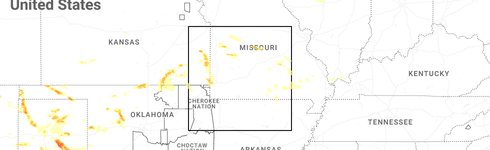
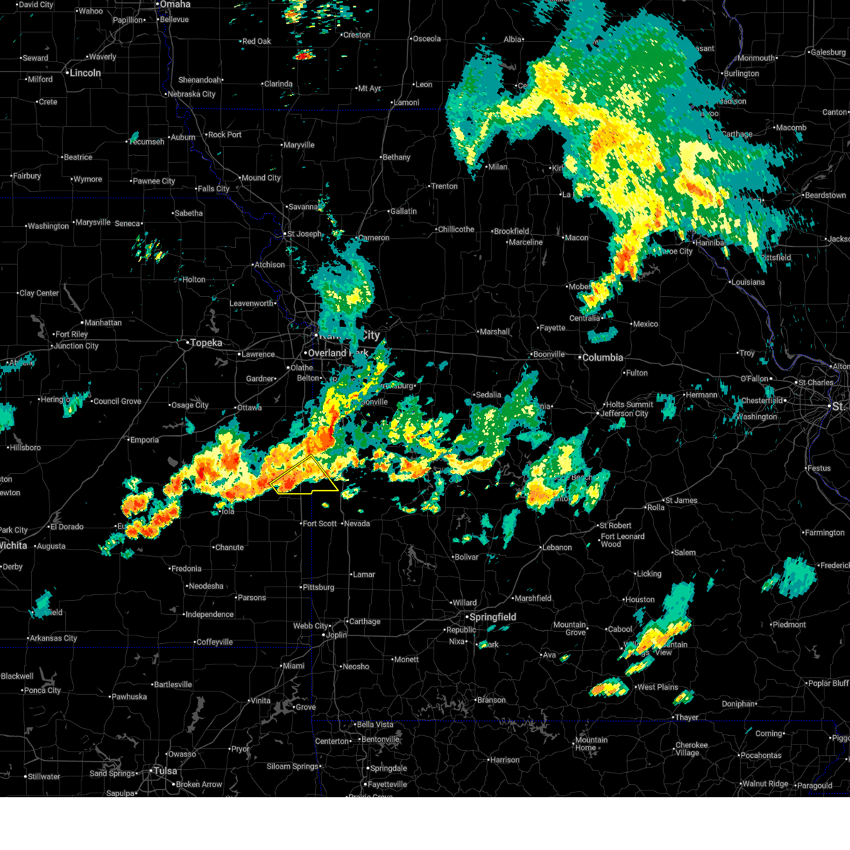
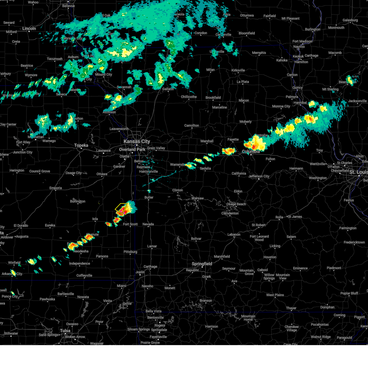
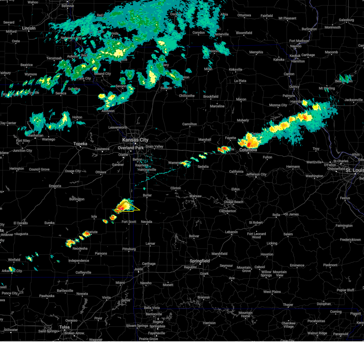
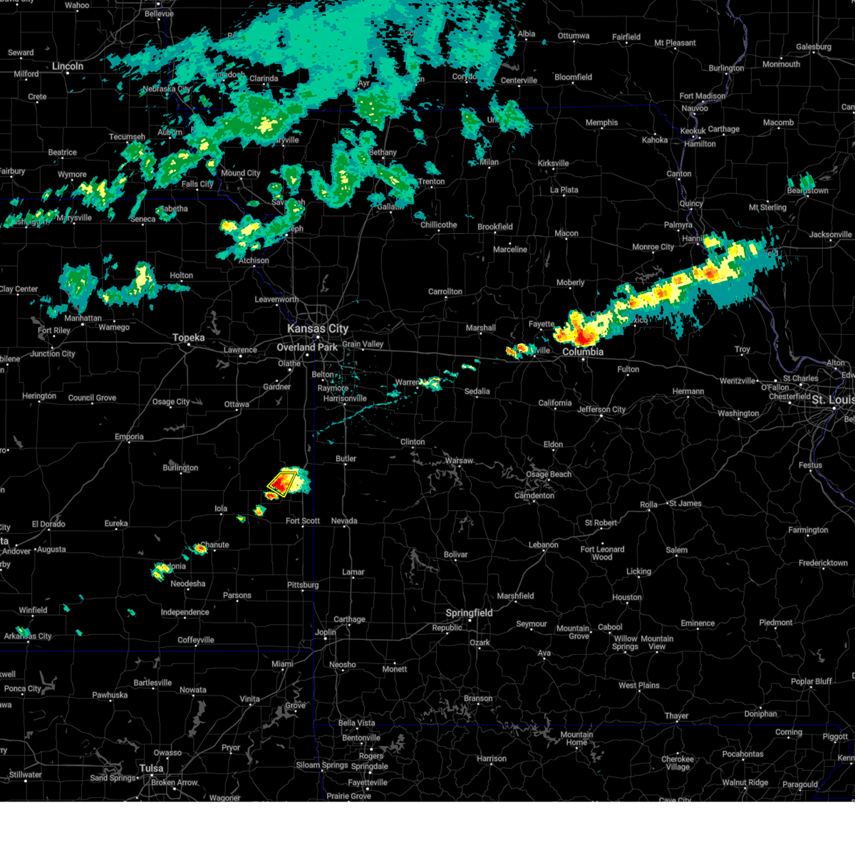
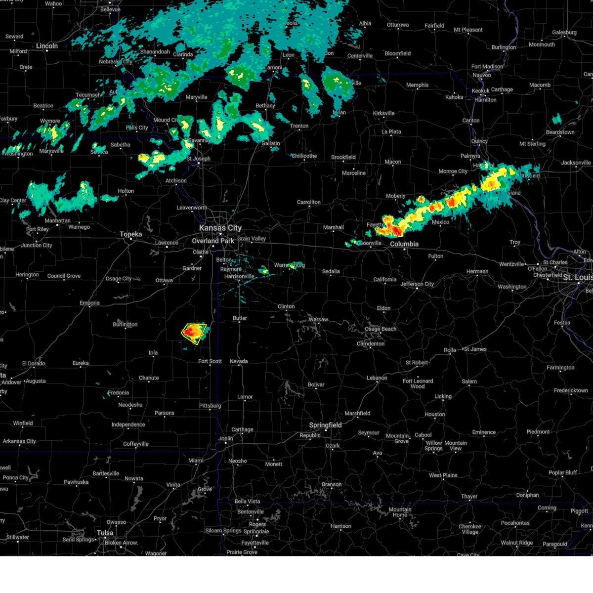
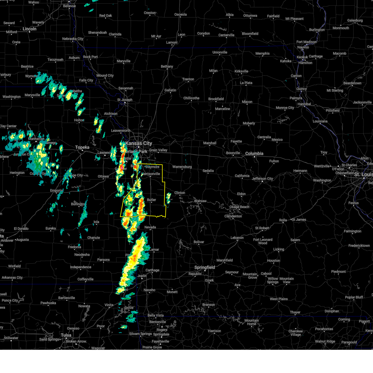
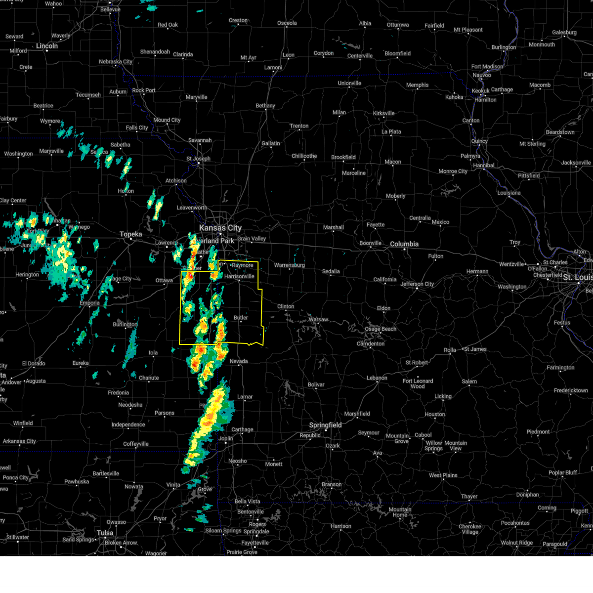
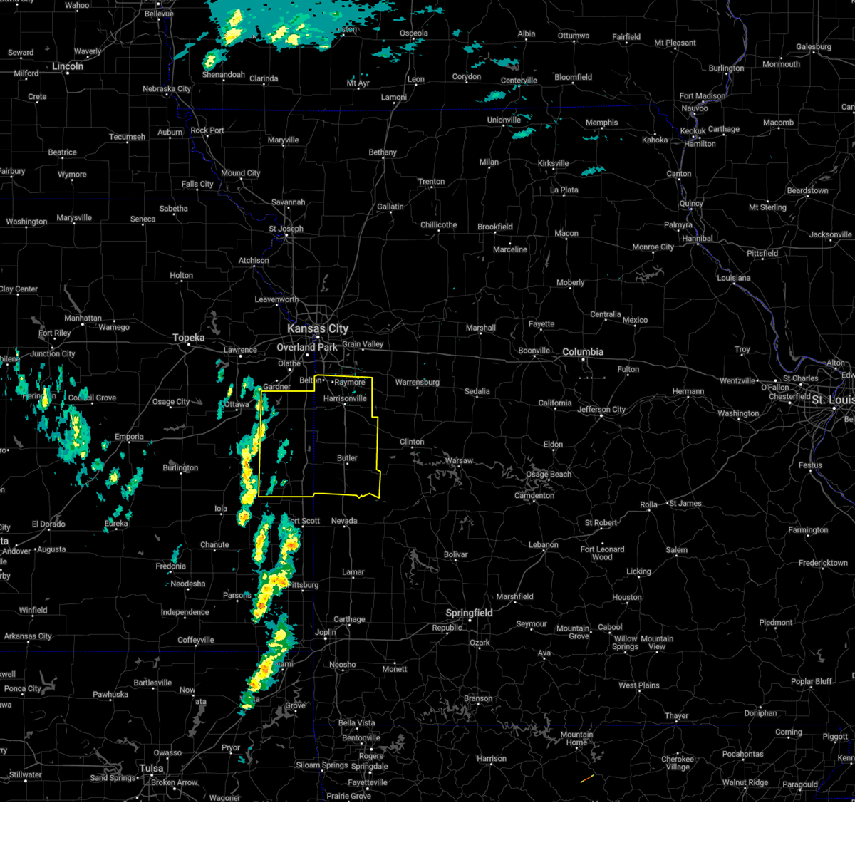
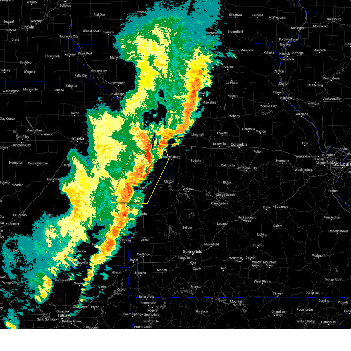
Hail Map for Mound City, KS
The Mound City, KS area has had 6 reports of on-the-ground hail by trained spotters, and has been under severe weather warnings 26 times during the past 12 months. Doppler radar has detected hail at or near Mound City, KS on 87 occasions, including 4 occasions during the past year.
| Name: | Mound City, KS |
| Where Located: | 46.5 miles NE of Chanute, KS |
| Map: | Google Map for Mound City, KS |
| Population: | 694 |
| Housing Units: | 351 |
| More Info: | Search Google for Mound City, KS |
2
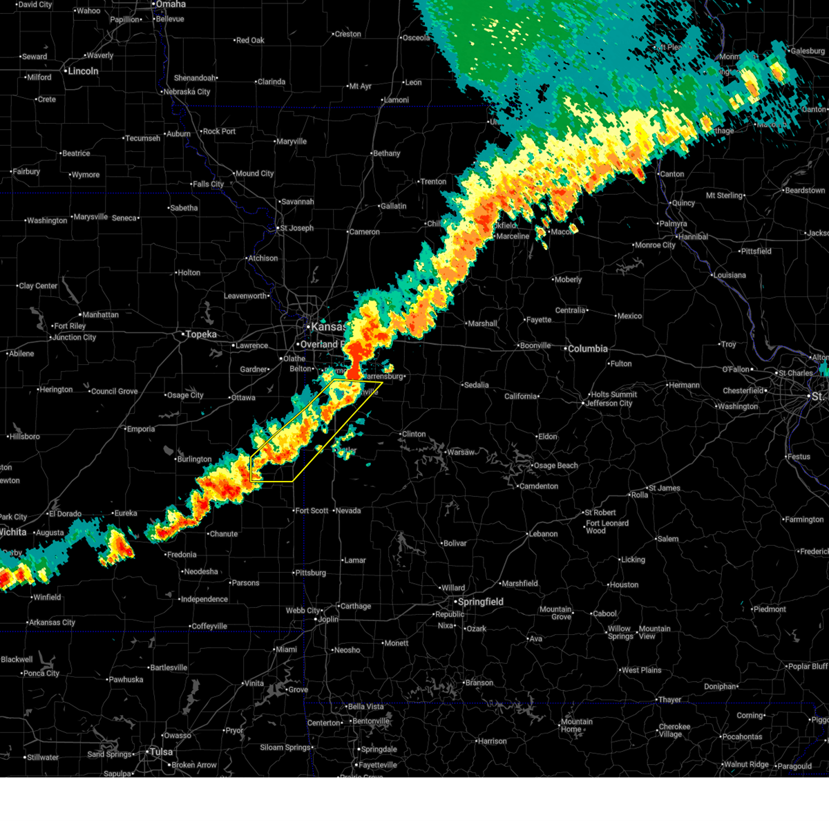
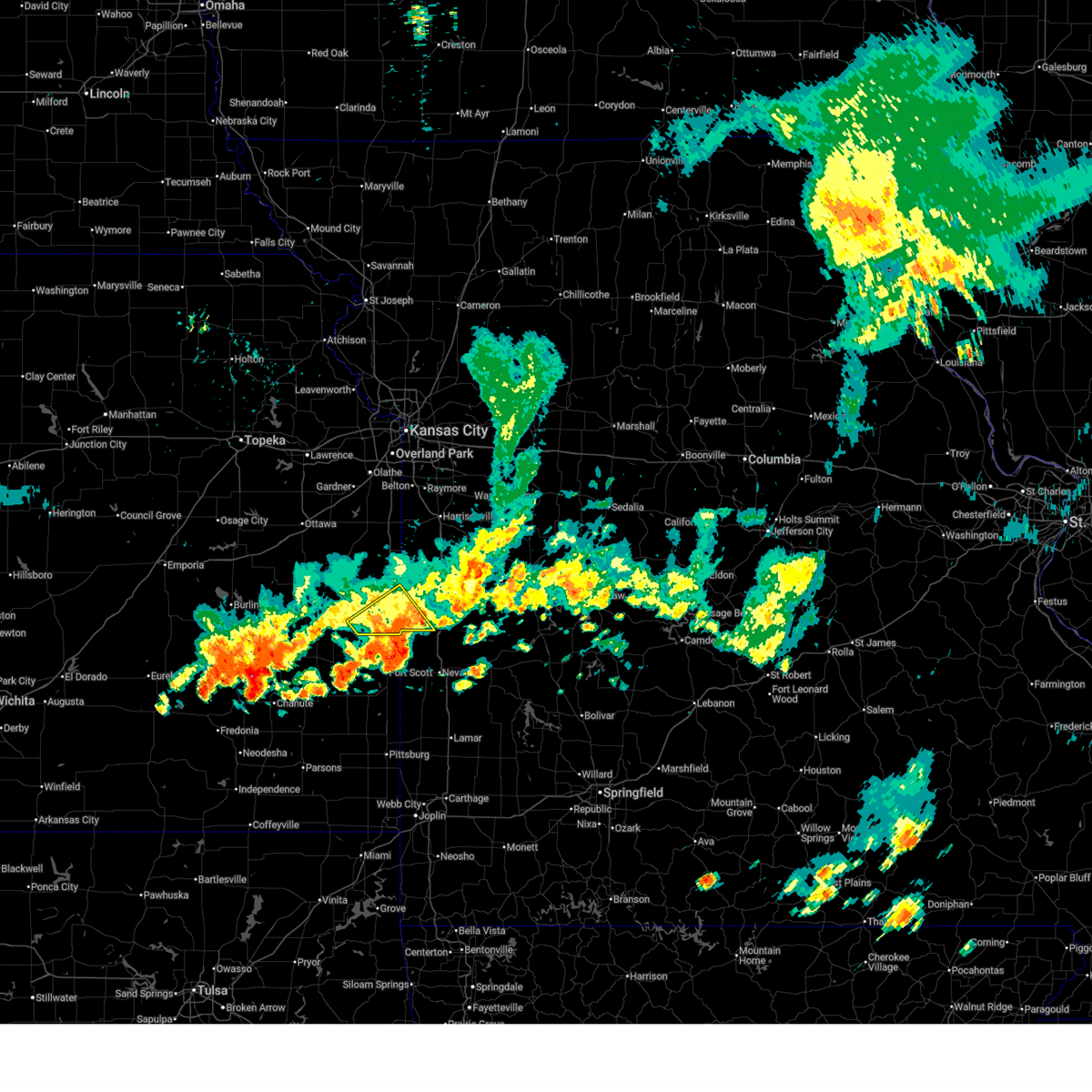
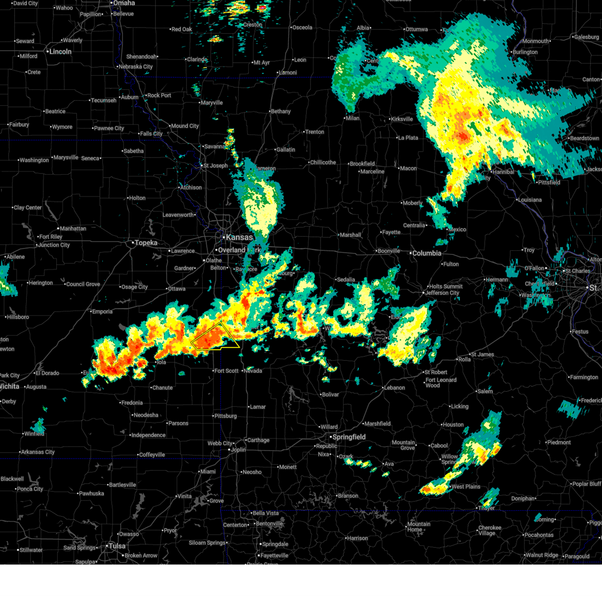
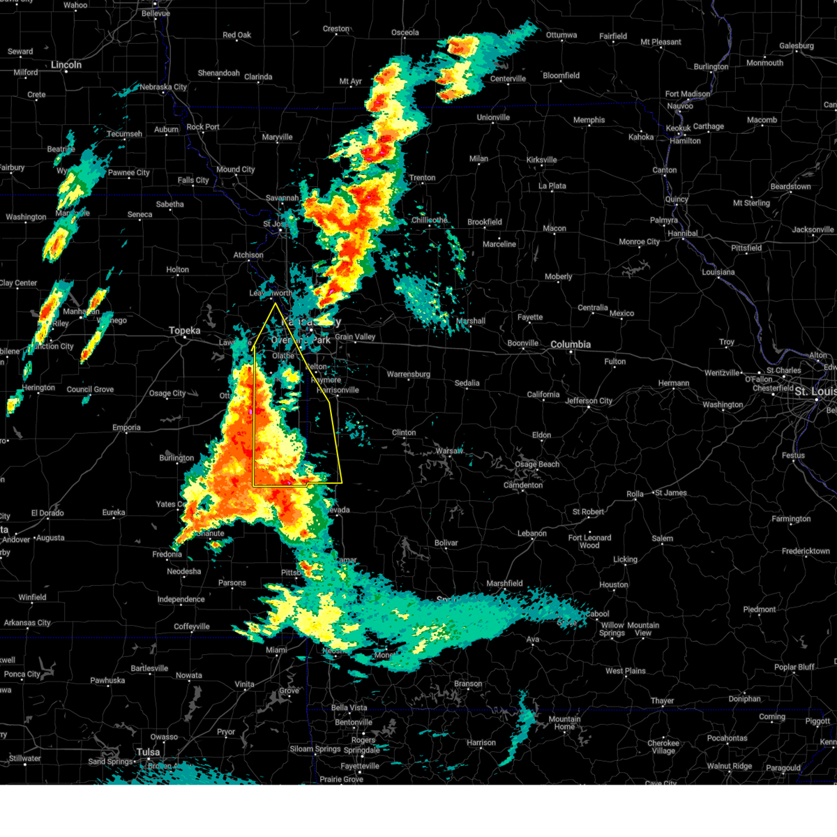
The Top Recent Hail Date for Mound City, KS is Sunday, June 8, 2025 (29th out of 87)
Hail and Wind Damage Spotted near Mound City, KS
| Date / Time | Report Details |
|---|---|
| 7/11/2025 8:31 PM CDT |
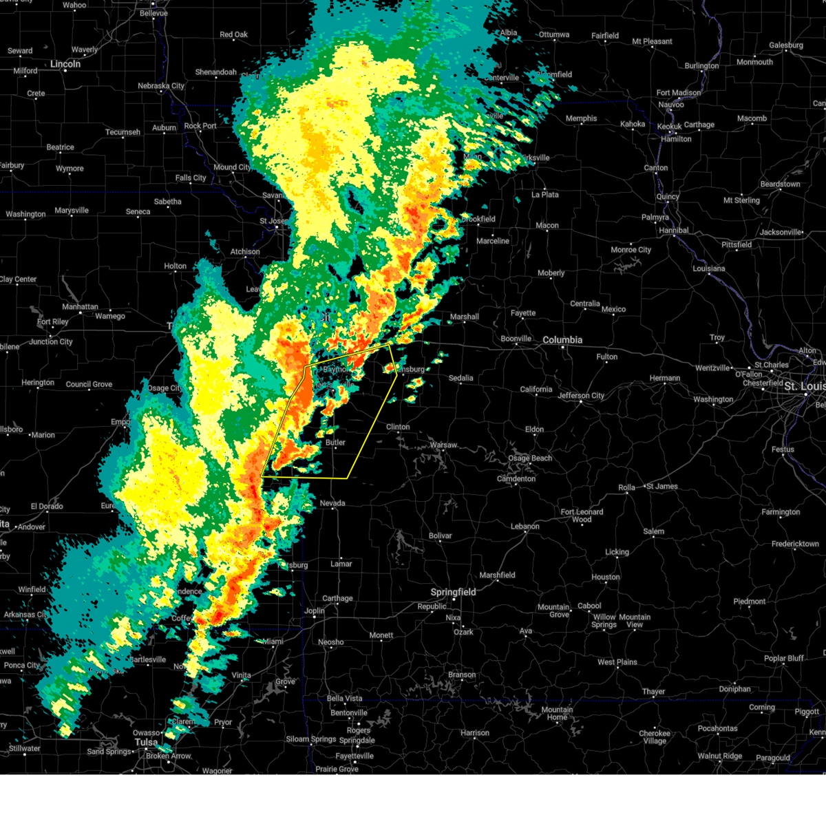
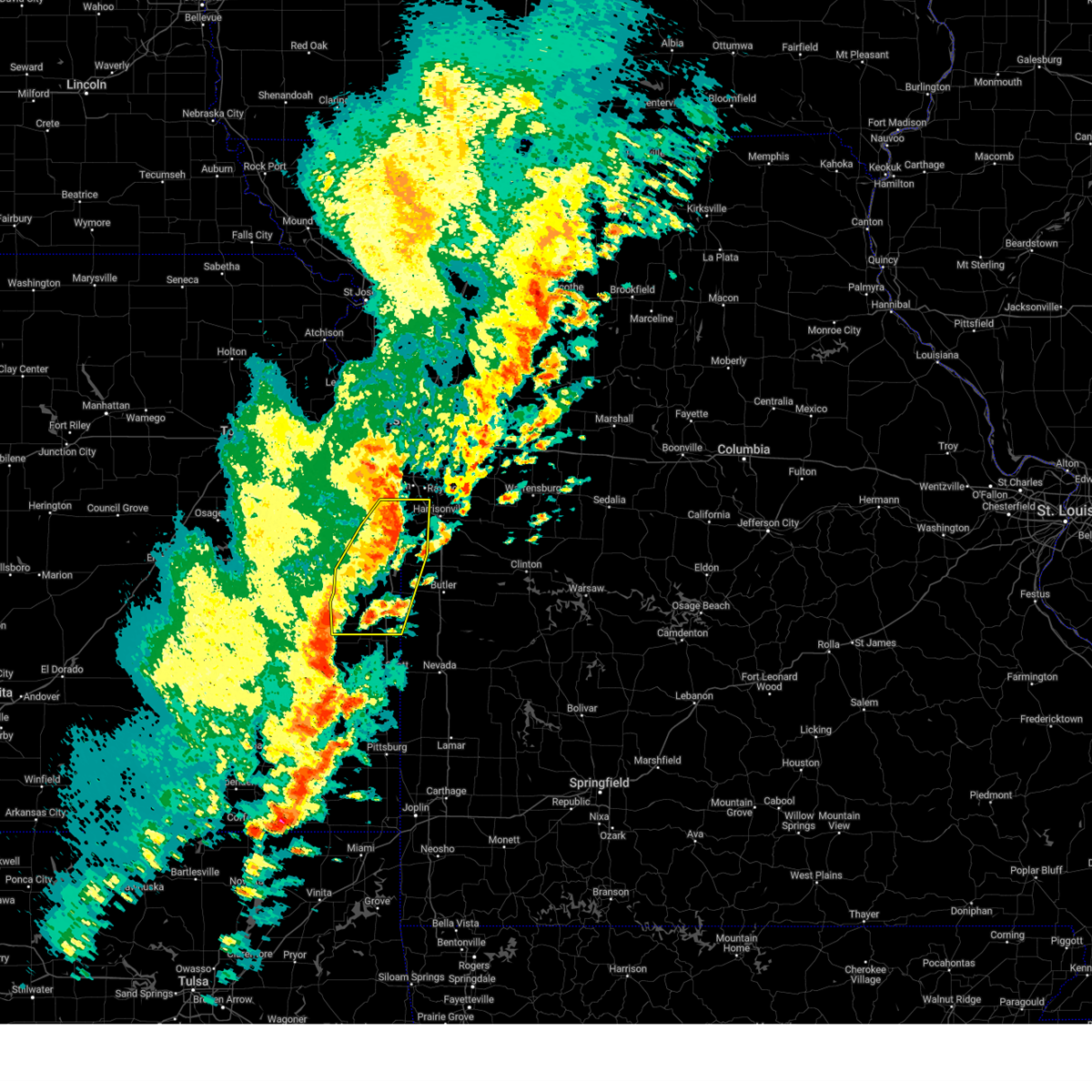
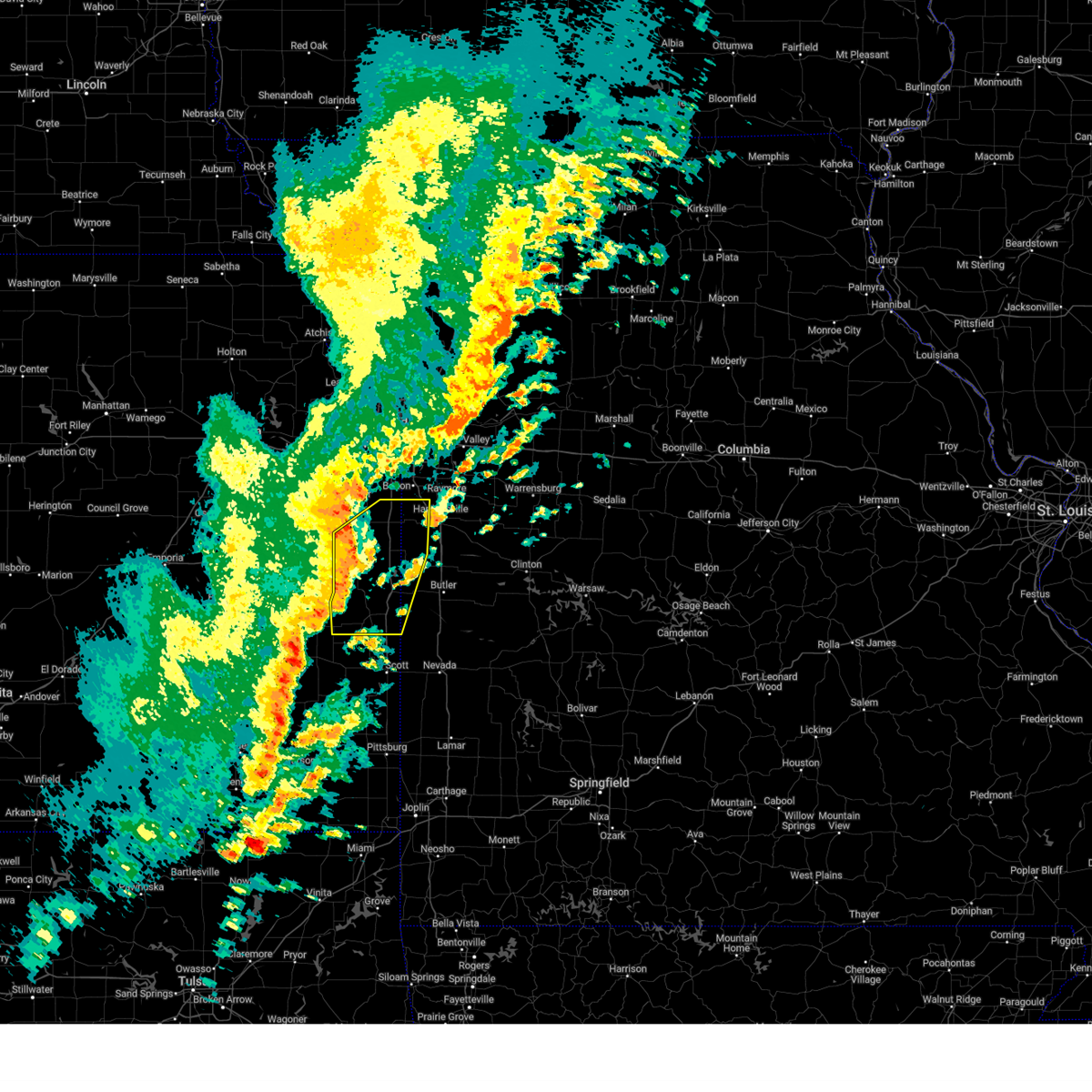
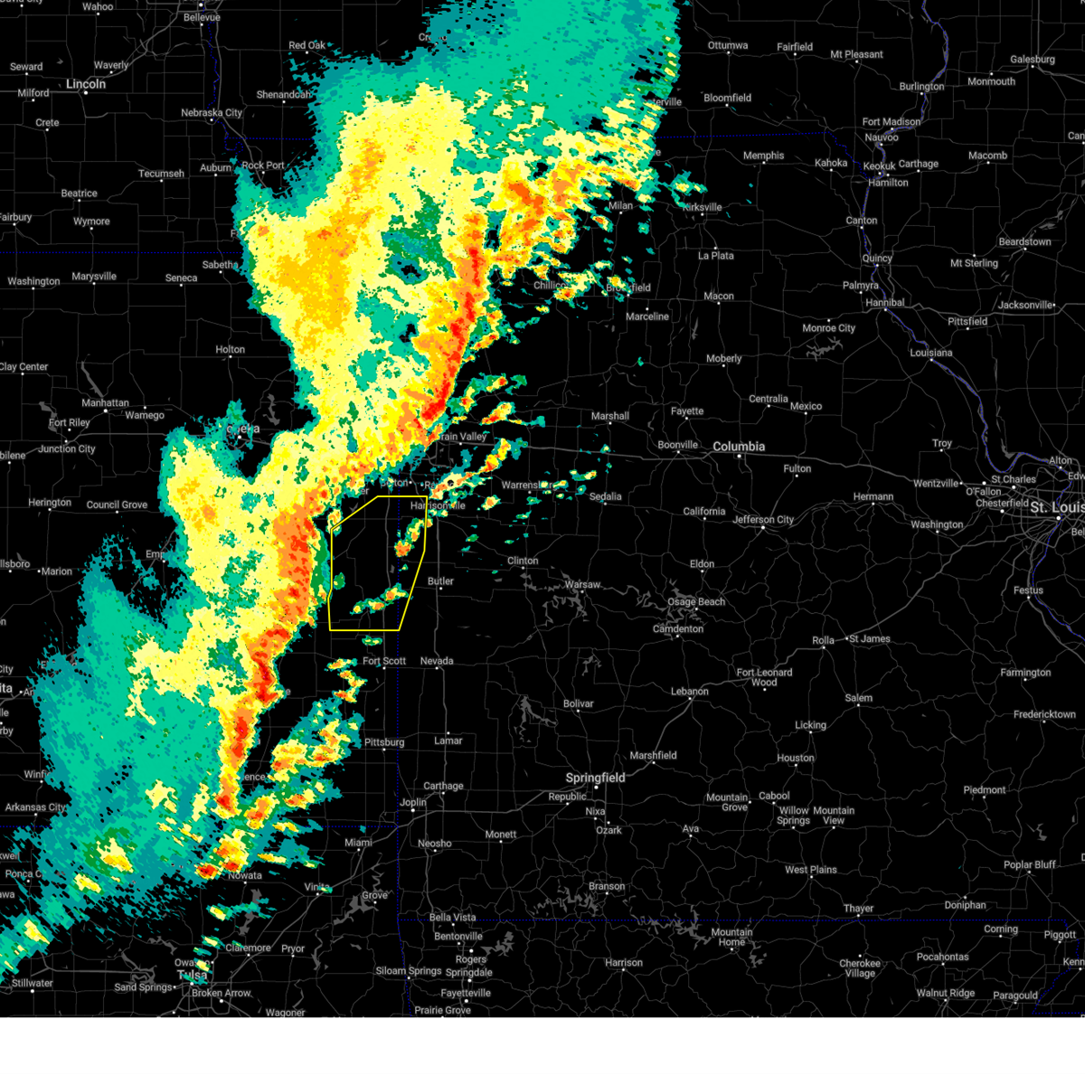
 At 830 pm cdt, severe thunderstorms were located along a line extending from near east lynne to mound city, moving east at 25 mph (radar indicated). Hazards include 60 mph wind gusts and quarter size hail. Hail damage to vehicles is expected. expect wind damage to roofs, siding, and trees. locations impacted include, harrisonville, holden, adrian, garden city, pleasanton, la cygne, mound city, archie, drexel, linn valley, freeman, east lynne, blue mound, prescott, amsterdam, amoret, gunn city, merwin, worland, and la tour. This includes interstate 49 between mile markers 140 and 164. At 830 pm cdt, severe thunderstorms were located along a line extending from near east lynne to mound city, moving east at 25 mph (radar indicated). Hazards include 60 mph wind gusts and quarter size hail. Hail damage to vehicles is expected. expect wind damage to roofs, siding, and trees. locations impacted include, harrisonville, holden, adrian, garden city, pleasanton, la cygne, mound city, archie, drexel, linn valley, freeman, east lynne, blue mound, prescott, amsterdam, amoret, gunn city, merwin, worland, and la tour. This includes interstate 49 between mile markers 140 and 164.
|
| 7/11/2025 7:59 PM CDT | Svreax the national weather service in pleasant hill has issued a * severe thunderstorm warning for, southeastern miami county in east central kansas, linn county in east central kansas, cass county in west central missouri, northwestern bates county in west central missouri, west central johnson county in west central missouri, * until 845 pm cdt. * at 759 pm cdt, severe thunderstorms were located along a line extending from near harrisonville to 8 miles north of blue mound, moving east at 25 mph (radar indicated). Hazards include 60 mph wind gusts and quarter size hail. Hail damage to vehicles is expected. Expect wind damage to roofs, siding, and trees. |
| 6/29/2025 2:14 PM CDT |
 The storm which prompted severe thunderstorm warning 135 has weakened below severe limits, and no longer poses an immediate threat to life or property. therefore, warning 135 will be allowed to expire. however, gusty winds and heavy rain are still possible with this thunderstorm. other portions of bates county missouri are still under severe thunderstorm warning 136 until 245 pm cdt. The storm which prompted severe thunderstorm warning 135 has weakened below severe limits, and no longer poses an immediate threat to life or property. therefore, warning 135 will be allowed to expire. however, gusty winds and heavy rain are still possible with this thunderstorm. other portions of bates county missouri are still under severe thunderstorm warning 136 until 245 pm cdt.
|
| 6/29/2025 1:47 PM CDT |
 At 147 pm cdt, a severe thunderstorm was located over prescott, or 8 miles south of pleasanton, moving southeast at 20 mph (radar indicated). Hazards include 60 mph wind gusts. Expect damage to roofs, siding, and trees. Locations impacted include, pleasanton, mound city, hume, prescott, amoret, foster, and worland. At 147 pm cdt, a severe thunderstorm was located over prescott, or 8 miles south of pleasanton, moving southeast at 20 mph (radar indicated). Hazards include 60 mph wind gusts. Expect damage to roofs, siding, and trees. Locations impacted include, pleasanton, mound city, hume, prescott, amoret, foster, and worland.
|
| 6/29/2025 1:31 PM CDT |
 Svreax the national weather service in pleasant hill has issued a * severe thunderstorm warning for, southeastern linn county in east central kansas, southwestern bates county in west central missouri, * until 215 pm cdt. * at 130 pm cdt, a severe thunderstorm was located over prescott, or 7 miles southeast of mound city, moving southeast at 15 mph (radar indicated). Hazards include 60 mph wind gusts. expect damage to roofs, siding, and trees Svreax the national weather service in pleasant hill has issued a * severe thunderstorm warning for, southeastern linn county in east central kansas, southwestern bates county in west central missouri, * until 215 pm cdt. * at 130 pm cdt, a severe thunderstorm was located over prescott, or 7 miles southeast of mound city, moving southeast at 15 mph (radar indicated). Hazards include 60 mph wind gusts. expect damage to roofs, siding, and trees
|
| 6/8/2025 2:40 PM CDT |
 The storm which prompted the warning has moved out of severe thunderstorm warning 109. therefore, warning 109 will be allowed to expire. however, severe thunderstorm warning 110 has been issued downstream for linn county kansas, and portions of bates county missouri. please see warning 110 for further details. a severe thunderstorm watch remains in effect until 1000 pm cdt for east central kansas. The storm which prompted the warning has moved out of severe thunderstorm warning 109. therefore, warning 109 will be allowed to expire. however, severe thunderstorm warning 110 has been issued downstream for linn county kansas, and portions of bates county missouri. please see warning 110 for further details. a severe thunderstorm watch remains in effect until 1000 pm cdt for east central kansas.
|
| 6/8/2025 2:37 PM CDT |
 Svreax the national weather service in pleasant hill has issued a * severe thunderstorm warning for, southeastern linn county in east central kansas, southwestern bates county in west central missouri, * until 300 pm cdt. * at 236 pm cdt, a severe thunderstorm was located near mound city, moving southeast at 30 mph (radar indicated). Hazards include 60 mph wind gusts and quarter size hail. Hail damage to vehicles is expected. Expect wind damage to roofs, siding, and trees. Svreax the national weather service in pleasant hill has issued a * severe thunderstorm warning for, southeastern linn county in east central kansas, southwestern bates county in west central missouri, * until 300 pm cdt. * at 236 pm cdt, a severe thunderstorm was located near mound city, moving southeast at 30 mph (radar indicated). Hazards include 60 mph wind gusts and quarter size hail. Hail damage to vehicles is expected. Expect wind damage to roofs, siding, and trees.
|
| 6/8/2025 2:32 PM CDT |
 At 232 pm cdt, a severe thunderstorm was located over mound city, moving east at 25 mph (radar indicated). Hazards include 60 mph wind gusts and quarter size hail. Hail damage to vehicles is expected. expect wind damage to roofs, siding, and trees. Locations impacted include, mound city. At 232 pm cdt, a severe thunderstorm was located over mound city, moving east at 25 mph (radar indicated). Hazards include 60 mph wind gusts and quarter size hail. Hail damage to vehicles is expected. expect wind damage to roofs, siding, and trees. Locations impacted include, mound city.
|
| 6/8/2025 2:23 PM CDT |
 At 223 pm cdt, a severe thunderstorm was located near mound city, moving east at 25 mph (radar indicated). Hazards include 60 mph wind gusts and half dollar size hail. Hail damage to vehicles is expected. expect wind damage to roofs, siding, and trees. Locations impacted include, mound city. At 223 pm cdt, a severe thunderstorm was located near mound city, moving east at 25 mph (radar indicated). Hazards include 60 mph wind gusts and half dollar size hail. Hail damage to vehicles is expected. expect wind damage to roofs, siding, and trees. Locations impacted include, mound city.
|
| 6/8/2025 2:11 PM CDT |
 At 211 pm cdt, a severe thunderstorm was located near blue mound, or 8 miles northwest of mound city, moving east at 25 mph (radar indicated). Hazards include 60 mph wind gusts and half dollar size hail. Hail damage to vehicles is expected. expect wind damage to roofs, siding, and trees. Locations impacted include, mound city. At 211 pm cdt, a severe thunderstorm was located near blue mound, or 8 miles northwest of mound city, moving east at 25 mph (radar indicated). Hazards include 60 mph wind gusts and half dollar size hail. Hail damage to vehicles is expected. expect wind damage to roofs, siding, and trees. Locations impacted include, mound city.
|
| 6/8/2025 1:56 PM CDT |
 Svreax the national weather service in pleasant hill has issued a * severe thunderstorm warning for, southwestern linn county in east central kansas, * until 245 pm cdt. * at 156 pm cdt, a severe thunderstorm was located 9 miles north of kincaid, or 9 miles southeast of garnett, moving east at 25 mph (radar indicated). Hazards include 60 mph wind gusts and quarter size hail. Hail damage to vehicles is expected. Expect wind damage to roofs, siding, and trees. Svreax the national weather service in pleasant hill has issued a * severe thunderstorm warning for, southwestern linn county in east central kansas, * until 245 pm cdt. * at 156 pm cdt, a severe thunderstorm was located 9 miles north of kincaid, or 9 miles southeast of garnett, moving east at 25 mph (radar indicated). Hazards include 60 mph wind gusts and quarter size hail. Hail damage to vehicles is expected. Expect wind damage to roofs, siding, and trees.
|
| 5/19/2025 4:13 PM CDT |
 The storms which prompted the warning have weakened below severe limits, and no longer pose an immediate threat to life or property. therefore, the warning will be allowed to expire. however, gusty winds and heavy rain are still possible with these thunderstorms. a tornado watch remains in effect until 900 pm cdt for northeastern and east central kansas, and west central missouri. The storms which prompted the warning have weakened below severe limits, and no longer pose an immediate threat to life or property. therefore, the warning will be allowed to expire. however, gusty winds and heavy rain are still possible with these thunderstorms. a tornado watch remains in effect until 900 pm cdt for northeastern and east central kansas, and west central missouri.
|
| 5/19/2025 3:52 PM CDT | At 352 pm cdt, severe thunderstorms were located along a line extending from near bonner springs to near olathe to near linn valley to near hume, moving northeast at 55 mph (radar indicated). Hazards include 60 mph wind gusts and quarter size hail. Hail damage to vehicles is expected. expect wind damage to roofs, siding, and trees. locations impacted include, overland park, olathe, shawnee, lenexa, leavenworth, leawood, gardner, lansing, bonner springs, de soto, paola, spring hill, basehor, osawatomie, edwardsville, louisburg, butler, edgerton, rich hill, and pleasanton. this includes the following highways, interstate 70 in kansas between mile markers 410 and 413. interstate 35 in kansas between mile markers 200 and 226. interstate 435 between mile markers 0 and 16, and between mile markers 79 and 83. kansas turnpike between mile markers 216 and 226. Interstate 49 between mile markers 119 and 134. |
| 5/19/2025 3:34 PM CDT |
 At 334 pm cdt, severe thunderstorms were located along a line extending from near edgerton to near osawatomie to near prescott to near fort scott, moving northeast at 60 mph (radar indicated). Hazards include ping pong ball size hail and 60 mph wind gusts. People and animals outdoors will be injured. expect hail damage to roofs, siding, windows, and vehicles. expect wind damage to roofs, siding, and trees. locations impacted include, overland park, olathe, shawnee, lenexa, leavenworth, leawood, gardner, lansing, bonner springs, de soto, paola, spring hill, basehor, osawatomie, edwardsville, louisburg, butler, edgerton, rich hill, and pleasanton. this includes the following highways, interstate 70 in kansas between mile markers 410 and 413. interstate 35 in kansas between mile markers 200 and 226. interstate 435 between mile markers 0 and 16, and between mile markers 79 and 83. kansas turnpike between mile markers 216 and 226. Interstate 49 between mile markers 119 and 134. At 334 pm cdt, severe thunderstorms were located along a line extending from near edgerton to near osawatomie to near prescott to near fort scott, moving northeast at 60 mph (radar indicated). Hazards include ping pong ball size hail and 60 mph wind gusts. People and animals outdoors will be injured. expect hail damage to roofs, siding, windows, and vehicles. expect wind damage to roofs, siding, and trees. locations impacted include, overland park, olathe, shawnee, lenexa, leavenworth, leawood, gardner, lansing, bonner springs, de soto, paola, spring hill, basehor, osawatomie, edwardsville, louisburg, butler, edgerton, rich hill, and pleasanton. this includes the following highways, interstate 70 in kansas between mile markers 410 and 413. interstate 35 in kansas between mile markers 200 and 226. interstate 435 between mile markers 0 and 16, and between mile markers 79 and 83. kansas turnpike between mile markers 216 and 226. Interstate 49 between mile markers 119 and 134.
|
| 5/19/2025 3:21 PM CDT |
 Svreax the national weather service in pleasant hill has issued a * severe thunderstorm warning for, western wyandotte county in northeastern kansas, miami county in east central kansas, linn county in east central kansas, southeastern leavenworth county in northeastern kansas, johnson county in east central kansas, western cass county in west central missouri, western bates county in west central missouri, * until 415 pm cdt. * at 321 pm cdt, severe thunderstorms were located along a line extending from near ottawa to greeley to 6 miles north of redfield to 7 miles east of hepler, moving northeast at 55 mph (radar indicated). Hazards include ping pong ball size hail and 60 mph wind gusts. People and animals outdoors will be injured. expect hail damage to roofs, siding, windows, and vehicles. Expect wind damage to roofs, siding, and trees. Svreax the national weather service in pleasant hill has issued a * severe thunderstorm warning for, western wyandotte county in northeastern kansas, miami county in east central kansas, linn county in east central kansas, southeastern leavenworth county in northeastern kansas, johnson county in east central kansas, western cass county in west central missouri, western bates county in west central missouri, * until 415 pm cdt. * at 321 pm cdt, severe thunderstorms were located along a line extending from near ottawa to greeley to 6 miles north of redfield to 7 miles east of hepler, moving northeast at 55 mph (radar indicated). Hazards include ping pong ball size hail and 60 mph wind gusts. People and animals outdoors will be injured. expect hail damage to roofs, siding, windows, and vehicles. Expect wind damage to roofs, siding, and trees.
|
| 5/19/2025 3:07 PM CDT |
 Svreax the national weather service in pleasant hill has issued a * severe thunderstorm warning for, southwestern miami county in east central kansas, linn county in east central kansas, * until 345 pm cdt. * at 307 pm cdt, a severe thunderstorm was located near lone elm, or 8 miles south of garnett, moving northeast at 40 mph (radar indicated). Hazards include ping pong ball size hail and 60 mph wind gusts. People and animals outdoors will be injured. expect hail damage to roofs, siding, windows, and vehicles. Expect wind damage to roofs, siding, and trees. Svreax the national weather service in pleasant hill has issued a * severe thunderstorm warning for, southwestern miami county in east central kansas, linn county in east central kansas, * until 345 pm cdt. * at 307 pm cdt, a severe thunderstorm was located near lone elm, or 8 miles south of garnett, moving northeast at 40 mph (radar indicated). Hazards include ping pong ball size hail and 60 mph wind gusts. People and animals outdoors will be injured. expect hail damage to roofs, siding, windows, and vehicles. Expect wind damage to roofs, siding, and trees.
|
| 4/2/2025 5:55 AM CDT |
 Svreax the national weather service in pleasant hill has issued a * severe thunderstorm warning for, miami county in east central kansas, linn county in east central kansas, southeastern johnson county in east central kansas, cass county in west central missouri, northwestern bates county in west central missouri, southern jackson county in west central missouri, northwestern johnson county in west central missouri, * until 645 am cdt. * at 555 am cdt, severe thunderstorms were located along a line extending from near peculiar to near louisburg to near parker to near blue mound, moving east at 40 mph (radar indicated). Hazards include 60 mph wind gusts. expect damage to roofs, siding, and trees Svreax the national weather service in pleasant hill has issued a * severe thunderstorm warning for, miami county in east central kansas, linn county in east central kansas, southeastern johnson county in east central kansas, cass county in west central missouri, northwestern bates county in west central missouri, southern jackson county in west central missouri, northwestern johnson county in west central missouri, * until 645 am cdt. * at 555 am cdt, severe thunderstorms were located along a line extending from near peculiar to near louisburg to near parker to near blue mound, moving east at 40 mph (radar indicated). Hazards include 60 mph wind gusts. expect damage to roofs, siding, and trees
|
| 3/14/2025 2:59 PM CDT |
 Svreax the national weather service in pleasant hill has issued a * severe thunderstorm warning for, southeastern miami county in east central kansas, eastern linn county in east central kansas, cass county in west central missouri, bates county in west central missouri, * until 345 pm cdt. * at 259 pm cdt, severe thunderstorms were located along a line extending from la cygne to 7 miles west of butler to 6 miles southwest of rich hill, moving north at 50 mph (radar indicated). Hazards include 70 mph wind gusts and penny size hail. Expect considerable tree damage. Damage is likely to mobile homes, roofs, and outbuildings. Svreax the national weather service in pleasant hill has issued a * severe thunderstorm warning for, southeastern miami county in east central kansas, eastern linn county in east central kansas, cass county in west central missouri, bates county in west central missouri, * until 345 pm cdt. * at 259 pm cdt, severe thunderstorms were located along a line extending from la cygne to 7 miles west of butler to 6 miles southwest of rich hill, moving north at 50 mph (radar indicated). Hazards include 70 mph wind gusts and penny size hail. Expect considerable tree damage. Damage is likely to mobile homes, roofs, and outbuildings.
|
| 3/14/2025 2:48 PM CDT |
 At 248 pm cdt, severe thunderstorms were located along a line extending from de soto to drexel to near prescott, moving north at 60 mph (radar indicated). Hazards include 70 mph wind gusts and penny size hail. Expect considerable tree damage. damage is likely to mobile homes, roofs, and outbuildings. locations impacted include, amoret, baldwin park, pleasanton, lake winnebago, strasburg, lake annette, west line, east lynne, la cygne, parker, fontana, hume, rich hill, chiles, belton, rockville, drexel, osawatomie, mound city, and worland. This includes interstate 35 in kansas between mile markers 200 and 201. At 248 pm cdt, severe thunderstorms were located along a line extending from de soto to drexel to near prescott, moving north at 60 mph (radar indicated). Hazards include 70 mph wind gusts and penny size hail. Expect considerable tree damage. damage is likely to mobile homes, roofs, and outbuildings. locations impacted include, amoret, baldwin park, pleasanton, lake winnebago, strasburg, lake annette, west line, east lynne, la cygne, parker, fontana, hume, rich hill, chiles, belton, rockville, drexel, osawatomie, mound city, and worland. This includes interstate 35 in kansas between mile markers 200 and 201.
|
| 3/14/2025 2:23 PM CDT |
 Svreax the national weather service in pleasant hill has issued a * severe thunderstorm warning for, miami county in east central kansas, linn county in east central kansas, cass county in west central missouri, bates county in west central missouri, * until 300 pm cdt. * at 222 pm cdt, severe thunderstorms were located along a line extending from near edgerton to near pleasanton to near arma, moving northeast at 55 mph (radar indicated). Hazards include 70 mph wind gusts and penny size hail. Expect considerable tree damage. Damage is likely to mobile homes, roofs, and outbuildings. Svreax the national weather service in pleasant hill has issued a * severe thunderstorm warning for, miami county in east central kansas, linn county in east central kansas, cass county in west central missouri, bates county in west central missouri, * until 300 pm cdt. * at 222 pm cdt, severe thunderstorms were located along a line extending from near edgerton to near pleasanton to near arma, moving northeast at 55 mph (radar indicated). Hazards include 70 mph wind gusts and penny size hail. Expect considerable tree damage. Damage is likely to mobile homes, roofs, and outbuildings.
|
| 10/30/2024 8:59 PM CDT |
 At 859 pm cdt, severe thunderstorms were located along a line extending from lone jack to near kingsville to near garden city to hume, moving east at 60 mph (radar indicated). Hazards include 60 mph wind gusts. Expect damage to roofs, siding, and trees. Locations impacted include, lee's summit, belton, raymore, harrisonville, pleasant hill, greenwood, peculiar, louisburg, butler, holden, adrian, garden city, rich hill, pleasanton, la cygne, mound city, archie, lake winnebago, lone jack, and drexel. At 859 pm cdt, severe thunderstorms were located along a line extending from lone jack to near kingsville to near garden city to hume, moving east at 60 mph (radar indicated). Hazards include 60 mph wind gusts. Expect damage to roofs, siding, and trees. Locations impacted include, lee's summit, belton, raymore, harrisonville, pleasant hill, greenwood, peculiar, louisburg, butler, holden, adrian, garden city, rich hill, pleasanton, la cygne, mound city, archie, lake winnebago, lone jack, and drexel.
|
| 10/30/2024 8:39 PM CDT |
 Svreax the national weather service in pleasant hill has issued a * severe thunderstorm warning for, southeastern miami county in east central kansas, eastern linn county in east central kansas, cass county in west central missouri, northwestern henry county in west central missouri, bates county in west central missouri, southwestern lafayette county in west central missouri, southeastern jackson county in west central missouri, western johnson county in west central missouri, * until 930 pm cdt. * at 838 pm cdt, severe thunderstorms were located along a line extending from near belton to near freeman to near linn valley to near mound city, moving east at 50 mph (radar indicated). Hazards include 60 mph wind gusts. expect damage to roofs, siding, and trees Svreax the national weather service in pleasant hill has issued a * severe thunderstorm warning for, southeastern miami county in east central kansas, eastern linn county in east central kansas, cass county in west central missouri, northwestern henry county in west central missouri, bates county in west central missouri, southwestern lafayette county in west central missouri, southeastern jackson county in west central missouri, western johnson county in west central missouri, * until 930 pm cdt. * at 838 pm cdt, severe thunderstorms were located along a line extending from near belton to near freeman to near linn valley to near mound city, moving east at 50 mph (radar indicated). Hazards include 60 mph wind gusts. expect damage to roofs, siding, and trees
|
| 10/30/2024 8:32 PM CDT |
 At 832 pm cdt, severe thunderstorms were located along a line extending from near cleveland to near drexel to near la cygne, moving northeast at 50 mph (radar indicated). Hazards include 60 mph wind gusts. Expect damage to roofs, siding, and trees. Locations impacted include, paola, peculiar, osawatomie, louisburg, pleasanton, la cygne, mound city, drexel, linn valley, cleveland, freeman, hume, parker, blue mound, prescott, fontana, lake annette, amsterdam, amoret, and west line. At 832 pm cdt, severe thunderstorms were located along a line extending from near cleveland to near drexel to near la cygne, moving northeast at 50 mph (radar indicated). Hazards include 60 mph wind gusts. Expect damage to roofs, siding, and trees. Locations impacted include, paola, peculiar, osawatomie, louisburg, pleasanton, la cygne, mound city, drexel, linn valley, cleveland, freeman, hume, parker, blue mound, prescott, fontana, lake annette, amsterdam, amoret, and west line.
|
| 10/30/2024 8:17 PM CDT |
 At 817 pm cdt, severe thunderstorms were located along a line extending from 6 miles northwest of paola to fontana to near blue mound, moving northeast at 65 mph (radar indicated). Hazards include 60 mph wind gusts and penny size hail. Expect damage to roofs, siding, and trees. Locations impacted include, paola, peculiar, osawatomie, louisburg, pleasanton, la cygne, mound city, drexel, linn valley, cleveland, freeman, hume, parker, blue mound, prescott, fontana, lake annette, amsterdam, amoret, and west line. At 817 pm cdt, severe thunderstorms were located along a line extending from 6 miles northwest of paola to fontana to near blue mound, moving northeast at 65 mph (radar indicated). Hazards include 60 mph wind gusts and penny size hail. Expect damage to roofs, siding, and trees. Locations impacted include, paola, peculiar, osawatomie, louisburg, pleasanton, la cygne, mound city, drexel, linn valley, cleveland, freeman, hume, parker, blue mound, prescott, fontana, lake annette, amsterdam, amoret, and west line.
|
| 10/30/2024 8:01 PM CDT |
 Svreax the national weather service in pleasant hill has issued a * severe thunderstorm warning for, miami county in east central kansas, linn county in east central kansas, southwestern cass county in west central missouri, northwestern bates county in west central missouri, * until 845 pm cdt. * at 800 pm cdt, severe thunderstorms were located along a line extending from rantoul to near garnett to near gas, moving northeast at 60 mph (radar indicated). Hazards include 60 mph wind gusts and penny size hail. expect damage to roofs, siding, and trees Svreax the national weather service in pleasant hill has issued a * severe thunderstorm warning for, miami county in east central kansas, linn county in east central kansas, southwestern cass county in west central missouri, northwestern bates county in west central missouri, * until 845 pm cdt. * at 800 pm cdt, severe thunderstorms were located along a line extending from rantoul to near garnett to near gas, moving northeast at 60 mph (radar indicated). Hazards include 60 mph wind gusts and penny size hail. expect damage to roofs, siding, and trees
|
| 9/19/2024 6:55 PM CDT |
 Svreax the national weather service in pleasant hill has issued a * severe thunderstorm warning for, southeastern miami county in east central kansas, linn county in east central kansas, western cass county in west central missouri, western bates county in west central missouri, * until 745 pm cdt. * at 654 pm cdt, severe thunderstorms were located along a line extending from near paola to near la cygne to near mound city, moving east at 30 mph (radar indicated). Hazards include 60 mph wind gusts and nickel size hail. expect damage to roofs, siding, and trees Svreax the national weather service in pleasant hill has issued a * severe thunderstorm warning for, southeastern miami county in east central kansas, linn county in east central kansas, western cass county in west central missouri, western bates county in west central missouri, * until 745 pm cdt. * at 654 pm cdt, severe thunderstorms were located along a line extending from near paola to near la cygne to near mound city, moving east at 30 mph (radar indicated). Hazards include 60 mph wind gusts and nickel size hail. expect damage to roofs, siding, and trees
|
| 6/28/2024 10:40 PM CDT |
 Svreax the national weather service in pleasant hill has issued a * severe thunderstorm warning for, southeastern miami county in east central kansas, linn county in east central kansas, eastern cass county in west central missouri, northern bates county in west central missouri, southwestern johnson county in west central missouri, * until 1115 pm cdt. * at 1040 pm cdt, severe thunderstorms were located along a line extending from near harrisonville to near archie to near linn valley to 8 miles southwest of parker, moving southeast at 35 mph (radar indicated). Hazards include 60 mph wind gusts. expect damage to roofs, siding, and trees Svreax the national weather service in pleasant hill has issued a * severe thunderstorm warning for, southeastern miami county in east central kansas, linn county in east central kansas, eastern cass county in west central missouri, northern bates county in west central missouri, southwestern johnson county in west central missouri, * until 1115 pm cdt. * at 1040 pm cdt, severe thunderstorms were located along a line extending from near harrisonville to near archie to near linn valley to 8 miles southwest of parker, moving southeast at 35 mph (radar indicated). Hazards include 60 mph wind gusts. expect damage to roofs, siding, and trees
|
| 5/26/2024 3:23 PM CDT |
 Svreax the national weather service in pleasant hill has issued a * severe thunderstorm warning for, southeastern linn county in east central kansas, southwestern bates county in west central missouri, * until 415 pm cdt. * at 322 pm cdt, a severe thunderstorm was located near prescott, or near mound city, moving east at 35 mph. another storm was located near worland and moving east at 35 mph (radar indicated). Hazards include ping pong ball size hail and 60 mph wind gusts. People and animals outdoors will be injured. expect hail damage to roofs, siding, windows, and vehicles. Expect wind damage to roofs, siding, and trees. Svreax the national weather service in pleasant hill has issued a * severe thunderstorm warning for, southeastern linn county in east central kansas, southwestern bates county in west central missouri, * until 415 pm cdt. * at 322 pm cdt, a severe thunderstorm was located near prescott, or near mound city, moving east at 35 mph. another storm was located near worland and moving east at 35 mph (radar indicated). Hazards include ping pong ball size hail and 60 mph wind gusts. People and animals outdoors will be injured. expect hail damage to roofs, siding, windows, and vehicles. Expect wind damage to roofs, siding, and trees.
|
| 5/26/2024 3:14 PM CDT |
 At 314 pm cdt, a severe thunderstorm was located over pleasanton, moving east at 35 mph (radar indicated). Hazards include 60 mph wind gusts and quarter size hail. Hail damage to vehicles is expected. expect wind damage to roofs, siding, and trees. Locations impacted include, pleasanton and mound city. At 314 pm cdt, a severe thunderstorm was located over pleasanton, moving east at 35 mph (radar indicated). Hazards include 60 mph wind gusts and quarter size hail. Hail damage to vehicles is expected. expect wind damage to roofs, siding, and trees. Locations impacted include, pleasanton and mound city.
|
| 5/26/2024 3:05 PM CDT | Golf Ball sized hail reported 1.1 miles SW of Mound City, KS, linn county so reported golf ball size hail. |
| 5/26/2024 3:03 PM CDT |
 Svreax the national weather service in pleasant hill has issued a * severe thunderstorm warning for, southeastern linn county in east central kansas, * until 330 pm cdt. * at 302 pm cdt, a severe thunderstorm was located near mound city, moving east at 35 mph (radar indicated). Hazards include 60 mph wind gusts and quarter size hail. Hail damage to vehicles is expected. Expect wind damage to roofs, siding, and trees. Svreax the national weather service in pleasant hill has issued a * severe thunderstorm warning for, southeastern linn county in east central kansas, * until 330 pm cdt. * at 302 pm cdt, a severe thunderstorm was located near mound city, moving east at 35 mph (radar indicated). Hazards include 60 mph wind gusts and quarter size hail. Hail damage to vehicles is expected. Expect wind damage to roofs, siding, and trees.
|
| 5/21/2024 4:12 PM CDT |
 At 408 pm cdt, severe thunderstorms were located along a line extending from 8 miles west of butler to near harrisonville, moving northeast at 65 mph (radar indicated). Hazards include 60 mph wind gusts and quarter size hail. Hail damage to vehicles is expected. expect wind damage to roofs, siding, and trees. Locations impacted include, harrisonville, butler, adrian, garden city, rich hill, pleasanton, la cygne, mound city, archie, drexel, linn valley, freeman, creighton, hume, east lynne, prescott, amsterdam, amoret, rockville, and gunn city. At 408 pm cdt, severe thunderstorms were located along a line extending from 8 miles west of butler to near harrisonville, moving northeast at 65 mph (radar indicated). Hazards include 60 mph wind gusts and quarter size hail. Hail damage to vehicles is expected. expect wind damage to roofs, siding, and trees. Locations impacted include, harrisonville, butler, adrian, garden city, rich hill, pleasanton, la cygne, mound city, archie, drexel, linn valley, freeman, creighton, hume, east lynne, prescott, amsterdam, amoret, rockville, and gunn city.
|
| 5/21/2024 3:57 PM CDT |
 Svreax the national weather service in pleasant hill has issued a * severe thunderstorm warning for, southeastern miami county in east central kansas, eastern linn county in east central kansas, southern cass county in west central missouri, bates county in west central missouri, * until 445 pm cdt. * at 356 pm cdt, severe thunderstorms were located along a line extending from near pleasanton to near archie, moving northeast at 65 mph (radar indicated). Hazards include 60 mph wind gusts and quarter size hail. Hail damage to vehicles is expected. Expect wind damage to roofs, siding, and trees. Svreax the national weather service in pleasant hill has issued a * severe thunderstorm warning for, southeastern miami county in east central kansas, eastern linn county in east central kansas, southern cass county in west central missouri, bates county in west central missouri, * until 445 pm cdt. * at 356 pm cdt, severe thunderstorms were located along a line extending from near pleasanton to near archie, moving northeast at 65 mph (radar indicated). Hazards include 60 mph wind gusts and quarter size hail. Hail damage to vehicles is expected. Expect wind damage to roofs, siding, and trees.
|
| 5/21/2024 3:46 PM CDT |
 At 345 pm cdt, severe thunderstorms were located along a line extending from near blue mound to near drexel, moving northeast at 45 mph (radar indicated). Hazards include 60 mph wind gusts and quarter size hail. Hail damage to vehicles is expected. expect wind damage to roofs, siding, and trees. Locations impacted include, pleasanton, la cygne, mound city, drexel, linn valley, blue mound, prescott, fontana, and new lancaster. At 345 pm cdt, severe thunderstorms were located along a line extending from near blue mound to near drexel, moving northeast at 45 mph (radar indicated). Hazards include 60 mph wind gusts and quarter size hail. Hail damage to vehicles is expected. expect wind damage to roofs, siding, and trees. Locations impacted include, pleasanton, la cygne, mound city, drexel, linn valley, blue mound, prescott, fontana, and new lancaster.
|
| 5/21/2024 3:37 PM CDT |
 At 337 pm cdt, severe thunderstorms were located along a line extending from near blue mound to near linn valley, moving northeast at 70 mph (radar indicated). Hazards include 60 mph wind gusts and quarter size hail. Hail damage to vehicles is expected. expect wind damage to roofs, siding, and trees. Locations impacted include, osawatomie, pleasanton, la cygne, mound city, drexel, linn valley, parker, blue mound, prescott, fontana, new lancaster, and beagle. At 337 pm cdt, severe thunderstorms were located along a line extending from near blue mound to near linn valley, moving northeast at 70 mph (radar indicated). Hazards include 60 mph wind gusts and quarter size hail. Hail damage to vehicles is expected. expect wind damage to roofs, siding, and trees. Locations impacted include, osawatomie, pleasanton, la cygne, mound city, drexel, linn valley, parker, blue mound, prescott, fontana, new lancaster, and beagle.
|
| 5/21/2024 3:21 PM CDT |
 Svreax the national weather service in pleasant hill has issued a * severe thunderstorm warning for, southern miami county in east central kansas, linn county in east central kansas, * until 400 pm cdt. * at 321 pm cdt, severe thunderstorms were located along a line extending from gas to near parker, moving northeast at 50 mph (radar indicated). Hazards include 60 mph wind gusts and penny size hail. expect damage to roofs, siding, and trees Svreax the national weather service in pleasant hill has issued a * severe thunderstorm warning for, southern miami county in east central kansas, linn county in east central kansas, * until 400 pm cdt. * at 321 pm cdt, severe thunderstorms were located along a line extending from gas to near parker, moving northeast at 50 mph (radar indicated). Hazards include 60 mph wind gusts and penny size hail. expect damage to roofs, siding, and trees
|
| 5/19/2024 10:01 PM CDT |
 Svreax the national weather service in pleasant hill has issued a * severe thunderstorm warning for, miami county in east central kansas, linn county in east central kansas, johnson county in east central kansas, * until 1045 pm cdt. * at 1001 pm cdt, severe thunderstorms were located along a line extending from near pleasant grove to near greeley to kincaid, moving east at 55 mph (radar indicated). Hazards include 60 mph wind gusts and quarter size hail. Hail damage to vehicles is expected. Expect wind damage to roofs, siding, and trees. Svreax the national weather service in pleasant hill has issued a * severe thunderstorm warning for, miami county in east central kansas, linn county in east central kansas, johnson county in east central kansas, * until 1045 pm cdt. * at 1001 pm cdt, severe thunderstorms were located along a line extending from near pleasant grove to near greeley to kincaid, moving east at 55 mph (radar indicated). Hazards include 60 mph wind gusts and quarter size hail. Hail damage to vehicles is expected. Expect wind damage to roofs, siding, and trees.
|
| 5/6/2024 11:15 PM CDT |
 The storms which prompted the warning have moved out of the area. therefore, the warning has been allowed to expire. however, gusty winds and heavy rain are still possible with these thunderstorms. a tornado watch remains in effect until 400 am cdt for east central kansas, and west central missouri. remember, a severe thunderstorm warning still remains in effect for far eastern miami and linn counties. The storms which prompted the warning have moved out of the area. therefore, the warning has been allowed to expire. however, gusty winds and heavy rain are still possible with these thunderstorms. a tornado watch remains in effect until 400 am cdt for east central kansas, and west central missouri. remember, a severe thunderstorm warning still remains in effect for far eastern miami and linn counties.
|
| 5/6/2024 10:14 PM CDT |
 Svreax the national weather service in pleasant hill has issued a * severe thunderstorm warning for, miami county in east central kansas, linn county in east central kansas, * until 1115 pm cdt. * at 1014 pm cdt, severe thunderstorms were located along a line extending from vinland to near princeton to near kincaid, moving east at 40 mph (radar indicated). Hazards include 60 mph wind gusts and penny size hail. expect damage to roofs, siding, and trees Svreax the national weather service in pleasant hill has issued a * severe thunderstorm warning for, miami county in east central kansas, linn county in east central kansas, * until 1115 pm cdt. * at 1014 pm cdt, severe thunderstorms were located along a line extending from vinland to near princeton to near kincaid, moving east at 40 mph (radar indicated). Hazards include 60 mph wind gusts and penny size hail. expect damage to roofs, siding, and trees
|
| 4/27/2024 8:20 PM CDT |
 The storms which prompted the warning have moved out of the area. therefore, the warning will be allowed to expire. however, heavy rain is still possible with these thunderstorms. a tornado watch remains in effect until midnight cdt for east central kansas, and west central missouri. to report severe weather, contact your nearest law enforcement agency. they will relay your report to the national weather service pleasant hill. The storms which prompted the warning have moved out of the area. therefore, the warning will be allowed to expire. however, heavy rain is still possible with these thunderstorms. a tornado watch remains in effect until midnight cdt for east central kansas, and west central missouri. to report severe weather, contact your nearest law enforcement agency. they will relay your report to the national weather service pleasant hill.
|
| 4/27/2024 7:52 PM CDT |
 At 752 pm cdt, severe thunderstorms were located along a line extending from near fontana to near prescott, moving northeast at 30 mph (radar indicated). Hazards include 60 mph wind gusts and penny size hail. Expect damage to roofs, siding, and trees. Locations impacted include, louisburg, pleasanton, la cygne, mound city, drexel, linn valley, hume, prescott, fontana, amsterdam, amoret, foster, merwin, worland, and new lancaster. At 752 pm cdt, severe thunderstorms were located along a line extending from near fontana to near prescott, moving northeast at 30 mph (radar indicated). Hazards include 60 mph wind gusts and penny size hail. Expect damage to roofs, siding, and trees. Locations impacted include, louisburg, pleasanton, la cygne, mound city, drexel, linn valley, hume, prescott, fontana, amsterdam, amoret, foster, merwin, worland, and new lancaster.
|
| 4/27/2024 7:39 PM CDT |
 Svreax the national weather service in pleasant hill has issued a * severe thunderstorm warning for, southeastern miami county in east central kansas, linn county in east central kansas, western bates county in west central missouri, * until 830 pm cdt. * at 739 pm cdt, severe thunderstorms were located along a line extending from near parker to near fulton, moving northeast at 30 mph (radar indicated). Hazards include 60 mph wind gusts and penny size hail. expect damage to roofs, siding, and trees Svreax the national weather service in pleasant hill has issued a * severe thunderstorm warning for, southeastern miami county in east central kansas, linn county in east central kansas, western bates county in west central missouri, * until 830 pm cdt. * at 739 pm cdt, severe thunderstorms were located along a line extending from near parker to near fulton, moving northeast at 30 mph (radar indicated). Hazards include 60 mph wind gusts and penny size hail. expect damage to roofs, siding, and trees
|
| 4/27/2024 7:29 PM CDT |
 Toreax the national weather service in pleasant hill has issued a * tornado warning for, central linn county in east central kansas, * until 800 pm cdt. * at 728 pm cdt, a severe thunderstorm capable of producing a tornado was located near mound city, moving northeast at 30 mph (radar indicated rotation). Hazards include tornado. Flying debris will be dangerous to those caught without shelter. mobile homes will be damaged or destroyed. damage to roofs, windows, and vehicles will occur. Tree damage is likely. Toreax the national weather service in pleasant hill has issued a * tornado warning for, central linn county in east central kansas, * until 800 pm cdt. * at 728 pm cdt, a severe thunderstorm capable of producing a tornado was located near mound city, moving northeast at 30 mph (radar indicated rotation). Hazards include tornado. Flying debris will be dangerous to those caught without shelter. mobile homes will be damaged or destroyed. damage to roofs, windows, and vehicles will occur. Tree damage is likely.
|
| 4/27/2024 7:24 PM CDT |
 At 724 pm cdt, a severe thunderstorm was located over mound city, moving northeast at 30 mph (radar indicated). Hazards include 70 mph wind gusts and quarter size hail. Hail damage to vehicles is expected. expect considerable tree damage. wind damage is also likely to mobile homes, roofs, and outbuildings. Locations impacted include, pleasanton, la cygne, mound city, linn valley, blue mound, and prescott. At 724 pm cdt, a severe thunderstorm was located over mound city, moving northeast at 30 mph (radar indicated). Hazards include 70 mph wind gusts and quarter size hail. Hail damage to vehicles is expected. expect considerable tree damage. wind damage is also likely to mobile homes, roofs, and outbuildings. Locations impacted include, pleasanton, la cygne, mound city, linn valley, blue mound, and prescott.
|
| 4/27/2024 7:08 PM CDT |
 At 708 pm cdt, a severe thunderstorm was located over blue mound, or 7 miles west of mound city, moving northeast at 30 mph (radar indicated). Hazards include 70 mph wind gusts and quarter size hail. Hail damage to vehicles is expected. expect considerable tree damage. wind damage is also likely to mobile homes, roofs, and outbuildings. Locations impacted include, pleasanton, la cygne, mound city, linn valley, blue mound, and prescott. At 708 pm cdt, a severe thunderstorm was located over blue mound, or 7 miles west of mound city, moving northeast at 30 mph (radar indicated). Hazards include 70 mph wind gusts and quarter size hail. Hail damage to vehicles is expected. expect considerable tree damage. wind damage is also likely to mobile homes, roofs, and outbuildings. Locations impacted include, pleasanton, la cygne, mound city, linn valley, blue mound, and prescott.
|
| 4/27/2024 6:49 PM CDT |
 Svreax the national weather service in pleasant hill has issued a * severe thunderstorm warning for, linn county in east central kansas, * until 745 pm cdt. * at 649 pm cdt, a severe thunderstorm was located near kincaid, or 11 miles northeast of la harpe, moving east at 30 mph (radar indicated). Hazards include 60 mph wind gusts and quarter size hail. Hail damage to vehicles is expected. Expect wind damage to roofs, siding, and trees. Svreax the national weather service in pleasant hill has issued a * severe thunderstorm warning for, linn county in east central kansas, * until 745 pm cdt. * at 649 pm cdt, a severe thunderstorm was located near kincaid, or 11 miles northeast of la harpe, moving east at 30 mph (radar indicated). Hazards include 60 mph wind gusts and quarter size hail. Hail damage to vehicles is expected. Expect wind damage to roofs, siding, and trees.
|
| 3/14/2024 2:56 AM CDT |
 Svreax the national weather service in pleasant hill has issued a * severe thunderstorm warning for, miami county in east central kansas, linn county in east central kansas, western cass county in west central missouri, western bates county in west central missouri, * until 330 am cdt. * at 256 am cdt, a severe thunderstorm was located near fontana, or near la cygne, moving northeast at 35 mph (radar indicated). Hazards include 60 mph wind gusts and quarter size hail. Hail damage to vehicles is expected. Expect wind damage to roofs, siding, and trees. Svreax the national weather service in pleasant hill has issued a * severe thunderstorm warning for, miami county in east central kansas, linn county in east central kansas, western cass county in west central missouri, western bates county in west central missouri, * until 330 am cdt. * at 256 am cdt, a severe thunderstorm was located near fontana, or near la cygne, moving northeast at 35 mph (radar indicated). Hazards include 60 mph wind gusts and quarter size hail. Hail damage to vehicles is expected. Expect wind damage to roofs, siding, and trees.
|
| 3/14/2024 2:33 AM CDT |
 Svreax the national weather service in pleasant hill has issued a * severe thunderstorm warning for, miami county in east central kansas, linn county in east central kansas, johnson county in east central kansas, * until 300 am cdt. * at 232 am cdt, severe thunderstorms were located along a line extending from near wellsville to rantoul to near richmond to near greeley to 6 miles southeast of garnett to near lone elm, moving northeast at 45 mph (radar indicated). Hazards include 60 mph wind gusts and quarter size hail. Hail damage to vehicles is expected. Expect wind damage to roofs, siding, and trees. Svreax the national weather service in pleasant hill has issued a * severe thunderstorm warning for, miami county in east central kansas, linn county in east central kansas, johnson county in east central kansas, * until 300 am cdt. * at 232 am cdt, severe thunderstorms were located along a line extending from near wellsville to rantoul to near richmond to near greeley to 6 miles southeast of garnett to near lone elm, moving northeast at 45 mph (radar indicated). Hazards include 60 mph wind gusts and quarter size hail. Hail damage to vehicles is expected. Expect wind damage to roofs, siding, and trees.
|
| 7/30/2023 9:33 PM CDT |
 At 932 pm cdt, severe thunderstorms were located along a line extending from near windsor to montrose to near fulton, moving east at 45 mph (radar indicated). Hazards include 70 mph wind gusts. Expect considerable tree damage. damage is likely to mobile homes, roofs, and outbuildings. locations impacted include, clinton, butler, windsor, adrian, rich hill, pleasanton, mound city, leeton, urich, calhoun, deepwater, montrose, creighton, hume, chilhowee, blue mound, prescott, coal, amoret and rockville. thunderstorm damage threat, considerable hail threat, radar indicated max hail size, <. 75 in wind threat, radar indicated max wind gust, 70 mph. At 932 pm cdt, severe thunderstorms were located along a line extending from near windsor to montrose to near fulton, moving east at 45 mph (radar indicated). Hazards include 70 mph wind gusts. Expect considerable tree damage. damage is likely to mobile homes, roofs, and outbuildings. locations impacted include, clinton, butler, windsor, adrian, rich hill, pleasanton, mound city, leeton, urich, calhoun, deepwater, montrose, creighton, hume, chilhowee, blue mound, prescott, coal, amoret and rockville. thunderstorm damage threat, considerable hail threat, radar indicated max hail size, <. 75 in wind threat, radar indicated max wind gust, 70 mph.
|
| 7/30/2023 8:58 PM CDT | Personal weather station measured 68 mph gus in linn county KS, 0.8 miles SSW of Mound City, KS |
| 7/30/2023 8:50 PM CDT |
 At 849 pm cdt, severe thunderstorms were located along a line extending from near oak grove to near archie to near parker, moving southeast at 40 mph (radar indicated). Hazards include 70 mph wind gusts. Expect considerable tree damage. Damage is likely to mobile homes, roofs, and outbuildings. At 849 pm cdt, severe thunderstorms were located along a line extending from near oak grove to near archie to near parker, moving southeast at 40 mph (radar indicated). Hazards include 70 mph wind gusts. Expect considerable tree damage. Damage is likely to mobile homes, roofs, and outbuildings.
|
| 7/30/2023 8:17 PM CDT |
 At 817 pm cdt, severe thunderstorms were located along a line extending from williamsburg to near princeton to near wellsville, moving south at 45 mph (radar indicated). Hazards include 60 mph wind gusts. expect damage to roofs, siding, and trees At 817 pm cdt, severe thunderstorms were located along a line extending from williamsburg to near princeton to near wellsville, moving south at 45 mph (radar indicated). Hazards include 60 mph wind gusts. expect damage to roofs, siding, and trees
|
| 7/12/2023 10:41 PM CDT |
 The severe thunderstorm warning for southwestern linn county will expire at 1045 pm cdt, the storm which prompted the warning has moved out of the area. therefore, the warning will be allowed to expire. a severe thunderstorm watch remains in effect until 300 am cdt for east central kansas. The severe thunderstorm warning for southwestern linn county will expire at 1045 pm cdt, the storm which prompted the warning has moved out of the area. therefore, the warning will be allowed to expire. a severe thunderstorm watch remains in effect until 300 am cdt for east central kansas.
|
| 7/12/2023 10:14 PM CDT | At 1013 pm cdt, a severe thunderstorm was located over blue mound, or 10 miles southwest of mound city, moving southeast at 35 mph (radar indicated). Hazards include 60 mph wind gusts and quarter size hail. Hail damage to vehicles is expected. Expect wind damage to roofs, siding, and trees. |
| 7/12/2023 10:00 PM CDT |
 At 959 pm cdt, a severe thunderstorm was located over pleasanton, moving east at 35 mph (radar indicated). Hazards include 70 mph wind gusts and half dollar size hail. Hail damage to vehicles is expected. expect considerable tree damage. Wind damage is also likely to mobile homes, roofs, and outbuildings. At 959 pm cdt, a severe thunderstorm was located over pleasanton, moving east at 35 mph (radar indicated). Hazards include 70 mph wind gusts and half dollar size hail. Hail damage to vehicles is expected. expect considerable tree damage. Wind damage is also likely to mobile homes, roofs, and outbuildings.
|
| 7/12/2023 9:53 PM CDT |
 At 953 pm cdt, a severe thunderstorm was located near mound city, moving east at 30 mph (radar indicated). Hazards include 60 mph wind gusts and half dollar size hail. Hail damage to vehicles is expected. expect wind damage to roofs, siding, and trees. locations impacted include, pleasanton, mound city, parker and blue mound. hail threat, radar indicated max hail size, 1. 25 in wind threat, radar indicated max wind gust, 60 mph. At 953 pm cdt, a severe thunderstorm was located near mound city, moving east at 30 mph (radar indicated). Hazards include 60 mph wind gusts and half dollar size hail. Hail damage to vehicles is expected. expect wind damage to roofs, siding, and trees. locations impacted include, pleasanton, mound city, parker and blue mound. hail threat, radar indicated max hail size, 1. 25 in wind threat, radar indicated max wind gust, 60 mph.
|
| 7/12/2023 9:30 PM CDT | At 930 pm cdt, a severe thunderstorm was located 7 miles northeast of kincaid, or 11 miles southeast of garnett, moving east at 20 mph (radar indicated). Hazards include 60 mph wind gusts and quarter size hail. Hail damage to vehicles is expected. Expect wind damage to roofs, siding, and trees. |
| 7/12/2023 8:35 PM CDT |
 At 835 pm cdt, a severe thunderstorm was located 9 miles west of butler, moving east at 20 mph (radar indicated). Hazards include 60 mph wind gusts and quarter size hail. Hail damage to vehicles is expected. expect wind damage to roofs, siding, and trees. locations impacted include, butler, rich hill, pleasanton, la cygne, mound city, hume, prescott, amsterdam, amoret, foster, passaic and worland. hail threat, radar indicated max hail size, 1. 00 in wind threat, radar indicated max wind gust, 60 mph. At 835 pm cdt, a severe thunderstorm was located 9 miles west of butler, moving east at 20 mph (radar indicated). Hazards include 60 mph wind gusts and quarter size hail. Hail damage to vehicles is expected. expect wind damage to roofs, siding, and trees. locations impacted include, butler, rich hill, pleasanton, la cygne, mound city, hume, prescott, amsterdam, amoret, foster, passaic and worland. hail threat, radar indicated max hail size, 1. 00 in wind threat, radar indicated max wind gust, 60 mph.
|
| 7/12/2023 8:24 PM CDT |
 At 824 pm cdt, a severe thunderstorm was located 7 miles northeast of pleasanton, moving east at 15 mph (radar indicated). Hazards include 60 mph wind gusts and quarter size hail. Hail damage to vehicles is expected. Expect wind damage to roofs, siding, and trees. At 824 pm cdt, a severe thunderstorm was located 7 miles northeast of pleasanton, moving east at 15 mph (radar indicated). Hazards include 60 mph wind gusts and quarter size hail. Hail damage to vehicles is expected. Expect wind damage to roofs, siding, and trees.
|
| 7/12/2023 8:18 PM CDT |
 At 817 pm cdt, a severe thunderstorm was located over pleasanton, moving east at 15 mph (law enforcement reported quarter sized hail at 548 and 1100 road). Hazards include 60 mph wind gusts and quarter size hail. Hail damage to vehicles is expected. expect wind damage to roofs, siding, and trees. locations impacted include, pleasanton, la cygne, mound city and prescott. hail threat, radar indicated max hail size, 1. 00 in wind threat, radar indicated max wind gust, 60 mph. At 817 pm cdt, a severe thunderstorm was located over pleasanton, moving east at 15 mph (law enforcement reported quarter sized hail at 548 and 1100 road). Hazards include 60 mph wind gusts and quarter size hail. Hail damage to vehicles is expected. expect wind damage to roofs, siding, and trees. locations impacted include, pleasanton, la cygne, mound city and prescott. hail threat, radar indicated max hail size, 1. 00 in wind threat, radar indicated max wind gust, 60 mph.
|
| 7/12/2023 8:11 PM CDT | Quarter sized hail reported 3.4 miles SW of Mound City, KS |
| 7/12/2023 8:03 PM CDT |
 At 803 pm cdt, a severe thunderstorm was located over mound city, moving east at 15 mph (radar indicated). Hazards include 60 mph wind gusts and quarter size hail. Hail damage to vehicles is expected. Expect wind damage to roofs, siding, and trees. At 803 pm cdt, a severe thunderstorm was located over mound city, moving east at 15 mph (radar indicated). Hazards include 60 mph wind gusts and quarter size hail. Hail damage to vehicles is expected. Expect wind damage to roofs, siding, and trees.
|
| 5/9/2023 6:11 PM CDT |
 At 610 pm cdt, severe thunderstorms were located along a line extending from 7 miles west of archie to near adrian to 6 miles southwest of butler to near hume, moving southeast at 40 mph (radar indicated). Hazards include 60 mph wind gusts and quarter size hail. Hail damage to vehicles is expected. expect wind damage to roofs, siding, and trees. locations impacted include, louisburg, butler, adrian, rich hill, pleasanton, mound city, archie, drexel, linn valley, urich, montrose, creighton, hume, prescott, amsterdam, amoret, rockville, foster, merwin and passaic. hail threat, radar indicated max hail size, 1. 00 in wind threat, radar indicated max wind gust, 60 mph. At 610 pm cdt, severe thunderstorms were located along a line extending from 7 miles west of archie to near adrian to 6 miles southwest of butler to near hume, moving southeast at 40 mph (radar indicated). Hazards include 60 mph wind gusts and quarter size hail. Hail damage to vehicles is expected. expect wind damage to roofs, siding, and trees. locations impacted include, louisburg, butler, adrian, rich hill, pleasanton, mound city, archie, drexel, linn valley, urich, montrose, creighton, hume, prescott, amsterdam, amoret, rockville, foster, merwin and passaic. hail threat, radar indicated max hail size, 1. 00 in wind threat, radar indicated max wind gust, 60 mph.
|
| 5/9/2023 6:05 PM CDT |
 At 605 pm cdt, severe thunderstorms were located along a line extending from near louisburg to near drexel to 9 miles west of butler to near hume, moving east at 35 mph (radar indicated). Hazards include 60 mph wind gusts and quarter size hail. Hail damage to vehicles is expected. expect wind damage to roofs, siding, and trees. locations impacted include, harrisonville, paola, louisburg, butler, adrian, garden city, rich hill, pleasanton, la cygne, mound city, archie, drexel, linn valley, urich, freeman, montrose, creighton, hume, prescott and amsterdam. hail threat, radar indicated max hail size, 1. 00 in wind threat, radar indicated max wind gust, 60 mph. At 605 pm cdt, severe thunderstorms were located along a line extending from near louisburg to near drexel to 9 miles west of butler to near hume, moving east at 35 mph (radar indicated). Hazards include 60 mph wind gusts and quarter size hail. Hail damage to vehicles is expected. expect wind damage to roofs, siding, and trees. locations impacted include, harrisonville, paola, louisburg, butler, adrian, garden city, rich hill, pleasanton, la cygne, mound city, archie, drexel, linn valley, urich, freeman, montrose, creighton, hume, prescott and amsterdam. hail threat, radar indicated max hail size, 1. 00 in wind threat, radar indicated max wind gust, 60 mph.
|
| 5/9/2023 5:50 PM CDT |
 At 550 pm cdt, severe thunderstorms were located along a line extending from near cleveland to drexel to 7 miles southeast of linn valley to near fulton, moving east at 40 mph (trained weather spotters). Hazards include 70 mph wind gusts and ping pong ball size hail. People and animals outdoors will be injured. expect hail damage to roofs, siding, windows, and vehicles. expect considerable tree damage. Wind damage is also likely to mobile homes, roofs, and outbuildings. At 550 pm cdt, severe thunderstorms were located along a line extending from near cleveland to drexel to 7 miles southeast of linn valley to near fulton, moving east at 40 mph (trained weather spotters). Hazards include 70 mph wind gusts and ping pong ball size hail. People and animals outdoors will be injured. expect hail damage to roofs, siding, windows, and vehicles. expect considerable tree damage. Wind damage is also likely to mobile homes, roofs, and outbuildings.
|
| 5/9/2023 5:44 PM CDT |
 At 544 pm cdt, severe thunderstorms were located along a line extending from near spring hill to near louisburg to 6 miles west of drexel to la cygne to near pleasanton to near mound city, moving east at 35 mph (trained weather spotters). Hazards include 70 mph wind gusts and ping pong ball size hail. People and animals outdoors will be injured. expect hail damage to roofs, siding, windows, and vehicles. expect considerable tree damage. wind damage is also likely to mobile homes, roofs, and outbuildings. locations impacted include, paola, spring hill, osawatomie, louisburg, pleasanton, la cygne, mound city, linn valley, parker, blue mound, prescott, fontana, hillsdale, chiles, bucyrus, new lancaster, wagstaff and beagle. this includes interstate 35 in kansas between mile markers 200 and 201. thunderstorm damage threat, considerable hail threat, observed max hail size, 1. 50 in wind threat, observed max wind gust, 70 mph. At 544 pm cdt, severe thunderstorms were located along a line extending from near spring hill to near louisburg to 6 miles west of drexel to la cygne to near pleasanton to near mound city, moving east at 35 mph (trained weather spotters). Hazards include 70 mph wind gusts and ping pong ball size hail. People and animals outdoors will be injured. expect hail damage to roofs, siding, windows, and vehicles. expect considerable tree damage. wind damage is also likely to mobile homes, roofs, and outbuildings. locations impacted include, paola, spring hill, osawatomie, louisburg, pleasanton, la cygne, mound city, linn valley, parker, blue mound, prescott, fontana, hillsdale, chiles, bucyrus, new lancaster, wagstaff and beagle. this includes interstate 35 in kansas between mile markers 200 and 201. thunderstorm damage threat, considerable hail threat, observed max hail size, 1. 50 in wind threat, observed max wind gust, 70 mph.
|
| 5/9/2023 5:40 PM CDT |
 At 540 pm cdt, severe thunderstorms were located along a line extending from near gardner to near louisburg to 6 miles west of drexel to la cygne to 6 miles northwest of pleasanton to 6 miles south of mound city, moving east at 35 mph (trained weather spotters). Hazards include 70 mph wind gusts and quarter size hail. Hail damage to vehicles is expected. expect considerable tree damage. wind damage is also likely to mobile homes, roofs, and outbuildings. locations impacted include, overland park, olathe, gardner, paola, spring hill, osawatomie, louisburg, edgerton, pleasanton, la cygne, mound city, linn valley, parker, blue mound, prescott, fontana, hillsdale, chiles, clare and bucyrus. this includes interstate 35 in kansas between mile markers 200 and 212. thunderstorm damage threat, considerable hail threat, radar indicated max hail size, 1. 00 in wind threat, radar indicated max wind gust, 70 mph. At 540 pm cdt, severe thunderstorms were located along a line extending from near gardner to near louisburg to 6 miles west of drexel to la cygne to 6 miles northwest of pleasanton to 6 miles south of mound city, moving east at 35 mph (trained weather spotters). Hazards include 70 mph wind gusts and quarter size hail. Hail damage to vehicles is expected. expect considerable tree damage. wind damage is also likely to mobile homes, roofs, and outbuildings. locations impacted include, overland park, olathe, gardner, paola, spring hill, osawatomie, louisburg, edgerton, pleasanton, la cygne, mound city, linn valley, parker, blue mound, prescott, fontana, hillsdale, chiles, clare and bucyrus. this includes interstate 35 in kansas between mile markers 200 and 212. thunderstorm damage threat, considerable hail threat, radar indicated max hail size, 1. 00 in wind threat, radar indicated max wind gust, 70 mph.
|
| 5/9/2023 5:24 PM CDT |
 At 524 pm cdt, severe thunderstorms were located along a line extending from near edgerton to 6 miles northwest of paola to near osawatomie to near parker to 10 miles northwest of mound city to blue mound, moving east at 40 mph (trained weather spotters). Hazards include 70 mph wind gusts and quarter size hail. Hail damage to vehicles is expected. expect considerable tree damage. wind damage is also likely to mobile homes, roofs, and outbuildings. locations impacted include, overland park, olathe, gardner, paola, spring hill, osawatomie, louisburg, edgerton, pleasanton, la cygne, mound city, linn valley, parker, blue mound, prescott, fontana, hillsdale, chiles, clare and bucyrus. this includes interstate 35 in kansas between mile markers 200 and 216. thunderstorm damage threat, considerable hail threat, radar indicated max hail size, 1. 00 in wind threat, radar indicated max wind gust, 70 mph. At 524 pm cdt, severe thunderstorms were located along a line extending from near edgerton to 6 miles northwest of paola to near osawatomie to near parker to 10 miles northwest of mound city to blue mound, moving east at 40 mph (trained weather spotters). Hazards include 70 mph wind gusts and quarter size hail. Hail damage to vehicles is expected. expect considerable tree damage. wind damage is also likely to mobile homes, roofs, and outbuildings. locations impacted include, overland park, olathe, gardner, paola, spring hill, osawatomie, louisburg, edgerton, pleasanton, la cygne, mound city, linn valley, parker, blue mound, prescott, fontana, hillsdale, chiles, clare and bucyrus. this includes interstate 35 in kansas between mile markers 200 and 216. thunderstorm damage threat, considerable hail threat, radar indicated max hail size, 1. 00 in wind threat, radar indicated max wind gust, 70 mph.
|
| 5/9/2023 5:18 PM CDT |
 At 517 pm cdt, severe thunderstorms were located along a line extending from vinland to near wellsville to near rantoul to lane to greeley to near kincaid to near neosho falls, moving east at 30 mph (trained weather spotters). Hazards include 70 mph wind gusts and quarter size hail. Hail damage to vehicles is expected. expect considerable tree damage. wind damage is also likely to mobile homes, roofs, and outbuildings. locations impacted include, overland park, olathe, gardner, paola, spring hill, osawatomie, louisburg, edgerton, pleasanton, la cygne, mound city, linn valley, parker, blue mound, prescott, fontana, hillsdale, chiles, clare and bucyrus. this includes interstate 35 in kansas between mile markers 200 and 218. thunderstorm damage threat, considerable hail threat, radar indicated max hail size, 1. 00 in wind threat, radar indicated max wind gust, 70 mph. At 517 pm cdt, severe thunderstorms were located along a line extending from vinland to near wellsville to near rantoul to lane to greeley to near kincaid to near neosho falls, moving east at 30 mph (trained weather spotters). Hazards include 70 mph wind gusts and quarter size hail. Hail damage to vehicles is expected. expect considerable tree damage. wind damage is also likely to mobile homes, roofs, and outbuildings. locations impacted include, overland park, olathe, gardner, paola, spring hill, osawatomie, louisburg, edgerton, pleasanton, la cygne, mound city, linn valley, parker, blue mound, prescott, fontana, hillsdale, chiles, clare and bucyrus. this includes interstate 35 in kansas between mile markers 200 and 218. thunderstorm damage threat, considerable hail threat, radar indicated max hail size, 1. 00 in wind threat, radar indicated max wind gust, 70 mph.
|
| 5/9/2023 4:54 PM CDT |
 At 454 pm cdt, severe thunderstorms were located along a line extending from near lone star to near centropolis to near richmond to near westphalia to near le roy, moving east at 35 mph (trained weather spotters). Hazards include 60 mph wind gusts and quarter size hail. Hail damage to vehicles is expected. Expect wind damage to roofs, siding, and trees. At 454 pm cdt, severe thunderstorms were located along a line extending from near lone star to near centropolis to near richmond to near westphalia to near le roy, moving east at 35 mph (trained weather spotters). Hazards include 60 mph wind gusts and quarter size hail. Hail damage to vehicles is expected. Expect wind damage to roofs, siding, and trees.
|
| 4/5/2023 12:53 AM CDT |
 The severe thunderstorm warning for linn county will expire at 100 am cdt, the storm which prompted the warning has moved out of the area. therefore, the warning will be allowed to expire. a severe thunderstorm watch remains in effect until 200 am cdt for east central kansas. a severe thunderstorm watch also remains in effect until 500 am cdt for east central kansas. remember, a severe thunderstorm warning still remains in effect for northeast linn county kansas. The severe thunderstorm warning for linn county will expire at 100 am cdt, the storm which prompted the warning has moved out of the area. therefore, the warning will be allowed to expire. a severe thunderstorm watch remains in effect until 200 am cdt for east central kansas. a severe thunderstorm watch also remains in effect until 500 am cdt for east central kansas. remember, a severe thunderstorm warning still remains in effect for northeast linn county kansas.
|
| 4/5/2023 12:27 AM CDT |
 At 1227 am cdt, a severe thunderstorm was located near lone elm, or 9 miles northeast of la harpe, moving northeast at 60 mph (radar indicated). Hazards include 60 mph wind gusts and quarter size hail. Hail damage to vehicles is expected. Expect wind damage to roofs, siding, and trees. At 1227 am cdt, a severe thunderstorm was located near lone elm, or 9 miles northeast of la harpe, moving northeast at 60 mph (radar indicated). Hazards include 60 mph wind gusts and quarter size hail. Hail damage to vehicles is expected. Expect wind damage to roofs, siding, and trees.
|
| 6/1/2022 12:51 AM CDT |
 At 1251 am cdt, a severe thunderstorm was located near mound city, moving northeast at 40 mph (radar indicated). Hazards include 60 mph wind gusts and quarter size hail. Hail damage to vehicles is expected. expect wind damage to roofs, siding, and trees. locations impacted include, pleasanton, mound city, blue mound and prescott. hail threat, radar indicated max hail size, 1. 00 in wind threat, radar indicated max wind gust, 60 mph. At 1251 am cdt, a severe thunderstorm was located near mound city, moving northeast at 40 mph (radar indicated). Hazards include 60 mph wind gusts and quarter size hail. Hail damage to vehicles is expected. expect wind damage to roofs, siding, and trees. locations impacted include, pleasanton, mound city, blue mound and prescott. hail threat, radar indicated max hail size, 1. 00 in wind threat, radar indicated max wind gust, 60 mph.
|
| 6/1/2022 12:16 AM CDT |
 At 1215 am cdt, a severe thunderstorm was located near lone elm, or 7 miles northeast of la harpe, moving northeast at 30 mph (radar indicated). Hazards include 60 mph wind gusts and quarter size hail. Hail damage to vehicles is expected. Expect wind damage to roofs, siding, and trees. At 1215 am cdt, a severe thunderstorm was located near lone elm, or 7 miles northeast of la harpe, moving northeast at 30 mph (radar indicated). Hazards include 60 mph wind gusts and quarter size hail. Hail damage to vehicles is expected. Expect wind damage to roofs, siding, and trees.
|
| 4/29/2022 11:24 PM CDT |
 The severe thunderstorm warning for eastern linn, cass and northwestern bates counties will expire at 1130 pm cdt, the storm which prompted the warning has moved out of the area. therefore, the warning will be allowed to expire. a severe thunderstorm warning remains for eastern cass county. a severe thunderstorm watch remains in effect until 400 am cdt for east central kansas, and west central missouri. The severe thunderstorm warning for eastern linn, cass and northwestern bates counties will expire at 1130 pm cdt, the storm which prompted the warning has moved out of the area. therefore, the warning will be allowed to expire. a severe thunderstorm warning remains for eastern cass county. a severe thunderstorm watch remains in effect until 400 am cdt for east central kansas, and west central missouri.
|
| 4/29/2022 11:17 PM CDT |
 At 1117 pm cdt, a severe thunderstorm was located over east lynne, or near garden city, moving northeast at 40 mph (radar indicated). Hazards include 60 mph wind gusts and quarter size hail. Hail damage to vehicles is expected. expect wind damage to roofs, siding, and trees. locations impacted include, harrisonville, pleasant hill, greenwood, peculiar, adrian, garden city, pleasanton, mound city, archie, lake winnebago, east lynne, prescott, baldwin park, amsterdam, amoret, strasburg, gunn city, merwin, passaic and worland. hail threat, radar indicated max hail size, 1. 00 in wind threat, radar indicated max wind gust, 60 mph. At 1117 pm cdt, a severe thunderstorm was located over east lynne, or near garden city, moving northeast at 40 mph (radar indicated). Hazards include 60 mph wind gusts and quarter size hail. Hail damage to vehicles is expected. expect wind damage to roofs, siding, and trees. locations impacted include, harrisonville, pleasant hill, greenwood, peculiar, adrian, garden city, pleasanton, mound city, archie, lake winnebago, east lynne, prescott, baldwin park, amsterdam, amoret, strasburg, gunn city, merwin, passaic and worland. hail threat, radar indicated max hail size, 1. 00 in wind threat, radar indicated max wind gust, 60 mph.
|
| 4/29/2022 10:57 PM CDT |
 At 1056 pm cdt, a severe thunderstorm was located near freeman, or 9 miles southwest of harrisonville, moving northeast at 45 mph (radar indicated). Hazards include 60 mph wind gusts and quarter size hail. Hail damage to vehicles is expected. expect wind damage to roofs, siding, and trees. locations impacted include, lee`s summit, belton, raymore, harrisonville, pleasant hill, peculiar, louisburg, adrian, garden city, pleasanton, la cygne, mound city, archie, lake winnebago, drexel, linn valley, cleveland, freeman, east lynne and blue mound. hail threat, radar indicated max hail size, 1. 00 in wind threat, radar indicated max wind gust, 60 mph. At 1056 pm cdt, a severe thunderstorm was located near freeman, or 9 miles southwest of harrisonville, moving northeast at 45 mph (radar indicated). Hazards include 60 mph wind gusts and quarter size hail. Hail damage to vehicles is expected. expect wind damage to roofs, siding, and trees. locations impacted include, lee`s summit, belton, raymore, harrisonville, pleasant hill, peculiar, louisburg, adrian, garden city, pleasanton, la cygne, mound city, archie, lake winnebago, drexel, linn valley, cleveland, freeman, east lynne and blue mound. hail threat, radar indicated max hail size, 1. 00 in wind threat, radar indicated max wind gust, 60 mph.
|
| 4/29/2022 10:44 PM CDT |
 At 1044 pm cdt, a severe thunderstorm was located over drexel, or 9 miles south of louisburg, moving northeast at 40 mph (radar indicated). Hazards include 60 mph wind gusts and quarter size hail. Hail damage to vehicles is expected. Expect wind damage to roofs, siding, and trees. At 1044 pm cdt, a severe thunderstorm was located over drexel, or 9 miles south of louisburg, moving northeast at 40 mph (radar indicated). Hazards include 60 mph wind gusts and quarter size hail. Hail damage to vehicles is expected. Expect wind damage to roofs, siding, and trees.
|
| 4/21/2022 2:16 PM CDT |
 At 215 pm cdt, a severe thunderstorm was located near blue mound, or 7 miles southwest of mound city, moving east at 20 mph (radar indicated). Hazards include 60 mph wind gusts and quarter size hail. Hail damage to vehicles is expected. expect wind damage to roofs, siding, and trees. locations impacted include, mound city. hail threat, radar indicated max hail size, 1. 00 in wind threat, radar indicated max wind gust, 60 mph. At 215 pm cdt, a severe thunderstorm was located near blue mound, or 7 miles southwest of mound city, moving east at 20 mph (radar indicated). Hazards include 60 mph wind gusts and quarter size hail. Hail damage to vehicles is expected. expect wind damage to roofs, siding, and trees. locations impacted include, mound city. hail threat, radar indicated max hail size, 1. 00 in wind threat, radar indicated max wind gust, 60 mph.
|
| 4/21/2022 2:03 PM CDT |
 At 203 pm cdt, a severe thunderstorm was located over blue mound, or 11 miles southwest of mound city, moving east at 20 mph (radar indicated). Hazards include 60 mph wind gusts and half dollar size hail. Hail damage to vehicles is expected. Expect wind damage to roofs, siding, and trees. At 203 pm cdt, a severe thunderstorm was located over blue mound, or 11 miles southwest of mound city, moving east at 20 mph (radar indicated). Hazards include 60 mph wind gusts and half dollar size hail. Hail damage to vehicles is expected. Expect wind damage to roofs, siding, and trees.
|
| 9/20/2021 6:51 PM CDT |
 The severe thunderstorm warning for southeastern linn and southwestern bates counties will expire at 700 pm cdt, the storm which prompted the warning has weakened below severe limits, and no longer poses an immediate threat to life or property. therefore, the warning will be allowed to expire. however heavy rain and frequent lightning is still possible with this thunderstorm. a severe thunderstorm watch remains in effect until 1000 pm cdt for east central kansas, and west central missouri. The severe thunderstorm warning for southeastern linn and southwestern bates counties will expire at 700 pm cdt, the storm which prompted the warning has weakened below severe limits, and no longer poses an immediate threat to life or property. therefore, the warning will be allowed to expire. however heavy rain and frequent lightning is still possible with this thunderstorm. a severe thunderstorm watch remains in effect until 1000 pm cdt for east central kansas, and west central missouri.
|
| 9/20/2021 6:42 PM CDT |
 At 642 pm cdt, a severe thunderstorm was located over pleasanton, moving east at 25 mph (radar indicated). Hazards include 60 mph wind gusts and quarter size hail. Hail damage to vehicles is expected. expect wind damage to roofs, siding, and trees. locations impacted include, pleasanton, mound city, hume, prescott and worland. hail threat, radar indicated max hail size, 1. 00 in wind threat, radar indicated max wind gust, 60 mph. At 642 pm cdt, a severe thunderstorm was located over pleasanton, moving east at 25 mph (radar indicated). Hazards include 60 mph wind gusts and quarter size hail. Hail damage to vehicles is expected. expect wind damage to roofs, siding, and trees. locations impacted include, pleasanton, mound city, hume, prescott and worland. hail threat, radar indicated max hail size, 1. 00 in wind threat, radar indicated max wind gust, 60 mph.
|
| 9/20/2021 6:13 PM CDT |
 At 612 pm cdt, a severe thunderstorm was located near mound city, moving east at 25 mph (radar indicated). Hazards include 60 mph wind gusts and quarter size hail. Hail damage to vehicles is expected. Expect wind damage to roofs, siding, and trees. At 612 pm cdt, a severe thunderstorm was located near mound city, moving east at 25 mph (radar indicated). Hazards include 60 mph wind gusts and quarter size hail. Hail damage to vehicles is expected. Expect wind damage to roofs, siding, and trees.
|
| 6/11/2021 6:05 PM CDT |
 At 605 pm cdt, severe thunderstorms were located along a line extending from 6 miles south of mound city to near bronson, moving southeast at 30 mph (radar indicated). Hazards include 70 mph wind gusts and quarter size hail. Hail damage to vehicles is expected. expect considerable tree damage. wind damage is also likely to mobile homes, roofs, and outbuildings. These severe thunderstorms will remain over mainly rural areas of southwestern linn county. At 605 pm cdt, severe thunderstorms were located along a line extending from 6 miles south of mound city to near bronson, moving southeast at 30 mph (radar indicated). Hazards include 70 mph wind gusts and quarter size hail. Hail damage to vehicles is expected. expect considerable tree damage. wind damage is also likely to mobile homes, roofs, and outbuildings. These severe thunderstorms will remain over mainly rural areas of southwestern linn county.
|
| 6/11/2021 5:42 PM CDT |
 At 541 pm cdt, severe thunderstorms were located along a line extending from 7 miles north of blue mound to near kincaid, moving southeast at 30 mph (radar indicated). Hazards include 70 mph wind gusts and quarter size hail. Hail damage to vehicles is expected. expect considerable tree damage. wind damage is also likely to mobile homes, roofs, and outbuildings. severe thunderstorms will be near, blue mound around 550 pm cdt. Mound city around 555 pm cdt. At 541 pm cdt, severe thunderstorms were located along a line extending from 7 miles north of blue mound to near kincaid, moving southeast at 30 mph (radar indicated). Hazards include 70 mph wind gusts and quarter size hail. Hail damage to vehicles is expected. expect considerable tree damage. wind damage is also likely to mobile homes, roofs, and outbuildings. severe thunderstorms will be near, blue mound around 550 pm cdt. Mound city around 555 pm cdt.
|
| 3/17/2021 5:19 AM CDT |
 At 519 am cdt, a severe thunderstorm was located over prescott, or near pleasanton, moving northeast at 40 mph (radar indicated). Hazards include quarter size hail. Damage to vehicles is expected. Locations impacted include, pleasanton, la cygne, mound city, linn valley, hume, prescott, amsterdam, amoret, foster and worland. At 519 am cdt, a severe thunderstorm was located over prescott, or near pleasanton, moving northeast at 40 mph (radar indicated). Hazards include quarter size hail. Damage to vehicles is expected. Locations impacted include, pleasanton, la cygne, mound city, linn valley, hume, prescott, amsterdam, amoret, foster and worland.
|
| 3/17/2021 5:02 AM CDT |
 At 502 am cdt, a severe thunderstorm was located 7 miles west of fulton, or 10 miles south of mound city, moving northeast at 45 mph (radar indicated). Hazards include quarter size hail. damage to vehicles is expected At 502 am cdt, a severe thunderstorm was located 7 miles west of fulton, or 10 miles south of mound city, moving northeast at 45 mph (radar indicated). Hazards include quarter size hail. damage to vehicles is expected
|
| 6/4/2020 2:55 AM CDT |
 At 255 am cdt, severe thunderstorms were located along a line extending from near garden city to near blue mound, moving southeast at 80 mph (radar indicated). Hazards include 60 mph wind gusts and nickel size hail. expect damage to roofs, siding, and trees At 255 am cdt, severe thunderstorms were located along a line extending from near garden city to near blue mound, moving southeast at 80 mph (radar indicated). Hazards include 60 mph wind gusts and nickel size hail. expect damage to roofs, siding, and trees
|
| 6/4/2020 2:21 AM CDT |
 At 221 am cdt, severe thunderstorms were located along a line extending from raymore to near lane, moving southeast at 40 mph (radar indicated). Hazards include 60 mph wind gusts and nickel size hail. expect damage to roofs, siding, and trees At 221 am cdt, severe thunderstorms were located along a line extending from raymore to near lane, moving southeast at 40 mph (radar indicated). Hazards include 60 mph wind gusts and nickel size hail. expect damage to roofs, siding, and trees
|
| 5/14/2020 11:20 PM CDT |
 At 1119 pm cdt, a severe thunderstorm was located near parker, or 8 miles south of osawatomie, moving east at 45 mph (radar indicated). Hazards include 60 mph wind gusts. expect damage to roofs, siding, and trees At 1119 pm cdt, a severe thunderstorm was located near parker, or 8 miles south of osawatomie, moving east at 45 mph (radar indicated). Hazards include 60 mph wind gusts. expect damage to roofs, siding, and trees
|
| 5/4/2020 9:59 AM CDT |
 At 959 am cdt, a severe thunderstorm was located near hume, or 7 miles east of pleasanton, moving east at 45 mph (radar indicated). Hazards include ping pong ball size hail and 60 mph wind gusts. People and animals outdoors will be injured. expect hail damage to roofs, siding, windows, and vehicles. expect wind damage to roofs, siding, and trees. Locations impacted include, butler, rich hill, pleasanton, mound city, hume, prescott, amoret, foster, passaic and worland. At 959 am cdt, a severe thunderstorm was located near hume, or 7 miles east of pleasanton, moving east at 45 mph (radar indicated). Hazards include ping pong ball size hail and 60 mph wind gusts. People and animals outdoors will be injured. expect hail damage to roofs, siding, windows, and vehicles. expect wind damage to roofs, siding, and trees. Locations impacted include, butler, rich hill, pleasanton, mound city, hume, prescott, amoret, foster, passaic and worland.
|
| 5/4/2020 9:43 AM CDT | Quarter sized hail reported 2.7 miles N of Mound City, KS, large hail...cracked car windshield. |
| 5/4/2020 9:43 AM CDT |
 At 942 am cdt, a severe thunderstorm was located over mound city, moving east at 45 mph (radar indicated). Hazards include ping pong ball size hail and 60 mph wind gusts. People and animals outdoors will be injured. expect hail damage to roofs, siding, windows, and vehicles. Expect wind damage to roofs, siding, and trees. At 942 am cdt, a severe thunderstorm was located over mound city, moving east at 45 mph (radar indicated). Hazards include ping pong ball size hail and 60 mph wind gusts. People and animals outdoors will be injured. expect hail damage to roofs, siding, windows, and vehicles. Expect wind damage to roofs, siding, and trees.
|
| 5/4/2020 9:12 AM CDT |
 At 912 am cdt, a severe thunderstorm was located near kincaid, or 9 miles northeast of la harpe, moving northeast at 45 mph (radar indicated). Hazards include 60 mph wind gusts and half dollar size hail. Hail damage to vehicles is expected. Expect wind damage to roofs, siding, and trees. At 912 am cdt, a severe thunderstorm was located near kincaid, or 9 miles northeast of la harpe, moving northeast at 45 mph (radar indicated). Hazards include 60 mph wind gusts and half dollar size hail. Hail damage to vehicles is expected. Expect wind damage to roofs, siding, and trees.
|
| 10/20/2019 10:53 PM CDT |
 At 1053 pm cdt, severe thunderstorms were located along a line extending from 6 miles northwest of paola to 6 miles northwest of mound city, moving northeast at 45 mph (radar indicated). Hazards include 60 mph wind gusts and quarter size hail. Hail damage to vehicles is expected. expect wind damage to roofs, siding, and trees. Locations impacted include, paola, osawatomie, louisburg, la cygne, mound city, drexel, linn valley, parker, fontana, hillsdale, chiles, bucyrus, new lancaster, wagstaff and beagle. At 1053 pm cdt, severe thunderstorms were located along a line extending from 6 miles northwest of paola to 6 miles northwest of mound city, moving northeast at 45 mph (radar indicated). Hazards include 60 mph wind gusts and quarter size hail. Hail damage to vehicles is expected. expect wind damage to roofs, siding, and trees. Locations impacted include, paola, osawatomie, louisburg, la cygne, mound city, drexel, linn valley, parker, fontana, hillsdale, chiles, bucyrus, new lancaster, wagstaff and beagle.
|
| 10/20/2019 10:43 PM CDT |
 At 1043 pm cdt, severe thunderstorms were located along a line extending from near osawatomie to near blue mound, moving northeast at 40 mph (radar indicated). Hazards include 60 mph wind gusts and quarter size hail. Hail damage to vehicles is expected. Expect wind damage to roofs, siding, and trees. At 1043 pm cdt, severe thunderstorms were located along a line extending from near osawatomie to near blue mound, moving northeast at 40 mph (radar indicated). Hazards include 60 mph wind gusts and quarter size hail. Hail damage to vehicles is expected. Expect wind damage to roofs, siding, and trees.
|
| 8/30/2019 2:24 AM CDT |
 At 223 am cdt, severe thunderstorms were located along a line extending from near richmond to near gas to near buffalo, moving east at 50 mph (radar indicated). Hazards include 60 mph wind gusts. expect damage to roofs, siding, and trees At 223 am cdt, severe thunderstorms were located along a line extending from near richmond to near gas to near buffalo, moving east at 50 mph (radar indicated). Hazards include 60 mph wind gusts. expect damage to roofs, siding, and trees
|
| 8/17/2019 3:49 AM CDT |
 At 349 am cdt, severe thunderstorms were located along a line extending from 6 miles north of louisburg to 6 miles northeast of fontana to near garnett, moving southeast at 40 mph (radar indicated). Hazards include 60 mph wind gusts and quarter size hail. Hail damage to vehicles is expected. Expect wind damage to roofs, siding, and trees. At 349 am cdt, severe thunderstorms were located along a line extending from 6 miles north of louisburg to 6 miles northeast of fontana to near garnett, moving southeast at 40 mph (radar indicated). Hazards include 60 mph wind gusts and quarter size hail. Hail damage to vehicles is expected. Expect wind damage to roofs, siding, and trees.
|
| 8/16/2019 3:18 AM CDT |
 At 317 am cdt, a severe thunderstorm was located near parker, or 7 miles southwest of la cygne, moving east at 35 mph (radar indicated). Hazards include ping pong ball size hail and 60 mph wind gusts. People and animals outdoors will be injured. expect hail damage to roofs, siding, windows, and vehicles. Expect wind damage to roofs, siding, and trees. At 317 am cdt, a severe thunderstorm was located near parker, or 7 miles southwest of la cygne, moving east at 35 mph (radar indicated). Hazards include ping pong ball size hail and 60 mph wind gusts. People and animals outdoors will be injured. expect hail damage to roofs, siding, windows, and vehicles. Expect wind damage to roofs, siding, and trees.
|
| 8/16/2019 12:35 AM CDT |
 The national weather service in pleasant hill has issued a * severe thunderstorm warning for. southeastern miami county in east central kansas. eastern linn county in east central kansas. bates county in west central missouri. Until 115 am cdt. The national weather service in pleasant hill has issued a * severe thunderstorm warning for. southeastern miami county in east central kansas. eastern linn county in east central kansas. bates county in west central missouri. Until 115 am cdt.
|
| 8/15/2019 11:59 PM CDT |
 The national weather service in pleasant hill has issued a * severe thunderstorm warning for. southern miami county in east central kansas. linn county in east central kansas. until 1245 am cdt. At 1158 pm cdt, severe thunderstorms were located along a line. The national weather service in pleasant hill has issued a * severe thunderstorm warning for. southern miami county in east central kansas. linn county in east central kansas. until 1245 am cdt. At 1158 pm cdt, severe thunderstorms were located along a line.
|
| 6/22/2019 10:28 PM CDT |
 At 1028 pm cdt, severe thunderstorms were located along a line extending from near wellington to near parker, moving southeast at 50 mph (radar indicated). Hazards include 60 mph wind gusts. expect damage to roofs, siding, and trees At 1028 pm cdt, severe thunderstorms were located along a line extending from near wellington to near parker, moving southeast at 50 mph (radar indicated). Hazards include 60 mph wind gusts. expect damage to roofs, siding, and trees
|
| 6/21/2019 11:42 AM CDT |
 At 1141 am cdt, a severe thunderstorm was located 7 miles west of montrose, or 11 miles east of butler, moving east at 40 mph (radar indicated). Hazards include 60 mph wind gusts. expect damage to roofs, siding, and trees At 1141 am cdt, a severe thunderstorm was located 7 miles west of montrose, or 11 miles east of butler, moving east at 40 mph (radar indicated). Hazards include 60 mph wind gusts. expect damage to roofs, siding, and trees
|
| 6/21/2019 10:58 AM CDT |
 At 1057 am cdt, a severe thunderstorm was located near garden city, moving southeast at 40 mph (radar indicated). Hazards include 60 mph wind gusts. expect damage to roofs, siding, and trees At 1057 am cdt, a severe thunderstorm was located near garden city, moving southeast at 40 mph (radar indicated). Hazards include 60 mph wind gusts. expect damage to roofs, siding, and trees
|
| 6/1/2019 5:52 PM CDT |
 At 552 pm cdt, severe thunderstorms were located along a line extending from near butler to near bronson, moving southeast at 30 mph (radar indicated). Hazards include 60 mph wind gusts and half dollar size hail. Hail damage to vehicles is expected. expect wind damage to roofs, siding, and trees. Locations impacted include, butler, rich hill, pleasanton, mound city, montrose, hume, blue mound, prescott, amoret, rockville, foster and worland. At 552 pm cdt, severe thunderstorms were located along a line extending from near butler to near bronson, moving southeast at 30 mph (radar indicated). Hazards include 60 mph wind gusts and half dollar size hail. Hail damage to vehicles is expected. expect wind damage to roofs, siding, and trees. Locations impacted include, butler, rich hill, pleasanton, mound city, montrose, hume, blue mound, prescott, amoret, rockville, foster and worland.
|
| 6/1/2019 5:41 PM CDT |
 At 540 pm cdt, severe thunderstorms were located along a line extending from near adrian to 6 miles southwest of blue mound, moving southeast at 30 mph (trained weather spotters quarter size hail at 535 pm in pleasanton kansas). Hazards include 60 mph wind gusts and half dollar size hail. Hail damage to vehicles is expected. expect wind damage to roofs, siding, and trees. Locations impacted include, butler, rich hill, pleasanton, mound city, montrose, hume, blue mound, prescott, amsterdam, amoret, rockville, foster, passaic and worland. At 540 pm cdt, severe thunderstorms were located along a line extending from near adrian to 6 miles southwest of blue mound, moving southeast at 30 mph (trained weather spotters quarter size hail at 535 pm in pleasanton kansas). Hazards include 60 mph wind gusts and half dollar size hail. Hail damage to vehicles is expected. expect wind damage to roofs, siding, and trees. Locations impacted include, butler, rich hill, pleasanton, mound city, montrose, hume, blue mound, prescott, amsterdam, amoret, rockville, foster, passaic and worland.
|
| 6/1/2019 5:26 PM CDT |
 At 526 pm cdt, severe thunderstorms were located along a line extending from near adrian to kincaid, moving southeast at 30 mph (radar indicated). Hazards include 60 mph wind gusts and half dollar size hail. Hail damage to vehicles is expected. Expect wind damage to roofs, siding, and trees. At 526 pm cdt, severe thunderstorms were located along a line extending from near adrian to kincaid, moving southeast at 30 mph (radar indicated). Hazards include 60 mph wind gusts and half dollar size hail. Hail damage to vehicles is expected. Expect wind damage to roofs, siding, and trees.
|
| 6/1/2019 5:16 PM CDT |
 At 516 pm cdt, severe thunderstorms were located along a line extending from near drexel to near blue mound, moving southeast at 45 mph (trained weather spotters). Hazards include 60 mph wind gusts and half dollar size hail. Hail damage to vehicles is expected. expect wind damage to roofs, siding, and trees. Locations impacted include, pleasanton, la cygne, mound city, linn valley, hume, blue mound, prescott, amsterdam, amoret, foster, merwin and worland. At 516 pm cdt, severe thunderstorms were located along a line extending from near drexel to near blue mound, moving southeast at 45 mph (trained weather spotters). Hazards include 60 mph wind gusts and half dollar size hail. Hail damage to vehicles is expected. expect wind damage to roofs, siding, and trees. Locations impacted include, pleasanton, la cygne, mound city, linn valley, hume, blue mound, prescott, amsterdam, amoret, foster, merwin and worland.
|
| 6/1/2019 5:02 PM CDT |
 At 501 pm cdt, severe thunderstorms were located along a line extending from paola to near kincaid, moving southeast at 40 mph (trained weather spotters reported 60 mph wind gusts near la cygne kansas at 455 pm ). Hazards include 60 mph wind gusts and half dollar size hail. Hail damage to vehicles is expected. expect wind damage to roofs, siding, and trees. Locations impacted include, pleasanton, la cygne, mound city, drexel, linn valley, hume, parker, blue mound, prescott, fontana, amsterdam, amoret, foster, merwin, worland and new lancaster. At 501 pm cdt, severe thunderstorms were located along a line extending from paola to near kincaid, moving southeast at 40 mph (trained weather spotters reported 60 mph wind gusts near la cygne kansas at 455 pm ). Hazards include 60 mph wind gusts and half dollar size hail. Hail damage to vehicles is expected. expect wind damage to roofs, siding, and trees. Locations impacted include, pleasanton, la cygne, mound city, drexel, linn valley, hume, parker, blue mound, prescott, fontana, amsterdam, amoret, foster, merwin, worland and new lancaster.
|
| 6/1/2019 4:43 PM CDT |
 At 443 pm cdt, severe thunderstorms were located along a line extending from near wellsville to 6 miles southwest of garnett, moving southeast at 35 mph (radar indicated). Hazards include 60 mph wind gusts and half dollar size hail. Hail damage to vehicles is expected. Expect wind damage to roofs, siding, and trees. At 443 pm cdt, severe thunderstorms were located along a line extending from near wellsville to 6 miles southwest of garnett, moving southeast at 35 mph (radar indicated). Hazards include 60 mph wind gusts and half dollar size hail. Hail damage to vehicles is expected. Expect wind damage to roofs, siding, and trees.
|
| 5/6/2019 8:41 PM CDT |
 The severe thunderstorm warning for miami and linn counties will expire at 845 pm cdt, the storm which prompted the warning has weakened below severe limits, and no longer poses an immediate threat to life or property. therefore, the warning will be allowed to expire. however gusty winds and heavy rain are still possible with this thunderstorm. a severe thunderstorm watch remains in effect until 900 pm cdt for east central kansas, and west central missouri. The severe thunderstorm warning for miami and linn counties will expire at 845 pm cdt, the storm which prompted the warning has weakened below severe limits, and no longer poses an immediate threat to life or property. therefore, the warning will be allowed to expire. however gusty winds and heavy rain are still possible with this thunderstorm. a severe thunderstorm watch remains in effect until 900 pm cdt for east central kansas, and west central missouri.
|
| 5/6/2019 7:55 PM CDT |
 At 753 pm cdt, a severe thunderstorm was located near princeton, or 7 miles south of ottawa, moving southeast at 45 mph (radar indicated). Hazards include 70 mph wind gusts and quarter size hail. Hail damage to vehicles is expected. expect considerable tree damage. Wind damage is also likely to mobile homes, roofs, and outbuildings. At 753 pm cdt, a severe thunderstorm was located near princeton, or 7 miles south of ottawa, moving southeast at 45 mph (radar indicated). Hazards include 70 mph wind gusts and quarter size hail. Hail damage to vehicles is expected. expect considerable tree damage. Wind damage is also likely to mobile homes, roofs, and outbuildings.
|
| 4/29/2019 4:08 AM CDT |
 At 408 am cdt, severe thunderstorms were located along a line extending from near spring hill to near fontana to 7 miles north of mound city, moving east at 60 mph (radar indicated). Hazards include 70 mph wind gusts. Expect considerable tree damage. damage is likely to mobile homes, roofs, and outbuildings. Locations impacted include, louisburg, pleasanton, la cygne, mound city, drexel, linn valley, fontana and new lancaster. At 408 am cdt, severe thunderstorms were located along a line extending from near spring hill to near fontana to 7 miles north of mound city, moving east at 60 mph (radar indicated). Hazards include 70 mph wind gusts. Expect considerable tree damage. damage is likely to mobile homes, roofs, and outbuildings. Locations impacted include, louisburg, pleasanton, la cygne, mound city, drexel, linn valley, fontana and new lancaster.
|
| 4/29/2019 4:06 AM CDT |
 At 406 am cdt, severe thunderstorms were located along a line extending from near paola to near pleasanton to near bronson, moving east at 65 mph (radar indicated). Hazards include 70 mph wind gusts and nickel size hail. Expect considerable tree damage. damage is likely to mobile homes, roofs, and outbuildings. Locations impacted include, butler, adrian, garden city, rich hill, pleasanton, la cygne, mound city, archie, drexel, linn valley, creighton, hume, prescott, fontana, amsterdam, amoret, rockville, foster, merwin and passaic. At 406 am cdt, severe thunderstorms were located along a line extending from near paola to near pleasanton to near bronson, moving east at 65 mph (radar indicated). Hazards include 70 mph wind gusts and nickel size hail. Expect considerable tree damage. damage is likely to mobile homes, roofs, and outbuildings. Locations impacted include, butler, adrian, garden city, rich hill, pleasanton, la cygne, mound city, archie, drexel, linn valley, creighton, hume, prescott, fontana, amsterdam, amoret, rockville, foster, merwin and passaic.
|
| 4/29/2019 4:00 AM CDT |
 At 400 am cdt, severe thunderstorms were located along a line extending from near osawatomie to near mound city to near moran, moving east at 65 mph (radar indicated). Hazards include 60 mph wind gusts and nickel size hail. expect damage to roofs, siding, and trees At 400 am cdt, severe thunderstorms were located along a line extending from near osawatomie to near mound city to near moran, moving east at 65 mph (radar indicated). Hazards include 60 mph wind gusts and nickel size hail. expect damage to roofs, siding, and trees
|
| 4/29/2019 3:51 AM CDT |
 At 350 am cdt, severe thunderstorms were located along a line extending from near rantoul to near greeley to near kincaid, moving east at 65 mph (radar indicated). Hazards include 60 mph wind gusts. expect damage to roofs, siding, and trees At 350 am cdt, severe thunderstorms were located along a line extending from near rantoul to near greeley to near kincaid, moving east at 65 mph (radar indicated). Hazards include 60 mph wind gusts. expect damage to roofs, siding, and trees
|
| 12/1/2018 12:08 AM CST |
 At 1207 am cst, severe thunderstorms were located along a line extending from 8 miles southeast of parker to near mound city to near pleasanton to 6 miles northeast of hume to near rich hill to 10 miles north of nevada, moving northeast at 50 mph (radar indicated). Hazards include 60 mph wind gusts. Expect damage to roofs, siding, and trees. Locations impacted include, butler, adrian, rich hill, pleasanton, la cygne, mound city, drexel, linn valley, hume, parker, fontana, amsterdam, amoret, rockville, foster, merwin, passaic, worland and new lancaster. At 1207 am cst, severe thunderstorms were located along a line extending from 8 miles southeast of parker to near mound city to near pleasanton to 6 miles northeast of hume to near rich hill to 10 miles north of nevada, moving northeast at 50 mph (radar indicated). Hazards include 60 mph wind gusts. Expect damage to roofs, siding, and trees. Locations impacted include, butler, adrian, rich hill, pleasanton, la cygne, mound city, drexel, linn valley, hume, parker, fontana, amsterdam, amoret, rockville, foster, merwin, passaic, worland and new lancaster.
|
| 11/30/2018 11:48 PM CST |
 At 1147 pm cst, severe thunderstorms were located along a line extending from near kincaid to near blue mound to 6 miles southwest of fulton to fort scott, moving northeast at 55 mph (radar indicated). Hazards include 60 mph wind gusts. expect damage to roofs, siding, and trees At 1147 pm cst, severe thunderstorms were located along a line extending from near kincaid to near blue mound to 6 miles southwest of fulton to fort scott, moving northeast at 55 mph (radar indicated). Hazards include 60 mph wind gusts. expect damage to roofs, siding, and trees
|
| 8/16/2018 6:14 PM CDT |
 At 614 pm cdt, a severe thunderstorm was located over mound city, moving southeast at 30 mph (radar indicated). Hazards include 60 mph wind gusts and half dollar size hail. Hail damage to vehicles is expected. Expect wind damage to roofs, siding, and trees. At 614 pm cdt, a severe thunderstorm was located over mound city, moving southeast at 30 mph (radar indicated). Hazards include 60 mph wind gusts and half dollar size hail. Hail damage to vehicles is expected. Expect wind damage to roofs, siding, and trees.
|
| 8/16/2018 6:02 PM CDT |
 At 532 pm cdt, a severe thunderstorm was located near greeley, or near garnett, moving southeast at 30 mph (radar indicated). Hazards include 60 mph wind gusts and half dollar size hail. Hail damage to vehicles is expected. Expect wind damage to roofs, siding, and trees. At 532 pm cdt, a severe thunderstorm was located near greeley, or near garnett, moving southeast at 30 mph (radar indicated). Hazards include 60 mph wind gusts and half dollar size hail. Hail damage to vehicles is expected. Expect wind damage to roofs, siding, and trees.
|
| 8/16/2018 5:32 PM CDT |
 At 532 pm cdt, a severe thunderstorm was located near greeley, or near garnett, moving southeast at 30 mph (radar indicated). Hazards include 60 mph wind gusts and half dollar size hail. Hail damage to vehicles is expected. Expect wind damage to roofs, siding, and trees. At 532 pm cdt, a severe thunderstorm was located near greeley, or near garnett, moving southeast at 30 mph (radar indicated). Hazards include 60 mph wind gusts and half dollar size hail. Hail damage to vehicles is expected. Expect wind damage to roofs, siding, and trees.
|
| 7/19/2018 4:47 PM CDT |
 At 446 pm cdt, severe thunderstorms were located along a line extending from raymore to near peculiar to 6 miles southwest of fulton, moving east at 45 mph (radar indicated). Hazards include 60 mph wind gusts and quarter size hail. Hail damage to vehicles is expected. expect wind damage to roofs, siding, and trees. Locations impacted include, overland park, lee`s summit, grandview, belton, raymore, harrisonville, pleasant hill, peculiar, butler, adrian, garden city, rich hill, pleasanton, la cygne, mound city, archie, lake winnebago, drexel, linn valley and freeman. At 446 pm cdt, severe thunderstorms were located along a line extending from raymore to near peculiar to 6 miles southwest of fulton, moving east at 45 mph (radar indicated). Hazards include 60 mph wind gusts and quarter size hail. Hail damage to vehicles is expected. expect wind damage to roofs, siding, and trees. Locations impacted include, overland park, lee`s summit, grandview, belton, raymore, harrisonville, pleasant hill, peculiar, butler, adrian, garden city, rich hill, pleasanton, la cygne, mound city, archie, lake winnebago, drexel, linn valley and freeman.
|
| 7/19/2018 4:15 PM CDT |
 At 414 pm cdt, severe thunderstorms were located along a line extending from near bonner springs to spring hill to near lone elm, moving east at 45 mph (radar indicated). Hazards include 70 mph wind gusts and quarter size hail. Hail damage to vehicles is expected. expect considerable tree damage. Wind damage is also likely to mobile homes, roofs, and outbuildings. At 414 pm cdt, severe thunderstorms were located along a line extending from near bonner springs to spring hill to near lone elm, moving east at 45 mph (radar indicated). Hazards include 70 mph wind gusts and quarter size hail. Hail damage to vehicles is expected. expect considerable tree damage. Wind damage is also likely to mobile homes, roofs, and outbuildings.
|
| 7/18/2018 8:39 PM CDT |
 At 829 pm cdt, a severe thunderstorm was located over blue mound, or 8 miles southwest of mound city, moving south at 15 mph (radar indicated). Hazards include 60 mph wind gusts. Expect damage to roofs, siding, and trees. Locations impacted include, mound city and blue mound. At 829 pm cdt, a severe thunderstorm was located over blue mound, or 8 miles southwest of mound city, moving south at 15 mph (radar indicated). Hazards include 60 mph wind gusts. Expect damage to roofs, siding, and trees. Locations impacted include, mound city and blue mound.
|
| 7/18/2018 8:30 PM CDT |
 At 829 pm cdt, a severe thunderstorm was located over blue mound, or 8 miles southwest of mound city, moving south at 15 mph (radar indicated). Hazards include 60 mph wind gusts. Expect damage to roofs, siding, and trees. Locations impacted include, mound city and blue mound. At 829 pm cdt, a severe thunderstorm was located over blue mound, or 8 miles southwest of mound city, moving south at 15 mph (radar indicated). Hazards include 60 mph wind gusts. Expect damage to roofs, siding, and trees. Locations impacted include, mound city and blue mound.
|
| 7/18/2018 7:56 PM CDT |
 At 755 pm cdt, a severe thunderstorm was located 7 miles south of parker, or 10 miles northwest of mound city, moving south at 15 mph (radar indicated). Hazards include 60 mph wind gusts and quarter size hail. Hail damage to vehicles is expected. Expect wind damage to roofs, siding, and trees. At 755 pm cdt, a severe thunderstorm was located 7 miles south of parker, or 10 miles northwest of mound city, moving south at 15 mph (radar indicated). Hazards include 60 mph wind gusts and quarter size hail. Hail damage to vehicles is expected. Expect wind damage to roofs, siding, and trees.
|
| 6/12/2018 2:23 AM CDT |
 The severe thunderstorm warning for southern linn and southern bates counties will expire at 230 am cdt, the storms which prompted the warning have moved out of the area. therefore, the warning will be allowed to expire. however gusty winds are still possible with these thunderstorms. The severe thunderstorm warning for southern linn and southern bates counties will expire at 230 am cdt, the storms which prompted the warning have moved out of the area. therefore, the warning will be allowed to expire. however gusty winds are still possible with these thunderstorms.
|
| 6/12/2018 2:16 AM CDT |
 At 215 am cdt, severe thunderstorms were located along a line extending from 6 miles south of mound city to prescott to 6 miles east of hume to near rich hill to 7 miles north of schell city, moving southeast at 30 mph (radar indicated). Hazards include 60 mph wind gusts and quarter size hail. Hail damage to vehicles is expected. expect wind damage to roofs, siding, and trees. Locations impacted include, rich hill, mound city, hume, blue mound, prescott, rockville and foster. At 215 am cdt, severe thunderstorms were located along a line extending from 6 miles south of mound city to prescott to 6 miles east of hume to near rich hill to 7 miles north of schell city, moving southeast at 30 mph (radar indicated). Hazards include 60 mph wind gusts and quarter size hail. Hail damage to vehicles is expected. expect wind damage to roofs, siding, and trees. Locations impacted include, rich hill, mound city, hume, blue mound, prescott, rockville and foster.
|
| 6/12/2018 2:06 AM CDT |
 At 206 am cdt, severe thunderstorms were located along a line extending from 6 miles southeast of blue mound to near prescott to near hume to rich hill to 7 miles west of appleton city, moving southeast at 35 mph (radar indicated). Hazards include 60 mph wind gusts and quarter size hail. Hail damage to vehicles is expected. expect wind damage to roofs, siding, and trees. Locations impacted include, butler, rich hill, pleasanton, mound city, hume, blue mound, prescott, rockville, foster and worland. At 206 am cdt, severe thunderstorms were located along a line extending from 6 miles southeast of blue mound to near prescott to near hume to rich hill to 7 miles west of appleton city, moving southeast at 35 mph (radar indicated). Hazards include 60 mph wind gusts and quarter size hail. Hail damage to vehicles is expected. expect wind damage to roofs, siding, and trees. Locations impacted include, butler, rich hill, pleasanton, mound city, hume, blue mound, prescott, rockville, foster and worland.
|
| 6/12/2018 2:00 AM CDT |
 At 159 am cdt, severe thunderstorms were located along a line extending from near blue mound to near pleasanton to 6 miles north of hume to 6 miles east of butler, moving southeast at 35 mph (radar indicated). Hazards include 60 mph wind gusts and quarter size hail. Hail damage to vehicles is expected. expect wind damage to roofs, siding, and trees. Locations impacted include, butler, rich hill, pleasanton, mound city, hume, blue mound, prescott, amoret, rockville, foster, passaic and worland. At 159 am cdt, severe thunderstorms were located along a line extending from near blue mound to near pleasanton to 6 miles north of hume to 6 miles east of butler, moving southeast at 35 mph (radar indicated). Hazards include 60 mph wind gusts and quarter size hail. Hail damage to vehicles is expected. expect wind damage to roofs, siding, and trees. Locations impacted include, butler, rich hill, pleasanton, mound city, hume, blue mound, prescott, amoret, rockville, foster, passaic and worland.
|
| 6/12/2018 2:00 AM CDT |
 At 145 am cdt, severe thunderstorms were located along a line extending from 7 miles north of blue mound to 6 miles northwest of pleasanton to 7 miles southeast of linn valley to near adrian, moving southeast at 35 mph (radar indicated). Hazards include 60 mph wind gusts and quarter size hail. Hail damage to vehicles is expected. Expect wind damage to roofs, siding, and trees. At 145 am cdt, severe thunderstorms were located along a line extending from 7 miles north of blue mound to 6 miles northwest of pleasanton to 7 miles southeast of linn valley to near adrian, moving southeast at 35 mph (radar indicated). Hazards include 60 mph wind gusts and quarter size hail. Hail damage to vehicles is expected. Expect wind damage to roofs, siding, and trees.
|
| 6/12/2018 1:46 AM CDT |
 At 145 am cdt, severe thunderstorms were located along a line extending from 7 miles north of blue mound to 6 miles northwest of pleasanton to 7 miles southeast of linn valley to near adrian, moving southeast at 35 mph (radar indicated). Hazards include 60 mph wind gusts and quarter size hail. Hail damage to vehicles is expected. Expect wind damage to roofs, siding, and trees. At 145 am cdt, severe thunderstorms were located along a line extending from 7 miles north of blue mound to 6 miles northwest of pleasanton to 7 miles southeast of linn valley to near adrian, moving southeast at 35 mph (radar indicated). Hazards include 60 mph wind gusts and quarter size hail. Hail damage to vehicles is expected. Expect wind damage to roofs, siding, and trees.
|
| 5/19/2018 5:39 PM CDT |
 The severe thunderstorm warning for southwestern linn county will expire at 545 pm cdt, the storm which prompted the warning has weakened below severe limits, and has exited the warned area. therefore, the warning will be allowed to expire. a severe thunderstorm watch remains in effect until 1100 pm cdt for east central kansas, and west central missouri. The severe thunderstorm warning for southwestern linn county will expire at 545 pm cdt, the storm which prompted the warning has weakened below severe limits, and has exited the warned area. therefore, the warning will be allowed to expire. a severe thunderstorm watch remains in effect until 1100 pm cdt for east central kansas, and west central missouri.
|
| 5/19/2018 4:54 PM CDT |
 At 454 pm cdt, a severe thunderstorm was located near blue mound, or 14 miles west of mound city, moving northeast at 25 mph (radar indicated). Hazards include 60 mph wind gusts and half dollar size hail. Hail damage to vehicles is expected. Expect wind damage to roofs, siding, and trees. At 454 pm cdt, a severe thunderstorm was located near blue mound, or 14 miles west of mound city, moving northeast at 25 mph (radar indicated). Hazards include 60 mph wind gusts and half dollar size hail. Hail damage to vehicles is expected. Expect wind damage to roofs, siding, and trees.
|
| 5/2/2018 8:41 PM CDT |
 At 834 pm cdt, severe thunderstorms were located along a line extending from near centropolis to princeton to near garnett to colony, moving east at 50 mph (trained weather spotters). Hazards include ping pong ball size hail and 60 mph wind gusts. People and animals outdoors will be injured. expect hail damage to roofs, siding, windows, and vehicles. Expect wind damage to roofs, siding, and trees. At 834 pm cdt, severe thunderstorms were located along a line extending from near centropolis to princeton to near garnett to colony, moving east at 50 mph (trained weather spotters). Hazards include ping pong ball size hail and 60 mph wind gusts. People and animals outdoors will be injured. expect hail damage to roofs, siding, windows, and vehicles. Expect wind damage to roofs, siding, and trees.
|
| 5/2/2018 8:35 PM CDT |
 At 834 pm cdt, severe thunderstorms were located along a line extending from near centropolis to princeton to near garnett to colony, moving east at 50 mph (trained weather spotters). Hazards include ping pong ball size hail and 60 mph wind gusts. People and animals outdoors will be injured. expect hail damage to roofs, siding, windows, and vehicles. Expect wind damage to roofs, siding, and trees. At 834 pm cdt, severe thunderstorms were located along a line extending from near centropolis to princeton to near garnett to colony, moving east at 50 mph (trained weather spotters). Hazards include ping pong ball size hail and 60 mph wind gusts. People and animals outdoors will be injured. expect hail damage to roofs, siding, windows, and vehicles. Expect wind damage to roofs, siding, and trees.
|
| 10/14/2017 7:28 PM CDT | Shingles blown off roof. also reported multiple power outages across linn count in linn county KS, 0.8 miles W of Mound City, KS |
| 10/14/2017 7:26 PM CDT | Multiple trees down at 300 rd and k-7 highway. time estimated to rada in linn county KS, 4.8 miles N of Mound City, KS |
| 10/14/2017 7:24 PM CDT |
 At 724 pm cdt, severe thunderstorms were located along a line extending from near parker to near blue mound to near bronson, moving east at 70 mph (radar indicated). Hazards include 60 mph wind gusts and quarter size hail. Hail damage to vehicles is expected. expect wind damage to roofs, siding, and trees. locations impacted include, butler, rich hill, pleasanton, la cygne, mound city, drexel, linn valley, hume, parker, blue mound, prescott, amsterdam, amoret, foster, merwin, passaic and worland. A tornado watch remains in effect until 100 am cdt for east central kansas, and west central missouri. At 724 pm cdt, severe thunderstorms were located along a line extending from near parker to near blue mound to near bronson, moving east at 70 mph (radar indicated). Hazards include 60 mph wind gusts and quarter size hail. Hail damage to vehicles is expected. expect wind damage to roofs, siding, and trees. locations impacted include, butler, rich hill, pleasanton, la cygne, mound city, drexel, linn valley, hume, parker, blue mound, prescott, amsterdam, amoret, foster, merwin, passaic and worland. A tornado watch remains in effect until 100 am cdt for east central kansas, and west central missouri.
|
| 10/14/2017 7:06 PM CDT |
 At 705 pm cdt, severe thunderstorms were located along a line extending from near colony to near lone elm to near humboldt, moving northeast at 80 mph (radar indicated). Hazards include 60 mph wind gusts and quarter size hail. Hail damage to vehicles is expected. Expect wind damage to roofs, siding, and trees. At 705 pm cdt, severe thunderstorms were located along a line extending from near colony to near lone elm to near humboldt, moving northeast at 80 mph (radar indicated). Hazards include 60 mph wind gusts and quarter size hail. Hail damage to vehicles is expected. Expect wind damage to roofs, siding, and trees.
|
| 9/16/2017 4:50 PM CDT |
 At 450 pm cdt, severe thunderstorms were located along a line extending from near mound city to 7 miles northwest of fulton to 7 miles north of redfield, moving east at 45 mph (radar indicated). Hazards include 60 mph wind gusts and penny size hail. Expect damage to roofs, siding, and trees. Locations impacted include, pleasanton, mound city, blue mound and prescott. At 450 pm cdt, severe thunderstorms were located along a line extending from near mound city to 7 miles northwest of fulton to 7 miles north of redfield, moving east at 45 mph (radar indicated). Hazards include 60 mph wind gusts and penny size hail. Expect damage to roofs, siding, and trees. Locations impacted include, pleasanton, mound city, blue mound and prescott.
|
| 9/16/2017 4:28 PM CDT |
 At 427 pm cdt, severe thunderstorms were located along a line extending from near lone elm to near moran to 7 miles southeast of la harpe, moving east at 40 mph (radar indicated). Hazards include 70 mph wind gusts and penny size hail. Expect considerable tree damage. Damage is likely to mobile homes, roofs, and outbuildings. At 427 pm cdt, severe thunderstorms were located along a line extending from near lone elm to near moran to 7 miles southeast of la harpe, moving east at 40 mph (radar indicated). Hazards include 70 mph wind gusts and penny size hail. Expect considerable tree damage. Damage is likely to mobile homes, roofs, and outbuildings.
|
| 8/16/2017 6:08 PM CDT |
 At 607 pm cdt, severe thunderstorms were located along a line extending from near fontana to near mound city to near uniontown, moving east at 50 mph (radar indicated). Hazards include 60 mph wind gusts and nickel size hail. Expect damage to roofs, siding, and trees. Locations impacted include, pleasanton, la cygne, mound city, linn valley, parker, blue mound and prescott. At 607 pm cdt, severe thunderstorms were located along a line extending from near fontana to near mound city to near uniontown, moving east at 50 mph (radar indicated). Hazards include 60 mph wind gusts and nickel size hail. Expect damage to roofs, siding, and trees. Locations impacted include, pleasanton, la cygne, mound city, linn valley, parker, blue mound and prescott.
|
| 8/16/2017 5:40 PM CDT |
 At 539 pm cdt, severe thunderstorms were located along a line extending from near garnett to near lone elm to near humboldt, moving east at 50 mph (radar indicated). Hazards include 60 mph wind gusts and nickel size hail. expect damage to roofs, siding, and trees At 539 pm cdt, severe thunderstorms were located along a line extending from near garnett to near lone elm to near humboldt, moving east at 50 mph (radar indicated). Hazards include 60 mph wind gusts and nickel size hail. expect damage to roofs, siding, and trees
|
| 6/17/2017 10:56 PM CDT |
 The severe thunderstorm warning for southeastern linn and southwestern bates counties will expire at 1100 pm cdt, the storm which prompted the warning has weakened below severe limits, and no longer poses an immediate threat to life or property. therefore the warning will be allowed to expire. however gusty winds are still possible with this thunderstorm. a severe thunderstorm watch remains in effect until 200 am cdt for east central kansas, and west central missouri. The severe thunderstorm warning for southeastern linn and southwestern bates counties will expire at 1100 pm cdt, the storm which prompted the warning has weakened below severe limits, and no longer poses an immediate threat to life or property. therefore the warning will be allowed to expire. however gusty winds are still possible with this thunderstorm. a severe thunderstorm watch remains in effect until 200 am cdt for east central kansas, and west central missouri.
|
| 6/17/2017 10:43 PM CDT |
 At 1042 pm cdt, a severe thunderstorm was located near pleasanton, moving east at 50 mph (radar indicated). Hazards include 60 mph wind gusts. Expect damage to roofs, siding, and trees. Locations impacted include, pleasanton, mound city, hume, prescott, amoret, foster and worland. At 1042 pm cdt, a severe thunderstorm was located near pleasanton, moving east at 50 mph (radar indicated). Hazards include 60 mph wind gusts. Expect damage to roofs, siding, and trees. Locations impacted include, pleasanton, mound city, hume, prescott, amoret, foster and worland.
|
| 6/17/2017 10:16 PM CDT |
 At 1015 pm cdt, a severe thunderstorm was located 7 miles north of kincaid, or 9 miles southeast of garnett, moving east at 50 mph (radar indicated). Hazards include 60 mph wind gusts. expect damage to roofs, siding, and trees At 1015 pm cdt, a severe thunderstorm was located 7 miles north of kincaid, or 9 miles southeast of garnett, moving east at 50 mph (radar indicated). Hazards include 60 mph wind gusts. expect damage to roofs, siding, and trees
|
| 6/17/2017 6:25 AM CDT |
 At 624 am cdt, a severe thunderstorm was located near fontana, or 7 miles south of osawatomie, moving southeast at 35 mph (radar indicated). Hazards include half dollar size hail. damage to vehicles is expected At 624 am cdt, a severe thunderstorm was located near fontana, or 7 miles south of osawatomie, moving southeast at 35 mph (radar indicated). Hazards include half dollar size hail. damage to vehicles is expected
|
| 6/17/2017 2:59 AM CDT |
 At 258 am cdt, a severe thunderstorm was located over prescott, or near pleasanton, moving southeast at 55 mph (radar indicated). Hazards include 70 mph wind gusts. Expect considerable tree damage. damage is likely to mobile homes, roofs, and outbuildings. Locations impacted include, rich hill, pleasanton, la cygne, mound city, hume, prescott, amoret, foster and worland. At 258 am cdt, a severe thunderstorm was located over prescott, or near pleasanton, moving southeast at 55 mph (radar indicated). Hazards include 70 mph wind gusts. Expect considerable tree damage. damage is likely to mobile homes, roofs, and outbuildings. Locations impacted include, rich hill, pleasanton, la cygne, mound city, hume, prescott, amoret, foster and worland.
|
| 6/17/2017 2:47 AM CDT |
 At 247 am cdt, a severe thunderstorm was located over mound city, moving southeast at 55 mph (radar indicated). Hazards include 60 mph wind gusts. expect damage to roofs, siding, and trees At 247 am cdt, a severe thunderstorm was located over mound city, moving southeast at 55 mph (radar indicated). Hazards include 60 mph wind gusts. expect damage to roofs, siding, and trees
|
| 5/31/2017 2:43 PM CDT |
 At 242 pm cdt, severe thunderstorms were located along a line extending from near adrian to near rich hill to near fulton, moving southeast at 40 mph (trained weather spotters). Hazards include 60 mph wind gusts and half dollar size hail. Hail damage to vehicles is expected. expect wind damage to roofs, siding, and trees. Locations impacted include, butler, adrian, rich hill, pleasanton, mound city, hume, prescott, rockville, foster, passaic, ballard and worland. At 242 pm cdt, severe thunderstorms were located along a line extending from near adrian to near rich hill to near fulton, moving southeast at 40 mph (trained weather spotters). Hazards include 60 mph wind gusts and half dollar size hail. Hail damage to vehicles is expected. expect wind damage to roofs, siding, and trees. Locations impacted include, butler, adrian, rich hill, pleasanton, mound city, hume, prescott, rockville, foster, passaic, ballard and worland.
|
| 5/31/2017 2:32 PM CDT |
 At 231 pm cdt, severe thunderstorms were located along a line extending from near adrian to 8 miles southwest of butler to near mound city, moving southeast at 30 mph (trained weather spotters). Hazards include ping pong ball size hail and 60 mph wind gusts. People and animals outdoors will be injured. expect hail damage to roofs, siding, windows, and vehicles. expect wind damage to roofs, siding, and trees. Locations impacted include, butler, adrian, rich hill, pleasanton, mound city, hume, prescott, amsterdam, amoret, rockville, foster, merwin, passaic, worland and ballard. At 231 pm cdt, severe thunderstorms were located along a line extending from near adrian to 8 miles southwest of butler to near mound city, moving southeast at 30 mph (trained weather spotters). Hazards include ping pong ball size hail and 60 mph wind gusts. People and animals outdoors will be injured. expect hail damage to roofs, siding, windows, and vehicles. expect wind damage to roofs, siding, and trees. Locations impacted include, butler, adrian, rich hill, pleasanton, mound city, hume, prescott, amsterdam, amoret, rockville, foster, merwin, passaic, worland and ballard.
|
| 5/31/2017 2:05 PM CDT |
 At 205 pm cdt, severe thunderstorms were located along a line extending from near drexel to near linn valley to near mound city, moving southeast at 40 mph (radar indicated). Hazards include golf ball size hail and 60 mph wind gusts. People and animals outdoors will be injured. expect hail damage to roofs, siding, windows, and vehicles. Expect wind damage to roofs, siding, and trees. At 205 pm cdt, severe thunderstorms were located along a line extending from near drexel to near linn valley to near mound city, moving southeast at 40 mph (radar indicated). Hazards include golf ball size hail and 60 mph wind gusts. People and animals outdoors will be injured. expect hail damage to roofs, siding, windows, and vehicles. Expect wind damage to roofs, siding, and trees.
|
| 3/6/2017 8:40 PM CST |
 The severe thunderstorm warning for southwestern miami, linn and southwestern bates counties will expire at 845 pm cst, the storm which prompted the warning has moved out of the area. therefore, the warning will be allowed to expire. a tornado watch remains in effect until 1000 pm cst for east central kansas, and west central missouri. The severe thunderstorm warning for southwestern miami, linn and southwestern bates counties will expire at 845 pm cst, the storm which prompted the warning has moved out of the area. therefore, the warning will be allowed to expire. a tornado watch remains in effect until 1000 pm cst for east central kansas, and west central missouri.
|
| 3/6/2017 8:25 PM CST |
 At 824 pm cst, severe thunderstorms were located along a line extending from lake annette to blue mound, moving east at 45 mph (radar indicated). Hazards include 60 mph wind gusts and quarter size hail. Hail damage to vehicles is expected. Expect wind damage to roofs, siding, and trees. At 824 pm cst, severe thunderstorms were located along a line extending from lake annette to blue mound, moving east at 45 mph (radar indicated). Hazards include 60 mph wind gusts and quarter size hail. Hail damage to vehicles is expected. Expect wind damage to roofs, siding, and trees.
|
| 3/6/2017 8:18 PM CST |
 At 817 pm cst, a severe thunderstorm was located near greeley, or 7 miles east of garnett, moving east at 45 mph (radar indicated). Hazards include 60 mph wind gusts and quarter size hail. Hail damage to vehicles is expected. Expect wind damage to roofs, siding, and trees. At 817 pm cst, a severe thunderstorm was located near greeley, or 7 miles east of garnett, moving east at 45 mph (radar indicated). Hazards include 60 mph wind gusts and quarter size hail. Hail damage to vehicles is expected. Expect wind damage to roofs, siding, and trees.
|
| 2/28/2017 10:10 PM CST |
 At 1010 pm cst, a severe thunderstorm was located near pleasanton, moving east at 45 mph (radar indicated). Hazards include 60 mph wind gusts and quarter size hail. Hail damage to vehicles is expected. expect wind damage to roofs, siding, and trees. locations impacted include, pleasanton, la cygne, mound city, linn valley, amsterdam, amoret and worland. A tornado watch remains in effect until 100 am cst for east central kansas, and west central missouri. At 1010 pm cst, a severe thunderstorm was located near pleasanton, moving east at 45 mph (radar indicated). Hazards include 60 mph wind gusts and quarter size hail. Hail damage to vehicles is expected. expect wind damage to roofs, siding, and trees. locations impacted include, pleasanton, la cygne, mound city, linn valley, amsterdam, amoret and worland. A tornado watch remains in effect until 100 am cst for east central kansas, and west central missouri.
|
| 2/28/2017 9:48 PM CST |
 At 947 pm cst, a severe thunderstorm was located 8 miles north of blue mound, or 12 miles southeast of garnett, moving east at 50 mph (radar indicated). Hazards include 60 mph wind gusts and quarter size hail. Hail damage to vehicles is expected. Expect wind damage to roofs, siding, and trees. At 947 pm cst, a severe thunderstorm was located 8 miles north of blue mound, or 12 miles southeast of garnett, moving east at 50 mph (radar indicated). Hazards include 60 mph wind gusts and quarter size hail. Hail damage to vehicles is expected. Expect wind damage to roofs, siding, and trees.
|
| 10/6/2016 6:58 PM CDT |
 At 658 pm cdt, a severe thunderstorm was located near mound city, moving northeast at 30 mph (radar indicated). Hazards include 60 mph wind gusts and half dollar size hail. Hail damage to vehicles is expected. Expect wind damage to roofs, siding, and trees. At 658 pm cdt, a severe thunderstorm was located near mound city, moving northeast at 30 mph (radar indicated). Hazards include 60 mph wind gusts and half dollar size hail. Hail damage to vehicles is expected. Expect wind damage to roofs, siding, and trees.
|
| 10/6/2016 6:54 PM CDT |
 At 654 pm cdt, a severe thunderstorm was located near mound city, moving east at 35 mph (radar indicated). Hazards include 60 mph wind gusts and half dollar size hail. Hail damage to vehicles is expected. expect wind damage to roofs, siding, and trees. Locations impacted include, pleasanton, mound city and prescott. At 654 pm cdt, a severe thunderstorm was located near mound city, moving east at 35 mph (radar indicated). Hazards include 60 mph wind gusts and half dollar size hail. Hail damage to vehicles is expected. expect wind damage to roofs, siding, and trees. Locations impacted include, pleasanton, mound city and prescott.
|
| 10/6/2016 6:45 PM CDT |
 At 644 pm cdt, a severe thunderstorm was located near mound city, moving northeast at 40 mph (radar indicated). Hazards include 60 mph wind gusts and half dollar size hail. Hail damage to vehicles is expected. expect wind damage to roofs, siding, and trees. Locations impacted include, pleasanton, mound city, blue mound and prescott. At 644 pm cdt, a severe thunderstorm was located near mound city, moving northeast at 40 mph (radar indicated). Hazards include 60 mph wind gusts and half dollar size hail. Hail damage to vehicles is expected. expect wind damage to roofs, siding, and trees. Locations impacted include, pleasanton, mound city, blue mound and prescott.
|
| 10/6/2016 6:35 PM CDT |
 At 634 pm cdt, a severe thunderstorm was located near blue mound, or 9 miles southwest of mound city, moving northeast at 30 mph. at 630 pm emergency management of linn county reported quarter sized hail south of k 31 on k3 highway southwest of blue mound (emergency management). Hazards include 60 mph wind gusts and half dollar size hail. Hail damage to vehicles is expected. expect wind damage to roofs, siding, and trees. Locations impacted include, pleasanton, mound city, blue mound and prescott. At 634 pm cdt, a severe thunderstorm was located near blue mound, or 9 miles southwest of mound city, moving northeast at 30 mph. at 630 pm emergency management of linn county reported quarter sized hail south of k 31 on k3 highway southwest of blue mound (emergency management). Hazards include 60 mph wind gusts and half dollar size hail. Hail damage to vehicles is expected. expect wind damage to roofs, siding, and trees. Locations impacted include, pleasanton, mound city, blue mound and prescott.
|
| 10/6/2016 6:16 PM CDT |
 At 616 pm cdt, a severe thunderstorm was located near kincaid, or 12 miles northeast of la harpe, moving northeast at 40 mph (radar indicated). Hazards include 60 mph wind gusts and half dollar size hail. Hail damage to vehicles is expected. Expect wind damage to roofs, siding, and trees. At 616 pm cdt, a severe thunderstorm was located near kincaid, or 12 miles northeast of la harpe, moving northeast at 40 mph (radar indicated). Hazards include 60 mph wind gusts and half dollar size hail. Hail damage to vehicles is expected. Expect wind damage to roofs, siding, and trees.
|
| 8/19/2016 8:09 PM CDT |
 At 808 pm cdt, severe thunderstorms were located along a line extending from near ottawa to greeley to near lone elm, moving east at 35 mph (radar indicated). Hazards include 60 mph wind gusts. Expect damage to roofs. siding. And trees. At 808 pm cdt, severe thunderstorms were located along a line extending from near ottawa to greeley to near lone elm, moving east at 35 mph (radar indicated). Hazards include 60 mph wind gusts. Expect damage to roofs. siding. And trees.
|
| 7/7/2016 6:19 AM CDT |
 At 618 am cdt, severe thunderstorms were located along a line extending from 6 miles southeast of windsor to near deepwater to near appleton city to near rich hill to near hume, moving southeast at 45 mph (radar indicated). Hazards include 60 mph wind gusts. Expect damage to roofs. siding. and trees. Locations impacted include, clinton, windsor, rich hill, pleasanton, mound city, calhoun, deepwater, montrose, hume, blue mound, prescott, coal, rockville, foster, brownington, tightwad, la due and worland. At 618 am cdt, severe thunderstorms were located along a line extending from 6 miles southeast of windsor to near deepwater to near appleton city to near rich hill to near hume, moving southeast at 45 mph (radar indicated). Hazards include 60 mph wind gusts. Expect damage to roofs. siding. and trees. Locations impacted include, clinton, windsor, rich hill, pleasanton, mound city, calhoun, deepwater, montrose, hume, blue mound, prescott, coal, rockville, foster, brownington, tightwad, la due and worland.
|
| 7/7/2016 6:04 AM CDT |
 At 604 am cdt, severe thunderstorms were located along a line extending from near windsor to near clinton to 6 miles west of montrose to 7 miles northeast of pleasanton, moving southeast at 65 mph (radar indicated). Hazards include 60 mph wind gusts. Expect damage to roofs. siding. and trees. Locations impacted include, clinton, butler, windsor, adrian, rich hill, pleasanton, la cygne, mound city, linn valley, leeton, calhoun, deepwater, montrose, hume, parker, blue mound, prescott, coal, amsterdam and amoret. At 604 am cdt, severe thunderstorms were located along a line extending from near windsor to near clinton to 6 miles west of montrose to 7 miles northeast of pleasanton, moving southeast at 65 mph (radar indicated). Hazards include 60 mph wind gusts. Expect damage to roofs. siding. and trees. Locations impacted include, clinton, butler, windsor, adrian, rich hill, pleasanton, la cygne, mound city, linn valley, leeton, calhoun, deepwater, montrose, hume, parker, blue mound, prescott, coal, amsterdam and amoret.
|
| 7/7/2016 5:42 AM CDT |
 At 541 am cdt, severe thunderstorms were located along a line extending from 6 miles northwest of warrensburg to near garden city to archie to near osawatomie, moving southeast at 40 mph. this storm has a history of producing 60 mph winds knocking tree limbs down (radar indicated). Hazards include 60 mph wind gusts. Expect damage to roofs. siding. And trees. At 541 am cdt, severe thunderstorms were located along a line extending from 6 miles northwest of warrensburg to near garden city to archie to near osawatomie, moving southeast at 40 mph. this storm has a history of producing 60 mph winds knocking tree limbs down (radar indicated). Hazards include 60 mph wind gusts. Expect damage to roofs. siding. And trees.
|
| 9/10/2015 10:45 PM CDT |
 At 1044 pm cdt, severe thunderstorms were located along a line extending from near belton to freeman to near drexel to 6 miles east of linn valley to near mound city, moving east at 45 mph (radar indicated). Hazards include 60 mph wind gusts. Expect damage to roofs. Siding and trees. At 1044 pm cdt, severe thunderstorms were located along a line extending from near belton to freeman to near drexel to 6 miles east of linn valley to near mound city, moving east at 45 mph (radar indicated). Hazards include 60 mph wind gusts. Expect damage to roofs. Siding and trees.
|
| 9/10/2015 10:18 PM CDT |
 At 1018 pm cdt, severe thunderstorms were located along a line extending from near spring hill to near paola to near fontana to near parker to near lone elm, moving east at 45 mph (radar indicated). Hazards include 70 mph wind gusts. Expect considerable tree damage. damage is likely to mobile homes, roofs and outbuildings. locations impacted include, olathe, belton, raymore, gardner, harrisonville, pleasant hill, paola, spring hill, peculiar, osawatomie, louisburg, butler, adrian, edgerton, pleasanton, la cygne, mound city, archie, lake winnebago and drexel. This includes interstate 35 in kansas between mile markers 200 and 213. At 1018 pm cdt, severe thunderstorms were located along a line extending from near spring hill to near paola to near fontana to near parker to near lone elm, moving east at 45 mph (radar indicated). Hazards include 70 mph wind gusts. Expect considerable tree damage. damage is likely to mobile homes, roofs and outbuildings. locations impacted include, olathe, belton, raymore, gardner, harrisonville, pleasant hill, paola, spring hill, peculiar, osawatomie, louisburg, butler, adrian, edgerton, pleasanton, la cygne, mound city, archie, lake winnebago and drexel. This includes interstate 35 in kansas between mile markers 200 and 213.
|
| 9/10/2015 10:06 PM CDT |
 At 1005 pm cdt, severe thunderstorms were located along a line extending from near edgerton to near osawatomie to near lane to 7 miles southwest of parker to near colony, moving east at 45 mph (radar indicated). Hazards include 70 mph wind gusts and nickel size hail. Expect considerable tree damage. damage is likely to mobile homes, roofs and outbuildings. locations impacted include, olathe, belton, raymore, gardner, harrisonville, pleasant hill, paola, spring hill, peculiar, osawatomie, louisburg, butler, adrian, edgerton, pleasanton, la cygne, mound city, archie, lake winnebago and drexel. This includes interstate 35 in kansas between mile markers 200 and 213. At 1005 pm cdt, severe thunderstorms were located along a line extending from near edgerton to near osawatomie to near lane to 7 miles southwest of parker to near colony, moving east at 45 mph (radar indicated). Hazards include 70 mph wind gusts and nickel size hail. Expect considerable tree damage. damage is likely to mobile homes, roofs and outbuildings. locations impacted include, olathe, belton, raymore, gardner, harrisonville, pleasant hill, paola, spring hill, peculiar, osawatomie, louisburg, butler, adrian, edgerton, pleasanton, la cygne, mound city, archie, lake winnebago and drexel. This includes interstate 35 in kansas between mile markers 200 and 213.
|
| 9/10/2015 9:51 PM CDT |
 At 950 pm cdt, severe thunderstorms were located along a line extending from near baldwin city to near rantoul to richmond to near garnett to near le roy, moving east at 45 mph (radar indicated). Hazards include 70 mph wind gusts and quarter size hail. Hail damage to vehicles is expected. expect considerable tree damage. Wind damage is also likely to mobile homes, roofs and outbuildings. At 950 pm cdt, severe thunderstorms were located along a line extending from near baldwin city to near rantoul to richmond to near garnett to near le roy, moving east at 45 mph (radar indicated). Hazards include 70 mph wind gusts and quarter size hail. Hail damage to vehicles is expected. expect considerable tree damage. Wind damage is also likely to mobile homes, roofs and outbuildings.
|
| 8/8/2015 11:38 PM CDT | Several power lines down in mound cit in linn county KS, 0.3 miles WSW of Mound City, KS |
| 7/14/2015 9:30 AM CDT |
 At 930 am cdt, a severe thunderstorm was located near blue mound, or 8 miles southwest of mound city, moving east at 35 mph (trained weather spotters). Hazards include 60 mph wind gusts. Expect damage to roofs. siding and trees. Locations impacted include, pleasanton, mound city, blue mound and prescott. At 930 am cdt, a severe thunderstorm was located near blue mound, or 8 miles southwest of mound city, moving east at 35 mph (trained weather spotters). Hazards include 60 mph wind gusts. Expect damage to roofs. siding and trees. Locations impacted include, pleasanton, mound city, blue mound and prescott.
|
| 7/14/2015 9:02 AM CDT |
 At 901 am cdt, a severe thunderstorm was located over lone elm, or 9 miles north of la harpe, moving east at 35 mph (radar indicated). Hazards include 60 mph wind gusts. Expect damage to roofs. Siding and trees. At 901 am cdt, a severe thunderstorm was located over lone elm, or 9 miles north of la harpe, moving east at 35 mph (radar indicated). Hazards include 60 mph wind gusts. Expect damage to roofs. Siding and trees.
|
| 7/2/2015 12:57 AM CDT | The severe thunderstorm warning for southern linn county in east central kansas, and southwestern bates county in west central missouri has expired, the storm which prompted the warning has weakened below severe limits, and no longer poses an immediate threat to life or property. however, gusty winds and heavy rain are still possible with this thunderstorm. |
| 7/2/2015 12:57 AM CDT | The severe thunderstorm warning for southern linn county in east central kansas, and southwestern bates county in west central missouri has expired, the storm which prompted the warning has weakened below severe limits, and no longer poses an immediate threat to life or property. however, gusty winds and heavy rain are still possible with this thunderstorm. |
| 7/2/2015 12:32 AM CDT |
 At 1231 am cdt, a severe thunderstorm was located near mound city, and moving southeast at 20 mph (radar indicated). Hazards include 60 mph wind gusts and quarter size hail. Hail damage to vehicles is expected. expect wind damage to roofs, siding and trees. Locations impacted include, prescott and hume. At 1231 am cdt, a severe thunderstorm was located near mound city, and moving southeast at 20 mph (radar indicated). Hazards include 60 mph wind gusts and quarter size hail. Hail damage to vehicles is expected. expect wind damage to roofs, siding and trees. Locations impacted include, prescott and hume.
|
| 7/2/2015 12:19 AM CDT |
 At 1216 am cdt, a severe thunderstorm was located near mound city, and moving southeast at 20 mph (radar indicated). Hazards include 60 mph wind gusts and quarter size hail. Hail damage to vehicles is expected. Expect wind damage to roofs, siding and trees. At 1216 am cdt, a severe thunderstorm was located near mound city, and moving southeast at 20 mph (radar indicated). Hazards include 60 mph wind gusts and quarter size hail. Hail damage to vehicles is expected. Expect wind damage to roofs, siding and trees.
|
| 7/2/2015 12:13 AM CDT | The severe thunderstorm warning for southern linn county in east central kansas, and southwestern bates county in west central missouri will expire at 1215 am cdt, the line of storms which prompted the warning has weakened below severe limits, and no longer poses an immediate threat to life or property. however, gusty winds and heavy rain are still possible with these thunderstorms. |
| 7/2/2015 12:13 AM CDT | The severe thunderstorm warning for southern linn county in east central kansas, and southwestern bates county in west central missouri will expire at 1215 am cdt, the line of storms which prompted the warning has weakened below severe limits, and no longer poses an immediate threat to life or property. however, gusty winds and heavy rain are still possible with these thunderstorms. |
| 7/1/2015 11:50 PM CDT |
 At 1110 pm, trained weather spotters reported a 60 mph wind gust 1 mile north of la cygne. at 1148 pm cdt, severe thunderstorms were located along a line extending from 7 miles southwest of parker to 6 miles northwest of mound city to prescott to rich hill, and moving south at 15 mph (radar indicated). Hazards include 60 mph wind gusts and quarter size hail. Hail damage to vehicles is expected. expect wind damage to roofs, siding and trees. Locations impacted include, mound city and prescott. At 1110 pm, trained weather spotters reported a 60 mph wind gust 1 mile north of la cygne. at 1148 pm cdt, severe thunderstorms were located along a line extending from 7 miles southwest of parker to 6 miles northwest of mound city to prescott to rich hill, and moving south at 15 mph (radar indicated). Hazards include 60 mph wind gusts and quarter size hail. Hail damage to vehicles is expected. expect wind damage to roofs, siding and trees. Locations impacted include, mound city and prescott.
|
| 7/1/2015 11:27 PM CDT |
 At 1122 pm cdt, severe thunderstorms were located along a line extending from greeley to 6 miles east of parker to pleasanton to rich hill, and moving south at 15 mph. at 1110 pm there was a 60 mph wind and power outages in la cynge (radar indicated). Hazards include 60 mph wind gusts and quarter size hail. Hail damage to vehicles is expected. Expect wind damage to roofs, siding and trees. At 1122 pm cdt, severe thunderstorms were located along a line extending from greeley to 6 miles east of parker to pleasanton to rich hill, and moving south at 15 mph. at 1110 pm there was a 60 mph wind and power outages in la cynge (radar indicated). Hazards include 60 mph wind gusts and quarter size hail. Hail damage to vehicles is expected. Expect wind damage to roofs, siding and trees.
|
| 4/8/2015 4:05 PM CDT | A severe thunderstorm warning remains in effect for linn and southern miami counties in east central kansas. and southwestern bates county in west central missouri until 415 pm cdt. at 402 pm cdt. severe thunderstorms were located along a line extending from richmond to prescott. and moving northeast at 60 mph. hazard. 60 mph wind gusts and nickel size hail. |
| 4/8/2015 4:05 PM CDT | A severe thunderstorm warning remains in effect for linn and southern miami counties in east central kansas. and southwestern bates county in west central missouri until 415 pm cdt. at 402 pm cdt. severe thunderstorms were located along a line extending from richmond to prescott. and moving northeast at 60 mph. hazard. 60 mph wind gusts and nickel size hail. |
| 4/8/2015 3:49 PM CDT | The national weather service in pleasant hill has issued a * severe thunderstorm warning for. linn county in east central kansas. southern miami county in east central kansas. southwestern bates county in west central missouri. Until 415 pm cdt. |
| 4/8/2015 3:49 PM CDT | The national weather service in pleasant hill has issued a * severe thunderstorm warning for. linn county in east central kansas. southern miami county in east central kansas. southwestern bates county in west central missouri. Until 415 pm cdt. |
| 10/1/2014 10:41 PM CDT | Quarter sized hail reported 2.7 miles N of Mound City, KS |
| 5/31/2013 5:11 PM CDT | Delayed report. thunderstorm winds blew off a roof to a small outbuilding that landed across the road. small tree limbs were also broken. time is estimated from rada in linn county KS, 2.9 miles ESE of Mound City, KS |
| 1/1/0001 12:00 AM | Quarter sized hail reported 0.3 miles WSW of Mound City, KS, mostly nickel sized. a few quarter sized. |
| 1/1/0001 12:00 AM | Tree blown over north of mound city along highway 7...delayed report in linn county KS, 1.5 miles S of Mound City, KS |
| 1/1/0001 12:00 AM | Quarter sized hail reported 4.1 miles SW of Mound City, KS, dime to quarter sized hail reported...corrected for mound city kansas |
Hail Maps for Mound City, KS
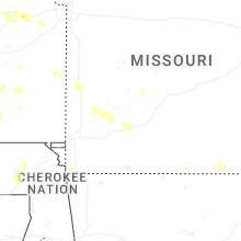

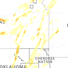


Connect with Interactive Hail Maps