

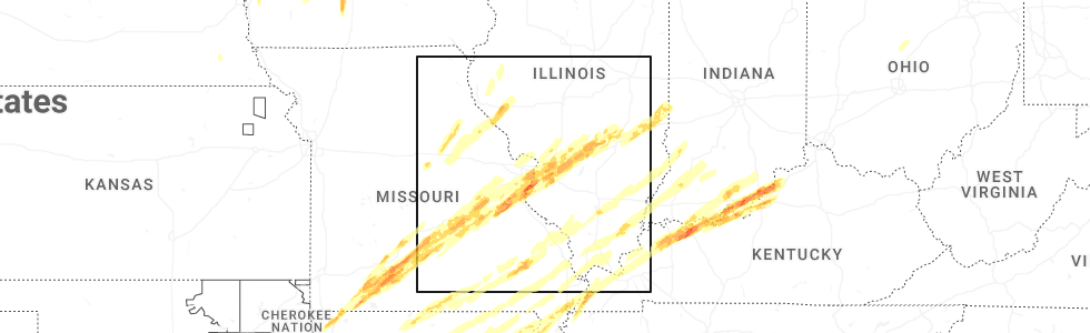
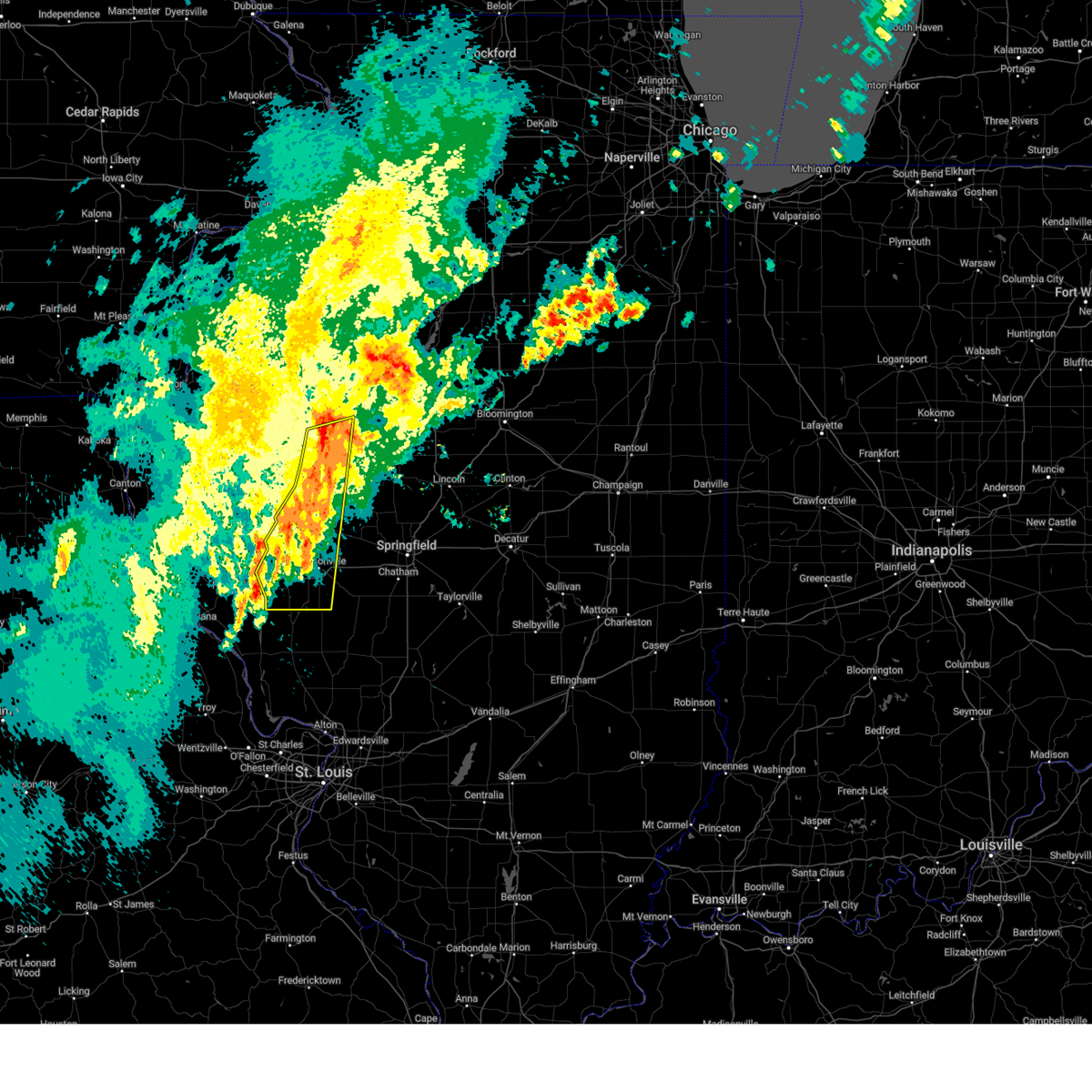
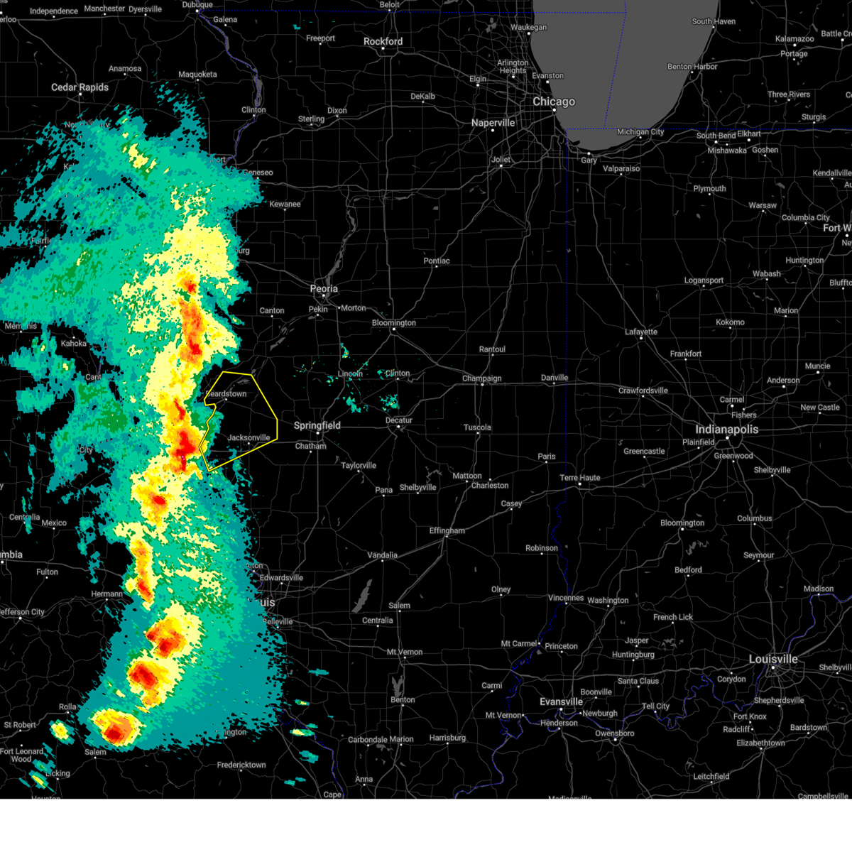
Hail Map for Naples, IL
The Naples, IL area has had 0 reports of on-the-ground hail by trained spotters, and has been under severe weather warnings 7 times during the past 12 months. Doppler radar has detected hail at or near Naples, IL on 62 occasions, including 3 occasions during the past year.
| Name: | Naples, IL |
| Where Located: | 74.7 miles SE of Kahoka, MO |
| Map: | Google Map for Naples, IL |
| Population: | 130 |
| Housing Units: | 69 |
| More Info: | Search Google for Naples, IL |
1
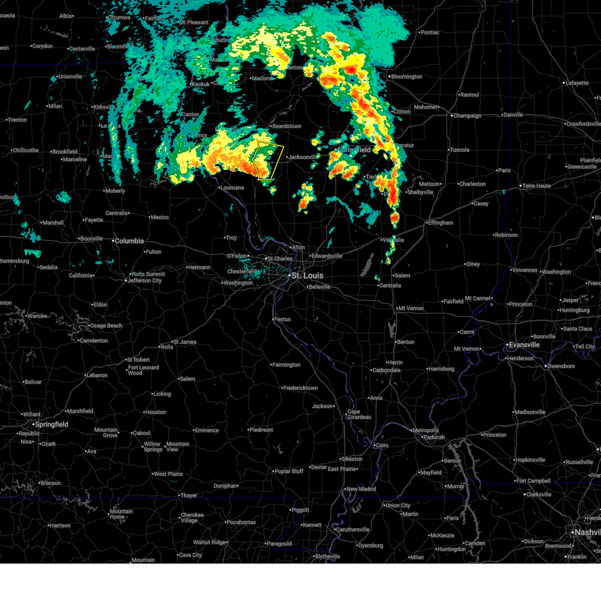
The Top Recent Hail Date for Naples, IL is Friday, March 14, 2025 (6th out of 62)
Hail and Wind Damage Spotted near Naples, IL
| Date / Time | Report Details |
|---|---|
| 6/18/2025 11:32 AM CDT |
 Svrilx the national weather service in lincoln has issued a * severe thunderstorm warning for, scott county in west central illinois, northwestern morgan county in west central illinois, * until noon cdt. * at 1132 am cdt, severe thunderstorms were located along a line extending from beverly to near griggsville to near glasgow, moving north at 30 mph (radar indicated). Hazards include 60 mph wind gusts. Expect damage to roofs, siding, and trees. severe thunderstorms will be near, winchester and naples around 1135 am cdt. bluffs around 1140 am cdt. meredosia around 1145 am cdt. This includes interstate 72 between mile markers 43 and 58. Svrilx the national weather service in lincoln has issued a * severe thunderstorm warning for, scott county in west central illinois, northwestern morgan county in west central illinois, * until noon cdt. * at 1132 am cdt, severe thunderstorms were located along a line extending from beverly to near griggsville to near glasgow, moving north at 30 mph (radar indicated). Hazards include 60 mph wind gusts. Expect damage to roofs, siding, and trees. severe thunderstorms will be near, winchester and naples around 1135 am cdt. bluffs around 1140 am cdt. meredosia around 1145 am cdt. This includes interstate 72 between mile markers 43 and 58.
|
| 4/20/2025 7:14 PM CDT | At 713 pm cdt, severe thunderstorms were located along a line extending from carthage to 6 miles west of meredosia to near hardin, moving northeast at 55 mph (broadcast media. broadcast media reported extensive tree damage across southern adams county around 6:55 pm). Hazards include 70 mph wind gusts and penny size hail. Expect considerable tree damage. damage is likely to mobile homes, roofs, and outbuildings. locations impacted include, franklin, bluffs, vermont, huntsville, alexander, beardstown, glasgow, ray, snicarte, bath, arenzville, nortonville, murrayville, astoria, lynnville, meredosia, jacksonville municipal airport, woodson, naples, and kilbourne. This includes interstate 72 between mile markers 43 and 79. |
| 4/20/2025 6:45 PM CDT |
 Svrilx the national weather service in lincoln has issued a * severe thunderstorm warning for, scott county in west central illinois, southwestern fulton county in west central illinois, cass county in west central illinois, schuyler county in west central illinois, southwestern mason county in central illinois, morgan county in west central illinois, * until 730 pm cdt. * at 644 pm cdt, severe thunderstorms were located along a line extending from near canton to near atlas to moscow mills, moving northeast at 55 mph (radar indicated). Hazards include 70 mph wind gusts and penny size hail. Expect considerable tree damage. Damage is likely to mobile homes, roofs, and outbuildings. Svrilx the national weather service in lincoln has issued a * severe thunderstorm warning for, scott county in west central illinois, southwestern fulton county in west central illinois, cass county in west central illinois, schuyler county in west central illinois, southwestern mason county in central illinois, morgan county in west central illinois, * until 730 pm cdt. * at 644 pm cdt, severe thunderstorms were located along a line extending from near canton to near atlas to moscow mills, moving northeast at 55 mph (radar indicated). Hazards include 70 mph wind gusts and penny size hail. Expect considerable tree damage. Damage is likely to mobile homes, roofs, and outbuildings.
|
| 4/2/2025 9:58 AM CDT |
 The storms still within this warning which prompted it have weakened below severe limits, and the rest have both weakened and exited the warned area. therefore, the warning will be allowed to expire. however, gusty winds are still possible with these thunderstorms. The storms still within this warning which prompted it have weakened below severe limits, and the rest have both weakened and exited the warned area. therefore, the warning will be allowed to expire. however, gusty winds are still possible with these thunderstorms.
|
| 4/2/2025 9:45 AM CDT |
 At 945 am cdt, severe thunderstorms were located along a line extending from st. david to chandlerville to near glasgow, moving northeast at 65 mph (radar indicated). Hazards include 60 mph wind gusts and penny size hail. Expect damage to roofs, siding, and trees. locations impacted include, bluffs, beardstown, glasgow, dunfermline, snicarte, bath, arenzville, murrayville, astoria, lynnville, meredosia, jacksonville municipal airport, woodson, naples, ipava, havana, jacksonville, lewistown, bryant, and frederick. This includes interstate 72 between mile markers 43 and 72. At 945 am cdt, severe thunderstorms were located along a line extending from st. david to chandlerville to near glasgow, moving northeast at 65 mph (radar indicated). Hazards include 60 mph wind gusts and penny size hail. Expect damage to roofs, siding, and trees. locations impacted include, bluffs, beardstown, glasgow, dunfermline, snicarte, bath, arenzville, murrayville, astoria, lynnville, meredosia, jacksonville municipal airport, woodson, naples, ipava, havana, jacksonville, lewistown, bryant, and frederick. This includes interstate 72 between mile markers 43 and 72.
|
| 4/2/2025 9:33 AM CDT | Svrilx the national weather service in lincoln has issued a * severe thunderstorm warning for, scott county in west central illinois, southern fulton county in west central illinois, cass county in west central illinois, central schuyler county in west central illinois, western mason county in central illinois, morgan county in west central illinois, * until 1000 am cdt. * at 932 am cdt, severe thunderstorms were located along a line extending from 8 miles southeast of buckhorn to near pittsfield, moving northeast at 65 mph (radar indicated). Hazards include 60 mph wind gusts and penny size hail. expect damage to roofs, siding, and trees |
| 3/14/2025 8:51 PM CDT |
 Svrilx the national weather service in lincoln has issued a * severe thunderstorm warning for, scott county in west central illinois, cass county in west central illinois, southeastern schuyler county in west central illinois, southwestern mason county in central illinois, northern morgan county in west central illinois, * until 930 pm cdt. * at 851 pm cdt, a severe thunderstorm was located over griggsville, or near pittsfield, moving northeast at 65 mph (radar indicated). Hazards include 70 mph wind gusts and half dollar size hail. Hail damage to vehicles is expected. expect considerable tree damage. wind damage is also likely to mobile homes, roofs, and outbuildings. this severe thunderstorm will be near, naples around 855 pm cdt. meredosia around 900 pm cdt. arenzville around 910 pm cdt. other locations in the path of this severe thunderstorm include beardstown, bluff springs and chandlerville. This includes interstate 72 between mile markers 43 and 75. Svrilx the national weather service in lincoln has issued a * severe thunderstorm warning for, scott county in west central illinois, cass county in west central illinois, southeastern schuyler county in west central illinois, southwestern mason county in central illinois, northern morgan county in west central illinois, * until 930 pm cdt. * at 851 pm cdt, a severe thunderstorm was located over griggsville, or near pittsfield, moving northeast at 65 mph (radar indicated). Hazards include 70 mph wind gusts and half dollar size hail. Hail damage to vehicles is expected. expect considerable tree damage. wind damage is also likely to mobile homes, roofs, and outbuildings. this severe thunderstorm will be near, naples around 855 pm cdt. meredosia around 900 pm cdt. arenzville around 910 pm cdt. other locations in the path of this severe thunderstorm include beardstown, bluff springs and chandlerville. This includes interstate 72 between mile markers 43 and 75.
|
| 6/25/2024 3:29 PM CDT |
 At 328 pm cdt, a severe thunderstorm was located near winchester, moving southeast at 35 mph (radar indicated). Hazards include 60 mph wind gusts and quarter size hail. Hail damage to vehicles is expected. expect wind damage to roofs, siding, and trees. this severe storm will be near, murrayville, woodson, and manchester around 335 pm cdt. other locations impacted by this severe thunderstorm include nortonville, merritt, lynnville, and exeter. This includes interstate 72 between mile markers 43 and 67. At 328 pm cdt, a severe thunderstorm was located near winchester, moving southeast at 35 mph (radar indicated). Hazards include 60 mph wind gusts and quarter size hail. Hail damage to vehicles is expected. expect wind damage to roofs, siding, and trees. this severe storm will be near, murrayville, woodson, and manchester around 335 pm cdt. other locations impacted by this severe thunderstorm include nortonville, merritt, lynnville, and exeter. This includes interstate 72 between mile markers 43 and 67.
|
| 6/25/2024 3:29 PM CDT |
 the severe thunderstorm warning has been cancelled and is no longer in effect the severe thunderstorm warning has been cancelled and is no longer in effect
|
| 6/25/2024 3:07 PM CDT |
 Svrilx the national weather service in lincoln has issued a * severe thunderstorm warning for, scott county in west central illinois, southwestern cass county in west central illinois, morgan county in west central illinois, * until 400 pm cdt. * at 307 pm cdt, a severe thunderstorm was located over naples, or 13 miles northwest of winchester, moving southeast at 40 mph (radar indicated). Hazards include 60 mph wind gusts and quarter size hail. Hail damage to vehicles is expected. expect wind damage to roofs, siding, and trees. this severe thunderstorm will be near, bluffs and naples around 310 pm cdt. winchester around 320 pm cdt. other locations in the path of this severe thunderstorm include murrayville, woodson and manchester. This includes interstate 72 between mile markers 43 and 70. Svrilx the national weather service in lincoln has issued a * severe thunderstorm warning for, scott county in west central illinois, southwestern cass county in west central illinois, morgan county in west central illinois, * until 400 pm cdt. * at 307 pm cdt, a severe thunderstorm was located over naples, or 13 miles northwest of winchester, moving southeast at 40 mph (radar indicated). Hazards include 60 mph wind gusts and quarter size hail. Hail damage to vehicles is expected. expect wind damage to roofs, siding, and trees. this severe thunderstorm will be near, bluffs and naples around 310 pm cdt. winchester around 320 pm cdt. other locations in the path of this severe thunderstorm include murrayville, woodson and manchester. This includes interstate 72 between mile markers 43 and 70.
|
| 6/5/2024 4:34 AM CDT |
 At 434 am cdt, a severe thunderstorm was located near glasgow, or 8 miles southwest of winchester, moving northeast at 40 mph (radar indicated). Hazards include 60 mph wind gusts and quarter size hail. Hail damage to vehicles is expected. expect wind damage to roofs, siding, and trees. this severe storm will be near, winchester, alsey, and glasgow around 440 am cdt. other locations impacted by this severe thunderstorm include concord, nortonville, merritt, lynnville, exeter, and valley city. This includes interstate 72 between mile markers 43 and 68. At 434 am cdt, a severe thunderstorm was located near glasgow, or 8 miles southwest of winchester, moving northeast at 40 mph (radar indicated). Hazards include 60 mph wind gusts and quarter size hail. Hail damage to vehicles is expected. expect wind damage to roofs, siding, and trees. this severe storm will be near, winchester, alsey, and glasgow around 440 am cdt. other locations impacted by this severe thunderstorm include concord, nortonville, merritt, lynnville, exeter, and valley city. This includes interstate 72 between mile markers 43 and 68.
|
| 6/5/2024 4:19 AM CDT |
 Svrilx the national weather service in lincoln has issued a * severe thunderstorm warning for, scott county in west central illinois, central morgan county in west central illinois, * until 445 am cdt. * at 418 am cdt, a severe thunderstorm was located 9 miles northeast of belleview, or 12 miles southeast of pittsfield, moving northeast at 40 mph (radar indicated). Hazards include 60 mph wind gusts and quarter size hail. Hail damage to vehicles is expected. expect wind damage to roofs, siding, and trees. this severe thunderstorm will be near, glasgow around 430 am cdt. alsey around 435 am cdt. other locations in the path of this severe thunderstorm include winchester. This includes interstate 72 between mile markers 43 and 68. Svrilx the national weather service in lincoln has issued a * severe thunderstorm warning for, scott county in west central illinois, central morgan county in west central illinois, * until 445 am cdt. * at 418 am cdt, a severe thunderstorm was located 9 miles northeast of belleview, or 12 miles southeast of pittsfield, moving northeast at 40 mph (radar indicated). Hazards include 60 mph wind gusts and quarter size hail. Hail damage to vehicles is expected. expect wind damage to roofs, siding, and trees. this severe thunderstorm will be near, glasgow around 430 am cdt. alsey around 435 am cdt. other locations in the path of this severe thunderstorm include winchester. This includes interstate 72 between mile markers 43 and 68.
|
| 5/24/2024 3:20 PM CDT |
 The storm which prompted the warning has moved out of the area. therefore, the warning will be allowed to expire. a severe thunderstorm watch remains in effect until 900 pm cdt for west central illinois. The storm which prompted the warning has moved out of the area. therefore, the warning will be allowed to expire. a severe thunderstorm watch remains in effect until 900 pm cdt for west central illinois.
|
| 5/24/2024 2:54 PM CDT |
 At 254 pm cdt, a severe thunderstorm was located over alsey, or near winchester, moving northeast at 25 mph (radar indicated). Hazards include 60 mph wind gusts and quarter size hail. Hail damage to vehicles is expected. expect wind damage to roofs, siding, and trees. this severe storm will be near, winchester around 300 pm cdt. other locations impacted by this severe thunderstorm include merritt and exeter. This includes interstate 72 between mile markers 43 and 57. At 254 pm cdt, a severe thunderstorm was located over alsey, or near winchester, moving northeast at 25 mph (radar indicated). Hazards include 60 mph wind gusts and quarter size hail. Hail damage to vehicles is expected. expect wind damage to roofs, siding, and trees. this severe storm will be near, winchester around 300 pm cdt. other locations impacted by this severe thunderstorm include merritt and exeter. This includes interstate 72 between mile markers 43 and 57.
|
| 5/24/2024 2:27 PM CDT |
 Svrilx the national weather service in lincoln has issued a * severe thunderstorm warning for, scott county in west central illinois, * until 330 pm cdt. * at 226 pm cdt, a severe thunderstorm was located 10 miles northeast of belleview, or 11 miles southeast of pittsfield, moving northeast at 30 mph (radar indicated). Hazards include 60 mph wind gusts and quarter size hail. Hail damage to vehicles is expected. expect wind damage to roofs, siding, and trees. this severe thunderstorm will be near, glasgow around 245 pm cdt. other locations in the path of this severe thunderstorm include winchester and alsey. This includes interstate 72 between mile markers 43 and 57. Svrilx the national weather service in lincoln has issued a * severe thunderstorm warning for, scott county in west central illinois, * until 330 pm cdt. * at 226 pm cdt, a severe thunderstorm was located 10 miles northeast of belleview, or 11 miles southeast of pittsfield, moving northeast at 30 mph (radar indicated). Hazards include 60 mph wind gusts and quarter size hail. Hail damage to vehicles is expected. expect wind damage to roofs, siding, and trees. this severe thunderstorm will be near, glasgow around 245 pm cdt. other locations in the path of this severe thunderstorm include winchester and alsey. This includes interstate 72 between mile markers 43 and 57.
|
| 3/14/2024 3:44 PM CDT |
 Svrilx the national weather service in lincoln has issued a * severe thunderstorm warning for, scott county in west central illinois, western morgan county in west central illinois, * until 430 pm cdt. * at 343 pm cdt, a severe thunderstorm was located over pittsfield, moving east at 40 mph (radar indicated). Hazards include 60 mph wind gusts and quarter size hail. Hail damage to vehicles is expected. Expect wind damage to roofs, siding, and trees. Svrilx the national weather service in lincoln has issued a * severe thunderstorm warning for, scott county in west central illinois, western morgan county in west central illinois, * until 430 pm cdt. * at 343 pm cdt, a severe thunderstorm was located over pittsfield, moving east at 40 mph (radar indicated). Hazards include 60 mph wind gusts and quarter size hail. Hail damage to vehicles is expected. Expect wind damage to roofs, siding, and trees.
|
| 7/17/2023 1:36 PM CDT |
 At 136 pm cdt, a severe thunderstorm was located over winchester, moving southeast at 45 mph (radar indicated). Hazards include 60 mph wind gusts and quarter size hail. Hail damage to vehicles is expected. expect wind damage to roofs, siding, and trees. this severe thunderstorm will be near, manchester around 145 pm cdt. murrayville and woodson around 150 pm cdt. this includes interstate 72 between mile markers 43 and 66. hail threat, radar indicated max hail size, 1. 00 in wind threat, radar indicated max wind gust, 60 mph. At 136 pm cdt, a severe thunderstorm was located over winchester, moving southeast at 45 mph (radar indicated). Hazards include 60 mph wind gusts and quarter size hail. Hail damage to vehicles is expected. expect wind damage to roofs, siding, and trees. this severe thunderstorm will be near, manchester around 145 pm cdt. murrayville and woodson around 150 pm cdt. this includes interstate 72 between mile markers 43 and 66. hail threat, radar indicated max hail size, 1. 00 in wind threat, radar indicated max wind gust, 60 mph.
|
| 6/29/2023 11:55 AM CDT |
 At 1154 am cdt, severe thunderstorms were located along a line extending from near easton to roodhouse, moving east at 65 mph (emergency management). Hazards include 70 mph wind gusts and half dollar size hail. Hail damage to vehicles is expected. expect considerable tree damage. wind damage is also likely to mobile homes, roofs, and outbuildings. locations impacted include, easton, woodson, franklin and waverly. this includes interstate 72 between mile markers 43 and 86. thunderstorm damage threat, considerable hail threat, radar indicated max hail size, 1. 25 in wind threat, observed max wind gust, 70 mph. At 1154 am cdt, severe thunderstorms were located along a line extending from near easton to roodhouse, moving east at 65 mph (emergency management). Hazards include 70 mph wind gusts and half dollar size hail. Hail damage to vehicles is expected. expect considerable tree damage. wind damage is also likely to mobile homes, roofs, and outbuildings. locations impacted include, easton, woodson, franklin and waverly. this includes interstate 72 between mile markers 43 and 86. thunderstorm damage threat, considerable hail threat, radar indicated max hail size, 1. 25 in wind threat, observed max wind gust, 70 mph.
|
| 6/29/2023 11:29 AM CDT |
 At 1128 am cdt, severe thunderstorms were located along a line extending from 6 miles southwest of astoria to near clarksville, moving east at 80 mph (radar indicated). Hazards include 70 mph wind gusts and quarter size hail. Hail damage to vehicles is expected. expect considerable tree damage. wind damage is also likely to mobile homes, roofs, and outbuildings. severe thunderstorms will be near, astoria and browning around 1135 am cdt. bath around 1140 am cdt. other locations in the path of these severe thunderstorms include kilbourne and easton. this includes interstate 72 between mile markers 43 and 86. thunderstorm damage threat, considerable hail threat, radar indicated max hail size, 1. 00 in wind threat, radar indicated max wind gust, 70 mph. At 1128 am cdt, severe thunderstorms were located along a line extending from 6 miles southwest of astoria to near clarksville, moving east at 80 mph (radar indicated). Hazards include 70 mph wind gusts and quarter size hail. Hail damage to vehicles is expected. expect considerable tree damage. wind damage is also likely to mobile homes, roofs, and outbuildings. severe thunderstorms will be near, astoria and browning around 1135 am cdt. bath around 1140 am cdt. other locations in the path of these severe thunderstorms include kilbourne and easton. this includes interstate 72 between mile markers 43 and 86. thunderstorm damage threat, considerable hail threat, radar indicated max hail size, 1. 00 in wind threat, radar indicated max wind gust, 70 mph.
|
| 4/15/2023 6:44 PM CDT |
 At 643 pm cdt, a severe thunderstorm was located near arenzville, or 9 miles south of beardstown, moving northeast at 40 mph (trained weather spotters). Hazards include 60 mph wind gusts and quarter size hail. Hail damage to vehicles is expected. expect wind damage to roofs, siding, and trees. locations impacted include, bluff springs. this includes interstate 72 between mile markers 71 and 73. hail threat, radar indicated max hail size, 1. 00 in wind threat, observed max wind gust, 60 mph. At 643 pm cdt, a severe thunderstorm was located near arenzville, or 9 miles south of beardstown, moving northeast at 40 mph (trained weather spotters). Hazards include 60 mph wind gusts and quarter size hail. Hail damage to vehicles is expected. expect wind damage to roofs, siding, and trees. locations impacted include, bluff springs. this includes interstate 72 between mile markers 71 and 73. hail threat, radar indicated max hail size, 1. 00 in wind threat, observed max wind gust, 60 mph.
|
| 4/15/2023 6:30 PM CDT |
 At 630 pm cdt, a severe thunderstorm was located over naples, or 10 miles northwest of winchester, moving northeast at 35 mph (radar indicated). Hazards include 60 mph wind gusts and quarter size hail. Hail damage to vehicles is expected. expect wind damage to roofs, siding, and trees. this severe thunderstorm will be near, bluffs and exeter around 635 pm cdt. meredosia around 640 pm cdt. chapin around 645 pm cdt. other locations in the path of this severe thunderstorm include arenzville and literberry. this includes interstate 72 between mile markers 43 and 73. hail threat, radar indicated max hail size, 1. 00 in wind threat, radar indicated max wind gust, 60 mph. At 630 pm cdt, a severe thunderstorm was located over naples, or 10 miles northwest of winchester, moving northeast at 35 mph (radar indicated). Hazards include 60 mph wind gusts and quarter size hail. Hail damage to vehicles is expected. expect wind damage to roofs, siding, and trees. this severe thunderstorm will be near, bluffs and exeter around 635 pm cdt. meredosia around 640 pm cdt. chapin around 645 pm cdt. other locations in the path of this severe thunderstorm include arenzville and literberry. this includes interstate 72 between mile markers 43 and 73. hail threat, radar indicated max hail size, 1. 00 in wind threat, radar indicated max wind gust, 60 mph.
|
| 4/5/2023 5:35 AM CDT |
 At 534 am cdt, a severe thunderstorm was located 8 miles west of alsey, or 8 miles southwest of winchester, moving northeast at 55 mph (radar indicated). Hazards include 60 mph wind gusts and quarter size hail. Hail damage to vehicles is expected. expect wind damage to roofs, siding, and trees. this severe thunderstorm will be near, alsey around 540 am cdt. winchester, manchester and exeter around 545 am cdt. chapin around 550 am cdt. other locations in the path of this severe thunderstorm include woodson, jacksonville and literberry. this includes interstate 72 between mile markers 43 and 73. hail threat, radar indicated max hail size, 1. 00 in wind threat, radar indicated max wind gust, 60 mph. At 534 am cdt, a severe thunderstorm was located 8 miles west of alsey, or 8 miles southwest of winchester, moving northeast at 55 mph (radar indicated). Hazards include 60 mph wind gusts and quarter size hail. Hail damage to vehicles is expected. expect wind damage to roofs, siding, and trees. this severe thunderstorm will be near, alsey around 540 am cdt. winchester, manchester and exeter around 545 am cdt. chapin around 550 am cdt. other locations in the path of this severe thunderstorm include woodson, jacksonville and literberry. this includes interstate 72 between mile markers 43 and 73. hail threat, radar indicated max hail size, 1. 00 in wind threat, radar indicated max wind gust, 60 mph.
|
| 6/17/2022 4:28 AM CDT |
 At 427 am cdt, severe thunderstorms were located along a line extending from near meredosia to 9 miles west of white hall, moving east at 50 mph. additional strong to severe storms were located between jacksonville and franklin, also moving east (radar indicated). Hazards include 60 mph wind gusts and nickel size hail. Expect damage to roofs, siding, and trees. locations impacted include, chapin, arenzville, jacksonville, literberry and alexander. this includes interstate 72 between mile markers 43 and 79. hail threat, radar indicated max hail size, 0. 88 in wind threat, radar indicated max wind gust, 60 mph. At 427 am cdt, severe thunderstorms were located along a line extending from near meredosia to 9 miles west of white hall, moving east at 50 mph. additional strong to severe storms were located between jacksonville and franklin, also moving east (radar indicated). Hazards include 60 mph wind gusts and nickel size hail. Expect damage to roofs, siding, and trees. locations impacted include, chapin, arenzville, jacksonville, literberry and alexander. this includes interstate 72 between mile markers 43 and 79. hail threat, radar indicated max hail size, 0. 88 in wind threat, radar indicated max wind gust, 60 mph.
|
| 6/17/2022 4:09 AM CDT |
 At 408 am cdt, a severe thunderstorm was located near griggsville, or 13 miles north of pittsfield, moving southeast at 40 mph (radar indicated). Hazards include 60 mph wind gusts and nickel size hail. Expect damage to roofs, siding, and trees. this severe thunderstorm will be near, meredosia and naples around 420 am cdt. bluffs around 425 am cdt. exeter around 430 am cdt. winchester and chapin around 435 am cdt. woodson and manchester around 450 am cdt. murrayville around 455 am cdt. franklin around 500 am cdt. other locations impacted by this severe thunderstorm include prentice, sinclair, riggston, merritt, concord, glasgow, oxville, nortonville, lynnville and south jacksonville. this includes interstate 72 between mile markers 43 and 79. hail threat, radar indicated max hail size, 0. 88 in wind threat, radar indicated max wind gust, 60 mph. At 408 am cdt, a severe thunderstorm was located near griggsville, or 13 miles north of pittsfield, moving southeast at 40 mph (radar indicated). Hazards include 60 mph wind gusts and nickel size hail. Expect damage to roofs, siding, and trees. this severe thunderstorm will be near, meredosia and naples around 420 am cdt. bluffs around 425 am cdt. exeter around 430 am cdt. winchester and chapin around 435 am cdt. woodson and manchester around 450 am cdt. murrayville around 455 am cdt. franklin around 500 am cdt. other locations impacted by this severe thunderstorm include prentice, sinclair, riggston, merritt, concord, glasgow, oxville, nortonville, lynnville and south jacksonville. this includes interstate 72 between mile markers 43 and 79. hail threat, radar indicated max hail size, 0. 88 in wind threat, radar indicated max wind gust, 60 mph.
|
| 10/24/2021 5:59 PM CDT |
 At 558 pm cdt, a severe thunderstorm was located near arenzville, or 9 miles southwest of virginia, moving northeast at 55 mph (radar indicated). Hazards include 60 mph wind gusts and quarter size hail. Hail damage to vehicles is expected. expect wind damage to roofs, siding, and trees. locations impacted include, virginia, ashland and chandlerville. This includes interstate 72 between mile markers 43 and 46. At 558 pm cdt, a severe thunderstorm was located near arenzville, or 9 miles southwest of virginia, moving northeast at 55 mph (radar indicated). Hazards include 60 mph wind gusts and quarter size hail. Hail damage to vehicles is expected. expect wind damage to roofs, siding, and trees. locations impacted include, virginia, ashland and chandlerville. This includes interstate 72 between mile markers 43 and 46.
|
| 10/24/2021 5:39 PM CDT |
 At 539 pm cdt, a severe thunderstorm was located over meredosia, or 13 miles north of winchester, moving northeast at 50 mph (radar indicated). Hazards include 60 mph wind gusts and quarter size hail. Hail damage to vehicles is expected. expect wind damage to roofs, siding, and trees. this severe thunderstorm will be near, chapin around 545 pm cdt. arenzville around 550 pm cdt. bluff springs around 555 pm cdt. other locations in the path of this severe thunderstorm include literberry, virginia and chandlerville. This includes interstate 72 between mile markers 43 and 46. At 539 pm cdt, a severe thunderstorm was located over meredosia, or 13 miles north of winchester, moving northeast at 50 mph (radar indicated). Hazards include 60 mph wind gusts and quarter size hail. Hail damage to vehicles is expected. expect wind damage to roofs, siding, and trees. this severe thunderstorm will be near, chapin around 545 pm cdt. arenzville around 550 pm cdt. bluff springs around 555 pm cdt. other locations in the path of this severe thunderstorm include literberry, virginia and chandlerville. This includes interstate 72 between mile markers 43 and 46.
|
| 8/12/2021 5:30 PM CDT |
 At 530 pm cdt, a severe thunderstorm was located over meredosia, or 13 miles north of winchester, moving east at 25 mph (radar indicated). Hazards include 60 mph wind gusts and quarter size hail. Hail damage to vehicles is expected. expect wind damage to roofs, siding, and trees. this severe thunderstorm will be near, exeter around 540 pm cdt. chapin and arenzville around 550 pm cdt. other locations in the path of this severe thunderstorm include jacksonville. this includes interstate 72 between mile markers 52 and 66. hail threat, radar indicated max hail size, 1. 00 in wind threat, radar indicated max wind gust, 60 mph. At 530 pm cdt, a severe thunderstorm was located over meredosia, or 13 miles north of winchester, moving east at 25 mph (radar indicated). Hazards include 60 mph wind gusts and quarter size hail. Hail damage to vehicles is expected. expect wind damage to roofs, siding, and trees. this severe thunderstorm will be near, exeter around 540 pm cdt. chapin and arenzville around 550 pm cdt. other locations in the path of this severe thunderstorm include jacksonville. this includes interstate 72 between mile markers 52 and 66. hail threat, radar indicated max hail size, 1. 00 in wind threat, radar indicated max wind gust, 60 mph.
|
| 6/25/2021 1:39 AM CDT |
 At 122 am cdt, severe thunderstorms were located along a line extending from sciota to near industry to rushville to 8 miles west of winchester to near belleview, moving east at 40 mph (radar indicated). Hazards include 60 mph wind gusts. Expect damage to roofs, siding, and trees. locations impacted include, beardstown, rushville, winchester, meredosia, bluff springs, bluffs, chapin, arenzville, manchester, alsey, browning, naples, exeter, frederick, concord, glasgow, lynnville, valley city, riggston and merritt. This includes interstate 72 between mile markers 43 and 61. At 122 am cdt, severe thunderstorms were located along a line extending from sciota to near industry to rushville to 8 miles west of winchester to near belleview, moving east at 40 mph (radar indicated). Hazards include 60 mph wind gusts. Expect damage to roofs, siding, and trees. locations impacted include, beardstown, rushville, winchester, meredosia, bluff springs, bluffs, chapin, arenzville, manchester, alsey, browning, naples, exeter, frederick, concord, glasgow, lynnville, valley city, riggston and merritt. This includes interstate 72 between mile markers 43 and 61.
|
| 6/25/2021 1:22 AM CDT |
 At 122 am cdt, severe thunderstorms were located along a line extending from sciota to near industry to rushville to 8 miles west of winchester to near belleview, moving east at 40 mph (radar indicated). Hazards include 60 mph wind gusts. Expect damage to roofs, siding, and trees. locations impacted include, beardstown, rushville, winchester, meredosia, bluff springs, bluffs, chapin, arenzville, manchester, alsey, browning, naples, exeter, frederick, concord, glasgow, lynnville, valley city, riggston and merritt. This includes interstate 72 between mile markers 43 and 61. At 122 am cdt, severe thunderstorms were located along a line extending from sciota to near industry to rushville to 8 miles west of winchester to near belleview, moving east at 40 mph (radar indicated). Hazards include 60 mph wind gusts. Expect damage to roofs, siding, and trees. locations impacted include, beardstown, rushville, winchester, meredosia, bluff springs, bluffs, chapin, arenzville, manchester, alsey, browning, naples, exeter, frederick, concord, glasgow, lynnville, valley city, riggston and merritt. This includes interstate 72 between mile markers 43 and 61.
|
| 6/25/2021 12:33 AM CDT |
 At 1232 am cdt, severe thunderstorms were located along a line extending from near nauvoo to near carthage to near golden to 9 miles northeast of frankford to near curryville, moving east at 45 mph (radar indicated). Hazards include 60 mph wind gusts. expect damage to roofs, siding, and trees At 1232 am cdt, severe thunderstorms were located along a line extending from near nauvoo to near carthage to near golden to 9 miles northeast of frankford to near curryville, moving east at 45 mph (radar indicated). Hazards include 60 mph wind gusts. expect damage to roofs, siding, and trees
|
| 7/21/2020 2:56 PM CDT |
 At 255 pm cdt, a severe thunderstorm was located near winchester, moving east at 30 mph (trained weather spotters). Hazards include 70 mph wind gusts and quarter size hail. Hail damage to vehicles is expected. expect considerable tree damage. wind damage is also likely to mobile homes, roofs, and outbuildings. locations impacted include, jacksonville, virginia, winchester, alexander, ashland, waverly, bluffs, franklin, murrayville, woodson, chapin, arenzville, manchester, alsey, naples, exeter, literberry, south jacksonville, philadelphia and concord. This includes interstate 72 between mile markers 43 and 79. At 255 pm cdt, a severe thunderstorm was located near winchester, moving east at 30 mph (trained weather spotters). Hazards include 70 mph wind gusts and quarter size hail. Hail damage to vehicles is expected. expect considerable tree damage. wind damage is also likely to mobile homes, roofs, and outbuildings. locations impacted include, jacksonville, virginia, winchester, alexander, ashland, waverly, bluffs, franklin, murrayville, woodson, chapin, arenzville, manchester, alsey, naples, exeter, literberry, south jacksonville, philadelphia and concord. This includes interstate 72 between mile markers 43 and 79.
|
| 7/21/2020 2:41 PM CDT |
 At 241 pm cdt, a severe thunderstorm was located near pittsfield, moving east at 35 mph (radar indicated). Hazards include 60 mph wind gusts and quarter size hail. Hail damage to vehicles is expected. Expect wind damage to roofs, siding, and trees. At 241 pm cdt, a severe thunderstorm was located near pittsfield, moving east at 35 mph (radar indicated). Hazards include 60 mph wind gusts and quarter size hail. Hail damage to vehicles is expected. Expect wind damage to roofs, siding, and trees.
|
| 6/28/2020 10:41 AM CDT |
 The severe thunderstorm warning for scott and southwestern morgan counties will expire at 1045 am cdt, the storm which prompted the warning has weakened below severe limits, and no longer poses an immediate threat to life or property. therefore, the warning will be allowed to expire. The severe thunderstorm warning for scott and southwestern morgan counties will expire at 1045 am cdt, the storm which prompted the warning has weakened below severe limits, and no longer poses an immediate threat to life or property. therefore, the warning will be allowed to expire.
|
| 6/28/2020 10:25 AM CDT |
 At 1025 am cdt, a severe thunderstorm was located over winchester, moving southeast at 45 mph (radar indicated). Hazards include 60 mph wind gusts. Expect damage to roofs, siding, and trees. locations impacted include, winchester, bluffs, murrayville, woodson, manchester, alsey, naples, exeter, glasgow, lynnville, valley city, riggston, merritt, oxville and nortonville. This includes interstate 72 between mile markers 43 and 61. At 1025 am cdt, a severe thunderstorm was located over winchester, moving southeast at 45 mph (radar indicated). Hazards include 60 mph wind gusts. Expect damage to roofs, siding, and trees. locations impacted include, winchester, bluffs, murrayville, woodson, manchester, alsey, naples, exeter, glasgow, lynnville, valley city, riggston, merritt, oxville and nortonville. This includes interstate 72 between mile markers 43 and 61.
|
| 6/28/2020 10:07 AM CDT |
 At 1007 am cdt, a severe thunderstorm was located near griggsville, or 11 miles northeast of pittsfield, moving southeast at 45 mph (radar indicated). Hazards include 60 mph wind gusts. expect damage to roofs, siding, and trees At 1007 am cdt, a severe thunderstorm was located near griggsville, or 11 miles northeast of pittsfield, moving southeast at 45 mph (radar indicated). Hazards include 60 mph wind gusts. expect damage to roofs, siding, and trees
|
| 4/8/2020 5:29 PM CDT |
 At 529 pm cdt, a severe thunderstorm was located near chapin, or near jacksonville, moving east at 55 mph (radar indicated). Hazards include 60 mph wind gusts and quarter size hail. Hail damage to vehicles is expected. Expect wind damage to roofs, siding, and trees. At 529 pm cdt, a severe thunderstorm was located near chapin, or near jacksonville, moving east at 55 mph (radar indicated). Hazards include 60 mph wind gusts and quarter size hail. Hail damage to vehicles is expected. Expect wind damage to roofs, siding, and trees.
|
| 7/17/2019 4:43 PM CDT |
 At 442 pm cdt, severe thunderstorms were located along a line extending from near virginia to near woodson to 9 miles east of belleview, moving southeast at 45 mph (radar indicated). Hazards include 60 mph wind gusts and quarter size hail. Hail damage to vehicles is expected. expect wind damage to roofs, siding, and trees. locations impacted include, jacksonville, beardstown, virginia, winchester, alexander, ashland, waverly, meredosia, bluff springs, bluffs, franklin, murrayville, woodson, chapin, arenzville, manchester, alsey, naples, exeter and literberry. This includes interstate 72 between mile markers 43 and 79. At 442 pm cdt, severe thunderstorms were located along a line extending from near virginia to near woodson to 9 miles east of belleview, moving southeast at 45 mph (radar indicated). Hazards include 60 mph wind gusts and quarter size hail. Hail damage to vehicles is expected. expect wind damage to roofs, siding, and trees. locations impacted include, jacksonville, beardstown, virginia, winchester, alexander, ashland, waverly, meredosia, bluff springs, bluffs, franklin, murrayville, woodson, chapin, arenzville, manchester, alsey, naples, exeter and literberry. This includes interstate 72 between mile markers 43 and 79.
|
| 7/17/2019 4:14 PM CDT |
 At 414 pm cdt, severe thunderstorms were located along a line extending from near rushville to 6 miles northwest of naples to 7 miles northeast of frankford, moving southeast at 45 mph (radar indicated). Hazards include 60 mph wind gusts and quarter size hail. Hail damage to vehicles is expected. Expect wind damage to roofs, siding, and trees. At 414 pm cdt, severe thunderstorms were located along a line extending from near rushville to 6 miles northwest of naples to 7 miles northeast of frankford, moving southeast at 45 mph (radar indicated). Hazards include 60 mph wind gusts and quarter size hail. Hail damage to vehicles is expected. Expect wind damage to roofs, siding, and trees.
|
| 6/28/2019 3:00 PM CDT |
 At 259 pm cdt, a severe thunderstorm was located near winchester, moving southeast at 20 mph (radar indicated). Hazards include 60 mph wind gusts and penny size hail. Expect damage to roofs, siding, and trees. locations impacted include, jacksonville, winchester, meredosia, bluffs, murrayville, chapin, woodson, manchester, alsey, naples, exeter, south jacksonville, glasgow, lynnville, valley city, riggston, merritt, oxville, nortonville and lake jacksonville. This includes interstate 72 between mile markers 43 and 68. At 259 pm cdt, a severe thunderstorm was located near winchester, moving southeast at 20 mph (radar indicated). Hazards include 60 mph wind gusts and penny size hail. Expect damage to roofs, siding, and trees. locations impacted include, jacksonville, winchester, meredosia, bluffs, murrayville, chapin, woodson, manchester, alsey, naples, exeter, south jacksonville, glasgow, lynnville, valley city, riggston, merritt, oxville, nortonville and lake jacksonville. This includes interstate 72 between mile markers 43 and 68.
|
| 6/28/2019 2:39 PM CDT |
 At 239 pm cdt, a severe thunderstorm was located over naples, or 10 miles northwest of winchester, moving southeast at 30 mph (radar indicated). Hazards include 60 mph wind gusts and penny size hail. expect damage to roofs, siding, and trees At 239 pm cdt, a severe thunderstorm was located over naples, or 10 miles northwest of winchester, moving southeast at 30 mph (radar indicated). Hazards include 60 mph wind gusts and penny size hail. expect damage to roofs, siding, and trees
|
| 6/28/2019 2:20 PM CDT |
 At 220 pm cdt, severe thunderstorms were located along a line extending from near mount sterling to 9 miles northwest of meredosia to near buckhorn to near beverly, moving southeast at 15 mph (radar indicated). Hazards include 60 mph wind gusts. Expect damage to roofs, siding, and trees. Locations impacted include, griggsville, naples, la grange, versailles, perry, chambersburg, ripley, fishhook and coopertown. At 220 pm cdt, severe thunderstorms were located along a line extending from near mount sterling to 9 miles northwest of meredosia to near buckhorn to near beverly, moving southeast at 15 mph (radar indicated). Hazards include 60 mph wind gusts. Expect damage to roofs, siding, and trees. Locations impacted include, griggsville, naples, la grange, versailles, perry, chambersburg, ripley, fishhook and coopertown.
|
| 6/28/2019 2:05 PM CDT |
 At 205 pm cdt, severe thunderstorms were located along a line extending from 9 miles southwest of rushville to near mount sterling to buckhorn to near beverly, moving southeast at 15 mph (radar indicated). Hazards include 60 mph wind gusts and penny size hail. expect damage to roofs, siding, and trees At 205 pm cdt, severe thunderstorms were located along a line extending from 9 miles southwest of rushville to near mount sterling to buckhorn to near beverly, moving southeast at 15 mph (radar indicated). Hazards include 60 mph wind gusts and penny size hail. expect damage to roofs, siding, and trees
|
| 6/21/2019 10:57 AM CDT |
 At 1055 am cdt, severe thunderstorms were located along a line extending from near beverly to near pittsfield to near belleview, moving east at 50 mph (emergency management. at 1040 am damaging wind was reported in the town of new canton in pike county). Hazards include 70 mph wind gusts and quarter size hail. Hail damage to vehicles is expected. expect considerable tree damage. Wind damage is also likely to mobile homes, roofs, and outbuildings. At 1055 am cdt, severe thunderstorms were located along a line extending from near beverly to near pittsfield to near belleview, moving east at 50 mph (emergency management. at 1040 am damaging wind was reported in the town of new canton in pike county). Hazards include 70 mph wind gusts and quarter size hail. Hail damage to vehicles is expected. expect considerable tree damage. Wind damage is also likely to mobile homes, roofs, and outbuildings.
|
| 5/22/2019 11:27 PM CDT |
 At 1126 pm cdt, a severe thunderstorm was located over exeter, or near winchester, moving east at 40 mph (radar indicated). Hazards include 60 mph wind gusts and quarter size hail. Hail damage to vehicles is expected. Expect wind damage to roofs, siding, and trees. At 1126 pm cdt, a severe thunderstorm was located over exeter, or near winchester, moving east at 40 mph (radar indicated). Hazards include 60 mph wind gusts and quarter size hail. Hail damage to vehicles is expected. Expect wind damage to roofs, siding, and trees.
|
| 5/22/2019 11:15 PM CDT |
 At 1115 pm cdt, a severe thunderstorm was located over griggsville, or 7 miles northeast of pittsfield, moving east at 40 mph (radar indicated). Hazards include 60 mph wind gusts and quarter size hail. Hail damage to vehicles is expected. expect wind damage to roofs, siding, and trees. locations impacted include, winchester, meredosia, bluffs, murrayville, chapin, manchester, alsey, naples, exeter, concord, glasgow, lynnville, valley city, riggston, merritt and oxville. This includes interstate 72 between mile markers 43 and 61. At 1115 pm cdt, a severe thunderstorm was located over griggsville, or 7 miles northeast of pittsfield, moving east at 40 mph (radar indicated). Hazards include 60 mph wind gusts and quarter size hail. Hail damage to vehicles is expected. expect wind damage to roofs, siding, and trees. locations impacted include, winchester, meredosia, bluffs, murrayville, chapin, manchester, alsey, naples, exeter, concord, glasgow, lynnville, valley city, riggston, merritt and oxville. This includes interstate 72 between mile markers 43 and 61.
|
| 5/22/2019 10:49 PM CDT |
 At 1049 pm cdt, a severe thunderstorm was located near barry, or 7 miles west of pittsfield, moving east at 45 mph (radar indicated). Hazards include 60 mph wind gusts and quarter size hail. Hail damage to vehicles is expected. Expect wind damage to roofs, siding, and trees. At 1049 pm cdt, a severe thunderstorm was located near barry, or 7 miles west of pittsfield, moving east at 45 mph (radar indicated). Hazards include 60 mph wind gusts and quarter size hail. Hail damage to vehicles is expected. Expect wind damage to roofs, siding, and trees.
|
| 12/1/2018 2:49 PM CST |
 At 249 pm cst, a severe thunderstorm capable of producing a tornado was located over naples, or 13 miles northwest of winchester, moving northeast at 35 mph (radar indicated rotation). Hazards include tornado and quarter size hail. Flying debris will be dangerous to those caught without shelter. mobile homes will be damaged or destroyed. damage to roofs, windows, and vehicles will occur. tree damage is likely. this dangerous storm will be near, meredosia around 255 pm cst. beardstown around 325 pm cst. Other locations impacted by this tornadic thunderstorm include la grange. At 249 pm cst, a severe thunderstorm capable of producing a tornado was located over naples, or 13 miles northwest of winchester, moving northeast at 35 mph (radar indicated rotation). Hazards include tornado and quarter size hail. Flying debris will be dangerous to those caught without shelter. mobile homes will be damaged or destroyed. damage to roofs, windows, and vehicles will occur. tree damage is likely. this dangerous storm will be near, meredosia around 255 pm cst. beardstown around 325 pm cst. Other locations impacted by this tornadic thunderstorm include la grange.
|
| 7/19/2018 8:57 PM CDT |
 At 856 pm cdt, a severe thunderstorm was located near griggsville, or 8 miles west of winchester, moving southeast at 35 mph (radar indicated). Hazards include 60 mph wind gusts and quarter size hail. Hail damage to vehicles is expected. expect wind damage to roofs, siding, and trees. locations impacted include, winchester, bluffs, manchester, alsey, naples, exeter, glasgow, riggston, merritt and oxville. This includes interstate 72 between mile markers 43 and 57. At 856 pm cdt, a severe thunderstorm was located near griggsville, or 8 miles west of winchester, moving southeast at 35 mph (radar indicated). Hazards include 60 mph wind gusts and quarter size hail. Hail damage to vehicles is expected. expect wind damage to roofs, siding, and trees. locations impacted include, winchester, bluffs, manchester, alsey, naples, exeter, glasgow, riggston, merritt and oxville. This includes interstate 72 between mile markers 43 and 57.
|
| 7/19/2018 8:32 PM CDT |
 At 831 pm cdt, a severe thunderstorm was located 7 miles northwest of griggsville, or 13 miles north of pittsfield, moving southeast at 35 mph (radar indicated). Hazards include 60 mph wind gusts and quarter size hail. Hail damage to vehicles is expected. Expect wind damage to roofs, siding, and trees. At 831 pm cdt, a severe thunderstorm was located 7 miles northwest of griggsville, or 13 miles north of pittsfield, moving southeast at 35 mph (radar indicated). Hazards include 60 mph wind gusts and quarter size hail. Hail damage to vehicles is expected. Expect wind damage to roofs, siding, and trees.
|
| 6/28/2018 4:08 PM CDT |
 At 408 pm cdt, severe thunderstorms were located along a line extending from literberry to chapin to 6 miles east of pittsfield, moving east at 55 mph (radar indicated). Hazards include 70 mph wind gusts. Expect considerable tree damage. damage is likely to mobile homes, roofs, and outbuildings. locations impacted include, jacksonville, winchester, alexander, waverly, meredosia, bluffs, franklin, murrayville, woodson, chapin, arenzville, manchester, alsey, naples, exeter, literberry, south jacksonville, concord, glasgow and lynnville. This includes interstate 72 between mile markers 43 and 79. At 408 pm cdt, severe thunderstorms were located along a line extending from literberry to chapin to 6 miles east of pittsfield, moving east at 55 mph (radar indicated). Hazards include 70 mph wind gusts. Expect considerable tree damage. damage is likely to mobile homes, roofs, and outbuildings. locations impacted include, jacksonville, winchester, alexander, waverly, meredosia, bluffs, franklin, murrayville, woodson, chapin, arenzville, manchester, alsey, naples, exeter, literberry, south jacksonville, concord, glasgow and lynnville. This includes interstate 72 between mile markers 43 and 79.
|
| 6/28/2018 3:57 PM CDT |
 At 356 pm cdt, severe thunderstorms were located along a line extending from near arenzville to naples to 6 miles east of barry, moving east at 50 mph (radar indicated). Hazards include 70 mph wind gusts. Expect considerable tree damage. Damage is likely to mobile homes, roofs, and outbuildings. At 356 pm cdt, severe thunderstorms were located along a line extending from near arenzville to naples to 6 miles east of barry, moving east at 50 mph (radar indicated). Hazards include 70 mph wind gusts. Expect considerable tree damage. Damage is likely to mobile homes, roofs, and outbuildings.
|
| 6/20/2018 7:36 PM CDT |
 At 736 pm cdt, a severe thunderstorm was located near winchester, moving northeast at 30 mph (radar indicated). Hazards include 60 mph wind gusts. expect damage to roofs, siding, and trees At 736 pm cdt, a severe thunderstorm was located near winchester, moving northeast at 30 mph (radar indicated). Hazards include 60 mph wind gusts. expect damage to roofs, siding, and trees
|
| 6/14/2017 5:53 PM CDT |
 At 553 pm cdt, a severe thunderstorm was located over bluffs, or 11 miles northwest of winchester, moving east at 35 mph (radar indicated). Hazards include 60 mph wind gusts and quarter size hail. Hail damage to vehicles is expected. Expect wind damage to roofs, siding, and trees. At 553 pm cdt, a severe thunderstorm was located over bluffs, or 11 miles northwest of winchester, moving east at 35 mph (radar indicated). Hazards include 60 mph wind gusts and quarter size hail. Hail damage to vehicles is expected. Expect wind damage to roofs, siding, and trees.
|
| 3/6/2017 11:21 PM CST |
 At 1120 pm cst, severe thunderstorms were located along a line extending from ipava to 7 miles west of winchester, moving east at 65 mph (radar indicated). Hazards include 70 mph wind gusts and quarter size hail. Hail damage to vehicles is expected. expect considerable tree damage. Wind damage is also likely to mobile homes, roofs, and outbuildings. At 1120 pm cst, severe thunderstorms were located along a line extending from ipava to 7 miles west of winchester, moving east at 65 mph (radar indicated). Hazards include 70 mph wind gusts and quarter size hail. Hail damage to vehicles is expected. expect considerable tree damage. Wind damage is also likely to mobile homes, roofs, and outbuildings.
|
| 7/19/2016 6:33 PM CDT |
 At 633 pm cdt, a severe thunderstorm was located near naples, or 9 miles northwest of winchester, moving southeast at 25 mph (radar indicated). Hazards include 60 mph wind gusts and quarter size hail. Hail damage to vehicles is expected. expect wind damage to roofs, siding, and trees. locations impacted include, winchester, bluffs, murrayville, chapin, manchester, alsey, naples, exeter, glasgow, lynnville, valley city, oxville, riggston and merritt. This includes interstate 72 between mile markers 43 and 62. At 633 pm cdt, a severe thunderstorm was located near naples, or 9 miles northwest of winchester, moving southeast at 25 mph (radar indicated). Hazards include 60 mph wind gusts and quarter size hail. Hail damage to vehicles is expected. expect wind damage to roofs, siding, and trees. locations impacted include, winchester, bluffs, murrayville, chapin, manchester, alsey, naples, exeter, glasgow, lynnville, valley city, oxville, riggston and merritt. This includes interstate 72 between mile markers 43 and 62.
|
| 7/19/2016 6:22 PM CDT |
 At 622 pm cdt, a severe thunderstorm was located over naples, or 13 miles northwest of winchester, moving southeast at 30 mph (radar indicated). Hazards include 70 mph wind gusts and quarter size hail. Hail damage to vehicles is expected. expect considerable tree damage. Wind damage is also likely to mobile homes, roofs, and outbuildings. At 622 pm cdt, a severe thunderstorm was located over naples, or 13 miles northwest of winchester, moving southeast at 30 mph (radar indicated). Hazards include 70 mph wind gusts and quarter size hail. Hail damage to vehicles is expected. expect considerable tree damage. Wind damage is also likely to mobile homes, roofs, and outbuildings.
|
| 7/13/2016 3:14 PM CDT |
 At 313 pm cdt, severe thunderstorms were located along a line extending from 7 miles north of meredosia to near chapin to near alsey, moving east at 40 mph (radar indicated). Hazards include 70 mph wind gusts and penny size hail. Expect considerable tree damage. damage is likely to mobile homes, roofs, and outbuildings. locations impacted include, jacksonville, beardstown, virginia, winchester, alexander, ashland, waverly, meredosia, bluff springs, bluffs, franklin, murrayville, chandlerville, chapin, woodson, arenzville, manchester, alsey, naples and exeter. This includes interstate 72 between mile markers 43 and 79. At 313 pm cdt, severe thunderstorms were located along a line extending from 7 miles north of meredosia to near chapin to near alsey, moving east at 40 mph (radar indicated). Hazards include 70 mph wind gusts and penny size hail. Expect considerable tree damage. damage is likely to mobile homes, roofs, and outbuildings. locations impacted include, jacksonville, beardstown, virginia, winchester, alexander, ashland, waverly, meredosia, bluff springs, bluffs, franklin, murrayville, chandlerville, chapin, woodson, arenzville, manchester, alsey, naples and exeter. This includes interstate 72 between mile markers 43 and 79.
|
| 7/13/2016 2:53 PM CDT |
 At 252 pm cdt, severe thunderstorms were located along a line extending from buckhorn to near griggsville to 10 miles northeast of belleview, moving east at 60 mph (radar indicated). Hazards include 70 mph wind gusts and penny size hail. Expect considerable tree damage. Damage is likely to mobile homes, roofs, and outbuildings. At 252 pm cdt, severe thunderstorms were located along a line extending from buckhorn to near griggsville to 10 miles northeast of belleview, moving east at 60 mph (radar indicated). Hazards include 70 mph wind gusts and penny size hail. Expect considerable tree damage. Damage is likely to mobile homes, roofs, and outbuildings.
|
| 7/7/2016 8:54 AM CDT |
 At 854 am cdt, severe thunderstorms were located along a line extending from near rushville to near jacksonville to near white hall, moving east at 55 mph (radar indicated). Hazards include 60 mph wind gusts. Expect damage to roofs. siding. and trees. locations impacted include, jacksonville, beardstown, virginia, winchester, alexander, ashland, waverly, meredosia, bluff springs, bluffs, franklin, murrayville, chandlerville, chapin, woodson, arenzville, manchester, alsey, naples and exeter. those attending the morgan county fair in jacksonville are in the path of these storms and should prepare for imminent dangerous weather conditions. Seek shelter now! this includes interstate 72 between mile markers 43 and 79. At 854 am cdt, severe thunderstorms were located along a line extending from near rushville to near jacksonville to near white hall, moving east at 55 mph (radar indicated). Hazards include 60 mph wind gusts. Expect damage to roofs. siding. and trees. locations impacted include, jacksonville, beardstown, virginia, winchester, alexander, ashland, waverly, meredosia, bluff springs, bluffs, franklin, murrayville, chandlerville, chapin, woodson, arenzville, manchester, alsey, naples and exeter. those attending the morgan county fair in jacksonville are in the path of these storms and should prepare for imminent dangerous weather conditions. Seek shelter now! this includes interstate 72 between mile markers 43 and 79.
|
| 7/7/2016 8:36 AM CDT |
 At 835 am cdt, severe thunderstorms were located along a line extending from near clayton to 6 miles northwest of naples to near pleasant hill, moving east at 55 mph (radar indicated). Hazards include 60 mph wind gusts. Expect damage to roofs. siding. And trees. At 835 am cdt, severe thunderstorms were located along a line extending from near clayton to 6 miles northwest of naples to near pleasant hill, moving east at 55 mph (radar indicated). Hazards include 60 mph wind gusts. Expect damage to roofs. siding. And trees.
|
| 12/23/2015 4:16 PM CST | At 415 pm cst, a severe thunderstorm capable of producing a tornado was located over naples, or 12 miles northeast of pittsfield, moving northeast at 50 mph (weather spotters reported funnel cloud). Hazards include tornado and quarter size hail. Flying debris will be dangerous to those caught without shelter. mobile homes will be damaged or destroyed. damage to roofs, windows and vehicles will occur. Tree damage is likely. |
| 7/13/2015 7:05 PM CDT |
 At 702 pm cdt, severe thunderstorms were located along a line extending from near chapin to winchester to 8 miles west of alsey, moving east at 70 mph (radar indicated). Hazards include 70 mph wind gusts. Expect considerable tree damage. damage is likely to mobile homes, roofs and outbuildings. locations impacted include, jacksonville, winchester, alexander, waverly, bluffs, franklin, murrayville, chapin, woodson, manchester, alsey, jacksonville municipal airport, south jacksonville, concord, glasgow, naples, lynnville, exeter and lake jacksonville. this includes interstate 72 between mile markers 43 and 79. A tornado watch remains in effect until 1100 pm cdt for west central illinois. At 702 pm cdt, severe thunderstorms were located along a line extending from near chapin to winchester to 8 miles west of alsey, moving east at 70 mph (radar indicated). Hazards include 70 mph wind gusts. Expect considerable tree damage. damage is likely to mobile homes, roofs and outbuildings. locations impacted include, jacksonville, winchester, alexander, waverly, bluffs, franklin, murrayville, chapin, woodson, manchester, alsey, jacksonville municipal airport, south jacksonville, concord, glasgow, naples, lynnville, exeter and lake jacksonville. this includes interstate 72 between mile markers 43 and 79. A tornado watch remains in effect until 1100 pm cdt for west central illinois.
|
| 7/13/2015 6:46 PM CDT |
 At 645 pm cdt, severe thunderstorms were located along a line extending from 10 miles west of meredosia to 11 miles west of bluffs, moving southeast at 65 mph (radar indicated). Hazards include 70 mph wind gusts. Expect considerable tree damage. Damage is likely to mobile homes, roofs and outbuildings. At 645 pm cdt, severe thunderstorms were located along a line extending from 10 miles west of meredosia to 11 miles west of bluffs, moving southeast at 65 mph (radar indicated). Hazards include 70 mph wind gusts. Expect considerable tree damage. Damage is likely to mobile homes, roofs and outbuildings.
|
| 7/11/2015 2:35 PM CDT |
 At 234 pm cdt, a severe thunderstorm was located over bluffs, or 8 miles northwest of winchester, moving east at 30 mph (radar indicated). Hazards include 60 mph wind gusts and quarter size hail. Hail damage to vehicles is expected. Expect wind damage to roofs, siding and trees. At 234 pm cdt, a severe thunderstorm was located over bluffs, or 8 miles northwest of winchester, moving east at 30 mph (radar indicated). Hazards include 60 mph wind gusts and quarter size hail. Hail damage to vehicles is expected. Expect wind damage to roofs, siding and trees.
|
| 6/20/2015 9:34 PM CDT |
 At 933 pm cdt, severe thunderstorms were located along a line extending from near greenview to 4 miles south of ashland to near bluffs, moving southeast at 45 mph (trained weather spotters). Hazards include 60 mph wind gusts. Expect damage to roofs. Siding and trees. At 933 pm cdt, severe thunderstorms were located along a line extending from near greenview to 4 miles south of ashland to near bluffs, moving southeast at 45 mph (trained weather spotters). Hazards include 60 mph wind gusts. Expect damage to roofs. Siding and trees.
|
Hail Maps for Naples, IL


Connect with Interactive Hail Maps