

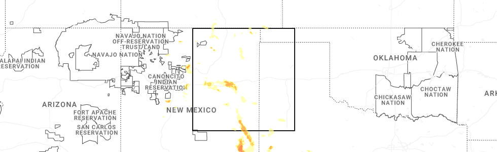
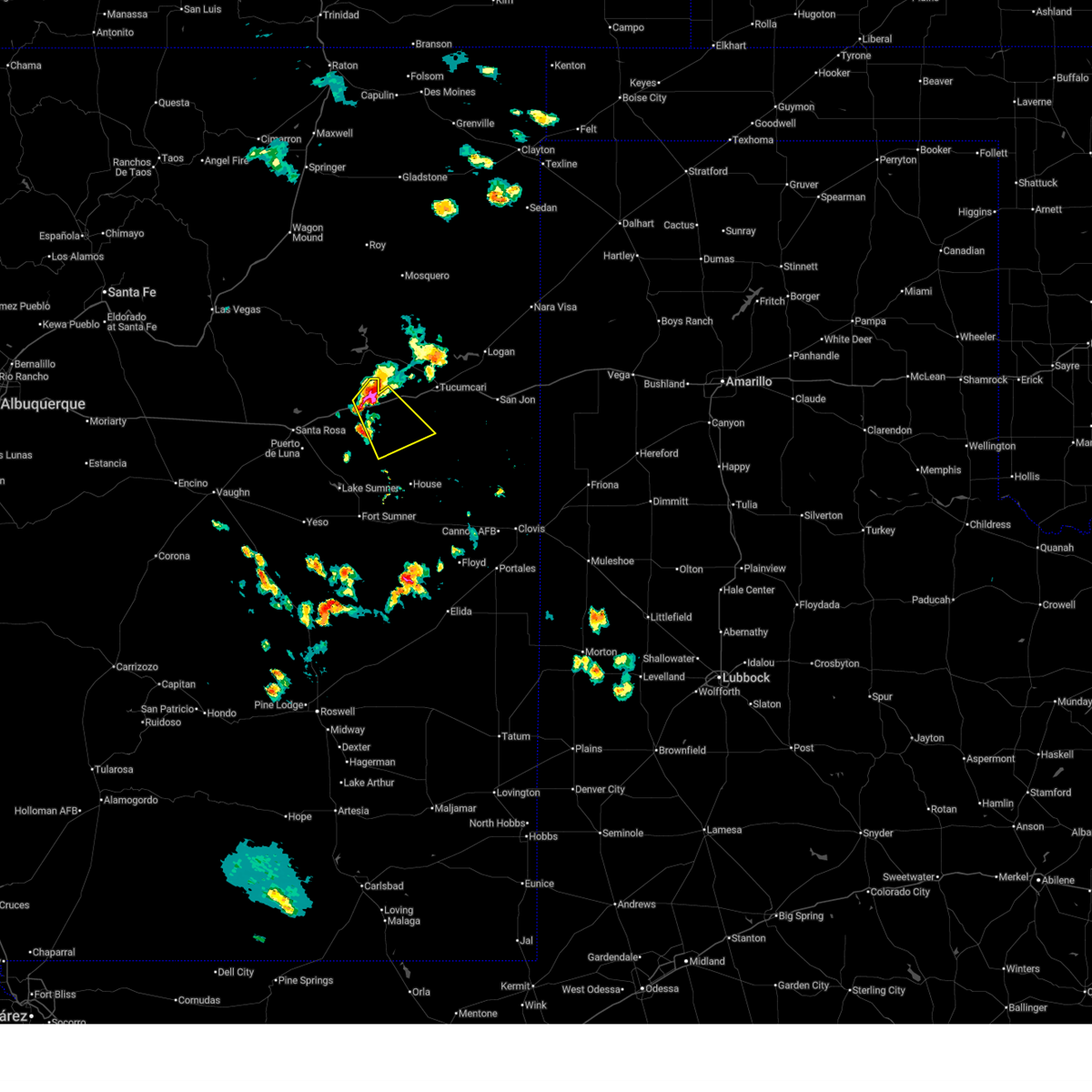
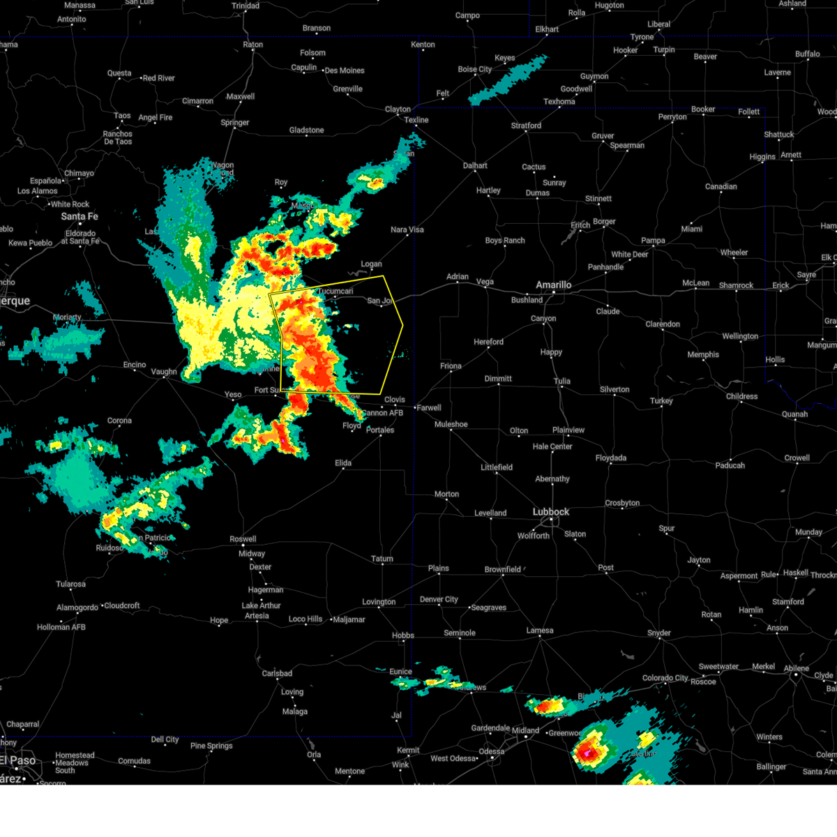
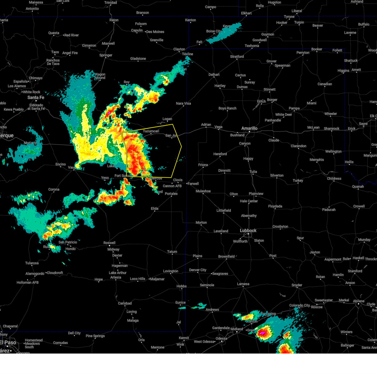
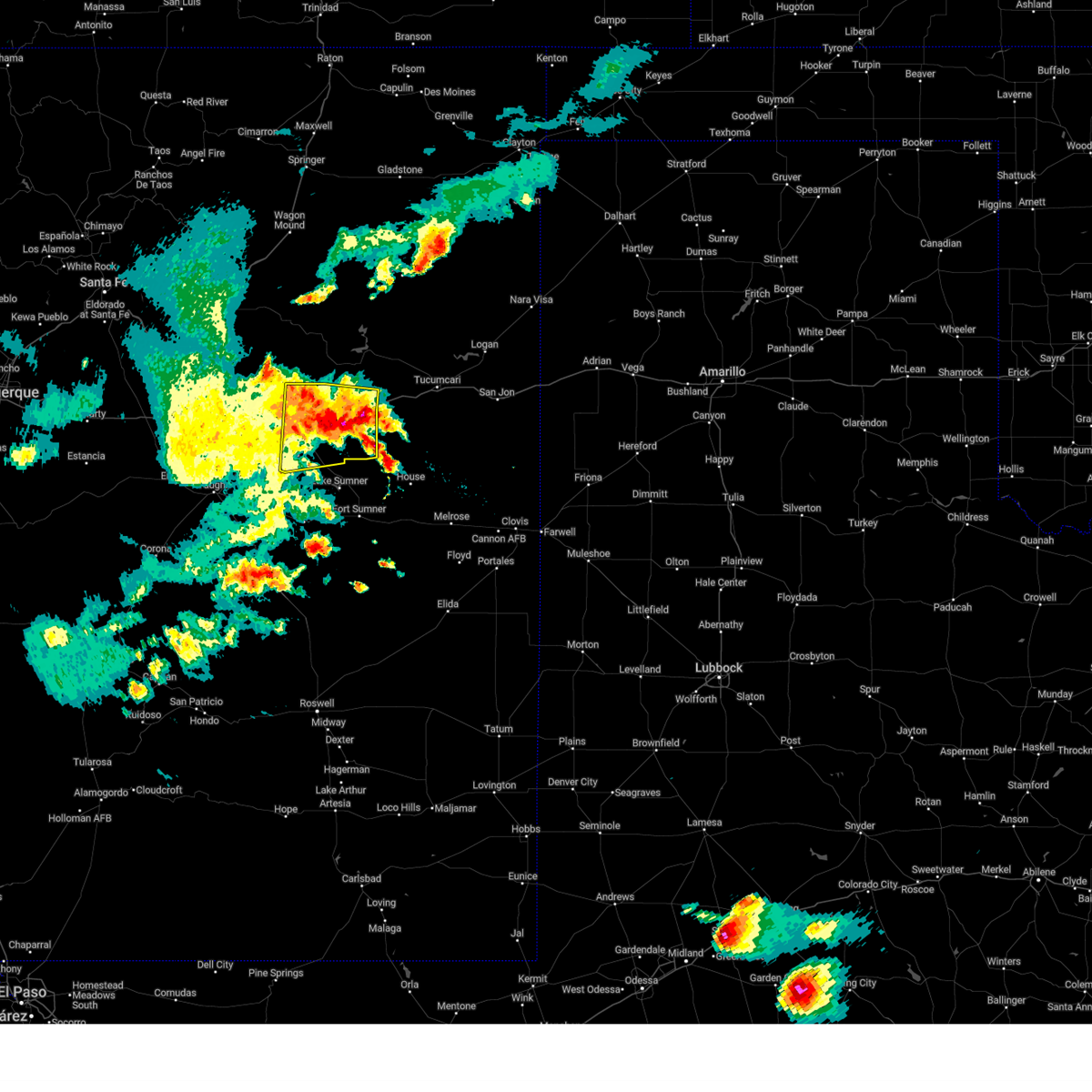
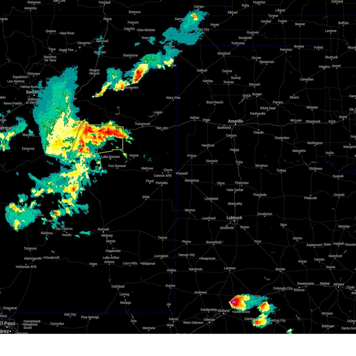
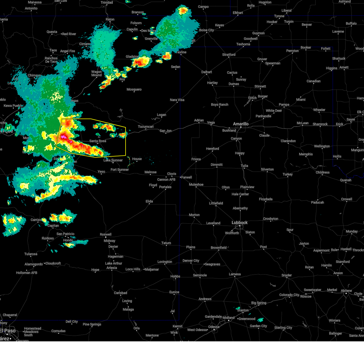
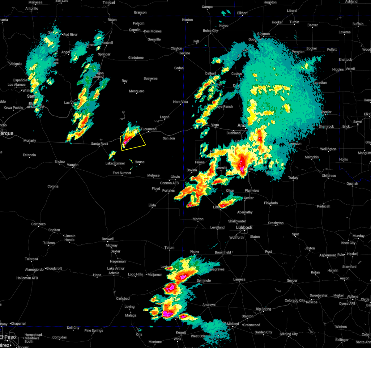
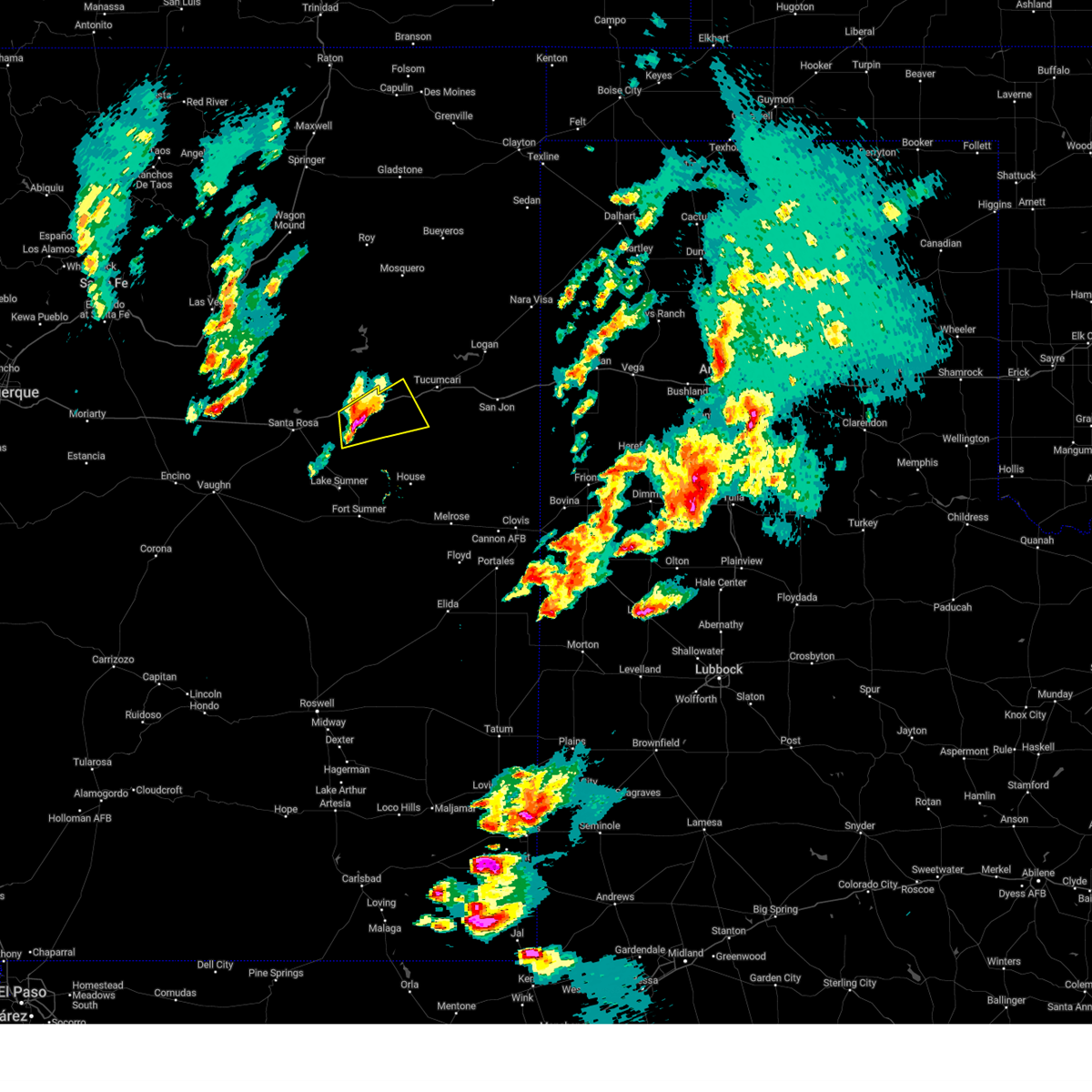
Hail Map for Newkirk, NM
The Newkirk, NM area has had 7 reports of on-the-ground hail by trained spotters, and has been under severe weather warnings 27 times during the past 12 months. Doppler radar has detected hail at or near Newkirk, NM on 51 occasions, including 7 occasions during the past year.
| Name: | Newkirk, NM |
| Where Located: | 31.5 miles WSW of Tucumcari, NM |
| Map: | Google Map for Newkirk, NM |
| Population: | 7 |
| Housing Units: | 11 |
| More Info: | Search Google for Newkirk, NM |
3
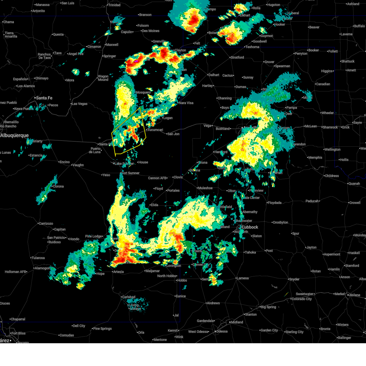
The Top Recent Hail Date for Newkirk, NM is Monday, June 9, 2025 (4th out of 51)
Hail and Wind Damage Spotted near Newkirk, NM
| Date / Time | Report Details |
|---|---|
| 6/23/2025 6:08 PM MDT |
 The earlier severe thunderstorms are no longer producing large hail, so the severe thunderstorm warning will be allowed to expire. however, small hail, gusty winds, and heavy rain are still possible with these thunderstorms. to report severe weather observed at your location, contact the national weather service office in albuquerque at 1.888.386.7637. The earlier severe thunderstorms are no longer producing large hail, so the severe thunderstorm warning will be allowed to expire. however, small hail, gusty winds, and heavy rain are still possible with these thunderstorms. to report severe weather observed at your location, contact the national weather service office in albuquerque at 1.888.386.7637.
|
| 6/23/2025 5:28 PM MDT |
 The severe thunderstorm warning that was previously in effect has been reissued for quay, san miguel, and guadalupe counties and is in effect until 615 pm mdt. please refer to that bulletin for the latest severe weather information. The severe thunderstorm warning that was previously in effect has been reissued for quay, san miguel, and guadalupe counties and is in effect until 615 pm mdt. please refer to that bulletin for the latest severe weather information.
|
| 6/23/2025 5:27 PM MDT |
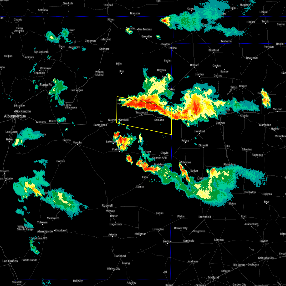
 Svrabq the national weather service in albuquerque has issued a * severe thunderstorm warning for, northeastern guadalupe county in east central new mexico, west central quay county in east central new mexico, southeastern san miguel county in northeastern new mexico, * until 615 pm mdt. * at 527 pm mdt, severe thunderstorms were located along a line from 13 miles northeast of montoya to 7 miles southeast of cuervo, moving east at 15 mph (radar indicated). Hazards include 60 mph wind gusts and quarter size hail. Hail damage to vehicles is expected. Expect wind damage to roofs, siding, and trees. Svrabq the national weather service in albuquerque has issued a * severe thunderstorm warning for, northeastern guadalupe county in east central new mexico, west central quay county in east central new mexico, southeastern san miguel county in northeastern new mexico, * until 615 pm mdt. * at 527 pm mdt, severe thunderstorms were located along a line from 13 miles northeast of montoya to 7 miles southeast of cuervo, moving east at 15 mph (radar indicated). Hazards include 60 mph wind gusts and quarter size hail. Hail damage to vehicles is expected. Expect wind damage to roofs, siding, and trees.
|
| 6/23/2025 5:15 PM MDT |
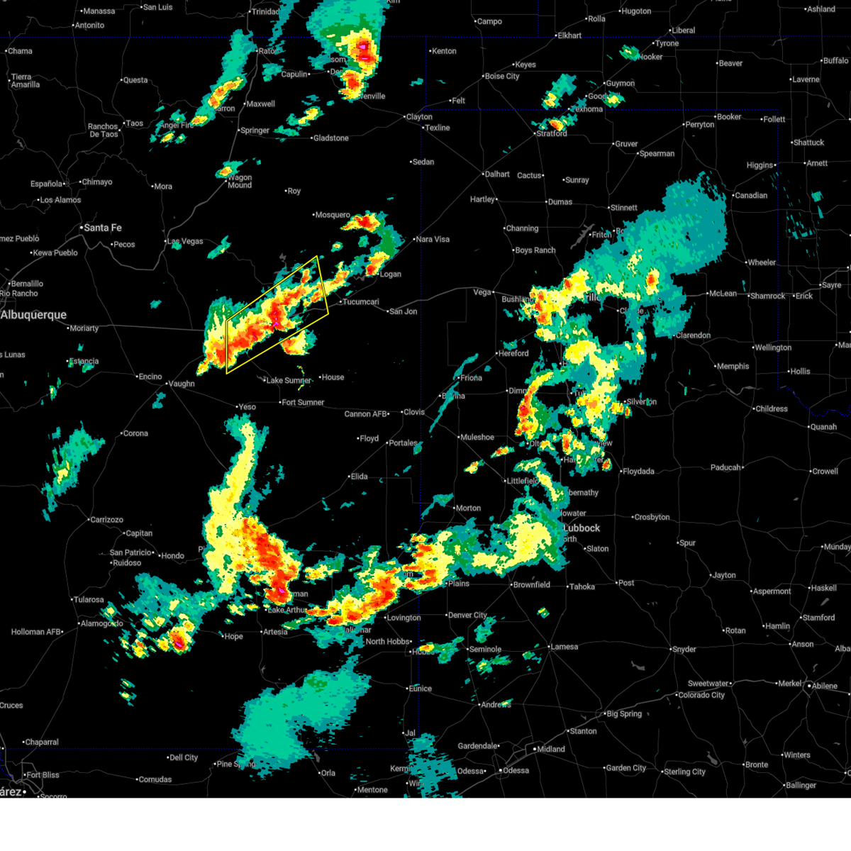
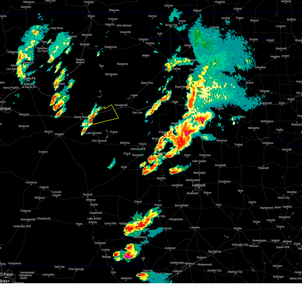
 At 515 pm mdt, severe thunderstorms were located along a line from 14 miles northwest of tucumcari to 8 miles south of cuervo, moving northeast at 20 mph (radar indicated). Hazards include 60 mph wind gusts and quarter size hail. Hail damage to vehicles is expected. expect wind damage to roofs, siding, and trees. locations impacted include, santa rosa, newkirk, cuervo, montoya, santa rosa lake state park and puerto de luna. this includes the following highways, interstate 40 between mile markers 274 and 325. State road 104 near mile marker 67, and between mile markers 69 and 71, and between mile markers 78 and 94. At 515 pm mdt, severe thunderstorms were located along a line from 14 miles northwest of tucumcari to 8 miles south of cuervo, moving northeast at 20 mph (radar indicated). Hazards include 60 mph wind gusts and quarter size hail. Hail damage to vehicles is expected. expect wind damage to roofs, siding, and trees. locations impacted include, santa rosa, newkirk, cuervo, montoya, santa rosa lake state park and puerto de luna. this includes the following highways, interstate 40 between mile markers 274 and 325. State road 104 near mile marker 67, and between mile markers 69 and 71, and between mile markers 78 and 94.
|
| 6/23/2025 4:47 PM MDT |
 Svrabq the national weather service in albuquerque has issued a * severe thunderstorm warning for, northeastern guadalupe county in east central new mexico, west central quay county in east central new mexico, southeastern san miguel county in northeastern new mexico, * until 530 pm mdt. * at 447 pm mdt, severe thunderstorms were located along a line from 10 miles north of montoya to near puerto de luna, moving northeast at 20 mph (radar indicated). Hazards include 60 mph wind gusts and quarter size hail. Hail damage to vehicles is expected. Expect wind damage to roofs, siding, and trees. Svrabq the national weather service in albuquerque has issued a * severe thunderstorm warning for, northeastern guadalupe county in east central new mexico, west central quay county in east central new mexico, southeastern san miguel county in northeastern new mexico, * until 530 pm mdt. * at 447 pm mdt, severe thunderstorms were located along a line from 10 miles north of montoya to near puerto de luna, moving northeast at 20 mph (radar indicated). Hazards include 60 mph wind gusts and quarter size hail. Hail damage to vehicles is expected. Expect wind damage to roofs, siding, and trees.
|
| 6/22/2025 4:58 PM MDT |
 The severe thunderstorm warning that was previously in effect has been replaced by a special weather statement. please refer to that bulletin for the latest information on this strong thunderstorm north of the tucumcari area. The severe thunderstorm warning that was previously in effect has been replaced by a special weather statement. please refer to that bulletin for the latest information on this strong thunderstorm north of the tucumcari area.
|
| 6/22/2025 4:26 PM MDT |
 At 426 pm mdt, a severe thunderstorm was located 9 miles north of montoya, or 22 miles west of tucumcari, moving northeast at 45 mph (radar indicated). Hazards include 60 mph wind gusts and small hail. Expect damage to roofs, siding, and trees. locations impacted include, tucumcari, conchas, conchas lake state park, montoya, conchas dam, newkirk and bell ranch. this includes the following highways, interstate 40 between mile markers 298 and 328. State road 104 between mile markers 62 and 100. At 426 pm mdt, a severe thunderstorm was located 9 miles north of montoya, or 22 miles west of tucumcari, moving northeast at 45 mph (radar indicated). Hazards include 60 mph wind gusts and small hail. Expect damage to roofs, siding, and trees. locations impacted include, tucumcari, conchas, conchas lake state park, montoya, conchas dam, newkirk and bell ranch. this includes the following highways, interstate 40 between mile markers 298 and 328. State road 104 between mile markers 62 and 100.
|
| 6/22/2025 4:08 PM MDT |
 Svrabq the national weather service in albuquerque has issued a * severe thunderstorm warning for, northeastern guadalupe county in east central new mexico, west central quay county in east central new mexico, southeastern san miguel county in northeastern new mexico, * until 500 pm mdt. * at 408 pm mdt, a severe thunderstorm was located near newkirk, or 25 miles northeast of santa rosa, moving northeast at 45 mph (radar indicated). Hazards include 60 mph wind gusts and quarter size hail. Hail damage to vehicles is expected. Expect wind damage to roofs, siding, and trees. Svrabq the national weather service in albuquerque has issued a * severe thunderstorm warning for, northeastern guadalupe county in east central new mexico, west central quay county in east central new mexico, southeastern san miguel county in northeastern new mexico, * until 500 pm mdt. * at 408 pm mdt, a severe thunderstorm was located near newkirk, or 25 miles northeast of santa rosa, moving northeast at 45 mph (radar indicated). Hazards include 60 mph wind gusts and quarter size hail. Hail damage to vehicles is expected. Expect wind damage to roofs, siding, and trees.
|
| 6/22/2025 3:55 PM MDT | Mesonet station newn5 newkir in guadalupe county NM, 0.6 miles SE of Newkirk, NM |
| 6/13/2025 5:13 PM MDT | At 513 pm mdt, a severe thunderstorm was located 6 miles south of montoya, or 22 miles southwest of tucumcari, moving southeast at 25 mph (radar indicated). Hazards include 60 mph wind gusts and half dollar size hail. Hail damage to vehicles is expected. expect wind damage to roofs, siding, and trees. locations impacted include, quay and montoya. This includes interstate 40 between mile markers 301 and 317. |
| 6/13/2025 4:55 PM MDT |
 Svrabq the national weather service in albuquerque has issued a * severe thunderstorm warning for, northeastern guadalupe county in east central new mexico, west central quay county in east central new mexico, * until 545 pm mdt. * at 455 pm mdt, a severe thunderstorm was located near montoya, or 23 miles west of tucumcari, moving southeast at 25 mph (radar indicated). Hazards include 60 mph wind gusts and quarter size hail. Hail damage to vehicles is expected. Expect wind damage to roofs, siding, and trees. Svrabq the national weather service in albuquerque has issued a * severe thunderstorm warning for, northeastern guadalupe county in east central new mexico, west central quay county in east central new mexico, * until 545 pm mdt. * at 455 pm mdt, a severe thunderstorm was located near montoya, or 23 miles west of tucumcari, moving southeast at 25 mph (radar indicated). Hazards include 60 mph wind gusts and quarter size hail. Hail damage to vehicles is expected. Expect wind damage to roofs, siding, and trees.
|
| 6/9/2025 7:27 PM MDT |
 At 727 pm mdt, severe thunderstorms were located along a line from 8 miles northeast of montoya to near house, moving east at 45 mph. these are destructive storms for ragland, mcalister (trained spotters reported). Hazards include 80 mph wind gusts and quarter size hail. Flying debris will be dangerous to those caught without shelter. mobile homes will be heavily damaged. expect considerable damage to roofs, windows, and vehicles. extensive tree damage and power outages are likely. locations impacted include, tucumcari, quay, san jon, grady, house, ragland, wheatland, montoya, broadview and forrest. this includes the following highways, interstate 40 between mile markers 301 and 362. State road 104 between mile markers 98 and 105. At 727 pm mdt, severe thunderstorms were located along a line from 8 miles northeast of montoya to near house, moving east at 45 mph. these are destructive storms for ragland, mcalister (trained spotters reported). Hazards include 80 mph wind gusts and quarter size hail. Flying debris will be dangerous to those caught without shelter. mobile homes will be heavily damaged. expect considerable damage to roofs, windows, and vehicles. extensive tree damage and power outages are likely. locations impacted include, tucumcari, quay, san jon, grady, house, ragland, wheatland, montoya, broadview and forrest. this includes the following highways, interstate 40 between mile markers 301 and 362. State road 104 between mile markers 98 and 105.
|
| 6/9/2025 7:12 PM MDT |
 Svrabq the national weather service in albuquerque has issued a * severe thunderstorm warning for, central curry county in east central new mexico, northeastern de baca county in east central new mexico, northeastern guadalupe county in east central new mexico, quay county in east central new mexico, northwestern roosevelt county in east central new mexico, southeastern san miguel county in northeastern new mexico, * until 815 pm mdt. * at 712 pm mdt, severe thunderstorms were located along a line from near montoya to 8 miles southwest of house, moving east at 45 mph. these are destructive storms for house (radar indicated). Hazards include 80 mph wind gusts and quarter size hail. Flying debris will be dangerous to those caught without shelter. mobile homes will be heavily damaged. expect considerable damage to roofs, windows, and vehicles. Extensive tree damage and power outages are likely. Svrabq the national weather service in albuquerque has issued a * severe thunderstorm warning for, central curry county in east central new mexico, northeastern de baca county in east central new mexico, northeastern guadalupe county in east central new mexico, quay county in east central new mexico, northwestern roosevelt county in east central new mexico, southeastern san miguel county in northeastern new mexico, * until 815 pm mdt. * at 712 pm mdt, severe thunderstorms were located along a line from near montoya to 8 miles southwest of house, moving east at 45 mph. these are destructive storms for house (radar indicated). Hazards include 80 mph wind gusts and quarter size hail. Flying debris will be dangerous to those caught without shelter. mobile homes will be heavily damaged. expect considerable damage to roofs, windows, and vehicles. Extensive tree damage and power outages are likely.
|
| 6/9/2025 6:32 PM MDT |
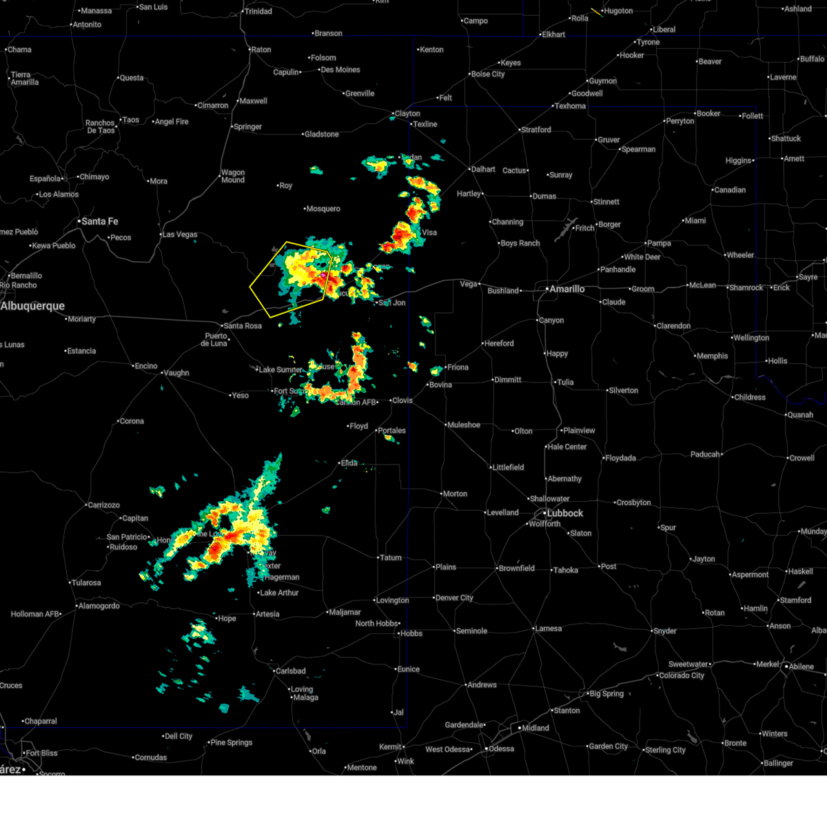
 At 632 pm mdt, severe thunderstorms were located along a line from near santa rosa lake state park to 13 miles southeast of newkirk, moving south at 15 mph (radar indicated). Hazards include 60 mph wind gusts and quarter size hail. Hail damage to vehicles is expected. expect wind damage to roofs, siding, and trees. locations impacted include, santa rosa, cuervo, puerto de luna, newkirk and santa rosa lake state park. This includes interstate 40 between mile markers 271 and 308. At 632 pm mdt, severe thunderstorms were located along a line from near santa rosa lake state park to 13 miles southeast of newkirk, moving south at 15 mph (radar indicated). Hazards include 60 mph wind gusts and quarter size hail. Hail damage to vehicles is expected. expect wind damage to roofs, siding, and trees. locations impacted include, santa rosa, cuervo, puerto de luna, newkirk and santa rosa lake state park. This includes interstate 40 between mile markers 271 and 308.
|
| 6/9/2025 6:13 PM MDT |
 Svrabq the national weather service in albuquerque has issued a * severe thunderstorm warning for, northern guadalupe county in east central new mexico, * until 715 pm mdt. * at 613 pm mdt, severe thunderstorms were located along a line from near colonias to 7 miles southwest of montoya, moving south at 5 mph (radar indicated). Hazards include 60 mph wind gusts and quarter size hail. Hail damage to vehicles is expected. Expect wind damage to roofs, siding, and trees. Svrabq the national weather service in albuquerque has issued a * severe thunderstorm warning for, northern guadalupe county in east central new mexico, * until 715 pm mdt. * at 613 pm mdt, severe thunderstorms were located along a line from near colonias to 7 miles southwest of montoya, moving south at 5 mph (radar indicated). Hazards include 60 mph wind gusts and quarter size hail. Hail damage to vehicles is expected. Expect wind damage to roofs, siding, and trees.
|
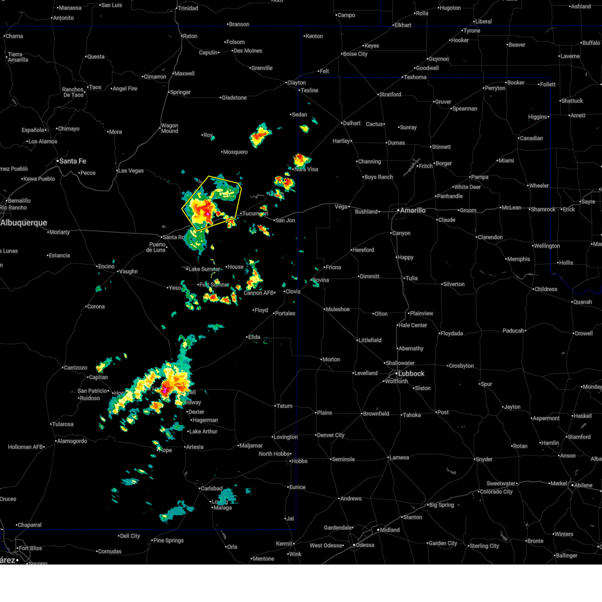
| 6/9/2025 6:10 PM MDT | Quarter sized hail reported 0.6 miles SE of Newkirk, NM, quarter size hail being reported along i-40 near newkirk. heavy hail accumulations are covering the roadways. |
| 6/9/2025 5:50 PM MDT | At 550 pm mdt, severe thunderstorms were located along a line from 7 miles south of cuervo to 6 miles south of anton chico, moving northeast at 30 mph (radar indicated). Hazards include 60 mph wind gusts and quarter size hail. Hail damage to vehicles is expected. expect wind damage to roofs, siding, and trees. locations impacted include, santa rosa, santa rosa lake state park, puerto de luna, colonias, cuervo, pastura, dilia, newkirk, anton chico and pintada. This includes interstate 40 between mile markers 240 and 307. |
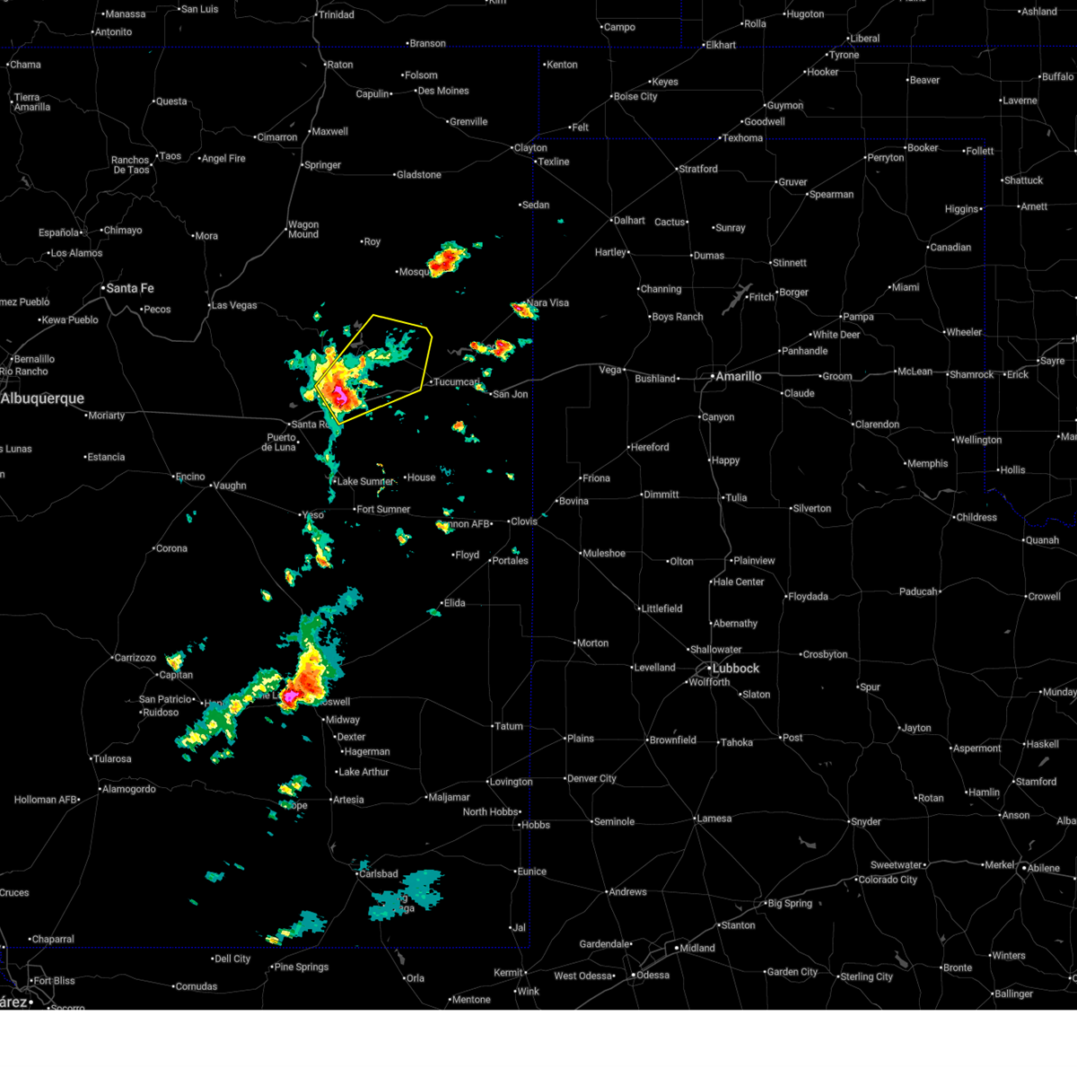
| 6/9/2025 5:50 PM MDT | the severe thunderstorm warning has been cancelled and is no longer in effect |
| 6/9/2025 5:28 PM MDT |
 Svrabq the national weather service in albuquerque has issued a * severe thunderstorm warning for, northeastern torrance county in central new mexico, north central de baca county in east central new mexico, guadalupe county in east central new mexico, southwestern san miguel county in northeastern new mexico, * until 615 pm mdt. * at 528 pm mdt, severe thunderstorms were located along a line from over puerto de luna to 15 miles south of villanueva state park, moving northeast at 15 mph (radar indicated). Hazards include 60 mph wind gusts and quarter size hail. Hail damage to vehicles is expected. Expect wind damage to roofs, siding, and trees. Svrabq the national weather service in albuquerque has issued a * severe thunderstorm warning for, northeastern torrance county in central new mexico, north central de baca county in east central new mexico, guadalupe county in east central new mexico, southwestern san miguel county in northeastern new mexico, * until 615 pm mdt. * at 528 pm mdt, severe thunderstorms were located along a line from over puerto de luna to 15 miles south of villanueva state park, moving northeast at 15 mph (radar indicated). Hazards include 60 mph wind gusts and quarter size hail. Hail damage to vehicles is expected. Expect wind damage to roofs, siding, and trees.
|
| 9/21/2024 6:25 PM MDT |
 At 625 pm mdt, a severe thunderstorm was located 7 miles southwest of montoya, or 25 miles southwest of tucumcari, moving northeast at 35 mph (radar indicated). Hazards include ping pong ball size hail and 60 mph wind gusts. People and animals outdoors will be injured. expect hail damage to roofs, siding, windows, and vehicles. expect wind damage to roofs, siding, and trees. locations impacted include, montoya and newkirk. This includes interstate 40 between mile markers 300 and 322. At 625 pm mdt, a severe thunderstorm was located 7 miles southwest of montoya, or 25 miles southwest of tucumcari, moving northeast at 35 mph (radar indicated). Hazards include ping pong ball size hail and 60 mph wind gusts. People and animals outdoors will be injured. expect hail damage to roofs, siding, windows, and vehicles. expect wind damage to roofs, siding, and trees. locations impacted include, montoya and newkirk. This includes interstate 40 between mile markers 300 and 322.
|
| 9/21/2024 6:13 PM MDT |
 At 613 pm mdt, a severe thunderstorm was located 6 miles south of newkirk, or 25 miles east of santa rosa, moving northeast at 35 mph (radar indicated). Hazards include golf ball size hail and 60 mph wind gusts. People and animals outdoors will be injured. expect hail damage to roofs, siding, windows, and vehicles. expect wind damage to roofs, siding, and trees. locations impacted include, montoya and newkirk. This includes interstate 40 between mile markers 295 and 322. At 613 pm mdt, a severe thunderstorm was located 6 miles south of newkirk, or 25 miles east of santa rosa, moving northeast at 35 mph (radar indicated). Hazards include golf ball size hail and 60 mph wind gusts. People and animals outdoors will be injured. expect hail damage to roofs, siding, windows, and vehicles. expect wind damage to roofs, siding, and trees. locations impacted include, montoya and newkirk. This includes interstate 40 between mile markers 295 and 322.
|
| 9/21/2024 6:02 PM MDT |
 Svrabq the national weather service in albuquerque has issued a * severe thunderstorm warning for, northeastern guadalupe county in east central new mexico, west central quay county in east central new mexico, * until 645 pm mdt. * at 602 pm mdt, a severe thunderstorm was located 6 miles southeast of cuervo, or 18 miles east of santa rosa, moving northeast at 35 mph (radar indicated). Hazards include 60 mph wind gusts and quarter size hail. Hail damage to vehicles is expected. Expect wind damage to roofs, siding, and trees. Svrabq the national weather service in albuquerque has issued a * severe thunderstorm warning for, northeastern guadalupe county in east central new mexico, west central quay county in east central new mexico, * until 645 pm mdt. * at 602 pm mdt, a severe thunderstorm was located 6 miles southeast of cuervo, or 18 miles east of santa rosa, moving northeast at 35 mph (radar indicated). Hazards include 60 mph wind gusts and quarter size hail. Hail damage to vehicles is expected. Expect wind damage to roofs, siding, and trees.
|
| 7/8/2024 4:00 AM MDT |
 Svrabq the national weather service in albuquerque has issued a * severe thunderstorm warning for, north central de baca county in east central new mexico, southwestern quay county in east central new mexico, east central guadalupe county in east central new mexico, * until 445 am mdt. * at 400 am mdt, a severe thunderstorm was located 11 miles southeast of cuervo, or 21 miles east of santa rosa, moving southeast at 15 mph (radar indicated). Hazards include 60 mph wind gusts and quarter size hail. Hail damage to vehicles is expected. Expect wind damage to roofs, siding, and trees. Svrabq the national weather service in albuquerque has issued a * severe thunderstorm warning for, north central de baca county in east central new mexico, southwestern quay county in east central new mexico, east central guadalupe county in east central new mexico, * until 445 am mdt. * at 400 am mdt, a severe thunderstorm was located 11 miles southeast of cuervo, or 21 miles east of santa rosa, moving southeast at 15 mph (radar indicated). Hazards include 60 mph wind gusts and quarter size hail. Hail damage to vehicles is expected. Expect wind damage to roofs, siding, and trees.
|
| 7/8/2024 3:36 AM MDT |
 At 336 am mdt, a severe thunderstorm was located near newkirk, or 21 miles east of santa rosa, moving southeast at 5 mph (radar indicated). Hazards include 60 mph wind gusts and quarter size hail. Hail damage to vehicles is expected. expect wind damage to roofs, siding, and trees. locations impacted include, newkirk and cuervo. This includes interstate 40 between mile markers 288 and 308. At 336 am mdt, a severe thunderstorm was located near newkirk, or 21 miles east of santa rosa, moving southeast at 5 mph (radar indicated). Hazards include 60 mph wind gusts and quarter size hail. Hail damage to vehicles is expected. expect wind damage to roofs, siding, and trees. locations impacted include, newkirk and cuervo. This includes interstate 40 between mile markers 288 and 308.
|
| 7/8/2024 2:54 AM MDT |
 Svrabq the national weather service in albuquerque has issued a * severe thunderstorm warning for, west central quay county in east central new mexico, northeastern guadalupe county in east central new mexico, * until 400 am mdt. * at 253 am mdt, a severe thunderstorm was located over cuervo, or 17 miles east of santa rosa, moving southeast at 10 mph (radar indicated). Hazards include 60 mph wind gusts and quarter size hail. Hail damage to vehicles is expected. Expect wind damage to roofs, siding, and trees. Svrabq the national weather service in albuquerque has issued a * severe thunderstorm warning for, west central quay county in east central new mexico, northeastern guadalupe county in east central new mexico, * until 400 am mdt. * at 253 am mdt, a severe thunderstorm was located over cuervo, or 17 miles east of santa rosa, moving southeast at 10 mph (radar indicated). Hazards include 60 mph wind gusts and quarter size hail. Hail damage to vehicles is expected. Expect wind damage to roofs, siding, and trees.
|
| 7/5/2024 12:09 AM MDT |
 The severe thunderstorm which prompted the warning has weakened and moved out of the warned area. therefore, the warning will be allowed to expire. The severe thunderstorm which prompted the warning has weakened and moved out of the warned area. therefore, the warning will be allowed to expire.
|
| 7/4/2024 11:44 PM MDT |
 At 1143 pm mdt, a severe thunderstorm was located near cuervo, or 12 miles northeast of santa rosa, moving northeast at 15 mph (radar indicated). Hazards include 60 mph wind gusts and quarter size hail. Hail damage to vehicles is expected. expect wind damage to roofs, siding, and trees. Locations impacted include, santa rosa, puerto de luna, santa rosa lake state park, and cuervo. At 1143 pm mdt, a severe thunderstorm was located near cuervo, or 12 miles northeast of santa rosa, moving northeast at 15 mph (radar indicated). Hazards include 60 mph wind gusts and quarter size hail. Hail damage to vehicles is expected. expect wind damage to roofs, siding, and trees. Locations impacted include, santa rosa, puerto de luna, santa rosa lake state park, and cuervo.
|
| 7/4/2024 11:44 PM MDT |
 the severe thunderstorm warning has been cancelled and is no longer in effect the severe thunderstorm warning has been cancelled and is no longer in effect
|
| 7/4/2024 11:24 PM MDT |
 Svrabq the national weather service in albuquerque has issued a * severe thunderstorm warning for, southeastern san miguel county in northeastern new mexico, northeastern guadalupe county in east central new mexico, * until 1215 am mdt. * at 1123 pm mdt, a severe thunderstorm was located near santa rosa lake state park, or 7 miles northeast of santa rosa, moving northeast at 10 mph (radar indicated). Hazards include 60 mph wind gusts and quarter size hail. Hail damage to vehicles is expected. Expect wind damage to roofs, siding, and trees. Svrabq the national weather service in albuquerque has issued a * severe thunderstorm warning for, southeastern san miguel county in northeastern new mexico, northeastern guadalupe county in east central new mexico, * until 1215 am mdt. * at 1123 pm mdt, a severe thunderstorm was located near santa rosa lake state park, or 7 miles northeast of santa rosa, moving northeast at 10 mph (radar indicated). Hazards include 60 mph wind gusts and quarter size hail. Hail damage to vehicles is expected. Expect wind damage to roofs, siding, and trees.
|
| 6/19/2024 1:20 PM MDT |
 Svrabq the national weather service in albuquerque has issued a * severe thunderstorm warning for, southeastern san miguel county in northeastern new mexico, northern guadalupe county in east central new mexico, * until 215 pm mdt. * at 119 pm mdt, severe thunderstorms were located along a line extending from 6 miles north of newkirk to 9 miles north of pastura, moving east at 10 mph (radar indicated). Hazards include ping pong ball size hail and 60 mph wind gusts. People and animals outdoors will be injured. expect hail damage to roofs, siding, windows, and vehicles. Expect wind damage to roofs, siding, and trees. Svrabq the national weather service in albuquerque has issued a * severe thunderstorm warning for, southeastern san miguel county in northeastern new mexico, northern guadalupe county in east central new mexico, * until 215 pm mdt. * at 119 pm mdt, severe thunderstorms were located along a line extending from 6 miles north of newkirk to 9 miles north of pastura, moving east at 10 mph (radar indicated). Hazards include ping pong ball size hail and 60 mph wind gusts. People and animals outdoors will be injured. expect hail damage to roofs, siding, windows, and vehicles. Expect wind damage to roofs, siding, and trees.
|
| 5/11/2024 9:48 PM MDT |
 At 947 pm mdt, severe thunderstorms were located along a line extending from 6 miles southwest of montoya to 12 miles south of cuervo, moving east at 35 mph (radar indicated). Hazards include 60 mph wind gusts and half dollar size hail. Hail damage to vehicles is expected. expect wind damage to roofs, siding, and trees. Locations impacted include, newkirk and montoya. At 947 pm mdt, severe thunderstorms were located along a line extending from 6 miles southwest of montoya to 12 miles south of cuervo, moving east at 35 mph (radar indicated). Hazards include 60 mph wind gusts and half dollar size hail. Hail damage to vehicles is expected. expect wind damage to roofs, siding, and trees. Locations impacted include, newkirk and montoya.
|
| 5/11/2024 9:37 PM MDT |
 Svrabq the national weather service in albuquerque has issued a * severe thunderstorm warning for, north central de baca county in east central new mexico, west central quay county in east central new mexico, northeastern guadalupe county in east central new mexico, * until 1045 pm mdt. * at 937 pm mdt, severe thunderstorms were located along a line extending from near newkirk to 8 miles east of puerto de luna, moving east at 30 mph (radar indicated). Hazards include 60 mph wind gusts and quarter size hail. Hail damage to vehicles is expected. Expect wind damage to roofs, siding, and trees. Svrabq the national weather service in albuquerque has issued a * severe thunderstorm warning for, north central de baca county in east central new mexico, west central quay county in east central new mexico, northeastern guadalupe county in east central new mexico, * until 1045 pm mdt. * at 937 pm mdt, severe thunderstorms were located along a line extending from near newkirk to 8 miles east of puerto de luna, moving east at 30 mph (radar indicated). Hazards include 60 mph wind gusts and quarter size hail. Hail damage to vehicles is expected. Expect wind damage to roofs, siding, and trees.
|
| 5/11/2024 7:46 PM MDT |
 The storm which prompted the warning has moved out of the area. therefore, the warning has been allowed to expire. however, small hail, gusty winds and heavy rain are still possible with this thunderstorm. The storm which prompted the warning has moved out of the area. therefore, the warning has been allowed to expire. however, small hail, gusty winds and heavy rain are still possible with this thunderstorm.
|
| 5/11/2024 7:17 PM MDT |
 the severe thunderstorm warning has been cancelled and is no longer in effect the severe thunderstorm warning has been cancelled and is no longer in effect
|
| 5/11/2024 7:17 PM MDT |
 At 716 pm mdt, a severe thunderstorm was located 7 miles southeast of cuervo, or 20 miles east of santa rosa, moving east at 25 mph (radar indicated). Hazards include ping pong ball size hail and 60 mph wind gusts. People and animals outdoors will be injured. expect hail damage to roofs, siding, windows, and vehicles. expect wind damage to roofs, siding, and trees. Locations impacted include, newkirk and cuervo. At 716 pm mdt, a severe thunderstorm was located 7 miles southeast of cuervo, or 20 miles east of santa rosa, moving east at 25 mph (radar indicated). Hazards include ping pong ball size hail and 60 mph wind gusts. People and animals outdoors will be injured. expect hail damage to roofs, siding, windows, and vehicles. expect wind damage to roofs, siding, and trees. Locations impacted include, newkirk and cuervo.
|
| 5/11/2024 6:52 PM MDT |
 Svrabq the national weather service in albuquerque has issued a * severe thunderstorm warning for, southeastern san miguel county in northeastern new mexico, north central de baca county in east central new mexico, northeastern guadalupe county in east central new mexico, * until 745 pm mdt. * at 651 pm mdt, a severe thunderstorm was located 9 miles southwest of cuervo, or 9 miles east of santa rosa, moving east at 20 mph (radar indicated). Hazards include golf ball size hail and 60 mph wind gusts. People and animals outdoors will be injured. expect hail damage to roofs, siding, windows, and vehicles. Expect wind damage to roofs, siding, and trees. Svrabq the national weather service in albuquerque has issued a * severe thunderstorm warning for, southeastern san miguel county in northeastern new mexico, north central de baca county in east central new mexico, northeastern guadalupe county in east central new mexico, * until 745 pm mdt. * at 651 pm mdt, a severe thunderstorm was located 9 miles southwest of cuervo, or 9 miles east of santa rosa, moving east at 20 mph (radar indicated). Hazards include golf ball size hail and 60 mph wind gusts. People and animals outdoors will be injured. expect hail damage to roofs, siding, windows, and vehicles. Expect wind damage to roofs, siding, and trees.
|
| 10/2/2023 8:54 PM MDT |
 The severe thunderstorm warning for northwestern roosevelt, southeastern san miguel, northern de baca, quay, curry and northeastern guadalupe counties will expire at 900 pm mdt, the storms which prompted the warning have weakened below severe limits, and no longer pose an immediate threat to life or property. therefore, the warning will be allowed to expire. a severe thunderstorm watch remains in effect until 100 am mdt for east central new mexico. a severe thunderstorm watch also remains in effect until 300 am mdt for east central new mexico. The severe thunderstorm warning for northwestern roosevelt, southeastern san miguel, northern de baca, quay, curry and northeastern guadalupe counties will expire at 900 pm mdt, the storms which prompted the warning have weakened below severe limits, and no longer pose an immediate threat to life or property. therefore, the warning will be allowed to expire. a severe thunderstorm watch remains in effect until 100 am mdt for east central new mexico. a severe thunderstorm watch also remains in effect until 300 am mdt for east central new mexico.
|
| 10/2/2023 8:44 PM MDT |
 At 844 pm mdt, severe thunderstorms were located along a line extending from near ute lake state park to near fort sumner, moving east at 35 mph (radar indicated). Hazards include 60 mph wind gusts. Expect damage to roofs, siding, and trees. locations impacted include, clovis, quay, tucumcari, texico, logan, fort sumner, melrose, san jon, grady, and house. this includes the following highways, interstate 40 between mile markers 293 and 373. highway 60 between mile markers 300 and 397. state road 104 between mile markers 69 and 105. hail threat, radar indicated max hail size, <. 75 in wind threat, radar indicated max wind gust, 60 mph. At 844 pm mdt, severe thunderstorms were located along a line extending from near ute lake state park to near fort sumner, moving east at 35 mph (radar indicated). Hazards include 60 mph wind gusts. Expect damage to roofs, siding, and trees. locations impacted include, clovis, quay, tucumcari, texico, logan, fort sumner, melrose, san jon, grady, and house. this includes the following highways, interstate 40 between mile markers 293 and 373. highway 60 between mile markers 300 and 397. state road 104 between mile markers 69 and 105. hail threat, radar indicated max hail size, <. 75 in wind threat, radar indicated max wind gust, 60 mph.
|
| 10/2/2023 7:59 PM MDT |
 At 759 pm mdt, severe thunderstorms were located along a line extending from 11 miles east of conchas to near yeso, moving east at 40 mph (radar indicated). Hazards include 60 mph wind gusts. expect damage to roofs, siding, and trees At 759 pm mdt, severe thunderstorms were located along a line extending from 11 miles east of conchas to near yeso, moving east at 40 mph (radar indicated). Hazards include 60 mph wind gusts. expect damage to roofs, siding, and trees
|
| 10/2/2023 7:24 PM MDT |
 At 724 pm mdt, severe thunderstorms were located along a line extending from 7 miles southwest of solano to near cuervo, moving east northeast at 40 mph (radar indicated). Hazards include 60 mph wind gusts and quarter size hail. Hail damage to vehicles is expected. expect wind damage to roofs, siding, and trees. locations impacted include, quay, tucumcari, santa rosa, mosquero, montoya, conchas, conchas lake state park, conchas dam, newkirk, and cuervo. this includes the following highways, interstate 40 between mile markers 276 and 332. state road 104 between mile markers 55 and 105. hail threat, radar indicated max hail size, 1. 00 in wind threat, radar indicated max wind gust, 60 mph. At 724 pm mdt, severe thunderstorms were located along a line extending from 7 miles southwest of solano to near cuervo, moving east northeast at 40 mph (radar indicated). Hazards include 60 mph wind gusts and quarter size hail. Hail damage to vehicles is expected. expect wind damage to roofs, siding, and trees. locations impacted include, quay, tucumcari, santa rosa, mosquero, montoya, conchas, conchas lake state park, conchas dam, newkirk, and cuervo. this includes the following highways, interstate 40 between mile markers 276 and 332. state road 104 between mile markers 55 and 105. hail threat, radar indicated max hail size, 1. 00 in wind threat, radar indicated max wind gust, 60 mph.
|
| 10/2/2023 6:54 PM MDT |
 At 654 pm mdt, severe thunderstorms were located along a line extending from 9 miles east of maes to santa rosa, moving northeast at 45 mph (radar indicated). Hazards include 70 mph wind gusts and quarter size hail. Hail damage to vehicles is expected. expect considerable tree damage. Wind damage is also likely to mobile homes, roofs, and outbuildings. At 654 pm mdt, severe thunderstorms were located along a line extending from 9 miles east of maes to santa rosa, moving northeast at 45 mph (radar indicated). Hazards include 70 mph wind gusts and quarter size hail. Hail damage to vehicles is expected. expect considerable tree damage. Wind damage is also likely to mobile homes, roofs, and outbuildings.
|
| 9/15/2023 5:42 PM MDT |
 At 542 pm mdt, a severe thunderstorm was located over newkirk, or 26 miles east of santa rosa, moving southeast at 25 mph (radar indicated). Hazards include ping pong ball size hail and 60 mph wind gusts. People and animals outdoors will be injured. expect hail damage to roofs, siding, windows, and vehicles. Expect wind damage to roofs, siding, and trees. At 542 pm mdt, a severe thunderstorm was located over newkirk, or 26 miles east of santa rosa, moving southeast at 25 mph (radar indicated). Hazards include ping pong ball size hail and 60 mph wind gusts. People and animals outdoors will be injured. expect hail damage to roofs, siding, windows, and vehicles. Expect wind damage to roofs, siding, and trees.
|
| 9/15/2023 5:28 PM MDT |
 At 528 pm mdt, a severe thunderstorm was located near newkirk, or 23 miles northeast of santa rosa, moving southeast at 20 mph (radar indicated). Hazards include 60 mph wind gusts and half dollar size hail. Hail damage to vehicles is expected. expect wind damage to roofs, siding, and trees. locations impacted include, newkirk and montoya. this includes interstate 40 between mile markers 293 and 316. hail threat, radar indicated max hail size, 1. 25 in wind threat, radar indicated max wind gust, 60 mph. At 528 pm mdt, a severe thunderstorm was located near newkirk, or 23 miles northeast of santa rosa, moving southeast at 20 mph (radar indicated). Hazards include 60 mph wind gusts and half dollar size hail. Hail damage to vehicles is expected. expect wind damage to roofs, siding, and trees. locations impacted include, newkirk and montoya. this includes interstate 40 between mile markers 293 and 316. hail threat, radar indicated max hail size, 1. 25 in wind threat, radar indicated max wind gust, 60 mph.
|
| 9/15/2023 5:07 PM MDT |
 At 507 pm mdt, a severe thunderstorm was located 8 miles north of cuervo, or 21 miles northeast of santa rosa, moving southeast at 20 mph (radar indicated). Hazards include 60 mph wind gusts and half dollar size hail. Hail damage to vehicles is expected. Expect wind damage to roofs, siding, and trees. At 507 pm mdt, a severe thunderstorm was located 8 miles north of cuervo, or 21 miles northeast of santa rosa, moving southeast at 20 mph (radar indicated). Hazards include 60 mph wind gusts and half dollar size hail. Hail damage to vehicles is expected. Expect wind damage to roofs, siding, and trees.
|
| 9/13/2023 9:32 PM MDT |
 At 931 pm mdt, a severe thunderstorm was located 11 miles northwest of newkirk, or 25 miles northeast of santa rosa, moving southeast at 30 mph (radar indicated). Hazards include 60 mph wind gusts and quarter size hail. Hail damage to vehicles is expected. expect wind damage to roofs, siding, and trees. locations impacted include, newkirk, variadero, and cuervo. this includes the following highways, interstate 40 between mile markers 285 and 307. state road 104 between mile markers 52 and 62. hail threat, radar indicated max hail size, 1. 00 in wind threat, radar indicated max wind gust, 60 mph. At 931 pm mdt, a severe thunderstorm was located 11 miles northwest of newkirk, or 25 miles northeast of santa rosa, moving southeast at 30 mph (radar indicated). Hazards include 60 mph wind gusts and quarter size hail. Hail damage to vehicles is expected. expect wind damage to roofs, siding, and trees. locations impacted include, newkirk, variadero, and cuervo. this includes the following highways, interstate 40 between mile markers 285 and 307. state road 104 between mile markers 52 and 62. hail threat, radar indicated max hail size, 1. 00 in wind threat, radar indicated max wind gust, 60 mph.
|
| 9/13/2023 9:12 PM MDT |
 At 911 pm mdt, a severe thunderstorm was located 7 miles south of variadero, or 26 miles northeast of santa rosa, moving southeast at 35 mph (radar indicated). Hazards include 60 mph wind gusts and quarter size hail. Hail damage to vehicles is expected. Expect wind damage to roofs, siding, and trees. At 911 pm mdt, a severe thunderstorm was located 7 miles south of variadero, or 26 miles northeast of santa rosa, moving southeast at 35 mph (radar indicated). Hazards include 60 mph wind gusts and quarter size hail. Hail damage to vehicles is expected. Expect wind damage to roofs, siding, and trees.
|
| 7/15/2023 8:11 PM MDT |
 At 810 pm mdt, severe thunderstorms were located along a line extending from 9 miles south of cuervo to 8 miles west of house, moving southeast at 20 mph (radar indicated). Hazards include ping pong ball size hail and 60 mph wind gusts. People and animals outdoors will be injured. expect hail damage to roofs, siding, windows, and vehicles. Expect wind damage to roofs, siding, and trees. At 810 pm mdt, severe thunderstorms were located along a line extending from 9 miles south of cuervo to 8 miles west of house, moving southeast at 20 mph (radar indicated). Hazards include ping pong ball size hail and 60 mph wind gusts. People and animals outdoors will be injured. expect hail damage to roofs, siding, windows, and vehicles. Expect wind damage to roofs, siding, and trees.
|
| 7/15/2023 7:53 PM MDT |
 At 752 pm mdt, severe thunderstorms were located along a line extending from 13 miles north of santa rosa lake state park to 6 miles south of newkirk, moving southeast at 20 mph (radar indicated). Hazards include tennis ball size hail and 60 mph wind gusts. People and animals outdoors will be injured. expect hail damage to roofs, siding, windows, and vehicles. expect wind damage to roofs, siding, and trees. locations impacted include, quay, santa rosa, fort sumner, house, puerto de luna, newkirk, santa rosa lake state park, cuervo, tolar and sumner lake state park. this includes the following highways, interstate 40 between mile markers 273 and 311. Highway 60 between mile markers 312 and 333, and between mile markers 345 and 346. At 752 pm mdt, severe thunderstorms were located along a line extending from 13 miles north of santa rosa lake state park to 6 miles south of newkirk, moving southeast at 20 mph (radar indicated). Hazards include tennis ball size hail and 60 mph wind gusts. People and animals outdoors will be injured. expect hail damage to roofs, siding, windows, and vehicles. expect wind damage to roofs, siding, and trees. locations impacted include, quay, santa rosa, fort sumner, house, puerto de luna, newkirk, santa rosa lake state park, cuervo, tolar and sumner lake state park. this includes the following highways, interstate 40 between mile markers 273 and 311. Highway 60 between mile markers 312 and 333, and between mile markers 345 and 346.
|
| 7/15/2023 7:20 PM MDT |
 At 719 pm mdt, severe thunderstorms were located along a line extending from 13 miles west of variadero to near newkirk, moving southeast at 20 mph (radar indicated). Hazards include tennis ball size hail and 70 mph wind gusts. People and animals outdoors will be injured. expect hail damage to roofs, siding, windows, and vehicles. expect considerable tree damage. Wind damage is also likely to mobile homes, roofs, and outbuildings. At 719 pm mdt, severe thunderstorms were located along a line extending from 13 miles west of variadero to near newkirk, moving southeast at 20 mph (radar indicated). Hazards include tennis ball size hail and 70 mph wind gusts. People and animals outdoors will be injured. expect hail damage to roofs, siding, windows, and vehicles. expect considerable tree damage. Wind damage is also likely to mobile homes, roofs, and outbuildings.
|
| 7/15/2023 7:01 PM MDT |
 At 700 pm mdt, severe thunderstorms were located along a line extending from 6 miles southwest of trujillo to 9 miles south of variadero, moving southeast at 25 mph (radar indicated). Hazards include tennis ball size hail and 70 mph wind gusts. People and animals outdoors will be injured. expect hail damage to roofs, siding, windows, and vehicles. expect considerable tree damage. wind damage is also likely to mobile homes, roofs, and outbuildings. locations impacted include, santa rosa, montoya, colonias, variadero, newkirk, santa rosa lake state park, cuervo, trujillo and trementina. this includes the following highways, interstate 40 between mile markers 265 and 314. State road 104 between mile markers 27 and 73. At 700 pm mdt, severe thunderstorms were located along a line extending from 6 miles southwest of trujillo to 9 miles south of variadero, moving southeast at 25 mph (radar indicated). Hazards include tennis ball size hail and 70 mph wind gusts. People and animals outdoors will be injured. expect hail damage to roofs, siding, windows, and vehicles. expect considerable tree damage. wind damage is also likely to mobile homes, roofs, and outbuildings. locations impacted include, santa rosa, montoya, colonias, variadero, newkirk, santa rosa lake state park, cuervo, trujillo and trementina. this includes the following highways, interstate 40 between mile markers 265 and 314. State road 104 between mile markers 27 and 73.
|
| 7/15/2023 6:29 PM MDT |
 At 628 pm mdt, severe thunderstorms were located along a line extending from 11 miles southeast of watrous to 8 miles west of variadero, moving south at 15 mph. these are destructive storms approaching i-40 from the north (radar indicated). Hazards include three inch hail and 70 mph wind gusts. People and animals outdoors will be severely injured. Expect shattered windows, extensive damage to roofs, siding, and vehicles. At 628 pm mdt, severe thunderstorms were located along a line extending from 11 miles southeast of watrous to 8 miles west of variadero, moving south at 15 mph. these are destructive storms approaching i-40 from the north (radar indicated). Hazards include three inch hail and 70 mph wind gusts. People and animals outdoors will be severely injured. Expect shattered windows, extensive damage to roofs, siding, and vehicles.
|
| 7/8/2023 3:55 PM MDT |
 At 354 pm mdt, a severe thunderstorm was located over newkirk, or 22 miles east of santa rosa, moving northeast at 35 mph (radar indicated). Hazards include ping pong ball size hail and 60 mph wind gusts. People and animals outdoors will be injured. expect hail damage to roofs, siding, windows, and vehicles. Expect wind damage to roofs, siding, and trees. At 354 pm mdt, a severe thunderstorm was located over newkirk, or 22 miles east of santa rosa, moving northeast at 35 mph (radar indicated). Hazards include ping pong ball size hail and 60 mph wind gusts. People and animals outdoors will be injured. expect hail damage to roofs, siding, windows, and vehicles. Expect wind damage to roofs, siding, and trees.
|
| 5/27/2023 5:33 PM MDT |
 At 532 pm mdt, a severe thunderstorm was located near puerto de luna, or near santa rosa, moving northeast at 30 mph (radar indicated). Hazards include ping pong ball size hail and 60 mph wind gusts. People and animals outdoors will be injured. expect hail damage to roofs, siding, windows, and vehicles. Expect wind damage to roofs, siding, and trees. At 532 pm mdt, a severe thunderstorm was located near puerto de luna, or near santa rosa, moving northeast at 30 mph (radar indicated). Hazards include ping pong ball size hail and 60 mph wind gusts. People and animals outdoors will be injured. expect hail damage to roofs, siding, windows, and vehicles. Expect wind damage to roofs, siding, and trees.
|
| 5/27/2023 4:39 PM MDT |
 At 439 pm mdt, a severe thunderstorm was located 9 miles southeast of puerto de luna, or 16 miles southeast of santa rosa, moving northeast at 30 mph (radar indicated). Hazards include 60 mph wind gusts and half dollar size hail. Hail damage to vehicles is expected. Expect wind damage to roofs, siding, and trees. At 439 pm mdt, a severe thunderstorm was located 9 miles southeast of puerto de luna, or 16 miles southeast of santa rosa, moving northeast at 30 mph (radar indicated). Hazards include 60 mph wind gusts and half dollar size hail. Hail damage to vehicles is expected. Expect wind damage to roofs, siding, and trees.
|
| 5/26/2023 1:15 AM MDT |
 At 115 am mdt, severe thunderstorms were located along a line extending from 12 miles north of cuervo to broadview, moving south at 10 mph (radar indicated). Hazards include 60 mph wind gusts and half dollar size hail. Hail damage to vehicles is expected. expect wind damage to roofs, siding, and trees. locations impacted include, quay, tucumcari, san jon, grady, ragland, montoya, conchas lake state park, newkirk, cuervo and conchas. this includes the following highways, interstate 40 between mile markers 287 and 362. state road 104 between mile markers 46 and 105. hail threat, radar indicated max hail size, 1. 25 in wind threat, radar indicated max wind gust, 60 mph. At 115 am mdt, severe thunderstorms were located along a line extending from 12 miles north of cuervo to broadview, moving south at 10 mph (radar indicated). Hazards include 60 mph wind gusts and half dollar size hail. Hail damage to vehicles is expected. expect wind damage to roofs, siding, and trees. locations impacted include, quay, tucumcari, san jon, grady, ragland, montoya, conchas lake state park, newkirk, cuervo and conchas. this includes the following highways, interstate 40 between mile markers 287 and 362. state road 104 between mile markers 46 and 105. hail threat, radar indicated max hail size, 1. 25 in wind threat, radar indicated max wind gust, 60 mph.
|
| 5/26/2023 12:44 AM MDT |
 At 1244 am mdt, severe thunderstorms were located along a line extending from near variadero to broadview, moving southeast at 10 mph (radar indicated). Hazards include ping pong ball size hail and 60 mph wind gusts. People and animals outdoors will be injured. expect hail damage to roofs, siding, windows, and vehicles. Expect wind damage to roofs, siding, and trees. At 1244 am mdt, severe thunderstorms were located along a line extending from near variadero to broadview, moving southeast at 10 mph (radar indicated). Hazards include ping pong ball size hail and 60 mph wind gusts. People and animals outdoors will be injured. expect hail damage to roofs, siding, windows, and vehicles. Expect wind damage to roofs, siding, and trees.
|
| 7/16/2021 8:37 PM MDT |
 At 836 pm mdt, a severe thunderstorm was located near newkirk, or 22 miles east of santa rosa, moving south at 10 mph (radar indicated). Hazards include 60 mph wind gusts and quarter size hail. Hail damage to vehicles is expected. Expect wind damage to roofs, siding, and trees. At 836 pm mdt, a severe thunderstorm was located near newkirk, or 22 miles east of santa rosa, moving south at 10 mph (radar indicated). Hazards include 60 mph wind gusts and quarter size hail. Hail damage to vehicles is expected. Expect wind damage to roofs, siding, and trees.
|
| 7/6/2021 5:31 PM MDT | Quarter sized hail reported 8.6 miles ENE of Newkirk, NM |
| 7/6/2021 5:23 PM MDT |
 The severe thunderstorm warning for south central san miguel and northeastern guadalupe counties will expire at 530 pm mdt, the storms which prompted the warning have weakened below severe limits, and no longer pose an immediate threat to life or property. therefore, the warning will be allowed to expire. however heavy rain is still possible with these thunderstorms. The severe thunderstorm warning for south central san miguel and northeastern guadalupe counties will expire at 530 pm mdt, the storms which prompted the warning have weakened below severe limits, and no longer pose an immediate threat to life or property. therefore, the warning will be allowed to expire. however heavy rain is still possible with these thunderstorms.
|
| 7/6/2021 5:19 PM MDT |
 At 518 pm mdt, severe thunderstorms were located along a line extending from 6 miles southeast of variadero to near cuervo, moving west at 5 mph (radar indicated). Hazards include 60 mph wind gusts and nickel size hail. Expect damage to roofs, siding, and trees. locations impacted include, newkirk, variadero and cuervo. this includes the following highways, interstate 40 between mile markers 283 and 303. State road 104 between mile markers 52 and 70. At 518 pm mdt, severe thunderstorms were located along a line extending from 6 miles southeast of variadero to near cuervo, moving west at 5 mph (radar indicated). Hazards include 60 mph wind gusts and nickel size hail. Expect damage to roofs, siding, and trees. locations impacted include, newkirk, variadero and cuervo. this includes the following highways, interstate 40 between mile markers 283 and 303. State road 104 between mile markers 52 and 70.
|
| 7/6/2021 5:02 PM MDT |
 At 501 pm mdt, severe thunderstorms were located along a line extending from 7 miles southeast of variadero to near cuervo, moving west at 5 mph (radar indicated). Hazards include 60 mph wind gusts and quarter size hail. Hail damage to vehicles is expected. Expect wind damage to roofs, siding, and trees. At 501 pm mdt, severe thunderstorms were located along a line extending from 7 miles southeast of variadero to near cuervo, moving west at 5 mph (radar indicated). Hazards include 60 mph wind gusts and quarter size hail. Hail damage to vehicles is expected. Expect wind damage to roofs, siding, and trees.
|
| 7/4/2021 10:58 PM MDT |
 At 1057 pm mdt, severe thunderstorms were located along a line extending from near newkirk to near bellview, moving south at 30 mph (radar indicated). Hazards include 70 mph wind gusts and penny size hail. Expect considerable tree damage. damage is likely to mobile homes, roofs, and outbuildings. locations impacted include, quay, tucumcari, san jon, montoya, newkirk, wheatland, bellview, bard and broadview. this includes the following highways, interstate 40 between mile markers 299 and 370. State road 104 between mile markers 67 and 71, near mile marker 93, and between mile markers 95 and 105. At 1057 pm mdt, severe thunderstorms were located along a line extending from near newkirk to near bellview, moving south at 30 mph (radar indicated). Hazards include 70 mph wind gusts and penny size hail. Expect considerable tree damage. damage is likely to mobile homes, roofs, and outbuildings. locations impacted include, quay, tucumcari, san jon, montoya, newkirk, wheatland, bellview, bard and broadview. this includes the following highways, interstate 40 between mile markers 299 and 370. State road 104 between mile markers 67 and 71, near mile marker 93, and between mile markers 95 and 105.
|
| 7/4/2021 10:46 PM MDT |
 At 1045 pm mdt, severe thunderstorms were located along a line extending from 9 miles south of conchas to 10 miles south of glenrio, moving south at 30 mph. the automated weather station in tucumcari reported a 63 mph wind gust at 1033 pm mdt (radar indicated). Hazards include 70 mph wind gusts and penny size hail. Expect considerable tree damage. damage is likely to mobile homes, roofs, and outbuildings. locations impacted include, quay, tucumcari, san jon, montoya, glenrio, conchas lake state park, conchas dam, newkirk, conchas and wheatland. this includes the following highways, interstate 40 between mile markers 298 and 373. State road 104 between mile markers 65 and 105. At 1045 pm mdt, severe thunderstorms were located along a line extending from 9 miles south of conchas to 10 miles south of glenrio, moving south at 30 mph. the automated weather station in tucumcari reported a 63 mph wind gust at 1033 pm mdt (radar indicated). Hazards include 70 mph wind gusts and penny size hail. Expect considerable tree damage. damage is likely to mobile homes, roofs, and outbuildings. locations impacted include, quay, tucumcari, san jon, montoya, glenrio, conchas lake state park, conchas dam, newkirk, conchas and wheatland. this includes the following highways, interstate 40 between mile markers 298 and 373. State road 104 between mile markers 65 and 105.
|
| 7/4/2021 10:36 PM MDT |
 At 1035 pm mdt, severe thunderstorms were located along a line extending from near conchas to 6 miles south of glenrio, moving south at 30 mph (radar indicated). Hazards include 70 mph wind gusts and penny size hail. Expect considerable tree damage. damage is likely to mobile homes, roofs, and outbuildings. locations impacted include, quay, tucumcari, logan, san jon, montoya, glenrio, conchas lake state park, conchas dam, newkirk and conchas. this includes the following highways, interstate 40 between mile markers 298 and 373. State road 104 between mile markers 65 and 105. At 1035 pm mdt, severe thunderstorms were located along a line extending from near conchas to 6 miles south of glenrio, moving south at 30 mph (radar indicated). Hazards include 70 mph wind gusts and penny size hail. Expect considerable tree damage. damage is likely to mobile homes, roofs, and outbuildings. locations impacted include, quay, tucumcari, logan, san jon, montoya, glenrio, conchas lake state park, conchas dam, newkirk and conchas. this includes the following highways, interstate 40 between mile markers 298 and 373. State road 104 between mile markers 65 and 105.
|
| 7/4/2021 10:23 PM MDT |
 At 1022 pm mdt, severe thunderstorms were located along a line extending from conchas dam to glenrio, moving south at 30 mph (radar indicated). Hazards include 60 mph wind gusts and penny size hail. expect damage to roofs, siding, and trees At 1022 pm mdt, severe thunderstorms were located along a line extending from conchas dam to glenrio, moving south at 30 mph (radar indicated). Hazards include 60 mph wind gusts and penny size hail. expect damage to roofs, siding, and trees
|
| 6/12/2021 8:53 PM MDT |
 The severe thunderstorm warning for northwestern roosevelt, southeastern san miguel, northeastern de baca, southwestern quay, west central curry and northeastern guadalupe counties will expire at 900 pm mdt, the storms which prompted the warning have moved out of the area. therefore, the warning will be allowed to expire. however small hail is still possible with these thunderstorms. a severe thunderstorm watch remains in effect until 1000 pm mdt for northeastern and east central new mexico. The severe thunderstorm warning for northwestern roosevelt, southeastern san miguel, northeastern de baca, southwestern quay, west central curry and northeastern guadalupe counties will expire at 900 pm mdt, the storms which prompted the warning have moved out of the area. therefore, the warning will be allowed to expire. however small hail is still possible with these thunderstorms. a severe thunderstorm watch remains in effect until 1000 pm mdt for northeastern and east central new mexico.
|
| 6/12/2021 8:00 PM MDT |
 At 800 pm mdt, severe thunderstorms were located along a line extending from near montoya to 9 miles south of taiban, moving east at 15 mph (radar indicated). Hazards include 60 mph wind gusts and half dollar size hail. Hail damage to vehicles is expected. Expect wind damage to roofs, siding, and trees. At 800 pm mdt, severe thunderstorms were located along a line extending from near montoya to 9 miles south of taiban, moving east at 15 mph (radar indicated). Hazards include 60 mph wind gusts and half dollar size hail. Hail damage to vehicles is expected. Expect wind damage to roofs, siding, and trees.
|
| 6/12/2021 7:34 PM MDT |
 At 733 pm mdt, severe thunderstorms were located along a line extending from near montoya to 12 miles southwest of taiban, moving east at 15 mph (radar indicated). Hazards include 60 mph wind gusts and half dollar size hail. Hail damage to vehicles is expected. expect wind damage to roofs, siding, and trees. locations impacted include, fort sumner, house, newkirk and montoya. This includes interstate 40 between mile markers 295 and 324. At 733 pm mdt, severe thunderstorms were located along a line extending from near montoya to 12 miles southwest of taiban, moving east at 15 mph (radar indicated). Hazards include 60 mph wind gusts and half dollar size hail. Hail damage to vehicles is expected. expect wind damage to roofs, siding, and trees. locations impacted include, fort sumner, house, newkirk and montoya. This includes interstate 40 between mile markers 295 and 324.
|
| 6/12/2021 6:55 PM MDT |
 At 655 pm mdt, severe thunderstorms were located along a line extending from newkirk to 12 miles southwest of fort sumner, moving east at 15 mph (radar indicated). Hazards include ping pong ball size hail and 60 mph wind gusts. People and animals outdoors will be injured. expect hail damage to roofs, siding, windows, and vehicles. Expect wind damage to roofs, siding, and trees. At 655 pm mdt, severe thunderstorms were located along a line extending from newkirk to 12 miles southwest of fort sumner, moving east at 15 mph (radar indicated). Hazards include ping pong ball size hail and 60 mph wind gusts. People and animals outdoors will be injured. expect hail damage to roofs, siding, windows, and vehicles. Expect wind damage to roofs, siding, and trees.
|
| 5/23/2021 8:05 PM MDT |
 At 805 pm mdt, a severe thunderstorm was located near newkirk, or 27 miles northeast of santa rosa, moving northeast at 25 mph (radar indicated). Hazards include 60 mph wind gusts and quarter size hail. Hail damage to vehicles is expected. expect wind damage to roofs, siding, and trees. locations impacted include, conchas and conchas lake state park. This includes state road 104 between mile markers 63 and 92. At 805 pm mdt, a severe thunderstorm was located near newkirk, or 27 miles northeast of santa rosa, moving northeast at 25 mph (radar indicated). Hazards include 60 mph wind gusts and quarter size hail. Hail damage to vehicles is expected. expect wind damage to roofs, siding, and trees. locations impacted include, conchas and conchas lake state park. This includes state road 104 between mile markers 63 and 92.
|
| 5/23/2021 7:47 PM MDT |
 At 747 pm mdt, a severe thunderstorm was located near newkirk, or 21 miles east of santa rosa, moving northeast at 25 mph (radar indicated). Hazards include 60 mph wind gusts and quarter size hail. Hail damage to vehicles is expected. Expect wind damage to roofs, siding, and trees. At 747 pm mdt, a severe thunderstorm was located near newkirk, or 21 miles east of santa rosa, moving northeast at 25 mph (radar indicated). Hazards include 60 mph wind gusts and quarter size hail. Hail damage to vehicles is expected. Expect wind damage to roofs, siding, and trees.
|
| 5/22/2021 8:02 PM MDT | Storm damage reported in guadalupe county NM, 7.4 miles S of Newkirk, NM |
| 3/13/2021 7:57 AM MST |
 At 756 am mst, a severe thunderstorm was located near newkirk, or 21 miles northeast of santa rosa, moving northeast at 45 mph (radar indicated). Hazards include 70 mph wind gusts and penny size hail. Expect considerable tree damage. damage is likely to mobile homes, roofs, and outbuildings. locations impacted include, conchas dam, newkirk, conchas and conchas lake state park. this includes the following highways, interstate 40 between mile markers 293 and 300. State road 104 near mile marker 51, and between mile markers 55 and 86. At 756 am mst, a severe thunderstorm was located near newkirk, or 21 miles northeast of santa rosa, moving northeast at 45 mph (radar indicated). Hazards include 70 mph wind gusts and penny size hail. Expect considerable tree damage. damage is likely to mobile homes, roofs, and outbuildings. locations impacted include, conchas dam, newkirk, conchas and conchas lake state park. this includes the following highways, interstate 40 between mile markers 293 and 300. State road 104 near mile marker 51, and between mile markers 55 and 86.
|
| 3/13/2021 7:35 AM MST |
 At 734 am mst, a severe thunderstorm was located 8 miles northeast of puerto de luna, or 10 miles east of santa rosa, moving north at 45 mph (radar indicated). Hazards include 70 mph wind gusts and penny size hail. Expect considerable tree damage. Damage is likely to mobile homes, roofs, and outbuildings. At 734 am mst, a severe thunderstorm was located 8 miles northeast of puerto de luna, or 10 miles east of santa rosa, moving north at 45 mph (radar indicated). Hazards include 70 mph wind gusts and penny size hail. Expect considerable tree damage. Damage is likely to mobile homes, roofs, and outbuildings.
|
| 7/31/2020 8:08 PM MDT |
 At 808 pm mdt, severe thunderstorms were located along a line extending from 10 miles south of bueyeros to 12 miles northeast of conchas dam to 6 miles west of variadero, moving southeast at 50 mph (radar indicated). Hazards include 60 mph wind gusts and quarter size hail. Hail damage to vehicles is expected. Expect wind damage to roofs, siding, and trees. At 808 pm mdt, severe thunderstorms were located along a line extending from 10 miles south of bueyeros to 12 miles northeast of conchas dam to 6 miles west of variadero, moving southeast at 50 mph (radar indicated). Hazards include 60 mph wind gusts and quarter size hail. Hail damage to vehicles is expected. Expect wind damage to roofs, siding, and trees.
|
| 7/3/2020 4:56 PM MDT |
 At 455 pm mdt, a severe thunderstorm was located near newkirk, or 21 miles northeast of santa rosa, moving northeast at 15 mph (radar indicated). Hazards include 60 mph wind gusts and quarter size hail. Hail damage to vehicles is expected. Expect wind damage to roofs, siding, and trees. At 455 pm mdt, a severe thunderstorm was located near newkirk, or 21 miles northeast of santa rosa, moving northeast at 15 mph (radar indicated). Hazards include 60 mph wind gusts and quarter size hail. Hail damage to vehicles is expected. Expect wind damage to roofs, siding, and trees.
|
| 6/25/2020 5:44 PM MDT |
 At 543 pm mdt, a severe thunderstorm was located 8 miles southwest of cuervo, or 9 miles east of santa rosa, moving east at 10 mph (radar indicated). Hazards include 60 mph wind gusts and nickel size hail. Expect damage to roofs, siding, and trees. locations impacted include, puerto de luna, newkirk and cuervo. This includes interstate 40 between mile markers 279 and 309. At 543 pm mdt, a severe thunderstorm was located 8 miles southwest of cuervo, or 9 miles east of santa rosa, moving east at 10 mph (radar indicated). Hazards include 60 mph wind gusts and nickel size hail. Expect damage to roofs, siding, and trees. locations impacted include, puerto de luna, newkirk and cuervo. This includes interstate 40 between mile markers 279 and 309.
|
| 6/25/2020 5:31 PM MDT |
 At 530 pm mdt, severe thunderstorms were located along a line extending from near cuervo to 10 miles east of santa rosa, moving east at 15 mph (radar indicated). Hazards include 60 mph wind gusts and nickel size hail. Expect damage to roofs, siding, and trees. locations impacted include, puerto de luna, newkirk, montoya and cuervo. This includes interstate 40 between mile markers 280 and 319. At 530 pm mdt, severe thunderstorms were located along a line extending from near cuervo to 10 miles east of santa rosa, moving east at 15 mph (radar indicated). Hazards include 60 mph wind gusts and nickel size hail. Expect damage to roofs, siding, and trees. locations impacted include, puerto de luna, newkirk, montoya and cuervo. This includes interstate 40 between mile markers 280 and 319.
|
| 6/25/2020 5:17 PM MDT |
 At 516 pm mdt, severe thunderstorms were located along a line extending from near cuervo to 7 miles east of santa rosa, moving east at 15 mph (radar indicated). Hazards include 60 mph wind gusts and nickel size hail. expect damage to roofs, siding, and trees At 516 pm mdt, severe thunderstorms were located along a line extending from near cuervo to 7 miles east of santa rosa, moving east at 15 mph (radar indicated). Hazards include 60 mph wind gusts and nickel size hail. expect damage to roofs, siding, and trees
|
| 7/5/2019 2:11 PM MDT |
 The severe thunderstorm warning for northeastern guadalupe county will expire at 215 pm mdt, the storm which prompted the warning has weakened below severe limits, and no longer poses an immediate threat to life or property. therefore the warning will be allowed to expire. however small hail and gusty winds are still possible with this thunderstorm. The severe thunderstorm warning for northeastern guadalupe county will expire at 215 pm mdt, the storm which prompted the warning has weakened below severe limits, and no longer poses an immediate threat to life or property. therefore the warning will be allowed to expire. however small hail and gusty winds are still possible with this thunderstorm.
|
| 7/5/2019 1:56 PM MDT |
 At 156 pm mdt, a severe thunderstorm was located over newkirk, or 24 miles east of santa rosa, moving north at 5 mph (radar indicated). Hazards include 60 mph wind gusts and nickel size hail. Expect damage to roofs, siding, and trees. locations impacted include, newkirk. This includes interstate 40 between mile markers 293 and 307. At 156 pm mdt, a severe thunderstorm was located over newkirk, or 24 miles east of santa rosa, moving north at 5 mph (radar indicated). Hazards include 60 mph wind gusts and nickel size hail. Expect damage to roofs, siding, and trees. locations impacted include, newkirk. This includes interstate 40 between mile markers 293 and 307.
|
| 7/5/2019 1:44 PM MDT |
 At 143 pm mdt, a severe thunderstorm was located over newkirk, or 25 miles east of santa rosa, and is nearly stationary (radar indicated). Hazards include 60 mph wind gusts and quarter size hail. Hail damage to vehicles is expected. Expect wind damage to roofs, siding, and trees. At 143 pm mdt, a severe thunderstorm was located over newkirk, or 25 miles east of santa rosa, and is nearly stationary (radar indicated). Hazards include 60 mph wind gusts and quarter size hail. Hail damage to vehicles is expected. Expect wind damage to roofs, siding, and trees.
|
| 3/12/2019 7:13 PM MDT |
 At 713 pm mdt, a severe thunderstorm capable of producing a tornado was located 15 miles northwest of house, or 25 miles north of fort sumner, moving north at 35 mph (radar indicated rotation). Hazards include tornado. Flying debris will be dangerous to those caught without shelter. mobile homes will be damaged or destroyed. damage to roofs, windows, and vehicles will occur. tree damage is likely. locations impacted include, newkirk. This includes interstate 40 between mile markers 300 and 310. At 713 pm mdt, a severe thunderstorm capable of producing a tornado was located 15 miles northwest of house, or 25 miles north of fort sumner, moving north at 35 mph (radar indicated rotation). Hazards include tornado. Flying debris will be dangerous to those caught without shelter. mobile homes will be damaged or destroyed. damage to roofs, windows, and vehicles will occur. tree damage is likely. locations impacted include, newkirk. This includes interstate 40 between mile markers 300 and 310.
|
| 3/12/2019 6:58 PM MDT |
 At 657 pm mdt, a severe thunderstorm capable of producing a tornado was located 9 miles northeast of sumner lake state park, or 14 miles north of fort sumner, moving north at 45 mph (radar indicated rotation). Hazards include tornado. Flying debris will be dangerous to those caught without shelter. mobile homes will be damaged or destroyed. damage to roofs, windows, and vehicles will occur. tree damage is likely. locations impacted include, newkirk. This includes interstate 40 between mile markers 300 and 310. At 657 pm mdt, a severe thunderstorm capable of producing a tornado was located 9 miles northeast of sumner lake state park, or 14 miles north of fort sumner, moving north at 45 mph (radar indicated rotation). Hazards include tornado. Flying debris will be dangerous to those caught without shelter. mobile homes will be damaged or destroyed. damage to roofs, windows, and vehicles will occur. tree damage is likely. locations impacted include, newkirk. This includes interstate 40 between mile markers 300 and 310.
|
| 3/12/2019 6:44 PM MDT |
 At 644 pm mdt, a severe thunderstorm capable of producing a tornado was located near sumner lake state park, or 8 miles north of fort sumner, moving north at 45 mph. additional storms capable of producing a tornado were located 8 miles southwest of fort sumner and were moving north at 45 mph (radar indicated rotation). Hazards include tornado. Flying debris will be dangerous to those caught without shelter. mobile homes will be damaged or destroyed. damage to roofs, windows, and vehicles will occur. tree damage is likely. these tornadic thunderstorms will remain over mainly rural areas of northeastern de baca, west central quay and northeastern guadalupe counties. This includes interstate 40 between mile markers 300 and 310. At 644 pm mdt, a severe thunderstorm capable of producing a tornado was located near sumner lake state park, or 8 miles north of fort sumner, moving north at 45 mph. additional storms capable of producing a tornado were located 8 miles southwest of fort sumner and were moving north at 45 mph (radar indicated rotation). Hazards include tornado. Flying debris will be dangerous to those caught without shelter. mobile homes will be damaged or destroyed. damage to roofs, windows, and vehicles will occur. tree damage is likely. these tornadic thunderstorms will remain over mainly rural areas of northeastern de baca, west central quay and northeastern guadalupe counties. This includes interstate 40 between mile markers 300 and 310.
|
| 9/9/2018 8:15 PM MDT |
 At 815 pm mdt, a severe thunderstorm was located near cuervo, or 19 miles east of santa rosa, moving southeast at 45 mph (radar indicated). Hazards include 70 mph wind gusts and penny size hail. Expect considerable tree damage. Damage is likely to mobile homes, roofs, and outbuildings. At 815 pm mdt, a severe thunderstorm was located near cuervo, or 19 miles east of santa rosa, moving southeast at 45 mph (radar indicated). Hazards include 70 mph wind gusts and penny size hail. Expect considerable tree damage. Damage is likely to mobile homes, roofs, and outbuildings.
|
| 8/9/2018 5:35 PM MDT |
 At 535 pm mdt, a severe thunderstorm was located 8 miles northwest of cuervo, or 15 miles northeast of santa rosa, moving southwest at 15 mph (radar indicated). Hazards include 60 mph wind gusts and quarter size hail. Hail damage to vehicles is expected. expect wind damage to roofs, siding, and trees. locations impacted include, newkirk and cuervo. This includes interstate 40 between mile markers 282 and 301. At 535 pm mdt, a severe thunderstorm was located 8 miles northwest of cuervo, or 15 miles northeast of santa rosa, moving southwest at 15 mph (radar indicated). Hazards include 60 mph wind gusts and quarter size hail. Hail damage to vehicles is expected. expect wind damage to roofs, siding, and trees. locations impacted include, newkirk and cuervo. This includes interstate 40 between mile markers 282 and 301.
|
| 8/9/2018 5:14 PM MDT |
 At 514 pm mdt, a severe thunderstorm was located 12 miles south of variadero, or 24 miles northeast of santa rosa, moving south at 15 mph (radar indicated). Hazards include 60 mph wind gusts and quarter size hail. Hail damage to vehicles is expected. Expect wind damage to roofs, siding, and trees. At 514 pm mdt, a severe thunderstorm was located 12 miles south of variadero, or 24 miles northeast of santa rosa, moving south at 15 mph (radar indicated). Hazards include 60 mph wind gusts and quarter size hail. Hail damage to vehicles is expected. Expect wind damage to roofs, siding, and trees.
|
| 5/19/2018 6:54 PM MDT |
 At 653 pm mdt, a severe thunderstorm was located over newkirk, or 24 miles northeast of santa rosa, moving southeast at 25 mph (radar indicated). Hazards include 60 mph wind gusts and half dollar size hail. Hail damage to vehicles is expected. Expect wind damage to roofs, siding, and trees. At 653 pm mdt, a severe thunderstorm was located over newkirk, or 24 miles northeast of santa rosa, moving southeast at 25 mph (radar indicated). Hazards include 60 mph wind gusts and half dollar size hail. Hail damage to vehicles is expected. Expect wind damage to roofs, siding, and trees.
|
| 9/25/2017 12:27 AM MDT |
 The severe thunderstorm warning for southeastern san miguel, west central quay and northeastern guadalupe counties will expire at 1230 am mdt, the storm which prompted the warning has weakened below severe limits, and no longer poses an immediate threat to life or property. therefore the warning will be allowed to expire. however, small hail, gusty winds and heavy rain are still possible with this thunderstorm. The severe thunderstorm warning for southeastern san miguel, west central quay and northeastern guadalupe counties will expire at 1230 am mdt, the storm which prompted the warning has weakened below severe limits, and no longer poses an immediate threat to life or property. therefore the warning will be allowed to expire. however, small hail, gusty winds and heavy rain are still possible with this thunderstorm.
|
| 9/25/2017 12:16 AM MDT |
 At 1216 am mdt, a severe thunderstorm was located near montoya, or 21 miles west of tucumcari, moving northeast at 25 mph (radar indicated). Hazards include 60 mph wind gusts and nickel size hail. Expect damage to roofs, siding, and trees. locations impacted include, newkirk and montoya. This includes interstate 40 between mile markers 299 and 319. At 1216 am mdt, a severe thunderstorm was located near montoya, or 21 miles west of tucumcari, moving northeast at 25 mph (radar indicated). Hazards include 60 mph wind gusts and nickel size hail. Expect damage to roofs, siding, and trees. locations impacted include, newkirk and montoya. This includes interstate 40 between mile markers 299 and 319.
|
| 9/24/2017 11:46 PM MDT |
 At 1146 pm mdt, a severe thunderstorm was located near newkirk, or 26 miles east of santa rosa, moving northeast at 25 mph (radar indicated). Hazards include 60 mph wind gusts and quarter size hail. Hail damage to vehicles is expected. Expect wind damage to roofs, siding, and trees. At 1146 pm mdt, a severe thunderstorm was located near newkirk, or 26 miles east of santa rosa, moving northeast at 25 mph (radar indicated). Hazards include 60 mph wind gusts and quarter size hail. Hail damage to vehicles is expected. Expect wind damage to roofs, siding, and trees.
|
| 8/14/2017 6:00 PM MDT |
 At 600 pm mdt, a severe thunderstorm was located 7 miles north of newkirk, or 26 miles northeast of santa rosa, moving southeast at 5 mph (radar indicated). Hazards include 60 mph wind gusts and quarter size hail. Hail damage to vehicles is expected. expect wind damage to roofs, siding, and trees. locations impacted include, newkirk. This includes interstate 40 between mile markers 295 and 302. At 600 pm mdt, a severe thunderstorm was located 7 miles north of newkirk, or 26 miles northeast of santa rosa, moving southeast at 5 mph (radar indicated). Hazards include 60 mph wind gusts and quarter size hail. Hail damage to vehicles is expected. expect wind damage to roofs, siding, and trees. locations impacted include, newkirk. This includes interstate 40 between mile markers 295 and 302.
|
| 8/14/2017 5:37 PM MDT |
 At 537 pm mdt, a severe thunderstorm was located 10 miles north of newkirk, or 27 miles northeast of santa rosa, moving southeast at 10 mph (radar indicated). Hazards include 60 mph wind gusts and quarter size hail. Hail damage to vehicles is expected. Expect wind damage to roofs, siding, and trees. At 537 pm mdt, a severe thunderstorm was located 10 miles north of newkirk, or 27 miles northeast of santa rosa, moving southeast at 10 mph (radar indicated). Hazards include 60 mph wind gusts and quarter size hail. Hail damage to vehicles is expected. Expect wind damage to roofs, siding, and trees.
|
| 7/1/2017 7:25 PM MDT |
 At 725 pm mdt, a severe thunderstorm was located 11 miles north of montoya, or 17 miles west of tucumcari, moving east at 30 mph (radar indicated). Hazards include 60 mph wind gusts. Expect damage to roofs, siding, and trees. locations impacted include, conchas dam, newkirk, montoya, conchas and conchas lake state park. This includes interstate 40 between mile markers 300 and 326. At 725 pm mdt, a severe thunderstorm was located 11 miles north of montoya, or 17 miles west of tucumcari, moving east at 30 mph (radar indicated). Hazards include 60 mph wind gusts. Expect damage to roofs, siding, and trees. locations impacted include, conchas dam, newkirk, montoya, conchas and conchas lake state park. This includes interstate 40 between mile markers 300 and 326.
|
| 7/1/2017 6:58 PM MDT |
 At 658 pm mdt, a severe thunderstorm was located over conchas lake state park, or 30 miles northwest of tucumcari, moving east at 30 mph (radar indicated). Hazards include 60 mph wind gusts. expect damage to roofs, siding, and trees At 658 pm mdt, a severe thunderstorm was located over conchas lake state park, or 30 miles northwest of tucumcari, moving east at 30 mph (radar indicated). Hazards include 60 mph wind gusts. expect damage to roofs, siding, and trees
|
| 6/30/2017 7:42 PM MDT |
 At 741 pm mdt, a severe thunderstorm was located near newkirk, or 25 miles east of santa rosa, moving southeast at 25 mph (radar indicated). Hazards include 60 mph wind gusts and half dollar size hail. Hail damage to vehicles is expected. Expect wind damage to roofs, siding, and trees. At 741 pm mdt, a severe thunderstorm was located near newkirk, or 25 miles east of santa rosa, moving southeast at 25 mph (radar indicated). Hazards include 60 mph wind gusts and half dollar size hail. Hail damage to vehicles is expected. Expect wind damage to roofs, siding, and trees.
|
| 6/30/2017 7:27 PM MDT |
 At 727 pm mdt, a severe thunderstorm was located over newkirk, or 24 miles east of santa rosa, moving southeast at 25 mph (radar indicated). Hazards include golf ball size hail and 60 mph wind gusts. People and animals outdoors will be injured. expect hail damage to roofs, siding, windows, and vehicles. expect wind damage to roofs, siding, and trees. locations impacted include, newkirk and montoya. This includes interstate 40 between mile markers 293 and 313. At 727 pm mdt, a severe thunderstorm was located over newkirk, or 24 miles east of santa rosa, moving southeast at 25 mph (radar indicated). Hazards include golf ball size hail and 60 mph wind gusts. People and animals outdoors will be injured. expect hail damage to roofs, siding, windows, and vehicles. expect wind damage to roofs, siding, and trees. locations impacted include, newkirk and montoya. This includes interstate 40 between mile markers 293 and 313.
|
| 6/30/2017 7:19 PM MDT |
 At 719 pm mdt, a severe thunderstorm was located near newkirk, or 24 miles northeast of santa rosa, moving southeast at 25 mph (radar indicated). Hazards include golf ball size hail and 60 mph wind gusts. People and animals outdoors will be injured. expect hail damage to roofs, siding, windows, and vehicles. expect wind damage to roofs, siding, and trees. locations impacted include, newkirk, montoya and cuervo. This includes interstate 40 between mile markers 286 and 321. At 719 pm mdt, a severe thunderstorm was located near newkirk, or 24 miles northeast of santa rosa, moving southeast at 25 mph (radar indicated). Hazards include golf ball size hail and 60 mph wind gusts. People and animals outdoors will be injured. expect hail damage to roofs, siding, windows, and vehicles. expect wind damage to roofs, siding, and trees. locations impacted include, newkirk, montoya and cuervo. This includes interstate 40 between mile markers 286 and 321.
|
| 6/30/2017 6:55 PM MDT |
 At 654 pm mdt, a severe thunderstorm was located 10 miles south of variadero, or 25 miles northeast of santa rosa, moving southeast at 25 mph (radar indicated). Hazards include 60 mph wind gusts and quarter size hail. Hail damage to vehicles is expected. Expect wind damage to roofs, siding, and trees. At 654 pm mdt, a severe thunderstorm was located 10 miles south of variadero, or 25 miles northeast of santa rosa, moving southeast at 25 mph (radar indicated). Hazards include 60 mph wind gusts and quarter size hail. Hail damage to vehicles is expected. Expect wind damage to roofs, siding, and trees.
|
| 5/9/2017 6:27 PM MDT |
 At 626 pm mdt, a severe thunderstorm was located over bootleg, or 13 miles northwest of friona, and is nearly stationary (radar indicated). Hazards include 70 mph wind gusts and quarter size hail. Hail damage to vehicles is expected. expect considerable tree damage. wind damage is also likely to mobile homes, roofs, and outbuildings. locations impacted include, santa rosa, puerto de luna, newkirk, santa rosa lake state park and cuervo. this includes interstate 40 between mile markers 266 and 305. A tornado watch remains in effect until 1000 pm mdt for east central new mexico. At 626 pm mdt, a severe thunderstorm was located over bootleg, or 13 miles northwest of friona, and is nearly stationary (radar indicated). Hazards include 70 mph wind gusts and quarter size hail. Hail damage to vehicles is expected. expect considerable tree damage. wind damage is also likely to mobile homes, roofs, and outbuildings. locations impacted include, santa rosa, puerto de luna, newkirk, santa rosa lake state park and cuervo. this includes interstate 40 between mile markers 266 and 305. A tornado watch remains in effect until 1000 pm mdt for east central new mexico.
|
| 5/9/2017 6:13 PM MDT |
 At 612 pm mdt, a severe thunderstorm was located 7 miles east of pastura, or 12 miles southwest of santa rosa, moving northeast at 50 mph (radar indicated). Hazards include 70 mph wind gusts and half dollar size hail. Hail damage to vehicles is expected. expect considerable tree damage. Wind damage is also likely to mobile homes, roofs, and outbuildings. At 612 pm mdt, a severe thunderstorm was located 7 miles east of pastura, or 12 miles southwest of santa rosa, moving northeast at 50 mph (radar indicated). Hazards include 70 mph wind gusts and half dollar size hail. Hail damage to vehicles is expected. expect considerable tree damage. Wind damage is also likely to mobile homes, roofs, and outbuildings.
|
| 5/9/2017 4:21 PM MDT |
 At 421 pm mdt, a severe thunderstorm was located 9 miles northwest of sumner lake state park, or 19 miles southeast of santa rosa, moving north at 40 mph (radar indicated). Hazards include 60 mph wind gusts and half dollar size hail. Hail damage to vehicles is expected. expect wind damage to roofs, siding, and trees. locations impacted include, puerto de luna, sumner lake state park, cuervo and sumner lake. this includes interstate 40 between mile markers 279 and 298. A tornado watch remains in effect until 1000 pm mdt for east central new mexico. At 421 pm mdt, a severe thunderstorm was located 9 miles northwest of sumner lake state park, or 19 miles southeast of santa rosa, moving north at 40 mph (radar indicated). Hazards include 60 mph wind gusts and half dollar size hail. Hail damage to vehicles is expected. expect wind damage to roofs, siding, and trees. locations impacted include, puerto de luna, sumner lake state park, cuervo and sumner lake. this includes interstate 40 between mile markers 279 and 298. A tornado watch remains in effect until 1000 pm mdt for east central new mexico.
|
| 5/9/2017 4:07 PM MDT |
 At 407 pm mdt, a severe thunderstorm was located 7 miles west of sumner lake, or 17 miles northwest of fort sumner, moving north at 40 mph (radar indicated). Hazards include 60 mph wind gusts and half dollar size hail. Hail damage to vehicles is expected. expect wind damage to roofs, siding, and trees. locations impacted include, puerto de luna, sumner lake state park, cuervo and sumner lake. this includes interstate 40 between mile markers 278 and 298. A tornado watch remains in effect until 1000 pm mdt for east central new mexico. At 407 pm mdt, a severe thunderstorm was located 7 miles west of sumner lake, or 17 miles northwest of fort sumner, moving north at 40 mph (radar indicated). Hazards include 60 mph wind gusts and half dollar size hail. Hail damage to vehicles is expected. expect wind damage to roofs, siding, and trees. locations impacted include, puerto de luna, sumner lake state park, cuervo and sumner lake. this includes interstate 40 between mile markers 278 and 298. A tornado watch remains in effect until 1000 pm mdt for east central new mexico.
|
| 5/9/2017 3:52 PM MDT |
 At 352 pm mdt, a severe thunderstorm was located near yeso, or 18 miles west of fort sumner, moving north at 40 mph (radar indicated). Hazards include 60 mph wind gusts and half dollar size hail. Hail damage to vehicles is expected. Expect wind damage to roofs, siding, and trees. At 352 pm mdt, a severe thunderstorm was located near yeso, or 18 miles west of fort sumner, moving north at 40 mph (radar indicated). Hazards include 60 mph wind gusts and half dollar size hail. Hail damage to vehicles is expected. Expect wind damage to roofs, siding, and trees.
|
| 5/8/2017 10:12 PM MDT | Quarter sized hail reported 7.4 miles S of Newkirk, NM |
| 5/8/2017 10:01 PM MDT |
 At 1001 pm mdt, a severe thunderstorm was located over newkirk, or 24 miles northeast of santa rosa, moving north at 15 mph (radar indicated). Hazards include 60 mph wind gusts and quarter size hail. Hail damage to vehicles is expected. Expect wind damage to roofs, siding, and trees. At 1001 pm mdt, a severe thunderstorm was located over newkirk, or 24 miles northeast of santa rosa, moving north at 15 mph (radar indicated). Hazards include 60 mph wind gusts and quarter size hail. Hail damage to vehicles is expected. Expect wind damage to roofs, siding, and trees.
|
| 5/8/2017 7:55 PM MDT |
 At 755 pm mdt, a severe thunderstorm was located 15 miles south of newkirk, or 25 miles north of fort sumner, moving northeast at 15 mph (radar indicated). Hazards include ping pong ball size hail and 60 mph wind gusts. People and animals outdoors will be injured. expect hail damage to roofs, siding, windows, and vehicles. expect wind damage to roofs, siding, and trees. this severe thunderstorm will remain over mainly rural areas of northern de baca and northeastern guadalupe counties. This includes interstate 40 between mile markers 303 and 307. At 755 pm mdt, a severe thunderstorm was located 15 miles south of newkirk, or 25 miles north of fort sumner, moving northeast at 15 mph (radar indicated). Hazards include ping pong ball size hail and 60 mph wind gusts. People and animals outdoors will be injured. expect hail damage to roofs, siding, windows, and vehicles. expect wind damage to roofs, siding, and trees. this severe thunderstorm will remain over mainly rural areas of northern de baca and northeastern guadalupe counties. This includes interstate 40 between mile markers 303 and 307.
|
| 5/8/2017 7:28 PM MDT |
 At 728 pm mdt, a severe thunderstorm was located 10 miles southeast of cuervo, or 20 miles east of santa rosa, moving north at 30 mph (radar indicated). Hazards include 60 mph wind gusts and half dollar size hail. Hail damage to vehicles is expected. Expect wind damage to roofs, siding, and trees. At 728 pm mdt, a severe thunderstorm was located 10 miles southeast of cuervo, or 20 miles east of santa rosa, moving north at 30 mph (radar indicated). Hazards include 60 mph wind gusts and half dollar size hail. Hail damage to vehicles is expected. Expect wind damage to roofs, siding, and trees.
|
| 5/8/2017 5:04 PM MDT |
 At 504 pm mdt, a severe thunderstorm was located near cuervo, or 12 miles east of santa rosa, moving north at 40 mph (radar indicated). Hazards include golf ball size hail and 60 mph wind gusts. People and animals outdoors will be injured. expect hail damage to roofs, siding, windows, and vehicles. expect wind damage to roofs, siding, and trees. locations impacted include, newkirk and cuervo. This includes interstate 40 between mile markers 282 and 300. At 504 pm mdt, a severe thunderstorm was located near cuervo, or 12 miles east of santa rosa, moving north at 40 mph (radar indicated). Hazards include golf ball size hail and 60 mph wind gusts. People and animals outdoors will be injured. expect hail damage to roofs, siding, windows, and vehicles. expect wind damage to roofs, siding, and trees. locations impacted include, newkirk and cuervo. This includes interstate 40 between mile markers 282 and 300.
|
| 5/8/2017 4:51 PM MDT |
 At 451 pm mdt, a severe thunderstorm was located 9 miles south of cuervo, or 13 miles east of santa rosa, moving north at 40 mph (radar indicated). Hazards include ping pong ball size hail and 60 mph wind gusts. People and animals outdoors will be injured. expect hail damage to roofs, siding, windows, and vehicles. Expect wind damage to roofs, siding, and trees. At 451 pm mdt, a severe thunderstorm was located 9 miles south of cuervo, or 13 miles east of santa rosa, moving north at 40 mph (radar indicated). Hazards include ping pong ball size hail and 60 mph wind gusts. People and animals outdoors will be injured. expect hail damage to roofs, siding, windows, and vehicles. Expect wind damage to roofs, siding, and trees.
|
| 6/13/2016 4:32 PM MDT |
 At 432 pm mdt, a severe thunderstorm was located over newkirk, or 23 miles east of santa rosa, moving north at 35 mph (radar indicated). Hazards include golf ball size hail and 60 mph wind gusts. People and animals outdoors will be injured. expect hail damage to roofs, siding, windows, and vehicles. expect wind damage to roofs, siding, and trees. locations impacted include, newkirk. this includes interstate 40 between mile markers 297 and 311. A tornado watch remains in effect until 900 pm mdt for northeastern and east central new mexico. At 432 pm mdt, a severe thunderstorm was located over newkirk, or 23 miles east of santa rosa, moving north at 35 mph (radar indicated). Hazards include golf ball size hail and 60 mph wind gusts. People and animals outdoors will be injured. expect hail damage to roofs, siding, windows, and vehicles. expect wind damage to roofs, siding, and trees. locations impacted include, newkirk. this includes interstate 40 between mile markers 297 and 311. A tornado watch remains in effect until 900 pm mdt for northeastern and east central new mexico.
|
| 6/13/2016 4:25 PM MDT |
 At 424 pm mdt, a severe thunderstorm was located near newkirk, or 21 miles east of santa rosa, moving north at 35 mph (radar indicated). Hazards include half dollar size hail and 60 mph wind gusts. Hail damage to vehicles is expected. Expect wind damage to roofs, siding, and trees. At 424 pm mdt, a severe thunderstorm was located near newkirk, or 21 miles east of santa rosa, moving north at 35 mph (radar indicated). Hazards include half dollar size hail and 60 mph wind gusts. Hail damage to vehicles is expected. Expect wind damage to roofs, siding, and trees.
|
| 5/30/2016 4:06 PM MDT |
 The severe thunderstorm warning for northeastern guadalupe, southeastern san miguel and west central quay counties will expire at 415 pm mdt, the storm which prompted the warning has weakened below severe limits, and no longer pose an immediate threat to life or property. therefore the warning will be allowed to expire. The severe thunderstorm warning for northeastern guadalupe, southeastern san miguel and west central quay counties will expire at 415 pm mdt, the storm which prompted the warning has weakened below severe limits, and no longer pose an immediate threat to life or property. therefore the warning will be allowed to expire.
|
| 5/30/2016 4:00 PM MDT |
 At 400 pm mdt, a severe thunderstorm was located near montoya, or 23 miles west of tucumcari, moving northeast at 30 mph (radar indicated). Hazards include 60 mph wind gusts and quarter size hail. Hail damage to vehicles is expected. expect wind damage to roofs, siding and trees. locations impacted include, montoya and newkirk. This includes interstate 40 between mile markers 297 and 322. At 400 pm mdt, a severe thunderstorm was located near montoya, or 23 miles west of tucumcari, moving northeast at 30 mph (radar indicated). Hazards include 60 mph wind gusts and quarter size hail. Hail damage to vehicles is expected. expect wind damage to roofs, siding and trees. locations impacted include, montoya and newkirk. This includes interstate 40 between mile markers 297 and 322.
|
| 5/30/2016 3:38 PM MDT |
 At 337 pm mdt, a severe thunderstorm was located 8 miles south of newkirk, or 23 miles east of santa rosa, moving northeast at 30 mph (radar indicated). Hazards include quarter size hail and 60 mph wind gusts. Hail damage to vehicles is expected. Expect wind damage to roofs, siding and trees. At 337 pm mdt, a severe thunderstorm was located 8 miles south of newkirk, or 23 miles east of santa rosa, moving northeast at 30 mph (radar indicated). Hazards include quarter size hail and 60 mph wind gusts. Hail damage to vehicles is expected. Expect wind damage to roofs, siding and trees.
|
| 10/20/2015 7:02 PM MDT |
 At 702 pm mdt, a severe thunderstorm was located near newkirk, or 27 miles west of tucumcari, moving north at 40 mph (radar indicated). Hazards include ping pong ball size hail and 60 mph wind gusts. People and animals outdoors will be injured. expect hail damage to roofs, siding, windows and vehicles. expect wind damage to roofs, siding and trees. locations impacted include, newkirk. This includes interstate 40 between mile markers 299 and 307. At 702 pm mdt, a severe thunderstorm was located near newkirk, or 27 miles west of tucumcari, moving north at 40 mph (radar indicated). Hazards include ping pong ball size hail and 60 mph wind gusts. People and animals outdoors will be injured. expect hail damage to roofs, siding, windows and vehicles. expect wind damage to roofs, siding and trees. locations impacted include, newkirk. This includes interstate 40 between mile markers 299 and 307.
|
| 10/20/2015 6:42 PM MDT |
 At 641 pm mdt, a severe thunderstorm was located 15 miles south of newkirk, or 25 miles north of fort sumner, moving north at 35 mph (radar indicated). Hazards include half dollar size hail and 60 mph wind gusts. Hail damage to vehicles is expected. Expect wind damage to roofs, siding and trees. At 641 pm mdt, a severe thunderstorm was located 15 miles south of newkirk, or 25 miles north of fort sumner, moving north at 35 mph (radar indicated). Hazards include half dollar size hail and 60 mph wind gusts. Hail damage to vehicles is expected. Expect wind damage to roofs, siding and trees.
|
| 10/19/2015 5:30 PM MDT |
 At 530 pm mdt, a severe thunderstorm was located near montoya, or 19 miles southwest of tucumcari, moving east at 20 mph (radar indicated). Hazards include 60 mph wind gusts and half dollar size hail. Hail damage to vehicles is expected. expect wind damage to roofs, siding and trees. locations impacted include, montoya and newkirk. This includes interstate 40 between mile markers 295 and 321. At 530 pm mdt, a severe thunderstorm was located near montoya, or 19 miles southwest of tucumcari, moving east at 20 mph (radar indicated). Hazards include 60 mph wind gusts and half dollar size hail. Hail damage to vehicles is expected. expect wind damage to roofs, siding and trees. locations impacted include, montoya and newkirk. This includes interstate 40 between mile markers 295 and 321.
|
| 10/19/2015 4:56 PM MDT |
 At 456 pm mdt, a severe thunderstorm was located over newkirk, or 25 miles east of santa rosa, moving east at 15 mph (radar indicated). Hazards include quarter size hail and 60 mph wind gusts. Hail damage to vehicles is expected. Expect wind damage to roofs, siding and trees. At 456 pm mdt, a severe thunderstorm was located over newkirk, or 25 miles east of santa rosa, moving east at 15 mph (radar indicated). Hazards include quarter size hail and 60 mph wind gusts. Hail damage to vehicles is expected. Expect wind damage to roofs, siding and trees.
|
| 10/19/2015 3:24 PM MDT |
 At 324 pm mdt, a severe thunderstorm was located 8 miles south of cuervo, or 14 miles east of santa rosa, moving east at 25 mph (radar indicated). Hazards include quarter size hail and 60 mph wind gusts. Hail damage to vehicles is expected. expect wind damage to roofs, siding and trees. this severe thunderstorm will remain over mainly rural areas of east central guadalupe county. This includes interstate 40 between mile markers 297 and 299. At 324 pm mdt, a severe thunderstorm was located 8 miles south of cuervo, or 14 miles east of santa rosa, moving east at 25 mph (radar indicated). Hazards include quarter size hail and 60 mph wind gusts. Hail damage to vehicles is expected. expect wind damage to roofs, siding and trees. this severe thunderstorm will remain over mainly rural areas of east central guadalupe county. This includes interstate 40 between mile markers 297 and 299.
|
| 10/2/2015 8:02 PM MDT |
 At 801 pm mdt, a severe thunderstorm was located 8 miles southeast of variadero, or 28 miles northeast of santa rosa, moving east at 35 mph (radar indicated). Hazards include 60 mph wind gusts and half dollar size hail. Hail damage to vehicles is expected. expect wind damage to roofs, siding and trees. locations impacted include, conchas lake state park, variadero, montoya, conchas dam and conchas. other locations affected include conchas dam and conchas lake state park. This includes interstate 40 between mile markers 302 and 317. At 801 pm mdt, a severe thunderstorm was located 8 miles southeast of variadero, or 28 miles northeast of santa rosa, moving east at 35 mph (radar indicated). Hazards include 60 mph wind gusts and half dollar size hail. Hail damage to vehicles is expected. expect wind damage to roofs, siding and trees. locations impacted include, conchas lake state park, variadero, montoya, conchas dam and conchas. other locations affected include conchas dam and conchas lake state park. This includes interstate 40 between mile markers 302 and 317.
|
| 10/2/2015 7:45 PM MDT |
 At 745 pm mdt, a severe thunderstorm was located 8 miles southwest of variadero, or 24 miles north of santa rosa, moving east at 35 mph (radar indicated). Hazards include ping pong size hail and 60 mph wind gusts. People and animals outdoors will be injured. expect hail damage to roofs, siding, windows and vehicles. Expect wind damage to roofs, siding and trees. At 745 pm mdt, a severe thunderstorm was located 8 miles southwest of variadero, or 24 miles north of santa rosa, moving east at 35 mph (radar indicated). Hazards include ping pong size hail and 60 mph wind gusts. People and animals outdoors will be injured. expect hail damage to roofs, siding, windows and vehicles. Expect wind damage to roofs, siding and trees.
|
| 8/28/2015 6:41 PM MDT |
 At 641 pm mdt, a severe thunderstorm was located 6 miles southwest of montoya, or 25 miles southwest of tucumcari, moving southwest at 10 mph (radar indicated). Hazards include 60 mph wind gusts and quarter size hail. Hail damage to vehicles is expected. expect wind damage to roofs, siding and trees. locations impacted include, montoya and newkirk. This includes interstate 40 between mile markers 300 and 316. At 641 pm mdt, a severe thunderstorm was located 6 miles southwest of montoya, or 25 miles southwest of tucumcari, moving southwest at 10 mph (radar indicated). Hazards include 60 mph wind gusts and quarter size hail. Hail damage to vehicles is expected. expect wind damage to roofs, siding and trees. locations impacted include, montoya and newkirk. This includes interstate 40 between mile markers 300 and 316.
|
| 8/28/2015 6:30 PM MDT |
 At 630 pm mdt, a severe thunderstorm was located over montoya, or 20 miles west of tucumcari, moving southwest at 10 mph (radar indicated). Hazards include quarter size hail and 60 mph wind gusts. Hail damage to vehicles is expected. Expect wind damage to roofs, siding and trees. At 630 pm mdt, a severe thunderstorm was located over montoya, or 20 miles west of tucumcari, moving southwest at 10 mph (radar indicated). Hazards include quarter size hail and 60 mph wind gusts. Hail damage to vehicles is expected. Expect wind damage to roofs, siding and trees.
|
| 8/1/2015 5:32 PM MDT |
 At 532 pm mdt, severe thunderstorms were located along a line extending from 8 miles southeast of conchas to 6 miles north of cuervo, moving east at 5 to 10 mph (radar indicated). Hazards include 60 mph wind gusts and penny size hail. Hail damage to vehicles is expected. expect wind damage to roofs, siding and trees. locations impacted include, tucumcari, montoya, cuervo and newkirk. This includes interstate 40 between mile markers 288 and 337. At 532 pm mdt, severe thunderstorms were located along a line extending from 8 miles southeast of conchas to 6 miles north of cuervo, moving east at 5 to 10 mph (radar indicated). Hazards include 60 mph wind gusts and penny size hail. Hail damage to vehicles is expected. expect wind damage to roofs, siding and trees. locations impacted include, tucumcari, montoya, cuervo and newkirk. This includes interstate 40 between mile markers 288 and 337.
|
| 8/1/2015 5:16 PM MDT |
 At 515 pm mdt, severe thunderstorms were located along a line extending from 5 miles southeast of conchas to just north of cuervo, moving southeast at 10 mph (radar indicated). Hazards include quarter size hail and 60 mph wind gusts. Hail damage to vehicles is expected. Expect wind damage to roofs, siding and trees. At 515 pm mdt, severe thunderstorms were located along a line extending from 5 miles southeast of conchas to just north of cuervo, moving southeast at 10 mph (radar indicated). Hazards include quarter size hail and 60 mph wind gusts. Hail damage to vehicles is expected. Expect wind damage to roofs, siding and trees.
|
| 7/6/2015 4:08 PM MDT | Large wooden doors on a barn were blown off. several trees had severe damage. plastic roof of a greenhouse was blown off. metal tail of a windmill was wrapped around th in guadalupe county NM, 7.8 miles NNE of Newkirk, NM |
| 6/13/2015 4:56 PM MDT | The severe thunderstorm warning for north central de baca, northeastern guadalupe and southwestern quay counties will expire at 500 pm mdt, the storm which prompted the warning has moved out of the area. therefore the warning will be allowed to expire. a severe thunderstorm watch remains in effect until 900 pm mdt for east central new mexico. |
| 6/13/2015 4:06 PM MDT |
 At 406 pm mdt, a severe thunderstorm was located 9 miles south of cuervo, or 15 miles east of santa rosa, moving northeast at 35 mph (radar indicated). Hazards include quarter size hail and 60 mph wind gusts. Hail damage to vehicles is expected. Expect wind damage to roofs, siding and trees. At 406 pm mdt, a severe thunderstorm was located 9 miles south of cuervo, or 15 miles east of santa rosa, moving northeast at 35 mph (radar indicated). Hazards include quarter size hail and 60 mph wind gusts. Hail damage to vehicles is expected. Expect wind damage to roofs, siding and trees.
|
| 6/7/2015 2:24 PM MDT | At 223 pm mdt, a severe thunderstorm was located 8 miles north of cuervo, or 18 miles northeast of santa rosa, moving east at 20 mph (radar indicated). Hazards include 60 mph wind gusts and quarter size hail. Hail damage to vehicles is expected. expect wind damage to roofs, siding and trees. locations impacted include, newkirk. This includes interstate 40 between mile markers 294 and 306. |
| 6/7/2015 2:09 PM MDT | At 209 pm mdt, a severe thunderstorm was located 11 miles northeast of santa rosa lake state park, or 16 miles northeast of santa rosa, moving east at 20 mph (radar indicated). Hazards include half dollar size hail and 60 mph wind gusts. Hail damage to vehicles is expected. Expect wind damage to roofs, siding and trees. |
| 6/1/2015 3:47 PM MDT | At 344 pm mdt, a severe thunderstorm was located 6 miles northeast of newkirk, or 26 miles west of tucumcari, moving east at 20 mph (radar indicated). Hazards include quarter size hail and 60 mph wind gusts. Hail damage to vehicles is expected. Expect wind damage to roofs, siding and trees. |
| 6/1/2015 3:38 PM MDT | At 338 pm mdt, a severe thunderstorm was located near newkirk, or 27 miles west of tucumcari, moving east at 20 mph (radar indicated). Hazards include 60 mph wind gusts and quarter size hail. Hail damage to vehicles is expected. expect wind damage to roofs, siding and trees. locations impacted include, newkirk. This includes interstate 40 between mile markers 293 and 308. |
| 6/1/2015 3:22 PM MDT | At 322 pm mdt, a severe thunderstorm was located near newkirk, or 24 miles northeast of santa rosa, moving east at 20 mph (radar indicated). Hazards include quarter size hail and 60 mph wind gusts. Hail damage to vehicles is expected. Expect wind damage to roofs, siding and trees. |
| 6/7/2014 5:10 PM MDT | Hen Egg sized hail reported 0.5 miles SSW of Newkirk, NM |
| 5/22/2014 12:54 PM MDT | Quarter sized hail reported 7.4 miles S of Newkirk, NM |
| 5/22/2014 12:50 PM MDT | Quarter sized hail reported 7.4 miles S of Newkirk, NM |
| 8/8/2013 5:00 PM MDT | Quarter sized hail reported 9.8 miles SSW of Newkirk, NM |
| 6/3/2013 7:38 PM MDT | Storm damage reported in guadalupe county NM, 7.4 miles S of Newkirk, NM |
| 6/12/2012 2:58 AM MDT | Semi overturned by thunderstorm winds on interstate 4 in guadalupe county NM, 0.5 miles SSW of Newkirk, NM |
Hail Maps for Newkirk, NM
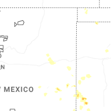
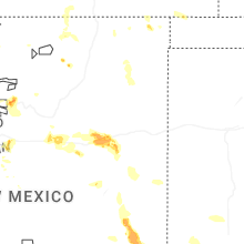
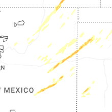
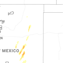


Connect with Interactive Hail Maps