

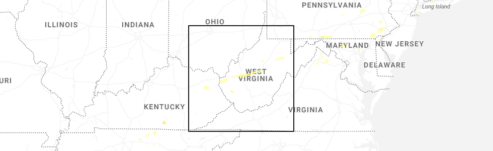
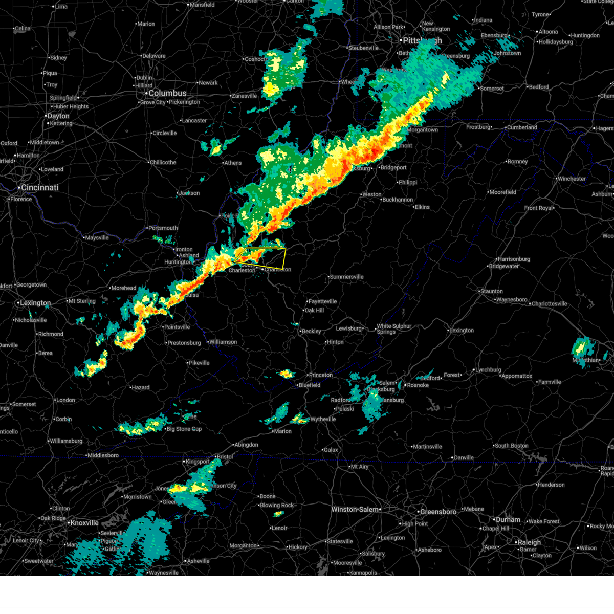
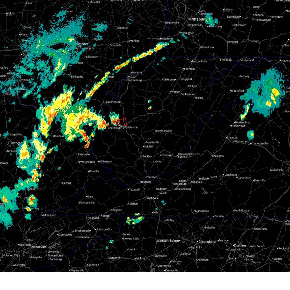
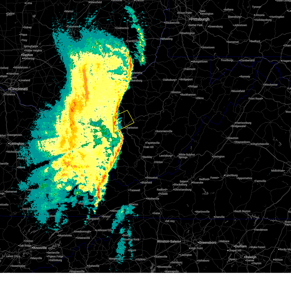
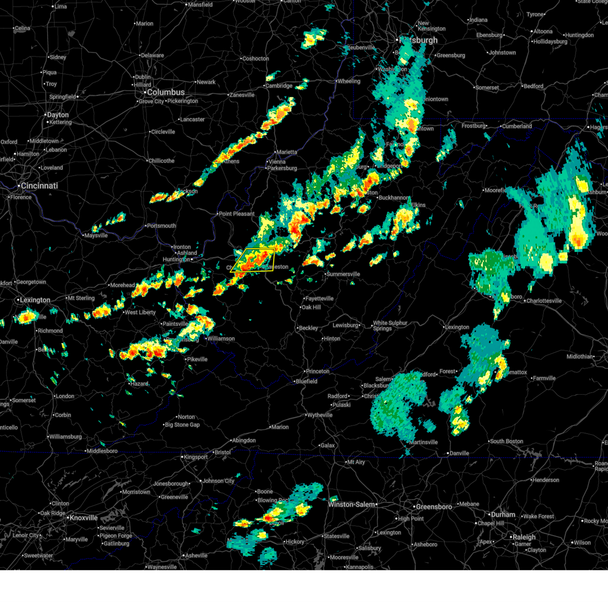
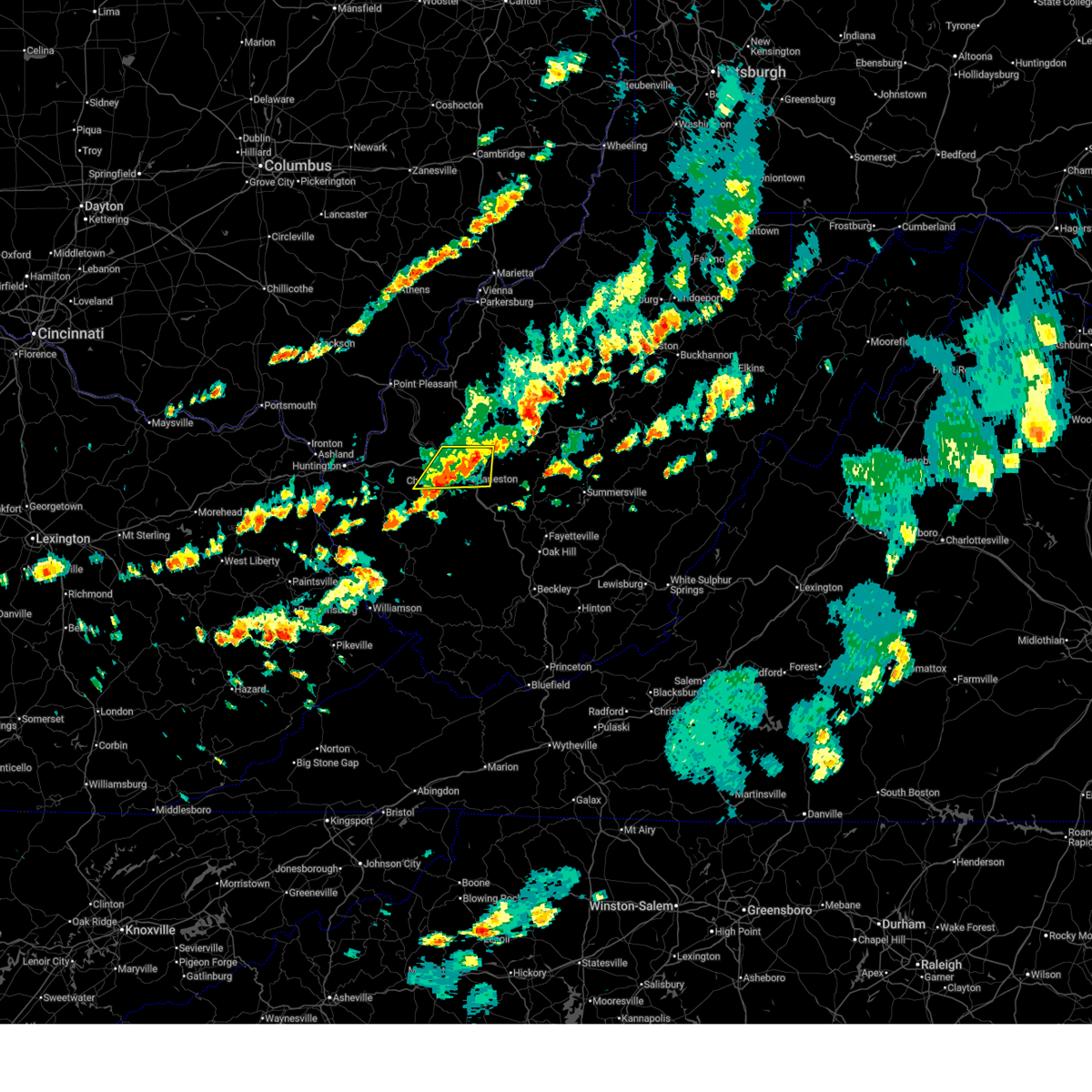
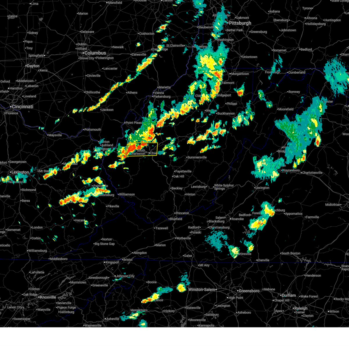
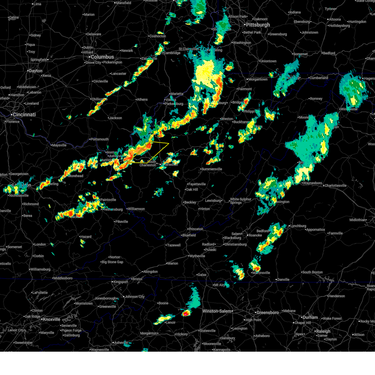
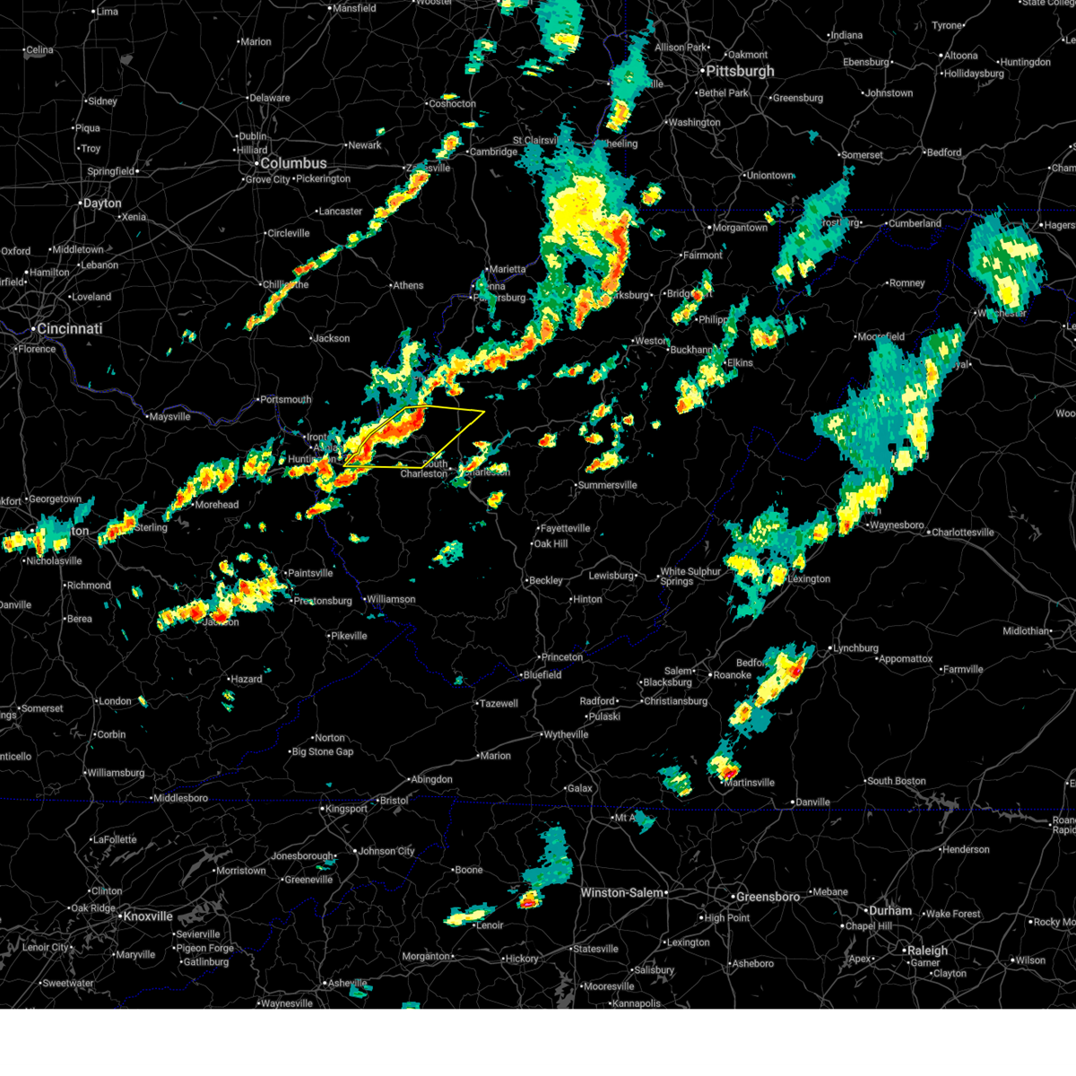
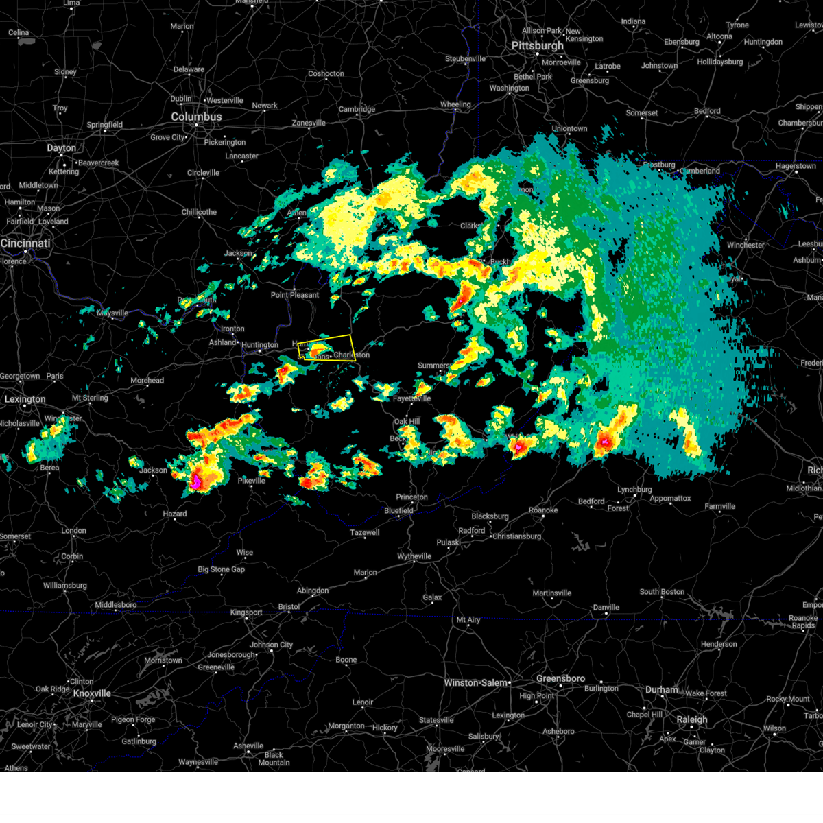
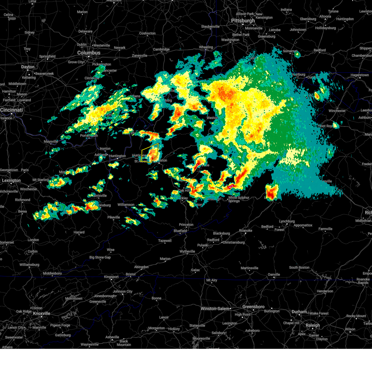
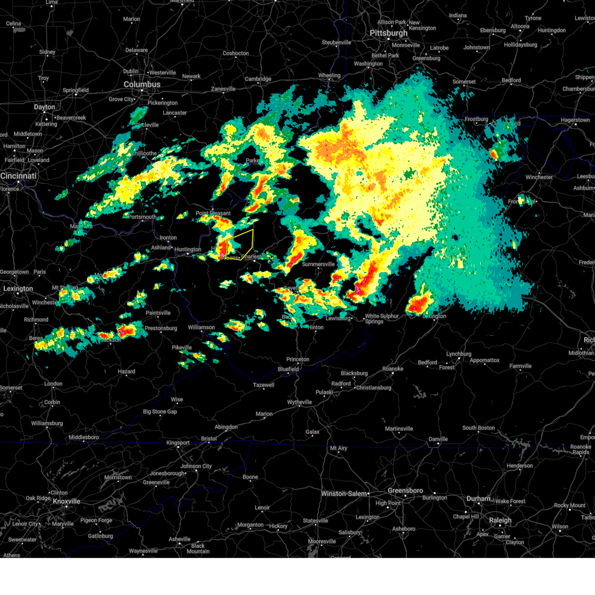
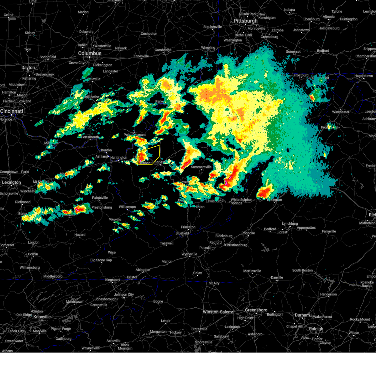
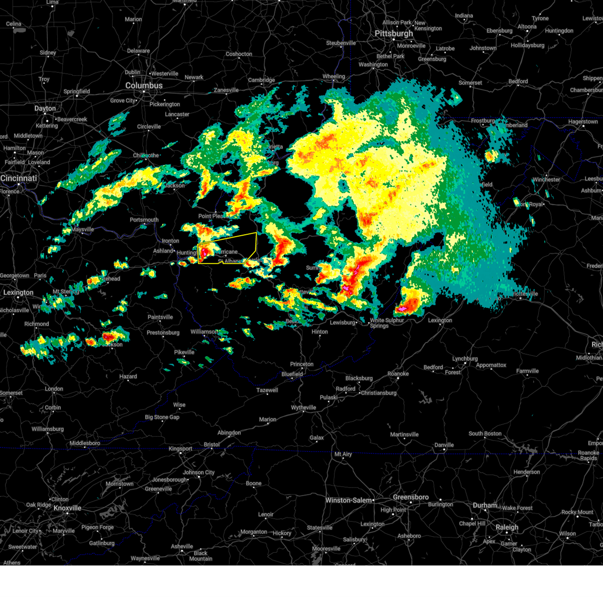
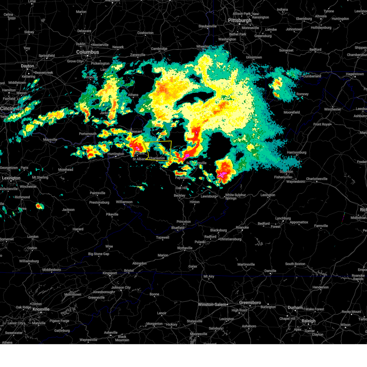
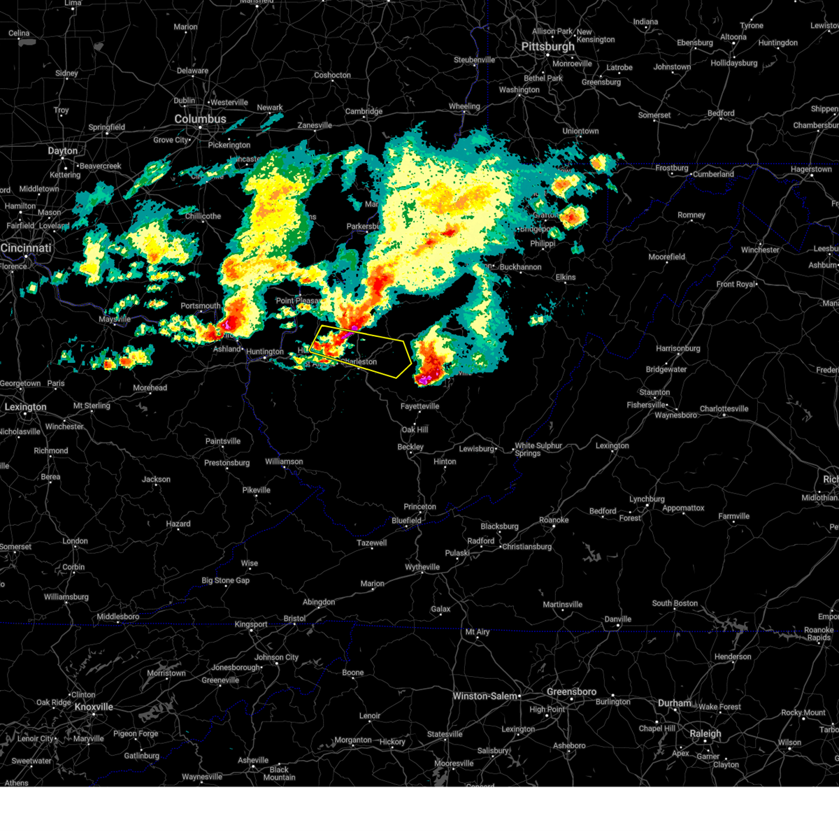
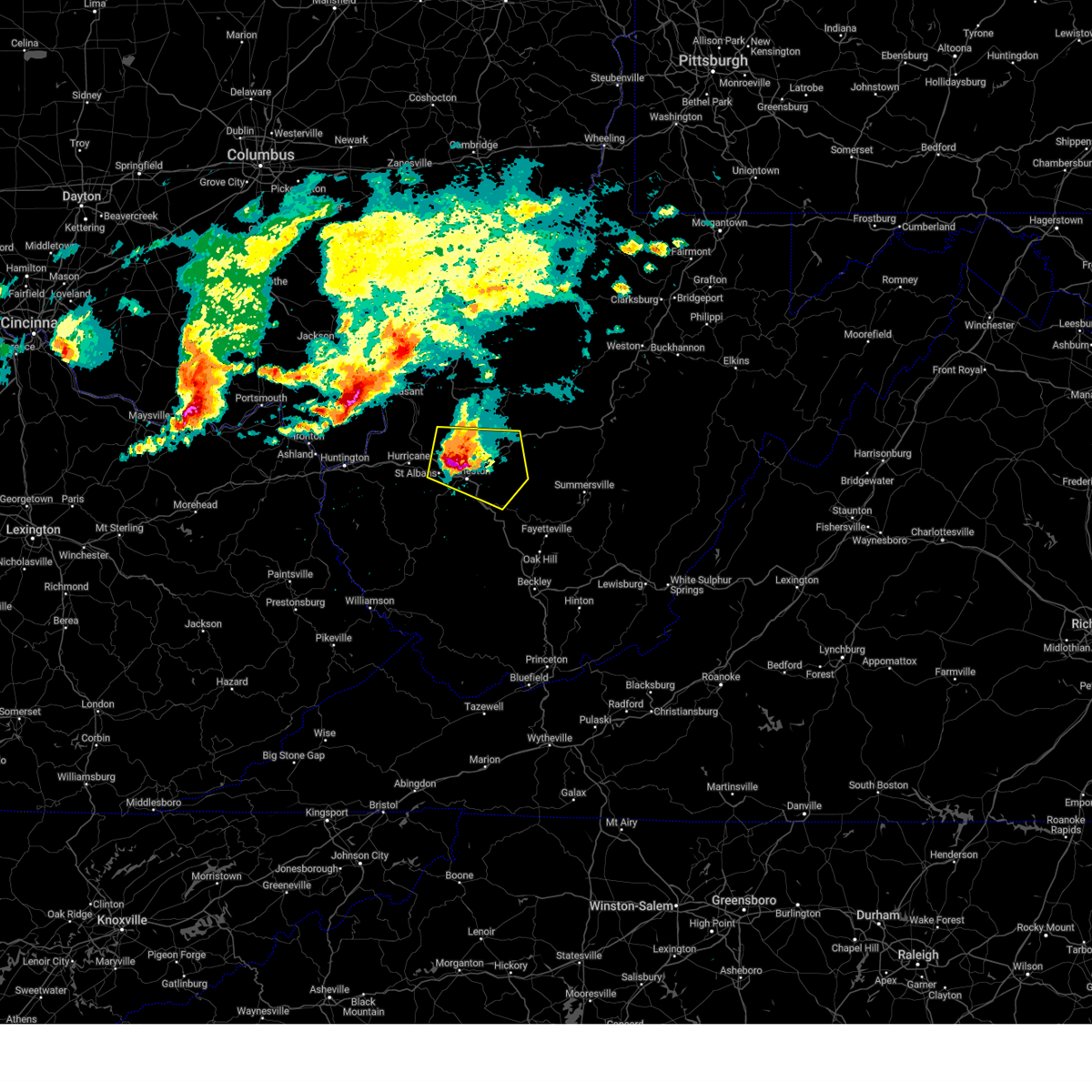
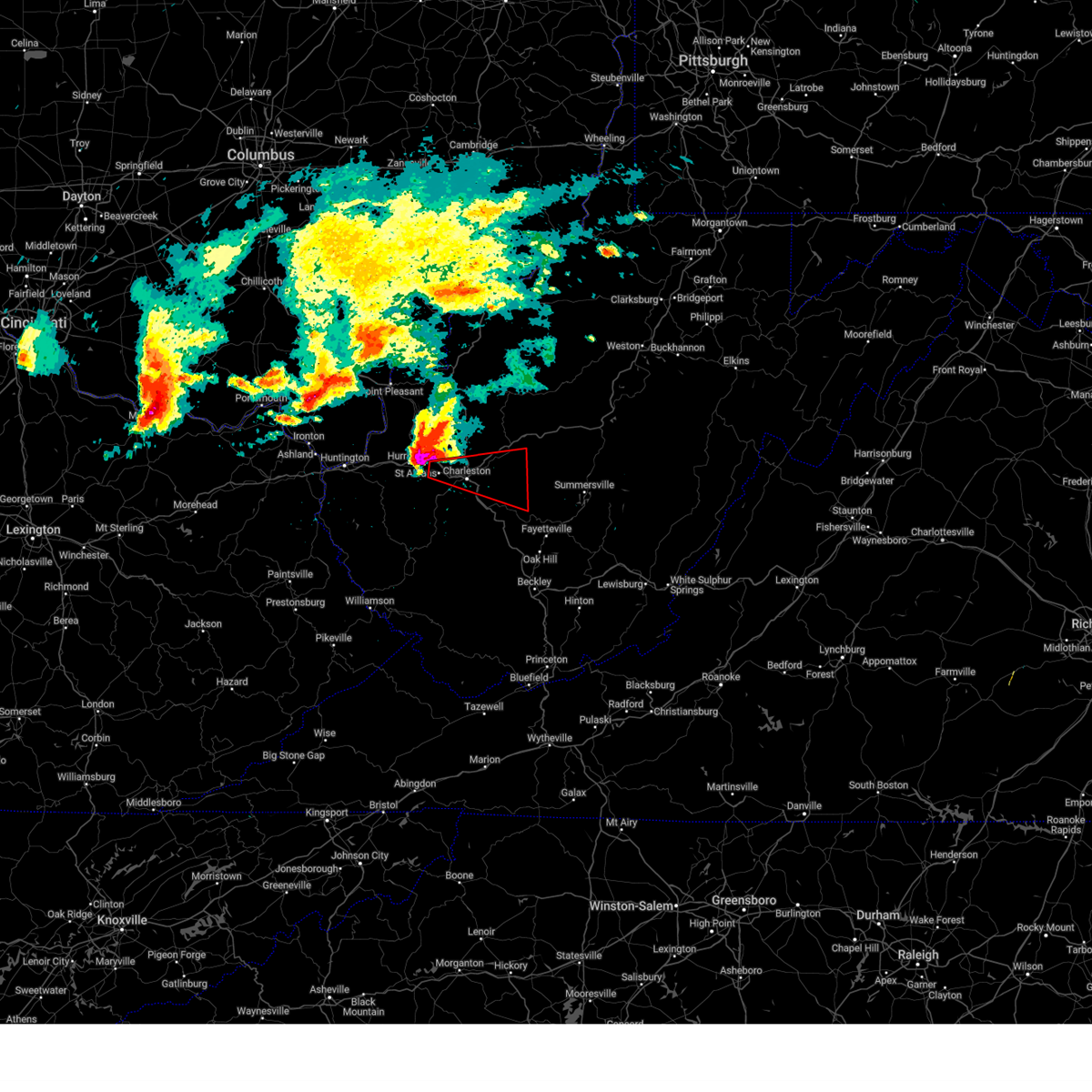
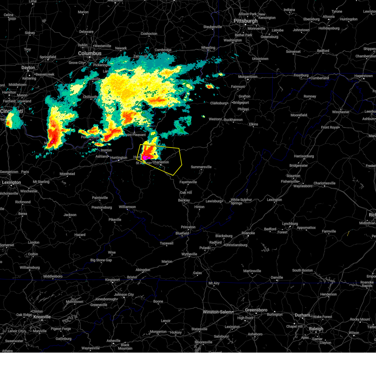
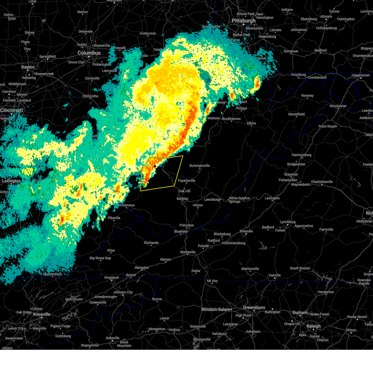
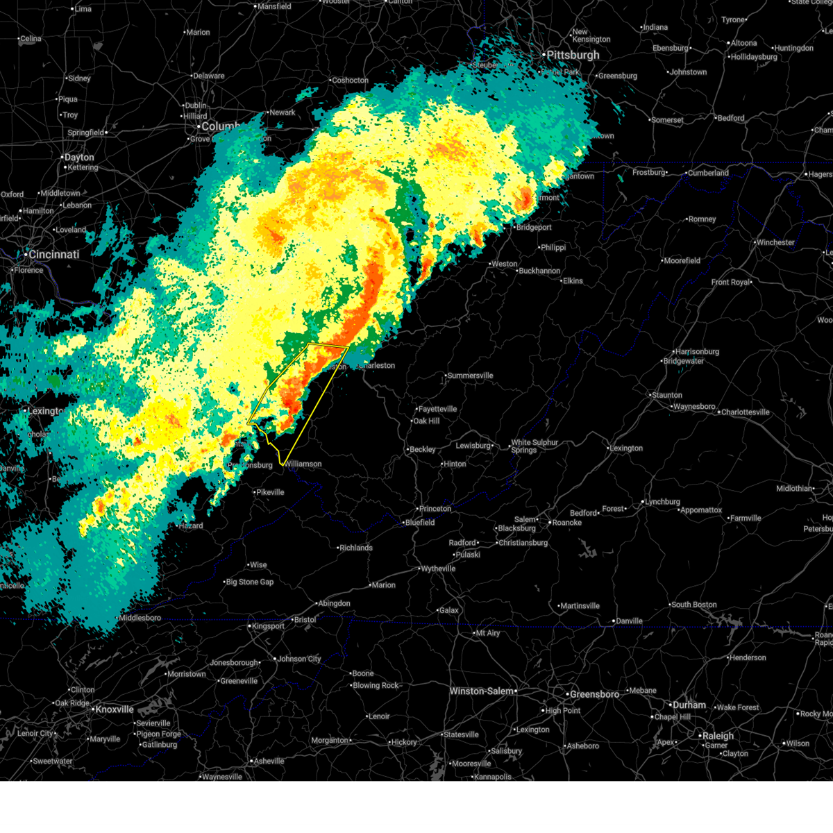
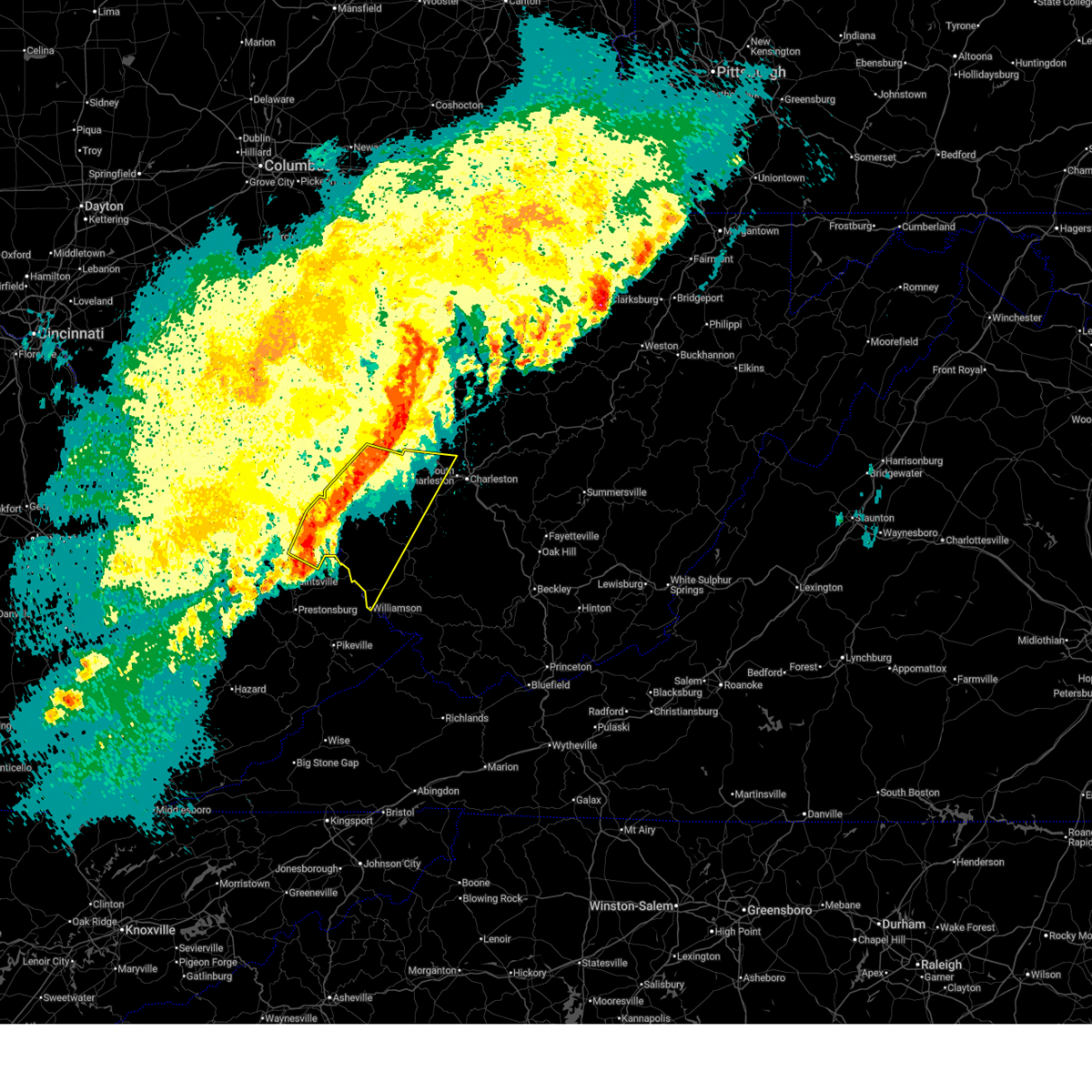
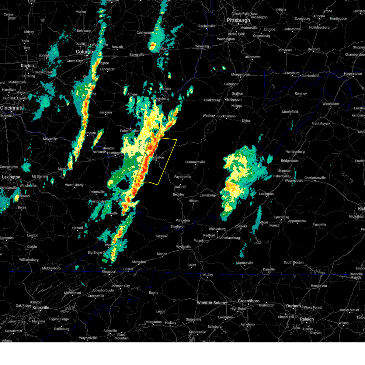
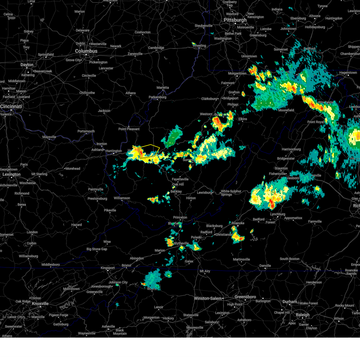
Hail Map for Nitro, WV
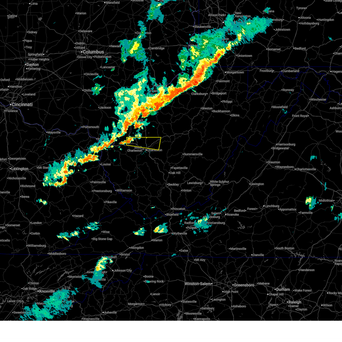
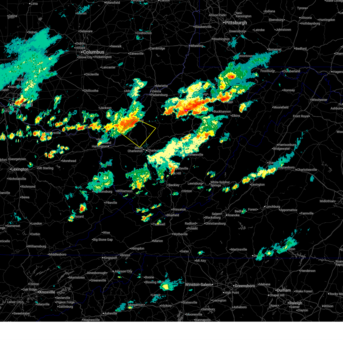
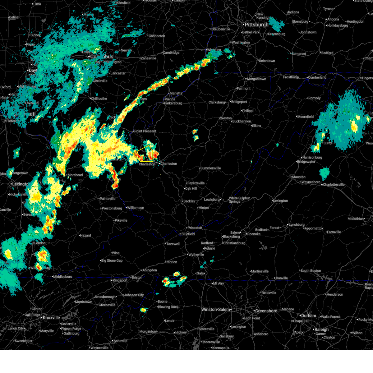
The Nitro, WV area has had 2 reports of on-the-ground hail by trained spotters, and has been under severe weather warnings 20 times during the past 12 months. Doppler radar has detected hail at or near Nitro, WV on 51 occasions, including 3 occasions during the past year.
| Name: | Nitro, WV |
| Where Located: | 11.4 miles WNW of Charleston, WV |
| Map: | Google Map for Nitro, WV |
| Population: | 7178 |
| Housing Units: | 3507 |
| More Info: | Search Google for Nitro, WV |
1
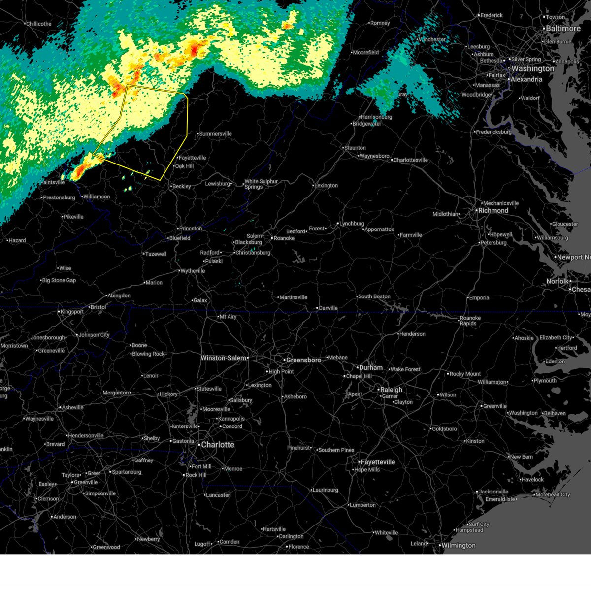
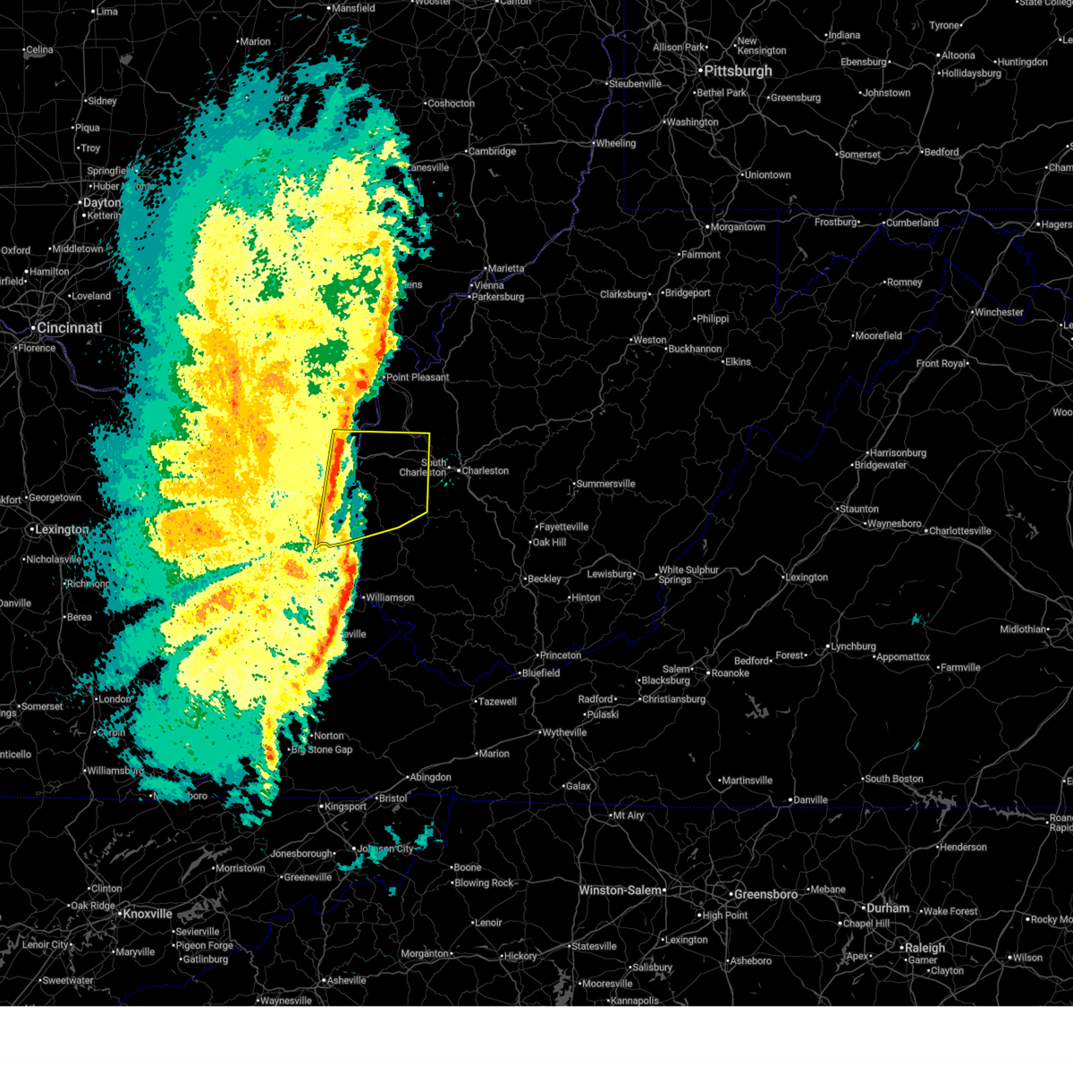
The Top Recent Hail Date for Nitro, WV is Wednesday, May 20, 2026 (16th out of 51)
Hail and Wind Damage Spotted near Nitro, WV
| Date / Time | Report Details |
|---|---|
| 6/18/2026 6:44 AM EDT |
 Svrrlx the national weather service in charleston west virginia has issued a * severe thunderstorm warning for, south central calhoun county in north central west virginia, west central nicholas county in southeastern west virginia, kanawha county in central west virginia, eastern putnam county in western west virginia, eastern lincoln county in central west virginia, southern roane county in central west virginia, northwestern raleigh county in southeastern west virginia, clay county in north central west virginia, southeastern jackson county in northwestern west virginia, western fayette county in southeastern west virginia, boone county in central west virginia, * until 715 am edt. * at 644 am edt, severe thunderstorms were located along a line extending from kenna to near charleston to near madison, moving east at 70 mph (radar indicated). Hazards include 60 mph wind gusts. expect damage to roofs, siding, and trees Svrrlx the national weather service in charleston west virginia has issued a * severe thunderstorm warning for, south central calhoun county in north central west virginia, west central nicholas county in southeastern west virginia, kanawha county in central west virginia, eastern putnam county in western west virginia, eastern lincoln county in central west virginia, southern roane county in central west virginia, northwestern raleigh county in southeastern west virginia, clay county in north central west virginia, southeastern jackson county in northwestern west virginia, western fayette county in southeastern west virginia, boone county in central west virginia, * until 715 am edt. * at 644 am edt, severe thunderstorms were located along a line extending from kenna to near charleston to near madison, moving east at 70 mph (radar indicated). Hazards include 60 mph wind gusts. expect damage to roofs, siding, and trees
|
| 6/18/2026 6:19 AM EDT |
 Svrrlx the national weather service in charleston west virginia has issued a * severe thunderstorm warning for, southeastern lawrence county in northeastern kentucky, southwestern mason county in western west virginia, eastern cabell county in central west virginia, northwestern mingo county in southern west virginia, kanawha county in central west virginia, putnam county in western west virginia, lincoln county in central west virginia, southwestern roane county in central west virginia, northwestern logan county in southern west virginia, southeastern jackson county in northwestern west virginia, southern wayne county in western west virginia, northern boone county in central west virginia, * until 645 am edt. * at 619 am edt, severe thunderstorms were located along a line extending from 7 miles north of milton to near hamlin to near chandlerville, moving east at 65 mph (radar indicated). Hazards include 60 mph wind gusts. expect damage to roofs, siding, and trees Svrrlx the national weather service in charleston west virginia has issued a * severe thunderstorm warning for, southeastern lawrence county in northeastern kentucky, southwestern mason county in western west virginia, eastern cabell county in central west virginia, northwestern mingo county in southern west virginia, kanawha county in central west virginia, putnam county in western west virginia, lincoln county in central west virginia, southwestern roane county in central west virginia, northwestern logan county in southern west virginia, southeastern jackson county in northwestern west virginia, southern wayne county in western west virginia, northern boone county in central west virginia, * until 645 am edt. * at 619 am edt, severe thunderstorms were located along a line extending from 7 miles north of milton to near hamlin to near chandlerville, moving east at 65 mph (radar indicated). Hazards include 60 mph wind gusts. expect damage to roofs, siding, and trees
|
| 6/14/2026 7:50 PM EDT |
 The storm which prompted the warning has weakened below severe limits, and no longer poses an immediate threat to life or property. therefore, the warning will be allowed to expire. however, gusty winds are still possible with this thunderstorm. a severe thunderstorm watch remains in effect until 900 pm edt for central west virginia. The storm which prompted the warning has weakened below severe limits, and no longer poses an immediate threat to life or property. therefore, the warning will be allowed to expire. however, gusty winds are still possible with this thunderstorm. a severe thunderstorm watch remains in effect until 900 pm edt for central west virginia.
|
| 6/14/2026 7:38 PM EDT |
 At 738 pm edt, a severe thunderstorm was located over cross lanes, or near nitro, moving east at 35 mph (radar indicated). Hazards include 60 mph wind gusts. Expect damage to roofs, siding, and trees. Locations impacted include, charleston, nitro, winfield, sissonville, poca, cross lanes, pinch, elkview, teays valley, and bancroft. At 738 pm edt, a severe thunderstorm was located over cross lanes, or near nitro, moving east at 35 mph (radar indicated). Hazards include 60 mph wind gusts. Expect damage to roofs, siding, and trees. Locations impacted include, charleston, nitro, winfield, sissonville, poca, cross lanes, pinch, elkview, teays valley, and bancroft.
|
| 6/14/2026 7:14 PM EDT |
 Svrrlx the national weather service in charleston west virginia has issued a * severe thunderstorm warning for, northern kanawha county in central west virginia, central putnam county in western west virginia, south central roane county in central west virginia, * until 800 pm edt. * at 714 pm edt, a severe thunderstorm was located over teays valley, or near winfield, moving east at 45 mph (radar indicated). Hazards include 60 mph wind gusts. expect damage to roofs, siding, and trees Svrrlx the national weather service in charleston west virginia has issued a * severe thunderstorm warning for, northern kanawha county in central west virginia, central putnam county in western west virginia, south central roane county in central west virginia, * until 800 pm edt. * at 714 pm edt, a severe thunderstorm was located over teays valley, or near winfield, moving east at 45 mph (radar indicated). Hazards include 60 mph wind gusts. expect damage to roofs, siding, and trees
|
| 5/27/2026 4:30 PM EDT |
 Svrrlx the national weather service in charleston west virginia has issued a * severe thunderstorm warning for, central mason county in western west virginia, northwestern kanawha county in central west virginia, putnam county in western west virginia, west central roane county in central west virginia, southern jackson county in northwestern west virginia, * until 500 pm edt. * at 430 pm edt, a severe thunderstorm was located 10 miles northeast of buffalo, or 11 miles southwest of ripley, moving east at 30 mph (radar indicated). Hazards include 60 mph wind gusts and penny size hail. expect damage to roofs, siding, and trees Svrrlx the national weather service in charleston west virginia has issued a * severe thunderstorm warning for, central mason county in western west virginia, northwestern kanawha county in central west virginia, putnam county in western west virginia, west central roane county in central west virginia, southern jackson county in northwestern west virginia, * until 500 pm edt. * at 430 pm edt, a severe thunderstorm was located 10 miles northeast of buffalo, or 11 miles southwest of ripley, moving east at 30 mph (radar indicated). Hazards include 60 mph wind gusts and penny size hail. expect damage to roofs, siding, and trees
|
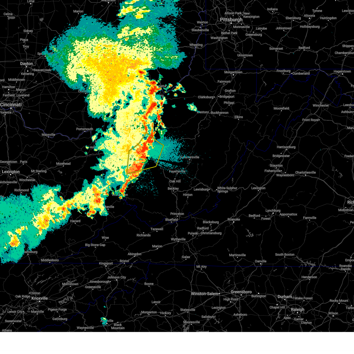
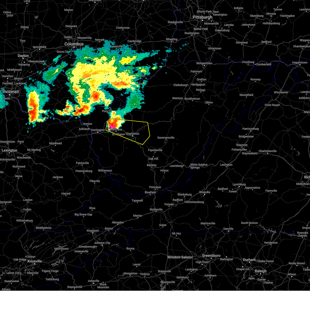
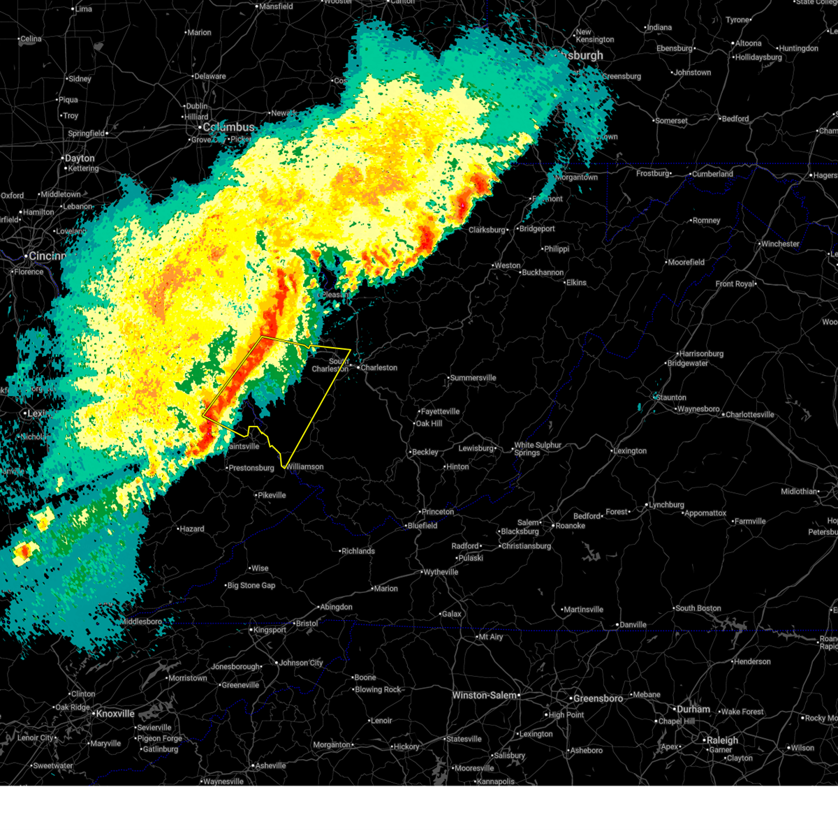
| 5/20/2026 4:20 PM EDT |
 At 420 pm edt, a severe thunderstorm was located over teays valley, or near winfield, moving northeast at 10 mph (radar indicated). Hazards include 60 mph wind gusts and quarter size hail. Hail damage to vehicles is expected. expect wind damage to roofs, siding, and trees. locations impacted include, nitro, winfield, st. Albans, hurricane, eleanor, poca, cross lanes, institute, teays valley, culloden, bancroft, and fraziers bottom. At 420 pm edt, a severe thunderstorm was located over teays valley, or near winfield, moving northeast at 10 mph (radar indicated). Hazards include 60 mph wind gusts and quarter size hail. Hail damage to vehicles is expected. expect wind damage to roofs, siding, and trees. locations impacted include, nitro, winfield, st. Albans, hurricane, eleanor, poca, cross lanes, institute, teays valley, culloden, bancroft, and fraziers bottom.
|
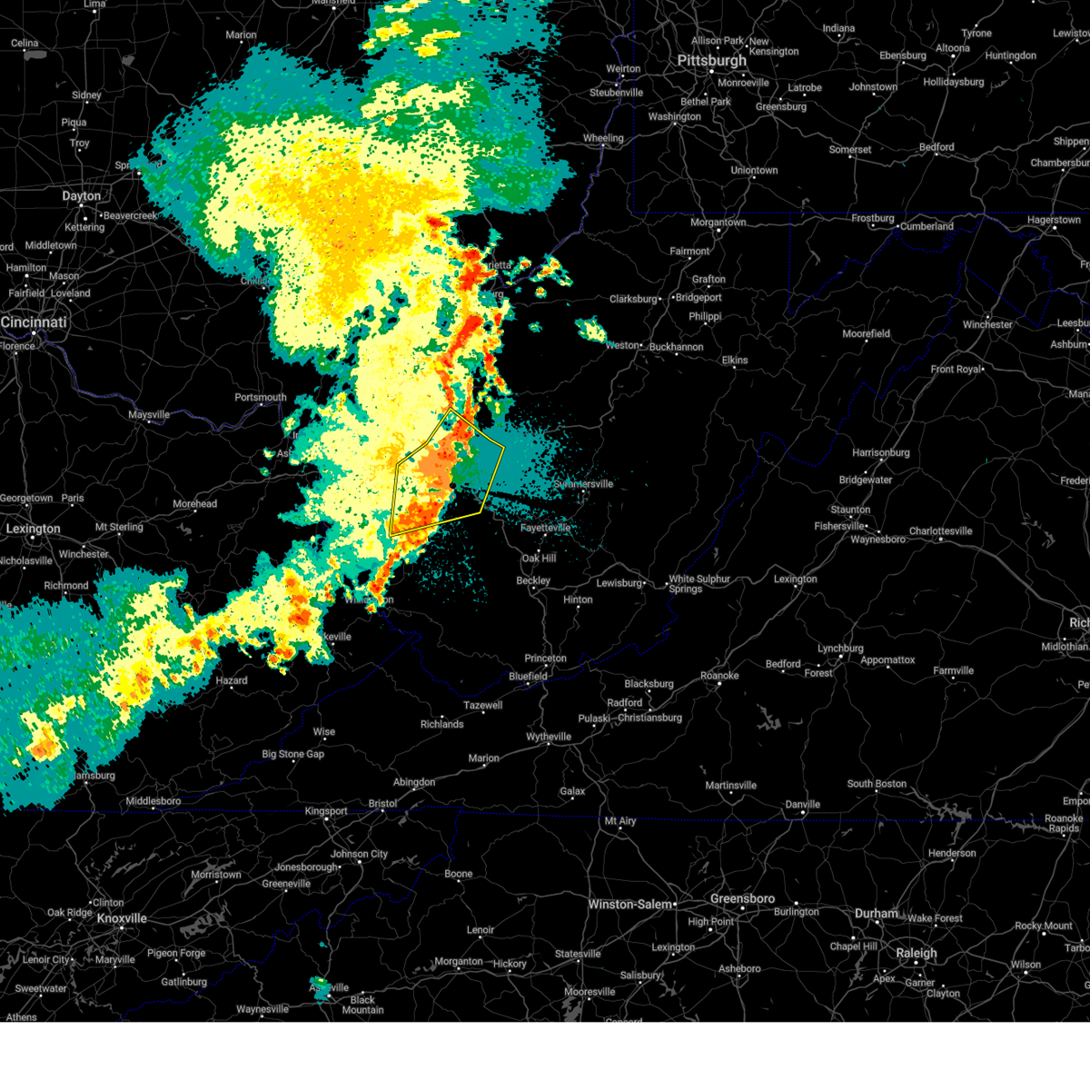
| 5/20/2026 4:09 PM EDT |
 Torrlx the national weather service in charleston west virginia has issued a * tornado warning for, northwestern kanawha county in central west virginia, east central putnam county in western west virginia, * until 445 pm edt. * at 409 pm edt, a severe thunderstorm capable of producing a tornado was located over cross lanes, or near nitro, moving east at 20 mph (radar indicated rotation). Hazards include tornado. Flying debris will be dangerous to those caught without shelter. mobile homes will be damaged or destroyed. damage to roofs, windows, and vehicles will occur. tree damage is likely. This dangerous storm will be near, charleston, sissonville, and cross lanes around 415 pm edt. Torrlx the national weather service in charleston west virginia has issued a * tornado warning for, northwestern kanawha county in central west virginia, east central putnam county in western west virginia, * until 445 pm edt. * at 409 pm edt, a severe thunderstorm capable of producing a tornado was located over cross lanes, or near nitro, moving east at 20 mph (radar indicated rotation). Hazards include tornado. Flying debris will be dangerous to those caught without shelter. mobile homes will be damaged or destroyed. damage to roofs, windows, and vehicles will occur. tree damage is likely. This dangerous storm will be near, charleston, sissonville, and cross lanes around 415 pm edt.
|
| 5/20/2026 4:05 PM EDT |
 Svrrlx the national weather service in charleston west virginia has issued a * severe thunderstorm warning for, northwestern kanawha county in central west virginia, east central putnam county in western west virginia, south central jackson county in northwestern west virginia, * until 445 pm edt. * at 405 pm edt, a severe thunderstorm was located over poca, or over nitro, moving east at 10 mph (radar indicated). Hazards include 60 mph wind gusts and half dollar size hail. Hail damage to vehicles is expected. Expect wind damage to roofs, siding, and trees. Svrrlx the national weather service in charleston west virginia has issued a * severe thunderstorm warning for, northwestern kanawha county in central west virginia, east central putnam county in western west virginia, south central jackson county in northwestern west virginia, * until 445 pm edt. * at 405 pm edt, a severe thunderstorm was located over poca, or over nitro, moving east at 10 mph (radar indicated). Hazards include 60 mph wind gusts and half dollar size hail. Hail damage to vehicles is expected. Expect wind damage to roofs, siding, and trees.
|
| 5/20/2026 3:49 PM EDT |
 Svrrlx the national weather service in charleston west virginia has issued a * severe thunderstorm warning for, southern mason county in western west virginia, east central cabell county in central west virginia, western kanawha county in central west virginia, putnam county in western west virginia, north central lincoln county in central west virginia, * until 430 pm edt. * at 349 pm edt, a severe thunderstorm was located over hurricane, or 9 miles west of nitro, moving northeast at 10 mph (radar indicated). Hazards include 60 mph wind gusts and quarter size hail. Hail damage to vehicles is expected. Expect wind damage to roofs, siding, and trees. Svrrlx the national weather service in charleston west virginia has issued a * severe thunderstorm warning for, southern mason county in western west virginia, east central cabell county in central west virginia, western kanawha county in central west virginia, putnam county in western west virginia, north central lincoln county in central west virginia, * until 430 pm edt. * at 349 pm edt, a severe thunderstorm was located over hurricane, or 9 miles west of nitro, moving northeast at 10 mph (radar indicated). Hazards include 60 mph wind gusts and quarter size hail. Hail damage to vehicles is expected. Expect wind damage to roofs, siding, and trees.
|
| 4/1/2026 9:27 PM EDT |
 Svrrlx the national weather service in charleston west virginia has issued a * severe thunderstorm warning for, east central putnam county in western west virginia, northwestern kanawha county in central west virginia, * until 1000 pm edt. * at 926 pm edt, a severe thunderstorm was located over st. albans, or near nitro, moving east at 25 mph (radar indicated). Hazards include 60 mph wind gusts and quarter size hail. Hail damage to vehicles is expected. Expect wind damage to roofs, siding, and trees. Svrrlx the national weather service in charleston west virginia has issued a * severe thunderstorm warning for, east central putnam county in western west virginia, northwestern kanawha county in central west virginia, * until 1000 pm edt. * at 926 pm edt, a severe thunderstorm was located over st. albans, or near nitro, moving east at 25 mph (radar indicated). Hazards include 60 mph wind gusts and quarter size hail. Hail damage to vehicles is expected. Expect wind damage to roofs, siding, and trees.
|
| 3/16/2026 5:28 AM EDT |
 Svrrlx the national weather service in charleston west virginia has issued a * severe thunderstorm warning for, northeastern putnam county in western west virginia, northwestern kanawha county in central west virginia, northeastern lincoln county in central west virginia, southwestern roane county in central west virginia, southeastern jackson county in northwestern west virginia, * until 600 am edt. * at 528 am edt, a severe thunderstorm was located over nitro, moving east at 40 mph (radar indicated). Hazards include 60 mph wind gusts. expect damage to roofs, siding, and trees Svrrlx the national weather service in charleston west virginia has issued a * severe thunderstorm warning for, northeastern putnam county in western west virginia, northwestern kanawha county in central west virginia, northeastern lincoln county in central west virginia, southwestern roane county in central west virginia, southeastern jackson county in northwestern west virginia, * until 600 am edt. * at 528 am edt, a severe thunderstorm was located over nitro, moving east at 40 mph (radar indicated). Hazards include 60 mph wind gusts. expect damage to roofs, siding, and trees
|
| 3/16/2026 5:28 AM EDT |
 The storms which prompted the warning have moved out of the area. therefore, the warning will be allowed to expire. however, gusty winds and heavy rain are still possible with these thunderstorms. a severe thunderstorm watch remains in effect until 700 am edt for central and western west virginia. The storms which prompted the warning have moved out of the area. therefore, the warning will be allowed to expire. however, gusty winds and heavy rain are still possible with these thunderstorms. a severe thunderstorm watch remains in effect until 700 am edt for central and western west virginia.
|
| 3/16/2026 5:18 AM EDT |
 At 518 am edt, severe thunderstorms were located along a line extending from near hurricane to near hamlin to near spurlockville, moving east at 45 mph (radar indicated). Hazards include 60 mph wind gusts. Expect damage to roofs, siding, and trees. locations impacted include, nitro, winfield, hamlin, st. Albans, hurricane, eleanor, culloden, alum creek, spurlockville, tornado, julian, teays valley, bancroft, sweetland, sod, woodville, palermo, griffithsville, alkol, and mud. At 518 am edt, severe thunderstorms were located along a line extending from near hurricane to near hamlin to near spurlockville, moving east at 45 mph (radar indicated). Hazards include 60 mph wind gusts. Expect damage to roofs, siding, and trees. locations impacted include, nitro, winfield, hamlin, st. Albans, hurricane, eleanor, culloden, alum creek, spurlockville, tornado, julian, teays valley, bancroft, sweetland, sod, woodville, palermo, griffithsville, alkol, and mud.
|
| 3/16/2026 5:18 AM EDT |
 the severe thunderstorm warning has been cancelled and is no longer in effect the severe thunderstorm warning has been cancelled and is no longer in effect
|
| 3/16/2026 4:56 AM EDT |
 the severe thunderstorm warning has been cancelled and is no longer in effect the severe thunderstorm warning has been cancelled and is no longer in effect
|
| 3/16/2026 4:56 AM EDT |
 At 456 am edt, severe thunderstorms were located along a line extending from 6 miles northwest of ona to near east lynn lake to kiahsville, moving east at 40 mph (radar indicated). Hazards include 60 mph wind gusts. Expect damage to roofs, siding, and trees. locations impacted include, nitro, winfield, hamlin, st. Albans, hurricane, barboursville, milton, eleanor, ranger, ona, culloden, spurlockville, tornado, harts, gill, alum creek, east lynn lake, kiahsville, julian, and teays valley. At 456 am edt, severe thunderstorms were located along a line extending from 6 miles northwest of ona to near east lynn lake to kiahsville, moving east at 40 mph (radar indicated). Hazards include 60 mph wind gusts. Expect damage to roofs, siding, and trees. locations impacted include, nitro, winfield, hamlin, st. Albans, hurricane, barboursville, milton, eleanor, ranger, ona, culloden, spurlockville, tornado, harts, gill, alum creek, east lynn lake, kiahsville, julian, and teays valley.
|
| 3/16/2026 4:42 AM EDT |
 Svrrlx the national weather service in charleston west virginia has issued a * severe thunderstorm warning for, southeastern lawrence county in northeastern kentucky, southeastern lawrence county in southeastern ohio, southern mason county in western west virginia, cabell county in central west virginia, southwestern putnam county in western west virginia, western kanawha county in central west virginia, lincoln county in central west virginia, wayne county in western west virginia, northwestern boone county in central west virginia, * until 530 am edt. * at 442 am edt, severe thunderstorms were located along a line extending from near proctorville to wayne to near job, moving east at 40 mph (radar indicated). Hazards include 60 mph wind gusts. expect damage to roofs, siding, and trees Svrrlx the national weather service in charleston west virginia has issued a * severe thunderstorm warning for, southeastern lawrence county in northeastern kentucky, southeastern lawrence county in southeastern ohio, southern mason county in western west virginia, cabell county in central west virginia, southwestern putnam county in western west virginia, western kanawha county in central west virginia, lincoln county in central west virginia, wayne county in western west virginia, northwestern boone county in central west virginia, * until 530 am edt. * at 442 am edt, severe thunderstorms were located along a line extending from near proctorville to wayne to near job, moving east at 40 mph (radar indicated). Hazards include 60 mph wind gusts. expect damage to roofs, siding, and trees
|
| 7/17/2025 2:15 PM EDT |
 At 215 pm edt, a severe thunderstorm was located near culloden, or near hamlin, moving southeast at 30 mph (radar indicated). Hazards include 60 mph wind gusts and quarter size hail. Hail damage to vehicles is expected. expect wind damage to roofs, siding, and trees. locations impacted include, nitro, hamlin, jefferson, st. Albans, hurricane, milton, culloden, alum creek, institute, tornado, teays valley, west hamlin, sweetland, sod, griffithsville, alkol, yawkey, and woodville. At 215 pm edt, a severe thunderstorm was located near culloden, or near hamlin, moving southeast at 30 mph (radar indicated). Hazards include 60 mph wind gusts and quarter size hail. Hail damage to vehicles is expected. expect wind damage to roofs, siding, and trees. locations impacted include, nitro, hamlin, jefferson, st. Albans, hurricane, milton, culloden, alum creek, institute, tornado, teays valley, west hamlin, sweetland, sod, griffithsville, alkol, yawkey, and woodville.
|
| 7/17/2025 1:58 PM EDT |
 Svrrlx the national weather service in charleston west virginia has issued a * severe thunderstorm warning for, southeastern cabell county in central west virginia, southwestern putnam county in western west virginia, west central kanawha county in central west virginia, northeastern lincoln county in central west virginia, * until 230 pm edt. * at 158 pm edt, a severe thunderstorm was located over ona, or 9 miles northwest of hamlin, moving southeast at 30 mph (radar indicated). Hazards include 60 mph wind gusts and quarter size hail. Hail damage to vehicles is expected. Expect wind damage to roofs, siding, and trees. Svrrlx the national weather service in charleston west virginia has issued a * severe thunderstorm warning for, southeastern cabell county in central west virginia, southwestern putnam county in western west virginia, west central kanawha county in central west virginia, northeastern lincoln county in central west virginia, * until 230 pm edt. * at 158 pm edt, a severe thunderstorm was located over ona, or 9 miles northwest of hamlin, moving southeast at 30 mph (radar indicated). Hazards include 60 mph wind gusts and quarter size hail. Hail damage to vehicles is expected. Expect wind damage to roofs, siding, and trees.
|
| 6/19/2025 3:46 PM EDT |
 The storm which prompted the warning has weakened below severe limits, and no longer poses an immediate threat to life or property. therefore, the warning has been allowed to expire. however, gusty winds are still possible with this thunderstorm. to report severe weather, contact your nearest law enforcement agency. they will relay your report to the national weather service charleston west virginia. The storm which prompted the warning has weakened below severe limits, and no longer poses an immediate threat to life or property. therefore, the warning has been allowed to expire. however, gusty winds are still possible with this thunderstorm. to report severe weather, contact your nearest law enforcement agency. they will relay your report to the national weather service charleston west virginia.
|
| 6/19/2025 3:29 PM EDT |
 the severe thunderstorm warning has been cancelled and is no longer in effect the severe thunderstorm warning has been cancelled and is no longer in effect
|
| 6/19/2025 3:29 PM EDT |
 At 329 pm edt, a severe thunderstorm was located near dunbar, or near charleston, moving east at 35 mph (radar indicated). Hazards include 60 mph wind gusts. Expect damage to roofs, siding, and trees. locations impacted include, charleston, nitro, jefferson, south charleston, st. Albans, dunbar, sissonville, poca, cross lanes, pinch, institute, tornado, coal fork, elkview, alum creek, and teays valley. At 329 pm edt, a severe thunderstorm was located near dunbar, or near charleston, moving east at 35 mph (radar indicated). Hazards include 60 mph wind gusts. Expect damage to roofs, siding, and trees. locations impacted include, charleston, nitro, jefferson, south charleston, st. Albans, dunbar, sissonville, poca, cross lanes, pinch, institute, tornado, coal fork, elkview, alum creek, and teays valley.
|
| 6/19/2025 3:04 PM EDT |
 Svrrlx the national weather service in charleston west virginia has issued a * severe thunderstorm warning for, east central cabell county in central west virginia, southern putnam county in western west virginia, northwestern kanawha county in central west virginia, northeastern lincoln county in central west virginia, * until 345 pm edt. * at 303 pm edt, a severe thunderstorm was located over hurricane, or 8 miles west of nitro, moving east at 35 mph (radar indicated). Hazards include 60 mph wind gusts. expect damage to roofs, siding, and trees Svrrlx the national weather service in charleston west virginia has issued a * severe thunderstorm warning for, east central cabell county in central west virginia, southern putnam county in western west virginia, northwestern kanawha county in central west virginia, northeastern lincoln county in central west virginia, * until 345 pm edt. * at 303 pm edt, a severe thunderstorm was located over hurricane, or 8 miles west of nitro, moving east at 35 mph (radar indicated). Hazards include 60 mph wind gusts. expect damage to roofs, siding, and trees
|
| 6/19/2025 2:48 PM EDT |
 At 248 pm edt, severe thunderstorms were located along a line extending from 7 miles west of kenna to milton, moving east at 45 mph (radar indicated). Hazards include 60 mph wind gusts. Expect damage to roofs, siding, and trees. Locations impacted include, nitro, winfield, hurricane, milton, eleanor, poca, culloden, kenna, teays valley, cross lanes, bancroft, liberty, kentuck, and fraziers bottom. At 248 pm edt, severe thunderstorms were located along a line extending from 7 miles west of kenna to milton, moving east at 45 mph (radar indicated). Hazards include 60 mph wind gusts. Expect damage to roofs, siding, and trees. Locations impacted include, nitro, winfield, hurricane, milton, eleanor, poca, culloden, kenna, teays valley, cross lanes, bancroft, liberty, kentuck, and fraziers bottom.
|
| 6/19/2025 2:40 PM EDT |
 the severe thunderstorm warning has been cancelled and is no longer in effect the severe thunderstorm warning has been cancelled and is no longer in effect
|
| 6/19/2025 2:40 PM EDT |
 At 239 pm edt, severe thunderstorms were located along a line extending from near buffalo to ona, moving east at 45 mph (radar indicated). Hazards include 60 mph wind gusts. Expect damage to roofs, siding, and trees. Locations impacted include, huntington, nitro, winfield, hurricane, barboursville, milton, eleanor, buffalo, poca, ona, culloden, kenna, teays valley, cross lanes, bancroft, liberty, kentuck, grimms landing, pea ridge, and fraziers bottom. At 239 pm edt, severe thunderstorms were located along a line extending from near buffalo to ona, moving east at 45 mph (radar indicated). Hazards include 60 mph wind gusts. Expect damage to roofs, siding, and trees. Locations impacted include, huntington, nitro, winfield, hurricane, barboursville, milton, eleanor, buffalo, poca, ona, culloden, kenna, teays valley, cross lanes, bancroft, liberty, kentuck, grimms landing, pea ridge, and fraziers bottom.
|
| 6/19/2025 2:26 PM EDT |
 Svrrlx the national weather service in charleston west virginia has issued a * severe thunderstorm warning for, southeastern lawrence county in southeastern ohio, southern mason county in western west virginia, cabell county in central west virginia, putnam county in western west virginia, northwestern kanawha county in central west virginia, southwestern roane county in central west virginia, southeastern jackson county in northwestern west virginia, * until 300 pm edt. * at 226 pm edt, severe thunderstorms were located along a line extending from 6 miles northwest of buffalo to huntington, moving east at 45 mph (radar indicated). Hazards include 60 mph wind gusts. expect damage to roofs, siding, and trees Svrrlx the national weather service in charleston west virginia has issued a * severe thunderstorm warning for, southeastern lawrence county in southeastern ohio, southern mason county in western west virginia, cabell county in central west virginia, putnam county in western west virginia, northwestern kanawha county in central west virginia, southwestern roane county in central west virginia, southeastern jackson county in northwestern west virginia, * until 300 pm edt. * at 226 pm edt, severe thunderstorms were located along a line extending from 6 miles northwest of buffalo to huntington, moving east at 45 mph (radar indicated). Hazards include 60 mph wind gusts. expect damage to roofs, siding, and trees
|
| 5/16/2025 11:04 PM EDT |
 Svrrlx the national weather service in charleston west virginia has issued a * severe thunderstorm warning for, southern putnam county in western west virginia, kanawha county in central west virginia, northeastern lincoln county in central west virginia, south central roane county in central west virginia, * until 1130 pm edt. * at 1103 pm edt, a severe thunderstorm was located over st. albans, or over nitro, moving east at 50 mph (radar indicated). Hazards include 60 mph wind gusts and nickel size hail. expect damage to roofs, siding, and trees Svrrlx the national weather service in charleston west virginia has issued a * severe thunderstorm warning for, southern putnam county in western west virginia, kanawha county in central west virginia, northeastern lincoln county in central west virginia, south central roane county in central west virginia, * until 1130 pm edt. * at 1103 pm edt, a severe thunderstorm was located over st. albans, or over nitro, moving east at 50 mph (radar indicated). Hazards include 60 mph wind gusts and nickel size hail. expect damage to roofs, siding, and trees
|
| 4/29/2025 9:51 PM EDT |
 the severe thunderstorm warning has been cancelled and is no longer in effect the severe thunderstorm warning has been cancelled and is no longer in effect
|
| 4/29/2025 9:51 PM EDT |
 At 951 pm edt, severe thunderstorms were located along a line extending from 9 miles east of kenna to near madison, moving east at 55 mph (radar indicated). Hazards include 60 mph wind gusts. Expect damage to roofs, siding, and trees. locations impacted include, charleston, pinch, nitro, ashford, liberty, spurlockville, institute, st. Albans, south charleston, tornado, alkol, poca, coal fork, mud, yawkey, elkview, sissonville, cross lanes, jefferson, and sod. At 951 pm edt, severe thunderstorms were located along a line extending from 9 miles east of kenna to near madison, moving east at 55 mph (radar indicated). Hazards include 60 mph wind gusts. Expect damage to roofs, siding, and trees. locations impacted include, charleston, pinch, nitro, ashford, liberty, spurlockville, institute, st. Albans, south charleston, tornado, alkol, poca, coal fork, mud, yawkey, elkview, sissonville, cross lanes, jefferson, and sod.
|
| 4/29/2025 9:45 PM EDT |
 At 945 pm edt, severe thunderstorms were located along a line extending from 6 miles southeast of kenna to near madison, moving east at 55 mph (radar indicated). Hazards include 60 mph wind gusts. Expect damage to roofs, siding, and trees. locations impacted include, charleston, pinch, winfield, culloden, nitro, ashford, liberty, palermo, spurlockville, institute, st. Albans, south charleston, tornado, alkol, poca, coal fork, hurricane, mud, yawkey, and elkview. At 945 pm edt, severe thunderstorms were located along a line extending from 6 miles southeast of kenna to near madison, moving east at 55 mph (radar indicated). Hazards include 60 mph wind gusts. Expect damage to roofs, siding, and trees. locations impacted include, charleston, pinch, winfield, culloden, nitro, ashford, liberty, palermo, spurlockville, institute, st. Albans, south charleston, tornado, alkol, poca, coal fork, hurricane, mud, yawkey, and elkview.
|
| 4/29/2025 9:45 PM EDT |
 the severe thunderstorm warning has been cancelled and is no longer in effect the severe thunderstorm warning has been cancelled and is no longer in effect
|
| 4/29/2025 9:30 PM EDT | Downed tree reported on robin road. time estimated from rada in kanawha county WV, 1 miles NNW of Nitro, WV |
| 4/29/2025 9:18 PM EDT |
 Svrrlx the national weather service in charleston west virginia has issued a * severe thunderstorm warning for, southern mason county in western west virginia, cabell county in central west virginia, putnam county in western west virginia, central kanawha county in central west virginia, lincoln county in central west virginia, northeastern wayne county in western west virginia, south central jackson county in northwestern west virginia, northwestern boone county in central west virginia, * until 1000 pm edt. * at 917 pm edt, a severe thunderstorm was located near hamlin, moving east at 50 mph (radar indicated). Hazards include 60 mph wind gusts and penny size hail. expect damage to roofs, siding, and trees Svrrlx the national weather service in charleston west virginia has issued a * severe thunderstorm warning for, southern mason county in western west virginia, cabell county in central west virginia, putnam county in western west virginia, central kanawha county in central west virginia, lincoln county in central west virginia, northeastern wayne county in western west virginia, south central jackson county in northwestern west virginia, northwestern boone county in central west virginia, * until 1000 pm edt. * at 917 pm edt, a severe thunderstorm was located near hamlin, moving east at 50 mph (radar indicated). Hazards include 60 mph wind gusts and penny size hail. expect damage to roofs, siding, and trees
|
| 4/14/2025 9:05 PM EDT |
 The storm which prompted the warning has weakened below severe limits, and has exited the warned area. therefore, the warning will be allowed to expire. a severe thunderstorm watch remains in effect until 1100 pm edt for central and western west virginia. The storm which prompted the warning has weakened below severe limits, and has exited the warned area. therefore, the warning will be allowed to expire. a severe thunderstorm watch remains in effect until 1100 pm edt for central and western west virginia.
|
| 4/14/2025 9:00 PM EDT |
 At 900 pm edt, a severe thunderstorm was located over institute, or near nitro, moving east at 55 mph (radar indicated). Hazards include 60 mph wind gusts and quarter size hail. Hail damage to vehicles is expected. expect wind damage to roofs, siding, and trees. locations impacted include, cross lanes, institute, jefferson, st. Albans, nitro, dunbar, poca, sissonville, charleston, south charleston, and teays valley. At 900 pm edt, a severe thunderstorm was located over institute, or near nitro, moving east at 55 mph (radar indicated). Hazards include 60 mph wind gusts and quarter size hail. Hail damage to vehicles is expected. expect wind damage to roofs, siding, and trees. locations impacted include, cross lanes, institute, jefferson, st. Albans, nitro, dunbar, poca, sissonville, charleston, south charleston, and teays valley.
|
| 4/14/2025 9:00 PM EDT |
 the severe thunderstorm warning has been cancelled and is no longer in effect the severe thunderstorm warning has been cancelled and is no longer in effect
|
| 4/14/2025 8:46 PM EDT |
 Svrrlx the national weather service in charleston west virginia has issued a * severe thunderstorm warning for, east central cabell county in central west virginia, central putnam county in western west virginia, northwestern kanawha county in central west virginia, * until 915 pm edt. * at 845 pm edt, a severe thunderstorm was located near hurricane, or 9 miles west of nitro, moving east at 55 mph (radar indicated). Hazards include 60 mph wind gusts and quarter size hail. Hail damage to vehicles is expected. Expect wind damage to roofs, siding, and trees. Svrrlx the national weather service in charleston west virginia has issued a * severe thunderstorm warning for, east central cabell county in central west virginia, central putnam county in western west virginia, northwestern kanawha county in central west virginia, * until 915 pm edt. * at 845 pm edt, a severe thunderstorm was located near hurricane, or 9 miles west of nitro, moving east at 55 mph (radar indicated). Hazards include 60 mph wind gusts and quarter size hail. Hail damage to vehicles is expected. Expect wind damage to roofs, siding, and trees.
|
| 4/14/2025 7:58 PM EDT |
 The storm which prompted the warning has moved out of the area. therefore, the warning will be allowed to expire. a severe thunderstorm watch remains in effect until 1100 pm edt for central, western and northwestern west virginia. The storm which prompted the warning has moved out of the area. therefore, the warning will be allowed to expire. a severe thunderstorm watch remains in effect until 1100 pm edt for central, western and northwestern west virginia.
|
| 4/14/2025 7:54 PM EDT | Half Dollar sized hail reported 2.4 miles NE of Nitro, WV, report from mping: half dollar (1.25 in.). |
| 4/14/2025 7:49 PM EDT |
 the severe thunderstorm warning has been cancelled and is no longer in effect the severe thunderstorm warning has been cancelled and is no longer in effect
|
| 4/14/2025 7:49 PM EDT |
 At 749 pm edt, a severe thunderstorm was located near scott depot, moving east at 65 mph (radar indicated). Hazards include 60 mph wind gusts and quarter size hail. Hail damage to vehicles is expected. expect wind damage to roofs, siding, and trees. locations impacted include, cross lanes, winfield, st. Albans, bancroft, eleanor, nitro, poca, liberty, teays valley, jefferson, and sissonville. At 749 pm edt, a severe thunderstorm was located near scott depot, moving east at 65 mph (radar indicated). Hazards include 60 mph wind gusts and quarter size hail. Hail damage to vehicles is expected. expect wind damage to roofs, siding, and trees. locations impacted include, cross lanes, winfield, st. Albans, bancroft, eleanor, nitro, poca, liberty, teays valley, jefferson, and sissonville.
|
| 4/14/2025 7:44 PM EDT |
 At 744 pm edt, a severe thunderstorm was located over milton, or 10 miles north of hamlin, moving east at 65 mph (radar indicated). Hazards include 60 mph wind gusts and quarter size hail. Hail damage to vehicles is expected. expect wind damage to roofs, siding, and trees. locations impacted include, cross lanes, winfield, nitro, liberty, st. Albans, bancroft, eleanor, poca, hurricane, teays valley, culloden, jefferson, sissonville, and tornado. At 744 pm edt, a severe thunderstorm was located over milton, or 10 miles north of hamlin, moving east at 65 mph (radar indicated). Hazards include 60 mph wind gusts and quarter size hail. Hail damage to vehicles is expected. expect wind damage to roofs, siding, and trees. locations impacted include, cross lanes, winfield, nitro, liberty, st. Albans, bancroft, eleanor, poca, hurricane, teays valley, culloden, jefferson, sissonville, and tornado.
|
| 4/14/2025 7:44 PM EDT |
 the severe thunderstorm warning has been cancelled and is no longer in effect the severe thunderstorm warning has been cancelled and is no longer in effect
|
| 4/14/2025 7:31 PM EDT |
 Svrrlx the national weather service in charleston west virginia has issued a * severe thunderstorm warning for, southeastern lawrence county in southeastern ohio, southern mason county in western west virginia, cabell county in central west virginia, putnam county in western west virginia, northwestern kanawha county in central west virginia, southern jackson county in northwestern west virginia, * until 800 pm edt. * at 731 pm edt, a severe thunderstorm was located over ona, or 7 miles east of proctorville, moving east at 60 mph (radar indicated). Hazards include 60 mph wind gusts and quarter size hail. Hail damage to vehicles is expected. Expect wind damage to roofs, siding, and trees. Svrrlx the national weather service in charleston west virginia has issued a * severe thunderstorm warning for, southeastern lawrence county in southeastern ohio, southern mason county in western west virginia, cabell county in central west virginia, putnam county in western west virginia, northwestern kanawha county in central west virginia, southern jackson county in northwestern west virginia, * until 800 pm edt. * at 731 pm edt, a severe thunderstorm was located over ona, or 7 miles east of proctorville, moving east at 60 mph (radar indicated). Hazards include 60 mph wind gusts and quarter size hail. Hail damage to vehicles is expected. Expect wind damage to roofs, siding, and trees.
|
| 4/14/2025 7:13 PM EDT |
 the severe thunderstorm warning has been cancelled and is no longer in effect the severe thunderstorm warning has been cancelled and is no longer in effect
|
| 4/14/2025 7:13 PM EDT |
 At 713 pm edt, a severe thunderstorm was located near sissonville, or 7 miles northeast of nitro, moving east at 60 mph (radar indicated). Hazards include 60 mph wind gusts and quarter size hail. Hail damage to vehicles is expected. expect wind damage to roofs, siding, and trees. locations impacted include, cross lanes, pinch, jefferson, liberty, walton, institute, st. Albans, dunbar, elkview, sissonville, poca, charleston, south charleston, and nitro. At 713 pm edt, a severe thunderstorm was located near sissonville, or 7 miles northeast of nitro, moving east at 60 mph (radar indicated). Hazards include 60 mph wind gusts and quarter size hail. Hail damage to vehicles is expected. expect wind damage to roofs, siding, and trees. locations impacted include, cross lanes, pinch, jefferson, liberty, walton, institute, st. Albans, dunbar, elkview, sissonville, poca, charleston, south charleston, and nitro.
|
| 4/14/2025 6:55 PM EDT |
 Svrrlx the national weather service in charleston west virginia has issued a * severe thunderstorm warning for, southern mason county in western west virginia, east central cabell county in central west virginia, putnam county in western west virginia, northwestern kanawha county in central west virginia, southwestern roane county in central west virginia, southeastern jackson county in northwestern west virginia, * until 745 pm edt. * at 655 pm edt, a severe thunderstorm was located near milton, or 12 miles west of winfield, moving east at 60 mph (radar indicated). Hazards include 60 mph wind gusts and half dollar size hail. Hail damage to vehicles is expected. Expect wind damage to roofs, siding, and trees. Svrrlx the national weather service in charleston west virginia has issued a * severe thunderstorm warning for, southern mason county in western west virginia, east central cabell county in central west virginia, putnam county in western west virginia, northwestern kanawha county in central west virginia, southwestern roane county in central west virginia, southeastern jackson county in northwestern west virginia, * until 745 pm edt. * at 655 pm edt, a severe thunderstorm was located near milton, or 12 miles west of winfield, moving east at 60 mph (radar indicated). Hazards include 60 mph wind gusts and half dollar size hail. Hail damage to vehicles is expected. Expect wind damage to roofs, siding, and trees.
|
| 4/14/2025 6:15 PM EDT |
 Svrrlx the national weather service in charleston west virginia has issued a * severe thunderstorm warning for, central putnam county in western west virginia, northern kanawha county in central west virginia, south central roane county in central west virginia, west central clay county in north central west virginia, south central jackson county in northwestern west virginia, * until 700 pm edt. * at 614 pm edt, a severe thunderstorm was located over winfield, moving east at 50 mph (radar indicated). Hazards include 60 mph wind gusts and quarter size hail. Hail damage to vehicles is expected. Expect wind damage to roofs, siding, and trees. Svrrlx the national weather service in charleston west virginia has issued a * severe thunderstorm warning for, central putnam county in western west virginia, northern kanawha county in central west virginia, south central roane county in central west virginia, west central clay county in north central west virginia, south central jackson county in northwestern west virginia, * until 700 pm edt. * at 614 pm edt, a severe thunderstorm was located over winfield, moving east at 50 mph (radar indicated). Hazards include 60 mph wind gusts and quarter size hail. Hail damage to vehicles is expected. Expect wind damage to roofs, siding, and trees.
|
| 4/14/2025 5:36 PM EDT |
 the severe thunderstorm warning has been cancelled and is no longer in effect the severe thunderstorm warning has been cancelled and is no longer in effect
|
| 4/14/2025 5:36 PM EDT |
 At 535 pm edt, a severe thunderstorm was located near cross lanes, or 7 miles northeast of nitro, moving east at 50 mph. this is a destructive storm for cross lanes and saint albans (radar indicated). Hazards include baseball size hail and 70 mph wind gusts. People and animals outdoors will be severely injured. expect shattered windows, extensive damage to roofs, siding, and vehicles. locations impacted include, charleston, pinch, cedar grove, glasgow, nitro, liberty, institute, st. Albans, south charleston, poca, coal fork, elkview, sissonville, cross lanes, clendenin, pratt, jefferson, bancroft, east bank, and dunbar. At 535 pm edt, a severe thunderstorm was located near cross lanes, or 7 miles northeast of nitro, moving east at 50 mph. this is a destructive storm for cross lanes and saint albans (radar indicated). Hazards include baseball size hail and 70 mph wind gusts. People and animals outdoors will be severely injured. expect shattered windows, extensive damage to roofs, siding, and vehicles. locations impacted include, charleston, pinch, cedar grove, glasgow, nitro, liberty, institute, st. Albans, south charleston, poca, coal fork, elkview, sissonville, cross lanes, clendenin, pratt, jefferson, bancroft, east bank, and dunbar.
|
| 4/14/2025 5:33 PM EDT | Quarter sized hail reported 1.3 miles E of Nitro, WV, report from mping: quarter (1.00 in.). time is estimated by radar. |
| 4/14/2025 5:31 PM EDT |
 Torrlx the national weather service in charleston west virginia has issued a * tornado warning for, southeastern putnam county in western west virginia, central kanawha county in central west virginia, southwestern clay county in north central west virginia, northwestern fayette county in southeastern west virginia, * until 600 pm edt. * at 531 pm edt, a severe thunderstorm capable of producing a tornado was located over st. albans, or over nitro, moving east at 65 mph (radar indicated rotation). Hazards include tornado and baseball size hail. Flying debris will be dangerous to those caught without shelter. mobile homes will be damaged or destroyed. damage to roofs, windows, and vehicles will occur. tree damage is likely. this dangerous storm will be near, institute, charleston, jefferson, dunbar, st. albans, sissonville, nitro, south charleston, tornado, and cross lanes around 535 pm edt. coal fork around 540 pm edt. pinch and elkview around 545 pm edt. Other locations impacted by this tornadic thunderstorm include pond gap. Torrlx the national weather service in charleston west virginia has issued a * tornado warning for, southeastern putnam county in western west virginia, central kanawha county in central west virginia, southwestern clay county in north central west virginia, northwestern fayette county in southeastern west virginia, * until 600 pm edt. * at 531 pm edt, a severe thunderstorm capable of producing a tornado was located over st. albans, or over nitro, moving east at 65 mph (radar indicated rotation). Hazards include tornado and baseball size hail. Flying debris will be dangerous to those caught without shelter. mobile homes will be damaged or destroyed. damage to roofs, windows, and vehicles will occur. tree damage is likely. this dangerous storm will be near, institute, charleston, jefferson, dunbar, st. albans, sissonville, nitro, south charleston, tornado, and cross lanes around 535 pm edt. coal fork around 540 pm edt. pinch and elkview around 545 pm edt. Other locations impacted by this tornadic thunderstorm include pond gap.
|
| 4/14/2025 5:28 PM EDT |
 At 527 pm edt, a severe thunderstorm was located over winfield, moving east at 50 mph. this is a destructive storm for cross lanes and saint albans (radar indicated). Hazards include baseball size hail and 70 mph wind gusts. People and animals outdoors will be severely injured. expect shattered windows, extensive damage to roofs, siding, and vehicles. locations impacted include, charleston, pinch, winfield, cedar grove, glasgow, nitro, liberty, institute, st. Albans, south charleston, eleanor, poca, fraziers bottom, coal fork, hurricane, elkview, sissonville, buffalo, cross lanes, and clendenin. At 527 pm edt, a severe thunderstorm was located over winfield, moving east at 50 mph. this is a destructive storm for cross lanes and saint albans (radar indicated). Hazards include baseball size hail and 70 mph wind gusts. People and animals outdoors will be severely injured. expect shattered windows, extensive damage to roofs, siding, and vehicles. locations impacted include, charleston, pinch, winfield, cedar grove, glasgow, nitro, liberty, institute, st. Albans, south charleston, eleanor, poca, fraziers bottom, coal fork, hurricane, elkview, sissonville, buffalo, cross lanes, and clendenin.
|
| 4/14/2025 5:13 PM EDT |
 Svrrlx the national weather service in charleston west virginia has issued a * severe thunderstorm warning for, southwestern mason county in western west virginia, northeastern cabell county in central west virginia, putnam county in western west virginia, kanawha county in central west virginia, southwestern roane county in central west virginia, west central clay county in north central west virginia, southeastern jackson county in northwestern west virginia, * until 615 pm edt. * at 512 pm edt, a severe thunderstorm was located near milton, or 12 miles west of winfield, moving east at 50 mph (radar indicated). Hazards include golf ball size hail and 60 mph wind gusts. People and animals outdoors will be injured. expect hail damage to roofs, siding, windows, and vehicles. Expect wind damage to roofs, siding, and trees. Svrrlx the national weather service in charleston west virginia has issued a * severe thunderstorm warning for, southwestern mason county in western west virginia, northeastern cabell county in central west virginia, putnam county in western west virginia, kanawha county in central west virginia, southwestern roane county in central west virginia, west central clay county in north central west virginia, southeastern jackson county in northwestern west virginia, * until 615 pm edt. * at 512 pm edt, a severe thunderstorm was located near milton, or 12 miles west of winfield, moving east at 50 mph (radar indicated). Hazards include golf ball size hail and 60 mph wind gusts. People and animals outdoors will be injured. expect hail damage to roofs, siding, windows, and vehicles. Expect wind damage to roofs, siding, and trees.
|
| 4/3/2025 5:45 AM EDT |
 the severe thunderstorm warning has been cancelled and is no longer in effect the severe thunderstorm warning has been cancelled and is no longer in effect
|
| 4/3/2025 5:45 AM EDT |
 At 544 am edt, a severe thunderstorm was located over jefferson, or near nitro, moving east at 50 mph (radar indicated). Hazards include 60 mph wind gusts. Expect damage to roofs, siding, and trees. Locations impacted include, charleston, van, pinch, glasgow, nitro, ashford, south charleston, alkol, mud, racine, cross lanes, pratt, montgomery, burnwell, woodville, marmet, handley, dunbar, julian, and seth. At 544 am edt, a severe thunderstorm was located over jefferson, or near nitro, moving east at 50 mph (radar indicated). Hazards include 60 mph wind gusts. Expect damage to roofs, siding, and trees. Locations impacted include, charleston, van, pinch, glasgow, nitro, ashford, south charleston, alkol, mud, racine, cross lanes, pratt, montgomery, burnwell, woodville, marmet, handley, dunbar, julian, and seth.
|
| 4/3/2025 5:27 AM EDT |
 Svrrlx the national weather service in charleston west virginia has issued a * severe thunderstorm warning for, north central mingo county in southern west virginia, southern putnam county in western west virginia, kanawha county in central west virginia, lincoln county in central west virginia, northwestern logan county in southern west virginia, east central wayne county in western west virginia, west central clay county in north central west virginia, northwestern fayette county in southeastern west virginia, boone county in central west virginia, * until 615 am edt. * at 526 am edt, a cluster of severe thunderstorms were located near hamlin, harts, and ranger, moving east at 50 mph (radar indicated). Hazards include 60 mph wind gusts. expect damage to roofs, siding, and trees Svrrlx the national weather service in charleston west virginia has issued a * severe thunderstorm warning for, north central mingo county in southern west virginia, southern putnam county in western west virginia, kanawha county in central west virginia, lincoln county in central west virginia, northwestern logan county in southern west virginia, east central wayne county in western west virginia, west central clay county in north central west virginia, northwestern fayette county in southeastern west virginia, boone county in central west virginia, * until 615 am edt. * at 526 am edt, a cluster of severe thunderstorms were located near hamlin, harts, and ranger, moving east at 50 mph (radar indicated). Hazards include 60 mph wind gusts. expect damage to roofs, siding, and trees
|
| 4/3/2025 5:22 AM EDT |
 the severe thunderstorm warning has been cancelled and is no longer in effect the severe thunderstorm warning has been cancelled and is no longer in effect
|
| 4/3/2025 5:22 AM EDT |
 At 521 am edt, severe thunderstorms were located along a line extending from near st. albans to 6 miles east of hode, moving east at 45 mph (radar indicated). Hazards include 60 mph wind gusts. Expect damage to roofs, siding, and trees. locations impacted include, ranger, crum, culloden, nitro, glenhayes, salt rock, palermo, williamson, spurlockville, institute, wilsondale, st. Albans, east lynn, tornado, alkol, poca, hurricane, harts, mud, and yawkey. At 521 am edt, severe thunderstorms were located along a line extending from near st. albans to 6 miles east of hode, moving east at 45 mph (radar indicated). Hazards include 60 mph wind gusts. Expect damage to roofs, siding, and trees. locations impacted include, ranger, crum, culloden, nitro, glenhayes, salt rock, palermo, williamson, spurlockville, institute, wilsondale, st. Albans, east lynn, tornado, alkol, poca, hurricane, harts, mud, and yawkey.
|
| 4/3/2025 5:02 AM EDT |
 the severe thunderstorm warning has been cancelled and is no longer in effect the severe thunderstorm warning has been cancelled and is no longer in effect
|
| 4/3/2025 5:02 AM EDT |
 At 502 am edt, severe thunderstorms were located along a line extending from milton to milo, moving east at 45 mph (radar indicated). Hazards include 60 mph wind gusts. Expect damage to roofs, siding, and trees. Locations impacted include, ranger, louisa, barboursville, nitro, salt rock, palermo, pea ridge, genoa, alkol, poca, harts, mud, cross lanes, gill, gallup, sweetland, lavalette, west hamlin, clifford, and ulysses. At 502 am edt, severe thunderstorms were located along a line extending from milton to milo, moving east at 45 mph (radar indicated). Hazards include 60 mph wind gusts. Expect damage to roofs, siding, and trees. Locations impacted include, ranger, louisa, barboursville, nitro, salt rock, palermo, pea ridge, genoa, alkol, poca, harts, mud, cross lanes, gill, gallup, sweetland, lavalette, west hamlin, clifford, and ulysses.
|
| 4/3/2025 4:45 AM EDT |
 Svrrlx the national weather service in charleston west virginia has issued a * severe thunderstorm warning for, southeastern boyd county in northeastern kentucky, lawrence county in northeastern kentucky, southeastern lawrence county in southeastern ohio, cabell county in central west virginia, northwestern mingo county in southern west virginia, southern putnam county in western west virginia, west central kanawha county in central west virginia, lincoln county in central west virginia, northwestern logan county in southern west virginia, wayne county in western west virginia, * until 530 am edt. * at 445 am edt, severe thunderstorms were located along a line extending from near proctorville to near chandlerville, moving east at 45 mph (radar indicated). Hazards include 60 mph wind gusts. expect damage to roofs, siding, and trees Svrrlx the national weather service in charleston west virginia has issued a * severe thunderstorm warning for, southeastern boyd county in northeastern kentucky, lawrence county in northeastern kentucky, southeastern lawrence county in southeastern ohio, cabell county in central west virginia, northwestern mingo county in southern west virginia, southern putnam county in western west virginia, west central kanawha county in central west virginia, lincoln county in central west virginia, northwestern logan county in southern west virginia, wayne county in western west virginia, * until 530 am edt. * at 445 am edt, severe thunderstorms were located along a line extending from near proctorville to near chandlerville, moving east at 45 mph (radar indicated). Hazards include 60 mph wind gusts. expect damage to roofs, siding, and trees
|
| 3/16/2025 10:32 AM EDT |
 Svrrlx the national weather service in charleston west virginia has issued a * severe thunderstorm warning for, northeastern putnam county in western west virginia, kanawha county in central west virginia, eastern lincoln county in central west virginia, southwestern roane county in central west virginia, north central logan county in southern west virginia, southeastern jackson county in northwestern west virginia, northern boone county in central west virginia, * until 1115 am edt. * at 1031 am edt, severe thunderstorms were located along a line extending from near kenna to near madison, moving northeast at 25 mph (radar indicated). Hazards include 60 mph wind gusts. expect damage to roofs, siding, and trees Svrrlx the national weather service in charleston west virginia has issued a * severe thunderstorm warning for, northeastern putnam county in western west virginia, kanawha county in central west virginia, eastern lincoln county in central west virginia, southwestern roane county in central west virginia, north central logan county in southern west virginia, southeastern jackson county in northwestern west virginia, northern boone county in central west virginia, * until 1115 am edt. * at 1031 am edt, severe thunderstorms were located along a line extending from near kenna to near madison, moving northeast at 25 mph (radar indicated). Hazards include 60 mph wind gusts. expect damage to roofs, siding, and trees
|
| 8/29/2024 8:08 PM EDT |
 the severe thunderstorm warning has been cancelled and is no longer in effect the severe thunderstorm warning has been cancelled and is no longer in effect
|
| 8/29/2024 7:58 PM EDT |
 At 758 pm edt, a severe thunderstorm was located near pinch, or near charleston, moving east at 30 mph (radar indicated). Hazards include 60 mph wind gusts and penny size hail. Expect damage to roofs, siding, and trees. locations impacted include, charleston, nitro, jefferson, south charleston, st. Albans, dunbar, sissonville, poca, cross lanes, and institute. At 758 pm edt, a severe thunderstorm was located near pinch, or near charleston, moving east at 30 mph (radar indicated). Hazards include 60 mph wind gusts and penny size hail. Expect damage to roofs, siding, and trees. locations impacted include, charleston, nitro, jefferson, south charleston, st. Albans, dunbar, sissonville, poca, cross lanes, and institute.
|
| 8/29/2024 7:32 PM EDT |
 Svrrlx the national weather service in charleston west virginia has issued a * severe thunderstorm warning for, central putnam county in western west virginia, northwestern kanawha county in central west virginia, * until 830 pm edt. * at 732 pm edt, a severe thunderstorm was located over nitro, moving east at 20 mph (radar indicated). Hazards include 60 mph wind gusts and penny size hail. expect damage to roofs, siding, and trees Svrrlx the national weather service in charleston west virginia has issued a * severe thunderstorm warning for, central putnam county in western west virginia, northwestern kanawha county in central west virginia, * until 830 pm edt. * at 732 pm edt, a severe thunderstorm was located over nitro, moving east at 20 mph (radar indicated). Hazards include 60 mph wind gusts and penny size hail. expect damage to roofs, siding, and trees
|
| 7/14/2024 7:13 PM EDT |
 The storms which prompted the warning have weakened below severe limits, and no longer pose an immediate threat to life or property. therefore, the warning will be allowed to expire. however, gusty winds of 40 to 50 mph are still possible with these thunderstorms. The storms which prompted the warning have weakened below severe limits, and no longer pose an immediate threat to life or property. therefore, the warning will be allowed to expire. however, gusty winds of 40 to 50 mph are still possible with these thunderstorms.
|
| 7/14/2024 7:00 PM EDT |
 At 658 pm edt, severe thunderstorms were located along a line extending from 7 miles east of kenna to near dunbar to near spurlockville, moving southeast at 45 mph (radar indicated). Hazards include 5o to 60 mph wind gusts. Expect damage to roofs, siding, and trees. locations impacted include, charleston, nitro, spencer, hamlin, jefferson, south charleston, st. Albans, dunbar, sissonville, chesapeake, marmet, belle, clendenin, cedar grove, poca, pinch, institute, tornado, coal fork, and elkview. At 658 pm edt, severe thunderstorms were located along a line extending from 7 miles east of kenna to near dunbar to near spurlockville, moving southeast at 45 mph (radar indicated). Hazards include 5o to 60 mph wind gusts. Expect damage to roofs, siding, and trees. locations impacted include, charleston, nitro, spencer, hamlin, jefferson, south charleston, st. Albans, dunbar, sissonville, chesapeake, marmet, belle, clendenin, cedar grove, poca, pinch, institute, tornado, coal fork, and elkview.
|
| 7/14/2024 7:00 PM EDT |
 the severe thunderstorm warning has been cancelled and is no longer in effect the severe thunderstorm warning has been cancelled and is no longer in effect
|
| 7/14/2024 6:46 PM EDT |
 At 645 pm edt, severe thunderstorms were located along a line extending from near kenna to poca to near hamlin, moving southeast at 45 mph (radar indicated). Hazards include 60 mph wind gusts. Expect damage to roofs, siding, and trees. locations impacted include, charleston, nitro, ripley, spencer, winfield, hamlin, jefferson, south charleston, st. Albans, dunbar, hurricane, ravenswood, sissonville, milton, chesapeake, eleanor, marmet, belle, clendenin, and cedar grove. At 645 pm edt, severe thunderstorms were located along a line extending from near kenna to poca to near hamlin, moving southeast at 45 mph (radar indicated). Hazards include 60 mph wind gusts. Expect damage to roofs, siding, and trees. locations impacted include, charleston, nitro, ripley, spencer, winfield, hamlin, jefferson, south charleston, st. Albans, dunbar, hurricane, ravenswood, sissonville, milton, chesapeake, eleanor, marmet, belle, clendenin, and cedar grove.
|
| 7/14/2024 6:46 PM EDT |
 the severe thunderstorm warning has been cancelled and is no longer in effect the severe thunderstorm warning has been cancelled and is no longer in effect
|
| 7/14/2024 6:07 PM EDT |
 Svrrlx the national weather service in charleston west virginia has issued a * severe thunderstorm warning for, central calhoun county in north central west virginia, southern mason county in western west virginia, cabell county in central west virginia, putnam county in western west virginia, kanawha county in central west virginia, northern lincoln county in central west virginia, roane county in central west virginia, jackson county in northwestern west virginia, northeastern wayne county in western west virginia, northern boone county in central west virginia, * until 715 pm edt. * at 607 pm edt, severe thunderstorms were located along a line extending from 6 miles southwest of racine to 8 miles west of buffalo to proctorville, moving southeast at 45 mph (radar indicated). Hazards include 60 mph wind gusts. expect damage to roofs, siding, and trees Svrrlx the national weather service in charleston west virginia has issued a * severe thunderstorm warning for, central calhoun county in north central west virginia, southern mason county in western west virginia, cabell county in central west virginia, putnam county in western west virginia, kanawha county in central west virginia, northern lincoln county in central west virginia, roane county in central west virginia, jackson county in northwestern west virginia, northeastern wayne county in western west virginia, northern boone county in central west virginia, * until 715 pm edt. * at 607 pm edt, severe thunderstorms were located along a line extending from 6 miles southwest of racine to 8 miles west of buffalo to proctorville, moving southeast at 45 mph (radar indicated). Hazards include 60 mph wind gusts. expect damage to roofs, siding, and trees
|
| 6/26/2024 3:57 PM EDT |
 Svrrlx the national weather service in charleston west virginia has issued a * severe thunderstorm warning for, east central putnam county in western west virginia, northern kanawha county in central west virginia, south central roane county in central west virginia, * until 430 pm edt. * at 357 pm edt, a severe thunderstorm was located over cross lanes, or near nitro, moving east at 30 mph (radar indicated). Hazards include 60 mph wind gusts and quarter size hail. Hail damage to vehicles is expected. Expect wind damage to roofs, siding, and trees. Svrrlx the national weather service in charleston west virginia has issued a * severe thunderstorm warning for, east central putnam county in western west virginia, northern kanawha county in central west virginia, south central roane county in central west virginia, * until 430 pm edt. * at 357 pm edt, a severe thunderstorm was located over cross lanes, or near nitro, moving east at 30 mph (radar indicated). Hazards include 60 mph wind gusts and quarter size hail. Hail damage to vehicles is expected. Expect wind damage to roofs, siding, and trees.
|
| 5/26/2024 4:38 PM EDT |
 The storms which prompted the warning have moved out of the warned area. therefore, the warning will be allowed to expire. a severe thunderstorm watch remains in effect until 800 pm edt for southeastern ohio, and central, western and northwestern west virginia. a severe thunderstorm watch also remains in effect until 900 pm edt for central west virginia. The storms which prompted the warning have moved out of the warned area. therefore, the warning will be allowed to expire. a severe thunderstorm watch remains in effect until 800 pm edt for southeastern ohio, and central, western and northwestern west virginia. a severe thunderstorm watch also remains in effect until 900 pm edt for central west virginia.
|
| 5/26/2024 4:30 PM EDT |
 the severe thunderstorm warning has been cancelled and is no longer in effect the severe thunderstorm warning has been cancelled and is no longer in effect
|
| 5/26/2024 4:30 PM EDT |
 At 429 pm edt, severe thunderstorms were located along a line extending from near athens to 8 miles north of buffalo to near spurlockville, moving east at 45 mph (radar indicated). Hazards include 60 mph wind gusts and penny size hail. Expect damage to roofs, siding, and trees. locations impacted include, charleston, nitro, ripley, winfield, pomeroy, racine, forked run state park, jefferson, south charleston, st. Albans, dunbar, ravenswood, sissonville, new haven, eleanor, buffalo, poca, mason, institute, and tuppers plains. At 429 pm edt, severe thunderstorms were located along a line extending from near athens to 8 miles north of buffalo to near spurlockville, moving east at 45 mph (radar indicated). Hazards include 60 mph wind gusts and penny size hail. Expect damage to roofs, siding, and trees. locations impacted include, charleston, nitro, ripley, winfield, pomeroy, racine, forked run state park, jefferson, south charleston, st. Albans, dunbar, ravenswood, sissonville, new haven, eleanor, buffalo, poca, mason, institute, and tuppers plains.
|
| 5/26/2024 4:28 PM EDT |
 The storm which prompted the warning has weakened below severe limits, and no longer appears capable of producing a tornado. therefore, the warning will be allowed to expire. however, gusty winds are still possible with this thunderstorm. a severe thunderstorm watch remains in effect until 800 pm edt for central and western west virginia. The storm which prompted the warning has weakened below severe limits, and no longer appears capable of producing a tornado. therefore, the warning will be allowed to expire. however, gusty winds are still possible with this thunderstorm. a severe thunderstorm watch remains in effect until 800 pm edt for central and western west virginia.
|
| 5/26/2024 4:27 PM EDT |
 The storms which prompted the warning have moved out of the area. therefore, the warning will be allowed to expire. a severe thunderstorm watch remains in effect until 800 pm edt for central and western west virginia. a severe thunderstorm watch also remains in effect until 900 pm edt for central west virginia. The storms which prompted the warning have moved out of the area. therefore, the warning will be allowed to expire. a severe thunderstorm watch remains in effect until 800 pm edt for central and western west virginia. a severe thunderstorm watch also remains in effect until 900 pm edt for central west virginia.
|
| 5/26/2024 4:16 PM EDT |
 the tornado warning has been cancelled and is no longer in effect the tornado warning has been cancelled and is no longer in effect
|
| 5/26/2024 4:16 PM EDT |
 At 416 pm edt, a severe thunderstorm capable of producing a tornado was located near hurricane, or 7 miles west of winfield, moving east at 45 mph (radar indicated rotation). Hazards include tornado. Flying debris will be dangerous to those caught without shelter. mobile homes will be damaged or destroyed. damage to roofs, windows, and vehicles will occur. tree damage is likely. this dangerous storm will be near, winfield, hurricane, eleanor, buffalo, poca, and teays valley around 420 pm edt. nitro around 425 pm edt. Other locations impacted by this tornadic thunderstorm include bancroft and fraziers bottom. At 416 pm edt, a severe thunderstorm capable of producing a tornado was located near hurricane, or 7 miles west of winfield, moving east at 45 mph (radar indicated rotation). Hazards include tornado. Flying debris will be dangerous to those caught without shelter. mobile homes will be damaged or destroyed. damage to roofs, windows, and vehicles will occur. tree damage is likely. this dangerous storm will be near, winfield, hurricane, eleanor, buffalo, poca, and teays valley around 420 pm edt. nitro around 425 pm edt. Other locations impacted by this tornadic thunderstorm include bancroft and fraziers bottom.
|
| 5/26/2024 4:11 PM EDT |
 At 411 pm edt, severe thunderstorms were located along a line extending from 7 miles north of milton to culloden to near hamlin, moving east at 50 mph (radar indicated). Hazards include 60 mph wind gusts and quarter size hail. Hail damage to vehicles is expected. expect wind damage to roofs, siding, and trees. Locations impacted include, hamlin, hurricane, milton, culloden, alum creek, teays valley, tornado, west hamlin, and sweetland. At 411 pm edt, severe thunderstorms were located along a line extending from 7 miles north of milton to culloden to near hamlin, moving east at 50 mph (radar indicated). Hazards include 60 mph wind gusts and quarter size hail. Hail damage to vehicles is expected. expect wind damage to roofs, siding, and trees. Locations impacted include, hamlin, hurricane, milton, culloden, alum creek, teays valley, tornado, west hamlin, and sweetland.
|
| 5/26/2024 4:00 PM EDT |
 Torrlx the national weather service in charleston west virginia has issued a * tornado warning for, southeastern lawrence county in southeastern ohio, southern mason county in western west virginia, northeastern cabell county in central west virginia, northwestern putnam county in western west virginia, * until 430 pm edt. * at 400 pm edt, a severe thunderstorm capable of producing a tornado was located near ona, or 8 miles east of proctorville, moving east at 40 mph (radar indicated rotation). Hazards include tornado. Flying debris will be dangerous to those caught without shelter. mobile homes will be damaged or destroyed. damage to roofs, windows, and vehicles will occur. tree damage is likely. this dangerous storm will be near, hurricane, milton, and culloden around 405 pm edt. eleanor, buffalo, and teays valley around 410 pm edt. winfield around 415 pm edt. Other locations impacted by this tornadic thunderstorm include bancroft, pea ridge, fraziers bottom, and athalia. Torrlx the national weather service in charleston west virginia has issued a * tornado warning for, southeastern lawrence county in southeastern ohio, southern mason county in western west virginia, northeastern cabell county in central west virginia, northwestern putnam county in western west virginia, * until 430 pm edt. * at 400 pm edt, a severe thunderstorm capable of producing a tornado was located near ona, or 8 miles east of proctorville, moving east at 40 mph (radar indicated rotation). Hazards include tornado. Flying debris will be dangerous to those caught without shelter. mobile homes will be damaged or destroyed. damage to roofs, windows, and vehicles will occur. tree damage is likely. this dangerous storm will be near, hurricane, milton, and culloden around 405 pm edt. eleanor, buffalo, and teays valley around 410 pm edt. winfield around 415 pm edt. Other locations impacted by this tornadic thunderstorm include bancroft, pea ridge, fraziers bottom, and athalia.
|
| 5/26/2024 3:58 PM EDT |
 Svrrlx the national weather service in charleston west virginia has issued a * severe thunderstorm warning for, eastern meigs county in southeastern ohio, eastern gallia county in southeastern ohio, southeastern athens county in southeastern ohio, mason county in western west virginia, putnam county in western west virginia, northwestern kanawha county in central west virginia, northeastern lincoln county in central west virginia, central jackson county in northwestern west virginia, * until 445 pm edt. * at 358 pm edt, a severe thunderstorm was located near rio grande, moving east at 45 mph (radar indicated). Hazards include 60 mph wind gusts and penny size hail. expect damage to roofs, siding, and trees Svrrlx the national weather service in charleston west virginia has issued a * severe thunderstorm warning for, eastern meigs county in southeastern ohio, eastern gallia county in southeastern ohio, southeastern athens county in southeastern ohio, mason county in western west virginia, putnam county in western west virginia, northwestern kanawha county in central west virginia, northeastern lincoln county in central west virginia, central jackson county in northwestern west virginia, * until 445 pm edt. * at 358 pm edt, a severe thunderstorm was located near rio grande, moving east at 45 mph (radar indicated). Hazards include 60 mph wind gusts and penny size hail. expect damage to roofs, siding, and trees
|
| 5/26/2024 3:45 PM EDT |
 Svrrlx the national weather service in charleston west virginia has issued a * severe thunderstorm warning for, southeastern cabell county in central west virginia, southwestern putnam county in western west virginia, northern lincoln county in central west virginia, * until 430 pm edt. * at 345 pm edt, a severe thunderstorm was located near beech fork state park, moving east at 45 mph (radar indicated). Hazards include 60 mph wind gusts and quarter size hail. Hail damage to vehicles is expected. Expect wind damage to roofs, siding, and trees. Svrrlx the national weather service in charleston west virginia has issued a * severe thunderstorm warning for, southeastern cabell county in central west virginia, southwestern putnam county in western west virginia, northern lincoln county in central west virginia, * until 430 pm edt. * at 345 pm edt, a severe thunderstorm was located near beech fork state park, moving east at 45 mph (radar indicated). Hazards include 60 mph wind gusts and quarter size hail. Hail damage to vehicles is expected. Expect wind damage to roofs, siding, and trees.
|
| 5/22/2024 3:32 PM EDT |
 the severe thunderstorm warning has been cancelled and is no longer in effect the severe thunderstorm warning has been cancelled and is no longer in effect
|
| 5/22/2024 3:15 PM EDT |
 Svrrlx the national weather service in charleston west virginia has issued a * severe thunderstorm warning for, southwestern putnam county in western west virginia, west central kanawha county in central west virginia, northeastern lincoln county in central west virginia, north central boone county in central west virginia, * until 345 pm edt. * at 315 pm edt, a severe thunderstorm was located near tornado, or near nitro, moving east at 25 mph (radar indicated). Hazards include 60 mph wind gusts and quarter size hail. Hail damage to vehicles is expected. Expect wind damage to roofs, siding, and trees. Svrrlx the national weather service in charleston west virginia has issued a * severe thunderstorm warning for, southwestern putnam county in western west virginia, west central kanawha county in central west virginia, northeastern lincoln county in central west virginia, north central boone county in central west virginia, * until 345 pm edt. * at 315 pm edt, a severe thunderstorm was located near tornado, or near nitro, moving east at 25 mph (radar indicated). Hazards include 60 mph wind gusts and quarter size hail. Hail damage to vehicles is expected. Expect wind damage to roofs, siding, and trees.
|
| 5/22/2024 2:58 PM EDT |
 At 257 pm edt, a severe thunderstorm was located over hurricane, or 9 miles west of nitro, moving east at 35 mph (radar indicated). Hazards include 60 mph wind gusts and quarter size hail. Hail damage to vehicles is expected. expect wind damage to roofs, siding, and trees. locations impacted include, nitro, winfield, jefferson, south charleston, st. Albans, dunbar, hurricane, milton, poca, cross lanes, culloden, alum creek, institute, tornado, teays valley, and bancroft. At 257 pm edt, a severe thunderstorm was located over hurricane, or 9 miles west of nitro, moving east at 35 mph (radar indicated). Hazards include 60 mph wind gusts and quarter size hail. Hail damage to vehicles is expected. expect wind damage to roofs, siding, and trees. locations impacted include, nitro, winfield, jefferson, south charleston, st. Albans, dunbar, hurricane, milton, poca, cross lanes, culloden, alum creek, institute, tornado, teays valley, and bancroft.
|
| 5/22/2024 2:58 PM EDT |
 the severe thunderstorm warning has been cancelled and is no longer in effect the severe thunderstorm warning has been cancelled and is no longer in effect
|
| 5/22/2024 2:43 PM EDT |
 Svrrlx the national weather service in charleston west virginia has issued a * severe thunderstorm warning for, southern mason county in western west virginia, northeastern cabell county in central west virginia, putnam county in western west virginia, northwestern kanawha county in central west virginia, northeastern lincoln county in central west virginia, * until 315 pm edt. * at 242 pm edt, a severe thunderstorm was located over milton, or 12 miles north of hamlin, moving east at 35 mph (radar indicated). Hazards include ping pong ball size hail and 60 mph wind gusts. People and animals outdoors will be injured. expect hail damage to roofs, siding, windows, and vehicles. Expect wind damage to roofs, siding, and trees. Svrrlx the national weather service in charleston west virginia has issued a * severe thunderstorm warning for, southern mason county in western west virginia, northeastern cabell county in central west virginia, putnam county in western west virginia, northwestern kanawha county in central west virginia, northeastern lincoln county in central west virginia, * until 315 pm edt. * at 242 pm edt, a severe thunderstorm was located over milton, or 12 miles north of hamlin, moving east at 35 mph (radar indicated). Hazards include ping pong ball size hail and 60 mph wind gusts. People and animals outdoors will be injured. expect hail damage to roofs, siding, windows, and vehicles. Expect wind damage to roofs, siding, and trees.
|
| 4/17/2024 11:33 PM EDT |
 At 1132 pm edt, severe thunderstorms were located along a line extending from 7 miles northeast of big otter to 7 miles east of buffalo, moving southeast at 20 mph (radar indicated). Hazards include 60 mph wind gusts and quarter size hail. Hail damage to vehicles is expected. expect wind damage to roofs, siding, and trees. Locations impacted include, nitro, winfield, clay, sissonville, clendenin, poca, cross lanes, birch river, big otter, kenna, amma, wallback, elkview, harrison, bancroft, nebo, procious, kentuck, liberty, and left hand. At 1132 pm edt, severe thunderstorms were located along a line extending from 7 miles northeast of big otter to 7 miles east of buffalo, moving southeast at 20 mph (radar indicated). Hazards include 60 mph wind gusts and quarter size hail. Hail damage to vehicles is expected. expect wind damage to roofs, siding, and trees. Locations impacted include, nitro, winfield, clay, sissonville, clendenin, poca, cross lanes, birch river, big otter, kenna, amma, wallback, elkview, harrison, bancroft, nebo, procious, kentuck, liberty, and left hand.
|
| 4/17/2024 11:33 PM EDT |
 the severe thunderstorm warning has been cancelled and is no longer in effect the severe thunderstorm warning has been cancelled and is no longer in effect
|
| 4/17/2024 11:17 PM EDT |
 Svrrlx the national weather service in charleston west virginia has issued a * severe thunderstorm warning for, southeastern calhoun county in north central west virginia, east central mason county in western west virginia, north central nicholas county in southeastern west virginia, northeastern putnam county in western west virginia, northern kanawha county in central west virginia, southwestern gilmer county in north central west virginia, southwestern braxton county in north central west virginia, roane county in central west virginia, west central webster county in northeastern west virginia, central clay county in north central west virginia, southeastern jackson county in northwestern west virginia, * until 1145 pm edt. * at 1116 pm edt, severe thunderstorms were located along a line extending from 8 miles southeast of arnoldsburg to 7 miles northeast of buffalo, moving southeast at 25 mph (radar indicated). Hazards include 60 mph wind gusts and quarter size hail. Hail damage to vehicles is expected. Expect wind damage to roofs, siding, and trees. Svrrlx the national weather service in charleston west virginia has issued a * severe thunderstorm warning for, southeastern calhoun county in north central west virginia, east central mason county in western west virginia, north central nicholas county in southeastern west virginia, northeastern putnam county in western west virginia, northern kanawha county in central west virginia, southwestern gilmer county in north central west virginia, southwestern braxton county in north central west virginia, roane county in central west virginia, west central webster county in northeastern west virginia, central clay county in north central west virginia, southeastern jackson county in northwestern west virginia, * until 1145 pm edt. * at 1116 pm edt, severe thunderstorms were located along a line extending from 8 miles southeast of arnoldsburg to 7 miles northeast of buffalo, moving southeast at 25 mph (radar indicated). Hazards include 60 mph wind gusts and quarter size hail. Hail damage to vehicles is expected. Expect wind damage to roofs, siding, and trees.
|
| 4/16/2024 3:13 PM EDT |
 The storm which prompted the warning has moved out of the area. therefore, the warning will be allowed to expire. however, gusty winds and heavy rain are still possible with this thunderstorm. The storm which prompted the warning has moved out of the area. therefore, the warning will be allowed to expire. however, gusty winds and heavy rain are still possible with this thunderstorm.
|
| 4/16/2024 2:58 PM EDT |
 At 258 pm edt, a severe thunderstorm was located over tornado, or 7 miles southwest of nitro, moving east at 10 mph (radar indicated). Hazards include quarter size hail. Damage to vehicles is expected. locations impacted include, nitro, st. Albans, tornado, alum creek, and sod. At 258 pm edt, a severe thunderstorm was located over tornado, or 7 miles southwest of nitro, moving east at 10 mph (radar indicated). Hazards include quarter size hail. Damage to vehicles is expected. locations impacted include, nitro, st. Albans, tornado, alum creek, and sod.
|
| 4/16/2024 2:42 PM EDT |
 Svrrlx the national weather service in charleston west virginia has issued a * severe thunderstorm warning for, southwestern putnam county in western west virginia, western kanawha county in central west virginia, northeastern lincoln county in central west virginia, * until 315 pm edt. * at 242 pm edt, a severe thunderstorm was located near tornado, or 8 miles southwest of nitro, moving east at 10 mph (radar indicated). Hazards include quarter size hail. damage to vehicles is expected Svrrlx the national weather service in charleston west virginia has issued a * severe thunderstorm warning for, southwestern putnam county in western west virginia, western kanawha county in central west virginia, northeastern lincoln county in central west virginia, * until 315 pm edt. * at 242 pm edt, a severe thunderstorm was located near tornado, or 8 miles southwest of nitro, moving east at 10 mph (radar indicated). Hazards include quarter size hail. damage to vehicles is expected
|
| 4/2/2024 11:05 AM EDT | Multiple trees snapped off. time estimated by rada in kanawha county WV, 0.8 miles ENE of Nitro, WV |
| 4/2/2024 11:05 AM EDT |
 the tornado warning has been cancelled and is no longer in effect the tornado warning has been cancelled and is no longer in effect
|
| 4/2/2024 11:05 AM EDT |
 At 1105 am edt, a severe squall line capable of producing both tornadoes and extensive straight line wind damage was located along a line extending from near poca to st. albans to near spurlockville, moving east at 70 mph (radar indicated rotation). Hazards include tornado. Flying debris will be dangerous to those caught without shelter. mobile homes will be damaged or destroyed. damage to roofs, windows, and vehicles will occur. tree damage is likely. these dangerous storms will be near, charleston, jefferson, south charleston, dunbar, sissonville, institute, cross lanes, and alum creek around 1110 am edt. chesapeake, marmet, belle, coal fork, pinch, and elkview around 1115 am edt. Other locations impacted by these tornadic storms include bancroft, sod, ashford, kentuck, liberty, and walton. At 1105 am edt, a severe squall line capable of producing both tornadoes and extensive straight line wind damage was located along a line extending from near poca to st. albans to near spurlockville, moving east at 70 mph (radar indicated rotation). Hazards include tornado. Flying debris will be dangerous to those caught without shelter. mobile homes will be damaged or destroyed. damage to roofs, windows, and vehicles will occur. tree damage is likely. these dangerous storms will be near, charleston, jefferson, south charleston, dunbar, sissonville, institute, cross lanes, and alum creek around 1110 am edt. chesapeake, marmet, belle, coal fork, pinch, and elkview around 1115 am edt. Other locations impacted by these tornadic storms include bancroft, sod, ashford, kentuck, liberty, and walton.
|
| 4/2/2024 10:53 AM EDT |
 the severe thunderstorm warning has been cancelled and is no longer in effect the severe thunderstorm warning has been cancelled and is no longer in effect
|
| 4/2/2024 10:53 AM EDT |
 At 1050 am edt, severe thunderstorms were located along a line extending from 10 miles north of ona to river, moving east at 60 mph (radar indicated). Hazards include 80 mph wind gusts and penny size hail. Flying debris will be dangerous to those caught without shelter. mobile homes will be heavily damaged. expect considerable damage to roofs, windows, and vehicles. extensive tree damage and power outages are likely. Locations impacted include, huntington, nitro, louisa, winfield, wayne, hamlin, proctorville, beech fork state park, hurricane, barboursville, milton, eleanor, buffalo, poca, fort gay, ranger, ona, culloden, harts, and gill. At 1050 am edt, severe thunderstorms were located along a line extending from 10 miles north of ona to river, moving east at 60 mph (radar indicated). Hazards include 80 mph wind gusts and penny size hail. Flying debris will be dangerous to those caught without shelter. mobile homes will be heavily damaged. expect considerable damage to roofs, windows, and vehicles. extensive tree damage and power outages are likely. Locations impacted include, huntington, nitro, louisa, winfield, wayne, hamlin, proctorville, beech fork state park, hurricane, barboursville, milton, eleanor, buffalo, poca, fort gay, ranger, ona, culloden, harts, and gill.
|
| 4/2/2024 10:51 AM EDT |
 Torrlx the national weather service in charleston west virginia has issued a * tornado warning for, southeastern mason county in western west virginia, east central cabell county in central west virginia, putnam county in western west virginia, kanawha county in central west virginia, northern lincoln county in central west virginia, southwestern roane county in central west virginia, southeastern jackson county in northwestern west virginia, northeastern boone county in central west virginia, * until 1115 am edt. * at 1050 am edt, severe thunderstorms capable of producing both tornadoes and extensive straight line wind damage were located along a line extending from 6 miles southwest of buffalo to near culloden to near ranger, moving east at 70 mph (radar indicated rotation). Hazards include tornado. Flying debris will be dangerous to those caught without shelter. mobile homes will be damaged or destroyed. damage to roofs, windows, and vehicles will occur. tree damage is likely. these dangerous storms will be near, nitro, winfield, hamlin, hurricane, eleanor, buffalo, culloden, tornado, and teays valley around 1055 am edt. jefferson, south charleston, st. albans, dunbar, poca, institute, cross lanes, and alum creek around 1100 am edt. charleston and sissonville around 1105 am edt. Other locations impacted by these tornadic storms include sweetland, sod, ashford, kentuck, liberty, walton, branchland, grimms landing, griffithsville, and bancroft. Torrlx the national weather service in charleston west virginia has issued a * tornado warning for, southeastern mason county in western west virginia, east central cabell county in central west virginia, putnam county in western west virginia, kanawha county in central west virginia, northern lincoln county in central west virginia, southwestern roane county in central west virginia, southeastern jackson county in northwestern west virginia, northeastern boone county in central west virginia, * until 1115 am edt. * at 1050 am edt, severe thunderstorms capable of producing both tornadoes and extensive straight line wind damage were located along a line extending from 6 miles southwest of buffalo to near culloden to near ranger, moving east at 70 mph (radar indicated rotation). Hazards include tornado. Flying debris will be dangerous to those caught without shelter. mobile homes will be damaged or destroyed. damage to roofs, windows, and vehicles will occur. tree damage is likely. these dangerous storms will be near, nitro, winfield, hamlin, hurricane, eleanor, buffalo, culloden, tornado, and teays valley around 1055 am edt. jefferson, south charleston, st. albans, dunbar, poca, institute, cross lanes, and alum creek around 1100 am edt. charleston and sissonville around 1105 am edt. Other locations impacted by these tornadic storms include sweetland, sod, ashford, kentuck, liberty, walton, branchland, grimms landing, griffithsville, and bancroft.
|
| 4/2/2024 10:36 AM EDT |
 At 1034 am edt, severe thunderstorms were located along a line extending from 9 miles north of proctorville to near barnetts creek, moving east at 70 mph. these are destructive storms for barboursville, louisa, winfield, milton, hurricane, chesapeake, and hamlin (radar indicated). Hazards include 80 mph wind gusts. Flying debris will be dangerous to those caught without shelter. mobile homes will be heavily damaged. expect considerable damage to roofs, windows, and vehicles. extensive tree damage and power outages are likely. Locations impacted include, huntington, nitro, louisa, winfield, wayne, hamlin, chesapeake, proctorville, blaine, beech fork state park, yatesville lake state park, hurricane, barboursville, kenova, milton, catlettsburg, eleanor, ceredo, buffalo, and poca. At 1034 am edt, severe thunderstorms were located along a line extending from 9 miles north of proctorville to near barnetts creek, moving east at 70 mph. these are destructive storms for barboursville, louisa, winfield, milton, hurricane, chesapeake, and hamlin (radar indicated). Hazards include 80 mph wind gusts. Flying debris will be dangerous to those caught without shelter. mobile homes will be heavily damaged. expect considerable damage to roofs, windows, and vehicles. extensive tree damage and power outages are likely. Locations impacted include, huntington, nitro, louisa, winfield, wayne, hamlin, chesapeake, proctorville, blaine, beech fork state park, yatesville lake state park, hurricane, barboursville, kenova, milton, catlettsburg, eleanor, ceredo, buffalo, and poca.
|
| 4/2/2024 10:36 AM EDT |
 the severe thunderstorm warning has been cancelled and is no longer in effect the severe thunderstorm warning has been cancelled and is no longer in effect
|
| 4/2/2024 10:22 AM EDT |
 Svrrlx the national weather service in charleston west virginia has issued a * severe thunderstorm warning for, boyd county in northeastern kentucky, lawrence county in northeastern kentucky, southeastern carter county in northeastern kentucky, south central gallia county in southeastern ohio, southeastern lawrence county in southeastern ohio, southwestern mason county in western west virginia, cabell county in central west virginia, northwestern mingo county in southern west virginia, putnam county in western west virginia, western lincoln county in central west virginia, wayne county in western west virginia, * until 1100 am edt. * at 1021 am edt, severe thunderstorms were located along a line extending from near lake vesuvius to logville, moving east at 65 mph (radar indicated). Hazards include 60 mph wind gusts. expect damage to roofs, siding, and trees Svrrlx the national weather service in charleston west virginia has issued a * severe thunderstorm warning for, boyd county in northeastern kentucky, lawrence county in northeastern kentucky, southeastern carter county in northeastern kentucky, south central gallia county in southeastern ohio, southeastern lawrence county in southeastern ohio, southwestern mason county in western west virginia, cabell county in central west virginia, northwestern mingo county in southern west virginia, putnam county in western west virginia, western lincoln county in central west virginia, wayne county in western west virginia, * until 1100 am edt. * at 1021 am edt, severe thunderstorms were located along a line extending from near lake vesuvius to logville, moving east at 65 mph (radar indicated). Hazards include 60 mph wind gusts. expect damage to roofs, siding, and trees
|
| 2/28/2024 8:15 AM EST |
 At 814 am est, a severe thunderstorm was located near sissonville, or 13 miles north of charleston, moving east at 60 mph (radar indicated). Hazards include 60 mph wind gusts and penny size hail. Expect damage to roofs, siding, and trees. locations impacted include, charleston, nitro, jefferson, st. Albans, dunbar, sissonville, poca, cross lanes, institute, teays valley, kentuck, and liberty. At 814 am est, a severe thunderstorm was located near sissonville, or 13 miles north of charleston, moving east at 60 mph (radar indicated). Hazards include 60 mph wind gusts and penny size hail. Expect damage to roofs, siding, and trees. locations impacted include, charleston, nitro, jefferson, st. Albans, dunbar, sissonville, poca, cross lanes, institute, teays valley, kentuck, and liberty.
|
| 2/28/2024 7:53 AM EST |
 Svrrlx the national weather service in charleston west virginia has issued a * severe thunderstorm warning for, east central cabell county in central west virginia, northwestern kanawha county in central west virginia, putnam county in western west virginia, southwestern roane county in central west virginia, southeastern jackson county in northwestern west virginia, * until 830 am est. * at 752 am est, a severe thunderstorm was located near teays valley, or near winfield, moving east at 60 mph (radar indicated). Hazards include 60 mph wind gusts and penny size hail. expect damage to roofs, siding, and trees Svrrlx the national weather service in charleston west virginia has issued a * severe thunderstorm warning for, east central cabell county in central west virginia, northwestern kanawha county in central west virginia, putnam county in western west virginia, southwestern roane county in central west virginia, southeastern jackson county in northwestern west virginia, * until 830 am est. * at 752 am est, a severe thunderstorm was located near teays valley, or near winfield, moving east at 60 mph (radar indicated). Hazards include 60 mph wind gusts and penny size hail. expect damage to roofs, siding, and trees
|
| 9/12/2023 12:56 PM EDT |
 At 1256 pm edt, a severe thunderstorm was located over south charleston, or near charleston, moving east at 30 mph (radar indicated). Hazards include 60 mph wind gusts and quarter size hail. Hail damage to vehicles is expected. Expect wind damage to roofs, siding, and trees. At 1256 pm edt, a severe thunderstorm was located over south charleston, or near charleston, moving east at 30 mph (radar indicated). Hazards include 60 mph wind gusts and quarter size hail. Hail damage to vehicles is expected. Expect wind damage to roofs, siding, and trees.
|
| 9/12/2023 12:42 PM EDT |
 At 1242 pm edt, a severe thunderstorm was located over alum creek, or 8 miles south of nitro, moving east at 30 mph (radar indicated). Hazards include 60 mph wind gusts and quarter size hail. Hail damage to vehicles is expected. expect wind damage to roofs, siding, and trees. locations impacted include, charleston, nitro, jefferson, south charleston, st. albans, dunbar, marmet, institute, tornado, alum creek, cross lanes, and sod. hail threat, radar indicated max hail size, 1. 00 in wind threat, radar indicated max wind gust, 60 mph. At 1242 pm edt, a severe thunderstorm was located over alum creek, or 8 miles south of nitro, moving east at 30 mph (radar indicated). Hazards include 60 mph wind gusts and quarter size hail. Hail damage to vehicles is expected. expect wind damage to roofs, siding, and trees. locations impacted include, charleston, nitro, jefferson, south charleston, st. albans, dunbar, marmet, institute, tornado, alum creek, cross lanes, and sod. hail threat, radar indicated max hail size, 1. 00 in wind threat, radar indicated max wind gust, 60 mph.
|
| 9/12/2023 12:33 PM EDT |
 At 1233 pm edt, a severe thunderstorm was located near alum creek, or 10 miles southwest of nitro, moving east at 30 mph (radar indicated). Hazards include 60 mph wind gusts and quarter size hail. Hail damage to vehicles is expected. Expect wind damage to roofs, siding, and trees. At 1233 pm edt, a severe thunderstorm was located near alum creek, or 10 miles southwest of nitro, moving east at 30 mph (radar indicated). Hazards include 60 mph wind gusts and quarter size hail. Hail damage to vehicles is expected. Expect wind damage to roofs, siding, and trees.
|
| 8/7/2023 3:39 PM EDT |
 At 339 pm edt, a severe thunderstorm was located over tornado, or near nitro, moving east at 30 mph (radar indicated). Hazards include 60 mph wind gusts and quarter size hail. Hail damage to vehicles is expected. expect wind damage to roofs, siding, and trees. locations impacted include, charleston, nitro, jefferson, south charleston, st. Albans, dunbar, sissonville, poca, cross lanes, alum creek, institute, tornado, and teays valley. At 339 pm edt, a severe thunderstorm was located over tornado, or near nitro, moving east at 30 mph (radar indicated). Hazards include 60 mph wind gusts and quarter size hail. Hail damage to vehicles is expected. expect wind damage to roofs, siding, and trees. locations impacted include, charleston, nitro, jefferson, south charleston, st. Albans, dunbar, sissonville, poca, cross lanes, alum creek, institute, tornado, and teays valley.
|
| 8/7/2023 3:32 PM EDT |
 At 332 pm edt, a severe thunderstorm was located over hamlin, moving east at 45 mph (radar indicated). Hazards include 60 mph wind gusts and quarter size hail. Hail damage to vehicles is expected. Expect wind damage to roofs, siding, and trees. At 332 pm edt, a severe thunderstorm was located over hamlin, moving east at 45 mph (radar indicated). Hazards include 60 mph wind gusts and quarter size hail. Hail damage to vehicles is expected. Expect wind damage to roofs, siding, and trees.
|
| 8/7/2023 2:41 PM EDT |
 At 241 pm edt, a severe thunderstorm was located over poca, or near winfield, moving east at 40 mph (radar indicated). Hazards include ping pong ball size hail and 60 mph wind gusts. People and animals outdoors will be injured. expect hail damage to roofs, siding, windows, and vehicles. Expect wind damage to roofs, siding, and trees. At 241 pm edt, a severe thunderstorm was located over poca, or near winfield, moving east at 40 mph (radar indicated). Hazards include ping pong ball size hail and 60 mph wind gusts. People and animals outdoors will be injured. expect hail damage to roofs, siding, windows, and vehicles. Expect wind damage to roofs, siding, and trees.
|
| 8/7/2023 2:29 PM EDT |
 At 229 pm edt, a severe thunderstorm was located over teays valley, or near winfield, moving east at 40 mph (radar indicated). Hazards include ping pong ball size hail and 60 mph wind gusts. People and animals outdoors will be injured. expect hail damage to roofs, siding, windows, and vehicles. Expect wind damage to roofs, siding, and trees. At 229 pm edt, a severe thunderstorm was located over teays valley, or near winfield, moving east at 40 mph (radar indicated). Hazards include ping pong ball size hail and 60 mph wind gusts. People and animals outdoors will be injured. expect hail damage to roofs, siding, windows, and vehicles. Expect wind damage to roofs, siding, and trees.
|
| 8/7/2023 2:28 PM EDT |
 The severe thunderstorm warning for southern mason, east central cabell, western kanawha and western putnam counties will expire at 230 pm edt, the storm which prompted the warning has moved out of the area. therefore, the warning will be allowed to expire. a tornado watch remains in effect until 600 pm edt for central and western west virginia. The severe thunderstorm warning for southern mason, east central cabell, western kanawha and western putnam counties will expire at 230 pm edt, the storm which prompted the warning has moved out of the area. therefore, the warning will be allowed to expire. a tornado watch remains in effect until 600 pm edt for central and western west virginia.
|
| 8/7/2023 2:22 PM EDT |
 At 222 pm edt, a severe thunderstorm was located over culloden, or 11 miles north of hamlin, moving east at 30 mph (radar indicated). Hazards include ping pong ball size hail and 60 mph wind gusts. People and animals outdoors will be injured. expect hail damage to roofs, siding, windows, and vehicles. expect wind damage to roofs, siding, and trees. locations impacted include, nitro, winfield, st. Albans, hurricane, milton, eleanor, culloden, teays valley, and tornado. At 222 pm edt, a severe thunderstorm was located over culloden, or 11 miles north of hamlin, moving east at 30 mph (radar indicated). Hazards include ping pong ball size hail and 60 mph wind gusts. People and animals outdoors will be injured. expect hail damage to roofs, siding, windows, and vehicles. expect wind damage to roofs, siding, and trees. locations impacted include, nitro, winfield, st. Albans, hurricane, milton, eleanor, culloden, teays valley, and tornado.
|
| 8/7/2023 2:05 PM EDT |
 At 205 pm edt, a severe thunderstorm was located over ona, or 8 miles east of proctorville, moving east at 30 mph (radar indicated). Hazards include ping pong ball size hail and 60 mph wind gusts. People and animals outdoors will be injured. expect hail damage to roofs, siding, windows, and vehicles. Expect wind damage to roofs, siding, and trees. At 205 pm edt, a severe thunderstorm was located over ona, or 8 miles east of proctorville, moving east at 30 mph (radar indicated). Hazards include ping pong ball size hail and 60 mph wind gusts. People and animals outdoors will be injured. expect hail damage to roofs, siding, windows, and vehicles. Expect wind damage to roofs, siding, and trees.
|
| 8/7/2023 12:17 PM EDT | Tree dow in putnam county WV, 0.9 miles ESE of Nitro, WV |
| 7/28/2023 3:26 PM EDT |
 At 325 pm edt, a severe thunderstorm was located near cross lanes, or near charleston, moving southeast at 40 mph (radar indicated). Hazards include 60 mph wind gusts and nickel size hail. Expect damage to roofs, siding, and trees. locations impacted include, charleston, nitro, jefferson, south charleston, st. albans, dunbar, sissonville, marmet, belle, clendenin, poca, pinch, institute, tornado, coal fork, elkview, cross lanes, amma, teays valley, and alum creek. hail threat, radar indicated max hail size, 0. 88 in wind threat, radar indicated max wind gust, 60 mph. At 325 pm edt, a severe thunderstorm was located near cross lanes, or near charleston, moving southeast at 40 mph (radar indicated). Hazards include 60 mph wind gusts and nickel size hail. Expect damage to roofs, siding, and trees. locations impacted include, charleston, nitro, jefferson, south charleston, st. albans, dunbar, sissonville, marmet, belle, clendenin, poca, pinch, institute, tornado, coal fork, elkview, cross lanes, amma, teays valley, and alum creek. hail threat, radar indicated max hail size, 0. 88 in wind threat, radar indicated max wind gust, 60 mph.
|
| 7/28/2023 3:20 PM EDT | Metro 911 reports tree down on blake rd in nitr in kanawha county WV, 1 miles NNW of Nitro, WV |
| 7/28/2023 3:05 PM EDT |
 At 305 pm edt, a severe thunderstorm was located 7 miles northeast of winfield, moving southeast at 50 mph (radar indicated). Hazards include 60 mph wind gusts and nickel size hail. expect damage to roofs, siding, and trees At 305 pm edt, a severe thunderstorm was located 7 miles northeast of winfield, moving southeast at 50 mph (radar indicated). Hazards include 60 mph wind gusts and nickel size hail. expect damage to roofs, siding, and trees
|
| 7/28/2023 2:43 PM EDT |
 At 243 pm edt, a severe thunderstorm was located near hamlin, moving east at 40 mph (radar indicated). Hazards include 60 mph wind gusts. expect damage to roofs, siding, and trees At 243 pm edt, a severe thunderstorm was located near hamlin, moving east at 40 mph (radar indicated). Hazards include 60 mph wind gusts. expect damage to roofs, siding, and trees
|
| 7/18/2023 5:55 PM EDT | Tree reported down. time estimated by rada in putnam county WV, 1.8 miles E of Nitro, WV |
| 7/13/2023 5:36 PM EDT |
 At 535 pm edt, a severe thunderstorm was located near cedar grove, or 11 miles southeast of charleston, moving east at 45 mph (radar indicated). Hazards include 60 mph wind gusts and quarter size hail. Hail damage to vehicles is expected. expect wind damage to roofs, siding, and trees. locations impacted include, charleston, jefferson, south charleston, st. albans, dunbar, chesapeake, marmet, belle, pinch, alum creek, institute, tornado, coal fork and elkview. hail threat, radar indicated max hail size, 1. 00 in wind threat, radar indicated max wind gust, 60 mph. At 535 pm edt, a severe thunderstorm was located near cedar grove, or 11 miles southeast of charleston, moving east at 45 mph (radar indicated). Hazards include 60 mph wind gusts and quarter size hail. Hail damage to vehicles is expected. expect wind damage to roofs, siding, and trees. locations impacted include, charleston, jefferson, south charleston, st. albans, dunbar, chesapeake, marmet, belle, pinch, alum creek, institute, tornado, coal fork and elkview. hail threat, radar indicated max hail size, 1. 00 in wind threat, radar indicated max wind gust, 60 mph.
|
| 7/13/2023 5:08 PM EDT |
 At 507 pm edt, a severe thunderstorm was located over tornado, or near nitro, moving east at 45 mph (radar indicated). Hazards include 60 mph wind gusts and quarter size hail. Hail damage to vehicles is expected. Expect wind damage to roofs, siding, and trees. At 507 pm edt, a severe thunderstorm was located over tornado, or near nitro, moving east at 45 mph (radar indicated). Hazards include 60 mph wind gusts and quarter size hail. Hail damage to vehicles is expected. Expect wind damage to roofs, siding, and trees.
|
| 7/13/2023 4:46 PM EDT |
 At 446 pm edt, a severe thunderstorm was located over sissonville, or 9 miles north of charleston, moving east at 35 mph (radar indicated). Hazards include 60 mph wind gusts and quarter size hail. Hail damage to vehicles is expected. expect wind damage to roofs, siding, and trees. locations impacted include, charleston, nitro, winfield, sissonville, eleanor, poca, cross lanes, teays valley, bancroft and liberty. hail threat, radar indicated max hail size, 1. 00 in wind threat, radar indicated max wind gust, 60 mph. At 446 pm edt, a severe thunderstorm was located over sissonville, or 9 miles north of charleston, moving east at 35 mph (radar indicated). Hazards include 60 mph wind gusts and quarter size hail. Hail damage to vehicles is expected. expect wind damage to roofs, siding, and trees. locations impacted include, charleston, nitro, winfield, sissonville, eleanor, poca, cross lanes, teays valley, bancroft and liberty. hail threat, radar indicated max hail size, 1. 00 in wind threat, radar indicated max wind gust, 60 mph.
|
| 7/13/2023 4:41 PM EDT |
 The severe thunderstorm warning for southern mason, northeastern cabell and putnam counties will expire at 445 pm edt, the storm which prompted the warning was moving out of the area. therefore, the warning will be allowed to expire. a severe thunderstorm watch remains in effect until 900 pm edt for southeastern ohio, and central, western and northwestern west virginia. The severe thunderstorm warning for southern mason, northeastern cabell and putnam counties will expire at 445 pm edt, the storm which prompted the warning was moving out of the area. therefore, the warning will be allowed to expire. a severe thunderstorm watch remains in effect until 900 pm edt for southeastern ohio, and central, western and northwestern west virginia.
|
| 7/13/2023 4:26 PM EDT |
 At 426 pm edt, a severe thunderstorm was located over poca, or near winfield, moving east at 35 mph (radar indicated). Hazards include 60 mph wind gusts and quarter size hail. Hail damage to vehicles is expected. Expect wind damage to roofs, siding, and trees. At 426 pm edt, a severe thunderstorm was located over poca, or near winfield, moving east at 35 mph (radar indicated). Hazards include 60 mph wind gusts and quarter size hail. Hail damage to vehicles is expected. Expect wind damage to roofs, siding, and trees.
|
| 7/13/2023 4:19 PM EDT |
 At 418 pm edt, a severe thunderstorm was located near eleanor, or near winfield, moving east at 30 mph (radar indicated). Hazards include 60 mph wind gusts and quarter size hail. Hail damage to vehicles is expected. Expect wind damage to roofs, siding, and trees. At 418 pm edt, a severe thunderstorm was located near eleanor, or near winfield, moving east at 30 mph (radar indicated). Hazards include 60 mph wind gusts and quarter size hail. Hail damage to vehicles is expected. Expect wind damage to roofs, siding, and trees.
|
| 7/13/2023 3:57 PM EDT |
 At 356 pm edt, a severe thunderstorm was located near buffalo, or 13 miles northwest of winfield, moving east at 30 mph (radar indicated). Hazards include quarter size hail. damage to vehicles is expected At 356 pm edt, a severe thunderstorm was located near buffalo, or 13 miles northwest of winfield, moving east at 30 mph (radar indicated). Hazards include quarter size hail. damage to vehicles is expected
|
| 7/2/2023 7:53 PM EDT |
 At 752 pm edt, a severe thunderstorm was located 7 miles west of alum creek, or 7 miles east of hamlin, moving east at 45 mph (radar indicated). Hazards include 60 mph wind gusts and penny size hail. expect damage to roofs, siding, and trees At 752 pm edt, a severe thunderstorm was located 7 miles west of alum creek, or 7 miles east of hamlin, moving east at 45 mph (radar indicated). Hazards include 60 mph wind gusts and penny size hail. expect damage to roofs, siding, and trees
|
| 7/12/2022 4:10 PM EDT |
 At 409 pm edt, severe thunderstorms were located along a line extending from near cross lanes to near hamlin, moving east at 30 mph (radar indicated). Hazards include 60 mph wind gusts and penny size hail. expect damage to roofs, siding, and trees At 409 pm edt, severe thunderstorms were located along a line extending from near cross lanes to near hamlin, moving east at 30 mph (radar indicated). Hazards include 60 mph wind gusts and penny size hail. expect damage to roofs, siding, and trees
|
| 7/12/2022 4:03 PM EDT |
 At 401 pm edt, severe thunderstorms were located along a line extending from poca to near hamlin, moving east at 25 mph (radar indicated). Hazards include 60 mph wind gusts. Expect damage to roofs, siding, and trees. locations impacted include, charleston, nitro, jefferson, south charleston, st. albans, dunbar, sissonville, poca, cross lanes, alum creek, institute, tornado, teays valley and elkview. hail threat, radar indicated max hail size, <. 75 in wind threat, radar indicated max wind gust, 60 mph. At 401 pm edt, severe thunderstorms were located along a line extending from poca to near hamlin, moving east at 25 mph (radar indicated). Hazards include 60 mph wind gusts. Expect damage to roofs, siding, and trees. locations impacted include, charleston, nitro, jefferson, south charleston, st. albans, dunbar, sissonville, poca, cross lanes, alum creek, institute, tornado, teays valley and elkview. hail threat, radar indicated max hail size, <. 75 in wind threat, radar indicated max wind gust, 60 mph.
|
| 7/12/2022 3:46 PM EDT |
 At 346 pm edt, severe thunderstorms were located along a line extending from winfield to near culloden, moving east at 30 mph (radar indicated). Hazards include 60 mph wind gusts. expect damage to roofs, siding, and trees At 346 pm edt, severe thunderstorms were located along a line extending from winfield to near culloden, moving east at 30 mph (radar indicated). Hazards include 60 mph wind gusts. expect damage to roofs, siding, and trees
|
| 7/12/2022 3:40 PM EDT | Tree dow in kanawha county WV, 2 miles ENE of Nitro, WV |
| 7/12/2022 3:34 PM EDT |
 At 333 pm edt, a severe thunderstorm was located over eleanor, or near winfield, moving east at 30 mph (radar indicated). Hazards include 60 mph wind gusts and nickel size hail. Expect damage to roofs, siding, and trees. locations impacted include, nitro, winfield, jefferson, south charleston, st. albans, dunbar, hurricane, eleanor, buffalo, poca, cross lanes, institute, teays valley, bancroft and fraziers bottom. hail threat, radar indicated max hail size, 0. 88 in wind threat, radar indicated max wind gust, 60 mph. At 333 pm edt, a severe thunderstorm was located over eleanor, or near winfield, moving east at 30 mph (radar indicated). Hazards include 60 mph wind gusts and nickel size hail. Expect damage to roofs, siding, and trees. locations impacted include, nitro, winfield, jefferson, south charleston, st. albans, dunbar, hurricane, eleanor, buffalo, poca, cross lanes, institute, teays valley, bancroft and fraziers bottom. hail threat, radar indicated max hail size, 0. 88 in wind threat, radar indicated max wind gust, 60 mph.
|
| 7/12/2022 3:16 PM EDT |
 At 316 pm edt, a severe thunderstorm was located near eleanor, or near winfield, moving east at 35 mph (radar indicated). Hazards include 60 mph wind gusts and nickel size hail. expect damage to roofs, siding, and trees At 316 pm edt, a severe thunderstorm was located near eleanor, or near winfield, moving east at 35 mph (radar indicated). Hazards include 60 mph wind gusts and nickel size hail. expect damage to roofs, siding, and trees
|
| 7/8/2022 4:36 PM EDT |
 At 436 pm edt, a severe thunderstorm was located over south charleston, or near charleston, moving east at 25 mph (radar indicated). Hazards include 60 mph wind gusts. Expect damage to roofs, siding, and trees. locations impacted include, charleston, nitro, jefferson, south charleston, st. albans, dunbar, sissonville, cross lanes, institute, tornado and alum creek. hail threat, radar indicated max hail size, <. 75 in wind threat, radar indicated max wind gust, 60 mph. At 436 pm edt, a severe thunderstorm was located over south charleston, or near charleston, moving east at 25 mph (radar indicated). Hazards include 60 mph wind gusts. Expect damage to roofs, siding, and trees. locations impacted include, charleston, nitro, jefferson, south charleston, st. albans, dunbar, sissonville, cross lanes, institute, tornado and alum creek. hail threat, radar indicated max hail size, <. 75 in wind threat, radar indicated max wind gust, 60 mph.
|
| 7/8/2022 4:23 PM EDT |
 At 422 pm edt, a severe thunderstorm was located over tornado, or near nitro, moving east at 25 mph (radar indicated). Hazards include 60 mph wind gusts. expect damage to roofs, siding, and trees At 422 pm edt, a severe thunderstorm was located over tornado, or near nitro, moving east at 25 mph (radar indicated). Hazards include 60 mph wind gusts. expect damage to roofs, siding, and trees
|
| 7/8/2022 4:07 PM EDT | Tree down at intersection winfield rd/ tompkins crossing r in kanawha county WV, 2 miles ENE of Nitro, WV |
| 7/8/2022 4:00 PM EDT | Tree down at intersectio in kanawha county WV, 2.4 miles NE of Nitro, WV |
| 7/8/2022 4:00 PM EDT | Tree down 400 block of 2nd avenu in kanawha county WV, 2 miles ENE of Nitro, WV |
| 7/8/2022 3:59 PM EDT |
 At 359 pm edt, a severe thunderstorm was located over st. albans, or over nitro, moving east at 55 mph (radar indicated). Hazards include 60 mph wind gusts. expect damage to roofs, siding, and trees At 359 pm edt, a severe thunderstorm was located over st. albans, or over nitro, moving east at 55 mph (radar indicated). Hazards include 60 mph wind gusts. expect damage to roofs, siding, and trees
|
| 7/8/2022 3:31 PM EDT |
 At 331 pm edt, a severe thunderstorm was located over milton, or 10 miles north of hamlin, moving east at 30 mph (radar indicated). Hazards include 60 mph wind gusts and penny size hail. Expect damage to roofs, siding, and trees. Locations impacted include, huntington, nitro, winfield, proctorville, hurricane, barboursville, milton, eleanor, buffalo, poca, ona, culloden, teays valley, bancroft, crown city, athalia, ashton, pea ridge, green bottom and fraziers bottom. At 331 pm edt, a severe thunderstorm was located over milton, or 10 miles north of hamlin, moving east at 30 mph (radar indicated). Hazards include 60 mph wind gusts and penny size hail. Expect damage to roofs, siding, and trees. Locations impacted include, huntington, nitro, winfield, proctorville, hurricane, barboursville, milton, eleanor, buffalo, poca, ona, culloden, teays valley, bancroft, crown city, athalia, ashton, pea ridge, green bottom and fraziers bottom.
|
| 7/8/2022 3:05 PM EDT |
 At 305 pm edt, a severe thunderstorm was located over proctorville, moving east at 30 mph (radar indicated). Hazards include 60 mph wind gusts and penny size hail. expect damage to roofs, siding, and trees At 305 pm edt, a severe thunderstorm was located over proctorville, moving east at 30 mph (radar indicated). Hazards include 60 mph wind gusts and penny size hail. expect damage to roofs, siding, and trees
|
| 7/6/2022 6:15 PM EDT |
 At 615 pm edt, a severe thunderstorm was located over alum creek, or 8 miles south of nitro, moving southeast at 40 mph (radar indicated). Hazards include 60 mph wind gusts. expect damage to roofs, siding, and trees At 615 pm edt, a severe thunderstorm was located over alum creek, or 8 miles south of nitro, moving southeast at 40 mph (radar indicated). Hazards include 60 mph wind gusts. expect damage to roofs, siding, and trees
|
| 7/6/2022 6:05 PM EDT |
 At 604 pm edt, severe thunderstorms were located along a line extending from near nitro to near hamlin, moving east at 45 mph (radar indicated). Hazards include 60 mph wind gusts. Expect damage to roofs, siding, and trees. locations impacted include, charleston, nitro, madison, hamlin, jefferson, south charleston, st. albans, dunbar, hurricane, milton, culloden, spurlockville, institute, tornado, alum creek, julian, teays valley, west hamlin, danville and turtle creek. hail threat, radar indicated max hail size, <. 75 in wind threat, radar indicated max wind gust, 60 mph. At 604 pm edt, severe thunderstorms were located along a line extending from near nitro to near hamlin, moving east at 45 mph (radar indicated). Hazards include 60 mph wind gusts. Expect damage to roofs, siding, and trees. locations impacted include, charleston, nitro, madison, hamlin, jefferson, south charleston, st. albans, dunbar, hurricane, milton, culloden, spurlockville, institute, tornado, alum creek, julian, teays valley, west hamlin, danville and turtle creek. hail threat, radar indicated max hail size, <. 75 in wind threat, radar indicated max wind gust, 60 mph.
|
| 7/6/2022 5:48 PM EDT |
 At 548 pm edt, a severe thunderstorm was located over cross lanes, or near nitro, moving east at 20 mph (radar indicated). Hazards include 60 mph wind gusts and quarter size hail. Hail damage to vehicles is expected. expect wind damage to roofs, siding, and trees. locations impacted include, nitro, jefferson, south charleston, st. albans, dunbar, cross lanes, institute and tornado. hail threat, radar indicated max hail size, 1. 00 in wind threat, radar indicated max wind gust, 60 mph. At 548 pm edt, a severe thunderstorm was located over cross lanes, or near nitro, moving east at 20 mph (radar indicated). Hazards include 60 mph wind gusts and quarter size hail. Hail damage to vehicles is expected. expect wind damage to roofs, siding, and trees. locations impacted include, nitro, jefferson, south charleston, st. albans, dunbar, cross lanes, institute and tornado. hail threat, radar indicated max hail size, 1. 00 in wind threat, radar indicated max wind gust, 60 mph.
|
| 7/6/2022 5:45 PM EDT |
 At 545 pm edt, severe thunderstorms were located along a line extending from near hurricane to 6 miles southeast of barboursville, moving southeast at 55 mph (radar indicated). Hazards include 60 mph wind gusts. expect damage to roofs, siding, and trees At 545 pm edt, severe thunderstorms were located along a line extending from near hurricane to 6 miles southeast of barboursville, moving southeast at 55 mph (radar indicated). Hazards include 60 mph wind gusts. expect damage to roofs, siding, and trees
|
| 7/6/2022 5:02 PM EDT |
 At 501 pm edt, a severe thunderstorm was located near eleanor, or near winfield, moving east at 20 mph (radar indicated). Hazards include 60 mph wind gusts and quarter size hail. Hail damage to vehicles is expected. Expect wind damage to roofs, siding, and trees. At 501 pm edt, a severe thunderstorm was located near eleanor, or near winfield, moving east at 20 mph (radar indicated). Hazards include 60 mph wind gusts and quarter size hail. Hail damage to vehicles is expected. Expect wind damage to roofs, siding, and trees.
|
| 6/22/2022 8:21 PM EDT |
 The severe thunderstorm warning for east central cabell, southwestern putnam and northeastern lincoln counties will expire at 830 pm edt, the storm which prompted the warning has weakened below severe limits, and no longer poses an immediate threat to life or property. therefore, the warning will be allowed to expire. a severe thunderstorm watch remains in effect until 1000 pm edt for western west virginia. a severe thunderstorm watch also remains in effect until midnight edt for central and western west virginia. The severe thunderstorm warning for east central cabell, southwestern putnam and northeastern lincoln counties will expire at 830 pm edt, the storm which prompted the warning has weakened below severe limits, and no longer poses an immediate threat to life or property. therefore, the warning will be allowed to expire. a severe thunderstorm watch remains in effect until 1000 pm edt for western west virginia. a severe thunderstorm watch also remains in effect until midnight edt for central and western west virginia.
|
| 6/22/2022 8:05 PM EDT |
 At 805 pm edt, a severe thunderstorm was located over milton, or 12 miles north of hamlin, moving east at 30 mph (radar indicated). Hazards include 60 mph wind gusts and quarter size hail. Hail damage to vehicles is expected. Expect wind damage to roofs, siding, and trees. At 805 pm edt, a severe thunderstorm was located over milton, or 12 miles north of hamlin, moving east at 30 mph (radar indicated). Hazards include 60 mph wind gusts and quarter size hail. Hail damage to vehicles is expected. Expect wind damage to roofs, siding, and trees.
|
| 6/17/2022 3:24 PM EDT |
 The severe thunderstorm warning for southern mason, northeastern cabell, nicholas, kanawha, southern putnam, southwestern braxton, northeastern lincoln, southeastern roane, southwestern webster, clay, north central fayette and north central boone counties will expire at 330 pm edt, the storms which prompted the warning have moved out of the area. therefore, the warning will be allowed to expire. a severe thunderstorm watch remains in effect until 500 pm edt for southeastern ohio, and central, western, southeastern, north central and northeastern west virginia. The severe thunderstorm warning for southern mason, northeastern cabell, nicholas, kanawha, southern putnam, southwestern braxton, northeastern lincoln, southeastern roane, southwestern webster, clay, north central fayette and north central boone counties will expire at 330 pm edt, the storms which prompted the warning have moved out of the area. therefore, the warning will be allowed to expire. a severe thunderstorm watch remains in effect until 500 pm edt for southeastern ohio, and central, western, southeastern, north central and northeastern west virginia.
|
| 6/17/2022 2:33 PM EDT |
 At 233 pm edt, severe thunderstorms were located along a line extending from 6 miles southeast of big otter to near milton, moving southeast at 30 mph (radar indicated). Hazards include 60 mph wind gusts. expect damage to roofs, siding, and trees At 233 pm edt, severe thunderstorms were located along a line extending from 6 miles southeast of big otter to near milton, moving southeast at 30 mph (radar indicated). Hazards include 60 mph wind gusts. expect damage to roofs, siding, and trees
|
| 6/17/2022 2:11 PM EDT |
 At 210 pm edt, severe thunderstorms were located along a line extending from big otter to 10 miles north of proctorville, moving east at 75 mph (radar indicated). Hazards include 60 mph wind gusts. expect damage to roofs, siding, and trees At 210 pm edt, severe thunderstorms were located along a line extending from big otter to 10 miles north of proctorville, moving east at 75 mph (radar indicated). Hazards include 60 mph wind gusts. expect damage to roofs, siding, and trees
|
| 6/13/2022 9:12 PM EDT |
 At 911 pm edt, severe thunderstorms were located along a line extending from near arnoldsburg to 6 miles southeast of pinch to near alum creek, moving east at 45 mph (radar indicated). Hazards include 70 mph wind gusts and nickel size hail. Expect considerable tree damage. Damage is likely to mobile homes, roofs, and outbuildings. At 911 pm edt, severe thunderstorms were located along a line extending from near arnoldsburg to 6 miles southeast of pinch to near alum creek, moving east at 45 mph (radar indicated). Hazards include 70 mph wind gusts and nickel size hail. Expect considerable tree damage. Damage is likely to mobile homes, roofs, and outbuildings.
|
| 6/13/2022 8:37 PM EDT |
 The national weather service in charleston west virginia has issued a * severe thunderstorm warning for. southern gallia county in southeastern ohio. mason county in western west virginia. cabell county in central west virginia. Kanawha county in central west virginia. The national weather service in charleston west virginia has issued a * severe thunderstorm warning for. southern gallia county in southeastern ohio. mason county in western west virginia. cabell county in central west virginia. Kanawha county in central west virginia.
|
| 6/8/2022 8:15 PM EDT |
 At 814 pm edt, a severe thunderstorm was located over poca, or near nitro, moving east at 35 mph (radar indicated). Hazards include 60 mph wind gusts and quarter size hail. Hail damage to vehicles is expected. Expect wind damage to roofs, siding, and trees. At 814 pm edt, a severe thunderstorm was located over poca, or near nitro, moving east at 35 mph (radar indicated). Hazards include 60 mph wind gusts and quarter size hail. Hail damage to vehicles is expected. Expect wind damage to roofs, siding, and trees.
|
| 5/27/2022 6:07 PM EDT |
 At 606 pm edt, a severe thunderstorm was located near hurricane, or 8 miles northeast of hamlin, moving east at 25 mph (radar indicated). Hazards include 60 mph wind gusts. expect damage to roofs, siding, and trees At 606 pm edt, a severe thunderstorm was located near hurricane, or 8 miles northeast of hamlin, moving east at 25 mph (radar indicated). Hazards include 60 mph wind gusts. expect damage to roofs, siding, and trees
|
| 8/29/2021 4:22 PM EDT |
 The severe thunderstorm warning for northwestern kanawha and east central putnam counties will expire at 430 pm edt, the storm which prompted the warning has weakened below severe limits, and no longer poses an immediate threat to life or property. therefore, the warning will be allowed to expire. however gusty winds and heavy rain are still possible with this thunderstorm. to report severe weather, contact your nearest law enforcement agency. they will relay your report to the national weather service charleston west virginia. The severe thunderstorm warning for northwestern kanawha and east central putnam counties will expire at 430 pm edt, the storm which prompted the warning has weakened below severe limits, and no longer poses an immediate threat to life or property. therefore, the warning will be allowed to expire. however gusty winds and heavy rain are still possible with this thunderstorm. to report severe weather, contact your nearest law enforcement agency. they will relay your report to the national weather service charleston west virginia.
|
| 8/29/2021 4:03 PM EDT |
 At 402 pm edt, a severe thunderstorm was located over cross lanes, or near nitro, moving east at 15 mph (radar indicated). Hazards include 60 mph wind gusts and penny size hail. expect damage to roofs, siding, and trees At 402 pm edt, a severe thunderstorm was located over cross lanes, or near nitro, moving east at 15 mph (radar indicated). Hazards include 60 mph wind gusts and penny size hail. expect damage to roofs, siding, and trees
|
| 8/13/2021 2:53 PM EDT |
 At 252 pm edt, a severe thunderstorm was located over tornado, or near nitro, moving east at 20 mph (radar indicated). Hazards include 60 mph wind gusts. Expect damage to roofs, siding, and trees. locations impacted include, charleston, nitro, jefferson, south charleston, st. albans, dunbar, institute, tornado and alum creek. hail threat, radar indicated max hail size, <. 75 in wind threat, radar indicated max wind gust, 60 mph. At 252 pm edt, a severe thunderstorm was located over tornado, or near nitro, moving east at 20 mph (radar indicated). Hazards include 60 mph wind gusts. Expect damage to roofs, siding, and trees. locations impacted include, charleston, nitro, jefferson, south charleston, st. albans, dunbar, institute, tornado and alum creek. hail threat, radar indicated max hail size, <. 75 in wind threat, radar indicated max wind gust, 60 mph.
|
| 8/13/2021 2:35 PM EDT |
 At 234 pm edt, a severe thunderstorm was located near tornado, or 8 miles east of hamlin, moving east at 25 mph (radar indicated). Hazards include 60 mph wind gusts. expect damage to roofs, siding, and trees At 234 pm edt, a severe thunderstorm was located near tornado, or 8 miles east of hamlin, moving east at 25 mph (radar indicated). Hazards include 60 mph wind gusts. expect damage to roofs, siding, and trees
|
| 6/21/2021 12:42 PM EDT | Trees down on crossroads village driv in kanawha county WV, 1 miles WSW of Nitro, WV |
| 6/21/2021 12:34 PM EDT |
 At 1234 pm edt, a severe thunderstorm was located over winfield, moving east at 35 mph (radar indicated). Hazards include 60 mph wind gusts and quarter size hail. Hail damage to vehicles is expected. Expect wind damage to roofs, siding, and trees. At 1234 pm edt, a severe thunderstorm was located over winfield, moving east at 35 mph (radar indicated). Hazards include 60 mph wind gusts and quarter size hail. Hail damage to vehicles is expected. Expect wind damage to roofs, siding, and trees.
|
| 6/13/2021 6:36 PM EDT |
 At 635 pm edt, severe thunderstorms were located along a line extending from near hurricane to near spurlockville to near harts, moving east at 30 mph (radar indicated). Hazards include 60 mph wind gusts and quarter size hail. Hail damage to vehicles is expected. Expect wind damage to roofs, siding, and trees. At 635 pm edt, severe thunderstorms were located along a line extending from near hurricane to near spurlockville to near harts, moving east at 30 mph (radar indicated). Hazards include 60 mph wind gusts and quarter size hail. Hail damage to vehicles is expected. Expect wind damage to roofs, siding, and trees.
|
| 6/13/2021 5:58 PM EDT |
 The severe thunderstorm warning for east central mason, northern kanawha, northern putnam and southeastern jackson counties will expire at 600 pm edt, the storm which prompted the warning has moved out of the area. therefore, the warning will be allowed to expire. a severe thunderstorm watch remains in effect until 700 pm edt for central, western and northwestern west virginia. remember, a severe thunderstorm warning still remains in effect for the northern portion of kanawha county until 645 pm. The severe thunderstorm warning for east central mason, northern kanawha, northern putnam and southeastern jackson counties will expire at 600 pm edt, the storm which prompted the warning has moved out of the area. therefore, the warning will be allowed to expire. a severe thunderstorm watch remains in effect until 700 pm edt for central, western and northwestern west virginia. remember, a severe thunderstorm warning still remains in effect for the northern portion of kanawha county until 645 pm.
|
| 6/13/2021 5:57 PM EDT |
 At 556 pm edt, a severe thunderstorm was located over sissonville, or 9 miles north of charleston, moving southeast at 25 mph (radar indicated). Hazards include 60 mph wind gusts and quarter size hail. Hail damage to vehicles is expected. Expect wind damage to roofs, siding, and trees. At 556 pm edt, a severe thunderstorm was located over sissonville, or 9 miles north of charleston, moving southeast at 25 mph (radar indicated). Hazards include 60 mph wind gusts and quarter size hail. Hail damage to vehicles is expected. Expect wind damage to roofs, siding, and trees.
|
| 6/13/2021 5:34 PM EDT |
 At 534 pm edt, a severe thunderstorm was located 7 miles northeast of winfield, moving southeast at 35 mph (radar indicated). Hazards include 60 mph wind gusts and quarter size hail. Hail damage to vehicles is expected. Expect wind damage to roofs, siding, and trees. At 534 pm edt, a severe thunderstorm was located 7 miles northeast of winfield, moving southeast at 35 mph (radar indicated). Hazards include 60 mph wind gusts and quarter size hail. Hail damage to vehicles is expected. Expect wind damage to roofs, siding, and trees.
|
| 3/18/2021 6:09 PM EDT |
 At 609 pm edt, a severe thunderstorm was located over barboursville, or 7 miles southeast of proctorville, moving east at 30 mph (radar indicated). Hazards include 60 mph wind gusts and quarter size hail. Hail damage to vehicles is expected. Expect wind damage to roofs, siding, and trees. At 609 pm edt, a severe thunderstorm was located over barboursville, or 7 miles southeast of proctorville, moving east at 30 mph (radar indicated). Hazards include 60 mph wind gusts and quarter size hail. Hail damage to vehicles is expected. Expect wind damage to roofs, siding, and trees.
|
| 8/1/2020 7:20 PM EDT |
 At 705 pm edt, a severe thunderstorm was located over south charleston, or near charleston, moving northeast at 30 mph (radar indicated). Hazards include 60 mph wind gusts. Expect damage to roofs, siding, and trees. locations impacted include, charleston, nitro, jefferson, south charleston, st. Albans, dunbar, cross lanes and institute. At 705 pm edt, a severe thunderstorm was located over south charleston, or near charleston, moving northeast at 30 mph (radar indicated). Hazards include 60 mph wind gusts. Expect damage to roofs, siding, and trees. locations impacted include, charleston, nitro, jefferson, south charleston, st. Albans, dunbar, cross lanes and institute.
|
| 8/1/2020 7:06 PM EDT |
 At 705 pm edt, a severe thunderstorm was located over south charleston, or near charleston, moving northeast at 30 mph (radar indicated). Hazards include 60 mph wind gusts. Expect damage to roofs, siding, and trees. locations impacted include, charleston, nitro, jefferson, south charleston, st. Albans, dunbar, cross lanes and institute. At 705 pm edt, a severe thunderstorm was located over south charleston, or near charleston, moving northeast at 30 mph (radar indicated). Hazards include 60 mph wind gusts. Expect damage to roofs, siding, and trees. locations impacted include, charleston, nitro, jefferson, south charleston, st. Albans, dunbar, cross lanes and institute.
|
| 8/1/2020 6:48 PM EDT |
 At 647 pm edt, a severe thunderstorm was located near alum creek, or 11 miles north of madison, moving northeast at 30 mph (radar indicated). Hazards include 60 mph wind gusts. expect damage to roofs, siding, and trees At 647 pm edt, a severe thunderstorm was located near alum creek, or 11 miles north of madison, moving northeast at 30 mph (radar indicated). Hazards include 60 mph wind gusts. expect damage to roofs, siding, and trees
|
| 7/27/2020 9:21 PM EDT |
 At 920 pm edt, a severe thunderstorm was located near sissonville, or 9 miles east of winfield, moving east at 30 mph (radar indicated). Hazards include 60 mph wind gusts. Expect damage to roofs, siding, and trees. Locations impacted include, nitro, winfield, sissonville, poca, cross lanes, pinch, elkview, teays valley, bancroft and liberty. At 920 pm edt, a severe thunderstorm was located near sissonville, or 9 miles east of winfield, moving east at 30 mph (radar indicated). Hazards include 60 mph wind gusts. Expect damage to roofs, siding, and trees. Locations impacted include, nitro, winfield, sissonville, poca, cross lanes, pinch, elkview, teays valley, bancroft and liberty.
|
| 7/27/2020 8:49 PM EDT |
 At 849 pm edt, a severe thunderstorm was located near buffalo, or 9 miles west of winfield, moving east at 30 mph (radar indicated). Hazards include 60 mph wind gusts. expect damage to roofs, siding, and trees At 849 pm edt, a severe thunderstorm was located near buffalo, or 9 miles west of winfield, moving east at 30 mph (radar indicated). Hazards include 60 mph wind gusts. expect damage to roofs, siding, and trees
|
| 7/22/2020 6:09 PM EDT |
 At 608 pm edt, a severe thunderstorm was located near charleston, moving east at 25 mph (radar indicated). Hazards include 60 mph wind gusts. expect damage to roofs, siding, and trees At 608 pm edt, a severe thunderstorm was located near charleston, moving east at 25 mph (radar indicated). Hazards include 60 mph wind gusts. expect damage to roofs, siding, and trees
|
| 7/22/2020 5:51 PM EDT | Trees down on 40th st in nitr in putnam county WV, 0.5 miles SSE of Nitro, WV |
| 7/22/2020 5:18 PM EDT |
 At 517 pm edt, a severe thunderstorm was located over ona, or 8 miles east of proctorville, moving east at 25 mph (radar indicated). Hazards include 60 mph wind gusts. expect damage to roofs, siding, and trees At 517 pm edt, a severe thunderstorm was located over ona, or 8 miles east of proctorville, moving east at 25 mph (radar indicated). Hazards include 60 mph wind gusts. expect damage to roofs, siding, and trees
|
| 6/10/2020 10:08 PM EDT |
 The severe thunderstorm warning for southern putnam, west central kanawha and northeastern lincoln counties will expire at 1015 pm edt, the storm which prompted the warning has weakened below severe limits, and has exited the warned area. therefore, the warning will be allowed to expire. however gusty winds are still possible with this thunderstorm. a severe thunderstorm watch remains in effect until 100 am edt for central and western west virginia. The severe thunderstorm warning for southern putnam, west central kanawha and northeastern lincoln counties will expire at 1015 pm edt, the storm which prompted the warning has weakened below severe limits, and has exited the warned area. therefore, the warning will be allowed to expire. however gusty winds are still possible with this thunderstorm. a severe thunderstorm watch remains in effect until 100 am edt for central and western west virginia.
|
| 6/10/2020 9:40 PM EDT |
 At 940 pm edt, a severe thunderstorm was located near hamlin, moving northeast at 45 mph (radar indicated). Hazards include 60 mph wind gusts. expect damage to roofs, siding, and trees At 940 pm edt, a severe thunderstorm was located near hamlin, moving northeast at 45 mph (radar indicated). Hazards include 60 mph wind gusts. expect damage to roofs, siding, and trees
|
| 4/9/2020 1:20 AM EDT |
 At 119 am edt, severe thunderstorms were located along a line extending from 7 miles southeast of kenna to near gill, moving southeast at 55 mph (radar indicated). Hazards include 70 mph wind gusts and quarter size hail. Hail damage to vehicles is expected. expect considerable tree damage. wind damage is also likely to mobile homes, roofs, and outbuildings. locations impacted include, charleston, nitro, madison, spencer, hamlin, jefferson, south charleston, st. Albans, dunbar, sissonville, montgomery, chesapeake, marmet, belle, clendenin, cedar grove, poca, east bank, glasgow and smithers. At 119 am edt, severe thunderstorms were located along a line extending from 7 miles southeast of kenna to near gill, moving southeast at 55 mph (radar indicated). Hazards include 70 mph wind gusts and quarter size hail. Hail damage to vehicles is expected. expect considerable tree damage. wind damage is also likely to mobile homes, roofs, and outbuildings. locations impacted include, charleston, nitro, madison, spencer, hamlin, jefferson, south charleston, st. Albans, dunbar, sissonville, montgomery, chesapeake, marmet, belle, clendenin, cedar grove, poca, east bank, glasgow and smithers.
|
| 4/9/2020 1:08 AM EDT |
 At 108 am edt, severe thunderstorms were located along a line extending from near kenna to near ranger, moving southeast at 55 mph (radar indicated). Hazards include 70 mph wind gusts and quarter size hail. Hail damage to vehicles is expected. expect considerable tree damage. wind damage is also likely to mobile homes, roofs, and outbuildings. locations impacted include, charleston, nitro, madison, spencer, winfield, hamlin, jefferson, south charleston, st. Albans, dunbar, hurricane, sissonville, milton, montgomery, chesapeake, eleanor, marmet, belle, buffalo and clendenin. At 108 am edt, severe thunderstorms were located along a line extending from near kenna to near ranger, moving southeast at 55 mph (radar indicated). Hazards include 70 mph wind gusts and quarter size hail. Hail damage to vehicles is expected. expect considerable tree damage. wind damage is also likely to mobile homes, roofs, and outbuildings. locations impacted include, charleston, nitro, madison, spencer, winfield, hamlin, jefferson, south charleston, st. Albans, dunbar, hurricane, sissonville, milton, montgomery, chesapeake, eleanor, marmet, belle, buffalo and clendenin.
|
| 4/9/2020 12:41 AM EDT |
 At 1241 am edt, severe thunderstorms were located along a line extending from near point pleasant to near durbin, moving southeast at 55 mph (radar indicated). Hazards include 70 mph wind gusts and quarter size hail. Hail damage to vehicles is expected. expect considerable tree damage. Wind damage is also likely to mobile homes, roofs, and outbuildings. At 1241 am edt, severe thunderstorms were located along a line extending from near point pleasant to near durbin, moving southeast at 55 mph (radar indicated). Hazards include 70 mph wind gusts and quarter size hail. Hail damage to vehicles is expected. expect considerable tree damage. Wind damage is also likely to mobile homes, roofs, and outbuildings.
|
| 4/8/2020 1:23 PM EDT |
 At 123 pm edt, a severe thunderstorm was located near alum creek, or 7 miles west of charleston, moving southeast at 35 mph (radar indicated). Hazards include 60 mph wind gusts and quarter size hail. Hail damage to vehicles is expected. expect wind damage to roofs, siding, and trees. locations impacted include, charleston, nitro, jefferson, south charleston, st. Albans, dunbar, chesapeake, marmet, belle, alum creek, institute, tornado, coal fork, cross lanes and ashford. At 123 pm edt, a severe thunderstorm was located near alum creek, or 7 miles west of charleston, moving southeast at 35 mph (radar indicated). Hazards include 60 mph wind gusts and quarter size hail. Hail damage to vehicles is expected. expect wind damage to roofs, siding, and trees. locations impacted include, charleston, nitro, jefferson, south charleston, st. Albans, dunbar, chesapeake, marmet, belle, alum creek, institute, tornado, coal fork, cross lanes and ashford.
|
| 4/8/2020 1:08 PM EDT |
 At 108 pm edt, a severe thunderstorm was located near teays valley, or near nitro, moving southeast at 35 mph (radar indicated). Hazards include 60 mph wind gusts and quarter size hail. Hail damage to vehicles is expected. Expect wind damage to roofs, siding, and trees. At 108 pm edt, a severe thunderstorm was located near teays valley, or near nitro, moving southeast at 35 mph (radar indicated). Hazards include 60 mph wind gusts and quarter size hail. Hail damage to vehicles is expected. Expect wind damage to roofs, siding, and trees.
|
| 4/8/2020 12:39 PM EDT |
 At 1238 pm edt, a severe thunderstorm was located near tornado, or near nitro, moving southeast at 30 mph (nws employee reported). Hazards include ping pong ball size hail and 60 mph wind gusts. People and animals outdoors will be injured. expect hail damage to roofs, siding, windows, and vehicles. expect wind damage to roofs, siding, and trees. locations impacted include, charleston, nitro, jefferson, south charleston, st. Albans, dunbar, marmet, poca, alum creek, institute, tornado, coal fork, teays valley and cross lanes. At 1238 pm edt, a severe thunderstorm was located near tornado, or near nitro, moving southeast at 30 mph (nws employee reported). Hazards include ping pong ball size hail and 60 mph wind gusts. People and animals outdoors will be injured. expect hail damage to roofs, siding, windows, and vehicles. expect wind damage to roofs, siding, and trees. locations impacted include, charleston, nitro, jefferson, south charleston, st. Albans, dunbar, marmet, poca, alum creek, institute, tornado, coal fork, teays valley and cross lanes.
|
| 4/8/2020 12:27 PM EDT |
 At 1227 pm edt, a severe thunderstorm was located over teays valley, or near nitro, moving southeast at 35 mph (radar indicated). Hazards include 60 mph wind gusts and quarter size hail. Hail damage to vehicles is expected. Expect wind damage to roofs, siding, and trees. At 1227 pm edt, a severe thunderstorm was located over teays valley, or near nitro, moving southeast at 35 mph (radar indicated). Hazards include 60 mph wind gusts and quarter size hail. Hail damage to vehicles is expected. Expect wind damage to roofs, siding, and trees.
|
| 10/31/2019 1:41 PM EDT |
 At 140 pm edt, severe thunderstorms were located along a line extending from near sissonville to near van, moving east at 50 mph (radar indicated). Hazards include 60 mph wind gusts. Expect damage to roofs, siding, and trees. locations impacted include, charleston, nitro, madison, jefferson, south charleston, st. Albans, dunbar, sissonville, chesapeake, marmet, belle, cedar grove, poca, east bank, glasgow, van, pinch, institute, coal fork and elkview. At 140 pm edt, severe thunderstorms were located along a line extending from near sissonville to near van, moving east at 50 mph (radar indicated). Hazards include 60 mph wind gusts. Expect damage to roofs, siding, and trees. locations impacted include, charleston, nitro, madison, jefferson, south charleston, st. Albans, dunbar, sissonville, chesapeake, marmet, belle, cedar grove, poca, east bank, glasgow, van, pinch, institute, coal fork and elkview.
|
| 10/31/2019 1:31 PM EDT |
 At 130 pm edt, severe thunderstorms were located along a line extending from near poca to near van, moving east at 50 mph (radar indicated). Hazards include 60 mph wind gusts. Expect damage to roofs, siding, and trees. locations impacted include, charleston, nitro, madison, jefferson, south charleston, st. Albans, dunbar, sissonville, chesapeake, marmet, belle, cedar grove, poca, east bank, glasgow, van, pinch, institute, tornado and coal fork. At 130 pm edt, severe thunderstorms were located along a line extending from near poca to near van, moving east at 50 mph (radar indicated). Hazards include 60 mph wind gusts. Expect damage to roofs, siding, and trees. locations impacted include, charleston, nitro, madison, jefferson, south charleston, st. Albans, dunbar, sissonville, chesapeake, marmet, belle, cedar grove, poca, east bank, glasgow, van, pinch, institute, tornado and coal fork.
|
| 10/31/2019 1:10 PM EDT |
 At 110 pm edt, severe thunderstorms were located along a line extending from culloden to near mount gay-shamrock, moving east at 50 mph (radar indicated). Hazards include 60 mph wind gusts. expect damage to roofs, siding, and trees At 110 pm edt, severe thunderstorms were located along a line extending from culloden to near mount gay-shamrock, moving east at 50 mph (radar indicated). Hazards include 60 mph wind gusts. expect damage to roofs, siding, and trees
|
| 7/2/2019 1:55 PM EDT |
 At 155 pm edt, a severe thunderstorm was located near buffalo, or 11 miles north of winfield, moving southeast at 25 mph (radar indicated). Hazards include 60 mph wind gusts. expect damage to roofs, siding, and trees At 155 pm edt, a severe thunderstorm was located near buffalo, or 11 miles north of winfield, moving southeast at 25 mph (radar indicated). Hazards include 60 mph wind gusts. expect damage to roofs, siding, and trees
|
| 6/24/2019 6:39 PM EDT |
 At 639 pm edt, severe thunderstorms were located along a line extending from near teays valley to near julian to near logan, moving east at 40 mph (radar indicated). Hazards include 60 mph wind gusts. expect damage to roofs, siding, and trees At 639 pm edt, severe thunderstorms were located along a line extending from near teays valley to near julian to near logan, moving east at 40 mph (radar indicated). Hazards include 60 mph wind gusts. expect damage to roofs, siding, and trees
|
| 6/24/2019 4:10 PM EDT | 911 reports trees down in cross lanes area... debris in road along big tyler r in kanawha county WV, 3 miles NW of Nitro, WV |
| 6/24/2019 3:58 PM EDT | Metro 911 reports trees down in the pickens road area of nitr in putnam county WV, 0.6 miles SW of Nitro, WV |
| 6/16/2019 9:35 PM EDT |
 The severe thunderstorm warning for putnam and northern lincoln counties will expire at 945 pm edt, the storms which prompted the warning have weakened below severe limits, and no longer pose an immediate threat to life or property. therefore, the warning will be allowed to expire. however gusty winds are still possible with these thunderstorms. a severe thunderstorm watch remains in effect until 300 am edt for central and western west virginia. to report severe weather, contact your nearest law enforcement agency. they will relay your report to the national weather service charleston west virginia. The severe thunderstorm warning for putnam and northern lincoln counties will expire at 945 pm edt, the storms which prompted the warning have weakened below severe limits, and no longer pose an immediate threat to life or property. therefore, the warning will be allowed to expire. however gusty winds are still possible with these thunderstorms. a severe thunderstorm watch remains in effect until 300 am edt for central and western west virginia. to report severe weather, contact your nearest law enforcement agency. they will relay your report to the national weather service charleston west virginia.
|
| 6/16/2019 9:25 PM EDT |
 At 924 pm edt, severe thunderstorms were located along a line extending from near buffalo to near tornado to spurlockville to near dunlow, moving east at 40 mph (radar indicated). Hazards include 60 mph wind gusts. Expect damage to roofs, siding, and trees. Locations impacted include, nitro, winfield, hamlin, hurricane, eleanor, buffalo, poca, teays valley, cross lanes, culloden, tornado, alum creek, west hamlin, bancroft, sweetland, sod, liberty, griffithsville, alkol and fraziers bottom. At 924 pm edt, severe thunderstorms were located along a line extending from near buffalo to near tornado to spurlockville to near dunlow, moving east at 40 mph (radar indicated). Hazards include 60 mph wind gusts. Expect damage to roofs, siding, and trees. Locations impacted include, nitro, winfield, hamlin, hurricane, eleanor, buffalo, poca, teays valley, cross lanes, culloden, tornado, alum creek, west hamlin, bancroft, sweetland, sod, liberty, griffithsville, alkol and fraziers bottom.
|
| 6/16/2019 9:06 PM EDT |
 At 905 pm edt, severe thunderstorms were located along a line extending from 7 miles south of gallipolis to near milton to near kiahsville to near charley, moving east at 40 mph (radar indicated). Hazards include 60 mph wind gusts and nickel size hail. Expect damage to roofs, siding, and trees. Locations impacted include, huntington, nitro, louisa, winfield, wayne, hamlin, proctorville, blaine, beech fork state park, yatesville lake state park, hurricane, barboursville, milton, eleanor, buffalo, poca, fort gay, ranger, harts and martha. At 905 pm edt, severe thunderstorms were located along a line extending from 7 miles south of gallipolis to near milton to near kiahsville to near charley, moving east at 40 mph (radar indicated). Hazards include 60 mph wind gusts and nickel size hail. Expect damage to roofs, siding, and trees. Locations impacted include, huntington, nitro, louisa, winfield, wayne, hamlin, proctorville, blaine, beech fork state park, yatesville lake state park, hurricane, barboursville, milton, eleanor, buffalo, poca, fort gay, ranger, harts and martha.
|
| 6/16/2019 8:42 PM EDT |
 At 840 pm edt, severe thunderstorms were located along a line extending from 11 miles northeast of lake vesuvius to near huntington to near fort gay to martha, moving east at 40 mph. this line of storms recently produced damage in ashland (radar indicated). Hazards include 60 mph wind gusts and quarter size hail. Hail damage to vehicles is expected. Expect wind damage to roofs, siding, and trees. At 840 pm edt, severe thunderstorms were located along a line extending from 11 miles northeast of lake vesuvius to near huntington to near fort gay to martha, moving east at 40 mph. this line of storms recently produced damage in ashland (radar indicated). Hazards include 60 mph wind gusts and quarter size hail. Hail damage to vehicles is expected. Expect wind damage to roofs, siding, and trees.
|
| 5/31/2019 2:09 PM EDT |
 The severe thunderstorm warning for northwestern kanawha and southeastern jackson counties will expire at 215 pm edt, the storm which prompted the warning has weakened below severe limits, and no longer poses an immediate threat to life or property. therefore, the warning will be allowed to expire. however small hail and heavy rain are still possible with this thunderstorm. to report severe weather, contact your nearest law enforcement agency. they will relay your report to the national weather service charleston west virginia. The severe thunderstorm warning for northwestern kanawha and southeastern jackson counties will expire at 215 pm edt, the storm which prompted the warning has weakened below severe limits, and no longer poses an immediate threat to life or property. therefore, the warning will be allowed to expire. however small hail and heavy rain are still possible with this thunderstorm. to report severe weather, contact your nearest law enforcement agency. they will relay your report to the national weather service charleston west virginia.
|
| 5/31/2019 1:44 PM EDT |
 At 142 pm edt, a severe thunderstorm was located over sissonville, or 8 miles north of charleston, moving east at 15 mph. a second severe storm was located near dunbar and south charleston (radar indicated). Hazards include 60 mph wind gusts and quarter size hail. Hail damage to vehicles is expected. expect wind damage to roofs, siding, and trees. locations impacted include, charleston, nitro, jefferson, south charleston, st. Albans, dunbar, sissonville, cross lanes, institute, tornado and kentuck. At 142 pm edt, a severe thunderstorm was located over sissonville, or 8 miles north of charleston, moving east at 15 mph. a second severe storm was located near dunbar and south charleston (radar indicated). Hazards include 60 mph wind gusts and quarter size hail. Hail damage to vehicles is expected. expect wind damage to roofs, siding, and trees. locations impacted include, charleston, nitro, jefferson, south charleston, st. Albans, dunbar, sissonville, cross lanes, institute, tornado and kentuck.
|
| 5/31/2019 1:25 PM EDT |
 At 124 pm edt, a severe thunderstorm was located over cross lanes, or near nitro, moving east at 15 mph (radar indicated). Hazards include 60 mph wind gusts and quarter size hail. Hail damage to vehicles is expected. Expect wind damage to roofs, siding, and trees. At 124 pm edt, a severe thunderstorm was located over cross lanes, or near nitro, moving east at 15 mph (radar indicated). Hazards include 60 mph wind gusts and quarter size hail. Hail damage to vehicles is expected. Expect wind damage to roofs, siding, and trees.
|
| 5/17/2019 7:37 PM EDT |
 The severe thunderstorm warning for northwestern kanawha, northern putnam and south central jackson counties will expire at 745 pm edt, the storm which prompted the warning has weakened below severe limits, and has exited the warned area. therefore, the warning will be allowed to expire. a severe thunderstorm watch remains in effect until 1100 pm edt for central, western and northwestern west virginia. The severe thunderstorm warning for northwestern kanawha, northern putnam and south central jackson counties will expire at 745 pm edt, the storm which prompted the warning has weakened below severe limits, and has exited the warned area. therefore, the warning will be allowed to expire. a severe thunderstorm watch remains in effect until 1100 pm edt for central, western and northwestern west virginia.
|
| 5/17/2019 6:56 PM EDT |
 At 655 pm edt, a severe thunderstorm was located over eleanor, or over winfield, moving southeast at 35 mph (radar indicated). Hazards include 60 mph wind gusts and quarter size hail. Hail damage to vehicles is expected. Expect wind damage to roofs, siding, and trees. At 655 pm edt, a severe thunderstorm was located over eleanor, or over winfield, moving southeast at 35 mph (radar indicated). Hazards include 60 mph wind gusts and quarter size hail. Hail damage to vehicles is expected. Expect wind damage to roofs, siding, and trees.
|
| 5/17/2019 6:36 PM EDT |
 At 636 pm edt, a severe thunderstorm was located 8 miles northwest of buffalo, or 10 miles southeast of gallipolis, moving southeast at 40 mph (radar indicated). Hazards include 60 mph wind gusts and quarter size hail. Hail damage to vehicles is expected. Expect wind damage to roofs, siding, and trees. At 636 pm edt, a severe thunderstorm was located 8 miles northwest of buffalo, or 10 miles southeast of gallipolis, moving southeast at 40 mph (radar indicated). Hazards include 60 mph wind gusts and quarter size hail. Hail damage to vehicles is expected. Expect wind damage to roofs, siding, and trees.
|
| 5/3/2019 2:30 PM EDT |
 At 230 pm edt, a severe thunderstorm was located near sissonville, or 13 miles north of charleston, moving northeast at 30 mph (radar indicated). Hazards include two inch hail and 70 mph wind gusts. People and animals outdoors will be injured. expect hail damage to roofs, siding, windows, and vehicles. expect considerable tree damage. wind damage is also likely to mobile homes, roofs, and outbuildings. locations impacted include, nitro, winfield, st. Albans, sissonville, poca, cross lanes, kenna, teays valley, bancroft, harmony, kentuck and liberty. At 230 pm edt, a severe thunderstorm was located near sissonville, or 13 miles north of charleston, moving northeast at 30 mph (radar indicated). Hazards include two inch hail and 70 mph wind gusts. People and animals outdoors will be injured. expect hail damage to roofs, siding, windows, and vehicles. expect considerable tree damage. wind damage is also likely to mobile homes, roofs, and outbuildings. locations impacted include, nitro, winfield, st. Albans, sissonville, poca, cross lanes, kenna, teays valley, bancroft, harmony, kentuck and liberty.
|
| 5/3/2019 2:08 PM EDT |
 At 207 pm edt, a severe thunderstorm was located near poca, or near winfield, moving east at 35 mph (radar indicated). Hazards include 60 mph wind gusts and quarter size hail. Hail damage to vehicles is expected. expect wind damage to roofs, siding, and trees. locations impacted include, nitro, winfield, st. Albans, sissonville, eleanor, poca, cross lanes, kenna, teays valley, bancroft, harmony, kentuck and liberty. At 207 pm edt, a severe thunderstorm was located near poca, or near winfield, moving east at 35 mph (radar indicated). Hazards include 60 mph wind gusts and quarter size hail. Hail damage to vehicles is expected. expect wind damage to roofs, siding, and trees. locations impacted include, nitro, winfield, st. Albans, sissonville, eleanor, poca, cross lanes, kenna, teays valley, bancroft, harmony, kentuck and liberty.
|
| 5/3/2019 1:56 PM EDT |
 At 155 pm edt, a severe thunderstorm was located over teays valley, or near winfield, moving east at 35 mph (radar indicated). Hazards include two inch hail and 70 mph wind gusts. People and animals outdoors will be injured. expect hail damage to roofs, siding, windows, and vehicles. expect considerable tree damage. Wind damage is also likely to mobile homes, roofs, and outbuildings. At 155 pm edt, a severe thunderstorm was located over teays valley, or near winfield, moving east at 35 mph (radar indicated). Hazards include two inch hail and 70 mph wind gusts. People and animals outdoors will be injured. expect hail damage to roofs, siding, windows, and vehicles. expect considerable tree damage. Wind damage is also likely to mobile homes, roofs, and outbuildings.
|
| 5/3/2019 1:37 PM EDT |
 At 129 pm edt, a severe thunderstorm was located over milton, or 9 miles north of hamlin, moving east at 30 mph (radar indicated). Hazards include 60 mph wind gusts and half dollar size hail. Hail damage to vehicles is expected. Expect wind damage to roofs, siding, and trees. At 129 pm edt, a severe thunderstorm was located over milton, or 9 miles north of hamlin, moving east at 30 mph (radar indicated). Hazards include 60 mph wind gusts and half dollar size hail. Hail damage to vehicles is expected. Expect wind damage to roofs, siding, and trees.
|
| 5/3/2019 1:29 PM EDT |
 At 129 pm edt, a severe thunderstorm was located over milton, or 9 miles north of hamlin, moving east at 30 mph (radar indicated). Hazards include 60 mph wind gusts and half dollar size hail. Hail damage to vehicles is expected. Expect wind damage to roofs, siding, and trees. At 129 pm edt, a severe thunderstorm was located over milton, or 9 miles north of hamlin, moving east at 30 mph (radar indicated). Hazards include 60 mph wind gusts and half dollar size hail. Hail damage to vehicles is expected. Expect wind damage to roofs, siding, and trees.
|
| 7/31/2018 2:39 PM EDT |
 At 238 pm edt, a severe thunderstorm was located near winfield, moving northeast at 40 mph (radar indicated). Hazards include 60 mph wind gusts and quarter size hail. Hail damage to vehicles is expected. expect wind damage to roofs, siding, and trees. locations impacted include, nitro, winfield, st. Albans, hurricane, sissonville, eleanor, poca, cross lanes, teays valley, bancroft and liberty. At 238 pm edt, a severe thunderstorm was located near winfield, moving northeast at 40 mph (radar indicated). Hazards include 60 mph wind gusts and quarter size hail. Hail damage to vehicles is expected. expect wind damage to roofs, siding, and trees. locations impacted include, nitro, winfield, st. Albans, hurricane, sissonville, eleanor, poca, cross lanes, teays valley, bancroft and liberty.
|
| 7/31/2018 2:29 PM EDT |
 At 228 pm edt, a severe thunderstorm was located over winfield, moving northeast at 40 mph (radar indicated). Hazards include 75 mph wind gusts and quarter size hail. Hail damage to vehicles is expected. expect considerable tree damage. wind damage is also likely to mobile homes, roofs, and outbuildings. locations impacted include, charleston, nitro, winfield, jefferson, st. Albans, dunbar, hurricane, sissonville, eleanor, buffalo, poca, cross lanes, institute, teays valley, culloden, tornado, bancroft, fraziers bottom and liberty. At 228 pm edt, a severe thunderstorm was located over winfield, moving northeast at 40 mph (radar indicated). Hazards include 75 mph wind gusts and quarter size hail. Hail damage to vehicles is expected. expect considerable tree damage. wind damage is also likely to mobile homes, roofs, and outbuildings. locations impacted include, charleston, nitro, winfield, jefferson, st. Albans, dunbar, hurricane, sissonville, eleanor, buffalo, poca, cross lanes, institute, teays valley, culloden, tornado, bancroft, fraziers bottom and liberty.
|
| 7/31/2018 2:10 PM EDT |
 At 209 pm edt, a severe thunderstorm was located over culloden, or 9 miles north of hamlin, moving northeast at 40 mph (radar indicated). Hazards include 70 mph wind gusts and quarter size hail. Hail damage to vehicles is expected. expect considerable tree damage. Wind damage is also likely to mobile homes, roofs, and outbuildings. At 209 pm edt, a severe thunderstorm was located over culloden, or 9 miles north of hamlin, moving northeast at 40 mph (radar indicated). Hazards include 70 mph wind gusts and quarter size hail. Hail damage to vehicles is expected. expect considerable tree damage. Wind damage is also likely to mobile homes, roofs, and outbuildings.
|
| 7/20/2018 6:50 PM EDT | Tree down on a house and a car in nitro reported on local morning new in kanawha county WV, 0.3 miles NE of Nitro, WV |
| 7/1/2018 5:39 PM EDT |
 At 539 pm edt, a severe thunderstorm was located over poca, or near nitro, moving northwest at 20 mph (radar indicated). Hazards include 60 mph wind gusts and nickel size hail. expect damage to roofs, siding, and trees At 539 pm edt, a severe thunderstorm was located over poca, or near nitro, moving northwest at 20 mph (radar indicated). Hazards include 60 mph wind gusts and nickel size hail. expect damage to roofs, siding, and trees
|
| 7/1/2018 5:22 PM EDT |
 The national weather service in charleston west virginia has issued a * severe thunderstorm warning for. northwestern kanawha county in central west virginia. central putnam county in western west virginia. northeastern lincoln county in central west virginia. Until 545 pm edt. The national weather service in charleston west virginia has issued a * severe thunderstorm warning for. northwestern kanawha county in central west virginia. central putnam county in western west virginia. northeastern lincoln county in central west virginia. Until 545 pm edt.
|
| 7/1/2018 4:57 PM EDT |
 At 457 pm edt, a severe thunderstorm was located over charleston, moving northwest at 20 mph (radar indicated). Hazards include 60 mph wind gusts. expect damage to roofs, siding, and trees At 457 pm edt, a severe thunderstorm was located over charleston, moving northwest at 20 mph (radar indicated). Hazards include 60 mph wind gusts. expect damage to roofs, siding, and trees
|
| 5/22/2018 4:19 PM EDT |
 At 418 pm edt, a severe thunderstorm was located over dunbar, or near nitro, moving east at 45 mph (radar indicated). Hazards include 60 mph wind gusts and quarter size hail. Hail damage to vehicles is expected. Expect wind damage to roofs, siding, and trees. At 418 pm edt, a severe thunderstorm was located over dunbar, or near nitro, moving east at 45 mph (radar indicated). Hazards include 60 mph wind gusts and quarter size hail. Hail damage to vehicles is expected. Expect wind damage to roofs, siding, and trees.
|
| 5/20/2017 8:20 PM EDT |
 The severe thunderstorm warning for west central kanawha and north central boone counties will expire at 830 pm edt, the storm which prompted the warning has weakened below severe limits, and no longer poses an immediate threat to life or property. therefore the warning will be allowed to expire. The severe thunderstorm warning for west central kanawha and north central boone counties will expire at 830 pm edt, the storm which prompted the warning has weakened below severe limits, and no longer poses an immediate threat to life or property. therefore the warning will be allowed to expire.
|
| 5/20/2017 8:02 PM EDT |
 At 801 pm edt, a severe thunderstorm was located near marmet, or 8 miles south of charleston, moving north at 10 mph (radar indicated). Hazards include 60 mph wind gusts and quarter size hail. Hail damage to vehicles is expected. Expect wind damage to roofs, siding, and trees. At 801 pm edt, a severe thunderstorm was located near marmet, or 8 miles south of charleston, moving north at 10 mph (radar indicated). Hazards include 60 mph wind gusts and quarter size hail. Hail damage to vehicles is expected. Expect wind damage to roofs, siding, and trees.
|
| 3/1/2017 10:09 AM EST |
 At 1009 am est, a severe thunderstorm was located near clendenin, or 12 miles west of clay, moving east at 60 mph (radar indicated). Hazards include 70 mph wind gusts and penny size hail. Expect considerable tree damage. damage is likely to mobile homes, roofs, and outbuildings. locations impacted include, charleston, nitro, jefferson, south charleston, st. albans, dunbar, sissonville, clendenin, cross lanes, pinch, institute, coal fork, elkview, amma, walton, left hand and pond gap. this includes the following highways, interstate 79 between mile markers 1 and 29. interstate 77 in west virginia between mile markers 98 and 121. interstate 64 in west virginia between mile markers 46 and 57. Route 119 near mile marker 80. At 1009 am est, a severe thunderstorm was located near clendenin, or 12 miles west of clay, moving east at 60 mph (radar indicated). Hazards include 70 mph wind gusts and penny size hail. Expect considerable tree damage. damage is likely to mobile homes, roofs, and outbuildings. locations impacted include, charleston, nitro, jefferson, south charleston, st. albans, dunbar, sissonville, clendenin, cross lanes, pinch, institute, coal fork, elkview, amma, walton, left hand and pond gap. this includes the following highways, interstate 79 between mile markers 1 and 29. interstate 77 in west virginia between mile markers 98 and 121. interstate 64 in west virginia between mile markers 46 and 57. Route 119 near mile marker 80.
|
| 3/1/2017 9:45 AM EST | Multiple trees down near the nitro exit of i64 via twitter with picture in putnam county WV, 0.5 miles SSE of Nitro, WV |
| 3/1/2017 9:41 AM EST |
 At 941 am est, a severe thunderstorm was located over poca, or near winfield, moving east at 60 mph (radar indicated). Hazards include 70 mph wind gusts and penny size hail. Expect considerable tree damage. Damage is likely to mobile homes, roofs, and outbuildings. At 941 am est, a severe thunderstorm was located over poca, or near winfield, moving east at 60 mph (radar indicated). Hazards include 70 mph wind gusts and penny size hail. Expect considerable tree damage. Damage is likely to mobile homes, roofs, and outbuildings.
|
| 3/1/2017 9:30 AM EST |
 At 929 am est, a severe thunderstorm was located near buffalo, or 7 miles north of winfield, moving east at 55 mph (radar indicated). Hazards include 70 mph wind gusts and ping pong ball size hail. People and animals outdoors will be injured. expect hail damage to roofs, siding, windows, and vehicles. expect considerable tree damage. wind damage is also likely to mobile homes, roofs, and outbuildings. locations impacted include, nitro, point pleasant, gallipolis, ripley, winfield, hurricane, ravenswood, milton, eleanor, buffalo, poca, sandyville, culloden, teays valley, bancroft, athalia, henderson, leon, given and liberty. this includes the following highways, interstate 77 in west virginia between mile markers 131 and 147. Interstate 64 in west virginia between mile markers 24 and 45. At 929 am est, a severe thunderstorm was located near buffalo, or 7 miles north of winfield, moving east at 55 mph (radar indicated). Hazards include 70 mph wind gusts and ping pong ball size hail. People and animals outdoors will be injured. expect hail damage to roofs, siding, windows, and vehicles. expect considerable tree damage. wind damage is also likely to mobile homes, roofs, and outbuildings. locations impacted include, nitro, point pleasant, gallipolis, ripley, winfield, hurricane, ravenswood, milton, eleanor, buffalo, poca, sandyville, culloden, teays valley, bancroft, athalia, henderson, leon, given and liberty. this includes the following highways, interstate 77 in west virginia between mile markers 131 and 147. Interstate 64 in west virginia between mile markers 24 and 45.
|
| 3/1/2017 9:16 AM EST |
 At 916 am est, a severe thunderstorm was located near buffalo, or 12 miles southeast of gallipolis, moving east at 55 mph (radar indicated). Hazards include 70 mph wind gusts and ping pong ball size hail. People and animals outdoors will be injured. expect hail damage to roofs, siding, windows, and vehicles. expect considerable tree damage. Wind damage is also likely to mobile homes, roofs, and outbuildings. At 916 am est, a severe thunderstorm was located near buffalo, or 12 miles southeast of gallipolis, moving east at 55 mph (radar indicated). Hazards include 70 mph wind gusts and ping pong ball size hail. People and animals outdoors will be injured. expect hail damage to roofs, siding, windows, and vehicles. expect considerable tree damage. Wind damage is also likely to mobile homes, roofs, and outbuildings.
|
| 9/26/2016 1:54 PM EDT |
 At 154 pm edt, a severe thunderstorm was located over alum creek, or 7 miles south of nitro, moving east at 30 mph (radar indicated). Hazards include 60 mph wind gusts and penny size hail. Expect damage to roofs. siding. and trees. locations impacted include, charleston, nitro, jefferson, south charleston, st. Albans, dunbar, chesapeake, marmet, belle, cedar grove, east bank, glasgow, tornado, coal fork, pinch, elkview, alum creek, institute and cross lanes. At 154 pm edt, a severe thunderstorm was located over alum creek, or 7 miles south of nitro, moving east at 30 mph (radar indicated). Hazards include 60 mph wind gusts and penny size hail. Expect damage to roofs. siding. and trees. locations impacted include, charleston, nitro, jefferson, south charleston, st. Albans, dunbar, chesapeake, marmet, belle, cedar grove, east bank, glasgow, tornado, coal fork, pinch, elkview, alum creek, institute and cross lanes.
|
| 9/26/2016 1:44 PM EDT |
 At 144 pm edt, a severe thunderstorm was located over (radar indicated). Hazards include 60 mph wind gusts and penny size hail. Expect damage to roofs. siding. And trees. At 144 pm edt, a severe thunderstorm was located over (radar indicated). Hazards include 60 mph wind gusts and penny size hail. Expect damage to roofs. siding. And trees.
|
| 8/17/2016 1:41 PM EDT |
 At 139 pm edt, a severe thunderstorm was located over nitro, moving east at 25 mph (radar indicated). Hazards include 60 mph wind gusts and quarter size hail. Hail damage to vehicles is expected. Expect wind damage to roofs, siding, and trees. At 139 pm edt, a severe thunderstorm was located over nitro, moving east at 25 mph (radar indicated). Hazards include 60 mph wind gusts and quarter size hail. Hail damage to vehicles is expected. Expect wind damage to roofs, siding, and trees.
|
| 8/17/2016 1:35 PM EDT |
 At 134 pm edt, a severe thunderstorm was located over teays valley, or near winfield, moving east at 20 mph (radar indicated). Hazards include 60 mph wind gusts and nickel size hail. Expect damage to roofs. siding. and trees. locations impacted include, nitro, winfield, jefferson, south charleston, st. Albans, dunbar, hurricane, eleanor, poca, culloden, cross lanes, teays valley, institute, tornado, bancroft and fraziers bottom. At 134 pm edt, a severe thunderstorm was located over teays valley, or near winfield, moving east at 20 mph (radar indicated). Hazards include 60 mph wind gusts and nickel size hail. Expect damage to roofs. siding. and trees. locations impacted include, nitro, winfield, jefferson, south charleston, st. Albans, dunbar, hurricane, eleanor, poca, culloden, cross lanes, teays valley, institute, tornado, bancroft and fraziers bottom.
|
| 8/17/2016 1:13 PM EDT |
 At 112 pm edt, a severe thunderstorm capable of producing a tornado was located over hurricane, or 10 miles southwest of winfield, moving east at 25 mph (radar indicated rotation). Hazards include tornado. Flying debris will be dangerous to those caught without shelter. mobile homes will be damaged or destroyed. damage to roofs, windows, and vehicles will occur. tree damage is likely. this dangerous storm will be near, teays valley around 125 pm edt. winfield and eleanor around 130 pm edt. tornado around 135 pm edt. nitro, jefferson, st. albans and poca around 140 pm edt. dunbar, cross lanes and institute around 145 pm edt. Other locations impacted by this tornadic thunderstorm include bancroft and liberty. At 112 pm edt, a severe thunderstorm capable of producing a tornado was located over hurricane, or 10 miles southwest of winfield, moving east at 25 mph (radar indicated rotation). Hazards include tornado. Flying debris will be dangerous to those caught without shelter. mobile homes will be damaged or destroyed. damage to roofs, windows, and vehicles will occur. tree damage is likely. this dangerous storm will be near, teays valley around 125 pm edt. winfield and eleanor around 130 pm edt. tornado around 135 pm edt. nitro, jefferson, st. albans and poca around 140 pm edt. dunbar, cross lanes and institute around 145 pm edt. Other locations impacted by this tornadic thunderstorm include bancroft and liberty.
|
| 8/17/2016 12:55 PM EDT |
 At 1254 pm edt, a severe thunderstorm was located over ona, or 9 miles east of proctorville, moving east at 20 mph (radar indicated). Hazards include 60 mph wind gusts and nickel size hail. Expect damage to roofs. siding. And trees. At 1254 pm edt, a severe thunderstorm was located over ona, or 9 miles east of proctorville, moving east at 20 mph (radar indicated). Hazards include 60 mph wind gusts and nickel size hail. Expect damage to roofs. siding. And trees.
|
| 7/14/2016 5:25 PM EDT |
 The severe thunderstorm warning for southwestern putnam, northeastern lincoln and west central kanawha counties will expire at 530 pm edt, the storm which prompted the warning has weakened below severe limits, and no longer pose an immediate threat to life or property. therefore, the warning will be allowed to expire. The severe thunderstorm warning for southwestern putnam, northeastern lincoln and west central kanawha counties will expire at 530 pm edt, the storm which prompted the warning has weakened below severe limits, and no longer pose an immediate threat to life or property. therefore, the warning will be allowed to expire.
|
| 7/14/2016 4:43 PM EDT |
 At 443 pm edt, a severe thunderstorm was located near hurricane, or 8 miles northeast of hamlin, moving east at 35 mph (radar indicated). Hazards include 60 mph wind gusts. Expect damage to roofs. siding. And trees. At 443 pm edt, a severe thunderstorm was located near hurricane, or 8 miles northeast of hamlin, moving east at 35 mph (radar indicated). Hazards include 60 mph wind gusts. Expect damage to roofs. siding. And trees.
|
| 7/14/2016 4:40 PM EDT | The severe thunderstorm warning for central putnam and northwestern kanawha counties will expire at 445 pm edt, the storm which prompted the warning has moved out of the area. therefore, the warning will be allowed to expire. |
| 7/14/2016 4:03 PM EDT | Trees reported down near log gardens in kanawha county WV, 0.3 miles NE of Nitro, WV |
| 7/14/2016 3:50 PM EDT |
 At 350 pm edt, a severe thunderstorm was located over teays valley, or near winfield, moving east at 35 mph (radar indicated). Hazards include 60 mph wind gusts and penny size hail. Expect damage to roofs. siding. And trees. At 350 pm edt, a severe thunderstorm was located over teays valley, or near winfield, moving east at 35 mph (radar indicated). Hazards include 60 mph wind gusts and penny size hail. Expect damage to roofs. siding. And trees.
|
| 7/8/2016 2:53 PM EDT |
 At 252 pm edt, severe thunderstorms were located along a line extending from near teays valley to near spurlockville, moving southeast at 45 mph (radar indicated). Hazards include 60 mph wind gusts. Expect damage to roofs. siding. And trees. At 252 pm edt, severe thunderstorms were located along a line extending from near teays valley to near spurlockville, moving southeast at 45 mph (radar indicated). Hazards include 60 mph wind gusts. Expect damage to roofs. siding. And trees.
|
| 6/23/2016 7:22 AM EDT |
 At 721 am edt, severe thunderstorms were located along a line extending from near milton to near culver, moving southeast at 45 mph (radar indicated). Hazards include 60 mph wind gusts. Expect damage to roofs. siding. and trees. locations impacted include, nitro, madison, louisa, wayne, hamlin, blaine, beech fork state park, yatesville lake state park, south charleston, st. Albans, hurricane, barboursville, milton, chapmanville, fort gay, durbin, ulysses, kiahsville, centerville and charley. At 721 am edt, severe thunderstorms were located along a line extending from near milton to near culver, moving southeast at 45 mph (radar indicated). Hazards include 60 mph wind gusts. Expect damage to roofs. siding. and trees. locations impacted include, nitro, madison, louisa, wayne, hamlin, blaine, beech fork state park, yatesville lake state park, south charleston, st. Albans, hurricane, barboursville, milton, chapmanville, fort gay, durbin, ulysses, kiahsville, centerville and charley.
|
| 6/23/2016 6:58 AM EDT |
 At 658 am edt, severe thunderstorms were located along a line extending from 14 miles east of lake vesuvius to near farley, moving southeast at 45 mph (radar indicated). Hazards include 60 mph wind gusts. Expect damage to roofs. siding. And trees. At 658 am edt, severe thunderstorms were located along a line extending from 14 miles east of lake vesuvius to near farley, moving southeast at 45 mph (radar indicated). Hazards include 60 mph wind gusts. Expect damage to roofs. siding. And trees.
|
| 6/23/2016 6:17 AM EDT |
 At 616 am edt, severe thunderstorms were located along a line extending from near jackson to 9 miles west of lucasville to near tollesboro, moving southeast at 50 mph (radar indicated). Hazards include 60 mph wind gusts. Expect damage to roofs. siding. And trees. At 616 am edt, severe thunderstorms were located along a line extending from near jackson to 9 miles west of lucasville to near tollesboro, moving southeast at 50 mph (radar indicated). Hazards include 60 mph wind gusts. Expect damage to roofs. siding. And trees.
|
| 6/23/2016 6:09 AM EDT |
 The severe thunderstorm warning for southeastern lawrence, southwestern putnam, southwestern nicholas, southwestern clay, northwestern fayette, northern boone, lincoln, cabell and kanawha counties will expire at 615 am edt, the storms which prompted the warning have weakened. therefore, the warning will be allowed to expire. a severe thunderstorm watch remains in effect until 800 am edt for southeastern ohio, and western, north central, southern, southeastern and central west virginia. The severe thunderstorm warning for southeastern lawrence, southwestern putnam, southwestern nicholas, southwestern clay, northwestern fayette, northern boone, lincoln, cabell and kanawha counties will expire at 615 am edt, the storms which prompted the warning have weakened. therefore, the warning will be allowed to expire. a severe thunderstorm watch remains in effect until 800 am edt for southeastern ohio, and western, north central, southern, southeastern and central west virginia.
|
| 6/23/2016 5:46 AM EDT |
 At 546 am edt, severe thunderstorms were located along a line extending from near hamlin to near glen, moving southeast at 40 mph (radar indicated). Hazards include 60 mph wind gusts. Expect damage to roofs. siding. and trees. locations impacted include, charleston, huntington, nitro, summersville, madison, hamlin, proctorville, clay, jefferson, south charleston, st. Albans, dunbar, hurricane, barboursville, milton, montgomery, chesapeake, marmet, ansted and belle. At 546 am edt, severe thunderstorms were located along a line extending from near hamlin to near glen, moving southeast at 40 mph (radar indicated). Hazards include 60 mph wind gusts. Expect damage to roofs. siding. and trees. locations impacted include, charleston, huntington, nitro, summersville, madison, hamlin, proctorville, clay, jefferson, south charleston, st. Albans, dunbar, hurricane, barboursville, milton, montgomery, chesapeake, marmet, ansted and belle.
|
| 6/23/2016 5:11 AM EDT |
 At 511 am edt, severe thunderstorms were located along a line extending from near chesapeake to 9 miles east of kenna, moving southeast at 40 mph (radar indicated). Hazards include 60 mph wind gusts. Expect damage to roofs. siding. And trees. At 511 am edt, severe thunderstorms were located along a line extending from near chesapeake to 9 miles east of kenna, moving southeast at 40 mph (radar indicated). Hazards include 60 mph wind gusts. Expect damage to roofs. siding. And trees.
|
| 6/21/2016 4:02 PM EDT |
 At 402 pm edt, a severe thunderstorm was located over cross lanes, or near nitro, moving east at 35 mph (radar indicated). Hazards include 60 mph wind gusts and half dollar size hail. Hail damage to vehicles is expected. Expect wind damage to roofs, siding, and trees. At 402 pm edt, a severe thunderstorm was located over cross lanes, or near nitro, moving east at 35 mph (radar indicated). Hazards include 60 mph wind gusts and half dollar size hail. Hail damage to vehicles is expected. Expect wind damage to roofs, siding, and trees.
|
| 6/21/2016 2:31 PM EDT |
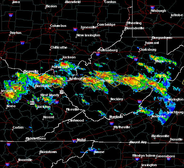 At 230 pm edt, a severe thunderstorm was located over dunbar, or near nitro, moving southeast at 45 mph (radar indicated. tennis ball size hail was reported with this storm in teays valley). Hazards include 70 mph wind gusts and half dollar size hail. Hail damage to vehicles is expected. expect considerable tree damage. wind damage is also likely to mobile homes, roofs, and outbuildings. locations impacted include, charleston, nitro, winfield, jefferson, south charleston, st. Albans, dunbar, hurricane, sissonville, chesapeake, eleanor, marmet, belle, cedar grove, poca, east bank,. At 230 pm edt, a severe thunderstorm was located over dunbar, or near nitro, moving southeast at 45 mph (radar indicated. tennis ball size hail was reported with this storm in teays valley). Hazards include 70 mph wind gusts and half dollar size hail. Hail damage to vehicles is expected. expect considerable tree damage. wind damage is also likely to mobile homes, roofs, and outbuildings. locations impacted include, charleston, nitro, winfield, jefferson, south charleston, st. Albans, dunbar, hurricane, sissonville, chesapeake, eleanor, marmet, belle, cedar grove, poca, east bank,.
|
| 6/21/2016 2:26 PM EDT | Trees down in nitro along dupont avenue in kanawha county WV, 0.3 miles NE of Nitro, WV |
| 6/21/2016 2:12 PM EDT |
 At 212 pm edt, a severe thunderstorm was located over nitro, moving southeast at 40 mph (radar indicated). Hazards include tennis ball size hail and 70 mph wind gusts. People and animals outdoors will be injured. expect hail damage to roofs, siding, windows, and vehicles. expect considerable tree damage. Wind damage is also likely to mobile homes, roofs, and outbuildings. At 212 pm edt, a severe thunderstorm was located over nitro, moving southeast at 40 mph (radar indicated). Hazards include tennis ball size hail and 70 mph wind gusts. People and animals outdoors will be injured. expect hail damage to roofs, siding, windows, and vehicles. expect considerable tree damage. Wind damage is also likely to mobile homes, roofs, and outbuildings.
|
| 6/21/2016 1:49 PM EDT |
 At 149 pm edt, a severe thunderstorm capable of producing a tornado was located near milton, or 13 miles west of winfield, moving southeast at 30 mph (radar indicated rotation). Hazards include tornado and tennis ball size hail. Flying debris will be dangerous to those caught without shelter. mobile homes will be damaged or destroyed. damage to roofs, windows, and vehicles will occur. tree damage is likely. this dangerous storm will be near, milton around 200 pm edt. hurricane and culloden around 205 pm edt. winfield, eleanor and teays valley around 210 pm edt. nitro and tornado around 215 pm edt. Other locations impacted by this tornadic thunderstorm include fraziers bottom, sod, bancroft and ashton. At 149 pm edt, a severe thunderstorm capable of producing a tornado was located near milton, or 13 miles west of winfield, moving southeast at 30 mph (radar indicated rotation). Hazards include tornado and tennis ball size hail. Flying debris will be dangerous to those caught without shelter. mobile homes will be damaged or destroyed. damage to roofs, windows, and vehicles will occur. tree damage is likely. this dangerous storm will be near, milton around 200 pm edt. hurricane and culloden around 205 pm edt. winfield, eleanor and teays valley around 210 pm edt. nitro and tornado around 215 pm edt. Other locations impacted by this tornadic thunderstorm include fraziers bottom, sod, bancroft and ashton.
|
| 6/4/2016 6:27 PM EDT | The severe thunderstorm warning for southern putnam, northeastern lincoln and west central kanawha counties will expire at 630 pm edt, the storm which prompted the warning has weakened below severe limits, and no longer poses an immediate threat to life or property. therefore the warning will be allowed to expire. however gusty winds and heavy rain are still possible with this thunderstorm. |
| 6/4/2016 6:18 PM EDT |
 At 618 pm edt, a severe thunderstorm was located over jefferson, or near nitro, moving northeast at 45 mph (radar indicated). Hazards include 60 mph wind gusts and quarter size hail. Hail damage to vehicles is expected. expect wind damage to roofs, siding, and trees. locations impacted include, charleston, nitro, jefferson, south charleston, st. Albans, dunbar, poca, tornado, alum creek, institute, cross lanes, coal fork and teays valley. At 618 pm edt, a severe thunderstorm was located over jefferson, or near nitro, moving northeast at 45 mph (radar indicated). Hazards include 60 mph wind gusts and quarter size hail. Hail damage to vehicles is expected. expect wind damage to roofs, siding, and trees. locations impacted include, charleston, nitro, jefferson, south charleston, st. Albans, dunbar, poca, tornado, alum creek, institute, cross lanes, coal fork and teays valley.
|
| 6/4/2016 6:02 PM EDT |
 At 602 pm edt, a severe thunderstorm was located near hamlin, moving northeast at 40 mph (radar indicated). Hazards include 60 mph wind gusts and quarter size hail. Hail damage to vehicles is expected. Expect wind damage to roofs, siding, and trees. At 602 pm edt, a severe thunderstorm was located near hamlin, moving northeast at 40 mph (radar indicated). Hazards include 60 mph wind gusts and quarter size hail. Hail damage to vehicles is expected. Expect wind damage to roofs, siding, and trees.
|
| 5/1/2016 6:47 PM EDT |
 At 647 pm edt, severe thunderstorms were located along a line extending from near teays valley to near tornado to near julian, moving east at 40 mph (radar indicated). Hazards include 60 mph wind gusts and half dollar size hail. Hail damage to vehicles is expected. expect wind damage to roofs, siding, and trees. locations impacted include, charleston, nitro, jefferson, south charleston, st. Albans, dunbar, chesapeake, marmet, belle, tornado, coal fork, julian, alum creek, institute, cross lanes, palermo, sod, griffithsville, woodville and yawkey. At 647 pm edt, severe thunderstorms were located along a line extending from near teays valley to near tornado to near julian, moving east at 40 mph (radar indicated). Hazards include 60 mph wind gusts and half dollar size hail. Hail damage to vehicles is expected. expect wind damage to roofs, siding, and trees. locations impacted include, charleston, nitro, jefferson, south charleston, st. Albans, dunbar, chesapeake, marmet, belle, tornado, coal fork, julian, alum creek, institute, cross lanes, palermo, sod, griffithsville, woodville and yawkey.
|
| 5/1/2016 6:35 PM EDT |
 At 635 pm edt, severe thunderstorms were located along a line extending from near culloden to near hamlin to near spurlockville, moving east at 40 mph (radar indicated). Hazards include 60 mph wind gusts and half dollar size hail. Hail damage to vehicles is expected. Expect wind damage to roofs, siding, and trees. At 635 pm edt, severe thunderstorms were located along a line extending from near culloden to near hamlin to near spurlockville, moving east at 40 mph (radar indicated). Hazards include 60 mph wind gusts and half dollar size hail. Hail damage to vehicles is expected. Expect wind damage to roofs, siding, and trees.
|
| 7/14/2015 5:59 PM EDT |
 At 559 pm edt, doppler radar indicated a line of severe thunderstorms capable of producing damaging winds in excess of 60 mph. these storms were located along a line extending from 7 miles southeast of grantsville to near amma to near nitro, moving southeast at 50 mph. locations impacted include, charleston, nitro, clay, jefferson, south charleston, st. albans, dunbar, hurricane, sissonville, marmet, belle, clendenin, poca, glen, arnoldsburg, spurlockville, teays valley, institute, tornado and amma. At 559 pm edt, doppler radar indicated a line of severe thunderstorms capable of producing damaging winds in excess of 60 mph. these storms were located along a line extending from 7 miles southeast of grantsville to near amma to near nitro, moving southeast at 50 mph. locations impacted include, charleston, nitro, clay, jefferson, south charleston, st. albans, dunbar, hurricane, sissonville, marmet, belle, clendenin, poca, glen, arnoldsburg, spurlockville, teays valley, institute, tornado and amma.
|
| 7/14/2015 5:18 PM EDT |
 At 518 pm edt, doppler radar indicated a line of severe thunderstorms capable of producing damaging winds in excess of 60 mph. these storms were located along a line extending from sandyville to 6 miles northwest of kenna to near buffalo, and moving southeast at 50 mph. At 518 pm edt, doppler radar indicated a line of severe thunderstorms capable of producing damaging winds in excess of 60 mph. these storms were located along a line extending from sandyville to 6 miles northwest of kenna to near buffalo, and moving southeast at 50 mph.
|
| 7/13/2015 4:26 PM EDT |
 At 425 pm edt, doppler radar indicated a line of severe thunderstorms capable of producing damaging winds in excess of 60 mph. these storms were located along a line extending from near winfield to 7 miles southeast of culloden, and moving east at 35 mph. * severe thunderstorms will be near, nitro and poca around 430 pm edt. alum creek and cross lanes around 435 pm edt. tornado around 440 pm edt. jefferson, st. albans, sissonville and institute around 445 pm edt. charleston, south charleston and dunbar around 450 pm edt. pinch around 500 pm edt. marmet and elkview around 505 pm edt. chesapeake, belle and coal fork around 510 pm edt. other locations impacted by these severe thunderstorms include sod, palermo, griffithsville, foster, prenter, myra, sharon, sylvester, yawkey and woodville. At 425 pm edt, doppler radar indicated a line of severe thunderstorms capable of producing damaging winds in excess of 60 mph. these storms were located along a line extending from near winfield to 7 miles southeast of culloden, and moving east at 35 mph. * severe thunderstorms will be near, nitro and poca around 430 pm edt. alum creek and cross lanes around 435 pm edt. tornado around 440 pm edt. jefferson, st. albans, sissonville and institute around 445 pm edt. charleston, south charleston and dunbar around 450 pm edt. pinch around 500 pm edt. marmet and elkview around 505 pm edt. chesapeake, belle and coal fork around 510 pm edt. other locations impacted by these severe thunderstorms include sod, palermo, griffithsville, foster, prenter, myra, sharon, sylvester, yawkey and woodville.
|
| 7/7/2015 3:59 PM EDT |
 At 359 pm edt, doppler radar indicated a line of severe thunderstorms capable of producing damaging winds in excess of 60 mph. these storms were located along a line extending from near winfield to tornado, and moving northeast at 30mph. At 359 pm edt, doppler radar indicated a line of severe thunderstorms capable of producing damaging winds in excess of 60 mph. these storms were located along a line extending from near winfield to tornado, and moving northeast at 30mph.
|
| 6/18/2015 5:41 PM EDT | The severe thunderstorm warning for southwestern roane, east central putnam, west central clay, northeastern lincoln, southeastern jackson and northern kanawha counties will expire at 545 pm edt, the storm which prompted the warning has weakened below severe limits. therefore the warning will be allowed to expire. |
| 6/18/2015 5:20 PM EDT | At 519 pm edt, doppler radar indicated a severe thunderstorm capable of producing quarter size hail and damaging winds in excess of 60 mph. this storm was located over sissonville, or 10 miles north of charleston, moving northeast at 50 mph. locations impacted include, charleston, nitro, jefferson, south charleston, st. albans, dunbar, sissonville, clendenin, poca, tornado, pinch, elkview, cross lanes, institute, teays valley, alum creek and walton. |
| 6/18/2015 5:10 PM EDT | Several 3 to 5 inch trees down 1 mile north of hwy 60 along winfield rd. numerous power outages in saint albans. time est from rada in kanawha county WV, 1 miles NNW of Nitro, WV |
| 6/18/2015 4:58 PM EDT | At 457 pm edt, doppler radar indicated a severe thunderstorm capable of producing quarter size hail and damaging winds in excess of 60 mph. this storm was located near teays valley, or near nitro, and moving northeast at 55 mph. |
| 5/11/2015 6:07 PM EDT | At 604 pm edt, national weather service doppler radar continued to indicate a line of severe thunderstorms capable of producing damaging winds in excess of 60 mph. these storms were located along a line extending from buffalo to teays valley to nitro to tornado, or along a line extending from 10 miles northwest of winfield to winfield to nitro, moving east at 45 mph. other locations in the warning include but are not limited to poca, institute, bancroft, south charleston, dunbar, liberty, yeager airport, sissonville, pinch, elkview, coal fork and charleston this will impact the following interstates, i-64 between mile markers 33 and 57 in west virginia, i-77 between mile markers 96 and 121 in west virginia, i-79 between mile markers 1 and 9, the west virginia turnpike between mile markers 91 and 95. a severe thunderstorm watch remains in effect until 1000 pm edt monday evening for central kentucky and southeast ohio and central west virginia. a severe thunderstorm watch also remains in effect until 100 am edt tuesday morning for central west virginia. please report severe weather to the national weather service by calling toll free, 800-401-9535, when you can do so safely. you may also report severe weather by posting your report to the charleston west virginia national weather service facebook page, or by using the twitter hashtag, nwsrlx. |
| 5/11/2015 5:50 PM EDT | At 549 pm edt, national weather service doppler radar indicated a line of severe thunderstorms capable of producing damaging winds in excess of 60 mph. these storms were located along a line extending from 6 miles north of milton to culloden to tornado to 7 miles southwest of tornado, or along a line extending from 13 miles west of winfield to 9 miles northeast of hamlin to 8 miles southwest of nitro to 9 miles east of hamlin, moving east at 40 mph. * other locations in the warning include but are not limited to yeager airport, alum creek, teays valley, poca, hurricane, eleanor, buffalo, st. albans, south charleston, sissonville, pinch, institute, elkview, dunbar, cross lanes and coal fork. this will impact the following interstates, i-64 between mile markers 25 and 57 in west virginia, i-77 between mile markers 96 and 120 in west virginia, i-79 between mile markers 1 and 9, the west virginia turnpike between mile markers 91 and 95. a severe thunderstorm watch remains in effect until 1000 pm edt monday evening for central kentucky and southeast ohio and central west virginia. a severe thunderstorm watch also remains in effect until 100 am edt tuesday morning for central west virginia. please report hail or strong wind to the national weather service by calling toll free, 800-401-9535, when you can do so safely. you may also report severe weather by posting your report to the charleston west virginia national weather service facebook page, or by using the twitter hashtag, nwsrlx. |
| 7/5/2012 11:51 AM EDT | Multiple trees down into power lines in kanawha county WV, 0.3 miles NE of Nitro, WV |
| 1/1/0001 12:00 AM | Tree down blake road and 21st stree in kanawha county WV, 0.3 miles NE of Nitro, WV |
Hail Maps for Nitro, WV
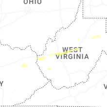
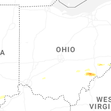
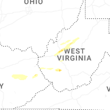
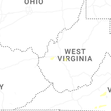
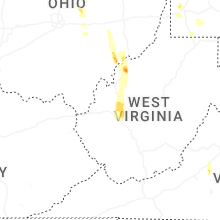


Connect with Interactive Hail Maps