

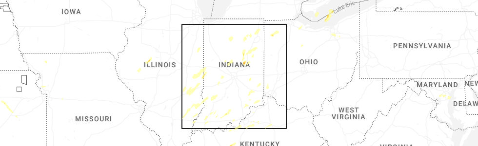
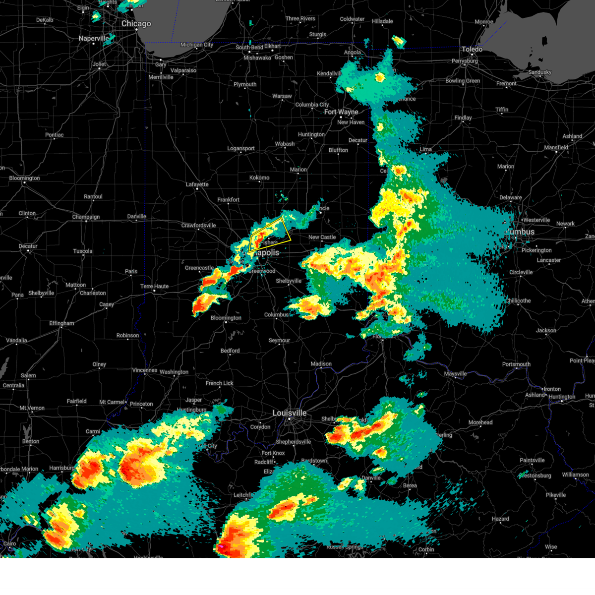
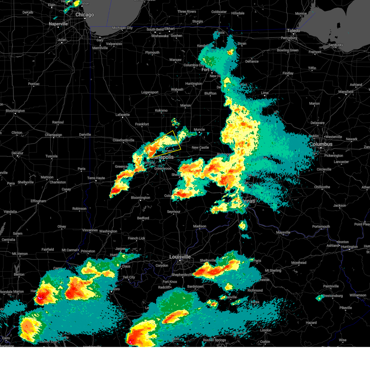
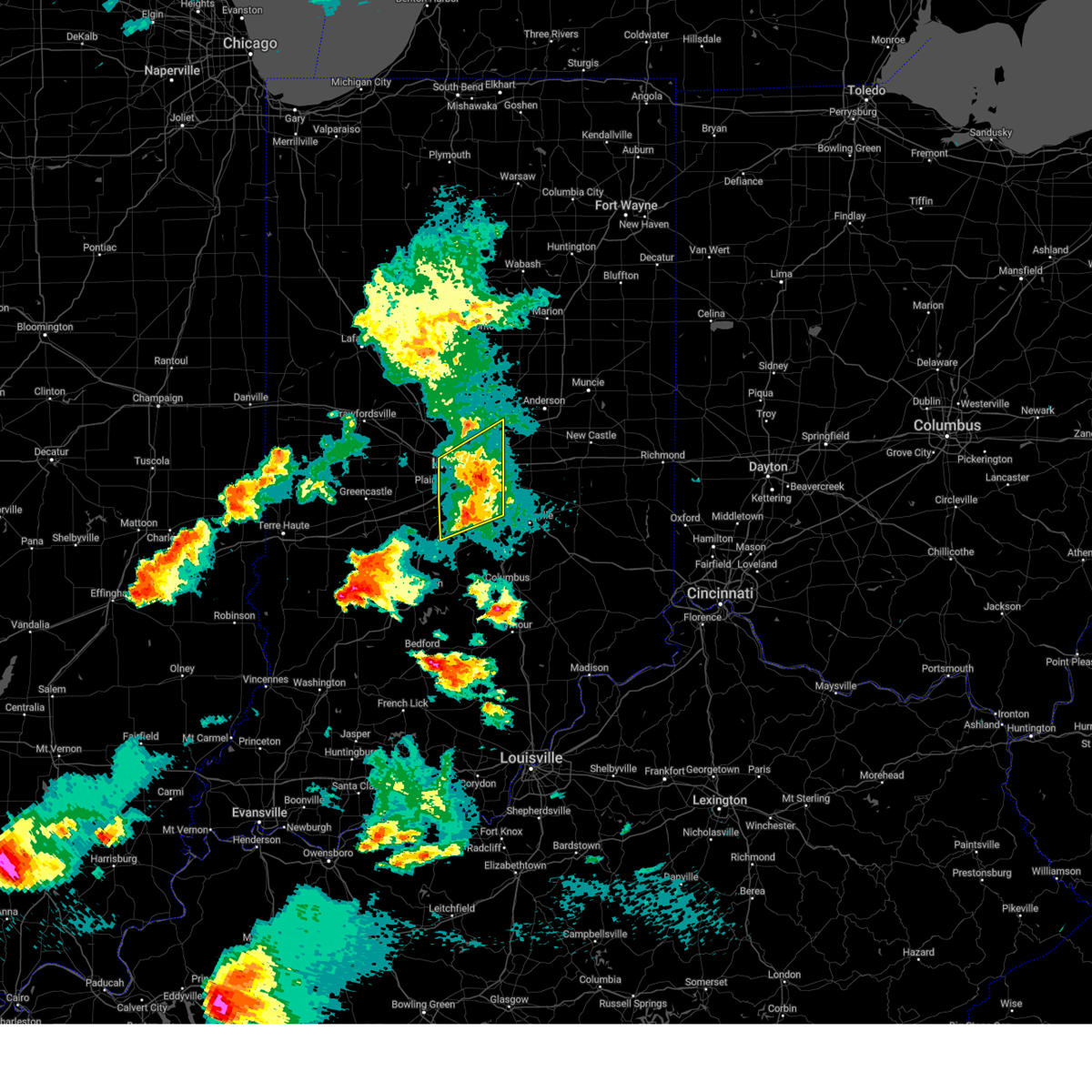
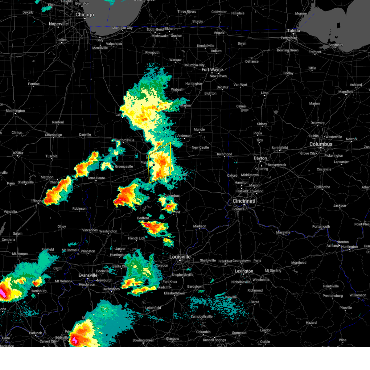
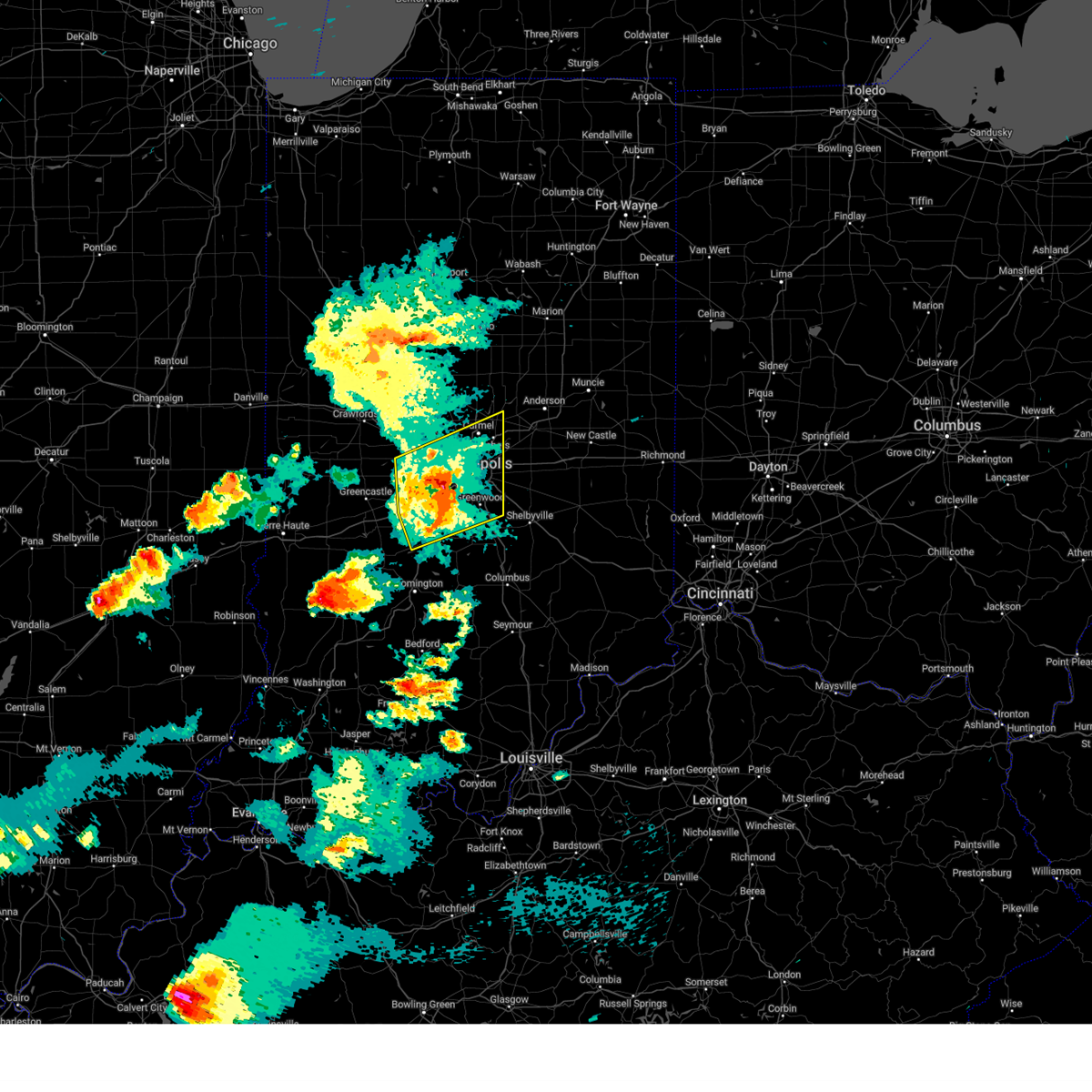
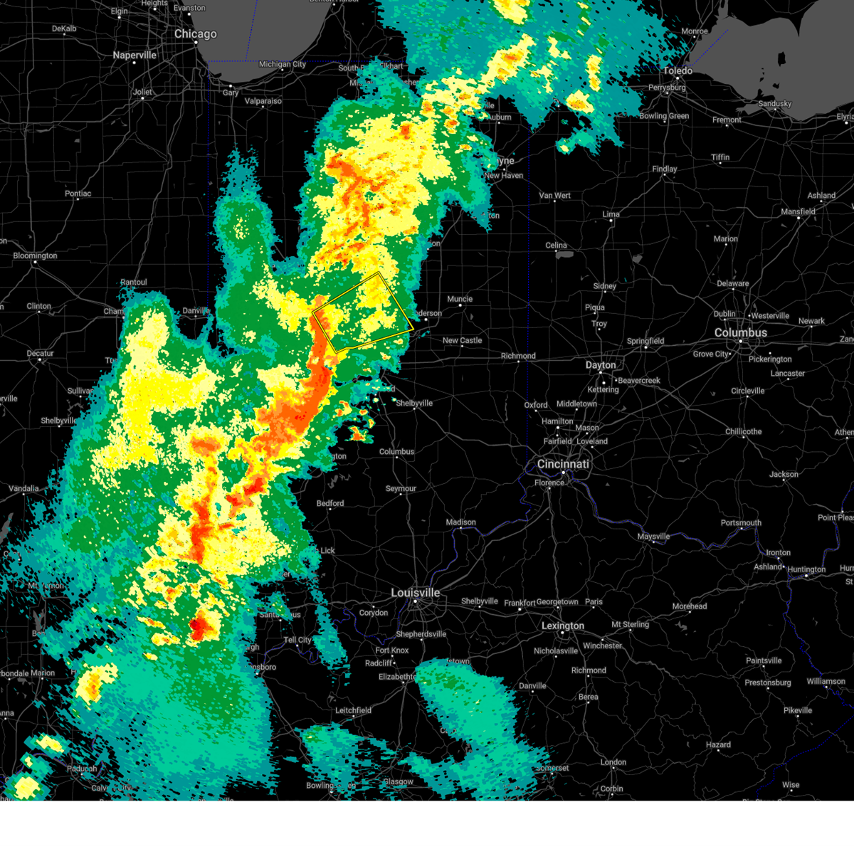
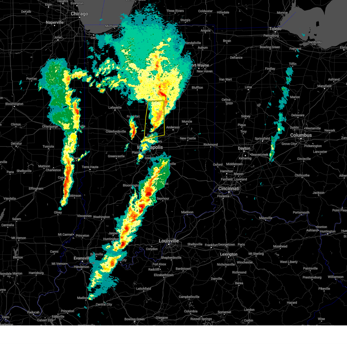
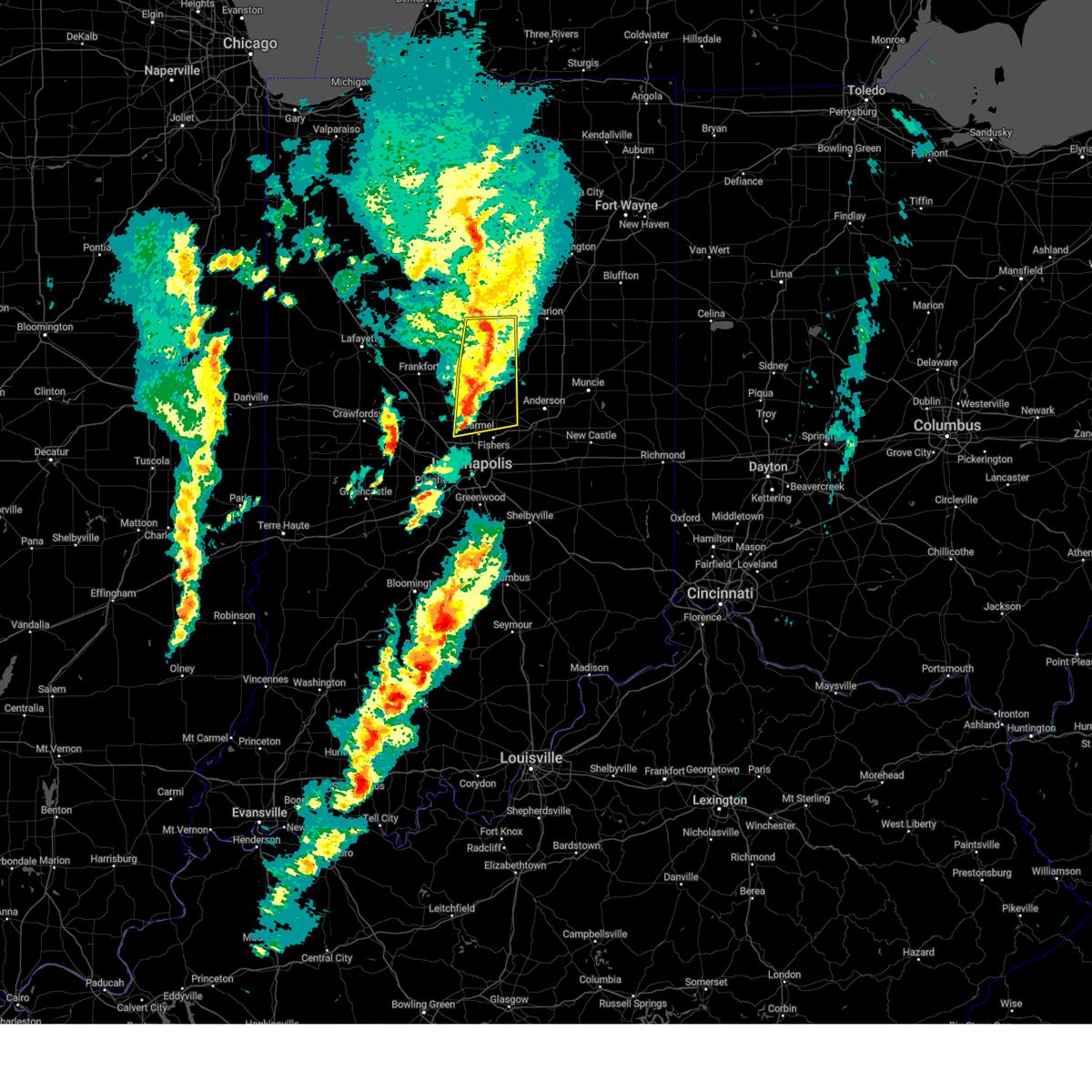
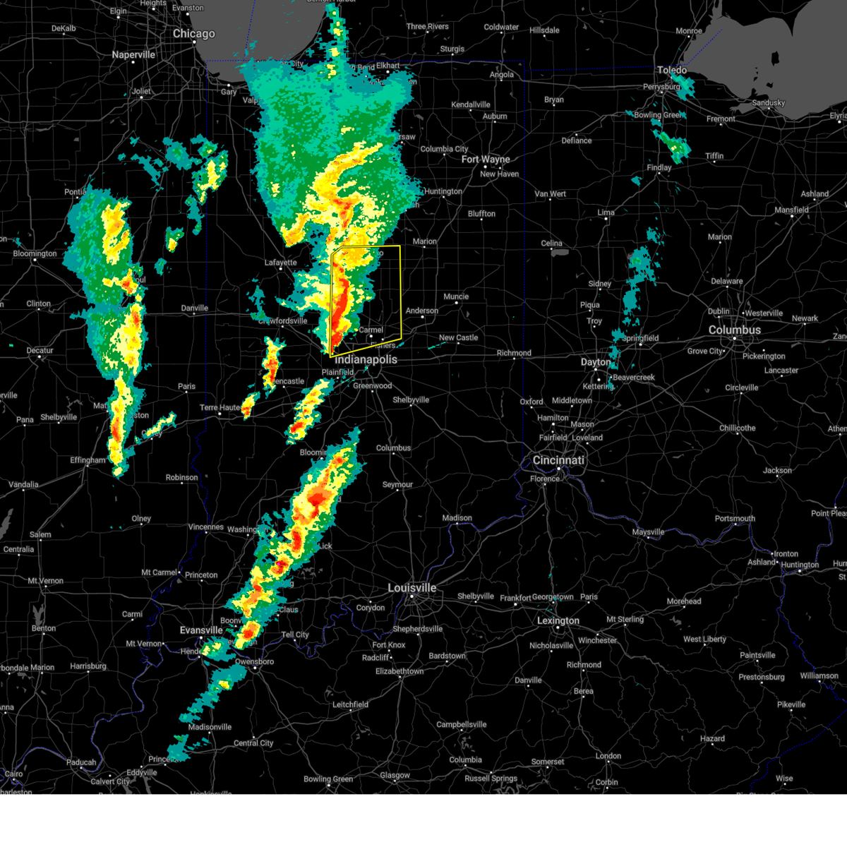
Hail Map for Noblesville, IN
The Noblesville, IN area has had 8 reports of on-the-ground hail by trained spotters, and has been under severe weather warnings 52 times during the past 12 months. Doppler radar has detected hail at or near Noblesville, IN on 85 occasions, including 3 occasions during the past year.
| Name: | Noblesville, IN |
| Where Located: | 20.1 miles NNE of Indianapolis, IN |
| Map: | Google Map for Noblesville, IN |
| Population: | 51969 |
| Housing Units: | 21121 |
| More Info: | Search Google for Noblesville, IN |
1
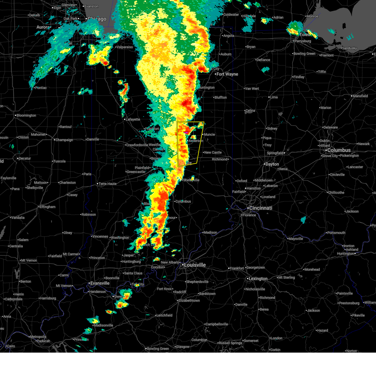
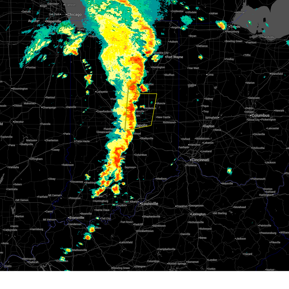
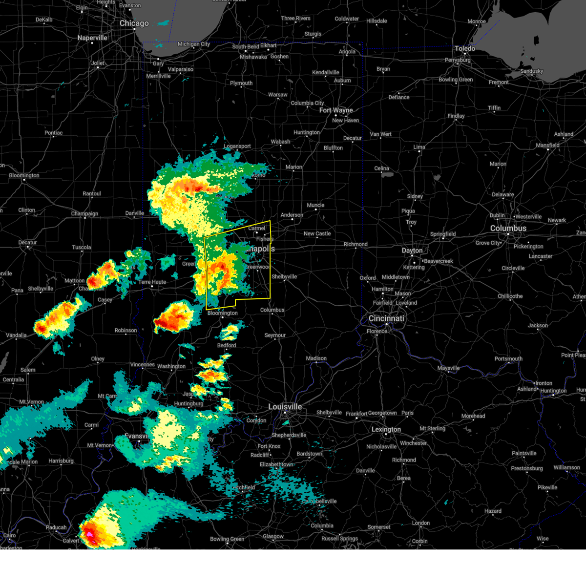
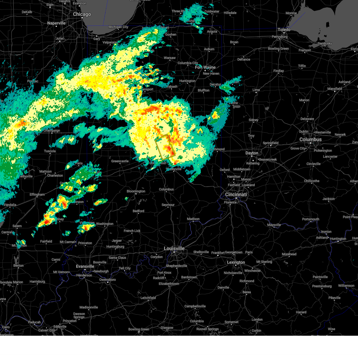
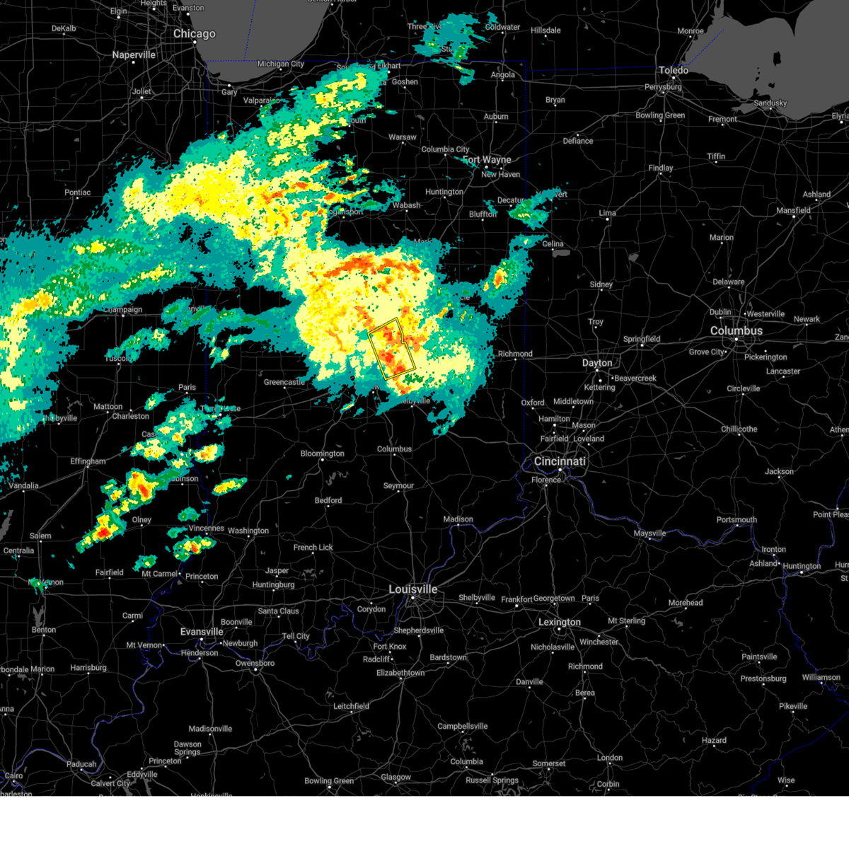
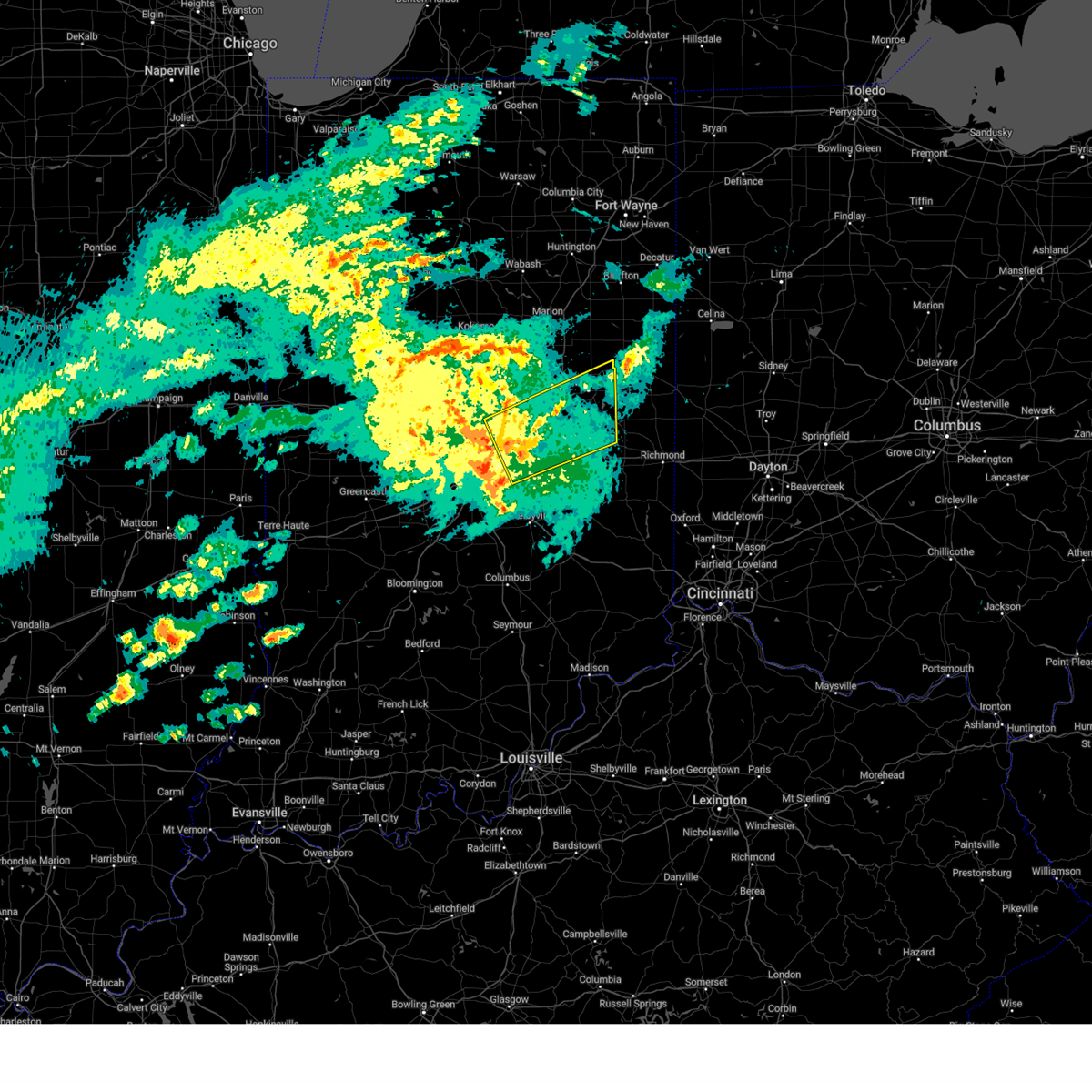
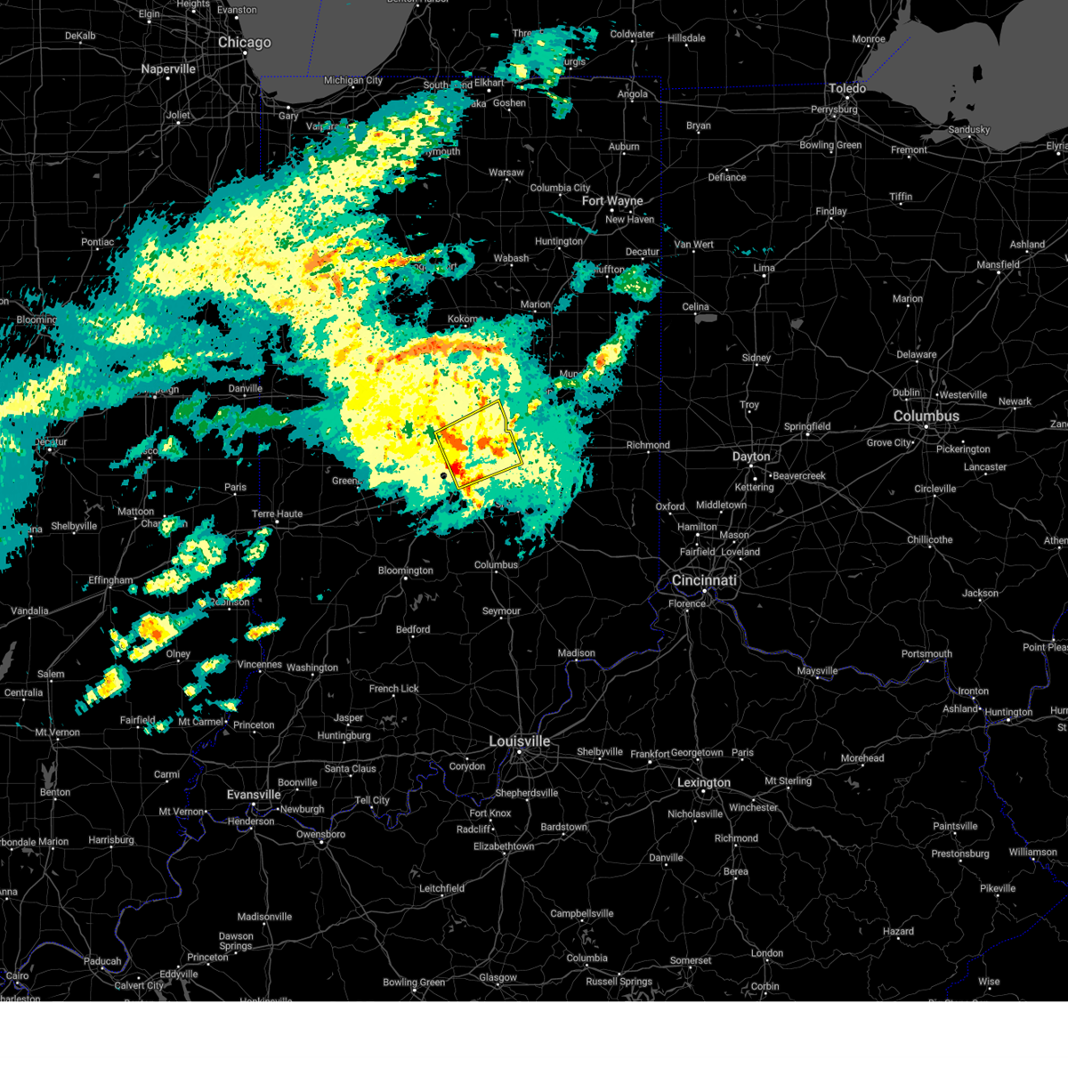
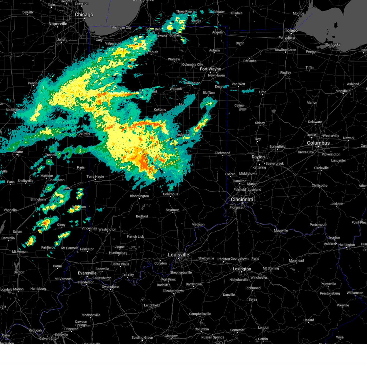
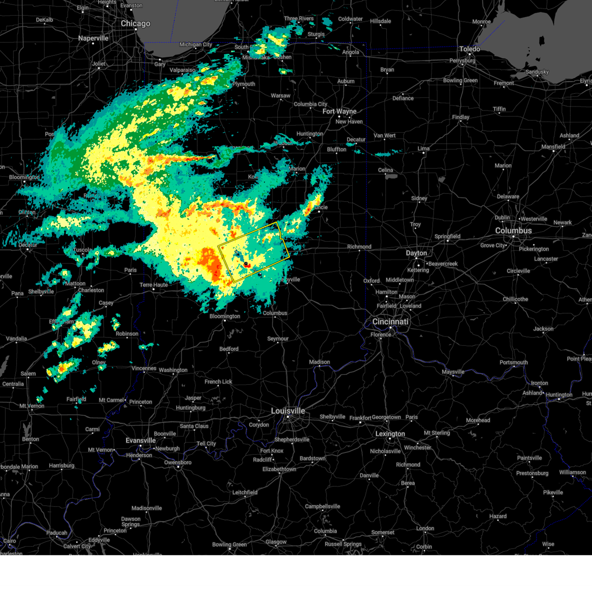
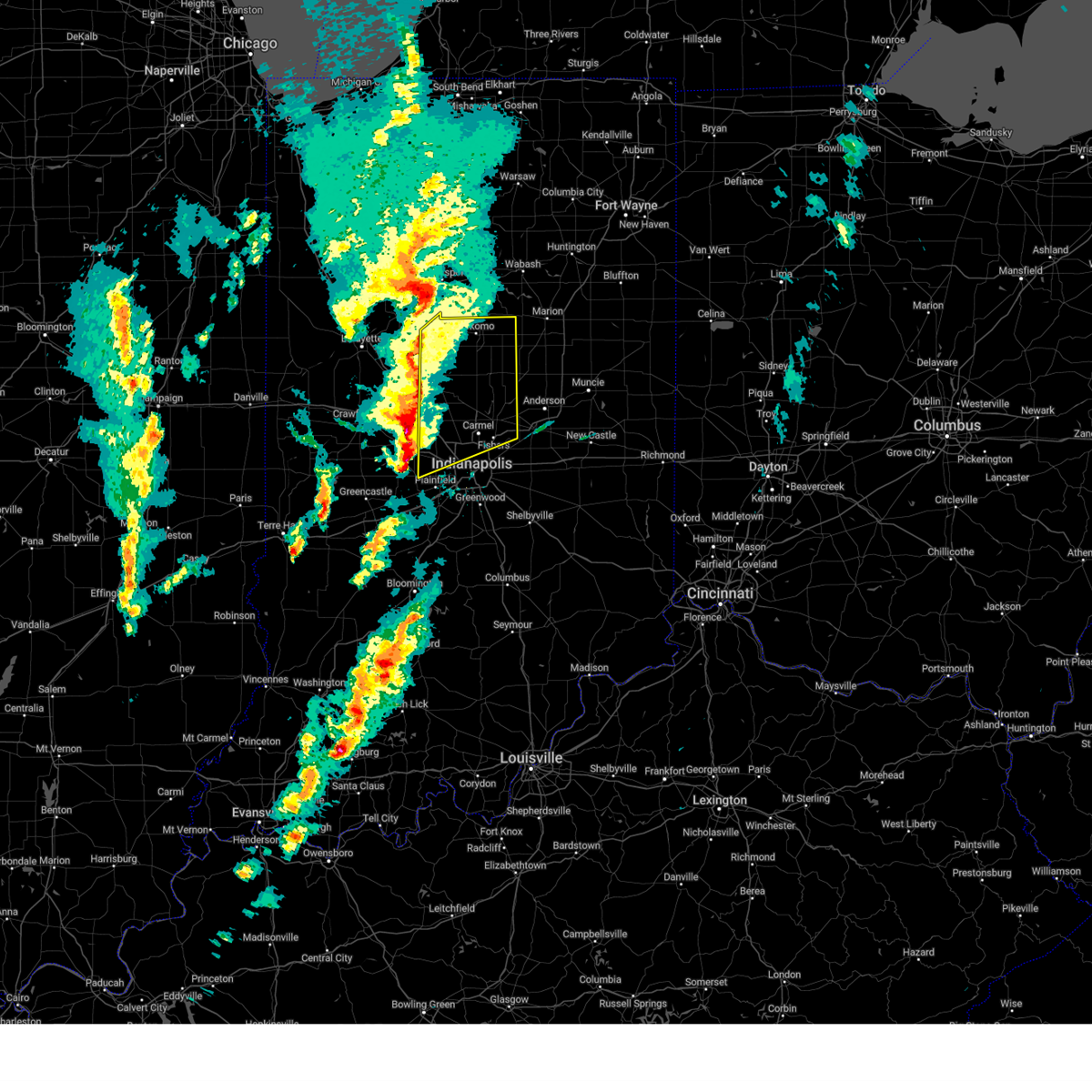
The Top Recent Hail Date for Noblesville, IN is Wednesday, June 18, 2025 (38th out of 85)
Hail and Wind Damage Spotted near Noblesville, IN
| Date / Time | Report Details |
|---|---|
| 6/18/2025 5:15 PM EDT |
 the severe thunderstorm warning has been cancelled and is no longer in effect the severe thunderstorm warning has been cancelled and is no longer in effect
|
| 6/18/2025 5:15 PM EDT |
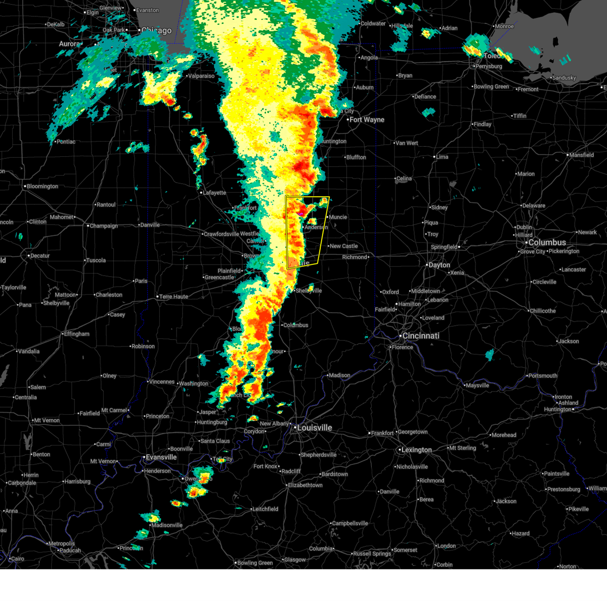 At 515 pm edt, severe thunderstorms were located along a line extending from near la fontaine to near greenfield, moving east at 40 mph (radar indicated). Hazards include 70 mph wind gusts and quarter size hail. Hail damage to vehicles is expected. expect considerable tree damage. wind damage is also likely to mobile homes, roofs, and outbuildings. locations impacted include, muncie, anderson, greenfield, elwood, alexandria, yorktown, pendleton, fortville, chesterfield, ingalls, knightstown, lapel, edgewood, frankton, eaton, daleville, summitville, gaston, shirley, and markleville. this includes the following highways, interstate 69 between mile markers 214 and 252. Interstate 70 between mile markers 99 and 119. At 515 pm edt, severe thunderstorms were located along a line extending from near la fontaine to near greenfield, moving east at 40 mph (radar indicated). Hazards include 70 mph wind gusts and quarter size hail. Hail damage to vehicles is expected. expect considerable tree damage. wind damage is also likely to mobile homes, roofs, and outbuildings. locations impacted include, muncie, anderson, greenfield, elwood, alexandria, yorktown, pendleton, fortville, chesterfield, ingalls, knightstown, lapel, edgewood, frankton, eaton, daleville, summitville, gaston, shirley, and markleville. this includes the following highways, interstate 69 between mile markers 214 and 252. Interstate 70 between mile markers 99 and 119.
|
| 6/18/2025 5:12 PM EDT |
 At 511 pm edt, severe thunderstorms were located along a line extending from near sweetser to near greenfield, moving northeast at 40 mph (radar indicated). Hazards include 70 mph wind gusts and quarter size hail. Hail damage to vehicles is expected. expect considerable tree damage. wind damage is also likely to mobile homes, roofs, and outbuildings. locations impacted include, indianapolis, muncie, anderson, carmel, fishers, noblesville, lawrence, greenfield, beech grove, elwood, alexandria, tipton, windfall, westfield, yorktown, cumberland, cicero, mccordsville, pendleton, and fortville. this includes the following highways, interstate 65 between mile markers 105 and 112. interstate 69 between mile markers 200 and 252. interstate 70 between mile markers 83 and 119. Interstate 74 between mile markers 93 and 97. At 511 pm edt, severe thunderstorms were located along a line extending from near sweetser to near greenfield, moving northeast at 40 mph (radar indicated). Hazards include 70 mph wind gusts and quarter size hail. Hail damage to vehicles is expected. expect considerable tree damage. wind damage is also likely to mobile homes, roofs, and outbuildings. locations impacted include, indianapolis, muncie, anderson, carmel, fishers, noblesville, lawrence, greenfield, beech grove, elwood, alexandria, tipton, windfall, westfield, yorktown, cumberland, cicero, mccordsville, pendleton, and fortville. this includes the following highways, interstate 65 between mile markers 105 and 112. interstate 69 between mile markers 200 and 252. interstate 70 between mile markers 83 and 119. Interstate 74 between mile markers 93 and 97.
|
| 6/18/2025 4:58 PM EDT |
 Svrind the national weather service in indianapolis has issued a * severe thunderstorm warning for, madison county in central indiana, hancock county in central indiana, northwestern rush county in central indiana, western delaware county in east central indiana, eastern howard county in central indiana, western henry county in east central indiana, eastern marion county in central indiana, hamilton county in central indiana, tipton county in central indiana, * until 545 pm edt. * at 458 pm edt, severe thunderstorms were located along a line extending from near swayzee to 7 miles southeast of lawrence, moving northeast at 40 mph (radar indicated). Hazards include 70 mph wind gusts and penny size hail. Expect considerable tree damage. Damage is likely to mobile homes, roofs, and outbuildings. Svrind the national weather service in indianapolis has issued a * severe thunderstorm warning for, madison county in central indiana, hancock county in central indiana, northwestern rush county in central indiana, western delaware county in east central indiana, eastern howard county in central indiana, western henry county in east central indiana, eastern marion county in central indiana, hamilton county in central indiana, tipton county in central indiana, * until 545 pm edt. * at 458 pm edt, severe thunderstorms were located along a line extending from near swayzee to 7 miles southeast of lawrence, moving northeast at 40 mph (radar indicated). Hazards include 70 mph wind gusts and penny size hail. Expect considerable tree damage. Damage is likely to mobile homes, roofs, and outbuildings.
|
| 6/18/2025 4:47 PM EDT | the severe thunderstorm warning has been cancelled and is no longer in effect |
| 6/18/2025 4:47 PM EDT | At 446 pm edt, severe thunderstorms were located along a line extending from tipton to near lawrence, moving northeast at 65 mph (radar indicated). Hazards include 70 mph wind gusts and nickel size hail. Expect considerable tree damage. damage is likely to mobile homes, roofs, and outbuildings. locations impacted include, indianapolis, anderson, kokomo, carmel, fishers, noblesville, lawrence, greenfield, beech grove, zionsville, speedway, elwood, alexandria, tipton, southport, windfall, westfield, cumberland, cicero, and mccordsville. this includes the following highways, interstate 65 between mile markers 103 and 130. interstate 69 between mile markers 200 and 228. interstate 70 between mile markers 71 and 110. Interstate 74 between mile markers 70 and 98. |
| 6/18/2025 4:22 PM EDT | Svrind the national weather service in indianapolis has issued a * severe thunderstorm warning for, madison county in central indiana, hancock county in central indiana, northeastern morgan county in central indiana, southeastern clinton county in central indiana, eastern howard county in central indiana, eastern hendricks county in central indiana, marion county in central indiana, boone county in central indiana, hamilton county in central indiana, tipton county in central indiana, * until 500 pm edt. * at 421 pm edt, severe thunderstorms were located along a line extending from near lebanon to near mooresville, moving northeast at 65 mph (radar indicated). Hazards include 70 mph wind gusts and nickel size hail. Expect considerable tree damage. Damage is likely to mobile homes, roofs, and outbuildings. |
| 5/16/2025 9:07 PM EDT |
 The storms which prompted the warning have moved out of the area. therefore, the warning will be allowed to expire. however, heavy rain is still possible with these thunderstorms. a tornado watch remains in effect until 1100 pm edt for central indiana. The storms which prompted the warning have moved out of the area. therefore, the warning will be allowed to expire. however, heavy rain is still possible with these thunderstorms. a tornado watch remains in effect until 1100 pm edt for central indiana.
|
| 5/16/2025 8:46 PM EDT |
 At 846 pm edt, severe thunderstorms were located along a line extending from near noblesville to fishers, moving east at 45 mph (radar indicated). Hazards include 60 mph wind gusts and penny size hail. Expect damage to roofs, siding, and trees. locations impacted include, indianapolis, fishers, noblesville, lawrence, mccordsville, pendleton, fortville, ingalls, lapel, geist reservoir, and castleton. This includes interstate 69 between mile markers 200 and 217. At 846 pm edt, severe thunderstorms were located along a line extending from near noblesville to fishers, moving east at 45 mph (radar indicated). Hazards include 60 mph wind gusts and penny size hail. Expect damage to roofs, siding, and trees. locations impacted include, indianapolis, fishers, noblesville, lawrence, mccordsville, pendleton, fortville, ingalls, lapel, geist reservoir, and castleton. This includes interstate 69 between mile markers 200 and 217.
|
| 5/16/2025 8:37 PM EDT |
 At 836 pm edt, a severe thunderstorm was located over carmel, or 14 miles north of indianapolis, moving northeast at 50 mph (radar indicated). Hazards include 60 mph wind gusts and nickel size hail. Expect damage to roofs, siding, and trees. Locations impacted include, indianapolis, carmel, fishers, noblesville, lawrence, westfield, mccordsville, pendleton, fortville, ingalls, lapel, meridian hills, rocky ripple, williams creek, crows nest, north crows nest, geist reservoir, castleton, and broad ripple. At 836 pm edt, a severe thunderstorm was located over carmel, or 14 miles north of indianapolis, moving northeast at 50 mph (radar indicated). Hazards include 60 mph wind gusts and nickel size hail. Expect damage to roofs, siding, and trees. Locations impacted include, indianapolis, carmel, fishers, noblesville, lawrence, westfield, mccordsville, pendleton, fortville, ingalls, lapel, meridian hills, rocky ripple, williams creek, crows nest, north crows nest, geist reservoir, castleton, and broad ripple.
|
| 5/16/2025 8:37 PM EDT |
 the severe thunderstorm warning has been cancelled and is no longer in effect the severe thunderstorm warning has been cancelled and is no longer in effect
|
| 5/16/2025 8:25 PM EDT |
 Svrind the national weather service in indianapolis has issued a * severe thunderstorm warning for, southwestern madison county in central indiana, northwestern hancock county in central indiana, northeastern hendricks county in central indiana, northern marion county in central indiana, southeastern boone county in central indiana, hamilton county in central indiana, * until 915 pm edt. * at 825 pm edt, a severe thunderstorm was located over zionsville, or 12 miles northwest of indianapolis, moving northeast at 50 mph (radar indicated). Hazards include 60 mph wind gusts and half dollar size hail. Hail damage to vehicles is expected. Expect wind damage to roofs, siding, and trees. Svrind the national weather service in indianapolis has issued a * severe thunderstorm warning for, southwestern madison county in central indiana, northwestern hancock county in central indiana, northeastern hendricks county in central indiana, northern marion county in central indiana, southeastern boone county in central indiana, hamilton county in central indiana, * until 915 pm edt. * at 825 pm edt, a severe thunderstorm was located over zionsville, or 12 miles northwest of indianapolis, moving northeast at 50 mph (radar indicated). Hazards include 60 mph wind gusts and half dollar size hail. Hail damage to vehicles is expected. Expect wind damage to roofs, siding, and trees.
|
| 5/16/2025 7:23 PM EDT | Svrind the national weather service in indianapolis has issued a * severe thunderstorm warning for, madison county in central indiana, southeastern carroll county in north central indiana, delaware county in east central indiana, northwestern randolph county in east central indiana, northeastern clinton county in central indiana, howard county in central indiana, northwestern henry county in east central indiana, hamilton county in central indiana, tipton county in central indiana, * until 815 pm edt. * at 722 pm edt, severe thunderstorms were located along a line extending from 10 miles southwest of walton to 6 miles east of fishers, moving east at 75 mph (public report of 60 mph winds). Hazards include 60 mph wind gusts. expect damage to roofs, siding, and trees |
| 5/16/2025 7:15 PM EDT | Large trees dow in hamilton county IN, 5.7 miles SE of Noblesville, IN |
| 5/16/2025 7:03 PM EDT |
 the severe thunderstorm warning has been cancelled and is no longer in effect the severe thunderstorm warning has been cancelled and is no longer in effect
|
| 5/16/2025 7:03 PM EDT |
 At 702 pm edt, severe thunderstorms were located along a line extending from near carmel to greenwood, moving northeast at 50 mph. these are destructive storms for warren park, beach grove and southport (radar indicated). Hazards include 80 mph wind gusts and penny size hail. Flying debris will be dangerous to those caught without shelter. mobile homes will be heavily damaged. expect considerable damage to roofs, windows, and vehicles. extensive tree damage and power outages are likely. locations impacted include, indianapolis, carmel, fishers, noblesville, greenwood, lawrence, plainfield, franklin, brownsburg, beech grove, speedway, mooresville, southport, avon, new whiteland, cumberland, whiteland, bargersville, meridian hills, and brooklyn. this includes the following highways, interstate 65 between mile markers 94 and 125. interstate 69 between mile markers 200 and 208. interstate 70 between mile markers 66 and 93. Interstate 74 between mile markers 67 and 100. At 702 pm edt, severe thunderstorms were located along a line extending from near carmel to greenwood, moving northeast at 50 mph. these are destructive storms for warren park, beach grove and southport (radar indicated). Hazards include 80 mph wind gusts and penny size hail. Flying debris will be dangerous to those caught without shelter. mobile homes will be heavily damaged. expect considerable damage to roofs, windows, and vehicles. extensive tree damage and power outages are likely. locations impacted include, indianapolis, carmel, fishers, noblesville, greenwood, lawrence, plainfield, franklin, brownsburg, beech grove, speedway, mooresville, southport, avon, new whiteland, cumberland, whiteland, bargersville, meridian hills, and brooklyn. this includes the following highways, interstate 65 between mile markers 94 and 125. interstate 69 between mile markers 200 and 208. interstate 70 between mile markers 66 and 93. Interstate 74 between mile markers 67 and 100.
|
| 5/16/2025 6:56 PM EDT | At 655 pm edt, severe thunderstorms were located along a line extending from near speedway to 7 miles southwest of greenwood, moving northeast at 50 mph. these are destructive storms for indianapolis, southport, speedway and clermont (74 mph wind recorded on the kind asos). Hazards include 80 mph wind gusts and penny size hail. Flying debris will be dangerous to those caught without shelter. mobile homes will be heavily damaged. expect considerable damage to roofs, windows, and vehicles. extensive tree damage and power outages are likely. locations impacted include, indianapolis, carmel, fishers, noblesville, greenwood, lawrence, plainfield, franklin, brownsburg, beech grove, zionsville, martinsville, speedway, mooresville, danville, southport, westfield, avon, new whiteland, and cumberland. this includes the following highways, interstate 65 between mile markers 94 and 130. interstate 69 between mile markers 200 and 208. interstate 70 between mile markers 55 and 93. Interstate 74 between mile markers 58 and 100. |
| 5/16/2025 6:51 PM EDT |
 the severe thunderstorm warning has been cancelled and is no longer in effect the severe thunderstorm warning has been cancelled and is no longer in effect
|
| 5/16/2025 6:51 PM EDT |
 At 651 pm edt, severe thunderstorms were located along a line extending from near speedway to 8 miles southeast of mooresville, moving east at 50 mph (radar indicated). Hazards include 70 mph wind gusts and quarter size hail. Hail damage to vehicles is expected. expect considerable tree damage. wind damage is also likely to mobile homes, roofs, and outbuildings. locations impacted include, indianapolis, carmel, fishers, noblesville, greenwood, lawrence, plainfield, franklin, brownsburg, beech grove, zionsville, martinsville, speedway, mooresville, danville, southport, westfield, avon, new whiteland, and cumberland. this includes the following highways, interstate 65 between mile markers 94 and 130. interstate 69 between mile markers 200 and 208. interstate 70 between mile markers 50 and 93. Interstate 74 between mile markers 58 and 100. At 651 pm edt, severe thunderstorms were located along a line extending from near speedway to 8 miles southeast of mooresville, moving east at 50 mph (radar indicated). Hazards include 70 mph wind gusts and quarter size hail. Hail damage to vehicles is expected. expect considerable tree damage. wind damage is also likely to mobile homes, roofs, and outbuildings. locations impacted include, indianapolis, carmel, fishers, noblesville, greenwood, lawrence, plainfield, franklin, brownsburg, beech grove, zionsville, martinsville, speedway, mooresville, danville, southport, westfield, avon, new whiteland, and cumberland. this includes the following highways, interstate 65 between mile markers 94 and 130. interstate 69 between mile markers 200 and 208. interstate 70 between mile markers 50 and 93. Interstate 74 between mile markers 58 and 100.
|
| 5/16/2025 6:41 PM EDT |
 At 641 pm edt, severe thunderstorms were located along a line extending from near brownsburg to near martinsville, moving northeast at 60 mph (radar indicated). Hazards include 70 mph wind gusts and quarter size hail. Hail damage to vehicles is expected. expect considerable tree damage. wind damage is also likely to mobile homes, roofs, and outbuildings. locations impacted include, indianapolis, carmel, fishers, noblesville, greenwood, lawrence, plainfield, franklin, brownsburg, beech grove, zionsville, martinsville, speedway, mooresville, danville, southport, westfield, avon, new whiteland, and cumberland. this includes the following highways, interstate 65 between mile markers 84 and 135. interstate 69 between mile markers 200 and 208. interstate 70 between mile markers 45 and 93. Interstate 74 between mile markers 51 and 100. At 641 pm edt, severe thunderstorms were located along a line extending from near brownsburg to near martinsville, moving northeast at 60 mph (radar indicated). Hazards include 70 mph wind gusts and quarter size hail. Hail damage to vehicles is expected. expect considerable tree damage. wind damage is also likely to mobile homes, roofs, and outbuildings. locations impacted include, indianapolis, carmel, fishers, noblesville, greenwood, lawrence, plainfield, franklin, brownsburg, beech grove, zionsville, martinsville, speedway, mooresville, danville, southport, westfield, avon, new whiteland, and cumberland. this includes the following highways, interstate 65 between mile markers 84 and 135. interstate 69 between mile markers 200 and 208. interstate 70 between mile markers 45 and 93. Interstate 74 between mile markers 51 and 100.
|
| 5/16/2025 6:20 PM EDT | Svrind the national weather service in indianapolis has issued a * severe thunderstorm warning for, northern monroe county in south central indiana, morgan county in central indiana, johnson county in central indiana, hendricks county in central indiana, northeastern owen county in west central indiana, marion county in central indiana, southern boone county in central indiana, southern hamilton county in central indiana, southeastern montgomery county in west central indiana, eastern putnam county in west central indiana, * until 715 pm edt. * at 620 pm edt, severe thunderstorms were located along a line extending from near greencastle to near spencer, moving northeast at 50 mph (radar indicated). Hazards include 60 mph wind gusts and quarter size hail. Hail damage to vehicles is expected. Expect wind damage to roofs, siding, and trees. |
| 4/19/2025 5:56 AM EDT |
 The storms which prompted the warning have moved out of the area. therefore, the warning will be allowed to expire. however, heavy rain is still possible with these thunderstorms. The storms which prompted the warning have moved out of the area. therefore, the warning will be allowed to expire. however, heavy rain is still possible with these thunderstorms.
|
| 4/19/2025 5:53 AM EDT |
 At 552 am edt, severe thunderstorms were located along a line extending from 7 miles northeast of noblesville to near greenfield, moving northeast at 75 mph. these are destructive storms for southern madison and northern hancock counties (radar indicated). Hazards include 80 mph wind gusts. Flying debris will be dangerous to those caught without shelter. mobile homes will be heavily damaged. expect considerable damage to roofs, windows, and vehicles. extensive tree damage and power outages are likely. locations impacted include, geist reservoir, summit lake state park, greensboro, ingalls, fortville, fishers, cadiz, new palestine, new castle, ball state university, selma, muncie, river forest, mccordsville, sulphur springs, daleville, kennard, shirley, mooreland, and albany. this includes the following highways, interstate 69 between mile markers 204 and 241. Interstate 70 between mile markers 95 and 121. At 552 am edt, severe thunderstorms were located along a line extending from 7 miles northeast of noblesville to near greenfield, moving northeast at 75 mph. these are destructive storms for southern madison and northern hancock counties (radar indicated). Hazards include 80 mph wind gusts. Flying debris will be dangerous to those caught without shelter. mobile homes will be heavily damaged. expect considerable damage to roofs, windows, and vehicles. extensive tree damage and power outages are likely. locations impacted include, geist reservoir, summit lake state park, greensboro, ingalls, fortville, fishers, cadiz, new palestine, new castle, ball state university, selma, muncie, river forest, mccordsville, sulphur springs, daleville, kennard, shirley, mooreland, and albany. this includes the following highways, interstate 69 between mile markers 204 and 241. Interstate 70 between mile markers 95 and 121.
|
| 4/19/2025 5:49 AM EDT |
 the severe thunderstorm warning has been cancelled and is no longer in effect the severe thunderstorm warning has been cancelled and is no longer in effect
|
| 4/19/2025 5:49 AM EDT |
 At 548 am edt, severe thunderstorms were located along a line extending from near carmel to near beech grove, moving northeast at 65 mph (radar indicated). Hazards include 70 mph wind gusts. Expect considerable tree damage. damage is likely to mobile homes, roofs, and outbuildings. locations impacted include, geist reservoir, castleton, carmel, noblesville, fortville, lawrence, fishers, cumberland, greenfield, spring lake, mccordsville, new palestine, westfield, and indianapolis. this includes the following highways, interstate 69 between mile markers 200 and 213. interstate 70 between mile markers 89 and 103. Interstate 74 near mile marker 97. At 548 am edt, severe thunderstorms were located along a line extending from near carmel to near beech grove, moving northeast at 65 mph (radar indicated). Hazards include 70 mph wind gusts. Expect considerable tree damage. damage is likely to mobile homes, roofs, and outbuildings. locations impacted include, geist reservoir, castleton, carmel, noblesville, fortville, lawrence, fishers, cumberland, greenfield, spring lake, mccordsville, new palestine, westfield, and indianapolis. this includes the following highways, interstate 69 between mile markers 200 and 213. interstate 70 between mile markers 89 and 103. Interstate 74 near mile marker 97.
|
| 4/19/2025 5:46 AM EDT |
 Svrind the national weather service in indianapolis has issued a * severe thunderstorm warning for, southern madison county in central indiana, hancock county in central indiana, southwestern randolph county in east central indiana, delaware county in east central indiana, henry county in east central indiana, northeastern marion county in central indiana, southeastern hamilton county in central indiana, * until 630 am edt. * at 545 am edt, severe thunderstorms were located along a line extending from near carmel to 8 miles east of beech grove, moving northeast at 75 mph (radar indicated). Hazards include 70 mph wind gusts. Expect considerable tree damage. Damage is likely to mobile homes, roofs, and outbuildings. Svrind the national weather service in indianapolis has issued a * severe thunderstorm warning for, southern madison county in central indiana, hancock county in central indiana, southwestern randolph county in east central indiana, delaware county in east central indiana, henry county in east central indiana, northeastern marion county in central indiana, southeastern hamilton county in central indiana, * until 630 am edt. * at 545 am edt, severe thunderstorms were located along a line extending from near carmel to 8 miles east of beech grove, moving northeast at 75 mph (radar indicated). Hazards include 70 mph wind gusts. Expect considerable tree damage. Damage is likely to mobile homes, roofs, and outbuildings.
|
| 4/19/2025 5:42 AM EDT |
 the severe thunderstorm warning has been cancelled and is no longer in effect the severe thunderstorm warning has been cancelled and is no longer in effect
|
| 4/19/2025 5:42 AM EDT |
 At 542 am edt, severe thunderstorms were located along a line extending from zionsville to southport, moving northeast at 65 mph (radar indicated). Hazards include 70 mph wind gusts. Expect considerable tree damage. damage is likely to mobile homes, roofs, and outbuildings. locations impacted include, geist reservoir, monument circle, castleton, carmel, crows nest, southport, spring hill, fortville, fishers, warren park, wynnedale, williams creek, zionsville, mccordsville, indiana state fairgrounds, broad ripple, beech grove, noblesville, homecroft, and meridian hills. this includes the following highways, interstate 65 between mile markers 104 and 128. interstate 69 between mile markers 200 and 213. interstate 70 between mile markers 76 and 103. Interstate 74 between mile markers 93 and 97. At 542 am edt, severe thunderstorms were located along a line extending from zionsville to southport, moving northeast at 65 mph (radar indicated). Hazards include 70 mph wind gusts. Expect considerable tree damage. damage is likely to mobile homes, roofs, and outbuildings. locations impacted include, geist reservoir, monument circle, castleton, carmel, crows nest, southport, spring hill, fortville, fishers, warren park, wynnedale, williams creek, zionsville, mccordsville, indiana state fairgrounds, broad ripple, beech grove, noblesville, homecroft, and meridian hills. this includes the following highways, interstate 65 between mile markers 104 and 128. interstate 69 between mile markers 200 and 213. interstate 70 between mile markers 76 and 103. Interstate 74 between mile markers 93 and 97.
|
| 4/19/2025 5:34 AM EDT |
 At 533 am edt, severe thunderstorms were located along a line extending from near brownsburg to near mooresville, moving northeast at 65 mph (radar indicated). Hazards include 70 mph wind gusts. Expect considerable tree damage. damage is likely to mobile homes, roofs, and outbuildings. locations impacted include, geist reservoir, monument circle, castleton, carmel, crows nest, southport, spring hill, fortville, fishers, warren park, wynnedale, williams creek, new palestine, zionsville, indianapolis int'l airport, mccordsville, indiana state fairgrounds, camby, broad ripple, and beech grove. this includes the following highways, interstate 65 between mile markers 103 and 129. interstate 69 between mile markers 200 and 213. interstate 70 between mile markers 68 and 103. Interstate 74 between mile markers 62 and 98. At 533 am edt, severe thunderstorms were located along a line extending from near brownsburg to near mooresville, moving northeast at 65 mph (radar indicated). Hazards include 70 mph wind gusts. Expect considerable tree damage. damage is likely to mobile homes, roofs, and outbuildings. locations impacted include, geist reservoir, monument circle, castleton, carmel, crows nest, southport, spring hill, fortville, fishers, warren park, wynnedale, williams creek, new palestine, zionsville, indianapolis int'l airport, mccordsville, indiana state fairgrounds, camby, broad ripple, and beech grove. this includes the following highways, interstate 65 between mile markers 103 and 129. interstate 69 between mile markers 200 and 213. interstate 70 between mile markers 68 and 103. Interstate 74 between mile markers 62 and 98.
|
| 4/19/2025 5:23 AM EDT |
 Svrind the national weather service in indianapolis has issued a * severe thunderstorm warning for, western hancock county in central indiana, northeastern morgan county in central indiana, northwestern johnson county in central indiana, eastern hendricks county in central indiana, marion county in central indiana, southeastern boone county in central indiana, southern hamilton county in central indiana, * until 600 am edt. * at 522 am edt, severe thunderstorms were located along a line extending from 9 miles northwest of danville to 7 miles southwest of mooresville, moving northeast at 65 mph (radar indicated). Hazards include 60 mph wind gusts. expect damage to roofs, siding, and trees Svrind the national weather service in indianapolis has issued a * severe thunderstorm warning for, western hancock county in central indiana, northeastern morgan county in central indiana, northwestern johnson county in central indiana, eastern hendricks county in central indiana, marion county in central indiana, southeastern boone county in central indiana, southern hamilton county in central indiana, * until 600 am edt. * at 522 am edt, severe thunderstorms were located along a line extending from 9 miles northwest of danville to 7 miles southwest of mooresville, moving northeast at 65 mph (radar indicated). Hazards include 60 mph wind gusts. expect damage to roofs, siding, and trees
|
| 4/2/2025 9:57 PM EDT | The storms which prompted the warning have moved out of the warned area. therefore, the warning will be allowed to expire. a tornado watch remains in effect until 1100 pm edt for central indiana. a tornado watch also remains in effect until 400 am edt for central indiana. |
| 4/2/2025 9:42 PM EDT | The storm which prompted the warning has moved out of the area. therefore, the warning will be allowed to expire. a tornado watch remains in effect until 1100 pm edt for central indiana. |
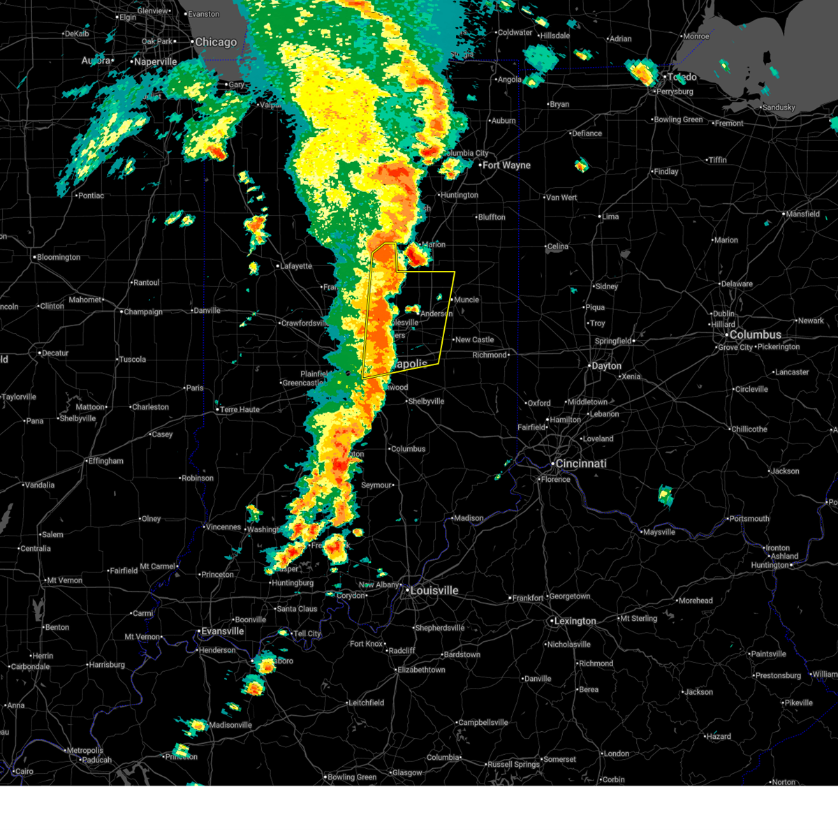
| 4/2/2025 9:38 PM EDT | Torind the national weather service in indianapolis has issued a * tornado warning for, southern madison county in central indiana, eastern hamilton county in central indiana, southeastern tipton county in central indiana, * until 1015 pm edt. * at 938 pm edt, a tornado producing storm was located near noblesville, or 13 miles west of anderson, moving northeast at 65 mph (radar confirmed tornado). Hazards include damaging tornado. Flying debris will be dangerous to those caught without shelter. mobile homes will be damaged or destroyed. damage to roofs, windows, and vehicles will occur. Tree damage is likely. |
| 4/2/2025 9:37 PM EDT | the severe thunderstorm warning has been cancelled and is no longer in effect |
| 4/2/2025 9:37 PM EDT | At 936 pm edt, severe thunderstorms were located along a line extending from near fishers to near lawrence to 7 miles east of beech grove, moving east at 70 mph. these are destructive storms for mccoordsville, greenfield (radar indicated). Hazards include 80 mph wind gusts and penny size hail. Flying debris will be dangerous to those caught without shelter. mobile homes will be heavily damaged. expect considerable damage to roofs, windows, and vehicles. extensive tree damage and power outages are likely. locations impacted include, geist reservoir, castleton, ingalls, greensboro, carmel, knightstown, fortville, fishers, warren park, williams creek, cadiz, spiceland, new palestine, carthage, mccordsville, kennard, shirley, indiana state fairgrounds, broad ripple, and beech grove. this includes the following highways, interstate 65 between mile markers 112 and 113. interstate 69 between mile markers 200 and 232. interstate 70 between mile markers 83 and 123. Interstate 74 between mile markers 93 and 97. |
| 4/2/2025 9:31 PM EDT | the severe thunderstorm warning has been cancelled and is no longer in effect |
| 4/2/2025 9:31 PM EDT | the tornado warning has been cancelled and is no longer in effect |
| 4/2/2025 9:31 PM EDT | At 930 pm edt, a confirmed tornado was located over carmel, or 11 miles north of indianapolis, moving northeast at 65 mph (radar confirmed tornado). Hazards include damaging tornado. Flying debris will be dangerous to those caught without shelter. mobile homes will be damaged or destroyed. damage to roofs, windows, and vehicles will occur. tree damage is likely. locations impacted include, carmel, noblesville, fishers, westfield, morse reservoir, cicero, and indianapolis. This includes interstate 69 between mile markers 202 and 211. |
| 4/2/2025 9:31 PM EDT | At 931 pm edt, severe thunderstorms were located along a line extending from 10 miles southwest of tipton to carmel, moving east at 55 mph (radar indicated). Hazards include 70 mph wind gusts and penny size hail. Expect considerable tree damage. damage is likely to mobile homes, roofs, and outbuildings. Locations impacted include, sheridan, noblesville, arcadia, atlanta, tipton, lapel, westfield, morse reservoir, cicero, carmel, and fishers. |
| 4/2/2025 9:22 PM EDT | Torind the national weather service in indianapolis has issued a * tornado warning for, northwestern hancock county in central indiana, northern marion county in central indiana, southeastern boone county in central indiana, hamilton county in central indiana, * until 945 pm edt. * at 922 pm edt, a tornado producing storm was located near zionsville, or 9 miles northwest of indianapolis, moving northeast at 65 mph (radar confirmed tornado). Hazards include damaging tornado. Flying debris will be dangerous to those caught without shelter. mobile homes will be damaged or destroyed. damage to roofs, windows, and vehicles will occur. Tree damage is likely. |
| 4/2/2025 9:18 PM EDT | Svrind the national weather service in indianapolis has issued a * severe thunderstorm warning for, southern madison county in central indiana, northern shelby county in central indiana, hancock county in central indiana, southwestern delaware county in east central indiana, northwestern rush county in central indiana, eastern hendricks county in central indiana, western henry county in east central indiana, marion county in central indiana, southeastern boone county in central indiana, southern hamilton county in central indiana, * until 1000 pm edt. * at 917 pm edt, severe thunderstorms were located along a line extending from near brownsburg to near speedway to near plainfield, moving east at 60 mph. these are destructive storms for indianapolis (radar indicated). Hazards include 80 mph wind gusts and penny size hail. Flying debris will be dangerous to those caught without shelter. mobile homes will be heavily damaged. expect considerable damage to roofs, windows, and vehicles. Extensive tree damage and power outages are likely. |
| 4/2/2025 9:13 PM EDT |
 Svrind the national weather service in indianapolis has issued a * severe thunderstorm warning for, southwestern madison county in central indiana, southeastern clinton county in central indiana, northeastern hendricks county in central indiana, boone county in central indiana, hamilton county in central indiana, western tipton county in central indiana, * until 1000 pm edt. * at 913 pm edt, severe thunderstorms were located along a line extending from 8 miles northwest of lebanon to near brownsburg, moving northeast at 45 mph (radar indicated). Hazards include 70 mph wind gusts and penny size hail. Expect considerable tree damage. Damage is likely to mobile homes, roofs, and outbuildings. Svrind the national weather service in indianapolis has issued a * severe thunderstorm warning for, southwestern madison county in central indiana, southeastern clinton county in central indiana, northeastern hendricks county in central indiana, boone county in central indiana, hamilton county in central indiana, western tipton county in central indiana, * until 1000 pm edt. * at 913 pm edt, severe thunderstorms were located along a line extending from 8 miles northwest of lebanon to near brownsburg, moving northeast at 45 mph (radar indicated). Hazards include 70 mph wind gusts and penny size hail. Expect considerable tree damage. Damage is likely to mobile homes, roofs, and outbuildings.
|
| 3/19/2025 8:30 PM EDT |
 Svrind the national weather service in indianapolis has issued a * severe thunderstorm warning for, northern madison county in central indiana, northeastern hamilton county in central indiana, southeastern tipton county in central indiana, * until 900 pm edt. * at 830 pm edt, a severe thunderstorm was located near noblesville, or 16 miles west of anderson, moving northeast at 45 mph (radar indicated). Hazards include 60 mph wind gusts. expect damage to roofs, siding, and trees Svrind the national weather service in indianapolis has issued a * severe thunderstorm warning for, northern madison county in central indiana, northeastern hamilton county in central indiana, southeastern tipton county in central indiana, * until 900 pm edt. * at 830 pm edt, a severe thunderstorm was located near noblesville, or 16 miles west of anderson, moving northeast at 45 mph (radar indicated). Hazards include 60 mph wind gusts. expect damage to roofs, siding, and trees
|
| 3/19/2025 8:26 PM EDT |
 The storms which prompted the warning have weakened below severe limits, and no longer pose an immediate threat to life or property. therefore, the warning will be allowed to expire. however, gusty winds are still possible with these thunderstorms. a severe thunderstorm watch remains in effect until 100 am edt for central indiana. The storms which prompted the warning have weakened below severe limits, and no longer pose an immediate threat to life or property. therefore, the warning will be allowed to expire. however, gusty winds are still possible with these thunderstorms. a severe thunderstorm watch remains in effect until 100 am edt for central indiana.
|
| 3/19/2025 8:18 PM EDT |
 At 818 pm edt, severe thunderstorms were located along a line extending from near peru to near georgetown, moving northeast at 70 mph (radar indicated). Hazards include 60 mph wind gusts and quarter size hail. Hail damage to vehicles is expected. expect wind damage to roofs, siding, and trees. Locations impacted include, greentown, noblesville, kokomo, tipton, westfield, morse reservoir, cicero, sheridan, indian heights, arcadia, atlanta, kempton, windfall, sharpsville, zionsville, and carmel. At 818 pm edt, severe thunderstorms were located along a line extending from near peru to near georgetown, moving northeast at 70 mph (radar indicated). Hazards include 60 mph wind gusts and quarter size hail. Hail damage to vehicles is expected. expect wind damage to roofs, siding, and trees. Locations impacted include, greentown, noblesville, kokomo, tipton, westfield, morse reservoir, cicero, sheridan, indian heights, arcadia, atlanta, kempton, windfall, sharpsville, zionsville, and carmel.
|
| 3/19/2025 8:08 PM EDT |
 At 808 pm edt, severe thunderstorms were located along a line extending from grissom afb to near zionsville, moving east at 70 mph (radar indicated). Hazards include 60 mph wind gusts and quarter size hail. Hail damage to vehicles is expected. expect wind damage to roofs, siding, and trees. locations impacted include, greentown, carmel, kirklin, noblesville, kokomo, whitestown, tipton, russiaville, zionsville, westfield, morse reservoir, cicero, sheridan, indian heights, arcadia, atlanta, kempton, windfall, sharpsville, and fishers. this includes the following highways, interstate 65 between mile markers 129 and 132. Interstate 69 between mile markers 206 and 213. At 808 pm edt, severe thunderstorms were located along a line extending from grissom afb to near zionsville, moving east at 70 mph (radar indicated). Hazards include 60 mph wind gusts and quarter size hail. Hail damage to vehicles is expected. expect wind damage to roofs, siding, and trees. locations impacted include, greentown, carmel, kirklin, noblesville, kokomo, whitestown, tipton, russiaville, zionsville, westfield, morse reservoir, cicero, sheridan, indian heights, arcadia, atlanta, kempton, windfall, sharpsville, and fishers. this includes the following highways, interstate 65 between mile markers 129 and 132. Interstate 69 between mile markers 206 and 213.
|
| 3/19/2025 8:08 PM EDT |
 the severe thunderstorm warning has been cancelled and is no longer in effect the severe thunderstorm warning has been cancelled and is no longer in effect
|
| 3/19/2025 8:00 PM EDT |
 At 759 pm edt, severe thunderstorms were located along a line extending from near walton to near brownsburg, moving east at 70 mph (radar indicated). Hazards include 70 mph wind gusts and quarter size hail. Hail damage to vehicles is expected. expect considerable tree damage. wind damage is also likely to mobile homes, roofs, and outbuildings. locations impacted include, pittsboro, greentown, carmel, kokomo, ulen, fishers, michigantown, whitestown, russiaville, zionsville, westfield, morse reservoir, indian heights, atlanta, burlington, kempton, sharpsville, kirklin, noblesville, and tipton. this includes the following highways, interstate 65 between mile markers 125 and 138. interstate 69 between mile markers 203 and 213. Interstate 74 between mile markers 62 and 66. At 759 pm edt, severe thunderstorms were located along a line extending from near walton to near brownsburg, moving east at 70 mph (radar indicated). Hazards include 70 mph wind gusts and quarter size hail. Hail damage to vehicles is expected. expect considerable tree damage. wind damage is also likely to mobile homes, roofs, and outbuildings. locations impacted include, pittsboro, greentown, carmel, kokomo, ulen, fishers, michigantown, whitestown, russiaville, zionsville, westfield, morse reservoir, indian heights, atlanta, burlington, kempton, sharpsville, kirklin, noblesville, and tipton. this includes the following highways, interstate 65 between mile markers 125 and 138. interstate 69 between mile markers 203 and 213. Interstate 74 between mile markers 62 and 66.
|
| 3/19/2025 7:47 PM EDT |
 Svrind the national weather service in indianapolis has issued a * severe thunderstorm warning for, southeastern carroll county in north central indiana, eastern clinton county in central indiana, howard county in central indiana, northeastern hendricks county in central indiana, northern marion county in central indiana, eastern boone county in central indiana, hamilton county in central indiana, tipton county in central indiana, * until 830 pm edt. * at 747 pm edt, severe thunderstorms were located along a line extending from 11 miles southeast of delphi to near danville, moving northeast at 70 mph (radar indicated). Hazards include 70 mph wind gusts and quarter size hail. Hail damage to vehicles is expected. expect considerable tree damage. Wind damage is also likely to mobile homes, roofs, and outbuildings. Svrind the national weather service in indianapolis has issued a * severe thunderstorm warning for, southeastern carroll county in north central indiana, eastern clinton county in central indiana, howard county in central indiana, northeastern hendricks county in central indiana, northern marion county in central indiana, eastern boone county in central indiana, hamilton county in central indiana, tipton county in central indiana, * until 830 pm edt. * at 747 pm edt, severe thunderstorms were located along a line extending from 11 miles southeast of delphi to near danville, moving northeast at 70 mph (radar indicated). Hazards include 70 mph wind gusts and quarter size hail. Hail damage to vehicles is expected. expect considerable tree damage. Wind damage is also likely to mobile homes, roofs, and outbuildings.
|
| 7/16/2024 1:06 AM EDT |
 Svrind the national weather service in indianapolis has issued a * severe thunderstorm warning for, southwestern madison county in central indiana, northern shelby county in central indiana, hancock county in central indiana, northwestern rush county in central indiana, northeastern morgan county in central indiana, johnson county in central indiana, north central brown county in south central indiana, southeastern hendricks county in central indiana, southwestern henry county in east central indiana, marion county in central indiana, southern hamilton county in central indiana, * until 130 am edt. * at 105 am edt, severe thunderstorms were located along a line extending from 7 miles east of fishers to near indianapolis to 11 miles northwest of martinsville, moving southeast at 45 mph (radar indicated). Hazards include 60 mph wind gusts. expect damage to roofs, siding, and trees Svrind the national weather service in indianapolis has issued a * severe thunderstorm warning for, southwestern madison county in central indiana, northern shelby county in central indiana, hancock county in central indiana, northwestern rush county in central indiana, northeastern morgan county in central indiana, johnson county in central indiana, north central brown county in south central indiana, southeastern hendricks county in central indiana, southwestern henry county in east central indiana, marion county in central indiana, southern hamilton county in central indiana, * until 130 am edt. * at 105 am edt, severe thunderstorms were located along a line extending from 7 miles east of fishers to near indianapolis to 11 miles northwest of martinsville, moving southeast at 45 mph (radar indicated). Hazards include 60 mph wind gusts. expect damage to roofs, siding, and trees
|
| 7/14/2024 1:24 PM EDT |
 the severe thunderstorm warning has been cancelled and is no longer in effect the severe thunderstorm warning has been cancelled and is no longer in effect
|
| 7/14/2024 1:24 PM EDT |
 At 124 pm edt, a severe thunderstorm was located 7 miles south of tipton, or 20 miles south of kokomo, moving southeast at 45 mph (radar indicated). Hazards include 60 mph wind gusts. Expect damage to roofs, siding, and trees. locations impacted include, anderson, fishers, noblesville, westfield, cicero, sheridan, lapel, edgewood, arcadia, atlanta, and morse reservoir. This includes interstate 69 between mile markers 208 and 214. At 124 pm edt, a severe thunderstorm was located 7 miles south of tipton, or 20 miles south of kokomo, moving southeast at 45 mph (radar indicated). Hazards include 60 mph wind gusts. Expect damage to roofs, siding, and trees. locations impacted include, anderson, fishers, noblesville, westfield, cicero, sheridan, lapel, edgewood, arcadia, atlanta, and morse reservoir. This includes interstate 69 between mile markers 208 and 214.
|
| 7/14/2024 1:07 PM EDT |
 Svrind the national weather service in indianapolis has issued a * severe thunderstorm warning for, west central madison county in central indiana, southeastern clinton county in central indiana, northeastern boone county in central indiana, hamilton county in central indiana, southwestern tipton county in central indiana, * until 145 pm edt. * at 106 pm edt, a severe thunderstorm was located 9 miles east of frankfort, moving southeast at 45 mph (radar indicated). Hazards include 60 mph wind gusts. expect damage to roofs, siding, and trees Svrind the national weather service in indianapolis has issued a * severe thunderstorm warning for, west central madison county in central indiana, southeastern clinton county in central indiana, northeastern boone county in central indiana, hamilton county in central indiana, southwestern tipton county in central indiana, * until 145 pm edt. * at 106 pm edt, a severe thunderstorm was located 9 miles east of frankfort, moving southeast at 45 mph (radar indicated). Hazards include 60 mph wind gusts. expect damage to roofs, siding, and trees
|
| 5/26/2024 1:12 PM EDT |
 The storm which prompted the warning has weakened below severe limits, and no longer poses an immediate threat to life or property. therefore, the warning will be allowed to expire. however, gusty winds are still possible with this thunderstorm. The storm which prompted the warning has weakened below severe limits, and no longer poses an immediate threat to life or property. therefore, the warning will be allowed to expire. however, gusty winds are still possible with this thunderstorm.
|
| 5/26/2024 1:01 PM EDT |
 At 101 pm edt, a severe thunderstorm was located over lawrence, or 11 miles northeast of indianapolis, moving northeast at 45 mph (radar indicated). Hazards include 60 mph wind gusts. Expect damage to roofs, siding, and trees. Locations impacted include, indianapolis, carmel, fishers, noblesville, lawrence, beech grove, southport, westfield, cumberland, fortville, meridian hills, warren park, rocky ripple, williams creek, wynnedale, spring hill, crows nest, north crows nest, monument circle, and geist reservoir. At 101 pm edt, a severe thunderstorm was located over lawrence, or 11 miles northeast of indianapolis, moving northeast at 45 mph (radar indicated). Hazards include 60 mph wind gusts. Expect damage to roofs, siding, and trees. Locations impacted include, indianapolis, carmel, fishers, noblesville, lawrence, beech grove, southport, westfield, cumberland, fortville, meridian hills, warren park, rocky ripple, williams creek, wynnedale, spring hill, crows nest, north crows nest, monument circle, and geist reservoir.
|
| 5/26/2024 12:52 PM EDT |
 At 1252 pm edt, a severe thunderstorm was located near indianapolis, moving northeast at 45 mph (radar indicated). Hazards include 60 mph wind gusts. Expect damage to roofs, siding, and trees. Locations impacted include, indianapolis, carmel, fishers, noblesville, lawrence, beech grove, speedway, southport, westfield, cumberland, fortville, meridian hills, warren park, clermont, homecroft, rocky ripple, williams creek, wynnedale, spring hill, and crows nest. At 1252 pm edt, a severe thunderstorm was located near indianapolis, moving northeast at 45 mph (radar indicated). Hazards include 60 mph wind gusts. Expect damage to roofs, siding, and trees. Locations impacted include, indianapolis, carmel, fishers, noblesville, lawrence, beech grove, speedway, southport, westfield, cumberland, fortville, meridian hills, warren park, clermont, homecroft, rocky ripple, williams creek, wynnedale, spring hill, and crows nest.
|
| 5/26/2024 12:52 PM EDT |
 the severe thunderstorm warning has been cancelled and is no longer in effect the severe thunderstorm warning has been cancelled and is no longer in effect
|
| 5/26/2024 12:45 PM EDT |
 Svrind the national weather service in indianapolis has issued a * severe thunderstorm warning for, east central hendricks county in central indiana, marion county in central indiana, southeastern hamilton county in central indiana, * until 115 pm edt. * at 1245 pm edt, a severe thunderstorm was located over indianapolis, moving northeast at 45 mph (radar indicated). Hazards include 60 mph wind gusts. expect damage to roofs, siding, and trees Svrind the national weather service in indianapolis has issued a * severe thunderstorm warning for, east central hendricks county in central indiana, marion county in central indiana, southeastern hamilton county in central indiana, * until 115 pm edt. * at 1245 pm edt, a severe thunderstorm was located over indianapolis, moving northeast at 45 mph (radar indicated). Hazards include 60 mph wind gusts. expect damage to roofs, siding, and trees
|
| 3/14/2024 8:37 PM EDT |
 The storm which prompted the warning has weakened below severe limits, and no longer poses an immediate threat to life or property. therefore, the warning will be allowed to expire. a tornado watch remains in effect until midnight edt for central indiana. The storm which prompted the warning has weakened below severe limits, and no longer poses an immediate threat to life or property. therefore, the warning will be allowed to expire. a tornado watch remains in effect until midnight edt for central indiana.
|
| 3/14/2024 8:21 PM EDT |
 Svrind the national weather service in indianapolis has issued a * severe thunderstorm warning for, southwestern madison county in central indiana, northwestern hancock county in central indiana, northeastern marion county in central indiana, southeastern boone county in central indiana, southern hamilton county in central indiana, * until 845 pm edt. * at 821 pm edt, a severe thunderstorm was located near zionsville, or 13 miles north of indianapolis, moving east at 50 mph (radar indicated). Hazards include 60 mph wind gusts and quarter size hail. Hail damage to vehicles is expected. Expect wind damage to roofs, siding, and trees. Svrind the national weather service in indianapolis has issued a * severe thunderstorm warning for, southwestern madison county in central indiana, northwestern hancock county in central indiana, northeastern marion county in central indiana, southeastern boone county in central indiana, southern hamilton county in central indiana, * until 845 pm edt. * at 821 pm edt, a severe thunderstorm was located near zionsville, or 13 miles north of indianapolis, moving east at 50 mph (radar indicated). Hazards include 60 mph wind gusts and quarter size hail. Hail damage to vehicles is expected. Expect wind damage to roofs, siding, and trees.
|
| 3/14/2024 8:02 PM EDT |
 Svrind the national weather service in indianapolis has issued a * severe thunderstorm warning for, southern madison county in central indiana, northeastern hamilton county in central indiana, * until 845 pm edt. * at 801 pm edt, a severe thunderstorm was located near noblesville, or 14 miles west of anderson, moving east at 45 mph (radar indicated). Hazards include 60 mph wind gusts and half dollar size hail. Hail damage to vehicles is expected. Expect wind damage to roofs, siding, and trees. Svrind the national weather service in indianapolis has issued a * severe thunderstorm warning for, southern madison county in central indiana, northeastern hamilton county in central indiana, * until 845 pm edt. * at 801 pm edt, a severe thunderstorm was located near noblesville, or 14 miles west of anderson, moving east at 45 mph (radar indicated). Hazards include 60 mph wind gusts and half dollar size hail. Hail damage to vehicles is expected. Expect wind damage to roofs, siding, and trees.
|
| 3/14/2024 7:58 PM EDT |
 the severe thunderstorm warning has been cancelled and is no longer in effect the severe thunderstorm warning has been cancelled and is no longer in effect
|
| 3/14/2024 7:58 PM EDT |
 At 757 pm edt, a severe thunderstorm was located 9 miles southwest of anderson, moving east at 40 mph (radar indicated). Hazards include ping pong ball size hail and 60 mph wind gusts. People and animals outdoors will be injured. expect hail damage to roofs, siding, windows, and vehicles. expect wind damage to roofs, siding, and trees. locations impacted include, pendleton and ingalls. This includes interstate 69 between mile markers 212 and 222. At 757 pm edt, a severe thunderstorm was located 9 miles southwest of anderson, moving east at 40 mph (radar indicated). Hazards include ping pong ball size hail and 60 mph wind gusts. People and animals outdoors will be injured. expect hail damage to roofs, siding, windows, and vehicles. expect wind damage to roofs, siding, and trees. locations impacted include, pendleton and ingalls. This includes interstate 69 between mile markers 212 and 222.
|
| 3/14/2024 7:44 PM EDT | Ping Pong Ball sized hail reported 6 miles W of Noblesville, IN, time estimated from radar. |
| 3/14/2024 7:40 PM EDT |
 Svrind the national weather service in indianapolis has issued a * severe thunderstorm warning for, southwestern madison county in central indiana, north central hancock county in central indiana, southeastern hamilton county in central indiana, * until 815 pm edt. * at 740 pm edt, a severe thunderstorm was located near fishers, or 16 miles north of indianapolis, moving east at 40 mph (radar indicated). Hazards include ping pong ball size hail and 60 mph wind gusts. People and animals outdoors will be injured. expect hail damage to roofs, siding, windows, and vehicles. Expect wind damage to roofs, siding, and trees. Svrind the national weather service in indianapolis has issued a * severe thunderstorm warning for, southwestern madison county in central indiana, north central hancock county in central indiana, southeastern hamilton county in central indiana, * until 815 pm edt. * at 740 pm edt, a severe thunderstorm was located near fishers, or 16 miles north of indianapolis, moving east at 40 mph (radar indicated). Hazards include ping pong ball size hail and 60 mph wind gusts. People and animals outdoors will be injured. expect hail damage to roofs, siding, windows, and vehicles. Expect wind damage to roofs, siding, and trees.
|
| 3/14/2024 7:34 PM EDT |
 At 733 pm edt, a severe thunderstorm was located near carmel, or 15 miles north of indianapolis, moving east at 40 mph (radar indicated). Hazards include 60 mph wind gusts and quarter size hail. Hail damage to vehicles is expected. expect wind damage to roofs, siding, and trees. Locations impacted include, carmel, noblesville, and westfield. At 733 pm edt, a severe thunderstorm was located near carmel, or 15 miles north of indianapolis, moving east at 40 mph (radar indicated). Hazards include 60 mph wind gusts and quarter size hail. Hail damage to vehicles is expected. expect wind damage to roofs, siding, and trees. Locations impacted include, carmel, noblesville, and westfield.
|
| 3/14/2024 7:34 PM EDT |
 the severe thunderstorm warning has been cancelled and is no longer in effect the severe thunderstorm warning has been cancelled and is no longer in effect
|
| 3/14/2024 7:14 PM EDT |
 Svrind the national weather service in indianapolis has issued a * severe thunderstorm warning for, southeastern boone county in central indiana, southwestern hamilton county in central indiana, * until 745 pm edt. * at 714 pm edt, a severe thunderstorm was located near lebanon, or 20 miles south of frankfort, moving east at 40 mph (radar indicated). Hazards include ping pong ball size hail and 60 mph wind gusts. People and animals outdoors will be injured. expect hail damage to roofs, siding, windows, and vehicles. Expect wind damage to roofs, siding, and trees. Svrind the national weather service in indianapolis has issued a * severe thunderstorm warning for, southeastern boone county in central indiana, southwestern hamilton county in central indiana, * until 745 pm edt. * at 714 pm edt, a severe thunderstorm was located near lebanon, or 20 miles south of frankfort, moving east at 40 mph (radar indicated). Hazards include ping pong ball size hail and 60 mph wind gusts. People and animals outdoors will be injured. expect hail damage to roofs, siding, windows, and vehicles. Expect wind damage to roofs, siding, and trees.
|
| 3/14/2024 12:12 PM EDT |
 the severe thunderstorm warning has been cancelled and is no longer in effect the severe thunderstorm warning has been cancelled and is no longer in effect
|
| 3/14/2024 12:12 PM EDT |
 At 1212 pm edt, a severe thunderstorm was located over indianapolis, moving northeast at 65 mph (radar indicated). Hazards include 60 mph wind gusts and quarter size hail. Hail damage to vehicles is expected. expect wind damage to roofs, siding, and trees. locations impacted include, indianapolis, fishers, lawrence, beech grove, speedway, southport, cumberland, mccordsville, new palestine, warren park, homecroft, rocky ripple, wynnedale, spring hill, crows nest, geist reservoir, monument circle, castleton, indianapolis int'l airport, and indiana state fairgrounds. this includes the following highways, interstate 65 between mile markers 102 and 118. interstate 69 between mile markers 200 and 208. interstate 70 between mile markers 72 and 97. Interstate 74 between mile markers 93 and 100. At 1212 pm edt, a severe thunderstorm was located over indianapolis, moving northeast at 65 mph (radar indicated). Hazards include 60 mph wind gusts and quarter size hail. Hail damage to vehicles is expected. expect wind damage to roofs, siding, and trees. locations impacted include, indianapolis, fishers, lawrence, beech grove, speedway, southport, cumberland, mccordsville, new palestine, warren park, homecroft, rocky ripple, wynnedale, spring hill, crows nest, geist reservoir, monument circle, castleton, indianapolis int'l airport, and indiana state fairgrounds. this includes the following highways, interstate 65 between mile markers 102 and 118. interstate 69 between mile markers 200 and 208. interstate 70 between mile markers 72 and 97. Interstate 74 between mile markers 93 and 100.
|
| 3/14/2024 12:06 PM EDT |
 Svrind the national weather service in indianapolis has issued a * severe thunderstorm warning for, northwestern shelby county in central indiana, southwestern hancock county in central indiana, northeastern morgan county in central indiana, east central hendricks county in central indiana, marion county in central indiana, south central hamilton county in central indiana, * until 1230 pm edt. * at 1206 pm edt, a severe thunderstorm was located near plainfield, or 8 miles southwest of indianapolis, moving northeast at 95 mph (radar indicated). Hazards include 60 mph wind gusts and quarter size hail. Hail damage to vehicles is expected. Expect wind damage to roofs, siding, and trees. Svrind the national weather service in indianapolis has issued a * severe thunderstorm warning for, northwestern shelby county in central indiana, southwestern hancock county in central indiana, northeastern morgan county in central indiana, east central hendricks county in central indiana, marion county in central indiana, south central hamilton county in central indiana, * until 1230 pm edt. * at 1206 pm edt, a severe thunderstorm was located near plainfield, or 8 miles southwest of indianapolis, moving northeast at 95 mph (radar indicated). Hazards include 60 mph wind gusts and quarter size hail. Hail damage to vehicles is expected. Expect wind damage to roofs, siding, and trees.
|
| 3/14/2024 11:48 AM EDT |
 Svrind the national weather service in indianapolis has issued a * severe thunderstorm warning for, northeastern hendricks county in central indiana, northwestern marion county in central indiana, southeastern boone county in central indiana, western hamilton county in central indiana, * until 1215 pm edt. * at 1147 am edt, severe thunderstorms were located along a line extending from 8 miles south of lebanon to near danville, moving northeast at 60 mph (radar indicated). Hazards include 70 mph wind gusts and quarter size hail. Hail damage to vehicles is expected. expect considerable tree damage. Wind damage is also likely to mobile homes, roofs, and outbuildings. Svrind the national weather service in indianapolis has issued a * severe thunderstorm warning for, northeastern hendricks county in central indiana, northwestern marion county in central indiana, southeastern boone county in central indiana, western hamilton county in central indiana, * until 1215 pm edt. * at 1147 am edt, severe thunderstorms were located along a line extending from 8 miles south of lebanon to near danville, moving northeast at 60 mph (radar indicated). Hazards include 70 mph wind gusts and quarter size hail. Hail damage to vehicles is expected. expect considerable tree damage. Wind damage is also likely to mobile homes, roofs, and outbuildings.
|
| 7/24/2023 4:18 PM EDT |
 At 418 pm edt, a severe thunderstorm was located near lawrence, or 16 miles southwest of anderson, moving southeast at 20 mph (radar indicated). Hazards include 60 mph wind gusts and quarter size hail. Hail damage to vehicles is expected. expect wind damage to roofs, siding, and trees. this severe thunderstorm will be near, ingalls around 425 pm edt. other locations in the path of this severe thunderstorm include greenfield. this includes the following highways, interstate 69 between mile markers 212 and 217. interstate 70 between mile markers 96 and 102. hail threat, radar indicated max hail size, 1. 00 in wind threat, radar indicated max wind gust, 60 mph. At 418 pm edt, a severe thunderstorm was located near lawrence, or 16 miles southwest of anderson, moving southeast at 20 mph (radar indicated). Hazards include 60 mph wind gusts and quarter size hail. Hail damage to vehicles is expected. expect wind damage to roofs, siding, and trees. this severe thunderstorm will be near, ingalls around 425 pm edt. other locations in the path of this severe thunderstorm include greenfield. this includes the following highways, interstate 69 between mile markers 212 and 217. interstate 70 between mile markers 96 and 102. hail threat, radar indicated max hail size, 1. 00 in wind threat, radar indicated max wind gust, 60 mph.
|
| 7/17/2023 6:22 PM EDT |
 At 622 pm edt, severe thunderstorms were located along a line extending from near anderson to near indianapolis, moving southeast at 25 mph (radar indicated). Hazards include 60 mph wind gusts and penny size hail. Expect damage to roofs, siding, and trees. severe thunderstorms will be near, pendleton around 625 pm edt. ingalls around 630 pm edt. markleville around 635 pm edt. cumberland around 640 pm edt. other locations in the path of these severe thunderstorms include new palestine, shirley, kennard and wilkinson. this includes the following highways, interstate 69 between mile markers 200 and 224. interstate 70 between mile markers 91 and 119. hail threat, radar indicated max hail size, 0. 75 in wind threat, radar indicated max wind gust, 60 mph. At 622 pm edt, severe thunderstorms were located along a line extending from near anderson to near indianapolis, moving southeast at 25 mph (radar indicated). Hazards include 60 mph wind gusts and penny size hail. Expect damage to roofs, siding, and trees. severe thunderstorms will be near, pendleton around 625 pm edt. ingalls around 630 pm edt. markleville around 635 pm edt. cumberland around 640 pm edt. other locations in the path of these severe thunderstorms include new palestine, shirley, kennard and wilkinson. this includes the following highways, interstate 69 between mile markers 200 and 224. interstate 70 between mile markers 91 and 119. hail threat, radar indicated max hail size, 0. 75 in wind threat, radar indicated max wind gust, 60 mph.
|
| 7/17/2023 5:54 PM EDT |
 At 554 pm edt, a severe thunderstorm was located near carmel, or 18 miles north of indianapolis, moving east at 25 mph (radar indicated). Hazards include 60 mph wind gusts and half dollar size hail. Hail damage to vehicles is expected. expect wind damage to roofs, siding, and trees. locations impacted include, carmel, noblesville and fishers. this includes interstate 69 between mile markers 204 and 209. hail threat, radar indicated max hail size, 1. 25 in wind threat, radar indicated max wind gust, 60 mph. At 554 pm edt, a severe thunderstorm was located near carmel, or 18 miles north of indianapolis, moving east at 25 mph (radar indicated). Hazards include 60 mph wind gusts and half dollar size hail. Hail damage to vehicles is expected. expect wind damage to roofs, siding, and trees. locations impacted include, carmel, noblesville and fishers. this includes interstate 69 between mile markers 204 and 209. hail threat, radar indicated max hail size, 1. 25 in wind threat, radar indicated max wind gust, 60 mph.
|
| 7/17/2023 5:51 PM EDT |
 At 551 pm edt, a severe thunderstorm was located over zionsville, or 14 miles northwest of indianapolis, moving east at 25 mph (radar indicated). Hazards include half dollar size hail. Damage to vehicles is expected. this severe thunderstorm will be near, meridian hills and williams creek around 605 pm edt. carmel around 610 pm edt. other locations in the path of this severe thunderstorm include indianapolis, fishers, castleton and geist reservoir. this includes the following highways, interstate 65 between mile markers 129 and 130. interstate 69 between mile markers 200 and 210. hail threat, radar indicated max hail size, 1. 25 in wind threat, radar indicated max wind gust, <50 mph. At 551 pm edt, a severe thunderstorm was located over zionsville, or 14 miles northwest of indianapolis, moving east at 25 mph (radar indicated). Hazards include half dollar size hail. Damage to vehicles is expected. this severe thunderstorm will be near, meridian hills and williams creek around 605 pm edt. carmel around 610 pm edt. other locations in the path of this severe thunderstorm include indianapolis, fishers, castleton and geist reservoir. this includes the following highways, interstate 65 between mile markers 129 and 130. interstate 69 between mile markers 200 and 210. hail threat, radar indicated max hail size, 1. 25 in wind threat, radar indicated max wind gust, <50 mph.
|
| 7/17/2023 5:38 PM EDT |
 At 538 pm edt, a severe thunderstorm was located 8 miles north of zionsville, or 19 miles southeast of frankfort, moving east at 25 mph (radar indicated). Hazards include 60 mph wind gusts and quarter size hail. Hail damage to vehicles is expected. expect wind damage to roofs, siding, and trees. this severe thunderstorm will be near, westfield around 555 pm edt. other locations in the path of this severe thunderstorm include carmel, morse reservoir, noblesville and fishers. this includes interstate 69 between mile markers 204 and 209. hail threat, radar indicated max hail size, 1. 00 in wind threat, radar indicated max wind gust, 60 mph. At 538 pm edt, a severe thunderstorm was located 8 miles north of zionsville, or 19 miles southeast of frankfort, moving east at 25 mph (radar indicated). Hazards include 60 mph wind gusts and quarter size hail. Hail damage to vehicles is expected. expect wind damage to roofs, siding, and trees. this severe thunderstorm will be near, westfield around 555 pm edt. other locations in the path of this severe thunderstorm include carmel, morse reservoir, noblesville and fishers. this includes interstate 69 between mile markers 204 and 209. hail threat, radar indicated max hail size, 1. 00 in wind threat, radar indicated max wind gust, 60 mph.
|
| 7/16/2023 6:10 PM EDT |
 At 609 pm edt, a severe thunderstorm was located over zionsville, or 13 miles northwest of indianapolis, moving east at 30 mph (radar indicated). Hazards include 60 mph wind gusts and penny size hail. Expect damage to roofs, siding, and trees. this severe thunderstorm will be near, carmel, meridian hills, rocky ripple, williams creek, crows nest, north crows nest and broad ripple around 625 pm edt. other locations in the path of this severe thunderstorm include castleton, fishers and indianapolis. this includes the following highways, interstate 65 between mile markers 127 and 131. interstate 69 between mile markers 200 and 205. hail threat, radar indicated max hail size, 0. 75 in wind threat, radar indicated max wind gust, 60 mph. At 609 pm edt, a severe thunderstorm was located over zionsville, or 13 miles northwest of indianapolis, moving east at 30 mph (radar indicated). Hazards include 60 mph wind gusts and penny size hail. Expect damage to roofs, siding, and trees. this severe thunderstorm will be near, carmel, meridian hills, rocky ripple, williams creek, crows nest, north crows nest and broad ripple around 625 pm edt. other locations in the path of this severe thunderstorm include castleton, fishers and indianapolis. this includes the following highways, interstate 65 between mile markers 127 and 131. interstate 69 between mile markers 200 and 205. hail threat, radar indicated max hail size, 0. 75 in wind threat, radar indicated max wind gust, 60 mph.
|
| 7/2/2023 4:25 PM EDT |
 At 425 pm edt, severe thunderstorms were located along a line extending from 8 miles east of fishers to 9 miles east of lawrence to greenfield to 14 miles east of beech grove to 6 miles northwest of shelbyville, moving east at 45 mph (radar indicated). Hazards include 60 mph wind gusts and quarter size hail. Hail damage to vehicles is expected. expect wind damage to roofs, siding, and trees. Locations impacted include, anderson, shelbyville, fishers, lawrence, greenfield, mccordsville, pendleton, fortville, ingalls, knightstown, new palestine, morristown, carthage, shirley, markleville, kennard, wilkinson, fairland, spring lake and boggstown. At 425 pm edt, severe thunderstorms were located along a line extending from 8 miles east of fishers to 9 miles east of lawrence to greenfield to 14 miles east of beech grove to 6 miles northwest of shelbyville, moving east at 45 mph (radar indicated). Hazards include 60 mph wind gusts and quarter size hail. Hail damage to vehicles is expected. expect wind damage to roofs, siding, and trees. Locations impacted include, anderson, shelbyville, fishers, lawrence, greenfield, mccordsville, pendleton, fortville, ingalls, knightstown, new palestine, morristown, carthage, shirley, markleville, kennard, wilkinson, fairland, spring lake and boggstown.
|
| 7/2/2023 4:23 PM EDT |
 At 423 pm edt, severe thunderstorms were located along a line extending from 7 miles east of fishers to 9 miles east of lawrence to greenfield to 14 miles east of beech grove to 6 miles northwest of shelbyville, moving east at 40 mph (radar indicated). Hazards include 60 mph wind gusts and penny size hail. Expect damage to roofs, siding, and trees. Locations impacted include, pendleton, morristown, shirley, markleville, wilkinson, knightstown, carthage and kennard. At 423 pm edt, severe thunderstorms were located along a line extending from 7 miles east of fishers to 9 miles east of lawrence to greenfield to 14 miles east of beech grove to 6 miles northwest of shelbyville, moving east at 40 mph (radar indicated). Hazards include 60 mph wind gusts and penny size hail. Expect damage to roofs, siding, and trees. Locations impacted include, pendleton, morristown, shirley, markleville, wilkinson, knightstown, carthage and kennard.
|
| 7/2/2023 4:12 PM EDT |
 At 411 pm edt, severe thunderstorms were located along a line extending from near fishers to near lawrence to 7 miles northeast of beech grove to 7 miles east of southport to near franklin, moving east at 40 mph (radar indicated). Hazards include 60 mph wind gusts and penny size hail. Expect damage to roofs, siding, and trees. severe thunderstorms will be near, fishers, cumberland, mccordsville, new palestine and geist reservoir around 415 pm edt. spring lake around 420 pm edt. greenfield, fortville and fairland around 425 pm edt. shelbyville and ingalls around 430 pm edt. other locations in the path of these severe thunderstorms include pendleton, morristown, shirley, markleville, wilkinson, anderson, knightstown, carthage and kennard. hail threat, radar indicated max hail size, 0. 75 in wind threat, radar indicated max wind gust, 60 mph. At 411 pm edt, severe thunderstorms were located along a line extending from near fishers to near lawrence to 7 miles northeast of beech grove to 7 miles east of southport to near franklin, moving east at 40 mph (radar indicated). Hazards include 60 mph wind gusts and penny size hail. Expect damage to roofs, siding, and trees. severe thunderstorms will be near, fishers, cumberland, mccordsville, new palestine and geist reservoir around 415 pm edt. spring lake around 420 pm edt. greenfield, fortville and fairland around 425 pm edt. shelbyville and ingalls around 430 pm edt. other locations in the path of these severe thunderstorms include pendleton, morristown, shirley, markleville, wilkinson, anderson, knightstown, carthage and kennard. hail threat, radar indicated max hail size, 0. 75 in wind threat, radar indicated max wind gust, 60 mph.
|
| 6/29/2023 3:55 PM EDT |
 At 355 pm edt, severe thunderstorms were located along a line extending from near walton to noblesville, moving east at 70 mph (radar indicated). Hazards include 60 mph wind gusts. Expect damage to roofs, siding, and trees. severe thunderstorms will be near, fishers around 400 pm edt. lapel around 405 pm edt. pendleton, edgewood, woodlawn heights, country club heights and river forest around 410 pm edt. anderson, chesterfield and markleville around 415 pm edt. other locations in the path of these severe thunderstorms include daleville, sulphur springs, mount summit, springport, selma, mooreland, blountsville, prairie creek reservoir and summit lake state park. this includes interstate 69 between mile markers 210 and 252. hail threat, radar indicated max hail size, <. 75 in wind threat, radar indicated max wind gust, 60 mph. At 355 pm edt, severe thunderstorms were located along a line extending from near walton to noblesville, moving east at 70 mph (radar indicated). Hazards include 60 mph wind gusts. Expect damage to roofs, siding, and trees. severe thunderstorms will be near, fishers around 400 pm edt. lapel around 405 pm edt. pendleton, edgewood, woodlawn heights, country club heights and river forest around 410 pm edt. anderson, chesterfield and markleville around 415 pm edt. other locations in the path of these severe thunderstorms include daleville, sulphur springs, mount summit, springport, selma, mooreland, blountsville, prairie creek reservoir and summit lake state park. this includes interstate 69 between mile markers 210 and 252. hail threat, radar indicated max hail size, <. 75 in wind threat, radar indicated max wind gust, 60 mph.
|
| 6/29/2023 3:27 PM EDT |
 At 327 pm edt, severe thunderstorms were located along a line extending from 6 miles west of lebanon to spencer, moving east at 70 mph (radar indicated). Hazards include 70 mph wind gusts. Expect considerable tree damage. damage is likely to mobile homes, roofs, and outbuildings. severe thunderstorms will be near, zionsville and eagle creek reservoir around 340 pm edt. wynnedale, spring hill and helmsburg around 345 pm edt. other locations in the path of these severe thunderstorms include carmel, nashville, meridian hills, rocky ripple, williams creek, crows nest, north crows nest, castleton, broad ripple, indiana state fairgrounds, indianapolis, fishers, lawrence, mccordsville, warren park, geist reservoir, gnaw bone, cumberland, fortville, spring lake, greenfield and elizabethtown. this includes the following highways, interstate 65 between mile markers 65 and 127. interstate 69 between mile markers 200 and 210. interstate 70 between mile markers 68 and 111. interstate 74 between mile markers 70 and 117. thunderstorm damage threat, considerable hail threat, radar indicated max hail size, <. 75 in wind threat, radar indicated max wind gust, 70 mph. At 327 pm edt, severe thunderstorms were located along a line extending from 6 miles west of lebanon to spencer, moving east at 70 mph (radar indicated). Hazards include 70 mph wind gusts. Expect considerable tree damage. damage is likely to mobile homes, roofs, and outbuildings. severe thunderstorms will be near, zionsville and eagle creek reservoir around 340 pm edt. wynnedale, spring hill and helmsburg around 345 pm edt. other locations in the path of these severe thunderstorms include carmel, nashville, meridian hills, rocky ripple, williams creek, crows nest, north crows nest, castleton, broad ripple, indiana state fairgrounds, indianapolis, fishers, lawrence, mccordsville, warren park, geist reservoir, gnaw bone, cumberland, fortville, spring lake, greenfield and elizabethtown. this includes the following highways, interstate 65 between mile markers 65 and 127. interstate 69 between mile markers 200 and 210. interstate 70 between mile markers 68 and 111. interstate 74 between mile markers 70 and 117. thunderstorm damage threat, considerable hail threat, radar indicated max hail size, <. 75 in wind threat, radar indicated max wind gust, 70 mph.
|
| 6/25/2023 4:27 PM EDT |
 The tornado warning for southwestern madison, northeastern hamilton and southeastern tipton counties will expire at 430 pm edt, the tornado threat has diminished and the tornado warning has been cancelled. however, large hail and damaging winds remain likely and a severe thunderstorm warning remains in effect for the area. a tornado watch remains in effect until 800 pm edt for central indiana. remember, a severe thunderstorm warning still remains in effect for madison county until 5:00 pm edt. The tornado warning for southwestern madison, northeastern hamilton and southeastern tipton counties will expire at 430 pm edt, the tornado threat has diminished and the tornado warning has been cancelled. however, large hail and damaging winds remain likely and a severe thunderstorm warning remains in effect for the area. a tornado watch remains in effect until 800 pm edt for central indiana. remember, a severe thunderstorm warning still remains in effect for madison county until 5:00 pm edt.
|
| 6/25/2023 4:12 PM EDT |
 At 412 pm edt, a severe thunderstorm capable of producing a tornado was located 9 miles northeast of noblesville, or 10 miles west of anderson, moving east at 40 mph (radar indicated rotation). Hazards include tornado and tennis ball size hail. Flying debris will be dangerous to those caught without shelter. mobile homes will be damaged or destroyed. damage to roofs, windows, and vehicles will occur. tree damage is likely. locations impacted include, edgewood, frankton, pendleton, river forest and anderson. This includes interstate 69 between mile markers 220 and 221. At 412 pm edt, a severe thunderstorm capable of producing a tornado was located 9 miles northeast of noblesville, or 10 miles west of anderson, moving east at 40 mph (radar indicated rotation). Hazards include tornado and tennis ball size hail. Flying debris will be dangerous to those caught without shelter. mobile homes will be damaged or destroyed. damage to roofs, windows, and vehicles will occur. tree damage is likely. locations impacted include, edgewood, frankton, pendleton, river forest and anderson. This includes interstate 69 between mile markers 220 and 221.
|
| 6/25/2023 3:56 PM EDT |
 At 355 pm edt, a severe thunderstorm capable of producing a tornado was located near noblesville, or 21 miles west of anderson, moving east at 40 mph (radar indicated rotation. storm has a history of producing hail greater than 2 inches). Hazards include tornado and tennis ball size hail. Flying debris will be dangerous to those caught without shelter. mobile homes will be damaged or destroyed. damage to roofs, windows, and vehicles will occur. tree damage is likely. this dangerous storm will be near, noblesville, cicero, arcadia and atlanta around 400 pm edt. lapel around 415 pm edt. other locations in the path of this tornadic thunderstorm include frankton, pendleton, edgewood, river forest and anderson. This includes interstate 69 between mile markers 220 and 221. At 355 pm edt, a severe thunderstorm capable of producing a tornado was located near noblesville, or 21 miles west of anderson, moving east at 40 mph (radar indicated rotation. storm has a history of producing hail greater than 2 inches). Hazards include tornado and tennis ball size hail. Flying debris will be dangerous to those caught without shelter. mobile homes will be damaged or destroyed. damage to roofs, windows, and vehicles will occur. tree damage is likely. this dangerous storm will be near, noblesville, cicero, arcadia and atlanta around 400 pm edt. lapel around 415 pm edt. other locations in the path of this tornadic thunderstorm include frankton, pendleton, edgewood, river forest and anderson. This includes interstate 69 between mile markers 220 and 221.
|
| 5/7/2023 2:00 AM EDT |
 At 200 am edt, severe thunderstorms were located along a line extending from 9 miles north of zionsville to speedway, moving east at 25 mph (radar indicated). Hazards include quarter size hail. Damage to vehicles is expected. these severe storms will be near, sheridan around 205 am edt. rocky ripple and crows nest around 210 am edt. other locations in the path of these severe thunderstorms include carmel, westfield, meridian hills, williams creek, north crows nest, indiana state fairgrounds, broad ripple, noblesville, morse reservoir, castleton, cicero, arcadia, geist reservoir, indianapolis and lawrence. this includes the following highways, interstate 65 between mile markers 118 and 128. interstate 69 between mile markers 200 and 213. interstate 74 between mile markers 70 and 71. hail threat, radar indicated max hail size, 1. 00 in wind threat, radar indicated max wind gust, <50 mph. At 200 am edt, severe thunderstorms were located along a line extending from 9 miles north of zionsville to speedway, moving east at 25 mph (radar indicated). Hazards include quarter size hail. Damage to vehicles is expected. these severe storms will be near, sheridan around 205 am edt. rocky ripple and crows nest around 210 am edt. other locations in the path of these severe thunderstorms include carmel, westfield, meridian hills, williams creek, north crows nest, indiana state fairgrounds, broad ripple, noblesville, morse reservoir, castleton, cicero, arcadia, geist reservoir, indianapolis and lawrence. this includes the following highways, interstate 65 between mile markers 118 and 128. interstate 69 between mile markers 200 and 213. interstate 74 between mile markers 70 and 71. hail threat, radar indicated max hail size, 1. 00 in wind threat, radar indicated max wind gust, <50 mph.
|
| 5/7/2023 1:51 AM EDT |
 At 151 am edt, severe thunderstorms were located along a line extending from 8 miles east of lebanon to near speedway, moving east at 25 mph (radar indicated). Hazards include quarter size hail. Damage to vehicles is expected. severe thunderstorms will be near, zionsville around 155 am edt. sheridan, wynnedale and spring hill around 205 am edt. carmel, meridian hills, rocky ripple, williams creek, crows nest and north crows nest around 210 am edt. other locations in the path of these severe thunderstorms include westfield, indiana state fairgrounds, broad ripple, morse reservoir, noblesville, cicero, castleton, arcadia, geist reservoir, indianapolis and lawrence. this includes the following highways, interstate 65 between mile markers 118 and 131. interstate 69 between mile markers 200 and 213. interstate 74 between mile markers 68 and 71. hail threat, radar indicated max hail size, 1. 00 in wind threat, radar indicated max wind gust, <50 mph. At 151 am edt, severe thunderstorms were located along a line extending from 8 miles east of lebanon to near speedway, moving east at 25 mph (radar indicated). Hazards include quarter size hail. Damage to vehicles is expected. severe thunderstorms will be near, zionsville around 155 am edt. sheridan, wynnedale and spring hill around 205 am edt. carmel, meridian hills, rocky ripple, williams creek, crows nest and north crows nest around 210 am edt. other locations in the path of these severe thunderstorms include westfield, indiana state fairgrounds, broad ripple, morse reservoir, noblesville, cicero, castleton, arcadia, geist reservoir, indianapolis and lawrence. this includes the following highways, interstate 65 between mile markers 118 and 131. interstate 69 between mile markers 200 and 213. interstate 74 between mile markers 68 and 71. hail threat, radar indicated max hail size, 1. 00 in wind threat, radar indicated max wind gust, <50 mph.
|
| 4/5/2023 12:56 PM EDT |
 The severe thunderstorm warning for southern madison and eastern hamilton counties will expire at 100 pm edt, the storms which prompted the warning have weakened below severe limits, and no longer pose an immediate threat to life or property. therefore, the warning will be allowed to expire. a tornado watch remains in effect until 500 pm edt for central indiana. The severe thunderstorm warning for southern madison and eastern hamilton counties will expire at 100 pm edt, the storms which prompted the warning have weakened below severe limits, and no longer pose an immediate threat to life or property. therefore, the warning will be allowed to expire. a tornado watch remains in effect until 500 pm edt for central indiana.
|
| 4/5/2023 12:47 PM EDT |
 At 1247 pm edt, severe thunderstorms were located along a line extending from near elwood to near fishers, moving east at 50 mph (radar indicated). Hazards include 60 mph wind gusts. Expect damage to roofs, siding, and trees. these severe storms will be near, frankton around 1250 pm edt. other locations in the path of these severe thunderstorms include ingalls, lapel, pendleton, edgewood, woodlawn heights, country club heights, river forest and anderson. This includes interstate 69 between mile markers 204 and 221. At 1247 pm edt, severe thunderstorms were located along a line extending from near elwood to near fishers, moving east at 50 mph (radar indicated). Hazards include 60 mph wind gusts. Expect damage to roofs, siding, and trees. these severe storms will be near, frankton around 1250 pm edt. other locations in the path of these severe thunderstorms include ingalls, lapel, pendleton, edgewood, woodlawn heights, country club heights, river forest and anderson. This includes interstate 69 between mile markers 204 and 221.
|
| 4/5/2023 12:36 PM EDT |
 At 1235 pm edt, severe thunderstorms were located along a line extending from near tipton to near zionsville, moving east at 50 mph (radar indicated). Hazards include 60 mph wind gusts. Expect damage to roofs, siding, and trees. these severe storms will be near, cicero, arcadia and atlanta around 1240 pm edt. other locations in the path of these severe thunderstorms include fishers, noblesville, frankton, ingalls, lapel, pendleton, edgewood, river forest, woodlawn heights, country club heights and anderson. This includes interstate 69 between mile markers 204 and 221. At 1235 pm edt, severe thunderstorms were located along a line extending from near tipton to near zionsville, moving east at 50 mph (radar indicated). Hazards include 60 mph wind gusts. Expect damage to roofs, siding, and trees. these severe storms will be near, cicero, arcadia and atlanta around 1240 pm edt. other locations in the path of these severe thunderstorms include fishers, noblesville, frankton, ingalls, lapel, pendleton, edgewood, river forest, woodlawn heights, country club heights and anderson. This includes interstate 69 between mile markers 204 and 221.
|
| 4/5/2023 12:24 PM EDT |
 At 1224 pm edt, severe thunderstorms were located along a line extending from 9 miles southwest of tipton to near zionsville, moving east at 50 mph (radar indicated). Hazards include 60 mph wind gusts. Expect damage to roofs, siding, and trees. severe thunderstorms will be near, noblesville, cicero and morse reservoir around 1230 pm edt. arcadia and atlanta around 1235 pm edt. carmel and westfield around 1240 pm edt. other locations in the path of these severe thunderstorms include fishers, frankton, lapel, pendleton, ingalls, edgewood and river forest. this includes the following highways, interstate 65 between mile markers 129 and 132. Interstate 69 between mile markers 204 and 221. At 1224 pm edt, severe thunderstorms were located along a line extending from 9 miles southwest of tipton to near zionsville, moving east at 50 mph (radar indicated). Hazards include 60 mph wind gusts. Expect damage to roofs, siding, and trees. severe thunderstorms will be near, noblesville, cicero and morse reservoir around 1230 pm edt. arcadia and atlanta around 1235 pm edt. carmel and westfield around 1240 pm edt. other locations in the path of these severe thunderstorms include fishers, frankton, lapel, pendleton, ingalls, edgewood and river forest. this includes the following highways, interstate 65 between mile markers 129 and 132. Interstate 69 between mile markers 204 and 221.
|
| 4/5/2023 12:19 PM EDT |
 At 1219 pm edt, severe thunderstorms were located along a line extending from 6 miles northeast of lebanon to near brownsburg, moving east at 50 mph (radar indicated). Hazards include 60 mph wind gusts. Expect damage to roofs, siding, and trees. locations impacted include, indianapolis, carmel, brownsburg, zionsville, westfield, pittsboro, whitestown, sheridan and morse reservoir. this includes the following highways, interstate 65 between mile markers 124 and 136. Interstate 74 between mile markers 60 and 64. At 1219 pm edt, severe thunderstorms were located along a line extending from 6 miles northeast of lebanon to near brownsburg, moving east at 50 mph (radar indicated). Hazards include 60 mph wind gusts. Expect damage to roofs, siding, and trees. locations impacted include, indianapolis, carmel, brownsburg, zionsville, westfield, pittsboro, whitestown, sheridan and morse reservoir. this includes the following highways, interstate 65 between mile markers 124 and 136. Interstate 74 between mile markers 60 and 64.
|
| 4/5/2023 12:12 PM EDT |
 At 1212 pm edt, severe thunderstorms were located along a line extending from near lebanon to 9 miles northwest of danville, moving east at 45 mph (radar indicated). Hazards include 60 mph wind gusts. Expect damage to roofs, siding, and trees. locations impacted include, indianapolis, carmel, brownsburg, lebanon, zionsville, westfield, pittsboro, whitestown, sheridan, lizton, ulen and morse reservoir. this includes the following highways, interstate 65 between mile markers 124 and 142. Interstate 74 between mile markers 53 and 64. At 1212 pm edt, severe thunderstorms were located along a line extending from near lebanon to 9 miles northwest of danville, moving east at 45 mph (radar indicated). Hazards include 60 mph wind gusts. Expect damage to roofs, siding, and trees. locations impacted include, indianapolis, carmel, brownsburg, lebanon, zionsville, westfield, pittsboro, whitestown, sheridan, lizton, ulen and morse reservoir. this includes the following highways, interstate 65 between mile markers 124 and 142. Interstate 74 between mile markers 53 and 64.
|
| 4/5/2023 12:05 PM EDT |
 At 1205 pm edt, severe thunderstorms were located along a line extending from near lebanon to 13 miles northwest of danville, moving east at 45 mph (radar indicated). Hazards include 60 mph wind gusts. Expect damage to roofs, siding, and trees. locations impacted include, lebanon, ulen, whitestown, lizton, brownsburg, pittsboro, sheridan, zionsville, westfield, morse reservoir and carmel. this includes the following highways, interstate 65 between mile markers 124 and 145. Interstate 74 between mile markers 50 and 64. At 1205 pm edt, severe thunderstorms were located along a line extending from near lebanon to 13 miles northwest of danville, moving east at 45 mph (radar indicated). Hazards include 60 mph wind gusts. Expect damage to roofs, siding, and trees. locations impacted include, lebanon, ulen, whitestown, lizton, brownsburg, pittsboro, sheridan, zionsville, westfield, morse reservoir and carmel. this includes the following highways, interstate 65 between mile markers 124 and 145. Interstate 74 between mile markers 50 and 64.
|
| 4/5/2023 11:51 AM EDT |
 At 1151 am edt, severe thunderstorms were located along a line extending from 7 miles east of crawfordsville to 14 miles north of greencastle, moving east at 45 mph (radar indicated). Hazards include 60 mph wind gusts. Expect damage to roofs, siding, and trees. severe thunderstorms will be near, advance around 1200 pm edt. new ross around 1205 pm edt. jamestown around 1210 pm edt. other locations in the path of these severe thunderstorms include lebanon, ulen, whitestown, lizton, brownsburg, pittsboro, westfield and sheridan. this includes the following highways, interstate 65 between mile markers 124 and 145. Interstate 74 between mile markers 40 and 64. At 1151 am edt, severe thunderstorms were located along a line extending from 7 miles east of crawfordsville to 14 miles north of greencastle, moving east at 45 mph (radar indicated). Hazards include 60 mph wind gusts. Expect damage to roofs, siding, and trees. severe thunderstorms will be near, advance around 1200 pm edt. new ross around 1205 pm edt. jamestown around 1210 pm edt. other locations in the path of these severe thunderstorms include lebanon, ulen, whitestown, lizton, brownsburg, pittsboro, westfield and sheridan. this includes the following highways, interstate 65 between mile markers 124 and 145. Interstate 74 between mile markers 40 and 64.
|
| 4/5/2023 9:03 AM EDT |
 At 902 am edt, a severe thunderstorm was located near southport, or near indianapolis, moving northeast at 85 mph (radar indicated). Hazards include 60 mph wind gusts. Expect damage to roofs, siding, and trees. this includes the following highways, interstate 65 between mile markers 99 and 119. interstate 69 between mile markers 200 and 208. interstate 70 between mile markers 69 and 106. interstate 74 between mile markers 93 and 99. hail threat, radar indicated max hail size, <. 75 in wind threat, radar indicated max wind gust, 60 mph. At 902 am edt, a severe thunderstorm was located near southport, or near indianapolis, moving northeast at 85 mph (radar indicated). Hazards include 60 mph wind gusts. Expect damage to roofs, siding, and trees. this includes the following highways, interstate 65 between mile markers 99 and 119. interstate 69 between mile markers 200 and 208. interstate 70 between mile markers 69 and 106. interstate 74 between mile markers 93 and 99. hail threat, radar indicated max hail size, <. 75 in wind threat, radar indicated max wind gust, 60 mph.
|
| 4/5/2023 8:53 AM EDT |
 At 852 am edt, a severe thunderstorm was located near mooresville, or 19 miles southwest of indianapolis, moving northeast at 75 mph (radar indicated). Hazards include 60 mph wind gusts. Expect damage to roofs, siding, and trees. other locations in the path of this severe thunderstorm include indianapolis, lawrence, cumberland, mccordsville, geist reservoir and castleton. this includes the following highways, interstate 65 between mile markers 99 and 120. interstate 69 between mile markers 200 and 208. interstate 70 between mile markers 62 and 106. interstate 74 between mile markers 93 and 99. hail threat, radar indicated max hail size, <. 75 in wind threat, radar indicated max wind gust, 60 mph. At 852 am edt, a severe thunderstorm was located near mooresville, or 19 miles southwest of indianapolis, moving northeast at 75 mph (radar indicated). Hazards include 60 mph wind gusts. Expect damage to roofs, siding, and trees. other locations in the path of this severe thunderstorm include indianapolis, lawrence, cumberland, mccordsville, geist reservoir and castleton. this includes the following highways, interstate 65 between mile markers 99 and 120. interstate 69 between mile markers 200 and 208. interstate 70 between mile markers 62 and 106. interstate 74 between mile markers 93 and 99. hail threat, radar indicated max hail size, <. 75 in wind threat, radar indicated max wind gust, 60 mph.
|
| 2/27/2023 1:25 PM EST |
 At 125 pm est, a severe thunderstorm was located near fishers, or 15 miles northeast of indianapolis, moving northeast at 55 mph (radar indicated). Hazards include 60 mph wind gusts and quarter size hail. Hail damage to vehicles is expected. expect wind damage to roofs, siding, and trees. locations impacted include, ingalls, lapel, pendleton, markleville and anderson. this includes the following highways, interstate 69 between mile markers 207 and 224. interstate 70 between mile markers 90 and 91. hail threat, radar indicated max hail size, 1. 00 in wind threat, radar indicated max wind gust, 60 mph. At 125 pm est, a severe thunderstorm was located near fishers, or 15 miles northeast of indianapolis, moving northeast at 55 mph (radar indicated). Hazards include 60 mph wind gusts and quarter size hail. Hail damage to vehicles is expected. expect wind damage to roofs, siding, and trees. locations impacted include, ingalls, lapel, pendleton, markleville and anderson. this includes the following highways, interstate 69 between mile markers 207 and 224. interstate 70 between mile markers 90 and 91. hail threat, radar indicated max hail size, 1. 00 in wind threat, radar indicated max wind gust, 60 mph.
|
| 2/27/2023 1:12 PM EST |
 At 112 pm est, a severe thunderstorm was located near indianapolis, moving northeast at 55 mph (radar indicated). Hazards include 60 mph wind gusts and quarter size hail. Hail damage to vehicles is expected. expect wind damage to roofs, siding, and trees. this severe thunderstorm will be near, cumberland, geist reservoir and castleton around 120 pm est. indianapolis, fishers, lawrence and mccordsville around 125 pm est. fortville around 130 pm est. other locations in the path of this severe thunderstorm include ingalls, lapel, pendleton, anderson and markleville. this includes the following highways, interstate 65 between mile markers 110 and 120. interstate 69 between mile markers 200 and 223. interstate 70 between mile markers 83 and 96. hail threat, radar indicated max hail size, 1. 00 in wind threat, radar indicated max wind gust, 60 mph. At 112 pm est, a severe thunderstorm was located near indianapolis, moving northeast at 55 mph (radar indicated). Hazards include 60 mph wind gusts and quarter size hail. Hail damage to vehicles is expected. expect wind damage to roofs, siding, and trees. this severe thunderstorm will be near, cumberland, geist reservoir and castleton around 120 pm est. indianapolis, fishers, lawrence and mccordsville around 125 pm est. fortville around 130 pm est. other locations in the path of this severe thunderstorm include ingalls, lapel, pendleton, anderson and markleville. this includes the following highways, interstate 65 between mile markers 110 and 120. interstate 69 between mile markers 200 and 223. interstate 70 between mile markers 83 and 96. hail threat, radar indicated max hail size, 1. 00 in wind threat, radar indicated max wind gust, 60 mph.
|
| 8/1/2022 9:14 AM EDT |
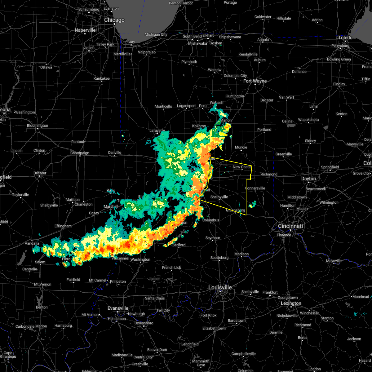 At 914 am edt, severe thunderstorms were located along a line extending from 7 miles southwest of anderson to 8 miles northwest of shelbyville, moving east at 55 mph (radar indicated). Hazards include 70 mph wind gusts. Expect considerable tree damage. damage is likely to mobile homes, roofs, and outbuildings. severe thunderstorms will be near, shelbyville, markleville and wilkinson around 925 am edt. shirley, kennard, cadiz, manilla and waldron around 930 am edt. other locations in the path of these severe thunderstorms include st. paul, spiceland, sulphur springs, mount summit, greensboro, moscow, new castle, lewisville, milroy, dunreith, sandusky, straughn, new salem, clarksburg and lake santee. this includes the following highways, interstate 65 between mile markers 91 and 98. interstate 69 between mile markers 210 and 226. interstate 70 between mile markers 94 and 133. interstate 74 between mile markers 99 and 131, between mile markers 133 and 138, and between mile markers 143 and 144. thunderstorm damage threat, considerable hail threat, radar indicated max hail size, <. 75 in wind threat, radar indicated max wind gust, 70 mph. At 914 am edt, severe thunderstorms were located along a line extending from 7 miles southwest of anderson to 8 miles northwest of shelbyville, moving east at 55 mph (radar indicated). Hazards include 70 mph wind gusts. Expect considerable tree damage. damage is likely to mobile homes, roofs, and outbuildings. severe thunderstorms will be near, shelbyville, markleville and wilkinson around 925 am edt. shirley, kennard, cadiz, manilla and waldron around 930 am edt. other locations in the path of these severe thunderstorms include st. paul, spiceland, sulphur springs, mount summit, greensboro, moscow, new castle, lewisville, milroy, dunreith, sandusky, straughn, new salem, clarksburg and lake santee. this includes the following highways, interstate 65 between mile markers 91 and 98. interstate 69 between mile markers 210 and 226. interstate 70 between mile markers 94 and 133. interstate 74 between mile markers 99 and 131, between mile markers 133 and 138, and between mile markers 143 and 144. thunderstorm damage threat, considerable hail threat, radar indicated max hail size, <. 75 in wind threat, radar indicated max wind gust, 70 mph.
|
| 8/1/2022 9:04 AM EDT |
 At 904 am edt, a severe thunderstorm was located over carmel, or 15 miles north of indianapolis, moving east at 50 mph (radar indicated). Hazards include 60 mph wind gusts and nickel size hail. Expect damage to roofs, siding, and trees. this severe storm will be near, fishers and geist reservoir around 910 am edt. lawrence around 915 am edt. this includes the following highways, interstate 65 between mile markers 84 and 128. interstate 69 between mile markers 200 and 211. interstate 70 between mile markers 67 and 93. Interstate 74 between mile markers 70 and 100. At 904 am edt, a severe thunderstorm was located over carmel, or 15 miles north of indianapolis, moving east at 50 mph (radar indicated). Hazards include 60 mph wind gusts and nickel size hail. Expect damage to roofs, siding, and trees. this severe storm will be near, fishers and geist reservoir around 910 am edt. lawrence around 915 am edt. this includes the following highways, interstate 65 between mile markers 84 and 128. interstate 69 between mile markers 200 and 211. interstate 70 between mile markers 67 and 93. Interstate 74 between mile markers 70 and 100.
|
| 8/1/2022 8:55 AM EDT |
 At 854 am edt, a severe thunderstorm was located near zionsville, or 16 miles north of indianapolis, moving east at 50 mph (radar indicated). Hazards include 60 mph wind gusts and nickel size hail. Expect damage to roofs, siding, and trees. this severe storm will be near, meridian hills and williams creek around 900 am edt. carmel and westfield around 905 am edt. other locations in the path of this severe thunderstorm include fishers, noblesville, geist reservoir, castleton, indianapolis and lawrence. this includes the following highways, interstate 65 between mile markers 84 and 136. interstate 69 between mile markers 200 and 211. interstate 70 between mile markers 61 and 93. Interstate 74 between mile markers 63 and 100. At 854 am edt, a severe thunderstorm was located near zionsville, or 16 miles north of indianapolis, moving east at 50 mph (radar indicated). Hazards include 60 mph wind gusts and nickel size hail. Expect damage to roofs, siding, and trees. this severe storm will be near, meridian hills and williams creek around 900 am edt. carmel and westfield around 905 am edt. other locations in the path of this severe thunderstorm include fishers, noblesville, geist reservoir, castleton, indianapolis and lawrence. this includes the following highways, interstate 65 between mile markers 84 and 136. interstate 69 between mile markers 200 and 211. interstate 70 between mile markers 61 and 93. Interstate 74 between mile markers 63 and 100.
|
| 8/1/2022 8:45 AM EDT |
 At 844 am edt, a severe thunderstorm was located near lebanon, or 19 miles south of frankfort, moving east at 50 mph (radar indicated). Hazards include 60 mph wind gusts and nickel size hail. Expect damage to roofs, siding, and trees. this severe storm will be near, zionsville around 850 am edt. other locations in the path of this severe thunderstorm include carmel, westfield, meridian hills, williams creek, noblesville, castleton, indianapolis, fishers, geist reservoir and lawrence. this includes the following highways, interstate 65 between mile markers 84 and 147. interstate 69 between mile markers 200 and 211. interstate 70 between mile markers 57 and 93. Interstate 74 between mile markers 59 and 100. At 844 am edt, a severe thunderstorm was located near lebanon, or 19 miles south of frankfort, moving east at 50 mph (radar indicated). Hazards include 60 mph wind gusts and nickel size hail. Expect damage to roofs, siding, and trees. this severe storm will be near, zionsville around 850 am edt. other locations in the path of this severe thunderstorm include carmel, westfield, meridian hills, williams creek, noblesville, castleton, indianapolis, fishers, geist reservoir and lawrence. this includes the following highways, interstate 65 between mile markers 84 and 147. interstate 69 between mile markers 200 and 211. interstate 70 between mile markers 57 and 93. Interstate 74 between mile markers 59 and 100.
|
| 8/1/2022 8:35 AM EDT |
 At 834 am edt, a severe thunderstorm was located near brownsburg, or 18 miles west of indianapolis, moving east at 60 mph (radar indicated). Hazards include 60 mph wind gusts and nickel size hail. Expect damage to roofs, siding, and trees. this severe thunderstorm will be near, avon around 840 am edt. plainfield, speedway, clermont, eagle creek reservoir and indianapolis int`l airport around 845 am edt. meridian hills, rocky ripple, williams creek, wynnedale, spring hill, crows nest and north crows nest around 850 am edt. other locations in the path of this severe thunderstorm include beech grove, monument circle, indiana state fairgrounds, broad ripple, warren park and cumberland. this includes the following highways, interstate 65 between mile markers 84 and 147. interstate 69 between mile markers 200 and 211. interstate 70 between mile markers 57 and 93. interstate 74 between mile markers 59 and 100. hail threat, radar indicated max hail size, 0. 88 in wind threat, radar indicated max wind gust, 60 mph. At 834 am edt, a severe thunderstorm was located near brownsburg, or 18 miles west of indianapolis, moving east at 60 mph (radar indicated). Hazards include 60 mph wind gusts and nickel size hail. Expect damage to roofs, siding, and trees. this severe thunderstorm will be near, avon around 840 am edt. plainfield, speedway, clermont, eagle creek reservoir and indianapolis int`l airport around 845 am edt. meridian hills, rocky ripple, williams creek, wynnedale, spring hill, crows nest and north crows nest around 850 am edt. other locations in the path of this severe thunderstorm include beech grove, monument circle, indiana state fairgrounds, broad ripple, warren park and cumberland. this includes the following highways, interstate 65 between mile markers 84 and 147. interstate 69 between mile markers 200 and 211. interstate 70 between mile markers 57 and 93. interstate 74 between mile markers 59 and 100. hail threat, radar indicated max hail size, 0. 88 in wind threat, radar indicated max wind gust, 60 mph.
|
| 7/24/2022 6:57 PM EDT |
 The tornado warning for southwestern hamilton county will expire at 700 pm edt, the storm which prompted the warning has weakened below severe limits, and has exited the warned area. therefore, the warning will be allowed to expire. however gusty winds and heavy rain are still possible with this thunderstorm. The tornado warning for southwestern hamilton county will expire at 700 pm edt, the storm which prompted the warning has weakened below severe limits, and has exited the warned area. therefore, the warning will be allowed to expire. however gusty winds and heavy rain are still possible with this thunderstorm.
|
| 7/24/2022 6:46 PM EDT |
 At 645 pm edt, a severe thunderstorm capable of producing a tornado was located over carmel, or 13 miles north of indianapolis, moving east at 25 mph (weather spotters reported a funnel cloud). Hazards include tornado. Flying debris will be dangerous to those caught without shelter. mobile homes will be damaged or destroyed. damage to roofs, windows, and vehicles will occur. tree damage is likely. Locations impacted include, fishers. At 645 pm edt, a severe thunderstorm capable of producing a tornado was located over carmel, or 13 miles north of indianapolis, moving east at 25 mph (weather spotters reported a funnel cloud). Hazards include tornado. Flying debris will be dangerous to those caught without shelter. mobile homes will be damaged or destroyed. damage to roofs, windows, and vehicles will occur. tree damage is likely. Locations impacted include, fishers.
|
| 7/24/2022 6:40 PM EDT |
 At 640 pm edt, a severe thunderstorm capable of producing a tornado was located near carmel, or 13 miles north of indianapolis, moving east at 25 mph (weather spotters reported a funnel cloud). Hazards include tornado. Flying debris will be dangerous to those caught without shelter. mobile homes will be damaged or destroyed. damage to roofs, windows, and vehicles will occur. tree damage is likely. this dangerous storm will be near, carmel around 645 pm edt. Other locations in the path of this tornadic thunderstorm include fishers. At 640 pm edt, a severe thunderstorm capable of producing a tornado was located near carmel, or 13 miles north of indianapolis, moving east at 25 mph (weather spotters reported a funnel cloud). Hazards include tornado. Flying debris will be dangerous to those caught without shelter. mobile homes will be damaged or destroyed. damage to roofs, windows, and vehicles will occur. tree damage is likely. this dangerous storm will be near, carmel around 645 pm edt. Other locations in the path of this tornadic thunderstorm include fishers.
|
| 7/24/2022 6:32 PM EDT |
 At 632 pm edt, a severe thunderstorm capable of producing a tornado was located over zionsville, or 15 miles north of indianapolis, moving east at 25 mph (weather spotters reported funnel cloud). Hazards include tornado. Flying debris will be dangerous to those caught without shelter. mobile homes will be damaged or destroyed. damage to roofs, windows, and vehicles will occur. tree damage is likely. this dangerous storm will be near, carmel and westfield around 645 pm edt. Other locations in the path of this tornadic thunderstorm include fishers. At 632 pm edt, a severe thunderstorm capable of producing a tornado was located over zionsville, or 15 miles north of indianapolis, moving east at 25 mph (weather spotters reported funnel cloud). Hazards include tornado. Flying debris will be dangerous to those caught without shelter. mobile homes will be damaged or destroyed. damage to roofs, windows, and vehicles will occur. tree damage is likely. this dangerous storm will be near, carmel and westfield around 645 pm edt. Other locations in the path of this tornadic thunderstorm include fishers.
|
| 7/23/2022 10:21 AM EDT | Numerous reports of trees and power lines down across hamilton count in hamilton county IN, 2.3 miles SE of Noblesville, IN |
| 5/25/2022 5:48 PM EDT |
 At 548 pm edt, a severe thunderstorm was located 8 miles southwest of anderson, moving north at 40 mph (radar indicated). Hazards include 60 mph wind gusts. Expect damage to roofs, siding, and trees. this severe storm will be near, woodlawn heights, country club heights and river forest around 555 pm edt. this includes interstate 69 between mile markers 214 and 224. hail threat, radar indicated max hail size, <. 75 in wind threat, radar indicated max wind gust, 60 mph. At 548 pm edt, a severe thunderstorm was located 8 miles southwest of anderson, moving north at 40 mph (radar indicated). Hazards include 60 mph wind gusts. Expect damage to roofs, siding, and trees. this severe storm will be near, woodlawn heights, country club heights and river forest around 555 pm edt. this includes interstate 69 between mile markers 214 and 224. hail threat, radar indicated max hail size, <. 75 in wind threat, radar indicated max wind gust, 60 mph.
|
| 5/25/2022 5:36 PM EDT |
 At 536 pm edt, a severe thunderstorm was located 9 miles east of fishers, or 13 miles southwest of anderson, moving north at 40 mph (radar indicated). Hazards include 60 mph wind gusts. Expect damage to roofs, siding, and trees. this severe thunderstorm will be near, pendleton around 545 pm edt. lapel around 550 pm edt. edgewood, woodlawn heights and river forest around 555 pm edt. other locations in the path of this severe thunderstorm include country club heights. This includes interstate 69 between mile markers 209 and 225. At 536 pm edt, a severe thunderstorm was located 9 miles east of fishers, or 13 miles southwest of anderson, moving north at 40 mph (radar indicated). Hazards include 60 mph wind gusts. Expect damage to roofs, siding, and trees. this severe thunderstorm will be near, pendleton around 545 pm edt. lapel around 550 pm edt. edgewood, woodlawn heights and river forest around 555 pm edt. other locations in the path of this severe thunderstorm include country club heights. This includes interstate 69 between mile markers 209 and 225.
|
| 4/11/2022 11:03 AM EDT |
 At 1102 am edt, severe thunderstorms were located along a line extending from near speedway to near indianapolis to greenwood, moving northeast at 50 mph (radar indicated). Hazards include 60 mph wind gusts. a 59 mph wind gust was measured at indianapolis airport as these storms moved through. Expect damage to roofs, siding, and trees. these severe storms will be near, warren park around 1110 am edt. lawrence, cumberland and geist reservoir around 1115 am edt. other locations in the path of these severe thunderstorms include indianapolis, carmel, mccordsville, new palestine, castleton, fortville, spring lake, fishers, noblesville, greenfield, ingalls and pendleton. hail threat, radar indicated max hail size, <. 75 in wind threat, radar indicated max wind gust, 60 mph. At 1102 am edt, severe thunderstorms were located along a line extending from near speedway to near indianapolis to greenwood, moving northeast at 50 mph (radar indicated). Hazards include 60 mph wind gusts. a 59 mph wind gust was measured at indianapolis airport as these storms moved through. Expect damage to roofs, siding, and trees. these severe storms will be near, warren park around 1110 am edt. lawrence, cumberland and geist reservoir around 1115 am edt. other locations in the path of these severe thunderstorms include indianapolis, carmel, mccordsville, new palestine, castleton, fortville, spring lake, fishers, noblesville, greenfield, ingalls and pendleton. hail threat, radar indicated max hail size, <. 75 in wind threat, radar indicated max wind gust, 60 mph.
|
| 4/11/2022 10:55 AM EDT |
 At 1054 am edt, a severe thunderstorm was located near southport, or near indianapolis, moving northeast at 40 mph (radar indicated). Hazards include 60 mph wind gusts. Expect damage to roofs, siding, and trees. this severe thunderstorm will be near, southport and monument circle around 1100 am edt. beech grove, rocky ripple, wynnedale, spring hill and indiana state fairgrounds around 1105 am edt. warren park and broad ripple around 1110 am edt. other locations in the path of this severe thunderstorm include castleton, cumberland, new palestine, geist reservoir, indianapolis, lawrence, mccordsville, spring lake, greenfield, fortville and ingalls. hail threat, radar indicated max hail size, <. 75 in wind threat, radar indicated max wind gust, 60 mph. At 1054 am edt, a severe thunderstorm was located near southport, or near indianapolis, moving northeast at 40 mph (radar indicated). Hazards include 60 mph wind gusts. Expect damage to roofs, siding, and trees. this severe thunderstorm will be near, southport and monument circle around 1100 am edt. beech grove, rocky ripple, wynnedale, spring hill and indiana state fairgrounds around 1105 am edt. warren park and broad ripple around 1110 am edt. other locations in the path of this severe thunderstorm include castleton, cumberland, new palestine, geist reservoir, indianapolis, lawrence, mccordsville, spring lake, greenfield, fortville and ingalls. hail threat, radar indicated max hail size, <. 75 in wind threat, radar indicated max wind gust, 60 mph.
|
| 3/6/2022 3:24 AM EST |
 The tornado warning for southwestern madison and eastern hamilton counties will expire at 330 am est, the tornadic thunderstorm which prompted the warning has moved out of the warned area. therefore, the warning will be allowed to expire. a severe thunderstorm watch remains in effect until 500 am est for central indiana. The tornado warning for southwestern madison and eastern hamilton counties will expire at 330 am est, the tornadic thunderstorm which prompted the warning has moved out of the warned area. therefore, the warning will be allowed to expire. a severe thunderstorm watch remains in effect until 500 am est for central indiana.
|
| 3/6/2022 3:12 AM EST |
 The severe thunderstorm warning for northern hendricks, northwestern marion, southern boone, hamilton, southern tipton and northern putnam counties will expire at 315 am est, the storm which prompted the warning has weakened below severe limits, or has exited the warned area. therefore, the warning will be allowed to expire. a severe thunderstorm watch remains in effect until 500 am est for central and west central indiana. The severe thunderstorm warning for northern hendricks, northwestern marion, southern boone, hamilton, southern tipton and northern putnam counties will expire at 315 am est, the storm which prompted the warning has weakened below severe limits, or has exited the warned area. therefore, the warning will be allowed to expire. a severe thunderstorm watch remains in effect until 500 am est for central and west central indiana.
|
| 3/6/2022 3:07 AM EST |
 At 307 am est, a severe thunderstorm capable of producing a tornado was located near noblesville, or 11 miles west of anderson, moving east at 65 mph (radar indicated rotation). Hazards include tornado. Flying debris will be dangerous to those caught without shelter. mobile homes will be damaged or destroyed. damage to roofs, windows, and vehicles will occur. tree damage is likely. this dangerous storm will be near, lapel around 310 am est. pendleton and edgewood around 315 am est. anderson around 320 am est. This includes interstate 69 between mile markers 210 and 211, and between mile markers 219 and 220. At 307 am est, a severe thunderstorm capable of producing a tornado was located near noblesville, or 11 miles west of anderson, moving east at 65 mph (radar indicated rotation). Hazards include tornado. Flying debris will be dangerous to those caught without shelter. mobile homes will be damaged or destroyed. damage to roofs, windows, and vehicles will occur. tree damage is likely. this dangerous storm will be near, lapel around 310 am est. pendleton and edgewood around 315 am est. anderson around 320 am est. This includes interstate 69 between mile markers 210 and 211, and between mile markers 219 and 220.
|
| 3/6/2022 3:05 AM EST |
 At 304 am est, a severe thunderstorm was located 9 miles northeast of noblesville, or 9 miles west of anderson, moving east at 70 mph (radar indicated). Hazards include 60 mph wind gusts. Expect damage to roofs, siding, and trees. this severe thunderstorm will be near, edgewood, frankton and river forest around 310 am est. anderson, alexandria, country club heights and woodlawn heights around 315 am est. chesterfield and daleville around 320 am est. other locations in the path of this severe thunderstorm include yorktown, ball state university, muncie, parker city, selma and prairie creek reservoir. This includes interstate 69 between mile markers 205 and 252. At 304 am est, a severe thunderstorm was located 9 miles northeast of noblesville, or 9 miles west of anderson, moving east at 70 mph (radar indicated). Hazards include 60 mph wind gusts. Expect damage to roofs, siding, and trees. this severe thunderstorm will be near, edgewood, frankton and river forest around 310 am est. anderson, alexandria, country club heights and woodlawn heights around 315 am est. chesterfield and daleville around 320 am est. other locations in the path of this severe thunderstorm include yorktown, ball state university, muncie, parker city, selma and prairie creek reservoir. This includes interstate 69 between mile markers 205 and 252.
|
| 3/6/2022 3:02 AM EST |
 At 302 am est, a severe thunderstorm capable of producing a tornado was located over noblesville, or 17 miles west of anderson, moving east at 65 mph (radar indicated rotation). Hazards include tornado. Flying debris will be dangerous to those caught without shelter. mobile homes will be damaged or destroyed. damage to roofs, windows, and vehicles will occur. tree damage is likely. this dangerous storm will be near, lapel around 310 am est. other locations in the path of this tornadic thunderstorm include pendleton, edgewood and anderson. This includes interstate 69 near mile marker 210, and between mile markers 219 and 220. At 302 am est, a severe thunderstorm capable of producing a tornado was located over noblesville, or 17 miles west of anderson, moving east at 65 mph (radar indicated rotation). Hazards include tornado. Flying debris will be dangerous to those caught without shelter. mobile homes will be damaged or destroyed. damage to roofs, windows, and vehicles will occur. tree damage is likely. this dangerous storm will be near, lapel around 310 am est. other locations in the path of this tornadic thunderstorm include pendleton, edgewood and anderson. This includes interstate 69 near mile marker 210, and between mile markers 219 and 220.
|
| 3/6/2022 3:01 AM EST |
 At 301 am est, a severe thunderstorm was located over zionsville, or 16 miles northwest of indianapolis, moving northeast at 75 mph (radar indicated). Hazards include 70 mph wind gusts. Expect considerable tree damage. damage is likely to mobile homes, roofs, and outbuildings. locations impacted include, carmel, westfield, morse reservoir, fishers, noblesville, cicero and arcadia. this includes the following highways, interstate 65 between mile markers 123 and 136. interstate 69 between mile markers 205 and 210. interstate 74 between mile markers 52 and 68. thunderstorm damage threat, considerable hail threat, radar indicated max hail size, <. 75 in wind threat, radar indicated max wind gust, 70 mph. At 301 am est, a severe thunderstorm was located over zionsville, or 16 miles northwest of indianapolis, moving northeast at 75 mph (radar indicated). Hazards include 70 mph wind gusts. Expect considerable tree damage. damage is likely to mobile homes, roofs, and outbuildings. locations impacted include, carmel, westfield, morse reservoir, fishers, noblesville, cicero and arcadia. this includes the following highways, interstate 65 between mile markers 123 and 136. interstate 69 between mile markers 205 and 210. interstate 74 between mile markers 52 and 68. thunderstorm damage threat, considerable hail threat, radar indicated max hail size, <. 75 in wind threat, radar indicated max wind gust, 70 mph.
|
| 3/6/2022 2:54 AM EST |
 At 253 am est, a severe thunderstorm capable of producing a tornado was located near zionsville, or 18 miles north of indianapolis, moving east at 65 mph (radar indicated rotation). Hazards include tornado. Flying debris will be dangerous to those caught without shelter. mobile homes will be damaged or destroyed. damage to roofs, windows, and vehicles will occur. tree damage is likely. this dangerous storm will be near, morse reservoir around 300 am est. fishers, noblesville and cicero around 305 am est. lapel around 310 am est. other locations in the path of this tornadic thunderstorm include pendleton, edgewood and anderson. This includes interstate 69 between mile markers 210 and 211, and between mile markers 219 and 220. At 253 am est, a severe thunderstorm capable of producing a tornado was located near zionsville, or 18 miles north of indianapolis, moving east at 65 mph (radar indicated rotation). Hazards include tornado. Flying debris will be dangerous to those caught without shelter. mobile homes will be damaged or destroyed. damage to roofs, windows, and vehicles will occur. tree damage is likely. this dangerous storm will be near, morse reservoir around 300 am est. fishers, noblesville and cicero around 305 am est. lapel around 310 am est. other locations in the path of this tornadic thunderstorm include pendleton, edgewood and anderson. This includes interstate 69 between mile markers 210 and 211, and between mile markers 219 and 220.
|
| 3/6/2022 2:42 AM EST |
 At 241 am est, a severe thunderstorm was located 11 miles northwest of danville, or 17 miles southeast of crawfordsville, moving northeast at 75 mph (radar indicated). Hazards include 70 mph wind gusts. Expect considerable tree damage. damage is likely to mobile homes, roofs, and outbuildings. this severe thunderstorm will be near, jamestown around 245 am est. pittsboro and lizton around 250 am est. brownsburg around 255 am est. zionsville and whitestown around 300 am est. other locations in the path of this severe thunderstorm include meridian hills, williams creek, carmel, westfield, fishers, noblesville, cicero, arcadia and morse reservoir. this includes the following highways, interstate 65 between mile markers 123 and 152. interstate 69 between mile markers 205 and 210. interstate 74 between mile markers 44 and 68. thunderstorm damage threat, considerable hail threat, radar indicated max hail size, <. 75 in wind threat, radar indicated max wind gust, 70 mph. At 241 am est, a severe thunderstorm was located 11 miles northwest of danville, or 17 miles southeast of crawfordsville, moving northeast at 75 mph (radar indicated). Hazards include 70 mph wind gusts. Expect considerable tree damage. damage is likely to mobile homes, roofs, and outbuildings. this severe thunderstorm will be near, jamestown around 245 am est. pittsboro and lizton around 250 am est. brownsburg around 255 am est. zionsville and whitestown around 300 am est. other locations in the path of this severe thunderstorm include meridian hills, williams creek, carmel, westfield, fishers, noblesville, cicero, arcadia and morse reservoir. this includes the following highways, interstate 65 between mile markers 123 and 152. interstate 69 between mile markers 205 and 210. interstate 74 between mile markers 44 and 68. thunderstorm damage threat, considerable hail threat, radar indicated max hail size, <. 75 in wind threat, radar indicated max wind gust, 70 mph.
|
| 12/11/2021 2:36 AM EST | Noblesville near the music center relayed via twitte in hamilton county IN, 5 miles WNW of Noblesville, IN |
| 6/20/2021 7:58 PM EDT |
 The severe thunderstorm warning for northwestern marion, eastern boone and hamilton counties will expire at 800 pm edt, the storm which prompted the warning has weakened below severe limits, and no longer poses an immediate threat to life or property. therefore, the warning will be allowed to expire. however gusty winds of up to 40 mph are still possible with this thunderstorm. a severe thunderstorm watch remains in effect until 100 am edt for central indiana. The severe thunderstorm warning for northwestern marion, eastern boone and hamilton counties will expire at 800 pm edt, the storm which prompted the warning has weakened below severe limits, and no longer poses an immediate threat to life or property. therefore, the warning will be allowed to expire. however gusty winds of up to 40 mph are still possible with this thunderstorm. a severe thunderstorm watch remains in effect until 100 am edt for central indiana.
|
| 6/20/2021 7:49 PM EDT |
 At 747 pm edt, a severe thunderstorm was located 7 miles northwest of carmel, or 19 miles north of indianapolis, moving northeast at 30 mph (trained weather spotters. at 7:41 pm edt 1 inch hail was reported in northern marion county). Hazards include 60 mph wind gusts and quarter size hail. Hail damage to vehicles is expected. expect wind damage to roofs, siding, and trees. locations impacted include, morse reservoir and cicero. This includes interstate 65 near mile marker 128. At 747 pm edt, a severe thunderstorm was located 7 miles northwest of carmel, or 19 miles north of indianapolis, moving northeast at 30 mph (trained weather spotters. at 7:41 pm edt 1 inch hail was reported in northern marion county). Hazards include 60 mph wind gusts and quarter size hail. Hail damage to vehicles is expected. expect wind damage to roofs, siding, and trees. locations impacted include, morse reservoir and cicero. This includes interstate 65 near mile marker 128.
|
| 6/20/2021 7:35 PM EDT |
 At 734 pm edt, a severe thunderstorm was located over zionsville, or 13 miles north of indianapolis, moving northeast at 30 mph (radar indicated). Hazards include 60 mph wind gusts and quarter size hail. Hail damage to vehicles is expected. expect wind damage to roofs, siding, and trees. this severe thunderstorm will be near, carmel around 745 pm edt. other locations in the path of this severe thunderstorm include westfield, sheridan, noblesville, cicero and morse reservoir. This includes interstate 65 between mile markers 127 and 128. At 734 pm edt, a severe thunderstorm was located over zionsville, or 13 miles north of indianapolis, moving northeast at 30 mph (radar indicated). Hazards include 60 mph wind gusts and quarter size hail. Hail damage to vehicles is expected. expect wind damage to roofs, siding, and trees. this severe thunderstorm will be near, carmel around 745 pm edt. other locations in the path of this severe thunderstorm include westfield, sheridan, noblesville, cicero and morse reservoir. This includes interstate 65 between mile markers 127 and 128.
|
| 6/18/2021 6:42 PM EDT |
 At 642 pm edt, a severe thunderstorm was located near carmel, or 7 miles north of indianapolis, moving southeast at 45 mph (radar indicated). Hazards include 60 mph wind gusts and quarter size hail. Hail damage to vehicles is expected. expect wind damage to roofs, siding, and trees. this severe thunderstorm will be near, warren park and geist reservoir around 650 pm edt. lawrence and mccordsville around 655 pm edt. cumberland around 700 pm edt. other locations in the path of this severe thunderstorm include new palestine and spring lake. this includes the following highways, interstate 69 between mile markers 200 and 208. Interstate 70 between mile markers 87 and 101. At 642 pm edt, a severe thunderstorm was located near carmel, or 7 miles north of indianapolis, moving southeast at 45 mph (radar indicated). Hazards include 60 mph wind gusts and quarter size hail. Hail damage to vehicles is expected. expect wind damage to roofs, siding, and trees. this severe thunderstorm will be near, warren park and geist reservoir around 650 pm edt. lawrence and mccordsville around 655 pm edt. cumberland around 700 pm edt. other locations in the path of this severe thunderstorm include new palestine and spring lake. this includes the following highways, interstate 69 between mile markers 200 and 208. Interstate 70 between mile markers 87 and 101.
|
| 3/27/2021 10:56 PM EDT |
 At 1055 pm edt, a severe thunderstorm was located near noblesville, or 11 miles west of anderson, moving northeast at 45 mph (radar indicated). Hazards include 60 mph wind gusts and half dollar size hail. Hail damage to vehicles is expected. Expect wind damage to roofs, siding, and trees. At 1055 pm edt, a severe thunderstorm was located near noblesville, or 11 miles west of anderson, moving northeast at 45 mph (radar indicated). Hazards include 60 mph wind gusts and half dollar size hail. Hail damage to vehicles is expected. Expect wind damage to roofs, siding, and trees.
|
| 3/27/2021 10:49 PM EDT | Quarter sized hail reported 2.5 miles E of Noblesville, IN |
| 3/27/2021 10:41 PM EDT |
 A severe thunderstorm warning remains in effect until 1100 pm edt for hamilton county. at 1040 pm edt, severe thunderstorms were located along a line extending from 9 miles southwest of tipton to carmel, moving northeast at 45 mph. hazard. Ping pong ball size hail and 60 mph wind gusts. A severe thunderstorm warning remains in effect until 1100 pm edt for hamilton county. at 1040 pm edt, severe thunderstorms were located along a line extending from 9 miles southwest of tipton to carmel, moving northeast at 45 mph. hazard. Ping pong ball size hail and 60 mph wind gusts.
|
| 3/27/2021 10:26 PM EDT |
 At 1026 pm edt, severe thunderstorms were located along a line extending from 10 miles northeast of lebanon to zionsville, moving northeast at 45 mph (radar indicated). Hazards include 60 mph wind gusts and quarter size hail. Hail damage to vehicles is expected. Expect wind damage to roofs, siding, and trees. At 1026 pm edt, severe thunderstorms were located along a line extending from 10 miles northeast of lebanon to zionsville, moving northeast at 45 mph (radar indicated). Hazards include 60 mph wind gusts and quarter size hail. Hail damage to vehicles is expected. Expect wind damage to roofs, siding, and trees.
|
| 8/10/2020 7:46 PM EDT |
 At 746 pm edt, a severe thunderstorm was located over greenfield, or 17 miles east of indianapolis, moving east at 50 mph (radar indicated). Hazards include 60 mph wind gusts. Expect damage to roofs, siding, and trees. locations impacted include, indianapolis, carmel, fishers, lawrence, greenfield, beech grove, speedway, cumberland, mccordsville, pendleton, fortville, ingalls, new palestine, meridian hills, warren park, rocky ripple, markleville, wilkinson, williams creek and wynnedale. this includes the following highways, interstate 65 between mile markers 107 and 120. interstate 69 between mile markers 200 and 210. interstate 70 between mile markers 74 and 112. Interstate 74 between mile markers 73 and 96. At 746 pm edt, a severe thunderstorm was located over greenfield, or 17 miles east of indianapolis, moving east at 50 mph (radar indicated). Hazards include 60 mph wind gusts. Expect damage to roofs, siding, and trees. locations impacted include, indianapolis, carmel, fishers, lawrence, greenfield, beech grove, speedway, cumberland, mccordsville, pendleton, fortville, ingalls, new palestine, meridian hills, warren park, rocky ripple, markleville, wilkinson, williams creek and wynnedale. this includes the following highways, interstate 65 between mile markers 107 and 120. interstate 69 between mile markers 200 and 210. interstate 70 between mile markers 74 and 112. Interstate 74 between mile markers 73 and 96.
|
| 8/10/2020 7:43 PM EDT |
 The severe thunderstorm warning for madison, western delaware, northwestern henry and southeastern hamilton counties will expire at 745 pm edt, the storm which prompted the warning has weakened below severe limits, and has exited the warned area. therefore, the warning will be allowed to expire. a severe thunderstorm watch remains in effect until midnight edt for central and east central indiana. The severe thunderstorm warning for madison, western delaware, northwestern henry and southeastern hamilton counties will expire at 745 pm edt, the storm which prompted the warning has weakened below severe limits, and has exited the warned area. therefore, the warning will be allowed to expire. a severe thunderstorm watch remains in effect until midnight edt for central and east central indiana.
|
| 8/10/2020 7:36 PM EDT |
 At 735 pm edt, a severe thunderstorm was located near lawrence, or 10 miles east of indianapolis, moving east at 90 mph (radar indicated). Hazards include 70 mph wind gusts. Expect considerable tree damage. Damage is likely to mobile homes, roofs, and outbuildings. At 735 pm edt, a severe thunderstorm was located near lawrence, or 10 miles east of indianapolis, moving east at 90 mph (radar indicated). Hazards include 70 mph wind gusts. Expect considerable tree damage. Damage is likely to mobile homes, roofs, and outbuildings.
|
| 8/10/2020 7:19 PM EDT |
 The national weather service in indianapolis has issued a * severe thunderstorm warning for. madison county in central indiana. western delaware county in east central indiana. northwestern henry county in east central indiana. Southeastern hamilton county in central indiana. The national weather service in indianapolis has issued a * severe thunderstorm warning for. madison county in central indiana. western delaware county in east central indiana. northwestern henry county in east central indiana. Southeastern hamilton county in central indiana.
|
| 8/10/2020 7:15 PM EDT |
 At 715 pm edt, a severe thunderstorm was located 9 miles north of zionsville, or 18 miles southeast of frankfort, moving east at 15 mph (radar indicated). Hazards include 70 mph wind gusts. Expect considerable tree damage. damage is likely to mobile homes, roofs, and outbuildings. locations impacted include, indianapolis, carmel, fishers, noblesville, lawrence, plainfield, brownsburg, lebanon, beech grove, zionsville, speedway, danville, westfield, avon, cicero, pittsboro, whitestown, sheridan, arcadia and meridian hills. this includes the following highways, interstate 65 between mile markers 107 and 138. interstate 69 between mile markers 200 and 209. interstate 70 between mile markers 73 and 91. Interstate 74 between mile markers 59 and 94. At 715 pm edt, a severe thunderstorm was located 9 miles north of zionsville, or 18 miles southeast of frankfort, moving east at 15 mph (radar indicated). Hazards include 70 mph wind gusts. Expect considerable tree damage. damage is likely to mobile homes, roofs, and outbuildings. locations impacted include, indianapolis, carmel, fishers, noblesville, lawrence, plainfield, brownsburg, lebanon, beech grove, zionsville, speedway, danville, westfield, avon, cicero, pittsboro, whitestown, sheridan, arcadia and meridian hills. this includes the following highways, interstate 65 between mile markers 107 and 138. interstate 69 between mile markers 200 and 209. interstate 70 between mile markers 73 and 91. Interstate 74 between mile markers 59 and 94.
|
| 8/10/2020 7:04 PM EDT |
 At 703 pm edt, a severe thunderstorm was located 7 miles northeast of lebanon, or 15 miles southeast of frankfort, moving east at 45 mph (radar indicated). Hazards include 70 mph wind gusts. Expect considerable tree damage. Damage is likely to mobile homes, roofs, and outbuildings. At 703 pm edt, a severe thunderstorm was located 7 miles northeast of lebanon, or 15 miles southeast of frankfort, moving east at 45 mph (radar indicated). Hazards include 70 mph wind gusts. Expect considerable tree damage. Damage is likely to mobile homes, roofs, and outbuildings.
|
| 7/27/2020 4:27 PM EDT |
 The severe thunderstorm warning for western hancock, northeastern marion and southern hamilton counties will expire at 430 pm edt, the storm which prompted the warning has weakened below severe limits, and has exited the warned area. therefore, the warning will be allowed to expire. The severe thunderstorm warning for western hancock, northeastern marion and southern hamilton counties will expire at 430 pm edt, the storm which prompted the warning has weakened below severe limits, and has exited the warned area. therefore, the warning will be allowed to expire.
|
| 7/27/2020 4:13 PM EDT |
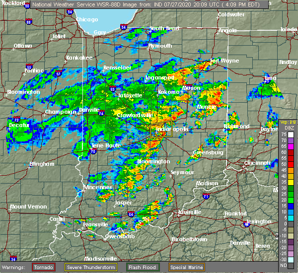 At 413 pm edt, a severe thunderstorm was located near lawrence, or 11 miles east of indianapolis, moving east at 40 mph (radar indicated). Hazards include 60 mph wind gusts. Expect damage to roofs, siding, and trees. locations impacted include, indianapolis, carmel, fishers, lawrence, beech grove, cumberland, mccordsville, fortville, new palestine, meridian hills, warren park, williams creek, spring lake, north crows nest, geist reservoir, castleton, indiana state fairgrounds and broad ripple. this includes the following highways, interstate 65 between mile markers 108 and 109. interstate 69 between mile markers 200 and 213. interstate 70 between mile markers 85 and 99. Interstate 74 between mile markers 93 and 95. At 413 pm edt, a severe thunderstorm was located near lawrence, or 11 miles east of indianapolis, moving east at 40 mph (radar indicated). Hazards include 60 mph wind gusts. Expect damage to roofs, siding, and trees. locations impacted include, indianapolis, carmel, fishers, lawrence, beech grove, cumberland, mccordsville, fortville, new palestine, meridian hills, warren park, williams creek, spring lake, north crows nest, geist reservoir, castleton, indiana state fairgrounds and broad ripple. this includes the following highways, interstate 65 between mile markers 108 and 109. interstate 69 between mile markers 200 and 213. interstate 70 between mile markers 85 and 99. Interstate 74 between mile markers 93 and 95.
|
| 7/27/2020 4:02 PM EDT |
 At 402 pm edt, a severe thunderstorm was located near lawrence, or near indianapolis, moving east at 40 mph (radar indicated). Hazards include 60 mph wind gusts. Expect damage to roofs, siding, and trees. locations impacted include, indianapolis, carmel, fishers, lawrence, beech grove, speedway, cumberland, mccordsville, fortville, new palestine, meridian hills, warren park, rocky ripple, williams creek, wynnedale, spring lake, spring hill, crows nest, north crows nest and geist reservoir. this includes the following highways, interstate 65 between mile markers 106 and 121. interstate 69 between mile markers 200 and 213. interstate 70 between mile markers 74 and 99. Interstate 74 between mile markers 93 and 96. At 402 pm edt, a severe thunderstorm was located near lawrence, or near indianapolis, moving east at 40 mph (radar indicated). Hazards include 60 mph wind gusts. Expect damage to roofs, siding, and trees. locations impacted include, indianapolis, carmel, fishers, lawrence, beech grove, speedway, cumberland, mccordsville, fortville, new palestine, meridian hills, warren park, rocky ripple, williams creek, wynnedale, spring lake, spring hill, crows nest, north crows nest and geist reservoir. this includes the following highways, interstate 65 between mile markers 106 and 121. interstate 69 between mile markers 200 and 213. interstate 70 between mile markers 74 and 99. Interstate 74 between mile markers 93 and 96.
|
| 7/27/2020 3:54 PM EDT |
 At 354 pm edt, a severe thunderstorm was located over indianapolis, moving east at 50 mph (radar indicated). Hazards include 60 mph wind gusts. expect damage to roofs, siding, and trees At 354 pm edt, a severe thunderstorm was located over indianapolis, moving east at 50 mph (radar indicated). Hazards include 60 mph wind gusts. expect damage to roofs, siding, and trees
|
| 7/11/2020 4:30 PM EDT | Tree damage around noblesville. a couple reports via twitte in hamilton county IN, 2.8 miles SSE of Noblesville, IN |
| 7/11/2020 4:25 PM EDT |
 The severe thunderstorm warning for southeastern clinton, northeastern boone, northern hamilton and southwestern tipton counties will expire at 430 pm edt, the storm which prompted the warning has weakened below severe limits, and no longer poses an immediate threat to life or property. therefore, the warning will be allowed to expire. The severe thunderstorm warning for southeastern clinton, northeastern boone, northern hamilton and southwestern tipton counties will expire at 430 pm edt, the storm which prompted the warning has weakened below severe limits, and no longer poses an immediate threat to life or property. therefore, the warning will be allowed to expire.
|
| 7/11/2020 4:13 PM EDT |
 At 413 pm edt, a severe thunderstorm was located 9 miles southeast of frankfort, moving southeast at 40 mph (radar indicated). Hazards include 60 mph wind gusts and penny size hail. Expect damage to roofs, siding, and trees. Locations impacted include, noblesville, westfield, cicero, sheridan, arcadia, kirklin, atlanta, kempton and morse reservoir. At 413 pm edt, a severe thunderstorm was located 9 miles southeast of frankfort, moving southeast at 40 mph (radar indicated). Hazards include 60 mph wind gusts and penny size hail. Expect damage to roofs, siding, and trees. Locations impacted include, noblesville, westfield, cicero, sheridan, arcadia, kirklin, atlanta, kempton and morse reservoir.
|
| 7/11/2020 4:01 PM EDT |
 At 401 pm edt, a severe thunderstorm was located near frankfort, moving southeast at 45 mph (radar indicated). Hazards include 60 mph wind gusts and penny size hail. expect damage to roofs, siding, and trees At 401 pm edt, a severe thunderstorm was located near frankfort, moving southeast at 45 mph (radar indicated). Hazards include 60 mph wind gusts and penny size hail. expect damage to roofs, siding, and trees
|
| 6/3/2020 7:41 PM EDT | Multiple trees down blocking the roa in hamilton county IN, 6.5 miles SE of Noblesville, IN |
| 6/3/2020 6:59 PM EDT |
 At 658 pm edt, a severe thunderstorm was located near lawrence, or 14 miles northeast of indianapolis, moving southeast at 25 mph. storm has a history of knocking trees and limbs down (public). Hazards include 60 mph wind gusts and penny size hail. expect damage to roofs, siding, and trees At 658 pm edt, a severe thunderstorm was located near lawrence, or 14 miles northeast of indianapolis, moving southeast at 25 mph. storm has a history of knocking trees and limbs down (public). Hazards include 60 mph wind gusts and penny size hail. expect damage to roofs, siding, and trees
|
| 6/3/2020 6:49 PM EDT |
 At 649 pm edt, a severe thunderstorm was located near fishers, or 13 miles southwest of anderson, moving southeast at 20 mph. numerous reports of trees down in the area (public). Hazards include 60 mph wind gusts and penny size hail. Expect damage to roofs, siding, and trees. locations impacted include, anderson, carmel, fishers, noblesville, lawrence, greenfield, westfield, mccordsville, pendleton, fortville, ingalls, lapel, edgewood and river forest. this includes the following highways, interstate 69 between mile markers 203 and 229. Interstate 70 between mile markers 98 and 102. At 649 pm edt, a severe thunderstorm was located near fishers, or 13 miles southwest of anderson, moving southeast at 20 mph. numerous reports of trees down in the area (public). Hazards include 60 mph wind gusts and penny size hail. Expect damage to roofs, siding, and trees. locations impacted include, anderson, carmel, fishers, noblesville, lawrence, greenfield, westfield, mccordsville, pendleton, fortville, ingalls, lapel, edgewood and river forest. this includes the following highways, interstate 69 between mile markers 203 and 229. Interstate 70 between mile markers 98 and 102.
|
| 6/3/2020 6:31 PM EDT |
 At 630 pm edt, a severe thunderstorm was located over noblesville, or 18 miles west of anderson, moving southeast at 20 mph. trees reported down in westfield (public). Hazards include 60 mph wind gusts and penny size hail. expect damage to roofs, siding, and trees At 630 pm edt, a severe thunderstorm was located over noblesville, or 18 miles west of anderson, moving southeast at 20 mph. trees reported down in westfield (public). Hazards include 60 mph wind gusts and penny size hail. expect damage to roofs, siding, and trees
|
| 6/3/2020 6:25 PM EDT | Corrects previous tstm wnd dmg report from 2 ssw morse reservoir. multiple trees down blocking the roa in hamilton county IN, 6.5 miles SE of Noblesville, IN |
| 4/8/2020 8:54 PM EDT |
 At 853 pm edt, a severe thunderstorm was located near greenfield, or 15 miles southwest of anderson, moving east at 55 mph. this is a very dangerous storm (trained weather spotters). Hazards include 80 mph wind gusts and quarter size hail. Flying debris will be dangerous to those caught without shelter. mobile homes will be heavily damaged. expect considerable damage to roofs, windows, and vehicles. Extensive tree damage and power outages are likely. At 853 pm edt, a severe thunderstorm was located near greenfield, or 15 miles southwest of anderson, moving east at 55 mph. this is a very dangerous storm (trained weather spotters). Hazards include 80 mph wind gusts and quarter size hail. Flying debris will be dangerous to those caught without shelter. mobile homes will be heavily damaged. expect considerable damage to roofs, windows, and vehicles. Extensive tree damage and power outages are likely.
|
| 4/8/2020 8:44 PM EDT |
 At 842 pm edt, a severe thunderstorm was located over fishers, or 12 miles northeast of indianapolis, moving east at 50 mph. this is a very dangerous storm. numerous reports of large hail and damaging winds have been received (public). Hazards include 80 mph wind gusts and half dollar size hail. Flying debris will be dangerous to those caught without shelter. mobile homes will be heavily damaged. expect considerable damage to roofs, windows, and vehicles. extensive tree damage and power outages are likely. locations impacted include, indianapolis, anderson, carmel, fishers, noblesville, lawrence, greenfield, zionsville, westfield, cumberland, cicero, mccordsville, pendleton, fortville, whitestown, sheridan, ingalls, lapel, new palestine and edgewood. this includes the following highways, interstate 65 between mile markers 123 and 134. interstate 69 between mile markers 200 and 221. Interstate 70 between mile markers 86 and 104. At 842 pm edt, a severe thunderstorm was located over fishers, or 12 miles northeast of indianapolis, moving east at 50 mph. this is a very dangerous storm. numerous reports of large hail and damaging winds have been received (public). Hazards include 80 mph wind gusts and half dollar size hail. Flying debris will be dangerous to those caught without shelter. mobile homes will be heavily damaged. expect considerable damage to roofs, windows, and vehicles. extensive tree damage and power outages are likely. locations impacted include, indianapolis, anderson, carmel, fishers, noblesville, lawrence, greenfield, zionsville, westfield, cumberland, cicero, mccordsville, pendleton, fortville, whitestown, sheridan, ingalls, lapel, new palestine and edgewood. this includes the following highways, interstate 65 between mile markers 123 and 134. interstate 69 between mile markers 200 and 221. Interstate 70 between mile markers 86 and 104.
|
| 4/8/2020 8:15 PM EDT |
 At 813 pm edt, a severe thunderstorm was located over lebanon, or 15 miles south of frankfort, moving east at 45 mph. quarter size hail was reported with this storm near thorntown. this storm may produce wind gusts up to 80 mph. this is a very dangerous storm (public). Hazards include 80 mph wind gusts and quarter size hail. Flying debris will be dangerous to those caught without shelter. mobile homes will be heavily damaged. expect considerable damage to roofs, windows, and vehicles. extensive tree damage and power outages are likely. locations impacted include, indianapolis, anderson, carmel, fishers, noblesville, lawrence, greenfield, lebanon, zionsville, westfield, cumberland, cicero, mccordsville, pendleton, fortville, whitestown, sheridan, ingalls, lapel and new palestine. this includes the following highways, interstate 65 between mile markers 123 and 152. interstate 69 between mile markers 200 and 221. Interstate 70 between mile markers 86 and 104. At 813 pm edt, a severe thunderstorm was located over lebanon, or 15 miles south of frankfort, moving east at 45 mph. quarter size hail was reported with this storm near thorntown. this storm may produce wind gusts up to 80 mph. this is a very dangerous storm (public). Hazards include 80 mph wind gusts and quarter size hail. Flying debris will be dangerous to those caught without shelter. mobile homes will be heavily damaged. expect considerable damage to roofs, windows, and vehicles. extensive tree damage and power outages are likely. locations impacted include, indianapolis, anderson, carmel, fishers, noblesville, lawrence, greenfield, lebanon, zionsville, westfield, cumberland, cicero, mccordsville, pendleton, fortville, whitestown, sheridan, ingalls, lapel and new palestine. this includes the following highways, interstate 65 between mile markers 123 and 152. interstate 69 between mile markers 200 and 221. Interstate 70 between mile markers 86 and 104.
|
| 4/8/2020 7:58 PM EDT |
 At 758 pm edt, a severe thunderstorm was located 11 miles northeast of crawfordsville, moving east at 60 mph. this is a very dangerous storm (radar indicated). Hazards include 80 mph wind gusts and quarter size hail. Flying debris will be dangerous to those caught without shelter. mobile homes will be heavily damaged. expect considerable damage to roofs, windows, and vehicles. Extensive tree damage and power outages are likely. At 758 pm edt, a severe thunderstorm was located 11 miles northeast of crawfordsville, moving east at 60 mph. this is a very dangerous storm (radar indicated). Hazards include 80 mph wind gusts and quarter size hail. Flying debris will be dangerous to those caught without shelter. mobile homes will be heavily damaged. expect considerable damage to roofs, windows, and vehicles. Extensive tree damage and power outages are likely.
|
| 3/28/2020 10:25 PM EDT |
 At 1024 pm edt, a severe thunderstorm was located near anderson, moving northeast at 55 mph (radar indicated). Hazards include 70 mph wind gusts. Expect considerable tree damage. Damage is likely to mobile homes, roofs, and outbuildings. At 1024 pm edt, a severe thunderstorm was located near anderson, moving northeast at 55 mph (radar indicated). Hazards include 70 mph wind gusts. Expect considerable tree damage. Damage is likely to mobile homes, roofs, and outbuildings.
|
| 3/28/2020 5:10 PM EDT |
 At 510 pm edt, a severe thunderstorm was located near noblesville, or 14 miles west of anderson, moving east at 50 mph. there are several storm cells within this warning (trained weather spotters). Hazards include quarter size hail. damage to vehicles is expected At 510 pm edt, a severe thunderstorm was located near noblesville, or 14 miles west of anderson, moving east at 50 mph. there are several storm cells within this warning (trained weather spotters). Hazards include quarter size hail. damage to vehicles is expected
|
| 3/28/2020 4:53 PM EDT |
 At 452 pm edt, a severe thunderstorm was located 7 miles northwest of anderson, moving northeast at 60 mph (trained weather spotters). Hazards include half dollar size hail. Damage to vehicles is expected. locations impacted include, anderson, carmel, fishers, noblesville, zionsville, elwood, alexandria, westfield, cicero, pendleton, sheridan, chesterfield, lapel, edgewood, frankton, arcadia, daleville, summitville, atlanta and orestes. this includes the following highways, interstate 65 between mile markers 128 and 129. Interstate 69 near mile marker 206, between mile markers 208 and 212, and between mile markers 220 and 243. At 452 pm edt, a severe thunderstorm was located 7 miles northwest of anderson, moving northeast at 60 mph (trained weather spotters). Hazards include half dollar size hail. Damage to vehicles is expected. locations impacted include, anderson, carmel, fishers, noblesville, zionsville, elwood, alexandria, westfield, cicero, pendleton, sheridan, chesterfield, lapel, edgewood, frankton, arcadia, daleville, summitville, atlanta and orestes. this includes the following highways, interstate 65 between mile markers 128 and 129. Interstate 69 near mile marker 206, between mile markers 208 and 212, and between mile markers 220 and 243.
|
| 3/28/2020 4:48 PM EDT | Ping Pong Ball sized hail reported 1.7 miles S of Noblesville, IN |
| 3/28/2020 4:42 PM EDT |
 At 441 pm edt, a severe thunderstorm was located over noblesville, or 16 miles west of anderson, moving northeast at 60 mph (trained weather spotters). Hazards include quarter size hail. damage to vehicles is expected At 441 pm edt, a severe thunderstorm was located over noblesville, or 16 miles west of anderson, moving northeast at 60 mph (trained weather spotters). Hazards include quarter size hail. damage to vehicles is expected
|
| 3/28/2020 4:21 PM EDT |
 At 420 pm edt, a severe thunderstorm was located near lebanon, or 16 miles southeast of frankfort, moving east at 55 mph. this storm has a history of producing half dollar size hail (trained weather spotters). Hazards include quarter size hail. damage to vehicles is expected At 420 pm edt, a severe thunderstorm was located near lebanon, or 16 miles southeast of frankfort, moving east at 55 mph. this storm has a history of producing half dollar size hail (trained weather spotters). Hazards include quarter size hail. damage to vehicles is expected
|
| 3/28/2020 2:46 PM EDT |
 At 245 pm edt, a severe thunderstorm was located near anderson, moving east at 60 mph (public). Hazards include quarter size hail. Damage to vehicles is expected. locations impacted include, anderson, fishers, pendleton, chesterfield, lapel, edgewood, daleville, country club heights, woodlawn heights and river forest. This includes interstate 69 between mile markers 210 and 242. At 245 pm edt, a severe thunderstorm was located near anderson, moving east at 60 mph (public). Hazards include quarter size hail. Damage to vehicles is expected. locations impacted include, anderson, fishers, pendleton, chesterfield, lapel, edgewood, daleville, country club heights, woodlawn heights and river forest. This includes interstate 69 between mile markers 210 and 242.
|
| 3/28/2020 2:32 PM EDT |
 At 232 pm edt, a severe thunderstorm was located over noblesville, or 17 miles north of indianapolis, moving east at 60 mph (public). Hazards include quarter size hail. damage to vehicles is expected At 232 pm edt, a severe thunderstorm was located over noblesville, or 17 miles north of indianapolis, moving east at 60 mph (public). Hazards include quarter size hail. damage to vehicles is expected
|
| 8/20/2019 2:46 PM EDT |
 At 223 pm edt, a severe thunderstorm was located near brownsburg, or 18 miles northwest of indianapolis, moving east at 40 mph (radar indicated). Hazards include 60 mph wind gusts and penny size hail. expect damage to roofs, siding, and trees At 223 pm edt, a severe thunderstorm was located near brownsburg, or 18 miles northwest of indianapolis, moving east at 40 mph (radar indicated). Hazards include 60 mph wind gusts and penny size hail. expect damage to roofs, siding, and trees
|
| 8/20/2019 2:23 PM EDT |
 At 223 pm edt, a severe thunderstorm was located near brownsburg, or 18 miles northwest of indianapolis, moving east at 40 mph (radar indicated). Hazards include 60 mph wind gusts and penny size hail. expect damage to roofs, siding, and trees At 223 pm edt, a severe thunderstorm was located near brownsburg, or 18 miles northwest of indianapolis, moving east at 40 mph (radar indicated). Hazards include 60 mph wind gusts and penny size hail. expect damage to roofs, siding, and trees
|
| 8/18/2019 7:52 PM EDT |
 At 751 pm edt, severe thunderstorms were located along a line extending from 8 miles west of anderson to near lawrence to 13 miles northwest of martinsville, moving east at 35 mph (radar indicated). Hazards include 60 mph wind gusts and quarter size hail. Hail damage to vehicles is expected. expect wind damage to roofs, siding, and trees. locations impacted include, indianapolis, anderson, carmel, fishers, noblesville, greenwood, lawrence, plainfield, greenfield, beech grove, speedway, greencastle, mooresville, danville, southport, westfield, avon, cumberland, cicero and mccordsville. those attending outdoor events across the indianapolis metro area are in the path of these storms and should prepare for dangerous weather conditions. seek shelter now! this includes the following highways, interstate 65 between mile markers 100 and 119. interstate 69 between mile markers 200 and 228. interstate 70 between mile markers 46 and 107. Interstate 74 between mile markers 72 and 100. At 751 pm edt, severe thunderstorms were located along a line extending from 8 miles west of anderson to near lawrence to 13 miles northwest of martinsville, moving east at 35 mph (radar indicated). Hazards include 60 mph wind gusts and quarter size hail. Hail damage to vehicles is expected. expect wind damage to roofs, siding, and trees. locations impacted include, indianapolis, anderson, carmel, fishers, noblesville, greenwood, lawrence, plainfield, greenfield, beech grove, speedway, greencastle, mooresville, danville, southport, westfield, avon, cumberland, cicero and mccordsville. those attending outdoor events across the indianapolis metro area are in the path of these storms and should prepare for dangerous weather conditions. seek shelter now! this includes the following highways, interstate 65 between mile markers 100 and 119. interstate 69 between mile markers 200 and 228. interstate 70 between mile markers 46 and 107. Interstate 74 between mile markers 72 and 100.
|
| 8/18/2019 7:24 PM EDT |
 At 722 pm edt, severe thunderstorms were located along a line extending from 6 miles northwest of noblesville to speedway to 9 miles east of brazil, moving east at 35 mph (radar indicated). Hazards include 60 mph wind gusts and quarter size hail. Hail damage to vehicles is expected. Expect wind damage to roofs, siding, and trees. At 722 pm edt, severe thunderstorms were located along a line extending from 6 miles northwest of noblesville to speedway to 9 miles east of brazil, moving east at 35 mph (radar indicated). Hazards include 60 mph wind gusts and quarter size hail. Hail damage to vehicles is expected. Expect wind damage to roofs, siding, and trees.
|
| 8/18/2019 7:10 PM EDT |
 At 708 pm edt, severe thunderstorms were located along a line extending from 13 miles northeast of lebanon to near brownsburg to near danville to 6 miles east of greencastle, moving east at 35 mph (radar indicated). Hazards include 60 mph wind gusts and quarter size hail. Hail damage to vehicles is expected. expect wind damage to roofs, siding, and trees. locations impacted include, indianapolis, carmel, fishers, noblesville, lawrence, plainfield, brownsburg, lebanon, beech grove, zionsville, speedway, greencastle, danville, rockville, westfield, avon, cicero, mccordsville, pittsboro and whitestown. those attending outdoor events in the indianapolis metro area are in the path of these storms and should prepare for dangerous weather conditions. seek shelter now! this includes the following highways, interstate 65 between mile markers 108 and 150. interstate 69 between mile markers 200 and 210. interstate 70 between mile markers 63 and 92. Interstate 74 between mile markers 42 and 73. At 708 pm edt, severe thunderstorms were located along a line extending from 13 miles northeast of lebanon to near brownsburg to near danville to 6 miles east of greencastle, moving east at 35 mph (radar indicated). Hazards include 60 mph wind gusts and quarter size hail. Hail damage to vehicles is expected. expect wind damage to roofs, siding, and trees. locations impacted include, indianapolis, carmel, fishers, noblesville, lawrence, plainfield, brownsburg, lebanon, beech grove, zionsville, speedway, greencastle, danville, rockville, westfield, avon, cicero, mccordsville, pittsboro and whitestown. those attending outdoor events in the indianapolis metro area are in the path of these storms and should prepare for dangerous weather conditions. seek shelter now! this includes the following highways, interstate 65 between mile markers 108 and 150. interstate 69 between mile markers 200 and 210. interstate 70 between mile markers 63 and 92. Interstate 74 between mile markers 42 and 73.
|
| 8/18/2019 6:55 PM EDT |
 At 655 pm edt, severe thunderstorms were located along a line extending from 9 miles southeast of frankfort to 6 miles northwest of brownsburg to near danville to greencastle, moving east at 40 mph (radar indicated). Hazards include 70 mph wind gusts and quarter size hail. Hail damage to vehicles is expected. expect considerable tree damage. wind damage is also likely to mobile homes, roofs, and outbuildings. locations impacted include, indianapolis, crawfordsville, carmel, fishers, noblesville, lawrence, plainfield, brownsburg, lebanon, beech grove, zionsville, speedway, greencastle, danville, clinton, rockville, westfield, avon, cicero and mccordsville. those attending outdoor events in the indianapolis metro area are in the path of these storms and should prepare for imminent dangerous weather conditions. seek shelter now! this includes the following highways, interstate 65 between mile markers 108 and 150. interstate 69 between mile markers 200 and 210. interstate 70 between mile markers 63 and 92. Interstate 74 between mile markers 32 and 73. At 655 pm edt, severe thunderstorms were located along a line extending from 9 miles southeast of frankfort to 6 miles northwest of brownsburg to near danville to greencastle, moving east at 40 mph (radar indicated). Hazards include 70 mph wind gusts and quarter size hail. Hail damage to vehicles is expected. expect considerable tree damage. wind damage is also likely to mobile homes, roofs, and outbuildings. locations impacted include, indianapolis, crawfordsville, carmel, fishers, noblesville, lawrence, plainfield, brownsburg, lebanon, beech grove, zionsville, speedway, greencastle, danville, clinton, rockville, westfield, avon, cicero and mccordsville. those attending outdoor events in the indianapolis metro area are in the path of these storms and should prepare for imminent dangerous weather conditions. seek shelter now! this includes the following highways, interstate 65 between mile markers 108 and 150. interstate 69 between mile markers 200 and 210. interstate 70 between mile markers 63 and 92. Interstate 74 between mile markers 32 and 73.
|
| 8/18/2019 6:35 PM EDT |
 At 634 pm edt, severe thunderstorms were located along a line extending from 10 miles northwest of lebanon to 12 miles southeast of crawfordsville to 6 miles southeast of rockville, moving east at 35 mph (radar indicated). Hazards include 70 mph wind gusts and quarter size hail. Hail damage to vehicles is expected. expect considerable tree damage. wind damage is also likely to mobile homes, roofs, and outbuildings. locations impacted include, indianapolis, crawfordsville, carmel, fishers, noblesville, lawrence, plainfield, brownsburg, lebanon, beech grove, zionsville, speedway, greencastle, danville, clinton, rockville, westfield, avon, cicero and mccordsville. those attending outdoor events in the indianapolis metro area are in the path of these storms and should prepare for imminent dangerous weather conditions. seek shelter now! this includes the following highways, interstate 65 between mile markers 108 and 150. interstate 69 between mile markers 200 and 210. interstate 70 between mile markers 63 and 92. Interstate 74 between mile markers 32 and 73. At 634 pm edt, severe thunderstorms were located along a line extending from 10 miles northwest of lebanon to 12 miles southeast of crawfordsville to 6 miles southeast of rockville, moving east at 35 mph (radar indicated). Hazards include 70 mph wind gusts and quarter size hail. Hail damage to vehicles is expected. expect considerable tree damage. wind damage is also likely to mobile homes, roofs, and outbuildings. locations impacted include, indianapolis, crawfordsville, carmel, fishers, noblesville, lawrence, plainfield, brownsburg, lebanon, beech grove, zionsville, speedway, greencastle, danville, clinton, rockville, westfield, avon, cicero and mccordsville. those attending outdoor events in the indianapolis metro area are in the path of these storms and should prepare for imminent dangerous weather conditions. seek shelter now! this includes the following highways, interstate 65 between mile markers 108 and 150. interstate 69 between mile markers 200 and 210. interstate 70 between mile markers 63 and 92. Interstate 74 between mile markers 32 and 73.
|
| 8/18/2019 6:13 PM EDT |
 At 612 pm edt, severe thunderstorms were located along a line extending from 7 miles north of crawfordsville to 15 miles northeast of rockville to near clinton, moving east at 35 mph. these are very dangerous storms (radar indicated). Hazards include 80 mph wind gusts and quarter size hail. Flying debris will be dangerous to those caught without shelter. mobile homes will be heavily damaged. expect considerable damage to roofs, windows, and vehicles. Extensive tree damage and power outages are likely. At 612 pm edt, severe thunderstorms were located along a line extending from 7 miles north of crawfordsville to 15 miles northeast of rockville to near clinton, moving east at 35 mph. these are very dangerous storms (radar indicated). Hazards include 80 mph wind gusts and quarter size hail. Flying debris will be dangerous to those caught without shelter. mobile homes will be heavily damaged. expect considerable damage to roofs, windows, and vehicles. Extensive tree damage and power outages are likely.
|
| 6/23/2019 4:41 PM EDT |
 At 421 pm edt, severe thunderstorms were located along a line extending from 7 miles west of anderson to 11 miles east of greenfield, moving northeast at 55 mph (radar indicated). Hazards include 60 mph wind gusts. Expect damage to roofs, siding, and trees. locations impacted include, muncie, anderson, fishers, noblesville, greenfield, new castle, alexandria, yorktown, mccordsville, pendleton, fortville, chesterfield, ingalls, lapel, edgewood, frankton, daleville, shirley, markleville and kennard. this includes the following highways, interstate 69 between mile markers 207 and 245. Interstate 70 between mile markers 101 and 120. At 421 pm edt, severe thunderstorms were located along a line extending from 7 miles west of anderson to 11 miles east of greenfield, moving northeast at 55 mph (radar indicated). Hazards include 60 mph wind gusts. Expect damage to roofs, siding, and trees. locations impacted include, muncie, anderson, fishers, noblesville, greenfield, new castle, alexandria, yorktown, mccordsville, pendleton, fortville, chesterfield, ingalls, lapel, edgewood, frankton, daleville, shirley, markleville and kennard. this includes the following highways, interstate 69 between mile markers 207 and 245. Interstate 70 between mile markers 101 and 120.
|
| 6/23/2019 4:21 PM EDT |
 At 421 pm edt, severe thunderstorms were located along a line extending from 7 miles west of anderson to 11 miles east of greenfield, moving northeast at 55 mph (radar indicated). Hazards include 60 mph wind gusts. Expect damage to roofs, siding, and trees. locations impacted include, muncie, anderson, fishers, noblesville, greenfield, new castle, alexandria, yorktown, mccordsville, pendleton, fortville, chesterfield, ingalls, lapel, edgewood, frankton, daleville, shirley, markleville and kennard. this includes the following highways, interstate 69 between mile markers 207 and 245. Interstate 70 between mile markers 101 and 120. At 421 pm edt, severe thunderstorms were located along a line extending from 7 miles west of anderson to 11 miles east of greenfield, moving northeast at 55 mph (radar indicated). Hazards include 60 mph wind gusts. Expect damage to roofs, siding, and trees. locations impacted include, muncie, anderson, fishers, noblesville, greenfield, new castle, alexandria, yorktown, mccordsville, pendleton, fortville, chesterfield, ingalls, lapel, edgewood, frankton, daleville, shirley, markleville and kennard. this includes the following highways, interstate 69 between mile markers 207 and 245. Interstate 70 between mile markers 101 and 120.
|
| 6/23/2019 4:04 PM EDT |
 At 404 pm edt, severe thunderstorms were located along a line extending from fishers to 7 miles north of shelbyville, moving northeast at 55 mph (radar indicated). Hazards include 60 mph wind gusts. expect damage to roofs, siding, and trees At 404 pm edt, severe thunderstorms were located along a line extending from fishers to 7 miles north of shelbyville, moving northeast at 55 mph (radar indicated). Hazards include 60 mph wind gusts. expect damage to roofs, siding, and trees
|
| 6/23/2019 3:58 PM EDT |
 At 357 pm edt, a severe thunderstorm was located 7 miles southeast of lawrence, or 10 miles east of indianapolis, moving northeast at 45 mph. a small pocket of stronger gusts is moving through eastern marion county (trained weather spotters). Hazards include 70 mph wind gusts. Expect considerable tree damage. damage is likely to mobile homes, roofs, and outbuildings. locations impacted include, indianapolis, fishers, lawrence, greenfield, cumberland, mccordsville, new palestine, meridian hills, warren park, rocky ripple, williams creek, spring lake, crows nest, north crows nest, geist reservoir, castleton, indiana state fairgrounds and broad ripple. this includes the following highways, interstate 69 between mile markers 200 and 209. interstate 70 between mile markers 85 and 104. Interstate 74 between mile markers 93 and 105. At 357 pm edt, a severe thunderstorm was located 7 miles southeast of lawrence, or 10 miles east of indianapolis, moving northeast at 45 mph. a small pocket of stronger gusts is moving through eastern marion county (trained weather spotters). Hazards include 70 mph wind gusts. Expect considerable tree damage. damage is likely to mobile homes, roofs, and outbuildings. locations impacted include, indianapolis, fishers, lawrence, greenfield, cumberland, mccordsville, new palestine, meridian hills, warren park, rocky ripple, williams creek, spring lake, crows nest, north crows nest, geist reservoir, castleton, indiana state fairgrounds and broad ripple. this includes the following highways, interstate 69 between mile markers 200 and 209. interstate 70 between mile markers 85 and 104. Interstate 74 between mile markers 93 and 105.
|
| 6/23/2019 3:44 PM EDT |
 A severe thunderstorm warning remains in effect until 415 pm edt for northwestern shelby. western hancock. northeastern johnson. marion and south central hamilton counties. at 343 pm edt, a severe thunderstorm was located over southport, or 7 miles south of indianapolis, moving northeast at 45 mph. The indianapolis airport had a measured gust of 49 mph with a spotter. A severe thunderstorm warning remains in effect until 415 pm edt for northwestern shelby. western hancock. northeastern johnson. marion and south central hamilton counties. at 343 pm edt, a severe thunderstorm was located over southport, or 7 miles south of indianapolis, moving northeast at 45 mph. The indianapolis airport had a measured gust of 49 mph with a spotter.
|
| 6/23/2019 3:26 PM EDT |
 At 325 pm edt, a severe thunderstorm was located near mooresville, or 18 miles southwest of indianapolis, moving northeast at 45 mph (radar indicated). Hazards include 60 mph wind gusts. expect damage to roofs, siding, and trees At 325 pm edt, a severe thunderstorm was located near mooresville, or 18 miles southwest of indianapolis, moving northeast at 45 mph (radar indicated). Hazards include 60 mph wind gusts. expect damage to roofs, siding, and trees
|
| 6/16/2019 2:57 AM EDT |
 The severe thunderstorm warning for clinton, boone, hamilton, southern tipton and eastern montgomery counties will expire at 300 am edt, the storm which prompted the warning has weakened below severe limits, and no longer poses an immediate threat to life or property. therefore, the warning will be allowed to expire. however gusty winds are still possible with this thunderstorm. The severe thunderstorm warning for clinton, boone, hamilton, southern tipton and eastern montgomery counties will expire at 300 am edt, the storm which prompted the warning has weakened below severe limits, and no longer poses an immediate threat to life or property. therefore, the warning will be allowed to expire. however gusty winds are still possible with this thunderstorm.
|
| 6/16/2019 2:37 AM EDT |
 At 237 am edt, a severe thunderstorm was located 9 miles west of lebanon, or 14 miles southwest of frankfort, moving east at 55 mph (radar indicated). Hazards include 60 mph wind gusts. expect damage to roofs, siding, and trees At 237 am edt, a severe thunderstorm was located 9 miles west of lebanon, or 14 miles southwest of frankfort, moving east at 55 mph (radar indicated). Hazards include 60 mph wind gusts. expect damage to roofs, siding, and trees
|
| 5/27/2019 8:08 PM EDT |
 At 807 pm edt, a severe thunderstorm capable of producing a tornado was located 7 miles east of noblesville, or 10 miles west of anderson, moving northeast at 30 mph (radar indicated rotation). Hazards include tornado and quarter size hail. Flying debris will be dangerous to those caught without shelter. mobile homes will be damaged or destroyed. damage to roofs, windows, and vehicles will occur. tree damage is likely. this dangerous storm will be near, edgewood and river forest around 825 pm edt. woodlawn heights around 830 pm edt. Anderson around 835 pm edt. At 807 pm edt, a severe thunderstorm capable of producing a tornado was located 7 miles east of noblesville, or 10 miles west of anderson, moving northeast at 30 mph (radar indicated rotation). Hazards include tornado and quarter size hail. Flying debris will be dangerous to those caught without shelter. mobile homes will be damaged or destroyed. damage to roofs, windows, and vehicles will occur. tree damage is likely. this dangerous storm will be near, edgewood and river forest around 825 pm edt. woodlawn heights around 830 pm edt. Anderson around 835 pm edt.
|
| 5/27/2019 7:56 PM EDT |
 At 756 pm edt, a severe thunderstorm was located near noblesville, or 12 miles west of anderson, moving east at 25 mph (radar indicated). Hazards include 60 mph wind gusts and quarter size hail. Hail damage to vehicles is expected. expect wind damage to roofs, siding, and trees. locations impacted include, anderson, noblesville, cicero, lapel, edgewood and river forest. This includes interstate 69 between mile markers 211 and 213. At 756 pm edt, a severe thunderstorm was located near noblesville, or 12 miles west of anderson, moving east at 25 mph (radar indicated). Hazards include 60 mph wind gusts and quarter size hail. Hail damage to vehicles is expected. expect wind damage to roofs, siding, and trees. locations impacted include, anderson, noblesville, cicero, lapel, edgewood and river forest. This includes interstate 69 between mile markers 211 and 213.
|
| 5/27/2019 7:49 PM EDT |
 At 749 pm edt, a severe thunderstorm was located near noblesville, or 14 miles west of anderson, moving east at 30 mph (radar indicated). Hazards include 60 mph wind gusts and quarter size hail. Hail damage to vehicles is expected. Expect wind damage to roofs, siding, and trees. At 749 pm edt, a severe thunderstorm was located near noblesville, or 14 miles west of anderson, moving east at 30 mph (radar indicated). Hazards include 60 mph wind gusts and quarter size hail. Hail damage to vehicles is expected. Expect wind damage to roofs, siding, and trees.
|
| 5/23/2019 5:41 AM EDT |
 The severe thunderstorm warning for madison, northeastern hancock, western delaware and eastern hamilton counties will expire at 545 am edt, the storms which prompted the warning have weakened below severe limits, and have exited the warned area. therefore, the warning will be allowed to expire. however gusty winds and heavy rain are still possible with these thunderstorms. a severe thunderstorm watch remains in effect until 1000 am edt for central and east central indiana. to report severe weather, contact your nearest law enforcement agency. they will relay your report to the national weather service indianapolis. The severe thunderstorm warning for madison, northeastern hancock, western delaware and eastern hamilton counties will expire at 545 am edt, the storms which prompted the warning have weakened below severe limits, and have exited the warned area. therefore, the warning will be allowed to expire. however gusty winds and heavy rain are still possible with these thunderstorms. a severe thunderstorm watch remains in effect until 1000 am edt for central and east central indiana. to report severe weather, contact your nearest law enforcement agency. they will relay your report to the national weather service indianapolis.
|
| 5/23/2019 5:26 AM EDT |
 At 524 am edt, severe thunderstorms were located along a line extending from near matthews to near fishers, moving east at 50 mph (radar indicated). Hazards include 60 mph wind gusts and penny size hail. Expect damage to roofs, siding, and trees. locations impacted include, muncie, anderson, carmel, fishers, noblesville, elwood, alexandria, yorktown, pendleton, fortville, chesterfield, ingalls, lapel, edgewood, frankton, eaton, daleville, summitville, gaston and markleville. This includes interstate 69 between mile markers 203 and 230, and between mile markers 232 and 252. At 524 am edt, severe thunderstorms were located along a line extending from near matthews to near fishers, moving east at 50 mph (radar indicated). Hazards include 60 mph wind gusts and penny size hail. Expect damage to roofs, siding, and trees. locations impacted include, muncie, anderson, carmel, fishers, noblesville, elwood, alexandria, yorktown, pendleton, fortville, chesterfield, ingalls, lapel, edgewood, frankton, eaton, daleville, summitville, gaston and markleville. This includes interstate 69 between mile markers 203 and 230, and between mile markers 232 and 252.
|
| 5/23/2019 4:51 AM EDT |
 At 450 am edt, severe thunderstorms were located along a line extending from 8 miles northeast of kokomo to 8 miles northwest of brownsburg, moving east at 55 mph (radar indicated). Hazards include 60 mph wind gusts and penny size hail. expect damage to roofs, siding, and trees At 450 am edt, severe thunderstorms were located along a line extending from 8 miles northeast of kokomo to 8 miles northwest of brownsburg, moving east at 55 mph (radar indicated). Hazards include 60 mph wind gusts and penny size hail. expect damage to roofs, siding, and trees
|
| 5/19/2019 7:11 PM EDT |
 At 711 pm edt, severe thunderstorms were located along a line extending from 7 miles northwest of anderson to near lawrence, moving east at 50 mph (radar indicated). Hazards include 60 mph wind gusts. Expect damage to roofs, siding, and trees. locations impacted include, indianapolis, muncie, anderson, fishers, noblesville, lawrence, greenfield, new castle, yorktown, cumberland, mccordsville, pendleton, fortville, chesterfield, ingalls, knightstown, lapel, edgewood, daleville and warren park. this includes the following highways, interstate 69 between mile markers 204 and 241. Interstate 70 between mile markers 88 and 126. At 711 pm edt, severe thunderstorms were located along a line extending from 7 miles northwest of anderson to near lawrence, moving east at 50 mph (radar indicated). Hazards include 60 mph wind gusts. Expect damage to roofs, siding, and trees. locations impacted include, indianapolis, muncie, anderson, fishers, noblesville, lawrence, greenfield, new castle, yorktown, cumberland, mccordsville, pendleton, fortville, chesterfield, ingalls, knightstown, lapel, edgewood, daleville and warren park. this includes the following highways, interstate 69 between mile markers 204 and 241. Interstate 70 between mile markers 88 and 126.
|
| 5/19/2019 6:56 PM EDT |
 The severe thunderstorm warning for northwestern shelby, western hancock, northeastern morgan, northern johnson, eastern hendricks, marion, southeastern boone and southern hamilton counties will expire at 700 pm edt, the storm which prompted the warning has moved out of the area. therefore, the warning will be allowed to expire. however gusty winds are still possible with this thunderstorm. a severe thunderstorm watch remains in effect until 1000 pm edt for central indiana. The severe thunderstorm warning for northwestern shelby, western hancock, northeastern morgan, northern johnson, eastern hendricks, marion, southeastern boone and southern hamilton counties will expire at 700 pm edt, the storm which prompted the warning has moved out of the area. therefore, the warning will be allowed to expire. however gusty winds are still possible with this thunderstorm. a severe thunderstorm watch remains in effect until 1000 pm edt for central indiana.
|
| 5/19/2019 6:54 PM EDT |
 At 654 pm edt, severe thunderstorms were located along a line extending from near noblesville to near speedway, moving east at 55 mph (radar indicated). Hazards include 60 mph wind gusts. expect damage to roofs, siding, and trees At 654 pm edt, severe thunderstorms were located along a line extending from near noblesville to near speedway, moving east at 55 mph (radar indicated). Hazards include 60 mph wind gusts. expect damage to roofs, siding, and trees
|
| 5/19/2019 6:36 PM EDT |
 At 635 pm edt, a severe thunderstorm was located near brownsburg, or 13 miles northwest of indianapolis, moving east at 45 mph. this storm has produced weak rotation north of brownsburg (radar indicated). Hazards include 60 mph wind gusts. expect damage to roofs, siding, and trees At 635 pm edt, a severe thunderstorm was located near brownsburg, or 13 miles northwest of indianapolis, moving east at 45 mph. this storm has produced weak rotation north of brownsburg (radar indicated). Hazards include 60 mph wind gusts. expect damage to roofs, siding, and trees
|
| 5/16/2019 5:15 PM EDT |
 At 514 pm edt, severe thunderstorms were located along a line extending from carmel to near brownsburg, moving southeast at 55 mph. this storm has a history of producing 55 mph winds (radar indicated). Hazards include 60 mph wind gusts. expect damage to roofs, siding, and trees At 514 pm edt, severe thunderstorms were located along a line extending from carmel to near brownsburg, moving southeast at 55 mph. this storm has a history of producing 55 mph winds (radar indicated). Hazards include 60 mph wind gusts. expect damage to roofs, siding, and trees
|
| 9/25/2018 11:28 AM EDT |
 At 1128 am edt, a severe thunderstorm was located 10 miles northeast of lebanon, or 10 miles southeast of frankfort, moving east at 35 mph (radar indicated). Hazards include 60 mph wind gusts. Expect damage to roofs, siding, and trees. Locations impacted include, frankfort, noblesville, lebanon, westfield, sheridan, kirklin, kempton and ulen. At 1128 am edt, a severe thunderstorm was located 10 miles northeast of lebanon, or 10 miles southeast of frankfort, moving east at 35 mph (radar indicated). Hazards include 60 mph wind gusts. Expect damage to roofs, siding, and trees. Locations impacted include, frankfort, noblesville, lebanon, westfield, sheridan, kirklin, kempton and ulen.
|
| 9/25/2018 11:13 AM EDT |
 At 1112 am edt, a severe thunderstorm was located 7 miles northwest of lebanon, or 9 miles south of frankfort, moving east at 25 mph (radar indicated). Hazards include 60 mph wind gusts. expect damage to roofs, siding, and trees At 1112 am edt, a severe thunderstorm was located 7 miles northwest of lebanon, or 9 miles south of frankfort, moving east at 25 mph (radar indicated). Hazards include 60 mph wind gusts. expect damage to roofs, siding, and trees
|
| 8/1/2017 4:06 PM EDT |
 At 406 pm edt, a severe thunderstorm was located over carmel, or 14 miles north of indianapolis, moving north at 10 mph (trained weather spotters). Hazards include quarter size hail. Damage to vehicles is expected. Locations impacted include, carmel and noblesville. At 406 pm edt, a severe thunderstorm was located over carmel, or 14 miles north of indianapolis, moving north at 10 mph (trained weather spotters). Hazards include quarter size hail. Damage to vehicles is expected. Locations impacted include, carmel and noblesville.
|
| 8/1/2017 3:52 PM EDT |
 At 351 pm edt, a severe thunderstorm was located over carmel, or 10 miles north of indianapolis, moving north at 15 mph (trained weather spotters). Hazards include quarter size hail. damage to vehicles is expected At 351 pm edt, a severe thunderstorm was located over carmel, or 10 miles north of indianapolis, moving north at 15 mph (trained weather spotters). Hazards include quarter size hail. damage to vehicles is expected
|
| 7/11/2017 12:56 PM EDT |
 The severe thunderstorm warning for northeastern morgan, northern johnson, eastern hendricks, marion, eastern boone and hamilton counties will expire at 100 pm edt, the storms which prompted the warning have weakened below severe limits, and have exited the warned area. therefore the warning will be allowed to expire. however gusty winds are still possible with these thunderstorms. The severe thunderstorm warning for northeastern morgan, northern johnson, eastern hendricks, marion, eastern boone and hamilton counties will expire at 100 pm edt, the storms which prompted the warning have weakened below severe limits, and have exited the warned area. therefore the warning will be allowed to expire. however gusty winds are still possible with these thunderstorms.
|
| 7/11/2017 12:40 PM EDT |
 At 1240 pm edt, severe thunderstorms were located along a line extending from 8 miles north of zionsville to near mooresville, moving east at 65 mph (radar indicated). Hazards include 60 mph wind gusts and penny size hail. Expect damage to roofs, siding, and trees. locations impacted include, indianapolis, carmel, fishers, noblesville, greenwood, lawrence, plainfield, brownsburg, lebanon, beech grove, zionsville, speedway, mooresville, danville, southport, westfield, avon, new whiteland, cumberland and cicero. this includes the following highways, interstate 65 between mile markers 94 and 138. interstate 69 between mile markers 200 and 210. interstate 70 between mile markers 57 and 93. Interstate 74 between mile markers 59 and 100. At 1240 pm edt, severe thunderstorms were located along a line extending from 8 miles north of zionsville to near mooresville, moving east at 65 mph (radar indicated). Hazards include 60 mph wind gusts and penny size hail. Expect damage to roofs, siding, and trees. locations impacted include, indianapolis, carmel, fishers, noblesville, greenwood, lawrence, plainfield, brownsburg, lebanon, beech grove, zionsville, speedway, mooresville, danville, southport, westfield, avon, new whiteland, cumberland and cicero. this includes the following highways, interstate 65 between mile markers 94 and 138. interstate 69 between mile markers 200 and 210. interstate 70 between mile markers 57 and 93. Interstate 74 between mile markers 59 and 100.
|
| 7/11/2017 12:31 PM EDT |
 At 1231 pm edt, severe thunderstorms were located along a line extending from near lebanon to 7 miles west of mooresville, moving east at 50 mph (radar indicated). Hazards include 60 mph wind gusts and penny size hail. expect damage to roofs, siding, and trees At 1231 pm edt, severe thunderstorms were located along a line extending from near lebanon to 7 miles west of mooresville, moving east at 50 mph (radar indicated). Hazards include 60 mph wind gusts and penny size hail. expect damage to roofs, siding, and trees
|
| 7/7/2017 4:56 PM EDT |
 The severe thunderstorm warning for southern madison, hancock, northeastern marion, henry and southern hamilton counties will expire at 500 pm edt, the storms which prompted the warning have weakened below severe limits, and no longer pose an immediate threat to life or property. therefore the warning will be allowed to expire. however gusty winds are still possible with these thunderstorms. a severe thunderstorm watch remains in effect until 900 pm edt for central and east central indiana. The severe thunderstorm warning for southern madison, hancock, northeastern marion, henry and southern hamilton counties will expire at 500 pm edt, the storms which prompted the warning have weakened below severe limits, and no longer pose an immediate threat to life or property. therefore the warning will be allowed to expire. however gusty winds are still possible with these thunderstorms. a severe thunderstorm watch remains in effect until 900 pm edt for central and east central indiana.
|
| 7/7/2017 4:39 PM EDT |
 At 439 pm edt, severe thunderstorms were located along a line extending from near muncie to 6 miles south of anderson to near carmel, moving southeast at 55 mph (radar indicated). Hazards include 60 mph wind gusts and quarter size hail. Hail damage to vehicles is expected. expect wind damage to roofs, siding, and trees. locations impacted include, indianapolis, anderson, carmel, fishers, noblesville, lawrence, greenfield, new castle, westfield, cumberland, mccordsville, pendleton, fortville, chesterfield, ingalls, knightstown, lapel, edgewood, daleville and spiceland. this includes the following highways, interstate 69 between mile markers 200 and 237. Interstate 70 between mile markers 94 and 133. At 439 pm edt, severe thunderstorms were located along a line extending from near muncie to 6 miles south of anderson to near carmel, moving southeast at 55 mph (radar indicated). Hazards include 60 mph wind gusts and quarter size hail. Hail damage to vehicles is expected. expect wind damage to roofs, siding, and trees. locations impacted include, indianapolis, anderson, carmel, fishers, noblesville, lawrence, greenfield, new castle, westfield, cumberland, mccordsville, pendleton, fortville, chesterfield, ingalls, knightstown, lapel, edgewood, daleville and spiceland. this includes the following highways, interstate 69 between mile markers 200 and 237. Interstate 70 between mile markers 94 and 133.
|
| 7/7/2017 4:28 PM EDT |
 At 427 pm edt, severe thunderstorms were located along a line extending from near alexandria to 7 miles east of noblesville to near zionsville, moving southeast at 55 mph (radar indicated). Hazards include 60 mph wind gusts and quarter size hail. Hail damage to vehicles is expected. Expect wind damage to roofs, siding, and trees. At 427 pm edt, severe thunderstorms were located along a line extending from near alexandria to 7 miles east of noblesville to near zionsville, moving southeast at 55 mph (radar indicated). Hazards include 60 mph wind gusts and quarter size hail. Hail damage to vehicles is expected. Expect wind damage to roofs, siding, and trees.
|
| 7/7/2017 4:20 PM EDT | Numerous trees and power poles downed along carrigan road near morse reservoi in hamilton county IN, 4.6 miles SSE of Noblesville, IN |
| 7/7/2017 4:12 PM EDT |
 At 411 pm edt, severe thunderstorms were located along a line extending from near muncie to near fishers, moving east at 45 mph (radar indicated). Hazards include 60 mph wind gusts and quarter size hail. Hail damage to vehicles is expected. expect wind damage to roofs, siding, and trees. locations impacted include, muncie, anderson, fishers, noblesville, yorktown, pendleton, fortville, chesterfield, ingalls, lapel, edgewood, daleville, markleville, sulphur springs, springport, woodlawn heights, country club heights, river forest and prairie creek reservoir. This includes interstate 69 between mile markers 209 and 240. At 411 pm edt, severe thunderstorms were located along a line extending from near muncie to near fishers, moving east at 45 mph (radar indicated). Hazards include 60 mph wind gusts and quarter size hail. Hail damage to vehicles is expected. expect wind damage to roofs, siding, and trees. locations impacted include, muncie, anderson, fishers, noblesville, yorktown, pendleton, fortville, chesterfield, ingalls, lapel, edgewood, daleville, markleville, sulphur springs, springport, woodlawn heights, country club heights, river forest and prairie creek reservoir. This includes interstate 69 between mile markers 209 and 240.
|
| 7/7/2017 4:10 PM EDT |
 At 410 pm edt, severe thunderstorms were located along a line extending from near windfall to 6 miles north of noblesville to 10 miles north of zionsville, moving southeast at 50 mph (radar indicated). Hazards include 60 mph wind gusts and quarter size hail. Hail damage to vehicles is expected. expect wind damage to roofs, siding, and trees. locations impacted include, carmel, fishers, noblesville, elwood, alexandria, tipton, windfall, westfield, cicero, sheridan, lapel, frankton, arcadia, kirklin, atlanta, orestes, kempton and morse reservoir. This includes interstate 65 between mile markers 148 and 153. At 410 pm edt, severe thunderstorms were located along a line extending from near windfall to 6 miles north of noblesville to 10 miles north of zionsville, moving southeast at 50 mph (radar indicated). Hazards include 60 mph wind gusts and quarter size hail. Hail damage to vehicles is expected. expect wind damage to roofs, siding, and trees. locations impacted include, carmel, fishers, noblesville, elwood, alexandria, tipton, windfall, westfield, cicero, sheridan, lapel, frankton, arcadia, kirklin, atlanta, orestes, kempton and morse reservoir. This includes interstate 65 between mile markers 148 and 153.
|
| 7/7/2017 3:59 PM EDT |
 The national weather service in indianapolis has issued a * severe thunderstorm warning for. northern madison county in central indiana. southern clinton county in central indiana. southeastern howard county in central indiana. Northeastern boone county in central indiana. The national weather service in indianapolis has issued a * severe thunderstorm warning for. northern madison county in central indiana. southern clinton county in central indiana. southeastern howard county in central indiana. Northeastern boone county in central indiana.
|
| 7/7/2017 3:56 PM EDT |
 At 356 pm edt, severe thunderstorms were located along a line extending from alexandria to near noblesville, moving east at 45 mph (radar indicated). Hazards include 60 mph wind gusts and quarter size hail. Hail damage to vehicles is expected. Expect wind damage to roofs, siding, and trees. At 356 pm edt, severe thunderstorms were located along a line extending from alexandria to near noblesville, moving east at 45 mph (radar indicated). Hazards include 60 mph wind gusts and quarter size hail. Hail damage to vehicles is expected. Expect wind damage to roofs, siding, and trees.
|
| 7/7/2017 3:50 PM EDT |
 At 331 pm edt, a severe thunderstorm was located near tipton, or 17 miles south of kokomo, moving southeast at 40 mph (radar indicated). Hazards include 60 mph wind gusts and quarter size hail. Hail damage to vehicles is expected. expect wind damage to roofs, siding, and trees. Locations impacted include, noblesville, tipton, windfall, cicero, sheridan, arcadia, russiaville, atlanta, sharpsville, kempton and morse reservoir. At 331 pm edt, a severe thunderstorm was located near tipton, or 17 miles south of kokomo, moving southeast at 40 mph (radar indicated). Hazards include 60 mph wind gusts and quarter size hail. Hail damage to vehicles is expected. expect wind damage to roofs, siding, and trees. Locations impacted include, noblesville, tipton, windfall, cicero, sheridan, arcadia, russiaville, atlanta, sharpsville, kempton and morse reservoir.
|
| 7/7/2017 3:31 PM EDT |
 At 331 pm edt, a severe thunderstorm was located near tipton, or 17 miles south of kokomo, moving southeast at 40 mph (radar indicated). Hazards include 60 mph wind gusts and quarter size hail. Hail damage to vehicles is expected. expect wind damage to roofs, siding, and trees. Locations impacted include, noblesville, tipton, windfall, cicero, sheridan, arcadia, russiaville, atlanta, sharpsville, kempton and morse reservoir. At 331 pm edt, a severe thunderstorm was located near tipton, or 17 miles south of kokomo, moving southeast at 40 mph (radar indicated). Hazards include 60 mph wind gusts and quarter size hail. Hail damage to vehicles is expected. expect wind damage to roofs, siding, and trees. Locations impacted include, noblesville, tipton, windfall, cicero, sheridan, arcadia, russiaville, atlanta, sharpsville, kempton and morse reservoir.
|
| 7/7/2017 3:10 PM EDT |
 At 309 pm edt, a severe thunderstorm was located 8 miles east of frankfort, moving southeast at 40 mph (radar indicated). Hazards include ping pong ball size hail and 60 mph wind gusts. People and animals outdoors will be injured. expect hail damage to roofs, siding, windows, and vehicles. Expect wind damage to roofs, siding, and trees. At 309 pm edt, a severe thunderstorm was located 8 miles east of frankfort, moving southeast at 40 mph (radar indicated). Hazards include ping pong ball size hail and 60 mph wind gusts. People and animals outdoors will be injured. expect hail damage to roofs, siding, windows, and vehicles. Expect wind damage to roofs, siding, and trees.
|
| 6/18/2017 1:10 AM EDT |
 The severe thunderstorm warning for southeastern clinton, northern boone, northwestern hamilton and western tipton counties will expire at 115 am edt, the storms which prompted the warning have weakened below severe limits, and no longer pose an immediate threat to life or property. therefore the warning will be allowed to expire. however gusty winds are still possible with these thunderstorms. a severe thunderstorm watch remains in effect until 700 am edt for central and west central indiana. The severe thunderstorm warning for southeastern clinton, northern boone, northwestern hamilton and western tipton counties will expire at 115 am edt, the storms which prompted the warning have weakened below severe limits, and no longer pose an immediate threat to life or property. therefore the warning will be allowed to expire. however gusty winds are still possible with these thunderstorms. a severe thunderstorm watch remains in effect until 700 am edt for central and west central indiana.
|
| 6/18/2017 1:01 AM EDT |
 At 100 am edt, severe thunderstorms were located along a line extending from 9 miles southwest of kokomo to 11 miles southeast of frankfort to near lebanon, moving east at 50 mph (radar indicated). Hazards include 60 mph wind gusts. Expect damage to roofs, siding, and trees. locations impacted include, frankfort, noblesville, tipton, westfield, cicero, sheridan, arcadia, thorntown, kirklin, atlanta, colfax, michigantown, kempton and morse reservoir. This includes interstate 65 between mile markers 145 and 154. At 100 am edt, severe thunderstorms were located along a line extending from 9 miles southwest of kokomo to 11 miles southeast of frankfort to near lebanon, moving east at 50 mph (radar indicated). Hazards include 60 mph wind gusts. Expect damage to roofs, siding, and trees. locations impacted include, frankfort, noblesville, tipton, westfield, cicero, sheridan, arcadia, thorntown, kirklin, atlanta, colfax, michigantown, kempton and morse reservoir. This includes interstate 65 between mile markers 145 and 154.
|
| 6/18/2017 12:42 AM EDT |
 At 1241 am edt, severe thunderstorms were located along a line extending from 15 miles southeast of delphi to 6 miles west of frankfort to 10 miles northeast of crawfordsville, moving east at 60 mph (radar indicated). Hazards include 60 mph wind gusts. expect damage to roofs, siding, and trees At 1241 am edt, severe thunderstorms were located along a line extending from 15 miles southeast of delphi to 6 miles west of frankfort to 10 miles northeast of crawfordsville, moving east at 60 mph (radar indicated). Hazards include 60 mph wind gusts. expect damage to roofs, siding, and trees
|
| 6/13/2017 2:06 PM EDT |
 A severe thunderstorm warning remains in effect until 215 pm edt for southwestern hamilton county. at 205 pm edt, a severe thunderstorm was located over carmel, or 14 miles north of indianapolis, moving northeast at 20 mph. hazard. 60 mph wind gusts and quarter size hail. source. Law enforcement. A severe thunderstorm warning remains in effect until 215 pm edt for southwestern hamilton county. at 205 pm edt, a severe thunderstorm was located over carmel, or 14 miles north of indianapolis, moving northeast at 20 mph. hazard. 60 mph wind gusts and quarter size hail. source. Law enforcement.
|
| 6/13/2017 1:51 PM EDT |
 At 150 pm edt, a severe thunderstorm was located over zionsville, or 13 miles northwest of indianapolis, moving east at 20 mph (law enforcement). Hazards include 60 mph wind gusts and quarter size hail. Hail damage to vehicles is expected. Expect wind damage to roofs, siding, and trees. At 150 pm edt, a severe thunderstorm was located over zionsville, or 13 miles northwest of indianapolis, moving east at 20 mph (law enforcement). Hazards include 60 mph wind gusts and quarter size hail. Hail damage to vehicles is expected. Expect wind damage to roofs, siding, and trees.
|
| 5/26/2017 9:22 PM EDT |
 The severe thunderstorm warning for southwestern madison, northwestern hancock, northeastern marion and southeastern hamilton counties will expire at 930 pm edt, the storm which prompted the warning has weakened below severe limits, and has exited the warned area. therefore, the warning will be allowed to expire. a severe thunderstorm watch remains in effect until 200 am edt for central indiana. The severe thunderstorm warning for southwestern madison, northwestern hancock, northeastern marion and southeastern hamilton counties will expire at 930 pm edt, the storm which prompted the warning has weakened below severe limits, and has exited the warned area. therefore, the warning will be allowed to expire. a severe thunderstorm watch remains in effect until 200 am edt for central indiana.
|
| 5/26/2017 9:18 PM EDT |
 At 917 pm edt, a severe thunderstorm was located 9 miles north of greenfield, or 12 miles southwest of anderson, moving east at 55 mph (radar indicated). Hazards include 60 mph wind gusts. Expect damage to roofs, siding, and trees. locations impacted include, indianapolis, anderson, fishers, lawrence, cumberland, mccordsville, fortville, lapel, edgewood and geist reservoir. this includes the following highways, interstate 69 between mile markers 212 and 215. Interstate 70 between mile markers 91 and 95. At 917 pm edt, a severe thunderstorm was located 9 miles north of greenfield, or 12 miles southwest of anderson, moving east at 55 mph (radar indicated). Hazards include 60 mph wind gusts. Expect damage to roofs, siding, and trees. locations impacted include, indianapolis, anderson, fishers, lawrence, cumberland, mccordsville, fortville, lapel, edgewood and geist reservoir. this includes the following highways, interstate 69 between mile markers 212 and 215. Interstate 70 between mile markers 91 and 95.
|
| 5/26/2017 9:08 PM EDT |
 At 907 pm edt, a severe thunderstorm was located near fishers, or 15 miles northeast of indianapolis, moving east at 55 mph (radar indicated). Hazards include 60 mph wind gusts. Expect damage to roofs, siding, and trees. locations impacted include, indianapolis, anderson, carmel, fishers, noblesville, lawrence, cumberland, cicero, mccordsville, fortville, lapel, edgewood, arcadia, meridian hills, rocky ripple, williams creek, spring hill, crows nest, north crows nest and geist reservoir. this includes the following highways, interstate 69 between mile markers 200 and 215. Interstate 70 between mile markers 90 and 95. At 907 pm edt, a severe thunderstorm was located near fishers, or 15 miles northeast of indianapolis, moving east at 55 mph (radar indicated). Hazards include 60 mph wind gusts. Expect damage to roofs, siding, and trees. locations impacted include, indianapolis, anderson, carmel, fishers, noblesville, lawrence, cumberland, cicero, mccordsville, fortville, lapel, edgewood, arcadia, meridian hills, rocky ripple, williams creek, spring hill, crows nest, north crows nest and geist reservoir. this includes the following highways, interstate 69 between mile markers 200 and 215. Interstate 70 between mile markers 90 and 95.
|
| 5/26/2017 8:57 PM EDT |
 At 856 pm edt, a severe thunderstorm was located over carmel, or 14 miles north of indianapolis, moving east at 55 mph (radar indicated). Hazards include 60 mph wind gusts. expect damage to roofs, siding, and trees At 856 pm edt, a severe thunderstorm was located over carmel, or 14 miles north of indianapolis, moving east at 55 mph (radar indicated). Hazards include 60 mph wind gusts. expect damage to roofs, siding, and trees
|
| 4/26/2017 7:42 PM EDT |
 At 742 pm edt, a severe thunderstorm was located near zionsville, or 14 miles north of indianapolis, moving northeast at 50 mph (radar indicated). Hazards include 60 mph wind gusts and penny size hail. Expect damage to roofs, siding, and trees. locations impacted include, indianapolis, carmel, fishers, noblesville, lawrence, lebanon, zionsville, westfield, cicero, fortville, whitestown, sheridan, arcadia, meridian hills, atlanta, williams creek, ulen, geist reservoir, castleton and morse reservoir. this includes the following highways, interstate 65 between mile markers 123 and 138. Interstate 69 between mile markers 200 and 213. At 742 pm edt, a severe thunderstorm was located near zionsville, or 14 miles north of indianapolis, moving northeast at 50 mph (radar indicated). Hazards include 60 mph wind gusts and penny size hail. Expect damage to roofs, siding, and trees. locations impacted include, indianapolis, carmel, fishers, noblesville, lawrence, lebanon, zionsville, westfield, cicero, fortville, whitestown, sheridan, arcadia, meridian hills, atlanta, williams creek, ulen, geist reservoir, castleton and morse reservoir. this includes the following highways, interstate 65 between mile markers 123 and 138. Interstate 69 between mile markers 200 and 213.
|
| 4/26/2017 7:25 PM EDT |
 At 725 pm edt, a severe thunderstorm was located over brownsburg, or 16 miles west of indianapolis, moving northeast at 50 mph (trained weather spotters). Hazards include 70 mph wind gusts and quarter size hail. Hail damage to vehicles is expected. expect considerable tree damage. Wind damage is also likely to mobile homes, roofs, and outbuildings. At 725 pm edt, a severe thunderstorm was located over brownsburg, or 16 miles west of indianapolis, moving northeast at 50 mph (trained weather spotters). Hazards include 70 mph wind gusts and quarter size hail. Hail damage to vehicles is expected. expect considerable tree damage. Wind damage is also likely to mobile homes, roofs, and outbuildings.
|
| 4/20/2017 5:03 PM EDT |
 At 503 pm edt, a severe thunderstorm capable of producing a tornado was located near noblesville, or 15 miles west of anderson, moving east at 35 mph (radar indicated rotation). Hazards include tornado. Flying debris will be dangerous to those caught without shelter. mobile homes will be damaged or destroyed. damage to roofs, windows, and vehicles will occur. tree damage is likely. this dangerous storm will be near, lapel around 515 pm edt. pendleton and edgewood around 525 pm edt. anderson, chesterfield, woodlawn heights, country club heights and river forest around 530 pm edt. This includes interstate 69 between mile markers 214 and 229. At 503 pm edt, a severe thunderstorm capable of producing a tornado was located near noblesville, or 15 miles west of anderson, moving east at 35 mph (radar indicated rotation). Hazards include tornado. Flying debris will be dangerous to those caught without shelter. mobile homes will be damaged or destroyed. damage to roofs, windows, and vehicles will occur. tree damage is likely. this dangerous storm will be near, lapel around 515 pm edt. pendleton and edgewood around 525 pm edt. anderson, chesterfield, woodlawn heights, country club heights and river forest around 530 pm edt. This includes interstate 69 between mile markers 214 and 229.
|
| 3/30/2017 6:54 PM EDT |
 At 653 pm edt, a severe thunderstorm was located over fishers, or 13 miles northeast of indianapolis, moving east at 40 mph (radar indicated). Hazards include 60 mph wind gusts. expect damage to roofs, siding, and trees At 653 pm edt, a severe thunderstorm was located over fishers, or 13 miles northeast of indianapolis, moving east at 40 mph (radar indicated). Hazards include 60 mph wind gusts. expect damage to roofs, siding, and trees
|
| 3/30/2017 4:43 PM EDT |
 At 442 pm edt, a severe thunderstorm was located 9 miles west of anderson, moving northeast at 30 mph (trained weather spotters reported penny size hail near fortville). Hazards include 60 mph wind gusts and penny size hail. Expect damage to roofs, siding, and trees. locations impacted include, anderson, fishers, noblesville, lapel, edgewood, frankton, country club heights, woodlawn heights and river forest. this includes interstate 69 between mile markers 207 and 216. A tornado watch remains in effect until 1000 pm edt for central indiana. At 442 pm edt, a severe thunderstorm was located 9 miles west of anderson, moving northeast at 30 mph (trained weather spotters reported penny size hail near fortville). Hazards include 60 mph wind gusts and penny size hail. Expect damage to roofs, siding, and trees. locations impacted include, anderson, fishers, noblesville, lapel, edgewood, frankton, country club heights, woodlawn heights and river forest. this includes interstate 69 between mile markers 207 and 216. A tornado watch remains in effect until 1000 pm edt for central indiana.
|
| 3/30/2017 4:29 PM EDT |
 At 428 pm edt, a severe thunderstorm was located near fishers, or 16 miles southwest of anderson, moving northeast at 45 mph (radar indicated). Hazards include 60 mph wind gusts and quarter size hail. Hail damage to vehicles is expected. Expect wind damage to roofs, siding, and trees. At 428 pm edt, a severe thunderstorm was located near fishers, or 16 miles southwest of anderson, moving northeast at 45 mph (radar indicated). Hazards include 60 mph wind gusts and quarter size hail. Hail damage to vehicles is expected. Expect wind damage to roofs, siding, and trees.
|
| 3/20/2017 4:35 PM EDT |
 At 434 pm edt, a severe thunderstorm was located over greenfield, or 17 miles east of indianapolis, moving southeast at 40 mph (trained weather spotters). Hazards include half dollar size hail. Damage to vehicles is expected. locations impacted include, indianapolis, carmel, fishers, noblesville, lawrence, greenfield, westfield, cumberland, mccordsville, fortville, new palestine, spring lake, geist reservoir and castleton. this includes the following highways, interstate 69 between mile markers 200 and 211. Interstate 70 between mile markers 91 and 109. At 434 pm edt, a severe thunderstorm was located over greenfield, or 17 miles east of indianapolis, moving southeast at 40 mph (trained weather spotters). Hazards include half dollar size hail. Damage to vehicles is expected. locations impacted include, indianapolis, carmel, fishers, noblesville, lawrence, greenfield, westfield, cumberland, mccordsville, fortville, new palestine, spring lake, geist reservoir and castleton. this includes the following highways, interstate 69 between mile markers 200 and 211. Interstate 70 between mile markers 91 and 109.
|
| 3/20/2017 4:18 PM EDT |
 At 417 pm edt, a severe thunderstorm was located over lawrence, or 9 miles northeast of indianapolis, moving southeast at 30 mph (radar indicated). Hazards include quarter size hail. Damage to vehicles is expected. locations impacted include, indianapolis, carmel, fishers, noblesville, lawrence, greenfield, zionsville, westfield, cumberland, mccordsville, pendleton, fortville, ingalls, new palestine, meridian hills, warren park, rocky ripple, williams creek, wynnedale and spring lake. this includes the following highways, interstate 65 between mile markers 115 and 127. interstate 69 between mile markers 200 and 220. interstate 70 between mile markers 83 and 109. Interstate 74 between mile markers 94 and 95. At 417 pm edt, a severe thunderstorm was located over lawrence, or 9 miles northeast of indianapolis, moving southeast at 30 mph (radar indicated). Hazards include quarter size hail. Damage to vehicles is expected. locations impacted include, indianapolis, carmel, fishers, noblesville, lawrence, greenfield, zionsville, westfield, cumberland, mccordsville, pendleton, fortville, ingalls, new palestine, meridian hills, warren park, rocky ripple, williams creek, wynnedale and spring lake. this includes the following highways, interstate 65 between mile markers 115 and 127. interstate 69 between mile markers 200 and 220. interstate 70 between mile markers 83 and 109. Interstate 74 between mile markers 94 and 95.
|
| 3/20/2017 4:00 PM EDT |
 At 359 pm edt, a severe thunderstorm was located near carmel, or 10 miles north of indianapolis, moving east at 50 mph (radar indicated). Hazards include quarter size hail. damage to vehicles is expected At 359 pm edt, a severe thunderstorm was located near carmel, or 10 miles north of indianapolis, moving east at 50 mph (radar indicated). Hazards include quarter size hail. damage to vehicles is expected
|
| 11/18/2016 6:30 PM EST |
 At 630 pm est, severe thunderstorms were located along a line extending from near elwood to 9 miles east of greenwood, moving east at 60 mph (radar indicated). Hazards include 60 mph wind gusts. Expect damage to roofs. siding. And trees. At 630 pm est, severe thunderstorms were located along a line extending from near elwood to 9 miles east of greenwood, moving east at 60 mph (radar indicated). Hazards include 60 mph wind gusts. Expect damage to roofs. siding. And trees.
|
| 11/18/2016 6:05 PM EST |
 At 605 pm est, severe thunderstorms were located along a line extending from 7 miles north of noblesville to near mooresville, moving northeast at 35 mph (radar indicated). Hazards include 70 mph wind gusts. Expect considerable tree damage. damage is likely to mobile homes, roofs, and outbuildings. locations impacted include, indianapolis, carmel, fishers, noblesville, greenwood, lawrence, plainfield, brownsburg, beech grove, zionsville, speedway, southport, westfield, avon, cumberland, cicero, mccordsville, sheridan, new palestine and arcadia. this includes the following highways, interstate 65 between mile markers 99 and 130. interstate 69 between mile markers 200 and 213. interstate 70 between mile markers 62 and 97. Interstate 74 between mile markers 67 and 100. At 605 pm est, severe thunderstorms were located along a line extending from 7 miles north of noblesville to near mooresville, moving northeast at 35 mph (radar indicated). Hazards include 70 mph wind gusts. Expect considerable tree damage. damage is likely to mobile homes, roofs, and outbuildings. locations impacted include, indianapolis, carmel, fishers, noblesville, greenwood, lawrence, plainfield, brownsburg, beech grove, zionsville, speedway, southport, westfield, avon, cumberland, cicero, mccordsville, sheridan, new palestine and arcadia. this includes the following highways, interstate 65 between mile markers 99 and 130. interstate 69 between mile markers 200 and 213. interstate 70 between mile markers 62 and 97. Interstate 74 between mile markers 67 and 100.
|
| 11/18/2016 5:41 PM EST |
 At 541 pm est, severe thunderstorms were located along a line extending from near lebanon to 7 miles west of mooresville, moving east at 60 mph (radar indicated). Hazards include 70 mph wind gusts. Expect considerable tree damage. Damage is likely to mobile homes, roofs, and outbuildings. At 541 pm est, severe thunderstorms were located along a line extending from near lebanon to 7 miles west of mooresville, moving east at 60 mph (radar indicated). Hazards include 70 mph wind gusts. Expect considerable tree damage. Damage is likely to mobile homes, roofs, and outbuildings.
|
| 8/28/2016 5:53 PM EDT |
 The severe thunderstorm warning for southeastern hamilton county will expire at 600 pm edt, the storm which prompted the warning has weakened below severe limits, and no longer poses an immediate threat to life or property. therefore, the warning will be allowed to expire. however heavy rain is still possible with this thunderstorm and a flash flood warning remains in effect for south central hamilton county. to report severe weather, contact your nearest law enforcement agency. they will relay your report to the national weather service indianapolis. The severe thunderstorm warning for southeastern hamilton county will expire at 600 pm edt, the storm which prompted the warning has weakened below severe limits, and no longer poses an immediate threat to life or property. therefore, the warning will be allowed to expire. however heavy rain is still possible with this thunderstorm and a flash flood warning remains in effect for south central hamilton county. to report severe weather, contact your nearest law enforcement agency. they will relay your report to the national weather service indianapolis.
|
| 8/28/2016 5:38 PM EDT |
 At 538 pm edt, a severe thunderstorm was located over noblesville, or 17 miles north of indianapolis, and is nearly stationary. this storm had weakened since 530 pm (radar indicated). Hazards include 60 mph wind gusts and nickel size hail. Expect damage to roofs. siding. and trees. Locations impacted include, carmel, fishers, noblesville and westfield. At 538 pm edt, a severe thunderstorm was located over noblesville, or 17 miles north of indianapolis, and is nearly stationary. this storm had weakened since 530 pm (radar indicated). Hazards include 60 mph wind gusts and nickel size hail. Expect damage to roofs. siding. and trees. Locations impacted include, carmel, fishers, noblesville and westfield.
|
| 8/28/2016 5:26 PM EDT |
 The national weather service in indianapolis has issued a * severe thunderstorm warning for. southern hamilton county in central indiana. until 600 pm edt * at 526 pm edt. a severe thunderstorm was located near noblesville. or 16 miles north of indianapolis. Moving. The national weather service in indianapolis has issued a * severe thunderstorm warning for. southern hamilton county in central indiana. until 600 pm edt * at 526 pm edt. a severe thunderstorm was located near noblesville. or 16 miles north of indianapolis. Moving.
|
| 7/13/2016 5:02 PM EDT |
 At 502 pm edt, severe thunderstorms were located along a line extending from 9 miles east of frankfort to 11 miles north of greencastle, moving northwest at 30 mph (radar indicated). Hazards include 60 mph wind gusts and nickel size hail. Expect damage to roofs. siding. and trees. locations impacted include, indianapolis, carmel, fishers, noblesville, lawrence, plainfield, brownsburg, beech grove, zionsville, speedway, danville, westfield, avon, cumberland, pittsboro, meridian hills, warren park, clermont, homecroft and rocky ripple. this includes the following highways, interstate 65 between mile markers 104 and 131. interstate 69 between mile markers 200 and 210. interstate 70 between mile markers 69 and 93. Interstate 74 between mile markers 57 and 99. At 502 pm edt, severe thunderstorms were located along a line extending from 9 miles east of frankfort to 11 miles north of greencastle, moving northwest at 30 mph (radar indicated). Hazards include 60 mph wind gusts and nickel size hail. Expect damage to roofs. siding. and trees. locations impacted include, indianapolis, carmel, fishers, noblesville, lawrence, plainfield, brownsburg, beech grove, zionsville, speedway, danville, westfield, avon, cumberland, pittsboro, meridian hills, warren park, clermont, homecroft and rocky ripple. this includes the following highways, interstate 65 between mile markers 104 and 131. interstate 69 between mile markers 200 and 210. interstate 70 between mile markers 69 and 93. Interstate 74 between mile markers 57 and 99.
|
| 7/13/2016 4:54 PM EDT |
 At 453 pm edt, severe thunderstorms were located along a line extending from 10 miles east of frankfort to 8 miles north of greencastle, moving east at 30 mph (radar indicated). Hazards include 60 mph wind gusts and nickel size hail. Expect damage to roofs. siding. and trees. locations impacted include, indianapolis, carmel, fishers, noblesville, lawrence, plainfield, brownsburg, beech grove, zionsville, speedway, danville, westfield, avon, cumberland, pittsboro, whitestown, meridian hills, warren park, clermont and clayton. this includes the following highways, interstate 65 between mile markers 104 and 135. interstate 69 between mile markers 200 and 210. interstate 70 between mile markers 69 and 93. Interstate 74 between mile markers 54 and 99. At 453 pm edt, severe thunderstorms were located along a line extending from 10 miles east of frankfort to 8 miles north of greencastle, moving east at 30 mph (radar indicated). Hazards include 60 mph wind gusts and nickel size hail. Expect damage to roofs. siding. and trees. locations impacted include, indianapolis, carmel, fishers, noblesville, lawrence, plainfield, brownsburg, beech grove, zionsville, speedway, danville, westfield, avon, cumberland, pittsboro, whitestown, meridian hills, warren park, clermont and clayton. this includes the following highways, interstate 65 between mile markers 104 and 135. interstate 69 between mile markers 200 and 210. interstate 70 between mile markers 69 and 93. Interstate 74 between mile markers 54 and 99.
|
| 7/13/2016 4:42 PM EDT |
 At 442 pm edt, severe thunderstorms were located along a line extending from 12 miles west of tipton to near greencastle, moving east at 30 mph (radar indicated). Hazards include 60 mph wind gusts and nickel size hail. Expect damage to roofs. siding. And trees. At 442 pm edt, severe thunderstorms were located along a line extending from 12 miles west of tipton to near greencastle, moving east at 30 mph (radar indicated). Hazards include 60 mph wind gusts and nickel size hail. Expect damage to roofs. siding. And trees.
|
| 7/13/2016 4:08 PM EDT |
 At 408 pm edt, a severe thunderstorm was located 9 miles southwest of tipton, or 19 miles east of frankfort, moving east at 30 mph (radar indicated). Hazards include 60 mph wind gusts and quarter size hail. Hail damage to vehicles is expected. Expect wind damage to roofs, siding, and trees. At 408 pm edt, a severe thunderstorm was located 9 miles southwest of tipton, or 19 miles east of frankfort, moving east at 30 mph (radar indicated). Hazards include 60 mph wind gusts and quarter size hail. Hail damage to vehicles is expected. Expect wind damage to roofs, siding, and trees.
|
| 7/13/2016 3:54 PM EDT |
 At 354 pm edt, a severe thunderstorm was located 9 miles northeast of lebanon, or 12 miles southeast of frankfort, moving northeast at 20 mph (radar indicated). Hazards include 60 mph wind gusts and quarter size hail. Hail damage to vehicles is expected. expect wind damage to roofs, siding, and trees. Locations impacted include, cicero, sheridan, kirklin, kempton and morse reservoir. At 354 pm edt, a severe thunderstorm was located 9 miles northeast of lebanon, or 12 miles southeast of frankfort, moving northeast at 20 mph (radar indicated). Hazards include 60 mph wind gusts and quarter size hail. Hail damage to vehicles is expected. expect wind damage to roofs, siding, and trees. Locations impacted include, cicero, sheridan, kirklin, kempton and morse reservoir.
|
| 7/13/2016 3:38 PM EDT |
 At 338 pm edt, a severe thunderstorm was located near lebanon, or 12 miles south of frankfort, moving northeast at 30 mph (radar indicated). Hazards include 60 mph wind gusts and quarter size hail. Hail damage to vehicles is expected. Expect wind damage to roofs, siding, and trees. At 338 pm edt, a severe thunderstorm was located near lebanon, or 12 miles south of frankfort, moving northeast at 30 mph (radar indicated). Hazards include 60 mph wind gusts and quarter size hail. Hail damage to vehicles is expected. Expect wind damage to roofs, siding, and trees.
|
| 6/23/2016 3:10 AM EDT |
 The severe thunderstorm warning for hamilton, northwestern hancock, southeastern boone, southern madison and northern marion counties will expire at 315 am edt, the storms which prompted the warning have weakened below severe limits, and no longer pose an immediate threat to life or property. therefore, the warning will be allowed to expire. however gusty winds and heavy rain are still possible with these thunderstorms. a tornado watch remains in effect until 500 am edt for central indiana. The severe thunderstorm warning for hamilton, northwestern hancock, southeastern boone, southern madison and northern marion counties will expire at 315 am edt, the storms which prompted the warning have weakened below severe limits, and no longer pose an immediate threat to life or property. therefore, the warning will be allowed to expire. however gusty winds and heavy rain are still possible with these thunderstorms. a tornado watch remains in effect until 500 am edt for central indiana.
|
| 6/23/2016 3:00 AM EDT |
 At 300 am edt, severe thunderstorms were located along a line extending from 8 miles east of fishers to near lawrence to near speedway, moving southeast at 45 mph (radar indicated). Hazards include 60 mph wind gusts and quarter size hail. Hail damage to vehicles is expected. expect wind damage to roofs, siding, and trees. locations impacted include, indianapolis, anderson, carmel, fishers, noblesville, lawrence, zionsville, westfield, cicero, mccordsville, pendleton, fortville, sheridan, ingalls, lapel, meridian hills, clermont, rocky ripple, williams creek and wynnedale. this includes the following highways, interstate 65 between mile markers 117 and 128. interstate 69 between mile markers 200 and 228. interstate 74 between mile markers 71 and 72. A tornado watch remains in effect until 500 am edt for central indiana. At 300 am edt, severe thunderstorms were located along a line extending from 8 miles east of fishers to near lawrence to near speedway, moving southeast at 45 mph (radar indicated). Hazards include 60 mph wind gusts and quarter size hail. Hail damage to vehicles is expected. expect wind damage to roofs, siding, and trees. locations impacted include, indianapolis, anderson, carmel, fishers, noblesville, lawrence, zionsville, westfield, cicero, mccordsville, pendleton, fortville, sheridan, ingalls, lapel, meridian hills, clermont, rocky ripple, williams creek and wynnedale. this includes the following highways, interstate 65 between mile markers 117 and 128. interstate 69 between mile markers 200 and 228. interstate 74 between mile markers 71 and 72. A tornado watch remains in effect until 500 am edt for central indiana.
|
| 6/23/2016 2:42 AM EDT |
 At 242 am edt, severe thunderstorms were located along a line extending from noblesville to near carmel to 6 miles south of lebanon, moving southeast at 45 mph (radar indicated). Hazards include 60 mph wind gusts and quarter size hail. Hail damage to vehicles is expected. Expect wind damage to roofs, siding, and trees. At 242 am edt, severe thunderstorms were located along a line extending from noblesville to near carmel to 6 miles south of lebanon, moving southeast at 45 mph (radar indicated). Hazards include 60 mph wind gusts and quarter size hail. Hail damage to vehicles is expected. Expect wind damage to roofs, siding, and trees.
|
| 6/23/2016 1:42 AM EDT |
 At 142 am edt, a severe thunderstorm was located 8 miles west of anderson, moving southeast at 55 mph (radar indicated). Hazards include 60 mph wind gusts and quarter size hail. Hail damage to vehicles is expected. expect wind damage to roofs, siding, and trees. locations impacted include, fishers, noblesville, elwood, tipton, westfield, cicero, fortville, sheridan, lapel, arcadia, atlanta and morse reservoir. this includes interstate 69 between mile markers 209 and 215. A tornado watch remains in effect until 500 am edt for central indiana. At 142 am edt, a severe thunderstorm was located 8 miles west of anderson, moving southeast at 55 mph (radar indicated). Hazards include 60 mph wind gusts and quarter size hail. Hail damage to vehicles is expected. expect wind damage to roofs, siding, and trees. locations impacted include, fishers, noblesville, elwood, tipton, westfield, cicero, fortville, sheridan, lapel, arcadia, atlanta and morse reservoir. this includes interstate 69 between mile markers 209 and 215. A tornado watch remains in effect until 500 am edt for central indiana.
|
| 6/23/2016 1:40 AM EDT |
 At 139 am edt, severe thunderstorms were located along a line extending from 9 miles southwest of muncie to 7 miles northeast of greenfield, moving southeast at 45 mph (radar indicated). Hazards include 60 mph wind gusts and quarter size hail. Hail damage to vehicles is expected. expect wind damage to roofs, siding, and trees. locations impacted include, anderson, noblesville, elwood, cicero, pendleton, chesterfield, ingalls, lapel, edgewood, frankton, arcadia, atlanta, markleville, wilkinson, woodlawn heights, country club heights and river forest. this includes the following highways, interstate 69 between mile markers 212 and 232. interstate 70 between mile markers 111 and 112. A tornado watch remains in effect until 500 am edt for central and east central indiana. At 139 am edt, severe thunderstorms were located along a line extending from 9 miles southwest of muncie to 7 miles northeast of greenfield, moving southeast at 45 mph (radar indicated). Hazards include 60 mph wind gusts and quarter size hail. Hail damage to vehicles is expected. expect wind damage to roofs, siding, and trees. locations impacted include, anderson, noblesville, elwood, cicero, pendleton, chesterfield, ingalls, lapel, edgewood, frankton, arcadia, atlanta, markleville, wilkinson, woodlawn heights, country club heights and river forest. this includes the following highways, interstate 69 between mile markers 212 and 232. interstate 70 between mile markers 111 and 112. A tornado watch remains in effect until 500 am edt for central and east central indiana.
|
| 6/23/2016 1:26 AM EDT |
 At 125 am edt, a severe thunderstorm was located 8 miles southwest of tipton, or 20 miles south of kokomo, moving southeast at 55 mph (radar indicated). Hazards include 70 mph wind gusts and quarter size hail. Hail damage to vehicles is expected. expect considerable tree damage. Wind damage is also likely to mobile homes, roofs, and outbuildings. At 125 am edt, a severe thunderstorm was located 8 miles southwest of tipton, or 20 miles south of kokomo, moving southeast at 55 mph (radar indicated). Hazards include 70 mph wind gusts and quarter size hail. Hail damage to vehicles is expected. expect considerable tree damage. Wind damage is also likely to mobile homes, roofs, and outbuildings.
|
| 6/23/2016 1:24 AM EDT |
 At 124 am edt, severe thunderstorms were located along a line extending from near anderson to 10 miles northeast of lawrence, moving southeast at 55 mph. these are very dangerous storms (radar indicated). Hazards include 80 mph wind gusts and quarter size hail. Flying debris will be dangerous to those caught without shelter. mobile homes will be heavily damaged. expect considerable damage to roofs, windows, and vehicles. extensive tree damage and power outages are likely. locations impacted include, anderson, fishers, noblesville, elwood, westfield, cicero, mccordsville, pendleton, fortville, chesterfield, ingalls, lapel, edgewood, frankton, arcadia, atlanta, markleville, wilkinson, woodlawn heights and country club heights. this includes the following highways, interstate 69 between mile markers 207 and 232. interstate 70 between mile markers 110 and 112. A tornado watch remains in effect until 500 am edt for central and east central indiana. At 124 am edt, severe thunderstorms were located along a line extending from near anderson to 10 miles northeast of lawrence, moving southeast at 55 mph. these are very dangerous storms (radar indicated). Hazards include 80 mph wind gusts and quarter size hail. Flying debris will be dangerous to those caught without shelter. mobile homes will be heavily damaged. expect considerable damage to roofs, windows, and vehicles. extensive tree damage and power outages are likely. locations impacted include, anderson, fishers, noblesville, elwood, westfield, cicero, mccordsville, pendleton, fortville, chesterfield, ingalls, lapel, edgewood, frankton, arcadia, atlanta, markleville, wilkinson, woodlawn heights and country club heights. this includes the following highways, interstate 69 between mile markers 207 and 232. interstate 70 between mile markers 110 and 112. A tornado watch remains in effect until 500 am edt for central and east central indiana.
|
| 6/23/2016 1:11 AM EDT |
 At 110 am edt, a severe thunderstorm was located 7 miles south of tipton, or 17 miles west of anderson, moving southeast at 40 mph. this is a very dangerous storm (radar indicated). Hazards include 80 mph wind gusts and quarter size hail. Flying debris will be dangerous to those caught without shelter. mobile homes will be heavily damaged. expect considerable damage to roofs, windows, and vehicles. Extensive tree damage and power outages are likely. At 110 am edt, a severe thunderstorm was located 7 miles south of tipton, or 17 miles west of anderson, moving southeast at 40 mph. this is a very dangerous storm (radar indicated). Hazards include 80 mph wind gusts and quarter size hail. Flying debris will be dangerous to those caught without shelter. mobile homes will be heavily damaged. expect considerable damage to roofs, windows, and vehicles. Extensive tree damage and power outages are likely.
|
| 6/23/2016 1:09 AM EDT |
 At 109 am edt, a severe thunderstorm was located 9 miles northeast of noblesville, or 13 miles west of anderson, moving southeast at 55 mph. this is a very dangerous storm (trained weather spotters). Hazards include 90 mph wind gusts and quarter size hail. You are in a life-threatening situation. flying debris may be deadly to those caught without shelter. mobile homes will be heavily damaged or destroyed. homes and businesses will have substantial roof and window damage. expect extensive tree damage and power outages. locations impacted include, fishers, noblesville, tipton, cicero, arcadia, russiaville, atlanta, michigantown, kempton and morse reservoir. this includes interstate 69 between mile markers 210 and 213. A tornado watch remains in effect until 500 am edt for central indiana. At 109 am edt, a severe thunderstorm was located 9 miles northeast of noblesville, or 13 miles west of anderson, moving southeast at 55 mph. this is a very dangerous storm (trained weather spotters). Hazards include 90 mph wind gusts and quarter size hail. You are in a life-threatening situation. flying debris may be deadly to those caught without shelter. mobile homes will be heavily damaged or destroyed. homes and businesses will have substantial roof and window damage. expect extensive tree damage and power outages. locations impacted include, fishers, noblesville, tipton, cicero, arcadia, russiaville, atlanta, michigantown, kempton and morse reservoir. this includes interstate 69 between mile markers 210 and 213. A tornado watch remains in effect until 500 am edt for central indiana.
|
| 6/23/2016 1:07 AM EDT |
 At 107 am edt, a severe thunderstorm was located near noblesville, or 20 miles north of indianapolis, moving southeast at 50 mph. this is a very dangerous storm (trained weather spotters). Hazards include 90 mph wind gusts and quarter size hail. You are in a life-threatening situation. flying debris may be deadly to those caught without shelter. mobile homes will be heavily damaged or destroyed. homes and businesses will have substantial roof and window damage. expect extensive tree damage and power outages. locations impacted include, frankfort, carmel, fishers, noblesville, lebanon, zionsville, westfield, cicero, whitestown, sheridan, kirklin, michigantown, kempton, ulen and morse reservoir. this includes the following highways, interstate 65 between mile markers 129 and 158. interstate 69 between mile markers 204 and 211. A tornado watch remains in effect until 500 am edt for central indiana. At 107 am edt, a severe thunderstorm was located near noblesville, or 20 miles north of indianapolis, moving southeast at 50 mph. this is a very dangerous storm (trained weather spotters). Hazards include 90 mph wind gusts and quarter size hail. You are in a life-threatening situation. flying debris may be deadly to those caught without shelter. mobile homes will be heavily damaged or destroyed. homes and businesses will have substantial roof and window damage. expect extensive tree damage and power outages. locations impacted include, frankfort, carmel, fishers, noblesville, lebanon, zionsville, westfield, cicero, whitestown, sheridan, kirklin, michigantown, kempton, ulen and morse reservoir. this includes the following highways, interstate 65 between mile markers 129 and 158. interstate 69 between mile markers 204 and 211. A tornado watch remains in effect until 500 am edt for central indiana.
|
| 6/23/2016 12:58 AM EDT |
 At 1258 am edt, a severe thunderstorm was located near tipton, or 16 miles south of kokomo, moving southeast at 60 mph. this is a very dangerous storm (trained weather spotters). Hazards include 90 mph wind gusts and quarter size hail. You are in a life-threatening situation. flying debris may be deadly to those caught without shelter. mobile homes will be heavily damaged or destroyed. homes and businesses will have substantial roof and window damage. expect extensive tree damage and power outages. locations impacted include, fishers, noblesville, tipton, cicero, arcadia, russiaville, atlanta, michigantown, kempton and morse reservoir. this includes interstate 69 between mile markers 210 and 213. A tornado watch remains in effect until 500 am edt for central indiana. At 1258 am edt, a severe thunderstorm was located near tipton, or 16 miles south of kokomo, moving southeast at 60 mph. this is a very dangerous storm (trained weather spotters). Hazards include 90 mph wind gusts and quarter size hail. You are in a life-threatening situation. flying debris may be deadly to those caught without shelter. mobile homes will be heavily damaged or destroyed. homes and businesses will have substantial roof and window damage. expect extensive tree damage and power outages. locations impacted include, fishers, noblesville, tipton, cicero, arcadia, russiaville, atlanta, michigantown, kempton and morse reservoir. this includes interstate 69 between mile markers 210 and 213. A tornado watch remains in effect until 500 am edt for central indiana.
|
| 6/23/2016 12:55 AM EDT |
 At 1254 am edt, a severe thunderstorm was located 12 miles northwest of noblesville, or 16 miles southeast of frankfort, moving southeast at 55 mph. this is a very dangerous storm (trained weather spotters). Hazards include 90 mph wind gusts and quarter size hail. You are in a life-threatening situation. flying debris may be deadly to those caught without shelter. mobile homes will be heavily damaged or destroyed. homes and businesses will have substantial roof and window damage. expect extensive tree damage and power outages. locations impacted include, frankfort, carmel, fishers, noblesville, lebanon, zionsville, westfield, cicero, whitestown, sheridan, kirklin, michigantown, kempton, ulen and morse reservoir. this includes the following highways, interstate 65 between mile markers 129 and 158. interstate 69 between mile markers 204 and 211. A tornado watch remains in effect until 500 am edt for central indiana. At 1254 am edt, a severe thunderstorm was located 12 miles northwest of noblesville, or 16 miles southeast of frankfort, moving southeast at 55 mph. this is a very dangerous storm (trained weather spotters). Hazards include 90 mph wind gusts and quarter size hail. You are in a life-threatening situation. flying debris may be deadly to those caught without shelter. mobile homes will be heavily damaged or destroyed. homes and businesses will have substantial roof and window damage. expect extensive tree damage and power outages. locations impacted include, frankfort, carmel, fishers, noblesville, lebanon, zionsville, westfield, cicero, whitestown, sheridan, kirklin, michigantown, kempton, ulen and morse reservoir. this includes the following highways, interstate 65 between mile markers 129 and 158. interstate 69 between mile markers 204 and 211. A tornado watch remains in effect until 500 am edt for central indiana.
|
| 6/23/2016 12:53 AM EDT |
 At 1252 am edt, a severe thunderstorm was located 12 miles east of frankfort, moving southeast at 50 mph. this is a very dangerous storm (radar indicated). Hazards include 90 mph wind gusts and quarter size hail. You are in a life-threatening situation. flying debris may be deadly to those caught without shelter. mobile homes will be heavily damaged or destroyed. homes and businesses will have substantial roof and window damage. Expect extensive tree damage and power outages. At 1252 am edt, a severe thunderstorm was located 12 miles east of frankfort, moving southeast at 50 mph. this is a very dangerous storm (radar indicated). Hazards include 90 mph wind gusts and quarter size hail. You are in a life-threatening situation. flying debris may be deadly to those caught without shelter. mobile homes will be heavily damaged or destroyed. homes and businesses will have substantial roof and window damage. Expect extensive tree damage and power outages.
|
| 6/23/2016 12:43 AM EDT |
 At 1242 am edt, a severe thunderstorm was located near frankfort, moving southeast at 55 mph. this is a very dangerous storm (radar indicated). Hazards include 90 mph wind gusts and quarter size hail. You are in a life-threatening situation. flying debris may be deadly to those caught without shelter. mobile homes will be heavily damaged or destroyed. homes and businesses will have substantial roof and window damage. Expect extensive tree damage and power outages. At 1242 am edt, a severe thunderstorm was located near frankfort, moving southeast at 55 mph. this is a very dangerous storm (radar indicated). Hazards include 90 mph wind gusts and quarter size hail. You are in a life-threatening situation. flying debris may be deadly to those caught without shelter. mobile homes will be heavily damaged or destroyed. homes and businesses will have substantial roof and window damage. Expect extensive tree damage and power outages.
|
| 6/21/2016 12:25 AM EDT |
 The severe thunderstorm warning for central hamilton and northeastern boone counties will expire at 1230 am edt, the storm which prompted the warning has weakened below severe limits, and no longer poses an immediate threat to life or property. therefore, the warning will be allowed to expire. The severe thunderstorm warning for central hamilton and northeastern boone counties will expire at 1230 am edt, the storm which prompted the warning has weakened below severe limits, and no longer poses an immediate threat to life or property. therefore, the warning will be allowed to expire.
|
| 6/21/2016 12:11 AM EDT |
 At 1211 am edt, a severe thunderstorm was located 10 miles west of noblesville, or 19 miles southeast of frankfort, moving southeast at 60 mph (radar indicated). Hazards include quarter size hail. Damage to vehicles is expected. locations impacted include, noblesville, lebanon, westfield, cicero, sheridan, ulen and morse reservoir. This includes interstate 65 between mile markers 137 and 140. At 1211 am edt, a severe thunderstorm was located 10 miles west of noblesville, or 19 miles southeast of frankfort, moving southeast at 60 mph (radar indicated). Hazards include quarter size hail. Damage to vehicles is expected. locations impacted include, noblesville, lebanon, westfield, cicero, sheridan, ulen and morse reservoir. This includes interstate 65 between mile markers 137 and 140.
|
| 6/20/2016 11:57 PM EDT |
 At 1157 pm edt, a severe thunderstorm was located 8 miles southeast of frankfort, moving east at 65 mph (radar indicated). Hazards include quarter size hail. damage to vehicles is expected At 1157 pm edt, a severe thunderstorm was located 8 miles southeast of frankfort, moving east at 65 mph (radar indicated). Hazards include quarter size hail. damage to vehicles is expected
|
| 6/20/2016 7:34 PM EDT | Tree down in hamilton county IN, 6.8 miles SSW of Noblesville, IN |
| 6/15/2016 4:37 PM EDT |
 At 437 pm edt, severe thunderstorms were located along a line extending from near carmel to near indianapolis, moving east at 25 mph (radar indicated). Hazards include 60 mph wind gusts and penny size hail. Expect damage to roofs. siding. and trees. locations impacted include, indianapolis, anderson, carmel, fishers, noblesville, lawrence, greenfield, zionsville, westfield, cumberland, mccordsville, pendleton, fortville, ingalls, lapel, new palestine, edgewood, meridian hills, warren park and rocky ripple. this includes the following highways, interstate 65 between mile markers 122 and 125. interstate 69 between mile markers 200 and 221. Interstate 70 between mile markers 85 and 104. At 437 pm edt, severe thunderstorms were located along a line extending from near carmel to near indianapolis, moving east at 25 mph (radar indicated). Hazards include 60 mph wind gusts and penny size hail. Expect damage to roofs. siding. and trees. locations impacted include, indianapolis, anderson, carmel, fishers, noblesville, lawrence, greenfield, zionsville, westfield, cumberland, mccordsville, pendleton, fortville, ingalls, lapel, new palestine, edgewood, meridian hills, warren park and rocky ripple. this includes the following highways, interstate 65 between mile markers 122 and 125. interstate 69 between mile markers 200 and 221. Interstate 70 between mile markers 85 and 104.
|
| 6/15/2016 4:35 PM EDT |
 At 435 pm edt, a severe thunderstorm was located near noblesville, or 18 miles north of indianapolis, moving east at 35 mph (radar indicated). Hazards include 60 mph wind gusts and penny size hail. Expect damage to roofs. siding. and trees. locations impacted include, carmel, fishers, noblesville, westfield, cicero, sheridan and morse reservoir. This includes interstate 69 between mile markers 206 and 207. At 435 pm edt, a severe thunderstorm was located near noblesville, or 18 miles north of indianapolis, moving east at 35 mph (radar indicated). Hazards include 60 mph wind gusts and penny size hail. Expect damage to roofs. siding. and trees. locations impacted include, carmel, fishers, noblesville, westfield, cicero, sheridan and morse reservoir. This includes interstate 69 between mile markers 206 and 207.
|
| 6/15/2016 4:23 PM EDT |
 At 423 pm edt, severe thunderstorms were located along a line extending from 6 miles north of zionsville to near speedway, moving east at 15 mph (radar indicated). Hazards include 60 mph wind gusts and penny size hail. Expect damage to roofs. siding. And trees. At 423 pm edt, severe thunderstorms were located along a line extending from 6 miles north of zionsville to near speedway, moving east at 15 mph (radar indicated). Hazards include 60 mph wind gusts and penny size hail. Expect damage to roofs. siding. And trees.
|
| 6/15/2016 4:12 PM EDT |
 At 412 pm edt, a severe thunderstorm was located 7 miles east of lebanon, or 17 miles southeast of frankfort, moving east at 35 mph (radar indicated). Hazards include 60 mph wind gusts and penny size hail. Expect damage to roofs. siding. And trees. At 412 pm edt, a severe thunderstorm was located 7 miles east of lebanon, or 17 miles southeast of frankfort, moving east at 35 mph (radar indicated). Hazards include 60 mph wind gusts and penny size hail. Expect damage to roofs. siding. And trees.
|
| 6/15/2016 3:50 PM EDT |
 At 350 pm edt, a severe thunderstorm was located over zionsville, or 14 miles northwest of indianapolis, moving east at 40 mph (radar indicated). Hazards include 60 mph wind gusts and penny size hail. Expect damage to roofs. siding. and trees. locations impacted include, indianapolis, carmel, fishers, noblesville, lawrence, zionsville, westfield, whitestown, meridian hills, williams creek, crows nest, north crows nest, castleton, broad ripple and geist reservoir. this includes the following highways, interstate 65 between mile markers 124 and 135. Interstate 69 between mile markers 200 and 207. At 350 pm edt, a severe thunderstorm was located over zionsville, or 14 miles northwest of indianapolis, moving east at 40 mph (radar indicated). Hazards include 60 mph wind gusts and penny size hail. Expect damage to roofs. siding. and trees. locations impacted include, indianapolis, carmel, fishers, noblesville, lawrence, zionsville, westfield, whitestown, meridian hills, williams creek, crows nest, north crows nest, castleton, broad ripple and geist reservoir. this includes the following highways, interstate 65 between mile markers 124 and 135. Interstate 69 between mile markers 200 and 207.
|
| 6/15/2016 3:38 PM EDT |
 At 338 pm edt, a severe thunderstorm was located near lebanon, or 20 miles northwest of indianapolis, moving east at 35 mph (radar indicated). Hazards include 60 mph wind gusts and penny size hail. Expect damage to roofs. siding. And trees. At 338 pm edt, a severe thunderstorm was located near lebanon, or 20 miles northwest of indianapolis, moving east at 35 mph (radar indicated). Hazards include 60 mph wind gusts and penny size hail. Expect damage to roofs. siding. And trees.
|
| 5/1/2016 10:05 PM EDT |
 At 1005 pm edt, a severe thunderstorm was located near elwood, or 12 miles northwest of anderson, moving east at 45 mph (radar indicated). Hazards include 60 mph wind gusts and quarter size hail. Hail damage to vehicles is expected. Expect wind damage to roofs, siding, and trees. At 1005 pm edt, a severe thunderstorm was located near elwood, or 12 miles northwest of anderson, moving east at 45 mph (radar indicated). Hazards include 60 mph wind gusts and quarter size hail. Hail damage to vehicles is expected. Expect wind damage to roofs, siding, and trees.
|
| 5/1/2016 9:57 PM EDT |
 At 957 pm edt, a severe thunderstorm was located near tipton, or 17 miles northwest of anderson, moving east at 35 mph (trained weather spotters). Hazards include golf ball size hail and 60 mph wind gusts. People and animals outdoors will be injured. expect hail damage to roofs, siding, windows, and vehicles. expect wind damage to roofs, siding, and trees. Locations impacted include, noblesville, tipton, windfall city, cicero, arcadia, atlanta, windfall and morse reservoir. At 957 pm edt, a severe thunderstorm was located near tipton, or 17 miles northwest of anderson, moving east at 35 mph (trained weather spotters). Hazards include golf ball size hail and 60 mph wind gusts. People and animals outdoors will be injured. expect hail damage to roofs, siding, windows, and vehicles. expect wind damage to roofs, siding, and trees. Locations impacted include, noblesville, tipton, windfall city, cicero, arcadia, atlanta, windfall and morse reservoir.
|
| 5/1/2016 9:54 PM EDT |
 At 953 pm edt, a severe thunderstorm was located near tipton, or 19 miles west of anderson, moving east at 35 mph (trained weather spotters). Hazards include golf ball size hail and 60 mph wind gusts. People and animals outdoors will be injured. expect hail damage to roofs, siding, windows, and vehicles. expect wind damage to roofs, siding, and trees. Locations impacted include, noblesville, tipton, windfall city, westfield, cicero, sheridan, arcadia, atlanta, kempton, windfall and morse reservoir. At 953 pm edt, a severe thunderstorm was located near tipton, or 19 miles west of anderson, moving east at 35 mph (trained weather spotters). Hazards include golf ball size hail and 60 mph wind gusts. People and animals outdoors will be injured. expect hail damage to roofs, siding, windows, and vehicles. expect wind damage to roofs, siding, and trees. Locations impacted include, noblesville, tipton, windfall city, westfield, cicero, sheridan, arcadia, atlanta, kempton, windfall and morse reservoir.
|
| 5/1/2016 9:51 PM EDT |
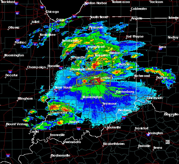 At 953 pm edt, a severe thunderstorm was located near tipton, or 19 miles west of anderson, moving east at 35 mph (trained weather spotters). Hazards include golf ball size hail and 60 mph wind gusts. People and animals outdoors will be injured. expect hail damage to roofs, siding, windows, and vehicles. expect wind damage to roofs, siding, and trees. Locations impacted include, noblesville, tipton, windfall city, westfield, cicero, sheridan, arcadia, atlanta, kempton, windfall and morse reservoir. At 953 pm edt, a severe thunderstorm was located near tipton, or 19 miles west of anderson, moving east at 35 mph (trained weather spotters). Hazards include golf ball size hail and 60 mph wind gusts. People and animals outdoors will be injured. expect hail damage to roofs, siding, windows, and vehicles. expect wind damage to roofs, siding, and trees. Locations impacted include, noblesville, tipton, windfall city, westfield, cicero, sheridan, arcadia, atlanta, kempton, windfall and morse reservoir.
|
| 5/1/2016 9:34 PM EDT |
 At 934 pm edt, a severe thunderstorm was located 13 miles northeast of lebanon, or 14 miles southeast of frankfort, moving east at 35 mph (law enforcement). Hazards include quarter size hail. Damage to vehicles is expected. Locations impacted include, noblesville, tipton, windfall city, westfield, cicero, sheridan, arcadia, kirklin, atlanta, kempton, windfall and morse reservoir. At 934 pm edt, a severe thunderstorm was located 13 miles northeast of lebanon, or 14 miles southeast of frankfort, moving east at 35 mph (law enforcement). Hazards include quarter size hail. Damage to vehicles is expected. Locations impacted include, noblesville, tipton, windfall city, westfield, cicero, sheridan, arcadia, kirklin, atlanta, kempton, windfall and morse reservoir.
|
| 5/1/2016 9:27 PM EDT |
 At 927 pm edt, a severe thunderstorm was located 10 miles southeast of frankfort, moving east at 35 mph (radar indicated). Hazards include quarter size hail. damage to vehicles is expected At 927 pm edt, a severe thunderstorm was located 10 miles southeast of frankfort, moving east at 35 mph (radar indicated). Hazards include quarter size hail. damage to vehicles is expected
|
| 4/21/2016 5:39 PM EDT |
 The severe thunderstorm warning for madison and hamilton counties will expire at 545 pm edt, the storm which prompted the warning has weakened below severe limits, and no longer pose an immediate threat to life or property. therefore the warning will be allowed to expire. The severe thunderstorm warning for madison and hamilton counties will expire at 545 pm edt, the storm which prompted the warning has weakened below severe limits, and no longer pose an immediate threat to life or property. therefore the warning will be allowed to expire.
|
| 4/21/2016 5:29 PM EDT |
 At 528 pm edt, a severe thunderstorm was located near elwood, or 12 miles northwest of anderson, moving northeast at 35 mph (radar indicated). Hazards include 60 mph wind gusts and quarter size hail. Hail damage to vehicles is expected. expect wind damage to roofs, siding, and trees. locations impacted include, anderson, carmel, fishers, noblesville, alexandria, westfield, cicero, pendleton, chesterfield, ingalls, lapel, edgewood, frankton, arcadia, atlanta, markleville, woodlawn heights, country club heights, river forest and morse reservoir. This includes interstate 69 between mile markers 204 and 230. At 528 pm edt, a severe thunderstorm was located near elwood, or 12 miles northwest of anderson, moving northeast at 35 mph (radar indicated). Hazards include 60 mph wind gusts and quarter size hail. Hail damage to vehicles is expected. expect wind damage to roofs, siding, and trees. locations impacted include, anderson, carmel, fishers, noblesville, alexandria, westfield, cicero, pendleton, chesterfield, ingalls, lapel, edgewood, frankton, arcadia, atlanta, markleville, woodlawn heights, country club heights, river forest and morse reservoir. This includes interstate 69 between mile markers 204 and 230.
|
| 4/21/2016 5:09 PM EDT |
 At 509 pm edt, a severe thunderstorm was located over noblesville, or 17 miles west of anderson, moving east at 40 mph (radar indicated). Hazards include 60 mph wind gusts and quarter size hail. Hail damage to vehicles is expected. Expect wind damage to roofs, siding, and trees. At 509 pm edt, a severe thunderstorm was located over noblesville, or 17 miles west of anderson, moving east at 40 mph (radar indicated). Hazards include 60 mph wind gusts and quarter size hail. Hail damage to vehicles is expected. Expect wind damage to roofs, siding, and trees.
|
| 3/27/2016 8:39 PM EDT |
 At 839 pm edt, severe thunderstorms were located along a line extending from near lawrence to 9 miles east of greenwood, moving northeast at 45 mph (radar indicated). Hazards include ping pong ball size hail. People and animals outdoors will be injured. Expect damage to roofs, siding, windows, and vehicles. At 839 pm edt, severe thunderstorms were located along a line extending from near lawrence to 9 miles east of greenwood, moving northeast at 45 mph (radar indicated). Hazards include ping pong ball size hail. People and animals outdoors will be injured. Expect damage to roofs, siding, windows, and vehicles.
|
| 3/27/2016 5:51 PM EDT |
 At 551 pm edt, a severe thunderstorm was located near fishers, or 16 miles west of anderson, moving northeast at 40 mph (radar indicated). Hazards include quarter size hail. Damage to vehicles is expected. locations impacted include, anderson, fishers, noblesville, elwood, pendleton, lapel, edgewood, frankton, woodlawn heights, country club heights and river forest. This includes interstate 69 between mile markers 203 and 216, and between mile markers 220 and 221. At 551 pm edt, a severe thunderstorm was located near fishers, or 16 miles west of anderson, moving northeast at 40 mph (radar indicated). Hazards include quarter size hail. Damage to vehicles is expected. locations impacted include, anderson, fishers, noblesville, elwood, pendleton, lapel, edgewood, frankton, woodlawn heights, country club heights and river forest. This includes interstate 69 between mile markers 203 and 216, and between mile markers 220 and 221.
|
| 3/27/2016 5:42 PM EDT |
 At 541 pm edt, a severe thunderstorm was located over fishers, or 10 miles northeast of indianapolis, moving northeast at 40 mph (radar indicated). Hazards include quarter size hail. damage to vehicles is expected At 541 pm edt, a severe thunderstorm was located over fishers, or 10 miles northeast of indianapolis, moving northeast at 40 mph (radar indicated). Hazards include quarter size hail. damage to vehicles is expected
|
| 3/27/2016 5:36 PM EDT |
 At 535 pm edt, a severe thunderstorm was located near noblesville, or 20 miles north of indianapolis, moving northeast at 35 mph (radar indicated). Hazards include quarter size hail. damage to vehicles is expected At 535 pm edt, a severe thunderstorm was located near noblesville, or 20 miles north of indianapolis, moving northeast at 35 mph (radar indicated). Hazards include quarter size hail. damage to vehicles is expected
|
| 12/23/2015 4:25 PM EST | Trees down on house near 161st and seminole road in hamilton county IN, 2.3 miles SE of Noblesville, IN |
| 12/23/2015 3:57 PM EST | At 357 pm est, severe thunderstorms were located along a line extending from near noblesville to near shelbyville to near columbus to 7 miles southeast of brownstown, moving east at 65 mph (radar indicated). Hazards include 70 mph wind gusts. Expect considerable tree damage. Damage is likely to mobile homes, roofs and outbuildings. |
| 12/23/2015 3:42 PM EST | At 342 pm est, severe thunderstorms were located along a line extending from near zionsville to near speedway to near southport, moving northeast at 65 mph (radar indicated). Hazards include 60 mph wind gusts. Expect damage to roofs. siding and trees. locations impacted include, indianapolis, carmel, fishers, noblesville, lawrence, plainfield, brownsburg, greenfield, beech grove, zionsville, speedway, southport, westfield, avon, cumberland, cicero, mccordsville, fortville, pittsboro and new palestine. this includes the following highways, interstate 65 between mile markers 101 and 131. interstate 69 between mile markers 200 and 213. interstate 70 between mile markers 70 and 108. interstate 74 between mile markers 62 and 100. A tornado watch remains in effect until 900 pm est for central indiana. |
| 12/23/2015 3:21 PM EST | At 320 pm est, severe thunderstorms were located along a line extending from 14 miles west of brownsburg to 8 miles south of danville, moving northeast at 65 mph (radar indicated). Hazards include 60 mph wind gusts. Expect damage to roofs. Siding and trees. |
| 7/13/2015 11:48 AM EDT |
 At 1146 am edt, severe thunderstorms were located along a line extending from lawrence to speedway to 9 miles east of greencastle, and moving southeast at 45 mph (radar indicated. 61 mph wind was reported at eagle creek airpark). Hazards include 70 mph wind gusts and penny size hail. Expect considerable tree damage. damage is likely to mobile homes, roofs and outbuildings. locations impacted include, beech grove, southport, stilesville, warren park, camby and homecroft. this includes interstate 65 between mile markers 102 and 135. this includes interstate 69 between mile markers 200 and 209. this includes interstate 70 between mile markers 62 and 93. This includes interstate 74 between mile markers 50 and 100. At 1146 am edt, severe thunderstorms were located along a line extending from lawrence to speedway to 9 miles east of greencastle, and moving southeast at 45 mph (radar indicated. 61 mph wind was reported at eagle creek airpark). Hazards include 70 mph wind gusts and penny size hail. Expect considerable tree damage. damage is likely to mobile homes, roofs and outbuildings. locations impacted include, beech grove, southport, stilesville, warren park, camby and homecroft. this includes interstate 65 between mile markers 102 and 135. this includes interstate 69 between mile markers 200 and 209. this includes interstate 70 between mile markers 62 and 93. This includes interstate 74 between mile markers 50 and 100.
|
| 7/13/2015 11:40 AM EDT | Tree limbs downed in hamilton county IN, 2.3 miles SE of Noblesville, IN |
| 7/13/2015 11:39 AM EDT |
 At 1137 am edt, severe thunderstorms were located along a line extending from fishers to speedway to 10 miles west of danville, and moving southeast at 45 mph (radar indicated. 65 mph wind was reported near noblesville. 60 mph wind was reported near brownsburg). Hazards include 70 mph wind gusts and penny size hail. Expect considerable tree damage. damage is likely to mobile homes, roofs and outbuildings. locations impacted include, indianapolis, danville, speedway, greencastle, lawrence, plainfield, beech grove, southport, castleton, wynnedale, spring hill, rocky ripple, crows nest, broad ripple, avon, geist reservoir, indiana state fairgrounds, fillmore, coatesville and amo. this includes interstate 65 between mile markers 102 and 144. this includes interstate 69 between mile markers 200 and 209. this includes interstate 70 between mile markers 62 and 93. This includes interstate 74 between mile markers 37 and 100. At 1137 am edt, severe thunderstorms were located along a line extending from fishers to speedway to 10 miles west of danville, and moving southeast at 45 mph (radar indicated. 65 mph wind was reported near noblesville. 60 mph wind was reported near brownsburg). Hazards include 70 mph wind gusts and penny size hail. Expect considerable tree damage. damage is likely to mobile homes, roofs and outbuildings. locations impacted include, indianapolis, danville, speedway, greencastle, lawrence, plainfield, beech grove, southport, castleton, wynnedale, spring hill, rocky ripple, crows nest, broad ripple, avon, geist reservoir, indiana state fairgrounds, fillmore, coatesville and amo. this includes interstate 65 between mile markers 102 and 144. this includes interstate 69 between mile markers 200 and 209. this includes interstate 70 between mile markers 62 and 93. This includes interstate 74 between mile markers 37 and 100.
|
| 7/13/2015 11:36 AM EDT | Hague and 202nd street in hamilton county IN, 2.3 miles SE of Noblesville, IN |
| 7/13/2015 11:30 AM EDT |
 At 1126 am edt, severe thunderstorms were located along a line extending from noblesville to zionsville to 13 miles southeast of crawfordsville, and moving southeast at 45 mph (radar indicated). Hazards include 70 mph wind gusts and penny size hail. Expect considerable tree damage. damage is likely to mobile homes, roofs and outbuildings. locations impacted include, indianapolis, brownsburg, carmel, fishers, danville, speedway, greencastle, lawrence, plainfield, beech grove, southport, pittsboro, carpentersville, bainbridge, eagle creek reservoir, meridian hills, williams creek, groveland, rocky ripple and clermont. this includes interstate 65 between mile markers 101 and 148. this includes interstate 69 between mile markers 200 and 209. this includes interstate 70 between mile markers 62 and 93. This includes interstate 74 between mile markers 24 and 100. At 1126 am edt, severe thunderstorms were located along a line extending from noblesville to zionsville to 13 miles southeast of crawfordsville, and moving southeast at 45 mph (radar indicated). Hazards include 70 mph wind gusts and penny size hail. Expect considerable tree damage. damage is likely to mobile homes, roofs and outbuildings. locations impacted include, indianapolis, brownsburg, carmel, fishers, danville, speedway, greencastle, lawrence, plainfield, beech grove, southport, pittsboro, carpentersville, bainbridge, eagle creek reservoir, meridian hills, williams creek, groveland, rocky ripple and clermont. this includes interstate 65 between mile markers 101 and 148. this includes interstate 69 between mile markers 200 and 209. this includes interstate 70 between mile markers 62 and 93. This includes interstate 74 between mile markers 24 and 100.
|
| 7/13/2015 11:11 AM EDT |
 At 1108 am edt, severe thunderstorms were located along a line extending from 7 miles west of tipton to lebanon to crawfordsville, and moving southeast at 45 mph (radar indicated). Hazards include 60 mph wind gusts and penny size hail. Expect damage to roofs. Siding and trees. At 1108 am edt, severe thunderstorms were located along a line extending from 7 miles west of tipton to lebanon to crawfordsville, and moving southeast at 45 mph (radar indicated). Hazards include 60 mph wind gusts and penny size hail. Expect damage to roofs. Siding and trees.
|
| 6/7/2015 11:06 PM EDT | Tree limbs down 1 to 2 inches around in hamilton county IN, 2.3 miles SE of Noblesville, IN |
| 6/7/2015 9:24 PM EDT | The severe thunderstorm warning for southern clinton, northern boone, northern hamilton, southeastern howard, northwestern madison, northeastern montgomery and tipton counties will expire at 930 pm edt/830 pm cdt/, the storm which prompted the warning has weakened below severe limits, and no longer poses an immediate threat to life or property. however, gusty winds are still possible with this thunderstorm. |
| 6/7/2015 9:03 PM EDT | At 902 pm edt, a severe thunderstorm was located 6 miles south of tipton, and moving east at 55 mph (radar indicated). Hazards include 60 mph wind gusts. Expect damage to roofs. siding and trees. locations impacted include, noblesville, elwood, windfall, arcadia and cicero. This includes interstate 65 between mile markers 141 and 158. |
| 6/7/2015 8:53 PM EDT | At 851 pm edt, a severe thunderstorm was located 13 miles southwest of tipton, and moving east at 50 mph (radar indicated). Hazards include 60 mph wind gusts. Expect damage to roofs. siding and trees. locations impacted include, tipton, noblesville, elwood, sheridan, indian heights, sharpsville, westfield, greentown, morse reservoir, atlanta, windfall, arcadia and cicero. this includes interstate 65 between mile markers 141 and 160. This includes interstate 74 between mile markers 32 and 39. |
| 6/7/2015 8:40 PM EDT | At 837 pm edt, a severe thunderstorm was located near frankfort, and moving east at 40 mph (radar indicated). Hazards include 60 mph wind gusts. Expect damage to roofs. Siding and trees. |
| 5/30/2015 5:36 PM EDT | At 535 pm edt, a severe thunderstorm was located 8 miles southwest of anderson, and moving northeast at 20 mph (radar indicated). Hazards include 60 mph wind gusts and quarter size hail. Hail damage to vehicles is expected. expect wind damage to roofs, siding and trees. locations impacted include, anderson, lapel, edgewood, river forest, woodlawn heights, country club heights and frankton. This includes interstate 69 between mile markers 211 and 223. |
| 5/30/2015 5:23 PM EDT | At 522 pm edt, a severe thunderstorm was located 8 miles east of fishers, and moving northeast at 20 mph (radar indicated). Hazards include 60 mph wind gusts and quarter size hail. Hail damage to vehicles is expected. Expect wind damage to roofs, siding and trees. |
| 5/30/2015 1:55 PM EDT | The severe thunderstorm warning for southern hamilton and northern marion counties will expire at 200 pm edt, the storm which prompted the warning has weakened below severe limits, and no longer poses an immediate threat to life or property. however, gusty winds and heavy rain are still possible with this thunderstorm. |
| 5/30/2015 1:45 PM EDT | At 143 pm edt, a severe thunderstorm was located near lawrence, and moving northeast at 35 mph (radar indicated). Hazards include 60 mph wind gusts. Expect damage to roofs. siding and trees. locations impacted include, carmel, fishers and geist reservoir. this includes interstate 65 between mile markers 114 and 121. This includes interstate 69 between mile markers 200 and 210. |
| 5/30/2015 1:36 PM EDT | At 133 pm edt, a severe thunderstorm was located near indianapolis, and moving northeast at 35 mph (trained weather spotters. the wind sensor at the indianapolis international airport measured a gust of 58 mph at 126 pm edt). Hazards include 60 mph wind gusts. Expect damage to roofs. siding and trees. locations impacted include, carmel, fishers, north crows nest, broad ripple, meridian hills, williams creek, castleton and geist reservoir. this includes interstate 65 between mile markers 111 and 121. this includes interstate 69 between mile markers 200 and 210. This includes interstate 70 between mile markers 71 and 85. |
| 5/30/2015 1:22 PM EDT | At 120 pm edt, a severe thunderstorm was located near speedway, and moving northeast at 35 mph (radar indicated). Hazards include 60 mph wind gusts. Expect damage to roofs. Siding and trees. |
| 5/4/2015 7:17 PM EDT | At 715 pm edt, a severe thunderstorm was located 9 miles northwest of noblesville, and moving east at 30 mph (radar indicated). Hazards include quarter size hail. Damage to vehicles is expected. locations impacted include, morse reservoir, cicero, atlanta and arcadia. 1. 00in. |
| 5/4/2015 7:00 PM EDT | At 658 pm edt, a severe thunderstorm was located 12 miles northeast of lebanon, and moving east at 30 mph (radar indicated). Hazards include quarter size hail. damage to vehicles is expected |
| 5/4/2015 6:42 PM EDT | At 639 pm edt, a severe thunderstorm was located 7 miles north of lebanon, and moving east at 25 mph (emergency management). Hazards include golf ball size hail. People and animals outdoors will be injured. expect damage to roofs, siding, windows and vehicles. locations impacted include, kirklin, sheridan, kempton and morse reservoir. this includes interstate 65 between mile markers 142 and 153. 1. 75in. |
| 5/4/2015 6:29 PM EDT | At 626 pm edt, a severe thunderstorm was located 8 miles northwest of lebanon, and moving east at 25 mph (radar indicated). Hazards include quarter size hail. damage to vehicles is expected |
| 4/8/2015 8:57 AM EDT | A severe thunderstorm warning remains in effect for southeastern hamilton. hancock. southern hendricks. southwestern henry. johnson. marion. morgan. southeastern putnam. northern rush and shelby counties until 915 am edt. at 855 am edt. Severe thunderstorms were located along a line extending from lawrence to 8 miles east of beech grove to greenwood. |
| 4/8/2015 8:39 AM EDT | The national weather service in indianapolis has issued a * severe thunderstorm warning for. southeastern hamilton county in central indiana. hancock county in central indiana. southern hendricks county in central indiana. Southwestern henry county in east central indiana. |
| 4/8/2015 8:22 AM EDT | A severe thunderstorm warning remains in effect for southeastern boone. hamilton. northwestern hancock. hendricks. southwestern madison. northern marion. northeastern putnam and south central tipton counties until 845 am edt. at 820 am edt. a severe thunderstorm was located near brownsburg. And moving east at 40 mph. |
| 4/8/2015 8:06 AM EDT | The national weather service in indianapolis has issued a * severe thunderstorm warning for. southeastern boone county in central indiana. hamilton county in central indiana. northwestern hancock county in central indiana. Hendricks county in central indiana. |
| 6/23/2014 5:25 PM EDT | Large tree limbs and branches down in hamilton county IN, 2.3 miles SE of Noblesville, IN |
| 5/21/2013 3:20 AM EDT | Trees down as well as damage to a cvs and speedway gas statio in hamilton county IN, 2.3 miles SE of Noblesville, IN |
| 4/10/2013 5:10 PM EDT | Golf Ball sized hail reported 1.1 miles NNE of Noblesville, IN |
| 8/5/2012 5:45 AM EDT | Power outages in noblesville are in hamilton county IN, 2.3 miles SE of Noblesville, IN |
| 4/1/2012 9:42 PM EDT | Ping Pong Ball sized hail reported 7.4 miles WSW of Noblesville, IN, near hamilton and madison county line |
| 3/2/2012 2:55 PM EST | Quarter sized hail reported 2.3 miles SE of Noblesville, IN |
| 1/1/0001 12:00 AM | Downed trees on 191st street and victory chapel roa in hamilton county IN, 3.9 miles SW of Noblesville, IN |
| 1/1/0001 12:00 AM | Tree reported over the road near 225th street and hinkel roa in hamilton county IN, 6.5 miles SE of Noblesville, IN |
| 1/1/0001 12:00 AM | Downed tree and telephone pole on 236th street...north of demin in hamilton county IN, 7.8 miles SE of Noblesville, IN |
| 1/1/0001 12:00 AM | Golf Ball sized hail reported 8.5 miles SSW of Noblesville, IN, golf ball sized hail covering the ground...near 246th st and brehm rd. |
| 1/1/0001 12:00 AM | Ping Pong Ball sized hail reported 2.3 miles SE of Noblesville, IN, eastern noblesville near the intersection of 32 and 37. |
Hail Maps for Noblesville, IN


Connect with Interactive Hail Maps