

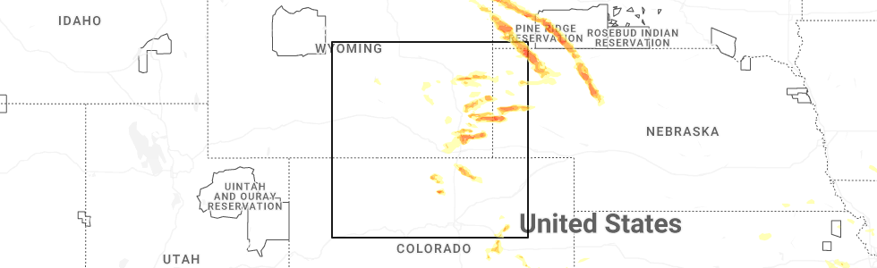
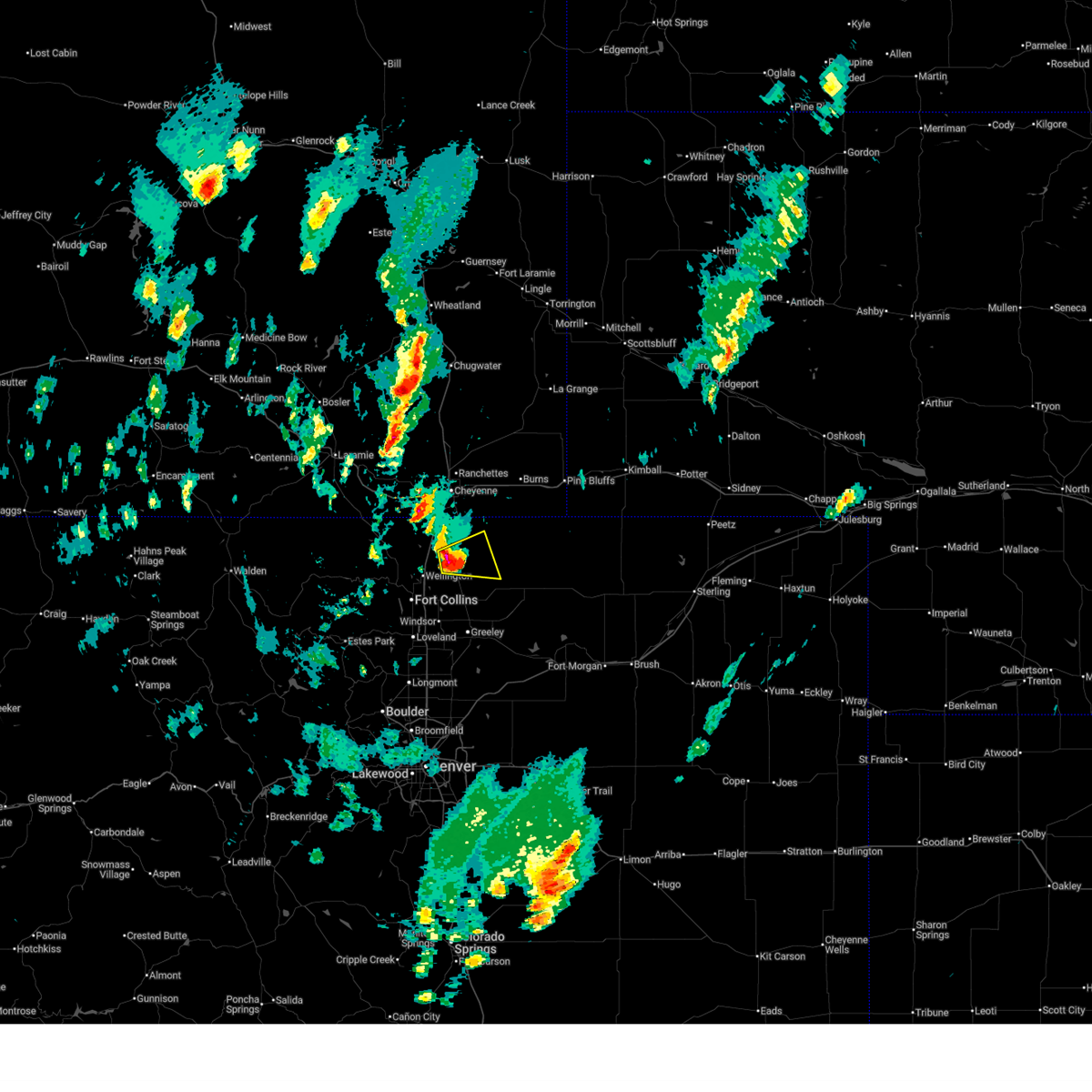
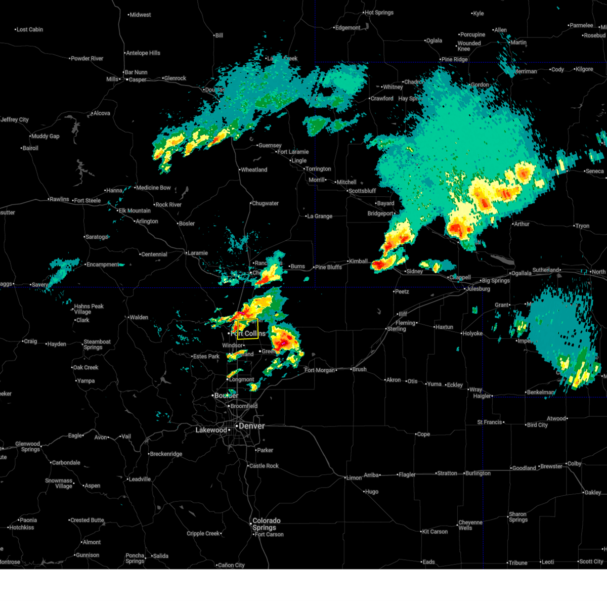
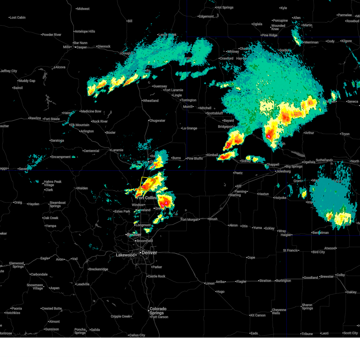
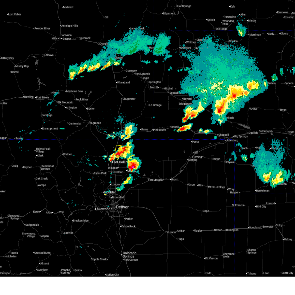
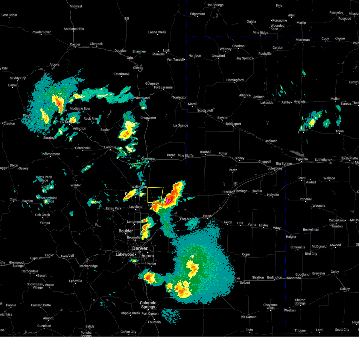
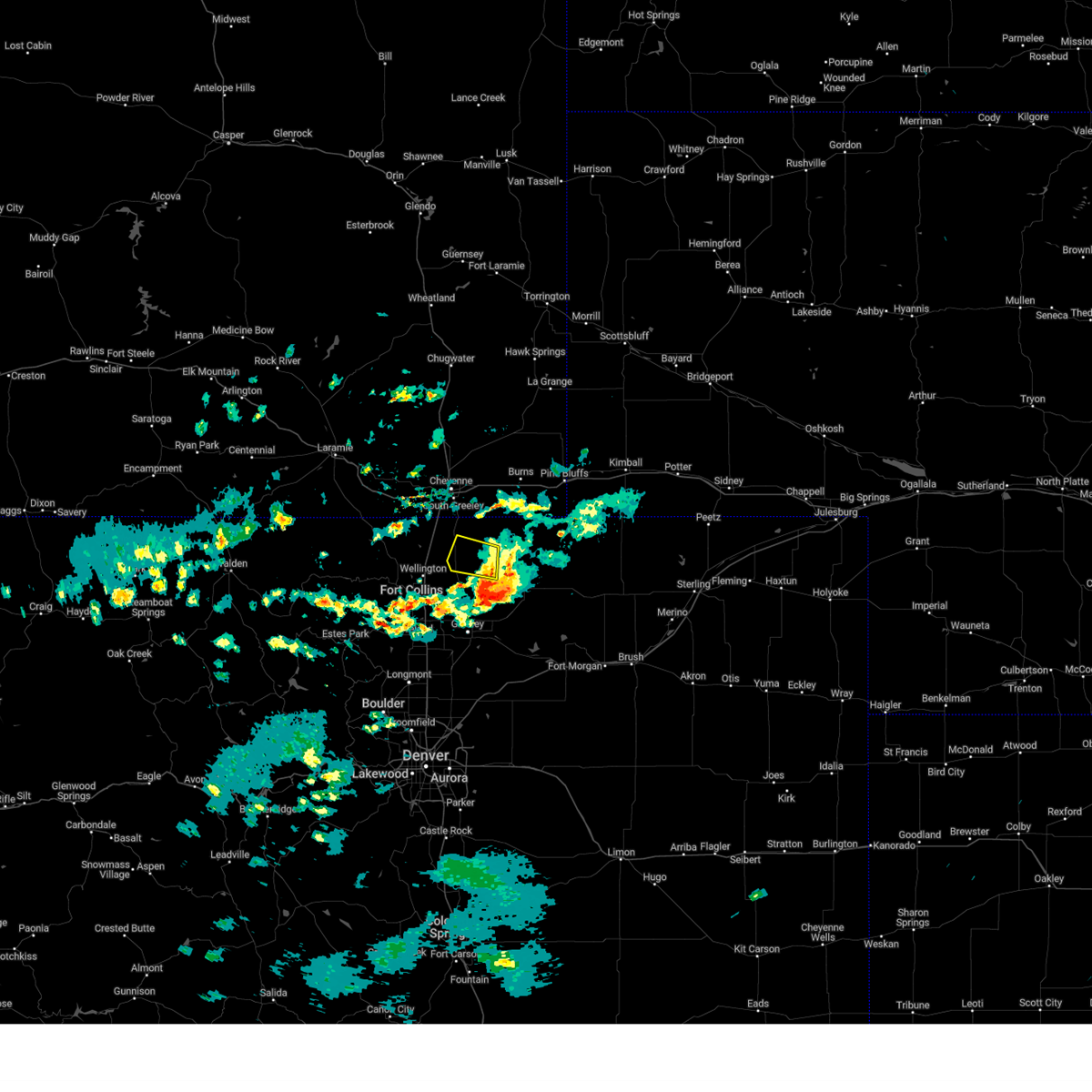
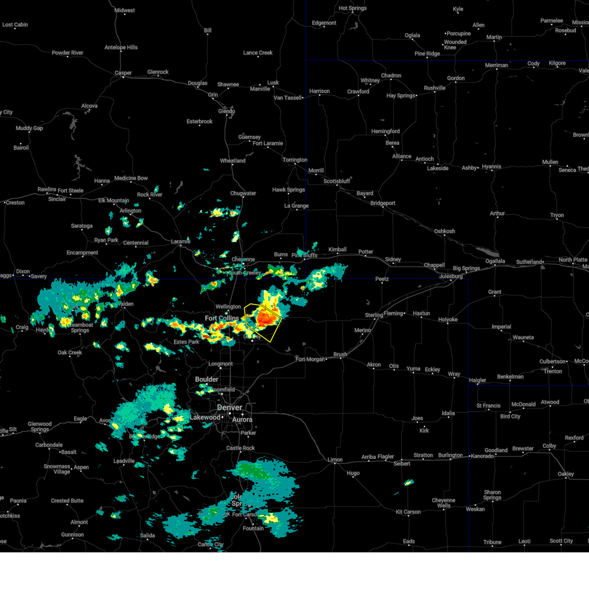
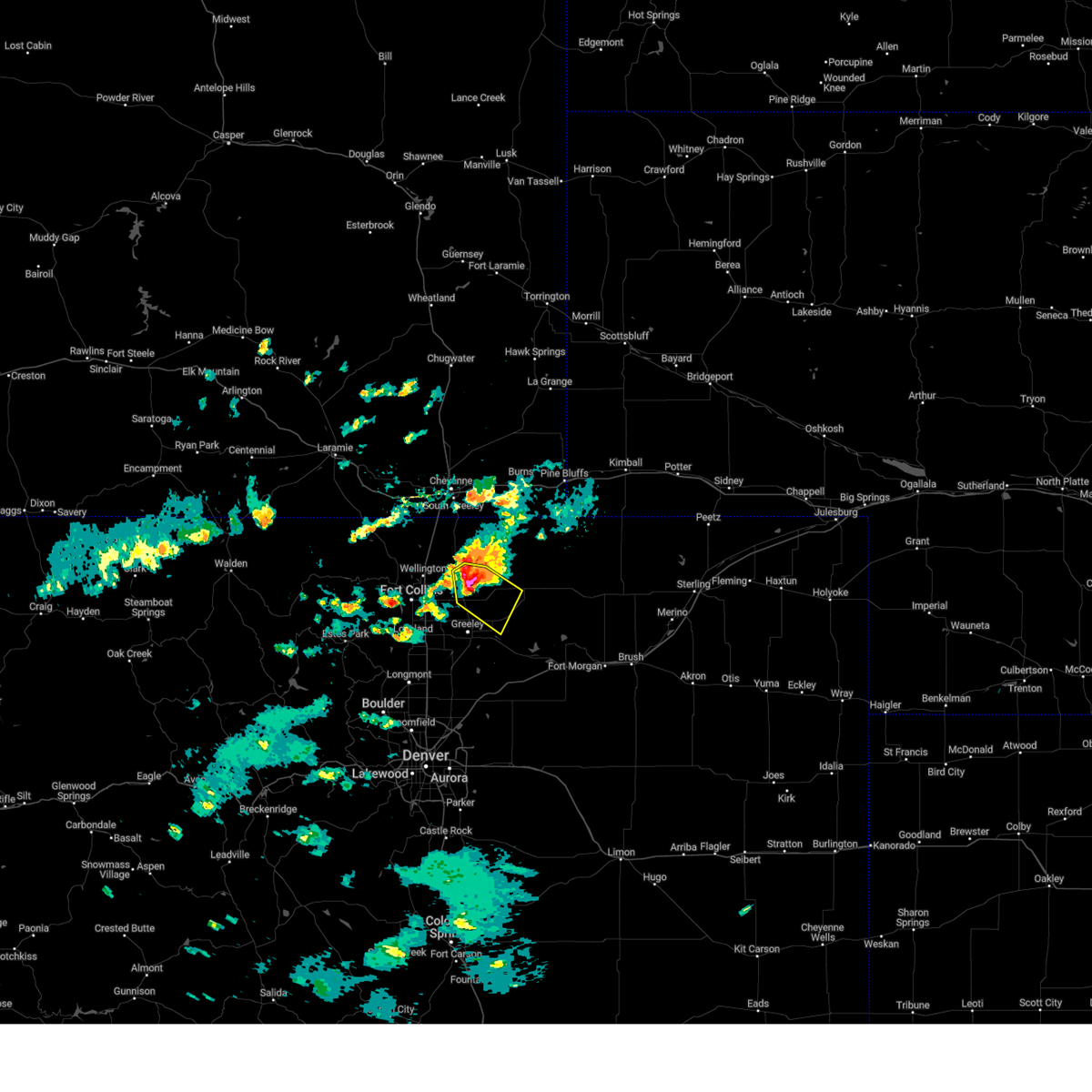
Hail Map for Nunn, CO
The Nunn, CO area has had 30 reports of on-the-ground hail by trained spotters, and has been under severe weather warnings 18 times during the past 12 months. Doppler radar has detected hail at or near Nunn, CO on 85 occasions, including 12 occasions during the past year.
| Name: | Nunn, CO |
| Where Located: | 58.9 miles SE of Laramie, WY |
| Map: | Google Map for Nunn, CO |
| Population: | 416 |
| Housing Units: | 197 |
| More Info: | Search Google for Nunn, CO |
2
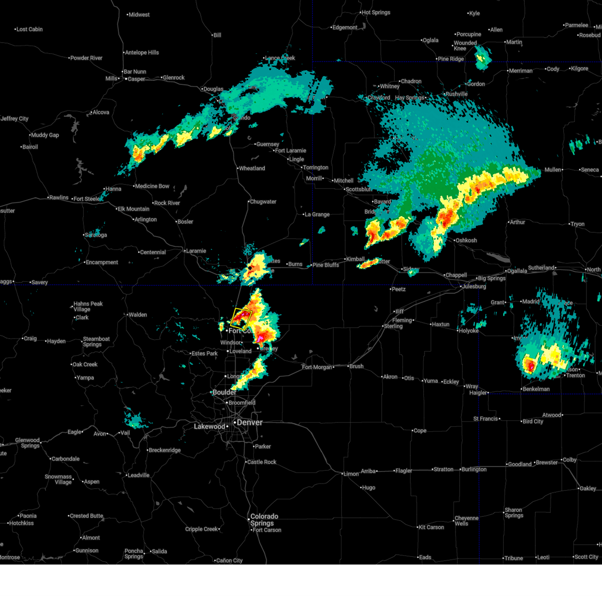
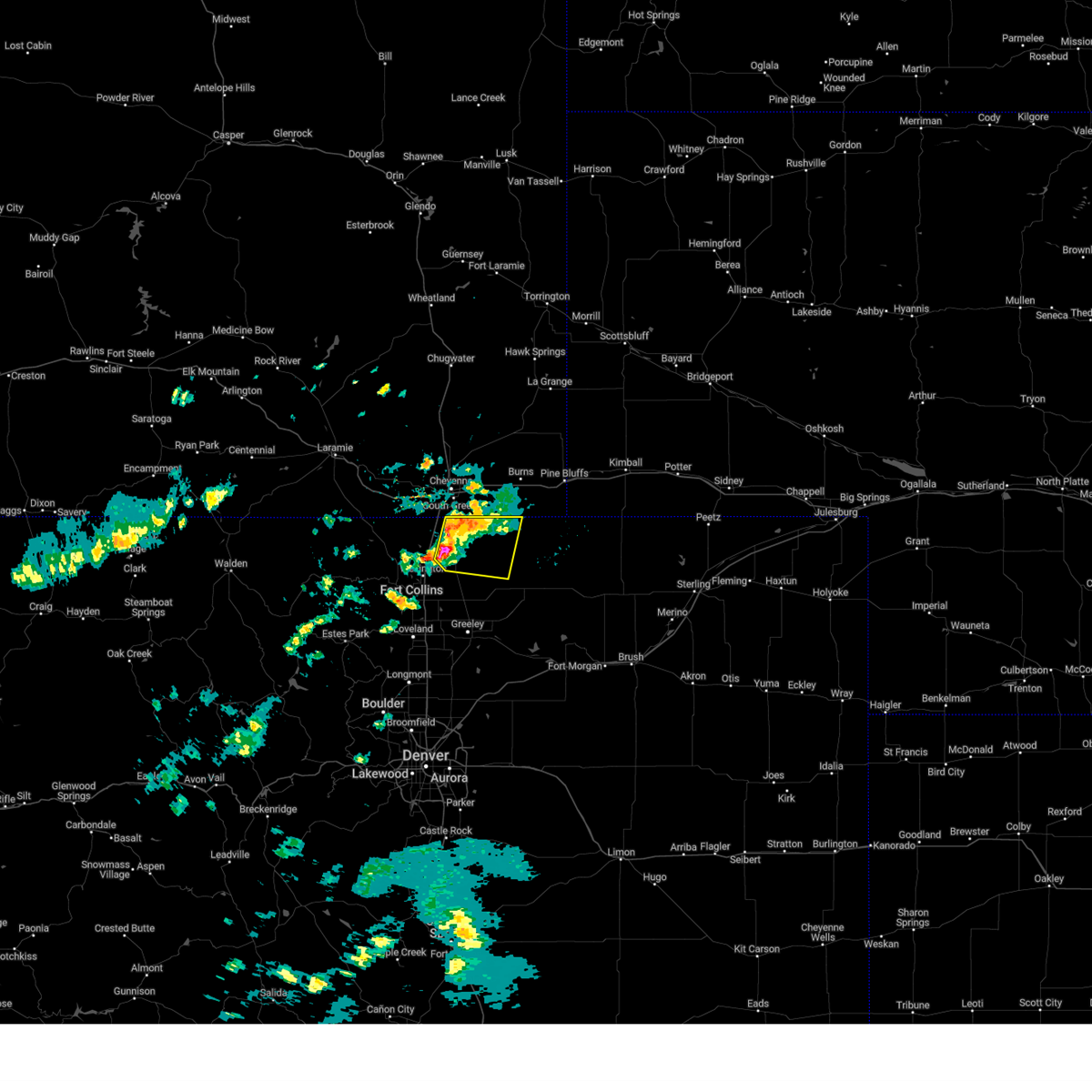
The Top Recent Hail Date for Nunn, CO is Sunday, June 29, 2025 (8th out of 85)
Hail and Wind Damage Spotted near Nunn, CO
| Date / Time | Report Details |
|---|---|
| 6/29/2025 3:33 PM MDT |
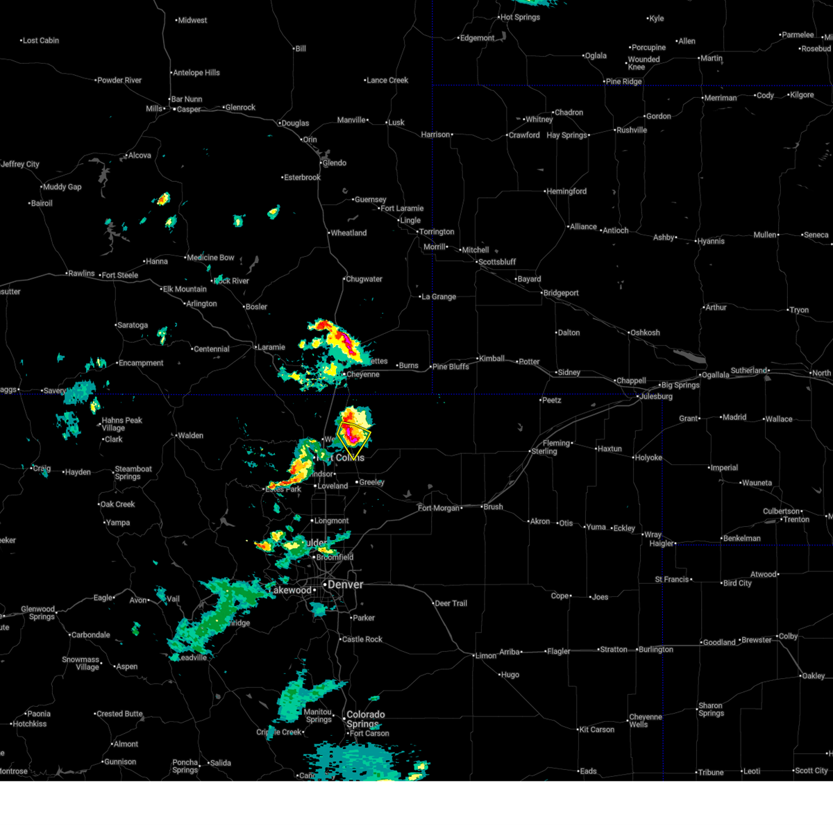 At 333 pm mdt, a severe thunderstorm was located over nunn, or 20 miles northeast of fort collins, moving southeast at 25 mph (radar indicated). Hazards include golf ball size hail and 60 mph wind gusts. People and animals outdoors will be injured. expect hail damage to roofs, siding, windows, and vehicles. expect wind damage to roofs, siding, and trees. Locations impacted include, ault, pierce and nunn. At 333 pm mdt, a severe thunderstorm was located over nunn, or 20 miles northeast of fort collins, moving southeast at 25 mph (radar indicated). Hazards include golf ball size hail and 60 mph wind gusts. People and animals outdoors will be injured. expect hail damage to roofs, siding, windows, and vehicles. expect wind damage to roofs, siding, and trees. Locations impacted include, ault, pierce and nunn.
|
| 6/29/2025 3:30 PM MDT | Quarter sized hail reported 1.6 miles SW of Nunn, CO |
| 6/29/2025 3:16 PM MDT |
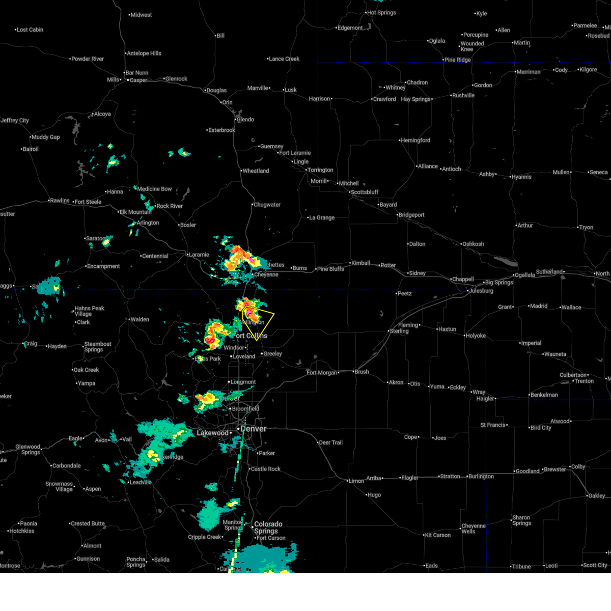 Svrbou the national weather service in denver has issued a * severe thunderstorm warning for, northwestern weld county in northeastern colorado, * until 400 pm mdt. * at 316 pm mdt, a severe thunderstorm was located 6 miles northwest of nunn, or 18 miles northeast of fort collins, moving southeast at 10 mph (radar indicated). Hazards include golf ball size hail and 60 mph wind gusts. People and animals outdoors will be injured. expect hail damage to roofs, siding, windows, and vehicles. Expect wind damage to roofs, siding, and trees. Svrbou the national weather service in denver has issued a * severe thunderstorm warning for, northwestern weld county in northeastern colorado, * until 400 pm mdt. * at 316 pm mdt, a severe thunderstorm was located 6 miles northwest of nunn, or 18 miles northeast of fort collins, moving southeast at 10 mph (radar indicated). Hazards include golf ball size hail and 60 mph wind gusts. People and animals outdoors will be injured. expect hail damage to roofs, siding, windows, and vehicles. Expect wind damage to roofs, siding, and trees.
|
| 6/25/2025 2:40 PM MDT |
 the severe thunderstorm warning has been cancelled and is no longer in effect the severe thunderstorm warning has been cancelled and is no longer in effect
|
| 6/25/2025 2:21 PM MDT |
 Svrbou the national weather service in denver has issued a * severe thunderstorm warning for, northwestern weld county in northeastern colorado, * until 300 pm mdt. * at 221 pm mdt, a severe thunderstorm was located near nunn, or 19 miles northeast of fort collins, moving east at 20 mph (radar indicated). Hazards include 60 mph wind gusts and half dollar size hail. Hail damage to vehicles is expected. Expect wind damage to roofs, siding, and trees. Svrbou the national weather service in denver has issued a * severe thunderstorm warning for, northwestern weld county in northeastern colorado, * until 300 pm mdt. * at 221 pm mdt, a severe thunderstorm was located near nunn, or 19 miles northeast of fort collins, moving east at 20 mph (radar indicated). Hazards include 60 mph wind gusts and half dollar size hail. Hail damage to vehicles is expected. Expect wind damage to roofs, siding, and trees.
|
| 6/17/2025 3:07 AM MDT |
 Svrbou the national weather service in denver has issued a * severe thunderstorm warning for, east central larimer county in north central colorado, western weld county in northeastern colorado, * until 330 am mdt. * at 307 am mdt, a severe thunderstorm was located 5 miles northwest of severance, or 9 miles northeast of fort collins, moving east at 15 mph (radar indicated). Hazards include half dollar size hail. damage to vehicles is expected Svrbou the national weather service in denver has issued a * severe thunderstorm warning for, east central larimer county in north central colorado, western weld county in northeastern colorado, * until 330 am mdt. * at 307 am mdt, a severe thunderstorm was located 5 miles northwest of severance, or 9 miles northeast of fort collins, moving east at 15 mph (radar indicated). Hazards include half dollar size hail. damage to vehicles is expected
|
| 6/17/2025 2:53 AM MDT |
 At 253 am mdt, a severe thunderstorm was located 7 miles northeast of wellington, or 17 miles northeast of fort collins, moving north at 15 mph (radar indicated). Hazards include half dollar size hail. Damage to vehicles is expected. Locations impacted include, mainly rural areas of east central larimer and northwestern weld counties. At 253 am mdt, a severe thunderstorm was located 7 miles northeast of wellington, or 17 miles northeast of fort collins, moving north at 15 mph (radar indicated). Hazards include half dollar size hail. Damage to vehicles is expected. Locations impacted include, mainly rural areas of east central larimer and northwestern weld counties.
|
| 6/17/2025 2:43 AM MDT |
 Svrbou the national weather service in denver has issued a * severe thunderstorm warning for, east central larimer county in north central colorado, northwestern weld county in northeastern colorado, * until 315 am mdt. * at 243 am mdt, a severe thunderstorm was located 5 miles northeast of wellington, or 15 miles northeast of fort collins, moving north at 15 mph (radar indicated). Hazards include half dollar size hail. damage to vehicles is expected Svrbou the national weather service in denver has issued a * severe thunderstorm warning for, east central larimer county in north central colorado, northwestern weld county in northeastern colorado, * until 315 am mdt. * at 243 am mdt, a severe thunderstorm was located 5 miles northeast of wellington, or 15 miles northeast of fort collins, moving north at 15 mph (radar indicated). Hazards include half dollar size hail. damage to vehicles is expected
|
| 6/17/2025 2:27 AM MDT |
 At 227 am mdt, a severe thunderstorm was located near wellington, or 13 miles northeast of fort collins, moving north at 20 mph (radar indicated). Hazards include ping pong ball size hail. People and animals outdoors will be injured. expect damage to roofs, siding, windows, and vehicles. Locations impacted include, northeastern fort collins, wellington and black hollow reservoir. At 227 am mdt, a severe thunderstorm was located near wellington, or 13 miles northeast of fort collins, moving north at 20 mph (radar indicated). Hazards include ping pong ball size hail. People and animals outdoors will be injured. expect damage to roofs, siding, windows, and vehicles. Locations impacted include, northeastern fort collins, wellington and black hollow reservoir.
|
| 6/17/2025 2:16 AM MDT |
 Svrbou the national weather service in denver has issued a * severe thunderstorm warning for, east central larimer county in north central colorado, west central weld county in northeastern colorado, * until 245 am mdt. * at 216 am mdt, a severe thunderstorm was located near wellington, or 9 miles northeast of fort collins, moving north at 15 mph (radar indicated). Hazards include quarter size hail. damage to vehicles is expected Svrbou the national weather service in denver has issued a * severe thunderstorm warning for, east central larimer county in north central colorado, west central weld county in northeastern colorado, * until 245 am mdt. * at 216 am mdt, a severe thunderstorm was located near wellington, or 9 miles northeast of fort collins, moving north at 15 mph (radar indicated). Hazards include quarter size hail. damage to vehicles is expected
|
| 5/18/2025 3:37 PM MDT | the severe thunderstorm warning has been cancelled and is no longer in effect |
| 5/18/2025 2:53 PM MDT |
 Svrbou the national weather service in denver has issued a * severe thunderstorm warning for, northeastern larimer county in north central colorado, northwestern weld county in northeastern colorado, * until 345 pm mdt. * at 253 pm mdt, severe thunderstorms were located along a line from near natural fort to 6 miles north of severance, or along a line from 12 miles southwest of cheyenne to 12 miles northeast of fort collins, moving northeast at 20 mph (radar indicated). Hazards include ping pong ball size hail and 60 mph wind gusts. People and animals outdoors will be injured. expect hail damage to roofs, siding, windows, and vehicles. Expect wind damage to roofs, siding, and trees. Svrbou the national weather service in denver has issued a * severe thunderstorm warning for, northeastern larimer county in north central colorado, northwestern weld county in northeastern colorado, * until 345 pm mdt. * at 253 pm mdt, severe thunderstorms were located along a line from near natural fort to 6 miles north of severance, or along a line from 12 miles southwest of cheyenne to 12 miles northeast of fort collins, moving northeast at 20 mph (radar indicated). Hazards include ping pong ball size hail and 60 mph wind gusts. People and animals outdoors will be injured. expect hail damage to roofs, siding, windows, and vehicles. Expect wind damage to roofs, siding, and trees.
|
| 4/24/2025 5:11 PM MDT |
 the severe thunderstorm warning has been cancelled and is no longer in effect the severe thunderstorm warning has been cancelled and is no longer in effect
|
| 4/24/2025 4:49 PM MDT |
 Svrbou the national weather service in denver has issued a * severe thunderstorm warning for, northwestern weld county in northeastern colorado, * until 530 pm mdt. * at 449 pm mdt, a severe thunderstorm was located over eaton, or 8 miles northeast of greeley, moving north at 15 mph (radar indicated). Hazards include half dollar size hail. damage to vehicles is expected Svrbou the national weather service in denver has issued a * severe thunderstorm warning for, northwestern weld county in northeastern colorado, * until 530 pm mdt. * at 449 pm mdt, a severe thunderstorm was located over eaton, or 8 miles northeast of greeley, moving north at 15 mph (radar indicated). Hazards include half dollar size hail. damage to vehicles is expected
|
| 8/7/2024 2:41 PM MDT |
 The storm which prompted the warning has weakened below severe limits, and has exited the warned area. therefore, the warning will be allowed to expire. a severe thunderstorm watch remains in effect until 1000 pm mdt for northeastern colorado. The storm which prompted the warning has weakened below severe limits, and has exited the warned area. therefore, the warning will be allowed to expire. a severe thunderstorm watch remains in effect until 1000 pm mdt for northeastern colorado.
|
| 8/7/2024 2:40 PM MDT |
 the severe thunderstorm warning has been cancelled and is no longer in effect the severe thunderstorm warning has been cancelled and is no longer in effect
|
| 8/7/2024 2:25 PM MDT | Golf Ball sized hail reported 0.8 miles NNW of Nunn, CO |
| 8/7/2024 2:22 PM MDT |
 Svrbou the national weather service in denver colorado has issued a * severe thunderstorm warning for, west central weld county in northeastern colorado, * until 300 pm mdt. * at 221 pm mdt, a severe thunderstorm was located near pierce, or 17 miles north of greeley, moving southeast at 30 mph (radar indicated). Hazards include 60 mph wind gusts and quarter size hail. Expect damage to roofs, siding, and trees. Hail damage to vehicles is expected. Svrbou the national weather service in denver colorado has issued a * severe thunderstorm warning for, west central weld county in northeastern colorado, * until 300 pm mdt. * at 221 pm mdt, a severe thunderstorm was located near pierce, or 17 miles north of greeley, moving southeast at 30 mph (radar indicated). Hazards include 60 mph wind gusts and quarter size hail. Expect damage to roofs, siding, and trees. Hail damage to vehicles is expected.
|
| 8/7/2024 2:12 PM MDT |
 At 212 pm mdt, a severe thunderstorm was located near nunn, or 20 miles northeast of fort collins, moving southeast at 25 mph (radar indicated). Hazards include 60 mph wind gusts and quarter size hail. Expect damage to roofs, siding, and trees. hail damage to vehicles is expected. This severe thunderstorm will remain over mainly rural areas of northwestern weld county. At 212 pm mdt, a severe thunderstorm was located near nunn, or 20 miles northeast of fort collins, moving southeast at 25 mph (radar indicated). Hazards include 60 mph wind gusts and quarter size hail. Expect damage to roofs, siding, and trees. hail damage to vehicles is expected. This severe thunderstorm will remain over mainly rural areas of northwestern weld county.
|
| 8/7/2024 2:08 PM MDT | Corrects previous non-tstm wnd gst report from nunn. mesonet station co171 nun in weld county CO, 0.4 miles W of Nunn, CO |
| 8/7/2024 2:06 PM MDT | Corrects previous non-tstm wnd gst report from 5 nnw nunn. mesonet station up718 4.9 n nunn (upr in weld county CO, 4.3 miles SSE of Nunn, CO |
| 8/7/2024 1:54 PM MDT |
 Svrbou the national weather service in denver colorado has issued a * severe thunderstorm warning for, northwestern weld county in northeastern colorado, * until 245 pm mdt. * at 153 pm mdt, a severe thunderstorm was located 5 miles south of rockport, or 22 miles south of cheyenne, moving east at 35 mph (radar indicated). Hazards include 60 mph wind gusts and quarter size hail. Expect damage to roofs, siding, and trees. Hail damage to vehicles is expected. Svrbou the national weather service in denver colorado has issued a * severe thunderstorm warning for, northwestern weld county in northeastern colorado, * until 245 pm mdt. * at 153 pm mdt, a severe thunderstorm was located 5 miles south of rockport, or 22 miles south of cheyenne, moving east at 35 mph (radar indicated). Hazards include 60 mph wind gusts and quarter size hail. Expect damage to roofs, siding, and trees. Hail damage to vehicles is expected.
|
| 6/20/2024 4:39 PM MDT |
 The storm which prompted the warning has weakened below severe limits, and no longer poses an immediate threat to life or property. therefore, the warning will be allowed to expire. however, small hail and gusty winds are still possible with this thunderstorm. a severe thunderstorm watch remains in effect until 700 pm mdt for northeastern colorado. The storm which prompted the warning has weakened below severe limits, and no longer poses an immediate threat to life or property. therefore, the warning will be allowed to expire. however, small hail and gusty winds are still possible with this thunderstorm. a severe thunderstorm watch remains in effect until 700 pm mdt for northeastern colorado.
|
| 6/20/2024 4:13 PM MDT |
 Svrbou the national weather service in denver colorado has issued a * severe thunderstorm warning for, northwestern weld county in northeastern colorado, * until 445 pm mdt. * at 412 pm mdt, a severe thunderstorm was located over ault, or 12 miles north of greeley, moving northeast at 20 mph (radar indicated). Hazards include 60 mph wind gusts and quarter size hail. Expect damage to roofs, siding, and trees. Hail damage to vehicles is expected. Svrbou the national weather service in denver colorado has issued a * severe thunderstorm warning for, northwestern weld county in northeastern colorado, * until 445 pm mdt. * at 412 pm mdt, a severe thunderstorm was located over ault, or 12 miles north of greeley, moving northeast at 20 mph (radar indicated). Hazards include 60 mph wind gusts and quarter size hail. Expect damage to roofs, siding, and trees. Hail damage to vehicles is expected.
|
| 6/20/2024 4:11 PM MDT |
 The tornadic thunderstorm which prompted the warning has weakened. therefore, the warning will be allowed to expire. however, hail is still possible with this thunderstorm. a severe thunderstorm watch remains in effect until 700 pm mdt for northeastern colorado. The tornadic thunderstorm which prompted the warning has weakened. therefore, the warning will be allowed to expire. however, hail is still possible with this thunderstorm. a severe thunderstorm watch remains in effect until 700 pm mdt for northeastern colorado.
|
| 6/20/2024 3:58 PM MDT |
 At 358 pm mdt, a severe thunderstorm capable of producing a tornado was located near eaton, or 8 miles north of greeley, moving northeast at 15 mph (radar indicated rotation). Hazards include tornado and quarter size hail. Flying debris will be dangerous to those caught without shelter. mobile homes will be damaged or destroyed. damage to roofs, windows, and vehicles will occur. tree damage is likely. Locations impacted include, northwestern greeley, windsor, eaton, severance, ault, pierce, nunn, purcell, and lucerne. At 358 pm mdt, a severe thunderstorm capable of producing a tornado was located near eaton, or 8 miles north of greeley, moving northeast at 15 mph (radar indicated rotation). Hazards include tornado and quarter size hail. Flying debris will be dangerous to those caught without shelter. mobile homes will be damaged or destroyed. damage to roofs, windows, and vehicles will occur. tree damage is likely. Locations impacted include, northwestern greeley, windsor, eaton, severance, ault, pierce, nunn, purcell, and lucerne.
|
| 6/20/2024 3:51 PM MDT |
 Torbou the national weather service in denver colorado has issued a * tornado warning for, west central weld county in northeastern colorado, * until 415 pm mdt. * at 351 pm mdt, a severe thunderstorm capable of producing a tornado was located near eaton, or 7 miles north of greeley, moving northeast at 15 mph (radar indicated rotation). Hazards include tornado. Flying debris will be dangerous to those caught without shelter. mobile homes will be damaged or destroyed. damage to roofs, windows, and vehicles will occur. Tree damage is likely. Torbou the national weather service in denver colorado has issued a * tornado warning for, west central weld county in northeastern colorado, * until 415 pm mdt. * at 351 pm mdt, a severe thunderstorm capable of producing a tornado was located near eaton, or 7 miles north of greeley, moving northeast at 15 mph (radar indicated rotation). Hazards include tornado. Flying debris will be dangerous to those caught without shelter. mobile homes will be damaged or destroyed. damage to roofs, windows, and vehicles will occur. Tree damage is likely.
|
| 6/8/2024 2:14 PM MDT |
 Svrbou the national weather service in denver colorado has issued a * severe thunderstorm warning for, northwestern weld county in northeastern colorado, * until 300 pm mdt. * at 214 pm mdt, severe thunderstorms were located along a line extending from 6 miles west of carpenter to 6 miles northwest of nunn, or along a line extending from 19 miles southeast of cheyenne to 18 miles northeast of fort collins, moving south at 30 mph (radar indicated). Hazards include 60 mph wind gusts and quarter size hail. Expect damage to roofs, siding, and trees. Hail damage to vehicles is expected. Svrbou the national weather service in denver colorado has issued a * severe thunderstorm warning for, northwestern weld county in northeastern colorado, * until 300 pm mdt. * at 214 pm mdt, severe thunderstorms were located along a line extending from 6 miles west of carpenter to 6 miles northwest of nunn, or along a line extending from 19 miles southeast of cheyenne to 18 miles northeast of fort collins, moving south at 30 mph (radar indicated). Hazards include 60 mph wind gusts and quarter size hail. Expect damage to roofs, siding, and trees. Hail damage to vehicles is expected.
|
| 7/31/2023 8:03 PM MDT |
 At 802 pm mdt, a severe thunderstorm was located over northern fort collins, and is nearly stationary. a second storm was located east of wellington, and is also nearly stationary (radar indicated). Hazards include 60 mph wind gusts and quarter size hail. Expect damage to roofs, siding, and trees. hail damage to vehicles is expected. Locations impacted include, northern fort collins, windsor, wellington, timnath, nunn and teds place. At 802 pm mdt, a severe thunderstorm was located over northern fort collins, and is nearly stationary. a second storm was located east of wellington, and is also nearly stationary (radar indicated). Hazards include 60 mph wind gusts and quarter size hail. Expect damage to roofs, siding, and trees. hail damage to vehicles is expected. Locations impacted include, northern fort collins, windsor, wellington, timnath, nunn and teds place.
|
| 7/31/2023 7:30 PM MDT |
 At 729 pm mdt, a severe thunderstorm was located over wellington, or 9 miles northeast of fort collins, moving southwest at 5 mph (radar indicated). Hazards include 60 mph wind gusts and quarter size hail. Expect damage to roofs, siding, and trees. Hail damage to vehicles is expected. At 729 pm mdt, a severe thunderstorm was located over wellington, or 9 miles northeast of fort collins, moving southwest at 5 mph (radar indicated). Hazards include 60 mph wind gusts and quarter size hail. Expect damage to roofs, siding, and trees. Hail damage to vehicles is expected.
|
| 7/31/2023 7:05 PM MDT |
 At 704 pm mdt, a severe thunderstorm was located near wellington, or 11 miles northeast of fort collins, moving southwest at 5 mph (radar indicated). Hazards include golf ball size hail and 60 mph wind gusts. Expect damage to roofs, siding, and trees. people and animals outdoors will be injured. expect hail damage to roofs, siding, windows, and vehicles. hail may accumulate on roadways causing hazardous travel. locations impacted include, northeastern fort collins and wellington. thunderstorm damage threat, considerable hail threat, radar indicated max hail size, 1. 75 in wind threat, radar indicated max wind gust, 60 mph. At 704 pm mdt, a severe thunderstorm was located near wellington, or 11 miles northeast of fort collins, moving southwest at 5 mph (radar indicated). Hazards include golf ball size hail and 60 mph wind gusts. Expect damage to roofs, siding, and trees. people and animals outdoors will be injured. expect hail damage to roofs, siding, windows, and vehicles. hail may accumulate on roadways causing hazardous travel. locations impacted include, northeastern fort collins and wellington. thunderstorm damage threat, considerable hail threat, radar indicated max hail size, 1. 75 in wind threat, radar indicated max wind gust, 60 mph.
|
| 7/31/2023 6:46 PM MDT | Quarter sized hail reported 1.3 miles S of Nunn, CO, report from mping: quarter (1.00 in.). |
| 7/31/2023 6:40 PM MDT |
 At 640 pm mdt, a severe thunderstorm was located 4 miles northeast of wellington, or 14 miles northeast of fort collins, moving southwest at 10 mph (radar indicated). Hazards include ping pong ball size hail and 60 mph wind gusts. Expect damage to roofs, siding, and trees. people and animals outdoors will be injured. expect hail damage to roofs, siding, windows, and vehicles. Hail may accumulate on roadways causing hazardous travel. At 640 pm mdt, a severe thunderstorm was located 4 miles northeast of wellington, or 14 miles northeast of fort collins, moving southwest at 10 mph (radar indicated). Hazards include ping pong ball size hail and 60 mph wind gusts. Expect damage to roofs, siding, and trees. people and animals outdoors will be injured. expect hail damage to roofs, siding, windows, and vehicles. Hail may accumulate on roadways causing hazardous travel.
|
| 7/31/2023 6:27 PM MDT |
 At 627 pm mdt, a severe thunderstorm was located 6 miles northwest of nunn, or 19 miles northeast of fort collins, moving south at 5 mph (radar indicated). Hazards include golf ball size hail. People and animals outdoors will be injured. expect damage to roofs, siding, windows, and vehicles. hail may accumulate on roadways causing hazardous travel. Locations impacted include, nunn. At 627 pm mdt, a severe thunderstorm was located 6 miles northwest of nunn, or 19 miles northeast of fort collins, moving south at 5 mph (radar indicated). Hazards include golf ball size hail. People and animals outdoors will be injured. expect damage to roofs, siding, windows, and vehicles. hail may accumulate on roadways causing hazardous travel. Locations impacted include, nunn.
|
| 7/31/2023 6:09 PM MDT |
 At 609 pm mdt, a severe thunderstorm was located 4 miles south of rockport, or 21 miles south of cheyenne, moving southeast at 5 mph (radar indicated). Hazards include golf ball size hail. People and animals outdoors will be injured. expect damage to roofs, siding, windows, and vehicles. Hail may accumulate on roadways causing hazardous travel. At 609 pm mdt, a severe thunderstorm was located 4 miles south of rockport, or 21 miles south of cheyenne, moving southeast at 5 mph (radar indicated). Hazards include golf ball size hail. People and animals outdoors will be injured. expect damage to roofs, siding, windows, and vehicles. Hail may accumulate on roadways causing hazardous travel.
|
| 7/15/2023 4:15 PM MDT |
 At 415 pm mdt, a severe thunderstorm was located 5 miles northwest of nunn, or 16 miles northeast of fort collins, moving southeast at 15 mph (radar indicated). Hazards include golf ball size hail and 60 mph wind gusts. Expect damage to roofs, siding, and trees. people and animals outdoors will be injured. expect hail damage to roofs, siding, windows, and vehicles. locations impacted include, wellington, severance, pierce and nunn. thunderstorm damage threat, considerable hail threat, radar indicated max hail size, 1. 75 in wind threat, radar indicated max wind gust, 60 mph. At 415 pm mdt, a severe thunderstorm was located 5 miles northwest of nunn, or 16 miles northeast of fort collins, moving southeast at 15 mph (radar indicated). Hazards include golf ball size hail and 60 mph wind gusts. Expect damage to roofs, siding, and trees. people and animals outdoors will be injured. expect hail damage to roofs, siding, windows, and vehicles. locations impacted include, wellington, severance, pierce and nunn. thunderstorm damage threat, considerable hail threat, radar indicated max hail size, 1. 75 in wind threat, radar indicated max wind gust, 60 mph.
|
| 7/15/2023 4:12 PM MDT |
 At 412 pm mdt, a severe thunderstorm was located 6 miles northwest of nunn, or 16 miles northeast of fort collins, moving southeast at 15 mph (radar indicated). Hazards include 60 mph wind gusts and half dollar size hail. Expect damage to roofs, siding, and trees. Hail damage to vehicles is expected. At 412 pm mdt, a severe thunderstorm was located 6 miles northwest of nunn, or 16 miles northeast of fort collins, moving southeast at 15 mph (radar indicated). Hazards include 60 mph wind gusts and half dollar size hail. Expect damage to roofs, siding, and trees. Hail damage to vehicles is expected.
|
| 7/15/2023 2:44 PM MDT |
 At 243 pm mdt, a severe thunderstorm was located near rockport, or 19 miles south of cheyenne, moving south at 20 mph (radar indicated). Hazards include ping pong ball size hail. People and animals outdoors will be injured. Expect damage to roofs, siding, windows, and vehicles. At 243 pm mdt, a severe thunderstorm was located near rockport, or 19 miles south of cheyenne, moving south at 20 mph (radar indicated). Hazards include ping pong ball size hail. People and animals outdoors will be injured. Expect damage to roofs, siding, windows, and vehicles.
|
| 6/21/2023 8:12 PM MDT |
 At 811 pm mdt, a severe thunderstorm was located near severance, or 11 miles east of fort collins, moving east at 20 mph (radar indicated). Hazards include ping pong ball size hail. People and animals outdoors will be injured. expect damage to roofs, siding, windows, and vehicles. this severe thunderstorm will be near, eaton, ault, pierce and nunn around 830 pm mdt. hail threat, radar indicated max hail size, 1. 50 in wind threat, radar indicated max wind gust, <50 mph. At 811 pm mdt, a severe thunderstorm was located near severance, or 11 miles east of fort collins, moving east at 20 mph (radar indicated). Hazards include ping pong ball size hail. People and animals outdoors will be injured. expect damage to roofs, siding, windows, and vehicles. this severe thunderstorm will be near, eaton, ault, pierce and nunn around 830 pm mdt. hail threat, radar indicated max hail size, 1. 50 in wind threat, radar indicated max wind gust, <50 mph.
|
| 5/27/2023 4:10 PM MDT |
 The severe thunderstorm warning for northwestern weld and east central larimer counties will expire at 415 pm mdt, the storm which prompted the warning has weakened below severe limits, and no longer poses an immediate threat to life or property. therefore, the warning will be allowed to expire. however heavy rain is still possible with this thunderstorm. a severe thunderstorm watch remains in effect until 900 pm mdt for northeastern colorado. The severe thunderstorm warning for northwestern weld and east central larimer counties will expire at 415 pm mdt, the storm which prompted the warning has weakened below severe limits, and no longer poses an immediate threat to life or property. therefore, the warning will be allowed to expire. however heavy rain is still possible with this thunderstorm. a severe thunderstorm watch remains in effect until 900 pm mdt for northeastern colorado.
|
| 5/27/2023 3:50 PM MDT |
 At 350 pm mdt, a severe thunderstorm was located 5 miles east of wellington, or 14 miles northeast of fort collins, moving north at 30 mph (radar indicated). Hazards include ping pong ball size hail. People and animals outdoors will be injured. Expect damage to roofs, siding, windows, and vehicles. At 350 pm mdt, a severe thunderstorm was located 5 miles east of wellington, or 14 miles northeast of fort collins, moving north at 30 mph (radar indicated). Hazards include ping pong ball size hail. People and animals outdoors will be injured. Expect damage to roofs, siding, windows, and vehicles.
|
| 5/27/2023 3:43 PM MDT |
 At 342 pm mdt, a severe thunderstorm was located 4 miles northeast of timnath, or 8 miles east of fort collins, moving northeast at 20 mph (radar indicated and spotter reported). Hazards include ping pong ball size hail and 60 mph wind gusts. Expect damage to roofs, siding, and trees. people and animals outdoors will be injured. expect hail damage to roofs, siding, windows, and vehicles. locations impacted include, ault, pierce and nunn. hail threat, radar indicated max hail size, 1. 50 in wind threat, radar indicated max wind gust, 60 mph. At 342 pm mdt, a severe thunderstorm was located 4 miles northeast of timnath, or 8 miles east of fort collins, moving northeast at 20 mph (radar indicated and spotter reported). Hazards include ping pong ball size hail and 60 mph wind gusts. Expect damage to roofs, siding, and trees. people and animals outdoors will be injured. expect hail damage to roofs, siding, windows, and vehicles. locations impacted include, ault, pierce and nunn. hail threat, radar indicated max hail size, 1. 50 in wind threat, radar indicated max wind gust, 60 mph.
|
| 5/27/2023 3:26 PM MDT |
 At 326 pm mdt, a severe thunderstorm was located near windsor, or 8 miles east of fort collins, moving northeast at 25 mph (radar indicated). Hazards include 60 mph wind gusts and half dollar size hail. Expect damage to roofs, siding, and trees. hail damage to vehicles is expected. this severe thunderstorm will be near, severance around 345 pm mdt. other locations in the path of this severe thunderstorm include eaton, ault and pierce. hail threat, radar indicated max hail size, 1. 25 in wind threat, radar indicated max wind gust, 60 mph. At 326 pm mdt, a severe thunderstorm was located near windsor, or 8 miles east of fort collins, moving northeast at 25 mph (radar indicated). Hazards include 60 mph wind gusts and half dollar size hail. Expect damage to roofs, siding, and trees. hail damage to vehicles is expected. this severe thunderstorm will be near, severance around 345 pm mdt. other locations in the path of this severe thunderstorm include eaton, ault and pierce. hail threat, radar indicated max hail size, 1. 25 in wind threat, radar indicated max wind gust, 60 mph.
|
| 5/26/2023 3:25 PM MDT |
 At 324 pm mdt, a severe thunderstorm was located 12 miles southeast of rockport, or 24 miles southeast of cheyenne, moving north at 30 mph (radar indicated). Hazards include ping pong ball size hail and 60 mph wind gusts. Expect damage to roofs, siding, and trees. people and animals outdoors will be injured. expect hail damage to roofs, siding, windows, and vehicles. locations impacted include, pierce, nunn, purcell, rockport and hereford. hail threat, radar indicated max hail size, 1. 50 in wind threat, radar indicated max wind gust, 60 mph. At 324 pm mdt, a severe thunderstorm was located 12 miles southeast of rockport, or 24 miles southeast of cheyenne, moving north at 30 mph (radar indicated). Hazards include ping pong ball size hail and 60 mph wind gusts. Expect damage to roofs, siding, and trees. people and animals outdoors will be injured. expect hail damage to roofs, siding, windows, and vehicles. locations impacted include, pierce, nunn, purcell, rockport and hereford. hail threat, radar indicated max hail size, 1. 50 in wind threat, radar indicated max wind gust, 60 mph.
|
| 5/26/2023 3:12 PM MDT |
 At 312 pm mdt, a severe thunderstorm was located 7 miles north of purcell, or 23 miles north of greeley, moving north at 30 mph (radar indicated). Hazards include quarter size hail. Hail damage to vehicles is expected. this severe thunderstorm will remain over mainly rural areas of northwestern weld county. hail threat, radar indicated max hail size, 1. 00 in wind threat, radar indicated max wind gust, 60 mph. At 312 pm mdt, a severe thunderstorm was located 7 miles north of purcell, or 23 miles north of greeley, moving north at 30 mph (radar indicated). Hazards include quarter size hail. Hail damage to vehicles is expected. this severe thunderstorm will remain over mainly rural areas of northwestern weld county. hail threat, radar indicated max hail size, 1. 00 in wind threat, radar indicated max wind gust, 60 mph.
|
| 5/9/2023 8:06 PM MDT |
 At 806 pm mdt, a severe thunderstorm was located 6 miles north of timnath, or 7 miles northeast of fort collins, moving northeast at 25 mph (radar indicated). Hazards include quarter size hail. Damage to vehicles is expected. locations impacted include, fort collins, greeley, northern loveland, windsor, wellington, eaton, severance, ault, pierce, timnath, nunn and lucerne. hail threat, radar indicated max hail size, 1. 00 in wind threat, radar indicated max wind gust, <50 mph. At 806 pm mdt, a severe thunderstorm was located 6 miles north of timnath, or 7 miles northeast of fort collins, moving northeast at 25 mph (radar indicated). Hazards include quarter size hail. Damage to vehicles is expected. locations impacted include, fort collins, greeley, northern loveland, windsor, wellington, eaton, severance, ault, pierce, timnath, nunn and lucerne. hail threat, radar indicated max hail size, 1. 00 in wind threat, radar indicated max wind gust, <50 mph.
|
| 5/9/2023 7:31 PM MDT |
 At 731 pm mdt, a severe thunderstorm was located near windsor, or 7 miles northwest of greeley, moving north at 25 mph (radar indicated). Hazards include 60 mph wind gusts and half dollar size hail. Expect damage to roofs, siding, and trees. Hail damage to vehicles is expected. At 731 pm mdt, a severe thunderstorm was located near windsor, or 7 miles northwest of greeley, moving north at 25 mph (radar indicated). Hazards include 60 mph wind gusts and half dollar size hail. Expect damage to roofs, siding, and trees. Hail damage to vehicles is expected.
|
| 7/27/2022 7:27 PM MDT |
 At 727 pm mdt, a severe thunderstorm was located 6 miles north of wellington, or 17 miles north of fort collins, moving southeast at 25 mph (radar indicated). Hazards include 60 mph wind gusts and quarter size hail. Expect damage to roofs, siding, and trees. hail damage to vehicles is expected. this severe thunderstorm will be near, wellington around 735 pm mdt. other locations in the path of this severe thunderstorm include nunn and pierce. hail threat, radar indicated max hail size, 1. 00 in wind threat, radar indicated max wind gust, 60 mph. At 727 pm mdt, a severe thunderstorm was located 6 miles north of wellington, or 17 miles north of fort collins, moving southeast at 25 mph (radar indicated). Hazards include 60 mph wind gusts and quarter size hail. Expect damage to roofs, siding, and trees. hail damage to vehicles is expected. this severe thunderstorm will be near, wellington around 735 pm mdt. other locations in the path of this severe thunderstorm include nunn and pierce. hail threat, radar indicated max hail size, 1. 00 in wind threat, radar indicated max wind gust, 60 mph.
|
| 7/27/2022 7:09 PM MDT |
 At 709 pm mdt, a severe thunderstorm was located 6 miles southwest of carr, or 20 miles north of fort collins, moving south at 20 mph (radar indicated). Hazards include 60 mph wind gusts and quarter size hail. Expect damage to roofs, siding, and trees. hail damage to vehicles is expected. locations impacted include, wellington and nunn. hail threat, radar indicated max hail size, 1. 00 in wind threat, radar indicated max wind gust, 60 mph. At 709 pm mdt, a severe thunderstorm was located 6 miles southwest of carr, or 20 miles north of fort collins, moving south at 20 mph (radar indicated). Hazards include 60 mph wind gusts and quarter size hail. Expect damage to roofs, siding, and trees. hail damage to vehicles is expected. locations impacted include, wellington and nunn. hail threat, radar indicated max hail size, 1. 00 in wind threat, radar indicated max wind gust, 60 mph.
|
| 7/27/2022 6:51 PM MDT |
 At 651 pm mdt, a severe thunderstorm was located 5 miles southwest of natural fort, or 19 miles southwest of cheyenne, moving south at 20 mph (radar indicated). Hazards include 60 mph wind gusts and quarter size hail. Expect damage to roofs, siding, and trees. Hail damage to vehicles is expected. At 651 pm mdt, a severe thunderstorm was located 5 miles southwest of natural fort, or 19 miles southwest of cheyenne, moving south at 20 mph (radar indicated). Hazards include 60 mph wind gusts and quarter size hail. Expect damage to roofs, siding, and trees. Hail damage to vehicles is expected.
|
| 7/27/2022 5:25 PM MDT | Quarter sized hail reported 6.6 miles SW of Nunn, CO, cocorahs co-we-409. 15 minutes of hail up to quarter size. |
| 7/27/2022 5:25 PM MDT |
 At 525 pm mdt, a severe thunderstorm was located 5 miles northeast of nunn, or 23 miles northeast of fort collins, moving south at 20 mph (radar indicated). Hazards include half dollar size hail. Damage to vehicles is expected. this severe thunderstorm will be near, nunn around 530 pm mdt. pierce around 545 pm mdt. other locations in the path of this severe thunderstorm include purcell, ault and eaton. hail threat, radar indicated max hail size, 1. 25 in wind threat, radar indicated max wind gust, <50 mph. At 525 pm mdt, a severe thunderstorm was located 5 miles northeast of nunn, or 23 miles northeast of fort collins, moving south at 20 mph (radar indicated). Hazards include half dollar size hail. Damage to vehicles is expected. this severe thunderstorm will be near, nunn around 530 pm mdt. pierce around 545 pm mdt. other locations in the path of this severe thunderstorm include purcell, ault and eaton. hail threat, radar indicated max hail size, 1. 25 in wind threat, radar indicated max wind gust, <50 mph.
|
| 7/12/2022 3:54 PM MDT |
 At 354 pm mdt, a severe thunderstorm was located over natural fort, or 16 miles southwest of cheyenne, moving south at 20 mph (radar indicated). Hazards include 60 mph wind gusts and quarter size hail. Expect damage to roofs, siding, and trees. hail damage to vehicles is expected. this severe thunderstorm will be near, carr and rockport around 405 pm mdt. other locations in the path of this severe thunderstorm include wellington and nunn. hail threat, radar indicated max hail size, 1. 00 in wind threat, radar indicated max wind gust, 60 mph. At 354 pm mdt, a severe thunderstorm was located over natural fort, or 16 miles southwest of cheyenne, moving south at 20 mph (radar indicated). Hazards include 60 mph wind gusts and quarter size hail. Expect damage to roofs, siding, and trees. hail damage to vehicles is expected. this severe thunderstorm will be near, carr and rockport around 405 pm mdt. other locations in the path of this severe thunderstorm include wellington and nunn. hail threat, radar indicated max hail size, 1. 00 in wind threat, radar indicated max wind gust, 60 mph.
|
| 7/30/2021 3:51 PM MDT |
 At 351 pm mdt, a severe thunderstorm was located near wellington, or 12 miles northeast of fort collins, moving southeast at 10 mph (radar indicated). Hazards include 60 mph wind gusts and quarter size hail. Expect damage to roofs, siding, and trees. hail damage to vehicles is expected. Locations impacted include, northeastern fort collins, wellington and pierce. At 351 pm mdt, a severe thunderstorm was located near wellington, or 12 miles northeast of fort collins, moving southeast at 10 mph (radar indicated). Hazards include 60 mph wind gusts and quarter size hail. Expect damage to roofs, siding, and trees. hail damage to vehicles is expected. Locations impacted include, northeastern fort collins, wellington and pierce.
|
| 7/30/2021 3:26 PM MDT |
 At 326 pm mdt, a severe thunderstorm was located 5 miles north of wellington, or 15 miles north of fort collins, moving southeast at 10 mph (radar indicated). Hazards include 60 mph wind gusts and quarter size hail. Expect damage to roofs, siding, and trees. Hail damage to vehicles is expected. At 326 pm mdt, a severe thunderstorm was located 5 miles north of wellington, or 15 miles north of fort collins, moving southeast at 10 mph (radar indicated). Hazards include 60 mph wind gusts and quarter size hail. Expect damage to roofs, siding, and trees. Hail damage to vehicles is expected.
|
| 5/14/2021 6:49 PM MDT |
 At 648 pm mdt, a severe thunderstorm was located 7 miles northeast of rockport, or 15 miles southeast of cheyenne, moving southeast at 25 mph (radar indicated). Hazards include 60 mph wind gusts and quarter size hail. Expect damage to roofs, siding, and trees. Hail damage to vehicles is expected. At 648 pm mdt, a severe thunderstorm was located 7 miles northeast of rockport, or 15 miles southeast of cheyenne, moving southeast at 25 mph (radar indicated). Hazards include 60 mph wind gusts and quarter size hail. Expect damage to roofs, siding, and trees. Hail damage to vehicles is expected.
|
| 8/4/2020 5:21 PM MDT | Half Dollar sized hail reported 4.1 miles S of Nunn, CO, spotter network report. |
| 8/4/2020 3:36 PM MDT |
 At 335 pm mdt, a severe thunderstorm was located near galeton, or 8 miles northeast of greeley, moving southeast at 25 mph. additional severe storms were just west of nunn and just north of rockport (radar indicated. the public reported 2 inch diameter hail 4 miles south of carr). Hazards include two inch hail and 60 mph wind gusts. Expect damage to roofs, siding, and trees. people and animals outdoors will be injured. expect hail damage to roofs, siding, windows, and vehicles. hail may accumulate on roadways causing hazardous travel. Locations impacted include, eaton, ault, pierce, nunn, purcell, carr, galeton, gill, rockport, briggsdale and barnesville. At 335 pm mdt, a severe thunderstorm was located near galeton, or 8 miles northeast of greeley, moving southeast at 25 mph. additional severe storms were just west of nunn and just north of rockport (radar indicated. the public reported 2 inch diameter hail 4 miles south of carr). Hazards include two inch hail and 60 mph wind gusts. Expect damage to roofs, siding, and trees. people and animals outdoors will be injured. expect hail damage to roofs, siding, windows, and vehicles. hail may accumulate on roadways causing hazardous travel. Locations impacted include, eaton, ault, pierce, nunn, purcell, carr, galeton, gill, rockport, briggsdale and barnesville.
|
| 8/4/2020 3:20 PM MDT | Hen Egg sized hail reported 10.1 miles SSE of Nunn, CO, time estimated by radar. |
| 8/4/2020 3:10 PM MDT |
 At 309 pm mdt, a severe thunderstorm was located over pierce, or 15 miles north of greeley, moving southeast at 20 mph. another severe storm was located near carr (radar indicated). Hazards include ping pong ball size hail and 60 mph wind gusts. Expect damage to roofs, siding, and trees. people and animals outdoors will be injured. expect hail damage to roofs, siding, windows, and vehicles. Hail may accumulate on roadways causing hazardous travel. At 309 pm mdt, a severe thunderstorm was located over pierce, or 15 miles north of greeley, moving southeast at 20 mph. another severe storm was located near carr (radar indicated). Hazards include ping pong ball size hail and 60 mph wind gusts. Expect damage to roofs, siding, and trees. people and animals outdoors will be injured. expect hail damage to roofs, siding, windows, and vehicles. Hail may accumulate on roadways causing hazardous travel.
|
| 7/20/2020 5:14 PM MDT |
 At 514 pm mdt, a severe thunderstorm was located near nunn, or 18 miles north of greeley, moving southeast at 25 mph (radar indicated). Hazards include ping pong ball size hail and 60 mph wind gusts. Expect damage to roofs, siding, and trees. people and animals outdoors will be injured. Expect hail damage to roofs, siding, windows, and vehicles. At 514 pm mdt, a severe thunderstorm was located near nunn, or 18 miles north of greeley, moving southeast at 25 mph (radar indicated). Hazards include ping pong ball size hail and 60 mph wind gusts. Expect damage to roofs, siding, and trees. people and animals outdoors will be injured. Expect hail damage to roofs, siding, windows, and vehicles.
|
| 7/20/2020 5:12 PM MDT | Ping Pong Ball sized hail reported 0.8 miles NNW of Nunn, CO |
| 7/20/2020 5:10 PM MDT | Quarter sized hail reported 1.4 miles SSW of Nunn, CO |
| 7/20/2020 4:43 PM MDT |
 At 442 pm mdt, a severe thunderstorm was located over carr, or 16 miles south of cheyenne, moving east at 15 mph (radar indicated). Hazards include 60 mph wind gusts and half dollar size hail. Expect damage to roofs, siding, and trees. Hail damage to vehicles is expected. At 442 pm mdt, a severe thunderstorm was located over carr, or 16 miles south of cheyenne, moving east at 15 mph (radar indicated). Hazards include 60 mph wind gusts and half dollar size hail. Expect damage to roofs, siding, and trees. Hail damage to vehicles is expected.
|
| 7/20/2020 4:20 PM MDT |
 At 420 pm mdt, a severe thunderstorm was located over rockport, or 15 miles south of cheyenne, moving east at 10 mph (radar indicated). Hazards include 60 mph wind gusts and quarter size hail. Expect damage to roofs, siding, and trees. hail damage to vehicles is expected. Locations impacted include, nunn, carr, rockport and natural fort. At 420 pm mdt, a severe thunderstorm was located over rockport, or 15 miles south of cheyenne, moving east at 10 mph (radar indicated). Hazards include 60 mph wind gusts and quarter size hail. Expect damage to roofs, siding, and trees. hail damage to vehicles is expected. Locations impacted include, nunn, carr, rockport and natural fort.
|
| 7/20/2020 3:55 PM MDT |
 At 355 pm mdt, a severe thunderstorm was located over carr, or 18 miles south of cheyenne, moving east at 10 mph (radar indicated). Hazards include 60 mph wind gusts and quarter size hail. Expect damage to roofs, siding, and trees. Hail damage to vehicles is expected. At 355 pm mdt, a severe thunderstorm was located over carr, or 18 miles south of cheyenne, moving east at 10 mph (radar indicated). Hazards include 60 mph wind gusts and quarter size hail. Expect damage to roofs, siding, and trees. Hail damage to vehicles is expected.
|
| 7/13/2020 4:34 PM MDT |
 At 433 pm mdt, severe thunderstorms were located along a line extending from 8 miles west of carpenter to milliken, or along a line extending from 16 miles southeast of cheyenne to 8 miles southwest of greeley, moving east at 45 mph (radar indicated). Hazards include 70 mph wind gusts. up to 80 mph gust and possible landspout tornado in the rockport and grover areas of far northern weld county. Expect considerable tree damage. damage is likely to mobile homes, roofs, and outbuildings. Locations impacted include, eastern fort collins, greeley, eastern loveland, windsor, evans, johnstown, milliken, berthoud, eaton, mead, severance, lasalle, ault, kersey, gilcrest, pierce, timnath, nunn, grover and purcell. At 433 pm mdt, severe thunderstorms were located along a line extending from 8 miles west of carpenter to milliken, or along a line extending from 16 miles southeast of cheyenne to 8 miles southwest of greeley, moving east at 45 mph (radar indicated). Hazards include 70 mph wind gusts. up to 80 mph gust and possible landspout tornado in the rockport and grover areas of far northern weld county. Expect considerable tree damage. damage is likely to mobile homes, roofs, and outbuildings. Locations impacted include, eastern fort collins, greeley, eastern loveland, windsor, evans, johnstown, milliken, berthoud, eaton, mead, severance, lasalle, ault, kersey, gilcrest, pierce, timnath, nunn, grover and purcell.
|
| 7/13/2020 4:16 PM MDT |
 At 416 pm mdt, severe thunderstorms were located along a line extending from 6 miles southeast of south greeley to near berthoud, or along a line extending from 8 miles southeast of cheyenne to 18 miles south of fort collins, moving east at 45 mph (radar indicated). Hazards include 60 mph wind gusts. expect damage to roofs, siding, and trees At 416 pm mdt, severe thunderstorms were located along a line extending from 6 miles southeast of south greeley to near berthoud, or along a line extending from 8 miles southeast of cheyenne to 18 miles south of fort collins, moving east at 45 mph (radar indicated). Hazards include 60 mph wind gusts. expect damage to roofs, siding, and trees
|
| 7/13/2020 4:08 PM MDT |
 At 407 pm mdt, severe thunderstorms were located along a line extending from 5 miles east of pumpkin vine to fort collins to 4 miles south of carter lake, or along a line extending from 22 miles southeast of laramie to 21 miles northwest of greeley to 40 miles north of denver, moving east at 45 mph (radar indicated). Hazards include 60 mph wind gusts. Expect damage to roofs, siding, and trees. Locations impacted include, fort collins, greeley, loveland, windsor, evans, johnstown, wellington, milliken, berthoud, eaton, mead, severance, platteville, lyons, lasalle, ault, gilcrest, pierce, timnath and nunn. At 407 pm mdt, severe thunderstorms were located along a line extending from 5 miles east of pumpkin vine to fort collins to 4 miles south of carter lake, or along a line extending from 22 miles southeast of laramie to 21 miles northwest of greeley to 40 miles north of denver, moving east at 45 mph (radar indicated). Hazards include 60 mph wind gusts. Expect damage to roofs, siding, and trees. Locations impacted include, fort collins, greeley, loveland, windsor, evans, johnstown, wellington, milliken, berthoud, eaton, mead, severance, platteville, lyons, lasalle, ault, gilcrest, pierce, timnath and nunn.
|
| 7/13/2020 3:36 PM MDT |
 At 335 pm mdt, severe thunderstorms were located along a line extending from 11 miles south of hutton lake to 6 miles west of buckhorn mountain to near allenspark, or along a line extending from 22 miles south of laramie to 20 miles west of fort collins to 43 miles northwest of denver, moving east at 45 mph (radar indicated). Hazards include 60 mph wind gusts. expect damage to roofs, siding, and trees At 335 pm mdt, severe thunderstorms were located along a line extending from 11 miles south of hutton lake to 6 miles west of buckhorn mountain to near allenspark, or along a line extending from 22 miles south of laramie to 20 miles west of fort collins to 43 miles northwest of denver, moving east at 45 mph (radar indicated). Hazards include 60 mph wind gusts. expect damage to roofs, siding, and trees
|
| 6/6/2020 4:02 PM MDT | Mesonet station co171 nun in weld county CO, 0.4 miles W of Nunn, CO |
| 6/6/2020 3:56 PM MDT |
 At 355 pm mdt, severe thunderstorms were located along a line extending from 6 miles south of carr to 3 miles east of dacono to aurora to 5 miles east of greenland, or along a line extending from 21 miles northeast of fort collins to 24 miles south of greeley to 10 miles east of denver to 22 miles north of colorado springs, moving northeast at 60 mph. these are very dangerous storms (radar indicated). Hazards include 80 mph wind gusts. Flying debris will be dangerous to those caught without shelter. mobile homes will be heavily damaged. expect considerable damage to roofs, windows, and vehicles. Extensive tree damage and power outages are likely. At 355 pm mdt, severe thunderstorms were located along a line extending from 6 miles south of carr to 3 miles east of dacono to aurora to 5 miles east of greenland, or along a line extending from 21 miles northeast of fort collins to 24 miles south of greeley to 10 miles east of denver to 22 miles north of colorado springs, moving northeast at 60 mph. these are very dangerous storms (radar indicated). Hazards include 80 mph wind gusts. Flying debris will be dangerous to those caught without shelter. mobile homes will be heavily damaged. expect considerable damage to roofs, windows, and vehicles. Extensive tree damage and power outages are likely.
|
| 6/6/2020 3:46 PM MDT |
 At 342 pm mdt, severe thunderstorms were located along a line extending from 3 miles north of drake to near aspen springs to 7 miles west of elevenmile canyon reservoir, or along a line extending from 15 miles west of fort collins to 28 miles west of denver to 39 miles north of hayden pass burn scar, the storms are moving northeast at 60 mph. these are very dangerous storms (an automated weather station in lakewood recorded a peak wind gust to 70 mph at bear creek golf club in southwest lakewood). Hazards include 75 mph wind gusts. Flying debris will be dangerous to those caught without shelter. mobile homes will be heavily damaged. expect considerable damage to roofs, windows, and vehicles. extensive tree damage and power outages are likely. Locations impacted include, denver, fort collins, greeley, aurora, lakewood, thornton, arvada, westminster, centennial, boulder, longmont, loveland, broomfield, highlands ranch, castle rock, commerce city, parker, littleton, northglenn and brighton. At 342 pm mdt, severe thunderstorms were located along a line extending from 3 miles north of drake to near aspen springs to 7 miles west of elevenmile canyon reservoir, or along a line extending from 15 miles west of fort collins to 28 miles west of denver to 39 miles north of hayden pass burn scar, the storms are moving northeast at 60 mph. these are very dangerous storms (an automated weather station in lakewood recorded a peak wind gust to 70 mph at bear creek golf club in southwest lakewood). Hazards include 75 mph wind gusts. Flying debris will be dangerous to those caught without shelter. mobile homes will be heavily damaged. expect considerable damage to roofs, windows, and vehicles. extensive tree damage and power outages are likely. Locations impacted include, denver, fort collins, greeley, aurora, lakewood, thornton, arvada, westminster, centennial, boulder, longmont, loveland, broomfield, highlands ranch, castle rock, commerce city, parker, littleton, northglenn and brighton.
|
| 6/6/2020 3:03 PM MDT |
 At 303 pm mdt, severe thunderstorms were located along a line extending from 3 miles north of drake to near aspen springs to 8 miles west of elevenmile canyon reservoir, or along a line extending from 15 miles west of fort collins to 28 miles west of denver to 39 miles north of hayden pass burn scar, moving northeast at 65 mph. these are very dangerous storms (radar indicated). Hazards include 80 mph wind gusts. Flying debris will be dangerous to those caught without shelter. mobile homes will be heavily damaged. expect considerable damage to roofs, windows, and vehicles. Extensive tree damage and power outages are likely. At 303 pm mdt, severe thunderstorms were located along a line extending from 3 miles north of drake to near aspen springs to 8 miles west of elevenmile canyon reservoir, or along a line extending from 15 miles west of fort collins to 28 miles west of denver to 39 miles north of hayden pass burn scar, moving northeast at 65 mph. these are very dangerous storms (radar indicated). Hazards include 80 mph wind gusts. Flying debris will be dangerous to those caught without shelter. mobile homes will be heavily damaged. expect considerable damage to roofs, windows, and vehicles. Extensive tree damage and power outages are likely.
|
| 8/31/2019 6:10 PM MDT |
 At 609 pm mdt, a severe thunderstorm was located 4 miles south of natural fort, or 19 miles southwest of cheyenne, moving southeast at 15 mph (radar indicated). Hazards include ping pong ball size hail and 60 mph wind gusts. Expect damage to roofs, siding, and trees. people and animals outdoors will be injured. Expect hail damage to roofs, siding, windows, and vehicles. At 609 pm mdt, a severe thunderstorm was located 4 miles south of natural fort, or 19 miles southwest of cheyenne, moving southeast at 15 mph (radar indicated). Hazards include ping pong ball size hail and 60 mph wind gusts. Expect damage to roofs, siding, and trees. people and animals outdoors will be injured. Expect hail damage to roofs, siding, windows, and vehicles.
|
| 8/23/2019 6:17 PM MDT |
 At 616 pm mdt, a severe thunderstorm was located over purcell, or 16 miles northeast of greeley, moving east at 10 mph (trained weather spotters. a spotter in the town of ault reported nickel sized hail at about 6 pm). Hazards include 60 mph wind gusts and half dollar size hail. Expect damage to roofs, siding, and trees. hail damage to vehicles is expected. Locations impacted include, northeastern greeley, windsor, eaton, severance, ault, pierce, nunn, purcell, lucerne and hereford. At 616 pm mdt, a severe thunderstorm was located over purcell, or 16 miles northeast of greeley, moving east at 10 mph (trained weather spotters. a spotter in the town of ault reported nickel sized hail at about 6 pm). Hazards include 60 mph wind gusts and half dollar size hail. Expect damage to roofs, siding, and trees. hail damage to vehicles is expected. Locations impacted include, northeastern greeley, windsor, eaton, severance, ault, pierce, nunn, purcell, lucerne and hereford.
|
| 8/23/2019 5:47 PM MDT |
 At 546 pm mdt, a severe thunderstorm was located near pierce, or 16 miles north of greeley, moving east at 5 mph (radar indicated). Hazards include 60 mph wind gusts and half dollar size hail. Expect damage to roofs, siding, and trees. Hail damage to vehicles is expected. At 546 pm mdt, a severe thunderstorm was located near pierce, or 16 miles north of greeley, moving east at 5 mph (radar indicated). Hazards include 60 mph wind gusts and half dollar size hail. Expect damage to roofs, siding, and trees. Hail damage to vehicles is expected.
|
| 7/5/2019 10:14 PM MDT |
 At 1012 pm mdt, a severe thunderstorm was located 6 miles northeast of wellington, or 17 miles northeast of fort collins, moving north at 20 mph. additional severe storms were located near nunn moving northeast, and 5 miles south of cheyenne, moving east near the state line (radar indicated). Hazards include ping pong ball size hail. People and animals outdoors will be injured. Expect damage to roofs, siding, windows, and vehicles. At 1012 pm mdt, a severe thunderstorm was located 6 miles northeast of wellington, or 17 miles northeast of fort collins, moving north at 20 mph. additional severe storms were located near nunn moving northeast, and 5 miles south of cheyenne, moving east near the state line (radar indicated). Hazards include ping pong ball size hail. People and animals outdoors will be injured. Expect damage to roofs, siding, windows, and vehicles.
|
| 7/5/2019 9:38 PM MDT |
 At 938 pm mdt, a severe thunderstorm was located over northeastern fort collins, moving north at 25 mph (trained weather spotters). Hazards include ping pong ball size hail. People and animals outdoors will be injured. Expect damage to roofs, siding, windows, and vehicles. At 938 pm mdt, a severe thunderstorm was located over northeastern fort collins, moving north at 25 mph (trained weather spotters). Hazards include ping pong ball size hail. People and animals outdoors will be injured. Expect damage to roofs, siding, windows, and vehicles.
|
| 7/4/2019 9:08 PM MDT |
 The severe thunderstorm warning for northwestern weld and northeastern larimer counties will expire at 915 pm mdt, the storm which prompted the warning has moved out of the area. therefore, the warning will be allowed to expire. a tornado watch remains in effect until 1000 pm mdt for north central and northeastern colorado. The severe thunderstorm warning for northwestern weld and northeastern larimer counties will expire at 915 pm mdt, the storm which prompted the warning has moved out of the area. therefore, the warning will be allowed to expire. a tornado watch remains in effect until 1000 pm mdt for north central and northeastern colorado.
|
| 7/4/2019 8:41 PM MDT |
 At 841 pm mdt, a severe thunderstorm was located 8 miles north of wellington, or 18 miles north of fort collins, moving north at 20 mph (radar indicated). Hazards include ping pong ball size hail. People and animals outdoors will be injured. Expect damage to roofs, siding, windows, and vehicles. At 841 pm mdt, a severe thunderstorm was located 8 miles north of wellington, or 18 miles north of fort collins, moving north at 20 mph (radar indicated). Hazards include ping pong ball size hail. People and animals outdoors will be injured. Expect damage to roofs, siding, windows, and vehicles.
|
| 7/1/2019 4:50 PM MDT | Half Dollar sized hail reported 13.9 miles SSE of Nunn, CO |
| 7/1/2019 4:45 PM MDT |
 At 444 pm mdt, a severe thunderstorm was located 5 miles southwest of carr, or 21 miles north of fort collins, moving southeast at 15 mph (radar indicated). Hazards include half dollar size hail. Damage to vehicles is expected. Travelers on interstate 25 should take caution. At 444 pm mdt, a severe thunderstorm was located 5 miles southwest of carr, or 21 miles north of fort collins, moving southeast at 15 mph (radar indicated). Hazards include half dollar size hail. Damage to vehicles is expected. Travelers on interstate 25 should take caution.
|
| 6/20/2019 5:19 PM MDT |
 At 518 pm mdt, a severe thunderstorm was located 6 miles southwest of nunn, or 12 miles northeast of fort collins, moving east at 35 mph (trained weather spotters). Hazards include half dollar size hail. Damage to vehicles is expected. Locations impacted include, severance, ault, pierce and nunn. At 518 pm mdt, a severe thunderstorm was located 6 miles southwest of nunn, or 12 miles northeast of fort collins, moving east at 35 mph (trained weather spotters). Hazards include half dollar size hail. Damage to vehicles is expected. Locations impacted include, severance, ault, pierce and nunn.
|
| 6/20/2019 5:01 PM MDT |
 At 500 pm mdt, a severe thunderstorm was located over eastern fort collins, moving east at 20 mph. nickel size hail was reported on the south side of fort collins at 543 pm (radar indicated). Hazards include quarter size hail. damage to vehicles is expected At 500 pm mdt, a severe thunderstorm was located over eastern fort collins, moving east at 20 mph. nickel size hail was reported on the south side of fort collins at 543 pm (radar indicated). Hazards include quarter size hail. damage to vehicles is expected
|
| 5/27/2019 4:12 PM MDT |
 The severe thunderstorm warning for northwestern weld county will expire at 415 pm mdt, the storm which prompted the warning has weakened below severe limits, and no longer poses an immediate threat to life or property. therefore, the warning will be allowed to expire. a tornado watch remains in effect until 900 pm mdt for northeastern colorado. The severe thunderstorm warning for northwestern weld county will expire at 415 pm mdt, the storm which prompted the warning has weakened below severe limits, and no longer poses an immediate threat to life or property. therefore, the warning will be allowed to expire. a tornado watch remains in effect until 900 pm mdt for northeastern colorado.
|
| 5/27/2019 3:55 PM MDT |
 At 354 pm mdt, a severe thunderstorm was located 8 miles southeast of rockport, or 22 miles south of cheyenne, moving northeast at 20 mph (radar indicated). Hazards include quarter size hail. Damage to vehicles is expected. Locations impacted include, rockport. At 354 pm mdt, a severe thunderstorm was located 8 miles southeast of rockport, or 22 miles south of cheyenne, moving northeast at 20 mph (radar indicated). Hazards include quarter size hail. Damage to vehicles is expected. Locations impacted include, rockport.
|
| 5/27/2019 3:40 PM MDT |
 At 340 pm mdt, a severe thunderstorm was located 5 miles northeast of nunn, or 23 miles northeast of fort collins, moving northeast at 20 mph (radar indicated). Hazards include quarter size hail. damage to vehicles is expected At 340 pm mdt, a severe thunderstorm was located 5 miles northeast of nunn, or 23 miles northeast of fort collins, moving northeast at 20 mph (radar indicated). Hazards include quarter size hail. damage to vehicles is expected
|
| 7/26/2018 8:25 PM MDT |
 At 759 pm mdt, a severe thunderstorm was located near severance, or 8 miles east of fort collins, moving southeast at 35 mph (radar indicated). Hazards include 60 mph wind gusts and quarter size hail. Expect damage to roofs, siding, and trees. Hail damage to vehicles is expected. At 759 pm mdt, a severe thunderstorm was located near severance, or 8 miles east of fort collins, moving southeast at 35 mph (radar indicated). Hazards include 60 mph wind gusts and quarter size hail. Expect damage to roofs, siding, and trees. Hail damage to vehicles is expected.
|
| 7/26/2018 8:00 PM MDT |
 The national weather service in denver colorado has issued a * severe thunderstorm warning for. west central weld county in northeastern colorado. east central larimer county in north central colorado. until 830 pm mdt. At 759 pm mdt, a severe thunderstorm was located near severance, or. The national weather service in denver colorado has issued a * severe thunderstorm warning for. west central weld county in northeastern colorado. east central larimer county in north central colorado. until 830 pm mdt. At 759 pm mdt, a severe thunderstorm was located near severance, or.
|
| 6/19/2018 5:03 PM MDT |
 At 449 pm mdt, a severe thunderstorm was located near ault, or 11 miles north of greeley, moving east at 35 mph (radar indicated). Hazards include golf ball size hail. People and animals outdoors will be injured. expect damage to roofs, siding, windows, and vehicles. locations impacted include, windsor, eaton, severance, ault, pierce, nunn, purcell, galeton, gill and lucerne. A tornado watch remains in effect until 700 pm mdt for northeastern colorado. At 449 pm mdt, a severe thunderstorm was located near ault, or 11 miles north of greeley, moving east at 35 mph (radar indicated). Hazards include golf ball size hail. People and animals outdoors will be injured. expect damage to roofs, siding, windows, and vehicles. locations impacted include, windsor, eaton, severance, ault, pierce, nunn, purcell, galeton, gill and lucerne. A tornado watch remains in effect until 700 pm mdt for northeastern colorado.
|
| 6/19/2018 4:49 PM MDT |
 At 449 pm mdt, a severe thunderstorm was located near ault, or 11 miles north of greeley, moving east at 35 mph (radar indicated). Hazards include golf ball size hail. People and animals outdoors will be injured. expect damage to roofs, siding, windows, and vehicles. locations impacted include, windsor, eaton, severance, ault, pierce, nunn, purcell, galeton, gill and lucerne. A tornado watch remains in effect until 700 pm mdt for northeastern colorado. At 449 pm mdt, a severe thunderstorm was located near ault, or 11 miles north of greeley, moving east at 35 mph (radar indicated). Hazards include golf ball size hail. People and animals outdoors will be injured. expect damage to roofs, siding, windows, and vehicles. locations impacted include, windsor, eaton, severance, ault, pierce, nunn, purcell, galeton, gill and lucerne. A tornado watch remains in effect until 700 pm mdt for northeastern colorado.
|
| 6/19/2018 4:34 PM MDT |
 At 433 pm mdt, a severe thunderstorm was located 5 miles northeast of timnath, or 6 miles northeast of fort collins, moving east at 35 mph. a second severe storm is located northeast of wellington and is also moving east at 35 mph (trained weather spotters). Hazards include golf ball size hail. People and animals outdoors will be injured. Expect damage to roofs, siding, windows, and vehicles. At 433 pm mdt, a severe thunderstorm was located 5 miles northeast of timnath, or 6 miles northeast of fort collins, moving east at 35 mph. a second severe storm is located northeast of wellington and is also moving east at 35 mph (trained weather spotters). Hazards include golf ball size hail. People and animals outdoors will be injured. Expect damage to roofs, siding, windows, and vehicles.
|
| 6/19/2018 3:02 PM MDT | Golf Ball sized hail reported 1.4 miles SSW of Nunn, CO |
| 6/19/2018 2:43 PM MDT |
 At 243 pm mdt, a severe thunderstorm was located near nunn, or 15 miles northeast of fort collins, moving east at 20 mph (trained weather spotters). Hazards include ping pong ball size hail and 60 mph wind gusts. Expect damage to roofs, siding, and trees. people and animals outdoors will be injured. expect hail damage to roofs, siding, windows, and vehicles. Hail may accumulate on roadways causing hazardous travel. At 243 pm mdt, a severe thunderstorm was located near nunn, or 15 miles northeast of fort collins, moving east at 20 mph (trained weather spotters). Hazards include ping pong ball size hail and 60 mph wind gusts. Expect damage to roofs, siding, and trees. people and animals outdoors will be injured. expect hail damage to roofs, siding, windows, and vehicles. Hail may accumulate on roadways causing hazardous travel.
|
| 6/19/2018 2:02 PM MDT |
 At 202 pm mdt, a severe thunderstorm was located over wellington, or 11 miles north of fort collins, moving southeast at 20 mph (radar indicated). Hazards include ping pong ball size hail and 60 mph wind gusts. Expect damage to roofs, siding, and trees. people and animals outdoors will be injured. Expect hail damage to roofs, siding, windows, and vehicles. At 202 pm mdt, a severe thunderstorm was located over wellington, or 11 miles north of fort collins, moving southeast at 20 mph (radar indicated). Hazards include ping pong ball size hail and 60 mph wind gusts. Expect damage to roofs, siding, and trees. people and animals outdoors will be injured. Expect hail damage to roofs, siding, windows, and vehicles.
|
| 5/15/2018 10:52 PM MDT |
 At 1052 pm mdt, a severe thunderstorm was located 7 miles northwest of nunn, or 18 miles northeast of fort collins, moving north at 15 mph (radar indicated). Hazards include ping pong ball size hail. People and animals outdoors will be injured. Expect damage to roofs, siding, windows, and vehicles. At 1052 pm mdt, a severe thunderstorm was located 7 miles northwest of nunn, or 18 miles northeast of fort collins, moving north at 15 mph (radar indicated). Hazards include ping pong ball size hail. People and animals outdoors will be injured. Expect damage to roofs, siding, windows, and vehicles.
|
| 7/6/2017 3:35 PM MDT | No damage. lots of blowing dus in weld county CO, 1.2 miles NW of Nunn, CO |
| 6/12/2017 4:00 PM MDT |
 At 359 pm mdt, a severe thunderstorm capable of producing a tornado was located 10 miles north of purcell, or 27 miles northeast of greeley, moving northeast at 35 mph (radar indicated rotation). Hazards include tornado and tennis ball size hail. Flying debris will be dangerous to those caught without shelter. mobile homes will be damaged or destroyed. damage to roofs, windows, and vehicles will occur. tree damage is likely. This tornadic thunderstorm will remain over mainly rural areas of northwestern weld county. At 359 pm mdt, a severe thunderstorm capable of producing a tornado was located 10 miles north of purcell, or 27 miles northeast of greeley, moving northeast at 35 mph (radar indicated rotation). Hazards include tornado and tennis ball size hail. Flying debris will be dangerous to those caught without shelter. mobile homes will be damaged or destroyed. damage to roofs, windows, and vehicles will occur. tree damage is likely. This tornadic thunderstorm will remain over mainly rural areas of northwestern weld county.
|
| 6/12/2017 3:59 PM MDT | Half Dollar sized hail reported 5.7 miles W of Nunn, CO |
| 6/12/2017 3:46 PM MDT |
 At 344 pm mdt, a severe thunderstorm capable of producing a tornado was located 5 miles northwest of purcell, or 19 miles north of greeley, moving northeast at 35 mph (radar indicated rotation). Hazards include tornado and tennis ball size hail. Flying debris will be dangerous to those caught without shelter. mobile homes will be damaged or destroyed. damage to roofs, windows, and vehicles will occur. Tree damage is likely. At 344 pm mdt, a severe thunderstorm capable of producing a tornado was located 5 miles northwest of purcell, or 19 miles north of greeley, moving northeast at 35 mph (radar indicated rotation). Hazards include tornado and tennis ball size hail. Flying debris will be dangerous to those caught without shelter. mobile homes will be damaged or destroyed. damage to roofs, windows, and vehicles will occur. Tree damage is likely.
|
| 6/12/2017 3:43 PM MDT | Quarter sized hail reported 0.8 miles NNW of Nunn, CO |
| 6/12/2017 3:18 PM MDT | Quarter sized hail reported 0.8 miles NNW of Nunn, CO |
| 6/12/2017 3:15 PM MDT |
 At 315 pm mdt, a severe thunderstorm capable of producing a tornado was located 4 miles west of pierce, or 12 miles northeast of fort collins, moving northeast at 30 mph (radar indicated rotation). Hazards include tornado and hail up to two inches in diameter. Flying debris will be dangerous to those caught without shelter. mobile homes will be damaged or destroyed. damage to roofs, windows, and vehicles will occur. Tree damage is likely. At 315 pm mdt, a severe thunderstorm capable of producing a tornado was located 4 miles west of pierce, or 12 miles northeast of fort collins, moving northeast at 30 mph (radar indicated rotation). Hazards include tornado and hail up to two inches in diameter. Flying debris will be dangerous to those caught without shelter. mobile homes will be damaged or destroyed. damage to roofs, windows, and vehicles will occur. Tree damage is likely.
|
| 8/19/2016 2:37 PM MDT |
 At 237 pm mdt, a severe thunderstorm was located over wellington, or 12 miles northeast of fort collins, moving southeast at 15 mph (trained weather spotters). Hazards include 60 mph wind gusts and quarter size hail. Hail damage to vehicles is expected. Expect wind damage to roofs, siding, and trees. At 237 pm mdt, a severe thunderstorm was located over wellington, or 12 miles northeast of fort collins, moving southeast at 15 mph (trained weather spotters). Hazards include 60 mph wind gusts and quarter size hail. Hail damage to vehicles is expected. Expect wind damage to roofs, siding, and trees.
|
| 7/29/2016 6:51 PM MDT | Golf Ball sized hail reported 1.3 miles ESE of Nunn, CO, second round of golfball sized tonight |
| 7/29/2016 6:48 PM MDT |
 At 647 pm mdt, another severe thunderstorm was located near nunn, or 17 miles northeast of fort collins, moving southeast at 25 mph (trained weather spotters). Hazards include tennis ball size hail and 60 mph wind gusts. People and animals outdoors will be injured. expect hail damage to roofs, siding, windows, and vehicles. expect wind damage to roofs, siding, and trees. Locations impacted include, ault, pierce and nunn. At 647 pm mdt, another severe thunderstorm was located near nunn, or 17 miles northeast of fort collins, moving southeast at 25 mph (trained weather spotters). Hazards include tennis ball size hail and 60 mph wind gusts. People and animals outdoors will be injured. expect hail damage to roofs, siding, windows, and vehicles. expect wind damage to roofs, siding, and trees. Locations impacted include, ault, pierce and nunn.
|
| 7/29/2016 6:26 PM MDT | Golf Ball sized hail reported 1.3 miles ESE of Nunn, CO |
| 7/29/2016 6:20 PM MDT |
 At 619 pm mdt, a severe thunderstorm was located near nunn, or 18 miles northeast of fort collins, moving south at 20 mph (trained weather spotters). Hazards include tennis ball size hail and 60 mph wind gusts. People and animals outdoors will be injured. expect hail damage to roofs, siding, windows, and vehicles. expect wind damage to roofs, siding, and trees. Locations impacted include, ault, pierce, nunn, purcell and carr. At 619 pm mdt, a severe thunderstorm was located near nunn, or 18 miles northeast of fort collins, moving south at 20 mph (trained weather spotters). Hazards include tennis ball size hail and 60 mph wind gusts. People and animals outdoors will be injured. expect hail damage to roofs, siding, windows, and vehicles. expect wind damage to roofs, siding, and trees. Locations impacted include, ault, pierce, nunn, purcell and carr.
|
| 7/29/2016 5:57 PM MDT |
 At 556 pm mdt, a severe thunderstorm was located 7 miles northeast of nunn, or 25 miles north of greeley, moving southeast at 20 mph (trained weather spotters). Hazards include golf ball size hail and 60 mph wind gusts. People and animals outdoors will be injured. expect hail damage to roofs, siding, windows, and vehicles. Expect wind damage to roofs, siding, and trees. At 556 pm mdt, a severe thunderstorm was located 7 miles northeast of nunn, or 25 miles north of greeley, moving southeast at 20 mph (trained weather spotters). Hazards include golf ball size hail and 60 mph wind gusts. People and animals outdoors will be injured. expect hail damage to roofs, siding, windows, and vehicles. Expect wind damage to roofs, siding, and trees.
|
| 7/29/2016 5:35 PM MDT | Golf Ball sized hail reported 8.3 miles S of Nunn, CO |
| 7/29/2016 5:35 PM MDT | Ping Pong Ball sized hail reported 13.8 miles SSE of Nunn, CO |
| 7/29/2016 5:35 PM MDT |
 At 534 pm mdt, a severe thunderstorm was located over natural fort, or 16 miles southwest of cheyenne, moving southeast at 25 mph. this will impact travel on i-25 north of wellington. automobile and windshield damage is likely (radar indicated). Hazards include two inch hail and 60 mph wind gusts. People and animals outdoors will be injured. expect hail damage to roofs, siding, windows, and vehicles. expect wind damage to roofs, siding, and trees. Locations impacted include, nunn, carr, natural fort and rockport. At 534 pm mdt, a severe thunderstorm was located over natural fort, or 16 miles southwest of cheyenne, moving southeast at 25 mph. this will impact travel on i-25 north of wellington. automobile and windshield damage is likely (radar indicated). Hazards include two inch hail and 60 mph wind gusts. People and animals outdoors will be injured. expect hail damage to roofs, siding, windows, and vehicles. expect wind damage to roofs, siding, and trees. Locations impacted include, nunn, carr, natural fort and rockport.
|
| 7/29/2016 5:12 PM MDT |
 At 511 pm mdt, a severe thunderstorm was located near rockport, or 14 miles south of cheyenne, moving south at 15 mph. another severe thunderstorm was developing northwest of natural fort rest area, also moving south at 15 mph (radar indicated). Hazards include golf ball size hail and 60 mph wind gusts. People and animals outdoors will be injured. expect hail damage to roofs, siding, windows, and vehicles. Expect wind damage to roofs, siding, and trees. At 511 pm mdt, a severe thunderstorm was located near rockport, or 14 miles south of cheyenne, moving south at 15 mph. another severe thunderstorm was developing northwest of natural fort rest area, also moving south at 15 mph (radar indicated). Hazards include golf ball size hail and 60 mph wind gusts. People and animals outdoors will be injured. expect hail damage to roofs, siding, windows, and vehicles. Expect wind damage to roofs, siding, and trees.
|
| 7/29/2016 5:03 PM MDT |
 At 502 pm mdt, a severe thunderstorm was located 4 miles east of natural fort, or 12 miles south of cheyenne, moving south at 15 mph. this is a very dangerous storm. hail between golf ball and baseball sized was reported as this storm moved through cheyenne wyoming (trained weather spotters). Hazards include baseball size hail and 60 mph wind gusts. People and animals outdoors will be severely injured. expect shattered windows, extensive damage to roofs, siding, and vehicles. Locations impacted include, carr, natural fort and rockport. At 502 pm mdt, a severe thunderstorm was located 4 miles east of natural fort, or 12 miles south of cheyenne, moving south at 15 mph. this is a very dangerous storm. hail between golf ball and baseball sized was reported as this storm moved through cheyenne wyoming (trained weather spotters). Hazards include baseball size hail and 60 mph wind gusts. People and animals outdoors will be severely injured. expect shattered windows, extensive damage to roofs, siding, and vehicles. Locations impacted include, carr, natural fort and rockport.
|
| 7/29/2016 4:35 PM MDT |
 At 434 pm mdt, a severe thunderstorm was located 5 miles southwest of cheyenne, moving south at 15 mph. this is a very dangerous storm (trained weather spotters). Hazards include baseball size hail and 60 mph wind gusts. People and animals outdoors will be severely injured. Expect shattered windows, extensive damage to roofs, siding, and vehicles. At 434 pm mdt, a severe thunderstorm was located 5 miles southwest of cheyenne, moving south at 15 mph. this is a very dangerous storm (trained weather spotters). Hazards include baseball size hail and 60 mph wind gusts. People and animals outdoors will be severely injured. Expect shattered windows, extensive damage to roofs, siding, and vehicles.
|
| 7/27/2016 5:39 PM MDT |
 The severe thunderstorm warning for northwestern weld county will expire at 545 pm mdt, the storm which prompted the warning has moved out of the area. therefore the warning will be allowed to expire. The severe thunderstorm warning for northwestern weld county will expire at 545 pm mdt, the storm which prompted the warning has moved out of the area. therefore the warning will be allowed to expire.
|
| 7/27/2016 5:08 PM MDT |
 At 508 pm mdt, a severe thunderstorm was located near nunn, or 20 miles northeast of fort collins, moving south at 25 mph (trained weather spotters). Hazards include golf ball size hail and 60 mph wind gusts. People and animals outdoors will be injured. expect hail damage to roofs, siding, windows, and vehicles. expect wind damage to roofs, siding, and trees. Locations impacted include, northern greeley, eaton, severance, ault, pierce, nunn, purcell, galeton and lucerne. At 508 pm mdt, a severe thunderstorm was located near nunn, or 20 miles northeast of fort collins, moving south at 25 mph (trained weather spotters). Hazards include golf ball size hail and 60 mph wind gusts. People and animals outdoors will be injured. expect hail damage to roofs, siding, windows, and vehicles. expect wind damage to roofs, siding, and trees. Locations impacted include, northern greeley, eaton, severance, ault, pierce, nunn, purcell, galeton and lucerne.
|
| 7/27/2016 4:57 PM MDT | Golf Ball sized hail reported 6.2 miles SW of Nunn, CO |
| 7/27/2016 4:55 PM MDT |
 The severe thunderstorm warning for northwestern weld county will expire at 500 pm mdt, the storm which prompted the warning has moved out of the area. therefore the warning will be allowed to expire. The severe thunderstorm warning for northwestern weld county will expire at 500 pm mdt, the storm which prompted the warning has moved out of the area. therefore the warning will be allowed to expire.
|
| 7/27/2016 4:54 PM MDT |
 At 454 pm mdt, a severe thunderstorm was located 6 miles north of nunn, or 21 miles northeast of fort collins, moving south at 25 mph (radar indicated). Hazards include two inch hail and 60 mph wind gusts. People and animals outdoors will be injured. expect hail damage to roofs, siding, windows, and vehicles. Expect wind damage to roofs, siding, and trees. At 454 pm mdt, a severe thunderstorm was located 6 miles north of nunn, or 21 miles northeast of fort collins, moving south at 25 mph (radar indicated). Hazards include two inch hail and 60 mph wind gusts. People and animals outdoors will be injured. expect hail damage to roofs, siding, windows, and vehicles. Expect wind damage to roofs, siding, and trees.
|
| 7/27/2016 4:52 PM MDT | Golf Ball sized hail reported 4.4 miles SSW of Nunn, CO |
| 7/27/2016 4:44 PM MDT |
 At 444 pm mdt, a severe thunderstorm was located near rockport, or 19 miles south of cheyenne, moving southeast at 25 mph (radar indicated). Hazards include 60 mph wind gusts and quarter size hail. Hail damage to vehicles is expected. expect wind damage to roofs, siding, and trees. Locations impacted include, carr, natural fort and rockport. At 444 pm mdt, a severe thunderstorm was located near rockport, or 19 miles south of cheyenne, moving southeast at 25 mph (radar indicated). Hazards include 60 mph wind gusts and quarter size hail. Hail damage to vehicles is expected. expect wind damage to roofs, siding, and trees. Locations impacted include, carr, natural fort and rockport.
|
| 7/27/2016 4:23 PM MDT |
 At 422 pm mdt, a severe thunderstorm was located near natural fort, or 13 miles south of cheyenne, moving southeast at 35 mph (radar indicated). Hazards include 60 mph wind gusts and quarter size hail. Hail damage to vehicles is expected. Expect wind damage to roofs, siding, and trees. At 422 pm mdt, a severe thunderstorm was located near natural fort, or 13 miles south of cheyenne, moving southeast at 35 mph (radar indicated). Hazards include 60 mph wind gusts and quarter size hail. Hail damage to vehicles is expected. Expect wind damage to roofs, siding, and trees.
|
| 7/18/2016 5:02 PM MDT |
 At 502 pm mdt, a severe thunderstorm was located over greeley, moving north at 25 mph (radar indicated). Hazards include 60 mph wind gusts and half dollar size hail. Hail damage to vehicles is expected. Expect wind damage to roofs, siding, and trees. At 502 pm mdt, a severe thunderstorm was located over greeley, moving north at 25 mph (radar indicated). Hazards include 60 mph wind gusts and half dollar size hail. Hail damage to vehicles is expected. Expect wind damage to roofs, siding, and trees.
|
| 6/29/2016 3:04 PM MDT |
 At 302 pm mdt, a severe thunderstorm was located over grover, or 35 miles southeast of cheyenne, moving east at 30 mph (radar indicated). Hazards include ping pong ball size hail and 60 mph wind gusts. People and animals outdoors will be injured. expect hail damage to roofs, siding, windows, and vehicles. expect wind damage to roofs, siding, and trees. Locations impacted include, northern greeley, windsor, eaton, severance, ault, pierce, nunn, grover, purcell, pawnee buttes, lucerne, briggsdale, galeton, hereford and keota. At 302 pm mdt, a severe thunderstorm was located over grover, or 35 miles southeast of cheyenne, moving east at 30 mph (radar indicated). Hazards include ping pong ball size hail and 60 mph wind gusts. People and animals outdoors will be injured. expect hail damage to roofs, siding, windows, and vehicles. expect wind damage to roofs, siding, and trees. Locations impacted include, northern greeley, windsor, eaton, severance, ault, pierce, nunn, grover, purcell, pawnee buttes, lucerne, briggsdale, galeton, hereford and keota.
|
| 6/29/2016 2:53 PM MDT |
 At 252 pm mdt, a severe thunderstorm was located near grover, or 32 miles southeast of cheyenne, moving east at 35 mph (radar indicated). Hazards include 60 mph wind gusts and quarter size hail. Hail damage to vehicles is expected. Expect wind damage to roofs, siding, and trees. At 252 pm mdt, a severe thunderstorm was located near grover, or 32 miles southeast of cheyenne, moving east at 35 mph (radar indicated). Hazards include 60 mph wind gusts and quarter size hail. Hail damage to vehicles is expected. Expect wind damage to roofs, siding, and trees.
|
| 6/25/2015 9:09 PM MDT |
 At 909 pm mdt, a severe thunderstorm was located 6 miles southwest of carr, or 19 miles north of fort collins, moving south at 30 mph (radar indicated). Hazards include ping pong ball size hail and 60 mph wind gusts. People and animals outdoors will be injured. expect hail damage to roofs, siding, windows and vehicles. Expect wind damage to roofs, siding and trees. At 909 pm mdt, a severe thunderstorm was located 6 miles southwest of carr, or 19 miles north of fort collins, moving south at 30 mph (radar indicated). Hazards include ping pong ball size hail and 60 mph wind gusts. People and animals outdoors will be injured. expect hail damage to roofs, siding, windows and vehicles. Expect wind damage to roofs, siding and trees.
|
| 6/25/2015 8:41 PM MDT |
 At 840 pm mdt, a severe thunderstorm was located 8 miles east of rockport, or 18 miles southeast of cheyenne, moving south at 30 mph (radar indicated). Hazards include ping pong ball size hail and 60 mph wind gusts. People and animals outdoors will be injured. expect hail damage to roofs, siding, windows and vehicles. expect wind damage to roofs, siding and trees. Locations impacted include, nunn and rockport. At 840 pm mdt, a severe thunderstorm was located 8 miles east of rockport, or 18 miles southeast of cheyenne, moving south at 30 mph (radar indicated). Hazards include ping pong ball size hail and 60 mph wind gusts. People and animals outdoors will be injured. expect hail damage to roofs, siding, windows and vehicles. expect wind damage to roofs, siding and trees. Locations impacted include, nunn and rockport.
|
| 6/25/2015 8:23 PM MDT |
 At 821 pm mdt, a severe thunderstorm was located 9 miles southeast of cheyenne, moving south at 25 mph (radar indicated). Hazards include 60 mph wind gusts and quarter size hail. Hail damage to vehicles is expected. Expect wind damage to roofs, siding and trees. At 821 pm mdt, a severe thunderstorm was located 9 miles southeast of cheyenne, moving south at 25 mph (radar indicated). Hazards include 60 mph wind gusts and quarter size hail. Hail damage to vehicles is expected. Expect wind damage to roofs, siding and trees.
|
| 6/3/2015 8:22 PM MDT | At 822 pm mdt, a severe thunderstorm was located over rockport, or 16 miles south of cheyenne, moving north at 35 mph (radar indicated). Hazards include quarter size hail and 60 mph wind gusts. Hail damage to vehicles is expected. expect wind damage to roofs, siding and trees. locations impacted include, pierce, nunn, carr, purcell and rockport. A tornado watch remains in effect until 900 pm mdt for northeastern colorado. |
| 6/3/2015 8:09 PM MDT | At 809 pm mdt, a severe thunderstorm was located 4 miles south of rockport, or 20 miles south of cheyenne, moving north at 40 mph (radar indicated). Hazards include quarter size hail and 60 mph wind gusts. Hail damage to vehicles is expected. expect wind damage to roofs, siding and trees. locations impacted include, pierce, nunn, carr, purcell and rockport. A tornado watch remains in effect until 900 pm mdt for northeastern colorado. |
| 6/3/2015 7:58 PM MDT | At 758 pm mdt, a severe thunderstorm was located 11 miles north of purcell, or 26 miles southeast of cheyenne, moving northeast at 45 mph (radar indicated). Hazards include 60 mph wind gusts and quarter size hail. Hail damage to vehicles is expected. Expect wind damage to roofs, siding and trees. |
| 6/3/2015 7:18 PM MDT | At 718 pm mdt, a severe thunderstorm was located over loveland, or 8 miles south of fort collins, moving north at 35 mph (radar indicated). Hazards include ping pong ball size hail and 60 mph wind gusts. People and animals outdoors will be injured. expect hail damage to roofs, siding, windows and vehicles. Expect wind damage to roofs, siding and trees. |
| 6/27/2014 1:55 PM MDT | Quarter sized hail reported 0.8 miles NNW of Nunn, CO |
| 6/22/2014 4:21 PM MDT | Golf Ball sized hail reported 4.6 miles SSW of Nunn, CO |
| 6/22/2014 4:20 PM MDT | Golf Ball sized hail reported 6.2 miles SW of Nunn, CO |
| 6/22/2014 3:43 PM MDT | Quarter sized hail reported 2.9 miles NW of Nunn, CO |
| 6/22/2014 3:41 PM MDT | Half Dollar sized hail reported 13.8 miles SSE of Nunn, CO, wall cloud near by |
| 8/3/2013 2:32 PM MDT | Quarter sized hail reported 0.8 miles NNW of Nunn, CO, lasted 5 minutes |
| 6/15/2013 10:59 PM MDT | Half Dollar sized hail reported 4 miles ESE of Nunn, CO |
| 6/7/2012 8:53 PM MDT | Storm damage reported in weld county CO, 0.4 miles W of Nunn, CO |
| 6/7/2012 8:50 PM MDT | Ping Pong Ball sized hail reported 4 miles ESE of Nunn, CO |
| 6/7/2012 8:45 PM MDT | Tennis Ball sized hail reported 6.4 miles SE of Nunn, CO, car windshield badly damaged |
| 6/7/2012 8:22 PM MDT | Hen Egg sized hail reported 6.9 miles S of Nunn, CO, a few house windows broken |
| 1/1/0001 12:00 AM | Quarter sized hail reported 0.4 miles W of Nunn, CO |
Hail Maps for Nunn, CO
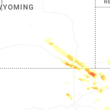
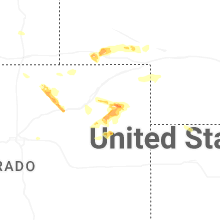
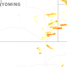
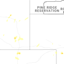
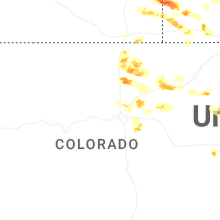
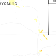
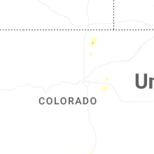
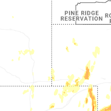


Connect with Interactive Hail Maps