

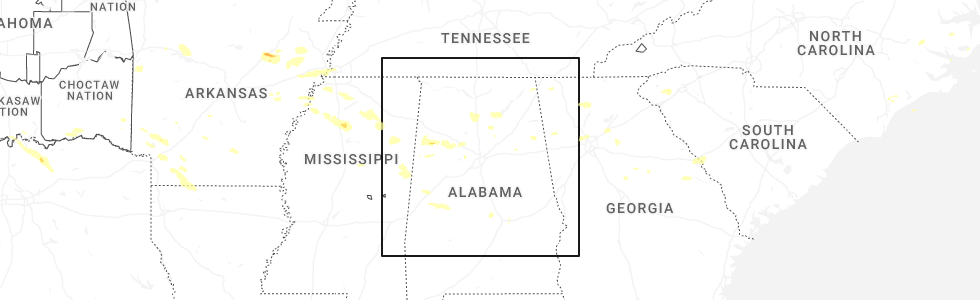
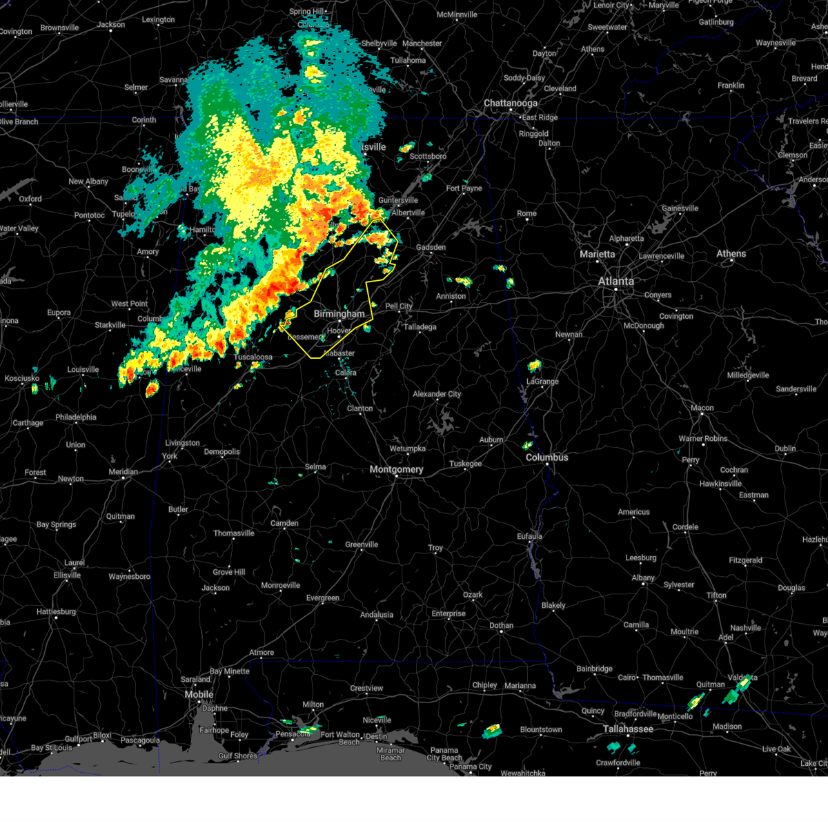
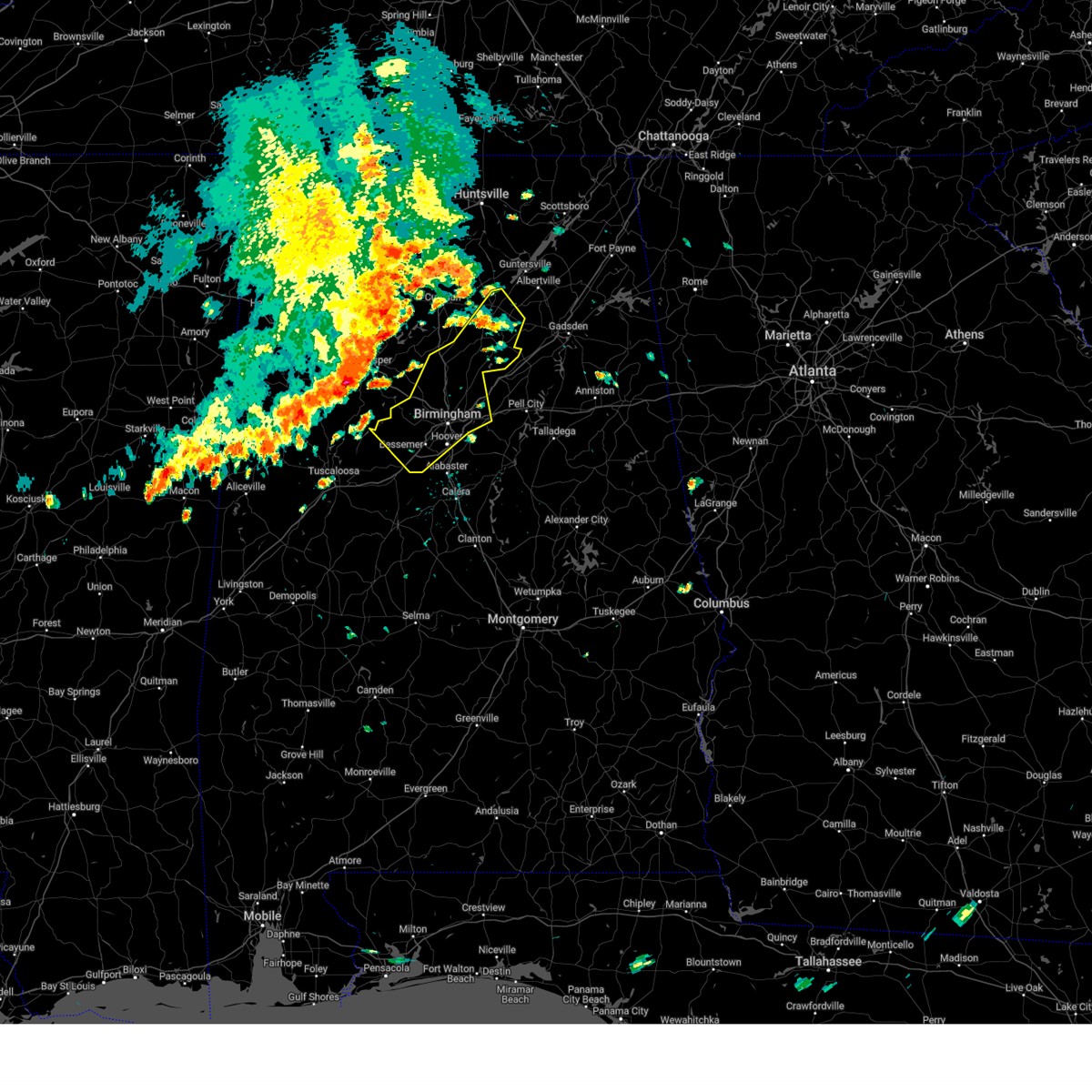
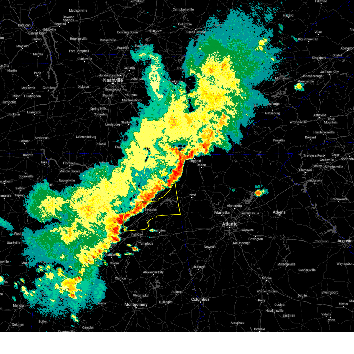
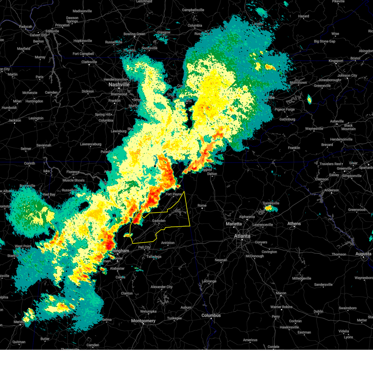
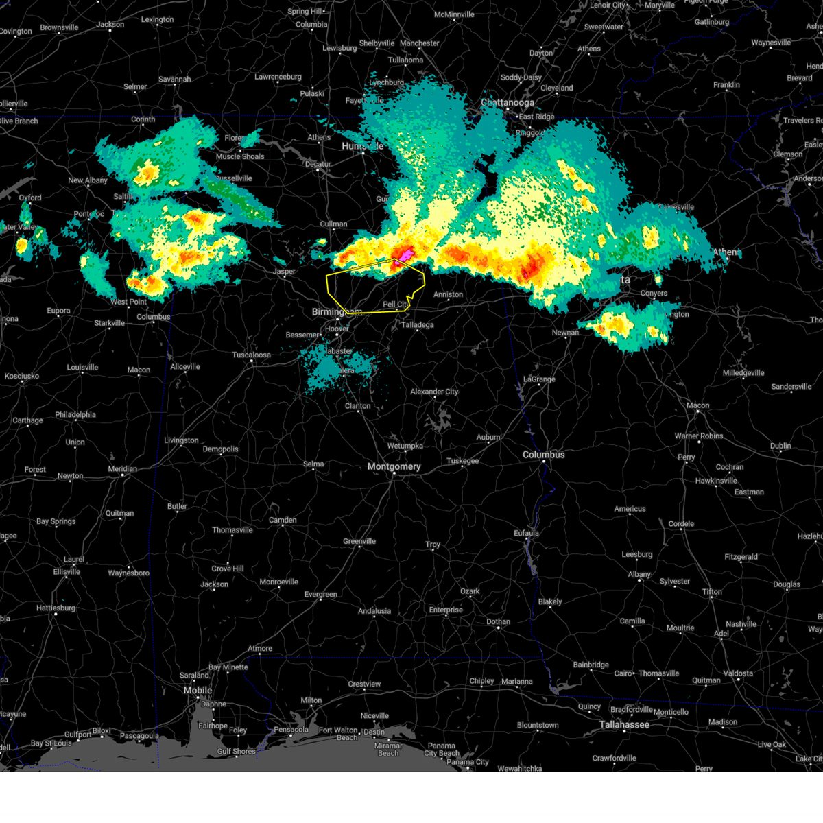
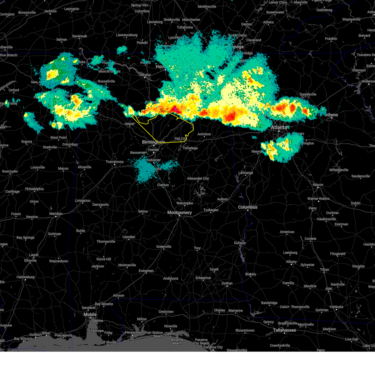
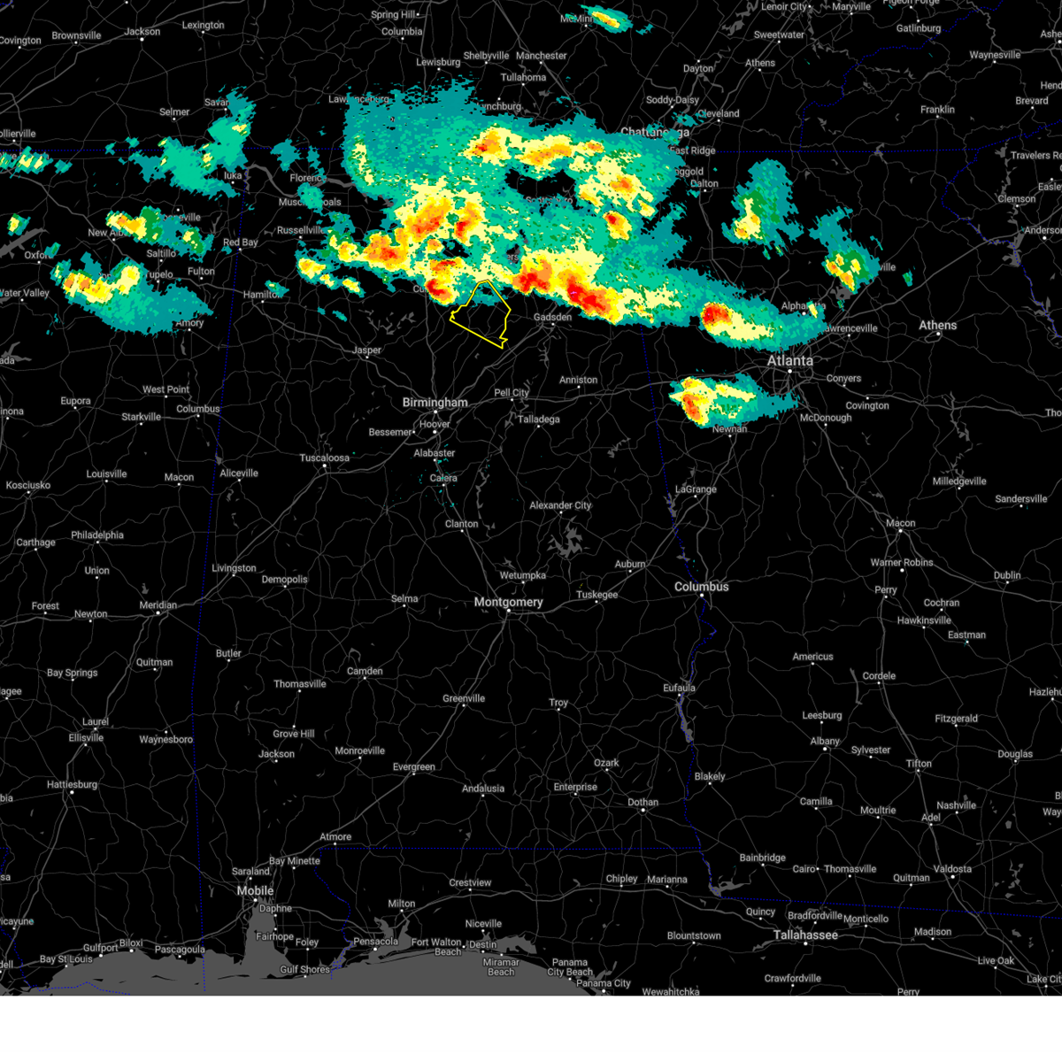
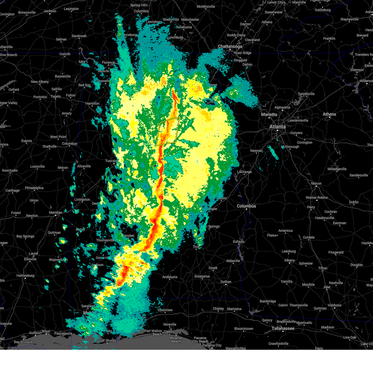
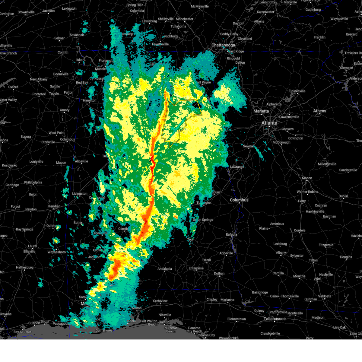
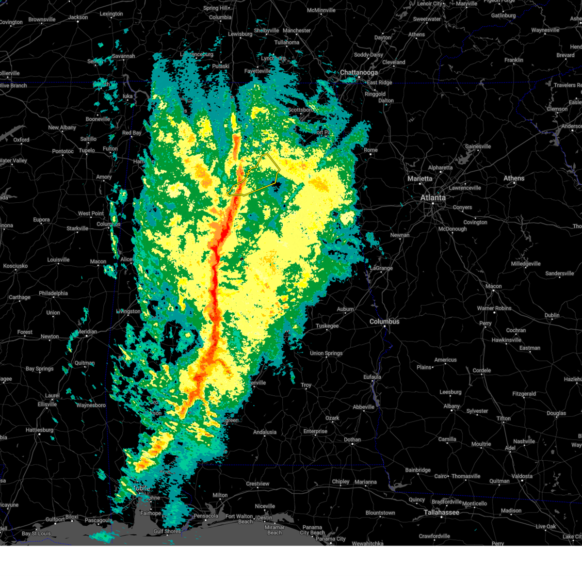
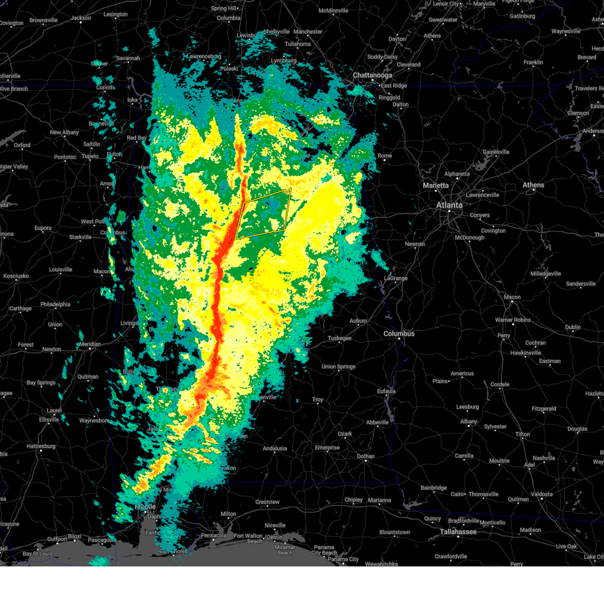
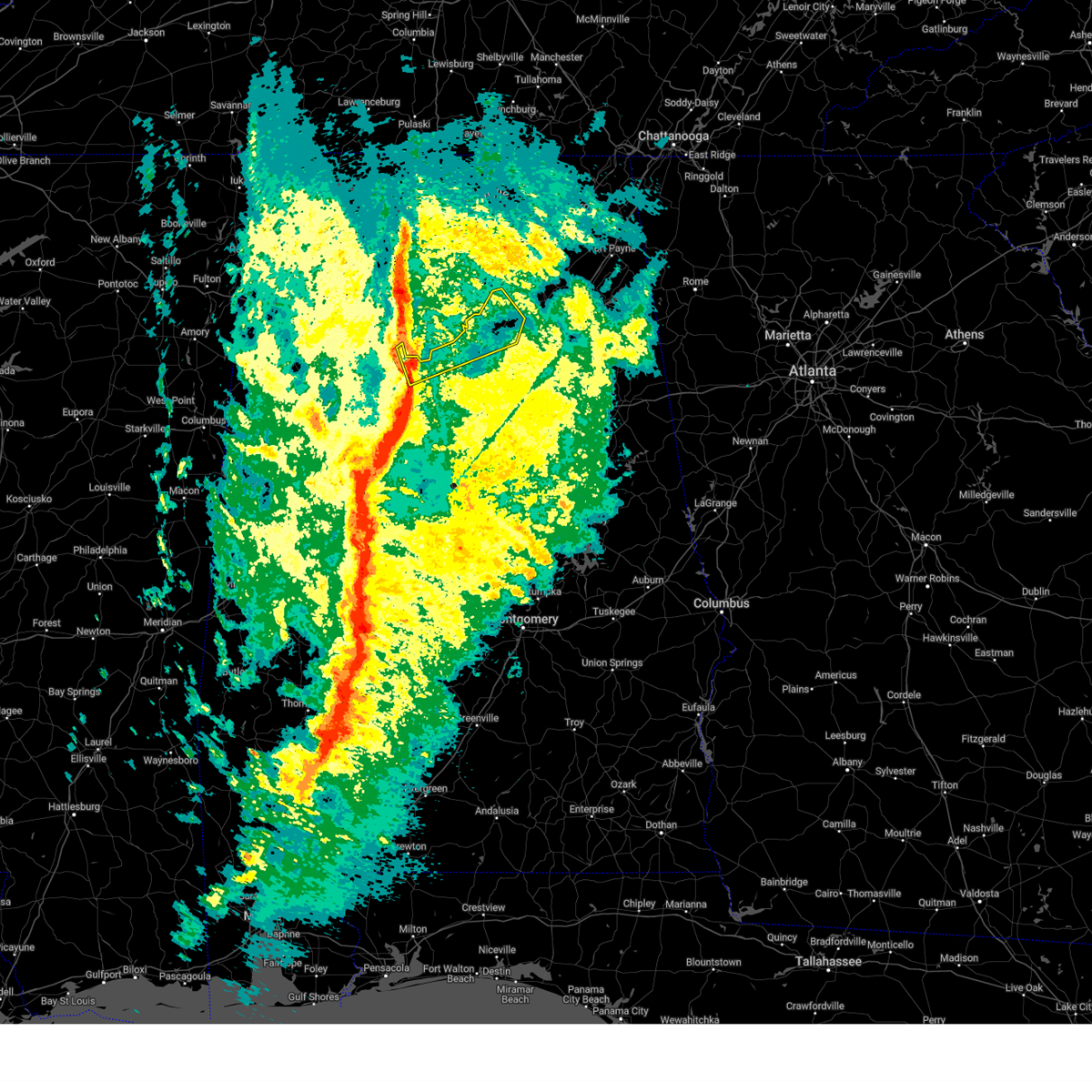
Hail Map for Oneonta, AL
The Oneonta, AL area has had 15 reports of on-the-ground hail by trained spotters, and has been under severe weather warnings 27 times during the past 12 months. Doppler radar has detected hail at or near Oneonta, AL on 79 occasions, including 6 occasions during the past year.
| Name: | Oneonta, AL |
| Where Located: | 32.8 miles NNE of Birmingham, AL |
| Map: | Google Map for Oneonta, AL |
| Population: | 6567 |
| Housing Units: | 2751 |
| More Info: | Search Google for Oneonta, AL |
1
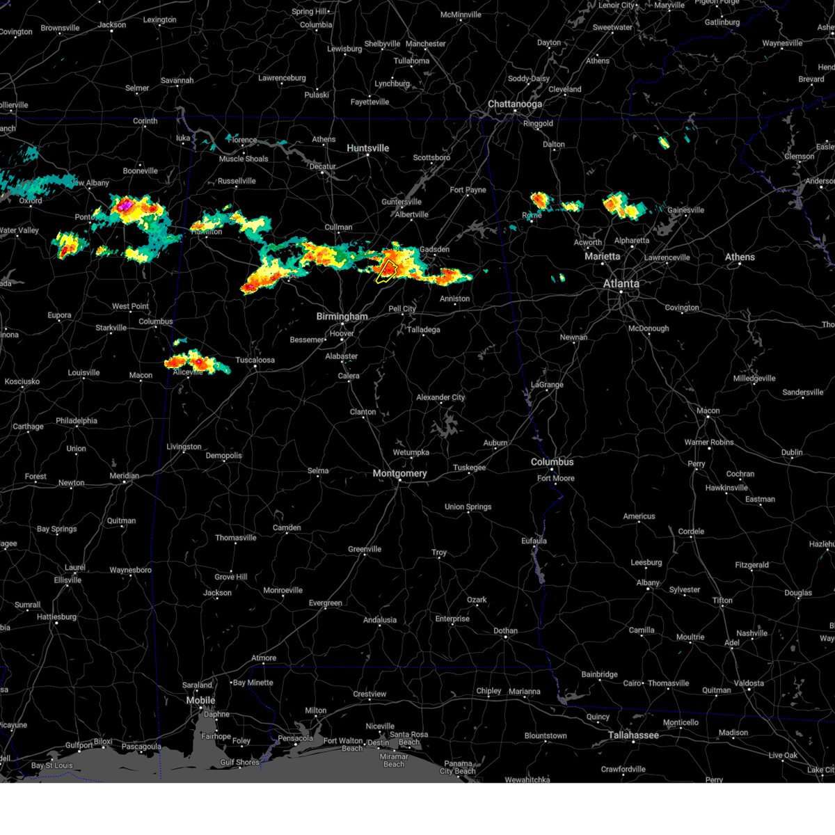
The Top Recent Hail Date for Oneonta, AL is Saturday, June 7, 2025 (24th out of 79)
Hail and Wind Damage Spotted near Oneonta, AL
| Date / Time | Report Details |
|---|---|
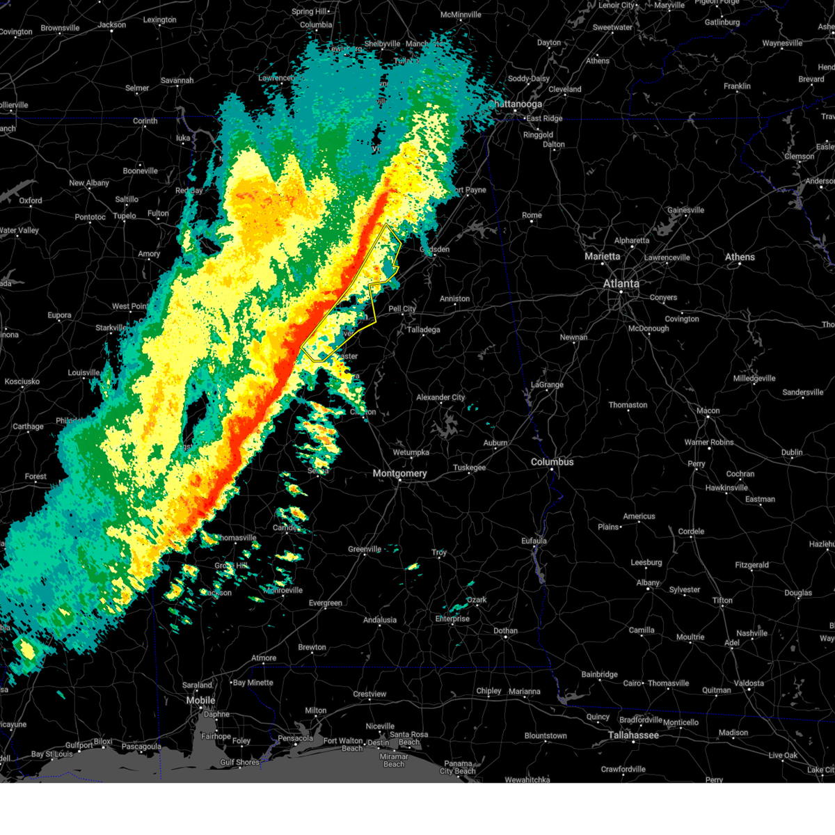
| 6/7/2025 2:48 PM CDT |
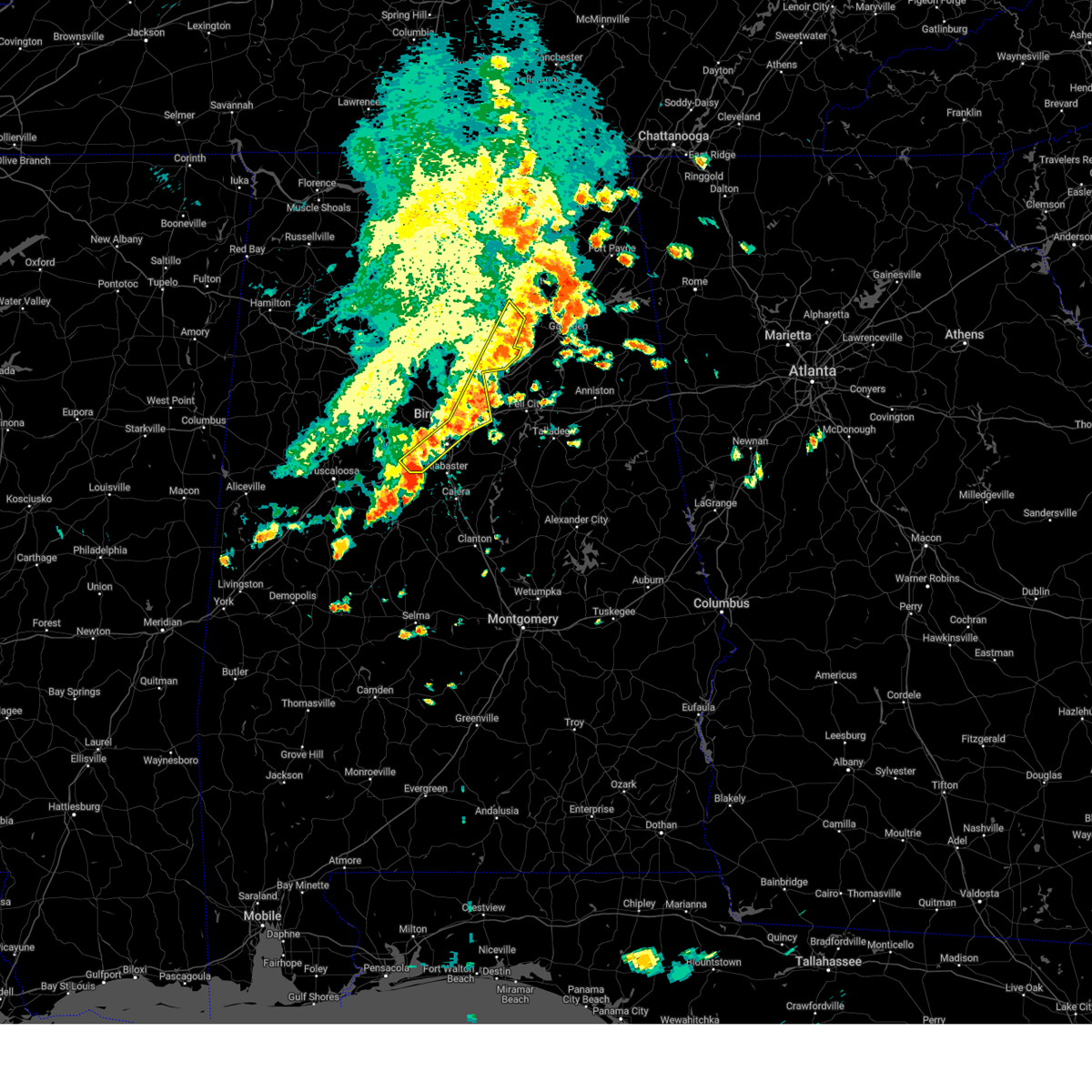 At 248 pm cdt, severe thunderstorms were located along a line extending from near mclarty to 6 miles southeast of oneonta to lake purdy to near maylene, moving east at 55 mph (radar indicated). Hazards include 60 mph wind gusts and penny size hail. Expect damage to roofs, siding, and trees. Locations impacted include, birmingham, hoover, vestavia hills, bessemer, homewood, mountain brook, trussville, irondale, leeds, moody, oneonta, center point, clay, pinson, tarrant, midfield, brighton, lipscomb, altoona, and snead. At 248 pm cdt, severe thunderstorms were located along a line extending from near mclarty to 6 miles southeast of oneonta to lake purdy to near maylene, moving east at 55 mph (radar indicated). Hazards include 60 mph wind gusts and penny size hail. Expect damage to roofs, siding, and trees. Locations impacted include, birmingham, hoover, vestavia hills, bessemer, homewood, mountain brook, trussville, irondale, leeds, moody, oneonta, center point, clay, pinson, tarrant, midfield, brighton, lipscomb, altoona, and snead.
|
| 6/7/2025 2:32 PM CDT | Trees down in the oneonta are in blount county AL, 3 miles SW of Oneonta, AL |
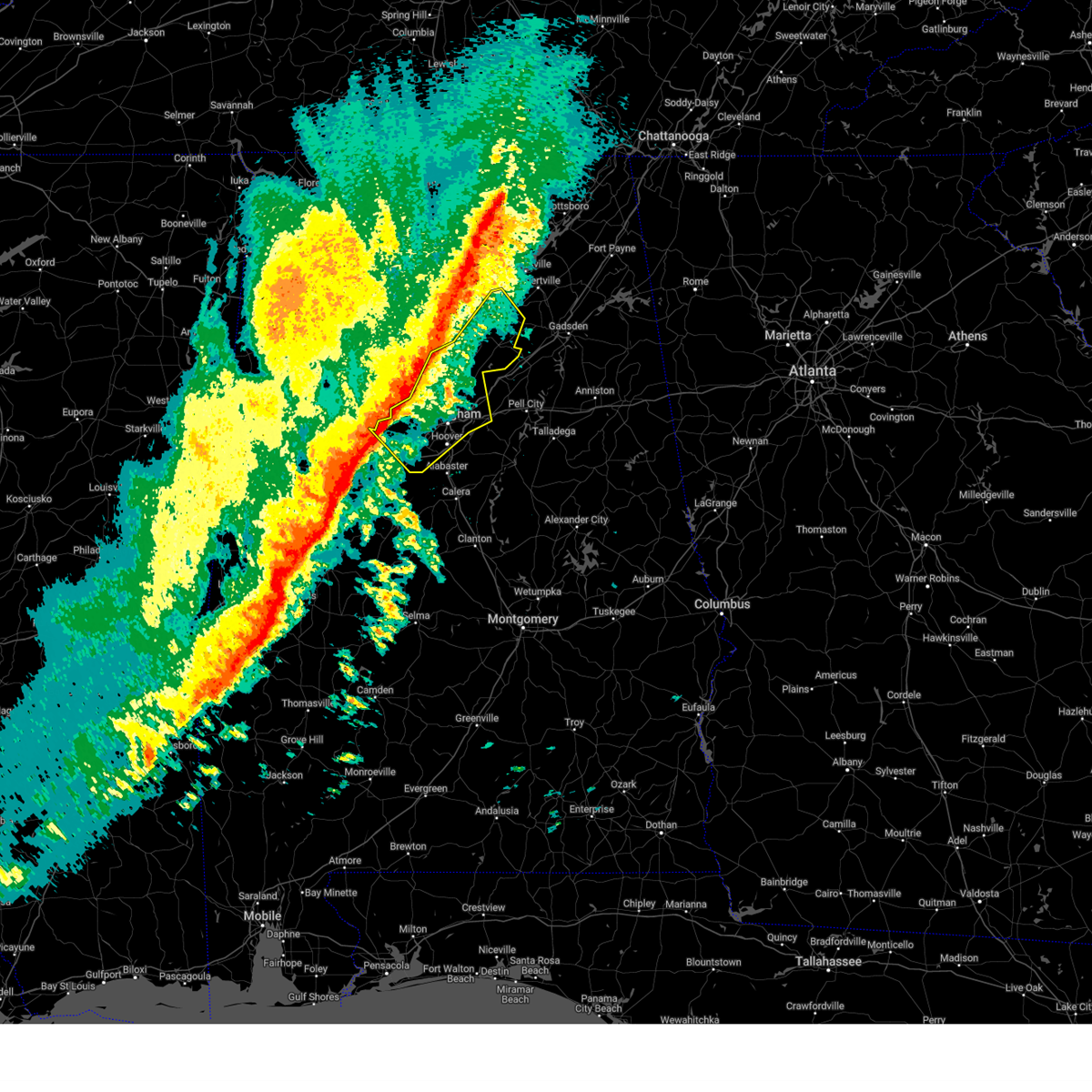
| 6/7/2025 2:31 PM CDT |
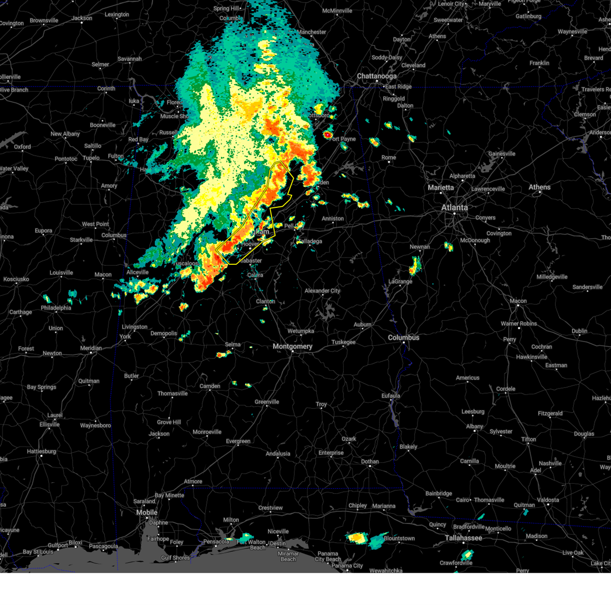 At 231 pm cdt, severe thunderstorms were located along a line extending from near mclarty to oneonta to birmingham to near tannehill ironworks state park, moving east at 45 mph (radar indicated). Hazards include 60 mph wind gusts and penny size hail. Expect damage to roofs, siding, and trees. Locations impacted include, birmingham, hoover, vestavia hills, bessemer, homewood, mountain brook, trussville, hueytown, gardendale, irondale, leeds, moody, fairfield, fultondale, oneonta, blountsville, cleveland, dallas, center point, and pleasant grove. At 231 pm cdt, severe thunderstorms were located along a line extending from near mclarty to oneonta to birmingham to near tannehill ironworks state park, moving east at 45 mph (radar indicated). Hazards include 60 mph wind gusts and penny size hail. Expect damage to roofs, siding, and trees. Locations impacted include, birmingham, hoover, vestavia hills, bessemer, homewood, mountain brook, trussville, hueytown, gardendale, irondale, leeds, moody, fairfield, fultondale, oneonta, blountsville, cleveland, dallas, center point, and pleasant grove.
|
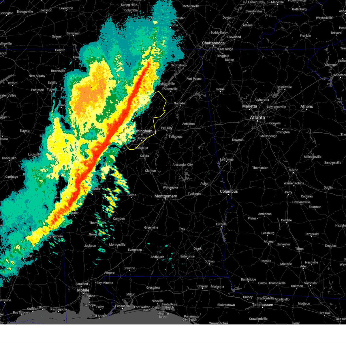
| 6/7/2025 2:12 PM CDT |
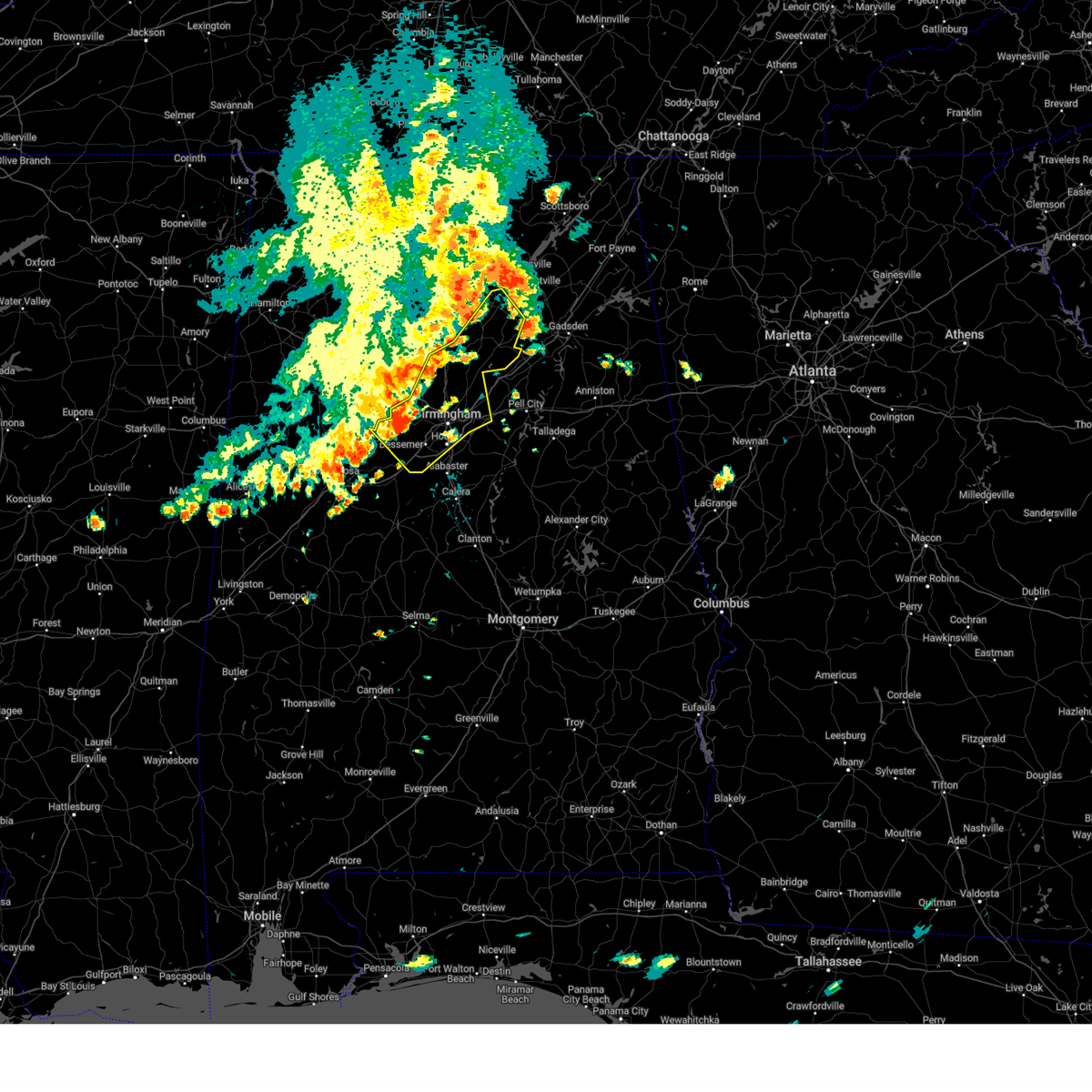 At 212 pm cdt, severe thunderstorms were located along a line extending from near holly pond to near blountsville to adamsville to near bull city, moving east at 70 mph (radar indicated). Hazards include 70 mph wind gusts and penny size hail. Expect considerable tree damage. damage is likely to mobile homes, roofs, and outbuildings. Locations impacted include, birmingham, hoover, vestavia hills, bessemer, homewood, mountain brook, trussville, hueytown, gardendale, irondale, leeds, moody, fairfield, fultondale, oneonta, blountsville, cleveland, dallas, center point, and pleasant grove. At 212 pm cdt, severe thunderstorms were located along a line extending from near holly pond to near blountsville to adamsville to near bull city, moving east at 70 mph (radar indicated). Hazards include 70 mph wind gusts and penny size hail. Expect considerable tree damage. damage is likely to mobile homes, roofs, and outbuildings. Locations impacted include, birmingham, hoover, vestavia hills, bessemer, homewood, mountain brook, trussville, hueytown, gardendale, irondale, leeds, moody, fairfield, fultondale, oneonta, blountsville, cleveland, dallas, center point, and pleasant grove.
|
| 6/7/2025 2:02 PM CDT |
 At 202 pm cdt, severe thunderstorms were located along a line extending from 8 miles southeast of falkville to near cullman to near sipsey to gorgas steam plant to near binion creek landing, moving east at 50 mph (radar indicated). Hazards include 70 mph wind gusts and penny size hail. Expect considerable tree damage. damage is likely to mobile homes, roofs, and outbuildings. Locations impacted include, birmingham, hoover, vestavia hills, bessemer, homewood, mountain brook, trussville, hueytown, gardendale, irondale, leeds, moody, fairfield, fultondale, oneonta, blountsville, cleveland, dallas, center point, and pleasant grove. At 202 pm cdt, severe thunderstorms were located along a line extending from 8 miles southeast of falkville to near cullman to near sipsey to gorgas steam plant to near binion creek landing, moving east at 50 mph (radar indicated). Hazards include 70 mph wind gusts and penny size hail. Expect considerable tree damage. damage is likely to mobile homes, roofs, and outbuildings. Locations impacted include, birmingham, hoover, vestavia hills, bessemer, homewood, mountain brook, trussville, hueytown, gardendale, irondale, leeds, moody, fairfield, fultondale, oneonta, blountsville, cleveland, dallas, center point, and pleasant grove.
|
| 6/7/2025 1:47 PM CDT |
 Svrbmx the national weather service in birmingham has issued a * severe thunderstorm warning for, blount county in central alabama, jefferson county in central alabama, * until 300 pm cdt. * at 146 pm cdt, severe thunderstorms were located along a line extending from addison to jasper to oakman to near binion creek landing, moving east at 65 mph (radar indicated). Hazards include 70 mph wind gusts and penny size hail. Expect considerable tree damage. Damage is likely to mobile homes, roofs, and outbuildings. Svrbmx the national weather service in birmingham has issued a * severe thunderstorm warning for, blount county in central alabama, jefferson county in central alabama, * until 300 pm cdt. * at 146 pm cdt, severe thunderstorms were located along a line extending from addison to jasper to oakman to near binion creek landing, moving east at 65 mph (radar indicated). Hazards include 70 mph wind gusts and penny size hail. Expect considerable tree damage. Damage is likely to mobile homes, roofs, and outbuildings.
|
| 5/2/2025 5:48 PM CDT |
 At 548 pm cdt, severe thunderstorms were located along a line extending from near trion to near steele, moving east at 55 mph (radar indicated). Hazards include 60 mph wind gusts and quarter size hail. Hail damage to vehicles is expected. expect wind damage to roofs, siding, and trees. Locations impacted include, whitney junction, weiss dam, gadsden steam plant, hokes bluff, yellow creek falls, rockledge, cherokee rock village, spring garden, fairview, aurora, little river canyon national preserve, pleasant gap, cornwall furnace park, cobb city, attalla, gadsden water works, blanche, eastern weiss lake, forney, and glencoe. At 548 pm cdt, severe thunderstorms were located along a line extending from near trion to near steele, moving east at 55 mph (radar indicated). Hazards include 60 mph wind gusts and quarter size hail. Hail damage to vehicles is expected. expect wind damage to roofs, siding, and trees. Locations impacted include, whitney junction, weiss dam, gadsden steam plant, hokes bluff, yellow creek falls, rockledge, cherokee rock village, spring garden, fairview, aurora, little river canyon national preserve, pleasant gap, cornwall furnace park, cobb city, attalla, gadsden water works, blanche, eastern weiss lake, forney, and glencoe.
|
| 5/2/2025 5:41 PM CDT | At 541 pm cdt, severe thunderstorms were located along a line extending from near albertville to birmingham fairgounds to near low gap, moving east at 40 mph (radar indicated). Hazards include 60 mph wind gusts and quarter size hail. Hail damage to vehicles is expected. expect wind damage to roofs, siding, and trees. locations impacted include, palmerdale, englewood, smoke rise, brookwood, mulga, new castle, mcfarland mall, green pond, ensley, miller steam plant, pearson, highland park golf course, lake tuscaloosa dam, snead, camp horne b. s. a. Village springs, weller, locust fork, mcadory, and duncanville. |
| 5/2/2025 5:28 PM CDT | Tree down on a vehicle on horton mill rd northeast of oneonta. no injuries reporte in blount county AL, 6.9 miles SSW of Oneonta, AL |
| 5/2/2025 5:25 PM CDT | Trees across roadway on county rd 39 northeast of oneont in blount county AL, 7.8 miles SW of Oneonta, AL |
| 5/2/2025 5:21 PM CDT |
 Svrbmx the national weather service in birmingham has issued a * severe thunderstorm warning for, eastern blount county in central alabama, etowah county in northeastern alabama, northern st. clair county in central alabama, cherokee county in northeastern alabama, * until 630 pm cdt. * at 520 pm cdt, severe thunderstorms were located along a line extending from near henagar to near nectar, moving east at 55 mph (radar indicated). Hazards include 60 mph wind gusts and half dollar size hail. Hail damage to vehicles is expected. Expect wind damage to roofs, siding, and trees. Svrbmx the national weather service in birmingham has issued a * severe thunderstorm warning for, eastern blount county in central alabama, etowah county in northeastern alabama, northern st. clair county in central alabama, cherokee county in northeastern alabama, * until 630 pm cdt. * at 520 pm cdt, severe thunderstorms were located along a line extending from near henagar to near nectar, moving east at 55 mph (radar indicated). Hazards include 60 mph wind gusts and half dollar size hail. Hail damage to vehicles is expected. Expect wind damage to roofs, siding, and trees.
|
| 5/2/2025 5:10 PM CDT | At 510 pm cdt, severe thunderstorms were located along a line extending from near strawberry to 6 miles west of concord to moundville, moving east at 40 mph (radar indicated). Hazards include 60 mph wind gusts and quarter size hail. Hail damage to vehicles is expected. expect wind damage to roofs, siding, and trees. Locations impacted include, lake tuscaloosa, palmerdale, englewood, ralph, northport, smoke rise, brookwood, mulga, new castle, bangor, mcfarland mall, green pond, ensley, miller steam plant, pearson, wiley, tuscaloosa regional airport, highland park golf course, lake tuscaloosa dam, and chamblees mill. |
| 5/2/2025 4:39 PM CDT | Svrbmx the national weather service in birmingham has issued a * severe thunderstorm warning for, tuscaloosa county in west central alabama, blount county in central alabama, jefferson county in central alabama, * until 600 pm cdt. * at 438 pm cdt, severe thunderstorms were located along a line extending from near cullman to 6 miles west of bankhead lock and dam to union, moving east at 40 mph (radar indicated). Hazards include 60 mph wind gusts and quarter size hail. Hail damage to vehicles is expected. Expect wind damage to roofs, siding, and trees. |
| 4/10/2025 7:38 PM CDT |
 the severe thunderstorm warning has been cancelled and is no longer in effect the severe thunderstorm warning has been cancelled and is no longer in effect
|
| 4/10/2025 7:38 PM CDT |
 At 738 pm cdt, severe thunderstorms were located along a line extending from near morris to near odenville to near neely henry lake, moving southeast at 55 mph (radar indicated). Hazards include 60 mph wind gusts and quarter size hail. Hail damage to vehicles is expected. expect wind damage to roofs, siding, and trees. Locations impacted include, whitney junction, pinson, palmerdale, wattsville, chalkville, new castle, gardendale, morris, clay, holly springs, village springs, chula vista, birmingham race course, trussville, moody, springville, neely henry lake, ragland, trafford, and bald rock. At 738 pm cdt, severe thunderstorms were located along a line extending from near morris to near odenville to near neely henry lake, moving southeast at 55 mph (radar indicated). Hazards include 60 mph wind gusts and quarter size hail. Hail damage to vehicles is expected. expect wind damage to roofs, siding, and trees. Locations impacted include, whitney junction, pinson, palmerdale, wattsville, chalkville, new castle, gardendale, morris, clay, holly springs, village springs, chula vista, birmingham race course, trussville, moody, springville, neely henry lake, ragland, trafford, and bald rock.
|
| 4/10/2025 7:27 PM CDT | Large trees down across oneont in blount county AL, 3 miles SW of Oneonta, AL |
| 4/10/2025 7:15 PM CDT |
 Svrbmx the national weather service in birmingham has issued a * severe thunderstorm warning for, northeastern walker county in central alabama, blount county in central alabama, northeastern jefferson county in central alabama, st. clair county in central alabama, * until 830 pm cdt. * at 715 pm cdt, severe thunderstorms were located along a line extending from near smith dam to near bangor to near susan moore, moving southeast at 35 mph (radar indicated). Hazards include 60 mph wind gusts and quarter size hail. Hail damage to vehicles is expected. Expect wind damage to roofs, siding, and trees. Svrbmx the national weather service in birmingham has issued a * severe thunderstorm warning for, northeastern walker county in central alabama, blount county in central alabama, northeastern jefferson county in central alabama, st. clair county in central alabama, * until 830 pm cdt. * at 715 pm cdt, severe thunderstorms were located along a line extending from near smith dam to near bangor to near susan moore, moving southeast at 35 mph (radar indicated). Hazards include 60 mph wind gusts and quarter size hail. Hail damage to vehicles is expected. Expect wind damage to roofs, siding, and trees.
|
| 4/10/2025 6:31 PM CDT |
 Svrbmx the national weather service in birmingham has issued a * severe thunderstorm warning for, northeastern blount county in central alabama, * until 715 pm cdt. * at 630 pm cdt, a severe thunderstorm was located near holly pond, or 7 miles northwest of blountsville, moving southeast at 55 mph (radar indicated). Hazards include 60 mph wind gusts and half dollar size hail. Hail damage to vehicles is expected. Expect wind damage to roofs, siding, and trees. Svrbmx the national weather service in birmingham has issued a * severe thunderstorm warning for, northeastern blount county in central alabama, * until 715 pm cdt. * at 630 pm cdt, a severe thunderstorm was located near holly pond, or 7 miles northwest of blountsville, moving southeast at 55 mph (radar indicated). Hazards include 60 mph wind gusts and half dollar size hail. Hail damage to vehicles is expected. Expect wind damage to roofs, siding, and trees.
|
| 3/4/2025 9:28 PM CST |
 At 928 pm cst, severe thunderstorms were located along a line extending from near altoona to near argo, moving northeast at 45 mph (radar indicated). Hazards include 60 mph wind gusts. Expect damage to roofs, siding, and trees. locations impacted include, pinson, palmerdale, chalkville, shops of grand river, bald rock, remlap, grayson valley, margaret, barber motorsports park, clear springs, center point, branchville, dallas, allgood, clay, st. Clair springs, leeds, argo, holly springs, and village springs. At 928 pm cst, severe thunderstorms were located along a line extending from near altoona to near argo, moving northeast at 45 mph (radar indicated). Hazards include 60 mph wind gusts. Expect damage to roofs, siding, and trees. locations impacted include, pinson, palmerdale, chalkville, shops of grand river, bald rock, remlap, grayson valley, margaret, barber motorsports park, clear springs, center point, branchville, dallas, allgood, clay, st. Clair springs, leeds, argo, holly springs, and village springs.
|
| 3/4/2025 9:23 PM CST |
 Svrbmx the national weather service in birmingham has issued a * severe thunderstorm warning for, southeastern blount county in central alabama, etowah county in northeastern alabama, st. clair county in central alabama, * until 1045 pm cst. * at 922 pm cst, severe thunderstorms were located along a line extending from mclarty to shops of grand river, moving east at 40 mph (radar indicated). Hazards include 60 mph wind gusts. expect damage to roofs, siding, and trees Svrbmx the national weather service in birmingham has issued a * severe thunderstorm warning for, southeastern blount county in central alabama, etowah county in northeastern alabama, st. clair county in central alabama, * until 1045 pm cst. * at 922 pm cst, severe thunderstorms were located along a line extending from mclarty to shops of grand river, moving east at 40 mph (radar indicated). Hazards include 60 mph wind gusts. expect damage to roofs, siding, and trees
|
| 3/4/2025 9:19 PM CST |
 At 919 pm cst, a severe thunderstorm was located over brooksville, or 7 miles northeast of blountsville, moving northeast at 45 mph (radar indicated). Hazards include 60 mph wind gusts. Expect damage to roofs, siding, and trees. Locations impacted include, mclarty, nectar, easley, snead, locust fork, cleveland, rosa, fairview, oneonta, fowler spring, strawberry, hendrix, brooksville, blountsville, susan moore, allgood, and altoona. At 919 pm cst, a severe thunderstorm was located over brooksville, or 7 miles northeast of blountsville, moving northeast at 45 mph (radar indicated). Hazards include 60 mph wind gusts. Expect damage to roofs, siding, and trees. Locations impacted include, mclarty, nectar, easley, snead, locust fork, cleveland, rosa, fairview, oneonta, fowler spring, strawberry, hendrix, brooksville, blountsville, susan moore, allgood, and altoona.
|
| 3/4/2025 8:55 PM CST |
 At 853 pm cst, a severe thunderstorm was located over bangor, or 12 miles west of cleveland, moving northeast at 45 mph (radar indicated). Hazards include 60 mph wind gusts. Expect damage to roofs, siding, and trees. Locations impacted include, mclarty, easley, smoke rise, cleveland, rosa, fairview, bangor, oneonta, strawberry, rickwood caverns, allgood, susan moore, nectar, hayden, chamblees mill, snead, locust fork, blount springs, arkadelphia, and fowler spring. At 853 pm cst, a severe thunderstorm was located over bangor, or 12 miles west of cleveland, moving northeast at 45 mph (radar indicated). Hazards include 60 mph wind gusts. Expect damage to roofs, siding, and trees. Locations impacted include, mclarty, easley, smoke rise, cleveland, rosa, fairview, bangor, oneonta, strawberry, rickwood caverns, allgood, susan moore, nectar, hayden, chamblees mill, snead, locust fork, blount springs, arkadelphia, and fowler spring.
|
| 3/4/2025 8:55 PM CST |
 the severe thunderstorm warning has been cancelled and is no longer in effect the severe thunderstorm warning has been cancelled and is no longer in effect
|
| 3/4/2025 8:47 PM CST |
 Svrbmx the national weather service in birmingham has issued a * severe thunderstorm warning for, southeastern blount county in central alabama, northeastern jefferson county in central alabama, northwestern st. clair county in central alabama, * until 945 pm cst. * at 846 pm cst, severe thunderstorms were located along a line extending from warrior to mcdonald chapel, moving northeast at 45 mph (radar indicated). Hazards include 60 mph wind gusts. expect damage to roofs, siding, and trees Svrbmx the national weather service in birmingham has issued a * severe thunderstorm warning for, southeastern blount county in central alabama, northeastern jefferson county in central alabama, northwestern st. clair county in central alabama, * until 945 pm cst. * at 846 pm cst, severe thunderstorms were located along a line extending from warrior to mcdonald chapel, moving northeast at 45 mph (radar indicated). Hazards include 60 mph wind gusts. expect damage to roofs, siding, and trees
|
| 3/4/2025 8:29 PM CST |
 Svrbmx the national weather service in birmingham has issued a * severe thunderstorm warning for, northeastern walker county in central alabama, blount county in central alabama, north central jefferson county in central alabama, * until 930 pm cst. * at 829 pm cst, a severe thunderstorm was located over sipsey, or near sumiton, moving northeast at 45 mph (radar indicated). Hazards include 60 mph wind gusts. expect damage to roofs, siding, and trees Svrbmx the national weather service in birmingham has issued a * severe thunderstorm warning for, northeastern walker county in central alabama, blount county in central alabama, north central jefferson county in central alabama, * until 930 pm cst. * at 829 pm cst, a severe thunderstorm was located over sipsey, or near sumiton, moving northeast at 45 mph (radar indicated). Hazards include 60 mph wind gusts. expect damage to roofs, siding, and trees
|
| 2/16/2025 1:32 AM CST | the severe thunderstorm warning has been cancelled and is no longer in effect |
| 2/16/2025 1:18 AM CST | At 117 am cst, severe thunderstorms were located along a line extending from near sardis city to near trussville to near helena, moving east at 70 mph (radar indicated). Hazards include 70 mph wind gusts. Expect considerable tree damage. damage is likely to mobile homes, roofs, and outbuildings. Locations impacted include, birmingham, hoover, vestavia hills, bessemer, homewood, mountain brook, trussville, gardendale, irondale, leeds, moody, fultondale, oneonta, center point, clay, pinson, tarrant, midfield, lipscomb, and altoona. |
| 2/16/2025 1:17 AM CST | At 117 am cst, severe thunderstorms were located along a line extending from near sardis city to near trussville to near helena, moving east at 70 mph (radar indicated). Hazards include 70 mph wind gusts. Expect considerable tree damage. damage is likely to mobile homes, roofs, and outbuildings. Locations impacted include, birmingham, hoover, vestavia hills, bessemer, homewood, mountain brook, trussville, gardendale, irondale, leeds, moody, fultondale, oneonta, center point, clay, pinson, tarrant, midfield, lipscomb, and altoona. |
| 2/16/2025 1:06 AM CST |
 At 105 am cst, severe thunderstorms were located along a line extending from near albertville to near clay to near tannehill ironworks state park, moving east at 50 mph (radar indicated). Hazards include 70 mph wind gusts. Expect considerable tree damage. damage is likely to mobile homes, roofs, and outbuildings. Locations impacted include, birmingham, hoover, vestavia hills, bessemer, homewood, mountain brook, trussville, hueytown, gardendale, irondale, leeds, moody, fairfield, fultondale, oneonta, cleveland, dallas, center point, pleasant grove, and clay. At 105 am cst, severe thunderstorms were located along a line extending from near albertville to near clay to near tannehill ironworks state park, moving east at 50 mph (radar indicated). Hazards include 70 mph wind gusts. Expect considerable tree damage. damage is likely to mobile homes, roofs, and outbuildings. Locations impacted include, birmingham, hoover, vestavia hills, bessemer, homewood, mountain brook, trussville, hueytown, gardendale, irondale, leeds, moody, fairfield, fultondale, oneonta, cleveland, dallas, center point, pleasant grove, and clay.
|
| 2/16/2025 1:01 AM CST | Trees down in various locations in blount count in blount county AL, 2.5 miles SW of Oneonta, AL |
| 2/16/2025 12:38 AM CST |
 At 1238 am cst, severe thunderstorms were located along a line extending from 8 miles northwest of holly pond to deerlick creek campgrounds, moving east at 50 mph (radar indicated). Hazards include 70 mph wind gusts. Expect considerable tree damage. damage is likely to mobile homes, roofs, and outbuildings. Locations impacted include, birmingham, hoover, vestavia hills, bessemer, homewood, mountain brook, trussville, hueytown, gardendale, irondale, leeds, moody, fairfield, fultondale, oneonta, blountsville, cleveland, dallas, center point, and pleasant grove. At 1238 am cst, severe thunderstorms were located along a line extending from 8 miles northwest of holly pond to deerlick creek campgrounds, moving east at 50 mph (radar indicated). Hazards include 70 mph wind gusts. Expect considerable tree damage. damage is likely to mobile homes, roofs, and outbuildings. Locations impacted include, birmingham, hoover, vestavia hills, bessemer, homewood, mountain brook, trussville, hueytown, gardendale, irondale, leeds, moody, fairfield, fultondale, oneonta, blountsville, cleveland, dallas, center point, and pleasant grove.
|
| 2/16/2025 12:25 AM CST |
 Svrbmx the national weather service in birmingham has issued a * severe thunderstorm warning for, blount county in central alabama, jefferson county in central alabama, * until 145 am cst. * at 1225 am cst, severe thunderstorms were located along a line extending from 6 miles south of falkville to near northport, moving east at 50 mph (radar indicated). Hazards include 70 mph wind gusts. Expect considerable tree damage. Damage is likely to mobile homes, roofs, and outbuildings. Svrbmx the national weather service in birmingham has issued a * severe thunderstorm warning for, blount county in central alabama, jefferson county in central alabama, * until 145 am cst. * at 1225 am cst, severe thunderstorms were located along a line extending from 6 miles south of falkville to near northport, moving east at 50 mph (radar indicated). Hazards include 70 mph wind gusts. Expect considerable tree damage. Damage is likely to mobile homes, roofs, and outbuildings.
|
| 6/26/2024 4:48 PM CDT |
 At 448 pm cdt, a severe thunderstorm was located over rosa, or near oneonta, moving northeast at 20 mph (radar indicated). Hazards include 60 mph wind gusts. Expect damage to roofs, siding, and trees. Locations impacted include, oneonta, cleveland, locust fork, altoona, snead, susan moore, walnut grove, allgood, fairview, nectar, rosa, mclarty, inland lake, highland lake, easley, hendrix, and holly springs. At 448 pm cdt, a severe thunderstorm was located over rosa, or near oneonta, moving northeast at 20 mph (radar indicated). Hazards include 60 mph wind gusts. Expect damage to roofs, siding, and trees. Locations impacted include, oneonta, cleveland, locust fork, altoona, snead, susan moore, walnut grove, allgood, fairview, nectar, rosa, mclarty, inland lake, highland lake, easley, hendrix, and holly springs.
|
| 6/26/2024 4:36 PM CDT | Trees and power lines were blown down on high school stree in blount county AL, 2.6 miles WSW of Oneonta, AL |
| 6/26/2024 4:33 PM CDT |
 At 433 pm cdt, a severe thunderstorm was located over oneonta, moving northeast at 25 mph (radar indicated). Hazards include 60 mph wind gusts. Expect damage to roofs, siding, and trees. Locations impacted include, oneonta, cleveland, locust fork, altoona, snead, susan moore, walnut grove, allgood, fairview, nectar, rosa, mclarty, inland lake, highland lake, easley, hendrix, and holly springs. At 433 pm cdt, a severe thunderstorm was located over oneonta, moving northeast at 25 mph (radar indicated). Hazards include 60 mph wind gusts. Expect damage to roofs, siding, and trees. Locations impacted include, oneonta, cleveland, locust fork, altoona, snead, susan moore, walnut grove, allgood, fairview, nectar, rosa, mclarty, inland lake, highland lake, easley, hendrix, and holly springs.
|
| 6/26/2024 4:21 PM CDT |
 Svrbmx the national weather service in birmingham has issued a * severe thunderstorm warning for, eastern blount county in central alabama, * until 500 pm cdt. * at 419 pm cdt, a severe thunderstorm was located over allgood, or near oneonta, moving northeast at 25 mph (radar indicated). Hazards include 60 mph wind gusts. expect damage to roofs, siding, and trees Svrbmx the national weather service in birmingham has issued a * severe thunderstorm warning for, eastern blount county in central alabama, * until 500 pm cdt. * at 419 pm cdt, a severe thunderstorm was located over allgood, or near oneonta, moving northeast at 25 mph (radar indicated). Hazards include 60 mph wind gusts. expect damage to roofs, siding, and trees
|
| 6/26/2024 4:20 PM CDT | A tree was blown down on moss drive near moss roa in blount county AL, 3.5 miles ESE of Oneonta, AL |
| 6/9/2024 8:05 PM CDT |
 The storm which prompted the warning has moved out of the area. therefore, the warning will be allowed to expire. a severe thunderstorm watch remains in effect until 100 am cdt for central and northeastern alabama. The storm which prompted the warning has moved out of the area. therefore, the warning will be allowed to expire. a severe thunderstorm watch remains in effect until 100 am cdt for central and northeastern alabama.
|
| 6/9/2024 7:58 PM CDT |
 At 757 pm cdt, a severe thunderstorm was located near oneonta, moving southeast at 15 mph (emergency management). Hazards include 60 mph wind gusts and half dollar size hail. Hail damage to vehicles is expected. expect wind damage to roofs, siding, and trees. Locations impacted include, inland lake, highland lake, and holly springs. At 757 pm cdt, a severe thunderstorm was located near oneonta, moving southeast at 15 mph (emergency management). Hazards include 60 mph wind gusts and half dollar size hail. Hail damage to vehicles is expected. expect wind damage to roofs, siding, and trees. Locations impacted include, inland lake, highland lake, and holly springs.
|
| 6/9/2024 7:51 PM CDT | Ping Pong Ball sized hail reported 1.8 miles WSW of Oneonta, AL, ping pong ball size hail. |
| 6/9/2024 7:48 PM CDT | Golf Ball sized hail reported 1 miles N of Oneonta, AL, golf ball size hail reported in allgood with pictures. |
| 6/9/2024 7:45 PM CDT | Ping Pong Ball sized hail reported 1.8 miles WSW of Oneonta, AL, corrects previous hail report from 1 s oneonta. ping pong ball size hail. |
| 6/9/2024 7:45 PM CDT | Golf Ball sized hail reported 2.1 miles WNW of Oneonta, AL |
| 6/9/2024 7:42 PM CDT | Golf Ball sized hail reported 1 miles N of Oneonta, AL, corrects previous hail report from 1 ne allgood. golf ball size hail reported in allgood with pictures. |
| 6/9/2024 7:42 PM CDT | Hen Egg sized hail reported 1 miles N of Oneonta, AL, picture of estimated 2 inch hail. |
| 6/9/2024 7:37 PM CDT |
 At 737 pm cdt, a severe thunderstorm was located over fairview, or near cleveland, moving southeast at 15 mph (radar indicated). Hazards include 60 mph wind gusts and half dollar size hail. Hail damage to vehicles is expected. expect wind damage to roofs, siding, and trees. Locations impacted include, oneonta, cleveland, locust fork, allgood, fairview, nectar, rosa, inland lake, highland lake, easley, clear springs, and holly springs. At 737 pm cdt, a severe thunderstorm was located over fairview, or near cleveland, moving southeast at 15 mph (radar indicated). Hazards include 60 mph wind gusts and half dollar size hail. Hail damage to vehicles is expected. expect wind damage to roofs, siding, and trees. Locations impacted include, oneonta, cleveland, locust fork, allgood, fairview, nectar, rosa, inland lake, highland lake, easley, clear springs, and holly springs.
|
| 6/9/2024 7:26 PM CDT |
 Svrbmx the national weather service in birmingham has issued a * severe thunderstorm warning for, southeastern blount county in central alabama, * until 815 pm cdt. * at 726 pm cdt, a severe thunderstorm was located over cleveland, moving southeast at 15 mph (radar indicated). Hazards include 60 mph wind gusts and quarter size hail. Hail damage to vehicles is expected. Expect wind damage to roofs, siding, and trees. Svrbmx the national weather service in birmingham has issued a * severe thunderstorm warning for, southeastern blount county in central alabama, * until 815 pm cdt. * at 726 pm cdt, a severe thunderstorm was located over cleveland, moving southeast at 15 mph (radar indicated). Hazards include 60 mph wind gusts and quarter size hail. Hail damage to vehicles is expected. Expect wind damage to roofs, siding, and trees.
|
| 6/5/2024 8:47 PM CDT |
 the severe thunderstorm warning has been cancelled and is no longer in effect the severe thunderstorm warning has been cancelled and is no longer in effect
|
| 6/5/2024 8:31 PM CDT |
 At 831 pm cdt, severe thunderstorms were located along a line extending from near locust fork to springville, moving northeast at 60 mph (radar indicated). Hazards include 60 mph wind gusts. Expect damage to roofs, siding, and trees. Locations impacted include, rainbow city, oneonta, springville, blountsville, cleveland, dallas, margaret, argo, ashville, locust fork, steele, altoona, snead, susan moore, walnut grove, allgood, fairview, nectar, rosa, and mclarty. At 831 pm cdt, severe thunderstorms were located along a line extending from near locust fork to springville, moving northeast at 60 mph (radar indicated). Hazards include 60 mph wind gusts. Expect damage to roofs, siding, and trees. Locations impacted include, rainbow city, oneonta, springville, blountsville, cleveland, dallas, margaret, argo, ashville, locust fork, steele, altoona, snead, susan moore, walnut grove, allgood, fairview, nectar, rosa, and mclarty.
|
| 6/5/2024 8:31 PM CDT |
 the severe thunderstorm warning has been cancelled and is no longer in effect the severe thunderstorm warning has been cancelled and is no longer in effect
|
| 6/5/2024 8:13 PM CDT |
 At 813 pm cdt, severe thunderstorms were located along a line extending from near sumiton to birmingham to riverchase galleria, moving northeast at 55 mph (radar indicated). Hazards include 60 mph wind gusts. Expect damage to roofs, siding, and trees. Locations impacted include, birmingham, hoover, vestavia hills, bessemer, homewood, pelham, mountain brook, trussville, helena, hueytown, gardendale, pell city, irondale, leeds, moody, fairfield, rainbow city, fultondale, oneonta, and springville. At 813 pm cdt, severe thunderstorms were located along a line extending from near sumiton to birmingham to riverchase galleria, moving northeast at 55 mph (radar indicated). Hazards include 60 mph wind gusts. Expect damage to roofs, siding, and trees. Locations impacted include, birmingham, hoover, vestavia hills, bessemer, homewood, pelham, mountain brook, trussville, helena, hueytown, gardendale, pell city, irondale, leeds, moody, fairfield, rainbow city, fultondale, oneonta, and springville.
|
| 6/5/2024 8:00 PM CDT |
 Svrbmx the national weather service in birmingham has issued a * severe thunderstorm warning for, blount county in central alabama, shelby county in central alabama, jefferson county in central alabama, st. clair county in central alabama, * until 900 pm cdt. * at 759 pm cdt, severe thunderstorms were located along a line extending from near gorgas steam plant to wilton, moving northeast at 50 mph (radar indicated). Hazards include 60 mph wind gusts. expect damage to roofs, siding, and trees Svrbmx the national weather service in birmingham has issued a * severe thunderstorm warning for, blount county in central alabama, shelby county in central alabama, jefferson county in central alabama, st. clair county in central alabama, * until 900 pm cdt. * at 759 pm cdt, severe thunderstorms were located along a line extending from near gorgas steam plant to wilton, moving northeast at 50 mph (radar indicated). Hazards include 60 mph wind gusts. expect damage to roofs, siding, and trees
|
| 5/27/2024 5:02 AM CDT |
 the severe thunderstorm warning has been cancelled and is no longer in effect the severe thunderstorm warning has been cancelled and is no longer in effect
|
| 5/27/2024 4:48 AM CDT |
 At 448 am cdt, severe thunderstorms were located along a line extending from 9 miles north of cave spring to 6 miles northwest of ashville, moving southeast at 40 mph (radar indicated). Hazards include 60 mph wind gusts and penny size hail. Expect damage to roofs, siding, and trees. Locations impacted include, gadsden, rainbow city, oneonta, attalla, hokes bluff, centre, cedar bluff, blountsville, cleveland, little river canyon national preserve, forney, centre municipal airport, glencoe, sardis city, steele, leesburg, altoona, snead, susan moore, and walnut grove. At 448 am cdt, severe thunderstorms were located along a line extending from 9 miles north of cave spring to 6 miles northwest of ashville, moving southeast at 40 mph (radar indicated). Hazards include 60 mph wind gusts and penny size hail. Expect damage to roofs, siding, and trees. Locations impacted include, gadsden, rainbow city, oneonta, attalla, hokes bluff, centre, cedar bluff, blountsville, cleveland, little river canyon national preserve, forney, centre municipal airport, glencoe, sardis city, steele, leesburg, altoona, snead, susan moore, and walnut grove.
|
| 5/27/2024 4:27 AM CDT |
 At 426 am cdt, severe thunderstorms were located along a line extending from 7 miles east of blanche to near susan moore, moving southeast at 40 mph (radar indicated). Hazards include 60 mph wind gusts and quarter size hail. Hail damage to vehicles is expected. expect wind damage to roofs, siding, and trees. Locations impacted include, gadsden, rainbow city, oneonta, attalla, hokes bluff, centre, cedar bluff, blountsville, cleveland, little river canyon national preserve, forney, centre municipal airport, glencoe, sardis city, steele, leesburg, altoona, snead, susan moore, and walnut grove. At 426 am cdt, severe thunderstorms were located along a line extending from 7 miles east of blanche to near susan moore, moving southeast at 40 mph (radar indicated). Hazards include 60 mph wind gusts and quarter size hail. Hail damage to vehicles is expected. expect wind damage to roofs, siding, and trees. Locations impacted include, gadsden, rainbow city, oneonta, attalla, hokes bluff, centre, cedar bluff, blountsville, cleveland, little river canyon national preserve, forney, centre municipal airport, glencoe, sardis city, steele, leesburg, altoona, snead, susan moore, and walnut grove.
|
| 5/27/2024 4:12 AM CDT |
 Svrbmx the national weather service in birmingham has issued a * severe thunderstorm warning for, eastern blount county in central alabama, etowah county in northeastern alabama, cherokee county in northeastern alabama, * until 515 am cdt. * at 412 am cdt, severe thunderstorms were located along a line extending from 8 miles northeast of little river falls to near holly pond, moving southeast at 40 mph (radar indicated). Hazards include 60 mph wind gusts and quarter size hail. Hail damage to vehicles is expected. Expect wind damage to roofs, siding, and trees. Svrbmx the national weather service in birmingham has issued a * severe thunderstorm warning for, eastern blount county in central alabama, etowah county in northeastern alabama, cherokee county in northeastern alabama, * until 515 am cdt. * at 412 am cdt, severe thunderstorms were located along a line extending from 8 miles northeast of little river falls to near holly pond, moving southeast at 40 mph (radar indicated). Hazards include 60 mph wind gusts and quarter size hail. Hail damage to vehicles is expected. Expect wind damage to roofs, siding, and trees.
|
| 5/18/2024 3:38 PM CDT |
 At 338 pm cdt, a severe thunderstorm was located near clay, or near springville, moving east at 20 mph (radar indicated). Hazards include 60 mph wind gusts and quarter size hail. Hail damage to vehicles is expected. expect wind damage to roofs, siding, and trees. Locations impacted include, trussville, dallas, center point, clay, pinson, locust fork, chalkville, grayson valley, inland lake, palmerdale, village springs, remlap, and clear springs. At 338 pm cdt, a severe thunderstorm was located near clay, or near springville, moving east at 20 mph (radar indicated). Hazards include 60 mph wind gusts and quarter size hail. Hail damage to vehicles is expected. expect wind damage to roofs, siding, and trees. Locations impacted include, trussville, dallas, center point, clay, pinson, locust fork, chalkville, grayson valley, inland lake, palmerdale, village springs, remlap, and clear springs.
|
| 5/18/2024 3:37 PM CDT |
 Svrbmx the national weather service in birmingham has issued a * severe thunderstorm warning for, southeastern blount county in central alabama, northeastern jefferson county in central alabama, northwestern st. clair county in central alabama, * until 415 pm cdt. * at 336 pm cdt, a severe thunderstorm was located near clay, or 7 miles west of springville, moving east at 30 mph (radar indicated). Hazards include 60 mph wind gusts and quarter size hail. Hail damage to vehicles is expected. Expect wind damage to roofs, siding, and trees. Svrbmx the national weather service in birmingham has issued a * severe thunderstorm warning for, southeastern blount county in central alabama, northeastern jefferson county in central alabama, northwestern st. clair county in central alabama, * until 415 pm cdt. * at 336 pm cdt, a severe thunderstorm was located near clay, or 7 miles west of springville, moving east at 30 mph (radar indicated). Hazards include 60 mph wind gusts and quarter size hail. Hail damage to vehicles is expected. Expect wind damage to roofs, siding, and trees.
|
| 5/18/2024 3:17 PM CDT |
 Svrbmx the national weather service in birmingham has issued a * severe thunderstorm warning for, southwestern blount county in central alabama, northeastern jefferson county in central alabama, * until 345 pm cdt. * at 316 pm cdt, a severe thunderstorm was located near county line, or 8 miles northeast of gardendale, moving east at 20 mph (radar indicated). Hazards include 60 mph wind gusts. expect damage to roofs, siding, and trees Svrbmx the national weather service in birmingham has issued a * severe thunderstorm warning for, southwestern blount county in central alabama, northeastern jefferson county in central alabama, * until 345 pm cdt. * at 316 pm cdt, a severe thunderstorm was located near county line, or 8 miles northeast of gardendale, moving east at 20 mph (radar indicated). Hazards include 60 mph wind gusts. expect damage to roofs, siding, and trees
|
| 5/9/2024 7:57 AM CDT |
 Svrbmx the national weather service in birmingham has issued a * severe thunderstorm warning for, blount county in central alabama, * until 845 am cdt. * at 757 am cdt, severe thunderstorms were located along a line extending from 9 miles west of arab to near smith dam, moving east at 60 mph (radar indicated). Hazards include 60 mph wind gusts and quarter size hail. Hail damage to vehicles is expected. Expect wind damage to roofs, siding, and trees. Svrbmx the national weather service in birmingham has issued a * severe thunderstorm warning for, blount county in central alabama, * until 845 am cdt. * at 757 am cdt, severe thunderstorms were located along a line extending from 9 miles west of arab to near smith dam, moving east at 60 mph (radar indicated). Hazards include 60 mph wind gusts and quarter size hail. Hail damage to vehicles is expected. Expect wind damage to roofs, siding, and trees.
|
| 3/15/2024 6:48 AM CDT |
 At 648 am cdt, severe thunderstorms were located along a line extending from snead to allgood, moving east at 40 mph (radar indicated). Hazards include 60 mph wind gusts. Expect damage to roofs, siding, and trees. Locations impacted include, gadsden, rainbow city, oneonta, attalla, ashville, sardis city, ragland, steele, altoona, snead, susan moore, walnut grove, reece city, allgood, rosa, tabor road, aurora, gadsden mall, noccalula falls, and neely henry lake. At 648 am cdt, severe thunderstorms were located along a line extending from snead to allgood, moving east at 40 mph (radar indicated). Hazards include 60 mph wind gusts. Expect damage to roofs, siding, and trees. Locations impacted include, gadsden, rainbow city, oneonta, attalla, ashville, sardis city, ragland, steele, altoona, snead, susan moore, walnut grove, reece city, allgood, rosa, tabor road, aurora, gadsden mall, noccalula falls, and neely henry lake.
|
| 3/15/2024 6:38 AM CDT |
 Svrbmx the national weather service in birmingham has issued a * severe thunderstorm warning for, blount county in central alabama, etowah county in northeastern alabama, northern st. clair county in central alabama, * until 745 am cdt. * at 638 am cdt, severe thunderstorms were located along a line extending from near mclarty to dallas, moving east at 40 mph (radar indicated). Hazards include 60 mph wind gusts. expect damage to roofs, siding, and trees Svrbmx the national weather service in birmingham has issued a * severe thunderstorm warning for, blount county in central alabama, etowah county in northeastern alabama, northern st. clair county in central alabama, * until 745 am cdt. * at 638 am cdt, severe thunderstorms were located along a line extending from near mclarty to dallas, moving east at 40 mph (radar indicated). Hazards include 60 mph wind gusts. expect damage to roofs, siding, and trees
|
| 12/10/2023 12:44 AM CST |
 At 1244 am cst, severe thunderstorms were located along a line extending from near inland lake to argo to near bald rock, moving northeast at 45 mph (public. numerous trees were reported down in the hoover and vestavia hills areas). Hazards include 60 mph wind gusts and quarter size hail. Hail damage to vehicles is expected. Expect wind damage to roofs, siding, and trees. At 1244 am cst, severe thunderstorms were located along a line extending from near inland lake to argo to near bald rock, moving northeast at 45 mph (public. numerous trees were reported down in the hoover and vestavia hills areas). Hazards include 60 mph wind gusts and quarter size hail. Hail damage to vehicles is expected. Expect wind damage to roofs, siding, and trees.
|
| 12/9/2023 11:59 PM CST |
 At 1159 pm cst, severe thunderstorms were located along a line extending from near cardiff to mcdonald chapel to near hoover metropolitan stadium, moving northeast at 55 mph (radar indicated). Hazards include 60 mph wind gusts and quarter size hail. Hail damage to vehicles is expected. Expect wind damage to roofs, siding, and trees. At 1159 pm cst, severe thunderstorms were located along a line extending from near cardiff to mcdonald chapel to near hoover metropolitan stadium, moving northeast at 55 mph (radar indicated). Hazards include 60 mph wind gusts and quarter size hail. Hail damage to vehicles is expected. Expect wind damage to roofs, siding, and trees.
|
| 8/12/2023 2:45 PM CDT | Multiple trees and power lines were blown down on al highway 75 north of oneonta. the highway was impassable near souls chapel roa in blount county AL, 10.4 miles SSW of Oneonta, AL |
| 8/11/2023 4:25 AM CDT |
 The severe thunderstorm warning for southeastern blount, northeastern jefferson and northwestern st. clair counties will expire at 430 am cdt, the storm which prompted the warning has weakened below severe limits, and has exited the warned area. therefore, the warning will be allowed to expire. The severe thunderstorm warning for southeastern blount, northeastern jefferson and northwestern st. clair counties will expire at 430 am cdt, the storm which prompted the warning has weakened below severe limits, and has exited the warned area. therefore, the warning will be allowed to expire.
|
| 8/11/2023 4:05 AM CDT |
 At 405 am cdt, a severe thunderstorm was located near springville, moving east at 35 mph (radar indicated). Hazards include 60 mph wind gusts. Expect damage to roofs, siding, and trees. locations impacted include, northeastern birmingham, trussville, moody, oneonta, springville, odenville, center point, clay, pinson, margaret, argo, allgood, chalkville, inland lake, grayson valley, branchville, highland lake, palmerdale, st. clair springs and holly springs. hail threat, radar indicated max hail size, <. 75 in wind threat, radar indicated max wind gust, 60 mph. At 405 am cdt, a severe thunderstorm was located near springville, moving east at 35 mph (radar indicated). Hazards include 60 mph wind gusts. Expect damage to roofs, siding, and trees. locations impacted include, northeastern birmingham, trussville, moody, oneonta, springville, odenville, center point, clay, pinson, margaret, argo, allgood, chalkville, inland lake, grayson valley, branchville, highland lake, palmerdale, st. clair springs and holly springs. hail threat, radar indicated max hail size, <. 75 in wind threat, radar indicated max wind gust, 60 mph.
|
| 8/11/2023 3:38 AM CDT |
 At 338 am cdt, a severe thunderstorm was located over trafford, or 9 miles north of gardendale, moving east at 25 mph (radar indicated). Hazards include 60 mph wind gusts. expect damage to roofs, siding, and trees At 338 am cdt, a severe thunderstorm was located over trafford, or 9 miles north of gardendale, moving east at 25 mph (radar indicated). Hazards include 60 mph wind gusts. expect damage to roofs, siding, and trees
|
| 8/9/2023 5:58 PM CDT |
 At 558 pm cdt, a severe thunderstorm was located near inland lake, or near springville, moving east at 30 mph (emergency management). Hazards include 60 mph wind gusts and half dollar size hail. Hail damage to vehicles is expected. expect wind damage to roofs, siding, and trees. locations impacted include, dallas, clay, pinson, argo, warrior, kimberly, locust fork, trafford, county line, inland lake, highland lake, palmerdale, holly springs, village springs, remlap and clear springs. hail threat, radar indicated max hail size, 1. 25 in wind threat, radar indicated max wind gust, 60 mph. At 558 pm cdt, a severe thunderstorm was located near inland lake, or near springville, moving east at 30 mph (emergency management). Hazards include 60 mph wind gusts and half dollar size hail. Hail damage to vehicles is expected. expect wind damage to roofs, siding, and trees. locations impacted include, dallas, clay, pinson, argo, warrior, kimberly, locust fork, trafford, county line, inland lake, highland lake, palmerdale, holly springs, village springs, remlap and clear springs. hail threat, radar indicated max hail size, 1. 25 in wind threat, radar indicated max wind gust, 60 mph.
|
| 8/9/2023 5:38 PM CDT |
 At 538 pm cdt, a severe thunderstorm was located over trafford, or 11 miles north of gardendale, moving east at 30 mph (emergency management). Hazards include golf ball size hail and 60 mph wind gusts. People and animals outdoors will be injured. expect hail damage to roofs, siding, windows, and vehicles. expect wind damage to roofs, siding, and trees. Locations impacted include, dallas, clay, pinson, argo, warrior, kimberly, locust fork, trafford, allgood, hayden, county line, inland lake, highland lake, palmerdale, holly springs, village springs, remlap, clear springs and smoke rise. At 538 pm cdt, a severe thunderstorm was located over trafford, or 11 miles north of gardendale, moving east at 30 mph (emergency management). Hazards include golf ball size hail and 60 mph wind gusts. People and animals outdoors will be injured. expect hail damage to roofs, siding, windows, and vehicles. expect wind damage to roofs, siding, and trees. Locations impacted include, dallas, clay, pinson, argo, warrior, kimberly, locust fork, trafford, allgood, hayden, county line, inland lake, highland lake, palmerdale, holly springs, village springs, remlap, clear springs and smoke rise.
|
| 8/9/2023 5:26 PM CDT |
 At 526 pm cdt, a severe thunderstorm was located near warrior, or 12 miles north of gardendale, moving east at 30 mph (radar indicated). Hazards include 60 mph wind gusts and half dollar size hail. Hail damage to vehicles is expected. Expect wind damage to roofs, siding, and trees. At 526 pm cdt, a severe thunderstorm was located near warrior, or 12 miles north of gardendale, moving east at 30 mph (radar indicated). Hazards include 60 mph wind gusts and half dollar size hail. Hail damage to vehicles is expected. Expect wind damage to roofs, siding, and trees.
|
| 8/7/2023 3:20 PM CDT |
 The severe thunderstorm warning for blount county will expire at 330 pm cdt, the storm which prompted the warning has moved out of the area. therefore, the warning will be allowed to expire. however gusty winds are still possible with this thunderstorm. a severe thunderstorm watch remains in effect until 700 pm cdt for central and northeastern alabama. The severe thunderstorm warning for blount county will expire at 330 pm cdt, the storm which prompted the warning has moved out of the area. therefore, the warning will be allowed to expire. however gusty winds are still possible with this thunderstorm. a severe thunderstorm watch remains in effect until 700 pm cdt for central and northeastern alabama.
|
| 8/7/2023 3:01 PM CDT | Tree down on holliday drive in the highland lake are in blount county AL, 6.1 miles WNW of Oneonta, AL |
| 8/7/2023 2:50 PM CDT |
 At 250 pm cdt, severe thunderstorms were located along a line extending from little river canyon national preserve to near bangor, moving southeast at 25 mph (radar indicated). Hazards include 60 mph wind gusts. expect damage to roofs, siding, and trees At 250 pm cdt, severe thunderstorms were located along a line extending from little river canyon national preserve to near bangor, moving southeast at 25 mph (radar indicated). Hazards include 60 mph wind gusts. expect damage to roofs, siding, and trees
|
| 8/7/2023 2:35 PM CDT | Tree down on county highway in blount county AL, 1.7 miles ESE of Oneonta, AL |
| 8/7/2023 2:33 PM CDT |
 At 233 pm cdt, a severe thunderstorm was located near blountsville, moving east at 30 mph (radar indicated). Hazards include 60 mph wind gusts. expect damage to roofs, siding, and trees At 233 pm cdt, a severe thunderstorm was located near blountsville, moving east at 30 mph (radar indicated). Hazards include 60 mph wind gusts. expect damage to roofs, siding, and trees
|
| 8/6/2023 3:47 PM CDT |
 At 347 pm cdt, severe thunderstorms were located along a line extending from near albertville to near springville, moving east at 45 mph (radar indicated). Hazards include 60 mph wind gusts. Expect damage to roofs, siding, and trees. locations impacted include, oneonta, cleveland, altoona, snead, susan moore, walnut grove, allgood, fairview, rosa, mclarty, inland lake, brooksville, highland lake, easley, holly springs, remlap, clear springs and hendrix. hail threat, radar indicated max hail size, <. 75 in wind threat, radar indicated max wind gust, 60 mph. At 347 pm cdt, severe thunderstorms were located along a line extending from near albertville to near springville, moving east at 45 mph (radar indicated). Hazards include 60 mph wind gusts. Expect damage to roofs, siding, and trees. locations impacted include, oneonta, cleveland, altoona, snead, susan moore, walnut grove, allgood, fairview, rosa, mclarty, inland lake, brooksville, highland lake, easley, holly springs, remlap, clear springs and hendrix. hail threat, radar indicated max hail size, <. 75 in wind threat, radar indicated max wind gust, 60 mph.
|
| 8/6/2023 3:30 PM CDT | Numerous reports of trees down in the oneonta area and around the count in blount county AL, 3 miles SW of Oneonta, AL |
| 8/6/2023 3:23 PM CDT |
 At 323 pm cdt, severe thunderstorms were located along a line extending from near holly pond to county line, moving east at 45 mph (radar indicated). Hazards include 60 mph wind gusts. Expect damage to roofs, siding, and trees. locations impacted include, oneonta, blountsville, cleveland, dallas, locust fork, altoona, snead, susan moore, walnut grove, trafford, allgood, fairview, hayden, nectar, rosa, county line, mclarty, bangor, strawberry and blount springs. hail threat, radar indicated max hail size, <. 75 in wind threat, radar indicated max wind gust, 60 mph. At 323 pm cdt, severe thunderstorms were located along a line extending from near holly pond to county line, moving east at 45 mph (radar indicated). Hazards include 60 mph wind gusts. Expect damage to roofs, siding, and trees. locations impacted include, oneonta, blountsville, cleveland, dallas, locust fork, altoona, snead, susan moore, walnut grove, trafford, allgood, fairview, hayden, nectar, rosa, county line, mclarty, bangor, strawberry and blount springs. hail threat, radar indicated max hail size, <. 75 in wind threat, radar indicated max wind gust, 60 mph.
|
| 8/6/2023 3:09 PM CDT |
 At 309 pm cdt, severe thunderstorms were located along a line extending from 6 miles northeast of cullman to near arkadelphia, moving east at 45 mph (radar indicated). Hazards include 60 mph wind gusts. expect damage to roofs, siding, and trees At 309 pm cdt, severe thunderstorms were located along a line extending from 6 miles northeast of cullman to near arkadelphia, moving east at 45 mph (radar indicated). Hazards include 60 mph wind gusts. expect damage to roofs, siding, and trees
|
| 8/3/2023 2:28 PM CDT |
 At 228 pm cdt, severe thunderstorms were located along a line extending from near steele to warrior, moving southeast at 30 mph (radar indicated). Hazards include 60 mph wind gusts. Expect damage to roofs, siding, and trees. locations impacted include, oneonta, dallas, locust fork, trafford, allgood, hayden, county line, inland lake, highland lake, smoke rise, holly springs, remlap, clear springs and rickwood caverns. hail threat, radar indicated max hail size, <. 75 in wind threat, radar indicated max wind gust, 60 mph. At 228 pm cdt, severe thunderstorms were located along a line extending from near steele to warrior, moving southeast at 30 mph (radar indicated). Hazards include 60 mph wind gusts. Expect damage to roofs, siding, and trees. locations impacted include, oneonta, dallas, locust fork, trafford, allgood, hayden, county line, inland lake, highland lake, smoke rise, holly springs, remlap, clear springs and rickwood caverns. hail threat, radar indicated max hail size, <. 75 in wind threat, radar indicated max wind gust, 60 mph.
|
| 8/3/2023 2:03 PM CDT | A few trees blown down in the oneonta are in blount county AL, 2.5 miles SW of Oneonta, AL |
| 8/3/2023 1:43 PM CDT |
 At 142 pm cdt, severe thunderstorms were located along a line extending from near strawberry to near smith dam, moving southeast at 25 mph (radar indicated). Hazards include 60 mph wind gusts. expect damage to roofs, siding, and trees At 142 pm cdt, severe thunderstorms were located along a line extending from near strawberry to near smith dam, moving southeast at 25 mph (radar indicated). Hazards include 60 mph wind gusts. expect damage to roofs, siding, and trees
|
| 7/21/2023 4:45 PM CDT |
 At 444 pm cdt, severe thunderstorms were located along a line extending from near aurora to near oneonta to near pinson, moving southeast at 25 mph (radar indicated). Hazards include 60 mph wind gusts and quarter size hail. Hail damage to vehicles is expected. expect wind damage to roofs, siding, and trees. locations impacted include, trussville, gardendale, oneonta, springville, dallas, center point, clay, pinson, margaret, argo, warrior, kimberly, ashville, morris, sardis city, locust fork, steele, altoona, snead and susan moore. hail threat, radar indicated max hail size, 1. 00 in wind threat, radar indicated max wind gust, 60 mph. At 444 pm cdt, severe thunderstorms were located along a line extending from near aurora to near oneonta to near pinson, moving southeast at 25 mph (radar indicated). Hazards include 60 mph wind gusts and quarter size hail. Hail damage to vehicles is expected. expect wind damage to roofs, siding, and trees. locations impacted include, trussville, gardendale, oneonta, springville, dallas, center point, clay, pinson, margaret, argo, warrior, kimberly, ashville, morris, sardis city, locust fork, steele, altoona, snead and susan moore. hail threat, radar indicated max hail size, 1. 00 in wind threat, radar indicated max wind gust, 60 mph.
|
| 7/21/2023 4:30 PM CDT |
 At 430 pm cdt, severe thunderstorms were located along a line extending from mclarty to fairview to near kimberly, moving southeast at 25 mph (radar indicated). Hazards include 60 mph wind gusts and quarter size hail. Hail damage to vehicles is expected. Expect wind damage to roofs, siding, and trees. At 430 pm cdt, severe thunderstorms were located along a line extending from mclarty to fairview to near kimberly, moving southeast at 25 mph (radar indicated). Hazards include 60 mph wind gusts and quarter size hail. Hail damage to vehicles is expected. Expect wind damage to roofs, siding, and trees.
|
| 7/18/2023 6:30 PM CDT | Large tree blocking roadway in oneonta. winds around 40-50 mp in blount county AL, 3 miles SW of Oneonta, AL |
| 6/25/2023 4:34 PM CDT |
 At 434 pm cdt, severe thunderstorms were located along a line extending from tennala to gadsden mall to cleveland, moving southeast at 30 mph (radar indicated). Hazards include 60 mph wind gusts and quarter size hail. Hail damage to vehicles is expected. expect wind damage to roofs, siding, and trees. locations impacted include, gadsden, rainbow city, oneonta, attalla, hokes bluff, centre, cedar bluff, blountsville, cleveland, forney, centre municipal airport, glencoe, leesburg, altoona, snead, susan moore, walnut grove, reece city, allgood and fairview. hail threat, radar indicated max hail size, 1. 00 in wind threat, radar indicated max wind gust, 60 mph. At 434 pm cdt, severe thunderstorms were located along a line extending from tennala to gadsden mall to cleveland, moving southeast at 30 mph (radar indicated). Hazards include 60 mph wind gusts and quarter size hail. Hail damage to vehicles is expected. expect wind damage to roofs, siding, and trees. locations impacted include, gadsden, rainbow city, oneonta, attalla, hokes bluff, centre, cedar bluff, blountsville, cleveland, forney, centre municipal airport, glencoe, leesburg, altoona, snead, susan moore, walnut grove, reece city, allgood and fairview. hail threat, radar indicated max hail size, 1. 00 in wind threat, radar indicated max wind gust, 60 mph.
|
| 6/25/2023 4:19 PM CDT |
 At 419 pm cdt, severe thunderstorms were located along a line extending from sand rock to near reece city to near blountsville, moving southeast at 30 mph (radar indicated). Hazards include 60 mph wind gusts and quarter size hail. Hail damage to vehicles is expected. expect wind damage to roofs, siding, and trees. locations impacted include, gadsden, rainbow city, oneonta, attalla, hokes bluff, centre, cedar bluff, blountsville, cleveland, forney, centre municipal airport, glencoe, sardis city, leesburg, altoona, snead, susan moore, walnut grove, reece city and allgood. hail threat, radar indicated max hail size, 1. 00 in wind threat, radar indicated max wind gust, 60 mph. At 419 pm cdt, severe thunderstorms were located along a line extending from sand rock to near reece city to near blountsville, moving southeast at 30 mph (radar indicated). Hazards include 60 mph wind gusts and quarter size hail. Hail damage to vehicles is expected. expect wind damage to roofs, siding, and trees. locations impacted include, gadsden, rainbow city, oneonta, attalla, hokes bluff, centre, cedar bluff, blountsville, cleveland, forney, centre municipal airport, glencoe, sardis city, leesburg, altoona, snead, susan moore, walnut grove, reece city and allgood. hail threat, radar indicated max hail size, 1. 00 in wind threat, radar indicated max wind gust, 60 mph.
|
| 6/25/2023 4:03 PM CDT |
 At 403 pm cdt, severe thunderstorms were located along a line extending from near crossville to near aurora to near hanceville, moving southeast at 25 mph (radar indicated). Hazards include 60 mph wind gusts and quarter size hail. Hail damage to vehicles is expected. expect wind damage to roofs, siding, and trees. locations impacted include, gadsden, rainbow city, oneonta, attalla, hokes bluff, centre, cedar bluff, blountsville, cleveland, forney, centre municipal airport, glencoe, sardis city, leesburg, altoona, snead, susan moore, walnut grove, reece city and allgood. hail threat, radar indicated max hail size, 1. 00 in wind threat, radar indicated max wind gust, 60 mph. At 403 pm cdt, severe thunderstorms were located along a line extending from near crossville to near aurora to near hanceville, moving southeast at 25 mph (radar indicated). Hazards include 60 mph wind gusts and quarter size hail. Hail damage to vehicles is expected. expect wind damage to roofs, siding, and trees. locations impacted include, gadsden, rainbow city, oneonta, attalla, hokes bluff, centre, cedar bluff, blountsville, cleveland, forney, centre municipal airport, glencoe, sardis city, leesburg, altoona, snead, susan moore, walnut grove, reece city and allgood. hail threat, radar indicated max hail size, 1. 00 in wind threat, radar indicated max wind gust, 60 mph.
|
| 6/25/2023 3:48 PM CDT |
 At 348 pm cdt, severe thunderstorms were located along a line extending from near geraldine to 6 miles northeast of strawberry to 8 miles northeast of cullman, moving southeast at 25 mph (radar indicated). Hazards include 60 mph wind gusts and quarter size hail. Hail damage to vehicles is expected. Expect wind damage to roofs, siding, and trees. At 348 pm cdt, severe thunderstorms were located along a line extending from near geraldine to 6 miles northeast of strawberry to 8 miles northeast of cullman, moving southeast at 25 mph (radar indicated). Hazards include 60 mph wind gusts and quarter size hail. Hail damage to vehicles is expected. Expect wind damage to roofs, siding, and trees.
|
| 6/14/2023 1:54 PM CDT |
 At 154 pm cdt, a severe thunderstorm was located near argo, or near springville, moving southeast at 55 mph (radar indicated). Hazards include 70 mph wind gusts and quarter size hail. Hail damage to vehicles is expected. expect considerable tree damage. wind damage is also likely to mobile homes, roofs, and outbuildings. locations impacted include, trussville, oneonta, center point, clay, pinson, altoona, snead, susan moore, allgood, rosa, chalkville, inland lake, grayson valley, highland lake, palmerdale, holly springs, village springs, remlap and clear springs. thunderstorm damage threat, considerable hail threat, radar indicated max hail size, 1. 00 in wind threat, radar indicated max wind gust, 70 mph. At 154 pm cdt, a severe thunderstorm was located near argo, or near springville, moving southeast at 55 mph (radar indicated). Hazards include 70 mph wind gusts and quarter size hail. Hail damage to vehicles is expected. expect considerable tree damage. wind damage is also likely to mobile homes, roofs, and outbuildings. locations impacted include, trussville, oneonta, center point, clay, pinson, altoona, snead, susan moore, allgood, rosa, chalkville, inland lake, grayson valley, highland lake, palmerdale, holly springs, village springs, remlap and clear springs. thunderstorm damage threat, considerable hail threat, radar indicated max hail size, 1. 00 in wind threat, radar indicated max wind gust, 70 mph.
|
| 6/14/2023 1:25 PM CDT |
 At 124 pm cdt, a severe thunderstorm was located near dodge city, or 15 miles south of cullman, moving southeast at 60 mph (radar indicated). Hazards include 70 mph wind gusts and quarter size hail. Hail damage to vehicles is expected. expect considerable tree damage. Wind damage is also likely to mobile homes, roofs, and outbuildings. At 124 pm cdt, a severe thunderstorm was located near dodge city, or 15 miles south of cullman, moving southeast at 60 mph (radar indicated). Hazards include 70 mph wind gusts and quarter size hail. Hail damage to vehicles is expected. expect considerable tree damage. Wind damage is also likely to mobile homes, roofs, and outbuildings.
|
| 6/14/2023 12:35 PM CDT | Trees down on covered bridge circl in blount county AL, 6.6 miles SW of Oneonta, AL |
| 6/14/2023 12:26 PM CDT |
 At 1226 pm cdt, a severe thunderstorm was located over rosa, or near oneonta, moving east at 45 mph (radar indicated). Hazards include 60 mph wind gusts and quarter size hail. Hail damage to vehicles is expected. expect wind damage to roofs, siding, and trees. locations impacted include, oneonta, blountsville, cleveland, locust fork, altoona, snead, susan moore, walnut grove, allgood, fairview, nectar, rosa, highland lake, easley, fowler spring and hendrix. hail threat, radar indicated max hail size, 1. 00 in wind threat, radar indicated max wind gust, 60 mph. At 1226 pm cdt, a severe thunderstorm was located over rosa, or near oneonta, moving east at 45 mph (radar indicated). Hazards include 60 mph wind gusts and quarter size hail. Hail damage to vehicles is expected. expect wind damage to roofs, siding, and trees. locations impacted include, oneonta, blountsville, cleveland, locust fork, altoona, snead, susan moore, walnut grove, allgood, fairview, nectar, rosa, highland lake, easley, fowler spring and hendrix. hail threat, radar indicated max hail size, 1. 00 in wind threat, radar indicated max wind gust, 60 mph.
|
| 6/14/2023 12:25 PM CDT | Quarter sized hail reported 9.1 miles SW of Oneonta, AL |
| 6/14/2023 11:59 AM CDT |
 At 1159 am cdt, a severe thunderstorm was located over bangor, or 10 miles west of cleveland, moving east at 35 mph (radar indicated). Hazards include 60 mph wind gusts and quarter size hail. Hail damage to vehicles is expected. Expect wind damage to roofs, siding, and trees. At 1159 am cdt, a severe thunderstorm was located over bangor, or 10 miles west of cleveland, moving east at 35 mph (radar indicated). Hazards include 60 mph wind gusts and quarter size hail. Hail damage to vehicles is expected. Expect wind damage to roofs, siding, and trees.
|
| 3/3/2023 12:39 PM CST |
 The severe thunderstorm warning for eastern blount and eastern jefferson counties will expire at 1245 pm cst, the storms which prompted the warning have moved out of the area. therefore, the warning will be allowed to expire. a tornado watch remains in effect until 400 pm cst for central, northeastern and west central alabama. to report severe weather, contact your nearest law enforcement agency. they will relay your report to the national weather service birmingham. The severe thunderstorm warning for eastern blount and eastern jefferson counties will expire at 1245 pm cst, the storms which prompted the warning have moved out of the area. therefore, the warning will be allowed to expire. a tornado watch remains in effect until 400 pm cst for central, northeastern and west central alabama. to report severe weather, contact your nearest law enforcement agency. they will relay your report to the national weather service birmingham.
|
| 3/3/2023 12:24 PM CST |
 At 1223 pm cst, severe thunderstorms were located along a line extending from near mclarty to birmingham to near tannehill ironworks state park, moving east at 35 mph (radar indicated). Hazards include 60 mph wind gusts. Expect damage to roofs, siding, and trees. locations impacted include, birmingham, hoover, vestavia hills, bessemer, homewood, mountain brook, trussville, gardendale, irondale, leeds, moody, fairfield, fultondale, oneonta, cleveland, dallas, center point, clay, pinson and tarrant. hail threat, radar indicated max hail size, <. 75 in wind threat, radar indicated max wind gust, 60 mph. At 1223 pm cst, severe thunderstorms were located along a line extending from near mclarty to birmingham to near tannehill ironworks state park, moving east at 35 mph (radar indicated). Hazards include 60 mph wind gusts. Expect damage to roofs, siding, and trees. locations impacted include, birmingham, hoover, vestavia hills, bessemer, homewood, mountain brook, trussville, gardendale, irondale, leeds, moody, fairfield, fultondale, oneonta, cleveland, dallas, center point, clay, pinson and tarrant. hail threat, radar indicated max hail size, <. 75 in wind threat, radar indicated max wind gust, 60 mph.
|
| 3/3/2023 12:08 PM CST |
 At 1207 pm cst, severe thunderstorms were located along a line extending from near strawberry to near woodstock, moving east at 50 mph (radar indicated). Hazards include 60 mph wind gusts. Expect damage to roofs, siding, and trees. locations impacted include, birmingham, hoover, vestavia hills, bessemer, homewood, mountain brook, trussville, hueytown, gardendale, irondale, leeds, moody, fairfield, fultondale, oneonta, centreville, blountsville, cleveland, dallas and center point. hail threat, radar indicated max hail size, <. 75 in wind threat, radar indicated max wind gust, 60 mph. At 1207 pm cst, severe thunderstorms were located along a line extending from near strawberry to near woodstock, moving east at 50 mph (radar indicated). Hazards include 60 mph wind gusts. Expect damage to roofs, siding, and trees. locations impacted include, birmingham, hoover, vestavia hills, bessemer, homewood, mountain brook, trussville, hueytown, gardendale, irondale, leeds, moody, fairfield, fultondale, oneonta, centreville, blountsville, cleveland, dallas and center point. hail threat, radar indicated max hail size, <. 75 in wind threat, radar indicated max wind gust, 60 mph.
|
| 3/3/2023 11:50 AM CST |
 At 1150 am cst, severe thunderstorms were located along a line extending from near hanceville to near low gap, moving east at 40 mph (radar indicated). Hazards include 60 mph wind gusts. Expect damage to roofs, siding, and trees. locations impacted include, birmingham, hoover, vestavia hills, bessemer, homewood, mountain brook, trussville, hueytown, gardendale, irondale, leeds, moody, fairfield, fultondale, oneonta, brent, centreville, blountsville, cleveland and dallas. hail threat, radar indicated max hail size, <. 75 in wind threat, radar indicated max wind gust, 60 mph. At 1150 am cst, severe thunderstorms were located along a line extending from near hanceville to near low gap, moving east at 40 mph (radar indicated). Hazards include 60 mph wind gusts. Expect damage to roofs, siding, and trees. locations impacted include, birmingham, hoover, vestavia hills, bessemer, homewood, mountain brook, trussville, hueytown, gardendale, irondale, leeds, moody, fairfield, fultondale, oneonta, brent, centreville, blountsville, cleveland and dallas. hail threat, radar indicated max hail size, <. 75 in wind threat, radar indicated max wind gust, 60 mph.
|
| 3/3/2023 11:31 AM CST |
 At 1131 am cst, severe thunderstorms were located along a line extending from near smith dam to holt, moving east at 40 mph (radar indicated). Hazards include 60 mph wind gusts. expect damage to roofs, siding, and trees At 1131 am cst, severe thunderstorms were located along a line extending from near smith dam to holt, moving east at 40 mph (radar indicated). Hazards include 60 mph wind gusts. expect damage to roofs, siding, and trees
|
| 1/12/2023 9:50 AM CST | Tree down along seven bark road. time estimated via rada in blount county AL, 2.4 miles S of Oneonta, AL |
| 11/30/2022 1:17 AM CST |
 At 117 am cst, severe thunderstorms were located along a line extending from altoona to near moody to near tannehill ironworks state park, moving east at 50 mph (radar indicated). Hazards include 60 mph wind gusts. Expect damage to roofs, siding, and trees. locations impacted include, southern birmingham, hoover, vestavia hills, bessemer, homewood, mountain brook, trussville, irondale, leeds, moody, oneonta, lipscomb, altoona, shops of grand river, five points south, barber motorsports park, bluff park, u. a. b. campus, samford university and splash adventure. hail threat, radar indicated max hail size, <. 75 in wind threat, radar indicated max wind gust, 60 mph. At 117 am cst, severe thunderstorms were located along a line extending from altoona to near moody to near tannehill ironworks state park, moving east at 50 mph (radar indicated). Hazards include 60 mph wind gusts. Expect damage to roofs, siding, and trees. locations impacted include, southern birmingham, hoover, vestavia hills, bessemer, homewood, mountain brook, trussville, irondale, leeds, moody, oneonta, lipscomb, altoona, shops of grand river, five points south, barber motorsports park, bluff park, u. a. b. campus, samford university and splash adventure. hail threat, radar indicated max hail size, <. 75 in wind threat, radar indicated max wind gust, 60 mph.
|
| 11/30/2022 1:03 AM CST |
 At 103 am cst, severe thunderstorms were located along a line extending from near rosa to near pinson to near north johns, moving east at 55 mph (radar indicated). Hazards include 60 mph wind gusts. Expect damage to roofs, siding, and trees. locations impacted include, birmingham, hoover, vestavia hills, bessemer, homewood, mountain brook, trussville, hueytown, gardendale, irondale, leeds, moody, fairfield, fultondale, oneonta, cleveland, dallas, center point, pleasant grove and clay. hail threat, radar indicated max hail size, <. 75 in wind threat, radar indicated max wind gust, 60 mph. At 103 am cst, severe thunderstorms were located along a line extending from near rosa to near pinson to near north johns, moving east at 55 mph (radar indicated). Hazards include 60 mph wind gusts. Expect damage to roofs, siding, and trees. locations impacted include, birmingham, hoover, vestavia hills, bessemer, homewood, mountain brook, trussville, hueytown, gardendale, irondale, leeds, moody, fairfield, fultondale, oneonta, cleveland, dallas, center point, pleasant grove and clay. hail threat, radar indicated max hail size, <. 75 in wind threat, radar indicated max wind gust, 60 mph.
|
| 11/30/2022 12:56 AM CST |
 At 1256 am cst, a severe thunderstorm capable of producing a tornado was located near locust fork, or 8 miles southwest of cleveland, moving east at 45 mph (radar indicated rotation). Hazards include tornado. Flying debris will be dangerous to those caught without shelter. mobile homes will be damaged or destroyed. damage to roofs, windows, and vehicles will occur. Tree damage is likely. At 1256 am cst, a severe thunderstorm capable of producing a tornado was located near locust fork, or 8 miles southwest of cleveland, moving east at 45 mph (radar indicated rotation). Hazards include tornado. Flying debris will be dangerous to those caught without shelter. mobile homes will be damaged or destroyed. damage to roofs, windows, and vehicles will occur. Tree damage is likely.
|
| 11/30/2022 12:45 AM CST |
 At 1245 am cst, severe thunderstorms were located along a line extending from near bangor to near cardiff to 6 miles southwest of bankhead lock and dam, moving east at 55 mph (radar indicated). Hazards include 60 mph wind gusts. Expect damage to roofs, siding, and trees. locations impacted include, birmingham, hoover, vestavia hills, bessemer, homewood, mountain brook, trussville, hueytown, gardendale, irondale, leeds, moody, fairfield, fultondale, oneonta, cleveland, dallas, center point, pleasant grove and clay. hail threat, radar indicated max hail size, <. 75 in wind threat, radar indicated max wind gust, 60 mph. At 1245 am cst, severe thunderstorms were located along a line extending from near bangor to near cardiff to 6 miles southwest of bankhead lock and dam, moving east at 55 mph (radar indicated). Hazards include 60 mph wind gusts. Expect damage to roofs, siding, and trees. locations impacted include, birmingham, hoover, vestavia hills, bessemer, homewood, mountain brook, trussville, hueytown, gardendale, irondale, leeds, moody, fairfield, fultondale, oneonta, cleveland, dallas, center point, pleasant grove and clay. hail threat, radar indicated max hail size, <. 75 in wind threat, radar indicated max wind gust, 60 mph.
|
| 11/30/2022 12:37 AM CST |
 At 1236 am cst, severe thunderstorms were located along a line extending from near dodge city to near binion creek landing, moving east at 55 mph (radar indicated). Hazards include 60 mph wind gusts. Expect damage to roofs, siding, and trees. locations impacted include, birmingham, hoover, vestavia hills, bessemer, homewood, mountain brook, trussville, hueytown, gardendale, irondale, leeds, moody, fairfield, fultondale, oneonta, cleveland, dallas, center point, pleasant grove and clay. hail threat, radar indicated max hail size, <. 75 in wind threat, radar indicated max wind gust, 60 mph. At 1236 am cst, severe thunderstorms were located along a line extending from near dodge city to near binion creek landing, moving east at 55 mph (radar indicated). Hazards include 60 mph wind gusts. Expect damage to roofs, siding, and trees. locations impacted include, birmingham, hoover, vestavia hills, bessemer, homewood, mountain brook, trussville, hueytown, gardendale, irondale, leeds, moody, fairfield, fultondale, oneonta, cleveland, dallas, center point, pleasant grove and clay. hail threat, radar indicated max hail size, <. 75 in wind threat, radar indicated max wind gust, 60 mph.
|
| 11/30/2022 12:27 AM CST |
 At 1226 am cst, severe thunderstorms were located along a line extending from near smith dam to near binion creek landing, moving east at 55 mph (radar indicated). Hazards include 60 mph wind gusts. expect damage to roofs, siding, and trees At 1226 am cst, severe thunderstorms were located along a line extending from near smith dam to near binion creek landing, moving east at 55 mph (radar indicated). Hazards include 60 mph wind gusts. expect damage to roofs, siding, and trees
|
| 8/9/2022 4:30 PM CDT | Tree down blocking road along springville blvd near hickory ridge road. time estimated by radar. winds likely sub-sever in blount county AL, 2.4 miles W of Oneonta, AL |
| 7/21/2022 4:55 PM CDT |
 At 455 pm cdt, severe thunderstorms were located along a line extending from near springville to 8 miles north of bankhead lock and dam, moving south at 25 mph (radar indicated). Hazards include 70 mph wind gusts. Expect considerable tree damage. damage is likely to mobile homes, roofs, and outbuildings. locations impacted include, birmingham, hoover, vestavia hills, bessemer, homewood, mountain brook, trussville, hueytown, gardendale, irondale, leeds, moody, fairfield, fultondale, springville, odenville, sumiton, dora, dallas and center point. thunderstorm damage threat, considerable hail threat, radar indicated max hail size, <. 75 in wind threat, radar indicated max wind gust, 70 mph. At 455 pm cdt, severe thunderstorms were located along a line extending from near springville to 8 miles north of bankhead lock and dam, moving south at 25 mph (radar indicated). Hazards include 70 mph wind gusts. Expect considerable tree damage. damage is likely to mobile homes, roofs, and outbuildings. locations impacted include, birmingham, hoover, vestavia hills, bessemer, homewood, mountain brook, trussville, hueytown, gardendale, irondale, leeds, moody, fairfield, fultondale, springville, odenville, sumiton, dora, dallas and center point. thunderstorm damage threat, considerable hail threat, radar indicated max hail size, <. 75 in wind threat, radar indicated max wind gust, 70 mph.
|
| 7/21/2022 4:39 PM CDT |
 At 438 pm cdt, severe thunderstorms were located along a line extending from near inland lake to near oakman, moving southeast at 25 mph (radar indicated). Hazards include 60 mph wind gusts. Expect damage to roofs, siding, and trees. locations impacted include, birmingham, hoover, vestavia hills, bessemer, homewood, mountain brook, trussville, hueytown, jasper, gardendale, irondale, leeds, moody, fairfield, fultondale, oneonta, springville, odenville, sumiton and cordova. hail threat, radar indicated max hail size, <. 75 in wind threat, radar indicated max wind gust, 60 mph. At 438 pm cdt, severe thunderstorms were located along a line extending from near inland lake to near oakman, moving southeast at 25 mph (radar indicated). Hazards include 60 mph wind gusts. Expect damage to roofs, siding, and trees. locations impacted include, birmingham, hoover, vestavia hills, bessemer, homewood, mountain brook, trussville, hueytown, jasper, gardendale, irondale, leeds, moody, fairfield, fultondale, oneonta, springville, odenville, sumiton and cordova. hail threat, radar indicated max hail size, <. 75 in wind threat, radar indicated max wind gust, 60 mph.
|
| 7/21/2022 4:29 PM CDT |
 At 429 pm cdt, severe thunderstorms were located along a line extending from near oneonta to near oakman, moving south at 25 mph (radar indicated). Hazards include 60 mph wind gusts. expect damage to roofs, siding, and trees At 429 pm cdt, severe thunderstorms were located along a line extending from near oneonta to near oakman, moving south at 25 mph (radar indicated). Hazards include 60 mph wind gusts. expect damage to roofs, siding, and trees
|
| 4/6/2022 5:54 PM CDT |
 At 554 pm cdt, a severe thunderstorm was located near oneonta, moving east at 35 mph (radar indicated). Hazards include 60 mph wind gusts and quarter size hail. Hail damage to vehicles is expected. expect wind damage to roofs, siding, and trees. locations impacted include, rainbow city, oneonta, steele, altoona, susan moore, walnut grove, rosa, aurora, alabama international dragway, howelton, gallant, rockledge, horse pens forty, camp sumatanga, hendrix and ramsey. hail threat, radar indicated max hail size, 1. 00 in wind threat, radar indicated max wind gust, 60 mph. At 554 pm cdt, a severe thunderstorm was located near oneonta, moving east at 35 mph (radar indicated). Hazards include 60 mph wind gusts and quarter size hail. Hail damage to vehicles is expected. expect wind damage to roofs, siding, and trees. locations impacted include, rainbow city, oneonta, steele, altoona, susan moore, walnut grove, rosa, aurora, alabama international dragway, howelton, gallant, rockledge, horse pens forty, camp sumatanga, hendrix and ramsey. hail threat, radar indicated max hail size, 1. 00 in wind threat, radar indicated max wind gust, 60 mph.
|
| 4/6/2022 5:43 PM CDT |
 At 543 pm cdt, a severe thunderstorm was located over rosa, or over cleveland, moving east at 35 mph (radar indicated). Hazards include 60 mph wind gusts and quarter size hail. Hail damage to vehicles is expected. Expect wind damage to roofs, siding, and trees. At 543 pm cdt, a severe thunderstorm was located over rosa, or over cleveland, moving east at 35 mph (radar indicated). Hazards include 60 mph wind gusts and quarter size hail. Hail damage to vehicles is expected. Expect wind damage to roofs, siding, and trees.
|
| 2/17/2022 6:20 PM CST | Tree dow in blount county AL, 2 miles NNE of Oneonta, AL |
| 12/29/2021 8:29 PM CST |
 At 829 pm cst, severe thunderstorms were located along a line extending from near walnut grove to near allgood to trafford, moving east at 45 mph (radar indicated). Hazards include 60 mph wind gusts. Expect damage to roofs, siding, and trees. locations impacted include, oneonta, cleveland, dallas, warrior, locust fork, altoona, snead, susan moore, walnut grove, trafford, allgood, fairview, hayden, nectar, rosa, county line, mclarty, blount springs, inland lake and highland lake. hail threat, radar indicated max hail size, <. 75 in wind threat, radar indicated max wind gust, 60 mph. At 829 pm cst, severe thunderstorms were located along a line extending from near walnut grove to near allgood to trafford, moving east at 45 mph (radar indicated). Hazards include 60 mph wind gusts. Expect damage to roofs, siding, and trees. locations impacted include, oneonta, cleveland, dallas, warrior, locust fork, altoona, snead, susan moore, walnut grove, trafford, allgood, fairview, hayden, nectar, rosa, county line, mclarty, blount springs, inland lake and highland lake. hail threat, radar indicated max hail size, <. 75 in wind threat, radar indicated max wind gust, 60 mph.
|
| 12/29/2021 8:25 PM CST | Tree dow in blount county AL, 5.5 miles WSW of Oneonta, AL |
| 12/29/2021 8:23 PM CST | Tree dow in blount county AL, 9 miles SSW of Oneonta, AL |
| 12/29/2021 8:04 PM CST |
 At 803 pm cst, severe thunderstorms were located along a line extending from strawberry to near arkadelphia, moving east at 40 mph (radar indicated). Hazards include 60 mph wind gusts. expect damage to roofs, siding, and trees At 803 pm cst, severe thunderstorms were located along a line extending from strawberry to near arkadelphia, moving east at 40 mph (radar indicated). Hazards include 60 mph wind gusts. expect damage to roofs, siding, and trees
|
| 8/21/2021 3:46 PM CDT |
 At 346 pm cdt, a severe thunderstorm was located over warrior, or 11 miles north of gardendale, moving east at 30 mph (radar indicated). Hazards include 60 mph wind gusts. Expect damage to roofs, siding, and trees. locations impacted include, gardendale, dallas, clay, pinson, warrior, kimberly, morris, locust fork, trafford, allgood, hayden, county line, blount springs, arkadelphia, inland lake, palmerdale, smoke rise, village springs, remlap and clear springs. hail threat, radar indicated max hail size, <. 75 in wind threat, radar indicated max wind gust, 60 mph. At 346 pm cdt, a severe thunderstorm was located over warrior, or 11 miles north of gardendale, moving east at 30 mph (radar indicated). Hazards include 60 mph wind gusts. Expect damage to roofs, siding, and trees. locations impacted include, gardendale, dallas, clay, pinson, warrior, kimberly, morris, locust fork, trafford, allgood, hayden, county line, blount springs, arkadelphia, inland lake, palmerdale, smoke rise, village springs, remlap and clear springs. hail threat, radar indicated max hail size, <. 75 in wind threat, radar indicated max wind gust, 60 mph.
|
| 8/21/2021 3:23 PM CDT |
 At 323 pm cdt, a severe thunderstorm was located over arkadelphia, or 11 miles northeast of sumiton, moving east at 35 mph (radar indicated). Hazards include 60 mph wind gusts. expect damage to roofs, siding, and trees At 323 pm cdt, a severe thunderstorm was located over arkadelphia, or 11 miles northeast of sumiton, moving east at 35 mph (radar indicated). Hazards include 60 mph wind gusts. expect damage to roofs, siding, and trees
|
| 7/30/2021 8:18 PM CDT |
 At 818 pm cdt, a severe thunderstorm was located over locust fork, or near cleveland, moving southeast at 25 mph (radar indicated). Hazards include 60 mph wind gusts. Expect damage to roofs, siding, and trees. Locations impacted include, oneonta, blountsville, cleveland, dallas, locust fork, allgood, fairview, nectar, rosa, inland lake, highland lake, easley, remlap, fowler spring, clear springs and hendrix. At 818 pm cdt, a severe thunderstorm was located over locust fork, or near cleveland, moving southeast at 25 mph (radar indicated). Hazards include 60 mph wind gusts. Expect damage to roofs, siding, and trees. Locations impacted include, oneonta, blountsville, cleveland, dallas, locust fork, allgood, fairview, nectar, rosa, inland lake, highland lake, easley, remlap, fowler spring, clear springs and hendrix.
|
| 7/30/2021 7:51 PM CDT |
 At 750 pm cdt, a severe thunderstorm was located near hanceville, or near blountsville, moving southeast at 30 mph (radar indicated). Hazards include 60 mph wind gusts. expect damage to roofs, siding, and trees At 750 pm cdt, a severe thunderstorm was located near hanceville, or near blountsville, moving southeast at 30 mph (radar indicated). Hazards include 60 mph wind gusts. expect damage to roofs, siding, and trees
|
| 5/4/2021 11:49 AM CDT |
 At 1148 am cdt, severe thunderstorms were located along a line extending from locust fork to near forestdale, moving east at 60 mph (radar indicated). Hazards include 60 mph wind gusts and quarter size hail. Hail damage to vehicles is expected. Expect wind damage to roofs, siding, and trees. At 1148 am cdt, severe thunderstorms were located along a line extending from locust fork to near forestdale, moving east at 60 mph (radar indicated). Hazards include 60 mph wind gusts and quarter size hail. Hail damage to vehicles is expected. Expect wind damage to roofs, siding, and trees.
|
| 5/4/2021 10:26 AM CDT |
 At 1026 am cdt, a severe thunderstorm was located near nectar, or 7 miles west of cleveland, moving east at 55 mph (radar indicated). Hazards include 60 mph wind gusts. expect damage to roofs, siding, and trees At 1026 am cdt, a severe thunderstorm was located near nectar, or 7 miles west of cleveland, moving east at 55 mph (radar indicated). Hazards include 60 mph wind gusts. expect damage to roofs, siding, and trees
|
| 5/4/2021 10:18 AM CDT | Tree down across 4th stree in blount county AL, 2.5 miles SW of Oneonta, AL |
| 4/24/2021 5:13 PM CDT | Ping Pong Ball sized hail reported 9.2 miles WNW of Oneonta, AL |
| 4/24/2021 5:13 PM CDT |
 At 513 pm cdt, a severe thunderstorm was located near springville, moving east at 45 mph (radar indicated). Hazards include golf ball size hail and 60 mph wind gusts. People and animals outdoors will be injured. expect hail damage to roofs, siding, windows, and vehicles. expect wind damage to roofs, siding, and trees. locations impacted include, oneonta, springville, ashville, allgood, inland lake, highland lake, whitney junction, st. Clair springs, holly springs, caldwell, horse pens forty, i 59 rest areas at oneonta and clear springs. At 513 pm cdt, a severe thunderstorm was located near springville, moving east at 45 mph (radar indicated). Hazards include golf ball size hail and 60 mph wind gusts. People and animals outdoors will be injured. expect hail damage to roofs, siding, windows, and vehicles. expect wind damage to roofs, siding, and trees. locations impacted include, oneonta, springville, ashville, allgood, inland lake, highland lake, whitney junction, st. Clair springs, holly springs, caldwell, horse pens forty, i 59 rest areas at oneonta and clear springs.
|
| 4/24/2021 5:12 PM CDT | Half Dollar sized hail reported 7.1 miles WNW of Oneonta, AL |
| 4/24/2021 5:02 PM CDT |
 At 502 pm cdt, a severe thunderstorm was located near inland lake, or near springville, moving east at 45 mph (radar indicated). Hazards include ping pong ball size hail and 60 mph wind gusts. People and animals outdoors will be injured. expect hail damage to roofs, siding, windows, and vehicles. Expect wind damage to roofs, siding, and trees. At 502 pm cdt, a severe thunderstorm was located near inland lake, or near springville, moving east at 45 mph (radar indicated). Hazards include ping pong ball size hail and 60 mph wind gusts. People and animals outdoors will be injured. expect hail damage to roofs, siding, windows, and vehicles. Expect wind damage to roofs, siding, and trees.
|
| 4/9/2021 1:52 PM CDT |
 At 151 pm cdt, a severe thunderstorm was located near county line, or 9 miles northeast of gardendale, moving east at 15 mph (radar indicated). Hazards include 60 mph wind gusts and quarter size hail. Hail damage to vehicles is expected. Expect wind damage to roofs, siding, and trees. At 151 pm cdt, a severe thunderstorm was located near county line, or 9 miles northeast of gardendale, moving east at 15 mph (radar indicated). Hazards include 60 mph wind gusts and quarter size hail. Hail damage to vehicles is expected. Expect wind damage to roofs, siding, and trees.
|
| 3/28/2021 7:00 AM CDT |
 At 700 am cdt, a severe thunderstorm was located over inland lake, or near springville, moving east at 50 mph (radar indicated). Hazards include 60 mph wind gusts. Expect damage to roofs, siding, and trees. Locations impacted include, northeastern birmingham, trussville, gardendale, fultondale, cleveland, dallas, center point, clay, pinson, tarrant, kimberly, graysville, morris, brookside, locust fork, trafford, allgood, fairview, nectar and rosa. At 700 am cdt, a severe thunderstorm was located over inland lake, or near springville, moving east at 50 mph (radar indicated). Hazards include 60 mph wind gusts. Expect damage to roofs, siding, and trees. Locations impacted include, northeastern birmingham, trussville, gardendale, fultondale, cleveland, dallas, center point, clay, pinson, tarrant, kimberly, graysville, morris, brookside, locust fork, trafford, allgood, fairview, nectar and rosa.
|
| 3/28/2021 6:53 AM CDT |
 At 653 am cdt, a severe thunderstorm was located near inland lake, or near springville, moving east at 50 mph (radar indicated). Hazards include 60 mph wind gusts. Expect damage to roofs, siding, and trees. Locations impacted include, northeastern birmingham, trussville, gardendale, fultondale, cleveland, dallas, center point, clay, pinson, tarrant, adamsville, warrior, kimberly, graysville, morris, brookside, locust fork, trafford, allgood and fairview. At 653 am cdt, a severe thunderstorm was located near inland lake, or near springville, moving east at 50 mph (radar indicated). Hazards include 60 mph wind gusts. Expect damage to roofs, siding, and trees. Locations impacted include, northeastern birmingham, trussville, gardendale, fultondale, cleveland, dallas, center point, clay, pinson, tarrant, adamsville, warrior, kimberly, graysville, morris, brookside, locust fork, trafford, allgood and fairview.
|
| 3/28/2021 6:44 AM CDT |
 At 644 am cdt, a severe thunderstorm was located over county line, or 9 miles northeast of gardendale, moving east at 50 mph (radar indicated). Hazards include 60 mph wind gusts. Expect damage to roofs, siding, and trees. Locations impacted include, northeastern birmingham, trussville, gardendale, fultondale, cleveland, dallas, center point, clay, pinson, tarrant, adamsville, warrior, kimberly, graysville, morris, brookside, locust fork, trafford, allgood and fairview. At 644 am cdt, a severe thunderstorm was located over county line, or 9 miles northeast of gardendale, moving east at 50 mph (radar indicated). Hazards include 60 mph wind gusts. Expect damage to roofs, siding, and trees. Locations impacted include, northeastern birmingham, trussville, gardendale, fultondale, cleveland, dallas, center point, clay, pinson, tarrant, adamsville, warrior, kimberly, graysville, morris, brookside, locust fork, trafford, allgood and fairview.
|
| 3/28/2021 6:32 AM CDT |
 At 632 am cdt, a severe thunderstorm was located near kimberly, or 7 miles east of sumiton, moving east at 50 mph (radar indicated). Hazards include 60 mph wind gusts. Expect damage to roofs, siding, and trees. Locations impacted include, northeastern birmingham, trussville, gardendale, fultondale, sumiton, cleveland, dallas, center point, clay, pinson, tarrant, adamsville, warrior, kimberly, graysville, morris, brookside, locust fork, trafford and allgood. At 632 am cdt, a severe thunderstorm was located near kimberly, or 7 miles east of sumiton, moving east at 50 mph (radar indicated). Hazards include 60 mph wind gusts. Expect damage to roofs, siding, and trees. Locations impacted include, northeastern birmingham, trussville, gardendale, fultondale, sumiton, cleveland, dallas, center point, clay, pinson, tarrant, adamsville, warrior, kimberly, graysville, morris, brookside, locust fork, trafford and allgood.
|
| 3/28/2021 6:13 AM CDT |
 At 613 am cdt, a severe thunderstorm was located over cordova, moving east at 50 mph (radar indicated). Hazards include 60 mph wind gusts. expect damage to roofs, siding, and trees At 613 am cdt, a severe thunderstorm was located over cordova, moving east at 50 mph (radar indicated). Hazards include 60 mph wind gusts. expect damage to roofs, siding, and trees
|
| 3/25/2021 8:51 PM CDT |
 At 851 pm cdt, severe thunderstorms were located along a line extending from near oneonta to steele, moving northeast at 75 mph (radar indicated). Hazards include 60 mph wind gusts and quarter size hail. Hail damage to vehicles is expected. Expect wind damage to roofs, siding, and trees. At 851 pm cdt, severe thunderstorms were located along a line extending from near oneonta to steele, moving northeast at 75 mph (radar indicated). Hazards include 60 mph wind gusts and quarter size hail. Hail damage to vehicles is expected. Expect wind damage to roofs, siding, and trees.
|
| 3/25/2021 8:43 PM CDT |
 At 843 pm cdt, a severe thunderstorm was located near inland lake, or near springville, moving northeast at 75 mph (radar indicated). Hazards include 60 mph wind gusts and half dollar size hail. Hail damage to vehicles is expected. expect wind damage to roofs, siding, and trees. locations impacted include, oneonta, springville, argo, allgood, inland lake, highland lake, st. Clair springs, clear springs, holly springs, caldwell and remlap. At 843 pm cdt, a severe thunderstorm was located near inland lake, or near springville, moving northeast at 75 mph (radar indicated). Hazards include 60 mph wind gusts and half dollar size hail. Hail damage to vehicles is expected. expect wind damage to roofs, siding, and trees. locations impacted include, oneonta, springville, argo, allgood, inland lake, highland lake, st. Clair springs, clear springs, holly springs, caldwell and remlap.
|
| 3/25/2021 8:35 PM CDT |
 At 835 pm cdt, a severe thunderstorm was located over pinson, or near gardendale, moving northeast at 75 mph (radar indicated). Hazards include 60 mph wind gusts and half dollar size hail. Hail damage to vehicles is expected. expect wind damage to roofs, siding, and trees. locations impacted include, northern birmingham, gardendale, oneonta, springville, center point, clay, pinson, argo, morris, allgood, inland lake, chalkville, grayson valley, highland lake, palmerdale, st. Clair springs, holly springs, village springs, caldwell and new castle. At 835 pm cdt, a severe thunderstorm was located over pinson, or near gardendale, moving northeast at 75 mph (radar indicated). Hazards include 60 mph wind gusts and half dollar size hail. Hail damage to vehicles is expected. expect wind damage to roofs, siding, and trees. locations impacted include, northern birmingham, gardendale, oneonta, springville, center point, clay, pinson, argo, morris, allgood, inland lake, chalkville, grayson valley, highland lake, palmerdale, st. Clair springs, holly springs, village springs, caldwell and new castle.
|
| 3/25/2021 8:28 PM CDT |
 At 828 pm cdt, a severe thunderstorm was located near fultondale, moving northeast at 75 mph (radar indicated). Hazards include 60 mph wind gusts and quarter size hail. Hail damage to vehicles is expected. Expect wind damage to roofs, siding, and trees. At 828 pm cdt, a severe thunderstorm was located near fultondale, moving northeast at 75 mph (radar indicated). Hazards include 60 mph wind gusts and quarter size hail. Hail damage to vehicles is expected. Expect wind damage to roofs, siding, and trees.
|
| 3/25/2021 4:02 PM CDT |
 At 402 pm cdt, a severe thunderstorm capable of producing a tornado was located over nectar, or near cleveland, moving northeast at 50 mph (radar indicated rotation). Hazards include tornado. Flying debris will be dangerous to those caught without shelter. mobile homes will be damaged or destroyed. damage to roofs, windows, and vehicles will occur. tree damage is likely. Locations impacted include, oneonta, blountsville, cleveland, locust fork, snead, susan moore, walnut grove, fairview, nectar, rosa, mclarty, bangor, strawberry, brooksville, easley, chamblees mill, fowler spring and hendrix. At 402 pm cdt, a severe thunderstorm capable of producing a tornado was located over nectar, or near cleveland, moving northeast at 50 mph (radar indicated rotation). Hazards include tornado. Flying debris will be dangerous to those caught without shelter. mobile homes will be damaged or destroyed. damage to roofs, windows, and vehicles will occur. tree damage is likely. Locations impacted include, oneonta, blountsville, cleveland, locust fork, snead, susan moore, walnut grove, fairview, nectar, rosa, mclarty, bangor, strawberry, brooksville, easley, chamblees mill, fowler spring and hendrix.
|
| 3/25/2021 3:51 PM CDT |
 At 350 pm cdt, a severe thunderstorm capable of producing a tornado was located near hayden, or 12 miles southwest of cleveland, moving northeast at 60 mph (radar indicated rotation). Hazards include tornado. Flying debris will be dangerous to those caught without shelter. mobile homes will be damaged or destroyed. damage to roofs, windows, and vehicles will occur. tree damage is likely. Locations impacted include, oneonta, blountsville, cleveland, dallas, locust fork, altoona, snead, susan moore, walnut grove, trafford, allgood, fairview, hayden, nectar, rosa, county line, mclarty, bangor, strawberry and blount springs. At 350 pm cdt, a severe thunderstorm capable of producing a tornado was located near hayden, or 12 miles southwest of cleveland, moving northeast at 60 mph (radar indicated rotation). Hazards include tornado. Flying debris will be dangerous to those caught without shelter. mobile homes will be damaged or destroyed. damage to roofs, windows, and vehicles will occur. tree damage is likely. Locations impacted include, oneonta, blountsville, cleveland, dallas, locust fork, altoona, snead, susan moore, walnut grove, trafford, allgood, fairview, hayden, nectar, rosa, county line, mclarty, bangor, strawberry and blount springs.
|
| 3/25/2021 3:44 PM CDT |
 At 343 pm cdt, a severe thunderstorm capable of producing a tornado was located over warrior, or 11 miles north of gardendale, moving northeast at 60 mph (radar indicated rotation). Hazards include tornado. Flying debris will be dangerous to those caught without shelter. mobile homes will be damaged or destroyed. damage to roofs, windows, and vehicles will occur. Tree damage is likely. At 343 pm cdt, a severe thunderstorm capable of producing a tornado was located over warrior, or 11 miles north of gardendale, moving northeast at 60 mph (radar indicated rotation). Hazards include tornado. Flying debris will be dangerous to those caught without shelter. mobile homes will be damaged or destroyed. damage to roofs, windows, and vehicles will occur. Tree damage is likely.
|
| 3/25/2021 12:18 PM CDT |
 At 1218 pm cdt, a severe thunderstorm was located over springville, moving east at 60 mph (radar indicated). Hazards include 60 mph wind gusts and half dollar size hail. Hail damage to vehicles is expected. expect wind damage to roofs, siding, and trees. Locations impacted include, gadsden, anniston, oxford, jacksonville, moody, rainbow city, oneonta, attalla, piedmont, hokes bluff, springville, odenville, west end-cobb town, cobb town, fort mcclellan, saks, lincoln, glencoe, margaret and argo. At 1218 pm cdt, a severe thunderstorm was located over springville, moving east at 60 mph (radar indicated). Hazards include 60 mph wind gusts and half dollar size hail. Hail damage to vehicles is expected. expect wind damage to roofs, siding, and trees. Locations impacted include, gadsden, anniston, oxford, jacksonville, moody, rainbow city, oneonta, attalla, piedmont, hokes bluff, springville, odenville, west end-cobb town, cobb town, fort mcclellan, saks, lincoln, glencoe, margaret and argo.
|
| 3/25/2021 12:03 PM CDT |
 At 1202 pm cdt, a severe thunderstorm was located near center point, or near gardendale, moving east at 60 mph (radar indicated). Hazards include 60 mph wind gusts and half dollar size hail. Hail damage to vehicles is expected. Expect wind damage to roofs, siding, and trees. At 1202 pm cdt, a severe thunderstorm was located near center point, or near gardendale, moving east at 60 mph (radar indicated). Hazards include 60 mph wind gusts and half dollar size hail. Hail damage to vehicles is expected. Expect wind damage to roofs, siding, and trees.
|
| 3/25/2021 11:54 AM CDT |
 At 1154 am cdt, a severe thunderstorm was located over clay, or 7 miles north of trussville, moving east at 55 mph (radar indicated). Hazards include 60 mph wind gusts and half dollar size hail. Hail damage to vehicles is expected. expect wind damage to roofs, siding, and trees. Locations impacted include, northern birmingham, trussville, gardendale, leeds, moody, rainbow city, fultondale, oneonta, springville, odenville, dallas, center point, clay, pinson, tarrant, margaret, argo, kimberly, ashville and riverside. At 1154 am cdt, a severe thunderstorm was located over clay, or 7 miles north of trussville, moving east at 55 mph (radar indicated). Hazards include 60 mph wind gusts and half dollar size hail. Hail damage to vehicles is expected. expect wind damage to roofs, siding, and trees. Locations impacted include, northern birmingham, trussville, gardendale, leeds, moody, rainbow city, fultondale, oneonta, springville, odenville, dallas, center point, clay, pinson, tarrant, margaret, argo, kimberly, ashville and riverside.
|
| 3/25/2021 11:25 AM CDT |
 At 1124 am cdt, a severe thunderstorm was located over gardendale, moving east at 60 mph (radar indicated). Hazards include 60 mph wind gusts and quarter size hail. Hail damage to vehicles is expected. expect wind damage to roofs, siding, and trees. Locations impacted include, northern birmingham, trussville, gardendale, leeds, moody, rainbow city, fultondale, oneonta, springville, odenville, dallas, center point, clay, pinson, tarrant, adamsville, margaret, argo, warrior and kimberly. At 1124 am cdt, a severe thunderstorm was located over gardendale, moving east at 60 mph (radar indicated). Hazards include 60 mph wind gusts and quarter size hail. Hail damage to vehicles is expected. expect wind damage to roofs, siding, and trees. Locations impacted include, northern birmingham, trussville, gardendale, leeds, moody, rainbow city, fultondale, oneonta, springville, odenville, dallas, center point, clay, pinson, tarrant, adamsville, margaret, argo, warrior and kimberly.
|
| 3/25/2021 11:14 AM CDT |
 At 1113 am cdt, a severe thunderstorm was located over graysville, or near dora, moving east at 60 mph (radar indicated). Hazards include 60 mph wind gusts and quarter size hail. Hail damage to vehicles is expected. Expect wind damage to roofs, siding, and trees. At 1113 am cdt, a severe thunderstorm was located over graysville, or near dora, moving east at 60 mph (radar indicated). Hazards include 60 mph wind gusts and quarter size hail. Hail damage to vehicles is expected. Expect wind damage to roofs, siding, and trees.
|
| 3/17/2021 6:02 PM CDT | Structural damage along promise lane. possible tornad in blount county AL, 8.3 miles SSW of Oneonta, AL |
| 3/17/2021 5:52 PM CDT | Trees down near the intersection of hwy 231 and cr 33. possible tornad in blount county AL, 4.5 miles S of Oneonta, AL |
| 3/17/2021 5:48 PM CDT |
 At 545 pm cdt, a severe thunderstorm capable of producing a tornado was located over fairview, or over cleveland, moving northeast at 35 mph (radar indicated rotation). Hazards include tornado. Flying debris will be dangerous to those caught without shelter. mobile homes will be damaged or destroyed. damage to roofs, windows, and vehicles will occur. Tree damage is likely. At 545 pm cdt, a severe thunderstorm capable of producing a tornado was located over fairview, or over cleveland, moving northeast at 35 mph (radar indicated rotation). Hazards include tornado. Flying debris will be dangerous to those caught without shelter. mobile homes will be damaged or destroyed. damage to roofs, windows, and vehicles will occur. Tree damage is likely.
|
| 3/17/2021 5:30 PM CDT |
 At 530 pm cdt, a severe thunderstorm capable of producing a tornado was located over dallas, or 12 miles west of springville, moving northeast at 30 mph (radar indicated rotation). Hazards include tornado. Flying debris will be dangerous to those caught without shelter. mobile homes will be damaged or destroyed. damage to roofs, windows, and vehicles will occur. tree damage is likely. Locations impacted include, oneonta, blountsville, cleveland, dallas, locust fork, allgood, fairview, hayden, nectar, rosa, county line, inland lake, highland lake, easley, remlap, fowler spring and clear springs. At 530 pm cdt, a severe thunderstorm capable of producing a tornado was located over dallas, or 12 miles west of springville, moving northeast at 30 mph (radar indicated rotation). Hazards include tornado. Flying debris will be dangerous to those caught without shelter. mobile homes will be damaged or destroyed. damage to roofs, windows, and vehicles will occur. tree damage is likely. Locations impacted include, oneonta, blountsville, cleveland, dallas, locust fork, allgood, fairview, hayden, nectar, rosa, county line, inland lake, highland lake, easley, remlap, fowler spring and clear springs.
|
| 3/17/2021 5:16 PM CDT |
 At 515 pm cdt, a confirmed tornado was located over kimberly, or 7 miles north of gardendale, moving northeast at 25 mph (public confirmed tornado). Hazards include damaging tornado. Flying debris will be dangerous to those caught without shelter. mobile homes will be damaged or destroyed. damage to roofs, windows, and vehicles will occur. Tree damage is likely. At 515 pm cdt, a confirmed tornado was located over kimberly, or 7 miles north of gardendale, moving northeast at 25 mph (public confirmed tornado). Hazards include damaging tornado. Flying debris will be dangerous to those caught without shelter. mobile homes will be damaged or destroyed. damage to roofs, windows, and vehicles will occur. Tree damage is likely.
|
| 3/17/2021 3:25 PM CDT |
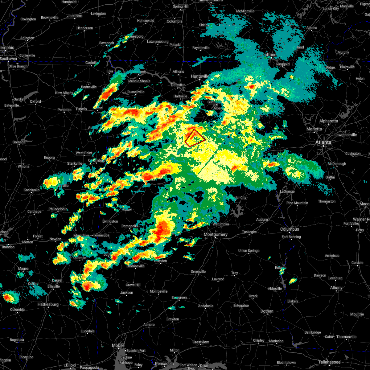 At 324 pm cdt, a severe thunderstorm capable of producing a tornado was located over trafford, or 11 miles north of gardendale, moving northeast at 25 mph (radar indicated rotation). Hazards include tornado. Flying debris will be dangerous to those caught without shelter. mobile homes will be damaged or destroyed. damage to roofs, windows, and vehicles will occur. tree damage is likely. Locations impacted include, dallas, warrior, kimberly, morris, locust fork, trafford, hayden, nectar, county line, inland lake, remlap, clear springs and smoke rise. At 324 pm cdt, a severe thunderstorm capable of producing a tornado was located over trafford, or 11 miles north of gardendale, moving northeast at 25 mph (radar indicated rotation). Hazards include tornado. Flying debris will be dangerous to those caught without shelter. mobile homes will be damaged or destroyed. damage to roofs, windows, and vehicles will occur. tree damage is likely. Locations impacted include, dallas, warrior, kimberly, morris, locust fork, trafford, hayden, nectar, county line, inland lake, remlap, clear springs and smoke rise.
|
| 3/17/2021 2:58 PM CDT |
 At 257 pm cdt, a severe thunderstorm capable of producing a tornado was located near cardiff, or 7 miles northwest of gardendale, moving northeast at 25 mph (radar indicated rotation). Hazards include tornado. Flying debris will be dangerous to those caught without shelter. mobile homes will be damaged or destroyed. damage to roofs, windows, and vehicles will occur. Tree damage is likely. At 257 pm cdt, a severe thunderstorm capable of producing a tornado was located near cardiff, or 7 miles northwest of gardendale, moving northeast at 25 mph (radar indicated rotation). Hazards include tornado. Flying debris will be dangerous to those caught without shelter. mobile homes will be damaged or destroyed. damage to roofs, windows, and vehicles will occur. Tree damage is likely.
|
| 8/20/2020 5:34 PM CDT | 2 trees downed along sawyer mountain road. time estimate in blount county AL, 1.8 miles S of Oneonta, AL |
| 7/31/2020 2:48 PM CDT | A tree was blown down on tidmore lane and odus murphree roa in blount county AL, 6.6 miles SW of Oneonta, AL |
| 7/31/2020 2:31 PM CDT |
 At 230 pm cdt, a severe thunderstorm was located over hayden, or 11 miles southwest of cleveland, moving east at 35 mph (radar indicated). Hazards include 60 mph wind gusts and quarter size hail. Hail damage to vehicles is expected. expect wind damage to roofs, siding, and trees. Locations impacted include, oneonta, blountsville, cleveland, dallas, warrior, kimberly, locust fork, susan moore, trafford, allgood, fairview, hayden, nectar, rosa, county line, bangor, blount springs, inland lake, easley and smoke rise. At 230 pm cdt, a severe thunderstorm was located over hayden, or 11 miles southwest of cleveland, moving east at 35 mph (radar indicated). Hazards include 60 mph wind gusts and quarter size hail. Hail damage to vehicles is expected. expect wind damage to roofs, siding, and trees. Locations impacted include, oneonta, blountsville, cleveland, dallas, warrior, kimberly, locust fork, susan moore, trafford, allgood, fairview, hayden, nectar, rosa, county line, bangor, blount springs, inland lake, easley and smoke rise.
|
| 7/31/2020 2:14 PM CDT |
 At 214 pm cdt, a severe thunderstorm was located near blount springs, or 15 miles south of cullman, moving east at 25 mph (radar indicated). Hazards include 60 mph wind gusts and penny size hail. expect damage to roofs, siding, and trees At 214 pm cdt, a severe thunderstorm was located near blount springs, or 15 miles south of cullman, moving east at 25 mph (radar indicated). Hazards include 60 mph wind gusts and penny size hail. expect damage to roofs, siding, and trees
|
| 7/12/2020 11:48 AM CDT |
 At 1148 am cdt, a severe thunderstorm was located over dodge city, or 8 miles south of cullman, moving southeast at 30 mph (radar indicated). Hazards include 60 mph wind gusts and quarter size hail. Hail damage to vehicles is expected. Expect wind damage to roofs, siding, and trees. At 1148 am cdt, a severe thunderstorm was located over dodge city, or 8 miles south of cullman, moving southeast at 30 mph (radar indicated). Hazards include 60 mph wind gusts and quarter size hail. Hail damage to vehicles is expected. Expect wind damage to roofs, siding, and trees.
|
| 4/12/2020 10:01 PM CDT | Several trees were blown down at straight mountai in blount county AL, 7.1 miles WNW of Oneonta, AL |
| 4/12/2020 10:00 PM CDT |
 At 959 pm cdt, severe thunderstorms were located along a line extending from near geraldine to reece city to near rainbow city to near bald rock, moving east at 45 mph (radar indicated). Hazards include 60 mph wind gusts. Expect damage to roofs, siding, and trees. Locations impacted include, birmingham, hoover, gadsden, vestavia hills, bessemer, homewood, mountain brook, trussville, hueytown, gardendale, pell city, irondale, leeds, moody, fairfield, chelsea, rainbow city, fultondale, oneonta and attalla. At 959 pm cdt, severe thunderstorms were located along a line extending from near geraldine to reece city to near rainbow city to near bald rock, moving east at 45 mph (radar indicated). Hazards include 60 mph wind gusts. Expect damage to roofs, siding, and trees. Locations impacted include, birmingham, hoover, gadsden, vestavia hills, bessemer, homewood, mountain brook, trussville, hueytown, gardendale, pell city, irondale, leeds, moody, fairfield, chelsea, rainbow city, fultondale, oneonta and attalla.
|
| 4/12/2020 9:19 PM CDT |
 At 919 pm cdt, severe thunderstorms were located along a line extending from near strawberry to fairview to near dallas to birmingham, moving east at 45 mph (radar indicated). Hazards include 60 mph wind gusts. expect damage to roofs, siding, and trees At 919 pm cdt, severe thunderstorms were located along a line extending from near strawberry to fairview to near dallas to birmingham, moving east at 45 mph (radar indicated). Hazards include 60 mph wind gusts. expect damage to roofs, siding, and trees
|
| 4/12/2020 9:15 PM CDT |
 At 914 pm cdt, severe thunderstorms were located along a line extending from 6 miles south of altoona to near ashville to near bald rock, moving east at 65 mph (radar indicated). Hazards include 60 mph wind gusts. Expect damage to roofs, siding, and trees. Locations impacted include, northern birmingham, trussville, gardendale, leeds, fultondale, oneonta, sumiton, blountsville, cleveland, dallas, center point, clay, pinson, tarrant, adamsville, warrior, kimberly, graysville, morris and brookside. At 914 pm cdt, severe thunderstorms were located along a line extending from 6 miles south of altoona to near ashville to near bald rock, moving east at 65 mph (radar indicated). Hazards include 60 mph wind gusts. Expect damage to roofs, siding, and trees. Locations impacted include, northern birmingham, trussville, gardendale, leeds, fultondale, oneonta, sumiton, blountsville, cleveland, dallas, center point, clay, pinson, tarrant, adamsville, warrior, kimberly, graysville, morris and brookside.
|
| 4/12/2020 8:36 PM CDT |
 At 835 pm cdt, severe thunderstorms were located along a line extending from smith dam to near sumiton to 6 miles south of gorgas steam plant, moving east at 65 mph (radar indicated). Hazards include 70 mph wind gusts. Expect considerable tree damage. Damage is likely to mobile homes, roofs, and outbuildings. At 835 pm cdt, severe thunderstorms were located along a line extending from smith dam to near sumiton to 6 miles south of gorgas steam plant, moving east at 65 mph (radar indicated). Hazards include 70 mph wind gusts. Expect considerable tree damage. Damage is likely to mobile homes, roofs, and outbuildings.
|
| 4/12/2020 6:06 PM CDT |
 At 606 pm cdt, a severe thunderstorm capable of producing a tornado was located over altoona, or 11 miles northeast of oneonta, moving northeast at 60 mph (radar indicated rotation). Hazards include tornado. Flying debris will be dangerous to those caught without shelter. mobile homes will be damaged or destroyed. damage to roofs, windows, and vehicles will occur. tree damage is likely. Locations impacted include, oneonta, altoona, snead, susan moore, walnut grove and hendrix. At 606 pm cdt, a severe thunderstorm capable of producing a tornado was located over altoona, or 11 miles northeast of oneonta, moving northeast at 60 mph (radar indicated rotation). Hazards include tornado. Flying debris will be dangerous to those caught without shelter. mobile homes will be damaged or destroyed. damage to roofs, windows, and vehicles will occur. tree damage is likely. Locations impacted include, oneonta, altoona, snead, susan moore, walnut grove and hendrix.
|
| 4/12/2020 6:01 PM CDT |
 At 600 pm cdt, a severe thunderstorm was located near oneonta, moving northeast at 55 mph (radar indicated). Hazards include 70 mph wind gusts. Expect considerable tree damage. damage is likely to mobile homes, roofs, and outbuildings. Locations impacted include, rainbow city, ashville, steele, altoona, snead, susan moore, walnut grove, mclarty, neely henry lake, highland lake, whitney junction, alabama international dragway, caldwell, horse pens forty, i 59 rest areas at oneonta, camp sumatanga and hendrix. At 600 pm cdt, a severe thunderstorm was located near oneonta, moving northeast at 55 mph (radar indicated). Hazards include 70 mph wind gusts. Expect considerable tree damage. damage is likely to mobile homes, roofs, and outbuildings. Locations impacted include, rainbow city, ashville, steele, altoona, snead, susan moore, walnut grove, mclarty, neely henry lake, highland lake, whitney junction, alabama international dragway, caldwell, horse pens forty, i 59 rest areas at oneonta, camp sumatanga and hendrix.
|
| 4/12/2020 5:58 PM CDT | Time estimated. trees down on sanders lane between cr 39 and hale creek roa in blount county AL, 8.2 miles SW of Oneonta, AL |
| 4/12/2020 5:55 PM CDT |
 At 554 pm cdt, a confirmed tornado was located over oneonta, moving northeast at 55 mph (radar confirmed tornado). Hazards include damaging tornado. Flying debris will be dangerous to those caught without shelter. mobile homes will be damaged or destroyed. damage to roofs, windows, and vehicles will occur. tree damage is likely. Locations impacted include, oneonta, cleveland, altoona, snead, susan moore, walnut grove, allgood, fairview, nectar, rosa, inland lake, highland lake, easley, holly springs, fowler spring and hendrix. At 554 pm cdt, a confirmed tornado was located over oneonta, moving northeast at 55 mph (radar confirmed tornado). Hazards include damaging tornado. Flying debris will be dangerous to those caught without shelter. mobile homes will be damaged or destroyed. damage to roofs, windows, and vehicles will occur. tree damage is likely. Locations impacted include, oneonta, cleveland, altoona, snead, susan moore, walnut grove, allgood, fairview, nectar, rosa, inland lake, highland lake, easley, holly springs, fowler spring and hendrix.
|
| 4/12/2020 5:53 PM CDT | Numerous trees were blown down between cr 20 and robin hill road along highway 231. road is completely blocke in blount county AL, 6.5 miles W of Oneonta, AL |
| 4/12/2020 5:50 PM CDT | Half Dollar sized hail reported 3 miles SW of Oneonta, AL, half dollar size reported in a few places around oneonta. |
| 4/12/2020 5:50 PM CDT | Trees were blown down and additional damage along county road 1 near dogwood lane. possible tornad in blount county AL, 1.7 miles ESE of Oneonta, AL |
| 4/12/2020 5:31 PM CDT |
 At 531 pm cdt, a severe thunderstorm capable of producing a tornado was located over warrior, or 10 miles north of gardendale, moving northeast at 65 mph (radar indicated rotation). Hazards include tornado. Flying debris will be dangerous to those caught without shelter. mobile homes will be damaged or destroyed. damage to roofs, windows, and vehicles will occur. Tree damage is likely. At 531 pm cdt, a severe thunderstorm capable of producing a tornado was located over warrior, or 10 miles north of gardendale, moving northeast at 65 mph (radar indicated rotation). Hazards include tornado. Flying debris will be dangerous to those caught without shelter. mobile homes will be damaged or destroyed. damage to roofs, windows, and vehicles will occur. Tree damage is likely.
|
| 4/12/2020 5:28 PM CDT | Corrects previous tstm wnd dmg report from 1 ese highland lake. several trees were blown down at straight mountai in blount county AL, 7.1 miles WNW of Oneonta, AL |
| 4/12/2020 5:28 PM CDT |
 At 527 pm cdt, a severe thunderstorm was located near kimberly, or 9 miles east of sumiton, moving northeast at 55 mph (radar indicated). Hazards include 70 mph wind gusts. Expect considerable tree damage. Damage is likely to mobile homes, roofs, and outbuildings. At 527 pm cdt, a severe thunderstorm was located near kimberly, or 9 miles east of sumiton, moving northeast at 55 mph (radar indicated). Hazards include 70 mph wind gusts. Expect considerable tree damage. Damage is likely to mobile homes, roofs, and outbuildings.
|
| 1/11/2020 1:10 PM CST | Tree down on roadway along 254 king road in oneont in blount county AL, 7.8 miles SSW of Oneonta, AL |
| 1/11/2020 1:02 PM CST |
 At 101 pm cst, severe thunderstorms were located along a line extending from near holly pond to leeds, moving northeast at 70 mph (radar indicated). Hazards include 70 mph wind gusts. Expect considerable tree damage. damage is likely to mobile homes, roofs, and outbuildings. Locations impacted include, northeastern birmingham, mountain brook, trussville, gardendale, irondale, leeds, moody, rainbow city, oneonta, springville, odenville, blountsville, cleveland, dallas, center point, clay, pinson, tarrant, margaret and argo. At 101 pm cst, severe thunderstorms were located along a line extending from near holly pond to leeds, moving northeast at 70 mph (radar indicated). Hazards include 70 mph wind gusts. Expect considerable tree damage. damage is likely to mobile homes, roofs, and outbuildings. Locations impacted include, northeastern birmingham, mountain brook, trussville, gardendale, irondale, leeds, moody, rainbow city, oneonta, springville, odenville, blountsville, cleveland, dallas, center point, clay, pinson, tarrant, margaret and argo.
|
| 1/11/2020 12:38 PM CST |
 At 1238 pm cst, severe thunderstorms were located along a line extending from 6 miles southeast of nesmith to birmingham, moving northeast at 80 mph (radar indicated). Hazards include 70 mph wind gusts. Expect considerable tree damage. Damage is likely to mobile homes, roofs, and outbuildings. At 1238 pm cst, severe thunderstorms were located along a line extending from 6 miles southeast of nesmith to birmingham, moving northeast at 80 mph (radar indicated). Hazards include 70 mph wind gusts. Expect considerable tree damage. Damage is likely to mobile homes, roofs, and outbuildings.
|
| 9/11/2019 4:55 PM CDT | Tree down in oneonta. time estimated from rada in blount county AL, 3.8 miles SW of Oneonta, AL |
| 8/27/2019 5:42 PM CDT | Numerous trees were blown down all along the blount st clair county lin in blount county AL, 8.7 miles W of Oneonta, AL |
| 8/27/2019 5:36 PM CDT | Several trees were blown down and blocking morton roa in blount county AL, 5.8 miles W of Oneonta, AL |
| 8/27/2019 5:31 PM CDT |
 At 531 pm cdt, severe thunderstorms were located along a line extending from walnut grove to near springville, moving southeast at 30 mph (radar indicated). Hazards include 60 mph wind gusts and quarter size hail. Hail damage to vehicles is expected. Expect wind damage to roofs, siding, and trees. At 531 pm cdt, severe thunderstorms were located along a line extending from walnut grove to near springville, moving southeast at 30 mph (radar indicated). Hazards include 60 mph wind gusts and quarter size hail. Hail damage to vehicles is expected. Expect wind damage to roofs, siding, and trees.
|
| 8/27/2019 5:24 PM CDT | Several trees were blown down in and around oneont in blount county AL, 3 miles SW of Oneonta, AL |
| 8/27/2019 5:14 PM CDT |
 At 514 pm cdt, a severe thunderstorm was located over blountsville, moving southeast at 20 mph (radar indicated). Hazards include 60 mph wind gusts and quarter size hail. Hail damage to vehicles is expected. expect wind damage to roofs, siding, and trees. Locations impacted include, oneonta, blountsville, cleveland, locust fork, altoona, snead, susan moore, walnut grove, allgood, fairview, nectar, rosa, mclarty, inland lake, brooksville, highland lake, easley, chamblees mill, holly springs and fowler spring. At 514 pm cdt, a severe thunderstorm was located over blountsville, moving southeast at 20 mph (radar indicated). Hazards include 60 mph wind gusts and quarter size hail. Hail damage to vehicles is expected. expect wind damage to roofs, siding, and trees. Locations impacted include, oneonta, blountsville, cleveland, locust fork, altoona, snead, susan moore, walnut grove, allgood, fairview, nectar, rosa, mclarty, inland lake, brooksville, highland lake, easley, chamblees mill, holly springs and fowler spring.
|
| 8/27/2019 5:02 PM CDT |
 At 502 pm cdt, a severe thunderstorm was located over blountsville, moving southeast at 20 mph (radar indicated). Hazards include 60 mph wind gusts and quarter size hail. Hail damage to vehicles is expected. Expect wind damage to roofs, siding, and trees. At 502 pm cdt, a severe thunderstorm was located over blountsville, moving southeast at 20 mph (radar indicated). Hazards include 60 mph wind gusts and quarter size hail. Hail damage to vehicles is expected. Expect wind damage to roofs, siding, and trees.
|
| 6/22/2019 3:51 PM CDT |
 The severe thunderstorm warning for blount and northern jefferson counties will expire at 400 pm cdt, the storms which prompted the warning have exited the warned area. therefore, the warning will be allowed to expire. a severe thunderstorm watch remains in effect until 900 pm cdt for central and northeastern alabama. The severe thunderstorm warning for blount and northern jefferson counties will expire at 400 pm cdt, the storms which prompted the warning have exited the warned area. therefore, the warning will be allowed to expire. a severe thunderstorm watch remains in effect until 900 pm cdt for central and northeastern alabama.
|
| 6/22/2019 3:31 PM CDT |
 At 331 pm cdt, severe thunderstorms were located along a line extending from minor to near clay to near snead, moving east at 25 mph (radar indicated). Hazards include 60 mph wind gusts and nickel size hail. Expect damage to roofs, siding, and trees. Locations impacted include, northern birmingham, trussville, gardendale, irondale, leeds, fultondale, oneonta, blountsville, cleveland, dallas, center point, clay, pinson, tarrant, adamsville, warrior, kimberly, graysville, morris and brookside. At 331 pm cdt, severe thunderstorms were located along a line extending from minor to near clay to near snead, moving east at 25 mph (radar indicated). Hazards include 60 mph wind gusts and nickel size hail. Expect damage to roofs, siding, and trees. Locations impacted include, northern birmingham, trussville, gardendale, irondale, leeds, fultondale, oneonta, blountsville, cleveland, dallas, center point, clay, pinson, tarrant, adamsville, warrior, kimberly, graysville, morris and brookside.
|
| 6/22/2019 3:05 PM CDT |
 At 305 pm cdt, severe thunderstorms were located along a line extending from gorgas steam plant to near holly pond, moving east at 20 mph (radar indicated). Hazards include 60 mph wind gusts and quarter size hail. Hail damage to vehicles is expected. Expect wind damage to roofs, siding, and trees. At 305 pm cdt, severe thunderstorms were located along a line extending from gorgas steam plant to near holly pond, moving east at 20 mph (radar indicated). Hazards include 60 mph wind gusts and quarter size hail. Hail damage to vehicles is expected. Expect wind damage to roofs, siding, and trees.
|
| 6/20/2019 3:51 AM CDT |
 The severe thunderstorm warning for eastern blount county will expire at 400 am cdt, the storms which prompted the warning have moved out of the area. therefore, the warning will be allowed to expire. a severe thunderstorm watch remains in effect until 600 am cdt for central and northeastern alabama. to report severe weather, contact your nearest law enforcement agency. they will relay your report to the national weather service birmingham. The severe thunderstorm warning for eastern blount county will expire at 400 am cdt, the storms which prompted the warning have moved out of the area. therefore, the warning will be allowed to expire. a severe thunderstorm watch remains in effect until 600 am cdt for central and northeastern alabama. to report severe weather, contact your nearest law enforcement agency. they will relay your report to the national weather service birmingham.
|
| 6/20/2019 3:44 AM CDT |
 At 344 am cdt, severe thunderstorms were located along a line extending from near guntersville to near ashville, moving east at 50 mph (radar indicated). Hazards include 60 mph wind gusts and penny size hail. Expect damage to roofs, siding, and trees. Locations impacted include, oneonta, altoona, snead, susan moore, walnut grove, allgood, rosa, mclarty, inland lake, brooksville, highland lake, holly springs, hendrix and easley. At 344 am cdt, severe thunderstorms were located along a line extending from near guntersville to near ashville, moving east at 50 mph (radar indicated). Hazards include 60 mph wind gusts and penny size hail. Expect damage to roofs, siding, and trees. Locations impacted include, oneonta, altoona, snead, susan moore, walnut grove, allgood, rosa, mclarty, inland lake, brooksville, highland lake, holly springs, hendrix and easley.
|
| 6/20/2019 3:27 AM CDT |
 At 327 am cdt, severe thunderstorms were located along a line extending from near arab to near inland lake, moving east at 50 mph (radar indicated). Hazards include 60 mph wind gusts and penny size hail. Expect damage to roofs, siding, and trees. Locations impacted include, oneonta, blountsville, cleveland, locust fork, altoona, snead, susan moore, walnut grove, allgood, fairview, nectar, rosa, mclarty, inland lake, strawberry, brooksville, highland lake, easley, chamblees mill and holly springs. At 327 am cdt, severe thunderstorms were located along a line extending from near arab to near inland lake, moving east at 50 mph (radar indicated). Hazards include 60 mph wind gusts and penny size hail. Expect damage to roofs, siding, and trees. Locations impacted include, oneonta, blountsville, cleveland, locust fork, altoona, snead, susan moore, walnut grove, allgood, fairview, nectar, rosa, mclarty, inland lake, strawberry, brooksville, highland lake, easley, chamblees mill and holly springs.
|
| 6/20/2019 2:45 AM CDT |
 At 245 am cdt, severe thunderstorms were located along a line extending from near sardis to west jefferson, moving east at 50 mph (radar indicated). Hazards include 60 mph wind gusts and penny size hail. expect damage to roofs, siding, and trees At 245 am cdt, severe thunderstorms were located along a line extending from near sardis to west jefferson, moving east at 50 mph (radar indicated). Hazards include 60 mph wind gusts and penny size hail. expect damage to roofs, siding, and trees
|
| 5/16/2019 4:12 PM CDT |
 At 411 pm cdt, severe thunderstorms were located along a line extending from near inland lake to near warrior, moving southeast at 5 mph (radar indicated). Hazards include 60 mph wind gusts and quarter size hail. Hail damage to vehicles is expected. Expect wind damage to roofs, siding, and trees. At 411 pm cdt, severe thunderstorms were located along a line extending from near inland lake to near warrior, moving southeast at 5 mph (radar indicated). Hazards include 60 mph wind gusts and quarter size hail. Hail damage to vehicles is expected. Expect wind damage to roofs, siding, and trees.
|
| 5/9/2019 12:57 PM CDT |
 A severe thunderstorm warning remains in effect until 130 pm cdt for eastern blount county. at 1257 pm cdt, severe thunderstorms were located along a line extending from near mclarty to near springville, moving east at 35 mph. hazard. 60 mph wind gusts. A severe thunderstorm warning remains in effect until 130 pm cdt for eastern blount county. at 1257 pm cdt, severe thunderstorms were located along a line extending from near mclarty to near springville, moving east at 35 mph. hazard. 60 mph wind gusts.
|
| 5/9/2019 12:51 PM CDT | A couple of trees down in oneont in blount county AL, 3 miles SW of Oneonta, AL |
| 5/9/2019 12:50 PM CDT |
 A severe thunderstorm warning remains in effect until 130 pm cdt for eastern blount county. at 1250 pm cdt, severe thunderstorms were located along a line extending from brooksville to springville, moving east at 45 mph. hazard. 60 mph wind gusts. source. Radar indicated. A severe thunderstorm warning remains in effect until 130 pm cdt for eastern blount county. at 1250 pm cdt, severe thunderstorms were located along a line extending from brooksville to springville, moving east at 45 mph. hazard. 60 mph wind gusts. source. Radar indicated.
|
| 5/9/2019 12:39 PM CDT |
 A severe thunderstorm warning remains in effect until 130 pm cdt for blount county. at 1239 pm cdt, severe thunderstorms were located along a line extending from near holly pond to near pinson, moving east at 35 mph. hazard. 60 mph wind gusts. source. Radar indicated. A severe thunderstorm warning remains in effect until 130 pm cdt for blount county. at 1239 pm cdt, severe thunderstorms were located along a line extending from near holly pond to near pinson, moving east at 35 mph. hazard. 60 mph wind gusts. source. Radar indicated.
|
| 5/9/2019 12:25 PM CDT |
 The national weather service in birmingham has issued a * severe thunderstorm warning for. blount county in central alabama. until 130 pm cdt. At 1224 pm cdt, severe thunderstorms were located along a line extending from near good hope to morris, moving east at 35 mph. The national weather service in birmingham has issued a * severe thunderstorm warning for. blount county in central alabama. until 130 pm cdt. At 1224 pm cdt, severe thunderstorms were located along a line extending from near good hope to morris, moving east at 35 mph.
|
| 4/18/2019 8:11 PM CDT |
 At 811 pm cdt, severe thunderstorms were located along a line extending from near brooksville to ragland to near logan martin lake, moving east at 50 mph (radar indicated). Hazards include 60 mph wind gusts. Expect damage to roofs, siding, and trees. locations impacted include, rainbow city, oneonta, blountsville, cleveland, ashville, ragland, ohatchee, steele, altoona, snead, susan moore, walnut grove, rosa, mclarty, strawberry, brooksville, neely henry lake, logan martin lake, highland lake and whitney junction. A tornado watch remains in effect until 1100 pm cdt for central and east central alabama. At 811 pm cdt, severe thunderstorms were located along a line extending from near brooksville to ragland to near logan martin lake, moving east at 50 mph (radar indicated). Hazards include 60 mph wind gusts. Expect damage to roofs, siding, and trees. locations impacted include, rainbow city, oneonta, blountsville, cleveland, ashville, ragland, ohatchee, steele, altoona, snead, susan moore, walnut grove, rosa, mclarty, strawberry, brooksville, neely henry lake, logan martin lake, highland lake and whitney junction. A tornado watch remains in effect until 1100 pm cdt for central and east central alabama.
|
| 4/18/2019 8:10 PM CDT | Tree down along us hwy 231 in oneonta... a in blount county AL, 4.2 miles WSW of Oneonta, AL |
| 4/18/2019 7:59 PM CDT |
 At 759 pm cdt, severe thunderstorms were located along a line extending from near hanceville to near ashville to logan martin lake, moving northeast at 55 mph (radar indicated). Hazards include 60 mph wind gusts. Expect damage to roofs, siding, and trees. locations impacted include, pell city, moody, rainbow city, oneonta, springville, odenville, blountsville, cleveland, dallas, lincoln, margaret, argo, ashville, ragland, locust fork, ohatchee, steele, altoona, snead and susan moore. A tornado watch remains in effect until 1100 pm cdt for central and east central alabama. At 759 pm cdt, severe thunderstorms were located along a line extending from near hanceville to near ashville to logan martin lake, moving northeast at 55 mph (radar indicated). Hazards include 60 mph wind gusts. Expect damage to roofs, siding, and trees. locations impacted include, pell city, moody, rainbow city, oneonta, springville, odenville, blountsville, cleveland, dallas, lincoln, margaret, argo, ashville, ragland, locust fork, ohatchee, steele, altoona, snead and susan moore. A tornado watch remains in effect until 1100 pm cdt for central and east central alabama.
|
| 4/18/2019 7:44 PM CDT |
 At 744 pm cdt, severe thunderstorms were located along a line extending from near dodge city to near argo to near vandiver, moving northeast at 55 mph (radar indicated). Hazards include 60 mph wind gusts. Expect damage to roofs, siding, and trees. locations impacted include, pell city, leeds, moody, rainbow city, oneonta, springville, odenville, blountsville, cleveland, dallas, lincoln, margaret, argo, warrior, ashville, ragland, locust fork, ohatchee, steele and altoona. A tornado watch remains in effect until 1100 pm cdt for central and east central alabama. At 744 pm cdt, severe thunderstorms were located along a line extending from near dodge city to near argo to near vandiver, moving northeast at 55 mph (radar indicated). Hazards include 60 mph wind gusts. Expect damage to roofs, siding, and trees. locations impacted include, pell city, leeds, moody, rainbow city, oneonta, springville, odenville, blountsville, cleveland, dallas, lincoln, margaret, argo, warrior, ashville, ragland, locust fork, ohatchee, steele and altoona. A tornado watch remains in effect until 1100 pm cdt for central and east central alabama.
|
| 4/18/2019 7:32 PM CDT |
 At 732 pm cdt, severe thunderstorms were located along a line extending from near smith dam to pinson to near mount laurel, moving northeast at 55 mph (radar indicated). Hazards include 60 mph wind gusts. expect damage to roofs, siding, and trees At 732 pm cdt, severe thunderstorms were located along a line extending from near smith dam to pinson to near mount laurel, moving northeast at 55 mph (radar indicated). Hazards include 60 mph wind gusts. expect damage to roofs, siding, and trees
|
| 3/14/2019 5:15 PM CDT |
 At 515 pm cdt, a severe thunderstorm capable of producing a tornado was located over oneonta, moving east at 40 mph (radar indicated rotation). Hazards include tornado and quarter size hail. Flying debris will be dangerous to those caught without shelter. mobile homes will be damaged or destroyed. damage to roofs, windows, and vehicles will occur. tree damage is likely. Locations impacted include, oneonta, altoona, rosa and highland lake. At 515 pm cdt, a severe thunderstorm capable of producing a tornado was located over oneonta, moving east at 40 mph (radar indicated rotation). Hazards include tornado and quarter size hail. Flying debris will be dangerous to those caught without shelter. mobile homes will be damaged or destroyed. damage to roofs, windows, and vehicles will occur. tree damage is likely. Locations impacted include, oneonta, altoona, rosa and highland lake.
|
| 3/14/2019 5:13 PM CDT | Structural damage in allgood. possible tornad in blount county AL, 1 miles N of Oneonta, AL |
| 3/14/2019 5:13 PM CDT | Trees down and outbuildings damaged. possible tornad in blount county AL, 8.2 miles WNW of Oneonta, AL |
| 3/14/2019 5:06 PM CDT |
 At 506 pm cdt, a severe thunderstorm capable of producing a tornado was located over allgood, or over oneonta, moving east at 40 mph (radar indicated rotation). Hazards include tornado and quarter size hail. Flying debris will be dangerous to those caught without shelter. mobile homes will be damaged or destroyed. damage to roofs, windows, and vehicles will occur. tree damage is likely. Locations impacted include, oneonta, cleveland, altoona, allgood, fairview, rosa, inland lake, highland lake, easley and clear springs. At 506 pm cdt, a severe thunderstorm capable of producing a tornado was located over allgood, or over oneonta, moving east at 40 mph (radar indicated rotation). Hazards include tornado and quarter size hail. Flying debris will be dangerous to those caught without shelter. mobile homes will be damaged or destroyed. damage to roofs, windows, and vehicles will occur. tree damage is likely. Locations impacted include, oneonta, cleveland, altoona, allgood, fairview, rosa, inland lake, highland lake, easley and clear springs.
|
| 3/14/2019 4:58 PM CDT |
 At 458 pm cdt, a severe thunderstorm capable of producing a tornado was located over locust fork, or near cleveland, moving east at 40 mph (radar indicated rotation). Hazards include tornado and quarter size hail. Flying debris will be dangerous to those caught without shelter. mobile homes will be damaged or destroyed. damage to roofs, windows, and vehicles will occur. Tree damage is likely. At 458 pm cdt, a severe thunderstorm capable of producing a tornado was located over locust fork, or near cleveland, moving east at 40 mph (radar indicated rotation). Hazards include tornado and quarter size hail. Flying debris will be dangerous to those caught without shelter. mobile homes will be damaged or destroyed. damage to roofs, windows, and vehicles will occur. Tree damage is likely.
|
| 3/14/2019 4:53 PM CDT |
 At 452 pm cdt, a severe thunderstorm was located over locust fork, or 8 miles southwest of cleveland, moving east at 35 mph (radar indicated). Hazards include 60 mph wind gusts and quarter size hail. Hail damage to vehicles is expected. Expect wind damage to roofs, siding, and trees. At 452 pm cdt, a severe thunderstorm was located over locust fork, or 8 miles southwest of cleveland, moving east at 35 mph (radar indicated). Hazards include 60 mph wind gusts and quarter size hail. Hail damage to vehicles is expected. Expect wind damage to roofs, siding, and trees.
|
| 6/28/2018 2:13 PM CDT | Tree down on taits gap loo in blount county AL, 7.1 miles WSW of Oneonta, AL |
| 6/28/2018 2:11 PM CDT |
 At 210 pm cdt, severe thunderstorms were located along a line extending from near dodge city to 7 miles southeast of oneonta, moving southwest at 20 mph (radar indicated). Hazards include 60 mph wind gusts. expect damage to roofs, siding, and trees At 210 pm cdt, severe thunderstorms were located along a line extending from near dodge city to 7 miles southeast of oneonta, moving southwest at 20 mph (radar indicated). Hazards include 60 mph wind gusts. expect damage to roofs, siding, and trees
|
| 6/28/2018 1:52 PM CDT |
 At 151 pm cdt, severe thunderstorms were located along a line extending from nectar to steele to near hokes bluff, moving south at 35 mph (emergency management). Hazards include 70 mph wind gusts and penny size hail. Expect considerable tree damage. damage is likely to mobile homes, roofs, and outbuildings. Locations impacted include, gadsden, rainbow city, oneonta, attalla, hokes bluff, blountsville, cleveland, dallas, glencoe, sardis city, locust fork, altoona, snead, susan moore, walnut grove, reece city, allgood, fairview, nectar and rosa. At 151 pm cdt, severe thunderstorms were located along a line extending from nectar to steele to near hokes bluff, moving south at 35 mph (emergency management). Hazards include 70 mph wind gusts and penny size hail. Expect considerable tree damage. damage is likely to mobile homes, roofs, and outbuildings. Locations impacted include, gadsden, rainbow city, oneonta, attalla, hokes bluff, blountsville, cleveland, dallas, glencoe, sardis city, locust fork, altoona, snead, susan moore, walnut grove, reece city, allgood, fairview, nectar and rosa.
|
| 6/28/2018 1:27 PM CDT |
 At 127 pm cdt, severe thunderstorms were located along a line extending from near brooksville to near aurora to near slackland, moving south at 35 mph (radar indicated). Hazards include 60 to 70 mph wind gusts and penny size hail. Expect considerable tree damage. damage is likely to mobile homes, roofs, and outbuildings. Locations impacted include, gadsden, rainbow city, oneonta, attalla, hokes bluff, blountsville, cleveland, dallas, glencoe, sardis city, locust fork, altoona, snead, susan moore, walnut grove, reece city, allgood, fairview, nectar and rosa. At 127 pm cdt, severe thunderstorms were located along a line extending from near brooksville to near aurora to near slackland, moving south at 35 mph (radar indicated). Hazards include 60 to 70 mph wind gusts and penny size hail. Expect considerable tree damage. damage is likely to mobile homes, roofs, and outbuildings. Locations impacted include, gadsden, rainbow city, oneonta, attalla, hokes bluff, blountsville, cleveland, dallas, glencoe, sardis city, locust fork, altoona, snead, susan moore, walnut grove, reece city, allgood, fairview, nectar and rosa.
|
| 6/28/2018 1:05 PM CDT |
 At 104 pm cdt, severe thunderstorms were located along a line extending from near arab to near guntersville to near fyffe, moving south at 35 mph (radar indicated). Hazards include 70 mph wind gusts. Expect considerable tree damage. Damage is likely to mobile homes, roofs, and outbuildings. At 104 pm cdt, severe thunderstorms were located along a line extending from near arab to near guntersville to near fyffe, moving south at 35 mph (radar indicated). Hazards include 70 mph wind gusts. Expect considerable tree damage. Damage is likely to mobile homes, roofs, and outbuildings.
|
| 4/3/2018 10:52 PM CDT |
 At 1051 pm cdt, severe thunderstorms were located along a line extending from 7 miles east of falkville to dodge city to cordova, moving east at 55 mph (radar indicated). Hazards include 60 mph wind gusts and nickel size hail. expect damage to roofs, siding, and trees At 1051 pm cdt, severe thunderstorms were located along a line extending from 7 miles east of falkville to dodge city to cordova, moving east at 55 mph (radar indicated). Hazards include 60 mph wind gusts and nickel size hail. expect damage to roofs, siding, and trees
|
| 3/19/2018 8:10 PM CDT |
 At 810 pm cdt, severe thunderstorms were located along a line extending from near walnut grove to blountsville, moving east at 45 mph (radar indicated). Hazards include 60 mph wind gusts and quarter size hail. Hail damage to vehicles is expected. expect wind damage to roofs, siding, and trees. locations impacted include, oneonta, blountsville, cleveland, altoona, snead, susan moore, walnut grove, nectar, rosa, mclarty, brooksville, chamblees mill, fowler spring and hendrix. A tornado watch remains in effect until 1100 pm cdt for central and northeastern alabama. At 810 pm cdt, severe thunderstorms were located along a line extending from near walnut grove to blountsville, moving east at 45 mph (radar indicated). Hazards include 60 mph wind gusts and quarter size hail. Hail damage to vehicles is expected. expect wind damage to roofs, siding, and trees. locations impacted include, oneonta, blountsville, cleveland, altoona, snead, susan moore, walnut grove, nectar, rosa, mclarty, brooksville, chamblees mill, fowler spring and hendrix. A tornado watch remains in effect until 1100 pm cdt for central and northeastern alabama.
|
| 3/19/2018 7:50 PM CDT | Multiple trees down on daylily lan in blount county AL, 8.3 miles WNW of Oneonta, AL |
| 3/19/2018 7:49 PM CDT |
 At 748 pm cdt, severe thunderstorms were located along a line extending from near walnut grove to near blountsville to near good hope, moving east at 55 mph (radar indicated). Hazards include 60 mph wind gusts and quarter size hail. Hail damage to vehicles is expected. Expect wind damage to roofs, siding, and trees. At 748 pm cdt, severe thunderstorms were located along a line extending from near walnut grove to near blountsville to near good hope, moving east at 55 mph (radar indicated). Hazards include 60 mph wind gusts and quarter size hail. Hail damage to vehicles is expected. Expect wind damage to roofs, siding, and trees.
|
| 3/19/2018 7:41 PM CDT |
 At 741 pm cdt, a severe thunderstorm was located near allgood, or near oneonta, moving east at 50 mph (radar indicated). Hazards include golf ball size hail and 60 mph wind gusts. People and animals outdoors will be injured. expect hail damage to roofs, siding, windows, and vehicles. Expect wind damage to roofs, siding, and trees. At 741 pm cdt, a severe thunderstorm was located near allgood, or near oneonta, moving east at 50 mph (radar indicated). Hazards include golf ball size hail and 60 mph wind gusts. People and animals outdoors will be injured. expect hail damage to roofs, siding, windows, and vehicles. Expect wind damage to roofs, siding, and trees.
|
| 3/19/2018 7:31 PM CDT |
 At 731 pm cdt, a severe thunderstorm capable of producing a tornado was located over blountsville, moving east at 45 mph (radar indicated rotation). Hazards include tornado and tennis ball size hail. Flying debris will be dangerous to those caught without shelter. mobile homes will be damaged or destroyed. damage to roofs, windows, and vehicles will occur. tree damage is likely. Locations impacted include, blountsville, cleveland, altoona, snead, susan moore, walnut grove, rosa, mclarty, brooksville, fowler spring, chamblees mill and hendrix. At 731 pm cdt, a severe thunderstorm capable of producing a tornado was located over blountsville, moving east at 45 mph (radar indicated rotation). Hazards include tornado and tennis ball size hail. Flying debris will be dangerous to those caught without shelter. mobile homes will be damaged or destroyed. damage to roofs, windows, and vehicles will occur. tree damage is likely. Locations impacted include, blountsville, cleveland, altoona, snead, susan moore, walnut grove, rosa, mclarty, brooksville, fowler spring, chamblees mill and hendrix.
|
| 3/19/2018 7:18 PM CDT |
 At 718 pm cdt, a severe thunderstorm capable of producing a tornado was located near holly pond, or 7 miles west of blountsville, moving east at 50 mph (radar indicated rotation). Hazards include tornado and tennis ball size hail. Flying debris will be dangerous to those caught without shelter. mobile homes will be damaged or destroyed. damage to roofs, windows, and vehicles will occur. Tree damage is likely. At 718 pm cdt, a severe thunderstorm capable of producing a tornado was located near holly pond, or 7 miles west of blountsville, moving east at 50 mph (radar indicated rotation). Hazards include tornado and tennis ball size hail. Flying debris will be dangerous to those caught without shelter. mobile homes will be damaged or destroyed. damage to roofs, windows, and vehicles will occur. Tree damage is likely.
|
| 11/18/2017 7:05 PM CST | Several trees down in the oneonta... locust fork and snead areas. radar estimated winds up to 50 mph. time estimate in blount county AL, 3 miles SW of Oneonta, AL |
| 8/10/2017 6:56 PM CDT |
 At 655 pm cdt, a severe thunderstorm was located over springville, and is nearly stationary (radar indicated). Hazards include 60 mph wind gusts. expect damage to roofs, siding, and trees At 655 pm cdt, a severe thunderstorm was located over springville, and is nearly stationary (radar indicated). Hazards include 60 mph wind gusts. expect damage to roofs, siding, and trees
|
| 7/17/2017 6:03 PM CDT |
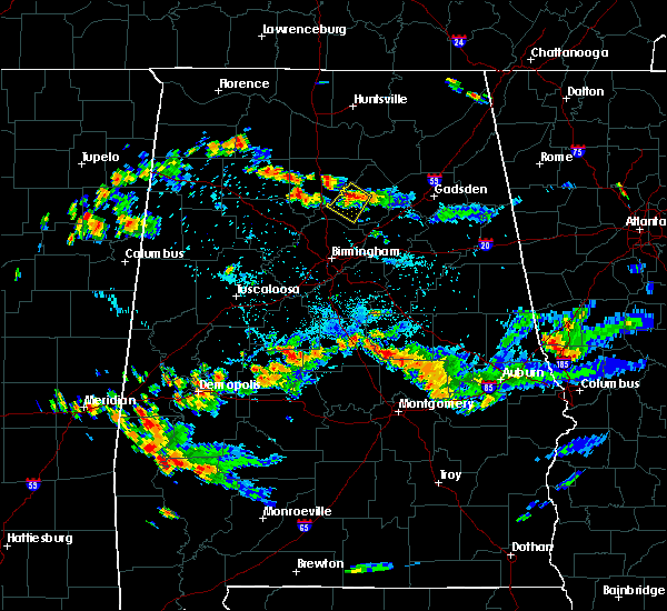 At 603 pm cdt, a severe thunderstorm was located over nectar, or near cleveland, moving southwest at 5 mph (radar indicated). Hazards include 60 mph wind gusts and penny size hail. expect damage to roofs, siding, and trees At 603 pm cdt, a severe thunderstorm was located over nectar, or near cleveland, moving southwest at 5 mph (radar indicated). Hazards include 60 mph wind gusts and penny size hail. expect damage to roofs, siding, and trees
|
| 7/4/2017 3:02 PM CDT | County highway 15 between state highway 75 and state highway 79 is closed due to multiple trees down in the roadwa in blount county AL, 4.6 miles ENE of Oneonta, AL |
| 6/15/2017 2:47 PM CDT |
 At 246 pm cdt, severe thunderstorms were located along a line extending from albertville to 7 miles southwest of bankhead lock and dam, moving southeast at 35 mph. there have been a few reports of downed trees with these storms (radar indicated). Hazards include 60 mph wind gusts. expect damage to roofs, siding, and trees At 246 pm cdt, severe thunderstorms were located along a line extending from albertville to 7 miles southwest of bankhead lock and dam, moving southeast at 35 mph. there have been a few reports of downed trees with these storms (radar indicated). Hazards include 60 mph wind gusts. expect damage to roofs, siding, and trees
|
| 5/28/2017 2:52 AM CDT |
 At 252 am cdt, severe thunderstorms were located along a line extending from dallas to near oneonta to near mclarty, moving southeast at 50 mph (radar indicated). Hazards include 70 mph wind gusts and quarter size hail. Hail damage to vehicles is expected. expect considerable tree damage. wind damage is also likely to mobile homes, roofs, and outbuildings. Locations impacted include, oneonta, blountsville, cleveland, dallas, warrior, locust fork, altoona, snead, susan moore, walnut grove, trafford, allgood, fairview, hayden, nectar, rosa, county line, mclarty, bangor and blount springs. At 252 am cdt, severe thunderstorms were located along a line extending from dallas to near oneonta to near mclarty, moving southeast at 50 mph (radar indicated). Hazards include 70 mph wind gusts and quarter size hail. Hail damage to vehicles is expected. expect considerable tree damage. wind damage is also likely to mobile homes, roofs, and outbuildings. Locations impacted include, oneonta, blountsville, cleveland, dallas, warrior, locust fork, altoona, snead, susan moore, walnut grove, trafford, allgood, fairview, hayden, nectar, rosa, county line, mclarty, bangor and blount springs.
|
| 5/28/2017 2:22 AM CDT |
 At 222 am cdt, severe thunderstorms were located along a line extending from near smith dam to near good hope to 11 miles northwest of holly pond, moving southeast at 50 mph (radar indicated). Hazards include 70 mph wind gusts and quarter size hail. Hail damage to vehicles is expected. expect considerable tree damage. Wind damage is also likely to mobile homes, roofs, and outbuildings. At 222 am cdt, severe thunderstorms were located along a line extending from near smith dam to near good hope to 11 miles northwest of holly pond, moving southeast at 50 mph (radar indicated). Hazards include 70 mph wind gusts and quarter size hail. Hail damage to vehicles is expected. expect considerable tree damage. Wind damage is also likely to mobile homes, roofs, and outbuildings.
|
| 5/24/2017 7:55 AM CDT | Several trees uprooted across eastern blount county. wind speeds estimated at 40-50 mp in blount county AL, 3 miles SW of Oneonta, AL |
| 5/12/2017 12:01 PM CDT |
 At 1201 pm cdt, a severe thunderstorm was located near clay, or near springville, moving east at 25 mph (radar indicated). Hazards include 60 mph wind gusts and quarter size hail. Hail damage to vehicles is expected. expect wind damage to roofs, siding, and trees. locations impacted include, trussville, oneonta, springville, pinson-clay-chalkv, center point, clay, pinson, argo, ashville, chalkville, highland lake, whitney junction, palmerdale, st. Clair springs, holly springs, village springs, caldwell, horse pens forty, i 59 rest areas at oneonta and remlap. At 1201 pm cdt, a severe thunderstorm was located near clay, or near springville, moving east at 25 mph (radar indicated). Hazards include 60 mph wind gusts and quarter size hail. Hail damage to vehicles is expected. expect wind damage to roofs, siding, and trees. locations impacted include, trussville, oneonta, springville, pinson-clay-chalkv, center point, clay, pinson, argo, ashville, chalkville, highland lake, whitney junction, palmerdale, st. Clair springs, holly springs, village springs, caldwell, horse pens forty, i 59 rest areas at oneonta and remlap.
|
| 5/12/2017 11:43 AM CDT |
 At 1143 am cdt, a severe thunderstorm was located near pinson, or near pinson-clay-chalkv, moving east at 25 mph (radar indicated). Hazards include 60 mph wind gusts and quarter size hail. Hail damage to vehicles is expected. Expect wind damage to roofs, siding, and trees. At 1143 am cdt, a severe thunderstorm was located near pinson, or near pinson-clay-chalkv, moving east at 25 mph (radar indicated). Hazards include 60 mph wind gusts and quarter size hail. Hail damage to vehicles is expected. Expect wind damage to roofs, siding, and trees.
|
| 4/30/2017 2:41 PM CDT |
 At 241 pm cdt, severe thunderstorms were located along a line extending from near blountsville to clay, moving northeast at 35 mph (radar indicated). Hazards include 60 mph wind gusts. expect damage to roofs, siding, and trees At 241 pm cdt, severe thunderstorms were located along a line extending from near blountsville to clay, moving northeast at 35 mph (radar indicated). Hazards include 60 mph wind gusts. expect damage to roofs, siding, and trees
|
| 4/30/2017 2:32 PM CDT |
 At 232 pm cdt, severe thunderstorms were located along a line extending from near morgan city to the summit, moving northeast at 50 mph (radar indicated). Hazards include 60 mph wind gusts. Expect damage to roofs, siding, and trees. locations impacted include, birmingham, hoover, vestavia hills, bessemer, homewood, mountain brook, trussville, gardendale, irondale, leeds, moody, fultondale, oneonta, blountsville, cleveland, pinson-clay-chalkv, dallas, center point, clay and pinson. a tornado watch remains in effect until 700 pm cdt for alabama. A tornado watch also remains in effect until 700 pm cdt for northeastern alabama. At 232 pm cdt, severe thunderstorms were located along a line extending from near morgan city to the summit, moving northeast at 50 mph (radar indicated). Hazards include 60 mph wind gusts. Expect damage to roofs, siding, and trees. locations impacted include, birmingham, hoover, vestavia hills, bessemer, homewood, mountain brook, trussville, gardendale, irondale, leeds, moody, fultondale, oneonta, blountsville, cleveland, pinson-clay-chalkv, dallas, center point, clay and pinson. a tornado watch remains in effect until 700 pm cdt for alabama. A tornado watch also remains in effect until 700 pm cdt for northeastern alabama.
|
| 4/30/2017 2:15 PM CDT |
 At 214 pm cdt, severe thunderstorms were located along a line extending from 9 miles northwest of holly pond to near bessemer, moving northeast at 35 mph (radar indicated). Hazards include 60 mph wind gusts. Expect damage to roofs, siding, and trees. locations impacted include, birmingham, hoover, vestavia hills, bessemer, homewood, mountain brook, trussville, hueytown, gardendale, irondale, leeds, moody, fairfield, fultondale, oneonta, blountsville, cleveland, pinson-clay-chalkv, dallas and center point. a tornado watch remains in effect until 700 pm cdt for alabama. A tornado watch also remains in effect until 700 pm cdt for northeastern alabama. At 214 pm cdt, severe thunderstorms were located along a line extending from 9 miles northwest of holly pond to near bessemer, moving northeast at 35 mph (radar indicated). Hazards include 60 mph wind gusts. Expect damage to roofs, siding, and trees. locations impacted include, birmingham, hoover, vestavia hills, bessemer, homewood, mountain brook, trussville, hueytown, gardendale, irondale, leeds, moody, fairfield, fultondale, oneonta, blountsville, cleveland, pinson-clay-chalkv, dallas and center point. a tornado watch remains in effect until 700 pm cdt for alabama. A tornado watch also remains in effect until 700 pm cdt for northeastern alabama.
|
| 4/30/2017 1:45 PM CDT |
 At 145 pm cdt, severe thunderstorms were located along a line extending from 7 miles southeast of helicon to tannehill ironworks state park, moving northeast at 50 mph (radar indicated). Hazards include 70 mph wind gusts. Expect considerable tree damage. Damage is likely to mobile homes, roofs, and outbuildings. At 145 pm cdt, severe thunderstorms were located along a line extending from 7 miles southeast of helicon to tannehill ironworks state park, moving northeast at 50 mph (radar indicated). Hazards include 70 mph wind gusts. Expect considerable tree damage. Damage is likely to mobile homes, roofs, and outbuildings.
|
| 3/27/2017 6:10 PM CDT |
 At 610 pm cdt, a severe thunderstorm was located near inland lake, or 7 miles southwest of oneonta, moving northeast at 30 mph (radar indicated). Hazards include quarter size hail. Damage to vehicles is expected. Locations impacted include, oneonta, locust fork, altoona, allgood, rosa, inland lake, highland lake and clear springs. At 610 pm cdt, a severe thunderstorm was located near inland lake, or 7 miles southwest of oneonta, moving northeast at 30 mph (radar indicated). Hazards include quarter size hail. Damage to vehicles is expected. Locations impacted include, oneonta, locust fork, altoona, allgood, rosa, inland lake, highland lake and clear springs.
|
| 3/27/2017 5:55 PM CDT |
 The national weather service in birmingham has issued a * severe thunderstorm warning for. southeastern blount county in alabama. Until 645 pm cdt * at 555 pm cdt, a severe thunderstorm was located over dallas, or 11 miles southwest of cleveland, moving northeast at 35 mph. The national weather service in birmingham has issued a * severe thunderstorm warning for. southeastern blount county in alabama. Until 645 pm cdt * at 555 pm cdt, a severe thunderstorm was located over dallas, or 11 miles southwest of cleveland, moving northeast at 35 mph.
|
| 3/27/2017 5:35 PM CDT |
 At 534 pm cdt, a severe thunderstorm was located near bangor, or 9 miles west of cleveland, moving east at 25 mph (radar indicated). Hazards include 60 mph wind gusts and quarter size hail. Hail damage to vehicles is expected. Expect wind damage to roofs, siding, and trees. At 534 pm cdt, a severe thunderstorm was located near bangor, or 9 miles west of cleveland, moving east at 25 mph (radar indicated). Hazards include 60 mph wind gusts and quarter size hail. Hail damage to vehicles is expected. Expect wind damage to roofs, siding, and trees.
|
| 1/22/2017 1:45 AM CST |
 At 144 am cst, severe thunderstorms were located along a line extending from near blountsville to susan moore to near altoona, moving northeast at 40 mph (radar indicated). Hazards include 70 mph wind gusts. Expect considerable tree damage. damage is likely to mobile homes, roofs, and outbuildings. Locations impacted include, oneonta, blountsville, cleveland, altoona, snead, susan moore, walnut grove, rosa, strawberry, mclarty, brooksville, chamblees mill, hendrix and fowler spring. At 144 am cst, severe thunderstorms were located along a line extending from near blountsville to susan moore to near altoona, moving northeast at 40 mph (radar indicated). Hazards include 70 mph wind gusts. Expect considerable tree damage. damage is likely to mobile homes, roofs, and outbuildings. Locations impacted include, oneonta, blountsville, cleveland, altoona, snead, susan moore, walnut grove, rosa, strawberry, mclarty, brooksville, chamblees mill, hendrix and fowler spring.
|
| 1/22/2017 1:38 AM CST | Trees down in oneont in blount county AL, 3 miles SW of Oneonta, AL |
| 1/22/2017 1:38 AM CST | Several second story windows blown out and damage to roofing and decking on front porch at the lester memorial methodist churc in blount county AL, 2.5 miles SW of Oneonta, AL |
| 1/22/2017 1:37 AM CST |
 At 137 am cst, severe thunderstorms were located along a line extending from bangor to rosa to 6 miles northwest of ashville, moving northeast at 70 mph (radar indicated). Hazards include 70 mph wind gusts. Expect considerable tree damage. damage is likely to mobile homes, roofs, and outbuildings. Locations impacted include, oneonta, blountsville, cleveland, locust fork, altoona, snead, susan moore, walnut grove, allgood, fairview, hayden, nectar, rosa, inland lake, blount springs, brooksville, strawberry, bangor, mclarty and highland lake. At 137 am cst, severe thunderstorms were located along a line extending from bangor to rosa to 6 miles northwest of ashville, moving northeast at 70 mph (radar indicated). Hazards include 70 mph wind gusts. Expect considerable tree damage. damage is likely to mobile homes, roofs, and outbuildings. Locations impacted include, oneonta, blountsville, cleveland, locust fork, altoona, snead, susan moore, walnut grove, allgood, fairview, hayden, nectar, rosa, inland lake, blount springs, brooksville, strawberry, bangor, mclarty and highland lake.
|
| 1/22/2017 1:30 AM CST |
 At 130 am cst, severe thunderstorms were located along a line extending from near nectar to allgood to near springville, moving northeast at 65 mph. these are very dangerous storms (radar indicated). Hazards include 80 mph wind gusts. Flying debris will be dangerous to those caught without shelter. mobile homes will be heavily damaged. expect considerable damage to roofs, windows, and vehicles. extensive tree damage and power outages are likely. Locations impacted include, oneonta, blountsville, cleveland, dallas, locust fork, altoona, snead, susan moore, walnut grove, trafford, allgood, fairview, hayden, nectar, rosa, county line, inland lake, blount springs, brooksville and strawberry. At 130 am cst, severe thunderstorms were located along a line extending from near nectar to allgood to near springville, moving northeast at 65 mph. these are very dangerous storms (radar indicated). Hazards include 80 mph wind gusts. Flying debris will be dangerous to those caught without shelter. mobile homes will be heavily damaged. expect considerable damage to roofs, windows, and vehicles. extensive tree damage and power outages are likely. Locations impacted include, oneonta, blountsville, cleveland, dallas, locust fork, altoona, snead, susan moore, walnut grove, trafford, allgood, fairview, hayden, nectar, rosa, county line, inland lake, blount springs, brooksville and strawberry.
|
| 1/22/2017 1:25 AM CST |
 At 125 am cst, severe thunderstorms were located along a line extending from near blount springs to near dallas to near argo, moving northeast at 60 mph. these are very dangerous storms (radar indicated). Hazards include 80 mph wind gusts. Flying debris will be dangerous to those caught without shelter. mobile homes will be heavily damaged. expect considerable damage to roofs, windows, and vehicles. extensive tree damage and power outages are likely. Locations impacted include, trussville, oneonta, blountsville, cleveland, dallas, clay, pinson, argo, warrior, kimberly, locust fork, altoona, snead, susan moore, walnut grove, trafford, allgood, fairview, hayden and nectar. At 125 am cst, severe thunderstorms were located along a line extending from near blount springs to near dallas to near argo, moving northeast at 60 mph. these are very dangerous storms (radar indicated). Hazards include 80 mph wind gusts. Flying debris will be dangerous to those caught without shelter. mobile homes will be heavily damaged. expect considerable damage to roofs, windows, and vehicles. extensive tree damage and power outages are likely. Locations impacted include, trussville, oneonta, blountsville, cleveland, dallas, clay, pinson, argo, warrior, kimberly, locust fork, altoona, snead, susan moore, walnut grove, trafford, allgood, fairview, hayden and nectar.
|
| 1/22/2017 1:18 AM CST |
 At 118 am cst, severe thunderstorms were located along a line extending from near arkadelphia to county line to near clay, moving northeast at 55 mph (radar indicated). Hazards include 70 mph wind gusts. Expect considerable tree damage. Damage is likely to mobile homes, roofs, and outbuildings. At 118 am cst, severe thunderstorms were located along a line extending from near arkadelphia to county line to near clay, moving northeast at 55 mph (radar indicated). Hazards include 70 mph wind gusts. Expect considerable tree damage. Damage is likely to mobile homes, roofs, and outbuildings.
|
| 6/17/2016 2:52 PM CDT |
 At 252 pm cdt, severe thunderstorms were located along a line extending from near inland lake to near ohatchee, moving southeast at 25 mph (radar indicated). Hazards include 70 mph wind gusts and quarter size hail. Hail damage to vehicles is expected. expect considerable tree damage. wind damage is also likely to mobile homes, roofs, and outbuildings. Locations impacted include, anniston, oxford, springville, odenville, cobb town, west end-cobb town, saks, margaret, argo, ashville, ragland, ohatchee, hobson city, allgood, inland lake, blue mountain, neely henry lake, alexandria, highland lake and caldwell. At 252 pm cdt, severe thunderstorms were located along a line extending from near inland lake to near ohatchee, moving southeast at 25 mph (radar indicated). Hazards include 70 mph wind gusts and quarter size hail. Hail damage to vehicles is expected. expect considerable tree damage. wind damage is also likely to mobile homes, roofs, and outbuildings. Locations impacted include, anniston, oxford, springville, odenville, cobb town, west end-cobb town, saks, margaret, argo, ashville, ragland, ohatchee, hobson city, allgood, inland lake, blue mountain, neely henry lake, alexandria, highland lake and caldwell.
|
| 6/17/2016 2:43 PM CDT | Tree down in roadway. time estimated by rada in blount county AL, 6.6 miles WNW of Oneonta, AL |
| 6/17/2016 2:43 PM CDT | Tree down in roadway. time estimated by rada in blount county AL, 5.2 miles NW of Oneonta, AL |
| 6/17/2016 2:43 PM CDT | Trees down near tip top one stop service station in the gallant community. time estimated by rada in st. clair county AL, 9.9 miles W of Oneonta, AL |
| 6/17/2016 2:40 PM CDT |
 At 240 pm cdt, severe thunderstorms were located along a line extending from near oneonta to near neely henry lake, moving south at 25 mph (radar indicated). Hazards include 60 mph wind gusts and quarter size hail. Hail damage to vehicles is expected. expect wind damage to roofs, siding, and trees. Locations impacted include, anniston, oxford, rainbow city, oneonta, springville, odenville, cleveland, cobb town, west end-cobb town, saks, attalla, glencoe, margaret, argo, ashville, ragland, ohatchee, steele, hobson city and allgood. At 240 pm cdt, severe thunderstorms were located along a line extending from near oneonta to near neely henry lake, moving south at 25 mph (radar indicated). Hazards include 60 mph wind gusts and quarter size hail. Hail damage to vehicles is expected. expect wind damage to roofs, siding, and trees. Locations impacted include, anniston, oxford, rainbow city, oneonta, springville, odenville, cleveland, cobb town, west end-cobb town, saks, attalla, glencoe, margaret, argo, ashville, ragland, ohatchee, steele, hobson city and allgood.
|
| 6/17/2016 2:25 PM CDT | Tree down on roadway. time estimated by rada in blount county AL, 3.9 miles S of Oneonta, AL |
| 6/17/2016 2:24 PM CDT |
 At 224 pm cdt, severe thunderstorms were located along a line extending from blountsville to rainbow city, moving southeast at 20 mph (radar indicated). Hazards include 60 mph wind gusts and quarter size hail. Hail damage to vehicles is expected. Expect wind damage to roofs, siding, and trees. At 224 pm cdt, severe thunderstorms were located along a line extending from blountsville to rainbow city, moving southeast at 20 mph (radar indicated). Hazards include 60 mph wind gusts and quarter size hail. Hail damage to vehicles is expected. Expect wind damage to roofs, siding, and trees.
|
| 6/15/2016 8:00 PM CDT | One tree reported dow in blount county AL, 3.8 miles SW of Oneonta, AL |
| 6/15/2016 7:56 PM CDT |
 At 756 pm cdt, severe thunderstorms were located along a line extending from 8 miles north of cave spring to near walnut grove to near arkadelphia, moving south at 45 mph (radar indicated). Hazards include 60 mph wind gusts. Expect damage to roofs. siding. and trees. Locations impacted include, gadsden, rainbow city, oneonta, hokes bluff, centre, cedar bluff, blountsville, cleveland, forney, centre municipal airport, dallas, attalla, glencoe, warrior, locust fork, leesburg, altoona, susan moore, walnut grove and reece city. At 756 pm cdt, severe thunderstorms were located along a line extending from 8 miles north of cave spring to near walnut grove to near arkadelphia, moving south at 45 mph (radar indicated). Hazards include 60 mph wind gusts. Expect damage to roofs. siding. and trees. Locations impacted include, gadsden, rainbow city, oneonta, hokes bluff, centre, cedar bluff, blountsville, cleveland, forney, centre municipal airport, dallas, attalla, glencoe, warrior, locust fork, leesburg, altoona, susan moore, walnut grove and reece city.
|
| 6/15/2016 7:45 PM CDT |
 At 745 pm cdt, severe thunderstorms were located along a line extending from 8 miles east of gaylesville to aurora to near smith dam, moving southeast at 40 mph (radar indicated). Hazards include 60 mph wind gusts. Expect damage to roofs. siding. and trees. Locations impacted include, gadsden, rainbow city, oneonta, hokes bluff, centre, cedar bluff, blountsville, cleveland, forney, little river canyon national preserve, centre municipal airport, dallas, attalla, glencoe, warrior, sardis city, locust fork, leesburg, altoona and snead. At 745 pm cdt, severe thunderstorms were located along a line extending from 8 miles east of gaylesville to aurora to near smith dam, moving southeast at 40 mph (radar indicated). Hazards include 60 mph wind gusts. Expect damage to roofs. siding. and trees. Locations impacted include, gadsden, rainbow city, oneonta, hokes bluff, centre, cedar bluff, blountsville, cleveland, forney, little river canyon national preserve, centre municipal airport, dallas, attalla, glencoe, warrior, sardis city, locust fork, leesburg, altoona and snead.
|
| 6/15/2016 7:27 PM CDT |
 At 727 pm cdt, severe thunderstorms were located along a line extending from 7 miles southwest of summerville to near albertville to 7 miles northwest of dodge city, moving south at 35 mph (radar indicated). Hazards include 60 mph wind gusts. Expect damage to roofs. siding. and trees. Locations impacted include, gadsden, rainbow city, oneonta, hokes bluff, centre, cedar bluff, blountsville, cleveland, forney, little river canyon national preserve, centre municipal airport, dallas, attalla, glencoe, warrior, sardis city, locust fork, leesburg, altoona and snead. At 727 pm cdt, severe thunderstorms were located along a line extending from 7 miles southwest of summerville to near albertville to 7 miles northwest of dodge city, moving south at 35 mph (radar indicated). Hazards include 60 mph wind gusts. Expect damage to roofs. siding. and trees. Locations impacted include, gadsden, rainbow city, oneonta, hokes bluff, centre, cedar bluff, blountsville, cleveland, forney, little river canyon national preserve, centre municipal airport, dallas, attalla, glencoe, warrior, sardis city, locust fork, leesburg, altoona and snead.
|
| 6/15/2016 7:13 PM CDT |
 At 713 pm cdt, severe thunderstorms were located along a line extending from 11 miles northwest of summerville to near guntersville to 6 miles east of nesmith, moving south at 45 mph (radar indicated). Hazards include 60 mph wind gusts. Expect damage to roofs. siding. And trees. At 713 pm cdt, severe thunderstorms were located along a line extending from 11 miles northwest of summerville to near guntersville to 6 miles east of nesmith, moving south at 45 mph (radar indicated). Hazards include 60 mph wind gusts. Expect damage to roofs. siding. And trees.
|
| 3/31/2016 9:42 PM CDT |
 At 942 pm cdt, a severe thunderstorm capable of producing a tornado was located over dallas, or 9 miles southwest of cleveland, moving northeast at 30 mph (radar indicated rotation). Hazards include tornado. Flying debris will be dangerous to those caught without shelter. mobile homes will be damaged or destroyed. damage to roofs, windows, and vehicles will occur. tree damage is likely. this dangerous storm will be near, locust fork around 945 pm cdt. inland lake around 950 pm cdt. allgood around 955 pm cdt. oneonta around 1000 pm cdt. Other locations impacted by this tornadic thunderstorm include clear springs and remlap. At 942 pm cdt, a severe thunderstorm capable of producing a tornado was located over dallas, or 9 miles southwest of cleveland, moving northeast at 30 mph (radar indicated rotation). Hazards include tornado. Flying debris will be dangerous to those caught without shelter. mobile homes will be damaged or destroyed. damage to roofs, windows, and vehicles will occur. tree damage is likely. this dangerous storm will be near, locust fork around 945 pm cdt. inland lake around 950 pm cdt. allgood around 955 pm cdt. oneonta around 1000 pm cdt. Other locations impacted by this tornadic thunderstorm include clear springs and remlap.
|
| 3/31/2016 9:36 PM CDT |
 At 935 pm cdt, a severe thunderstorm capable of producing a tornado was located over dallas, or 12 miles southwest of cleveland, moving east at 35 mph (radar indicated rotation). Hazards include tornado. Flying debris will be dangerous to those caught without shelter. mobile homes will be damaged or destroyed. damage to roofs, windows, and vehicles will occur. tree damage is likely. this dangerous storm will be near, locust fork around 945 pm cdt. inland lake around 950 pm cdt. allgood around 955 pm cdt. oneonta around 1000 pm cdt. Other locations impacted by this tornadic thunderstorm include clear springs, remlap and holly springs. At 935 pm cdt, a severe thunderstorm capable of producing a tornado was located over dallas, or 12 miles southwest of cleveland, moving east at 35 mph (radar indicated rotation). Hazards include tornado. Flying debris will be dangerous to those caught without shelter. mobile homes will be damaged or destroyed. damage to roofs, windows, and vehicles will occur. tree damage is likely. this dangerous storm will be near, locust fork around 945 pm cdt. inland lake around 950 pm cdt. allgood around 955 pm cdt. oneonta around 1000 pm cdt. Other locations impacted by this tornadic thunderstorm include clear springs, remlap and holly springs.
|
| 3/31/2016 9:25 PM CDT |
 At 925 pm cdt, a severe thunderstorm capable of producing a tornado was located over warrior, or 9 miles north of gardendale, moving northeast at 35 mph (radar indicated rotation). Hazards include tornado. Flying debris will be dangerous to those caught without shelter. mobile homes will be damaged or destroyed. damage to roofs, windows, and vehicles will occur. tree damage is likely. this dangerous storm will be near, trafford around 930 pm cdt. county line around 935 pm cdt. dallas around 940 pm cdt. locust fork around 945 pm cdt. inland lake around 950 pm cdt. allgood around 955 pm cdt. oneonta around 1000 pm cdt. Other locations impacted by this tornadic thunderstorm include clear springs, remlap and holly springs. At 925 pm cdt, a severe thunderstorm capable of producing a tornado was located over warrior, or 9 miles north of gardendale, moving northeast at 35 mph (radar indicated rotation). Hazards include tornado. Flying debris will be dangerous to those caught without shelter. mobile homes will be damaged or destroyed. damage to roofs, windows, and vehicles will occur. tree damage is likely. this dangerous storm will be near, trafford around 930 pm cdt. county line around 935 pm cdt. dallas around 940 pm cdt. locust fork around 945 pm cdt. inland lake around 950 pm cdt. allgood around 955 pm cdt. oneonta around 1000 pm cdt. Other locations impacted by this tornadic thunderstorm include clear springs, remlap and holly springs.
|
| 3/31/2016 9:17 PM CDT |
 At 917 pm cdt, a severe thunderstorm capable of producing a tornado was located near morris, or 7 miles northwest of gardendale, moving east at 35 mph (radar indicated rotation). Hazards include tornado. Flying debris will be dangerous to those caught without shelter. mobile homes will be damaged or destroyed. damage to roofs, windows, and vehicles will occur. tree damage is likely. this dangerous storm will be near, trafford around 930 pm cdt. county line around 935 pm cdt. dallas around 940 pm cdt. locust fork around 945 pm cdt. inland lake around 950 pm cdt. allgood around 955 pm cdt. oneonta around 1000 pm cdt. Other locations impacted by this tornadic thunderstorm include clear springs, holly springs, remlap, village springs and mount olive. At 917 pm cdt, a severe thunderstorm capable of producing a tornado was located near morris, or 7 miles northwest of gardendale, moving east at 35 mph (radar indicated rotation). Hazards include tornado. Flying debris will be dangerous to those caught without shelter. mobile homes will be damaged or destroyed. damage to roofs, windows, and vehicles will occur. tree damage is likely. this dangerous storm will be near, trafford around 930 pm cdt. county line around 935 pm cdt. dallas around 940 pm cdt. locust fork around 945 pm cdt. inland lake around 950 pm cdt. allgood around 955 pm cdt. oneonta around 1000 pm cdt. Other locations impacted by this tornadic thunderstorm include clear springs, holly springs, remlap, village springs and mount olive.
|
| 7/14/2015 8:02 PM CDT |
 At 802 pm cdt, severe thunderstorms were located along a line extending from 6 miles northwest of ashville to near springville to center point to birmingham to near oak grove to near bankhead lock and dam, moving southeast at 50 mph (radar indicated). Hazards include 70 mph wind gusts and penny size hail. Expect considerable tree damage. damage is likely to mobile homes, roofs and outbuildings. Locations impacted include, birmingham, hoover, vestavia hills, bessemer, homewood, mountain brook, trussville, hueytown, gardendale, irondale, leeds, moody, fairfield, fultondale, oneonta, blountsville, cleveland, dallas, center point and pleasant grove. At 802 pm cdt, severe thunderstorms were located along a line extending from 6 miles northwest of ashville to near springville to center point to birmingham to near oak grove to near bankhead lock and dam, moving southeast at 50 mph (radar indicated). Hazards include 70 mph wind gusts and penny size hail. Expect considerable tree damage. damage is likely to mobile homes, roofs and outbuildings. Locations impacted include, birmingham, hoover, vestavia hills, bessemer, homewood, mountain brook, trussville, hueytown, gardendale, irondale, leeds, moody, fairfield, fultondale, oneonta, blountsville, cleveland, dallas, center point and pleasant grove.
|
| 7/14/2015 7:31 PM CDT |
 At 731 pm cdt, severe thunderstorms were located along a line extending from brooksville to near nectar to near blount springs to near arkadelphia to near parrish to 6 miles south of carbon hill, moving south at 50 mph (radar indicated). Hazards include 70 mph wind gusts and penny size hail. Expect considerable tree damage. Damage is likely to mobile homes, roofs and outbuildings. At 731 pm cdt, severe thunderstorms were located along a line extending from brooksville to near nectar to near blount springs to near arkadelphia to near parrish to 6 miles south of carbon hill, moving south at 50 mph (radar indicated). Hazards include 70 mph wind gusts and penny size hail. Expect considerable tree damage. Damage is likely to mobile homes, roofs and outbuildings.
|
| 5/31/2015 10:35 PM CDT | At 1035 pm cdt, a severe thunderstorm was located near springville, moving north at 30 mph (radar indicated). Hazards include 60 mph wind gusts and penny size hail. Expect damage to roofs. Siding and trees. |
| 3/31/2015 8:05 PM CDT | The severe thunderstorm warning for southeastern blount county will expire at 815 pm cdt. the severe thunderstorm which prompted the warning has moved out of the warned area. therefore the warning will be allowed to expire. A severe thunderstorm watch remains in effect until 1000 pm cdt for central alabama. |
| 3/31/2015 7:38 PM CDT | A severe thunderstorm warning remains in effect until 815 pm cdt for southeastern blount county. at 738 pm cdt. a severe thunderstorm was located over locust fork. or 8 miles south of cleveland. moving east at 45 mph. hazard. 60 mph wind gusts and quarter size hail. source. Radar indicated. |
| 3/31/2015 7:25 PM CDT | A severe thunderstorm warning remains in effect until 815 pm cdt for blount county. at 725 pm cdt. a severe thunderstorm was located near blount springs. or 14 miles north of gardendale. moving east at 25 mph. hazard. 60 mph wind gusts and quarter size hail. source. Radar indicated. |
| 3/31/2015 7:10 PM CDT | The national weather service in birmingham has issued a * severe thunderstorm warning for. blount county in central alabama. until 815 pm cdt * at 709 pm cdt. a severe thunderstorm was located over arkadelphia. or 10 miles northeast of sumiton. Moving east at 25. |
| 3/31/2015 3:57 PM CDT | The national weather service in birmingham has issued a * severe thunderstorm warning for. northern blount county in central alabama. until 430 pm cdt * at 356 pm cdt. a severe thunderstorm was located near susan moore. or near blountsville. Moving southeast at 30 mph. |
| 6/5/2014 5:45 PM CDT | Trees were reported down in oneont in blount county AL, 3 miles SW of Oneonta, AL |
| 3/18/2013 3:28 PM CDT | Structural damage to a business in town in blount county AL, 3 miles SW of Oneonta, AL |
| 7/27/2012 4:43 PM CDT | Quarter sized hail reported 4.3 miles SW of Oneonta, AL |
| 7/27/2012 4:37 PM CDT | Numerous trees and some power lines downed across the city of oneonta. time estimated from rada in blount county AL, 3 miles SW of Oneonta, AL |
| 7/27/2012 4:15 PM CDT | Power line down across state road in oneont in blount county AL, 2.5 miles SW of Oneonta, AL |
| 7/10/2012 6:16 PM CDT | A tree was blown down and blocking a road in woodhaven just east of highway 7 in blount county AL, 3.3 miles NE of Oneonta, AL |
| 7/5/2012 6:00 PM CDT | Golf Ball sized hail reported 3 miles SW of Oneonta, AL, law enforcement reports just under golf ball size hail along highway 75. |
| 6/11/2012 8:15 PM CDT | Trees down across the central and south central portions of the county. times estimated from the radar from 815pm to 830p in blount county AL, 3 miles SW of Oneonta, AL |
| 5/7/2012 3:36 PM CDT | Quarter sized hail reported 2.1 miles WSW of Oneonta, AL |
| 3/31/2012 6:29 PM CDT | Quarter sized hail reported 4.7 miles SW of Oneonta, AL, quarter sized hail on county road 39. corrected. |
| 3/31/2012 6:29 PM CDT | Quarter sized hail reported 5.1 miles SSW of Oneonta, AL, quarter sized hail on county road 39. |
| 1/1/0001 12:00 AM | Several trees were blown down in and around oneonta. one garage/barn had a large portion of its tin roof remove in blount county AL, 2.6 miles WSW of Oneonta, AL |
| 1/1/0001 12:00 AM | Tree down across airport roa in blount county AL, 5.5 miles WSW of Oneonta, AL |
| 1/1/0001 12:00 AM | Roof blown off barn in blount county AL, 0.3 miles NNW of Oneonta, AL |
| 1/1/0001 12:00 AM | Tree down across co hwy in blount county AL, 1.1 miles ENE of Oneonta, AL |
Hail Maps for Oneonta, AL
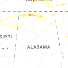


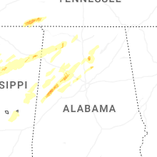


Connect with Interactive Hail Maps