

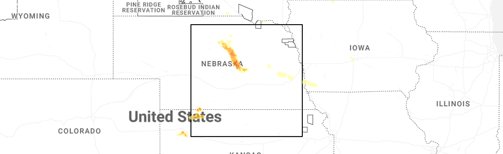
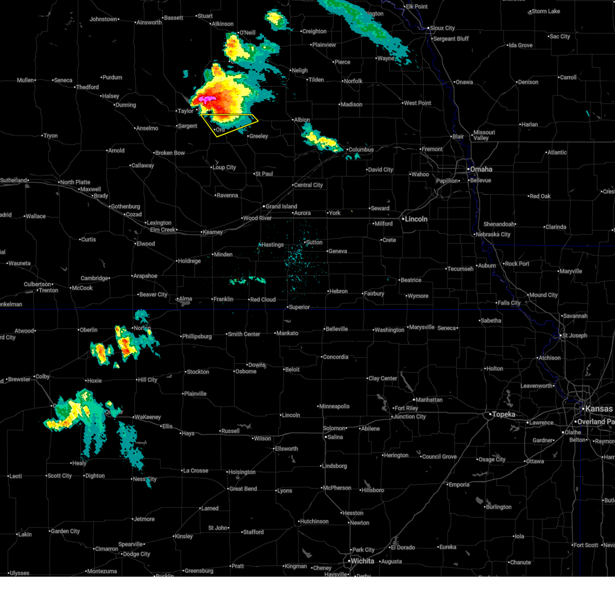
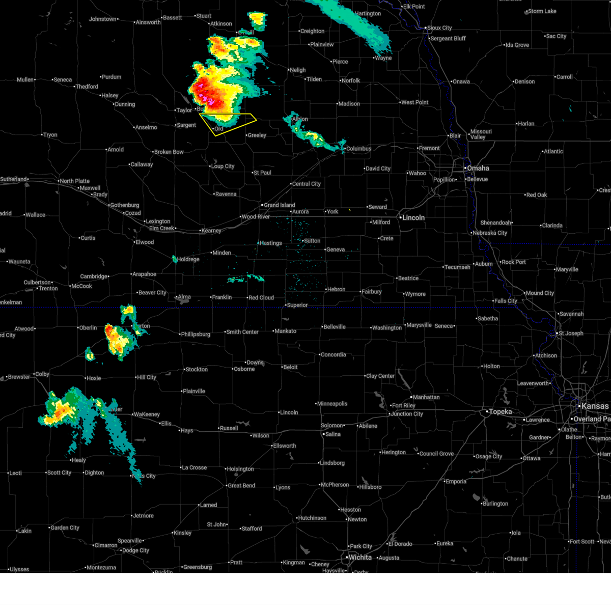
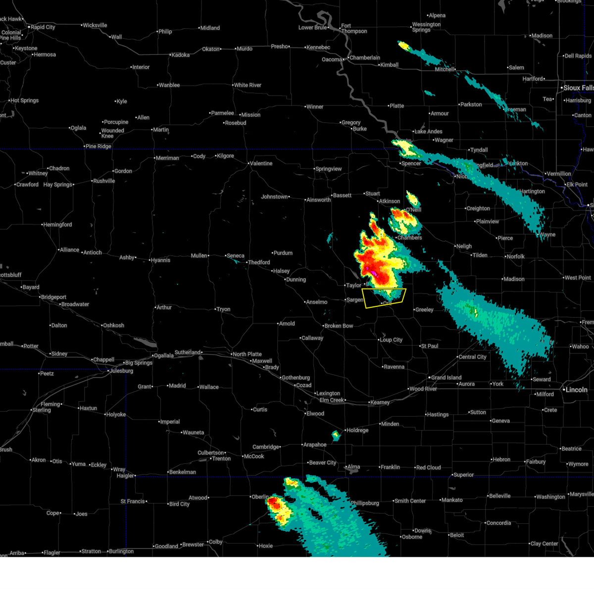
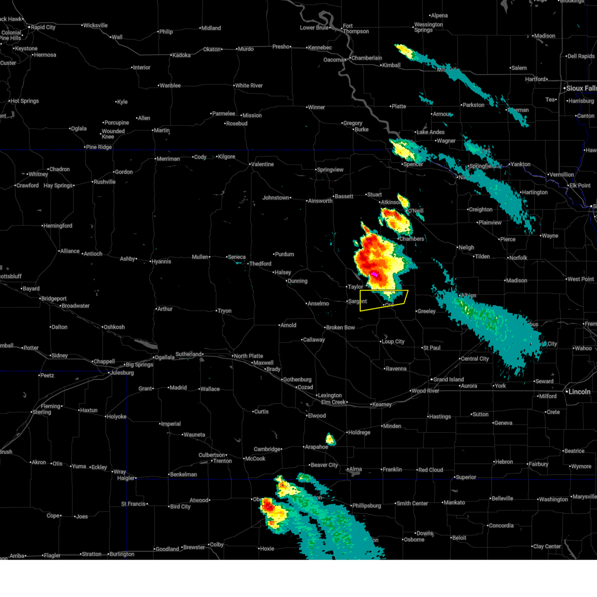
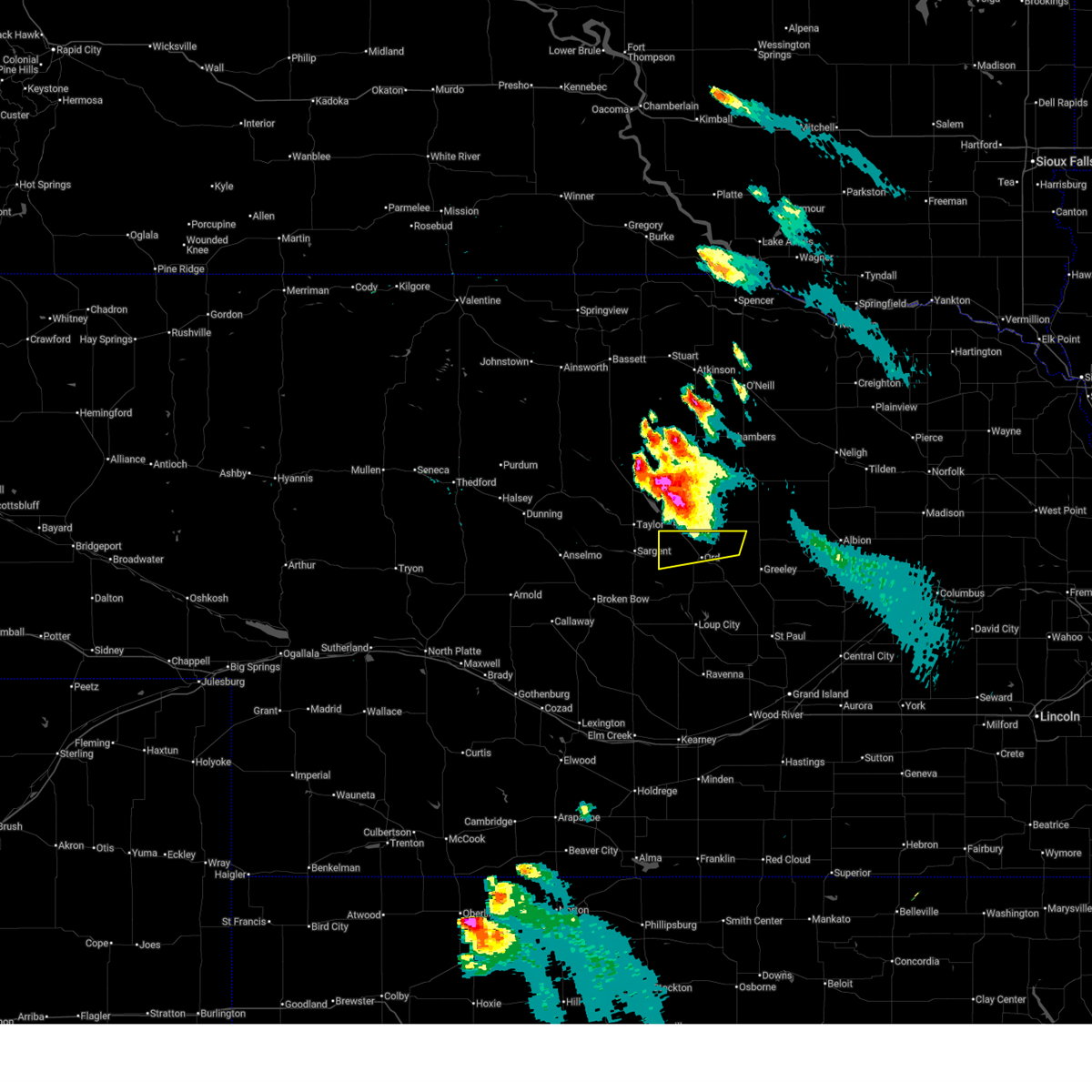
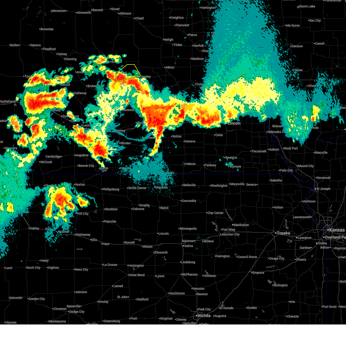
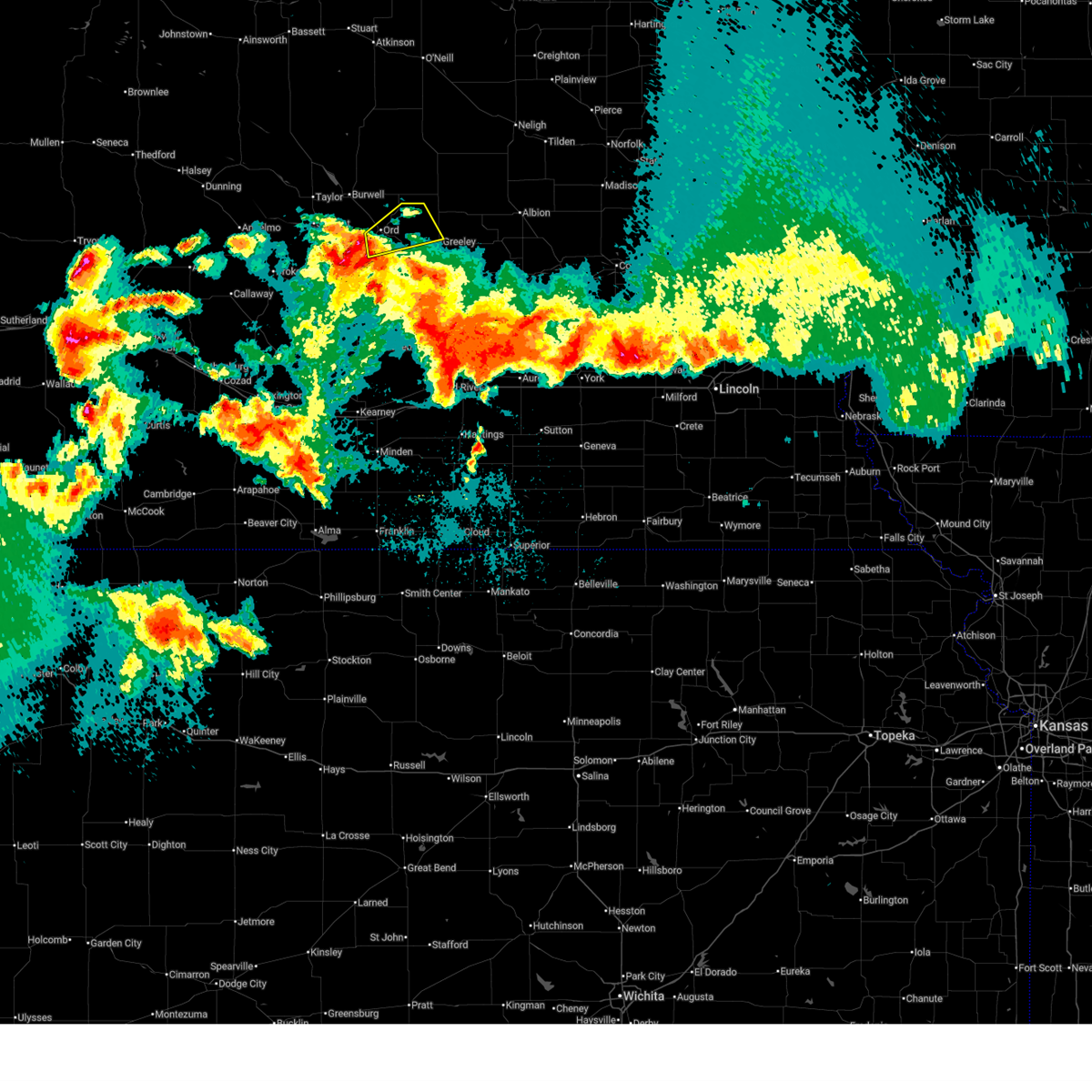
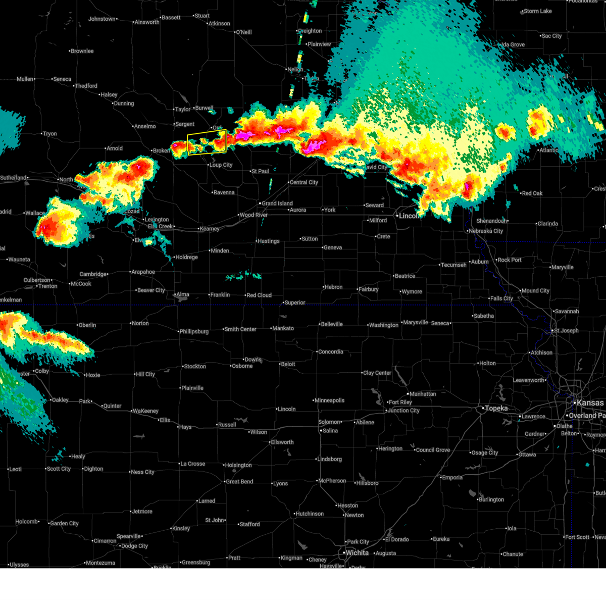
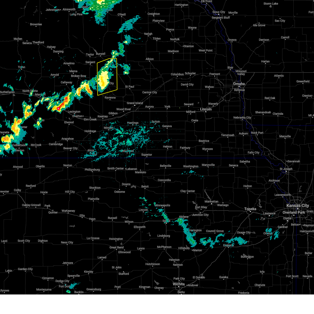
Hail Map for Ord, NE
The Ord, NE area has had 29 reports of on-the-ground hail by trained spotters, and has been under severe weather warnings 33 times during the past 12 months. Doppler radar has detected hail at or near Ord, NE on 116 occasions, including 6 occasions during the past year.
| Name: | Ord, NE |
| Where Located: | 55.5 miles NNW of Grand Island, NE |
| Map: | Google Map for Ord, NE |
| Population: | 2112 |
| Housing Units: | 1122 |
| More Info: | Search Google for Ord, NE |
3
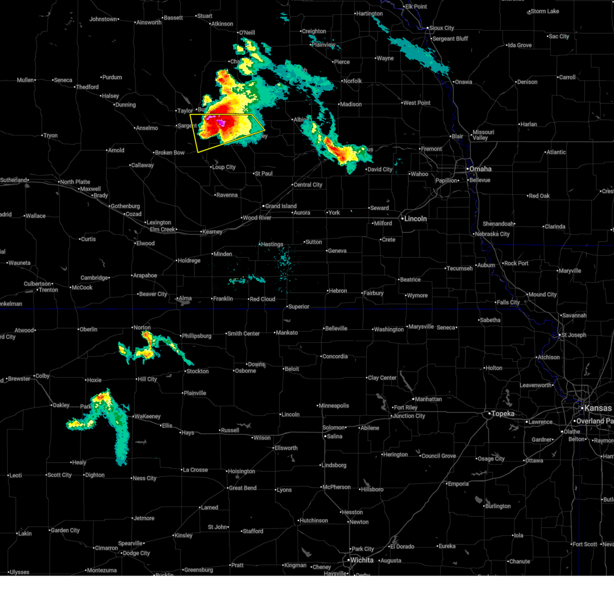
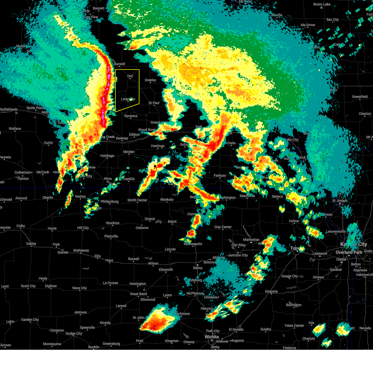
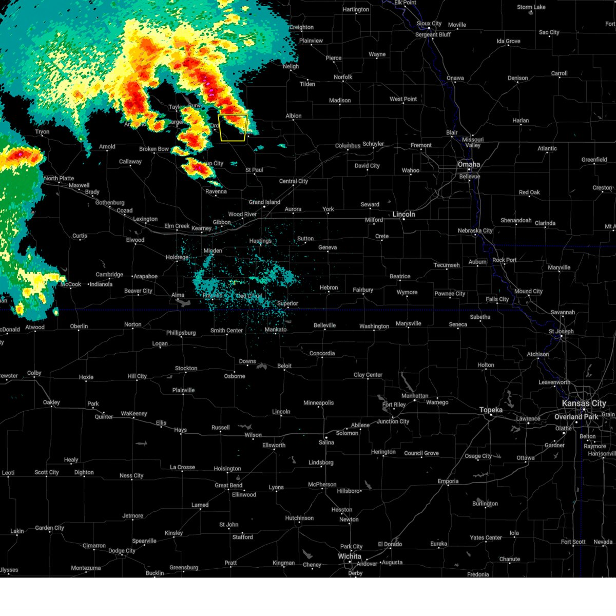
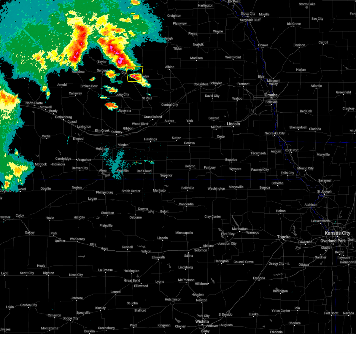
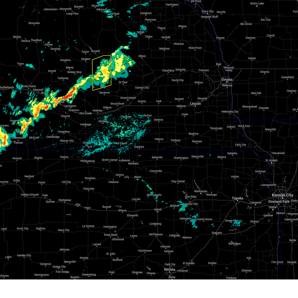
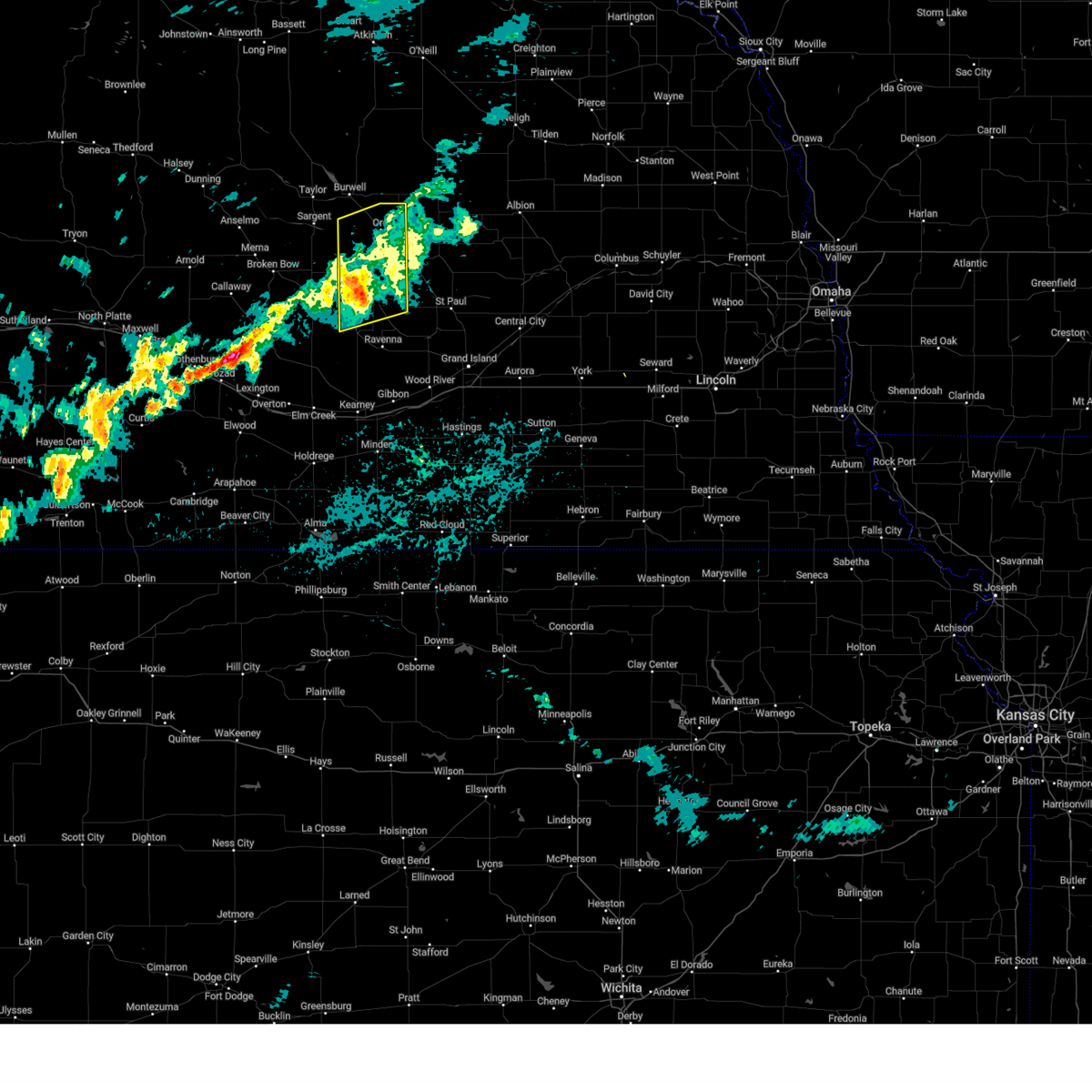
The Top Recent Hail Date for Ord, NE is Thursday, June 19, 2025 (8th out of 116)
Hail and Wind Damage Spotted near Ord, NE
| Date / Time | Report Details |
|---|---|
| 6/19/2025 9:54 PM CDT |
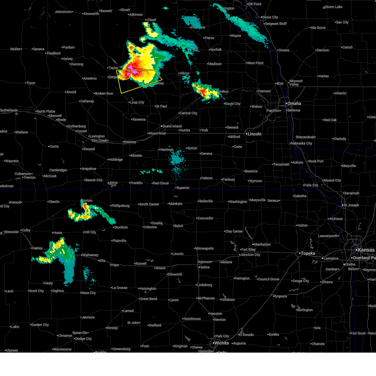
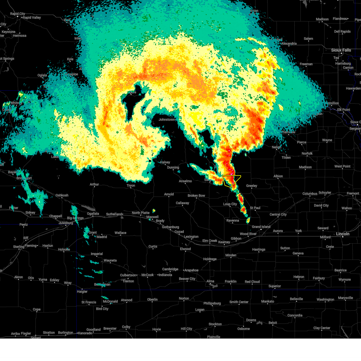
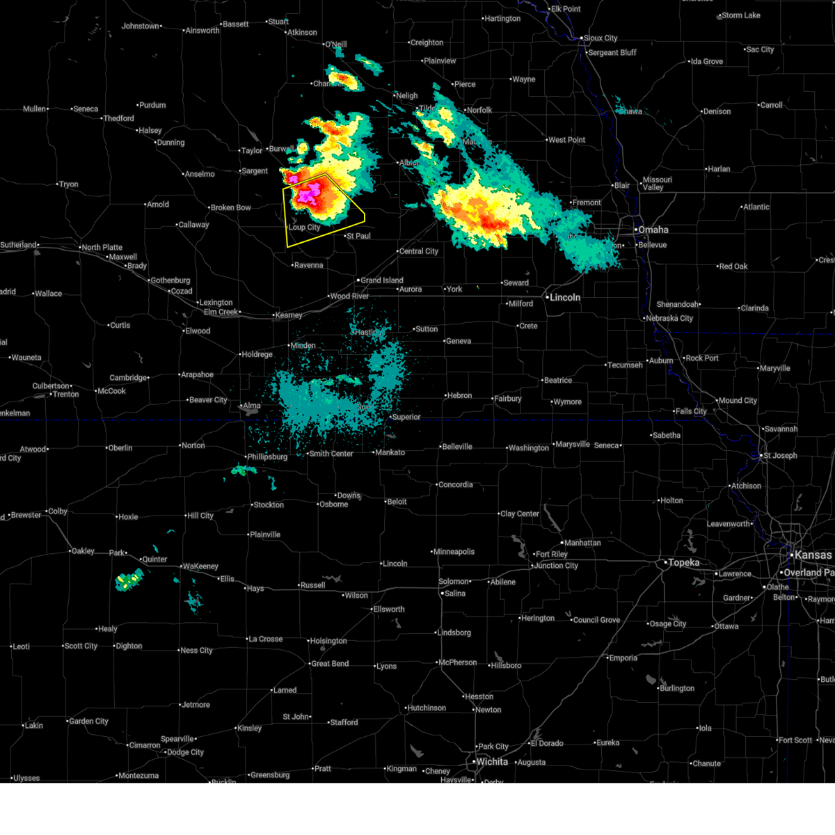 At 953 pm cdt, a severe thunderstorm was located near scotia, or 16 miles southeast of ord, moving southeast at 25 mph (trained weather spotters reported golf ball to two inch hail in north loup at 952 pm). Hazards include two inch hail and 60 mph wind gusts. People and animals outdoors will be injured. expect hail damage to roofs, siding, windows, and vehicles. expect wind damage to roofs, siding, and trees. this severe storm will be near, cotesfield around 1000 pm cdt. Elba around 1015 pm cdt. At 953 pm cdt, a severe thunderstorm was located near scotia, or 16 miles southeast of ord, moving southeast at 25 mph (trained weather spotters reported golf ball to two inch hail in north loup at 952 pm). Hazards include two inch hail and 60 mph wind gusts. People and animals outdoors will be injured. expect hail damage to roofs, siding, windows, and vehicles. expect wind damage to roofs, siding, and trees. this severe storm will be near, cotesfield around 1000 pm cdt. Elba around 1015 pm cdt.
|
| 6/19/2025 9:29 PM CDT |
 At 928 pm cdt, a severe thunderstorm was located near ord, moving southeast at 10 mph (automated weather station. at 910 pm... ord gusted to 72 mph. hail size estimated from radar). Hazards include two inch hail and 70 mph wind gusts. People and animals outdoors will be injured. expect hail damage to roofs, siding, windows, and vehicles. expect considerable tree damage. wind damage is also likely to mobile homes, roofs, and outbuildings. This severe storm will be near, north loup around 940 pm cdt. At 928 pm cdt, a severe thunderstorm was located near ord, moving southeast at 10 mph (automated weather station. at 910 pm... ord gusted to 72 mph. hail size estimated from radar). Hazards include two inch hail and 70 mph wind gusts. People and animals outdoors will be injured. expect hail damage to roofs, siding, windows, and vehicles. expect considerable tree damage. wind damage is also likely to mobile homes, roofs, and outbuildings. This severe storm will be near, north loup around 940 pm cdt.
|
| 6/19/2025 9:26 PM CDT |
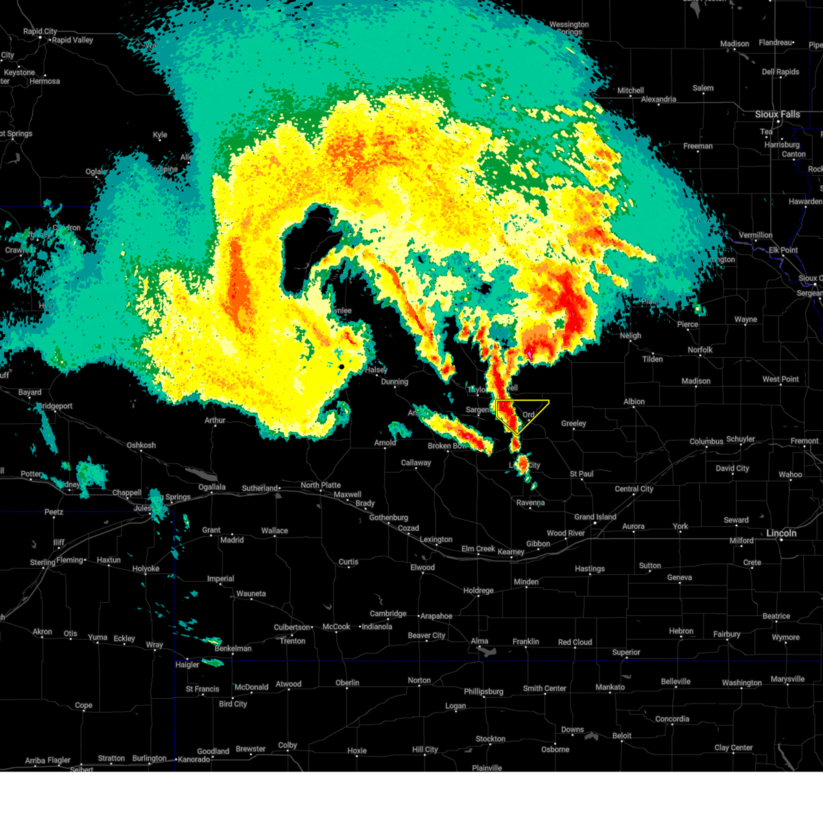
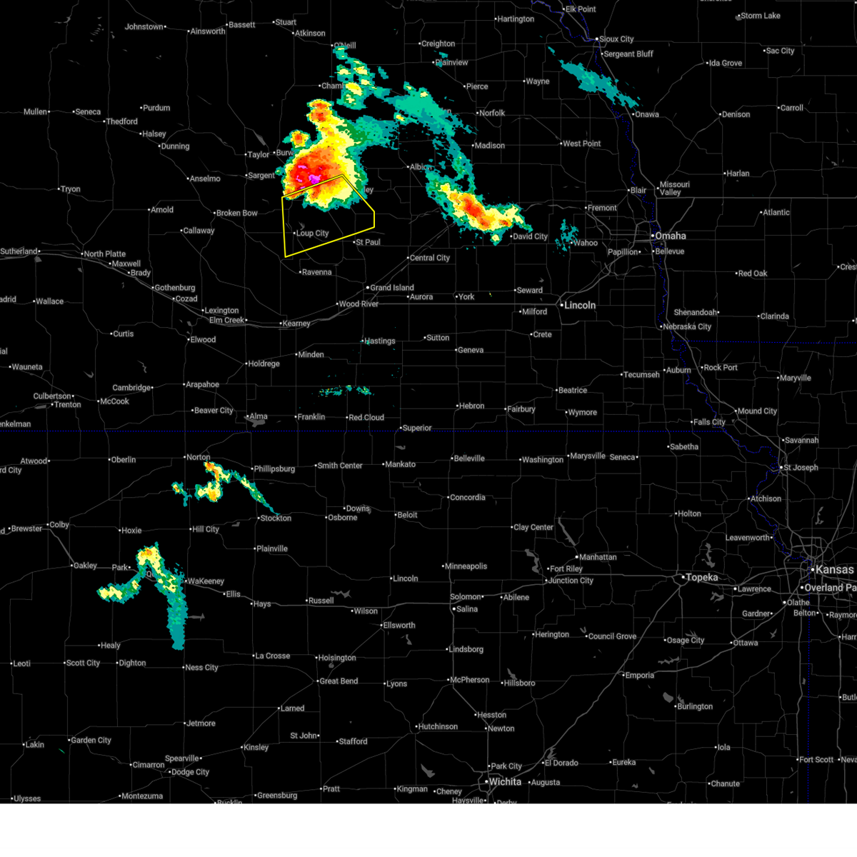 Svrgid the national weather service in hastings has issued a * severe thunderstorm warning for, southern greeley county in central nebraska, southeastern valley county in central nebraska, eastern sherman county in central nebraska, northern howard county in central nebraska, * until 1015 pm cdt. * at 925 pm cdt, a severe thunderstorm was located near ord, moving southeast at 25 mph (automated weather station. ord gusted to 72 mph at 910 pm. hail size estimated from radar). Hazards include two inch hail and 70 mph wind gusts. People and animals outdoors will be injured. expect hail damage to roofs, siding, windows, and vehicles. expect considerable tree damage. wind damage is also likely to mobile homes, roofs, and outbuildings. this severe thunderstorm will be near, north loup around 935 pm cdt. Other locations in the path of this severe thunderstorm include ashton. Svrgid the national weather service in hastings has issued a * severe thunderstorm warning for, southern greeley county in central nebraska, southeastern valley county in central nebraska, eastern sherman county in central nebraska, northern howard county in central nebraska, * until 1015 pm cdt. * at 925 pm cdt, a severe thunderstorm was located near ord, moving southeast at 25 mph (automated weather station. ord gusted to 72 mph at 910 pm. hail size estimated from radar). Hazards include two inch hail and 70 mph wind gusts. People and animals outdoors will be injured. expect hail damage to roofs, siding, windows, and vehicles. expect considerable tree damage. wind damage is also likely to mobile homes, roofs, and outbuildings. this severe thunderstorm will be near, north loup around 935 pm cdt. Other locations in the path of this severe thunderstorm include ashton.
|
| 6/19/2025 9:22 PM CDT |
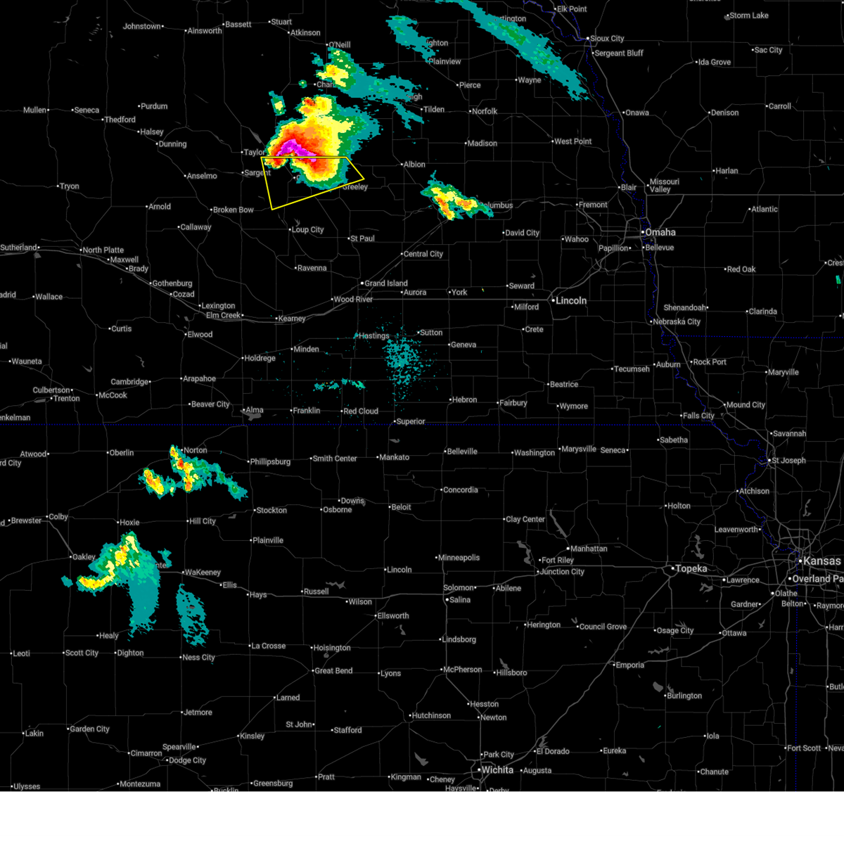
 At 922 pm cdt, a severe thunderstorm was located near ord, moving southeast at 10 mph (radar indicated. at 910 pm cdt, a wind gust of 72 mph was measured by the ord airport asos). Hazards include tennis ball size hail and 70 mph wind gusts. People and animals outdoors will be injured. expect hail damage to roofs, siding, windows, and vehicles. expect considerable tree damage. wind damage is also likely to mobile homes, roofs, and outbuildings. This severe storm will be near, north loup around 940 pm cdt. At 922 pm cdt, a severe thunderstorm was located near ord, moving southeast at 10 mph (radar indicated. at 910 pm cdt, a wind gust of 72 mph was measured by the ord airport asos). Hazards include tennis ball size hail and 70 mph wind gusts. People and animals outdoors will be injured. expect hail damage to roofs, siding, windows, and vehicles. expect considerable tree damage. wind damage is also likely to mobile homes, roofs, and outbuildings. This severe storm will be near, north loup around 940 pm cdt.
|
| 6/19/2025 9:13 PM CDT |
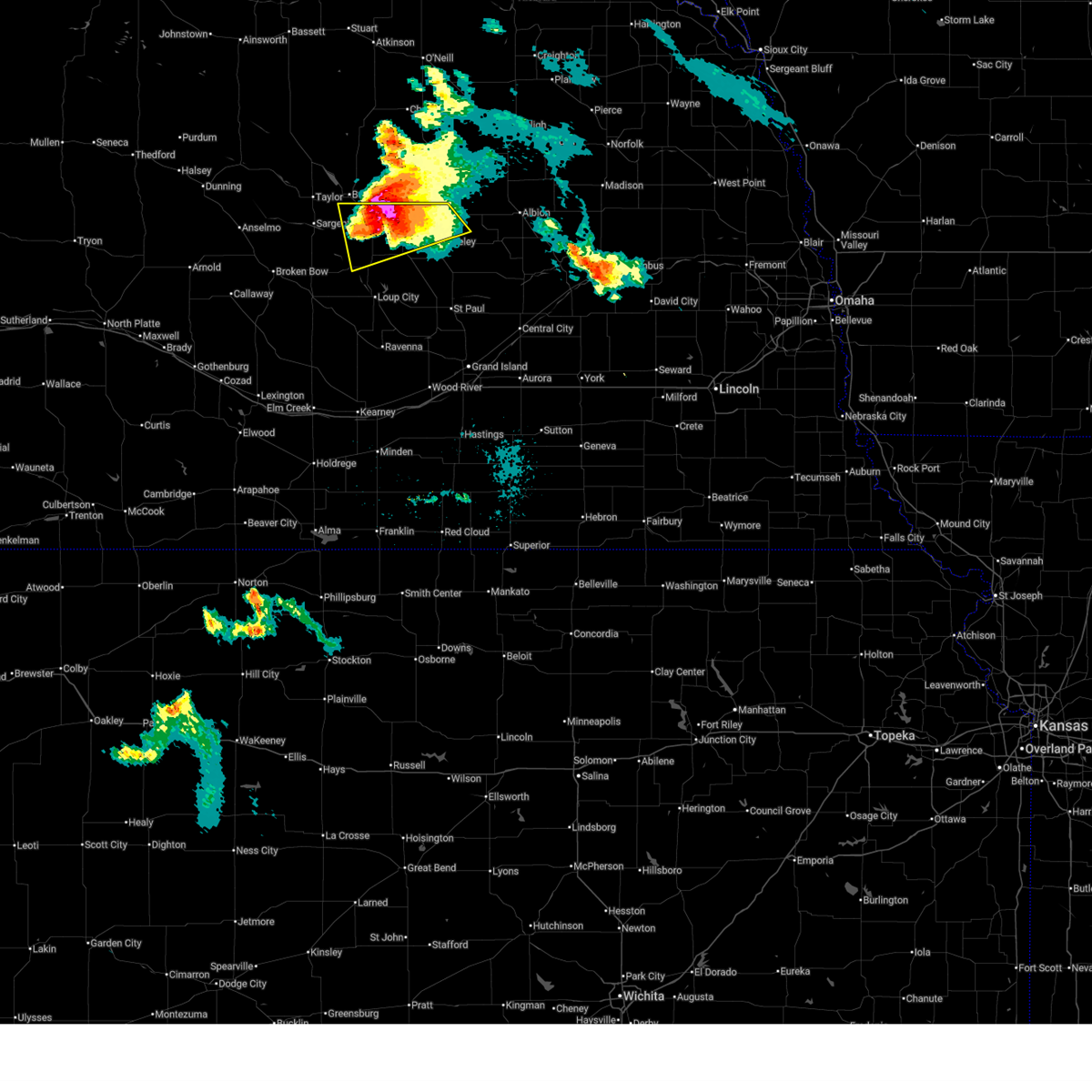 At 913 pm cdt, a severe thunderstorm was located over ord, moving southeast at 20 mph (radar indicated). Hazards include tennis ball size hail and 70 mph wind gusts. People and animals outdoors will be injured. expect hail damage to roofs, siding, windows, and vehicles. expect considerable tree damage. wind damage is also likely to mobile homes, roofs, and outbuildings. This severe storm will be near, north loup around 930 pm cdt. At 913 pm cdt, a severe thunderstorm was located over ord, moving southeast at 20 mph (radar indicated). Hazards include tennis ball size hail and 70 mph wind gusts. People and animals outdoors will be injured. expect hail damage to roofs, siding, windows, and vehicles. expect considerable tree damage. wind damage is also likely to mobile homes, roofs, and outbuildings. This severe storm will be near, north loup around 930 pm cdt.
|
| 6/19/2025 9:10 PM CDT | Storm damage reported in valley county NE, 2.1 miles SE of Ord, NE |
| 6/19/2025 9:04 PM CDT |
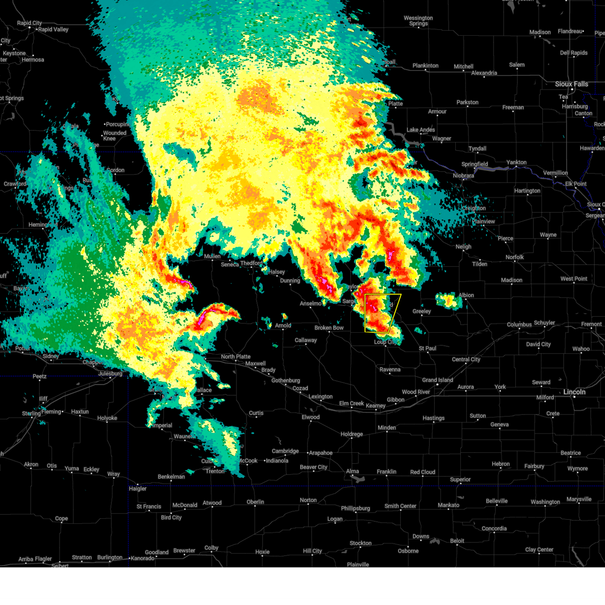
 Svrgid the national weather service in hastings has issued a * severe thunderstorm warning for, northern greeley county in central nebraska, valley county in central nebraska, * until 945 pm cdt. * at 904 pm cdt, a severe thunderstorm was located near fort hartsuff state park, or 8 miles north of ord, moving southeast at 10 mph (radar indicated). Hazards include tennis ball size hail and 70 mph wind gusts. People and animals outdoors will be injured. expect hail damage to roofs, siding, windows, and vehicles. expect considerable tree damage. wind damage is also likely to mobile homes, roofs, and outbuildings. this severe thunderstorm will be near, elyria around 910 pm cdt. Other locations in the path of this severe thunderstorm include ord. Svrgid the national weather service in hastings has issued a * severe thunderstorm warning for, northern greeley county in central nebraska, valley county in central nebraska, * until 945 pm cdt. * at 904 pm cdt, a severe thunderstorm was located near fort hartsuff state park, or 8 miles north of ord, moving southeast at 10 mph (radar indicated). Hazards include tennis ball size hail and 70 mph wind gusts. People and animals outdoors will be injured. expect hail damage to roofs, siding, windows, and vehicles. expect considerable tree damage. wind damage is also likely to mobile homes, roofs, and outbuildings. this severe thunderstorm will be near, elyria around 910 pm cdt. Other locations in the path of this severe thunderstorm include ord.
|
| 6/19/2025 8:57 PM CDT |
 Svrgid the national weather service in hastings has issued a * severe thunderstorm warning for, northern greeley county in central nebraska, valley county in central nebraska, * until 945 pm cdt. * at 856 pm cdt, a severe thunderstorm was located over fort hartsuff state park, or 8 miles east of burwell, moving southeast at 10 mph (radar indicated). Hazards include golf ball size hail and 70 mph wind gusts. People and animals outdoors will be injured. expect hail damage to roofs, siding, windows, and vehicles. expect considerable tree damage. wind damage is also likely to mobile homes, roofs, and outbuildings. this severe thunderstorm will be near, elyria around 900 pm cdt. Other locations in the path of this severe thunderstorm include ord. Svrgid the national weather service in hastings has issued a * severe thunderstorm warning for, northern greeley county in central nebraska, valley county in central nebraska, * until 945 pm cdt. * at 856 pm cdt, a severe thunderstorm was located over fort hartsuff state park, or 8 miles east of burwell, moving southeast at 10 mph (radar indicated). Hazards include golf ball size hail and 70 mph wind gusts. People and animals outdoors will be injured. expect hail damage to roofs, siding, windows, and vehicles. expect considerable tree damage. wind damage is also likely to mobile homes, roofs, and outbuildings. this severe thunderstorm will be near, elyria around 900 pm cdt. Other locations in the path of this severe thunderstorm include ord.
|
| 6/19/2025 8:46 PM CDT |
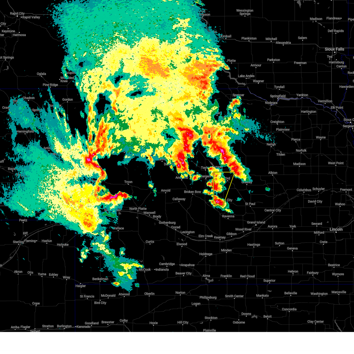
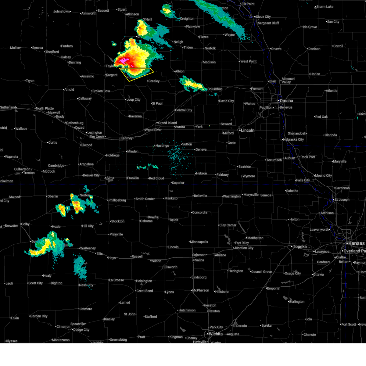 At 845 pm cdt, a severe thunderstorm was located near ericson, or 11 miles northeast of ord, moving southeast at 15 mph (radar indicated. at 835 pm cdt, tennis ball size hail was reported 7 miles northeast of burwell). Hazards include tennis ball size hail and 60 mph wind gusts. People and animals outdoors will be injured. expect hail damage to roofs, siding, windows, and vehicles. expect wind damage to roofs, siding, and trees. Locations impacted include, ord, elyria, and fort hartsuff state park. At 845 pm cdt, a severe thunderstorm was located near ericson, or 11 miles northeast of ord, moving southeast at 15 mph (radar indicated. at 835 pm cdt, tennis ball size hail was reported 7 miles northeast of burwell). Hazards include tennis ball size hail and 60 mph wind gusts. People and animals outdoors will be injured. expect hail damage to roofs, siding, windows, and vehicles. expect wind damage to roofs, siding, and trees. Locations impacted include, ord, elyria, and fort hartsuff state park.
|
| 6/19/2025 8:39 PM CDT |
 At 839 pm cdt, a severe thunderstorm was located near ericson, or 12 miles northeast of ord, moving southeast at 15 mph (radar indicated). Hazards include ping pong ball size hail and 60 mph wind gusts. People and animals outdoors will be injured. expect hail damage to roofs, siding, windows, and vehicles. expect wind damage to roofs, siding, and trees. Locations impacted include, ord, elyria, and fort hartsuff state park. At 839 pm cdt, a severe thunderstorm was located near ericson, or 12 miles northeast of ord, moving southeast at 15 mph (radar indicated). Hazards include ping pong ball size hail and 60 mph wind gusts. People and animals outdoors will be injured. expect hail damage to roofs, siding, windows, and vehicles. expect wind damage to roofs, siding, and trees. Locations impacted include, ord, elyria, and fort hartsuff state park.
|
| 6/19/2025 8:24 PM CDT |
 Svrgid the national weather service in hastings has issued a * severe thunderstorm warning for, northwestern greeley county in central nebraska, northeastern valley county in central nebraska, * until 915 pm cdt. * at 824 pm cdt, a severe thunderstorm was located 8 miles west of ericson, or 12 miles north of ord, moving southeast at 10 mph (radar indicated). Hazards include ping pong ball size hail and 60 mph wind gusts. People and animals outdoors will be injured. expect hail damage to roofs, siding, windows, and vehicles. expect wind damage to roofs, siding, and trees. This severe thunderstorm will remain over mainly rural areas of northwestern greeley and northeastern valley counties. Svrgid the national weather service in hastings has issued a * severe thunderstorm warning for, northwestern greeley county in central nebraska, northeastern valley county in central nebraska, * until 915 pm cdt. * at 824 pm cdt, a severe thunderstorm was located 8 miles west of ericson, or 12 miles north of ord, moving southeast at 10 mph (radar indicated). Hazards include ping pong ball size hail and 60 mph wind gusts. People and animals outdoors will be injured. expect hail damage to roofs, siding, windows, and vehicles. expect wind damage to roofs, siding, and trees. This severe thunderstorm will remain over mainly rural areas of northwestern greeley and northeastern valley counties.
|
| 6/19/2025 8:12 PM CDT |
 At 812 pm cdt, a severe thunderstorm was located 8 miles east of fort hartsuff state park, or 10 miles northeast of ord, moving southeast at 15 mph (radar indicated). Hazards include ping pong ball size hail and 60 mph wind gusts. People and animals outdoors will be injured. expect hail damage to roofs, siding, windows, and vehicles. expect wind damage to roofs, siding, and trees. Locations impacted include, ord, elyria, and fort hartsuff state park. At 812 pm cdt, a severe thunderstorm was located 8 miles east of fort hartsuff state park, or 10 miles northeast of ord, moving southeast at 15 mph (radar indicated). Hazards include ping pong ball size hail and 60 mph wind gusts. People and animals outdoors will be injured. expect hail damage to roofs, siding, windows, and vehicles. expect wind damage to roofs, siding, and trees. Locations impacted include, ord, elyria, and fort hartsuff state park.
|
| 6/19/2025 8:00 PM CDT |
 At 800 pm cdt, a severe thunderstorm was located near fort hartsuff state park, or 9 miles east of burwell, moving southeast at 15 mph (radar indicated). Hazards include ping pong ball size hail and 60 mph wind gusts. People and animals outdoors will be injured. expect hail damage to roofs, siding, windows, and vehicles. expect wind damage to roofs, siding, and trees. This severe thunderstorm will remain over mainly rural areas of northwestern greeley and northern valley counties. At 800 pm cdt, a severe thunderstorm was located near fort hartsuff state park, or 9 miles east of burwell, moving southeast at 15 mph (radar indicated). Hazards include ping pong ball size hail and 60 mph wind gusts. People and animals outdoors will be injured. expect hail damage to roofs, siding, windows, and vehicles. expect wind damage to roofs, siding, and trees. This severe thunderstorm will remain over mainly rural areas of northwestern greeley and northern valley counties.
|
| 6/19/2025 7:41 PM CDT |
 Svrgid the national weather service in hastings has issued a * severe thunderstorm warning for, northwestern greeley county in central nebraska, northern valley county in central nebraska, * until 830 pm cdt. * at 741 pm cdt, a severe thunderstorm was located near burwell, moving southeast at 15 mph (radar indicated). Hazards include ping pong ball size hail and 60 mph wind gusts. People and animals outdoors will be injured. expect hail damage to roofs, siding, windows, and vehicles. expect wind damage to roofs, siding, and trees. this severe thunderstorm will be near, fort hartsuff state park around 750 pm cdt. Elyria around 800 pm cdt. Svrgid the national weather service in hastings has issued a * severe thunderstorm warning for, northwestern greeley county in central nebraska, northern valley county in central nebraska, * until 830 pm cdt. * at 741 pm cdt, a severe thunderstorm was located near burwell, moving southeast at 15 mph (radar indicated). Hazards include ping pong ball size hail and 60 mph wind gusts. People and animals outdoors will be injured. expect hail damage to roofs, siding, windows, and vehicles. expect wind damage to roofs, siding, and trees. this severe thunderstorm will be near, fort hartsuff state park around 750 pm cdt. Elyria around 800 pm cdt.
|
| 6/16/2025 10:35 PM CDT |
 The storm which prompted the warning has weakened below severe limits, and no longer poses an immediate threat to life or property. therefore, the warning will be allowed to expire. a severe thunderstorm watch remains in effect until midnight cdt for central nebraska. The storm which prompted the warning has weakened below severe limits, and no longer poses an immediate threat to life or property. therefore, the warning will be allowed to expire. a severe thunderstorm watch remains in effect until midnight cdt for central nebraska.
|
| 6/16/2025 10:15 PM CDT |
 Svrgid the national weather service in hastings has issued a * severe thunderstorm warning for, northwestern greeley county in central nebraska, eastern valley county in central nebraska, * until 1045 pm cdt. * at 1014 pm cdt, a severe thunderstorm was located near ord, moving northeast at 15 mph (automated weather station). Hazards include 60 mph wind gusts and penny size hail. Expect damage to roofs, siding, and trees. This severe thunderstorm will be near, ord around 1020 pm cdt. Svrgid the national weather service in hastings has issued a * severe thunderstorm warning for, northwestern greeley county in central nebraska, eastern valley county in central nebraska, * until 1045 pm cdt. * at 1014 pm cdt, a severe thunderstorm was located near ord, moving northeast at 15 mph (automated weather station). Hazards include 60 mph wind gusts and penny size hail. Expect damage to roofs, siding, and trees. This severe thunderstorm will be near, ord around 1020 pm cdt.
|
| 6/16/2025 10:06 PM CDT | Storm damage reported in valley county NE, 2.1 miles SE of Ord, NE |
| 6/16/2025 8:25 PM CDT |
 Svrgid the national weather service in hastings has issued a * severe thunderstorm warning for, southern valley county in central nebraska, northern sherman county in central nebraska, * until 900 pm cdt. * at 825 pm cdt, a severe thunderstorm was located near weissert, or 16 miles east of broken bow, moving east at 20 mph (radar indicated). Hazards include 60 mph wind gusts and quarter size hail. Hail damage to vehicles is expected. expect wind damage to roofs, siding, and trees. This severe thunderstorm will be near, arcadia around 845 pm cdt. Svrgid the national weather service in hastings has issued a * severe thunderstorm warning for, southern valley county in central nebraska, northern sherman county in central nebraska, * until 900 pm cdt. * at 825 pm cdt, a severe thunderstorm was located near weissert, or 16 miles east of broken bow, moving east at 20 mph (radar indicated). Hazards include 60 mph wind gusts and quarter size hail. Hail damage to vehicles is expected. expect wind damage to roofs, siding, and trees. This severe thunderstorm will be near, arcadia around 845 pm cdt.
|
| 5/19/2025 12:22 AM CDT |
 Svrgid the national weather service in hastings has issued a * severe thunderstorm warning for, greeley county in central nebraska, eastern valley county in central nebraska, northeastern buffalo county in south central nebraska, eastern sherman county in central nebraska, howard county in central nebraska, northern hall county in south central nebraska, * until 115 am cdt. * at 1222 am cdt, severe thunderstorms were located along a line extending from 7 miles east of fort hartsuff state park to 6 miles north of sherman reservoir dam to near poole, moving east at 30 mph (radar indicated). Hazards include 60 mph wind gusts. Expect damage to roofs, siding, and trees. severe thunderstorms will be near, ravenna, scotia, north loup, ashton, and rockville around 1230 am cdt. howard city around 1235 am cdt. cotesfield and boelus around 1240 am cdt. other locations in the path of these severe thunderstorms include farwell, greeley, cairo, greeley center, elba, dannebrog and st. Paul. Svrgid the national weather service in hastings has issued a * severe thunderstorm warning for, greeley county in central nebraska, eastern valley county in central nebraska, northeastern buffalo county in south central nebraska, eastern sherman county in central nebraska, howard county in central nebraska, northern hall county in south central nebraska, * until 115 am cdt. * at 1222 am cdt, severe thunderstorms were located along a line extending from 7 miles east of fort hartsuff state park to 6 miles north of sherman reservoir dam to near poole, moving east at 30 mph (radar indicated). Hazards include 60 mph wind gusts. Expect damage to roofs, siding, and trees. severe thunderstorms will be near, ravenna, scotia, north loup, ashton, and rockville around 1230 am cdt. howard city around 1235 am cdt. cotesfield and boelus around 1240 am cdt. other locations in the path of these severe thunderstorms include farwell, greeley, cairo, greeley center, elba, dannebrog and st. Paul.
|
| 5/19/2025 12:11 AM CDT |
 At 1210 am cdt, severe thunderstorms were located along a line extending from near fort hartsuff state park to near hazard, moving east at 30 mph (radar indicated). Hazards include 60 mph wind gusts. Expect damage to roofs, siding, and trees. these severe storms will be near, ord, loup city, elyria, and fort hartsuff state park around 1215 am cdt. sherman reservoir dam around 1225 am cdt. North loup and ashton around 1235 am cdt. At 1210 am cdt, severe thunderstorms were located along a line extending from near fort hartsuff state park to near hazard, moving east at 30 mph (radar indicated). Hazards include 60 mph wind gusts. Expect damage to roofs, siding, and trees. these severe storms will be near, ord, loup city, elyria, and fort hartsuff state park around 1215 am cdt. sherman reservoir dam around 1225 am cdt. North loup and ashton around 1235 am cdt.
|
| 5/18/2025 11:44 PM CDT |
 Svrgid the national weather service in hastings has issued a * severe thunderstorm warning for, valley county in central nebraska, sherman county in central nebraska, * until 1230 am cdt. * at 1144 pm cdt, severe thunderstorms were located along a line extending from near taylor to 9 miles south of mason city, moving east at 30 mph (radar indicated). Hazards include 60 mph wind gusts. Expect damage to roofs, siding, and trees. severe thunderstorms will be near, arcadia and litchfield around 1155 pm cdt. Other locations in the path of these severe thunderstorms include elyria, fort hartsuff state park, ord and loup city. Svrgid the national weather service in hastings has issued a * severe thunderstorm warning for, valley county in central nebraska, sherman county in central nebraska, * until 1230 am cdt. * at 1144 pm cdt, severe thunderstorms were located along a line extending from near taylor to 9 miles south of mason city, moving east at 30 mph (radar indicated). Hazards include 60 mph wind gusts. Expect damage to roofs, siding, and trees. severe thunderstorms will be near, arcadia and litchfield around 1155 pm cdt. Other locations in the path of these severe thunderstorms include elyria, fort hartsuff state park, ord and loup city.
|
| 5/14/2025 11:45 PM CDT |
 The storm which prompted the warning has moved out of the area. therefore, the warning will be allowed to expire. however, up to nickel size hail is still possible with this thunderstorm. a severe thunderstorm watch remains in effect until 300 am cdt for central nebraska. The storm which prompted the warning has moved out of the area. therefore, the warning will be allowed to expire. however, up to nickel size hail is still possible with this thunderstorm. a severe thunderstorm watch remains in effect until 300 am cdt for central nebraska.
|
| 5/14/2025 11:35 PM CDT |
 At 1135 pm cdt, a severe thunderstorm was located near elyria, or near ord, moving northeast at 35 mph (radar indicated). Hazards include 60 mph wind gusts and quarter size hail. Hail damage to vehicles is expected. expect wind damage to roofs, siding, and trees. This severe thunderstorm will remain over mainly rural areas of northeastern valley county. At 1135 pm cdt, a severe thunderstorm was located near elyria, or near ord, moving northeast at 35 mph (radar indicated). Hazards include 60 mph wind gusts and quarter size hail. Hail damage to vehicles is expected. expect wind damage to roofs, siding, and trees. This severe thunderstorm will remain over mainly rural areas of northeastern valley county.
|
| 5/14/2025 11:19 PM CDT |
 Svrgid the national weather service in hastings has issued a * severe thunderstorm warning for, northern valley county in central nebraska, * until 1145 pm cdt. * at 1119 pm cdt, a severe thunderstorm was located near elyria, or near ord, moving northeast at 40 mph (radar indicated). Hazards include 60 mph wind gusts and quarter size hail. Hail damage to vehicles is expected. expect wind damage to roofs, siding, and trees. This severe thunderstorm will be near, elyria and fort hartsuff state park around 1125 pm cdt. Svrgid the national weather service in hastings has issued a * severe thunderstorm warning for, northern valley county in central nebraska, * until 1145 pm cdt. * at 1119 pm cdt, a severe thunderstorm was located near elyria, or near ord, moving northeast at 40 mph (radar indicated). Hazards include 60 mph wind gusts and quarter size hail. Hail damage to vehicles is expected. expect wind damage to roofs, siding, and trees. This severe thunderstorm will be near, elyria and fort hartsuff state park around 1125 pm cdt.
|
| 5/14/2025 9:47 PM CDT |
 At 947 pm cdt, severe thunderstorms were located along a line extending from 6 miles east of taylor to near arcadia, moving north at 55 mph (radar indicated). Hazards include half dollar size hail. Damage to vehicles is expected. These severe storms will be near, elyria and fort hartsuff state park around 1000 pm cdt. At 947 pm cdt, severe thunderstorms were located along a line extending from 6 miles east of taylor to near arcadia, moving north at 55 mph (radar indicated). Hazards include half dollar size hail. Damage to vehicles is expected. These severe storms will be near, elyria and fort hartsuff state park around 1000 pm cdt.
|
| 5/14/2025 9:47 PM CDT |
 the severe thunderstorm warning has been cancelled and is no longer in effect the severe thunderstorm warning has been cancelled and is no longer in effect
|
| 5/14/2025 9:29 PM CDT |
 Svrgid the national weather service in hastings has issued a * severe thunderstorm warning for, valley county in central nebraska, northwestern sherman county in central nebraska, * until 1015 pm cdt. * at 928 pm cdt, a severe thunderstorm was located 7 miles west of loup city, or 22 miles southwest of ord, moving north at 45 mph (radar indicated). Hazards include ping pong ball size hail. People and animals outdoors will be injured. expect damage to roofs, siding, windows, and vehicles. this severe thunderstorm will be near, arcadia around 935 pm cdt. Other locations in the path of this severe thunderstorm include ord, elyria and fort hartsuff state park. Svrgid the national weather service in hastings has issued a * severe thunderstorm warning for, valley county in central nebraska, northwestern sherman county in central nebraska, * until 1015 pm cdt. * at 928 pm cdt, a severe thunderstorm was located 7 miles west of loup city, or 22 miles southwest of ord, moving north at 45 mph (radar indicated). Hazards include ping pong ball size hail. People and animals outdoors will be injured. expect damage to roofs, siding, windows, and vehicles. this severe thunderstorm will be near, arcadia around 935 pm cdt. Other locations in the path of this severe thunderstorm include ord, elyria and fort hartsuff state park.
|
| 5/14/2025 9:28 PM CDT |
 the severe thunderstorm warning has been cancelled and is no longer in effect the severe thunderstorm warning has been cancelled and is no longer in effect
|
| 5/14/2025 9:13 PM CDT |
 Svrgid the national weather service in hastings has issued a * severe thunderstorm warning for, northwestern greeley county in central nebraska, northeastern valley county in central nebraska, * until 945 pm cdt. * at 912 pm cdt, a severe thunderstorm was located 7 miles northeast of north loup, or 11 miles east of ord, moving north at 50 mph (radar indicated). Hazards include half dollar size hail. Damage to vehicles is expected. This severe thunderstorm will remain over mainly rural areas of northwestern greeley and northeastern valley counties. Svrgid the national weather service in hastings has issued a * severe thunderstorm warning for, northwestern greeley county in central nebraska, northeastern valley county in central nebraska, * until 945 pm cdt. * at 912 pm cdt, a severe thunderstorm was located 7 miles northeast of north loup, or 11 miles east of ord, moving north at 50 mph (radar indicated). Hazards include half dollar size hail. Damage to vehicles is expected. This severe thunderstorm will remain over mainly rural areas of northwestern greeley and northeastern valley counties.
|
| 5/14/2025 8:39 PM CDT | Quarter sized hail reported 10.3 miles ENE of Ord, NE, hail to around quarter size...second round of hail in last 11 minutes from a new core. |
| 5/14/2025 8:28 PM CDT | Half Dollar sized hail reported 10.3 miles ENE of Ord, NE, hail up to half dollar size...more flat than round. |
| 7/31/2024 12:40 PM CDT |
 The storm which prompted the warning has weakened below severe limits, and no longer poses an immediate threat to life or property. therefore, the warning will be allowed to expire. however, gusty winds are still possible with this thunderstorm. The storm which prompted the warning has weakened below severe limits, and no longer poses an immediate threat to life or property. therefore, the warning will be allowed to expire. however, gusty winds are still possible with this thunderstorm.
|
| 7/31/2024 12:21 PM CDT |
 At 1220 pm cdt, a severe thunderstorm was located over scotia, or 15 miles southeast of ord, moving east at 45 mph. wind gusts around 60 to 65 mph have been reported (automated weather station). Hazards include 60 mph wind gusts and penny size hail. Expect damage to roofs, siding, and trees. Locations impacted include, ord, loup city, arcadia, north loup, litchfield, ashton, elyria, and sherman reservoir dam. At 1220 pm cdt, a severe thunderstorm was located over scotia, or 15 miles southeast of ord, moving east at 45 mph. wind gusts around 60 to 65 mph have been reported (automated weather station). Hazards include 60 mph wind gusts and penny size hail. Expect damage to roofs, siding, and trees. Locations impacted include, ord, loup city, arcadia, north loup, litchfield, ashton, elyria, and sherman reservoir dam.
|
| 7/31/2024 12:17 PM CDT | Storm damage reported in valley county NE, 2.1 miles SE of Ord, NE |
| 7/31/2024 12:00 PM CDT |
 Svrgid the national weather service in hastings has issued a * severe thunderstorm warning for, valley county in central nebraska, sherman county in central nebraska, * until 1245 pm cdt. * at 1200 pm cdt, a severe thunderstorm was located near loup city, or 16 miles south of ord, moving east at 45 mph (automated weather station). Hazards include 60 mph wind gusts. Expect damage to roofs, siding, and trees. This severe thunderstorm will remain over mainly rural areas of valley and sherman counties. Svrgid the national weather service in hastings has issued a * severe thunderstorm warning for, valley county in central nebraska, sherman county in central nebraska, * until 1245 pm cdt. * at 1200 pm cdt, a severe thunderstorm was located near loup city, or 16 miles south of ord, moving east at 45 mph (automated weather station). Hazards include 60 mph wind gusts. Expect damage to roofs, siding, and trees. This severe thunderstorm will remain over mainly rural areas of valley and sherman counties.
|
| 7/31/2024 11:46 AM CDT | Nebraska mesonet site. time used from nearby asos gust tim in valley county NE, 2.1 miles SE of Ord, NE |
| 7/31/2024 11:46 AM CDT | Nebraska mesonet site. time used from nearby asos gust tim in valley county NE, 2.1 miles SE of Ord, NE |
| 7/31/2024 11:41 AM CDT | Storm damage reported in valley county NE, 4.4 miles ENE of Ord, NE |
| 7/31/2024 11:35 AM CDT | Storm damage reported in valley county NE, 8.6 miles ENE of Ord, NE |
| 7/3/2024 7:59 PM CDT |
 The storms which prompted the warning have weakened just below severe limits, and are exiting the warned area. therefore, the warning will be allowed to expire. however, gusty winds as high as 45 to 55 mph are still possible with these thunderstorms. a severe thunderstorm watch remains in effect until midnight cdt for central nebraska. The storms which prompted the warning have weakened just below severe limits, and are exiting the warned area. therefore, the warning will be allowed to expire. however, gusty winds as high as 45 to 55 mph are still possible with these thunderstorms. a severe thunderstorm watch remains in effect until midnight cdt for central nebraska.
|
| 7/3/2024 7:43 PM CDT |
 At 743 pm cdt, severe thunderstorms were located along a line extending from near ord to 6 miles northwest of sherman reservoir dam to near litchfield, moving east at 40 mph (radar indicated. in addition, at 734 pm cdt, a nws coooperative observer 2 miles west of arcadia estimated 50 to 55 mph winds). Hazards include 60 mph wind gusts. Expect damage to roofs, siding, and trees. Locations impacted include, ord, loup city, arcadia, north loup, litchfield, ashton, rockville, and sherman reservoir dam. At 743 pm cdt, severe thunderstorms were located along a line extending from near ord to 6 miles northwest of sherman reservoir dam to near litchfield, moving east at 40 mph (radar indicated. in addition, at 734 pm cdt, a nws coooperative observer 2 miles west of arcadia estimated 50 to 55 mph winds). Hazards include 60 mph wind gusts. Expect damage to roofs, siding, and trees. Locations impacted include, ord, loup city, arcadia, north loup, litchfield, ashton, rockville, and sherman reservoir dam.
|
| 7/3/2024 7:25 PM CDT |
 Svrgid the national weather service in hastings has issued a * severe thunderstorm warning for, valley county in central nebraska, sherman county in central nebraska, * until 800 pm cdt. * at 724 pm cdt, severe thunderstorms were located along a line extending from near comstock to near arcadia to mason city, moving east at 40 mph (radar indicated). Hazards include 60 mph wind gusts and penny size hail. expect damage to roofs, siding, and trees Svrgid the national weather service in hastings has issued a * severe thunderstorm warning for, valley county in central nebraska, sherman county in central nebraska, * until 800 pm cdt. * at 724 pm cdt, severe thunderstorms were located along a line extending from near comstock to near arcadia to mason city, moving east at 40 mph (radar indicated). Hazards include 60 mph wind gusts and penny size hail. expect damage to roofs, siding, and trees
|
| 6/25/2024 11:25 PM CDT | Storm damage reported in valley county NE, 2.1 miles SE of Ord, NE |
| 6/7/2024 5:44 PM CDT |
 Svrgid the national weather service in hastings has issued a * severe thunderstorm warning for, greeley county in central nebraska, northeastern valley county in central nebraska, * until 630 pm cdt. * at 544 pm cdt, a severe thunderstorm was located 8 miles east of ord, moving southeast at 35 mph (radar indicated). Hazards include 60 mph wind gusts and quarter size hail. Hail damage to vehicles is expected. expect wind damage to roofs, siding, and trees. this severe thunderstorm will be near, greeley center around 600 pm cdt. Other locations in the path of this severe thunderstorm include greeley. Svrgid the national weather service in hastings has issued a * severe thunderstorm warning for, greeley county in central nebraska, northeastern valley county in central nebraska, * until 630 pm cdt. * at 544 pm cdt, a severe thunderstorm was located 8 miles east of ord, moving southeast at 35 mph (radar indicated). Hazards include 60 mph wind gusts and quarter size hail. Hail damage to vehicles is expected. expect wind damage to roofs, siding, and trees. this severe thunderstorm will be near, greeley center around 600 pm cdt. Other locations in the path of this severe thunderstorm include greeley.
|
| 6/7/2024 5:28 PM CDT |
 At 528 pm cdt, a severe thunderstorm was located near fort hartsuff state park, or 9 miles north of ord, moving southeast at 35 mph (radar indicated). Hazards include 60 mph wind gusts and half dollar size hail. Hail damage to vehicles is expected. expect wind damage to roofs, siding, and trees. Locations impacted include, ord, elyria, and fort hartsuff state park. At 528 pm cdt, a severe thunderstorm was located near fort hartsuff state park, or 9 miles north of ord, moving southeast at 35 mph (radar indicated). Hazards include 60 mph wind gusts and half dollar size hail. Hail damage to vehicles is expected. expect wind damage to roofs, siding, and trees. Locations impacted include, ord, elyria, and fort hartsuff state park.
|
| 6/7/2024 4:54 PM CDT |
 Svrgid the national weather service in hastings has issued a * severe thunderstorm warning for, northwestern greeley county in central nebraska, northern valley county in central nebraska, * until 545 pm cdt. * at 454 pm cdt, a severe thunderstorm was located over calamus reservoir state recreation area, or 8 miles northwest of burwell, moving southeast at 35 mph (radar indicated). Hazards include ping pong ball size hail and 60 mph wind gusts. People and animals outdoors will be injured. expect hail damage to roofs, siding, windows, and vehicles. Expect wind damage to roofs, siding, and trees. Svrgid the national weather service in hastings has issued a * severe thunderstorm warning for, northwestern greeley county in central nebraska, northern valley county in central nebraska, * until 545 pm cdt. * at 454 pm cdt, a severe thunderstorm was located over calamus reservoir state recreation area, or 8 miles northwest of burwell, moving southeast at 35 mph (radar indicated). Hazards include ping pong ball size hail and 60 mph wind gusts. People and animals outdoors will be injured. expect hail damage to roofs, siding, windows, and vehicles. Expect wind damage to roofs, siding, and trees.
|
| 6/2/2024 9:46 PM CDT |
 The storms which prompted the warning have weakened below severe limits, and no longer pose an immediate threat to life or property. therefore, the warning has been allowed to expire. however, gusty winds of 50 to 55 mph are still possible with these thunderstorms. a severe thunderstorm watch remains in effect until midnight cdt for central nebraska. The storms which prompted the warning have weakened below severe limits, and no longer pose an immediate threat to life or property. therefore, the warning has been allowed to expire. however, gusty winds of 50 to 55 mph are still possible with these thunderstorms. a severe thunderstorm watch remains in effect until midnight cdt for central nebraska.
|
| 6/2/2024 9:35 PM CDT |
 At 934 pm cdt, severe thunderstorms were located along a line extending from near ericson to near howard city, moving northeast at 75 mph (radar indicated). Hazards include 70 mph wind gusts. Expect considerable tree damage. damage is likely to mobile homes, roofs, and outbuildings. These severe storms will be near, greeley center, dannebrog, elba, farwell, and cotesfield around 940 pm cdt. At 934 pm cdt, severe thunderstorms were located along a line extending from near ericson to near howard city, moving northeast at 75 mph (radar indicated). Hazards include 70 mph wind gusts. Expect considerable tree damage. damage is likely to mobile homes, roofs, and outbuildings. These severe storms will be near, greeley center, dannebrog, elba, farwell, and cotesfield around 940 pm cdt.
|
| 6/2/2024 9:01 PM CDT |
 Svrgid the national weather service in hastings has issued a * severe thunderstorm warning for, western greeley county in central nebraska, valley county in central nebraska, sherman county in central nebraska, western howard county in central nebraska, * until 945 pm cdt. * at 901 pm cdt, severe thunderstorms were located along a line extending from near taylor to near litchfield, moving northeast at 50 mph (radar indicated). Hazards include 60 mph wind gusts. Expect damage to roofs, siding, and trees. severe thunderstorms will be near, arcadia around 905 pm cdt. loup city around 910 pm cdt. elyria and fort hartsuff state park around 915 pm cdt. ord and sherman reservoir dam around 920 pm cdt. Other locations in the path of these severe thunderstorms include scotia and north loup. Svrgid the national weather service in hastings has issued a * severe thunderstorm warning for, western greeley county in central nebraska, valley county in central nebraska, sherman county in central nebraska, western howard county in central nebraska, * until 945 pm cdt. * at 901 pm cdt, severe thunderstorms were located along a line extending from near taylor to near litchfield, moving northeast at 50 mph (radar indicated). Hazards include 60 mph wind gusts. Expect damage to roofs, siding, and trees. severe thunderstorms will be near, arcadia around 905 pm cdt. loup city around 910 pm cdt. elyria and fort hartsuff state park around 915 pm cdt. ord and sherman reservoir dam around 920 pm cdt. Other locations in the path of these severe thunderstorms include scotia and north loup.
|
| 5/23/2024 11:53 PM CDT |
 Svrgid the national weather service in hastings has issued a * severe thunderstorm warning for, greeley county in central nebraska, nance county in central nebraska, southeastern valley county in central nebraska, sherman county in central nebraska, northwestern merrick county in central nebraska, howard county in central nebraska, * until 1245 am cdt. * at 1153 pm cdt, severe thunderstorms were located along a line extending from near primrose to near farwell, moving east at 35 mph (radar indicated). Hazards include 60 mph wind gusts and quarter size hail. Hail damage to vehicles is expected. expect wind damage to roofs, siding, and trees. severe thunderstorms will be near, st. paul, wolbach, and elba around 1200 am cdt. cushing around 1205 am cdt. Other locations in the path of these severe thunderstorms include palmer and belgrade. Svrgid the national weather service in hastings has issued a * severe thunderstorm warning for, greeley county in central nebraska, nance county in central nebraska, southeastern valley county in central nebraska, sherman county in central nebraska, northwestern merrick county in central nebraska, howard county in central nebraska, * until 1245 am cdt. * at 1153 pm cdt, severe thunderstorms were located along a line extending from near primrose to near farwell, moving east at 35 mph (radar indicated). Hazards include 60 mph wind gusts and quarter size hail. Hail damage to vehicles is expected. expect wind damage to roofs, siding, and trees. severe thunderstorms will be near, st. paul, wolbach, and elba around 1200 am cdt. cushing around 1205 am cdt. Other locations in the path of these severe thunderstorms include palmer and belgrade.
|
| 5/23/2024 11:32 PM CDT |
 At 1131 pm cdt, severe thunderstorms were located along a line extending from near greeley to near rockville, moving northeast at 40 mph (radar indicated). Hazards include 60 mph wind gusts and quarter size hail. Hail damage to vehicles is expected. expect wind damage to roofs, siding, and trees. these severe storms will be near, greeley, greeley center, ashton, and cotesfield around 1135 pm cdt. spalding around 1140 pm cdt. elba around 1150 pm cdt. Wolbach around 1200 am cdt. At 1131 pm cdt, severe thunderstorms were located along a line extending from near greeley to near rockville, moving northeast at 40 mph (radar indicated). Hazards include 60 mph wind gusts and quarter size hail. Hail damage to vehicles is expected. expect wind damage to roofs, siding, and trees. these severe storms will be near, greeley, greeley center, ashton, and cotesfield around 1135 pm cdt. spalding around 1140 pm cdt. elba around 1150 pm cdt. Wolbach around 1200 am cdt.
|
| 5/23/2024 11:17 PM CDT |
 Svrgid the national weather service in hastings has issued a * severe thunderstorm warning for, greeley county in central nebraska, southeastern valley county in central nebraska, sherman county in central nebraska, howard county in central nebraska, * until midnight cdt. * at 1117 pm cdt, severe thunderstorms were located along a line extending from near greeley center to near litchfield, moving northeast at 40 mph (radar indicated). Hazards include 60 mph wind gusts and quarter size hail. Hail damage to vehicles is expected. expect wind damage to roofs, siding, and trees. severe thunderstorms will be near, greeley, loup city, greeley center, scotia, north loup, and sherman reservoir dam around 1120 pm cdt. ashton around 1130 pm cdt. spalding around 1135 pm cdt. Other locations in the path of these severe thunderstorms include cotesfield. Svrgid the national weather service in hastings has issued a * severe thunderstorm warning for, greeley county in central nebraska, southeastern valley county in central nebraska, sherman county in central nebraska, howard county in central nebraska, * until midnight cdt. * at 1117 pm cdt, severe thunderstorms were located along a line extending from near greeley center to near litchfield, moving northeast at 40 mph (radar indicated). Hazards include 60 mph wind gusts and quarter size hail. Hail damage to vehicles is expected. expect wind damage to roofs, siding, and trees. severe thunderstorms will be near, greeley, loup city, greeley center, scotia, north loup, and sherman reservoir dam around 1120 pm cdt. ashton around 1130 pm cdt. spalding around 1135 pm cdt. Other locations in the path of these severe thunderstorms include cotesfield.
|
| 5/20/2024 11:59 PM CDT |
 The storms which prompted the warning have weakened below severe limits, and no longer pose an immediate threat to life or property. therefore, the warning will be allowed to expire. however, gusty winds are still possible with these thunderstorms. a severe thunderstorm watch remains in effect until 700 am cdt for central nebraska. The storms which prompted the warning have weakened below severe limits, and no longer pose an immediate threat to life or property. therefore, the warning will be allowed to expire. however, gusty winds are still possible with these thunderstorms. a severe thunderstorm watch remains in effect until 700 am cdt for central nebraska.
|
| 5/20/2024 11:46 PM CDT |
 At 1146 pm cdt, severe thunderstorms were located along a line extending from near comstock to near loup city, moving east at 30 mph (radar indicated). Hazards include 60 mph wind gusts and penny size hail. Expect damage to roofs, siding, and trees. Locations impacted include, ord, arcadia, north loup, elyria, and fort hartsuff state park. At 1146 pm cdt, severe thunderstorms were located along a line extending from near comstock to near loup city, moving east at 30 mph (radar indicated). Hazards include 60 mph wind gusts and penny size hail. Expect damage to roofs, siding, and trees. Locations impacted include, ord, arcadia, north loup, elyria, and fort hartsuff state park.
|
| 5/20/2024 11:34 PM CDT |
 At 1134 pm cdt, a severe thunderstorm was located near arcadia, or 15 miles southwest of ord, moving east at 30 mph (radar indicated). Hazards include 60 mph wind gusts and quarter size hail. Hail damage to vehicles is expected. expect wind damage to roofs, siding, and trees. Locations impacted include, ord, arcadia, north loup, elyria, and fort hartsuff state park. At 1134 pm cdt, a severe thunderstorm was located near arcadia, or 15 miles southwest of ord, moving east at 30 mph (radar indicated). Hazards include 60 mph wind gusts and quarter size hail. Hail damage to vehicles is expected. expect wind damage to roofs, siding, and trees. Locations impacted include, ord, arcadia, north loup, elyria, and fort hartsuff state park.
|
| 5/20/2024 11:12 PM CDT |
 Svrgid the national weather service in hastings has issued a * severe thunderstorm warning for, valley county in central nebraska, northern sherman county in central nebraska, * until midnight cdt. * at 1111 pm cdt, a severe thunderstorm was located near weissert, or 15 miles northeast of broken bow, moving east at 40 mph (radar indicated). Hazards include 60 mph wind gusts and quarter size hail. Hail damage to vehicles is expected. Expect wind damage to roofs, siding, and trees. Svrgid the national weather service in hastings has issued a * severe thunderstorm warning for, valley county in central nebraska, northern sherman county in central nebraska, * until midnight cdt. * at 1111 pm cdt, a severe thunderstorm was located near weissert, or 15 miles northeast of broken bow, moving east at 40 mph (radar indicated). Hazards include 60 mph wind gusts and quarter size hail. Hail damage to vehicles is expected. Expect wind damage to roofs, siding, and trees.
|
| 4/16/2024 4:15 AM CDT |
 Svrgid the national weather service in hastings has issued a * severe thunderstorm warning for, greeley county in central nebraska, nance county in central nebraska, valley county in central nebraska, york county in east central nebraska, northeastern hamilton county in south central nebraska, northeastern fillmore county in south central nebraska, northeastern merrick county in central nebraska, polk county in east central nebraska, * until 445 am cdt. * at 415 am cdt, severe thunderstorms were located along a line extending from near sargent to near primrose to near stromsburg to 6 miles south of dorchester, moving north at 75 mph (radar indicated). Hazards include 60 mph wind gusts. Expect damage to roofs, siding, and trees. severe thunderstorms will be near, stromsburg, osceola, spalding, silver creek, waco, gresham, elyria, and fort hartsuff state park around 420 am cdt. genoa and shelby around 425 am cdt. This includes interstate 80 between mile markers 346 and 365. Svrgid the national weather service in hastings has issued a * severe thunderstorm warning for, greeley county in central nebraska, nance county in central nebraska, valley county in central nebraska, york county in east central nebraska, northeastern hamilton county in south central nebraska, northeastern fillmore county in south central nebraska, northeastern merrick county in central nebraska, polk county in east central nebraska, * until 445 am cdt. * at 415 am cdt, severe thunderstorms were located along a line extending from near sargent to near primrose to near stromsburg to 6 miles south of dorchester, moving north at 75 mph (radar indicated). Hazards include 60 mph wind gusts. Expect damage to roofs, siding, and trees. severe thunderstorms will be near, stromsburg, osceola, spalding, silver creek, waco, gresham, elyria, and fort hartsuff state park around 420 am cdt. genoa and shelby around 425 am cdt. This includes interstate 80 between mile markers 346 and 365.
|
| 4/16/2024 4:06 AM CDT |
 At 404 am cdt, severe thunderstorms were located along a line extending from 6 miles southwest of burwell to near spalding to near hordville to near ohiowa, moving north at 50 mph (automated weather station. at 351 am cdt, the ord airport measured a 75 mph wind gust). Hazards include 70 mph wind gusts. Expect considerable tree damage. damage is likely to mobile homes, roofs, and outbuildings. these severe storms will be near, york, fullerton, exeter, spalding, mccool junction, clarks, polk, milligan, and belgrade around 410 am cdt. benedict around 415 am cdt. stromsburg and waco around 420 am cdt. This includes interstate 80 between mile markers 339 and 365. At 404 am cdt, severe thunderstorms were located along a line extending from 6 miles southwest of burwell to near spalding to near hordville to near ohiowa, moving north at 50 mph (automated weather station. at 351 am cdt, the ord airport measured a 75 mph wind gust). Hazards include 70 mph wind gusts. Expect considerable tree damage. damage is likely to mobile homes, roofs, and outbuildings. these severe storms will be near, york, fullerton, exeter, spalding, mccool junction, clarks, polk, milligan, and belgrade around 410 am cdt. benedict around 415 am cdt. stromsburg and waco around 420 am cdt. This includes interstate 80 between mile markers 339 and 365.
|
| 4/16/2024 4:06 AM CDT |
 the severe thunderstorm warning has been cancelled and is no longer in effect the severe thunderstorm warning has been cancelled and is no longer in effect
|
| 4/16/2024 3:51 AM CDT | Storm damage reported in valley county NE, 8.6 miles ENE of Ord, NE |
| 4/16/2024 3:51 AM CDT | Storm damage reported in valley county NE, 2.1 miles SE of Ord, NE |
| 4/16/2024 3:50 AM CDT |
 At 348 am cdt, severe thunderstorms were located along a line extending from near comstock to near greeley to near central city to near geneva, moving north at 55 mph (radar indicated. in addition, at 340 am cdt, a personal weather station measured a 62 mph wind gust 4 miles north- northwest of strang). Hazards include 60 mph wind gusts and penny size hail. Expect damage to roofs, siding, and trees. these severe storms will be near, ord, central city, greeley, fairmont, greeley center, mccool junction, bradshaw, hordville, elyria, and lushton around 355 am cdt. york, fullerton, spalding, polk, and fort hartsuff state park around 400 am cdt. clarks and belgrade around 405 am cdt. benedict around 410 am cdt. waco around 415 am cdt. stromsburg around 420 am cdt. This includes interstate 80 between mile markers 328 and 365. At 348 am cdt, severe thunderstorms were located along a line extending from near comstock to near greeley to near central city to near geneva, moving north at 55 mph (radar indicated. in addition, at 340 am cdt, a personal weather station measured a 62 mph wind gust 4 miles north- northwest of strang). Hazards include 60 mph wind gusts and penny size hail. Expect damage to roofs, siding, and trees. these severe storms will be near, ord, central city, greeley, fairmont, greeley center, mccool junction, bradshaw, hordville, elyria, and lushton around 355 am cdt. york, fullerton, spalding, polk, and fort hartsuff state park around 400 am cdt. clarks and belgrade around 405 am cdt. benedict around 410 am cdt. waco around 415 am cdt. stromsburg around 420 am cdt. This includes interstate 80 between mile markers 328 and 365.
|
| 4/16/2024 3:50 AM CDT |
 the severe thunderstorm warning has been cancelled and is no longer in effect the severe thunderstorm warning has been cancelled and is no longer in effect
|
| 4/16/2024 3:39 AM CDT |
 Svrgid the national weather service in hastings has issued a * severe thunderstorm warning for, eastern clay county in south central nebraska, greeley county in central nebraska, nance county in central nebraska, valley county in central nebraska, york county in east central nebraska, hamilton county in south central nebraska, fillmore county in south central nebraska, northern sherman county in central nebraska, merrick county in central nebraska, southwestern polk county in east central nebraska, howard county in central nebraska, northeastern hall county in south central nebraska, * until 415 am cdt. * at 339 am cdt, severe thunderstorms were located along a line extending from near arcadia to near wolbach to near chapman to near strang, moving north at 55 mph (radar indicated). Hazards include 60 mph wind gusts and penny size hail. Expect damage to roofs, siding, and trees. severe thunderstorms will be near, central city, geneva, henderson, palmer, greeley center, hampton, scotia, north loup, wolbach, and marquette around 345 am cdt. ord, greeley, fairmont, bradshaw, and hordville around 350 am cdt. mccool junction and elyria around 355 am cdt. other locations in the path of these severe thunderstorms include york, fullerton, spalding, clarks, polk, belgrade and fort hartsuff state park. This includes interstate 80 between mile markers 319 and 365. Svrgid the national weather service in hastings has issued a * severe thunderstorm warning for, eastern clay county in south central nebraska, greeley county in central nebraska, nance county in central nebraska, valley county in central nebraska, york county in east central nebraska, hamilton county in south central nebraska, fillmore county in south central nebraska, northern sherman county in central nebraska, merrick county in central nebraska, southwestern polk county in east central nebraska, howard county in central nebraska, northeastern hall county in south central nebraska, * until 415 am cdt. * at 339 am cdt, severe thunderstorms were located along a line extending from near arcadia to near wolbach to near chapman to near strang, moving north at 55 mph (radar indicated). Hazards include 60 mph wind gusts and penny size hail. Expect damage to roofs, siding, and trees. severe thunderstorms will be near, central city, geneva, henderson, palmer, greeley center, hampton, scotia, north loup, wolbach, and marquette around 345 am cdt. ord, greeley, fairmont, bradshaw, and hordville around 350 am cdt. mccool junction and elyria around 355 am cdt. other locations in the path of these severe thunderstorms include york, fullerton, spalding, clarks, polk, belgrade and fort hartsuff state park. This includes interstate 80 between mile markers 319 and 365.
|
| 4/6/2024 5:49 PM CDT |
 the severe thunderstorm warning has been cancelled and is no longer in effect the severe thunderstorm warning has been cancelled and is no longer in effect
|
| 4/6/2024 5:36 PM CDT |
 At 536 pm cdt, severe thunderstorms were located along a line extending from near scotia to near st. libory, moving north at 65 mph (automated weather station). Hazards include 60 mph wind gusts. Expect damage to roofs, siding, and trees. locations impacted include, greeley, st. paul, spalding, greeley center, scotia, dannebrog, north loup, wolbach, elba, farwell, cotesfield, cushing, and st. Libory. At 536 pm cdt, severe thunderstorms were located along a line extending from near scotia to near st. libory, moving north at 65 mph (automated weather station). Hazards include 60 mph wind gusts. Expect damage to roofs, siding, and trees. locations impacted include, greeley, st. paul, spalding, greeley center, scotia, dannebrog, north loup, wolbach, elba, farwell, cotesfield, cushing, and st. Libory.
|
| 4/6/2024 5:36 PM CDT |
 the severe thunderstorm warning has been cancelled and is no longer in effect the severe thunderstorm warning has been cancelled and is no longer in effect
|
| 4/6/2024 5:17 PM CDT |
 At 516 pm cdt, severe thunderstorms were located along a line extending from 6 miles east of comstock to near ashton to near st. libory, moving north at 40 mph (automated weather station). Hazards include 60 mph wind gusts. Expect damage to roofs, siding, and trees. locations impacted include, ord, greeley, st. Paul, loup city, spalding, greeley center, scotia, arcadia, dannebrog, north loup, wolbach, elba, ashton, howard city, farwell, rockville, elyria, cotesfield, cushing, and fort hartsuff state park. At 516 pm cdt, severe thunderstorms were located along a line extending from 6 miles east of comstock to near ashton to near st. libory, moving north at 40 mph (automated weather station). Hazards include 60 mph wind gusts. Expect damage to roofs, siding, and trees. locations impacted include, ord, greeley, st. Paul, loup city, spalding, greeley center, scotia, arcadia, dannebrog, north loup, wolbach, elba, ashton, howard city, farwell, rockville, elyria, cotesfield, cushing, and fort hartsuff state park.
|
| 4/6/2024 4:58 PM CDT |
 Svrgid the national weather service in hastings has issued a * severe thunderstorm warning for, greeley county in central nebraska, valley county in central nebraska, sherman county in central nebraska, howard county in central nebraska, * until 600 pm cdt. * at 458 pm cdt, severe thunderstorms were located along a line extending from comstock to sherman reservoir dam to near dannebrog, moving north at 50 mph (automated weather station). Hazards include 70 mph wind gusts. Expect considerable tree damage. damage is likely to mobile homes, roofs, and outbuildings. severe thunderstorms will be near, dannebrog and farwell around 505 pm cdt. st. paul, elba, and cotesfield around 510 pm cdt. ord, scotia, north loup, and elyria around 515 pm cdt. Other locations in the path of these severe thunderstorms include fort hartsuff state park, greeley and greeley center. Svrgid the national weather service in hastings has issued a * severe thunderstorm warning for, greeley county in central nebraska, valley county in central nebraska, sherman county in central nebraska, howard county in central nebraska, * until 600 pm cdt. * at 458 pm cdt, severe thunderstorms were located along a line extending from comstock to sherman reservoir dam to near dannebrog, moving north at 50 mph (automated weather station). Hazards include 70 mph wind gusts. Expect considerable tree damage. damage is likely to mobile homes, roofs, and outbuildings. severe thunderstorms will be near, dannebrog and farwell around 505 pm cdt. st. paul, elba, and cotesfield around 510 pm cdt. ord, scotia, north loup, and elyria around 515 pm cdt. Other locations in the path of these severe thunderstorms include fort hartsuff state park, greeley and greeley center.
|
| 4/6/2024 4:51 PM CDT |
 At 451 pm cdt, severe thunderstorms were located along a line extending from near sargent to 7 miles north of sherman reservoir dam to shelton, moving north at 55 mph (automated weather station). Hazards include 70 mph wind gusts. Expect considerable tree damage. damage is likely to mobile homes, roofs, and outbuildings. these severe storms will be near, ashton, howard city, rockville, and sherman reservoir dam around 455 pm cdt. ord, elyria, and boelus around 500 pm cdt. Fort hartsuff state park around 505 pm cdt. At 451 pm cdt, severe thunderstorms were located along a line extending from near sargent to 7 miles north of sherman reservoir dam to shelton, moving north at 55 mph (automated weather station). Hazards include 70 mph wind gusts. Expect considerable tree damage. damage is likely to mobile homes, roofs, and outbuildings. these severe storms will be near, ashton, howard city, rockville, and sherman reservoir dam around 455 pm cdt. ord, elyria, and boelus around 500 pm cdt. Fort hartsuff state park around 505 pm cdt.
|
| 4/6/2024 4:51 PM CDT |
 the severe thunderstorm warning has been cancelled and is no longer in effect the severe thunderstorm warning has been cancelled and is no longer in effect
|
| 4/6/2024 4:32 PM CDT |
 At 431 pm cdt, severe thunderstorms were located along a line extending from near weissert to 6 miles northeast of hazard to near heartwell, moving north at 65 mph (automated weather station). Hazards include 70 mph wind gusts. Expect considerable tree damage. damage is likely to mobile homes, roofs, and outbuildings. these severe storms will be near, gibbon, ravenna, shelton, loup city, heartwell, and poole around 435 pm cdt. arcadia, rockville, and sherman reservoir dam around 440 pm cdt. ashton around 445 pm cdt. howard city and boelus around 450 pm cdt. ord around 455 pm cdt. elyria and fort hartsuff state park around 500 pm cdt. This includes interstate 80 between mile markers 278 and 298. At 431 pm cdt, severe thunderstorms were located along a line extending from near weissert to 6 miles northeast of hazard to near heartwell, moving north at 65 mph (automated weather station). Hazards include 70 mph wind gusts. Expect considerable tree damage. damage is likely to mobile homes, roofs, and outbuildings. these severe storms will be near, gibbon, ravenna, shelton, loup city, heartwell, and poole around 435 pm cdt. arcadia, rockville, and sherman reservoir dam around 440 pm cdt. ashton around 445 pm cdt. howard city and boelus around 450 pm cdt. ord around 455 pm cdt. elyria and fort hartsuff state park around 500 pm cdt. This includes interstate 80 between mile markers 278 and 298.
|
| 4/6/2024 4:32 PM CDT |
 the severe thunderstorm warning has been cancelled and is no longer in effect the severe thunderstorm warning has been cancelled and is no longer in effect
|
| 4/6/2024 4:14 PM CDT |
 Svrgid the national weather service in hastings has issued a * severe thunderstorm warning for, northeastern franklin county in south central nebraska, kearney county in south central nebraska, valley county in central nebraska, buffalo county in south central nebraska, sherman county in central nebraska, southwestern howard county in central nebraska, western hall county in south central nebraska, * until 500 pm cdt. * at 413 pm cdt, severe thunderstorms were located along a line extending from near ansley to pleasanton to norman, moving north at 55 mph (automated weather station. this line of thunderstorms has a history of producing 60 to 70 mph wind gusts). Hazards include 70 mph wind gusts. Expect considerable tree damage. damage is likely to mobile homes, roofs, and outbuildings. severe thunderstorms will be near, gibbon, pleasanton, litchfield, heartwell, hazard, and poole around 420 pm cdt. ravenna around 425 pm cdt. shelton around 430 pm cdt. other locations in the path of these severe thunderstorms include loup city, arcadia, rockville, howard city, sherman reservoir dam, ashton and boelus. This includes interstate 80 between mile markers 267 and 298. Svrgid the national weather service in hastings has issued a * severe thunderstorm warning for, northeastern franklin county in south central nebraska, kearney county in south central nebraska, valley county in central nebraska, buffalo county in south central nebraska, sherman county in central nebraska, southwestern howard county in central nebraska, western hall county in south central nebraska, * until 500 pm cdt. * at 413 pm cdt, severe thunderstorms were located along a line extending from near ansley to pleasanton to norman, moving north at 55 mph (automated weather station. this line of thunderstorms has a history of producing 60 to 70 mph wind gusts). Hazards include 70 mph wind gusts. Expect considerable tree damage. damage is likely to mobile homes, roofs, and outbuildings. severe thunderstorms will be near, gibbon, pleasanton, litchfield, heartwell, hazard, and poole around 420 pm cdt. ravenna around 425 pm cdt. shelton around 430 pm cdt. other locations in the path of these severe thunderstorms include loup city, arcadia, rockville, howard city, sherman reservoir dam, ashton and boelus. This includes interstate 80 between mile markers 267 and 298.
|
| 10/3/2023 5:40 PM CDT |
 At 539 pm cdt, a severe thunderstorm was located near ord, moving northeast at 45 mph (radar indicated). Hazards include 70 mph wind gusts and penny size hail. Expect considerable tree damage. damage is likely to mobile homes, roofs, and outbuildings. this severe thunderstorm will remain over mainly rural areas of northern greeley and valley counties. thunderstorm damage threat, considerable hail threat, radar indicated max hail size, 0. 75 in wind threat, radar indicated max wind gust, 70 mph. At 539 pm cdt, a severe thunderstorm was located near ord, moving northeast at 45 mph (radar indicated). Hazards include 70 mph wind gusts and penny size hail. Expect considerable tree damage. damage is likely to mobile homes, roofs, and outbuildings. this severe thunderstorm will remain over mainly rural areas of northern greeley and valley counties. thunderstorm damage threat, considerable hail threat, radar indicated max hail size, 0. 75 in wind threat, radar indicated max wind gust, 70 mph.
|
| 10/3/2023 5:33 PM CDT | Asos reports a wind gust of 62 mp in valley county NE, 2.1 miles SE of Ord, NE |
| 10/3/2023 5:33 PM CDT | Minor tree damage in town including a few downed trees. nearby asos clocked a gust of 62 mp in valley county NE, 0.6 miles E of Ord, NE |
| 9/23/2023 7:11 AM CDT |
 At 710 am cdt, severe thunderstorms were located along a line extending from near fort hartsuff state park to sherman reservoir dam, moving east at 35 mph. additional severe thunderstorms with large hail were located over central greeley county, also moving east (radar indicated). Hazards include half dollar size hail. Damage to vehicles is expected. locations impacted include, ord, greeley, st. paul, spalding, scotia, north loup, wolbach, elba, ashton, farwell, elyria, cotesfield, cushing, fort hartsuff state park, and sherman reservoir dam. hail threat, radar indicated max hail size, 1. 25 in wind threat, radar indicated max wind gust, <50 mph. At 710 am cdt, severe thunderstorms were located along a line extending from near fort hartsuff state park to sherman reservoir dam, moving east at 35 mph. additional severe thunderstorms with large hail were located over central greeley county, also moving east (radar indicated). Hazards include half dollar size hail. Damage to vehicles is expected. locations impacted include, ord, greeley, st. paul, spalding, scotia, north loup, wolbach, elba, ashton, farwell, elyria, cotesfield, cushing, fort hartsuff state park, and sherman reservoir dam. hail threat, radar indicated max hail size, 1. 25 in wind threat, radar indicated max wind gust, <50 mph.
|
| 9/23/2023 7:01 AM CDT | At 701 am cdt, severe thunderstorms were located along a line extending from near fort hartsuff state park to near loup city, moving east at 45 mph (radar indicated). Hazards include ping pong ball size hail. People and animals outdoors will be injured. expect damage to roofs, siding, windows, and vehicles. locations impacted include, ord, greeley, st. paul, loup city, spalding, scotia, arcadia, north loup, wolbach, elba, ashton, farwell, elyria, cotesfield, cushing, fort hartsuff state park, and sherman reservoir dam. hail threat, radar indicated max hail size, 1. 50 in wind threat, radar indicated max wind gust, <50 mph. |
| 9/23/2023 6:53 AM CDT |
 At 652 am cdt, a severe thunderstorm was located 9 miles south of ericson, or 10 miles east of ord, moving northeast at 35 mph. additional line of severe thunderstorms is moving in from the west (trained weather spotters. at 642 am cdt, half dollar size hail was reported in ord). Hazards include quarter size hail. Damage to vehicles is expected. locations impacted include, ord, scotia, north loup, elyria, and fort hartsuff state park. hail threat, observed max hail size, 1. 00 in wind threat, radar indicated max wind gust, <50 mph. At 652 am cdt, a severe thunderstorm was located 9 miles south of ericson, or 10 miles east of ord, moving northeast at 35 mph. additional line of severe thunderstorms is moving in from the west (trained weather spotters. at 642 am cdt, half dollar size hail was reported in ord). Hazards include quarter size hail. Damage to vehicles is expected. locations impacted include, ord, scotia, north loup, elyria, and fort hartsuff state park. hail threat, observed max hail size, 1. 00 in wind threat, radar indicated max wind gust, <50 mph.
|
| 9/23/2023 6:50 AM CDT |
 At 650 am cdt, severe thunderstorms were located along a line extending from near burwell to 7 miles south of arcadia, moving east at 35 mph (trained weather spotters). Hazards include quarter size hail. Damage to vehicles is expected. severe thunderstorms will be near, arcadia, elyria, and fort hartsuff state park around 655 am cdt. ord and loup city around 705 am cdt. sherman reservoir dam around 710 am cdt. other locations in the path of these severe thunderstorms include north loup, scotia and cotesfield. hail threat, observed max hail size, 1. 00 in wind threat, radar indicated max wind gust, <50 mph. At 650 am cdt, severe thunderstorms were located along a line extending from near burwell to 7 miles south of arcadia, moving east at 35 mph (trained weather spotters). Hazards include quarter size hail. Damage to vehicles is expected. severe thunderstorms will be near, arcadia, elyria, and fort hartsuff state park around 655 am cdt. ord and loup city around 705 am cdt. sherman reservoir dam around 710 am cdt. other locations in the path of these severe thunderstorms include north loup, scotia and cotesfield. hail threat, observed max hail size, 1. 00 in wind threat, radar indicated max wind gust, <50 mph.
|
| 9/23/2023 6:31 AM CDT |
 At 631 am cdt, severe thunderstorms were located along a line extending from 7 miles northeast of comstock to near ord to north loup, moving northeast at 35 mph (radar indicated). Hazards include quarter size hail. damage to vehicles is expected At 631 am cdt, severe thunderstorms were located along a line extending from 7 miles northeast of comstock to near ord to north loup, moving northeast at 35 mph (radar indicated). Hazards include quarter size hail. damage to vehicles is expected
|
| 9/7/2023 9:48 PM CDT |
 At 948 pm cdt, a severe thunderstorm was located over ord, moving east at 40 mph (automated weather station reported over 70 mph winds in ord). Hazards include 70 mph wind gusts. Expect considerable tree damage. Damage is likely to mobile homes, roofs, and outbuildings. At 948 pm cdt, a severe thunderstorm was located over ord, moving east at 40 mph (automated weather station reported over 70 mph winds in ord). Hazards include 70 mph wind gusts. Expect considerable tree damage. Damage is likely to mobile homes, roofs, and outbuildings.
|
| 9/7/2023 9:44 PM CDT | Nebraska mesonet statio in valley county NE, 2.1 miles SE of Ord, NE |
| 8/10/2023 7:45 PM CDT | Hen Egg sized hail reported 10.5 miles SSW of Ord, NE, public report of 1.5 to 2 inch hail based on measurements. |
| 7/29/2023 5:39 AM CDT |
 At 539 am cdt, severe thunderstorms were located along a line extending from near cedar rapids to near st. paul to near cairo, moving southeast at 40 mph (automated weather station). Hazards include 70 mph wind gusts and quarter size hail. Hail damage to vehicles is expected. expect considerable tree damage. wind damage is also likely to mobile homes, roofs, and outbuildings. these severe storms will be near, palmer around 545 am cdt. st. libory around 550 am cdt. belgrade around 555 am cdt. alda around 600 am cdt. fullerton and chapman around 605 am cdt. doniphan around 610 am cdt. marquette around 615 am cdt. this includes interstate 80 between mile markers 309 and 323. thunderstorm damage threat, considerable hail threat, radar indicated max hail size, 1. 00 in wind threat, observed max wind gust, 70 mph. At 539 am cdt, severe thunderstorms were located along a line extending from near cedar rapids to near st. paul to near cairo, moving southeast at 40 mph (automated weather station). Hazards include 70 mph wind gusts and quarter size hail. Hail damage to vehicles is expected. expect considerable tree damage. wind damage is also likely to mobile homes, roofs, and outbuildings. these severe storms will be near, palmer around 545 am cdt. st. libory around 550 am cdt. belgrade around 555 am cdt. alda around 600 am cdt. fullerton and chapman around 605 am cdt. doniphan around 610 am cdt. marquette around 615 am cdt. this includes interstate 80 between mile markers 309 and 323. thunderstorm damage threat, considerable hail threat, radar indicated max hail size, 1. 00 in wind threat, observed max wind gust, 70 mph.
|
| 7/29/2023 5:13 AM CDT |
 At 512 am cdt, severe thunderstorms were located along a line extending from near spalding to cotesfield to near rockville, moving southeast at 40 mph (automated weather station. this storm has a history of producing measured gusts of 70 to 80 mph in valley county). Hazards include 70 mph wind gusts and quarter size hail. Hail damage to vehicles is expected. expect considerable tree damage. wind damage is also likely to mobile homes, roofs, and outbuildings. severe thunderstorms will be near, cotesfield around 515 am cdt. spalding, elba, farwell and rockville around 520 am cdt. st. paul, cushing and boelus around 530 am cdt. other locations in the path of these severe thunderstorms include dannebrog, cairo, palmer, st. libory, belgrade and alda. this includes interstate 80 between mile markers 309 and 323. thunderstorm damage threat, considerable hail threat, radar indicated max hail size, 1. 00 in wind threat, observed max wind gust, 70 mph. At 512 am cdt, severe thunderstorms were located along a line extending from near spalding to cotesfield to near rockville, moving southeast at 40 mph (automated weather station. this storm has a history of producing measured gusts of 70 to 80 mph in valley county). Hazards include 70 mph wind gusts and quarter size hail. Hail damage to vehicles is expected. expect considerable tree damage. wind damage is also likely to mobile homes, roofs, and outbuildings. severe thunderstorms will be near, cotesfield around 515 am cdt. spalding, elba, farwell and rockville around 520 am cdt. st. paul, cushing and boelus around 530 am cdt. other locations in the path of these severe thunderstorms include dannebrog, cairo, palmer, st. libory, belgrade and alda. this includes interstate 80 between mile markers 309 and 323. thunderstorm damage threat, considerable hail threat, radar indicated max hail size, 1. 00 in wind threat, observed max wind gust, 70 mph.
|
| 7/29/2023 4:56 AM CDT |
 At 453 am cdt, severe thunderstorms were located along a line extending from near ericson to near north loup to 8 miles northeast of mason city, moving southeast at 40 mph. these are destructive storms for ord, loup city, north loup, and greeley (automated weather station. at 449 am cdt, a 81 mph wind gust was reported at the ord airport). Hazards include 80 mph wind gusts and half dollar size hail. Flying debris will be dangerous to those caught without shelter. mobile homes will be heavily damaged. expect considerable damage to roofs, windows, and vehicles. extensive tree damage and power outages are likely. these severe storms will be near, scotia around 500 am cdt. hazard and cotesfield around 510 am cdt. greeley around 515 am cdt. spalding and elba around 520 am cdt. thunderstorm damage threat, destructive hail threat, radar indicated max hail size, 1. 25 in wind threat, observed max wind gust, 80 mph. At 453 am cdt, severe thunderstorms were located along a line extending from near ericson to near north loup to 8 miles northeast of mason city, moving southeast at 40 mph. these are destructive storms for ord, loup city, north loup, and greeley (automated weather station. at 449 am cdt, a 81 mph wind gust was reported at the ord airport). Hazards include 80 mph wind gusts and half dollar size hail. Flying debris will be dangerous to those caught without shelter. mobile homes will be heavily damaged. expect considerable damage to roofs, windows, and vehicles. extensive tree damage and power outages are likely. these severe storms will be near, scotia around 500 am cdt. hazard and cotesfield around 510 am cdt. greeley around 515 am cdt. spalding and elba around 520 am cdt. thunderstorm damage threat, destructive hail threat, radar indicated max hail size, 1. 25 in wind threat, observed max wind gust, 80 mph.
|
| 7/29/2023 4:47 AM CDT |
 At 445 am cdt, severe thunderstorms were located along a line extending from near ericson to near north loup to 7 miles northeast of mason city, moving east at 40 mph (automated weather station. at 435 am cdt, a 66 mph wind gust was reported at the ord airport). Hazards include 70 mph wind gusts and half dollar size hail. Hail damage to vehicles is expected. expect considerable tree damage. wind damage is also likely to mobile homes, roofs, and outbuildings. these severe storms will be near, arcadia and north loup around 455 am cdt. scotia around 500 am cdt. loup city around 505 am cdt. greeley, spalding and sherman reservoir dam around 515 am cdt. ashton around 520 am cdt. wolbach around 525 am cdt. elba and cotesfield around 530 am cdt. thunderstorm damage threat, considerable hail threat, radar indicated max hail size, 1. 25 in wind threat, observed max wind gust, 70 mph. At 445 am cdt, severe thunderstorms were located along a line extending from near ericson to near north loup to 7 miles northeast of mason city, moving east at 40 mph (automated weather station. at 435 am cdt, a 66 mph wind gust was reported at the ord airport). Hazards include 70 mph wind gusts and half dollar size hail. Hail damage to vehicles is expected. expect considerable tree damage. wind damage is also likely to mobile homes, roofs, and outbuildings. these severe storms will be near, arcadia and north loup around 455 am cdt. scotia around 500 am cdt. loup city around 505 am cdt. greeley, spalding and sherman reservoir dam around 515 am cdt. ashton around 520 am cdt. wolbach around 525 am cdt. elba and cotesfield around 530 am cdt. thunderstorm damage threat, considerable hail threat, radar indicated max hail size, 1. 25 in wind threat, observed max wind gust, 70 mph.
|
| 7/29/2023 4:30 AM CDT |
 At 428 am cdt, severe thunderstorms were located along a line extending from 12 miles northeast of fort hartsuff state park to near ord to near weissert, moving southeast at 40 mph (automated weather station reported wind gusts near 60 mph). Hazards include 60 mph wind gusts and half dollar size hail. Hail damage to vehicles is expected. expect wind damage to roofs, siding, and trees. severe thunderstorms will be near, ord around 435 am cdt. other locations in the path of these severe thunderstorms include arcadia, north loup, scotia, loup city, cotesfield, greeley, spalding and elba. hail threat, radar indicated max hail size, 1. 25 in wind threat, observed max wind gust, 60 mph. At 428 am cdt, severe thunderstorms were located along a line extending from 12 miles northeast of fort hartsuff state park to near ord to near weissert, moving southeast at 40 mph (automated weather station reported wind gusts near 60 mph). Hazards include 60 mph wind gusts and half dollar size hail. Hail damage to vehicles is expected. expect wind damage to roofs, siding, and trees. severe thunderstorms will be near, ord around 435 am cdt. other locations in the path of these severe thunderstorms include arcadia, north loup, scotia, loup city, cotesfield, greeley, spalding and elba. hail threat, radar indicated max hail size, 1. 25 in wind threat, observed max wind gust, 60 mph.
|
| 7/29/2023 4:11 AM CDT |
 At 411 am cdt, severe thunderstorms were located along a line extending from 11 miles northwest of ericson to 6 miles west of elyria to near weissert, moving southeast at 30 mph (radar indicated). Hazards include 60 mph wind gusts and half dollar size hail. Hail damage to vehicles is expected. expect wind damage to roofs, siding, and trees. these severe storms will be near, elyria around 420 am cdt. ord around 430 am cdt. arcadia and north loup around 450 am cdt. spalding and scotia around 500 am cdt. hail threat, radar indicated max hail size, 1. 25 in wind threat, radar indicated max wind gust, 60 mph. At 411 am cdt, severe thunderstorms were located along a line extending from 11 miles northwest of ericson to 6 miles west of elyria to near weissert, moving southeast at 30 mph (radar indicated). Hazards include 60 mph wind gusts and half dollar size hail. Hail damage to vehicles is expected. expect wind damage to roofs, siding, and trees. these severe storms will be near, elyria around 420 am cdt. ord around 430 am cdt. arcadia and north loup around 450 am cdt. spalding and scotia around 500 am cdt. hail threat, radar indicated max hail size, 1. 25 in wind threat, radar indicated max wind gust, 60 mph.
|
| 7/29/2023 3:47 AM CDT |
 At 347 am cdt, severe thunderstorms were located along a line extending from 14 miles south of swan lake to near burwell to 10 miles northeast of victoria springs state recreation area, moving southeast at 40 mph (radar indicated). Hazards include 60 mph wind gusts and half dollar size hail. Hail damage to vehicles is expected. expect wind damage to roofs, siding, and trees. severe thunderstorms will be near, fort hartsuff state park around 400 am cdt. elyria around 405 am cdt. other locations in the path of these severe thunderstorms include ord, scotia, arcadia and north loup. hail threat, radar indicated max hail size, 1. 25 in wind threat, radar indicated max wind gust, 60 mph. At 347 am cdt, severe thunderstorms were located along a line extending from 14 miles south of swan lake to near burwell to 10 miles northeast of victoria springs state recreation area, moving southeast at 40 mph (radar indicated). Hazards include 60 mph wind gusts and half dollar size hail. Hail damage to vehicles is expected. expect wind damage to roofs, siding, and trees. severe thunderstorms will be near, fort hartsuff state park around 400 am cdt. elyria around 405 am cdt. other locations in the path of these severe thunderstorms include ord, scotia, arcadia and north loup. hail threat, radar indicated max hail size, 1. 25 in wind threat, radar indicated max wind gust, 60 mph.
|
| 7/18/2023 6:41 AM CDT |
 At 641 am cdt, a severe thunderstorm was located over north loup, or 12 miles southeast of ord, moving southeast at 45 mph (radar indicated). Hazards include 60 mph wind gusts and quarter size hail. Hail damage to vehicles is expected. expect wind damage to roofs, siding, and trees. this severe storm will be near, scotia around 645 am cdt. cotesfield around 655 am cdt. elba and farwell around 705 am cdt. st. paul and cushing around 710 am cdt. hail threat, radar indicated max hail size, 1. 00 in wind threat, radar indicated max wind gust, 60 mph. At 641 am cdt, a severe thunderstorm was located over north loup, or 12 miles southeast of ord, moving southeast at 45 mph (radar indicated). Hazards include 60 mph wind gusts and quarter size hail. Hail damage to vehicles is expected. expect wind damage to roofs, siding, and trees. this severe storm will be near, scotia around 645 am cdt. cotesfield around 655 am cdt. elba and farwell around 705 am cdt. st. paul and cushing around 710 am cdt. hail threat, radar indicated max hail size, 1. 00 in wind threat, radar indicated max wind gust, 60 mph.
|
| 7/18/2023 6:26 AM CDT |
 At 625 am cdt, a severe thunderstorm was located near ord, moving southeast at 45 mph (radar indicated). Hazards include 60 mph wind gusts and quarter size hail. Hail damage to vehicles is expected. expect wind damage to roofs, siding, and trees. this severe thunderstorm will be near, north loup around 640 am cdt. scotia around 645 am cdt. other locations in the path of this severe thunderstorm include sherman reservoir dam, cotesfield, ashton, elba, farwell and st. paul. hail threat, radar indicated max hail size, 1. 00 in wind threat, radar indicated max wind gust, 60 mph. At 625 am cdt, a severe thunderstorm was located near ord, moving southeast at 45 mph (radar indicated). Hazards include 60 mph wind gusts and quarter size hail. Hail damage to vehicles is expected. expect wind damage to roofs, siding, and trees. this severe thunderstorm will be near, north loup around 640 am cdt. scotia around 645 am cdt. other locations in the path of this severe thunderstorm include sherman reservoir dam, cotesfield, ashton, elba, farwell and st. paul. hail threat, radar indicated max hail size, 1. 00 in wind threat, radar indicated max wind gust, 60 mph.
|
| 7/18/2023 6:12 AM CDT |
 At 612 am cdt, a severe thunderstorm was located near elyria, or near burwell, moving southeast at 40 mph (radar indicated). Hazards include 60 mph wind gusts and half dollar size hail. Hail damage to vehicles is expected. expect wind damage to roofs, siding, and trees. this severe storm will be near, ord around 625 am cdt. hail threat, radar indicated max hail size, 1. 25 in wind threat, radar indicated max wind gust, 60 mph. At 612 am cdt, a severe thunderstorm was located near elyria, or near burwell, moving southeast at 40 mph (radar indicated). Hazards include 60 mph wind gusts and half dollar size hail. Hail damage to vehicles is expected. expect wind damage to roofs, siding, and trees. this severe storm will be near, ord around 625 am cdt. hail threat, radar indicated max hail size, 1. 25 in wind threat, radar indicated max wind gust, 60 mph.
|
| 7/18/2023 5:56 AM CDT |
 At 556 am cdt, a severe thunderstorm was located near burwell, moving southeast at 45 mph (radar indicated). Hazards include 60 mph wind gusts and half dollar size hail. Hail damage to vehicles is expected. expect wind damage to roofs, siding, and trees. this severe thunderstorm will be near, fort hartsuff state park around 610 am cdt. elyria around 615 am cdt. other locations in the path of this severe thunderstorm include ord. hail threat, radar indicated max hail size, 1. 25 in wind threat, radar indicated max wind gust, 60 mph. At 556 am cdt, a severe thunderstorm was located near burwell, moving southeast at 45 mph (radar indicated). Hazards include 60 mph wind gusts and half dollar size hail. Hail damage to vehicles is expected. expect wind damage to roofs, siding, and trees. this severe thunderstorm will be near, fort hartsuff state park around 610 am cdt. elyria around 615 am cdt. other locations in the path of this severe thunderstorm include ord. hail threat, radar indicated max hail size, 1. 25 in wind threat, radar indicated max wind gust, 60 mph.
|
| 7/16/2023 6:08 AM CDT |
 At 608 am cdt, severe thunderstorms were located along a line extending from near fort hartsuff state park to near comstock, moving southeast at 35 mph (radar indicated). Hazards include 60 mph wind gusts and penny size hail. Expect damage to roofs, siding, and trees. severe thunderstorms will be near, ord around 615 am cdt. arcadia around 625 am cdt. hail threat, radar indicated max hail size, 0. 75 in wind threat, radar indicated max wind gust, 60 mph. At 608 am cdt, severe thunderstorms were located along a line extending from near fort hartsuff state park to near comstock, moving southeast at 35 mph (radar indicated). Hazards include 60 mph wind gusts and penny size hail. Expect damage to roofs, siding, and trees. severe thunderstorms will be near, ord around 615 am cdt. arcadia around 625 am cdt. hail threat, radar indicated max hail size, 0. 75 in wind threat, radar indicated max wind gust, 60 mph.
|
| 6/24/2023 2:33 AM CDT |
 At 232 am cdt, severe thunderstorms were located along a line extending from 6 miles west of bartlett to 6 miles west of greeley to near ashton, moving east at 50 mph (automated weather station. several mesonet sites have reported gusts of 55 to 65 mph, with a peak gust of 68 mph measured at the ord airport at 214 am cdt). Hazards include 60 mph wind gusts and quarter size hail. Hail damage to vehicles is expected. expect wind damage to roofs, siding, and trees. these severe storms will be near, greeley around 240 am cdt. elba around 245 am cdt. st. paul around 255 am cdt. cushing around 300 am cdt. palmer around 305 am cdt. hail threat, radar indicated max hail size, 1. 00 in wind threat, observed max wind gust, 60 mph. At 232 am cdt, severe thunderstorms were located along a line extending from 6 miles west of bartlett to 6 miles west of greeley to near ashton, moving east at 50 mph (automated weather station. several mesonet sites have reported gusts of 55 to 65 mph, with a peak gust of 68 mph measured at the ord airport at 214 am cdt). Hazards include 60 mph wind gusts and quarter size hail. Hail damage to vehicles is expected. expect wind damage to roofs, siding, and trees. these severe storms will be near, greeley around 240 am cdt. elba around 245 am cdt. st. paul around 255 am cdt. cushing around 300 am cdt. palmer around 305 am cdt. hail threat, radar indicated max hail size, 1. 00 in wind threat, observed max wind gust, 60 mph.
|
| 6/24/2023 2:20 AM CDT |
 At 220 am cdt, severe thunderstorms were located along a line extending from 14 miles south of chambers to near ord to near loup city, moving east at 50 mph (automated weather station). Hazards include 60 mph wind gusts and quarter size hail. Hail damage to vehicles is expected. expect wind damage to roofs, siding, and trees. severe thunderstorms will be near, greeley, elba, farwell and cotesfield around 240 am cdt. other locations in the path of these severe thunderstorms include st. paul, cushing and palmer. hail threat, radar indicated max hail size, 1. 00 in wind threat, observed max wind gust, 60 mph. At 220 am cdt, severe thunderstorms were located along a line extending from 14 miles south of chambers to near ord to near loup city, moving east at 50 mph (automated weather station). Hazards include 60 mph wind gusts and quarter size hail. Hail damage to vehicles is expected. expect wind damage to roofs, siding, and trees. severe thunderstorms will be near, greeley, elba, farwell and cotesfield around 240 am cdt. other locations in the path of these severe thunderstorms include st. paul, cushing and palmer. hail threat, radar indicated max hail size, 1. 00 in wind threat, observed max wind gust, 60 mph.
|
| 6/24/2023 2:17 AM CDT | Asos station kodx ord airpor in valley county NE, 2.1 miles SE of Ord, NE |
| 6/16/2023 7:43 PM CDT |
 The severe thunderstorm warning for central valley county will expire at 745 pm cdt, the storm which prompted the warning has weakened below severe limits, and no longer poses an immediate threat to life or property. therefore, the warning will be allowed to expire. however small hail and gusty winds are still possible with this thunderstorm. The severe thunderstorm warning for central valley county will expire at 745 pm cdt, the storm which prompted the warning has weakened below severe limits, and no longer poses an immediate threat to life or property. therefore, the warning will be allowed to expire. however small hail and gusty winds are still possible with this thunderstorm.
|
| 6/16/2023 7:35 PM CDT |
 At 735 pm cdt, a severe thunderstorm was located over ord, and is nearly stationary (radar indicated). Hazards include quarter size hail. Damage to vehicles is expected. locations impacted include, ord. hail threat, radar indicated max hail size, 1. 00 in wind threat, radar indicated max wind gust, <50 mph. At 735 pm cdt, a severe thunderstorm was located over ord, and is nearly stationary (radar indicated). Hazards include quarter size hail. Damage to vehicles is expected. locations impacted include, ord. hail threat, radar indicated max hail size, 1. 00 in wind threat, radar indicated max wind gust, <50 mph.
|
| 6/16/2023 7:14 PM CDT |
 At 713 pm cdt, a severe thunderstorm was located near ord, and is nearly stationary (radar indicated). Hazards include quarter size hail. damage to vehicles is expected At 713 pm cdt, a severe thunderstorm was located near ord, and is nearly stationary (radar indicated). Hazards include quarter size hail. damage to vehicles is expected
|
| 5/12/2023 2:30 PM CDT |
 At 230 pm cdt, severe thunderstorms were located along a line extending from near fort hartsuff state park to near ord, moving northwest at 35 mph (trained weather spotters). Hazards include 60 mph wind gusts and quarter size hail. Hail damage to vehicles is expected. expect wind damage to roofs, siding, and trees. locations impacted include, ord, elyria and fort hartsuff state park. hail threat, radar indicated max hail size, 1. 00 in wind threat, radar indicated max wind gust, 60 mph. At 230 pm cdt, severe thunderstorms were located along a line extending from near fort hartsuff state park to near ord, moving northwest at 35 mph (trained weather spotters). Hazards include 60 mph wind gusts and quarter size hail. Hail damage to vehicles is expected. expect wind damage to roofs, siding, and trees. locations impacted include, ord, elyria and fort hartsuff state park. hail threat, radar indicated max hail size, 1. 00 in wind threat, radar indicated max wind gust, 60 mph.
|
| 5/12/2023 2:17 PM CDT |
 At 217 pm cdt, severe thunderstorms were located along a line extending from near elyria to 6 miles south of ord, moving northwest at 35 mph (radar indicated). Hazards include 60 mph wind gusts and quarter size hail. Hail damage to vehicles is expected. Expect wind damage to roofs, siding, and trees. At 217 pm cdt, severe thunderstorms were located along a line extending from near elyria to 6 miles south of ord, moving northwest at 35 mph (radar indicated). Hazards include 60 mph wind gusts and quarter size hail. Hail damage to vehicles is expected. Expect wind damage to roofs, siding, and trees.
|
| 3/30/2023 8:30 PM CDT | Golf Ball sized hail reported 9.2 miles NE of Ord, NE, report via facebook. |
| 3/30/2023 8:07 PM CDT |
 At 807 pm cdt, a severe thunderstorm was located near ord, moving northeast at 45 mph (trained weather spotters hail up to the size of golf balls on the west side of ord). Hazards include golf ball size hail and 60 mph wind gusts. People and animals outdoors will be injured. expect hail damage to roofs, siding, windows, and vehicles. expect wind damage to roofs, siding, and trees. locations impacted include, ord and elyria. thunderstorm damage threat, considerable hail threat, radar indicated max hail size, 1. 75 in wind threat, radar indicated max wind gust, 60 mph. At 807 pm cdt, a severe thunderstorm was located near ord, moving northeast at 45 mph (trained weather spotters hail up to the size of golf balls on the west side of ord). Hazards include golf ball size hail and 60 mph wind gusts. People and animals outdoors will be injured. expect hail damage to roofs, siding, windows, and vehicles. expect wind damage to roofs, siding, and trees. locations impacted include, ord and elyria. thunderstorm damage threat, considerable hail threat, radar indicated max hail size, 1. 75 in wind threat, radar indicated max wind gust, 60 mph.
|
| 3/30/2023 8:05 PM CDT | Hen Egg sized hail reported 3.7 miles E of Ord, NE |
| 3/30/2023 8:05 PM CDT | Quarter sized hail reported 0.9 miles SE of Ord, NE |
| 3/30/2023 8:03 PM CDT |
 At 802 pm cdt, a severe thunderstorm was located near ord, moving northeast at 60 mph (trained weather spotters reported golf ball size hail in arcadia). Hazards include golf ball size hail and 60 mph wind gusts. People and animals outdoors will be injured. expect hail damage to roofs, siding, windows, and vehicles. expect wind damage to roofs, siding, and trees. this severe thunderstorm will remain over mainly rural areas of valley county. thunderstorm damage threat, considerable hail threat, radar indicated max hail size, 1. 75 in wind threat, radar indicated max wind gust, 60 mph. At 802 pm cdt, a severe thunderstorm was located near ord, moving northeast at 60 mph (trained weather spotters reported golf ball size hail in arcadia). Hazards include golf ball size hail and 60 mph wind gusts. People and animals outdoors will be injured. expect hail damage to roofs, siding, windows, and vehicles. expect wind damage to roofs, siding, and trees. this severe thunderstorm will remain over mainly rural areas of valley county. thunderstorm damage threat, considerable hail threat, radar indicated max hail size, 1. 75 in wind threat, radar indicated max wind gust, 60 mph.
|
| 3/30/2023 8:00 PM CDT | Golf Ball sized hail reported 1.1 miles E of Ord, NE |
| 3/30/2023 7:58 PM CDT |
 At 758 pm cdt, a severe thunderstorm was located 7 miles north of arcadia, or 8 miles southwest of ord, moving northeast at 50 mph (trained weather spotters). Hazards include golf ball size hail and 60 mph wind gusts. People and animals outdoors will be injured. expect hail damage to roofs, siding, windows, and vehicles. expect wind damage to roofs, siding, and trees. this severe storm will be near, ord and elyria around 810 pm cdt. fort hartsuff state park around 815 pm cdt. thunderstorm damage threat, considerable hail threat, radar indicated max hail size, 1. 75 in wind threat, radar indicated max wind gust, 60 mph. At 758 pm cdt, a severe thunderstorm was located 7 miles north of arcadia, or 8 miles southwest of ord, moving northeast at 50 mph (trained weather spotters). Hazards include golf ball size hail and 60 mph wind gusts. People and animals outdoors will be injured. expect hail damage to roofs, siding, windows, and vehicles. expect wind damage to roofs, siding, and trees. this severe storm will be near, ord and elyria around 810 pm cdt. fort hartsuff state park around 815 pm cdt. thunderstorm damage threat, considerable hail threat, radar indicated max hail size, 1. 75 in wind threat, radar indicated max wind gust, 60 mph.
|
| 3/30/2023 7:54 PM CDT | Golf Ball sized hail reported 9.2 miles NE of Ord, NE, corrects time of previous hail report from 7 nne arcadia. report via facebook. |
| 3/30/2023 7:54 PM CDT |
 At 753 pm cdt, a severe thunderstorm was located near arcadia, or 12 miles southwest of ord, moving northeast at 50 mph (radar indicated). Hazards include golf ball size hail and 60 mph wind gusts. People and animals outdoors will be injured. expect hail damage to roofs, siding, windows, and vehicles. expect wind damage to roofs, siding, and trees. this severe storm will be near, ord and elyria around 810 pm cdt. fort hartsuff state park around 815 pm cdt. thunderstorm damage threat, considerable hail threat, radar indicated max hail size, 1. 75 in wind threat, radar indicated max wind gust, 60 mph. At 753 pm cdt, a severe thunderstorm was located near arcadia, or 12 miles southwest of ord, moving northeast at 50 mph (radar indicated). Hazards include golf ball size hail and 60 mph wind gusts. People and animals outdoors will be injured. expect hail damage to roofs, siding, windows, and vehicles. expect wind damage to roofs, siding, and trees. this severe storm will be near, ord and elyria around 810 pm cdt. fort hartsuff state park around 815 pm cdt. thunderstorm damage threat, considerable hail threat, radar indicated max hail size, 1. 75 in wind threat, radar indicated max wind gust, 60 mph.
|
| 3/30/2023 7:43 PM CDT |
 At 743 pm cdt, a severe thunderstorm was located near arcadia, or 20 miles southwest of ord, moving northeast at 45 mph (radar indicated). Hazards include 60 mph wind gusts and quarter size hail. Hail damage to vehicles is expected. expect wind damage to roofs, siding, and trees. this severe thunderstorm will be near, arcadia around 750 pm cdt. other locations in the path of this severe thunderstorm include ord, elyria and fort hartsuff state park. hail threat, radar indicated max hail size, 1. 00 in wind threat, radar indicated max wind gust, 60 mph. At 743 pm cdt, a severe thunderstorm was located near arcadia, or 20 miles southwest of ord, moving northeast at 45 mph (radar indicated). Hazards include 60 mph wind gusts and quarter size hail. Hail damage to vehicles is expected. expect wind damage to roofs, siding, and trees. this severe thunderstorm will be near, arcadia around 750 pm cdt. other locations in the path of this severe thunderstorm include ord, elyria and fort hartsuff state park. hail threat, radar indicated max hail size, 1. 00 in wind threat, radar indicated max wind gust, 60 mph.
|
| 7/16/2022 7:15 PM CDT |
 At 714 pm cdt, a severe thunderstorm was located near north loup, or 10 miles east of ord, moving southeast at 25 mph (mesonet observation of 68 mph at ord). Hazards include 70 mph wind gusts and half dollar size hail. Hail damage to vehicles is expected. expect considerable tree damage. wind damage is also likely to mobile homes, roofs, and outbuildings. this severe thunderstorm will be near, north loup around 720 pm cdt. scotia around 730 pm cdt. other locations in the path of this severe thunderstorm include cotesfield. thunderstorm damage threat, considerable hail threat, radar indicated max hail size, 1. 25 in wind threat, observed max wind gust, 70 mph. At 714 pm cdt, a severe thunderstorm was located near north loup, or 10 miles east of ord, moving southeast at 25 mph (mesonet observation of 68 mph at ord). Hazards include 70 mph wind gusts and half dollar size hail. Hail damage to vehicles is expected. expect considerable tree damage. wind damage is also likely to mobile homes, roofs, and outbuildings. this severe thunderstorm will be near, north loup around 720 pm cdt. scotia around 730 pm cdt. other locations in the path of this severe thunderstorm include cotesfield. thunderstorm damage threat, considerable hail threat, radar indicated max hail size, 1. 25 in wind threat, observed max wind gust, 70 mph.
|
| 7/16/2022 7:00 PM CDT |
 At 659 pm cdt, a severe thunderstorm was located near ord, moving southeast at 30 mph (radar indicated). Hazards include 60 mph wind gusts and half dollar size hail. Hail damage to vehicles is expected. expect wind damage to roofs, siding, and trees. This severe storm will be near, north loup around 715 pm cdt. At 659 pm cdt, a severe thunderstorm was located near ord, moving southeast at 30 mph (radar indicated). Hazards include 60 mph wind gusts and half dollar size hail. Hail damage to vehicles is expected. expect wind damage to roofs, siding, and trees. This severe storm will be near, north loup around 715 pm cdt.
|
| 7/16/2022 6:54 PM CDT | Storm damage reported in valley county NE, 2.1 miles SE of Ord, NE |
| 7/16/2022 6:51 PM CDT | Storm damage reported in valley county NE, 3.5 miles SE of Ord, NE |
| 7/16/2022 6:47 PM CDT |
 At 646 pm cdt, a severe thunderstorm was located near elyria, or 7 miles north of ord, moving southeast at 35 mph (trained weather spotters reported golf ball size hail near burwell). Hazards include golf ball size hail and 60 mph wind gusts. People and animals outdoors will be injured. expect hail damage to roofs, siding, windows, and vehicles. expect wind damage to roofs, siding, and trees. this severe storm will be near, ord around 655 pm cdt. North loup around 715 pm cdt. At 646 pm cdt, a severe thunderstorm was located near elyria, or 7 miles north of ord, moving southeast at 35 mph (trained weather spotters reported golf ball size hail near burwell). Hazards include golf ball size hail and 60 mph wind gusts. People and animals outdoors will be injured. expect hail damage to roofs, siding, windows, and vehicles. expect wind damage to roofs, siding, and trees. this severe storm will be near, ord around 655 pm cdt. North loup around 715 pm cdt.
|
| 7/16/2022 6:21 PM CDT |
 At 620 pm cdt, a severe thunderstorm was located near burwell, moving southeast at 25 mph (radar indicated). Hazards include 60 mph wind gusts and half dollar size hail. Hail damage to vehicles is expected. expect wind damage to roofs, siding, and trees. this severe thunderstorm will be near, fort hartsuff state park around 640 pm cdt. other locations in the path of this severe thunderstorm include elyria, ord and north loup. hail threat, radar indicated max hail size, 1. 25 in wind threat, radar indicated max wind gust, 60 mph. At 620 pm cdt, a severe thunderstorm was located near burwell, moving southeast at 25 mph (radar indicated). Hazards include 60 mph wind gusts and half dollar size hail. Hail damage to vehicles is expected. expect wind damage to roofs, siding, and trees. this severe thunderstorm will be near, fort hartsuff state park around 640 pm cdt. other locations in the path of this severe thunderstorm include elyria, ord and north loup. hail threat, radar indicated max hail size, 1. 25 in wind threat, radar indicated max wind gust, 60 mph.
|
| 7/11/2022 12:25 AM CDT |
 At 1224 am cdt, a severe thunderstorm was located near spalding, or 24 miles east of ord, moving northeast at 45 mph (radar indicated). Hazards include 60 mph wind gusts. Expect damage to roofs, siding, and trees. this severe storm will be near, spalding around 1230 am cdt. hail threat, radar indicated max hail size, <. 75 in wind threat, radar indicated max wind gust, 60 mph. At 1224 am cdt, a severe thunderstorm was located near spalding, or 24 miles east of ord, moving northeast at 45 mph (radar indicated). Hazards include 60 mph wind gusts. Expect damage to roofs, siding, and trees. this severe storm will be near, spalding around 1230 am cdt. hail threat, radar indicated max hail size, <. 75 in wind threat, radar indicated max wind gust, 60 mph.
|
| 7/11/2022 12:01 AM CDT |
 At 1201 am cdt, a severe thunderstorm was located near north loup, or 11 miles east of ord, moving east at 55 mph (radar indicated). Hazards include 60 mph wind gusts. Expect damage to roofs, siding, and trees. this severe thunderstorm will be near, greeley around 1210 am cdt. other locations in the path of this severe thunderstorm include spalding. hail threat, radar indicated max hail size, <. 75 in wind threat, radar indicated max wind gust, 60 mph. At 1201 am cdt, a severe thunderstorm was located near north loup, or 11 miles east of ord, moving east at 55 mph (radar indicated). Hazards include 60 mph wind gusts. Expect damage to roofs, siding, and trees. this severe thunderstorm will be near, greeley around 1210 am cdt. other locations in the path of this severe thunderstorm include spalding. hail threat, radar indicated max hail size, <. 75 in wind threat, radar indicated max wind gust, 60 mph.
|
| 7/10/2022 11:59 PM CDT | Storm damage reported in valley county NE, 2.1 miles SE of Ord, NE |
| 6/20/2022 5:55 PM CDT | Storm damage reported in valley county NE, 2.1 miles SE of Ord, NE |
| 6/4/2022 7:36 PM CDT |
 At 736 pm cdt, a severe thunderstorm was located near comstock, or 11 miles west of ord, moving east at 15 mph (radar indicated). Hazards include quarter size hail. damage to vehicles is expected At 736 pm cdt, a severe thunderstorm was located near comstock, or 11 miles west of ord, moving east at 15 mph (radar indicated). Hazards include quarter size hail. damage to vehicles is expected
|
| 5/30/2022 1:22 AM CDT |
 The severe thunderstorm warning for northwestern greeley and northeastern valley counties will expire at 130 am cdt, the storm which prompted the warning has weakened below severe limits, and has exited the warned area. therefore, the warning will be allowed to expire. a tornado watch remains in effect until 200 am cdt for central nebraska. The severe thunderstorm warning for northwestern greeley and northeastern valley counties will expire at 130 am cdt, the storm which prompted the warning has weakened below severe limits, and has exited the warned area. therefore, the warning will be allowed to expire. a tornado watch remains in effect until 200 am cdt for central nebraska.
|
| 5/30/2022 1:12 AM CDT |
 At 110 am cdt, a severe thunderstorm was located over ericson, or 15 miles northeast of ord, moving northeast at 40 mph (radar indicated). Hazards include 60 mph wind gusts and quarter size hail. Hail damage to vehicles is expected. expect wind damage to roofs, siding, and trees. locations impacted include, north loup. hail threat, radar indicated max hail size, 1. 00 in wind threat, radar indicated max wind gust, 60 mph. At 110 am cdt, a severe thunderstorm was located over ericson, or 15 miles northeast of ord, moving northeast at 40 mph (radar indicated). Hazards include 60 mph wind gusts and quarter size hail. Hail damage to vehicles is expected. expect wind damage to roofs, siding, and trees. locations impacted include, north loup. hail threat, radar indicated max hail size, 1. 00 in wind threat, radar indicated max wind gust, 60 mph.
|
| 5/30/2022 1:01 AM CDT |
 At 101 am cdt, a severe thunderstorm was located 8 miles southwest of ericson, or 9 miles northeast of ord, moving northeast at 35 mph (radar indicated). Hazards include 60 mph wind gusts and quarter size hail. Hail damage to vehicles is expected. expect wind damage to roofs, siding, and trees. this severe thunderstorm will remain over mainly rural areas of northwestern greeley and eastern valley counties. hail threat, radar indicated max hail size, 1. 00 in wind threat, radar indicated max wind gust, 60 mph. At 101 am cdt, a severe thunderstorm was located 8 miles southwest of ericson, or 9 miles northeast of ord, moving northeast at 35 mph (radar indicated). Hazards include 60 mph wind gusts and quarter size hail. Hail damage to vehicles is expected. expect wind damage to roofs, siding, and trees. this severe thunderstorm will remain over mainly rural areas of northwestern greeley and eastern valley counties. hail threat, radar indicated max hail size, 1. 00 in wind threat, radar indicated max wind gust, 60 mph.
|
| 5/30/2022 12:39 AM CDT |
 At 1238 am cdt, a severe thunderstorm was located near ord, moving northeast at 40 mph (radar indicated). Hazards include 60 mph wind gusts and quarter size hail. Hail damage to vehicles is expected. expect wind damage to roofs, siding, and trees. this severe thunderstorm will be near, ord around 1245 am cdt. hail threat, radar indicated max hail size, 1. 00 in wind threat, radar indicated max wind gust, 60 mph. At 1238 am cdt, a severe thunderstorm was located near ord, moving northeast at 40 mph (radar indicated). Hazards include 60 mph wind gusts and quarter size hail. Hail damage to vehicles is expected. expect wind damage to roofs, siding, and trees. this severe thunderstorm will be near, ord around 1245 am cdt. hail threat, radar indicated max hail size, 1. 00 in wind threat, radar indicated max wind gust, 60 mph.
|
| 5/30/2022 12:21 AM CDT |
 At 1220 am cdt, severe thunderstorms were located along a line extending from 7 miles north of ericson to 9 miles southwest of mason city, moving northeast at 55 mph (radar indicated). Hazards include 60 mph wind gusts and quarter size hail. Hail damage to vehicles is expected. expect wind damage to roofs, siding, and trees. locations impacted include, ord, arcadia, elyria and fort hartsuff state park. hail threat, radar indicated max hail size, 1. 00 in wind threat, radar indicated max wind gust, 60 mph. At 1220 am cdt, severe thunderstorms were located along a line extending from 7 miles north of ericson to 9 miles southwest of mason city, moving northeast at 55 mph (radar indicated). Hazards include 60 mph wind gusts and quarter size hail. Hail damage to vehicles is expected. expect wind damage to roofs, siding, and trees. locations impacted include, ord, arcadia, elyria and fort hartsuff state park. hail threat, radar indicated max hail size, 1. 00 in wind threat, radar indicated max wind gust, 60 mph.
|
| 5/29/2022 11:58 PM CDT |
 At 1158 pm cdt, severe thunderstorms were located along a line extending from 7 miles northwest of ericson to near mason city, moving northeast at 50 mph (radar indicated). Hazards include golf ball size hail and 60 mph wind gusts. People and animals outdoors will be injured. expect hail damage to roofs, siding, windows, and vehicles. Expect wind damage to roofs, siding, and trees. At 1158 pm cdt, severe thunderstorms were located along a line extending from 7 miles northwest of ericson to near mason city, moving northeast at 50 mph (radar indicated). Hazards include golf ball size hail and 60 mph wind gusts. People and animals outdoors will be injured. expect hail damage to roofs, siding, windows, and vehicles. Expect wind damage to roofs, siding, and trees.
|
| 5/29/2022 11:41 PM CDT | Quarter sized hail reported 6.9 miles N of Ord, NE |
| 5/29/2022 11:38 PM CDT |
 At 1137 pm cdt, a severe thunderstorm was located near ord, moving northeast at 20 mph (radar indicated). Hazards include two inch hail and 60 mph wind gusts. People and animals outdoors will be injured. expect hail damage to roofs, siding, windows, and vehicles. expect wind damage to roofs, siding, and trees. this severe storm will be near, fort hartsuff state park around 1155 pm cdt. thunderstorm damage threat, considerable hail threat, radar indicated max hail size, 2. 00 in wind threat, radar indicated max wind gust, 60 mph. At 1137 pm cdt, a severe thunderstorm was located near ord, moving northeast at 20 mph (radar indicated). Hazards include two inch hail and 60 mph wind gusts. People and animals outdoors will be injured. expect hail damage to roofs, siding, windows, and vehicles. expect wind damage to roofs, siding, and trees. this severe storm will be near, fort hartsuff state park around 1155 pm cdt. thunderstorm damage threat, considerable hail threat, radar indicated max hail size, 2. 00 in wind threat, radar indicated max wind gust, 60 mph.
|
| 5/29/2022 11:26 PM CDT |
 At 1126 pm cdt, a severe thunderstorm was located near ord, moving northeast at 40 mph (radar indicated). Hazards include ping pong ball size hail and 60 mph wind gusts. People and animals outdoors will be injured. expect hail damage to roofs, siding, windows, and vehicles. expect wind damage to roofs, siding, and trees. this severe thunderstorm will be near, fort hartsuff state park around 1135 pm cdt. hail threat, radar indicated max hail size, 1. 50 in wind threat, radar indicated max wind gust, 60 mph. At 1126 pm cdt, a severe thunderstorm was located near ord, moving northeast at 40 mph (radar indicated). Hazards include ping pong ball size hail and 60 mph wind gusts. People and animals outdoors will be injured. expect hail damage to roofs, siding, windows, and vehicles. expect wind damage to roofs, siding, and trees. this severe thunderstorm will be near, fort hartsuff state park around 1135 pm cdt. hail threat, radar indicated max hail size, 1. 50 in wind threat, radar indicated max wind gust, 60 mph.
|
| 5/12/2022 3:03 PM CDT |
 At 302 pm cdt, severe thunderstorms were located along a line extending from near ericson to near greeley to near wolbach to near palmer to near st. libory to near grand island to near hastings, moving east at 70 mph (radar indicated). Hazards include two inch hail and 70 mph wind gusts. People and animals outdoors will be injured. expect hail damage to roofs, siding, windows, and vehicles. expect considerable tree damage. wind damage is also likely to mobile homes, roofs, and outbuildings. these severe storms will be near, palmer and archer around 310 pm cdt. spalding and belgrade around 315 pm cdt. central city and fullerton around 320 pm cdt. hordville around 325 pm cdt. clarks around 330 pm cdt. thunderstorm damage threat, considerable hail threat, radar indicated max hail size, 2. 00 in wind threat, radar indicated max wind gust, 70 mph. At 302 pm cdt, severe thunderstorms were located along a line extending from near ericson to near greeley to near wolbach to near palmer to near st. libory to near grand island to near hastings, moving east at 70 mph (radar indicated). Hazards include two inch hail and 70 mph wind gusts. People and animals outdoors will be injured. expect hail damage to roofs, siding, windows, and vehicles. expect considerable tree damage. wind damage is also likely to mobile homes, roofs, and outbuildings. these severe storms will be near, palmer and archer around 310 pm cdt. spalding and belgrade around 315 pm cdt. central city and fullerton around 320 pm cdt. hordville around 325 pm cdt. clarks around 330 pm cdt. thunderstorm damage threat, considerable hail threat, radar indicated max hail size, 2. 00 in wind threat, radar indicated max wind gust, 70 mph.
|
| 5/12/2022 2:57 PM CDT |
 At 256 pm cdt, severe thunderstorms were located along a line extending from 6 miles southwest of ericson to near greeley to near wolbach to near st. paul to 7 miles east of cairo to near alda to near juniata, moving northeast at 45 mph (radar indicated). Hazards include 70 mph wind gusts and quarter size hail. Hail damage to vehicles is expected. expect considerable tree damage. wind damage is also likely to mobile homes, roofs, and outbuildings. these severe storms will be near, greeley, st. paul and cushing around 300 pm cdt. wolbach and st. libory around 305 pm cdt. palmer around 310 pm cdt. spalding around 315 pm cdt. belgrade and archer around 325 pm cdt. central city and fullerton around 330 pm cdt. thunderstorm damage threat, considerable hail threat, radar indicated max hail size, 1. 00 in wind threat, radar indicated max wind gust, 70 mph. At 256 pm cdt, severe thunderstorms were located along a line extending from 6 miles southwest of ericson to near greeley to near wolbach to near st. paul to 7 miles east of cairo to near alda to near juniata, moving northeast at 45 mph (radar indicated). Hazards include 70 mph wind gusts and quarter size hail. Hail damage to vehicles is expected. expect considerable tree damage. wind damage is also likely to mobile homes, roofs, and outbuildings. these severe storms will be near, greeley, st. paul and cushing around 300 pm cdt. wolbach and st. libory around 305 pm cdt. palmer around 310 pm cdt. spalding around 315 pm cdt. belgrade and archer around 325 pm cdt. central city and fullerton around 330 pm cdt. thunderstorm damage threat, considerable hail threat, radar indicated max hail size, 1. 00 in wind threat, radar indicated max wind gust, 70 mph.
|
| 5/12/2022 2:42 PM CDT | Nebraska mesonet site north of ord. time estimated from radar and nearby ob in valley county NE, 2.1 miles SE of Ord, NE |
| 5/12/2022 2:42 PM CDT |
 At 242 pm cdt, a severe thunderstorm was located over ord, moving northeast at 80 mph. this is a destructive storm for valley county (radar indicated). Hazards include 80 mph wind gusts. Flying debris will be dangerous to those caught without shelter. mobile homes will be heavily damaged. expect considerable damage to roofs, windows, and vehicles. extensive tree damage and power outages are likely. this severe thunderstorm will remain over mainly rural areas of northwestern greeley, valley and north central sherman counties. thunderstorm damage threat, destructive hail threat, radar indicated max hail size, <. 75 in wind threat, radar indicated max wind gust, 80 mph. At 242 pm cdt, a severe thunderstorm was located over ord, moving northeast at 80 mph. this is a destructive storm for valley county (radar indicated). Hazards include 80 mph wind gusts. Flying debris will be dangerous to those caught without shelter. mobile homes will be heavily damaged. expect considerable damage to roofs, windows, and vehicles. extensive tree damage and power outages are likely. this severe thunderstorm will remain over mainly rural areas of northwestern greeley, valley and north central sherman counties. thunderstorm damage threat, destructive hail threat, radar indicated max hail size, <. 75 in wind threat, radar indicated max wind gust, 80 mph.
|
| 5/12/2022 2:41 PM CDT | Have received reports via law enforcement and social media of widespread tree damage in ord. fencing and tin sheds also damage in valley county NE, 0.6 miles E of Ord, NE |
| 5/12/2022 2:41 PM CDT | Storm damage reported in valley county NE, 4.4 miles ENE of Ord, NE |
| 5/12/2022 2:40 PM CDT | Davis weatherlin in valley county NE, 8.6 miles ENE of Ord, NE |
| 5/12/2022 2:38 PM CDT | Davis weatherlin in valley county NE, 6.3 miles NE of Ord, NE |
| 5/12/2022 2:35 PM CDT |
 At 235 pm cdt, severe thunderstorms were located along a line extending from near comstock to 8 miles east of arcadia to ashton to near boelus to near wood river to near prosser to near campbell, moving east at 65 mph (radar indicated). Hazards include 70 mph wind gusts and half dollar size hail. Hail damage to vehicles is expected. expect considerable tree damage. wind damage is also likely to mobile homes, roofs, and outbuildings. severe thunderstorms will be near, wood river, cairo, alda, dannebrog and prosser around 240 pm cdt. doniphan, north loup, farwell, cotesfield and hansen around 245 pm cdt. grand island, ord, st. paul, scotia, elba, trumbull, ayr, elyria and st. libory around 250 pm cdt. greeley, palmer, giltner, phillips, wolbach and cushing around 255 pm cdt. other locations in the path of these severe thunderstorms include glenvil, chapman, inland, archer, aurora, central city, clay center, fairfield, marquette, hampton, hordville, sutton, fullerton, spalding, clarks, belgrade and saronville. this includes interstate 80 between mile markers 277 and 340. thunderstorm damage threat, considerable hail threat, radar indicated max hail size, 1. 25 in wind threat, radar indicated max wind gust, 70 mph. At 235 pm cdt, severe thunderstorms were located along a line extending from near comstock to 8 miles east of arcadia to ashton to near boelus to near wood river to near prosser to near campbell, moving east at 65 mph (radar indicated). Hazards include 70 mph wind gusts and half dollar size hail. Hail damage to vehicles is expected. expect considerable tree damage. wind damage is also likely to mobile homes, roofs, and outbuildings. severe thunderstorms will be near, wood river, cairo, alda, dannebrog and prosser around 240 pm cdt. doniphan, north loup, farwell, cotesfield and hansen around 245 pm cdt. grand island, ord, st. paul, scotia, elba, trumbull, ayr, elyria and st. libory around 250 pm cdt. greeley, palmer, giltner, phillips, wolbach and cushing around 255 pm cdt. other locations in the path of these severe thunderstorms include glenvil, chapman, inland, archer, aurora, central city, clay center, fairfield, marquette, hampton, hordville, sutton, fullerton, spalding, clarks, belgrade and saronville. this includes interstate 80 between mile markers 277 and 340. thunderstorm damage threat, considerable hail threat, radar indicated max hail size, 1. 25 in wind threat, radar indicated max wind gust, 70 mph.
|
| 5/12/2022 2:25 PM CDT |
 At 224 pm cdt, severe thunderstorms were located along a line extending from 6 miles north of mason city to 8 miles northeast of riverdale to upland, moving northeast at 55 mph (radar indicated). Hazards include 70 mph wind gusts and half dollar size hail. Hail damage to vehicles is expected. expect considerable tree damage. wind damage is also likely to mobile homes, roofs, and outbuildings. these severe storms will be near, pleasanton around 230 pm cdt. arcadia and poole around 235 pm cdt. ravenna, holstein and norman around 240 pm cdt. heartwell around 245 pm cdt. kenesaw, rockville and boelus around 250 pm cdt. ord, ashton and elyria around 255 pm cdt. wood river, farwell, prosser and fort hartsuff state park around 300 pm cdt. this includes interstate 80 between mile markers 255 and 302. thunderstorm damage threat, considerable hail threat, radar indicated max hail size, 1. 25 in wind threat, radar indicated max wind gust, 70 mph. At 224 pm cdt, severe thunderstorms were located along a line extending from 6 miles north of mason city to 8 miles northeast of riverdale to upland, moving northeast at 55 mph (radar indicated). Hazards include 70 mph wind gusts and half dollar size hail. Hail damage to vehicles is expected. expect considerable tree damage. wind damage is also likely to mobile homes, roofs, and outbuildings. these severe storms will be near, pleasanton around 230 pm cdt. arcadia and poole around 235 pm cdt. ravenna, holstein and norman around 240 pm cdt. heartwell around 245 pm cdt. kenesaw, rockville and boelus around 250 pm cdt. ord, ashton and elyria around 255 pm cdt. wood river, farwell, prosser and fort hartsuff state park around 300 pm cdt. this includes interstate 80 between mile markers 255 and 302. thunderstorm damage threat, considerable hail threat, radar indicated max hail size, 1. 25 in wind threat, radar indicated max wind gust, 70 mph.
|
| 5/12/2022 2:11 PM CDT |
 At 211 pm cdt, severe thunderstorms were located along a line extending from near mason city to near kearney to 8 miles north of franklin, moving northeast at 55 mph (radar indicated). Hazards include 70 mph wind gusts and half dollar size hail. Hail damage to vehicles is expected. expect considerable tree damage. wind damage is also likely to mobile homes, roofs, and outbuildings. severe thunderstorms will be near, pleasanton around 225 pm cdt. arcadia and poole around 230 pm cdt. other locations in the path of these severe thunderstorms include ravenna, norman, holstein, heartwell, ord, kenesaw, rockville, elyria and boelus. this includes interstate 80 between mile markers 249 and 302. thunderstorm damage threat, considerable hail threat, radar indicated max hail size, 1. 25 in wind threat, radar indicated max wind gust, 70 mph. At 211 pm cdt, severe thunderstorms were located along a line extending from near mason city to near kearney to 8 miles north of franklin, moving northeast at 55 mph (radar indicated). Hazards include 70 mph wind gusts and half dollar size hail. Hail damage to vehicles is expected. expect considerable tree damage. wind damage is also likely to mobile homes, roofs, and outbuildings. severe thunderstorms will be near, pleasanton around 225 pm cdt. arcadia and poole around 230 pm cdt. other locations in the path of these severe thunderstorms include ravenna, norman, holstein, heartwell, ord, kenesaw, rockville, elyria and boelus. this includes interstate 80 between mile markers 249 and 302. thunderstorm damage threat, considerable hail threat, radar indicated max hail size, 1. 25 in wind threat, radar indicated max wind gust, 70 mph.
|
| 4/29/2022 5:40 PM CDT | Nebraska mesonet sit in valley county NE, 2.1 miles SE of Ord, NE |
| 4/29/2022 5:03 PM CDT |
 At 503 pm cdt, severe thunderstorms were located along a line extending from near taylor to near arcadia to 7 miles south of mason city, moving east at 45 mph (radar indicated). Hazards include 60 mph wind gusts and quarter size hail. Hail damage to vehicles is expected. expect wind damage to roofs, siding, and trees. severe thunderstorms will be near, arcadia around 510 pm cdt. litchfield around 515 pm cdt. hazard around 520 pm cdt. other locations in the path of these severe thunderstorms include loup city, elyria, fort hartsuff state park, ord, sherman reservoir dam, ashton and rockville. hail threat, radar indicated max hail size, 1. 00 in wind threat, radar indicated max wind gust, 60 mph. At 503 pm cdt, severe thunderstorms were located along a line extending from near taylor to near arcadia to 7 miles south of mason city, moving east at 45 mph (radar indicated). Hazards include 60 mph wind gusts and quarter size hail. Hail damage to vehicles is expected. expect wind damage to roofs, siding, and trees. severe thunderstorms will be near, arcadia around 510 pm cdt. litchfield around 515 pm cdt. hazard around 520 pm cdt. other locations in the path of these severe thunderstorms include loup city, elyria, fort hartsuff state park, ord, sherman reservoir dam, ashton and rockville. hail threat, radar indicated max hail size, 1. 00 in wind threat, radar indicated max wind gust, 60 mph.
|
| 4/28/2022 6:30 PM CDT |
 At 630 pm cdt, a severe thunderstorm was located near north loup, or 11 miles southeast of ord, moving southeast at 15 mph (radar indicated). Hazards include 60 mph wind gusts and quarter size hail. Hail damage to vehicles is expected. expect wind damage to roofs, siding, and trees. this severe thunderstorm will be near, scotia around 645 pm cdt. hail threat, radar indicated max hail size, 1. 00 in wind threat, radar indicated max wind gust, 60 mph. At 630 pm cdt, a severe thunderstorm was located near north loup, or 11 miles southeast of ord, moving southeast at 15 mph (radar indicated). Hazards include 60 mph wind gusts and quarter size hail. Hail damage to vehicles is expected. expect wind damage to roofs, siding, and trees. this severe thunderstorm will be near, scotia around 645 pm cdt. hail threat, radar indicated max hail size, 1. 00 in wind threat, radar indicated max wind gust, 60 mph.
|
| 4/28/2022 5:47 PM CDT |
 At 546 pm cdt, a severe thunderstorm was located near ord, moving east at 10 mph (radar indicated). Hazards include 60 mph wind gusts and quarter size hail. Hail damage to vehicles is expected. expect wind damage to roofs, siding, and trees. locations impacted include, rural portions of northeastern valley county hail threat, radar indicated max hail size, 1. 00 in wind threat, radar indicated max wind gust, 60 mph. At 546 pm cdt, a severe thunderstorm was located near ord, moving east at 10 mph (radar indicated). Hazards include 60 mph wind gusts and quarter size hail. Hail damage to vehicles is expected. expect wind damage to roofs, siding, and trees. locations impacted include, rural portions of northeastern valley county hail threat, radar indicated max hail size, 1. 00 in wind threat, radar indicated max wind gust, 60 mph.
|
| 4/28/2022 5:08 PM CDT |
 At 508 pm cdt, a severe thunderstorm was located near elyria, or near ord, moving northeast at 5 mph (radar indicated). Hazards include 60 mph wind gusts and quarter size hail. Hail damage to vehicles is expected. Expect wind damage to roofs, siding, and trees. At 508 pm cdt, a severe thunderstorm was located near elyria, or near ord, moving northeast at 5 mph (radar indicated). Hazards include 60 mph wind gusts and quarter size hail. Hail damage to vehicles is expected. Expect wind damage to roofs, siding, and trees.
|
| 3/29/2022 6:41 PM CDT |
 The severe thunderstorm warning for west central greeley and northeastern valley counties will expire at 645 pm cdt, the storm which prompted the warning has weakened below severe limits, and no longer poses an immediate threat to life or property. therefore, the warning will be allowed to expire. however small hail and gusty winds are still possible with this thunderstorm. a severe thunderstorm watch remains in effect until 1100 pm cdt for central nebraska. to report severe weather, contact your nearest law enforcement agency. they will relay your report to the national weather service hastings. The severe thunderstorm warning for west central greeley and northeastern valley counties will expire at 645 pm cdt, the storm which prompted the warning has weakened below severe limits, and no longer poses an immediate threat to life or property. therefore, the warning will be allowed to expire. however small hail and gusty winds are still possible with this thunderstorm. a severe thunderstorm watch remains in effect until 1100 pm cdt for central nebraska. to report severe weather, contact your nearest law enforcement agency. they will relay your report to the national weather service hastings.
|
| 3/29/2022 6:34 PM CDT |
 At 634 pm cdt, a severe thunderstorm was located near north loup, or near ord, moving northeast at 20 mph (radar indicated). Hazards include 60 mph wind gusts and quarter size hail. Hail damage to vehicles is expected. expect wind damage to roofs, siding, and trees. this severe thunderstorm will remain over mainly rural areas of west central greeley and northeastern valley counties. hail threat, radar indicated max hail size, 1. 00 in wind threat, radar indicated max wind gust, 60 mph. At 634 pm cdt, a severe thunderstorm was located near north loup, or near ord, moving northeast at 20 mph (radar indicated). Hazards include 60 mph wind gusts and quarter size hail. Hail damage to vehicles is expected. expect wind damage to roofs, siding, and trees. this severe thunderstorm will remain over mainly rural areas of west central greeley and northeastern valley counties. hail threat, radar indicated max hail size, 1. 00 in wind threat, radar indicated max wind gust, 60 mph.
|
| 3/29/2022 6:24 PM CDT |
 At 623 pm cdt, a severe thunderstorm was located near north loup, or near ord, moving northeast at 30 mph (radar indicated). Hazards include 60 mph wind gusts and quarter size hail. Hail damage to vehicles is expected. expect wind damage to roofs, siding, and trees. this severe thunderstorm will remain over mainly rural areas of southwestern greeley and eastern valley counties. hail threat, radar indicated max hail size, 1. 00 in wind threat, radar indicated max wind gust, 60 mph. At 623 pm cdt, a severe thunderstorm was located near north loup, or near ord, moving northeast at 30 mph (radar indicated). Hazards include 60 mph wind gusts and quarter size hail. Hail damage to vehicles is expected. expect wind damage to roofs, siding, and trees. this severe thunderstorm will remain over mainly rural areas of southwestern greeley and eastern valley counties. hail threat, radar indicated max hail size, 1. 00 in wind threat, radar indicated max wind gust, 60 mph.
|
| 3/29/2022 6:13 PM CDT |
 At 613 pm cdt, a severe thunderstorm was located 8 miles south of ord, moving northeast at 30 mph (radar indicated). Hazards include 60 mph wind gusts and quarter size hail. Hail damage to vehicles is expected. expect wind damage to roofs, siding, and trees. this severe thunderstorm will be near, ord and north loup around 625 pm cdt. hail threat, radar indicated max hail size, 1. 00 in wind threat, radar indicated max wind gust, 60 mph. At 613 pm cdt, a severe thunderstorm was located 8 miles south of ord, moving northeast at 30 mph (radar indicated). Hazards include 60 mph wind gusts and quarter size hail. Hail damage to vehicles is expected. expect wind damage to roofs, siding, and trees. this severe thunderstorm will be near, ord and north loup around 625 pm cdt. hail threat, radar indicated max hail size, 1. 00 in wind threat, radar indicated max wind gust, 60 mph.
|
| 8/28/2021 8:31 PM CDT |
 At 830 pm cdt, severe thunderstorms were located along a line extending from 8 miles southwest of north loup to near burwell, moving east at 20 mph (radar indicated). Hazards include 60 mph wind gusts and penny size hail. Expect damage to roofs, siding, and trees. locations impacted include, ord, greeley, spalding, scotia, arcadia, north loup, elyria and fort hartsuff state park. through 845 pm cdt, the main threat for hail will focus within northern valley county, while strong winds will remain a threat across more of the warning area. hail threat, radar indicated max hail size, 0. 75 in wind threat, radar indicated max wind gust, 60 mph. At 830 pm cdt, severe thunderstorms were located along a line extending from 8 miles southwest of north loup to near burwell, moving east at 20 mph (radar indicated). Hazards include 60 mph wind gusts and penny size hail. Expect damage to roofs, siding, and trees. locations impacted include, ord, greeley, spalding, scotia, arcadia, north loup, elyria and fort hartsuff state park. through 845 pm cdt, the main threat for hail will focus within northern valley county, while strong winds will remain a threat across more of the warning area. hail threat, radar indicated max hail size, 0. 75 in wind threat, radar indicated max wind gust, 60 mph.
|
| 8/28/2021 8:10 PM CDT |
 At 809 pm cdt, severe thunderstorms were located along a line extending from 8 miles northeast of spalding to near weissert, moving southeast at 35 mph (radar indicated). Hazards include 60 mph wind gusts and penny size hail. Expect damage to roofs, siding, and trees. locations impacted include, ord, greeley, spalding, scotia, arcadia, north loup, elyria and fort hartsuff state park. hail threat, radar indicated max hail size, 0. 75 in wind threat, radar indicated max wind gust, 60 mph. At 809 pm cdt, severe thunderstorms were located along a line extending from 8 miles northeast of spalding to near weissert, moving southeast at 35 mph (radar indicated). Hazards include 60 mph wind gusts and penny size hail. Expect damage to roofs, siding, and trees. locations impacted include, ord, greeley, spalding, scotia, arcadia, north loup, elyria and fort hartsuff state park. hail threat, radar indicated max hail size, 0. 75 in wind threat, radar indicated max wind gust, 60 mph.
|
| 8/28/2021 7:57 PM CDT |
 At 757 pm cdt, severe thunderstorms were located along a line extending from 7 miles northeast of spalding to weissert, moving southeast at 45 mph (radar indicated). Hazards include 60 mph wind gusts and penny size hail. expect damage to roofs, siding, and trees At 757 pm cdt, severe thunderstorms were located along a line extending from 7 miles northeast of spalding to weissert, moving southeast at 45 mph (radar indicated). Hazards include 60 mph wind gusts and penny size hail. expect damage to roofs, siding, and trees
|
| 8/26/2021 10:24 PM CDT |
 The severe thunderstorm warning for northeastern valley county will expire at 1030 pm cdt, the storms which prompted the warning have moved out of the area. therefore, the warning will be allowed to expire. however gusty winds are still possible behind these thunderstorms. The severe thunderstorm warning for northeastern valley county will expire at 1030 pm cdt, the storms which prompted the warning have moved out of the area. therefore, the warning will be allowed to expire. however gusty winds are still possible behind these thunderstorms.
|
| 8/26/2021 9:50 PM CDT |
 At 950 pm cdt, a severe thunderstorm was located over ord, moving northeast at 45 mph (radar indicated). Hazards include 60 mph wind gusts and quarter size hail. Hail damage to vehicles is expected. expect wind damage to roofs, siding, and trees. this severe thunderstorm will remain over mainly rural areas of northeastern valley county. hail threat, radar indicated max hail size, 1. 00 in wind threat, radar indicated max wind gust, 60 mph. At 950 pm cdt, a severe thunderstorm was located over ord, moving northeast at 45 mph (radar indicated). Hazards include 60 mph wind gusts and quarter size hail. Hail damage to vehicles is expected. expect wind damage to roofs, siding, and trees. this severe thunderstorm will remain over mainly rural areas of northeastern valley county. hail threat, radar indicated max hail size, 1. 00 in wind threat, radar indicated max wind gust, 60 mph.
|
| 6/25/2021 6:04 PM CDT |
 At 604 pm cdt, a severe thunderstorm was located 7 miles south of ericson, or 11 miles northeast of ord, moving east at 25 mph (radar indicated). Hazards include 60 mph wind gusts and quarter size hail. Hail damage to vehicles is expected. Expect wind damage to roofs, siding, and trees. At 604 pm cdt, a severe thunderstorm was located 7 miles south of ericson, or 11 miles northeast of ord, moving east at 25 mph (radar indicated). Hazards include 60 mph wind gusts and quarter size hail. Hail damage to vehicles is expected. Expect wind damage to roofs, siding, and trees.
|
| 6/24/2021 12:42 AM CDT |
 At 1242 am cdt, severe thunderstorms were located along a line extending from 7 miles northwest of cedar rapids to near scotia to near arcadia, moving southeast at 50 mph (radar indicated). Hazards include 70 mph wind gusts and quarter size hail. Hail damage to vehicles is expected. expect considerable tree damage. Wind damage is also likely to mobile homes, roofs, and outbuildings. At 1242 am cdt, severe thunderstorms were located along a line extending from 7 miles northwest of cedar rapids to near scotia to near arcadia, moving southeast at 50 mph (radar indicated). Hazards include 70 mph wind gusts and quarter size hail. Hail damage to vehicles is expected. expect considerable tree damage. Wind damage is also likely to mobile homes, roofs, and outbuildings.
|
| 6/24/2021 12:36 AM CDT |
 At 1234 am cdt, a severe thunderstorm was located over elyria, or 7 miles southeast of burwell, moving east at 50 mph (radar indicated. at 1225 am a wind gust of 69 mph was reported at ord airport). Hazards include 70 mph wind gusts and quarter size hail. Hail damage to vehicles is expected. expect considerable tree damage. wind damage is also likely to mobile homes, roofs, and outbuildings. Locations impacted include, ord, north loup, elyria and fort hartsuff state park. At 1234 am cdt, a severe thunderstorm was located over elyria, or 7 miles southeast of burwell, moving east at 50 mph (radar indicated. at 1225 am a wind gust of 69 mph was reported at ord airport). Hazards include 70 mph wind gusts and quarter size hail. Hail damage to vehicles is expected. expect considerable tree damage. wind damage is also likely to mobile homes, roofs, and outbuildings. Locations impacted include, ord, north loup, elyria and fort hartsuff state park.
|
| 6/24/2021 12:29 AM CDT | Measured by a mesonet on the west side of or in valley county NE, 1.1 miles E of Ord, NE |
| 6/24/2021 12:25 AM CDT | Storm damage reported in valley county NE, 2.1 miles SE of Ord, NE |
| 6/24/2021 12:23 AM CDT |
 At 1223 am cdt, a severe thunderstorm was located near burwell, moving east at 35 mph (radar indicated). Hazards include 60 mph wind gusts and quarter size hail. Hail damage to vehicles is expected. expect wind damage to roofs, siding, and trees. Locations impacted include, ord, north loup, elyria and fort hartsuff state park. At 1223 am cdt, a severe thunderstorm was located near burwell, moving east at 35 mph (radar indicated). Hazards include 60 mph wind gusts and quarter size hail. Hail damage to vehicles is expected. expect wind damage to roofs, siding, and trees. Locations impacted include, ord, north loup, elyria and fort hartsuff state park.
|
| 6/24/2021 12:07 AM CDT |
 At 1207 am cdt, a severe thunderstorm was located over taylor, moving east at 50 mph (radar indicated). Hazards include 60 mph wind gusts and half dollar size hail. Hail damage to vehicles is expected. Expect wind damage to roofs, siding, and trees. At 1207 am cdt, a severe thunderstorm was located over taylor, moving east at 50 mph (radar indicated). Hazards include 60 mph wind gusts and half dollar size hail. Hail damage to vehicles is expected. Expect wind damage to roofs, siding, and trees.
|
| 6/18/2021 3:36 AM CDT |
 At 335 am cdt, a severe thunderstorm was located just east of ord, moving east at 40 mph (radar indicated). Hazards include quarter to half dollar size hail. Damage to vehicles is expected. Locations impacted include, ord, scotia, north loup and rural western greeley county. At 335 am cdt, a severe thunderstorm was located just east of ord, moving east at 40 mph (radar indicated). Hazards include quarter to half dollar size hail. Damage to vehicles is expected. Locations impacted include, ord, scotia, north loup and rural western greeley county.
|
| 6/18/2021 3:21 AM CDT |
 At 320 am cdt, a severe thunderstorm was located near ord, moving east at 45 mph (radar indicated). Hazards include quarter size hail. damage to vehicles is expected At 320 am cdt, a severe thunderstorm was located near ord, moving east at 45 mph (radar indicated). Hazards include quarter size hail. damage to vehicles is expected
|
| 8/31/2020 12:13 AM CDT |
 At 1213 am cdt, a severe thunderstorm was located over north loup, or 9 miles southeast of ord, moving east at 30 mph (radar indicated). Hazards include 60 mph wind gusts and quarter size hail. Hail damage to vehicles is expected. Expect wind damage to roofs, siding, and trees. At 1213 am cdt, a severe thunderstorm was located over north loup, or 9 miles southeast of ord, moving east at 30 mph (radar indicated). Hazards include 60 mph wind gusts and quarter size hail. Hail damage to vehicles is expected. Expect wind damage to roofs, siding, and trees.
|
| 8/11/2020 11:30 PM CDT |
 At 1130 pm cdt, severe thunderstorms were located along a line extending from near elyria to 8 miles west of ord, moving east at 20 mph (radar indicated). Hazards include 60 mph wind gusts and quarter size hail. Hail damage to vehicles is expected. expect wind damage to roofs, siding, and trees. Locations impacted include, ord, north loup, elyria and fort hartsuff state park. At 1130 pm cdt, severe thunderstorms were located along a line extending from near elyria to 8 miles west of ord, moving east at 20 mph (radar indicated). Hazards include 60 mph wind gusts and quarter size hail. Hail damage to vehicles is expected. expect wind damage to roofs, siding, and trees. Locations impacted include, ord, north loup, elyria and fort hartsuff state park.
|
| 8/11/2020 11:16 PM CDT |
 At 1116 pm cdt, severe thunderstorms were located along a line extending from fort hartsuff state park to near comstock, moving east at 20 mph (radar indicated). Hazards include 60 mph wind gusts and quarter size hail. Hail damage to vehicles is expected. expect wind damage to roofs, siding, and trees. Locations impacted include, ord, north loup, elyria and fort hartsuff state park. At 1116 pm cdt, severe thunderstorms were located along a line extending from fort hartsuff state park to near comstock, moving east at 20 mph (radar indicated). Hazards include 60 mph wind gusts and quarter size hail. Hail damage to vehicles is expected. expect wind damage to roofs, siding, and trees. Locations impacted include, ord, north loup, elyria and fort hartsuff state park.
|
| 8/11/2020 11:00 PM CDT |
 At 1058 pm cdt, a severe thunderstorm was located near elyria, or 9 miles south of burwell, moving east at 25 mph (radar indicated). Hazards include 60 mph wind gusts and quarter size hail. Hail damage to vehicles is expected. Expect wind damage to roofs, siding, and trees. At 1058 pm cdt, a severe thunderstorm was located near elyria, or 9 miles south of burwell, moving east at 25 mph (radar indicated). Hazards include 60 mph wind gusts and quarter size hail. Hail damage to vehicles is expected. Expect wind damage to roofs, siding, and trees.
|
| 7/11/2020 2:28 AM CDT |
 At 226 am cdt, a severe thunderstorm was located near arcadia, or 13 miles southwest of ord, moving east at 50 mph (radar indicated). Hazards include 60 mph wind gusts and quarter size hail. Hail damage to vehicles is expected. expect wind damage to roofs, siding, and trees. locations impacted include, ord, loup city, arcadia, north loup, ashton and sherman reservoir dam. those camping at sherman reservoir are in the path of this storm and should prepare for imminent dangerous weather conditions. Seek shelter now!. At 226 am cdt, a severe thunderstorm was located near arcadia, or 13 miles southwest of ord, moving east at 50 mph (radar indicated). Hazards include 60 mph wind gusts and quarter size hail. Hail damage to vehicles is expected. expect wind damage to roofs, siding, and trees. locations impacted include, ord, loup city, arcadia, north loup, ashton and sherman reservoir dam. those camping at sherman reservoir are in the path of this storm and should prepare for imminent dangerous weather conditions. Seek shelter now!.
|
| 7/11/2020 2:09 AM CDT |
 At 208 am cdt, a severe thunderstorm was located near sargent, or 14 miles south of taylor, moving east at 40 mph (radar indicated). Hazards include 60 mph wind gusts and quarter size hail. Hail damage to vehicles is expected. Expect wind damage to roofs, siding, and trees. At 208 am cdt, a severe thunderstorm was located near sargent, or 14 miles south of taylor, moving east at 40 mph (radar indicated). Hazards include 60 mph wind gusts and quarter size hail. Hail damage to vehicles is expected. Expect wind damage to roofs, siding, and trees.
|
| 7/11/2020 12:13 AM CDT |
 The severe thunderstorm warning for southern greeley, southern valley, sherman and howard counties will expire at 1215 am cdt, the storms which prompted the warning have weakened below severe limits, and no longer pose an immediate threat to life or property. therefore, the warning will be allowed to expire. however gusty winds around 50 mph are still possible with these thunderstorms. to report severe weather, contact your nearest law enforcement agency. they will relay your report to the national weather service hastings. The severe thunderstorm warning for southern greeley, southern valley, sherman and howard counties will expire at 1215 am cdt, the storms which prompted the warning have weakened below severe limits, and no longer pose an immediate threat to life or property. therefore, the warning will be allowed to expire. however gusty winds around 50 mph are still possible with these thunderstorms. to report severe weather, contact your nearest law enforcement agency. they will relay your report to the national weather service hastings.
|
| 7/11/2020 12:05 AM CDT |
 At 1204 am cdt, severe thunderstorms were located along a line extending from 7 miles south of greeley to near loup city, moving southeast at 45 mph (radar indicated). Hazards include 60 mph wind gusts. Expect damage to roofs, siding, and trees. locations impacted include, greeley, st. Paul, loup city, scotia, arcadia, north loup, wolbach, elba, ashton, farwell, rockville, cotesfield, cushing and sherman reservoir dam. At 1204 am cdt, severe thunderstorms were located along a line extending from 7 miles south of greeley to near loup city, moving southeast at 45 mph (radar indicated). Hazards include 60 mph wind gusts. Expect damage to roofs, siding, and trees. locations impacted include, greeley, st. Paul, loup city, scotia, arcadia, north loup, wolbach, elba, ashton, farwell, rockville, cotesfield, cushing and sherman reservoir dam.
|
| 7/10/2020 11:56 PM CDT |
 At 1156 pm cdt, severe thunderstorms were located along a line extending from near greeley to 6 miles south of arcadia, moving southeast at 35 mph (radar indicated). Hazards include 60 mph wind gusts. Expect damage to roofs, siding, and trees. locations impacted include, ord, greeley, st. Paul, loup city, scotia, arcadia, north loup, wolbach, elba, ashton, farwell, rockville, cotesfield, cushing and sherman reservoir dam. At 1156 pm cdt, severe thunderstorms were located along a line extending from near greeley to 6 miles south of arcadia, moving southeast at 35 mph (radar indicated). Hazards include 60 mph wind gusts. Expect damage to roofs, siding, and trees. locations impacted include, ord, greeley, st. Paul, loup city, scotia, arcadia, north loup, wolbach, elba, ashton, farwell, rockville, cotesfield, cushing and sherman reservoir dam.
|
| 7/10/2020 11:40 PM CDT |
 At 1139 pm cdt, severe thunderstorms were located along a line extending from near greeley to near arcadia, moving southeast at 40 mph (radar indicated. at 1123 pm cdt, a 63 mph wind gust was reported at the ord airport). Hazards include 60 mph wind gusts. expect damage to roofs, siding, and trees At 1139 pm cdt, severe thunderstorms were located along a line extending from near greeley to near arcadia, moving southeast at 40 mph (radar indicated. at 1123 pm cdt, a 63 mph wind gust was reported at the ord airport). Hazards include 60 mph wind gusts. expect damage to roofs, siding, and trees
|
| 7/10/2020 11:23 PM CDT | Asos station kodx ord airpor in valley county NE, 2.1 miles SE of Ord, NE |
| 7/10/2020 4:31 PM CDT |
 At 431 pm cdt, severe thunderstorms were located along a line extending from near comstock to near berwyn, moving southeast at 35 mph (radar indicated). Hazards include 70 mph wind gusts and ping pong ball size hail. People and animals outdoors will be injured. expect hail damage to roofs, siding, windows, and vehicles. expect considerable tree damage. Wind damage is also likely to mobile homes, roofs, and outbuildings. At 431 pm cdt, severe thunderstorms were located along a line extending from near comstock to near berwyn, moving southeast at 35 mph (radar indicated). Hazards include 70 mph wind gusts and ping pong ball size hail. People and animals outdoors will be injured. expect hail damage to roofs, siding, windows, and vehicles. expect considerable tree damage. Wind damage is also likely to mobile homes, roofs, and outbuildings.
|
| 7/8/2020 10:36 PM CDT |
 At 1036 pm cdt, severe thunderstorms were located along a line extending from 6 miles north of albion to near greeley to 6 miles southwest of north loup, moving southeast at 40 mph (trained weather spotters). Hazards include 60 mph wind gusts. expect damage to roofs, siding, and trees At 1036 pm cdt, severe thunderstorms were located along a line extending from 6 miles north of albion to near greeley to 6 miles southwest of north loup, moving southeast at 40 mph (trained weather spotters). Hazards include 60 mph wind gusts. expect damage to roofs, siding, and trees
|
| 6/4/2020 9:20 PM CDT |
 At 920 pm cdt, severe thunderstorms were located along a line extending from 6 miles northwest of spalding to near scotia to near loup city, moving east at 35 mph (radar indicated). Hazards include 60 mph wind gusts. Expect damage to roofs, siding, and trees. Locations impacted include, ord, greeley, loup city, spalding, scotia, arcadia, north loup, litchfield, elba, ashton, farwell, rockville, hazard, cotesfield and sherman reservoir dam. At 920 pm cdt, severe thunderstorms were located along a line extending from 6 miles northwest of spalding to near scotia to near loup city, moving east at 35 mph (radar indicated). Hazards include 60 mph wind gusts. Expect damage to roofs, siding, and trees. Locations impacted include, ord, greeley, loup city, spalding, scotia, arcadia, north loup, litchfield, elba, ashton, farwell, rockville, hazard, cotesfield and sherman reservoir dam.
|
| 6/4/2020 8:52 PM CDT |
 At 851 pm cdt, severe thunderstorms were located along a line extending from near ericson to near ord to near mason city, moving east at 35 mph (radar indicated). Hazards include 60 mph wind gusts and quarter size hail. Hail damage to vehicles is expected. Expect wind damage to roofs, siding, and trees. At 851 pm cdt, severe thunderstorms were located along a line extending from near ericson to near ord to near mason city, moving east at 35 mph (radar indicated). Hazards include 60 mph wind gusts and quarter size hail. Hail damage to vehicles is expected. Expect wind damage to roofs, siding, and trees.
|
| 6/4/2020 8:45 PM CDT | Storm damage reported in valley county NE, 2.1 miles SE of Ord, NE |
| 6/4/2020 8:44 PM CDT |
 At 844 pm cdt, a severe thunderstorm was located over comstock, or 15 miles south of taylor, moving southeast at 35 mph (radar indicated). Hazards include 60 mph wind gusts and quarter size hail. Hail damage to vehicles is expected. expect wind damage to roofs, siding, and trees. Locations impacted include, ord, arcadia, elyria and fort hartsuff state park. At 844 pm cdt, a severe thunderstorm was located over comstock, or 15 miles south of taylor, moving southeast at 35 mph (radar indicated). Hazards include 60 mph wind gusts and quarter size hail. Hail damage to vehicles is expected. expect wind damage to roofs, siding, and trees. Locations impacted include, ord, arcadia, elyria and fort hartsuff state park.
|
| 6/4/2020 8:43 PM CDT | Corrects previous tstm wnd gst report from ord airpor in valley county NE, 2.1 miles SE of Ord, NE |
| 6/4/2020 8:33 PM CDT |
 At 832 pm cdt, a severe thunderstorm was located near sargent, or 11 miles south of taylor, moving southeast at 35 mph (radar indicated). Hazards include 60 mph wind gusts and quarter size hail. Hail damage to vehicles is expected. Expect wind damage to roofs, siding, and trees. At 832 pm cdt, a severe thunderstorm was located near sargent, or 11 miles south of taylor, moving southeast at 35 mph (radar indicated). Hazards include 60 mph wind gusts and quarter size hail. Hail damage to vehicles is expected. Expect wind damage to roofs, siding, and trees.
|
| 6/3/2020 7:52 PM CDT |
 At 751 pm cdt, severe thunderstorms were located along a line extending from near north loup to near arcadia, moving southeast at 40 mph (radar indicated). Hazards include 60 mph wind gusts and quarter size hail. Hail damage to vehicles is expected. expect wind damage to roofs, siding, and trees. Locations impacted include, ord, greeley, loup city, scotia, arcadia, north loup, wolbach, litchfield, elba, ashton, hazard, cotesfield and sherman reservoir dam. At 751 pm cdt, severe thunderstorms were located along a line extending from near north loup to near arcadia, moving southeast at 40 mph (radar indicated). Hazards include 60 mph wind gusts and quarter size hail. Hail damage to vehicles is expected. expect wind damage to roofs, siding, and trees. Locations impacted include, ord, greeley, loup city, scotia, arcadia, north loup, wolbach, litchfield, elba, ashton, hazard, cotesfield and sherman reservoir dam.
|
| 6/3/2020 7:42 PM CDT | Quarter sized hail reported 0.6 miles E of Ord, NE |
| 6/3/2020 7:38 PM CDT |
 At 738 pm cdt, severe thunderstorms were located along a line extending from ord to 6 miles south of comstock, moving southeast at 35 mph (radar indicated). Hazards include 60 mph wind gusts and quarter size hail. Hail damage to vehicles is expected. Expect wind damage to roofs, siding, and trees. At 738 pm cdt, severe thunderstorms were located along a line extending from ord to 6 miles south of comstock, moving southeast at 35 mph (radar indicated). Hazards include 60 mph wind gusts and quarter size hail. Hail damage to vehicles is expected. Expect wind damage to roofs, siding, and trees.
|
| 6/3/2020 7:33 PM CDT |
 At 733 pm cdt, a severe thunderstorm was located over ord, moving southeast at 40 mph (radar indicated). Hazards include 60 mph wind gusts and half dollar size hail. Hail damage to vehicles is expected. expect wind damage to roofs, siding, and trees. Locations impacted include, ord, scotia, arcadia, north loup, elyria and fort hartsuff state park. At 733 pm cdt, a severe thunderstorm was located over ord, moving southeast at 40 mph (radar indicated). Hazards include 60 mph wind gusts and half dollar size hail. Hail damage to vehicles is expected. expect wind damage to roofs, siding, and trees. Locations impacted include, ord, scotia, arcadia, north loup, elyria and fort hartsuff state park.
|
| 6/3/2020 7:32 PM CDT | Storm damage reported in valley county NE, 2.1 miles SE of Ord, NE |
| 6/3/2020 7:06 PM CDT |
 At 705 pm cdt, a severe thunderstorm was located near burwell, moving southeast at 40 mph (radar indicated). Hazards include 60 mph wind gusts and half dollar size hail. Hail damage to vehicles is expected. Expect wind damage to roofs, siding, and trees. At 705 pm cdt, a severe thunderstorm was located near burwell, moving southeast at 40 mph (radar indicated). Hazards include 60 mph wind gusts and half dollar size hail. Hail damage to vehicles is expected. Expect wind damage to roofs, siding, and trees.
|
| 5/24/2020 1:50 AM CDT |
 At 150 am cdt, severe thunderstorms were located along a line extending from near bartlett to near greeley to near farwell, moving east at 50 mph (radar indicated). Hazards include 70 mph wind gusts. Expect considerable tree damage. Damage is likely to mobile homes, roofs, and outbuildings. At 150 am cdt, severe thunderstorms were located along a line extending from near bartlett to near greeley to near farwell, moving east at 50 mph (radar indicated). Hazards include 70 mph wind gusts. Expect considerable tree damage. Damage is likely to mobile homes, roofs, and outbuildings.
|
| 5/24/2020 1:36 AM CDT |
 At 135 am cdt, severe thunderstorms were located along a line extending from near ericson to near north loup to sherman reservoir dam, moving east at 40 mph (radar indicated). Hazards include 70 mph wind gusts and penny to quarter size hail. Hail damage to vehicles is expected. expect considerable tree damage. wind damage is also likely to mobile homes, roofs, and outbuildings. Locations impacted include, ord, greeley, spalding, scotia, arcadia, north loup, elyria, cotesfield, fort hartsuff state park and sherman reservoir dam. At 135 am cdt, severe thunderstorms were located along a line extending from near ericson to near north loup to sherman reservoir dam, moving east at 40 mph (radar indicated). Hazards include 70 mph wind gusts and penny to quarter size hail. Hail damage to vehicles is expected. expect considerable tree damage. wind damage is also likely to mobile homes, roofs, and outbuildings. Locations impacted include, ord, greeley, spalding, scotia, arcadia, north loup, elyria, cotesfield, fort hartsuff state park and sherman reservoir dam.
|
| 5/24/2020 1:12 AM CDT |
 At 111 am cdt, severe thunderstorms were located along a line extending from 6 miles northeast of fort hartsuff state park to near ord to near arcadia, moving east at 30 mph (radar indicated). Hazards include 70 mph wind gusts and ping pong ball size hail. People and animals outdoors will be injured. expect hail damage to roofs, siding, windows, and vehicles. expect considerable tree damage. Wind damage is also likely to mobile homes, roofs, and outbuildings. At 111 am cdt, severe thunderstorms were located along a line extending from 6 miles northeast of fort hartsuff state park to near ord to near arcadia, moving east at 30 mph (radar indicated). Hazards include 70 mph wind gusts and ping pong ball size hail. People and animals outdoors will be injured. expect hail damage to roofs, siding, windows, and vehicles. expect considerable tree damage. Wind damage is also likely to mobile homes, roofs, and outbuildings.
|
| 5/24/2020 12:52 AM CDT |
 At 1251 am cdt, severe thunderstorms were located along a line extending from near burwell to 6 miles southwest of ord to 6 miles west of arcadia, moving east at 20 mph (radar indicated). Hazards include golf ball size hail and 70 mph wind gusts. People and animals outdoors will be injured. expect hail damage to roofs, siding, windows, and vehicles. expect considerable tree damage. wind damage is also likely to mobile homes, roofs, and outbuildings. Locations impacted include, ord, arcadia, north loup, elyria and fort hartsuff state park. At 1251 am cdt, severe thunderstorms were located along a line extending from near burwell to 6 miles southwest of ord to 6 miles west of arcadia, moving east at 20 mph (radar indicated). Hazards include golf ball size hail and 70 mph wind gusts. People and animals outdoors will be injured. expect hail damage to roofs, siding, windows, and vehicles. expect considerable tree damage. wind damage is also likely to mobile homes, roofs, and outbuildings. Locations impacted include, ord, arcadia, north loup, elyria and fort hartsuff state park.
|
| 5/24/2020 12:31 AM CDT |
 At 1230 am cdt, severe thunderstorms were located along a line extending from near burwell to 6 miles east of comstock to 7 miles east of weissert, moving northeast at 55 mph (radar indicated). Hazards include golf ball size hail and 70 mph wind gusts. People and animals outdoors will be injured. expect hail damage to roofs, siding, windows, and vehicles. expect considerable tree damage. Wind damage is also likely to mobile homes, roofs, and outbuildings. At 1230 am cdt, severe thunderstorms were located along a line extending from near burwell to 6 miles east of comstock to 7 miles east of weissert, moving northeast at 55 mph (radar indicated). Hazards include golf ball size hail and 70 mph wind gusts. People and animals outdoors will be injured. expect hail damage to roofs, siding, windows, and vehicles. expect considerable tree damage. Wind damage is also likely to mobile homes, roofs, and outbuildings.
|
| 9/30/2019 7:27 PM CDT |
 At 727 pm cdt, a severe thunderstorm was located over scotia, or 17 miles southeast of ord, moving northeast at 45 mph (radar indicated). Hazards include quarter size hail. Damage to vehicles is expected. Locations impacted include, greeley, spalding, scotia and north loup. At 727 pm cdt, a severe thunderstorm was located over scotia, or 17 miles southeast of ord, moving northeast at 45 mph (radar indicated). Hazards include quarter size hail. Damage to vehicles is expected. Locations impacted include, greeley, spalding, scotia and north loup.
|
| 9/30/2019 7:07 PM CDT |
 At 707 pm cdt, a severe thunderstorm was located over ashton, or 25 miles south of ord, moving northeast at 45 mph (trained weather spotters. at 700 pm cdt, tennis ball sized hail was reported 6 miles northwest of rockville). Hazards include half dollar size hail. damage to vehicles is expected At 707 pm cdt, a severe thunderstorm was located over ashton, or 25 miles south of ord, moving northeast at 45 mph (trained weather spotters. at 700 pm cdt, tennis ball sized hail was reported 6 miles northwest of rockville). Hazards include half dollar size hail. damage to vehicles is expected
|
| 9/12/2019 12:19 AM CDT | Storm damage reported in valley county NE, 2.1 miles SE of Ord, NE |
| 8/26/2019 4:44 AM CDT |
 The national weather service in hastings has issued a * severe thunderstorm warning for. valley county in central nebraska. northwestern sherman county in central nebraska. until 530 am cdt. At 444 am cdt, a severe thunderstorm was located near weissert, or. The national weather service in hastings has issued a * severe thunderstorm warning for. valley county in central nebraska. northwestern sherman county in central nebraska. until 530 am cdt. At 444 am cdt, a severe thunderstorm was located near weissert, or.
|
| 8/10/2019 12:48 AM CDT |
 At 1248 am cdt, a severe thunderstorm was located 7 miles west of elyria, or 7 miles south of burwell, moving southeast at 25 mph (radar indicated). Hazards include 60 mph wind gusts and penny size hail. Expect damage to roofs, siding, and trees. Locations impacted include, ord, arcadia, elyria and fort hartsuff state park. At 1248 am cdt, a severe thunderstorm was located 7 miles west of elyria, or 7 miles south of burwell, moving southeast at 25 mph (radar indicated). Hazards include 60 mph wind gusts and penny size hail. Expect damage to roofs, siding, and trees. Locations impacted include, ord, arcadia, elyria and fort hartsuff state park.
|
| 8/10/2019 12:12 AM CDT |
 At 1212 am cdt, a severe thunderstorm was located near taylor, moving southeast at 30 mph (radar indicated). Hazards include 70 mph wind gusts and ping pong ball size hail. People and animals outdoors will be injured. expect hail damage to roofs, siding, windows, and vehicles. expect considerable tree damage. Wind damage is also likely to mobile homes, roofs, and outbuildings. At 1212 am cdt, a severe thunderstorm was located near taylor, moving southeast at 30 mph (radar indicated). Hazards include 70 mph wind gusts and ping pong ball size hail. People and animals outdoors will be injured. expect hail damage to roofs, siding, windows, and vehicles. expect considerable tree damage. Wind damage is also likely to mobile homes, roofs, and outbuildings.
|
| 8/7/2019 3:11 AM CDT |
 The severe thunderstorm warning for southwestern greeley and valley counties will expire at 315 am cdt, the storm which prompted the warning has weakened below severe limits, and no longer poses an immediate threat to life or property. therefore, the warning will be allowed to expire. however gusty winds and heavy rain are still possible with this thunderstorm. a severe thunderstorm watch remains in effect until 500 am cdt for central nebraska. to report severe weather, contact your nearest law enforcement agency. they will relay your report to the national weather service hastings. The severe thunderstorm warning for southwestern greeley and valley counties will expire at 315 am cdt, the storm which prompted the warning has weakened below severe limits, and no longer poses an immediate threat to life or property. therefore, the warning will be allowed to expire. however gusty winds and heavy rain are still possible with this thunderstorm. a severe thunderstorm watch remains in effect until 500 am cdt for central nebraska. to report severe weather, contact your nearest law enforcement agency. they will relay your report to the national weather service hastings.
|
| 8/7/2019 2:54 AM CDT |
 At 254 am cdt, a severe thunderstorm was located over ord, moving southeast at 35 mph (radar indicated). Hazards include 60 mph wind gusts and quarter size hail. Hail damage to vehicles is expected. expect wind damage to roofs, siding, and trees. Locations impacted include, ord, arcadia, north loup, elyria and fort hartsuff state park. At 254 am cdt, a severe thunderstorm was located over ord, moving southeast at 35 mph (radar indicated). Hazards include 60 mph wind gusts and quarter size hail. Hail damage to vehicles is expected. expect wind damage to roofs, siding, and trees. Locations impacted include, ord, arcadia, north loup, elyria and fort hartsuff state park.
|
| 8/7/2019 2:32 AM CDT |
 At 232 am cdt, a severe thunderstorm was located over burwell, moving southeast at 35 mph (radar indicated). Hazards include 60 mph wind gusts and quarter size hail. Hail damage to vehicles is expected. Expect wind damage to roofs, siding, and trees. At 232 am cdt, a severe thunderstorm was located over burwell, moving southeast at 35 mph (radar indicated). Hazards include 60 mph wind gusts and quarter size hail. Hail damage to vehicles is expected. Expect wind damage to roofs, siding, and trees.
|
| 8/7/2019 2:22 AM CDT |
 The severe thunderstorm warning for greeley, southern valley, sherman and howard counties will expire at 230 am cdt, the storms which prompted the warning have moved out of portions of the area. therefore, this warning will be allowed to expire. however, a severe thunderstorm warning remains in effect for southwestern nance county, hamilton county, northeastern buffalo county, merrick county, eastern sherman county, howard county and hall county until 300 am cdt. a severe thunderstorm watch remains in effect until 500 am cdt for central nebraska. The severe thunderstorm warning for greeley, southern valley, sherman and howard counties will expire at 230 am cdt, the storms which prompted the warning have moved out of portions of the area. therefore, this warning will be allowed to expire. however, a severe thunderstorm warning remains in effect for southwestern nance county, hamilton county, northeastern buffalo county, merrick county, eastern sherman county, howard county and hall county until 300 am cdt. a severe thunderstorm watch remains in effect until 500 am cdt for central nebraska.
|
| 8/7/2019 2:05 AM CDT |
 At 156 am cdt, severe thunderstorms were located along a line extending from near arcadia to 7 miles southwest of north loup to near wolbach, moving south at 35 mph (radar indicated). Hazards include 60 mph wind gusts and quarter size hail. Hail damage to vehicles is expected. expect wind damage to roofs, siding, and trees. locations impacted include, ord, greeley, st. Paul, loup city, spalding, scotia, arcadia, dannebrog, north loup, wolbach, litchfield, elba, ashton, farwell, elyria, cotesfield, cushing, fort hartsuff state park and sherman reservoir dam. At 156 am cdt, severe thunderstorms were located along a line extending from near arcadia to 7 miles southwest of north loup to near wolbach, moving south at 35 mph (radar indicated). Hazards include 60 mph wind gusts and quarter size hail. Hail damage to vehicles is expected. expect wind damage to roofs, siding, and trees. locations impacted include, ord, greeley, st. Paul, loup city, spalding, scotia, arcadia, dannebrog, north loup, wolbach, litchfield, elba, ashton, farwell, elyria, cotesfield, cushing, fort hartsuff state park and sherman reservoir dam.
|
| 8/7/2019 1:56 AM CDT |
 At 156 am cdt, severe thunderstorms were located along a line extending from near arcadia to 7 miles southwest of north loup to near wolbach, moving south at 35 mph (radar indicated). Hazards include 60 mph wind gusts and quarter size hail. Hail damage to vehicles is expected. expect wind damage to roofs, siding, and trees. locations impacted include, ord, greeley, st. Paul, loup city, spalding, scotia, arcadia, dannebrog, north loup, wolbach, litchfield, elba, ashton, farwell, elyria, cotesfield, cushing, fort hartsuff state park and sherman reservoir dam. At 156 am cdt, severe thunderstorms were located along a line extending from near arcadia to 7 miles southwest of north loup to near wolbach, moving south at 35 mph (radar indicated). Hazards include 60 mph wind gusts and quarter size hail. Hail damage to vehicles is expected. expect wind damage to roofs, siding, and trees. locations impacted include, ord, greeley, st. Paul, loup city, spalding, scotia, arcadia, dannebrog, north loup, wolbach, litchfield, elba, ashton, farwell, elyria, cotesfield, cushing, fort hartsuff state park and sherman reservoir dam.
|
| 8/7/2019 1:41 AM CDT |
 At 140 am cdt, severe thunderstorms were located along a line extending from 7 miles northeast of comstock to near ord to near greeley, moving south at 30 mph (radar indicated). Hazards include 60 mph wind gusts and quarter size hail. Hail damage to vehicles is expected. Expect wind damage to roofs, siding, and trees. At 140 am cdt, severe thunderstorms were located along a line extending from 7 miles northeast of comstock to near ord to near greeley, moving south at 30 mph (radar indicated). Hazards include 60 mph wind gusts and quarter size hail. Hail damage to vehicles is expected. Expect wind damage to roofs, siding, and trees.
|
| 8/7/2019 1:34 AM CDT |
 At 133 am cdt, severe thunderstorms were located along a line extending from 8 miles south of burwell to 6 miles north of north loup to near spalding, moving south at 25 mph (radar indicated. at 131 am, a 59 mph wind gust was reported at the ord airport). Hazards include 60 mph wind gusts and penny size hail. Expect damage to roofs, siding, and trees. Locations impacted include, ord, greeley, spalding, scotia, arcadia, north loup, wolbach, elyria and fort hartsuff state park. At 133 am cdt, severe thunderstorms were located along a line extending from 8 miles south of burwell to 6 miles north of north loup to near spalding, moving south at 25 mph (radar indicated. at 131 am, a 59 mph wind gust was reported at the ord airport). Hazards include 60 mph wind gusts and penny size hail. Expect damage to roofs, siding, and trees. Locations impacted include, ord, greeley, spalding, scotia, arcadia, north loup, wolbach, elyria and fort hartsuff state park.
|
| 8/7/2019 1:31 AM CDT | Storm damage reported in valley county NE, 2.1 miles SE of Ord, NE |
| 8/7/2019 1:19 AM CDT |
 At 119 am cdt, severe thunderstorms were located along a line extending from near burwell to near ericson to 9 miles north of spalding, moving south at 20 mph (radar indicated). Hazards include 60 mph wind gusts and penny size hail. expect damage to roofs, siding, and trees At 119 am cdt, severe thunderstorms were located along a line extending from near burwell to near ericson to 9 miles north of spalding, moving south at 20 mph (radar indicated). Hazards include 60 mph wind gusts and penny size hail. expect damage to roofs, siding, and trees
|
| 7/5/2019 3:54 AM CDT |
 The severe thunderstorm warning for northwestern greeley and valley counties will expire at 400 am cdt, the storm which prompted the warning has weakened below severe limits, and has exited the warned area. therefore, the warning will be allowed to expire. a severe thunderstorm watch remains in effect until 500 am cdt for central nebraska. The severe thunderstorm warning for northwestern greeley and valley counties will expire at 400 am cdt, the storm which prompted the warning has weakened below severe limits, and has exited the warned area. therefore, the warning will be allowed to expire. a severe thunderstorm watch remains in effect until 500 am cdt for central nebraska.
|
| 7/5/2019 3:39 AM CDT |
 At 337 am cdt, a severe thunderstorm was located near fort hartsuff state park, or 9 miles north of ord, moving northeast at 65 mph (radar indicated). Hazards include 60 mph wind gusts. Expect damage to roofs, siding, and trees. Locations impacted include, ord, elyria and fort hartsuff state park. At 337 am cdt, a severe thunderstorm was located near fort hartsuff state park, or 9 miles north of ord, moving northeast at 65 mph (radar indicated). Hazards include 60 mph wind gusts. Expect damage to roofs, siding, and trees. Locations impacted include, ord, elyria and fort hartsuff state park.
|
| 7/5/2019 3:09 AM CDT |
 The national weather service in hastings has issued a * severe thunderstorm warning for. greeley county in central nebraska. valley county in central nebraska. sherman county in central nebraska. Western howard county in central nebraska. The national weather service in hastings has issued a * severe thunderstorm warning for. greeley county in central nebraska. valley county in central nebraska. sherman county in central nebraska. Western howard county in central nebraska.
|
| 7/1/2019 7:26 PM CDT |
 At 712 pm cdt, severe thunderstorms were located along a line extending from near ericson to near north loup to 7 miles south of ord to near arcadia, and are nearly stationary. the storm north of arcadia is the strongest and most likely to produce severe wind gusts and large hail (radar indicated). Hazards include golf ball size hail and 60 mph wind gusts. People and animals outdoors will be injured. expect hail damage to roofs, siding, windows, and vehicles. expect wind damage to roofs, siding, and trees. Locations impacted include, ord, scotia, arcadia and north loup. At 712 pm cdt, severe thunderstorms were located along a line extending from near ericson to near north loup to 7 miles south of ord to near arcadia, and are nearly stationary. the storm north of arcadia is the strongest and most likely to produce severe wind gusts and large hail (radar indicated). Hazards include golf ball size hail and 60 mph wind gusts. People and animals outdoors will be injured. expect hail damage to roofs, siding, windows, and vehicles. expect wind damage to roofs, siding, and trees. Locations impacted include, ord, scotia, arcadia and north loup.
|
| 7/1/2019 7:13 PM CDT |
 At 712 pm cdt, severe thunderstorms were located along a line extending from near ericson to near north loup to 7 miles south of ord to near arcadia, and are nearly stationary. the storm north of arcadia is the strongest and most likely to produce severe wind gusts and large hail (radar indicated). Hazards include golf ball size hail and 60 mph wind gusts. People and animals outdoors will be injured. expect hail damage to roofs, siding, windows, and vehicles. expect wind damage to roofs, siding, and trees. Locations impacted include, ord, scotia, arcadia and north loup. At 712 pm cdt, severe thunderstorms were located along a line extending from near ericson to near north loup to 7 miles south of ord to near arcadia, and are nearly stationary. the storm north of arcadia is the strongest and most likely to produce severe wind gusts and large hail (radar indicated). Hazards include golf ball size hail and 60 mph wind gusts. People and animals outdoors will be injured. expect hail damage to roofs, siding, windows, and vehicles. expect wind damage to roofs, siding, and trees. Locations impacted include, ord, scotia, arcadia and north loup.
|
| 7/1/2019 6:52 PM CDT |
 At 651 pm cdt, severe thunderstorms were located along a line extending from 6 miles south of ericson to near north loup to 8 miles south of ord to near arcadia, moving northeast at 25 mph (radar indicated). Hazards include golf ball size hail and 60 mph wind gusts. People and animals outdoors will be injured. expect hail damage to roofs, siding, windows, and vehicles. Expect wind damage to roofs, siding, and trees. At 651 pm cdt, severe thunderstorms were located along a line extending from 6 miles south of ericson to near north loup to 8 miles south of ord to near arcadia, moving northeast at 25 mph (radar indicated). Hazards include golf ball size hail and 60 mph wind gusts. People and animals outdoors will be injured. expect hail damage to roofs, siding, windows, and vehicles. Expect wind damage to roofs, siding, and trees.
|
| 6/26/2019 3:54 AM CDT |
 At 353 am cdt, severe thunderstorms were located along a line extending from near cedar rapids to near cotesfield to near loup city, moving southeast at 20 mph (radar indicated). Hazards include 60 mph wind gusts and quarter size hail. Hail damage to vehicles is expected. expect wind damage to roofs, siding, and trees. locations impacted include, greeley, st. Paul, fullerton, loup city, scotia, arcadia, north loup, wolbach, litchfield, elba, ashton, belgrade, farwell, rockville, hazard, cotesfield, cushing and sherman reservoir dam. At 353 am cdt, severe thunderstorms were located along a line extending from near cedar rapids to near cotesfield to near loup city, moving southeast at 20 mph (radar indicated). Hazards include 60 mph wind gusts and quarter size hail. Hail damage to vehicles is expected. expect wind damage to roofs, siding, and trees. locations impacted include, greeley, st. Paul, fullerton, loup city, scotia, arcadia, north loup, wolbach, litchfield, elba, ashton, belgrade, farwell, rockville, hazard, cotesfield, cushing and sherman reservoir dam.
|
| 6/26/2019 3:27 AM CDT |
 At 326 am cdt, severe thunderstorms were located along a line extending from near spalding to near north loup to near arcadia, moving south at 35 mph (radar indicated). Hazards include 60 mph wind gusts and quarter size hail. Hail damage to vehicles is expected. Expect wind damage to roofs, siding, and trees. At 326 am cdt, severe thunderstorms were located along a line extending from near spalding to near north loup to near arcadia, moving south at 35 mph (radar indicated). Hazards include 60 mph wind gusts and quarter size hail. Hail damage to vehicles is expected. Expect wind damage to roofs, siding, and trees.
|
| 6/26/2019 2:32 AM CDT |
 At 232 am cdt, severe thunderstorms were located along a line extending from 9 miles northeast of fort hartsuff state park to near sargent to near victoria springs state recreation area, moving east at 35 mph (radar indicated). Hazards include 60 mph wind gusts and quarter size hail. Hail damage to vehicles is expected. Expect wind damage to roofs, siding, and trees. At 232 am cdt, severe thunderstorms were located along a line extending from 9 miles northeast of fort hartsuff state park to near sargent to near victoria springs state recreation area, moving east at 35 mph (radar indicated). Hazards include 60 mph wind gusts and quarter size hail. Hail damage to vehicles is expected. Expect wind damage to roofs, siding, and trees.
|
| 6/25/2019 1:35 AM CDT | Storm damage reported in valley county NE, 2.1 miles SE of Ord, NE |
| 5/28/2019 12:59 AM CDT |
 At 1259 am cdt, severe thunderstorms were located along a line extending from 6 miles southwest of ericson to near rockville, moving east at 25 mph (radar indicated). Hazards include 60 mph wind gusts and nickel size hail. Expect damage to roofs, siding, and trees. Locations impacted include, greeley, loup city, scotia, dannebrog, north loup, elba, ashton, farwell, rockville, cotesfield, sherman reservoir dam and boelus. At 1259 am cdt, severe thunderstorms were located along a line extending from 6 miles southwest of ericson to near rockville, moving east at 25 mph (radar indicated). Hazards include 60 mph wind gusts and nickel size hail. Expect damage to roofs, siding, and trees. Locations impacted include, greeley, loup city, scotia, dannebrog, north loup, elba, ashton, farwell, rockville, cotesfield, sherman reservoir dam and boelus.
|
| 5/28/2019 12:30 AM CDT |
 At 1230 am cdt, severe thunderstorms were located along a line extending from fort hartsuff state park to near hazard, moving east at 25 mph (radar indicated). Hazards include 60 mph wind gusts and nickel size hail. expect damage to roofs, siding, and trees At 1230 am cdt, severe thunderstorms were located along a line extending from fort hartsuff state park to near hazard, moving east at 25 mph (radar indicated). Hazards include 60 mph wind gusts and nickel size hail. expect damage to roofs, siding, and trees
|
| 5/27/2019 11:41 PM CDT |
 At 1140 pm cdt, a severe thunderstorm was located over weissert, or 12 miles northeast of broken bow, moving northeast at 30 mph (radar indicated). Hazards include 60 mph wind gusts and quarter size hail. Hail damage to vehicles is expected. Expect wind damage to roofs, siding, and trees. At 1140 pm cdt, a severe thunderstorm was located over weissert, or 12 miles northeast of broken bow, moving northeast at 30 mph (radar indicated). Hazards include 60 mph wind gusts and quarter size hail. Hail damage to vehicles is expected. Expect wind damage to roofs, siding, and trees.
|
| 5/17/2019 11:41 PM CDT |
 At 1141 pm cdt, severe thunderstorms were located along a line extending from near calamus reservoir state recreation area to near sargent to 7 miles southwest of berwyn to eddyville, moving northeast at 30 mph (radar indicated). Hazards include 60 mph wind gusts and quarter size hail. Hail damage to vehicles is expected. Expect wind damage to roofs, siding, and trees. At 1141 pm cdt, severe thunderstorms were located along a line extending from near calamus reservoir state recreation area to near sargent to 7 miles southwest of berwyn to eddyville, moving northeast at 30 mph (radar indicated). Hazards include 60 mph wind gusts and quarter size hail. Hail damage to vehicles is expected. Expect wind damage to roofs, siding, and trees.
|
| 5/17/2019 10:32 PM CDT |
 At 1031 pm cdt, a severe thunderstorm capable of producing a tornado was located over elyria, or near ord, moving northeast at 30 mph (radar indicated rotation). Hazards include tornado and two inch hail. Flying debris will be dangerous to those caught without shelter. mobile homes will be damaged or destroyed. damage to roofs, windows, and vehicles will occur. tree damage is likely. This dangerous storm will be near, elyria at 10:35 pm and fort hartsuff state park around 1040 pm cdt. At 1031 pm cdt, a severe thunderstorm capable of producing a tornado was located over elyria, or near ord, moving northeast at 30 mph (radar indicated rotation). Hazards include tornado and two inch hail. Flying debris will be dangerous to those caught without shelter. mobile homes will be damaged or destroyed. damage to roofs, windows, and vehicles will occur. tree damage is likely. This dangerous storm will be near, elyria at 10:35 pm and fort hartsuff state park around 1040 pm cdt.
|
| 5/17/2019 10:22 PM CDT |
 At 1021 pm cdt, a severe thunderstorm capable of producing a tornado was located near ord, moving northeast at 30 mph (radar indicated rotation). Hazards include tornado and golf ball size hail. Flying debris will be dangerous to those caught without shelter. mobile homes will be damaged or destroyed. damage to roofs, windows, and vehicles will occur. tree damage is likely. this dangerous storm will be near, ord and elyria around 1030 pm cdt. Fort hartsuff state park around 1035 pm cdt. At 1021 pm cdt, a severe thunderstorm capable of producing a tornado was located near ord, moving northeast at 30 mph (radar indicated rotation). Hazards include tornado and golf ball size hail. Flying debris will be dangerous to those caught without shelter. mobile homes will be damaged or destroyed. damage to roofs, windows, and vehicles will occur. tree damage is likely. this dangerous storm will be near, ord and elyria around 1030 pm cdt. Fort hartsuff state park around 1035 pm cdt.
|
| 5/17/2019 10:00 PM CDT |
 A severe thunderstorm warning remains in effect until 1030 pm cdt for valley county. at 1000 pm cdt, a severe thunderstorm was located near comstock, or 12 miles southwest of ord, moving northeast at 35 mph. hazard. 60 mph wind gusts and quarter size hail. source. Radar indicated. A severe thunderstorm warning remains in effect until 1030 pm cdt for valley county. at 1000 pm cdt, a severe thunderstorm was located near comstock, or 12 miles southwest of ord, moving northeast at 35 mph. hazard. 60 mph wind gusts and quarter size hail. source. Radar indicated.
|
| 5/17/2019 9:36 PM CDT |
 At 936 pm cdt, a severe thunderstorm was located 8 miles southeast of weissert, or 16 miles east of broken bow, moving northeast at 45 mph (radar indicated). Hazards include 60 mph wind gusts and quarter size hail. Hail damage to vehicles is expected. Expect wind damage to roofs, siding, and trees. At 936 pm cdt, a severe thunderstorm was located 8 miles southeast of weissert, or 16 miles east of broken bow, moving northeast at 45 mph (radar indicated). Hazards include 60 mph wind gusts and quarter size hail. Hail damage to vehicles is expected. Expect wind damage to roofs, siding, and trees.
|
| 5/17/2019 5:21 PM CDT |
 At 513 pm cdt, a severe thunderstorm was located 7 miles east of arcadia, or 10 miles south of ord, moving north at 50 mph (radar indicated). Hazards include 60 mph wind gusts and quarter size hail. Hail damage to vehicles is expected. expect wind damage to roofs, siding, and trees. locations impacted include, ord. A tornado watch remains in effect until 1000 pm cdt for central nebraska. At 513 pm cdt, a severe thunderstorm was located 7 miles east of arcadia, or 10 miles south of ord, moving north at 50 mph (radar indicated). Hazards include 60 mph wind gusts and quarter size hail. Hail damage to vehicles is expected. expect wind damage to roofs, siding, and trees. locations impacted include, ord. A tornado watch remains in effect until 1000 pm cdt for central nebraska.
|
| 5/17/2019 5:13 PM CDT |
 At 513 pm cdt, a severe thunderstorm was located 7 miles east of arcadia, or 10 miles south of ord, moving north at 50 mph (radar indicated). Hazards include 60 mph wind gusts and quarter size hail. Hail damage to vehicles is expected. expect wind damage to roofs, siding, and trees. locations impacted include, ord. A tornado watch remains in effect until 1000 pm cdt for central nebraska. At 513 pm cdt, a severe thunderstorm was located 7 miles east of arcadia, or 10 miles south of ord, moving north at 50 mph (radar indicated). Hazards include 60 mph wind gusts and quarter size hail. Hail damage to vehicles is expected. expect wind damage to roofs, siding, and trees. locations impacted include, ord. A tornado watch remains in effect until 1000 pm cdt for central nebraska.
|
| 5/17/2019 5:00 PM CDT |
 At 459 pm cdt, a severe thunderstorm was located near loup city, or 23 miles south of ord, moving north at 35 mph (radar indicated). Hazards include 60 mph wind gusts and quarter size hail. Hail damage to vehicles is expected. expect wind damage to roofs, siding, and trees. locations impacted include, loup city, arcadia, and sherman reservoir dam. A tornado watch remains in effect until 1000 pm cdt for central nebraska. At 459 pm cdt, a severe thunderstorm was located near loup city, or 23 miles south of ord, moving north at 35 mph (radar indicated). Hazards include 60 mph wind gusts and quarter size hail. Hail damage to vehicles is expected. expect wind damage to roofs, siding, and trees. locations impacted include, loup city, arcadia, and sherman reservoir dam. A tornado watch remains in effect until 1000 pm cdt for central nebraska.
|
| 5/17/2019 4:46 PM CDT |
 At 446 pm cdt, a severe thunderstorm was located near litchfield, or 28 miles southeast of broken bow, moving northeast at 55 mph (radar indicated). Hazards include 60 mph wind gusts and quarter size hail. Hail damage to vehicles is expected. Expect wind damage to roofs, siding, and trees. At 446 pm cdt, a severe thunderstorm was located near litchfield, or 28 miles southeast of broken bow, moving northeast at 55 mph (radar indicated). Hazards include 60 mph wind gusts and quarter size hail. Hail damage to vehicles is expected. Expect wind damage to roofs, siding, and trees.
|
| 7/28/2018 9:34 PM CDT |
 At 933 pm cdt, a severe thunderstorm was located over scotia, or 17 miles southeast of ord, moving southeast at 30 mph (radar indicated). Hazards include golf ball size hail and 60 mph wind gusts. People and animals outdoors will be injured. expect hail damage to roofs, siding, windows, and vehicles. expect wind damage to roofs, siding, and trees. Locations impacted include, greeley, scotia, north loup, wolbach, elba, ashton, farwell, cotesfield and cushing. At 933 pm cdt, a severe thunderstorm was located over scotia, or 17 miles southeast of ord, moving southeast at 30 mph (radar indicated). Hazards include golf ball size hail and 60 mph wind gusts. People and animals outdoors will be injured. expect hail damage to roofs, siding, windows, and vehicles. expect wind damage to roofs, siding, and trees. Locations impacted include, greeley, scotia, north loup, wolbach, elba, ashton, farwell, cotesfield and cushing.
|
| 7/28/2018 9:25 PM CDT |
 The severe thunderstorm warning for northwestern greeley and northeastern valley counties will expire at 930 pm cdt, the storm which prompted the warning has moved out of the area. therefore, the warning will be allowed to expire. a new severe thunderstorm warning has been issued for southwestern greeley, southeastern valley, northeastern sherman and northern howard counties until 1000 pm cdt. The severe thunderstorm warning for northwestern greeley and northeastern valley counties will expire at 930 pm cdt, the storm which prompted the warning has moved out of the area. therefore, the warning will be allowed to expire. a new severe thunderstorm warning has been issued for southwestern greeley, southeastern valley, northeastern sherman and northern howard counties until 1000 pm cdt.
|
| 7/28/2018 9:24 PM CDT |
 At 923 pm cdt, a severe thunderstorm was located near north loup, or 12 miles southeast of ord, moving southeast at 30 mph (radar indicated). Hazards include golf ball size hail and 60 mph wind gusts. People and animals outdoors will be injured. expect hail damage to roofs, siding, windows, and vehicles. Expect wind damage to roofs, siding, and trees. At 923 pm cdt, a severe thunderstorm was located near north loup, or 12 miles southeast of ord, moving southeast at 30 mph (radar indicated). Hazards include golf ball size hail and 60 mph wind gusts. People and animals outdoors will be injured. expect hail damage to roofs, siding, windows, and vehicles. Expect wind damage to roofs, siding, and trees.
|
| 7/28/2018 9:09 PM CDT |
 At 908 pm cdt, a severe thunderstorm was located 8 miles north of north loup, or 9 miles east of ord, moving southeast at 30 mph (radar indicated). Hazards include golf ball size hail and 60 mph wind gusts. People and animals outdoors will be injured. expect hail damage to roofs, siding, windows, and vehicles. expect wind damage to roofs, siding, and trees. Locations impacted include, ord and fort hartsuff state park. At 908 pm cdt, a severe thunderstorm was located 8 miles north of north loup, or 9 miles east of ord, moving southeast at 30 mph (radar indicated). Hazards include golf ball size hail and 60 mph wind gusts. People and animals outdoors will be injured. expect hail damage to roofs, siding, windows, and vehicles. expect wind damage to roofs, siding, and trees. Locations impacted include, ord and fort hartsuff state park.
|
| 7/28/2018 9:00 PM CDT |
 At 900 pm cdt, a severe thunderstorm was located 7 miles southwest of ericson, or 10 miles northeast of ord, moving southeast at 25 mph (radar indicated). Hazards include 60 mph wind gusts and quarter size hail. Hail damage to vehicles is expected. Expect wind damage to roofs, siding, and trees. At 900 pm cdt, a severe thunderstorm was located 7 miles southwest of ericson, or 10 miles northeast of ord, moving southeast at 25 mph (radar indicated). Hazards include 60 mph wind gusts and quarter size hail. Hail damage to vehicles is expected. Expect wind damage to roofs, siding, and trees.
|
| 6/9/2018 1:00 AM CDT |
 At 1259 am cdt, severe thunderstorm outflow winds were located along a line extending from near spalding to near sherman reservoir dam to near oconto, moving south at 45 mph (radar indicated. in addition, at 1231 am cdt, the ord airport gusted to 64 mph). Hazards include 60 mph wind gusts. expect damage to roofs, siding, and trees At 1259 am cdt, severe thunderstorm outflow winds were located along a line extending from near spalding to near sherman reservoir dam to near oconto, moving south at 45 mph (radar indicated. in addition, at 1231 am cdt, the ord airport gusted to 64 mph). Hazards include 60 mph wind gusts. expect damage to roofs, siding, and trees
|
| 6/9/2018 12:51 AM CDT |
 At 1249 am cdt, the leading edge of severe thunderstorm outflow was located near a line extending from spalding to near north loup to near ansley, moving east at 45 mph (radar indicated). Hazards include 60 mph wind gusts along thunderstorm outflow. Expect damage to roofs, siding, and trees. Locations impacted include, ord, greeley, spalding, scotia, arcadia, north loup, elyria and fort hartsuff state park. At 1249 am cdt, the leading edge of severe thunderstorm outflow was located near a line extending from spalding to near north loup to near ansley, moving east at 45 mph (radar indicated). Hazards include 60 mph wind gusts along thunderstorm outflow. Expect damage to roofs, siding, and trees. Locations impacted include, ord, greeley, spalding, scotia, arcadia, north loup, elyria and fort hartsuff state park.
|
| 6/9/2018 12:37 AM CDT |
 At 1236 am cdt, severe thunderstorms were located along a line extending from 7 miles north of spalding to near ord to 6 miles southeast of weissert, moving south at 45 mph (radar indicated. in addition, at 1231 am cdt, the ord airport measured a 64 mph gust). Hazards include 60 mph wind gusts along thunderstorm outflow. expect damage to roofs, siding, and trees At 1236 am cdt, severe thunderstorms were located along a line extending from 7 miles north of spalding to near ord to 6 miles southeast of weissert, moving south at 45 mph (radar indicated. in addition, at 1231 am cdt, the ord airport measured a 64 mph gust). Hazards include 60 mph wind gusts along thunderstorm outflow. expect damage to roofs, siding, and trees
|
| 6/9/2018 12:31 AM CDT | Peak gust so far along leading edge of storm outflo in valley county NE, 2.1 miles SE of Ord, NE |
| 6/1/2018 9:25 PM CDT |
 At 925 pm cdt, severe thunderstorms were located along a line extending from near ericson to 6 miles north of sherman reservoir dam, moving east at 30 mph (radar indicated). Hazards include 60 mph wind gusts and half dollar size hail. Hail damage to vehicles is expected. Expect wind damage to roofs, siding, and trees. At 925 pm cdt, severe thunderstorms were located along a line extending from near ericson to 6 miles north of sherman reservoir dam, moving east at 30 mph (radar indicated). Hazards include 60 mph wind gusts and half dollar size hail. Hail damage to vehicles is expected. Expect wind damage to roofs, siding, and trees.
|
| 6/1/2018 9:19 PM CDT |
 At 919 pm cdt, a severe thunderstorm capable of producing a tornado was located 7 miles northeast of ord, moving northeast at 60 mph (radar indicated rotation). Hazards include tornado and golf ball size hail. Flying debris will be dangerous to those caught without shelter. mobile homes will be damaged or destroyed. damage to roofs, windows, and vehicles will occur. tree damage is likely. Locations impacted include, ord and elyria. At 919 pm cdt, a severe thunderstorm capable of producing a tornado was located 7 miles northeast of ord, moving northeast at 60 mph (radar indicated rotation). Hazards include tornado and golf ball size hail. Flying debris will be dangerous to those caught without shelter. mobile homes will be damaged or destroyed. damage to roofs, windows, and vehicles will occur. tree damage is likely. Locations impacted include, ord and elyria.
|
| 6/1/2018 9:08 PM CDT |
 At 908 pm cdt, a severe thunderstorm capable of producing a tornado was located near ord, moving east at 40 mph (radar indicated rotation). Hazards include tornado and golf ball size hail. Flying debris will be dangerous to those caught without shelter. mobile homes will be damaged or destroyed. damage to roofs, windows, and vehicles will occur. tree damage is likely. Locations impacted include, ord and elyria. At 908 pm cdt, a severe thunderstorm capable of producing a tornado was located near ord, moving east at 40 mph (radar indicated rotation). Hazards include tornado and golf ball size hail. Flying debris will be dangerous to those caught without shelter. mobile homes will be damaged or destroyed. damage to roofs, windows, and vehicles will occur. tree damage is likely. Locations impacted include, ord and elyria.
|
| 6/1/2018 9:04 PM CDT |
 At 904 pm cdt, severe thunderstorms were located along a line extending from 7 miles southwest of ord to near arcadia, moving east at 40 mph (radar indicated). Hazards include 60 mph wind gusts and half dollar size hail. Hail damage to vehicles is expected. Expect wind damage to roofs, siding, and trees. At 904 pm cdt, severe thunderstorms were located along a line extending from 7 miles southwest of ord to near arcadia, moving east at 40 mph (radar indicated). Hazards include 60 mph wind gusts and half dollar size hail. Hail damage to vehicles is expected. Expect wind damage to roofs, siding, and trees.
|
| 6/1/2018 8:58 PM CDT |
 At 857 pm cdt, a severe thunderstorm capable of producing a tornado was located near elyria, or 8 miles west of ord, moving northeast at 60 mph (radar indicated rotation). Hazards include tornado and golf ball size hail. Flying debris will be dangerous to those caught without shelter. mobile homes will be damaged or destroyed. damage to roofs, windows, and vehicles will occur. tree damage is likely. This tornadic thunderstorm will remain over mainly rural areas of northern valley county. At 857 pm cdt, a severe thunderstorm capable of producing a tornado was located near elyria, or 8 miles west of ord, moving northeast at 60 mph (radar indicated rotation). Hazards include tornado and golf ball size hail. Flying debris will be dangerous to those caught without shelter. mobile homes will be damaged or destroyed. damage to roofs, windows, and vehicles will occur. tree damage is likely. This tornadic thunderstorm will remain over mainly rural areas of northern valley county.
|
| 5/10/2018 11:35 PM CDT |
 At 1135 pm cdt, severe thunderstorms were located along a line extending from near elyria to near loup city to 7 miles west of hazard to near miller, moving east at 45 mph (radar indicated). Hazards include 60 mph wind gusts. Expect damage to roofs, siding, and trees. Locations impacted include, ord, ravenna, loup city, pleasanton, arcadia, north loup, litchfield, ashton, miller, rockville, hazard, elyria, fort hartsuff state park and sherman reservoir dam. At 1135 pm cdt, severe thunderstorms were located along a line extending from near elyria to near loup city to 7 miles west of hazard to near miller, moving east at 45 mph (radar indicated). Hazards include 60 mph wind gusts. Expect damage to roofs, siding, and trees. Locations impacted include, ord, ravenna, loup city, pleasanton, arcadia, north loup, litchfield, ashton, miller, rockville, hazard, elyria, fort hartsuff state park and sherman reservoir dam.
|
| 5/10/2018 10:57 PM CDT |
 The national weather service in hastings has issued a * severe thunderstorm warning for. valley county in central nebraska. northwestern buffalo county in south central nebraska. sherman county in central nebraska. Until midnight cdt. The national weather service in hastings has issued a * severe thunderstorm warning for. valley county in central nebraska. northwestern buffalo county in south central nebraska. sherman county in central nebraska. Until midnight cdt.
|
| 4/30/2018 9:41 PM CDT |
 At 931 pm cdt, a severe thunderstorm was located near elyria, or near ord, moving northeast at 25 mph (radar indicated). Hazards include 60 mph wind gusts and quarter size hail. Hail damage to vehicles is expected. expect wind damage to roofs, siding, and trees. Locations impacted include, ord, elyria and fort hartsuff state park. At 931 pm cdt, a severe thunderstorm was located near elyria, or near ord, moving northeast at 25 mph (radar indicated). Hazards include 60 mph wind gusts and quarter size hail. Hail damage to vehicles is expected. expect wind damage to roofs, siding, and trees. Locations impacted include, ord, elyria and fort hartsuff state park.
|
| 4/30/2018 9:32 PM CDT |
 At 931 pm cdt, a severe thunderstorm was located near elyria, or near ord, moving northeast at 25 mph (radar indicated). Hazards include 60 mph wind gusts and quarter size hail. Hail damage to vehicles is expected. expect wind damage to roofs, siding, and trees. Locations impacted include, ord, elyria and fort hartsuff state park. At 931 pm cdt, a severe thunderstorm was located near elyria, or near ord, moving northeast at 25 mph (radar indicated). Hazards include 60 mph wind gusts and quarter size hail. Hail damage to vehicles is expected. expect wind damage to roofs, siding, and trees. Locations impacted include, ord, elyria and fort hartsuff state park.
|
| 4/30/2018 9:20 PM CDT |
 At 920 pm cdt, a severe thunderstorm was located near comstock, or 10 miles west of ord, moving northeast at 25 mph (radar indicated). Hazards include ping pong ball size hail and 60 mph wind gusts. People and animals outdoors will be injured. expect hail damage to roofs, siding, windows, and vehicles. expect wind damage to roofs, siding, and trees. Locations impacted include, ord, elyria and fort hartsuff state park. At 920 pm cdt, a severe thunderstorm was located near comstock, or 10 miles west of ord, moving northeast at 25 mph (radar indicated). Hazards include ping pong ball size hail and 60 mph wind gusts. People and animals outdoors will be injured. expect hail damage to roofs, siding, windows, and vehicles. expect wind damage to roofs, siding, and trees. Locations impacted include, ord, elyria and fort hartsuff state park.
|
| 4/30/2018 8:53 PM CDT |
 At 852 pm cdt, a severe thunderstorm was located over comstock, or 17 miles south of taylor, moving northeast at 25 mph (radar indicated). Hazards include 70 mph wind gusts and ping pong ball size hail. People and animals outdoors will be injured. expect hail damage to roofs, siding, windows, and vehicles. expect considerable tree damage. Wind damage is also likely to mobile homes, roofs, and outbuildings. At 852 pm cdt, a severe thunderstorm was located over comstock, or 17 miles south of taylor, moving northeast at 25 mph (radar indicated). Hazards include 70 mph wind gusts and ping pong ball size hail. People and animals outdoors will be injured. expect hail damage to roofs, siding, windows, and vehicles. expect considerable tree damage. Wind damage is also likely to mobile homes, roofs, and outbuildings.
|
| 9/15/2017 7:27 PM CDT |
 At 726 pm cdt, a severe thunderstorm was located near ord, moving northeast at 25 mph (radar indicated). Hazards include 60 mph wind gusts and quarter size hail. Hail damage to vehicles is expected. expect wind damage to roofs, siding, and trees. Locations impacted include, ord, elyria and fort hartsuff state park. At 726 pm cdt, a severe thunderstorm was located near ord, moving northeast at 25 mph (radar indicated). Hazards include 60 mph wind gusts and quarter size hail. Hail damage to vehicles is expected. expect wind damage to roofs, siding, and trees. Locations impacted include, ord, elyria and fort hartsuff state park.
|
| 9/15/2017 7:05 PM CDT |
 At 704 pm cdt, a severe thunderstorm was located over arcadia, or 14 miles southwest of ord, moving northeast at 25 mph (radar indicated). Hazards include 60 mph wind gusts and quarter size hail. Hail damage to vehicles is expected. Expect wind damage to roofs, siding, and trees. At 704 pm cdt, a severe thunderstorm was located over arcadia, or 14 miles southwest of ord, moving northeast at 25 mph (radar indicated). Hazards include 60 mph wind gusts and quarter size hail. Hail damage to vehicles is expected. Expect wind damage to roofs, siding, and trees.
|
| 8/27/2017 2:28 AM CDT |
 At 228 am cdt, a severe thunderstorm was located over ord, moving south at 25 mph (radar indicated). Hazards include ping pong ball size hail and 60 mph wind gusts. People and animals outdoors will be injured. expect hail damage to roofs, siding, windows, and vehicles. expect wind damage to roofs, siding, and trees. This severe storm will be near, north loup around 250 am cdt. At 228 am cdt, a severe thunderstorm was located over ord, moving south at 25 mph (radar indicated). Hazards include ping pong ball size hail and 60 mph wind gusts. People and animals outdoors will be injured. expect hail damage to roofs, siding, windows, and vehicles. expect wind damage to roofs, siding, and trees. This severe storm will be near, north loup around 250 am cdt.
|
| 8/27/2017 2:14 AM CDT |
 At 214 am cdt, a severe thunderstorm was located over elyria, or near ord, moving south at 25 mph (radar indicated). Hazards include ping pong ball size hail and 60 mph wind gusts. People and animals outdoors will be injured. expect hail damage to roofs, siding, windows, and vehicles. expect wind damage to roofs, siding, and trees. this severe thunderstorm will be near, ord around 220 am cdt. North loup around 245 am cdt. At 214 am cdt, a severe thunderstorm was located over elyria, or near ord, moving south at 25 mph (radar indicated). Hazards include ping pong ball size hail and 60 mph wind gusts. People and animals outdoors will be injured. expect hail damage to roofs, siding, windows, and vehicles. expect wind damage to roofs, siding, and trees. this severe thunderstorm will be near, ord around 220 am cdt. North loup around 245 am cdt.
|
| 8/2/2017 10:25 PM CDT |
 At 1024 pm cdt, a severe thunderstorm was located just south of ord, moving southeast at 30 mph (radar indicated). Hazards include quarter size hail. Damage to vehicles is expected. this severe thunderstorm will be near, north loup around 1035 pm cdt. Sherman reservoir dam around 1055 pm cdt. At 1024 pm cdt, a severe thunderstorm was located just south of ord, moving southeast at 30 mph (radar indicated). Hazards include quarter size hail. Damage to vehicles is expected. this severe thunderstorm will be near, north loup around 1035 pm cdt. Sherman reservoir dam around 1055 pm cdt.
|
| 8/2/2017 10:13 PM CDT |
 At 1013 pm cdt, a severe thunderstorm was located over ord, moving southeast at 30 mph (radar indicated). Hazards include quarter size hail. Damage to vehicles is expected. This severe thunderstorm will remain over mainly rural areas of central valley county. At 1013 pm cdt, a severe thunderstorm was located over ord, moving southeast at 30 mph (radar indicated). Hazards include quarter size hail. Damage to vehicles is expected. This severe thunderstorm will remain over mainly rural areas of central valley county.
|
| 8/2/2017 9:59 PM CDT |
 At 959 pm cdt, a severe thunderstorm was located over elyria, or 7 miles northwest of ord, moving southeast at 30 mph (radar indicated). Hazards include ping pong ball size hail and 60 mph wind gusts. People and animals outdoors will be injured. expect hail damage to roofs, siding, windows, and vehicles. expect wind damage to roofs, siding, and trees. This severe thunderstorm will be near, ord around 1010 pm cdt. At 959 pm cdt, a severe thunderstorm was located over elyria, or 7 miles northwest of ord, moving southeast at 30 mph (radar indicated). Hazards include ping pong ball size hail and 60 mph wind gusts. People and animals outdoors will be injured. expect hail damage to roofs, siding, windows, and vehicles. expect wind damage to roofs, siding, and trees. This severe thunderstorm will be near, ord around 1010 pm cdt.
|
| 7/21/2017 8:40 PM CDT |
 At 839 pm cdt, a severe thunderstorm was centered east of elyria and north of ord, moving southeast at 15 mph (radar indicated). Hazards include quarter size hail. Damage to vehicles is expected. Locations impacted include, ord, elyria and rural areas of northern valley county. At 839 pm cdt, a severe thunderstorm was centered east of elyria and north of ord, moving southeast at 15 mph (radar indicated). Hazards include quarter size hail. Damage to vehicles is expected. Locations impacted include, ord, elyria and rural areas of northern valley county.
|
| 7/21/2017 8:26 PM CDT |
 At 825 pm cdt, a severe thunderstorm was located near elyria, or near ord, moving southeast at 10 mph (radar indicated. in addition, 824 pm cdt, the public reported quarter size hail 6 miles north of ord). Hazards include 60 mph wind gusts and quarter size hail. Hail damage to vehicles is expected. expect wind damage to roofs, siding, and trees. Locations impacted include, ord, elyria and fort hartsuff state park. At 825 pm cdt, a severe thunderstorm was located near elyria, or near ord, moving southeast at 10 mph (radar indicated. in addition, 824 pm cdt, the public reported quarter size hail 6 miles north of ord). Hazards include 60 mph wind gusts and quarter size hail. Hail damage to vehicles is expected. expect wind damage to roofs, siding, and trees. Locations impacted include, ord, elyria and fort hartsuff state park.
|
| 7/21/2017 8:24 PM CDT | Quarter sized hail reported 6.2 miles S of Ord, NE, pea to quarter sized hail. |
| 7/21/2017 8:20 PM CDT | Half Dollar sized hail reported 8.7 miles SSE of Ord, NE, hailed for at least 10 minutes...most stones were smaller. also had some small branches down from estimated winds at least 45 mph. |
| 7/21/2017 8:00 PM CDT |
 The national weather service in hastings has issued a * severe thunderstorm warning for. northern valley county in central nebraska. Until 845 pm cdt * at 800 pm cdt, severe thunderstorms were located along a line extending from near burwell to near ericson, moving south at 20. The national weather service in hastings has issued a * severe thunderstorm warning for. northern valley county in central nebraska. Until 845 pm cdt * at 800 pm cdt, severe thunderstorms were located along a line extending from near burwell to near ericson, moving south at 20.
|
| 7/2/2017 4:45 PM CDT |
 At 445 pm cdt, a severe thunderstorm was located near burwell, moving southeast at 15 mph (radar indicated). Hazards include quarter size hail. damage to vehicles is expected At 445 pm cdt, a severe thunderstorm was located near burwell, moving southeast at 15 mph (radar indicated). Hazards include quarter size hail. damage to vehicles is expected
|
| 7/2/2017 4:20 PM CDT | Quarter sized hail reported 4.6 miles WSW of Ord, NE, reported via twitter. |
| 7/2/2017 3:58 PM CDT |
 At 357 pm cdt, a severe thunderstorm was located 7 miles east of fort hartsuff state park, or 9 miles northeast of ord, moving south at 10 mph (radar indicated). Hazards include 60 mph wind gusts and quarter size hail. Hail damage to vehicles is expected. expect wind damage to roofs, siding, and trees. Locations impacted include, ord, elyria and fort hartsuff state park. At 357 pm cdt, a severe thunderstorm was located 7 miles east of fort hartsuff state park, or 9 miles northeast of ord, moving south at 10 mph (radar indicated). Hazards include 60 mph wind gusts and quarter size hail. Hail damage to vehicles is expected. expect wind damage to roofs, siding, and trees. Locations impacted include, ord, elyria and fort hartsuff state park.
|
| 7/2/2017 3:43 PM CDT |
 At 343 pm cdt, severe thunderstorms were located along a line extending from near fort hartsuff state park to 6 miles west of ericson, moving south at 10 mph (radar indicated). Hazards include 60 mph wind gusts and quarter size hail. Hail damage to vehicles is expected. expect wind damage to roofs, siding, and trees. Locations impacted include, ord, elyria and fort hartsuff state park. At 343 pm cdt, severe thunderstorms were located along a line extending from near fort hartsuff state park to 6 miles west of ericson, moving south at 10 mph (radar indicated). Hazards include 60 mph wind gusts and quarter size hail. Hail damage to vehicles is expected. expect wind damage to roofs, siding, and trees. Locations impacted include, ord, elyria and fort hartsuff state park.
|
| 7/2/2017 3:31 PM CDT |
 At 331 pm cdt, severe thunderstorms were located along a line extending from near fort hartsuff state park to near ericson, moving southeast at 15 mph (radar indicated). Hazards include 60 mph wind gusts and half dollar size hail. Hail damage to vehicles is expected. Expect wind damage to roofs, siding, and trees. At 331 pm cdt, severe thunderstorms were located along a line extending from near fort hartsuff state park to near ericson, moving southeast at 15 mph (radar indicated). Hazards include 60 mph wind gusts and half dollar size hail. Hail damage to vehicles is expected. Expect wind damage to roofs, siding, and trees.
|
| 6/27/2017 5:36 PM CDT |
 At 1036 pm cdt, severe thunderstorms were located along a line extending from near bartlett to near scotia to near farwell to poole, moving east at 50 mph (radar indicated). Hazards include 60 mph wind gusts and penny size hail. Expect damage to roofs, siding, and trees. Locations impacted include, ord, greeley, ravenna, loup city, pleasanton, scotia, north loup, litchfield, sumner, elba, ashton, farwell, rockville, eddyville, hazard, cotesfield, sherman reservoir dam, poole and boelus. At 1036 pm cdt, severe thunderstorms were located along a line extending from near bartlett to near scotia to near farwell to poole, moving east at 50 mph (radar indicated). Hazards include 60 mph wind gusts and penny size hail. Expect damage to roofs, siding, and trees. Locations impacted include, ord, greeley, ravenna, loup city, pleasanton, scotia, north loup, litchfield, sumner, elba, ashton, farwell, rockville, eddyville, hazard, cotesfield, sherman reservoir dam, poole and boelus.
|
| 6/27/2017 5:29 PM CDT |
 At 1029 pm cdt, severe thunderstorms were located along a line extending from 6 miles north of ericson to scotia to ashton to pleasanton, moving east at 50 mph (radar indicated). Hazards include 60 mph wind gusts and nickel size hail. Expect damage to roofs, siding, and trees. Locations impacted include, ord, greeley, ravenna, loup city, pleasanton, scotia, arcadia, north loup, litchfield, sumner, elba, ashton, farwell, rockville, eddyville, hazard, elyria, cotesfield, fort hartsuff state park and sherman reservoir dam. At 1029 pm cdt, severe thunderstorms were located along a line extending from 6 miles north of ericson to scotia to ashton to pleasanton, moving east at 50 mph (radar indicated). Hazards include 60 mph wind gusts and nickel size hail. Expect damage to roofs, siding, and trees. Locations impacted include, ord, greeley, ravenna, loup city, pleasanton, scotia, arcadia, north loup, litchfield, sumner, elba, ashton, farwell, rockville, eddyville, hazard, elyria, cotesfield, fort hartsuff state park and sherman reservoir dam.
|
| 6/27/2017 5:12 PM CDT |
 At 1011 pm cdt, severe thunderstorms were located along a line extending from 13 miles northeast of burwell to near ord to near litchfield to near miller, moving east at 45 mph (radar indicated). Hazards include 60 mph wind gusts and nickel size hail. Expect damage to roofs, siding, and trees. Locations impacted include, ord, greeley, ravenna, loup city, pleasanton, scotia, arcadia, north loup, litchfield, sumner, elba, ashton, farwell, rockville, eddyville, hazard, elyria, cotesfield, fort hartsuff state park and sherman reservoir dam. At 1011 pm cdt, severe thunderstorms were located along a line extending from 13 miles northeast of burwell to near ord to near litchfield to near miller, moving east at 45 mph (radar indicated). Hazards include 60 mph wind gusts and nickel size hail. Expect damage to roofs, siding, and trees. Locations impacted include, ord, greeley, ravenna, loup city, pleasanton, scotia, arcadia, north loup, litchfield, sumner, elba, ashton, farwell, rockville, eddyville, hazard, elyria, cotesfield, fort hartsuff state park and sherman reservoir dam.
|
| 6/27/2017 4:54 PM CDT |
 At 952 pm cdt, severe thunderstorms were located along a line extending from near calamus reservoir state recreation area to 6 miles south of comstock to near sumner, moving east at 50 mph (radar indicated. the broken bow airport also reported 59 mph winds at 930 pm). Hazards include 60 mph wind gusts. expect damage to roofs, siding, and trees At 952 pm cdt, severe thunderstorms were located along a line extending from near calamus reservoir state recreation area to 6 miles south of comstock to near sumner, moving east at 50 mph (radar indicated. the broken bow airport also reported 59 mph winds at 930 pm). Hazards include 60 mph wind gusts. expect damage to roofs, siding, and trees
|
| 4/14/2017 11:18 PM CDT |
 At 1118 pm cdt, a severe thunderstorm was located 7 miles southwest of ord, moving northeast at 30 mph (radar indicated). Hazards include 60 mph wind gusts and quarter size hail. Hail damage to vehicles is expected. expect wind damage to roofs, siding, and trees. Locations impacted include, ord, elyria and fort hartsuff state park. At 1118 pm cdt, a severe thunderstorm was located 7 miles southwest of ord, moving northeast at 30 mph (radar indicated). Hazards include 60 mph wind gusts and quarter size hail. Hail damage to vehicles is expected. expect wind damage to roofs, siding, and trees. Locations impacted include, ord, elyria and fort hartsuff state park.
|
| 4/14/2017 11:08 PM CDT |
 At 1107 pm cdt, a severe thunderstorm was located near comstock, or 13 miles southwest of ord, moving northeast at 25 mph (radar indicated). Hazards include 60 mph wind gusts and half dollar size hail. Hail damage to vehicles is expected. expect wind damage to roofs, siding, and trees. Locations impacted include, ord, elyria and fort hartsuff state park. At 1107 pm cdt, a severe thunderstorm was located near comstock, or 13 miles southwest of ord, moving northeast at 25 mph (radar indicated). Hazards include 60 mph wind gusts and half dollar size hail. Hail damage to vehicles is expected. expect wind damage to roofs, siding, and trees. Locations impacted include, ord, elyria and fort hartsuff state park.
|
| 4/14/2017 10:57 PM CDT |
 At 1056 pm cdt, a severe thunderstorm was located near comstock, or 16 miles southwest of ord, moving northeast at 30 mph (radar indicated). Hazards include golf ball size hail and 60 mph wind gusts. People and animals outdoors will be injured. expect hail damage to roofs, siding, windows, and vehicles. Expect wind damage to roofs, siding, and trees. At 1056 pm cdt, a severe thunderstorm was located near comstock, or 16 miles southwest of ord, moving northeast at 30 mph (radar indicated). Hazards include golf ball size hail and 60 mph wind gusts. People and animals outdoors will be injured. expect hail damage to roofs, siding, windows, and vehicles. Expect wind damage to roofs, siding, and trees.
|
| 4/14/2017 9:20 PM CDT |
 The severe thunderstorm warning for northwestern valley county will expire at 930 pm cdt, the storm which prompted the warning has weakened below severe limits, and no longer poses an immediate threat to life or property. therefore, the warning will be allowed to expire. however gusty winds are still possible with this thunderstorm. a severe thunderstorm watch remains in effect until midnight cdt for central nebraska. The severe thunderstorm warning for northwestern valley county will expire at 930 pm cdt, the storm which prompted the warning has weakened below severe limits, and no longer poses an immediate threat to life or property. therefore, the warning will be allowed to expire. however gusty winds are still possible with this thunderstorm. a severe thunderstorm watch remains in effect until midnight cdt for central nebraska.
|
| 4/14/2017 9:07 PM CDT |
 At 907 pm cdt, a severe thunderstorm was located a few miles southwest of elyria, or near ord, moving northeast at 40 mph (public). Hazards include 60 mph wind gusts and half dollar size hail. Hail damage to vehicles is expected. expect wind damage to roofs, siding, and trees. Locations impacted include, ord, elyria and fort hartsuff state park. At 907 pm cdt, a severe thunderstorm was located a few miles southwest of elyria, or near ord, moving northeast at 40 mph (public). Hazards include 60 mph wind gusts and half dollar size hail. Hail damage to vehicles is expected. expect wind damage to roofs, siding, and trees. Locations impacted include, ord, elyria and fort hartsuff state park.
|
| 4/14/2017 8:55 PM CDT |
 At 854 pm cdt, a severe thunderstorm was located near arcadia, or 10 miles southwest of ord, moving northeast at 40 mph (public. at 850 pm cdt, hail to around half dollar size was reported 4 miles north-northwest of arcadia). Hazards include 60 mph wind gusts and half dollar size hail. Hail damage to vehicles is expected. Expect wind damage to roofs, siding, and trees. At 854 pm cdt, a severe thunderstorm was located near arcadia, or 10 miles southwest of ord, moving northeast at 40 mph (public. at 850 pm cdt, hail to around half dollar size was reported 4 miles north-northwest of arcadia). Hazards include 60 mph wind gusts and half dollar size hail. Hail damage to vehicles is expected. Expect wind damage to roofs, siding, and trees.
|
| 4/14/2017 8:00 PM CDT |
 At 759 pm cdt, severe thunderstorms were located along a line extending from near arcadia to loup city to 6 miles northeast of sherman reservoir dam, moving northeast at 20 mph (radar indicated. in addition...half dollar size hail was reported by emergency management in loup city at 755 pm cdt). Hazards include 60 mph wind gusts and half dollar size hail. Hail damage to vehicles is expected. Expect wind damage to roofs, siding, and trees. At 759 pm cdt, severe thunderstorms were located along a line extending from near arcadia to loup city to 6 miles northeast of sherman reservoir dam, moving northeast at 20 mph (radar indicated. in addition...half dollar size hail was reported by emergency management in loup city at 755 pm cdt). Hazards include 60 mph wind gusts and half dollar size hail. Hail damage to vehicles is expected. Expect wind damage to roofs, siding, and trees.
|
| 4/14/2017 7:12 PM CDT |
 At 711 pm cdt, a severe thunderstorm was located near loup city, or 16 miles south of ord, moving northeast at 15 mph (radar indicated). Hazards include golf ball size hail and 60 mph wind gusts. People and animals outdoors will be injured. expect hail damage to roofs, siding, windows, and vehicles. expect wind damage to roofs, siding, and trees. Locations impacted include, loup city, arcadia, north loup, ashton and sherman reservoir dam. At 711 pm cdt, a severe thunderstorm was located near loup city, or 16 miles south of ord, moving northeast at 15 mph (radar indicated). Hazards include golf ball size hail and 60 mph wind gusts. People and animals outdoors will be injured. expect hail damage to roofs, siding, windows, and vehicles. expect wind damage to roofs, siding, and trees. Locations impacted include, loup city, arcadia, north loup, ashton and sherman reservoir dam.
|
| 4/14/2017 6:53 PM CDT |
 At 653 pm cdt, a severe thunderstorm was located near arcadia, or 20 miles southwest of ord, moving northeast at 30 mph (radar indicated). Hazards include golf ball size hail and 60 mph wind gusts. People and animals outdoors will be injured. expect hail damage to roofs, siding, windows, and vehicles. expect wind damage to roofs, siding, and trees. Locations impacted include, loup city, arcadia, north loup, litchfield, ashton and sherman reservoir dam. At 653 pm cdt, a severe thunderstorm was located near arcadia, or 20 miles southwest of ord, moving northeast at 30 mph (radar indicated). Hazards include golf ball size hail and 60 mph wind gusts. People and animals outdoors will be injured. expect hail damage to roofs, siding, windows, and vehicles. expect wind damage to roofs, siding, and trees. Locations impacted include, loup city, arcadia, north loup, litchfield, ashton and sherman reservoir dam.
|
| 4/14/2017 6:39 PM CDT |
 At 639 pm cdt, a severe thunderstorm was located near arcadia, or 21 miles southwest of ord, moving northeast at 20 mph (radar indicated). Hazards include 60 mph wind gusts and half dollar size hail. Hail damage to vehicles is expected. Expect wind damage to roofs, siding, and trees. At 639 pm cdt, a severe thunderstorm was located near arcadia, or 21 miles southwest of ord, moving northeast at 20 mph (radar indicated). Hazards include 60 mph wind gusts and half dollar size hail. Hail damage to vehicles is expected. Expect wind damage to roofs, siding, and trees.
|
| 3/23/2017 11:25 PM CDT |
 The severe thunderstorm warning for greeley, nance, valley, northeastern hamilton, merrick, northern sherman and howard counties will expire at 1130 pm cdt, the storms which prompted the warning have weakened below severe limits, and no longer pose an immediate threat to life or property. therefore, the warning will be allowed to expire. The severe thunderstorm warning for greeley, nance, valley, northeastern hamilton, merrick, northern sherman and howard counties will expire at 1130 pm cdt, the storms which prompted the warning have weakened below severe limits, and no longer pose an immediate threat to life or property. therefore, the warning will be allowed to expire.
|
| 3/23/2017 10:43 PM CDT |
 At 1042 pm cdt, severe thunderstorms were producing severe wind gusts along a line extending from 7 miles southwest of arcadia to hordville, moving northeast at 65 mph (radar indicated). Hazards include 70 mph wind gusts. Expect considerable tree damage. Damage is likely to mobile homes, roofs, and outbuildings. At 1042 pm cdt, severe thunderstorms were producing severe wind gusts along a line extending from 7 miles southwest of arcadia to hordville, moving northeast at 65 mph (radar indicated). Hazards include 70 mph wind gusts. Expect considerable tree damage. Damage is likely to mobile homes, roofs, and outbuildings.
|
| 3/23/2017 10:17 PM CDT |
 At 1016 pm cdt, severe thunderstorms were producing severe outflow wind extending from near eddyville to near giltner, moving northeast at 35 mph (radar indicated). Hazards include 70 mph wind gusts. Expect considerable tree damage. Damage is likely to mobile homes, roofs, and outbuildings. At 1016 pm cdt, severe thunderstorms were producing severe outflow wind extending from near eddyville to near giltner, moving northeast at 35 mph (radar indicated). Hazards include 70 mph wind gusts. Expect considerable tree damage. Damage is likely to mobile homes, roofs, and outbuildings.
|
| 3/23/2017 8:54 PM CDT |
 At 854 pm cdt, a severe thunderstorm was located near comstock, or 12 miles west of ord, moving northeast at 25 mph (radar indicated). Hazards include 60 mph wind gusts and half dollar size hail. Hail damage to vehicles is expected. Expect wind damage to roofs, siding, and trees. At 854 pm cdt, a severe thunderstorm was located near comstock, or 12 miles west of ord, moving northeast at 25 mph (radar indicated). Hazards include 60 mph wind gusts and half dollar size hail. Hail damage to vehicles is expected. Expect wind damage to roofs, siding, and trees.
|
| 3/23/2017 8:28 PM CDT |
 At 828 pm cdt, a severe thunderstorm was located near ord, moving northeast at 50 mph (radar indicated). Hazards include 60 mph wind gusts and quarter size hail. Hail damage to vehicles is expected. expect wind damage to roofs, siding, and trees. Locations impacted include, ord and elyria. At 828 pm cdt, a severe thunderstorm was located near ord, moving northeast at 50 mph (radar indicated). Hazards include 60 mph wind gusts and quarter size hail. Hail damage to vehicles is expected. expect wind damage to roofs, siding, and trees. Locations impacted include, ord and elyria.
|
| 3/23/2017 8:01 PM CDT |
 At 800 pm cdt, a severe thunderstorm was located near arcadia, or 18 miles southwest of ord, moving northeast at 50 mph (radar indicated). Hazards include 60 mph wind gusts and quarter size hail. Hail damage to vehicles is expected. Expect wind damage to roofs, siding, and trees. At 800 pm cdt, a severe thunderstorm was located near arcadia, or 18 miles southwest of ord, moving northeast at 50 mph (radar indicated). Hazards include 60 mph wind gusts and quarter size hail. Hail damage to vehicles is expected. Expect wind damage to roofs, siding, and trees.
|
| 7/27/2016 12:40 AM CDT | Power is out in ord. pea sized hail reporte in valley county NE, 0.6 miles E of Ord, NE |
| 7/27/2016 12:30 AM CDT |
 At 1230 am cdt, severe thunderstorms were located along a line extending from near fort hartsuff state park to near arcadia to 12 miles northwest of litchfield, moving southeast at 45 mph (radar indicated). Hazards include 70 mph wind gusts. Expect considerable tree damage. damage is likely to mobile homes, roofs, and outbuildings. Locations impacted include, ord, loup city, arcadia, north loup, litchfield, ashton, rockville, hazard, elyria, sherman reservoir dam and fort hartsuff state park. At 1230 am cdt, severe thunderstorms were located along a line extending from near fort hartsuff state park to near arcadia to 12 miles northwest of litchfield, moving southeast at 45 mph (radar indicated). Hazards include 70 mph wind gusts. Expect considerable tree damage. damage is likely to mobile homes, roofs, and outbuildings. Locations impacted include, ord, loup city, arcadia, north loup, litchfield, ashton, rockville, hazard, elyria, sherman reservoir dam and fort hartsuff state park.
|
| 7/27/2016 12:18 AM CDT |
 At 1218 am cdt, severe thunderstorms were located along a line extending from 10 miles northwest of fort hartsuff state park to 8 miles northwest of arcadia to 18 miles northwest of litchfield, moving southeast at 35 mph (radar indicated). Hazards include 70 mph wind gusts. Expect considerable tree damage. Damage is likely to mobile homes, roofs, and outbuildings. At 1218 am cdt, severe thunderstorms were located along a line extending from 10 miles northwest of fort hartsuff state park to 8 miles northwest of arcadia to 18 miles northwest of litchfield, moving southeast at 35 mph (radar indicated). Hazards include 70 mph wind gusts. Expect considerable tree damage. Damage is likely to mobile homes, roofs, and outbuildings.
|
| 7/6/2016 10:18 PM CDT |
 At 1018 pm cdt, severe thunderstorms were located along a line extending from 13 miles northwest of greeley to 13 miles northwest of litchfield, moving east at 45 mph (radar indicated). Hazards include 60 mph wind gusts and quarter size hail. Hail damage to vehicles is expected. expect wind damage to roofs, siding, and trees. Locations impacted include, ord, arcadia, north loup, elyria and fort hartsuff state park. At 1018 pm cdt, severe thunderstorms were located along a line extending from 13 miles northwest of greeley to 13 miles northwest of litchfield, moving east at 45 mph (radar indicated). Hazards include 60 mph wind gusts and quarter size hail. Hail damage to vehicles is expected. expect wind damage to roofs, siding, and trees. Locations impacted include, ord, arcadia, north loup, elyria and fort hartsuff state park.
|
| 7/6/2016 9:48 PM CDT |
 At 948 pm cdt, severe thunderstorms were located along a line extending from 7 miles northwest of fort hartsuff state park to 26 miles north of eddyville, moving east at 30 mph (radar indicated). Hazards include 60 mph wind gusts and quarter size hail. Hail damage to vehicles is expected. Expect wind damage to roofs, siding, and trees. At 948 pm cdt, severe thunderstorms were located along a line extending from 7 miles northwest of fort hartsuff state park to 26 miles north of eddyville, moving east at 30 mph (radar indicated). Hazards include 60 mph wind gusts and quarter size hail. Hail damage to vehicles is expected. Expect wind damage to roofs, siding, and trees.
|
| 6/17/2016 9:51 PM CDT |
 At 950 pm cdt, a severe thunderstorm was located near ord, moving east at 10 mph (radar indicated. at 946 pm golf ball size hail was reported 10 miles southwest of ord). Hazards include golf ball size hail. People and animals outdoors will be injured. expect damage to roofs, siding, windows, and vehicles. Locations impacted include, ord, arcadia, north loup, elyria and fort hartsuff state park. At 950 pm cdt, a severe thunderstorm was located near ord, moving east at 10 mph (radar indicated. at 946 pm golf ball size hail was reported 10 miles southwest of ord). Hazards include golf ball size hail. People and animals outdoors will be injured. expect damage to roofs, siding, windows, and vehicles. Locations impacted include, ord, arcadia, north loup, elyria and fort hartsuff state park.
|
| 6/17/2016 9:50 PM CDT | Ping Pong Ball sized hail reported 0.6 miles E of Ord, NE, quarter to ping pong ball sized. |
| 6/17/2016 9:46 PM CDT | Golf Ball sized hail reported 10.4 miles NE of Ord, NE |
| 6/17/2016 9:41 PM CDT |
 At 941 pm cdt, a severe thunderstorm was located 7 miles north of arcadia, or 8 miles southwest of ord, and is nearly stationary (radar indicated). Hazards include golf ball size hail. People and animals outdoors will be injured. expect damage to roofs, siding, windows, and vehicles. Locations impacted include, ord, arcadia, north loup, elyria and fort hartsuff state park. At 941 pm cdt, a severe thunderstorm was located 7 miles north of arcadia, or 8 miles southwest of ord, and is nearly stationary (radar indicated). Hazards include golf ball size hail. People and animals outdoors will be injured. expect damage to roofs, siding, windows, and vehicles. Locations impacted include, ord, arcadia, north loup, elyria and fort hartsuff state park.
|
| 6/17/2016 9:36 PM CDT |
 At 936 pm cdt, a severe thunderstorm was located 7 miles north of arcadia, or 9 miles southwest of ord, and is nearly stationary (radar indicated). Hazards include quarter size hail. damage to vehicles is expected At 936 pm cdt, a severe thunderstorm was located 7 miles north of arcadia, or 9 miles southwest of ord, and is nearly stationary (radar indicated). Hazards include quarter size hail. damage to vehicles is expected
|
| 5/8/2016 8:26 PM CDT |
 At 825 pm cdt, a severe thunderstorm was located 8 miles north of litchfield, or 26 miles southwest of ord, moving north at 15 mph (radar indicated). Hazards include 60 mph wind gusts and quarter size hail. Hail damage to vehicles is expected. expect wind damage to roofs, siding, and trees. Locations impacted include, rural northwestern sherman county. At 825 pm cdt, a severe thunderstorm was located 8 miles north of litchfield, or 26 miles southwest of ord, moving north at 15 mph (radar indicated). Hazards include 60 mph wind gusts and quarter size hail. Hail damage to vehicles is expected. expect wind damage to roofs, siding, and trees. Locations impacted include, rural northwestern sherman county.
|
| 5/8/2016 8:13 PM CDT |
 At 812 pm cdt, a severe thunderstorm was located 7 miles north of litchfield, or 25 miles southwest of ord, moving north at 25 mph (radar indicated). Hazards include 60 mph wind gusts and quarter size hail. Hail damage to vehicles is expected. Expect wind damage to roofs, siding, and trees. At 812 pm cdt, a severe thunderstorm was located 7 miles north of litchfield, or 25 miles southwest of ord, moving north at 25 mph (radar indicated). Hazards include 60 mph wind gusts and quarter size hail. Hail damage to vehicles is expected. Expect wind damage to roofs, siding, and trees.
|
| 9/9/2015 6:10 PM CDT |
 At 609 pm cdt, a severe thunderstorm was located over ord, moving southeast at 30 mph (radar indicated). Hazards include golf ball size hail and 60 mph wind gusts. People and animals outdoors will be injured. expect hail damage to roofs, siding, windows and vehicles. Expect wind damage to roofs, siding and trees. At 609 pm cdt, a severe thunderstorm was located over ord, moving southeast at 30 mph (radar indicated). Hazards include golf ball size hail and 60 mph wind gusts. People and animals outdoors will be injured. expect hail damage to roofs, siding, windows and vehicles. Expect wind damage to roofs, siding and trees.
|
| 9/9/2015 5:41 PM CDT | Half Dollar sized hail reported 10.4 miles NE of Ord, NE, hail ranged from nickel to half dollar |
| 9/9/2015 5:28 PM CDT |
 At 527 pm cdt, severe thunderstorms were located along a line extending from 8 miles southwest of elyria to near arcadia, moving east at 20 mph. another severe thunderstorm was approaching northwestern valley county from the calamus reservoir area (radar indicated). Hazards include 60 mph wind gusts and half dollar size hail. Hail damage to vehicles is expected. Expect wind damage to roofs, siding and trees. At 527 pm cdt, severe thunderstorms were located along a line extending from 8 miles southwest of elyria to near arcadia, moving east at 20 mph. another severe thunderstorm was approaching northwestern valley county from the calamus reservoir area (radar indicated). Hazards include 60 mph wind gusts and half dollar size hail. Hail damage to vehicles is expected. Expect wind damage to roofs, siding and trees.
|
| 7/24/2015 9:43 PM CDT | The severe thunderstorm warning for southeastern valley county will expire at 945 pm cdt, the storm which prompted the warning has weakened below severe limits, and no longer poses an immediate threat to life or property. therefore the warning will be allowed to expire. |
| 7/24/2015 9:34 PM CDT |
 At 933 pm cdt, a severe thunderstorm was located near north loup, or 9 miles southeast of ord, moving east at 30 mph (radar indicated). Hazards include 60 mph wind gusts. Expect damage to roofs. siding and trees. Locations impacted include, north loup. At 933 pm cdt, a severe thunderstorm was located near north loup, or 9 miles southeast of ord, moving east at 30 mph (radar indicated). Hazards include 60 mph wind gusts. Expect damage to roofs. siding and trees. Locations impacted include, north loup.
|
| 7/24/2015 9:24 PM CDT |
 At 924 pm cdt, a severe thunderstorm was located 7 miles west of north loup, or 9 miles south of ord, moving northeast at 35 mph (radar indicated). Hazards include 60 mph wind gusts and quarter size hail. Hail damage to vehicles is expected. expect wind damage to roofs, siding and trees. Locations impacted include, ord and north loup. At 924 pm cdt, a severe thunderstorm was located 7 miles west of north loup, or 9 miles south of ord, moving northeast at 35 mph (radar indicated). Hazards include 60 mph wind gusts and quarter size hail. Hail damage to vehicles is expected. expect wind damage to roofs, siding and trees. Locations impacted include, ord and north loup.
|
| 7/24/2015 9:00 PM CDT |
 At 900 pm cdt, a severe thunderstorm was located over arcadia, or 18 miles southwest of ord, moving northeast at 35 mph (radar indicated). Hazards include golf ball size hail and 60 mph wind gusts. People and animals outdoors will be injured. expect hail damage to roofs, siding, windows and vehicles. Expect wind damage to roofs, siding and trees. At 900 pm cdt, a severe thunderstorm was located over arcadia, or 18 miles southwest of ord, moving northeast at 35 mph (radar indicated). Hazards include golf ball size hail and 60 mph wind gusts. People and animals outdoors will be injured. expect hail damage to roofs, siding, windows and vehicles. Expect wind damage to roofs, siding and trees.
|
| 7/17/2015 7:56 PM CDT |
 The severe thunderstorm warning for valley county will expire at 800 pm cdt, the storm which prompted the warning has weakened below severe limits, and no longer poses an immediate threat to life or property. therefore the warning will be allowed to expire. a severe thunderstorm watch remains in effect until 1100 pm cdt for central nebraska. The severe thunderstorm warning for valley county will expire at 800 pm cdt, the storm which prompted the warning has weakened below severe limits, and no longer poses an immediate threat to life or property. therefore the warning will be allowed to expire. a severe thunderstorm watch remains in effect until 1100 pm cdt for central nebraska.
|
| 7/17/2015 7:41 PM CDT |
 At 741 pm cdt, a severe thunderstorm was located 7 miles east of comstock, or 9 miles west of ord, moving northeast at 40 mph (radar indicated). Hazards include 60 mph wind gusts and quarter size hail. Hail damage to vehicles is expected. expect wind damage to roofs, siding and trees. This severe storm will be near, ord around 755 pm cdt. At 741 pm cdt, a severe thunderstorm was located 7 miles east of comstock, or 9 miles west of ord, moving northeast at 40 mph (radar indicated). Hazards include 60 mph wind gusts and quarter size hail. Hail damage to vehicles is expected. expect wind damage to roofs, siding and trees. This severe storm will be near, ord around 755 pm cdt.
|
| 7/17/2015 7:29 PM CDT |
 At 728 pm cdt, a severe thunderstorm was located near arcadia, or 10 miles southwest of ord, moving northeast at 40 mph (radar indicated). Hazards include ping pong ball size hail and 60 mph wind gusts. People and animals outdoors will be injured. expect hail damage to roofs, siding, windows and vehicles. expect wind damage to roofs, siding and trees. This severe thunderstorm will be near, ord around 745 pm cdt. At 728 pm cdt, a severe thunderstorm was located near arcadia, or 10 miles southwest of ord, moving northeast at 40 mph (radar indicated). Hazards include ping pong ball size hail and 60 mph wind gusts. People and animals outdoors will be injured. expect hail damage to roofs, siding, windows and vehicles. expect wind damage to roofs, siding and trees. This severe thunderstorm will be near, ord around 745 pm cdt.
|
| 7/17/2015 7:08 PM CDT |
 At 707 pm cdt, a strong thunderstorm was located near comstock, or 12 miles west of ord, moving northeast at 20 mph. this storm has temporarily weakened but there are indications it could strengthen and become severe again (radar indicated). Hazards include 60 mph wind gusts and quarter size hail. Hail damage to vehicles is expected. expect wind damage to roofs, siding and trees. Locations impacted include, ord, elyria and fort hartsuff state park. At 707 pm cdt, a strong thunderstorm was located near comstock, or 12 miles west of ord, moving northeast at 20 mph. this storm has temporarily weakened but there are indications it could strengthen and become severe again (radar indicated). Hazards include 60 mph wind gusts and quarter size hail. Hail damage to vehicles is expected. expect wind damage to roofs, siding and trees. Locations impacted include, ord, elyria and fort hartsuff state park.
|
| 7/17/2015 6:51 PM CDT |
 At 651 pm cdt, a severe thunderstorm was located over wescott, or 14 miles south of taylor, moving northeast at 20 mph (radar indicated). Hazards include golf ball size hail and 60 mph wind gusts. People and animals outdoors will be injured. expect hail damage to roofs, siding, windows and vehicles. Expect wind damage to roofs, siding and trees. At 651 pm cdt, a severe thunderstorm was located over wescott, or 14 miles south of taylor, moving northeast at 20 mph (radar indicated). Hazards include golf ball size hail and 60 mph wind gusts. People and animals outdoors will be injured. expect hail damage to roofs, siding, windows and vehicles. Expect wind damage to roofs, siding and trees.
|
| 7/14/2015 5:39 PM CDT | Quarter sized hail reported 7.2 miles SSE of Ord, NE |
| 7/14/2015 5:29 PM CDT |
 At 529 pm cdt, a severe thunderstorm was located near ord, moving northeast at 15 mph (radar indicated). Hazards include ping pong ball size hail and 60 mph wind gusts. People and animals outdoors will be injured. expect hail damage to roofs, siding, windows and vehicles. expect wind damage to roofs, siding and trees. Locations impacted include, ord and elyria. At 529 pm cdt, a severe thunderstorm was located near ord, moving northeast at 15 mph (radar indicated). Hazards include ping pong ball size hail and 60 mph wind gusts. People and animals outdoors will be injured. expect hail damage to roofs, siding, windows and vehicles. expect wind damage to roofs, siding and trees. Locations impacted include, ord and elyria.
|
| 7/14/2015 5:15 PM CDT |
 At 515 pm cdt, a severe thunderstorm was located 7 miles west of ord, moving northeast at 5 mph (radar indicated). Hazards include 60 mph wind gusts and quarter size hail. Hail damage to vehicles is expected. Expect wind damage to roofs, siding and trees. At 515 pm cdt, a severe thunderstorm was located 7 miles west of ord, moving northeast at 5 mph (radar indicated). Hazards include 60 mph wind gusts and quarter size hail. Hail damage to vehicles is expected. Expect wind damage to roofs, siding and trees.
|
| 6/10/2015 5:44 PM CDT |
 At 544 pm cdt, severe thunderstorms were located along a line extending from near virginia smith dam to near comstock to near arcadia, moving northeast at 35 mph (radar indicated). Hazards include 60 mph wind gusts. Expect damage to roofs. Siding and trees. At 544 pm cdt, severe thunderstorms were located along a line extending from near virginia smith dam to near comstock to near arcadia, moving northeast at 35 mph (radar indicated). Hazards include 60 mph wind gusts. Expect damage to roofs. Siding and trees.
|
| 6/3/2015 1:10 AM CDT | At 108 am cdt, a severe thunderstorm was located near pleasanton, or 22 miles north of kearney, moving southeast at 45 mph (radar indicated). Hazards include 70 mph wind gusts and penny size hail. Expect considerable tree damage. damage is likely to mobile homes, roofs and outbuildings. Locations impacted include, ord, ravenna, loup city, pleasanton, arcadia, north loup, litchfield, ashton, rockville, hazard, elyria, poole and sherman reservoir dam. |
| 6/3/2015 12:39 AM CDT | At 1239 am cdt, a severe thunderstorm was located near intersection of highway 183 and cumro road, or 20 miles southeast of broken bow, moving southeast at 45 mph (radar indicated). Hazards include 70 mph wind gusts and penny size hail. Expect considerable tree damage. Damage is likely to mobile homes, roofs and outbuildings. |
| 7/9/2014 6:51 PM CDT | Quarter sized hail reported 0.6 miles E of Ord, NE, photo rcvd via facebook of mostly pea-nickel size hail. a couple of quarter size hailstones are visible. time est fm radar. |
| 6/19/2014 2:48 AM CDT | Storm damage reported in valley county NE, 2.1 miles SE of Ord, NE |
| 6/3/2014 6:38 PM CDT | Asos reported 79mph wind gust in valley county NE, 2.1 miles SE of Ord, NE |
| 8/1/2013 8:10 PM CDT | Quarter sized hail reported 3.6 miles W of Ord, NE, quarter sized hail |
| 8/1/2013 7:55 PM CDT | Quarter sized hail reported 0.6 miles E of Ord, NE |
| 7/24/2013 6:18 PM CDT | Corected location. 4 miles east/southeast of ord...emergency manager reports a house received significant wind and hail damage. the roof was peeled back 8-10 feet...exp in valley county NE, 3.8 miles WNW of Ord, NE |
| 7/24/2013 6:18 PM CDT | Storm damage reported in valley county NE, 2.1 miles SE of Ord, NE |
| 7/24/2013 6:18 PM CDT | 4 miles east of ord...emergency manager reports a house received significant wind and hail damage. the roof was peeled back 8-10 feet...exposing the inside of the house in valley county NE, 3.6 miles W of Ord, NE |
| 7/24/2013 6:17 PM CDT | Golf Ball sized hail reported 0.6 miles E of Ord, NE, golf ball size hail on the north side of ord with estimated 60 mph winds. |
| 7/24/2013 6:15 PM CDT | Quarter sized hail reported 1.5 miles SSE of Ord, NE, one inch hail and estimated 60 mph winds reported 1 mile north of ord. |
| 7/7/2013 10:01 PM CDT | Golf Ball sized hail reported 0.6 miles E of Ord, NE, mostly nickel and dime hail with some quarters in some sections of ord. golf ball hail reported near the hospital. |
| 6/23/2013 12:23 AM CDT | 67 mph wind gust measured with automated equipment at ord airpor in valley county NE, 2.1 miles SE of Ord, NE |
| 6/21/2013 11:00 PM CDT | 63 mph wind gust recorded by automated equipment at ord airpor in valley county NE, 2.1 miles SE of Ord, NE |
| 6/21/2013 11:00 PM CDT | 63 mph wind gust recorded by automated equipment at ord airport. this is is addition to earlier gust at 1050pm of same magntidu in valley county NE, 2.1 miles SE of Ord, NE |
| 6/21/2013 10:50 PM CDT | Wind gust measured by automated system at ord airpor in valley county NE, 2.1 miles SE of Ord, NE |
| 5/26/2013 9:38 PM CDT | Hen Egg sized hail reported 9.4 miles E of Ord, NE |
| 5/4/2012 10:09 PM CDT | Quarter sized hail reported 2.5 miles W of Ord, NE |
| 5/4/2012 9:55 PM CDT | Quarter sized hail reported 0.6 miles E of Ord, NE |
| 5/4/2012 9:51 PM CDT | Quarter sized hail reported 3.7 miles E of Ord, NE |
| 1/1/0001 12:00 AM | Windows blown out at the caseys gas station in town in valley county NE, 0.6 miles E of Ord, NE |
| 1/1/0001 12:00 AM | Quarter sized hail reported 5.7 miles W of Ord, NE |
| 1/1/0001 12:00 AM | Quarter sized hail reported 2.5 miles W of Ord, NE |
| 1/1/0001 12:00 AM | Reports of buildings destroyed at airport from valley emergency manager in valley county NE, 2.1 miles SE of Ord, NE |
| 1/1/0001 12:00 AM | Roof and one side ripped off old hangar at evelyn sharp fiel in valley county NE, 2.1 miles SE of Ord, NE |
| 1/1/0001 12:00 AM | Measured at ord airport by automated equipment in valley county NE, 2.1 miles SE of Ord, NE |
Hail Maps for Ord, NE
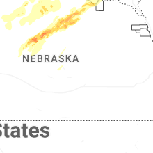


Connect with Interactive Hail Maps