

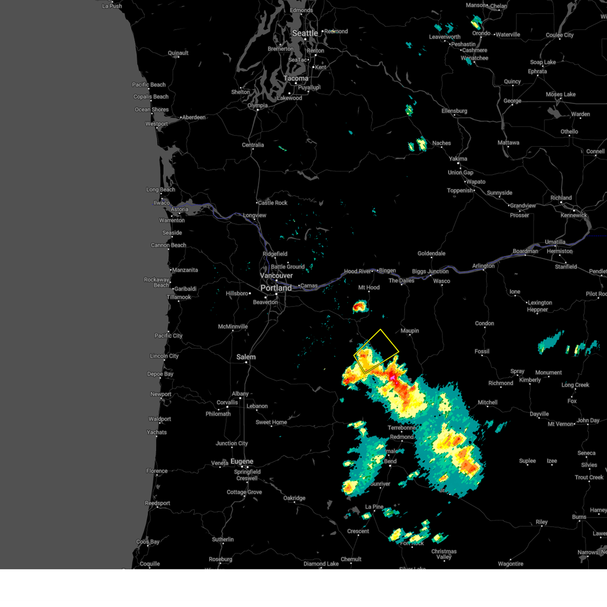
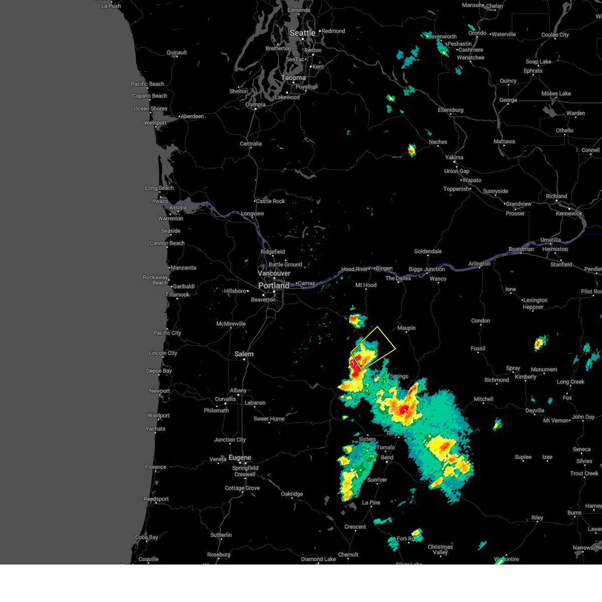
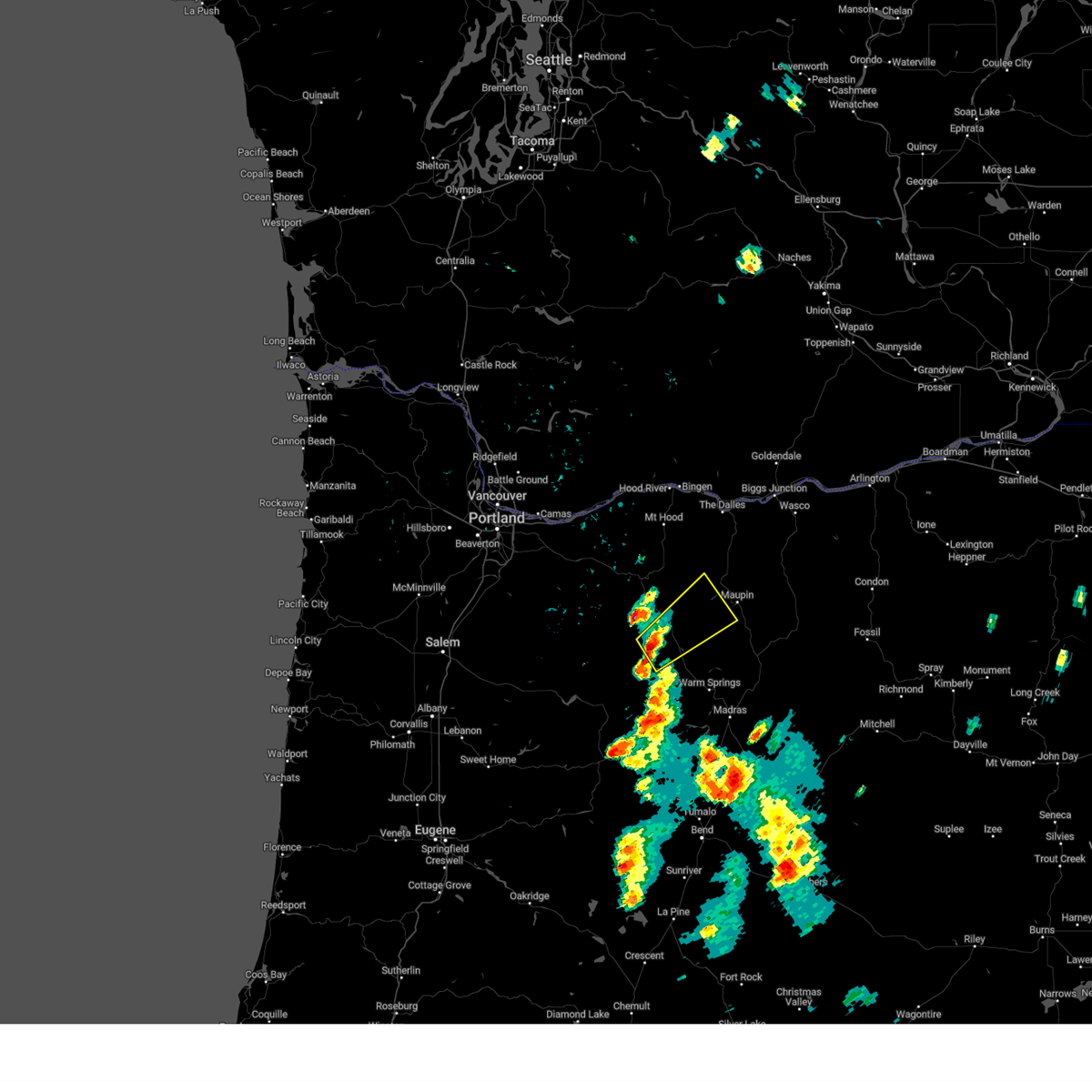
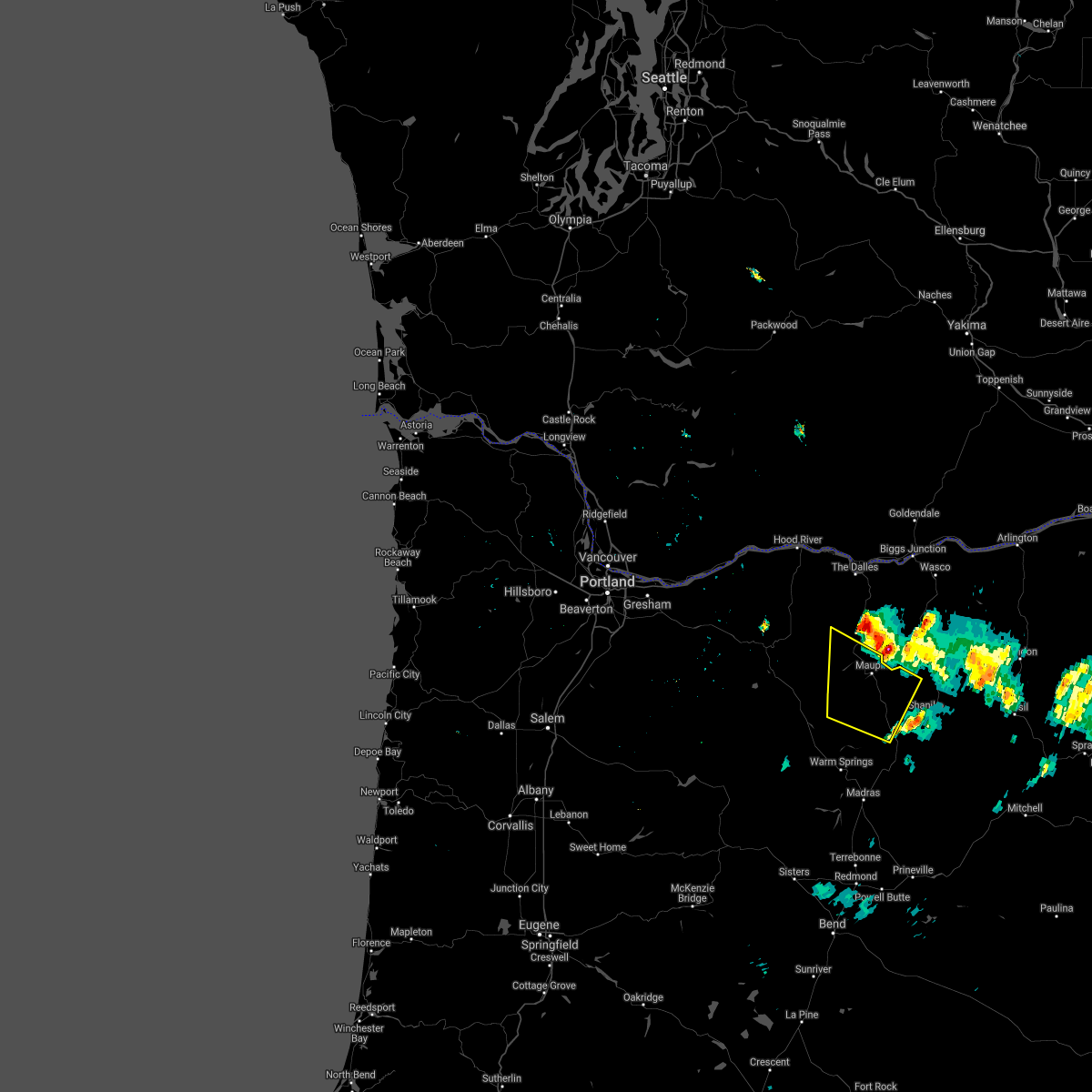
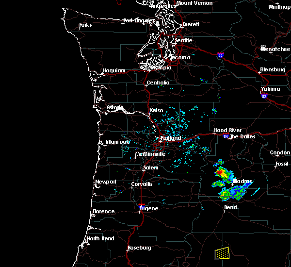
Hail Map for Pine Grove, OR
The Pine Grove, OR area has had 1 report of on-the-ground hail by trained spotters, and has been under severe weather warnings 0 times during the past 12 months. Doppler radar has detected hail at or near Pine Grove, OR on 5 occasions.
| Name: | Pine Grove, OR |
| Where Located: | 61 miles NNW of Bend, OR |
| Map: | Google Map for Pine Grove, OR |
| Population: | 148 |
| Housing Units: | 103 |
| More Info: | Search Google for Pine Grove, OR |
0
The Top Recent Hail Date for Pine Grove, OR is Monday, August 17, 2020 (5th out of 5)

Hail and Wind Damage Spotted near Pine Grove, OR
| Date / Time | Report Details |
|---|---|
| 5/19/2023 5:21 PM PDT |
 The severe thunderstorm warning for southwestern wasco county will expire at 530 pm pdt, the storm which prompted the warning has weakened below severe limits, and no longer poses an immediate threat to life or property. therefore, the warning will be allowed to expire. however small hail and heavy rain are still possible with this thunderstorm. to report severe weather, contact your nearest law enforcement agency. they will relay your report to the national weather service pendleton oregon. The severe thunderstorm warning for southwestern wasco county will expire at 530 pm pdt, the storm which prompted the warning has weakened below severe limits, and no longer poses an immediate threat to life or property. therefore, the warning will be allowed to expire. however small hail and heavy rain are still possible with this thunderstorm. to report severe weather, contact your nearest law enforcement agency. they will relay your report to the national weather service pendleton oregon.
|
| 5/19/2023 5:04 PM PDT |
 At 503 pm pdt, a severe thunderstorm was located over northern warm springs reservation, or 21 miles southeast of government camp, moving northeast at 20 mph (radar indicated). Hazards include 60 mph wind gusts and quarter size hail. Hail damage to vehicles is expected. expect wind damage to roofs, siding, and trees. locations impacted include, simnasho, pine grove and northwestern warm springs reservation. hail threat, radar indicated max hail size, 1. 00 in wind threat, radar indicated max wind gust, 60 mph. At 503 pm pdt, a severe thunderstorm was located over northern warm springs reservation, or 21 miles southeast of government camp, moving northeast at 20 mph (radar indicated). Hazards include 60 mph wind gusts and quarter size hail. Hail damage to vehicles is expected. expect wind damage to roofs, siding, and trees. locations impacted include, simnasho, pine grove and northwestern warm springs reservation. hail threat, radar indicated max hail size, 1. 00 in wind threat, radar indicated max wind gust, 60 mph.
|
| 5/19/2023 4:26 PM PDT |
 At 426 pm pdt, a severe thunderstorm was located over northwestern warm springs reservation, or 22 miles south of government camp, moving northeast at 20 mph (radar indicated). Hazards include 60 mph wind gusts and quarter size hail. Hail damage to vehicles is expected. Expect wind damage to roofs, siding, and trees. At 426 pm pdt, a severe thunderstorm was located over northwestern warm springs reservation, or 22 miles south of government camp, moving northeast at 20 mph (radar indicated). Hazards include 60 mph wind gusts and quarter size hail. Hail damage to vehicles is expected. Expect wind damage to roofs, siding, and trees.
|
| 8/17/2020 6:10 PM PDT |
 The severe thunderstorm warning for south central wasco county will expire at 615 pm pdt, the severe thunderstorm which prompted the warning has weakened, moved out of the warned area. therefore, the warning will be allowed to expire at 6:15 pm pdt. The severe thunderstorm warning for south central wasco county will expire at 615 pm pdt, the severe thunderstorm which prompted the warning has weakened, moved out of the warned area. therefore, the warning will be allowed to expire at 6:15 pm pdt.
|
| 8/17/2020 5:55 PM PDT |
 At 553 pm pdt, a severe thunderstorm was located over tygh valley, or 26 miles south of the dalles, moving north at 25 mph. this storm is weakening but still capable of producing strong gusty winds and small hail (radar indicated). Hazards include 60 mph wind gusts and penny size hail. Expect damage to roofs, siding, and trees. Locations impacted include, maupin, wamic, wapinitia and tygh valley. At 553 pm pdt, a severe thunderstorm was located over tygh valley, or 26 miles south of the dalles, moving north at 25 mph. this storm is weakening but still capable of producing strong gusty winds and small hail (radar indicated). Hazards include 60 mph wind gusts and penny size hail. Expect damage to roofs, siding, and trees. Locations impacted include, maupin, wamic, wapinitia and tygh valley.
|
| 8/17/2020 5:38 PM PDT |
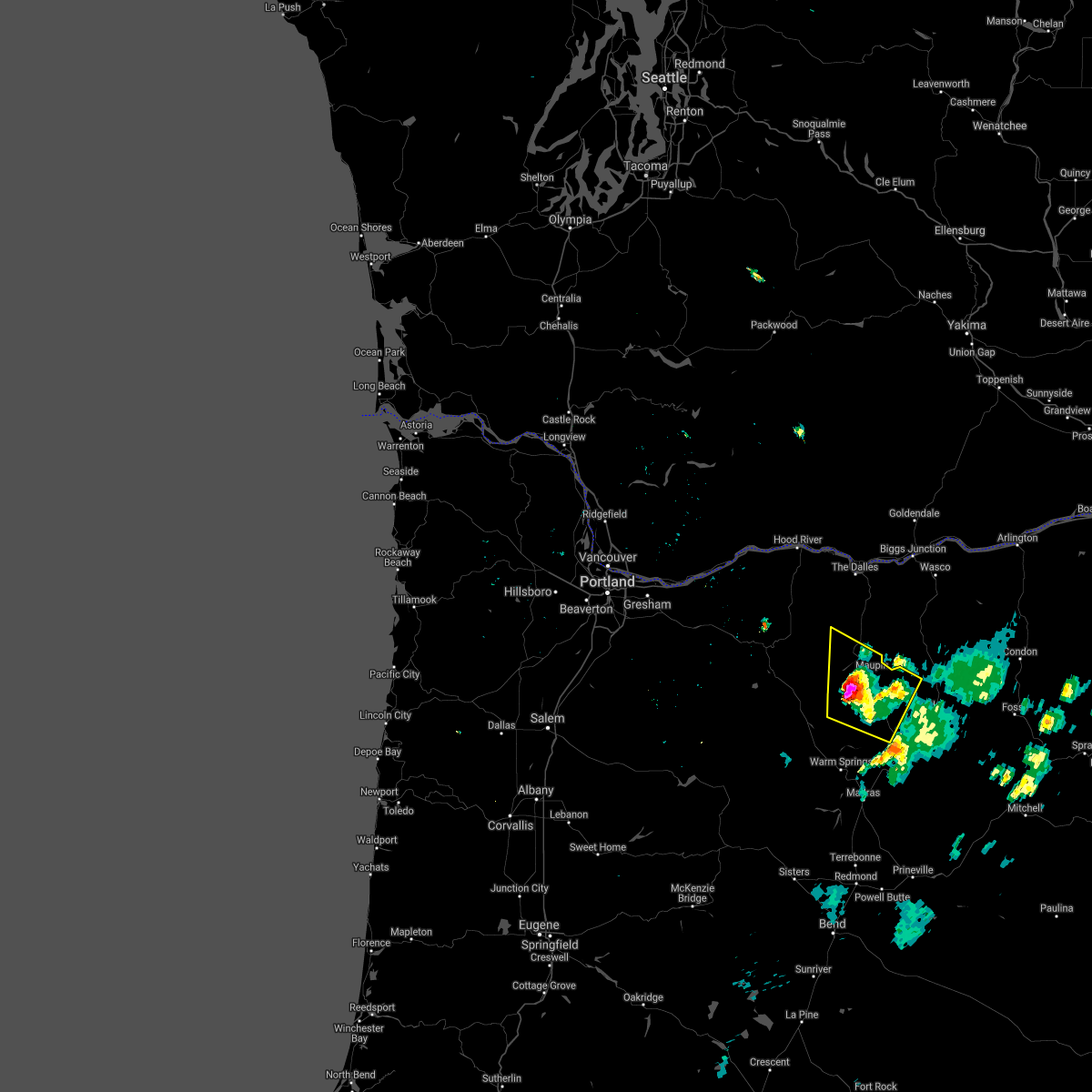 At 537 pm pdt, a severe thunderstorm was located over wapinitia, or 30 miles southeast of government camp, moving north at 25 mph (radar indicated). Hazards include 60 mph wind gusts, quarter or bigger size hail and brief heavy rain is possible. Hail damage to vehicles is expected. Expect wind damage to roofs, siding, and trees. At 537 pm pdt, a severe thunderstorm was located over wapinitia, or 30 miles southeast of government camp, moving north at 25 mph (radar indicated). Hazards include 60 mph wind gusts, quarter or bigger size hail and brief heavy rain is possible. Hail damage to vehicles is expected. Expect wind damage to roofs, siding, and trees.
|
| 6/11/2020 6:09 PM PDT |
 The severe thunderstorm warning for north central jefferson and southwestern wasco counties will expire at 615 pm pdt, the storm which prompted the warning has weakened below severe limits, and no longer poses an immediate threat to life or property. therefore, the warning will be allowed to expire. however small hail and heavy rain are still possible with this thunderstorm. The severe thunderstorm warning for north central jefferson and southwestern wasco counties will expire at 615 pm pdt, the storm which prompted the warning has weakened below severe limits, and no longer poses an immediate threat to life or property. therefore, the warning will be allowed to expire. however small hail and heavy rain are still possible with this thunderstorm.
|
| 6/11/2020 5:34 PM PDT |
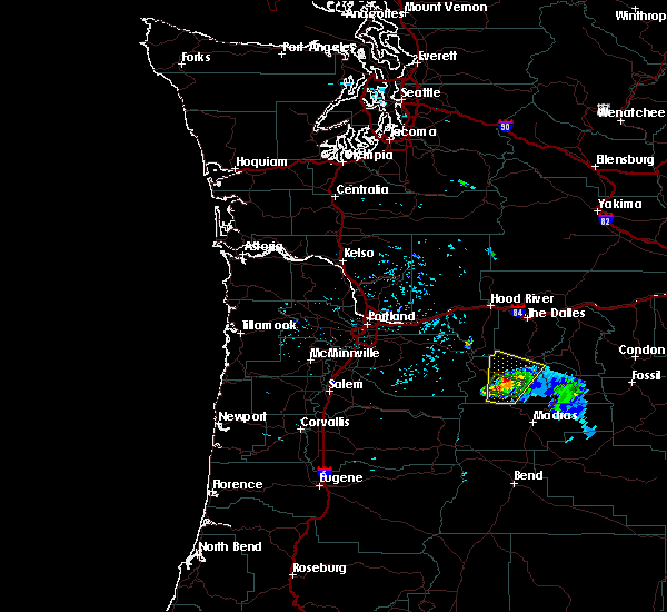
 At 534 pm pdt, a severe thunderstorm was located over northeastern warm springs reservation, or 21 miles northwest of madras, moving north at 25 mph (radar indicated). Hazards include 60 mph wind gusts and half dollar size hail. Hail damage to vehicles is expected. expect wind damage to roofs, siding, and trees. Locations impacted include, maupin, warm springs reservation, wapinitia, pine grove, wamic, warm springs, simnasho and tygh valley. At 534 pm pdt, a severe thunderstorm was located over northeastern warm springs reservation, or 21 miles northwest of madras, moving north at 25 mph (radar indicated). Hazards include 60 mph wind gusts and half dollar size hail. Hail damage to vehicles is expected. expect wind damage to roofs, siding, and trees. Locations impacted include, maupin, warm springs reservation, wapinitia, pine grove, wamic, warm springs, simnasho and tygh valley.
|
| 6/11/2020 5:13 PM PDT |
 At 512 pm pdt, a severe thunderstorm was located over southeastern warm springs reservation, or 13 miles northwest of madras, moving north at 25 mph (radar indicated). Hazards include 60 mph wind gusts and quarter size hail. Hail damage to vehicles is expected. Expect wind damage to roofs, siding, and trees. At 512 pm pdt, a severe thunderstorm was located over southeastern warm springs reservation, or 13 miles northwest of madras, moving north at 25 mph (radar indicated). Hazards include 60 mph wind gusts and quarter size hail. Hail damage to vehicles is expected. Expect wind damage to roofs, siding, and trees.
|
| 5/30/2020 3:06 PM PDT |
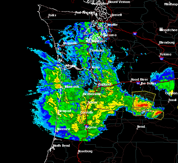 At 304 pm pdt, severe thunderstorms were located along a line extending from warm springs reservation to near south junction to willowdale, moving north at 45 mph. these are very dangerous storms (storm spotters and weather stations have measured winds of 60 to 80 mph with these storms). Hazards include 80 mph wind gusts and quarter size hail. Flying debris will be dangerous to those caught without shelter. mobile homes will be heavily damaged. expect considerable damage to roofs, windows, and vehicles. extensive tree damage and power outages are likely. Locations impacted include, maupin, kent, wapinitia, pine grove, wamic, south junction, willowdale, tygh valley, simnasho and eastern warm springs reservation. At 304 pm pdt, severe thunderstorms were located along a line extending from warm springs reservation to near south junction to willowdale, moving north at 45 mph. these are very dangerous storms (storm spotters and weather stations have measured winds of 60 to 80 mph with these storms). Hazards include 80 mph wind gusts and quarter size hail. Flying debris will be dangerous to those caught without shelter. mobile homes will be heavily damaged. expect considerable damage to roofs, windows, and vehicles. extensive tree damage and power outages are likely. Locations impacted include, maupin, kent, wapinitia, pine grove, wamic, south junction, willowdale, tygh valley, simnasho and eastern warm springs reservation.
|
| 5/30/2020 2:58 PM PDT |
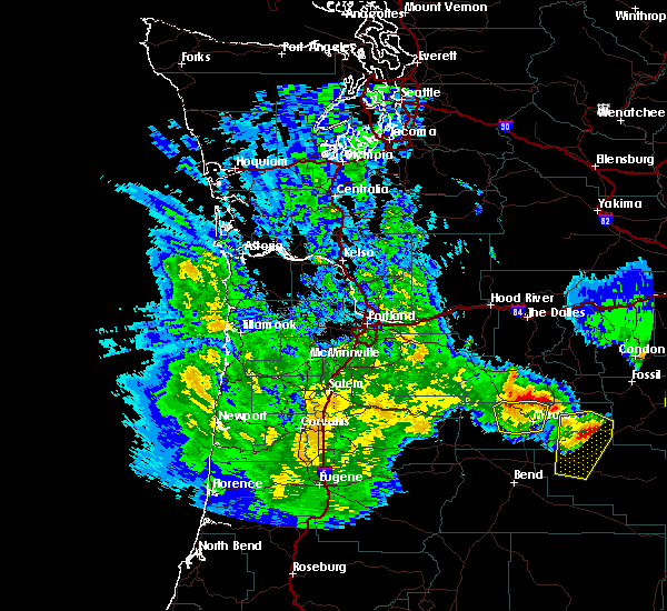 At 257 pm pdt, severe thunderstorms were located along a line extending from warm springs reservation to near gateway to near willowdale, moving north at 45 mph (radar indicated and spotter verified with several reports of wind damage in and around madras). Hazards include 70 mph wind gusts and quarter size hail. Hail damage to vehicles is expected. expect considerable tree damage. Wind damage is also likely to mobile homes, roofs, and outbuildings. At 257 pm pdt, severe thunderstorms were located along a line extending from warm springs reservation to near gateway to near willowdale, moving north at 45 mph (radar indicated and spotter verified with several reports of wind damage in and around madras). Hazards include 70 mph wind gusts and quarter size hail. Hail damage to vehicles is expected. expect considerable tree damage. Wind damage is also likely to mobile homes, roofs, and outbuildings.
|
| 6/12/2019 6:32 PM PDT |
 The national weather service in pendleton oregon has issued a * severe thunderstorm warning for. southwestern wasco county in north central oregon. until 730 pm pdt. At 631 pm pdt, a severe thunderstorm was located over northern warm springs reservation, or 25 miles southeast of government camp,. The national weather service in pendleton oregon has issued a * severe thunderstorm warning for. southwestern wasco county in north central oregon. until 730 pm pdt. At 631 pm pdt, a severe thunderstorm was located over northern warm springs reservation, or 25 miles southeast of government camp,.
|
| 6/12/2019 5:58 PM PDT |
 At 557 pm pdt, a severe thunderstorm was located over northeastern warm springs reservation, or 26 miles northwest of madras, moving north at 15 mph (radar indicated). Hazards include 60 mph wind gusts and half dollar size hail. Hail damage to vehicles is expected. expect wind damage to roofs, siding, and trees. Locations impacted include, maupin, warm springs reservation, wamic, wapinitia, simnasho and pine grove. At 557 pm pdt, a severe thunderstorm was located over northeastern warm springs reservation, or 26 miles northwest of madras, moving north at 15 mph (radar indicated). Hazards include 60 mph wind gusts and half dollar size hail. Hail damage to vehicles is expected. expect wind damage to roofs, siding, and trees. Locations impacted include, maupin, warm springs reservation, wamic, wapinitia, simnasho and pine grove.
|
| 6/12/2019 5:34 PM PDT |
 At 533 pm pdt, a severe thunderstorm was located over northern warm springs reservation, or 23 miles northwest of madras, moving north at 20 mph (radar indicated). Hazards include 60 mph wind gusts and quarter size hail. Hail damage to vehicles is expected. Expect wind damage to roofs, siding, and trees. At 533 pm pdt, a severe thunderstorm was located over northern warm springs reservation, or 23 miles northwest of madras, moving north at 20 mph (radar indicated). Hazards include 60 mph wind gusts and quarter size hail. Hail damage to vehicles is expected. Expect wind damage to roofs, siding, and trees.
|
| 5/4/2017 10:53 PM PDT |
 At 1045 pm pdt, trained weather spotters reported a severe thunderstorm producing large damaging hail up to golf ball size and damaging winds in excess of 60 mph. this storm was located near culver, or 9 miles southwest of madras, and moving northeast at 45 mph. At 1045 pm pdt, trained weather spotters reported a severe thunderstorm producing large damaging hail up to golf ball size and damaging winds in excess of 60 mph. this storm was located near culver, or 9 miles southwest of madras, and moving northeast at 45 mph.
|
| 8/2/2014 5:10 PM PDT | Half Dollar sized hail reported 16.2 miles ENE of Pine Grove, OR |
Hail Maps for Pine Grove, OR


Connect with Interactive Hail Maps