

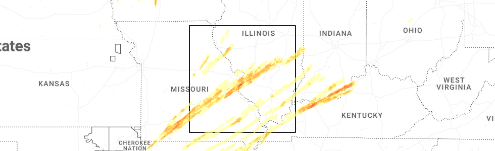
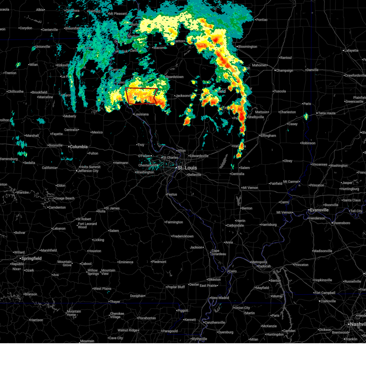
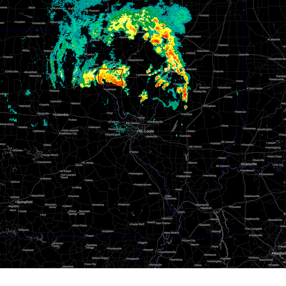
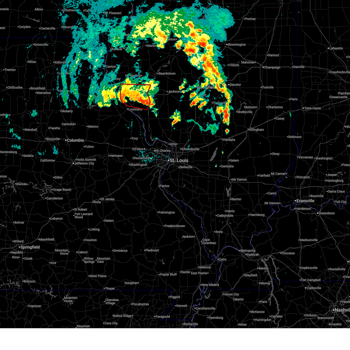
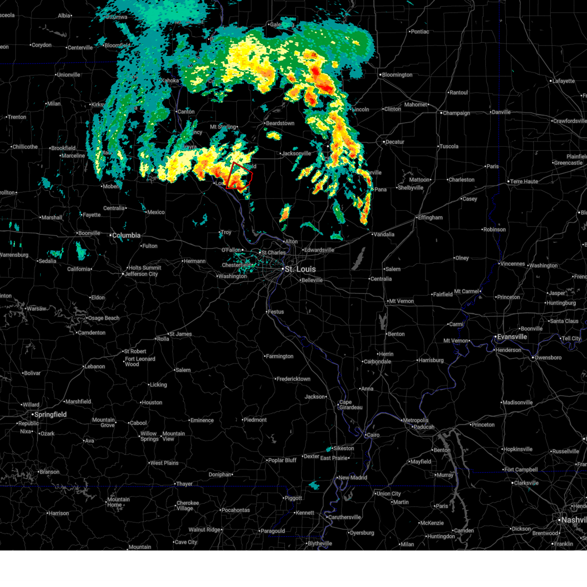
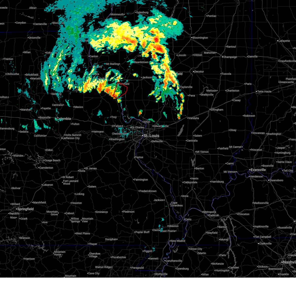
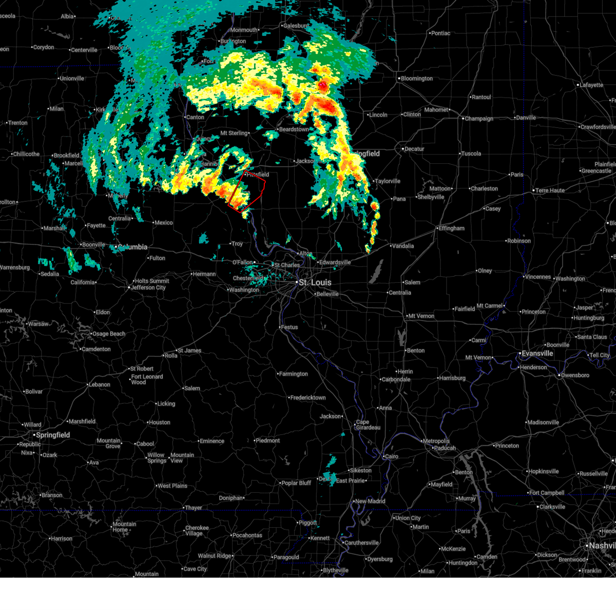
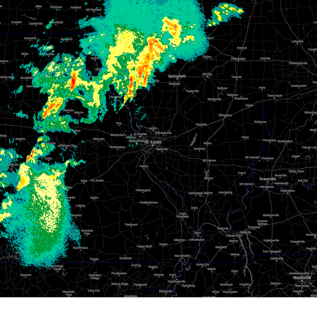
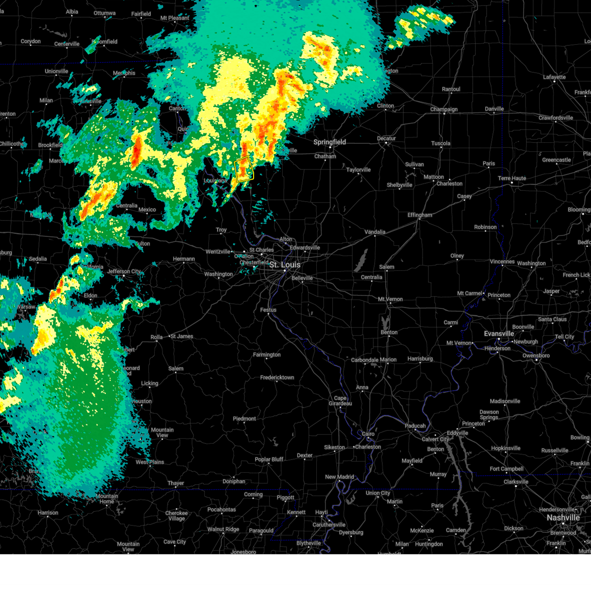
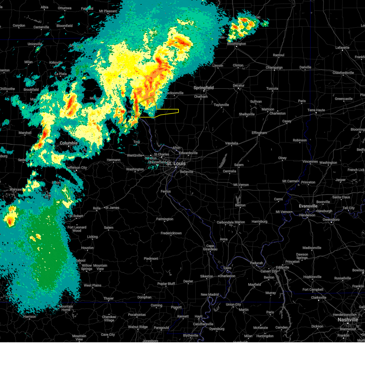
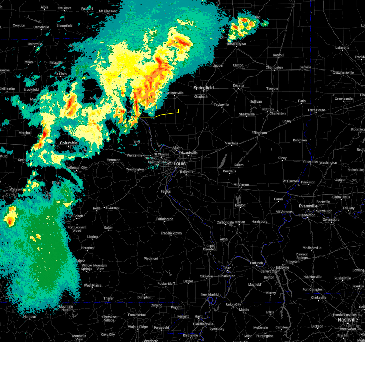
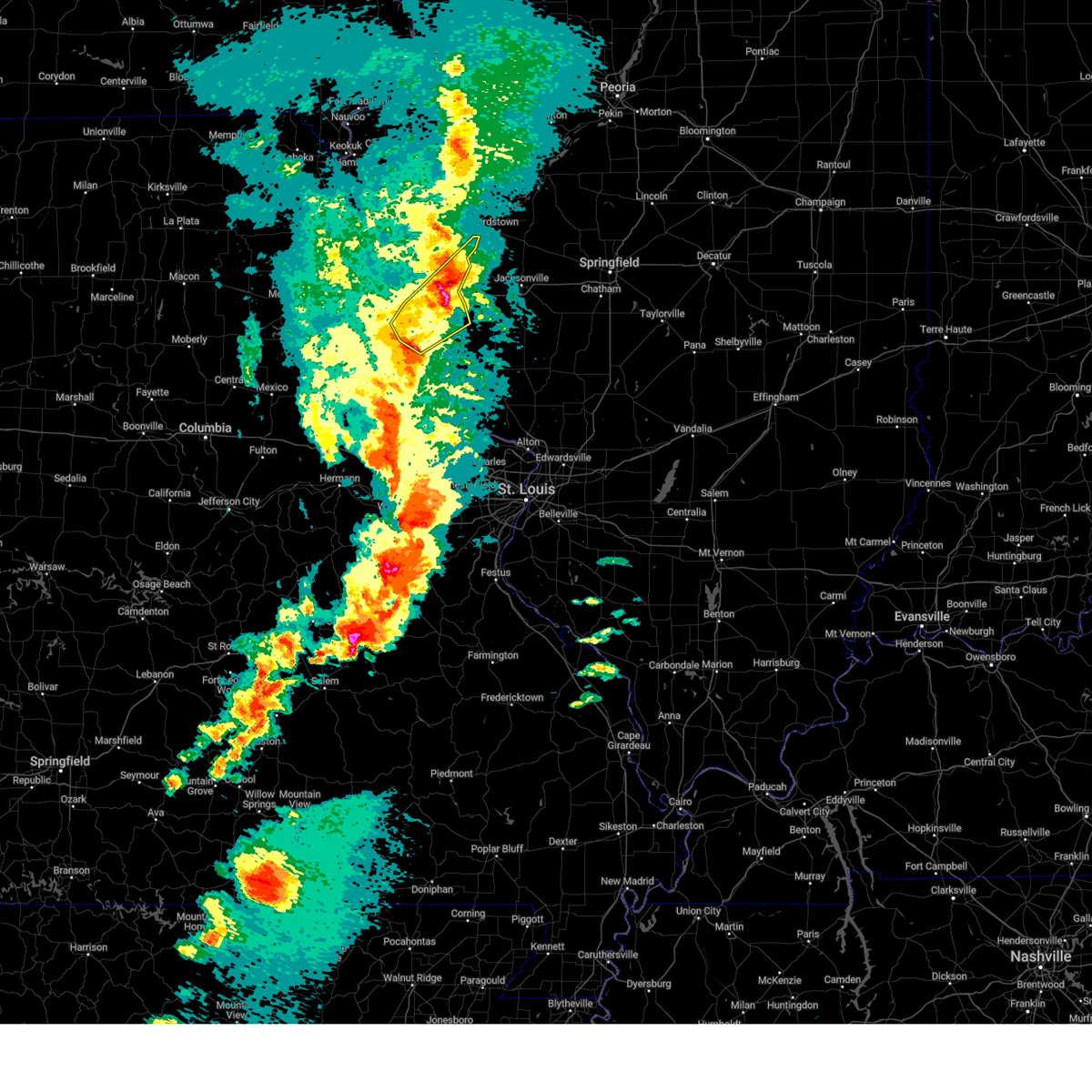
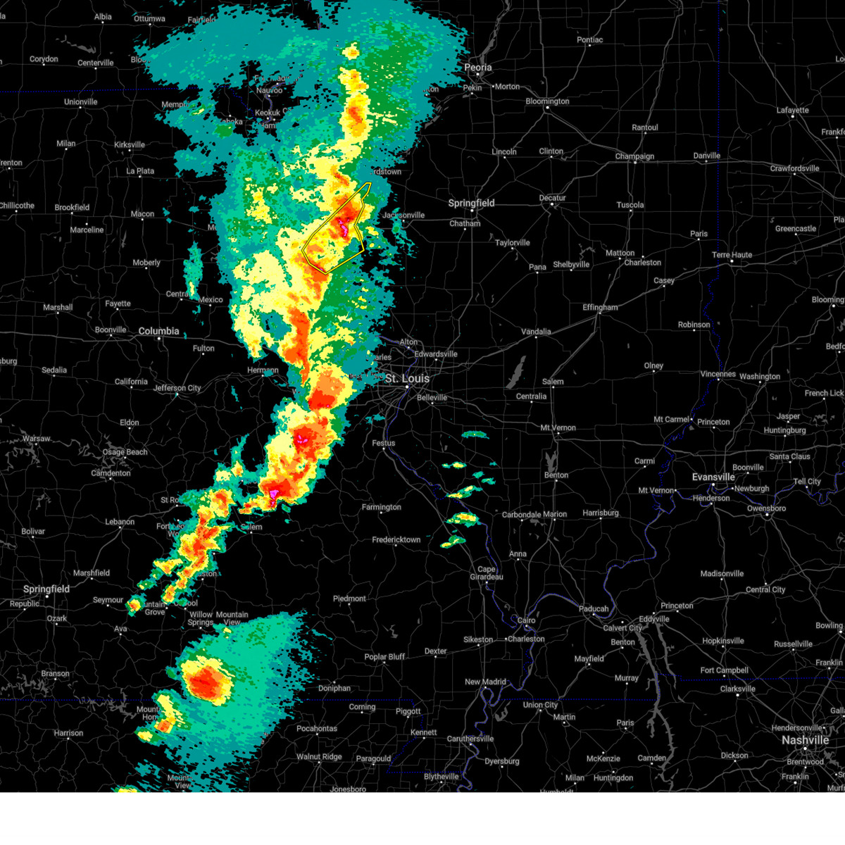
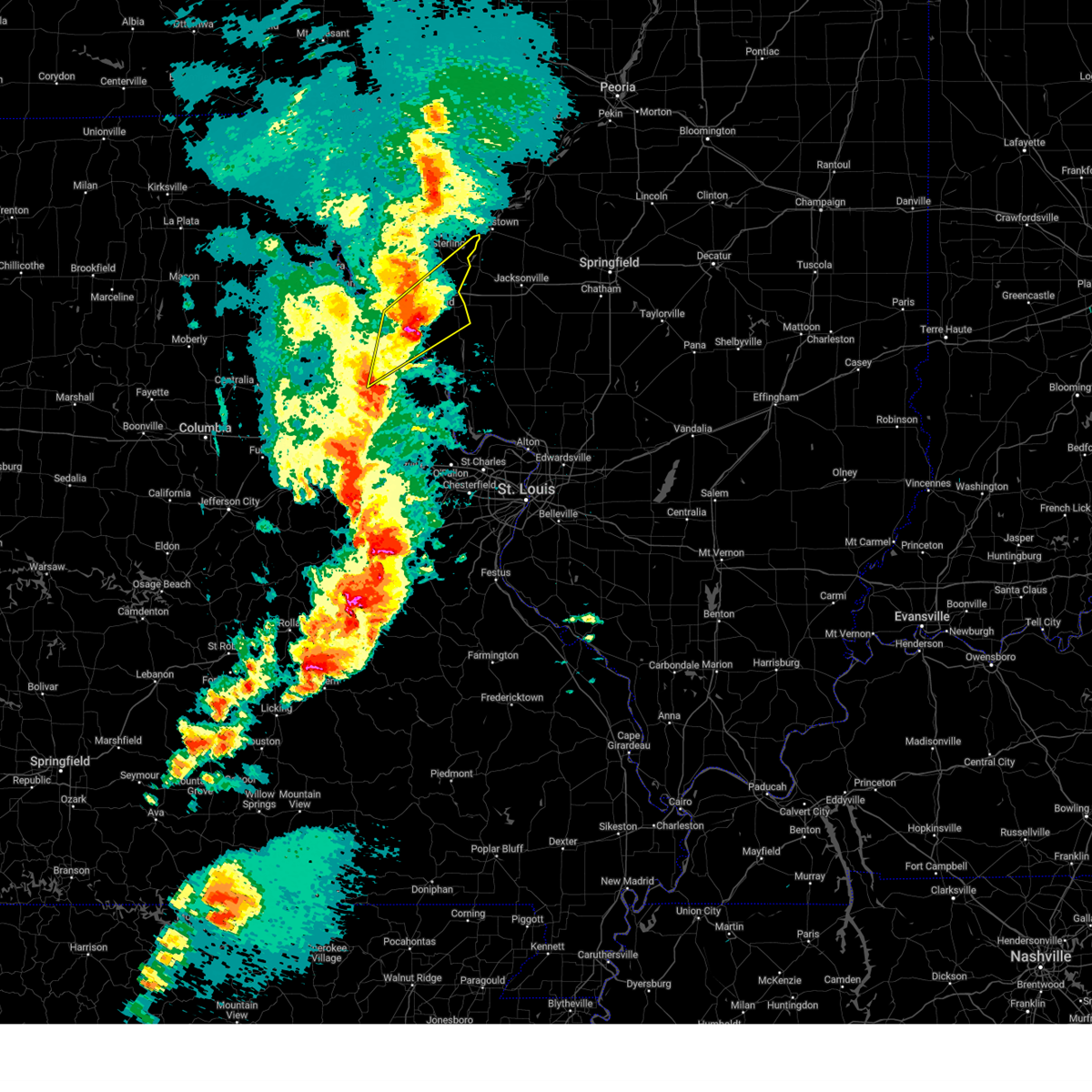
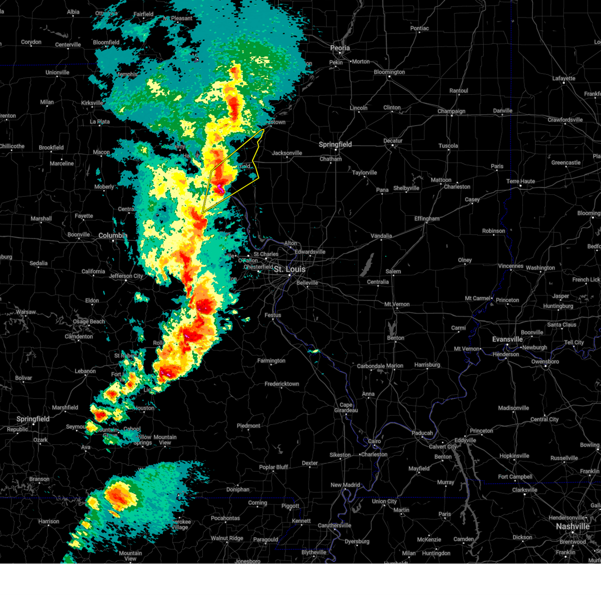
Hail Map for Pittsfield, IL
The Pittsfield, IL area has had 7 reports of on-the-ground hail by trained spotters, and has been under severe weather warnings 36 times during the past 12 months. Doppler radar has detected hail at or near Pittsfield, IL on 76 occasions, including 3 occasions during the past year.
| Name: | Pittsfield, IL |
| Where Located: | 73.8 miles SE of Kahoka, MO |
| Map: | Google Map for Pittsfield, IL |
| Population: | 4576 |
| Housing Units: | 2035 |
| More Info: | Search Google for Pittsfield, IL |
3
The Top Recent Hail Date for Pittsfield, IL is Friday, March 14, 2025 (3rd out of 76)
Hail and Wind Damage Spotted near Pittsfield, IL
| Date / Time | Report Details |
|---|---|
| 7/11/2025 10:59 PM CDT |
 The storms which prompted the warning have weakened below severe limits, and no longer pose an immediate threat to life or property. therefore, the warning will be allowed to expire. however, gusty winds and heavy rain are still possible with these thunderstorms. The storms which prompted the warning have weakened below severe limits, and no longer pose an immediate threat to life or property. therefore, the warning will be allowed to expire. however, gusty winds and heavy rain are still possible with these thunderstorms.
|
| 7/11/2025 10:35 PM CDT |
 At 1035 pm cdt, severe thunderstorms were located along a line from 10 miles northwest of white hall to over laddonia, or along a line from 10 miles northwest of white hall to 7 miles southwest of vandalia, moving south at 25 mph (law enforcement reported tree damage in hannibal, mo and highway 79 in eastern ralls county). Hazards include 60 mph wind gusts. Expect damage to roofs, siding, and trees. this severe thunderstorm will be near, atlas, spencerburg, pittsfield, perry, frankford, griggsville and center around 1015 pm cdt. louisiana and pike around 1020 pm cdt. other locations impacted by the severe thunderstorm include detroit, summer hill, rockport, new hartford, valley city, ashburn, el dara, time, martinsburg and independence. This includes interstate 72 between exits 10 and 35. At 1035 pm cdt, severe thunderstorms were located along a line from 10 miles northwest of white hall to over laddonia, or along a line from 10 miles northwest of white hall to 7 miles southwest of vandalia, moving south at 25 mph (law enforcement reported tree damage in hannibal, mo and highway 79 in eastern ralls county). Hazards include 60 mph wind gusts. Expect damage to roofs, siding, and trees. this severe thunderstorm will be near, atlas, spencerburg, pittsfield, perry, frankford, griggsville and center around 1015 pm cdt. louisiana and pike around 1020 pm cdt. other locations impacted by the severe thunderstorm include detroit, summer hill, rockport, new hartford, valley city, ashburn, el dara, time, martinsburg and independence. This includes interstate 72 between exits 10 and 35.
|
| 7/11/2025 10:15 PM CDT |
 Svrlsx the national weather service in st louis has issued a * severe thunderstorm warning for, northwestern calhoun county in southwestern illinois, northern greene county in southwestern illinois, pike county in west central illinois, eastern audrain county in central missouri, pike county in northeastern missouri, ralls county in northeastern missouri, * until 1100 pm cdt. * at 1015 pm cdt, severe thunderstorms were located along a line from 9 miles southeast of griggsville to near perry, or along a line from 12 miles east of pittsfield to 9 miles east of santa fe, moving south at 20 mph (law enforcement reported tree damage was reported in hannibal, mo and highway 79 in eastern ralls county). Hazards include 60 mph wind gusts. Expect damage to roofs, siding, and trees. this severe thunderstorm will be near, atlas, spencerburg, pittsfield, louisiana, perry, frankford, griggsville and center around 1015 pm cdt. pike around 1020 pm cdt. other locations impacted by the severe thunderstorm include detroit, summer hill, rockport, new hartford, valley city, ashburn, el dara, independence, milton and martinsburg. This includes interstate 72 between exits 10 and 35. Svrlsx the national weather service in st louis has issued a * severe thunderstorm warning for, northwestern calhoun county in southwestern illinois, northern greene county in southwestern illinois, pike county in west central illinois, eastern audrain county in central missouri, pike county in northeastern missouri, ralls county in northeastern missouri, * until 1100 pm cdt. * at 1015 pm cdt, severe thunderstorms were located along a line from 9 miles southeast of griggsville to near perry, or along a line from 12 miles east of pittsfield to 9 miles east of santa fe, moving south at 20 mph (law enforcement reported tree damage was reported in hannibal, mo and highway 79 in eastern ralls county). Hazards include 60 mph wind gusts. Expect damage to roofs, siding, and trees. this severe thunderstorm will be near, atlas, spencerburg, pittsfield, louisiana, perry, frankford, griggsville and center around 1015 pm cdt. pike around 1020 pm cdt. other locations impacted by the severe thunderstorm include detroit, summer hill, rockport, new hartford, valley city, ashburn, el dara, independence, milton and martinsburg. This includes interstate 72 between exits 10 and 35.
|
| 6/18/2025 11:39 AM CDT |
 At 1139 am cdt, severe thunderstorms capable of producing a tornado were located along a line from over barry to near pittsfield, or along a line from 14 miles west of pittsfield to near pittsfield, moving northeast at 25 mph (radar indicated rotation). Hazards include tornado. Flying debris will be dangerous to those caught without shelter. mobile homes will be damaged or destroyed. damage to roofs, windows and vehicles will occur. tree damage is likely. locations impacted include, pittsfield, barry, griggsville, beverly, kingston, richfield, perry, new canton, plainville, kinderhook, baylis, chambersburg, new salem, detroit, el dara, florence, valley city and fishhook. This includes interstate 72 between exits 20 and 35. At 1139 am cdt, severe thunderstorms capable of producing a tornado were located along a line from over barry to near pittsfield, or along a line from 14 miles west of pittsfield to near pittsfield, moving northeast at 25 mph (radar indicated rotation). Hazards include tornado. Flying debris will be dangerous to those caught without shelter. mobile homes will be damaged or destroyed. damage to roofs, windows and vehicles will occur. tree damage is likely. locations impacted include, pittsfield, barry, griggsville, beverly, kingston, richfield, perry, new canton, plainville, kinderhook, baylis, chambersburg, new salem, detroit, el dara, florence, valley city and fishhook. This includes interstate 72 between exits 20 and 35.
|
| 6/18/2025 11:29 AM CDT |
 At 1129 am cdt, severe thunderstorms capable of producing a tornado were located along a line from near barry to 9 miles south of griggsville, or along a line from 13 miles north of louisiana to 8 miles east of pittsfield, moving north at 35 mph (radar indicated rotation). Hazards include tornado. Flying debris will be dangerous to those caught without shelter. mobile homes will be damaged or destroyed. damage to roofs, windows and vehicles will occur. tree damage is likely. locations impacted include, pittsfield, barry, griggsville, beverly, kingston, independence, hull, richfield, perry, new canton, milton, plainville, kinderhook, baylis, chambersburg, new salem, detroit, el dara, florence and time. This includes interstate 72 between exits 10 and 35. At 1129 am cdt, severe thunderstorms capable of producing a tornado were located along a line from near barry to 9 miles south of griggsville, or along a line from 13 miles north of louisiana to 8 miles east of pittsfield, moving north at 35 mph (radar indicated rotation). Hazards include tornado. Flying debris will be dangerous to those caught without shelter. mobile homes will be damaged or destroyed. damage to roofs, windows and vehicles will occur. tree damage is likely. locations impacted include, pittsfield, barry, griggsville, beverly, kingston, independence, hull, richfield, perry, new canton, milton, plainville, kinderhook, baylis, chambersburg, new salem, detroit, el dara, florence and time. This includes interstate 72 between exits 10 and 35.
|
| 6/18/2025 11:23 AM CDT |
 Torlsx the national weather service in st louis has issued a * tornado warning for, southeastern adams county in west central illinois, pike county in west central illinois, * until 1215 pm cdt. * at 1123 am cdt, severe thunderstorms capable of producing a tornado were located along a line from 6 miles southwest of barry to 8 miles southeast of pittsfield, or along a line from 12 miles north of louisiana to 8 miles southeast of pittsfield, moving north at 35 mph (radar indicated rotation). Hazards include tornado. Flying debris will be dangerous to those caught without shelter. mobile homes will be damaged or destroyed. damage to roofs, windows and vehicles will occur. Tree damage is likely. Torlsx the national weather service in st louis has issued a * tornado warning for, southeastern adams county in west central illinois, pike county in west central illinois, * until 1215 pm cdt. * at 1123 am cdt, severe thunderstorms capable of producing a tornado were located along a line from 6 miles southwest of barry to 8 miles southeast of pittsfield, or along a line from 12 miles north of louisiana to 8 miles southeast of pittsfield, moving north at 35 mph (radar indicated rotation). Hazards include tornado. Flying debris will be dangerous to those caught without shelter. mobile homes will be damaged or destroyed. damage to roofs, windows and vehicles will occur. Tree damage is likely.
|
| 6/18/2025 11:09 AM CDT |
 the tornado warning has been cancelled and is no longer in effect the tornado warning has been cancelled and is no longer in effect
|
| 6/18/2025 11:09 AM CDT |
 At 1109 am cdt, a severe thunderstorm capable of producing a tornado was located 5 miles east of pleasant hill, or 11 miles south of pittsfield, moving northeast at 40 mph (radar indicated rotation). Hazards include tornado. Flying debris will be dangerous to those caught without shelter. mobile homes will be damaged or destroyed. damage to roofs, windows and vehicles will occur. tree damage is likely. Locations impacted include, pittsfield, pleasant hill, independence, bedford, montezuma, martinsburg, nebo, milton, pearl and time. At 1109 am cdt, a severe thunderstorm capable of producing a tornado was located 5 miles east of pleasant hill, or 11 miles south of pittsfield, moving northeast at 40 mph (radar indicated rotation). Hazards include tornado. Flying debris will be dangerous to those caught without shelter. mobile homes will be damaged or destroyed. damage to roofs, windows and vehicles will occur. tree damage is likely. Locations impacted include, pittsfield, pleasant hill, independence, bedford, montezuma, martinsburg, nebo, milton, pearl and time.
|
| 6/18/2025 11:02 AM CDT |
 the tornado warning has been cancelled and is no longer in effect the tornado warning has been cancelled and is no longer in effect
|
| 6/18/2025 11:02 AM CDT |
 At 1102 am cdt, a confirmed tornado was located near belleview, or 13 miles east of louisiana, moving northeast at 35 mph (law enforcement confirmed tornado). Hazards include damaging tornado. Flying debris will be dangerous to those caught without shelter. mobile homes will be damaged or destroyed. damage to roofs, windows and vehicles will occur. tree damage is likely. Locations impacted include, pittsfield, pleasant hill, clarksville, independence, bedford, montezuma, martinsburg, nebo, milton, pearl and time. At 1102 am cdt, a confirmed tornado was located near belleview, or 13 miles east of louisiana, moving northeast at 35 mph (law enforcement confirmed tornado). Hazards include damaging tornado. Flying debris will be dangerous to those caught without shelter. mobile homes will be damaged or destroyed. damage to roofs, windows and vehicles will occur. tree damage is likely. Locations impacted include, pittsfield, pleasant hill, clarksville, independence, bedford, montezuma, martinsburg, nebo, milton, pearl and time.
|
| 6/18/2025 10:55 AM CDT |
 Torlsx the national weather service in st louis has issued a * tornado warning for, northwestern calhoun county in southwestern illinois, southeastern pike county in west central illinois, east central pike county in northeastern missouri, * until 1130 am cdt. * at 1055 am cdt, a severe thunderstorm capable of producing a tornado was located near clarksville, or 12 miles north of elsberry, moving northeast at 35 mph (radar indicated rotation). Hazards include tornado. Flying debris will be dangerous to those caught without shelter. mobile homes will be damaged or destroyed. damage to roofs, windows and vehicles will occur. Tree damage is likely. Torlsx the national weather service in st louis has issued a * tornado warning for, northwestern calhoun county in southwestern illinois, southeastern pike county in west central illinois, east central pike county in northeastern missouri, * until 1130 am cdt. * at 1055 am cdt, a severe thunderstorm capable of producing a tornado was located near clarksville, or 12 miles north of elsberry, moving northeast at 35 mph (radar indicated rotation). Hazards include tornado. Flying debris will be dangerous to those caught without shelter. mobile homes will be damaged or destroyed. damage to roofs, windows and vehicles will occur. Tree damage is likely.
|
| 5/20/2025 4:34 PM CDT | Tree down on a vehicle in pittsfiel in pike county IL, 1.1 miles N of Pittsfield, IL |
| 5/20/2025 12:01 AM CDT | the severe thunderstorm warning has been cancelled and is no longer in effect |
| 5/19/2025 11:33 PM CDT |
 At 1133 pm cdt, a severe thunderstorm was located near pittsfield, moving northeast at 35 mph (radar indicated). Hazards include 60 mph wind gusts. Expect damage to roofs, siding, and trees. Locations impacted include, pittsfield, griggsville, independence, bedford, montezuma, martinsburg, nebo, milton, pearl, detroit, florence, time, valley city, new hartford and summer hill. At 1133 pm cdt, a severe thunderstorm was located near pittsfield, moving northeast at 35 mph (radar indicated). Hazards include 60 mph wind gusts. Expect damage to roofs, siding, and trees. Locations impacted include, pittsfield, griggsville, independence, bedford, montezuma, martinsburg, nebo, milton, pearl, detroit, florence, time, valley city, new hartford and summer hill.
|
| 5/19/2025 11:33 PM CDT |
 the severe thunderstorm warning has been cancelled and is no longer in effect the severe thunderstorm warning has been cancelled and is no longer in effect
|
| 5/19/2025 11:28 PM CDT | the tornado warning has been cancelled and is no longer in effect |
| 5/19/2025 11:19 PM CDT |
 the tornado warning has been cancelled and is no longer in effect the tornado warning has been cancelled and is no longer in effect
|
| 5/19/2025 11:19 PM CDT |
 At 1119 pm cdt, a severe thunderstorm capable of producing a tornado was located near pleasant hill, or 8 miles southwest of pittsfield, moving northeast at 35 mph (radar indicated rotation). Hazards include tornado. Flying debris will be dangerous to those caught without shelter. mobile homes will be damaged or destroyed. damage to roofs, windows and vehicles will occur. tree damage is likely. locations impacted include, pittsfield, pleasant hill, atlas, independence, martinsburg, time, new hartford, summer hill and rockport. This includes interstate 72 near exit 31. At 1119 pm cdt, a severe thunderstorm capable of producing a tornado was located near pleasant hill, or 8 miles southwest of pittsfield, moving northeast at 35 mph (radar indicated rotation). Hazards include tornado. Flying debris will be dangerous to those caught without shelter. mobile homes will be damaged or destroyed. damage to roofs, windows and vehicles will occur. tree damage is likely. locations impacted include, pittsfield, pleasant hill, atlas, independence, martinsburg, time, new hartford, summer hill and rockport. This includes interstate 72 near exit 31.
|
| 5/19/2025 11:18 PM CDT |
 At 1118 pm cdt, a severe thunderstorm was located near atlas, or 9 miles northeast of louisiana, moving northeast at 35 mph (radar indicated). Hazards include 60 mph wind gusts. Expect damage to roofs, siding, and trees. Locations impacted include, pittsfield, pleasant hill, atlas, belleview, independence, bedford, montezuma, martinsburg, nebo, milton, pearl, detroit, florence, time, valley city, summer hill, new hartford and beecreek. At 1118 pm cdt, a severe thunderstorm was located near atlas, or 9 miles northeast of louisiana, moving northeast at 35 mph (radar indicated). Hazards include 60 mph wind gusts. Expect damage to roofs, siding, and trees. Locations impacted include, pittsfield, pleasant hill, atlas, belleview, independence, bedford, montezuma, martinsburg, nebo, milton, pearl, detroit, florence, time, valley city, summer hill, new hartford and beecreek.
|
| 5/19/2025 11:18 PM CDT |
 the severe thunderstorm warning has been cancelled and is no longer in effect the severe thunderstorm warning has been cancelled and is no longer in effect
|
| 5/19/2025 11:03 PM CDT |
 Torlsx the national weather service in st louis has issued a * tornado warning for, northwestern calhoun county in southwestern illinois, southeastern pike county in west central illinois, central pike county in northeastern missouri, * until 1145 pm cdt. * at 1103 pm cdt, a severe thunderstorm capable of producing a tornado was located over louisiana, moving northeast at 25 mph (radar indicated rotation). Hazards include tornado. Flying debris will be dangerous to those caught without shelter. mobile homes will be damaged or destroyed. damage to roofs, windows and vehicles will occur. Tree damage is likely. Torlsx the national weather service in st louis has issued a * tornado warning for, northwestern calhoun county in southwestern illinois, southeastern pike county in west central illinois, central pike county in northeastern missouri, * until 1145 pm cdt. * at 1103 pm cdt, a severe thunderstorm capable of producing a tornado was located over louisiana, moving northeast at 25 mph (radar indicated rotation). Hazards include tornado. Flying debris will be dangerous to those caught without shelter. mobile homes will be damaged or destroyed. damage to roofs, windows and vehicles will occur. Tree damage is likely.
|
| 5/19/2025 10:53 PM CDT | Svrlsx the national weather service in st louis has issued a * severe thunderstorm warning for, northwestern calhoun county in southwestern illinois, southeastern pike county in west central illinois, central pike county in northeastern missouri, * until 1215 am cdt. * at 1053 pm cdt, a severe thunderstorm was located 7 miles south of louisiana, moving northeast at 25 mph (radar indicated). Hazards include 60 mph wind gusts. expect damage to roofs, siding, and trees |
| 4/20/2025 7:25 PM CDT | The storms which prompted the warning have moved out of the area. therefore, the warning will be allowed to expire. however, gusty winds are still possible with these thunderstorms. a tornado watch remains in effect until 1100 pm cdt for portions of southwest and west central illinois. |
| 4/20/2025 7:04 PM CDT |
 At 704 pm cdt, severe thunderstorms were located along a line from over beverly to near belleview, or along a line from 16 miles southeast of quincy regional airport to 10 miles north of elsberry, moving northeast at 50 mph (trained spotters reported. at 6:50 pm power poles were blown down near hull, il). Hazards include 70 mph wind gusts and quarter size hail. Hail damage to vehicles is expected. expect considerable tree damage. wind damage is also likely to mobile homes, roofs, and outbuildings. other locations impacted by the severe thunderstorm include martinsburg, new salem, baylis, nebo, mozier, independence, hamburg, time, fishhook and michael. This includes interstate 72 between exits 31 and 35. At 704 pm cdt, severe thunderstorms were located along a line from over beverly to near belleview, or along a line from 16 miles southeast of quincy regional airport to 10 miles north of elsberry, moving northeast at 50 mph (trained spotters reported. at 6:50 pm power poles were blown down near hull, il). Hazards include 70 mph wind gusts and quarter size hail. Hail damage to vehicles is expected. expect considerable tree damage. wind damage is also likely to mobile homes, roofs, and outbuildings. other locations impacted by the severe thunderstorm include martinsburg, new salem, baylis, nebo, mozier, independence, hamburg, time, fishhook and michael. This includes interstate 72 between exits 31 and 35.
|
| 4/20/2025 6:56 PM CDT |
 Torlsx the national weather service in st louis has issued a * tornado warning for, southeastern brown county in west central illinois, northeastern pike county in west central illinois, * until 745 pm cdt. * at 656 pm cdt, a severe thunderstorm capable of producing a tornado was located near pittsfield, moving northeast at 50 mph (radar indicated rotation). Hazards include tornado and quarter size hail. Flying debris will be dangerous to those caught without shelter. mobile homes will be damaged or destroyed. damage to roofs, windows and vehicles will occur. tree damage is likely. this tornado will be near, pittsfield around 700 pm cdt. griggsville around 705 pm cdt. other locations impacted by the tornado include new salem, detroit, baylis, perry, valley city, chambersburg, versailles and la grange. This includes interstate 72 between exits 31 and 35. Torlsx the national weather service in st louis has issued a * tornado warning for, southeastern brown county in west central illinois, northeastern pike county in west central illinois, * until 745 pm cdt. * at 656 pm cdt, a severe thunderstorm capable of producing a tornado was located near pittsfield, moving northeast at 50 mph (radar indicated rotation). Hazards include tornado and quarter size hail. Flying debris will be dangerous to those caught without shelter. mobile homes will be damaged or destroyed. damage to roofs, windows and vehicles will occur. tree damage is likely. this tornado will be near, pittsfield around 700 pm cdt. griggsville around 705 pm cdt. other locations impacted by the tornado include new salem, detroit, baylis, perry, valley city, chambersburg, versailles and la grange. This includes interstate 72 between exits 31 and 35.
|
| 4/20/2025 6:27 PM CDT |
 Svrlsx the national weather service in st louis has issued a * severe thunderstorm warning for, northwestern calhoun county in southwestern illinois, brown county in west central illinois, pike county in west central illinois, * until 730 pm cdt. * at 627 pm cdt, severe thunderstorms were located along a line from near center to 6 miles southwest of eolia, or along a line from 12 miles south of hannibal to 11 miles southeast of bowling green, moving northeast at 60 mph (radar indicated). Hazards include 70 mph wind gusts and quarter size hail. Hail damage to vehicles is expected. expect considerable tree damage. wind damage is also likely to mobile homes, roofs, and outbuildings. this severe thunderstorm will be near, pike around 635 pm cdt. other locations impacted by the severe thunderstorm include rockport, summer hill, hull, new canton, new hartford, el dara, kinderhook, seehorn, mozier and martinsburg. This includes interstate 72 between exits 10 and 35. Svrlsx the national weather service in st louis has issued a * severe thunderstorm warning for, northwestern calhoun county in southwestern illinois, brown county in west central illinois, pike county in west central illinois, * until 730 pm cdt. * at 627 pm cdt, severe thunderstorms were located along a line from near center to 6 miles southwest of eolia, or along a line from 12 miles south of hannibal to 11 miles southeast of bowling green, moving northeast at 60 mph (radar indicated). Hazards include 70 mph wind gusts and quarter size hail. Hail damage to vehicles is expected. expect considerable tree damage. wind damage is also likely to mobile homes, roofs, and outbuildings. this severe thunderstorm will be near, pike around 635 pm cdt. other locations impacted by the severe thunderstorm include rockport, summer hill, hull, new canton, new hartford, el dara, kinderhook, seehorn, mozier and martinsburg. This includes interstate 72 between exits 10 and 35.
|
| 4/2/2025 9:55 AM CDT |
 The storm which prompted the warning has weakened below severe limits, and no longer poses an immediate threat to life or property. therefore, the warning will be allowed to expire. a tornado watch remains in effect until 400 pm cdt wednesday for a portion of west central illinois. The storm which prompted the warning has weakened below severe limits, and no longer poses an immediate threat to life or property. therefore, the warning will be allowed to expire. a tornado watch remains in effect until 400 pm cdt wednesday for a portion of west central illinois.
|
| 4/2/2025 9:37 AM CDT |
 At 937 am cdt, a severe thunderstorm was located 7 miles southeast of pittsfield, moving northeast at 40 mph (radar indicated). Hazards include 60 mph wind gusts and small hail. Expect damage to roofs, siding, and trees. locations impacted include, pittsfield, independence, bedford, montezuma, milton, detroit, florence, time and valley city. This includes interstate 72 near exit 35. At 937 am cdt, a severe thunderstorm was located 7 miles southeast of pittsfield, moving northeast at 40 mph (radar indicated). Hazards include 60 mph wind gusts and small hail. Expect damage to roofs, siding, and trees. locations impacted include, pittsfield, independence, bedford, montezuma, milton, detroit, florence, time and valley city. This includes interstate 72 near exit 35.
|
| 4/2/2025 9:37 AM CDT |
 the severe thunderstorm warning has been cancelled and is no longer in effect the severe thunderstorm warning has been cancelled and is no longer in effect
|
| 4/2/2025 9:24 AM CDT |
 the severe thunderstorm warning has been cancelled and is no longer in effect the severe thunderstorm warning has been cancelled and is no longer in effect
|
| 4/2/2025 9:24 AM CDT |
 At 924 am cdt, a severe thunderstorm was located over pleasant hill, or 10 miles south of pittsfield, moving northeast at 70 mph (radar indicated). Hazards include 60 mph wind gusts and small hail. Expect damage to roofs, siding, and trees. locations impacted include, pittsfield, white hall, roodhouse, pleasant hill, atlas, independence, bedford, patterson, montezuma, martinsburg, nebo, milton, hillview, pearl, detroit, florence, time, valley city, beecreek and new hartford. This includes interstate 72 near exit 35. At 924 am cdt, a severe thunderstorm was located over pleasant hill, or 10 miles south of pittsfield, moving northeast at 70 mph (radar indicated). Hazards include 60 mph wind gusts and small hail. Expect damage to roofs, siding, and trees. locations impacted include, pittsfield, white hall, roodhouse, pleasant hill, atlas, independence, bedford, patterson, montezuma, martinsburg, nebo, milton, hillview, pearl, detroit, florence, time, valley city, beecreek and new hartford. This includes interstate 72 near exit 35.
|
| 4/2/2025 9:09 AM CDT | Svrlsx the national weather service in st louis has issued a * severe thunderstorm warning for, northwestern calhoun county in southwestern illinois, northern greene county in southwestern illinois, southeastern pike county in west central illinois, central pike county in northeastern missouri, * until 1000 am cdt. * at 909 am cdt, a severe thunderstorm was located near tarrants, or 5 miles east of bowling green, moving northeast at 80 mph (radar indicated). Hazards include 60 mph wind gusts and small hail. expect damage to roofs, siding, and trees |
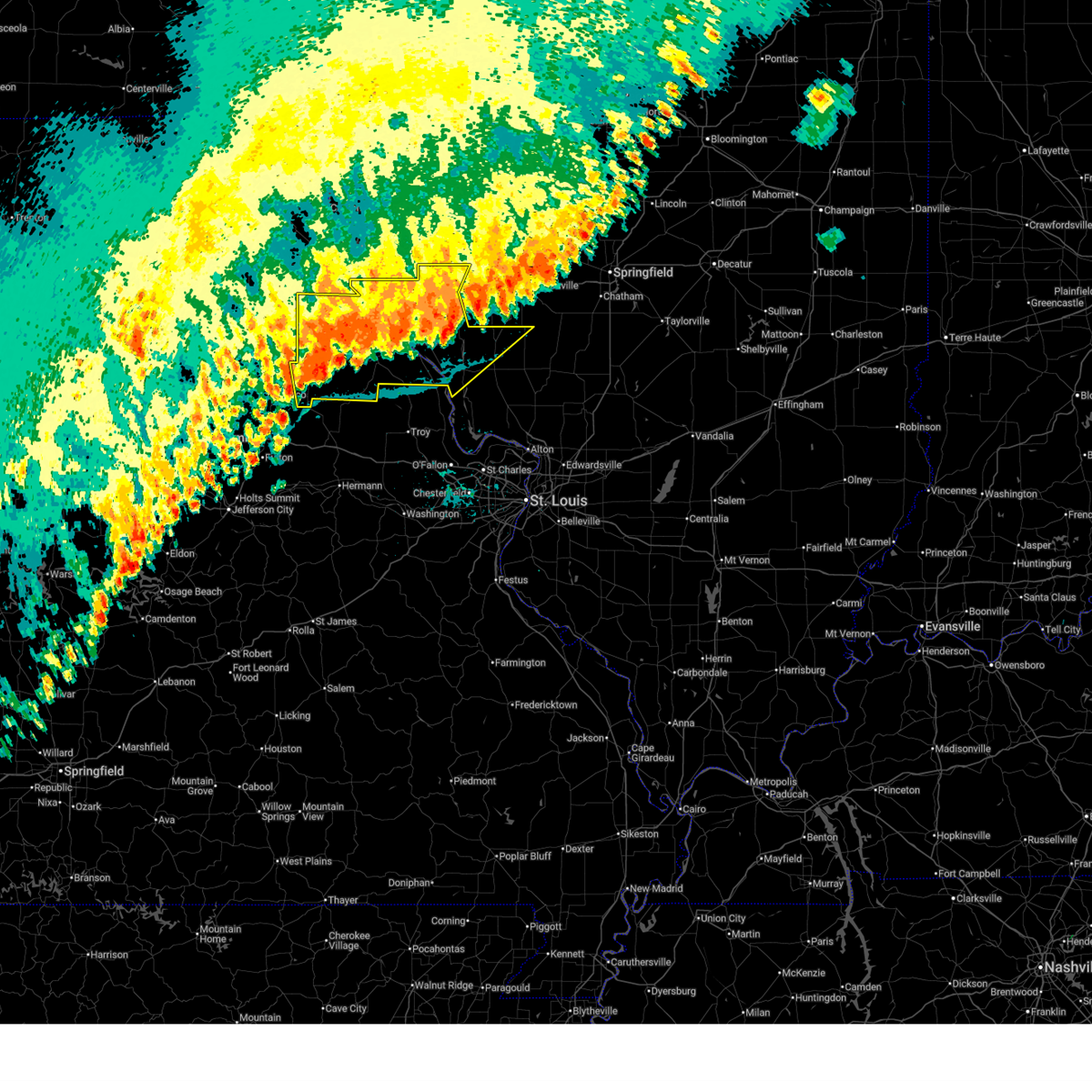
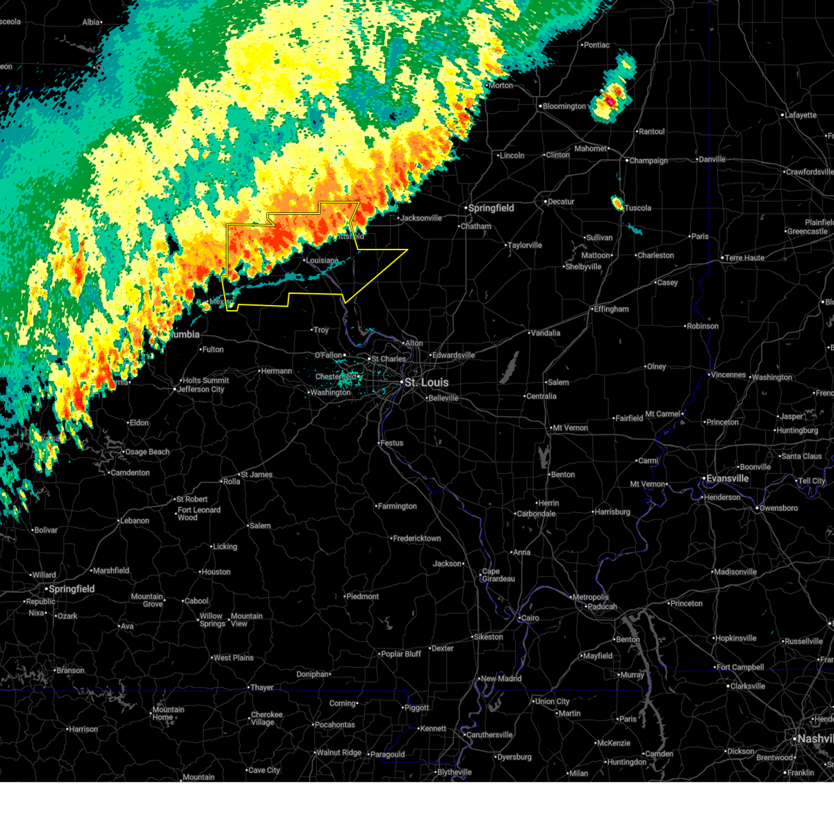
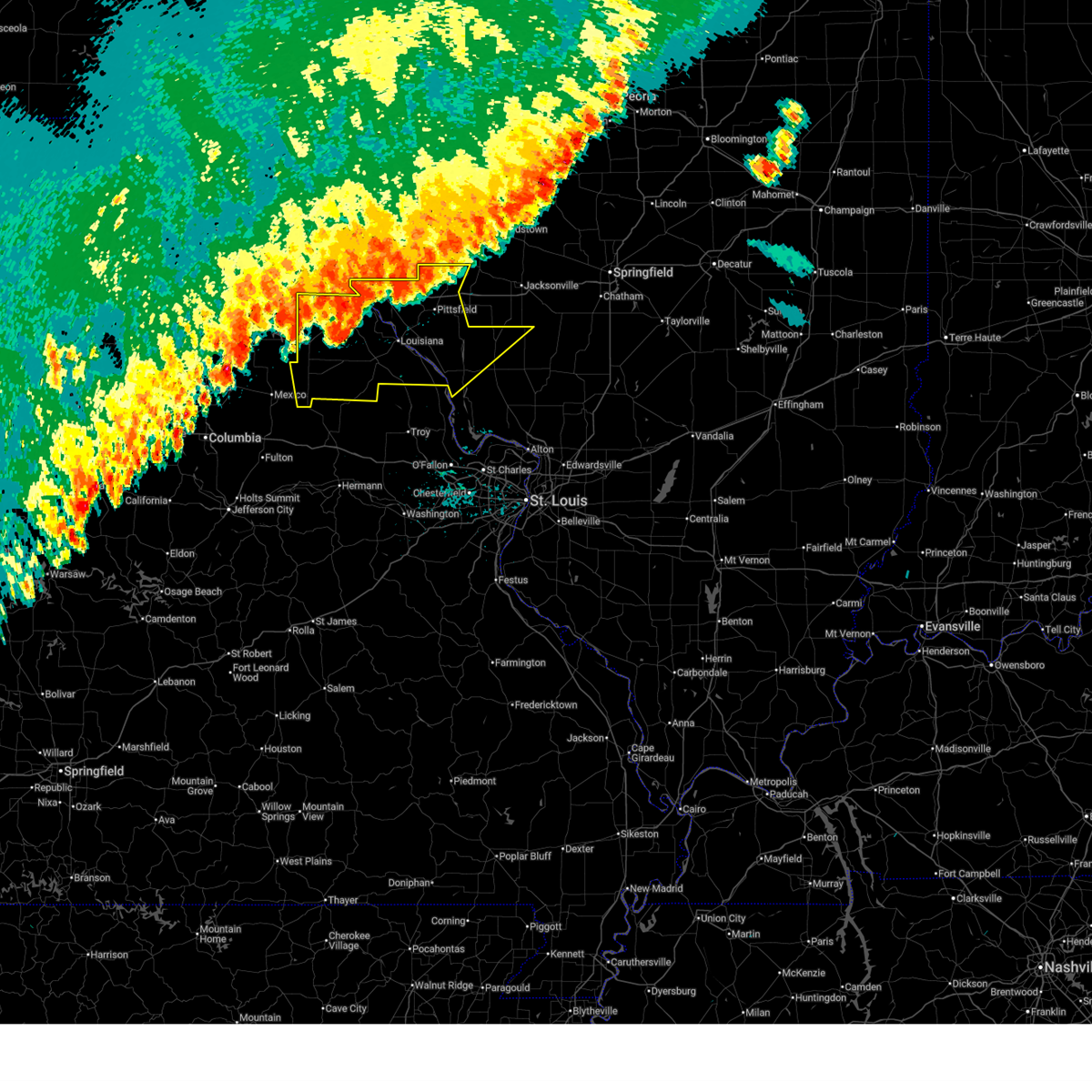
| 3/14/2025 9:10 PM CDT | Svrlsx the national weather service in st louis has issued a * severe thunderstorm warning for, calhoun county in southwestern illinois, greene county in southwestern illinois, eastern pike county in west central illinois, northeastern lincoln county in east central missouri, southeastern pike county in northeastern missouri, * until 1000 pm cdt. * at 910 pm cdt, severe thunderstorms were located along a line from 14 miles east of mount sterling to near pleasant hill, or along a line from 32 miles northeast of pittsfield to 13 miles east of louisiana, moving northeast at 50 mph (radar indicated). Hazards include 60 mph wind gusts and small hail. Expect damage to roofs, siding, and trees. this severe thunderstorm will be near, pleasant hill, clarksville, belleview, griggsville and pittsfield around 910 pm cdt. other locations impacted by the severe thunderstorm include detroit, time, nebo, valley city, independence, martinsburg, chambersburg, pearl, milton and florence. This includes interstate 72 between exits 31 and 35. |
| 3/14/2025 8:55 PM CDT |
 At 855 pm cdt, a severe thunderstorm was located near griggsville, or 11 miles northeast of pittsfield, moving northeast at 60 mph (radar indicated). Hazards include 70 mph wind gusts and half dollar size hail. Hail damage to vehicles is expected. expect considerable tree damage. wind damage is also likely to mobile homes, roofs, and outbuildings. this severe thunderstorm will remain over mainly rural areas of northern calhoun county in southwestern illinois and southeastern brown and pike counties in west central illinois. This includes interstate 72 between exits 31 and 35. At 855 pm cdt, a severe thunderstorm was located near griggsville, or 11 miles northeast of pittsfield, moving northeast at 60 mph (radar indicated). Hazards include 70 mph wind gusts and half dollar size hail. Hail damage to vehicles is expected. expect considerable tree damage. wind damage is also likely to mobile homes, roofs, and outbuildings. this severe thunderstorm will remain over mainly rural areas of northern calhoun county in southwestern illinois and southeastern brown and pike counties in west central illinois. This includes interstate 72 between exits 31 and 35.
|
| 3/14/2025 8:55 PM CDT |
 the severe thunderstorm warning has been cancelled and is no longer in effect the severe thunderstorm warning has been cancelled and is no longer in effect
|
| 3/14/2025 8:47 PM CDT | Quarter sized hail reported 1.1 miles NNE of Pittsfield, IL, report from mping: quarter (1.00 in.). |
| 3/14/2025 8:45 PM CDT | Golf Ball sized hail reported 1.1 miles NNE of Pittsfield, IL, report from mping: golf ball (1.75 in.). |
| 3/14/2025 8:35 PM CDT |
 At 835 pm cdt, a severe thunderstorm was located near atlas, or 9 miles southwest of pittsfield, moving northeast at 70 mph (radar indicated). Hazards include 70 mph wind gusts and ping pong ball size hail. People and animals outdoors will be injured. expect hail damage to roofs, siding, windows, and vehicles. expect considerable tree damage. wind damage is also likely to mobile homes, roofs, and outbuildings. this severe thunderstorm will remain over mainly rural areas of northwestern calhoun county in southwestern illinois, southeastern brown and pike counties in west central illinois and central pike county in northeastern missouri. This includes interstate 72 between exits 31 and 35. At 835 pm cdt, a severe thunderstorm was located near atlas, or 9 miles southwest of pittsfield, moving northeast at 70 mph (radar indicated). Hazards include 70 mph wind gusts and ping pong ball size hail. People and animals outdoors will be injured. expect hail damage to roofs, siding, windows, and vehicles. expect considerable tree damage. wind damage is also likely to mobile homes, roofs, and outbuildings. this severe thunderstorm will remain over mainly rural areas of northwestern calhoun county in southwestern illinois, southeastern brown and pike counties in west central illinois and central pike county in northeastern missouri. This includes interstate 72 between exits 31 and 35.
|
| 3/14/2025 8:27 PM CDT |
 Svrlsx the national weather service in st louis has issued a * severe thunderstorm warning for, northwestern calhoun county in southwestern illinois, southeastern brown county in west central illinois, pike county in west central illinois, central pike county in northeastern missouri, * until 915 pm cdt. * at 827 pm cdt, a severe thunderstorm was located over pike, or over louisiana, moving northeast at 75 mph (radar indicated). Hazards include 70 mph wind gusts and quarter size hail. Hail damage to vehicles is expected. expect considerable tree damage. wind damage is also likely to mobile homes, roofs, and outbuildings. this severe thunderstorm will be near, louisiana, pike, atlas, pleasant hill and clarksville around 830 pm cdt. pittsfield around 840 pm cdt. other locations impacted by the severe thunderstorm include rockport, summer hill, martinsburg, new hartford, nebo, independence, time, detroit, milton and new salem. This includes interstate 72 between exits 31 and 35. Svrlsx the national weather service in st louis has issued a * severe thunderstorm warning for, northwestern calhoun county in southwestern illinois, southeastern brown county in west central illinois, pike county in west central illinois, central pike county in northeastern missouri, * until 915 pm cdt. * at 827 pm cdt, a severe thunderstorm was located over pike, or over louisiana, moving northeast at 75 mph (radar indicated). Hazards include 70 mph wind gusts and quarter size hail. Hail damage to vehicles is expected. expect considerable tree damage. wind damage is also likely to mobile homes, roofs, and outbuildings. this severe thunderstorm will be near, louisiana, pike, atlas, pleasant hill and clarksville around 830 pm cdt. pittsfield around 840 pm cdt. other locations impacted by the severe thunderstorm include rockport, summer hill, martinsburg, new hartford, nebo, independence, time, detroit, milton and new salem. This includes interstate 72 between exits 31 and 35.
|
| 6/25/2024 3:51 PM CDT |
 The storm which prompted the warning has weakened below severe limits, and has exited the warned area. therefore, the warning will be allowed to expire. however, gusty winds are still possible with this thunderstorm. a severe thunderstorm watch remains in effect until 700 pm cdt for southwestern and west central illinois. The storm which prompted the warning has weakened below severe limits, and has exited the warned area. therefore, the warning will be allowed to expire. however, gusty winds are still possible with this thunderstorm. a severe thunderstorm watch remains in effect until 700 pm cdt for southwestern and west central illinois.
|
| 6/25/2024 3:48 PM CDT |
 At 347 pm cdt, a severe thunderstorm was located near griggsville, moving east at 20 mph (radar indicated). Hazards include 60 mph wind gusts and quarter size hail. Hail damage to vehicles is expected. expect wind damage to roofs, siding, and trees. locations impacted include, pittsfield, atlas, pike, independence, bedford, montezuma, martinsburg, milton, detroit, el dara, florence, time, new hartford, summer hill, and rockport. This includes interstate 72 between exits 31 and 35. At 347 pm cdt, a severe thunderstorm was located near griggsville, moving east at 20 mph (radar indicated). Hazards include 60 mph wind gusts and quarter size hail. Hail damage to vehicles is expected. expect wind damage to roofs, siding, and trees. locations impacted include, pittsfield, atlas, pike, independence, bedford, montezuma, martinsburg, milton, detroit, el dara, florence, time, new hartford, summer hill, and rockport. This includes interstate 72 between exits 31 and 35.
|
| 6/25/2024 3:29 PM CDT |
 At 329 pm cdt, a severe thunderstorm was located near pittsfield, moving east at 30 mph (radar indicated). Hazards include 60 mph wind gusts and quarter size hail. Hail damage to vehicles is expected. expect wind damage to roofs, siding, and trees. locations impacted include, pittsfield and griggsville. This includes interstate 72 between exits 20 and 35. At 329 pm cdt, a severe thunderstorm was located near pittsfield, moving east at 30 mph (radar indicated). Hazards include 60 mph wind gusts and quarter size hail. Hail damage to vehicles is expected. expect wind damage to roofs, siding, and trees. locations impacted include, pittsfield and griggsville. This includes interstate 72 between exits 20 and 35.
|
| 6/25/2024 3:29 PM CDT |
 the severe thunderstorm warning has been cancelled and is no longer in effect the severe thunderstorm warning has been cancelled and is no longer in effect
|
| 6/25/2024 3:08 PM CDT |
 Svrlsx the national weather service in st louis has issued a * severe thunderstorm warning for, pike county in west central illinois, southeastern adams county in west central illinois, * until 400 pm cdt. * at 308 pm cdt, severe thunderstorms were located along a line extending from near griggsville to near barry to 6 miles northwest of atlas, moving east at 20 mph (radar indicated). Hazards include 60 mph wind gusts and quarter size hail. Hail damage to vehicles is expected. expect wind damage to roofs, siding, and trees. severe thunderstorms will be near, griggsville and atlas around 315 pm cdt. pittsfield around 320 pm cdt. This includes interstate 72 between exits 20 and 35. Svrlsx the national weather service in st louis has issued a * severe thunderstorm warning for, pike county in west central illinois, southeastern adams county in west central illinois, * until 400 pm cdt. * at 308 pm cdt, severe thunderstorms were located along a line extending from near griggsville to near barry to 6 miles northwest of atlas, moving east at 20 mph (radar indicated). Hazards include 60 mph wind gusts and quarter size hail. Hail damage to vehicles is expected. expect wind damage to roofs, siding, and trees. severe thunderstorms will be near, griggsville and atlas around 315 pm cdt. pittsfield around 320 pm cdt. This includes interstate 72 between exits 20 and 35.
|
| 6/5/2024 4:37 AM CDT |
 The storms which prompted the warning have moved out of the area. therefore, the warning will be allowed to expire. however, gusty winds and heavy rain are still possible with these thunderstorms. The storms which prompted the warning have moved out of the area. therefore, the warning will be allowed to expire. however, gusty winds and heavy rain are still possible with these thunderstorms.
|
| 6/5/2024 4:34 AM CDT |
 At 433 am cdt, severe thunderstorms were located along a line extending from near pittsfield to 6 miles southwest of glasgow to 7 miles west of carrollton, moving northeast at 35 mph (radar indicated). Hazards include 60 mph wind gusts and quarter size hail. Hail damage to vehicles is expected. expect wind damage to roofs, siding, and trees. Locations impacted include, pittsfield, white hall, carrollton, pleasant hill, independence, bedford, patterson, martinsburg, nebo, kampsville, milton, eldred, hillview, pearl, detroit, florence, time, belltown, berdan, and haypress. At 433 am cdt, severe thunderstorms were located along a line extending from near pittsfield to 6 miles southwest of glasgow to 7 miles west of carrollton, moving northeast at 35 mph (radar indicated). Hazards include 60 mph wind gusts and quarter size hail. Hail damage to vehicles is expected. expect wind damage to roofs, siding, and trees. Locations impacted include, pittsfield, white hall, carrollton, pleasant hill, independence, bedford, patterson, martinsburg, nebo, kampsville, milton, eldred, hillview, pearl, detroit, florence, time, belltown, berdan, and haypress.
|
| 6/5/2024 4:28 AM CDT |
 the severe thunderstorm warning has been cancelled and is no longer in effect the severe thunderstorm warning has been cancelled and is no longer in effect
|
| 6/5/2024 4:28 AM CDT |
 At 427 am cdt, severe thunderstorms were located along a line extending from near pittsfield to 9 miles southwest of glasgow to 7 miles north of hardin, moving northeast at 40 mph (radar indicated). Hazards include 60 mph wind gusts and quarter size hail. Hail damage to vehicles is expected. expect wind damage to roofs, siding, and trees. Locations impacted include, pittsfield, white hall, carrollton, pleasant hill, clarksville, belleview, independence, bedford, patterson, martinsburg, nebo, kampsville, milton, eldred, hillview, pearl, hamburg, detroit, florence, and time. At 427 am cdt, severe thunderstorms were located along a line extending from near pittsfield to 9 miles southwest of glasgow to 7 miles north of hardin, moving northeast at 40 mph (radar indicated). Hazards include 60 mph wind gusts and quarter size hail. Hail damage to vehicles is expected. expect wind damage to roofs, siding, and trees. Locations impacted include, pittsfield, white hall, carrollton, pleasant hill, clarksville, belleview, independence, bedford, patterson, martinsburg, nebo, kampsville, milton, eldred, hillview, pearl, hamburg, detroit, florence, and time.
|
| 6/5/2024 4:15 AM CDT |
 the severe thunderstorm warning has been cancelled and is no longer in effect the severe thunderstorm warning has been cancelled and is no longer in effect
|
| 6/5/2024 4:15 AM CDT |
 At 414 am cdt, severe thunderstorms were located along a line extending from near atlas to near belleview to near elsberry, moving northeast at 45 mph (radar indicated). Hazards include 60 mph wind gusts and quarter size hail. Hail damage to vehicles is expected. expect wind damage to roofs, siding, and trees. Locations impacted include, pittsfield, white hall and carrollton. At 414 am cdt, severe thunderstorms were located along a line extending from near atlas to near belleview to near elsberry, moving northeast at 45 mph (radar indicated). Hazards include 60 mph wind gusts and quarter size hail. Hail damage to vehicles is expected. expect wind damage to roofs, siding, and trees. Locations impacted include, pittsfield, white hall and carrollton.
|
| 6/5/2024 4:02 AM CDT |
 Svrlsx the national weather service in st louis has issued a * severe thunderstorm warning for, northwestern calhoun county in southwestern illinois, western greene county in southwestern illinois, southeastern pike county in west central illinois, northeastern lincoln county in east central missouri, eastern pike county in northeastern missouri, * until 445 am cdt. * at 402 am cdt, severe thunderstorms were located along a line extending from near tarrants to clarksville to near elsberry, moving northeast at 40 mph (radar indicated). Hazards include 60 mph wind gusts and quarter size hail. Hail damage to vehicles is expected. expect wind damage to roofs, siding, and trees. severe thunderstorms will be near, louisiana, elsberry, pleasant hill, clarksville, and pike around 405 am cdt. belleview around 410 am cdt. atlas around 415 am cdt. Other locations in the path of these severe thunderstorms include pittsfield. Svrlsx the national weather service in st louis has issued a * severe thunderstorm warning for, northwestern calhoun county in southwestern illinois, western greene county in southwestern illinois, southeastern pike county in west central illinois, northeastern lincoln county in east central missouri, eastern pike county in northeastern missouri, * until 445 am cdt. * at 402 am cdt, severe thunderstorms were located along a line extending from near tarrants to clarksville to near elsberry, moving northeast at 40 mph (radar indicated). Hazards include 60 mph wind gusts and quarter size hail. Hail damage to vehicles is expected. expect wind damage to roofs, siding, and trees. severe thunderstorms will be near, louisiana, elsberry, pleasant hill, clarksville, and pike around 405 am cdt. belleview around 410 am cdt. atlas around 415 am cdt. Other locations in the path of these severe thunderstorms include pittsfield.
|
| 5/24/2024 4:01 PM CDT |
 At 400 pm cdt, severe thunderstorms were located along a line extending from near griggsville to near pittsfield to near atlas to near louisiana, moving east at 40 mph (radar indicated). Hazards include 60 mph wind gusts and quarter size hail. Hail damage to vehicles is expected. expect wind damage to roofs, siding, and trees. locations impacted include, pittsfield, louisiana, griggsville, pleasant hill, atlas, pike, independence, bedford, montezuma, martinsburg, nebo, milton, pearl, new salem, detroit, el dara, florence, time, valley city, and new hartford. This includes interstate 72 between exits 31 and 35. At 400 pm cdt, severe thunderstorms were located along a line extending from near griggsville to near pittsfield to near atlas to near louisiana, moving east at 40 mph (radar indicated). Hazards include 60 mph wind gusts and quarter size hail. Hail damage to vehicles is expected. expect wind damage to roofs, siding, and trees. locations impacted include, pittsfield, louisiana, griggsville, pleasant hill, atlas, pike, independence, bedford, montezuma, martinsburg, nebo, milton, pearl, new salem, detroit, el dara, florence, time, valley city, and new hartford. This includes interstate 72 between exits 31 and 35.
|
| 5/24/2024 4:01 PM CDT |
 the severe thunderstorm warning has been cancelled and is no longer in effect the severe thunderstorm warning has been cancelled and is no longer in effect
|
| 5/24/2024 3:41 PM CDT |
 Svrlsx the national weather service in st louis has issued a * severe thunderstorm warning for, pike county in west central illinois, southeastern brown county in west central illinois, northwestern pike county in northeastern missouri, * until 430 pm cdt. * at 341 pm cdt, severe thunderstorms were located along a line extending from 6 miles northwest of griggsville to 7 miles west of pittsfield to near atlas to near frankford, moving east at 35 mph (radar indicated). Hazards include 60 mph wind gusts and quarter size hail. Hail damage to vehicles is expected. Expect wind damage to roofs, siding, and trees. Svrlsx the national weather service in st louis has issued a * severe thunderstorm warning for, pike county in west central illinois, southeastern brown county in west central illinois, northwestern pike county in northeastern missouri, * until 430 pm cdt. * at 341 pm cdt, severe thunderstorms were located along a line extending from 6 miles northwest of griggsville to 7 miles west of pittsfield to near atlas to near frankford, moving east at 35 mph (radar indicated). Hazards include 60 mph wind gusts and quarter size hail. Hail damage to vehicles is expected. Expect wind damage to roofs, siding, and trees.
|
| 5/24/2024 2:31 PM CDT |
 At 231 pm cdt, a severe thunderstorm was located near pleasant hill, moving northeast at 30 mph (radar indicated). Hazards include 60 mph wind gusts and quarter size hail. Hail damage to vehicles is expected. expect wind damage to roofs, siding, and trees. Locations impacted include, pleasant hill, independence, bedford, patterson, montezuma, martinsburg, nebo, milton, hillview, pearl, detroit, florence, time, valley city, and beecreek. At 231 pm cdt, a severe thunderstorm was located near pleasant hill, moving northeast at 30 mph (radar indicated). Hazards include 60 mph wind gusts and quarter size hail. Hail damage to vehicles is expected. expect wind damage to roofs, siding, and trees. Locations impacted include, pleasant hill, independence, bedford, patterson, montezuma, martinsburg, nebo, milton, hillview, pearl, detroit, florence, time, valley city, and beecreek.
|
| 5/24/2024 2:16 PM CDT |
 Svrlsx the national weather service in st louis has issued a * severe thunderstorm warning for, northwestern greene county in southwestern illinois, southeastern pike county in west central illinois, * until 300 pm cdt. * at 216 pm cdt, a severe thunderstorm was located over pleasant hill, moving northeast at 30 mph (radar indicated). Hazards include 60 mph wind gusts and quarter size hail. Hail damage to vehicles is expected. Expect wind damage to roofs, siding, and trees. Svrlsx the national weather service in st louis has issued a * severe thunderstorm warning for, northwestern greene county in southwestern illinois, southeastern pike county in west central illinois, * until 300 pm cdt. * at 216 pm cdt, a severe thunderstorm was located over pleasant hill, moving northeast at 30 mph (radar indicated). Hazards include 60 mph wind gusts and quarter size hail. Hail damage to vehicles is expected. Expect wind damage to roofs, siding, and trees.
|
| 3/14/2024 3:57 PM CDT |
 the severe thunderstorm warning has been cancelled and is no longer in effect the severe thunderstorm warning has been cancelled and is no longer in effect
|
| 3/14/2024 3:43 PM CDT |
 Svrlsx the national weather service in st louis has issued a * severe thunderstorm warning for, east central pike county in west central illinois, * until 415 pm cdt. * at 343 pm cdt, a severe thunderstorm was located over pittsfield, moving east at 45 mph (radar indicated). Hazards include 60 mph wind gusts and quarter size hail. Hail damage to vehicles is expected. Expect wind damage to roofs, siding, and trees. Svrlsx the national weather service in st louis has issued a * severe thunderstorm warning for, east central pike county in west central illinois, * until 415 pm cdt. * at 343 pm cdt, a severe thunderstorm was located over pittsfield, moving east at 45 mph (radar indicated). Hazards include 60 mph wind gusts and quarter size hail. Hail damage to vehicles is expected. Expect wind damage to roofs, siding, and trees.
|
| 8/12/2023 2:00 AM CDT | Report of a tree down in summer hill... il. time is approximat in pike county IL, 7.7 miles NE of Pittsfield, IL |
| 8/12/2023 1:48 AM CDT |
 At 146 am cdt, severe thunderstorms were located along a line extending from 6 miles east of payson to 8 miles southwest of barry to near spencerburg, moving east at 50 mph (radar indicated. at 120, a large tree was reported down in palmyra). Hazards include 70 mph wind gusts and penny size hail. Expect considerable tree damage. damage is likely to mobile homes, roofs, and outbuildings. locations impacted include, bowling green, pittsfield, louisiana, barry, griggsville, payson, pleasant hill, atlas, clarksville, beverly, frankford, pike, tarrants, spencerburg, kingston, independence, hull, martinsburg, richfield, and perry. this includes interstate 72 between exits 10 and 35. thunderstorm damage threat, considerable hail threat, radar indicated max hail size, 0. 75 in wind threat, radar indicated max wind gust, 70 mph. At 146 am cdt, severe thunderstorms were located along a line extending from 6 miles east of payson to 8 miles southwest of barry to near spencerburg, moving east at 50 mph (radar indicated. at 120, a large tree was reported down in palmyra). Hazards include 70 mph wind gusts and penny size hail. Expect considerable tree damage. damage is likely to mobile homes, roofs, and outbuildings. locations impacted include, bowling green, pittsfield, louisiana, barry, griggsville, payson, pleasant hill, atlas, clarksville, beverly, frankford, pike, tarrants, spencerburg, kingston, independence, hull, martinsburg, richfield, and perry. this includes interstate 72 between exits 10 and 35. thunderstorm damage threat, considerable hail threat, radar indicated max hail size, 0. 75 in wind threat, radar indicated max wind gust, 70 mph.
|
| 8/12/2023 1:31 AM CDT |
 At 131 am cdt, severe thunderstorms were located along a line extending from near fall creek to near hannibal to center, moving east at 50 mph (radar indicated). Hazards include 60 mph wind gusts and penny size hail. expect damage to roofs, siding, and trees At 131 am cdt, severe thunderstorms were located along a line extending from near fall creek to near hannibal to center, moving east at 50 mph (radar indicated). Hazards include 60 mph wind gusts and penny size hail. expect damage to roofs, siding, and trees
|
| 7/14/2023 8:41 PM CDT |
 At 841 pm cdt, a severe thunderstorm was located near atlas, moving northeast at 40 mph (radar indicated). Hazards include 60 mph wind gusts and penny size hail. Expect damage to roofs, siding, and trees. locations impacted include, pittsfield. this includes interstate 72 between exits 20 and 31. hail threat, radar indicated max hail size, 0. 75 in wind threat, radar indicated max wind gust, 60 mph. At 841 pm cdt, a severe thunderstorm was located near atlas, moving northeast at 40 mph (radar indicated). Hazards include 60 mph wind gusts and penny size hail. Expect damage to roofs, siding, and trees. locations impacted include, pittsfield. this includes interstate 72 between exits 20 and 31. hail threat, radar indicated max hail size, 0. 75 in wind threat, radar indicated max wind gust, 60 mph.
|
| 7/14/2023 8:26 PM CDT |
 At 826 pm cdt, a severe thunderstorm was located near frankford, moving northeast at 40 mph (radar indicated). Hazards include 60 mph wind gusts and penny size hail. expect damage to roofs, siding, and trees At 826 pm cdt, a severe thunderstorm was located near frankford, moving northeast at 40 mph (radar indicated). Hazards include 60 mph wind gusts and penny size hail. expect damage to roofs, siding, and trees
|
| 6/29/2023 11:35 AM CDT | Trees and power lines reported down throughout the county. time of arrival at pittsfield estimated from rada in pike county IL, 0.5 miles NE of Pittsfield, IL |
| 6/29/2023 11:27 AM CDT |
 At 1127 am cdt, severe thunderstorms were located along a line extending from near griggsville to near pleasant hill to near bowling green, moving east at 60 mph (radar indicated). Hazards include 60 mph wind gusts and quarter size hail. Hail damage to vehicles is expected. expect wind damage to roofs, siding, and trees. locations impacted include, bowling green, pittsfield, louisiana, barry, pleasant hill, atlas, eolia, clarksville, pike, curryville, tarrants, belleview, independence, bedford, martinsburg, new canton, nebo, milton, kinderhook, and baylis. this includes interstate 72 between exits 20 and 35. hail threat, radar indicated max hail size, 1. 00 in wind threat, radar indicated max wind gust, 60 mph. At 1127 am cdt, severe thunderstorms were located along a line extending from near griggsville to near pleasant hill to near bowling green, moving east at 60 mph (radar indicated). Hazards include 60 mph wind gusts and quarter size hail. Hail damage to vehicles is expected. expect wind damage to roofs, siding, and trees. locations impacted include, bowling green, pittsfield, louisiana, barry, pleasant hill, atlas, eolia, clarksville, pike, curryville, tarrants, belleview, independence, bedford, martinsburg, new canton, nebo, milton, kinderhook, and baylis. this includes interstate 72 between exits 20 and 35. hail threat, radar indicated max hail size, 1. 00 in wind threat, radar indicated max wind gust, 60 mph.
|
| 6/29/2023 11:01 AM CDT |
 At 1100 am cdt, severe thunderstorms were located along a line extending from fall creek to near new london to near perry, moving southeast at 50 mph (radar indicated). Hazards include 60 mph wind gusts and quarter size hail. Hail damage to vehicles is expected. Expect wind damage to roofs, siding, and trees. At 1100 am cdt, severe thunderstorms were located along a line extending from fall creek to near new london to near perry, moving southeast at 50 mph (radar indicated). Hazards include 60 mph wind gusts and quarter size hail. Hail damage to vehicles is expected. Expect wind damage to roofs, siding, and trees.
|
| 6/24/2023 10:05 PM CDT |
 At 1005 pm cdt, a severe thunderstorm was located near atlas, moving east at 30 mph (radar indicated). Hazards include two inch hail and 60 mph wind gusts. People and animals outdoors will be injured. expect hail damage to roofs, siding, windows, and vehicles. expect wind damage to roofs, siding, and trees. this severe storm will be near, atlas around 1010 pm cdt. pleasant hill around 1020 pm cdt. other locations impacted by this severe thunderstorm include nebo, pearl, montezuma, martinsburg, independence, bedford, rockport, time, milton, and new hartford. thunderstorm damage threat, considerable hail threat, radar indicated max hail size, 2. 00 in wind threat, radar indicated max wind gust, 60 mph. At 1005 pm cdt, a severe thunderstorm was located near atlas, moving east at 30 mph (radar indicated). Hazards include two inch hail and 60 mph wind gusts. People and animals outdoors will be injured. expect hail damage to roofs, siding, windows, and vehicles. expect wind damage to roofs, siding, and trees. this severe storm will be near, atlas around 1010 pm cdt. pleasant hill around 1020 pm cdt. other locations impacted by this severe thunderstorm include nebo, pearl, montezuma, martinsburg, independence, bedford, rockport, time, milton, and new hartford. thunderstorm damage threat, considerable hail threat, radar indicated max hail size, 2. 00 in wind threat, radar indicated max wind gust, 60 mph.
|
| 6/24/2023 9:59 PM CDT |
 At 958 pm cdt, a severe thunderstorm was located 7 miles northwest of atlas, moving southeast at 25 mph (radar indicated). Hazards include two inch hail and 60 mph wind gusts. People and animals outdoors will be injured. expect hail damage to roofs, siding, windows, and vehicles. expect wind damage to roofs, siding, and trees. this severe storm will be near, atlas around 1010 pm cdt. pleasant hill around 1025 pm cdt. other locations impacted by this severe thunderstorm include nebo, detroit, martinsburg, independence, florence, time, new hartford, summer hill, pearl, and new canton. this includes interstate 72 between exits 31 and 35. thunderstorm damage threat, considerable hail threat, radar indicated max hail size, 2. 00 in wind threat, radar indicated max wind gust, 60 mph. At 958 pm cdt, a severe thunderstorm was located 7 miles northwest of atlas, moving southeast at 25 mph (radar indicated). Hazards include two inch hail and 60 mph wind gusts. People and animals outdoors will be injured. expect hail damage to roofs, siding, windows, and vehicles. expect wind damage to roofs, siding, and trees. this severe storm will be near, atlas around 1010 pm cdt. pleasant hill around 1025 pm cdt. other locations impacted by this severe thunderstorm include nebo, detroit, martinsburg, independence, florence, time, new hartford, summer hill, pearl, and new canton. this includes interstate 72 between exits 31 and 35. thunderstorm damage threat, considerable hail threat, radar indicated max hail size, 2. 00 in wind threat, radar indicated max wind gust, 60 mph.
|
| 6/24/2023 9:41 PM CDT |
 At 940 pm cdt, a severe thunderstorm was located 7 miles southwest of barry, moving east at 40 mph (radar indicated). Hazards include 60 mph wind gusts and quarter size hail. Hail damage to vehicles is expected. Expect wind damage to roofs, siding, and trees. At 940 pm cdt, a severe thunderstorm was located 7 miles southwest of barry, moving east at 40 mph (radar indicated). Hazards include 60 mph wind gusts and quarter size hail. Hail damage to vehicles is expected. Expect wind damage to roofs, siding, and trees.
|
| 5/6/2023 10:47 AM CDT |
 At 1047 am cdt, a severe thunderstorm was located near frankford, moving east at 30 mph (radar indicated). Hazards include 60 mph wind gusts and half dollar size hail. Hail damage to vehicles is expected. Expect wind damage to roofs, siding, and trees. At 1047 am cdt, a severe thunderstorm was located near frankford, moving east at 30 mph (radar indicated). Hazards include 60 mph wind gusts and half dollar size hail. Hail damage to vehicles is expected. Expect wind damage to roofs, siding, and trees.
|
| 4/20/2023 3:17 PM CDT |
 At 316 pm cdt, a severe thunderstorm was located near pittsfield, moving northeast at 45 mph (public reported quarter size hail near pleasant hill). Hazards include 60 mph wind gusts and quarter size hail. Hail damage to vehicles is expected. expect wind damage to roofs, siding, and trees. locations impacted include, pittsfield, independence, bedford, montezuma, martinsburg, nebo, milton, pearl, detroit, florence, and time. hail threat, observed max hail size, 1. 00 in wind threat, radar indicated max wind gust, 60 mph. At 316 pm cdt, a severe thunderstorm was located near pittsfield, moving northeast at 45 mph (public reported quarter size hail near pleasant hill). Hazards include 60 mph wind gusts and quarter size hail. Hail damage to vehicles is expected. expect wind damage to roofs, siding, and trees. locations impacted include, pittsfield, independence, bedford, montezuma, martinsburg, nebo, milton, pearl, detroit, florence, and time. hail threat, observed max hail size, 1. 00 in wind threat, radar indicated max wind gust, 60 mph.
|
| 4/20/2023 3:05 PM CDT |
 At 305 pm cdt, a severe thunderstorm was located near pleasant hill, moving northeast at 45 mph (radar indicated). Hazards include 60 mph wind gusts and quarter size hail. Hail damage to vehicles is expected. expect wind damage to roofs, siding, and trees. locations impacted include, pittsfield, pleasant hill, atlas, pike, independence, bedford, montezuma, martinsburg, nebo, milton, pearl, detroit, florence, time, and summer hill. hail threat, radar indicated max hail size, 1. 00 in wind threat, radar indicated max wind gust, 60 mph. At 305 pm cdt, a severe thunderstorm was located near pleasant hill, moving northeast at 45 mph (radar indicated). Hazards include 60 mph wind gusts and quarter size hail. Hail damage to vehicles is expected. expect wind damage to roofs, siding, and trees. locations impacted include, pittsfield, pleasant hill, atlas, pike, independence, bedford, montezuma, martinsburg, nebo, milton, pearl, detroit, florence, time, and summer hill. hail threat, radar indicated max hail size, 1. 00 in wind threat, radar indicated max wind gust, 60 mph.
|
| 4/20/2023 2:46 PM CDT |
 At 245 pm cdt, a severe thunderstorm was located near louisiana, moving northeast at 45 mph (radar indicated). Hazards include 60 mph wind gusts and quarter size hail. Hail damage to vehicles is expected. Expect wind damage to roofs, siding, and trees. At 245 pm cdt, a severe thunderstorm was located near louisiana, moving northeast at 45 mph (radar indicated). Hazards include 60 mph wind gusts and quarter size hail. Hail damage to vehicles is expected. Expect wind damage to roofs, siding, and trees.
|
| 4/5/2023 5:29 AM CDT |
 At 528 am cdt, a severe thunderstorm was located 10 miles southeast of pittsfield, moving east at 65 mph (radar indicated). Hazards include 60 mph wind gusts and quarter size hail. Hail damage to vehicles is expected. expect wind damage to roofs, siding, and trees. locations impacted include, pittsfield, white hall, roodhouse, independence, bedford, patterson, montezuma, nebo, milton, hillview, pearl, detroit, time, valley city and barrow. hail threat, radar indicated max hail size, 1. 00 in wind threat, radar indicated max wind gust, 60 mph. At 528 am cdt, a severe thunderstorm was located 10 miles southeast of pittsfield, moving east at 65 mph (radar indicated). Hazards include 60 mph wind gusts and quarter size hail. Hail damage to vehicles is expected. expect wind damage to roofs, siding, and trees. locations impacted include, pittsfield, white hall, roodhouse, independence, bedford, patterson, montezuma, nebo, milton, hillview, pearl, detroit, time, valley city and barrow. hail threat, radar indicated max hail size, 1. 00 in wind threat, radar indicated max wind gust, 60 mph.
|
| 4/5/2023 5:19 AM CDT |
 At 518 am cdt, a severe thunderstorm was located over clarksville, moving northeast at 55 mph (radar indicated). Hazards include 60 mph wind gusts and quarter size hail. Hail damage to vehicles is expected. expect wind damage to roofs, siding, and trees. locations impacted include, white hall and roodhouse. this includes interstate 72 near exit 35. hail threat, radar indicated max hail size, 1. 00 in wind threat, radar indicated max wind gust, 60 mph. At 518 am cdt, a severe thunderstorm was located over clarksville, moving northeast at 55 mph (radar indicated). Hazards include 60 mph wind gusts and quarter size hail. Hail damage to vehicles is expected. expect wind damage to roofs, siding, and trees. locations impacted include, white hall and roodhouse. this includes interstate 72 near exit 35. hail threat, radar indicated max hail size, 1. 00 in wind threat, radar indicated max wind gust, 60 mph.
|
| 4/5/2023 5:07 AM CDT |
 At 507 am cdt, a severe thunderstorm was located near eolia, moving northeast at 60 mph (radar indicated). Hazards include 60 mph wind gusts and quarter size hail. Hail damage to vehicles is expected. expect wind damage to roofs, siding, and trees. this severe thunderstorm will be near, pleasant hill and clarksville around 520 am cdt. belleview around 525 am cdt. other locations in the path of this severe thunderstorm include white hall and roodhouse. this includes interstate 72 near exit 35. hail threat, radar indicated max hail size, 1. 00 in wind threat, radar indicated max wind gust, 60 mph. At 507 am cdt, a severe thunderstorm was located near eolia, moving northeast at 60 mph (radar indicated). Hazards include 60 mph wind gusts and quarter size hail. Hail damage to vehicles is expected. expect wind damage to roofs, siding, and trees. this severe thunderstorm will be near, pleasant hill and clarksville around 520 am cdt. belleview around 525 am cdt. other locations in the path of this severe thunderstorm include white hall and roodhouse. this includes interstate 72 near exit 35. hail threat, radar indicated max hail size, 1. 00 in wind threat, radar indicated max wind gust, 60 mph.
|
| 2/27/2023 5:21 AM CST | Storm damage reported in pike county IL, 4.1 miles E of Pittsfield, IL |
| 6/17/2022 4:31 AM CDT |
 At 430 am cdt, severe thunderstorms were located along a line extending from near arenzville to alsey to near hardin, moving east at 55 mph (radar indicated). Hazards include 60 mph wind gusts. Expect damage to roofs, siding, and trees. locations impacted include, roodhouse, carrollton, athensville and old kane. hail threat, radar indicated max hail size, <. 75 in wind threat, radar indicated max wind gust, 60 mph. At 430 am cdt, severe thunderstorms were located along a line extending from near arenzville to alsey to near hardin, moving east at 55 mph (radar indicated). Hazards include 60 mph wind gusts. Expect damage to roofs, siding, and trees. locations impacted include, roodhouse, carrollton, athensville and old kane. hail threat, radar indicated max hail size, <. 75 in wind threat, radar indicated max wind gust, 60 mph.
|
| 6/17/2022 4:15 AM CDT |
 At 414 am cdt, severe thunderstorms were located along a line extending from near pittsfield to clarksville to 8 miles southeast of new hartford, moving east at 50 mph (trained weather spotters). Hazards include 60 mph wind gusts. Expect damage to roofs, siding, and trees. locations impacted include, bowling green, pittsfield, louisiana, wellsville, barry, pleasant hill, atlas, eolia, clarksville, beverly, pike, buell, new hartford, kingston, independence, liberty, martinsburg, richfield, new canton and baylis. this also includes siloam springs state park. this includes interstate 72 between exits 20 and 31. hail threat, radar indicated max hail size, <. 75 in wind threat, radar indicated max wind gust, 60 mph. At 414 am cdt, severe thunderstorms were located along a line extending from near pittsfield to clarksville to 8 miles southeast of new hartford, moving east at 50 mph (trained weather spotters). Hazards include 60 mph wind gusts. Expect damage to roofs, siding, and trees. locations impacted include, bowling green, pittsfield, louisiana, wellsville, barry, pleasant hill, atlas, eolia, clarksville, beverly, pike, buell, new hartford, kingston, independence, liberty, martinsburg, richfield, new canton and baylis. this also includes siloam springs state park. this includes interstate 72 between exits 20 and 31. hail threat, radar indicated max hail size, <. 75 in wind threat, radar indicated max wind gust, 60 mph.
|
| 6/17/2022 4:06 AM CDT |
 At 405 am cdt, severe thunderstorms were located along a line extending from barry to near louisiana to 7 miles northeast of buell, moving east at 50 mph (trained weather spotters). Hazards include 60 mph wind gusts. Expect damage to roofs, siding, and trees. locations impacted include, pike, pleasant hill, clarksville and pittsfield. this also includes siloam springs state park. this includes the following highways, interstate 172 near exit 10. interstate 72 between exits 10 and 31. hail threat, radar indicated max hail size, <. 75 in wind threat, radar indicated max wind gust, 60 mph. At 405 am cdt, severe thunderstorms were located along a line extending from barry to near louisiana to 7 miles northeast of buell, moving east at 50 mph (trained weather spotters). Hazards include 60 mph wind gusts. Expect damage to roofs, siding, and trees. locations impacted include, pike, pleasant hill, clarksville and pittsfield. this also includes siloam springs state park. this includes the following highways, interstate 172 near exit 10. interstate 72 between exits 10 and 31. hail threat, radar indicated max hail size, <. 75 in wind threat, radar indicated max wind gust, 60 mph.
|
| 6/17/2022 4:04 AM CDT |
 At 404 am cdt, severe thunderstorms were located along a line extending from near buckhorn to near pittsfield to eolia, moving east at 70 mph (radar indicated). Hazards include 60 mph wind gusts. Expect damage to roofs, siding, and trees. severe thunderstorms will be near, belleview around 415 am cdt. other locations in the path of these severe thunderstorms include white hall, roodhouse, carrollton, athensville, old kane and greenfield. this includes interstate 72 near exit 35. hail threat, radar indicated max hail size, <. 75 in wind threat, radar indicated max wind gust, 60 mph. At 404 am cdt, severe thunderstorms were located along a line extending from near buckhorn to near pittsfield to eolia, moving east at 70 mph (radar indicated). Hazards include 60 mph wind gusts. Expect damage to roofs, siding, and trees. severe thunderstorms will be near, belleview around 415 am cdt. other locations in the path of these severe thunderstorms include white hall, roodhouse, carrollton, athensville, old kane and greenfield. this includes interstate 72 near exit 35. hail threat, radar indicated max hail size, <. 75 in wind threat, radar indicated max wind gust, 60 mph.
|
| 6/17/2022 3:49 AM CDT |
 At 349 am cdt, severe thunderstorms were located along a line extending from near fall creek to near frankford to near martinsburg, moving east at 65 mph (trained weather spotters reported trees down and power out in hannibal). Hazards include 70 mph wind gusts. Expect considerable tree damage. damage is likely to mobile homes, roofs, and outbuildings. these severe storms will be near, bowling green and tarrants around 355 am cdt. other locations in the path of these severe thunderstorms include louisiana, barry, beverly, pike, atlas, clarksville, new hartford, pittsfield, pleasant hill and eolia. this also includes siloam springs state park. this includes the following highways, interstate 172 between exits 2 and 10. interstate 72 between exits 4 and 31. thunderstorm damage threat, considerable hail threat, radar indicated max hail size, <. 75 in wind threat, radar indicated max wind gust, 70 mph. At 349 am cdt, severe thunderstorms were located along a line extending from near fall creek to near frankford to near martinsburg, moving east at 65 mph (trained weather spotters reported trees down and power out in hannibal). Hazards include 70 mph wind gusts. Expect considerable tree damage. damage is likely to mobile homes, roofs, and outbuildings. these severe storms will be near, bowling green and tarrants around 355 am cdt. other locations in the path of these severe thunderstorms include louisiana, barry, beverly, pike, atlas, clarksville, new hartford, pittsfield, pleasant hill and eolia. this also includes siloam springs state park. this includes the following highways, interstate 172 between exits 2 and 10. interstate 72 between exits 4 and 31. thunderstorm damage threat, considerable hail threat, radar indicated max hail size, <. 75 in wind threat, radar indicated max wind gust, 70 mph.
|
| 6/17/2022 3:38 AM CDT |
 At 337 am cdt, severe thunderstorms were located along a line extending from near palmyra to near center to near mexico, moving east at 50 mph (a missouri mesonet in monroe city sited reported a wind gust of 74 mph). Hazards include 70 mph wind gusts and penny size hail. Expect considerable tree damage. damage is likely to mobile homes, roofs, and outbuildings. severe thunderstorms will be near, hannibal and spencerburg around 345 am cdt. fall creek, frankford and curryville around 350 am cdt. wellsville around 355 am cdt. other locations in the path of these severe thunderstorms include bowling green, tarrants, louisiana, barry, pike, buell, atlas, clarksville and pittsfield. this includes the following highways, interstate 172 between exits 2 and 10. interstate 72 between exits 4 and 31. this also includes siloam springs state park. thunderstorm damage threat, considerable hail threat, radar indicated max hail size, 0. 75 in wind threat, radar indicated max wind gust, 70 mph. At 337 am cdt, severe thunderstorms were located along a line extending from near palmyra to near center to near mexico, moving east at 50 mph (a missouri mesonet in monroe city sited reported a wind gust of 74 mph). Hazards include 70 mph wind gusts and penny size hail. Expect considerable tree damage. damage is likely to mobile homes, roofs, and outbuildings. severe thunderstorms will be near, hannibal and spencerburg around 345 am cdt. fall creek, frankford and curryville around 350 am cdt. wellsville around 355 am cdt. other locations in the path of these severe thunderstorms include bowling green, tarrants, louisiana, barry, pike, buell, atlas, clarksville and pittsfield. this includes the following highways, interstate 172 between exits 2 and 10. interstate 72 between exits 4 and 31. this also includes siloam springs state park. thunderstorm damage threat, considerable hail threat, radar indicated max hail size, 0. 75 in wind threat, radar indicated max wind gust, 70 mph.
|
| 5/13/2022 7:41 PM CDT |
 The severe thunderstorm warning for central pike county in west central illinois, northeastern ralls and north central pike counties in northeastern missouri will expire at 745 pm cdt, the storm which prompted the warning has weakened below severe limits, and no longer poses an immediate threat to life or property. therefore, the warning will be allowed to expire. however gusty winds and heavy rain are still possible with this thunderstorm. The severe thunderstorm warning for central pike county in west central illinois, northeastern ralls and north central pike counties in northeastern missouri will expire at 745 pm cdt, the storm which prompted the warning has weakened below severe limits, and no longer poses an immediate threat to life or property. therefore, the warning will be allowed to expire. however gusty winds and heavy rain are still possible with this thunderstorm.
|
| 5/13/2022 7:22 PM CDT |
 At 722 pm cdt, a severe thunderstorm was located 7 miles southwest of barry, moving southeast at 10 mph (radar indicated). Hazards include 60 mph wind gusts and quarter size hail. Hail damage to vehicles is expected. expect wind damage to roofs, siding, and trees. locations impacted include, pittsfield, barry, griggsville, atlas, hull, new canton, kinderhook, baylis, new salem, detroit, el dara, saverton, new hartford, summer hill, rockport and ashburn. this includes interstate 72 between exits 20 and 35. hail threat, radar indicated max hail size, 1. 00 in wind threat, radar indicated max wind gust, 60 mph. At 722 pm cdt, a severe thunderstorm was located 7 miles southwest of barry, moving southeast at 10 mph (radar indicated). Hazards include 60 mph wind gusts and quarter size hail. Hail damage to vehicles is expected. expect wind damage to roofs, siding, and trees. locations impacted include, pittsfield, barry, griggsville, atlas, hull, new canton, kinderhook, baylis, new salem, detroit, el dara, saverton, new hartford, summer hill, rockport and ashburn. this includes interstate 72 between exits 20 and 35. hail threat, radar indicated max hail size, 1. 00 in wind threat, radar indicated max wind gust, 60 mph.
|
| 5/13/2022 7:09 PM CDT |
 At 708 pm cdt, a severe thunderstorm was located 8 miles northwest of pike, moving southeast at 20 mph (radar indicated). Hazards include 60 mph wind gusts and half dollar size hail. Hail damage to vehicles is expected. expect wind damage to roofs, siding, and trees. locations impacted include, pittsfield, barry, griggsville, atlas, hull, new canton, kinderhook, baylis, new salem, detroit, el dara, saverton, new hartford, summer hill, rockport and ashburn. this includes interstate 72 between exits 20 and 35. hail threat, radar indicated max hail size, 1. 25 in wind threat, radar indicated max wind gust, 60 mph. At 708 pm cdt, a severe thunderstorm was located 8 miles northwest of pike, moving southeast at 20 mph (radar indicated). Hazards include 60 mph wind gusts and half dollar size hail. Hail damage to vehicles is expected. expect wind damage to roofs, siding, and trees. locations impacted include, pittsfield, barry, griggsville, atlas, hull, new canton, kinderhook, baylis, new salem, detroit, el dara, saverton, new hartford, summer hill, rockport and ashburn. this includes interstate 72 between exits 20 and 35. hail threat, radar indicated max hail size, 1. 25 in wind threat, radar indicated max wind gust, 60 mph.
|
| 5/13/2022 6:57 PM CDT |
 At 656 pm cdt, a severe thunderstorm was located near barry, moving southeast at 10 mph (trained weather spotters). Hazards include 60 mph wind gusts and quarter size hail. Hail damage to vehicles is expected. Expect wind damage to roofs, siding, and trees. At 656 pm cdt, a severe thunderstorm was located near barry, moving southeast at 10 mph (trained weather spotters). Hazards include 60 mph wind gusts and quarter size hail. Hail damage to vehicles is expected. Expect wind damage to roofs, siding, and trees.
|
| 12/15/2021 10:24 PM CST |
 The severe thunderstorm warning for northwestern calhoun county in southwestern illinois, pike and brown counties in west central illinois, northwestern lincoln, northeastern montgomery counties in east central missouri and pike counties in northeastern missouri will expire at 1030 pm cst, the storms which prompted the warning have weakened below severe limits, and no longer pose an immediate threat to life or property. therefore, the warning will be allowed to expire. however gusty winds are still possible with these thunderstorms. a severe thunderstorm watch remains in effect until midnight cst for southwestern and west central illinois, and northeastern and east central missouri. The severe thunderstorm warning for northwestern calhoun county in southwestern illinois, pike and brown counties in west central illinois, northwestern lincoln, northeastern montgomery counties in east central missouri and pike counties in northeastern missouri will expire at 1030 pm cst, the storms which prompted the warning have weakened below severe limits, and no longer pose an immediate threat to life or property. therefore, the warning will be allowed to expire. however gusty winds are still possible with these thunderstorms. a severe thunderstorm watch remains in effect until midnight cst for southwestern and west central illinois, and northeastern and east central missouri.
|
| 10/24/2021 5:42 PM CDT |
 At 542 pm cdt, a severe thunderstorm capable of producing a tornado was located near pittsfield, moving northeast at 60 mph (radar indicated rotation). Hazards include tornado and quarter size hail. Flying debris will be dangerous to those caught without shelter. mobile homes will be damaged or destroyed. damage to roofs, windows, and vehicles will occur. tree damage is likely. locations impacted include, pittsfield, griggsville, independence, martinsburg, milton, detroit, florence, time and valley city. This includes interstate 72 near exit 35. At 542 pm cdt, a severe thunderstorm capable of producing a tornado was located near pittsfield, moving northeast at 60 mph (radar indicated rotation). Hazards include tornado and quarter size hail. Flying debris will be dangerous to those caught without shelter. mobile homes will be damaged or destroyed. damage to roofs, windows, and vehicles will occur. tree damage is likely. locations impacted include, pittsfield, griggsville, independence, martinsburg, milton, detroit, florence, time and valley city. This includes interstate 72 near exit 35.
|
| 10/24/2021 5:35 PM CDT |
 At 534 pm cdt, a severe thunderstorm capable of producing a tornado was located near pittsfield, moving northeast at 40 mph (radar indicated rotation). Hazards include tornado. Flying debris will be dangerous to those caught without shelter. mobile homes will be damaged or destroyed. damage to roofs, windows, and vehicles will occur. tree damage is likely. locations impacted include, pittsfield, griggsville, atlas, independence, martinsburg, milton, detroit, florence, time, valley city, new hartford, summer hill and rockport. This includes interstate 72 near exit 35. At 534 pm cdt, a severe thunderstorm capable of producing a tornado was located near pittsfield, moving northeast at 40 mph (radar indicated rotation). Hazards include tornado. Flying debris will be dangerous to those caught without shelter. mobile homes will be damaged or destroyed. damage to roofs, windows, and vehicles will occur. tree damage is likely. locations impacted include, pittsfield, griggsville, atlas, independence, martinsburg, milton, detroit, florence, time, valley city, new hartford, summer hill and rockport. This includes interstate 72 near exit 35.
|
| 10/24/2021 5:29 PM CDT |
 At 528 pm cdt, a severe thunderstorm capable of producing a tornado was located near atlas, moving northeast at 55 mph (radar indicated rotation). Hazards include tornado. Flying debris will be dangerous to those caught without shelter. mobile homes will be damaged or destroyed. damage to roofs, windows, and vehicles will occur. tree damage is likely. locations impacted include, pittsfield and griggsville. This includes interstate 72 near exit 35. At 528 pm cdt, a severe thunderstorm capable of producing a tornado was located near atlas, moving northeast at 55 mph (radar indicated rotation). Hazards include tornado. Flying debris will be dangerous to those caught without shelter. mobile homes will be damaged or destroyed. damage to roofs, windows, and vehicles will occur. tree damage is likely. locations impacted include, pittsfield and griggsville. This includes interstate 72 near exit 35.
|
| 10/24/2021 5:17 PM CDT |
 At 517 pm cdt, a severe thunderstorm capable of producing a tornado was located over louisiana, moving northeast at 65 mph (radar indicated rotation). Hazards include tornado. Flying debris will be dangerous to those caught without shelter. mobile homes will be damaged or destroyed. damage to roofs, windows, and vehicles will occur. tree damage is likely. this dangerous storm will be near, pleasant hill around 525 pm cdt. pittsfield around 535 pm cdt. other locations in the path of this tornadic thunderstorm include griggsville. This includes interstate 72 near exit 35. At 517 pm cdt, a severe thunderstorm capable of producing a tornado was located over louisiana, moving northeast at 65 mph (radar indicated rotation). Hazards include tornado. Flying debris will be dangerous to those caught without shelter. mobile homes will be damaged or destroyed. damage to roofs, windows, and vehicles will occur. tree damage is likely. this dangerous storm will be near, pleasant hill around 525 pm cdt. pittsfield around 535 pm cdt. other locations in the path of this tornadic thunderstorm include griggsville. This includes interstate 72 near exit 35.
|
| 10/24/2021 5:10 PM CDT |
 At 509 pm cdt, a severe thunderstorm was located near louisiana, moving northeast at 45 mph (radar indicated). Hazards include 60 mph wind gusts. Expect damage to roofs, siding, and trees. locations impacted include, bowling green, pittsfield, louisiana, pleasant hill, atlas, pike, curryville, tarrants, independence, martinsburg, new canton, nebo, baylis, new salem, el dara, time, new hartford, summer hill, rockport and ashburn. This includes interstate 72 between exits 31 and 35. At 509 pm cdt, a severe thunderstorm was located near louisiana, moving northeast at 45 mph (radar indicated). Hazards include 60 mph wind gusts. Expect damage to roofs, siding, and trees. locations impacted include, bowling green, pittsfield, louisiana, pleasant hill, atlas, pike, curryville, tarrants, independence, martinsburg, new canton, nebo, baylis, new salem, el dara, time, new hartford, summer hill, rockport and ashburn. This includes interstate 72 between exits 31 and 35.
|
| 10/24/2021 4:58 PM CDT |
 At 457 pm cdt, a severe thunderstorm was located near frankford, moving northeast at 45 mph (radar indicated). Hazards include 60 mph wind gusts. Expect damage to roofs, siding, and trees. locations impacted include, louisiana, pike, pleasant hill, atlas and pittsfield. This includes interstate 72 between exits 31 and 35. At 457 pm cdt, a severe thunderstorm was located near frankford, moving northeast at 45 mph (radar indicated). Hazards include 60 mph wind gusts. Expect damage to roofs, siding, and trees. locations impacted include, louisiana, pike, pleasant hill, atlas and pittsfield. This includes interstate 72 between exits 31 and 35.
|
| 10/24/2021 4:49 PM CDT |
 At 449 pm cdt, a severe thunderstorm was located over spencerburg, moving northeast at 55 mph (radar indicated). Hazards include 60 mph wind gusts. Expect damage to roofs, siding, and trees. this severe thunderstorm will be near, bowling green and frankford around 455 pm cdt. tarrants around 500 pm cdt. other locations in the path of this severe thunderstorm include louisiana, pike, atlas and pittsfield. This includes interstate 72 between exits 31 and 35. At 449 pm cdt, a severe thunderstorm was located over spencerburg, moving northeast at 55 mph (radar indicated). Hazards include 60 mph wind gusts. Expect damage to roofs, siding, and trees. this severe thunderstorm will be near, bowling green and frankford around 455 pm cdt. tarrants around 500 pm cdt. other locations in the path of this severe thunderstorm include louisiana, pike, atlas and pittsfield. This includes interstate 72 between exits 31 and 35.
|
| 9/20/2021 11:00 PM CDT |
 At 1100 pm cdt, severe thunderstorms were located along a line extending from near hannibal to 7 miles northeast of frankford to near tarrants, moving east at 50 mph (radar indicated). Hazards include 60 mph wind gusts. Expect damage to roofs, siding, and trees. locations impacted include, louisiana, payson, pike, barry, pleasant hill, atlas, beverly and pittsfield. this includes the following highways, interstate 172 near exit 2. interstate 72 between exits 4 and 35. hail threat, radar indicated max hail size, <. 75 in wind threat, radar indicated max wind gust, 60 mph. At 1100 pm cdt, severe thunderstorms were located along a line extending from near hannibal to 7 miles northeast of frankford to near tarrants, moving east at 50 mph (radar indicated). Hazards include 60 mph wind gusts. Expect damage to roofs, siding, and trees. locations impacted include, louisiana, payson, pike, barry, pleasant hill, atlas, beverly and pittsfield. this includes the following highways, interstate 172 near exit 2. interstate 72 between exits 4 and 35. hail threat, radar indicated max hail size, <. 75 in wind threat, radar indicated max wind gust, 60 mph.
|
| 9/20/2021 10:35 PM CDT |
 At 1035 pm cdt, severe thunderstorms were located along a line extending from near monroe city to near center to near vandalia, moving east at 45 mph (radar indicated). Hazards include 60 mph wind gusts. Expect damage to roofs, siding, and trees. severe thunderstorms will be near, curryville and spencerburg around 1045 pm cdt. new london, frankford, rensselaer and spaulding around 1050 pm cdt. tarrants around 1055 pm cdt. other locations in the path of these severe thunderstorms include hannibal, fall creek, louisiana, payson, pike, barry, pleasant hill and atlas. this includes the following highways, interstate 172 near exit 2. interstate 72 between exits 4 and 35. hail threat, radar indicated max hail size, <. 75 in wind threat, radar indicated max wind gust, 60 mph. At 1035 pm cdt, severe thunderstorms were located along a line extending from near monroe city to near center to near vandalia, moving east at 45 mph (radar indicated). Hazards include 60 mph wind gusts. Expect damage to roofs, siding, and trees. severe thunderstorms will be near, curryville and spencerburg around 1045 pm cdt. new london, frankford, rensselaer and spaulding around 1050 pm cdt. tarrants around 1055 pm cdt. other locations in the path of these severe thunderstorms include hannibal, fall creek, louisiana, payson, pike, barry, pleasant hill and atlas. this includes the following highways, interstate 172 near exit 2. interstate 72 between exits 4 and 35. hail threat, radar indicated max hail size, <. 75 in wind threat, radar indicated max wind gust, 60 mph.
|
| 8/12/2021 5:43 PM CDT |
 At 542 pm cdt, severe thunderstorms were located along a line extending from pike to 7 miles east of new hartford to near bellflower, moving east at 35 mph (this storm has a history of wind damage). Hazards include 60 mph wind gusts and penny size hail. Expect damage to roofs, siding, and trees. locations impacted include, louisiana, atlas, clarksville, pike, pleasant hill, eolia, hawk point, belleview, elsberry, davis, troy, moscow mills, hardin and fountain n` lakes. this also includes cuivre river state park. hail threat, radar indicated max hail size, 0. 75 in wind threat, radar indicated max wind gust, 60 mph. At 542 pm cdt, severe thunderstorms were located along a line extending from pike to 7 miles east of new hartford to near bellflower, moving east at 35 mph (this storm has a history of wind damage). Hazards include 60 mph wind gusts and penny size hail. Expect damage to roofs, siding, and trees. locations impacted include, louisiana, atlas, clarksville, pike, pleasant hill, eolia, hawk point, belleview, elsberry, davis, troy, moscow mills, hardin and fountain n` lakes. this also includes cuivre river state park. hail threat, radar indicated max hail size, 0. 75 in wind threat, radar indicated max wind gust, 60 mph.
|
| 8/12/2021 5:27 PM CDT |
 At 526 pm cdt, severe thunderstorms were located along a line extending from near louisiana to near new hartford to near wellsville, moving east at 35 mph (this line of storms has a history of wind damage). Hazards include 60 mph wind gusts and penny size hail. Expect damage to roofs, siding, and trees. severe thunderstorms will be near, bowling green and new hartford around 530 pm cdt. louisiana around 535 pm cdt. atlas and pike around 540 pm cdt. bellflower around 545 pm cdt. other locations in the path of these severe thunderstorms include clarksville, pleasant hill, eolia, hawk point, belleview and davis. this also includes cuivre river state park. hail threat, radar indicated max hail size, 0. 75 in wind threat, radar indicated max wind gust, 60 mph. At 526 pm cdt, severe thunderstorms were located along a line extending from near louisiana to near new hartford to near wellsville, moving east at 35 mph (this line of storms has a history of wind damage). Hazards include 60 mph wind gusts and penny size hail. Expect damage to roofs, siding, and trees. severe thunderstorms will be near, bowling green and new hartford around 530 pm cdt. louisiana around 535 pm cdt. atlas and pike around 540 pm cdt. bellflower around 545 pm cdt. other locations in the path of these severe thunderstorms include clarksville, pleasant hill, eolia, hawk point, belleview and davis. this also includes cuivre river state park. hail threat, radar indicated max hail size, 0. 75 in wind threat, radar indicated max wind gust, 60 mph.
|
| 7/9/2021 9:41 PM CDT |
 At 941 pm cdt, a severe thunderstorm was located near griggsville, moving southeast at 25 mph (radar indicated). Hazards include two inch hail and 60 mph wind gusts. People and animals outdoors will be injured. expect hail damage to roofs, siding, windows, and vehicles. expect wind damage to roofs, siding, and trees. locations impacted include, pittsfield, griggsville, independence, bedford, montezuma, versailles, perry, milton, baylis, chambersburg, new salem, detroit, florence, time, valley city, new hartford, fishhook and summer hill. This includes interstate 72 between exits 31 and 35. At 941 pm cdt, a severe thunderstorm was located near griggsville, moving southeast at 25 mph (radar indicated). Hazards include two inch hail and 60 mph wind gusts. People and animals outdoors will be injured. expect hail damage to roofs, siding, windows, and vehicles. expect wind damage to roofs, siding, and trees. locations impacted include, pittsfield, griggsville, independence, bedford, montezuma, versailles, perry, milton, baylis, chambersburg, new salem, detroit, florence, time, valley city, new hartford, fishhook and summer hill. This includes interstate 72 between exits 31 and 35.
|
| 7/9/2021 9:17 PM CDT |
 At 917 pm cdt, a severe thunderstorm was located near buckhorn, moving southeast at 20 mph (radar indicated). Hazards include two inch hail and 60 mph wind gusts. People and animals outdoors will be injured. expect hail damage to roofs, siding, windows, and vehicles. Expect wind damage to roofs, siding, and trees. At 917 pm cdt, a severe thunderstorm was located near buckhorn, moving southeast at 20 mph (radar indicated). Hazards include two inch hail and 60 mph wind gusts. People and animals outdoors will be injured. expect hail damage to roofs, siding, windows, and vehicles. Expect wind damage to roofs, siding, and trees.
|
| 6/25/2021 12:57 AM CDT |
 At 1257 am cdt, severe thunderstorms were located along a line extending from 7 miles southwest of littleton to 8 miles east of pleasant hill to near hawk point, moving east at 40 mph (radar indicated). Hazards include 60 mph wind gusts. expect damage to roofs, siding, and trees At 1257 am cdt, severe thunderstorms were located along a line extending from 7 miles southwest of littleton to 8 miles east of pleasant hill to near hawk point, moving east at 40 mph (radar indicated). Hazards include 60 mph wind gusts. expect damage to roofs, siding, and trees
|
| 6/25/2021 12:46 AM CDT |
 At 1246 am cdt, severe thunderstorms were located along a line extending from 9 miles north of mount sterling to near griggsville to near eolia to 6 miles north of hawk point, moving east at 40 mph (radar indicated). Hazards include 60 mph wind gusts. Expect damage to roofs, siding, and trees. locations impacted include, pittsfield, griggsville, elsberry and belleview. this also includes siloam springs state park. This includes interstate 72 between exits 20 and 35. At 1246 am cdt, severe thunderstorms were located along a line extending from 9 miles north of mount sterling to near griggsville to near eolia to 6 miles north of hawk point, moving east at 40 mph (radar indicated). Hazards include 60 mph wind gusts. Expect damage to roofs, siding, and trees. locations impacted include, pittsfield, griggsville, elsberry and belleview. this also includes siloam springs state park. This includes interstate 72 between exits 20 and 35.
|
| 6/25/2021 12:17 AM CDT |
 At 1216 am cdt, severe thunderstorms were located along a line extending from near mendon to 6 miles southeast of fall creek to near curryville to near martinsburg, moving east at 65 mph (radar indicated). Hazards include 60 mph wind gusts. Expect damage to roofs, siding, and trees. severe thunderstorms will be near, mendon around 1220 am cdt. bowling green, barry and camp point around 1225 am cdt. golden, beverly and tarrants around 1230 am cdt. other locations in the path of these severe thunderstorms include griggsville, clarksville, pleasant hill, eolia, belleview and elsberry. this includes the following highways, interstate 172 near exit 2, and between exits 14 and 19. interstate 72 between exits 4 and 35. This also includes siloam springs state park. At 1216 am cdt, severe thunderstorms were located along a line extending from near mendon to 6 miles southeast of fall creek to near curryville to near martinsburg, moving east at 65 mph (radar indicated). Hazards include 60 mph wind gusts. Expect damage to roofs, siding, and trees. severe thunderstorms will be near, mendon around 1220 am cdt. bowling green, barry and camp point around 1225 am cdt. golden, beverly and tarrants around 1230 am cdt. other locations in the path of these severe thunderstorms include griggsville, clarksville, pleasant hill, eolia, belleview and elsberry. this includes the following highways, interstate 172 near exit 2, and between exits 14 and 19. interstate 72 between exits 4 and 35. This also includes siloam springs state park.
|
| 6/19/2021 3:36 PM CDT |
 At 335 pm cdt, a severe thunderstorm was located 8 miles southeast of pittsfield, moving east at 50 mph (radar indicated). Hazards include 60 mph wind gusts and quarter size hail. Hail damage to vehicles is expected. expect wind damage to roofs, siding, and trees. Locations impacted include, pittsfield, pleasant hill, belleview, independence, bedford, patterson, montezuma, martinsburg, nebo, milton, hillview, pearl, detroit, florence, time, summer hill and beecreek. At 335 pm cdt, a severe thunderstorm was located 8 miles southeast of pittsfield, moving east at 50 mph (radar indicated). Hazards include 60 mph wind gusts and quarter size hail. Hail damage to vehicles is expected. expect wind damage to roofs, siding, and trees. Locations impacted include, pittsfield, pleasant hill, belleview, independence, bedford, patterson, montezuma, martinsburg, nebo, milton, hillview, pearl, detroit, florence, time, summer hill and beecreek.
|
| 6/19/2021 3:21 PM CDT |
 At 321 pm cdt, a severe thunderstorm was located over pleasant hill, moving east at 50 mph (radar indicated). Hazards include 60 mph wind gusts and quarter size hail. Hail damage to vehicles is expected. expect wind damage to roofs, siding, and trees. this severe thunderstorm will remain over mainly rural areas of northwestern calhoun and northwestern greene counties in southwestern illinois, southeastern pike county in west central illinois and northeastern pike counties in northeastern missouri, including the following locations, nebo, detroit, martinsburg, independence, florence, time, patterson, new hartford, summer hill and pearl. This includes interstate 72 near exit 35. At 321 pm cdt, a severe thunderstorm was located over pleasant hill, moving east at 50 mph (radar indicated). Hazards include 60 mph wind gusts and quarter size hail. Hail damage to vehicles is expected. expect wind damage to roofs, siding, and trees. this severe thunderstorm will remain over mainly rural areas of northwestern calhoun and northwestern greene counties in southwestern illinois, southeastern pike county in west central illinois and northeastern pike counties in northeastern missouri, including the following locations, nebo, detroit, martinsburg, independence, florence, time, patterson, new hartford, summer hill and pearl. This includes interstate 72 near exit 35.
|
| 3/23/2021 7:04 PM CDT |
 At 704 pm cdt, a severe thunderstorm capable of producing a tornado was located near louisiana, moving northeast at 35 mph (radar indicated rotation). Hazards include tornado. Flying debris will be dangerous to those caught without shelter. mobile homes will be damaged or destroyed. damage to roofs, windows, and vehicles will occur. tree damage is likely. this dangerous storm will be near, pike around 710 pm cdt. atlas around 720 pm cdt. pittsfield around 745 pm cdt. Other locations impacted by this tornadic thunderstorm include el dara, rockport, new hartford and summer hill. At 704 pm cdt, a severe thunderstorm capable of producing a tornado was located near louisiana, moving northeast at 35 mph (radar indicated rotation). Hazards include tornado. Flying debris will be dangerous to those caught without shelter. mobile homes will be damaged or destroyed. damage to roofs, windows, and vehicles will occur. tree damage is likely. this dangerous storm will be near, pike around 710 pm cdt. atlas around 720 pm cdt. pittsfield around 745 pm cdt. Other locations impacted by this tornadic thunderstorm include el dara, rockport, new hartford and summer hill.
|
| 11/10/2020 2:45 PM CST |
 At 245 pm cst, severe thunderstorms were located along a line extending from near naples to 8 miles northeast of pleasant hill, moving northeast at 50 mph (radar indicated). Hazards include 60 mph wind gusts. Expect damage to roofs, siding, and trees. locations impacted include, pittsfield, griggsville, pleasant hill, independence, bedford, montezuma, martinsburg, nebo, milton, pearl, detroit, florence, time, valley city and beecreek. This includes interstate 72 near exit 35. At 245 pm cst, severe thunderstorms were located along a line extending from near naples to 8 miles northeast of pleasant hill, moving northeast at 50 mph (radar indicated). Hazards include 60 mph wind gusts. Expect damage to roofs, siding, and trees. locations impacted include, pittsfield, griggsville, pleasant hill, independence, bedford, montezuma, martinsburg, nebo, milton, pearl, detroit, florence, time, valley city and beecreek. This includes interstate 72 near exit 35.
|
| 11/10/2020 2:31 PM CST |
 At 231 pm cst, severe thunderstorms were located along a line extending from near pittsfield to clarksville, moving east at 55 mph (radar indicated). Hazards include 60 mph wind gusts. Expect damage to roofs, siding, and trees. locations impacted include, pittsfield, griggsville, pleasant hill, atlas, pike, independence, bedford, montezuma, martinsburg, nebo, milton, pearl, detroit, el dara, florence, time, valley city, new hartford, summer hill and rockport. This includes interstate 72 between exits 31 and 35. At 231 pm cst, severe thunderstorms were located along a line extending from near pittsfield to clarksville, moving east at 55 mph (radar indicated). Hazards include 60 mph wind gusts. Expect damage to roofs, siding, and trees. locations impacted include, pittsfield, griggsville, pleasant hill, atlas, pike, independence, bedford, montezuma, martinsburg, nebo, milton, pearl, detroit, el dara, florence, time, valley city, new hartford, summer hill and rockport. This includes interstate 72 between exits 31 and 35.
|
| 11/10/2020 2:21 PM CST |
 At 221 pm cst, severe thunderstorms were located along a line extending from 6 miles east of barry to near eolia, moving northeast at 60 mph (radar indicated). Hazards include 60 mph wind gusts. expect damage to roofs, siding, and trees At 221 pm cst, severe thunderstorms were located along a line extending from 6 miles east of barry to near eolia, moving northeast at 60 mph (radar indicated). Hazards include 60 mph wind gusts. expect damage to roofs, siding, and trees
|
| 7/21/2020 2:36 PM CDT | Numerous trees blown down around town. one tree fell onto a hous in pike county IL, 0.5 miles NE of Pittsfield, IL |
| 7/21/2020 2:26 PM CDT |
 At 226 pm cdt, severe thunderstorms were located along a line extending from near barry to near atlas to near bowling green, moving east at 35 mph (radar indicated). Hazards include 60 mph wind gusts and quarter size hail. Hail damage to vehicles is expected. expect wind damage to roofs, siding, and trees. locations impacted include, bowling green, pittsfield, louisiana, griggsville, pleasant hill, atlas, clarksville, pike, belleview, independence, bedford, montezuma, martinsburg, perry, nebo, milton, baylis, chambersburg, pearl and new salem. This includes interstate 72 between exits 31 and 35. At 226 pm cdt, severe thunderstorms were located along a line extending from near barry to near atlas to near bowling green, moving east at 35 mph (radar indicated). Hazards include 60 mph wind gusts and quarter size hail. Hail damage to vehicles is expected. expect wind damage to roofs, siding, and trees. locations impacted include, bowling green, pittsfield, louisiana, griggsville, pleasant hill, atlas, clarksville, pike, belleview, independence, bedford, montezuma, martinsburg, perry, nebo, milton, baylis, chambersburg, pearl and new salem. This includes interstate 72 between exits 31 and 35.
|
| 7/21/2020 2:12 PM CDT |
 At 211 pm cdt, severe thunderstorms were located along a line extending from near barry to near atlas to near curryville, moving east at 30 mph (radar indicated). Hazards include 60 mph wind gusts and quarter size hail. Hail damage to vehicles is expected. Expect wind damage to roofs, siding, and trees. At 211 pm cdt, severe thunderstorms were located along a line extending from near barry to near atlas to near curryville, moving east at 30 mph (radar indicated). Hazards include 60 mph wind gusts and quarter size hail. Hail damage to vehicles is expected. Expect wind damage to roofs, siding, and trees.
|
| 6/28/2020 10:04 AM CDT |
 At 1003 am cdt, a severe thunderstorm was located near griggsville, moving southeast at 35 mph (radar indicated). Hazards include 60 mph wind gusts and nickel size hail. Expect damage to roofs, siding, and trees. locations impacted include, griggsville, buckhorn, versailles, perry, baylis, chambersburg, new salem, detroit, florence, valley city and fishhook. This includes interstate 72 near exit 35. At 1003 am cdt, a severe thunderstorm was located near griggsville, moving southeast at 35 mph (radar indicated). Hazards include 60 mph wind gusts and nickel size hail. Expect damage to roofs, siding, and trees. locations impacted include, griggsville, buckhorn, versailles, perry, baylis, chambersburg, new salem, detroit, florence, valley city and fishhook. This includes interstate 72 near exit 35.
|
| 6/28/2020 9:46 AM CDT |
 At 946 am cdt, a severe thunderstorm was located near beverly, moving southeast at 35 mph (radar indicated). Hazards include 60 mph wind gusts and nickel size hail. expect damage to roofs, siding, and trees At 946 am cdt, a severe thunderstorm was located near beverly, moving southeast at 35 mph (radar indicated). Hazards include 60 mph wind gusts and nickel size hail. expect damage to roofs, siding, and trees
|
| 6/3/2020 4:05 PM CDT |
 At 405 pm cdt, a severe thunderstorm was located near atlas, moving south at 20 mph (emergency management). Hazards include 60 mph wind gusts and quarter size hail. Hail damage to vehicles is expected. expect wind damage to roofs, siding, and trees. Locations impacted include, pittsfield, louisiana, pleasant hill, atlas, pike, independence, martinsburg, nebo, el dara, time, new hartford, summer hill and rockport. At 405 pm cdt, a severe thunderstorm was located near atlas, moving south at 20 mph (emergency management). Hazards include 60 mph wind gusts and quarter size hail. Hail damage to vehicles is expected. expect wind damage to roofs, siding, and trees. Locations impacted include, pittsfield, louisiana, pleasant hill, atlas, pike, independence, martinsburg, nebo, el dara, time, new hartford, summer hill and rockport.
|
| 6/3/2020 3:52 PM CDT |
 At 351 pm cdt, a severe thunderstorm was located near pittsfield, moving south at 10 mph (emergency management reported 62 mph wind and quarter sized hail). Hazards include 60 mph wind gusts and quarter size hail. Hail damage to vehicles is expected. expect wind damage to roofs, siding, and trees. Locations impacted include, pittsfield, louisiana, pleasant hill, atlas, pike, independence, martinsburg, nebo, milton, detroit, el dara, time, new hartford, summer hill and rockport. At 351 pm cdt, a severe thunderstorm was located near pittsfield, moving south at 10 mph (emergency management reported 62 mph wind and quarter sized hail). Hazards include 60 mph wind gusts and quarter size hail. Hail damage to vehicles is expected. expect wind damage to roofs, siding, and trees. Locations impacted include, pittsfield, louisiana, pleasant hill, atlas, pike, independence, martinsburg, nebo, milton, detroit, el dara, time, new hartford, summer hill and rockport.
|
| 6/3/2020 3:41 PM CDT |
 At 341 pm cdt, a severe thunderstorm was located over pittsfield, moving southeast at 15 mph (radar indicated). Hazards include 60 mph wind gusts and penny size hail. Expect damage to roofs, siding, and trees. locations impacted include, pittsfield, louisiana, pleasant hill, atlas, pike, independence, martinsburg, nebo, milton, baylis, new salem, detroit, el dara, florence, time, new hartford, summer hill and rockport. This includes interstate 72 between exits 31 and 35. At 341 pm cdt, a severe thunderstorm was located over pittsfield, moving southeast at 15 mph (radar indicated). Hazards include 60 mph wind gusts and penny size hail. Expect damage to roofs, siding, and trees. locations impacted include, pittsfield, louisiana, pleasant hill, atlas, pike, independence, martinsburg, nebo, milton, baylis, new salem, detroit, el dara, florence, time, new hartford, summer hill and rockport. This includes interstate 72 between exits 31 and 35.
|
| 6/3/2020 3:35 PM CDT | Emergency management reported a gust of 62 mph at the leading edge of the storm. hail began falling shortly after the storm moved overhead. hail size ranged from penny in pike county IL, 0.4 miles NNW of Pittsfield, IL |
| 6/3/2020 3:22 PM CDT |
 At 322 pm cdt, a severe thunderstorm was located near pittsfield, moving southeast at 20 mph (radar indicated). Hazards include 60 mph wind gusts and penny size hail. expect damage to roofs, siding, and trees At 322 pm cdt, a severe thunderstorm was located near pittsfield, moving southeast at 20 mph (radar indicated). Hazards include 60 mph wind gusts and penny size hail. expect damage to roofs, siding, and trees
|
| 9/27/2019 10:14 PM CDT |
 At 1014 pm cdt, severe thunderstorms were located along a line extending from near camp point to near palmyra, moving east at 55 mph (radar indicated). Hazards include 60 mph wind gusts and quarter size hail. Hail damage to vehicles is expected. Expect wind damage to roofs, siding, and trees. At 1014 pm cdt, severe thunderstorms were located along a line extending from near camp point to near palmyra, moving east at 55 mph (radar indicated). Hazards include 60 mph wind gusts and quarter size hail. Hail damage to vehicles is expected. Expect wind damage to roofs, siding, and trees.
|
| 7/17/2019 4:32 PM CDT |
 At 431 pm cdt, severe thunderstorms were located along a line extending from near meredosia to 8 miles east of pittsfield to near frankford, moving southeast at 55 mph (emergency management reported trees down in pittsfield at about 425 pm). Hazards include 60 mph wind gusts and penny size hail. Expect damage to roofs, siding, and trees. locations impacted include, bowling green, pittsfield, louisiana, white hall, carrollton, roodhouse, barry, griggsville, greenfield, new london, hardin, pleasant hill, atlas, eolia, clarksville, athensville, frankford, pike, curryville and spencerburg. This includes interstate 72 between exits 31 and 35. At 431 pm cdt, severe thunderstorms were located along a line extending from near meredosia to 8 miles east of pittsfield to near frankford, moving southeast at 55 mph (emergency management reported trees down in pittsfield at about 425 pm). Hazards include 60 mph wind gusts and penny size hail. Expect damage to roofs, siding, and trees. locations impacted include, bowling green, pittsfield, louisiana, white hall, carrollton, roodhouse, barry, griggsville, greenfield, new london, hardin, pleasant hill, atlas, eolia, clarksville, athensville, frankford, pike, curryville and spencerburg. This includes interstate 72 between exits 31 and 35.
|
| 7/17/2019 4:29 PM CDT |
 At 428 pm cdt, severe thunderstorms were located along a line extending from near meredosia to 6 miles southeast of griggsville to near frankford, moving southeast at 45 mph (radar indicated). Hazards include 60 mph wind gusts and penny size hail. Expect damage to roofs, siding, and trees. locations impacted include, bowling green, pittsfield, louisiana, white hall, carrollton, roodhouse, barry, griggsville, greenfield, new london, hardin, pleasant hill, atlas, eolia, clarksville, athensville, frankford, pike, curryville and spencerburg. This includes interstate 72 between exits 31 and 35. At 428 pm cdt, severe thunderstorms were located along a line extending from near meredosia to 6 miles southeast of griggsville to near frankford, moving southeast at 45 mph (radar indicated). Hazards include 60 mph wind gusts and penny size hail. Expect damage to roofs, siding, and trees. locations impacted include, bowling green, pittsfield, louisiana, white hall, carrollton, roodhouse, barry, griggsville, greenfield, new london, hardin, pleasant hill, atlas, eolia, clarksville, athensville, frankford, pike, curryville and spencerburg. This includes interstate 72 between exits 31 and 35.
|
| 7/17/2019 4:25 PM CDT | Trees down... estimated 60-70 mph wind gust in pike county IL, 0.5 miles NE of Pittsfield, IL |
| 7/17/2019 4:13 PM CDT |
 At 413 pm cdt, severe thunderstorms were located along a line extending from 6 miles east of mount sterling to near griggsville to spaulding, moving southeast at 55 mph (law enforcement reported power outages and tree damage in hannibal). Hazards include 60 mph wind gusts and penny size hail. Expect damage to roofs, siding, and trees. locations impacted include, hannibal, bowling green, pittsfield, louisiana, white hall, carrollton, mount sterling, roodhouse, barry, griggsville, greenfield, new london, hardin, pleasant hill, atlas, eolia, clarksville, athensville, frankford and pike. This includes interstate 72 between exits 10 and 35. At 413 pm cdt, severe thunderstorms were located along a line extending from 6 miles east of mount sterling to near griggsville to spaulding, moving southeast at 55 mph (law enforcement reported power outages and tree damage in hannibal). Hazards include 60 mph wind gusts and penny size hail. Expect damage to roofs, siding, and trees. locations impacted include, hannibal, bowling green, pittsfield, louisiana, white hall, carrollton, mount sterling, roodhouse, barry, griggsville, greenfield, new london, hardin, pleasant hill, atlas, eolia, clarksville, athensville, frankford and pike. This includes interstate 72 between exits 10 and 35.
|
| 7/17/2019 4:11 PM CDT |
 At 411 pm cdt, severe thunderstorms were located along a line extending from 6 miles east of mount sterling to near griggsville to spaulding, moving southeast at 55 mph (radar indicated). Hazards include 60 mph wind gusts and penny size hail. expect damage to roofs, siding, and trees At 411 pm cdt, severe thunderstorms were located along a line extending from 6 miles east of mount sterling to near griggsville to spaulding, moving southeast at 55 mph (radar indicated). Hazards include 60 mph wind gusts and penny size hail. expect damage to roofs, siding, and trees
|
| 7/17/2019 3:56 PM CDT |
 At 356 pm cdt, severe thunderstorms were located along a line extending from near golden to 6 miles north of beverly to payson, moving southeast at 40 mph (radar indicated). Hazards include 60 mph wind gusts and nickel size hail. Expect damage to roofs, siding, and trees. locations impacted include, quincy, pittsfield, quincy regional airport, mount sterling, barry, griggsville, camp point, payson, clayton, golden, fall creek, beverly, buckhorn, adams, la grange, kingston, burton, liberty, versailles and hull. this also includes siloam springs state park. this includes the following highways, interstate 172 between exits 2 and 15. Interstate 72 between exits 4 and 35. At 356 pm cdt, severe thunderstorms were located along a line extending from near golden to 6 miles north of beverly to payson, moving southeast at 40 mph (radar indicated). Hazards include 60 mph wind gusts and nickel size hail. Expect damage to roofs, siding, and trees. locations impacted include, quincy, pittsfield, quincy regional airport, mount sterling, barry, griggsville, camp point, payson, clayton, golden, fall creek, beverly, buckhorn, adams, la grange, kingston, burton, liberty, versailles and hull. this also includes siloam springs state park. this includes the following highways, interstate 172 between exits 2 and 15. Interstate 72 between exits 4 and 35.
|
| 7/17/2019 3:36 PM CDT |
 At 336 pm cdt, severe thunderstorms were located along a line extending from near bowen to near mendon to near quincy, moving southeast at 40 mph (radar indicated). Hazards include 60 mph wind gusts and penny size hail. expect damage to roofs, siding, and trees At 336 pm cdt, severe thunderstorms were located along a line extending from near bowen to near mendon to near quincy, moving southeast at 40 mph (radar indicated). Hazards include 60 mph wind gusts and penny size hail. expect damage to roofs, siding, and trees
|
| 6/26/2019 2:58 PM CDT |
 The severe thunderstorm warning for north central calhoun, northwestern greene counties in southwestern illinois and southeastern pike counties in west central illinois will expire at 300 pm cdt, the storm which prompted the warning has weakened below severe limits, and no longer poses an immediate threat to life or property. therefore, the warning will be allowed to expire. however small hail, gusty winds and heavy rain are still possible with this thunderstorm. to report severe weather, contact your nearest law enforcement agency. they will relay your report to the national weather service st louis. The severe thunderstorm warning for north central calhoun, northwestern greene counties in southwestern illinois and southeastern pike counties in west central illinois will expire at 300 pm cdt, the storm which prompted the warning has weakened below severe limits, and no longer poses an immediate threat to life or property. therefore, the warning will be allowed to expire. however small hail, gusty winds and heavy rain are still possible with this thunderstorm. to report severe weather, contact your nearest law enforcement agency. they will relay your report to the national weather service st louis.
|
| 6/26/2019 2:35 PM CDT |
 At 235 pm cdt, a severe thunderstorm was located near pleasant hill, moving southeast at 20 mph (radar indicated). Hazards include 60 mph wind gusts and quarter size hail. Hail damage to vehicles is expected. expect wind damage to roofs, siding, and trees. Locations impacted include, pleasant hill, independence, bedford, patterson, montezuma, martinsburg, nebo, kampsville, milton, eldred, hillview, pearl, time, haypress and beecreek. At 235 pm cdt, a severe thunderstorm was located near pleasant hill, moving southeast at 20 mph (radar indicated). Hazards include 60 mph wind gusts and quarter size hail. Hail damage to vehicles is expected. expect wind damage to roofs, siding, and trees. Locations impacted include, pleasant hill, independence, bedford, patterson, montezuma, martinsburg, nebo, kampsville, milton, eldred, hillview, pearl, time, haypress and beecreek.
|
| 6/26/2019 2:19 PM CDT |
 At 218 pm cdt, a severe thunderstorm was located near pleasant hill, moving east at 20 mph (radar indicated). Hazards include 60 mph wind gusts and quarter size hail. Hail damage to vehicles is expected. Expect wind damage to roofs, siding, and trees. At 218 pm cdt, a severe thunderstorm was located near pleasant hill, moving east at 20 mph (radar indicated). Hazards include 60 mph wind gusts and quarter size hail. Hail damage to vehicles is expected. Expect wind damage to roofs, siding, and trees.
|
| 6/21/2019 11:07 AM CDT |
 At 1106 am cdt, severe thunderstorms capable of producing tornadoes were located along a line extending from near buckhorn to 8 miles southeast of pittsfield, moving east at 45 mph (radar indicated rotation). Hazards include tornado. Flying debris will be dangerous to those caught without shelter. mobile homes will be damaged or destroyed. damage to roofs, windows, and vehicles will occur. tree damage is likely. these tornadic storms will remain over mainly rural areas of eastern pike and southeastern brown counties in west central illinois, including the following locations, pearl, perry, detroit, montezuma, la grange, versailles, bedford, time, chambersburg and milton. This includes interstate 72 near exit 35. At 1106 am cdt, severe thunderstorms capable of producing tornadoes were located along a line extending from near buckhorn to 8 miles southeast of pittsfield, moving east at 45 mph (radar indicated rotation). Hazards include tornado. Flying debris will be dangerous to those caught without shelter. mobile homes will be damaged or destroyed. damage to roofs, windows, and vehicles will occur. tree damage is likely. these tornadic storms will remain over mainly rural areas of eastern pike and southeastern brown counties in west central illinois, including the following locations, pearl, perry, detroit, montezuma, la grange, versailles, bedford, time, chambersburg and milton. This includes interstate 72 near exit 35.
|
| 6/21/2019 11:05 AM CDT |
 At 1105 am cdt, severe thunderstorms were located along a line extending from 7 miles north of griggsville to 9 miles west of winchester to near belleview, moving east at 60 mph (trained weather spotters reported 60 mph wind gusts and quarter size hail in pittsfield). Hazards include 60 mph wind gusts and quarter size hail. Hail damage to vehicles is expected. expect wind damage to roofs, siding, and trees. locations impacted include, pittsfield, mount sterling, griggsville, buckhorn, belleview, la grange, independence, bedford, montezuma, versailles, perry, nebo, kampsville, milton, baylis, chambersburg, pearl, new salem, hamburg and ripley. this also includes siloam springs state park. This includes interstate 72 between exits 31 and 35. At 1105 am cdt, severe thunderstorms were located along a line extending from 7 miles north of griggsville to 9 miles west of winchester to near belleview, moving east at 60 mph (trained weather spotters reported 60 mph wind gusts and quarter size hail in pittsfield). Hazards include 60 mph wind gusts and quarter size hail. Hail damage to vehicles is expected. expect wind damage to roofs, siding, and trees. locations impacted include, pittsfield, mount sterling, griggsville, buckhorn, belleview, la grange, independence, bedford, montezuma, versailles, perry, nebo, kampsville, milton, baylis, chambersburg, pearl, new salem, hamburg and ripley. this also includes siloam springs state park. This includes interstate 72 between exits 31 and 35.
|
| 6/21/2019 10:59 AM CDT | Quarter sized hail reported 0.5 miles NE of Pittsfield, IL, also 60mph plus winds. |
| 6/21/2019 10:59 AM CDT | Also quarter size hai in pike county IL, 0.5 miles NE of Pittsfield, IL |
| 6/21/2019 10:50 AM CDT |
 At 1050 am cdt, severe thunderstorms capable of producing tornadoes were located along a line extending from beverly to near pleasant hill, moving northeast at 40 mph (radar indicated rotation). Hazards include tornado. Flying debris will be dangerous to those caught without shelter. mobile homes will be damaged or destroyed. damage to roofs, windows, and vehicles will occur. tree damage is likely. these dangerous storms will be near, buckhorn around 1110 am cdt. other locations impacted by these tornadic storms include nebo, detroit, martinsburg, independence, la grange, kingston, time, chambersburg, new hartford and summer hill. this also includes siloam springs state park. This includes interstate 72 between exits 31 and 35. At 1050 am cdt, severe thunderstorms capable of producing tornadoes were located along a line extending from beverly to near pleasant hill, moving northeast at 40 mph (radar indicated rotation). Hazards include tornado. Flying debris will be dangerous to those caught without shelter. mobile homes will be damaged or destroyed. damage to roofs, windows, and vehicles will occur. tree damage is likely. these dangerous storms will be near, buckhorn around 1110 am cdt. other locations impacted by these tornadic storms include nebo, detroit, martinsburg, independence, la grange, kingston, time, chambersburg, new hartford and summer hill. this also includes siloam springs state park. This includes interstate 72 between exits 31 and 35.
|
| 6/21/2019 10:48 AM CDT |
 At 1048 am cdt, severe thunderstorms were located along a line extending from near beverly to near pittsfield to near clarksville, moving east at 45 mph (trained weather spotters reported trees and power lines down in new canton, illinois and hannibal, missouri). Hazards include 60 mph wind gusts and nickel size hail. Expect damage to roofs, siding, and trees. locations impacted include, pittsfield, louisiana, mount sterling, barry, griggsville, pleasant hill, atlas, eolia, clarksville, beverly, pike, buckhorn, belleview, la grange, kingston, independence, bedford, montezuma, versailles and martinsburg. this also includes siloam springs state park. This includes interstate 72 between exits 20 and 35. At 1048 am cdt, severe thunderstorms were located along a line extending from near beverly to near pittsfield to near clarksville, moving east at 45 mph (trained weather spotters reported trees and power lines down in new canton, illinois and hannibal, missouri). Hazards include 60 mph wind gusts and nickel size hail. Expect damage to roofs, siding, and trees. locations impacted include, pittsfield, louisiana, mount sterling, barry, griggsville, pleasant hill, atlas, eolia, clarksville, beverly, pike, buckhorn, belleview, la grange, kingston, independence, bedford, montezuma, versailles and martinsburg. this also includes siloam springs state park. This includes interstate 72 between exits 20 and 35.
|
| 6/21/2019 10:35 AM CDT |
 At 1035 am cdt, severe thunderstorms capable of producing a tornado were located along a line extending from 6 miles southeast of payson to near tarrants, moving east at 45 mph (radar indicated rotation). Hazards include tornado. Flying debris will be dangerous to those caught without shelter. mobile homes will be damaged or destroyed. damage to roofs, windows, and vehicles will occur. tree damage is likely. these dangerous storms will be near, barry around 1040 am cdt. beverly around 1045 am cdt. atlas around 1050 am cdt. pleasant hill around 1055 am cdt. buckhorn around 1100 am cdt. other locations impacted by these tornadic storms include nebo, detroit, martinsburg, la grange, kingston, time, chambersburg, new hartford, perry and kinderhook. this also includes siloam springs state park. This includes interstate 72 between exits 20 and 35. At 1035 am cdt, severe thunderstorms capable of producing a tornado were located along a line extending from 6 miles southeast of payson to near tarrants, moving east at 45 mph (radar indicated rotation). Hazards include tornado. Flying debris will be dangerous to those caught without shelter. mobile homes will be damaged or destroyed. damage to roofs, windows, and vehicles will occur. tree damage is likely. these dangerous storms will be near, barry around 1040 am cdt. beverly around 1045 am cdt. atlas around 1050 am cdt. pleasant hill around 1055 am cdt. buckhorn around 1100 am cdt. other locations impacted by these tornadic storms include nebo, detroit, martinsburg, la grange, kingston, time, chambersburg, new hartford, perry and kinderhook. this also includes siloam springs state park. This includes interstate 72 between exits 20 and 35.
|
| 6/21/2019 10:27 AM CDT |
 At 1027 am cdt, severe thunderstorms were located along a line extending from near fall creek to 9 miles northeast of frankford to near curryville, moving east at 55 mph (radar indicated). Hazards include 60 mph wind gusts and nickel size hail. expect damage to roofs, siding, and trees At 1027 am cdt, severe thunderstorms were located along a line extending from near fall creek to 9 miles northeast of frankford to near curryville, moving east at 55 mph (radar indicated). Hazards include 60 mph wind gusts and nickel size hail. expect damage to roofs, siding, and trees
|
| 6/1/2019 6:06 PM CDT |
 At 606 pm cdt, a severe thunderstorm was located over atlas, moving southeast at 25 mph (radar indicated). Hazards include ping pong ball size hail and 60 mph wind gusts. People and animals outdoors will be injured. expect hail damage to roofs, siding, windows, and vehicles. expect wind damage to roofs, siding, and trees. Locations impacted include, pittsfield, white hall, pleasant hill, atlas, belleview, independence, martinsburg, nebo, kampsville, eldred, hillview, pearl, time, belltown, mozier, haypress, new hartford, summer hill, walkersville and rockport. At 606 pm cdt, a severe thunderstorm was located over atlas, moving southeast at 25 mph (radar indicated). Hazards include ping pong ball size hail and 60 mph wind gusts. People and animals outdoors will be injured. expect hail damage to roofs, siding, windows, and vehicles. expect wind damage to roofs, siding, and trees. Locations impacted include, pittsfield, white hall, pleasant hill, atlas, belleview, independence, martinsburg, nebo, kampsville, eldred, hillview, pearl, time, belltown, mozier, haypress, new hartford, summer hill, walkersville and rockport.
|
| 6/1/2019 5:44 PM CDT |
 At 544 pm cdt, a severe thunderstorm was located near atlas, moving southeast at 30 mph (radar indicated). Hazards include 60 mph wind gusts and quarter size hail. Hail damage to vehicles is expected. Expect wind damage to roofs, siding, and trees. At 544 pm cdt, a severe thunderstorm was located near atlas, moving southeast at 30 mph (radar indicated). Hazards include 60 mph wind gusts and quarter size hail. Hail damage to vehicles is expected. Expect wind damage to roofs, siding, and trees.
|
| 6/1/2019 5:40 PM CDT |
 At 540 pm cdt, a severe thunderstorm was located 7 miles south of barry, moving southeast at 30 mph (radar indicated). Hazards include 60 mph wind gusts and quarter size hail. Hail damage to vehicles is expected. expect wind damage to roofs, siding, and trees. locations impacted include, pittsfield, barry, hull, new canton, kinderhook, el dara, new hartford and summer hill. This includes interstate 72 between exits 10 and 20. At 540 pm cdt, a severe thunderstorm was located 7 miles south of barry, moving southeast at 30 mph (radar indicated). Hazards include 60 mph wind gusts and quarter size hail. Hail damage to vehicles is expected. expect wind damage to roofs, siding, and trees. locations impacted include, pittsfield, barry, hull, new canton, kinderhook, el dara, new hartford and summer hill. This includes interstate 72 between exits 10 and 20.
|
| 6/1/2019 5:29 PM CDT |
 At 529 pm cdt, a severe thunderstorm was located near barry, moving southeast at 40 mph (radar indicated). Hazards include 60 mph wind gusts and quarter size hail. Hail damage to vehicles is expected. expect wind damage to roofs, siding, and trees. locations impacted include, pittsfield, barry, payson, fall creek, adams, hull, richfield, new canton, plainville, kinderhook, el dara, marblehead, seehorn, new hartford and summer hill. this includes the following highways, interstate 172 between exits 2 and 10. Interstate 72 between exits 4 and 20. At 529 pm cdt, a severe thunderstorm was located near barry, moving southeast at 40 mph (radar indicated). Hazards include 60 mph wind gusts and quarter size hail. Hail damage to vehicles is expected. expect wind damage to roofs, siding, and trees. locations impacted include, pittsfield, barry, payson, fall creek, adams, hull, richfield, new canton, plainville, kinderhook, el dara, marblehead, seehorn, new hartford and summer hill. this includes the following highways, interstate 172 between exits 2 and 10. Interstate 72 between exits 4 and 20.
|
| 6/1/2019 5:08 PM CDT |
 At 508 pm cdt, severe thunderstorms were located along a line extending from near palmyra to near payson, moving southeast at 25 mph (radar indicated). Hazards include 60 mph wind gusts and quarter size hail. Hail damage to vehicles is expected. Expect wind damage to roofs, siding, and trees. At 508 pm cdt, severe thunderstorms were located along a line extending from near palmyra to near payson, moving southeast at 25 mph (radar indicated). Hazards include 60 mph wind gusts and quarter size hail. Hail damage to vehicles is expected. Expect wind damage to roofs, siding, and trees.
|
| 5/22/2019 11:29 PM CDT |
 At 1129 pm cdt, severe thunderstorms were located along a line extending from near pittsfield to near belleview to near hardin, moving east at 50 mph (radar indicated). Hazards include 60 mph wind gusts and quarter size hail. Hail damage to vehicles is expected. Expect wind damage to roofs, siding, and trees. At 1129 pm cdt, severe thunderstorms were located along a line extending from near pittsfield to near belleview to near hardin, moving east at 50 mph (radar indicated). Hazards include 60 mph wind gusts and quarter size hail. Hail damage to vehicles is expected. Expect wind damage to roofs, siding, and trees.
|
| 5/22/2019 11:19 PM CDT |
 At 1119 pm cdt, severe thunderstorms were located along a line extending from near naples to near pittsfield to near pleasant hill, moving east at 30 mph (radar indicated). Hazards include 60 mph wind gusts. Expect damage to roofs, siding, and trees. locations impacted include, pittsfield, griggsville, pleasant hill, atlas, independence, bedford, montezuma, martinsburg, nebo, milton, pearl, detroit, el dara, florence, time, valley city, new hartford, summer hill, rockport and beecreek. This includes interstate 72 between exits 31 and 35. At 1119 pm cdt, severe thunderstorms were located along a line extending from near naples to near pittsfield to near pleasant hill, moving east at 30 mph (radar indicated). Hazards include 60 mph wind gusts. Expect damage to roofs, siding, and trees. locations impacted include, pittsfield, griggsville, pleasant hill, atlas, independence, bedford, montezuma, martinsburg, nebo, milton, pearl, detroit, el dara, florence, time, valley city, new hartford, summer hill, rockport and beecreek. This includes interstate 72 between exits 31 and 35.
|
| 5/22/2019 10:47 PM CDT |
 At 1047 pm cdt, severe thunderstorms were located along a line extending from near barry to near pike to near tarrants, moving northeast at 60 mph (radar indicated). Hazards include 60 mph wind gusts. expect damage to roofs, siding, and trees At 1047 pm cdt, severe thunderstorms were located along a line extending from near barry to near pike to near tarrants, moving northeast at 60 mph (radar indicated). Hazards include 60 mph wind gusts. expect damage to roofs, siding, and trees
|
| 5/22/2019 10:22 PM CDT |
 At 1022 pm cdt, a severe thunderstorm capable of producing a tornado was located near frankford, moving east at 35 mph (radar indicated rotation). Hazards include tornado and half dollar size hail. Flying debris will be dangerous to those caught without shelter. mobile homes will be damaged or destroyed. damage to roofs, windows, and vehicles will occur. tree damage is likely. this dangerous storm will be near, louisiana and pike around 1045 pm cdt. atlas around 1055 pm cdt. pittsfield around 1100 pm cdt. other locations impacted by this tornadic thunderstorm include new canton, martinsburg, independence, el dara, rockport, time, new hartford, summer hill, ashburn and nebo. This includes interstate 72 between exits 31 and 35. At 1022 pm cdt, a severe thunderstorm capable of producing a tornado was located near frankford, moving east at 35 mph (radar indicated rotation). Hazards include tornado and half dollar size hail. Flying debris will be dangerous to those caught without shelter. mobile homes will be damaged or destroyed. damage to roofs, windows, and vehicles will occur. tree damage is likely. this dangerous storm will be near, louisiana and pike around 1045 pm cdt. atlas around 1055 pm cdt. pittsfield around 1100 pm cdt. other locations impacted by this tornadic thunderstorm include new canton, martinsburg, independence, el dara, rockport, time, new hartford, summer hill, ashburn and nebo. This includes interstate 72 between exits 31 and 35.
|
| 4/7/2019 8:14 PM CDT |
 At 813 pm cdt, severe thunderstorms were located along a line extending from 7 miles southeast of pittsfield to near clarksville, moving east at 30 mph (trained weather spotters). Hazards include 60 mph wind gusts and penny size hail. Expect damage to roofs, siding, and trees. Locations impacted include, pittsfield, louisiana, pleasant hill, clarksville, pike, tarrants, belleview, independence, bedford, montezuma, martinsburg, nebo, kampsville, milton, pearl, detroit, florence, time, mozier and beecreek. At 813 pm cdt, severe thunderstorms were located along a line extending from 7 miles southeast of pittsfield to near clarksville, moving east at 30 mph (trained weather spotters). Hazards include 60 mph wind gusts and penny size hail. Expect damage to roofs, siding, and trees. Locations impacted include, pittsfield, louisiana, pleasant hill, clarksville, pike, tarrants, belleview, independence, bedford, montezuma, martinsburg, nebo, kampsville, milton, pearl, detroit, florence, time, mozier and beecreek.
|
| 4/7/2019 8:14 PM CDT |
 At 743 pm cdt, severe thunderstorms were located along a line extending from near atlas to near tarrants, moving east at 30 mph (radar indicated). Hazards include ping pong ball size hail and 60 mph wind gusts. People and animals outdoors will be injured. expect hail damage to roofs, siding, windows, and vehicles. Expect wind damage to roofs, siding, and trees. At 743 pm cdt, severe thunderstorms were located along a line extending from near atlas to near tarrants, moving east at 30 mph (radar indicated). Hazards include ping pong ball size hail and 60 mph wind gusts. People and animals outdoors will be injured. expect hail damage to roofs, siding, windows, and vehicles. Expect wind damage to roofs, siding, and trees.
|
| 4/7/2019 8:06 PM CDT |
 At 806 pm cdt, severe thunderstorms were located along a line extending from near pittsfield to clarksville, moving east at 30 mph (radar indicated). Hazards include 60 mph wind gusts and quarter size hail. Hail damage to vehicles is expected. expect wind damage to roofs, siding, and trees. Locations impacted include, pittsfield, louisiana, pleasant hill, atlas, clarksville, pike, tarrants, belleview, independence, bedford, montezuma, martinsburg, nebo, kampsville, milton, pearl, detroit, florence, time and mozier. At 806 pm cdt, severe thunderstorms were located along a line extending from near pittsfield to clarksville, moving east at 30 mph (radar indicated). Hazards include 60 mph wind gusts and quarter size hail. Hail damage to vehicles is expected. expect wind damage to roofs, siding, and trees. Locations impacted include, pittsfield, louisiana, pleasant hill, atlas, clarksville, pike, tarrants, belleview, independence, bedford, montezuma, martinsburg, nebo, kampsville, milton, pearl, detroit, florence, time and mozier.
|
| 4/7/2019 7:44 PM CDT |
 At 743 pm cdt, severe thunderstorms were located along a line extending from near atlas to near tarrants, moving east at 30 mph (radar indicated). Hazards include ping pong ball size hail and 60 mph wind gusts. People and animals outdoors will be injured. expect hail damage to roofs, siding, windows, and vehicles. Expect wind damage to roofs, siding, and trees. At 743 pm cdt, severe thunderstorms were located along a line extending from near atlas to near tarrants, moving east at 30 mph (radar indicated). Hazards include ping pong ball size hail and 60 mph wind gusts. People and animals outdoors will be injured. expect hail damage to roofs, siding, windows, and vehicles. Expect wind damage to roofs, siding, and trees.
|
| 12/1/2018 2:34 PM CST |
 At 234 pm cst, a severe thunderstorm was located over griggsville, moving northeast at 35 mph (radar indicated). Hazards include 60 mph wind gusts and quarter size hail. Hail damage to vehicles is expected. expect wind damage to roofs, siding, and trees. locations impacted include, griggsville, perry, chambersburg, detroit and valley city. this includes interstate 72 near exit 35. A tornado watch remains in effect until 700 pm cst for west central illinois. At 234 pm cst, a severe thunderstorm was located over griggsville, moving northeast at 35 mph (radar indicated). Hazards include 60 mph wind gusts and quarter size hail. Hail damage to vehicles is expected. expect wind damage to roofs, siding, and trees. locations impacted include, griggsville, perry, chambersburg, detroit and valley city. this includes interstate 72 near exit 35. A tornado watch remains in effect until 700 pm cst for west central illinois.
|
| 12/1/2018 2:17 PM CST |
 At 216 pm cst, a severe thunderstorm was located near pittsfield, moving north at 30 mph. a trained spotter near pleasant hill is seeing a funnel cloud from this storm (radar indicated). Hazards include 60 mph wind gusts and quarter size hail. Hail damage to vehicles is expected. Expect wind damage to roofs, siding, and trees. At 216 pm cst, a severe thunderstorm was located near pittsfield, moving north at 30 mph. a trained spotter near pleasant hill is seeing a funnel cloud from this storm (radar indicated). Hazards include 60 mph wind gusts and quarter size hail. Hail damage to vehicles is expected. Expect wind damage to roofs, siding, and trees.
|
| 7/19/2018 9:03 PM CDT | Golf Ball sized hail reported 0.5 miles NE of Pittsfield, IL, via nws chat. time estimated by radar. |
| 7/19/2018 8:54 PM CDT |
 At 854 pm cdt, a severe thunderstorm was located over pittsfield, moving southeast at 30 mph (radar indicated). Hazards include ping pong ball size hail and 60 mph wind gusts. People and animals outdoors will be injured. expect hail damage to roofs, siding, windows, and vehicles. Expect wind damage to roofs, siding, and trees. At 854 pm cdt, a severe thunderstorm was located over pittsfield, moving southeast at 30 mph (radar indicated). Hazards include ping pong ball size hail and 60 mph wind gusts. People and animals outdoors will be injured. expect hail damage to roofs, siding, windows, and vehicles. Expect wind damage to roofs, siding, and trees.
|
| 7/19/2018 8:48 PM CDT |
 At 847 pm cdt, a severe thunderstorm was located near winchester, moving southeast at 40 mph (public). Hazards include ping pong ball size hail and 60 mph wind gusts. People and animals outdoors will be injured. expect hail damage to roofs, siding, windows, and vehicles. expect wind damage to roofs, siding, and trees. locations impacted include, pittsfield, griggsville, independence, martinsburg, perry, baylis, new salem, detroit, florence, time, valley city and new hartford. This includes interstate 72 between exits 31 and 35. At 847 pm cdt, a severe thunderstorm was located near winchester, moving southeast at 40 mph (public). Hazards include ping pong ball size hail and 60 mph wind gusts. People and animals outdoors will be injured. expect hail damage to roofs, siding, windows, and vehicles. expect wind damage to roofs, siding, and trees. locations impacted include, pittsfield, griggsville, independence, martinsburg, perry, baylis, new salem, detroit, florence, time, valley city and new hartford. This includes interstate 72 between exits 31 and 35.
|
| 7/19/2018 8:25 PM CDT |
 At 825 pm cdt, a severe thunderstorm was located near griggsville, moving southeast at 40 mph (public). Hazards include 60 mph wind gusts and quarter size hail. Hail damage to vehicles is expected. expect wind damage to roofs, siding, and trees. locations impacted include, pittsfield, barry, griggsville, beverly, buckhorn, kingston, independence, versailles, martinsburg, richfield, perry, baylis, chambersburg, new salem, detroit, florence, time, valley city, new hartford and fishhook. this also includes siloam springs state park. This includes interstate 72 between exits 31 and 35. At 825 pm cdt, a severe thunderstorm was located near griggsville, moving southeast at 40 mph (public). Hazards include 60 mph wind gusts and quarter size hail. Hail damage to vehicles is expected. expect wind damage to roofs, siding, and trees. locations impacted include, pittsfield, barry, griggsville, beverly, buckhorn, kingston, independence, versailles, martinsburg, richfield, perry, baylis, chambersburg, new salem, detroit, florence, time, valley city, new hartford and fishhook. this also includes siloam springs state park. This includes interstate 72 between exits 31 and 35.
|
| 7/19/2018 8:04 PM CDT |
 At 804 pm cdt, a severe thunderstorm was located near buckhorn, moving southeast at 40 mph (public). Hazards include 60 mph wind gusts and quarter size hail. Hail damage to vehicles is expected. expect wind damage to roofs, siding, and trees. locations impacted include, pittsfield, quincy regional airport, mount sterling, barry, griggsville, camp point, clayton, golden, beverly, buckhorn, kingston, independence, liberty, versailles, martinsburg, richfield, perry, baylis, chambersburg and coatsburg. this also includes siloam springs state park. This includes interstate 72 between exits 31 and 35. At 804 pm cdt, a severe thunderstorm was located near buckhorn, moving southeast at 40 mph (public). Hazards include 60 mph wind gusts and quarter size hail. Hail damage to vehicles is expected. expect wind damage to roofs, siding, and trees. locations impacted include, pittsfield, quincy regional airport, mount sterling, barry, griggsville, camp point, clayton, golden, beverly, buckhorn, kingston, independence, liberty, versailles, martinsburg, richfield, perry, baylis, chambersburg and coatsburg. this also includes siloam springs state park. This includes interstate 72 between exits 31 and 35.
|
| 7/19/2018 7:53 PM CDT |
 At 753 pm cdt, a severe thunderstorm was located over camp point, moving southeast at 40 mph (radar indicated). Hazards include 60 mph wind gusts and half dollar size hail. Hail damage to vehicles is expected. Expect wind damage to roofs, siding, and trees. At 753 pm cdt, a severe thunderstorm was located over camp point, moving southeast at 40 mph (radar indicated). Hazards include 60 mph wind gusts and half dollar size hail. Hail damage to vehicles is expected. Expect wind damage to roofs, siding, and trees.
|
| 7/14/2018 3:32 PM CDT | Trees down throughout the county. time estimated by rada in pike county IL, 0.5 miles NE of Pittsfield, IL |
| 7/14/2018 3:31 PM CDT |
 At 331 pm cdt, severe thunderstorms were located along a line extending from near pittsfield to near pleasant hill, moving northeast at 25 mph (radar indicated). Hazards include 60 mph wind gusts and penny size hail. Expect damage to roofs, siding, and trees. locations impacted include, pittsfield, griggsville, pleasant hill, atlas, independence, bedford, montezuma, martinsburg, perry, nebo, milton, pearl, new salem, detroit, el dara, florence, time, valley city, new hartford and summer hill. This includes interstate 72 between exits 31 and 35. At 331 pm cdt, severe thunderstorms were located along a line extending from near pittsfield to near pleasant hill, moving northeast at 25 mph (radar indicated). Hazards include 60 mph wind gusts and penny size hail. Expect damage to roofs, siding, and trees. locations impacted include, pittsfield, griggsville, pleasant hill, atlas, independence, bedford, montezuma, martinsburg, perry, nebo, milton, pearl, new salem, detroit, el dara, florence, time, valley city, new hartford and summer hill. This includes interstate 72 between exits 31 and 35.
|
| 7/14/2018 3:23 PM CDT | Fb report of large tree down on powerlines in summer hill... il. time estimated from rada in pike county IL, 7.7 miles NE of Pittsfield, IL |
| 7/14/2018 3:11 PM CDT |
 At 310 pm cdt, severe thunderstorms were located along a line extending from near atlas to near clarksville, moving northeast at 25 mph (radar indicated). Hazards include 60 mph wind gusts and quarter size hail. Hail damage to vehicles is expected. Expect wind damage to roofs, siding, and trees. At 310 pm cdt, severe thunderstorms were located along a line extending from near atlas to near clarksville, moving northeast at 25 mph (radar indicated). Hazards include 60 mph wind gusts and quarter size hail. Hail damage to vehicles is expected. Expect wind damage to roofs, siding, and trees.
|
| 6/28/2018 4:26 PM CDT |
 At 412 pm cdt, severe thunderstorms were located along a line extending from near belleview to near spaulding, moving southeast at 50 mph (radar indicated). Hazards include 60 mph wind gusts and nickel size hail. Expect damage to roofs, siding, and trees. Locations impacted include, hannibal, pittsfield, monroe city, new london, atlas, center, frankford, rensselaer, spaulding, independence, martinsburg, new canton, el dara, saverton, the landing, new hartford, summer hill, ilasco, rockport and ashburn. At 412 pm cdt, severe thunderstorms were located along a line extending from near belleview to near spaulding, moving southeast at 50 mph (radar indicated). Hazards include 60 mph wind gusts and nickel size hail. Expect damage to roofs, siding, and trees. Locations impacted include, hannibal, pittsfield, monroe city, new london, atlas, center, frankford, rensselaer, spaulding, independence, martinsburg, new canton, el dara, saverton, the landing, new hartford, summer hill, ilasco, rockport and ashburn.
|
| 6/28/2018 4:13 PM CDT |
 At 412 pm cdt, severe thunderstorms were located along a line extending from near belleview to near spaulding, moving southeast at 50 mph (radar indicated). Hazards include 60 mph wind gusts and nickel size hail. Expect damage to roofs, siding, and trees. Locations impacted include, hannibal, pittsfield, monroe city, new london, atlas, center, frankford, rensselaer, spaulding, independence, martinsburg, new canton, el dara, saverton, the landing, new hartford, summer hill, ilasco, rockport and ashburn. At 412 pm cdt, severe thunderstorms were located along a line extending from near belleview to near spaulding, moving southeast at 50 mph (radar indicated). Hazards include 60 mph wind gusts and nickel size hail. Expect damage to roofs, siding, and trees. Locations impacted include, hannibal, pittsfield, monroe city, new london, atlas, center, frankford, rensselaer, spaulding, independence, martinsburg, new canton, el dara, saverton, the landing, new hartford, summer hill, ilasco, rockport and ashburn.
|
| 6/28/2018 4:03 PM CDT |
 At 403 pm cdt, severe thunderstorms were located along a line extending from beardstown to near griggsville to 7 miles southwest of monroe city, moving southeast at 50 mph (radar indicated). Hazards include 60 mph wind gusts and nickel size hail. Expect damage to roofs, siding, and trees. locations impacted include, hannibal, pittsfield, palmyra, monroe city, paris, warren, barry, griggsville, new london, atlas, center, frankford, rensselaer, spaulding, la grange, independence, bedford, montezuma, versailles and hull. this also includes mark twain lake recreational area. This includes interstate 72 between exits 4 and 35. At 403 pm cdt, severe thunderstorms were located along a line extending from beardstown to near griggsville to 7 miles southwest of monroe city, moving southeast at 50 mph (radar indicated). Hazards include 60 mph wind gusts and nickel size hail. Expect damage to roofs, siding, and trees. locations impacted include, hannibal, pittsfield, palmyra, monroe city, paris, warren, barry, griggsville, new london, atlas, center, frankford, rensselaer, spaulding, la grange, independence, bedford, montezuma, versailles and hull. this also includes mark twain lake recreational area. This includes interstate 72 between exits 4 and 35.
|
| 6/28/2018 4:03 PM CDT |
 A severe thunderstorm warning remains in effect until 430 pm cdt for pike and southeastern brown counties in west central illinois. ralls. southern marion. northeastern monroe and northwestern pike counties in northeastern missouri. At 403 pm cdt, severe thunderstorms were located along a line extending from beardstown to near griggsville to 7 miles southwest of. A severe thunderstorm warning remains in effect until 430 pm cdt for pike and southeastern brown counties in west central illinois. ralls. southern marion. northeastern monroe and northwestern pike counties in northeastern missouri. At 403 pm cdt, severe thunderstorms were located along a line extending from beardstown to near griggsville to 7 miles southwest of.
|
| 6/28/2018 3:51 PM CDT |
 At 350 pm cdt, severe thunderstorms were located along a line extending from rushville to near griggsville to near shelbina, moving southeast at 40 mph (trained weather spotters. a 57 mph wind gust was reported at the quincy airport at 308 pm cdt). Hazards include 60 mph wind gusts and nickel size hail. Expect damage to roofs, siding, and trees. locations impacted include, hannibal, pittsfield, palmyra, monroe city, shelbina, paris, quincy regional airport, warren, mount sterling, barry, griggsville, payson, new london, clayton, atlas, shelbyville, fall creek, center, beverly and frankford. this also includes mark twain lake recreational area and siloam springs state park. this includes the following highways, interstate 172 near exit 2. Interstate 72 between exits 4 and 35. At 350 pm cdt, severe thunderstorms were located along a line extending from rushville to near griggsville to near shelbina, moving southeast at 40 mph (trained weather spotters. a 57 mph wind gust was reported at the quincy airport at 308 pm cdt). Hazards include 60 mph wind gusts and nickel size hail. Expect damage to roofs, siding, and trees. locations impacted include, hannibal, pittsfield, palmyra, monroe city, shelbina, paris, quincy regional airport, warren, mount sterling, barry, griggsville, payson, new london, clayton, atlas, shelbyville, fall creek, center, beverly and frankford. this also includes mark twain lake recreational area and siloam springs state park. this includes the following highways, interstate 172 near exit 2. Interstate 72 between exits 4 and 35.
|
| 6/28/2018 3:21 PM CDT |
 The national weather service in st louis has issued a * severe thunderstorm warning for. pike county in west central illinois. adams county in west central illinois. brown county in west central illinois. Ralls county in northeastern missouri. The national weather service in st louis has issued a * severe thunderstorm warning for. pike county in west central illinois. adams county in west central illinois. brown county in west central illinois. Ralls county in northeastern missouri.
|
| 6/28/2018 3:21 PM CDT |
 At 320 pm cdt, severe thunderstorms were located along a line extending from near colmar to 6 miles south of camp point to 9 miles north of clarence, moving southeast at 55 mph (trained weather spotters. a 57 mph wind gust was reported at the quincy airport at 308 pm cdt). Hazards include 60 mph wind gusts and nickel size hail. expect damage to roofs, siding, and trees At 320 pm cdt, severe thunderstorms were located along a line extending from near colmar to 6 miles south of camp point to 9 miles north of clarence, moving southeast at 55 mph (trained weather spotters. a 57 mph wind gust was reported at the quincy airport at 308 pm cdt). Hazards include 60 mph wind gusts and nickel size hail. expect damage to roofs, siding, and trees
|
| 5/14/2018 6:02 PM CDT |
 At 602 pm cdt, severe thunderstorms were located along a line extending from near mount sterling to near exeter, moving northeast at 45 mph (trained weather spotters). Hazards include 60 mph wind gusts. Expect damage to roofs, siding, and trees. locations impacted include, pittsfield, mount sterling, griggsville, buckhorn, la grange, versailles, perry, milton, chambersburg, pearl, new salem, mound station, ripley, detroit, florence, time, valley city, fishhook and coopertown. This includes interstate 72 between exits 31 and 35. At 602 pm cdt, severe thunderstorms were located along a line extending from near mount sterling to near exeter, moving northeast at 45 mph (trained weather spotters). Hazards include 60 mph wind gusts. Expect damage to roofs, siding, and trees. locations impacted include, pittsfield, mount sterling, griggsville, buckhorn, la grange, versailles, perry, milton, chambersburg, pearl, new salem, mound station, ripley, detroit, florence, time, valley city, fishhook and coopertown. This includes interstate 72 between exits 31 and 35.
|
| 5/14/2018 5:42 PM CDT |
 At 541 pm cdt, severe thunderstorms were located along a line extending from 6 miles southwest of buckhorn to near pittsfield, moving northeast at 45 mph (trained weather spotters). Hazards include 60 mph wind gusts. Expect damage to roofs, siding, and trees. locations impacted include, pittsfield, quincy regional airport, mount sterling, barry, griggsville, payson, pleasant hill, clayton, atlas, fall creek, beverly, pike, buckhorn, adams, la grange, kingston, independence, liberty, versailles and hull. this also includes siloam springs state park. this includes the following highways, interstate 172 near exit 2. Interstate 72 between exits 4 and 35. At 541 pm cdt, severe thunderstorms were located along a line extending from 6 miles southwest of buckhorn to near pittsfield, moving northeast at 45 mph (trained weather spotters). Hazards include 60 mph wind gusts. Expect damage to roofs, siding, and trees. locations impacted include, pittsfield, quincy regional airport, mount sterling, barry, griggsville, payson, pleasant hill, clayton, atlas, fall creek, beverly, pike, buckhorn, adams, la grange, kingston, independence, liberty, versailles and hull. this also includes siloam springs state park. this includes the following highways, interstate 172 near exit 2. Interstate 72 between exits 4 and 35.
|
| 5/14/2018 5:15 PM CDT |
 At 515 pm cdt, severe thunderstorms were located along a line extending from near payson to louisiana, moving northeast at 45 mph (trained weather spotters). Hazards include 70 mph wind gusts. Expect considerable tree damage. Damage is likely to mobile homes, roofs, and outbuildings. At 515 pm cdt, severe thunderstorms were located along a line extending from near payson to louisiana, moving northeast at 45 mph (trained weather spotters). Hazards include 70 mph wind gusts. Expect considerable tree damage. Damage is likely to mobile homes, roofs, and outbuildings.
|
| 7/23/2017 2:48 AM CDT |
 At 248 am cdt, severe thunderstorms were located along a line extending from near atlas to near elsberry to wentzville, moving east at 50 mph (radar indicated). Hazards include 60 mph wind gusts and quarter size hail. Hail damage to vehicles is expected. Expect wind damage to roofs, siding, and trees. At 248 am cdt, severe thunderstorms were located along a line extending from near atlas to near elsberry to wentzville, moving east at 50 mph (radar indicated). Hazards include 60 mph wind gusts and quarter size hail. Hail damage to vehicles is expected. Expect wind damage to roofs, siding, and trees.
|
| 6/14/2017 7:14 PM CDT |
 At 714 pm cdt, a severe thunderstorm was located 7 miles northeast of pleasant hill, moving northeast at 30 mph (radar indicated). Hazards include 60 mph wind gusts and quarter size hail. Hail damage to vehicles is expected. Expect wind damage to roofs, siding, and trees. At 714 pm cdt, a severe thunderstorm was located 7 miles northeast of pleasant hill, moving northeast at 30 mph (radar indicated). Hazards include 60 mph wind gusts and quarter size hail. Hail damage to vehicles is expected. Expect wind damage to roofs, siding, and trees.
|
| 6/14/2017 6:41 PM CDT |
 At 641 pm cdt, a severe thunderstorm was located near hannibal, moving east at 25 mph (radar indicated). Hazards include 60 mph wind gusts and nickel size hail. expect damage to roofs, siding, and trees At 641 pm cdt, a severe thunderstorm was located near hannibal, moving east at 25 mph (radar indicated). Hazards include 60 mph wind gusts and nickel size hail. expect damage to roofs, siding, and trees
|
| 3/6/2017 11:10 PM CST |
 The severe thunderstorm warning for northern pike, adams and brown counties in west central illinois will expire at 1115 pm cst, the storms which prompted the warning have weakened below severe limits, and no longer poses an immediate threat to life or property. therefore, the warning will be allowed to expire. however gusty winds are still possible with these thunderstorms. a tornado watch remains in effect until 400 am cst for west central illinois, and northeastern missouri. The severe thunderstorm warning for northern pike, adams and brown counties in west central illinois will expire at 1115 pm cst, the storms which prompted the warning have weakened below severe limits, and no longer poses an immediate threat to life or property. therefore, the warning will be allowed to expire. however gusty winds are still possible with these thunderstorms. a tornado watch remains in effect until 400 am cst for west central illinois, and northeastern missouri.
|
| 3/6/2017 10:49 PM CST |
 At 1048 pm cst, severe thunderstorms were located along a line extending from 7 miles northwest of colmar to camp point to near payson, moving east at 65 mph (trained weather spotters. a 60 mph wind gust was reported at the quincy airport). Hazards include 60 mph wind gusts and quarter size hail. Hail damage to vehicles is expected. expect wind damage to roofs, siding, and trees. locations impacted include, quincy, pittsfield, quincy regional airport, mount sterling, barry, griggsville, camp point, payson, mendon, clayton, golden, fall creek, beverly, buckhorn, adams, la grange, kingston, burton, ursa and liberty. this also includes siloam springs state park. this includes the following highways, interstate 172 between exits 2 and 19. interstate 72 between exits 4 and 35. A tornado watch remains in effect until 400 am cst for west central illinois, and northeastern missouri. At 1048 pm cst, severe thunderstorms were located along a line extending from 7 miles northwest of colmar to camp point to near payson, moving east at 65 mph (trained weather spotters. a 60 mph wind gust was reported at the quincy airport). Hazards include 60 mph wind gusts and quarter size hail. Hail damage to vehicles is expected. expect wind damage to roofs, siding, and trees. locations impacted include, quincy, pittsfield, quincy regional airport, mount sterling, barry, griggsville, camp point, payson, mendon, clayton, golden, fall creek, beverly, buckhorn, adams, la grange, kingston, burton, ursa and liberty. this also includes siloam springs state park. this includes the following highways, interstate 172 between exits 2 and 19. interstate 72 between exits 4 and 35. A tornado watch remains in effect until 400 am cst for west central illinois, and northeastern missouri.
|
| 3/6/2017 10:20 PM CST |
 At 1020 pm cst, severe thunderstorms were located along a line extending from near alexandria to maywood to near monroe city, moving east at 65 mph (radar indicated). Hazards include 60 mph wind gusts and quarter size hail. Hail damage to vehicles is expected. Expect wind damage to roofs, siding, and trees. At 1020 pm cst, severe thunderstorms were located along a line extending from near alexandria to maywood to near monroe city, moving east at 65 mph (radar indicated). Hazards include 60 mph wind gusts and quarter size hail. Hail damage to vehicles is expected. Expect wind damage to roofs, siding, and trees.
|
| 7/19/2016 6:38 PM CDT |
 At 637 pm cdt, severe thunderstorms were located along a line extending from near winchester to near pleasant hill, moving southeast at 35 mph (radar indicated). Hazards include 60 mph wind gusts. Expect damage to roofs. siding. and trees. locations impacted include, pittsfield, griggsville, pleasant hill, atlas, independence, bedford, montezuma, martinsburg, nebo, milton, pearl, new salem, detroit, el dara, florence, time, valley city, rockport, summer hill and beecreek. This includes interstate 72 between exits 31 and 35. At 637 pm cdt, severe thunderstorms were located along a line extending from near winchester to near pleasant hill, moving southeast at 35 mph (radar indicated). Hazards include 60 mph wind gusts. Expect damage to roofs. siding. and trees. locations impacted include, pittsfield, griggsville, pleasant hill, atlas, independence, bedford, montezuma, martinsburg, nebo, milton, pearl, new salem, detroit, el dara, florence, time, valley city, rockport, summer hill and beecreek. This includes interstate 72 between exits 31 and 35.
|
| 7/19/2016 6:20 PM CDT | Large tree limb downed on the north side of pittsfield. required city services to remov in pike county IL, 0.5 miles NE of Pittsfield, IL |
| 7/19/2016 6:13 PM CDT |
 At 613 pm cdt, severe thunderstorms were located along a line extending from near beverly to 9 miles southeast of hannibal, moving southeast at 40 mph (radar indicated). Hazards include 60 mph wind gusts. Expect damage to roofs. siding. And trees. At 613 pm cdt, severe thunderstorms were located along a line extending from near beverly to 9 miles southeast of hannibal, moving southeast at 40 mph (radar indicated). Hazards include 60 mph wind gusts. Expect damage to roofs. siding. And trees.
|
| 7/13/2016 2:38 PM CDT |
 At 237 pm cdt, severe thunderstorms were located along a line extending from near barry to troy to 8 miles northwest of bourbon, moving east at 40 mph (trained weather spotters). Hazards include 70 mph wind gusts and penny size hail. Expect considerable tree damage. damage is likely to mobile homes, roofs, and outbuildings. locations impacted include, st. louis, o`fallon, st. charles, st. peters, florissant, chesterfield, wildwood, university city, ballwin, granite city, wentzville, alton, kirkwood, maryland heights, east st. louis, hazelwood, webster groves, ferguson, arnold and manchester. this also includes babler memorial state park, scott joplin historic site, route 66 state park, cuivre river state park, castlewood state park, mastodon historic site, sandy creek covered bridge historic site, gov. dunklin`s grave historic site, first missouri state capitol historic site, robertsville state park, meramec state park, and pere marquette state park. this includes the following highways, interstate 72 between exits 20 and 35. interstate 44 in missouri between exits 225 and 277. interstate 55 in missouri between exits 170 and 191. Interstate 70 in missouri between exits 188 and 231. At 237 pm cdt, severe thunderstorms were located along a line extending from near barry to troy to 8 miles northwest of bourbon, moving east at 40 mph (trained weather spotters). Hazards include 70 mph wind gusts and penny size hail. Expect considerable tree damage. damage is likely to mobile homes, roofs, and outbuildings. locations impacted include, st. louis, o`fallon, st. charles, st. peters, florissant, chesterfield, wildwood, university city, ballwin, granite city, wentzville, alton, kirkwood, maryland heights, east st. louis, hazelwood, webster groves, ferguson, arnold and manchester. this also includes babler memorial state park, scott joplin historic site, route 66 state park, cuivre river state park, castlewood state park, mastodon historic site, sandy creek covered bridge historic site, gov. dunklin`s grave historic site, first missouri state capitol historic site, robertsville state park, meramec state park, and pere marquette state park. this includes the following highways, interstate 72 between exits 20 and 35. interstate 44 in missouri between exits 225 and 277. interstate 55 in missouri between exits 170 and 191. Interstate 70 in missouri between exits 188 and 231.
|
| 7/13/2016 2:06 PM CDT |
 At 206 pm cdt, severe thunderstorms were located along a line extending from near hannibal to bellflower to near belle, moving east at 50 mph (trained weather spotters). Hazards include 70 mph wind gusts and penny size hail. Expect considerable tree damage. Damage is likely to mobile homes, roofs, and outbuildings. At 206 pm cdt, severe thunderstorms were located along a line extending from near hannibal to bellflower to near belle, moving east at 50 mph (trained weather spotters). Hazards include 70 mph wind gusts and penny size hail. Expect considerable tree damage. Damage is likely to mobile homes, roofs, and outbuildings.
|
| 7/7/2016 8:54 AM CDT |
 At 853 am cdt, severe thunderstorms were located along a line extending from 6 miles west of alsey to st. peters to near anthonies mill, moving east at 50 mph (radar indicated). Hazards include 60 mph wind gusts. Expect damage to roofs. siding. and trees. locations impacted include, o`fallon, st. charles, st. peters, florissant, chesterfield, wildwood, university city, ballwin, wentzville, kirkwood, maryland heights, hazelwood, webster groves, ferguson, arnold, manchester, godfrey, creve coeur, overland and clayton. this also includes babler memorial state park, washington state park, route 66 state park, onondaga cave state park, cuivre river state park, castlewood state park, mastodon historic site, sandy creek covered bridge historic site, first missouri state capitol historic site, robertsville state park, meramec state park, and pere marquette state park. this includes the following highways, interstate 44 in missouri between exits 203 and 277. interstate 55 in missouri between exits 175 and 191. Interstate 70 in missouri between exits 203 and 231. At 853 am cdt, severe thunderstorms were located along a line extending from 6 miles west of alsey to st. peters to near anthonies mill, moving east at 50 mph (radar indicated). Hazards include 60 mph wind gusts. Expect damage to roofs. siding. and trees. locations impacted include, o`fallon, st. charles, st. peters, florissant, chesterfield, wildwood, university city, ballwin, wentzville, kirkwood, maryland heights, hazelwood, webster groves, ferguson, arnold, manchester, godfrey, creve coeur, overland and clayton. this also includes babler memorial state park, washington state park, route 66 state park, onondaga cave state park, cuivre river state park, castlewood state park, mastodon historic site, sandy creek covered bridge historic site, first missouri state capitol historic site, robertsville state park, meramec state park, and pere marquette state park. this includes the following highways, interstate 44 in missouri between exits 203 and 277. interstate 55 in missouri between exits 175 and 191. Interstate 70 in missouri between exits 203 and 231.
|
| 7/7/2016 8:36 AM CDT |
 At 835 am cdt, severe thunderstorms were located along a line extending from near pittsfield to wentzville to cuba, moving east at 30 mph (radar indicated). Hazards include 60 mph wind gusts. Expect damage to roofs. siding. and trees. locations impacted include, o`fallon, st. charles, st. peters, florissant, chesterfield, wildwood, university city, ballwin, wentzville, kirkwood, maryland heights, hazelwood, webster groves, ferguson, arnold, manchester, godfrey, creve coeur, overland and clayton. this also includes babler memorial state park, washington state park, route 66 state park, onondaga cave state park, cuivre river state park, castlewood state park, mastodon historic site, sandy creek covered bridge historic site, first missouri state capitol historic site, robertsville state park, meramec state park, and pere marquette state park. this includes the following highways, interstate 44 in missouri between exits 203 and 277. interstate 55 in missouri between exits 175 and 191. Interstate 70 in missouri between exits 188 and 231. At 835 am cdt, severe thunderstorms were located along a line extending from near pittsfield to wentzville to cuba, moving east at 30 mph (radar indicated). Hazards include 60 mph wind gusts. Expect damage to roofs. siding. and trees. locations impacted include, o`fallon, st. charles, st. peters, florissant, chesterfield, wildwood, university city, ballwin, wentzville, kirkwood, maryland heights, hazelwood, webster groves, ferguson, arnold, manchester, godfrey, creve coeur, overland and clayton. this also includes babler memorial state park, washington state park, route 66 state park, onondaga cave state park, cuivre river state park, castlewood state park, mastodon historic site, sandy creek covered bridge historic site, first missouri state capitol historic site, robertsville state park, meramec state park, and pere marquette state park. this includes the following highways, interstate 44 in missouri between exits 203 and 277. interstate 55 in missouri between exits 175 and 191. Interstate 70 in missouri between exits 188 and 231.
|
| 7/7/2016 8:11 AM CDT |
 At 811 am cdt, severe thunderstorms were located along a line extending from 6 miles southwest of barry to warrenton to 8 miles southeast of owensville, moving east at 40 mph (radar indicated). Hazards include 70 mph wind gusts. Expect considerable tree damage. damage is likely to mobile homes, roofs, and outbuildings. locations impacted include, o`fallon, st. charles, st. peters, florissant, chesterfield, wildwood, university city, ballwin, wentzville, kirkwood, maryland heights, hazelwood, webster groves, ferguson, arnold, manchester, godfrey, creve coeur, overland and clayton. this also includes babler memorial state park, washington state park, route 66 state park, onondaga cave state park, deutschheim historic site, cuivre river state park, castlewood state park, mastodon historic site, sandy creek covered bridge historic site, first missouri state capitol historic site, robertsville state park, meramec state park, and pere marquette state park. this includes the following highways, interstate 44 in missouri between exits 203 and 277. interstate 55 in missouri between exits 175 and 191. Interstate 70 in missouri between exits 175 and 231. At 811 am cdt, severe thunderstorms were located along a line extending from 6 miles southwest of barry to warrenton to 8 miles southeast of owensville, moving east at 40 mph (radar indicated). Hazards include 70 mph wind gusts. Expect considerable tree damage. damage is likely to mobile homes, roofs, and outbuildings. locations impacted include, o`fallon, st. charles, st. peters, florissant, chesterfield, wildwood, university city, ballwin, wentzville, kirkwood, maryland heights, hazelwood, webster groves, ferguson, arnold, manchester, godfrey, creve coeur, overland and clayton. this also includes babler memorial state park, washington state park, route 66 state park, onondaga cave state park, deutschheim historic site, cuivre river state park, castlewood state park, mastodon historic site, sandy creek covered bridge historic site, first missouri state capitol historic site, robertsville state park, meramec state park, and pere marquette state park. this includes the following highways, interstate 44 in missouri between exits 203 and 277. interstate 55 in missouri between exits 175 and 191. Interstate 70 in missouri between exits 175 and 231.
|
| 7/7/2016 7:59 AM CDT |
 At 758 am cdt, severe thunderstorms were located along a line extending from 9 miles southeast of hannibal to jonesburg to near bland, moving east at 65 mph (radar indicated). Hazards include 70 mph wind gusts. Expect considerable tree damage. Damage is likely to mobile homes, roofs, and outbuildings. At 758 am cdt, severe thunderstorms were located along a line extending from 9 miles southeast of hannibal to jonesburg to near bland, moving east at 65 mph (radar indicated). Hazards include 70 mph wind gusts. Expect considerable tree damage. Damage is likely to mobile homes, roofs, and outbuildings.
|
| 6/25/2016 5:56 PM CDT |
 The severe thunderstorm warning for southeastern pike county in west central illinois will expire at 600 pm cdt, the storm which prompted the warning has weakened below severe limits, and no longer poses an immediate threat to life or property. therefore the warning will be allowed to expire. however gusty winds and heavy rain are still possible with this thunderstorm. The severe thunderstorm warning for southeastern pike county in west central illinois will expire at 600 pm cdt, the storm which prompted the warning has weakened below severe limits, and no longer poses an immediate threat to life or property. therefore the warning will be allowed to expire. however gusty winds and heavy rain are still possible with this thunderstorm.
|
| 6/25/2016 5:45 PM CDT |
 At 544 pm cdt, a severe thunderstorm was located near pittsfield, moving northeast at 20 mph (radar indicated). Hazards include 60 mph wind gusts and nickel size hail. Expect damage to roofs. siding. and trees. locations impacted include, pittsfield, griggsville, independence, detroit, time and valley city. This includes interstate 72 near exit 35. At 544 pm cdt, a severe thunderstorm was located near pittsfield, moving northeast at 20 mph (radar indicated). Hazards include 60 mph wind gusts and nickel size hail. Expect damage to roofs. siding. and trees. locations impacted include, pittsfield, griggsville, independence, detroit, time and valley city. This includes interstate 72 near exit 35.
|
| 6/25/2016 5:11 PM CDT |
 At 511 pm cdt, a severe thunderstorm was located near pleasant hill, moving north at 15 mph (radar indicated). Hazards include 60 mph wind gusts and nickel size hail. Expect damage to roofs. siding. And trees. At 511 pm cdt, a severe thunderstorm was located near pleasant hill, moving north at 15 mph (radar indicated). Hazards include 60 mph wind gusts and nickel size hail. Expect damage to roofs. siding. And trees.
|
| 4/30/2016 8:45 PM CDT |
 At 844 pm cdt, a severe thunderstorm was located near pittsfield, moving east at 30 mph (radar indicated). Hazards include quarter size hail. Damage to vehicles is expected. locations impacted include, pittsfield, griggsville, perry, baylis, new salem, detroit and valley city. This includes interstate 72 between exits 31 and 35. At 844 pm cdt, a severe thunderstorm was located near pittsfield, moving east at 30 mph (radar indicated). Hazards include quarter size hail. Damage to vehicles is expected. locations impacted include, pittsfield, griggsville, perry, baylis, new salem, detroit and valley city. This includes interstate 72 between exits 31 and 35.
|
| 4/30/2016 8:25 PM CDT |
 At 825 pm cdt, a severe thunderstorm was located near beverly, moving east at 50 mph (radar indicated). Hazards include quarter size hail. damage to vehicles is expected At 825 pm cdt, a severe thunderstorm was located near beverly, moving east at 50 mph (radar indicated). Hazards include quarter size hail. damage to vehicles is expected
|
| 12/23/2015 4:24 PM CST | The severe thunderstorm warning for central pike county in west central illinois and north central pike counties in northeastern missouri will expire at 430 pm cst, the storm which prompted the warning has moved out of the area. therefore the warning will be allowed to expire. a tornado watch remains in effect until 800 pm cst for west central illinois and northeastern missouri. |
| 12/23/2015 4:24 PM CST | The severe thunderstorm warning for central pike county in west central illinois and north central pike counties in northeastern missouri will expire at 430 pm cst, the storm which prompted the warning has moved out of the area. therefore the warning will be allowed to expire. a tornado watch remains in effect until 800 pm cst for west central illinois and northeastern missouri. |
| 12/23/2015 3:57 PM CST | At 356 pm cst, a severe thunderstorm capable of producing a tornado was located near pittsfield, moving northeast at 40 mph (radar indicated rotation). Hazards include tornado. Flying debris will be dangerous to those caught without shelter. mobile homes will be damaged or destroyed. damage to roofs, windows and vehicles will occur. tree damage is likely. this dangerous storm will be near, pittsfield around 405 pm cst. griggsville around 415 pm cst. This includes interstate 72 between exits 31 and 35. |
| 12/23/2015 3:51 PM CST | At 350 pm cst, a severe thunderstorm capable of producing a tornado was located near atlas, moving northeast at 50 mph (radar indicated rotation). Hazards include tornado. Flying debris will be dangerous to those caught without shelter. mobile homes will be damaged or destroyed. damage to roofs, windows and vehicles will occur. tree damage is likely. this dangerous storm will be near, pittsfield around 400 pm cst. griggsville around 410 pm cst. This includes interstate 72 between exits 31 and 35. |
| 12/23/2015 3:45 PM CST | At 345 pm cst, a severe thunderstorm was located near atlas, moving northeast at 45 mph (radar indicated). Hazards include 60 mph wind gusts and quarter size hail. Hail damage to vehicles is expected. Expect wind damage to roofs, siding and trees. |
| 12/23/2015 3:45 PM CST | At 345 pm cst, a severe thunderstorm was located near atlas, moving northeast at 45 mph (radar indicated). Hazards include 60 mph wind gusts and quarter size hail. Hail damage to vehicles is expected. Expect wind damage to roofs, siding and trees. |
| 12/23/2015 3:40 PM CST | At 340 pm cst, a severe thunderstorm was located near bowling green, moving northeast at 45 mph (radar indicated). Hazards include 60 mph wind gusts and quarter size hail. Hail damage to vehicles is expected. Expect wind damage to roofs, siding and trees. |
| 12/23/2015 3:40 PM CST | At 340 pm cst, a severe thunderstorm was located near bowling green, moving northeast at 45 mph (radar indicated). Hazards include 60 mph wind gusts and quarter size hail. Hail damage to vehicles is expected. Expect wind damage to roofs, siding and trees. |
| 7/13/2015 7:06 PM CDT |
 At 706 pm cdt, severe thunderstorms were located along a line extending from near arenzville to near winchester, moving east at 60 mph (trained weather spotters). Hazards include 70 mph wind gusts. Expect considerable tree damage. damage is likely to mobile homes, roofs and outbuildings. locations impacted include, griggsville, versailles, perry, chambersburg, new salem, florence and valley city. This includes interstate 72 between exits 31 and 35. At 706 pm cdt, severe thunderstorms were located along a line extending from near arenzville to near winchester, moving east at 60 mph (trained weather spotters). Hazards include 70 mph wind gusts. Expect considerable tree damage. damage is likely to mobile homes, roofs and outbuildings. locations impacted include, griggsville, versailles, perry, chambersburg, new salem, florence and valley city. This includes interstate 72 between exits 31 and 35.
|
| 7/13/2015 6:58 PM CDT |
 At 657 pm cdt, severe thunderstorms were located along a line extending from 7 miles northwest of meredosia to near griggsville, moving east at 55 mph (trained weather spotters). Hazards include 70 mph wind gusts. Expect considerable tree damage. damage is likely to mobile homes, roofs and outbuildings. locations impacted include, mount sterling, barry, griggsville, beverly, buckhorn, la grange, versailles, perry, baylis, chambersburg, new salem, mound station, ripley, florence, valley city, fishhook, kellerville and coopertown. this warning also includes siloam springs state park. This includes interstate 72 between exits 20 and 35. At 657 pm cdt, severe thunderstorms were located along a line extending from 7 miles northwest of meredosia to near griggsville, moving east at 55 mph (trained weather spotters). Hazards include 70 mph wind gusts. Expect considerable tree damage. damage is likely to mobile homes, roofs and outbuildings. locations impacted include, mount sterling, barry, griggsville, beverly, buckhorn, la grange, versailles, perry, baylis, chambersburg, new salem, mound station, ripley, florence, valley city, fishhook, kellerville and coopertown. this warning also includes siloam springs state park. This includes interstate 72 between exits 20 and 35.
|
| 7/13/2015 6:55 PM CDT | Storm damage reported in pike county IL, 1.6 miles SW of Pittsfield, IL |
| 7/13/2015 6:55 PM CDT |
 At 654 pm cdt, severe thunderstorms were located along a line extending from naples to near pittsfield, moving east at 60 mph (trained weather spotters). Hazards include 70 mph wind gusts. Expect considerable tree damage. Damage is likely to mobile homes, roofs and outbuildings. At 654 pm cdt, severe thunderstorms were located along a line extending from naples to near pittsfield, moving east at 60 mph (trained weather spotters). Hazards include 70 mph wind gusts. Expect considerable tree damage. Damage is likely to mobile homes, roofs and outbuildings.
|
| 7/13/2015 6:47 PM CDT |
 At 646 pm cdt, a large severe thunderstorm was located along a line extending from near mount sterling to 7 miles west of griggsville, moving east at 55 mph (trained weather spotters). Hazards include 70 mph wind gusts. Expect considerable tree damage. damage is likely to mobile homes, roofs and outbuildings. locations impacted include, mount sterling, barry, griggsville, camp point, payson, clayton, beverly, buckhorn, adams, la grange, kingston, liberty, versailles, hull, richfield, perry, plainville, kinderhook, baylis and chambersburg. this warning also includes siloam springs state park. This includes interstate 72 between exits 10 and 35. At 646 pm cdt, a large severe thunderstorm was located along a line extending from near mount sterling to 7 miles west of griggsville, moving east at 55 mph (trained weather spotters). Hazards include 70 mph wind gusts. Expect considerable tree damage. damage is likely to mobile homes, roofs and outbuildings. locations impacted include, mount sterling, barry, griggsville, camp point, payson, clayton, beverly, buckhorn, adams, la grange, kingston, liberty, versailles, hull, richfield, perry, plainville, kinderhook, baylis and chambersburg. this warning also includes siloam springs state park. This includes interstate 72 between exits 10 and 35.
|
| 7/13/2015 6:37 PM CDT |
 At 636 pm cdt, a severe thunderstorm was located near buckhorn, moving east at 55 mph (trained weather spotters). Hazards include 70 mph wind gusts. Expect considerable tree damage. damage is likely to mobile homes, roofs and outbuildings. locations impacted include, mount sterling, barry, griggsville, camp point, payson, clayton, golden, fall creek, beverly, buckhorn, adams, la grange, kingston, burton, liberty, versailles, hull, richfield, perry and loraine. this warning also includes siloam springs state park. this includes the following highways, interstate 172 near exit 2. Interstate 72 between exits 4 and 35. At 636 pm cdt, a severe thunderstorm was located near buckhorn, moving east at 55 mph (trained weather spotters). Hazards include 70 mph wind gusts. Expect considerable tree damage. damage is likely to mobile homes, roofs and outbuildings. locations impacted include, mount sterling, barry, griggsville, camp point, payson, clayton, golden, fall creek, beverly, buckhorn, adams, la grange, kingston, burton, liberty, versailles, hull, richfield, perry and loraine. this warning also includes siloam springs state park. this includes the following highways, interstate 172 near exit 2. Interstate 72 between exits 4 and 35.
|
| 7/13/2015 6:20 PM CDT |
 At 620 pm cdt, a severe thunderstorm was located near camp point, moving east at 60 mph (trained weather spotters). Hazards include 70 mph wind gusts. Expect considerable tree damage. Damage is likely to mobile homes, roofs and outbuildings. At 620 pm cdt, a severe thunderstorm was located near camp point, moving east at 60 mph (trained weather spotters). Hazards include 70 mph wind gusts. Expect considerable tree damage. Damage is likely to mobile homes, roofs and outbuildings.
|
| 7/11/2015 9:53 PM CDT |
 At 951 pm cdt, a severe thunderstorm was located 7 miles west of pittsfield, moving southeast at 30 mph (radar indicated). Hazards include 60 mph wind gusts and penny size hail. Expect damage to roofs. siding and trees. locations impacted include, pittsfield, barry, griggsville, pleasant hill, atlas, pike, independence, hull, martinsburg, perry, new canton, nebo, milton, kinderhook, baylis, pearl, new salem, detroit, el dara and time. This includes interstate 72 between exits 10 and 35. At 951 pm cdt, a severe thunderstorm was located 7 miles west of pittsfield, moving southeast at 30 mph (radar indicated). Hazards include 60 mph wind gusts and penny size hail. Expect damage to roofs. siding and trees. locations impacted include, pittsfield, barry, griggsville, pleasant hill, atlas, pike, independence, hull, martinsburg, perry, new canton, nebo, milton, kinderhook, baylis, pearl, new salem, detroit, el dara and time. This includes interstate 72 between exits 10 and 35.
|
| 7/11/2015 9:39 PM CDT |
 At 938 pm cdt, a severe thunderstorm was located over barry, moving southeast at 35 mph (radar indicated). Hazards include 60 mph wind gusts and penny size hail. Expect damage to roofs. Siding and trees. At 938 pm cdt, a severe thunderstorm was located over barry, moving southeast at 35 mph (radar indicated). Hazards include 60 mph wind gusts and penny size hail. Expect damage to roofs. Siding and trees.
|
| 7/11/2015 7:35 PM CDT |
 At 734 pm cdt, severe thunderstorms were located along a line extending from near barry to near winchester to 6 miles west of woodson, moving south at 25 mph (radar indicated). Hazards include 60 mph wind gusts and penny size hail. Expect damage to roofs. Siding and trees. At 734 pm cdt, severe thunderstorms were located along a line extending from near barry to near winchester to 6 miles west of woodson, moving south at 25 mph (radar indicated). Hazards include 60 mph wind gusts and penny size hail. Expect damage to roofs. Siding and trees.
|
| 6/28/2015 5:34 PM CDT |
 At 532 pm cdt, a severe thunderstorm was located 7 miles northwest of atlas, and moving east at 30 mph (radar indicated). Hazards include 60 mph wind gusts and quarter size hail. Hail damage to vehicles is expected. expect wind damage to roofs, siding and trees. Locations impacted include, pittsfield, atlas, el dara, rockport, summer hill and new hartford. At 532 pm cdt, a severe thunderstorm was located 7 miles northwest of atlas, and moving east at 30 mph (radar indicated). Hazards include 60 mph wind gusts and quarter size hail. Hail damage to vehicles is expected. expect wind damage to roofs, siding and trees. Locations impacted include, pittsfield, atlas, el dara, rockport, summer hill and new hartford.
|
| 6/28/2015 5:23 PM CDT |
 At 520 pm cdt, a severe thunderstorm was located 9 miles southwest of barry, and moving east at 30 mph (radar indicated). Hazards include 60 mph wind gusts and half dollar size hail. Hail damage to vehicles is expected. expect wind damage to roofs, siding and trees. Locations impacted include, pittsfield, pike, atlas, new canton, el dara, rockport, summer hill and new hartford. At 520 pm cdt, a severe thunderstorm was located 9 miles southwest of barry, and moving east at 30 mph (radar indicated). Hazards include 60 mph wind gusts and half dollar size hail. Hail damage to vehicles is expected. expect wind damage to roofs, siding and trees. Locations impacted include, pittsfield, pike, atlas, new canton, el dara, rockport, summer hill and new hartford.
|
| 6/28/2015 5:05 PM CDT |
 At 503 pm cdt, a severe thunderstorm was located 9 miles east of new london, and moving east at 30 mph (radar indicated). Hazards include 60 mph wind gusts and half dollar size hail. Hail damage to vehicles is expected. Expect wind damage to roofs, siding and trees. At 503 pm cdt, a severe thunderstorm was located 9 miles east of new london, and moving east at 30 mph (radar indicated). Hazards include 60 mph wind gusts and half dollar size hail. Hail damage to vehicles is expected. Expect wind damage to roofs, siding and trees.
|
| 4/9/2015 5:43 PM CDT | The national weather service in st louis has issued a * severe thunderstorm warning for. northern calhoun county in southwest illinois. northwestern greene county in southwest illinois. southeastern pike county in west central illinois. Until 615 pm cdt. |
| 6/21/2014 5:15 PM CDT | Sheriffs office has received several reports of trees and power lines down across tow in pike county IL, 0.5 miles NE of Pittsfield, IL |
| 2/20/2014 2:24 PM CST | One home had all windows shattered and most roof shingles removed. a 30 to 40 yard row of pine trees were sheared off near the base. several large 2 to 3 foot diameter in pike county IL, 6.2 miles NNE of Pittsfield, IL |
| 6/16/2012 7:15 PM CDT | Storm damage reported in pike county IL, 1.6 miles SW of Pittsfield, IL |
| 6/16/2012 7:10 PM CDT | Limbs down throughout town with damage to a vehicle due to flying plywood...also trees down blocking the road in perry and pleasant hill in pike county IL, 0.5 miles NE of Pittsfield, IL |
| 4/25/2012 10:26 PM CDT | Quarter sized hail reported 2.9 miles W of Pittsfield, IL |
| 4/25/2012 10:25 PM CDT | Quarter sized hail reported 0.5 miles NE of Pittsfield, IL |
| 1/1/0001 12:00 AM | Hen Egg sized hail reported 0.5 miles NE of Pittsfield, IL, reported by illinois state police just south of pittsfield |
Hail Maps for Pittsfield, IL


Connect with Interactive Hail Maps