

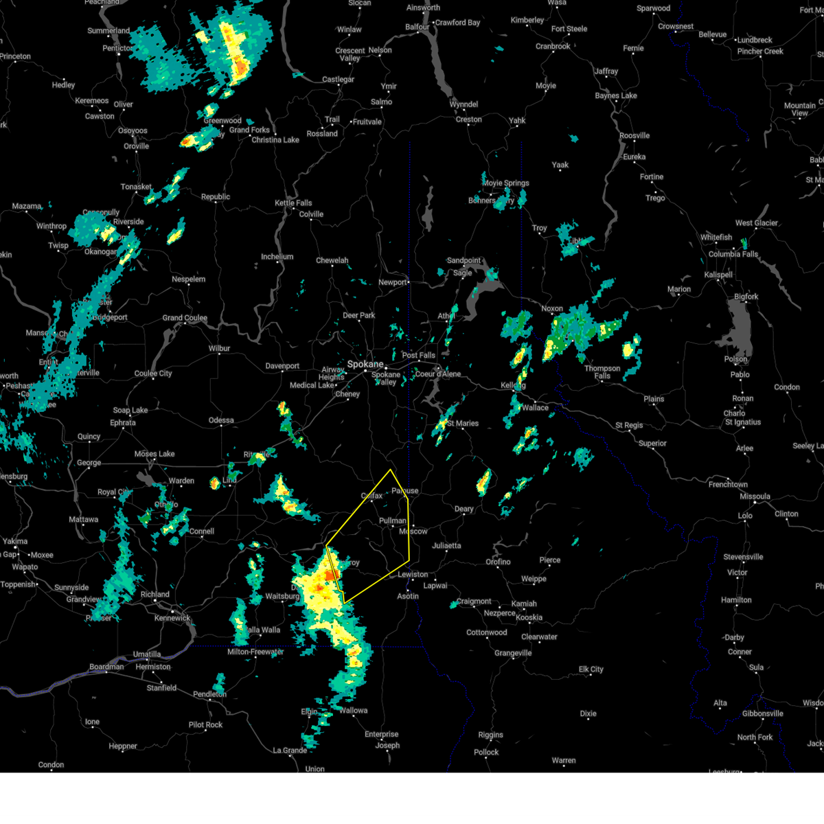
Hail Map for Pomeroy, WA
The Pomeroy, WA area has had 4 reports of on-the-ground hail by trained spotters, and has been under severe weather warnings 1 time during the past 12 months. Doppler radar has detected hail at or near Pomeroy, WA on 6 occasions.
| Name: | Pomeroy, WA |
| Where Located: | 45.1 miles NE of Walla Walla, WA |
| Map: | Google Map for Pomeroy, WA |
| Population: | 1425 |
| Housing Units: | 723 |
| More Info: | Search Google for Pomeroy, WA |
5
The Top Recent Hail Date for Pomeroy, WA is Wednesday, July 23, 2014 (1st out of 6)

Hail and Wind Damage Spotted near Pomeroy, WA
| Date / Time | Report Details |
|---|---|
| 9/25/2024 3:41 PM PDT |
 Svrotx the national weather service in spokane has issued a * severe thunderstorm warning for, garfield county in southeastern washington, southeastern whitman county in eastern washington, northwestern asotin county in southeastern washington, * until 445 pm pdt. * at 340 pm pdt, a severe thunderstorm was located near pomeroy, or 23 miles west of clarkston, moving northeast at 40 mph (radar indicated). Hazards include 60 mph wind gusts and penny size hail. expect damage to roofs, siding, and trees Svrotx the national weather service in spokane has issued a * severe thunderstorm warning for, garfield county in southeastern washington, southeastern whitman county in eastern washington, northwestern asotin county in southeastern washington, * until 445 pm pdt. * at 340 pm pdt, a severe thunderstorm was located near pomeroy, or 23 miles west of clarkston, moving northeast at 40 mph (radar indicated). Hazards include 60 mph wind gusts and penny size hail. expect damage to roofs, siding, and trees
|
| 6/15/2021 8:39 AM PDT | Quarter sized hail reported 5.8 miles NE of Pomeroy, WA |
| 6/15/2021 8:28 AM PDT | Quarter sized hail reported 0.4 miles SSW of Pomeroy, WA |
| 5/30/2020 6:14 PM PDT |
 At 613 pm pdt, severe thunderstorms were located along a line extending from 16 miles south of ritzville to near pomeroy, moving northeast at 50 mph (radar indicated). Hazards include 70 mph wind gusts and quarter size hail. Expect considerable tree damage. wind damage is also likely to mobile homes, roofs, and outbuildings. Isolated large hail is also expected. At 613 pm pdt, severe thunderstorms were located along a line extending from 16 miles south of ritzville to near pomeroy, moving northeast at 50 mph (radar indicated). Hazards include 70 mph wind gusts and quarter size hail. Expect considerable tree damage. wind damage is also likely to mobile homes, roofs, and outbuildings. Isolated large hail is also expected.
|
| 5/30/2020 5:36 PM PDT |
 At 533 pm pdt, a severe thunderstorm was located near kahlotus, or 17 miles east of connell, moving northeast at 50 mph (radar indicated). Hazards include golf ball size hail and 70 mph wind gusts. Expect considerable tree damage. wind damage is also likely to mobile homes, roofs, and outbuildings. Isolated large hail is expected which may cause damage to roofs, siding, windows, and vehicles. At 533 pm pdt, a severe thunderstorm was located near kahlotus, or 17 miles east of connell, moving northeast at 50 mph (radar indicated). Hazards include golf ball size hail and 70 mph wind gusts. Expect considerable tree damage. wind damage is also likely to mobile homes, roofs, and outbuildings. Isolated large hail is expected which may cause damage to roofs, siding, windows, and vehicles.
|
| 5/17/2020 1:52 PM PDT |
 At 151 pm pdt, a severe thunderstorm was located near pomeroy, or 21 miles southwest of pullman, moving northeast at 35 mph (radar indicated). Hazards include 60 mph wind gusts and quarter size hail. Hail damage to vehicles is expected. Expect wind damage to roofs, siding, and trees. At 151 pm pdt, a severe thunderstorm was located near pomeroy, or 21 miles southwest of pullman, moving northeast at 35 mph (radar indicated). Hazards include 60 mph wind gusts and quarter size hail. Hail damage to vehicles is expected. Expect wind damage to roofs, siding, and trees.
|
| 8/11/2019 3:36 PM PDT | Tree limbs blown down into powerlines at rv par in garfield county WA, 1.1 miles WNW of Pomeroy, WA |
| 8/10/2019 4:11 PM PDT |
 At 410 pm pdt, a severe thunderstorm was located over pomeroy, or 21 miles northeast of dayton, moving north at 10 mph (radar indicated). Hazards include quarter size hail. damage to vehicles is expected At 410 pm pdt, a severe thunderstorm was located over pomeroy, or 21 miles northeast of dayton, moving north at 10 mph (radar indicated). Hazards include quarter size hail. damage to vehicles is expected
|
| 8/10/2015 6:10 PM PDT | Alder ridge raws measured a 65 mph wind gust during the previous hou in garfield county WA, 15 miles NNW of Pomeroy, WA |
| 5/31/2015 10:33 PM PDT | At 1026 pm pdt, doppler radar indicated a line of severe thunderstorms capable of producing damaging winds around 55 mph. these storms were located along a line extending from 7 miles east of pomeroy to 6 miles west of clarkston heights-vineland to 16 miles south of west clarkston-highland, and moving northeast at 30 mph. penny size hail may also accompany the strong winds. |
| 5/31/2015 10:33 PM PDT | At 1026 pm pdt, doppler radar indicated a line of severe thunderstorms capable of producing damaging winds around 55 mph. these storms were located along a line extending from 7 miles east of pomeroy to 6 miles west of clarkston heights-vineland to 16 miles south of west clarkston-highland, and moving northeast at 30 mph. penny size hail may also accompany the strong winds. |
| 5/31/2015 10:24 PM PDT | At 1019 pm pdt, doppler radar indicated a line of severe thunderstorms capable of producing hail to around dime size, and winds up to 60 mph. these storms were located along a line extending from 11 miles south of pullman to near genesee to 8 miles south of lewiston, moving east at 30 mph. this warning will likely be extended beyond 1030 pm pdt. lewiston is still in the direct patch of this storm. locations impacted include, lewiston, clarkston, pomeroy, west clarkston-highland, clarkston heights-vineland, asotin, colton, uniontown, cloverland, wickiup campground, jerry, clarkston heights and peola. |
| 5/31/2015 10:24 PM PDT | At 1019 pm pdt, doppler radar indicated a line of severe thunderstorms capable of producing hail to around dime size, and winds up to 60 mph. these storms were located along a line extending from 11 miles south of pullman to near genesee to 8 miles south of lewiston, moving east at 30 mph. this warning will likely be extended beyond 1030 pm pdt. lewiston is still in the direct patch of this storm. locations impacted include, lewiston, clarkston, pomeroy, west clarkston-highland, clarkston heights-vineland, asotin, colton, uniontown, cloverland, wickiup campground, jerry, clarkston heights and peola. |
| 5/31/2015 9:33 PM PDT | At 932 pm pdt, doppler radar indicated a line of severe thunderstorms capable of producing quarter size hail and damaging winds in excess of 60 mph. these storms were located along a line extending from near pomeroy to 15 miles west of clarkston heights-vineland to 14 miles north of troy, and moving northeast at 40 mph. |
| 5/31/2015 9:33 PM PDT | At 932 pm pdt, doppler radar indicated a line of severe thunderstorms capable of producing quarter size hail and damaging winds in excess of 60 mph. these storms were located along a line extending from near pomeroy to 15 miles west of clarkston heights-vineland to 14 miles north of troy, and moving northeast at 40 mph. |
| 5/31/2015 9:15 PM PDT | At 910 pm pdt, doppler radar showed the line of strong thunderstorm winds crossing into garfield county. these storms are still capable of producing damaging winds in excess of 60 mph. these storms were located along a line extending from near delaney to 6 miles south of pomeroy to 10 miles northwest of troy, moving northeast at 40 mph. nickel size hail also will accompany the damaging winds. locations impacted include, pomeroy, misery spring campground, dodge, alder thicket campground, wickiup campground, spruce spring campground, .peola, and highway 12. those attending outdoor events that are in the path of these storms should prepare for imminent dangerous weather conditions. seek shelter now. |
| 5/31/2015 8:54 PM PDT | At 849 pm pdt, doppler radar indicated a line of severe thunderstorms capable of producing damaging winds in excess of 60 mph. these storms were located along a line extending from 13 miles southwest of delaney to 10 miles southeast of dayton to 10 miles southeast of ski bluewood, and moving northeast at 40 mph. nickel size hail may also accompany the damaging winds. |
| 7/23/2014 2:45 PM PDT | Ping Pong Ball sized hail reported 1.5 miles NW of Pomeroy, WA, emergency manager reported hail up to ping pong size just south of pomeroy |
| 7/20/2012 2:30 PM PDT | Ping Pong Ball sized hail reported 32.3 miles N of Pomeroy, WA, at camp wooten state park slightly smaller than golf ball sized hail was reported with heavy rain. the largest hail stones ranged from quarter sized to ping pong ball s |
Hail Maps for Pomeroy, WA


Connect with Interactive Hail Maps