

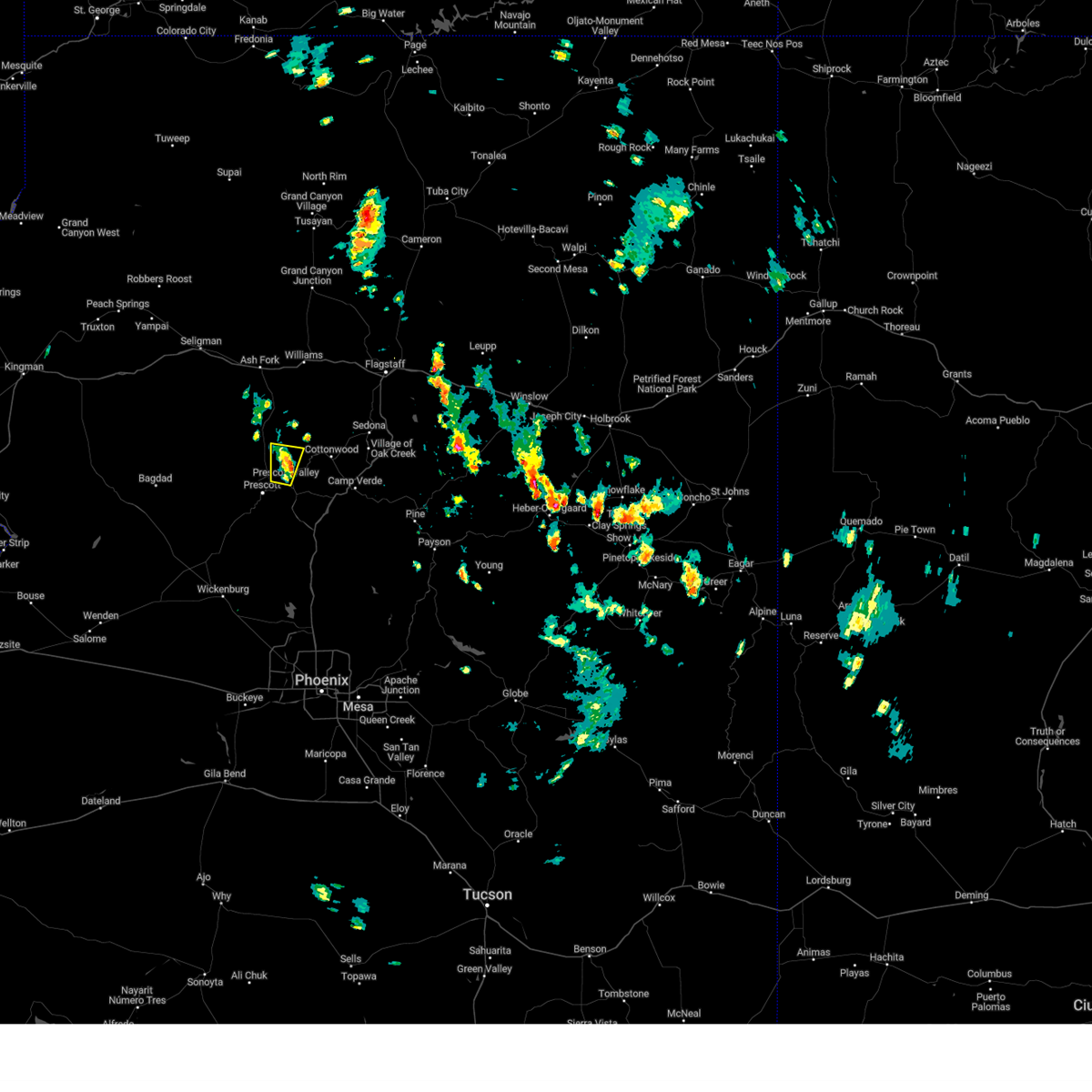
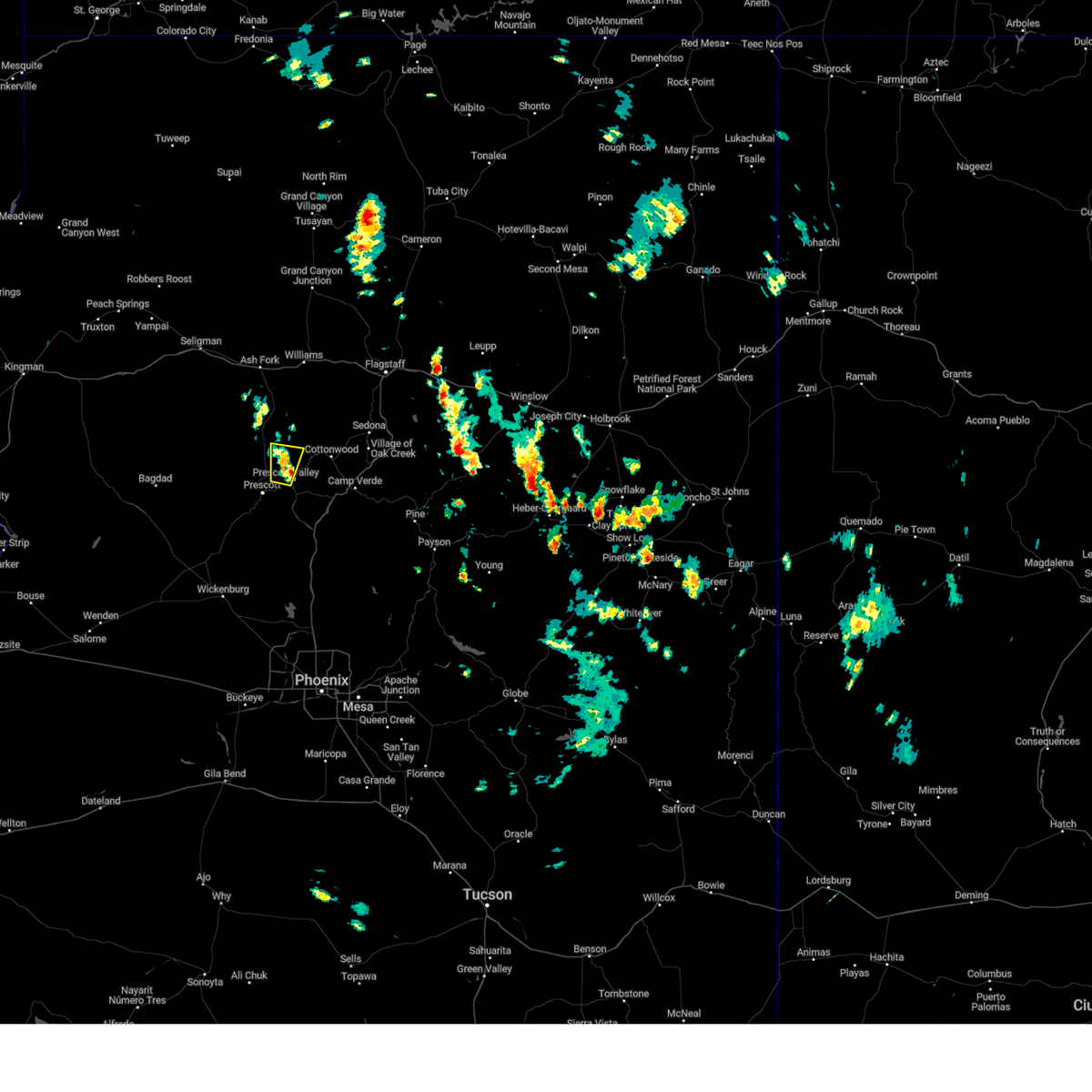
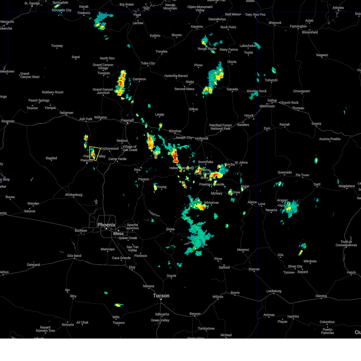
Hail Map for Prescott, AZ
The Prescott, AZ area has had 21 reports of on-the-ground hail by trained spotters, and has been under severe weather warnings 11 times during the past 12 months. Doppler radar has detected hail at or near Prescott, AZ on 63 occasions, including 8 occasions during the past year.
| Name: | Prescott, AZ |
| Where Located: | 63.1 miles SW of Flagstaff, AZ |
| Map: | Google Map for Prescott, AZ |
| Population: | 39843 |
| Housing Units: | 22159 |
| More Info: | Search Google for Prescott, AZ |
3
The Top Recent Hail Date for Prescott, AZ is Wednesday, July 10, 2024 (3rd out of 63)

Hail and Wind Damage Spotted near Prescott, AZ
| Date / Time | Report Details |
|---|---|
| 8/12/2024 1:12 PM MST |
 The storm which prompted the warning has weakened below severe limits, and no longer poses an immediate threat to life or property. therefore, the warning will be allowed to expire. however, small hail and gusty winds are still possible with this thunderstorm. The storm which prompted the warning has weakened below severe limits, and no longer poses an immediate threat to life or property. therefore, the warning will be allowed to expire. however, small hail and gusty winds are still possible with this thunderstorm.
|
| 8/12/2024 1:07 PM MST |
 At 106 pm mst, a severe thunderstorm was located near yavapai county fairgrounds, or near prescott valley, moving north at 5 mph (public). Hazards include quarter size hail. Damage to vehicles is expected. locations impacted include, yavapai county fairgrounds, prescott valley, mountainview park, prescott regional airport, chino valley, and prescott. This includes state route 89a between mile markers 319 and 329. At 106 pm mst, a severe thunderstorm was located near yavapai county fairgrounds, or near prescott valley, moving north at 5 mph (public). Hazards include quarter size hail. Damage to vehicles is expected. locations impacted include, yavapai county fairgrounds, prescott valley, mountainview park, prescott regional airport, chino valley, and prescott. This includes state route 89a between mile markers 319 and 329.
|
| 8/12/2024 12:46 PM MST |
 Svrfgz the national weather service in flagstaff has issued a * severe thunderstorm warning for, yavapai county in west central arizona, * until 115 pm mst. * at 1245 pm mst, a severe thunderstorm was located over yavapai county fairgrounds, or near prescott valley, moving north at 5 mph (public). Hazards include quarter size hail. damage to vehicles is expected Svrfgz the national weather service in flagstaff has issued a * severe thunderstorm warning for, yavapai county in west central arizona, * until 115 pm mst. * at 1245 pm mst, a severe thunderstorm was located over yavapai county fairgrounds, or near prescott valley, moving north at 5 mph (public). Hazards include quarter size hail. damage to vehicles is expected
|
| 8/7/2024 5:40 PM MST | Microburst. thunderstorm wind gust measured at embry riddle aeronautical university. power outages in are in yavapai county AZ, 3.4 miles S of Prescott, AZ |
| 7/21/2024 2:19 PM MST | Corrects previous non-tstm wnd gst report from 1 ene prescott airport. asos station kprc prescott airpor in yavapai county AZ, 5.9 miles SSW of Prescott, AZ |
| 7/11/2024 3:14 PM MST |
 The severe thunderstorm over prescott has weakened below severe limits and no longer poses an immediate threat to life or property. therefore, the warning will be allowed to expire. however, small hail, heavy rain and minor street flooding are still possible with this thunderstorm. The severe thunderstorm over prescott has weakened below severe limits and no longer poses an immediate threat to life or property. therefore, the warning will be allowed to expire. however, small hail, heavy rain and minor street flooding are still possible with this thunderstorm.
|
| 7/11/2024 2:52 PM MST |
 At 251 pm mst, a severe thunderstorm was located over the greater prescott area and was moving southwest at 10 to 15 mph (radar indicated). Hazards include 60 mph wind gusts and quarter size hail. Hail damage to vehicles is expected. expect wind damage to roofs, siding, and trees. locations impacted include, quartz mountain, thumbe butte, rancho vista estates, willow creek reservoir, poland junction, prescott gateway mall, iron springs, embry-riddle aeronautical university, acker park, prescott valley, goldwater lake park, wildwood estates, fain lake, alto pit ohv, courthouse plaza, wilhoit, prescott regional airport, goldwater lake, lynx lake, and potato patch. this includes the following highways, state route 89 between mile markers 293 and 322. state route 89a between mile markers 318 and 325. State route 69 between mile markers 275 and 276, and between mile markers 286 and 296. At 251 pm mst, a severe thunderstorm was located over the greater prescott area and was moving southwest at 10 to 15 mph (radar indicated). Hazards include 60 mph wind gusts and quarter size hail. Hail damage to vehicles is expected. expect wind damage to roofs, siding, and trees. locations impacted include, quartz mountain, thumbe butte, rancho vista estates, willow creek reservoir, poland junction, prescott gateway mall, iron springs, embry-riddle aeronautical university, acker park, prescott valley, goldwater lake park, wildwood estates, fain lake, alto pit ohv, courthouse plaza, wilhoit, prescott regional airport, goldwater lake, lynx lake, and potato patch. this includes the following highways, state route 89 between mile markers 293 and 322. state route 89a between mile markers 318 and 325. State route 69 between mile markers 275 and 276, and between mile markers 286 and 296.
|
| 7/11/2024 2:50 PM MST | Quarter sized hail reported 2 miles S of Prescott, AZ |
| 7/11/2024 2:34 PM MST |
 Svrfgz the national weather service in flagstaff has issued a * severe thunderstorm warning for, yavapai county in west central arizona, * until 315 pm mst. * at 233 pm mst, a severe thunderstorm was located over central prescott, moving southwest at 10 to 15 mph (radar indicated). Hazards include 60 mph wind gusts and quarter size hail. Hail damage to vehicles is expected. Expect wind damage to roofs, siding, and trees. Svrfgz the national weather service in flagstaff has issued a * severe thunderstorm warning for, yavapai county in west central arizona, * until 315 pm mst. * at 233 pm mst, a severe thunderstorm was located over central prescott, moving southwest at 10 to 15 mph (radar indicated). Hazards include 60 mph wind gusts and quarter size hail. Hail damage to vehicles is expected. Expect wind damage to roofs, siding, and trees.
|
| 7/10/2024 3:44 PM MST |
 The storm which prompted the warning has weakened below severe limits, and no longer poses an immediate threat to life or property. therefore, the warning will be allowed to expire. however, small hail, gusty winds up to 50 mph and heavy rain are still possible with this thunderstorm. The storm which prompted the warning has weakened below severe limits, and no longer poses an immediate threat to life or property. therefore, the warning will be allowed to expire. however, small hail, gusty winds up to 50 mph and heavy rain are still possible with this thunderstorm.
|
| 7/10/2024 3:35 PM MST |
 At 335 pm mst, a severe thunderstorm was located over lynx lake, or near prescott, moving southeast at 15 mph (radar indicated). Hazards include 60 mph wind gusts and penny size hail. Expect damage to roofs, siding, and trees. locations impacted include, quartz mountain, thumbe butte, rancho vista estates, willow creek reservoir, poland junction, prescott gateway mall, iron springs, embry-riddle aeronautical university, acker park, prescott valley, goldwater lake park, wildwood estates, fain lake, alto pit ohv, courthouse plaza, prescott regional airport, goldwater lake, lynx lake, potato patch, and palace station. this includes the following highways, state route 89 between mile markers 302 and 326. state route 89a between mile markers 318 and 325. State route 69 between mile markers 275 and 296. At 335 pm mst, a severe thunderstorm was located over lynx lake, or near prescott, moving southeast at 15 mph (radar indicated). Hazards include 60 mph wind gusts and penny size hail. Expect damage to roofs, siding, and trees. locations impacted include, quartz mountain, thumbe butte, rancho vista estates, willow creek reservoir, poland junction, prescott gateway mall, iron springs, embry-riddle aeronautical university, acker park, prescott valley, goldwater lake park, wildwood estates, fain lake, alto pit ohv, courthouse plaza, prescott regional airport, goldwater lake, lynx lake, potato patch, and palace station. this includes the following highways, state route 89 between mile markers 302 and 326. state route 89a between mile markers 318 and 325. State route 69 between mile markers 275 and 296.
|
| 7/10/2024 3:25 PM MST |
 The storm near wilhoit which prompted the warning has weakened below severe limits, and no longer poses an immediate threat to life or property. therefore, the warning will be allowed to expire. however, small hail, gusty winds and heavy rain are still possible with this thunderstorm. remember, a severe thunderstorm warning still remains in effect for the prescott area from prescott to dewey-humboldt to walker. The storm near wilhoit which prompted the warning has weakened below severe limits, and no longer poses an immediate threat to life or property. therefore, the warning will be allowed to expire. however, small hail, gusty winds and heavy rain are still possible with this thunderstorm. remember, a severe thunderstorm warning still remains in effect for the prescott area from prescott to dewey-humboldt to walker.
|
| 7/10/2024 3:24 PM MST | Quarter sized hail reported 2.7 miles S of Prescott, AZ |
| 7/10/2024 3:21 PM MST | Svrfgz the national weather service in flagstaff has issued a * severe thunderstorm warning for, yavapai county in west central arizona, * until 345 pm mst. * at 320 pm mst, a severe thunderstorm was located over embry-riddle aeronautical university, or near prescott, moving southeast at 15 mph (radar indicated). Hazards include 60 mph wind gusts and penny size hail. expect damage to roofs, siding, and trees |
| 7/10/2024 3:07 PM MST |
 Svrfgz the national weather service in flagstaff has issued a * severe thunderstorm warning for, yavapai county in west central arizona, * until 330 pm mst. * at 307 pm mst, a severe thunderstorm was located over copper basin, or near prescott, moving southeast at 15 mph (radar indicated). Hazards include 60 mph wind gusts and penny size hail. expect damage to roofs, siding, and trees Svrfgz the national weather service in flagstaff has issued a * severe thunderstorm warning for, yavapai county in west central arizona, * until 330 pm mst. * at 307 pm mst, a severe thunderstorm was located over copper basin, or near prescott, moving southeast at 15 mph (radar indicated). Hazards include 60 mph wind gusts and penny size hail. expect damage to roofs, siding, and trees
|
| 7/31/2023 3:00 PM MST | Quarter sized hail reported 1.5 miles NNE of Prescott, AZ, spotter showed an photo of a mixture of dime... nickel and quarter sized hail. |
| 7/31/2023 2:52 PM MST |
 At 251 pm mst, a severe thunderstorm was located over prescott, moving northeast at 15 mph (radar indicated). Hazards include 60 mph wind gusts and quarter size hail. Hail damage to vehicles is expected. Expect wind damage to roofs, siding, and trees. At 251 pm mst, a severe thunderstorm was located over prescott, moving northeast at 15 mph (radar indicated). Hazards include 60 mph wind gusts and quarter size hail. Hail damage to vehicles is expected. Expect wind damage to roofs, siding, and trees.
|
| 7/28/2023 12:09 PM MST | Quarter sized hail reported 3.8 miles WNW of Prescott, AZ, hail around an inch reported near costco. |
| 7/28/2023 11:33 AM MST | Quarter sized hail reported 4.1 miles W of Prescott, AZ, quarter sized hail reported in yavapai hills area. |
| 7/28/2023 11:30 AM MST |
 At 1130 am mst, a severe thunderstorm was located near prescott valley, moving north at 10 mph (radar indicated). Hazards include 60 mph wind gusts and quarter size hail. Hail damage to vehicles is expected. Expect wind damage to roofs, siding, and trees. At 1130 am mst, a severe thunderstorm was located near prescott valley, moving north at 10 mph (radar indicated). Hazards include 60 mph wind gusts and quarter size hail. Hail damage to vehicles is expected. Expect wind damage to roofs, siding, and trees.
|
| 7/28/2023 10:50 AM MST |
 At 1049 am mst, a severe thunderstorm was located near yavapai campground, or near prescott, moving northeast at 5 mph (radar indicated). Hazards include 60 mph wind gusts and quarter size hail. Hail damage to vehicles is expected. Expect wind damage to roofs, siding, and trees. At 1049 am mst, a severe thunderstorm was located near yavapai campground, or near prescott, moving northeast at 5 mph (radar indicated). Hazards include 60 mph wind gusts and quarter size hail. Hail damage to vehicles is expected. Expect wind damage to roofs, siding, and trees.
|
| 7/22/2023 6:59 PM MST | Wunderground station kazpresc1037 clocked wind gust of 64 mp in yavapai county AZ, 0.5 miles E of Prescott, AZ |
| 7/22/2023 6:35 PM MST |
 At 634 pm mst, a severe thunderstorm was located over prescott gateway mall, or near prescott valley, moving west at 10 mph (radar indicated). Hazards include 60 mph wind gusts and penny size hail. Expect damage to roofs, siding, and trees. locations impacted include, prescott valley, prescott, yavapai campground, prescott airport, prescott gateway mall, iron springs, and prescott valley event center. this includes the following highways, state route 89 between mile markers 312 and 324. state route 89a between mile markers 318 and 325. state route 69 between mile markers 286 and 296. hail threat, radar indicated max hail size, 0. 75 in wind threat, radar indicated max wind gust, 60 mph. At 634 pm mst, a severe thunderstorm was located over prescott gateway mall, or near prescott valley, moving west at 10 mph (radar indicated). Hazards include 60 mph wind gusts and penny size hail. Expect damage to roofs, siding, and trees. locations impacted include, prescott valley, prescott, yavapai campground, prescott airport, prescott gateway mall, iron springs, and prescott valley event center. this includes the following highways, state route 89 between mile markers 312 and 324. state route 89a between mile markers 318 and 325. state route 69 between mile markers 286 and 296. hail threat, radar indicated max hail size, 0. 75 in wind threat, radar indicated max wind gust, 60 mph.
|
| 7/22/2023 6:24 PM MST |
 At 624 pm mst, a severe thunderstorm was located over prescott valley, moving west at 10 mph (radar indicated). Hazards include 60 mph wind gusts and penny size hail. Expect damage to roofs, siding, and trees. locations impacted include, chino valley, prescott valley, prescott, yavapai county fairgrounds, yavapai campground, prescott airport, prescott gateway mall, iron springs, and prescott valley event center. this includes the following highways, state route 89 between mile markers 312 and 330. state route 89a between mile markers 318 and 328. state route 69 between mile markers 286 and 296. hail threat, radar indicated max hail size, 0. 75 in wind threat, radar indicated max wind gust, 60 mph. At 624 pm mst, a severe thunderstorm was located over prescott valley, moving west at 10 mph (radar indicated). Hazards include 60 mph wind gusts and penny size hail. Expect damage to roofs, siding, and trees. locations impacted include, chino valley, prescott valley, prescott, yavapai county fairgrounds, yavapai campground, prescott airport, prescott gateway mall, iron springs, and prescott valley event center. this includes the following highways, state route 89 between mile markers 312 and 330. state route 89a between mile markers 318 and 328. state route 69 between mile markers 286 and 296. hail threat, radar indicated max hail size, 0. 75 in wind threat, radar indicated max wind gust, 60 mph.
|
| 7/22/2023 6:12 PM MST |
 At 611 pm mst, a severe thunderstorm was located over prescott valley, moving northwest at 10 mph (radar indicated). Hazards include 60 mph wind gusts and penny size hail. expect damage to roofs, siding, and trees At 611 pm mst, a severe thunderstorm was located over prescott valley, moving northwest at 10 mph (radar indicated). Hazards include 60 mph wind gusts and penny size hail. expect damage to roofs, siding, and trees
|
| 5/17/2023 2:45 PM MST | Ping Pong Ball sized hail reported 5.4 miles NW of Prescott, AZ |
| 10/3/2022 2:39 PM MST |
 The severe thunderstorm warning for yavapai county will expire at 245 pm mst, the storm which prompted the warning has weakened below severe limits, and no longer poses an immediate threat to life or property. therefore, the warning will be allowed to expire. The severe thunderstorm warning for yavapai county will expire at 245 pm mst, the storm which prompted the warning has weakened below severe limits, and no longer poses an immediate threat to life or property. therefore, the warning will be allowed to expire.
|
| 10/3/2022 2:15 PM MST | Wind gusts of over 50 mph breaking branche in yavapai county AZ, 0.5 miles E of Prescott, AZ |
| 10/3/2022 2:07 PM MST | Tea Cup sized hail reported 3.1 miles NE of Prescott, AZ, 3/8 inch diameter hail and heavy rain. |
| 10/3/2022 2:05 PM MST | Asos station kprc prescott airpor in yavapai county AZ, 5.9 miles SSW of Prescott, AZ |
| 10/3/2022 2:02 PM MST |
 At 202 pm mst, a severe thunderstorm was located over prescott, moving east at 20 mph (radar indicated). Hazards include 60 mph wind gusts and quarter size hail. Hail damage to vehicles is expected. Expect wind damage to roofs, siding, and trees. At 202 pm mst, a severe thunderstorm was located over prescott, moving east at 20 mph (radar indicated). Hazards include 60 mph wind gusts and quarter size hail. Hail damage to vehicles is expected. Expect wind damage to roofs, siding, and trees.
|
| 8/23/2022 5:10 PM MST | Golf Ball sized hail reported 42.7 miles E of Prescott, AZ, social media report of golf ball size hail near bagdad. |
| 8/23/2022 3:15 PM MST | At 314 pm mst, a severe thunderstorm was located near iron springs, or 9 miles northwest of prescott, moving southwest at 10 mph (radar indicated). Hazards include 60 mph wind gusts and quarter size hail. Hail damage to vehicles is expected. Expect wind damage to roofs, siding, and trees. |
| 8/20/2022 5:54 PM MST |
 The severe thunderstorm warning for yavapai county will expire at 600 pm mst, the storm which prompted the warning has weakened below severe limits and no longer poses an immediate threat to life or property. therefore, the warning will be allowed to expire. however, additional strong thunderstorms have formed in the area, producing heavy rain and small hail. please continue to practice caution near thunderstorms. when thunder roars, go indoors. The severe thunderstorm warning for yavapai county will expire at 600 pm mst, the storm which prompted the warning has weakened below severe limits and no longer poses an immediate threat to life or property. therefore, the warning will be allowed to expire. however, additional strong thunderstorms have formed in the area, producing heavy rain and small hail. please continue to practice caution near thunderstorms. when thunder roars, go indoors.
|
| 8/20/2022 5:41 PM MST |
 At 535 pm mst, a severe thunderstorm was located over iron springs and has now moved east-southeast. the thunderstorm is showing signs of weakening. additional strong thunderstorms continue to impact areas southwest and west of prescott (radar indicated). Hazards include up to quarter size hail, up to 40 mph winds, and heavy rainfall. Damage to vehicles is expected. locations impacted include, prescott, yavapai campground, downtown prescott, ponderosa park, indian hill west prescott, iron springs and white spar campground. hail threat, radar indicated max hail size, 1. 00 in wind threat, radar indicated max wind gust, <50 mph. At 535 pm mst, a severe thunderstorm was located over iron springs and has now moved east-southeast. the thunderstorm is showing signs of weakening. additional strong thunderstorms continue to impact areas southwest and west of prescott (radar indicated). Hazards include up to quarter size hail, up to 40 mph winds, and heavy rainfall. Damage to vehicles is expected. locations impacted include, prescott, yavapai campground, downtown prescott, ponderosa park, indian hill west prescott, iron springs and white spar campground. hail threat, radar indicated max hail size, 1. 00 in wind threat, radar indicated max wind gust, <50 mph.
|
| 8/20/2022 5:17 PM MST |
 At 516 pm mst, a severe thunderstorm was located over iron springs, or west of prescott, moving east at 5 to 10 mph (radar indicated). Hazards include quarter size hail, winds up to 45 mph, and heavy rainfall. damage to vehicles is expected At 516 pm mst, a severe thunderstorm was located over iron springs, or west of prescott, moving east at 5 to 10 mph (radar indicated). Hazards include quarter size hail, winds up to 45 mph, and heavy rainfall. damage to vehicles is expected
|
| 8/8/2022 5:13 PM MST |
 At 512 pm mst, a severe thunderstorm was located near prescott, moving south at 10 mph (radar indicated). Hazards include 60 mph wind gusts, half inch to penny size hail, and heavy rainfall. Expect damage to roofs, siding, and trees. locations impacted include, prescott valley, prescott, groom creek subdivision, prescott airport, walker, prescott gateway mall, yavapai campground, downtown prescott, ponderosa park, indian hill west prescott, oak knoll village, lynx lake dam, prescott valley event center and white spar campground. hail threat, radar indicated max hail size, 0. 75 in wind threat, radar indicated max wind gust, 60 mph. At 512 pm mst, a severe thunderstorm was located near prescott, moving south at 10 mph (radar indicated). Hazards include 60 mph wind gusts, half inch to penny size hail, and heavy rainfall. Expect damage to roofs, siding, and trees. locations impacted include, prescott valley, prescott, groom creek subdivision, prescott airport, walker, prescott gateway mall, yavapai campground, downtown prescott, ponderosa park, indian hill west prescott, oak knoll village, lynx lake dam, prescott valley event center and white spar campground. hail threat, radar indicated max hail size, 0. 75 in wind threat, radar indicated max wind gust, 60 mph.
|
| 8/8/2022 5:10 PM MST |
 The severe thunderstorm warning for yavapai county will expire at 515 pm mst, the storm which prompted the warning near chino valley has moved out of the area and towards prescott. therefore, this warning will be allowed to expire. however gusty winds and heavy rain are still possible with this thunderstorm. The severe thunderstorm warning for yavapai county will expire at 515 pm mst, the storm which prompted the warning near chino valley has moved out of the area and towards prescott. therefore, this warning will be allowed to expire. however gusty winds and heavy rain are still possible with this thunderstorm.
|
| 8/8/2022 5:02 PM MST |
 At 501 pm mst, a severe thunderstorm was located over prescott airport, or near prescott, moving south at 10 mph (radar indicated). Hazards include 60 mph wind gusts, quarter size hail, and heavy rainfall. Hail damage to vehicles is expected. Expect wind damage to roofs, siding, and trees. At 501 pm mst, a severe thunderstorm was located over prescott airport, or near prescott, moving south at 10 mph (radar indicated). Hazards include 60 mph wind gusts, quarter size hail, and heavy rainfall. Hail damage to vehicles is expected. Expect wind damage to roofs, siding, and trees.
|
| 8/8/2022 4:54 PM MST |
 At 453 pm mst, a severe thunderstorm was located over prescott airport, or near chino valley, moving southwest at 10 mph (radar indicated). Hazards include 60 mph wind gusts, penny size hail, and heavy rainfall. Expect damage to roofs, siding, and trees. locations impacted include, chino valley, prescott valley, prescott airport and williamson valley. hail threat, radar indicated max hail size, 0. 75 in wind threat, radar indicated max wind gust, 60 mph. At 453 pm mst, a severe thunderstorm was located over prescott airport, or near chino valley, moving southwest at 10 mph (radar indicated). Hazards include 60 mph wind gusts, penny size hail, and heavy rainfall. Expect damage to roofs, siding, and trees. locations impacted include, chino valley, prescott valley, prescott airport and williamson valley. hail threat, radar indicated max hail size, 0. 75 in wind threat, radar indicated max wind gust, 60 mph.
|
| 8/8/2022 4:30 PM MST |
 At 430 pm mst, a severe thunderstorm was located near prescott airport, or near chino valley, moving southwest at 10 mph (radar indicated). Hazards include 60 mph wind gusts and quarter size hail. Hail damage to vehicles is expected. Expect wind damage to roofs, siding, and trees. At 430 pm mst, a severe thunderstorm was located near prescott airport, or near chino valley, moving southwest at 10 mph (radar indicated). Hazards include 60 mph wind gusts and quarter size hail. Hail damage to vehicles is expected. Expect wind damage to roofs, siding, and trees.
|
| 6/28/2022 5:47 PM MST |
 At 546 pm mst, a severe thunderstorm was located over prescott valley, moving south at 10 mph (radar indicated). Hazards include quarter size hail. damage to vehicles is expected At 546 pm mst, a severe thunderstorm was located over prescott valley, moving south at 10 mph (radar indicated). Hazards include quarter size hail. damage to vehicles is expected
|
| 6/28/2022 5:45 PM MST | Quarter sized hail reported 3.8 miles WNW of Prescott, AZ, public reports quarter sized hail. report via twitter. |
| 6/28/2022 5:26 PM MST |
 At 524 pm mst, a severe thunderstorm was located over downtown prescott, or near prescott valley, moving south at 5 mph (radar indicated). Hazards include 60 mph wind gusts and quarter size hail. Hail damage to vehicles is expected. expect wind damage to roofs, siding, and trees. locations impacted include, prescott, yavapai campground, downtown prescott, ponderosa park, groom creek subdivision, indian hill west prescott, oak knoll village, prescott gateway mall, lower wolf creek campground, upper wolf creek group campground and white spar campground. hail threat, radar indicated max hail size, 1. 00 in wind threat, radar indicated max wind gust, 60 mph. At 524 pm mst, a severe thunderstorm was located over downtown prescott, or near prescott valley, moving south at 5 mph (radar indicated). Hazards include 60 mph wind gusts and quarter size hail. Hail damage to vehicles is expected. expect wind damage to roofs, siding, and trees. locations impacted include, prescott, yavapai campground, downtown prescott, ponderosa park, groom creek subdivision, indian hill west prescott, oak knoll village, prescott gateway mall, lower wolf creek campground, upper wolf creek group campground and white spar campground. hail threat, radar indicated max hail size, 1. 00 in wind threat, radar indicated max wind gust, 60 mph.
|
| 6/28/2022 5:11 PM MST |
 At 511 pm mst, a severe thunderstorm was located over downtown prescott, moving south at 5 mph (radar indicated). Hazards include 60 mph wind gusts and quarter size hail. Hail damage to vehicles is expected. Expect wind damage to roofs, siding, and trees. At 511 pm mst, a severe thunderstorm was located over downtown prescott, moving south at 5 mph (radar indicated). Hazards include 60 mph wind gusts and quarter size hail. Hail damage to vehicles is expected. Expect wind damage to roofs, siding, and trees.
|
| 8/15/2021 11:44 PM MST |
 At 1143 pm mst, a severe thunderstorm was located near yavapai campground, or 10 miles southwest of chino valley, moving southwest at 30 mph (radar indicated). Hazards include 60 mph wind gusts and quarter size hail. Hail damage to vehicles is expected. expect wind damage to roofs, siding, and trees. locations impacted include, prescott, yavapai campground and williamson valley. hail threat, radar indicated max hail size, 1. 00 in wind threat, radar indicated max wind gust, 60 mph. At 1143 pm mst, a severe thunderstorm was located near yavapai campground, or 10 miles southwest of chino valley, moving southwest at 30 mph (radar indicated). Hazards include 60 mph wind gusts and quarter size hail. Hail damage to vehicles is expected. expect wind damage to roofs, siding, and trees. locations impacted include, prescott, yavapai campground and williamson valley. hail threat, radar indicated max hail size, 1. 00 in wind threat, radar indicated max wind gust, 60 mph.
|
| 8/15/2021 11:27 PM MST |
 At 1127 pm mst, a severe thunderstorm was located over chino valley, moving southwest at 30 mph (radar indicated). Hazards include 60 mph wind gusts and quarter size hail. Hail damage to vehicles is expected. Expect wind damage to roofs, siding, and trees. At 1127 pm mst, a severe thunderstorm was located over chino valley, moving southwest at 30 mph (radar indicated). Hazards include 60 mph wind gusts and quarter size hail. Hail damage to vehicles is expected. Expect wind damage to roofs, siding, and trees.
|
| 8/10/2021 3:09 PM MST |
 The severe thunderstorm warning near prescott in yavapai county will expire at 315 pm mst, the storm which prompted the warning has weakened below severe limits, and no longer poses an immediate threat to life or property. therefore, the warning will be allowed to expire. however heavy rain is still possible with this thunderstorm. The severe thunderstorm warning near prescott in yavapai county will expire at 315 pm mst, the storm which prompted the warning has weakened below severe limits, and no longer poses an immediate threat to life or property. therefore, the warning will be allowed to expire. however heavy rain is still possible with this thunderstorm.
|
| 8/10/2021 3:01 PM MST |
 At 301 pm mst, a severe thunderstorm was located over downtown prescott, or near prescott valley, and is nearly stationary (radar indicated). Hazards include 60 mph wind gusts and quarter size hail. Hail damage to vehicles is expected. expect wind damage to roofs, siding, and trees. locations impacted include, prescott valley, prescott, groom creek subdivision, walker, iron springs, yavapai campground, ponderosa park, indian hill west prescott, oak knoll village, lower wolf creek campground, lynx lake dam, upper wolf creek group campground and white spar campground. hail threat, radar indicated max hail size, 1. 00 in wind threat, radar indicated max wind gust, 60 mph. At 301 pm mst, a severe thunderstorm was located over downtown prescott, or near prescott valley, and is nearly stationary (radar indicated). Hazards include 60 mph wind gusts and quarter size hail. Hail damage to vehicles is expected. expect wind damage to roofs, siding, and trees. locations impacted include, prescott valley, prescott, groom creek subdivision, walker, iron springs, yavapai campground, ponderosa park, indian hill west prescott, oak knoll village, lower wolf creek campground, lynx lake dam, upper wolf creek group campground and white spar campground. hail threat, radar indicated max hail size, 1. 00 in wind threat, radar indicated max wind gust, 60 mph.
|
| 8/10/2021 2:35 PM MST |
 At 234 pm mst, a severe thunderstorm was located over indian hill west prescott, or near prescott valley, and is nearly stationary (radar indicated). Hazards include 60 mph wind gusts and quarter size hail. Hail damage to vehicles is expected. Expect wind damage to roofs, siding, and trees. At 234 pm mst, a severe thunderstorm was located over indian hill west prescott, or near prescott valley, and is nearly stationary (radar indicated). Hazards include 60 mph wind gusts and quarter size hail. Hail damage to vehicles is expected. Expect wind damage to roofs, siding, and trees.
|
| 7/23/2021 1:50 PM MST |
 At 149 pm mst, a severe thunderstorm was located near yavapai county fairgrounds, or near prescott valley, moving southeast at 20 mph (radar indicated). Hazards include 60 mph wind gusts and quarter size hail. Hail damage to vehicles is expected. expect wind damage to roofs, siding, and trees. Locations impacted include, prescott valley, yavapai county fairgrounds, prescott airport and prescott valley event center. At 149 pm mst, a severe thunderstorm was located near yavapai county fairgrounds, or near prescott valley, moving southeast at 20 mph (radar indicated). Hazards include 60 mph wind gusts and quarter size hail. Hail damage to vehicles is expected. expect wind damage to roofs, siding, and trees. Locations impacted include, prescott valley, yavapai county fairgrounds, prescott airport and prescott valley event center.
|
| 7/23/2021 1:31 PM MST |
 At 131 pm mst, a severe thunderstorm was located near chino valley, moving southeast at 25 mph (radar indicated). Hazards include 60 mph wind gusts and quarter size hail. Hail damage to vehicles is expected. Expect wind damage to roofs, siding, and trees. At 131 pm mst, a severe thunderstorm was located near chino valley, moving southeast at 25 mph (radar indicated). Hazards include 60 mph wind gusts and quarter size hail. Hail damage to vehicles is expected. Expect wind damage to roofs, siding, and trees.
|
| 7/18/2021 11:21 AM MST |
 At 1120 am mst, a severe thunderstorm was located near prescott and is nearly stationary (radar indicated). Hazards include 60 mph wind gusts and quarter size hail. Hail damage to vehicles is expected. expect wind damage to roofs, siding, and trees. Locations impacted include, chino valley, prescott valley, prescott, yavapai campground, downtown prescott, prescott airport, oak knoll village, prescott gateway mall, lynx lake dam and prescott valley event center. At 1120 am mst, a severe thunderstorm was located near prescott and is nearly stationary (radar indicated). Hazards include 60 mph wind gusts and quarter size hail. Hail damage to vehicles is expected. expect wind damage to roofs, siding, and trees. Locations impacted include, chino valley, prescott valley, prescott, yavapai campground, downtown prescott, prescott airport, oak knoll village, prescott gateway mall, lynx lake dam and prescott valley event center.
|
| 7/18/2021 10:58 AM MST |
 At 1058 am mst, a severe thunderstorm was located over prescott valley, and is nearly stationary (radar indicated). Hazards include 60 mph wind gusts and quarter size hail. Hail damage to vehicles is expected. Expect wind damage to roofs, siding, and trees. At 1058 am mst, a severe thunderstorm was located over prescott valley, and is nearly stationary (radar indicated). Hazards include 60 mph wind gusts and quarter size hail. Hail damage to vehicles is expected. Expect wind damage to roofs, siding, and trees.
|
| 7/11/2021 4:40 PM MST |
 At 440 pm mst, a severe thunderstorm was located over yavapai campground, or 8 miles northwest of prescott valley, moving west at 10 mph (trained weather spotters). Hazards include 70 mph wind gusts and quarter size hail. Hail damage to vehicles is expected. expect considerable tree damage. wind damage is also likely to mobile homes, roofs, and outbuildings. Locations impacted include, chino valley, prescott, yavapai campground, williamson valley and iron springs. At 440 pm mst, a severe thunderstorm was located over yavapai campground, or 8 miles northwest of prescott valley, moving west at 10 mph (trained weather spotters). Hazards include 70 mph wind gusts and quarter size hail. Hail damage to vehicles is expected. expect considerable tree damage. wind damage is also likely to mobile homes, roofs, and outbuildings. Locations impacted include, chino valley, prescott, yavapai campground, williamson valley and iron springs.
|
| 7/11/2021 4:30 PM MST | Law enforcement dispatch reported damage to the roof of an apartment complex in prescot in yavapai county AZ, 1.5 miles NNE of Prescott, AZ |
| 7/11/2021 4:25 PM MST |
 At 424 pm mst, a severe thunderstorm was located near prescott airport, or near prescott valley, moving west at 10 mph (trained spotters and automated observations). Hazards include 70 mph wind gusts and half dollar size hail. Hail damage to vehicles is expected. expect considerable tree damage. Wind damage is also likely to mobile homes, roofs, and outbuildings. At 424 pm mst, a severe thunderstorm was located near prescott airport, or near prescott valley, moving west at 10 mph (trained spotters and automated observations). Hazards include 70 mph wind gusts and half dollar size hail. Hail damage to vehicles is expected. expect considerable tree damage. Wind damage is also likely to mobile homes, roofs, and outbuildings.
|
| 7/11/2021 4:14 PM MST | Asos station kprc prescott airpor in yavapai county AZ, 5.9 miles SSW of Prescott, AZ |
| 7/11/2021 4:05 PM MST |
 At 404 pm mst, a severe thunderstorm was located over walker, or 9 miles south of prescott valley, moving southwest at 15 mph (trained weather spotters). Hazards include 60 mph wind gusts and half dollar size hail. Hail damage to vehicles is expected. expect wind damage to roofs, siding, and trees. Locations impacted include, prescott valley, prescott, downtown prescott, indian hill west prescott, oak knoll village, prescott gateway mall, prescott valley event center, white spar campground and lynx lake dam. At 404 pm mst, a severe thunderstorm was located over walker, or 9 miles south of prescott valley, moving southwest at 15 mph (trained weather spotters). Hazards include 60 mph wind gusts and half dollar size hail. Hail damage to vehicles is expected. expect wind damage to roofs, siding, and trees. Locations impacted include, prescott valley, prescott, downtown prescott, indian hill west prescott, oak knoll village, prescott gateway mall, prescott valley event center, white spar campground and lynx lake dam.
|
| 7/11/2021 4:04 PM MST | Half Dollar sized hail reported 4.1 miles W of Prescott, AZ, trained spotter y532 reports hail up to 1.25 inches in diameter. |
| 7/11/2021 4:02 PM MST |
 At 401 pm mst, a severe thunderstorm was located near yavapai campground, or near prescott valley, moving west at 10 mph (trained weather spotters). Hazards include 60 mph wind gusts and half dollar size hail. Hail damage to vehicles is expected. expect wind damage to roofs, siding, and trees. Locations impacted include, prescott, yavapai campground and prescott airport. At 401 pm mst, a severe thunderstorm was located near yavapai campground, or near prescott valley, moving west at 10 mph (trained weather spotters). Hazards include 60 mph wind gusts and half dollar size hail. Hail damage to vehicles is expected. expect wind damage to roofs, siding, and trees. Locations impacted include, prescott, yavapai campground and prescott airport.
|
| 7/11/2021 3:59 PM MST | Quarter sized hail reported 2 miles S of Prescott, AZ |
| 7/11/2021 3:58 PM MST |
 At 357 pm mst, a severe thunderstorm was located near ponderosa park, or 11 miles southwest of prescott valley, moving southwest at 55 mph (trained weather spotters). Hazards include 60 mph wind gusts and half dollar size hail. Hail damage to vehicles is expected. expect wind damage to roofs, siding, and trees. Locations impacted include, prescott valley, prescott, yavapai campground and prescott airport. At 357 pm mst, a severe thunderstorm was located near ponderosa park, or 11 miles southwest of prescott valley, moving southwest at 55 mph (trained weather spotters). Hazards include 60 mph wind gusts and half dollar size hail. Hail damage to vehicles is expected. expect wind damage to roofs, siding, and trees. Locations impacted include, prescott valley, prescott, yavapai campground and prescott airport.
|
| 7/11/2021 3:57 PM MST |
 At 356 pm mst, a severe thunderstorm was located over walker, or 8 miles south of prescott valley, moving southwest at 15 mph (trained weather spotters). Hazards include 60 mph wind gusts and half dollar size hail. Hail damage to vehicles is expected. expect wind damage to roofs, siding, and trees. Locations impacted include, prescott valley, prescott, dewey-humboldt, groom creek subdivision, walker, prescott gateway mall, downtown prescott, indian hill west prescott, oak knoll village, lynx lake dam, prescott valley event center, upper wolf creek group campground, white spar campground and lower wolf creek campground. At 356 pm mst, a severe thunderstorm was located over walker, or 8 miles south of prescott valley, moving southwest at 15 mph (trained weather spotters). Hazards include 60 mph wind gusts and half dollar size hail. Hail damage to vehicles is expected. expect wind damage to roofs, siding, and trees. Locations impacted include, prescott valley, prescott, dewey-humboldt, groom creek subdivision, walker, prescott gateway mall, downtown prescott, indian hill west prescott, oak knoll village, lynx lake dam, prescott valley event center, upper wolf creek group campground, white spar campground and lower wolf creek campground.
|
| 7/11/2021 3:55 PM MST | Half Dollar sized hail reported 2 miles S of Prescott, AZ, half dollar size hail measured by spotter y421. |
| 7/11/2021 3:52 PM MST | Half Dollar sized hail reported 2.7 miles WSW of Prescott, AZ |
| 7/11/2021 3:50 PM MST |
 At 350 pm mst, a severe thunderstorm was located over walker, or 8 miles south of prescott valley, moving southwest at 15 mph (trained weather spotters). Hazards include 60 mph wind gusts and quarter size hail. Hail damage to vehicles is expected. expect wind damage to roofs, siding, and trees. Locations impacted include, prescott valley, prescott, dewey-humboldt, groom creek subdivision, walker, poland junction, prescott gateway mall, downtown prescott, indian hill west prescott, oak knoll village, lynx lake dam, prescott valley event center, upper wolf creek group campground and white spar campground. At 350 pm mst, a severe thunderstorm was located over walker, or 8 miles south of prescott valley, moving southwest at 15 mph (trained weather spotters). Hazards include 60 mph wind gusts and quarter size hail. Hail damage to vehicles is expected. expect wind damage to roofs, siding, and trees. Locations impacted include, prescott valley, prescott, dewey-humboldt, groom creek subdivision, walker, poland junction, prescott gateway mall, downtown prescott, indian hill west prescott, oak knoll village, lynx lake dam, prescott valley event center, upper wolf creek group campground and white spar campground.
|
| 7/11/2021 3:49 PM MST | Quarter sized hail reported 5.8 miles W of Prescott, AZ |
| 7/11/2021 3:49 PM MST |
 At 348 pm mst, a severe thunderstorm was located over downtown prescott, or near prescott valley, moving southwest at 55 mph (trained weather spotters). Hazards include 60 mph wind gusts and quarter size hail. Hail damage to vehicles is expected. Expect wind damage to roofs, siding, and trees. At 348 pm mst, a severe thunderstorm was located over downtown prescott, or near prescott valley, moving southwest at 55 mph (trained weather spotters). Hazards include 60 mph wind gusts and quarter size hail. Hail damage to vehicles is expected. Expect wind damage to roofs, siding, and trees.
|
| 7/11/2021 3:35 PM MST |
 At 334 pm mst, a severe thunderstorm was located near dewey-humboldt, or 7 miles southeast of prescott valley, moving southwest at 15 mph (radar indicated). Hazards include 60 mph wind gusts and quarter size hail. Hail damage to vehicles is expected. Expect wind damage to roofs, siding, and trees. At 334 pm mst, a severe thunderstorm was located near dewey-humboldt, or 7 miles southeast of prescott valley, moving southwest at 15 mph (radar indicated). Hazards include 60 mph wind gusts and quarter size hail. Hail damage to vehicles is expected. Expect wind damage to roofs, siding, and trees.
|
| 7/9/2021 3:33 PM MST |
 At 332 pm mst, a severe thunderstorm was located over downtown prescott, or near prescott valley, moving southwest at 10 mph (radar indicated). Hazards include 60 mph wind gusts and quarter size hail. Hail damage to vehicles is expected. Expect wind damage to roofs, siding, and trees. At 332 pm mst, a severe thunderstorm was located over downtown prescott, or near prescott valley, moving southwest at 10 mph (radar indicated). Hazards include 60 mph wind gusts and quarter size hail. Hail damage to vehicles is expected. Expect wind damage to roofs, siding, and trees.
|
| 8/23/2020 12:53 PM MST |
 The severe thunderstorm warning for yavapai county will expire at 100 pm mst, the storm which prompted the warning has weakened below severe limits, and no longer poses an immediate threat to life or property. therefore, the warning will be allowed to expire. however half inch hail and heavy rain are still possible with this thunderstorm. The severe thunderstorm warning for yavapai county will expire at 100 pm mst, the storm which prompted the warning has weakened below severe limits, and no longer poses an immediate threat to life or property. therefore, the warning will be allowed to expire. however half inch hail and heavy rain are still possible with this thunderstorm.
|
| 8/23/2020 12:26 PM MST |
 At 1226 pm mst, a severe thunderstorm was located over groom creek subdivision, or 7 miles south of prescott valley, and is nearly stationary (radar indicated). Hazards include 60 mph wind gusts and quarter size hail. Hail damage to vehicles is expected. Expect wind damage to roofs, siding, and trees. At 1226 pm mst, a severe thunderstorm was located over groom creek subdivision, or 7 miles south of prescott valley, and is nearly stationary (radar indicated). Hazards include 60 mph wind gusts and quarter size hail. Hail damage to vehicles is expected. Expect wind damage to roofs, siding, and trees.
|
| 8/22/2020 4:40 PM MST | Quarter sized hail reported 8.7 miles NW of Prescott, AZ, trained spotter reports one inch hail. |
| 8/22/2020 4:21 PM MST |
 At 421 pm mst, a severe thunderstorm was located over walker, or 7 miles south of prescott valley, and is nearly stationary (radar indicated). Hazards include 60 mph wind gusts and half dollar size hail. Hail damage to vehicles is expected. Expect wind damage to roofs, siding, and trees. At 421 pm mst, a severe thunderstorm was located over walker, or 7 miles south of prescott valley, and is nearly stationary (radar indicated). Hazards include 60 mph wind gusts and half dollar size hail. Hail damage to vehicles is expected. Expect wind damage to roofs, siding, and trees.
|
| 8/28/2019 11:51 AM MST |
 At 1150 am mst, a severe thunderstorm was located over yavapai county fairgrounds, or near prescott valley, moving northeast at 15 mph (radar indicated). Hazards include 60 mph wind gusts and quarter size hail. Hail damage to vehicles is expected. Expect wind damage to roofs, siding, and trees. At 1150 am mst, a severe thunderstorm was located over yavapai county fairgrounds, or near prescott valley, moving northeast at 15 mph (radar indicated). Hazards include 60 mph wind gusts and quarter size hail. Hail damage to vehicles is expected. Expect wind damage to roofs, siding, and trees.
|
| 8/12/2018 4:54 PM MST |
 The severe thunderstorm warning for yavapai county will expire at 500 pm mst, the storm which prompted the warning has weakened below severe limits, and no longer pose an immediate threat to life or property. therefore the warning will be allowed to expire. however small hail and heavy rain are still possible with this thunderstorm. a severe thunderstorm watch remains in effect until 1100 pm mst for west central arizona. The severe thunderstorm warning for yavapai county will expire at 500 pm mst, the storm which prompted the warning has weakened below severe limits, and no longer pose an immediate threat to life or property. therefore the warning will be allowed to expire. however small hail and heavy rain are still possible with this thunderstorm. a severe thunderstorm watch remains in effect until 1100 pm mst for west central arizona.
|
| 8/12/2018 4:14 PM MST |
 At 414 pm mst, a severe thunderstorm was located over dewey-humboldt, or 7 miles southeast of prescott valley, moving west at 30 mph (radar indicated). Hazards include 60 mph wind gusts and quarter size hail. Hail damage to vehicles is expected. Expect wind damage to roofs, siding, and trees. At 414 pm mst, a severe thunderstorm was located over dewey-humboldt, or 7 miles southeast of prescott valley, moving west at 30 mph (radar indicated). Hazards include 60 mph wind gusts and quarter size hail. Hail damage to vehicles is expected. Expect wind damage to roofs, siding, and trees.
|
| 8/12/2018 3:54 PM MST |
 At 354 pm mst, a severe thunderstorm was located over skull valley, or 19 miles west of prescott valley, moving northwest at 15 mph (radar indicated). Hazards include 60 mph wind gusts and quarter size hail. Hail damage to vehicles is expected. Expect wind damage to roofs, siding, and trees. At 354 pm mst, a severe thunderstorm was located over skull valley, or 19 miles west of prescott valley, moving northwest at 15 mph (radar indicated). Hazards include 60 mph wind gusts and quarter size hail. Hail damage to vehicles is expected. Expect wind damage to roofs, siding, and trees.
|
| 8/12/2018 3:28 PM MST |
 The severe thunderstorm warning for yavapai county will expire at 330 pm mst, the storm which prompted the warning has weakened below severe limits, and no longer pose an immediate threat to life or property. therefore the warning will be allowed to expire. however small hail, gusty winds and heavy rain are still possible with this thunderstorm. The severe thunderstorm warning for yavapai county will expire at 330 pm mst, the storm which prompted the warning has weakened below severe limits, and no longer pose an immediate threat to life or property. therefore the warning will be allowed to expire. however small hail, gusty winds and heavy rain are still possible with this thunderstorm.
|
| 8/12/2018 3:18 PM MST |
 At 318 pm mst, a severe thunderstorm was located over wilhoit, or 14 miles southwest of prescott valley, moving southwest at 10 mph (radar indicated). Hazards include 60 mph wind gusts and quarter size hail. Hail damage to vehicles is expected. expect wind damage to roofs, siding, and trees. locations impacted include, wilhoit, walnut grove, wagoner, skull valley, ponderosa park and kirkland. This includes state route 89 between mile markers 285 and 307. At 318 pm mst, a severe thunderstorm was located over wilhoit, or 14 miles southwest of prescott valley, moving southwest at 10 mph (radar indicated). Hazards include 60 mph wind gusts and quarter size hail. Hail damage to vehicles is expected. expect wind damage to roofs, siding, and trees. locations impacted include, wilhoit, walnut grove, wagoner, skull valley, ponderosa park and kirkland. This includes state route 89 between mile markers 285 and 307.
|
| 8/12/2018 2:52 PM MST |
 At 252 pm mst, a severe thunderstorm was located over ponderosa park, or 9 miles southwest of prescott valley, moving southwest at 10 mph (radar indicated). Hazards include 60 mph wind gusts and quarter size hail. Hail damage to vehicles is expected. Expect wind damage to roofs, siding, and trees. At 252 pm mst, a severe thunderstorm was located over ponderosa park, or 9 miles southwest of prescott valley, moving southwest at 10 mph (radar indicated). Hazards include 60 mph wind gusts and quarter size hail. Hail damage to vehicles is expected. Expect wind damage to roofs, siding, and trees.
|
| 8/2/2018 2:26 PM MST |
 At 201 pm mst, a severe thunderstorm was located near prescott airport, or near chino valley, moving northeast at 15 mph (radar indicated). Hazards include 60 mph wind gusts and quarter size hail. Hail damage to vehicles is expected. expect wind damage to roofs, siding, and trees. locations impacted include, chino valley, prescott valley, prescott, prescott airport, williamson valley, prescott gateway mall, iron springs, yavapai campground, downtown prescott, indian hill west prescott, oak knoll village, prescott valley event center and white spar campground. this includes the following highways, state route 89 between mile markers 308 and 326. state route 89a between mile markers 318 and 321. State route 69 between mile markers 287 and 296. At 201 pm mst, a severe thunderstorm was located near prescott airport, or near chino valley, moving northeast at 15 mph (radar indicated). Hazards include 60 mph wind gusts and quarter size hail. Hail damage to vehicles is expected. expect wind damage to roofs, siding, and trees. locations impacted include, chino valley, prescott valley, prescott, prescott airport, williamson valley, prescott gateway mall, iron springs, yavapai campground, downtown prescott, indian hill west prescott, oak knoll village, prescott valley event center and white spar campground. this includes the following highways, state route 89 between mile markers 308 and 326. state route 89a between mile markers 318 and 321. State route 69 between mile markers 287 and 296.
|
| 8/2/2018 2:01 PM MST |
 At 201 pm mst, a severe thunderstorm was located near prescott airport, or near chino valley, moving northeast at 15 mph (radar indicated). Hazards include 60 mph wind gusts and quarter size hail. Hail damage to vehicles is expected. expect wind damage to roofs, siding, and trees. locations impacted include, chino valley, prescott valley, prescott, prescott airport, williamson valley, prescott gateway mall, iron springs, yavapai campground, downtown prescott, indian hill west prescott, oak knoll village, prescott valley event center and white spar campground. this includes the following highways, state route 89 between mile markers 308 and 326. state route 89a between mile markers 318 and 321. State route 69 between mile markers 287 and 296. At 201 pm mst, a severe thunderstorm was located near prescott airport, or near chino valley, moving northeast at 15 mph (radar indicated). Hazards include 60 mph wind gusts and quarter size hail. Hail damage to vehicles is expected. expect wind damage to roofs, siding, and trees. locations impacted include, chino valley, prescott valley, prescott, prescott airport, williamson valley, prescott gateway mall, iron springs, yavapai campground, downtown prescott, indian hill west prescott, oak knoll village, prescott valley event center and white spar campground. this includes the following highways, state route 89 between mile markers 308 and 326. state route 89a between mile markers 318 and 321. State route 69 between mile markers 287 and 296.
|
| 8/2/2018 1:39 PM MST |
 At 139 pm mst, a severe thunderstorm was located over yavapai campground, or 8 miles west of prescott valley, moving northeast at 15 mph (radar indicated). Hazards include 60 mph wind gusts and quarter size hail. Hail damage to vehicles is expected. Expect wind damage to roofs, siding, and trees. At 139 pm mst, a severe thunderstorm was located over yavapai campground, or 8 miles west of prescott valley, moving northeast at 15 mph (radar indicated). Hazards include 60 mph wind gusts and quarter size hail. Hail damage to vehicles is expected. Expect wind damage to roofs, siding, and trees.
|
| 8/2/2018 11:45 AM MST | Quarter sized hail reported 3 miles SE of Prescott, AZ, quarter-sized hail was reported by the public as a strong thunderstorm moved over the prescott area. |
| 7/18/2018 2:39 PM MST |
 The severe thunderstorm warning for yavapai county will expire at 245 pm mst, the severe thunderstorm over east prescott has weakened and is no longer severe. very heavy rain and small hail are still occurring in the area. The severe thunderstorm warning for yavapai county will expire at 245 pm mst, the severe thunderstorm over east prescott has weakened and is no longer severe. very heavy rain and small hail are still occurring in the area.
|
| 7/18/2018 2:15 PM MST |
 At 214 pm mst, a severe thunderstorm was located over prescott valley, moving southwest at 10 mph (radar indicated). Hazards include 60 mph wind gusts and quarter size hail. Hail damage to vehicles is expected. Expect wind damage to roofs, siding, and trees. At 214 pm mst, a severe thunderstorm was located over prescott valley, moving southwest at 10 mph (radar indicated). Hazards include 60 mph wind gusts and quarter size hail. Hail damage to vehicles is expected. Expect wind damage to roofs, siding, and trees.
|
| 7/14/2018 12:57 PM MST |
 The severe thunderstorm warning for yavapai county will expire at 100 pm mst, the storm which prompted the warning has weakened below severe limits, and no longer pose an immediate threat of severe winds or hail. therefore the warning will be allowed to expire. however heavy rain is still occurring with this thunderstorm. The severe thunderstorm warning for yavapai county will expire at 100 pm mst, the storm which prompted the warning has weakened below severe limits, and no longer pose an immediate threat of severe winds or hail. therefore the warning will be allowed to expire. however heavy rain is still occurring with this thunderstorm.
|
| 7/14/2018 12:35 PM MST |
 At 1234 pm mst, a severe thunderstorm was located over downtown prescott, or near prescott valley, moving south at 10 mph (radar indicated). Hazards include 60 mph wind gusts. Expect damage to roofs, siding, and trees. locations impacted include, prescott valley, prescott, groom creek subdivision, walker, prescott gateway mall, downtown prescott, ponderosa park, indian hill west prescott, oak knoll village, lower wolf creek campground, lynx lake dam, upper wolf creek group campground and white spar campground. this includes the following highways, state route 89 between mile markers 296 and 316. State route 69 between mile markers 290 and 296. At 1234 pm mst, a severe thunderstorm was located over downtown prescott, or near prescott valley, moving south at 10 mph (radar indicated). Hazards include 60 mph wind gusts. Expect damage to roofs, siding, and trees. locations impacted include, prescott valley, prescott, groom creek subdivision, walker, prescott gateway mall, downtown prescott, ponderosa park, indian hill west prescott, oak knoll village, lower wolf creek campground, lynx lake dam, upper wolf creek group campground and white spar campground. this includes the following highways, state route 89 between mile markers 296 and 316. State route 69 between mile markers 290 and 296.
|
| 7/14/2018 12:21 PM MST |
 At 1221 pm mst, a severe thunderstorm was located over downtown prescott, or near prescott valley, moving south at 10 mph (radar indicated). Hazards include 60 mph wind gusts and penny size hail. expect damage to roofs, siding, and trees At 1221 pm mst, a severe thunderstorm was located over downtown prescott, or near prescott valley, moving south at 10 mph (radar indicated). Hazards include 60 mph wind gusts and penny size hail. expect damage to roofs, siding, and trees
|
| 7/14/2018 12:16 PM MST |
 At 1215 pm mst, a severe thunderstorm was located over north prescott, or 7 miles northwest of prescott valley, moving south at 5 mph (radar indicated). Hazards include 60 mph wind gusts and penny size hail. expect damage to roofs, siding, and trees At 1215 pm mst, a severe thunderstorm was located over north prescott, or 7 miles northwest of prescott valley, moving south at 5 mph (radar indicated). Hazards include 60 mph wind gusts and penny size hail. expect damage to roofs, siding, and trees
|
| 7/28/2017 4:04 PM MST |
 At 404 pm mst, a severe thunderstorm was located over indian hill west prescott, or near prescott valley, and is nearly stationary (radar indicated). Hazards include 60 mph wind gusts and penny size hail. expect damage to roofs, siding, and trees At 404 pm mst, a severe thunderstorm was located over indian hill west prescott, or near prescott valley, and is nearly stationary (radar indicated). Hazards include 60 mph wind gusts and penny size hail. expect damage to roofs, siding, and trees
|
| 7/22/2017 4:49 PM MST | Wind gust associated with a wet microburst. a few aircraft were moved/turned by the wind. no damage reported. the duration of the tstm wnd gst event was 30 minute in yavapai county AZ, 5.9 miles SSW of Prescott, AZ |
| 7/17/2017 9:14 AM MST | Golf Ball sized hail reported 6.1 miles SSE of Prescott, AZ, five miles north of iron springs road on williamson valley rd. -- golf ball sized hail. |
| 7/16/2017 3:32 PM MST |
 At 331 pm mst, a severe thunderstorm was located near ponderosa park, or 10 miles southwest of prescott valley, moving southwest at 10 mph (trained weather spotters). Hazards include quarter size hail. Damage to vehicles is expected. this severe thunderstorm will remain over mainly rural areas of yavapai county. This includes state route 89 between mile markers 300 and 307. At 331 pm mst, a severe thunderstorm was located near ponderosa park, or 10 miles southwest of prescott valley, moving southwest at 10 mph (trained weather spotters). Hazards include quarter size hail. Damage to vehicles is expected. this severe thunderstorm will remain over mainly rural areas of yavapai county. This includes state route 89 between mile markers 300 and 307.
|
| 7/16/2017 3:21 PM MST | Quarter sized hail reported 4 miles NE of Prescott, AZ, just began hailing with largest stones up to quarter sized. |
| 7/16/2017 3:20 PM MST |
 At 320 pm mst, a severe thunderstorm was located over indian hill west prescott, or 7 miles southwest of prescott valley, moving southwest at 10 mph (trained weather spotters). Hazards include quarter size hail. damage to vehicles is expected At 320 pm mst, a severe thunderstorm was located over indian hill west prescott, or 7 miles southwest of prescott valley, moving southwest at 10 mph (trained weather spotters). Hazards include quarter size hail. damage to vehicles is expected
|
| 7/16/2017 2:45 PM MST |
 At 244 pm mst, a severe thunderstorm was located over yavapai campground, or 8 miles west of prescott valley, moving southwest at 20 mph (trained weather spotters). Hazards include ping pong ball size hail and 60 mph wind gusts. People and animals outdoors will be injured. expect hail damage to roofs, siding, windows, and vehicles. expect wind damage to roofs, siding, and trees. Locations impacted include, prescott, yavapai campground and iron springs. At 244 pm mst, a severe thunderstorm was located over yavapai campground, or 8 miles west of prescott valley, moving southwest at 20 mph (trained weather spotters). Hazards include ping pong ball size hail and 60 mph wind gusts. People and animals outdoors will be injured. expect hail damage to roofs, siding, windows, and vehicles. expect wind damage to roofs, siding, and trees. Locations impacted include, prescott, yavapai campground and iron springs.
|
| 7/16/2017 2:37 PM MST | Ping Pong Ball sized hail reported 5.2 miles SSE of Prescott, AZ |
| 7/16/2017 2:27 PM MST |
 At 226 pm mst, a severe thunderstorm was located over prescott airport, or near chino valley, moving southwest at 15 mph (radar indicated). Hazards include 60 mph wind gusts and quarter size hail. Hail damage to vehicles is expected. Expect wind damage to roofs, siding, and trees. At 226 pm mst, a severe thunderstorm was located over prescott airport, or near chino valley, moving southwest at 15 mph (radar indicated). Hazards include 60 mph wind gusts and quarter size hail. Hail damage to vehicles is expected. Expect wind damage to roofs, siding, and trees.
|
| 7/15/2017 3:15 PM MST |
 At 313 pm mst, a severe thunderstorm was located over oak knoll village, or 3 miles southeast of downtown prescott, moving southwest at 15 mph (radar indicated). Hazards include 70 mph wind gusts and quarter size hail. Hail damage to vehicles is expected. expect considerable tree damage. wind damage is also likely to mobile homes, roofs, and outbuildings. locations impacted include, prescott valley, prescott, walker, prescott gateway mall, downtown prescott, ponderosa park, prescott valley event center. this includes the following highways, state route 89 between mile markers 298 and 318. state route 89a between mile markers 318 and 323. State route 69 between mile markers 287 and 296. At 313 pm mst, a severe thunderstorm was located over oak knoll village, or 3 miles southeast of downtown prescott, moving southwest at 15 mph (radar indicated). Hazards include 70 mph wind gusts and quarter size hail. Hail damage to vehicles is expected. expect considerable tree damage. wind damage is also likely to mobile homes, roofs, and outbuildings. locations impacted include, prescott valley, prescott, walker, prescott gateway mall, downtown prescott, ponderosa park, prescott valley event center. this includes the following highways, state route 89 between mile markers 298 and 318. state route 89a between mile markers 318 and 323. State route 69 between mile markers 287 and 296.
|
| 7/15/2017 2:57 PM MST |
 At 255 pm mst, a severe thunderstorm was located near prescott valley, moving southwest at 15 mph (radar indicated). Hazards include 70 mph wind gusts and quarter size hail. Hail damage to vehicles is expected. expect considerable tree damage. wind damage is also likely to mobile homes, roofs, and outbuildings. locations impacted include, prescott valley, prescott, dewey-humboldt, walker, poland junction, prescott gateway mall, yavapai county fairgrounds, downtown prescott, ponderosa park, prescott valley event center. this includes the following highways, state route 89 between mile markers 298 and 318. state route 89a between mile markers 318 and 326. State route 69 between mile markers 275 and 296. At 255 pm mst, a severe thunderstorm was located near prescott valley, moving southwest at 15 mph (radar indicated). Hazards include 70 mph wind gusts and quarter size hail. Hail damage to vehicles is expected. expect considerable tree damage. wind damage is also likely to mobile homes, roofs, and outbuildings. locations impacted include, prescott valley, prescott, dewey-humboldt, walker, poland junction, prescott gateway mall, yavapai county fairgrounds, downtown prescott, ponderosa park, prescott valley event center. this includes the following highways, state route 89 between mile markers 298 and 318. state route 89a between mile markers 318 and 326. State route 69 between mile markers 275 and 296.
|
| 7/15/2017 2:49 PM MST |
 At 248 pm mst, a severe thunderstorm was located near dewey- humboldt, or near prescott valley, moving southwest at 15 mph (radar indicated). Hazards include 60 mph wind gusts and quarter size hail. Hail damage to vehicles is expected. Expect wind damage to roofs, siding, and trees. At 248 pm mst, a severe thunderstorm was located near dewey- humboldt, or near prescott valley, moving southwest at 15 mph (radar indicated). Hazards include 60 mph wind gusts and quarter size hail. Hail damage to vehicles is expected. Expect wind damage to roofs, siding, and trees.
|
| 8/20/2016 1:28 PM MST |
 At 127 pm mst, trained weather spotters reported a severe thunderstorm producing half dollar size hail. these storms were located from the south side of prescott to southwest of mayer, and were nearly stationary. locations impacted include, prescott, ponderosa park, walker, indian hill west prescott, groom creek subdivision, yavapai county courthouse prescott, oak knoll village, lower wolf creek campground, white spar campground and upper wolf creek group campground. At 127 pm mst, trained weather spotters reported a severe thunderstorm producing half dollar size hail. these storms were located from the south side of prescott to southwest of mayer, and were nearly stationary. locations impacted include, prescott, ponderosa park, walker, indian hill west prescott, groom creek subdivision, yavapai county courthouse prescott, oak knoll village, lower wolf creek campground, white spar campground and upper wolf creek group campground.
|
| 8/20/2016 1:25 PM MST | Half Dollar sized hail reported 0.9 miles SW of Prescott, AZ |
| 8/20/2016 1:21 PM MST |
 At 120 pm mst, doppler radar indicated a line of severe thunderstorms capable of producing quarter size hail. these storms were located from just south of prescott to west of mayer, and were nearly stationary. At 120 pm mst, doppler radar indicated a line of severe thunderstorms capable of producing quarter size hail. these storms were located from just south of prescott to west of mayer, and were nearly stationary.
|
| 7/28/2016 4:38 PM MST |
 At 437 pm mst, doppler radar indicated a severe thunderstorm capable of producing quarter size hail and damaging winds in excess of 60 mph. this storm was located over groom creek subdivision south of prescott, and moving west at 15 mph. At 437 pm mst, doppler radar indicated a severe thunderstorm capable of producing quarter size hail and damaging winds in excess of 60 mph. this storm was located over groom creek subdivision south of prescott, and moving west at 15 mph.
|
| 7/28/2016 4:16 PM MST | Ping Pong Ball sized hail reported 8.7 miles NW of Prescott, AZ, pictures from trained spotter via social media showing 1.5 inch hail. |
| 7/28/2016 4:16 PM MST |
 At 415 pm mst, doppler radar indicated a severe thunderstorm capable of producing quarter size hail and damaging winds in excess of 60 mph. this storm was located over walker, and moving northwest at 5 mph. At 415 pm mst, doppler radar indicated a severe thunderstorm capable of producing quarter size hail and damaging winds in excess of 60 mph. this storm was located over walker, and moving northwest at 5 mph.
|
| 6/29/2015 4:53 PM MST | Storm damage reported in yavapai county AZ, 5.9 miles SSW of Prescott, AZ |
| 6/29/2015 4:49 PM MST |
 At 448 pm mst, doppler radar indicated a severe thunderstorm capable of producing quarter size hail and damaging winds in excess of 60 mph. this storm was located over prescott valley, and moving southwest at 20 mph. At 448 pm mst, doppler radar indicated a severe thunderstorm capable of producing quarter size hail and damaging winds in excess of 60 mph. this storm was located over prescott valley, and moving southwest at 20 mph.
|
Hail Maps for Prescott, AZ


Connect with Interactive Hail Maps