

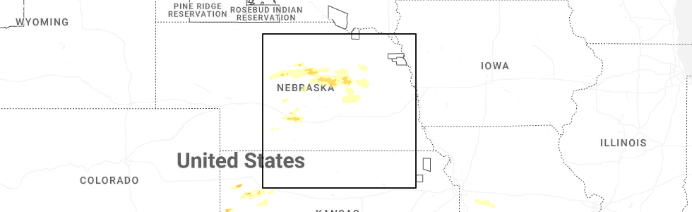
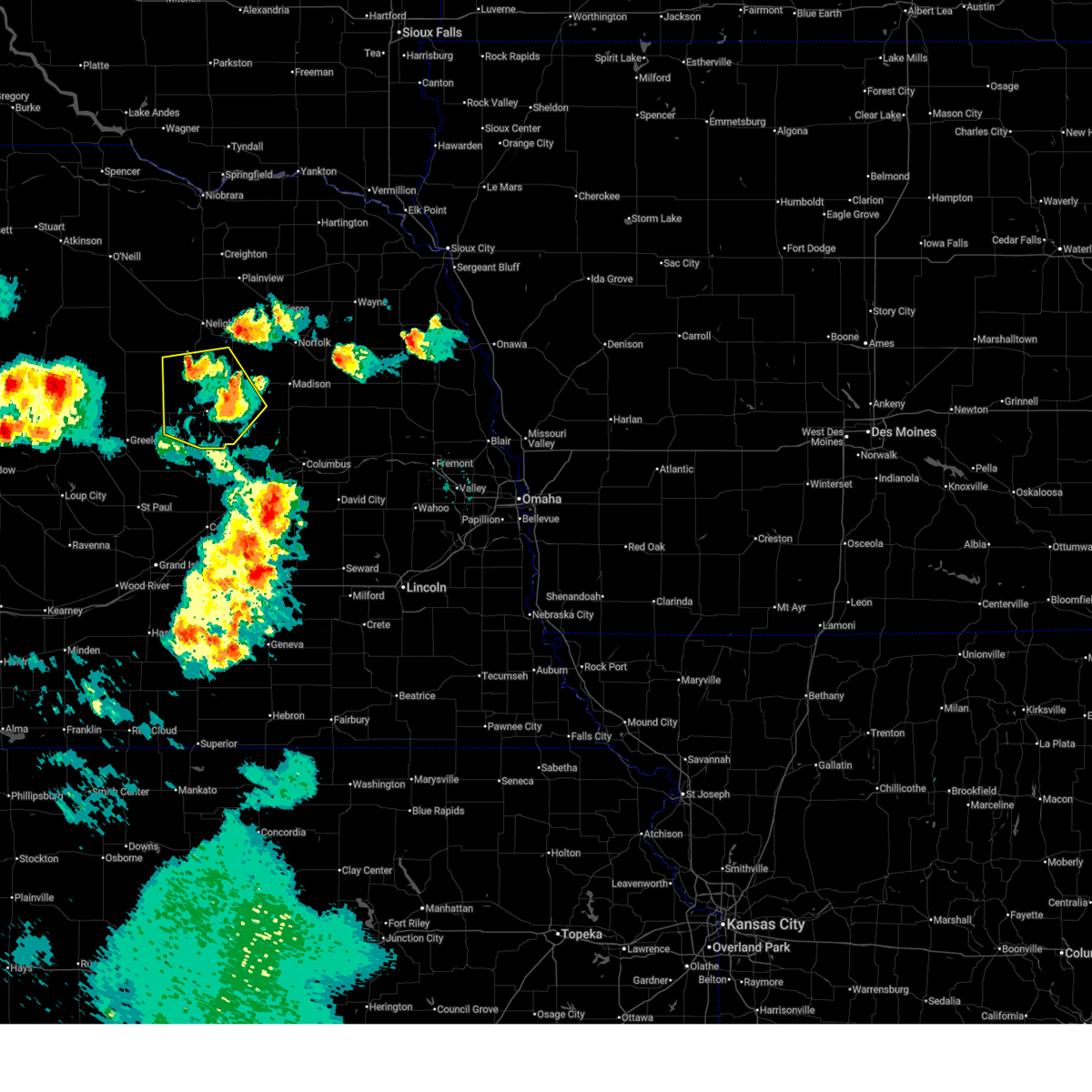
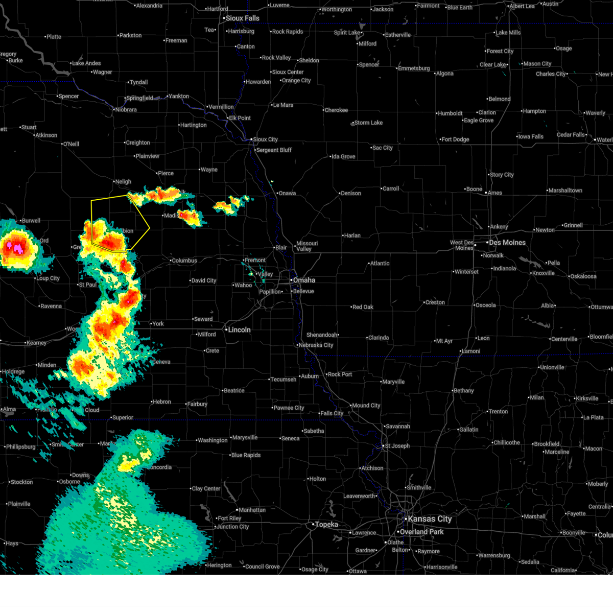
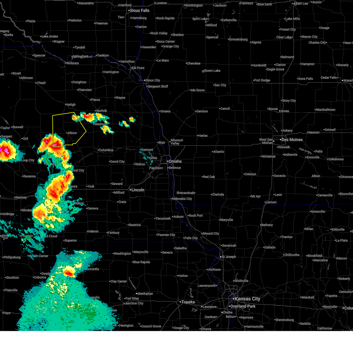
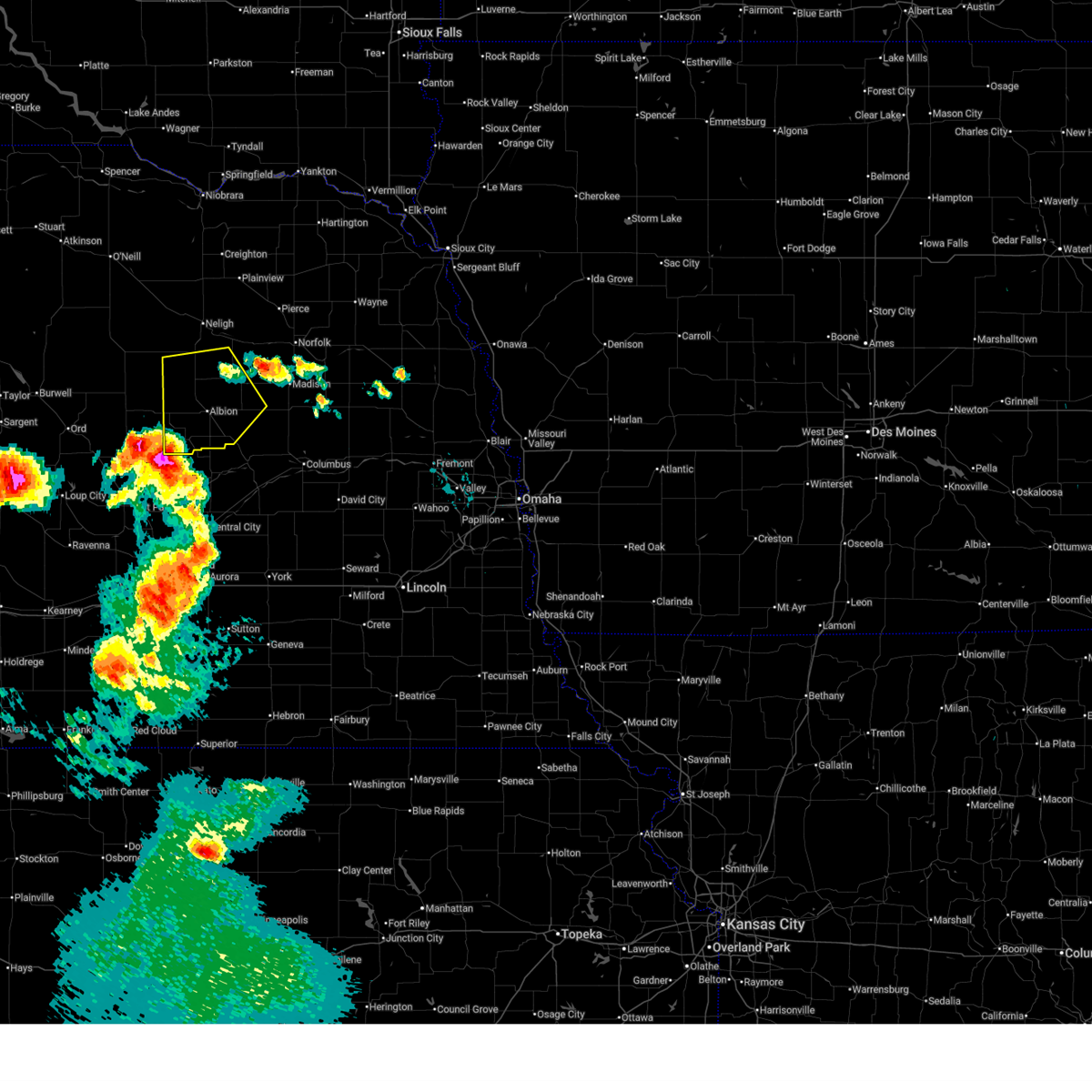
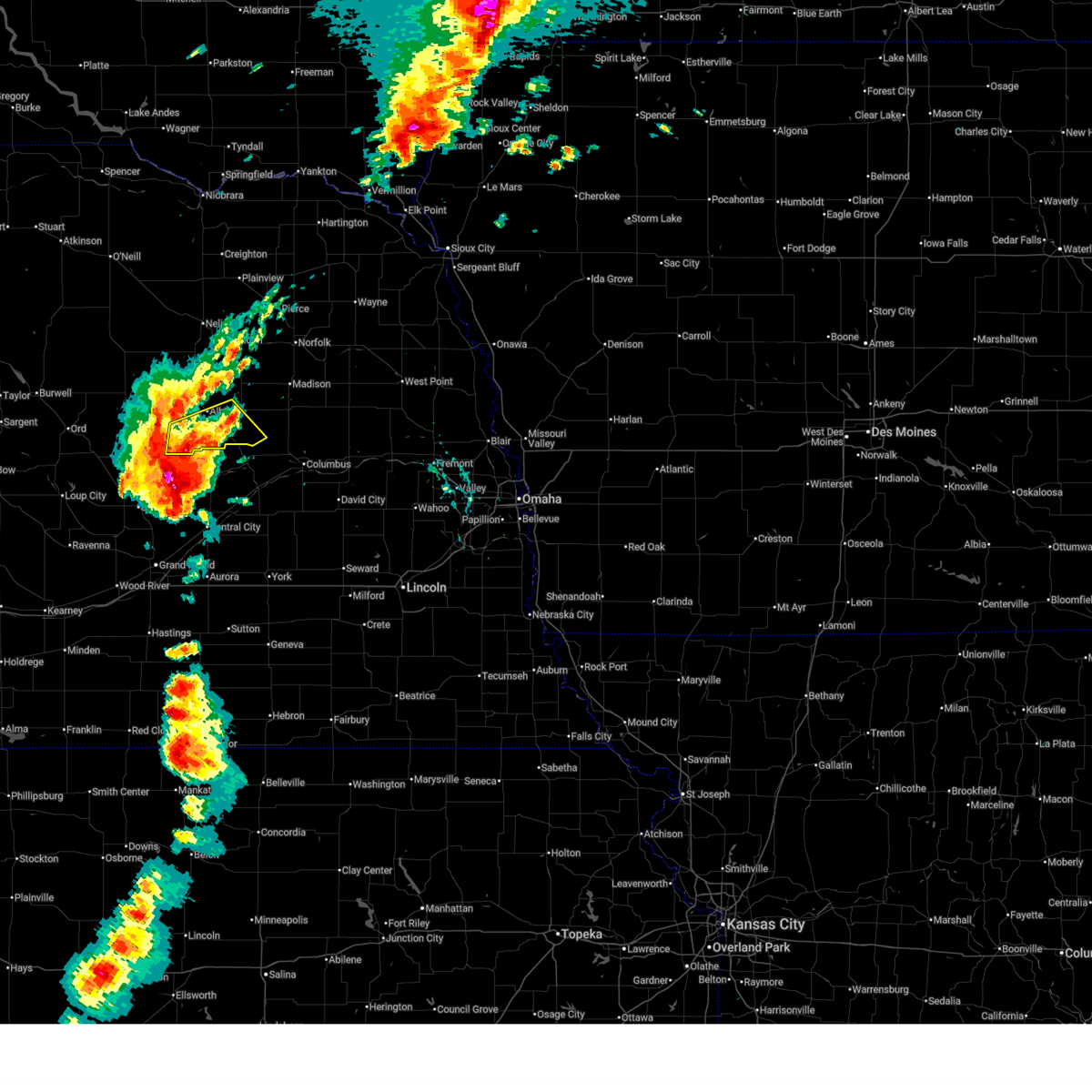
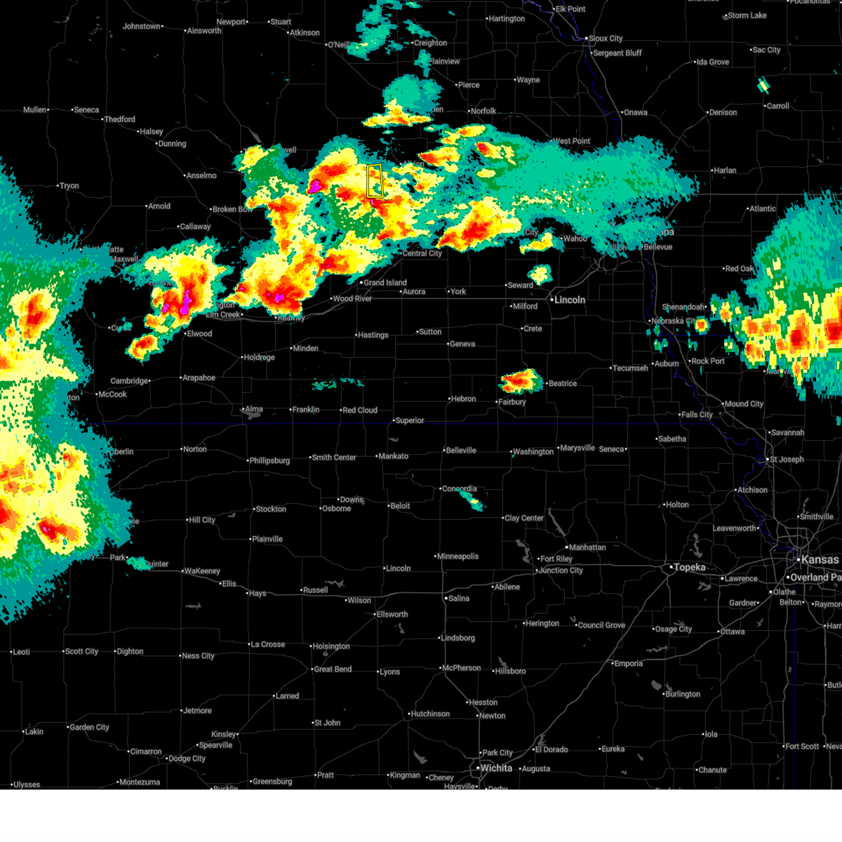
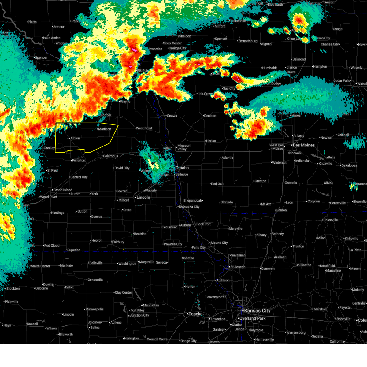
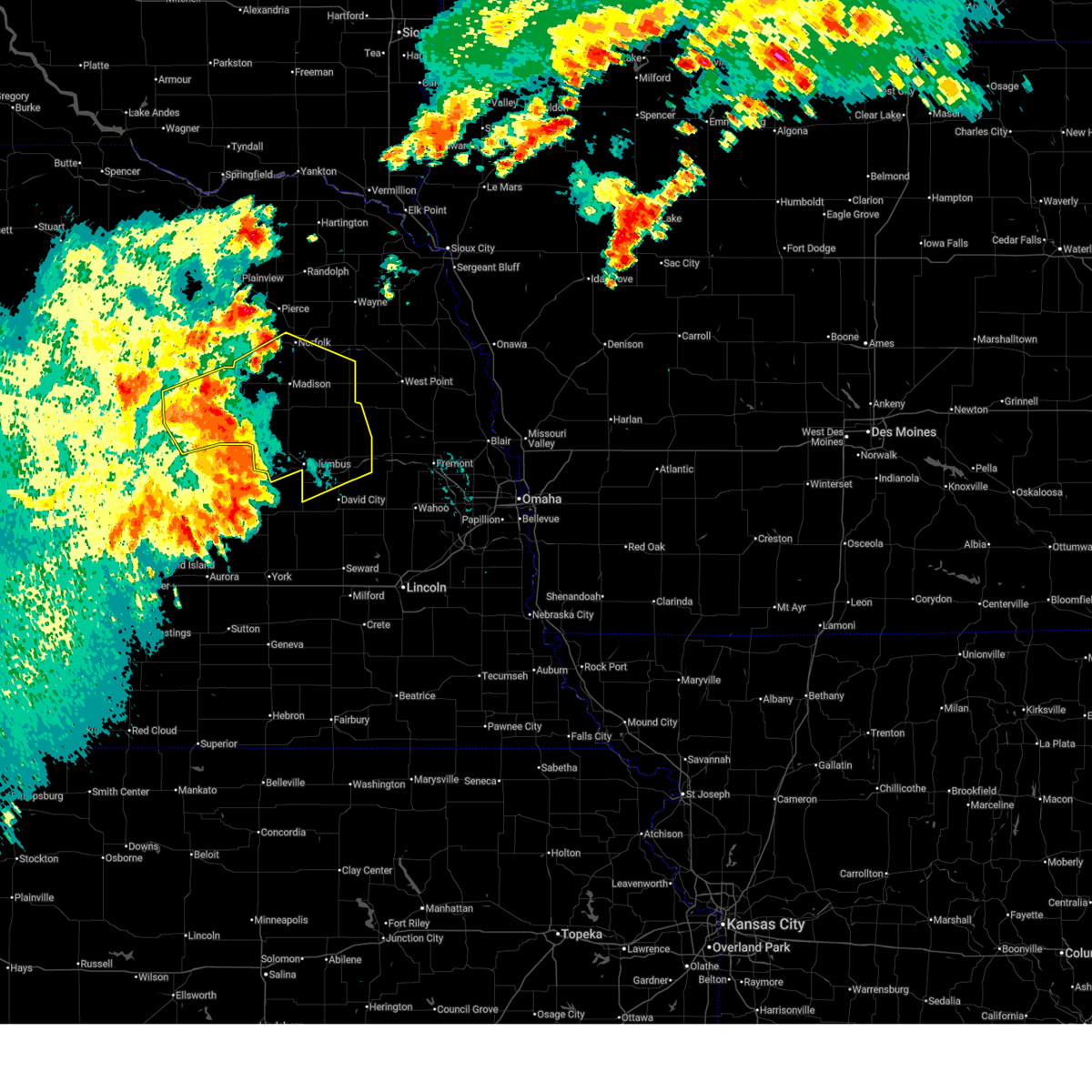
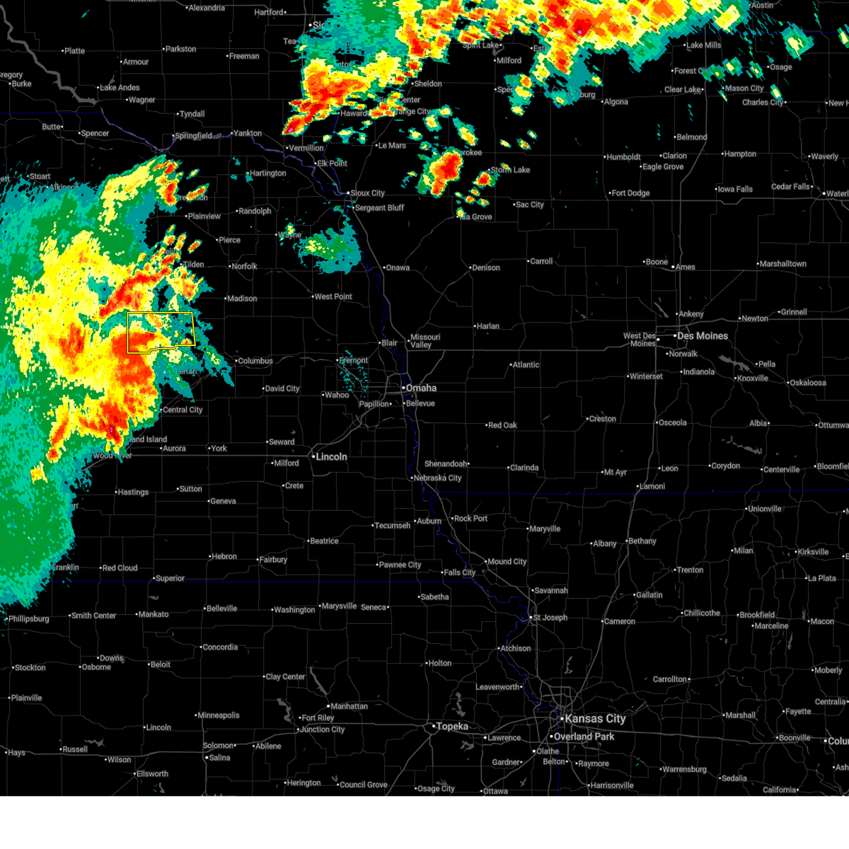
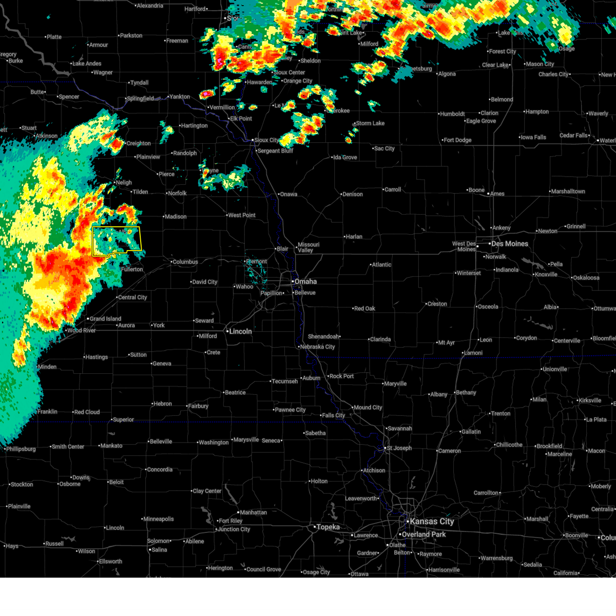
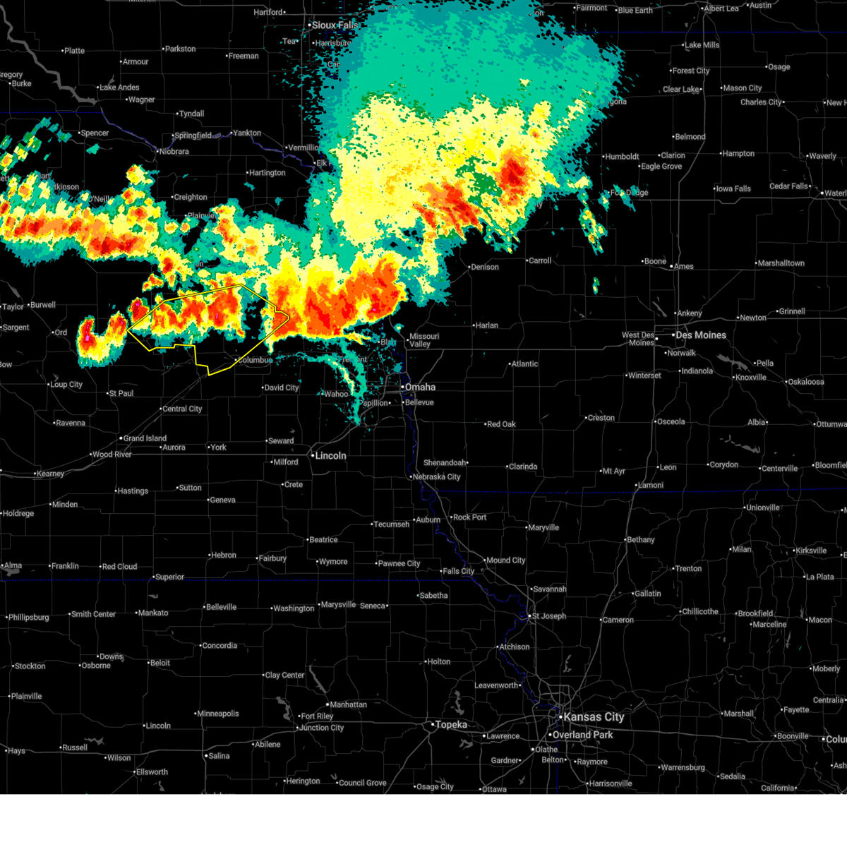
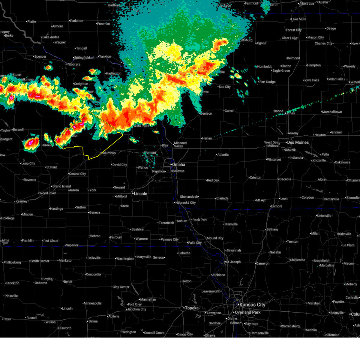
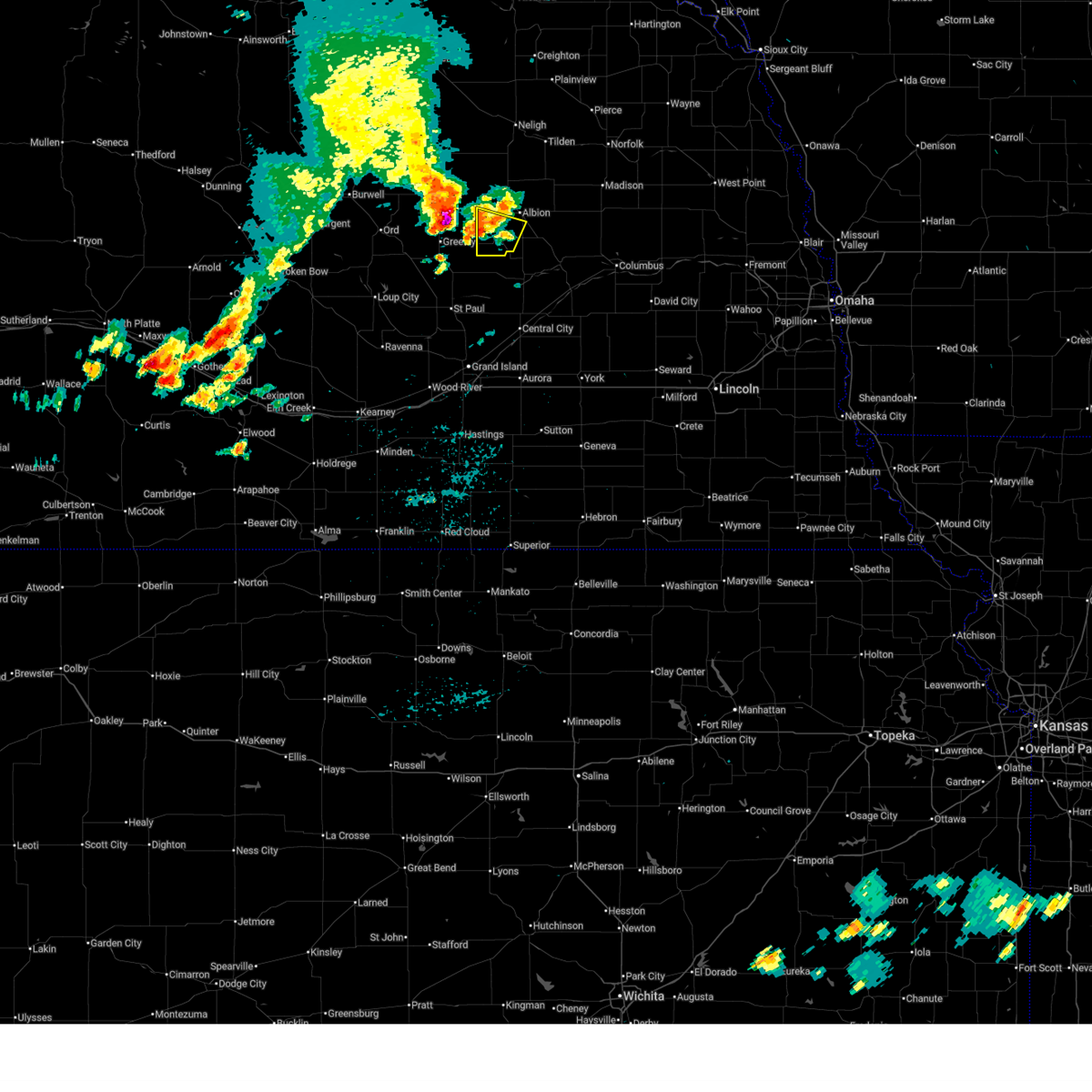
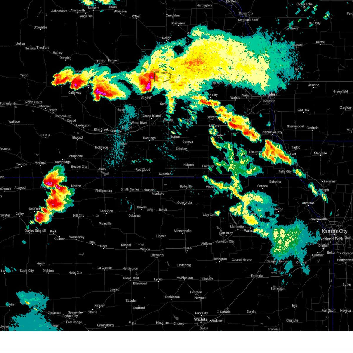
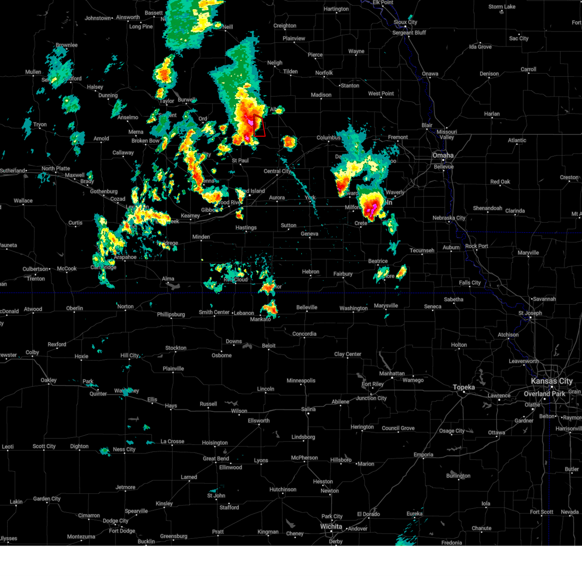
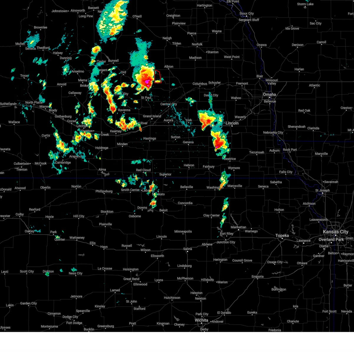
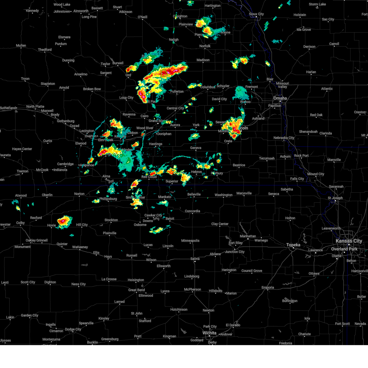
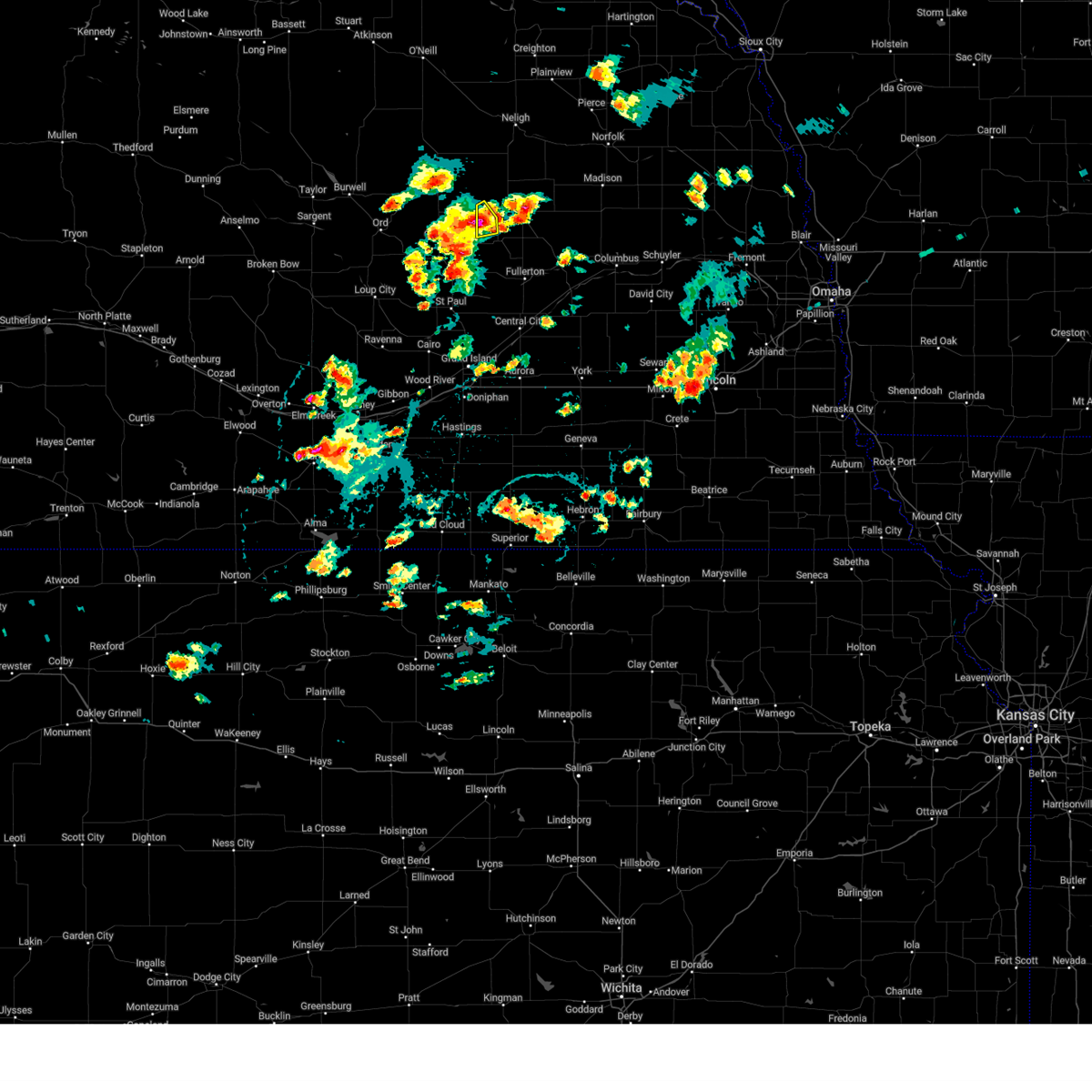
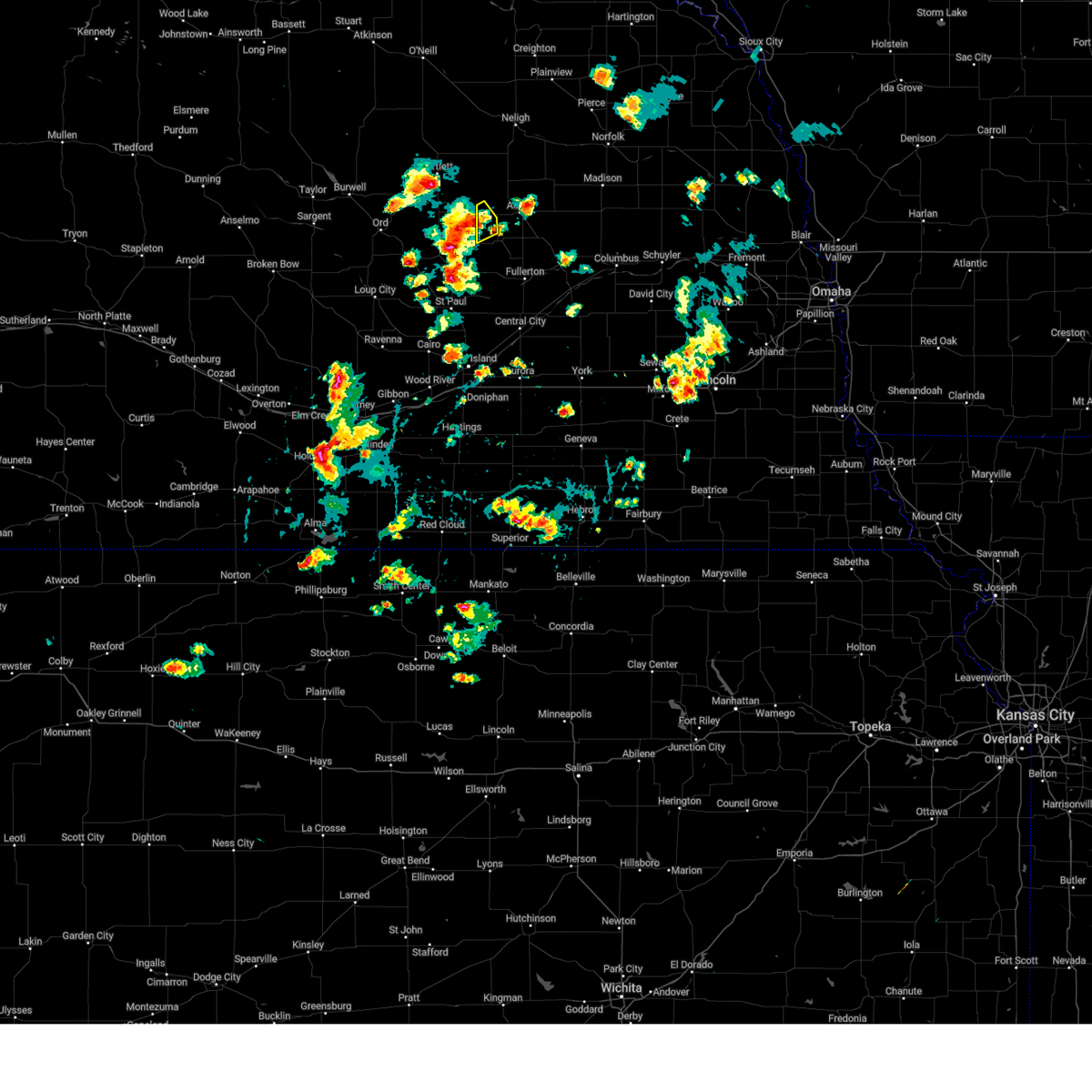
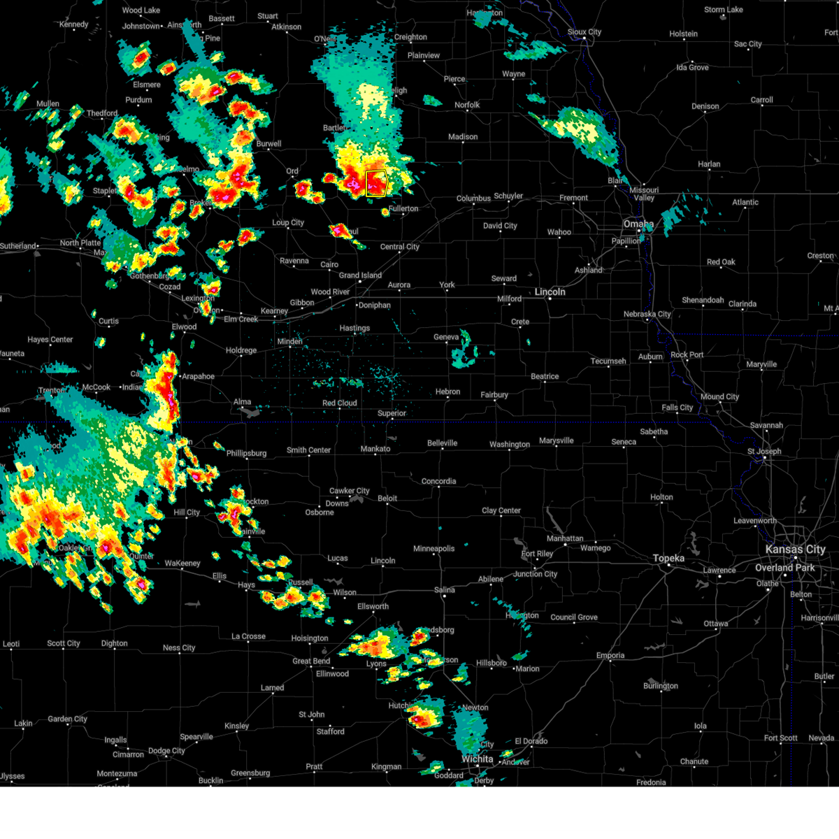
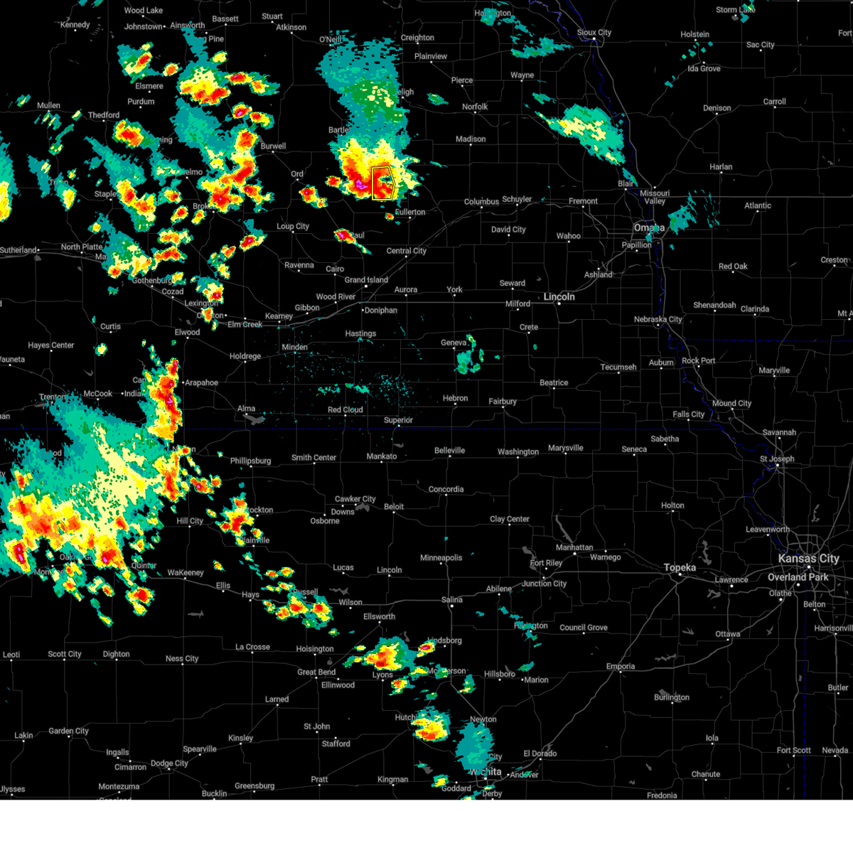
Hail Map for Primrose, NE
The Primrose, NE area has had 7 reports of on-the-ground hail by trained spotters, and has been under severe weather warnings 17 times during the past 12 months. Doppler radar has detected hail at or near Primrose, NE on 91 occasions, including 9 occasions during the past year.
| Name: | Primrose, NE |
| Where Located: | 48.6 miles N of Grand Island, NE |
| Map: | Google Map for Primrose, NE |
| Population: | 61 |
| Housing Units: | 39 |
| More Info: | Search Google for Primrose, NE |
2
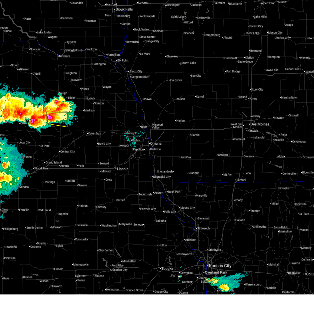
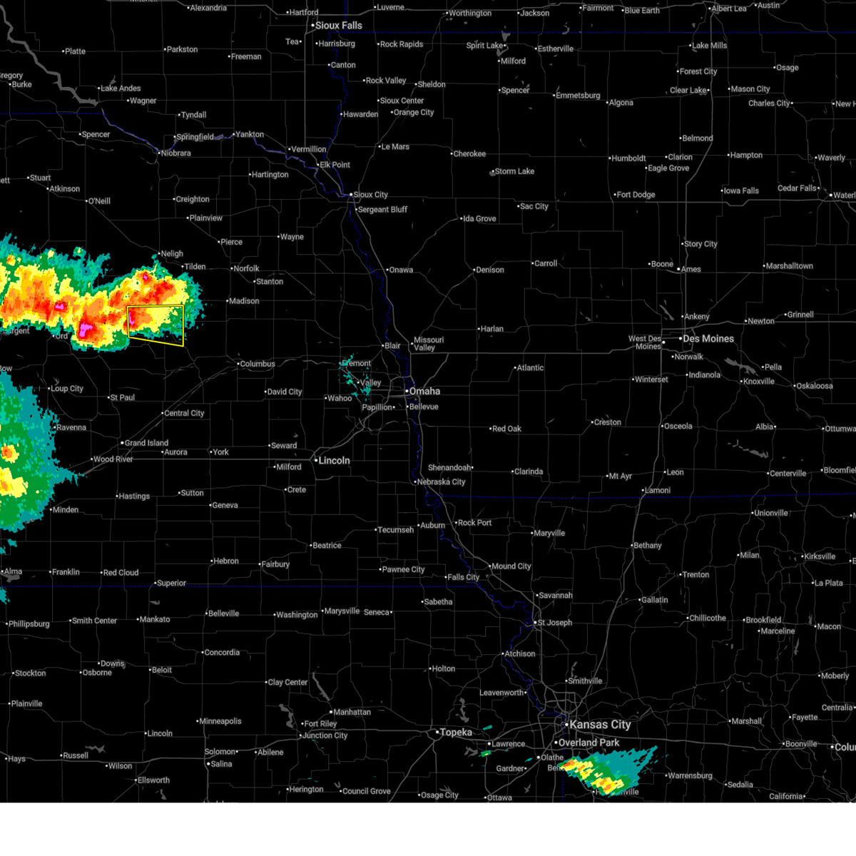
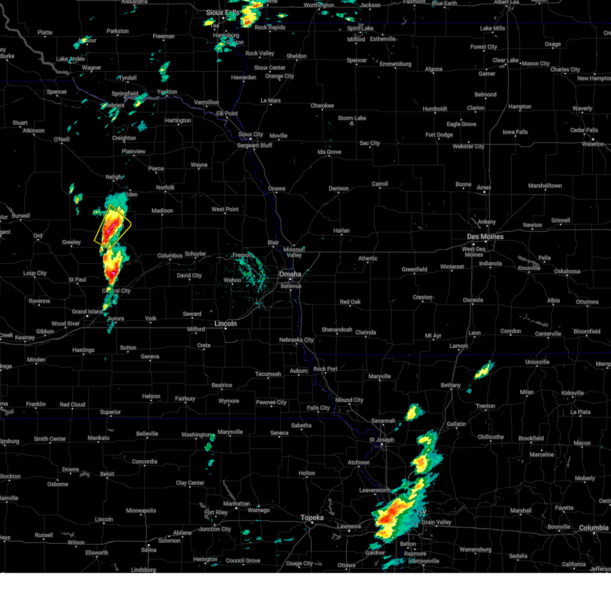
The Top Recent Hail Date for Primrose, NE is Friday, June 12, 2026 (5th out of 91)
Hail and Wind Damage Spotted near Primrose, NE
| Date / Time | Report Details |
|---|---|
| 6/13/2026 6:00 AM CDT |
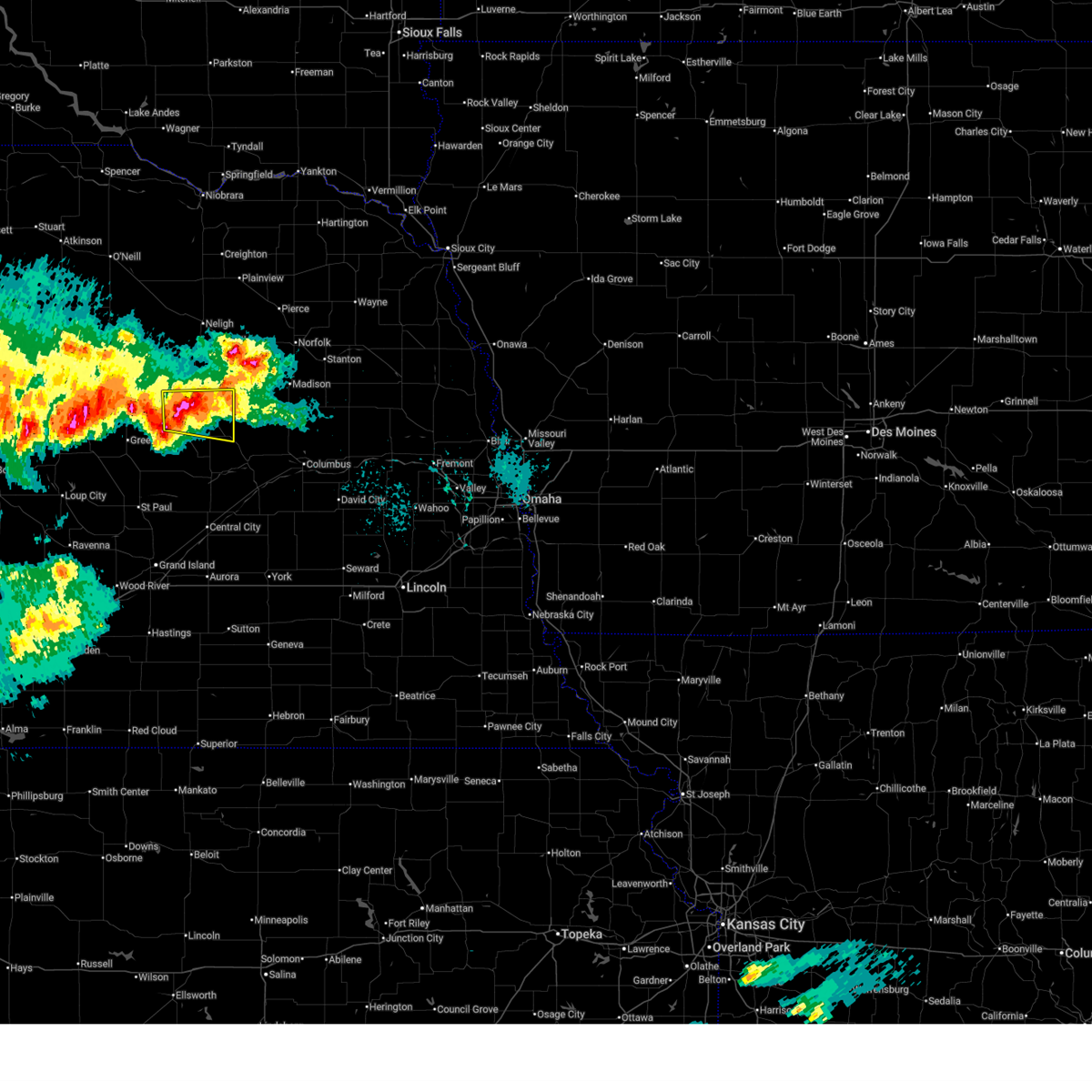 At 600 am cdt, a severe thunderstorm was located 6 miles west of albion, moving east at 20 mph (radar indicated). Hazards include 60 mph wind gusts and quarter size hail. Hail damage to vehicles is expected. expect wind damage to roofs, siding, and trees. locations impacted include, albion, st. Edward, primrose, loretto, and the highway 14 and 56 junction. At 600 am cdt, a severe thunderstorm was located 6 miles west of albion, moving east at 20 mph (radar indicated). Hazards include 60 mph wind gusts and quarter size hail. Hail damage to vehicles is expected. expect wind damage to roofs, siding, and trees. locations impacted include, albion, st. Edward, primrose, loretto, and the highway 14 and 56 junction.
|
| 6/13/2026 5:39 AM CDT |
 At 538 am cdt, a severe thunderstorm was located 5 miles north of primrose, or 10 miles west of albion, moving east at 25 mph (radar indicated). Hazards include ping pong ball size hail and 60 mph wind gusts. People and animals outdoors will be injured. expect hail damage to roofs, siding, windows, and vehicles. expect wind damage to roofs, siding, and trees. locations impacted include, albion, st. Edward, primrose, loretto, and the highway 14 and 56 junction. At 538 am cdt, a severe thunderstorm was located 5 miles north of primrose, or 10 miles west of albion, moving east at 25 mph (radar indicated). Hazards include ping pong ball size hail and 60 mph wind gusts. People and animals outdoors will be injured. expect hail damage to roofs, siding, windows, and vehicles. expect wind damage to roofs, siding, and trees. locations impacted include, albion, st. Edward, primrose, loretto, and the highway 14 and 56 junction.
|
| 6/13/2026 5:32 AM CDT |
 Svroax the national weather service in omaha has issued a * severe thunderstorm warning for, central boone county in northeastern nebraska, * until 615 am cdt. * at 532 am cdt, a severe thunderstorm was located 5 miles north of primrose, or 13 miles west of albion, moving east at 25 mph (radar indicated). Hazards include 60 mph wind gusts and quarter size hail. Hail damage to vehicles is expected. Expect wind damage to roofs, siding, and trees. Svroax the national weather service in omaha has issued a * severe thunderstorm warning for, central boone county in northeastern nebraska, * until 615 am cdt. * at 532 am cdt, a severe thunderstorm was located 5 miles north of primrose, or 13 miles west of albion, moving east at 25 mph (radar indicated). Hazards include 60 mph wind gusts and quarter size hail. Hail damage to vehicles is expected. Expect wind damage to roofs, siding, and trees.
|
| 6/9/2026 9:09 PM CDT |
 The storms which prompted the warning have weakened below severe limits, and no longer pose an immediate threat to life or property. therefore, the warning will be allowed to expire. a tornado watch remains in effect until 300 am cdt for northeastern nebraska. to report severe weather, contact your nearest law enforcement agency. they will relay your report to the national weather service omaha. The storms which prompted the warning have weakened below severe limits, and no longer pose an immediate threat to life or property. therefore, the warning will be allowed to expire. a tornado watch remains in effect until 300 am cdt for northeastern nebraska. to report severe weather, contact your nearest law enforcement agency. they will relay your report to the national weather service omaha.
|
| 6/9/2026 8:51 PM CDT |
 At 850 pm cdt, severe thunderstorms were located along a line extending from 7 miles northeast of spalding to 5 miles northwest of albion to 3 miles west of st. edward, moving northeast at 35 mph (radar indicated). Hazards include 60 mph wind gusts and nickel size hail. Expect damage to roofs, siding, and trees. locations impacted include, albion, st. Edward, petersburg, newman grove, elgin and lindsay. At 850 pm cdt, severe thunderstorms were located along a line extending from 7 miles northeast of spalding to 5 miles northwest of albion to 3 miles west of st. edward, moving northeast at 35 mph (radar indicated). Hazards include 60 mph wind gusts and nickel size hail. Expect damage to roofs, siding, and trees. locations impacted include, albion, st. Edward, petersburg, newman grove, elgin and lindsay.
|
| 6/9/2026 8:34 PM CDT |
 At 833 pm cdt, severe thunderstorms were located along a line extending from 4 miles southwest of spalding to 2 miles east of primrose to 2 miles south of belgrade, moving northeast at 50 mph (at 830 pm, a public mesonet station reported winds gusting to 62 mph 5.7 miles nne of wolbach, ne). Hazards include 70 mph wind gusts and half dollar size hail. Hail damage to vehicles is expected. expect considerable tree damage. wind damage is also likely to mobile homes, roofs, and outbuildings. these severe storms will be near, albion around 840 pm cdt. st. edward around 845 pm cdt. Other locations in the path of these severe thunderstorms include petersburg, newman grove, elgin and lindsay. At 833 pm cdt, severe thunderstorms were located along a line extending from 4 miles southwest of spalding to 2 miles east of primrose to 2 miles south of belgrade, moving northeast at 50 mph (at 830 pm, a public mesonet station reported winds gusting to 62 mph 5.7 miles nne of wolbach, ne). Hazards include 70 mph wind gusts and half dollar size hail. Hail damage to vehicles is expected. expect considerable tree damage. wind damage is also likely to mobile homes, roofs, and outbuildings. these severe storms will be near, albion around 840 pm cdt. st. edward around 845 pm cdt. Other locations in the path of these severe thunderstorms include petersburg, newman grove, elgin and lindsay.
|
| 6/9/2026 8:28 PM CDT |
 Svroax the national weather service in omaha has issued a * severe thunderstorm warning for, southwestern madison county in northeastern nebraska, northwestern platte county in northeastern nebraska, southern antelope county in northeastern nebraska, boone county in northeastern nebraska, * until 915 pm cdt. * at 827 pm cdt, severe thunderstorms were located along a line extending from 4 miles northeast of greeley to 3 miles south of primrose to 6 miles southwest of belgrade, moving northeast at 50 mph (radar indicated). Hazards include 60 mph wind gusts and half dollar size hail. Hail damage to vehicles is expected. expect wind damage to roofs, siding, and trees. severe thunderstorms will be near, cedar rapids and primrose around 835 pm cdt. albion around 840 pm cdt. st. edward around 845 pm cdt. Other locations in the path of these severe thunderstorms include petersburg, newman grove, elgin and lindsay. Svroax the national weather service in omaha has issued a * severe thunderstorm warning for, southwestern madison county in northeastern nebraska, northwestern platte county in northeastern nebraska, southern antelope county in northeastern nebraska, boone county in northeastern nebraska, * until 915 pm cdt. * at 827 pm cdt, severe thunderstorms were located along a line extending from 4 miles northeast of greeley to 3 miles south of primrose to 6 miles southwest of belgrade, moving northeast at 50 mph (radar indicated). Hazards include 60 mph wind gusts and half dollar size hail. Hail damage to vehicles is expected. expect wind damage to roofs, siding, and trees. severe thunderstorms will be near, cedar rapids and primrose around 835 pm cdt. albion around 840 pm cdt. st. edward around 845 pm cdt. Other locations in the path of these severe thunderstorms include petersburg, newman grove, elgin and lindsay.
|
| 5/17/2026 5:34 PM CDT |
 Svroax the national weather service in omaha has issued a * severe thunderstorm warning for, west central platte county in northeastern nebraska, southern boone county in northeastern nebraska, * until 630 pm cdt. * at 534 pm cdt, a severe thunderstorm was located 6 miles southwest of belgrade, or 20 miles southwest of albion, moving northeast at 35 mph (radar indicated. this storm has a history of producing hail larger than baseballs in howard county). Hazards include tennis ball size hail and 60 mph wind gusts. People and animals outdoors will be injured. expect hail damage to roofs, siding, windows, and vehicles. Expect wind damage to roofs, siding, and trees. Svroax the national weather service in omaha has issued a * severe thunderstorm warning for, west central platte county in northeastern nebraska, southern boone county in northeastern nebraska, * until 630 pm cdt. * at 534 pm cdt, a severe thunderstorm was located 6 miles southwest of belgrade, or 20 miles southwest of albion, moving northeast at 35 mph (radar indicated. this storm has a history of producing hail larger than baseballs in howard county). Hazards include tennis ball size hail and 60 mph wind gusts. People and animals outdoors will be injured. expect hail damage to roofs, siding, windows, and vehicles. Expect wind damage to roofs, siding, and trees.
|
| 5/16/2026 7:16 PM CDT |
 Svroax the national weather service in omaha has issued a * severe thunderstorm warning for, southwestern boone county in northeastern nebraska, * until 800 pm cdt. * at 716 pm cdt, a severe thunderstorm was located 6 miles southwest of cedar rapids, or 18 miles southwest of albion, moving north at 25 mph (radar indicated). Hazards include 60 mph wind gusts and half dollar size hail. Hail damage to vehicles is expected. Expect wind damage to roofs, siding, and trees. Svroax the national weather service in omaha has issued a * severe thunderstorm warning for, southwestern boone county in northeastern nebraska, * until 800 pm cdt. * at 716 pm cdt, a severe thunderstorm was located 6 miles southwest of cedar rapids, or 18 miles southwest of albion, moving north at 25 mph (radar indicated). Hazards include 60 mph wind gusts and half dollar size hail. Hail damage to vehicles is expected. Expect wind damage to roofs, siding, and trees.
|
| 7/29/2025 9:15 PM CDT |
 Svroax the national weather service in omaha has issued a * severe thunderstorm warning for, southern madison county in northeastern nebraska, northwestern colfax county in northeastern nebraska, platte county in northeastern nebraska, south central antelope county in northeastern nebraska, boone county in northeastern nebraska, southern stanton county in northeastern nebraska, * until 945 pm cdt. * at 915 pm cdt, severe thunderstorms were located along a line extending from 5 miles north of madison to 6 miles southeast of petersburg, moving southeast at 40 mph (radar indicated). Hazards include 60 mph wind gusts. Expect damage to roofs, siding, and trees. severe thunderstorms will be near, albion, madison, and newman grove around 920 pm cdt. lindsay around 925 pm cdt. humphrey and creston around 930 pm cdt. st. Edward around 935 pm cdt. Svroax the national weather service in omaha has issued a * severe thunderstorm warning for, southern madison county in northeastern nebraska, northwestern colfax county in northeastern nebraska, platte county in northeastern nebraska, south central antelope county in northeastern nebraska, boone county in northeastern nebraska, southern stanton county in northeastern nebraska, * until 945 pm cdt. * at 915 pm cdt, severe thunderstorms were located along a line extending from 5 miles north of madison to 6 miles southeast of petersburg, moving southeast at 40 mph (radar indicated). Hazards include 60 mph wind gusts. Expect damage to roofs, siding, and trees. severe thunderstorms will be near, albion, madison, and newman grove around 920 pm cdt. lindsay around 925 pm cdt. humphrey and creston around 930 pm cdt. st. Edward around 935 pm cdt.
|
| 7/23/2025 8:37 PM CDT |
 At 837 pm cdt, severe thunderstorms were located along a line extending from 4 miles west of newman grove to 5 miles southeast of lindsay to 5 miles south of duncan, moving east at 50 mph (radar indicated). Hazards include 60 mph wind gusts and penny size hail. Expect damage to roofs, siding, and trees. these severe storms will be near, columbus, humphrey, newman grove, platte center, lindsay, and lakeview around 845 pm cdt. Other locations in the path of these severe thunderstorms include bellwood, creston, richland, schuyler, leigh, octavia, clarkson, linwood and howells. At 837 pm cdt, severe thunderstorms were located along a line extending from 4 miles west of newman grove to 5 miles southeast of lindsay to 5 miles south of duncan, moving east at 50 mph (radar indicated). Hazards include 60 mph wind gusts and penny size hail. Expect damage to roofs, siding, and trees. these severe storms will be near, columbus, humphrey, newman grove, platte center, lindsay, and lakeview around 845 pm cdt. Other locations in the path of these severe thunderstorms include bellwood, creston, richland, schuyler, leigh, octavia, clarkson, linwood and howells.
|
| 7/23/2025 8:25 PM CDT |
 Svroax the national weather service in omaha has issued a * severe thunderstorm warning for, madison county in northeastern nebraska, colfax county in northeastern nebraska, platte county in northeastern nebraska, northern butler county in east central nebraska, boone county in northeastern nebraska, stanton county in northeastern nebraska, * until 915 pm cdt. * at 825 pm cdt, severe thunderstorms were located along a line extending from 2 miles southwest of albion to 3 miles east of st. edward to 5 miles south of silver creek, moving northeast at 50 mph (radar indicated). Hazards include 60 mph wind gusts and penny size hail. Expect damage to roofs, siding, and trees. severe thunderstorms will be near, albion and monroe around 830 pm cdt. newman grove, duncan, and lindsay around 835 pm cdt. columbus, humphrey, and platte center around 840 pm cdt. lakeview around 845 pm cdt. Other locations in the path of these severe thunderstorms include madison, creston, leigh, richland, norfolk, stanton and clarkson. Svroax the national weather service in omaha has issued a * severe thunderstorm warning for, madison county in northeastern nebraska, colfax county in northeastern nebraska, platte county in northeastern nebraska, northern butler county in east central nebraska, boone county in northeastern nebraska, stanton county in northeastern nebraska, * until 915 pm cdt. * at 825 pm cdt, severe thunderstorms were located along a line extending from 2 miles southwest of albion to 3 miles east of st. edward to 5 miles south of silver creek, moving northeast at 50 mph (radar indicated). Hazards include 60 mph wind gusts and penny size hail. Expect damage to roofs, siding, and trees. severe thunderstorms will be near, albion and monroe around 830 pm cdt. newman grove, duncan, and lindsay around 835 pm cdt. columbus, humphrey, and platte center around 840 pm cdt. lakeview around 845 pm cdt. Other locations in the path of these severe thunderstorms include madison, creston, leigh, richland, norfolk, stanton and clarkson.
|
| 7/23/2025 8:11 PM CDT |
 At 811 pm cdt, severe thunderstorms were located along a line extending from 3 miles west of albion to 8 miles southwest of fullerton to 3 miles south of archer, moving east at 25 mph (radar indicated). Hazards include 70 mph wind gusts and penny size hail. Expect considerable tree damage. damage is likely to mobile homes, roofs, and outbuildings. locations impacted include, albion and st. Edward. At 811 pm cdt, severe thunderstorms were located along a line extending from 3 miles west of albion to 8 miles southwest of fullerton to 3 miles south of archer, moving east at 25 mph (radar indicated). Hazards include 70 mph wind gusts and penny size hail. Expect considerable tree damage. damage is likely to mobile homes, roofs, and outbuildings. locations impacted include, albion and st. Edward.
|
| 7/23/2025 7:50 PM CDT |
 Svroax the national weather service in omaha has issued a * severe thunderstorm warning for, northwestern platte county in northeastern nebraska, southern boone county in northeastern nebraska, * until 830 pm cdt. * at 750 pm cdt, severe thunderstorms were located along a line extending from 3 miles north of primrose to 3 miles northeast of palmer to 4 miles northeast of st. libory, moving east at 25 mph (radar indicated). Hazards include 60 mph wind gusts and penny size hail. Expect damage to roofs, siding, and trees. severe thunderstorms will be near, cedar rapids around 755 pm cdt. Albion around 805 pm cdt. Svroax the national weather service in omaha has issued a * severe thunderstorm warning for, northwestern platte county in northeastern nebraska, southern boone county in northeastern nebraska, * until 830 pm cdt. * at 750 pm cdt, severe thunderstorms were located along a line extending from 3 miles north of primrose to 3 miles northeast of palmer to 4 miles northeast of st. libory, moving east at 25 mph (radar indicated). Hazards include 60 mph wind gusts and penny size hail. Expect damage to roofs, siding, and trees. severe thunderstorms will be near, cedar rapids around 755 pm cdt. Albion around 805 pm cdt.
|
| 7/7/2025 9:30 PM CDT |
 At 930 pm cdt, severe thunderstorms were located along a line extending from 4 miles northeast of creston to 4 miles southeast of humphrey to 6 miles northeast of primrose, moving southeast at 30 mph (radar indicated). Hazards include 60 mph wind gusts and quarter size hail. Hail damage to vehicles is expected. expect wind damage to roofs, siding, and trees. locations impacted include, st. edward, leigh, platte center, creston, lakeview, columbus, monroe and duncan. People attending madison county fairgrounds should seek safe shelter immediately!. At 930 pm cdt, severe thunderstorms were located along a line extending from 4 miles northeast of creston to 4 miles southeast of humphrey to 6 miles northeast of primrose, moving southeast at 30 mph (radar indicated). Hazards include 60 mph wind gusts and quarter size hail. Hail damage to vehicles is expected. expect wind damage to roofs, siding, and trees. locations impacted include, st. edward, leigh, platte center, creston, lakeview, columbus, monroe and duncan. People attending madison county fairgrounds should seek safe shelter immediately!.
|
| 7/7/2025 9:07 PM CDT |
 Svroax the national weather service in omaha has issued a * severe thunderstorm warning for, madison county in northeastern nebraska, northern colfax county in northeastern nebraska, platte county in northeastern nebraska, central boone county in northeastern nebraska, southern stanton county in northeastern nebraska, * until 1000 pm cdt. * at 907 pm cdt, severe thunderstorms were located along a line extending from 6 miles northwest of madison to 3 miles north of lindsay to 2 miles northeast of cedar rapids, moving southeast at 40 mph (radar indicated). Hazards include 60 mph wind gusts and quarter size hail. Hail damage to vehicles is expected. expect wind damage to roofs, siding, and trees. severe thunderstorms will be near, madison, humphrey, st. edward, and lindsay around 915 pm cdt. creston around 925 pm cdt. other locations in the path of these severe thunderstorms include leigh, platte center, monroe, clarkson, lakeview, columbus and duncan. People attending madison county fairgrounds should seek safe shelter immediately!. Svroax the national weather service in omaha has issued a * severe thunderstorm warning for, madison county in northeastern nebraska, northern colfax county in northeastern nebraska, platte county in northeastern nebraska, central boone county in northeastern nebraska, southern stanton county in northeastern nebraska, * until 1000 pm cdt. * at 907 pm cdt, severe thunderstorms were located along a line extending from 6 miles northwest of madison to 3 miles north of lindsay to 2 miles northeast of cedar rapids, moving southeast at 40 mph (radar indicated). Hazards include 60 mph wind gusts and quarter size hail. Hail damage to vehicles is expected. expect wind damage to roofs, siding, and trees. severe thunderstorms will be near, madison, humphrey, st. edward, and lindsay around 915 pm cdt. creston around 925 pm cdt. other locations in the path of these severe thunderstorms include leigh, platte center, monroe, clarkson, lakeview, columbus and duncan. People attending madison county fairgrounds should seek safe shelter immediately!.
|
| 7/6/2025 1:46 PM CDT |
 Svroax the national weather service in omaha has issued a * severe thunderstorm warning for, southwestern boone county in northeastern nebraska, * until 230 pm cdt. * at 145 pm cdt, a severe thunderstorm was located 6 miles southwest of spalding, or 23 miles east of ord, moving southeast at 35 mph (radar indicated). Hazards include ping pong ball size hail and 60 mph wind gusts. People and animals outdoors will be injured. expect hail damage to roofs, siding, windows, and vehicles. expect wind damage to roofs, siding, and trees. this severe thunderstorm will be near, primrose around 205 pm cdt. Other locations in the path of this severe thunderstorm include cedar rapids. Svroax the national weather service in omaha has issued a * severe thunderstorm warning for, southwestern boone county in northeastern nebraska, * until 230 pm cdt. * at 145 pm cdt, a severe thunderstorm was located 6 miles southwest of spalding, or 23 miles east of ord, moving southeast at 35 mph (radar indicated). Hazards include ping pong ball size hail and 60 mph wind gusts. People and animals outdoors will be injured. expect hail damage to roofs, siding, windows, and vehicles. expect wind damage to roofs, siding, and trees. this severe thunderstorm will be near, primrose around 205 pm cdt. Other locations in the path of this severe thunderstorm include cedar rapids.
|
| 5/19/2025 2:30 PM CDT |
 At 230 pm cdt, a severe thunderstorm was located 4 miles west of albion, moving northeast at 15 mph (radar indicated). Hazards include 60 mph wind gusts and quarter size hail. Hail damage to vehicles is expected. expect wind damage to roofs, siding, and trees. This severe storm will be near, albion around 235 pm cdt. At 230 pm cdt, a severe thunderstorm was located 4 miles west of albion, moving northeast at 15 mph (radar indicated). Hazards include 60 mph wind gusts and quarter size hail. Hail damage to vehicles is expected. expect wind damage to roofs, siding, and trees. This severe storm will be near, albion around 235 pm cdt.
|
| 5/19/2025 2:25 PM CDT |
 At 225 pm cdt, a severe thunderstorm was located 5 miles southwest of albion, moving northeast at 20 mph (radar indicated). Hazards include 60 mph wind gusts and quarter size hail. Hail damage to vehicles is expected. expect wind damage to roofs, siding, and trees. This severe storm will be near, albion around 230 pm cdt. At 225 pm cdt, a severe thunderstorm was located 5 miles southwest of albion, moving northeast at 20 mph (radar indicated). Hazards include 60 mph wind gusts and quarter size hail. Hail damage to vehicles is expected. expect wind damage to roofs, siding, and trees. This severe storm will be near, albion around 230 pm cdt.
|
| 5/19/2025 2:18 PM CDT |
 Svroax the national weather service in omaha has issued a * severe thunderstorm warning for, central boone county in northeastern nebraska, * until 300 pm cdt. * at 218 pm cdt, a severe thunderstorm was located 4 miles north of cedar rapids, or 9 miles southwest of albion, moving northeast at 20 mph (radar indicated). Hazards include 60 mph wind gusts and quarter size hail. Hail damage to vehicles is expected. expect wind damage to roofs, siding, and trees. This severe thunderstorm will be near, albion around 235 pm cdt. Svroax the national weather service in omaha has issued a * severe thunderstorm warning for, central boone county in northeastern nebraska, * until 300 pm cdt. * at 218 pm cdt, a severe thunderstorm was located 4 miles north of cedar rapids, or 9 miles southwest of albion, moving northeast at 20 mph (radar indicated). Hazards include 60 mph wind gusts and quarter size hail. Hail damage to vehicles is expected. expect wind damage to roofs, siding, and trees. This severe thunderstorm will be near, albion around 235 pm cdt.
|
| 6/26/2024 12:18 AM CDT |
 the severe thunderstorm warning has been cancelled and is no longer in effect the severe thunderstorm warning has been cancelled and is no longer in effect
|
| 6/25/2024 11:39 PM CDT |
 Svroax the national weather service in omaha has issued a * severe thunderstorm warning for, southwestern platte county in northeastern nebraska, southern boone county in northeastern nebraska, * until 1230 am cdt. * at 1139 pm cdt, a severe thunderstorm was located 3 miles southeast of st. edward, or 14 miles southeast of albion, moving east at 20 mph (radar indicated). Hazards include quarter size hail. damage to vehicles is expected Svroax the national weather service in omaha has issued a * severe thunderstorm warning for, southwestern platte county in northeastern nebraska, southern boone county in northeastern nebraska, * until 1230 am cdt. * at 1139 pm cdt, a severe thunderstorm was located 3 miles southeast of st. edward, or 14 miles southeast of albion, moving east at 20 mph (radar indicated). Hazards include quarter size hail. damage to vehicles is expected
|
| 6/7/2024 6:28 PM CDT |
 At 627 pm cdt, a severe thunderstorm was located 5 miles northeast of wolbach, or 23 miles southwest of albion, moving southeast at 35 mph (radar indicated). Hazards include 60 mph wind gusts and quarter size hail. Hail damage to vehicles is expected. expect wind damage to roofs, siding, and trees. Locations impacted include, cedar rapids, primrose, and the highway 14 and 56 junction. At 627 pm cdt, a severe thunderstorm was located 5 miles northeast of wolbach, or 23 miles southwest of albion, moving southeast at 35 mph (radar indicated). Hazards include 60 mph wind gusts and quarter size hail. Hail damage to vehicles is expected. expect wind damage to roofs, siding, and trees. Locations impacted include, cedar rapids, primrose, and the highway 14 and 56 junction.
|
| 6/7/2024 6:16 PM CDT |
 Svroax the national weather service in omaha has issued a * severe thunderstorm warning for, southern boone county in northeastern nebraska, * until 715 pm cdt. * at 615 pm cdt, a severe thunderstorm was located 4 miles east of greeley, or 24 miles southwest of albion, moving southeast at 35 mph (radar indicated). Hazards include 60 mph wind gusts and quarter size hail. Hail damage to vehicles is expected. Expect wind damage to roofs, siding, and trees. Svroax the national weather service in omaha has issued a * severe thunderstorm warning for, southern boone county in northeastern nebraska, * until 715 pm cdt. * at 615 pm cdt, a severe thunderstorm was located 4 miles east of greeley, or 24 miles southwest of albion, moving southeast at 35 mph (radar indicated). Hazards include 60 mph wind gusts and quarter size hail. Hail damage to vehicles is expected. Expect wind damage to roofs, siding, and trees.
|
| 5/24/2024 12:33 AM CDT |
 At 1231 am cdt, severe thunderstorms were located along a line extending from 3 miles southwest of meadow grove to 3 miles south of belgrade, moving northeast at 40 mph (public. at 1214 am, a private weather station recorded a 66 mph wind gust 4 miles east of albion). Hazards include 70 mph wind gusts and half dollar size hail. Hail damage to vehicles is expected. expect considerable tree damage. wind damage is also likely to mobile homes, roofs, and outbuildings. locations impacted include, albion, battle creek, newman grove, st. Edward, elgin, cedar rapids, petersburg, meadow grove, monroe, lindsay, primrose, cornlea, loretto, and the highway 14 and 56 junction. At 1231 am cdt, severe thunderstorms were located along a line extending from 3 miles southwest of meadow grove to 3 miles south of belgrade, moving northeast at 40 mph (public. at 1214 am, a private weather station recorded a 66 mph wind gust 4 miles east of albion). Hazards include 70 mph wind gusts and half dollar size hail. Hail damage to vehicles is expected. expect considerable tree damage. wind damage is also likely to mobile homes, roofs, and outbuildings. locations impacted include, albion, battle creek, newman grove, st. Edward, elgin, cedar rapids, petersburg, meadow grove, monroe, lindsay, primrose, cornlea, loretto, and the highway 14 and 56 junction.
|
| 5/24/2024 12:31 AM CDT |
 At 1230 am cdt, severe thunderstorms were located along a line extending from 2 miles southwest of meadow grove to 3 miles south of belgrade, moving northeast at 40 mph (radar indicated). Hazards include 60 mph wind gusts and half dollar size hail. Hail damage to vehicles is expected. expect wind damage to roofs, siding, and trees. locations impacted include, albion, battle creek, newman grove, st. Edward, elgin, cedar rapids, petersburg, meadow grove, monroe, lindsay, primrose, cornlea, loretto, and the highway 14 and 56 junction. At 1230 am cdt, severe thunderstorms were located along a line extending from 2 miles southwest of meadow grove to 3 miles south of belgrade, moving northeast at 40 mph (radar indicated). Hazards include 60 mph wind gusts and half dollar size hail. Hail damage to vehicles is expected. expect wind damage to roofs, siding, and trees. locations impacted include, albion, battle creek, newman grove, st. Edward, elgin, cedar rapids, petersburg, meadow grove, monroe, lindsay, primrose, cornlea, loretto, and the highway 14 and 56 junction.
|
| 5/24/2024 12:17 AM CDT |
 Svroax the national weather service in omaha has issued a * severe thunderstorm warning for, western madison county in northeastern nebraska, western platte county in northeastern nebraska, southeastern antelope county in northeastern nebraska, boone county in northeastern nebraska, * until 100 am cdt. * at 1217 am cdt, severe thunderstorms were located along a line extending from 7 miles southwest of tilden to 8 miles northeast of palmer, moving northeast at 40 mph (radar indicated). Hazards include 60 mph wind gusts and half dollar size hail. Hail damage to vehicles is expected. Expect wind damage to roofs, siding, and trees. Svroax the national weather service in omaha has issued a * severe thunderstorm warning for, western madison county in northeastern nebraska, western platte county in northeastern nebraska, southeastern antelope county in northeastern nebraska, boone county in northeastern nebraska, * until 100 am cdt. * at 1217 am cdt, severe thunderstorms were located along a line extending from 7 miles southwest of tilden to 8 miles northeast of palmer, moving northeast at 40 mph (radar indicated). Hazards include 60 mph wind gusts and half dollar size hail. Hail damage to vehicles is expected. Expect wind damage to roofs, siding, and trees.
|
| 4/26/2024 3:56 PM CDT |
 the severe thunderstorm warning has been cancelled and is no longer in effect the severe thunderstorm warning has been cancelled and is no longer in effect
|
| 4/26/2024 3:20 PM CDT |
 Svroax the national weather service in omaha has issued a * severe thunderstorm warning for, northwestern madison county in northeastern nebraska, southwestern pierce county in northeastern nebraska, antelope county in northeastern nebraska, central boone county in northeastern nebraska, * until 415 pm cdt. * at 320 pm cdt, severe thunderstorms were located along a line extending from clearwater to 4 miles southwest of albion, moving northeast at 25 mph (radar indicated). Hazards include 70 mph wind gusts and quarter size hail. Hail damage to vehicles is expected. expect considerable tree damage. Wind damage is also likely to mobile homes, roofs, and outbuildings. Svroax the national weather service in omaha has issued a * severe thunderstorm warning for, northwestern madison county in northeastern nebraska, southwestern pierce county in northeastern nebraska, antelope county in northeastern nebraska, central boone county in northeastern nebraska, * until 415 pm cdt. * at 320 pm cdt, severe thunderstorms were located along a line extending from clearwater to 4 miles southwest of albion, moving northeast at 25 mph (radar indicated). Hazards include 70 mph wind gusts and quarter size hail. Hail damage to vehicles is expected. expect considerable tree damage. Wind damage is also likely to mobile homes, roofs, and outbuildings.
|
| 4/26/2024 2:29 PM CDT |
 Toroax the national weather service in omaha has issued a * tornado warning for, northern boone county in northeastern nebraska, * until 315 pm cdt. * at 228 pm cdt, a severe thunderstorm capable of producing a tornado was located 3 miles southwest of primrose, or 16 miles southwest of albion, moving northeast at 25 mph (radar indicated rotation). Hazards include tornado and golf ball size hail. Flying debris will be dangerous to those caught without shelter. mobile homes will be damaged or destroyed. damage to roofs, windows, and vehicles will occur. tree damage is likely. This dangerous storm will be near, primrose around 235 pm cdt. Toroax the national weather service in omaha has issued a * tornado warning for, northern boone county in northeastern nebraska, * until 315 pm cdt. * at 228 pm cdt, a severe thunderstorm capable of producing a tornado was located 3 miles southwest of primrose, or 16 miles southwest of albion, moving northeast at 25 mph (radar indicated rotation). Hazards include tornado and golf ball size hail. Flying debris will be dangerous to those caught without shelter. mobile homes will be damaged or destroyed. damage to roofs, windows, and vehicles will occur. tree damage is likely. This dangerous storm will be near, primrose around 235 pm cdt.
|
| 4/26/2024 2:23 PM CDT |
 At 222 pm cdt, a confirmed tornado was located 4 miles southwest of primrose, or 17 miles southwest of albion, moving northeast at 25 mph (weather spotters confirmed tornado). Hazards include damaging tornado and two inch hail. Flying debris will be dangerous to those caught without shelter. mobile homes will be damaged or destroyed. damage to roofs, windows, and vehicles will occur. tree damage is likely. This tornado will be near, primrose around 230 pm cdt. At 222 pm cdt, a confirmed tornado was located 4 miles southwest of primrose, or 17 miles southwest of albion, moving northeast at 25 mph (weather spotters confirmed tornado). Hazards include damaging tornado and two inch hail. Flying debris will be dangerous to those caught without shelter. mobile homes will be damaged or destroyed. damage to roofs, windows, and vehicles will occur. tree damage is likely. This tornado will be near, primrose around 230 pm cdt.
|
| 4/26/2024 1:57 PM CDT |
 Toroax the national weather service in omaha has issued a * tornado warning for, southwestern boone county in northeastern nebraska, * until 245 pm cdt. * at 157 pm cdt, a confirmed tornado was located 3 miles north of wolbach, or 27 miles southwest of albion, moving northeast at 25 mph (weather spotters confirmed tornado). Hazards include damaging tornado and hail up to two inches in diameter. Flying debris will be dangerous to those caught without shelter. mobile homes will be damaged or destroyed. damage to roofs, windows, and vehicles will occur. Tree damage is likely. Toroax the national weather service in omaha has issued a * tornado warning for, southwestern boone county in northeastern nebraska, * until 245 pm cdt. * at 157 pm cdt, a confirmed tornado was located 3 miles north of wolbach, or 27 miles southwest of albion, moving northeast at 25 mph (weather spotters confirmed tornado). Hazards include damaging tornado and hail up to two inches in diameter. Flying debris will be dangerous to those caught without shelter. mobile homes will be damaged or destroyed. damage to roofs, windows, and vehicles will occur. Tree damage is likely.
|
| 10/3/2023 6:26 PM CDT |
 The severe thunderstorm warning for southwestern madison, northwestern platte, south central antelope and boone counties will expire at 630 pm cdt, the storm which prompted the warning has weakened below severe limits, and has exited the warned area. therefore, the warning will be allowed to expire. a severe thunderstorm watch remains in effect until 1100 pm cdt for northeastern nebraska. to report severe weather, contact your nearest law enforcement agency. they will relay your report to the national weather service omaha. The severe thunderstorm warning for southwestern madison, northwestern platte, south central antelope and boone counties will expire at 630 pm cdt, the storm which prompted the warning has weakened below severe limits, and has exited the warned area. therefore, the warning will be allowed to expire. a severe thunderstorm watch remains in effect until 1100 pm cdt for northeastern nebraska. to report severe weather, contact your nearest law enforcement agency. they will relay your report to the national weather service omaha.
|
| 10/3/2023 6:02 PM CDT |
 At 602 pm cdt, a severe thunderstorm was located over primrose, or 11 miles west of albion, moving northeast at 45 mph (radar indicated). Hazards include 60 mph wind gusts. Expect damage to roofs, siding, and trees. this severe storm will be near, petersburg around 620 pm cdt. other locations impacted by this severe thunderstorm include loretto. hail threat, radar indicated max hail size, <. 75 in wind threat, radar indicated max wind gust, 60 mph. At 602 pm cdt, a severe thunderstorm was located over primrose, or 11 miles west of albion, moving northeast at 45 mph (radar indicated). Hazards include 60 mph wind gusts. Expect damage to roofs, siding, and trees. this severe storm will be near, petersburg around 620 pm cdt. other locations impacted by this severe thunderstorm include loretto. hail threat, radar indicated max hail size, <. 75 in wind threat, radar indicated max wind gust, 60 mph.
|
| 10/3/2023 5:47 PM CDT |
 At 547 pm cdt, a severe thunderstorm was located 8 miles north of wolbach, or 22 miles southwest of albion, moving northeast at 45 mph (radar indicated). Hazards include 60 mph wind gusts and quarter size hail. Hail damage to vehicles is expected. expect wind damage to roofs, siding, and trees. this severe thunderstorm will be near, primrose around 555 pm cdt. petersburg around 620 pm cdt. other locations impacted by this severe thunderstorm include loretto and the highway 14 and 56 junction. hail threat, radar indicated max hail size, 1. 00 in wind threat, radar indicated max wind gust, 60 mph. At 547 pm cdt, a severe thunderstorm was located 8 miles north of wolbach, or 22 miles southwest of albion, moving northeast at 45 mph (radar indicated). Hazards include 60 mph wind gusts and quarter size hail. Hail damage to vehicles is expected. expect wind damage to roofs, siding, and trees. this severe thunderstorm will be near, primrose around 555 pm cdt. petersburg around 620 pm cdt. other locations impacted by this severe thunderstorm include loretto and the highway 14 and 56 junction. hail threat, radar indicated max hail size, 1. 00 in wind threat, radar indicated max wind gust, 60 mph.
|
| 9/23/2023 7:36 AM CDT |
 At 735 am cdt, a severe thunderstorm was located 3 miles south of primrose, or 15 miles southwest of albion, moving northeast at 40 mph (radar indicated). Hazards include golf ball size hail. People and animals outdoors will be injured. expect damage to roofs, siding, windows, and vehicles. locations impacted include, albion, st. edward, cedar rapids, primrose, loretto, and the highway 14 and 56 junction. thunderstorm damage threat, considerable hail threat, radar indicated max hail size, 1. 75 in wind threat, radar indicated max wind gust, <50 mph. At 735 am cdt, a severe thunderstorm was located 3 miles south of primrose, or 15 miles southwest of albion, moving northeast at 40 mph (radar indicated). Hazards include golf ball size hail. People and animals outdoors will be injured. expect damage to roofs, siding, windows, and vehicles. locations impacted include, albion, st. edward, cedar rapids, primrose, loretto, and the highway 14 and 56 junction. thunderstorm damage threat, considerable hail threat, radar indicated max hail size, 1. 75 in wind threat, radar indicated max wind gust, <50 mph.
|
| 9/23/2023 7:23 AM CDT |
 At 723 am cdt, a severe thunderstorm was located 6 miles east of greeley, or 23 miles southwest of albion, moving east at 40 mph (radar indicated). Hazards include half dollar size hail. damage to vehicles is expected At 723 am cdt, a severe thunderstorm was located 6 miles east of greeley, or 23 miles southwest of albion, moving east at 40 mph (radar indicated). Hazards include half dollar size hail. damage to vehicles is expected
|
| 7/29/2023 6:13 AM CDT |
 At 613 am cdt, severe thunderstorms were located along a line extending from 4 miles south of primrose to 6 miles northeast of palmer to 2 miles south of st. libory, moving east at 25 mph (radar indicated). Hazards include 60 mph wind gusts. Expect damage to roofs, siding, and trees. locations impacted include, st. edward, cedar rapids, primrose, and the highway 14 and 56 junction. hail threat, radar indicated max hail size, <. 75 in wind threat, radar indicated max wind gust, 60 mph. At 613 am cdt, severe thunderstorms were located along a line extending from 4 miles south of primrose to 6 miles northeast of palmer to 2 miles south of st. libory, moving east at 25 mph (radar indicated). Hazards include 60 mph wind gusts. Expect damage to roofs, siding, and trees. locations impacted include, st. edward, cedar rapids, primrose, and the highway 14 and 56 junction. hail threat, radar indicated max hail size, <. 75 in wind threat, radar indicated max wind gust, 60 mph.
|
| 7/29/2023 5:53 AM CDT |
 At 552 am cdt, severe thunderstorms were located along a line extending from 6 miles south of spalding to 2 miles northeast of cushing to 3 miles west of dannebrog, moving east at 25 mph (radar indicated). Hazards include 60 mph wind gusts and quarter size hail. Hail damage to vehicles is expected. expect wind damage to roofs, siding, and trees. locations impacted include, st. edward, cedar rapids, primrose, and the highway 14 and 56 junction. hail threat, radar indicated max hail size, 1. 00 in wind threat, radar indicated max wind gust, 60 mph. At 552 am cdt, severe thunderstorms were located along a line extending from 6 miles south of spalding to 2 miles northeast of cushing to 3 miles west of dannebrog, moving east at 25 mph (radar indicated). Hazards include 60 mph wind gusts and quarter size hail. Hail damage to vehicles is expected. expect wind damage to roofs, siding, and trees. locations impacted include, st. edward, cedar rapids, primrose, and the highway 14 and 56 junction. hail threat, radar indicated max hail size, 1. 00 in wind threat, radar indicated max wind gust, 60 mph.
|
| 7/29/2023 5:32 AM CDT |
 At 532 am cdt, severe thunderstorms were located along a line extending from 6 miles north of greeley center to 3 miles southwest of wolbach to 5 miles northeast of rockville, moving southeast at 30 mph (radar indicated). Hazards include 60 mph wind gusts and quarter size hail. Hail damage to vehicles is expected. Expect wind damage to roofs, siding, and trees. At 532 am cdt, severe thunderstorms were located along a line extending from 6 miles north of greeley center to 3 miles southwest of wolbach to 5 miles northeast of rockville, moving southeast at 30 mph (radar indicated). Hazards include 60 mph wind gusts and quarter size hail. Hail damage to vehicles is expected. Expect wind damage to roofs, siding, and trees.
|
| 7/12/2023 5:13 AM CDT |
 At 512 am cdt, a severe thunderstorm was located 5 miles northwest of albion, moving southeast at 55 mph (radar indicated). Hazards include 60 mph wind gusts and quarter size hail. Hail damage to vehicles is expected. expect wind damage to roofs, siding, and trees. this severe thunderstorm will be near, st. edward around 530 am cdt. monroe around 545 am cdt. platte center around 550 am cdt. duncan and lakeview around 555 am cdt. columbus around 600 am cdt. other locations impacted by this severe thunderstorm include loretto, central community college, college view trailer park, the highway 14 and 56 junction, lake babcock, camp pawnee, lake ocaonee, circle h trailer park and lake north. hail threat, radar indicated max hail size, 1. 00 in wind threat, radar indicated max wind gust, 60 mph. At 512 am cdt, a severe thunderstorm was located 5 miles northwest of albion, moving southeast at 55 mph (radar indicated). Hazards include 60 mph wind gusts and quarter size hail. Hail damage to vehicles is expected. expect wind damage to roofs, siding, and trees. this severe thunderstorm will be near, st. edward around 530 am cdt. monroe around 545 am cdt. platte center around 550 am cdt. duncan and lakeview around 555 am cdt. columbus around 600 am cdt. other locations impacted by this severe thunderstorm include loretto, central community college, college view trailer park, the highway 14 and 56 junction, lake babcock, camp pawnee, lake ocaonee, circle h trailer park and lake north. hail threat, radar indicated max hail size, 1. 00 in wind threat, radar indicated max wind gust, 60 mph.
|
| 7/12/2023 5:10 AM CDT |
 At 510 am cdt, severe thunderstorms were located along a line extending from emerson to 7 miles southwest of beemer to 4 miles south of lindsay, moving southeast at 70 mph (at 508 am, a private weather station in wisner, nebraska recorded a 66 mph wind gust). Hazards include 70 mph wind gusts and penny size hail. Expect considerable tree damage. damage is likely to mobile homes, roofs, and outbuildings. locations impacted include, dodge, thurston, west point, walthill, winnebago, snyder, scribner, duncan, rosalie, lakeview, columbus and richland. people attending madison county fairgrounds should seek safe shelter immediately! thunderstorm damage threat, considerable hail threat, radar indicated max hail size, 0. 75 in wind threat, observed max wind gust, 70 mph. At 510 am cdt, severe thunderstorms were located along a line extending from emerson to 7 miles southwest of beemer to 4 miles south of lindsay, moving southeast at 70 mph (at 508 am, a private weather station in wisner, nebraska recorded a 66 mph wind gust). Hazards include 70 mph wind gusts and penny size hail. Expect considerable tree damage. damage is likely to mobile homes, roofs, and outbuildings. locations impacted include, dodge, thurston, west point, walthill, winnebago, snyder, scribner, duncan, rosalie, lakeview, columbus and richland. people attending madison county fairgrounds should seek safe shelter immediately! thunderstorm damage threat, considerable hail threat, radar indicated max hail size, 0. 75 in wind threat, observed max wind gust, 70 mph.
|
| 7/12/2023 4:45 AM CDT |
 At 444 am cdt, severe thunderstorms were located along a line extending from near coleridge to 3 miles west of hoskins to 2 miles west of petersburg, moving southeast at 75 mph (radar indicated). Hazards include 70 mph wind gusts and penny size hail. Expect considerable tree damage. damage is likely to mobile homes, roofs, and outbuildings. severe thunderstorms will be near, stanton around 455 am cdt. newman grove and pilger around 500 am cdt. other locations in the path of these severe thunderstorms include wakefield, st. edward, lindsay, howells, thurston, pender, dodge, platte center, snyder, monroe, scribner, walthill, bancroft, duncan, rosalie, columbus and lyons. people attending madison county fairgrounds should seek safe shelter immediately! thunderstorm damage threat, considerable hail threat, radar indicated max hail size, 0. 75 in wind threat, observed max wind gust, 70 mph. At 444 am cdt, severe thunderstorms were located along a line extending from near coleridge to 3 miles west of hoskins to 2 miles west of petersburg, moving southeast at 75 mph (radar indicated). Hazards include 70 mph wind gusts and penny size hail. Expect considerable tree damage. damage is likely to mobile homes, roofs, and outbuildings. severe thunderstorms will be near, stanton around 455 am cdt. newman grove and pilger around 500 am cdt. other locations in the path of these severe thunderstorms include wakefield, st. edward, lindsay, howells, thurston, pender, dodge, platte center, snyder, monroe, scribner, walthill, bancroft, duncan, rosalie, columbus and lyons. people attending madison county fairgrounds should seek safe shelter immediately! thunderstorm damage threat, considerable hail threat, radar indicated max hail size, 0. 75 in wind threat, observed max wind gust, 70 mph.
|
| 6/24/2023 3:05 AM CDT |
 At 305 am cdt, severe thunderstorms were located along a line extending from 9 miles southwest of creighton to 2 miles southeast of elgin to 4 miles northeast of cedar rapids, moving east at 60 mph (trained weather spotters). Hazards include 70 mph wind gusts and quarter size hail. Hail damage to vehicles is expected. expect considerable tree damage. wind damage is also likely to mobile homes, roofs, and outbuildings. locations impacted include, oakdale, plainview, tilden, st. edward, meadow grove, osmond, lindsay, battle creek, norfolk, humphrey, hadar and creston. thunderstorm damage threat, considerable hail threat, radar indicated max hail size, 1. 00 in wind threat, radar indicated max wind gust, 70 mph. At 305 am cdt, severe thunderstorms were located along a line extending from 9 miles southwest of creighton to 2 miles southeast of elgin to 4 miles northeast of cedar rapids, moving east at 60 mph (trained weather spotters). Hazards include 70 mph wind gusts and quarter size hail. Hail damage to vehicles is expected. expect considerable tree damage. wind damage is also likely to mobile homes, roofs, and outbuildings. locations impacted include, oakdale, plainview, tilden, st. edward, meadow grove, osmond, lindsay, battle creek, norfolk, humphrey, hadar and creston. thunderstorm damage threat, considerable hail threat, radar indicated max hail size, 1. 00 in wind threat, radar indicated max wind gust, 70 mph.
|
| 6/24/2023 2:45 AM CDT |
 At 245 am cdt, severe thunderstorms were located along a line extending from 4 miles south of page to 10 miles northeast of bartlett to 6 miles south of spalding, moving east at 55 mph (trained weather spotters). Hazards include 70 mph wind gusts and quarter size hail. Hail damage to vehicles is expected. expect considerable tree damage. wind damage is also likely to mobile homes, roofs, and outbuildings. severe thunderstorms will be near, cedar rapids, orchard and primrose around 255 am cdt. elgin and petersburg around 300 am cdt. albion around 305 am cdt. other locations in the path of these severe thunderstorms include oakdale, tilden, st. edward, plainview, meadow grove, lindsay, battle creek, osmond and humphrey. thunderstorm damage threat, considerable hail threat, radar indicated max hail size, 1. 00 in wind threat, radar indicated max wind gust, 70 mph. At 245 am cdt, severe thunderstorms were located along a line extending from 4 miles south of page to 10 miles northeast of bartlett to 6 miles south of spalding, moving east at 55 mph (trained weather spotters). Hazards include 70 mph wind gusts and quarter size hail. Hail damage to vehicles is expected. expect considerable tree damage. wind damage is also likely to mobile homes, roofs, and outbuildings. severe thunderstorms will be near, cedar rapids, orchard and primrose around 255 am cdt. elgin and petersburg around 300 am cdt. albion around 305 am cdt. other locations in the path of these severe thunderstorms include oakdale, tilden, st. edward, plainview, meadow grove, lindsay, battle creek, osmond and humphrey. thunderstorm damage threat, considerable hail threat, radar indicated max hail size, 1. 00 in wind threat, radar indicated max wind gust, 70 mph.
|
| 6/16/2023 5:28 PM CDT |
 At 528 pm cdt, a severe thunderstorm was located 3 miles north of primrose, or 11 miles west of albion, moving northeast at 5 mph (radar indicated). Hazards include 60 mph wind gusts and quarter size hail. Hail damage to vehicles is expected. expect wind damage to roofs, siding, and trees. locations impacted include, primrose. hail threat, radar indicated max hail size, 1. 00 in wind threat, radar indicated max wind gust, 60 mph. At 528 pm cdt, a severe thunderstorm was located 3 miles north of primrose, or 11 miles west of albion, moving northeast at 5 mph (radar indicated). Hazards include 60 mph wind gusts and quarter size hail. Hail damage to vehicles is expected. expect wind damage to roofs, siding, and trees. locations impacted include, primrose. hail threat, radar indicated max hail size, 1. 00 in wind threat, radar indicated max wind gust, 60 mph.
|
| 6/16/2023 5:15 PM CDT |
 At 515 pm cdt, a severe thunderstorm was located over primrose, or 13 miles west of albion, moving east at 5 mph (radar indicated). Hazards include 60 mph wind gusts and quarter size hail. Hail damage to vehicles is expected. expect wind damage to roofs, siding, and trees. locations impacted include, primrose. hail threat, radar indicated max hail size, 1. 00 in wind threat, radar indicated max wind gust, 60 mph. At 515 pm cdt, a severe thunderstorm was located over primrose, or 13 miles west of albion, moving east at 5 mph (radar indicated). Hazards include 60 mph wind gusts and quarter size hail. Hail damage to vehicles is expected. expect wind damage to roofs, siding, and trees. locations impacted include, primrose. hail threat, radar indicated max hail size, 1. 00 in wind threat, radar indicated max wind gust, 60 mph.
|
| 6/16/2023 5:10 PM CDT | Quarter sized hail reported 1.9 miles ESE of Primrose, NE |
| 6/16/2023 5:03 PM CDT |
 At 503 pm cdt, a severe thunderstorm was located west of primrose, or 14 miles west of albion, moving east at 5 mph (radar indicated). Hazards include 60 mph wind gusts and quarter size hail. Hail damage to vehicles is expected. Expect wind damage to roofs, siding, and trees. At 503 pm cdt, a severe thunderstorm was located west of primrose, or 14 miles west of albion, moving east at 5 mph (radar indicated). Hazards include 60 mph wind gusts and quarter size hail. Hail damage to vehicles is expected. Expect wind damage to roofs, siding, and trees.
|
| 6/9/2023 3:38 PM CDT |
 At 335 pm cdt, a severe thunderstorm was located 4 miles south of primrose, or 15 miles southwest of albion, moving south at 15 mph (radar indicated). Hazards include 60 mph wind gusts and quarter size hail. Hail damage to vehicles is expected. expect wind damage to roofs, siding, and trees. this severe storm will be near, rural areas of the warned county. precautionary/preparedness actions, for your protection move to an interior room on the lowest floor of a building. hail threat, radar indicated max hail size, 1. 00 in wind threat, radar indicated max wind gust, 60 mph. At 335 pm cdt, a severe thunderstorm was located 4 miles south of primrose, or 15 miles southwest of albion, moving south at 15 mph (radar indicated). Hazards include 60 mph wind gusts and quarter size hail. Hail damage to vehicles is expected. expect wind damage to roofs, siding, and trees. this severe storm will be near, rural areas of the warned county. precautionary/preparedness actions, for your protection move to an interior room on the lowest floor of a building. hail threat, radar indicated max hail size, 1. 00 in wind threat, radar indicated max wind gust, 60 mph.
|
| 6/9/2023 3:29 PM CDT |
 At 329 pm cdt, a severe thunderstorm was located west primrose, or 14 miles west of albion, moving south at 15 mph (radar indicated). Hazards include 60 mph wind gusts and quarter size hail. Hail damage to vehicles is expected. expect wind damage to roofs, siding, and trees. locations impacted include, cedar rapids. hail threat, radar indicated max hail size, 1. 00 in wind threat, radar indicated max wind gust, 60 mph. At 329 pm cdt, a severe thunderstorm was located west primrose, or 14 miles west of albion, moving south at 15 mph (radar indicated). Hazards include 60 mph wind gusts and quarter size hail. Hail damage to vehicles is expected. expect wind damage to roofs, siding, and trees. locations impacted include, cedar rapids. hail threat, radar indicated max hail size, 1. 00 in wind threat, radar indicated max wind gust, 60 mph.
|
| 6/9/2023 3:22 PM CDT |
 At 322 pm cdt, a severe thunderstorm was located north of primrose, or 13 miles west of albion, moving southeast at 15 mph (radar indicated). Hazards include 60 mph wind gusts and quarter size hail. Hail damage to vehicles is expected. expect wind damage to roofs, siding, and trees. this severe storm will be near, primrose around 330 pm cdt. other locations in the path of this severe thunderstorm include cedar rapids. hail threat, radar indicated max hail size, 1. 00 in wind threat, radar indicated max wind gust, 60 mph. At 322 pm cdt, a severe thunderstorm was located north of primrose, or 13 miles west of albion, moving southeast at 15 mph (radar indicated). Hazards include 60 mph wind gusts and quarter size hail. Hail damage to vehicles is expected. expect wind damage to roofs, siding, and trees. this severe storm will be near, primrose around 330 pm cdt. other locations in the path of this severe thunderstorm include cedar rapids. hail threat, radar indicated max hail size, 1. 00 in wind threat, radar indicated max wind gust, 60 mph.
|
| 6/9/2023 3:16 PM CDT |
 At 316 pm cdt, a severe thunderstorm was located near primrose, or 13 miles west of albion, moving southeast at 15 mph (radar indicated). Hazards include 60 mph wind gusts and quarter size hail. Hail damage to vehicles is expected. expect wind damage to roofs, siding, and trees. this severe thunderstorm will be near, primrose around 325 pm cdt. other locations in the path of this severe thunderstorm include cedar rapids. hail threat, radar indicated max hail size, 1. 00 in wind threat, radar indicated max wind gust, 60 mph. At 316 pm cdt, a severe thunderstorm was located near primrose, or 13 miles west of albion, moving southeast at 15 mph (radar indicated). Hazards include 60 mph wind gusts and quarter size hail. Hail damage to vehicles is expected. expect wind damage to roofs, siding, and trees. this severe thunderstorm will be near, primrose around 325 pm cdt. other locations in the path of this severe thunderstorm include cedar rapids. hail threat, radar indicated max hail size, 1. 00 in wind threat, radar indicated max wind gust, 60 mph.
|
| 5/6/2023 1:26 AM CDT |
 The severe thunderstorm warning for northwestern platte and southern boone counties will expire at 130 am cdt, the storms which prompted the warning have weakened below severe limits, and no longer pose an immediate threat to life or property. therefore, the warning will be allowed to expire. however gusty winds are still possible with these thunderstorms. The severe thunderstorm warning for northwestern platte and southern boone counties will expire at 130 am cdt, the storms which prompted the warning have weakened below severe limits, and no longer pose an immediate threat to life or property. therefore, the warning will be allowed to expire. however gusty winds are still possible with these thunderstorms.
|
| 5/6/2023 1:14 AM CDT |
 At 113 am cdt, severe thunderstorms were located along a line extending from 4 miles north of albion to 4 miles north of st. edward to 6 miles northwest of genoa, moving northeast at 50 mph (radar indicated). Hazards include 60 mph wind gusts and quarter size hail. Hail damage to vehicles is expected. expect wind damage to roofs, siding, and trees. locations impacted include, albion, st. edward, cedar rapids, lindsay, primrose and the highway 14 and 56 junction. hail threat, radar indicated max hail size, 1. 00 in wind threat, radar indicated max wind gust, 60 mph. At 113 am cdt, severe thunderstorms were located along a line extending from 4 miles north of albion to 4 miles north of st. edward to 6 miles northwest of genoa, moving northeast at 50 mph (radar indicated). Hazards include 60 mph wind gusts and quarter size hail. Hail damage to vehicles is expected. expect wind damage to roofs, siding, and trees. locations impacted include, albion, st. edward, cedar rapids, lindsay, primrose and the highway 14 and 56 junction. hail threat, radar indicated max hail size, 1. 00 in wind threat, radar indicated max wind gust, 60 mph.
|
| 5/6/2023 12:57 AM CDT |
 At 1256 am cdt, severe thunderstorms were located along a line extending from 2 miles northeast of primrose to 2 miles southeast of cedar rapids to 4 miles south of belgrade, moving northeast at 50 mph (radar indicated). Hazards include 60 mph wind gusts and quarter size hail. Hail damage to vehicles is expected. expect wind damage to roofs, siding, and trees. locations impacted include, albion, st. edward and lindsay. hail threat, radar indicated max hail size, 1. 00 in wind threat, radar indicated max wind gust, 60 mph. At 1256 am cdt, severe thunderstorms were located along a line extending from 2 miles northeast of primrose to 2 miles southeast of cedar rapids to 4 miles south of belgrade, moving northeast at 50 mph (radar indicated). Hazards include 60 mph wind gusts and quarter size hail. Hail damage to vehicles is expected. expect wind damage to roofs, siding, and trees. locations impacted include, albion, st. edward and lindsay. hail threat, radar indicated max hail size, 1. 00 in wind threat, radar indicated max wind gust, 60 mph.
|
| 5/6/2023 12:43 AM CDT |
 At 1243 am cdt, severe thunderstorms were located along a line extending from 7 miles east of greeley to 7 miles northeast of wolbach to 7 miles north of palmer, moving northeast at 50 mph (radar indicated). Hazards include 60 mph wind gusts and quarter size hail. Hail damage to vehicles is expected. expect wind damage to roofs, siding, and trees. severe thunderstorms will be near, cedar rapids and primrose around 1255 am cdt. other locations in the path of these severe thunderstorms include albion, st. edward and lindsay. hail threat, radar indicated max hail size, 1. 00 in wind threat, radar indicated max wind gust, 60 mph. At 1243 am cdt, severe thunderstorms were located along a line extending from 7 miles east of greeley to 7 miles northeast of wolbach to 7 miles north of palmer, moving northeast at 50 mph (radar indicated). Hazards include 60 mph wind gusts and quarter size hail. Hail damage to vehicles is expected. expect wind damage to roofs, siding, and trees. severe thunderstorms will be near, cedar rapids and primrose around 1255 am cdt. other locations in the path of these severe thunderstorms include albion, st. edward and lindsay. hail threat, radar indicated max hail size, 1. 00 in wind threat, radar indicated max wind gust, 60 mph.
|
| 10/23/2022 5:10 PM CDT |
 At 509 pm cdt, a severe thunderstorm was located 8 miles northwest of newman grove, or 12 miles northeast of albion, moving northeast at 60 mph (radar indicated. at 508 pm, winds of 58 mph was reported albion airport). Hazards include 70 mph wind gusts. Expect considerable tree damage. damage is likely to mobile homes, roofs, and outbuildings. this severe thunderstorm will be near, battle creek, tilden and meadow grove around 525 pm cdt. other locations in the path of this severe thunderstorm include pierce. thunderstorm damage threat, considerable hail threat, radar indicated max hail size, <. 75 in wind threat, observed max wind gust, 70 mph. At 509 pm cdt, a severe thunderstorm was located 8 miles northwest of newman grove, or 12 miles northeast of albion, moving northeast at 60 mph (radar indicated. at 508 pm, winds of 58 mph was reported albion airport). Hazards include 70 mph wind gusts. Expect considerable tree damage. damage is likely to mobile homes, roofs, and outbuildings. this severe thunderstorm will be near, battle creek, tilden and meadow grove around 525 pm cdt. other locations in the path of this severe thunderstorm include pierce. thunderstorm damage threat, considerable hail threat, radar indicated max hail size, <. 75 in wind threat, observed max wind gust, 70 mph.
|
| 10/23/2022 5:02 PM CDT |
 At 502 pm cdt, a severe thunderstorm was located 8 miles northwest of newman grove, or 9 miles northeast of albion, moving northeast at 60 mph (radar indicated). Hazards include 70 mph wind gusts. Expect considerable tree damage. damage is likely to mobile homes, roofs, and outbuildings. this severe thunderstorm will remain over mainly rural areas of southwestern madison, northwestern platte and boone counties, including the following locations, loretto and the highway 14 and 56 junction. thunderstorm damage threat, considerable hail threat, radar indicated max hail size, <. 75 in wind threat, radar indicated max wind gust, 70 mph. At 502 pm cdt, a severe thunderstorm was located 8 miles northwest of newman grove, or 9 miles northeast of albion, moving northeast at 60 mph (radar indicated). Hazards include 70 mph wind gusts. Expect considerable tree damage. damage is likely to mobile homes, roofs, and outbuildings. this severe thunderstorm will remain over mainly rural areas of southwestern madison, northwestern platte and boone counties, including the following locations, loretto and the highway 14 and 56 junction. thunderstorm damage threat, considerable hail threat, radar indicated max hail size, <. 75 in wind threat, radar indicated max wind gust, 70 mph.
|
| 10/23/2022 4:38 PM CDT |
 At 437 pm cdt, a severe thunderstorm was located 3 miles southwest of cedar rapids, or 15 miles southwest of albion, moving northeast at 60 mph (radar indicated). Hazards include 70 mph wind gusts. Expect considerable tree damage. damage is likely to mobile homes, roofs, and outbuildings. this severe thunderstorm will be near, albion around 455 pm cdt. thunderstorm damage threat, considerable hail threat, radar indicated max hail size, <. 75 in wind threat, radar indicated max wind gust, 70 mph. At 437 pm cdt, a severe thunderstorm was located 3 miles southwest of cedar rapids, or 15 miles southwest of albion, moving northeast at 60 mph (radar indicated). Hazards include 70 mph wind gusts. Expect considerable tree damage. damage is likely to mobile homes, roofs, and outbuildings. this severe thunderstorm will be near, albion around 455 pm cdt. thunderstorm damage threat, considerable hail threat, radar indicated max hail size, <. 75 in wind threat, radar indicated max wind gust, 70 mph.
|
| 7/23/2022 6:31 PM CDT |
 At 631 pm cdt, a severe thunderstorm was located 6 miles north of belgrade, or 9 miles south of albion, moving east at 35 mph (radar indicated). Hazards include ping pong ball size hail and 60 mph wind gusts. People and animals outdoors will be injured. expect hail damage to roofs, siding, windows, and vehicles. expect wind damage to roofs, siding, and trees. locations impacted include, st. edward. hail threat, radar indicated max hail size, 1. 50 in wind threat, radar indicated max wind gust, 60 mph. At 631 pm cdt, a severe thunderstorm was located 6 miles north of belgrade, or 9 miles south of albion, moving east at 35 mph (radar indicated). Hazards include ping pong ball size hail and 60 mph wind gusts. People and animals outdoors will be injured. expect hail damage to roofs, siding, windows, and vehicles. expect wind damage to roofs, siding, and trees. locations impacted include, st. edward. hail threat, radar indicated max hail size, 1. 50 in wind threat, radar indicated max wind gust, 60 mph.
|
| 7/23/2022 6:26 PM CDT |
 At 626 pm cdt, a severe thunderstorm was located 5 miles northeast of primrose, or 8 miles west of albion, moving east at 25 mph (radar indicated). Hazards include ping pong ball size hail and 60 mph wind gusts. People and animals outdoors will be injured. expect hail damage to roofs, siding, windows, and vehicles. expect wind damage to roofs, siding, and trees. this severe thunderstorm will be near, albion around 645 pm cdt. hail threat, radar indicated max hail size, 1. 50 in wind threat, radar indicated max wind gust, 60 mph. At 626 pm cdt, a severe thunderstorm was located 5 miles northeast of primrose, or 8 miles west of albion, moving east at 25 mph (radar indicated). Hazards include ping pong ball size hail and 60 mph wind gusts. People and animals outdoors will be injured. expect hail damage to roofs, siding, windows, and vehicles. expect wind damage to roofs, siding, and trees. this severe thunderstorm will be near, albion around 645 pm cdt. hail threat, radar indicated max hail size, 1. 50 in wind threat, radar indicated max wind gust, 60 mph.
|
| 7/23/2022 6:14 PM CDT |
 At 614 pm cdt, a severe thunderstorm was located 5 miles southwest of cedar rapids, or 17 miles southwest of albion, moving east at 35 mph (radar indicated). Hazards include 60 mph wind gusts and quarter size hail. Hail damage to vehicles is expected. expect wind damage to roofs, siding, and trees. this severe thunderstorm will be near, cedar rapids around 620 pm cdt. other locations in the path of this severe thunderstorm include st. edward. hail threat, radar indicated max hail size, 1. 00 in wind threat, radar indicated max wind gust, 60 mph. At 614 pm cdt, a severe thunderstorm was located 5 miles southwest of cedar rapids, or 17 miles southwest of albion, moving east at 35 mph (radar indicated). Hazards include 60 mph wind gusts and quarter size hail. Hail damage to vehicles is expected. expect wind damage to roofs, siding, and trees. this severe thunderstorm will be near, cedar rapids around 620 pm cdt. other locations in the path of this severe thunderstorm include st. edward. hail threat, radar indicated max hail size, 1. 00 in wind threat, radar indicated max wind gust, 60 mph.
|
| 7/11/2022 12:54 AM CDT |
 At 1253 am cdt, severe thunderstorms were located along a line extending from 3 miles east of elgin to 3 miles west of st. edward, moving northeast at 55 mph (automated weather observing system). Hazards include 60 mph wind gusts. Expect damage to roofs, siding, and trees. these severe storms will be near, oakdale around 100 am cdt. tilden around 105 am cdt. other locations in the path of these severe thunderstorms include newman grove and lindsay. hail threat, radar indicated max hail size, <. 75 in wind threat, observed max wind gust, 60 mph. At 1253 am cdt, severe thunderstorms were located along a line extending from 3 miles east of elgin to 3 miles west of st. edward, moving northeast at 55 mph (automated weather observing system). Hazards include 60 mph wind gusts. Expect damage to roofs, siding, and trees. these severe storms will be near, oakdale around 100 am cdt. tilden around 105 am cdt. other locations in the path of these severe thunderstorms include newman grove and lindsay. hail threat, radar indicated max hail size, <. 75 in wind threat, observed max wind gust, 60 mph.
|
| 7/11/2022 12:46 AM CDT |
 At 1245 am cdt, severe thunderstorms were located along a line extending from 5 miles southwest of elgin to 4 miles southeast of cedar rapids, moving northeast at 55 mph (radar indicated). Hazards include 60 mph wind gusts. Expect damage to roofs, siding, and trees. these severe storms will be near, petersburg around 1250 am cdt. other locations in the path of these severe thunderstorms include st. edward, elgin, oakdale, tilden, newman grove and lindsay. hail threat, radar indicated max hail size, <. 75 in wind threat, radar indicated max wind gust, 60 mph. At 1245 am cdt, severe thunderstorms were located along a line extending from 5 miles southwest of elgin to 4 miles southeast of cedar rapids, moving northeast at 55 mph (radar indicated). Hazards include 60 mph wind gusts. Expect damage to roofs, siding, and trees. these severe storms will be near, petersburg around 1250 am cdt. other locations in the path of these severe thunderstorms include st. edward, elgin, oakdale, tilden, newman grove and lindsay. hail threat, radar indicated max hail size, <. 75 in wind threat, radar indicated max wind gust, 60 mph.
|
| 7/11/2022 12:32 AM CDT |
 At 1232 am cdt, severe thunderstorms were located along a line extending from 8 miles southeast of bartlett to 5 miles northeast of wolbach, moving northeast at 45 mph (radar indicated). Hazards include 60 mph wind gusts. Expect damage to roofs, siding, and trees. severe thunderstorms will be near, cedar rapids around 1245 am cdt. petersburg around 1250 am cdt. other locations in the path of these severe thunderstorms include elgin, st. edward, oakdale, tilden, newman grove and lindsay. hail threat, radar indicated max hail size, <. 75 in wind threat, radar indicated max wind gust, 60 mph. At 1232 am cdt, severe thunderstorms were located along a line extending from 8 miles southeast of bartlett to 5 miles northeast of wolbach, moving northeast at 45 mph (radar indicated). Hazards include 60 mph wind gusts. Expect damage to roofs, siding, and trees. severe thunderstorms will be near, cedar rapids around 1245 am cdt. petersburg around 1250 am cdt. other locations in the path of these severe thunderstorms include elgin, st. edward, oakdale, tilden, newman grove and lindsay. hail threat, radar indicated max hail size, <. 75 in wind threat, radar indicated max wind gust, 60 mph.
|
| 5/30/2022 11:50 AM CDT |
 At 1150 am cdt, a severe thunderstorm was located over cedar rapids, or 12 miles southwest of albion, moving north at 60 mph (radar indicated). Hazards include 60 mph wind gusts and quarter size hail. Hail damage to vehicles is expected. expect wind damage to roofs, siding, and trees. locations impacted include, albion and petersburg. hail threat, radar indicated max hail size, 1. 00 in wind threat, radar indicated max wind gust, 60 mph. At 1150 am cdt, a severe thunderstorm was located over cedar rapids, or 12 miles southwest of albion, moving north at 60 mph (radar indicated). Hazards include 60 mph wind gusts and quarter size hail. Hail damage to vehicles is expected. expect wind damage to roofs, siding, and trees. locations impacted include, albion and petersburg. hail threat, radar indicated max hail size, 1. 00 in wind threat, radar indicated max wind gust, 60 mph.
|
| 5/30/2022 11:38 AM CDT |
 At 1138 am cdt, severe thunderstorms were located along a line extending from 3 miles west of spalding to 8 miles southwest of belgrade, moving north at 65 mph (radar indicated). Hazards include 60 mph wind gusts and quarter size hail. Hail damage to vehicles is expected. expect wind damage to roofs, siding, and trees. severe thunderstorms will be near, primrose around 1150 am cdt. other locations in the path of these severe thunderstorms include albion and petersburg. hail threat, radar indicated max hail size, 1. 00 in wind threat, radar indicated max wind gust, 60 mph. At 1138 am cdt, severe thunderstorms were located along a line extending from 3 miles west of spalding to 8 miles southwest of belgrade, moving north at 65 mph (radar indicated). Hazards include 60 mph wind gusts and quarter size hail. Hail damage to vehicles is expected. expect wind damage to roofs, siding, and trees. severe thunderstorms will be near, primrose around 1150 am cdt. other locations in the path of these severe thunderstorms include albion and petersburg. hail threat, radar indicated max hail size, 1. 00 in wind threat, radar indicated max wind gust, 60 mph.
|
| 5/12/2022 3:19 PM CDT |
 At 319 pm cdt, a severe thunderstorm was located 6 miles southwest of petersburg, or 9 miles northwest of albion, and is nearly stationary (radar indicated). Hazards include 70 mph wind gusts and ping pong ball size hail. People and animals outdoors will be injured. expect hail damage to roofs, siding, windows, and vehicles. expect considerable tree damage. wind damage is also likely to mobile homes, roofs, and outbuildings. locations impacted include, petersburg and elgin. thunderstorm damage threat, considerable hail threat, radar indicated max hail size, 1. 50 in wind threat, radar indicated max wind gust, 70 mph. At 319 pm cdt, a severe thunderstorm was located 6 miles southwest of petersburg, or 9 miles northwest of albion, and is nearly stationary (radar indicated). Hazards include 70 mph wind gusts and ping pong ball size hail. People and animals outdoors will be injured. expect hail damage to roofs, siding, windows, and vehicles. expect considerable tree damage. wind damage is also likely to mobile homes, roofs, and outbuildings. locations impacted include, petersburg and elgin. thunderstorm damage threat, considerable hail threat, radar indicated max hail size, 1. 50 in wind threat, radar indicated max wind gust, 70 mph.
|
| 5/12/2022 3:01 PM CDT |
 At 301 pm cdt, a severe thunderstorm was located 6 miles east of greeley, or 22 miles southwest of albion, moving northeast at 65 mph (radar indicated). Hazards include 70 mph wind gusts and ping pong ball size hail. People and animals outdoors will be injured. expect hail damage to roofs, siding, windows, and vehicles. expect considerable tree damage. wind damage is also likely to mobile homes, roofs, and outbuildings. this severe thunderstorm will be near, primrose around 310 pm cdt. other locations in the path of this severe thunderstorm include petersburg and elgin. thunderstorm damage threat, considerable hail threat, radar indicated max hail size, 1. 50 in wind threat, radar indicated max wind gust, 70 mph. At 301 pm cdt, a severe thunderstorm was located 6 miles east of greeley, or 22 miles southwest of albion, moving northeast at 65 mph (radar indicated). Hazards include 70 mph wind gusts and ping pong ball size hail. People and animals outdoors will be injured. expect hail damage to roofs, siding, windows, and vehicles. expect considerable tree damage. wind damage is also likely to mobile homes, roofs, and outbuildings. this severe thunderstorm will be near, primrose around 310 pm cdt. other locations in the path of this severe thunderstorm include petersburg and elgin. thunderstorm damage threat, considerable hail threat, radar indicated max hail size, 1. 50 in wind threat, radar indicated max wind gust, 70 mph.
|
| 6/25/2021 7:42 PM CDT |
 The severe thunderstorm warning for central boone county will expire at 745 pm cdt, the storm which prompted the warning has weakened and no longer poses an immediate threat to life or property. therefore, the warning will be allowed to expire. however gusty winds are still possible with this thunderstorm. a severe thunderstorm watch remains in effect until 1000 pm cdt for northeastern nebraska. to report severe weather, contact your nearest law enforcement agency. they will relay your report to the national weather service omaha. The severe thunderstorm warning for central boone county will expire at 745 pm cdt, the storm which prompted the warning has weakened and no longer poses an immediate threat to life or property. therefore, the warning will be allowed to expire. however gusty winds are still possible with this thunderstorm. a severe thunderstorm watch remains in effect until 1000 pm cdt for northeastern nebraska. to report severe weather, contact your nearest law enforcement agency. they will relay your report to the national weather service omaha.
|
| 6/25/2021 7:05 PM CDT |
 At 705 pm cdt, a severe thunderstorm was located 6 miles north of cedar rapids, or 39 miles east of ord, moving east at 30 mph (radar indicated). Hazards include ping pong ball size hail and 65 mph wind gusts. People and animals outdoors will be injured. expect hail damage to roofs, siding, windows, and vehicles. expect wind damage to roofs, siding, and trees. locations impacted include, albion, st. Edward, primrose and loretto. At 705 pm cdt, a severe thunderstorm was located 6 miles north of cedar rapids, or 39 miles east of ord, moving east at 30 mph (radar indicated). Hazards include ping pong ball size hail and 65 mph wind gusts. People and animals outdoors will be injured. expect hail damage to roofs, siding, windows, and vehicles. expect wind damage to roofs, siding, and trees. locations impacted include, albion, st. Edward, primrose and loretto.
|
| 6/25/2021 6:53 PM CDT |
 At 653 pm cdt, a severe thunderstorm was located 5 miles east of spalding, or 35 miles east of ord, moving east at 25 mph (radar indicated). Hazards include ping pong ball size hail and 65 mph wind gusts. People and animals outdoors will be injured. expect hail damage to roofs, siding, windows, and vehicles. Expect wind damage to roofs, siding, and trees. At 653 pm cdt, a severe thunderstorm was located 5 miles east of spalding, or 35 miles east of ord, moving east at 25 mph (radar indicated). Hazards include ping pong ball size hail and 65 mph wind gusts. People and animals outdoors will be injured. expect hail damage to roofs, siding, windows, and vehicles. Expect wind damage to roofs, siding, and trees.
|
| 6/24/2021 1:25 AM CDT |
 At 124 am cdt, a severe thunderstorm was located 5 miles west of pilger, or 13 miles east of norfolk, moving east at 35 mph. this is a very dangerous storm with a history of producing 80 mph gusts and uprooting trees (radar indicated). Hazards include 80 mph wind gusts and penny size hail. Flying debris will be dangerous to those caught without shelter. mobile homes will be heavily damaged. expect considerable damage to roofs, windows, and vehicles. extensive tree damage and power outages are likely. locations impacted include, norfolk, columbus, madison, pierce, albion, stanton, battle creek, newman grove, st. Edward, winside, leigh, cedar rapids, pilger, platte center, petersburg, meadow grove, hadar, hoskins, monroe and lindsay. At 124 am cdt, a severe thunderstorm was located 5 miles west of pilger, or 13 miles east of norfolk, moving east at 35 mph. this is a very dangerous storm with a history of producing 80 mph gusts and uprooting trees (radar indicated). Hazards include 80 mph wind gusts and penny size hail. Flying debris will be dangerous to those caught without shelter. mobile homes will be heavily damaged. expect considerable damage to roofs, windows, and vehicles. extensive tree damage and power outages are likely. locations impacted include, norfolk, columbus, madison, pierce, albion, stanton, battle creek, newman grove, st. Edward, winside, leigh, cedar rapids, pilger, platte center, petersburg, meadow grove, hadar, hoskins, monroe and lindsay.
|
| 6/24/2021 1:08 AM CDT |
 At 107 am cdt, a severe thunderstorm was located near norfolk, moving east at 35 mph. this is a very dangerous storm (a 84 mph gust was recorded at the albion airport at 12:55am). Hazards include 80 mph wind gusts and penny size hail. Flying debris will be dangerous to those caught without shelter. mobile homes will be heavily damaged. expect considerable damage to roofs, windows, and vehicles. extensive tree damage and power outages are likely. Locations impacted include, stanton and pilger. At 107 am cdt, a severe thunderstorm was located near norfolk, moving east at 35 mph. this is a very dangerous storm (a 84 mph gust was recorded at the albion airport at 12:55am). Hazards include 80 mph wind gusts and penny size hail. Flying debris will be dangerous to those caught without shelter. mobile homes will be heavily damaged. expect considerable damage to roofs, windows, and vehicles. extensive tree damage and power outages are likely. Locations impacted include, stanton and pilger.
|
| 6/24/2021 12:58 AM CDT |
 At 1257 am cdt, a severe thunderstorm was located near norfolk, moving east at 35 mph. this is a very dangerous storm (law enforcement). Hazards include 80 mph wind gusts and penny size hail. Flying debris will be dangerous to those caught without shelter. mobile homes will be heavily damaged. expect considerable damage to roofs, windows, and vehicles. extensive tree damage and power outages are likely. this severe thunderstorm will be near, hoskins around 110 am cdt. Other locations in the path of this severe thunderstorm include stanton and pilger. At 1257 am cdt, a severe thunderstorm was located near norfolk, moving east at 35 mph. this is a very dangerous storm (law enforcement). Hazards include 80 mph wind gusts and penny size hail. Flying debris will be dangerous to those caught without shelter. mobile homes will be heavily damaged. expect considerable damage to roofs, windows, and vehicles. extensive tree damage and power outages are likely. this severe thunderstorm will be near, hoskins around 110 am cdt. Other locations in the path of this severe thunderstorm include stanton and pilger.
|
| 7/8/2020 11:08 PM CDT |
 The severe thunderstorm warning for southwestern madison, northwestern platte and boone counties will expire at 1115 pm cdt, the storms which prompted the warning have weakened. therefore, the warning will be allowed to expire. however small hail and gusty winds to near 50 mph will still possible with these thunderstorms. a severe thunderstorm watch remains in effect until midnight cdt for northeastern nebraska. a severe thunderstorm watch also remains in effect until 500 am cdt for northeastern nebraska. The severe thunderstorm warning for southwestern madison, northwestern platte and boone counties will expire at 1115 pm cdt, the storms which prompted the warning have weakened. therefore, the warning will be allowed to expire. however small hail and gusty winds to near 50 mph will still possible with these thunderstorms. a severe thunderstorm watch remains in effect until midnight cdt for northeastern nebraska. a severe thunderstorm watch also remains in effect until 500 am cdt for northeastern nebraska.
|
| 7/8/2020 10:55 PM CDT |
 At 1054 pm cdt, severe thunderstorms were located along a line extending from 4 miles southwest of newman grove to near belgrade to 6 miles east of wolbach, moving south at 40 mph. the strongest storms are expected to affect the southern half of boone county (radar indicated). Hazards include 60 mph wind gusts and nickel size hail. Expect damage to roofs, siding, and trees. locations impacted include, albion, newman grove, st. Edward, cedar rapids, petersburg, lindsay, primrose, loretto and the highway 14 and 56 junction. At 1054 pm cdt, severe thunderstorms were located along a line extending from 4 miles southwest of newman grove to near belgrade to 6 miles east of wolbach, moving south at 40 mph. the strongest storms are expected to affect the southern half of boone county (radar indicated). Hazards include 60 mph wind gusts and nickel size hail. Expect damage to roofs, siding, and trees. locations impacted include, albion, newman grove, st. Edward, cedar rapids, petersburg, lindsay, primrose, loretto and the highway 14 and 56 junction.
|
| 7/8/2020 10:45 PM CDT |
 At 1043 pm cdt, the leading edge of an area of severe thunderstorms was located along a line extending from 7 miles north of newman grove to 5 miles north of st. edward to 6 miles southwest of cedar rapids, moving southeast at 30 mph. the strongest storms in this area were just north of primrose (radar indicated). Hazards include 60 mph wind gusts and nickel size hail. Expect damage to roofs, siding, and trees. locations impacted include, albion, newman grove, st. Edward, cedar rapids, petersburg, lindsay, primrose, loretto and the highway 14 and 56 junction. At 1043 pm cdt, the leading edge of an area of severe thunderstorms was located along a line extending from 7 miles north of newman grove to 5 miles north of st. edward to 6 miles southwest of cedar rapids, moving southeast at 30 mph. the strongest storms in this area were just north of primrose (radar indicated). Hazards include 60 mph wind gusts and nickel size hail. Expect damage to roofs, siding, and trees. locations impacted include, albion, newman grove, st. Edward, cedar rapids, petersburg, lindsay, primrose, loretto and the highway 14 and 56 junction.
|
| 7/8/2020 10:35 PM CDT |
 At 1035 pm cdt, the leading edge of an severe thunderstorms were located along a line extending from near meadow grove to near newman grove to near cedar rapids, moving east at 45 mph. the strongest part of the area was about 10 miles west of albion (radar indicated). Hazards include 60 mph wind gusts and nickel size hail. Expect damage to roofs, siding, and trees. locations impacted include, albion, newman grove, st. Edward, cedar rapids, petersburg, lindsay, primrose, loretto and the highway 14 and 56 junction. At 1035 pm cdt, the leading edge of an severe thunderstorms were located along a line extending from near meadow grove to near newman grove to near cedar rapids, moving east at 45 mph. the strongest part of the area was about 10 miles west of albion (radar indicated). Hazards include 60 mph wind gusts and nickel size hail. Expect damage to roofs, siding, and trees. locations impacted include, albion, newman grove, st. Edward, cedar rapids, petersburg, lindsay, primrose, loretto and the highway 14 and 56 junction.
|
| 7/8/2020 10:24 PM CDT |
 At 1024 pm cdt, severe thunderstorms were located along a line extending from 4 miles southwest of meadow grove to 4 miles north of albion to 6 miles northwest of cedar rapids, moving east at 45 mph (radar indicated). Hazards include 60 mph wind gusts and nickel size hail. expect damage to roofs, siding, and trees At 1024 pm cdt, severe thunderstorms were located along a line extending from 4 miles southwest of meadow grove to 4 miles north of albion to 6 miles northwest of cedar rapids, moving east at 45 mph (radar indicated). Hazards include 60 mph wind gusts and nickel size hail. expect damage to roofs, siding, and trees
|
| 6/30/2020 9:19 PM CDT |
 At 919 pm cdt, a severe thunderstorm was located 8 miles north of cedar rapids, or 38 miles east of ord, moving east at 15 mph (radar indicated). Hazards include 60 mph wind gusts and half dollar size hail. Hail damage to vehicles is expected. Expect wind damage to roofs, siding, and trees. At 919 pm cdt, a severe thunderstorm was located 8 miles north of cedar rapids, or 38 miles east of ord, moving east at 15 mph (radar indicated). Hazards include 60 mph wind gusts and half dollar size hail. Hail damage to vehicles is expected. Expect wind damage to roofs, siding, and trees.
|
| 5/24/2020 2:41 AM CDT |
 The severe thunderstorm warning for western madison, northwestern platte, southern antelope and boone counties will expire at 245 am cdt, the storms which prompted the warning have weakened below severe limits, and no longer pose an immediate threat to life or property. therefore, the warning will be allowed to expire. however gusty winds are still possible with these thunderstorms. a severe thunderstorm watch remains in effect until 600 am cdt for northeastern nebraska. to report severe weather, contact your nearest law enforcement agency. they will relay your report to the national weather service omaha. The severe thunderstorm warning for western madison, northwestern platte, southern antelope and boone counties will expire at 245 am cdt, the storms which prompted the warning have weakened below severe limits, and no longer pose an immediate threat to life or property. therefore, the warning will be allowed to expire. however gusty winds are still possible with these thunderstorms. a severe thunderstorm watch remains in effect until 600 am cdt for northeastern nebraska. to report severe weather, contact your nearest law enforcement agency. they will relay your report to the national weather service omaha.
|
| 5/24/2020 2:36 AM CDT |
 At 236 am cdt, severe thunderstorms were located along a line extending from 4 miles southwest of oakdale to 7 miles northeast of albion to belgrade, moving east at 50 mph (radar indicated). Hazards include 60 mph wind gusts and penny size hail. Expect damage to roofs, siding, and trees. locations impacted include, albion, newman grove, st. Edward, elgin, cedar rapids, petersburg, oakdale, tilden, primrose, loretto and the highway 14 and 56 junction. At 236 am cdt, severe thunderstorms were located along a line extending from 4 miles southwest of oakdale to 7 miles northeast of albion to belgrade, moving east at 50 mph (radar indicated). Hazards include 60 mph wind gusts and penny size hail. Expect damage to roofs, siding, and trees. locations impacted include, albion, newman grove, st. Edward, elgin, cedar rapids, petersburg, oakdale, tilden, primrose, loretto and the highway 14 and 56 junction.
|
| 5/24/2020 2:18 AM CDT |
 At 217 am cdt, severe thunderstorms were located along a line extending from 6 miles west of elgin to 8 miles northeast of wolbach, moving east at 35 mph (radar indicated. this storm has a history of producing 80 mph wind gusts in wheeler county). Hazards include 70 mph wind gusts and penny size hail. Expect considerable tree damage. damage is likely to mobile homes, roofs, and outbuildings. locations impacted include, albion, newman grove, st. Edward, elgin, cedar rapids, petersburg, oakdale, tilden, primrose, loretto and the highway 14 and 56 junction. At 217 am cdt, severe thunderstorms were located along a line extending from 6 miles west of elgin to 8 miles northeast of wolbach, moving east at 35 mph (radar indicated. this storm has a history of producing 80 mph wind gusts in wheeler county). Hazards include 70 mph wind gusts and penny size hail. Expect considerable tree damage. damage is likely to mobile homes, roofs, and outbuildings. locations impacted include, albion, newman grove, st. Edward, elgin, cedar rapids, petersburg, oakdale, tilden, primrose, loretto and the highway 14 and 56 junction.
|
| 5/24/2020 1:56 AM CDT |
 At 154 am cdt, severe thunderstorms were located along a line extending from 9 miles northeast of bartlett to 6 miles south of greeley, moving east at 35 mph (radar indicated. this storm has a history of producing winds gusts over 50 mph). Hazards include 60 mph wind gusts and penny size hail. expect damage to roofs, siding, and trees At 154 am cdt, severe thunderstorms were located along a line extending from 9 miles northeast of bartlett to 6 miles south of greeley, moving east at 35 mph (radar indicated. this storm has a history of producing winds gusts over 50 mph). Hazards include 60 mph wind gusts and penny size hail. expect damage to roofs, siding, and trees
|
| 6/26/2019 6:16 AM CDT |
 At 616 am cdt, a severe thunderstorm was located over cedar rapids, or 39 miles west of columbus, moving east at 35 mph (radar indicated). Hazards include quarter size hail. Damage to vehicles is expected. locations impacted include, st. Edward, cedar rapids, primrose and the highway 14 and 56 junction. At 616 am cdt, a severe thunderstorm was located over cedar rapids, or 39 miles west of columbus, moving east at 35 mph (radar indicated). Hazards include quarter size hail. Damage to vehicles is expected. locations impacted include, st. Edward, cedar rapids, primrose and the highway 14 and 56 junction.
|
| 6/26/2019 5:58 AM CDT |
 At 558 am cdt, a severe thunderstorm was located near cedar rapids, or 39 miles east of ord, moving southeast at 45 mph (radar indicated). Hazards include 60 mph wind gusts and quarter size hail. Hail damage to vehicles is expected. Expect wind damage to roofs, siding, and trees. At 558 am cdt, a severe thunderstorm was located near cedar rapids, or 39 miles east of ord, moving southeast at 45 mph (radar indicated). Hazards include 60 mph wind gusts and quarter size hail. Hail damage to vehicles is expected. Expect wind damage to roofs, siding, and trees.
|
| 5/28/2019 1:56 AM CDT |
 At 156 am cdt, a severe thunderstorm was located 5 miles northeast of cedar rapids, or 38 miles west of columbus, moving east at 35 mph (radar indicated). Hazards include 60 mph wind gusts and nickel size hail. expect damage to roofs, siding, and trees At 156 am cdt, a severe thunderstorm was located 5 miles northeast of cedar rapids, or 38 miles west of columbus, moving east at 35 mph (radar indicated). Hazards include 60 mph wind gusts and nickel size hail. expect damage to roofs, siding, and trees
|
| 5/28/2019 1:16 AM CDT |
 At 115 am cdt, a severe thunderstorm was located near greeley center, or 20 miles east of ord, moving east at 35 mph (radar indicated). Hazards include 60 mph wind gusts and quarter size hail. Hail damage to vehicles is expected. Expect wind damage to roofs, siding, and trees. At 115 am cdt, a severe thunderstorm was located near greeley center, or 20 miles east of ord, moving east at 35 mph (radar indicated). Hazards include 60 mph wind gusts and quarter size hail. Hail damage to vehicles is expected. Expect wind damage to roofs, siding, and trees.
|
| 7/5/2018 12:25 AM CDT |
 The severe thunderstorm warning for boone county will expire at 1230 am cdt, the storms which prompted the warning have weakened below severe limits, and no longer pose an immediate threat to life or property. therefore, the warning will be allowed to expire. however gusty winds are still possible with these thunderstorms. The severe thunderstorm warning for boone county will expire at 1230 am cdt, the storms which prompted the warning have weakened below severe limits, and no longer pose an immediate threat to life or property. therefore, the warning will be allowed to expire. however gusty winds are still possible with these thunderstorms.
|
| 7/5/2018 12:04 AM CDT |
 At 1147 pm cdt, severe thunderstorms were located along a line extending from 10 miles east of bartlett to spalding to 8 miles northeast of greeley to 4 miles north of cotesfield, moving east at 35 mph (radar indicated). Hazards include 60 mph wind gusts. expect damage to roofs, siding, and trees At 1147 pm cdt, severe thunderstorms were located along a line extending from 10 miles east of bartlett to spalding to 8 miles northeast of greeley to 4 miles north of cotesfield, moving east at 35 mph (radar indicated). Hazards include 60 mph wind gusts. expect damage to roofs, siding, and trees
|
| 7/4/2018 11:47 PM CDT |
 At 1147 pm cdt, severe thunderstorms were located along a line extending from 10 miles east of bartlett to spalding to 8 miles northeast of greeley to 4 miles north of cotesfield, moving east at 35 mph (radar indicated). Hazards include 60 mph wind gusts. expect damage to roofs, siding, and trees At 1147 pm cdt, severe thunderstorms were located along a line extending from 10 miles east of bartlett to spalding to 8 miles northeast of greeley to 4 miles north of cotesfield, moving east at 35 mph (radar indicated). Hazards include 60 mph wind gusts. expect damage to roofs, siding, and trees
|
| 6/28/2018 7:36 AM CDT |
 At 735 am cdt, severe thunderstorms were located along a line extending from 5 miles northeast of oakdale to 5 miles northeast of albion, moving east at 40 mph. wind damage was reported in petersburg. these are very dangerous storms (radar indicated). Hazards include 80 mph wind gusts and half dollar size hail. Flying debris will be dangerous to those caught without shelter. mobile homes will be heavily damaged. expect considerable damage to roofs, windows, and vehicles. extensive tree damage and power outages are likely. locations impacted include, albion, neligh, st. Edward, elgin, clearwater, orchard, petersburg, oakdale, brunswick, royal, primrose, loretto and the highway 14 and 56 junction. At 735 am cdt, severe thunderstorms were located along a line extending from 5 miles northeast of oakdale to 5 miles northeast of albion, moving east at 40 mph. wind damage was reported in petersburg. these are very dangerous storms (radar indicated). Hazards include 80 mph wind gusts and half dollar size hail. Flying debris will be dangerous to those caught without shelter. mobile homes will be heavily damaged. expect considerable damage to roofs, windows, and vehicles. extensive tree damage and power outages are likely. locations impacted include, albion, neligh, st. Edward, elgin, clearwater, orchard, petersburg, oakdale, brunswick, royal, primrose, loretto and the highway 14 and 56 junction.
|
| 6/28/2018 7:33 AM CDT |
 At 735 am cdt, severe thunderstorms were located along a line extending from 5 miles northeast of oakdale to 5 miles northeast of albion, moving east at 40 mph. wind damage was reported in petersburg. these are very dangerous storms (radar indicated). Hazards include 80 mph wind gusts and half dollar size hail. Flying debris will be dangerous to those caught without shelter. mobile homes will be heavily damaged. expect considerable damage to roofs, windows, and vehicles. extensive tree damage and power outages are likely. locations impacted include, albion, neligh, st. Edward, elgin, clearwater, orchard, petersburg, oakdale, brunswick, royal, primrose, loretto and the highway 14 and 56 junction. At 735 am cdt, severe thunderstorms were located along a line extending from 5 miles northeast of oakdale to 5 miles northeast of albion, moving east at 40 mph. wind damage was reported in petersburg. these are very dangerous storms (radar indicated). Hazards include 80 mph wind gusts and half dollar size hail. Flying debris will be dangerous to those caught without shelter. mobile homes will be heavily damaged. expect considerable damage to roofs, windows, and vehicles. extensive tree damage and power outages are likely. locations impacted include, albion, neligh, st. Edward, elgin, clearwater, orchard, petersburg, oakdale, brunswick, royal, primrose, loretto and the highway 14 and 56 junction.
|
| 6/28/2018 7:22 AM CDT |
 At 720 am cdt, severe thunderstorms were located along a line extending from near neligh to 7 miles southwest of petersburg, moving east at 45 mph. these are very dangerous storms (radar indicated). Hazards include 80 mph wind gusts and two inch hail. Flying debris will be dangerous to those caught without shelter. mobile homes will be heavily damaged. expect considerable damage to roofs, windows, and vehicles. extensive tree damage and power outages are likely. locations impacted include, albion, neligh, st. Edward, elgin, clearwater, orchard, petersburg, oakdale, brunswick, royal, primrose, loretto and the highway 14 and 56 junction. At 720 am cdt, severe thunderstorms were located along a line extending from near neligh to 7 miles southwest of petersburg, moving east at 45 mph. these are very dangerous storms (radar indicated). Hazards include 80 mph wind gusts and two inch hail. Flying debris will be dangerous to those caught without shelter. mobile homes will be heavily damaged. expect considerable damage to roofs, windows, and vehicles. extensive tree damage and power outages are likely. locations impacted include, albion, neligh, st. Edward, elgin, clearwater, orchard, petersburg, oakdale, brunswick, royal, primrose, loretto and the highway 14 and 56 junction.
|
| 6/28/2018 7:16 AM CDT |
 At 716 am cdt, severe thunderstorms were located along a line extending from near clearwater to 6 miles northeast of spalding, moving east at 40 mph (radar indicated). Hazards include two inch hail and 70 mph wind gusts. People and animals outdoors will be injured. expect hail damage to roofs, siding, windows, and vehicles. expect considerable tree damage. wind damage is also likely to mobile homes, roofs, and outbuildings. locations impacted include, albion, neligh, st. Edward, elgin, clearwater, orchard, petersburg, oakdale, brunswick, royal, primrose, loretto and the highway 14 and 56 junction. At 716 am cdt, severe thunderstorms were located along a line extending from near clearwater to 6 miles northeast of spalding, moving east at 40 mph (radar indicated). Hazards include two inch hail and 70 mph wind gusts. People and animals outdoors will be injured. expect hail damage to roofs, siding, windows, and vehicles. expect considerable tree damage. wind damage is also likely to mobile homes, roofs, and outbuildings. locations impacted include, albion, neligh, st. Edward, elgin, clearwater, orchard, petersburg, oakdale, brunswick, royal, primrose, loretto and the highway 14 and 56 junction.
|
| 6/28/2018 7:11 AM CDT |
 At 710 am cdt, severe thunderstorms were located along a line extending from 5 miles northwest of clearwater to 5 miles north of spalding, moving east at 40 mph (radar indicated). Hazards include 70 mph wind gusts and quarter size hail. Hail damage to vehicles is expected. expect considerable tree damage. wind damage is also likely to mobile homes, roofs, and outbuildings. locations impacted include, albion, neligh, st. Edward, elgin, clearwater, orchard, petersburg, oakdale, brunswick, royal, primrose, loretto and the highway 14 and 56 junction. At 710 am cdt, severe thunderstorms were located along a line extending from 5 miles northwest of clearwater to 5 miles north of spalding, moving east at 40 mph (radar indicated). Hazards include 70 mph wind gusts and quarter size hail. Hail damage to vehicles is expected. expect considerable tree damage. wind damage is also likely to mobile homes, roofs, and outbuildings. locations impacted include, albion, neligh, st. Edward, elgin, clearwater, orchard, petersburg, oakdale, brunswick, royal, primrose, loretto and the highway 14 and 56 junction.
|
| 6/28/2018 7:00 AM CDT |
 At 700 am cdt, severe thunderstorms were located along a line extending from 5 miles southwest of ewing to 8 miles east of ericson, moving east at 35 mph (radar indicated). Hazards include 70 mph wind gusts and quarter size hail. Hail damage to vehicles is expected. expect considerable tree damage. Wind damage is also likely to mobile homes, roofs, and outbuildings. At 700 am cdt, severe thunderstorms were located along a line extending from 5 miles southwest of ewing to 8 miles east of ericson, moving east at 35 mph (radar indicated). Hazards include 70 mph wind gusts and quarter size hail. Hail damage to vehicles is expected. expect considerable tree damage. Wind damage is also likely to mobile homes, roofs, and outbuildings.
|
| 6/9/2018 1:19 AM CDT |
 At 1255 am cdt, severe thunderstorms were located along a line extending from 6 miles northwest of elgin to 8 miles west of petersburg to spalding to near north loup, moving southeast at 45 mph (radar indicated). Hazards include 60 mph wind gusts. expect damage to roofs, siding, and trees At 1255 am cdt, severe thunderstorms were located along a line extending from 6 miles northwest of elgin to 8 miles west of petersburg to spalding to near north loup, moving southeast at 45 mph (radar indicated). Hazards include 60 mph wind gusts. expect damage to roofs, siding, and trees
|
| 6/9/2018 12:55 AM CDT |
 At 1255 am cdt, severe thunderstorms were located along a line extending from 6 miles northwest of elgin to 8 miles west of petersburg to spalding to near north loup, moving southeast at 45 mph (radar indicated). Hazards include 60 mph wind gusts. expect damage to roofs, siding, and trees At 1255 am cdt, severe thunderstorms were located along a line extending from 6 miles northwest of elgin to 8 miles west of petersburg to spalding to near north loup, moving southeast at 45 mph (radar indicated). Hazards include 60 mph wind gusts. expect damage to roofs, siding, and trees
|
| 6/6/2018 9:55 PM CDT | Quarter sized hail reported 0.4 miles NE of Primrose, NE |
| 6/6/2018 9:54 PM CDT |
 The severe thunderstorm warning for southwestern boone county will expire at 1000 pm cdt, the storm which prompted the warning has weakened below severe limits, and no longer poses an immediate threat to life or property. therefore, the warning will be allowed to expire. however small hail and heavy rain are still possible with this thunderstorm. a severe thunderstorm watch remains in effect until 1100 pm cdt for northeastern nebraska. The severe thunderstorm warning for southwestern boone county will expire at 1000 pm cdt, the storm which prompted the warning has weakened below severe limits, and no longer poses an immediate threat to life or property. therefore, the warning will be allowed to expire. however small hail and heavy rain are still possible with this thunderstorm. a severe thunderstorm watch remains in effect until 1100 pm cdt for northeastern nebraska.
|
| 6/6/2018 9:43 PM CDT |
 At 943 pm cdt, a severe thunderstorm was located 7 miles east of spalding, or 36 miles east of ord, moving northeast at 10 mph (radar indicated). Hazards include quarter size hail. Damage to vehicles is expected. Locations impacted include, cedar rapids and primrose. At 943 pm cdt, a severe thunderstorm was located 7 miles east of spalding, or 36 miles east of ord, moving northeast at 10 mph (radar indicated). Hazards include quarter size hail. Damage to vehicles is expected. Locations impacted include, cedar rapids and primrose.
|
| 6/6/2018 9:30 PM CDT |
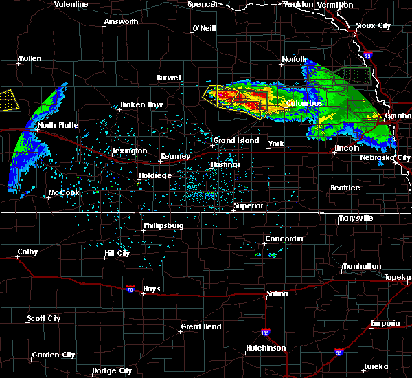 At 930 pm cdt, a severe thunderstorm was located 6 miles northwest of cedar rapids, or 34 miles east of ord, moving northeast at 10 mph (radar indicated). Hazards include quarter size hail. damage to vehicles is expected At 930 pm cdt, a severe thunderstorm was located 6 miles northwest of cedar rapids, or 34 miles east of ord, moving northeast at 10 mph (radar indicated). Hazards include quarter size hail. damage to vehicles is expected
|
| 6/6/2018 9:11 PM CDT |
 The severe thunderstorm warning for central platte and southern boone counties will expire at 915 pm cdt. the storms which prompted the warning have weakened below severe limits, and no longer pose an immediate threat to life or property. therefore, the warning will be allowed to expire. However small hail and heavy rain are still possible with these thunderstorms. The severe thunderstorm warning for central platte and southern boone counties will expire at 915 pm cdt. the storms which prompted the warning have weakened below severe limits, and no longer pose an immediate threat to life or property. therefore, the warning will be allowed to expire. However small hail and heavy rain are still possible with these thunderstorms.
|
| 6/6/2018 8:59 PM CDT |
 At 859 pm cdt, severe thunderstorms were located along a line extending from 3 miles north of cedar rapids to 5 miles northwest of platte center, moving northeast at 15 mph (radar indicated). Hazards include 60 mph wind gusts and quarter size hail. Hail damage to vehicles is expected. expect wind damage to roofs, siding, and trees. locations impacted include, albion, st. Edward, cedar rapids, platte center, monroe, lindsay, primrose, tarnov, cornlea and the highway 14 and 56 junction. At 859 pm cdt, severe thunderstorms were located along a line extending from 3 miles north of cedar rapids to 5 miles northwest of platte center, moving northeast at 15 mph (radar indicated). Hazards include 60 mph wind gusts and quarter size hail. Hail damage to vehicles is expected. expect wind damage to roofs, siding, and trees. locations impacted include, albion, st. Edward, cedar rapids, platte center, monroe, lindsay, primrose, tarnov, cornlea and the highway 14 and 56 junction.
|
| 6/6/2018 8:46 PM CDT |
 At 846 pm cdt, severe thunderstorms were located along a line extending from near cedar rapids to 4 miles north of monroe, moving northeast at 15 mph (radar indicated). Hazards include 60 mph wind gusts and quarter size hail. Hail damage to vehicles is expected. Expect wind damage to roofs, siding, and trees. At 846 pm cdt, severe thunderstorms were located along a line extending from near cedar rapids to 4 miles north of monroe, moving northeast at 15 mph (radar indicated). Hazards include 60 mph wind gusts and quarter size hail. Hail damage to vehicles is expected. Expect wind damage to roofs, siding, and trees.
|
| 9/15/2017 9:04 PM CDT |
 At 903 pm cdt, a severe thunderstorm was located from near loretto to albion, or about 35 miles southwest of norfolk, moving northeast at 45 mph. a second storm was near cedar rapids (radar indicated). Hazards include quarter size hail. Damage to vehicles is expected. locations impacted include, albion, st. Edward, cedar rapids, petersburg, primrose, loretto and the highway 14 and 56 junction. At 903 pm cdt, a severe thunderstorm was located from near loretto to albion, or about 35 miles southwest of norfolk, moving northeast at 45 mph. a second storm was near cedar rapids (radar indicated). Hazards include quarter size hail. Damage to vehicles is expected. locations impacted include, albion, st. Edward, cedar rapids, petersburg, primrose, loretto and the highway 14 and 56 junction.
|
| 9/15/2017 8:58 PM CDT |
 At 857 pm cdt, a severe thunderstorm was located near albion, or 39 miles southwest of norfolk, moving northeast at 50 mph. other storms developing south of cedar rapids could also produce hail (radar indicated). Hazards include 60 mph wind gusts and half dollar size hail. Hail damage to vehicles is expected. expect wind damage to roofs, siding, and trees. locations impacted include, albion, st. Edward, cedar rapids, petersburg, primrose, loretto and the highway 14 and 56 junction. At 857 pm cdt, a severe thunderstorm was located near albion, or 39 miles southwest of norfolk, moving northeast at 50 mph. other storms developing south of cedar rapids could also produce hail (radar indicated). Hazards include 60 mph wind gusts and half dollar size hail. Hail damage to vehicles is expected. expect wind damage to roofs, siding, and trees. locations impacted include, albion, st. Edward, cedar rapids, petersburg, primrose, loretto and the highway 14 and 56 junction.
|
| 9/15/2017 8:54 PM CDT |
 At 853 pm cdt, a severe thunderstorm was located 5 miles west of albion, or 42 miles east of ord, moving northeast at 45 mph (radar indicated). Hazards include half dollar size hail. Damage to vehicles is expected. locations impacted include, albion, st. Edward, cedar rapids, petersburg, primrose, loretto and the highway 14 and 56 junction. At 853 pm cdt, a severe thunderstorm was located 5 miles west of albion, or 42 miles east of ord, moving northeast at 45 mph (radar indicated). Hazards include half dollar size hail. Damage to vehicles is expected. locations impacted include, albion, st. Edward, cedar rapids, petersburg, primrose, loretto and the highway 14 and 56 junction.
|
| 9/15/2017 8:46 PM CDT |
 At 845 pm cdt, a severe thunderstorm was located 4 miles northwest of cedar rapids, or 37 miles east of ord, moving northeast at 45 mph (radar indicated). Hazards include quarter size hail. damage to vehicles is expected At 845 pm cdt, a severe thunderstorm was located 4 miles northwest of cedar rapids, or 37 miles east of ord, moving northeast at 45 mph (radar indicated). Hazards include quarter size hail. damage to vehicles is expected
|
| 7/21/2017 8:10 PM CDT |
 The severe thunderstorm warning for southern boone county will expire at 815 pm cdt, the storm which prompted the warning has weakened below severe limits, and no longer poses an immediate threat to life or property. therefore the warning will be allowed to expire. The severe thunderstorm warning for southern boone county will expire at 815 pm cdt, the storm which prompted the warning has weakened below severe limits, and no longer poses an immediate threat to life or property. therefore the warning will be allowed to expire.
|
| 7/21/2017 8:06 PM CDT |
 At 806 pm cdt, a severe thunderstorm was located 4 miles south of albion, or 37 miles west of columbus, moving southeast at 30 mph (radar indicated). Hazards include 60 mph wind gusts and half dollar size hail. Hail damage to vehicles is expected. expect wind damage to roofs, siding, and trees. locations impacted include, albion, st. Edward, cedar rapids, primrose and the highway 14 and 56 junction. At 806 pm cdt, a severe thunderstorm was located 4 miles south of albion, or 37 miles west of columbus, moving southeast at 30 mph (radar indicated). Hazards include 60 mph wind gusts and half dollar size hail. Hail damage to vehicles is expected. expect wind damage to roofs, siding, and trees. locations impacted include, albion, st. Edward, cedar rapids, primrose and the highway 14 and 56 junction.
|
| 7/21/2017 7:49 PM CDT |
 At 749 pm cdt, a severe thunderstorm was located 7 miles north of cedar rapids, or 38 miles east of ord, moving southeast at 30 mph (radar indicated). Hazards include 60 mph wind gusts and half dollar size hail. Hail damage to vehicles is expected. expect wind damage to roofs, siding, and trees. locations impacted include, albion, st. Edward, cedar rapids, primrose and the highway 14 and 56 junction. At 749 pm cdt, a severe thunderstorm was located 7 miles north of cedar rapids, or 38 miles east of ord, moving southeast at 30 mph (radar indicated). Hazards include 60 mph wind gusts and half dollar size hail. Hail damage to vehicles is expected. expect wind damage to roofs, siding, and trees. locations impacted include, albion, st. Edward, cedar rapids, primrose and the highway 14 and 56 junction.
|
| 7/21/2017 7:38 PM CDT |
 At 738 pm cdt, a severe thunderstorm was located 4 miles northeast of spalding, or 33 miles east of ord, moving southeast at 30 mph (radar indicated). Hazards include 60 mph wind gusts and half dollar size hail. Hail damage to vehicles is expected. Expect wind damage to roofs, siding, and trees. At 738 pm cdt, a severe thunderstorm was located 4 miles northeast of spalding, or 33 miles east of ord, moving southeast at 30 mph (radar indicated). Hazards include 60 mph wind gusts and half dollar size hail. Hail damage to vehicles is expected. Expect wind damage to roofs, siding, and trees.
|
| 6/27/2017 6:21 PM CDT |
 At 1120 pm cdt, severe thunderstorms were located along a line extending from 6 miles northeast of clearwater to 3 miles northwest of belgrade, moving east at 45 mph (radar indicated). Hazards include 60 mph wind gusts and quarter size hail. Hail damage to vehicles is expected. expect wind damage to roofs, siding, and trees. locations impacted include, albion, neligh, st. edward, elgin, clearwater, cedar rapids, orchard, petersburg, oakdale, tilden, brunswick, royal, primrose, loretto and the highway 14 and 56 junction. this includes the following highways, highway 275 in nebraska between mile markers 25 and 53. Highway 20 in nebraska between mile markers 329 and 352. At 1120 pm cdt, severe thunderstorms were located along a line extending from 6 miles northeast of clearwater to 3 miles northwest of belgrade, moving east at 45 mph (radar indicated). Hazards include 60 mph wind gusts and quarter size hail. Hail damage to vehicles is expected. expect wind damage to roofs, siding, and trees. locations impacted include, albion, neligh, st. edward, elgin, clearwater, cedar rapids, orchard, petersburg, oakdale, tilden, brunswick, royal, primrose, loretto and the highway 14 and 56 junction. this includes the following highways, highway 275 in nebraska between mile markers 25 and 53. Highway 20 in nebraska between mile markers 329 and 352.
|
| 6/27/2017 6:06 PM CDT |
 At 1106 pm cdt, severe thunderstorms were located along a line extending from near ewing to 7 miles northeast of wolbach, moving east at 45 mph (radar indicated). Hazards include 60 mph wind gusts and quarter size hail. Hail damage to vehicles is expected. Expect wind damage to roofs, siding, and trees. At 1106 pm cdt, severe thunderstorms were located along a line extending from near ewing to 7 miles northeast of wolbach, moving east at 45 mph (radar indicated). Hazards include 60 mph wind gusts and quarter size hail. Hail damage to vehicles is expected. Expect wind damage to roofs, siding, and trees.
|
| 4/14/2017 10:52 PM CDT |
 The severe thunderstorm warning for west central platte and southern boone counties will expire at 1100 pm cdt, the storm which prompted the warning has weakened below severe limits, and no longer poses an immediate threat to life or property. therefore, the warning will be allowed to expire. however small hail and heavy rain are still possible with this thunderstorm. a severe thunderstorm watch remains in effect until midnight cdt for northeastern nebraska. The severe thunderstorm warning for west central platte and southern boone counties will expire at 1100 pm cdt, the storm which prompted the warning has weakened below severe limits, and no longer poses an immediate threat to life or property. therefore, the warning will be allowed to expire. however small hail and heavy rain are still possible with this thunderstorm. a severe thunderstorm watch remains in effect until midnight cdt for northeastern nebraska.
|
| 4/14/2017 10:44 PM CDT |
 At 1044 pm cdt, a severe thunderstorm was located 4 miles north of belgrade, or 36 miles west of columbus, moving east at 35 mph (radar indicated). Hazards include 60 mph wind gusts and quarter size hail. Hail damage to vehicles is expected. expect wind damage to roofs, siding, and trees. locations impacted include, albion, st. Edward, cedar rapids, primrose and the highway 14 and 56 junction. At 1044 pm cdt, a severe thunderstorm was located 4 miles north of belgrade, or 36 miles west of columbus, moving east at 35 mph (radar indicated). Hazards include 60 mph wind gusts and quarter size hail. Hail damage to vehicles is expected. expect wind damage to roofs, siding, and trees. locations impacted include, albion, st. Edward, cedar rapids, primrose and the highway 14 and 56 junction.
|
| 4/14/2017 10:15 PM CDT |
 At 1014 pm cdt, a severe thunderstorm was located near wolbach, or 29 miles east of ord, moving east at 40 mph (radar indicated). Hazards include 60 mph wind gusts and half dollar size hail. Hail damage to vehicles is expected. Expect wind damage to roofs, siding, and trees. At 1014 pm cdt, a severe thunderstorm was located near wolbach, or 29 miles east of ord, moving east at 40 mph (radar indicated). Hazards include 60 mph wind gusts and half dollar size hail. Hail damage to vehicles is expected. Expect wind damage to roofs, siding, and trees.
|
| 4/14/2017 9:56 PM CDT |
 At 956 pm cdt, a severe thunderstorm was located 6 miles south of albion, or 37 miles west of columbus, moving northeast at 30 mph (radar indicated). Hazards include quarter size hail. Damage to vehicles is expected. locations impacted include, albion, newman grove, st. Edward, cedar rapids, primrose, loretto and the highway 14 and 56 junction. At 956 pm cdt, a severe thunderstorm was located 6 miles south of albion, or 37 miles west of columbus, moving northeast at 30 mph (radar indicated). Hazards include quarter size hail. Damage to vehicles is expected. locations impacted include, albion, newman grove, st. Edward, cedar rapids, primrose, loretto and the highway 14 and 56 junction.
|
| 4/14/2017 9:35 PM CDT |
 At 935 pm cdt, a severe thunderstorm was located near belgrade, or 39 miles north of grand island, moving northeast at 30 mph (radar indicated). Hazards include half dollar size hail. damage to vehicles is expected At 935 pm cdt, a severe thunderstorm was located near belgrade, or 39 miles north of grand island, moving northeast at 30 mph (radar indicated). Hazards include half dollar size hail. damage to vehicles is expected
|
| 6/18/2016 12:40 AM CDT | Trees reported blown down in the cit in boone county NE, 0.4 miles NE of Primrose, NE |
| 8/2/2015 7:58 PM CDT |
 At 757 pm cdt, a severe thunderstorm was located near cedar rapids, or 37 miles west of columbus, moving southeast at 10 mph (radar indicated). Hazards include quarter size hail. damage to vehicles is expected At 757 pm cdt, a severe thunderstorm was located near cedar rapids, or 37 miles west of columbus, moving southeast at 10 mph (radar indicated). Hazards include quarter size hail. damage to vehicles is expected
|
| 7/17/2015 9:27 PM CDT |
 At 927 pm cdt, a severe thunderstorm was located near albion, or 41 miles southwest of norfolk, moving east at 30 mph (radar indicated). Hazards include ping pong ball size hail and 60 mph wind gusts. People and animals outdoors will be injured. expect hail damage to roofs, siding, windows and vehicles. Expect wind damage to roofs, siding and trees. At 927 pm cdt, a severe thunderstorm was located near albion, or 41 miles southwest of norfolk, moving east at 30 mph (radar indicated). Hazards include ping pong ball size hail and 60 mph wind gusts. People and animals outdoors will be injured. expect hail damage to roofs, siding, windows and vehicles. Expect wind damage to roofs, siding and trees.
|
| 5/2/2015 8:55 PM CDT | At 855 pm cdt, a severe thunderstorm was located 7 miles west of cedar rapids, or 33 miles east of ord, moving east at 25 mph (radar indicated). Hazards include quarter size hail. damage to vehicles is expected |
| 5/27/2012 5:48 PM CDT | Ping Pong Ball sized hail reported 0.4 miles NE of Primrose, NE, time estimated |
| 5/27/2012 5:30 PM CDT | Public reported when they arrived home small branches were down...3 windows on the north side of house were broken...and a windshield broken in a vehicle. time estimate in greeley county NE, 8.3 miles NE of Primrose, NE |
| 5/4/2012 6:18 PM CDT | Golf Ball sized hail reported 0.4 miles NE of Primrose, NE |
| 4/14/2012 12:13 PM CDT | Baseball sized hail reported 16.3 miles SSW of Primrose, NE |
| 4/14/2012 11:52 AM CDT | Hen Egg sized hail reported 11.1 miles SSW of Primrose, NE, hailed for 7 minutes with wind gusts estimated at 50mph. |
| 4/14/2012 12:13 AM CDT | Baseball sized hail reported 16.3 miles SSW of Primrose, NE |
| 1/1/0001 12:00 AM | Winds gusts estimated up to 55 to 60 mph. also small hail. corn shredded. 1.60 inches of rai in boone county NE, 5 miles NNE of Primrose, NE |
| 1/1/0001 12:00 AM | Winds gusts estimated up to 55 to 60 mph. also small hail. corn shredded. 1.60 inches of rai in boone county NE, 5 miles NNE of Primrose, NE |
| 1/1/0001 12:00 AM | Storm damage reported in boone county NE, 0.4 miles NE of Primrose, NE |
Hail Maps for Primrose, NE
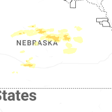
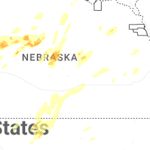

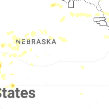
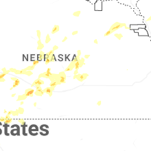
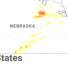
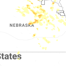
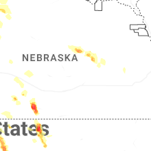

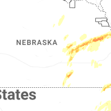
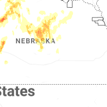
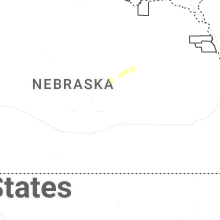


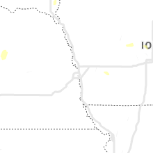

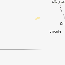


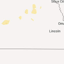


Connect with Interactive Hail Maps