

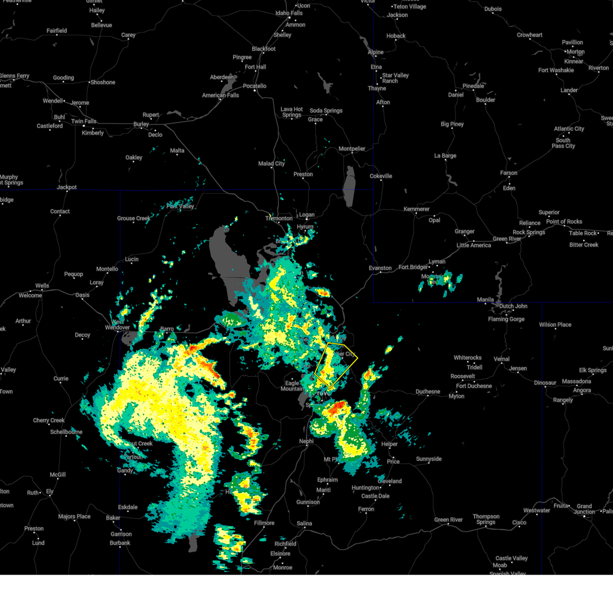
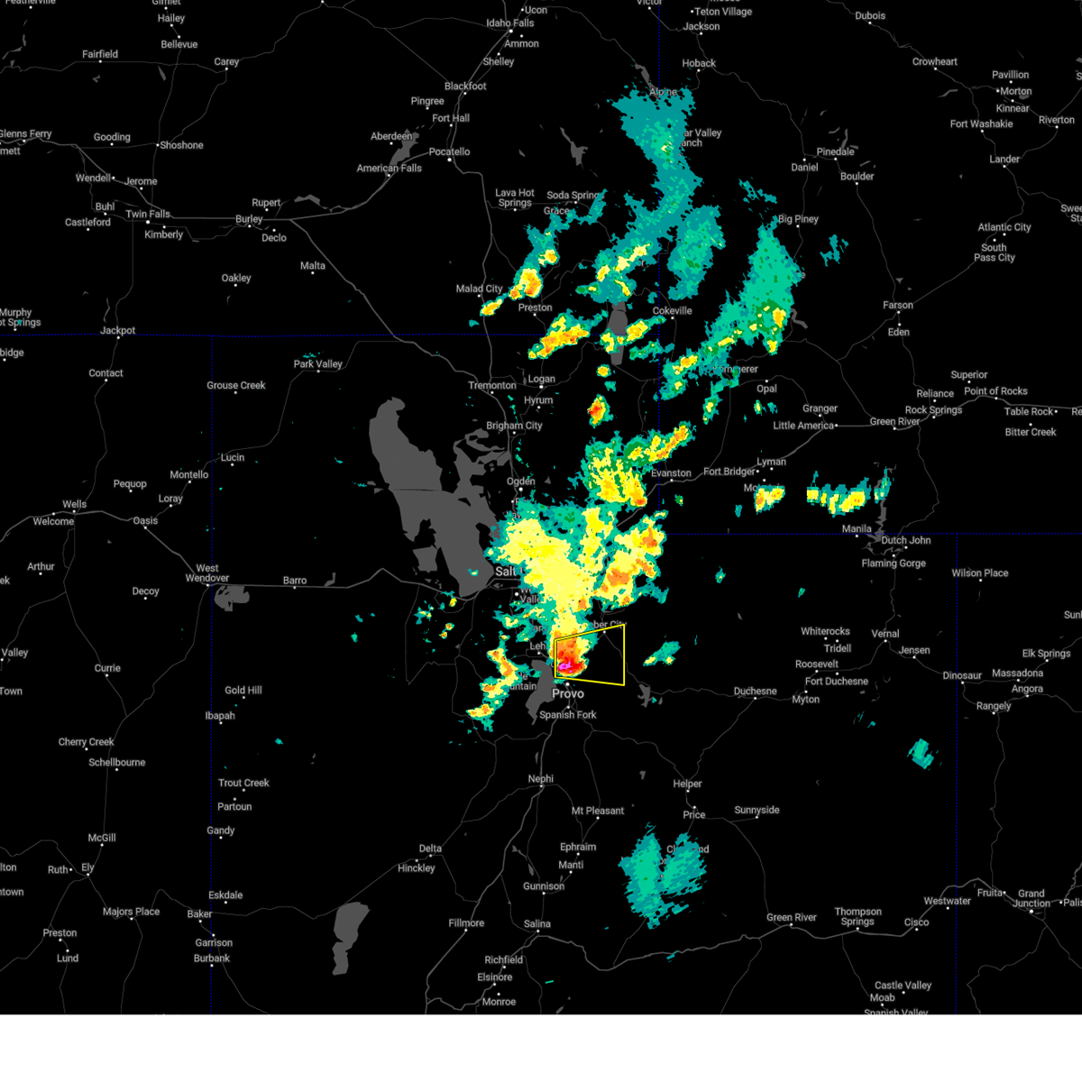
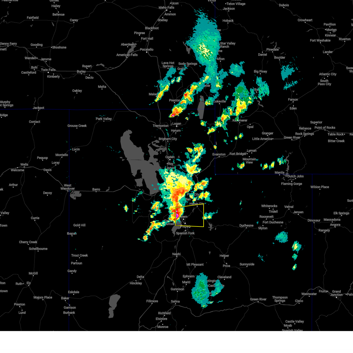
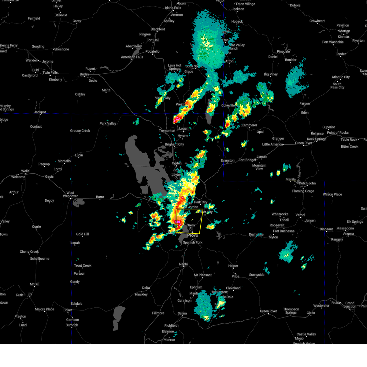
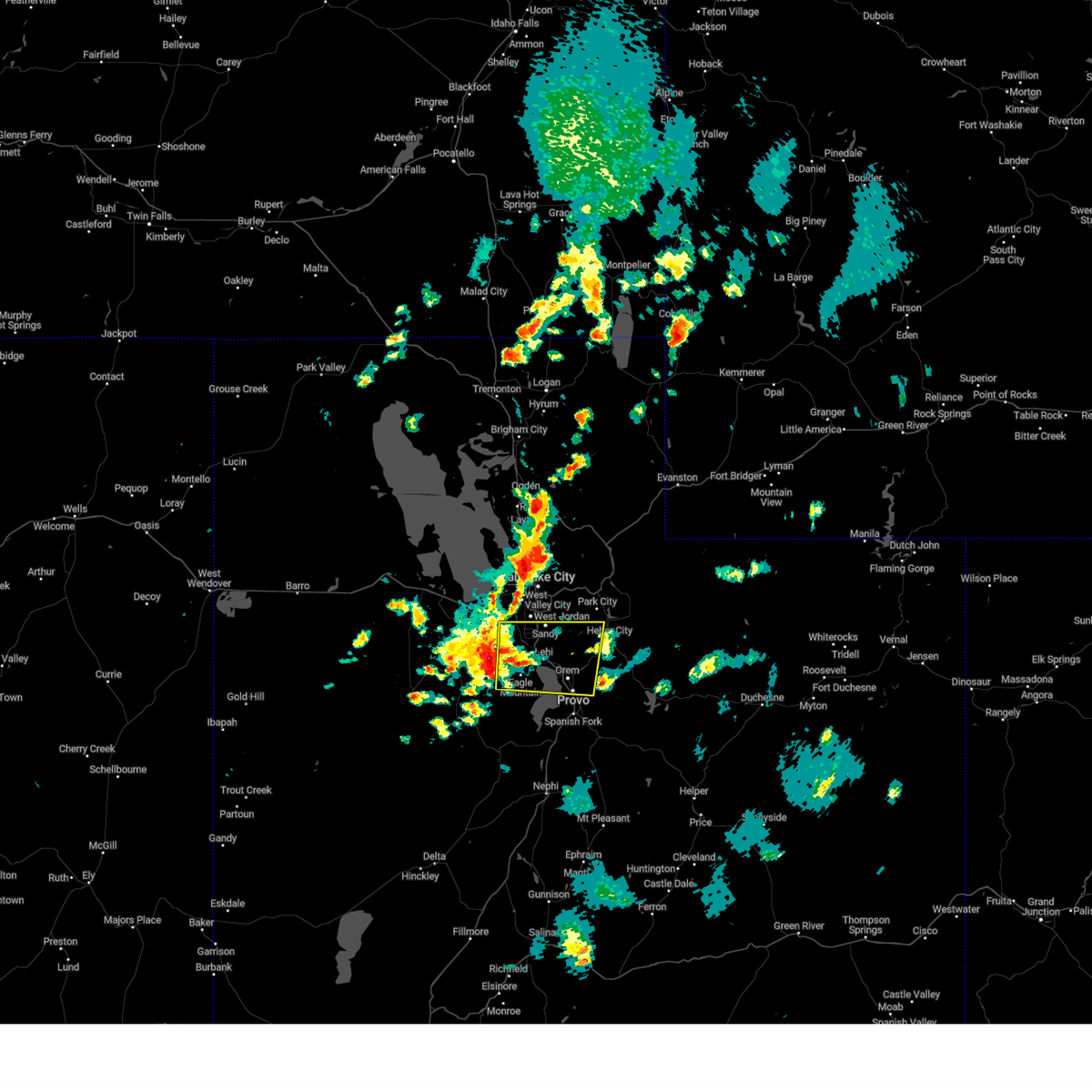
Hail Map for Provo, UT
The Provo, UT area has had 0 reports of on-the-ground hail by trained spotters, and has been under severe weather warnings 6 times during the past 12 months. Doppler radar has detected hail at or near Provo, UT on 8 occasions, including 2 occasions during the past year.
| Name: | Provo, UT |
| Where Located: | 35.9 miles SSE of Salt Lake City, UT |
| Map: | Google Map for Provo, UT |
| Population: | 112488 |
| Housing Units: | 33212 |
| More Info: | Search Google for Provo, UT |
2
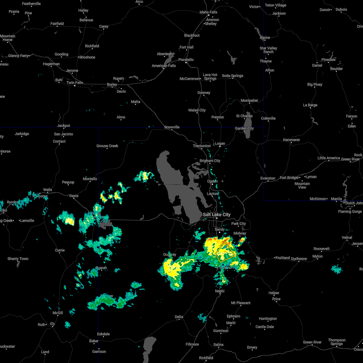
The Top Recent Hail Date for Provo, UT is Tuesday, August 13, 2024 (2nd out of 8)

Hail and Wind Damage Spotted near Provo, UT
| Date / Time | Report Details |
|---|---|
| 8/17/2024 1:14 PM MDT | the severe thunderstorm warning has been cancelled and is no longer in effect |
| 8/17/2024 12:47 PM MDT |
 Svrslc the national weather service in salt lake city has issued a * severe thunderstorm warning for, northwestern wasatch county in northern utah, east central salt lake county in northern utah, southwestern summit county in northern utah, north central utah county in northern utah, * until 130 pm mdt. * at 1247 pm mdt, a severe thunderstorm was located near orem, or 7 miles north of provo, moving northeast at 30 mph (radar indicated). Hazards include 60 mph wind gusts and penny size hail. expect damage to roofs, siding, and trees Svrslc the national weather service in salt lake city has issued a * severe thunderstorm warning for, northwestern wasatch county in northern utah, east central salt lake county in northern utah, southwestern summit county in northern utah, north central utah county in northern utah, * until 130 pm mdt. * at 1247 pm mdt, a severe thunderstorm was located near orem, or 7 miles north of provo, moving northeast at 30 mph (radar indicated). Hazards include 60 mph wind gusts and penny size hail. expect damage to roofs, siding, and trees
|
| 8/13/2024 6:34 PM MDT |
 At 634 pm mdt, a severe thunderstorm was located 8 miles northeast of orem, or 8 miles northeast of provo, moving east at 25 mph (radar indicated). Hazards include ping pong ball size hail and 60 mph wind gusts. People and animals outdoors may be injured. possible hail damage to roofs, siding, windows, and vehicles, as well as wind damage to roofs, siding, and trees. locations impacted include, north provo, heber city, orem, pleasant grove, heber, lindon, daniel, vineyard, wasatch mountain state park, timber lakes, cedar hills, midway, charleston, wallsburg, deer creek state park, mt timpanogos, and sundance. this includes the following highways, interstate 15 between mile markers 269 and 273. Us route 40 between mile markers 17 and 30. At 634 pm mdt, a severe thunderstorm was located 8 miles northeast of orem, or 8 miles northeast of provo, moving east at 25 mph (radar indicated). Hazards include ping pong ball size hail and 60 mph wind gusts. People and animals outdoors may be injured. possible hail damage to roofs, siding, windows, and vehicles, as well as wind damage to roofs, siding, and trees. locations impacted include, north provo, heber city, orem, pleasant grove, heber, lindon, daniel, vineyard, wasatch mountain state park, timber lakes, cedar hills, midway, charleston, wallsburg, deer creek state park, mt timpanogos, and sundance. this includes the following highways, interstate 15 between mile markers 269 and 273. Us route 40 between mile markers 17 and 30.
|
| 8/13/2024 6:30 PM MDT | Measured at the provo canyon pacificorp sit in utah county UT, 5.7 miles SSW of Provo, UT |
| 8/13/2024 6:20 PM MDT | Measured at the udot rwis site at prov in utah county UT, 4.1 miles N of Provo, UT |
| 8/13/2024 6:14 PM MDT |
 Svrslc the national weather service in salt lake city has issued a * severe thunderstorm warning for, northwestern wasatch county in northern utah, north central utah county in northern utah, * until 700 pm mdt. * at 612 pm mdt, a severe thunderstorm was located over lindon, or 8 miles northwest of provo, moving east at 25 mph (radar indicated). Hazards include ping pong ball size hail and 60 mph wind gusts. People and animals outdoors may be injured. Possible hail damage to roofs, siding, windows, and vehicles, as well as wind damage to roofs, siding, and trees. Svrslc the national weather service in salt lake city has issued a * severe thunderstorm warning for, northwestern wasatch county in northern utah, north central utah county in northern utah, * until 700 pm mdt. * at 612 pm mdt, a severe thunderstorm was located over lindon, or 8 miles northwest of provo, moving east at 25 mph (radar indicated). Hazards include ping pong ball size hail and 60 mph wind gusts. People and animals outdoors may be injured. Possible hail damage to roofs, siding, windows, and vehicles, as well as wind damage to roofs, siding, and trees.
|
| 8/13/2024 6:01 PM MDT |
 At 600 pm mdt, severe thunderstorms were located along a line extending from near sandy to near eagle mountain, moving east at 25 mph (radar indicated). Hazards include ping pong ball size hail and 60 mph wind gusts. People and animals outdoors could be injured. possible damage to roofs, siding, windows, and vehicles. locations impacted include, provo, sandy, orem, south jordan, lehi, draper, riverton, pleasant grove, cottonwood heights, american fork, eagle mountain, lindon, alpine, bluffdale, vineyard, little cottonwood canyon, brigham young university, wasatch mountain state park, granite, and utah lake. This includes interstate 15 between mile markers 265 and 295. At 600 pm mdt, severe thunderstorms were located along a line extending from near sandy to near eagle mountain, moving east at 25 mph (radar indicated). Hazards include ping pong ball size hail and 60 mph wind gusts. People and animals outdoors could be injured. possible damage to roofs, siding, windows, and vehicles. locations impacted include, provo, sandy, orem, south jordan, lehi, draper, riverton, pleasant grove, cottonwood heights, american fork, eagle mountain, lindon, alpine, bluffdale, vineyard, little cottonwood canyon, brigham young university, wasatch mountain state park, granite, and utah lake. This includes interstate 15 between mile markers 265 and 295.
|
| 8/13/2024 5:29 PM MDT |
 Svrslc the national weather service in salt lake city has issued a * severe thunderstorm warning for, northwestern wasatch county in northern utah, southern salt lake county in northern utah, northwestern utah county in northern utah, * until 615 pm mdt. * at 528 pm mdt, severe thunderstorms were located along a line extending from bingham canyon mine to near cedar fort, moving east at 25 mph (radar indicated). Hazards include 60 mph wind gusts and quarter size hail. hail damage to vehicles is possible, as well as wind damage to roofs, siding, and trees Svrslc the national weather service in salt lake city has issued a * severe thunderstorm warning for, northwestern wasatch county in northern utah, southern salt lake county in northern utah, northwestern utah county in northern utah, * until 615 pm mdt. * at 528 pm mdt, severe thunderstorms were located along a line extending from bingham canyon mine to near cedar fort, moving east at 25 mph (radar indicated). Hazards include 60 mph wind gusts and quarter size hail. hail damage to vehicles is possible, as well as wind damage to roofs, siding, and trees
|
| 7/27/2024 8:10 PM MDT | Mesonet station snd arrowhead summi in utah county UT, 7.8 miles SSW of Provo, UT |
| 6/24/2024 2:10 PM MDT | Mesonet station utprv i-15 at prov in utah county UT, 4.8 miles N of Provo, UT |
| 5/28/2024 7:16 PM MDT | Awos station kpvu provo municipal airpor in utah county UT, 4.8 miles NE of Provo, UT |
| 8/17/2023 4:05 PM MDT |
 At 404 pm mdt, a severe thunderstorm was located near utah lake, or 10 miles northwest of payson, moving north at 20 mph (radar indicated). Hazards include 60 mph wind gusts. Expect damage to roofs, siding, and trees. locations impacted include, provo, payson, orem, lehi, spanish fork, pleasant grove, springville, american fork, eagle mountain, lindon, salem, cedar fort, vineyard, brigham young university, palmyra, benjamin, lake shore, utah lake, west mountain and camp williams. this includes interstate 15 between mile markers 251 and 281. hail threat, radar indicated max hail size, <. 75 in wind threat, observed max wind gust, 60 mph. At 404 pm mdt, a severe thunderstorm was located near utah lake, or 10 miles northwest of payson, moving north at 20 mph (radar indicated). Hazards include 60 mph wind gusts. Expect damage to roofs, siding, and trees. locations impacted include, provo, payson, orem, lehi, spanish fork, pleasant grove, springville, american fork, eagle mountain, lindon, salem, cedar fort, vineyard, brigham young university, palmyra, benjamin, lake shore, utah lake, west mountain and camp williams. this includes interstate 15 between mile markers 251 and 281. hail threat, radar indicated max hail size, <. 75 in wind threat, observed max wind gust, 60 mph.
|
| 8/17/2023 3:44 PM MDT |
 At 343 pm mdt, a severe thunderstorm was located near west mountain, or 8 miles west of payson, moving north at 20 mph (radar indicated). Hazards include 60 mph wind gusts. expect damage to roofs, siding, and trees At 343 pm mdt, a severe thunderstorm was located near west mountain, or 8 miles west of payson, moving north at 20 mph (radar indicated). Hazards include 60 mph wind gusts. expect damage to roofs, siding, and trees
|
| 8/2/2023 3:32 PM MDT |
 At 331 pm mdt, severe thunderstorms were located along a line extending from tooele to little cottonwood canyon to near daniel, moving northeast at 40 mph (radar indicated. at 320 pm a wind gust to 61 mph was observed in charleston near deer creek reservoir). Hazards include 60 mph wind gusts and penny size hail. Expect damage to roofs, siding, and trees. locations impacted include, salt lake city, west valley city, provo, sandy, murray, tooele, grantsville, park city, heber city, west jordan, orem, taylorsville, south jordan, lehi, draper, riverton, pleasant grove, cottonwood heights, midvale and holladay. this includes the following highways, interstate 15 between mile markers 273 and 309. interstate 80 in utah between mile markers 85 and 152. us route 40 between mile markers 0 and 25. hail threat, radar indicated max hail size, 0. 75 in wind threat, observed max wind gust, 60 mph. At 331 pm mdt, severe thunderstorms were located along a line extending from tooele to little cottonwood canyon to near daniel, moving northeast at 40 mph (radar indicated. at 320 pm a wind gust to 61 mph was observed in charleston near deer creek reservoir). Hazards include 60 mph wind gusts and penny size hail. Expect damage to roofs, siding, and trees. locations impacted include, salt lake city, west valley city, provo, sandy, murray, tooele, grantsville, park city, heber city, west jordan, orem, taylorsville, south jordan, lehi, draper, riverton, pleasant grove, cottonwood heights, midvale and holladay. this includes the following highways, interstate 15 between mile markers 273 and 309. interstate 80 in utah between mile markers 85 and 152. us route 40 between mile markers 0 and 25. hail threat, radar indicated max hail size, 0. 75 in wind threat, observed max wind gust, 60 mph.
|
| 8/2/2023 3:13 PM MDT |
 At 313 pm mdt, severe thunderstorms were located along a line extending from near tooele army depot south to 6 miles northeast of lindon, moving north at 40 mph (radar indicated). Hazards include 70 mph wind gusts and penny size hail. Expect considerable tree damage. damage is likely to mobile homes, roofs, and outbuildings. locations impacted include, salt lake city, west valley city, provo, sandy, murray, tooele, grantsville, park city, heber city, west jordan, orem, taylorsville, south jordan, lehi, draper, riverton, pleasant grove, cottonwood heights, midvale and holladay. this includes the following highways, interstate 15 between mile markers 263 and 309. interstate 80 in utah between mile markers 85 and 152. us route 40 between mile markers 0 and 25. mirror lake highway near mile marker 0. thunderstorm damage threat, considerable hail threat, radar indicated max hail size, 0. 75 in wind threat, observed max wind gust, 70 mph. At 313 pm mdt, severe thunderstorms were located along a line extending from near tooele army depot south to 6 miles northeast of lindon, moving north at 40 mph (radar indicated). Hazards include 70 mph wind gusts and penny size hail. Expect considerable tree damage. damage is likely to mobile homes, roofs, and outbuildings. locations impacted include, salt lake city, west valley city, provo, sandy, murray, tooele, grantsville, park city, heber city, west jordan, orem, taylorsville, south jordan, lehi, draper, riverton, pleasant grove, cottonwood heights, midvale and holladay. this includes the following highways, interstate 15 between mile markers 263 and 309. interstate 80 in utah between mile markers 85 and 152. us route 40 between mile markers 0 and 25. mirror lake highway near mile marker 0. thunderstorm damage threat, considerable hail threat, radar indicated max hail size, 0. 75 in wind threat, observed max wind gust, 70 mph.
|
| 8/2/2023 3:10 PM MDT | Mesonet station pc034 provo canyo in utah county UT, 5.7 miles SSW of Provo, UT |
| 8/2/2023 3:01 PM MDT |
 At 301 pm mdt, severe thunderstorms were located along a line extending from near tooele army depot south to near orem, moving north at 40 mph (radar indicated). Hazards include 70 mph wind gusts and penny size hail. Expect considerable tree damage. Damage is likely to mobile homes, roofs, and outbuildings. At 301 pm mdt, severe thunderstorms were located along a line extending from near tooele army depot south to near orem, moving north at 40 mph (radar indicated). Hazards include 70 mph wind gusts and penny size hail. Expect considerable tree damage. Damage is likely to mobile homes, roofs, and outbuildings.
|
| 8/2/2023 3:00 PM MDT | Mesonet station snd arrowhead summi in utah county UT, 7.8 miles SSW of Provo, UT |
| 8/2/2023 2:47 PM MDT | Awos station kpvu provo municipal airpor in utah county UT, 4.8 miles NE of Provo, UT |
| 8/2/2023 2:40 PM MDT |
 At 239 pm mdt, severe thunderstorms were located along a line extending from 6 miles southeast of tooele army depot south to lake shore, moving north at 25 mph (radar indicated). Hazards include 70 mph wind gusts and quarter size hail. Hail damage to vehicles is expected. expect considerable tree damage. wind damage is also likely to mobile homes, roofs, and outbuildings. locations impacted include, provo, heber city, orem, lehi, draper, pleasant grove, springville, american fork, eagle mountain, heber, lindon, alpine, daniel, cedar fort, vineyard, ophir, brigham young university, wasatch mountain state park, tooele army depot south and utah lake. this includes the following highways, interstate 15 between mile markers 262 and 285. us route 40 between mile markers 13 and 24. thunderstorm damage threat, considerable hail threat, radar indicated max hail size, 1. 00 in wind threat, radar indicated max wind gust, 70 mph. At 239 pm mdt, severe thunderstorms were located along a line extending from 6 miles southeast of tooele army depot south to lake shore, moving north at 25 mph (radar indicated). Hazards include 70 mph wind gusts and quarter size hail. Hail damage to vehicles is expected. expect considerable tree damage. wind damage is also likely to mobile homes, roofs, and outbuildings. locations impacted include, provo, heber city, orem, lehi, draper, pleasant grove, springville, american fork, eagle mountain, heber, lindon, alpine, daniel, cedar fort, vineyard, ophir, brigham young university, wasatch mountain state park, tooele army depot south and utah lake. this includes the following highways, interstate 15 between mile markers 262 and 285. us route 40 between mile markers 13 and 24. thunderstorm damage threat, considerable hail threat, radar indicated max hail size, 1. 00 in wind threat, radar indicated max wind gust, 70 mph.
|
| 8/2/2023 2:27 PM MDT |
 At 226 pm mdt, severe thunderstorms were located along a line extending from near tooele army depot south to near brigham young university, moving north at 35 mph (radar indicated). Hazards include 70 mph wind gusts and quarter size hail. Hail damage to vehicles is expected. expect considerable tree damage. Wind damage is also likely to mobile homes, roofs, and outbuildings. At 226 pm mdt, severe thunderstorms were located along a line extending from near tooele army depot south to near brigham young university, moving north at 35 mph (radar indicated). Hazards include 70 mph wind gusts and quarter size hail. Hail damage to vehicles is expected. expect considerable tree damage. Wind damage is also likely to mobile homes, roofs, and outbuildings.
|
| 7/26/2023 5:57 PM MDT |
 The severe thunderstorm warning for northwestern wasatch, southeastern salt lake and north central utah counties will expire at 600 pm mdt, the storms which prompted the warning have weakened below severe limits, and no longer pose an immediate threat to life or property. therefore, the warning will be allowed to expire. however gusty winds are still possible with these thunderstorms. The severe thunderstorm warning for northwestern wasatch, southeastern salt lake and north central utah counties will expire at 600 pm mdt, the storms which prompted the warning have weakened below severe limits, and no longer pose an immediate threat to life or property. therefore, the warning will be allowed to expire. however gusty winds are still possible with these thunderstorms.
|
| 7/26/2023 5:45 PM MDT |
 At 544 pm mdt, severe thunderstorms were located along a line extending from granite to 8 miles northeast of mapleton, moving east at 20 mph (automated sensors at provo airport and deer creek dam). Hazards include 60 mph wind gusts. Expect damage to roofs, siding, and trees. locations impacted include, provo, heber city, heber, summit park, daniel, little cottonwood canyon, wasatch mountain state park, mill creek canyon, big cottonwood canyon, timber lakes, midway, charleston, alta, wallsburg, brighton, deer creek state park, snowbird, sundance, hailstone and jordanelle reservoir. this includes the following highways, interstate 80 in utah between mile markers 137 and 138. us route 40 between mile markers 7 and 35. hail threat, radar indicated max hail size, <. 75 in wind threat, observed max wind gust, 60 mph. At 544 pm mdt, severe thunderstorms were located along a line extending from granite to 8 miles northeast of mapleton, moving east at 20 mph (automated sensors at provo airport and deer creek dam). Hazards include 60 mph wind gusts. Expect damage to roofs, siding, and trees. locations impacted include, provo, heber city, heber, summit park, daniel, little cottonwood canyon, wasatch mountain state park, mill creek canyon, big cottonwood canyon, timber lakes, midway, charleston, alta, wallsburg, brighton, deer creek state park, snowbird, sundance, hailstone and jordanelle reservoir. this includes the following highways, interstate 80 in utah between mile markers 137 and 138. us route 40 between mile markers 7 and 35. hail threat, radar indicated max hail size, <. 75 in wind threat, observed max wind gust, 60 mph.
|
| 7/26/2023 5:36 PM MDT |
 At 535 pm mdt, severe thunderstorms were located along a line extending from sandy to near springville, moving east at 20 mph (automated sensor at provo airport). Hazards include 60 mph wind gusts. Expect damage to roofs, siding, and trees. locations impacted include, provo, sandy, heber city, orem, lehi, draper, pleasant grove, cottonwood heights, springville, american fork, heber, lindon, alpine, mapleton, summit park, daniel, vineyard, little cottonwood canyon, brigham young university and wasatch mountain state park. this includes the following highways, interstate 15 between mile markers 262 and 265, and between mile markers 271 and 274. interstate 80 in utah between mile markers 136 and 138. us route 40 between mile markers 7 and 35. hail threat, radar indicated max hail size, <. 75 in wind threat, observed max wind gust, 60 mph. At 535 pm mdt, severe thunderstorms were located along a line extending from sandy to near springville, moving east at 20 mph (automated sensor at provo airport). Hazards include 60 mph wind gusts. Expect damage to roofs, siding, and trees. locations impacted include, provo, sandy, heber city, orem, lehi, draper, pleasant grove, cottonwood heights, springville, american fork, heber, lindon, alpine, mapleton, summit park, daniel, vineyard, little cottonwood canyon, brigham young university and wasatch mountain state park. this includes the following highways, interstate 15 between mile markers 262 and 265, and between mile markers 271 and 274. interstate 80 in utah between mile markers 136 and 138. us route 40 between mile markers 7 and 35. hail threat, radar indicated max hail size, <. 75 in wind threat, observed max wind gust, 60 mph.
|
| 7/26/2023 5:25 PM MDT |
 At 524 pm mdt, severe thunderstorms were located along a line extending from sandy to near springville, moving northeast at 20 mph. a wind gusts to 58 mph was just reported at provo airport (mesonet). Hazards include 60 mph wind gusts. expect damage to roofs, siding, and trees At 524 pm mdt, severe thunderstorms were located along a line extending from sandy to near springville, moving northeast at 20 mph. a wind gusts to 58 mph was just reported at provo airport (mesonet). Hazards include 60 mph wind gusts. expect damage to roofs, siding, and trees
|
| 7/26/2023 5:16 PM MDT | Awos station kpvu provo municipal airpor in utah county UT, 4.8 miles NE of Provo, UT |
| 7/26/2023 5:15 PM MDT | Awos station kpvu provo municipal airpor in utah county UT, 4.8 miles NE of Provo, UT |
| 7/24/2023 5:20 PM MDT | Measured at the provo canyon upr mesonet site (site pc034 in utah county UT, 5.7 miles SSW of Provo, UT |
| 7/19/2023 7:10 PM MDT | Mesonet station snd arrowhead summi in utah county UT, 7.8 miles SSW of Provo, UT |
| 7/19/2023 7:00 PM MDT | Mesonet station snd arrowhead summi in utah county UT, 7.8 miles SSW of Provo, UT |
| 7/19/2023 7:00 PM MDT | Mesonet station pc034 provo canyo in utah county UT, 5.7 miles SSW of Provo, UT |
| 7/3/2023 5:52 PM MDT |
 At 552 pm mdt, severe thunderstorms were located along a line extending from layton to 9 miles northeast of mapleton, moving northeast at 40 mph (radar indicated). Hazards include 60 mph wind gusts. expect damage to roofs, siding, and trees At 552 pm mdt, severe thunderstorms were located along a line extending from layton to 9 miles northeast of mapleton, moving northeast at 40 mph (radar indicated). Hazards include 60 mph wind gusts. expect damage to roofs, siding, and trees
|
| 7/3/2023 5:41 PM MDT |
 At 540 pm mdt, a severe thunderstorm was located over american fork, or 11 miles northwest of provo, moving northeast at 30 mph (radar indicated). Hazards include 60 mph wind gusts. Expect damage to roofs, siding, and trees. locations impacted include, salt lake city, west valley city, provo, sandy, murray, payson, west jordan, orem, taylorsville, south jordan, lehi, draper, riverton, spanish fork, pleasant grove, cottonwood heights, springville, midvale, holladay and american fork. this includes the following highways, interstate 15 between mile markers 249 and 307. interstate 80 in utah between mile markers 123 and 139. us route 6 between mile markers 174 and 182. hail threat, radar indicated max hail size, <. 75 in wind threat, radar indicated max wind gust, 60 mph. At 540 pm mdt, a severe thunderstorm was located over american fork, or 11 miles northwest of provo, moving northeast at 30 mph (radar indicated). Hazards include 60 mph wind gusts. Expect damage to roofs, siding, and trees. locations impacted include, salt lake city, west valley city, provo, sandy, murray, payson, west jordan, orem, taylorsville, south jordan, lehi, draper, riverton, spanish fork, pleasant grove, cottonwood heights, springville, midvale, holladay and american fork. this includes the following highways, interstate 15 between mile markers 249 and 307. interstate 80 in utah between mile markers 123 and 139. us route 6 between mile markers 174 and 182. hail threat, radar indicated max hail size, <. 75 in wind threat, radar indicated max wind gust, 60 mph.
|
| 7/3/2023 5:30 PM MDT |
 At 530 pm mdt, a severe thunderstorm was located near american fork, or 13 miles northwest of provo, moving east at 30 mph (radar indicated). Hazards include 60 mph wind gusts. expect damage to roofs, siding, and trees At 530 pm mdt, a severe thunderstorm was located near american fork, or 13 miles northwest of provo, moving east at 30 mph (radar indicated). Hazards include 60 mph wind gusts. expect damage to roofs, siding, and trees
|
| 6/3/2023 2:55 PM MDT |
 The severe thunderstorm warning for northwestern utah county will expire at 300 pm mdt, the storm which prompted the warning has weakened below severe limits, and no longer poses an immediate threat to life or property. therefore, the warning will be allowed to expire. however small hail, gusty winds and heavy rain are still possible with this thunderstorm. The severe thunderstorm warning for northwestern utah county will expire at 300 pm mdt, the storm which prompted the warning has weakened below severe limits, and no longer poses an immediate threat to life or property. therefore, the warning will be allowed to expire. however small hail, gusty winds and heavy rain are still possible with this thunderstorm.
|
| 6/3/2023 2:38 PM MDT |
 At 237 pm mdt, a severe thunderstorm was located over eagle mountain, or 19 miles west of provo, moving east at 10 mph (radar indicated). Hazards include 60 mph wind gusts and nickel size hail. Expect damage to roofs, siding, and trees. locations impacted include, provo, orem, lehi, draper, spanish fork, pleasant grove, springville, american fork, eagle mountain, lindon, cedar fort, vineyard, utah lake, palmyra, brigham young university, lake shore, camp williams, saratoga springs, highland and cedar hills. This includes interstate 15 between mile markers 259 and 284. At 237 pm mdt, a severe thunderstorm was located over eagle mountain, or 19 miles west of provo, moving east at 10 mph (radar indicated). Hazards include 60 mph wind gusts and nickel size hail. Expect damage to roofs, siding, and trees. locations impacted include, provo, orem, lehi, draper, spanish fork, pleasant grove, springville, american fork, eagle mountain, lindon, cedar fort, vineyard, utah lake, palmyra, brigham young university, lake shore, camp williams, saratoga springs, highland and cedar hills. This includes interstate 15 between mile markers 259 and 284.
|
| 6/3/2023 2:28 PM MDT |
 At 227 pm mdt, a severe thunderstorm was located over eagle mountain, or 21 miles southwest of sandy, moving east at 10 mph (radar indicated). Hazards include 60 mph wind gusts and nickel size hail. Expect damage to roofs, siding, and trees. locations impacted include, provo, orem, lehi, draper, spanish fork, pleasant grove, springville, american fork, eagle mountain, lindon, bluffdale, cedar fort, vineyard, palmyra, utah lake, camp williams, brigham young university, lake shore, saratoga springs and highland. this includes interstate 15 between mile markers 259 and 285. hail threat, radar indicated max hail size, 0. 88 in wind threat, radar indicated max wind gust, 60 mph. At 227 pm mdt, a severe thunderstorm was located over eagle mountain, or 21 miles southwest of sandy, moving east at 10 mph (radar indicated). Hazards include 60 mph wind gusts and nickel size hail. Expect damage to roofs, siding, and trees. locations impacted include, provo, orem, lehi, draper, spanish fork, pleasant grove, springville, american fork, eagle mountain, lindon, bluffdale, cedar fort, vineyard, palmyra, utah lake, camp williams, brigham young university, lake shore, saratoga springs and highland. this includes interstate 15 between mile markers 259 and 285. hail threat, radar indicated max hail size, 0. 88 in wind threat, radar indicated max wind gust, 60 mph.
|
| 6/3/2023 2:09 PM MDT |
 At 208 pm mdt, a severe thunderstorm was located near cedar fort, or 21 miles southeast of tooele, moving east at 10 mph (radar indicated). Hazards include 60 mph wind gusts and quarter size hail. Hail damage to vehicles is expected. Expect wind damage to roofs, siding, and trees. At 208 pm mdt, a severe thunderstorm was located near cedar fort, or 21 miles southeast of tooele, moving east at 10 mph (radar indicated). Hazards include 60 mph wind gusts and quarter size hail. Hail damage to vehicles is expected. Expect wind damage to roofs, siding, and trees.
|
| 9/21/2022 2:22 PM MDT |
 At 222 pm mdt, a severe thunderstorm was located near brigham young university, or near provo, moving northeast at 30 mph (radar indicated). Hazards include 60 mph wind gusts and quarter size hail. Hail damage to vehicles is expected. expect wind damage to roofs, siding, and trees. locations impacted include, provo, heber city, orem, heber, lindon, daniel, brigham young university, wasatch mountain state park, timber lakes, midway, charleston, wallsburg, deer creek state park and sundance. this includes the following highways, interstate 15 near mile marker 271. us route 40 between mile markers 11 and 25. hail threat, radar indicated max hail size, 1. 00 in wind threat, radar indicated max wind gust, 60 mph. At 222 pm mdt, a severe thunderstorm was located near brigham young university, or near provo, moving northeast at 30 mph (radar indicated). Hazards include 60 mph wind gusts and quarter size hail. Hail damage to vehicles is expected. expect wind damage to roofs, siding, and trees. locations impacted include, provo, heber city, orem, heber, lindon, daniel, brigham young university, wasatch mountain state park, timber lakes, midway, charleston, wallsburg, deer creek state park and sundance. this includes the following highways, interstate 15 near mile marker 271. us route 40 between mile markers 11 and 25. hail threat, radar indicated max hail size, 1. 00 in wind threat, radar indicated max wind gust, 60 mph.
|
| 9/21/2022 2:11 PM MDT |
 At 210 pm mdt, a severe thunderstorm was located over brigham young university, or over provo, moving northeast at 35 mph (radar indicated). Hazards include 60 mph wind gusts and quarter size hail. Hail damage to vehicles is expected. Expect wind damage to roofs, siding, and trees. At 210 pm mdt, a severe thunderstorm was located over brigham young university, or over provo, moving northeast at 35 mph (radar indicated). Hazards include 60 mph wind gusts and quarter size hail. Hail damage to vehicles is expected. Expect wind damage to roofs, siding, and trees.
|
| 9/21/2022 2:01 PM MDT |
 At 201 pm mdt, a severe thunderstorm was located over palmyra, or near provo, moving northeast at 30 mph (radar indicated). Hazards include 60 mph wind gusts and quarter size hail. Hail damage to vehicles is expected. expect wind damage to roofs, siding, and trees. locations impacted include, provo, payson, orem, spanish fork, pleasant grove, springville, lindon, mapleton, salem, woodland hills, vineyard, brigham young university, palmyra, benjamin, lake shore, utah lake, west mountain, mt timpanogos and sundance. this includes the following highways, interstate 15 between mile markers 251 and 274. us route 6 between mile markers 174 and 177. hail threat, radar indicated max hail size, 1. 00 in wind threat, radar indicated max wind gust, 60 mph. At 201 pm mdt, a severe thunderstorm was located over palmyra, or near provo, moving northeast at 30 mph (radar indicated). Hazards include 60 mph wind gusts and quarter size hail. Hail damage to vehicles is expected. expect wind damage to roofs, siding, and trees. locations impacted include, provo, payson, orem, spanish fork, pleasant grove, springville, lindon, mapleton, salem, woodland hills, vineyard, brigham young university, palmyra, benjamin, lake shore, utah lake, west mountain, mt timpanogos and sundance. this includes the following highways, interstate 15 between mile markers 251 and 274. us route 6 between mile markers 174 and 177. hail threat, radar indicated max hail size, 1. 00 in wind threat, radar indicated max wind gust, 60 mph.
|
| 9/21/2022 1:48 PM MDT |
 At 148 pm mdt, a severe thunderstorm was located over benjamin, or near payson, moving northeast at 30 mph (radar indicated). Hazards include 60 mph wind gusts and quarter size hail. Hail damage to vehicles is expected. Expect wind damage to roofs, siding, and trees. At 148 pm mdt, a severe thunderstorm was located over benjamin, or near payson, moving northeast at 30 mph (radar indicated). Hazards include 60 mph wind gusts and quarter size hail. Hail damage to vehicles is expected. Expect wind damage to roofs, siding, and trees.
|
| 8/11/2022 6:50 PM MDT | Sundance arrowhead weather station in utah county UT, 7.8 miles SSW of Provo, UT |
| 7/22/2022 5:54 PM MDT |
 At 554 pm mdt, severe thunderstorms were located along a line extending from 7 miles southwest of kaysville to near american fork, moving east at 30 mph (radar indicated). Hazards include 60 mph wind gusts. Expect damage to roofs, siding, and trees. locations impacted include, salt lake city, west valley city, provo, sandy, ogden, layton, murray, bountiful, farmington, park city, morgan, hill air force base, heber city, west jordan, orem, taylorsville, south jordan, lehi, draper and riverton. this includes the following highways, interstate 15 between mile markers 257 and 336. interstate 84 between mile markers 85 and 109. interstate 80 in utah between mile markers 110 and 154. us route 40 between mile markers 0 and 22. hail threat, radar indicated max hail size, <. 75 in wind threat, observed max wind gust, 60 mph. At 554 pm mdt, severe thunderstorms were located along a line extending from 7 miles southwest of kaysville to near american fork, moving east at 30 mph (radar indicated). Hazards include 60 mph wind gusts. Expect damage to roofs, siding, and trees. locations impacted include, salt lake city, west valley city, provo, sandy, ogden, layton, murray, bountiful, farmington, park city, morgan, hill air force base, heber city, west jordan, orem, taylorsville, south jordan, lehi, draper and riverton. this includes the following highways, interstate 15 between mile markers 257 and 336. interstate 84 between mile markers 85 and 109. interstate 80 in utah between mile markers 110 and 154. us route 40 between mile markers 0 and 22. hail threat, radar indicated max hail size, <. 75 in wind threat, observed max wind gust, 60 mph.
|
| 7/22/2022 5:26 PM MDT |
 At 525 pm mdt, severe thunderstorms were located along a line extending from 8 miles southeast of great salt lake south of the causeway to near cedar fort, moving east at 30 mph (radar indicated). Hazards include 60 mph wind gusts. expect damage to roofs, siding, and trees At 525 pm mdt, severe thunderstorms were located along a line extending from 8 miles southeast of great salt lake south of the causeway to near cedar fort, moving east at 30 mph (radar indicated). Hazards include 60 mph wind gusts. expect damage to roofs, siding, and trees
|
| 7/18/2022 7:11 PM MDT |
 The severe thunderstorm warning for north central utah county will expire at 715 pm mdt, the storm which prompted the warning has weakened below severe limits. therefore, the warning will be allowed to expire. however gusty winds are still possible with this thunderstorm and a special weather statement is now in effect. The severe thunderstorm warning for north central utah county will expire at 715 pm mdt, the storm which prompted the warning has weakened below severe limits. therefore, the warning will be allowed to expire. however gusty winds are still possible with this thunderstorm and a special weather statement is now in effect.
|
| 7/18/2022 6:58 PM MDT |
 At 657 pm mdt, a severe thunderstorm was located near vineyard, or 8 miles west of provo, moving northeast at 20 mph (radar indicated). Hazards include 60 mph wind gusts. Expect damage to roofs, siding, and trees. locations impacted include, provo, orem, pleasant grove, american fork, lindon, vineyard, utah lake, brigham young university, saratoga springs, highland, cedar hills and mt timpanogos. this includes interstate 15 between mile markers 264 and 277. hail threat, radar indicated max hail size, <. 75 in wind threat, radar indicated max wind gust, 60 mph. At 657 pm mdt, a severe thunderstorm was located near vineyard, or 8 miles west of provo, moving northeast at 20 mph (radar indicated). Hazards include 60 mph wind gusts. Expect damage to roofs, siding, and trees. locations impacted include, provo, orem, pleasant grove, american fork, lindon, vineyard, utah lake, brigham young university, saratoga springs, highland, cedar hills and mt timpanogos. this includes interstate 15 between mile markers 264 and 277. hail threat, radar indicated max hail size, <. 75 in wind threat, radar indicated max wind gust, 60 mph.
|
| 7/18/2022 6:49 PM MDT |
 At 649 pm mdt, a severe thunderstorm was located near utah lake, or 10 miles west of provo, moving northeast at 20 mph (radar indicated). Hazards include 60 mph wind gusts. expect damage to roofs, siding, and trees At 649 pm mdt, a severe thunderstorm was located near utah lake, or 10 miles west of provo, moving northeast at 20 mph (radar indicated). Hazards include 60 mph wind gusts. expect damage to roofs, siding, and trees
|
| 7/17/2022 6:45 PM MDT |
 At 644 pm mdt, severe thunderstorms were located along a line extending from near weber state university to near daniel, moving east at 40 mph (trained weather spotters). Hazards include 60 mph wind gusts. expect damage to roofs, siding, and trees At 644 pm mdt, severe thunderstorms were located along a line extending from near weber state university to near daniel, moving east at 40 mph (trained weather spotters). Hazards include 60 mph wind gusts. expect damage to roofs, siding, and trees
|
| 7/17/2022 6:30 PM MDT | Wind gust recorded at provo canyon mesonet sit in utah county UT, 5.7 miles SSW of Provo, UT |
| 6/30/2022 6:50 PM MDT | Provo canyon in utah county UT, 5.7 miles SSW of Provo, UT |
| 8/18/2021 2:38 PM MDT |
 The severe thunderstorm warning for east central juab and southwestern utah counties will expire at 245 pm mdt, the storms which prompted the warning have weakened below severe limits, and no longer pose an immediate threat to life or property. therefore, the warning will be allowed to expire. however heavy rain is still possible with these thunderstorms. a severe thunderstorm watch remains in effect until 800 pm mdt for central and northern utah. The severe thunderstorm warning for east central juab and southwestern utah counties will expire at 245 pm mdt, the storms which prompted the warning have weakened below severe limits, and no longer pose an immediate threat to life or property. therefore, the warning will be allowed to expire. however heavy rain is still possible with these thunderstorms. a severe thunderstorm watch remains in effect until 800 pm mdt for central and northern utah.
|
| 8/18/2021 2:30 PM MDT |
 At 229 pm mdt, severe thunderstorms were located along a line extending from near lindon to 10 miles east of woodland hills, moving northeast at 35 mph (radar indicated). Hazards include 60 mph wind gusts. Expect damage to roofs, siding, and trees. locations impacted include, provo, payson, nephi, spanish fork, springville, santaquin, mapleton, salem, elk ridge, woodland hills, rocky ridge, benjamin, palmyra, lake shore, spring lake, west mountain, elberta, utah lake, mona and genola. this includes the following highways, interstate 15 between mile markers 224 and 263. us route 6 between mile markers 150 and 195. us route 89 between mile markers 297 and 312. hail threat, radar indicated max hail size, <. 75 in wind threat, radar indicated max wind gust, 60 mph. At 229 pm mdt, severe thunderstorms were located along a line extending from near lindon to 10 miles east of woodland hills, moving northeast at 35 mph (radar indicated). Hazards include 60 mph wind gusts. Expect damage to roofs, siding, and trees. locations impacted include, provo, payson, nephi, spanish fork, springville, santaquin, mapleton, salem, elk ridge, woodland hills, rocky ridge, benjamin, palmyra, lake shore, spring lake, west mountain, elberta, utah lake, mona and genola. this includes the following highways, interstate 15 between mile markers 224 and 263. us route 6 between mile markers 150 and 195. us route 89 between mile markers 297 and 312. hail threat, radar indicated max hail size, <. 75 in wind threat, radar indicated max wind gust, 60 mph.
|
| 8/18/2021 2:05 PM MDT |
 At 205 pm mdt, severe thunderstorms were located along a line extending from 6 miles northwest of utah lake to 9 miles southeast of rocky ridge, moving east at 35 mph (radar indicated). Hazards include 60 mph wind gusts and quarter size hail. Hail damage to vehicles is expected. expect wind damage to roofs, siding, and trees. locations impacted include, provo, payson, nephi, orem, lehi, spanish fork, pleasant grove, springville, american fork, eagle mountain, lindon, alpine, santaquin, mapleton, salem, elk ridge, woodland hills, rocky ridge, vineyard and brigham young university. this includes the following highways, interstate 15 between mile markers 224 and 283. us route 6 between mile markers 150 and 195. Us route 89 between mile markers 297 and 312. At 205 pm mdt, severe thunderstorms were located along a line extending from 6 miles northwest of utah lake to 9 miles southeast of rocky ridge, moving east at 35 mph (radar indicated). Hazards include 60 mph wind gusts and quarter size hail. Hail damage to vehicles is expected. expect wind damage to roofs, siding, and trees. locations impacted include, provo, payson, nephi, orem, lehi, spanish fork, pleasant grove, springville, american fork, eagle mountain, lindon, alpine, santaquin, mapleton, salem, elk ridge, woodland hills, rocky ridge, vineyard and brigham young university. this includes the following highways, interstate 15 between mile markers 224 and 283. us route 6 between mile markers 150 and 195. Us route 89 between mile markers 297 and 312.
|
| 8/18/2021 1:46 PM MDT |
 At 145 pm mdt, severe thunderstorms were located along a line extending from 10 miles south of eagle mountain to near nephi, moving northeast at 35 mph (radar indicated). Hazards include 60 mph wind gusts. Expect damage to roofs, siding, and trees. locations impacted include, provo, payson, nephi, orem, lehi, spanish fork, pleasant grove, springville, american fork, eagle mountain, lindon, alpine, santaquin, mapleton, salem, elk ridge, woodland hills, rocky ridge, vineyard and brigham young university. this includes the following highways, interstate 15 between mile markers 223 and 282. us route 6 between mile markers 127 and 195. Us route 89 between mile markers 297 and 312. At 145 pm mdt, severe thunderstorms were located along a line extending from 10 miles south of eagle mountain to near nephi, moving northeast at 35 mph (radar indicated). Hazards include 60 mph wind gusts. Expect damage to roofs, siding, and trees. locations impacted include, provo, payson, nephi, orem, lehi, spanish fork, pleasant grove, springville, american fork, eagle mountain, lindon, alpine, santaquin, mapleton, salem, elk ridge, woodland hills, rocky ridge, vineyard and brigham young university. this includes the following highways, interstate 15 between mile markers 223 and 282. us route 6 between mile markers 127 and 195. Us route 89 between mile markers 297 and 312.
|
| 8/18/2021 1:24 PM MDT |
 At 124 pm mdt, severe thunderstorms were located along a line extending from 11 miles east of vernon to 10 miles west of nephi, moving northeast at 35 mph (radar indicated). Hazards include 60 mph wind gusts and quarter size hail. Hail damage to vehicles is expected. Expect wind damage to roofs, siding, and trees. At 124 pm mdt, severe thunderstorms were located along a line extending from 11 miles east of vernon to 10 miles west of nephi, moving northeast at 35 mph (radar indicated). Hazards include 60 mph wind gusts and quarter size hail. Hail damage to vehicles is expected. Expect wind damage to roofs, siding, and trees.
|
| 8/17/2021 7:07 PM MDT |
 At 705 pm mdt, a severe thunderstorm was located near timber lakes, or 7 miles southeast of heber city, moving northeast at 45 mph (radar indicated). Hazards include 60 mph wind gusts. Expect damage to roofs, siding, and trees. locations impacted include, provo, heber city, orem, heber, lindon, daniel, wasatch mountain state park, timber lakes, midway, charleston, wallsburg, deer creek state park, sundance, hailstone and jordanelle reservoir. this includes us route 40 between mile markers 9 and 31. hail threat, radar indicated max hail size, <. 75 in wind threat, observed max wind gust, 60 mph. At 705 pm mdt, a severe thunderstorm was located near timber lakes, or 7 miles southeast of heber city, moving northeast at 45 mph (radar indicated). Hazards include 60 mph wind gusts. Expect damage to roofs, siding, and trees. locations impacted include, provo, heber city, orem, heber, lindon, daniel, wasatch mountain state park, timber lakes, midway, charleston, wallsburg, deer creek state park, sundance, hailstone and jordanelle reservoir. this includes us route 40 between mile markers 9 and 31. hail threat, radar indicated max hail size, <. 75 in wind threat, observed max wind gust, 60 mph.
|
| 8/17/2021 6:57 PM MDT | Thunderstorm wind gust recorded at the provo canyon statio in utah county UT, 5.7 miles SSW of Provo, UT |
| 8/17/2021 6:49 PM MDT |
 At 648 pm mdt, a severe thunderstorm was located 7 miles northeast of brigham young university, or 8 miles northeast of provo, moving northeast at 45 mph (radar indicated). Hazards include 60 mph wind gusts and quarter size hail. Hail damage to vehicles is expected. Expect wind damage to roofs, siding, and trees. At 648 pm mdt, a severe thunderstorm was located 7 miles northeast of brigham young university, or 8 miles northeast of provo, moving northeast at 45 mph (radar indicated). Hazards include 60 mph wind gusts and quarter size hail. Hail damage to vehicles is expected. Expect wind damage to roofs, siding, and trees.
|
| 6/5/2020 5:50 PM MDT |
 At 550 pm mdt, severe thunderstorms were located along a line extending from 19 miles southwest of dugway english village to near mapleton, moving north at 45 mph (provo airport measured with gust of 61 mph). Hazards include 60 mph wind gusts. expect damage to roofs, siding, and trees At 550 pm mdt, severe thunderstorms were located along a line extending from 19 miles southwest of dugway english village to near mapleton, moving north at 45 mph (provo airport measured with gust of 61 mph). Hazards include 60 mph wind gusts. expect damage to roofs, siding, and trees
|
| 6/5/2020 5:41 PM MDT | Storm damage reported in utah county UT, 4.8 miles NE of Provo, UT |
| 6/5/2020 4:08 PM MDT | Storm damage reported in utah county UT, 4.8 miles NE of Provo, UT |
| 5/30/2020 3:22 PM MDT |
 At 322 pm mdt, a severe thunderstorm was located over american fork, or 12 miles south of sandy, moving north at 30 mph (radar indicated). Hazards include 60 mph wind gusts. Expect damage to roofs, siding, and trees. locations impacted include, provo, sandy, orem, lehi, draper, riverton, pleasant grove, american fork, lindon, alpine, bluffdale, vineyard, utah lake, little cottonwood canyon, camp williams, saratoga springs, highland, cedar hills and mt timpanogos. this includes interstate 15 between mile markers 269 and 291. Wind gusts to 59 mph have been reported with this storm in saratoga springs and american fork. At 322 pm mdt, a severe thunderstorm was located over american fork, or 12 miles south of sandy, moving north at 30 mph (radar indicated). Hazards include 60 mph wind gusts. Expect damage to roofs, siding, and trees. locations impacted include, provo, sandy, orem, lehi, draper, riverton, pleasant grove, american fork, lindon, alpine, bluffdale, vineyard, utah lake, little cottonwood canyon, camp williams, saratoga springs, highland, cedar hills and mt timpanogos. this includes interstate 15 between mile markers 269 and 291. Wind gusts to 59 mph have been reported with this storm in saratoga springs and american fork.
|
| 5/30/2020 3:08 PM MDT |
 At 308 pm mdt, a severe thunderstorm was located near vineyard, or 9 miles west of provo, moving north at 30 mph (radar indicated). Hazards include 60 mph wind gusts. expect damage to roofs, siding, and trees At 308 pm mdt, a severe thunderstorm was located near vineyard, or 9 miles west of provo, moving north at 30 mph (radar indicated). Hazards include 60 mph wind gusts. expect damage to roofs, siding, and trees
|
| 6/13/2019 3:56 PM MDT |
 The severe thunderstorm warning for northern utah county will expire at 400 pm mdt, the storm which prompted the warning has weakened below severe limits, and no longer poses an immediate threat to life or property. therefore, the warning will be allowed to expire. however gusty winds are still possible with this thunderstorm. The severe thunderstorm warning for northern utah county will expire at 400 pm mdt, the storm which prompted the warning has weakened below severe limits, and no longer poses an immediate threat to life or property. therefore, the warning will be allowed to expire. however gusty winds are still possible with this thunderstorm.
|
| 6/13/2019 3:45 PM MDT |
 At 345 pm mdt, a severe thunderstorm was located near vineyard, or near provo, moving northeast at 20 mph (radar indicated). Hazards include 60 mph wind gusts. Expect damage to roofs, siding, and trees. Locations impacted include, provo, orem, pleasant grove, lindon, vineyard and saratoga springs. At 345 pm mdt, a severe thunderstorm was located near vineyard, or near provo, moving northeast at 20 mph (radar indicated). Hazards include 60 mph wind gusts. Expect damage to roofs, siding, and trees. Locations impacted include, provo, orem, pleasant grove, lindon, vineyard and saratoga springs.
|
| 6/13/2019 3:25 PM MDT |
 At 324 pm mdt, a severe thunderstorm was located over utah lake, or 11 miles west of provo, moving east at 20 mph (radar indicated). Hazards include 60 mph wind gusts and quarter size hail. Hail damage to vehicles is expected. expect wind damage to roofs, siding, and trees. Locations impacted include, provo, orem, lehi, pleasant grove, american fork, eagle mountain, lindon, vineyard, saratoga springs, highland, cedar hills and mt timpanogos. At 324 pm mdt, a severe thunderstorm was located over utah lake, or 11 miles west of provo, moving east at 20 mph (radar indicated). Hazards include 60 mph wind gusts and quarter size hail. Hail damage to vehicles is expected. expect wind damage to roofs, siding, and trees. Locations impacted include, provo, orem, lehi, pleasant grove, american fork, eagle mountain, lindon, vineyard, saratoga springs, highland, cedar hills and mt timpanogos.
|
| 6/13/2019 3:16 PM MDT |
 At 316 pm mdt, a severe thunderstorm was located 7 miles south of eagle mountain, or 16 miles west of provo, moving northeast at 15 mph (radar indicated). Hazards include 60 mph wind gusts and nickel size hail. expect damage to roofs, siding, and trees At 316 pm mdt, a severe thunderstorm was located 7 miles south of eagle mountain, or 16 miles west of provo, moving northeast at 15 mph (radar indicated). Hazards include 60 mph wind gusts and nickel size hail. expect damage to roofs, siding, and trees
|
| 6/6/2019 4:20 PM MDT | Arrowhead summit - snd 8250 ft in utah county UT, 7.8 miles SSW of Provo, UT |
| 6/6/2019 3:40 PM MDT |
 At 339 pm mdt, a severe thunderstorm was located near lake shore, or 10 miles northwest of payson, moving northeast at 35 mph (radar indicated). Hazards include 60 mph wind gusts and quarter size hail. Hail damage to vehicles is expected. expect wind damage to roofs, siding, and trees. Locations impacted include, provo, payson, orem, lehi, spanish fork, pleasant grove, springville, american fork, eagle mountain, lindon, santaquin, mapleton, salem, elk ridge, woodland hills, vineyard, palmyra, lake shore, benjamin and spring lake. At 339 pm mdt, a severe thunderstorm was located near lake shore, or 10 miles northwest of payson, moving northeast at 35 mph (radar indicated). Hazards include 60 mph wind gusts and quarter size hail. Hail damage to vehicles is expected. expect wind damage to roofs, siding, and trees. Locations impacted include, provo, payson, orem, lehi, spanish fork, pleasant grove, springville, american fork, eagle mountain, lindon, santaquin, mapleton, salem, elk ridge, woodland hills, vineyard, palmyra, lake shore, benjamin and spring lake.
|
| 6/6/2019 3:11 PM MDT |
 At 311 pm mdt, a severe thunderstorm was located near elberta, or 18 miles west of payson, moving northeast at 35 mph (radar indicated). Hazards include 60 mph wind gusts and quarter size hail. Hail damage to vehicles is expected. Expect wind damage to roofs, siding, and trees. At 311 pm mdt, a severe thunderstorm was located near elberta, or 18 miles west of payson, moving northeast at 35 mph (radar indicated). Hazards include 60 mph wind gusts and quarter size hail. Hail damage to vehicles is expected. Expect wind damage to roofs, siding, and trees.
|
| 8/22/2018 6:55 PM MDT |
 At 654 pm mdt, a severe thunderstorm was located over lehi, or 12 miles south of sandy, moving northeast at 50 mph (radar indicated). Hazards include 60 mph wind gusts and quarter size hail. Hail damage to vehicles is expected. expect wind damage to roofs, siding, and trees. Locations impacted include, provo, orem, lehi, draper, pleasant grove, american fork, eagle mountain, lindon, alpine, vineyard, saratoga springs, highland, cedar hills and mt timpanogos. At 654 pm mdt, a severe thunderstorm was located over lehi, or 12 miles south of sandy, moving northeast at 50 mph (radar indicated). Hazards include 60 mph wind gusts and quarter size hail. Hail damage to vehicles is expected. expect wind damage to roofs, siding, and trees. Locations impacted include, provo, orem, lehi, draper, pleasant grove, american fork, eagle mountain, lindon, alpine, vineyard, saratoga springs, highland, cedar hills and mt timpanogos.
|
| 8/22/2018 6:39 PM MDT |
 At 638 pm mdt, a severe thunderstorm was located over eagle mountain, or 20 miles southeast of tooele, moving northeast at 50 mph (radar indicated). Hazards include 60 mph wind gusts and quarter size hail. Hail damage to vehicles is expected. Expect wind damage to roofs, siding, and trees. At 638 pm mdt, a severe thunderstorm was located over eagle mountain, or 20 miles southeast of tooele, moving northeast at 50 mph (radar indicated). Hazards include 60 mph wind gusts and quarter size hail. Hail damage to vehicles is expected. Expect wind damage to roofs, siding, and trees.
|
| 8/22/2018 3:23 PM MDT |
 The severe thunderstorm warning for northeastern juab, western utah and southeastern tooele counties will expire at 330 pm mdt, the storm which prompted the warning has weakened below severe limits, and no longer poses an immediate threat to life or property. therefore, the warning will be allowed to expire. a severe thunderstorm watch remains in effect until 900 pm mdt for central and northern utah. The severe thunderstorm warning for northeastern juab, western utah and southeastern tooele counties will expire at 330 pm mdt, the storm which prompted the warning has weakened below severe limits, and no longer poses an immediate threat to life or property. therefore, the warning will be allowed to expire. a severe thunderstorm watch remains in effect until 900 pm mdt for central and northern utah.
|
| 8/22/2018 3:16 PM MDT |
 At 316 pm mdt, a severe thunderstorm was located over elberta, or 14 miles southwest of payson, moving northeast at 20 mph (radar indicated). Hazards include 60 mph wind gusts and quarter size hail. Hail damage to vehicles is expected. expect wind damage to roofs, siding, and trees. Locations impacted include, provo, payson, orem, lehi, spanish fork, pleasant grove, springville, american fork, eagle mountain, lindon, santaquin, mapleton, salem, vernon, vineyard, palmyra, lake shore, benjamin, west mountain and elberta. At 316 pm mdt, a severe thunderstorm was located over elberta, or 14 miles southwest of payson, moving northeast at 20 mph (radar indicated). Hazards include 60 mph wind gusts and quarter size hail. Hail damage to vehicles is expected. expect wind damage to roofs, siding, and trees. Locations impacted include, provo, payson, orem, lehi, spanish fork, pleasant grove, springville, american fork, eagle mountain, lindon, santaquin, mapleton, salem, vernon, vineyard, palmyra, lake shore, benjamin, west mountain and elberta.
|
| 8/22/2018 2:48 PM MDT |
 At 248 pm mdt, a severe thunderstorm was located near elberta, or 10 miles west of payson, moving northeast at 30 mph (radar indicated). Hazards include 60 mph wind gusts and quarter size hail. Hail damage to vehicles is expected. Expect wind damage to roofs, siding, and trees. At 248 pm mdt, a severe thunderstorm was located near elberta, or 10 miles west of payson, moving northeast at 30 mph (radar indicated). Hazards include 60 mph wind gusts and quarter size hail. Hail damage to vehicles is expected. Expect wind damage to roofs, siding, and trees.
|
| 12/16/2016 12:58 PM MST |
 The severe thunderstorm warning for utah, southeastern tooele, eastern salt lake, northeastern juab, south central morgan, northwestern wasatch and southwestern summit counties will expire at 100 pm mst, the storms which prompted the warning have weakened below severe limits, and no longer pose an immediate threat to life or property. therefore the warning will be allowed to expire. however gusty winds are still possible with any lingering thunderstorms. The severe thunderstorm warning for utah, southeastern tooele, eastern salt lake, northeastern juab, south central morgan, northwestern wasatch and southwestern summit counties will expire at 100 pm mst, the storms which prompted the warning have weakened below severe limits, and no longer pose an immediate threat to life or property. therefore the warning will be allowed to expire. however gusty winds are still possible with any lingering thunderstorms.
|
| 12/16/2016 12:20 PM MST |
 At 1218 pm mst, doppler radar indicated a line of severe thunderstorms capable of producing damaging winds in excess of 60 mph. these storms were located along a line extending from near summit park to 25 miles northwest of delta, and moving southeast at 35 mph. At 1218 pm mst, doppler radar indicated a line of severe thunderstorms capable of producing damaging winds in excess of 60 mph. these storms were located along a line extending from near summit park to 25 miles northwest of delta, and moving southeast at 35 mph.
|
| 11/23/2016 5:40 PM MST | Us-189 at lower provo canyon in utah county UT, 4.3 miles SSW of Provo, UT |
| 11/23/2016 5:39 PM MST |
 The severe thunderstorm warning for utah, southeastern tooele and northeastern juab counties will expire at 545 pm mst, the storms which prompted the warning have weakened below severe limits and exited the warned area. therefore the warning will be allowed to expire. The severe thunderstorm warning for utah, southeastern tooele and northeastern juab counties will expire at 545 pm mst, the storms which prompted the warning have weakened below severe limits and exited the warned area. therefore the warning will be allowed to expire.
|
| 11/23/2016 5:10 PM MST |
 At 510 pm mst, doppler radar indicated severe thunderstorms with a history of producing damaging winds in excess of 60 mph. these storms were located along a line extending from near lehi to 6 miles southwest of elberta, moving east at 40 mph. locations impacted include, provo, payson, nephi, orem, lehi, draper, spanish fork, pleasant grove, springville, american fork, eagle mountain, lindon, alpine, santaquin, mapleton, bluffdale, salem, elk ridge, woodland hills and rocky ridge. At 510 pm mst, doppler radar indicated severe thunderstorms with a history of producing damaging winds in excess of 60 mph. these storms were located along a line extending from near lehi to 6 miles southwest of elberta, moving east at 40 mph. locations impacted include, provo, payson, nephi, orem, lehi, draper, spanish fork, pleasant grove, springville, american fork, eagle mountain, lindon, alpine, santaquin, mapleton, bluffdale, salem, elk ridge, woodland hills and rocky ridge.
|
| 11/23/2016 4:40 PM MST |
 At 440 pm mst, doppler radar indicated a line of severe thunderstorms capable of producing damaging winds in excess of 60 mph. these storms were located along a line extending from 13 miles south of cedar fort to 25 miles northeast of delta, and moving east at 50 mph. At 440 pm mst, doppler radar indicated a line of severe thunderstorms capable of producing damaging winds in excess of 60 mph. these storms were located along a line extending from 13 miles south of cedar fort to 25 miles northeast of delta, and moving east at 50 mph.
|
| 9/11/2016 5:40 PM MDT | Dry micro-burst winds not associated with a thunderstorm knocked down several power lines on freedom blv in utah county UT, 1.1 miles NW of Provo, UT |
| 9/7/2013 4:20 PM MDT | Roof reported torn off an apartment building in prov in utah county UT, 1.6 miles NNW of Provo, UT |
| 9/7/2013 4:10 PM MDT | Provo awos in utah county UT, 1.6 miles NNW of Provo, UT |
| 7/11/2013 5:20 PM MDT | Arrowhead summit...snd in utah county UT, 7.8 miles SSW of Provo, UT |
| 1/1/0001 12:00 AM | Dry microburst in utah county UT, 1.6 miles NNW of Provo, UT |
Hail Maps for Provo, UT


Connect with Interactive Hail Maps