

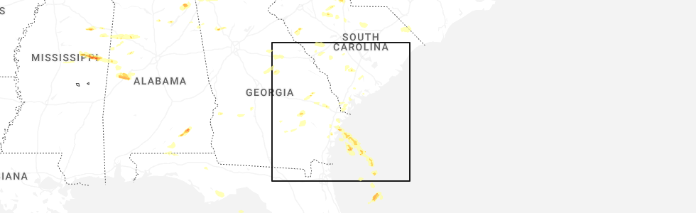
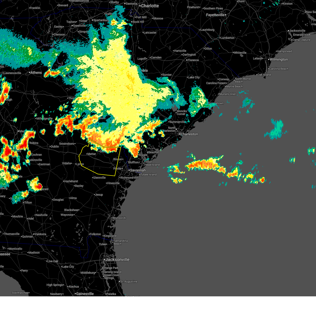
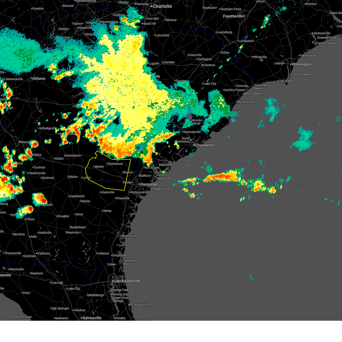
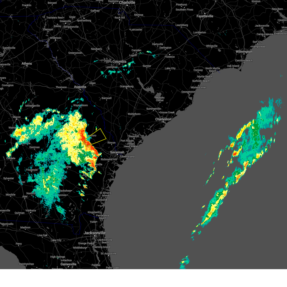
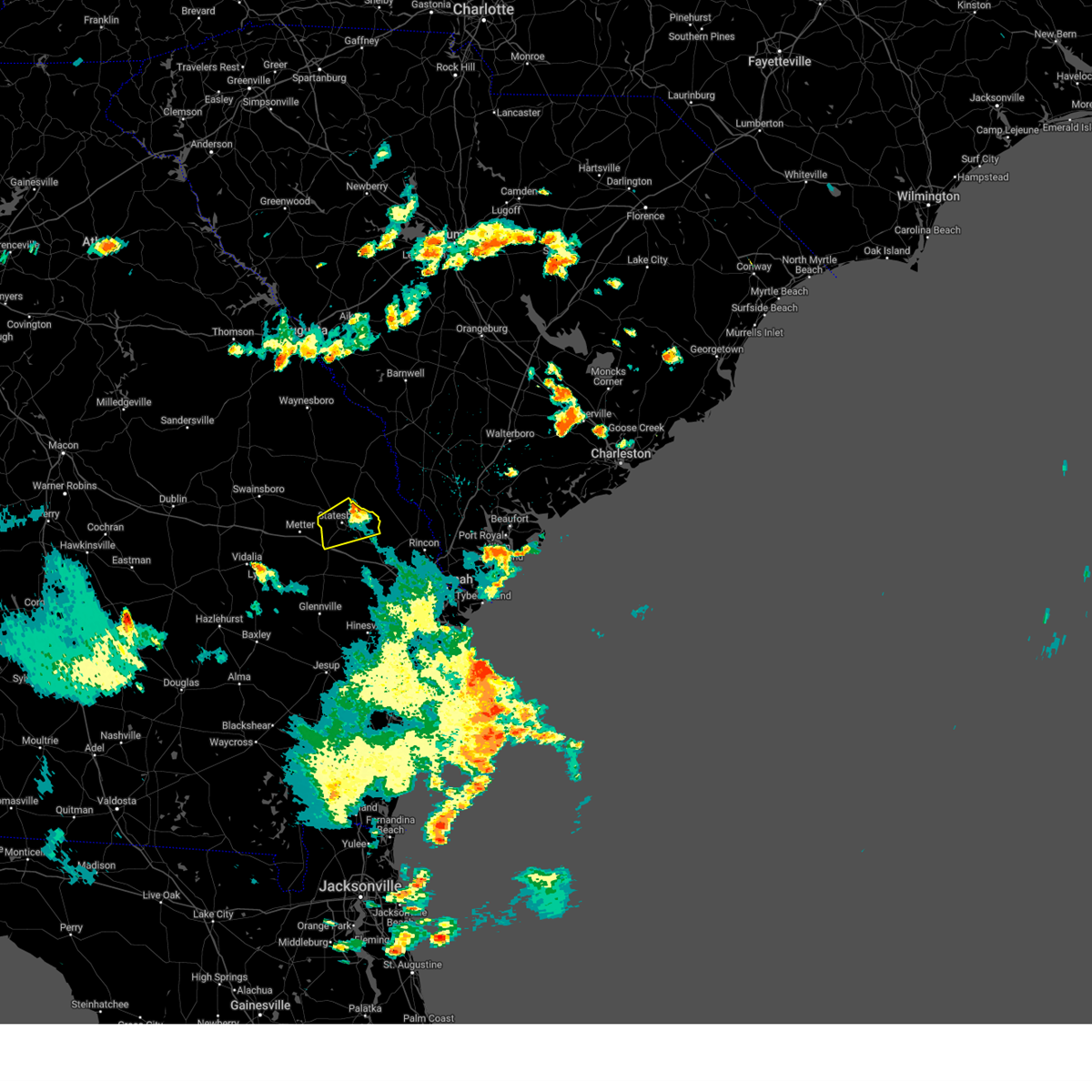
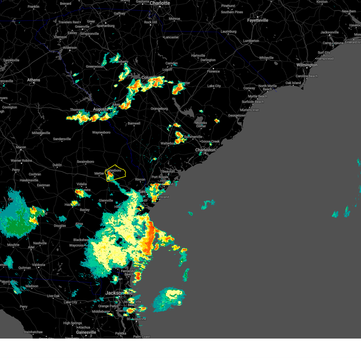
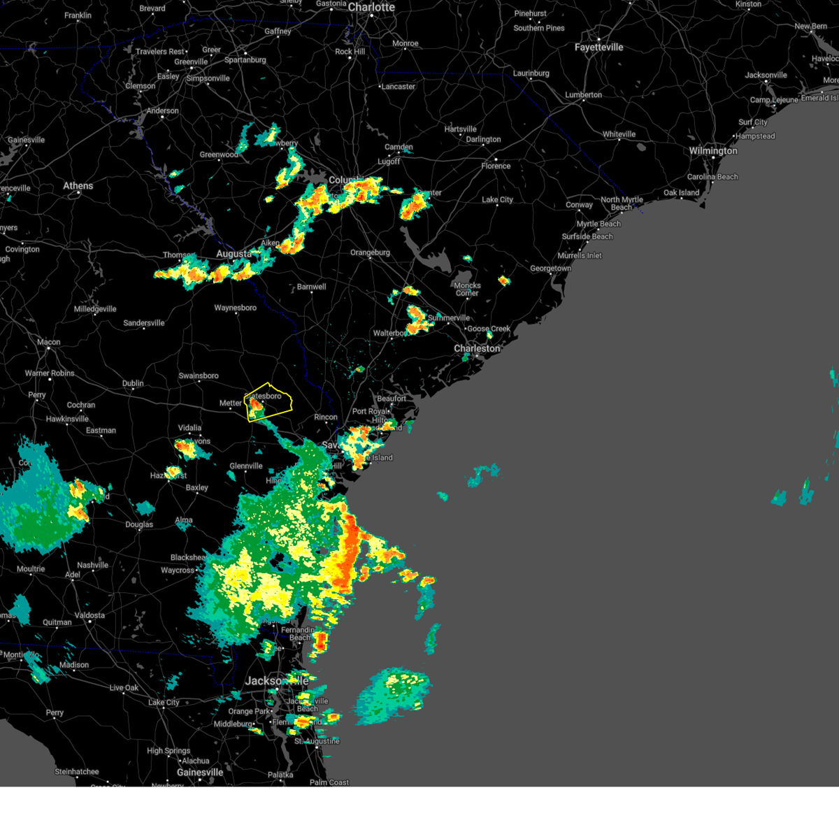
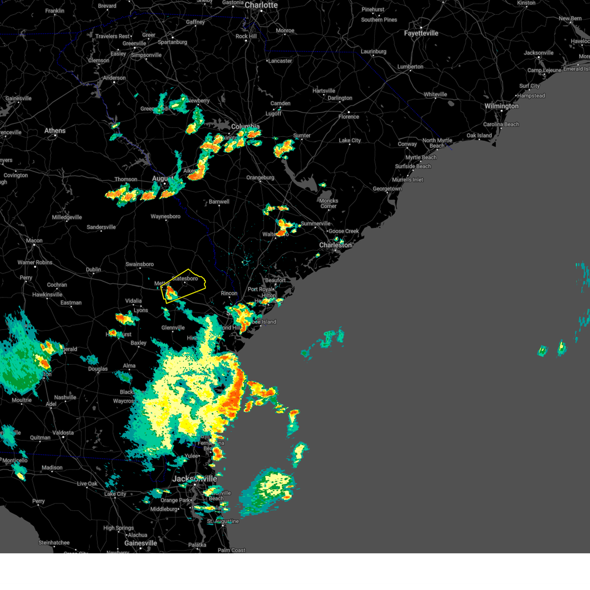
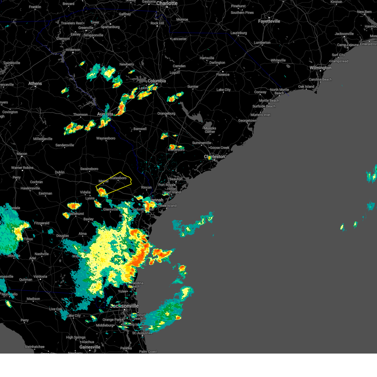
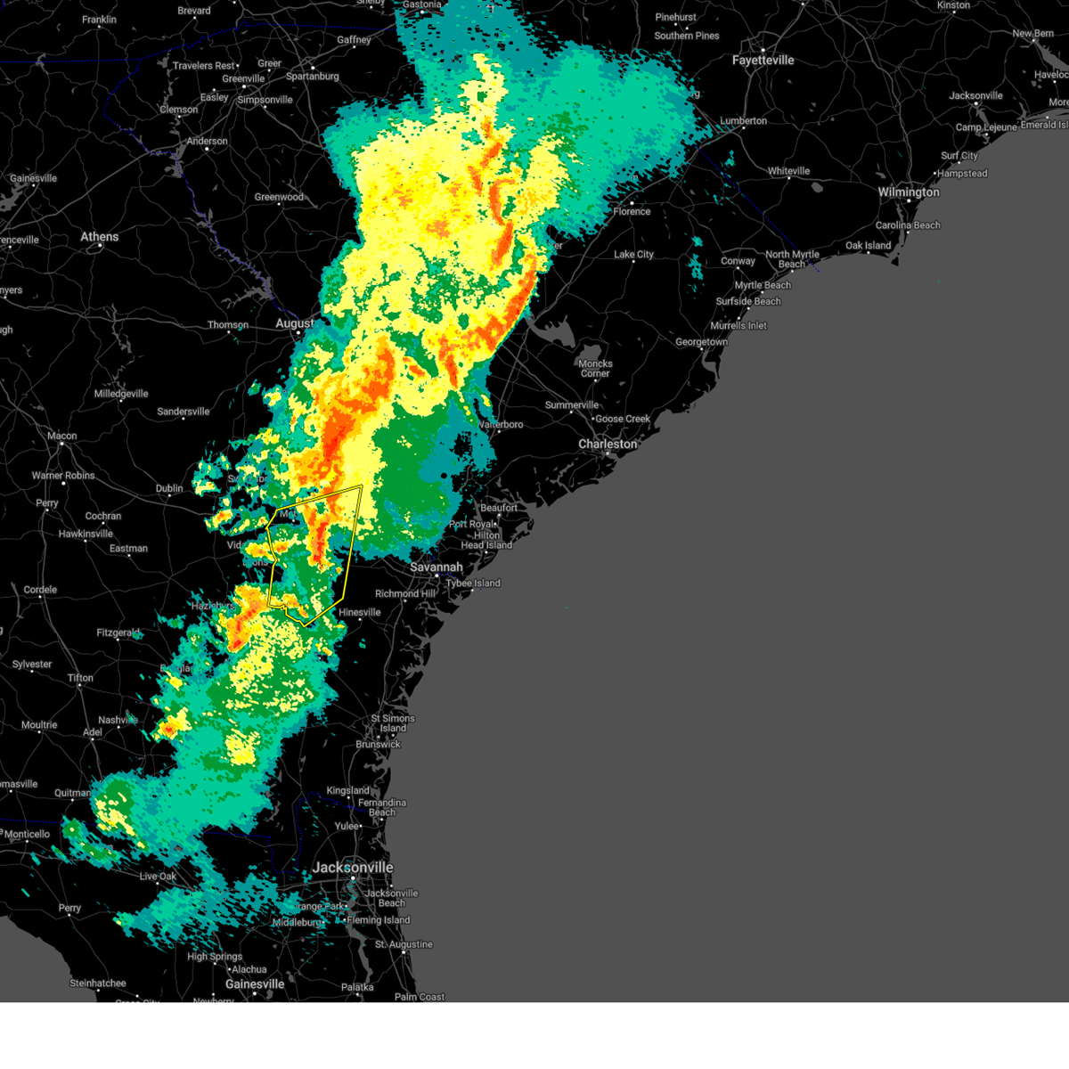
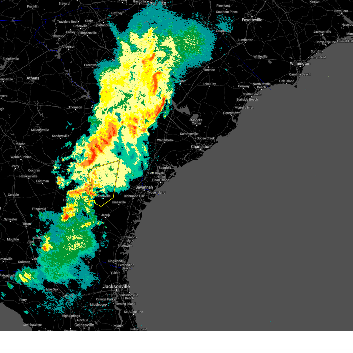
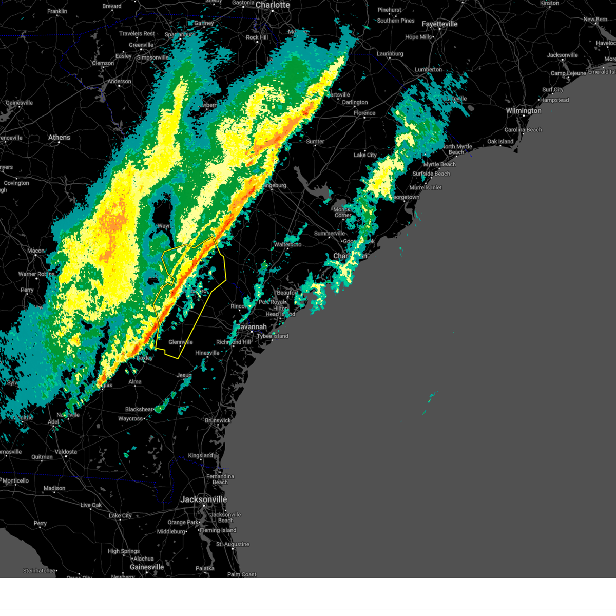
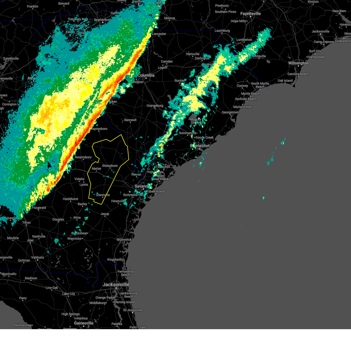
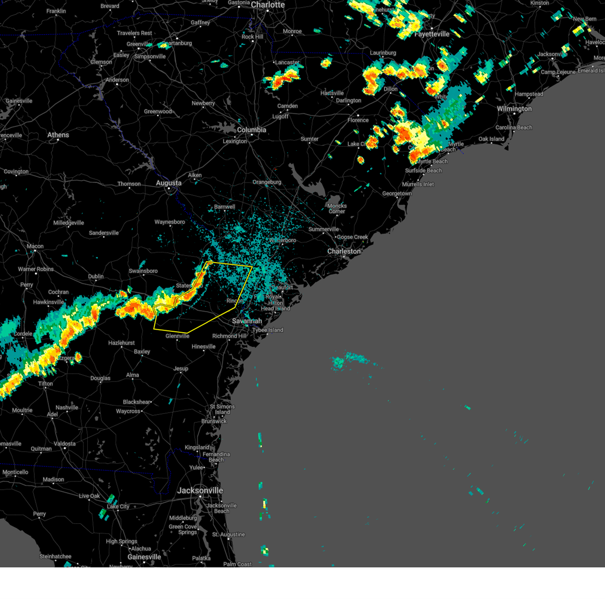
Hail Map for Register, GA
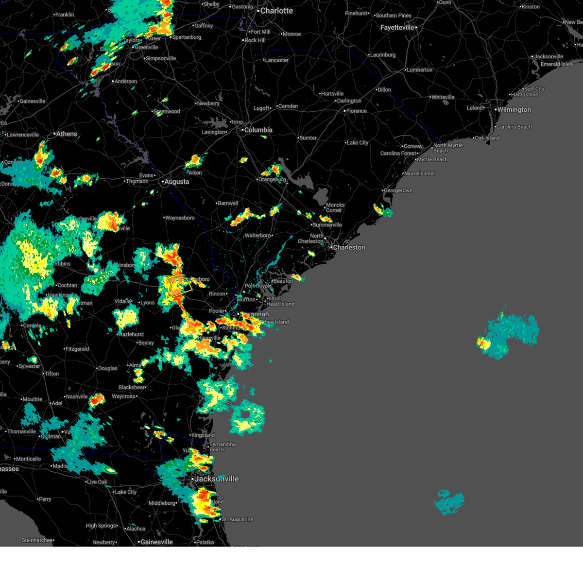
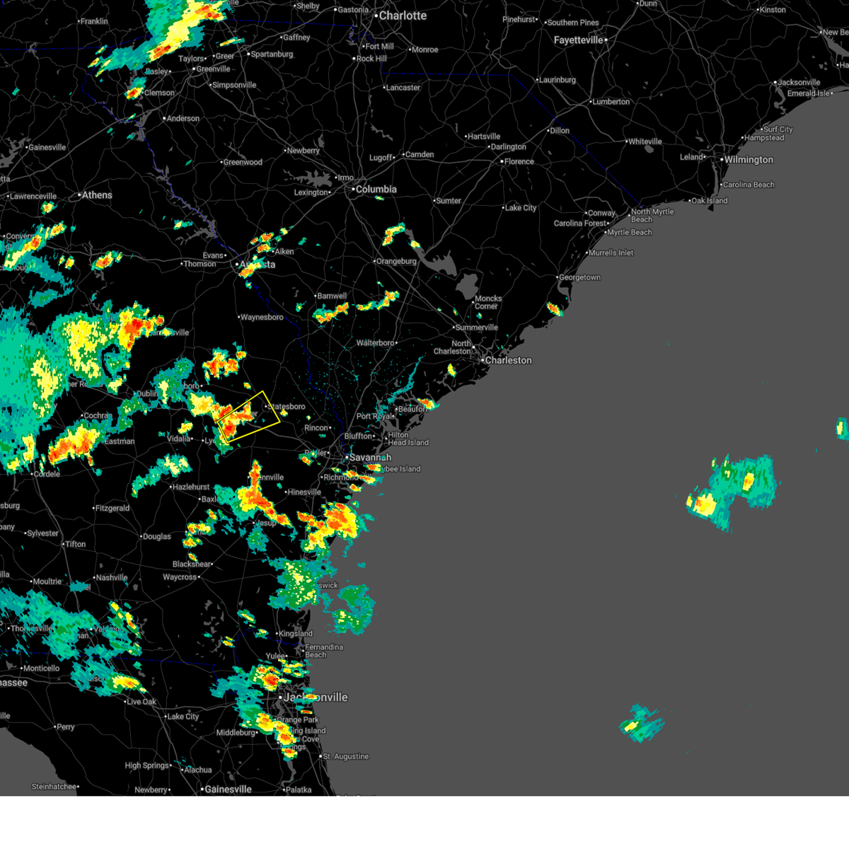
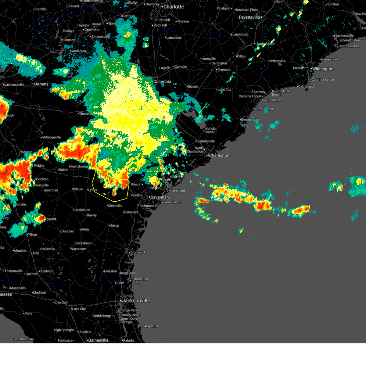
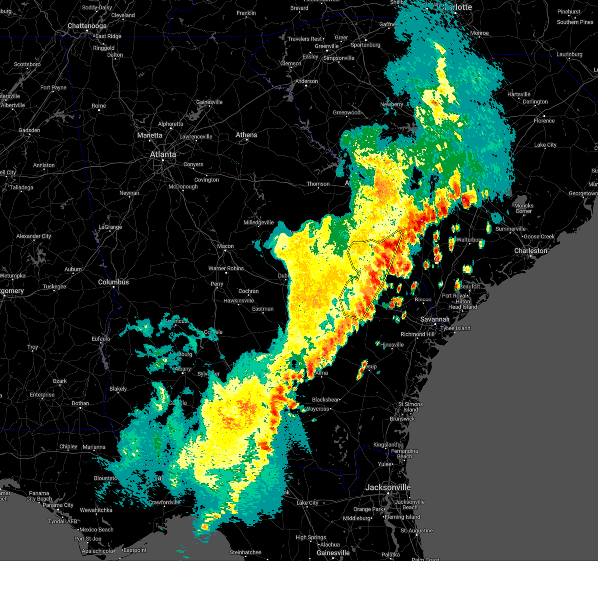
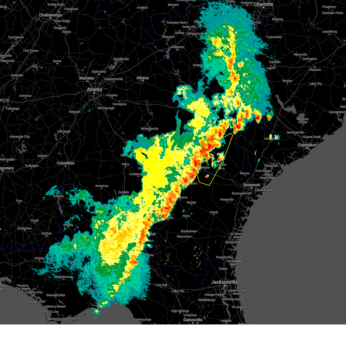
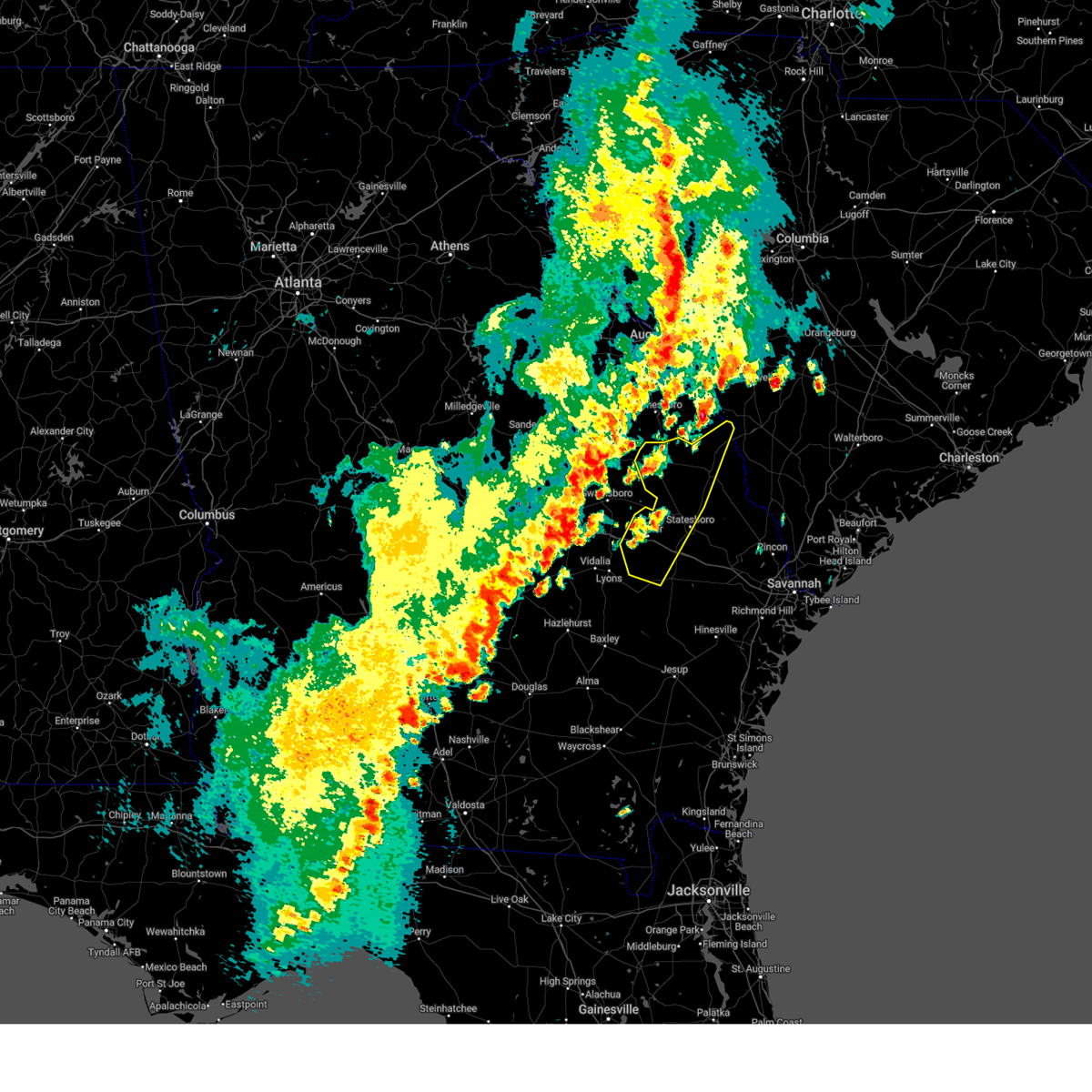
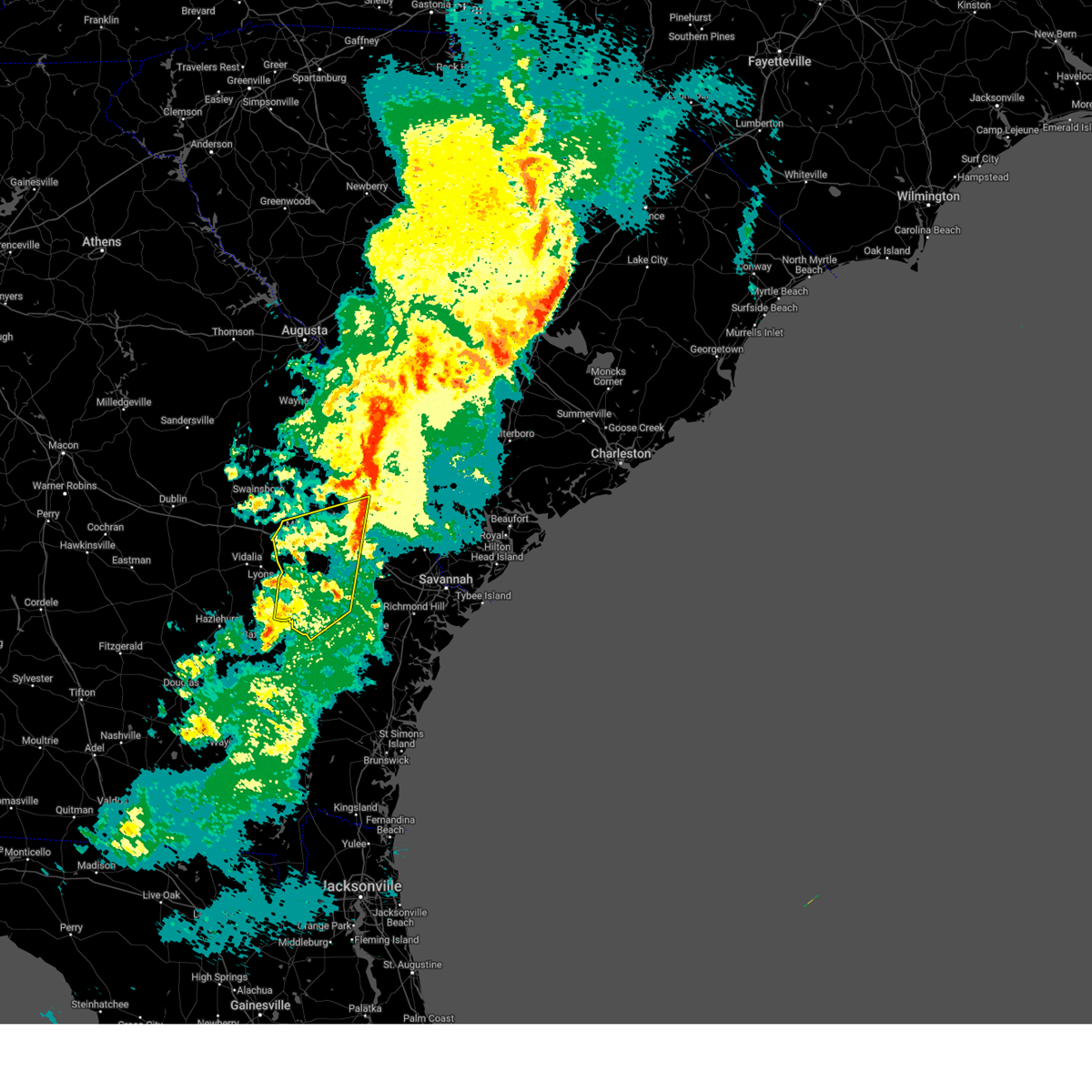
The Register, GA area has had 1 report of on-the-ground hail by trained spotters, and has been under severe weather warnings 30 times during the past 12 months. Doppler radar has detected hail at or near Register, GA on 45 occasions, including 1 occasion during the past year.
| Name: | Register, GA |
| Where Located: | 50.5 miles WNW of Savannah, GA |
| Map: | Google Map for Register, GA |
| Population: | 175 |
| Housing Units: | 73 |
| More Info: | Search Google for Register, GA |
0
The Top Recent Hail Date for Register, GA is Thursday, May 8, 2025 (45th out of 45)
Hail and Wind Damage Spotted near Register, GA
| Date / Time | Report Details |
|---|---|
| 7/11/2025 5:24 PM EDT | The storm which prompted the warning has moved out of the area. therefore, the warning will be allowed to expire. however, gusty winds are still possible with this thunderstorm. |
| 7/11/2025 5:05 PM EDT |
 the severe thunderstorm warning has been cancelled and is no longer in effect the severe thunderstorm warning has been cancelled and is no longer in effect
|
| 7/11/2025 5:05 PM EDT |
 At 505 pm edt, a severe thunderstorm was located near register, moving east at 25 mph (radar indicated). Hazards include 60 mph wind gusts and small hail. Expect damage to roofs, siding, and trees. locations impacted include, statesboro, register, georgia southern, jimps, irongate, kennedy pond, westbrooke, somerset, new hope and statesboro mall. This includes i-16 between mile markers 113 and 121. At 505 pm edt, a severe thunderstorm was located near register, moving east at 25 mph (radar indicated). Hazards include 60 mph wind gusts and small hail. Expect damage to roofs, siding, and trees. locations impacted include, statesboro, register, georgia southern, jimps, irongate, kennedy pond, westbrooke, somerset, new hope and statesboro mall. This includes i-16 between mile markers 113 and 121.
|
| 7/11/2025 4:31 PM EDT |
 Svrchs the national weather service in charleston has issued a * severe thunderstorm warning for portions of, bulloch county in southeastern georgia, candler county in southeastern georgia, evans county in southeastern georgia, tattnall county in southeastern georgia, * until 530 pm edt. * at 431 pm edt, a severe thunderstorm was located near cobbtown, moving northeast at 15 mph (radar indicated). Hazards include 60 mph wind gusts. expect damage to roofs, siding, and trees Svrchs the national weather service in charleston has issued a * severe thunderstorm warning for portions of, bulloch county in southeastern georgia, candler county in southeastern georgia, evans county in southeastern georgia, tattnall county in southeastern georgia, * until 530 pm edt. * at 431 pm edt, a severe thunderstorm was located near cobbtown, moving northeast at 15 mph (radar indicated). Hazards include 60 mph wind gusts. expect damage to roofs, siding, and trees
|
| 6/26/2025 12:17 AM EDT |
 the severe thunderstorm warning has been cancelled and is no longer in effect the severe thunderstorm warning has been cancelled and is no longer in effect
|
| 6/26/2025 12:09 AM EDT |
 At 1209 am edt, severe thunderstorms were located along a line from near stilson to over metter, moving south at 30 mph (emergency management reported. at 1147 pm, emergency management officials reported trees down across portions of bulloch county). Hazards include 60 mph wind gusts. Expect damage to roofs, siding, and trees. locations impacted include, brooklet, register, pulaski, metter, claxton, hagan, pembroke, cobbtown, collins and lanier. This includes i-16 between mile markers 97 and 139. At 1209 am edt, severe thunderstorms were located along a line from near stilson to over metter, moving south at 30 mph (emergency management reported. at 1147 pm, emergency management officials reported trees down across portions of bulloch county). Hazards include 60 mph wind gusts. Expect damage to roofs, siding, and trees. locations impacted include, brooklet, register, pulaski, metter, claxton, hagan, pembroke, cobbtown, collins and lanier. This includes i-16 between mile markers 97 and 139.
|
| 6/26/2025 12:09 AM EDT |
 the severe thunderstorm warning has been cancelled and is no longer in effect the severe thunderstorm warning has been cancelled and is no longer in effect
|
| 6/25/2025 11:49 PM EDT |
 At 1149 pm edt, severe thunderstorms were located along a line from near stilson to 6 miles west of portal, moving south at 30 mph (emergency management reported. at 1147 pm, emergency management officials reported trees down across portions of bulloch county). Hazards include 60 mph wind gusts and quarter size hail. Hail damage to vehicles is expected. expect wind damage to roofs, siding, and trees. locations impacted include, statesboro, portal, brooklet, springfield, guyton, metter, claxton, hagan, pembroke and lanier. This includes i-16 between mile markers 96 and 149. At 1149 pm edt, severe thunderstorms were located along a line from near stilson to 6 miles west of portal, moving south at 30 mph (emergency management reported. at 1147 pm, emergency management officials reported trees down across portions of bulloch county). Hazards include 60 mph wind gusts and quarter size hail. Hail damage to vehicles is expected. expect wind damage to roofs, siding, and trees. locations impacted include, statesboro, portal, brooklet, springfield, guyton, metter, claxton, hagan, pembroke and lanier. This includes i-16 between mile markers 96 and 149.
|
| 6/25/2025 11:28 PM EDT |
 Svrchs the national weather service in charleston has issued a * severe thunderstorm warning for portions of, bryan county in southeastern georgia, bulloch county in southeastern georgia, candler county in southeastern georgia, effingham county in southeastern georgia, evans county in southeastern georgia, jenkins county in southeastern georgia, liberty county in southeastern georgia, screven county in southeastern georgia, tattnall county in southeastern georgia, * until 1230 am edt. * at 1128 pm edt, severe thunderstorms were located along a line from over shawnee to near butts, moving south at 30 mph (radar indicated). Hazards include 60 mph wind gusts and small hail. expect damage to roofs, siding, and trees Svrchs the national weather service in charleston has issued a * severe thunderstorm warning for portions of, bryan county in southeastern georgia, bulloch county in southeastern georgia, candler county in southeastern georgia, effingham county in southeastern georgia, evans county in southeastern georgia, jenkins county in southeastern georgia, liberty county in southeastern georgia, screven county in southeastern georgia, tattnall county in southeastern georgia, * until 1230 am edt. * at 1128 pm edt, severe thunderstorms were located along a line from over shawnee to near butts, moving south at 30 mph (radar indicated). Hazards include 60 mph wind gusts and small hail. expect damage to roofs, siding, and trees
|
| 6/10/2025 8:23 AM EDT |
 Svrchs the national weather service in charleston has issued a * severe thunderstorm warning for portions of, bulloch county in southeastern georgia, effingham county in southeastern georgia, screven county in southeastern georgia, * until 915 am edt. * at 823 am edt, a severe thunderstorm was located near georgia southern, moving northeast at 30 mph (radar indicated). Hazards include 60 mph wind gusts. expect damage to roofs, siding, and trees Svrchs the national weather service in charleston has issued a * severe thunderstorm warning for portions of, bulloch county in southeastern georgia, effingham county in southeastern georgia, screven county in southeastern georgia, * until 915 am edt. * at 823 am edt, a severe thunderstorm was located near georgia southern, moving northeast at 30 mph (radar indicated). Hazards include 60 mph wind gusts. expect damage to roofs, siding, and trees
|
| 6/9/2025 4:41 PM EDT |
 The severe thunderstorm warning that was previously in effect has been reissued for bulloch county and is in effect until 530 pm edt. please refer to that bulletin for the latest severe weather information. The severe thunderstorm warning that was previously in effect has been reissued for bulloch county and is in effect until 530 pm edt. please refer to that bulletin for the latest severe weather information.
|
| 6/9/2025 4:22 PM EDT |
 At 422 pm edt, a severe thunderstorm was located near register, moving northeast at 35 mph (radar indicated). Hazards include 60 mph wind gusts. Expect damage to roofs, siding, and trees. locations impacted include, statesboro, brooklet, register, georgia southern, hopeulikit, leefield, windfield, statesboro mall, mill creek regional park and mill creek park. This includes i-16 between mile markers 116 and 117. At 422 pm edt, a severe thunderstorm was located near register, moving northeast at 35 mph (radar indicated). Hazards include 60 mph wind gusts. Expect damage to roofs, siding, and trees. locations impacted include, statesboro, brooklet, register, georgia southern, hopeulikit, leefield, windfield, statesboro mall, mill creek regional park and mill creek park. This includes i-16 between mile markers 116 and 117.
|
| 6/9/2025 4:22 PM EDT |
 the severe thunderstorm warning has been cancelled and is no longer in effect the severe thunderstorm warning has been cancelled and is no longer in effect
|
| 6/9/2025 4:13 PM EDT |
 the severe thunderstorm warning has been cancelled and is no longer in effect the severe thunderstorm warning has been cancelled and is no longer in effect
|
| 6/9/2025 4:13 PM EDT |
 At 413 pm edt, a severe thunderstorm was located over pulaski, moving northeast at 35 mph (radar indicated). Hazards include 60 mph wind gusts. Expect damage to roofs, siding, and trees. locations impacted include, statesboro, metter, brooklet, pulaski, register, georgia southern, hopeulikit, leefield, westbrooke and irongate. This includes i-16 between mile markers 105 and 120. At 413 pm edt, a severe thunderstorm was located over pulaski, moving northeast at 35 mph (radar indicated). Hazards include 60 mph wind gusts. Expect damage to roofs, siding, and trees. locations impacted include, statesboro, metter, brooklet, pulaski, register, georgia southern, hopeulikit, leefield, westbrooke and irongate. This includes i-16 between mile markers 105 and 120.
|
| 6/9/2025 3:55 PM EDT |
 Svrchs the national weather service in charleston has issued a * severe thunderstorm warning for portions of, bulloch county in southeastern georgia, candler county in southeastern georgia, evans county in southeastern georgia, tattnall county in southeastern georgia, * until 445 pm edt. * at 355 pm edt, a severe thunderstorm was located over cobbtown, moving northeast at 35 mph (radar indicated). Hazards include 60 mph wind gusts. expect damage to roofs, siding, and trees Svrchs the national weather service in charleston has issued a * severe thunderstorm warning for portions of, bulloch county in southeastern georgia, candler county in southeastern georgia, evans county in southeastern georgia, tattnall county in southeastern georgia, * until 445 pm edt. * at 355 pm edt, a severe thunderstorm was located over cobbtown, moving northeast at 35 mph (radar indicated). Hazards include 60 mph wind gusts. expect damage to roofs, siding, and trees
|
| 3/31/2025 5:01 PM EDT |
 The storms which prompted the warning have weakened below severe limits, and have exited the warned area. therefore, the warning has been allowed to expire. however, gusty winds are still possible with these thunderstorms. a severe thunderstorm watch remains in effect until 900 pm edt for a portion of southeast georgia. The storms which prompted the warning have weakened below severe limits, and have exited the warned area. therefore, the warning has been allowed to expire. however, gusty winds are still possible with these thunderstorms. a severe thunderstorm watch remains in effect until 900 pm edt for a portion of southeast georgia.
|
| 3/31/2025 4:25 PM EDT |
 At 425 pm edt, severe thunderstorms were located along a line from 7 miles northeast of perkins to 12 miles west of gordonia altamaha state park, moving east at 45 mph (radar indicated). Hazards include 60 mph wind gusts and small hail. Expect damage to roofs, siding, and trees. locations impacted include, statesboro, metter, millen, sylvania, butts, portal, collins, cobbtown, hiltonia and pulaski. This includes i-16 between mile markers 96 and 118. At 425 pm edt, severe thunderstorms were located along a line from 7 miles northeast of perkins to 12 miles west of gordonia altamaha state park, moving east at 45 mph (radar indicated). Hazards include 60 mph wind gusts and small hail. Expect damage to roofs, siding, and trees. locations impacted include, statesboro, metter, millen, sylvania, butts, portal, collins, cobbtown, hiltonia and pulaski. This includes i-16 between mile markers 96 and 118.
|
| 3/31/2025 3:59 PM EDT |
 Svrchs the national weather service in charleston has issued a * severe thunderstorm warning for portions of, bulloch county in southeastern georgia, candler county in southeastern georgia, evans county in southeastern georgia, jenkins county in southeastern georgia, screven county in southeastern georgia, tattnall county in southeastern georgia, * until 500 pm edt. * at 359 pm edt, severe thunderstorms were located along a line from 12 miles north of herndon to 30 miles west of gordonia altamaha state park, moving east at 45 mph (radar indicated). Hazards include 60 mph wind gusts. expect damage to roofs, siding, and trees Svrchs the national weather service in charleston has issued a * severe thunderstorm warning for portions of, bulloch county in southeastern georgia, candler county in southeastern georgia, evans county in southeastern georgia, jenkins county in southeastern georgia, screven county in southeastern georgia, tattnall county in southeastern georgia, * until 500 pm edt. * at 359 pm edt, severe thunderstorms were located along a line from 12 miles north of herndon to 30 miles west of gordonia altamaha state park, moving east at 45 mph (radar indicated). Hazards include 60 mph wind gusts. expect damage to roofs, siding, and trees
|
| 3/16/2025 9:10 AM EDT |
 The storms which prompted the warning have moved out of the area. therefore, the warning will be allowed to expire. however, gusty winds are still possible with these thunderstorms. a severe thunderstorm warning still remains in effect for portions of bryan, bulloch, evans, liberty, long, and tattnall counties until 1000 am. a tornado watch remains in effect until 200 pm edt sunday for a portion of southeast georgia. The storms which prompted the warning have moved out of the area. therefore, the warning will be allowed to expire. however, gusty winds are still possible with these thunderstorms. a severe thunderstorm warning still remains in effect for portions of bryan, bulloch, evans, liberty, long, and tattnall counties until 1000 am. a tornado watch remains in effect until 200 pm edt sunday for a portion of southeast georgia.
|
| 3/16/2025 8:51 AM EDT |
 At 851 am edt, severe thunderstorms were located along a line from 5 miles south of rocky ford to near glennville, moving northeast at 50 mph (radar indicated). Hazards include 70 mph wind gusts and small hail. Expect considerable tree damage. damage is likely to mobile homes, roofs, and outbuildings. locations impacted include, statesboro, reidsville, metter, glennville, claxton, brooklet, hagan, collins, cobbtown and pulaski. This includes i-16 between mile markers 96 and 130. At 851 am edt, severe thunderstorms were located along a line from 5 miles south of rocky ford to near glennville, moving northeast at 50 mph (radar indicated). Hazards include 70 mph wind gusts and small hail. Expect considerable tree damage. damage is likely to mobile homes, roofs, and outbuildings. locations impacted include, statesboro, reidsville, metter, glennville, claxton, brooklet, hagan, collins, cobbtown and pulaski. This includes i-16 between mile markers 96 and 130.
|
| 3/16/2025 8:32 AM EDT |
 Svrchs the national weather service in charleston has issued a * severe thunderstorm warning for portions of, bryan county in southeastern georgia, bulloch county in southeastern georgia, candler county in southeastern georgia, evans county in southeastern georgia, liberty county in southeastern georgia, long county in southeastern georgia, screven county in southeastern georgia, tattnall county in southeastern georgia, * until 915 am edt. * at 832 am edt, severe thunderstorms were located along a line from near metter to 13 miles southwest of mendes, moving northeast at 50 mph (radar indicated). Hazards include 60 mph wind gusts and small hail. expect damage to roofs, siding, and trees Svrchs the national weather service in charleston has issued a * severe thunderstorm warning for portions of, bryan county in southeastern georgia, bulloch county in southeastern georgia, candler county in southeastern georgia, evans county in southeastern georgia, liberty county in southeastern georgia, long county in southeastern georgia, screven county in southeastern georgia, tattnall county in southeastern georgia, * until 915 am edt. * at 832 am edt, severe thunderstorms were located along a line from near metter to 13 miles southwest of mendes, moving northeast at 50 mph (radar indicated). Hazards include 60 mph wind gusts and small hail. expect damage to roofs, siding, and trees
|
| 2/16/2025 8:18 AM EST |
 The severe thunderstorm warning that was previously in effect has been reissued for tattnall, jenkins, evans, bulloch, screven, and candler counties and is in effect until 915 am est. please refer to that bulletin for the latest severe weather information. a severe thunderstorm watch remains in effect until 100 pm est for a portion of southeast georgia. The severe thunderstorm warning that was previously in effect has been reissued for tattnall, jenkins, evans, bulloch, screven, and candler counties and is in effect until 915 am est. please refer to that bulletin for the latest severe weather information. a severe thunderstorm watch remains in effect until 100 pm est for a portion of southeast georgia.
|
| 2/16/2025 8:14 AM EST |
 Svrchs the national weather service in charleston has issued a * severe thunderstorm warning for portions of, bryan county in southeastern georgia, bulloch county in southeastern georgia, candler county in southeastern georgia, effingham county in southeastern georgia, evans county in southeastern georgia, jenkins county in southeastern georgia, liberty county in southeastern georgia, long county in southeastern georgia, screven county in southeastern georgia, tattnall county in southeastern georgia, allendale county in southeastern south carolina, hampton county in southeastern south carolina, jasper county in southeastern south carolina, * until 915 am est. * at 814 am est, severe thunderstorms were located along a line from near millett to 13 miles southwest of gordonia altamaha state park, moving southeast at 40 mph (radar indicated). Hazards include 60 mph wind gusts. expect damage to roofs, siding, and trees Svrchs the national weather service in charleston has issued a * severe thunderstorm warning for portions of, bryan county in southeastern georgia, bulloch county in southeastern georgia, candler county in southeastern georgia, effingham county in southeastern georgia, evans county in southeastern georgia, jenkins county in southeastern georgia, liberty county in southeastern georgia, long county in southeastern georgia, screven county in southeastern georgia, tattnall county in southeastern georgia, allendale county in southeastern south carolina, hampton county in southeastern south carolina, jasper county in southeastern south carolina, * until 915 am est. * at 814 am est, severe thunderstorms were located along a line from near millett to 13 miles southwest of gordonia altamaha state park, moving southeast at 40 mph (radar indicated). Hazards include 60 mph wind gusts. expect damage to roofs, siding, and trees
|
| 2/16/2025 7:52 AM EST | At 752 am est, severe thunderstorms were located along a line from 9 miles northeast of perkins to 19 miles west of gordonia altamaha state park, moving east at 45 mph (radar indicated). Hazards include 60 mph wind gusts. Expect damage to roofs, siding, and trees. locations impacted include, statesboro, reidsville, metter, glennville, millen, sylvania, claxton, butts, brooklet and hagan. This includes i-16 between mile markers 96 and 128. |
| 2/16/2025 7:19 AM EST |
 Svrchs the national weather service in charleston has issued a * severe thunderstorm warning for portions of, bulloch county in southeastern georgia, candler county in southeastern georgia, evans county in southeastern georgia, jenkins county in southeastern georgia, screven county in southeastern georgia, tattnall county in southeastern georgia, * until 815 am est. * at 719 am est, severe thunderstorms were located along a line from 17 miles northwest of perkins to 35 miles west of aline, moving east at 50 mph (radar indicated). Hazards include 60 mph wind gusts. expect damage to roofs, siding, and trees Svrchs the national weather service in charleston has issued a * severe thunderstorm warning for portions of, bulloch county in southeastern georgia, candler county in southeastern georgia, evans county in southeastern georgia, jenkins county in southeastern georgia, screven county in southeastern georgia, tattnall county in southeastern georgia, * until 815 am est. * at 719 am est, severe thunderstorms were located along a line from 17 miles northwest of perkins to 35 miles west of aline, moving east at 50 mph (radar indicated). Hazards include 60 mph wind gusts. expect damage to roofs, siding, and trees
|
| 8/18/2024 9:22 PM EDT | The storms which prompted the warning have weakened below severe limits, and no longer pose an immediate threat to life or property. therefore, the warning will be allowed to expire. a severe thunderstorm watch remains in effect until 200 am edt for southeastern georgia. |
| 8/18/2024 8:59 PM EDT |
 At 858 pm edt, severe thunderstorms were located along a line extending from near newington to brooklet to near manassas, moving east at 30 mph (radar indicated. at 838 pm edt, screven county dispatch reported a tree down near the intersection of statesboro highway and dover road). Hazards include 60 mph wind gusts. Expect damage to trees and powerlines. locations impacted include: statesboro, reidsville, springfield, claxton, pembroke, rincon, guyton, brooklet, hagan, collins, cobbtown, newington, furman, oliver, and scotia. This warning includes i-16 between mile markers 113 and 144. At 858 pm edt, severe thunderstorms were located along a line extending from near newington to brooklet to near manassas, moving east at 30 mph (radar indicated. at 838 pm edt, screven county dispatch reported a tree down near the intersection of statesboro highway and dover road). Hazards include 60 mph wind gusts. Expect damage to trees and powerlines. locations impacted include: statesboro, reidsville, springfield, claxton, pembroke, rincon, guyton, brooklet, hagan, collins, cobbtown, newington, furman, oliver, and scotia. This warning includes i-16 between mile markers 113 and 144.
|
| 8/18/2024 8:59 PM EDT |
 the severe thunderstorm warning has been cancelled and is no longer in effect the severe thunderstorm warning has been cancelled and is no longer in effect
|
| 8/18/2024 8:28 PM EDT | Svrchs the national weather service in charleston has issued a * severe thunderstorm warning for portions of, bryan county in southeastern georgia, screven county in southeastern georgia, evans county in southeastern georgia, liberty county in southeastern georgia, bulloch county in southeastern georgia, candler county in southeastern georgia, effingham county in southeastern georgia, tattnall county in southeastern georgia, hampton county in southeastern south carolina, jasper county in southeastern south carolina, * until 930 pm edt. * at 828 pm edt, severe thunderstorms were located along a line extending from near rocky ford to near hopeulikit to 6 miles north of lyons, moving east at 30 mph (radar indicated). Hazards include 60 mph wind gusts and penny size hail. Expect damage to trees and powerlines. locations impacted include: statesboro, reidsville, metter, sylvania, springfield, claxton, pembroke, rincon, guyton, brooklet, hagan, portal, collins, cobbtown, and newington. This warning includes i-16 between mile markers 99 and 144. |
| 5/25/2024 4:09 PM EDT |
 the severe thunderstorm warning has been cancelled and is no longer in effect the severe thunderstorm warning has been cancelled and is no longer in effect
|
| 5/25/2024 3:46 PM EDT |
 At 345 pm edt, a severe thunderstorm was located over statesboro, moving southeast at 15 mph (trained weather spotters. at 338 pm edt, a spotter reported quarter sized hail in the center of statesboro). Hazards include 60 mph wind gusts and quarter size hail. Minor hail damage to vehicles is possible. expect wind damage to trees and powerlines. locations impacted include: statesboro, brooklet, register, nevils, georgia southern, denmark, leefield, bay, and stilson. This warning includes i-16 between mile markers 120 and 139. At 345 pm edt, a severe thunderstorm was located over statesboro, moving southeast at 15 mph (trained weather spotters. at 338 pm edt, a spotter reported quarter sized hail in the center of statesboro). Hazards include 60 mph wind gusts and quarter size hail. Minor hail damage to vehicles is possible. expect wind damage to trees and powerlines. locations impacted include: statesboro, brooklet, register, nevils, georgia southern, denmark, leefield, bay, and stilson. This warning includes i-16 between mile markers 120 and 139.
|
| 5/25/2024 3:29 PM EDT |
 Svrchs the national weather service in charleston has issued a * severe thunderstorm warning for portions of, bulloch county in southeastern georgia, * until 430 pm edt. * at 329 pm edt, a severe thunderstorm was located over georgia southern, moving southeast at 20 mph (radar indicated). Hazards include 60 mph wind gusts and quarter size hail. Minor hail damage to vehicles is possible. expect wind damage to trees and powerlines. locations impacted include: statesboro, brooklet, register, nevils, georgia southern, hopeulikit, denmark, leefield, bay, and stilson. This warning includes i-16 between mile markers 120 and 139. Svrchs the national weather service in charleston has issued a * severe thunderstorm warning for portions of, bulloch county in southeastern georgia, * until 430 pm edt. * at 329 pm edt, a severe thunderstorm was located over georgia southern, moving southeast at 20 mph (radar indicated). Hazards include 60 mph wind gusts and quarter size hail. Minor hail damage to vehicles is possible. expect wind damage to trees and powerlines. locations impacted include: statesboro, brooklet, register, nevils, georgia southern, hopeulikit, denmark, leefield, bay, and stilson. This warning includes i-16 between mile markers 120 and 139.
|
| 5/9/2024 2:30 PM EDT |
 At 229 pm edt, severe thunderstorms were located along a line extending from near pulaski to daisy to near mendes, moving east at 40 mph (trained weather spotters). Hazards include 70 mph wind gusts and half dollar size hail. at 218 pm, quarter size hail was reported at the tattnall county high school southeast of reidsville. Minor hail damage to vehicles is possible. expect considerable tree damage. wind damage is also likely to mobile homes, roofs, and outbuildings. locations impacted include: glennville, pembroke, fort stewart, register, daisy, nevils, denmark, bay, and groveland. This warning includes i-16 between mile markers 110 and 136. At 229 pm edt, severe thunderstorms were located along a line extending from near pulaski to daisy to near mendes, moving east at 40 mph (trained weather spotters). Hazards include 70 mph wind gusts and half dollar size hail. at 218 pm, quarter size hail was reported at the tattnall county high school southeast of reidsville. Minor hail damage to vehicles is possible. expect considerable tree damage. wind damage is also likely to mobile homes, roofs, and outbuildings. locations impacted include: glennville, pembroke, fort stewart, register, daisy, nevils, denmark, bay, and groveland. This warning includes i-16 between mile markers 110 and 136.
|
| 5/9/2024 2:18 PM EDT |
 Svrchs the national weather service in charleston has issued a * severe thunderstorm warning for portions of, bryan county in southeastern georgia, evans county in southeastern georgia, liberty county in southeastern georgia, bulloch county in southeastern georgia, candler county in southeastern georgia, long county in southeastern georgia, tattnall county in southeastern georgia, * until 315 pm edt. * at 217 pm edt, severe thunderstorms were located along a line extending from near metter to bellville to 7 miles south of reidsville, moving east at 55 mph (radar indicated). Hazards include 70 mph wind gusts and quarter size hail. Minor hail damage to vehicles is possible. expect considerable tree damage. wind damage is also likely to mobile homes, roofs, and outbuildings. locations impacted include: glennville, pembroke, fort stewart, register, daisy, nevils, denmark, bay, and groveland. This warning includes i-16 between mile markers 110 and 136. Svrchs the national weather service in charleston has issued a * severe thunderstorm warning for portions of, bryan county in southeastern georgia, evans county in southeastern georgia, liberty county in southeastern georgia, bulloch county in southeastern georgia, candler county in southeastern georgia, long county in southeastern georgia, tattnall county in southeastern georgia, * until 315 pm edt. * at 217 pm edt, severe thunderstorms were located along a line extending from near metter to bellville to 7 miles south of reidsville, moving east at 55 mph (radar indicated). Hazards include 70 mph wind gusts and quarter size hail. Minor hail damage to vehicles is possible. expect considerable tree damage. wind damage is also likely to mobile homes, roofs, and outbuildings. locations impacted include: glennville, pembroke, fort stewart, register, daisy, nevils, denmark, bay, and groveland. This warning includes i-16 between mile markers 110 and 136.
|
| 1/9/2024 1:29 PM EST |
 At 128 pm est, severe thunderstorms were located along a line extending from near sardis to 6 miles west of mendes, moving northeast at 55 mph (radar indicated). Hazards include 70 mph wind gusts. Expect considerable tree damage. damage is likely to mobile homes, roofs, and outbuildings. locations impacted include: statesboro, reidsville, metter, glennville, millen, sylvania, claxton, butts, hagan, portal, collins, cobbtown, hiltonia, pulaski, and register. This warning includes i-16 between mile markers 98 and 124. At 128 pm est, severe thunderstorms were located along a line extending from near sardis to 6 miles west of mendes, moving northeast at 55 mph (radar indicated). Hazards include 70 mph wind gusts. Expect considerable tree damage. damage is likely to mobile homes, roofs, and outbuildings. locations impacted include: statesboro, reidsville, metter, glennville, millen, sylvania, claxton, butts, hagan, portal, collins, cobbtown, hiltonia, pulaski, and register. This warning includes i-16 between mile markers 98 and 124.
|
| 1/9/2024 1:14 PM EST |
 At 113 pm est, severe thunderstorms were located along a line extending from near herndon to near plant hatch, moving northeast at 45 mph (radar indicated). Hazards include 70 mph wind gusts. Expect considerable tree damage. damage is likely to mobile homes, roofs, and outbuildings. locations impacted include: statesboro, reidsville, metter, glennville, millen, sylvania, claxton, butts, hagan, portal, collins, cobbtown, hiltonia, pulaski, and register. This warning includes i-16 between mile markers 96 and 124. At 113 pm est, severe thunderstorms were located along a line extending from near herndon to near plant hatch, moving northeast at 45 mph (radar indicated). Hazards include 70 mph wind gusts. Expect considerable tree damage. damage is likely to mobile homes, roofs, and outbuildings. locations impacted include: statesboro, reidsville, metter, glennville, millen, sylvania, claxton, butts, hagan, portal, collins, cobbtown, hiltonia, pulaski, and register. This warning includes i-16 between mile markers 96 and 124.
|
| 1/9/2024 12:53 PM EST |
 At 1253 pm est, severe thunderstorms were located along a line extending from near midville to uvalda, moving northeast at 55 mph (radar indicated). Hazards include 70 mph wind gusts. Expect considerable tree damage. damage is likely to mobile homes, roofs, and outbuildings. locations impacted include: statesboro, reidsville, metter, glennville, millen, sylvania, claxton, butts, hagan, portal, collins, cobbtown, hiltonia, pulaski, and register. this warning includes i-16 between mile markers 96 and 124. thunderstorm damage threat, considerable hail threat, radar indicated max hail size, <. 75 in wind threat, radar indicated max wind gust, 70 mph. At 1253 pm est, severe thunderstorms were located along a line extending from near midville to uvalda, moving northeast at 55 mph (radar indicated). Hazards include 70 mph wind gusts. Expect considerable tree damage. damage is likely to mobile homes, roofs, and outbuildings. locations impacted include: statesboro, reidsville, metter, glennville, millen, sylvania, claxton, butts, hagan, portal, collins, cobbtown, hiltonia, pulaski, and register. this warning includes i-16 between mile markers 96 and 124. thunderstorm damage threat, considerable hail threat, radar indicated max hail size, <. 75 in wind threat, radar indicated max wind gust, 70 mph.
|
| 8/8/2023 7:56 PM EDT |
 The severe thunderstorm warning for portions of evans, bulloch, candler, long and tattnall counties will expire at 800 pm edt, the storm which prompted the warning has moved out of the area. therefore, the warning will be allowed to expire. a severe thunderstorm watch remains in effect until 1100 pm edt for southeastern georgia. to report severe weather, contact your nearest law enforcement agency. they will relay your report to the national weather service charleston. The severe thunderstorm warning for portions of evans, bulloch, candler, long and tattnall counties will expire at 800 pm edt, the storm which prompted the warning has moved out of the area. therefore, the warning will be allowed to expire. a severe thunderstorm watch remains in effect until 1100 pm edt for southeastern georgia. to report severe weather, contact your nearest law enforcement agency. they will relay your report to the national weather service charleston.
|
| 8/8/2023 7:41 PM EDT |
 At 741 pm edt, a severe thunderstorm was located over register, moving east at 45 mph (emergency management. at 830 pm edt, metter fire department reported multiple trees down in metter). Hazards include 70 mph wind gusts. Expect considerable tree damage. damage is likely to mobile homes, roofs, and outbuildings. locations impacted include: metter, glennville, claxton, hagan, pulaski, register, daisy, bellville, manassas, and mendes. this warning includes i-16 between mile markers 104 and 120. thunderstorm damage threat, considerable hail threat, radar indicated max hail size, <. 75 in wind threat, observed max wind gust, 70 mph. At 741 pm edt, a severe thunderstorm was located over register, moving east at 45 mph (emergency management. at 830 pm edt, metter fire department reported multiple trees down in metter). Hazards include 70 mph wind gusts. Expect considerable tree damage. damage is likely to mobile homes, roofs, and outbuildings. locations impacted include: metter, glennville, claxton, hagan, pulaski, register, daisy, bellville, manassas, and mendes. this warning includes i-16 between mile markers 104 and 120. thunderstorm damage threat, considerable hail threat, radar indicated max hail size, <. 75 in wind threat, observed max wind gust, 70 mph.
|
| 8/8/2023 7:36 PM EDT |
 At 735 pm edt, a severe thunderstorm was located near register, moving east at 35 mph (emergency management. the metter fire department chief reported multiple trees down in the metter area). Hazards include 70 mph wind gusts. Expect considerable tree damage. damage is likely to mobile homes, roofs, and outbuildings. locations impacted include: statesboro, springfield, rincon, port wentworth, guyton, brooklet, newington, oliver, furman, scotia, register, egypt, stillwell, pineora, and leefield. this warning includes the following interstates: i-16 between mile markers 117 and 141. i-95 in georgia between mile markers 111 and 112. thunderstorm damage threat, considerable hail threat, radar indicated max hail size, <. 75 in wind threat, radar indicated max wind gust, 70 mph. At 735 pm edt, a severe thunderstorm was located near register, moving east at 35 mph (emergency management. the metter fire department chief reported multiple trees down in the metter area). Hazards include 70 mph wind gusts. Expect considerable tree damage. damage is likely to mobile homes, roofs, and outbuildings. locations impacted include: statesboro, springfield, rincon, port wentworth, guyton, brooklet, newington, oliver, furman, scotia, register, egypt, stillwell, pineora, and leefield. this warning includes the following interstates: i-16 between mile markers 117 and 141. i-95 in georgia between mile markers 111 and 112. thunderstorm damage threat, considerable hail threat, radar indicated max hail size, <. 75 in wind threat, radar indicated max wind gust, 70 mph.
|
| 8/8/2023 7:32 PM EDT | Multiple trees down reported in register... ga. time estimated from rada in bulloch county GA, 0.5 miles SW of Register, GA |
| 8/8/2023 7:05 PM EDT |
 At 704 pm edt, a severe thunderstorm was located near oak park, moving east at 30 mph (radar indicated). Hazards include 60 mph wind gusts. Expect damage to trees and powerlines. locations impacted include: reidsville, metter, glennville, claxton, hagan, portal, collins, cobbtown, pulaski, register, daisy, bellville, manassas, gordonia altamaha state park, and aline. this warning includes i-16 between mile markers 96 and 120. hail threat, radar indicated max hail size, <. 75 in wind threat, radar indicated max wind gust, 60 mph. At 704 pm edt, a severe thunderstorm was located near oak park, moving east at 30 mph (radar indicated). Hazards include 60 mph wind gusts. Expect damage to trees and powerlines. locations impacted include: reidsville, metter, glennville, claxton, hagan, portal, collins, cobbtown, pulaski, register, daisy, bellville, manassas, gordonia altamaha state park, and aline. this warning includes i-16 between mile markers 96 and 120. hail threat, radar indicated max hail size, <. 75 in wind threat, radar indicated max wind gust, 60 mph.
|
| 8/8/2023 6:21 PM EDT |
 At 620 pm edt, a severe thunderstorm was located near cobbtown, moving east at 30 mph (radar indicated). Hazards include 60 mph wind gusts and penny size hail. Expect damage to trees and powerlines. locations impacted include: reidsville, metter, claxton, hagan, collins, cobbtown, pulaski, register, daisy, bellville, manassas, gordonia altamaha state park, and aline. this warning includes i-16 between mile markers 96 and 118. hail threat, radar indicated max hail size, 0. 75 in wind threat, radar indicated max wind gust, 60 mph. At 620 pm edt, a severe thunderstorm was located near cobbtown, moving east at 30 mph (radar indicated). Hazards include 60 mph wind gusts and penny size hail. Expect damage to trees and powerlines. locations impacted include: reidsville, metter, claxton, hagan, collins, cobbtown, pulaski, register, daisy, bellville, manassas, gordonia altamaha state park, and aline. this warning includes i-16 between mile markers 96 and 118. hail threat, radar indicated max hail size, 0. 75 in wind threat, radar indicated max wind gust, 60 mph.
|
| 7/19/2023 7:54 PM EDT |
 At 754 pm edt, severe thunderstorms were located along a line extending from near shirley to near statesboro, moving southeast at 20 mph (radar indicated). Hazards include 60 mph wind gusts. Expect damage to trees and powerlines. these severe thunderstorms will remain over mainly rural areas of screven, bulloch, effingham, hampton and jasper counties, including the following locations, westchester, statesboro mall, middleground, oaky, stafford, cooperville, hunters pointe, huntington, nixville, and cameron. this warning includes i-16 between mile markers 114 and 123. hail threat, radar indicated max hail size, <. 75 in wind threat, radar indicated max wind gust, 60 mph. At 754 pm edt, severe thunderstorms were located along a line extending from near shirley to near statesboro, moving southeast at 20 mph (radar indicated). Hazards include 60 mph wind gusts. Expect damage to trees and powerlines. these severe thunderstorms will remain over mainly rural areas of screven, bulloch, effingham, hampton and jasper counties, including the following locations, westchester, statesboro mall, middleground, oaky, stafford, cooperville, hunters pointe, huntington, nixville, and cameron. this warning includes i-16 between mile markers 114 and 123. hail threat, radar indicated max hail size, <. 75 in wind threat, radar indicated max wind gust, 60 mph.
|
| 7/19/2023 7:30 PM EDT |
 At 730 pm edt, severe thunderstorms were located along a line extending from 8 miles west of luray to near portal, moving southeast at 20 mph (radar indicated). Hazards include 60 mph wind gusts and nickel size hail. Expect damage to trees and powerlines. locations impacted include: statesboro, sylvania, estill, brooklet, portal, newington, pulaski, furman, oliver, scotia, register, rocky ford, luray, egypt, and tarboro. this warning includes i-16 between mile markers 110 and 123. hail threat, radar indicated max hail size, 0. 88 in wind threat, radar indicated max wind gust, 60 mph. At 730 pm edt, severe thunderstorms were located along a line extending from 8 miles west of luray to near portal, moving southeast at 20 mph (radar indicated). Hazards include 60 mph wind gusts and nickel size hail. Expect damage to trees and powerlines. locations impacted include: statesboro, sylvania, estill, brooklet, portal, newington, pulaski, furman, oliver, scotia, register, rocky ford, luray, egypt, and tarboro. this warning includes i-16 between mile markers 110 and 123. hail threat, radar indicated max hail size, 0. 88 in wind threat, radar indicated max wind gust, 60 mph.
|
| 7/19/2023 7:15 PM EDT |
 At 715 pm edt, severe thunderstorms were located along a line extending from 8 miles southeast of burtons ferry landing to near portal, moving southeast at 30 mph (radar indicated). Hazards include 60 mph wind gusts and nickel size hail. Expect damage to trees and powerlines. locations impacted include: statesboro, metter, millen, sylvania, butts, portal, hiltonia, newington, pulaski, register, rocky ford, altman, dover, emmalane, and scarboro. this warning includes i-16 between mile markers 96 and 114. hail threat, radar indicated max hail size, 0. 88 in wind threat, radar indicated max wind gust, 60 mph. At 715 pm edt, severe thunderstorms were located along a line extending from 8 miles southeast of burtons ferry landing to near portal, moving southeast at 30 mph (radar indicated). Hazards include 60 mph wind gusts and nickel size hail. Expect damage to trees and powerlines. locations impacted include: statesboro, metter, millen, sylvania, butts, portal, hiltonia, newington, pulaski, register, rocky ford, altman, dover, emmalane, and scarboro. this warning includes i-16 between mile markers 96 and 114. hail threat, radar indicated max hail size, 0. 88 in wind threat, radar indicated max wind gust, 60 mph.
|
| 7/19/2023 6:55 PM EDT |
 At 654 pm edt, severe thunderstorms were located along a line extending from near burtons ferry landing to twin city, moving southeast at 25 mph (radar indicated). Hazards include 60 mph wind gusts and nickel size hail. Expect damage to trees and powerlines. these severe thunderstorms will remain over mainly rural areas of screven, bulloch, jenkins, candler, tattnall, hampton and allendale counties, including the following locations, westchester, hunters pointe, farmdale, cameron, metter municiple airport, mill creek park, canoe pond, goloid, zeigler, and georgian walk. this warning includes i-16 between mile markers 96 and 114. hail threat, radar indicated max hail size, 0. 88 in wind threat, radar indicated max wind gust, 60 mph. At 654 pm edt, severe thunderstorms were located along a line extending from near burtons ferry landing to twin city, moving southeast at 25 mph (radar indicated). Hazards include 60 mph wind gusts and nickel size hail. Expect damage to trees and powerlines. these severe thunderstorms will remain over mainly rural areas of screven, bulloch, jenkins, candler, tattnall, hampton and allendale counties, including the following locations, westchester, hunters pointe, farmdale, cameron, metter municiple airport, mill creek park, canoe pond, goloid, zeigler, and georgian walk. this warning includes i-16 between mile markers 96 and 114. hail threat, radar indicated max hail size, 0. 88 in wind threat, radar indicated max wind gust, 60 mph.
|
| 7/19/2023 6:32 PM EDT |
 At 632 pm edt, severe thunderstorms were located along a line extending from millhaven to near summertown, moving southeast at 25 mph (radar indicated). Hazards include 60 mph wind gusts and nickel size hail. Expect damage to trees and powerlines. locations impacted include: statesboro, metter, millen, sylvania, butts, portal, hiltonia, newington, pulaski, register, rocky ford, emmalane, millhaven, captolo, and herndon. this warning includes i-16 between mile markers 96 and 114. hail threat, radar indicated max hail size, 0. 88 in wind threat, radar indicated max wind gust, 60 mph. At 632 pm edt, severe thunderstorms were located along a line extending from millhaven to near summertown, moving southeast at 25 mph (radar indicated). Hazards include 60 mph wind gusts and nickel size hail. Expect damage to trees and powerlines. locations impacted include: statesboro, metter, millen, sylvania, butts, portal, hiltonia, newington, pulaski, register, rocky ford, emmalane, millhaven, captolo, and herndon. this warning includes i-16 between mile markers 96 and 114. hail threat, radar indicated max hail size, 0. 88 in wind threat, radar indicated max wind gust, 60 mph.
|
| 6/14/2023 7:44 PM EDT |
 At 744 pm edt, severe thunderstorms were located along a line extending from near dover to georgia southern to near register, moving east at 40 mph (radar indicated). Hazards include 60 mph wind gusts. Expect damage to trees and powerlines. locations impacted include: statesboro, brooklet, pulaski, oliver, register, egypt, shawnee, nevils, georgia southern, denmark, leefield, kildare, and stilson. this warning includes i-16 between mile markers 109 and 129. hail threat, radar indicated max hail size, <. 75 in wind threat, radar indicated max wind gust, 60 mph. At 744 pm edt, severe thunderstorms were located along a line extending from near dover to georgia southern to near register, moving east at 40 mph (radar indicated). Hazards include 60 mph wind gusts. Expect damage to trees and powerlines. locations impacted include: statesboro, brooklet, pulaski, oliver, register, egypt, shawnee, nevils, georgia southern, denmark, leefield, kildare, and stilson. this warning includes i-16 between mile markers 109 and 129. hail threat, radar indicated max hail size, <. 75 in wind threat, radar indicated max wind gust, 60 mph.
|
| 6/14/2023 7:02 PM EDT |
 At 702 pm edt, a severe thunderstorm was located over brooklet, moving southeast at 55 mph (radar indicated). Hazards include 60 mph wind gusts. Expect damage to trees and powerlines. locations impacted include: statesboro, metter, springfield, pembroke, lanier, rincon, guyton, brooklet, pulaski, oliver, register, egypt, eden, stillwell, and pineora. this warning includes i-16 between mile markers 105 and 150. hail threat, radar indicated max hail size, <. 75 in wind threat, radar indicated max wind gust, 60 mph. At 702 pm edt, a severe thunderstorm was located over brooklet, moving southeast at 55 mph (radar indicated). Hazards include 60 mph wind gusts. Expect damage to trees and powerlines. locations impacted include: statesboro, metter, springfield, pembroke, lanier, rincon, guyton, brooklet, pulaski, oliver, register, egypt, eden, stillwell, and pineora. this warning includes i-16 between mile markers 105 and 150. hail threat, radar indicated max hail size, <. 75 in wind threat, radar indicated max wind gust, 60 mph.
|
| 3/25/2023 5:59 PM EDT |
 At 559 pm edt, a severe thunderstorm was located 7 miles southwest of register, moving east at 25 mph (radar indicated). Hazards include 60 mph wind gusts and quarter size hail. Minor hail damage to vehicles is possible. expect wind damage to trees and powerlines. locations impacted include: statesboro, claxton, pembroke, brooklet, pulaski, register, daisy, nevils, denmark, bay, groveland and stilson. this warning includes i-16 between mile markers 110 and 136. hail threat, radar indicated max hail size, 1. 00 in wind threat, radar indicated max wind gust, 60 mph. At 559 pm edt, a severe thunderstorm was located 7 miles southwest of register, moving east at 25 mph (radar indicated). Hazards include 60 mph wind gusts and quarter size hail. Minor hail damage to vehicles is possible. expect wind damage to trees and powerlines. locations impacted include: statesboro, claxton, pembroke, brooklet, pulaski, register, daisy, nevils, denmark, bay, groveland and stilson. this warning includes i-16 between mile markers 110 and 136. hail threat, radar indicated max hail size, 1. 00 in wind threat, radar indicated max wind gust, 60 mph.
|
| 3/25/2023 5:18 PM EDT |
 At 518 pm edt, a severe thunderstorm was located near oak park, moving east at 45 mph (radar indicated). Hazards include 60 mph wind gusts and quarter size hail. Minor hail damage to vehicles is possible. expect wind damage to trees and powerlines. locations impacted include: statesboro, metter, claxton, hagan, collins, cobbtown, pulaski, register, daisy, bellville, manassas and aline. this warning includes i-16 between mile markers 96 and 120. hail threat, radar indicated max hail size, 1. 00 in wind threat, radar indicated max wind gust, 60 mph. At 518 pm edt, a severe thunderstorm was located near oak park, moving east at 45 mph (radar indicated). Hazards include 60 mph wind gusts and quarter size hail. Minor hail damage to vehicles is possible. expect wind damage to trees and powerlines. locations impacted include: statesboro, metter, claxton, hagan, collins, cobbtown, pulaski, register, daisy, bellville, manassas and aline. this warning includes i-16 between mile markers 96 and 120. hail threat, radar indicated max hail size, 1. 00 in wind threat, radar indicated max wind gust, 60 mph.
|
| 1/12/2023 8:58 PM EST |
 The severe thunderstorm warning for portions of evans, bulloch, jenkins, candler and tattnall counties will expire at 900 pm est, the storm which prompted the warning has weakened below severe limits, and no longer poses an immediate threat to life or property. therefore, the warning will be allowed to expire. The severe thunderstorm warning for portions of evans, bulloch, jenkins, candler and tattnall counties will expire at 900 pm est, the storm which prompted the warning has weakened below severe limits, and no longer poses an immediate threat to life or property. therefore, the warning will be allowed to expire.
|
| 1/12/2023 8:44 PM EST |
 At 844 pm est, a severe thunderstorm was located over pulaski, moving northeast at 60 mph (radar indicated). Hazards include 60 mph wind gusts. Expect damage to trees and powerlines. locations impacted include: statesboro, metter, brooklet, portal, collins, pulaski, register, manassas, scarboro, nevils, georgia southern, hopeulikit, denmark, leefield and stilson. this warning includes i-16 between mile markers 106 and 129. hail threat, radar indicated max hail size, <. 75 in wind threat, radar indicated max wind gust, 60 mph. At 844 pm est, a severe thunderstorm was located over pulaski, moving northeast at 60 mph (radar indicated). Hazards include 60 mph wind gusts. Expect damage to trees and powerlines. locations impacted include: statesboro, metter, brooklet, portal, collins, pulaski, register, manassas, scarboro, nevils, georgia southern, hopeulikit, denmark, leefield and stilson. this warning includes i-16 between mile markers 106 and 129. hail threat, radar indicated max hail size, <. 75 in wind threat, radar indicated max wind gust, 60 mph.
|
| 1/12/2023 8:29 PM EST |
 At 829 pm est, a severe thunderstorm was located near cobbtown, moving northeast at 55 mph (radar indicated). Hazards include 60 mph wind gusts. Expect damage to trees and powerlines. locations impacted include: statesboro, metter, brooklet, portal, collins, cobbtown, pulaski, register, manassas, scarboro, nevils, aline, georgia southern, hopeulikit and denmark. this warning includes i-16 between mile markers 96 and 129. hail threat, radar indicated max hail size, <. 75 in wind threat, radar indicated max wind gust, 60 mph. At 829 pm est, a severe thunderstorm was located near cobbtown, moving northeast at 55 mph (radar indicated). Hazards include 60 mph wind gusts. Expect damage to trees and powerlines. locations impacted include: statesboro, metter, brooklet, portal, collins, cobbtown, pulaski, register, manassas, scarboro, nevils, aline, georgia southern, hopeulikit and denmark. this warning includes i-16 between mile markers 96 and 129. hail threat, radar indicated max hail size, <. 75 in wind threat, radar indicated max wind gust, 60 mph.
|
| 1/12/2023 8:00 PM EST |
 At 759 pm est, a severe thunderstorm was located near vidalia, moving northeast at 75 mph (radar indicated). Hazards include 60 mph wind gusts. Expect damage to trees and powerlines. locations impacted include: statesboro, metter, brooklet, portal, collins, cobbtown, pulaski, register, manassas, scarboro, nevils, aline, georgia southern, hopeulikit and denmark. this warning includes i-16 between mile markers 96 and 129. hail threat, radar indicated max hail size, <. 75 in wind threat, radar indicated max wind gust, 60 mph. At 759 pm est, a severe thunderstorm was located near vidalia, moving northeast at 75 mph (radar indicated). Hazards include 60 mph wind gusts. Expect damage to trees and powerlines. locations impacted include: statesboro, metter, brooklet, portal, collins, cobbtown, pulaski, register, manassas, scarboro, nevils, aline, georgia southern, hopeulikit and denmark. this warning includes i-16 between mile markers 96 and 129. hail threat, radar indicated max hail size, <. 75 in wind threat, radar indicated max wind gust, 60 mph.
|
| 8/19/2022 5:38 PM EDT |
 At 538 pm edt, severe thunderstorms were located along a line extending from near rocky ford to near register, moving east at 35 mph (radar indicated). Hazards include 60 mph wind gusts and quarter size hail. Minor hail damage to vehicles is possible. expect wind damage to trees and powerlines. Locations impacted include: statesboro, guyton, brooklet, newington, oliver, register, rocky ford, egypt, marlow, shawnee, dover, pineora, georgia southern, hopeulikit and captolo. At 538 pm edt, severe thunderstorms were located along a line extending from near rocky ford to near register, moving east at 35 mph (radar indicated). Hazards include 60 mph wind gusts and quarter size hail. Minor hail damage to vehicles is possible. expect wind damage to trees and powerlines. Locations impacted include: statesboro, guyton, brooklet, newington, oliver, register, rocky ford, egypt, marlow, shawnee, dover, pineora, georgia southern, hopeulikit and captolo.
|
| 6/17/2022 8:36 PM EDT |
 At 836 pm edt, severe thunderstorms were located along a line extending from near oliver to near aline, moving southeast at 30 mph (radar indicated). Hazards include 60 mph wind gusts and penny size hail. Expect damage to trees and powerlines. locations impacted include: statesboro, reidsville, metter, claxton, pembroke, godley station, lanier, port wentworth, guyton, brooklet, hagan, collins, cobbtown, pulaski and register. this warning includes i-16 between mile markers 96 and 150. hail threat, radar indicated max hail size, 0. 75 in wind threat, radar indicated max wind gust, 60 mph. At 836 pm edt, severe thunderstorms were located along a line extending from near oliver to near aline, moving southeast at 30 mph (radar indicated). Hazards include 60 mph wind gusts and penny size hail. Expect damage to trees and powerlines. locations impacted include: statesboro, reidsville, metter, claxton, pembroke, godley station, lanier, port wentworth, guyton, brooklet, hagan, collins, cobbtown, pulaski and register. this warning includes i-16 between mile markers 96 and 150. hail threat, radar indicated max hail size, 0. 75 in wind threat, radar indicated max wind gust, 60 mph.
|
| 6/14/2022 1:57 PM EDT |
 The severe thunderstorm warning for portions of screven, bulloch and effingham counties will expire at 200 pm edt, the storm which prompted the warning has moved out of the area. therefore, the warning will be allowed to expire. The severe thunderstorm warning for portions of screven, bulloch and effingham counties will expire at 200 pm edt, the storm which prompted the warning has moved out of the area. therefore, the warning will be allowed to expire.
|
| 6/14/2022 1:32 PM EDT |
 At 131 pm edt, a severe thunderstorm was located near brooklet, moving south at 10 mph (radar indicated). Hazards include 60 mph wind gusts and penny size hail. Expect damage to trees and powerlines. locations impacted include: statesboro, springfield, rincon, guyton, brooklet, oliver, register, ebenezer, egypt, marlow, shawnee, stillwell, nevils, pineora and georgia southern. this warning includes i-16 between mile markers 119 and 138. hail threat, radar indicated max hail size, 0. 75 in wind threat, radar indicated max wind gust, 60 mph. At 131 pm edt, a severe thunderstorm was located near brooklet, moving south at 10 mph (radar indicated). Hazards include 60 mph wind gusts and penny size hail. Expect damage to trees and powerlines. locations impacted include: statesboro, springfield, rincon, guyton, brooklet, oliver, register, ebenezer, egypt, marlow, shawnee, stillwell, nevils, pineora and georgia southern. this warning includes i-16 between mile markers 119 and 138. hail threat, radar indicated max hail size, 0. 75 in wind threat, radar indicated max wind gust, 60 mph.
|
| 6/14/2022 1:17 PM EDT |
 At 117 pm edt, a severe thunderstorm was located near oliver, moving southeast at 20 mph (radar indicated). Hazards include 60 mph wind gusts and nickel size hail. Expect damage to trees and powerlines. locations impacted include: statesboro, springfield, rincon, guyton, brooklet, newington, oliver, register, egypt, stillwell, pineora, captolo, leefield, kildare and ebenezer. this warning includes i-16 between mile markers 119 and 138. hail threat, radar indicated max hail size, 0. 88 in wind threat, radar indicated max wind gust, 60 mph. At 117 pm edt, a severe thunderstorm was located near oliver, moving southeast at 20 mph (radar indicated). Hazards include 60 mph wind gusts and nickel size hail. Expect damage to trees and powerlines. locations impacted include: statesboro, springfield, rincon, guyton, brooklet, newington, oliver, register, egypt, stillwell, pineora, captolo, leefield, kildare and ebenezer. this warning includes i-16 between mile markers 119 and 138. hail threat, radar indicated max hail size, 0. 88 in wind threat, radar indicated max wind gust, 60 mph.
|
| 5/24/2022 6:25 PM EDT |
 The severe thunderstorm warning for portions of bulloch and candler counties will expire at 630 pm edt, the storms which prompted the warning have weakened below severe limits, and no longer pose an immediate threat to life or property. therefore, the warning will be allowed to expire. The severe thunderstorm warning for portions of bulloch and candler counties will expire at 630 pm edt, the storms which prompted the warning have weakened below severe limits, and no longer pose an immediate threat to life or property. therefore, the warning will be allowed to expire.
|
| 5/24/2022 6:04 PM EDT |
 At 604 pm edt, severe thunderstorms were located along a line extending from near nevils to 6 miles south of register, moving northwest at 10 mph (radar indicated). Hazards include 60 mph wind gusts and penny size hail. Expect damage to trees and powerlines. locations impacted include: statesboro, metter, brooklet, portal, pulaski, register, nevils, georgia southern, hopeulikit and denmark. this warning includes i-16 between mile markers 105 and 125. hail threat, radar indicated max hail size, 0. 75 in wind threat, radar indicated max wind gust, 60 mph. At 604 pm edt, severe thunderstorms were located along a line extending from near nevils to 6 miles south of register, moving northwest at 10 mph (radar indicated). Hazards include 60 mph wind gusts and penny size hail. Expect damage to trees and powerlines. locations impacted include: statesboro, metter, brooklet, portal, pulaski, register, nevils, georgia southern, hopeulikit and denmark. this warning includes i-16 between mile markers 105 and 125. hail threat, radar indicated max hail size, 0. 75 in wind threat, radar indicated max wind gust, 60 mph.
|
| 5/24/2022 5:48 PM EDT |
 At 548 pm edt, severe thunderstorms were located along a line extending from near denmark to 6 miles south of register, moving northwest at 15 mph (radar indicated). Hazards include 60 mph wind gusts and quarter size hail. Minor hail damage to vehicles is possible. expect wind damage to trees and powerlines. locations impacted include: statesboro, metter, brooklet, portal, pulaski, register, nevils, aline, georgia southern, hopeulikit and denmark. this warning includes i-16 between mile markers 99 and 126. hail threat, radar indicated max hail size, 1. 00 in wind threat, radar indicated max wind gust, 60 mph. At 548 pm edt, severe thunderstorms were located along a line extending from near denmark to 6 miles south of register, moving northwest at 15 mph (radar indicated). Hazards include 60 mph wind gusts and quarter size hail. Minor hail damage to vehicles is possible. expect wind damage to trees and powerlines. locations impacted include: statesboro, metter, brooklet, portal, pulaski, register, nevils, aline, georgia southern, hopeulikit and denmark. this warning includes i-16 between mile markers 99 and 126. hail threat, radar indicated max hail size, 1. 00 in wind threat, radar indicated max wind gust, 60 mph.
|
| 5/24/2022 5:45 PM EDT | Multiple trees were reported down near the intersection of neville dairy and beasley roads. time estimated by rada in bulloch county GA, 4.1 miles NNW of Register, GA |
| 5/24/2022 5:37 PM EDT |
 At 537 pm edt, severe thunderstorms were located along a line extending from near nevils to near claxton, moving northwest at 15 mph (radar indicated). Hazards include 60 mph wind gusts and penny size hail. Expect damage to trees and powerlines. locations impacted include: statesboro, metter, brooklet, hagan, portal, pulaski, register, nevils, aline, georgia southern, hopeulikit and denmark. this warning includes i-16 between mile markers 99 and 126. hail threat, radar indicated max hail size, 0. 75 in wind threat, radar indicated max wind gust, 60 mph. At 537 pm edt, severe thunderstorms were located along a line extending from near nevils to near claxton, moving northwest at 15 mph (radar indicated). Hazards include 60 mph wind gusts and penny size hail. Expect damage to trees and powerlines. locations impacted include: statesboro, metter, brooklet, hagan, portal, pulaski, register, nevils, aline, georgia southern, hopeulikit and denmark. this warning includes i-16 between mile markers 99 and 126. hail threat, radar indicated max hail size, 0. 75 in wind threat, radar indicated max wind gust, 60 mph.
|
| 5/23/2022 5:29 PM EDT |
 At 528 pm edt, severe thunderstorms were located along a line extending from near burtons ferry landing to near donald, moving east at 30 mph (radar indicated). Hazards include 60 mph wind gusts and penny size hail. Expect damage to trees and powerlines. locations impacted include: hinesville, statesboro, glennville, sylvania, claxton, pembroke, ludowici, fort stewart, brooklet, hagan, portal, hiltonia, gumbranch, oliver and register. this warning includes i-16 between mile markers 113 and 135. hail threat, radar indicated max hail size, 0. 75 in wind threat, radar indicated max wind gust, 60 mph. At 528 pm edt, severe thunderstorms were located along a line extending from near burtons ferry landing to near donald, moving east at 30 mph (radar indicated). Hazards include 60 mph wind gusts and penny size hail. Expect damage to trees and powerlines. locations impacted include: hinesville, statesboro, glennville, sylvania, claxton, pembroke, ludowici, fort stewart, brooklet, hagan, portal, hiltonia, gumbranch, oliver and register. this warning includes i-16 between mile markers 113 and 135. hail threat, radar indicated max hail size, 0. 75 in wind threat, radar indicated max wind gust, 60 mph.
|
| 5/23/2022 5:08 PM EDT |
 At 506 pm edt, severe thunderstorms were located along a line extending from near sardis to near donald, moving east at 25 mph (radar indicated. downed trees and powerlines were reported along this line in northern candler county). Hazards include 60 mph wind gusts and penny size hail. Expect damage to trees and powerlines. locations impacted include: hinesville, statesboro, reidsville, metter, glennville, millen, sylvania, claxton, pembroke, ludowici, fort stewart, butts, brooklet, hagan and portal. this warning includes i-16 between mile markers 99 and 135. hail threat, radar indicated max hail size, 0. 75 in wind threat, radar indicated max wind gust, 60 mph. At 506 pm edt, severe thunderstorms were located along a line extending from near sardis to near donald, moving east at 25 mph (radar indicated. downed trees and powerlines were reported along this line in northern candler county). Hazards include 60 mph wind gusts and penny size hail. Expect damage to trees and powerlines. locations impacted include: hinesville, statesboro, reidsville, metter, glennville, millen, sylvania, claxton, pembroke, ludowici, fort stewart, butts, brooklet, hagan and portal. this warning includes i-16 between mile markers 99 and 135. hail threat, radar indicated max hail size, 0. 75 in wind threat, radar indicated max wind gust, 60 mph.
|
| 5/23/2022 4:47 PM EDT |
 At 447 pm edt, severe thunderstorms were located along a line extending from near perkins to near surrency, moving east at 15 mph (radar indicated). Hazards include 60 mph wind gusts and penny size hail. Expect damage to trees and powerlines. locations impacted include: hinesville, statesboro, reidsville, metter, glennville, millen, sylvania, claxton, pembroke, ludowici, fort stewart, butts, brooklet, hagan and portal. this warning includes i-16 between mile markers 96 and 135. hail threat, radar indicated max hail size, 0. 75 in wind threat, radar indicated max wind gust, 60 mph. At 447 pm edt, severe thunderstorms were located along a line extending from near perkins to near surrency, moving east at 15 mph (radar indicated). Hazards include 60 mph wind gusts and penny size hail. Expect damage to trees and powerlines. locations impacted include: hinesville, statesboro, reidsville, metter, glennville, millen, sylvania, claxton, pembroke, ludowici, fort stewart, butts, brooklet, hagan and portal. this warning includes i-16 between mile markers 96 and 135. hail threat, radar indicated max hail size, 0. 75 in wind threat, radar indicated max wind gust, 60 mph.
|
| 5/22/2022 4:35 PM EDT | Large tree down on d anderson road. time estimated by rada in bulloch county GA, 8.3 miles NNW of Register, GA |
| 5/22/2022 4:35 PM EDT | Several trees down along a 4-mile stretch of nevils daisy road and daisy nevils highway. time estimated by rada in evans county GA, 9.2 miles NNW of Register, GA |
| 5/6/2022 4:23 PM EDT |
 The severe thunderstorm warning for portions of bulloch, candler and tattnall counties will expire at 430 pm edt, the storm which prompted the warning has moved out of the area. therefore, the warning will be allowed to expire. remember, a severe thunderstorm warning still remains in effect for a portion of bulloch county until 500 pm edt. The severe thunderstorm warning for portions of bulloch, candler and tattnall counties will expire at 430 pm edt, the storm which prompted the warning has moved out of the area. therefore, the warning will be allowed to expire. remember, a severe thunderstorm warning still remains in effect for a portion of bulloch county until 500 pm edt.
|
| 5/6/2022 4:08 PM EDT |
 At 406 pm edt, a severe thunderstorm was located over portal, moving northeast at 45 mph (law enforcement reported quarter size hail about 3 miles north of metter on state route 23). Hazards include 60 mph wind gusts and quarter size hail. Minor hail damage to vehicles is possible. expect wind damage to trees and powerlines. locations impacted include: statesboro, metter, brooklet, portal, cobbtown, pulaski, register, aline, georgia southern and hopeulikit. this warning includes i-16 between mile markers 96 and 114. hail threat, radar indicated max hail size, 1. 00 in wind threat, radar indicated max wind gust, 60 mph. At 406 pm edt, a severe thunderstorm was located over portal, moving northeast at 45 mph (law enforcement reported quarter size hail about 3 miles north of metter on state route 23). Hazards include 60 mph wind gusts and quarter size hail. Minor hail damage to vehicles is possible. expect wind damage to trees and powerlines. locations impacted include: statesboro, metter, brooklet, portal, cobbtown, pulaski, register, aline, georgia southern and hopeulikit. this warning includes i-16 between mile markers 96 and 114. hail threat, radar indicated max hail size, 1. 00 in wind threat, radar indicated max wind gust, 60 mph.
|
| 5/6/2022 3:56 PM EDT |
 At 356 pm edt, a severe thunderstorm was located near metter, moving northeast at 45 mph (radar indicated). Hazards include 60 mph wind gusts and quarter size hail. Minor hail damage to vehicles is possible. expect wind damage to trees and powerlines. locations impacted include: statesboro, metter, brooklet, portal, cobbtown, pulaski, register, aline, georgia southern and hopeulikit. this warning includes i-16 between mile markers 96 and 114. hail threat, radar indicated max hail size, 1. 00 in wind threat, radar indicated max wind gust, 60 mph. At 356 pm edt, a severe thunderstorm was located near metter, moving northeast at 45 mph (radar indicated). Hazards include 60 mph wind gusts and quarter size hail. Minor hail damage to vehicles is possible. expect wind damage to trees and powerlines. locations impacted include: statesboro, metter, brooklet, portal, cobbtown, pulaski, register, aline, georgia southern and hopeulikit. this warning includes i-16 between mile markers 96 and 114. hail threat, radar indicated max hail size, 1. 00 in wind threat, radar indicated max wind gust, 60 mph.
|
| 5/6/2022 3:35 PM EDT |
 At 334 pm edt, a severe thunderstorm was located near oak park, moving northeast at 45 mph (radar indicated). Hazards include 60 mph wind gusts and quarter size hail. Minor hail damage to vehicles is possible. expect wind damage to trees and powerlines. locations impacted include: statesboro, metter, brooklet, portal, cobbtown, pulaski, register, aline, georgia southern and hopeulikit. this warning includes i-16 between mile markers 96 and 114. hail threat, radar indicated max hail size, 1. 00 in wind threat, radar indicated max wind gust, 60 mph. At 334 pm edt, a severe thunderstorm was located near oak park, moving northeast at 45 mph (radar indicated). Hazards include 60 mph wind gusts and quarter size hail. Minor hail damage to vehicles is possible. expect wind damage to trees and powerlines. locations impacted include: statesboro, metter, brooklet, portal, cobbtown, pulaski, register, aline, georgia southern and hopeulikit. this warning includes i-16 between mile markers 96 and 114. hail threat, radar indicated max hail size, 1. 00 in wind threat, radar indicated max wind gust, 60 mph.
|
| 4/6/2022 8:58 PM EDT |
 At 857 pm edt, severe thunderstorms were located along a line extending from near perkins to near portal to 6 miles north of metter to near aline to near collins, moving east at 55 mph (radar indicated). Hazards include 60 mph wind gusts. Expect damage to trees and powerlines. locations impacted include: statesboro, reidsville, metter, glennville, millen, sylvania, claxton, pembroke, butts, brooklet, hagan, portal, collins, cobbtown and hiltonia. this warning includes i-16 between mile markers 96 and 135. hail threat, radar indicated max hail size, <. 75 in wind threat, radar indicated max wind gust, 60 mph. At 857 pm edt, severe thunderstorms were located along a line extending from near perkins to near portal to 6 miles north of metter to near aline to near collins, moving east at 55 mph (radar indicated). Hazards include 60 mph wind gusts. Expect damage to trees and powerlines. locations impacted include: statesboro, reidsville, metter, glennville, millen, sylvania, claxton, pembroke, butts, brooklet, hagan, portal, collins, cobbtown and hiltonia. this warning includes i-16 between mile markers 96 and 135. hail threat, radar indicated max hail size, <. 75 in wind threat, radar indicated max wind gust, 60 mph.
|
| 4/6/2022 8:25 PM EDT |
 At 825 pm edt, severe thunderstorms were located along a line extending from 9 miles southeast of wrightsville to near adrian to 7 miles southwest of soperton to near alamo, moving east at 55 mph (radar indicated). Hazards include 60 mph wind gusts. Expect damage to trees and powerlines. locations impacted include: statesboro, reidsville, metter, glennville, millen, sylvania, claxton, pembroke, butts, brooklet, hagan, portal, collins, cobbtown and hiltonia. this warning includes i-16 between mile markers 96 and 135. hail threat, radar indicated max hail size, <. 75 in wind threat, radar indicated max wind gust, 60 mph. At 825 pm edt, severe thunderstorms were located along a line extending from 9 miles southeast of wrightsville to near adrian to 7 miles southwest of soperton to near alamo, moving east at 55 mph (radar indicated). Hazards include 60 mph wind gusts. Expect damage to trees and powerlines. locations impacted include: statesboro, reidsville, metter, glennville, millen, sylvania, claxton, pembroke, butts, brooklet, hagan, portal, collins, cobbtown and hiltonia. this warning includes i-16 between mile markers 96 and 135. hail threat, radar indicated max hail size, <. 75 in wind threat, radar indicated max wind gust, 60 mph.
|
| 4/5/2022 5:50 PM EDT |
 At 550 pm edt, severe thunderstorms were located along a line extending from near millen to near reidsville, moving east at 45 mph (radar indicated). Hazards include 60 mph wind gusts and penny size hail. Expect damage to trees and powerlines. locations impacted include: statesboro, reidsville, metter, glennville, millen, claxton, butts, hagan, portal, collins, cobbtown, hiltonia, pulaski, register and rocky ford. this warning includes i-16 between mile markers 96 and 121. hail threat, radar indicated max hail size, 0. 75 in wind threat, radar indicated max wind gust, 60 mph. At 550 pm edt, severe thunderstorms were located along a line extending from near millen to near reidsville, moving east at 45 mph (radar indicated). Hazards include 60 mph wind gusts and penny size hail. Expect damage to trees and powerlines. locations impacted include: statesboro, reidsville, metter, glennville, millen, claxton, butts, hagan, portal, collins, cobbtown, hiltonia, pulaski, register and rocky ford. this warning includes i-16 between mile markers 96 and 121. hail threat, radar indicated max hail size, 0. 75 in wind threat, radar indicated max wind gust, 60 mph.
|
| 4/5/2022 5:28 PM EDT |
 At 527 pm edt, severe thunderstorms were located along a line extending from herndon to 6 miles southwest of baxley, moving east at 45 mph (radar indicated). Hazards include 60 mph wind gusts and penny size hail. Expect damage to trees and powerlines. locations impacted include: statesboro, reidsville, metter, glennville, millen, claxton, butts, hagan, portal, collins, cobbtown, hiltonia, pulaski, register and rocky ford. this warning includes i-16 between mile markers 96 and 121. hail threat, radar indicated max hail size, 0. 75 in wind threat, radar indicated max wind gust, 60 mph. At 527 pm edt, severe thunderstorms were located along a line extending from herndon to 6 miles southwest of baxley, moving east at 45 mph (radar indicated). Hazards include 60 mph wind gusts and penny size hail. Expect damage to trees and powerlines. locations impacted include: statesboro, reidsville, metter, glennville, millen, claxton, butts, hagan, portal, collins, cobbtown, hiltonia, pulaski, register and rocky ford. this warning includes i-16 between mile markers 96 and 121. hail threat, radar indicated max hail size, 0. 75 in wind threat, radar indicated max wind gust, 60 mph.
|
| 3/16/2022 12:13 PM EDT |
 At 1212 pm edt, a severe thunderstorm was located near hopeulikit, moving northeast at 30 mph (radar indicated). Hazards include quarter size hail. Minor damage to vehicles is possible. locations impacted include: statesboro, sylvania, portal, register, rocky ford, woodcliff, altman, georgia southern, hopeulikit, captolo, dover and scarboro. hail threat, radar indicated max hail size, 1. 00 in wind threat, radar indicated max wind gust, <50 mph. At 1212 pm edt, a severe thunderstorm was located near hopeulikit, moving northeast at 30 mph (radar indicated). Hazards include quarter size hail. Minor damage to vehicles is possible. locations impacted include: statesboro, sylvania, portal, register, rocky ford, woodcliff, altman, georgia southern, hopeulikit, captolo, dover and scarboro. hail threat, radar indicated max hail size, 1. 00 in wind threat, radar indicated max wind gust, <50 mph.
|
| 12/30/2021 7:46 PM EST |
 At 746 pm est, a severe thunderstorm capable of producing a tornado was located over register, moving east at 30 mph (radar indicated rotation). Hazards include tornado and quarter size hail. Flying debris will be dangerous to those caught without shelter. mobile homes will be damaged or destroyed. damage to roofs, windows, and vehicles will occur. tree damage is likely. locations impacted include: statesboro, brooklet, register, leefield, stilson and georgia southern. This warning includes i-16 between mile markers 113 and 114. At 746 pm est, a severe thunderstorm capable of producing a tornado was located over register, moving east at 30 mph (radar indicated rotation). Hazards include tornado and quarter size hail. Flying debris will be dangerous to those caught without shelter. mobile homes will be damaged or destroyed. damage to roofs, windows, and vehicles will occur. tree damage is likely. locations impacted include: statesboro, brooklet, register, leefield, stilson and georgia southern. This warning includes i-16 between mile markers 113 and 114.
|
| 12/30/2021 7:30 PM EST |
 At 730 pm est, a severe thunderstorm capable of producing a tornado was located over pulaski, moving east at 40 mph (radar indicated rotation). Hazards include tornado and quarter size hail. Flying debris will be dangerous to those caught without shelter. mobile homes will be damaged or destroyed. damage to roofs, windows, and vehicles will occur. tree damage is likely. locations impacted include: statesboro, metter, brooklet, pulaski, register, georgia southern, leefield and stilson. This warning includes i-16 between mile markers 105 and 114. At 730 pm est, a severe thunderstorm capable of producing a tornado was located over pulaski, moving east at 40 mph (radar indicated rotation). Hazards include tornado and quarter size hail. Flying debris will be dangerous to those caught without shelter. mobile homes will be damaged or destroyed. damage to roofs, windows, and vehicles will occur. tree damage is likely. locations impacted include: statesboro, metter, brooklet, pulaski, register, georgia southern, leefield and stilson. This warning includes i-16 between mile markers 105 and 114.
|
| 8/7/2020 5:09 PM EDT |
 The severe thunderstorm warning for screven, bulloch and effingham counties will expire at 515 pm edt, the storms which prompted the warning have weakened below severe limits, and no longer pose an immediate threat to life or property. therefore the warning will be allowed to expire. however gusty winds are still possible with these thunderstorms. The severe thunderstorm warning for screven, bulloch and effingham counties will expire at 515 pm edt, the storms which prompted the warning have weakened below severe limits, and no longer pose an immediate threat to life or property. therefore the warning will be allowed to expire. however gusty winds are still possible with these thunderstorms.
|
| 8/7/2020 4:34 PM EDT |
 At 434 pm edt, severe thunderstorms were located along a line extending from near shawnee to near nevils, moving northwest at 5 mph (radar indicated). Hazards include 60 mph wind gusts and quarter size hail. Minor hail damage to vehicles is possible. Expect wind damage to trees and powerlines. At 434 pm edt, severe thunderstorms were located along a line extending from near shawnee to near nevils, moving northwest at 5 mph (radar indicated). Hazards include 60 mph wind gusts and quarter size hail. Minor hail damage to vehicles is possible. Expect wind damage to trees and powerlines.
|
| 4/13/2020 6:35 AM EDT | A tree was reported down on kennedy bridge road. time is estimated by rada in bulloch county GA, 0.4 miles NE of Register, GA |
| 4/13/2020 6:29 AM EDT |
 At 628 am edt, severe thunderstorms were located along a line extending from near pulaski to 11 miles southwest of mendes, moving east at 65 mph (radar indicated). Hazards include 60 mph wind gusts and penny size hail. expect damage to trees and powerlines At 628 am edt, severe thunderstorms were located along a line extending from near pulaski to 11 miles southwest of mendes, moving east at 65 mph (radar indicated). Hazards include 60 mph wind gusts and penny size hail. expect damage to trees and powerlines
|
| 4/13/2020 6:03 AM EDT |
 At 602 am edt, severe thunderstorms were located along a line extending from near bamberg to near nevils, moving east at 60 mph (radar indicated). Hazards include 60 mph wind gusts and penny size hail. Expect damage to trees and powerlines. locations impacted include, statesboro, reidsville, metter, allendale, springfield, hampton, claxton, lake warren state park, varnville, estill, fairfax, guyton, brooklet, hagan and collins. This warning includes i-16 between mile markers 106 and 139. At 602 am edt, severe thunderstorms were located along a line extending from near bamberg to near nevils, moving east at 60 mph (radar indicated). Hazards include 60 mph wind gusts and penny size hail. Expect damage to trees and powerlines. locations impacted include, statesboro, reidsville, metter, allendale, springfield, hampton, claxton, lake warren state park, varnville, estill, fairfax, guyton, brooklet, hagan and collins. This warning includes i-16 between mile markers 106 and 139.
|
| 4/13/2020 5:33 AM EDT |
 At 532 am edt, severe thunderstorms were located along a line extending from 6 miles west of barnwell to near santa claus, moving east at 60 mph (radar indicated). Hazards include 60 mph wind gusts and penny size hail. expect damage to trees and powerlines At 532 am edt, severe thunderstorms were located along a line extending from 6 miles west of barnwell to near santa claus, moving east at 60 mph (radar indicated). Hazards include 60 mph wind gusts and penny size hail. expect damage to trees and powerlines
|
| 4/13/2020 5:13 AM EDT |
 At 513 am edt, severe thunderstorms were located along a line extending from near perkins to oak park, moving east at 40 mph (radar indicated). Hazards include 60 mph wind gusts. Expect damage to trees and powerlines. locations impacted include, statesboro, metter, millen, sylvania, butts, portal, hiltonia, pulaski, register, rocky ford, perkins, emmalane, millhaven, scarboro and woodcliff. This warning includes i-16 between mile markers 96 and 120. At 513 am edt, severe thunderstorms were located along a line extending from near perkins to oak park, moving east at 40 mph (radar indicated). Hazards include 60 mph wind gusts. Expect damage to trees and powerlines. locations impacted include, statesboro, metter, millen, sylvania, butts, portal, hiltonia, pulaski, register, rocky ford, perkins, emmalane, millhaven, scarboro and woodcliff. This warning includes i-16 between mile markers 96 and 120.
|
| 4/13/2020 4:44 AM EDT |
 At 444 am edt, severe thunderstorms were located along a line extending from 8 miles north of midville to 6 miles southwest of soperton, moving east at 50 mph (radar indicated). Hazards include 60 mph wind gusts. expect damage to trees and powerlines At 444 am edt, severe thunderstorms were located along a line extending from 8 miles north of midville to 6 miles southwest of soperton, moving east at 50 mph (radar indicated). Hazards include 60 mph wind gusts. expect damage to trees and powerlines
|
| 9/9/2019 3:40 PM EDT | A 911 call center reported a tree down at the 700 block of bowen lan in bulloch county GA, 5.4 miles NNE of Register, GA |
| 9/9/2019 3:38 PM EDT |
 The severe thunderstorm warning for evans, bulloch and candler counties will expire at 345 pm edt, the storm which prompted the warning has weakened below severe limits, and no longer pose an immediate threat to life or property. therefore the warning will be allowed to expire. however heavy rain and dangerous lightning strikes are still possible with this thunderstorm. The severe thunderstorm warning for evans, bulloch and candler counties will expire at 345 pm edt, the storm which prompted the warning has weakened below severe limits, and no longer pose an immediate threat to life or property. therefore the warning will be allowed to expire. however heavy rain and dangerous lightning strikes are still possible with this thunderstorm.
|
| 9/9/2019 3:27 PM EDT |
 At 326 pm edt, a severe thunderstorm was located near denmark, moving south at 15 mph (radar indicated). Hazards include 60 mph wind gusts and nickel size hail. Expect damage to trees and powerlines. locations impacted include, statesboro, metter, claxton, westside, bay, brooklet, hagan and pulaski. This warning includes i-16 between mile markers 101 and 137. At 326 pm edt, a severe thunderstorm was located near denmark, moving south at 15 mph (radar indicated). Hazards include 60 mph wind gusts and nickel size hail. Expect damage to trees and powerlines. locations impacted include, statesboro, metter, claxton, westside, bay, brooklet, hagan and pulaski. This warning includes i-16 between mile markers 101 and 137.
|
| 9/9/2019 3:06 PM EDT |
 At 306 pm edt, a severe thunderstorm was located 7 miles south of westside, moving south at 10 mph (radar indicated). Hazards include 60 mph wind gusts and quarter size hail. Minor hail damage to vehicles is possible. expect wind damage to trees and powerlines. locations impacted include, statesboro, metter, claxton, westside, bay, brooklet, hagan and pulaski. This warning includes i-16 between mile markers 101 and 137. At 306 pm edt, a severe thunderstorm was located 7 miles south of westside, moving south at 10 mph (radar indicated). Hazards include 60 mph wind gusts and quarter size hail. Minor hail damage to vehicles is possible. expect wind damage to trees and powerlines. locations impacted include, statesboro, metter, claxton, westside, bay, brooklet, hagan and pulaski. This warning includes i-16 between mile markers 101 and 137.
|
| 9/9/2019 2:48 PM EDT |
 At 248 pm edt, a severe thunderstorm was located near westside, moving south at 10 mph (radar indicated). Hazards include 60 mph wind gusts and quarter size hail. Minor hail damage to vehicles is possible. Expect wind damage to trees and powerlines. At 248 pm edt, a severe thunderstorm was located near westside, moving south at 10 mph (radar indicated). Hazards include 60 mph wind gusts and quarter size hail. Minor hail damage to vehicles is possible. Expect wind damage to trees and powerlines.
|
| 7/18/2019 7:41 PM EDT |
 At 655 pm edt, a severe thunderstorm was located over metter, and is nearly stationary (radar indicated). Hazards include 60 mph wind gusts. expect damage to trees and powerlines At 655 pm edt, a severe thunderstorm was located over metter, and is nearly stationary (radar indicated). Hazards include 60 mph wind gusts. expect damage to trees and powerlines
|
| 7/18/2019 6:55 PM EDT |
 At 655 pm edt, a severe thunderstorm was located over metter, and is nearly stationary (radar indicated). Hazards include 60 mph wind gusts. expect damage to trees and powerlines At 655 pm edt, a severe thunderstorm was located over metter, and is nearly stationary (radar indicated). Hazards include 60 mph wind gusts. expect damage to trees and powerlines
|
| 6/22/2019 4:01 PM EDT |
 At 401 pm edt, severe thunderstorms were located along a line extending from 6 miles southwest of sylvania to 6 miles south of statesboro, moving east at 30 mph (radar indicated). Hazards include 60 mph wind gusts. expect damage to trees and powerlines At 401 pm edt, severe thunderstorms were located along a line extending from 6 miles southwest of sylvania to 6 miles south of statesboro, moving east at 30 mph (radar indicated). Hazards include 60 mph wind gusts. expect damage to trees and powerlines
|
| 6/22/2019 6:36 AM EDT |
 The severe thunderstorm warning for bulloch, candler, effingham, beaufort, hampton and jasper counties will expire at 645 am edt, the storms which prompted the warning have moved out of the area. therefore the warning will be allowed to expire. to report severe weather, contact your nearest law enforcement agency. they will relay your report to the national weather service charleston. The severe thunderstorm warning for bulloch, candler, effingham, beaufort, hampton and jasper counties will expire at 645 am edt, the storms which prompted the warning have moved out of the area. therefore the warning will be allowed to expire. to report severe weather, contact your nearest law enforcement agency. they will relay your report to the national weather service charleston.
|
| 6/22/2019 6:10 AM EDT |
 At 610 am edt, severe thunderstorms were located along a line extending from 6 miles southwest of yemassee to near bay, moving east at 45 mph (radar indicated). Hazards include 60 mph wind gusts and quarter size hail. Minor hail damage to vehicles is possible. expect wind damage to trees and powerlines. locations impacted include, statesboro, metter, ridgeland, springfield, yemassee, lake warren state park, westside and bay. this warning includes, i-16 between mile markers 96 and 137. I-95 in south carolina between mile markers 2 and 42. At 610 am edt, severe thunderstorms were located along a line extending from 6 miles southwest of yemassee to near bay, moving east at 45 mph (radar indicated). Hazards include 60 mph wind gusts and quarter size hail. Minor hail damage to vehicles is possible. expect wind damage to trees and powerlines. locations impacted include, statesboro, metter, ridgeland, springfield, yemassee, lake warren state park, westside and bay. this warning includes, i-16 between mile markers 96 and 137. I-95 in south carolina between mile markers 2 and 42.
|
| 6/22/2019 5:40 AM EDT |
 At 540 am edt, severe thunderstorms were located along a line extending from 11 miles southwest of lake warren state park to 6 miles south of westside, moving east at 45 mph (radar indicated). Hazards include 60 mph wind gusts and quarter size hail. Minor hail damage to vehicles is possible. Expect wind damage to trees and powerlines. At 540 am edt, severe thunderstorms were located along a line extending from 11 miles southwest of lake warren state park to 6 miles south of westside, moving east at 45 mph (radar indicated). Hazards include 60 mph wind gusts and quarter size hail. Minor hail damage to vehicles is possible. Expect wind damage to trees and powerlines.
|
| 6/20/2019 7:07 PM EDT |
 At 707 pm edt, severe thunderstorms were located along a line extending from 10 miles northwest of yemassee to 11 miles north of springfield to near metter, moving east at 35 mph (radar indicated). Hazards include 60 mph wind gusts. Expect damage to trees and powerlines. locations impacted include, statesboro, metter, springfield, hampton, yemassee, bay, varnville and guyton. this warning includes, i-16 between mile markers 97 and 128. I-95 in south carolina between mile markers 37 and 41. At 707 pm edt, severe thunderstorms were located along a line extending from 10 miles northwest of yemassee to 11 miles north of springfield to near metter, moving east at 35 mph (radar indicated). Hazards include 60 mph wind gusts. Expect damage to trees and powerlines. locations impacted include, statesboro, metter, springfield, hampton, yemassee, bay, varnville and guyton. this warning includes, i-16 between mile markers 97 and 128. I-95 in south carolina between mile markers 37 and 41.
|
| 6/20/2019 6:26 PM EDT |
 At 626 pm edt, severe thunderstorms were located along a line extending from 7 miles north of allendale to 9 miles east of sylvania to near westside, moving east at 60 mph (radar indicated). Hazards include 70 mph wind gusts. Expect considerable tree damage. Damage is likely to mobile homes, roofs, and outbuildings. At 626 pm edt, severe thunderstorms were located along a line extending from 7 miles north of allendale to 9 miles east of sylvania to near westside, moving east at 60 mph (radar indicated). Hazards include 70 mph wind gusts. Expect considerable tree damage. Damage is likely to mobile homes, roofs, and outbuildings.
|
| 6/20/2019 6:11 PM EDT |
 At 531 pm edt, severe thunderstorms were located along a line extending from 9 miles northwest of millen to 10 miles northwest of swainsboro, moving east at 45 mph (radar indicated). Hazards include 60 mph wind gusts and penny size hail. expect damage to trees and powerlines At 531 pm edt, severe thunderstorms were located along a line extending from 9 miles northwest of millen to 10 miles northwest of swainsboro, moving east at 45 mph (radar indicated). Hazards include 60 mph wind gusts and penny size hail. expect damage to trees and powerlines
|
| 6/20/2019 5:31 PM EDT |
 At 531 pm edt, severe thunderstorms were located along a line extending from 9 miles northwest of millen to 10 miles northwest of swainsboro, moving east at 45 mph (radar indicated). Hazards include 60 mph wind gusts and penny size hail. expect damage to trees and powerlines At 531 pm edt, severe thunderstorms were located along a line extending from 9 miles northwest of millen to 10 miles northwest of swainsboro, moving east at 45 mph (radar indicated). Hazards include 60 mph wind gusts and penny size hail. expect damage to trees and powerlines
|
| 6/9/2019 2:27 PM EDT |
 The severe thunderstorm warning for evans, bulloch, candler and tattnall counties will expire at 230 pm edt, the storm which prompted the warning has weakened below severe limits, and no longer pose an immediate threat to life or property. therefore the warning will be allowed to expire. however gusty winds are still possible with this thunderstorm. The severe thunderstorm warning for evans, bulloch, candler and tattnall counties will expire at 230 pm edt, the storm which prompted the warning has weakened below severe limits, and no longer pose an immediate threat to life or property. therefore the warning will be allowed to expire. however gusty winds are still possible with this thunderstorm.
|
| 6/9/2019 2:18 PM EDT |
 At 203 pm edt, a severe thunderstorm was located near metter, moving northeast at 25 mph (radar indicated). Hazards include 60 mph wind gusts. Expect damage to trees and powerlines. locations impacted include, statesboro, reidsville, metter, claxton, middleground, westside, hagan and portal. This warning includes i-16 between mile markers 96 and 122. At 203 pm edt, a severe thunderstorm was located near metter, moving northeast at 25 mph (radar indicated). Hazards include 60 mph wind gusts. Expect damage to trees and powerlines. locations impacted include, statesboro, reidsville, metter, claxton, middleground, westside, hagan and portal. This warning includes i-16 between mile markers 96 and 122.
|
| 6/9/2019 2:03 PM EDT |
 At 203 pm edt, a severe thunderstorm was located near metter, moving northeast at 25 mph (radar indicated). Hazards include 60 mph wind gusts. Expect damage to trees and powerlines. locations impacted include, statesboro, reidsville, metter, claxton, middleground, westside, hagan and portal. This warning includes i-16 between mile markers 96 and 122. At 203 pm edt, a severe thunderstorm was located near metter, moving northeast at 25 mph (radar indicated). Hazards include 60 mph wind gusts. Expect damage to trees and powerlines. locations impacted include, statesboro, reidsville, metter, claxton, middleground, westside, hagan and portal. This warning includes i-16 between mile markers 96 and 122.
|
| 6/9/2019 1:47 PM EDT |
 At 147 pm edt, a severe thunderstorm was located 8 miles northeast of lyons, moving northeast at 45 mph (radar indicated). Hazards include 60 mph wind gusts. expect damage to trees and powerlines At 147 pm edt, a severe thunderstorm was located 8 miles northeast of lyons, moving northeast at 45 mph (radar indicated). Hazards include 60 mph wind gusts. expect damage to trees and powerlines
|
| 6/4/2019 3:47 PM EDT |
 At 347 pm edt, a severe thunderstorm was located over westside, moving east at 30 mph (radar indicated). Hazards include 60 mph wind gusts and half dollar size hail. Minor hail damage to vehicles is possible. expect wind damage to trees and powerlines. Locations impacted include, statesboro, middleground, westside, portal, pulaski, register, georgia southern and hopeulikit. At 347 pm edt, a severe thunderstorm was located over westside, moving east at 30 mph (radar indicated). Hazards include 60 mph wind gusts and half dollar size hail. Minor hail damage to vehicles is possible. expect wind damage to trees and powerlines. Locations impacted include, statesboro, middleground, westside, portal, pulaski, register, georgia southern and hopeulikit.
|
| 6/4/2019 3:30 PM EDT |
 At 330 pm edt, a severe thunderstorm was located near metter, moving east at 15 mph (radar indicated). Hazards include 60 mph wind gusts and quarter size hail. Minor hail damage to vehicles is possible. Expect wind damage to trees and powerlines. At 330 pm edt, a severe thunderstorm was located near metter, moving east at 15 mph (radar indicated). Hazards include 60 mph wind gusts and quarter size hail. Minor hail damage to vehicles is possible. Expect wind damage to trees and powerlines.
|
| 5/12/2019 4:12 PM EDT |
 At 411 pm edt, severe thunderstorms were located along a line extending from near westside to 6 miles southeast of statesboro, moving northeast at 35 mph (radar indicated). Hazards include 60 mph wind gusts. Expect damage to trees and powerlines. locations impacted include, statesboro, metter, westside, portal, pulaski, register, georgia southern and hopeulikit. This warning includes i-16 between mile markers 107 and 111. At 411 pm edt, severe thunderstorms were located along a line extending from near westside to 6 miles southeast of statesboro, moving northeast at 35 mph (radar indicated). Hazards include 60 mph wind gusts. Expect damage to trees and powerlines. locations impacted include, statesboro, metter, westside, portal, pulaski, register, georgia southern and hopeulikit. This warning includes i-16 between mile markers 107 and 111.
|
| 5/12/2019 4:01 PM EDT |
 A severe thunderstorm warning remains in effect until 445 pm edt for evans. bulloch and candler counties. at 400 pm edt, severe thunderstorms were located along a line extending from near metter to near claxton, moving northeast at 45 mph. hazard. 60 mph wind gusts. A severe thunderstorm warning remains in effect until 445 pm edt for evans. bulloch and candler counties. at 400 pm edt, severe thunderstorms were located along a line extending from near metter to near claxton, moving northeast at 45 mph. hazard. 60 mph wind gusts.
|
| 5/12/2019 3:50 PM EDT |
 At 350 pm edt, severe thunderstorms were located along a line extending from near metter to near claxton, moving northeast at 40 mph (radar indicated). Hazards include 60 mph wind gusts and penny size hail. expect damage to trees and powerlines At 350 pm edt, severe thunderstorms were located along a line extending from near metter to near claxton, moving northeast at 40 mph (radar indicated). Hazards include 60 mph wind gusts and penny size hail. expect damage to trees and powerlines
|
| 4/19/2019 11:48 AM EDT |
 At 1148 am edt, severe thunderstorms were located along a line extending from 8 miles southeast of metter to near gardi, moving northeast at 55 mph (radar indicated). Hazards include 60 mph wind gusts. Expect damage to trees and powerlines. locations impacted include, hinesville, statesboro, reidsville, metter, millen, sylvania, claxton and pembroke. This warning includes i-16 between mile markers 96 and 139. At 1148 am edt, severe thunderstorms were located along a line extending from 8 miles southeast of metter to near gardi, moving northeast at 55 mph (radar indicated). Hazards include 60 mph wind gusts. Expect damage to trees and powerlines. locations impacted include, hinesville, statesboro, reidsville, metter, millen, sylvania, claxton and pembroke. This warning includes i-16 between mile markers 96 and 139.
|
| 4/19/2019 11:32 AM EDT |
 At 1131 am edt, severe thunderstorms were located along a line extending from 8 miles north of reidsville to 7 miles southeast of patterson, moving northeast at 50 mph (radar indicated). Hazards include 60 mph wind gusts. Expect damage to trees and powerlines. locations impacted include, hinesville, statesboro, reidsville, metter, millen, sylvania, claxton and pembroke. This warning includes i-16 between mile markers 96 and 139. At 1131 am edt, severe thunderstorms were located along a line extending from 8 miles north of reidsville to 7 miles southeast of patterson, moving northeast at 50 mph (radar indicated). Hazards include 60 mph wind gusts. Expect damage to trees and powerlines. locations impacted include, hinesville, statesboro, reidsville, metter, millen, sylvania, claxton and pembroke. This warning includes i-16 between mile markers 96 and 139.
|
| 4/19/2019 11:14 AM EDT |
 At 1111 am edt, severe thunderstorms were located along a line extending from 9 miles south of lyons to 6 miles south of blackshear, moving northeast at 55 mph (radar indicated). Hazards include 60 mph wind gusts. expect damage to trees and powerlines At 1111 am edt, severe thunderstorms were located along a line extending from 9 miles south of lyons to 6 miles south of blackshear, moving northeast at 55 mph (radar indicated). Hazards include 60 mph wind gusts. expect damage to trees and powerlines
|
| 3/3/2019 3:37 PM EST |
 At 335 pm est, a severe thunderstorm was located over westside, moving northeast at 30 mph (radar indicated). Hazards include 60 mph wind gusts and nickel size hail. also, this thunderstorm is exhibiting rotation and could produce a tornado. a tornado watch is in effect. Expect damage to trees and powerlines. locations impacted include, statesboro, metter, middleground, westside, brooklet, portal, pulaski and register. This warning includes i-16 between mile markers 96 and 110. At 335 pm est, a severe thunderstorm was located over westside, moving northeast at 30 mph (radar indicated). Hazards include 60 mph wind gusts and nickel size hail. also, this thunderstorm is exhibiting rotation and could produce a tornado. a tornado watch is in effect. Expect damage to trees and powerlines. locations impacted include, statesboro, metter, middleground, westside, brooklet, portal, pulaski and register. This warning includes i-16 between mile markers 96 and 110.
|
| 3/3/2019 3:24 PM EST |
 At 324 pm est, a severe thunderstorm was located near metter, moving northeast at 35 mph (radar indicated). Hazards include 60 mph wind gusts. Expect damage to trees and powerlines. locations impacted include, statesboro, metter, middleground, westside, brooklet, portal, pulaski and register. This warning includes i-16 between mile markers 96 and 110. At 324 pm est, a severe thunderstorm was located near metter, moving northeast at 35 mph (radar indicated). Hazards include 60 mph wind gusts. Expect damage to trees and powerlines. locations impacted include, statesboro, metter, middleground, westside, brooklet, portal, pulaski and register. This warning includes i-16 between mile markers 96 and 110.
|
| 3/3/2019 3:02 PM EST |
 At 302 pm est, a severe thunderstorm was located 9 miles west of metter, moving northeast at 30 mph (radar indicated). Hazards include 60 mph wind gusts. expect damage to trees and powerlines At 302 pm est, a severe thunderstorm was located 9 miles west of metter, moving northeast at 30 mph (radar indicated). Hazards include 60 mph wind gusts. expect damage to trees and powerlines
|
| 7/22/2018 6:00 PM EDT |
 At 600 pm edt, severe thunderstorms were located along a line extending from 12 miles northeast of lyons to 8 miles southeast of metter, moving east at 15 mph (radar indicated). Hazards include 60 mph wind gusts and quarter size hail. Minor hail damage to vehicles is possible. expect wind damage to trees and powerlines. locations impacted include, statesboro, metter, claxton, hagan, cobbtown, pulaski, register and daisy. This warning includes i-16 between mile markers 96 and 124. At 600 pm edt, severe thunderstorms were located along a line extending from 12 miles northeast of lyons to 8 miles southeast of metter, moving east at 15 mph (radar indicated). Hazards include 60 mph wind gusts and quarter size hail. Minor hail damage to vehicles is possible. expect wind damage to trees and powerlines. locations impacted include, statesboro, metter, claxton, hagan, cobbtown, pulaski, register and daisy. This warning includes i-16 between mile markers 96 and 124.
|
| 7/22/2018 5:56 PM EDT |
 At 555 pm edt, a severe thunderstorm was located 7 miles southeast of metter, moving east at 15 mph. other severe thunderstorms were located along i-26 west of metter, also moving east at 15 mph (radar indicated). Hazards include 60 mph wind gusts and quarter size hail. Minor hail damage to vehicles is possible. Expect wind damage to trees and powerlines. At 555 pm edt, a severe thunderstorm was located 7 miles southeast of metter, moving east at 15 mph. other severe thunderstorms were located along i-26 west of metter, also moving east at 15 mph (radar indicated). Hazards include 60 mph wind gusts and quarter size hail. Minor hail damage to vehicles is possible. Expect wind damage to trees and powerlines.
|
| 6/25/2018 9:40 PM EDT |
 The severe thunderstorm warning for screven, evans, bulloch, jenkins, candler, effingham, tattnall, hampton, colleton and allendale counties will expire at 945 pm edt, the storms which prompted the warning will have weakened below severe limits by 945 pm and will no longer pose an immediate threat to life or property. therefore the warning will be allowed to expire. however gusty winds and heavy rain are still possible with these thunderstorms. to report severe weather, contact your nearest law enforcement agency. they will relay your report to the national weather service charleston. The severe thunderstorm warning for screven, evans, bulloch, jenkins, candler, effingham, tattnall, hampton, colleton and allendale counties will expire at 945 pm edt, the storms which prompted the warning will have weakened below severe limits by 945 pm and will no longer pose an immediate threat to life or property. therefore the warning will be allowed to expire. however gusty winds and heavy rain are still possible with these thunderstorms. to report severe weather, contact your nearest law enforcement agency. they will relay your report to the national weather service charleston.
|
| 6/25/2018 9:18 PM EDT |
 At 917 pm edt, severe thunderstorms were located along a line extending from near denmark to 7 miles south of lyons, moving east at 30 mph (radar indicated). Hazards include 60 mph wind gusts. Expect damage to trees and powerlines. locations impacted include, statesboro, reidsville, metter, allendale, millen, sylvania, hampton and claxton. this warning includes, i-16 between mile markers 96 and 130. I-95 in south carolina near mile marker 68. At 917 pm edt, severe thunderstorms were located along a line extending from near denmark to 7 miles south of lyons, moving east at 30 mph (radar indicated). Hazards include 60 mph wind gusts. Expect damage to trees and powerlines. locations impacted include, statesboro, reidsville, metter, allendale, millen, sylvania, hampton and claxton. this warning includes, i-16 between mile markers 96 and 130. I-95 in south carolina near mile marker 68.
|
| 6/25/2018 8:52 PM EDT |
 At 851 pm edt, severe thunderstorms were located along a line extending from 12 miles northwest of barnwell to near mount vernon, moving east at 45 mph (law enforcement reports. multiple reports of trees blown down). Hazards include 60 mph wind gusts and penny size hail. expect damage to trees and powerlines At 851 pm edt, severe thunderstorms were located along a line extending from 12 miles northwest of barnwell to near mount vernon, moving east at 45 mph (law enforcement reports. multiple reports of trees blown down). Hazards include 60 mph wind gusts and penny size hail. expect damage to trees and powerlines
|
| 5/25/2017 12:36 AM EDT |
 The severe thunderstorm warning for bulloch county will expire at 1245 am edt, the storm which prompted the warning has moved out of the area. therefore the warning will be allowed to expire. The severe thunderstorm warning for bulloch county will expire at 1245 am edt, the storm which prompted the warning has moved out of the area. therefore the warning will be allowed to expire.
|
| 5/25/2017 12:22 AM EDT |
 At 1222 am edt, a severe thunderstorm was located near statesboro, moving northeast at 50 mph (radar indicated). Hazards include 60 mph wind gusts and nickel size hail. Expect damage to trees and powerlines. locations impacted include, statesboro, brooklet, leefield and georgia southern. This warning includes i-16 between mile markers 118 and 120. At 1222 am edt, a severe thunderstorm was located near statesboro, moving northeast at 50 mph (radar indicated). Hazards include 60 mph wind gusts and nickel size hail. Expect damage to trees and powerlines. locations impacted include, statesboro, brooklet, leefield and georgia southern. This warning includes i-16 between mile markers 118 and 120.
|
| 5/25/2017 12:07 AM EDT |
 At 1207 am edt, a severe thunderstorm was located near westside, moving northeast at 50 mph (radar indicated). Hazards include 60 mph wind gusts and nickel size hail. Expect damage to trees and powerlines. locations impacted include, statesboro, middleground, westside, brooklet, portal, pulaski, register and georgia southern. This warning includes i-16 between mile markers 106 and 120. At 1207 am edt, a severe thunderstorm was located near westside, moving northeast at 50 mph (radar indicated). Hazards include 60 mph wind gusts and nickel size hail. Expect damage to trees and powerlines. locations impacted include, statesboro, middleground, westside, brooklet, portal, pulaski, register and georgia southern. This warning includes i-16 between mile markers 106 and 120.
|
| 5/24/2017 11:40 PM EDT |
 At 1140 pm edt, a severe thunderstorm was located near lyons, moving northeast at 50 mph (radar indicated). Hazards include 60 mph wind gusts and quarter size hail. Minor hail damage to vehicles is possible. Expect wind damage to trees and powerlines. At 1140 pm edt, a severe thunderstorm was located near lyons, moving northeast at 50 mph (radar indicated). Hazards include 60 mph wind gusts and quarter size hail. Minor hail damage to vehicles is possible. Expect wind damage to trees and powerlines.
|
| 5/23/2017 2:59 PM EDT |
 A severe thunderstorm warning remains in effect until 345 pm edt for evans and bulloch counties. at 257 pm edt, a severe thunderstorm was located 9 miles north of claxton, moving east at 30 mph. hazard. 60 mph wind gusts and penny size hail. source. Radar indicated. A severe thunderstorm warning remains in effect until 345 pm edt for evans and bulloch counties. at 257 pm edt, a severe thunderstorm was located 9 miles north of claxton, moving east at 30 mph. hazard. 60 mph wind gusts and penny size hail. source. Radar indicated.
|
| 5/23/2017 2:42 PM EDT |
 At 241 pm edt, a severe thunderstorm was located 8 miles northwest of claxton, moving east at 30 mph (radar indicated). Hazards include 60 mph wind gusts and penny size hail. Expect damage to trees and powerlines. This thunderstorm is rotating, and an additional tornado warning could be required. At 241 pm edt, a severe thunderstorm was located 8 miles northwest of claxton, moving east at 30 mph (radar indicated). Hazards include 60 mph wind gusts and penny size hail. Expect damage to trees and powerlines. This thunderstorm is rotating, and an additional tornado warning could be required.
|
| 5/13/2017 1:57 PM EDT | Warning point reported tree down across powerlines at the 2000 block of cypress lake roa in bulloch county GA, 1.9 miles SSW of Register, GA |
| 5/13/2017 1:51 PM EDT |
 At 150 pm edt, a severe thunderstorm was located 10 miles north of claxton, moving northeast at 30 mph (radar indicated). Hazards include 60 mph wind gusts and penny size hail. expect damage to trees and powerlines At 150 pm edt, a severe thunderstorm was located 10 miles north of claxton, moving northeast at 30 mph (radar indicated). Hazards include 60 mph wind gusts and penny size hail. expect damage to trees and powerlines
|
| 4/5/2017 5:40 PM EDT |
 At 540 pm edt, severe thunderstorms were located along a line extending from 10 miles east of millen to 8 miles south of sylvania to near statesboro, moving northeast at 45 mph (radar indicated). Hazards include 60 mph wind gusts and penny size hail. Expect damage to roofs, siding, and trees. locations impacted include, statesboro, sylvania, brooklet, newington, oliver, register, rocky ford and altman. A tornado watch remains in effect until 800 pm edt for southeastern georgia, and southeastern south carolina. At 540 pm edt, severe thunderstorms were located along a line extending from 10 miles east of millen to 8 miles south of sylvania to near statesboro, moving northeast at 45 mph (radar indicated). Hazards include 60 mph wind gusts and penny size hail. Expect damage to roofs, siding, and trees. locations impacted include, statesboro, sylvania, brooklet, newington, oliver, register, rocky ford and altman. A tornado watch remains in effect until 800 pm edt for southeastern georgia, and southeastern south carolina.
|
| 4/5/2017 5:27 PM EDT |
 At 525 pm edt, severe thunderstorms were located along a line extending from near millen to near middleground to near statesboro, moving northeast at 45 mph (radar indicated. at 525 pm edt, a wind gust to 52 mph was reported by the automated weather sensor at the statesboro airport). Hazards include 60 mph wind gusts and penny size hail. expect damage to roofs, siding, and trees At 525 pm edt, severe thunderstorms were located along a line extending from near millen to near middleground to near statesboro, moving northeast at 45 mph (radar indicated. at 525 pm edt, a wind gust to 52 mph was reported by the automated weather sensor at the statesboro airport). Hazards include 60 mph wind gusts and penny size hail. expect damage to roofs, siding, and trees
|
| 4/5/2017 4:33 PM EDT |
 At 432 pm edt, severe thunderstorms were located along a line extending from 17 miles east of wrightsville to swainsboro to 11 miles north of lyons, moving east at 40 mph. this line of thunderstorms have a history of producing widespread wind damage and tornadoes (radar indicated). Hazards include 70 mph wind gusts and quarter size hail. Hail damage to vehicles is expected. expect considerable tree damage. Wind damage is also likely to mobile homes, roofs, and outbuildings. At 432 pm edt, severe thunderstorms were located along a line extending from 17 miles east of wrightsville to swainsboro to 11 miles north of lyons, moving east at 40 mph. this line of thunderstorms have a history of producing widespread wind damage and tornadoes (radar indicated). Hazards include 70 mph wind gusts and quarter size hail. Hail damage to vehicles is expected. expect considerable tree damage. Wind damage is also likely to mobile homes, roofs, and outbuildings.
|
| 4/3/2017 3:43 PM EDT |
 At 343 pm edt, a severe thunderstorm was located 8 miles south of statesboro, moving northeast at 40 mph (radar indicated). Hazards include 60 mph wind gusts and quarter size hail. Hail damage to vehicles is expected. Expect wind damage to roofs, siding, and trees. At 343 pm edt, a severe thunderstorm was located 8 miles south of statesboro, moving northeast at 40 mph (radar indicated). Hazards include 60 mph wind gusts and quarter size hail. Hail damage to vehicles is expected. Expect wind damage to roofs, siding, and trees.
|
| 2/9/2017 3:34 AM EST |
 At 333 am est, a severe thunderstorm was located near westside, moving east at 50 mph (radar indicated). Hazards include 60 mph wind gusts and nickel size hail. expect damage to roofs, siding, and trees At 333 am est, a severe thunderstorm was located near westside, moving east at 50 mph (radar indicated). Hazards include 60 mph wind gusts and nickel size hail. expect damage to roofs, siding, and trees
|
| 1/21/2017 2:43 PM EST |
 At 242 pm est, severe thunderstorms were located along a line extending from 15 miles west of allendale to near sylvania to 14 miles north of statesboro to near middleground, moving northeast at 70 mph (radar indicated). Hazards include 60 mph wind gusts and penny size hail. Expect damage to roofs, siding, and trees. locations impacted include, statesboro, reidsville, metter, millen, sylvania, claxton, middleground and westside. A tornado watch remains in effect until 700 pm est for southeastern georgia, and southeastern south carolina. At 242 pm est, severe thunderstorms were located along a line extending from 15 miles west of allendale to near sylvania to 14 miles north of statesboro to near middleground, moving northeast at 70 mph (radar indicated). Hazards include 60 mph wind gusts and penny size hail. Expect damage to roofs, siding, and trees. locations impacted include, statesboro, reidsville, metter, millen, sylvania, claxton, middleground and westside. A tornado watch remains in effect until 700 pm est for southeastern georgia, and southeastern south carolina.
|
| 1/21/2017 2:13 PM EST |
 At 212 pm est, severe thunderstorms were located along a line extending from 7 miles west of millen to 10 miles east of swainsboro to 10 miles west of metter to 6 miles north of lyons, moving northeast at 70 mph (radar indicated). Hazards include 60 mph wind gusts and penny size hail. expect damage to roofs, siding, and trees At 212 pm est, severe thunderstorms were located along a line extending from 7 miles west of millen to 10 miles east of swainsboro to 10 miles west of metter to 6 miles north of lyons, moving northeast at 70 mph (radar indicated). Hazards include 60 mph wind gusts and penny size hail. expect damage to roofs, siding, and trees
|
| 7/15/2016 7:44 PM EDT |
 At 744 pm edt, a severe thunderstorm was located 9 miles west of bay, moving northeast at 15 mph (radar indicated). Hazards include 60 mph wind gusts and quarter size hail. Hail damage to vehicles is expected. Expect wind damage to roofs, siding, and trees. At 744 pm edt, a severe thunderstorm was located 9 miles west of bay, moving northeast at 15 mph (radar indicated). Hazards include 60 mph wind gusts and quarter size hail. Hail damage to vehicles is expected. Expect wind damage to roofs, siding, and trees.
|
| 7/9/2016 2:00 PM EDT |
 At 200 pm edt, a severe thunderstorm was located near metter, moving east at 20 mph (radar indicated). Hazards include 60 mph wind gusts and quarter size hail. Hail damage to vehicles is expected. Expect wind damage to roofs, siding, and trees. At 200 pm edt, a severe thunderstorm was located near metter, moving east at 20 mph (radar indicated). Hazards include 60 mph wind gusts and quarter size hail. Hail damage to vehicles is expected. Expect wind damage to roofs, siding, and trees.
|
| 7/6/2016 5:53 PM EDT |
 The severe thunderstorm warning for bulloch, evans, candler, screven and tattnall counties will expire at 600 pm edt, the storms which prompted the warning have weakened below severe limits, and no longer pose an immediate threat to life or property. therefore the warning will be allowed to expire. however gusty winds are still possible with these thunderstorms. a severe thunderstorm watch remains in effect until 900 pm edt for southeastern georgia. to report severe weather, contact your nearest law enforcement agency. they will relay your report to the national weather service charleston. The severe thunderstorm warning for bulloch, evans, candler, screven and tattnall counties will expire at 600 pm edt, the storms which prompted the warning have weakened below severe limits, and no longer pose an immediate threat to life or property. therefore the warning will be allowed to expire. however gusty winds are still possible with these thunderstorms. a severe thunderstorm watch remains in effect until 900 pm edt for southeastern georgia. to report severe weather, contact your nearest law enforcement agency. they will relay your report to the national weather service charleston.
|
| 7/6/2016 5:36 PM EDT |
 At 535 pm edt, severe thunderstorms were located along a line extending from near statesboro to 6 miles north of reidsville, moving southeast at 30 mph (radar indicated). Hazards include 60 mph wind gusts. Expect damage to roofs. siding. and trees. Locations impacted include, statesboro, reidsville, metter, westside, middleground, portal, collins and cobbtown. At 535 pm edt, severe thunderstorms were located along a line extending from near statesboro to 6 miles north of reidsville, moving southeast at 30 mph (radar indicated). Hazards include 60 mph wind gusts. Expect damage to roofs. siding. and trees. Locations impacted include, statesboro, reidsville, metter, westside, middleground, portal, collins and cobbtown.
|
| 7/6/2016 5:16 PM EDT |
 At 515 pm edt, severe thunderstorms were located along a line extending from 6 miles northeast of middleground to 10 miles west of metter, moving east at 30 mph. gusty winds of 40 to 50 mph are also occurring well ahead of thunderstorms (radar indicated). Hazards include 60 mph wind gusts. Expect damage to roofs. siding. and trees. Locations impacted include, statesboro, reidsville, metter, westside, middleground, portal, collins and cobbtown. At 515 pm edt, severe thunderstorms were located along a line extending from 6 miles northeast of middleground to 10 miles west of metter, moving east at 30 mph. gusty winds of 40 to 50 mph are also occurring well ahead of thunderstorms (radar indicated). Hazards include 60 mph wind gusts. Expect damage to roofs. siding. and trees. Locations impacted include, statesboro, reidsville, metter, westside, middleground, portal, collins and cobbtown.
|
| 7/6/2016 4:56 PM EDT |
 At 455 pm edt, severe thunderstorms were located along a line extending from 10 miles northwest of westside to near alamo, moving east at 35 mph (radar indicated). Hazards include 60 mph wind gusts. Expect damage to roofs. siding. And trees. At 455 pm edt, severe thunderstorms were located along a line extending from 10 miles northwest of westside to near alamo, moving east at 35 mph (radar indicated). Hazards include 60 mph wind gusts. Expect damage to roofs. siding. And trees.
|
| 6/17/2016 6:00 PM EDT |
 At 559 pm edt, severe thunderstorms were located along a line extending from 6 miles southeast of springfield to 6 miles northwest of lyons, moving south at 35 mph (radar indicated). Hazards include 60 mph wind gusts and penny size hail. Expect damage to roofs. siding. and trees. Locations impacted include, statesboro, reidsville, metter, springfield, claxton, westside, middleground and guyton. At 559 pm edt, severe thunderstorms were located along a line extending from 6 miles southeast of springfield to 6 miles northwest of lyons, moving south at 35 mph (radar indicated). Hazards include 60 mph wind gusts and penny size hail. Expect damage to roofs. siding. and trees. Locations impacted include, statesboro, reidsville, metter, springfield, claxton, westside, middleground and guyton.
|
| 6/17/2016 5:30 PM EDT |
 At 529 pm edt, severe thunderstorms were located along a line extending from 10 miles north of springfield to 9 miles northeast of soperton, moving south at 35 mph (radar indicated). Hazards include 60 mph wind gusts and penny size hail. Expect damage to roofs. siding. And trees. At 529 pm edt, severe thunderstorms were located along a line extending from 10 miles north of springfield to 9 miles northeast of soperton, moving south at 35 mph (radar indicated). Hazards include 60 mph wind gusts and penny size hail. Expect damage to roofs. siding. And trees.
|
| 6/5/2016 4:52 PM EDT |
 The severe thunderstorm warning for bulloch and evans counties will expire at 500 pm edt, the storm which prompted the warning has moved out of the area. therefore the warning will be allowed to expire. a severe thunderstorm warning remains in effect for southeastern bulloch county. to report severe weather, contact your nearest law enforcement agency. they will relay your report to the national weather service charleston. The severe thunderstorm warning for bulloch and evans counties will expire at 500 pm edt, the storm which prompted the warning has moved out of the area. therefore the warning will be allowed to expire. a severe thunderstorm warning remains in effect for southeastern bulloch county. to report severe weather, contact your nearest law enforcement agency. they will relay your report to the national weather service charleston.
|
| 6/5/2016 4:30 PM EDT |
 At 429 pm edt, a severe thunderstorm was located over claxton, moving northeast at 25 mph (radar indicated). Hazards include 60 mph wind gusts. Expect damage to roofs. siding. and trees. Locations impacted include, claxton, bay, hagan, register, daisy, bellville, denmark and nevils. At 429 pm edt, a severe thunderstorm was located over claxton, moving northeast at 25 mph (radar indicated). Hazards include 60 mph wind gusts. Expect damage to roofs. siding. and trees. Locations impacted include, claxton, bay, hagan, register, daisy, bellville, denmark and nevils.
|
| 6/5/2016 4:13 PM EDT |
 At 413 pm edt, a severe thunderstorm was located 7 miles east of reidsville, moving northeast at 25 mph (radar indicated). Hazards include 60 mph wind gusts and quarter size hail. Hail damage to vehicles is expected. Expect wind damage to roofs, siding, and trees. At 413 pm edt, a severe thunderstorm was located 7 miles east of reidsville, moving northeast at 25 mph (radar indicated). Hazards include 60 mph wind gusts and quarter size hail. Hail damage to vehicles is expected. Expect wind damage to roofs, siding, and trees.
|
| 5/3/2016 8:05 PM EDT |
 At 803 pm edt, a severe thunderstorm was located 8 miles northwest of bay, moving east at 40 mph (law enforcement indicated a tree down in claxton). Hazards include 60 mph wind gusts and penny size hail. Expect damage to roofs. siding. and trees. Locations impacted include, pulaski, register and nevils. At 803 pm edt, a severe thunderstorm was located 8 miles northwest of bay, moving east at 40 mph (law enforcement indicated a tree down in claxton). Hazards include 60 mph wind gusts and penny size hail. Expect damage to roofs. siding. and trees. Locations impacted include, pulaski, register and nevils.
|
| 5/3/2016 7:20 PM EDT |
 At 720 pm edt, a severe thunderstorm was located near reidsville, moving northeast at 30 mph (radar indicated). Hazards include 60 mph wind gusts and quarter size hail. Hail damage to vehicles is expected. Expect wind damage to roofs, siding, and trees. At 720 pm edt, a severe thunderstorm was located near reidsville, moving northeast at 30 mph (radar indicated). Hazards include 60 mph wind gusts and quarter size hail. Hail damage to vehicles is expected. Expect wind damage to roofs, siding, and trees.
|
| 3/26/2016 3:14 PM EDT |
 At 314 pm edt, a severe thunderstorm was located 10 miles northwest of bay, moving northeast at 15 mph (radar indicated). Hazards include 60 mph wind gusts and quarter size hail. Hail damage to vehicles is expected. Expect wind damage to roofs, siding, and trees. At 314 pm edt, a severe thunderstorm was located 10 miles northwest of bay, moving northeast at 15 mph (radar indicated). Hazards include 60 mph wind gusts and quarter size hail. Hail damage to vehicles is expected. Expect wind damage to roofs, siding, and trees.
|
| 11/2/2015 7:14 PM EST |
 At 714 pm est, a severe thunderstorm was located near statesboro, moving northeast at 35 mph (radar indicated). Hazards include 60 mph wind gusts. Expect damage to roofs. Siding and trees. At 714 pm est, a severe thunderstorm was located near statesboro, moving northeast at 35 mph (radar indicated). Hazards include 60 mph wind gusts. Expect damage to roofs. Siding and trees.
|
| 11/2/2015 5:49 PM EST |
 At 547 pm est, a severe thunderstorm was located near lyons, moving east northeast at 40 mph (radar indicated). Hazards include 60 mph wind gusts. Expect damage to roofs. Siding and trees. At 547 pm est, a severe thunderstorm was located near lyons, moving east northeast at 40 mph (radar indicated). Hazards include 60 mph wind gusts. Expect damage to roofs. Siding and trees.
|
| 9/5/2015 4:43 PM EDT |
 At 442 pm edt, severe thunderstorms were located along a line extending from near middleground to near statesboro, moving southwest at 20 mph (radar indicated). Hazards include 60 mph wind gusts. Expect damage to roofs. siding and trees. Locations impacted include, statesboro, westside, middleground, portal, pulaski, register, hopeulikit and georgia southern. At 442 pm edt, severe thunderstorms were located along a line extending from near middleground to near statesboro, moving southwest at 20 mph (radar indicated). Hazards include 60 mph wind gusts. Expect damage to roofs. siding and trees. Locations impacted include, statesboro, westside, middleground, portal, pulaski, register, hopeulikit and georgia southern.
|
| 9/5/2015 4:34 PM EDT |
 At 434 pm edt, severe thunderstorms were located along a line extending from middleground to near statesboro, moving southwest at 20 mph (radar indicated). Hazards include 60 mph wind gusts and quarter size hail. Hail damage to vehicles is expected. Expect wind damage to roofs, siding and trees. At 434 pm edt, severe thunderstorms were located along a line extending from middleground to near statesboro, moving southwest at 20 mph (radar indicated). Hazards include 60 mph wind gusts and quarter size hail. Hail damage to vehicles is expected. Expect wind damage to roofs, siding and trees.
|
| 8/18/2015 9:05 PM EDT |
 At 904 pm edt, severe thunderstorms were located along a line extending from middleground to 6 miles south of statesboro, moving northeast at 25 mph (radar indicated). Hazards include 60 mph wind gusts. Expect damage to roofs. siding and trees. Locations impacted include, georgia southern, statesboro, middleground, brooklet, oliver, register, egypt, hopeulikit and leefield. At 904 pm edt, severe thunderstorms were located along a line extending from middleground to 6 miles south of statesboro, moving northeast at 25 mph (radar indicated). Hazards include 60 mph wind gusts. Expect damage to roofs. siding and trees. Locations impacted include, georgia southern, statesboro, middleground, brooklet, oliver, register, egypt, hopeulikit and leefield.
|
| 8/18/2015 8:50 PM EDT |
 At 850 pm edt, a severe thunderstorm was located near westside, moving northeast at 25 mph (radar indicated). Hazards include 60 mph wind gusts. Expect damage to roofs. Siding and trees. At 850 pm edt, a severe thunderstorm was located near westside, moving northeast at 25 mph (radar indicated). Hazards include 60 mph wind gusts. Expect damage to roofs. Siding and trees.
|
| 8/6/2015 6:35 PM EDT |
 At 634 pm edt, severe thunderstorms were located along a line extending from 6 miles northeast of middleground to near metter, moving east at 25 mph (radar indicated). Hazards include 60 mph wind gusts. Expect damage to roofs. siding and trees. Locations impacted include, statesboro, metter, westside, middleground, portal, pulaski, register and rocky ford. At 634 pm edt, severe thunderstorms were located along a line extending from 6 miles northeast of middleground to near metter, moving east at 25 mph (radar indicated). Hazards include 60 mph wind gusts. Expect damage to roofs. siding and trees. Locations impacted include, statesboro, metter, westside, middleground, portal, pulaski, register and rocky ford.
|
| 8/6/2015 6:07 PM EDT |
 At 605 pm edt, severe thunderstorms were located along a line extending from 13 miles east of swainsboro to 6 miles west of metter, moving east at 45 mph (law enforcement. at 6 pm...the emanuel county warning point reported widespread tree and powerlines damage throughout the county). Hazards include 60 mph wind gusts. Expect damage to roofs. siding and trees. Locations impacted include, statesboro, metter, westside, middleground, portal, pulaski, register and rocky ford. At 605 pm edt, severe thunderstorms were located along a line extending from 13 miles east of swainsboro to 6 miles west of metter, moving east at 45 mph (law enforcement. at 6 pm...the emanuel county warning point reported widespread tree and powerlines damage throughout the county). Hazards include 60 mph wind gusts. Expect damage to roofs. siding and trees. Locations impacted include, statesboro, metter, westside, middleground, portal, pulaski, register and rocky ford.
|
| 8/6/2015 6:02 PM EDT |
 At 602 pm edt, severe thunderstorms were located along a line extending from 11 miles east of swainsboro to 8 miles west of metter, moving east at 45 mph (radar indicated). Hazards include 60 mph wind gusts. Expect damage to roofs. Siding and trees. At 602 pm edt, severe thunderstorms were located along a line extending from 11 miles east of swainsboro to 8 miles west of metter, moving east at 45 mph (radar indicated). Hazards include 60 mph wind gusts. Expect damage to roofs. Siding and trees.
|
| 7/13/2015 8:56 PM EDT | The bulloch county 911 call center reported several trees down along kennedy pond road. 1 tree was down on a house and another tree was down on a ca in bulloch county GA, 4.5 miles WNW of Register, GA |
| 7/4/2015 4:39 PM EDT |
 At 439 pm edt, a severe thunderstorm was located over westside, moving east at 20 mph (radar indicated). Hazards include 60 mph wind gusts. Expect damage to roofs. siding and trees. Locations impacted include, statesboro, westside and middleground. At 439 pm edt, a severe thunderstorm was located over westside, moving east at 20 mph (radar indicated). Hazards include 60 mph wind gusts. Expect damage to roofs. siding and trees. Locations impacted include, statesboro, westside and middleground.
|
| 7/4/2015 4:30 PM EDT |
 At 430 pm edt, a severe thunderstorm was located over westside, moving east at 20 mph (radar indicated). Hazards include 60 mph wind gusts and penny size hail. Expect damage to roofs. siding and trees. Locations impacted include, statesboro, westside and middleground. At 430 pm edt, a severe thunderstorm was located over westside, moving east at 20 mph (radar indicated). Hazards include 60 mph wind gusts and penny size hail. Expect damage to roofs. siding and trees. Locations impacted include, statesboro, westside and middleground.
|
| 7/4/2015 4:17 PM EDT |
 At 417 pm edt, a severe thunderstorm was located near metter, moving east at 20 mph (radar indicated). Hazards include 60 mph wind gusts and penny size hail. Expect damage to roofs. siding and trees. Locations impacted include, statesboro, metter, westside and middleground. At 417 pm edt, a severe thunderstorm was located near metter, moving east at 20 mph (radar indicated). Hazards include 60 mph wind gusts and penny size hail. Expect damage to roofs. siding and trees. Locations impacted include, statesboro, metter, westside and middleground.
|
| 7/4/2015 4:08 PM EDT |
 At 407 pm edt, a severe thunderstorm was located near metter, moving east at 20 mph (radar indicated). Hazards include 60 mph wind gusts and quarter size hail. Hail damage to vehicles is expected. expect wind damage to roofs, siding and trees. locations impacted include, statesboro, metter, westside and middleground. At 407 pm, multiple trees are reported donw in metter with much of the city without power. At 407 pm edt, a severe thunderstorm was located near metter, moving east at 20 mph (radar indicated). Hazards include 60 mph wind gusts and quarter size hail. Hail damage to vehicles is expected. expect wind damage to roofs, siding and trees. locations impacted include, statesboro, metter, westside and middleground. At 407 pm, multiple trees are reported donw in metter with much of the city without power.
|
| 7/4/2015 3:58 PM EDT |
 At 358 pm edt, a severe thunderstorm was located near metter, moving east at 20 mph (radar indicated). Hazards include 60 mph wind gusts and quarter size hail. Hail damage to vehicles is expected. Expect wind damage to roofs, siding and trees. At 358 pm edt, a severe thunderstorm was located near metter, moving east at 20 mph (radar indicated). Hazards include 60 mph wind gusts and quarter size hail. Hail damage to vehicles is expected. Expect wind damage to roofs, siding and trees.
|
| 7/3/2015 1:43 PM EDT |
 At 142 pm edt, severe thunderstorms were located along a line extending from crocketville to near portal, moving southeast at 30 mph (radar indicated). Hazards include 60 mph wind gusts. Expect damage to roofs. siding and trees. Locations impacted include, statesboro, metter, hampton, yemassee, westside, middleground and lake warren state park. At 142 pm edt, severe thunderstorms were located along a line extending from crocketville to near portal, moving southeast at 30 mph (radar indicated). Hazards include 60 mph wind gusts. Expect damage to roofs. siding and trees. Locations impacted include, statesboro, metter, hampton, yemassee, westside, middleground and lake warren state park.
|
| 7/3/2015 1:32 PM EDT |
 At 132 pm edt, severe thunderstorms were located along a line extending from near crocketville to near twin city, moving southeast at 30 mph (radar indicated). Hazards include 60 mph wind gusts. Expect damage to roofs. Siding and trees. At 132 pm edt, severe thunderstorms were located along a line extending from near crocketville to near twin city, moving southeast at 30 mph (radar indicated). Hazards include 60 mph wind gusts. Expect damage to roofs. Siding and trees.
|
| 7/2/2015 6:25 PM EDT |
 At 625 pm edt, severe thunderstorms were located along a line extending from near sylvania to near register, moving east at 30 mph (radar indicated). Hazards include 60 mph wind gusts. Expect damage to roofs. siding and trees. Locations impacted include, statesboro, middleground and bay. At 625 pm edt, severe thunderstorms were located along a line extending from near sylvania to near register, moving east at 30 mph (radar indicated). Hazards include 60 mph wind gusts. Expect damage to roofs. siding and trees. Locations impacted include, statesboro, middleground and bay.
|
| 7/2/2015 6:09 PM EDT |
 At 609 pm edt, severe thunderstorms were located along a line extending from near woodcliff to near pulaski, moving east at 35 mph (radar indicated). Hazards include 60 mph wind gusts and penny size hail. Expect damage to roofs. siding and trees. Locations impacted include, statesboro, westside, middleground and bay. At 609 pm edt, severe thunderstorms were located along a line extending from near woodcliff to near pulaski, moving east at 35 mph (radar indicated). Hazards include 60 mph wind gusts and penny size hail. Expect damage to roofs. siding and trees. Locations impacted include, statesboro, westside, middleground and bay.
|
| 7/2/2015 5:47 PM EDT |
 At 547 pm edt, severe thunderstorms were located along a line extending from near butts to near collins, moving east at 30 mph (radar indicated). Hazards include 60 mph wind gusts. Expect damage to roofs. Siding and trees. At 547 pm edt, severe thunderstorms were located along a line extending from near butts to near collins, moving east at 30 mph (radar indicated). Hazards include 60 mph wind gusts. Expect damage to roofs. Siding and trees.
|
| 7/1/2015 10:19 PM EDT |
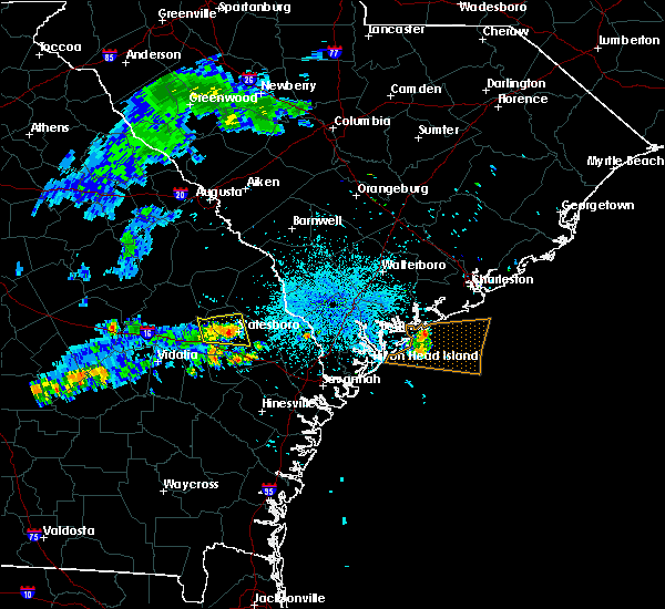 At 1016 pm edt, a severe thunderstorm was located over statesboro, moving east at 35 mph (radar indicated). Hazards include 60 mph wind gusts. Expect damage to roofs. siding and trees. Locations impacted include, statesboro, westside and middleground. At 1016 pm edt, a severe thunderstorm was located over statesboro, moving east at 35 mph (radar indicated). Hazards include 60 mph wind gusts. Expect damage to roofs. siding and trees. Locations impacted include, statesboro, westside and middleground.
|
| 7/1/2015 10:07 PM EDT |
 At 1007 pm edt, a severe thunderstorm was located over westside, moving east at 35 mph (radar indicated). Hazards include 60 mph wind gusts. Expect damage to roofs. siding and trees. Locations impacted include, statesboro, metter, westside, hopeulikit, westchester and middleground. At 1007 pm edt, a severe thunderstorm was located over westside, moving east at 35 mph (radar indicated). Hazards include 60 mph wind gusts. Expect damage to roofs. siding and trees. Locations impacted include, statesboro, metter, westside, hopeulikit, westchester and middleground.
|
| 7/1/2015 9:54 PM EDT |
 At 953 pm edt, a severe thunderstorm was located near metter, moving east at 35 mph (radar indicated). Hazards include 60 mph wind gusts. Expect damage to roofs. siding and trees. Locations impacted include, statesboro, metter, westside and middleground. At 953 pm edt, a severe thunderstorm was located near metter, moving east at 35 mph (radar indicated). Hazards include 60 mph wind gusts. Expect damage to roofs. siding and trees. Locations impacted include, statesboro, metter, westside and middleground.
|
| 7/1/2015 9:33 PM EDT |
 At 932 pm edt, a severe thunderstorm was located near stillmore, or 9 miles southeast of swainsboro, moving east at 35 mph (radar indicated). Hazards include 60 mph wind gusts. Expect damage to roofs. Siding and trees. At 932 pm edt, a severe thunderstorm was located near stillmore, or 9 miles southeast of swainsboro, moving east at 35 mph (radar indicated). Hazards include 60 mph wind gusts. Expect damage to roofs. Siding and trees.
|
| 6/30/2015 4:39 PM EDT |
 At 439 pm edt, severe thunderstorms were located along a line extending from near burtons ferry landing to near register, moving east at 35 mph (radar indicated). Hazards include 60 mph wind gusts. Expect damage to roofs. Siding and trees. At 439 pm edt, severe thunderstorms were located along a line extending from near burtons ferry landing to near register, moving east at 35 mph (radar indicated). Hazards include 60 mph wind gusts. Expect damage to roofs. Siding and trees.
|
| 6/3/2015 3:35 PM EDT | The severe thunderstorm warning for bulloch county will expire at 345 pm edt, the storm which prompted the warning has weakened below severe limits, and no longer pose an immediate threat to life or property. therefore the warning will be allowed to expire. however heavy rain is still possible with this thunderstorm that could cause ponding of water on roadways. |
| 6/3/2015 3:23 PM EDT | At 322 pm edt, a severe thunderstorm was located over register, or near statesboro, moving east at 10 mph (radar indicated. at 312 pm...the media relayed a public report of ping pong ball size hail south of statesboro). Hazards include 60 mph wind gusts and quarter size hail. Hail damage to vehicles is expected. expect wind damage to roofs, siding and trees. Locations impacted include, statesboro. |
| 6/3/2015 3:06 PM EDT | At 306 pm edt, a severe thunderstorm was located over register, or 7 miles south of westside, moving east at 10 mph (radar indicated). Hazards include 60 mph wind gusts and quarter size hail. Hail damage to vehicles is expected. Expect wind damage to roofs, siding and trees. |
| 4/25/2015 8:17 PM EDT | At 817 pm edt, a severe thunderstorm was located near register, or 8 miles north of claxton, moving east at 40 mph (radar indicated). Hazards include quarter size hail and 60 mph wind gusts. Hail damage to vehicles is expected. expect wind damage to roofs, siding and trees. locations impacted include, statesboro, reidsville, metter, claxton and westside. 1. 00in. |
| 4/25/2015 7:57 PM EDT | At 757 pm edt, a severe thunderstorm was located near metter, moving east at 40 mph (radar indicated). Hazards include quarter size hail and 60 mph wind gusts. Hail damage to vehicles is expected. expect wind damage to roofs, siding and trees. locations impacted include, statesboro, reidsville, metter, claxton, westside and middleground. 1. 00in. |
| 4/25/2015 7:47 PM EDT | At 747 pm edt, a severe thunderstorm was located over aline, or near metter, moving east at 35 mph (radar indicated). Hazards include golf ball size hail and 70 mph wind gusts. People and animals outdoors will be injured. expect hail damage to roofs, siding, windows and vehicles. expect considerable tree damage. wind damage is also likely to mobile homes, roofs and outbuildings. locations impacted include, statesboro, reidsville, metter, claxton, westside and middleground. Possible. |
| 4/25/2015 7:27 PM EDT | At 725 pm edt, a severe thunderstorm was located near oak park, or 13 miles north of lyons, moving east at 40 mph (radar indicated). Hazards include quarter size hail and 60 mph wind gusts. Hail damage to vehicles is expected. Expect wind damage to roofs, siding and trees. |
| 4/19/2015 3:43 PM EDT | this alert has expired |
| 4/19/2015 3:38 PM EDT | At 337 pm edt, severe thunderstorms were located along a line extending from near register to near midway, moving northeast at 45 mph. another severe thunderstorm was located 12 miles east of statesboro (radar indicated). Hazards include 60 mph wind gusts. Expect damage to roofs. Siding and trees. |
| 6/27/2013 4:33 PM EDT | Tree down on old register wa in bulloch county GA, 2.1 miles W of Register, GA |
| 12/17/2012 2:45 PM EST | Bulloch county 911 call center reported a tree down on a powerline on highway 301 sout in bulloch county GA, 6.5 miles N of Register, GA |
| 8/11/2012 1:39 PM EDT | Bulloch county warning point reported a tree down on highway 46 1 mile west of register. time estimated by rada in bulloch county GA, 0.9 miles ESE of Register, GA |
| 4/5/2012 5:09 PM EDT | The public reported 3 trees dow in bulloch county GA, 4.9 miles NNE of Register, GA |
| 1/1/0001 12:00 AM | Quarter sized hail reported 3.9 miles NNW of Register, GA |
| 1/1/0001 12:00 AM | Tree down on a power in in bulloch county GA, 0.5 miles SE of Register, GA |
Hail Maps for Register, GA
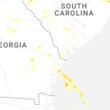


Connect with Interactive Hail Maps