

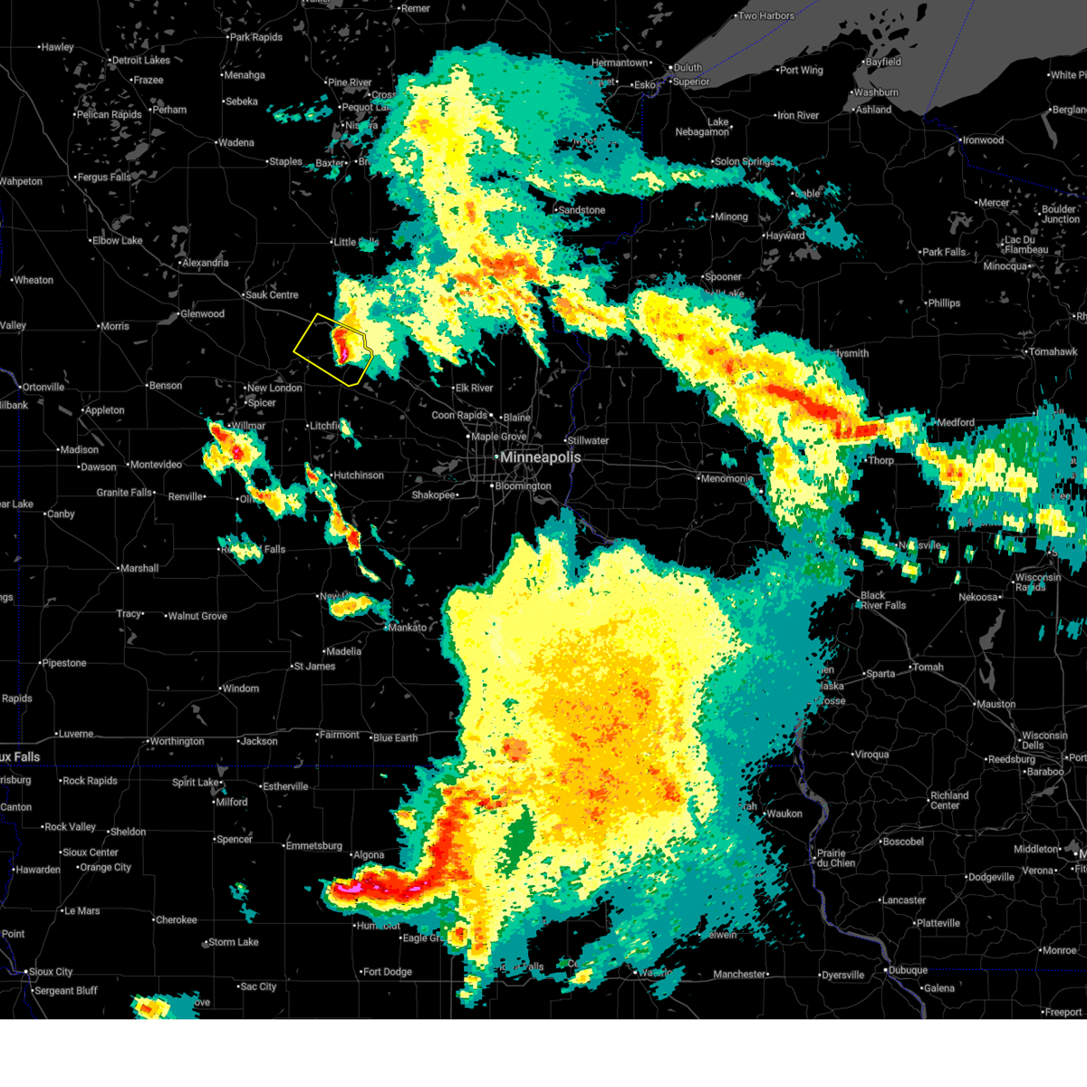
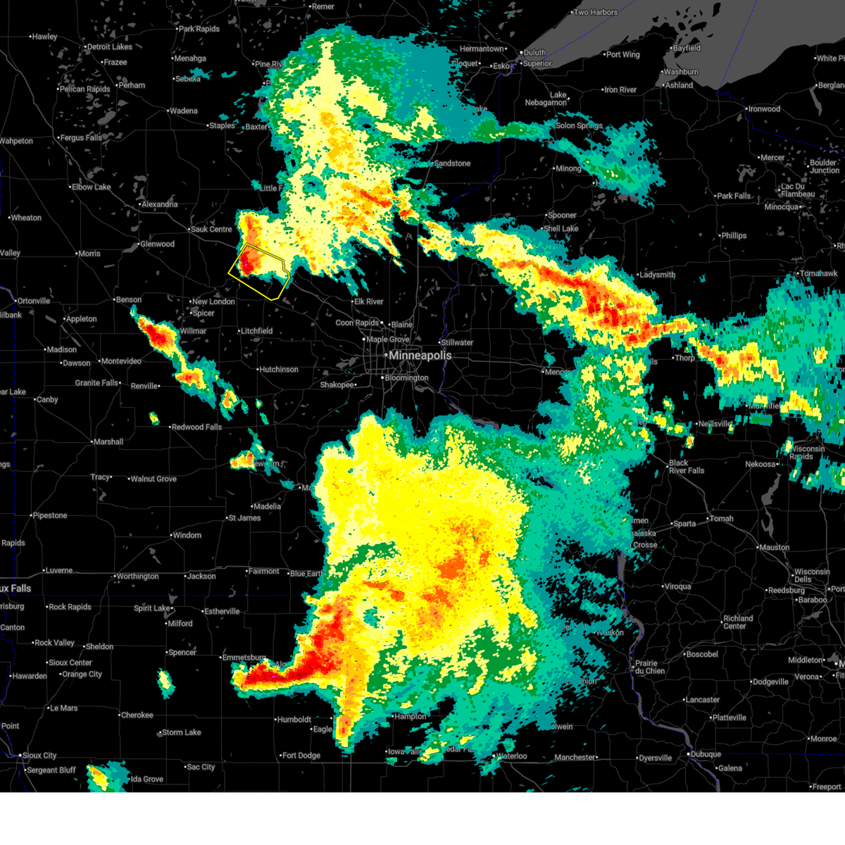
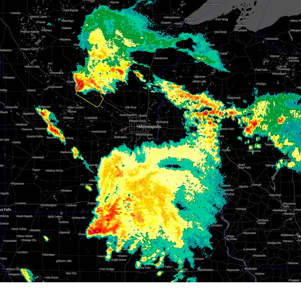
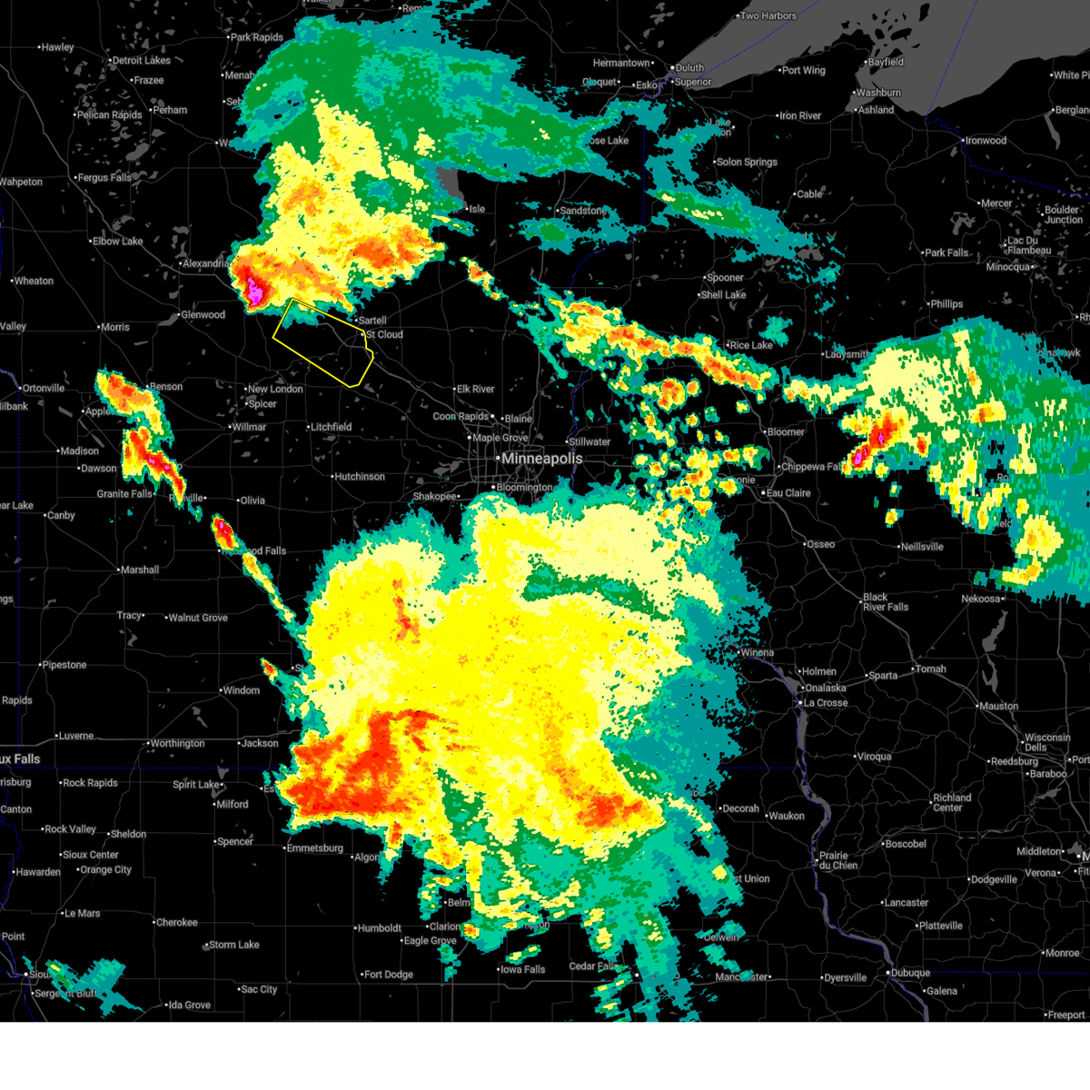
Hail Map for Richmond, MN
The Richmond, MN area has had 3 reports of on-the-ground hail by trained spotters, and has been under severe weather warnings 22 times during the past 12 months. Doppler radar has detected hail at or near Richmond, MN on 41 occasions, including 1 occasion during the past year.
| Name: | Richmond, MN |
| Where Located: | 67.9 miles ENE of Montevideo, MN |
| Map: | Google Map for Richmond, MN |
| Population: | 1422 |
| Housing Units: | 627 |
| More Info: | Search Google for Richmond, MN |
1
The Top Recent Hail Date for Richmond, MN is Saturday, August 3, 2024 (21st out of 41)

Hail and Wind Damage Spotted near Richmond, MN
| Date / Time | Report Details |
|---|---|
| 6/20/2025 3:55 AM CDT |
 The storm which prompted the warning has weakened below severe limits, and no longer poses an immediate threat to life or property. therefore, the warning will be allowed to expire. however, small hail, gusty winds, and heavy rain are still possible with this thunderstorm. to report severe weather, contact your nearest law enforcement agency. they will send your report to the national weather service office. a severe thunderstorm watch remains in effect until 600 am cdt for a portion of central minnesota. The storm which prompted the warning has weakened below severe limits, and no longer poses an immediate threat to life or property. therefore, the warning will be allowed to expire. however, small hail, gusty winds, and heavy rain are still possible with this thunderstorm. to report severe weather, contact your nearest law enforcement agency. they will send your report to the national weather service office. a severe thunderstorm watch remains in effect until 600 am cdt for a portion of central minnesota.
|
| 6/20/2025 3:44 AM CDT |
 At 344 am cdt, a severe thunderstorm was located over rockville, or 8 miles southwest of st. cloud, moving southeast at 35 mph (radar indicated). Hazards include 60 mph wind gusts and quarter size hail. Hail damage to vehicles is expected. expect wind damage to roofs, siding, and trees. this severe thunderstorm will be near, avon around 325 am cdt. cold spring around 335 am cdt. rockville and st. joseph around 340 am cdt. Other locations impacted by the severe thunderstorm include pleasant lake, luxemburg and st augusta. At 344 am cdt, a severe thunderstorm was located over rockville, or 8 miles southwest of st. cloud, moving southeast at 35 mph (radar indicated). Hazards include 60 mph wind gusts and quarter size hail. Hail damage to vehicles is expected. expect wind damage to roofs, siding, and trees. this severe thunderstorm will be near, avon around 325 am cdt. cold spring around 335 am cdt. rockville and st. joseph around 340 am cdt. Other locations impacted by the severe thunderstorm include pleasant lake, luxemburg and st augusta.
|
| 6/20/2025 3:21 AM CDT |
 At 321 am cdt, a severe thunderstorm was located near albany, or 18 miles west of st. cloud, moving southeast at 35 mph (at 249 am cdt, the sauk centre airport reported a wind gust of 66 mph). Hazards include 60 mph wind gusts and quarter size hail. Hail damage to vehicles is expected. expect wind damage to roofs, siding, and trees. this severe thunderstorm will be near, st. anthony around 310 am cdt. albany around 315 am cdt. avon around 325 am cdt. cold spring around 335 am cdt. Other locations impacted by the severe thunderstorm include farming, pleasant lake, luxemburg and st augusta. At 321 am cdt, a severe thunderstorm was located near albany, or 18 miles west of st. cloud, moving southeast at 35 mph (at 249 am cdt, the sauk centre airport reported a wind gust of 66 mph). Hazards include 60 mph wind gusts and quarter size hail. Hail damage to vehicles is expected. expect wind damage to roofs, siding, and trees. this severe thunderstorm will be near, st. anthony around 310 am cdt. albany around 315 am cdt. avon around 325 am cdt. cold spring around 335 am cdt. Other locations impacted by the severe thunderstorm include farming, pleasant lake, luxemburg and st augusta.
|
| 6/20/2025 3:03 AM CDT |
 Svrmpx the national weather service in the twin cities has issued a * severe thunderstorm warning for, eastern stearns county in central minnesota, * until 400 am cdt. * at 303 am cdt, a severe thunderstorm was located over freeport, or 28 miles west of st. cloud, moving southeast at 35 mph (at 249 am cdt, the sauk centre airport reported a wind gust of 66 mph). Hazards include 60 mph wind gusts and quarter size hail. Hail damage to vehicles is expected. expect wind damage to roofs, siding, and trees. this severe thunderstorm will be near, st. anthony around 310 am cdt. albany around 315 am cdt. avon around 325 am cdt. cold spring around 335 am cdt. Other locations impacted by the severe thunderstorm include farming, pleasant lake, luxemburg and st augusta. Svrmpx the national weather service in the twin cities has issued a * severe thunderstorm warning for, eastern stearns county in central minnesota, * until 400 am cdt. * at 303 am cdt, a severe thunderstorm was located over freeport, or 28 miles west of st. cloud, moving southeast at 35 mph (at 249 am cdt, the sauk centre airport reported a wind gust of 66 mph). Hazards include 60 mph wind gusts and quarter size hail. Hail damage to vehicles is expected. expect wind damage to roofs, siding, and trees. this severe thunderstorm will be near, st. anthony around 310 am cdt. albany around 315 am cdt. avon around 325 am cdt. cold spring around 335 am cdt. Other locations impacted by the severe thunderstorm include farming, pleasant lake, luxemburg and st augusta.
|
| 8/29/2024 3:20 PM CDT |
 At 320 pm cdt, severe thunderstorms were located along a line extending from 6 miles east of camp ripley to 5 miles north of collegeville to near st. cloud, moving northeast at 50 mph (radar indicated). Hazards include 60 mph wind gusts and quarter size hail. Hail damage to vehicles is expected. expect wind damage to roofs, siding, and trees. locations impacted include, st. cloud, little falls, sartell, sauk rapids, waite park, st. Joseph, cold spring, collegeville, rockville, clearwater, richmond, and avon. At 320 pm cdt, severe thunderstorms were located along a line extending from 6 miles east of camp ripley to 5 miles north of collegeville to near st. cloud, moving northeast at 50 mph (radar indicated). Hazards include 60 mph wind gusts and quarter size hail. Hail damage to vehicles is expected. expect wind damage to roofs, siding, and trees. locations impacted include, st. cloud, little falls, sartell, sauk rapids, waite park, st. Joseph, cold spring, collegeville, rockville, clearwater, richmond, and avon.
|
| 8/29/2024 2:54 PM CDT |
 Svrmpx the national weather service in the twin cities has issued a * severe thunderstorm warning for, northern meeker county in central minnesota, western benton county in central minnesota, northwestern sherburne county in central minnesota, eastern stearns county in central minnesota, morrison county in central minnesota, * until 345 pm cdt. * at 253 pm cdt, severe thunderstorms were located along a line extending from near flensburg to near richmond to near watkins, moving northeast at 50 mph (radar indicated). Hazards include 60 mph wind gusts and quarter size hail. Hail damage to vehicles is expected. Expect wind damage to roofs, siding, and trees. Svrmpx the national weather service in the twin cities has issued a * severe thunderstorm warning for, northern meeker county in central minnesota, western benton county in central minnesota, northwestern sherburne county in central minnesota, eastern stearns county in central minnesota, morrison county in central minnesota, * until 345 pm cdt. * at 253 pm cdt, severe thunderstorms were located along a line extending from near flensburg to near richmond to near watkins, moving northeast at 50 mph (radar indicated). Hazards include 60 mph wind gusts and quarter size hail. Hail damage to vehicles is expected. Expect wind damage to roofs, siding, and trees.
|
| 8/3/2024 8:50 PM CDT |
 The storm which prompted the warning has moved out of the area. therefore, the warning will be allowed to expire. a severe thunderstorm watch remains in effect until 100 am cdt for central minnesota. remember, a severe thunderstorm warning still remains in effect for stearns county. The storm which prompted the warning has moved out of the area. therefore, the warning will be allowed to expire. a severe thunderstorm watch remains in effect until 100 am cdt for central minnesota. remember, a severe thunderstorm warning still remains in effect for stearns county.
|
| 8/3/2024 8:48 PM CDT |
 Svrmpx the national weather service in the twin cities has issued a * severe thunderstorm warning for, meeker county in central minnesota, southwestern stearns county in central minnesota, northeastern kandiyohi county in central minnesota, * until 945 pm cdt. * at 848 pm cdt, a severe thunderstorm was located near paynesville, or 25 miles northeast of willmar, moving south at 30 mph (radar indicated). Hazards include golf ball size hail and 60 mph wind gusts. People and animals outdoors will be injured. expect hail damage to roofs, siding, windows, and vehicles. Expect wind damage to roofs, siding, and trees. Svrmpx the national weather service in the twin cities has issued a * severe thunderstorm warning for, meeker county in central minnesota, southwestern stearns county in central minnesota, northeastern kandiyohi county in central minnesota, * until 945 pm cdt. * at 848 pm cdt, a severe thunderstorm was located near paynesville, or 25 miles northeast of willmar, moving south at 30 mph (radar indicated). Hazards include golf ball size hail and 60 mph wind gusts. People and animals outdoors will be injured. expect hail damage to roofs, siding, windows, and vehicles. Expect wind damage to roofs, siding, and trees.
|
| 8/3/2024 8:45 PM CDT |
 At 845 pm cdt, a severe thunderstorm was located 6 miles west of richmond, or 23 miles west of st. cloud, moving southeast at 30 mph (trained weather spotters). Hazards include ping pong ball size hail and 60 mph wind gusts. People and animals outdoors will be injured. expect hail damage to roofs, siding, windows, and vehicles. expect wind damage to roofs, siding, and trees. locations impacted include, farming, roscoe, and st. Martin. At 845 pm cdt, a severe thunderstorm was located 6 miles west of richmond, or 23 miles west of st. cloud, moving southeast at 30 mph (trained weather spotters). Hazards include ping pong ball size hail and 60 mph wind gusts. People and animals outdoors will be injured. expect hail damage to roofs, siding, windows, and vehicles. expect wind damage to roofs, siding, and trees. locations impacted include, farming, roscoe, and st. Martin.
|
| 8/3/2024 8:36 PM CDT |
 At 836 pm cdt, a severe thunderstorm was located near albany, or 20 miles west of st. cloud, moving south at 30 mph (trained weather spotters). Hazards include ping pong ball size hail and 60 mph wind gusts. People and animals outdoors will be injured. expect hail damage to roofs, siding, windows, and vehicles. expect wind damage to roofs, siding, and trees. locations impacted include, st. cloud, sartell, waite park, st. joseph, collegeville, albany, avon, freeport, farming, new munich, roscoe, and st. Martin. At 836 pm cdt, a severe thunderstorm was located near albany, or 20 miles west of st. cloud, moving south at 30 mph (trained weather spotters). Hazards include ping pong ball size hail and 60 mph wind gusts. People and animals outdoors will be injured. expect hail damage to roofs, siding, windows, and vehicles. expect wind damage to roofs, siding, and trees. locations impacted include, st. cloud, sartell, waite park, st. joseph, collegeville, albany, avon, freeport, farming, new munich, roscoe, and st. Martin.
|
| 8/3/2024 8:29 PM CDT |
 At 828 pm cdt, a severe thunderstorm was located over albany, or 21 miles west of st. cloud, moving southeast at 30 mph (trained weather spotters). Hazards include two inch hail and 60 mph wind gusts. People and animals outdoors will be injured. expect hail damage to roofs, siding, windows, and vehicles. expect wind damage to roofs, siding, and trees. locations impacted include, st. cloud, sartell, waite park, st. Joseph, melrose, collegeville, albany, avon, holdingford, freeport, farming, and new munich. At 828 pm cdt, a severe thunderstorm was located over albany, or 21 miles west of st. cloud, moving southeast at 30 mph (trained weather spotters). Hazards include two inch hail and 60 mph wind gusts. People and animals outdoors will be injured. expect hail damage to roofs, siding, windows, and vehicles. expect wind damage to roofs, siding, and trees. locations impacted include, st. cloud, sartell, waite park, st. Joseph, melrose, collegeville, albany, avon, holdingford, freeport, farming, and new munich.
|
| 8/3/2024 8:21 PM CDT |
 the severe thunderstorm warning has been cancelled and is no longer in effect the severe thunderstorm warning has been cancelled and is no longer in effect
|
| 8/3/2024 8:21 PM CDT |
 At 821 pm cdt, a severe thunderstorm was located over freeport, or 24 miles northwest of st. cloud, moving southeast at 30 mph (radar indicated). Hazards include two inch hail and 60 mph wind gusts. People and animals outdoors will be injured. expect hail damage to roofs, siding, windows, and vehicles. expect wind damage to roofs, siding, and trees. locations impacted include, st. cloud, sartell, waite park, st. Joseph, melrose, collegeville, albany, avon, holdingford, freeport, farming, and new munich. At 821 pm cdt, a severe thunderstorm was located over freeport, or 24 miles northwest of st. cloud, moving southeast at 30 mph (radar indicated). Hazards include two inch hail and 60 mph wind gusts. People and animals outdoors will be injured. expect hail damage to roofs, siding, windows, and vehicles. expect wind damage to roofs, siding, and trees. locations impacted include, st. cloud, sartell, waite park, st. Joseph, melrose, collegeville, albany, avon, holdingford, freeport, farming, and new munich.
|
| 8/3/2024 8:11 PM CDT |
 At 811 pm cdt, a severe thunderstorm was located near freeport, or 22 miles southwest of little falls, moving southeast at 30 mph (radar indicated). Hazards include two inch hail and 60 mph wind gusts. People and animals outdoors will be injured. expect hail damage to roofs, siding, windows, and vehicles. expect wind damage to roofs, siding, and trees. locations impacted include, st. cloud, sartell, waite park, st. Joseph, melrose, collegeville, albany, avon, holdingford, freeport, upsala, and farming. At 811 pm cdt, a severe thunderstorm was located near freeport, or 22 miles southwest of little falls, moving southeast at 30 mph (radar indicated). Hazards include two inch hail and 60 mph wind gusts. People and animals outdoors will be injured. expect hail damage to roofs, siding, windows, and vehicles. expect wind damage to roofs, siding, and trees. locations impacted include, st. cloud, sartell, waite park, st. Joseph, melrose, collegeville, albany, avon, holdingford, freeport, upsala, and farming.
|
| 8/3/2024 8:00 PM CDT |
 Svrmpx the national weather service in the twin cities has issued a * severe thunderstorm warning for, southeastern todd county in central minnesota, northeastern stearns county in central minnesota, southwestern morrison county in central minnesota, * until 900 pm cdt. * at 800 pm cdt, a severe thunderstorm was located over grey eagle, or 19 miles southwest of little falls, moving southeast at 30 mph (radar indicated). Hazards include two inch hail and 60 mph wind gusts. People and animals outdoors will be injured. expect hail damage to roofs, siding, windows, and vehicles. Expect wind damage to roofs, siding, and trees. Svrmpx the national weather service in the twin cities has issued a * severe thunderstorm warning for, southeastern todd county in central minnesota, northeastern stearns county in central minnesota, southwestern morrison county in central minnesota, * until 900 pm cdt. * at 800 pm cdt, a severe thunderstorm was located over grey eagle, or 19 miles southwest of little falls, moving southeast at 30 mph (radar indicated). Hazards include two inch hail and 60 mph wind gusts. People and animals outdoors will be injured. expect hail damage to roofs, siding, windows, and vehicles. Expect wind damage to roofs, siding, and trees.
|
| 7/31/2024 3:19 PM CDT |
 the severe thunderstorm warning has been cancelled and is no longer in effect the severe thunderstorm warning has been cancelled and is no longer in effect
|
| 7/31/2024 3:09 PM CDT |
 At 309 pm cdt, severe thunderstorms were located along a line extending from 8 miles south of freeport to near paynesville to atwater, moving east at 40 mph (radar indicated). Hazards include 60 mph wind gusts. Expect damage to roofs, siding, and trees. these severe storms will be near, grove city around 315 pm cdt. richmond around 320 pm cdt. other locations impacted by these severe thunderstorms include paynesville airport, spring hill, regal, st. Martin, greenwald, green lake, lake henry, georgeville, elrosa, and hawick. At 309 pm cdt, severe thunderstorms were located along a line extending from 8 miles south of freeport to near paynesville to atwater, moving east at 40 mph (radar indicated). Hazards include 60 mph wind gusts. Expect damage to roofs, siding, and trees. these severe storms will be near, grove city around 315 pm cdt. richmond around 320 pm cdt. other locations impacted by these severe thunderstorms include paynesville airport, spring hill, regal, st. Martin, greenwald, green lake, lake henry, georgeville, elrosa, and hawick.
|
| 7/31/2024 2:56 PM CDT |
 At 256 pm cdt, severe thunderstorms were located along a line extending from 9 miles north of belgrade to 7 miles north of new london to near spicer, moving east at 40 mph (radar indicated). Hazards include 60 mph wind gusts and penny size hail. Expect damage to roofs, siding, and trees. these severe storms will be near, paynesville and new london around 300 pm cdt. atwater around 305 pm cdt. grove city around 310 pm cdt. richmond around 320 pm cdt. other locations impacted by these severe thunderstorms include paynesville airport, spring hill, padua, sibley state park, regal, st. Martin, greenwald, green lake, lake henry, and georgeville. At 256 pm cdt, severe thunderstorms were located along a line extending from 9 miles north of belgrade to 7 miles north of new london to near spicer, moving east at 40 mph (radar indicated). Hazards include 60 mph wind gusts and penny size hail. Expect damage to roofs, siding, and trees. these severe storms will be near, paynesville and new london around 300 pm cdt. atwater around 305 pm cdt. grove city around 310 pm cdt. richmond around 320 pm cdt. other locations impacted by these severe thunderstorms include paynesville airport, spring hill, padua, sibley state park, regal, st. Martin, greenwald, green lake, lake henry, and georgeville.
|
| 7/31/2024 2:37 PM CDT |
 Svrmpx the national weather service in the twin cities has issued a * severe thunderstorm warning for, northwestern meeker county in central minnesota, southwestern stearns county in central minnesota, northern kandiyohi county in central minnesota, * until 330 pm cdt. * at 236 pm cdt, a severe thunderstorm was located 8 miles southwest of brooten, or 21 miles northwest of willmar, moving east at 45 mph (radar indicated). Hazards include 60 mph wind gusts and penny size hail. Expect damage to roofs, siding, and trees. this severe thunderstorm will be near, belgrade around 250 pm cdt. paynesville around 305 pm cdt. other locations impacted by this severe thunderstorm include paynesville airport, spring hill, padua, sibley state park, regal, st. Martin, greenwald, green lake, lake henry, and georgeville. Svrmpx the national weather service in the twin cities has issued a * severe thunderstorm warning for, northwestern meeker county in central minnesota, southwestern stearns county in central minnesota, northern kandiyohi county in central minnesota, * until 330 pm cdt. * at 236 pm cdt, a severe thunderstorm was located 8 miles southwest of brooten, or 21 miles northwest of willmar, moving east at 45 mph (radar indicated). Hazards include 60 mph wind gusts and penny size hail. Expect damage to roofs, siding, and trees. this severe thunderstorm will be near, belgrade around 250 pm cdt. paynesville around 305 pm cdt. other locations impacted by this severe thunderstorm include paynesville airport, spring hill, padua, sibley state park, regal, st. Martin, greenwald, green lake, lake henry, and georgeville.
|
| 7/13/2024 11:42 PM CDT |
 At 1142 pm cdt, a severe thunderstorm was located near sartell, or 11 miles northwest of st. cloud, moving southeast at 40 mph (radar indicated). Hazards include ping pong ball size hail and 60 mph wind gusts. People and animals outdoors will be injured. expect hail damage to roofs, siding, windows, and vehicles. expect wind damage to roofs, siding, and trees. locations impacted include, st. cloud, sartell, sauk rapids, waite park, st. Joseph, cold spring, collegeville, richmond, avon, holdingford, rice, and mayhew. At 1142 pm cdt, a severe thunderstorm was located near sartell, or 11 miles northwest of st. cloud, moving southeast at 40 mph (radar indicated). Hazards include ping pong ball size hail and 60 mph wind gusts. People and animals outdoors will be injured. expect hail damage to roofs, siding, windows, and vehicles. expect wind damage to roofs, siding, and trees. locations impacted include, st. cloud, sartell, sauk rapids, waite park, st. Joseph, cold spring, collegeville, richmond, avon, holdingford, rice, and mayhew.
|
| 7/13/2024 11:42 PM CDT |
 the severe thunderstorm warning has been cancelled and is no longer in effect the severe thunderstorm warning has been cancelled and is no longer in effect
|
| 7/13/2024 11:15 PM CDT |
 Svrmpx the national weather service in the twin cities has issued a * severe thunderstorm warning for, western benton county in central minnesota, southeastern todd county in central minnesota, northeastern stearns county in central minnesota, southwestern morrison county in central minnesota, * until midnight cdt. * at 1114 pm cdt, a severe thunderstorm was located over upsala, or 14 miles southwest of little falls, moving southeast at 40 mph (radar indicated). Hazards include ping pong ball size hail and 60 mph wind gusts. People and animals outdoors will be injured. expect hail damage to roofs, siding, windows, and vehicles. Expect wind damage to roofs, siding, and trees. Svrmpx the national weather service in the twin cities has issued a * severe thunderstorm warning for, western benton county in central minnesota, southeastern todd county in central minnesota, northeastern stearns county in central minnesota, southwestern morrison county in central minnesota, * until midnight cdt. * at 1114 pm cdt, a severe thunderstorm was located over upsala, or 14 miles southwest of little falls, moving southeast at 40 mph (radar indicated). Hazards include ping pong ball size hail and 60 mph wind gusts. People and animals outdoors will be injured. expect hail damage to roofs, siding, windows, and vehicles. Expect wind damage to roofs, siding, and trees.
|
| 7/27/2023 3:57 PM CDT |
 At 357 pm cdt, a severe thunderstorm was located over paynesville, or 24 miles northeast of willmar, moving east at 30 mph (radar indicated). Hazards include 60 mph wind gusts and quarter size hail. Hail damage to vehicles is expected. expect wind damage to roofs, siding, and trees. this severe storm will be near, richmond around 415 pm cdt. cold spring around 420 pm cdt. watkins around 425 pm cdt. rockville around 430 pm cdt. other locations impacted by this severe thunderstorm include manannah, paynesville airport, st nicholas, roscoe and st. martin. hail threat, radar indicated max hail size, 1. 00 in wind threat, radar indicated max wind gust, 60 mph. At 357 pm cdt, a severe thunderstorm was located over paynesville, or 24 miles northeast of willmar, moving east at 30 mph (radar indicated). Hazards include 60 mph wind gusts and quarter size hail. Hail damage to vehicles is expected. expect wind damage to roofs, siding, and trees. this severe storm will be near, richmond around 415 pm cdt. cold spring around 420 pm cdt. watkins around 425 pm cdt. rockville around 430 pm cdt. other locations impacted by this severe thunderstorm include manannah, paynesville airport, st nicholas, roscoe and st. martin. hail threat, radar indicated max hail size, 1. 00 in wind threat, radar indicated max wind gust, 60 mph.
|
| 7/27/2023 3:48 PM CDT |
 At 347 pm cdt, a severe thunderstorm was located near paynesville, or 22 miles northeast of willmar, moving east at 30 mph (radar indicated). Hazards include 60 mph wind gusts and half dollar size hail. Hail damage to vehicles is expected. expect wind damage to roofs, siding, and trees. this severe thunderstorm will be near, paynesville around 355 pm cdt. richmond around 415 pm cdt. cold spring around 420 pm cdt. watkins around 425 pm cdt. rockville around 430 pm cdt. other locations impacted by this severe thunderstorm include paynesville airport, lake henry, manannah, lake koronis regional park, st nicholas, roscoe, regal, st. martin and spring hill. hail threat, radar indicated max hail size, 1. 25 in wind threat, radar indicated max wind gust, 60 mph. At 347 pm cdt, a severe thunderstorm was located near paynesville, or 22 miles northeast of willmar, moving east at 30 mph (radar indicated). Hazards include 60 mph wind gusts and half dollar size hail. Hail damage to vehicles is expected. expect wind damage to roofs, siding, and trees. this severe thunderstorm will be near, paynesville around 355 pm cdt. richmond around 415 pm cdt. cold spring around 420 pm cdt. watkins around 425 pm cdt. rockville around 430 pm cdt. other locations impacted by this severe thunderstorm include paynesville airport, lake henry, manannah, lake koronis regional park, st nicholas, roscoe, regal, st. martin and spring hill. hail threat, radar indicated max hail size, 1. 25 in wind threat, radar indicated max wind gust, 60 mph.
|
| 7/25/2023 11:05 PM CDT |
 At 1104 pm cdt, a severe thunderstorm was located near new london, or 14 miles northeast of willmar, moving east at 50 mph (radar indicated). Hazards include 60 mph wind gusts. Expect damage to roofs, siding, and trees. this severe thunderstorm will be near, paynesville around 1115 pm cdt. other locations in the path of this severe thunderstorm include watkins and kimball. hail threat, radar indicated max hail size, <. 75 in wind threat, radar indicated max wind gust, 60 mph. At 1104 pm cdt, a severe thunderstorm was located near new london, or 14 miles northeast of willmar, moving east at 50 mph (radar indicated). Hazards include 60 mph wind gusts. Expect damage to roofs, siding, and trees. this severe thunderstorm will be near, paynesville around 1115 pm cdt. other locations in the path of this severe thunderstorm include watkins and kimball. hail threat, radar indicated max hail size, <. 75 in wind threat, radar indicated max wind gust, 60 mph.
|
| 7/24/2023 4:09 PM CDT |
 The severe thunderstorm warning for central stearns county will expire at 415 pm cdt, the storm which prompted the warning has weakened below severe limits, and has exited the warned area. therefore, the warning will be allowed to expire. to report severe weather, contact your nearest law enforcement agency. they will relay your report to the national weather service the twin cities. The severe thunderstorm warning for central stearns county will expire at 415 pm cdt, the storm which prompted the warning has weakened below severe limits, and has exited the warned area. therefore, the warning will be allowed to expire. to report severe weather, contact your nearest law enforcement agency. they will relay your report to the national weather service the twin cities.
|
| 7/24/2023 4:02 PM CDT |
 At 402 pm cdt, a severe thunderstorm was located near cold spring, or 13 miles west of st. cloud, moving southeast at 15 mph (radar indicated). Hazards include 60 mph wind gusts and quarter size hail. Hail damage to vehicles is expected. expect wind damage to roofs, siding, and trees. this severe thunderstorm will remain over mainly rural areas of central stearns county. hail threat, radar indicated max hail size, 1. 00 in wind threat, radar indicated max wind gust, 60 mph. At 402 pm cdt, a severe thunderstorm was located near cold spring, or 13 miles west of st. cloud, moving southeast at 15 mph (radar indicated). Hazards include 60 mph wind gusts and quarter size hail. Hail damage to vehicles is expected. expect wind damage to roofs, siding, and trees. this severe thunderstorm will remain over mainly rural areas of central stearns county. hail threat, radar indicated max hail size, 1. 00 in wind threat, radar indicated max wind gust, 60 mph.
|
| 7/24/2023 3:58 PM CDT |
 At 358 pm cdt, a severe thunderstorm was located near cold spring, or 14 miles west of st. cloud, moving south at 15 mph (radar indicated). Hazards include 60 mph wind gusts and quarter size hail. Hail damage to vehicles is expected. expect wind damage to roofs, siding, and trees. this severe thunderstorm will be near, cold spring around 410 pm cdt. rockville around 415 pm cdt. watkins around 445 pm cdt. kimball around 450 pm cdt. other locations impacted by this severe thunderstorm include fairhaven, st nicholas and pleasant lake. hail threat, radar indicated max hail size, 1. 00 in wind threat, radar indicated max wind gust, 60 mph. At 358 pm cdt, a severe thunderstorm was located near cold spring, or 14 miles west of st. cloud, moving south at 15 mph (radar indicated). Hazards include 60 mph wind gusts and quarter size hail. Hail damage to vehicles is expected. expect wind damage to roofs, siding, and trees. this severe thunderstorm will be near, cold spring around 410 pm cdt. rockville around 415 pm cdt. watkins around 445 pm cdt. kimball around 450 pm cdt. other locations impacted by this severe thunderstorm include fairhaven, st nicholas and pleasant lake. hail threat, radar indicated max hail size, 1. 00 in wind threat, radar indicated max wind gust, 60 mph.
|
| 7/24/2023 3:38 PM CDT |
 At 338 pm cdt, a severe thunderstorm was located near albany, or 17 miles west of st. cloud, moving southeast at 15 mph (radar indicated). Hazards include 60 mph wind gusts and half dollar size hail. Hail damage to vehicles is expected. expect wind damage to roofs, siding, and trees. this severe storm will be near, collegeville around 350 pm cdt. st. joseph around 400 pm cdt. other locations impacted by this severe thunderstorm include farming. hail threat, radar indicated max hail size, 1. 25 in wind threat, radar indicated max wind gust, 60 mph. At 338 pm cdt, a severe thunderstorm was located near albany, or 17 miles west of st. cloud, moving southeast at 15 mph (radar indicated). Hazards include 60 mph wind gusts and half dollar size hail. Hail damage to vehicles is expected. expect wind damage to roofs, siding, and trees. this severe storm will be near, collegeville around 350 pm cdt. st. joseph around 400 pm cdt. other locations impacted by this severe thunderstorm include farming. hail threat, radar indicated max hail size, 1. 25 in wind threat, radar indicated max wind gust, 60 mph.
|
| 7/24/2023 3:28 PM CDT |
 At 328 pm cdt, a severe thunderstorm was located over albany, or 19 miles west of st. cloud, moving south at 20 mph (radar indicated). Hazards include two inch hail and 60 mph wind gusts. People and animals outdoors will be injured. expect hail damage to roofs, siding, windows, and vehicles. expect wind damage to roofs, siding, and trees. this severe storm will be near, st. anthony around 335 pm cdt. avon around 340 pm cdt. collegeville around 345 pm cdt. other locations impacted by this severe thunderstorm include farming. thunderstorm damage threat, considerable hail threat, radar indicated max hail size, 2. 00 in wind threat, radar indicated max wind gust, 60 mph. At 328 pm cdt, a severe thunderstorm was located over albany, or 19 miles west of st. cloud, moving south at 20 mph (radar indicated). Hazards include two inch hail and 60 mph wind gusts. People and animals outdoors will be injured. expect hail damage to roofs, siding, windows, and vehicles. expect wind damage to roofs, siding, and trees. this severe storm will be near, st. anthony around 335 pm cdt. avon around 340 pm cdt. collegeville around 345 pm cdt. other locations impacted by this severe thunderstorm include farming. thunderstorm damage threat, considerable hail threat, radar indicated max hail size, 2. 00 in wind threat, radar indicated max wind gust, 60 mph.
|
| 7/24/2023 3:18 PM CDT |
 At 318 pm cdt, a severe thunderstorm was located near holdingford, or 21 miles southwest of little falls, moving southeast at 15 mph (radar indicated). Hazards include 60 mph wind gusts and quarter size hail. Hail damage to vehicles is expected. expect wind damage to roofs, siding, and trees. this severe thunderstorm will be near, st. anthony around 325 pm cdt. albany around 335 pm cdt. other locations in the path of this severe thunderstorm include avon, collegeville, st. joseph and waite park. hail threat, radar indicated max hail size, 1. 00 in wind threat, radar indicated max wind gust, 60 mph. At 318 pm cdt, a severe thunderstorm was located near holdingford, or 21 miles southwest of little falls, moving southeast at 15 mph (radar indicated). Hazards include 60 mph wind gusts and quarter size hail. Hail damage to vehicles is expected. expect wind damage to roofs, siding, and trees. this severe thunderstorm will be near, st. anthony around 325 pm cdt. albany around 335 pm cdt. other locations in the path of this severe thunderstorm include avon, collegeville, st. joseph and waite park. hail threat, radar indicated max hail size, 1. 00 in wind threat, radar indicated max wind gust, 60 mph.
|
| 7/19/2023 5:17 PM CDT |
 At 516 pm cdt, a severe thunderstorm was located near rockville, or 10 miles west of st. cloud, moving east at 40 mph (trained weather spotters measured 74 mph wind gust near richmond at 515 pm cdt). Hazards include 70 mph wind gusts and half dollar size hail. Hail damage to vehicles is expected. expect considerable tree damage. wind damage is also likely to mobile homes, roofs, and outbuildings. this severe storm will be near, st. joseph and rockville around 520 pm cdt. other locations in the path of this severe thunderstorm include waite park and st. Cloud. At 516 pm cdt, a severe thunderstorm was located near rockville, or 10 miles west of st. cloud, moving east at 40 mph (trained weather spotters measured 74 mph wind gust near richmond at 515 pm cdt). Hazards include 70 mph wind gusts and half dollar size hail. Hail damage to vehicles is expected. expect considerable tree damage. wind damage is also likely to mobile homes, roofs, and outbuildings. this severe storm will be near, st. joseph and rockville around 520 pm cdt. other locations in the path of this severe thunderstorm include waite park and st. Cloud.
|
| 7/19/2023 5:15 PM CDT | Relayed via stearns county e in stearns county MN, 1 miles ENE of Richmond, MN |
| 7/19/2023 5:01 PM CDT |
 At 501 pm cdt, a severe thunderstorm was located 7 miles northwest of richmond, or 21 miles west of st. cloud, moving east at 40 mph (radar indicated). Hazards include 60 mph wind gusts and half dollar size hail. Hail damage to vehicles is expected. expect wind damage to roofs, siding, and trees. this severe storm will be near, richmond around 510 pm cdt. cold spring around 515 pm cdt. other locations in the path of this severe thunderstorm include st. Joseph, rockville and waite park. At 501 pm cdt, a severe thunderstorm was located 7 miles northwest of richmond, or 21 miles west of st. cloud, moving east at 40 mph (radar indicated). Hazards include 60 mph wind gusts and half dollar size hail. Hail damage to vehicles is expected. expect wind damage to roofs, siding, and trees. this severe storm will be near, richmond around 510 pm cdt. cold spring around 515 pm cdt. other locations in the path of this severe thunderstorm include st. Joseph, rockville and waite park.
|
| 7/19/2023 4:55 PM CDT |
 At 455 pm cdt, a severe thunderstorm was located 8 miles south of freeport, or 25 miles west of st. cloud, moving east at 40 mph (radar indicated). Hazards include 60 mph wind gusts and half dollar size hail. Hail damage to vehicles is expected. expect wind damage to roofs, siding, and trees. this severe thunderstorm will be near, richmond around 510 pm cdt. cold spring around 515 pm cdt. other locations in the path of this severe thunderstorm include st. joseph, rockville and waite park. hail threat, radar indicated max hail size, 1. 25 in wind threat, radar indicated max wind gust, 60 mph. At 455 pm cdt, a severe thunderstorm was located 8 miles south of freeport, or 25 miles west of st. cloud, moving east at 40 mph (radar indicated). Hazards include 60 mph wind gusts and half dollar size hail. Hail damage to vehicles is expected. expect wind damage to roofs, siding, and trees. this severe thunderstorm will be near, richmond around 510 pm cdt. cold spring around 515 pm cdt. other locations in the path of this severe thunderstorm include st. joseph, rockville and waite park. hail threat, radar indicated max hail size, 1. 25 in wind threat, radar indicated max wind gust, 60 mph.
|
| 7/13/2023 8:20 PM CDT |
 At 820 pm cdt, a severe thunderstorm was located near richmond, or 18 miles southwest of st. cloud, moving east at 45 mph (radar indicated). Hazards include 60 mph wind gusts and quarter size hail. Hail damage to vehicles is expected. expect wind damage to roofs, siding, and trees. Locations impacted include, paynesville, roscoe, hawick and paynesville airport. At 820 pm cdt, a severe thunderstorm was located near richmond, or 18 miles southwest of st. cloud, moving east at 45 mph (radar indicated). Hazards include 60 mph wind gusts and quarter size hail. Hail damage to vehicles is expected. expect wind damage to roofs, siding, and trees. Locations impacted include, paynesville, roscoe, hawick and paynesville airport.
|
| 7/13/2023 8:09 PM CDT |
 At 808 pm cdt, a severe thunderstorm was located near paynesville, or 25 miles west of st. cloud, moving east at 50 mph (radar indicated). Hazards include 60 mph wind gusts and quarter size hail. Hail damage to vehicles is expected. expect wind damage to roofs, siding, and trees. locations impacted include, paynesville, belgrade, lake henry, roscoe, spring hill, regal, paynesville airport, georgeville, hawick and st. Martin. At 808 pm cdt, a severe thunderstorm was located near paynesville, or 25 miles west of st. cloud, moving east at 50 mph (radar indicated). Hazards include 60 mph wind gusts and quarter size hail. Hail damage to vehicles is expected. expect wind damage to roofs, siding, and trees. locations impacted include, paynesville, belgrade, lake henry, roscoe, spring hill, regal, paynesville airport, georgeville, hawick and st. Martin.
|
| 7/13/2023 7:56 PM CDT |
 At 755 pm cdt, a severe thunderstorm was located near belgrade, or 26 miles north of willmar, moving east at 45 mph (radar indicated). Hazards include 60 mph wind gusts and half dollar size hail. Hail damage to vehicles is expected. expect wind damage to roofs, siding, and trees. Locations impacted include, paynesville. At 755 pm cdt, a severe thunderstorm was located near belgrade, or 26 miles north of willmar, moving east at 45 mph (radar indicated). Hazards include 60 mph wind gusts and half dollar size hail. Hail damage to vehicles is expected. expect wind damage to roofs, siding, and trees. Locations impacted include, paynesville.
|
| 7/13/2023 7:43 PM CDT |
 At 743 pm cdt, a severe thunderstorm was located near brooten, or 26 miles southeast of alexandria, moving east at 45 mph (radar indicated). Hazards include 60 mph wind gusts and half dollar size hail. Hail damage to vehicles is expected. expect wind damage to roofs, siding, and trees. this severe thunderstorm will be near, belgrade around 755 pm cdt. other locations in the path of this severe thunderstorm include paynesville. hail threat, radar indicated max hail size, 1. 25 in wind threat, radar indicated max wind gust, 60 mph. At 743 pm cdt, a severe thunderstorm was located near brooten, or 26 miles southeast of alexandria, moving east at 45 mph (radar indicated). Hazards include 60 mph wind gusts and half dollar size hail. Hail damage to vehicles is expected. expect wind damage to roofs, siding, and trees. this severe thunderstorm will be near, belgrade around 755 pm cdt. other locations in the path of this severe thunderstorm include paynesville. hail threat, radar indicated max hail size, 1. 25 in wind threat, radar indicated max wind gust, 60 mph.
|
| 7/13/2023 6:19 PM CDT |
 At 618 pm cdt, a severe thunderstorm was located near belgrade, or 21 miles north of willmar, moving southeast at 30 mph (law enforcement). Hazards include two inch hail and 60 mph wind gusts. People and animals outdoors will be injured. expect hail damage to roofs, siding, windows, and vehicles. expect wind damage to roofs, siding, and trees. locations impacted include, paynesville, richmond, new london, brooten, belgrade, green lake, lake henry, roscoe, spring hill, regal, paynesville airport and georgeville. thunderstorm damage threat, considerable hail threat, observed max hail size, 2. 00 in wind threat, radar indicated max wind gust, 60 mph. At 618 pm cdt, a severe thunderstorm was located near belgrade, or 21 miles north of willmar, moving southeast at 30 mph (law enforcement). Hazards include two inch hail and 60 mph wind gusts. People and animals outdoors will be injured. expect hail damage to roofs, siding, windows, and vehicles. expect wind damage to roofs, siding, and trees. locations impacted include, paynesville, richmond, new london, brooten, belgrade, green lake, lake henry, roscoe, spring hill, regal, paynesville airport and georgeville. thunderstorm damage threat, considerable hail threat, observed max hail size, 2. 00 in wind threat, radar indicated max wind gust, 60 mph.
|
| 7/13/2023 6:14 PM CDT |
 At 613 pm cdt, a severe thunderstorm was located over belgrade, or 22 miles north of willmar, moving southeast at 30 mph (trained spotter). Hazards include golf ball size hail and 60 mph wind gusts. People and animals outdoors will be injured. expect hail damage to roofs, siding, windows, and vehicles. expect wind damage to roofs, siding, and trees. locations impacted include, paynesville. thunderstorm damage threat, considerable hail threat, observed max hail size, 1. 75 in wind threat, radar indicated max wind gust, 60 mph. At 613 pm cdt, a severe thunderstorm was located over belgrade, or 22 miles north of willmar, moving southeast at 30 mph (trained spotter). Hazards include golf ball size hail and 60 mph wind gusts. People and animals outdoors will be injured. expect hail damage to roofs, siding, windows, and vehicles. expect wind damage to roofs, siding, and trees. locations impacted include, paynesville. thunderstorm damage threat, considerable hail threat, observed max hail size, 1. 75 in wind threat, radar indicated max wind gust, 60 mph.
|
| 7/13/2023 6:01 PM CDT |
 At 601 pm cdt, a severe thunderstorm was located over brooten, or 26 miles north of willmar, moving southeast at 35 mph (radar indicated). Hazards include 60 mph wind gusts and quarter size hail. Hail damage to vehicles is expected. expect wind damage to roofs, siding, and trees. this severe thunderstorm will be near, belgrade around 610 pm cdt. other locations in the path of this severe thunderstorm include paynesville and richmond. hail threat, radar indicated max hail size, 1. 00 in wind threat, radar indicated max wind gust, 60 mph. At 601 pm cdt, a severe thunderstorm was located over brooten, or 26 miles north of willmar, moving southeast at 35 mph (radar indicated). Hazards include 60 mph wind gusts and quarter size hail. Hail damage to vehicles is expected. expect wind damage to roofs, siding, and trees. this severe thunderstorm will be near, belgrade around 610 pm cdt. other locations in the path of this severe thunderstorm include paynesville and richmond. hail threat, radar indicated max hail size, 1. 00 in wind threat, radar indicated max wind gust, 60 mph.
|
| 8/28/2022 9:34 PM CDT | At 933 pm cdt, a severe thunderstorm was located near cold spring, or 14 miles southwest of st. cloud, moving east at 20 mph (radar indicated). Hazards include two inch hail and 60 mph wind gusts. People and animals outdoors will be injured. expect hail damage to roofs, siding, windows, and vehicles. expect wind damage to roofs, siding, and trees. This severe thunderstorm will remain over mainly rural areas of south central stearns county, including the following locations, st nicholas. |
| 8/28/2022 9:02 PM CDT | At 902 pm cdt, a severe thunderstorm was located near paynesville, or 24 miles southwest of st. cloud, moving east at 15 mph (radar indicated). Hazards include 60 mph wind gusts and quarter size hail. Hail damage to vehicles is expected. Expect wind damage to roofs, siding, and trees. |
| 6/21/2022 12:07 AM CDT |
 At 1207 am cdt, severe thunderstorms were located along a line extending from 5 miles southwest of grey eagle to near upsala to near albany, moving northeast at 50 mph (radar indicated). Hazards include 60 mph wind gusts. Expect damage to roofs, siding, and trees. locations impacted include, little falls, sauk centre, melrose, albany, paynesville, richmond, avon, belgrade, holdingford, freeport, upsala and swanville. hail threat, radar indicated max hail size, <. 75 in wind threat, radar indicated max wind gust, 60 mph. At 1207 am cdt, severe thunderstorms were located along a line extending from 5 miles southwest of grey eagle to near upsala to near albany, moving northeast at 50 mph (radar indicated). Hazards include 60 mph wind gusts. Expect damage to roofs, siding, and trees. locations impacted include, little falls, sauk centre, melrose, albany, paynesville, richmond, avon, belgrade, holdingford, freeport, upsala and swanville. hail threat, radar indicated max hail size, <. 75 in wind threat, radar indicated max wind gust, 60 mph.
|
| 6/20/2022 11:45 PM CDT |
 At 1145 pm cdt, severe thunderstorms were located along a line extending from sauk centre to near brooten, moving northeast at 55 mph (radar indicated). Hazards include 60 mph wind gusts. expect damage to roofs, siding, and trees At 1145 pm cdt, severe thunderstorms were located along a line extending from sauk centre to near brooten, moving northeast at 55 mph (radar indicated). Hazards include 60 mph wind gusts. expect damage to roofs, siding, and trees
|
| 5/30/2022 4:33 AM CDT |
 At 433 am cdt, severe thunderstorms were located along a line extending from 6 miles west of sauk centre to annandale, moving east at 65 mph (radar indicated). Hazards include 70 mph wind gusts. Expect considerable tree damage. damage is likely to mobile homes, roofs, and outbuildings. locations impacted include, annandale, freeport, st. anthony, albany, avon, holdingford, collegeville, sartell and rice. thunderstorm damage threat, considerable hail threat, radar indicated max hail size, <. 75 in wind threat, radar indicated max wind gust, 70 mph. At 433 am cdt, severe thunderstorms were located along a line extending from 6 miles west of sauk centre to annandale, moving east at 65 mph (radar indicated). Hazards include 70 mph wind gusts. Expect considerable tree damage. damage is likely to mobile homes, roofs, and outbuildings. locations impacted include, annandale, freeport, st. anthony, albany, avon, holdingford, collegeville, sartell and rice. thunderstorm damage threat, considerable hail threat, radar indicated max hail size, <. 75 in wind threat, radar indicated max wind gust, 70 mph.
|
| 5/30/2022 4:14 AM CDT |
 At 414 am cdt, severe thunderstorms were located along a line extending from 8 miles west of brooten to near dassel, moving northeast at 65 mph (radar indicated). Hazards include 70 mph wind gusts. Expect considerable tree damage. damage is likely to mobile homes, roofs, and outbuildings. severe thunderstorms will be near, cokato and dassel around 420 am cdt. annandale around 430 am cdt. other locations in the path of these severe thunderstorms include sauk centre, clearwater, becker and clear lake. thunderstorm damage threat, considerable hail threat, radar indicated max hail size, <. 75 in wind threat, radar indicated max wind gust, 70 mph. At 414 am cdt, severe thunderstorms were located along a line extending from 8 miles west of brooten to near dassel, moving northeast at 65 mph (radar indicated). Hazards include 70 mph wind gusts. Expect considerable tree damage. damage is likely to mobile homes, roofs, and outbuildings. severe thunderstorms will be near, cokato and dassel around 420 am cdt. annandale around 430 am cdt. other locations in the path of these severe thunderstorms include sauk centre, clearwater, becker and clear lake. thunderstorm damage threat, considerable hail threat, radar indicated max hail size, <. 75 in wind threat, radar indicated max wind gust, 70 mph.
|
| 5/12/2022 7:54 PM CDT |
 At 753 pm cdt, severe thunderstorms were located along a line extending from 9 miles south of motley to near camp ripley to 5 miles east of royalton to 5 miles south of clearwater, moving northeast at 65 mph (radar indicated). Hazards include 70 mph wind gusts. Expect considerable tree damage. damage is likely to mobile homes, roofs, and outbuildings. these severe thunderstorms will remain over mainly rural areas of western wright, eastern meeker, western benton, northwestern sherburne, southern todd, eastern stearns and southwestern morrison counties, including the following locations, mayhew, sobieski, st augusta, opole, burtrum, pleasant lake, smith lake, clotho, darwin and little falls airport. thunderstorm damage threat, considerable hail threat, radar indicated max hail size, <. 75 in wind threat, radar indicated max wind gust, 70 mph. At 753 pm cdt, severe thunderstorms were located along a line extending from 9 miles south of motley to near camp ripley to 5 miles east of royalton to 5 miles south of clearwater, moving northeast at 65 mph (radar indicated). Hazards include 70 mph wind gusts. Expect considerable tree damage. damage is likely to mobile homes, roofs, and outbuildings. these severe thunderstorms will remain over mainly rural areas of western wright, eastern meeker, western benton, northwestern sherburne, southern todd, eastern stearns and southwestern morrison counties, including the following locations, mayhew, sobieski, st augusta, opole, burtrum, pleasant lake, smith lake, clotho, darwin and little falls airport. thunderstorm damage threat, considerable hail threat, radar indicated max hail size, <. 75 in wind threat, radar indicated max wind gust, 70 mph.
|
| 5/12/2022 7:30 PM CDT | Reported from stearns county e in stearns county MN, 0.3 miles NNW of Richmond, MN |
| 5/12/2022 7:25 PM CDT |
 At 724 pm cdt, severe thunderstorms were located along a line extending from near long prairie to near upsala to near avon to dassel, moving northeast at 75 mph (radar indicated). Hazards include 70 mph wind gusts. Expect considerable tree damage. damage is likely to mobile homes, roofs, and outbuildings. these severe storms will be near, waite park, st. joseph, collegeville, holdingford and upsala around 730 pm cdt. sartell, annandale, browerville and flensburg around 735 pm cdt. little falls, maple lake, royalton and rice around 740 pm cdt. thunderstorm damage threat, considerable hail threat, radar indicated max hail size, <. 75 in wind threat, radar indicated max wind gust, 70 mph. At 724 pm cdt, severe thunderstorms were located along a line extending from near long prairie to near upsala to near avon to dassel, moving northeast at 75 mph (radar indicated). Hazards include 70 mph wind gusts. Expect considerable tree damage. damage is likely to mobile homes, roofs, and outbuildings. these severe storms will be near, waite park, st. joseph, collegeville, holdingford and upsala around 730 pm cdt. sartell, annandale, browerville and flensburg around 735 pm cdt. little falls, maple lake, royalton and rice around 740 pm cdt. thunderstorm damage threat, considerable hail threat, radar indicated max hail size, <. 75 in wind threat, radar indicated max wind gust, 70 mph.
|
| 5/12/2022 7:08 PM CDT |
 At 707 pm cdt, severe thunderstorms were located along a line extending from 8 miles northeast of glenwood to 8 miles northeast of belgrade to near paynesville to 6 miles south of grove city, moving northeast at 70 mph (radar indicated). Hazards include 70 mph wind gusts. Expect considerable tree damage. damage is likely to mobile homes, roofs, and outbuildings. severe thunderstorms will be near, melrose around 715 pm cdt. st. anthony, freeport and lake osakis around 720 pm cdt. collegeville, albany, avon, watkins and grey eagle around 725 pm cdt. long prairie, kimball, holdingford, upsala and swanville around 730 pm cdt. rockville, browerville, clarissa, bowlus and flensburg around 735 pm cdt. thunderstorm damage threat, considerable hail threat, radar indicated max hail size, <. 75 in wind threat, radar indicated max wind gust, 70 mph. At 707 pm cdt, severe thunderstorms were located along a line extending from 8 miles northeast of glenwood to 8 miles northeast of belgrade to near paynesville to 6 miles south of grove city, moving northeast at 70 mph (radar indicated). Hazards include 70 mph wind gusts. Expect considerable tree damage. damage is likely to mobile homes, roofs, and outbuildings. severe thunderstorms will be near, melrose around 715 pm cdt. st. anthony, freeport and lake osakis around 720 pm cdt. collegeville, albany, avon, watkins and grey eagle around 725 pm cdt. long prairie, kimball, holdingford, upsala and swanville around 730 pm cdt. rockville, browerville, clarissa, bowlus and flensburg around 735 pm cdt. thunderstorm damage threat, considerable hail threat, radar indicated max hail size, <. 75 in wind threat, radar indicated max wind gust, 70 mph.
|
| 5/12/2022 11:08 AM CDT |
 At 1108 am cdt, a severe thunderstorm was located over avon, or 11 miles west of st. cloud, moving northeast at 30 mph (emergency management). Hazards include two inch hail and 60 mph wind gusts. People and animals outdoors will be injured. expect hail damage to roofs, siding, windows, and vehicles. expect wind damage to roofs, siding, and trees. locations impacted include, st. cloud, sauk rapids, waite park, st. Joseph, cold spring, collegeville, albany, rockville, richmond, avon, rice and farming. At 1108 am cdt, a severe thunderstorm was located over avon, or 11 miles west of st. cloud, moving northeast at 30 mph (emergency management). Hazards include two inch hail and 60 mph wind gusts. People and animals outdoors will be injured. expect hail damage to roofs, siding, windows, and vehicles. expect wind damage to roofs, siding, and trees. locations impacted include, st. cloud, sauk rapids, waite park, st. Joseph, cold spring, collegeville, albany, rockville, richmond, avon, rice and farming.
|
| 5/12/2022 10:58 AM CDT |
 At 1058 am cdt, a severe thunderstorm was located near avon, or 16 miles west of st. cloud, moving northeast at 30 mph (radar indicated). Hazards include ping pong ball size hail and 60 mph wind gusts. People and animals outdoors will be injured. expect hail damage to roofs, siding, windows, and vehicles. expect wind damage to roofs, siding, and trees. locations impacted include, avon, waite park, st. Joseph, collegeville, sartell and rice. At 1058 am cdt, a severe thunderstorm was located near avon, or 16 miles west of st. cloud, moving northeast at 30 mph (radar indicated). Hazards include ping pong ball size hail and 60 mph wind gusts. People and animals outdoors will be injured. expect hail damage to roofs, siding, windows, and vehicles. expect wind damage to roofs, siding, and trees. locations impacted include, avon, waite park, st. Joseph, collegeville, sartell and rice.
|
| 5/12/2022 10:44 AM CDT |
 At 1044 am cdt, a severe thunderstorm was located 7 miles west of richmond, or 23 miles west of st. cloud, moving northeast at 30 mph (radar indicated). Hazards include 60 mph wind gusts and half dollar size hail. Hail damage to vehicles is expected. expect wind damage to roofs, siding, and trees. this severe thunderstorm will be near, richmond around 1050 am cdt. albany around 1100 am cdt. other locations in the path of this severe thunderstorm include avon, st. joseph, collegeville, waite park, sartell and rice. hail threat, radar indicated max hail size, 1. 25 in wind threat, radar indicated max wind gust, 60 mph. At 1044 am cdt, a severe thunderstorm was located 7 miles west of richmond, or 23 miles west of st. cloud, moving northeast at 30 mph (radar indicated). Hazards include 60 mph wind gusts and half dollar size hail. Hail damage to vehicles is expected. expect wind damage to roofs, siding, and trees. this severe thunderstorm will be near, richmond around 1050 am cdt. albany around 1100 am cdt. other locations in the path of this severe thunderstorm include avon, st. joseph, collegeville, waite park, sartell and rice. hail threat, radar indicated max hail size, 1. 25 in wind threat, radar indicated max wind gust, 60 mph.
|
| 5/11/2022 8:26 PM CDT |
 The severe thunderstorm warning for western wright, northeastern meeker and southeastern stearns counties will expire at 830 pm cdt, the storm which prompted the warning has moved out of the area. therefore, the warning will be allowed to expire. a tornado watch remains in effect until midnight cdt for central minnesota. The severe thunderstorm warning for western wright, northeastern meeker and southeastern stearns counties will expire at 830 pm cdt, the storm which prompted the warning has moved out of the area. therefore, the warning will be allowed to expire. a tornado watch remains in effect until midnight cdt for central minnesota.
|
| 5/11/2022 7:46 PM CDT |
 At 746 pm cdt, a severe thunderstorm was located near annandale, or 18 miles west of buffalo, moving northwest at 35 mph (radar indicated). Hazards include 60 mph wind gusts and quarter size hail. Hail damage to vehicles is expected. expect wind damage to roofs, siding, and trees. this severe thunderstorm will be near, kimball around 755 pm cdt. watkins around 800 pm cdt. other locations in the path of this severe thunderstorm include cold spring, rockville, waite park, richmond, st. joseph and collegeville. hail threat, radar indicated max hail size, 1. 00 in wind threat, radar indicated max wind gust, 60 mph. At 746 pm cdt, a severe thunderstorm was located near annandale, or 18 miles west of buffalo, moving northwest at 35 mph (radar indicated). Hazards include 60 mph wind gusts and quarter size hail. Hail damage to vehicles is expected. expect wind damage to roofs, siding, and trees. this severe thunderstorm will be near, kimball around 755 pm cdt. watkins around 800 pm cdt. other locations in the path of this severe thunderstorm include cold spring, rockville, waite park, richmond, st. joseph and collegeville. hail threat, radar indicated max hail size, 1. 00 in wind threat, radar indicated max wind gust, 60 mph.
|
| 5/11/2022 7:40 PM CDT |
 At 740 pm cdt, a severe thunderstorm was located near watkins, or 17 miles southwest of st. cloud, moving north at 35 mph (radar indicated). Hazards include 60 mph wind gusts and half dollar size hail. Hail damage to vehicles is expected. expect wind damage to roofs, siding, and trees. locations impacted include, cold spring, rockville, richmond, watkins, kimball, roscoe and st nicholas. hail threat, radar indicated max hail size, 1. 25 in wind threat, radar indicated max wind gust, 60 mph. At 740 pm cdt, a severe thunderstorm was located near watkins, or 17 miles southwest of st. cloud, moving north at 35 mph (radar indicated). Hazards include 60 mph wind gusts and half dollar size hail. Hail damage to vehicles is expected. expect wind damage to roofs, siding, and trees. locations impacted include, cold spring, rockville, richmond, watkins, kimball, roscoe and st nicholas. hail threat, radar indicated max hail size, 1. 25 in wind threat, radar indicated max wind gust, 60 mph.
|
| 5/11/2022 7:30 PM CDT |
 At 729 pm cdt, a severe thunderstorm was located over watkins, or 21 miles southwest of st. cloud, moving north at 35 mph (radar indicated). Hazards include 60 mph wind gusts and half dollar size hail. Hail damage to vehicles is expected. expect wind damage to roofs, siding, and trees. locations impacted include, rockville, cold spring and richmond. hail threat, radar indicated max hail size, 1. 25 in wind threat, radar indicated max wind gust, 60 mph. At 729 pm cdt, a severe thunderstorm was located over watkins, or 21 miles southwest of st. cloud, moving north at 35 mph (radar indicated). Hazards include 60 mph wind gusts and half dollar size hail. Hail damage to vehicles is expected. expect wind damage to roofs, siding, and trees. locations impacted include, rockville, cold spring and richmond. hail threat, radar indicated max hail size, 1. 25 in wind threat, radar indicated max wind gust, 60 mph.
|
| 5/11/2022 7:20 PM CDT |
 At 720 pm cdt, a severe thunderstorm was located 7 miles south of kimball, or 22 miles north of hutchinson, moving north at 35 mph (radar indicated). Hazards include golf ball size hail and 60 mph wind gusts. People and animals outdoors will be injured. expect hail damage to roofs, siding, windows, and vehicles. expect wind damage to roofs, siding, and trees. this severe thunderstorm will be near, watkins and kimball around 730 pm cdt. other locations in the path of this severe thunderstorm include cold spring, rockville and richmond. thunderstorm damage threat, considerable hail threat, radar indicated max hail size, 1. 75 in wind threat, radar indicated max wind gust, 60 mph. At 720 pm cdt, a severe thunderstorm was located 7 miles south of kimball, or 22 miles north of hutchinson, moving north at 35 mph (radar indicated). Hazards include golf ball size hail and 60 mph wind gusts. People and animals outdoors will be injured. expect hail damage to roofs, siding, windows, and vehicles. expect wind damage to roofs, siding, and trees. this severe thunderstorm will be near, watkins and kimball around 730 pm cdt. other locations in the path of this severe thunderstorm include cold spring, rockville and richmond. thunderstorm damage threat, considerable hail threat, radar indicated max hail size, 1. 75 in wind threat, radar indicated max wind gust, 60 mph.
|
| 5/11/2022 12:03 PM CDT |
 At 1203 pm cdt, a severe thunderstorm was located near st. joseph, or 10 miles west of st. cloud, moving north at 45 mph (radar indicated). Hazards include quarter size hail. Damage to vehicles is expected. locations impacted include, waite park and holdingford. hail threat, radar indicated max hail size, 1. 00 in wind threat, radar indicated max wind gust, <50 mph. At 1203 pm cdt, a severe thunderstorm was located near st. joseph, or 10 miles west of st. cloud, moving north at 45 mph (radar indicated). Hazards include quarter size hail. Damage to vehicles is expected. locations impacted include, waite park and holdingford. hail threat, radar indicated max hail size, 1. 00 in wind threat, radar indicated max wind gust, <50 mph.
|
| 5/11/2022 11:44 AM CDT |
 At 1143 am cdt, a severe thunderstorm was located near watkins, or 22 miles southwest of st. cloud, moving north at 45 mph (radar indicated). Hazards include quarter size hail. Damage to vehicles is expected. this severe thunderstorm will be near, cold spring and richmond around 1155 am cdt. rockville around 1200 pm cdt. other locations in the path of this severe thunderstorm include waite park, st. joseph, collegeville, avon and holdingford. hail threat, radar indicated max hail size, 1. 00 in wind threat, radar indicated max wind gust, <50 mph. At 1143 am cdt, a severe thunderstorm was located near watkins, or 22 miles southwest of st. cloud, moving north at 45 mph (radar indicated). Hazards include quarter size hail. Damage to vehicles is expected. this severe thunderstorm will be near, cold spring and richmond around 1155 am cdt. rockville around 1200 pm cdt. other locations in the path of this severe thunderstorm include waite park, st. joseph, collegeville, avon and holdingford. hail threat, radar indicated max hail size, 1. 00 in wind threat, radar indicated max wind gust, <50 mph.
|
| 5/9/2022 8:15 AM CDT |
 At 815 am cdt, severe thunderstorms were located along a line extending from 6 miles southeast of belgrade to 5 miles northwest of atwater to 5 miles southwest of dassel, moving northeast at 55 mph (radar indicated). Hazards include half dollar size hail. Damage to vehicles is expected. severe thunderstorms will be near, dassel around 820 am cdt. cokato and paynesville around 825 am cdt. annandale around 835 am cdt. albany, richmond and watkins around 840 am cdt. cold spring and avon around 845 am cdt. st. joseph, collegeville, rockville and holdingford around 850 am cdt. waite park around 855 am cdt. st. cloud around 900 am cdt. other locations impacted by these severe thunderstorms include paynesville airport, fairhaven, litchfield airport, spring hill, strout, south haven, st augusta, pleasant lake, st nicholas and smith lake. hail threat, radar indicated max hail size, 1. 25 in wind threat, radar indicated max wind gust, <50 mph. At 815 am cdt, severe thunderstorms were located along a line extending from 6 miles southeast of belgrade to 5 miles northwest of atwater to 5 miles southwest of dassel, moving northeast at 55 mph (radar indicated). Hazards include half dollar size hail. Damage to vehicles is expected. severe thunderstorms will be near, dassel around 820 am cdt. cokato and paynesville around 825 am cdt. annandale around 835 am cdt. albany, richmond and watkins around 840 am cdt. cold spring and avon around 845 am cdt. st. joseph, collegeville, rockville and holdingford around 850 am cdt. waite park around 855 am cdt. st. cloud around 900 am cdt. other locations impacted by these severe thunderstorms include paynesville airport, fairhaven, litchfield airport, spring hill, strout, south haven, st augusta, pleasant lake, st nicholas and smith lake. hail threat, radar indicated max hail size, 1. 25 in wind threat, radar indicated max wind gust, <50 mph.
|
| 9/16/2021 6:48 PM CDT |
 At 648 pm cdt, a severe thunderstorm was located near paynesville, or 26 miles northeast of willmar, moving northeast at 40 mph (radar indicated). Hazards include 60 mph wind gusts and half dollar size hail. Hail damage to vehicles is expected. expect wind damage to roofs, siding, and trees. this severe thunderstorm will be near, albany and richmond around 705 pm cdt. other locations in the path of this severe thunderstorm include cold spring, rockville, avon, st. joseph, collegeville, waite park and sartell. hail threat, radar indicated max hail size, 1. 25 in wind threat, radar indicated max wind gust, 60 mph. At 648 pm cdt, a severe thunderstorm was located near paynesville, or 26 miles northeast of willmar, moving northeast at 40 mph (radar indicated). Hazards include 60 mph wind gusts and half dollar size hail. Hail damage to vehicles is expected. expect wind damage to roofs, siding, and trees. this severe thunderstorm will be near, albany and richmond around 705 pm cdt. other locations in the path of this severe thunderstorm include cold spring, rockville, avon, st. joseph, collegeville, waite park and sartell. hail threat, radar indicated max hail size, 1. 25 in wind threat, radar indicated max wind gust, 60 mph.
|
| 8/28/2021 11:55 AM CDT |
 The severe thunderstorm warning for central stearns county will expire at noon cdt, the storms which prompted the warning have moved out of the area. therefore, the warning will be allowed to expire. however gusty winds and heavy rain are still possible with these thunderstorms. a tornado watch remains in effect until 400 pm cdt for central minnesota. The severe thunderstorm warning for central stearns county will expire at noon cdt, the storms which prompted the warning have moved out of the area. therefore, the warning will be allowed to expire. however gusty winds and heavy rain are still possible with these thunderstorms. a tornado watch remains in effect until 400 pm cdt for central minnesota.
|
| 8/28/2021 11:20 AM CDT |
 At 1120 am cdt, severe thunderstorms were located along a line extending from near grey eagle to near freeport to 5 miles northwest of paynesville, moving east at 45 mph (radar indicated). Hazards include 70 mph wind gusts and ping pong ball size hail. People and animals outdoors will be injured. expect hail damage to roofs, siding, windows, and vehicles. expect considerable tree damage. wind damage is also likely to mobile homes, roofs, and outbuildings. severe thunderstorms will be near, st. anthony and freeport around 1125 am cdt. albany around 1130 am cdt. avon and holdingford around 1135 am cdt. collegeville and richmond around 1140 am cdt. other locations in the path of these severe thunderstorms include st. Joseph, cold spring, rockville, sartell and waite park. At 1120 am cdt, severe thunderstorms were located along a line extending from near grey eagle to near freeport to 5 miles northwest of paynesville, moving east at 45 mph (radar indicated). Hazards include 70 mph wind gusts and ping pong ball size hail. People and animals outdoors will be injured. expect hail damage to roofs, siding, windows, and vehicles. expect considerable tree damage. wind damage is also likely to mobile homes, roofs, and outbuildings. severe thunderstorms will be near, st. anthony and freeport around 1125 am cdt. albany around 1130 am cdt. avon and holdingford around 1135 am cdt. collegeville and richmond around 1140 am cdt. other locations in the path of these severe thunderstorms include st. Joseph, cold spring, rockville, sartell and waite park.
|
| 8/24/2021 5:29 AM CDT | At 529 am cdt, a severe thunderstorm was located 6 miles southeast of rockville, or 9 miles south of st. cloud, moving southeast at 45 mph (radar indicated). Hazards include 60 mph wind gusts and quarter size hail. Hail damage to vehicles is expected. expect wind damage to roofs, siding, and trees. this severe thunderstorm will be near, clearwater around 540 am cdt. clear lake around 545 am cdt. other locations in the path of this severe thunderstorm include becker, monticello, maple lake and big lake. hail threat, radar indicated max hail size, 1. 00 in wind threat, radar indicated max wind gust, 60 mph. |
| 8/24/2021 4:44 AM CDT |
 At 443 am cdt, a severe thunderstorm was located near new london, or 13 miles northeast of willmar, moving east at 55 mph (radar indicated). Hazards include 70 mph wind gusts and quarter size hail. Hail damage to vehicles is expected. expect considerable tree damage. wind damage is also likely to mobile homes, roofs, and outbuildings. this severe thunderstorm will be near, paynesville around 450 am cdt. grove city around 455 am cdt. other locations in the path of this severe thunderstorm include watkins and kimball. thunderstorm damage threat, considerable hail threat, radar indicated max hail size, 1. 00 in wind threat, observed max wind gust, 70 mph. At 443 am cdt, a severe thunderstorm was located near new london, or 13 miles northeast of willmar, moving east at 55 mph (radar indicated). Hazards include 70 mph wind gusts and quarter size hail. Hail damage to vehicles is expected. expect considerable tree damage. wind damage is also likely to mobile homes, roofs, and outbuildings. this severe thunderstorm will be near, paynesville around 450 am cdt. grove city around 455 am cdt. other locations in the path of this severe thunderstorm include watkins and kimball. thunderstorm damage threat, considerable hail threat, radar indicated max hail size, 1. 00 in wind threat, observed max wind gust, 70 mph.
|
| 7/28/2021 6:06 AM CDT |
 The severe thunderstorm warning for northwestern meeker, central stearns and northeastern kandiyohi counties will expire at 615 am cdt, the storm which prompted the warning has weakened below severe limits, and no longer poses an immediate threat to life or property. therefore, the warning will be allowed to expire. however small hail, gusty winds and heavy rain are still possible with this thunderstorm. The severe thunderstorm warning for northwestern meeker, central stearns and northeastern kandiyohi counties will expire at 615 am cdt, the storm which prompted the warning has weakened below severe limits, and no longer poses an immediate threat to life or property. therefore, the warning will be allowed to expire. however small hail, gusty winds and heavy rain are still possible with this thunderstorm.
|
| 7/28/2021 5:47 AM CDT |
 At 547 am cdt, a severe thunderstorm was located 9 miles northwest of richmond, or 24 miles west of st. cloud, moving southeast at 35 mph (radar indicated). Hazards include 60 mph wind gusts and quarter size hail. Hail damage to vehicles is expected. expect wind damage to roofs, siding, and trees. Locations impacted include, cold spring, melrose, rockville, paynesville, richmond, new london, freeport, green lake, farming, manannah, new munich and greenwald. At 547 am cdt, a severe thunderstorm was located 9 miles northwest of richmond, or 24 miles west of st. cloud, moving southeast at 35 mph (radar indicated). Hazards include 60 mph wind gusts and quarter size hail. Hail damage to vehicles is expected. expect wind damage to roofs, siding, and trees. Locations impacted include, cold spring, melrose, rockville, paynesville, richmond, new london, freeport, green lake, farming, manannah, new munich and greenwald.
|
| 7/28/2021 5:29 AM CDT |
 At 529 am cdt, a severe thunderstorm was located near melrose, or 29 miles southeast of alexandria, moving southeast at 35 mph (radar indicated). Hazards include 60 mph wind gusts and half dollar size hail. Hail damage to vehicles is expected. Expect wind damage to roofs, siding, and trees. At 529 am cdt, a severe thunderstorm was located near melrose, or 29 miles southeast of alexandria, moving southeast at 35 mph (radar indicated). Hazards include 60 mph wind gusts and half dollar size hail. Hail damage to vehicles is expected. Expect wind damage to roofs, siding, and trees.
|
| 8/14/2020 6:24 PM CDT |
 The tornado warning for north central meeker and southeastern stearns counties will expire at 630 pm cdt, the storm which prompted the warning has weakened below severe limits, and no longer appears capable of producing a tornado. therefore, the warning will be allowed to expire. a tornado watch remains in effect until 800 pm cdt for central minnesota. The tornado warning for north central meeker and southeastern stearns counties will expire at 630 pm cdt, the storm which prompted the warning has weakened below severe limits, and no longer appears capable of producing a tornado. therefore, the warning will be allowed to expire. a tornado watch remains in effect until 800 pm cdt for central minnesota.
|
| 8/14/2020 6:18 PM CDT |
 At 618 pm cdt, a severe thunderstorm was located near sauk rapids, or 8 miles northeast of st. cloud, moving east at 55 mph (radar indicated). Hazards include 60 mph wind gusts and half dollar size hail. Hail damage to vehicles is expected. expect wind damage to roofs, siding, and trees. this severe storm will be near, foley around 625 pm cdt. foreston around 640 pm cdt. other locations impacted by this severe thunderstorm include sherburne national wildlife refuge, duelm, mayhew, morrill, glendorado, parent, st cloud airport, oak park, pleasant lake and st. Stephen. At 618 pm cdt, a severe thunderstorm was located near sauk rapids, or 8 miles northeast of st. cloud, moving east at 55 mph (radar indicated). Hazards include 60 mph wind gusts and half dollar size hail. Hail damage to vehicles is expected. expect wind damage to roofs, siding, and trees. this severe storm will be near, foley around 625 pm cdt. foreston around 640 pm cdt. other locations impacted by this severe thunderstorm include sherburne national wildlife refuge, duelm, mayhew, morrill, glendorado, parent, st cloud airport, oak park, pleasant lake and st. Stephen.
|
| 8/14/2020 6:09 PM CDT |
 At 606 pm cdt, a severe thunderstorm capable of producing a tornado was located near paynesville, or 24 miles northeast of willmar, moving northeast at 40 mph (radar indicated rotation). Hazards include tornado and quarter size hail. Flying debris will be dangerous to those caught without shelter. mobile homes will be damaged or destroyed. damage to roofs, windows, and vehicles will occur. tree damage is likely. this dangerous storm will be near, richmond and watkins around 620 pm cdt. cold spring around 625 pm cdt. rockville around 630 pm cdt. Other locations impacted by this tornadic thunderstorm include manannah and st nicholas. At 606 pm cdt, a severe thunderstorm capable of producing a tornado was located near paynesville, or 24 miles northeast of willmar, moving northeast at 40 mph (radar indicated rotation). Hazards include tornado and quarter size hail. Flying debris will be dangerous to those caught without shelter. mobile homes will be damaged or destroyed. damage to roofs, windows, and vehicles will occur. tree damage is likely. this dangerous storm will be near, richmond and watkins around 620 pm cdt. cold spring around 625 pm cdt. rockville around 630 pm cdt. Other locations impacted by this tornadic thunderstorm include manannah and st nicholas.
|
| 8/14/2020 6:03 PM CDT |
 At 602 pm cdt, a severe thunderstorm capable of producing a tornado was located over collegeville, or 8 miles west of st. cloud, moving east at 45 mph (radar indicated rotation). Hazards include tornado and quarter size hail. Flying debris will be dangerous to those caught without shelter. mobile homes will be damaged or destroyed. damage to roofs, windows, and vehicles will occur. tree damage is likely. This tornadic thunderstorm will remain over mainly rural areas of northeastern stearns county, including the following locations, st wendel and pleasant lake. At 602 pm cdt, a severe thunderstorm capable of producing a tornado was located over collegeville, or 8 miles west of st. cloud, moving east at 45 mph (radar indicated rotation). Hazards include tornado and quarter size hail. Flying debris will be dangerous to those caught without shelter. mobile homes will be damaged or destroyed. damage to roofs, windows, and vehicles will occur. tree damage is likely. This tornadic thunderstorm will remain over mainly rural areas of northeastern stearns county, including the following locations, st wendel and pleasant lake.
|
| 8/14/2020 6:01 PM CDT |
 At 601 pm cdt, a severe thunderstorm was located over collegeville, or 10 miles west of st. cloud, moving east at 55 mph (radar indicated). Hazards include 60 mph wind gusts and quarter size hail. Hail damage to vehicles is expected. expect wind damage to roofs, siding, and trees. this severe thunderstorm will be near, waite park around 605 pm cdt. sauk rapids and rice around 615 pm cdt. st. cloud around 620 pm cdt. foley around 625 pm cdt. foreston around 640 pm cdt. Other locations impacted by this severe thunderstorm include sherburne national wildlife refuge, duelm, mayhew, morrill, glendorado, parent, st cloud airport, oak park, opole and pleasant lake. At 601 pm cdt, a severe thunderstorm was located over collegeville, or 10 miles west of st. cloud, moving east at 55 mph (radar indicated). Hazards include 60 mph wind gusts and quarter size hail. Hail damage to vehicles is expected. expect wind damage to roofs, siding, and trees. this severe thunderstorm will be near, waite park around 605 pm cdt. sauk rapids and rice around 615 pm cdt. st. cloud around 620 pm cdt. foley around 625 pm cdt. foreston around 640 pm cdt. Other locations impacted by this severe thunderstorm include sherburne national wildlife refuge, duelm, mayhew, morrill, glendorado, parent, st cloud airport, oak park, opole and pleasant lake.
|
| 8/14/2020 5:49 PM CDT |
 At 549 pm cdt, a severe thunderstorm capable of producing a tornado was located near richmond, or 19 miles west of st. cloud, moving east at 45 mph (radar indicated rotation). Hazards include tornado and quarter size hail. Flying debris will be dangerous to those caught without shelter. mobile homes will be damaged or destroyed. damage to roofs, windows, and vehicles will occur. tree damage is likely. this dangerous storm will be near, cold spring around 555 pm cdt. avon around 600 pm cdt. st. joseph, collegeville and rockville around 605 pm cdt. other locations impacted by this tornadic thunderstorm include st wendel, pleasant lake, farming and st. Martin. At 549 pm cdt, a severe thunderstorm capable of producing a tornado was located near richmond, or 19 miles west of st. cloud, moving east at 45 mph (radar indicated rotation). Hazards include tornado and quarter size hail. Flying debris will be dangerous to those caught without shelter. mobile homes will be damaged or destroyed. damage to roofs, windows, and vehicles will occur. tree damage is likely. this dangerous storm will be near, cold spring around 555 pm cdt. avon around 600 pm cdt. st. joseph, collegeville and rockville around 605 pm cdt. other locations impacted by this tornadic thunderstorm include st wendel, pleasant lake, farming and st. Martin.
|
| 8/14/2020 5:40 PM CDT |
 At 540 pm cdt, a severe thunderstorm capable of producing a tornado was located 9 miles north of paynesville, or 26 miles west of st. cloud, moving east at 45 mph (radar indicated rotation). Hazards include tornado and quarter size hail. Flying debris will be dangerous to those caught without shelter. mobile homes will be damaged or destroyed. damage to roofs, windows, and vehicles will occur. tree damage is likely. this dangerous storm will be near, albany and richmond around 550 pm cdt. cold spring around 555 pm cdt. avon around 600 pm cdt. st. joseph, collegeville and rockville around 605 pm cdt. other locations impacted by this tornadic thunderstorm include st wendel, pleasant lake, farming and st. Martin. At 540 pm cdt, a severe thunderstorm capable of producing a tornado was located 9 miles north of paynesville, or 26 miles west of st. cloud, moving east at 45 mph (radar indicated rotation). Hazards include tornado and quarter size hail. Flying debris will be dangerous to those caught without shelter. mobile homes will be damaged or destroyed. damage to roofs, windows, and vehicles will occur. tree damage is likely. this dangerous storm will be near, albany and richmond around 550 pm cdt. cold spring around 555 pm cdt. avon around 600 pm cdt. st. joseph, collegeville and rockville around 605 pm cdt. other locations impacted by this tornadic thunderstorm include st wendel, pleasant lake, farming and st. Martin.
|
| 7/18/2020 1:51 AM CDT |
 The severe thunderstorm warning for northern meeker and southeastern stearns counties will expire at 200 am cdt, the storms which prompted the warning have weakened below severe limits, and no longer pose an immediate threat to life or property. therefore, the warning will be allowed to expire. however gusty winds are still possible with these thunderstorms. a severe thunderstorm watch remains in effect until 200 am cdt for central minnesota. to report severe weather, contact your nearest law enforcement agency. they will relay your report to the national weather service the twin cities. The severe thunderstorm warning for northern meeker and southeastern stearns counties will expire at 200 am cdt, the storms which prompted the warning have weakened below severe limits, and no longer pose an immediate threat to life or property. therefore, the warning will be allowed to expire. however gusty winds are still possible with these thunderstorms. a severe thunderstorm watch remains in effect until 200 am cdt for central minnesota. to report severe weather, contact your nearest law enforcement agency. they will relay your report to the national weather service the twin cities.
|
| 7/18/2020 1:28 AM CDT |
 At 128 am cdt, severe thunderstorms were located along a line extending from near cold spring to near richmond to near grove city, moving east at 45 mph (radar indicated). Hazards include 60 mph wind gusts. Expect damage to roofs, siding, and trees. these severe storms will be near, st. joseph, rockville and watkins around 135 am cdt. waite park around 140 am cdt. kimball around 145 am cdt. Clearwater around 155 am cdt. At 128 am cdt, severe thunderstorms were located along a line extending from near cold spring to near richmond to near grove city, moving east at 45 mph (radar indicated). Hazards include 60 mph wind gusts. Expect damage to roofs, siding, and trees. these severe storms will be near, st. joseph, rockville and watkins around 135 am cdt. waite park around 140 am cdt. kimball around 145 am cdt. Clearwater around 155 am cdt.
|
| 7/18/2020 1:16 AM CDT |
 At 116 am cdt, severe thunderstorms were located along a line extending from 8 miles south of freeport to near paynesville to near new london, moving east at 45 mph (radar indicated). Hazards include 60 mph wind gusts. Expect damage to roofs, siding, and trees. severe thunderstorms will be near, richmond around 125 am cdt. avon around 130 am cdt. cold spring and watkins around 135 am cdt. st. joseph and rockville around 140 am cdt. waite park and kimball around 145 am cdt. Clearwater around 200 am cdt. At 116 am cdt, severe thunderstorms were located along a line extending from 8 miles south of freeport to near paynesville to near new london, moving east at 45 mph (radar indicated). Hazards include 60 mph wind gusts. Expect damage to roofs, siding, and trees. severe thunderstorms will be near, richmond around 125 am cdt. avon around 130 am cdt. cold spring and watkins around 135 am cdt. st. joseph and rockville around 140 am cdt. waite park and kimball around 145 am cdt. Clearwater around 200 am cdt.
|
| 7/18/2020 12:46 AM CDT |
 At 1246 am cdt, severe thunderstorms were located along a line extending from near foley to cold spring to 6 miles north of new london, moving southeast at 25 mph (radar indicated). Hazards include 60 mph wind gusts. Expect damage to roofs, siding, and trees. these severe storms will be near, st. cloud, sauk rapids and foley around 1250 am cdt. rockville around 1255 am cdt. paynesville around 100 am cdt. other locations impacted by these severe thunderstorms include mayhew, paynesville airport, parent, spring hill, oak park, padua, pleasant lake, st. stephen, regal and st. Martin. At 1246 am cdt, severe thunderstorms were located along a line extending from near foley to cold spring to 6 miles north of new london, moving southeast at 25 mph (radar indicated). Hazards include 60 mph wind gusts. Expect damage to roofs, siding, and trees. these severe storms will be near, st. cloud, sauk rapids and foley around 1250 am cdt. rockville around 1255 am cdt. paynesville around 100 am cdt. other locations impacted by these severe thunderstorms include mayhew, paynesville airport, parent, spring hill, oak park, padua, pleasant lake, st. stephen, regal and st. Martin.
|
| 7/18/2020 12:19 AM CDT |
 At 1218 am cdt, severe thunderstorms were located along a line extending from 7 miles east of rice to near albany to near brooten, moving southeast at 35 mph (radar indicated). Hazards include 60 mph wind gusts. Expect damage to roofs, siding, and trees. these severe storms will be near, sauk rapids, foley and richmond around 1235 am cdt. st. cloud, cold spring and rockville around 1240 am cdt. new london around 1250 am cdt. other locations impacted by these severe thunderstorms include mayhew, morrill, parent, spring hill, opole, pleasant lake, hillman, st. Martin, greenwald and gilman. At 1218 am cdt, severe thunderstorms were located along a line extending from 7 miles east of rice to near albany to near brooten, moving southeast at 35 mph (radar indicated). Hazards include 60 mph wind gusts. Expect damage to roofs, siding, and trees. these severe storms will be near, sauk rapids, foley and richmond around 1235 am cdt. st. cloud, cold spring and rockville around 1240 am cdt. new london around 1250 am cdt. other locations impacted by these severe thunderstorms include mayhew, morrill, parent, spring hill, opole, pleasant lake, hillman, st. Martin, greenwald and gilman.
|
| 7/17/2020 11:58 PM CDT |
 At 1158 pm cdt, severe thunderstorms were located along a line extending from near royalton to near melrose to near brooten, moving southeast at 25 mph (radar indicated). Hazards include 60 mph wind gusts. Expect damage to roofs, siding, and trees. severe thunderstorms will be near, royalton around 1205 am cdt. st. anthony and freeport around 1215 am cdt. rice around 1220 am cdt. albany around 1225 am cdt. sauk rapids, paynesville and new london around 1250 am cdt. st. Cloud and cold spring around 100 am cdt. At 1158 pm cdt, severe thunderstorms were located along a line extending from near royalton to near melrose to near brooten, moving southeast at 25 mph (radar indicated). Hazards include 60 mph wind gusts. Expect damage to roofs, siding, and trees. severe thunderstorms will be near, royalton around 1205 am cdt. st. anthony and freeport around 1215 am cdt. rice around 1220 am cdt. albany around 1225 am cdt. sauk rapids, paynesville and new london around 1250 am cdt. st. Cloud and cold spring around 100 am cdt.
|
| 9/2/2019 9:08 PM CDT |
 At 908 pm cdt, severe thunderstorms were located along a line extending from near rice to 11 miles east of prinsburg, moving east at 60 mph (radar indicated). Hazards include 60 mph wind gusts and half dollar size hail. Hail damage to vehicles is expected. Expect wind damage to roofs, siding, and trees. At 908 pm cdt, severe thunderstorms were located along a line extending from near rice to 11 miles east of prinsburg, moving east at 60 mph (radar indicated). Hazards include 60 mph wind gusts and half dollar size hail. Hail damage to vehicles is expected. Expect wind damage to roofs, siding, and trees.
|
| 6/30/2019 11:25 AM CDT |
 At 1125 am cdt, a severe thunderstorm was located near kimball, or 16 miles south of st. cloud, moving southeast at 45 mph (trained weather spotters). Hazards include 60 mph wind gusts and penny size hail. expect damage to roofs, siding, and trees At 1125 am cdt, a severe thunderstorm was located near kimball, or 16 miles south of st. cloud, moving southeast at 45 mph (trained weather spotters). Hazards include 60 mph wind gusts and penny size hail. expect damage to roofs, siding, and trees
|
| 6/4/2019 1:44 PM CDT |
 At 144 pm cdt, a severe thunderstorm was located over richmond, or 18 miles southwest of st. cloud, moving southeast at 25 mph (radar indicated). Hazards include 60 mph wind gusts and nickel size hail. expect damage to roofs, siding, and trees At 144 pm cdt, a severe thunderstorm was located over richmond, or 18 miles southwest of st. cloud, moving southeast at 25 mph (radar indicated). Hazards include 60 mph wind gusts and nickel size hail. expect damage to roofs, siding, and trees
|
| 6/6/2018 3:42 AM CDT |
 At 341 am cdt, severe thunderstorms were located along a line extending from albany to near paynesville to near kandiyohi, moving east at 65 mph (radar indicated). Hazards include 60 mph wind gusts and penny size hail. Expect damage to roofs, siding, and trees. These severe thunderstorms will remain over mainly rural areas of northern meeker and southeastern stearns counties, including the following locations: fairhaven, st augusta, pleasant lake, st nicholas, luxemburg, manannah, lake koronis regional park and forest city. At 341 am cdt, severe thunderstorms were located along a line extending from albany to near paynesville to near kandiyohi, moving east at 65 mph (radar indicated). Hazards include 60 mph wind gusts and penny size hail. Expect damage to roofs, siding, and trees. These severe thunderstorms will remain over mainly rural areas of northern meeker and southeastern stearns counties, including the following locations: fairhaven, st augusta, pleasant lake, st nicholas, luxemburg, manannah, lake koronis regional park and forest city.
|
| 6/6/2018 3:11 AM CDT |
 At 310 am cdt, severe thunderstorms were located along a line extending from villard to near sunburg to 8 miles north of gluek, moving east at 60 mph (radar indicated. at 300am a 67 mph wind gust was reported at benson). Hazards include 60 mph wind gusts. Expect damage to roofs, siding, and trees. severe thunderstorms will be near, sauk centre around 325 am cdt. willmar, melrose, new london and spicer around 330 am cdt. freeport around 335 am cdt. st. anthony and paynesville around 340 am cdt. albany, avon and holdingford around 345 am cdt. other locations impacted by these severe thunderstorms include spring hill, st. Martin, greenwald, green lake, new munich, meire grove, sedan and westport. At 310 am cdt, severe thunderstorms were located along a line extending from villard to near sunburg to 8 miles north of gluek, moving east at 60 mph (radar indicated. at 300am a 67 mph wind gust was reported at benson). Hazards include 60 mph wind gusts. Expect damage to roofs, siding, and trees. severe thunderstorms will be near, sauk centre around 325 am cdt. willmar, melrose, new london and spicer around 330 am cdt. freeport around 335 am cdt. st. anthony and paynesville around 340 am cdt. albany, avon and holdingford around 345 am cdt. other locations impacted by these severe thunderstorms include spring hill, st. Martin, greenwald, green lake, new munich, meire grove, sedan and westport.
|
| 5/28/2018 6:38 PM CDT |
 At 638 pm cdt, a severe thunderstorm was located over sauk rapids, or near st. cloud, moving north at 35 mph (radar indicated). Hazards include 60 mph wind gusts and half dollar size hail. Hail damage to vehicles is expected. expect wind damage to roofs, siding, and trees. locations impacted include, st. cloud, sauk rapids, waite park, st. Joseph, cold spring, collegeville, foley, rockville, avon, holdingford, rice and glendorado. At 638 pm cdt, a severe thunderstorm was located over sauk rapids, or near st. cloud, moving north at 35 mph (radar indicated). Hazards include 60 mph wind gusts and half dollar size hail. Hail damage to vehicles is expected. expect wind damage to roofs, siding, and trees. locations impacted include, st. cloud, sauk rapids, waite park, st. Joseph, cold spring, collegeville, foley, rockville, avon, holdingford, rice and glendorado.
|
| 5/28/2018 6:22 PM CDT |
 At 622 pm cdt, a severe thunderstorm was located near st augusta, or 7 miles south of st. cloud, moving north at 35 mph (radar indicated). Hazards include 60 mph wind gusts and half dollar size hail. Hail damage to vehicles is expected. expect wind damage to roofs, siding, and trees. this severe thunderstorm will remain over mainly rural areas of benton, northwestern sherburne and eastern stearns counties, including the following locations: duelm, mayhew, glendorado, parent, st cloud airport, st augusta, oak park, opole, pleasant lake and st. stephen. this includes the following highways, interstate 94 in minnesota between mile markers 151 and 178. u. s. Highway 10 in minnesota between mile markers 158 and 196. At 622 pm cdt, a severe thunderstorm was located near st augusta, or 7 miles south of st. cloud, moving north at 35 mph (radar indicated). Hazards include 60 mph wind gusts and half dollar size hail. Hail damage to vehicles is expected. expect wind damage to roofs, siding, and trees. this severe thunderstorm will remain over mainly rural areas of benton, northwestern sherburne and eastern stearns counties, including the following locations: duelm, mayhew, glendorado, parent, st cloud airport, st augusta, oak park, opole, pleasant lake and st. stephen. this includes the following highways, interstate 94 in minnesota between mile markers 151 and 178. u. s. Highway 10 in minnesota between mile markers 158 and 196.
|
| 9/20/2017 1:27 AM CDT |
 At 127 am cdt, severe thunderstorms were located along a line extending from near camp ripley junction to near royalton to near st. joseph, moving northeast at 70 mph (radar indicated). Hazards include 70 mph wind gusts and nickel size hail. Expect considerable tree damage. damage is likely to mobile homes, roofs, and outbuildings. locations impacted include, st. cloud, little falls, sauk rapids, waite park, st. Joseph, cold spring, collegeville, foley, albany, rockville, paynesville and richmond. At 127 am cdt, severe thunderstorms were located along a line extending from near camp ripley junction to near royalton to near st. joseph, moving northeast at 70 mph (radar indicated). Hazards include 70 mph wind gusts and nickel size hail. Expect considerable tree damage. damage is likely to mobile homes, roofs, and outbuildings. locations impacted include, st. cloud, little falls, sauk rapids, waite park, st. Joseph, cold spring, collegeville, foley, albany, rockville, paynesville and richmond.
|
| 9/20/2017 1:11 AM CDT |
 At 110 am cdt, severe thunderstorms were located along a line extending from swanville to near albany to near manannah, moving northeast at 70 mph (radar indicated). Hazards include 60 mph wind gusts and nickel size hail. Expect damage to roofs, siding, and trees. These severe thunderstorms will remain over mainly rural areas of benton, northwestern sherburne, eastern stearns and morrison counties, including the following locations: mayhew, morrill, glendorado, parent, sobieski, st augusta, opole, pleasant lake, harding and hillman. At 110 am cdt, severe thunderstorms were located along a line extending from swanville to near albany to near manannah, moving northeast at 70 mph (radar indicated). Hazards include 60 mph wind gusts and nickel size hail. Expect damage to roofs, siding, and trees. These severe thunderstorms will remain over mainly rural areas of benton, northwestern sherburne, eastern stearns and morrison counties, including the following locations: mayhew, morrill, glendorado, parent, sobieski, st augusta, opole, pleasant lake, harding and hillman.
|
| 6/11/2017 7:55 AM CDT |
 At 755 am cdt, severe thunderstorms were located along a line extending from collegeville to near french lake, moving northeast at 60 mph (radar indicated). Hazards include 60 mph wind gusts and quarter size hail. Hail damage to vehicles is expected. expect wind damage to roofs, siding, and trees. these severe storms will be near, waite park around 800 am cdt. clearwater around 810 am cdt. Other locations impacted by these severe thunderstorms include luxemburg, fairhaven, south haven, st augusta, hasty, pleasant lake and st nicholas. At 755 am cdt, severe thunderstorms were located along a line extending from collegeville to near french lake, moving northeast at 60 mph (radar indicated). Hazards include 60 mph wind gusts and quarter size hail. Hail damage to vehicles is expected. expect wind damage to roofs, siding, and trees. these severe storms will be near, waite park around 800 am cdt. clearwater around 810 am cdt. Other locations impacted by these severe thunderstorms include luxemburg, fairhaven, south haven, st augusta, hasty, pleasant lake and st nicholas.
|
| 6/11/2017 7:38 AM CDT |
 At 737 am cdt, severe thunderstorms were located along a line extending from st. martin to litchfield, moving northeast at 60 mph (radar indicated). Hazards include 70 mph wind gusts and quarter size hail. Hail damage to vehicles is expected. expect considerable tree damage. wind damage is also likely to mobile homes, roofs, and outbuildings. severe thunderstorms will be near, waite park, st. joseph and kimball around 755 am cdt. clearwater around 810 am cdt. other locations impacted by these severe thunderstorms include luxemburg, paynesville airport, fairhaven, south haven, st augusta, hasty, pleasant lake, st nicholas and roscoe. This includes interstate 94 in minnesota between mile markers 160 and 184. At 737 am cdt, severe thunderstorms were located along a line extending from st. martin to litchfield, moving northeast at 60 mph (radar indicated). Hazards include 70 mph wind gusts and quarter size hail. Hail damage to vehicles is expected. expect considerable tree damage. wind damage is also likely to mobile homes, roofs, and outbuildings. severe thunderstorms will be near, waite park, st. joseph and kimball around 755 am cdt. clearwater around 810 am cdt. other locations impacted by these severe thunderstorms include luxemburg, paynesville airport, fairhaven, south haven, st augusta, hasty, pleasant lake, st nicholas and roscoe. This includes interstate 94 in minnesota between mile markers 160 and 184.
|
| 7/11/2016 7:16 PM CDT |
 At 716 pm cdt, a severe thunderstorm capable of producing a tornado was located over richmond, or 18 miles southwest of st. cloud, moving northeast at 25 mph (radar indicated rotation). Hazards include tornado. Flying debris will be dangerous to those caught without shelter. mobile homes will be damaged or destroyed. damage to roofs, windows, and vehicles will occur. tree damage is likely. this dangerous storm will be near, cold spring around 725 pm cdt. rockville around 735 pm cdt. avon around 740 pm cdt. other locations impacted by this tornadic thunderstorm include roscoe. This includes interstate 94 in minnesota between mile markers 152 and 154. At 716 pm cdt, a severe thunderstorm capable of producing a tornado was located over richmond, or 18 miles southwest of st. cloud, moving northeast at 25 mph (radar indicated rotation). Hazards include tornado. Flying debris will be dangerous to those caught without shelter. mobile homes will be damaged or destroyed. damage to roofs, windows, and vehicles will occur. tree damage is likely. this dangerous storm will be near, cold spring around 725 pm cdt. rockville around 735 pm cdt. avon around 740 pm cdt. other locations impacted by this tornadic thunderstorm include roscoe. This includes interstate 94 in minnesota between mile markers 152 and 154.
|
| 7/11/2016 11:35 AM CDT |
 At 1135 am cdt, a severe thunderstorm was located over st. cloud, moving east at 45 mph (radar indicated). Hazards include quarter size hail. Damage to vehicles is expected. this severe thunderstorm will remain over mainly rural areas of northeastern stearns, northwestern sherburne and benton counties, including the following locations: ronneby, glendorado, parent, oak park, st. stephen, st cloud airport, duelm, st wendel, santiago and pleasant lake. this includes the following highways, interstate 94 in minnesota between mile markers 153 and 173. u. s. Highway 10 in minnesota between mile markers 164 and 187. At 1135 am cdt, a severe thunderstorm was located over st. cloud, moving east at 45 mph (radar indicated). Hazards include quarter size hail. Damage to vehicles is expected. this severe thunderstorm will remain over mainly rural areas of northeastern stearns, northwestern sherburne and benton counties, including the following locations: ronneby, glendorado, parent, oak park, st. stephen, st cloud airport, duelm, st wendel, santiago and pleasant lake. this includes the following highways, interstate 94 in minnesota between mile markers 153 and 173. u. s. Highway 10 in minnesota between mile markers 164 and 187.
|
| 7/5/2016 4:16 PM CDT |
 At 416 pm cdt, a severe thunderstorm was located near watkins, or 25 miles southwest of st. cloud, moving east at 35 mph (public). Hazards include 70 mph wind gusts and half dollar size hail. Hail damage to vehicles is expected. expect considerable tree damage. wind damage is also likely to mobile homes, roofs, and outbuildings. this severe storm will be near, watkins around 425 pm cdt. kimball around 435 pm cdt. other locations impacted by this severe thunderstorm include darwin, fairhaven, st nicholas, forest city and litchfield airport. A tornado watch remains in effect until 900 pm cdt for central minnesota. At 416 pm cdt, a severe thunderstorm was located near watkins, or 25 miles southwest of st. cloud, moving east at 35 mph (public). Hazards include 70 mph wind gusts and half dollar size hail. Hail damage to vehicles is expected. expect considerable tree damage. wind damage is also likely to mobile homes, roofs, and outbuildings. this severe storm will be near, watkins around 425 pm cdt. kimball around 435 pm cdt. other locations impacted by this severe thunderstorm include darwin, fairhaven, st nicholas, forest city and litchfield airport. A tornado watch remains in effect until 900 pm cdt for central minnesota.
|
| 7/5/2016 4:05 PM CDT |
 At 404 pm cdt, a severe thunderstorm was located over manannah, or 22 miles northeast of willmar, moving east at 35 mph (radar indicated). Hazards include 70 mph wind gusts and half dollar size hail. Hail damage to vehicles is expected. expect considerable tree damage. wind damage is also likely to mobile homes, roofs, and outbuildings. this severe thunderstorm will be near, watkins around 425 pm cdt. kimball around 435 pm cdt. other locations impacted by this severe thunderstorm include darwin, fairhaven, st nicholas, forest city and litchfield airport. this includes u. s. highway 12 between mile markers 95 and 114. A tornado watch remains in effect until 900 pm cdt for central minnesota. At 404 pm cdt, a severe thunderstorm was located over manannah, or 22 miles northeast of willmar, moving east at 35 mph (radar indicated). Hazards include 70 mph wind gusts and half dollar size hail. Hail damage to vehicles is expected. expect considerable tree damage. wind damage is also likely to mobile homes, roofs, and outbuildings. this severe thunderstorm will be near, watkins around 425 pm cdt. kimball around 435 pm cdt. other locations impacted by this severe thunderstorm include darwin, fairhaven, st nicholas, forest city and litchfield airport. this includes u. s. highway 12 between mile markers 95 and 114. A tornado watch remains in effect until 900 pm cdt for central minnesota.
|
| 6/19/2016 8:30 PM CDT |
 At 830 pm cdt, a severe thunderstorm capable of producing a tornado was located over rockville, or 11 miles southwest of st. cloud, moving east at 40 mph (radar indicated rotation). Hazards include tornado. Flying debris will be dangerous to those caught without shelter. mobile homes will be damaged or destroyed. damage to roofs, windows, and vehicles will occur. tree damage is likely. this tornadic thunderstorm will remain over mainly rural areas of southeastern stearns, northwestern sherburne and southeastern benton counties, including the following locations: glendorado, parent, luxemburg, st cloud airport, duelm, santiago, pleasant lake and st augusta. this includes the following highways, interstate 94 in minnesota between mile markers 159 and 178. u. s. Highway 10 in minnesota between mile markers 176 and 198. At 830 pm cdt, a severe thunderstorm capable of producing a tornado was located over rockville, or 11 miles southwest of st. cloud, moving east at 40 mph (radar indicated rotation). Hazards include tornado. Flying debris will be dangerous to those caught without shelter. mobile homes will be damaged or destroyed. damage to roofs, windows, and vehicles will occur. tree damage is likely. this tornadic thunderstorm will remain over mainly rural areas of southeastern stearns, northwestern sherburne and southeastern benton counties, including the following locations: glendorado, parent, luxemburg, st cloud airport, duelm, santiago, pleasant lake and st augusta. this includes the following highways, interstate 94 in minnesota between mile markers 159 and 178. u. s. Highway 10 in minnesota between mile markers 176 and 198.
|
| 6/19/2016 8:25 PM CDT |
 At 824 pm cdt, a severe thunderstorm capable of producing a tornado was located over cold spring, or 15 miles southwest of st. cloud, moving east at 45 mph (radar indicated rotation). Hazards include tornado and half dollar size hail. Flying debris will be dangerous to those caught without shelter. mobile homes will be damaged or destroyed. damage to roofs, windows, and vehicles will occur. tree damage is likely. this tornadic thunderstorm will remain over mainly rural areas of south central stearns county, including the following locations: st nicholas, roscoe and st. Martin. At 824 pm cdt, a severe thunderstorm capable of producing a tornado was located over cold spring, or 15 miles southwest of st. cloud, moving east at 45 mph (radar indicated rotation). Hazards include tornado and half dollar size hail. Flying debris will be dangerous to those caught without shelter. mobile homes will be damaged or destroyed. damage to roofs, windows, and vehicles will occur. tree damage is likely. this tornadic thunderstorm will remain over mainly rural areas of south central stearns county, including the following locations: st nicholas, roscoe and st. Martin.
|
| 6/19/2016 8:14 PM CDT |
 At 814 pm cdt, a severe thunderstorm capable of producing a tornado was located over roscoe, or 21 miles west of st. cloud, moving east at 30 mph (radar indicated rotation). Hazards include tornado and half dollar size hail. Flying debris will be dangerous to those caught without shelter. mobile homes will be damaged or destroyed. damage to roofs, windows, and vehicles will occur. tree damage is likely. this dangerous storm will be near, richmond around 825 pm cdt. cold spring and rockville around 830 pm cdt. other locations impacted by this tornadic thunderstorm include st nicholas, roscoe and st. Martin. At 814 pm cdt, a severe thunderstorm capable of producing a tornado was located over roscoe, or 21 miles west of st. cloud, moving east at 30 mph (radar indicated rotation). Hazards include tornado and half dollar size hail. Flying debris will be dangerous to those caught without shelter. mobile homes will be damaged or destroyed. damage to roofs, windows, and vehicles will occur. tree damage is likely. this dangerous storm will be near, richmond around 825 pm cdt. cold spring and rockville around 830 pm cdt. other locations impacted by this tornadic thunderstorm include st nicholas, roscoe and st. Martin.
|
| 6/19/2016 7:55 PM CDT |
 At 755 pm cdt, a severe thunderstorm capable of producing a tornado was located over lake henry, or 24 miles northeast of willmar, moving east at 45 mph (radar indicated rotation). Hazards include tornado. Flying debris will be dangerous to those caught without shelter. mobile homes will be damaged or destroyed. damage to roofs, windows, and vehicles will occur. tree damage is likely. this dangerous storm will be near, paynesville around 800 pm cdt. richmond around 815 pm cdt. cold spring around 825 pm cdt. rockville around 830 pm cdt. Other locations impacted by this tornadic thunderstorm include st nicholas, roscoe and lake henry. At 755 pm cdt, a severe thunderstorm capable of producing a tornado was located over lake henry, or 24 miles northeast of willmar, moving east at 45 mph (radar indicated rotation). Hazards include tornado. Flying debris will be dangerous to those caught without shelter. mobile homes will be damaged or destroyed. damage to roofs, windows, and vehicles will occur. tree damage is likely. this dangerous storm will be near, paynesville around 800 pm cdt. richmond around 815 pm cdt. cold spring around 825 pm cdt. rockville around 830 pm cdt. Other locations impacted by this tornadic thunderstorm include st nicholas, roscoe and lake henry.
|
| 6/17/2016 2:27 PM CDT |
 The severe thunderstorm warning for south central stearns county will expire at 230 pm cdt, the storm which prompted the warning has moved out of the area. therefore the warning will be allowed to expire. The severe thunderstorm warning for south central stearns county will expire at 230 pm cdt, the storm which prompted the warning has moved out of the area. therefore the warning will be allowed to expire.
|
| 6/17/2016 2:09 PM CDT |
 At 209 pm cdt, a severe thunderstorm was located over cold spring, or 15 miles southwest of st. cloud, moving southeast at 20 mph (radar indicated). Hazards include 60 mph wind gusts and half dollar size hail. Hail damage to vehicles is expected. expect wind damage to roofs, siding, and trees. this severe thunderstorm will be near, watkins around 230 pm cdt. kimball around 240 pm cdt. Other locations impacted by this severe thunderstorm include st nicholas and fairhaven. At 209 pm cdt, a severe thunderstorm was located over cold spring, or 15 miles southwest of st. cloud, moving southeast at 20 mph (radar indicated). Hazards include 60 mph wind gusts and half dollar size hail. Hail damage to vehicles is expected. expect wind damage to roofs, siding, and trees. this severe thunderstorm will be near, watkins around 230 pm cdt. kimball around 240 pm cdt. Other locations impacted by this severe thunderstorm include st nicholas and fairhaven.
|
| 6/17/2016 2:02 PM CDT |
 At 202 pm cdt, a severe thunderstorm was located near richmond, or 20 miles southwest of st. cloud, moving southeast at 25 mph (public). Hazards include 60 mph wind gusts and quarter size hail. Hail damage to vehicles is expected. expect wind damage to roofs, siding, and trees. This severe thunderstorm will remain over mainly rural areas of south central stearns county. At 202 pm cdt, a severe thunderstorm was located near richmond, or 20 miles southwest of st. cloud, moving southeast at 25 mph (public). Hazards include 60 mph wind gusts and quarter size hail. Hail damage to vehicles is expected. expect wind damage to roofs, siding, and trees. This severe thunderstorm will remain over mainly rural areas of south central stearns county.
|
| 6/17/2016 1:47 PM CDT |
 At 147 pm cdt, a severe thunderstorm was located near roscoe, or 20 miles west of st. cloud, moving southeast at 20 mph (public). Hazards include 60 mph wind gusts and half dollar size hail. Hail damage to vehicles is expected. expect wind damage to roofs, siding, and trees. this severe storm will be near, richmond around 155 pm cdt. other locations impacted by this severe thunderstorm include paynesville airport, roscoe and st. Martin. At 147 pm cdt, a severe thunderstorm was located near roscoe, or 20 miles west of st. cloud, moving southeast at 20 mph (public). Hazards include 60 mph wind gusts and half dollar size hail. Hail damage to vehicles is expected. expect wind damage to roofs, siding, and trees. this severe storm will be near, richmond around 155 pm cdt. other locations impacted by this severe thunderstorm include paynesville airport, roscoe and st. Martin.
|
| 6/17/2016 1:34 PM CDT |
 At 133 pm cdt, a severe thunderstorm was located over st. martin, or 23 miles west of st. cloud, moving southeast at 25 mph (radar indicated). Hazards include ping pong ball size hail and 60 mph wind gusts. People and animals outdoors will be injured. expect hail damage to roofs, siding, windows, and vehicles. expect wind damage to roofs, siding, and trees. this severe storm will be near, paynesville and richmond around 150 pm cdt. other locations impacted by this severe thunderstorm include paynesville airport, roscoe and st. Martin. At 133 pm cdt, a severe thunderstorm was located over st. martin, or 23 miles west of st. cloud, moving southeast at 25 mph (radar indicated). Hazards include ping pong ball size hail and 60 mph wind gusts. People and animals outdoors will be injured. expect hail damage to roofs, siding, windows, and vehicles. expect wind damage to roofs, siding, and trees. this severe storm will be near, paynesville and richmond around 150 pm cdt. other locations impacted by this severe thunderstorm include paynesville airport, roscoe and st. Martin.
|
| 6/17/2016 1:25 PM CDT |
 At 125 pm cdt, a severe thunderstorm was located near st. martin, or 25 miles west of st. cloud, moving southeast at 25 mph (radar indicated). Hazards include 60 mph wind gusts and quarter size hail. Hail damage to vehicles is expected. expect wind damage to roofs, siding, and trees. this severe thunderstorm will be near, paynesville and richmond around 150 pm cdt. other locations impacted by this severe thunderstorm include paynesville airport, roscoe and st. Martin. At 125 pm cdt, a severe thunderstorm was located near st. martin, or 25 miles west of st. cloud, moving southeast at 25 mph (radar indicated). Hazards include 60 mph wind gusts and quarter size hail. Hail damage to vehicles is expected. expect wind damage to roofs, siding, and trees. this severe thunderstorm will be near, paynesville and richmond around 150 pm cdt. other locations impacted by this severe thunderstorm include paynesville airport, roscoe and st. Martin.
|
| 6/12/2016 6:33 PM CDT |
 At 633 pm cdt, a severe thunderstorm was located near lake henry, or 26 miles northeast of willmar, moving east at 15 mph (radar indicated). Hazards include 60 mph wind gusts and penny size hail. Expect damage to roofs. siding. and trees. this severe storm will be near, richmond around 645 pm cdt. other locations impacted by this severe thunderstorm include lake henry, roscoe, st. Martin, paynesville airport, spring hill, farming and regal. At 633 pm cdt, a severe thunderstorm was located near lake henry, or 26 miles northeast of willmar, moving east at 15 mph (radar indicated). Hazards include 60 mph wind gusts and penny size hail. Expect damage to roofs. siding. and trees. this severe storm will be near, richmond around 645 pm cdt. other locations impacted by this severe thunderstorm include lake henry, roscoe, st. Martin, paynesville airport, spring hill, farming and regal.
|
| 6/12/2016 6:11 PM CDT |
 At 611 pm cdt, a severe thunderstorm was located over lake henry, or 27 miles west of st. cloud, moving east at 25 mph (radar indicated). Hazards include 60 mph wind gusts and penny size hail. Expect damage to roofs. siding. and trees. this severe storm will be near, richmond around 640 pm cdt. other locations impacted by this severe thunderstorm include lake henry, roscoe, georgeville, st. Martin, paynesville airport, elrosa, spring hill, farming and regal. At 611 pm cdt, a severe thunderstorm was located over lake henry, or 27 miles west of st. cloud, moving east at 25 mph (radar indicated). Hazards include 60 mph wind gusts and penny size hail. Expect damage to roofs. siding. and trees. this severe storm will be near, richmond around 640 pm cdt. other locations impacted by this severe thunderstorm include lake henry, roscoe, georgeville, st. Martin, paynesville airport, elrosa, spring hill, farming and regal.
|
| 6/12/2016 5:48 PM CDT |
 At 547 pm cdt, a severe thunderstorm was located over belgrade, or 23 miles north of willmar, moving east at 25 mph (radar indicated). Hazards include 60 mph wind gusts and quarter size hail. Hail damage to vehicles is expected. expect wind damage to roofs, siding, and trees. this severe thunderstorm will be near, richmond around 640 pm cdt. other locations impacted by this severe thunderstorm include lake henry, roscoe, georgeville, st. martin, elrosa, spring hill, farming and regal. this includes the following highways, interstate 94 in minnesota between mile markers 146 and 150. u. s. highway 8 in minnesota near mile marker 6. u. s. Highway 71 between mile markers 138 and 156. At 547 pm cdt, a severe thunderstorm was located over belgrade, or 23 miles north of willmar, moving east at 25 mph (radar indicated). Hazards include 60 mph wind gusts and quarter size hail. Hail damage to vehicles is expected. expect wind damage to roofs, siding, and trees. this severe thunderstorm will be near, richmond around 640 pm cdt. other locations impacted by this severe thunderstorm include lake henry, roscoe, georgeville, st. martin, elrosa, spring hill, farming and regal. this includes the following highways, interstate 94 in minnesota between mile markers 146 and 150. u. s. highway 8 in minnesota near mile marker 6. u. s. Highway 71 between mile markers 138 and 156.
|
| 7/17/2015 11:31 PM CDT |
 At 1131 pm cdt, severe thunderstorms were located along a line extending from st nicholas to near kimball to near lakeside, moving east at 35 mph (radar indicated). Hazards include 60 mph wind gusts. Expect damage to roofs. siding and trees. these severe storms will be near, hutchinson, annandale and kimball around 1145 pm cdt. silver lake around 1155 pm cdt. maple lake, clearwater and lester prairie around 1200 am cdt. other locations impacted by these severe thunderstorms include greenleaf, fairhaven, forest city, waverly, darwin, st augusta, rassat, smith lake, luxemburg and south haven. this includes the following highways, interstate 94 in minnesota between mile markers 173 and 182. u. s. Highway 12 between mile markers 96 and 129. At 1131 pm cdt, severe thunderstorms were located along a line extending from st nicholas to near kimball to near lakeside, moving east at 35 mph (radar indicated). Hazards include 60 mph wind gusts. Expect damage to roofs. siding and trees. these severe storms will be near, hutchinson, annandale and kimball around 1145 pm cdt. silver lake around 1155 pm cdt. maple lake, clearwater and lester prairie around 1200 am cdt. other locations impacted by these severe thunderstorms include greenleaf, fairhaven, forest city, waverly, darwin, st augusta, rassat, smith lake, luxemburg and south haven. this includes the following highways, interstate 94 in minnesota between mile markers 173 and 182. u. s. Highway 12 between mile markers 96 and 129.
|
| 7/17/2015 11:09 PM CDT |
 At 1108 pm cdt, severe thunderstorms were located along a line extending from near roscoe to near eden valley to near cosmos, moving east at 40 mph (radar indicated). Hazards include 60 mph wind gusts. Expect damage to roofs. siding and trees. severe thunderstorms will be near, eden valley around 1115 pm cdt. richmond and watkins around 1120 pm cdt. cold spring and kimball around 1130 pm cdt. rockville around 1135 pm cdt. hutchinson and annandale around 1140 pm cdt. silver lake around 1150 pm cdt. maple lake around 1155 pm cdt. clearwater and lester prairie around 1200 am cdt. other locations impacted by these severe thunderstorms include greenleaf, fairhaven, forest city, waverly, darwin, st augusta, rassat, smith lake, luxemburg and south haven. this includes the following highways, interstate 94 in minnesota between mile markers 173 and 182. u. s. Highway 12 between mile markers 93 and 129. At 1108 pm cdt, severe thunderstorms were located along a line extending from near roscoe to near eden valley to near cosmos, moving east at 40 mph (radar indicated). Hazards include 60 mph wind gusts. Expect damage to roofs. siding and trees. severe thunderstorms will be near, eden valley around 1115 pm cdt. richmond and watkins around 1120 pm cdt. cold spring and kimball around 1130 pm cdt. rockville around 1135 pm cdt. hutchinson and annandale around 1140 pm cdt. silver lake around 1150 pm cdt. maple lake around 1155 pm cdt. clearwater and lester prairie around 1200 am cdt. other locations impacted by these severe thunderstorms include greenleaf, fairhaven, forest city, waverly, darwin, st augusta, rassat, smith lake, luxemburg and south haven. this includes the following highways, interstate 94 in minnesota between mile markers 173 and 182. u. s. Highway 12 between mile markers 93 and 129.
|
| 7/17/2015 10:58 PM CDT |
 At 1058 pm cdt, severe thunderstorms were located along a line extending from lake henry to near grove city to near lake lillian, moving east at 40 mph (radar indicated). Hazards include 60 mph wind gusts. Expect damage to roofs. siding and trees. these severe storms will be near, grove city around 1105 pm cdt. litchfield, cold spring, richmond, eden valley and cosmos around 1115 pm cdt. other locations impacted by these severe thunderstorms include lake henry, forest city, georgeville, kandiyohi, svea, hawick, lake koronis regional park, lake lillian, luxemburg and manannah. this includes the following highways, u. s. highway 12 between mile markers 73 and 105. u. s. highway 8 in minnesota near mile marker 6. u. s. Highway 71 between mile markers 108 and 147. At 1058 pm cdt, severe thunderstorms were located along a line extending from lake henry to near grove city to near lake lillian, moving east at 40 mph (radar indicated). Hazards include 60 mph wind gusts. Expect damage to roofs. siding and trees. these severe storms will be near, grove city around 1105 pm cdt. litchfield, cold spring, richmond, eden valley and cosmos around 1115 pm cdt. other locations impacted by these severe thunderstorms include lake henry, forest city, georgeville, kandiyohi, svea, hawick, lake koronis regional park, lake lillian, luxemburg and manannah. this includes the following highways, u. s. highway 12 between mile markers 73 and 105. u. s. highway 8 in minnesota near mile marker 6. u. s. Highway 71 between mile markers 108 and 147.
|
| 7/17/2015 10:30 PM CDT |
 At 1030 pm cdt, severe thunderstorms were located along a line extending from belgrade to near pennock to gluek, moving east at 45 mph (radar indicated). Hazards include 70 mph wind gusts and quarter size hail. Hail damage to vehicles is expected. expect considerable tree damage. wind damage is also likely to mobile homes, roofs and outbuildings. severe thunderstorms will be near, willmar and belgrade around 1035 pm cdt. new london and spicer around 1045 pm cdt. paynesville, raymond and prinsburg around 1050 pm cdt. atwater around 1055 pm cdt. richmond and grove city around 1100 pm cdt. litchfield and cold spring around 1110 pm cdt. rockville and cosmos around 1115 pm cdt. other locations impacted by these severe thunderstorms include lake henry, forest city, georgeville, kandiyohi, svea, hawick, lake koronis regional park, norway lake, willmar airport and lake lillian. this includes the following highways, u. s. highway 12 between mile markers 69 and 105. u. s. highway 8 in minnesota near mile marker 6. u. s. Highway 71 between mile markers 108 and 147. At 1030 pm cdt, severe thunderstorms were located along a line extending from belgrade to near pennock to gluek, moving east at 45 mph (radar indicated). Hazards include 70 mph wind gusts and quarter size hail. Hail damage to vehicles is expected. expect considerable tree damage. wind damage is also likely to mobile homes, roofs and outbuildings. severe thunderstorms will be near, willmar and belgrade around 1035 pm cdt. new london and spicer around 1045 pm cdt. paynesville, raymond and prinsburg around 1050 pm cdt. atwater around 1055 pm cdt. richmond and grove city around 1100 pm cdt. litchfield and cold spring around 1110 pm cdt. rockville and cosmos around 1115 pm cdt. other locations impacted by these severe thunderstorms include lake henry, forest city, georgeville, kandiyohi, svea, hawick, lake koronis regional park, norway lake, willmar airport and lake lillian. this includes the following highways, u. s. highway 12 between mile markers 69 and 105. u. s. highway 8 in minnesota near mile marker 6. u. s. Highway 71 between mile markers 108 and 147.
|
| 7/12/2015 9:20 PM CDT |
 At 919 pm cdt, severe thunderstorms were located along a line extending from enfield to near st nicholas, moving southeast at 25 mph (trained weather spotters reported a measured 69 mph wind gust with this line of storms). Hazards include 70 mph wind gusts and half dollar size hail. Hail damage to vehicles is expected. expect considerable tree damage. wind damage is also likely to mobile homes, roofs and outbuildings. these severe storms will be near, monticello around 925 pm cdt. big lake around 935 pm cdt. albertville around 950 pm cdt. annandale around 955 pm cdt. st. michael and otsego around 1000 pm cdt. independence and maple lake around 1010 pm cdt. buffalo, montrose and howard lake around 1015 pm cdt. other locations impacted by these severe thunderstorms include buffalo airport, pleasant lake, darwin, rassat, luxemburg, south haven, enfield, roscoe, st. martin and french lake. this includes interstate 94 in minnesota between mile markers 158 and 205. A tornado watch remains in effect until 100 am cdt for east central minnesota. At 919 pm cdt, severe thunderstorms were located along a line extending from enfield to near st nicholas, moving southeast at 25 mph (trained weather spotters reported a measured 69 mph wind gust with this line of storms). Hazards include 70 mph wind gusts and half dollar size hail. Hail damage to vehicles is expected. expect considerable tree damage. wind damage is also likely to mobile homes, roofs and outbuildings. these severe storms will be near, monticello around 925 pm cdt. big lake around 935 pm cdt. albertville around 950 pm cdt. annandale around 955 pm cdt. st. michael and otsego around 1000 pm cdt. independence and maple lake around 1010 pm cdt. buffalo, montrose and howard lake around 1015 pm cdt. other locations impacted by these severe thunderstorms include buffalo airport, pleasant lake, darwin, rassat, luxemburg, south haven, enfield, roscoe, st. martin and french lake. this includes interstate 94 in minnesota between mile markers 158 and 205. A tornado watch remains in effect until 100 am cdt for east central minnesota.
|
| 7/12/2015 8:54 PM CDT |
 At 853 pm cdt, severe thunderstorms were located along a line extending from clear lake to near richmond, moving southeast at 35 mph (trained weather spotters). Hazards include 70 mph wind gusts and half dollar size hail. Hail damage to vehicles is expected. expect considerable tree damage. wind damage is also likely to mobile homes, roofs and outbuildings. severe thunderstorms will be near, clearwater around 900 pm cdt. monticello and watkins around 915 pm cdt. big lake around 920 pm cdt. kimball around 925 pm cdt. albertville and annandale around 935 pm cdt. st. michael and otsego around 945 pm cdt. maple lake around 950 pm cdt. buffalo around 1000 pm cdt. other locations impacted by these severe thunderstorms include greenleaf, buffalo airport, pleasant lake, darwin, rassat, luxemburg, south haven, enfield, roscoe and st. martin. this includes interstate 94 in minnesota between mile markers 158 and 205. A tornado watch remains in effect until 100 am cdt for east central minnesota. At 853 pm cdt, severe thunderstorms were located along a line extending from clear lake to near richmond, moving southeast at 35 mph (trained weather spotters). Hazards include 70 mph wind gusts and half dollar size hail. Hail damage to vehicles is expected. expect considerable tree damage. wind damage is also likely to mobile homes, roofs and outbuildings. severe thunderstorms will be near, clearwater around 900 pm cdt. monticello and watkins around 915 pm cdt. big lake around 920 pm cdt. kimball around 925 pm cdt. albertville and annandale around 935 pm cdt. st. michael and otsego around 945 pm cdt. maple lake around 950 pm cdt. buffalo around 1000 pm cdt. other locations impacted by these severe thunderstorms include greenleaf, buffalo airport, pleasant lake, darwin, rassat, luxemburg, south haven, enfield, roscoe and st. martin. this includes interstate 94 in minnesota between mile markers 158 and 205. A tornado watch remains in effect until 100 am cdt for east central minnesota.
|
| 7/12/2015 8:41 PM CDT |
 At 841 pm cdt, severe thunderstorms were located along a line extending from near mayhew to manannah, moving southeast at 35 mph (radar indicated). Hazards include 70 mph wind gusts and half dollar size hail. Hail damage to vehicles is expected. expect considerable tree damage. wind damage is also likely to mobile homes, roofs and outbuildings. these severe storms will be near, watkins around 900 pm cdt. other locations impacted by these severe thunderstorms include fairhaven, lake henry, georgeville, st wendel, pleasant lake, elrosa, greenwald, st augusta, farming and new munich. this includes interstate 94 in minnesota between mile markers 128 and 178. A tornado watch remains in effect until 100 am cdt for west central minnesota. At 841 pm cdt, severe thunderstorms were located along a line extending from near mayhew to manannah, moving southeast at 35 mph (radar indicated). Hazards include 70 mph wind gusts and half dollar size hail. Hail damage to vehicles is expected. expect considerable tree damage. wind damage is also likely to mobile homes, roofs and outbuildings. these severe storms will be near, watkins around 900 pm cdt. other locations impacted by these severe thunderstorms include fairhaven, lake henry, georgeville, st wendel, pleasant lake, elrosa, greenwald, st augusta, farming and new munich. this includes interstate 94 in minnesota between mile markers 128 and 178. A tornado watch remains in effect until 100 am cdt for west central minnesota.
|
| 7/12/2015 8:16 PM CDT |
 At 815 pm cdt, severe thunderstorms were located along a line extending from royalton to near regal, moving southeast at 35 mph (radar indicated). Hazards include 70 mph wind gusts and half dollar size hail. Hail damage to vehicles is expected. expect considerable tree damage. wind damage is also likely to mobile homes, roofs and outbuildings. severe thunderstorms will be near, rice around 825 pm cdt. eden valley around 845 pm cdt. watkins around 855 pm cdt. other locations impacted by these severe thunderstorms include fairhaven, lake henry, georgeville, st wendel, pleasant lake, elrosa, greenwald, st augusta, farming and new munich. this includes interstate 94 in minnesota between mile markers 125 and 178. A tornado watch remains in effect until 100 am cdt for west central minnesota. At 815 pm cdt, severe thunderstorms were located along a line extending from royalton to near regal, moving southeast at 35 mph (radar indicated). Hazards include 70 mph wind gusts and half dollar size hail. Hail damage to vehicles is expected. expect considerable tree damage. wind damage is also likely to mobile homes, roofs and outbuildings. severe thunderstorms will be near, rice around 825 pm cdt. eden valley around 845 pm cdt. watkins around 855 pm cdt. other locations impacted by these severe thunderstorms include fairhaven, lake henry, georgeville, st wendel, pleasant lake, elrosa, greenwald, st augusta, farming and new munich. this includes interstate 94 in minnesota between mile markers 125 and 178. A tornado watch remains in effect until 100 am cdt for west central minnesota.
|
| 6/9/2015 6:35 PM CDT |
 At 635 pm cdt, a severe thunderstorm was located over cold spring, or 14 miles southwest of st. cloud, moving east at 40 mph (radar indicated). Hazards include 60 mph wind gusts and quarter size hail. Hail damage to vehicles is expected. expect wind damage to roofs, siding and trees. this severe thunderstorm will remain over mainly rural areas of southeastern stearns county, including the following locations, pleasant lake and st nicholas. This includes interstate 94 in minnesota between mile markers 163 and 164. At 635 pm cdt, a severe thunderstorm was located over cold spring, or 14 miles southwest of st. cloud, moving east at 40 mph (radar indicated). Hazards include 60 mph wind gusts and quarter size hail. Hail damage to vehicles is expected. expect wind damage to roofs, siding and trees. this severe thunderstorm will remain over mainly rural areas of southeastern stearns county, including the following locations, pleasant lake and st nicholas. This includes interstate 94 in minnesota between mile markers 163 and 164.
|
| 6/9/2015 6:27 PM CDT |
 At 627 pm cdt, a severe thunderstorm was located over richmond, or 17 miles southwest of st. cloud, moving east at 45 mph (radar indicated). Hazards include 60 mph wind gusts and quarter size hail. Hail damage to vehicles is expected. expect wind damage to roofs, siding and trees. this severe storm will be near, cold spring around 630 pm cdt. rockville around 635 pm cdt. other locations impacted by this severe thunderstorm include pleasant lake, paynesville airport, st nicholas, roscoe and st. martin. This includes interstate 94 in minnesota between mile markers 163 and 164. At 627 pm cdt, a severe thunderstorm was located over richmond, or 17 miles southwest of st. cloud, moving east at 45 mph (radar indicated). Hazards include 60 mph wind gusts and quarter size hail. Hail damage to vehicles is expected. expect wind damage to roofs, siding and trees. this severe storm will be near, cold spring around 630 pm cdt. rockville around 635 pm cdt. other locations impacted by this severe thunderstorm include pleasant lake, paynesville airport, st nicholas, roscoe and st. martin. This includes interstate 94 in minnesota between mile markers 163 and 164.
|
| 6/9/2015 6:21 PM CDT |
 At 621 pm cdt, a severe thunderstorm was located over roscoe, or 20 miles southwest of st. cloud, moving east at 45 mph (radar indicated). Hazards include 60 mph wind gusts and nickel size hail. Expect damage to roofs. siding and trees. this severe storm will be near, richmond around 625 pm cdt. cold spring around 630 pm cdt. rockville around 635 pm cdt. other locations impacted by this severe thunderstorm include lake henry, roscoe, st. martin, pleasant lake, paynesville airport, st nicholas and regal. This includes interstate 94 in minnesota between mile markers 163 and 164. At 621 pm cdt, a severe thunderstorm was located over roscoe, or 20 miles southwest of st. cloud, moving east at 45 mph (radar indicated). Hazards include 60 mph wind gusts and nickel size hail. Expect damage to roofs. siding and trees. this severe storm will be near, richmond around 625 pm cdt. cold spring around 630 pm cdt. rockville around 635 pm cdt. other locations impacted by this severe thunderstorm include lake henry, roscoe, st. martin, pleasant lake, paynesville airport, st nicholas and regal. This includes interstate 94 in minnesota between mile markers 163 and 164.
|
| 6/9/2015 6:03 PM CDT |
 At 603 pm cdt, a severe thunderstorm was located over spring hill, or 26 miles north of willmar, moving east at 45 mph (radar indicated). Hazards include 60 mph wind gusts and quarter size hail. Hail damage to vehicles is expected. expect wind damage to roofs, siding and trees. this severe thunderstorm will be near, paynesville around 615 pm cdt. richmond around 625 pm cdt. cold spring around 630 pm cdt. rockville around 635 pm cdt. other locations impacted by this severe thunderstorm include lake henry, roscoe, georgeville, st. martin, pleasant lake, paynesville airport, spring hill, st nicholas and regal. This includes interstate 94 in minnesota between mile markers 163 and 164. At 603 pm cdt, a severe thunderstorm was located over spring hill, or 26 miles north of willmar, moving east at 45 mph (radar indicated). Hazards include 60 mph wind gusts and quarter size hail. Hail damage to vehicles is expected. expect wind damage to roofs, siding and trees. this severe thunderstorm will be near, paynesville around 615 pm cdt. richmond around 625 pm cdt. cold spring around 630 pm cdt. rockville around 635 pm cdt. other locations impacted by this severe thunderstorm include lake henry, roscoe, georgeville, st. martin, pleasant lake, paynesville airport, spring hill, st nicholas and regal. This includes interstate 94 in minnesota between mile markers 163 and 164.
|
| 6/21/2013 6:55 PM CDT | Power lines down in stearns county MN, 0.3 miles NNW of Richmond, MN |
| 8/3/2012 10:00 PM CDT | Few trees dow in stearns county MN, 0.3 miles NNW of Richmond, MN |
| 8/1/2012 9:45 AM CDT | Several large trees down and on power line in stearns county MN, 0.3 miles NNW of Richmond, MN |
| 1/1/0001 12:00 AM | Golf Ball sized hail reported 0.3 miles NNW of Richmond, MN |
| 1/1/0001 12:00 AM | Quarter sized hail reported 0.6 miles SE of Richmond, MN, 1 inch hail reported near hwy 23. |
| 1/1/0001 12:00 AM | Quarter sized hail reported 1 miles N of Richmond, MN |
Hail Maps for Richmond, MN


Connect with Interactive Hail Maps