

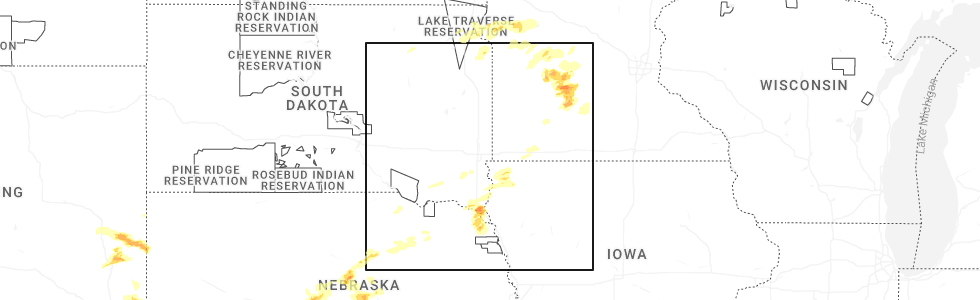
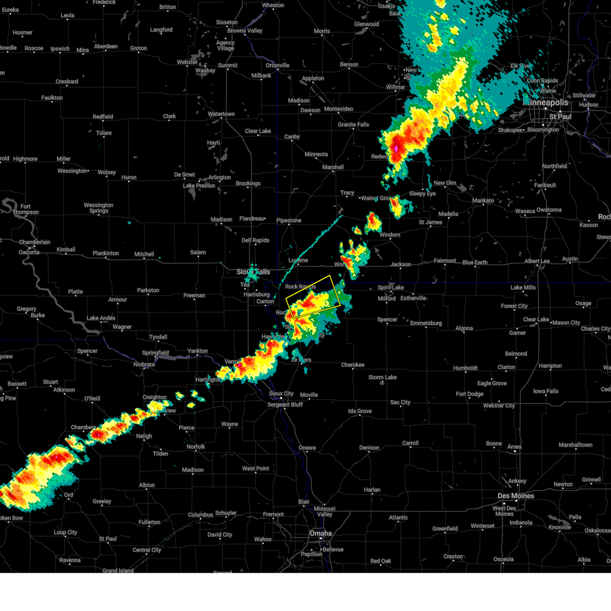
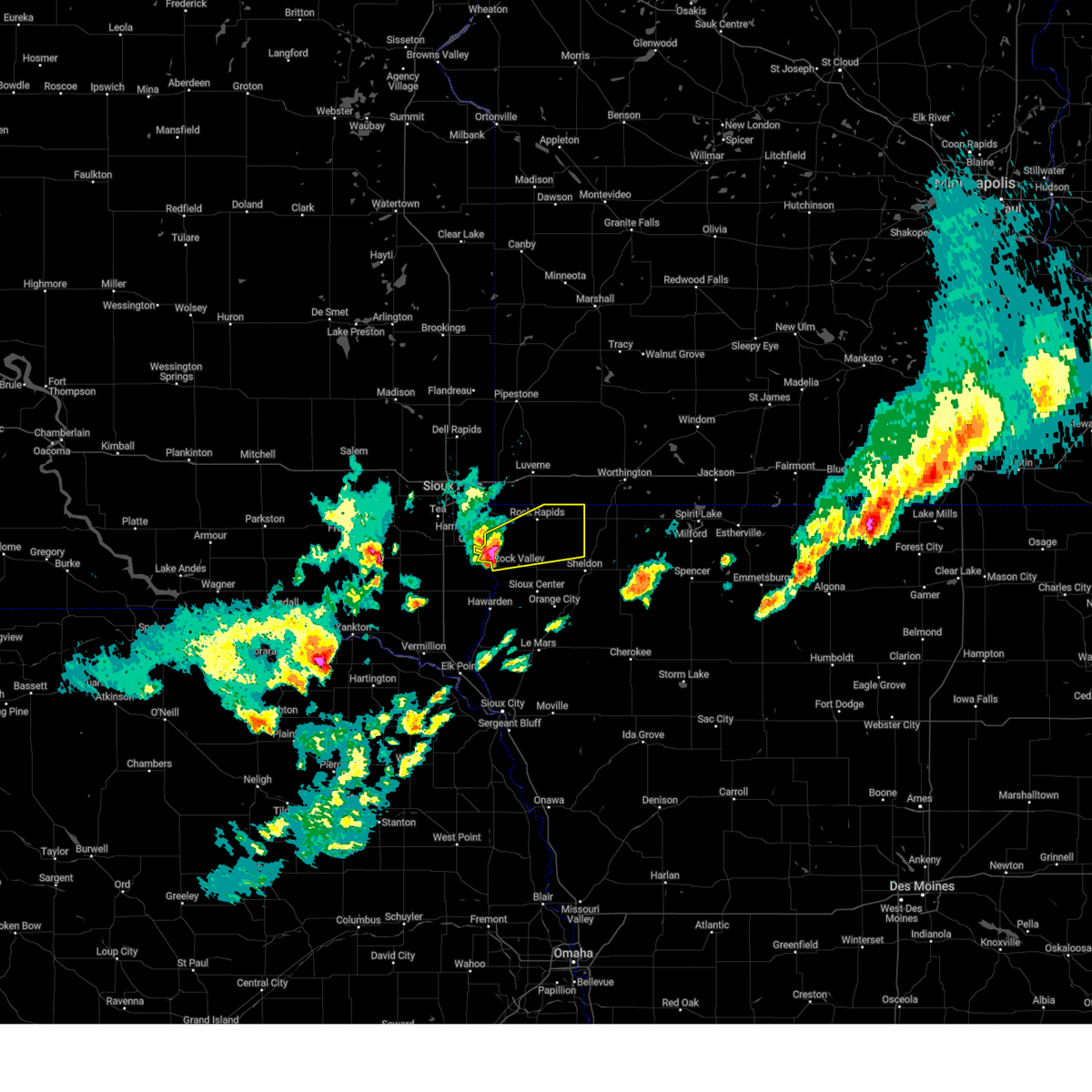
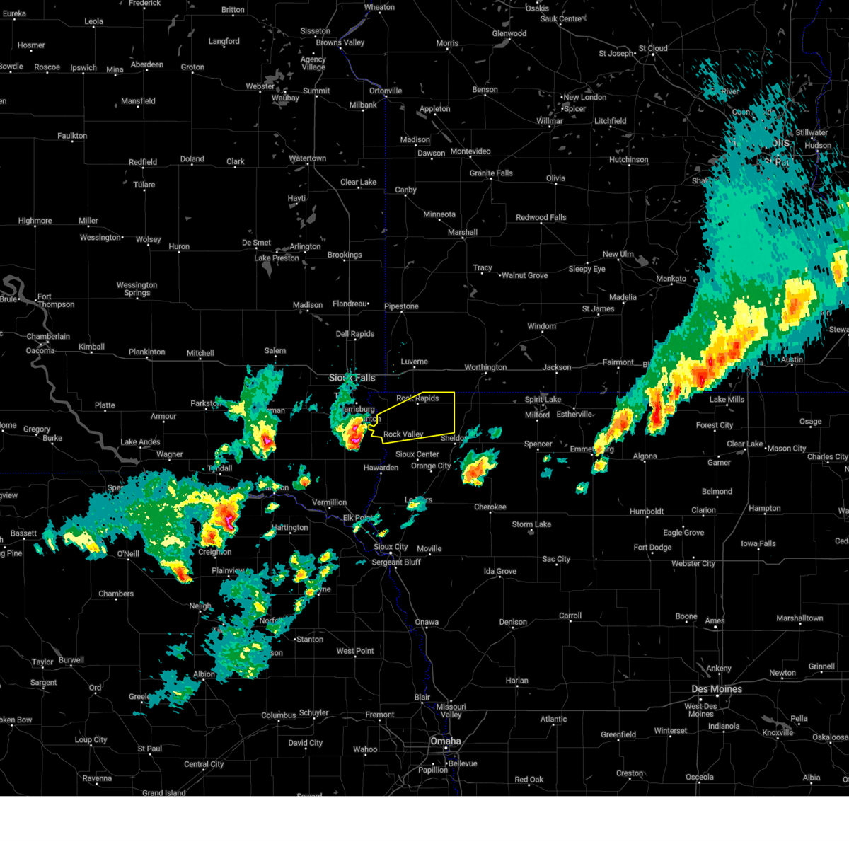
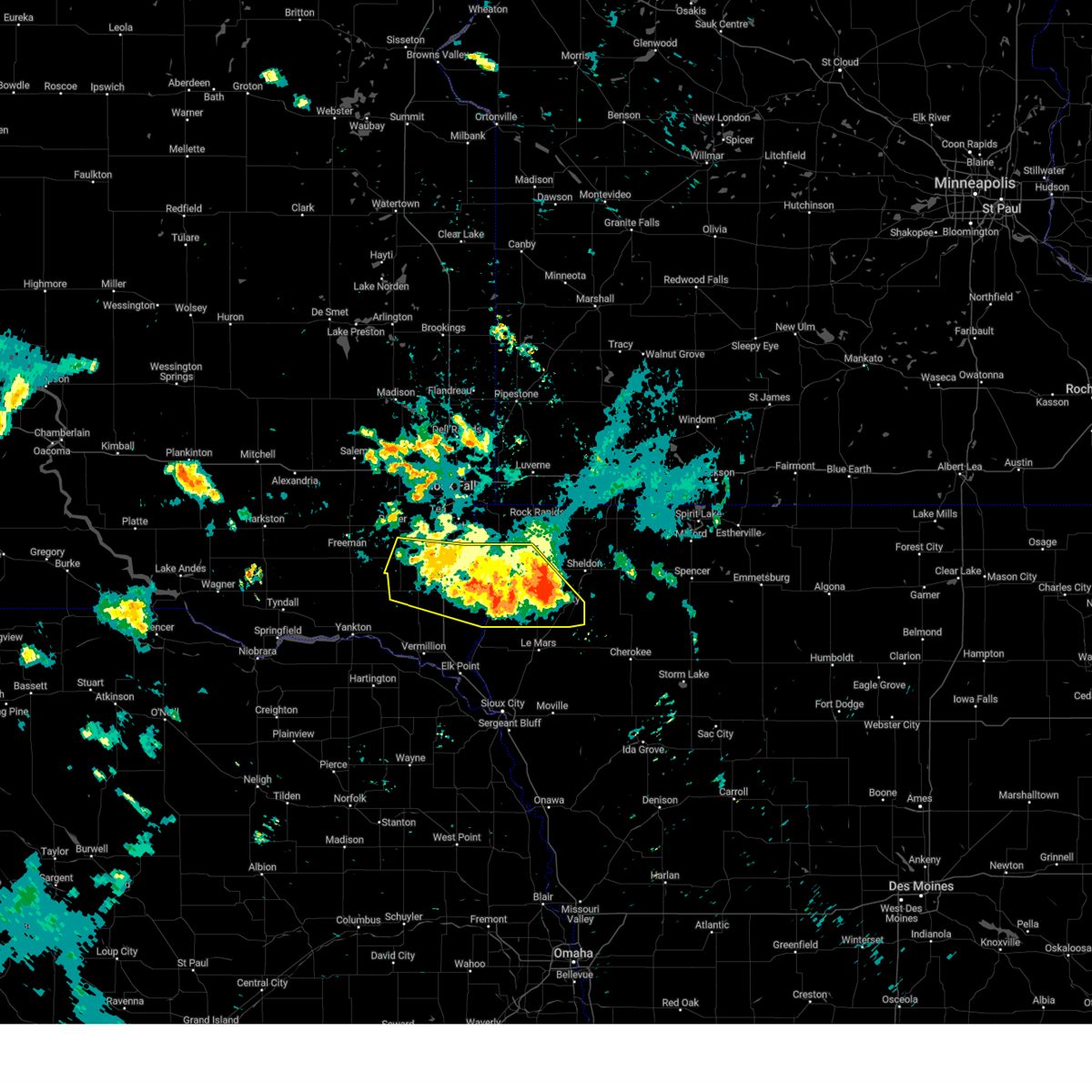
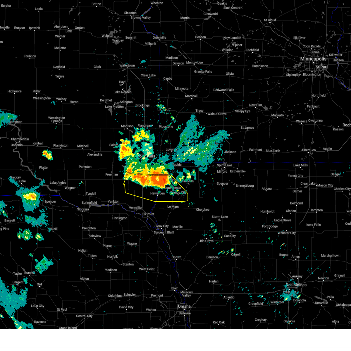
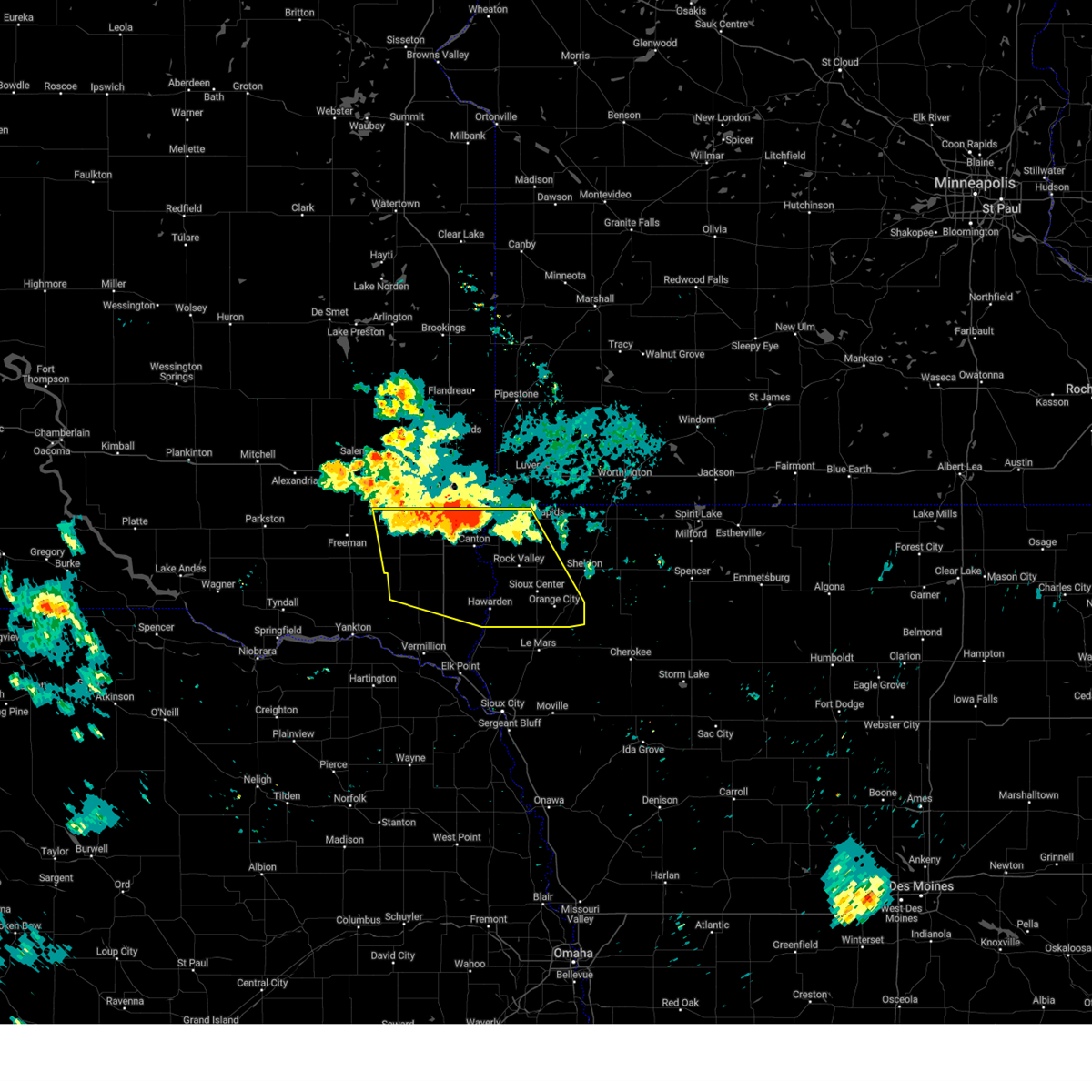
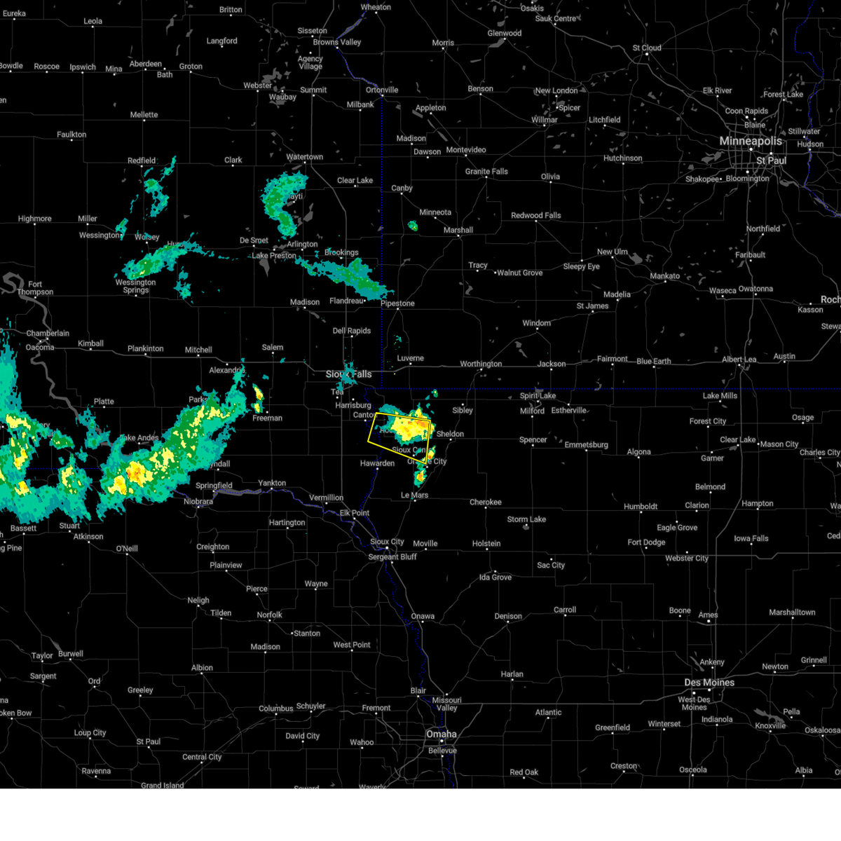
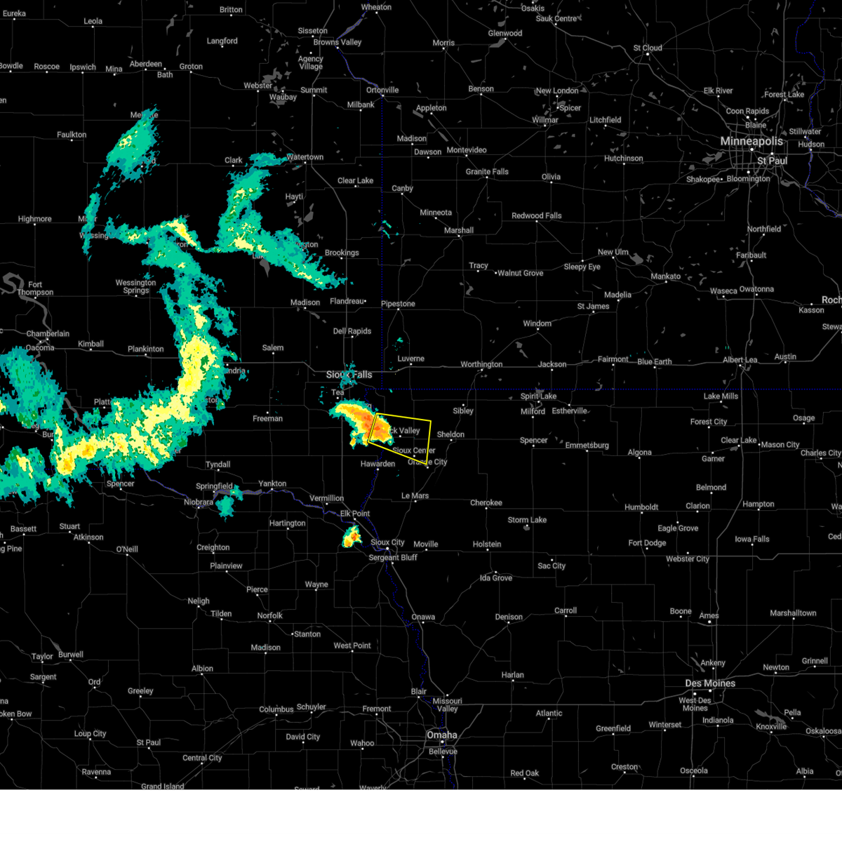
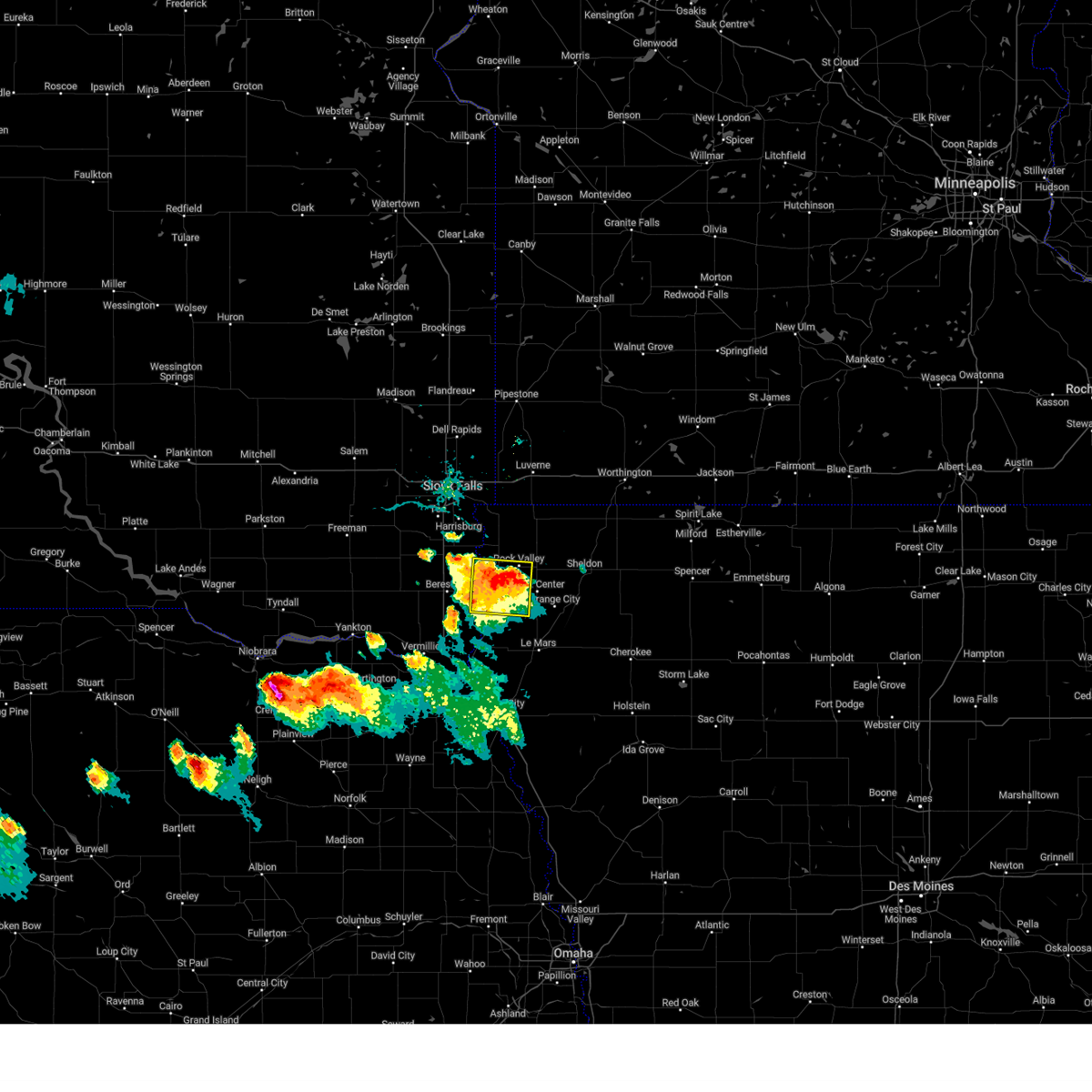
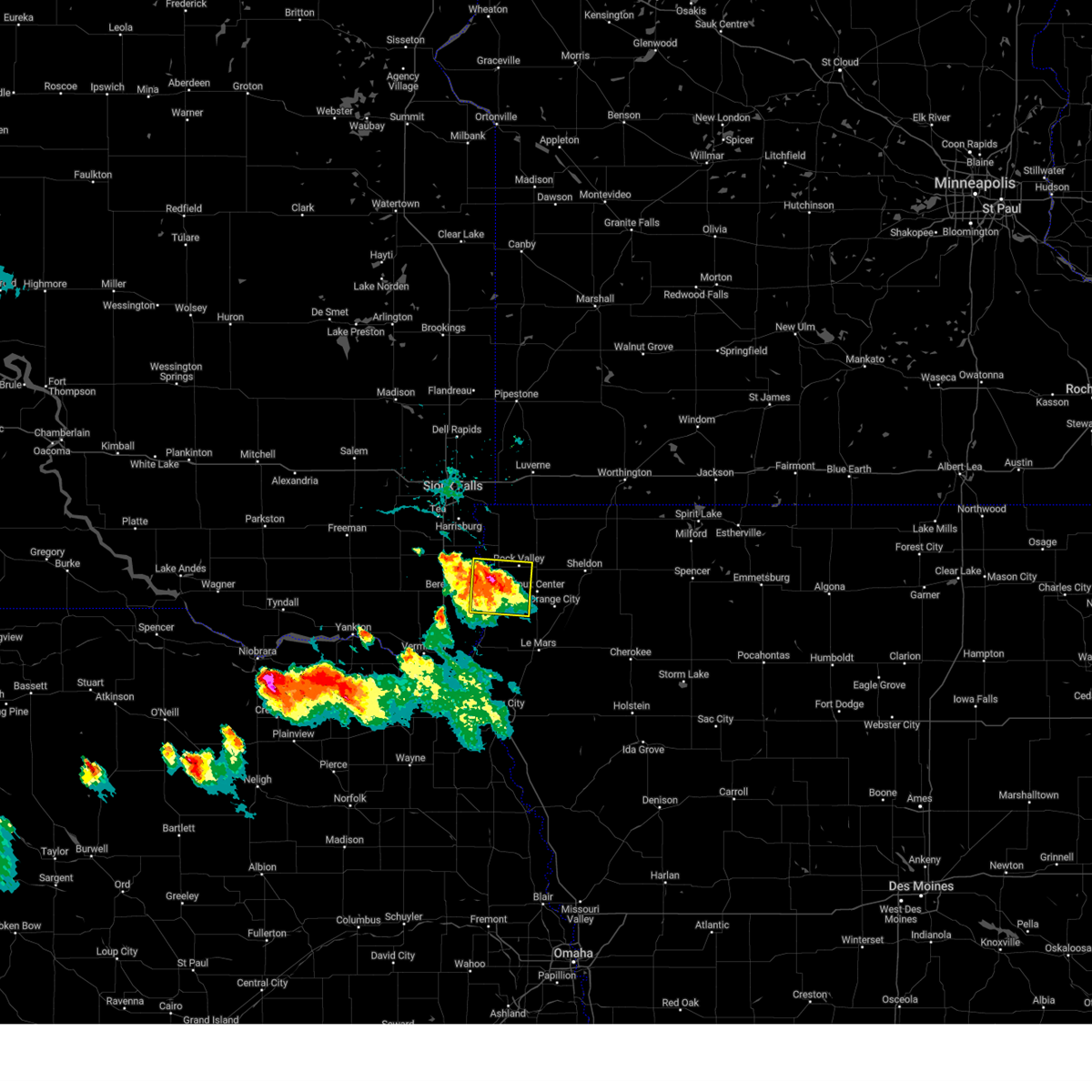
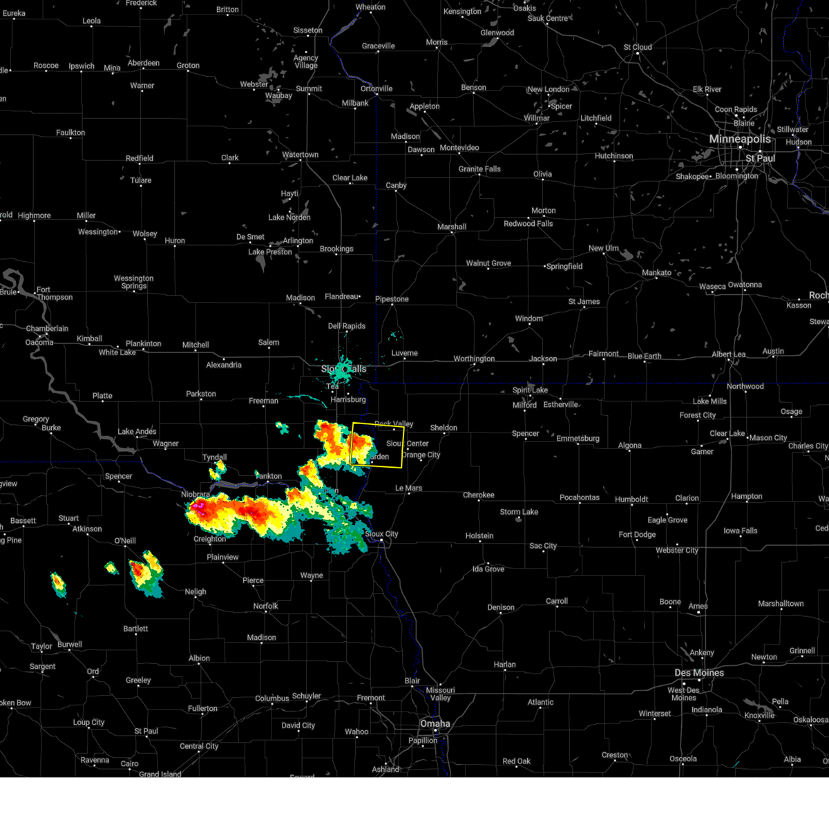
Hail Map for Rock Valley, IA
The Rock Valley, IA area has had 6 reports of on-the-ground hail by trained spotters, and has been under severe weather warnings 17 times during the past 12 months. Doppler radar has detected hail at or near Rock Valley, IA on 51 occasions, including 2 occasions during the past year.
| Name: | Rock Valley, IA |
| Where Located: | 32.4 miles SE of Sioux Falls, SD |
| Map: | Google Map for Rock Valley, IA |
| Population: | 3354 |
| Housing Units: | 1356 |
| More Info: | Search Google for Rock Valley, IA |
1
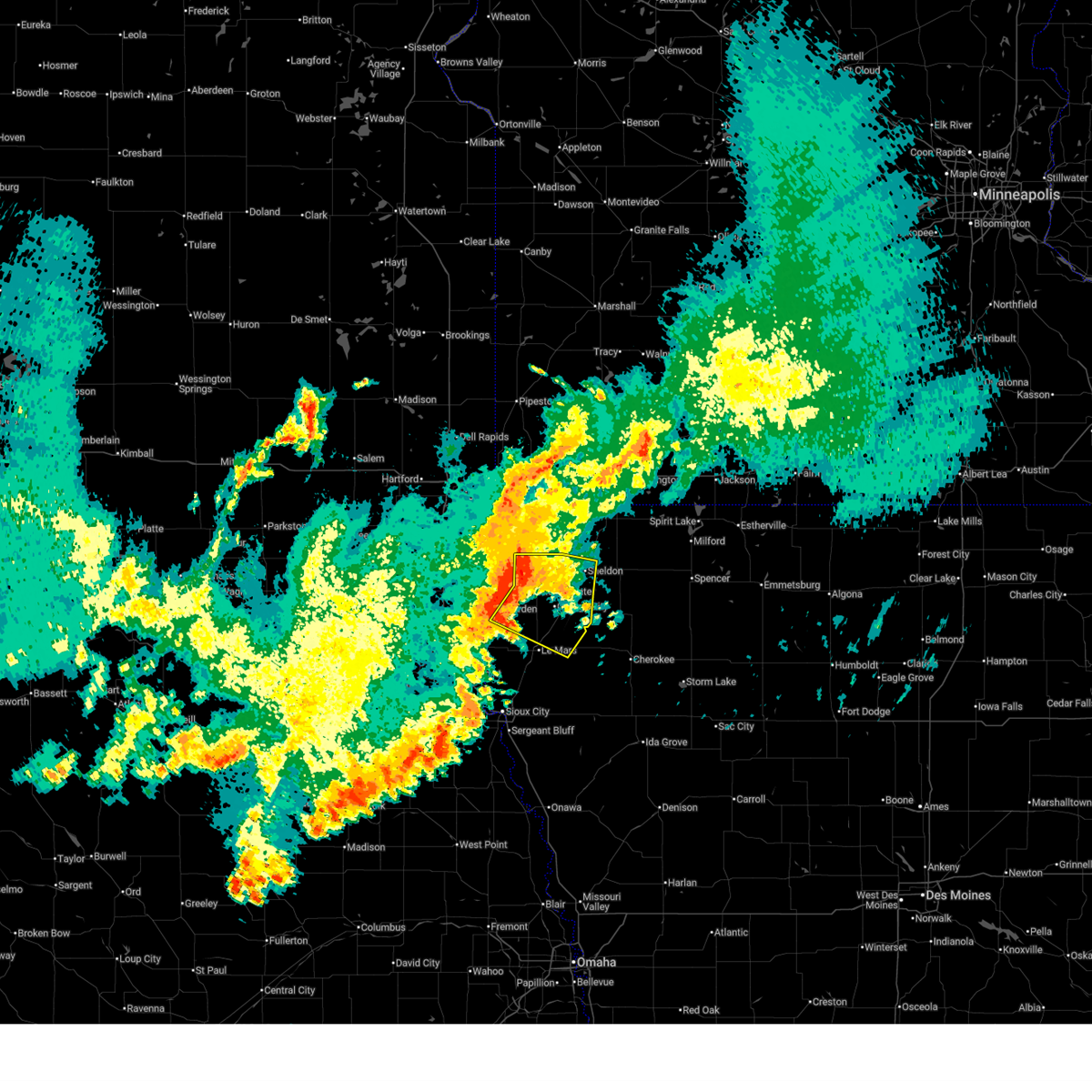
The Top Recent Hail Date for Rock Valley, IA is Monday, June 2, 2025 (7th out of 51)
Hail and Wind Damage Spotted near Rock Valley, IA
| Date / Time | Report Details |
|---|---|
| 6/29/2025 3:38 AM CDT |
 Svrfsd the national weather service in sioux falls has issued a * severe thunderstorm warning for, sioux county in northwestern iowa, northeastern plymouth county in northwestern iowa, western o'brien county in northwestern iowa, * until 415 am cdt. * at 337 am cdt, severe thunderstorms were located along a line extending from near rock valley to near sioux center to near ireton, moving east at 25 mph (radar indicated). Hazards include 60 mph wind gusts. Expect damage to roofs, siding, and trees. severe thunderstorms will be near, sioux center, hull, ireton, and maurice around 345 am cdt. orange city and struble around 350 am cdt. Alton and boyden around 355 am cdt. Svrfsd the national weather service in sioux falls has issued a * severe thunderstorm warning for, sioux county in northwestern iowa, northeastern plymouth county in northwestern iowa, western o'brien county in northwestern iowa, * until 415 am cdt. * at 337 am cdt, severe thunderstorms were located along a line extending from near rock valley to near sioux center to near ireton, moving east at 25 mph (radar indicated). Hazards include 60 mph wind gusts. Expect damage to roofs, siding, and trees. severe thunderstorms will be near, sioux center, hull, ireton, and maurice around 345 am cdt. orange city and struble around 350 am cdt. Alton and boyden around 355 am cdt.
|
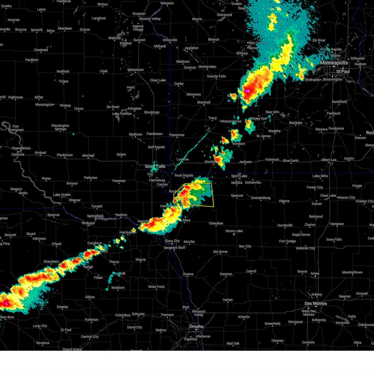
| 6/2/2025 6:00 PM CDT |
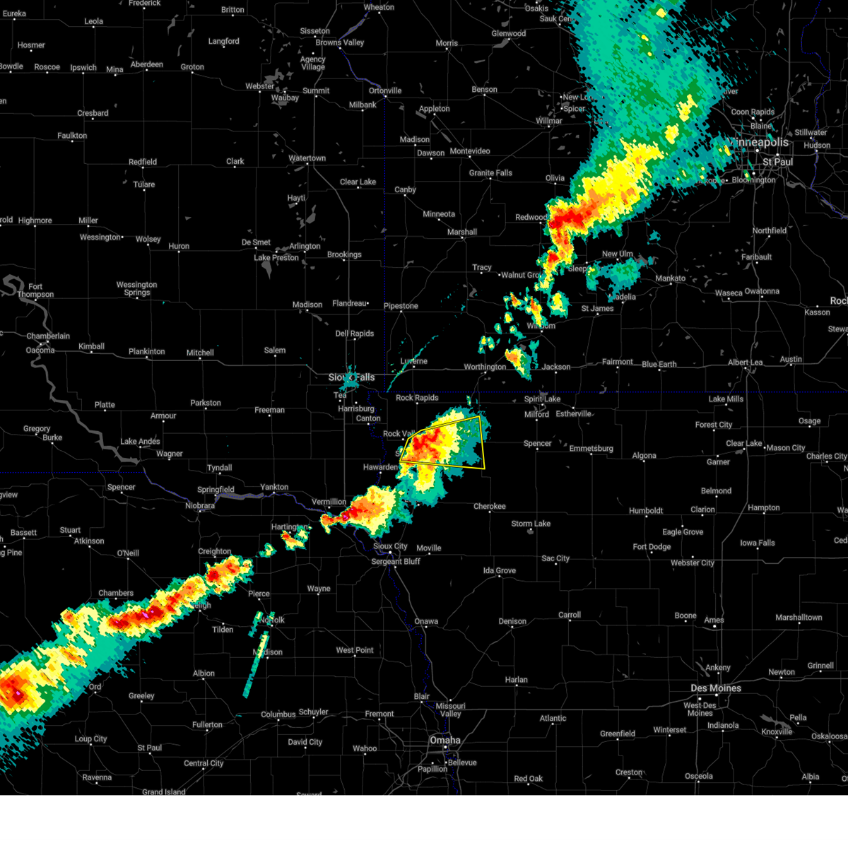 At 600 pm cdt, a severe thunderstorm was located near boyden, or 7 miles northeast of sioux center, moving east at 35 mph (radar indicated). Hazards include 60 mph wind gusts and quarter size hail. Hail damage to vehicles is expected. expect wind damage to roofs, siding, and trees. Locations impacted include, sheldon, boyden, hospers, matlock, archer, sanborn and primghar. At 600 pm cdt, a severe thunderstorm was located near boyden, or 7 miles northeast of sioux center, moving east at 35 mph (radar indicated). Hazards include 60 mph wind gusts and quarter size hail. Hail damage to vehicles is expected. expect wind damage to roofs, siding, and trees. Locations impacted include, sheldon, boyden, hospers, matlock, archer, sanborn and primghar.
|
| 6/2/2025 5:51 PM CDT | The storm which prompted the warning has moved out of the area. therefore, the warning will be allowed to expire. a severe thunderstorm watch remains in effect until 100 am cdt for northwestern iowa. |
| 6/2/2025 5:43 PM CDT | the severe thunderstorm warning has been cancelled and is no longer in effect |
| 6/2/2025 5:43 PM CDT | At 543 pm cdt, a severe thunderstorm was located near sibley, moving east at 35 mph (radar indicated). Hazards include 60 mph wind gusts and half dollar size hail. Hail damage to vehicles is expected. expect wind damage to roofs, siding, and trees. Locations impacted include, george and ashton. |
| 6/2/2025 5:41 PM CDT |
 Svrfsd the national weather service in sioux falls has issued a * severe thunderstorm warning for, southeastern lyon county in northwestern iowa, southwestern osceola county in northwestern iowa, northeastern sioux county in northwestern iowa, northwestern o'brien county in northwestern iowa, * until 630 pm cdt. * at 541 pm cdt, a severe thunderstorm was located near rock valley, or near sioux center, moving east at 35 mph (radar indicated). Hazards include 60 mph wind gusts and quarter size hail. Hail damage to vehicles is expected. expect wind damage to roofs, siding, and trees. this severe thunderstorm will be near, sioux center and hull around 545 pm cdt. boyden around 550 pm cdt. sheldon and hospers around 600 pm cdt. Other locations in the path of this severe thunderstorm include matlock and archer. Svrfsd the national weather service in sioux falls has issued a * severe thunderstorm warning for, southeastern lyon county in northwestern iowa, southwestern osceola county in northwestern iowa, northeastern sioux county in northwestern iowa, northwestern o'brien county in northwestern iowa, * until 630 pm cdt. * at 541 pm cdt, a severe thunderstorm was located near rock valley, or near sioux center, moving east at 35 mph (radar indicated). Hazards include 60 mph wind gusts and quarter size hail. Hail damage to vehicles is expected. expect wind damage to roofs, siding, and trees. this severe thunderstorm will be near, sioux center and hull around 545 pm cdt. boyden around 550 pm cdt. sheldon and hospers around 600 pm cdt. Other locations in the path of this severe thunderstorm include matlock and archer.
|
| 6/2/2025 5:29 PM CDT |
 At 529 pm cdt, a severe thunderstorm was located over george, or 10 miles southeast of rock rapids, moving east at 35 mph (radar indicated). Hazards include 60 mph wind gusts and half dollar size hail. Hail damage to vehicles is expected. expect wind damage to roofs, siding, and trees. Locations impacted include, sibley, little rock and ashton. At 529 pm cdt, a severe thunderstorm was located over george, or 10 miles southeast of rock rapids, moving east at 35 mph (radar indicated). Hazards include 60 mph wind gusts and half dollar size hail. Hail damage to vehicles is expected. expect wind damage to roofs, siding, and trees. Locations impacted include, sibley, little rock and ashton.
|
| 6/2/2025 5:12 PM CDT |
 Svrfsd the national weather service in sioux falls has issued a * severe thunderstorm warning for, eastern lyon county in northwestern iowa, western osceola county in northwestern iowa, north central sioux county in northwestern iowa, south central nobles county in southwestern minnesota, * until 600 pm cdt. * at 511 pm cdt, a severe thunderstorm was located over doon, or 9 miles south of rock rapids, moving east at 35 mph (radar indicated). Hazards include 60 mph wind gusts and half dollar size hail. Hail damage to vehicles is expected. expect wind damage to roofs, siding, and trees. this severe thunderstorm will be near, rock rapids and george around 515 pm cdt. little rock around 530 pm cdt. Other locations in the path of this severe thunderstorm include sibley and ashton. Svrfsd the national weather service in sioux falls has issued a * severe thunderstorm warning for, eastern lyon county in northwestern iowa, western osceola county in northwestern iowa, north central sioux county in northwestern iowa, south central nobles county in southwestern minnesota, * until 600 pm cdt. * at 511 pm cdt, a severe thunderstorm was located over doon, or 9 miles south of rock rapids, moving east at 35 mph (radar indicated). Hazards include 60 mph wind gusts and half dollar size hail. Hail damage to vehicles is expected. expect wind damage to roofs, siding, and trees. this severe thunderstorm will be near, rock rapids and george around 515 pm cdt. little rock around 530 pm cdt. Other locations in the path of this severe thunderstorm include sibley and ashton.
|
| 6/2/2025 4:40 PM CDT |
 The storm which prompted the warning has weakened below severe limits, and no longer poses an immediate threat to life or property. therefore, the warning will be allowed to expire. however, gusty winds are still possible with this thunderstorm. The storm which prompted the warning has weakened below severe limits, and no longer poses an immediate threat to life or property. therefore, the warning will be allowed to expire. however, gusty winds are still possible with this thunderstorm.
|
| 6/2/2025 4:34 PM CDT | At 434 pm cdt, a severe thunderstorm was located over boyden, or 9 miles west of sheldon, moving east at 30 mph (public). Hazards include 60 mph wind gusts and quarter size hail. Hail damage to vehicles is expected. expect wind damage to roofs, siding, and trees. This severe storm will be near, sheldon, boyden, and matlock around 440 pm cdt. |
| 6/2/2025 4:22 PM CDT |
 At 421 pm cdt, a severe thunderstorm was located over hull, or near sioux center, moving east at 30 mph (public report of 1 inch hail 7 south of rock valley at 4:16 pm cdt). Hazards include 60 mph wind gusts and half dollar size hail. Hail damage to vehicles is expected. expect wind damage to roofs, siding, and trees. this severe storm will be near, hull and boyden around 425 pm cdt. Other locations in the path of this severe thunderstorm include matlock and sheldon. At 421 pm cdt, a severe thunderstorm was located over hull, or near sioux center, moving east at 30 mph (public report of 1 inch hail 7 south of rock valley at 4:16 pm cdt). Hazards include 60 mph wind gusts and half dollar size hail. Hail damage to vehicles is expected. expect wind damage to roofs, siding, and trees. this severe storm will be near, hull and boyden around 425 pm cdt. Other locations in the path of this severe thunderstorm include matlock and sheldon.
|
| 6/2/2025 4:07 PM CDT | Svrfsd the national weather service in sioux falls has issued a * severe thunderstorm warning for, northern sioux county in northwestern iowa, * until 445 pm cdt. * at 406 pm cdt, a severe thunderstorm was located near rock valley, or 7 miles northwest of sioux center, moving east at 30 mph (radar indicated). Hazards include 60 mph wind gusts and half dollar size hail. Hail damage to vehicles is expected. expect wind damage to roofs, siding, and trees. this severe thunderstorm will be near, sioux center, rock valley, and hull around 410 pm cdt. boyden around 420 pm cdt. Other locations in the path of this severe thunderstorm include matlock. |
| 4/28/2025 6:51 PM CDT |
 At 651 pm cdt, a severe thunderstorm was located over inwood, or 8 miles east of canton, moving northeast at 55 mph (radar indicated). Hazards include ping pong ball size hail and 60 mph wind gusts. People and animals outdoors will be injured. expect hail damage to roofs, siding, windows, and vehicles. expect wind damage to roofs, siding, and trees. this severe storm will be near, rock valley, doon, alvord, and rock rapids around 655 pm cdt. Other locations in the path of this severe thunderstorm include george and little rock. At 651 pm cdt, a severe thunderstorm was located over inwood, or 8 miles east of canton, moving northeast at 55 mph (radar indicated). Hazards include ping pong ball size hail and 60 mph wind gusts. People and animals outdoors will be injured. expect hail damage to roofs, siding, windows, and vehicles. expect wind damage to roofs, siding, and trees. this severe storm will be near, rock valley, doon, alvord, and rock rapids around 655 pm cdt. Other locations in the path of this severe thunderstorm include george and little rock.
|
| 4/28/2025 6:41 PM CDT |
 Svrfsd the national weather service in sioux falls has issued a * severe thunderstorm warning for, lyon county in northwestern iowa, northern sioux county in northwestern iowa, * until 730 pm cdt. * at 641 pm cdt, a severe thunderstorm was located over newton hills state park, or near canton, moving east at 60 mph (radar indicated). Hazards include 60 mph wind gusts and quarter size hail. Hail damage to vehicles is expected. expect wind damage to roofs, siding, and trees. this severe thunderstorm will be near, inwood, fairview, rock valley, and alvord around 645 pm cdt. doon around 650 pm cdt. rock rapids around 655 pm cdt. george around 700 pm cdt. Other locations in the path of this severe thunderstorm include little rock. Svrfsd the national weather service in sioux falls has issued a * severe thunderstorm warning for, lyon county in northwestern iowa, northern sioux county in northwestern iowa, * until 730 pm cdt. * at 641 pm cdt, a severe thunderstorm was located over newton hills state park, or near canton, moving east at 60 mph (radar indicated). Hazards include 60 mph wind gusts and quarter size hail. Hail damage to vehicles is expected. expect wind damage to roofs, siding, and trees. this severe thunderstorm will be near, inwood, fairview, rock valley, and alvord around 645 pm cdt. doon around 650 pm cdt. rock rapids around 655 pm cdt. george around 700 pm cdt. Other locations in the path of this severe thunderstorm include little rock.
|
| 7/30/2024 5:51 AM CDT |
 The storms which prompted the warning have weakened below severe limits, and no longer pose an immediate threat to life or property. therefore, the warning will be allowed to expire. however, small hail is still possible with these thunderstorms. to report severe weather, contact your nearest law enforcement agency. they will relay your report to the national weather service sioux falls. The storms which prompted the warning have weakened below severe limits, and no longer pose an immediate threat to life or property. therefore, the warning will be allowed to expire. however, small hail is still possible with these thunderstorms. to report severe weather, contact your nearest law enforcement agency. they will relay your report to the national weather service sioux falls.
|
| 7/30/2024 5:34 AM CDT |
 At 534 am cdt, severe thunderstorms were located along a line extending from near sioux center to near beresford to near viborg, moving south at 35 mph (radar indicated). Hazards include 60 mph wind gusts and quarter size hail. Hail damage to vehicles is expected. expect wind damage to roofs, siding, and trees. Locations impacted include, sioux center, hawarden, beresford, centerville, alcester, viborg, ireton, maurice and orange city. At 534 am cdt, severe thunderstorms were located along a line extending from near sioux center to near beresford to near viborg, moving south at 35 mph (radar indicated). Hazards include 60 mph wind gusts and quarter size hail. Hail damage to vehicles is expected. expect wind damage to roofs, siding, and trees. Locations impacted include, sioux center, hawarden, beresford, centerville, alcester, viborg, ireton, maurice and orange city.
|
| 7/30/2024 5:09 AM CDT |
 Svrfsd the national weather service in sioux falls has issued a * severe thunderstorm warning for, western lyon county in northwestern iowa, sioux county in northwestern iowa, northern clay county in southeastern south dakota, lincoln county in southeastern south dakota, turner county in southeastern south dakota, northern union county in southeastern south dakota, * until 600 am cdt. * at 509 am cdt, severe thunderstorms were located along a line extending from near doon to worthing to parker, moving southeast at 35 mph (radar indicated). Hazards include 60 mph wind gusts and quarter size hail. Hail damage to vehicles is expected. expect wind damage to roofs, siding, and trees. severe thunderstorms will be near, canton, rock valley, hull, doon, hurley, davis, fairview, and newton hills state park around 515 am cdt. hudson around 525 am cdt. Other locations in the path of these severe thunderstorms include sioux center, viborg, beresford, centerville, orange city, hawarden, alcester, alton, ireton and maurice. Svrfsd the national weather service in sioux falls has issued a * severe thunderstorm warning for, western lyon county in northwestern iowa, sioux county in northwestern iowa, northern clay county in southeastern south dakota, lincoln county in southeastern south dakota, turner county in southeastern south dakota, northern union county in southeastern south dakota, * until 600 am cdt. * at 509 am cdt, severe thunderstorms were located along a line extending from near doon to worthing to parker, moving southeast at 35 mph (radar indicated). Hazards include 60 mph wind gusts and quarter size hail. Hail damage to vehicles is expected. expect wind damage to roofs, siding, and trees. severe thunderstorms will be near, canton, rock valley, hull, doon, hurley, davis, fairview, and newton hills state park around 515 am cdt. hudson around 525 am cdt. Other locations in the path of these severe thunderstorms include sioux center, viborg, beresford, centerville, orange city, hawarden, alcester, alton, ireton and maurice.
|
| 7/14/2024 5:53 AM CDT |
 the severe thunderstorm warning has been cancelled and is no longer in effect the severe thunderstorm warning has been cancelled and is no longer in effect
|
| 7/14/2024 5:31 AM CDT |
 Svrfsd the national weather service in sioux falls has issued a * severe thunderstorm warning for, southwestern lyon county in northwestern iowa, northwestern sioux county in northwestern iowa, southeastern lincoln county in southeastern south dakota, * until 615 am cdt. * at 531 am cdt, a severe thunderstorm was located near fairview, or 8 miles southeast of canton, moving east at 30 mph (radar indicated). Hazards include 60 mph wind gusts and quarter size hail. Hail damage to vehicles is expected. expect wind damage to roofs, siding, and trees. this severe thunderstorm will be near, rock valley and doon around 535 am cdt. hull around 545 am cdt. Sioux center around 550 am cdt. Svrfsd the national weather service in sioux falls has issued a * severe thunderstorm warning for, southwestern lyon county in northwestern iowa, northwestern sioux county in northwestern iowa, southeastern lincoln county in southeastern south dakota, * until 615 am cdt. * at 531 am cdt, a severe thunderstorm was located near fairview, or 8 miles southeast of canton, moving east at 30 mph (radar indicated). Hazards include 60 mph wind gusts and quarter size hail. Hail damage to vehicles is expected. expect wind damage to roofs, siding, and trees. this severe thunderstorm will be near, rock valley and doon around 535 am cdt. hull around 545 am cdt. Sioux center around 550 am cdt.
|
| 7/12/2023 4:59 AM CDT |
 At 459 am cdt, severe thunderstorms were located along a line extending from near ellsworth to near hull to craig, moving east at 50 mph (radar indicated). Hazards include 60 mph wind gusts. Expect damage to roofs, siding, and trees. severe thunderstorms will be near, george and boyden around 505 am cdt. orange city, little rock and matlock around 510 am cdt. sheldon, sibley, alton and hospers around 515 am cdt. other locations in the path of these severe thunderstorms include ashton, granville, sanborn, archer, primghar, ocheyedan, melvin, paullina, harris and hartley. hail threat, radar indicated max hail size, <. 75 in wind threat, radar indicated max wind gust, 60 mph. At 459 am cdt, severe thunderstorms were located along a line extending from near ellsworth to near hull to craig, moving east at 50 mph (radar indicated). Hazards include 60 mph wind gusts. Expect damage to roofs, siding, and trees. severe thunderstorms will be near, george and boyden around 505 am cdt. orange city, little rock and matlock around 510 am cdt. sheldon, sibley, alton and hospers around 515 am cdt. other locations in the path of these severe thunderstorms include ashton, granville, sanborn, archer, primghar, ocheyedan, melvin, paullina, harris and hartley. hail threat, radar indicated max hail size, <. 75 in wind threat, radar indicated max wind gust, 60 mph.
|
| 7/12/2023 4:51 AM CDT |
 At 448 am cdt, severe thunderstorms were located along a line extending from near rock rapids to doon to near hawarden, moving southeast at 45 mph (radar indicated). Hazards include 70 mph wind gusts. Expect considerable tree damage. damage is likely to mobile homes, roofs, and outbuildings. locations impacted include, rock valley, rock rapids, doon, hull, sioux center and george. thunderstorm damage threat, considerable hail threat, radar indicated max hail size, <. 75 in wind threat, radar indicated max wind gust, 70 mph. At 448 am cdt, severe thunderstorms were located along a line extending from near rock rapids to doon to near hawarden, moving southeast at 45 mph (radar indicated). Hazards include 70 mph wind gusts. Expect considerable tree damage. damage is likely to mobile homes, roofs, and outbuildings. locations impacted include, rock valley, rock rapids, doon, hull, sioux center and george. thunderstorm damage threat, considerable hail threat, radar indicated max hail size, <. 75 in wind threat, radar indicated max wind gust, 70 mph.
|
| 7/12/2023 4:21 AM CDT |
 At 421 am cdt, severe thunderstorms were located along a line extending from near sherman to near rowena to near beresford, moving east at 60 mph (radar indicated). Hazards include 70 mph wind gusts. Expect considerable tree damage. damage is likely to mobile homes, roofs, and outbuildings. severe thunderstorms will be near, garretson, valley springs, sherman and rowena around 425 am cdt. canton, larchwood and beaver creek around 430 am cdt. luverne, inwood, hills, lester, fairview, blue mounds state park and newton hills state park around 435 am cdt. hudson and alvord around 440 am cdt. other locations in the path of these severe thunderstorms include rock rapids, rock valley, doon, adrian, ellsworth, sioux center, hull, george, boyden, rushmore, maurice, worthington, orange city, sibley, alton, little rock and matlock. thunderstorm damage threat, considerable hail threat, radar indicated max hail size, <. 75 in wind threat, observed max wind gust, 70 mph. At 421 am cdt, severe thunderstorms were located along a line extending from near sherman to near rowena to near beresford, moving east at 60 mph (radar indicated). Hazards include 70 mph wind gusts. Expect considerable tree damage. damage is likely to mobile homes, roofs, and outbuildings. severe thunderstorms will be near, garretson, valley springs, sherman and rowena around 425 am cdt. canton, larchwood and beaver creek around 430 am cdt. luverne, inwood, hills, lester, fairview, blue mounds state park and newton hills state park around 435 am cdt. hudson and alvord around 440 am cdt. other locations in the path of these severe thunderstorms include rock rapids, rock valley, doon, adrian, ellsworth, sioux center, hull, george, boyden, rushmore, maurice, worthington, orange city, sibley, alton, little rock and matlock. thunderstorm damage threat, considerable hail threat, radar indicated max hail size, <. 75 in wind threat, observed max wind gust, 70 mph.
|
| 7/10/2023 4:47 PM CDT |
 At 447 pm cdt, a severe thunderstorm was located near rock valley, or near sioux center, moving east at 35 mph (radar indicated). Hazards include 60 mph wind gusts and quarter size hail. Hail damage to vehicles is expected. expect wind damage to roofs, siding, and trees. this severe thunderstorm will be near, sioux center around 450 pm cdt. hull around 455 pm cdt. boyden around 505 pm cdt. other locations in the path of this severe thunderstorm include matlock, sheldon and hospers. hail threat, radar indicated max hail size, 1. 00 in wind threat, radar indicated max wind gust, 60 mph. At 447 pm cdt, a severe thunderstorm was located near rock valley, or near sioux center, moving east at 35 mph (radar indicated). Hazards include 60 mph wind gusts and quarter size hail. Hail damage to vehicles is expected. expect wind damage to roofs, siding, and trees. this severe thunderstorm will be near, sioux center around 450 pm cdt. hull around 455 pm cdt. boyden around 505 pm cdt. other locations in the path of this severe thunderstorm include matlock, sheldon and hospers. hail threat, radar indicated max hail size, 1. 00 in wind threat, radar indicated max wind gust, 60 mph.
|
| 7/10/2023 4:42 PM CDT | Multiple 3-4 inch tree limbs downe in sioux county IA, 0.7 miles SE of Rock Valley, IA |
| 7/10/2023 4:36 PM CDT |
 At 435 pm cdt, a severe thunderstorm was located near hudson, or 10 miles northeast of hawarden, moving east at 35 mph (trained weather spotters. at 429 pm, half dollar sized hail was reported in hudson). Hazards include 60 mph wind gusts and half dollar size hail. Hail damage to vehicles is expected. expect wind damage to roofs, siding, and trees. locations impacted include, rock valley and ireton. hail threat, radar indicated max hail size, 1. 25 in wind threat, radar indicated max wind gust, 60 mph. At 435 pm cdt, a severe thunderstorm was located near hudson, or 10 miles northeast of hawarden, moving east at 35 mph (trained weather spotters. at 429 pm, half dollar sized hail was reported in hudson). Hazards include 60 mph wind gusts and half dollar size hail. Hail damage to vehicles is expected. expect wind damage to roofs, siding, and trees. locations impacted include, rock valley and ireton. hail threat, radar indicated max hail size, 1. 25 in wind threat, radar indicated max wind gust, 60 mph.
|
| 7/10/2023 4:17 PM CDT |
 At 417 pm cdt, a severe thunderstorm was located near hudson, or 9 miles northwest of hawarden, moving east at 35 mph (radar indicated). Hazards include 60 mph wind gusts and half dollar size hail. Hail damage to vehicles is expected. expect wind damage to roofs, siding, and trees. this severe thunderstorm will be near, hawarden, hudson and fairview around 425 pm cdt. other locations in the path of this severe thunderstorm include rock valley and ireton. hail threat, radar indicated max hail size, 1. 25 in wind threat, radar indicated max wind gust, 60 mph. At 417 pm cdt, a severe thunderstorm was located near hudson, or 9 miles northwest of hawarden, moving east at 35 mph (radar indicated). Hazards include 60 mph wind gusts and half dollar size hail. Hail damage to vehicles is expected. expect wind damage to roofs, siding, and trees. this severe thunderstorm will be near, hawarden, hudson and fairview around 425 pm cdt. other locations in the path of this severe thunderstorm include rock valley and ireton. hail threat, radar indicated max hail size, 1. 25 in wind threat, radar indicated max wind gust, 60 mph.
|
| 6/24/2023 5:49 AM CDT | Report from mping: 3-inch tree limbs broke in sioux county IA, 0.6 miles S of Rock Valley, IA |
| 6/24/2023 4:52 AM CDT | Photos of multiple large tree limbs broken via social media. time estimated from rada in sioux county IA, 0.5 miles ENE of Rock Valley, IA |
| 6/24/2023 4:45 AM CDT |
 At 445 am cdt, severe thunderstorms were located along a line extending from near baltic to near valley springs to sioux center, moving northeast at 70 mph (radar indicated). Hazards include 60 mph wind gusts. Expect damage to roofs, siding, and trees. severe thunderstorms will be near, rock rapids, hills and beaver creek around 450 am cdt. boyden, egan and sherman around 455 am cdt. sheldon, luverne, flandreau, george, jasper, ellsworth, matlock and blue mounds state park around 500 am cdt. sanborn, ashton, hardwick and trosky around 505 am cdt. other locations in the path of these severe thunderstorms include pipestone, sibley, adrian, edgerton, little rock, leota, rushmore, lismore, pipestone national monument, wilmont, melvin, holland, woodstock, ocheyedan, chandler, lake wilson, ruthton, slayton, round lake, harris and current lake. hail threat, radar indicated max hail size, <. 75 in wind threat, radar indicated max wind gust, 60 mph. At 445 am cdt, severe thunderstorms were located along a line extending from near baltic to near valley springs to sioux center, moving northeast at 70 mph (radar indicated). Hazards include 60 mph wind gusts. Expect damage to roofs, siding, and trees. severe thunderstorms will be near, rock rapids, hills and beaver creek around 450 am cdt. boyden, egan and sherman around 455 am cdt. sheldon, luverne, flandreau, george, jasper, ellsworth, matlock and blue mounds state park around 500 am cdt. sanborn, ashton, hardwick and trosky around 505 am cdt. other locations in the path of these severe thunderstorms include pipestone, sibley, adrian, edgerton, little rock, leota, rushmore, lismore, pipestone national monument, wilmont, melvin, holland, woodstock, ocheyedan, chandler, lake wilson, ruthton, slayton, round lake, harris and current lake. hail threat, radar indicated max hail size, <. 75 in wind threat, radar indicated max wind gust, 60 mph.
|
| 6/24/2023 4:34 AM CDT |
 At 432 am cdt, severe thunderstorms were located along a line extending from hartford to near harrisburg to near ireton, moving northeast at 55 mph (radar indicated). Hazards include 70 mph wind gusts. Expect considerable tree damage. damage is likely to mobile homes, roofs, and outbuildings. locations impacted include, inwood, maurice, rowena, renner, brandon, baltic, larchwood, alvord, corson, sioux center, rock valley, valley springs, hills, lester, garretson, doon, beaver creek and palisades state park. thunderstorm damage threat, considerable hail threat, radar indicated max hail size, <. 75 in wind threat, radar indicated max wind gust, 70 mph. At 432 am cdt, severe thunderstorms were located along a line extending from hartford to near harrisburg to near ireton, moving northeast at 55 mph (radar indicated). Hazards include 70 mph wind gusts. Expect considerable tree damage. damage is likely to mobile homes, roofs, and outbuildings. locations impacted include, inwood, maurice, rowena, renner, brandon, baltic, larchwood, alvord, corson, sioux center, rock valley, valley springs, hills, lester, garretson, doon, beaver creek and palisades state park. thunderstorm damage threat, considerable hail threat, radar indicated max hail size, <. 75 in wind threat, radar indicated max wind gust, 70 mph.
|
| 6/24/2023 4:03 AM CDT |
 At 403 am cdt, severe thunderstorms were located along a line extending from near monroe to davis to near vermillion, moving northeast at 70 mph (radar indicated). Hazards include 60 mph wind gusts. Expect damage to roofs, siding, and trees. severe thunderstorms will be near, lennox and chancellor around 410 am cdt. tea, akron, wall lake and worthing around 415 am cdt. canton, harrisburg, hartford, alcester, ellis and newton hills state park around 420 am cdt. other locations in the path of these severe thunderstorms include sioux falls, hawarden, crooks, inwood, craig, lake alvin state recreation area, renner, brandon, baltic, larchwood, ireton, hudson, alvord, struble, fairview, rowena, corson, valley springs, hills, lester, maurice, palisades state park, sioux center, rock valley, garretson, beaver creek and doon. hail threat, radar indicated max hail size, <. 75 in wind threat, radar indicated max wind gust, 60 mph. At 403 am cdt, severe thunderstorms were located along a line extending from near monroe to davis to near vermillion, moving northeast at 70 mph (radar indicated). Hazards include 60 mph wind gusts. Expect damage to roofs, siding, and trees. severe thunderstorms will be near, lennox and chancellor around 410 am cdt. tea, akron, wall lake and worthing around 415 am cdt. canton, harrisburg, hartford, alcester, ellis and newton hills state park around 420 am cdt. other locations in the path of these severe thunderstorms include sioux falls, hawarden, crooks, inwood, craig, lake alvin state recreation area, renner, brandon, baltic, larchwood, ireton, hudson, alvord, struble, fairview, rowena, corson, valley springs, hills, lester, maurice, palisades state park, sioux center, rock valley, garretson, beaver creek and doon. hail threat, radar indicated max hail size, <. 75 in wind threat, radar indicated max wind gust, 60 mph.
|
| 4/19/2023 9:14 PM CDT | Quarter sized hail reported 0.2 miles NNW of Rock Valley, IA |
| 4/19/2023 9:14 PM CDT |
 At 913 pm cdt, a severe thunderstorm was located near rock valley, or 11 miles north of sioux center, moving northeast at 35 mph (trained weather spotters. at 914 pm trained weather spotters reported quarter size hail in rock valley!). Hazards include 60 mph wind gusts and half dollar size hail. Hail damage to vehicles is expected. expect wind damage to roofs, siding, and trees. this severe storm will be near, alvord around 925 pm cdt. other locations in the path of this severe thunderstorm include rock rapids and george. hail threat, radar indicated max hail size, 1. 25 in wind threat, radar indicated max wind gust, 60 mph. At 913 pm cdt, a severe thunderstorm was located near rock valley, or 11 miles north of sioux center, moving northeast at 35 mph (trained weather spotters. at 914 pm trained weather spotters reported quarter size hail in rock valley!). Hazards include 60 mph wind gusts and half dollar size hail. Hail damage to vehicles is expected. expect wind damage to roofs, siding, and trees. this severe storm will be near, alvord around 925 pm cdt. other locations in the path of this severe thunderstorm include rock rapids and george. hail threat, radar indicated max hail size, 1. 25 in wind threat, radar indicated max wind gust, 60 mph.
|
| 4/19/2023 9:11 PM CDT |
 At 911 pm cdt, a severe thunderstorm was located over rock valley, or 10 miles northwest of sioux center, moving northeast at 35 mph (radar indicated). Hazards include 60 mph wind gusts and half dollar size hail. Hail damage to vehicles is expected. expect wind damage to roofs, siding, and trees. this severe thunderstorm will be near, doon around 920 pm cdt. alvord around 925 pm cdt. other locations in the path of this severe thunderstorm include rock rapids and george. hail threat, radar indicated max hail size, 1. 25 in wind threat, radar indicated max wind gust, 60 mph. At 911 pm cdt, a severe thunderstorm was located over rock valley, or 10 miles northwest of sioux center, moving northeast at 35 mph (radar indicated). Hazards include 60 mph wind gusts and half dollar size hail. Hail damage to vehicles is expected. expect wind damage to roofs, siding, and trees. this severe thunderstorm will be near, doon around 920 pm cdt. alvord around 925 pm cdt. other locations in the path of this severe thunderstorm include rock rapids and george. hail threat, radar indicated max hail size, 1. 25 in wind threat, radar indicated max wind gust, 60 mph.
|
| 10/23/2022 7:34 PM CDT |
 At 734 pm cdt, a severe thunderstorm was located over rock valley, or 13 miles northwest of sioux center, moving northeast at 55 mph (radar indicated). Hazards include 60 mph wind gusts. Expect damage to roofs, siding, and trees. locations impacted include, larchwood, lester, rock rapids, george and little rock. hail threat, radar indicated max hail size, <. 75 in wind threat, radar indicated max wind gust, 60 mph. At 734 pm cdt, a severe thunderstorm was located over rock valley, or 13 miles northwest of sioux center, moving northeast at 55 mph (radar indicated). Hazards include 60 mph wind gusts. Expect damage to roofs, siding, and trees. locations impacted include, larchwood, lester, rock rapids, george and little rock. hail threat, radar indicated max hail size, <. 75 in wind threat, radar indicated max wind gust, 60 mph.
|
| 10/23/2022 7:25 PM CDT | Report from mping: 1-inch tree limbs broken; shingles blown of in sioux county IA, 0.2 miles NNW of Rock Valley, IA |
| 10/23/2022 7:16 PM CDT |
 At 715 pm cdt, a severe thunderstorm was located over hawarden, moving northeast at 55 mph (mesonet. sdsu mesonet reported a 63 mph gust at approximately 7:02 cdt). Hazards include 70 mph wind gusts. Expect considerable tree damage. damage is likely to mobile homes, roofs, and outbuildings. this severe thunderstorm will be near, ireton around 720 pm cdt. hudson and newton hills state park around 725 pm cdt. sioux center, canton and fairview around 730 pm cdt. rock valley and inwood around 735 pm cdt. other locations in the path of this severe thunderstorm include hull, doon, alvord, larchwood, lester, rock rapids, george and little rock. thunderstorm damage threat, considerable hail threat, radar indicated max hail size, <. 75 in wind threat, radar indicated max wind gust, 70 mph. At 715 pm cdt, a severe thunderstorm was located over hawarden, moving northeast at 55 mph (mesonet. sdsu mesonet reported a 63 mph gust at approximately 7:02 cdt). Hazards include 70 mph wind gusts. Expect considerable tree damage. damage is likely to mobile homes, roofs, and outbuildings. this severe thunderstorm will be near, ireton around 720 pm cdt. hudson and newton hills state park around 725 pm cdt. sioux center, canton and fairview around 730 pm cdt. rock valley and inwood around 735 pm cdt. other locations in the path of this severe thunderstorm include hull, doon, alvord, larchwood, lester, rock rapids, george and little rock. thunderstorm damage threat, considerable hail threat, radar indicated max hail size, <. 75 in wind threat, radar indicated max wind gust, 70 mph.
|
| 8/18/2022 5:58 PM CDT |
 At 557 pm cdt, a severe thunderstorm was located near sioux center, moving southeast at 20 mph (radar indicated. at 544 pm cdt, up to tennis ball sized hail was reported 10 miles west of sioux center). Hazards include two inch hail and 60 mph wind gusts. People and animals outdoors will be injured. expect hail damage to roofs, siding, windows, and vehicles. expect wind damage to roofs, siding, and trees. this severe storm will be near, hull around 605 pm cdt. sioux center around 610 pm cdt. boyden around 625 pm cdt. orange city around 635 pm cdt. alton and hospers around 645 pm cdt. thunderstorm damage threat, considerable hail threat, observed max hail size, 2. 00 in wind threat, radar indicated max wind gust, 60 mph. At 557 pm cdt, a severe thunderstorm was located near sioux center, moving southeast at 20 mph (radar indicated. at 544 pm cdt, up to tennis ball sized hail was reported 10 miles west of sioux center). Hazards include two inch hail and 60 mph wind gusts. People and animals outdoors will be injured. expect hail damage to roofs, siding, windows, and vehicles. expect wind damage to roofs, siding, and trees. this severe storm will be near, hull around 605 pm cdt. sioux center around 610 pm cdt. boyden around 625 pm cdt. orange city around 635 pm cdt. alton and hospers around 645 pm cdt. thunderstorm damage threat, considerable hail threat, observed max hail size, 2. 00 in wind threat, radar indicated max wind gust, 60 mph.
|
| 8/18/2022 5:32 PM CDT |
 At 531 pm cdt, a severe thunderstorm was located near rock valley, or 9 miles northwest of sioux center, moving east at 25 mph (radar indicated). Hazards include 60 mph wind gusts and half dollar size hail. Hail damage to vehicles is expected. expect wind damage to roofs, siding, and trees. this severe thunderstorm will be near, rock valley around 535 pm cdt. sioux center and hull around 555 pm cdt. orange city around 610 pm cdt. alton, boyden and hospers around 615 pm cdt. hail threat, radar indicated max hail size, 1. 25 in wind threat, radar indicated max wind gust, 60 mph. At 531 pm cdt, a severe thunderstorm was located near rock valley, or 9 miles northwest of sioux center, moving east at 25 mph (radar indicated). Hazards include 60 mph wind gusts and half dollar size hail. Hail damage to vehicles is expected. expect wind damage to roofs, siding, and trees. this severe thunderstorm will be near, rock valley around 535 pm cdt. sioux center and hull around 555 pm cdt. orange city around 610 pm cdt. alton, boyden and hospers around 615 pm cdt. hail threat, radar indicated max hail size, 1. 25 in wind threat, radar indicated max wind gust, 60 mph.
|
| 7/22/2022 2:13 AM CDT |
 At 212 am cdt, severe thunderstorms were located along a line extending from near sioux falls to fairview, moving east at 30 mph (radar indicated). Hazards include quarter size hail. Damage to vehicles is expected. these severe storms will be near, canton, hudson and fairview around 215 am cdt. other locations in the path of these severe thunderstorms include lake alvin state recreation area, inwood, brandon, rowena, rock valley, corson, sioux center, larchwood, alvord and valley springs. hail threat, radar indicated max hail size, 1. 00 in wind threat, radar indicated max wind gust, <50 mph. At 212 am cdt, severe thunderstorms were located along a line extending from near sioux falls to fairview, moving east at 30 mph (radar indicated). Hazards include quarter size hail. Damage to vehicles is expected. these severe storms will be near, canton, hudson and fairview around 215 am cdt. other locations in the path of these severe thunderstorms include lake alvin state recreation area, inwood, brandon, rowena, rock valley, corson, sioux center, larchwood, alvord and valley springs. hail threat, radar indicated max hail size, 1. 00 in wind threat, radar indicated max wind gust, <50 mph.
|
| 7/22/2022 1:57 AM CDT |
 At 156 am cdt, severe thunderstorms were located along a line extending from tea to 6 miles west of newton hills state park, moving east at 35 mph (radar indicated). Hazards include quarter size hail. Damage to vehicles is expected. severe thunderstorms will be near, canton, harrisburg and newton hills state park around 210 am cdt. brandon and fairview around 215 am cdt. other locations in the path of these severe thunderstorms include hudson, lake alvin state recreation area, rowena, corson, rock valley, valley springs, larchwood, inwood, sioux center and alvord. hail threat, radar indicated max hail size, 1. 00 in wind threat, radar indicated max wind gust, <50 mph. At 156 am cdt, severe thunderstorms were located along a line extending from tea to 6 miles west of newton hills state park, moving east at 35 mph (radar indicated). Hazards include quarter size hail. Damage to vehicles is expected. severe thunderstorms will be near, canton, harrisburg and newton hills state park around 210 am cdt. brandon and fairview around 215 am cdt. other locations in the path of these severe thunderstorms include hudson, lake alvin state recreation area, rowena, corson, rock valley, valley springs, larchwood, inwood, sioux center and alvord. hail threat, radar indicated max hail size, 1. 00 in wind threat, radar indicated max wind gust, <50 mph.
|
| 7/5/2022 5:40 PM CDT |
 At 537 pm cdt, severe thunderstorms were located along a line extending from near lismore to 8 miles northwest of orleans to near arnolds park, moving east at 45 mph (trained weather spotters. at 530 pm cdt, the public measured a 64 mph wind gust in rock rapids). Hazards include 60 mph wind gusts. Expect damage to roofs, siding, and trees. locations impacted include, brewster, round lake, heron lake, lakefield, kilen woods state park, bergen and jackson in jackson county. hail threat, radar indicated max hail size, <. 75 in wind threat, radar indicated max wind gust, 60 mph. At 537 pm cdt, severe thunderstorms were located along a line extending from near lismore to 8 miles northwest of orleans to near arnolds park, moving east at 45 mph (trained weather spotters. at 530 pm cdt, the public measured a 64 mph wind gust in rock rapids). Hazards include 60 mph wind gusts. Expect damage to roofs, siding, and trees. locations impacted include, brewster, round lake, heron lake, lakefield, kilen woods state park, bergen and jackson in jackson county. hail threat, radar indicated max hail size, <. 75 in wind threat, radar indicated max wind gust, 60 mph.
|
| 7/5/2022 5:20 PM CDT |
 At 518 pm cdt, severe thunderstorms were located along a line extending from near blue mounds state park to near round lake to near lake park, moving east at 45 mph (trained weather spotters). Hazards include 70 mph wind gusts. at 505 pm, a 64 mph wind gust was measured 1 mile west-southwest of magnolia. Expect considerable tree damage. damage is likely to mobile homes, roofs, and outbuildings. these severe storms will be near, round lake around 525 pm cdt. damaging winds of 60 to 80 mph may persist for 30 minutes across portions of rock, nobles, and lyon counties. other locations in the path of these severe thunderstorms include lakefield, wilmont, kilen woods state park, jackson in jackson county, rushmore, worthington, brewster and heron lake. thunderstorm damage threat, considerable hail threat, radar indicated max hail size, <. 75 in wind threat, radar indicated max wind gust, 70 mph. At 518 pm cdt, severe thunderstorms were located along a line extending from near blue mounds state park to near round lake to near lake park, moving east at 45 mph (trained weather spotters). Hazards include 70 mph wind gusts. at 505 pm, a 64 mph wind gust was measured 1 mile west-southwest of magnolia. Expect considerable tree damage. damage is likely to mobile homes, roofs, and outbuildings. these severe storms will be near, round lake around 525 pm cdt. damaging winds of 60 to 80 mph may persist for 30 minutes across portions of rock, nobles, and lyon counties. other locations in the path of these severe thunderstorms include lakefield, wilmont, kilen woods state park, jackson in jackson county, rushmore, worthington, brewster and heron lake. thunderstorm damage threat, considerable hail threat, radar indicated max hail size, <. 75 in wind threat, radar indicated max wind gust, 70 mph.
|
| 7/5/2022 5:12 PM CDT |
 At 510 pm cdt, severe thunderstorms were located along a line extending from 6 miles west of blue mounds state park to near worthington to near harris, moving east at 45 mph (radar indicated). Hazards include 70 mph wind gusts. Expect considerable tree damage. damage is likely to mobile homes, roofs, and outbuildings. severe thunderstorms will be near, round lake around 520 pm cdt. leota around 530 pm cdt. damaging winds are occurring well behind the main line of storms. winds at sioux falls airport gusted over 60 mph for over 30 minutes. other locations in the path of these severe thunderstorms include ellsworth, lismore, lakefield, adrian, wilmont, kilen woods state park, jackson in jackson county, worthington and brewster. thunderstorm damage threat, considerable hail threat, radar indicated max hail size, <. 75 in wind threat, radar indicated max wind gust, 70 mph. At 510 pm cdt, severe thunderstorms were located along a line extending from 6 miles west of blue mounds state park to near worthington to near harris, moving east at 45 mph (radar indicated). Hazards include 70 mph wind gusts. Expect considerable tree damage. damage is likely to mobile homes, roofs, and outbuildings. severe thunderstorms will be near, round lake around 520 pm cdt. leota around 530 pm cdt. damaging winds are occurring well behind the main line of storms. winds at sioux falls airport gusted over 60 mph for over 30 minutes. other locations in the path of these severe thunderstorms include ellsworth, lismore, lakefield, adrian, wilmont, kilen woods state park, jackson in jackson county, worthington and brewster. thunderstorm damage threat, considerable hail threat, radar indicated max hail size, <. 75 in wind threat, radar indicated max wind gust, 70 mph.
|
| 7/5/2022 5:00 PM CDT |
 At 458 pm cdt, severe thunderstorms were located along a line extending from 6 miles east of wilmont to near ocheyedan to near paullina, moving east at 45 mph. these are destructive storms for beaver creek, garretson, and luverne (radar indicated. at 442 pm cdt, a 73 mph wind gust was reported 1 mile west of beaver creek). Hazards include 80 mph wind gusts and quarter size hail. Flying debris will be dangerous to those caught without shelter. mobile homes will be heavily damaged. expect considerable damage to roofs, windows, and vehicles. extensive tree damage and power outages are likely. these severe storms will be near, round lake and harris around 505 pm cdt. hartley around 510 pm cdt. brewster around 515 pm cdt. other locations impacted by these severe thunderstorms include kenneth, moneta, calumet, kinbrae, dundee, steen, magnolia and bigelow. thunderstorm damage threat, destructive hail threat, radar indicated max hail size, 1. 00 in wind threat, radar indicated max wind gust, 80 mph. At 458 pm cdt, severe thunderstorms were located along a line extending from 6 miles east of wilmont to near ocheyedan to near paullina, moving east at 45 mph. these are destructive storms for beaver creek, garretson, and luverne (radar indicated. at 442 pm cdt, a 73 mph wind gust was reported 1 mile west of beaver creek). Hazards include 80 mph wind gusts and quarter size hail. Flying debris will be dangerous to those caught without shelter. mobile homes will be heavily damaged. expect considerable damage to roofs, windows, and vehicles. extensive tree damage and power outages are likely. these severe storms will be near, round lake and harris around 505 pm cdt. hartley around 510 pm cdt. brewster around 515 pm cdt. other locations impacted by these severe thunderstorms include kenneth, moneta, calumet, kinbrae, dundee, steen, magnolia and bigelow. thunderstorm damage threat, destructive hail threat, radar indicated max hail size, 1. 00 in wind threat, radar indicated max wind gust, 80 mph.
|
| 7/5/2022 4:36 PM CDT |
 At 434 pm cdt, severe thunderstorms were located along a line extending from leota to near sibley to near hospers, moving east at 45 mph. these are destructive storms for sioux falls, brandon, and harrisburg (radar indicated). Hazards include 80 mph wind gusts and quarter size hail. at 433 pm, an 80 mph gust was reported at sioux falls airport. Flying debris will be dangerous to those caught without shelter. mobile homes will be heavily damaged. expect considerable damage to roofs, windows, and vehicles. extensive tree damage and power outages are likely. these severe storms will be near, sibley and ashton around 440 pm cdt. rushmore, melvin and archer around 450 pm cdt. sanborn, paullina, ocheyedan and round lake around 455 pm cdt. primghar and harris around 500 pm cdt. worthington around 505 pm cdt. hartley, sutherland and brewster around 510 pm cdt. other locations impacted by these severe thunderstorms include kenneth, moneta, calumet, kinbrae, dundee, steen, magnolia and bigelow. thunderstorm damage threat, destructive hail threat, radar indicated max hail size, 1. 00 in wind threat, radar indicated max wind gust, 80 mph. At 434 pm cdt, severe thunderstorms were located along a line extending from leota to near sibley to near hospers, moving east at 45 mph. these are destructive storms for sioux falls, brandon, and harrisburg (radar indicated). Hazards include 80 mph wind gusts and quarter size hail. at 433 pm, an 80 mph gust was reported at sioux falls airport. Flying debris will be dangerous to those caught without shelter. mobile homes will be heavily damaged. expect considerable damage to roofs, windows, and vehicles. extensive tree damage and power outages are likely. these severe storms will be near, sibley and ashton around 440 pm cdt. rushmore, melvin and archer around 450 pm cdt. sanborn, paullina, ocheyedan and round lake around 455 pm cdt. primghar and harris around 500 pm cdt. worthington around 505 pm cdt. hartley, sutherland and brewster around 510 pm cdt. other locations impacted by these severe thunderstorms include kenneth, moneta, calumet, kinbrae, dundee, steen, magnolia and bigelow. thunderstorm damage threat, destructive hail threat, radar indicated max hail size, 1. 00 in wind threat, radar indicated max wind gust, 80 mph.
|
| 7/5/2022 4:10 PM CDT |
 At 409 pm cdt, severe thunderstorms were located along a line extending from near jasper to near rock rapids to near hudson, moving east at 45 mph (radar indicated). Hazards include 70 mph wind gusts and quarter size hail. Hail damage to vehicles is expected. expect considerable tree damage. wind damage is also likely to mobile homes, roofs, and outbuildings. severe thunderstorms will be near, rock rapids, hull and doon around 415 pm cdt. george and ellsworth around 420 pm cdt. boyden, maurice and matlock around 425 pm cdt. orange city and little rock around 430 pm cdt. sheldon, sibley, alton, ashton and leota around 435 pm cdt. adrian, hospers and lismore around 440 pm cdt. sanborn, wilmont and granville around 445 pm cdt. ocheyedan, rushmore, melvin and archer around 450 pm cdt. other locations impacted by these severe thunderstorms include kenneth, moneta, calumet, kinbrae, dundee, steen, magnolia and bigelow. thunderstorm damage threat, considerable hail threat, radar indicated max hail size, 1. 00 in wind threat, radar indicated max wind gust, 70 mph. At 409 pm cdt, severe thunderstorms were located along a line extending from near jasper to near rock rapids to near hudson, moving east at 45 mph (radar indicated). Hazards include 70 mph wind gusts and quarter size hail. Hail damage to vehicles is expected. expect considerable tree damage. wind damage is also likely to mobile homes, roofs, and outbuildings. severe thunderstorms will be near, rock rapids, hull and doon around 415 pm cdt. george and ellsworth around 420 pm cdt. boyden, maurice and matlock around 425 pm cdt. orange city and little rock around 430 pm cdt. sheldon, sibley, alton, ashton and leota around 435 pm cdt. adrian, hospers and lismore around 440 pm cdt. sanborn, wilmont and granville around 445 pm cdt. ocheyedan, rushmore, melvin and archer around 450 pm cdt. other locations impacted by these severe thunderstorms include kenneth, moneta, calumet, kinbrae, dundee, steen, magnolia and bigelow. thunderstorm damage threat, considerable hail threat, radar indicated max hail size, 1. 00 in wind threat, radar indicated max wind gust, 70 mph.
|
| 7/5/2022 3:54 PM CDT |
 At 352 pm cdt, severe thunderstorms were located along a line extending from near renner to canton to 7 miles southwest of beresford, moving east at 50 mph. these are destructive storms for sioux falls, brandon, garretson, and harrisburg (emergency management. at 351 pm, a 70 mph wind gust was reported in hartford. at 353 pm, an 85 mph wind gust was reported near wall lake). Hazards include 80 mph wind gusts and half dollar size hail. Flying debris will be dangerous to those caught without shelter. mobile homes will be heavily damaged. expect considerable damage to roofs, windows, and vehicles. extensive tree damage and power outages are likely. these severe storms will be near, canton and newton hills state park around 355 pm cdt. Other locations in the path of these severe thunderstorms include inwood, fairview, valley springs, hudson, alvord, rock rapids, rock valley, larchwood, doon, beaver creek, luverne, hull, hills, lester, hardwick and blue mounds state park. At 352 pm cdt, severe thunderstorms were located along a line extending from near renner to canton to 7 miles southwest of beresford, moving east at 50 mph. these are destructive storms for sioux falls, brandon, garretson, and harrisburg (emergency management. at 351 pm, a 70 mph wind gust was reported in hartford. at 353 pm, an 85 mph wind gust was reported near wall lake). Hazards include 80 mph wind gusts and half dollar size hail. Flying debris will be dangerous to those caught without shelter. mobile homes will be heavily damaged. expect considerable damage to roofs, windows, and vehicles. extensive tree damage and power outages are likely. these severe storms will be near, canton and newton hills state park around 355 pm cdt. Other locations in the path of these severe thunderstorms include inwood, fairview, valley springs, hudson, alvord, rock rapids, rock valley, larchwood, doon, beaver creek, luverne, hull, hills, lester, hardwick and blue mounds state park.
|
| 7/5/2022 3:45 PM CDT |
 At 344 pm cdt, severe thunderstorms were located along a line extending from near baltic to near worthing to near centerville, moving east at 50 mph. these are destructive storms for sioux falls, hartford, and dell rapids (emergency management. at 344 pm, an 80 mph wind gust was reported south of humboldt. at 346 pm, quarter size hail was also reported on the west side of sioux falls). Hazards include 80 mph wind gusts and ping pong ball size hail. Flying debris will be dangerous to those caught without shelter. mobile homes will be heavily damaged. expect considerable damage to roofs, windows, and vehicles. extensive tree damage and power outages are likely. these severe storms will be near, lake alvin state recreation area around 350 pm cdt. canton, beresford and newton hills state park around 355 pm cdt. Other locations in the path of these severe thunderstorms include brandon, garretson, inwood, sherman, fairview, palisades state park, corson, valley springs, hudson, alvord, rowena, rock valley, larchwood, doon, beaver creek, luverne, rock rapids, hull, hills, lester, hardwick and blue mounds state park. At 344 pm cdt, severe thunderstorms were located along a line extending from near baltic to near worthing to near centerville, moving east at 50 mph. these are destructive storms for sioux falls, hartford, and dell rapids (emergency management. at 344 pm, an 80 mph wind gust was reported south of humboldt. at 346 pm, quarter size hail was also reported on the west side of sioux falls). Hazards include 80 mph wind gusts and ping pong ball size hail. Flying debris will be dangerous to those caught without shelter. mobile homes will be heavily damaged. expect considerable damage to roofs, windows, and vehicles. extensive tree damage and power outages are likely. these severe storms will be near, lake alvin state recreation area around 350 pm cdt. canton, beresford and newton hills state park around 355 pm cdt. Other locations in the path of these severe thunderstorms include brandon, garretson, inwood, sherman, fairview, palisades state park, corson, valley springs, hudson, alvord, rowena, rock valley, larchwood, doon, beaver creek, luverne, rock rapids, hull, hills, lester, hardwick and blue mounds state park.
|
| 7/5/2022 3:23 PM CDT |
 At 322 pm cdt, severe thunderstorms were located along a line extending from near colton to near chancellor to near mayfield, moving east at 50 mph. these are destructive storms for sioux falls, crooks, colton, and baltic (emergency management). Hazards include 80 mph wind gusts and half dollar size hail. Flying debris will be dangerous to those caught without shelter. mobile homes will be heavily damaged. expect considerable damage to roofs, windows, and vehicles. extensive tree damage and power outages are likely. these severe storms will be near, tea, lennox and davis around 330 pm cdt. harrisburg and worthing around 335 pm cdt. Other locations in the path of these severe thunderstorms include baltic, centerville, dell rapids, lake alvin state recreation area, ellis, sioux falls, crooks, renner, canton, beresford, newton hills state park, brandon, garretson, inwood, sherman, fairview, palisades state park, corson, hudson, alvord, rowena, rock valley and valley springs. At 322 pm cdt, severe thunderstorms were located along a line extending from near colton to near chancellor to near mayfield, moving east at 50 mph. these are destructive storms for sioux falls, crooks, colton, and baltic (emergency management). Hazards include 80 mph wind gusts and half dollar size hail. Flying debris will be dangerous to those caught without shelter. mobile homes will be heavily damaged. expect considerable damage to roofs, windows, and vehicles. extensive tree damage and power outages are likely. these severe storms will be near, tea, lennox and davis around 330 pm cdt. harrisburg and worthing around 335 pm cdt. Other locations in the path of these severe thunderstorms include baltic, centerville, dell rapids, lake alvin state recreation area, ellis, sioux falls, crooks, renner, canton, beresford, newton hills state park, brandon, garretson, inwood, sherman, fairview, palisades state park, corson, hudson, alvord, rowena, rock valley and valley springs.
|
| 7/5/2022 3:19 PM CDT |
 At 319 pm cdt, severe thunderstorms were located along a line extending from 7 miles west of colton to near chancellor to near mayfield, moving east at 50 mph (radar indicated). Hazards include 70 mph wind gusts and ping pong ball size hail. People and animals outdoors will be injured. expect hail damage to roofs, siding, windows, and vehicles. expect considerable tree damage. wind damage is also likely to mobile homes, roofs, and outbuildings. severe thunderstorms will be near, tea, lennox, chancellor and davis around 325 pm cdt. viborg around 330 pm cdt. harrisburg, centerville, worthing and lyons around 335 pm cdt. Other locations in the path of these severe thunderstorms include sioux falls, crooks, baltic, dell rapids, lake alvin state recreation area, ellis, renner, canton, beresford, brandon, newton hills state park, garretson, inwood, sherman, fairview, palisades state park, corson, rowena, valley springs, hudson and alvord. At 319 pm cdt, severe thunderstorms were located along a line extending from 7 miles west of colton to near chancellor to near mayfield, moving east at 50 mph (radar indicated). Hazards include 70 mph wind gusts and ping pong ball size hail. People and animals outdoors will be injured. expect hail damage to roofs, siding, windows, and vehicles. expect considerable tree damage. wind damage is also likely to mobile homes, roofs, and outbuildings. severe thunderstorms will be near, tea, lennox, chancellor and davis around 325 pm cdt. viborg around 330 pm cdt. harrisburg, centerville, worthing and lyons around 335 pm cdt. Other locations in the path of these severe thunderstorms include sioux falls, crooks, baltic, dell rapids, lake alvin state recreation area, ellis, renner, canton, beresford, brandon, newton hills state park, garretson, inwood, sherman, fairview, palisades state park, corson, rowena, valley springs, hudson and alvord.
|
| 5/30/2022 8:38 AM CDT |
 At 838 am cdt, a severe thunderstorm was located near hawarden, moving north at 55 mph (radar indicated). Hazards include 60 mph wind gusts and quarter size hail. Hail damage to vehicles is expected. expect wind damage to roofs, siding, and trees. this severe thunderstorm will be near, sioux center and hudson around 850 am cdt. fairview around 855 am cdt. rock valley and hull around 900 am cdt. inwood and doon around 905 am cdt. alvord around 910 am cdt. other locations impacted by this severe thunderstorm include chatsworth. hail threat, radar indicated max hail size, 1. 00 in wind threat, radar indicated max wind gust, 60 mph. At 838 am cdt, a severe thunderstorm was located near hawarden, moving north at 55 mph (radar indicated). Hazards include 60 mph wind gusts and quarter size hail. Hail damage to vehicles is expected. expect wind damage to roofs, siding, and trees. this severe thunderstorm will be near, sioux center and hudson around 850 am cdt. fairview around 855 am cdt. rock valley and hull around 900 am cdt. inwood and doon around 905 am cdt. alvord around 910 am cdt. other locations impacted by this severe thunderstorm include chatsworth. hail threat, radar indicated max hail size, 1. 00 in wind threat, radar indicated max wind gust, 60 mph.
|
| 5/30/2022 2:29 AM CDT |
 At 228 am cdt, severe thunderstorms were located along a line extending from near ellsworth to hull to near struble, moving east at 50 mph (radar indicated). Hazards include 70 mph wind gusts. Expect considerable tree damage. damage is likely to mobile homes, roofs, and outbuildings. these severe storms will be near, george and boyden around 235 am cdt. little rock and matlock around 240 am cdt. sheldon, alton and hospers around 245 am cdt. granville around 250 am cdt. Other locations impacted by these severe thunderstorms include chatsworth. At 228 am cdt, severe thunderstorms were located along a line extending from near ellsworth to hull to near struble, moving east at 50 mph (radar indicated). Hazards include 70 mph wind gusts. Expect considerable tree damage. damage is likely to mobile homes, roofs, and outbuildings. these severe storms will be near, george and boyden around 235 am cdt. little rock and matlock around 240 am cdt. sheldon, alton and hospers around 245 am cdt. granville around 250 am cdt. Other locations impacted by these severe thunderstorms include chatsworth.
|
| 5/30/2022 2:22 AM CDT |
 At 221 am cdt, a severe thunderstorm capable of producing a tornado was located over doon, or 11 miles north of sioux center, moving east at 55 mph (radar indicated rotation). Hazards include tornado and quarter size hail. Flying debris will be dangerous to those caught without shelter. mobile homes will be damaged or destroyed. damage to roofs, windows, and vehicles will occur. tree damage is likely. this dangerous storm will be near, hull around 225 am cdt. boyden around 230 am cdt. george and matlock around 235 am cdt. Other locations in the path of this tornadic thunderstorm include sibley, ashton and melvin. At 221 am cdt, a severe thunderstorm capable of producing a tornado was located over doon, or 11 miles north of sioux center, moving east at 55 mph (radar indicated rotation). Hazards include tornado and quarter size hail. Flying debris will be dangerous to those caught without shelter. mobile homes will be damaged or destroyed. damage to roofs, windows, and vehicles will occur. tree damage is likely. this dangerous storm will be near, hull around 225 am cdt. boyden around 230 am cdt. george and matlock around 235 am cdt. Other locations in the path of this tornadic thunderstorm include sibley, ashton and melvin.
|
| 5/30/2022 2:00 AM CDT |
 At 200 am cdt, severe thunderstorms were located along a line extending from near sioux falls to near newton hills state park to near union grove state park, moving northeast at 50 mph (radar indicated). Hazards include 70 mph wind gusts. Expect considerable tree damage. damage is likely to mobile homes, roofs, and outbuildings. severe thunderstorms will be near, canton and lake alvin state recreation area around 205 am cdt. larchwood and fairview around 210 am cdt. inwood around 215 am cdt. rock valley, hudson and alvord around 220 am cdt. ireton, doon and lester around 225 am cdt. rock rapids and maurice around 230 am cdt. sioux center and george around 235 am cdt. orange city, hull and alton around 240 am cdt. other locations impacted by these severe thunderstorms include chatsworth. thunderstorm damage threat, considerable hail threat, radar indicated max hail size, <. 75 in wind threat, radar indicated max wind gust, 70 mph. At 200 am cdt, severe thunderstorms were located along a line extending from near sioux falls to near newton hills state park to near union grove state park, moving northeast at 50 mph (radar indicated). Hazards include 70 mph wind gusts. Expect considerable tree damage. damage is likely to mobile homes, roofs, and outbuildings. severe thunderstorms will be near, canton and lake alvin state recreation area around 205 am cdt. larchwood and fairview around 210 am cdt. inwood around 215 am cdt. rock valley, hudson and alvord around 220 am cdt. ireton, doon and lester around 225 am cdt. rock rapids and maurice around 230 am cdt. sioux center and george around 235 am cdt. orange city, hull and alton around 240 am cdt. other locations impacted by these severe thunderstorms include chatsworth. thunderstorm damage threat, considerable hail threat, radar indicated max hail size, <. 75 in wind threat, radar indicated max wind gust, 70 mph.
|
| 5/12/2022 8:09 PM CDT |
 At 808 pm cdt, severe thunderstorms were located along a line extending from garretson to near george, moving northeast at 60 mph (radar indicated. at 8:03 pm cdt, a 60 mph wind gust was reported at beaver creek). Hazards include 70 mph wind gusts and half dollar size hail. Hail damage to vehicles is expected. expect considerable tree damage. wind damage is also likely to mobile homes, roofs, and outbuildings. locations impacted include, luverne, jasper, ellsworth, little rock, blue mounds state park, sibley and hardwick. thunderstorm damage threat, considerable hail threat, radar indicated max hail size, 1. 25 in wind threat, radar indicated max wind gust, 70 mph. At 808 pm cdt, severe thunderstorms were located along a line extending from garretson to near george, moving northeast at 60 mph (radar indicated. at 8:03 pm cdt, a 60 mph wind gust was reported at beaver creek). Hazards include 70 mph wind gusts and half dollar size hail. Hail damage to vehicles is expected. expect considerable tree damage. wind damage is also likely to mobile homes, roofs, and outbuildings. locations impacted include, luverne, jasper, ellsworth, little rock, blue mounds state park, sibley and hardwick. thunderstorm damage threat, considerable hail threat, radar indicated max hail size, 1. 25 in wind threat, radar indicated max wind gust, 70 mph.
|
| 5/12/2022 7:46 PM CDT |
 At 746 pm cdt, severe thunderstorms were located along a line extending from near tea to 6 miles south of rock valley, moving northeast at 60 mph (radar indicated). Hazards include 70 mph wind gusts and half dollar size hail. Hail damage to vehicles is expected. expect considerable tree damage. wind damage is also likely to mobile homes, roofs, and outbuildings. severe thunderstorms will be near, inwood around 750 pm cdt. rock valley around 755 pm cdt. brandon, larchwood, doon, alvord, corson and rowena around 800 pm cdt. rock rapids, valley springs, hills and palisades state park around 805 pm cdt. other locations in the path of these severe thunderstorms include garretson, george, beaver creek, sherman, ellsworth, luverne, sibley, jasper, little rock, blue mounds state park and hardwick. thunderstorm damage threat, considerable hail threat, radar indicated max hail size, 1. 25 in wind threat, radar indicated max wind gust, 70 mph. At 746 pm cdt, severe thunderstorms were located along a line extending from near tea to 6 miles south of rock valley, moving northeast at 60 mph (radar indicated). Hazards include 70 mph wind gusts and half dollar size hail. Hail damage to vehicles is expected. expect considerable tree damage. wind damage is also likely to mobile homes, roofs, and outbuildings. severe thunderstorms will be near, inwood around 750 pm cdt. rock valley around 755 pm cdt. brandon, larchwood, doon, alvord, corson and rowena around 800 pm cdt. rock rapids, valley springs, hills and palisades state park around 805 pm cdt. other locations in the path of these severe thunderstorms include garretson, george, beaver creek, sherman, ellsworth, luverne, sibley, jasper, little rock, blue mounds state park and hardwick. thunderstorm damage threat, considerable hail threat, radar indicated max hail size, 1. 25 in wind threat, radar indicated max wind gust, 70 mph.
|
| 5/12/2022 7:17 PM CDT |
 At 717 pm cdt, severe thunderstorms were located along a line extending from near mayfield to near vermillion, moving northeast at 55 mph (radar indicated). Hazards include 70 mph wind gusts and ping pong ball size hail. People and animals outdoors will be injured. expect hail damage to roofs, siding, windows, and vehicles. expect considerable tree damage. wind damage is also likely to mobile homes, roofs, and outbuildings. severe thunderstorms will be near, centerville, viborg and union grove state park around 730 pm cdt. hurley and davis around 735 pm cdt. other locations in the path of these severe thunderstorms include beresford, alcester, hawarden, lennox, chancellor, worthing, tea, hudson, fairview, newton hills state park, sioux falls, canton, harrisburg, rock valley, inwood and lake alvin state recreation area. thunderstorm damage threat, considerable hail threat, radar indicated max hail size, 1. 50 in wind threat, radar indicated max wind gust, 70 mph. At 717 pm cdt, severe thunderstorms were located along a line extending from near mayfield to near vermillion, moving northeast at 55 mph (radar indicated). Hazards include 70 mph wind gusts and ping pong ball size hail. People and animals outdoors will be injured. expect hail damage to roofs, siding, windows, and vehicles. expect considerable tree damage. wind damage is also likely to mobile homes, roofs, and outbuildings. severe thunderstorms will be near, centerville, viborg and union grove state park around 730 pm cdt. hurley and davis around 735 pm cdt. other locations in the path of these severe thunderstorms include beresford, alcester, hawarden, lennox, chancellor, worthing, tea, hudson, fairview, newton hills state park, sioux falls, canton, harrisburg, rock valley, inwood and lake alvin state recreation area. thunderstorm damage threat, considerable hail threat, radar indicated max hail size, 1. 50 in wind threat, radar indicated max wind gust, 70 mph.
|
| 5/12/2022 6:13 PM CDT | Report from mping: homes/buildings completely destroye in sioux county IA, 2.9 miles NE of Rock Valley, IA |
| 5/12/2022 5:37 PM CDT |
 At 536 pm cdt, severe thunderstorms were located along a line extending from near lake vermillion state recreation area to 6 miles south of worthing to 6 miles southeast of martinsburg, moving northeast at 55 mph (radar indicated). Hazards include 70 mph wind gusts. Expect considerable tree damage. damage is likely to mobile homes, roofs, and outbuildings. severe thunderstorms will be near, lake vermillion state recreation area, lennox, wall lake, worthing, canistota, humboldt, montrose, hudson and newton hills state park around 540 pm cdt. canton, tea, hartford, fairview and ellis around 545 pm cdt. sioux falls, harrisburg, crooks, inwood, lake alvin state recreation area, lyons and renner around 550 pm cdt. colton around 555 pm cdt. brandon, akron, baltic, larchwood, valley springs, merrill, hills, colman, beaver creek and lester around 600 pm cdt. other locations impacted by these severe thunderstorms include brunsville, westfield and chatsworth. thunderstorm damage threat, considerable hail threat, radar indicated max hail size, <. 75 in wind threat, radar indicated max wind gust, 70 mph. At 536 pm cdt, severe thunderstorms were located along a line extending from near lake vermillion state recreation area to 6 miles south of worthing to 6 miles southeast of martinsburg, moving northeast at 55 mph (radar indicated). Hazards include 70 mph wind gusts. Expect considerable tree damage. damage is likely to mobile homes, roofs, and outbuildings. severe thunderstorms will be near, lake vermillion state recreation area, lennox, wall lake, worthing, canistota, humboldt, montrose, hudson and newton hills state park around 540 pm cdt. canton, tea, hartford, fairview and ellis around 545 pm cdt. sioux falls, harrisburg, crooks, inwood, lake alvin state recreation area, lyons and renner around 550 pm cdt. colton around 555 pm cdt. brandon, akron, baltic, larchwood, valley springs, merrill, hills, colman, beaver creek and lester around 600 pm cdt. other locations impacted by these severe thunderstorms include brunsville, westfield and chatsworth. thunderstorm damage threat, considerable hail threat, radar indicated max hail size, <. 75 in wind threat, radar indicated max wind gust, 70 mph.
|
| 5/12/2022 5:22 PM CDT |
 At 522 pm cdt, severe thunderstorms were located along a line extending from near lester to hospers to kingsley, moving northeast at 70 mph (radar indicated). Hazards include 70 mph wind gusts. Expect considerable tree damage. damage is likely to mobile homes, roofs, and outbuildings. severe thunderstorms will be near, rock rapids, paullina, boyden, hospers and granville around 525 pm cdt. sheldon, remsen, ellsworth, archer and matlock around 530 pm cdt. sanborn, marcus, primghar, little rock and ashton around 535 pm cdt. sibley, hartley, adrian, cleghorn and melvin around 540 pm cdt. cherokee, everly, rushmore, lismore and larrabee around 545 pm cdt. worthington, ocheyedan and wilmont around 550 pm cdt. sutherland, round lake, peterson and harris around 555 pm cdt. spirit lake, milford, arnolds park, lake park, okoboji, brewster, royal, wahpeton, west okoboji and linn grove around 600 pm cdt. other locations impacted by these severe thunderstorms include oyens, moneta, brunsville, calumet, rossie, kinbrae, dundee, steen, magnolia and bigelow. thunderstorm damage threat, considerable hail threat, radar indicated max hail size, <. 75 in wind threat, radar indicated max wind gust, 70 mph. At 522 pm cdt, severe thunderstorms were located along a line extending from near lester to hospers to kingsley, moving northeast at 70 mph (radar indicated). Hazards include 70 mph wind gusts. Expect considerable tree damage. damage is likely to mobile homes, roofs, and outbuildings. severe thunderstorms will be near, rock rapids, paullina, boyden, hospers and granville around 525 pm cdt. sheldon, remsen, ellsworth, archer and matlock around 530 pm cdt. sanborn, marcus, primghar, little rock and ashton around 535 pm cdt. sibley, hartley, adrian, cleghorn and melvin around 540 pm cdt. cherokee, everly, rushmore, lismore and larrabee around 545 pm cdt. worthington, ocheyedan and wilmont around 550 pm cdt. sutherland, round lake, peterson and harris around 555 pm cdt. spirit lake, milford, arnolds park, lake park, okoboji, brewster, royal, wahpeton, west okoboji and linn grove around 600 pm cdt. other locations impacted by these severe thunderstorms include oyens, moneta, brunsville, calumet, rossie, kinbrae, dundee, steen, magnolia and bigelow. thunderstorm damage threat, considerable hail threat, radar indicated max hail size, <. 75 in wind threat, radar indicated max wind gust, 70 mph.
|
| 5/12/2022 4:53 PM CDT |
 At 452 pm cdt, severe thunderstorms were located along a line extending from near beresford to 6 miles west of craig to near sioux city, moving northeast at 70 mph. these are destructive storms for le mars, rock rapids, sioux center, sibley and surrounding areas (radar indicated). Hazards include 80 mph wind gusts. Flying debris will be dangerous to those caught without shelter. mobile homes will be heavily damaged. expect considerable damage to roofs, windows, and vehicles. extensive tree damage and power outages are likely. severe thunderstorms will be near, hawarden and craig around 455 pm cdt. le mars, hinton, ireton, struble and newton hills state park around 500 pm cdt. merrill, hudson, maurice and fairview around 505 pm cdt. sioux center, orange city, rock valley, kingsley, alton and inwood around 510 pm cdt. hull, remsen, boyden, doon, granville, lester and alvord around 515 pm cdt. rock rapids, hospers and matlock around 520 pm cdt. sheldon, marcus, george, paullina, cleghorn and archer around 525 pm cdt. cherokee, sibley, hartley, sanborn, aurelia, primghar, sutherland, ellsworth, little rock and ashton around 530 pm cdt. Other locations impacted by these severe thunderstorms include oyens, brunsville, calumet, steen, chatsworth, magnolia, meriden and westfield. At 452 pm cdt, severe thunderstorms were located along a line extending from near beresford to 6 miles west of craig to near sioux city, moving northeast at 70 mph. these are destructive storms for le mars, rock rapids, sioux center, sibley and surrounding areas (radar indicated). Hazards include 80 mph wind gusts. Flying debris will be dangerous to those caught without shelter. mobile homes will be heavily damaged. expect considerable damage to roofs, windows, and vehicles. extensive tree damage and power outages are likely. severe thunderstorms will be near, hawarden and craig around 455 pm cdt. le mars, hinton, ireton, struble and newton hills state park around 500 pm cdt. merrill, hudson, maurice and fairview around 505 pm cdt. sioux center, orange city, rock valley, kingsley, alton and inwood around 510 pm cdt. hull, remsen, boyden, doon, granville, lester and alvord around 515 pm cdt. rock rapids, hospers and matlock around 520 pm cdt. sheldon, marcus, george, paullina, cleghorn and archer around 525 pm cdt. cherokee, sibley, hartley, sanborn, aurelia, primghar, sutherland, ellsworth, little rock and ashton around 530 pm cdt. Other locations impacted by these severe thunderstorms include oyens, brunsville, calumet, steen, chatsworth, magnolia, meriden and westfield.
|
| 12/15/2021 5:25 PM CST |
 The severe thunderstorm warning for sioux and o`brien counties will expire at 530 pm cst, the storms which prompted the warning have weakened below severe limits, and no longer pose an immediate threat to life or property. therefore, the warning will be allowed to expire. however gusty winds are still possible with these thunderstorms. a tornado watch remains in effect until 800 pm cst for northwestern iowa. The severe thunderstorm warning for sioux and o`brien counties will expire at 530 pm cst, the storms which prompted the warning have weakened below severe limits, and no longer pose an immediate threat to life or property. therefore, the warning will be allowed to expire. however gusty winds are still possible with these thunderstorms. a tornado watch remains in effect until 800 pm cst for northwestern iowa.
|
| 9/17/2021 1:03 AM CDT |
 At 103 am cdt, severe thunderstorms were located along a line extending from wilmont to little rock to hull, moving east at 60 mph (radar indicated). Hazards include 70 mph wind gusts. Expect considerable tree damage. damage is likely to mobile homes, roofs, and outbuildings. locations impacted include, sibley, wilmont, sheldon, ocheyedan, brewster, round lake, archer, sanborn, primghar, heron lake, melvin, harris, hartley, lake park, lakefield, okoboji, wahpeton, spirit lake, orleans and kilen woods state park. thunderstorm damage threat, considerable hail threat, radar indicated max hail size, <. 75 in wind threat, radar indicated max wind gust, 70 mph. At 103 am cdt, severe thunderstorms were located along a line extending from wilmont to little rock to hull, moving east at 60 mph (radar indicated). Hazards include 70 mph wind gusts. Expect considerable tree damage. damage is likely to mobile homes, roofs, and outbuildings. locations impacted include, sibley, wilmont, sheldon, ocheyedan, brewster, round lake, archer, sanborn, primghar, heron lake, melvin, harris, hartley, lake park, lakefield, okoboji, wahpeton, spirit lake, orleans and kilen woods state park. thunderstorm damage threat, considerable hail threat, radar indicated max hail size, <. 75 in wind threat, radar indicated max wind gust, 70 mph.
|
| 9/17/2021 12:36 AM CDT |
 At 1235 am cdt, severe thunderstorms were located along a line extending from near sherman to near larchwood to near newton hills state park, moving east at 60 mph (radar indicated). Hazards include 70 mph wind gusts. Expect considerable tree damage. damage is likely to mobile homes, roofs, and outbuildings. severe thunderstorms will be near, hills, lester and alvord around 1240 am cdt. luverne, rock rapids, hardwick and blue mounds state park around 1245 am cdt. rock valley, doon, ellsworth and lismore around 1255 am cdt. other locations in the path of these severe thunderstorms include sioux center, hull, little rock, wilmont, sibley, boyden, matlock, sheldon, ocheyedan, brewster, round lake and archer. thunderstorm damage threat, considerable hail threat, radar indicated max hail size, <. 75 in wind threat, radar indicated max wind gust, 70 mph. At 1235 am cdt, severe thunderstorms were located along a line extending from near sherman to near larchwood to near newton hills state park, moving east at 60 mph (radar indicated). Hazards include 70 mph wind gusts. Expect considerable tree damage. damage is likely to mobile homes, roofs, and outbuildings. severe thunderstorms will be near, hills, lester and alvord around 1240 am cdt. luverne, rock rapids, hardwick and blue mounds state park around 1245 am cdt. rock valley, doon, ellsworth and lismore around 1255 am cdt. other locations in the path of these severe thunderstorms include sioux center, hull, little rock, wilmont, sibley, boyden, matlock, sheldon, ocheyedan, brewster, round lake and archer. thunderstorm damage threat, considerable hail threat, radar indicated max hail size, <. 75 in wind threat, radar indicated max wind gust, 70 mph.
|
| 9/17/2021 12:29 AM CDT |
 At 1228 am cdt, severe thunderstorms were located along a line extending from near centerville to 6 miles west of union grove state park to near hartington, moving east at 55 mph (radar indicated). Hazards include 60 mph wind gusts. Expect damage to roofs, siding, and trees. severe thunderstorms will be near, beresford and union grove state park around 1235 am cdt. alcester, maskell and newton hills state park around 1245 am cdt. vermillion, akron, hudson and fairview around 1250 am cdt. hawarden and newcastle around 1255 am cdt. rock valley, ireton, craig and ponca state park around 100 am cdt. sioux center and elk point around 105 am cdt. hull, jefferson, maurice and struble around 110 am cdt. orange city, alton and boyden around 115 am cdt. other locations impacted by these severe thunderstorms include gayville, chatsworth, brunsville and westfield. hail threat, radar indicated max hail size, <. 75 in wind threat, radar indicated max wind gust, 60 mph. At 1228 am cdt, severe thunderstorms were located along a line extending from near centerville to 6 miles west of union grove state park to near hartington, moving east at 55 mph (radar indicated). Hazards include 60 mph wind gusts. Expect damage to roofs, siding, and trees. severe thunderstorms will be near, beresford and union grove state park around 1235 am cdt. alcester, maskell and newton hills state park around 1245 am cdt. vermillion, akron, hudson and fairview around 1250 am cdt. hawarden and newcastle around 1255 am cdt. rock valley, ireton, craig and ponca state park around 100 am cdt. sioux center and elk point around 105 am cdt. hull, jefferson, maurice and struble around 110 am cdt. orange city, alton and boyden around 115 am cdt. other locations impacted by these severe thunderstorms include gayville, chatsworth, brunsville and westfield. hail threat, radar indicated max hail size, <. 75 in wind threat, radar indicated max wind gust, 60 mph.
|
| 8/28/2021 9:55 PM CDT |
 The severe thunderstorm warning for eastern lyon, osceola, northwestern dickinson, northern sioux, northwestern o`brien, jackson and nobles counties will expire at 1000 pm cdt, the storms which prompted the warning have weakened below severe limits, and no longer pose an immediate threat to life or property. therefore, the warning will be allowed to expire. however gusty winds to 50 miles per hour and heavy rain are still possible with these thunderstorms. a severe thunderstorm watch remains in effect until 1100 pm cdt for northwestern iowa, and southwestern minnesota. The severe thunderstorm warning for eastern lyon, osceola, northwestern dickinson, northern sioux, northwestern o`brien, jackson and nobles counties will expire at 1000 pm cdt, the storms which prompted the warning have weakened below severe limits, and no longer pose an immediate threat to life or property. therefore, the warning will be allowed to expire. however gusty winds to 50 miles per hour and heavy rain are still possible with these thunderstorms. a severe thunderstorm watch remains in effect until 1100 pm cdt for northwestern iowa, and southwestern minnesota.
|
| 8/28/2021 9:45 PM CDT |
 At 945 pm cdt, severe thunderstorms were located along a line extending from near heron lake to near worthington to near little rock to near sioux center, moving east at 45 mph (radar indicated). Hazards include 60 mph wind gusts. Expect damage to roofs, siding, and trees. these severe storms will be near, worthington, heron lake and brewster around 950 pm cdt. matlock around 1005 pm cdt. sheldon, lakefield and ocheyedan around 1010 pm cdt. round lake, harris, archer and kilen woods state park around 1015 pm cdt. sanborn and lake park around 1020 pm cdt. melvin around 1025 pm cdt. Other locations impacted by these severe thunderstorms include kinbrae, wilder, dundee, okabena and bigelow. At 945 pm cdt, severe thunderstorms were located along a line extending from near heron lake to near worthington to near little rock to near sioux center, moving east at 45 mph (radar indicated). Hazards include 60 mph wind gusts. Expect damage to roofs, siding, and trees. these severe storms will be near, worthington, heron lake and brewster around 950 pm cdt. matlock around 1005 pm cdt. sheldon, lakefield and ocheyedan around 1010 pm cdt. round lake, harris, archer and kilen woods state park around 1015 pm cdt. sanborn and lake park around 1020 pm cdt. melvin around 1025 pm cdt. Other locations impacted by these severe thunderstorms include kinbrae, wilder, dundee, okabena and bigelow.
|
| 8/28/2021 9:21 PM CDT |
 At 920 pm cdt, severe thunderstorms were located along a line extending from near fulda to rushmore to near rock rapids to near hudson, moving east at 60 mph (radar indicated). Hazards include 60 mph wind gusts. Expect damage to roofs, siding, and trees. these severe storms will be near, rushmore around 925 pm cdt. worthington and little rock around 930 pm cdt. ashton and round lake around 935 pm cdt. sioux center, sibley, hull, heron lake and brewster around 940 pm cdt. boyden and melvin around 945 pm cdt. ocheyedan, matlock and kilen woods state park around 950 pm cdt. sheldon, lakefield and harris around 955 pm cdt. lake park and archer around 1000 pm cdt. Other locations impacted by these severe thunderstorms include kenneth, kinbrae, wilder, dundee, steen, magnolia, okabena and bigelow. At 920 pm cdt, severe thunderstorms were located along a line extending from near fulda to rushmore to near rock rapids to near hudson, moving east at 60 mph (radar indicated). Hazards include 60 mph wind gusts. Expect damage to roofs, siding, and trees. these severe storms will be near, rushmore around 925 pm cdt. worthington and little rock around 930 pm cdt. ashton and round lake around 935 pm cdt. sioux center, sibley, hull, heron lake and brewster around 940 pm cdt. boyden and melvin around 945 pm cdt. ocheyedan, matlock and kilen woods state park around 950 pm cdt. sheldon, lakefield and harris around 955 pm cdt. lake park and archer around 1000 pm cdt. Other locations impacted by these severe thunderstorms include kenneth, kinbrae, wilder, dundee, steen, magnolia, okabena and bigelow.
|
| 8/28/2021 9:13 PM CDT |
 At 912 pm cdt, severe thunderstorms were located along a line extending from near wilmont to near adrian to rock rapids to near alcester, moving east at 65 mph (radar indicated). Hazards include 60 mph wind gusts. Expect damage to roofs, siding, and trees. severe thunderstorms will be near, adrian, ellsworth and rushmore around 920 pm cdt. little rock around 925 pm cdt. worthington and rock valley around 930 pm cdt. sioux center, doon and brewster around 935 pm cdt. hull around 940 pm cdt. george, boyden, heron lake and round lake around 945 pm cdt. sheldon and matlock around 950 pm cdt. ashton and kilen woods state park around 955 pm cdt. other locations impacted by these severe thunderstorms include kenneth, kinbrae, wilder, dundee, steen, magnolia, okabena and bigelow. hail threat, radar indicated max hail size, <. 75 in wind threat, radar indicated max wind gust, 60 mph. At 912 pm cdt, severe thunderstorms were located along a line extending from near wilmont to near adrian to rock rapids to near alcester, moving east at 65 mph (radar indicated). Hazards include 60 mph wind gusts. Expect damage to roofs, siding, and trees. severe thunderstorms will be near, adrian, ellsworth and rushmore around 920 pm cdt. little rock around 925 pm cdt. worthington and rock valley around 930 pm cdt. sioux center, doon and brewster around 935 pm cdt. hull around 940 pm cdt. george, boyden, heron lake and round lake around 945 pm cdt. sheldon and matlock around 950 pm cdt. ashton and kilen woods state park around 955 pm cdt. other locations impacted by these severe thunderstorms include kenneth, kinbrae, wilder, dundee, steen, magnolia, okabena and bigelow. hail threat, radar indicated max hail size, <. 75 in wind threat, radar indicated max wind gust, 60 mph.
|
| 8/28/2021 8:52 PM CDT |
 At 851 pm cdt, severe thunderstorms were located along a line extending from near hardwick to near luverne to near inwood to near canton, moving east at 70 mph (radar indicated). Hazards include 60 mph wind gusts. Expect damage to roofs, siding, and trees. severe thunderstorms will be near, luverne and leota around 855 pm cdt. adrian and lismore around 900 pm cdt. rock rapids, rushmore and wilmont around 905 pm cdt. rock valley and doon around 910 pm cdt. worthington, george, brewster, ellsworth and little rock around 915 pm cdt. other locations impacted by these severe thunderstorms include kinbrae, kenneth, steen, magnolia and bigelow. hail threat, radar indicated max hail size, <. 75 in wind threat, radar indicated max wind gust, 60 mph. At 851 pm cdt, severe thunderstorms were located along a line extending from near hardwick to near luverne to near inwood to near canton, moving east at 70 mph (radar indicated). Hazards include 60 mph wind gusts. Expect damage to roofs, siding, and trees. severe thunderstorms will be near, luverne and leota around 855 pm cdt. adrian and lismore around 900 pm cdt. rock rapids, rushmore and wilmont around 905 pm cdt. rock valley and doon around 910 pm cdt. worthington, george, brewster, ellsworth and little rock around 915 pm cdt. other locations impacted by these severe thunderstorms include kinbrae, kenneth, steen, magnolia and bigelow. hail threat, radar indicated max hail size, <. 75 in wind threat, radar indicated max wind gust, 60 mph.
|
| 8/28/2021 5:00 PM CDT |
 At 500 pm cdt, severe thunderstorms were located along a line extending from near lake alvin state recreation area to near newton hills state park, moving east at 40 mph (radar indicated). Hazards include 70 mph wind gusts and ping pong ball size hail. People and animals outdoors will be injured. expect hail damage to roofs, siding, windows, and vehicles. expect considerable tree damage. wind damage is also likely to mobile homes, roofs, and outbuildings. severe thunderstorms will be near, larchwood around 510 pm cdt. lester and fairview around 515 pm cdt. inwood around 520 pm cdt. rock rapids around 525 pm cdt. rock valley and alvord around 530 pm cdt. doon around 535 pm cdt. hull and ellsworth around 540 pm cdt. george and boyden around 545 pm cdt. other locations impacted by these severe thunderstorms include steen. thunderstorm damage threat, considerable hail threat, radar indicated max hail size, 1. 50 in wind threat, radar indicated max wind gust, 70 mph. At 500 pm cdt, severe thunderstorms were located along a line extending from near lake alvin state recreation area to near newton hills state park, moving east at 40 mph (radar indicated). Hazards include 70 mph wind gusts and ping pong ball size hail. People and animals outdoors will be injured. expect hail damage to roofs, siding, windows, and vehicles. expect considerable tree damage. wind damage is also likely to mobile homes, roofs, and outbuildings. severe thunderstorms will be near, larchwood around 510 pm cdt. lester and fairview around 515 pm cdt. inwood around 520 pm cdt. rock rapids around 525 pm cdt. rock valley and alvord around 530 pm cdt. doon around 535 pm cdt. hull and ellsworth around 540 pm cdt. george and boyden around 545 pm cdt. other locations impacted by these severe thunderstorms include steen. thunderstorm damage threat, considerable hail threat, radar indicated max hail size, 1. 50 in wind threat, radar indicated max wind gust, 70 mph.
|
| 8/28/2021 4:54 PM CDT |
 At 454 pm cdt, severe thunderstorms were located along a line extending from hills to inwood, moving east at 50 mph (radar indicated). Hazards include 70 mph wind gusts and ping pong ball size hail. People and animals outdoors will be injured. expect hail damage to roofs, siding, windows, and vehicles. expect considerable tree damage. wind damage is also likely to mobile homes, roofs, and outbuildings. Locations impacted include, doon and rock rapids. At 454 pm cdt, severe thunderstorms were located along a line extending from hills to inwood, moving east at 50 mph (radar indicated). Hazards include 70 mph wind gusts and ping pong ball size hail. People and animals outdoors will be injured. expect hail damage to roofs, siding, windows, and vehicles. expect considerable tree damage. wind damage is also likely to mobile homes, roofs, and outbuildings. Locations impacted include, doon and rock rapids.
|
| 8/28/2021 4:27 PM CDT |
 At 426 pm cdt, severe thunderstorms were located along a line extending from tea to 6 miles southwest of worthing, moving east at 50 mph (at 4:19 pm, emergency management reported quarter-sized hail and winds gusting up to 70 mph in hurley). Hazards include two inch hail and 70 mph wind gusts. People and animals outdoors will be injured. expect hail damage to roofs, siding, windows, and vehicles. expect considerable tree damage. wind damage is also likely to mobile homes, roofs, and outbuildings. these severe storms will be near, harrisburg and worthing around 435 pm cdt. lake alvin state recreation area around 440 pm cdt. canton and newton hills state park around 445 pm cdt. larchwood and fairview around 450 pm cdt. inwood and lester around 455 pm cdt. Rock rapids, rock valley, doon and alvord around 500 pm cdt. At 426 pm cdt, severe thunderstorms were located along a line extending from tea to 6 miles southwest of worthing, moving east at 50 mph (at 4:19 pm, emergency management reported quarter-sized hail and winds gusting up to 70 mph in hurley). Hazards include two inch hail and 70 mph wind gusts. People and animals outdoors will be injured. expect hail damage to roofs, siding, windows, and vehicles. expect considerable tree damage. wind damage is also likely to mobile homes, roofs, and outbuildings. these severe storms will be near, harrisburg and worthing around 435 pm cdt. lake alvin state recreation area around 440 pm cdt. canton and newton hills state park around 445 pm cdt. larchwood and fairview around 450 pm cdt. inwood and lester around 455 pm cdt. Rock rapids, rock valley, doon and alvord around 500 pm cdt.
|
| 8/28/2021 4:23 PM CDT |
 At 422 pm cdt, severe thunderstorms were located along a line extending from near tea to near davis, moving east at 50 mph (radar indicated). Hazards include two inch hail and 70 mph wind gusts. People and animals outdoors will be injured. expect hail damage to roofs, siding, windows, and vehicles. expect considerable tree damage. wind damage is also likely to mobile homes, roofs, and outbuildings. severe thunderstorms will be near, worthing around 430 pm cdt. harrisburg around 435 pm cdt. lake alvin state recreation area around 440 pm cdt. canton and newton hills state park around 445 pm cdt. larchwood, inwood and fairview around 450 pm cdt. lester around 455 pm cdt. Rock rapids, rock valley, doon and alvord around 500 pm cdt. At 422 pm cdt, severe thunderstorms were located along a line extending from near tea to near davis, moving east at 50 mph (radar indicated). Hazards include two inch hail and 70 mph wind gusts. People and animals outdoors will be injured. expect hail damage to roofs, siding, windows, and vehicles. expect considerable tree damage. wind damage is also likely to mobile homes, roofs, and outbuildings. severe thunderstorms will be near, worthing around 430 pm cdt. harrisburg around 435 pm cdt. lake alvin state recreation area around 440 pm cdt. canton and newton hills state park around 445 pm cdt. larchwood, inwood and fairview around 450 pm cdt. lester around 455 pm cdt. Rock rapids, rock valley, doon and alvord around 500 pm cdt.
|
| 8/27/2021 1:09 AM CDT |
 At 109 am cdt, severe thunderstorms were located along a line extending from doon to near sioux center to near struble, moving east at 45 mph (radar indicated). Hazards include 70 mph wind gusts. Expect considerable tree damage. damage is likely to mobile homes, roofs, and outbuildings. severe thunderstorms will be near, boyden and hospers around 120 am cdt. remsen, george and matlock around 125 am cdt. Other locations in the path of these severe thunderstorms include sheldon, alton, archer, granville, sibley, sanborn, ashton, melvin, hartley, paullina, primghar and ocheyedan. At 109 am cdt, severe thunderstorms were located along a line extending from doon to near sioux center to near struble, moving east at 45 mph (radar indicated). Hazards include 70 mph wind gusts. Expect considerable tree damage. damage is likely to mobile homes, roofs, and outbuildings. severe thunderstorms will be near, boyden and hospers around 120 am cdt. remsen, george and matlock around 125 am cdt. Other locations in the path of these severe thunderstorms include sheldon, alton, archer, granville, sibley, sanborn, ashton, melvin, hartley, paullina, primghar and ocheyedan.
|
| 8/27/2021 12:53 AM CDT |
 At 1253 am cdt, severe thunderstorms were located along a line extending from near rock valley to near ireton to 6 miles east of akron, moving east at 40 mph (radar indicated). Hazards include 70 mph wind gusts. Expect considerable tree damage. damage is likely to mobile homes, roofs, and outbuildings. Locations impacted include, sioux center, maurice, struble, le mars, orange city, hull, alton and boyden. At 1253 am cdt, severe thunderstorms were located along a line extending from near rock valley to near ireton to 6 miles east of akron, moving east at 40 mph (radar indicated). Hazards include 70 mph wind gusts. Expect considerable tree damage. damage is likely to mobile homes, roofs, and outbuildings. Locations impacted include, sioux center, maurice, struble, le mars, orange city, hull, alton and boyden.
|
| 8/27/2021 12:34 AM CDT |
 At 1233 am cdt, severe thunderstorms were located along a line extending from near newton hills state park to near alcester to 6 miles west of akron, moving east at 40 mph (radar indicated). Hazards include 70 mph wind gusts. Expect considerable tree damage. damage is likely to mobile homes, roofs, and outbuildings. severe thunderstorms will be near, hawarden around 1240 am cdt. fairview around 1245 am cdt. hudson around 1250 am cdt. Other locations in the path of these severe thunderstorms include ireton, rock valley, craig, sioux center, maurice, struble, le mars, orange city, hull, alton and boyden. At 1233 am cdt, severe thunderstorms were located along a line extending from near newton hills state park to near alcester to 6 miles west of akron, moving east at 40 mph (radar indicated). Hazards include 70 mph wind gusts. Expect considerable tree damage. damage is likely to mobile homes, roofs, and outbuildings. severe thunderstorms will be near, hawarden around 1240 am cdt. fairview around 1245 am cdt. hudson around 1250 am cdt. Other locations in the path of these severe thunderstorms include ireton, rock valley, craig, sioux center, maurice, struble, le mars, orange city, hull, alton and boyden.
|
| 8/27/2021 12:28 AM CDT |
 At 1227 am cdt, a severe thunderstorm was located near alvord, or 12 miles east of canton, moving northeast at 35 mph (radar indicated). Hazards include 60 mph wind gusts and quarter size hail. Hail damage to vehicles is expected. expect wind damage to roofs, siding, and trees. this severe storm will be near, alvord around 1235 am cdt. other locations in the path of this severe thunderstorm include rock rapids. hail threat, radar indicated max hail size, 1. 00 in wind threat, radar indicated max wind gust, 60 mph. At 1227 am cdt, a severe thunderstorm was located near alvord, or 12 miles east of canton, moving northeast at 35 mph (radar indicated). Hazards include 60 mph wind gusts and quarter size hail. Hail damage to vehicles is expected. expect wind damage to roofs, siding, and trees. this severe storm will be near, alvord around 1235 am cdt. other locations in the path of this severe thunderstorm include rock rapids. hail threat, radar indicated max hail size, 1. 00 in wind threat, radar indicated max wind gust, 60 mph.
|
| 8/27/2021 12:17 AM CDT |
 At 1216 am cdt, a pair of severe thunderstorms were located near fairview, or 10 miles southeast of canton, moving northeast at 50 mph (radar indicated). Hazards include 60 mph wind gusts and quarter size hail. Hail damage to vehicles is expected. expect wind damage to roofs, siding, and trees. this severe thunderstorm will be near, rock valley around 1220 am cdt. alvord around 1225 am cdt. doon around 1230 am cdt. rock rapids around 1235 am cdt. other locations in the path of these severe thunderstorms include george. hail threat, radar indicated max hail size, 1. 00 in wind threat, radar indicated max wind gust, 60 mph. At 1216 am cdt, a pair of severe thunderstorms were located near fairview, or 10 miles southeast of canton, moving northeast at 50 mph (radar indicated). Hazards include 60 mph wind gusts and quarter size hail. Hail damage to vehicles is expected. expect wind damage to roofs, siding, and trees. this severe thunderstorm will be near, rock valley around 1220 am cdt. alvord around 1225 am cdt. doon around 1230 am cdt. rock rapids around 1235 am cdt. other locations in the path of these severe thunderstorms include george. hail threat, radar indicated max hail size, 1. 00 in wind threat, radar indicated max wind gust, 60 mph.
|
| 8/5/2021 10:05 PM CDT |
 The severe thunderstorm warning for south central lyon and northeastern sioux counties will expire at 1015 pm cdt, the storm which prompted the warning has weakened below severe limits, and no longer poses an immediate threat to life or property. therefore, the warning will be allowed to expire. however small hail, gusty winds and heavy rain are still possible with this thunderstorm. The severe thunderstorm warning for south central lyon and northeastern sioux counties will expire at 1015 pm cdt, the storm which prompted the warning has weakened below severe limits, and no longer poses an immediate threat to life or property. therefore, the warning will be allowed to expire. however small hail, gusty winds and heavy rain are still possible with this thunderstorm.
|
| 8/5/2021 9:49 PM CDT |
 At 949 pm cdt, a severe thunderstorm was located near doon, or 12 miles southwest of rock rapids, moving southeast at 35 mph (radar indicated). Hazards include 60 mph wind gusts and half dollar size hail. Hail damage to vehicles is expected. expect wind damage to roofs, siding, and trees. locations impacted include, rock valley and hull. hail threat, radar indicated max hail size, 1. 25 in wind threat, radar indicated max wind gust, 60 mph. At 949 pm cdt, a severe thunderstorm was located near doon, or 12 miles southwest of rock rapids, moving southeast at 35 mph (radar indicated). Hazards include 60 mph wind gusts and half dollar size hail. Hail damage to vehicles is expected. expect wind damage to roofs, siding, and trees. locations impacted include, rock valley and hull. hail threat, radar indicated max hail size, 1. 25 in wind threat, radar indicated max wind gust, 60 mph.
|
| 8/5/2021 9:31 PM CDT |
 At 930 pm cdt, a severe thunderstorm was located near larchwood, or 9 miles northeast of canton, moving southeast at 35 mph (radar indicated). Hazards include ping pong ball size hail and 60 mph wind gusts. People and animals outdoors will be injured. expect hail damage to roofs, siding, windows, and vehicles. expect wind damage to roofs, siding, and trees. this severe thunderstorm will be near, inwood around 940 pm cdt. alvord around 945 pm cdt. other locations in the path of this severe thunderstorm include doon, rock valley and hull. hail threat, radar indicated max hail size, 1. 50 in wind threat, radar indicated max wind gust, 60 mph. At 930 pm cdt, a severe thunderstorm was located near larchwood, or 9 miles northeast of canton, moving southeast at 35 mph (radar indicated). Hazards include ping pong ball size hail and 60 mph wind gusts. People and animals outdoors will be injured. expect hail damage to roofs, siding, windows, and vehicles. expect wind damage to roofs, siding, and trees. this severe thunderstorm will be near, inwood around 940 pm cdt. alvord around 945 pm cdt. other locations in the path of this severe thunderstorm include doon, rock valley and hull. hail threat, radar indicated max hail size, 1. 50 in wind threat, radar indicated max wind gust, 60 mph.
|
| 10/11/2020 6:27 PM CDT |
 At 626 pm cdt, a severe thunderstorm was located near hudson, or 8 miles northeast of hawarden, moving northeast at 35 mph (radar indicated). Hazards include ping pong ball size hail and 60 mph wind gusts. People and animals outdoors will be injured. expect hail damage to roofs, siding, windows, and vehicles. expect wind damage to roofs, siding, and trees. This severe storm will be near, rock valley around 640 pm cdt. At 626 pm cdt, a severe thunderstorm was located near hudson, or 8 miles northeast of hawarden, moving northeast at 35 mph (radar indicated). Hazards include ping pong ball size hail and 60 mph wind gusts. People and animals outdoors will be injured. expect hail damage to roofs, siding, windows, and vehicles. expect wind damage to roofs, siding, and trees. This severe storm will be near, rock valley around 640 pm cdt.
|
| 10/11/2020 6:24 PM CDT |
 At 624 pm cdt, a severe thunderstorm was located over doon, or 8 miles south of rock rapids, moving northeast at 30 mph (radar indicated). Hazards include 60 mph wind gusts and half dollar size hail. Hail damage to vehicles is expected. expect wind damage to roofs, siding, and trees. this severe storm will be near, rock rapids around 635 pm cdt. George around 640 pm cdt. At 624 pm cdt, a severe thunderstorm was located over doon, or 8 miles south of rock rapids, moving northeast at 30 mph (radar indicated). Hazards include 60 mph wind gusts and half dollar size hail. Hail damage to vehicles is expected. expect wind damage to roofs, siding, and trees. this severe storm will be near, rock rapids around 635 pm cdt. George around 640 pm cdt.
|
| 10/11/2020 6:14 PM CDT | Personal weather station measured wind gus in sioux county IA, 0.5 miles ENE of Rock Valley, IA |
| 10/11/2020 6:13 PM CDT |
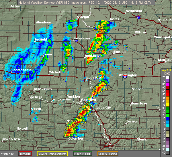 At 613 pm cdt, a severe thunderstorm was located over hawarden, moving northeast at 35 mph (radar indicated). Hazards include ping pong ball size hail and 60 mph wind gusts. People and animals outdoors will be injured. expect hail damage to roofs, siding, windows, and vehicles. expect wind damage to roofs, siding, and trees. This severe thunderstorm will be near, hudson around 625 pm cdt. At 613 pm cdt, a severe thunderstorm was located over hawarden, moving northeast at 35 mph (radar indicated). Hazards include ping pong ball size hail and 60 mph wind gusts. People and animals outdoors will be injured. expect hail damage to roofs, siding, windows, and vehicles. expect wind damage to roofs, siding, and trees. This severe thunderstorm will be near, hudson around 625 pm cdt.
|
| 10/11/2020 6:13 PM CDT |
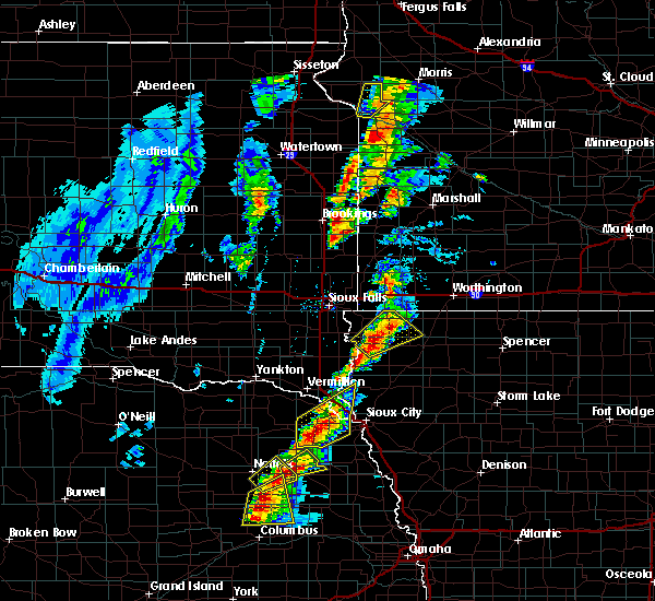 At 613 pm cdt, a severe thunderstorm was located over hawarden, moving northeast at 35 mph (radar indicated). Hazards include ping pong ball size hail and 60 mph wind gusts. People and animals outdoors will be injured. expect hail damage to roofs, siding, windows, and vehicles. expect wind damage to roofs, siding, and trees. This severe thunderstorm will be near, hudson around 625 pm cdt. At 613 pm cdt, a severe thunderstorm was located over hawarden, moving northeast at 35 mph (radar indicated). Hazards include ping pong ball size hail and 60 mph wind gusts. People and animals outdoors will be injured. expect hail damage to roofs, siding, windows, and vehicles. expect wind damage to roofs, siding, and trees. This severe thunderstorm will be near, hudson around 625 pm cdt.
|
| 10/11/2020 5:53 PM CDT |
 At 553 pm cdt, a severe thunderstorm was located near fairview, or 11 miles southeast of canton, moving northeast at 35 mph (radar indicated). Hazards include 70 mph wind gusts and half dollar size hail. Hail damage to vehicles is expected. expect considerable tree damage. wind damage is also likely to mobile homes, roofs, and outbuildings. this severe thunderstorm will be near, rock valley around 605 pm cdt. doon and alvord around 610 pm cdt. rock rapids around 625 pm cdt. George around 630 pm cdt. At 553 pm cdt, a severe thunderstorm was located near fairview, or 11 miles southeast of canton, moving northeast at 35 mph (radar indicated). Hazards include 70 mph wind gusts and half dollar size hail. Hail damage to vehicles is expected. expect considerable tree damage. wind damage is also likely to mobile homes, roofs, and outbuildings. this severe thunderstorm will be near, rock valley around 605 pm cdt. doon and alvord around 610 pm cdt. rock rapids around 625 pm cdt. George around 630 pm cdt.
|
| 8/9/2020 2:52 AM CDT |
 The severe thunderstorm warning for lyon, western osceola, sioux, northwestern o`brien, southern rock and southwestern nobles counties will expire at 300 am cdt, the storms which prompted the warning have weakened below severe limits, and no longer pose an immediate threat to life or property. therefore, the warning will be allowed to expire. however gusty winds are still possible with these thunderstorms. a severe thunderstorm watch remains in effect until 500 am cdt for northwestern iowa, and southwestern minnesota. The severe thunderstorm warning for lyon, western osceola, sioux, northwestern o`brien, southern rock and southwestern nobles counties will expire at 300 am cdt, the storms which prompted the warning have weakened below severe limits, and no longer pose an immediate threat to life or property. therefore, the warning will be allowed to expire. however gusty winds are still possible with these thunderstorms. a severe thunderstorm watch remains in effect until 500 am cdt for northwestern iowa, and southwestern minnesota.
|
| 8/9/2020 2:36 AM CDT |
 At 236 am cdt, severe thunderstorms were located along a line extending from 7 miles west of ellsworth to hull to near sioux center, moving east at 65 mph (radar indicated). Hazards include 60 mph wind gusts and penny size hail. Expect damage to roofs, siding, and trees. these severe storms will be near, alton, george, boyden, ellsworth and matlock around 245 am cdt. adrian and hospers around 250 am cdt. sheldon, ashton and rushmore around 255 am cdt. sibley and archer around 300 am cdt. sanborn around 305 am cdt. Other locations impacted by these severe thunderstorms include bigelow and steen. At 236 am cdt, severe thunderstorms were located along a line extending from 7 miles west of ellsworth to hull to near sioux center, moving east at 65 mph (radar indicated). Hazards include 60 mph wind gusts and penny size hail. Expect damage to roofs, siding, and trees. these severe storms will be near, alton, george, boyden, ellsworth and matlock around 245 am cdt. adrian and hospers around 250 am cdt. sheldon, ashton and rushmore around 255 am cdt. sibley and archer around 300 am cdt. sanborn around 305 am cdt. Other locations impacted by these severe thunderstorms include bigelow and steen.
|
| 8/9/2020 2:18 AM CDT |
 At 218 am cdt, severe thunderstorms were located along a line extending from near larchwood to hudson to near hawarden, moving east at 65 mph (radar indicated). Hazards include 60 mph wind gusts and penny size hail. Expect damage to roofs, siding, and trees. severe thunderstorms will be near, hills and lester around 225 am cdt. rock valley and doon around 230 am cdt. sioux center, hull and maurice around 235 am cdt. orange city, boyden and ellsworth around 240 am cdt. alton, adrian, george and matlock around 245 am cdt. hospers and rushmore around 250 am cdt. sheldon, sibley, ashton and archer around 255 am cdt. sanborn around 300 am cdt. Other locations impacted by these severe thunderstorms include bigelow, steen and chatsworth. At 218 am cdt, severe thunderstorms were located along a line extending from near larchwood to hudson to near hawarden, moving east at 65 mph (radar indicated). Hazards include 60 mph wind gusts and penny size hail. Expect damage to roofs, siding, and trees. severe thunderstorms will be near, hills and lester around 225 am cdt. rock valley and doon around 230 am cdt. sioux center, hull and maurice around 235 am cdt. orange city, boyden and ellsworth around 240 am cdt. alton, adrian, george and matlock around 245 am cdt. hospers and rushmore around 250 am cdt. sheldon, sibley, ashton and archer around 255 am cdt. sanborn around 300 am cdt. Other locations impacted by these severe thunderstorms include bigelow, steen and chatsworth.
|
| 6/21/2020 4:01 PM CDT |
 At 354 pm cdt, severe thunderstorms were located along a line extending from doon to hull to near sioux center, moving northeast at 40 mph (radar indicated). Hazards include 60 mph wind gusts and quarter size hail. Hail damage to vehicles is expected. expect wind damage to roofs, siding, and trees. severe thunderstorms will be near, boyden around 405 pm cdt. george and matlock around 410 pm cdt. sheldon around 415 pm cdt. little rock and ashton around 425 pm cdt. sibley and sanborn around 430 pm cdt. Melvin around 435 pm cdt. At 354 pm cdt, severe thunderstorms were located along a line extending from doon to hull to near sioux center, moving northeast at 40 mph (radar indicated). Hazards include 60 mph wind gusts and quarter size hail. Hail damage to vehicles is expected. expect wind damage to roofs, siding, and trees. severe thunderstorms will be near, boyden around 405 pm cdt. george and matlock around 410 pm cdt. sheldon around 415 pm cdt. little rock and ashton around 425 pm cdt. sibley and sanborn around 430 pm cdt. Melvin around 435 pm cdt.
|
| 6/21/2020 4:01 PM CDT |
 At 400 pm cdt, severe thunderstorms were located along a line extending from near doon to near hull to 6 miles southwest of boyden, moving northeast at 45 mph (trained weather spotters. at 359 pm cdt tree damage was reported 1 mile south southwest of hull). Hazards include 60 mph wind gusts and quarter size hail. Hail damage to vehicles is expected. expect wind damage to roofs, siding, and trees. these severe storms will be near, george, boyden and matlock around 410 pm cdt. sheldon around 420 pm cdt. little rock and ashton around 425 pm cdt. sibley and sanborn around 430 pm cdt. Melvin around 435 pm cdt. At 400 pm cdt, severe thunderstorms were located along a line extending from near doon to near hull to 6 miles southwest of boyden, moving northeast at 45 mph (trained weather spotters. at 359 pm cdt tree damage was reported 1 mile south southwest of hull). Hazards include 60 mph wind gusts and quarter size hail. Hail damage to vehicles is expected. expect wind damage to roofs, siding, and trees. these severe storms will be near, george, boyden and matlock around 410 pm cdt. sheldon around 420 pm cdt. little rock and ashton around 425 pm cdt. sibley and sanborn around 430 pm cdt. Melvin around 435 pm cdt.
|
| 6/21/2020 3:57 PM CDT |
 The severe thunderstorm warning for southwestern lyon, northwestern sioux, southeastern lincoln and northeastern union counties will expire at 400 pm cdt, the storms which prompted the warning have moved out of the area. therefore, the warning will be allowed to expire. however quarter size hail and gusty winds are still possible with these thunderstorms and a new severe thunderstorm warning has been issues for portions of northwestern iowa. a severe thunderstorm watch remains in effect until 1000 pm cdt for northwestern iowa, and southeastern south dakota. to report severe weather, contact your nearest law enforcement agency. they will relay your report to the national weather service sioux falls. The severe thunderstorm warning for southwestern lyon, northwestern sioux, southeastern lincoln and northeastern union counties will expire at 400 pm cdt, the storms which prompted the warning have moved out of the area. therefore, the warning will be allowed to expire. however quarter size hail and gusty winds are still possible with these thunderstorms and a new severe thunderstorm warning has been issues for portions of northwestern iowa. a severe thunderstorm watch remains in effect until 1000 pm cdt for northwestern iowa, and southeastern south dakota. to report severe weather, contact your nearest law enforcement agency. they will relay your report to the national weather service sioux falls.
|
| 6/21/2020 3:55 PM CDT |
 The national weather service in sioux falls has issued a * severe thunderstorm warning for. eastern lyon county in northwestern iowa. western osceola county in northwestern iowa. northeastern sioux county in northwestern iowa. Northwestern o`brien county in northwestern iowa. The national weather service in sioux falls has issued a * severe thunderstorm warning for. eastern lyon county in northwestern iowa. western osceola county in northwestern iowa. northeastern sioux county in northwestern iowa. Northwestern o`brien county in northwestern iowa.
|
| 6/21/2020 3:55 PM CDT |
 At 354 pm cdt, severe thunderstorms were located along a line extending from doon to hull to near sioux center, moving northeast at 40 mph (radar indicated). Hazards include 60 mph wind gusts and quarter size hail. Hail damage to vehicles is expected. expect wind damage to roofs, siding, and trees. severe thunderstorms will be near, boyden around 405 pm cdt. george and matlock around 410 pm cdt. sheldon around 415 pm cdt. little rock and ashton around 425 pm cdt. sibley and sanborn around 430 pm cdt. Melvin around 435 pm cdt. At 354 pm cdt, severe thunderstorms were located along a line extending from doon to hull to near sioux center, moving northeast at 40 mph (radar indicated). Hazards include 60 mph wind gusts and quarter size hail. Hail damage to vehicles is expected. expect wind damage to roofs, siding, and trees. severe thunderstorms will be near, boyden around 405 pm cdt. george and matlock around 410 pm cdt. sheldon around 415 pm cdt. little rock and ashton around 425 pm cdt. sibley and sanborn around 430 pm cdt. Melvin around 435 pm cdt.
|
| 6/21/2020 3:48 PM CDT | 6 to 9 inch diameter tree branch down... power outages in rock valle in sioux county IA, 0.5 miles ENE of Rock Valley, IA |
| 6/21/2020 3:40 PM CDT |
 At 340 pm cdt, severe thunderstorms were located along a line extending from near beresford to near hudson to hawarden, moving northeast at 50 mph (public. at 325 pm cdt a 58 mph wind was reported in hawarden by a public weather station). Hazards include 70 mph wind gusts. Expect considerable tree damage. damage is likely to mobile homes, roofs, and outbuildings. these severe storms will be near, ireton and hudson around 345 pm cdt. newton hills state park around 350 pm cdt. canton, rock valley and fairview around 355 pm cdt. sioux center and doon around 400 pm cdt. hull and inwood around 405 pm cdt. rock rapids, larchwood, boyden and alvord around 410 pm cdt. George and lester around 415 pm cdt. At 340 pm cdt, severe thunderstorms were located along a line extending from near beresford to near hudson to hawarden, moving northeast at 50 mph (public. at 325 pm cdt a 58 mph wind was reported in hawarden by a public weather station). Hazards include 70 mph wind gusts. Expect considerable tree damage. damage is likely to mobile homes, roofs, and outbuildings. these severe storms will be near, ireton and hudson around 345 pm cdt. newton hills state park around 350 pm cdt. canton, rock valley and fairview around 355 pm cdt. sioux center and doon around 400 pm cdt. hull and inwood around 405 pm cdt. rock rapids, larchwood, boyden and alvord around 410 pm cdt. George and lester around 415 pm cdt.
|
| 6/21/2020 3:30 PM CDT |
 At 329 pm cdt, severe thunderstorms were located along a line extending from near beresford to near hudson to near hawarden, moving northeast at 50 mph (public. at 325 pm cdt a 58 mph wind gust was reported in hawarden by a public weather station). Hazards include 70 mph wind gusts. Expect considerable tree damage. damage is likely to mobile homes, roofs, and outbuildings. these severe storms will be near, hudson around 335 pm cdt. newton hills state park around 340 pm cdt. canton, rock valley and fairview around 345 pm cdt. sioux center and doon around 350 pm cdt. hull and inwood around 355 pm cdt. rock rapids, larchwood, boyden and alvord around 400 pm cdt. lester around 405 pm cdt. george around 410 pm cdt. Other locations impacted by these severe thunderstorms include chatsworth. At 329 pm cdt, severe thunderstorms were located along a line extending from near beresford to near hudson to near hawarden, moving northeast at 50 mph (public. at 325 pm cdt a 58 mph wind gust was reported in hawarden by a public weather station). Hazards include 70 mph wind gusts. Expect considerable tree damage. damage is likely to mobile homes, roofs, and outbuildings. these severe storms will be near, hudson around 335 pm cdt. newton hills state park around 340 pm cdt. canton, rock valley and fairview around 345 pm cdt. sioux center and doon around 350 pm cdt. hull and inwood around 355 pm cdt. rock rapids, larchwood, boyden and alvord around 400 pm cdt. lester around 405 pm cdt. george around 410 pm cdt. Other locations impacted by these severe thunderstorms include chatsworth.
|
| 6/21/2020 3:20 PM CDT |
 At 320 pm cdt, severe thunderstorms were located along a line extending from beresford to near alcester to near hawarden, moving northeast at 50 mph (radar indicated). Hazards include 60 mph wind gusts. Expect damage to roofs, siding, and trees. severe thunderstorms will be near, hawarden around 325 pm cdt. hudson around 330 pm cdt. rock valley, fairview and newton hills state park around 340 pm cdt. sioux center and canton around 345 pm cdt. hull, inwood and doon around 350 pm cdt. rock rapids, larchwood, boyden and alvord around 355 pm cdt. george and lester around 400 pm cdt. Other locations impacted by these severe thunderstorms include chatsworth. At 320 pm cdt, severe thunderstorms were located along a line extending from beresford to near alcester to near hawarden, moving northeast at 50 mph (radar indicated). Hazards include 60 mph wind gusts. Expect damage to roofs, siding, and trees. severe thunderstorms will be near, hawarden around 325 pm cdt. hudson around 330 pm cdt. rock valley, fairview and newton hills state park around 340 pm cdt. sioux center and canton around 345 pm cdt. hull, inwood and doon around 350 pm cdt. rock rapids, larchwood, boyden and alvord around 355 pm cdt. george and lester around 400 pm cdt. Other locations impacted by these severe thunderstorms include chatsworth.
|
| 9/11/2019 12:44 AM CDT |
 At 1243 am cdt, severe thunderstorms were located along a line extending from near sibley to ashton to near sioux center, moving east at 70 mph (radar indicated). Hazards include 60 mph wind gusts and quarter size hail. Hail damage to vehicles is expected. expect wind damage to roofs, siding, and trees. severe thunderstorms will be near, sanborn and melvin around 1250 am cdt. hartley and ocheyedan around 1255 am cdt. lake park, harris and archer around 100 am cdt. primghar around 105 am cdt. spencer in clay county, spirit lake, milford, arnolds park, okoboji, orleans, wahpeton, west okoboji and fostoria around 110 am cdt. everly around 115 am cdt. royal, terril and superior around 120 am cdt. Other locations impacted by these severe thunderstorms include dickens, moneta and bigelow. At 1243 am cdt, severe thunderstorms were located along a line extending from near sibley to ashton to near sioux center, moving east at 70 mph (radar indicated). Hazards include 60 mph wind gusts and quarter size hail. Hail damage to vehicles is expected. expect wind damage to roofs, siding, and trees. severe thunderstorms will be near, sanborn and melvin around 1250 am cdt. hartley and ocheyedan around 1255 am cdt. lake park, harris and archer around 100 am cdt. primghar around 105 am cdt. spencer in clay county, spirit lake, milford, arnolds park, okoboji, orleans, wahpeton, west okoboji and fostoria around 110 am cdt. everly around 115 am cdt. royal, terril and superior around 120 am cdt. Other locations impacted by these severe thunderstorms include dickens, moneta and bigelow.
|
| 9/11/2019 12:27 AM CDT |
 At 1227 am cdt, severe thunderstorms were located along a line extending from near leota to rushmore to near little rock, moving east at 45 mph. these are very dangerous storms (emergency management). Hazards include 80 mph wind gusts and quarter size hail. Flying debris will be dangerous to those caught without shelter. mobile homes will be heavily damaged. expect considerable damage to roofs, windows, and vehicles. extensive tree damage and power outages are likely. these severe storms will be near, worthington around 1245 am cdt. Other locations impacted by these severe thunderstorms include kenneth, steen, magnolia and bigelow. At 1227 am cdt, severe thunderstorms were located along a line extending from near leota to rushmore to near little rock, moving east at 45 mph. these are very dangerous storms (emergency management). Hazards include 80 mph wind gusts and quarter size hail. Flying debris will be dangerous to those caught without shelter. mobile homes will be heavily damaged. expect considerable damage to roofs, windows, and vehicles. extensive tree damage and power outages are likely. these severe storms will be near, worthington around 1245 am cdt. Other locations impacted by these severe thunderstorms include kenneth, steen, magnolia and bigelow.
|
| 9/11/2019 12:15 AM CDT |
 At 1214 am cdt, severe thunderstorms were located along a line extending from near hardwick to near ellsworth to near george, moving east at 45 mph. these are very dangerous storms (emergency management). Hazards include 80 mph wind gusts and quarter size hail. Flying debris will be dangerous to those caught without shelter. mobile homes will be heavily damaged. expect considerable damage to roofs, windows, and vehicles. extensive tree damage and power outages are likely. these severe storms will be near, adrian around 1225 am cdt. little rock, leota, rushmore and lismore around 1230 am cdt. sibley and ashton around 1235 am cdt. wilmont around 1240 am cdt. worthington around 1245 am cdt. Other locations impacted by these severe thunderstorms include kenneth, steen, magnolia and bigelow. At 1214 am cdt, severe thunderstorms were located along a line extending from near hardwick to near ellsworth to near george, moving east at 45 mph. these are very dangerous storms (emergency management). Hazards include 80 mph wind gusts and quarter size hail. Flying debris will be dangerous to those caught without shelter. mobile homes will be heavily damaged. expect considerable damage to roofs, windows, and vehicles. extensive tree damage and power outages are likely. these severe storms will be near, adrian around 1225 am cdt. little rock, leota, rushmore and lismore around 1230 am cdt. sibley and ashton around 1235 am cdt. wilmont around 1240 am cdt. worthington around 1245 am cdt. Other locations impacted by these severe thunderstorms include kenneth, steen, magnolia and bigelow.
|
| 9/10/2019 11:59 PM CDT |
 At 1158 pm cdt, severe thunderstorms were located along a line extending from near garretson to near hills to near alvord, moving east at 45 mph. these are very dangerous storms (emergency management). Hazards include 80 mph wind gusts and quarter size hail. Flying debris will be dangerous to those caught without shelter. mobile homes will be heavily damaged. expect considerable damage to roofs, windows, and vehicles. extensive tree damage and power outages are likely. severe thunderstorms will be near, rock rapids around 1210 am cdt. luverne, ellsworth, hardwick and blue mounds state park around 1215 am cdt. adrian, george and matlock around 1220 am cdt. little rock, leota, rushmore and lismore around 1230 am cdt. sibley and ashton around 1235 am cdt. wilmont around 1240 am cdt. worthington around 1245 am cdt. Other locations impacted by these severe thunderstorms include kenneth, steen, magnolia and bigelow. At 1158 pm cdt, severe thunderstorms were located along a line extending from near garretson to near hills to near alvord, moving east at 45 mph. these are very dangerous storms (emergency management). Hazards include 80 mph wind gusts and quarter size hail. Flying debris will be dangerous to those caught without shelter. mobile homes will be heavily damaged. expect considerable damage to roofs, windows, and vehicles. extensive tree damage and power outages are likely. severe thunderstorms will be near, rock rapids around 1210 am cdt. luverne, ellsworth, hardwick and blue mounds state park around 1215 am cdt. adrian, george and matlock around 1220 am cdt. little rock, leota, rushmore and lismore around 1230 am cdt. sibley and ashton around 1235 am cdt. wilmont around 1240 am cdt. worthington around 1245 am cdt. Other locations impacted by these severe thunderstorms include kenneth, steen, magnolia and bigelow.
|
| 8/17/2019 11:14 PM CDT |
 At 1114 pm cdt, severe thunderstorms were located along a line extending from near heron lake to ocheyedan to sheldon, moving east at 60 mph (radar indicated). Hazards include 60 mph wind gusts. Expect damage to roofs, siding, and trees. these severe storms will be near, heron lake and harris around 1120 pm cdt. lakefield and lake park around 1125 pm cdt. spirit lake, hartley, okoboji, wahpeton, west okoboji and kilen woods state park around 1130 pm cdt. Other locations impacted by these severe thunderstorms include kinbrae, wilder, dundee, okabena, bigelow and magnolia. At 1114 pm cdt, severe thunderstorms were located along a line extending from near heron lake to ocheyedan to sheldon, moving east at 60 mph (radar indicated). Hazards include 60 mph wind gusts. Expect damage to roofs, siding, and trees. these severe storms will be near, heron lake and harris around 1120 pm cdt. lakefield and lake park around 1125 pm cdt. spirit lake, hartley, okoboji, wahpeton, west okoboji and kilen woods state park around 1130 pm cdt. Other locations impacted by these severe thunderstorms include kinbrae, wilder, dundee, okabena, bigelow and magnolia.
|
| 8/17/2019 11:14 PM CDT |
 A severe thunderstorm warning remains in effect until 1130 pm cdt for eastern lyon. osceola. western dickinson. northern sioux. northwestern clay. o`brien. southeastern rock. jackson. nobles. southeastern murray. southwestern cottonwood and southeastern lincoln counties. At 1114 pm cdt, severe thunderstorms were located along a line. A severe thunderstorm warning remains in effect until 1130 pm cdt for eastern lyon. osceola. western dickinson. northern sioux. northwestern clay. o`brien. southeastern rock. jackson. nobles. southeastern murray. southwestern cottonwood and southeastern lincoln counties. At 1114 pm cdt, severe thunderstorms were located along a line.
|
| 8/17/2019 10:46 PM CDT |
 The national weather service in sioux falls has issued a * severe thunderstorm warning for. eastern lyon county in northwestern iowa. osceola county in northwestern iowa. western dickinson county in northwestern iowa. Northern sioux county in northwestern iowa. The national weather service in sioux falls has issued a * severe thunderstorm warning for. eastern lyon county in northwestern iowa. osceola county in northwestern iowa. western dickinson county in northwestern iowa. Northern sioux county in northwestern iowa.
|
| 8/17/2019 10:46 PM CDT |
 At 1046 pm cdt, severe thunderstorms were located along a line extending from near lismore to near rock rapids to near rock valley, moving east at 60 mph (radar indicated). Hazards include 60 mph wind gusts. Expect damage to roofs, siding, and trees. severe thunderstorms will be near, george, wilmont and lismore around 1050 pm cdt. little rock around 1055 pm cdt. ashton around 1100 pm cdt. sibley, fulda, boyden and matlock around 1105 pm cdt. sheldon, hospers, brewster and melvin around 1110 pm cdt. ocheyedan around 1115 pm cdt. sanborn, heron lake, harris and archer around 1120 pm cdt. lakefield, lake park and primghar around 1125 pm cdt. Other locations impacted by these severe thunderstorms include kinbrae, wilder, dundee, okabena, bigelow and magnolia. At 1046 pm cdt, severe thunderstorms were located along a line extending from near lismore to near rock rapids to near rock valley, moving east at 60 mph (radar indicated). Hazards include 60 mph wind gusts. Expect damage to roofs, siding, and trees. severe thunderstorms will be near, george, wilmont and lismore around 1050 pm cdt. little rock around 1055 pm cdt. ashton around 1100 pm cdt. sibley, fulda, boyden and matlock around 1105 pm cdt. sheldon, hospers, brewster and melvin around 1110 pm cdt. ocheyedan around 1115 pm cdt. sanborn, heron lake, harris and archer around 1120 pm cdt. lakefield, lake park and primghar around 1125 pm cdt. Other locations impacted by these severe thunderstorms include kinbrae, wilder, dundee, okabena, bigelow and magnolia.
|
| 7/20/2019 9:06 AM CDT | Four inch diameter tree branch dow in sioux county IA, 0.7 miles SE of Rock Valley, IA |
| 7/20/2019 8:51 AM CDT |
 At 851 am cdt, severe thunderstorms were located along a line extending from near ellsworth to near hawarden, moving east at 50 mph (radar indicated). Hazards include 70 mph wind gusts. Expect considerable tree damage. damage is likely to mobile homes, roofs, and outbuildings. these severe storms will be near, george around 855 am cdt. little rock around 900 am cdt. ireton around 905 am cdt. sioux center and sibley around 910 am cdt. Other locations impacted by these severe thunderstorms include bigelow. At 851 am cdt, severe thunderstorms were located along a line extending from near ellsworth to near hawarden, moving east at 50 mph (radar indicated). Hazards include 70 mph wind gusts. Expect considerable tree damage. damage is likely to mobile homes, roofs, and outbuildings. these severe storms will be near, george around 855 am cdt. little rock around 900 am cdt. ireton around 905 am cdt. sioux center and sibley around 910 am cdt. Other locations impacted by these severe thunderstorms include bigelow.
|
| 7/20/2019 8:39 AM CDT |
 At 839 am cdt, severe thunderstorms were located along a line extending from near rock rapids to near beresford, moving east at 50 mph (radar indicated). Hazards include 70 mph wind gusts. Expect considerable tree damage. damage is likely to mobile homes, roofs, and outbuildings. severe thunderstorms will be near, rock rapids around 845 am cdt. hawarden, george and hudson around 855 am cdt. little rock around 900 am cdt. ireton around 905 am cdt. sioux center and sibley around 910 am cdt. Other locations impacted by these severe thunderstorms include bigelow. At 839 am cdt, severe thunderstorms were located along a line extending from near rock rapids to near beresford, moving east at 50 mph (radar indicated). Hazards include 70 mph wind gusts. Expect considerable tree damage. damage is likely to mobile homes, roofs, and outbuildings. severe thunderstorms will be near, rock rapids around 845 am cdt. hawarden, george and hudson around 855 am cdt. little rock around 900 am cdt. ireton around 905 am cdt. sioux center and sibley around 910 am cdt. Other locations impacted by these severe thunderstorms include bigelow.
|
| 7/20/2019 8:32 AM CDT |
 At 832 am cdt, a severe thunderstorm was located over lake alvin state recreation area, or 8 miles north of canton, moving east at 45 mph (radar indicated). Hazards include 70 mph wind gusts. Expect considerable tree damage. damage is likely to mobile homes, roofs, and outbuildings. this severe storm will be near, larchwood and inwood around 840 am cdt. lester and alvord around 845 am cdt. Other locations impacted by this severe thunderstorm include steen. At 832 am cdt, a severe thunderstorm was located over lake alvin state recreation area, or 8 miles north of canton, moving east at 45 mph (radar indicated). Hazards include 70 mph wind gusts. Expect considerable tree damage. damage is likely to mobile homes, roofs, and outbuildings. this severe storm will be near, larchwood and inwood around 840 am cdt. lester and alvord around 845 am cdt. Other locations impacted by this severe thunderstorm include steen.
|
| 7/20/2019 8:15 AM CDT |
 At 815 am cdt, a severe thunderstorm was located over tea, or 9 miles southwest of sioux falls, moving east at 45 mph (radar indicated). Hazards include 70 mph wind gusts. Expect considerable tree damage. damage is likely to mobile homes, roofs, and outbuildings. this severe thunderstorm will be near, harrisburg around 825 am cdt. lake alvin state recreation area around 830 am cdt. rowena around 835 am cdt. larchwood around 840 am cdt. inwood, lester and alvord around 845 am cdt. Other locations impacted by this severe thunderstorm include steen. At 815 am cdt, a severe thunderstorm was located over tea, or 9 miles southwest of sioux falls, moving east at 45 mph (radar indicated). Hazards include 70 mph wind gusts. Expect considerable tree damage. damage is likely to mobile homes, roofs, and outbuildings. this severe thunderstorm will be near, harrisburg around 825 am cdt. lake alvin state recreation area around 830 am cdt. rowena around 835 am cdt. larchwood around 840 am cdt. inwood, lester and alvord around 845 am cdt. Other locations impacted by this severe thunderstorm include steen.
|
| 7/17/2019 7:13 AM CDT |
 At 711 am cdt, severe thunderstorms were located along a line extending from inwood to near ireton to 6 miles east of elk point, moving east at 50 mph (radar indicated). Hazards include 70 mph wind gusts. Expect considerable tree damage. damage is likely to mobile homes, roofs, and outbuildings. these severe storms will be near, sioux center, rock valley, maurice and alvord around 720 am cdt. orange city and doon around 725 am cdt. hull, alton, hinton and merrill around 730 am cdt. hospers around 735 am cdt. boyden, granville and matlock around 740 am cdt. kingsley around 745 am cdt. sheldon around 750 am cdt. Other locations impacted by these severe thunderstorms include oyens, chatsworth, brunsville and westfield. At 711 am cdt, severe thunderstorms were located along a line extending from inwood to near ireton to 6 miles east of elk point, moving east at 50 mph (radar indicated). Hazards include 70 mph wind gusts. Expect considerable tree damage. damage is likely to mobile homes, roofs, and outbuildings. these severe storms will be near, sioux center, rock valley, maurice and alvord around 720 am cdt. orange city and doon around 725 am cdt. hull, alton, hinton and merrill around 730 am cdt. hospers around 735 am cdt. boyden, granville and matlock around 740 am cdt. kingsley around 745 am cdt. sheldon around 750 am cdt. Other locations impacted by these severe thunderstorms include oyens, chatsworth, brunsville and westfield.
|
| 7/17/2019 6:54 AM CDT |
 At 653 am cdt, severe thunderstorms were located along a line extending from near canton to near elk point, moving east at 55 mph (radar indicated). Hazards include 70 mph wind gusts and quarter size hail. Hail damage to vehicles is expected. expect considerable tree damage. wind damage is also likely to mobile homes, roofs, and outbuildings. severe thunderstorms will be near, fairview around 700 am cdt. inwood around 705 am cdt. alvord around 710 am cdt. rock valley and doon around 715 am cdt. hull, hinton and merrill around 720 am cdt. boyden and matlock around 730 am cdt. kingsley and hospers around 735 am cdt. sheldon around 740 am cdt. Other locations impacted by these severe thunderstorms include oyens, chatsworth, brunsville and westfield. At 653 am cdt, severe thunderstorms were located along a line extending from near canton to near elk point, moving east at 55 mph (radar indicated). Hazards include 70 mph wind gusts and quarter size hail. Hail damage to vehicles is expected. expect considerable tree damage. wind damage is also likely to mobile homes, roofs, and outbuildings. severe thunderstorms will be near, fairview around 700 am cdt. inwood around 705 am cdt. alvord around 710 am cdt. rock valley and doon around 715 am cdt. hull, hinton and merrill around 720 am cdt. boyden and matlock around 730 am cdt. kingsley and hospers around 735 am cdt. sheldon around 740 am cdt. Other locations impacted by these severe thunderstorms include oyens, chatsworth, brunsville and westfield.
|
| 7/4/2019 2:45 AM CDT | Roof and most walls removed from house at corner of 8th ave. and 12th st. debris damaged downstream home to east. utility pole and several trees snapped... starting a s in sioux county IA, 1 miles E of Rock Valley, IA |
| 6/27/2019 9:26 AM CDT |
 The severe thunderstorm warning for southeastern lyon, southern osceola, sioux and northwestern o`brien counties will expire at 930 am cdt, the storms which prompted the warning have weakened below severe limits, and no longer pose an immediate threat to life or property. therefore, the warning will be allowed to expire. however gusty winds, small hail, and heavy rain are still possible with these thunderstorms. remember a flash flood warning remains in effect for portions of sioux and lyon counties until 1215 pm cdt. a severe thunderstorm watch remains in effect until 100 pm cdt for northwestern iowa, and southeastern south dakota. The severe thunderstorm warning for southeastern lyon, southern osceola, sioux and northwestern o`brien counties will expire at 930 am cdt, the storms which prompted the warning have weakened below severe limits, and no longer pose an immediate threat to life or property. therefore, the warning will be allowed to expire. however gusty winds, small hail, and heavy rain are still possible with these thunderstorms. remember a flash flood warning remains in effect for portions of sioux and lyon counties until 1215 pm cdt. a severe thunderstorm watch remains in effect until 100 pm cdt for northwestern iowa, and southeastern south dakota.
|
| 6/27/2019 9:15 AM CDT |
 At 914 am cdt, severe thunderstorms were located along a line extending from near ashton to near matlock to near maurice, moving east at 30 mph (radar indicated. at 855 am cdt, a trained spotter reported tree branches down 4 miles north-northeast of hawarden). Hazards include 60 mph wind gusts and quarter size hail. Hail damage to vehicles is expected. expect wind damage to roofs, siding, and trees. these severe storms will be near, sheldon and matlock around 920 am cdt. ashton around 925 am cdt. Sanborn, hospers, melvin and archer around 930 am cdt. At 914 am cdt, severe thunderstorms were located along a line extending from near ashton to near matlock to near maurice, moving east at 30 mph (radar indicated. at 855 am cdt, a trained spotter reported tree branches down 4 miles north-northeast of hawarden). Hazards include 60 mph wind gusts and quarter size hail. Hail damage to vehicles is expected. expect wind damage to roofs, siding, and trees. these severe storms will be near, sheldon and matlock around 920 am cdt. ashton around 925 am cdt. Sanborn, hospers, melvin and archer around 930 am cdt.
|
| 6/27/2019 9:01 AM CDT |
 At 859 am cdt, severe thunderstorms were located along a line extending from near little rock to near george to near sioux center, moving east at 35 mph (radar indicated). Hazards include 70 mph wind gusts and quarter size hail. Hail damage to vehicles is expected. expect considerable tree damage. wind damage is also likely to mobile homes, roofs, and outbuildings. these severe storms will be near, little rock and matlock around 905 am cdt. hull and ashton around 910 am cdt. sibley around 915 am cdt. orange city around 920 am cdt. boyden and melvin around 925 am cdt. hospers, ocheyedan and harris around 930 am cdt. Other locations impacted by these severe thunderstorms include bigelow. At 859 am cdt, severe thunderstorms were located along a line extending from near little rock to near george to near sioux center, moving east at 35 mph (radar indicated). Hazards include 70 mph wind gusts and quarter size hail. Hail damage to vehicles is expected. expect considerable tree damage. wind damage is also likely to mobile homes, roofs, and outbuildings. these severe storms will be near, little rock and matlock around 905 am cdt. hull and ashton around 910 am cdt. sibley around 915 am cdt. orange city around 920 am cdt. boyden and melvin around 925 am cdt. hospers, ocheyedan and harris around 930 am cdt. Other locations impacted by these severe thunderstorms include bigelow.
|
| 6/27/2019 8:40 AM CDT |
 At 839 am cdt, severe thunderstorms were located along a line extending from near ellsworth to 6 miles west of george to near hudson, moving east at 35 mph (radar indicated. at 823 am cdt, quarter size hail was reported near lester). Hazards include 70 mph wind gusts and half dollar size hail. Hail damage to vehicles is expected. expect considerable tree damage. wind damage is also likely to mobile homes, roofs, and outbuildings. severe thunderstorms will be near, george around 850 am cdt. matlock around 855 am cdt. little rock around 900 am cdt. sioux center around 905 am cdt. hull and ashton around 910 am cdt. orange city and sibley around 915 am cdt. boyden around 920 am cdt. melvin around 925 am cdt. Other locations impacted by these severe thunderstorms include bigelow. At 839 am cdt, severe thunderstorms were located along a line extending from near ellsworth to 6 miles west of george to near hudson, moving east at 35 mph (radar indicated. at 823 am cdt, quarter size hail was reported near lester). Hazards include 70 mph wind gusts and half dollar size hail. Hail damage to vehicles is expected. expect considerable tree damage. wind damage is also likely to mobile homes, roofs, and outbuildings. severe thunderstorms will be near, george around 850 am cdt. matlock around 855 am cdt. little rock around 900 am cdt. sioux center around 905 am cdt. hull and ashton around 910 am cdt. orange city and sibley around 915 am cdt. boyden around 920 am cdt. melvin around 925 am cdt. Other locations impacted by these severe thunderstorms include bigelow.
|
| 6/27/2019 8:33 AM CDT |
 At 833 am cdt, a severe thunderstorm was located near doon, or 10 miles south of rock rapids, moving east at 45 mph (radar indicated). Hazards include 70 mph wind gusts and quarter size hail. Hail damage to vehicles is expected. expect considerable tree damage. wind damage is also likely to mobile homes, roofs, and outbuildings. this severe storm will be near, george around 840 am cdt. Boyden and matlock around 845 am cdt. At 833 am cdt, a severe thunderstorm was located near doon, or 10 miles south of rock rapids, moving east at 45 mph (radar indicated). Hazards include 70 mph wind gusts and quarter size hail. Hail damage to vehicles is expected. expect considerable tree damage. wind damage is also likely to mobile homes, roofs, and outbuildings. this severe storm will be near, george around 840 am cdt. Boyden and matlock around 845 am cdt.
|
| 6/27/2019 8:25 AM CDT |
 At 825 am cdt, a severe thunderstorm was located over doon, or 9 miles southwest of rock rapids, moving east at 45 mph (radar indicated). Hazards include 70 mph wind gusts. Expect considerable tree damage. damage is likely to mobile homes, roofs, and outbuildings. this severe storm will be near, hull around 835 am cdt. george around 840 am cdt. Boyden and matlock around 845 am cdt. At 825 am cdt, a severe thunderstorm was located over doon, or 9 miles southwest of rock rapids, moving east at 45 mph (radar indicated). Hazards include 70 mph wind gusts. Expect considerable tree damage. damage is likely to mobile homes, roofs, and outbuildings. this severe storm will be near, hull around 835 am cdt. george around 840 am cdt. Boyden and matlock around 845 am cdt.
|
| 6/27/2019 8:22 AM CDT |
 At 821 am cdt, a severe thunderstorm was located over alvord, or 10 miles southwest of rock rapids, moving east at 40 mph (radar indicated). Hazards include 70 mph wind gusts. Expect considerable tree damage. damage is likely to mobile homes, roofs, and outbuildings. this severe thunderstorm will be near, rock valley and doon around 830 am cdt. hull and george around 840 am cdt. Boyden and matlock around 845 am cdt. At 821 am cdt, a severe thunderstorm was located over alvord, or 10 miles southwest of rock rapids, moving east at 40 mph (radar indicated). Hazards include 70 mph wind gusts. Expect considerable tree damage. damage is likely to mobile homes, roofs, and outbuildings. this severe thunderstorm will be near, rock valley and doon around 830 am cdt. hull and george around 840 am cdt. Boyden and matlock around 845 am cdt.
|
| 8/28/2018 4:43 AM CDT |
 At 433 am cdt, a severe thunderstorm was located near inwood, or 10 miles east of canton, moving east at 40 mph (radar indicated). Hazards include 60 mph wind gusts and half dollar size hail. Hail damage to vehicles is expected. expect wind damage to roofs, siding, and trees. this severe thunderstorm will be near, rock valley and alvord around 440 am cdt. doon around 445 am cdt. hull around 450 am cdt. george around 500 am cdt. matlock around 505 am cdt. Ashton around 515 am cdt. At 433 am cdt, a severe thunderstorm was located near inwood, or 10 miles east of canton, moving east at 40 mph (radar indicated). Hazards include 60 mph wind gusts and half dollar size hail. Hail damage to vehicles is expected. expect wind damage to roofs, siding, and trees. this severe thunderstorm will be near, rock valley and alvord around 440 am cdt. doon around 445 am cdt. hull around 450 am cdt. george around 500 am cdt. matlock around 505 am cdt. Ashton around 515 am cdt.
|
| 8/28/2018 4:35 AM CDT |
 At 433 am cdt, a severe thunderstorm was located near inwood, or 10 miles east of canton, moving east at 40 mph (radar indicated). Hazards include 60 mph wind gusts and half dollar size hail. Hail damage to vehicles is expected. expect wind damage to roofs, siding, and trees. this severe thunderstorm will be near, rock valley and alvord around 440 am cdt. doon around 445 am cdt. hull around 450 am cdt. george around 500 am cdt. matlock around 505 am cdt. Ashton around 515 am cdt. At 433 am cdt, a severe thunderstorm was located near inwood, or 10 miles east of canton, moving east at 40 mph (radar indicated). Hazards include 60 mph wind gusts and half dollar size hail. Hail damage to vehicles is expected. expect wind damage to roofs, siding, and trees. this severe thunderstorm will be near, rock valley and alvord around 440 am cdt. doon around 445 am cdt. hull around 450 am cdt. george around 500 am cdt. matlock around 505 am cdt. Ashton around 515 am cdt.
|
| 8/5/2018 3:22 AM CDT |
 The severe thunderstorm warning for lyon, northeastern sioux and southeastern lincoln counties will expire at 330 am cdt, the storms which prompted the warning have moved out of the area. therefore, the warning will be allowed to expire. however gusty winds are still possible with these thunderstorms. a severe thunderstorm watch remains in effect until 700 am cdt for northwestern iowa, and southwestern minnesota. The severe thunderstorm warning for lyon, northeastern sioux and southeastern lincoln counties will expire at 330 am cdt, the storms which prompted the warning have moved out of the area. therefore, the warning will be allowed to expire. however gusty winds are still possible with these thunderstorms. a severe thunderstorm watch remains in effect until 700 am cdt for northwestern iowa, and southwestern minnesota.
|
| 8/5/2018 3:00 AM CDT |
 At 258 am cdt, severe thunderstorms were located along a line extending from near george to near orange city, moving east at 50 mph. these are very dangerous storms (radar indicated). Hazards include 90 mph wind gusts and half dollar size hail. Flying debris will be dangerous to those caught without shelter. mobile homes will be heavily damaged. expect considerable damage to roofs, windows, and vehicles. extensive tree damage and power outages are likely. these severe storms will be near, little rock and boyden around 305 am cdt. orange city around 305 am cdt. Granville around 315 am cdt. At 258 am cdt, severe thunderstorms were located along a line extending from near george to near orange city, moving east at 50 mph. these are very dangerous storms (radar indicated). Hazards include 90 mph wind gusts and half dollar size hail. Flying debris will be dangerous to those caught without shelter. mobile homes will be heavily damaged. expect considerable damage to roofs, windows, and vehicles. extensive tree damage and power outages are likely. these severe storms will be near, little rock and boyden around 305 am cdt. orange city around 305 am cdt. Granville around 315 am cdt.
|
| 8/5/2018 2:41 AM CDT |
 At 240 am cdt, severe thunderstorms were located along a line extending from near rock rapids to near hudson, moving southeast at 25 mph. these are very dangerous storms (radar indicated). Hazards include 80 mph wind gusts and quarter size hail. Flying debris will be dangerous to those caught without shelter. mobile homes will be heavily damaged. expect considerable damage to roofs, windows, and vehicles. extensive tree damage and power outages are likely. severe thunderstorms will be near, rock rapids around 245 am cdt. george around 300 am cdt. boyden and matlock around 315 am cdt. Orange city and sheldon around 330 am cdt. At 240 am cdt, severe thunderstorms were located along a line extending from near rock rapids to near hudson, moving southeast at 25 mph. these are very dangerous storms (radar indicated). Hazards include 80 mph wind gusts and quarter size hail. Flying debris will be dangerous to those caught without shelter. mobile homes will be heavily damaged. expect considerable damage to roofs, windows, and vehicles. extensive tree damage and power outages are likely. severe thunderstorms will be near, rock rapids around 245 am cdt. george around 300 am cdt. boyden and matlock around 315 am cdt. Orange city and sheldon around 330 am cdt.
|
| 8/5/2018 2:41 AM CDT |
 The national weather service in sioux falls has issued a * severe thunderstorm warning for. lyon county in northwestern iowa. northeastern sioux county in northwestern iowa. southeastern lincoln county in southeastern south dakota. Until 330 am cdt. The national weather service in sioux falls has issued a * severe thunderstorm warning for. lyon county in northwestern iowa. northeastern sioux county in northwestern iowa. southeastern lincoln county in southeastern south dakota. Until 330 am cdt.
|
| 8/5/2018 2:28 AM CDT |
 At 228 am cdt, severe thunderstorms were located along a line extending from near hills to near alvord to inwood to 7 miles south of worthing, moving southeast at 20 mph. these are very dangerous storms (radar indicated). Hazards include 80 mph wind gusts and penny size hail. Flying debris will be dangerous to those caught without shelter. mobile homes will be heavily damaged. expect considerable damage to roofs, windows, and vehicles. extensive tree damage and power outages are likely. these severe storms will be near, inwood, alvord and fairview around 235 am cdt. rock rapids, rock valley, doon, hudson and newton hills state park around 245 am cdt. Other locations impacted by these severe thunderstorms include steen. At 228 am cdt, severe thunderstorms were located along a line extending from near hills to near alvord to inwood to 7 miles south of worthing, moving southeast at 20 mph. these are very dangerous storms (radar indicated). Hazards include 80 mph wind gusts and penny size hail. Flying debris will be dangerous to those caught without shelter. mobile homes will be heavily damaged. expect considerable damage to roofs, windows, and vehicles. extensive tree damage and power outages are likely. these severe storms will be near, inwood, alvord and fairview around 235 am cdt. rock rapids, rock valley, doon, hudson and newton hills state park around 245 am cdt. Other locations impacted by these severe thunderstorms include steen.
|
| 8/5/2018 2:14 AM CDT |
 At 213 am cdt, severe thunderstorms were located along a line extending from near beaver creek to near larchwood to near canton to near worthing, moving southeast at 35 mph. these are very dangerous storms (radar indicated). Hazards include 80 mph wind gusts and penny size hail. Flying debris will be dangerous to those caught without shelter. mobile homes will be heavily damaged. expect considerable damage to roofs, windows, and vehicles. extensive tree damage and power outages are likely. these severe storms will be near, luverne, inwood, lester and fairview around 220 am cdt. alvord around 225 am cdt. rock rapids, rock valley and doon around 235 am cdt. hudson around 245 am cdt. Other locations impacted by these severe thunderstorms include steen. At 213 am cdt, severe thunderstorms were located along a line extending from near beaver creek to near larchwood to near canton to near worthing, moving southeast at 35 mph. these are very dangerous storms (radar indicated). Hazards include 80 mph wind gusts and penny size hail. Flying debris will be dangerous to those caught without shelter. mobile homes will be heavily damaged. expect considerable damage to roofs, windows, and vehicles. extensive tree damage and power outages are likely. these severe storms will be near, luverne, inwood, lester and fairview around 220 am cdt. alvord around 225 am cdt. rock rapids, rock valley and doon around 235 am cdt. hudson around 245 am cdt. Other locations impacted by these severe thunderstorms include steen.
|
| 8/5/2018 2:14 AM CDT |
 At 154 am cdt, severe thunderstorms were located along a line extending from palisades state park to near rowena to harrisburg to chancellor, moving southeast at 20 mph (radar indicated). Hazards include 70 mph wind gusts and penny size hail. Expect considerable tree damage. damage is likely to mobile homes, roofs, and outbuildings. severe thunderstorms will be near, harrisburg, worthing and rowena around 200 am cdt. lake alvin state recreation area around 205 am cdt. valley springs around 215 am cdt. larchwood and beaver creek around 220 am cdt. canton around 230 am cdt. hills and newton hills state park around 235 am cdt. inwood around 240 am cdt. rock rapids, doon, hudson, lester, alvord and fairview around 245 am cdt. Other locations impacted by these severe thunderstorms include steen. At 154 am cdt, severe thunderstorms were located along a line extending from palisades state park to near rowena to harrisburg to chancellor, moving southeast at 20 mph (radar indicated). Hazards include 70 mph wind gusts and penny size hail. Expect considerable tree damage. damage is likely to mobile homes, roofs, and outbuildings. severe thunderstorms will be near, harrisburg, worthing and rowena around 200 am cdt. lake alvin state recreation area around 205 am cdt. valley springs around 215 am cdt. larchwood and beaver creek around 220 am cdt. canton around 230 am cdt. hills and newton hills state park around 235 am cdt. inwood around 240 am cdt. rock rapids, doon, hudson, lester, alvord and fairview around 245 am cdt. Other locations impacted by these severe thunderstorms include steen.
|
| 8/5/2018 1:54 AM CDT |
 At 154 am cdt, severe thunderstorms were located along a line extending from palisades state park to near rowena to harrisburg to chancellor, moving southeast at 20 mph (radar indicated). Hazards include 70 mph wind gusts and penny size hail. Expect considerable tree damage. damage is likely to mobile homes, roofs, and outbuildings. severe thunderstorms will be near, harrisburg, worthing and rowena around 200 am cdt. lake alvin state recreation area around 205 am cdt. valley springs around 215 am cdt. larchwood and beaver creek around 220 am cdt. canton around 230 am cdt. hills and newton hills state park around 235 am cdt. inwood around 240 am cdt. rock rapids, doon, hudson, lester, alvord and fairview around 245 am cdt. Other locations impacted by these severe thunderstorms include steen. At 154 am cdt, severe thunderstorms were located along a line extending from palisades state park to near rowena to harrisburg to chancellor, moving southeast at 20 mph (radar indicated). Hazards include 70 mph wind gusts and penny size hail. Expect considerable tree damage. damage is likely to mobile homes, roofs, and outbuildings. severe thunderstorms will be near, harrisburg, worthing and rowena around 200 am cdt. lake alvin state recreation area around 205 am cdt. valley springs around 215 am cdt. larchwood and beaver creek around 220 am cdt. canton around 230 am cdt. hills and newton hills state park around 235 am cdt. inwood around 240 am cdt. rock rapids, doon, hudson, lester, alvord and fairview around 245 am cdt. Other locations impacted by these severe thunderstorms include steen.
|
| 8/21/2017 2:55 PM CDT |
 The severe thunderstorm warning for southwestern lyon, sioux and plymouth counties will expire at 300 pm cdt, the storms which prompted the warning have weakened. therefore, the warning will be allowed to expire. however gusty winds are still possible with these thunderstorms. a severe thunderstorm watch remains in effect until 700 pm cdt for northwestern and west central iowa, and southeastern south dakota. The severe thunderstorm warning for southwestern lyon, sioux and plymouth counties will expire at 300 pm cdt, the storms which prompted the warning have weakened. therefore, the warning will be allowed to expire. however gusty winds are still possible with these thunderstorms. a severe thunderstorm watch remains in effect until 700 pm cdt for northwestern and west central iowa, and southeastern south dakota.
|
| 8/21/2017 2:37 PM CDT |
 At 237 pm cdt, severe thunderstorms were located along a line extending from near hull to near hinton, moving east at 45 mph (radar indicated). Hazards include 60 mph wind gusts. Expect damage to roofs, siding, and trees. these severe storms will be near, orange city and boyden around 250 pm cdt. alton around 255 pm cdt. sheldon, kingsley, hospers and granville around 300 pm cdt. Other locations impacted by these severe thunderstorms include oyens, chatsworth, brunsville and westfield. At 237 pm cdt, severe thunderstorms were located along a line extending from near hull to near hinton, moving east at 45 mph (radar indicated). Hazards include 60 mph wind gusts. Expect damage to roofs, siding, and trees. these severe storms will be near, orange city and boyden around 250 pm cdt. alton around 255 pm cdt. sheldon, kingsley, hospers and granville around 300 pm cdt. Other locations impacted by these severe thunderstorms include oyens, chatsworth, brunsville and westfield.
|
| 8/21/2017 2:11 PM CDT |
 At 210 pm cdt, severe thunderstorms were located along a line extending from newton hills state park to near elk point, moving east at 45 mph (radar indicated). Hazards include 60 mph wind gusts and penny size hail. Expect damage to roofs, siding, and trees. severe thunderstorms will be near, akron around 215 pm cdt. rock valley around 230 pm cdt. hinton and merrill around 235 pm cdt. sioux center and hull around 240 pm cdt. boyden around 245 pm cdt. orange city around 250 pm cdt. kingsley, alton and hospers around 255 pm cdt. granville around 300 pm cdt. Other locations impacted by these severe thunderstorms include oyens, chatsworth, brunsville and westfield. At 210 pm cdt, severe thunderstorms were located along a line extending from newton hills state park to near elk point, moving east at 45 mph (radar indicated). Hazards include 60 mph wind gusts and penny size hail. Expect damage to roofs, siding, and trees. severe thunderstorms will be near, akron around 215 pm cdt. rock valley around 230 pm cdt. hinton and merrill around 235 pm cdt. sioux center and hull around 240 pm cdt. boyden around 245 pm cdt. orange city around 250 pm cdt. kingsley, alton and hospers around 255 pm cdt. granville around 300 pm cdt. Other locations impacted by these severe thunderstorms include oyens, chatsworth, brunsville and westfield.
|
| 8/19/2017 10:20 PM CDT |
 At 1012 pm cdt, a severe thunderstorm was located near sioux center, moving east at 30 mph (radar indicated). Hazards include 60 mph wind gusts and quarter size hail. Hail damage to vehicles is expected. expect wind damage to roofs, siding, and trees. This severe storm will be near, sioux center and hull around 1025 pm cdt. At 1012 pm cdt, a severe thunderstorm was located near sioux center, moving east at 30 mph (radar indicated). Hazards include 60 mph wind gusts and quarter size hail. Hail damage to vehicles is expected. expect wind damage to roofs, siding, and trees. This severe storm will be near, sioux center and hull around 1025 pm cdt.
|
| 8/19/2017 10:20 PM CDT |
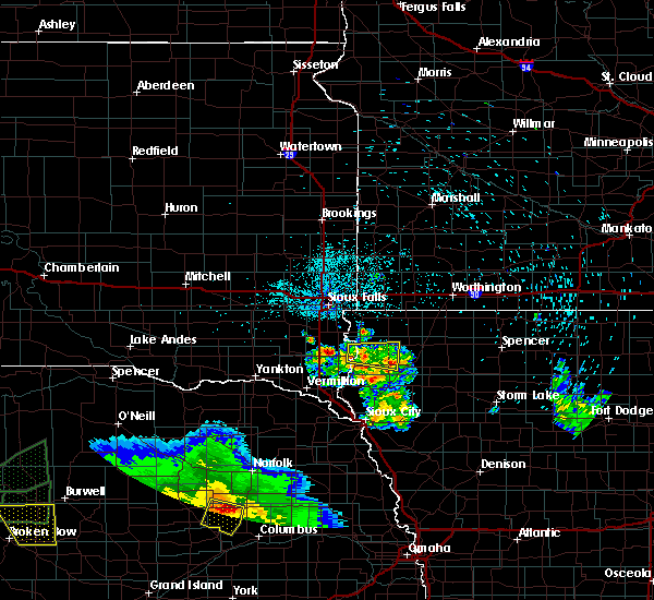 At 1012 pm cdt, a severe thunderstorm was located near sioux center, moving east at 30 mph (radar indicated). Hazards include 60 mph wind gusts and quarter size hail. Hail damage to vehicles is expected. expect wind damage to roofs, siding, and trees. This severe storm will be near, sioux center and hull around 1025 pm cdt. At 1012 pm cdt, a severe thunderstorm was located near sioux center, moving east at 30 mph (radar indicated). Hazards include 60 mph wind gusts and quarter size hail. Hail damage to vehicles is expected. expect wind damage to roofs, siding, and trees. This severe storm will be near, sioux center and hull around 1025 pm cdt.
|
| 8/19/2017 10:12 PM CDT |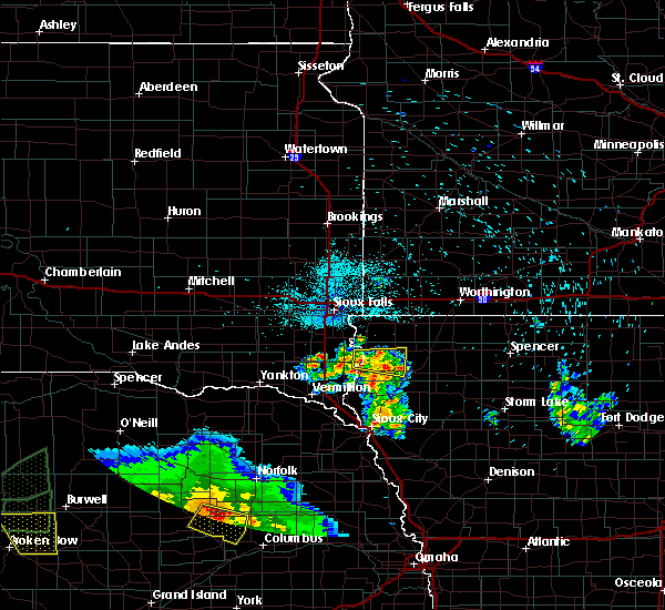
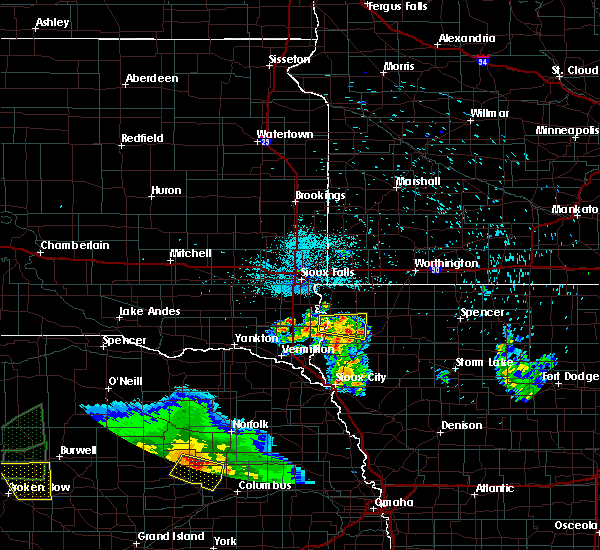 At 1012 pm cdt, a severe thunderstorm was located near sioux center, moving east at 30 mph (radar indicated). Hazards include 60 mph wind gusts and quarter size hail. Hail damage to vehicles is expected. expect wind damage to roofs, siding, and trees. This severe storm will be near, sioux center and hull around 1025 pm cdt. At 1012 pm cdt, a severe thunderstorm was located near sioux center, moving east at 30 mph (radar indicated). Hazards include 60 mph wind gusts and quarter size hail. Hail damage to vehicles is expected. expect wind damage to roofs, siding, and trees. This severe storm will be near, sioux center and hull around 1025 pm cdt.
|
| 8/19/2017 9:54 PM CDT |
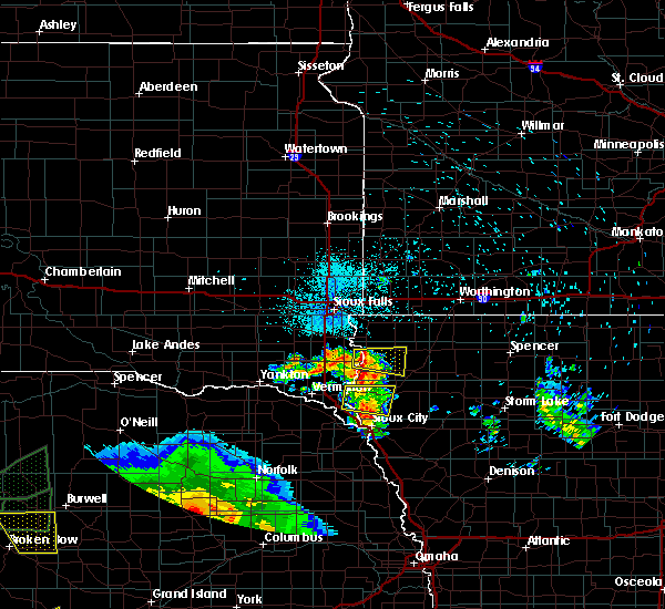 At 954 pm cdt, a severe thunderstorm was located over hudson, or near hawarden, moving east at 30 mph (radar indicated). Hazards include 60 mph wind gusts and quarter size hail. Hail damage to vehicles is expected. expect wind damage to roofs, siding, and trees. This severe thunderstorm will be near, sioux center and maurice around 1025 pm cdt. At 954 pm cdt, a severe thunderstorm was located over hudson, or near hawarden, moving east at 30 mph (radar indicated). Hazards include 60 mph wind gusts and quarter size hail. Hail damage to vehicles is expected. expect wind damage to roofs, siding, and trees. This severe thunderstorm will be near, sioux center and maurice around 1025 pm cdt.
|
| 6/29/2017 12:16 PM CDT |
 At 516 pm cdt, a severe thunderstorm was located near ireton, or near sioux center, moving northeast at 20 mph (radar indicated). Hazards include ping pong ball size hail and 60 mph wind gusts. People and animals outdoors will be injured. expect hail damage to roofs, siding, windows, and vehicles. expect wind damage to roofs, siding, and trees. this severe storm will be near, orange city around 535 pm cdt. sioux center around 540 pm cdt. hull around 545 pm cdt. At 508 pm cdt, half dollar hail was reported in ireton. At 516 pm cdt, a severe thunderstorm was located near ireton, or near sioux center, moving northeast at 20 mph (radar indicated). Hazards include ping pong ball size hail and 60 mph wind gusts. People and animals outdoors will be injured. expect hail damage to roofs, siding, windows, and vehicles. expect wind damage to roofs, siding, and trees. this severe storm will be near, orange city around 535 pm cdt. sioux center around 540 pm cdt. hull around 545 pm cdt. At 508 pm cdt, half dollar hail was reported in ireton.
|
| 6/29/2017 11:54 AM CDT |
 At 452 pm cdt, a severe thunderstorm was located over craig, or 8 miles southeast of hawarden, moving north at 30 mph (radar indicated). Hazards include ping pong ball size hail and 60 mph wind gusts. People and animals outdoors will be injured. expect hail damage to roofs, siding, windows, and vehicles. expect wind damage to roofs, siding, and trees. this severe thunderstorm will be near, ireton around 500 pm cdt. maurice around 505 pm cdt. sioux center around 520 pm cdt. Rock valley and hull around 535 pm cdt. At 452 pm cdt, a severe thunderstorm was located over craig, or 8 miles southeast of hawarden, moving north at 30 mph (radar indicated). Hazards include ping pong ball size hail and 60 mph wind gusts. People and animals outdoors will be injured. expect hail damage to roofs, siding, windows, and vehicles. expect wind damage to roofs, siding, and trees. this severe thunderstorm will be near, ireton around 500 pm cdt. maurice around 505 pm cdt. sioux center around 520 pm cdt. Rock valley and hull around 535 pm cdt.
|
| 6/13/2017 9:58 PM CDT |
 At 957 pm cdt, severe thunderstorms were located along a line extending from near ghent to near hawarden, moving east at 20 mph (radar indicated). Hazards include 70 mph wind gusts and penny size hail. Expect considerable tree damage. damage is likely to mobile homes, roofs, and outbuildings. severe thunderstorms will be near, minneota and ghent around 1005 pm cdt. marshall around 1015 pm cdt. cottonwood around 1035 pm cdt. other locations impacted by these severe thunderstorms include kenneth, avoca, lynd, garvin, hadley, kinbrae, dundee, steen, iona and magnolia. precautionary/preparedness actions, for your protection move to an interior room on the lowest floor of a building. this is a dangerous situation. these storms are producing widespread wind damage across parts of southwest minnesota. Seek shelter now inside a sturdy structure and stay away from windows! && a tornado watch remains in effect until 200 am cdt for northwestern iowa, and southwestern minnesota. At 957 pm cdt, severe thunderstorms were located along a line extending from near ghent to near hawarden, moving east at 20 mph (radar indicated). Hazards include 70 mph wind gusts and penny size hail. Expect considerable tree damage. damage is likely to mobile homes, roofs, and outbuildings. severe thunderstorms will be near, minneota and ghent around 1005 pm cdt. marshall around 1015 pm cdt. cottonwood around 1035 pm cdt. other locations impacted by these severe thunderstorms include kenneth, avoca, lynd, garvin, hadley, kinbrae, dundee, steen, iona and magnolia. precautionary/preparedness actions, for your protection move to an interior room on the lowest floor of a building. this is a dangerous situation. these storms are producing widespread wind damage across parts of southwest minnesota. Seek shelter now inside a sturdy structure and stay away from windows! && a tornado watch remains in effect until 200 am cdt for northwestern iowa, and southwestern minnesota.
|
| 6/13/2017 9:36 PM CDT |
 At 936 pm cdt, severe thunderstorms were located along a line extending from near sherman to near newton hills state park, moving northeast at 50 mph (radar indicated). Hazards include 70 mph wind gusts and nickel size hail. Expect considerable tree damage. damage is likely to mobile homes, roofs, and outbuildings. these severe storms will be near, garretson around 940 pm cdt. rock valley and hardwick around 950 pm cdt. doon and alvord around 955 pm cdt. rock rapids and lester around 1000 pm cdt. other locations impacted by these severe thunderstorms include magnolia, kenneth and steen. A tornado watch remains in effect until 200 am cdt for northwestern iowa, southwestern minnesota, and southeastern south dakota. At 936 pm cdt, severe thunderstorms were located along a line extending from near sherman to near newton hills state park, moving northeast at 50 mph (radar indicated). Hazards include 70 mph wind gusts and nickel size hail. Expect considerable tree damage. damage is likely to mobile homes, roofs, and outbuildings. these severe storms will be near, garretson around 940 pm cdt. rock valley and hardwick around 950 pm cdt. doon and alvord around 955 pm cdt. rock rapids and lester around 1000 pm cdt. other locations impacted by these severe thunderstorms include magnolia, kenneth and steen. A tornado watch remains in effect until 200 am cdt for northwestern iowa, southwestern minnesota, and southeastern south dakota.
|
| 6/13/2017 9:27 PM CDT |
 At 926 pm cdt, a severe thunderstorm was located near lake alvin state recreation area, or 7 miles north of canton, moving east at 35 mph (radar indicated). Hazards include 70 mph wind gusts and nickel size hail. Expect considerable tree damage. damage is likely to mobile homes, roofs, and outbuildings. this severe storm will be near, inwood around 935 pm cdt. larchwood around 940 pm cdt. hills, lester and alvord around 945 pm cdt. rock rapids around 1000 pm cdt. other locations impacted by this severe thunderstorm include magnolia, kenneth and steen. at 925 pm cdt, the strongest winds were likely near lake alvin and heading towards hudson and fairview. A tornado watch remains in effect until 200 am cdt for northwestern iowa, southwestern minnesota, and southeastern south dakota. At 926 pm cdt, a severe thunderstorm was located near lake alvin state recreation area, or 7 miles north of canton, moving east at 35 mph (radar indicated). Hazards include 70 mph wind gusts and nickel size hail. Expect considerable tree damage. damage is likely to mobile homes, roofs, and outbuildings. this severe storm will be near, inwood around 935 pm cdt. larchwood around 940 pm cdt. hills, lester and alvord around 945 pm cdt. rock rapids around 1000 pm cdt. other locations impacted by this severe thunderstorm include magnolia, kenneth and steen. at 925 pm cdt, the strongest winds were likely near lake alvin and heading towards hudson and fairview. A tornado watch remains in effect until 200 am cdt for northwestern iowa, southwestern minnesota, and southeastern south dakota.
|
| 6/13/2017 9:13 PM CDT |
 At 913 pm cdt, a severe thunderstorm was located near harrisburg, or near sioux falls, moving northeast at 55 mph (radar indicated). Hazards include 70 mph wind gusts and nickel size hail. Expect considerable tree damage. damage is likely to mobile homes, roofs, and outbuildings. this severe thunderstorm will be near, rowena around 920 pm cdt. brandon and larchwood around 925 pm cdt. valley springs and hills around 930 pm cdt. beaver creek around 935 pm cdt. luverne and blue mounds state park around 945 pm cdt. hardwick around 950 pm cdt. other locations impacted by this severe thunderstorm include magnolia, kenneth and steen. A tornado watch remains in effect until 200 am cdt for northwestern iowa, southwestern minnesota, and southeastern south dakota. At 913 pm cdt, a severe thunderstorm was located near harrisburg, or near sioux falls, moving northeast at 55 mph (radar indicated). Hazards include 70 mph wind gusts and nickel size hail. Expect considerable tree damage. damage is likely to mobile homes, roofs, and outbuildings. this severe thunderstorm will be near, rowena around 920 pm cdt. brandon and larchwood around 925 pm cdt. valley springs and hills around 930 pm cdt. beaver creek around 935 pm cdt. luverne and blue mounds state park around 945 pm cdt. hardwick around 950 pm cdt. other locations impacted by this severe thunderstorm include magnolia, kenneth and steen. A tornado watch remains in effect until 200 am cdt for northwestern iowa, southwestern minnesota, and southeastern south dakota.
|
| 6/12/2017 12:36 PM CDT |
 At 1236 pm cdt, a severe thunderstorm was located near hudson, or 9 miles northeast of hawarden, moving east at 40 mph (radar indicated). Hazards include 60 mph wind gusts. Expect damage to roofs, siding, and trees. This severe storm will be near, sioux center around 1250 pm cdt. At 1236 pm cdt, a severe thunderstorm was located near hudson, or 9 miles northeast of hawarden, moving east at 40 mph (radar indicated). Hazards include 60 mph wind gusts. Expect damage to roofs, siding, and trees. This severe storm will be near, sioux center around 1250 pm cdt.
|
| 6/12/2017 12:08 PM CDT |
 At 1208 pm cdt, a severe thunderstorm was located 7 miles west of newton hills state park, or 8 miles north of beresford, moving east at 40 mph (radar indicated). Hazards include 60 mph wind gusts. Expect damage to roofs, siding, and trees. this severe thunderstorm will be near, newton hills state park around 1220 pm cdt. fairview around 1225 pm cdt. hudson around 1230 pm cdt. rock valley around 1240 pm cdt. Sioux center around 1250 pm cdt. At 1208 pm cdt, a severe thunderstorm was located 7 miles west of newton hills state park, or 8 miles north of beresford, moving east at 40 mph (radar indicated). Hazards include 60 mph wind gusts. Expect damage to roofs, siding, and trees. this severe thunderstorm will be near, newton hills state park around 1220 pm cdt. fairview around 1225 pm cdt. hudson around 1230 pm cdt. rock valley around 1240 pm cdt. Sioux center around 1250 pm cdt.
|
| 8/11/2016 3:15 AM CDT |
 At 315 am cdt, severe thunderstorms were located along a line extending from alvord to near rock valley, moving east at 40 mph (radar indicated). Hazards include 60 mph wind gusts. Expect damage to roofs. siding. and trees. severe thunderstorms will be near, sioux center, hull and doon around 325 am cdt. george around 335 am cdt. orange city and boyden around 340 am cdt. Sheldon, alton, hospers, granville and matlock around 345 am cdt. At 315 am cdt, severe thunderstorms were located along a line extending from alvord to near rock valley, moving east at 40 mph (radar indicated). Hazards include 60 mph wind gusts. Expect damage to roofs. siding. and trees. severe thunderstorms will be near, sioux center, hull and doon around 325 am cdt. george around 335 am cdt. orange city and boyden around 340 am cdt. Sheldon, alton, hospers, granville and matlock around 345 am cdt.
|
| 7/17/2016 12:41 AM CDT |
 At 1240 am cdt, a severe thunderstorm was located over inwood, or near canton, moving east at 65 mph (radar indicated). Hazards include 70 mph wind gusts. Expect considerable tree damage. damage is likely to mobile homes, roofs, and outbuildings. this severe thunderstorm will be near, alvord around 1245 am cdt. rock valley and doon around 1250 am cdt. hull around 1255 am cdt. george and boyden around 100 am cdt. Matlock around 105 am cdt. At 1240 am cdt, a severe thunderstorm was located over inwood, or near canton, moving east at 65 mph (radar indicated). Hazards include 70 mph wind gusts. Expect considerable tree damage. damage is likely to mobile homes, roofs, and outbuildings. this severe thunderstorm will be near, alvord around 1245 am cdt. rock valley and doon around 1250 am cdt. hull around 1255 am cdt. george and boyden around 100 am cdt. Matlock around 105 am cdt.
|
| 6/17/2016 8:44 PM CDT |
 At 842 pm cdt, severe thunderstorms were located along a line extending from 6 miles south of worthing to near granville, moving south at 20 mph (trained weather spotters. widespread spotter and public reports of 50 mph with occasional gusts to 60 mph). Hazards include prolonged 60 mph wind gusts and penny size hail. Expect damage to roofs. siding. and trees. Locations impacted include, spencer in clay county, sioux center, orange city, sheldon, canton, sibley, rock rapids, rock valley, milford, hull, hartley, sanborn, alton, arnolds park, george, paullina, primghar, larchwood, inwood and okoboji. At 842 pm cdt, severe thunderstorms were located along a line extending from 6 miles south of worthing to near granville, moving south at 20 mph (trained weather spotters. widespread spotter and public reports of 50 mph with occasional gusts to 60 mph). Hazards include prolonged 60 mph wind gusts and penny size hail. Expect damage to roofs. siding. and trees. Locations impacted include, spencer in clay county, sioux center, orange city, sheldon, canton, sibley, rock rapids, rock valley, milford, hull, hartley, sanborn, alton, arnolds park, george, paullina, primghar, larchwood, inwood and okoboji.
|
| 6/17/2016 8:40 PM CDT | Tree branches down and there was a power outag in sioux county IA, 0.5 miles ENE of Rock Valley, IA |
| 6/17/2016 8:18 PM CDT |
 At 818 pm cdt, severe thunderstorms were located along a line extending from near worthing to near hospers, moving south at 20 mph (trained weather spotters). Hazards include prolonged 60 mph wind gusts and penny size hail. Expect damage to roofs. siding. And trees. At 818 pm cdt, severe thunderstorms were located along a line extending from near worthing to near hospers, moving south at 20 mph (trained weather spotters). Hazards include prolonged 60 mph wind gusts and penny size hail. Expect damage to roofs. siding. And trees.
|
| 7/6/2015 1:53 AM CDT |
 The severe thunderstorm warning for southern lyon, sioux, western plymouth, northern union and southeastern lincoln counties will expire at 200 am cdt, the storms which prompted the warning have weakened below severe limits, and exited the warned area. therefore the warning will be allowed to expire. however gusty winds and heavy rain are still possible with these thunderstorms. a severe thunderstorm watch remains in effect until 400 am cdt for northwestern iowa and southeastern south dakota. The severe thunderstorm warning for southern lyon, sioux, western plymouth, northern union and southeastern lincoln counties will expire at 200 am cdt, the storms which prompted the warning have weakened below severe limits, and exited the warned area. therefore the warning will be allowed to expire. however gusty winds and heavy rain are still possible with these thunderstorms. a severe thunderstorm watch remains in effect until 400 am cdt for northwestern iowa and southeastern south dakota.
|
| 7/6/2015 1:35 AM CDT |
 At 134 am cdt, severe thunderstorms were located along a line extending from near inwood to near hawarden to elk point, moving east at 45 mph (radar indicated). Hazards include 70 mph wind gusts. Expect considerable tree damage. damage is likely to mobile homes, roofs and outbuildings. these severe storms will be near, ireton around 140 am cdt. rock valley and alvord around 145 am cdt. sioux center, doon and maurice around 150 am cdt. hull around 155 am cdt. hinton and merrill around 200 am cdt. Other locations impacted by these severe thunderstorms include brunsville, westfield and chatsworth. At 134 am cdt, severe thunderstorms were located along a line extending from near inwood to near hawarden to elk point, moving east at 45 mph (radar indicated). Hazards include 70 mph wind gusts. Expect considerable tree damage. damage is likely to mobile homes, roofs and outbuildings. these severe storms will be near, ireton around 140 am cdt. rock valley and alvord around 145 am cdt. sioux center, doon and maurice around 150 am cdt. hull around 155 am cdt. hinton and merrill around 200 am cdt. Other locations impacted by these severe thunderstorms include brunsville, westfield and chatsworth.
|
| 7/6/2015 1:24 AM CDT |
 At 122 am cdt, severe thunderstorms were located along a line extending from near canton to near alcester to 6 miles northeast of newcastle, moving east at 50 mph (radar indicated). Hazards include 70 mph wind gusts. Expect considerable tree damage. damage is likely to mobile homes, roofs and outbuildings. these severe storms will be near, newton hills state park around 125 am cdt. canton, hawarden, hudson and fairview around 130 am cdt. inwood around 135 am cdt. akron, ireton and alvord around 140 am cdt. sioux center, doon and maurice around 145 am cdt. The area of strongest winds will likely impact areas from east of beresford, through hudson, toward sioux center and orange city. At 122 am cdt, severe thunderstorms were located along a line extending from near canton to near alcester to 6 miles northeast of newcastle, moving east at 50 mph (radar indicated). Hazards include 70 mph wind gusts. Expect considerable tree damage. damage is likely to mobile homes, roofs and outbuildings. these severe storms will be near, newton hills state park around 125 am cdt. canton, hawarden, hudson and fairview around 130 am cdt. inwood around 135 am cdt. akron, ireton and alvord around 140 am cdt. sioux center, doon and maurice around 145 am cdt. The area of strongest winds will likely impact areas from east of beresford, through hudson, toward sioux center and orange city.
|
| 7/6/2015 1:11 AM CDT |
 At 111 am cdt, severe thunderstorms were located along a line extending from worthing to vermillion, moving east at 50 mph (radar indicated). Hazards include 60 mph wind gusts. Expect damage to roofs. siding and trees. severe thunderstorms will be near, canton and newton hills state park around 125 am cdt. elk point and fairview around 130 am cdt. inwood around 135 am cdt. alvord around 140 am cdt. rock valley and doon around 145 am cdt. sioux center, hull, hinton and merrill around 155 am cdt. Other locations impacted by these severe thunderstorms include brunsville, westfield and chatsworth. At 111 am cdt, severe thunderstorms were located along a line extending from worthing to vermillion, moving east at 50 mph (radar indicated). Hazards include 60 mph wind gusts. Expect damage to roofs. siding and trees. severe thunderstorms will be near, canton and newton hills state park around 125 am cdt. elk point and fairview around 130 am cdt. inwood around 135 am cdt. alvord around 140 am cdt. rock valley and doon around 145 am cdt. sioux center, hull, hinton and merrill around 155 am cdt. Other locations impacted by these severe thunderstorms include brunsville, westfield and chatsworth.
|
| 6/22/2015 5:41 AM CDT |
 The severe thunderstorm warning for lyon, northern sioux, osceola, northwestern o`brien, nobles, rock, southeastern minnehaha and central lincoln counties will expire at 545 am cdt, the storms which prompted the warning have moved out of the area. therefore the warning will be allowed to expire. a severe thunderstorm watch remains in effect until 1000 am cdt for northwestern iowa, southwestern minnesota and southeastern south dakota. The severe thunderstorm warning for lyon, northern sioux, osceola, northwestern o`brien, nobles, rock, southeastern minnehaha and central lincoln counties will expire at 545 am cdt, the storms which prompted the warning have moved out of the area. therefore the warning will be allowed to expire. a severe thunderstorm watch remains in effect until 1000 am cdt for northwestern iowa, southwestern minnesota and southeastern south dakota.
|
| 6/22/2015 5:37 AM CDT |
 At 537 am cdt, severe thunderstorms were located along a line extending from 6 miles north of jefferson to near boyden, moving east at 75 mph (radar indicated). Hazards include 60 mph wind gusts. Expect damage to roofs. siding and trees. these severe storms will be near, hospers around 540 am cdt. sioux city, hinton, merrill and granville around 545 am cdt. paullina, primghar and archer around 550 am cdt. Other locations impacted by these severe thunderstorms include brunsville, oyens, westfield and chatsworth. At 537 am cdt, severe thunderstorms were located along a line extending from 6 miles north of jefferson to near boyden, moving east at 75 mph (radar indicated). Hazards include 60 mph wind gusts. Expect damage to roofs. siding and trees. these severe storms will be near, hospers around 540 am cdt. sioux city, hinton, merrill and granville around 545 am cdt. paullina, primghar and archer around 550 am cdt. Other locations impacted by these severe thunderstorms include brunsville, oyens, westfield and chatsworth.
|
| 6/22/2015 5:33 AM CDT |
 At 532 am cdt, severe thunderstorms were located along a line extending from 6 miles northeast of rushmore to near sibley to near matlock, moving east at 65 mph (radar indicated). Hazards include 70 mph wind gusts. Expect considerable tree damage. damage is likely to mobile homes, roofs and outbuildings. these severe storms will be near, worthington around 540 am cdt. ocheyedan, brewster and round lake around 545 am cdt. Other locations impacted by these severe thunderstorms include bigelow, magnolia, steen and kenneth. At 532 am cdt, severe thunderstorms were located along a line extending from 6 miles northeast of rushmore to near sibley to near matlock, moving east at 65 mph (radar indicated). Hazards include 70 mph wind gusts. Expect considerable tree damage. damage is likely to mobile homes, roofs and outbuildings. these severe storms will be near, worthington around 540 am cdt. ocheyedan, brewster and round lake around 545 am cdt. Other locations impacted by these severe thunderstorms include bigelow, magnolia, steen and kenneth.
|
| 6/22/2015 5:20 AM CDT |
 At 520 am cdt, severe thunderstorms were located along a line extending from near vermillion to near hudson, moving east at 70 mph (radar indicated). Hazards include 60 mph wind gusts. Expect damage to roofs. siding and trees. severe thunderstorms will be near, rock valley around 525 am cdt. sioux center and hull around 530 am cdt. orange city around 535 am cdt. alton and hospers around 540 am cdt. sioux city, hinton, merrill and granville around 545 am cdt. paullina and archer around 550 am cdt. primghar around 555 am cdt. Other locations impacted by these severe thunderstorms include brunsville, oyens, westfield and chatsworth. At 520 am cdt, severe thunderstorms were located along a line extending from near vermillion to near hudson, moving east at 70 mph (radar indicated). Hazards include 60 mph wind gusts. Expect damage to roofs. siding and trees. severe thunderstorms will be near, rock valley around 525 am cdt. sioux center and hull around 530 am cdt. orange city around 535 am cdt. alton and hospers around 540 am cdt. sioux city, hinton, merrill and granville around 545 am cdt. paullina and archer around 550 am cdt. primghar around 555 am cdt. Other locations impacted by these severe thunderstorms include brunsville, oyens, westfield and chatsworth.
|
| 6/22/2015 5:15 AM CDT |
 At 514 am cdt, severe thunderstorms were located along a line extending from near hardwick to 6 miles west of ellsworth to near inwood, moving east at 70 mph. these are very dangerous storms (radar indicated). Hazards include 80 mph wind gusts. Flying debris will be dangerous to those caught without shelter. mobile homes will be heavily damaged. expect considerable damage to roofs, windows and vehicles. extensive tree damage and power outages are likely. these severe storms will be near, ellsworth, leota and lismore around 520 am cdt. adrian, little rock and wilmont around 525 am cdt. george and rushmore around 530 am cdt. matlock around 535 am cdt. worthington, ocheyedan and ashton around 540 am cdt. sibley, brewster and round lake around 545 am cdt. Other locations impacted by these severe thunderstorms include bigelow, magnolia, steen and kenneth. At 514 am cdt, severe thunderstorms were located along a line extending from near hardwick to 6 miles west of ellsworth to near inwood, moving east at 70 mph. these are very dangerous storms (radar indicated). Hazards include 80 mph wind gusts. Flying debris will be dangerous to those caught without shelter. mobile homes will be heavily damaged. expect considerable damage to roofs, windows and vehicles. extensive tree damage and power outages are likely. these severe storms will be near, ellsworth, leota and lismore around 520 am cdt. adrian, little rock and wilmont around 525 am cdt. george and rushmore around 530 am cdt. matlock around 535 am cdt. worthington, ocheyedan and ashton around 540 am cdt. sibley, brewster and round lake around 545 am cdt. Other locations impacted by these severe thunderstorms include bigelow, magnolia, steen and kenneth.
|
| 6/22/2015 5:06 AM CDT |
 At 506 am cdt, severe thunderstorms were located along a line extending from 6 miles west of hardwick to hills to near canton, moving east at 65 mph. these are very dangerous storms (radar indicated). Hazards include 100 mph wind gusts. You are in a life-threatening situation. flying debris may be deadly to those caught without shelter. mobile homes will be destroyed. expect considerable damage to homes and businesses. expect extensive tree damage and power outages. severe thunderstorms will be near, lester and hardwick around 510 am cdt. luverne, rock rapids and blue mounds state park around 515 am cdt. ellsworth and alvord around 520 am cdt. rock valley, adrian, doon and lismore around 525 am cdt. hull, little rock, rushmore and wilmont around 530 am cdt. sibley, george and boyden around 535 am cdt. worthington and matlock around 540 am cdt. sheldon, ocheyedan, brewster and round lake around 545 am cdt. Other locations impacted by these severe thunderstorms include bigelow, magnolia, steen and kenneth. At 506 am cdt, severe thunderstorms were located along a line extending from 6 miles west of hardwick to hills to near canton, moving east at 65 mph. these are very dangerous storms (radar indicated). Hazards include 100 mph wind gusts. You are in a life-threatening situation. flying debris may be deadly to those caught without shelter. mobile homes will be destroyed. expect considerable damage to homes and businesses. expect extensive tree damage and power outages. severe thunderstorms will be near, lester and hardwick around 510 am cdt. luverne, rock rapids and blue mounds state park around 515 am cdt. ellsworth and alvord around 520 am cdt. rock valley, adrian, doon and lismore around 525 am cdt. hull, little rock, rushmore and wilmont around 530 am cdt. sibley, george and boyden around 535 am cdt. worthington and matlock around 540 am cdt. sheldon, ocheyedan, brewster and round lake around 545 am cdt. Other locations impacted by these severe thunderstorms include bigelow, magnolia, steen and kenneth.
|
| 9/19/2014 9:55 PM CDT | Quarter sized hail reported 6.1 miles NE of Rock Valley, IA |
| 6/16/2014 1:30 PM CDT | Half Dollar sized hail reported 0.5 miles ENE of Rock Valley, IA |
| 6/16/2014 1:30 PM CDT | 8 inch diameter tree branch down in tow in sioux county IA, 0.5 miles ENE of Rock Valley, IA |
| 5/4/2012 9:45 PM CDT | Quarter sized hail reported 2.6 miles W of Rock Valley, IA, a few quarter size...most stones were smaller. |
| 5/4/2012 9:36 PM CDT | Half Dollar sized hail reported 0.5 miles ENE of Rock Valley, IA |
| 5/1/2012 7:22 PM CDT | Ping Pong Ball sized hail reported 11.5 miles ESE of Rock Valley, IA |
Hail Maps for Rock Valley, IA
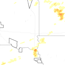
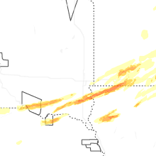


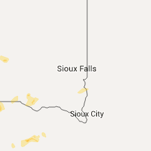


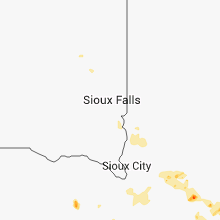


Connect with Interactive Hail Maps