

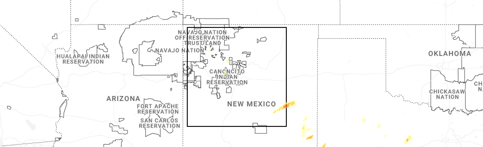
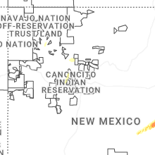
Hail Map for San Luis, NM
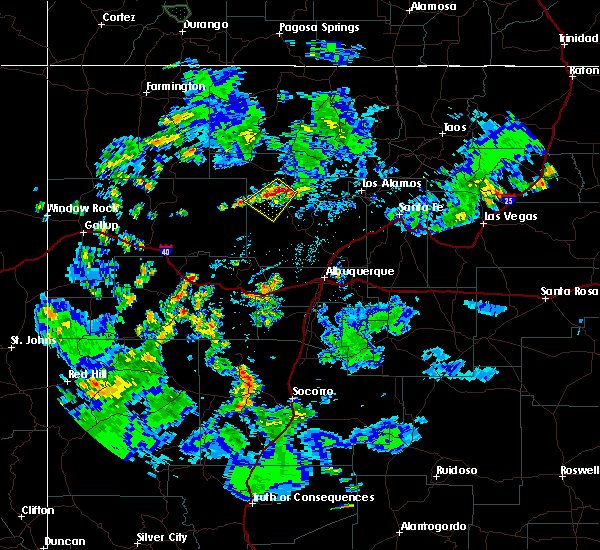
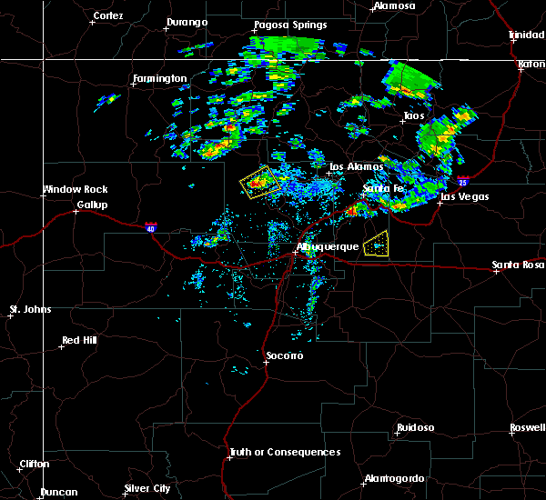
The San Luis, NM area has had 0 reports of on-the-ground hail by trained spotters, and has been under severe weather warnings 0 times during the past 12 months. Doppler radar has detected hail at or near San Luis, NM on 16 occasions, including 3 occasions during the past year.
| Name: | San Luis, NM |
| Where Located: | 47.6 miles NNW of Albuquerque, NM |
| Map: | Google Map for San Luis, NM |
| Population: | 59 |
| Housing Units: | 52 |
| More Info: | Search Google for San Luis, NM |
5
The Top Recent Hail Date for San Luis, NM is Monday, May 5, 2025 (1st out of 16)
Hail and Wind Damage Spotted near San Luis, NM
| Date / Time | Report Details |
|---|---|
| 7/12/2021 4:08 PM MDT |
 At 408 pm mdt, a severe thunderstorm was located near fenton lake state park, or 16 miles southeast of cuba, moving southwest at 15 mph (radar indicated). Hazards include 60 mph wind gusts and quarter size hail. Hail damage to vehicles is expected. Expect wind damage to roofs, siding, and trees. At 408 pm mdt, a severe thunderstorm was located near fenton lake state park, or 16 miles southeast of cuba, moving southwest at 15 mph (radar indicated). Hazards include 60 mph wind gusts and quarter size hail. Hail damage to vehicles is expected. Expect wind damage to roofs, siding, and trees.
|
| 7/13/2018 5:19 PM MDT |
 At 519 pm mdt, a severe thunderstorm was located 9 miles south of cuba, moving southwest at 10 mph (radar indicated). Hazards include 60 mph wind gusts and quarter size hail. Hail damage to vehicles is expected. Expect wind damage to roofs, siding, and trees. At 519 pm mdt, a severe thunderstorm was located 9 miles south of cuba, moving southwest at 10 mph (radar indicated). Hazards include 60 mph wind gusts and quarter size hail. Hail damage to vehicles is expected. Expect wind damage to roofs, siding, and trees.
|
| 5/21/2018 3:05 PM MDT |
 At 304 pm mdt, severe thunderstorms were located along a line extending from 7 miles west of san ysidro to 7 miles northwest of golden, moving north at 40 mph (radar indicated). Hazards include 70 mph wind gusts and quarter size hail. Hail damage to vehicles is expected. expect considerable tree damage. wind damage is also likely to mobile homes, roofs, and outbuildings. locations impacted include, rio rancho, bernalillo, santo domingo pueblo, jemez springs, san ysidro, mariposa, san felipe pueblo, coronado state monument, jemez pueblo and santa ana pueblo. This includes interstate 25 between mile markers 239 and 273. At 304 pm mdt, severe thunderstorms were located along a line extending from 7 miles west of san ysidro to 7 miles northwest of golden, moving north at 40 mph (radar indicated). Hazards include 70 mph wind gusts and quarter size hail. Hail damage to vehicles is expected. expect considerable tree damage. wind damage is also likely to mobile homes, roofs, and outbuildings. locations impacted include, rio rancho, bernalillo, santo domingo pueblo, jemez springs, san ysidro, mariposa, san felipe pueblo, coronado state monument, jemez pueblo and santa ana pueblo. This includes interstate 25 between mile markers 239 and 273.
|
| 5/21/2018 2:44 PM MDT |
 At 243 pm mdt, severe thunderstorms were located along a line extending from 12 miles northeast of marquez to sandia park, moving north at 35 mph (radar indicated). Hazards include 60 mph wind gusts and quarter size hail. Hail damage to vehicles is expected. Expect wind damage to roofs, siding, and trees. At 243 pm mdt, severe thunderstorms were located along a line extending from 12 miles northeast of marquez to sandia park, moving north at 35 mph (radar indicated). Hazards include 60 mph wind gusts and quarter size hail. Hail damage to vehicles is expected. Expect wind damage to roofs, siding, and trees.
|
| 10/5/2017 5:15 PM MDT |
 At 514 pm mdt, severe thunderstorms were located along a line extending from near torreon navajo mission to 20 miles south of ojo encino, moving northeast at 30 mph (radar indicated). Hazards include 60 mph wind gusts and quarter size hail. Hail damage to vehicles is expected. Expect wind damage to roofs, siding, and trees. At 514 pm mdt, severe thunderstorms were located along a line extending from near torreon navajo mission to 20 miles south of ojo encino, moving northeast at 30 mph (radar indicated). Hazards include 60 mph wind gusts and quarter size hail. Hail damage to vehicles is expected. Expect wind damage to roofs, siding, and trees.
|
| 9/30/2017 4:10 PM MDT |
 The severe thunderstorm warning for central sandoval county will expire at 415 pm mdt, the storm which prompted the warning has weakened below severe limits, and no longer poses an immediate threat to life or property. therefore the warning will be allowed to expire. however small hail, gusty winds and heavy rain are still possible with this thunderstorm. The severe thunderstorm warning for central sandoval county will expire at 415 pm mdt, the storm which prompted the warning has weakened below severe limits, and no longer poses an immediate threat to life or property. therefore the warning will be allowed to expire. however small hail, gusty winds and heavy rain are still possible with this thunderstorm.
|
| 9/30/2017 3:53 PM MDT |
 At 353 pm mdt, a severe thunderstorm was located near san ysidro, or 23 miles north of rio rancho, moving east at 20 mph (radar indicated). Hazards include 60 mph wind gusts and quarter size hail. Hail damage to vehicles is expected. expect wind damage to roofs, siding, and trees. Locations impacted include, jemez springs, san ysidro, zia pueblo, jemez state monument, jemez pueblo and ponderosa. At 353 pm mdt, a severe thunderstorm was located near san ysidro, or 23 miles north of rio rancho, moving east at 20 mph (radar indicated). Hazards include 60 mph wind gusts and quarter size hail. Hail damage to vehicles is expected. expect wind damage to roofs, siding, and trees. Locations impacted include, jemez springs, san ysidro, zia pueblo, jemez state monument, jemez pueblo and ponderosa.
|
| 9/30/2017 3:36 PM MDT |
 At 336 pm mdt, a severe thunderstorm was located near san ysidro, or 25 miles northwest of rio rancho, moving east at 20 mph (radar indicated). Hazards include 60 mph wind gusts and half dollar size hail. Hail damage to vehicles is expected. expect wind damage to roofs, siding, and trees. Locations impacted include, jemez springs, san ysidro, zia pueblo, jemez state monument, jemez pueblo and ponderosa. At 336 pm mdt, a severe thunderstorm was located near san ysidro, or 25 miles northwest of rio rancho, moving east at 20 mph (radar indicated). Hazards include 60 mph wind gusts and half dollar size hail. Hail damage to vehicles is expected. expect wind damage to roofs, siding, and trees. Locations impacted include, jemez springs, san ysidro, zia pueblo, jemez state monument, jemez pueblo and ponderosa.
|
| 9/30/2017 3:16 PM MDT |
 At 316 pm mdt, a severe thunderstorm was located 12 miles west of san ysidro, or 29 miles south of cuba, moving east at 20 mph (radar indicated). Hazards include 60 mph wind gusts and quarter size hail. Hail damage to vehicles is expected. Expect wind damage to roofs, siding, and trees. At 316 pm mdt, a severe thunderstorm was located 12 miles west of san ysidro, or 29 miles south of cuba, moving east at 20 mph (radar indicated). Hazards include 60 mph wind gusts and quarter size hail. Hail damage to vehicles is expected. Expect wind damage to roofs, siding, and trees.
|
| 5/15/2016 1:06 PM MDT |
 At 106 pm mdt, a severe thunderstorm was located 9 miles east of torreon navajo mission, or 17 miles south of cuba, moving northeast at 15 mph (radar indicated). Hazards include golf ball size hail and 60 mph wind gusts. People and animals outdoors will be injured. expect hail damage to roofs, siding, windows and vehicles. expect wind damage to roofs, siding and trees. This severe thunderstorm will remain over mainly rural areas of central sandoval county. At 106 pm mdt, a severe thunderstorm was located 9 miles east of torreon navajo mission, or 17 miles south of cuba, moving northeast at 15 mph (radar indicated). Hazards include golf ball size hail and 60 mph wind gusts. People and animals outdoors will be injured. expect hail damage to roofs, siding, windows and vehicles. expect wind damage to roofs, siding and trees. This severe thunderstorm will remain over mainly rural areas of central sandoval county.
|
Hail Maps for San Luis, NM


Connect with Interactive Hail Maps