

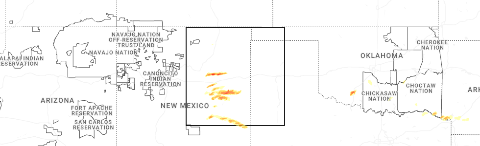
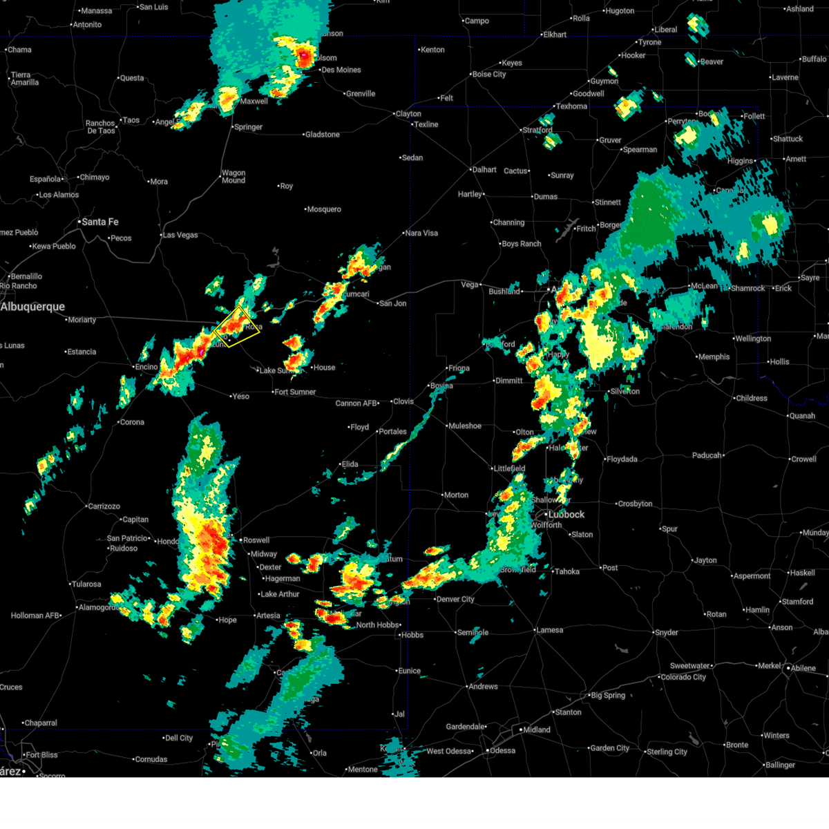
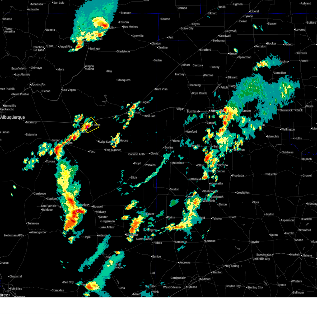
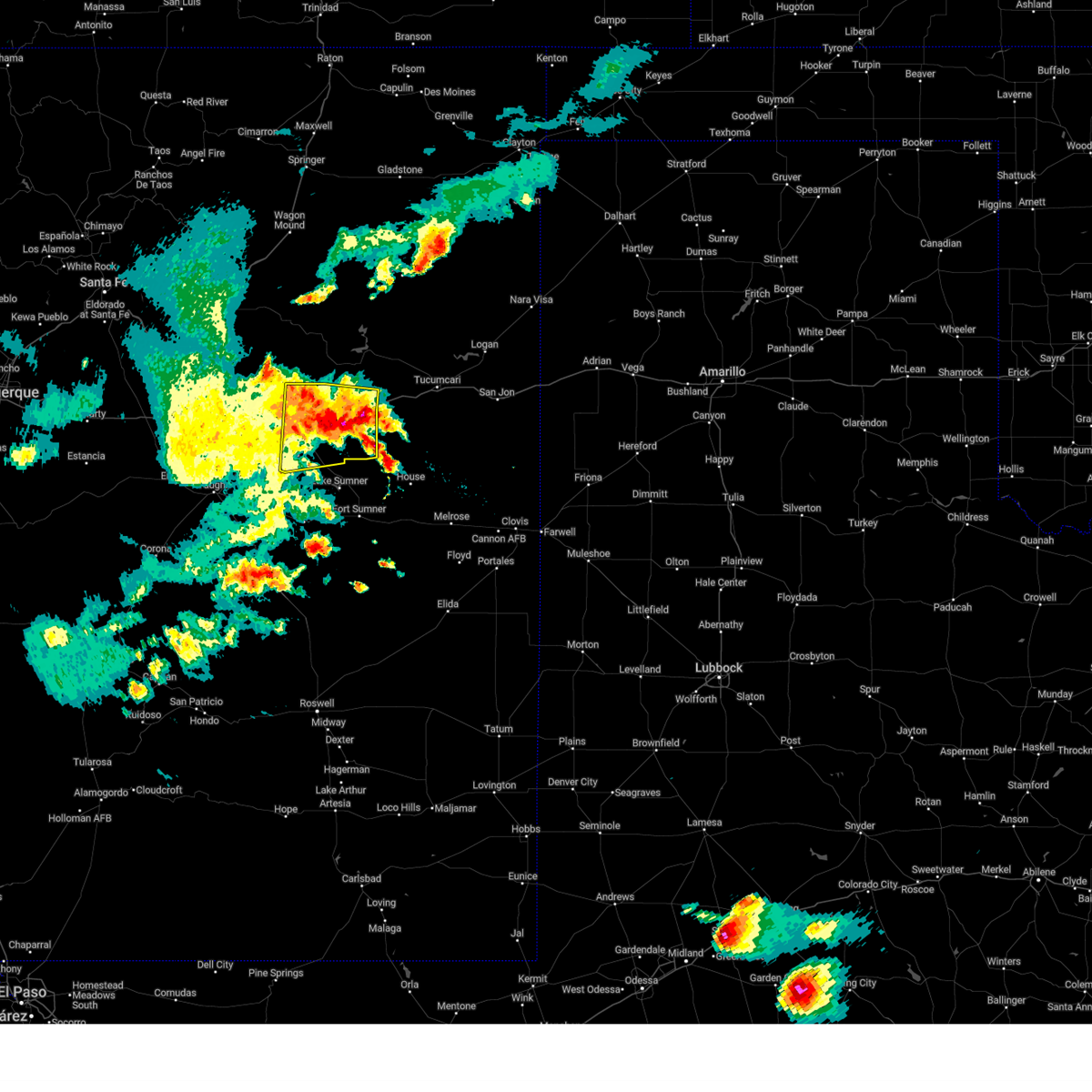
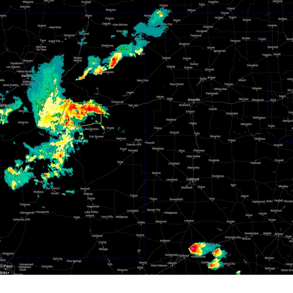
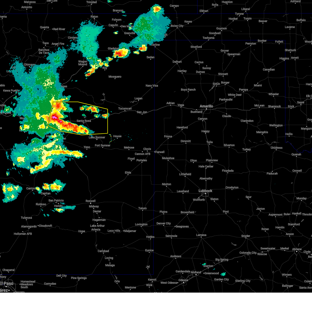
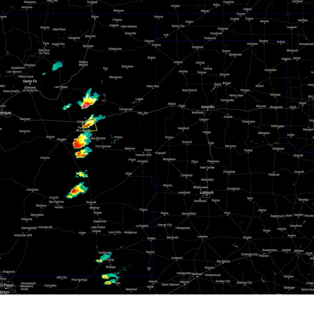
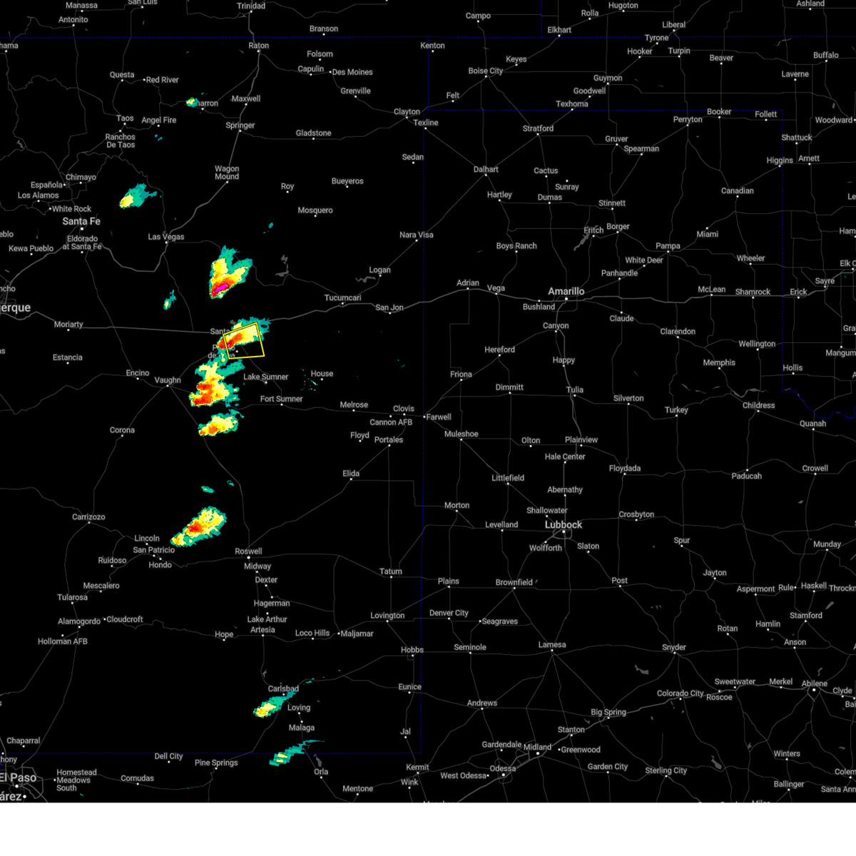
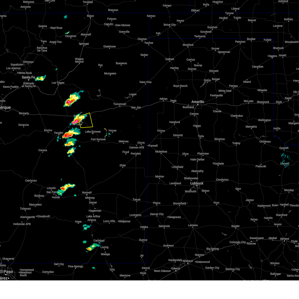
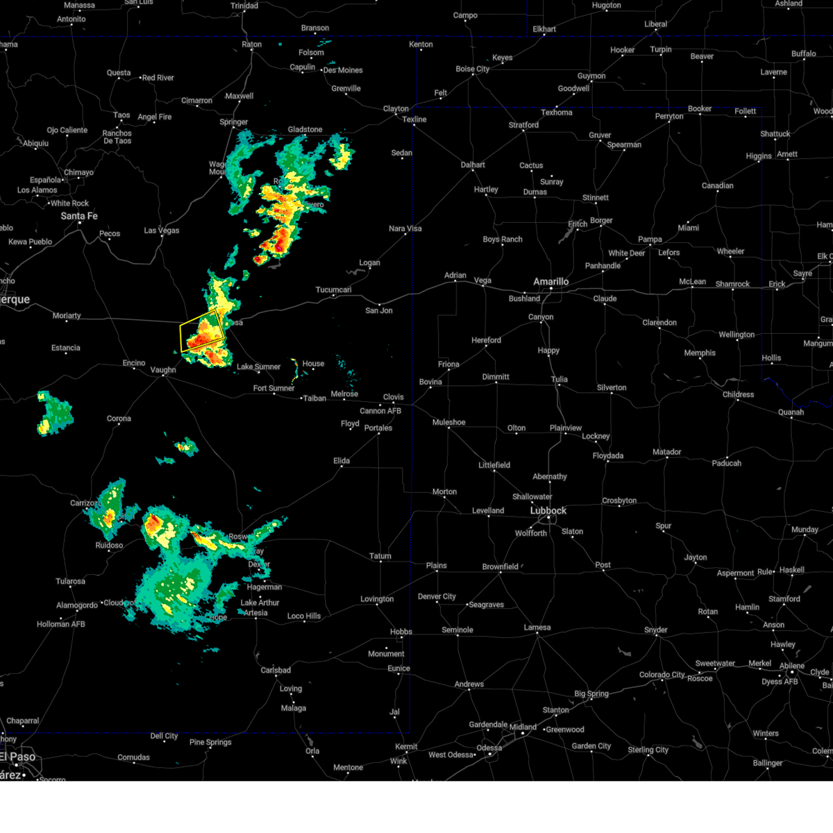
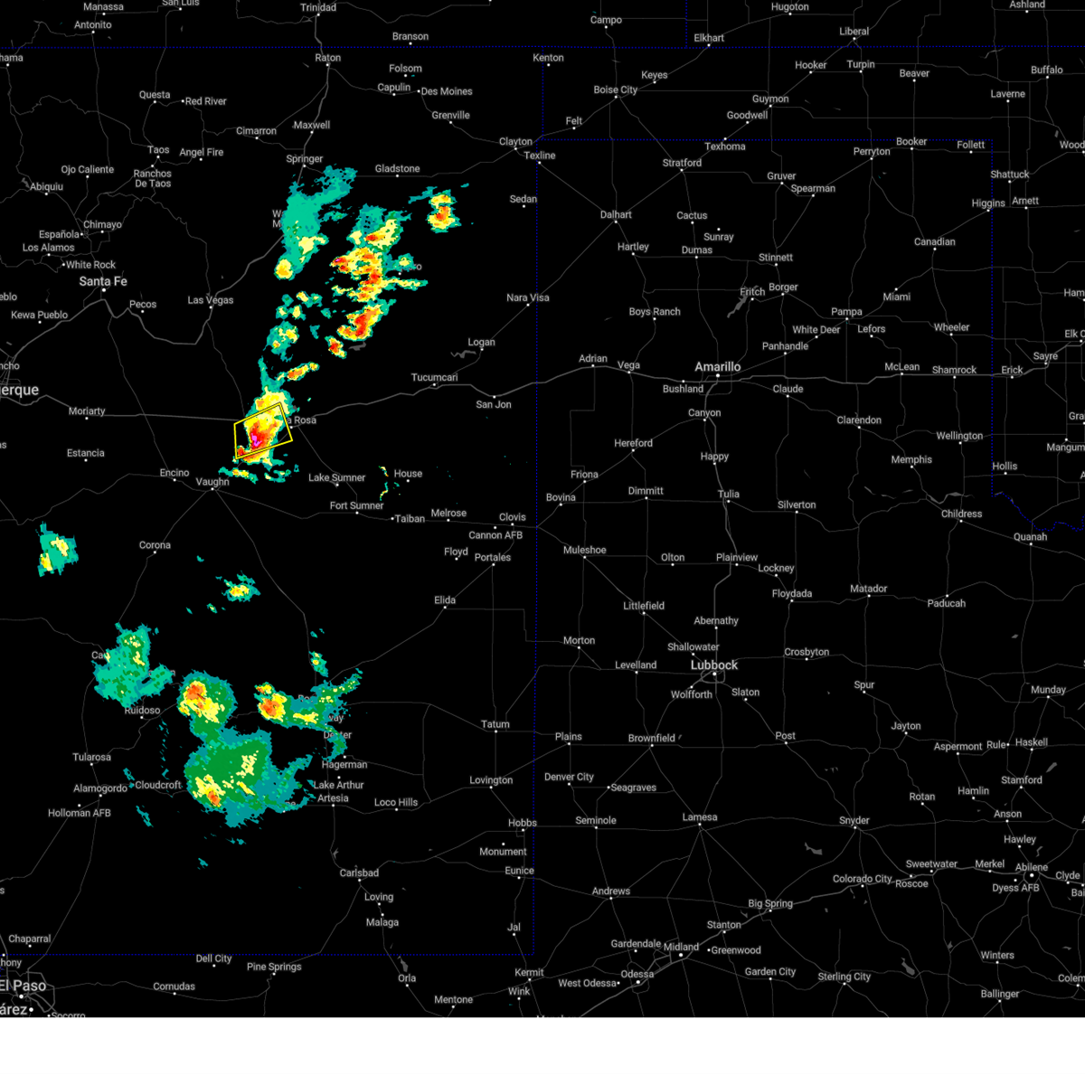
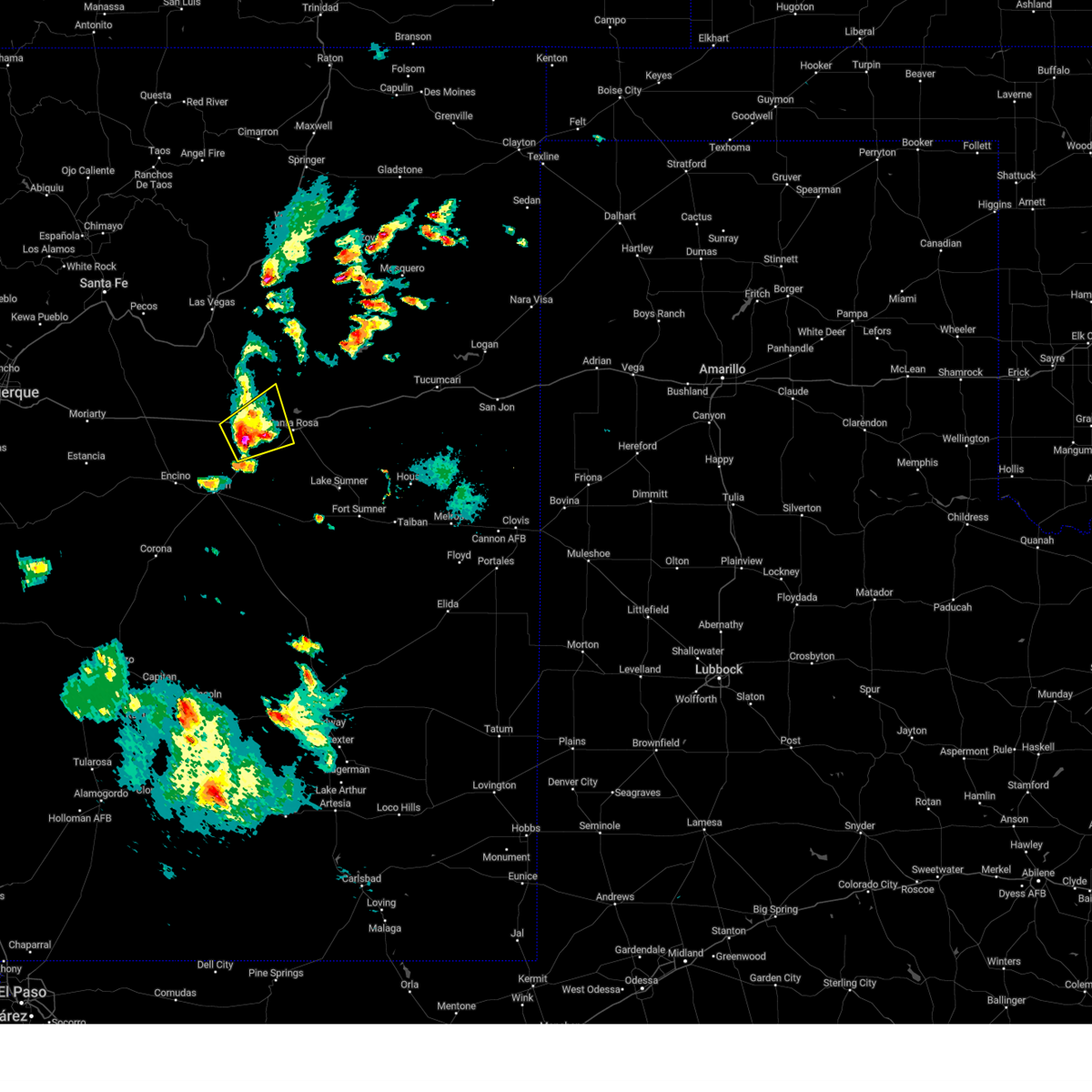
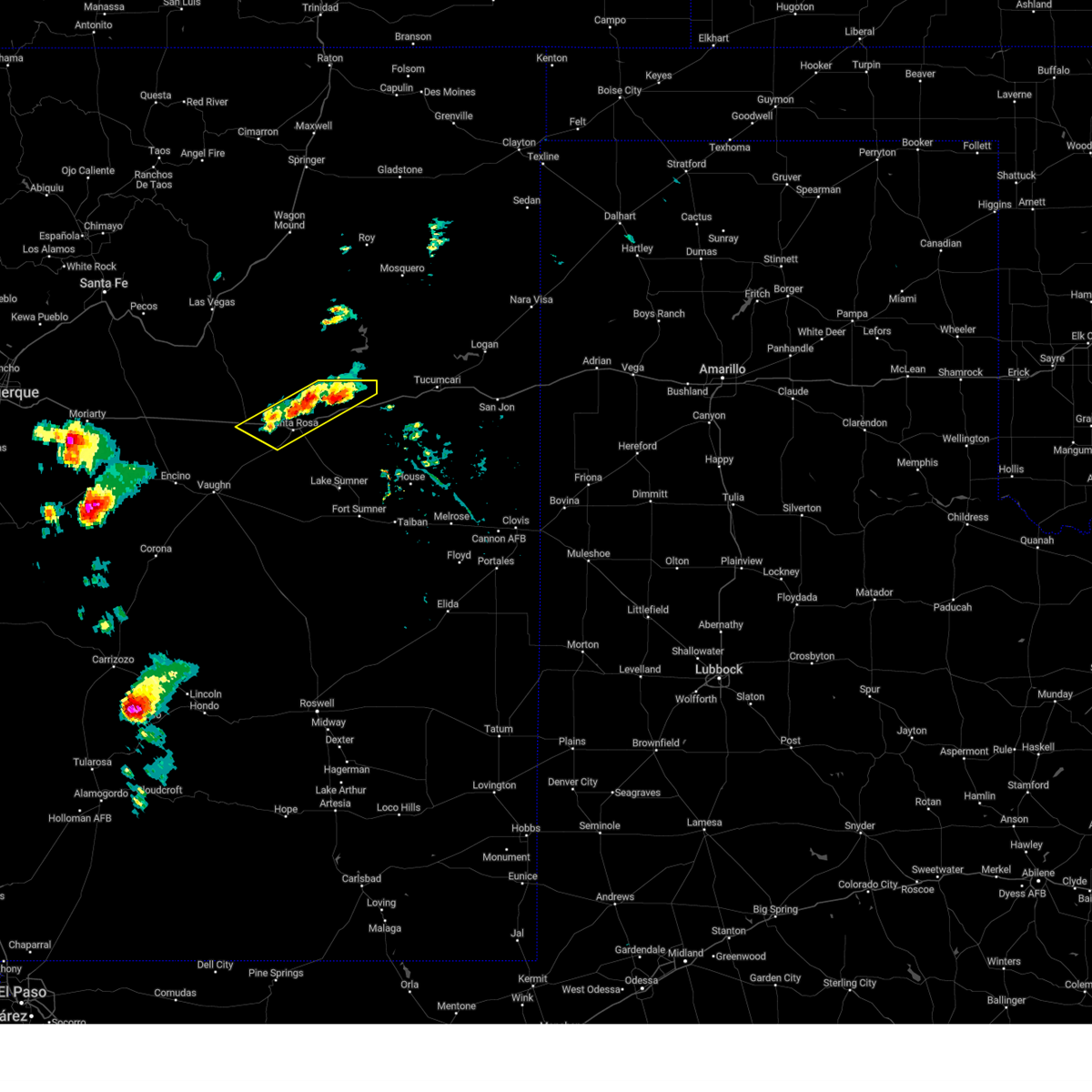
Hail Map for Santa Rosa, NM
The Santa Rosa, NM area has had 25 reports of on-the-ground hail by trained spotters, and has been under severe weather warnings 13 times during the past 12 months. Doppler radar has detected hail at or near Santa Rosa, NM on 60 occasions, including 8 occasions during the past year.
| Name: | Santa Rosa, NM |
| Where Located: | 56.2 miles WSW of Tucumcari, NM |
| Map: | Google Map for Santa Rosa, NM |
| Population: | 2848 |
| Housing Units: | 1178 |
| More Info: | Search Google for Santa Rosa, NM |
1
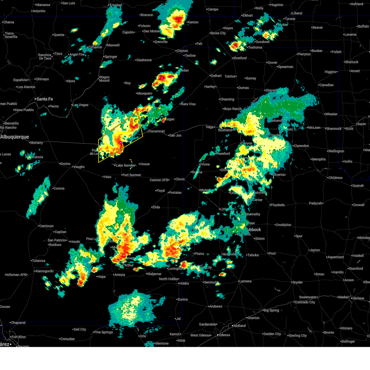
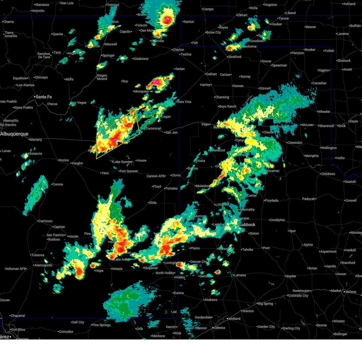
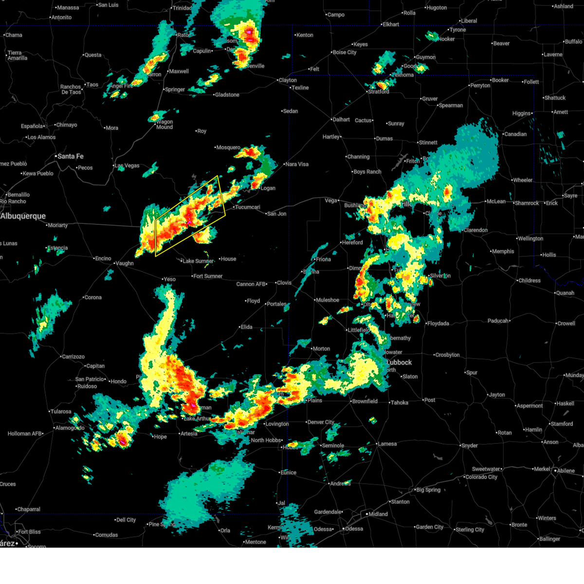
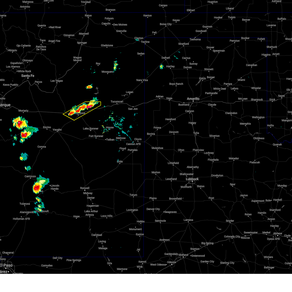
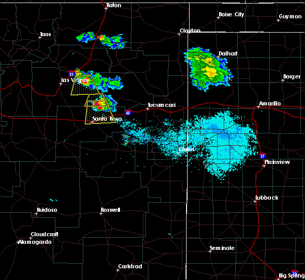
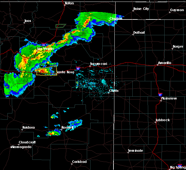
The Top Recent Hail Date for Santa Rosa, NM is Saturday, April 26, 2025 (13th out of 60)
Hail and Wind Damage Spotted near Santa Rosa, NM
| Date / Time | Report Details |
|---|---|
| 7/10/2025 5:35 PM MDT | Awos station ksxu santa rosa airpor in guadalupe county NM, 1.9 miles W of Santa Rosa, NM |
| 6/23/2025 5:28 PM MDT |
 The severe thunderstorm warning that was previously in effect has been reissued for quay, san miguel, and guadalupe counties and is in effect until 615 pm mdt. please refer to that bulletin for the latest severe weather information. The severe thunderstorm warning that was previously in effect has been reissued for quay, san miguel, and guadalupe counties and is in effect until 615 pm mdt. please refer to that bulletin for the latest severe weather information.
|
| 6/23/2025 5:15 PM MDT |
 At 515 pm mdt, severe thunderstorms were located along a line from 14 miles northwest of tucumcari to 8 miles south of cuervo, moving northeast at 20 mph (radar indicated). Hazards include 60 mph wind gusts and quarter size hail. Hail damage to vehicles is expected. expect wind damage to roofs, siding, and trees. locations impacted include, santa rosa, newkirk, cuervo, montoya, santa rosa lake state park and puerto de luna. this includes the following highways, interstate 40 between mile markers 274 and 325. State road 104 near mile marker 67, and between mile markers 69 and 71, and between mile markers 78 and 94. At 515 pm mdt, severe thunderstorms were located along a line from 14 miles northwest of tucumcari to 8 miles south of cuervo, moving northeast at 20 mph (radar indicated). Hazards include 60 mph wind gusts and quarter size hail. Hail damage to vehicles is expected. expect wind damage to roofs, siding, and trees. locations impacted include, santa rosa, newkirk, cuervo, montoya, santa rosa lake state park and puerto de luna. this includes the following highways, interstate 40 between mile markers 274 and 325. State road 104 near mile marker 67, and between mile markers 69 and 71, and between mile markers 78 and 94.
|
| 6/23/2025 4:47 PM MDT |
 Svrabq the national weather service in albuquerque has issued a * severe thunderstorm warning for, northeastern guadalupe county in east central new mexico, west central quay county in east central new mexico, southeastern san miguel county in northeastern new mexico, * until 530 pm mdt. * at 447 pm mdt, severe thunderstorms were located along a line from 10 miles north of montoya to near puerto de luna, moving northeast at 20 mph (radar indicated). Hazards include 60 mph wind gusts and quarter size hail. Hail damage to vehicles is expected. Expect wind damage to roofs, siding, and trees. Svrabq the national weather service in albuquerque has issued a * severe thunderstorm warning for, northeastern guadalupe county in east central new mexico, west central quay county in east central new mexico, southeastern san miguel county in northeastern new mexico, * until 530 pm mdt. * at 447 pm mdt, severe thunderstorms were located along a line from 10 miles north of montoya to near puerto de luna, moving northeast at 20 mph (radar indicated). Hazards include 60 mph wind gusts and quarter size hail. Hail damage to vehicles is expected. Expect wind damage to roofs, siding, and trees.
|
| 6/23/2025 3:58 PM MDT |
 The storm which prompted the warning has weakened below severe limits, and no longer poses an immediate threat to life or property. therefore, the warning will be allowed to expire. however, small hail, gusty winds, and heavy rain are still possible with this thunderstorm. The storm which prompted the warning has weakened below severe limits, and no longer poses an immediate threat to life or property. therefore, the warning will be allowed to expire. however, small hail, gusty winds, and heavy rain are still possible with this thunderstorm.
|
| 6/23/2025 3:20 PM MDT |
 Svrabq the national weather service in albuquerque has issued a * severe thunderstorm warning for, northeastern guadalupe county in east central new mexico, * until 400 pm mdt. * at 320 pm mdt, a severe thunderstorm was located near puerto de luna, or near santa rosa, moving northeast at 10 mph (radar indicated). Hazards include 60 mph wind gusts and quarter size hail. Hail damage to vehicles is expected. Expect wind damage to roofs, siding, and trees. Svrabq the national weather service in albuquerque has issued a * severe thunderstorm warning for, northeastern guadalupe county in east central new mexico, * until 400 pm mdt. * at 320 pm mdt, a severe thunderstorm was located near puerto de luna, or near santa rosa, moving northeast at 10 mph (radar indicated). Hazards include 60 mph wind gusts and quarter size hail. Hail damage to vehicles is expected. Expect wind damage to roofs, siding, and trees.
|
| 6/9/2025 6:32 PM MDT |
 At 632 pm mdt, severe thunderstorms were located along a line from near santa rosa lake state park to 13 miles southeast of newkirk, moving south at 15 mph (radar indicated). Hazards include 60 mph wind gusts and quarter size hail. Hail damage to vehicles is expected. expect wind damage to roofs, siding, and trees. locations impacted include, santa rosa, cuervo, puerto de luna, newkirk and santa rosa lake state park. This includes interstate 40 between mile markers 271 and 308. At 632 pm mdt, severe thunderstorms were located along a line from near santa rosa lake state park to 13 miles southeast of newkirk, moving south at 15 mph (radar indicated). Hazards include 60 mph wind gusts and quarter size hail. Hail damage to vehicles is expected. expect wind damage to roofs, siding, and trees. locations impacted include, santa rosa, cuervo, puerto de luna, newkirk and santa rosa lake state park. This includes interstate 40 between mile markers 271 and 308.
|
| 6/9/2025 6:13 PM MDT |
 Svrabq the national weather service in albuquerque has issued a * severe thunderstorm warning for, northern guadalupe county in east central new mexico, * until 715 pm mdt. * at 613 pm mdt, severe thunderstorms were located along a line from near colonias to 7 miles southwest of montoya, moving south at 5 mph (radar indicated). Hazards include 60 mph wind gusts and quarter size hail. Hail damage to vehicles is expected. Expect wind damage to roofs, siding, and trees. Svrabq the national weather service in albuquerque has issued a * severe thunderstorm warning for, northern guadalupe county in east central new mexico, * until 715 pm mdt. * at 613 pm mdt, severe thunderstorms were located along a line from near colonias to 7 miles southwest of montoya, moving south at 5 mph (radar indicated). Hazards include 60 mph wind gusts and quarter size hail. Hail damage to vehicles is expected. Expect wind damage to roofs, siding, and trees.
|
| 6/9/2025 5:50 PM MDT | the severe thunderstorm warning has been cancelled and is no longer in effect |
| 6/9/2025 5:50 PM MDT | At 550 pm mdt, severe thunderstorms were located along a line from 7 miles south of cuervo to 6 miles south of anton chico, moving northeast at 30 mph (radar indicated). Hazards include 60 mph wind gusts and quarter size hail. Hail damage to vehicles is expected. expect wind damage to roofs, siding, and trees. locations impacted include, santa rosa, santa rosa lake state park, puerto de luna, colonias, cuervo, pastura, dilia, newkirk, anton chico and pintada. This includes interstate 40 between mile markers 240 and 307. |
| 6/9/2025 5:28 PM MDT |
 Svrabq the national weather service in albuquerque has issued a * severe thunderstorm warning for, northeastern torrance county in central new mexico, north central de baca county in east central new mexico, guadalupe county in east central new mexico, southwestern san miguel county in northeastern new mexico, * until 615 pm mdt. * at 528 pm mdt, severe thunderstorms were located along a line from over puerto de luna to 15 miles south of villanueva state park, moving northeast at 15 mph (radar indicated). Hazards include 60 mph wind gusts and quarter size hail. Hail damage to vehicles is expected. Expect wind damage to roofs, siding, and trees. Svrabq the national weather service in albuquerque has issued a * severe thunderstorm warning for, northeastern torrance county in central new mexico, north central de baca county in east central new mexico, guadalupe county in east central new mexico, southwestern san miguel county in northeastern new mexico, * until 615 pm mdt. * at 528 pm mdt, severe thunderstorms were located along a line from over puerto de luna to 15 miles south of villanueva state park, moving northeast at 15 mph (radar indicated). Hazards include 60 mph wind gusts and quarter size hail. Hail damage to vehicles is expected. Expect wind damage to roofs, siding, and trees.
|
| 6/4/2025 6:07 PM MDT | Quarter sized hail reported 13.8 miles NW of Santa Rosa, NM, report from mping: quarter (1.00 in.). |
| 6/4/2025 5:55 PM MDT | Quarter sized hail reported 11.6 miles NW of Santa Rosa, NM, post-event report. occurred between mile markers 28 and 29 on u.s. highway 84. |
| 5/19/2025 3:15 PM MDT | Mesonet station tccn5 thompson cattl in guadalupe county NM, 18.2 miles E of Santa Rosa, NM |
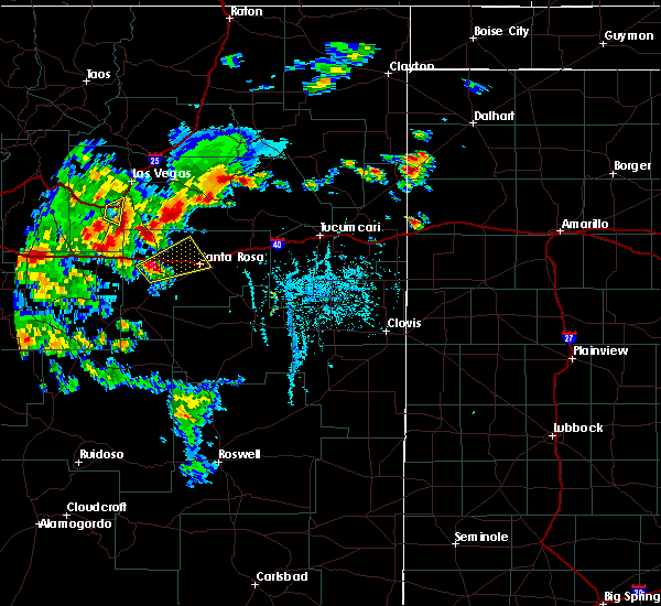
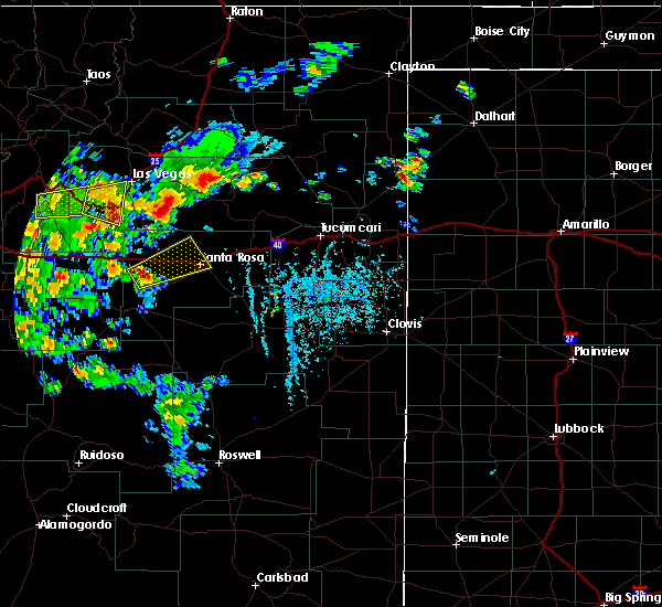
| 4/26/2025 3:29 PM MDT |
 the severe thunderstorm warning has been cancelled and is no longer in effect the severe thunderstorm warning has been cancelled and is no longer in effect
|
| 4/26/2025 3:13 PM MDT |
 At 313 pm mdt, a severe thunderstorm was located near santa rosa, moving northeast at 15 mph (radar indicated). Hazards include 60 mph wind gusts and half dollar size hail. Hail damage to vehicles is expected. expect wind damage to roofs, siding, and trees. locations impacted include, santa rosa and puerto de luna. This includes interstate 40 between mile markers 272 and 288. At 313 pm mdt, a severe thunderstorm was located near santa rosa, moving northeast at 15 mph (radar indicated). Hazards include 60 mph wind gusts and half dollar size hail. Hail damage to vehicles is expected. expect wind damage to roofs, siding, and trees. locations impacted include, santa rosa and puerto de luna. This includes interstate 40 between mile markers 272 and 288.
|
| 4/26/2025 2:48 PM MDT |
 Svrabq the national weather service in albuquerque has issued a * severe thunderstorm warning for, central guadalupe county in east central new mexico, * until 345 pm mdt. * at 248 pm mdt, a severe thunderstorm was located 6 miles southwest of santa rosa, moving east at 15 mph (radar indicated). Hazards include ping pong ball size hail and 60 mph wind gusts. People and animals outdoors will be injured. expect hail damage to roofs, siding, windows, and vehicles. Expect wind damage to roofs, siding, and trees. Svrabq the national weather service in albuquerque has issued a * severe thunderstorm warning for, central guadalupe county in east central new mexico, * until 345 pm mdt. * at 248 pm mdt, a severe thunderstorm was located 6 miles southwest of santa rosa, moving east at 15 mph (radar indicated). Hazards include ping pong ball size hail and 60 mph wind gusts. People and animals outdoors will be injured. expect hail damage to roofs, siding, windows, and vehicles. Expect wind damage to roofs, siding, and trees.
|
| 7/5/2024 12:09 AM MDT |
 The severe thunderstorm which prompted the warning has weakened and moved out of the warned area. therefore, the warning will be allowed to expire. The severe thunderstorm which prompted the warning has weakened and moved out of the warned area. therefore, the warning will be allowed to expire.
|
| 7/4/2024 11:44 PM MDT |
 At 1143 pm mdt, a severe thunderstorm was located near cuervo, or 12 miles northeast of santa rosa, moving northeast at 15 mph (radar indicated). Hazards include 60 mph wind gusts and quarter size hail. Hail damage to vehicles is expected. expect wind damage to roofs, siding, and trees. Locations impacted include, santa rosa, puerto de luna, santa rosa lake state park, and cuervo. At 1143 pm mdt, a severe thunderstorm was located near cuervo, or 12 miles northeast of santa rosa, moving northeast at 15 mph (radar indicated). Hazards include 60 mph wind gusts and quarter size hail. Hail damage to vehicles is expected. expect wind damage to roofs, siding, and trees. Locations impacted include, santa rosa, puerto de luna, santa rosa lake state park, and cuervo.
|
| 7/4/2024 11:44 PM MDT |
 the severe thunderstorm warning has been cancelled and is no longer in effect the severe thunderstorm warning has been cancelled and is no longer in effect
|
| 7/4/2024 11:24 PM MDT |
 Svrabq the national weather service in albuquerque has issued a * severe thunderstorm warning for, southeastern san miguel county in northeastern new mexico, northeastern guadalupe county in east central new mexico, * until 1215 am mdt. * at 1123 pm mdt, a severe thunderstorm was located near santa rosa lake state park, or 7 miles northeast of santa rosa, moving northeast at 10 mph (radar indicated). Hazards include 60 mph wind gusts and quarter size hail. Hail damage to vehicles is expected. Expect wind damage to roofs, siding, and trees. Svrabq the national weather service in albuquerque has issued a * severe thunderstorm warning for, southeastern san miguel county in northeastern new mexico, northeastern guadalupe county in east central new mexico, * until 1215 am mdt. * at 1123 pm mdt, a severe thunderstorm was located near santa rosa lake state park, or 7 miles northeast of santa rosa, moving northeast at 10 mph (radar indicated). Hazards include 60 mph wind gusts and quarter size hail. Hail damage to vehicles is expected. Expect wind damage to roofs, siding, and trees.
|
| 6/19/2024 9:03 PM MDT |
 The storm which prompted the warning has weakened below severe limits, and no longer poses an immediate threat to life or property. therefore, the warning has been allowed to expire. however, heavy rain is still possible with this thunderstorm. The storm which prompted the warning has weakened below severe limits, and no longer poses an immediate threat to life or property. therefore, the warning has been allowed to expire. however, heavy rain is still possible with this thunderstorm.
|
| 6/19/2024 8:39 PM MDT |
 At 839 pm mdt, a severe thunderstorm was located 7 miles northeast of pastura, or 12 miles west of santa rosa, moving east at 20 mph (radar indicated). Hazards include 60 mph wind gusts and half dollar size hail. Hail damage to vehicles is expected. expect wind damage to roofs, siding, and trees. Locations impacted include, santa rosa. At 839 pm mdt, a severe thunderstorm was located 7 miles northeast of pastura, or 12 miles west of santa rosa, moving east at 20 mph (radar indicated). Hazards include 60 mph wind gusts and half dollar size hail. Hail damage to vehicles is expected. expect wind damage to roofs, siding, and trees. Locations impacted include, santa rosa.
|
| 6/19/2024 8:13 PM MDT |
 Svrabq the national weather service in albuquerque has issued a * severe thunderstorm warning for, northwestern guadalupe county in east central new mexico, * until 900 pm mdt. * at 812 pm mdt, a severe thunderstorm was located 8 miles north of pastura, or 18 miles west of santa rosa, moving northeast at 20 mph (radar indicated). Hazards include 60 mph wind gusts and half dollar size hail. Hail damage to vehicles is expected. Expect wind damage to roofs, siding, and trees. Svrabq the national weather service in albuquerque has issued a * severe thunderstorm warning for, northwestern guadalupe county in east central new mexico, * until 900 pm mdt. * at 812 pm mdt, a severe thunderstorm was located 8 miles north of pastura, or 18 miles west of santa rosa, moving northeast at 20 mph (radar indicated). Hazards include 60 mph wind gusts and half dollar size hail. Hail damage to vehicles is expected. Expect wind damage to roofs, siding, and trees.
|
| 6/19/2024 2:04 PM MDT |
 the severe thunderstorm warning has been cancelled and is no longer in effect the severe thunderstorm warning has been cancelled and is no longer in effect
|
| 6/19/2024 1:48 PM MDT |
 At 148 pm mdt, severe thunderstorms were located along a line extending from 7 miles northeast of newkirk to 7 miles west of santa rosa, moving east at 10 mph (radar indicated). Hazards include 60 mph wind gusts and quarter size hail. Hail damage to vehicles is expected. expect wind damage to roofs, siding, and trees. Locations impacted include, santa rosa, santa rosa lake state park, and cuervo. At 148 pm mdt, severe thunderstorms were located along a line extending from 7 miles northeast of newkirk to 7 miles west of santa rosa, moving east at 10 mph (radar indicated). Hazards include 60 mph wind gusts and quarter size hail. Hail damage to vehicles is expected. expect wind damage to roofs, siding, and trees. Locations impacted include, santa rosa, santa rosa lake state park, and cuervo.
|
| 6/19/2024 1:48 PM MDT |
 the severe thunderstorm warning has been cancelled and is no longer in effect the severe thunderstorm warning has been cancelled and is no longer in effect
|
| 6/19/2024 1:20 PM MDT |
 Svrabq the national weather service in albuquerque has issued a * severe thunderstorm warning for, southeastern san miguel county in northeastern new mexico, northern guadalupe county in east central new mexico, * until 215 pm mdt. * at 119 pm mdt, severe thunderstorms were located along a line extending from 6 miles north of newkirk to 9 miles north of pastura, moving east at 10 mph (radar indicated). Hazards include ping pong ball size hail and 60 mph wind gusts. People and animals outdoors will be injured. expect hail damage to roofs, siding, windows, and vehicles. Expect wind damage to roofs, siding, and trees. Svrabq the national weather service in albuquerque has issued a * severe thunderstorm warning for, southeastern san miguel county in northeastern new mexico, northern guadalupe county in east central new mexico, * until 215 pm mdt. * at 119 pm mdt, severe thunderstorms were located along a line extending from 6 miles north of newkirk to 9 miles north of pastura, moving east at 10 mph (radar indicated). Hazards include ping pong ball size hail and 60 mph wind gusts. People and animals outdoors will be injured. expect hail damage to roofs, siding, windows, and vehicles. Expect wind damage to roofs, siding, and trees.
|
| 5/31/2024 4:42 PM MDT |
 The storm which prompted the warning has moved out of the area. therefore, the warning will be allowed to expire. however, small hail and gusty winds are still possible with this thunderstorm. The storm which prompted the warning has moved out of the area. therefore, the warning will be allowed to expire. however, small hail and gusty winds are still possible with this thunderstorm.
|
| 5/31/2024 4:29 PM MDT |
 At 427 pm mdt, a severe thunderstorm was located near santa rosa, moving northeast at 35 mph (radar indicated). Hazards include 60 mph wind gusts and quarter size hail. Hail damage to vehicles is expected. expect wind damage to roofs, siding, and trees. Locations impacted include, santa rosa, puerto de luna, and pastura. At 427 pm mdt, a severe thunderstorm was located near santa rosa, moving northeast at 35 mph (radar indicated). Hazards include 60 mph wind gusts and quarter size hail. Hail damage to vehicles is expected. expect wind damage to roofs, siding, and trees. Locations impacted include, santa rosa, puerto de luna, and pastura.
|
| 5/31/2024 4:00 PM MDT |
 Svrabq the national weather service in albuquerque has issued a * severe thunderstorm warning for, central guadalupe county in east central new mexico, * until 445 pm mdt. * at 400 pm mdt, a severe thunderstorm was located near pastura, or 16 miles northeast of vaughn, moving northeast at 30 mph (radar indicated). Hazards include 60 mph wind gusts and quarter size hail. Hail damage to vehicles is expected. Expect wind damage to roofs, siding, and trees. Svrabq the national weather service in albuquerque has issued a * severe thunderstorm warning for, central guadalupe county in east central new mexico, * until 445 pm mdt. * at 400 pm mdt, a severe thunderstorm was located near pastura, or 16 miles northeast of vaughn, moving northeast at 30 mph (radar indicated). Hazards include 60 mph wind gusts and quarter size hail. Hail damage to vehicles is expected. Expect wind damage to roofs, siding, and trees.
|
| 5/11/2024 7:48 PM MDT | Quarter sized hail reported 11.9 miles NW of Santa Rosa, NM, mostly pea size but a few quarters. hail depth up to 4 inches in places. |
| 5/11/2024 7:25 PM MDT |
 At 725 pm mdt, a severe thunderstorm was located near puerto de luna, or 7 miles south of santa rosa, moving east at 30 mph (radar indicated). Hazards include 60 mph wind gusts and half dollar size hail. Hail damage to vehicles is expected. expect wind damage to roofs, siding, and trees. Locations impacted include, santa rosa and puerto de luna and i-40 near santa rosa. At 725 pm mdt, a severe thunderstorm was located near puerto de luna, or 7 miles south of santa rosa, moving east at 30 mph (radar indicated). Hazards include 60 mph wind gusts and half dollar size hail. Hail damage to vehicles is expected. expect wind damage to roofs, siding, and trees. Locations impacted include, santa rosa and puerto de luna and i-40 near santa rosa.
|
| 5/11/2024 7:05 PM MDT |
 Svrabq the national weather service in albuquerque has issued a * severe thunderstorm warning for, central guadalupe county in east central new mexico, * until 745 pm mdt. * at 705 pm mdt, a severe thunderstorm was located near pastura, or 14 miles west of santa rosa, moving east at 30 mph (radar indicated). Hazards include 60 mph wind gusts and quarter size hail. Hail damage to vehicles is expected. Expect wind damage to roofs, siding, and trees. Svrabq the national weather service in albuquerque has issued a * severe thunderstorm warning for, central guadalupe county in east central new mexico, * until 745 pm mdt. * at 705 pm mdt, a severe thunderstorm was located near pastura, or 14 miles west of santa rosa, moving east at 30 mph (radar indicated). Hazards include 60 mph wind gusts and quarter size hail. Hail damage to vehicles is expected. Expect wind damage to roofs, siding, and trees.
|
| 5/11/2024 6:52 PM MDT |
 Svrabq the national weather service in albuquerque has issued a * severe thunderstorm warning for, southeastern san miguel county in northeastern new mexico, north central de baca county in east central new mexico, northeastern guadalupe county in east central new mexico, * until 745 pm mdt. * at 651 pm mdt, a severe thunderstorm was located 9 miles southwest of cuervo, or 9 miles east of santa rosa, moving east at 20 mph (radar indicated). Hazards include golf ball size hail and 60 mph wind gusts. People and animals outdoors will be injured. expect hail damage to roofs, siding, windows, and vehicles. Expect wind damage to roofs, siding, and trees. Svrabq the national weather service in albuquerque has issued a * severe thunderstorm warning for, southeastern san miguel county in northeastern new mexico, north central de baca county in east central new mexico, northeastern guadalupe county in east central new mexico, * until 745 pm mdt. * at 651 pm mdt, a severe thunderstorm was located 9 miles southwest of cuervo, or 9 miles east of santa rosa, moving east at 20 mph (radar indicated). Hazards include golf ball size hail and 60 mph wind gusts. People and animals outdoors will be injured. expect hail damage to roofs, siding, windows, and vehicles. Expect wind damage to roofs, siding, and trees.
|
| 5/11/2024 6:41 PM MDT |
 The tornado threat has diminished and the tornado warning has been cancelled. however, large hail and damaging winds remain likely and a severe thunderstorm warning remains in effect for the area. remember, a severe thunderstorm warning remains in effect for north central guadalupe county. The tornado threat has diminished and the tornado warning has been cancelled. however, large hail and damaging winds remain likely and a severe thunderstorm warning remains in effect for the area. remember, a severe thunderstorm warning remains in effect for north central guadalupe county.
|
| 5/11/2024 6:37 PM MDT | Quarter sized hail reported 1.3 miles N of Santa Rosa, NM, report from mping: quarter (1.00 in.). |
| 5/11/2024 6:31 PM MDT |
 At 630 pm mdt, a severe thunderstorm capable of producing a tornado was located over santa rosa, moving east at 20 mph (radar indicated rotation). Hazards include tornado and ping pong ball size hail. Flying debris will be dangerous to those caught without shelter. mobile homes will be damaged or destroyed. damage to roofs, windows, and vehicles will occur. tree damage is likely. This dangerous storm will be near, santa rosa around 635 pm mdt. At 630 pm mdt, a severe thunderstorm capable of producing a tornado was located over santa rosa, moving east at 20 mph (radar indicated rotation). Hazards include tornado and ping pong ball size hail. Flying debris will be dangerous to those caught without shelter. mobile homes will be damaged or destroyed. damage to roofs, windows, and vehicles will occur. tree damage is likely. This dangerous storm will be near, santa rosa around 635 pm mdt.
|
| 5/11/2024 6:30 PM MDT | Golf Ball sized hail reported 0.4 miles ESE of Santa Rosa, NM |
| 5/11/2024 6:16 PM MDT |
 Torabq the national weather service in albuquerque has issued a * tornado warning for, north central guadalupe county in east central new mexico, * until 645 pm mdt. * at 615 pm mdt, a severe thunderstorm capable of producing a tornado was located near santa rosa, moving east at 20 mph (radar indicated rotation). Hazards include tornado and ping pong ball size hail. Flying debris will be dangerous to those caught without shelter. mobile homes will be damaged or destroyed. damage to roofs, windows, and vehicles will occur. tree damage is likely. This dangerous storm will be near, santa rosa around 620 pm mdt. Torabq the national weather service in albuquerque has issued a * tornado warning for, north central guadalupe county in east central new mexico, * until 645 pm mdt. * at 615 pm mdt, a severe thunderstorm capable of producing a tornado was located near santa rosa, moving east at 20 mph (radar indicated rotation). Hazards include tornado and ping pong ball size hail. Flying debris will be dangerous to those caught without shelter. mobile homes will be damaged or destroyed. damage to roofs, windows, and vehicles will occur. tree damage is likely. This dangerous storm will be near, santa rosa around 620 pm mdt.
|
| 5/11/2024 6:07 PM MDT |
 At 607 pm mdt, a severe thunderstorm was located 9 miles south of colonias, or 10 miles west of santa rosa, moving east at 25 mph (radar indicated). Hazards include golf ball size hail and 60 mph wind gusts. People and animals outdoors will be injured. expect hail damage to roofs, siding, windows, and vehicles. expect wind damage to roofs, siding, and trees. locations impacted include, santa rosa, puerto de luna, colonias, santa rosa lake state park, and cuervo. This will impact i-40 between clines corners and santa rosa. At 607 pm mdt, a severe thunderstorm was located 9 miles south of colonias, or 10 miles west of santa rosa, moving east at 25 mph (radar indicated). Hazards include golf ball size hail and 60 mph wind gusts. People and animals outdoors will be injured. expect hail damage to roofs, siding, windows, and vehicles. expect wind damage to roofs, siding, and trees. locations impacted include, santa rosa, puerto de luna, colonias, santa rosa lake state park, and cuervo. This will impact i-40 between clines corners and santa rosa.
|
| 5/11/2024 5:57 PM MDT |
 Svrabq the national weather service in albuquerque has issued a * severe thunderstorm warning for, northern guadalupe county in east central new mexico, * until 700 pm mdt. * at 556 pm mdt, a severe thunderstorm was located 11 miles southwest of colonias, or 15 miles west of santa rosa, moving east at 25 mph (radar indicated). Hazards include golf ball size hail and 60 mph wind gusts. People and animals outdoors will be injured. expect hail damage to roofs, siding, windows, and vehicles. Expect wind damage to roofs, siding, and trees. Svrabq the national weather service in albuquerque has issued a * severe thunderstorm warning for, northern guadalupe county in east central new mexico, * until 700 pm mdt. * at 556 pm mdt, a severe thunderstorm was located 11 miles southwest of colonias, or 15 miles west of santa rosa, moving east at 25 mph (radar indicated). Hazards include golf ball size hail and 60 mph wind gusts. People and animals outdoors will be injured. expect hail damage to roofs, siding, windows, and vehicles. Expect wind damage to roofs, siding, and trees.
|
| 5/11/2024 5:49 PM MDT | Ping Pong Ball sized hail reported 23.8 miles E of Santa Rosa, NM, posted on x. |
| 10/2/2023 7:27 PM MDT |
 At 727 pm mdt, severe thunderstorms were located along a line extending from 7 miles south of cuervo to near ramon, moving east at 10 mph (radar indicated). Hazards include 60 mph wind gusts and quarter size hail. Hail damage to vehicles is expected. expect wind damage to roofs, siding, and trees. locations impacted include, santa rosa, fort sumner, house, tolar, yeso, puerto de luna, taiban, sumner lake state park, and sumner lake. this includes the following highways, interstate 40 between mile markers 276 and 277. highway 60 between mile markers 294 and 351. hail threat, radar indicated max hail size, 1. 00 in wind threat, radar indicated max wind gust, 60 mph. At 727 pm mdt, severe thunderstorms were located along a line extending from 7 miles south of cuervo to near ramon, moving east at 10 mph (radar indicated). Hazards include 60 mph wind gusts and quarter size hail. Hail damage to vehicles is expected. expect wind damage to roofs, siding, and trees. locations impacted include, santa rosa, fort sumner, house, tolar, yeso, puerto de luna, taiban, sumner lake state park, and sumner lake. this includes the following highways, interstate 40 between mile markers 276 and 277. highway 60 between mile markers 294 and 351. hail threat, radar indicated max hail size, 1. 00 in wind threat, radar indicated max wind gust, 60 mph.
|
| 10/2/2023 7:24 PM MDT |
 At 724 pm mdt, severe thunderstorms were located along a line extending from 7 miles southwest of solano to near cuervo, moving east northeast at 40 mph (radar indicated). Hazards include 60 mph wind gusts and quarter size hail. Hail damage to vehicles is expected. expect wind damage to roofs, siding, and trees. locations impacted include, quay, tucumcari, santa rosa, mosquero, montoya, conchas, conchas lake state park, conchas dam, newkirk, and cuervo. this includes the following highways, interstate 40 between mile markers 276 and 332. state road 104 between mile markers 55 and 105. hail threat, radar indicated max hail size, 1. 00 in wind threat, radar indicated max wind gust, 60 mph. At 724 pm mdt, severe thunderstorms were located along a line extending from 7 miles southwest of solano to near cuervo, moving east northeast at 40 mph (radar indicated). Hazards include 60 mph wind gusts and quarter size hail. Hail damage to vehicles is expected. expect wind damage to roofs, siding, and trees. locations impacted include, quay, tucumcari, santa rosa, mosquero, montoya, conchas, conchas lake state park, conchas dam, newkirk, and cuervo. this includes the following highways, interstate 40 between mile markers 276 and 332. state road 104 between mile markers 55 and 105. hail threat, radar indicated max hail size, 1. 00 in wind threat, radar indicated max wind gust, 60 mph.
|
| 10/2/2023 6:58 PM MDT |
 At 658 pm mdt, severe thunderstorms were located along a line extending from santa rosa to near ramon, moving northeast at 25 mph (radar indicated). Hazards include quarter size hail. damage to vehicles is expected At 658 pm mdt, severe thunderstorms were located along a line extending from santa rosa to near ramon, moving northeast at 25 mph (radar indicated). Hazards include quarter size hail. damage to vehicles is expected
|
| 10/2/2023 6:54 PM MDT |
 At 654 pm mdt, severe thunderstorms were located along a line extending from 9 miles east of maes to santa rosa, moving northeast at 45 mph (radar indicated). Hazards include 70 mph wind gusts and quarter size hail. Hail damage to vehicles is expected. expect considerable tree damage. Wind damage is also likely to mobile homes, roofs, and outbuildings. At 654 pm mdt, severe thunderstorms were located along a line extending from 9 miles east of maes to santa rosa, moving northeast at 45 mph (radar indicated). Hazards include 70 mph wind gusts and quarter size hail. Hail damage to vehicles is expected. expect considerable tree damage. Wind damage is also likely to mobile homes, roofs, and outbuildings.
|
| 8/13/2023 2:35 PM MDT | Awos station ksxu santa rosa airpor in guadalupe county NM, 1.9 miles W of Santa Rosa, NM |
| 7/15/2023 8:11 PM MDT |
 At 810 pm mdt, severe thunderstorms were located along a line extending from 9 miles south of cuervo to 8 miles west of house, moving southeast at 20 mph (radar indicated). Hazards include ping pong ball size hail and 60 mph wind gusts. People and animals outdoors will be injured. expect hail damage to roofs, siding, windows, and vehicles. Expect wind damage to roofs, siding, and trees. At 810 pm mdt, severe thunderstorms were located along a line extending from 9 miles south of cuervo to 8 miles west of house, moving southeast at 20 mph (radar indicated). Hazards include ping pong ball size hail and 60 mph wind gusts. People and animals outdoors will be injured. expect hail damage to roofs, siding, windows, and vehicles. Expect wind damage to roofs, siding, and trees.
|
| 7/15/2023 7:53 PM MDT |
 At 752 pm mdt, severe thunderstorms were located along a line extending from 13 miles north of santa rosa lake state park to 6 miles south of newkirk, moving southeast at 20 mph (radar indicated). Hazards include tennis ball size hail and 60 mph wind gusts. People and animals outdoors will be injured. expect hail damage to roofs, siding, windows, and vehicles. expect wind damage to roofs, siding, and trees. locations impacted include, quay, santa rosa, fort sumner, house, puerto de luna, newkirk, santa rosa lake state park, cuervo, tolar and sumner lake state park. this includes the following highways, interstate 40 between mile markers 273 and 311. Highway 60 between mile markers 312 and 333, and between mile markers 345 and 346. At 752 pm mdt, severe thunderstorms were located along a line extending from 13 miles north of santa rosa lake state park to 6 miles south of newkirk, moving southeast at 20 mph (radar indicated). Hazards include tennis ball size hail and 60 mph wind gusts. People and animals outdoors will be injured. expect hail damage to roofs, siding, windows, and vehicles. expect wind damage to roofs, siding, and trees. locations impacted include, quay, santa rosa, fort sumner, house, puerto de luna, newkirk, santa rosa lake state park, cuervo, tolar and sumner lake state park. this includes the following highways, interstate 40 between mile markers 273 and 311. Highway 60 between mile markers 312 and 333, and between mile markers 345 and 346.
|
| 7/15/2023 7:20 PM MDT |
 At 719 pm mdt, severe thunderstorms were located along a line extending from 13 miles west of variadero to near newkirk, moving southeast at 20 mph (radar indicated). Hazards include tennis ball size hail and 70 mph wind gusts. People and animals outdoors will be injured. expect hail damage to roofs, siding, windows, and vehicles. expect considerable tree damage. Wind damage is also likely to mobile homes, roofs, and outbuildings. At 719 pm mdt, severe thunderstorms were located along a line extending from 13 miles west of variadero to near newkirk, moving southeast at 20 mph (radar indicated). Hazards include tennis ball size hail and 70 mph wind gusts. People and animals outdoors will be injured. expect hail damage to roofs, siding, windows, and vehicles. expect considerable tree damage. Wind damage is also likely to mobile homes, roofs, and outbuildings.
|
| 7/15/2023 7:01 PM MDT |
 At 700 pm mdt, severe thunderstorms were located along a line extending from 6 miles southwest of trujillo to 9 miles south of variadero, moving southeast at 25 mph (radar indicated). Hazards include tennis ball size hail and 70 mph wind gusts. People and animals outdoors will be injured. expect hail damage to roofs, siding, windows, and vehicles. expect considerable tree damage. wind damage is also likely to mobile homes, roofs, and outbuildings. locations impacted include, santa rosa, montoya, colonias, variadero, newkirk, santa rosa lake state park, cuervo, trujillo and trementina. this includes the following highways, interstate 40 between mile markers 265 and 314. State road 104 between mile markers 27 and 73. At 700 pm mdt, severe thunderstorms were located along a line extending from 6 miles southwest of trujillo to 9 miles south of variadero, moving southeast at 25 mph (radar indicated). Hazards include tennis ball size hail and 70 mph wind gusts. People and animals outdoors will be injured. expect hail damage to roofs, siding, windows, and vehicles. expect considerable tree damage. wind damage is also likely to mobile homes, roofs, and outbuildings. locations impacted include, santa rosa, montoya, colonias, variadero, newkirk, santa rosa lake state park, cuervo, trujillo and trementina. this includes the following highways, interstate 40 between mile markers 265 and 314. State road 104 between mile markers 27 and 73.
|
| 7/15/2023 6:29 PM MDT |
 At 628 pm mdt, severe thunderstorms were located along a line extending from 11 miles southeast of watrous to 8 miles west of variadero, moving south at 15 mph. these are destructive storms approaching i-40 from the north (radar indicated). Hazards include three inch hail and 70 mph wind gusts. People and animals outdoors will be severely injured. Expect shattered windows, extensive damage to roofs, siding, and vehicles. At 628 pm mdt, severe thunderstorms were located along a line extending from 11 miles southeast of watrous to 8 miles west of variadero, moving south at 15 mph. these are destructive storms approaching i-40 from the north (radar indicated). Hazards include three inch hail and 70 mph wind gusts. People and animals outdoors will be severely injured. Expect shattered windows, extensive damage to roofs, siding, and vehicles.
|
| 7/8/2023 3:35 PM MDT |
 At 335 pm mdt, a severe thunderstorm was located 7 miles southwest of cuervo, or 10 miles east of santa rosa, moving northeast at 35 mph (radar indicated). Hazards include ping pong ball size hail and 60 mph wind gusts. People and animals outdoors will be injured. expect hail damage to roofs, siding, windows, and vehicles. expect wind damage to roofs, siding, and trees. locations impacted include, santa rosa and cuervo. this includes interstate 40 between mile markers 277 and 294. hail threat, radar indicated max hail size, 1. 50 in wind threat, radar indicated max wind gust, 60 mph. At 335 pm mdt, a severe thunderstorm was located 7 miles southwest of cuervo, or 10 miles east of santa rosa, moving northeast at 35 mph (radar indicated). Hazards include ping pong ball size hail and 60 mph wind gusts. People and animals outdoors will be injured. expect hail damage to roofs, siding, windows, and vehicles. expect wind damage to roofs, siding, and trees. locations impacted include, santa rosa and cuervo. this includes interstate 40 between mile markers 277 and 294. hail threat, radar indicated max hail size, 1. 50 in wind threat, radar indicated max wind gust, 60 mph.
|
| 7/8/2023 3:18 PM MDT |
 At 318 pm mdt, a severe thunderstorm was located over puerto de luna, or near santa rosa, moving northeast at 30 mph (radar indicated). Hazards include quarter size hail. Damage to vehicles is expected. locations impacted include, santa rosa, puerto de luna and cuervo. this includes interstate 40 between mile markers 273 and 294. hail threat, radar indicated max hail size, 1. 00 in wind threat, radar indicated max wind gust, <50 mph. At 318 pm mdt, a severe thunderstorm was located over puerto de luna, or near santa rosa, moving northeast at 30 mph (radar indicated). Hazards include quarter size hail. Damage to vehicles is expected. locations impacted include, santa rosa, puerto de luna and cuervo. this includes interstate 40 between mile markers 273 and 294. hail threat, radar indicated max hail size, 1. 00 in wind threat, radar indicated max wind gust, <50 mph.
|
| 7/8/2023 3:04 PM MDT |
 At 304 pm mdt, a severe thunderstorm was located 8 miles east of pastura, or 10 miles southwest of santa rosa, moving northeast at 30 mph (radar indicated). Hazards include half dollar size hail. damage to vehicles is expected At 304 pm mdt, a severe thunderstorm was located 8 miles east of pastura, or 10 miles southwest of santa rosa, moving northeast at 30 mph (radar indicated). Hazards include half dollar size hail. damage to vehicles is expected
|
| 6/1/2023 5:40 PM MDT |
 At 540 pm mdt, a severe thunderstorm was located 7 miles southeast of puerto de luna, or 14 miles southeast of santa rosa, moving east at 20 mph (radar indicated). Hazards include ping pong ball size hail and 60 mph wind gusts. People and animals outdoors will be injured. expect hail damage to roofs, siding, windows, and vehicles. expect wind damage to roofs, siding, and trees. locations impacted include, santa rosa and puerto de luna. hail threat, radar indicated max hail size, 1. 50 in wind threat, radar indicated max wind gust, 60 mph. At 540 pm mdt, a severe thunderstorm was located 7 miles southeast of puerto de luna, or 14 miles southeast of santa rosa, moving east at 20 mph (radar indicated). Hazards include ping pong ball size hail and 60 mph wind gusts. People and animals outdoors will be injured. expect hail damage to roofs, siding, windows, and vehicles. expect wind damage to roofs, siding, and trees. locations impacted include, santa rosa and puerto de luna. hail threat, radar indicated max hail size, 1. 50 in wind threat, radar indicated max wind gust, 60 mph.
|
| 6/1/2023 5:13 PM MDT | Hen Egg sized hail reported 12.1 miles NW of Santa Rosa, NM, 2 inch hail falling now at this location. |
| 6/1/2023 5:09 PM MDT |
 A severe thunderstorm warning remains in effect until 600 pm mdt for central guadalupe county. at 507 pm mdt, a severe thunderstorm was located near puerto de luna, or 9 miles south of santa rosa, moving east at 15 mph. hazard. two inch hail and 60 mph wind gusts. source. trained weather spotters. At 505 pm mdt, a trained spotter. A severe thunderstorm warning remains in effect until 600 pm mdt for central guadalupe county. at 507 pm mdt, a severe thunderstorm was located near puerto de luna, or 9 miles south of santa rosa, moving east at 15 mph. hazard. two inch hail and 60 mph wind gusts. source. trained weather spotters. At 505 pm mdt, a trained spotter.
|
| 6/1/2023 5:01 PM MDT |
 At 500 pm mdt, a severe thunderstorm was located 7 miles west of puerto de luna, or 10 miles southwest of santa rosa, moving east at 15 mph (radar indicated). Hazards include 60 mph wind gusts and quarter size hail. Hail damage to vehicles is expected. Expect wind damage to roofs, siding, and trees. At 500 pm mdt, a severe thunderstorm was located 7 miles west of puerto de luna, or 10 miles southwest of santa rosa, moving east at 15 mph (radar indicated). Hazards include 60 mph wind gusts and quarter size hail. Hail damage to vehicles is expected. Expect wind damage to roofs, siding, and trees.
|
| 6/1/2023 5:00 PM MDT | Golf Ball sized hail reported 11.2 miles NW of Santa Rosa, NM, 1.5 inch hail falling now. |
| 6/1/2023 4:35 PM MDT | Golf Ball sized hail reported 16 miles NE of Santa Rosa, NM, hail covering highway 54... hail lasted 15 minutes. biggest hailstone 1.75 inch... mostly 1-1.5 inches. |
| 6/1/2023 4:30 PM MDT | Ping Pong Ball sized hail reported 18.3 miles NE of Santa Rosa, NM, hail lasted 10 minutes. |
| 6/1/2023 4:16 PM MDT | Quarter sized hail reported 18.7 miles NE of Santa Rosa, NM, hail from 2nd storm... following same path as first one. |
| 6/1/2023 3:30 PM MDT | Quarter sized hail reported 16.4 miles ENE of Santa Rosa, NM, hail covering street highway 219. |
| 5/31/2023 4:52 PM MDT |
 At 451 pm mdt, a severe thunderstorm was located near puerto de luna, or 11 miles southeast of santa rosa, moving north at 25 mph (radar indicated). Hazards include 60 mph wind gusts and half dollar size hail. Hail damage to vehicles is expected. expect wind damage to roofs, siding, and trees. locations impacted include, santa rosa and puerto de luna. this includes interstate 40 between mile markers 272 and 289. hail threat, radar indicated max hail size, 1. 25 in wind threat, radar indicated max wind gust, 60 mph. At 451 pm mdt, a severe thunderstorm was located near puerto de luna, or 11 miles southeast of santa rosa, moving north at 25 mph (radar indicated). Hazards include 60 mph wind gusts and half dollar size hail. Hail damage to vehicles is expected. expect wind damage to roofs, siding, and trees. locations impacted include, santa rosa and puerto de luna. this includes interstate 40 between mile markers 272 and 289. hail threat, radar indicated max hail size, 1. 25 in wind threat, radar indicated max wind gust, 60 mph.
|
| 5/31/2023 4:22 PM MDT |
 At 422 pm mdt, a severe thunderstorm was located 9 miles west of sumner lake, or 20 miles northwest of fort sumner, moving north at 25 mph (radar indicated). Hazards include 60 mph wind gusts and quarter size hail. Hail damage to vehicles is expected. Expect wind damage to roofs, siding, and trees. At 422 pm mdt, a severe thunderstorm was located 9 miles west of sumner lake, or 20 miles northwest of fort sumner, moving north at 25 mph (radar indicated). Hazards include 60 mph wind gusts and quarter size hail. Hail damage to vehicles is expected. Expect wind damage to roofs, siding, and trees.
|
| 5/27/2023 5:33 PM MDT |
 At 532 pm mdt, a severe thunderstorm was located near puerto de luna, or near santa rosa, moving northeast at 30 mph (radar indicated). Hazards include ping pong ball size hail and 60 mph wind gusts. People and animals outdoors will be injured. expect hail damage to roofs, siding, windows, and vehicles. Expect wind damage to roofs, siding, and trees. At 532 pm mdt, a severe thunderstorm was located near puerto de luna, or near santa rosa, moving northeast at 30 mph (radar indicated). Hazards include ping pong ball size hail and 60 mph wind gusts. People and animals outdoors will be injured. expect hail damage to roofs, siding, windows, and vehicles. Expect wind damage to roofs, siding, and trees.
|
| 5/26/2023 3:57 AM MDT |
 The severe thunderstorm warning for northeastern guadalupe county will expire at 400 am mdt, the storm which prompted the warning has weakened below severe limits, and no longer poses an immediate threat to life or property. therefore, the warning will be allowed to expire. however small hail, gusty winds and heavy rain are still possible with this thunderstorm. a severe thunderstorm watch remains in effect until 600 am mdt for east central new mexico. The severe thunderstorm warning for northeastern guadalupe county will expire at 400 am mdt, the storm which prompted the warning has weakened below severe limits, and no longer poses an immediate threat to life or property. therefore, the warning will be allowed to expire. however small hail, gusty winds and heavy rain are still possible with this thunderstorm. a severe thunderstorm watch remains in effect until 600 am mdt for east central new mexico.
|
| 5/26/2023 3:41 AM MDT |
 At 341 am mdt, a severe thunderstorm was located 9 miles south of cuervo, or 14 miles east of santa rosa, moving east at 10 mph (public). Hazards include 60 mph wind gusts and quarter size hail. Hail damage to vehicles is expected. expect wind damage to roofs, siding, and trees. locations impacted include, santa rosa, puerto de luna and cuervo. this includes interstate 40 between mile markers 272 and 295. hail threat, radar indicated max hail size, 1. 00 in wind threat, radar indicated max wind gust, 60 mph. At 341 am mdt, a severe thunderstorm was located 9 miles south of cuervo, or 14 miles east of santa rosa, moving east at 10 mph (public). Hazards include 60 mph wind gusts and quarter size hail. Hail damage to vehicles is expected. expect wind damage to roofs, siding, and trees. locations impacted include, santa rosa, puerto de luna and cuervo. this includes interstate 40 between mile markers 272 and 295. hail threat, radar indicated max hail size, 1. 00 in wind threat, radar indicated max wind gust, 60 mph.
|
| 5/26/2023 3:25 AM MDT |
 At 325 am mdt, a severe thunderstorm was located 8 miles southwest of cuervo, or 11 miles east of santa rosa, moving east at 15 mph (public). Hazards include ping pong ball size hail and 60 mph wind gusts. People and animals outdoors will be injured. expect hail damage to roofs, siding, windows, and vehicles. expect wind damage to roofs, siding, and trees. locations impacted include, santa rosa, puerto de luna, santa rosa lake state park and cuervo. this includes interstate 40 between mile markers 270 and 295. hail threat, radar indicated max hail size, 1. 50 in wind threat, radar indicated max wind gust, 60 mph. At 325 am mdt, a severe thunderstorm was located 8 miles southwest of cuervo, or 11 miles east of santa rosa, moving east at 15 mph (public). Hazards include ping pong ball size hail and 60 mph wind gusts. People and animals outdoors will be injured. expect hail damage to roofs, siding, windows, and vehicles. expect wind damage to roofs, siding, and trees. locations impacted include, santa rosa, puerto de luna, santa rosa lake state park and cuervo. this includes interstate 40 between mile markers 270 and 295. hail threat, radar indicated max hail size, 1. 50 in wind threat, radar indicated max wind gust, 60 mph.
|
| 5/26/2023 3:04 AM MDT |
 At 304 am mdt, a severe thunderstorm was located near santa rosa, moving east at 10 mph (public). Hazards include quarter size hail. damage to vehicles is expected At 304 am mdt, a severe thunderstorm was located near santa rosa, moving east at 10 mph (public). Hazards include quarter size hail. damage to vehicles is expected
|
| 5/26/2023 2:59 AM MDT | Quarter sized hail reported 1.1 miles SW of Santa Rosa, NM, report from mping: quarter (1.00 in.). |
| 7/19/2022 2:05 PM MDT | Semi-truck overturned near mm 286 on interstate 40 due to microburst wind in guadalupe county NM, 7.8 miles WSW of Santa Rosa, NM |
| 6/3/2022 4:14 PM MDT |
 At 413 pm mdt, a severe thunderstorm was located near pastura, or 18 miles northeast of vaughn, moving east at 15 mph (radar indicated). Hazards include 60 mph wind gusts and quarter size hail. Hail damage to vehicles is expected. Expect wind damage to roofs, siding, and trees. At 413 pm mdt, a severe thunderstorm was located near pastura, or 18 miles northeast of vaughn, moving east at 15 mph (radar indicated). Hazards include 60 mph wind gusts and quarter size hail. Hail damage to vehicles is expected. Expect wind damage to roofs, siding, and trees.
|
| 6/3/2022 3:46 PM MDT |
 At 346 pm mdt, a severe thunderstorm was located near pastura, or 16 miles southwest of santa rosa, moving east at 20 mph (radar indicated). Hazards include 60 mph wind gusts and quarter size hail. Hail damage to vehicles is expected. expect wind damage to roofs, siding, and trees. locations impacted include, pastura. hail threat, radar indicated max hail size, 1. 00 in wind threat, radar indicated max wind gust, 60 mph. At 346 pm mdt, a severe thunderstorm was located near pastura, or 16 miles southwest of santa rosa, moving east at 20 mph (radar indicated). Hazards include 60 mph wind gusts and quarter size hail. Hail damage to vehicles is expected. expect wind damage to roofs, siding, and trees. locations impacted include, pastura. hail threat, radar indicated max hail size, 1. 00 in wind threat, radar indicated max wind gust, 60 mph.
|
| 6/3/2022 3:23 PM MDT |
 At 323 pm mdt, a severe thunderstorm was located near pastura, or 15 miles northeast of vaughn, moving east at 20 mph (radar indicated). Hazards include 60 mph wind gusts and quarter size hail. Hail damage to vehicles is expected. Expect wind damage to roofs, siding, and trees. At 323 pm mdt, a severe thunderstorm was located near pastura, or 15 miles northeast of vaughn, moving east at 20 mph (radar indicated). Hazards include 60 mph wind gusts and quarter size hail. Hail damage to vehicles is expected. Expect wind damage to roofs, siding, and trees.
|
| 8/22/2021 7:45 PM MDT | Ksxu awo in guadalupe county NM, 1.9 miles W of Santa Rosa, NM |
| 5/17/2021 3:30 PM MDT |
 At 330 pm mdt, a severe thunderstorm was located 7 miles west of santa rosa, moving north at 15 mph (radar indicated). Hazards include 60 mph wind gusts and quarter size hail. Hail damage to vehicles is expected. Expect wind damage to roofs, siding, and trees. At 330 pm mdt, a severe thunderstorm was located 7 miles west of santa rosa, moving north at 15 mph (radar indicated). Hazards include 60 mph wind gusts and quarter size hail. Hail damage to vehicles is expected. Expect wind damage to roofs, siding, and trees.
|
| 7/15/2020 5:01 PM MDT |
 At 450 pm mdt, a severe thunderstorm was located over santa rosa, moving north at 20 mph (radar indicated). Hazards include 60 mph wind gusts and quarter size hail. Hail damage to vehicles is expected. Expect wind damage to roofs, siding, and trees. At 450 pm mdt, a severe thunderstorm was located over santa rosa, moving north at 20 mph (radar indicated). Hazards include 60 mph wind gusts and quarter size hail. Hail damage to vehicles is expected. Expect wind damage to roofs, siding, and trees.
|
| 7/15/2020 4:55 PM MDT | Ksxu awo in guadalupe county NM, 1.9 miles W of Santa Rosa, NM |
| 7/15/2020 4:50 PM MDT |
 At 450 pm mdt, a severe thunderstorm was located over santa rosa, moving north at 20 mph (radar indicated). Hazards include 60 mph wind gusts and quarter size hail. Hail damage to vehicles is expected. Expect wind damage to roofs, siding, and trees. At 450 pm mdt, a severe thunderstorm was located over santa rosa, moving north at 20 mph (radar indicated). Hazards include 60 mph wind gusts and quarter size hail. Hail damage to vehicles is expected. Expect wind damage to roofs, siding, and trees.
|
| 7/12/2020 5:37 PM MDT |
 The severe thunderstorm warning for north central guadalupe county will expire at 545 pm mdt, the storm which prompted the warning has moved out of the area. therefore the warning will be allowed to expire. however small hail, gusty winds and heavy rain are still possible with this thunderstorm. a severe thunderstorm watch remains in effect until 900 pm mdt for east central new mexico. The severe thunderstorm warning for north central guadalupe county will expire at 545 pm mdt, the storm which prompted the warning has moved out of the area. therefore the warning will be allowed to expire. however small hail, gusty winds and heavy rain are still possible with this thunderstorm. a severe thunderstorm watch remains in effect until 900 pm mdt for east central new mexico.
|
| 7/12/2020 5:07 PM MDT |
 At 507 pm mdt, a severe thunderstorm was located near santa rosa, moving east at 20 mph (radar indicated). Hazards include 60 mph wind gusts and quarter size hail. Hail damage to vehicles is expected. expect wind damage to roofs, siding, and trees. locations impacted include, santa rosa, puerto de luna and santa rosa lake state park. This includes interstate 40 between mile markers 265 and 284. At 507 pm mdt, a severe thunderstorm was located near santa rosa, moving east at 20 mph (radar indicated). Hazards include 60 mph wind gusts and quarter size hail. Hail damage to vehicles is expected. expect wind damage to roofs, siding, and trees. locations impacted include, santa rosa, puerto de luna and santa rosa lake state park. This includes interstate 40 between mile markers 265 and 284.
|
| 7/12/2020 4:44 PM MDT |
 At 443 pm mdt, a severe thunderstorm was located 7 miles northeast of pastura, or 12 miles southwest of santa rosa, moving east at 20 mph (radar indicated). Hazards include ping pong ball size hail and 60 mph wind gusts. People and animals outdoors will be injured. expect hail damage to roofs, siding, windows, and vehicles. Expect wind damage to roofs, siding, and trees. At 443 pm mdt, a severe thunderstorm was located 7 miles northeast of pastura, or 12 miles southwest of santa rosa, moving east at 20 mph (radar indicated). Hazards include ping pong ball size hail and 60 mph wind gusts. People and animals outdoors will be injured. expect hail damage to roofs, siding, windows, and vehicles. Expect wind damage to roofs, siding, and trees.
|
| 6/25/2020 5:58 PM MDT |
 The national weather service in albuquerque has issued a * severe thunderstorm warning for. northern de baca county in east central new mexico. northeastern guadalupe county in east central new mexico. until 700 pm mdt. At 558 pm mdt, a severe thunderstorm was located 7 miles northeast. The national weather service in albuquerque has issued a * severe thunderstorm warning for. northern de baca county in east central new mexico. northeastern guadalupe county in east central new mexico. until 700 pm mdt. At 558 pm mdt, a severe thunderstorm was located 7 miles northeast.
|
| 6/25/2020 5:44 PM MDT |
 At 543 pm mdt, a severe thunderstorm was located 8 miles southwest of cuervo, or 9 miles east of santa rosa, moving east at 10 mph (radar indicated). Hazards include 60 mph wind gusts and nickel size hail. Expect damage to roofs, siding, and trees. locations impacted include, puerto de luna, newkirk and cuervo. This includes interstate 40 between mile markers 279 and 309. At 543 pm mdt, a severe thunderstorm was located 8 miles southwest of cuervo, or 9 miles east of santa rosa, moving east at 10 mph (radar indicated). Hazards include 60 mph wind gusts and nickel size hail. Expect damage to roofs, siding, and trees. locations impacted include, puerto de luna, newkirk and cuervo. This includes interstate 40 between mile markers 279 and 309.
|
| 6/25/2020 5:31 PM MDT |
 At 530 pm mdt, severe thunderstorms were located along a line extending from near cuervo to 10 miles east of santa rosa, moving east at 15 mph (radar indicated). Hazards include 60 mph wind gusts and nickel size hail. Expect damage to roofs, siding, and trees. locations impacted include, puerto de luna, newkirk, montoya and cuervo. This includes interstate 40 between mile markers 280 and 319. At 530 pm mdt, severe thunderstorms were located along a line extending from near cuervo to 10 miles east of santa rosa, moving east at 15 mph (radar indicated). Hazards include 60 mph wind gusts and nickel size hail. Expect damage to roofs, siding, and trees. locations impacted include, puerto de luna, newkirk, montoya and cuervo. This includes interstate 40 between mile markers 280 and 319.
|
| 6/25/2020 5:17 PM MDT |
 At 516 pm mdt, severe thunderstorms were located along a line extending from near cuervo to 7 miles east of santa rosa, moving east at 15 mph (radar indicated). Hazards include 60 mph wind gusts and nickel size hail. expect damage to roofs, siding, and trees At 516 pm mdt, severe thunderstorms were located along a line extending from near cuervo to 7 miles east of santa rosa, moving east at 15 mph (radar indicated). Hazards include 60 mph wind gusts and nickel size hail. expect damage to roofs, siding, and trees
|
| 6/25/2020 4:55 PM MDT | Ksxu awo in guadalupe county NM, 1.9 miles W of Santa Rosa, NM |
| 9/20/2019 4:07 PM MDT | Quarter sized hail reported 14.6 miles NW of Santa Rosa, NM |
| 5/26/2019 4:46 PM MDT |
 At 446 pm mdt, a severe thunderstorm was located near santa rosa lake state park, or 8 miles north of santa rosa, moving northeast at 35 mph (radar indicated). Hazards include 60 mph wind gusts and half dollar size hail. Hail damage to vehicles is expected. expect wind damage to roofs, siding, and trees. locations impacted include, santa rosa, santa rosa lake state park and colonias. this includes interstate 40 between mile markers 265 and 289. A tornado watch remains in effect until 900 pm mdt for northeastern and east central new mexico. At 446 pm mdt, a severe thunderstorm was located near santa rosa lake state park, or 8 miles north of santa rosa, moving northeast at 35 mph (radar indicated). Hazards include 60 mph wind gusts and half dollar size hail. Hail damage to vehicles is expected. expect wind damage to roofs, siding, and trees. locations impacted include, santa rosa, santa rosa lake state park and colonias. this includes interstate 40 between mile markers 265 and 289. A tornado watch remains in effect until 900 pm mdt for northeastern and east central new mexico.
|
| 5/26/2019 4:35 PM MDT |
 At 435 pm mdt, a severe thunderstorm was located over santa rosa, moving northeast at 30 mph (radar indicated). Hazards include 60 mph wind gusts and half dollar size hail. Hail damage to vehicles is expected. Expect wind damage to roofs, siding, and trees. At 435 pm mdt, a severe thunderstorm was located over santa rosa, moving northeast at 30 mph (radar indicated). Hazards include 60 mph wind gusts and half dollar size hail. Hail damage to vehicles is expected. Expect wind damage to roofs, siding, and trees.
|
| 9/9/2018 8:11 PM MDT |
 At 811 pm mdt, a severe thunderstorm was located over cuervo, or 18 miles northeast of santa rosa, moving southeast at 45 mph (radar indicated). Hazards include 60 mph wind gusts and penny size hail. Expect damage to roofs, siding, and trees. locations impacted include, santa rosa, puerto de luna, santa rosa lake state park and cuervo. This includes interstate 40 between mile markers 265 and 298. At 811 pm mdt, a severe thunderstorm was located over cuervo, or 18 miles northeast of santa rosa, moving southeast at 45 mph (radar indicated). Hazards include 60 mph wind gusts and penny size hail. Expect damage to roofs, siding, and trees. locations impacted include, santa rosa, puerto de luna, santa rosa lake state park and cuervo. This includes interstate 40 between mile markers 265 and 298.
|
| 9/9/2018 7:39 PM MDT |
 At 739 pm mdt, a severe thunderstorm was located near colonias, or 15 miles north of santa rosa, moving southeast at 25 mph (radar indicated). Hazards include 60 mph wind gusts and penny size hail. Expect damage to roofs, siding, and trees. locations impacted include, santa rosa, puerto de luna, santa rosa lake state park, colonias and cuervo. This includes interstate 40 between mile markers 261 and 298. At 739 pm mdt, a severe thunderstorm was located near colonias, or 15 miles north of santa rosa, moving southeast at 25 mph (radar indicated). Hazards include 60 mph wind gusts and penny size hail. Expect damage to roofs, siding, and trees. locations impacted include, santa rosa, puerto de luna, santa rosa lake state park, colonias and cuervo. This includes interstate 40 between mile markers 261 and 298.
|
| 9/9/2018 7:23 PM MDT |
 At 722 pm mdt, a severe thunderstorm was located 8 miles north of colonias, or 22 miles northwest of santa rosa, moving southeast at 25 mph (radar indicated). Hazards include 70 mph wind gusts and penny size hail. Expect considerable tree damage. Damage is likely to mobile homes, roofs, and outbuildings. At 722 pm mdt, a severe thunderstorm was located 8 miles north of colonias, or 22 miles northwest of santa rosa, moving southeast at 25 mph (radar indicated). Hazards include 70 mph wind gusts and penny size hail. Expect considerable tree damage. Damage is likely to mobile homes, roofs, and outbuildings.
|
| 8/19/2018 6:18 PM MDT |
 At 617 pm mdt, a severe thunderstorm was located 7 miles east of santa rosa lake state park, or 7 miles northeast of santa rosa, moving south at 20 mph (radar indicated). Hazards include two inch hail and 70 mph wind gusts. People and animals outdoors will be injured. expect hail damage to roofs, siding, windows, and vehicles. expect considerable tree damage. wind damage is also likely to mobile homes, roofs, and outbuildings. locations impacted include, santa rosa, santa rosa lake state park and cuervo. This includes interstate 40 between mile markers 273 and 291. At 617 pm mdt, a severe thunderstorm was located 7 miles east of santa rosa lake state park, or 7 miles northeast of santa rosa, moving south at 20 mph (radar indicated). Hazards include two inch hail and 70 mph wind gusts. People and animals outdoors will be injured. expect hail damage to roofs, siding, windows, and vehicles. expect considerable tree damage. wind damage is also likely to mobile homes, roofs, and outbuildings. locations impacted include, santa rosa, santa rosa lake state park and cuervo. This includes interstate 40 between mile markers 273 and 291.
|
| 8/19/2018 6:04 PM MDT |
 A severe thunderstorm warning remains in effect until 645 pm mdt for northeastern guadalupe county. at 604 pm mdt, a severe thunderstorm was located near santa rosa lake state park, or 11 miles northeast of santa rosa, moving south at 20 mph. hazard. Two inch hail and 70 mph wind gusts. A severe thunderstorm warning remains in effect until 645 pm mdt for northeastern guadalupe county. at 604 pm mdt, a severe thunderstorm was located near santa rosa lake state park, or 11 miles northeast of santa rosa, moving south at 20 mph. hazard. Two inch hail and 70 mph wind gusts.
|
| 8/19/2018 5:47 PM MDT |
 At 547 pm mdt, a severe thunderstorm was located 13 miles southwest of variadero, or 19 miles north of santa rosa, moving south at 20 mph (radar indicated). Hazards include ping pong ball size hail and 60 mph wind gusts. People and animals outdoors will be injured. expect hail damage to roofs, siding, windows, and vehicles. Expect wind damage to roofs, siding, and trees. At 547 pm mdt, a severe thunderstorm was located 13 miles southwest of variadero, or 19 miles north of santa rosa, moving south at 20 mph (radar indicated). Hazards include ping pong ball size hail and 60 mph wind gusts. People and animals outdoors will be injured. expect hail damage to roofs, siding, windows, and vehicles. Expect wind damage to roofs, siding, and trees.
|
| 9/30/2017 7:28 PM MDT |
 At 728 pm mdt, a severe thunderstorm was located 10 miles southwest of colonias, or 19 miles west of santa rosa, moving east at 30 mph (radar indicated). Hazards include ping pong ball size hail and 60 mph wind gusts. People and animals outdoors will be injured. expect hail damage to roofs, siding, windows, and vehicles. expect wind damage to roofs, siding, and trees. locations impacted include, santa rosa, santa rosa lake state park and colonias. This includes interstate 40 between mile markers 244 and 276. At 728 pm mdt, a severe thunderstorm was located 10 miles southwest of colonias, or 19 miles west of santa rosa, moving east at 30 mph (radar indicated). Hazards include ping pong ball size hail and 60 mph wind gusts. People and animals outdoors will be injured. expect hail damage to roofs, siding, windows, and vehicles. expect wind damage to roofs, siding, and trees. locations impacted include, santa rosa, santa rosa lake state park and colonias. This includes interstate 40 between mile markers 244 and 276.
|
| 9/30/2017 7:18 PM MDT |
 At 718 pm mdt, a severe thunderstorm was located 12 miles south of dilia, or 23 miles west of santa rosa, moving east at 30 mph (radar indicated). Hazards include 60 mph wind gusts and half dollar size hail. Hail damage to vehicles is expected. Expect wind damage to roofs, siding, and trees. At 718 pm mdt, a severe thunderstorm was located 12 miles south of dilia, or 23 miles west of santa rosa, moving east at 30 mph (radar indicated). Hazards include 60 mph wind gusts and half dollar size hail. Hail damage to vehicles is expected. Expect wind damage to roofs, siding, and trees.
|
| 9/17/2017 2:38 PM MDT |
 At 237 pm mdt, a severe thunderstorm was located near puerto de luna, or near santa rosa, moving northeast at 25 mph (radar indicated). Hazards include 60 mph wind gusts and quarter size hail. Hail damage to vehicles is expected. Expect wind damage to roofs, siding, and trees. At 237 pm mdt, a severe thunderstorm was located near puerto de luna, or near santa rosa, moving northeast at 25 mph (radar indicated). Hazards include 60 mph wind gusts and quarter size hail. Hail damage to vehicles is expected. Expect wind damage to roofs, siding, and trees.
|
| 8/22/2017 5:35 PM MDT | Half Dollar sized hail reported 32.5 miles E of Santa Rosa, NM, hail fall extended from mile marker 242 to 244 with verified reports of 1 2 dollar size hail. |
| 8/11/2017 4:55 PM MDT | Ksxu awo in guadalupe county NM, 1.9 miles W of Santa Rosa, NM |
| 8/6/2017 6:15 PM MDT | Ksxu awo in guadalupe county NM, 1.9 miles W of Santa Rosa, NM |
| 8/4/2017 4:51 PM MDT |
 The severe thunderstorm warning for central guadalupe county will expire at 500 pm mdt, the storm which prompted the warning has weakened below severe limits, and no longer pose an immediate threat to life or property. therefore the warning will be allowed to expire. however gusty winds and heavy rain are still possible with this thunderstorm. The severe thunderstorm warning for central guadalupe county will expire at 500 pm mdt, the storm which prompted the warning has weakened below severe limits, and no longer pose an immediate threat to life or property. therefore the warning will be allowed to expire. however gusty winds and heavy rain are still possible with this thunderstorm.
|
| 8/4/2017 4:25 PM MDT |
 At 425 pm mdt, a severe thunderstorm was located near puerto de luna, or 8 miles south of santa rosa, moving southeast at 10 mph (radar indicated). Hazards include 60 mph wind gusts and quarter size hail. Hail damage to vehicles is expected. Expect wind damage to roofs, siding, and trees. At 425 pm mdt, a severe thunderstorm was located near puerto de luna, or 8 miles south of santa rosa, moving southeast at 10 mph (radar indicated). Hazards include 60 mph wind gusts and quarter size hail. Hail damage to vehicles is expected. Expect wind damage to roofs, siding, and trees.
|
| 7/1/2017 6:08 PM MDT |
 At 608 pm mdt, a severe thunderstorm was located 8 miles north of pastura, or 17 miles west of santa rosa, moving northeast at 30 mph (radar indicated). Hazards include 60 mph wind gusts and quarter size hail. Hail damage to vehicles is expected. expect wind damage to roofs, siding, and trees. locations impacted include, santa rosa, santa rosa lake state park and pintada. This includes interstate 40 between mile markers 252 and 279. At 608 pm mdt, a severe thunderstorm was located 8 miles north of pastura, or 17 miles west of santa rosa, moving northeast at 30 mph (radar indicated). Hazards include 60 mph wind gusts and quarter size hail. Hail damage to vehicles is expected. expect wind damage to roofs, siding, and trees. locations impacted include, santa rosa, santa rosa lake state park and pintada. This includes interstate 40 between mile markers 252 and 279.
|
| 7/1/2017 5:53 PM MDT |
 At 553 pm mdt, a severe thunderstorm was located 10 miles northwest of pastura, or 18 miles north of vaughn, moving northeast at 30 mph (radar indicated). Hazards include 60 mph wind gusts and quarter size hail. Hail damage to vehicles is expected. Expect wind damage to roofs, siding, and trees. At 553 pm mdt, a severe thunderstorm was located 10 miles northwest of pastura, or 18 miles north of vaughn, moving northeast at 30 mph (radar indicated). Hazards include 60 mph wind gusts and quarter size hail. Hail damage to vehicles is expected. Expect wind damage to roofs, siding, and trees.
|
| 6/30/2017 7:29 PM MDT |
 At 729 pm mdt, a severe thunderstorm was located 7 miles west of cuervo, or 9 miles northeast of santa rosa, moving southeast at 25 mph (radar indicated). Hazards include 60 mph wind gusts and half dollar size hail. Hail damage to vehicles is expected. Expect wind damage to roofs, siding, and trees. At 729 pm mdt, a severe thunderstorm was located 7 miles west of cuervo, or 9 miles northeast of santa rosa, moving southeast at 25 mph (radar indicated). Hazards include 60 mph wind gusts and half dollar size hail. Hail damage to vehicles is expected. Expect wind damage to roofs, siding, and trees.
|
| 5/22/2017 11:05 PM MDT |
 At 1104 pm mdt, a severe thunderstorm was located 13 miles southwest of variadero, or 19 miles north of santa rosa, moving southeast at 35 mph (radar indicated). Hazards include 60 mph wind gusts and quarter size hail. Hail damage to vehicles is expected. expect wind damage to roofs, siding, and trees. This severe thunderstorm will remain over mainly rural areas of south central san miguel and northeastern guadalupe counties. At 1104 pm mdt, a severe thunderstorm was located 13 miles southwest of variadero, or 19 miles north of santa rosa, moving southeast at 35 mph (radar indicated). Hazards include 60 mph wind gusts and quarter size hail. Hail damage to vehicles is expected. expect wind damage to roofs, siding, and trees. This severe thunderstorm will remain over mainly rural areas of south central san miguel and northeastern guadalupe counties.
|
| 5/22/2017 10:39 PM MDT |
 At 1039 pm mdt, a severe thunderstorm was located 12 miles south of trujillo, or 29 miles north of santa rosa, moving southeast at 35 mph (radar indicated). Hazards include 60 mph wind gusts and quarter size hail. Hail damage to vehicles is expected. Expect wind damage to roofs, siding, and trees. At 1039 pm mdt, a severe thunderstorm was located 12 miles south of trujillo, or 29 miles north of santa rosa, moving southeast at 35 mph (radar indicated). Hazards include 60 mph wind gusts and quarter size hail. Hail damage to vehicles is expected. Expect wind damage to roofs, siding, and trees.
|
| 5/22/2017 4:08 PM MDT |
 At 408 pm mdt, a severe thunderstorm was located near puerto de luna, or 7 miles southwest of santa rosa, moving southeast at 25 mph (radar indicated). Hazards include 60 mph wind gusts and quarter size hail. Hail damage to vehicles is expected. expect wind damage to roofs, siding, and trees. locations impacted include, santa rosa. This includes interstate 40 between mile markers 271 and 273. At 408 pm mdt, a severe thunderstorm was located near puerto de luna, or 7 miles southwest of santa rosa, moving southeast at 25 mph (radar indicated). Hazards include 60 mph wind gusts and quarter size hail. Hail damage to vehicles is expected. expect wind damage to roofs, siding, and trees. locations impacted include, santa rosa. This includes interstate 40 between mile markers 271 and 273.
|
| 5/22/2017 3:58 PM MDT | Quarter sized hail reported 4.3 miles E of Santa Rosa, NM, on i-40 4 miles west of santa rosa |
| 5/22/2017 3:58 PM MDT |
 At 358 pm mdt, a severe thunderstorm was located 8 miles west of santa rosa, moving south at 20 mph (radar indicated). Hazards include 60 mph wind gusts and quarter size hail. Hail damage to vehicles is expected. Expect wind damage to roofs, siding, and trees. At 358 pm mdt, a severe thunderstorm was located 8 miles west of santa rosa, moving south at 20 mph (radar indicated). Hazards include 60 mph wind gusts and quarter size hail. Hail damage to vehicles is expected. Expect wind damage to roofs, siding, and trees.
|
| 5/9/2017 6:27 PM MDT |
 At 626 pm mdt, a severe thunderstorm was located over bootleg, or 13 miles northwest of friona, and is nearly stationary (radar indicated). Hazards include 70 mph wind gusts and quarter size hail. Hail damage to vehicles is expected. expect considerable tree damage. wind damage is also likely to mobile homes, roofs, and outbuildings. locations impacted include, santa rosa, puerto de luna, newkirk, santa rosa lake state park and cuervo. this includes interstate 40 between mile markers 266 and 305. A tornado watch remains in effect until 1000 pm mdt for east central new mexico. At 626 pm mdt, a severe thunderstorm was located over bootleg, or 13 miles northwest of friona, and is nearly stationary (radar indicated). Hazards include 70 mph wind gusts and quarter size hail. Hail damage to vehicles is expected. expect considerable tree damage. wind damage is also likely to mobile homes, roofs, and outbuildings. locations impacted include, santa rosa, puerto de luna, newkirk, santa rosa lake state park and cuervo. this includes interstate 40 between mile markers 266 and 305. A tornado watch remains in effect until 1000 pm mdt for east central new mexico.
|
| 5/9/2017 6:13 PM MDT |
 At 612 pm mdt, a severe thunderstorm was located 7 miles east of pastura, or 12 miles southwest of santa rosa, moving northeast at 50 mph (radar indicated). Hazards include 70 mph wind gusts and half dollar size hail. Hail damage to vehicles is expected. expect considerable tree damage. Wind damage is also likely to mobile homes, roofs, and outbuildings. At 612 pm mdt, a severe thunderstorm was located 7 miles east of pastura, or 12 miles southwest of santa rosa, moving northeast at 50 mph (radar indicated). Hazards include 70 mph wind gusts and half dollar size hail. Hail damage to vehicles is expected. expect considerable tree damage. Wind damage is also likely to mobile homes, roofs, and outbuildings.
|
| 5/9/2017 4:07 PM MDT |
 At 407 pm mdt, a severe thunderstorm was located 7 miles west of sumner lake, or 17 miles northwest of fort sumner, moving north at 40 mph (radar indicated). Hazards include 60 mph wind gusts and half dollar size hail. Hail damage to vehicles is expected. expect wind damage to roofs, siding, and trees. locations impacted include, puerto de luna, sumner lake state park, cuervo and sumner lake. this includes interstate 40 between mile markers 278 and 298. A tornado watch remains in effect until 1000 pm mdt for east central new mexico. At 407 pm mdt, a severe thunderstorm was located 7 miles west of sumner lake, or 17 miles northwest of fort sumner, moving north at 40 mph (radar indicated). Hazards include 60 mph wind gusts and half dollar size hail. Hail damage to vehicles is expected. expect wind damage to roofs, siding, and trees. locations impacted include, puerto de luna, sumner lake state park, cuervo and sumner lake. this includes interstate 40 between mile markers 278 and 298. A tornado watch remains in effect until 1000 pm mdt for east central new mexico.
|
| 5/9/2017 3:52 PM MDT |
 At 352 pm mdt, a severe thunderstorm was located near yeso, or 18 miles west of fort sumner, moving north at 40 mph (radar indicated). Hazards include 60 mph wind gusts and half dollar size hail. Hail damage to vehicles is expected. Expect wind damage to roofs, siding, and trees. At 352 pm mdt, a severe thunderstorm was located near yeso, or 18 miles west of fort sumner, moving north at 40 mph (radar indicated). Hazards include 60 mph wind gusts and half dollar size hail. Hail damage to vehicles is expected. Expect wind damage to roofs, siding, and trees.
|
| 5/9/2017 3:10 PM MDT | Quarter sized hail reported 21.6 miles E of Santa Rosa, NM, quarter sized hail reported by krqe along i-40 near exit 252 |
| 5/8/2017 8:03 PM MDT | Quarter sized hail reported 22 miles NW of Santa Rosa, NM |
| 9/15/2016 3:20 PM MDT |
 The severe thunderstorm warning for central guadalupe county will expire at 330 pm mdt, the storm which prompted the warning has weakened below severe limits, and no longer pose an immediate threat to life or property. therefore the warning will be allowed to expire. however small hail, gusty winds and heavy rain are still possible with this thunderstorm. a severe thunderstorm watch remains in effect until 800 pm mdt for east central new mexico. The severe thunderstorm warning for central guadalupe county will expire at 330 pm mdt, the storm which prompted the warning has weakened below severe limits, and no longer pose an immediate threat to life or property. therefore the warning will be allowed to expire. however small hail, gusty winds and heavy rain are still possible with this thunderstorm. a severe thunderstorm watch remains in effect until 800 pm mdt for east central new mexico.
|
| 9/15/2016 3:04 PM MDT |
 At 304 pm mdt, a severe thunderstorm was located near puerto de luna, or near santa rosa, moving east at 15 mph (radar indicated). Hazards include 60 mph wind gusts and quarter size hail. Hail damage to vehicles is expected. expect wind damage to roofs, siding, and trees. locations impacted include, santa rosa and puerto de luna. This includes interstate 40 between mile markers 268 and 289. At 304 pm mdt, a severe thunderstorm was located near puerto de luna, or near santa rosa, moving east at 15 mph (radar indicated). Hazards include 60 mph wind gusts and quarter size hail. Hail damage to vehicles is expected. expect wind damage to roofs, siding, and trees. locations impacted include, santa rosa and puerto de luna. This includes interstate 40 between mile markers 268 and 289.
|
| 9/15/2016 2:41 PM MDT |
 At 241 pm mdt, a severe thunderstorm was located 8 miles southwest of santa rosa, moving east at 25 mph (radar indicated). Hazards include ping pong ball size hail and 60 mph wind gusts. People and animals outdoors will be injured. expect hail damage to roofs, siding, windows, and vehicles. Expect wind damage to roofs, siding, and trees. At 241 pm mdt, a severe thunderstorm was located 8 miles southwest of santa rosa, moving east at 25 mph (radar indicated). Hazards include ping pong ball size hail and 60 mph wind gusts. People and animals outdoors will be injured. expect hail damage to roofs, siding, windows, and vehicles. Expect wind damage to roofs, siding, and trees.
|
| 7/8/2016 4:28 PM MDT |
 At 428 pm mdt, a severe thunderstorm was located 10 miles west of santa rosa, moving south at 15 mph (radar indicated). Hazards include quarter size hail and 60 mph wind gusts. Hail damage to vehicles is expected. Expect wind damage to roofs, siding, and trees. At 428 pm mdt, a severe thunderstorm was located 10 miles west of santa rosa, moving south at 15 mph (radar indicated). Hazards include quarter size hail and 60 mph wind gusts. Hail damage to vehicles is expected. Expect wind damage to roofs, siding, and trees.
|
| 7/8/2016 3:39 PM MDT |
 At 339 pm mdt, severe thunderstorms were located along a line extending from 8 miles south of colonias to 7 miles northeast of vaughn, moving southeast at 30 mph (radar indicated). Hazards include quarter size hail and 60 mph wind gusts. Hail damage to vehicles is expected. Expect wind damage to roofs, siding, and trees. At 339 pm mdt, severe thunderstorms were located along a line extending from 8 miles south of colonias to 7 miles northeast of vaughn, moving southeast at 30 mph (radar indicated). Hazards include quarter size hail and 60 mph wind gusts. Hail damage to vehicles is expected. Expect wind damage to roofs, siding, and trees.
|
| 8/1/2015 6:25 PM MDT |
 The severe thunderstorm warning for north central guadalupe county will expire at 630 pm mdt, the storm which prompted the warning has weakened below severe limits, and no longer pose an immediate threat to life or property. therefore the warning will be allowed to expire. however very heavy rain is still expected with this thunderstorm. The severe thunderstorm warning for north central guadalupe county will expire at 630 pm mdt, the storm which prompted the warning has weakened below severe limits, and no longer pose an immediate threat to life or property. therefore the warning will be allowed to expire. however very heavy rain is still expected with this thunderstorm.
|
| 8/1/2015 6:20 PM MDT | Storm damage reported in guadalupe county NM, 0.4 miles ESE of Santa Rosa, NM |
| 8/1/2015 6:20 PM MDT | Quarter sized hail reported 2.2 miles S of Santa Rosa, NM |
| 8/1/2015 6:16 PM MDT |
 At 615 pm mdt, a severe thunderstorm was located over santa rosa, moving east at 5 to 10 mph (radar indicated). Hazards include 60 mph wind gusts and quarter size hail. Hail damage to vehicles is expected. expect wind damage to roofs, siding and trees. locations impacted include, santa rosa. other locations affected include power dam lake. This includes interstate 40 between mile markers 270 and 282. At 615 pm mdt, a severe thunderstorm was located over santa rosa, moving east at 5 to 10 mph (radar indicated). Hazards include 60 mph wind gusts and quarter size hail. Hail damage to vehicles is expected. expect wind damage to roofs, siding and trees. locations impacted include, santa rosa. other locations affected include power dam lake. This includes interstate 40 between mile markers 270 and 282.
|
| 8/1/2015 6:02 PM MDT |
 At 602 pm mdt, a severe thunderstorm was located over santa rosa, moving southeast at 10 mph (radar indicated). Hazards include quarter size hail and 60 mph wind gusts. Hail damage to vehicles is expected. Expect wind damage to roofs, siding and trees. At 602 pm mdt, a severe thunderstorm was located over santa rosa, moving southeast at 10 mph (radar indicated). Hazards include quarter size hail and 60 mph wind gusts. Hail damage to vehicles is expected. Expect wind damage to roofs, siding and trees.
|
| 6/7/2015 2:45 PM MDT | At 245 pm mdt, a severe thunderstorm was located near santa rosa, moving northeast at 30 mph (radar indicated). Hazards include 60 mph wind gusts and quarter size hail. Hail damage to vehicles is expected. expect wind damage to roofs, siding and trees. locations impacted include, santa rosa and puerto de luna. other locations affected include power dam lake. This includes interstate 40 between mile markers 274 and 287. |
| 6/7/2015 2:22 PM MDT | At 222 pm mdt, a severe thunderstorm was located 6 miles southwest of puerto de luna, or 11 miles south of santa rosa, moving northeast at 30 mph (radar indicated). Hazards include quarter size hail and 60 mph wind gusts. Hail damage to vehicles is expected. Expect wind damage to roofs, siding and trees. |
| 5/19/2015 3:12 AM MDT | At 311 am mdt, severe thunderstorms were located along a line extending from 7 miles west of trujillo to colonias, moving northeast at 40 mph (radar indicated). Hazards include quarter size hail. Damage to vehicles is expected. locations impacted include, santa rosa, maes, pastura, variadero, santa rosa lake state park, colonias, trujillo and trementina. 1. 00in. |
| 5/19/2015 3:07 AM MDT | The severe thunderstorm warning for northeastern de baca, northeastern guadalupe and southwestern quay counties will expire at 315 am mdt, the storm which prompted the warning has moved out of the area. therefore the warning will be allowed to expire. however small hail is still possible with this thunderstorm. |
| 5/19/2015 2:47 AM MDT | At 247 am mdt, a severe thunderstorm was located 9 miles northwest of sumner lake state park, or 19 miles southeast of santa rosa, moving northeast at 20 mph (radar indicated). Hazards include quarter size hail. Damage to vehicles is expected. locations impacted include, puerto de luna, sumner lake, cuervo and sumner lake state park. 1. 00in. |
| 5/19/2015 2:46 AM MDT | At 245 am mdt, severe thunderstorms were located along a line extending from near dilia to 6 miles west of pastura, moving northeast at 60 mph (radar indicated). Hazards include quarter size hail. damage to vehicles is expected |
| 5/19/2015 2:15 AM MDT | At 214 am mdt, a severe thunderstorm was located 9 miles north of yeso, or 25 miles west of fort sumner, moving northeast at 20 mph (radar indicated). Hazards include quarter size hail. damage to vehicles is expected |
| 5/18/2015 10:53 PM MDT | At 1053 pm mdt, a severe thunderstorm was located 7 miles north of pastura, or 17 miles west of santa rosa, moving northeast at 35 mph (radar indicated). Hazards include 60 mph wind gusts and quarter size hail. Hail damage to vehicles is expected. expect wind damage to roofs, siding and trees. this severe storm will be near, colonias and santa rosa lake state park around 1115 pm mdt. other locations impacted by this severe thunderstorm include pintada. 1. 00in. |
| 5/18/2015 10:36 PM MDT | At 1036 pm mdt, a severe thunderstorm was located 8 miles west of pastura, or 16 miles northeast of vaughn, moving northeast at 35 mph (radar indicated). Hazards include quarter size hail and 60 mph wind gusts. Hail damage to vehicles is expected. expect wind damage to roofs, siding and trees. this severe thunderstorm will be near, pastura around 1045 pm mdt. santa rosa, santa rosa lake state park and colonias around 1115 pm mdt. other locations impacted by this severe thunderstorm include pintada. this includes interstate 40 between mile markers 252 and 282. 1. 00in. |
| 5/14/2015 5:51 PM MDT | At 551 pm mdt, a severe thunderstorm was located 6 miles east of pastura, and moving northeast at 15 mph (radar indicated). Hazards include 60 mph wind gusts and quarter size hail. Hail damage to vehicles is expected. expect wind damage to roofs, siding and trees. locations impacted include, santa rosa and power dam lake. this will impact interstate 40 between mile markers 262 and 273, and highway 54 near pastura. 1. 00in. |
| 5/14/2015 5:31 PM MDT | At 531 pm mdt, a severe thunderstorm was located near pastura, and moving northeast at 20 mph (radar indicated). Hazards include 60 mph wind gusts and quarter size hail. Hail damage to vehicles is expected. expect wind damage to roofs, siding and trees. locations impacted include, santa rosa, pastura, san ignacio and power dam lake. this will impact interstate 40 between mile markers 255 and 274, this will also impact highway 54 near pastura, , 1. 00in. |
| 5/14/2015 5:14 PM MDT | At 514 pm mdt, a severe thunderstorm was located 6 miles southwest of pastura, and moving northeast at 20 mph (radar indicated). Hazards include ping pong ball size hail and 60 mph wind gusts. People and animals outdoors will be injured. expect hail damage to roofs, siding, windows and vehicles. Expect wind damage to roofs, siding and trees. |
| 7/19/2014 4:06 PM MDT | Quarter sized hail reported 20.9 miles NE of Santa Rosa, NM, nws employee reported 1.0 inch hail on state road 54 southwest of pastura. |
| 6/21/2014 3:50 PM MDT | Quarter sized hail reported 16.4 miles ENE of Santa Rosa, NM, state police reported quarter sized hail on state road 219 south of interstate 40. |
| 5/23/2014 8:40 PM MDT | Quarter sized hail reported 20.6 miles ESE of Santa Rosa, NM |
| 5/22/2014 11:55 AM MDT | Quarter sized hail reported 1.9 miles W of Santa Rosa, NM |
| 7/3/2013 6:05 PM MDT | Golf Ball sized hail reported 0.4 miles ESE of Santa Rosa, NM, nickel to golfball size hail at the santa rosa pd |
| 6/12/2012 6:23 PM MDT | Quarter sized hail reported 20.1 miles NW of Santa Rosa, NM, hail drifts cover u.s. highway 84 |
Hail Maps for Santa Rosa, NM
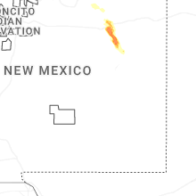
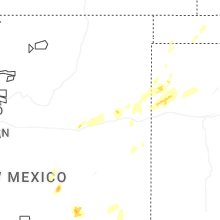
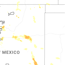

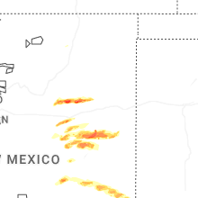


Connect with Interactive Hail Maps