

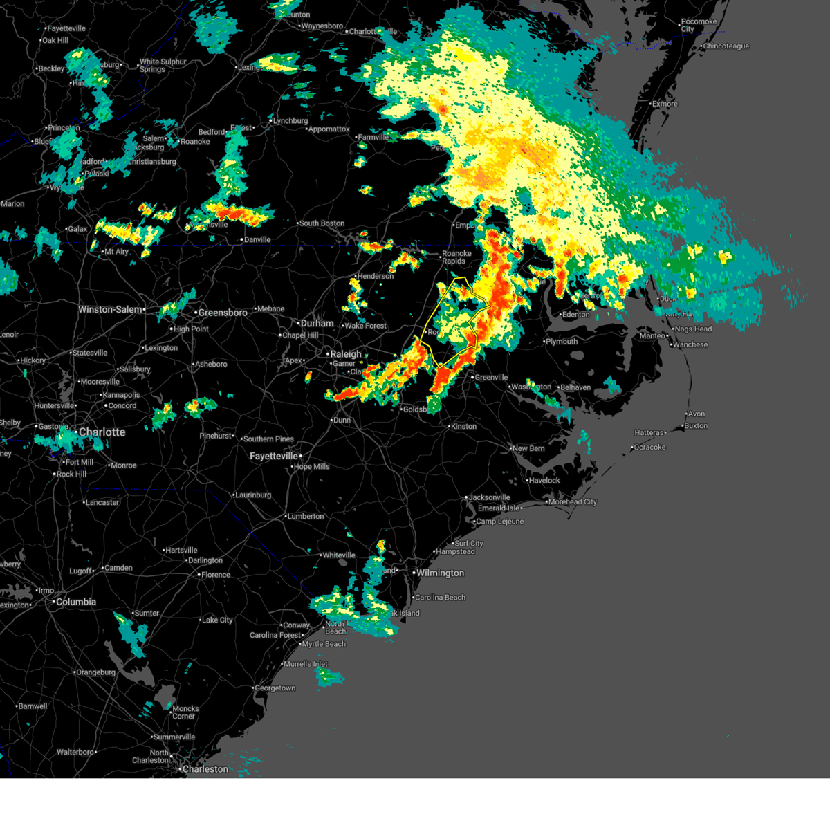
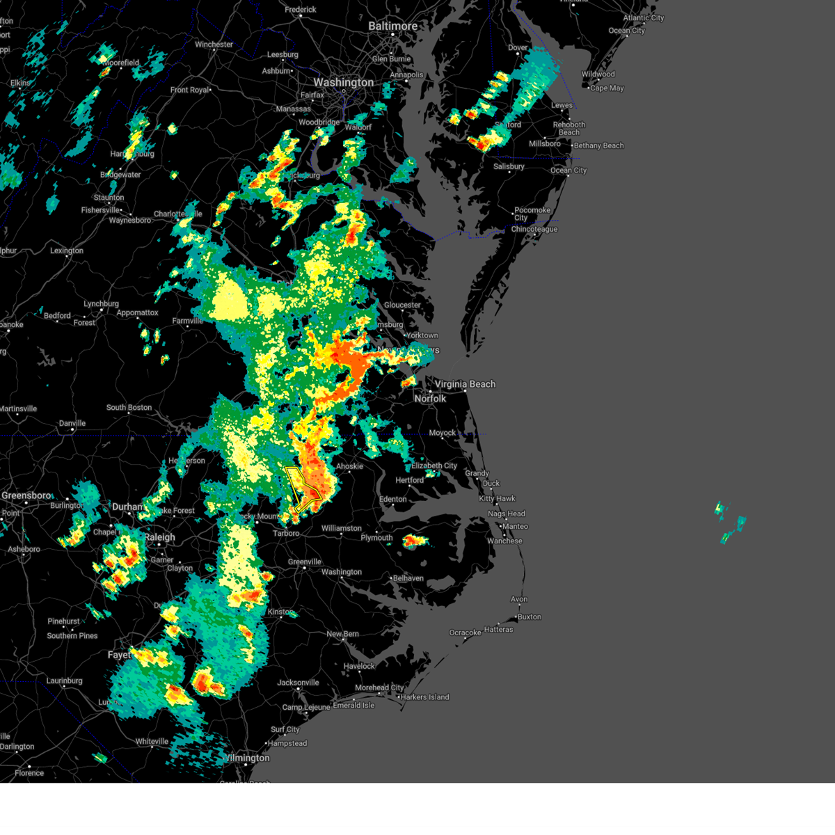
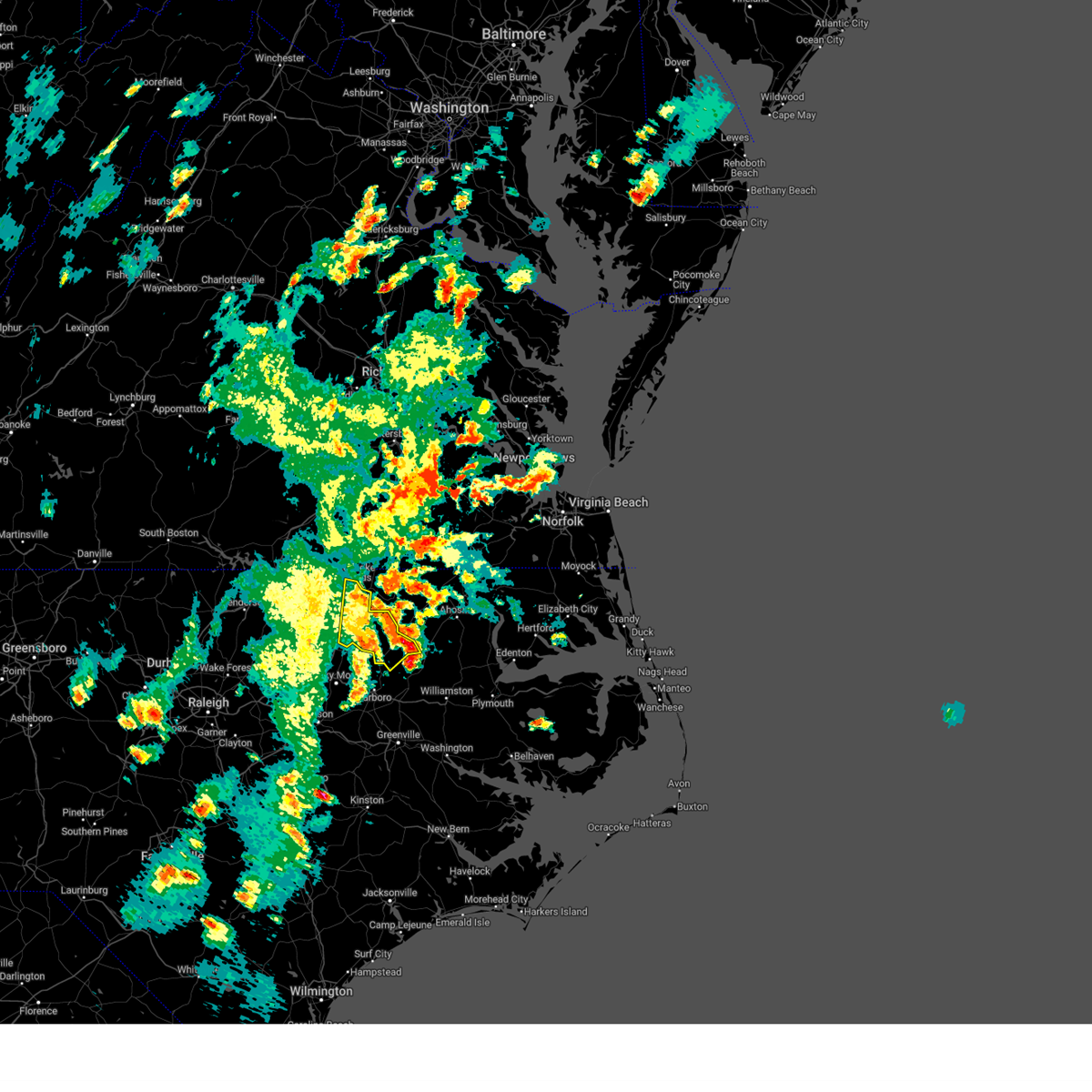
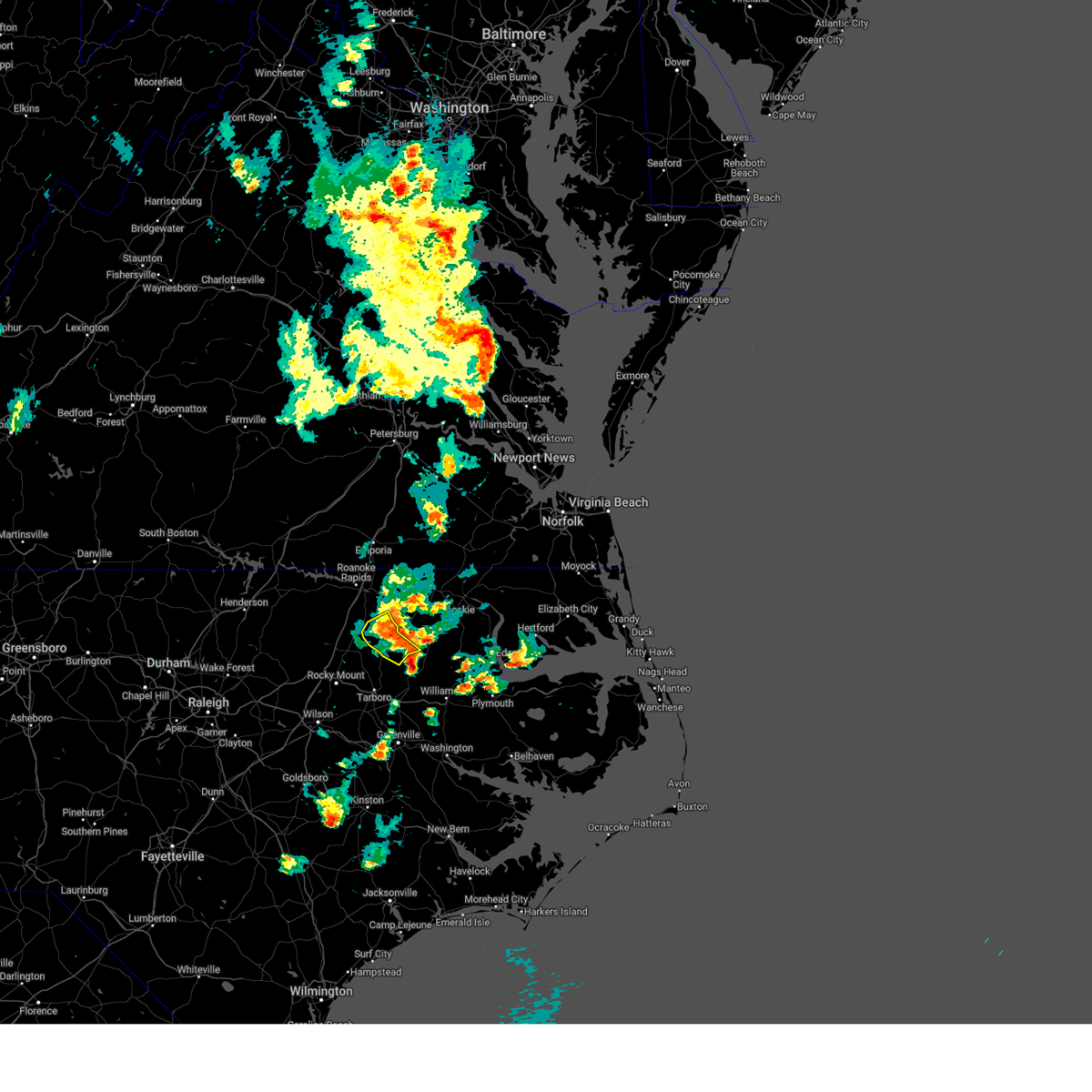
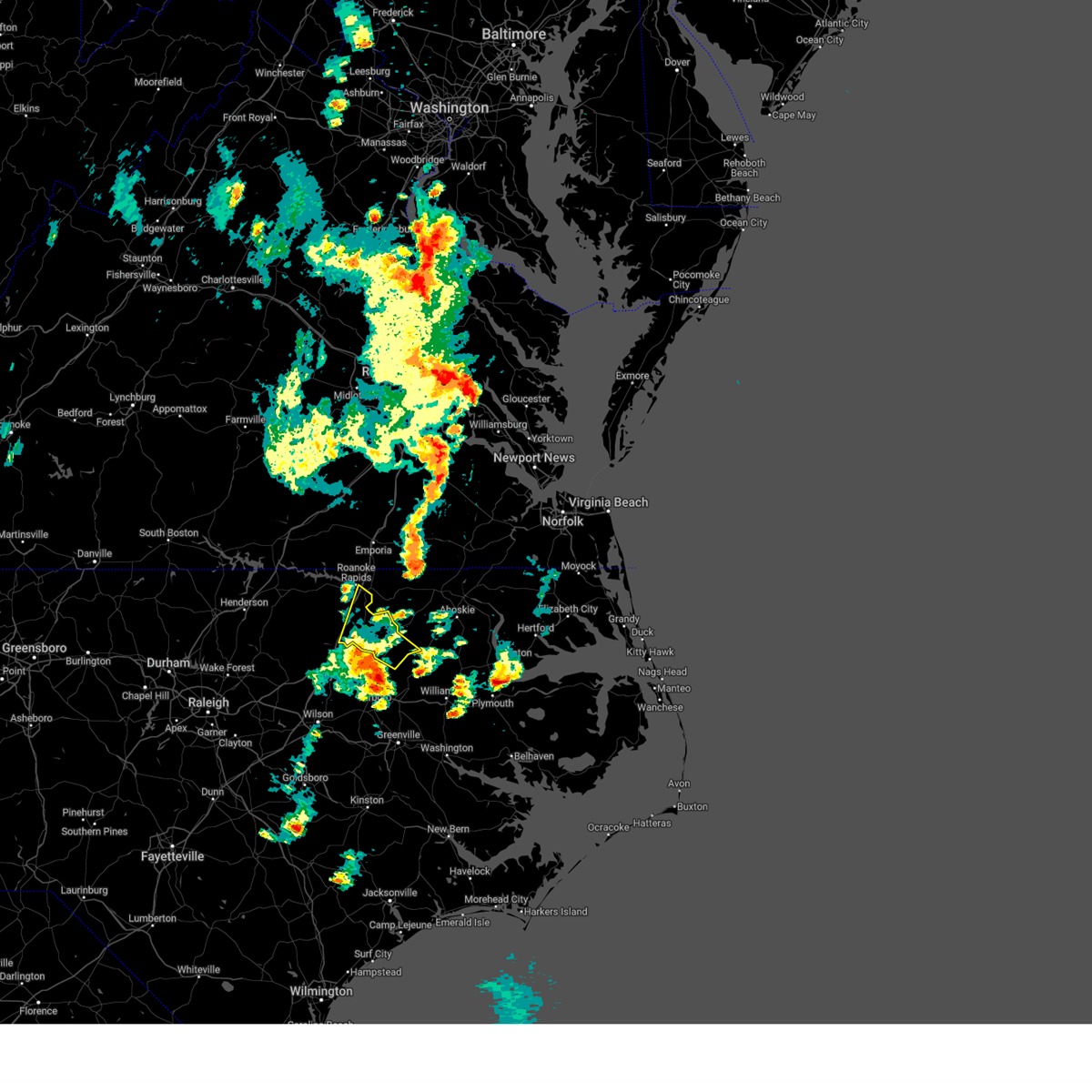
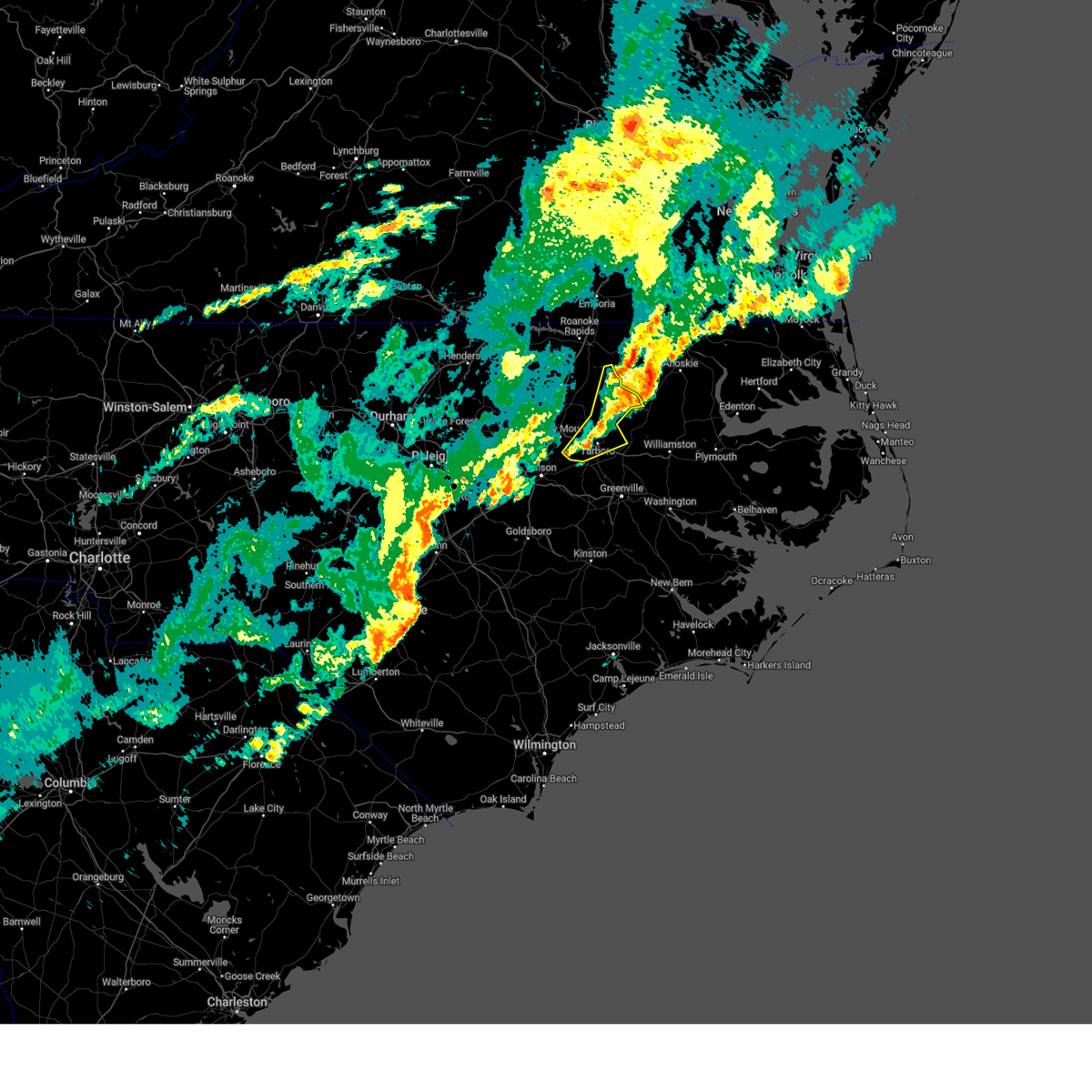
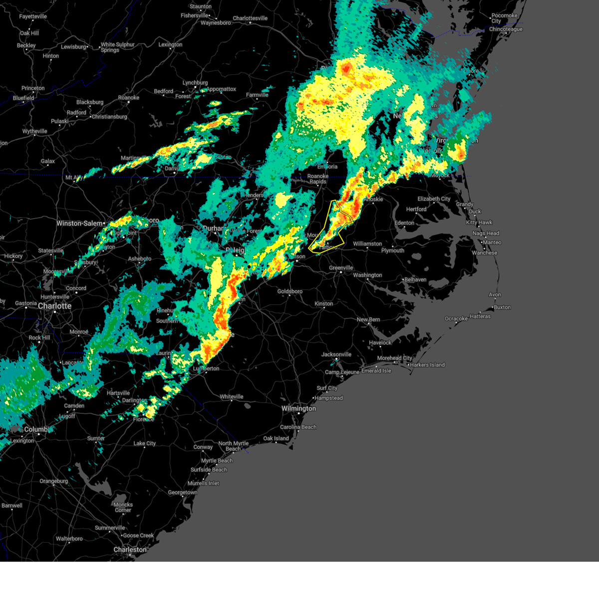
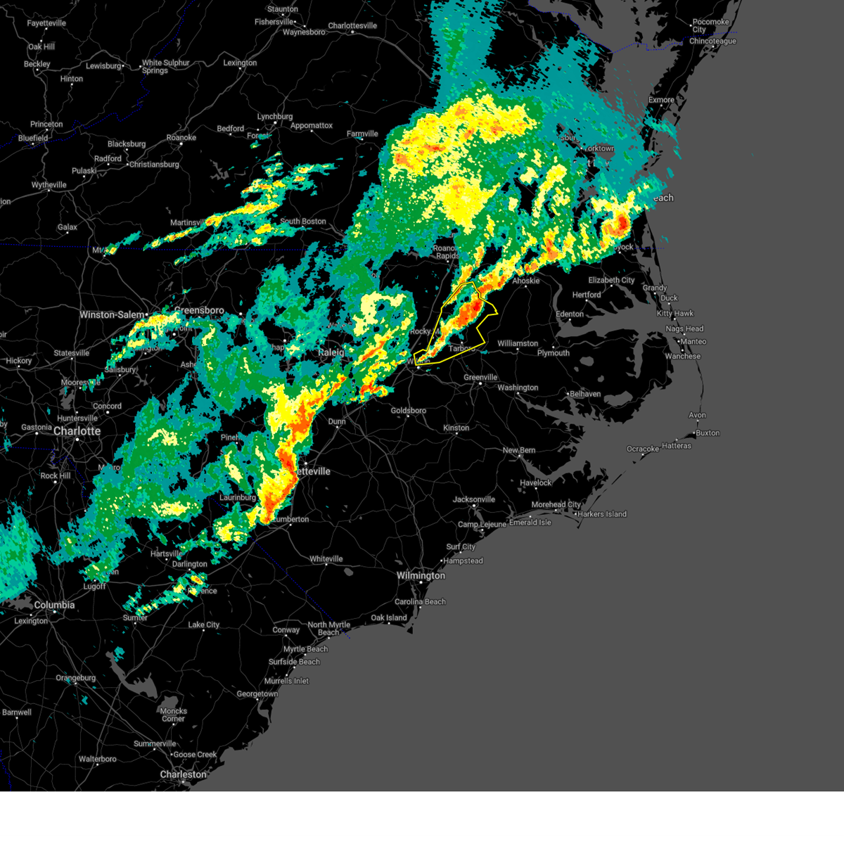
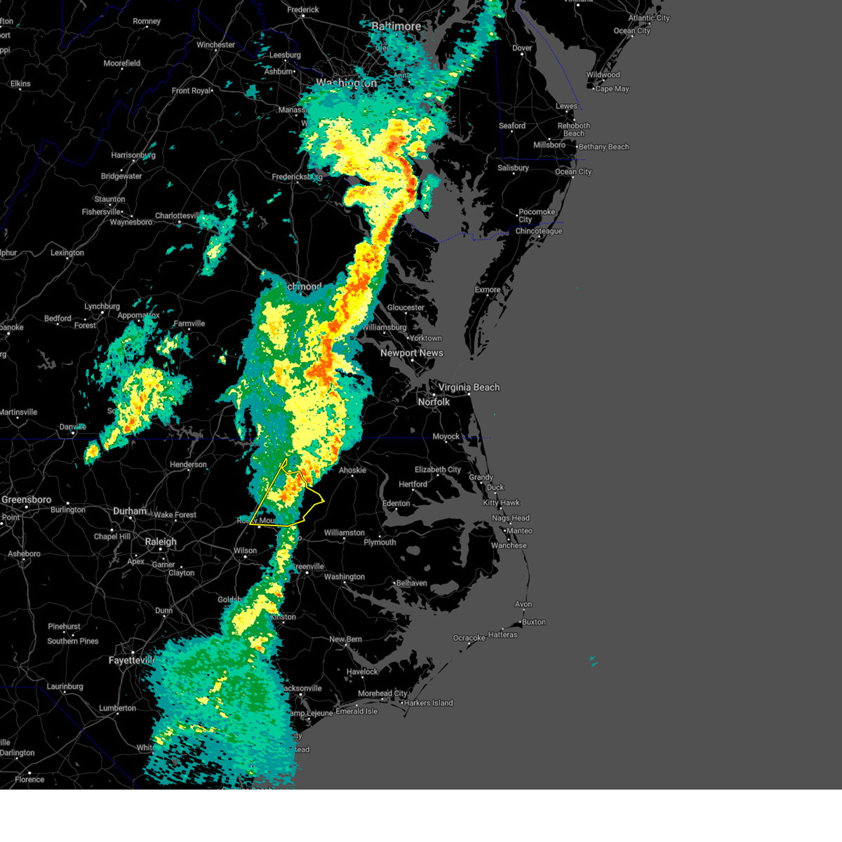
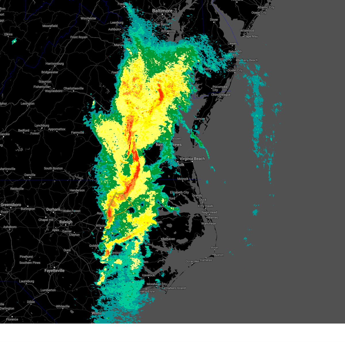
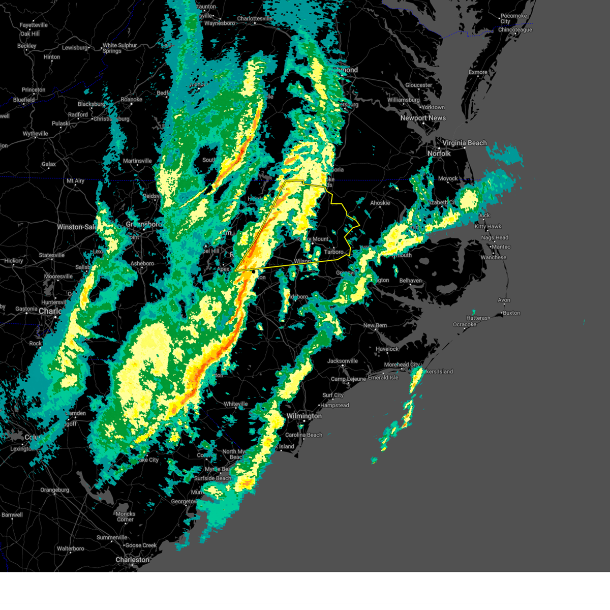
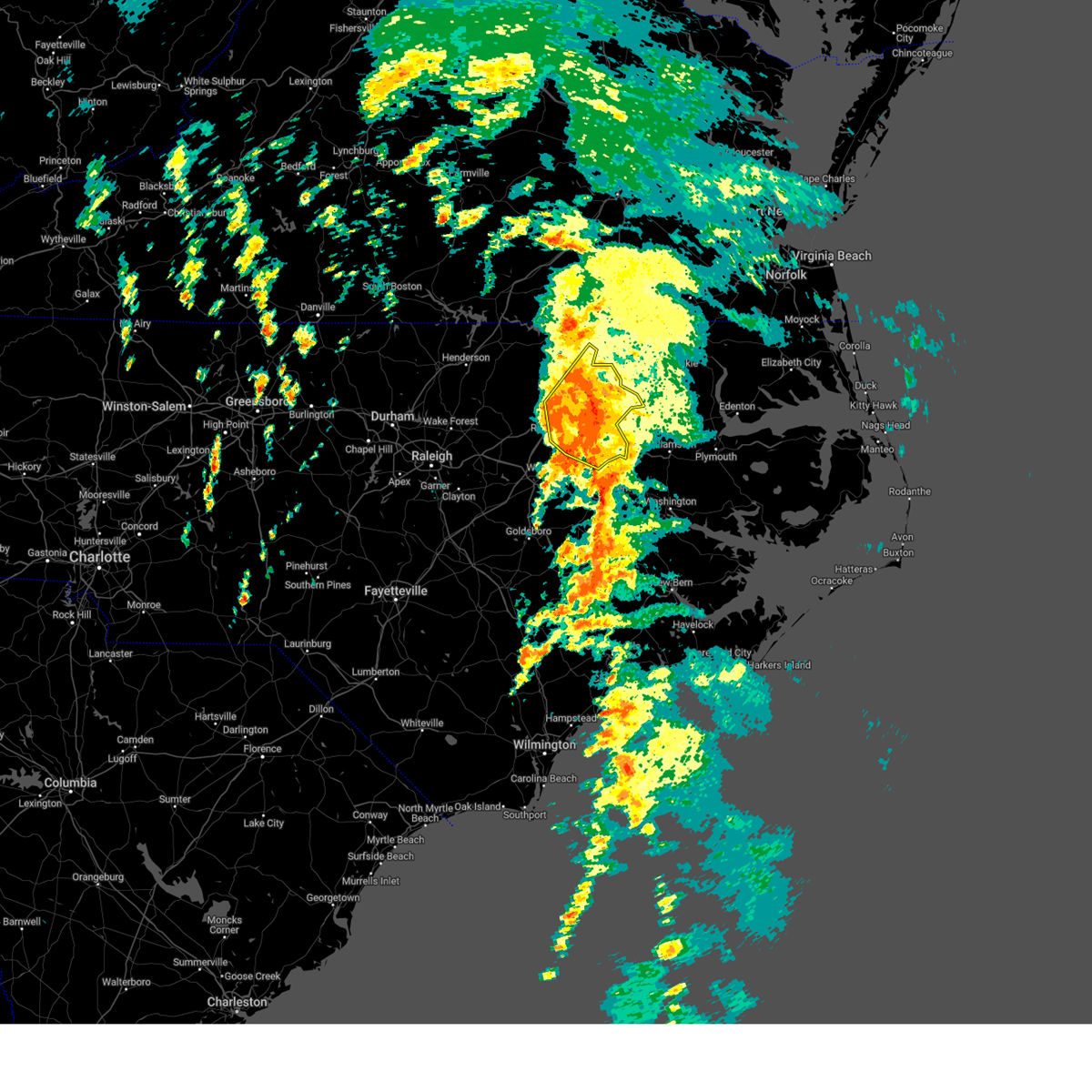
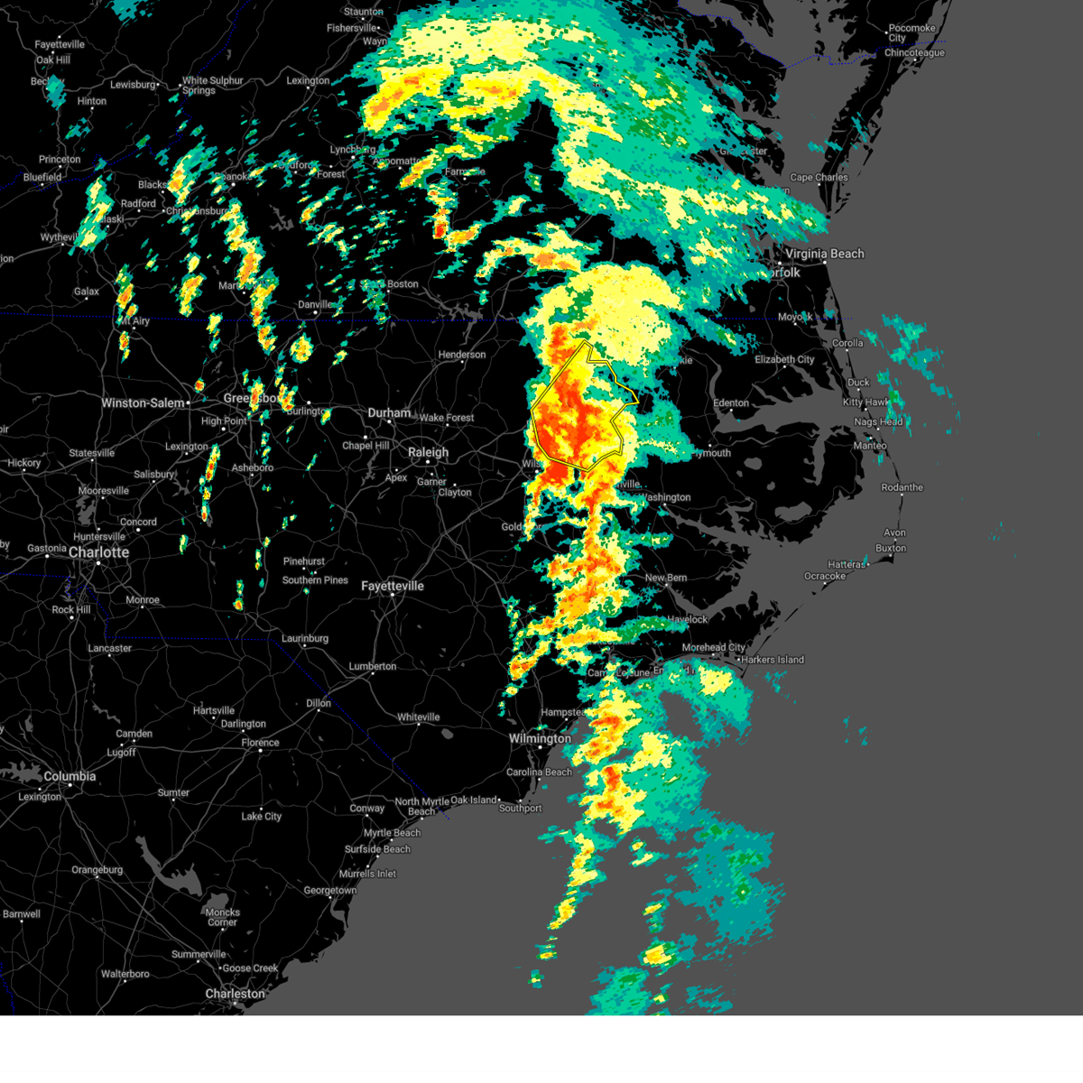
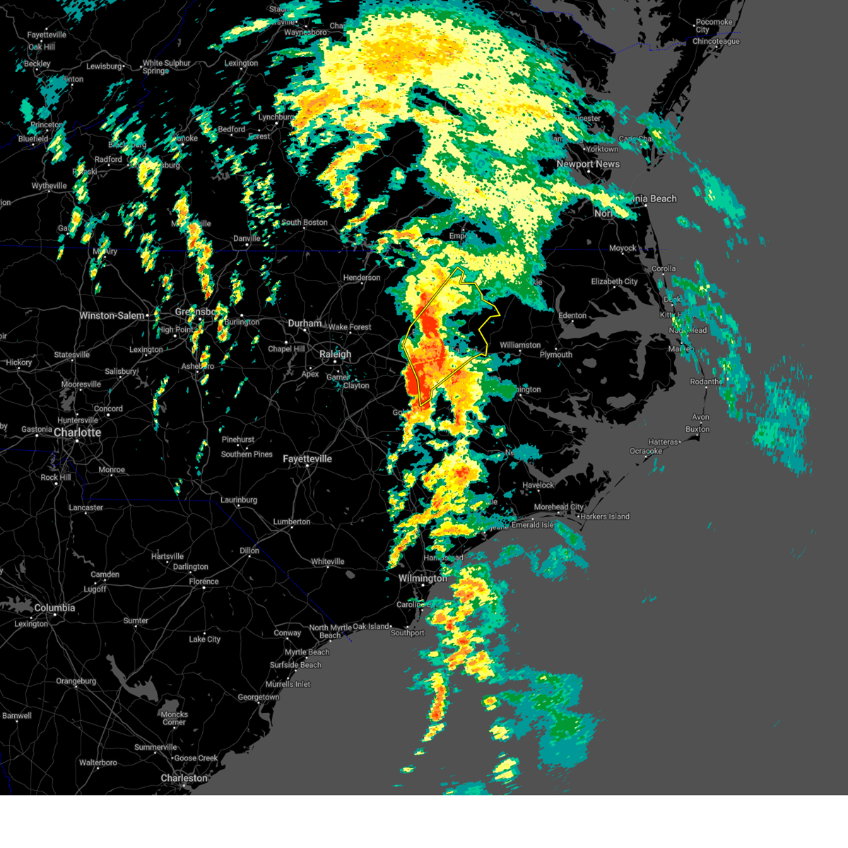
Hail Map for Scotland Neck, NC
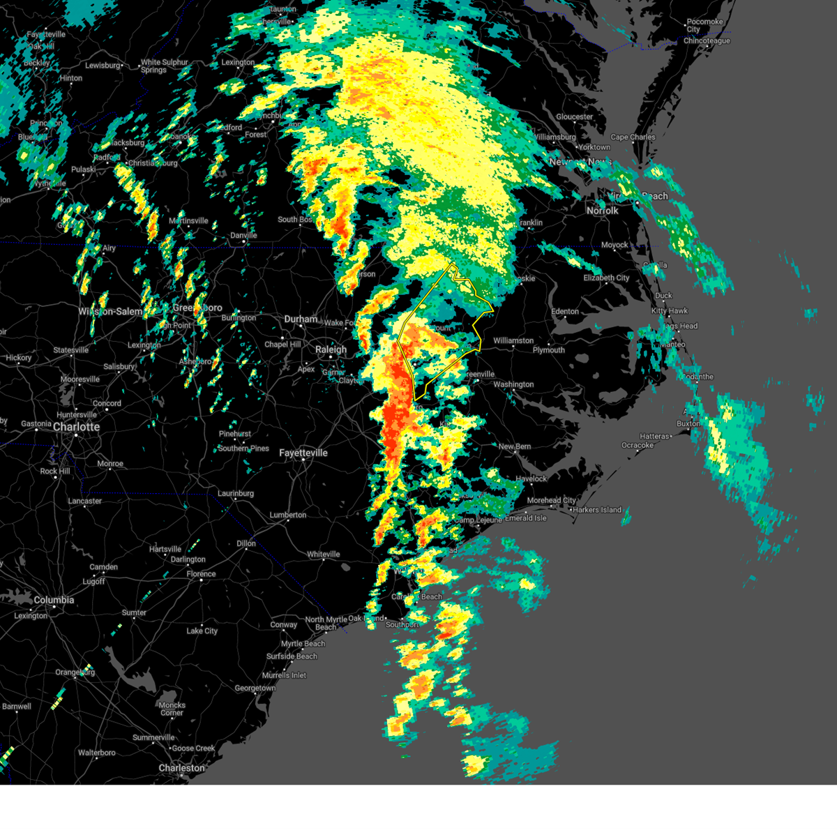
The Scotland Neck, NC area has had 1 report of on-the-ground hail by trained spotters, and has been under severe weather warnings 29 times during the past 12 months. Doppler radar has detected hail at or near Scotland Neck, NC on 44 occasions, including 2 occasions during the past year.
| Name: | Scotland Neck, NC |
| Where Located: | 72.3 miles ENE of Raleigh, NC |
| Map: | Google Map for Scotland Neck, NC |
| Population: | 2059 |
| Housing Units: | 1085 |
| More Info: | Search Google for Scotland Neck, NC |
0
The Top Recent Hail Date for Scotland Neck, NC is Sunday, June 15, 2025 (44th out of 44)

Hail and Wind Damage Spotted near Scotland Neck, NC
| Date / Time | Report Details |
|---|---|
| 6/15/2025 8:23 PM EDT |
 The storm which prompted the warning has weakened below severe limits, and has exited the warned area. therefore, the warning will be allowed to expire. to report severe weather, contact your nearest law enforcement agency. they will relay your report to the national weather service raleigh. The storm which prompted the warning has weakened below severe limits, and has exited the warned area. therefore, the warning will be allowed to expire. to report severe weather, contact your nearest law enforcement agency. they will relay your report to the national weather service raleigh.
|
| 6/15/2025 7:44 PM EDT | Svrrah the national weather service in raleigh has issued a * severe thunderstorm warning for, edgecombe county in central north carolina, southeastern halifax county in central north carolina, * until 830 pm edt. * at 743 pm edt, a severe thunderstorm was located near scotland neck, or 7 miles southwest of rich square, moving northeast at 35 mph (radar indicated). Hazards include 60 mph wind gusts and quarter size hail. Hail damage to vehicles is expected. Expect wind damage to roofs, siding, and trees. |
| 5/14/2025 5:36 PM EDT |
 At 536 pm edt, a severe thunderstorm was located near roxobel, or 8 miles south of rich square, moving east at 45 mph (radar indicated). Hazards include 60 mph wind gusts and quarter size hail. Hail damage to vehicles is expected. expect wind damage to roofs, siding, and trees. Locations impacted include, scotland neck, hobgood, and tillery. At 536 pm edt, a severe thunderstorm was located near roxobel, or 8 miles south of rich square, moving east at 45 mph (radar indicated). Hazards include 60 mph wind gusts and quarter size hail. Hail damage to vehicles is expected. expect wind damage to roofs, siding, and trees. Locations impacted include, scotland neck, hobgood, and tillery.
|
| 5/14/2025 5:13 PM EDT |
 Svrrah the national weather service in raleigh has issued a * severe thunderstorm warning for, halifax county in central north carolina, * until 615 pm edt. * at 512 pm edt, severe thunderstorms were located across halifax county, moving east at 20 mph (radar indicated). Hazards include 60 mph wind gusts and quarter size hail. Hail damage to vehicles is expected. Expect wind damage to roofs, siding, and trees. Svrrah the national weather service in raleigh has issued a * severe thunderstorm warning for, halifax county in central north carolina, * until 615 pm edt. * at 512 pm edt, severe thunderstorms were located across halifax county, moving east at 20 mph (radar indicated). Hazards include 60 mph wind gusts and quarter size hail. Hail damage to vehicles is expected. Expect wind damage to roofs, siding, and trees.
|
| 5/5/2025 6:41 PM EDT |
 The storm which prompted the warning is moving out of the area. therefore, the warning will be allowed to expire. a severe thunderstorm watch remains in effect until 900 pm edt for central north carolina. The storm which prompted the warning is moving out of the area. therefore, the warning will be allowed to expire. a severe thunderstorm watch remains in effect until 900 pm edt for central north carolina.
|
| 5/5/2025 6:35 PM EDT | At 635 pm edt, a severe thunderstorm was located near scotland neck, or 8 miles southwest of rich square, moving northeast at 35 mph (radar indicated). Hazards include 60 mph wind gusts and quarter size hail. Hail damage to vehicles is expected. expect wind damage to roofs, siding, and trees. Locations impacted include, scotland neck and tillery. |
| 5/5/2025 6:11 PM EDT |
 Svrrah the national weather service in raleigh has issued a * severe thunderstorm warning for, central halifax county in central north carolina, * until 645 pm edt. * at 611 pm edt, a severe thunderstorm was located near scotland neck, or 12 miles north of tarboro, moving northeast at 45 mph (radar indicated). Hazards include 60 mph wind gusts and quarter size hail. Hail damage to vehicles is expected. Expect wind damage to roofs, siding, and trees. Svrrah the national weather service in raleigh has issued a * severe thunderstorm warning for, central halifax county in central north carolina, * until 645 pm edt. * at 611 pm edt, a severe thunderstorm was located near scotland neck, or 12 miles north of tarboro, moving northeast at 45 mph (radar indicated). Hazards include 60 mph wind gusts and quarter size hail. Hail damage to vehicles is expected. Expect wind damage to roofs, siding, and trees.
|
| 4/7/2025 2:48 PM EDT |
 At 245 pm edt, a severe thunderstorm was located near scotland neck, moving northeast at 55 mph (radar indicated). Hazards include 60 mph wind gusts. Expect damage to roofs, siding, and trees. Locations impacted include, speed, leggett, scotland neck, princeville, hobgood, tarboro, tillery, and kingsboro. At 245 pm edt, a severe thunderstorm was located near scotland neck, moving northeast at 55 mph (radar indicated). Hazards include 60 mph wind gusts. Expect damage to roofs, siding, and trees. Locations impacted include, speed, leggett, scotland neck, princeville, hobgood, tarboro, tillery, and kingsboro.
|
| 4/7/2025 2:48 PM EDT |
 the severe thunderstorm warning has been cancelled and is no longer in effect the severe thunderstorm warning has been cancelled and is no longer in effect
|
| 4/7/2025 2:32 PM EDT |
 Svrrah the national weather service in raleigh has issued a * severe thunderstorm warning for, edgecombe county in central north carolina, southeastern halifax county in central north carolina, northeastern wilson county in central north carolina, * until 315 pm edt. * at 232 pm edt, a severe thunderstorm was located 7 miles southwest of scotland neck, or 10 miles north of tarboro, moving northeast at 55 mph (radar indicated). Hazards include 60 mph wind gusts. expect damage to roofs, siding, and trees Svrrah the national weather service in raleigh has issued a * severe thunderstorm warning for, edgecombe county in central north carolina, southeastern halifax county in central north carolina, northeastern wilson county in central north carolina, * until 315 pm edt. * at 232 pm edt, a severe thunderstorm was located 7 miles southwest of scotland neck, or 10 miles north of tarboro, moving northeast at 55 mph (radar indicated). Hazards include 60 mph wind gusts. expect damage to roofs, siding, and trees
|
| 3/31/2025 9:09 PM EDT |
 The storms which prompted the warning have weakened below severe limits, and have exited the warned area. therefore, the warning will be allowed to expire. a severe thunderstorm watch remains in effect until 1000 pm edt for central north carolina. The storms which prompted the warning have weakened below severe limits, and have exited the warned area. therefore, the warning will be allowed to expire. a severe thunderstorm watch remains in effect until 1000 pm edt for central north carolina.
|
| 3/31/2025 8:57 PM EDT |
 At 857 pm edt, severe thunderstorms were located along a line extending from near boykins to near woodland to 8 miles northeast of rocky mount, moving northeast at 50 mph (radar indicated). Hazards include 60 mph wind gusts and quarter size hail. Hail damage to vehicles is expected. expect wind damage to roofs, siding, and trees. Locations impacted include, enfield, speed, rocky mount, leggett, battleboro, whitakers, scotland neck, hobgood, tillery, and halifax. At 857 pm edt, severe thunderstorms were located along a line extending from near boykins to near woodland to 8 miles northeast of rocky mount, moving northeast at 50 mph (radar indicated). Hazards include 60 mph wind gusts and quarter size hail. Hail damage to vehicles is expected. expect wind damage to roofs, siding, and trees. Locations impacted include, enfield, speed, rocky mount, leggett, battleboro, whitakers, scotland neck, hobgood, tillery, and halifax.
|
| 3/31/2025 8:25 PM EDT |
 Svrrah the national weather service in raleigh has issued a * severe thunderstorm warning for, central nash county in central north carolina, northern edgecombe county in central north carolina, halifax county in central north carolina, * until 915 pm edt. * at 825 pm edt, severe thunderstorms were located along a line extending from near dahlia to near halifax to near nashville, moving northeast at 45 mph (radar indicated). Hazards include 60 mph wind gusts and quarter size hail. Hail damage to vehicles is expected. Expect wind damage to roofs, siding, and trees. Svrrah the national weather service in raleigh has issued a * severe thunderstorm warning for, central nash county in central north carolina, northern edgecombe county in central north carolina, halifax county in central north carolina, * until 915 pm edt. * at 825 pm edt, severe thunderstorms were located along a line extending from near dahlia to near halifax to near nashville, moving northeast at 45 mph (radar indicated). Hazards include 60 mph wind gusts and quarter size hail. Hail damage to vehicles is expected. Expect wind damage to roofs, siding, and trees.
|
| 3/5/2025 3:44 PM EST |
 the severe thunderstorm warning has been cancelled and is no longer in effect the severe thunderstorm warning has been cancelled and is no longer in effect
|
| 3/5/2025 2:56 PM EST |
 the severe thunderstorm warning has been cancelled and is no longer in effect the severe thunderstorm warning has been cancelled and is no longer in effect
|
| 3/5/2025 2:56 PM EST |
 At 256 pm est, severe thunderstorms were located along a line extending from near conway to near rocky mount, moving northeast at 50 mph (radar indicated). Hazards include 60 mph wind gusts. Expect damage to roofs, siding, and trees. Locations impacted include, enfield, leggett, whitakers, scotland neck, hobgood, tillery, battleboro, and rocky mount. At 256 pm est, severe thunderstorms were located along a line extending from near conway to near rocky mount, moving northeast at 50 mph (radar indicated). Hazards include 60 mph wind gusts. Expect damage to roofs, siding, and trees. Locations impacted include, enfield, leggett, whitakers, scotland neck, hobgood, tillery, battleboro, and rocky mount.
|
| 3/5/2025 2:41 PM EST |
 A new severe thunderstorm warning has been issued for nash, edgecombe, and halifax counties. a tornado watch remains in effect until 800 pm est for central north carolina. A new severe thunderstorm warning has been issued for nash, edgecombe, and halifax counties. a tornado watch remains in effect until 800 pm est for central north carolina.
|
| 3/5/2025 2:40 PM EST |
 Svrrah the national weather service in raleigh has issued a * severe thunderstorm warning for, southeastern nash county in central north carolina, northern edgecombe county in central north carolina, southeastern halifax county in central north carolina, * until 400 pm est. * at 240 pm est, severe thunderstorms were located along a line extending from 7 miles south of seaboard to near elm city, moving northeast at 50 mph (radar indicated). Hazards include 60 mph wind gusts. expect damage to roofs, siding, and trees Svrrah the national weather service in raleigh has issued a * severe thunderstorm warning for, southeastern nash county in central north carolina, northern edgecombe county in central north carolina, southeastern halifax county in central north carolina, * until 400 pm est. * at 240 pm est, severe thunderstorms were located along a line extending from 7 miles south of seaboard to near elm city, moving northeast at 50 mph (radar indicated). Hazards include 60 mph wind gusts. expect damage to roofs, siding, and trees
|
| 3/5/2025 2:32 PM EST |
 At 232 pm est, severe thunderstorms were located along a line extending from near halifax to 11 miles west of scotland neck to near elm city, moving northeast at 50 mph (radar indicated). Hazards include 60 mph wind gusts. Expect damage to roofs, siding, and trees. Locations impacted include, enfield, rocky mount, leggett, battleboro, whitakers, sharpsburg, tillery, halifax, scotland neck, and tar river reservoir. At 232 pm est, severe thunderstorms were located along a line extending from near halifax to 11 miles west of scotland neck to near elm city, moving northeast at 50 mph (radar indicated). Hazards include 60 mph wind gusts. Expect damage to roofs, siding, and trees. Locations impacted include, enfield, rocky mount, leggett, battleboro, whitakers, sharpsburg, tillery, halifax, scotland neck, and tar river reservoir.
|
| 3/5/2025 1:34 PM EST |
 Svrrah the national weather service in raleigh has issued a * severe thunderstorm warning for, nash county in central north carolina, northern edgecombe county in central north carolina, halifax county in central north carolina, * until 245 pm est. * at 133 pm est, severe thunderstorms were located along a line extending from 9 miles east of louisburg to near bunn to near bailey, moving northeast at 40 mph (radar indicated). Hazards include 60 mph wind gusts. expect damage to roofs, siding, and trees Svrrah the national weather service in raleigh has issued a * severe thunderstorm warning for, nash county in central north carolina, northern edgecombe county in central north carolina, halifax county in central north carolina, * until 245 pm est. * at 133 pm est, severe thunderstorms were located along a line extending from 9 miles east of louisburg to near bunn to near bailey, moving northeast at 40 mph (radar indicated). Hazards include 60 mph wind gusts. expect damage to roofs, siding, and trees
|
| 2/16/2025 9:32 AM EST |
 Svrrah the national weather service in raleigh has issued a * severe thunderstorm warning for, warren county in central north carolina, nash county in central north carolina, edgecombe county in central north carolina, halifax county in central north carolina, northeastern wake county in central north carolina, northern wilson county in central north carolina, northeastern johnston county in central north carolina, franklin county in central north carolina, * until 1015 am est. * at 932 am est, severe thunderstorms were located along a line extending from 7 miles southwest of ebony to 7 miles southeast of franklinton to near garner, moving east at 45 mph (radar indicated). Hazards include 60 mph wind gusts. expect damage to roofs, siding, and trees Svrrah the national weather service in raleigh has issued a * severe thunderstorm warning for, warren county in central north carolina, nash county in central north carolina, edgecombe county in central north carolina, halifax county in central north carolina, northeastern wake county in central north carolina, northern wilson county in central north carolina, northeastern johnston county in central north carolina, franklin county in central north carolina, * until 1015 am est. * at 932 am est, severe thunderstorms were located along a line extending from 7 miles southwest of ebony to 7 miles southeast of franklinton to near garner, moving east at 45 mph (radar indicated). Hazards include 60 mph wind gusts. expect damage to roofs, siding, and trees
|
| 9/27/2024 2:07 PM EDT |
 the severe thunderstorm warning has been cancelled and is no longer in effect the severe thunderstorm warning has been cancelled and is no longer in effect
|
| 9/27/2024 2:07 PM EDT |
 At 207 pm edt, severe thunderstorms were located along a line extending from near halifax to near scotland neck to 8 miles north of tarboro, moving northeast at 25 mph. a tornado warning remains in effect for halifax county (radar indicated). Hazards include 60 mph wind gusts. Expect damage to roofs, siding, and trees. Locations impacted include, tarboro, halifax, scotland neck, enfield, weldon, hobgood, speed, and tillery. At 207 pm edt, severe thunderstorms were located along a line extending from near halifax to near scotland neck to 8 miles north of tarboro, moving northeast at 25 mph. a tornado warning remains in effect for halifax county (radar indicated). Hazards include 60 mph wind gusts. Expect damage to roofs, siding, and trees. Locations impacted include, tarboro, halifax, scotland neck, enfield, weldon, hobgood, speed, and tillery.
|
| 9/27/2024 2:00 PM EDT |
 At 200 pm edt, severe thunderstorms were located along a line extending from near halifax to near scotland neck to near tarboro, moving northeast at 30 mph. a tornado warning also remains in effect for halifax county (radar indicated). Hazards include 60 mph wind gusts. Expect damage to roofs, siding, and trees. Locations impacted include, rocky mount, tarboro, halifax, scotland neck, dortches, enfield, princeville, weldon, whitakers, and hobgood. At 200 pm edt, severe thunderstorms were located along a line extending from near halifax to near scotland neck to near tarboro, moving northeast at 30 mph. a tornado warning also remains in effect for halifax county (radar indicated). Hazards include 60 mph wind gusts. Expect damage to roofs, siding, and trees. Locations impacted include, rocky mount, tarboro, halifax, scotland neck, dortches, enfield, princeville, weldon, whitakers, and hobgood.
|
| 9/27/2024 2:00 PM EDT |
 the severe thunderstorm warning has been cancelled and is no longer in effect the severe thunderstorm warning has been cancelled and is no longer in effect
|
| 9/27/2024 1:46 PM EDT |
 At 145 pm edt, severe thunderstorms were located along a line extending from 11 miles southwest of halifax to 9 miles southwest of scotland neck to 6 miles east of tarboro, moving northeast at 50 mph (radar indicated). Hazards include 60 mph wind gusts. Expect damage to roofs, siding, and trees. Locations impacted include, rocky mount, tarboro, halifax, scotland neck, dortches, red oak, enfield, princeville, sharpsburg, and weldon. At 145 pm edt, severe thunderstorms were located along a line extending from 11 miles southwest of halifax to 9 miles southwest of scotland neck to 6 miles east of tarboro, moving northeast at 50 mph (radar indicated). Hazards include 60 mph wind gusts. Expect damage to roofs, siding, and trees. Locations impacted include, rocky mount, tarboro, halifax, scotland neck, dortches, red oak, enfield, princeville, sharpsburg, and weldon.
|
| 9/27/2024 1:46 PM EDT |
 the severe thunderstorm warning has been cancelled and is no longer in effect the severe thunderstorm warning has been cancelled and is no longer in effect
|
| 9/27/2024 1:27 PM EDT |
 At 126 pm edt, severe thunderstorms were located along a line extending from near dortches to 7 miles southeast of rocky mount to 9 miles northwest of farmville, moving northeast at 40 mph (radar indicated). Hazards include 60 mph wind gusts. Expect damage to roofs, siding, and trees. Locations impacted include, rocky mount, tarboro, nashville, halifax, wilson, scotland neck, elm city, dortches, red oak, and enfield. At 126 pm edt, severe thunderstorms were located along a line extending from near dortches to 7 miles southeast of rocky mount to 9 miles northwest of farmville, moving northeast at 40 mph (radar indicated). Hazards include 60 mph wind gusts. Expect damage to roofs, siding, and trees. Locations impacted include, rocky mount, tarboro, nashville, halifax, wilson, scotland neck, elm city, dortches, red oak, and enfield.
|
| 9/27/2024 1:07 PM EDT |
 Svrrah the national weather service in raleigh has issued a * severe thunderstorm warning for, northeastern wayne county in central north carolina, eastern nash county in central north carolina, edgecombe county in central north carolina, southeastern halifax county in central north carolina, wilson county in central north carolina, * until 215 pm edt. * at 107 pm edt, severe thunderstorms were located along a line extending from 6 miles south of nashville to near wilson to 7 miles northeast of fremont, moving northeast at 45 mph (radar indicated). Hazards include 60 mph wind gusts. expect damage to roofs, siding, and trees Svrrah the national weather service in raleigh has issued a * severe thunderstorm warning for, northeastern wayne county in central north carolina, eastern nash county in central north carolina, edgecombe county in central north carolina, southeastern halifax county in central north carolina, wilson county in central north carolina, * until 215 pm edt. * at 107 pm edt, severe thunderstorms were located along a line extending from 6 miles south of nashville to near wilson to 7 miles northeast of fremont, moving northeast at 45 mph (radar indicated). Hazards include 60 mph wind gusts. expect damage to roofs, siding, and trees
|
| 5/27/2024 5:15 PM EDT |
 the severe thunderstorm warning has been cancelled and is no longer in effect the severe thunderstorm warning has been cancelled and is no longer in effect
|
| 5/27/2024 5:06 PM EDT |
 the severe thunderstorm warning has been cancelled and is no longer in effect the severe thunderstorm warning has been cancelled and is no longer in effect
|
| 5/27/2024 5:02 PM EDT |
 At 502 pm edt, severe thunderstorms were located along a line extending from 6 miles north of scotland neck to near bethel, moving northeast at 30 mph (radar indicated). Hazards include 60 mph wind gusts. Expect damage to roofs, siding, and trees. Locations impacted include, scotland neck, hobgood, and speed. At 502 pm edt, severe thunderstorms were located along a line extending from 6 miles north of scotland neck to near bethel, moving northeast at 30 mph (radar indicated). Hazards include 60 mph wind gusts. Expect damage to roofs, siding, and trees. Locations impacted include, scotland neck, hobgood, and speed.
|
| 5/27/2024 4:55 PM EDT |
 At 454 pm edt, a severe thunderstorm was located near scotland neck, or 10 miles south of rich square, moving east at 30 mph (radar indicated). Hazards include 60 mph wind gusts and quarter size hail. Hail damage to vehicles is expected. expect wind damage to roofs, siding, and trees. Locations impacted include, scotland neck, hobgood, and tillery. At 454 pm edt, a severe thunderstorm was located near scotland neck, or 10 miles south of rich square, moving east at 30 mph (radar indicated). Hazards include 60 mph wind gusts and quarter size hail. Hail damage to vehicles is expected. expect wind damage to roofs, siding, and trees. Locations impacted include, scotland neck, hobgood, and tillery.
|
| 5/27/2024 4:55 PM EDT |
 the severe thunderstorm warning has been cancelled and is no longer in effect the severe thunderstorm warning has been cancelled and is no longer in effect
|
| 5/27/2024 4:51 PM EDT |
 Svrrah the national weather service in raleigh has issued a * severe thunderstorm warning for, southeastern edgecombe county in central north carolina, southeastern halifax county in central north carolina, * until 530 pm edt. * at 451 pm edt, severe thunderstorms were located along a line extending from near scotland neck to 12 miles west of lewiston woodville, moving northeast at 30 mph (radar indicated). Hazards include 60 mph wind gusts and penny size hail. expect damage to roofs, siding, and trees Svrrah the national weather service in raleigh has issued a * severe thunderstorm warning for, southeastern edgecombe county in central north carolina, southeastern halifax county in central north carolina, * until 530 pm edt. * at 451 pm edt, severe thunderstorms were located along a line extending from near scotland neck to 12 miles west of lewiston woodville, moving northeast at 30 mph (radar indicated). Hazards include 60 mph wind gusts and penny size hail. expect damage to roofs, siding, and trees
|
| 5/27/2024 4:49 PM EDT |
 the tornado warning has been cancelled and is no longer in effect the tornado warning has been cancelled and is no longer in effect
|
| 5/27/2024 4:47 PM EDT | Trees and powerlines down on downing dr. radar estimated tim in halifax county NC, 0.7 miles NNE of Scotland Neck, NC |
| 5/27/2024 4:39 PM EDT |
 the tornado warning has been cancelled and is no longer in effect the tornado warning has been cancelled and is no longer in effect
|
| 5/27/2024 4:39 PM EDT |
 At 438 pm edt, a severe thunderstorm capable of producing a tornado was located 4 miles west southwest of scotland neck, or 14 miles north of tarboro, moving east at 20 mph (radar indicated rotation). Hazards include tornado and quarter size hail. Flying debris will be dangerous to those caught without shelter. mobile homes will be damaged or destroyed. damage to roofs, windows, and vehicles will occur. tree damage is likely. This dangerous storm will be near, scotland neck around 445 pm edt. At 438 pm edt, a severe thunderstorm capable of producing a tornado was located 4 miles west southwest of scotland neck, or 14 miles north of tarboro, moving east at 20 mph (radar indicated rotation). Hazards include tornado and quarter size hail. Flying debris will be dangerous to those caught without shelter. mobile homes will be damaged or destroyed. damage to roofs, windows, and vehicles will occur. tree damage is likely. This dangerous storm will be near, scotland neck around 445 pm edt.
|
| 5/27/2024 4:33 PM EDT |
 At 433 pm edt, a severe thunderstorm was located near scotland neck, or 13 miles north of tarboro, moving east at 20 mph (radar indicated). Hazards include 60 mph wind gusts and quarter size hail. Hail damage to vehicles is expected. expect wind damage to roofs, siding, and trees. Locations impacted include, scotland neck, hobgood, and tillery. At 433 pm edt, a severe thunderstorm was located near scotland neck, or 13 miles north of tarboro, moving east at 20 mph (radar indicated). Hazards include 60 mph wind gusts and quarter size hail. Hail damage to vehicles is expected. expect wind damage to roofs, siding, and trees. Locations impacted include, scotland neck, hobgood, and tillery.
|
| 5/27/2024 4:27 PM EDT |
 At 427 pm edt, a severe thunderstorm capable of producing a tornado was located 8 miles west of scotland neck, or 13 miles north of tarboro, moving east at 20 mph (radar indicated rotation). Hazards include tornado and quarter size hail. Flying debris will be dangerous to those caught without shelter. mobile homes will be damaged or destroyed. damage to roofs, windows, and vehicles will occur. tree damage is likely. This dangerous storm will be near, scotland neck around 435 pm edt. At 427 pm edt, a severe thunderstorm capable of producing a tornado was located 8 miles west of scotland neck, or 13 miles north of tarboro, moving east at 20 mph (radar indicated rotation). Hazards include tornado and quarter size hail. Flying debris will be dangerous to those caught without shelter. mobile homes will be damaged or destroyed. damage to roofs, windows, and vehicles will occur. tree damage is likely. This dangerous storm will be near, scotland neck around 435 pm edt.
|
| 5/27/2024 4:15 PM EDT |
 Torrah the national weather service in raleigh has issued a * tornado warning for, north central edgecombe county in central north carolina, southeastern halifax county in central north carolina, * until 500 pm edt. * at 415 pm edt, a severe thunderstorm capable of producing a tornado was located 12 miles northeast of rocky mount, moving east at 20 mph (radar indicated rotation). Hazards include tornado. Flying debris will be dangerous to those caught without shelter. mobile homes will be damaged or destroyed. damage to roofs, windows, and vehicles will occur. tree damage is likely. this dangerous storm will be near, scotland neck around 430 pm edt. Other locations impacted by this tornadic thunderstorm include whitakers and hobgood. Torrah the national weather service in raleigh has issued a * tornado warning for, north central edgecombe county in central north carolina, southeastern halifax county in central north carolina, * until 500 pm edt. * at 415 pm edt, a severe thunderstorm capable of producing a tornado was located 12 miles northeast of rocky mount, moving east at 20 mph (radar indicated rotation). Hazards include tornado. Flying debris will be dangerous to those caught without shelter. mobile homes will be damaged or destroyed. damage to roofs, windows, and vehicles will occur. tree damage is likely. this dangerous storm will be near, scotland neck around 430 pm edt. Other locations impacted by this tornadic thunderstorm include whitakers and hobgood.
|
| 5/27/2024 4:13 PM EDT |
 Svrrah the national weather service in raleigh has issued a * severe thunderstorm warning for, northeastern edgecombe county in central north carolina, southeastern halifax county in central north carolina, * until 515 pm edt. * at 413 pm edt, a severe thunderstorm was located 10 miles northeast of dortches, or 11 miles northeast of rocky mount, moving northeast at 10 mph (radar indicated). Hazards include 60 mph wind gusts and quarter size hail. Hail damage to vehicles is expected. Expect wind damage to roofs, siding, and trees. Svrrah the national weather service in raleigh has issued a * severe thunderstorm warning for, northeastern edgecombe county in central north carolina, southeastern halifax county in central north carolina, * until 515 pm edt. * at 413 pm edt, a severe thunderstorm was located 10 miles northeast of dortches, or 11 miles northeast of rocky mount, moving northeast at 10 mph (radar indicated). Hazards include 60 mph wind gusts and quarter size hail. Hail damage to vehicles is expected. Expect wind damage to roofs, siding, and trees.
|
| 1/9/2024 7:24 PM EST |
 At 723 pm est, severe thunderstorms were located along a line extending from near littleton to 9 miles southwest of roanoke rapids to near rocky mount to near fremont, moving northeast at 70 mph (radar indicated). Hazards include 60 mph wind gusts. expect damage to roofs, siding, and trees At 723 pm est, severe thunderstorms were located along a line extending from near littleton to 9 miles southwest of roanoke rapids to near rocky mount to near fremont, moving northeast at 70 mph (radar indicated). Hazards include 60 mph wind gusts. expect damage to roofs, siding, and trees
|
| 9/9/2023 2:35 PM EDT | 911 call center reported trees and powerlines down along jr high school rd in scotland neck. time estimated by rada in halifax county NC, 0.4 miles ESE of Scotland Neck, NC |
| 9/9/2023 2:29 PM EDT | Power outages were reported due to fallen trees on powerlines. time estimated by rada in halifax county NC, 0.9 miles SSE of Scotland Neck, NC |
| 9/9/2023 2:26 PM EDT | Corrects previous tstm wnd dmg report from scotland neck. 911 call center reported trees and powerlines down along jr high school rd in scotland neck. time estimated by in halifax county NC, 0.4 miles ESE of Scotland Neck, NC |
| 9/9/2023 2:19 PM EDT |
 At 219 pm edt, a severe thunderstorm was located over scotland neck, or 13 miles southwest of rich square, moving northwest at 20 mph (radar indicated). Hazards include 60 mph wind gusts. expect damage to roofs, siding, and trees At 219 pm edt, a severe thunderstorm was located over scotland neck, or 13 miles southwest of rich square, moving northwest at 20 mph (radar indicated). Hazards include 60 mph wind gusts. expect damage to roofs, siding, and trees
|
| 9/8/2023 5:40 PM EDT |
 At 540 pm edt, severe thunderstorms were located along a line extending from 13 miles southeast of warrenton to 8 miles west of scotland neck, moving north at 15 mph (radar indicated). Hazards include 60 mph wind gusts and quarter size hail. Hail damage to vehicles is expected. expect wind damage to roofs, siding, and trees. locations impacted include, warrenton, halifax, scotland neck, littleton, enfield, weldon, whitakers, macon, centerville and glenview. hail threat, radar indicated max hail size, 1. 00 in wind threat, radar indicated max wind gust, 60 mph. At 540 pm edt, severe thunderstorms were located along a line extending from 13 miles southeast of warrenton to 8 miles west of scotland neck, moving north at 15 mph (radar indicated). Hazards include 60 mph wind gusts and quarter size hail. Hail damage to vehicles is expected. expect wind damage to roofs, siding, and trees. locations impacted include, warrenton, halifax, scotland neck, littleton, enfield, weldon, whitakers, macon, centerville and glenview. hail threat, radar indicated max hail size, 1. 00 in wind threat, radar indicated max wind gust, 60 mph.
|
| 9/8/2023 5:34 PM EDT |
 At 534 pm edt, severe thunderstorms were located along a line extending from 14 miles southeast of warrenton to 6 miles southwest of scotland neck, moving northeast at 30 mph (radar indicated). Hazards include 60 mph wind gusts and quarter size hail. Hail damage to vehicles is expected. expect wind damage to roofs, siding, and trees. locations impacted include, warrenton, halifax, scotland neck, littleton, red oak, enfield, weldon, whitakers, hobgood and castalia. hail threat, radar indicated max hail size, 1. 00 in wind threat, radar indicated max wind gust, 60 mph. At 534 pm edt, severe thunderstorms were located along a line extending from 14 miles southeast of warrenton to 6 miles southwest of scotland neck, moving northeast at 30 mph (radar indicated). Hazards include 60 mph wind gusts and quarter size hail. Hail damage to vehicles is expected. expect wind damage to roofs, siding, and trees. locations impacted include, warrenton, halifax, scotland neck, littleton, red oak, enfield, weldon, whitakers, hobgood and castalia. hail threat, radar indicated max hail size, 1. 00 in wind threat, radar indicated max wind gust, 60 mph.
|
| 9/8/2023 5:23 PM EDT |
 At 523 pm edt, severe thunderstorms were located along a line extending from 12 miles northwest of nashville to near tarboro, moving north at 30 mph (radar indicated). Hazards include 60 mph wind gusts and quarter size hail. Hail damage to vehicles is expected. Expect wind damage to roofs, siding, and trees. At 523 pm edt, severe thunderstorms were located along a line extending from 12 miles northwest of nashville to near tarboro, moving north at 30 mph (radar indicated). Hazards include 60 mph wind gusts and quarter size hail. Hail damage to vehicles is expected. Expect wind damage to roofs, siding, and trees.
|
| 8/15/2023 6:14 PM EDT |
 At 613 pm edt, severe thunderstorms were located along a line extending from 6 miles northeast of tarboro to bethel, moving east at 45 mph (emergency management). Hazards include 70 mph wind gusts. Expect considerable tree damage. damage is likely to mobile homes, roofs, and outbuildings. locations impacted include, scotland neck, princeville, hobgood, conetoe and speed. thunderstorm damage threat, considerable hail threat, radar indicated max hail size, <. 75 in wind threat, observed max wind gust, 70 mph. At 613 pm edt, severe thunderstorms were located along a line extending from 6 miles northeast of tarboro to bethel, moving east at 45 mph (emergency management). Hazards include 70 mph wind gusts. Expect considerable tree damage. damage is likely to mobile homes, roofs, and outbuildings. locations impacted include, scotland neck, princeville, hobgood, conetoe and speed. thunderstorm damage threat, considerable hail threat, radar indicated max hail size, <. 75 in wind threat, observed max wind gust, 70 mph.
|
| 8/15/2023 6:01 PM EDT |
 At 600 pm edt, severe thunderstorms were located along a line extending from near tarboro to 8 miles west of bethel, moving east at 45 mph (emergency management). Hazards include 70 mph wind gusts. Expect considerable tree damage. damage is likely to mobile homes, roofs, and outbuildings. locations impacted include, tarboro, halifax, scotland neck, enfield, princeville, weldon, pinetops, macclesfield, hobgood and conetoe. thunderstorm damage threat, considerable hail threat, radar indicated max hail size, <. 75 in wind threat, observed max wind gust, 70 mph. At 600 pm edt, severe thunderstorms were located along a line extending from near tarboro to 8 miles west of bethel, moving east at 45 mph (emergency management). Hazards include 70 mph wind gusts. Expect considerable tree damage. damage is likely to mobile homes, roofs, and outbuildings. locations impacted include, tarboro, halifax, scotland neck, enfield, princeville, weldon, pinetops, macclesfield, hobgood and conetoe. thunderstorm damage threat, considerable hail threat, radar indicated max hail size, <. 75 in wind threat, observed max wind gust, 70 mph.
|
| 8/15/2023 5:46 PM EDT |
 At 545 pm edt, severe thunderstorms were located along a line extending from 7 miles west of halifax to 6 miles southwest of scotland neck to 8 miles southwest of tarboro, moving east at 50 mph (emergency management). Hazards include 70 mph wind gusts. Expect considerable tree damage. damage is likely to mobile homes, roofs, and outbuildings. locations impacted include, rocky mount, tarboro, halifax, scotland neck, elm city, enfield, princeville, sharpsburg, weldon and pinetops. thunderstorm damage threat, considerable hail threat, radar indicated max hail size, <. 75 in wind threat, observed max wind gust, 70 mph. At 545 pm edt, severe thunderstorms were located along a line extending from 7 miles west of halifax to 6 miles southwest of scotland neck to 8 miles southwest of tarboro, moving east at 50 mph (emergency management). Hazards include 70 mph wind gusts. Expect considerable tree damage. damage is likely to mobile homes, roofs, and outbuildings. locations impacted include, rocky mount, tarboro, halifax, scotland neck, elm city, enfield, princeville, sharpsburg, weldon and pinetops. thunderstorm damage threat, considerable hail threat, radar indicated max hail size, <. 75 in wind threat, observed max wind gust, 70 mph.
|
| 8/15/2023 5:25 PM EDT |
 At 523 pm edt, severe thunderstorms were located along a line extending from 7 miles southeast of warrenton to 8 miles northeast of dortches to nashville to near bailey, moving east at 45 mph (radar indicated). Hazards include 70 mph wind gusts. Expect considerable tree damage. Damage is likely to mobile homes, roofs, and outbuildings. At 523 pm edt, severe thunderstorms were located along a line extending from 7 miles southeast of warrenton to 8 miles northeast of dortches to nashville to near bailey, moving east at 45 mph (radar indicated). Hazards include 70 mph wind gusts. Expect considerable tree damage. Damage is likely to mobile homes, roofs, and outbuildings.
|
| 8/15/2023 4:02 PM EDT |
 At 402 pm edt, severe thunderstorms were located along a line extending from near seaboard to 8 miles northwest of rich square to 10 miles northeast of rocky mount, moving east at 30 mph (radar indicated). Hazards include 60 mph wind gusts and quarter size hail. Hail damage to vehicles is expected. expect wind damage to roofs, siding, and trees. locations impacted include, halifax, scotland neck, dortches, red oak, enfield, weldon, whitakers, battleboro, south weldon and tillery. hail threat, radar indicated max hail size, 1. 00 in wind threat, radar indicated max wind gust, 60 mph. At 402 pm edt, severe thunderstorms were located along a line extending from near seaboard to 8 miles northwest of rich square to 10 miles northeast of rocky mount, moving east at 30 mph (radar indicated). Hazards include 60 mph wind gusts and quarter size hail. Hail damage to vehicles is expected. expect wind damage to roofs, siding, and trees. locations impacted include, halifax, scotland neck, dortches, red oak, enfield, weldon, whitakers, battleboro, south weldon and tillery. hail threat, radar indicated max hail size, 1. 00 in wind threat, radar indicated max wind gust, 60 mph.
|
| 8/15/2023 3:30 PM EDT |
 At 330 pm edt, severe thunderstorms were located along a line extending from gaston to 7 miles west of halifax to 6 miles northwest of dortches, moving east at 35 mph (radar indicated). Hazards include 60 mph wind gusts and nickel size hail. expect damage to roofs, siding, and trees At 330 pm edt, severe thunderstorms were located along a line extending from gaston to 7 miles west of halifax to 6 miles northwest of dortches, moving east at 35 mph (radar indicated). Hazards include 60 mph wind gusts and nickel size hail. expect damage to roofs, siding, and trees
|
| 8/7/2023 9:14 PM EDT |
 The severe thunderstorm warning for edgecombe and eastern halifax counties will expire at 915 pm edt, the storms which prompted the warning have weakened below severe limits, and no longer pose an immediate threat to life or property. therefore, the warning will be allowed to expire. however gusty winds to near 50 mph are still possible with these thunderstorms. a severe thunderstorm watch remains in effect until midnight edt for central north carolina. The severe thunderstorm warning for edgecombe and eastern halifax counties will expire at 915 pm edt, the storms which prompted the warning have weakened below severe limits, and no longer pose an immediate threat to life or property. therefore, the warning will be allowed to expire. however gusty winds to near 50 mph are still possible with these thunderstorms. a severe thunderstorm watch remains in effect until midnight edt for central north carolina.
|
| 8/7/2023 9:13 PM EDT | Multiple trees reported down in scotland neck... n in halifax county NC, 0.4 miles ESE of Scotland Neck, NC |
| 8/7/2023 8:57 PM EDT |
 At 857 pm edt, severe thunderstorms were located along a line extending from 8 miles south of halifax to 6 miles south of scotland neck to near bruce, moving northeast at 45 mph (radar indicated). Hazards include 60 mph wind gusts. expect damage to roofs, siding, and trees At 857 pm edt, severe thunderstorms were located along a line extending from 8 miles south of halifax to 6 miles south of scotland neck to near bruce, moving northeast at 45 mph (radar indicated). Hazards include 60 mph wind gusts. expect damage to roofs, siding, and trees
|
| 8/7/2023 8:43 PM EDT |
 At 843 pm edt, severe thunderstorms were located along a line extending from 12 miles north of dortches to 7 miles northwest of tarboro to 8 miles northwest of farmville to walnut creek, moving east at 50 mph (radar indicated). Hazards include 70 mph wind gusts. Expect considerable tree damage. damage is likely to mobile homes, roofs, and outbuildings. Locations impacted include, rocky mount, goldsboro, tarboro, nashville, wilson, mount olive, scotland neck, elm city, fremont and dortches. At 843 pm edt, severe thunderstorms were located along a line extending from 12 miles north of dortches to 7 miles northwest of tarboro to 8 miles northwest of farmville to walnut creek, moving east at 50 mph (radar indicated). Hazards include 70 mph wind gusts. Expect considerable tree damage. damage is likely to mobile homes, roofs, and outbuildings. Locations impacted include, rocky mount, goldsboro, tarboro, nashville, wilson, mount olive, scotland neck, elm city, fremont and dortches.
|
| 8/7/2023 8:29 PM EDT |
 At 829 pm edt, severe thunderstorms were located along a line extending from 13 miles northwest of dortches to near rocky mount to 6 miles south of wilson to 6 miles northeast of mount olive, moving east at 50 mph (radar indicated). Hazards include 70 mph wind gusts. Expect considerable tree damage. damage is likely to mobile homes, roofs, and outbuildings. Locations impacted include, rocky mount, goldsboro, tarboro, nashville, wilson, mount olive, scotland neck, elm city, fremont and dortches. At 829 pm edt, severe thunderstorms were located along a line extending from 13 miles northwest of dortches to near rocky mount to 6 miles south of wilson to 6 miles northeast of mount olive, moving east at 50 mph (radar indicated). Hazards include 70 mph wind gusts. Expect considerable tree damage. damage is likely to mobile homes, roofs, and outbuildings. Locations impacted include, rocky mount, goldsboro, tarboro, nashville, wilson, mount olive, scotland neck, elm city, fremont and dortches.
|
| 8/7/2023 8:26 PM EDT |
 At 826 pm edt, severe thunderstorms were located along a line extending from 13 miles northwest of dortches to rocky mount to 6 miles south of wilson to near mount olive, moving east at 50 mph (radar indicated). Hazards include 60 mph wind gusts. Expect damage to roofs, siding, and trees. Locations impacted include, rocky mount, goldsboro, tarboro, nashville, wilson, mount olive, scotland neck, elm city, fremont and dortches. At 826 pm edt, severe thunderstorms were located along a line extending from 13 miles northwest of dortches to rocky mount to 6 miles south of wilson to near mount olive, moving east at 50 mph (radar indicated). Hazards include 60 mph wind gusts. Expect damage to roofs, siding, and trees. Locations impacted include, rocky mount, goldsboro, tarboro, nashville, wilson, mount olive, scotland neck, elm city, fremont and dortches.
|
| 8/7/2023 8:14 PM EDT |
 At 813 pm edt, severe thunderstorms were located along a line extending from 7 miles northeast of louisburg to nashville to 8 miles northwest of fremont to 8 miles northwest of mount olive, moving east at 65 mph (radar indicated). Hazards include 60 mph wind gusts. Expect damage to roofs, siding, and trees. Locations impacted include, rocky mount, goldsboro, tarboro, smithfield, nashville, louisburg, wilson, mount olive, zebulon and scotland neck. At 813 pm edt, severe thunderstorms were located along a line extending from 7 miles northeast of louisburg to nashville to 8 miles northwest of fremont to 8 miles northwest of mount olive, moving east at 65 mph (radar indicated). Hazards include 60 mph wind gusts. Expect damage to roofs, siding, and trees. Locations impacted include, rocky mount, goldsboro, tarboro, smithfield, nashville, louisburg, wilson, mount olive, zebulon and scotland neck.
|
| 8/7/2023 7:53 PM EDT |
 At 752 pm edt, severe thunderstorms were located along a line extending from creedmoor to 7 miles southwest of zebulon to 6 miles southeast of dunn, moving east at 50 mph (radar indicated). Hazards include 60 mph wind gusts. expect damage to roofs, siding, and trees At 752 pm edt, severe thunderstorms were located along a line extending from creedmoor to 7 miles southwest of zebulon to 6 miles southeast of dunn, moving east at 50 mph (radar indicated). Hazards include 60 mph wind gusts. expect damage to roofs, siding, and trees
|
| 7/19/2023 1:30 PM EDT |
 At 129 pm edt, a severe thunderstorm was located near scotland neck, or 9 miles southwest of rich square, moving east at 30 mph (radar indicated). Hazards include 60 mph wind gusts. expect damage to roofs, siding, and trees At 129 pm edt, a severe thunderstorm was located near scotland neck, or 9 miles southwest of rich square, moving east at 30 mph (radar indicated). Hazards include 60 mph wind gusts. expect damage to roofs, siding, and trees
|
| 7/19/2023 1:20 PM EDT |
 At 120 pm edt, a confirmed tornado was located over scotland neck, or 12 miles southwest of rich square, moving east at 30 mph (radar confirmed tornado). Hazards include damaging tornado and quarter size hail. Flying debris will be dangerous to those caught without shelter. mobile homes will be damaged or destroyed. damage to roofs, windows, and vehicles will occur. tree damage is likely. This tornadic thunderstorm will remain over mainly rural areas of southeastern halifax county. At 120 pm edt, a confirmed tornado was located over scotland neck, or 12 miles southwest of rich square, moving east at 30 mph (radar confirmed tornado). Hazards include damaging tornado and quarter size hail. Flying debris will be dangerous to those caught without shelter. mobile homes will be damaged or destroyed. damage to roofs, windows, and vehicles will occur. tree damage is likely. This tornadic thunderstorm will remain over mainly rural areas of southeastern halifax county.
|
| 7/19/2023 1:16 PM EDT |
 At 116 pm edt, a confirmed tornado was located near scotland neck, or 14 miles southwest of rich square, moving east at 25 mph (radar confirmed tornado). Hazards include damaging tornado and quarter size hail. Flying debris will be dangerous to those caught without shelter. mobile homes will be damaged or destroyed. damage to roofs, windows, and vehicles will occur. tree damage is likely. This tornado will be near, scotland neck around 125 pm edt. At 116 pm edt, a confirmed tornado was located near scotland neck, or 14 miles southwest of rich square, moving east at 25 mph (radar confirmed tornado). Hazards include damaging tornado and quarter size hail. Flying debris will be dangerous to those caught without shelter. mobile homes will be damaged or destroyed. damage to roofs, windows, and vehicles will occur. tree damage is likely. This tornado will be near, scotland neck around 125 pm edt.
|
| 7/19/2023 1:06 PM EDT |
 At 106 pm edt, a confirmed tornado was located near scotland neck, or 13 miles north of tarboro, moving east at 40 mph (radar confirmed tornado). Hazards include damaging tornado and quarter size hail. Flying debris will be dangerous to those caught without shelter. mobile homes will be damaged or destroyed. damage to roofs, windows, and vehicles will occur. tree damage is likely. This tornado will be near, scotland neck around 115 pm edt. At 106 pm edt, a confirmed tornado was located near scotland neck, or 13 miles north of tarboro, moving east at 40 mph (radar confirmed tornado). Hazards include damaging tornado and quarter size hail. Flying debris will be dangerous to those caught without shelter. mobile homes will be damaged or destroyed. damage to roofs, windows, and vehicles will occur. tree damage is likely. This tornado will be near, scotland neck around 115 pm edt.
|
| 7/19/2023 12:56 PM EDT |
 At 1256 pm edt, a confirmed tornado was located 10 miles west of scotland neck, or 12 miles north of tarboro, moving east at 30 mph (radar confirmed tornado). Hazards include damaging tornado and quarter size hail. Flying debris will be dangerous to those caught without shelter. mobile homes will be damaged or destroyed. damage to roofs, windows, and vehicles will occur. tree damage is likely. This tornado will be near, scotland neck around 115 pm edt. At 1256 pm edt, a confirmed tornado was located 10 miles west of scotland neck, or 12 miles north of tarboro, moving east at 30 mph (radar confirmed tornado). Hazards include damaging tornado and quarter size hail. Flying debris will be dangerous to those caught without shelter. mobile homes will be damaged or destroyed. damage to roofs, windows, and vehicles will occur. tree damage is likely. This tornado will be near, scotland neck around 115 pm edt.
|
| 7/19/2023 12:49 PM EDT |
 At 1249 pm edt, a confirmed tornado was located 11 miles northeast of rocky mount, moving east at 25 mph (law enforcement confirmed tornado). Hazards include damaging tornado. Flying debris will be dangerous to those caught without shelter. mobile homes will be damaged or destroyed. damage to roofs, windows, and vehicles will occur. tree damage is likely. this tornado will be near, scotland neck around 120 pm edt. Other locations impacted by this tornadic thunderstorm include whitakers. At 1249 pm edt, a confirmed tornado was located 11 miles northeast of rocky mount, moving east at 25 mph (law enforcement confirmed tornado). Hazards include damaging tornado. Flying debris will be dangerous to those caught without shelter. mobile homes will be damaged or destroyed. damage to roofs, windows, and vehicles will occur. tree damage is likely. this tornado will be near, scotland neck around 120 pm edt. Other locations impacted by this tornadic thunderstorm include whitakers.
|
| 7/19/2023 12:37 PM EDT |
 At 1236 pm edt, a confirmed tornado was located near dortches, or 7 miles northeast of rocky mount, moving east at 30 mph (law enforcement confirmed tornado). Hazards include damaging tornado. Flying debris will be dangerous to those caught without shelter. mobile homes will be damaged or destroyed. damage to roofs, windows, and vehicles will occur. tree damage is likely. this tornado will be near, scotland neck around 110 pm edt. Other locations impacted by this tornadic thunderstorm include whitakers and battleboro. At 1236 pm edt, a confirmed tornado was located near dortches, or 7 miles northeast of rocky mount, moving east at 30 mph (law enforcement confirmed tornado). Hazards include damaging tornado. Flying debris will be dangerous to those caught without shelter. mobile homes will be damaged or destroyed. damage to roofs, windows, and vehicles will occur. tree damage is likely. this tornado will be near, scotland neck around 110 pm edt. Other locations impacted by this tornadic thunderstorm include whitakers and battleboro.
|
| 7/19/2023 12:31 PM EDT |
 At 1231 pm edt, a severe thunderstorm capable of producing a tornado was located near dortches, or near rocky mount, moving east at 30 mph (radar indicated rotation). Hazards include tornado. Flying debris will be dangerous to those caught without shelter. mobile homes will be damaged or destroyed. damage to roofs, windows, and vehicles will occur. tree damage is likely. this dangerous storm will be near, scotland neck around 115 pm edt. Other locations impacted by this tornadic thunderstorm include enfield, battleboro, whitakers, hobgood and tillery. At 1231 pm edt, a severe thunderstorm capable of producing a tornado was located near dortches, or near rocky mount, moving east at 30 mph (radar indicated rotation). Hazards include tornado. Flying debris will be dangerous to those caught without shelter. mobile homes will be damaged or destroyed. damage to roofs, windows, and vehicles will occur. tree damage is likely. this dangerous storm will be near, scotland neck around 115 pm edt. Other locations impacted by this tornadic thunderstorm include enfield, battleboro, whitakers, hobgood and tillery.
|
| 7/9/2023 3:25 PM EDT |
 At 323 pm edt, severe thunderstorms were located along a line extending from 13 miles southwest of halifax to 8 miles northwest of farmville to 11 miles south of clinton, moving east at 50 mph (radar indicated. goldsboro recently measured a wind gust of 52 mph. the line also has a history of producing extensive wind damage). Hazards include 60 mph wind gusts and penny size hail. Expect damage to roofs, siding, and trees. locations impacted include, rocky mount, goldsboro, roanoke rapids, tarboro, clinton, halifax, wilson, mount olive, scotland neck and elm city. hail threat, radar indicated max hail size, 0. 75 in wind threat, observed max wind gust, 60 mph. At 323 pm edt, severe thunderstorms were located along a line extending from 13 miles southwest of halifax to 8 miles northwest of farmville to 11 miles south of clinton, moving east at 50 mph (radar indicated. goldsboro recently measured a wind gust of 52 mph. the line also has a history of producing extensive wind damage). Hazards include 60 mph wind gusts and penny size hail. Expect damage to roofs, siding, and trees. locations impacted include, rocky mount, goldsboro, roanoke rapids, tarboro, clinton, halifax, wilson, mount olive, scotland neck and elm city. hail threat, radar indicated max hail size, 0. 75 in wind threat, observed max wind gust, 60 mph.
|
| 7/9/2023 3:00 PM EDT |
 At 258 pm edt, severe thunderstorms were located along a line extending from 8 miles south of warrenton to near wilson to near jerome, moving east at 50 mph (radar indicated. the line also has a history of producing extensive wind damage). Hazards include 60 mph wind gusts and penny size hail. expect damage to roofs, siding, and trees At 258 pm edt, severe thunderstorms were located along a line extending from 8 miles south of warrenton to near wilson to near jerome, moving east at 50 mph (radar indicated. the line also has a history of producing extensive wind damage). Hazards include 60 mph wind gusts and penny size hail. expect damage to roofs, siding, and trees
|
| 7/3/2023 3:04 PM EDT |
 At 303 pm edt, a severe thunderstorm was located over scotland neck, or 11 miles southwest of rich square, moving east at 25 mph (radar indicated). Hazards include 60 mph wind gusts and quarter size hail. Hail damage to vehicles is expected. expect wind damage to roofs, siding, and trees. locations impacted include, scotland neck, enfield, hobgood and tillery. hail threat, radar indicated max hail size, 1. 00 in wind threat, radar indicated max wind gust, 60 mph. At 303 pm edt, a severe thunderstorm was located over scotland neck, or 11 miles southwest of rich square, moving east at 25 mph (radar indicated). Hazards include 60 mph wind gusts and quarter size hail. Hail damage to vehicles is expected. expect wind damage to roofs, siding, and trees. locations impacted include, scotland neck, enfield, hobgood and tillery. hail threat, radar indicated max hail size, 1. 00 in wind threat, radar indicated max wind gust, 60 mph.
|
| 7/3/2023 2:54 PM EDT | Trees down on highway 258. time estimated by rada in halifax county NC, 5.3 miles SSW of Scotland Neck, NC |
| 7/3/2023 2:41 PM EDT |
 At 241 pm edt, a severe thunderstorm was located near scotland neck, or 11 miles southeast of halifax, moving east at 35 mph (radar indicated). Hazards include 60 mph wind gusts and quarter size hail. Hail damage to vehicles is expected. Expect wind damage to roofs, siding, and trees. At 241 pm edt, a severe thunderstorm was located near scotland neck, or 11 miles southeast of halifax, moving east at 35 mph (radar indicated). Hazards include 60 mph wind gusts and quarter size hail. Hail damage to vehicles is expected. Expect wind damage to roofs, siding, and trees.
|
| 7/3/2023 2:34 PM EDT | Numerous reports of trees down across halifax county. most reports coming out of enfield and scotland neck are in halifax county NC, 7.1 miles ESE of Scotland Neck, NC |
| 7/3/2023 2:34 PM EDT |
 At 234 pm edt, a severe thunderstorm was located near halifax, moving east at 35 mph (radar indicated). Hazards include 60 mph wind gusts and nickel size hail. Expect damage to roofs, siding, and trees. locations impacted include, roanoke rapids, halifax, scotland neck, enfield, weldon, south weldon and tillery. hail threat, radar indicated max hail size, 0. 88 in wind threat, radar indicated max wind gust, 60 mph. At 234 pm edt, a severe thunderstorm was located near halifax, moving east at 35 mph (radar indicated). Hazards include 60 mph wind gusts and nickel size hail. Expect damage to roofs, siding, and trees. locations impacted include, roanoke rapids, halifax, scotland neck, enfield, weldon, south weldon and tillery. hail threat, radar indicated max hail size, 0. 88 in wind threat, radar indicated max wind gust, 60 mph.
|
| 7/3/2023 2:18 PM EDT |
 At 218 pm edt, a severe thunderstorm was located 8 miles southwest of halifax, moving northeast at 45 mph (radar indicated). Hazards include 60 mph wind gusts and nickel size hail. Expect damage to roofs, siding, and trees. locations impacted include, roanoke rapids, halifax, scotland neck, enfield, weldon, glenview, medoc mountain state park, south weldon, airlie and tillery. hail threat, radar indicated max hail size, 0. 88 in wind threat, radar indicated max wind gust, 60 mph. At 218 pm edt, a severe thunderstorm was located 8 miles southwest of halifax, moving northeast at 45 mph (radar indicated). Hazards include 60 mph wind gusts and nickel size hail. Expect damage to roofs, siding, and trees. locations impacted include, roanoke rapids, halifax, scotland neck, enfield, weldon, glenview, medoc mountain state park, south weldon, airlie and tillery. hail threat, radar indicated max hail size, 0. 88 in wind threat, radar indicated max wind gust, 60 mph.
|
| 7/3/2023 1:59 PM EDT |
 At 158 pm edt, a severe thunderstorm was located 12 miles north of dortches, or 14 miles north of nashville, moving northeast at 25 mph (radar indicated). Hazards include 60 mph wind gusts and nickel size hail. Expect damage to roofs, siding, and trees. locations impacted include, roanoke rapids, halifax, scotland neck, enfield, weldon, whitakers, glenview, medoc mountain state park, aventon and tillery. hail threat, radar indicated max hail size, 0. 88 in wind threat, radar indicated max wind gust, 60 mph. At 158 pm edt, a severe thunderstorm was located 12 miles north of dortches, or 14 miles north of nashville, moving northeast at 25 mph (radar indicated). Hazards include 60 mph wind gusts and nickel size hail. Expect damage to roofs, siding, and trees. locations impacted include, roanoke rapids, halifax, scotland neck, enfield, weldon, whitakers, glenview, medoc mountain state park, aventon and tillery. hail threat, radar indicated max hail size, 0. 88 in wind threat, radar indicated max wind gust, 60 mph.
|
| 7/3/2023 1:45 PM EDT |
 At 144 pm edt, a severe thunderstorm was located 12 miles north of nashville, moving northeast at 25 mph (radar indicated). Hazards include 60 mph wind gusts and nickel size hail. expect damage to roofs, siding, and trees At 144 pm edt, a severe thunderstorm was located 12 miles north of nashville, moving northeast at 25 mph (radar indicated). Hazards include 60 mph wind gusts and nickel size hail. expect damage to roofs, siding, and trees
|
| 7/2/2023 5:57 PM EDT |
 The severe thunderstorm warning for edgecombe and southeastern halifax counties will expire at 600 pm edt, the storms which prompted the warning have weakened below severe limits, and have exited the warned area. therefore, the warning will be allowed to expire. however gusty winds are still possible with these thunderstorms. a severe thunderstorm watch remains in effect until 600 pm edt for central north carolina. The severe thunderstorm warning for edgecombe and southeastern halifax counties will expire at 600 pm edt, the storms which prompted the warning have weakened below severe limits, and have exited the warned area. therefore, the warning will be allowed to expire. however gusty winds are still possible with these thunderstorms. a severe thunderstorm watch remains in effect until 600 pm edt for central north carolina.
|
| 7/2/2023 5:33 PM EDT |
 At 532 pm edt, severe thunderstorms were located along a line extending from near rich square to 6 miles south of scotland neck to 6 miles east of rocky mount, moving east at 25 mph (radar indicated). Hazards include 60 mph wind gusts and nickel size hail. Expect damage to roofs, siding, and trees. locations impacted include, rocky mount, tarboro, scotland neck, princeville, hobgood, conetoe, speed, leggett and kingsboro. hail threat, radar indicated max hail size, 0. 88 in wind threat, radar indicated max wind gust, 60 mph. At 532 pm edt, severe thunderstorms were located along a line extending from near rich square to 6 miles south of scotland neck to 6 miles east of rocky mount, moving east at 25 mph (radar indicated). Hazards include 60 mph wind gusts and nickel size hail. Expect damage to roofs, siding, and trees. locations impacted include, rocky mount, tarboro, scotland neck, princeville, hobgood, conetoe, speed, leggett and kingsboro. hail threat, radar indicated max hail size, 0. 88 in wind threat, radar indicated max wind gust, 60 mph.
|
| 7/2/2023 5:11 PM EDT |
 At 511 pm edt, severe thunderstorms were located along a line extending from near halifax to 6 miles west of scotland neck to near rocky mount, moving east at 30 mph (radar indicated). Hazards include 60 mph wind gusts and nickel size hail. expect damage to roofs, siding, and trees At 511 pm edt, severe thunderstorms were located along a line extending from near halifax to 6 miles west of scotland neck to near rocky mount, moving east at 30 mph (radar indicated). Hazards include 60 mph wind gusts and nickel size hail. expect damage to roofs, siding, and trees
|
| 5/16/2023 11:58 PM EDT | At 1157 pm edt, severe thunderstorms were located along a line extending from near scotland neck to 7 miles southeast of wilson to near smithfield, moving east at 45 mph (radar indicated). Hazards include 60 mph wind gusts. Expect damage to roofs, siding, and trees. locations impacted include, rocky mount, tarboro, smithfield, wilson, scotland neck, elm city, fremont, micro, selma and enfield. hail threat, radar indicated max hail size, <. 75 in wind threat, radar indicated max wind gust, 60 mph. |
| 5/16/2023 11:58 PM EDT | At 1157 pm edt, severe thunderstorms were located along a line extending from near scotland neck to 7 miles southeast of wilson to near smithfield, moving east at 45 mph (radar indicated). Hazards include 60 mph wind gusts. Expect damage to roofs, siding, and trees. locations impacted include, rocky mount, tarboro, smithfield, wilson, scotland neck, elm city, fremont, micro, selma and enfield. hail threat, radar indicated max hail size, <. 75 in wind threat, radar indicated max wind gust, 60 mph. |
| 5/16/2023 11:42 PM EDT |
 At 1142 pm edt, severe thunderstorms were located along a line extending from 10 miles northeast of dortches to 7 miles southwest of wilson to near smithfield, moving east at 55 mph (radar indicated). Hazards include 60 mph wind gusts. expect damage to roofs, siding, and trees At 1142 pm edt, severe thunderstorms were located along a line extending from 10 miles northeast of dortches to 7 miles southwest of wilson to near smithfield, moving east at 55 mph (radar indicated). Hazards include 60 mph wind gusts. expect damage to roofs, siding, and trees
|
| 5/9/2023 7:07 PM EDT |
 At 706 pm edt, a severe thunderstorm was located near tarboro, moving southeast at 35 mph. this storm has a history of producing large hail and wind damage. seek shelter immediately if you are in the path of this storm (law enforcement). Hazards include 60 mph wind gusts and quarter size hail. Hail damage to vehicles is expected. expect wind damage to roofs, siding, and trees. locations impacted include, rocky mount, roanoke rapids, tarboro, halifax, scotland neck, elm city, dortches, littleton, red oak and enfield. hail threat, radar indicated max hail size, 1. 00 in wind threat, radar indicated max wind gust, 60 mph. At 706 pm edt, a severe thunderstorm was located near tarboro, moving southeast at 35 mph. this storm has a history of producing large hail and wind damage. seek shelter immediately if you are in the path of this storm (law enforcement). Hazards include 60 mph wind gusts and quarter size hail. Hail damage to vehicles is expected. expect wind damage to roofs, siding, and trees. locations impacted include, rocky mount, roanoke rapids, tarboro, halifax, scotland neck, elm city, dortches, littleton, red oak and enfield. hail threat, radar indicated max hail size, 1. 00 in wind threat, radar indicated max wind gust, 60 mph.
|
| 5/9/2023 6:40 PM EDT |
 At 639 pm edt, a severe thunderstorm was located 9 miles north of dortches, or 13 miles north of rocky mount, moving southeast at 40 mph (law enforcement). Hazards include 60 mph wind gusts and quarter size hail. Hail damage to vehicles is expected. expect wind damage to roofs, siding, and trees. locations impacted include, rocky mount, roanoke rapids, tarboro, nashville, halifax, wilson, scotland neck, elm city, dortches and littleton. hail threat, radar indicated max hail size, 1. 00 in wind threat, radar indicated max wind gust, 60 mph. At 639 pm edt, a severe thunderstorm was located 9 miles north of dortches, or 13 miles north of rocky mount, moving southeast at 40 mph (law enforcement). Hazards include 60 mph wind gusts and quarter size hail. Hail damage to vehicles is expected. expect wind damage to roofs, siding, and trees. locations impacted include, rocky mount, roanoke rapids, tarboro, nashville, halifax, wilson, scotland neck, elm city, dortches and littleton. hail threat, radar indicated max hail size, 1. 00 in wind threat, radar indicated max wind gust, 60 mph.
|
| 5/9/2023 6:30 PM EDT |
 At 629 pm edt, a severe thunderstorm was located 14 miles north of dortches, or 17 miles north of nashville, moving southeast at 40 mph (radar indicated). Hazards include 60 mph wind gusts and quarter size hail. Hail damage to vehicles is expected. Expect wind damage to roofs, siding, and trees. At 629 pm edt, a severe thunderstorm was located 14 miles north of dortches, or 17 miles north of nashville, moving southeast at 40 mph (radar indicated). Hazards include 60 mph wind gusts and quarter size hail. Hail damage to vehicles is expected. Expect wind damage to roofs, siding, and trees.
|
| 4/30/2023 4:00 PM EDT |
 At 358 pm edt, severe thunderstorms were located along a line extending from near scotland neck to 10 miles southwest of lewiston woodville to 7 miles north of robersonville, moving east at 45 mph (law enforcement. widespread tree damage was reported across edgecombe county). Hazards include 60 mph wind gusts and nickel size hail. Expect damage to roofs, siding, and trees. locations impacted include, tarboro, scotland neck, princeville, hobgood, conetoe, speed and leggett. hail threat, radar indicated max hail size, 0. 88 in wind threat, observed max wind gust, 60 mph. At 358 pm edt, severe thunderstorms were located along a line extending from near scotland neck to 10 miles southwest of lewiston woodville to 7 miles north of robersonville, moving east at 45 mph (law enforcement. widespread tree damage was reported across edgecombe county). Hazards include 60 mph wind gusts and nickel size hail. Expect damage to roofs, siding, and trees. locations impacted include, tarboro, scotland neck, princeville, hobgood, conetoe, speed and leggett. hail threat, radar indicated max hail size, 0. 88 in wind threat, observed max wind gust, 60 mph.
|
| 4/30/2023 3:48 PM EDT |
 At 348 pm edt, severe thunderstorms were located along a line extending from 10 miles west of scotland neck to 7 miles northeast of tarboro to near bethel, moving northeast at 45 mph (radar indicated). Hazards include 60 mph wind gusts and nickel size hail. Expect damage to roofs, siding, and trees. locations impacted include, tarboro, scotland neck, princeville, hobgood, conetoe, speed, leggett and kingsboro. hail threat, radar indicated max hail size, 0. 88 in wind threat, radar indicated max wind gust, 60 mph. At 348 pm edt, severe thunderstorms were located along a line extending from 10 miles west of scotland neck to 7 miles northeast of tarboro to near bethel, moving northeast at 45 mph (radar indicated). Hazards include 60 mph wind gusts and nickel size hail. Expect damage to roofs, siding, and trees. locations impacted include, tarboro, scotland neck, princeville, hobgood, conetoe, speed, leggett and kingsboro. hail threat, radar indicated max hail size, 0. 88 in wind threat, radar indicated max wind gust, 60 mph.
|
| 4/30/2023 3:18 PM EDT |
 At 318 pm edt, severe thunderstorms were located along a line extending from near elm city to 7 miles east of wilson to 8 miles west of farmville, moving northeast at 45 mph (radar indicated). Hazards include 60 mph wind gusts and nickel size hail. expect damage to roofs, siding, and trees At 318 pm edt, severe thunderstorms were located along a line extending from near elm city to 7 miles east of wilson to 8 miles west of farmville, moving northeast at 45 mph (radar indicated). Hazards include 60 mph wind gusts and nickel size hail. expect damage to roofs, siding, and trees
|
| 7/31/2022 3:52 PM EDT |
 The severe thunderstorm warning for north central edgecombe and halifax counties will expire at 400 pm edt, the storms which prompted the warning have weakened below severe limits, and no longer pose an immediate threat to life or property. therefore, the warning will be allowed to expire. however heavy rain is still possible with these thunderstorms. to report severe weather, contact your nearest law enforcement agency. they will relay your report to the national weather service raleigh. The severe thunderstorm warning for north central edgecombe and halifax counties will expire at 400 pm edt, the storms which prompted the warning have weakened below severe limits, and no longer pose an immediate threat to life or property. therefore, the warning will be allowed to expire. however heavy rain is still possible with these thunderstorms. to report severe weather, contact your nearest law enforcement agency. they will relay your report to the national weather service raleigh.
|
| 7/31/2022 3:44 PM EDT |
 At 343 pm edt, severe thunderstorms were located along a line extending from near roanoke rapids to near scotland neck, moving northeast at 25 mph (radar indicated). Hazards include 60 mph wind gusts and quarter size hail. Hail damage to vehicles is expected. expect wind damage to roofs, siding, and trees. locations impacted include, roanoke rapids, halifax, scotland neck, enfield, weldon, whitakers, leggett, south weldon and tillery. hail threat, radar indicated max hail size, 1. 00 in wind threat, radar indicated max wind gust, 60 mph. At 343 pm edt, severe thunderstorms were located along a line extending from near roanoke rapids to near scotland neck, moving northeast at 25 mph (radar indicated). Hazards include 60 mph wind gusts and quarter size hail. Hail damage to vehicles is expected. expect wind damage to roofs, siding, and trees. locations impacted include, roanoke rapids, halifax, scotland neck, enfield, weldon, whitakers, leggett, south weldon and tillery. hail threat, radar indicated max hail size, 1. 00 in wind threat, radar indicated max wind gust, 60 mph.
|
| 7/31/2022 3:31 PM EDT |
 At 331 pm edt, severe thunderstorms were located along a line extending from near roanoke rapids to 9 miles southwest of scotland neck, moving east at 25 mph (radar indicated). Hazards include 60 mph wind gusts and quarter size hail. Hail damage to vehicles is expected. expect wind damage to roofs, siding, and trees. locations impacted include, rocky mount, roanoke rapids, halifax, scotland neck, enfield, weldon, whitakers, leggett, glenview and battleboro. hail threat, radar indicated max hail size, 1. 00 in wind threat, radar indicated max wind gust, 60 mph. At 331 pm edt, severe thunderstorms were located along a line extending from near roanoke rapids to 9 miles southwest of scotland neck, moving east at 25 mph (radar indicated). Hazards include 60 mph wind gusts and quarter size hail. Hail damage to vehicles is expected. expect wind damage to roofs, siding, and trees. locations impacted include, rocky mount, roanoke rapids, halifax, scotland neck, enfield, weldon, whitakers, leggett, glenview and battleboro. hail threat, radar indicated max hail size, 1. 00 in wind threat, radar indicated max wind gust, 60 mph.
|
| 7/31/2022 3:00 PM EDT |
 At 300 pm edt, severe thunderstorms were located along a line extending from near ebony to near rocky mount, moving northeast at 25 mph (radar indicated). Hazards include 60 mph wind gusts and quarter size hail. Hail damage to vehicles is expected. Expect wind damage to roofs, siding, and trees. At 300 pm edt, severe thunderstorms were located along a line extending from near ebony to near rocky mount, moving northeast at 25 mph (radar indicated). Hazards include 60 mph wind gusts and quarter size hail. Hail damage to vehicles is expected. Expect wind damage to roofs, siding, and trees.
|
| 7/31/2022 1:46 PM EDT |
 At 146 pm edt, a severe thunderstorm capable of producing a tornado was located 11 miles west of scotland neck, or 11 miles south of halifax, moving east at 10 mph (radar indicated rotation). Hazards include tornado and quarter size hail. Flying debris will be dangerous to those caught without shelter. mobile homes will be damaged or destroyed. damage to roofs, windows, and vehicles will occur. tree damage is likely. This dangerous storm will be near, scotland neck around 240 pm edt. At 146 pm edt, a severe thunderstorm capable of producing a tornado was located 11 miles west of scotland neck, or 11 miles south of halifax, moving east at 10 mph (radar indicated rotation). Hazards include tornado and quarter size hail. Flying debris will be dangerous to those caught without shelter. mobile homes will be damaged or destroyed. damage to roofs, windows, and vehicles will occur. tree damage is likely. This dangerous storm will be near, scotland neck around 240 pm edt.
|
| 7/31/2022 1:31 PM EDT |
 At 131 pm edt, a severe thunderstorm capable of producing a tornado was located 11 miles southwest of halifax, moving east at 10 mph (radar indicated rotation). Hazards include tornado and quarter size hail. Flying debris will be dangerous to those caught without shelter. mobile homes will be damaged or destroyed. damage to roofs, windows, and vehicles will occur. tree damage is likely. this dangerous storm will be near, scotland neck around 230 pm edt. Other locations impacted by this tornadic thunderstorm include enfield and tillery. At 131 pm edt, a severe thunderstorm capable of producing a tornado was located 11 miles southwest of halifax, moving east at 10 mph (radar indicated rotation). Hazards include tornado and quarter size hail. Flying debris will be dangerous to those caught without shelter. mobile homes will be damaged or destroyed. damage to roofs, windows, and vehicles will occur. tree damage is likely. this dangerous storm will be near, scotland neck around 230 pm edt. Other locations impacted by this tornadic thunderstorm include enfield and tillery.
|
| 7/21/2022 5:31 PM EDT |
 At 531 pm edt, a severe thunderstorm was located near scotland neck, or 12 miles north of tarboro, moving northeast at 45 mph (radar indicated). Hazards include 60 mph wind gusts. Expect damage to roofs, siding, and trees. locations impacted include, tarboro, scotland neck, hobgood, speed and leggett. hail threat, radar indicated max hail size, <. 75 in wind threat, radar indicated max wind gust, 60 mph. At 531 pm edt, a severe thunderstorm was located near scotland neck, or 12 miles north of tarboro, moving northeast at 45 mph (radar indicated). Hazards include 60 mph wind gusts. Expect damage to roofs, siding, and trees. locations impacted include, tarboro, scotland neck, hobgood, speed and leggett. hail threat, radar indicated max hail size, <. 75 in wind threat, radar indicated max wind gust, 60 mph.
|
| 7/21/2022 5:29 PM EDT |
 At 529 pm edt, a severe thunderstorm was located 7 miles northwest of scotland neck, or 8 miles southeast of halifax, moving east at 35 mph (radar indicated). Hazards include 60 mph wind gusts. Expect damage to roofs, siding, and trees. locations impacted include, halifax, scotland neck and tillery. hail threat, radar indicated max hail size, <. 75 in wind threat, radar indicated max wind gust, 60 mph. At 529 pm edt, a severe thunderstorm was located 7 miles northwest of scotland neck, or 8 miles southeast of halifax, moving east at 35 mph (radar indicated). Hazards include 60 mph wind gusts. Expect damage to roofs, siding, and trees. locations impacted include, halifax, scotland neck and tillery. hail threat, radar indicated max hail size, <. 75 in wind threat, radar indicated max wind gust, 60 mph.
|
| 7/21/2022 5:21 PM EDT |
 At 521 pm edt, a severe thunderstorm was located 9 miles south of halifax, moving northeast at 40 mph (radar indicated). Hazards include 60 mph wind gusts. Expect damage to roofs, siding, and trees. locations impacted include, roanoke rapids, halifax, scotland neck, enfield, weldon, south weldon and tillery. hail threat, radar indicated max hail size, <. 75 in wind threat, radar indicated max wind gust, 60 mph. At 521 pm edt, a severe thunderstorm was located 9 miles south of halifax, moving northeast at 40 mph (radar indicated). Hazards include 60 mph wind gusts. Expect damage to roofs, siding, and trees. locations impacted include, roanoke rapids, halifax, scotland neck, enfield, weldon, south weldon and tillery. hail threat, radar indicated max hail size, <. 75 in wind threat, radar indicated max wind gust, 60 mph.
|
| 7/21/2022 5:20 PM EDT |
 At 520 pm edt, a severe thunderstorm was located 9 miles northwest of tarboro, moving east at 35 mph (radar indicated). Hazards include 60 mph wind gusts. Expect damage to roofs, siding, and trees. locations impacted include, tarboro, scotland neck, whitakers, hobgood, speed, leggett and battleboro. hail threat, radar indicated max hail size, <. 75 in wind threat, radar indicated max wind gust, 60 mph. At 520 pm edt, a severe thunderstorm was located 9 miles northwest of tarboro, moving east at 35 mph (radar indicated). Hazards include 60 mph wind gusts. Expect damage to roofs, siding, and trees. locations impacted include, tarboro, scotland neck, whitakers, hobgood, speed, leggett and battleboro. hail threat, radar indicated max hail size, <. 75 in wind threat, radar indicated max wind gust, 60 mph.
|
| 7/21/2022 5:10 PM EDT |
 At 510 pm edt, a severe thunderstorm was located near halifax, moving east at 45 mph (radar indicated). Hazards include 60 mph wind gusts. Expect damage to roofs, siding, and trees. locations impacted include, roanoke rapids, halifax, scotland neck, enfield, weldon, south weldon and tillery. hail threat, radar indicated max hail size, <. 75 in wind threat, radar indicated max wind gust, 60 mph. At 510 pm edt, a severe thunderstorm was located near halifax, moving east at 45 mph (radar indicated). Hazards include 60 mph wind gusts. Expect damage to roofs, siding, and trees. locations impacted include, roanoke rapids, halifax, scotland neck, enfield, weldon, south weldon and tillery. hail threat, radar indicated max hail size, <. 75 in wind threat, radar indicated max wind gust, 60 mph.
|
| 7/21/2022 5:01 PM EDT |
 At 501 pm edt, a severe thunderstorm was located 9 miles northeast of dortches, or 11 miles north of rocky mount, moving east at 45 mph (radar indicated). Hazards include 60 mph wind gusts. expect damage to roofs, siding, and trees At 501 pm edt, a severe thunderstorm was located 9 miles northeast of dortches, or 11 miles north of rocky mount, moving east at 45 mph (radar indicated). Hazards include 60 mph wind gusts. expect damage to roofs, siding, and trees
|
| 7/21/2022 4:53 PM EDT |
 At 453 pm edt, a severe thunderstorm was located 14 miles north of dortches, or 16 miles southwest of halifax, moving east at 40 mph (radar indicated). Hazards include 60 mph wind gusts. expect damage to roofs, siding, and trees At 453 pm edt, a severe thunderstorm was located 14 miles north of dortches, or 16 miles southwest of halifax, moving east at 40 mph (radar indicated). Hazards include 60 mph wind gusts. expect damage to roofs, siding, and trees
|
| 6/17/2022 7:30 PM EDT | Several trees and power lines dow in halifax county NC, 0.2 miles WSW of Scotland Neck, NC |
| 6/17/2022 7:21 PM EDT |
 At 721 pm edt, severe thunderstorms were located along a line extending from garysburg to 9 miles west of scotland neck to 9 miles east of elm city, moving east at 30 mph (radar indicated). Hazards include 70 mph wind gusts. Expect considerable tree damage. damage is likely to mobile homes, roofs, and outbuildings. locations impacted include, rocky mount, roanoke rapids, tarboro, nashville, halifax, scotland neck, elm city, dortches, red oak and enfield. thunderstorm damage threat, considerable hail threat, radar indicated max hail size, <. 75 in wind threat, radar indicated max wind gust, 70 mph. At 721 pm edt, severe thunderstorms were located along a line extending from garysburg to 9 miles west of scotland neck to 9 miles east of elm city, moving east at 30 mph (radar indicated). Hazards include 70 mph wind gusts. Expect considerable tree damage. damage is likely to mobile homes, roofs, and outbuildings. locations impacted include, rocky mount, roanoke rapids, tarboro, nashville, halifax, scotland neck, elm city, dortches, red oak and enfield. thunderstorm damage threat, considerable hail threat, radar indicated max hail size, <. 75 in wind threat, radar indicated max wind gust, 70 mph.
|
| 6/17/2022 7:05 PM EDT |
 At 704 pm edt, severe thunderstorms were located along a line extending from 9 miles south of warrenton to 9 miles northwest of dortches to near nashville, moving east at 40 mph (radar indicated). Hazards include 70 mph wind gusts. Expect considerable tree damage. damage is likely to mobile homes, roofs, and outbuildings. locations impacted include, rocky mount, roanoke rapids, tarboro, nashville, louisburg, warrenton, halifax, scotland neck, elm city and dortches. thunderstorm damage threat, considerable hail threat, radar indicated max hail size, <. 75 in wind threat, radar indicated max wind gust, 70 mph. At 704 pm edt, severe thunderstorms were located along a line extending from 9 miles south of warrenton to 9 miles northwest of dortches to near nashville, moving east at 40 mph (radar indicated). Hazards include 70 mph wind gusts. Expect considerable tree damage. damage is likely to mobile homes, roofs, and outbuildings. locations impacted include, rocky mount, roanoke rapids, tarboro, nashville, louisburg, warrenton, halifax, scotland neck, elm city and dortches. thunderstorm damage threat, considerable hail threat, radar indicated max hail size, <. 75 in wind threat, radar indicated max wind gust, 70 mph.
|
| 6/17/2022 6:48 PM EDT |
 At 647 pm edt, severe thunderstorms were located along a line extending from near henderson to 14 miles north of bunn to 6 miles east of louisburg, moving east at 70 mph (radar indicated). Hazards include 70 mph wind gusts. Expect considerable tree damage. Damage is likely to mobile homes, roofs, and outbuildings. At 647 pm edt, severe thunderstorms were located along a line extending from near henderson to 14 miles north of bunn to 6 miles east of louisburg, moving east at 70 mph (radar indicated). Hazards include 70 mph wind gusts. Expect considerable tree damage. Damage is likely to mobile homes, roofs, and outbuildings.
|
| 5/6/2022 9:56 PM EDT |
 The severe thunderstorm warning for vance, southern warren, northern edgecombe and halifax counties will expire at 1000 pm edt, the storm which prompted the warning has moved out of the area. therefore, the warning will be allowed to expire. however gusty winds are still possible with this thunderstorm. a tornado watch remains in effect until midnight edt for central north carolina. The severe thunderstorm warning for vance, southern warren, northern edgecombe and halifax counties will expire at 1000 pm edt, the storm which prompted the warning has moved out of the area. therefore, the warning will be allowed to expire. however gusty winds are still possible with this thunderstorm. a tornado watch remains in effect until midnight edt for central north carolina.
|
| 5/6/2022 9:50 PM EDT |
 At 950 pm edt, a severe thunderstorm was located near scotland neck, or 9 miles southwest of rich square, moving northeast at 50 mph (radar indicated). Hazards include 60 mph wind gusts. Expect damage to roofs, siding, and trees. locations impacted include, rocky mount, roanoke rapids, henderson, tarboro, halifax, scotland neck, littleton, enfield, princeville and weldon. hail threat, radar indicated max hail size, <. 75 in wind threat, radar indicated max wind gust, 60 mph. At 950 pm edt, a severe thunderstorm was located near scotland neck, or 9 miles southwest of rich square, moving northeast at 50 mph (radar indicated). Hazards include 60 mph wind gusts. Expect damage to roofs, siding, and trees. locations impacted include, rocky mount, roanoke rapids, henderson, tarboro, halifax, scotland neck, littleton, enfield, princeville and weldon. hail threat, radar indicated max hail size, <. 75 in wind threat, radar indicated max wind gust, 60 mph.
|
| 5/6/2022 9:39 PM EDT |
 At 938 pm edt, a severe thunderstorm was located near scotland neck, or 12 miles north of tarboro, moving east at 60 mph (radar indicated). Hazards include 60 mph wind gusts. Expect damage to roofs, siding, and trees. locations impacted include, rocky mount, roanoke rapids, tarboro, warrenton, halifax, scotland neck, norlina, littleton, enfield and princeville. hail threat, radar indicated max hail size, <. 75 in wind threat, radar indicated max wind gust, 60 mph. At 938 pm edt, a severe thunderstorm was located near scotland neck, or 12 miles north of tarboro, moving east at 60 mph (radar indicated). Hazards include 60 mph wind gusts. Expect damage to roofs, siding, and trees. locations impacted include, rocky mount, roanoke rapids, tarboro, warrenton, halifax, scotland neck, norlina, littleton, enfield and princeville. hail threat, radar indicated max hail size, <. 75 in wind threat, radar indicated max wind gust, 60 mph.
|
| 5/6/2022 9:14 PM EDT |
 At 913 pm edt, a severe thunderstorm was located 8 miles northeast of dortches, or 11 miles north of rocky mount, moving northeast at 55 mph (radar indicated). Hazards include 60 mph wind gusts. expect damage to roofs, siding, and trees At 913 pm edt, a severe thunderstorm was located 8 miles northeast of dortches, or 11 miles north of rocky mount, moving northeast at 55 mph (radar indicated). Hazards include 60 mph wind gusts. expect damage to roofs, siding, and trees
|
| 5/6/2022 4:56 PM EDT |
 The severe thunderstorm warning for southeastern halifax county will expire at 500 pm edt, the storm which prompted the warning is starting to move out of the area. therefore, the warning will be allowed to expire. however small hail is still possible as another strong thunderstorm moves northeast through the area. a tornado watch remains in effect until 1000 pm edt for central north carolina. The severe thunderstorm warning for southeastern halifax county will expire at 500 pm edt, the storm which prompted the warning is starting to move out of the area. therefore, the warning will be allowed to expire. however small hail is still possible as another strong thunderstorm moves northeast through the area. a tornado watch remains in effect until 1000 pm edt for central north carolina.
|
| 5/6/2022 4:36 PM EDT |
 At 434 pm edt, a severe thunderstorm was located 8 miles west of rich square, moving northeast at 40 mph. additionally, another strong to severe storm has moved into the warning area and it too will have the potential to produce severe weather (radar indicated). Hazards include 60 mph wind gusts and quarter size hail. Hail damage to vehicles is expected. Expect wind damage to roofs, siding, and trees. At 434 pm edt, a severe thunderstorm was located 8 miles west of rich square, moving northeast at 40 mph. additionally, another strong to severe storm has moved into the warning area and it too will have the potential to produce severe weather (radar indicated). Hazards include 60 mph wind gusts and quarter size hail. Hail damage to vehicles is expected. Expect wind damage to roofs, siding, and trees.
|
| 5/6/2022 4:23 PM EDT |
 At 423 pm edt, a severe thunderstorm was located near scotland neck, or 10 miles southeast of halifax, moving northeast at 25 mph (radar indicated). Hazards include 60 mph wind gusts and quarter size hail. Hail damage to vehicles is expected. Expect wind damage to roofs, siding, and trees. At 423 pm edt, a severe thunderstorm was located near scotland neck, or 10 miles southeast of halifax, moving northeast at 25 mph (radar indicated). Hazards include 60 mph wind gusts and quarter size hail. Hail damage to vehicles is expected. Expect wind damage to roofs, siding, and trees.
|
| 4/26/2022 5:35 PM EDT |
 At 534 pm edt, severe thunderstorms were located along a line extending from seaboard to 9 miles east of fremont to 6 miles northeast of ammon, moving east at 35 mph (radar indicated). Hazards include 60 mph wind gusts and quarter size hail. Hail damage to vehicles is expected. expect wind damage to roofs, siding, and trees. locations impacted include, rocky mount, goldsboro, tarboro, clinton, halifax, wilson, mount olive, scotland neck, elm city and fremont. hail threat, radar indicated max hail size, 1. 00 in wind threat, radar indicated max wind gust, 60 mph. At 534 pm edt, severe thunderstorms were located along a line extending from seaboard to 9 miles east of fremont to 6 miles northeast of ammon, moving east at 35 mph (radar indicated). Hazards include 60 mph wind gusts and quarter size hail. Hail damage to vehicles is expected. expect wind damage to roofs, siding, and trees. locations impacted include, rocky mount, goldsboro, tarboro, clinton, halifax, wilson, mount olive, scotland neck, elm city and fremont. hail threat, radar indicated max hail size, 1. 00 in wind threat, radar indicated max wind gust, 60 mph.
|
| 4/26/2022 5:27 PM EDT |
 At 526 pm edt, severe thunderstorms were located along a line extending from near seaboard to 6 miles east of fremont to near ammon, moving east at 35 mph (radar indicated). Hazards include 60 mph wind gusts and quarter size hail. Hail damage to vehicles is expected. expect wind damage to roofs, siding, and trees. these severe thunderstorms will remain over wayne, eastern nash, sampson, edgecombe, southeastern cumberland, central halifax, wilson and southeastern johnston counties, including the following locations, enfield, mar-mac, leggett, salemburg and fountain. hail threat, radar indicated max hail size, 1. 00 in wind threat, radar indicated max wind gust, 60 mph. At 526 pm edt, severe thunderstorms were located along a line extending from near seaboard to 6 miles east of fremont to near ammon, moving east at 35 mph (radar indicated). Hazards include 60 mph wind gusts and quarter size hail. Hail damage to vehicles is expected. expect wind damage to roofs, siding, and trees. these severe thunderstorms will remain over wayne, eastern nash, sampson, edgecombe, southeastern cumberland, central halifax, wilson and southeastern johnston counties, including the following locations, enfield, mar-mac, leggett, salemburg and fountain. hail threat, radar indicated max hail size, 1. 00 in wind threat, radar indicated max wind gust, 60 mph.
|
| 4/26/2022 5:05 PM EDT |
 At 505 pm edt, severe thunderstorms were located along a line extending from near gaston to near fremont to near jerome, moving east at 35 mph (radar indicated). Hazards include 60 mph wind gusts and quarter size hail. Hail damage to vehicles is expected. expect wind damage to roofs, siding, and trees. these severe storms will be near, roanoke rapids around 510 pm edt. fremont around 515 pm edt. other locations impacted by these severe thunderstorms include mar-mac, salemburg, whitakers, medoc mountain state park and pinetops. hail threat, radar indicated max hail size, 1. 00 in wind threat, radar indicated max wind gust, 60 mph. At 505 pm edt, severe thunderstorms were located along a line extending from near gaston to near fremont to near jerome, moving east at 35 mph (radar indicated). Hazards include 60 mph wind gusts and quarter size hail. Hail damage to vehicles is expected. expect wind damage to roofs, siding, and trees. these severe storms will be near, roanoke rapids around 510 pm edt. fremont around 515 pm edt. other locations impacted by these severe thunderstorms include mar-mac, salemburg, whitakers, medoc mountain state park and pinetops. hail threat, radar indicated max hail size, 1. 00 in wind threat, radar indicated max wind gust, 60 mph.
|
| 4/26/2022 4:44 PM EDT |
 At 442 pm edt, severe thunderstorms were located along a line extending from near gasburg to near smithfield to near rex, moving east at 35 mph (radar indicated). Hazards include 60 mph wind gusts and quarter size hail. Hail damage is expected. expect wind damage to trees and subsequent damage to homes and businesses from falling trees. severe thunderstorms will be near, littleton around 450 pm edt. jerome around 505 pm edt. roanoke rapids and fremont around 510 pm edt. other locations impacted by these severe thunderstorms include pilot, mar-mac, salemburg, whitakers and medoc mountain state park. hail threat, radar indicated max hail size, 1. 00 in wind threat, radar indicated max wind gust, 60 mph. At 442 pm edt, severe thunderstorms were located along a line extending from near gasburg to near smithfield to near rex, moving east at 35 mph (radar indicated). Hazards include 60 mph wind gusts and quarter size hail. Hail damage is expected. expect wind damage to trees and subsequent damage to homes and businesses from falling trees. severe thunderstorms will be near, littleton around 450 pm edt. jerome around 505 pm edt. roanoke rapids and fremont around 510 pm edt. other locations impacted by these severe thunderstorms include pilot, mar-mac, salemburg, whitakers and medoc mountain state park. hail threat, radar indicated max hail size, 1. 00 in wind threat, radar indicated max wind gust, 60 mph.
|
| 4/7/2022 5:57 PM EDT |
 At 557 pm edt, a severe thunderstorm was located near smithfield, moving northeast at 50 mph (radar indicated). Hazards include 60 mph wind gusts and quarter size hail. Hail damage to vehicles is expected. Expect wind damage to roofs, siding, and trees. At 557 pm edt, a severe thunderstorm was located near smithfield, moving northeast at 50 mph (radar indicated). Hazards include 60 mph wind gusts and quarter size hail. Hail damage to vehicles is expected. Expect wind damage to roofs, siding, and trees.
|
| 4/7/2022 5:37 PM EDT |
 At 536 pm edt, a severe thunderstorm was located near scotland neck, or 13 miles south of rich square, moving northeast at 45 mph (radar indicated). Hazards include golf ball size hail and 60 mph wind gusts. People and animals outdoors will be injured. expect hail damage to roofs, siding, windows, and vehicles. expect wind damage to roofs, siding, and trees. Locations impacted include, tarboro, scotland neck, princeville, hobgood, conetoe, speed, leggett, tillery and kingsboro. At 536 pm edt, a severe thunderstorm was located near scotland neck, or 13 miles south of rich square, moving northeast at 45 mph (radar indicated). Hazards include golf ball size hail and 60 mph wind gusts. People and animals outdoors will be injured. expect hail damage to roofs, siding, windows, and vehicles. expect wind damage to roofs, siding, and trees. Locations impacted include, tarboro, scotland neck, princeville, hobgood, conetoe, speed, leggett, tillery and kingsboro.
|
| 4/7/2022 5:09 PM EDT |
 At 508 pm edt, severe thunderstorms were located along a line extending from near halifax to near rocky mount, moving east at 60 mph (radar indicated). Hazards include golf ball size hail and 60 mph wind gusts. People and animals outdoors will be injured. expect hail damage to roofs, siding, windows, and vehicles. Expect wind damage to roofs, siding, and trees. At 508 pm edt, severe thunderstorms were located along a line extending from near halifax to near rocky mount, moving east at 60 mph (radar indicated). Hazards include golf ball size hail and 60 mph wind gusts. People and animals outdoors will be injured. expect hail damage to roofs, siding, windows, and vehicles. Expect wind damage to roofs, siding, and trees.
|
| 4/7/2022 4:47 PM EDT |
 At 446 pm edt, a severe thunderstorm was located 11 miles north of dortches, or 14 miles north of nashville, moving northeast at 50 mph (radar indicated). Hazards include 60 mph wind gusts and quarter size hail. Hail damage to vehicles is expected. expect wind damage to roofs, siding, and trees. locations impacted include, rocky mount, roanoke rapids, nashville, halifax, scotland neck, dortches, littleton, red oak, enfield and weldon. hail threat, radar indicated max hail size, 1. 00 in wind threat, radar indicated max wind gust, 60 mph. At 446 pm edt, a severe thunderstorm was located 11 miles north of dortches, or 14 miles north of nashville, moving northeast at 50 mph (radar indicated). Hazards include 60 mph wind gusts and quarter size hail. Hail damage to vehicles is expected. expect wind damage to roofs, siding, and trees. locations impacted include, rocky mount, roanoke rapids, nashville, halifax, scotland neck, dortches, littleton, red oak, enfield and weldon. hail threat, radar indicated max hail size, 1. 00 in wind threat, radar indicated max wind gust, 60 mph.
|
| 4/7/2022 4:27 PM EDT |
 At 426 pm edt, a severe thunderstorm was located 8 miles east of louisburg, moving northeast at 50 mph (radar indicated). Hazards include 60 mph wind gusts and quarter size hail. Hail damage to vehicles is expected. Expect wind damage to roofs, siding, and trees. At 426 pm edt, a severe thunderstorm was located 8 miles east of louisburg, moving northeast at 50 mph (radar indicated). Hazards include 60 mph wind gusts and quarter size hail. Hail damage to vehicles is expected. Expect wind damage to roofs, siding, and trees.
|
| 3/7/2022 9:41 PM EST |
 At 940 pm est, a severe thunderstorm was located 11 miles west of scotland neck, or 13 miles south of halifax, moving east at 55 mph (radar indicated). Hazards include 60 mph wind gusts. Expect damage to roofs, siding, and trees. locations impacted include, halifax, scotland neck, enfield, whitakers, hobgood, leggett and tillery. hail threat, radar indicated max hail size, <. 75 in wind threat, radar indicated max wind gust, 60 mph. At 940 pm est, a severe thunderstorm was located 11 miles west of scotland neck, or 13 miles south of halifax, moving east at 55 mph (radar indicated). Hazards include 60 mph wind gusts. Expect damage to roofs, siding, and trees. locations impacted include, halifax, scotland neck, enfield, whitakers, hobgood, leggett and tillery. hail threat, radar indicated max hail size, <. 75 in wind threat, radar indicated max wind gust, 60 mph.
|
| 3/7/2022 9:27 PM EST |
 At 927 pm est, a severe thunderstorm was located 8 miles north of dortches, or 12 miles north of nashville, moving east at 45 mph (radar indicated). Hazards include 60 mph wind gusts. Expect damage to roofs, siding, and trees. locations impacted include, rocky mount, halifax, scotland neck, dortches, red oak, enfield, whitakers, hobgood, castalia and centerville. hail threat, radar indicated max hail size, <. 75 in wind threat, radar indicated max wind gust, 60 mph. At 927 pm est, a severe thunderstorm was located 8 miles north of dortches, or 12 miles north of nashville, moving east at 45 mph (radar indicated). Hazards include 60 mph wind gusts. Expect damage to roofs, siding, and trees. locations impacted include, rocky mount, halifax, scotland neck, dortches, red oak, enfield, whitakers, hobgood, castalia and centerville. hail threat, radar indicated max hail size, <. 75 in wind threat, radar indicated max wind gust, 60 mph.
|
| 3/7/2022 9:15 PM EST |
 At 914 pm est, a severe thunderstorm was located 10 miles east of louisburg, moving east at 40 mph (radar indicated). Hazards include 60 mph wind gusts. expect damage to roofs, siding, and trees At 914 pm est, a severe thunderstorm was located 10 miles east of louisburg, moving east at 40 mph (radar indicated). Hazards include 60 mph wind gusts. expect damage to roofs, siding, and trees
|
| 4/14/2021 8:28 PM EDT |
 At 827 pm edt, a severe thunderstorm was located near scotland neck, or 8 miles southwest of rich square, moving southeast at 30 mph (radar indicated). Hazards include golf ball size hail and 70 mph wind gusts. People and animals outdoors will be injured. expect hail damage to roofs, siding, windows, and vehicles. expect considerable tree damage. Wind damage is also likely to mobile homes, roofs, and outbuildings. At 827 pm edt, a severe thunderstorm was located near scotland neck, or 8 miles southwest of rich square, moving southeast at 30 mph (radar indicated). Hazards include golf ball size hail and 70 mph wind gusts. People and animals outdoors will be injured. expect hail damage to roofs, siding, windows, and vehicles. expect considerable tree damage. Wind damage is also likely to mobile homes, roofs, and outbuildings.
|
| 4/14/2021 8:28 PM EDT |
 The tornado warning for southeastern halifax county will expire at 830 pm edt, the tornado threat has diminished and the tornado warning has been cancelled. however, large hail and damaging winds remain likely and a severe thunderstorm warning remains in effect for the area. however small hail and gusty winds are still possible with this thunderstorm. to report severe weather, contact your nearest law enforcement agency. they will relay your report to the national weather service raleigh. The tornado warning for southeastern halifax county will expire at 830 pm edt, the tornado threat has diminished and the tornado warning has been cancelled. however, large hail and damaging winds remain likely and a severe thunderstorm warning remains in effect for the area. however small hail and gusty winds are still possible with this thunderstorm. to report severe weather, contact your nearest law enforcement agency. they will relay your report to the national weather service raleigh.
|
| 4/14/2021 8:19 PM EDT |
 At 819 pm edt, a severe thunderstorm capable of producing a tornado was located near scotland neck, or 10 miles southwest of rich square, moving southeast at 35 mph (radar indicated rotation). Hazards include tornado and two inch hail. Flying debris will be dangerous to those caught without shelter. mobile homes will be damaged or destroyed. damage to roofs, windows, and vehicles will occur. tree damage is likely. This tornadic thunderstorm will remain over mainly rural areas of southeastern halifax county, including the following locations, hobgood and tillery. At 819 pm edt, a severe thunderstorm capable of producing a tornado was located near scotland neck, or 10 miles southwest of rich square, moving southeast at 35 mph (radar indicated rotation). Hazards include tornado and two inch hail. Flying debris will be dangerous to those caught without shelter. mobile homes will be damaged or destroyed. damage to roofs, windows, and vehicles will occur. tree damage is likely. This tornadic thunderstorm will remain over mainly rural areas of southeastern halifax county, including the following locations, hobgood and tillery.
|
| 4/14/2021 8:12 PM EDT |
 At 812 pm edt, a severe thunderstorm capable of producing a tornado was located near scotland neck, or 9 miles southeast of halifax, moving southeast at 40 mph (radar indicated rotation). Hazards include tornado and golf ball size hail. Flying debris will be dangerous to those caught without shelter. mobile homes will be damaged or destroyed. damage to roofs, windows, and vehicles will occur. tree damage is likely. this dangerous storm will be near, scotland neck around 820 pm edt. Other locations impacted by this tornadic thunderstorm include hobgood and tillery. At 812 pm edt, a severe thunderstorm capable of producing a tornado was located near scotland neck, or 9 miles southeast of halifax, moving southeast at 40 mph (radar indicated rotation). Hazards include tornado and golf ball size hail. Flying debris will be dangerous to those caught without shelter. mobile homes will be damaged or destroyed. damage to roofs, windows, and vehicles will occur. tree damage is likely. this dangerous storm will be near, scotland neck around 820 pm edt. Other locations impacted by this tornadic thunderstorm include hobgood and tillery.
|
| 4/14/2021 8:04 PM EDT |
 At 804 pm edt, a severe thunderstorm capable of producing a tornado was located near halifax, moving southeast at 35 mph (radar indicated rotation). Hazards include tornado and golf ball size hail. Flying debris will be dangerous to those caught without shelter. mobile homes will be damaged or destroyed. damage to roofs, windows, and vehicles will occur. tree damage is likely. this dangerous storm will be near, scotland neck around 825 pm edt. Other locations impacted by this tornadic thunderstorm include hobgood, tillery and enfield. At 804 pm edt, a severe thunderstorm capable of producing a tornado was located near halifax, moving southeast at 35 mph (radar indicated rotation). Hazards include tornado and golf ball size hail. Flying debris will be dangerous to those caught without shelter. mobile homes will be damaged or destroyed. damage to roofs, windows, and vehicles will occur. tree damage is likely. this dangerous storm will be near, scotland neck around 825 pm edt. Other locations impacted by this tornadic thunderstorm include hobgood, tillery and enfield.
|
| 4/14/2021 8:03 PM EDT |
 At 802 pm edt, a severe thunderstorm was located over halifax, moving southeast at 30 mph (radar indicated). Hazards include golf ball size hail and 60 mph wind gusts. People and animals outdoors will be injured. expect hail damage to roofs, siding, windows, and vehicles. expect wind damage to roofs, siding, and trees. Locations impacted include, halifax, scotland neck, weldon, tillery and south weldon. At 802 pm edt, a severe thunderstorm was located over halifax, moving southeast at 30 mph (radar indicated). Hazards include golf ball size hail and 60 mph wind gusts. People and animals outdoors will be injured. expect hail damage to roofs, siding, windows, and vehicles. expect wind damage to roofs, siding, and trees. Locations impacted include, halifax, scotland neck, weldon, tillery and south weldon.
|
| 4/14/2021 7:54 PM EDT |
 At 753 pm edt, a severe thunderstorm was located near halifax, moving southeast at 35 mph (radar indicated). Hazards include 60 mph wind gusts and half dollar size hail. Hail damage to vehicles is expected. expect wind damage to roofs, siding, and trees. Locations impacted include, roanoke rapids, halifax, scotland neck, enfield, weldon, south weldon, rosemary and tillery. At 753 pm edt, a severe thunderstorm was located near halifax, moving southeast at 35 mph (radar indicated). Hazards include 60 mph wind gusts and half dollar size hail. Hail damage to vehicles is expected. expect wind damage to roofs, siding, and trees. Locations impacted include, roanoke rapids, halifax, scotland neck, enfield, weldon, south weldon, rosemary and tillery.
|
| 4/14/2021 7:46 PM EDT |
 At 746 pm edt, a severe thunderstorm was located near roanoke rapids, moving southeast at 35 mph (radar indicated). Hazards include 60 mph wind gusts and quarter size hail. Hail damage to vehicles is expected. expect wind damage to roofs, siding, and trees. Locations impacted include, roanoke rapids, halifax, scotland neck, enfield, weldon, south weldon, airlie, rosemary, tillery and roanoke rapids lake. At 746 pm edt, a severe thunderstorm was located near roanoke rapids, moving southeast at 35 mph (radar indicated). Hazards include 60 mph wind gusts and quarter size hail. Hail damage to vehicles is expected. expect wind damage to roofs, siding, and trees. Locations impacted include, roanoke rapids, halifax, scotland neck, enfield, weldon, south weldon, airlie, rosemary, tillery and roanoke rapids lake.
|
| 4/14/2021 7:42 PM EDT |
 At 740 pm edt, severe thunderstorms were located along a line extending from 7 miles south of barley to near roanoke rapids to 6 miles southeast of littleton, moving east at 40 mph (radar indicated). Hazards include 60 mph wind gusts and quarter size hail. Hail damage to vehicles is expected. expect wind damage to roofs, siding, and trees. Locations impacted include, roanoke rapids, halifax, scotland neck, littleton, enfield, weldon, tillery, south weldon, airlie and rosemary. At 740 pm edt, severe thunderstorms were located along a line extending from 7 miles south of barley to near roanoke rapids to 6 miles southeast of littleton, moving east at 40 mph (radar indicated). Hazards include 60 mph wind gusts and quarter size hail. Hail damage to vehicles is expected. expect wind damage to roofs, siding, and trees. Locations impacted include, roanoke rapids, halifax, scotland neck, littleton, enfield, weldon, tillery, south weldon, airlie and rosemary.
|
| 4/14/2021 7:26 PM EDT |
 At 725 pm edt, severe thunderstorms were located along a line extending from near gasburg to near littleton to 8 miles east of warrenton, moving east at 40 mph (radar indicated). Hazards include 60 mph wind gusts and quarter size hail. Hail damage to vehicles is expected. expect wind damage to roofs, siding, and trees. Locations impacted include, roanoke rapids, halifax, scotland neck, littleton, enfield, weldon, tillery, lake gaston, southpointe and morningstar marinas and south weldon. At 725 pm edt, severe thunderstorms were located along a line extending from near gasburg to near littleton to 8 miles east of warrenton, moving east at 40 mph (radar indicated). Hazards include 60 mph wind gusts and quarter size hail. Hail damage to vehicles is expected. expect wind damage to roofs, siding, and trees. Locations impacted include, roanoke rapids, halifax, scotland neck, littleton, enfield, weldon, tillery, lake gaston, southpointe and morningstar marinas and south weldon.
|
| 4/14/2021 7:14 PM EDT |
 At 713 pm edt, severe thunderstorms were located along a line extending from near ebony to 9 miles northeast of warrenton to near norlina, moving east at 35 mph (radar indicated). Hazards include 60 mph wind gusts and quarter size hail. Hail damage to vehicles is expected. Expect wind damage to roofs, siding, and trees. At 713 pm edt, severe thunderstorms were located along a line extending from near ebony to 9 miles northeast of warrenton to near norlina, moving east at 35 mph (radar indicated). Hazards include 60 mph wind gusts and quarter size hail. Hail damage to vehicles is expected. Expect wind damage to roofs, siding, and trees.
|
| 3/28/2021 4:07 PM EDT |
 The severe thunderstorm warning for southeastern halifax county will expire at 415 pm edt, the storm which prompted the warning has moved out of the area. therefore, the warning will be allowed to expire. a severe thunderstorm watch remains in effect until 900 pm edt for central north carolina. The severe thunderstorm warning for southeastern halifax county will expire at 415 pm edt, the storm which prompted the warning has moved out of the area. therefore, the warning will be allowed to expire. a severe thunderstorm watch remains in effect until 900 pm edt for central north carolina.
|
| 3/28/2021 3:54 PM EDT |
 At 353 pm edt, a severe thunderstorm was located 7 miles southeast of scotland neck, or 13 miles south of rich square, moving east at 45 mph (public. one inch hail was previously reported with this storm). Hazards include 60 mph wind gusts and quarter size hail. Hail damage to vehicles is expected. expect wind damage to roofs, siding, and trees. Locations impacted include, scotland neck and hobgood. At 353 pm edt, a severe thunderstorm was located 7 miles southeast of scotland neck, or 13 miles south of rich square, moving east at 45 mph (public. one inch hail was previously reported with this storm). Hazards include 60 mph wind gusts and quarter size hail. Hail damage to vehicles is expected. expect wind damage to roofs, siding, and trees. Locations impacted include, scotland neck and hobgood.
|
| 3/28/2021 3:35 PM EDT |
 At 334 pm edt, a severe thunderstorm was located 8 miles north of tarboro, moving east at 45 mph (public. one inch sized hail was reported earlier with this storm in nashville). Hazards include 60 mph wind gusts and half dollar size hail. Hail damage to vehicles is expected. expect wind damage to roofs, siding, and trees. Locations impacted include, scotland neck, whitakers, hobgood, speed and leggett. At 334 pm edt, a severe thunderstorm was located 8 miles north of tarboro, moving east at 45 mph (public. one inch sized hail was reported earlier with this storm in nashville). Hazards include 60 mph wind gusts and half dollar size hail. Hail damage to vehicles is expected. expect wind damage to roofs, siding, and trees. Locations impacted include, scotland neck, whitakers, hobgood, speed and leggett.
|
| 3/28/2021 3:27 PM EDT |
 At 325 pm edt, a severe thunderstorm was located 7 miles northeast of rocky mount, moving east at 45 mph (public. at 3:16pm, one inch hail was reported near nashville). Hazards include 60 mph wind gusts and half dollar size hail. Hail damage to vehicles is expected. expect wind damage to roofs, siding, and trees. Locations impacted include, rocky mount, tarboro, scotland neck, dortches, red oak, princeville, whitakers, hobgood, speed and leggett. At 325 pm edt, a severe thunderstorm was located 7 miles northeast of rocky mount, moving east at 45 mph (public. at 3:16pm, one inch hail was reported near nashville). Hazards include 60 mph wind gusts and half dollar size hail. Hail damage to vehicles is expected. expect wind damage to roofs, siding, and trees. Locations impacted include, rocky mount, tarboro, scotland neck, dortches, red oak, princeville, whitakers, hobgood, speed and leggett.
|
| 3/28/2021 3:16 PM EDT |
 At 316 pm edt, a severe thunderstorm was located over rocky mount, moving east at 50 mph (radar indicated). Hazards include 60 mph wind gusts and half dollar size hail. Hail damage to vehicles is expected. Expect wind damage to roofs, siding, and trees. At 316 pm edt, a severe thunderstorm was located over rocky mount, moving east at 50 mph (radar indicated). Hazards include 60 mph wind gusts and half dollar size hail. Hail damage to vehicles is expected. Expect wind damage to roofs, siding, and trees.
|
| 2/22/2021 2:52 PM EST |
 At 249 pm est, severe thunderstorms were located along a line extending from near roxobel to near tarboro to near wilson, moving east at 50 mph. this storm recently downed trees on interstate 95, near both highway one thirty seven and at mile marker 162 (radar indicated). Hazards include 60 mph wind gusts. Expect damage to roofs, siding, and trees. Locations impacted include, tarboro, wilson, scotland neck, elm city, princeville, pinetops, stantonsburg, black creek, macclesfield and saratoga. At 249 pm est, severe thunderstorms were located along a line extending from near roxobel to near tarboro to near wilson, moving east at 50 mph. this storm recently downed trees on interstate 95, near both highway one thirty seven and at mile marker 162 (radar indicated). Hazards include 60 mph wind gusts. Expect damage to roofs, siding, and trees. Locations impacted include, tarboro, wilson, scotland neck, elm city, princeville, pinetops, stantonsburg, black creek, macclesfield and saratoga.
|
| 2/22/2021 2:29 PM EST |
 At 228 pm est, severe thunderstorms were located along a line extending from 7 miles west of rich square to near bailey, moving east at 40 mph (radar indicated). Hazards include 60 mph wind gusts. expect damage to roofs, siding, and trees At 228 pm est, severe thunderstorms were located along a line extending from 7 miles west of rich square to near bailey, moving east at 40 mph (radar indicated). Hazards include 60 mph wind gusts. expect damage to roofs, siding, and trees
|
| 12/24/2020 10:51 PM EST |
 The severe thunderstorm warning for edgecombe, halifax and northeastern wilson counties will expire at 1100 pm est, the storms which prompted the warning have moved out of the area. therefore, the warning will be allowed to expire. a tornado watch remains in effect until 1100 pm est for central north carolina. to report severe weather, contact your nearest law enforcement agency. they will relay your report to the national weather service raleigh. The severe thunderstorm warning for edgecombe, halifax and northeastern wilson counties will expire at 1100 pm est, the storms which prompted the warning have moved out of the area. therefore, the warning will be allowed to expire. a tornado watch remains in effect until 1100 pm est for central north carolina. to report severe weather, contact your nearest law enforcement agency. they will relay your report to the national weather service raleigh.
|
| 12/24/2020 10:24 PM EST |
 At 1023 pm est, severe thunderstorms were located along a line extending from near dahlia to 7 miles west of scotland neck to near farmville, moving northeast at 60 mph (radar indicated). Hazards include 60 mph wind gusts. Expect damage to roofs, siding, and trees. Locations impacted include, roanoke rapids, tarboro, halifax, scotland neck, enfield, princeville, weldon, pinetops, whitakers and macclesfield. At 1023 pm est, severe thunderstorms were located along a line extending from near dahlia to 7 miles west of scotland neck to near farmville, moving northeast at 60 mph (radar indicated). Hazards include 60 mph wind gusts. Expect damage to roofs, siding, and trees. Locations impacted include, roanoke rapids, tarboro, halifax, scotland neck, enfield, princeville, weldon, pinetops, whitakers and macclesfield.
|
| 12/24/2020 9:46 PM EST |
 At 945 pm est, severe thunderstorms were located along a line extending from near gasburg to near bailey to near bowdens, moving east at 35 mph (radar indicated). Hazards include 60 mph wind gusts. expect damage to roofs, siding, and trees At 945 pm est, severe thunderstorms were located along a line extending from near gasburg to near bailey to near bowdens, moving east at 35 mph (radar indicated). Hazards include 60 mph wind gusts. expect damage to roofs, siding, and trees
|
| 4/13/2020 8:24 AM EDT |
 At 823 am edt, severe thunderstorms were located along a line extending from 9 miles northeast of dortches through 7 miles west of nashville to 9 miles south of zebulon, moving northeast at 50 mph (radar indicated). Hazards include 60 mph wind gusts and penny size hail. expect damage to roofs, siding, and trees At 823 am edt, severe thunderstorms were located along a line extending from 9 miles northeast of dortches through 7 miles west of nashville to 9 miles south of zebulon, moving northeast at 50 mph (radar indicated). Hazards include 60 mph wind gusts and penny size hail. expect damage to roofs, siding, and trees
|
| 2/6/2020 3:28 PM EST |
 At 327 pm est, severe thunderstorms were located along a line extending from near isle of wight to near windsor to near whaleyville to 6 miles south of chowan university, moving northeast at 100 mph (radar indicated). Hazards include 60 mph wind gusts. Expect damage to roofs, siding, and trees. Locations impacted include, rocky mount, tarboro, wilson, scotland neck, elm city, bailey, princeville, sharpsburg, pinetops and lucama. At 327 pm est, severe thunderstorms were located along a line extending from near isle of wight to near windsor to near whaleyville to 6 miles south of chowan university, moving northeast at 100 mph (radar indicated). Hazards include 60 mph wind gusts. Expect damage to roofs, siding, and trees. Locations impacted include, rocky mount, tarboro, wilson, scotland neck, elm city, bailey, princeville, sharpsburg, pinetops and lucama.
|
| 2/6/2020 2:57 PM EST | A couple of outbuildings were damaged along with a few small grain bins that were picked up and blown away. there was also minor roof damage to area homes. numerous tre in halifax county NC, 8.1 miles SE of Scotland Neck, NC |
| 2/6/2020 2:48 PM EST |
 At 247 pm est, severe thunderstorms were located along a line extending from 6 miles west of roanoke rapids to 6 miles west of halifax to 9 miles northeast of dortches to 7 miles southwest of nashville, moving northeast at 100 mph (radar indicated). Hazards include 60 mph wind gusts and penny size hail. expect damage to roofs, siding, and trees At 247 pm est, severe thunderstorms were located along a line extending from 6 miles west of roanoke rapids to 6 miles west of halifax to 9 miles northeast of dortches to 7 miles southwest of nashville, moving northeast at 100 mph (radar indicated). Hazards include 60 mph wind gusts and penny size hail. expect damage to roofs, siding, and trees
|
| 1/12/2020 12:57 AM EST |
 At 1256 am est, severe thunderstorms were located along a line extending from 7 miles southeast of littleton to 11 miles north of clinton to near st. pauls, moving northeast at 60 mph (radar indicated). Hazards include 60 mph wind gusts. expect damage to roofs, siding, and trees At 1256 am est, severe thunderstorms were located along a line extending from 7 miles southeast of littleton to 11 miles north of clinton to near st. pauls, moving northeast at 60 mph (radar indicated). Hazards include 60 mph wind gusts. expect damage to roofs, siding, and trees
|
| 8/23/2019 5:01 PM EDT |
 At 501 pm edt, a severe thunderstorm was located near tarboro, moving east at 25 mph (radar indicated). Hazards include 60 mph wind gusts and quarter size hail. Hail damage to vehicles is expected. Expect wind damage to roofs, siding, and trees. At 501 pm edt, a severe thunderstorm was located near tarboro, moving east at 25 mph (radar indicated). Hazards include 60 mph wind gusts and quarter size hail. Hail damage to vehicles is expected. Expect wind damage to roofs, siding, and trees.
|
| 8/22/2019 5:47 PM EDT | Roof ripped off a house and power lines dow in halifax county NC, 3.2 miles E of Scotland Neck, NC |
| 8/22/2019 5:45 PM EDT |
 At 545 pm edt, severe thunderstorms were located along a line extending from 8 miles southwest of rich square to near scotland neck to 7 miles southeast of rocky mount, moving east at 15 mph (radar indicated). Hazards include 60 mph wind gusts and penny size hail. Expect damage to roofs, siding, and trees. Locations impacted include, tarboro, scotland neck, princeville, sharpsburg, pinetops, hobgood, conetoe, speed, leggett and tillery. At 545 pm edt, severe thunderstorms were located along a line extending from 8 miles southwest of rich square to near scotland neck to 7 miles southeast of rocky mount, moving east at 15 mph (radar indicated). Hazards include 60 mph wind gusts and penny size hail. Expect damage to roofs, siding, and trees. Locations impacted include, tarboro, scotland neck, princeville, sharpsburg, pinetops, hobgood, conetoe, speed, leggett and tillery.
|
| 8/22/2019 5:30 PM EDT |
 At 529 pm edt, a severe thunderstorm was located near scotland neck, or 10 miles southeast of halifax, moving east at 20 mph (radar indicated). Hazards include 60 mph wind gusts and penny size hail. Expect damage to roofs, siding, and trees. Locations impacted include, rocky mount, tarboro, scotland neck, princeville, sharpsburg, pinetops, hobgood, conetoe, speed and leggett. At 529 pm edt, a severe thunderstorm was located near scotland neck, or 10 miles southeast of halifax, moving east at 20 mph (radar indicated). Hazards include 60 mph wind gusts and penny size hail. Expect damage to roofs, siding, and trees. Locations impacted include, rocky mount, tarboro, scotland neck, princeville, sharpsburg, pinetops, hobgood, conetoe, speed and leggett.
|
| 8/22/2019 4:54 PM EDT |
 At 454 pm edt, severe thunderstorms were located along a line extending from near halifax to near nashville, moving east at 20 mph (radar indicated). Hazards include 60 mph wind gusts and penny size hail. expect damage to roofs, siding, and trees At 454 pm edt, severe thunderstorms were located along a line extending from near halifax to near nashville, moving east at 20 mph (radar indicated). Hazards include 60 mph wind gusts and penny size hail. expect damage to roofs, siding, and trees
|
| 8/15/2019 9:19 PM EDT |
 At 919 pm edt, severe thunderstorms were located along a line extending from near scotland neck to 6 miles southwest of roxobel to 8 miles northeast of rocky mount, moving east at 25 mph (radar indicated). Hazards include 60 mph wind gusts and quarter size hail. Hail damage to vehicles is expected. expect wind damage to roofs, siding, and trees. Locations impacted include, tarboro, scotland neck, princeville, hobgood, conetoe, speed, leggett and battleboro. At 919 pm edt, severe thunderstorms were located along a line extending from near scotland neck to 6 miles southwest of roxobel to 8 miles northeast of rocky mount, moving east at 25 mph (radar indicated). Hazards include 60 mph wind gusts and quarter size hail. Hail damage to vehicles is expected. expect wind damage to roofs, siding, and trees. Locations impacted include, tarboro, scotland neck, princeville, hobgood, conetoe, speed, leggett and battleboro.
|
| 8/15/2019 9:10 PM EDT |
 At 910 pm edt, severe thunderstorms were located along a line extending from 8 miles west of rich square to near roxobel to 8 miles northeast of rocky mount, moving east at 25 mph (radar indicated). Hazards include 60 mph wind gusts and quarter size hail. Hail damage to vehicles is expected. expect wind damage to roofs, siding, and trees. Locations impacted include, rocky mount, tarboro, nashville, scotland neck, dortches, red oak, princeville, sharpsburg, pinetops and hobgood. At 910 pm edt, severe thunderstorms were located along a line extending from 8 miles west of rich square to near roxobel to 8 miles northeast of rocky mount, moving east at 25 mph (radar indicated). Hazards include 60 mph wind gusts and quarter size hail. Hail damage to vehicles is expected. expect wind damage to roofs, siding, and trees. Locations impacted include, rocky mount, tarboro, nashville, scotland neck, dortches, red oak, princeville, sharpsburg, pinetops and hobgood.
|
| 8/15/2019 9:01 PM EDT |
 At 900 pm edt, severe thunderstorms were located along a line extending from 8 miles west of rich square to near scotland neck to 14 miles north of tarboro, moving southeast at 20 mph (radar indicated). Hazards include 60 mph wind gusts and quarter size hail. Hail damage to vehicles is expected. expect wind damage to roofs, siding, and trees. Locations impacted include, scotland neck and tillery. At 900 pm edt, severe thunderstorms were located along a line extending from 8 miles west of rich square to near scotland neck to 14 miles north of tarboro, moving southeast at 20 mph (radar indicated). Hazards include 60 mph wind gusts and quarter size hail. Hail damage to vehicles is expected. expect wind damage to roofs, siding, and trees. Locations impacted include, scotland neck and tillery.
|
| 8/15/2019 8:57 PM EDT |
 The national weather service in raleigh has issued a * severe thunderstorm warning for. east central nash county in central north carolina. edgecombe county in central north carolina. southeastern halifax county in central north carolina. Until 1000 pm edt. The national weather service in raleigh has issued a * severe thunderstorm warning for. east central nash county in central north carolina. edgecombe county in central north carolina. southeastern halifax county in central north carolina. Until 1000 pm edt.
|
| 8/15/2019 8:36 PM EDT |
 At 835 pm edt, severe thunderstorms were located along a line extending from halifax to 10 miles northwest of scotland neck to 13 miles northeast of dortches, moving southeast at 15 mph (radar indicated). Hazards include 60 mph wind gusts and quarter size hail. Hail damage to vehicles is expected. expect wind damage to roofs, siding, and trees. Locations impacted include, roanoke rapids, halifax, scotland neck, enfield, weldon, south weldon and tillery. At 835 pm edt, severe thunderstorms were located along a line extending from halifax to 10 miles northwest of scotland neck to 13 miles northeast of dortches, moving southeast at 15 mph (radar indicated). Hazards include 60 mph wind gusts and quarter size hail. Hail damage to vehicles is expected. expect wind damage to roofs, siding, and trees. Locations impacted include, roanoke rapids, halifax, scotland neck, enfield, weldon, south weldon and tillery.
|
| 8/15/2019 8:15 PM EDT |
 At 814 pm edt, severe thunderstorms were located along a line extending from near roanoke rapids to near halifax to 12 miles northeast of dortches, moving southeast at 25 mph (radar indicated). Hazards include 60 mph wind gusts and penny size hail. Expect damage to roofs, siding, and trees. Locations impacted include, roanoke rapids, halifax, scotland neck, enfield, weldon, glenview, medoc mountain state park, south weldon, rosemary and tillery. At 814 pm edt, severe thunderstorms were located along a line extending from near roanoke rapids to near halifax to 12 miles northeast of dortches, moving southeast at 25 mph (radar indicated). Hazards include 60 mph wind gusts and penny size hail. Expect damage to roofs, siding, and trees. Locations impacted include, roanoke rapids, halifax, scotland neck, enfield, weldon, glenview, medoc mountain state park, south weldon, rosemary and tillery.
|
| 8/15/2019 7:53 PM EDT |
 At 753 pm edt, severe thunderstorms were located along a line extending from near barley to 6 miles south of littleton, moving southeast at 20 mph (radar indicated). Hazards include 60 mph wind gusts and penny size hail. expect damage to roofs, siding, and trees At 753 pm edt, severe thunderstorms were located along a line extending from near barley to 6 miles south of littleton, moving southeast at 20 mph (radar indicated). Hazards include 60 mph wind gusts and penny size hail. expect damage to roofs, siding, and trees
|
| 8/7/2019 4:14 PM EDT |
 At 414 pm edt, severe thunderstorms were located along a line extending from near roxobel to 9 miles southeast of scotland neck to 6 miles south of tarboro, moving east at 30 mph (radar indicated). Hazards include 60 mph wind gusts. Expect damage to roofs, siding, and trees. Locations impacted include, tarboro, scotland neck, princeville, pinetops, hobgood, conetoe and speed. At 414 pm edt, severe thunderstorms were located along a line extending from near roxobel to 9 miles southeast of scotland neck to 6 miles south of tarboro, moving east at 30 mph (radar indicated). Hazards include 60 mph wind gusts. Expect damage to roofs, siding, and trees. Locations impacted include, tarboro, scotland neck, princeville, pinetops, hobgood, conetoe and speed.
|
| 8/7/2019 4:01 PM EDT |
 At 400 pm edt, severe thunderstorms were located along a line extending from near scotland neck to 8 miles southwest of tarboro, moving east at 35 mph (radar indicated). Hazards include 60 mph wind gusts and quarter size hail. Hail damage to vehicles is expected. expect wind damage to roofs, siding, and trees. Locations impacted include, tarboro, scotland neck, princeville, pinetops, hobgood, conetoe, speed, leggett, tillery and kingsboro. At 400 pm edt, severe thunderstorms were located along a line extending from near scotland neck to 8 miles southwest of tarboro, moving east at 35 mph (radar indicated). Hazards include 60 mph wind gusts and quarter size hail. Hail damage to vehicles is expected. expect wind damage to roofs, siding, and trees. Locations impacted include, tarboro, scotland neck, princeville, pinetops, hobgood, conetoe, speed, leggett, tillery and kingsboro.
|
| 8/7/2019 3:47 PM EDT |
 At 347 pm edt, severe thunderstorms were located along a line extending from scotland neck to 6 miles west of tarboro, moving east at 30 mph (radar indicated). Hazards include 60 mph wind gusts and quarter size hail. Hail damage to vehicles is expected. expect wind damage to roofs, siding, and trees. Locations impacted include, rocky mount, tarboro, scotland neck, princeville, sharpsburg, pinetops, whitakers, hobgood, conetoe and speed. At 347 pm edt, severe thunderstorms were located along a line extending from scotland neck to 6 miles west of tarboro, moving east at 30 mph (radar indicated). Hazards include 60 mph wind gusts and quarter size hail. Hail damage to vehicles is expected. expect wind damage to roofs, siding, and trees. Locations impacted include, rocky mount, tarboro, scotland neck, princeville, sharpsburg, pinetops, whitakers, hobgood, conetoe and speed.
|
| 8/7/2019 3:37 PM EDT |
 At 336 pm edt, severe thunderstorms were located along a line extending from scotland neck to rocky mount, moving east at 30 mph (radar indicated). Hazards include 60 mph wind gusts. expect damage to roofs, siding, and trees At 336 pm edt, severe thunderstorms were located along a line extending from scotland neck to rocky mount, moving east at 30 mph (radar indicated). Hazards include 60 mph wind gusts. expect damage to roofs, siding, and trees
|
| 7/23/2019 12:38 AM EDT |
 At 1238 am edt, severe thunderstorms were located along a line extending from 7 miles south of halifax to 15 miles west of scotland neck to 9 miles northeast of dortches, moving east at 25 mph (radar indicated). Hazards include 60 mph wind gusts. Expect damage to roofs, siding, and trees. Locations impacted include, halifax, scotland neck, enfield, weldon, whitakers, glenview, south weldon and tillery. At 1238 am edt, severe thunderstorms were located along a line extending from 7 miles south of halifax to 15 miles west of scotland neck to 9 miles northeast of dortches, moving east at 25 mph (radar indicated). Hazards include 60 mph wind gusts. Expect damage to roofs, siding, and trees. Locations impacted include, halifax, scotland neck, enfield, weldon, whitakers, glenview, south weldon and tillery.
|
| 7/23/2019 12:23 AM EDT |
 At 1223 am edt, severe thunderstorms were located along a line extending from 8 miles south of seaboard to 7 miles southeast of halifax to 6 miles northwest of dortches, moving east at 35 mph (radar indicated). Hazards include 60 mph wind gusts. Expect damage to roofs, siding, and trees. Locations impacted include, halifax, scotland neck, dortches, red oak, enfield, weldon, whitakers, glenview, battleboro and medoc mountain state park. At 1223 am edt, severe thunderstorms were located along a line extending from 8 miles south of seaboard to 7 miles southeast of halifax to 6 miles northwest of dortches, moving east at 35 mph (radar indicated). Hazards include 60 mph wind gusts. Expect damage to roofs, siding, and trees. Locations impacted include, halifax, scotland neck, dortches, red oak, enfield, weldon, whitakers, glenview, battleboro and medoc mountain state park.
|
| 7/22/2019 11:56 PM EDT |
 At 1156 pm edt, severe thunderstorms were located along a line extending from near halifax to 11 miles northeast of dortches to 6 miles northeast of bunn, moving east at 40 mph (radar indicated). Hazards include 60 mph wind gusts. Expect damage to roofs, siding, and trees. Locations impacted include, nashville, halifax, scotland neck, dortches, red oak, enfield, weldon, whitakers, castalia and glenview. At 1156 pm edt, severe thunderstorms were located along a line extending from near halifax to 11 miles northeast of dortches to 6 miles northeast of bunn, moving east at 40 mph (radar indicated). Hazards include 60 mph wind gusts. Expect damage to roofs, siding, and trees. Locations impacted include, nashville, halifax, scotland neck, dortches, red oak, enfield, weldon, whitakers, castalia and glenview.
|
| 7/22/2019 11:37 PM EDT |
 At 1137 pm edt, a severe thunderstorm was located 7 miles northwest of dortches, or 9 miles north of nashville, moving northeast at 35 mph (radar indicated). Hazards include 60 mph wind gusts. expect damage to roofs, siding, and trees At 1137 pm edt, a severe thunderstorm was located 7 miles northwest of dortches, or 9 miles north of nashville, moving northeast at 35 mph (radar indicated). Hazards include 60 mph wind gusts. expect damage to roofs, siding, and trees
|
| 6/20/2019 4:49 PM EDT |
 A severe thunderstorm warning remains in effect until 500 pm edt for northeastern edgecombe and southeastern halifax counties. at 449 pm edt, a severe thunderstorm was located near scotland neck, or 12 miles northeast of tarboro, moving east at 40 mph. hazard. 60 mph wind gusts. source. Law enforcement. A severe thunderstorm warning remains in effect until 500 pm edt for northeastern edgecombe and southeastern halifax counties. at 449 pm edt, a severe thunderstorm was located near scotland neck, or 12 miles northeast of tarboro, moving east at 40 mph. hazard. 60 mph wind gusts. source. Law enforcement.
|
| 6/20/2019 4:17 PM EDT |
 At 416 pm edt, a severe thunderstorm was located near dortches, or near nashville, moving east at 65 mph (law enforcement). Hazards include 60 mph wind gusts. expect damage to roofs, siding, and trees At 416 pm edt, a severe thunderstorm was located near dortches, or near nashville, moving east at 65 mph (law enforcement). Hazards include 60 mph wind gusts. expect damage to roofs, siding, and trees
|
| 6/5/2019 5:57 PM EDT |
 At 556 pm edt, severe thunderstorms were located along a line extending from near seaboard to near scotland neck to tarboro, moving northeast at 45 mph (radar indicated). Hazards include 60 mph wind gusts and quarter size hail. Hail damage to vehicles is expected. expect wind damage to roofs, siding, and trees. Locations impacted include, scotland neck, hobgood, speed, leggett, tillery and kingsboro. At 556 pm edt, severe thunderstorms were located along a line extending from near seaboard to near scotland neck to tarboro, moving northeast at 45 mph (radar indicated). Hazards include 60 mph wind gusts and quarter size hail. Hail damage to vehicles is expected. expect wind damage to roofs, siding, and trees. Locations impacted include, scotland neck, hobgood, speed, leggett, tillery and kingsboro.
|
| 6/5/2019 5:34 PM EDT |
 At 534 pm edt, severe thunderstorms were located along a line extending from near halifax to near elm city, moving east at 35 mph (radar indicated). Hazards include 60 mph wind gusts and quarter size hail. Hail damage to vehicles is expected. expect wind damage to roofs, siding, and trees. Locations impacted include, rocky mount, roanoke rapids, tarboro, halifax, scotland neck, dortches, enfield, sharpsburg, weldon and whitakers. At 534 pm edt, severe thunderstorms were located along a line extending from near halifax to near elm city, moving east at 35 mph (radar indicated). Hazards include 60 mph wind gusts and quarter size hail. Hail damage to vehicles is expected. expect wind damage to roofs, siding, and trees. Locations impacted include, rocky mount, roanoke rapids, tarboro, halifax, scotland neck, dortches, enfield, sharpsburg, weldon and whitakers.
|
| 6/5/2019 5:20 PM EDT |
 At 520 pm edt, severe thunderstorms were located along a line extending from 10 miles southeast of littleton to near rocky mount, moving northeast at 30 mph (radar indicated). Hazards include 60 mph wind gusts and quarter size hail. Hail damage to vehicles is expected. Expect wind damage to roofs, siding, and trees. At 520 pm edt, severe thunderstorms were located along a line extending from 10 miles southeast of littleton to near rocky mount, moving northeast at 30 mph (radar indicated). Hazards include 60 mph wind gusts and quarter size hail. Hail damage to vehicles is expected. Expect wind damage to roofs, siding, and trees.
|
| 5/31/2019 6:48 PM EDT |
 At 647 pm edt, a severe thunderstorm was located 7 miles west of rich square, moving northeast at 20 mph (radar indicated). Hazards include 60 mph wind gusts and quarter size hail. Hail damage to vehicles is expected. expect wind damage to roofs, siding, and trees. Locations impacted include, halifax, scotland neck, enfield, whitakers, hobgood, leggett, battleboro and tillery. At 647 pm edt, a severe thunderstorm was located 7 miles west of rich square, moving northeast at 20 mph (radar indicated). Hazards include 60 mph wind gusts and quarter size hail. Hail damage to vehicles is expected. expect wind damage to roofs, siding, and trees. Locations impacted include, halifax, scotland neck, enfield, whitakers, hobgood, leggett, battleboro and tillery.
|
| 5/31/2019 6:18 PM EDT |
 At 617 pm edt, a severe thunderstorm was located near dortches, or 10 miles north of rocky mount, moving east at 30 mph (radar indicated). Hazards include 60 mph wind gusts and quarter size hail. Hail damage to vehicles is expected. Expect wind damage to roofs, siding, and trees. At 617 pm edt, a severe thunderstorm was located near dortches, or 10 miles north of rocky mount, moving east at 30 mph (radar indicated). Hazards include 60 mph wind gusts and quarter size hail. Hail damage to vehicles is expected. Expect wind damage to roofs, siding, and trees.
|
| 5/31/2019 6:00 PM EDT |
 At 559 pm edt, a severe thunderstorm was located near scotland neck, or 13 miles south of rich square, moving northeast at 30 mph (radar indicated). Hazards include 60 mph wind gusts and half dollar size hail. Hail damage to vehicles is expected. expect wind damage to roofs, siding, and trees. Locations impacted include, scotland neck and hobgood. At 559 pm edt, a severe thunderstorm was located near scotland neck, or 13 miles south of rich square, moving northeast at 30 mph (radar indicated). Hazards include 60 mph wind gusts and half dollar size hail. Hail damage to vehicles is expected. expect wind damage to roofs, siding, and trees. Locations impacted include, scotland neck and hobgood.
|
| 5/31/2019 5:50 PM EDT | Quarter sized hail reported 4.1 miles WNW of Scotland Neck, NC, quarter size hail on winslow road. |
| 5/31/2019 5:40 PM EDT |
 At 539 pm edt, a severe thunderstorm was located near tarboro, moving northeast at 30 mph (radar indicated). Hazards include 60 mph wind gusts and half dollar size hail. Hail damage to vehicles is expected. Expect wind damage to roofs, siding, and trees. At 539 pm edt, a severe thunderstorm was located near tarboro, moving northeast at 30 mph (radar indicated). Hazards include 60 mph wind gusts and half dollar size hail. Hail damage to vehicles is expected. Expect wind damage to roofs, siding, and trees.
|
| 4/19/2019 7:13 PM EDT |
 The severe thunderstorm warning for nash, warren, edgecombe, halifax and northeastern franklin counties will expire at 715 pm edt, the storms which prompted the warning have moved out of the area. therefore the warning will be allowed to expire. a tornado watch remains in effect until 800 pm edt for central north carolina. a tornado watch also remains in effect until midnight edt for central north carolina. The severe thunderstorm warning for nash, warren, edgecombe, halifax and northeastern franklin counties will expire at 715 pm edt, the storms which prompted the warning have moved out of the area. therefore the warning will be allowed to expire. a tornado watch remains in effect until 800 pm edt for central north carolina. a tornado watch also remains in effect until midnight edt for central north carolina.
|
| 4/19/2019 6:00 PM EDT |
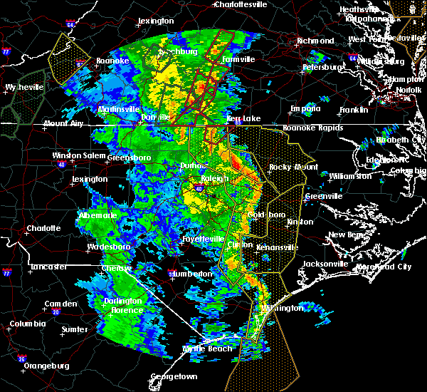 At 559 pm edt, a line of severe thunderstorms was moving through the area, located from henderson to louisburg to rocky mount, moving northeast at 50 mph (radar indicated). Hazards include 70 mph wind gusts. Expect considerable tree damage. Damage is likely to mobile homes, roofs, and outbuildings. At 559 pm edt, a line of severe thunderstorms was moving through the area, located from henderson to louisburg to rocky mount, moving northeast at 50 mph (radar indicated). Hazards include 70 mph wind gusts. Expect considerable tree damage. Damage is likely to mobile homes, roofs, and outbuildings.
|
| 4/19/2019 5:10 PM EDT |
 At 509 pm edt, a severe thunderstorm capable of producing a tornado was located 7 miles northwest of scotland neck, or 9 miles south of halifax, moving north at 45 mph (radar indicated rotation). Hazards include tornado. Flying debris will be dangerous to those caught without shelter. mobile homes will be damaged or destroyed. damage to roofs, windows, and vehicles will occur. tree damage is likely. Locations impacted include, halifax, scotland neck and tillery. At 509 pm edt, a severe thunderstorm capable of producing a tornado was located 7 miles northwest of scotland neck, or 9 miles south of halifax, moving north at 45 mph (radar indicated rotation). Hazards include tornado. Flying debris will be dangerous to those caught without shelter. mobile homes will be damaged or destroyed. damage to roofs, windows, and vehicles will occur. tree damage is likely. Locations impacted include, halifax, scotland neck and tillery.
|
| 4/19/2019 5:02 PM EDT |
 At 502 pm edt, a severe thunderstorm capable of producing a tornado was located 7 miles west of scotland neck, or 13 miles south of halifax, moving north at 45 mph (radar indicated rotation). Hazards include tornado. Flying debris will be dangerous to those caught without shelter. mobile homes will be damaged or destroyed. damage to roofs, windows, and vehicles will occur. Tree damage is likely. At 502 pm edt, a severe thunderstorm capable of producing a tornado was located 7 miles west of scotland neck, or 13 miles south of halifax, moving north at 45 mph (radar indicated rotation). Hazards include tornado. Flying debris will be dangerous to those caught without shelter. mobile homes will be damaged or destroyed. damage to roofs, windows, and vehicles will occur. Tree damage is likely.
|
| 4/8/2019 7:37 PM EDT |
 The severe thunderstorm warning for edgecombe and southeastern halifax counties will expire at 745 pm edt, the storm which prompted the warning has moved out of the area. therefore the warning will be allowed to expire. a severe thunderstorm watch remains in effect until 1000 pm edt for central north carolina. continue to monitor you local news outlet or weather radio broadcast in case additional warnings are issued. The severe thunderstorm warning for edgecombe and southeastern halifax counties will expire at 745 pm edt, the storm which prompted the warning has moved out of the area. therefore the warning will be allowed to expire. a severe thunderstorm watch remains in effect until 1000 pm edt for central north carolina. continue to monitor you local news outlet or weather radio broadcast in case additional warnings are issued.
|
| 4/8/2019 7:08 PM EDT |
 At 707 pm edt, a severe thunderstorm was located near tarboro, moving northeast at 25 mph (radar indicated). Hazards include 60 mph wind gusts and nickel size hail. Expect damage to roofs, siding, and trees. Locations impacted include, tarboro, scotland neck, princeville, whitakers, hobgood, conetoe, speed, leggett, tillery and kingsboro. At 707 pm edt, a severe thunderstorm was located near tarboro, moving northeast at 25 mph (radar indicated). Hazards include 60 mph wind gusts and nickel size hail. Expect damage to roofs, siding, and trees. Locations impacted include, tarboro, scotland neck, princeville, whitakers, hobgood, conetoe, speed, leggett, tillery and kingsboro.
|
| 4/8/2019 6:40 PM EDT |
 At 640 pm edt, a severe thunderstorm was located near elm city, or near rocky mount, moving northeast at 45 mph (radar indicated). Hazards include 60 mph wind gusts and nickel size hail. expect damage to roofs, siding, and trees At 640 pm edt, a severe thunderstorm was located near elm city, or near rocky mount, moving northeast at 45 mph (radar indicated). Hazards include 60 mph wind gusts and nickel size hail. expect damage to roofs, siding, and trees
|
| 10/11/2018 6:41 PM EDT |
 The severe thunderstorm warning for warren, nash, edgecombe, halifax and central franklin counties will expire at 645 pm edt, the gusty winds which prompted the warning have begun to subside. therefore the warning will be allowed to expire. however, gusty winds are still going to cause an issue across the area as tropical storm michael pushes northeast into virginia. The severe thunderstorm warning for warren, nash, edgecombe, halifax and central franklin counties will expire at 645 pm edt, the gusty winds which prompted the warning have begun to subside. therefore the warning will be allowed to expire. however, gusty winds are still going to cause an issue across the area as tropical storm michael pushes northeast into virginia.
|
| 10/11/2018 5:22 PM EDT |
 At 520 pm edt, a line of damaging winds mixing south along the western side of michael were located along a line extending from 6 miles southeast of hitesburg through creedmoor to near fuquay- varina, moving east at 25 mph. this line of wind gusts have produced extensive wind damage, and the high wind gusts could last for up to 30 minutes. an isolated spin up tornado is also not out of the question (radar indicated). Hazards include 60 mph wind gusts. expect damage to roofs, siding, and trees At 520 pm edt, a line of damaging winds mixing south along the western side of michael were located along a line extending from 6 miles southeast of hitesburg through creedmoor to near fuquay- varina, moving east at 25 mph. this line of wind gusts have produced extensive wind damage, and the high wind gusts could last for up to 30 minutes. an isolated spin up tornado is also not out of the question (radar indicated). Hazards include 60 mph wind gusts. expect damage to roofs, siding, and trees
|
| 8/14/2018 3:09 PM EDT |
 At 309 pm edt, a severe thunderstorm was located 10 miles west of scotland neck, or 11 miles south of halifax, moving northeast at 30 mph (radar indicated). Hazards include 60 mph wind gusts and quarter size hail. Hail damage to vehicles is expected. expect wind damage to roofs, siding, and trees. Locations impacted include, roanoke rapids, halifax, scotland neck, enfield, weldon, glenview, medoc mountain state park, south weldon, rosemary and tillery. At 309 pm edt, a severe thunderstorm was located 10 miles west of scotland neck, or 11 miles south of halifax, moving northeast at 30 mph (radar indicated). Hazards include 60 mph wind gusts and quarter size hail. Hail damage to vehicles is expected. expect wind damage to roofs, siding, and trees. Locations impacted include, roanoke rapids, halifax, scotland neck, enfield, weldon, glenview, medoc mountain state park, south weldon, rosemary and tillery.
|
| 8/14/2018 2:45 PM EDT |
 At 245 pm edt, a severe thunderstorm was located near dortches, or 8 miles north of rocky mount, moving northeast at 30 mph (radar indicated). Hazards include 60 mph wind gusts and quarter size hail. Hail damage to vehicles is expected. Expect wind damage to roofs, siding, and trees. At 245 pm edt, a severe thunderstorm was located near dortches, or 8 miles north of rocky mount, moving northeast at 30 mph (radar indicated). Hazards include 60 mph wind gusts and quarter size hail. Hail damage to vehicles is expected. Expect wind damage to roofs, siding, and trees.
|
| 8/8/2018 8:39 PM EDT |
 The severe thunderstorm warning for central edgecombe and southeastern halifax counties will expire at 845 pm edt, the storms which prompted the warning have moved out of the area. therefore the warning will be allowed to expire. to report severe weather, contact your nearest law enforcement agency. they will relay your report to the national weather service raleigh. The severe thunderstorm warning for central edgecombe and southeastern halifax counties will expire at 845 pm edt, the storms which prompted the warning have moved out of the area. therefore the warning will be allowed to expire. to report severe weather, contact your nearest law enforcement agency. they will relay your report to the national weather service raleigh.
|
| 8/8/2018 7:54 PM EDT |
 At 753 pm edt, severe thunderstorms were located along a line extending from 7 miles west of scotland neck to near tarboro to 6 miles east of rocky mount, moving east at 25 mph (radar indicated). Hazards include 60 mph wind gusts. expect damage to roofs, siding, and trees At 753 pm edt, severe thunderstorms were located along a line extending from 7 miles west of scotland neck to near tarboro to 6 miles east of rocky mount, moving east at 25 mph (radar indicated). Hazards include 60 mph wind gusts. expect damage to roofs, siding, and trees
|
| 7/23/2018 2:40 AM EDT |
 At 239 am edt, a severe thunderstorm was located near halifax, moving north at 35 mph (radar indicated). Hazards include 60 mph wind gusts. Expect damage to roofs, siding, and trees. Locations impacted include, roanoke rapids, halifax, scotland neck, weldon, hobgood, south weldon, rosemary, tillery and roanoke rapids lake. At 239 am edt, a severe thunderstorm was located near halifax, moving north at 35 mph (radar indicated). Hazards include 60 mph wind gusts. Expect damage to roofs, siding, and trees. Locations impacted include, roanoke rapids, halifax, scotland neck, weldon, hobgood, south weldon, rosemary, tillery and roanoke rapids lake.
|
| 7/23/2018 2:32 AM EDT |
 At 232 am edt, severe thunderstorms were located along a line extending from 7 miles west of scotland neck to 10 miles southwest of lewiston woodville, moving north at 55 mph (radar indicated). Hazards include 60 mph wind gusts. Expect damage to roofs, siding, and trees. Locations impacted include, roanoke rapids, halifax, scotland neck, enfield, weldon, hobgood, south weldon, rosemary, tillery and roanoke rapids lake. At 232 am edt, severe thunderstorms were located along a line extending from 7 miles west of scotland neck to 10 miles southwest of lewiston woodville, moving north at 55 mph (radar indicated). Hazards include 60 mph wind gusts. Expect damage to roofs, siding, and trees. Locations impacted include, roanoke rapids, halifax, scotland neck, enfield, weldon, hobgood, south weldon, rosemary, tillery and roanoke rapids lake.
|
| 7/23/2018 2:30 AM EDT | Two trees were reported down near the intersection of highway 125 and kentucky lan in halifax county NC, 7.3 miles SE of Scotland Neck, NC |
| 7/23/2018 2:10 AM EDT |
 At 209 am edt, severe thunderstorms were located along a line extending from near tarboro to house to 8 miles southeast of scotland neck, moving north at 30 mph (radar indicated). Hazards include 60 mph wind gusts. Expect damage to roofs, siding, and trees. Locations impacted include, roanoke rapids, tarboro, halifax, scotland neck, enfield, princeville, weldon, whitakers, hobgood and conetoe. At 209 am edt, severe thunderstorms were located along a line extending from near tarboro to house to 8 miles southeast of scotland neck, moving north at 30 mph (radar indicated). Hazards include 60 mph wind gusts. Expect damage to roofs, siding, and trees. Locations impacted include, roanoke rapids, tarboro, halifax, scotland neck, enfield, princeville, weldon, whitakers, hobgood and conetoe.
|
| 7/23/2018 1:55 AM EDT |
 At 155 am edt, severe thunderstorms were located along a line extending from near tarboro to near bruce to 10 miles north of robersonville, moving north at 35 mph (radar indicated). Hazards include 60 mph wind gusts. Expect damage to roofs, siding, and trees. Locations impacted include, rocky mount, roanoke rapids, tarboro, halifax, scotland neck, dortches, red oak, enfield, princeville and sharpsburg. At 155 am edt, severe thunderstorms were located along a line extending from near tarboro to near bruce to 10 miles north of robersonville, moving north at 35 mph (radar indicated). Hazards include 60 mph wind gusts. Expect damage to roofs, siding, and trees. Locations impacted include, rocky mount, roanoke rapids, tarboro, halifax, scotland neck, dortches, red oak, enfield, princeville and sharpsburg.
|
| 7/23/2018 1:39 AM EDT |
 At 139 am edt, severe thunderstorms were located along a line extending from 7 miles west of farmville to 6 miles northwest of bruce to near shelmerdine, moving north at 50 mph (radar indicated). Hazards include 60 mph wind gusts. expect damage to roofs, siding, and trees At 139 am edt, severe thunderstorms were located along a line extending from 7 miles west of farmville to 6 miles northwest of bruce to near shelmerdine, moving north at 50 mph (radar indicated). Hazards include 60 mph wind gusts. expect damage to roofs, siding, and trees
|
| 6/20/2018 7:20 PM EDT |
 The severe thunderstorm warning for edgecombe and southeastern halifax counties will expire at 730 pm edt, the storm which prompted the warning has weakened below severe limits, and no longer poses an immediate threat to life or property. therefore the warning will be allowed to expire. however gusty winds and heavy rain are still possible with this thunderstorm. to report severe weather, contact your nearest law enforcement agency. they will relay your report to the national weather service raleigh. The severe thunderstorm warning for edgecombe and southeastern halifax counties will expire at 730 pm edt, the storm which prompted the warning has weakened below severe limits, and no longer poses an immediate threat to life or property. therefore the warning will be allowed to expire. however gusty winds and heavy rain are still possible with this thunderstorm. to report severe weather, contact your nearest law enforcement agency. they will relay your report to the national weather service raleigh.
|
| 6/20/2018 7:02 PM EDT |
 At 701 pm edt, a severe thunderstorm was located near tarboro, moving east at 15 mph (radar indicated). Hazards include 60 mph wind gusts and quarter size hail. Hail damage to vehicles is expected. expect wind damage to roofs, siding, and trees. Locations impacted include, rocky mount, tarboro, scotland neck, princeville, sharpsburg, whitakers, hobgood, speed, leggett and kingsboro. At 701 pm edt, a severe thunderstorm was located near tarboro, moving east at 15 mph (radar indicated). Hazards include 60 mph wind gusts and quarter size hail. Hail damage to vehicles is expected. expect wind damage to roofs, siding, and trees. Locations impacted include, rocky mount, tarboro, scotland neck, princeville, sharpsburg, whitakers, hobgood, speed, leggett and kingsboro.
|
| 6/20/2018 6:34 PM EDT |
 At 634 pm edt, a severe thunderstorm was located over rocky mount, moving east at 15 mph (radar indicated). Hazards include 60 mph wind gusts and quarter size hail. Hail damage to vehicles is expected. Expect wind damage to roofs, siding, and trees. At 634 pm edt, a severe thunderstorm was located over rocky mount, moving east at 15 mph (radar indicated). Hazards include 60 mph wind gusts and quarter size hail. Hail damage to vehicles is expected. Expect wind damage to roofs, siding, and trees.
|
| 5/10/2018 7:47 PM EDT |
 At 746 pm edt, a severe thunderstorm was located 7 miles northeast of dortches, or 8 miles north of rocky mount, moving east at 25 mph (radar indicated). Hazards include 60 mph wind gusts and nickel size hail. Expect damage to roofs, siding, and trees. Locations impacted include, scotland neck, enfield, whitakers and hobgood. At 746 pm edt, a severe thunderstorm was located 7 miles northeast of dortches, or 8 miles north of rocky mount, moving east at 25 mph (radar indicated). Hazards include 60 mph wind gusts and nickel size hail. Expect damage to roofs, siding, and trees. Locations impacted include, scotland neck, enfield, whitakers and hobgood.
|
| 5/10/2018 7:14 PM EDT |
 At 713 pm edt, a severe thunderstorm was located 10 miles northeast of dortches, or 12 miles north of rocky mount, moving east at 35 mph (radar indicated). Hazards include 60 mph wind gusts and penny size hail. expect damage to roofs, siding, and trees At 713 pm edt, a severe thunderstorm was located 10 miles northeast of dortches, or 12 miles north of rocky mount, moving east at 35 mph (radar indicated). Hazards include 60 mph wind gusts and penny size hail. expect damage to roofs, siding, and trees
|
| 5/6/2018 5:16 PM EDT |
 At 516 pm edt, severe thunderstorms were located along a line extending from near halifax to near scotland neck to 8 miles northeast of rocky mount, moving east at 30 mph (radar indicated). Hazards include 60 mph wind gusts. Expect damage to roofs, siding, and trees. Locations impacted include, scotland neck, hobgood, speed, leggett and tillery. At 516 pm edt, severe thunderstorms were located along a line extending from near halifax to near scotland neck to 8 miles northeast of rocky mount, moving east at 30 mph (radar indicated). Hazards include 60 mph wind gusts. Expect damage to roofs, siding, and trees. Locations impacted include, scotland neck, hobgood, speed, leggett and tillery.
|
| 5/6/2018 5:15 PM EDT | One tree down at sand pit rd. and bynums bridge r in halifax county NC, 3.8 miles ESE of Scotland Neck, NC |
| 5/6/2018 4:59 PM EDT |
 At 459 pm edt, severe thunderstorms were located along a line extending from halifax to 9 miles northwest of scotland neck to 7 miles northeast of rocky mount, moving east at 35 mph (radar indicated). Hazards include 60 mph wind gusts. Expect damage to roofs, siding, and trees. Locations impacted include, halifax, scotland neck, dortches, enfield, whitakers, hobgood, speed, leggett, battleboro and tillery. At 459 pm edt, severe thunderstorms were located along a line extending from halifax to 9 miles northwest of scotland neck to 7 miles northeast of rocky mount, moving east at 35 mph (radar indicated). Hazards include 60 mph wind gusts. Expect damage to roofs, siding, and trees. Locations impacted include, halifax, scotland neck, dortches, enfield, whitakers, hobgood, speed, leggett, battleboro and tillery.
|
| 5/6/2018 4:46 PM EDT |
 At 445 pm edt, severe thunderstorms were located along a line extending from 6 miles southwest of roanoke rapids to near halifax to near dortches, moving east at 35 mph (radar indicated). Hazards include 60 mph wind gusts. Expect damage to roofs, siding, and trees. Locations impacted include, halifax, scotland neck, dortches, red oak, enfield, weldon, whitakers, hobgood, castalia and speed. At 445 pm edt, severe thunderstorms were located along a line extending from 6 miles southwest of roanoke rapids to near halifax to near dortches, moving east at 35 mph (radar indicated). Hazards include 60 mph wind gusts. Expect damage to roofs, siding, and trees. Locations impacted include, halifax, scotland neck, dortches, red oak, enfield, weldon, whitakers, hobgood, castalia and speed.
|
| 5/6/2018 4:34 PM EDT |
 At 431 pm edt, severe thunderstorms were located along a line extending from 6 miles west of roanoke rapids to 11 miles west of halifax to 9 miles northwest of nashville, moving east at 35 mph (radar indicated). Hazards include 60 mph wind gusts and quarter size hail. Hail damage to vehicles is expected. expect wind damage to roofs, siding, and trees. Locations impacted include, roanoke rapids, halifax, scotland neck, dortches, red oak, enfield, weldon, whitakers, hobgood and castalia. At 431 pm edt, severe thunderstorms were located along a line extending from 6 miles west of roanoke rapids to 11 miles west of halifax to 9 miles northwest of nashville, moving east at 35 mph (radar indicated). Hazards include 60 mph wind gusts and quarter size hail. Hail damage to vehicles is expected. expect wind damage to roofs, siding, and trees. Locations impacted include, roanoke rapids, halifax, scotland neck, dortches, red oak, enfield, weldon, whitakers, hobgood and castalia.
|
| 5/6/2018 4:24 PM EDT |
 At 424 pm edt, severe thunderstorms were located along a line extending from near littleton to 14 miles west of halifax to 10 miles east of louisburg, moving east at 35 mph (radar indicated). Hazards include 60 mph wind gusts and quarter size hail. Hail damage to vehicles is expected. Expect wind damage to roofs, siding, and trees. At 424 pm edt, severe thunderstorms were located along a line extending from near littleton to 14 miles west of halifax to 10 miles east of louisburg, moving east at 35 mph (radar indicated). Hazards include 60 mph wind gusts and quarter size hail. Hail damage to vehicles is expected. Expect wind damage to roofs, siding, and trees.
|
| 7/23/2017 8:10 PM EDT |
 At 809 pm edt, severe thunderstorms were located along a line extending from near lewiston woodville to near tarboro to bailey, moving southeast at 15 mph (radar indicated). Hazards include 60 mph wind gusts. Expect damage to roofs, siding, and trees. Locations impacted include, rocky mount, tarboro, nashville, wilson, scotland neck, elm city, dortches, bailey, red oak and princeville. At 809 pm edt, severe thunderstorms were located along a line extending from near lewiston woodville to near tarboro to bailey, moving southeast at 15 mph (radar indicated). Hazards include 60 mph wind gusts. Expect damage to roofs, siding, and trees. Locations impacted include, rocky mount, tarboro, nashville, wilson, scotland neck, elm city, dortches, bailey, red oak and princeville.
|
| 7/23/2017 7:43 PM EDT |
 At 742 pm edt, severe thunderstorms were located along a line extending from near scotland neck to 7 miles south of tarboro to near bailey, moving southeast at 20 mph (radar indicated). Hazards include 60 mph wind gusts. Expect damage to roofs, siding, and trees. Locations impacted include, rocky mount, tarboro, nashville, wilson, clayton, scotland neck, elm city, dortches, bailey and red oak. At 742 pm edt, severe thunderstorms were located along a line extending from near scotland neck to 7 miles south of tarboro to near bailey, moving southeast at 20 mph (radar indicated). Hazards include 60 mph wind gusts. Expect damage to roofs, siding, and trees. Locations impacted include, rocky mount, tarboro, nashville, wilson, clayton, scotland neck, elm city, dortches, bailey and red oak.
|
| 7/23/2017 7:24 PM EDT |
 At 723 pm edt, severe thunderstorms were located along a line extending from near scotland neck to near rocky mount to near zebulon, moving southeast at 15 mph (radar indicated). Hazards include 60 mph wind gusts and penny size hail. expect damage to roofs, siding, and trees At 723 pm edt, severe thunderstorms were located along a line extending from near scotland neck to near rocky mount to near zebulon, moving southeast at 15 mph (radar indicated). Hazards include 60 mph wind gusts and penny size hail. expect damage to roofs, siding, and trees
|
| 7/23/2017 7:07 PM EDT |
 At 706 pm edt, severe thunderstorms were located along a line extending from bunn to 7 miles northeast of dortches to 7 miles west of rich square, moving northeast at 15 mph (radar indicated). Hazards include 60 mph wind gusts and penny size hail. Expect damage to roofs, siding, and trees. Locations impacted include, rocky mount, nashville, louisburg, halifax, zebulon, scotland neck, franklinton, dortches, bunn and rolesville. At 706 pm edt, severe thunderstorms were located along a line extending from bunn to 7 miles northeast of dortches to 7 miles west of rich square, moving northeast at 15 mph (radar indicated). Hazards include 60 mph wind gusts and penny size hail. Expect damage to roofs, siding, and trees. Locations impacted include, rocky mount, nashville, louisburg, halifax, zebulon, scotland neck, franklinton, dortches, bunn and rolesville.
|
| 7/23/2017 6:38 PM EDT |
 At 638 pm edt, severe thunderstorms were located along a line extending from 7 miles east of wake forest to dortches to 6 miles north of scotland neck, moving east at 20 mph (radar indicated). Hazards include 60 mph wind gusts and penny size hail. Expect damage to roofs, siding, and trees. Locations impacted include, raleigh, rocky mount, roanoke rapids, nashville, louisburg, halifax, wake forest, zebulon, scotland neck and franklinton. At 638 pm edt, severe thunderstorms were located along a line extending from 7 miles east of wake forest to dortches to 6 miles north of scotland neck, moving east at 20 mph (radar indicated). Hazards include 60 mph wind gusts and penny size hail. Expect damage to roofs, siding, and trees. Locations impacted include, raleigh, rocky mount, roanoke rapids, nashville, louisburg, halifax, wake forest, zebulon, scotland neck and franklinton.
|
| 7/23/2017 6:11 PM EDT |
 At 610 pm edt, severe thunderstorms were located along a line extending from near bunn to 9 miles southeast of louisburg, moving northeast at 15 mph (radar indicated). Hazards include 60 mph wind gusts and quarter size hail. Hail damage to vehicles is expected. Expect wind damage to roofs, siding, and trees. At 610 pm edt, severe thunderstorms were located along a line extending from near bunn to 9 miles southeast of louisburg, moving northeast at 15 mph (radar indicated). Hazards include 60 mph wind gusts and quarter size hail. Hail damage to vehicles is expected. Expect wind damage to roofs, siding, and trees.
|
| 5/24/2017 7:17 PM EDT |
 At 717 pm edt, a severe thunderstorm was located near tarboro, moving northeast at 25 mph (radar indicated). Hazards include 60 mph wind gusts. Expect damage to roofs, siding, and trees. locations impacted include, tarboro, scotland neck, princeville, hobgood, conetoe and speed. A tornado watch remains in effect until midnight edt for central north carolina. At 717 pm edt, a severe thunderstorm was located near tarboro, moving northeast at 25 mph (radar indicated). Hazards include 60 mph wind gusts. Expect damage to roofs, siding, and trees. locations impacted include, tarboro, scotland neck, princeville, hobgood, conetoe and speed. A tornado watch remains in effect until midnight edt for central north carolina.
|
| 5/24/2017 7:04 PM EDT |
 At 704 pm edt, a severe thunderstorm was located near tarboro, moving northeast at 30 mph (radar indicated). Hazards include 60 mph wind gusts. Expect damage to roofs, siding, and trees. locations impacted include, tarboro, scotland neck, princeville, hobgood, conetoe, speed and leggett. A tornado watch remains in effect until midnight edt for central north carolina. At 704 pm edt, a severe thunderstorm was located near tarboro, moving northeast at 30 mph (radar indicated). Hazards include 60 mph wind gusts. Expect damage to roofs, siding, and trees. locations impacted include, tarboro, scotland neck, princeville, hobgood, conetoe, speed and leggett. A tornado watch remains in effect until midnight edt for central north carolina.
|
| 5/24/2017 6:51 PM EDT |
 At 651 pm edt, a severe thunderstorm was located 8 miles south of tarboro, moving northeast at 25 mph (radar indicated). Hazards include 60 mph wind gusts. expect damage to roofs, siding, and trees At 651 pm edt, a severe thunderstorm was located 8 miles south of tarboro, moving northeast at 25 mph (radar indicated). Hazards include 60 mph wind gusts. expect damage to roofs, siding, and trees
|
| 5/5/2017 6:52 AM EDT |
 At 652 am edt, severe thunderstorms were located along a line extending from near halifax to near tarboro, moving northeast at 70 mph (radar indicated). Hazards include 60 mph wind gusts. Expect damage to roofs, siding, and trees. locations impacted include, tarboro, halifax, scotland neck, princeville, pinetops, macclesfield, hobgood, conetoe, speed and leggett. A tornado watch remains in effect until 900 am edt for central north carolina. At 652 am edt, severe thunderstorms were located along a line extending from near halifax to near tarboro, moving northeast at 70 mph (radar indicated). Hazards include 60 mph wind gusts. Expect damage to roofs, siding, and trees. locations impacted include, tarboro, halifax, scotland neck, princeville, pinetops, macclesfield, hobgood, conetoe, speed and leggett. A tornado watch remains in effect until 900 am edt for central north carolina.
|
| 5/5/2017 6:39 AM EDT |
 At 639 am edt, severe thunderstorms were located along a line extending from 8 miles southwest of halifax to 8 miles southwest of tarboro, moving northeast at 60 mph (radar indicated). Hazards include 60 mph wind gusts. Expect damage to roofs, siding, and trees. locations impacted include, tarboro, halifax, scotland neck, enfield, princeville, pinetops, whitakers, macclesfield, hobgood and conetoe. A tornado watch remains in effect until 900 am edt for central north carolina. At 639 am edt, severe thunderstorms were located along a line extending from 8 miles southwest of halifax to 8 miles southwest of tarboro, moving northeast at 60 mph (radar indicated). Hazards include 60 mph wind gusts. Expect damage to roofs, siding, and trees. locations impacted include, tarboro, halifax, scotland neck, enfield, princeville, pinetops, whitakers, macclesfield, hobgood and conetoe. A tornado watch remains in effect until 900 am edt for central north carolina.
|
| 5/5/2017 6:21 AM EDT |
 At 621 am edt, severe thunderstorms were located along a line extending from dortches to 8 miles east of fremont, moving northeast at 50 mph (radar indicated). Hazards include 60 mph wind gusts. expect damage to roofs, siding, and trees At 621 am edt, severe thunderstorms were located along a line extending from dortches to 8 miles east of fremont, moving northeast at 50 mph (radar indicated). Hazards include 60 mph wind gusts. expect damage to roofs, siding, and trees
|
| 3/31/2017 5:36 PM EDT |
 The severe thunderstorm warning for southeastern halifax county will expire at 545 pm edt, the storm which prompted the warning has moved out of the area. therefore the warning will be allowed to expire. a tornado watch remains in effect until 1000 pm edt for portions of central north carolina. to report severe weather, contact your nearest law enforcement agency. they will relay your report to the national weather service raleigh. The severe thunderstorm warning for southeastern halifax county will expire at 545 pm edt, the storm which prompted the warning has moved out of the area. therefore the warning will be allowed to expire. a tornado watch remains in effect until 1000 pm edt for portions of central north carolina. to report severe weather, contact your nearest law enforcement agency. they will relay your report to the national weather service raleigh.
|
| 3/31/2017 5:25 PM EDT |
 At 525 pm edt, a severe thunderstorm was located near scotland neck, or 9 miles southwest of rich square, moving northeast at 30 mph (radar indicated). Hazards include 60 mph wind gusts and quarter size hail. Hail damage to vehicles is expected. Expect wind damage to roofs, siding, and trees. At 525 pm edt, a severe thunderstorm was located near scotland neck, or 9 miles southwest of rich square, moving northeast at 30 mph (radar indicated). Hazards include 60 mph wind gusts and quarter size hail. Hail damage to vehicles is expected. Expect wind damage to roofs, siding, and trees.
|
| 3/28/2017 4:44 PM EDT |
 At 443 pm edt, a severe thunderstorm was located 8 miles north of scotland neck, or 8 miles west of rich square, moving southeast at 20 mph (radar indicated). Hazards include 60 mph wind gusts and quarter size hail. Hail damage to vehicles is expected. expect wind damage to roofs, siding, and trees. Locations impacted include, scotland neck and tillery. At 443 pm edt, a severe thunderstorm was located 8 miles north of scotland neck, or 8 miles west of rich square, moving southeast at 20 mph (radar indicated). Hazards include 60 mph wind gusts and quarter size hail. Hail damage to vehicles is expected. expect wind damage to roofs, siding, and trees. Locations impacted include, scotland neck and tillery.
|
| 3/28/2017 4:30 PM EDT |
 At 429 pm edt, a severe thunderstorm was located near halifax, moving southeast at 25 mph (radar indicated). Hazards include 60 mph wind gusts and quarter size hail. Hail damage to vehicles is expected. Expect wind damage to roofs, siding, and trees. At 429 pm edt, a severe thunderstorm was located near halifax, moving southeast at 25 mph (radar indicated). Hazards include 60 mph wind gusts and quarter size hail. Hail damage to vehicles is expected. Expect wind damage to roofs, siding, and trees.
|
| 7/26/2016 7:28 PM EDT |
 At 728 pm edt, a severe thunderstorm was located 13 miles southwest of halifax, moving southeast at 15 mph (radar indicated). Hazards include 60 mph wind gusts. Expect damage to roofs. siding. and trees. Locations impacted include, scotland neck, enfield, whitakers, leggett, glenview and battleboro. At 728 pm edt, a severe thunderstorm was located 13 miles southwest of halifax, moving southeast at 15 mph (radar indicated). Hazards include 60 mph wind gusts. Expect damage to roofs. siding. and trees. Locations impacted include, scotland neck, enfield, whitakers, leggett, glenview and battleboro.
|
| 7/26/2016 7:11 PM EDT |
 At 711 pm edt, a severe thunderstorm was located 11 miles southwest of halifax, moving southeast at 20 mph (radar indicated). Hazards include 60 mph wind gusts and penny size hail. Expect damage to roofs. siding. And trees. At 711 pm edt, a severe thunderstorm was located 11 miles southwest of halifax, moving southeast at 20 mph (radar indicated). Hazards include 60 mph wind gusts and penny size hail. Expect damage to roofs. siding. And trees.
|
| 7/19/2016 8:09 PM EDT |
 The severe thunderstorm warning for central halifax county will expire at 815 pm edt, the storm which prompted the warning has weakened below severe limits, and no longer poses an immediate threat to life or property. therefore the warning will be allowed to expire. to report severe weather, contact your nearest law enforcement agency. they will relay your report to the national weather service raleigh. The severe thunderstorm warning for central halifax county will expire at 815 pm edt, the storm which prompted the warning has weakened below severe limits, and no longer poses an immediate threat to life or property. therefore the warning will be allowed to expire. to report severe weather, contact your nearest law enforcement agency. they will relay your report to the national weather service raleigh.
|
| 7/19/2016 7:28 PM EDT |
 At 727 pm edt, a severe thunderstorm was located over halifax, moving south at 25 mph (radar indicated). Hazards include 60 mph wind gusts. Expect damage to roofs. siding. and trees. Locations impacted include, halifax, scotland neck, enfield, weldon, tillery and south weldon. At 727 pm edt, a severe thunderstorm was located over halifax, moving south at 25 mph (radar indicated). Hazards include 60 mph wind gusts. Expect damage to roofs. siding. and trees. Locations impacted include, halifax, scotland neck, enfield, weldon, tillery and south weldon.
|
| 7/19/2016 7:09 PM EDT |
 At 709 pm edt, a severe thunderstorm was located over garysburg, moving southeast at 20 mph (radar indicated). Hazards include 60 mph wind gusts and quarter size hail. Hail damage to vehicles is expected. Expect wind damage to roofs, siding, and trees. At 709 pm edt, a severe thunderstorm was located over garysburg, moving southeast at 20 mph (radar indicated). Hazards include 60 mph wind gusts and quarter size hail. Hail damage to vehicles is expected. Expect wind damage to roofs, siding, and trees.
|
| 7/16/2016 6:00 PM EDT |
 At 559 pm edt, severe thunderstorms were located along a line extending from 6 miles south of tarboro to 11 miles southwest of scotland neck to near dortches, moving northeast at 15 mph (radar indicated). Hazards include 60 mph wind gusts. Expect damage to roofs. siding. And trees. At 559 pm edt, severe thunderstorms were located along a line extending from 6 miles south of tarboro to 11 miles southwest of scotland neck to near dortches, moving northeast at 15 mph (radar indicated). Hazards include 60 mph wind gusts. Expect damage to roofs. siding. And trees.
|
| 7/15/2016 7:05 PM EDT |
 At 704 pm edt, severe thunderstorms were located along a line extending from near roxobel to tarboro to 9 miles east of elm city, moving east at 40 mph (radar indicated). Hazards include 60 mph wind gusts. Expect damage to roofs. siding. and trees. Locations impacted include, tarboro, scotland neck, princeville, pinetops, macclesfield, hobgood, conetoe, speed, leggett and kingsboro. At 704 pm edt, severe thunderstorms were located along a line extending from near roxobel to tarboro to 9 miles east of elm city, moving east at 40 mph (radar indicated). Hazards include 60 mph wind gusts. Expect damage to roofs. siding. and trees. Locations impacted include, tarboro, scotland neck, princeville, pinetops, macclesfield, hobgood, conetoe, speed, leggett and kingsboro.
|
| 7/15/2016 6:53 PM EDT |
 At 652 pm edt, severe thunderstorms were located along a line extending from near scotland neck to near elm city to near bailey, moving east at 20 mph (radar indicated). Hazards include 60 mph wind gusts and penny size hail. Expect damage to roofs. siding. and trees. Locations impacted include, rocky mount, tarboro, nashville, wilson, scotland neck, elm city, dortches, bailey, enfield and princeville. At 652 pm edt, severe thunderstorms were located along a line extending from near scotland neck to near elm city to near bailey, moving east at 20 mph (radar indicated). Hazards include 60 mph wind gusts and penny size hail. Expect damage to roofs. siding. and trees. Locations impacted include, rocky mount, tarboro, nashville, wilson, scotland neck, elm city, dortches, bailey, enfield and princeville.
|
| 7/15/2016 6:31 PM EDT |
 At 631 pm edt, severe thunderstorms were located along a line extending from 11 miles west of scotland neck to near rocky mount to bailey, moving east at 25 mph (radar indicated). Hazards include 60 mph wind gusts and penny size hail. Expect damage to roofs. siding. and trees. Locations impacted include, rocky mount, tarboro, nashville, wilson, zebulon, scotland neck, elm city, dortches, bailey and wendell. At 631 pm edt, severe thunderstorms were located along a line extending from 11 miles west of scotland neck to near rocky mount to bailey, moving east at 25 mph (radar indicated). Hazards include 60 mph wind gusts and penny size hail. Expect damage to roofs. siding. and trees. Locations impacted include, rocky mount, tarboro, nashville, wilson, zebulon, scotland neck, elm city, dortches, bailey and wendell.
|
| 7/15/2016 6:13 PM EDT |
 At 612 pm edt, severe thunderstorms were located along a line extending from 12 miles southwest of halifax to near nashville to near zebulon, moving east at 20 mph (radar indicated). Hazards include 60 mph wind gusts and quarter size hail. Hail damage to vehicles is expected. Expect wind damage to roofs, siding, and trees. At 612 pm edt, severe thunderstorms were located along a line extending from 12 miles southwest of halifax to near nashville to near zebulon, moving east at 20 mph (radar indicated). Hazards include 60 mph wind gusts and quarter size hail. Hail damage to vehicles is expected. Expect wind damage to roofs, siding, and trees.
|
| 7/8/2016 8:49 PM EDT |
 At 846 pm edt, severe thunderstorms were located along a line extending from 7 miles southeast of aulander to 7 miles northwest of farmville to near garner, moving southeast at 60 mph (radar indicated). Hazards include 60 mph wind gusts. Expect damage to roofs. siding. and trees. locations impacted include, rocky mount, goldsboro, tarboro, smithfield, wilson, clayton, scotland neck, elm city, fremont and bailey. A severe thunderstorm watch remains in effect until midnight edt for central north carolina. At 846 pm edt, severe thunderstorms were located along a line extending from 7 miles southeast of aulander to 7 miles northwest of farmville to near garner, moving southeast at 60 mph (radar indicated). Hazards include 60 mph wind gusts. Expect damage to roofs. siding. and trees. locations impacted include, rocky mount, goldsboro, tarboro, smithfield, wilson, clayton, scotland neck, elm city, fremont and bailey. A severe thunderstorm watch remains in effect until midnight edt for central north carolina.
|
| 7/8/2016 8:34 PM EDT |
 At 833 pm edt, severe thunderstorms were located along a line extending from near roxobel to wilson to rdu international, moving east at 45 mph (radar indicated). Hazards include 60 mph wind gusts. Expect damage to roofs. siding. and trees. locations impacted include, raleigh, durham, cary, rocky mount, chapel hill, goldsboro, tarboro, smithfield, nashville and wilson. A severe thunderstorm watch remains in effect until midnight edt for central north carolina. At 833 pm edt, severe thunderstorms were located along a line extending from near roxobel to wilson to rdu international, moving east at 45 mph (radar indicated). Hazards include 60 mph wind gusts. Expect damage to roofs. siding. and trees. locations impacted include, raleigh, durham, cary, rocky mount, chapel hill, goldsboro, tarboro, smithfield, nashville and wilson. A severe thunderstorm watch remains in effect until midnight edt for central north carolina.
|
| 7/8/2016 8:03 PM EDT |
 At 803 pm edt, severe thunderstorms were located along a line extending from 6 miles northwest of rich square to near nashville to near durham, moving southeast at 60 mph (radar indicated). Hazards include 60 mph wind gusts. Expect damage to roofs. siding. And trees. At 803 pm edt, severe thunderstorms were located along a line extending from 6 miles northwest of rich square to near nashville to near durham, moving southeast at 60 mph (radar indicated). Hazards include 60 mph wind gusts. Expect damage to roofs. siding. And trees.
|
| 4/28/2016 7:27 PM EDT |
 At 726 pm edt, a severe thunderstorm was located 8 miles southwest of halifax, moving northeast at 35 mph (radar indicated). Hazards include 60 mph wind gusts and quarter size hail. Hail damage to vegetation is expected. expect wind damage to house siding, and trees. Locations impacted include, halifax, scotland neck, enfield, whitakers and tillery. At 726 pm edt, a severe thunderstorm was located 8 miles southwest of halifax, moving northeast at 35 mph (radar indicated). Hazards include 60 mph wind gusts and quarter size hail. Hail damage to vegetation is expected. expect wind damage to house siding, and trees. Locations impacted include, halifax, scotland neck, enfield, whitakers and tillery.
|
| 4/28/2016 7:08 PM EDT |
 At 707 pm edt, a severe thunderstorm was located near dortches, or 10 miles north of rocky mount, moving east at 35 mph (radar indicated). Hazards include 60 mph wind gusts and quarter size hail. Hail damage to vegetation is expected. Expect wind damage to house siding, and trees. At 707 pm edt, a severe thunderstorm was located near dortches, or 10 miles north of rocky mount, moving east at 35 mph (radar indicated). Hazards include 60 mph wind gusts and quarter size hail. Hail damage to vegetation is expected. Expect wind damage to house siding, and trees.
|
| 3/13/2016 10:14 PM EDT |
 At 1013 pm edt, doppler radar continued to indicate a severe thunderstorm capable of producing quarter size hail and damaging winds in excess of 58 mph. this storm was located 7 miles southwest of scotland neck, or 9 miles north of tarboro, moving east at 30 mph. locations impacted include, tarboro, scotland neck, hobgood, speed and leggett. At 1013 pm edt, doppler radar continued to indicate a severe thunderstorm capable of producing quarter size hail and damaging winds in excess of 58 mph. this storm was located 7 miles southwest of scotland neck, or 9 miles north of tarboro, moving east at 30 mph. locations impacted include, tarboro, scotland neck, hobgood, speed and leggett.
|
| 3/13/2016 9:44 PM EDT |
 At 944 pm edt, doppler radar indicated a severe thunderstorm capable of producing quarter size hail and damaging winds in excess of 58 mph. this storm was located near dortches, or 7 miles north of rocky mount, and moving east at 30 mph. At 944 pm edt, doppler radar indicated a severe thunderstorm capable of producing quarter size hail and damaging winds in excess of 58 mph. this storm was located near dortches, or 7 miles north of rocky mount, and moving east at 30 mph.
|
| 2/24/2016 7:15 PM EST | Downed trees and power lines throughout count in halifax county NC, 0.6 miles NNW of Scotland Neck, NC |
| 8/6/2015 6:09 PM EDT |
 At 604 pm edt, doppler radar indicated a severe thunderstorm capable of producing damaging wind gusts of 55 to 65 mph. this storm was located near halifax, moving northwest at 20 mph. locations impacted include, enfield, halifax, and other locations along or near highway 301 in central halifax county. seek shelter immediately. damaging straight line winds as strong as 65 mph will be possible for a brief period of time through 610 to 615 pm as the core of this particular storm collapses along or just east of highway 301. At 604 pm edt, doppler radar indicated a severe thunderstorm capable of producing damaging wind gusts of 55 to 65 mph. this storm was located near halifax, moving northwest at 20 mph. locations impacted include, enfield, halifax, and other locations along or near highway 301 in central halifax county. seek shelter immediately. damaging straight line winds as strong as 65 mph will be possible for a brief period of time through 610 to 615 pm as the core of this particular storm collapses along or just east of highway 301.
|
| 8/6/2015 5:40 PM EDT |
 At 538 pm edt, doppler radar indicated a severe thunderstorm capable of producing damaging wind gusts as high as 60 mph. this storm was located near scotland neck, or 13 miles north of tarboro, and moving northeast at 10 mph. At 538 pm edt, doppler radar indicated a severe thunderstorm capable of producing damaging wind gusts as high as 60 mph. this storm was located near scotland neck, or 13 miles north of tarboro, and moving northeast at 10 mph.
|
| 7/18/2015 4:22 PM EDT |
 At 421 pm edt, doppler radar indicated a severe thunderstorm with damaging winds in excess of 58 mph. this storm was located near scotland neck, or 12 miles south of rich square, moving east at 20 mph. locations impacted include, scotland neck and hobgood. At 421 pm edt, doppler radar indicated a severe thunderstorm with damaging winds in excess of 58 mph. this storm was located near scotland neck, or 12 miles south of rich square, moving east at 20 mph. locations impacted include, scotland neck and hobgood.
|
| 7/18/2015 4:00 PM EDT | Tree down in scotland neck... reported by county 91 in halifax county NC, 0.2 miles WSW of Scotland Neck, NC |
| 7/18/2015 3:55 PM EDT |
 At 355 pm edt, doppler radar continued to indicate a severe thunderstorm capable of producing damaging winds in excess of 58 mph. this storm was located over scotland neck, or 12 miles southwest of rich square, moving east at 35 mph. locations impacted include, halifax, scotland neck, enfield, hobgood and tillery. At 355 pm edt, doppler radar continued to indicate a severe thunderstorm capable of producing damaging winds in excess of 58 mph. this storm was located over scotland neck, or 12 miles southwest of rich square, moving east at 35 mph. locations impacted include, halifax, scotland neck, enfield, hobgood and tillery.
|
| 7/18/2015 3:36 PM EDT |
 At 336 pm edt, doppler radar indicated a severe thunderstorm capable of producing damaging winds in excess of 58 mph. this storm was located 10 miles southwest of halifax, and moving east at 30 mph. At 336 pm edt, doppler radar indicated a severe thunderstorm capable of producing damaging winds in excess of 58 mph. this storm was located 10 miles southwest of halifax, and moving east at 30 mph.
|
| 6/30/2015 10:07 PM EDT |
 At 1007 pm edt, doppler radar continued to indicate a severe thunderstorm capable of producing damaging winds in excess of 58 mph. this storm was located 8 miles southeast of halifax, moving northeast at 40 mph. locations impacted include, scotland neck and tillery. At 1007 pm edt, doppler radar continued to indicate a severe thunderstorm capable of producing damaging winds in excess of 58 mph. this storm was located 8 miles southeast of halifax, moving northeast at 40 mph. locations impacted include, scotland neck and tillery.
|
| 6/30/2015 9:53 PM EDT |
 At 952 pm edt, doppler radar continued to indicate a line of severe thunderstorms capable of producing damaging winds in excess of 58 mph. these storms were located along a line extending from near halifax to 12 miles west of scotland neck, moving east at 30 mph. locations impacted include, halifax, scotland neck, enfield, weldon, hobgood and tillery. At 952 pm edt, doppler radar continued to indicate a line of severe thunderstorms capable of producing damaging winds in excess of 58 mph. these storms were located along a line extending from near halifax to 12 miles west of scotland neck, moving east at 30 mph. locations impacted include, halifax, scotland neck, enfield, weldon, hobgood and tillery.
|
| 6/30/2015 9:34 PM EDT |
 At 933 pm edt, doppler radar continued to indicate a line of severe thunderstorms capable of producing damaging winds in excess of 58 mph. these storms were located along a line extending from garysburg to 6 miles northeast of dortches, moving northeast at 40 mph. locations impacted include, rocky mount, roanoke rapids, nashville, halifax, scotland neck, dortches, red oak, enfield, weldon and whitakers and locations along i-95 near the nash halifax county line. At 933 pm edt, doppler radar continued to indicate a line of severe thunderstorms capable of producing damaging winds in excess of 58 mph. these storms were located along a line extending from garysburg to 6 miles northeast of dortches, moving northeast at 40 mph. locations impacted include, rocky mount, roanoke rapids, nashville, halifax, scotland neck, dortches, red oak, enfield, weldon and whitakers and locations along i-95 near the nash halifax county line.
|
| 6/30/2015 9:25 PM EDT |
 At 925 pm edt, doppler radar indicated a line of severe thunderstorms capable of producing damaging winds in excess of 58 mph. these storms were located along a line extending from near garysburg to near dortches, and moving northeast at 40 mph. At 925 pm edt, doppler radar indicated a line of severe thunderstorms capable of producing damaging winds in excess of 58 mph. these storms were located along a line extending from near garysburg to near dortches, and moving northeast at 40 mph.
|
| 6/30/2015 8:12 PM EDT | The severe thunderstorm warning for southern halifax county will expire at 815 pm edt, the storm which prompted the warning has weakened below severe limits, and no longer poses an immediate threat to life or property. therefore the warning will be allowed to expire. however gusty winds and heavy rain are still possible with this thunderstorm. |
| 6/30/2015 8:07 PM EDT |
 At 806 pm edt, doppler radar continued to indicate a thunderstorm with damaging winds in excess of 58 mph. this storm was located 10 miles west of scotland neck, or 13 miles south of halifax, moving east at 15 mph. locations impacted include, scotland neck, enfield, tillery and glenview. At 806 pm edt, doppler radar continued to indicate a thunderstorm with damaging winds in excess of 58 mph. this storm was located 10 miles west of scotland neck, or 13 miles south of halifax, moving east at 15 mph. locations impacted include, scotland neck, enfield, tillery and glenview.
|
| 6/30/2015 7:39 PM EDT |
 At 739 pm edt, doppler radar continued to indicate a severe thunderstorm capable of producing damaging winds in excess of 58 mph. this storm was located 7 miles northeast of dortches, or 9 miles north of rocky mount, moving east at 15 mph. locations impacted include, rocky mount, scotland neck, dortches, enfield, whitakers, glenview, tillery and battleboro. At 739 pm edt, doppler radar continued to indicate a severe thunderstorm capable of producing damaging winds in excess of 58 mph. this storm was located 7 miles northeast of dortches, or 9 miles north of rocky mount, moving east at 15 mph. locations impacted include, rocky mount, scotland neck, dortches, enfield, whitakers, glenview, tillery and battleboro.
|
| 6/30/2015 7:17 PM EDT |
 At 717 pm edt, doppler radar indicated a severe thunderstorm capable of producing damaging winds in excess of 58 mph. this storm was located near dortches, or 8 miles northeast of nashville, and moving east at 15 mph. At 717 pm edt, doppler radar indicated a severe thunderstorm capable of producing damaging winds in excess of 58 mph. this storm was located near dortches, or 8 miles northeast of nashville, and moving east at 15 mph.
|
| 6/26/2015 2:09 AM EDT |
 At 208 am edt, doppler radar continued to indicate a pair of severe thunderstorms capable of producing damaging winds in excess of 58 mph. these storms were located along a line extending from 11 miles southeast of littleton to near halifax, moving southeast at 25 mph. locations impacted include, roanoke rapids, halifax, scotland neck, littleton, enfield, weldon, south weldon, medoc mountain state park, rosemary and airlie. At 208 am edt, doppler radar continued to indicate a pair of severe thunderstorms capable of producing damaging winds in excess of 58 mph. these storms were located along a line extending from 11 miles southeast of littleton to near halifax, moving southeast at 25 mph. locations impacted include, roanoke rapids, halifax, scotland neck, littleton, enfield, weldon, south weldon, medoc mountain state park, rosemary and airlie.
|
| 6/26/2015 1:59 AM EDT |
 At 157 am edt, doppler radar continued to indicate a severe thunderstorm capable of producing damaging winds in excess of 58 mph. this storm was located near warrenton, moving southeast at 25 mph. locations impacted include, roanoke rapids, halifax, scotland neck, littleton, enfield, weldon, south weldon, medoc mountain state park, rosemary and arcola. At 157 am edt, doppler radar continued to indicate a severe thunderstorm capable of producing damaging winds in excess of 58 mph. this storm was located near warrenton, moving southeast at 25 mph. locations impacted include, roanoke rapids, halifax, scotland neck, littleton, enfield, weldon, south weldon, medoc mountain state park, rosemary and arcola.
|
| 6/26/2015 1:44 AM EDT |
 At 143 am edt, doppler radar continued to indicate a pair of severe thunderstorms capable of producing quarter size hail and damaging winds in excess of 58 mph. these storms were located along a line extending from near littleton to halifax, moving east at 30 mph. locations impacted include, roanoke rapids, warrenton, halifax, scotland neck, littleton, enfield, weldon, macon, medoc mountain state park and tillery. At 143 am edt, doppler radar continued to indicate a pair of severe thunderstorms capable of producing quarter size hail and damaging winds in excess of 58 mph. these storms were located along a line extending from near littleton to halifax, moving east at 30 mph. locations impacted include, roanoke rapids, warrenton, halifax, scotland neck, littleton, enfield, weldon, macon, medoc mountain state park and tillery.
|
| 6/26/2015 1:31 AM EDT |
 At 130 am edt, doppler radar indicated a pair of severe thunderstorms capable of producing damaging winds in excess of 58 mph. these storms were located along a line extending from 6 miles east of warrenton to near halifax, and moving southeast at 35 mph. At 130 am edt, doppler radar indicated a pair of severe thunderstorms capable of producing damaging winds in excess of 58 mph. these storms were located along a line extending from 6 miles east of warrenton to near halifax, and moving southeast at 35 mph.
|
| 6/20/2015 10:54 PM EDT |
 At 1053 pm edt, doppler radar continued to indicate a severe thunderstorm capable of producing damaging winds in excess of 58 mph. this storm was located near garysburg, moving northeast at 25 mph. locations impacted include, roanoke rapids, halifax, scotland neck, enfield, weldon, hobgood, south weldon and tillery. At 1053 pm edt, doppler radar continued to indicate a severe thunderstorm capable of producing damaging winds in excess of 58 mph. this storm was located near garysburg, moving northeast at 25 mph. locations impacted include, roanoke rapids, halifax, scotland neck, enfield, weldon, hobgood, south weldon and tillery.
|
| 6/20/2015 10:20 PM EDT |
 At 1019 pm edt, doppler radar indicated a severe thunderstorm capable of producing damaging winds in excess of 58 mph. this storm was located near enfield, and moving northeast at 25 mph. At 1019 pm edt, doppler radar indicated a severe thunderstorm capable of producing damaging winds in excess of 58 mph. this storm was located near enfield, and moving northeast at 25 mph.
|
| 6/20/2015 9:34 PM EDT |
 At 934 pm edt, doppler radar indicated a severe thunderstorm capable of producing damaging winds in excess of 58 mph. this storm was located 9 miles south of littleton, or 14 miles southeast of warrenton, and moving east at 50 mph. At 934 pm edt, doppler radar indicated a severe thunderstorm capable of producing damaging winds in excess of 58 mph. this storm was located 9 miles south of littleton, or 14 miles southeast of warrenton, and moving east at 50 mph.
|
| 7/9/2014 4:31 PM EDT | Several trees downed and uprooted in the area of scotland nec in halifax county NC, 0.2 miles WSW of Scotland Neck, NC |
| 1/1/0001 12:00 AM | Multiple trees down reported near the intersection of barnhill road and douglas hill farm road. time estimated via rada in halifax county NC, 7.2 miles E of Scotland Neck, NC |
| 1/1/0001 12:00 AM | Tree down on nc 125 near scotland nec in halifax county NC, 1.3 miles N of Scotland Neck, NC |
Hail Maps for Scotland Neck, NC


Connect with Interactive Hail Maps