

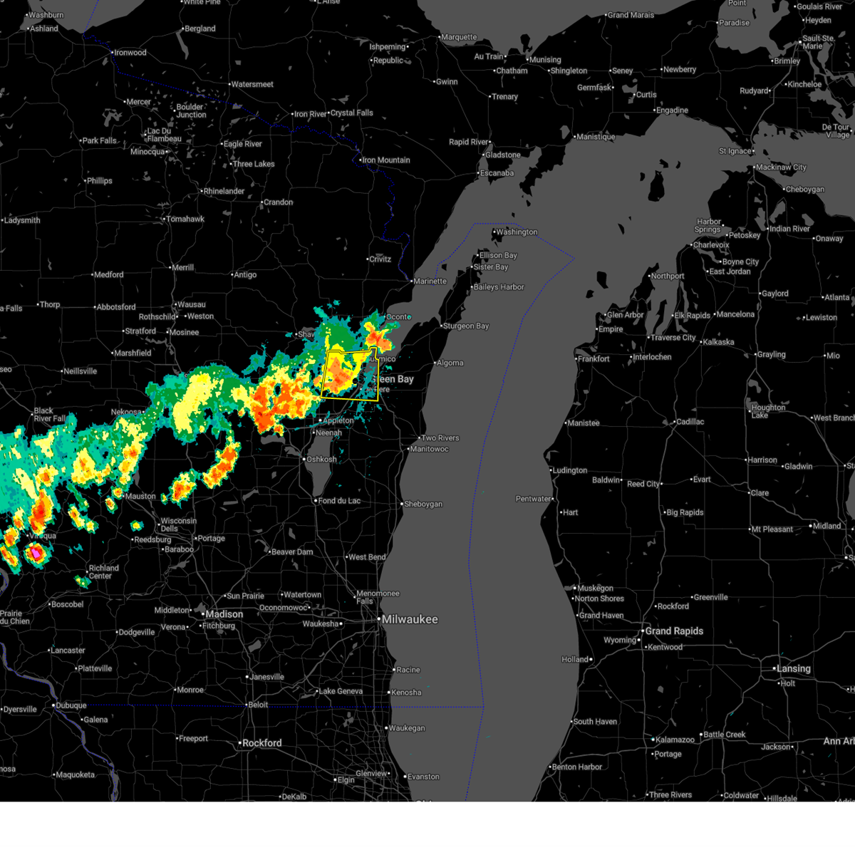
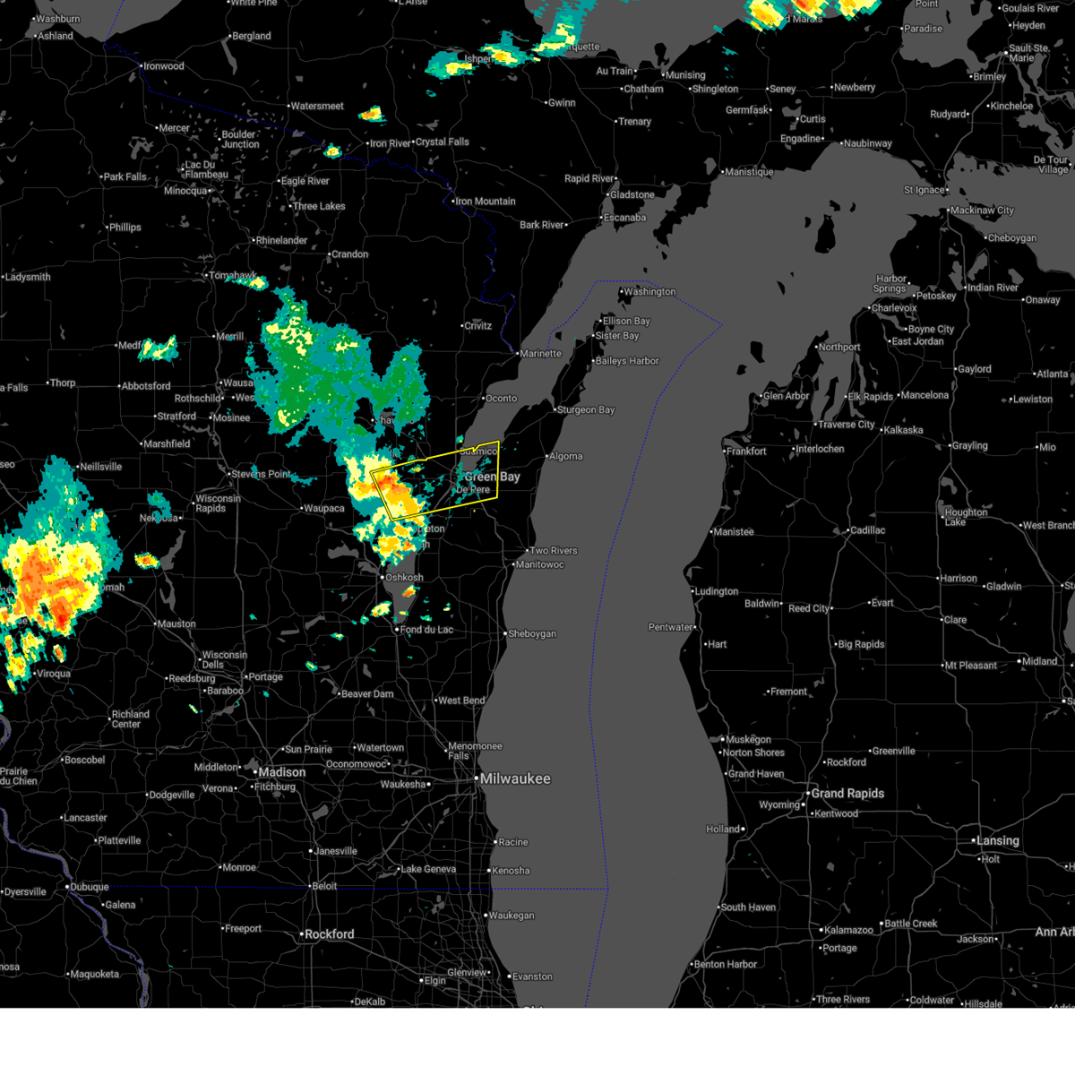
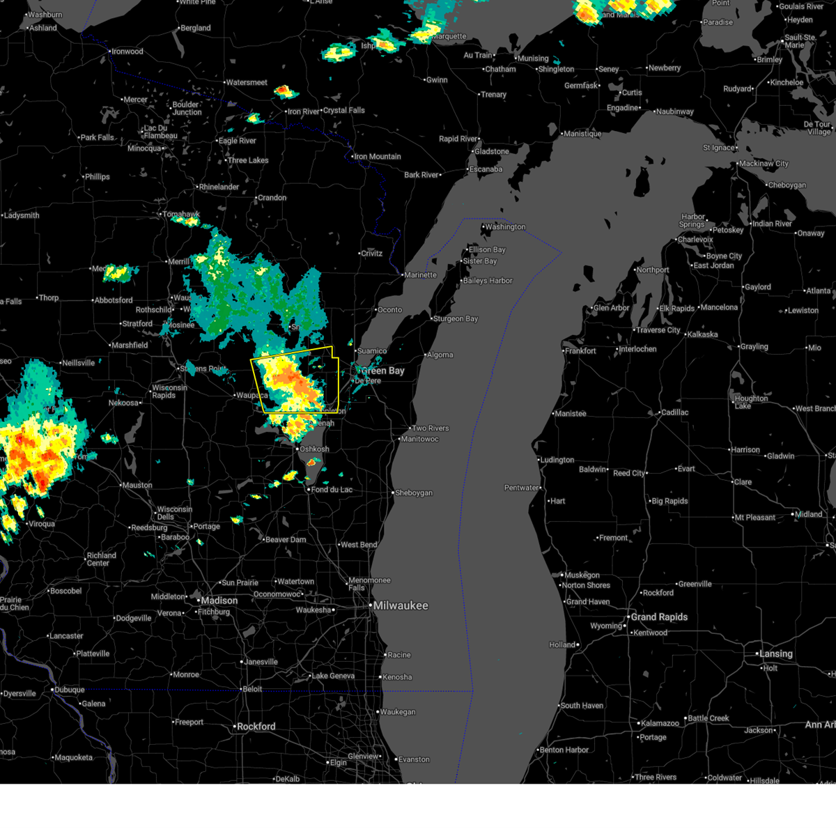
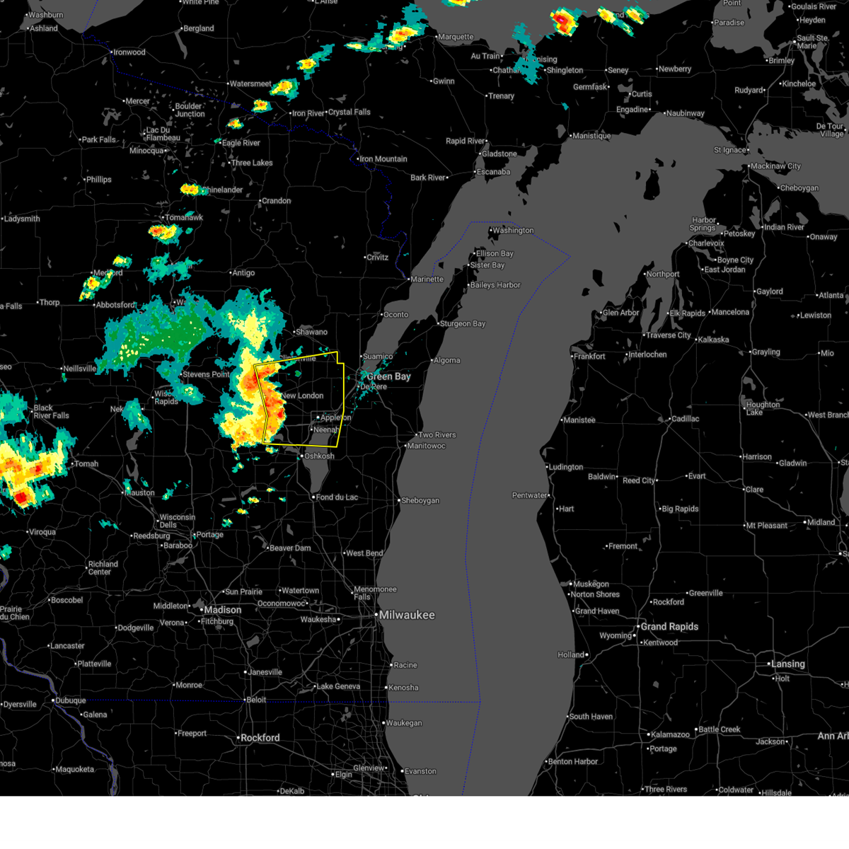
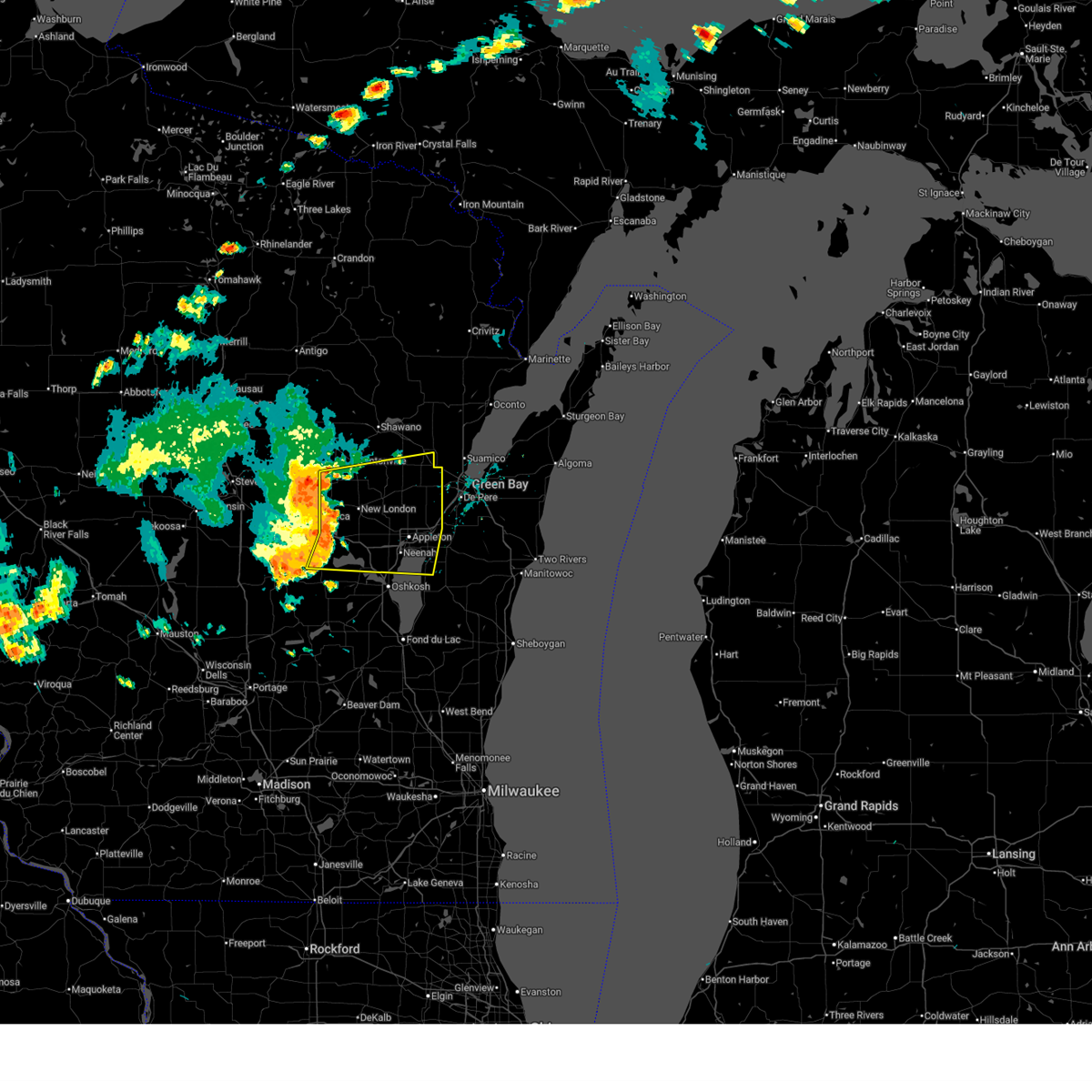
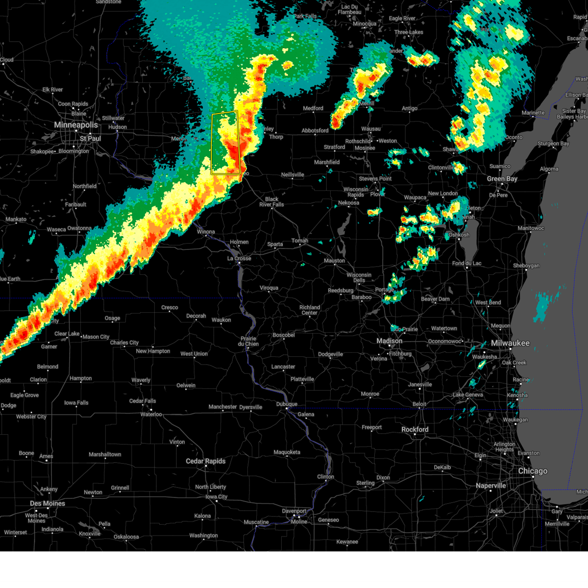
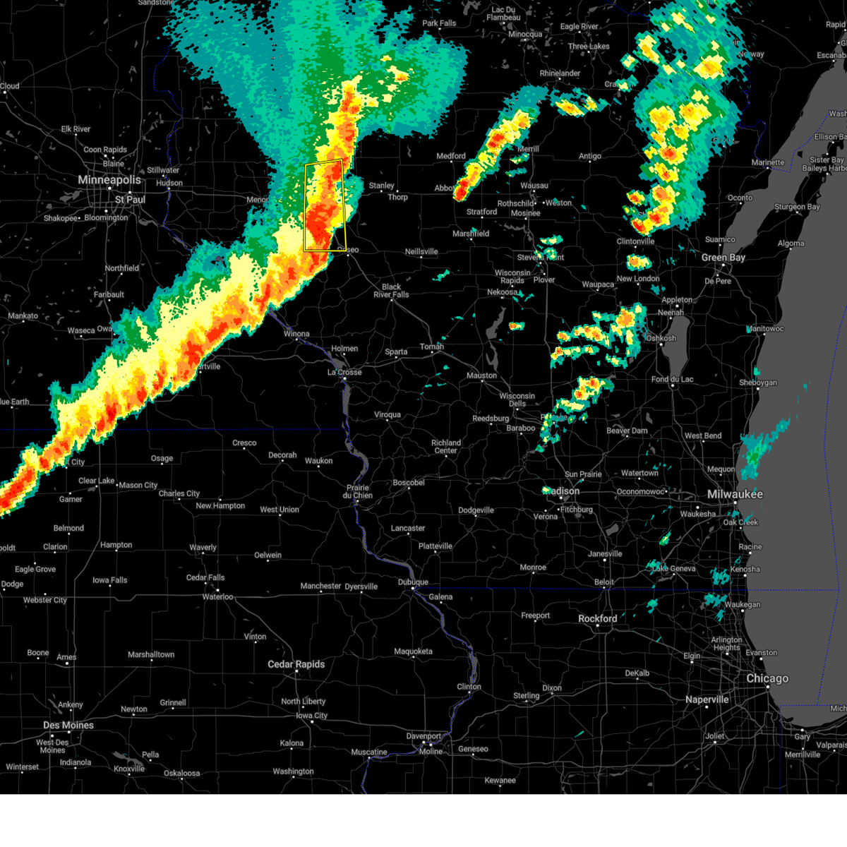
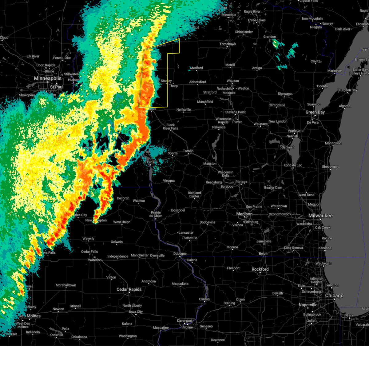
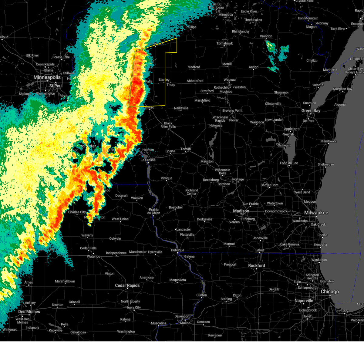
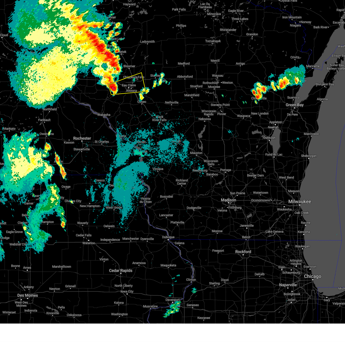
Hail Map for Seymour, WI
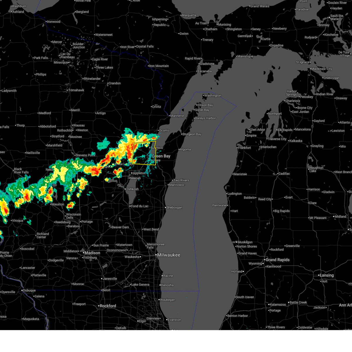
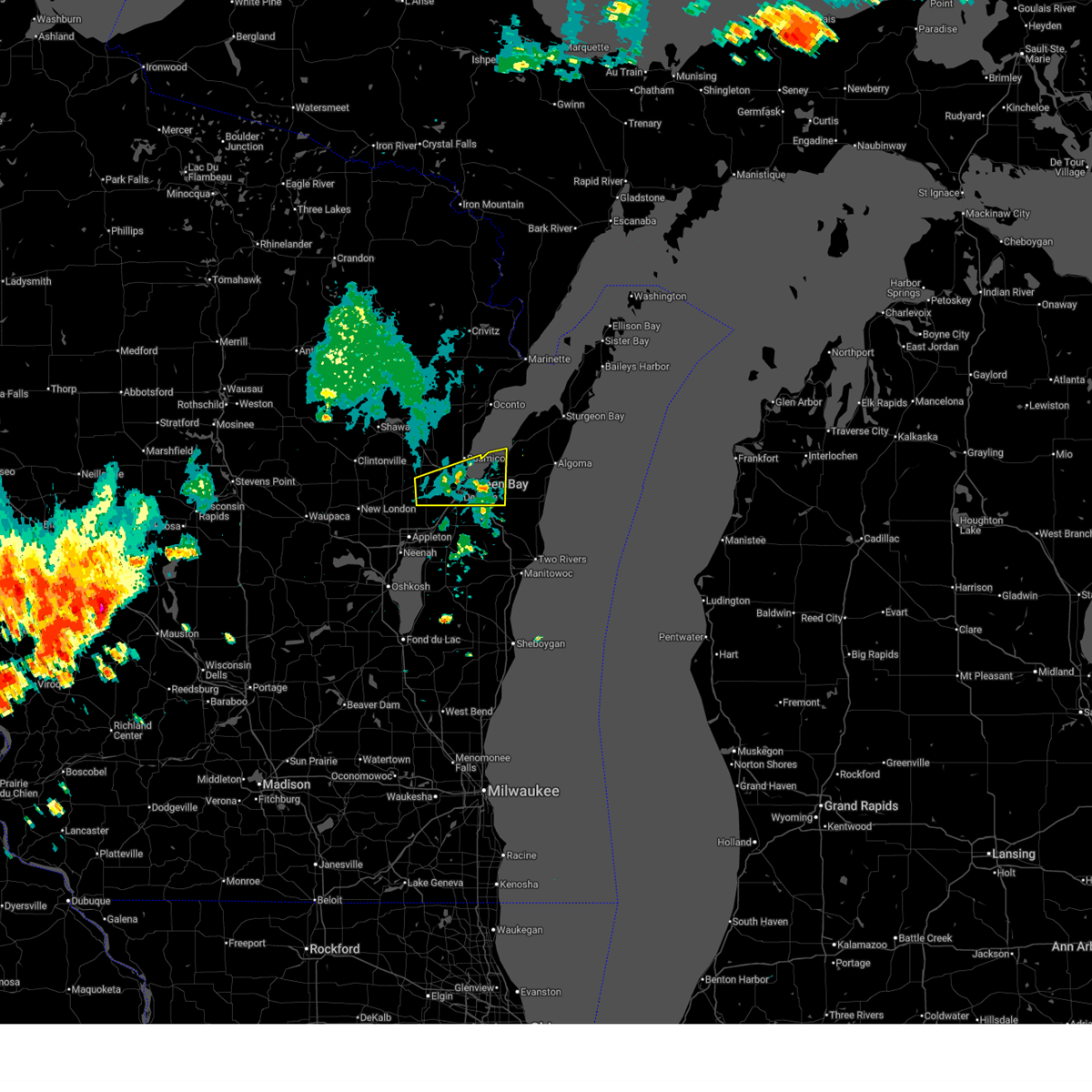
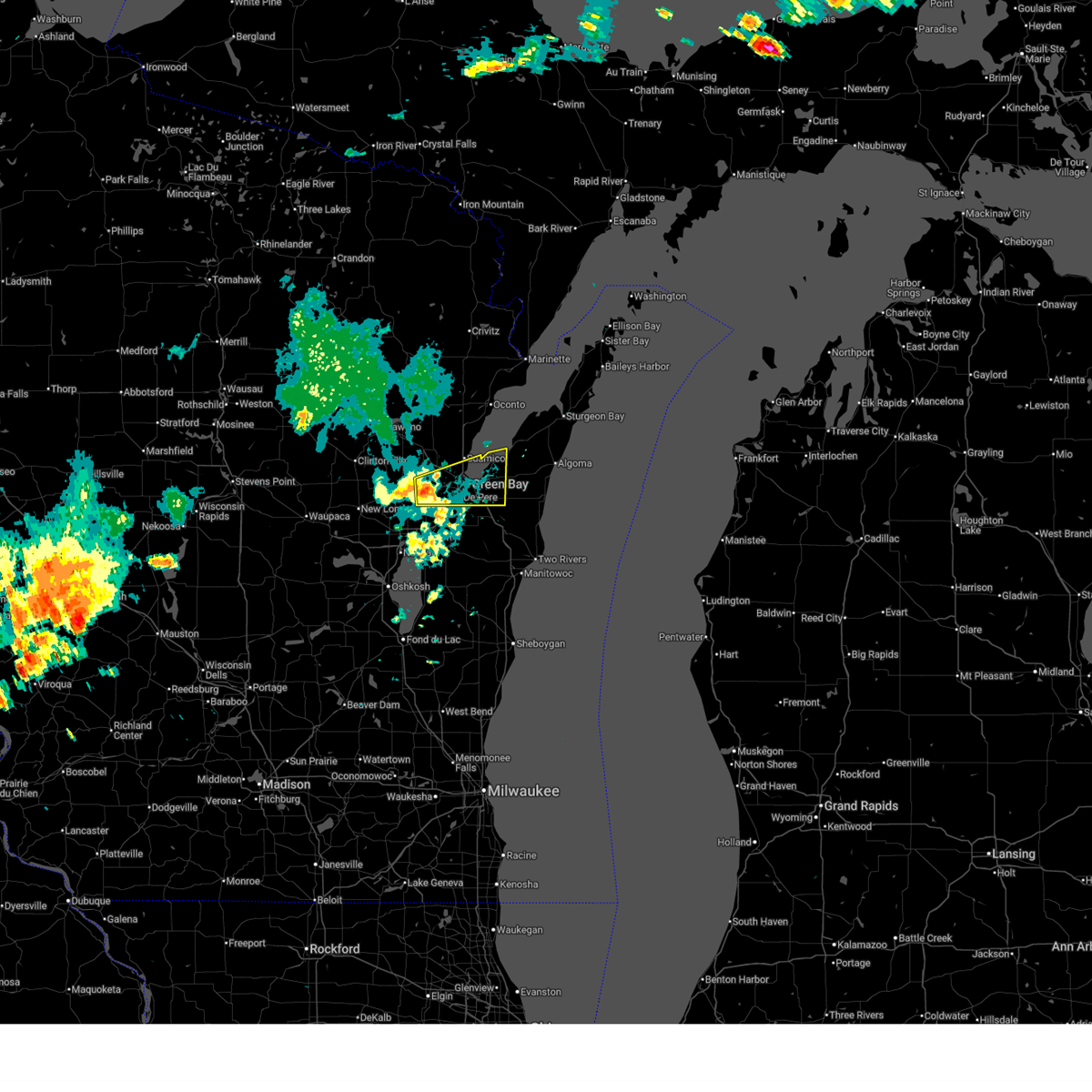
The Seymour, WI area has had 1 report of on-the-ground hail by trained spotters, and has been under severe weather warnings 47 times during the past 12 months. Doppler radar has detected hail at or near Seymour, WI on 80 occasions, including 6 occasions during the past year.
| Name: | Seymour, WI |
| Where Located: | 15.5 miles W of Green Bay, WI |
| Map: | Google Map for Seymour, WI |
| Population: | 3451 |
| Housing Units: | 1565 |
| More Info: | Search Google for Seymour, WI |
5
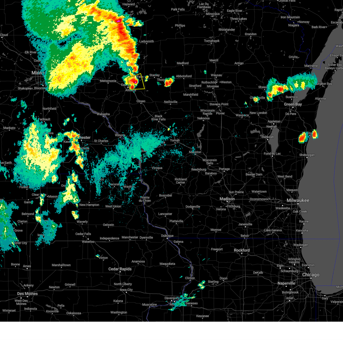
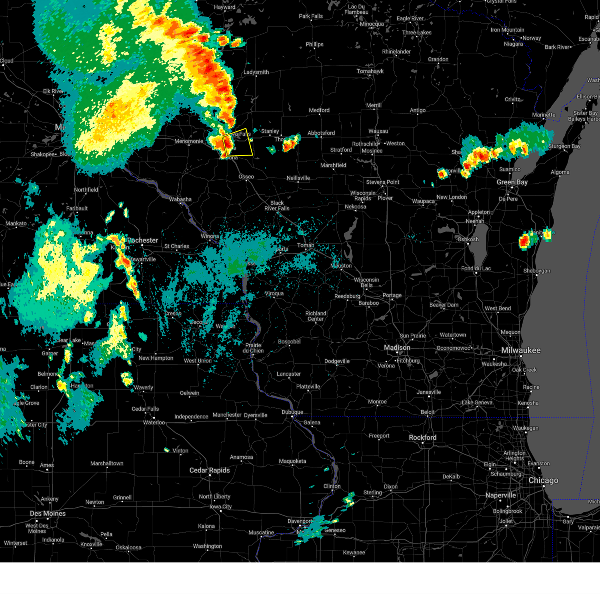
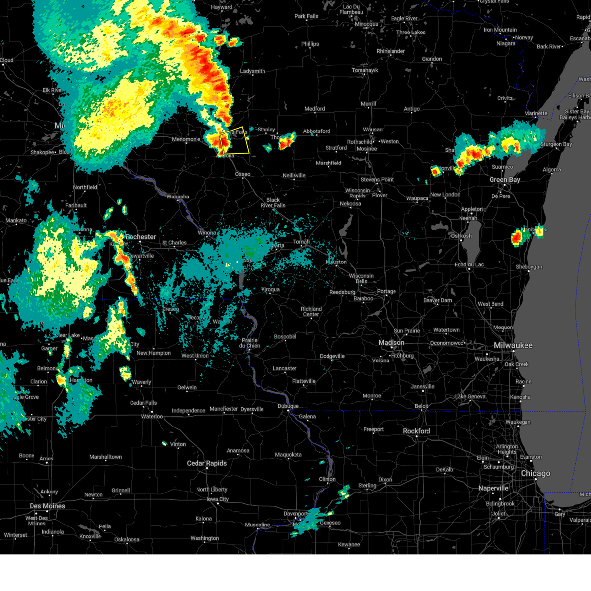
The Top Recent Hail Date for Seymour, WI is Thursday, May 15, 2025 (1st out of 80)

Hail and Wind Damage Spotted near Seymour, WI
| Date / Time | Report Details |
|---|---|
| 6/29/2025 3:16 PM CDT |
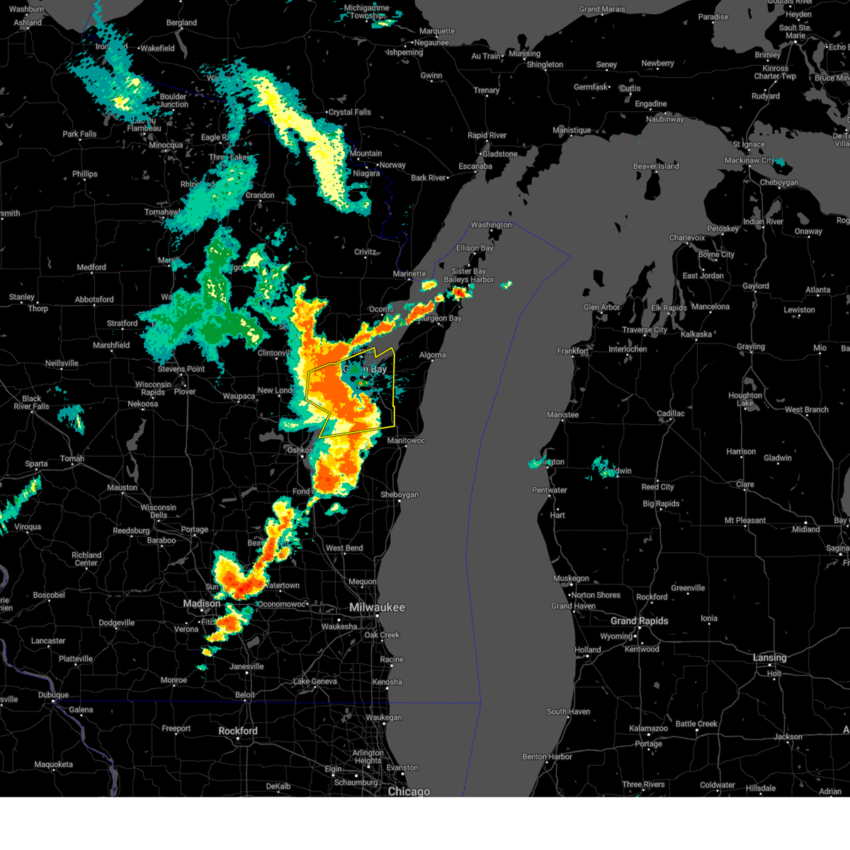
 At 316 pm cdt, a severe thunderstorm was located near green bay, moving east at 35 mph (radar indicated). Hazards include 60 mph wind gusts and penny size hail. Expect damage to roofs, siding, and trees. this severe storm will be near, green bay and bellevue town around 320 pm cdt. Other locations impacted by this severe thunderstorm include anston, hofa park, rose lawn, kunesh, chicago corners, glenmore, pittsfield, oneida, de pere, and lambeau field. At 316 pm cdt, a severe thunderstorm was located near green bay, moving east at 35 mph (radar indicated). Hazards include 60 mph wind gusts and penny size hail. Expect damage to roofs, siding, and trees. this severe storm will be near, green bay and bellevue town around 320 pm cdt. Other locations impacted by this severe thunderstorm include anston, hofa park, rose lawn, kunesh, chicago corners, glenmore, pittsfield, oneida, de pere, and lambeau field.
|
| 6/29/2025 3:16 PM CDT |
 the severe thunderstorm warning has been cancelled and is no longer in effect the severe thunderstorm warning has been cancelled and is no longer in effect
|
| 6/29/2025 3:01 PM CDT |
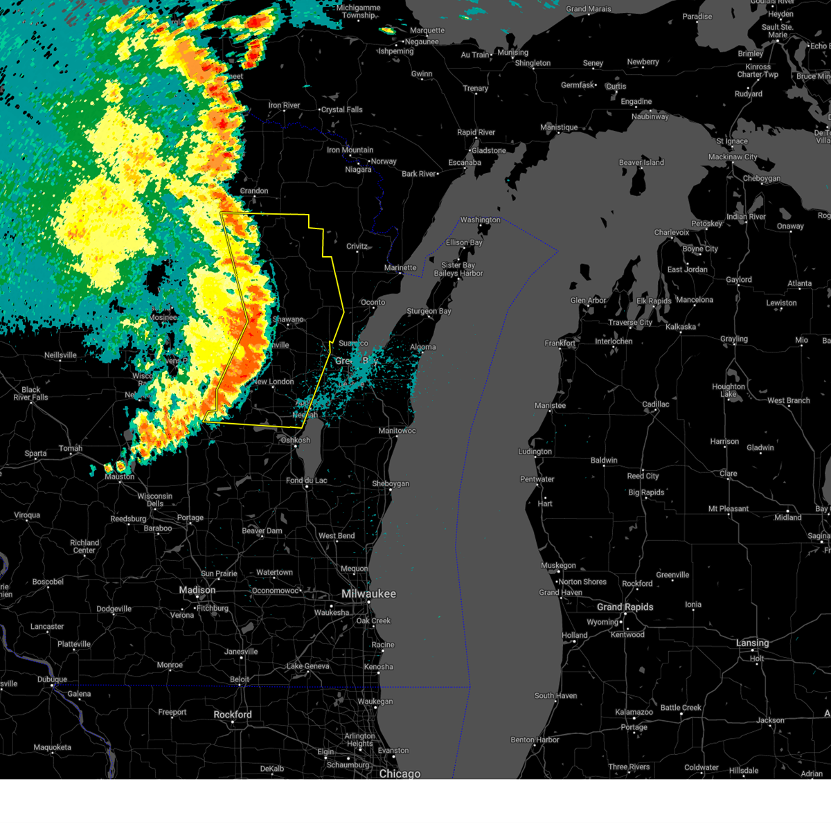
 Svrgrb the national weather service in green bay has issued a * severe thunderstorm warning for, northwestern brown county in northeastern wisconsin, south central oconto county in northeastern wisconsin, northeastern outagamie county in northeastern wisconsin, eastern shawano county in northeastern wisconsin, * until 345 pm cdt. * at 301 pm cdt, a severe thunderstorms were located near pulaski to seymour, moving east at 25 mph (radar indicated). Hazards include 60 mph wind gusts and quarter size hail. Hail damage to vehicles is expected. expect wind damage to roofs, siding, and trees. this severe thunderstorm will be near, green bay around 310 pm cdt. Other locations impacted by this severe thunderstorm include hofa park, rose lawn, sobieski, kunesh, south chase, de pere, lambeau field, ledgeview, hobart, and leo frigo bridge. Svrgrb the national weather service in green bay has issued a * severe thunderstorm warning for, northwestern brown county in northeastern wisconsin, south central oconto county in northeastern wisconsin, northeastern outagamie county in northeastern wisconsin, eastern shawano county in northeastern wisconsin, * until 345 pm cdt. * at 301 pm cdt, a severe thunderstorms were located near pulaski to seymour, moving east at 25 mph (radar indicated). Hazards include 60 mph wind gusts and quarter size hail. Hail damage to vehicles is expected. expect wind damage to roofs, siding, and trees. this severe thunderstorm will be near, green bay around 310 pm cdt. Other locations impacted by this severe thunderstorm include hofa park, rose lawn, sobieski, kunesh, south chase, de pere, lambeau field, ledgeview, hobart, and leo frigo bridge.
|
| 6/23/2025 3:56 PM CDT |
 The storm which prompted the warning has weakened below severe limits, and no longer poses an immediate threat to life or property. therefore, the warning will be allowed to expire. however, gusty winds are still possible with this thunderstorm. a severe thunderstorm watch remains in effect until 900 pm cdt for northeastern wisconsin. The storm which prompted the warning has weakened below severe limits, and no longer poses an immediate threat to life or property. therefore, the warning will be allowed to expire. however, gusty winds are still possible with this thunderstorm. a severe thunderstorm watch remains in effect until 900 pm cdt for northeastern wisconsin.
|
| 6/23/2025 3:37 PM CDT |
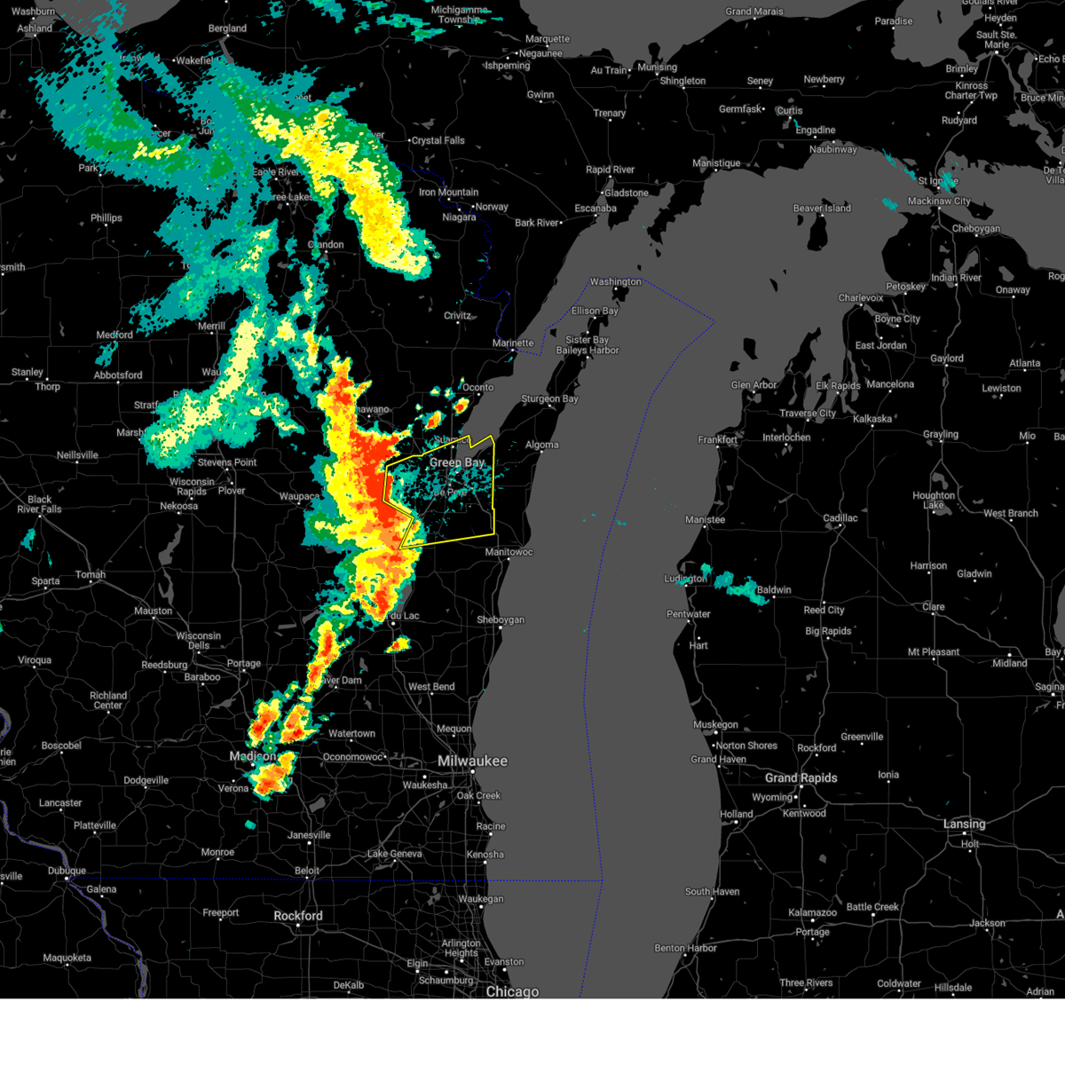
 At 337 pm cdt, a severe thunderstorm was located near green bay, moving east at 55 mph (radar indicated). Hazards include 60 mph wind gusts. Expect damage to roofs, siding, and trees. this severe storm will be near, green bay and bellevue town around 345 pm cdt. Other locations impacted by this severe thunderstorm include humboldt, chicago corners, bellevue, oneida, de pere, lambeau field, ledgeview, hobart, leo frigo bridge, and howard. At 337 pm cdt, a severe thunderstorm was located near green bay, moving east at 55 mph (radar indicated). Hazards include 60 mph wind gusts. Expect damage to roofs, siding, and trees. this severe storm will be near, green bay and bellevue town around 345 pm cdt. Other locations impacted by this severe thunderstorm include humboldt, chicago corners, bellevue, oneida, de pere, lambeau field, ledgeview, hobart, leo frigo bridge, and howard.
|
| 6/23/2025 3:25 PM CDT |
 Svrgrb the national weather service in green bay has issued a * severe thunderstorm warning for, brown county in northeastern wisconsin, eastern outagamie county in northeastern wisconsin, * until 400 pm cdt. * at 325 pm cdt, a severe thunderstorm was located near black creek, or 13 miles north of appleton, moving east at 55 mph (radar indicated). Hazards include 60 mph wind gusts. Expect damage to roofs, siding, and trees. this severe thunderstorm will be near, green bay around 330 pm cdt. bellevue town around 335 pm cdt. Other locations impacted by this severe thunderstorm include little rapids, mackville, humboldt, de pere, lambeau field, freedom, ledgeview, wolf river bottoms wildlife area, hobart, and leo frigo bridge. Svrgrb the national weather service in green bay has issued a * severe thunderstorm warning for, brown county in northeastern wisconsin, eastern outagamie county in northeastern wisconsin, * until 400 pm cdt. * at 325 pm cdt, a severe thunderstorm was located near black creek, or 13 miles north of appleton, moving east at 55 mph (radar indicated). Hazards include 60 mph wind gusts. Expect damage to roofs, siding, and trees. this severe thunderstorm will be near, green bay around 330 pm cdt. bellevue town around 335 pm cdt. Other locations impacted by this severe thunderstorm include little rapids, mackville, humboldt, de pere, lambeau field, freedom, ledgeview, wolf river bottoms wildlife area, hobart, and leo frigo bridge.
|
| 6/23/2025 3:17 PM CDT |
 At 317 pm cdt, severe thunderstorms were located along a line extending from near navarino wildlife area to near appleton to near oshkosh, moving east at 45 mph (radar indicated). Hazards include 60 mph wind gusts. Expect damage to roofs, siding, and trees. these severe storms will be near, appleton, kaukauna, little chute, kimberly, and black creek around 320 pm cdt. Other locations impacted by these severe thunderstorms include nichols, fitzgerald corners, mackville, leeman, hofa park, northport, sugar bush, rose lawn, freedom, and wolf river bottoms wildlife area. At 317 pm cdt, severe thunderstorms were located along a line extending from near navarino wildlife area to near appleton to near oshkosh, moving east at 45 mph (radar indicated). Hazards include 60 mph wind gusts. Expect damage to roofs, siding, and trees. these severe storms will be near, appleton, kaukauna, little chute, kimberly, and black creek around 320 pm cdt. Other locations impacted by these severe thunderstorms include nichols, fitzgerald corners, mackville, leeman, hofa park, northport, sugar bush, rose lawn, freedom, and wolf river bottoms wildlife area.
|
| 6/23/2025 3:17 PM CDT |
 the severe thunderstorm warning has been cancelled and is no longer in effect the severe thunderstorm warning has been cancelled and is no longer in effect
|
| 6/23/2025 3:01 PM CDT |
 the severe thunderstorm warning has been cancelled and is no longer in effect the severe thunderstorm warning has been cancelled and is no longer in effect
|
| 6/23/2025 3:01 PM CDT |
 At 301 pm cdt, severe thunderstorms were located along a line extending from near clintonville to 8 miles southeast of new london to 7 miles south of lake poygan, moving east at 45 mph (radar indicated). Hazards include 60 mph wind gusts. Expect damage to roofs, siding, and trees. these severe storms will be near, appleton, menasha, black creek, and northern lake winnebago around 310 pm cdt. little chute, kimberly, and central lake winnebago around 315 pm cdt. kaukauna and darboy around 320 pm cdt. high cliff state park around 325 pm cdt. Other locations impacted by these severe thunderstorms include nichols, fitzgerald corners, mackville, leeman, butte des morts, larsen, hofa park, northport, sugar bush, and orihula. At 301 pm cdt, severe thunderstorms were located along a line extending from near clintonville to 8 miles southeast of new london to 7 miles south of lake poygan, moving east at 45 mph (radar indicated). Hazards include 60 mph wind gusts. Expect damage to roofs, siding, and trees. these severe storms will be near, appleton, menasha, black creek, and northern lake winnebago around 310 pm cdt. little chute, kimberly, and central lake winnebago around 315 pm cdt. kaukauna and darboy around 320 pm cdt. high cliff state park around 325 pm cdt. Other locations impacted by these severe thunderstorms include nichols, fitzgerald corners, mackville, leeman, butte des morts, larsen, hofa park, northport, sugar bush, and orihula.
|
| 6/23/2025 2:47 PM CDT |
 Svrgrb the national weather service in green bay has issued a * severe thunderstorm warning for, northwestern calumet county in east central wisconsin, northern winnebago county in east central wisconsin, northeastern waushara county in central wisconsin, central waupaca county in northeastern wisconsin, outagamie county in northeastern wisconsin, eastern shawano county in northeastern wisconsin, * until 330 pm cdt. * at 247 pm cdt, severe thunderstorms were located along a line extending from 7 miles southwest of clintonville to fremont to near redgranite, moving east at 45 mph (radar indicated). Hazards include 60 mph wind gusts. Expect damage to roofs, siding, and trees. severe thunderstorms will be near, new london, fremont, and lake poygan around 250 pm cdt. appleton, menasha, black creek, and northern lake winnebago around 310 pm cdt. little chute, kimberly, and central lake winnebago around 315 pm cdt. kaukauna and darboy around 320 pm cdt. high cliff state park around 325 pm cdt. Other locations impacted by these severe thunderstorms include mackville, leeman, butte des morts, larsen, northport, sugar bush, orihula, rose lawn, freedom, and wolf river bottoms wildlife area. Svrgrb the national weather service in green bay has issued a * severe thunderstorm warning for, northwestern calumet county in east central wisconsin, northern winnebago county in east central wisconsin, northeastern waushara county in central wisconsin, central waupaca county in northeastern wisconsin, outagamie county in northeastern wisconsin, eastern shawano county in northeastern wisconsin, * until 330 pm cdt. * at 247 pm cdt, severe thunderstorms were located along a line extending from 7 miles southwest of clintonville to fremont to near redgranite, moving east at 45 mph (radar indicated). Hazards include 60 mph wind gusts. Expect damage to roofs, siding, and trees. severe thunderstorms will be near, new london, fremont, and lake poygan around 250 pm cdt. appleton, menasha, black creek, and northern lake winnebago around 310 pm cdt. little chute, kimberly, and central lake winnebago around 315 pm cdt. kaukauna and darboy around 320 pm cdt. high cliff state park around 325 pm cdt. Other locations impacted by these severe thunderstorms include mackville, leeman, butte des morts, larsen, northport, sugar bush, orihula, rose lawn, freedom, and wolf river bottoms wildlife area.
|
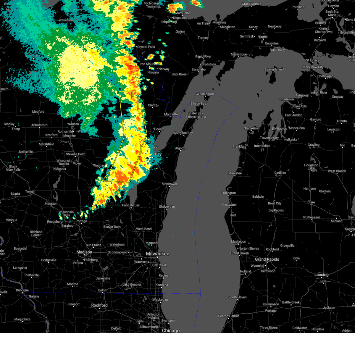
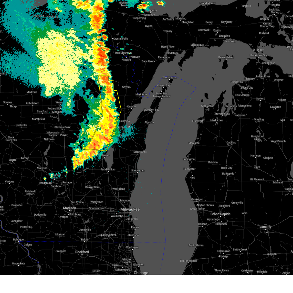
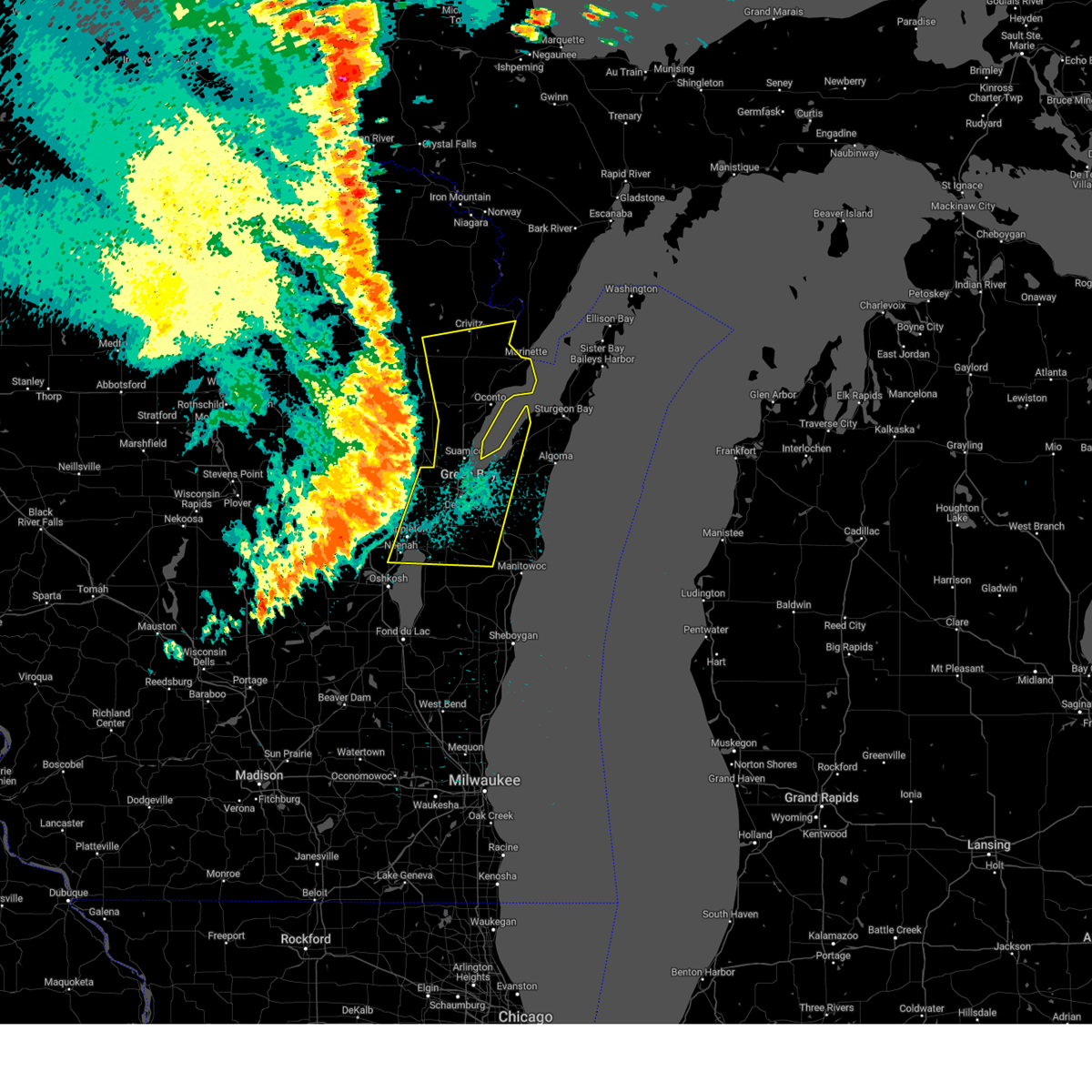
| 5/16/2025 5:54 PM CDT | At 554 pm cdt, severe thunderstorms were located along a line extending from near pulaski to 7 miles northwest of green bay to 7 miles north of brillion, moving northeast at 55 mph (radar indicated). Hazards include 70 mph wind gusts. Expect considerable tree damage. damage is likely to mobile homes, roofs, and outbuildings. these severe storms will be near, green bay and bellevue town around 600 pm cdt. Other locations impacted by these severe thunderstorms include wayside, morrison, rose lawn, freedom, ledgeview, leo frigo bridge, askeaton, howard, st john, and frazer corners. |
| 5/16/2025 5:54 PM CDT | the severe thunderstorm warning has been cancelled and is no longer in effect |
| 5/16/2025 5:27 PM CDT | Svrgrb the national weather service in green bay has issued a * severe thunderstorm warning for, brown county in northeastern wisconsin, northern calumet county in east central wisconsin, northeastern winnebago county in east central wisconsin, northeastern waupaca county in northeastern wisconsin, south central oconto county in northeastern wisconsin, outagamie county in northeastern wisconsin, eastern shawano county in northeastern wisconsin, west central manitowoc county in east central wisconsin, * until 615 pm cdt. * at 527 pm cdt, severe thunderstorms were located along a line extending from 9 miles northeast of new london to near black creek to near central lake winnebago, moving northeast at 55 mph (radar indicated). Hazards include 70 mph wind gusts. Expect considerable tree damage. damage is likely to mobile homes, roofs, and outbuildings. severe thunderstorms will be near, appleton, menasha, kaukauna, little chute, kimberly, black creek, darboy, high cliff state park, and northern lake winnebago around 535 pm cdt. green bay around 540 pm cdt. pulaski around 545 pm cdt. bellevue town around 550 pm cdt. Other locations impacted by these severe thunderstorms include mackville, leeman, wayside, morrison, sugar bush, rose lawn, freedom, ledgeview, wolf river bottoms wildlife area, and leo frigo bridge. |
| 5/15/2025 4:44 PM CDT |
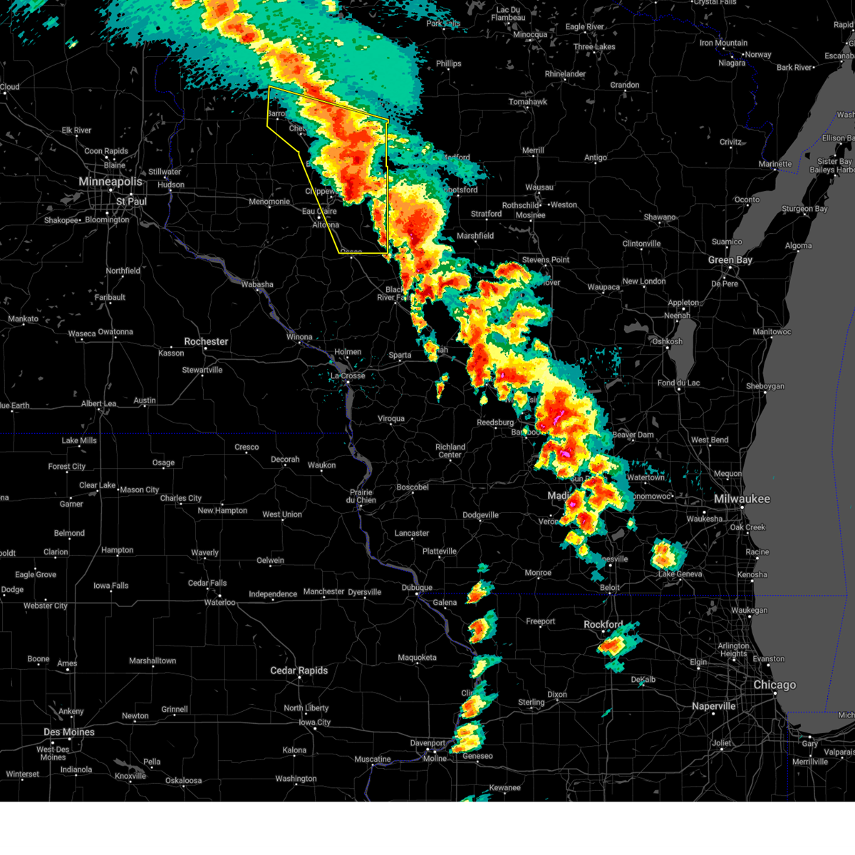 The severe thunderstorm warning that was previously in effect has been reissued for barron, chippewa, eau claire, and rusk counties and is in effect until 530 pm cdt. please refer to that bulletin for the latest severe weather information. The severe thunderstorm warning that was previously in effect has been reissued for barron, chippewa, eau claire, and rusk counties and is in effect until 530 pm cdt. please refer to that bulletin for the latest severe weather information.
|
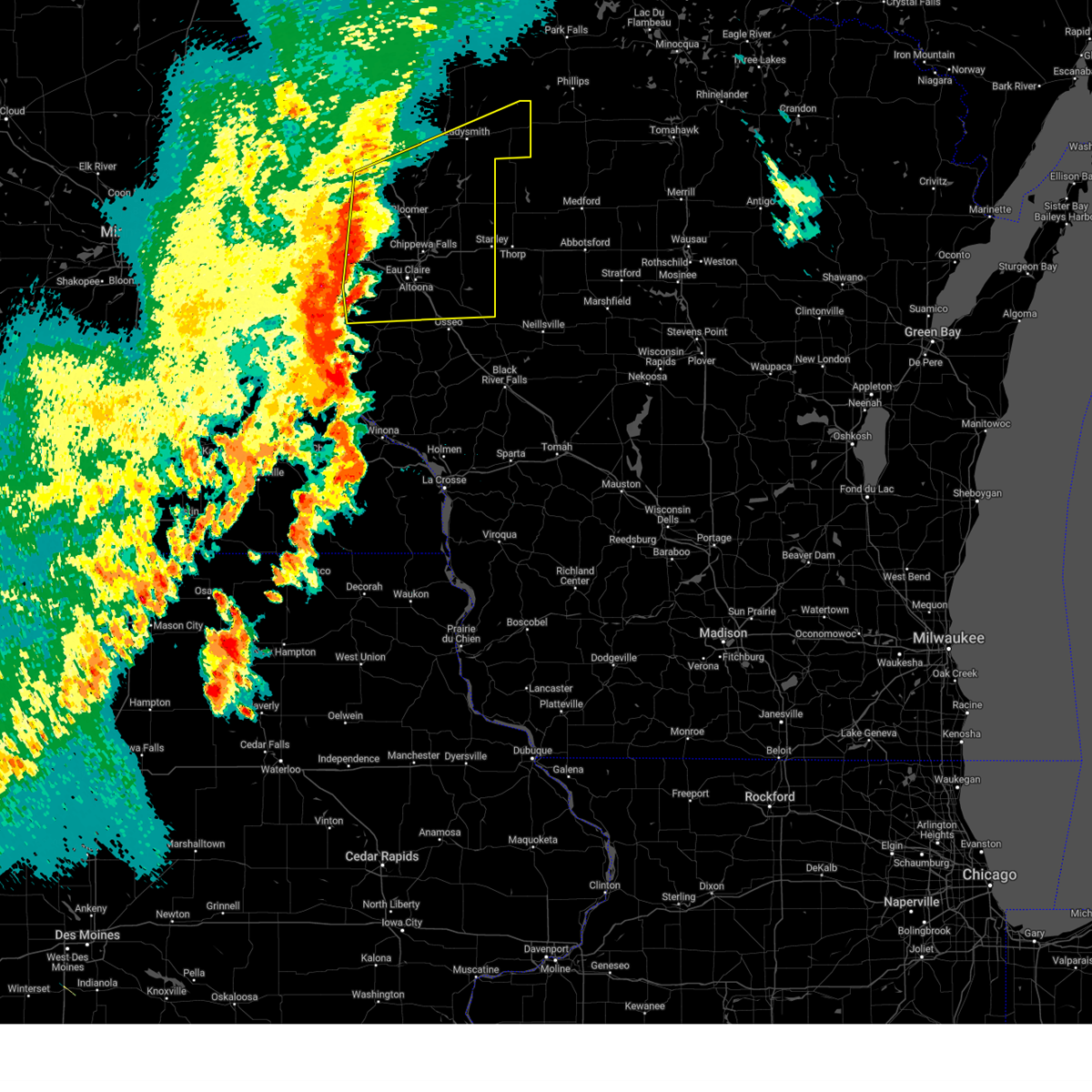
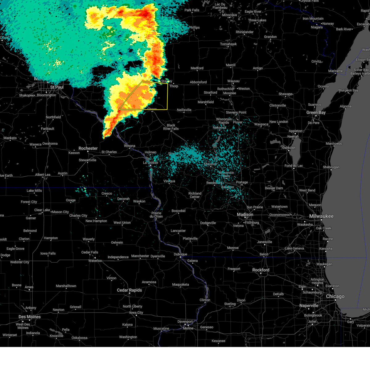
| 5/15/2025 4:27 PM CDT | At 427 pm cdt, a severe thunderstorm was located 10 miles south of weyerhaeuser, or 20 miles southwest of ladysmith, moving northeast at 50 mph (radar indicated). Hazards include 60 mph wind gusts and half dollar size hail. Hail damage to vehicles is expected. expect wind damage to roofs, siding, and trees. Locations impacted include, eau claire, rice lake, chippewa falls, altoona, lake hallie, stanley, bloomer, barron, lake wissota, chetek, cameron, augusta, cornell, cadott, fall creek, bruce, boyd, fairchild, new auburn and weyerhaeuser. |
| 5/15/2025 4:27 PM CDT | the severe thunderstorm warning has been cancelled and is no longer in effect |
| 5/15/2025 4:25 PM CDT | The tornado threat has diminished and the tornado warning has been cancelled. however, large hail and damaging winds remain likely and a severe thunderstorm warning remains in effect for the area. to report severe weather, contact your nearest law enforcement agency. they will send your report to the national weather service office. a tornado watch remains in effect until 800 pm cdt for a portion of west central wisconsin. |
| 5/15/2025 4:14 PM CDT | the severe thunderstorm warning has been cancelled and is no longer in effect |
| 5/15/2025 4:14 PM CDT | At 414 pm cdt, a severe thunderstorm was located near new auburn, or 22 miles north of eau claire, moving northeast at 50 mph (radar indicated). Hazards include 60 mph wind gusts and quarter size hail. Hail damage to vehicles is expected. expect wind damage to roofs, siding, and trees. Locations impacted include, eau claire, rice lake, chippewa falls, altoona, lake hallie, stanley, bloomer, barron, lake wissota, chetek, cameron, augusta, cornell, cadott, fall creek, bruce, boyd, fairchild, new auburn and dallas. |
| 5/15/2025 4:12 PM CDT |
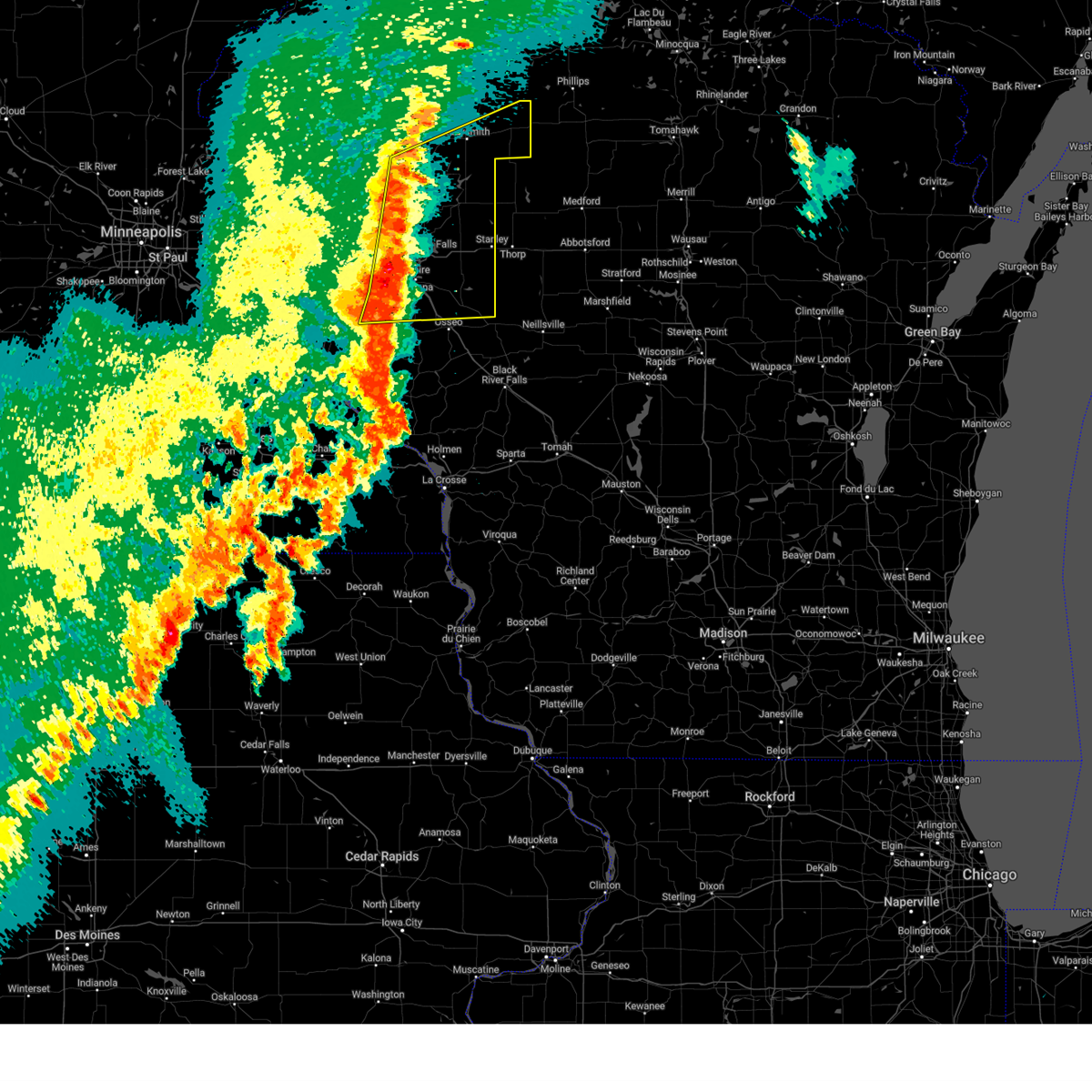
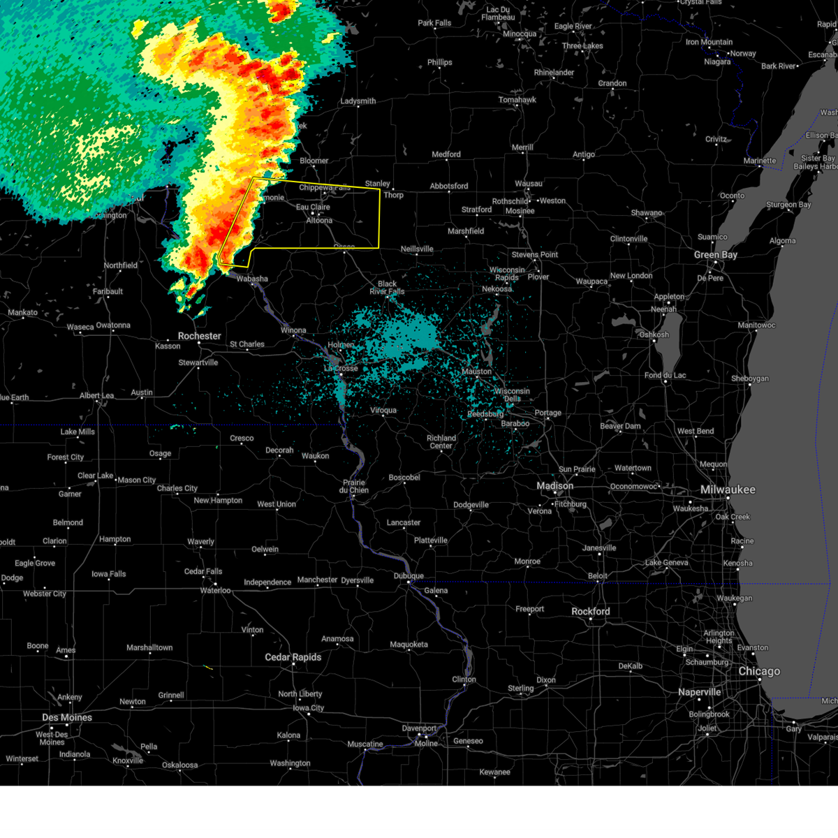
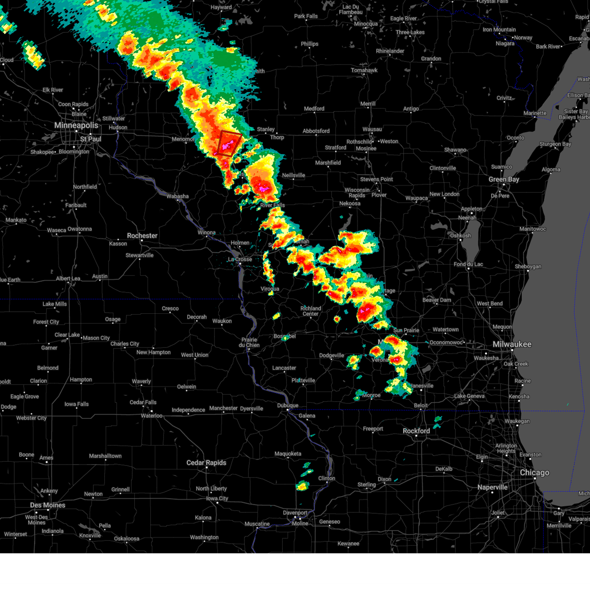 At 412 pm cdt, a severe thunderstorm capable of producing a tornado was located over altoona, or near eau claire, moving north at 40 mph (radar indicated rotation). Hazards include tornado and two inch hail. Flying debris will be dangerous to those caught without shelter. mobile homes will be damaged or destroyed. damage to roofs, windows and vehicles will occur. tree damage is likely. Locations impacted include, eau claire, chippewa falls, altoona, lake hallie, lake wissota, seymour, eau claire airport and bateman. At 412 pm cdt, a severe thunderstorm capable of producing a tornado was located over altoona, or near eau claire, moving north at 40 mph (radar indicated rotation). Hazards include tornado and two inch hail. Flying debris will be dangerous to those caught without shelter. mobile homes will be damaged or destroyed. damage to roofs, windows and vehicles will occur. tree damage is likely. Locations impacted include, eau claire, chippewa falls, altoona, lake hallie, lake wissota, seymour, eau claire airport and bateman.
|
| 5/15/2025 4:05 PM CDT |
 Tormpx the national weather service in the twin cities has issued a * tornado warning for, south central chippewa county in west central wisconsin, northwestern eau claire county in west central wisconsin, * until 430 pm cdt. * at 405 pm cdt, a severe thunderstorm capable of producing a tornado was located near altoona, or 5 miles southeast of eau claire, moving north at 40 mph (radar indicated rotation). Hazards include tornado. Flying debris will be dangerous to those caught without shelter. mobile homes will be damaged or destroyed. damage to roofs, windows and vehicles will occur. Tree damage is likely. Tormpx the national weather service in the twin cities has issued a * tornado warning for, south central chippewa county in west central wisconsin, northwestern eau claire county in west central wisconsin, * until 430 pm cdt. * at 405 pm cdt, a severe thunderstorm capable of producing a tornado was located near altoona, or 5 miles southeast of eau claire, moving north at 40 mph (radar indicated rotation). Hazards include tornado. Flying debris will be dangerous to those caught without shelter. mobile homes will be damaged or destroyed. damage to roofs, windows and vehicles will occur. Tree damage is likely.
|
| 5/15/2025 3:58 PM CDT |
 Svrmpx the national weather service in the twin cities has issued a * severe thunderstorm warning for, eastern barron county in northwestern wisconsin, southern rusk county in northwestern wisconsin, chippewa county in west central wisconsin, dunn county in west central wisconsin, eau claire county in west central wisconsin, northeastern pepin county in west central wisconsin, * until 445 pm cdt. * at 358 pm cdt, a line of severe thunderstorms was located from near prairie farm through elk mound through fall creek moving northeast at 50 mph (radar indicated). Hazards include 60 mph wind gusts and quarter size hail. Hail damage to vehicles is expected. Expect wind damage to roofs, siding, and trees. Svrmpx the national weather service in the twin cities has issued a * severe thunderstorm warning for, eastern barron county in northwestern wisconsin, southern rusk county in northwestern wisconsin, chippewa county in west central wisconsin, dunn county in west central wisconsin, eau claire county in west central wisconsin, northeastern pepin county in west central wisconsin, * until 445 pm cdt. * at 358 pm cdt, a line of severe thunderstorms was located from near prairie farm through elk mound through fall creek moving northeast at 50 mph (radar indicated). Hazards include 60 mph wind gusts and quarter size hail. Hail damage to vehicles is expected. Expect wind damage to roofs, siding, and trees.
|
| 4/28/2025 8:08 PM CDT |
 The storm which prompted the warning has moved out of the area. therefore, the warning has been allowed to expire. a tornado watch remains in effect until 1100 pm cdt for a portion of west central wisconsin. The storm which prompted the warning has moved out of the area. therefore, the warning has been allowed to expire. a tornado watch remains in effect until 1100 pm cdt for a portion of west central wisconsin.
|
| 4/28/2025 7:47 PM CDT |
 the severe thunderstorm warning has been cancelled and is no longer in effect the severe thunderstorm warning has been cancelled and is no longer in effect
|
| 4/28/2025 7:47 PM CDT |
 At 747 pm cdt, a severe thunderstorm was located over altoona, or 6 miles east of eau claire, moving east at 45 mph (radar indicated). Hazards include 60 mph wind gusts and small hail. Expect damage to roofs, siding, and trees. Locations impacted include, eau claire, chippewa falls, altoona, lake hallie, bloomer, lake wissota, fall creek, tilden, foster, seymour, eau claire airport, bateman, brackett, eagleton, allen and jim falls. At 747 pm cdt, a severe thunderstorm was located over altoona, or 6 miles east of eau claire, moving east at 45 mph (radar indicated). Hazards include 60 mph wind gusts and small hail. Expect damage to roofs, siding, and trees. Locations impacted include, eau claire, chippewa falls, altoona, lake hallie, bloomer, lake wissota, fall creek, tilden, foster, seymour, eau claire airport, bateman, brackett, eagleton, allen and jim falls.
|
| 4/28/2025 7:15 PM CDT | Svrmpx the national weather service in the twin cities has issued a * severe thunderstorm warning for, southwestern chippewa county in west central wisconsin, eastern dunn county in west central wisconsin, western eau claire county in west central wisconsin, northeastern pepin county in west central wisconsin, * until 800 pm cdt. * at 715 pm cdt, a severe thunderstorm was located 9 miles northeast of durand, or 11 miles south of menomonie, moving east at 45 mph (radar indicated). Hazards include 60 mph wind gusts and small hail. expect damage to roofs, siding, and trees |
| 8/29/2024 7:48 PM CDT |
 At 748 pm cdt, severe thunderstorms were located along a line extending from near bruce to near cornell to 5 miles southeast of lake wissota to 5 miles south of fall creek, moving east at 50 mph (radar indicated). Hazards include 60 mph wind gusts. Expect damage to roofs, siding, and trees. these severe storms will be near, ladysmith, augusta, cornell, cadott, and boyd around 755 pm cdt. stanley and sheldon around 800 pm cdt. Hawkins around 815 pm cdt. At 748 pm cdt, severe thunderstorms were located along a line extending from near bruce to near cornell to 5 miles southeast of lake wissota to 5 miles south of fall creek, moving east at 50 mph (radar indicated). Hazards include 60 mph wind gusts. Expect damage to roofs, siding, and trees. these severe storms will be near, ladysmith, augusta, cornell, cadott, and boyd around 755 pm cdt. stanley and sheldon around 800 pm cdt. Hawkins around 815 pm cdt.
|
| 8/29/2024 7:40 PM CDT |
 the severe thunderstorm warning has been cancelled and is no longer in effect the severe thunderstorm warning has been cancelled and is no longer in effect
|
| 8/29/2024 7:40 PM CDT |
 At 739 pm cdt, severe thunderstorms were located along a line extending from near bruce to 7 miles east of bloomer to near lake hallie to 7 miles north of strum, moving east at 35 mph (radar indicated). Hazards include 60 mph wind gusts. Expect damage to roofs, siding, and trees. these severe storms will be near, ladysmith, lake wissota, cornell, cadott, and fall creek around 745 pm cdt. augusta and boyd around 755 pm cdt. sheldon around 800 pm cdt. stanley around 805 pm cdt. Hawkins around 815 pm cdt. At 739 pm cdt, severe thunderstorms were located along a line extending from near bruce to 7 miles east of bloomer to near lake hallie to 7 miles north of strum, moving east at 35 mph (radar indicated). Hazards include 60 mph wind gusts. Expect damage to roofs, siding, and trees. these severe storms will be near, ladysmith, lake wissota, cornell, cadott, and fall creek around 745 pm cdt. augusta and boyd around 755 pm cdt. sheldon around 800 pm cdt. stanley around 805 pm cdt. Hawkins around 815 pm cdt.
|
| 8/29/2024 7:29 PM CDT |
 At 729 pm cdt, severe thunderstorms were located along a line extending from 5 miles south of weyerhaeuser to near bloomer to near eau claire to 8 miles northeast of mondovi, moving east at 40 mph (radar indicated). Hazards include 60 mph wind gusts. Expect damage to roofs, siding, and trees. these severe storms will be near, eau claire, chippewa falls, altoona, lake hallie, and lake wissota around 735 pm cdt. fall creek around 740 pm cdt. cornell and cadott around 745 pm cdt. ladysmith around 750 pm cdt. boyd around 755 pm cdt. Stanley and sheldon around 800 pm cdt. At 729 pm cdt, severe thunderstorms were located along a line extending from 5 miles south of weyerhaeuser to near bloomer to near eau claire to 8 miles northeast of mondovi, moving east at 40 mph (radar indicated). Hazards include 60 mph wind gusts. Expect damage to roofs, siding, and trees. these severe storms will be near, eau claire, chippewa falls, altoona, lake hallie, and lake wissota around 735 pm cdt. fall creek around 740 pm cdt. cornell and cadott around 745 pm cdt. ladysmith around 750 pm cdt. boyd around 755 pm cdt. Stanley and sheldon around 800 pm cdt.
|
| 8/29/2024 7:07 PM CDT |
 Svrmpx the national weather service in the twin cities has issued a * severe thunderstorm warning for, northeastern pepin county in west central wisconsin, rusk county in northwestern wisconsin, eastern dunn county in west central wisconsin, chippewa county in west central wisconsin, eau claire county in west central wisconsin, southeastern barron county in northwestern wisconsin, * until 800 pm cdt. * at 706 pm cdt, severe thunderstorms were located along a line extending from near chetek to near colfax to 5 miles south of elk mound to 5 miles northwest of mondovi, moving east at 50 mph (radar indicated). Hazards include 60 mph wind gusts. expect damage to roofs, siding, and trees Svrmpx the national weather service in the twin cities has issued a * severe thunderstorm warning for, northeastern pepin county in west central wisconsin, rusk county in northwestern wisconsin, eastern dunn county in west central wisconsin, chippewa county in west central wisconsin, eau claire county in west central wisconsin, southeastern barron county in northwestern wisconsin, * until 800 pm cdt. * at 706 pm cdt, severe thunderstorms were located along a line extending from near chetek to near colfax to 5 miles south of elk mound to 5 miles northwest of mondovi, moving east at 50 mph (radar indicated). Hazards include 60 mph wind gusts. expect damage to roofs, siding, and trees
|
| 8/27/2024 11:15 AM CDT |
 At 1114 am cdt, severe thunderstorms were located along a line extending from 10 miles south of pulaski to 10 miles north of kaukauna to 8 miles southwest of bellevue town to near brillion, moving east at 45 mph (trained weather spotters). Hazards include 60 mph wind gusts and penny size hail. Expect damage to roofs, siding, and trees. these severe storms will be near, green bay, denmark, and bellevue town around 1120 am cdt. bay shore park around 1140 am cdt. Other locations impacted by these severe thunderstorms include mackville, little rapids, kellnersville, maribel, wayside, morrison, rose lawn, humboldt, de pere, and lambeau field. At 1114 am cdt, severe thunderstorms were located along a line extending from 10 miles south of pulaski to 10 miles north of kaukauna to 8 miles southwest of bellevue town to near brillion, moving east at 45 mph (trained weather spotters). Hazards include 60 mph wind gusts and penny size hail. Expect damage to roofs, siding, and trees. these severe storms will be near, green bay, denmark, and bellevue town around 1120 am cdt. bay shore park around 1140 am cdt. Other locations impacted by these severe thunderstorms include mackville, little rapids, kellnersville, maribel, wayside, morrison, rose lawn, humboldt, de pere, and lambeau field.
|
| 8/27/2024 11:01 AM CDT |
 Svrgrb the national weather service in green bay has issued a * severe thunderstorm warning for, brown county in northeastern wisconsin, northern calumet county in east central wisconsin, eastern outagamie county in northeastern wisconsin, northwestern manitowoc county in east central wisconsin, * until 1145 am cdt. * at 1101 am cdt, severe thunderstorms were located along a line extending from near black creek to 8 miles north of appleton to near kaukauna to near darboy, moving east at 45 mph (trained weather spotters). Hazards include 60 mph wind gusts and penny size hail. Expect damage to roofs, siding, and trees. severe thunderstorms will be near, kaukauna around 1105 am cdt. green bay around 1115 am cdt. denmark and bellevue town around 1120 am cdt. Other locations impacted by these severe thunderstorms include mackville, little rapids, kellnersville, maribel, wayside, morrison, rose lawn, humboldt, de pere, and lambeau field. Svrgrb the national weather service in green bay has issued a * severe thunderstorm warning for, brown county in northeastern wisconsin, northern calumet county in east central wisconsin, eastern outagamie county in northeastern wisconsin, northwestern manitowoc county in east central wisconsin, * until 1145 am cdt. * at 1101 am cdt, severe thunderstorms were located along a line extending from near black creek to 8 miles north of appleton to near kaukauna to near darboy, moving east at 45 mph (trained weather spotters). Hazards include 60 mph wind gusts and penny size hail. Expect damage to roofs, siding, and trees. severe thunderstorms will be near, kaukauna around 1105 am cdt. green bay around 1115 am cdt. denmark and bellevue town around 1120 am cdt. Other locations impacted by these severe thunderstorms include mackville, little rapids, kellnersville, maribel, wayside, morrison, rose lawn, humboldt, de pere, and lambeau field.
|
| 8/27/2024 7:24 AM CDT |
 The storm which prompted the warning has weakened below severe limits, and has exited the warned area. therefore, the warning will be allowed to expire. The storm which prompted the warning has weakened below severe limits, and has exited the warned area. therefore, the warning will be allowed to expire.
|
| 8/27/2024 7:17 AM CDT |
 the severe thunderstorm warning has been cancelled and is no longer in effect the severe thunderstorm warning has been cancelled and is no longer in effect
|
| 8/27/2024 7:17 AM CDT |
 At 717 am cdt, a severe thunderstorm was located over lake hallie, or 6 miles northeast of eau claire, moving east at 45 mph (radar indicated). Hazards include 60 mph wind gusts and quarter size hail. Hail damage to vehicles is expected. expect wind damage to roofs, siding, and trees. this severe storm will be near, chippewa falls, lake hallie, and lake wissota around 720 am cdt. Other locations impacted by this severe thunderstorm include bateman and seymour. At 717 am cdt, a severe thunderstorm was located over lake hallie, or 6 miles northeast of eau claire, moving east at 45 mph (radar indicated). Hazards include 60 mph wind gusts and quarter size hail. Hail damage to vehicles is expected. expect wind damage to roofs, siding, and trees. this severe storm will be near, chippewa falls, lake hallie, and lake wissota around 720 am cdt. Other locations impacted by this severe thunderstorm include bateman and seymour.
|
| 8/27/2024 7:01 AM CDT |
 At 701 am cdt, a severe thunderstorm was located near elk mound, or 6 miles west of eau claire, moving east at 45 mph (radar indicated). Hazards include 60 mph wind gusts and quarter size hail. Hail damage to vehicles is expected. expect wind damage to roofs, siding, and trees. this severe storm will be near, eau claire and lake hallie around 705 am cdt. chippewa falls and altoona around 710 am cdt. lake wissota around 715 am cdt. Other locations impacted by this severe thunderstorm include bateman, caryville, eau claire airport, and seymour. At 701 am cdt, a severe thunderstorm was located near elk mound, or 6 miles west of eau claire, moving east at 45 mph (radar indicated). Hazards include 60 mph wind gusts and quarter size hail. Hail damage to vehicles is expected. expect wind damage to roofs, siding, and trees. this severe storm will be near, eau claire and lake hallie around 705 am cdt. chippewa falls and altoona around 710 am cdt. lake wissota around 715 am cdt. Other locations impacted by this severe thunderstorm include bateman, caryville, eau claire airport, and seymour.
|
| 8/27/2024 6:50 AM CDT |
 Svrmpx the national weather service in the twin cities has issued a * severe thunderstorm warning for, southeastern dunn county in west central wisconsin, southwestern chippewa county in west central wisconsin, northwestern eau claire county in west central wisconsin, * until 730 am cdt. * at 649 am cdt, a severe thunderstorm was located 6 miles southwest of elk mound, or 7 miles southeast of menomonie, moving east at 45 mph (radar indicated). Hazards include 60 mph wind gusts and quarter size hail. Hail damage to vehicles is expected. expect wind damage to roofs, siding, and trees. this severe thunderstorm will be near, elk mound around 655 am cdt. eau claire around 700 am cdt. lake hallie around 705 am cdt. chippewa falls and altoona around 710 am cdt. lake wissota around 720 am cdt. Other locations impacted by this severe thunderstorm include bateman, caryville, eau claire airport, and seymour. Svrmpx the national weather service in the twin cities has issued a * severe thunderstorm warning for, southeastern dunn county in west central wisconsin, southwestern chippewa county in west central wisconsin, northwestern eau claire county in west central wisconsin, * until 730 am cdt. * at 649 am cdt, a severe thunderstorm was located 6 miles southwest of elk mound, or 7 miles southeast of menomonie, moving east at 45 mph (radar indicated). Hazards include 60 mph wind gusts and quarter size hail. Hail damage to vehicles is expected. expect wind damage to roofs, siding, and trees. this severe thunderstorm will be near, elk mound around 655 am cdt. eau claire around 700 am cdt. lake hallie around 705 am cdt. chippewa falls and altoona around 710 am cdt. lake wissota around 720 am cdt. Other locations impacted by this severe thunderstorm include bateman, caryville, eau claire airport, and seymour.
|
| 8/27/2024 12:42 AM CDT |
 The storms which prompted the warning have moved out of the area. therefore, the warning will be allowed to expire. however, heavy rain is still possible with these thunderstorms. a severe thunderstorm watch remains in effect until 400 am cdt for central, north central, northeastern and east central wisconsin. remember, a severe thunderstorm warning still remains in effect for portions of these counties until 130 am cdt. The storms which prompted the warning have moved out of the area. therefore, the warning will be allowed to expire. however, heavy rain is still possible with these thunderstorms. a severe thunderstorm watch remains in effect until 400 am cdt for central, north central, northeastern and east central wisconsin. remember, a severe thunderstorm warning still remains in effect for portions of these counties until 130 am cdt.
|
| 8/27/2024 12:34 AM CDT |
 the severe thunderstorm warning has been cancelled and is no longer in effect the severe thunderstorm warning has been cancelled and is no longer in effect
|
| 8/27/2024 12:34 AM CDT |
 At 1232 am cdt, severe thunderstorms were located along a line extending from 7 miles southeast of goodman to 6 miles west of oconto to menasha, moving east at 55 mph (radar indicated). Hazards include 60 mph wind gusts. Expect damage to roofs, siding, and trees. Locations impacted include, appleton, shawano, menasha, new london, pulaski, gillett, black creek, mountain, fremont, and carter. At 1232 am cdt, severe thunderstorms were located along a line extending from 7 miles southeast of goodman to 6 miles west of oconto to menasha, moving east at 55 mph (radar indicated). Hazards include 60 mph wind gusts. Expect damage to roofs, siding, and trees. Locations impacted include, appleton, shawano, menasha, new london, pulaski, gillett, black creek, mountain, fremont, and carter.
|
| 8/27/2024 12:26 AM CDT |
 Svrgrb the national weather service in green bay has issued a * severe thunderstorm warning for, brown county in northeastern wisconsin, northwestern kewaunee county in northeastern wisconsin, southern marinette county in northeastern wisconsin, southern door county in northeastern wisconsin, northern calumet county in east central wisconsin, northeastern winnebago county in east central wisconsin, southern oconto county in northeastern wisconsin, eastern outagamie county in northeastern wisconsin, northwestern manitowoc county in east central wisconsin, * until 130 am cdt. * at 1225 am cdt, severe thunderstorms were located along a line extending from near bear paw scout camp to 6 miles south of gillett to 7 miles west of menasha, moving east at 40 mph (radar indicated). Hazards include 60 mph wind gusts. expect damage to roofs, siding, and trees Svrgrb the national weather service in green bay has issued a * severe thunderstorm warning for, brown county in northeastern wisconsin, northwestern kewaunee county in northeastern wisconsin, southern marinette county in northeastern wisconsin, southern door county in northeastern wisconsin, northern calumet county in east central wisconsin, northeastern winnebago county in east central wisconsin, southern oconto county in northeastern wisconsin, eastern outagamie county in northeastern wisconsin, northwestern manitowoc county in east central wisconsin, * until 130 am cdt. * at 1225 am cdt, severe thunderstorms were located along a line extending from near bear paw scout camp to 6 miles south of gillett to 7 miles west of menasha, moving east at 40 mph (radar indicated). Hazards include 60 mph wind gusts. expect damage to roofs, siding, and trees
|
| 8/26/2024 11:53 PM CDT |
 Svrgrb the national weather service in green bay has issued a * severe thunderstorm warning for, southern forest county in northeastern wisconsin, menominee county in northeastern wisconsin, northern winnebago county in east central wisconsin, northeastern waushara county in central wisconsin, waupaca county in northeastern wisconsin, oconto county in northeastern wisconsin, outagamie county in northeastern wisconsin, central langlade county in north central wisconsin, shawano county in northeastern wisconsin, * until 1245 am cdt. * at 1153 pm cdt, severe thunderstorms were located along a line extending from near crandon to near shawano to near napowan scout camp, moving east at 55 mph (radar indicated). Hazards include 60 mph wind gusts and penny size hail. expect damage to roofs, siding, and trees Svrgrb the national weather service in green bay has issued a * severe thunderstorm warning for, southern forest county in northeastern wisconsin, menominee county in northeastern wisconsin, northern winnebago county in east central wisconsin, northeastern waushara county in central wisconsin, waupaca county in northeastern wisconsin, oconto county in northeastern wisconsin, outagamie county in northeastern wisconsin, central langlade county in north central wisconsin, shawano county in northeastern wisconsin, * until 1245 am cdt. * at 1153 pm cdt, severe thunderstorms were located along a line extending from near crandon to near shawano to near napowan scout camp, moving east at 55 mph (radar indicated). Hazards include 60 mph wind gusts and penny size hail. expect damage to roofs, siding, and trees
|
| 8/26/2024 9:40 PM CDT |
 the severe thunderstorm warning has been cancelled and is no longer in effect the severe thunderstorm warning has been cancelled and is no longer in effect
|
| 8/26/2024 9:40 PM CDT |
 At 939 pm cdt, a severe thunderstorm was located over augusta, or 22 miles southeast of eau claire, moving east at 60 mph (radar indicated). Hazards include 60 mph wind gusts and penny size hail. Expect damage to roofs, siding, and trees. Locations impacted include, eau claire, chippewa falls, altoona, lake hallie, stanley, lake wissota, augusta, cadott, fall creek, boyd, fairchild, and ludington. At 939 pm cdt, a severe thunderstorm was located over augusta, or 22 miles southeast of eau claire, moving east at 60 mph (radar indicated). Hazards include 60 mph wind gusts and penny size hail. Expect damage to roofs, siding, and trees. Locations impacted include, eau claire, chippewa falls, altoona, lake hallie, stanley, lake wissota, augusta, cadott, fall creek, boyd, fairchild, and ludington.
|
| 8/26/2024 8:58 PM CDT |
 Svrmpx the national weather service in the twin cities has issued a * severe thunderstorm warning for, pepin county in west central wisconsin, southeastern pierce county in west central wisconsin, southern dunn county in west central wisconsin, southern chippewa county in west central wisconsin, eau claire county in west central wisconsin, * until 1000 pm cdt. * at 857 pm cdt, a severe thunderstorm was located 8 miles south of menomonie, moving east at 65 mph (radar indicated). Hazards include 60 mph wind gusts and penny size hail. expect damage to roofs, siding, and trees Svrmpx the national weather service in the twin cities has issued a * severe thunderstorm warning for, pepin county in west central wisconsin, southeastern pierce county in west central wisconsin, southern dunn county in west central wisconsin, southern chippewa county in west central wisconsin, eau claire county in west central wisconsin, * until 1000 pm cdt. * at 857 pm cdt, a severe thunderstorm was located 8 miles south of menomonie, moving east at 65 mph (radar indicated). Hazards include 60 mph wind gusts and penny size hail. expect damage to roofs, siding, and trees
|
| 7/13/2024 6:29 PM CDT |
 The storms which prompted the warning have weakened below severe limits, and no longer pose an immediate threat to life or property. therefore, the warning will be allowed to expire. however, gusty winds of 40 to 50 mph are still possible with these thunderstorms. a severe thunderstorm watch remains in effect until 1000 pm cdt for northeastern wisconsin. The storms which prompted the warning have weakened below severe limits, and no longer pose an immediate threat to life or property. therefore, the warning will be allowed to expire. however, gusty winds of 40 to 50 mph are still possible with these thunderstorms. a severe thunderstorm watch remains in effect until 1000 pm cdt for northeastern wisconsin.
|
| 7/13/2024 6:10 PM CDT | At 610 pm cdt, severe thunderstorms were located along a line extending from near pulaski to near black creek, moving east at 35 mph (radar indicated). Hazards include 60 mph wind gusts and penny size hail. Expect damage to roofs, siding, and trees. Locations impacted include, green bay, bay shore park, pulaski, black creek, bellevue town, navarino wildlife area, oneida, de pere, howard, and ashwaubenon. |
| 7/13/2024 5:50 PM CDT |
 Svrgrb the national weather service in green bay has issued a * severe thunderstorm warning for, brown county in northeastern wisconsin, south central oconto county in northeastern wisconsin, northern outagamie county in northeastern wisconsin, eastern shawano county in northeastern wisconsin, * until 630 pm cdt. * at 550 pm cdt, severe thunderstorms were located along a line extending from 7 miles east of shawano to 7 miles northeast of new london, moving east at 35 mph (radar indicated). Hazards include 60 mph wind gusts. expect damage to roofs, siding, and trees Svrgrb the national weather service in green bay has issued a * severe thunderstorm warning for, brown county in northeastern wisconsin, south central oconto county in northeastern wisconsin, northern outagamie county in northeastern wisconsin, eastern shawano county in northeastern wisconsin, * until 630 pm cdt. * at 550 pm cdt, severe thunderstorms were located along a line extending from 7 miles east of shawano to 7 miles northeast of new london, moving east at 35 mph (radar indicated). Hazards include 60 mph wind gusts. expect damage to roofs, siding, and trees
|
| 6/17/2024 7:52 AM CDT |
 At 752 am cdt, severe thunderstorms were located along a line extending from 8 miles south of altoona to near menomonie, moving northeast at 45 mph (radar indicated). Hazards include 60 mph wind gusts. Expect damage to roofs, siding, and trees. these severe storms will be near, eau claire, menomonie, altoona, colfax, and elk mound around 755 am cdt. lake hallie and fall creek around 800 am cdt. chippewa falls around 805 am cdt. Other locations impacted by these severe thunderstorms include cedar falls, caryville, foster, brackett, tainter lake, menomonie airport, rock falls, hoffman hills rec area, eau claire airport, and allen. At 752 am cdt, severe thunderstorms were located along a line extending from 8 miles south of altoona to near menomonie, moving northeast at 45 mph (radar indicated). Hazards include 60 mph wind gusts. Expect damage to roofs, siding, and trees. these severe storms will be near, eau claire, menomonie, altoona, colfax, and elk mound around 755 am cdt. lake hallie and fall creek around 800 am cdt. chippewa falls around 805 am cdt. Other locations impacted by these severe thunderstorms include cedar falls, caryville, foster, brackett, tainter lake, menomonie airport, rock falls, hoffman hills rec area, eau claire airport, and allen.
|
| 6/17/2024 7:52 AM CDT |
 the severe thunderstorm warning has been cancelled and is no longer in effect the severe thunderstorm warning has been cancelled and is no longer in effect
|
| 6/17/2024 7:19 AM CDT |
 Svrmpx the national weather service in the twin cities has issued a * severe thunderstorm warning for, northeastern pepin county in west central wisconsin, southern dunn county in west central wisconsin, southwestern chippewa county in west central wisconsin, eau claire county in west central wisconsin, * until 815 am cdt. * at 718 am cdt, severe thunderstorms were located along a line extending from near modena to near plum city, moving northeast at 45 mph (radar indicated). Hazards include 60 mph wind gusts. Expect damage to roofs, siding, and trees. severe thunderstorms will be near, durand and eau galle around 725 am cdt. menomonie around 735 am cdt. eau claire and elk mound around 750 am cdt. altoona and colfax around 755 am cdt. lake hallie and fall creek around 800 am cdt. chippewa falls around 805 am cdt. other locations impacted by these severe thunderstorms include cedar falls, caryville, tainter lake, allen, arkansaw, foster, brackett, downsville, weston, and menomonie airport. this includes the following highways, interstate 94 in wisconsin between mile markers 41 and 86. u. s. Highway 53 between mile markers 86 and 99. Svrmpx the national weather service in the twin cities has issued a * severe thunderstorm warning for, northeastern pepin county in west central wisconsin, southern dunn county in west central wisconsin, southwestern chippewa county in west central wisconsin, eau claire county in west central wisconsin, * until 815 am cdt. * at 718 am cdt, severe thunderstorms were located along a line extending from near modena to near plum city, moving northeast at 45 mph (radar indicated). Hazards include 60 mph wind gusts. Expect damage to roofs, siding, and trees. severe thunderstorms will be near, durand and eau galle around 725 am cdt. menomonie around 735 am cdt. eau claire and elk mound around 750 am cdt. altoona and colfax around 755 am cdt. lake hallie and fall creek around 800 am cdt. chippewa falls around 805 am cdt. other locations impacted by these severe thunderstorms include cedar falls, caryville, tainter lake, allen, arkansaw, foster, brackett, downsville, weston, and menomonie airport. this includes the following highways, interstate 94 in wisconsin between mile markers 41 and 86. u. s. Highway 53 between mile markers 86 and 99.
|
| 5/21/2024 9:15 PM CDT |
 the severe thunderstorm warning has been cancelled and is no longer in effect the severe thunderstorm warning has been cancelled and is no longer in effect
|
| 5/21/2024 9:15 PM CDT |
 At 914 pm cdt, severe thunderstorms were located along a line extending from 9 miles east of black creek to 9 miles east of kaukauna to near chilton, moving northeast at 60 mph (radar indicated). Hazards include 70 mph wind gusts. Expect considerable tree damage. damage is likely to mobile homes, roofs, and outbuildings. Locations impacted include, green bay, appleton, menasha, kaukauna, little chute, kimberly, chilton, pulaski, brillion, and cleveland. At 914 pm cdt, severe thunderstorms were located along a line extending from 9 miles east of black creek to 9 miles east of kaukauna to near chilton, moving northeast at 60 mph (radar indicated). Hazards include 70 mph wind gusts. Expect considerable tree damage. damage is likely to mobile homes, roofs, and outbuildings. Locations impacted include, green bay, appleton, menasha, kaukauna, little chute, kimberly, chilton, pulaski, brillion, and cleveland.
|
| 5/21/2024 9:06 PM CDT |
 At 905 pm cdt, severe thunderstorms were located along a line extending from near black creek to near kaukauna to near chilton, moving northeast at 60 mph (radar indicated). Hazards include 70 mph wind gusts. Expect considerable tree damage. damage is likely to mobile homes, roofs, and outbuildings. Locations impacted include, green bay, appleton, oshkosh, menasha, kaukauna, little chute, new london, kimberly, clintonville, and chilton. At 905 pm cdt, severe thunderstorms were located along a line extending from near black creek to near kaukauna to near chilton, moving northeast at 60 mph (radar indicated). Hazards include 70 mph wind gusts. Expect considerable tree damage. damage is likely to mobile homes, roofs, and outbuildings. Locations impacted include, green bay, appleton, oshkosh, menasha, kaukauna, little chute, new london, kimberly, clintonville, and chilton.
|
| 5/21/2024 8:52 PM CDT |
 At 851 pm cdt, severe thunderstorms were located along a line extending from near new london to near northern lake winnebago to near fond du lac, moving northeast at 60 mph (radar indicated). Hazards include 70 mph wind gusts. Expect considerable tree damage. damage is likely to mobile homes, roofs, and outbuildings. Locations impacted include, green bay, appleton, oshkosh, menasha, kaukauna, little chute, new london, kimberly, clintonville, and chilton. At 851 pm cdt, severe thunderstorms were located along a line extending from near new london to near northern lake winnebago to near fond du lac, moving northeast at 60 mph (radar indicated). Hazards include 70 mph wind gusts. Expect considerable tree damage. damage is likely to mobile homes, roofs, and outbuildings. Locations impacted include, green bay, appleton, oshkosh, menasha, kaukauna, little chute, new london, kimberly, clintonville, and chilton.
|
| 5/21/2024 8:47 PM CDT |
 Svrgrb the national weather service in green bay has issued a * severe thunderstorm warning for, brown county in northeastern wisconsin, calumet county in east central wisconsin, winnebago county in east central wisconsin, eastern waupaca county in northeastern wisconsin, outagamie county in northeastern wisconsin, western manitowoc county in east central wisconsin, * until 945 pm cdt. * at 847 pm cdt, severe thunderstorms were located along a line extending from near new london to near oshkosh to near oakfield, moving northeast at 60 mph (radar indicated). Hazards include 70 mph wind gusts. Expect considerable tree damage. Damage is likely to mobile homes, roofs, and outbuildings. Svrgrb the national weather service in green bay has issued a * severe thunderstorm warning for, brown county in northeastern wisconsin, calumet county in east central wisconsin, winnebago county in east central wisconsin, eastern waupaca county in northeastern wisconsin, outagamie county in northeastern wisconsin, western manitowoc county in east central wisconsin, * until 945 pm cdt. * at 847 pm cdt, severe thunderstorms were located along a line extending from near new london to near oshkosh to near oakfield, moving northeast at 60 mph (radar indicated). Hazards include 70 mph wind gusts. Expect considerable tree damage. Damage is likely to mobile homes, roofs, and outbuildings.
|
| 5/21/2024 6:35 PM CDT |
 Svrmpx the national weather service in the twin cities has issued a * severe thunderstorm warning for, chippewa county in west central wisconsin, eau claire county in west central wisconsin, * until 730 pm cdt. * at 635 pm cdt, severe thunderstorms were located along a line extending from near elk mound to 5 miles southeast of mondovi to near independence, moving northeast at 60 mph (radar indicated). Hazards include 60 mph wind gusts. expect damage to roofs, siding, and trees Svrmpx the national weather service in the twin cities has issued a * severe thunderstorm warning for, chippewa county in west central wisconsin, eau claire county in west central wisconsin, * until 730 pm cdt. * at 635 pm cdt, severe thunderstorms were located along a line extending from near elk mound to 5 miles southeast of mondovi to near independence, moving northeast at 60 mph (radar indicated). Hazards include 60 mph wind gusts. expect damage to roofs, siding, and trees
|
| 8/11/2023 6:05 PM CDT |
 At 605 pm cdt, a severe thunderstorm was located near eau claire, moving east at 45 mph (radar indicated). Hazards include 60 mph wind gusts and quarter size hail. Hail damage to vehicles is expected. expect wind damage to roofs, siding, and trees. locations impacted include, eau claire, lake hallie and altoona. hail threat, radar indicated max hail size, 1. 00 in wind threat, radar indicated max wind gust, 60 mph. At 605 pm cdt, a severe thunderstorm was located near eau claire, moving east at 45 mph (radar indicated). Hazards include 60 mph wind gusts and quarter size hail. Hail damage to vehicles is expected. expect wind damage to roofs, siding, and trees. locations impacted include, eau claire, lake hallie and altoona. hail threat, radar indicated max hail size, 1. 00 in wind threat, radar indicated max wind gust, 60 mph.
|
| 8/11/2023 5:32 PM CDT |
 At 532 pm cdt, a severe thunderstorm was located over knapp, or 8 miles west of menomonie, moving east at 45 mph (radar indicated). Hazards include ping pong ball size hail and 60 mph wind gusts. People and animals outdoors will be injured. expect hail damage to roofs, siding, windows, and vehicles. expect wind damage to roofs, siding, and trees. this severe thunderstorm will be near, menomonie around 540 pm cdt. other locations in the path of this severe thunderstorm include elk mound, eau claire, lake hallie and altoona. hail threat, radar indicated max hail size, 1. 50 in wind threat, radar indicated max wind gust, 60 mph. At 532 pm cdt, a severe thunderstorm was located over knapp, or 8 miles west of menomonie, moving east at 45 mph (radar indicated). Hazards include ping pong ball size hail and 60 mph wind gusts. People and animals outdoors will be injured. expect hail damage to roofs, siding, windows, and vehicles. expect wind damage to roofs, siding, and trees. this severe thunderstorm will be near, menomonie around 540 pm cdt. other locations in the path of this severe thunderstorm include elk mound, eau claire, lake hallie and altoona. hail threat, radar indicated max hail size, 1. 50 in wind threat, radar indicated max wind gust, 60 mph.
|
| 7/27/2023 9:10 PM CDT | Reports of tree on power line and another tree down per outagamie so dispatch from gust front moving through the immediate are in outagamie county WI, 154.7 miles W of Seymour, WI |
| 9/20/2022 10:06 PM CDT |
 At 1005 pm cdt, severe thunderstorms were located along a line extending from 5 miles north of fall creek to near mondovi, moving southeast at 35 mph (radar indicated). Hazards include two inch hail. People and animals outdoors will be injured. expect damage to roofs, siding, windows, and vehicles. locations impacted include, eau claire, altoona, lake hallie, augusta, fall creek, fairchild, ludington, foster, brackett, lake eau claire county park, allen and seymour. thunderstorm damage threat, considerable hail threat, radar indicated max hail size, 2. 00 in wind threat, radar indicated max wind gust, <50 mph. At 1005 pm cdt, severe thunderstorms were located along a line extending from 5 miles north of fall creek to near mondovi, moving southeast at 35 mph (radar indicated). Hazards include two inch hail. People and animals outdoors will be injured. expect damage to roofs, siding, windows, and vehicles. locations impacted include, eau claire, altoona, lake hallie, augusta, fall creek, fairchild, ludington, foster, brackett, lake eau claire county park, allen and seymour. thunderstorm damage threat, considerable hail threat, radar indicated max hail size, 2. 00 in wind threat, radar indicated max wind gust, <50 mph.
|
| 9/20/2022 9:45 PM CDT |
 At 944 pm cdt, severe thunderstorms were located along a line extending from near lake wissota to near eau galle, moving southeast at 35 mph (radar indicated). Hazards include two inch hail. People and animals outdoors will be injured. expect damage to roofs, siding, windows, and vehicles. locations impacted include, lake wissota, cadott, boyd and stanley. thunderstorm damage threat, considerable hail threat, radar indicated max hail size, 2. 00 in wind threat, radar indicated max wind gust, <50 mph. At 944 pm cdt, severe thunderstorms were located along a line extending from near lake wissota to near eau galle, moving southeast at 35 mph (radar indicated). Hazards include two inch hail. People and animals outdoors will be injured. expect damage to roofs, siding, windows, and vehicles. locations impacted include, lake wissota, cadott, boyd and stanley. thunderstorm damage threat, considerable hail threat, radar indicated max hail size, 2. 00 in wind threat, radar indicated max wind gust, <50 mph.
|
| 9/20/2022 9:28 PM CDT |
 At 927 pm cdt, severe thunderstorms were located along a line extending from 5 miles northwest of chippewa falls to 5 miles southwest of elmwood, moving southeast at 35 mph (radar indicated). Hazards include two inch hail. People and animals outdoors will be injured. expect damage to roofs, siding, windows, and vehicles. severe thunderstorms will be near, chippewa falls around 935 pm cdt. lake wissota around 940 pm cdt. other locations in the path of these severe thunderstorms include durand, cadott, boyd and stanley. thunderstorm damage threat, considerable hail threat, radar indicated max hail size, 2. 00 in wind threat, radar indicated max wind gust, <50 mph. At 927 pm cdt, severe thunderstorms were located along a line extending from 5 miles northwest of chippewa falls to 5 miles southwest of elmwood, moving southeast at 35 mph (radar indicated). Hazards include two inch hail. People and animals outdoors will be injured. expect damage to roofs, siding, windows, and vehicles. severe thunderstorms will be near, chippewa falls around 935 pm cdt. lake wissota around 940 pm cdt. other locations in the path of these severe thunderstorms include durand, cadott, boyd and stanley. thunderstorm damage threat, considerable hail threat, radar indicated max hail size, 2. 00 in wind threat, radar indicated max wind gust, <50 mph.
|
| 9/20/2022 9:24 PM CDT |
 At 924 pm cdt, a severe thunderstorm was located near elk mound, or 7 miles northwest of eau claire, moving east at 40 mph (trained weather spotters). Hazards include two inch hail. People and animals outdoors will be injured. expect damage to roofs, siding, windows, and vehicles. locations impacted include, eau claire, chippewa falls, altoona, lake hallie and lake wissota. thunderstorm damage threat, considerable hail threat, radar indicated max hail size, 2. 00 in wind threat, radar indicated max wind gust, <50 mph. At 924 pm cdt, a severe thunderstorm was located near elk mound, or 7 miles northwest of eau claire, moving east at 40 mph (trained weather spotters). Hazards include two inch hail. People and animals outdoors will be injured. expect damage to roofs, siding, windows, and vehicles. locations impacted include, eau claire, chippewa falls, altoona, lake hallie and lake wissota. thunderstorm damage threat, considerable hail threat, radar indicated max hail size, 2. 00 in wind threat, radar indicated max wind gust, <50 mph.
|
| 9/20/2022 9:02 PM CDT |
 At 901 pm cdt, a severe thunderstorm was located near colfax, or 7 miles northeast of menomonie, moving east at 40 mph (trained weather spotters). Hazards include two inch hail. People and animals outdoors will be injured. expect damage to roofs, siding, windows, and vehicles. this severe storm will be near, colfax around 905 pm cdt. other locations in the path of this severe thunderstorm include elk mound, eau claire, lake hallie, chippewa falls, altoona and lake wissota. thunderstorm damage threat, considerable hail threat, radar indicated max hail size, 2. 00 in wind threat, radar indicated max wind gust, <50 mph. At 901 pm cdt, a severe thunderstorm was located near colfax, or 7 miles northeast of menomonie, moving east at 40 mph (trained weather spotters). Hazards include two inch hail. People and animals outdoors will be injured. expect damage to roofs, siding, windows, and vehicles. this severe storm will be near, colfax around 905 pm cdt. other locations in the path of this severe thunderstorm include elk mound, eau claire, lake hallie, chippewa falls, altoona and lake wissota. thunderstorm damage threat, considerable hail threat, radar indicated max hail size, 2. 00 in wind threat, radar indicated max wind gust, <50 mph.
|
| 9/20/2022 8:46 PM CDT |
 At 845 pm cdt, a severe thunderstorm was located over wheeler, or 9 miles north of menomonie, moving east at 40 mph (radar indicated). Hazards include ping pong ball size hail. People and animals outdoors will be injured. expect damage to roofs, siding, windows, and vehicles. this severe thunderstorm will be near, colfax around 905 pm cdt. other locations in the path of this severe thunderstorm include elk mound, lake hallie, chippewa falls, altoona and lake wissota. hail threat, radar indicated max hail size, 1. 50 in wind threat, radar indicated max wind gust, <50 mph. At 845 pm cdt, a severe thunderstorm was located over wheeler, or 9 miles north of menomonie, moving east at 40 mph (radar indicated). Hazards include ping pong ball size hail. People and animals outdoors will be injured. expect damage to roofs, siding, windows, and vehicles. this severe thunderstorm will be near, colfax around 905 pm cdt. other locations in the path of this severe thunderstorm include elk mound, lake hallie, chippewa falls, altoona and lake wissota. hail threat, radar indicated max hail size, 1. 50 in wind threat, radar indicated max wind gust, <50 mph.
|
| 8/3/2022 2:06 AM CDT |
 At 206 am cdt, severe thunderstorms were located along a line extending from 5 miles northwest of cornell to cadott to augusta, moving east at 50 mph (radar indicated). Hazards include 60 mph wind gusts. Expect damage to roofs, siding, and trees. these severe storms will be near, cornell around 210 am cdt. boyd around 215 am cdt. stanley around 220 am cdt. other locations impacted by these severe thunderstorms include brackett, holcombe, tilden, lake eau claire county park, bateman, ludington, eau claire airport, otter lake, jim falls and eagleton. hail threat, radar indicated max hail size, <. 75 in wind threat, radar indicated max wind gust, 60 mph. At 206 am cdt, severe thunderstorms were located along a line extending from 5 miles northwest of cornell to cadott to augusta, moving east at 50 mph (radar indicated). Hazards include 60 mph wind gusts. Expect damage to roofs, siding, and trees. these severe storms will be near, cornell around 210 am cdt. boyd around 215 am cdt. stanley around 220 am cdt. other locations impacted by these severe thunderstorms include brackett, holcombe, tilden, lake eau claire county park, bateman, ludington, eau claire airport, otter lake, jim falls and eagleton. hail threat, radar indicated max hail size, <. 75 in wind threat, radar indicated max wind gust, 60 mph.
|
| 8/3/2022 1:57 AM CDT |
 At 157 am cdt, severe thunderstorms were located along a line extending from 9 miles northeast of bloomer to lake wissota to 5 miles south of fall creek, moving east at 50 mph (radar indicated). Hazards include 60 mph wind gusts. Expect damage to roofs, siding, and trees. these severe storms will be near, augusta and cadott around 205 am cdt. cornell around 210 am cdt. boyd around 215 am cdt. stanley around 220 am cdt. other locations impacted by these severe thunderstorms include caryville, holcombe, tilden, otter lake, jim falls, sand creek, chippewa moraine state rec area, brackett, lake eau claire county park and rock falls. hail threat, radar indicated max hail size, <. 75 in wind threat, radar indicated max wind gust, 60 mph. At 157 am cdt, severe thunderstorms were located along a line extending from 9 miles northeast of bloomer to lake wissota to 5 miles south of fall creek, moving east at 50 mph (radar indicated). Hazards include 60 mph wind gusts. Expect damage to roofs, siding, and trees. these severe storms will be near, augusta and cadott around 205 am cdt. cornell around 210 am cdt. boyd around 215 am cdt. stanley around 220 am cdt. other locations impacted by these severe thunderstorms include caryville, holcombe, tilden, otter lake, jim falls, sand creek, chippewa moraine state rec area, brackett, lake eau claire county park and rock falls. hail threat, radar indicated max hail size, <. 75 in wind threat, radar indicated max wind gust, 60 mph.
|
| 8/3/2022 1:39 AM CDT |
 At 138 am cdt, a severe thunderstorm was located over elk mound, or 9 miles west of eau claire, moving east at 50 mph (radar indicated). Hazards include 60 mph wind gusts. Expect damage to roofs, siding, and trees. this severe thunderstorm will be near, lake hallie around 145 am cdt. chippewa falls and altoona around 150 am cdt. eau claire and lake wissota around 155 am cdt. cadott around 210 am cdt. boyd around 215 am cdt. stanley around 220 am cdt. other locations impacted by this severe thunderstorm include caryville, holcombe, tilden, otter lake, jim falls, allen, sand creek, chippewa moraine state rec area, brackett and lake eau claire county park. hail threat, radar indicated max hail size, <. 75 in wind threat, radar indicated max wind gust, 60 mph. At 138 am cdt, a severe thunderstorm was located over elk mound, or 9 miles west of eau claire, moving east at 50 mph (radar indicated). Hazards include 60 mph wind gusts. Expect damage to roofs, siding, and trees. this severe thunderstorm will be near, lake hallie around 145 am cdt. chippewa falls and altoona around 150 am cdt. eau claire and lake wissota around 155 am cdt. cadott around 210 am cdt. boyd around 215 am cdt. stanley around 220 am cdt. other locations impacted by this severe thunderstorm include caryville, holcombe, tilden, otter lake, jim falls, allen, sand creek, chippewa moraine state rec area, brackett and lake eau claire county park. hail threat, radar indicated max hail size, <. 75 in wind threat, radar indicated max wind gust, 60 mph.
|
| 7/23/2022 6:39 PM CDT |
 The severe thunderstorm warning for eastern calumet and eastern outagamie counties will expire at 645 pm cdt, the storms which prompted the warning have moved out of the area. therefore, the warning will be allowed to expire. however heavy rain is still possible with additional thunderstorms. a severe thunderstorm watch remains in effect until 1100 pm cdt for northeastern and east central wisconsin. The severe thunderstorm warning for eastern calumet and eastern outagamie counties will expire at 645 pm cdt, the storms which prompted the warning have moved out of the area. therefore, the warning will be allowed to expire. however heavy rain is still possible with additional thunderstorms. a severe thunderstorm watch remains in effect until 1100 pm cdt for northeastern and east central wisconsin.
|
| 7/23/2022 6:32 PM CDT |
 At 632 pm cdt, severe thunderstorms were located along a line extending from 6 miles northwest of green bay to bellevue town to near denmark to 12 miles west of two creeks to 6 miles northeast of valders, moving northeast at 60 mph (trained weather spotters). Hazards include 70 mph wind gusts. Expect considerable tree damage. damage is likely to mobile homes, roofs, and outbuildings. locations impacted include, kaukauna, little chute, chilton, brillion, st anna, oneida, new holstein, wrightstown, hilbert and freedom. thunderstorm damage threat, considerable hail threat, radar indicated max hail size, <. 75 in wind threat, observed max wind gust, 70 mph. At 632 pm cdt, severe thunderstorms were located along a line extending from 6 miles northwest of green bay to bellevue town to near denmark to 12 miles west of two creeks to 6 miles northeast of valders, moving northeast at 60 mph (trained weather spotters). Hazards include 70 mph wind gusts. Expect considerable tree damage. damage is likely to mobile homes, roofs, and outbuildings. locations impacted include, kaukauna, little chute, chilton, brillion, st anna, oneida, new holstein, wrightstown, hilbert and freedom. thunderstorm damage threat, considerable hail threat, radar indicated max hail size, <. 75 in wind threat, observed max wind gust, 70 mph.
|
| 7/23/2022 6:16 PM CDT |
 At 616 pm cdt, severe thunderstorms were located along a line extending from 6 miles east of black creek to 7 miles northeast of kaukauna to near brillion to near chilton, moving northeast at 50 mph (trained weather spotters). Hazards include 70 mph wind gusts. Expect considerable tree damage. damage is likely to mobile homes, roofs, and outbuildings. these severe thunderstorms will remain over mainly rural areas of calumet and eastern outagamie counties, including the following locations, killsnake wildlife area, mackville, jericho, freedom, charlesburg, brothertown, twelve corners, five corners, st john and potter. thunderstorm damage threat, considerable hail threat, radar indicated max hail size, <. 75 in wind threat, observed max wind gust, 70 mph. At 616 pm cdt, severe thunderstorms were located along a line extending from 6 miles east of black creek to 7 miles northeast of kaukauna to near brillion to near chilton, moving northeast at 50 mph (trained weather spotters). Hazards include 70 mph wind gusts. Expect considerable tree damage. damage is likely to mobile homes, roofs, and outbuildings. these severe thunderstorms will remain over mainly rural areas of calumet and eastern outagamie counties, including the following locations, killsnake wildlife area, mackville, jericho, freedom, charlesburg, brothertown, twelve corners, five corners, st john and potter. thunderstorm damage threat, considerable hail threat, radar indicated max hail size, <. 75 in wind threat, observed max wind gust, 70 mph.
|
| 7/23/2022 6:02 PM CDT |
 At 601 pm cdt, severe thunderstorms were located along a line extending from 7 miles northwest of appleton to darboy to high cliff state park to near central lake winnebago to near camp rokilio scout camp, moving east at 60 mph (trained weather spotters). Hazards include 70 mph wind gusts. Expect considerable tree damage. damage is likely to mobile homes, roofs, and outbuildings. these severe storms will be near, kaukauna around 605 pm cdt. chilton around 610 pm cdt. brillion around 615 pm cdt. other locations impacted by these severe thunderstorms include killsnake wildlife area, mackville, jericho, freedom, charlesburg, brothertown, medina, twelve corners, five corners and st john. thunderstorm damage threat, considerable hail threat, radar indicated max hail size, <. 75 in wind threat, observed max wind gust, 70 mph. At 601 pm cdt, severe thunderstorms were located along a line extending from 7 miles northwest of appleton to darboy to high cliff state park to near central lake winnebago to near camp rokilio scout camp, moving east at 60 mph (trained weather spotters). Hazards include 70 mph wind gusts. Expect considerable tree damage. damage is likely to mobile homes, roofs, and outbuildings. these severe storms will be near, kaukauna around 605 pm cdt. chilton around 610 pm cdt. brillion around 615 pm cdt. other locations impacted by these severe thunderstorms include killsnake wildlife area, mackville, jericho, freedom, charlesburg, brothertown, medina, twelve corners, five corners and st john. thunderstorm damage threat, considerable hail threat, radar indicated max hail size, <. 75 in wind threat, observed max wind gust, 70 mph.
|
| 7/23/2022 5:50 PM CDT |
 At 549 pm cdt, severe thunderstorms were located along a line extending from 11 miles southeast of new london to near menasha to near northern lake winnebago to near oshkosh to near central lake winnebago, moving northeast at 60 mph (trained weather spotters). Hazards include 70 mph wind gusts. Expect considerable tree damage. damage is likely to mobile homes, roofs, and outbuildings. severe thunderstorms will be near, menasha around 555 pm cdt. appleton, kimberly, darboy and northern lake winnebago around 600 pm cdt. kaukauna, little chute, chilton and high cliff state park around 605 pm cdt. brillion around 615 pm cdt. other locations impacted by these severe thunderstorms include killsnake wildlife area, mackville, jericho, freedom, charlesburg, brothertown, medina, twelve corners, five corners and st john. thunderstorm damage threat, considerable hail threat, radar indicated max hail size, <. 75 in wind threat, observed max wind gust, 70 mph. At 549 pm cdt, severe thunderstorms were located along a line extending from 11 miles southeast of new london to near menasha to near northern lake winnebago to near oshkosh to near central lake winnebago, moving northeast at 60 mph (trained weather spotters). Hazards include 70 mph wind gusts. Expect considerable tree damage. damage is likely to mobile homes, roofs, and outbuildings. severe thunderstorms will be near, menasha around 555 pm cdt. appleton, kimberly, darboy and northern lake winnebago around 600 pm cdt. kaukauna, little chute, chilton and high cliff state park around 605 pm cdt. brillion around 615 pm cdt. other locations impacted by these severe thunderstorms include killsnake wildlife area, mackville, jericho, freedom, charlesburg, brothertown, medina, twelve corners, five corners and st john. thunderstorm damage threat, considerable hail threat, radar indicated max hail size, <. 75 in wind threat, observed max wind gust, 70 mph.
|
| 6/15/2022 7:03 PM CDT |
 At 702 pm cdt, severe thunderstorms were located along a line extending from 6 miles southeast of black creek to near kaukauna to near southern lake winnebago, moving northeast at 50 mph (radar indicated). Hazards include 60 mph wind gusts. Expect damage to roofs, siding, and trees. locations impacted include, chilton, northern lake winnebago, high cliff state park and brillion. hail threat, radar indicated max hail size, <. 75 in wind threat, radar indicated max wind gust, 60 mph. At 702 pm cdt, severe thunderstorms were located along a line extending from 6 miles southeast of black creek to near kaukauna to near southern lake winnebago, moving northeast at 50 mph (radar indicated). Hazards include 60 mph wind gusts. Expect damage to roofs, siding, and trees. locations impacted include, chilton, northern lake winnebago, high cliff state park and brillion. hail threat, radar indicated max hail size, <. 75 in wind threat, radar indicated max wind gust, 60 mph.
|
| 6/15/2022 6:59 PM CDT | Multiple trees snapped in the cit in outagamie county WI, 154.7 miles W of Seymour, WI |
| 6/15/2022 6:43 PM CDT |
 At 643 pm cdt, severe thunderstorms were located along a line extending from 8 miles northeast of lake poygan to 6 miles west of northern lake winnebago to near rosendale, moving northeast at 70 mph (radar indicated). Hazards include 60 mph wind gusts. Expect damage to roofs, siding, and trees. severe thunderstorms will be near, menasha and northern lake winnebago around 650 pm cdt. appleton, little chute, kimberly, darboy and high cliff state park around 655 pm cdt. kaukauna and central lake winnebago around 700 pm cdt. other locations in the path of these severe thunderstorms include st anna, chilton and brillion. hail threat, radar indicated max hail size, <. 75 in wind threat, radar indicated max wind gust, 60 mph. At 643 pm cdt, severe thunderstorms were located along a line extending from 8 miles northeast of lake poygan to 6 miles west of northern lake winnebago to near rosendale, moving northeast at 70 mph (radar indicated). Hazards include 60 mph wind gusts. Expect damage to roofs, siding, and trees. severe thunderstorms will be near, menasha and northern lake winnebago around 650 pm cdt. appleton, little chute, kimberly, darboy and high cliff state park around 655 pm cdt. kaukauna and central lake winnebago around 700 pm cdt. other locations in the path of these severe thunderstorms include st anna, chilton and brillion. hail threat, radar indicated max hail size, <. 75 in wind threat, radar indicated max wind gust, 60 mph.
|
| 6/15/2022 6:23 PM CDT | Trees and power lines dow in outagamie county WI, 154.2 miles W of Seymour, WI |
| 6/15/2022 6:21 PM CDT |
 At 620 pm cdt, a severe thunderstorm capable of producing a tornado was located 9 miles south of pulaski, or 12 miles west of green bay, moving northeast at 65 mph (radar indicated rotation). Hazards include tornado. Flying debris will be dangerous to those caught without shelter. mobile homes will be damaged or destroyed. damage to roofs, windows, and vehicles will occur. tree damage is likely. This dangerous storm will be near, green bay around 630 pm cdt. At 620 pm cdt, a severe thunderstorm capable of producing a tornado was located 9 miles south of pulaski, or 12 miles west of green bay, moving northeast at 65 mph (radar indicated rotation). Hazards include tornado. Flying debris will be dangerous to those caught without shelter. mobile homes will be damaged or destroyed. damage to roofs, windows, and vehicles will occur. tree damage is likely. This dangerous storm will be near, green bay around 630 pm cdt.
|
| 6/15/2022 6:18 PM CDT | Multiple trees snapped in the cit in outagamie county WI, 154.7 miles W of Seymour, WI |
| 6/15/2022 6:17 PM CDT |
 At 616 pm cdt, a severe thunderstorm capable of producing a tornado was located near black creek, or 16 miles north of appleton, moving northeast at 65 mph (radar indicated rotation). Hazards include tornado. Flying debris will be dangerous to those caught without shelter. mobile homes will be damaged or destroyed. damage to roofs, windows, and vehicles will occur. tree damage is likely. This dangerous storm will be near, green bay around 630 pm cdt. At 616 pm cdt, a severe thunderstorm capable of producing a tornado was located near black creek, or 16 miles north of appleton, moving northeast at 65 mph (radar indicated rotation). Hazards include tornado. Flying debris will be dangerous to those caught without shelter. mobile homes will be damaged or destroyed. damage to roofs, windows, and vehicles will occur. tree damage is likely. This dangerous storm will be near, green bay around 630 pm cdt.
|
| 6/15/2022 6:15 PM CDT |
 At 615 pm cdt, severe thunderstorms were located along a line extending from near navarino wildlife area to 8 miles north of black creek to 9 miles north of little chute to near darboy, moving northeast at 75 mph (radar indicated). Hazards include 70 mph wind gusts. Expect considerable tree damage. damage is likely to mobile homes, roofs, and outbuildings. severe thunderstorms will be near, green bay, pulaski and bellevue town around 625 pm cdt. gillett around 630 pm cdt. bay shore park and denmark around 635 pm cdt. other locations in the path of these severe thunderstorms include oconto, luxemburg, kewaunee, algoma, marinette, sturgeon bay, menominee and egg harbor. thunderstorm damage threat, considerable hail threat, radar indicated max hail size, <. 75 in wind threat, radar indicated max wind gust, 70 mph. At 615 pm cdt, severe thunderstorms were located along a line extending from near navarino wildlife area to 8 miles north of black creek to 9 miles north of little chute to near darboy, moving northeast at 75 mph (radar indicated). Hazards include 70 mph wind gusts. Expect considerable tree damage. damage is likely to mobile homes, roofs, and outbuildings. severe thunderstorms will be near, green bay, pulaski and bellevue town around 625 pm cdt. gillett around 630 pm cdt. bay shore park and denmark around 635 pm cdt. other locations in the path of these severe thunderstorms include oconto, luxemburg, kewaunee, algoma, marinette, sturgeon bay, menominee and egg harbor. thunderstorm damage threat, considerable hail threat, radar indicated max hail size, <. 75 in wind threat, radar indicated max wind gust, 70 mph.
|
| 6/15/2022 6:10 PM CDT |
 At 610 pm cdt, severe thunderstorms were located along a line extending from near black creek to 10 miles northwest of little chute to near appleton, moving northeast at 65 mph. these are destructive storms (radar indicated). Hazards include 80 mph wind gusts. Flying debris will be dangerous to those caught without shelter. mobile homes will be heavily damaged. expect considerable damage to roofs, windows, and vehicles. extensive tree damage and power outages are likely. these severe thunderstorms will remain over mainly rural areas of outagamie county, including the following locations, nichols, mackville, briarton, murphy corner, greenville, rose lawn, shiocton, chicago corners, oneida and freedom. thunderstorm damage threat, destructive hail threat, radar indicated max hail size, <. 75 in wind threat, radar indicated max wind gust, 80 mph. At 610 pm cdt, severe thunderstorms were located along a line extending from near black creek to 10 miles northwest of little chute to near appleton, moving northeast at 65 mph. these are destructive storms (radar indicated). Hazards include 80 mph wind gusts. Flying debris will be dangerous to those caught without shelter. mobile homes will be heavily damaged. expect considerable damage to roofs, windows, and vehicles. extensive tree damage and power outages are likely. these severe thunderstorms will remain over mainly rural areas of outagamie county, including the following locations, nichols, mackville, briarton, murphy corner, greenville, rose lawn, shiocton, chicago corners, oneida and freedom. thunderstorm damage threat, destructive hail threat, radar indicated max hail size, <. 75 in wind threat, radar indicated max wind gust, 80 mph.
|
| 6/15/2022 6:04 PM CDT |
 At 604 pm cdt, a severe thunderstorm capable of producing a tornado was located 7 miles east of new london, or 13 miles northwest of appleton, moving northeast at 80 mph (radar indicated rotation). Hazards include tornado. Flying debris will be dangerous to those caught without shelter. mobile homes will be damaged or destroyed. damage to roofs, windows, and vehicles will occur. tree damage is likely. this dangerous storm will be near, black creek around 610 pm cdt. Other locations impacted by this tornadic thunderstorm include nichols, mackville, leeman, murphy corner, greenville, shiocton, chicago corners, wolf river bottoms wildlife area, hortonville and stephensville. At 604 pm cdt, a severe thunderstorm capable of producing a tornado was located 7 miles east of new london, or 13 miles northwest of appleton, moving northeast at 80 mph (radar indicated rotation). Hazards include tornado. Flying debris will be dangerous to those caught without shelter. mobile homes will be damaged or destroyed. damage to roofs, windows, and vehicles will occur. tree damage is likely. this dangerous storm will be near, black creek around 610 pm cdt. Other locations impacted by this tornadic thunderstorm include nichols, mackville, leeman, murphy corner, greenville, shiocton, chicago corners, wolf river bottoms wildlife area, hortonville and stephensville.
|
| 6/15/2022 5:57 PM CDT |
 At 557 pm cdt, a severe thunderstorm capable of producing a tornado was located near fremont, or 15 miles east of waupaca, moving northeast at 55 mph (radar indicated rotation). Hazards include tornado. Flying debris will be dangerous to those caught without shelter. mobile homes will be damaged or destroyed. damage to roofs, windows, and vehicles will occur. tree damage is likely. this dangerous storm will be near, new london around 600 pm cdt. black creek around 620 pm cdt. Other locations impacted by this tornadic thunderstorm include nichols, mackville, leeman, northport, murphy corner, greenville, shiocton, chicago corners, freedom and wolf river bottoms wildlife area. At 557 pm cdt, a severe thunderstorm capable of producing a tornado was located near fremont, or 15 miles east of waupaca, moving northeast at 55 mph (radar indicated rotation). Hazards include tornado. Flying debris will be dangerous to those caught without shelter. mobile homes will be damaged or destroyed. damage to roofs, windows, and vehicles will occur. tree damage is likely. this dangerous storm will be near, new london around 600 pm cdt. black creek around 620 pm cdt. Other locations impacted by this tornadic thunderstorm include nichols, mackville, leeman, northport, murphy corner, greenville, shiocton, chicago corners, freedom and wolf river bottoms wildlife area.
|
| 6/15/2022 5:54 PM CDT |
 At 553 pm cdt, severe thunderstorms were located along a line extending from near fremont to 8 miles south of new london to 6 miles east of lake poygan, moving northeast at 75 mph. these are destructive storms (radar indicated). Hazards include 80 mph wind gusts. Flying debris will be dangerous to those caught without shelter. mobile homes will be heavily damaged. expect considerable damage to roofs, windows, and vehicles. extensive tree damage and power outages are likely. severe thunderstorms will be near, appleton around 605 pm cdt. black creek around 610 pm cdt. thunderstorm damage threat, destructive hail threat, radar indicated max hail size, <. 75 in wind threat, radar indicated max wind gust, 80 mph. At 553 pm cdt, severe thunderstorms were located along a line extending from near fremont to 8 miles south of new london to 6 miles east of lake poygan, moving northeast at 75 mph. these are destructive storms (radar indicated). Hazards include 80 mph wind gusts. Flying debris will be dangerous to those caught without shelter. mobile homes will be heavily damaged. expect considerable damage to roofs, windows, and vehicles. extensive tree damage and power outages are likely. severe thunderstorms will be near, appleton around 605 pm cdt. black creek around 610 pm cdt. thunderstorm damage threat, destructive hail threat, radar indicated max hail size, <. 75 in wind threat, radar indicated max wind gust, 80 mph.
|
| 6/15/2022 5:49 PM CDT |
 At 549 pm cdt, a severe thunderstorm capable of producing a tornado was located near fremont, or 9 miles southeast of waupaca, moving northeast at 75 mph (radar indicated rotation). Hazards include tornado. Flying debris will be dangerous to those caught without shelter. mobile homes will be damaged or destroyed. damage to roofs, windows, and vehicles will occur. tree damage is likely. this dangerous storm will be near, new london around 600 pm cdt. black creek around 615 pm cdt. Other locations impacted by this tornadic thunderstorm include nichols, mackville, leeman, lind center, northport, murphy corner, greenville, shiocton, chicago corners and freedom. At 549 pm cdt, a severe thunderstorm capable of producing a tornado was located near fremont, or 9 miles southeast of waupaca, moving northeast at 75 mph (radar indicated rotation). Hazards include tornado. Flying debris will be dangerous to those caught without shelter. mobile homes will be damaged or destroyed. damage to roofs, windows, and vehicles will occur. tree damage is likely. this dangerous storm will be near, new london around 600 pm cdt. black creek around 615 pm cdt. Other locations impacted by this tornadic thunderstorm include nichols, mackville, leeman, lind center, northport, murphy corner, greenville, shiocton, chicago corners and freedom.
|
| 6/15/2022 5:40 PM CDT |
 At 539 pm cdt, severe thunderstorms were located along a line extending from near napowan scout camp to near redgranite to near berlin to near montello, moving northeast at 65 mph (radar indicated). Hazards include 70 mph wind gusts. Expect considerable tree damage. damage is likely to mobile homes, roofs, and outbuildings. severe thunderstorms will be near, lake poygan around 550 pm cdt. fremont around 555 pm cdt. new london and rush lake around 605 pm cdt. appleton and menasha around 610 pm cdt. little chute and darboy around 615 pm cdt. oshkosh, kaukauna, kimberly and black creek around 620 pm cdt. northern lake winnebago around 630 pm cdt. Other locations impacted by these severe thunderstorms include pickett, butte des morts, mackville, larsen, orihula, rose lawn, freedom, winneconne, zittau and harbor springs. At 539 pm cdt, severe thunderstorms were located along a line extending from near napowan scout camp to near redgranite to near berlin to near montello, moving northeast at 65 mph (radar indicated). Hazards include 70 mph wind gusts. Expect considerable tree damage. damage is likely to mobile homes, roofs, and outbuildings. severe thunderstorms will be near, lake poygan around 550 pm cdt. fremont around 555 pm cdt. new london and rush lake around 605 pm cdt. appleton and menasha around 610 pm cdt. little chute and darboy around 615 pm cdt. oshkosh, kaukauna, kimberly and black creek around 620 pm cdt. northern lake winnebago around 630 pm cdt. Other locations impacted by these severe thunderstorms include pickett, butte des morts, mackville, larsen, orihula, rose lawn, freedom, winneconne, zittau and harbor springs.
|
| 5/31/2022 1:47 AM CDT |
 At 146 am cdt, a severe thunderstorm was located near boyd, or 21 miles northeast of eau claire, moving northeast at 60 mph (radar indicated). Hazards include 60 mph wind gusts and nickel size hail. Expect damage to roofs, siding, and trees. this severe storm will be near, stanley around 150 am cdt. hail threat, radar indicated max hail size, 0. 88 in wind threat, radar indicated max wind gust, 60 mph. At 146 am cdt, a severe thunderstorm was located near boyd, or 21 miles northeast of eau claire, moving northeast at 60 mph (radar indicated). Hazards include 60 mph wind gusts and nickel size hail. Expect damage to roofs, siding, and trees. this severe storm will be near, stanley around 150 am cdt. hail threat, radar indicated max hail size, 0. 88 in wind threat, radar indicated max wind gust, 60 mph.
|
| 5/31/2022 1:39 AM CDT |
 At 139 am cdt, a severe thunderstorm was located over cadott, or 14 miles northeast of eau claire, moving northeast at 60 mph (radar indicated). Hazards include 60 mph wind gusts and nickel size hail. Expect damage to roofs, siding, and trees. this severe storm will be near, boyd around 145 am cdt. other locations in the path of this severe thunderstorm include stanley. hail threat, radar indicated max hail size, 0. 88 in wind threat, radar indicated max wind gust, 60 mph. At 139 am cdt, a severe thunderstorm was located over cadott, or 14 miles northeast of eau claire, moving northeast at 60 mph (radar indicated). Hazards include 60 mph wind gusts and nickel size hail. Expect damage to roofs, siding, and trees. this severe storm will be near, boyd around 145 am cdt. other locations in the path of this severe thunderstorm include stanley. hail threat, radar indicated max hail size, 0. 88 in wind threat, radar indicated max wind gust, 60 mph.
|
| 5/31/2022 1:25 AM CDT |
 At 125 am cdt, a severe thunderstorm was located over eau claire, moving northeast at 60 mph (radar indicated). Hazards include 60 mph wind gusts and nickel size hail. Expect damage to roofs, siding, and trees. this severe thunderstorm will be near, chippewa falls and lake wissota around 130 am cdt. cadott around 140 am cdt. other locations in the path of this severe thunderstorm include cornell. hail threat, radar indicated max hail size, 0. 88 in wind threat, radar indicated max wind gust, 60 mph. At 125 am cdt, a severe thunderstorm was located over eau claire, moving northeast at 60 mph (radar indicated). Hazards include 60 mph wind gusts and nickel size hail. Expect damage to roofs, siding, and trees. this severe thunderstorm will be near, chippewa falls and lake wissota around 130 am cdt. cadott around 140 am cdt. other locations in the path of this severe thunderstorm include cornell. hail threat, radar indicated max hail size, 0. 88 in wind threat, radar indicated max wind gust, 60 mph.
|
| 5/19/2022 5:26 PM CDT |
 At 525 pm cdt, a severe thunderstorm was located over chippewa falls, or 7 miles northeast of eau claire, moving east at 55 mph (radar indicated). Hazards include 60 mph wind gusts and penny size hail. Expect damage to roofs, siding, and trees. locations impacted include, cadott, boyd and stanley. hail threat, radar indicated max hail size, 0. 75 in wind threat, radar indicated max wind gust, 60 mph. At 525 pm cdt, a severe thunderstorm was located over chippewa falls, or 7 miles northeast of eau claire, moving east at 55 mph (radar indicated). Hazards include 60 mph wind gusts and penny size hail. Expect damage to roofs, siding, and trees. locations impacted include, cadott, boyd and stanley. hail threat, radar indicated max hail size, 0. 75 in wind threat, radar indicated max wind gust, 60 mph.
|
| 5/19/2022 5:08 PM CDT |
 At 507 pm cdt, a severe thunderstorm was located over colfax, or 9 miles northeast of menomonie, moving east at 55 mph (trained weather spotters). Hazards include golf ball size hail and 60 mph wind gusts. People and animals outdoors will be injured. expect hail damage to roofs, siding, windows, and vehicles. expect wind damage to roofs, siding, and trees. this severe thunderstorm will be near, lake hallie around 520 pm cdt. chippewa falls around 525 pm cdt. other locations in the path of this severe thunderstorm include lake wissota, cadott, boyd and stanley. thunderstorm damage threat, considerable hail threat, radar indicated max hail size, 1. 75 in wind threat, radar indicated max wind gust, 60 mph. At 507 pm cdt, a severe thunderstorm was located over colfax, or 9 miles northeast of menomonie, moving east at 55 mph (trained weather spotters). Hazards include golf ball size hail and 60 mph wind gusts. People and animals outdoors will be injured. expect hail damage to roofs, siding, windows, and vehicles. expect wind damage to roofs, siding, and trees. this severe thunderstorm will be near, lake hallie around 520 pm cdt. chippewa falls around 525 pm cdt. other locations in the path of this severe thunderstorm include lake wissota, cadott, boyd and stanley. thunderstorm damage threat, considerable hail threat, radar indicated max hail size, 1. 75 in wind threat, radar indicated max wind gust, 60 mph.
|
| 5/19/2022 4:29 PM CDT |
 At 429 pm cdt, a severe thunderstorm was located over chippewa falls, or near eau claire, moving east at 50 mph (radar indicated). Hazards include 60 mph wind gusts and quarter size hail. Hail damage to vehicles is expected. expect wind damage to roofs, siding, and trees. locations impacted include, cadott, boyd and stanley. hail threat, radar indicated max hail size, 1. 00 in wind threat, radar indicated max wind gust, 60 mph. At 429 pm cdt, a severe thunderstorm was located over chippewa falls, or near eau claire, moving east at 50 mph (radar indicated). Hazards include 60 mph wind gusts and quarter size hail. Hail damage to vehicles is expected. expect wind damage to roofs, siding, and trees. locations impacted include, cadott, boyd and stanley. hail threat, radar indicated max hail size, 1. 00 in wind threat, radar indicated max wind gust, 60 mph.
|
| 5/19/2022 4:20 PM CDT |
 At 420 pm cdt, a severe thunderstorm was located near eau claire, moving east at 50 mph (radar indicated). Hazards include 60 mph wind gusts and quarter size hail. Hail damage to vehicles is expected. expect wind damage to roofs, siding, and trees. this severe storm will be near, chippewa falls, altoona and lake hallie around 425 pm cdt. eau claire and lake wissota around 430 pm cdt. other locations in the path of this severe thunderstorm include cadott, boyd and stanley. hail threat, radar indicated max hail size, 1. 00 in wind threat, radar indicated max wind gust, 60 mph. At 420 pm cdt, a severe thunderstorm was located near eau claire, moving east at 50 mph (radar indicated). Hazards include 60 mph wind gusts and quarter size hail. Hail damage to vehicles is expected. expect wind damage to roofs, siding, and trees. this severe storm will be near, chippewa falls, altoona and lake hallie around 425 pm cdt. eau claire and lake wissota around 430 pm cdt. other locations in the path of this severe thunderstorm include cadott, boyd and stanley. hail threat, radar indicated max hail size, 1. 00 in wind threat, radar indicated max wind gust, 60 mph.
|
| 5/19/2022 4:16 PM CDT |
 At 416 pm cdt, a severe thunderstorm was located near elk mound, or 8 miles west of eau claire, moving east at 50 mph (radar indicated). Hazards include 60 mph wind gusts and quarter size hail. Hail damage to vehicles is expected. expect wind damage to roofs, siding, and trees. this severe thunderstorm will be near, lake hallie around 420 pm cdt. altoona around 425 pm cdt. eau claire, chippewa falls and lake wissota around 430 pm cdt. other locations in the path of this severe thunderstorm include cadott, boyd and stanley. hail threat, radar indicated max hail size, 1. 00 in wind threat, radar indicated max wind gust, 60 mph. At 416 pm cdt, a severe thunderstorm was located near elk mound, or 8 miles west of eau claire, moving east at 50 mph (radar indicated). Hazards include 60 mph wind gusts and quarter size hail. Hail damage to vehicles is expected. expect wind damage to roofs, siding, and trees. this severe thunderstorm will be near, lake hallie around 420 pm cdt. altoona around 425 pm cdt. eau claire, chippewa falls and lake wissota around 430 pm cdt. other locations in the path of this severe thunderstorm include cadott, boyd and stanley. hail threat, radar indicated max hail size, 1. 00 in wind threat, radar indicated max wind gust, 60 mph.
|
| 5/11/2022 11:06 PM CDT |
 At 1106 pm cdt, a severe thunderstorm was located over eau claire, moving east at 35 mph (trained weather spotters). Hazards include 60 mph wind gusts and quarter size hail. Hail damage to vehicles is expected. expect wind damage to roofs, siding, and trees. Locations impacted include, lake wissota, fall creek and cadott. At 1106 pm cdt, a severe thunderstorm was located over eau claire, moving east at 35 mph (trained weather spotters). Hazards include 60 mph wind gusts and quarter size hail. Hail damage to vehicles is expected. expect wind damage to roofs, siding, and trees. Locations impacted include, lake wissota, fall creek and cadott.
|
| 5/11/2022 10:20 PM CDT |
 At 1020 pm cdt, a severe thunderstorm was located near elk mound, or 7 miles east of menomonie, moving east at 35 mph (trained weather spotters). Hazards include 60 mph wind gusts and quarter size hail. Hail damage to vehicles is expected. expect wind damage to roofs, siding, and trees. this severe thunderstorm will be near, elk mound around 1025 pm cdt. altoona and lake hallie around 1040 pm cdt. Other locations in the path of this severe thunderstorm include eau claire, chippewa falls, lake wissota and cadott. At 1020 pm cdt, a severe thunderstorm was located near elk mound, or 7 miles east of menomonie, moving east at 35 mph (trained weather spotters). Hazards include 60 mph wind gusts and quarter size hail. Hail damage to vehicles is expected. expect wind damage to roofs, siding, and trees. this severe thunderstorm will be near, elk mound around 1025 pm cdt. altoona and lake hallie around 1040 pm cdt. Other locations in the path of this severe thunderstorm include eau claire, chippewa falls, lake wissota and cadott.
|
| 4/12/2022 6:14 PM CDT |
 At 614 pm cdt, a severe thunderstorm was located 8 miles west of green bay, moving east at 60 mph (trained weather spotters). Hazards include quarter size hail. Damage to vehicles is expected. locations impacted include, green bay, appleton, menasha, kaukauna, little chute, kimberly, denmark, darboy, bellevue town and northern lake winnebago. hail threat, observed max hail size, 1. 00 in wind threat, radar indicated max wind gust, <50 mph. At 614 pm cdt, a severe thunderstorm was located 8 miles west of green bay, moving east at 60 mph (trained weather spotters). Hazards include quarter size hail. Damage to vehicles is expected. locations impacted include, green bay, appleton, menasha, kaukauna, little chute, kimberly, denmark, darboy, bellevue town and northern lake winnebago. hail threat, observed max hail size, 1. 00 in wind threat, radar indicated max wind gust, <50 mph.
|
| 4/12/2022 5:57 PM CDT |
 At 556 pm cdt, a severe thunderstorm was located near black creek, or 9 miles north of appleton, moving east at 65 mph (trained weather spotters). Hazards include ping pong ball size hail and 60 mph wind gusts. People and animals outdoors will be injured. expect hail damage to roofs, siding, windows, and vehicles. expect wind damage to roofs, siding, and trees. locations impacted include, green bay, appleton, menasha, kaukauna, little chute, kimberly, brillion, denmark, black creek and darboy. hail threat, observed max hail size, 1. 50 in wind threat, radar indicated max wind gust, 60 mph. At 556 pm cdt, a severe thunderstorm was located near black creek, or 9 miles north of appleton, moving east at 65 mph (trained weather spotters). Hazards include ping pong ball size hail and 60 mph wind gusts. People and animals outdoors will be injured. expect hail damage to roofs, siding, windows, and vehicles. expect wind damage to roofs, siding, and trees. locations impacted include, green bay, appleton, menasha, kaukauna, little chute, kimberly, brillion, denmark, black creek and darboy. hail threat, observed max hail size, 1. 50 in wind threat, radar indicated max wind gust, 60 mph.
|
| 4/12/2022 5:50 PM CDT |
 At 550 pm cdt, a severe thunderstorm was located 8 miles southwest of black creek, or 11 miles northwest of appleton, moving east at 65 mph (trained weather spotters). Hazards include 60 mph wind gusts and quarter size hail. Hail damage to vehicles is expected. Expect wind damage to roofs, siding, and trees. At 550 pm cdt, a severe thunderstorm was located 8 miles southwest of black creek, or 11 miles northwest of appleton, moving east at 65 mph (trained weather spotters). Hazards include 60 mph wind gusts and quarter size hail. Hail damage to vehicles is expected. Expect wind damage to roofs, siding, and trees.
|
| 9/7/2021 9:18 AM CDT |
 At 918 am cdt, a severe thunderstorm was located near kaukauna, or 12 miles east of appleton, moving east at 60 mph (trained weather spotters). Hazards include tennis ball size hail and 60 mph wind gusts. People and animals outdoors will be injured. expect hail damage to roofs, siding, windows, and vehicles. expect wind damage to roofs, siding, and trees. locations impacted include, green bay, appleton, kaukauna, little chute, kimberly, denmark, bellevue town, oneida, de pere and ashwaubenon. thunderstorm damage threat, considerable hail threat, observed max hail size, 2. 50 in wind threat, radar indicated max wind gust, 60 mph. At 918 am cdt, a severe thunderstorm was located near kaukauna, or 12 miles east of appleton, moving east at 60 mph (trained weather spotters). Hazards include tennis ball size hail and 60 mph wind gusts. People and animals outdoors will be injured. expect hail damage to roofs, siding, windows, and vehicles. expect wind damage to roofs, siding, and trees. locations impacted include, green bay, appleton, kaukauna, little chute, kimberly, denmark, bellevue town, oneida, de pere and ashwaubenon. thunderstorm damage threat, considerable hail threat, observed max hail size, 2. 50 in wind threat, radar indicated max wind gust, 60 mph.
|
| 9/7/2021 9:05 AM CDT |
 At 904 am cdt, a severe thunderstorm was located 8 miles southwest of bellevue town, or 11 miles south of green bay, moving east at 55 mph. at 859 am tennis ball size hail was reported near wrightstown (trained weather spotters). Hazards include tennis ball size hail and 60 mph wind gusts. People and animals outdoors will be injured. expect hail damage to roofs, siding, windows, and vehicles. expect wind damage to roofs, siding, and trees. locations impacted include, denmark. thunderstorm damage threat, considerable hail threat, observed max hail size, 2. 50 in wind threat, radar indicated max wind gust, 60 mph. At 904 am cdt, a severe thunderstorm was located 8 miles southwest of bellevue town, or 11 miles south of green bay, moving east at 55 mph. at 859 am tennis ball size hail was reported near wrightstown (trained weather spotters). Hazards include tennis ball size hail and 60 mph wind gusts. People and animals outdoors will be injured. expect hail damage to roofs, siding, windows, and vehicles. expect wind damage to roofs, siding, and trees. locations impacted include, denmark. thunderstorm damage threat, considerable hail threat, observed max hail size, 2. 50 in wind threat, radar indicated max wind gust, 60 mph.
|
| 9/7/2021 8:47 AM CDT |
 At 846 am cdt, a severe thunderstorm was located near black creek, or 7 miles north of appleton, moving east at 60 mph. tennis ball size hail was reported 6 miles north of the appleton airport (spotter reported). Hazards include two inch hail and 60 mph wind gusts. People and animals outdoors will be injured. expect hail damage to roofs, siding, windows, and vehicles. expect wind damage to roofs, siding, and trees. this severe storm will be near, kaukauna around 850 am cdt. other locations in the path of this severe thunderstorm include bellevue town and denmark. thunderstorm damage threat, considerable hail threat, observed max hail size, 2. 00 in wind threat, radar indicated max wind gust, 60 mph. At 846 am cdt, a severe thunderstorm was located near black creek, or 7 miles north of appleton, moving east at 60 mph. tennis ball size hail was reported 6 miles north of the appleton airport (spotter reported). Hazards include two inch hail and 60 mph wind gusts. People and animals outdoors will be injured. expect hail damage to roofs, siding, windows, and vehicles. expect wind damage to roofs, siding, and trees. this severe storm will be near, kaukauna around 850 am cdt. other locations in the path of this severe thunderstorm include bellevue town and denmark. thunderstorm damage threat, considerable hail threat, observed max hail size, 2. 00 in wind threat, radar indicated max wind gust, 60 mph.
|
| 9/7/2021 8:42 AM CDT |
 At 841 am cdt, a severe thunderstorm was located 7 miles south of black creek, or 8 miles northwest of appleton, moving east at 55 mph. one inch hail was observed near new london around 825 am (radar indicated). Hazards include 60 mph wind gusts and quarter size hail. Hail damage to vehicles is expected. expect wind damage to roofs, siding, and trees. this severe thunderstorm will be near, appleton around 845 am cdt. kaukauna, little chute and kimberly around 850 am cdt. other locations in the path of this severe thunderstorm include bellevue town and denmark. hail threat, observed max hail size, 1. 00 in wind threat, radar indicated max wind gust, 60 mph. At 841 am cdt, a severe thunderstorm was located 7 miles south of black creek, or 8 miles northwest of appleton, moving east at 55 mph. one inch hail was observed near new london around 825 am (radar indicated). Hazards include 60 mph wind gusts and quarter size hail. Hail damage to vehicles is expected. expect wind damage to roofs, siding, and trees. this severe thunderstorm will be near, appleton around 845 am cdt. kaukauna, little chute and kimberly around 850 am cdt. other locations in the path of this severe thunderstorm include bellevue town and denmark. hail threat, observed max hail size, 1. 00 in wind threat, radar indicated max wind gust, 60 mph.
|
| 8/27/2021 8:07 PM CDT |
 At 807 pm cdt, severe thunderstorms were located along a line extending from near pulaski to 6 miles northwest of green bay to 8 miles north of kaukauna, moving east at 45 mph (radar indicated). Hazards include 60 mph wind gusts. Expect damage to roofs, siding, and trees. these severe storms will be near, green bay around 810 pm cdt. bellevue town around 815 pm cdt. other locations in the path of these severe thunderstorms include bay shore park and denmark. hail threat, radar indicated max hail size, <. 75 in wind threat, radar indicated max wind gust, 60 mph. At 807 pm cdt, severe thunderstorms were located along a line extending from near pulaski to 6 miles northwest of green bay to 8 miles north of kaukauna, moving east at 45 mph (radar indicated). Hazards include 60 mph wind gusts. Expect damage to roofs, siding, and trees. these severe storms will be near, green bay around 810 pm cdt. bellevue town around 815 pm cdt. other locations in the path of these severe thunderstorms include bay shore park and denmark. hail threat, radar indicated max hail size, <. 75 in wind threat, radar indicated max wind gust, 60 mph.
|
| 8/27/2021 7:55 PM CDT |
 At 755 pm cdt, severe thunderstorms were located along a line extending from 6 miles northwest of pulaski to near black creek, moving east at 40 mph (radar indicated). Hazards include 60 mph wind gusts. Expect damage to roofs, siding, and trees. severe thunderstorms will be near, pulaski around 800 pm cdt. other locations in the path of these severe thunderstorms include bellevue town, bay shore park and denmark. hail threat, radar indicated max hail size, <. 75 in wind threat, radar indicated max wind gust, 60 mph. At 755 pm cdt, severe thunderstorms were located along a line extending from 6 miles northwest of pulaski to near black creek, moving east at 40 mph (radar indicated). Hazards include 60 mph wind gusts. Expect damage to roofs, siding, and trees. severe thunderstorms will be near, pulaski around 800 pm cdt. other locations in the path of these severe thunderstorms include bellevue town, bay shore park and denmark. hail threat, radar indicated max hail size, <. 75 in wind threat, radar indicated max wind gust, 60 mph.
|
| 8/24/2021 7:11 AM CDT |
 The severe thunderstorm warning for southeastern chippewa and eau claire counties will expire at 715 am cdt, the storm which prompted the warning has weakened below severe limits, and no longer poses an immediate threat to life or property. therefore, the warning will be allowed to expire. however gusty winds and heavy rain are still possible with this thunderstorm. The severe thunderstorm warning for southeastern chippewa and eau claire counties will expire at 715 am cdt, the storm which prompted the warning has weakened below severe limits, and no longer poses an immediate threat to life or property. therefore, the warning will be allowed to expire. however gusty winds and heavy rain are still possible with this thunderstorm.
|
| 8/24/2021 7:00 AM CDT |
 At 700 am cdt, a severe thunderstorm was located near fall creek, or 14 miles southeast of eau claire, moving east at 45 mph (radar indicated). Hazards include 60 mph wind gusts and quarter size hail. Hail damage to vehicles is expected. expect wind damage to roofs, siding, and trees. this severe storm will be near, augusta around 705 am cdt. hail threat, radar indicated max hail size, 1. 00 in wind threat, radar indicated max wind gust, 60 mph. At 700 am cdt, a severe thunderstorm was located near fall creek, or 14 miles southeast of eau claire, moving east at 45 mph (radar indicated). Hazards include 60 mph wind gusts and quarter size hail. Hail damage to vehicles is expected. expect wind damage to roofs, siding, and trees. this severe storm will be near, augusta around 705 am cdt. hail threat, radar indicated max hail size, 1. 00 in wind threat, radar indicated max wind gust, 60 mph.
|
| 8/24/2021 6:50 AM CDT |
 At 650 am cdt, a severe thunderstorm was located near fall creek, or 11 miles southeast of eau claire, moving east at 55 mph (radar indicated). Hazards include 60 mph wind gusts and quarter size hail. Hail damage to vehicles is expected. expect wind damage to roofs, siding, and trees. this severe thunderstorm will be near, augusta around 700 am cdt. hail threat, radar indicated max hail size, 1. 00 in wind threat, radar indicated max wind gust, 60 mph. At 650 am cdt, a severe thunderstorm was located near fall creek, or 11 miles southeast of eau claire, moving east at 55 mph (radar indicated). Hazards include 60 mph wind gusts and quarter size hail. Hail damage to vehicles is expected. expect wind damage to roofs, siding, and trees. this severe thunderstorm will be near, augusta around 700 am cdt. hail threat, radar indicated max hail size, 1. 00 in wind threat, radar indicated max wind gust, 60 mph.
|
| 8/11/2021 3:48 PM CDT |
 At 347 pm cdt, severe thunderstorms were located along a line extending from 9 miles northwest of bay shore park to near green bay to near bellevue town, moving east at 55 mph. gusts to 47 mph were reported at austin straubel airport in green bay (radar indicated). Hazards include 60 mph wind gusts. Expect damage to roofs, siding, and trees. locations impacted include, green bay, kewaunee, bay shore park, pulaski, algoma, luxemburg, black creek, bellevue town, oneida and de pere. hail threat, radar indicated max hail size, <. 75 in wind threat, radar indicated max wind gust, 60 mph. At 347 pm cdt, severe thunderstorms were located along a line extending from 9 miles northwest of bay shore park to near green bay to near bellevue town, moving east at 55 mph. gusts to 47 mph were reported at austin straubel airport in green bay (radar indicated). Hazards include 60 mph wind gusts. Expect damage to roofs, siding, and trees. locations impacted include, green bay, kewaunee, bay shore park, pulaski, algoma, luxemburg, black creek, bellevue town, oneida and de pere. hail threat, radar indicated max hail size, <. 75 in wind threat, radar indicated max wind gust, 60 mph.
|
| 8/11/2021 3:36 PM CDT |
 At 336 pm cdt, severe thunderstorms were located along a line extending from near pulaski to 9 miles northwest of green bay to near black creek, moving east at 60 mph (radar indicated). Hazards include 70 mph wind gusts. Expect considerable tree damage. damage is likely to mobile homes, roofs, and outbuildings. locations impacted include, green bay, kewaunee, bay shore park, pulaski, algoma, luxemburg, black creek, bellevue town, oneida and de pere. thunderstorm damage threat, considerable hail threat, radar indicated max hail size, <. 75 in wind threat, radar indicated max wind gust, 70 mph. At 336 pm cdt, severe thunderstorms were located along a line extending from near pulaski to 9 miles northwest of green bay to near black creek, moving east at 60 mph (radar indicated). Hazards include 70 mph wind gusts. Expect considerable tree damage. damage is likely to mobile homes, roofs, and outbuildings. locations impacted include, green bay, kewaunee, bay shore park, pulaski, algoma, luxemburg, black creek, bellevue town, oneida and de pere. thunderstorm damage threat, considerable hail threat, radar indicated max hail size, <. 75 in wind threat, radar indicated max wind gust, 70 mph.
|
| 8/11/2021 3:30 PM CDT |
 At 330 pm cdt, severe thunderstorms were located along a line extending from near pulaski to 13 miles southeast of navarino wildlife area to near black creek, moving east at 55 mph (radar indicated). Hazards include 60 mph wind gusts. expect damage to roofs, siding, and trees At 330 pm cdt, severe thunderstorms were located along a line extending from near pulaski to 13 miles southeast of navarino wildlife area to near black creek, moving east at 55 mph (radar indicated). Hazards include 60 mph wind gusts. expect damage to roofs, siding, and trees
|
| 8/11/2021 3:27 PM CDT |
 At 326 pm cdt, a severe thunderstorm was located 7 miles northeast of black creek, or 17 miles southeast of shawano, moving east at 70 mph (radar indicated). Hazards include 60 mph wind gusts and quarter size hail. Hail damage to vehicles is expected. expect wind damage to roofs, siding, and trees. locations impacted include, pulaski, black creek, navarino wildlife area, oneida, pittsfield, angelica, shiocton, navarino, nichols and leeman. hail threat, radar indicated max hail size, 1. 00 in wind threat, radar indicated max wind gust, 60 mph. At 326 pm cdt, a severe thunderstorm was located 7 miles northeast of black creek, or 17 miles southeast of shawano, moving east at 70 mph (radar indicated). Hazards include 60 mph wind gusts and quarter size hail. Hail damage to vehicles is expected. expect wind damage to roofs, siding, and trees. locations impacted include, pulaski, black creek, navarino wildlife area, oneida, pittsfield, angelica, shiocton, navarino, nichols and leeman. hail threat, radar indicated max hail size, 1. 00 in wind threat, radar indicated max wind gust, 60 mph.
|
| 8/11/2021 3:19 PM CDT |
 At 318 pm cdt, a severe thunderstorm was located near navarino wildlife area, or 13 miles south of shawano, moving east at 60 mph (radar indicated). Hazards include 70 mph wind gusts and quarter size hail. Hail damage to vehicles is expected. expect considerable tree damage. wind damage is also likely to mobile homes, roofs, and outbuildings. Locations impacted include, clintonville, pulaski, black creek, embarrass, navarino wildlife area, oneida, pittsfield, angelica, shiocton and bear creek. At 318 pm cdt, a severe thunderstorm was located near navarino wildlife area, or 13 miles south of shawano, moving east at 60 mph (radar indicated). Hazards include 70 mph wind gusts and quarter size hail. Hail damage to vehicles is expected. expect considerable tree damage. wind damage is also likely to mobile homes, roofs, and outbuildings. Locations impacted include, clintonville, pulaski, black creek, embarrass, navarino wildlife area, oneida, pittsfield, angelica, shiocton and bear creek.
|
| 8/11/2021 3:08 PM CDT |
 At 308 pm cdt, a severe thunderstorm was located near clintonville, or 18 miles southwest of shawano, moving east at 30 mph (radar indicated). Hazards include 60 mph wind gusts and quarter size hail. Hail damage to vehicles is expected. Expect wind damage to roofs, siding, and trees. At 308 pm cdt, a severe thunderstorm was located near clintonville, or 18 miles southwest of shawano, moving east at 30 mph (radar indicated). Hazards include 60 mph wind gusts and quarter size hail. Hail damage to vehicles is expected. Expect wind damage to roofs, siding, and trees.
|
| 8/10/2021 6:29 PM CDT |
 At 629 pm cdt, a severe thunderstorm was located 9 miles south of pulaski, or 13 miles west of green bay, moving east at 20 mph (radar indicated). Hazards include 60 mph wind gusts. expect damage to roofs, siding, and trees At 629 pm cdt, a severe thunderstorm was located 9 miles south of pulaski, or 13 miles west of green bay, moving east at 20 mph (radar indicated). Hazards include 60 mph wind gusts. expect damage to roofs, siding, and trees
|
| 8/10/2021 6:22 PM CDT |
 At 621 pm cdt, a confirmed tornado was located near black creek, or 17 miles southeast of shawano, moving east at 15 mph. spotters reported a funnel cloud 2 miles north of black creek at 6:18pm (law enforcement confirmed tornado). Hazards include damaging tornado. Flying debris will be dangerous to those caught without shelter. mobile homes will be damaged or destroyed. damage to roofs, windows, and vehicles will occur. tree damage is likely. Locations impacted include, oneida, nichols, briarton and rose lawn. At 621 pm cdt, a confirmed tornado was located near black creek, or 17 miles southeast of shawano, moving east at 15 mph. spotters reported a funnel cloud 2 miles north of black creek at 6:18pm (law enforcement confirmed tornado). Hazards include damaging tornado. Flying debris will be dangerous to those caught without shelter. mobile homes will be damaged or destroyed. damage to roofs, windows, and vehicles will occur. tree damage is likely. Locations impacted include, oneida, nichols, briarton and rose lawn.
|
| 8/10/2021 6:13 PM CDT |
 At 612 pm cdt, a confirmed tornado was located near black creek, or 17 miles south of shawano, moving east at 15 mph. another circulation is forming on radar, east-southeast of the confirmed tornado, approximately four miles south of the town of nichols (law enforcement confirmed tornado). Hazards include damaging tornado. Flying debris will be dangerous to those caught without shelter. mobile homes will be damaged or destroyed. damage to roofs, windows, and vehicles will occur. tree damage is likely. Locations impacted include, oneida, nichols, laney, briarton, hofa park and rose lawn. At 612 pm cdt, a confirmed tornado was located near black creek, or 17 miles south of shawano, moving east at 15 mph. another circulation is forming on radar, east-southeast of the confirmed tornado, approximately four miles south of the town of nichols (law enforcement confirmed tornado). Hazards include damaging tornado. Flying debris will be dangerous to those caught without shelter. mobile homes will be damaged or destroyed. damage to roofs, windows, and vehicles will occur. tree damage is likely. Locations impacted include, oneida, nichols, laney, briarton, hofa park and rose lawn.
|
| 8/10/2021 6:04 PM CDT |
 At 603 pm cdt, a confirmed tornado was located near black creek, or 16 miles south of shawano, moving east at 15 mph (emergency management confirmed tornado). Hazards include damaging tornado. Flying debris will be dangerous to those caught without shelter. mobile homes will be damaged or destroyed. damage to roofs, windows, and vehicles will occur. tree damage is likely. Locations impacted include, oneida, nichols, leeman, laney, briarton, hofa park and rose lawn. At 603 pm cdt, a confirmed tornado was located near black creek, or 16 miles south of shawano, moving east at 15 mph (emergency management confirmed tornado). Hazards include damaging tornado. Flying debris will be dangerous to those caught without shelter. mobile homes will be damaged or destroyed. damage to roofs, windows, and vehicles will occur. tree damage is likely. Locations impacted include, oneida, nichols, leeman, laney, briarton, hofa park and rose lawn.
|
| 8/10/2021 6:00 PM CDT |
 At 600 pm cdt, a severe thunderstorm capable of producing a tornado was located near black creek, or 16 miles south of shawano, moving east at 20 mph (weather spotters reported funnel cloud). Hazards include tornado. Flying debris will be dangerous to those caught without shelter. mobile homes will be damaged or destroyed. damage to roofs, windows, and vehicles will occur. tree damage is likely. This tornadic thunderstorm will remain over mainly rural areas of northeastern outagamie and eastern shawano counties, including the following locations, nichols, leeman, laney, briarton, hofa park, rose lawn and oneida. At 600 pm cdt, a severe thunderstorm capable of producing a tornado was located near black creek, or 16 miles south of shawano, moving east at 20 mph (weather spotters reported funnel cloud). Hazards include tornado. Flying debris will be dangerous to those caught without shelter. mobile homes will be damaged or destroyed. damage to roofs, windows, and vehicles will occur. tree damage is likely. This tornadic thunderstorm will remain over mainly rural areas of northeastern outagamie and eastern shawano counties, including the following locations, nichols, leeman, laney, briarton, hofa park, rose lawn and oneida.
|
| 7/28/2021 10:18 PM CDT |
 At 1018 pm cdt, a severe thunderstorm was located 7 miles southwest of altoona, or 9 miles southwest of eau claire, moving southeast at 40 mph (radar indicated). Hazards include 60 mph wind gusts and quarter size hail. Hail damage to vehicles is expected. expect wind damage to roofs, siding, and trees. This severe thunderstorm will remain over mainly rural areas of northeastern pepin, southeastern dunn and eau claire counties, including the following locations, caryville, foster, brackett, lake eau claire county park, rock falls, ludington, allen and seymour. At 1018 pm cdt, a severe thunderstorm was located 7 miles southwest of altoona, or 9 miles southwest of eau claire, moving southeast at 40 mph (radar indicated). Hazards include 60 mph wind gusts and quarter size hail. Hail damage to vehicles is expected. expect wind damage to roofs, siding, and trees. This severe thunderstorm will remain over mainly rural areas of northeastern pepin, southeastern dunn and eau claire counties, including the following locations, caryville, foster, brackett, lake eau claire county park, rock falls, ludington, allen and seymour.
|
| 7/27/2021 12:54 AM CDT |
 The severe thunderstorm warning for waupaca and outagamie counties will expire at 100 am cdt, the storms which prompted the warning have moved out of the area. therefore, the warning will be allowed to expire. however heavy rain is still possible with these thunderstorms. The severe thunderstorm warning for waupaca and outagamie counties will expire at 100 am cdt, the storms which prompted the warning have moved out of the area. therefore, the warning will be allowed to expire. however heavy rain is still possible with these thunderstorms.
|
| 7/27/2021 12:34 AM CDT |
 At 1233 am cdt, severe thunderstorms were located along a line extending from near pulaski to 6 miles east of new london to near waupaca, moving southeast at 55 mph (radar indicated). Hazards include 60 mph wind gusts. Expect damage to roofs, siding, and trees. these severe storms will be near, appleton around 1245 am cdt. kimberly and darboy around 1250 am cdt. Other locations impacted by these severe thunderstorms include nichols, fitzgerald corners, mackville, leeman, schmidt corner, northport, sugar bush, rose lawn, freedom and scandinavia. At 1233 am cdt, severe thunderstorms were located along a line extending from near pulaski to 6 miles east of new london to near waupaca, moving southeast at 55 mph (radar indicated). Hazards include 60 mph wind gusts. Expect damage to roofs, siding, and trees. these severe storms will be near, appleton around 1245 am cdt. kimberly and darboy around 1250 am cdt. Other locations impacted by these severe thunderstorms include nichols, fitzgerald corners, mackville, leeman, schmidt corner, northport, sugar bush, rose lawn, freedom and scandinavia.
|
| 7/26/2021 11:58 PM CDT |
 At 1157 pm cdt, severe thunderstorms were located along a line extending from near neopit to 9 miles southeast of wittenberg to near bevent, moving southeast at 55 mph (radar indicated). Hazards include 70 mph wind gusts and penny size hail. Expect considerable tree damage. damage is likely to mobile homes, roofs, and outbuildings. severe thunderstorms will be near, clintonville around 1215 am cdt. new london around 1230 am cdt. waupaca around 1240 am cdt. appleton around 1245 am cdt. kaukauna, little chute, kimberly and fremont around 1250 am cdt. darboy around 1255 am cdt. Other locations impacted by these severe thunderstorms include nichols, fitzgerald corners, mackville, leeman, schmidt corner, northport, sugar bush, rose lawn, north star and freedom. At 1157 pm cdt, severe thunderstorms were located along a line extending from near neopit to 9 miles southeast of wittenberg to near bevent, moving southeast at 55 mph (radar indicated). Hazards include 70 mph wind gusts and penny size hail. Expect considerable tree damage. damage is likely to mobile homes, roofs, and outbuildings. severe thunderstorms will be near, clintonville around 1215 am cdt. new london around 1230 am cdt. waupaca around 1240 am cdt. appleton around 1245 am cdt. kaukauna, little chute, kimberly and fremont around 1250 am cdt. darboy around 1255 am cdt. Other locations impacted by these severe thunderstorms include nichols, fitzgerald corners, mackville, leeman, schmidt corner, northport, sugar bush, rose lawn, north star and freedom.
|
| 6/24/2021 7:56 AM CDT |
 A severe thunderstorm warning remains in effect until 845 am cdt for southeastern portage. calumet. winnebago. waushara. waupaca and outagamie counties. At 755 am cdt, severe thunderstorms were located along a line extending from 6 miles north of little chute to near fremont to near chain o` lakes-king to 9 miles southwest of plainfield, moving south. A severe thunderstorm warning remains in effect until 845 am cdt for southeastern portage. calumet. winnebago. waushara. waupaca and outagamie counties. At 755 am cdt, severe thunderstorms were located along a line extending from 6 miles north of little chute to near fremont to near chain o` lakes-king to 9 miles southwest of plainfield, moving south.
|
| 6/24/2021 7:39 AM CDT |
 At 739 am cdt, severe thunderstorms were located along a line extending from near black creek to 6 miles north of fremont to near amherst to near new rome, moving southeast at 45 mph (radar indicated). Hazards include 60 mph wind gusts and quarter size hail. Hail damage to vehicles is expected. Expect wind damage to roofs, siding, and trees. At 739 am cdt, severe thunderstorms were located along a line extending from near black creek to 6 miles north of fremont to near amherst to near new rome, moving southeast at 45 mph (radar indicated). Hazards include 60 mph wind gusts and quarter size hail. Hail damage to vehicles is expected. Expect wind damage to roofs, siding, and trees.
|
| 6/17/2021 9:21 PM CDT |
 The severe thunderstorm warning for eau claire county will expire at 930 pm cdt, the storms which prompted the warning have moved out of the area. therefore, the warning will be allowed to expire. a severe thunderstorm watch remains in effect until 100 am cdt for west central wisconsin. The severe thunderstorm warning for eau claire county will expire at 930 pm cdt, the storms which prompted the warning have moved out of the area. therefore, the warning will be allowed to expire. a severe thunderstorm watch remains in effect until 100 am cdt for west central wisconsin.
|
| 6/17/2021 9:03 PM CDT |
 At 903 pm cdt, severe thunderstorms were located along a line extending from near altoona to 6 miles east of mondovi, moving east at 50 mph (radar indicated). Hazards include 60 mph wind gusts and half dollar size hail. Hail damage to vehicles is expected. expect wind damage to roofs, siding, and trees. these severe storms will be near, fall creek around 910 pm cdt. augusta around 930 pm cdt. fairchild around 940 pm cdt. Other locations impacted by these severe thunderstorms include foster, brackett, lake eau claire county park, ludington, allen and seymour. At 903 pm cdt, severe thunderstorms were located along a line extending from near altoona to 6 miles east of mondovi, moving east at 50 mph (radar indicated). Hazards include 60 mph wind gusts and half dollar size hail. Hail damage to vehicles is expected. expect wind damage to roofs, siding, and trees. these severe storms will be near, fall creek around 910 pm cdt. augusta around 930 pm cdt. fairchild around 940 pm cdt. Other locations impacted by these severe thunderstorms include foster, brackett, lake eau claire county park, ludington, allen and seymour.
|
| 6/17/2021 8:51 PM CDT |
 At 851 pm cdt, severe thunderstorms were located along a line extending from 8 miles south of elk mound to 7 miles southeast of durand, moving east at 50 mph (radar indicated). Hazards include 60 mph wind gusts and half dollar size hail. Hail damage to vehicles is expected. expect wind damage to roofs, siding, and trees. these severe storms will be near, altoona around 905 pm cdt. eau claire around 910 pm cdt. fall creek around 915 pm cdt. augusta around 925 pm cdt. fairchild around 945 pm cdt. Other locations impacted by these severe thunderstorms include caryville, foster, brackett, lake eau claire county park, rock falls, ludington, allen and seymour. At 851 pm cdt, severe thunderstorms were located along a line extending from 8 miles south of elk mound to 7 miles southeast of durand, moving east at 50 mph (radar indicated). Hazards include 60 mph wind gusts and half dollar size hail. Hail damage to vehicles is expected. expect wind damage to roofs, siding, and trees. these severe storms will be near, altoona around 905 pm cdt. eau claire around 910 pm cdt. fall creek around 915 pm cdt. augusta around 925 pm cdt. fairchild around 945 pm cdt. Other locations impacted by these severe thunderstorms include caryville, foster, brackett, lake eau claire county park, rock falls, ludington, allen and seymour.
|
| 6/17/2021 8:34 PM CDT |
 At 834 pm cdt, severe thunderstorms were located along a line extending from 8 miles northeast of eau galle to near durand, moving east at 50 mph (radar indicated). Hazards include ping pong ball size hail and 60 mph wind gusts. People and animals outdoors will be injured. expect hail damage to roofs, siding, windows, and vehicles. expect wind damage to roofs, siding, and trees. severe thunderstorms will be near, altoona and lake hallie around 855 pm cdt. eau claire around 900 pm cdt. fall creek around 910 pm cdt. augusta around 920 pm cdt. fairchild around 930 pm cdt. Other locations impacted by these severe thunderstorms include caryville, foster, brackett, lake eau claire county park, rock falls, ludington, allen and seymour. At 834 pm cdt, severe thunderstorms were located along a line extending from 8 miles northeast of eau galle to near durand, moving east at 50 mph (radar indicated). Hazards include ping pong ball size hail and 60 mph wind gusts. People and animals outdoors will be injured. expect hail damage to roofs, siding, windows, and vehicles. expect wind damage to roofs, siding, and trees. severe thunderstorms will be near, altoona and lake hallie around 855 pm cdt. eau claire around 900 pm cdt. fall creek around 910 pm cdt. augusta around 920 pm cdt. fairchild around 930 pm cdt. Other locations impacted by these severe thunderstorms include caryville, foster, brackett, lake eau claire county park, rock falls, ludington, allen and seymour.
|
| 6/17/2021 6:20 PM CDT |
 At 619 pm cdt, a severe thunderstorm was located near fall creek, or 6 miles southeast of eau claire, moving east at 30 mph (radar indicated). Hazards include 60 mph wind gusts and quarter size hail. Hail damage to vehicles is expected. expect wind damage to roofs, siding, and trees. this severe thunderstorm will be near, fall creek around 630 pm cdt. Other locations impacted by this severe thunderstorm include lake eau claire county park, ludington and seymour. At 619 pm cdt, a severe thunderstorm was located near fall creek, or 6 miles southeast of eau claire, moving east at 30 mph (radar indicated). Hazards include 60 mph wind gusts and quarter size hail. Hail damage to vehicles is expected. expect wind damage to roofs, siding, and trees. this severe thunderstorm will be near, fall creek around 630 pm cdt. Other locations impacted by this severe thunderstorm include lake eau claire county park, ludington and seymour.
|
| 8/25/2020 1:41 AM CDT |
 The severe thunderstorm warning for southwestern chippewa and north central eau claire counties will expire at 145 am cdt, the storm which prompted the warning has weakened below severe limits, and no longer poses an immediate threat to life or property. therefore, the warning will be allowed to expire. however small hail and heavy rain are still possible with this thunderstorm. The severe thunderstorm warning for southwestern chippewa and north central eau claire counties will expire at 145 am cdt, the storm which prompted the warning has weakened below severe limits, and no longer poses an immediate threat to life or property. therefore, the warning will be allowed to expire. however small hail and heavy rain are still possible with this thunderstorm.
|
| 8/25/2020 1:32 AM CDT |
 At 131 am cdt, a severe thunderstorm was located near fall creek, or near eau claire, moving southeast at 30 mph (radar indicated). Hazards include 60 mph wind gusts and quarter size hail. Hail damage to vehicles is expected. expect wind damage to roofs, siding, and trees. this severe storm will be near, fall creek around 140 am cdt. Other locations impacted by this severe thunderstorm include seymour and eau claire airport. At 131 am cdt, a severe thunderstorm was located near fall creek, or near eau claire, moving southeast at 30 mph (radar indicated). Hazards include 60 mph wind gusts and quarter size hail. Hail damage to vehicles is expected. expect wind damage to roofs, siding, and trees. this severe storm will be near, fall creek around 140 am cdt. Other locations impacted by this severe thunderstorm include seymour and eau claire airport.
|
| 8/25/2020 1:17 AM CDT |
 At 116 am cdt, a severe thunderstorm was located over lake hallie, or over eau claire, moving southeast at 30 mph (radar indicated). Hazards include 60 mph wind gusts and quarter size hail. Hail damage to vehicles is expected. expect wind damage to roofs, siding, and trees. this severe storm will be near, altoona around 120 am cdt. lake wissota around 125 am cdt. fall creek around 140 am cdt. Other locations impacted by this severe thunderstorm include seymour. At 116 am cdt, a severe thunderstorm was located over lake hallie, or over eau claire, moving southeast at 30 mph (radar indicated). Hazards include 60 mph wind gusts and quarter size hail. Hail damage to vehicles is expected. expect wind damage to roofs, siding, and trees. this severe storm will be near, altoona around 120 am cdt. lake wissota around 125 am cdt. fall creek around 140 am cdt. Other locations impacted by this severe thunderstorm include seymour.
|
| 8/25/2020 1:05 AM CDT |
 At 105 am cdt, a severe thunderstorm was located near lake hallie, or near eau claire, moving southeast at 30 mph (radar indicated). Hazards include golf ball size hail and 60 mph wind gusts. People and animals outdoors will be injured. expect hail damage to roofs, siding, windows, and vehicles. expect wind damage to roofs, siding, and trees. this severe thunderstorm will be near, chippewa falls and lake hallie around 115 am cdt. altoona around 120 am cdt. eau claire and lake wissota around 125 am cdt. fall creek around 145 am cdt. Other locations impacted by this severe thunderstorm include seymour. At 105 am cdt, a severe thunderstorm was located near lake hallie, or near eau claire, moving southeast at 30 mph (radar indicated). Hazards include golf ball size hail and 60 mph wind gusts. People and animals outdoors will be injured. expect hail damage to roofs, siding, windows, and vehicles. expect wind damage to roofs, siding, and trees. this severe thunderstorm will be near, chippewa falls and lake hallie around 115 am cdt. altoona around 120 am cdt. eau claire and lake wissota around 125 am cdt. fall creek around 145 am cdt. Other locations impacted by this severe thunderstorm include seymour.
|
| 8/25/2020 12:13 AM CDT |
 At 1213 am cdt, severe thunderstorms were located along a line extending from near fall creek to 6 miles north of fairchild, moving east at 30 mph (radar indicated). Hazards include quarter size hail. Damage to vehicles is expected. these severe storms will be near, fairchild around 1220 am cdt. Other locations impacted by these severe thunderstorms include lake eau claire county park, ludington, brackett and seymour. At 1213 am cdt, severe thunderstorms were located along a line extending from near fall creek to 6 miles north of fairchild, moving east at 30 mph (radar indicated). Hazards include quarter size hail. Damage to vehicles is expected. these severe storms will be near, fairchild around 1220 am cdt. Other locations impacted by these severe thunderstorms include lake eau claire county park, ludington, brackett and seymour.
|
| 8/24/2020 11:59 PM CDT |
 The national weather service in the twin cities has issued a * severe thunderstorm warning for. eau claire county in west central wisconsin. until 1245 am cdt. At 1159 pm cdt, severe thunderstorms were located along a line extending from near altoona to near fairchild, moving east at 25. The national weather service in the twin cities has issued a * severe thunderstorm warning for. eau claire county in west central wisconsin. until 1245 am cdt. At 1159 pm cdt, severe thunderstorms were located along a line extending from near altoona to near fairchild, moving east at 25.
|
| 7/21/2020 8:43 PM CDT |
 At 843 pm cdt, a confirmed tornado was located over eau claire, moving east at 20 mph (weather spotters confirmed tornado). Hazards include damaging tornado. Flying debris will be dangerous to those caught without shelter. mobile homes will be damaged or destroyed. damage to roofs, windows, and vehicles will occur. tree damage is likely. this tornado will be near, lake wissota around 850 pm cdt. Other locations impacted by this tornadic thunderstorm include bateman, eau claire airport and seymour. At 843 pm cdt, a confirmed tornado was located over eau claire, moving east at 20 mph (weather spotters confirmed tornado). Hazards include damaging tornado. Flying debris will be dangerous to those caught without shelter. mobile homes will be damaged or destroyed. damage to roofs, windows, and vehicles will occur. tree damage is likely. this tornado will be near, lake wissota around 850 pm cdt. Other locations impacted by this tornadic thunderstorm include bateman, eau claire airport and seymour.
|
| 7/21/2020 8:32 PM CDT |
 At 832 pm cdt, a confirmed tornado was located near eau claire, moving east at 15 mph (weather spotters confirmed tornado). Hazards include damaging tornado. Flying debris will be dangerous to those caught without shelter. mobile homes will be damaged or destroyed. damage to roofs, windows, and vehicles will occur. tree damage is likely. this tornado will be near, lake hallie around 835 pm cdt. chippewa falls and altoona around 840 pm cdt. eau claire around 855 pm cdt. lake wissota around 900 pm cdt. Other locations impacted by this tornadic thunderstorm include bateman, eau claire airport and seymour. At 832 pm cdt, a confirmed tornado was located near eau claire, moving east at 15 mph (weather spotters confirmed tornado). Hazards include damaging tornado. Flying debris will be dangerous to those caught without shelter. mobile homes will be damaged or destroyed. damage to roofs, windows, and vehicles will occur. tree damage is likely. this tornado will be near, lake hallie around 835 pm cdt. chippewa falls and altoona around 840 pm cdt. eau claire around 855 pm cdt. lake wissota around 900 pm cdt. Other locations impacted by this tornadic thunderstorm include bateman, eau claire airport and seymour.
|
| 7/21/2020 8:19 PM CDT |
 The national weather service in the twin cities has issued a * tornado warning for. south central chippewa county in west central wisconsin. northwestern eau claire county in west central wisconsin. until 900 pm cdt. At 819 pm cdt, a confirmed tornado was located near eau claire,. The national weather service in the twin cities has issued a * tornado warning for. south central chippewa county in west central wisconsin. northwestern eau claire county in west central wisconsin. until 900 pm cdt. At 819 pm cdt, a confirmed tornado was located near eau claire,.
|
| 7/18/2020 4:15 AM CDT |
 At 415 am cdt, a severe thunderstorm was located over lake wissota, or 7 miles northeast of eau claire, moving east at 35 mph (radar indicated). Hazards include 60 mph wind gusts and quarter size hail. Hail damage to vehicles is expected. expect wind damage to roofs, siding, and trees. this severe thunderstorm will be near, cadott around 430 am cdt. boyd around 440 am cdt. Stanley around 450 am cdt. At 415 am cdt, a severe thunderstorm was located over lake wissota, or 7 miles northeast of eau claire, moving east at 35 mph (radar indicated). Hazards include 60 mph wind gusts and quarter size hail. Hail damage to vehicles is expected. expect wind damage to roofs, siding, and trees. this severe thunderstorm will be near, cadott around 430 am cdt. boyd around 440 am cdt. Stanley around 450 am cdt.
|
| 5/25/2020 10:28 AM CDT |
 The severe thunderstorm warning for southwestern chippewa and northwestern eau claire counties will expire at 1030 am cdt, the storm which prompted the warning has weakened below severe limits, and no longer poses an immediate threat to life or property. therefore, the warning will be allowed to expire. however small hail and gusty winds are still possible with this thunderstorm. The severe thunderstorm warning for southwestern chippewa and northwestern eau claire counties will expire at 1030 am cdt, the storm which prompted the warning has weakened below severe limits, and no longer poses an immediate threat to life or property. therefore, the warning will be allowed to expire. however small hail and gusty winds are still possible with this thunderstorm.
|
| 5/25/2020 10:08 AM CDT |
 At 1008 am cdt, a severe thunderstorm was located near eau claire, moving north-northeast at 35 mph (radar indicated). Hazards include two inch hail and 60 mph wind gusts. People and animals outdoors will be injured. expect hail damage to roofs, siding, windows, and vehicles. expect wind damage to roofs, siding, and trees. Locations impacted include, eau claire, chippewa falls, altoona, lake hallie, lake wissota, tilden, bateman, eau claire airport and seymour. At 1008 am cdt, a severe thunderstorm was located near eau claire, moving north-northeast at 35 mph (radar indicated). Hazards include two inch hail and 60 mph wind gusts. People and animals outdoors will be injured. expect hail damage to roofs, siding, windows, and vehicles. expect wind damage to roofs, siding, and trees. Locations impacted include, eau claire, chippewa falls, altoona, lake hallie, lake wissota, tilden, bateman, eau claire airport and seymour.
|
| 5/25/2020 10:01 AM CDT |
 At 1000 am cdt, a severe thunderstorm was located 7 miles southeast of elk mound, or 8 miles southwest of eau claire, moving north-northeast at 35 mph (radar indicated). Hazards include 60 mph wind gusts and quarter size hail. Hail damage to vehicles is expected. Expect wind damage to roofs, siding, and trees. At 1000 am cdt, a severe thunderstorm was located 7 miles southeast of elk mound, or 8 miles southwest of eau claire, moving north-northeast at 35 mph (radar indicated). Hazards include 60 mph wind gusts and quarter size hail. Hail damage to vehicles is expected. Expect wind damage to roofs, siding, and trees.
|
| 4/20/2020 7:47 PM CDT | Six power poles snapped and wires down in the town of cicero. time estimated by rada in outagamie county WI, 151.1 miles W of Seymour, WI |
| 4/20/2020 7:40 PM CDT |
 The severe thunderstorm warning for winnebago, eastern waushara, eastern waupaca, outagamie and eastern shawano counties will expire at 745 pm cdt, the storms which prompted the warning have moved out of the area. therefore, the warning will be allowed to expire. however, a severe thunderstorm warning has been reissued for eastern outagamie and winnebago county until 845 pm. The severe thunderstorm warning for winnebago, eastern waushara, eastern waupaca, outagamie and eastern shawano counties will expire at 745 pm cdt, the storms which prompted the warning have moved out of the area. therefore, the warning will be allowed to expire. however, a severe thunderstorm warning has been reissued for eastern outagamie and winnebago county until 845 pm.
|
| 4/20/2020 7:37 PM CDT |
 At 736 pm cdt, severe thunderstorms were located along a line extending from 6 miles northeast of black creek to appleton to near rush lake, moving east at 60 mph (radar indicated). Hazards include 60 mph wind gusts and penny size hail. Expect damage to roofs, siding, and trees. severe thunderstorms will be near, appleton, menasha, little chute, kimberly and darboy around 740 pm cdt. kaukauna and high cliff state park around 745 pm cdt. green bay, brillion and bellevue town around 755 pm cdt. central lake winnebago around 805 pm cdt. luxemburg around 810 pm cdt. st anna around 815 pm cdt. kewaunee and two creeks around 820 pm cdt. st. nazianz and camp rokilio scout camp around 825 pm cdt. Other locations impacted by these severe thunderstorms include pickett, butte des morts, curran, wayside, gregorville, rankin, rose lawn, freedom, newtonberg and harbor springs. At 736 pm cdt, severe thunderstorms were located along a line extending from 6 miles northeast of black creek to appleton to near rush lake, moving east at 60 mph (radar indicated). Hazards include 60 mph wind gusts and penny size hail. Expect damage to roofs, siding, and trees. severe thunderstorms will be near, appleton, menasha, little chute, kimberly and darboy around 740 pm cdt. kaukauna and high cliff state park around 745 pm cdt. green bay, brillion and bellevue town around 755 pm cdt. central lake winnebago around 805 pm cdt. luxemburg around 810 pm cdt. st anna around 815 pm cdt. kewaunee and two creeks around 820 pm cdt. st. nazianz and camp rokilio scout camp around 825 pm cdt. Other locations impacted by these severe thunderstorms include pickett, butte des morts, curran, wayside, gregorville, rankin, rose lawn, freedom, newtonberg and harbor springs.
|
| 4/20/2020 7:29 PM CDT |
 At 728 pm cdt, severe thunderstorms were located along a line extending from near navarino wildlife area to near lake poygan to montello, moving southeast at 55 mph (radar indicated). Hazards include 60 mph wind gusts and penny size hail. Expect damage to roofs, siding, and trees. these severe storms will be near, black creek around 735 pm cdt. oshkosh around 745 pm cdt. central lake winnebago around 800 pm cdt. Other locations impacted by these severe thunderstorms include pickett, butte des morts, mackville, leeman, larsen, northport, orihula, sugar bush, rose lawn and freedom. At 728 pm cdt, severe thunderstorms were located along a line extending from near navarino wildlife area to near lake poygan to montello, moving southeast at 55 mph (radar indicated). Hazards include 60 mph wind gusts and penny size hail. Expect damage to roofs, siding, and trees. these severe storms will be near, black creek around 735 pm cdt. oshkosh around 745 pm cdt. central lake winnebago around 800 pm cdt. Other locations impacted by these severe thunderstorms include pickett, butte des morts, mackville, leeman, larsen, northport, orihula, sugar bush, rose lawn and freedom.
|
| 4/20/2020 7:15 PM CDT |
 At 715 pm cdt, severe thunderstorms were located along a line extending from near navarino wildlife area to near lake poygan to near westfield, moving southeast at 55 mph (radar indicated). Hazards include 60 mph wind gusts. Expect damage to roofs, siding, and trees. these severe storms will be near, fremont, lake poygan and navarino wildlife area around 720 pm cdt. black creek around 730 pm cdt. oshkosh around 740 pm cdt. Other locations impacted by these severe thunderstorms include pickett, butte des morts, northport, rose lawn, freedom, borth, zittau, harbor springs, allenville and frazer corners. At 715 pm cdt, severe thunderstorms were located along a line extending from near navarino wildlife area to near lake poygan to near westfield, moving southeast at 55 mph (radar indicated). Hazards include 60 mph wind gusts. Expect damage to roofs, siding, and trees. these severe storms will be near, fremont, lake poygan and navarino wildlife area around 720 pm cdt. black creek around 730 pm cdt. oshkosh around 740 pm cdt. Other locations impacted by these severe thunderstorms include pickett, butte des morts, northport, rose lawn, freedom, borth, zittau, harbor springs, allenville and frazer corners.
|
| 4/20/2020 6:58 PM CDT |
 At 657 pm cdt, severe thunderstorms were located along a line extending from 10 miles northwest of embarrass to near chain o` lakes-king to 6 miles east of adams, moving southeast at 55 mph (radar indicated). Hazards include 60 mph wind gusts. Expect damage to roofs, siding, and trees. severe thunderstorms will be near, waupaca and napowan scout camp around 705 pm cdt. shawano, clintonville and embarrass around 710 pm cdt. fremont around 715 pm cdt. lake poygan and navarino wildlife area around 720 pm cdt. black creek around 730 pm cdt. oshkosh around 735 pm cdt. central lake winnebago around 745 pm cdt. Other locations impacted by these severe thunderstorms include pickett, butte des morts, northport, rose lawn, freedom, borth, whitcomb, zittau, harbor springs and allenville. At 657 pm cdt, severe thunderstorms were located along a line extending from 10 miles northwest of embarrass to near chain o` lakes-king to 6 miles east of adams, moving southeast at 55 mph (radar indicated). Hazards include 60 mph wind gusts. Expect damage to roofs, siding, and trees. severe thunderstorms will be near, waupaca and napowan scout camp around 705 pm cdt. shawano, clintonville and embarrass around 710 pm cdt. fremont around 715 pm cdt. lake poygan and navarino wildlife area around 720 pm cdt. black creek around 730 pm cdt. oshkosh around 735 pm cdt. central lake winnebago around 745 pm cdt. Other locations impacted by these severe thunderstorms include pickett, butte des morts, northport, rose lawn, freedom, borth, whitcomb, zittau, harbor springs and allenville.
|
| 8/7/2019 5:45 PM CDT |
 At 544 pm cdt, a severe thunderstorm was located near green bay, moving east at 40 mph (radar indicated). Hazards include 60 mph wind gusts and quarter size hail. Hail damage to vehicles is expected. expect wind damage to roofs, siding, and trees. locations impacted include, green bay, pulaski, black creek, bellevue town, oneida, de pere, howard, ashwaubenon, allouez and suamico. People at downtown green bay should seek safe shelter immediately!. At 544 pm cdt, a severe thunderstorm was located near green bay, moving east at 40 mph (radar indicated). Hazards include 60 mph wind gusts and quarter size hail. Hail damage to vehicles is expected. expect wind damage to roofs, siding, and trees. locations impacted include, green bay, pulaski, black creek, bellevue town, oneida, de pere, howard, ashwaubenon, allouez and suamico. People at downtown green bay should seek safe shelter immediately!.
|
| 8/7/2019 5:23 PM CDT |
 At 523 pm cdt, a severe thunderstorm was located near pulaski, or 15 miles west of green bay, moving east at 45 mph (radar indicated). Hazards include 60 mph wind gusts and quarter size hail. Hail damage to vehicles is expected. Expect wind damage to roofs, siding, and trees. At 523 pm cdt, a severe thunderstorm was located near pulaski, or 15 miles west of green bay, moving east at 45 mph (radar indicated). Hazards include 60 mph wind gusts and quarter size hail. Hail damage to vehicles is expected. Expect wind damage to roofs, siding, and trees.
|
| 8/7/2019 5:19 PM CDT |
 At 519 pm cdt, a severe thunderstorm was located near black creek, or 14 miles north of appleton, moving east at 45 mph (trained weather spotters). Hazards include 60 mph wind gusts and penny size hail. Expect damage to roofs, siding, and trees. locations impacted include, green bay, black creek, bellevue town, oneida, de pere, howard, ashwaubenon, allouez, ledgeview and hobart. People at downtown green bay should seek safe shelter immediately!. At 519 pm cdt, a severe thunderstorm was located near black creek, or 14 miles north of appleton, moving east at 45 mph (trained weather spotters). Hazards include 60 mph wind gusts and penny size hail. Expect damage to roofs, siding, and trees. locations impacted include, green bay, black creek, bellevue town, oneida, de pere, howard, ashwaubenon, allouez, ledgeview and hobart. People at downtown green bay should seek safe shelter immediately!.
|
| 8/7/2019 5:09 PM CDT |
 At 509 pm cdt, a severe thunderstorm was located over black creek, or 15 miles north of appleton, moving east at 55 mph (trained weather spotters). Hazards include 60 mph wind gusts. Expect damage to roofs, siding, and trees. locations impacted include, green bay, new london, black creek, bellevue town, oneida, de pere, howard, ashwaubenon, allouez and ledgeview. People at downtown green bay should seek safe shelter immediately!. At 509 pm cdt, a severe thunderstorm was located over black creek, or 15 miles north of appleton, moving east at 55 mph (trained weather spotters). Hazards include 60 mph wind gusts. Expect damage to roofs, siding, and trees. locations impacted include, green bay, new london, black creek, bellevue town, oneida, de pere, howard, ashwaubenon, allouez and ledgeview. People at downtown green bay should seek safe shelter immediately!.
|
| 8/7/2019 4:51 PM CDT |
 At 450 pm cdt, a severe thunderstorm was located 8 miles northwest of new london, or 14 miles northeast of waupaca, moving east at 55 mph (trained weather spotters. at 442 pm, downed trees was reported iola). Hazards include 60 mph wind gusts. expect damage to roofs, siding, and trees At 450 pm cdt, a severe thunderstorm was located 8 miles northwest of new london, or 14 miles northeast of waupaca, moving east at 55 mph (trained weather spotters. at 442 pm, downed trees was reported iola). Hazards include 60 mph wind gusts. expect damage to roofs, siding, and trees
|
| 8/3/2019 4:23 PM CDT |
 At 406 pm cdt, a severe thunderstorm was located near pulaski, or 11 miles northwest of green bay, moving south at 15 mph (radar indicated). Hazards include 60 mph wind gusts and nickel size hail. Expect damage to roofs, siding, and trees. Locations impacted include, green bay, pulaski, oneida, howard, ashwaubenon, hobart, seymour, anston, rose lawn and kunesh. At 406 pm cdt, a severe thunderstorm was located near pulaski, or 11 miles northwest of green bay, moving south at 15 mph (radar indicated). Hazards include 60 mph wind gusts and nickel size hail. Expect damage to roofs, siding, and trees. Locations impacted include, green bay, pulaski, oneida, howard, ashwaubenon, hobart, seymour, anston, rose lawn and kunesh.
|
| 8/3/2019 4:07 PM CDT |
 At 406 pm cdt, a severe thunderstorm was located near pulaski, or 11 miles northwest of green bay, moving south at 15 mph (radar indicated). Hazards include 60 mph wind gusts and nickel size hail. Expect damage to roofs, siding, and trees. Locations impacted include, green bay, pulaski, oneida, howard, ashwaubenon, hobart, seymour, anston, rose lawn and kunesh. At 406 pm cdt, a severe thunderstorm was located near pulaski, or 11 miles northwest of green bay, moving south at 15 mph (radar indicated). Hazards include 60 mph wind gusts and nickel size hail. Expect damage to roofs, siding, and trees. Locations impacted include, green bay, pulaski, oneida, howard, ashwaubenon, hobart, seymour, anston, rose lawn and kunesh.
|
| 8/3/2019 3:53 PM CDT |
 At 353 pm cdt, a severe thunderstorm was located over pulaski, or 14 miles northwest of green bay, moving southwest at 20 mph (radar indicated). Hazards include 60 mph wind gusts and nickel size hail. Expect damage to roofs, siding, and trees. Locations impacted include, green bay, pulaski, oneida, howard, ashwaubenon, hobart, seymour, pittsfield, angelica and nichols. At 353 pm cdt, a severe thunderstorm was located over pulaski, or 14 miles northwest of green bay, moving southwest at 20 mph (radar indicated). Hazards include 60 mph wind gusts and nickel size hail. Expect damage to roofs, siding, and trees. Locations impacted include, green bay, pulaski, oneida, howard, ashwaubenon, hobart, seymour, pittsfield, angelica and nichols.
|
| 8/3/2019 3:47 PM CDT |
 At 346 pm cdt, a severe thunderstorm was located over pulaski, or 15 miles northwest of green bay, moving south at 10 mph (radar indicated). Hazards include 60 mph wind gusts and nickel size hail. expect damage to roofs, siding, and trees At 346 pm cdt, a severe thunderstorm was located over pulaski, or 15 miles northwest of green bay, moving south at 10 mph (radar indicated). Hazards include 60 mph wind gusts and nickel size hail. expect damage to roofs, siding, and trees
|
| 7/20/2019 12:06 PM CDT |
 At 1205 pm cdt, severe thunderstorms were located along a line extending from 9 miles east of gillett to 9 miles northwest of bay shore park to 6 miles west of luxemburg to 6 miles northwest of two creeks to 8 miles northwest of manitowoc to near st anna, moving east at 55 mph. these are very dangerous storms (radar indicated). Hazards include 80 mph wind gusts. Flying debris will be dangerous to those caught without shelter. mobile homes will be heavily damaged. expect considerable damage to roofs, windows, and vehicles. extensive tree damage and power outages are likely. these severe storms will be near, bay shore park, luxemburg and two creeks around 1210 pm cdt. kewaunee and valders around 1215 pm cdt. other locations impacted by these severe thunderstorms include curran, wayside, gregorville, rankin, rose lawn, freedom, newtonberg, howard, st john and shirley. People at pulaski community park should seek safe shelter immediately!. At 1205 pm cdt, severe thunderstorms were located along a line extending from 9 miles east of gillett to 9 miles northwest of bay shore park to 6 miles west of luxemburg to 6 miles northwest of two creeks to 8 miles northwest of manitowoc to near st anna, moving east at 55 mph. these are very dangerous storms (radar indicated). Hazards include 80 mph wind gusts. Flying debris will be dangerous to those caught without shelter. mobile homes will be heavily damaged. expect considerable damage to roofs, windows, and vehicles. extensive tree damage and power outages are likely. these severe storms will be near, bay shore park, luxemburg and two creeks around 1210 pm cdt. kewaunee and valders around 1215 pm cdt. other locations impacted by these severe thunderstorms include curran, wayside, gregorville, rankin, rose lawn, freedom, newtonberg, howard, st john and shirley. People at pulaski community park should seek safe shelter immediately!.
|
| 7/20/2019 11:56 AM CDT |
 The tornado warning for western brown and outagamie counties will expire at noon cdt, the tornado warning that was previously in effect has been reissued for brown, northern manitowoc and kewaunee counties until 1230 pm cdt. please see that bulletin for details. widespread damaging straight line winds and embedded tornadoes are likely with this squall line. this is a dangerous situation! please take shelter immediately!!!. The tornado warning for western brown and outagamie counties will expire at noon cdt, the tornado warning that was previously in effect has been reissued for brown, northern manitowoc and kewaunee counties until 1230 pm cdt. please see that bulletin for details. widespread damaging straight line winds and embedded tornadoes are likely with this squall line. this is a dangerous situation! please take shelter immediately!!!.
|
| 7/20/2019 11:45 AM CDT |
 At 1144 am cdt, severe thunderstorms were located along a line extending from near legend lake to near pulaski to 8 miles west of green bay to 9 miles west of denmark to near brillion to near southern lake winnebago, moving east at 55 mph (radar indicated). Hazards include 70 mph wind gusts and quarter size hail. Hail damage to vehicles is expected. expect considerable tree damage. wind damage is also likely to mobile homes, roofs, and outbuildings. these severe storms will be near, green bay and brillion around 1150 am cdt. denmark, valders and bellevue town around 1155 am cdt. bay shore park, chilton and st anna around 1205 pm cdt. luxemburg and two creeks around 1210 pm cdt. kewaunee, st. nazianz and camp rokilio scout camp around 1215 pm cdt. other locations impacted by these severe thunderstorms include wayside, gregorville, freedom, whitcomb, allenville, frazer corners, metz, buckbee, uw fox valley and dyckesville. People at pulaski community park, downtown green bay, ford festival park, and experimental aircraft association grounds should seek safe shelter immediately! a tornado warning remains in effect until noon for western brown and outagamie counties. At 1144 am cdt, severe thunderstorms were located along a line extending from near legend lake to near pulaski to 8 miles west of green bay to 9 miles west of denmark to near brillion to near southern lake winnebago, moving east at 55 mph (radar indicated). Hazards include 70 mph wind gusts and quarter size hail. Hail damage to vehicles is expected. expect considerable tree damage. wind damage is also likely to mobile homes, roofs, and outbuildings. these severe storms will be near, green bay and brillion around 1150 am cdt. denmark, valders and bellevue town around 1155 am cdt. bay shore park, chilton and st anna around 1205 pm cdt. luxemburg and two creeks around 1210 pm cdt. kewaunee, st. nazianz and camp rokilio scout camp around 1215 pm cdt. other locations impacted by these severe thunderstorms include wayside, gregorville, freedom, whitcomb, allenville, frazer corners, metz, buckbee, uw fox valley and dyckesville. People at pulaski community park, downtown green bay, ford festival park, and experimental aircraft association grounds should seek safe shelter immediately! a tornado warning remains in effect until noon for western brown and outagamie counties.
|
| 7/20/2019 11:38 AM CDT |
 At 1134 am cdt, a radar confirmed tornado was located 2 miles southeast of black creek or near freedpm, or about 10 miles northeast of appleton, moving east at 50 mph (radar confirmed tornado). Hazards include damaging tornado. Flying debris will be dangerous to those caught without shelter. mobile homes will be damaged or destroyed. damage to roofs, windows, and vehicles will occur. tree damage is likely. this tornado will be near, green bay and bellevue town by 1150 am cdt. other locations impacted by this tornadic thunderstorm include mackville, little rapids, wayside, morrison, de pere, freedom, lambeau field, ledgeview, hobart and leo frigo bridge. People at downtown green bay should seek safe shelter immediately!. At 1134 am cdt, a radar confirmed tornado was located 2 miles southeast of black creek or near freedpm, or about 10 miles northeast of appleton, moving east at 50 mph (radar confirmed tornado). Hazards include damaging tornado. Flying debris will be dangerous to those caught without shelter. mobile homes will be damaged or destroyed. damage to roofs, windows, and vehicles will occur. tree damage is likely. this tornado will be near, green bay and bellevue town by 1150 am cdt. other locations impacted by this tornadic thunderstorm include mackville, little rapids, wayside, morrison, de pere, freedom, lambeau field, ledgeview, hobart and leo frigo bridge. People at downtown green bay should seek safe shelter immediately!.
|
| 7/20/2019 11:22 AM CDT |
 At 1121 am cdt, a tornado producing storm was located 9 miles southwest of black creek, or 9 miles northwest of appleton, moving east at 50 mph (radar confirmed tornado). Hazards include damaging tornado. Flying debris will be dangerous to those caught without shelter. mobile homes will be damaged or destroyed. damage to roofs, windows, and vehicles will occur. tree damage is likely. this tornadic storm will be near, appleton and black creek around 1130 am cdt. kaukauna and little chute around 1135 am cdt. green bay around 1155 am cdt. bellevue town around 1200 pm cdt. other locations impacted by this tornadic thunderstorm include mackville, little rapids, wayside, morrison, de pere, freedom, lambeau field, ledgeview, hobart and leo frigo bridge. People at downtown green bay should seek safe shelter immediately!. At 1121 am cdt, a tornado producing storm was located 9 miles southwest of black creek, or 9 miles northwest of appleton, moving east at 50 mph (radar confirmed tornado). Hazards include damaging tornado. Flying debris will be dangerous to those caught without shelter. mobile homes will be damaged or destroyed. damage to roofs, windows, and vehicles will occur. tree damage is likely. this tornadic storm will be near, appleton and black creek around 1130 am cdt. kaukauna and little chute around 1135 am cdt. green bay around 1155 am cdt. bellevue town around 1200 pm cdt. other locations impacted by this tornadic thunderstorm include mackville, little rapids, wayside, morrison, de pere, freedom, lambeau field, ledgeview, hobart and leo frigo bridge. People at downtown green bay should seek safe shelter immediately!.
|
| 7/20/2019 11:21 AM CDT |
 The national weather service in green bay has issued a * severe thunderstorm warning for. brown county in northeastern wisconsin. kewaunee county in northeastern wisconsin. calumet county in east central wisconsin. Winnebago county in east central wisconsin. The national weather service in green bay has issued a * severe thunderstorm warning for. brown county in northeastern wisconsin. kewaunee county in northeastern wisconsin. calumet county in east central wisconsin. Winnebago county in east central wisconsin.
|
| 7/19/2019 9:38 PM CDT |
 At 937 pm cdt, severe thunderstorms were located along a line extending from near bay shore park to near green bay to 6 miles north of black creek to near new london to 6 miles northeast of necedah, moving southeast at 45 mph (radar indicated). Hazards include 60 mph wind gusts. Expect damage to roofs, siding, and trees. these severe storms will be near, green bay, black creek and bellevue town around 945 pm cdt. luxemburg around 950 pm cdt. appleton and menasha around 955 pm cdt. kewaunee, little chute, kimberly, darboy and high cliff state park around 1000 pm cdt. Other locations impacted by these severe thunderstorms include krok, butte des morts, mackville, larsen, northport, orihula, slovan, sugar bush, humboldt and freedom. At 937 pm cdt, severe thunderstorms were located along a line extending from near bay shore park to near green bay to 6 miles north of black creek to near new london to 6 miles northeast of necedah, moving southeast at 45 mph (radar indicated). Hazards include 60 mph wind gusts. Expect damage to roofs, siding, and trees. these severe storms will be near, green bay, black creek and bellevue town around 945 pm cdt. luxemburg around 950 pm cdt. appleton and menasha around 955 pm cdt. kewaunee, little chute, kimberly, darboy and high cliff state park around 1000 pm cdt. Other locations impacted by these severe thunderstorms include krok, butte des morts, mackville, larsen, northport, orihula, slovan, sugar bush, humboldt and freedom.
|
| 7/19/2019 9:10 PM CDT |
 At 910 pm cdt, severe thunderstorms were located along a line extending from 8 miles north of pulaski to near navarino wildlife area to near embarrass to 7 miles north of waupaca to 11 miles southwest of babcock, moving southeast at 45 mph (radar indicated). Hazards include 60 mph wind gusts. Expect damage to roofs, siding, and trees. severe thunderstorms will be near, clintonville and embarrass around 915 pm cdt. waupaca around 920 pm cdt. navarino wildlife area around 925 pm cdt. new london and fremont around 930 pm cdt. green bay around 935 pm cdt. black creek and bellevue town around 940 pm cdt. luxemburg around 950 pm cdt. appleton and menasha around 955 pm cdt. Other locations impacted by these severe thunderstorms include butte des morts, northport, rose lawn, coddington, freedom, borth, kellner, zittau, howard and allenville. At 910 pm cdt, severe thunderstorms were located along a line extending from 8 miles north of pulaski to near navarino wildlife area to near embarrass to 7 miles north of waupaca to 11 miles southwest of babcock, moving southeast at 45 mph (radar indicated). Hazards include 60 mph wind gusts. Expect damage to roofs, siding, and trees. severe thunderstorms will be near, clintonville and embarrass around 915 pm cdt. waupaca around 920 pm cdt. navarino wildlife area around 925 pm cdt. new london and fremont around 930 pm cdt. green bay around 935 pm cdt. black creek and bellevue town around 940 pm cdt. luxemburg around 950 pm cdt. appleton and menasha around 955 pm cdt. Other locations impacted by these severe thunderstorms include butte des morts, northport, rose lawn, coddington, freedom, borth, kellner, zittau, howard and allenville.
|
| 6/27/2019 5:31 PM CDT |
 At 531 pm cdt, severe thunderstorms were located along a line extending from near shawano to near pulaski to 7 miles southwest of green bay, moving northeast at 35 mph (trained weather spotters). Hazards include 60 mph wind gusts. Expect damage to roofs, siding, and trees. locations impacted include, kaukauna, little chute, kimberly, black creek, oneida, seymour, combined locks, wrightstown, freedom and nichols. People at norbert hill center should seek safe shelter immediately!. At 531 pm cdt, severe thunderstorms were located along a line extending from near shawano to near pulaski to 7 miles southwest of green bay, moving northeast at 35 mph (trained weather spotters). Hazards include 60 mph wind gusts. Expect damage to roofs, siding, and trees. locations impacted include, kaukauna, little chute, kimberly, black creek, oneida, seymour, combined locks, wrightstown, freedom and nichols. People at norbert hill center should seek safe shelter immediately!.
|
| 6/27/2019 5:11 PM CDT |
 At 511 pm cdt, severe thunderstorms were located along a line extending from near embarrass to near black creek to near kaukauna, moving northeast at 40 mph (trained weather spotters). Hazards include 60 mph wind gusts. Expect damage to roofs, siding, and trees. locations impacted include, appleton, kaukauna, little chute, new london, kimberly, black creek, oneida, greenville, seymour and combined locks. People at norbert hill center should seek safe shelter immediately!. At 511 pm cdt, severe thunderstorms were located along a line extending from near embarrass to near black creek to near kaukauna, moving northeast at 40 mph (trained weather spotters). Hazards include 60 mph wind gusts. Expect damage to roofs, siding, and trees. locations impacted include, appleton, kaukauna, little chute, new london, kimberly, black creek, oneida, greenville, seymour and combined locks. People at norbert hill center should seek safe shelter immediately!.
|
| 6/27/2019 4:54 PM CDT |
 At 454 pm cdt, severe thunderstorms were located along a line extending from 6 miles south of clintonville to 7 miles east of new london to 9 miles northwest of menasha, moving northeast at 35 mph (radar indicated). Hazards include 60 mph wind gusts. Expect damage to roofs, siding, and trees. severe thunderstorms will be near, appleton around 505 pm cdt. black creek around 510 pm cdt. other locations impacted by these severe thunderstorms include nichols, mackville, leeman, rose lawn, freedom, wolf river bottoms wildlife area, twelve corners, medina, five corners and bear creek. People at norbert hill center should seek safe shelter immediately!. At 454 pm cdt, severe thunderstorms were located along a line extending from 6 miles south of clintonville to 7 miles east of new london to 9 miles northwest of menasha, moving northeast at 35 mph (radar indicated). Hazards include 60 mph wind gusts. Expect damage to roofs, siding, and trees. severe thunderstorms will be near, appleton around 505 pm cdt. black creek around 510 pm cdt. other locations impacted by these severe thunderstorms include nichols, mackville, leeman, rose lawn, freedom, wolf river bottoms wildlife area, twelve corners, medina, five corners and bear creek. People at norbert hill center should seek safe shelter immediately!.
|
| 10/3/2018 7:15 PM CDT |
 At 715 pm cdt, a severe thunderstorm was located over allen, or 11 miles south of eau claire, moving east at 50 mph (radar indicated). Hazards include 60 mph wind gusts. Expect damage to roofs, siding, and trees. locations impacted include, eau claire, chippewa falls, altoona, lake hallie, lake wissota, rock falls, caryville, bateman, eau claire airport, jim falls and seymour. A tornado watch remains in effect until 1100 pm cdt for west central wisconsin. At 715 pm cdt, a severe thunderstorm was located over allen, or 11 miles south of eau claire, moving east at 50 mph (radar indicated). Hazards include 60 mph wind gusts. Expect damage to roofs, siding, and trees. locations impacted include, eau claire, chippewa falls, altoona, lake hallie, lake wissota, rock falls, caryville, bateman, eau claire airport, jim falls and seymour. A tornado watch remains in effect until 1100 pm cdt for west central wisconsin.
|
| 10/3/2018 7:04 PM CDT |
 At 704 pm cdt, a severe thunderstorm was located near rock falls, or 10 miles north of mondovi, moving east at 50 mph (radar indicated). Hazards include 60 mph wind gusts. Expect damage to roofs, siding, and trees. locations impacted include, eau claire, chippewa falls, altoona, lake hallie, lake wissota, durand, elk mound, pepin, eau galle, tilden, rock falls and caryville. A tornado watch remains in effect until 1100 pm cdt for west central wisconsin. At 704 pm cdt, a severe thunderstorm was located near rock falls, or 10 miles north of mondovi, moving east at 50 mph (radar indicated). Hazards include 60 mph wind gusts. Expect damage to roofs, siding, and trees. locations impacted include, eau claire, chippewa falls, altoona, lake hallie, lake wissota, durand, elk mound, pepin, eau galle, tilden, rock falls and caryville. A tornado watch remains in effect until 1100 pm cdt for west central wisconsin.
|
| 10/3/2018 6:44 PM CDT |
 At 644 pm cdt, a severe thunderstorm was located over downsville, or 10 miles south of menomonie, moving east at 50 mph (radar indicated). Hazards include 60 mph wind gusts. expect damage to roofs, siding, and trees At 644 pm cdt, a severe thunderstorm was located over downsville, or 10 miles south of menomonie, moving east at 50 mph (radar indicated). Hazards include 60 mph wind gusts. expect damage to roofs, siding, and trees
|
| 9/20/2018 8:36 PM CDT |
 The severe thunderstorm warning for eastern chippewa and eau claire counties will expire at 845 pm cdt, the storms which prompted the warning have weakened below severe limits, and have exited the warned area. therefore, the warning will be allowed to expire. a tornado watch remains in effect until midnight cdt for west central wisconsin. to report severe weather, contact your nearest law enforcement agency. they will relay your report to the national weather service the twin cities. The severe thunderstorm warning for eastern chippewa and eau claire counties will expire at 845 pm cdt, the storms which prompted the warning have weakened below severe limits, and have exited the warned area. therefore, the warning will be allowed to expire. a tornado watch remains in effect until midnight cdt for west central wisconsin. to report severe weather, contact your nearest law enforcement agency. they will relay your report to the national weather service the twin cities.
|
| 9/20/2018 8:23 PM CDT |
 A severe thunderstorm warning remains in effect until 845 pm cdt for eastern chippewa and eau claire counties. at 822 pm cdt, severe thunderstorms were located along a line extending from near cornell to near osseo, moving east at 55 mph. hazard. 60 mph wind gusts. source. Radar indicated. A severe thunderstorm warning remains in effect until 845 pm cdt for eastern chippewa and eau claire counties. at 822 pm cdt, severe thunderstorms were located along a line extending from near cornell to near osseo, moving east at 55 mph. hazard. 60 mph wind gusts. source. Radar indicated.
|
| 9/20/2018 8:08 PM CDT |
 At 808 pm cdt, severe thunderstorms were located along a line extending from near bloomer to near eleva, moving east at 60 mph (radar indicated). Hazards include 60 mph wind gusts. Expect damage to roofs, siding, and trees. severe thunderstorms will be near, augusta and cornell around 830 pm cdt. fairchild around 835 pm cdt. other locations impacted by these severe thunderstorms include foster, brackett, holcombe, lake eau claire county park, bateman, ludington, otter lake, jim falls, allen and eagleton. this includes interstate 94 in wisconsin between mile markers 72 and 86. A tornado watch remains in effect until midnight cdt for west central wisconsin. At 808 pm cdt, severe thunderstorms were located along a line extending from near bloomer to near eleva, moving east at 60 mph (radar indicated). Hazards include 60 mph wind gusts. Expect damage to roofs, siding, and trees. severe thunderstorms will be near, augusta and cornell around 830 pm cdt. fairchild around 835 pm cdt. other locations impacted by these severe thunderstorms include foster, brackett, holcombe, lake eau claire county park, bateman, ludington, otter lake, jim falls, allen and eagleton. this includes interstate 94 in wisconsin between mile markers 72 and 86. A tornado watch remains in effect until midnight cdt for west central wisconsin.
|
| 9/20/2018 7:56 PM CDT |
 At 756 pm cdt, severe thunderstorms were located along a line extending from prairie farm to colfax to near mondovi, moving northeast at 70 mph (radar indicated). Hazards include 60 mph wind gusts. Expect damage to roofs, siding, and trees. these severe storms will be near, colfax around 800 pm cdt. bloomer around 805 pm cdt. new auburn around 810 pm cdt. eau claire and altoona around 815 pm cdt. Other locations impacted by these severe thunderstorms include cedar falls, caryville, tainter lake, tilden, sand creek, downsville, menomonie airport, rock falls, hoffman hills rec area and eau claire airport. At 756 pm cdt, severe thunderstorms were located along a line extending from prairie farm to colfax to near mondovi, moving northeast at 70 mph (radar indicated). Hazards include 60 mph wind gusts. Expect damage to roofs, siding, and trees. these severe storms will be near, colfax around 800 pm cdt. bloomer around 805 pm cdt. new auburn around 810 pm cdt. eau claire and altoona around 815 pm cdt. Other locations impacted by these severe thunderstorms include cedar falls, caryville, tainter lake, tilden, sand creek, downsville, menomonie airport, rock falls, hoffman hills rec area and eau claire airport.
|
| 9/20/2018 7:50 PM CDT |
 A severe thunderstorm warning remains in effect until 815 pm cdt for northeastern pepin. dunn. northeastern st. croix. southwestern chippewa and western eau claire counties. At 750 pm cdt, severe thunderstorms were located along a line extending from near reeve to tainter lake to near the big swamp area, moving northeast at 70 mph. A severe thunderstorm warning remains in effect until 815 pm cdt for northeastern pepin. dunn. northeastern st. croix. southwestern chippewa and western eau claire counties. At 750 pm cdt, severe thunderstorms were located along a line extending from near reeve to tainter lake to near the big swamp area, moving northeast at 70 mph.
|
| 9/20/2018 7:37 PM CDT |
 At 737 pm cdt, severe thunderstorms were located along a line extending from near woodville to near weston to pepin, moving northeast at 75 mph (radar indicated). Hazards include 70 mph wind gusts. Expect considerable tree damage. damage is likely to mobile homes, roofs, and outbuildings. severe thunderstorms will be near, menomonie and knapp around 745 pm cdt. glenwood city and boyceville around 750 pm cdt. colfax and wheeler around 755 pm cdt. ridgeland around 800 pm cdt. bloomer and new auburn around 805 pm cdt. altoona and lake hallie around 810 pm cdt. eau claire and chippewa falls around 815 pm cdt. A tornado watch remains in effect until midnight cdt for west central wisconsin. At 737 pm cdt, severe thunderstorms were located along a line extending from near woodville to near weston to pepin, moving northeast at 75 mph (radar indicated). Hazards include 70 mph wind gusts. Expect considerable tree damage. damage is likely to mobile homes, roofs, and outbuildings. severe thunderstorms will be near, menomonie and knapp around 745 pm cdt. glenwood city and boyceville around 750 pm cdt. colfax and wheeler around 755 pm cdt. ridgeland around 800 pm cdt. bloomer and new auburn around 805 pm cdt. altoona and lake hallie around 810 pm cdt. eau claire and chippewa falls around 815 pm cdt. A tornado watch remains in effect until midnight cdt for west central wisconsin.
|
| 8/28/2018 2:45 PM CDT |
 At 244 pm cdt, a severe thunderstorm was located near black creek, or 11 miles north of appleton, moving northeast at 30 mph (radar indicated). Hazards include 60 mph wind gusts. Expect damage to roofs, siding, and trees. Locations impacted include, green bay, appleton, black creek, oneida, de pere, howard, ashwaubenon, allouez, hobart and seymour. At 244 pm cdt, a severe thunderstorm was located near black creek, or 11 miles north of appleton, moving northeast at 30 mph (radar indicated). Hazards include 60 mph wind gusts. Expect damage to roofs, siding, and trees. Locations impacted include, green bay, appleton, black creek, oneida, de pere, howard, ashwaubenon, allouez, hobart and seymour.
|
| 8/28/2018 2:35 PM CDT |
 At 235 pm cdt, a severe thunderstorm was located near black creek, or 10 miles north of appleton, moving northeast at 30 mph (radar indicated). Hazards include 60 mph wind gusts. expect damage to roofs, siding, and trees At 235 pm cdt, a severe thunderstorm was located near black creek, or 10 miles north of appleton, moving northeast at 30 mph (radar indicated). Hazards include 60 mph wind gusts. expect damage to roofs, siding, and trees
|
| 8/27/2018 10:25 PM CDT |
 At 1023 pm cdt, severe thunderstorms were located along a line extending from 8 miles west of green bay to near darboy, moving east at 60 mph (radar indicated). Hazards include 60 mph wind gusts. Expect damage to roofs, siding, and trees. locations impacted include, appleton, oshkosh, menasha, kaukauna, little chute, kimberly, black creek, northern lake winnebago, darboy and high cliff state park. A wind gust of 52 mph was reported at austin straubel airport at 1023 pm cdt. At 1023 pm cdt, severe thunderstorms were located along a line extending from 8 miles west of green bay to near darboy, moving east at 60 mph (radar indicated). Hazards include 60 mph wind gusts. Expect damage to roofs, siding, and trees. locations impacted include, appleton, oshkosh, menasha, kaukauna, little chute, kimberly, black creek, northern lake winnebago, darboy and high cliff state park. A wind gust of 52 mph was reported at austin straubel airport at 1023 pm cdt.
|
| 8/27/2018 10:14 PM CDT |
 At 1013 pm cdt, severe thunderstorms were located along a line extending from near black creek to menasha, moving northeast at 75 mph (radar indicated). Hazards include 60 mph wind gusts. Expect damage to roofs, siding, and trees. These severe thunderstorms will remain over mainly rural areas of northwestern calumet, winnebago and outagamie counties, including the following locations, nichols, butte des morts, mackville, leeman, larsen, lake butte des morts, rose lawn, rivermoor, freedom and wolf river bottoms wildlife area. At 1013 pm cdt, severe thunderstorms were located along a line extending from near black creek to menasha, moving northeast at 75 mph (radar indicated). Hazards include 60 mph wind gusts. Expect damage to roofs, siding, and trees. These severe thunderstorms will remain over mainly rural areas of northwestern calumet, winnebago and outagamie counties, including the following locations, nichols, butte des morts, mackville, leeman, larsen, lake butte des morts, rose lawn, rivermoor, freedom and wolf river bottoms wildlife area.
|
| 8/27/2018 9:59 PM CDT |
 The national weather service in green bay has issued a * severe thunderstorm warning for. northwestern calumet county in east central wisconsin. winnebago county in east central wisconsin. eastern waupaca county in northeastern wisconsin. Outagamie county in northeastern wisconsin. The national weather service in green bay has issued a * severe thunderstorm warning for. northwestern calumet county in east central wisconsin. winnebago county in east central wisconsin. eastern waupaca county in northeastern wisconsin. Outagamie county in northeastern wisconsin.
|
| 8/27/2018 7:13 PM CDT |
 The severe thunderstorm warning for chippewa and eau claire counties will expire at 715 pm cdt. the storms which prompted the warning have weakened below severe limits, and no longer pose an immediate threat to life or property. therefore, the warning will be allowed to expire. However heavy rain is still possible with these thunderstorms. The severe thunderstorm warning for chippewa and eau claire counties will expire at 715 pm cdt. the storms which prompted the warning have weakened below severe limits, and no longer pose an immediate threat to life or property. therefore, the warning will be allowed to expire. However heavy rain is still possible with these thunderstorms.
|
| 8/27/2018 7:00 PM CDT |
 At 659 pm cdt, severe thunderstorms were located along a line extending from near chippewa moraine state rec area to foster, moving east at 55 mph (radar indicated). Hazards include 60 mph wind gusts. Expect damage to roofs, siding, and trees. these severe storms will be near, augusta and cornell around 710 pm cdt. fairchild around 715 pm cdt. Other locations impacted by these severe thunderstorms include holcombe, tilden, otter lake, jim falls, allen, chippewa moraine state rec area, foster, brackett, lake eau claire county park and bateman. At 659 pm cdt, severe thunderstorms were located along a line extending from near chippewa moraine state rec area to foster, moving east at 55 mph (radar indicated). Hazards include 60 mph wind gusts. Expect damage to roofs, siding, and trees. these severe storms will be near, augusta and cornell around 710 pm cdt. fairchild around 715 pm cdt. Other locations impacted by these severe thunderstorms include holcombe, tilden, otter lake, jim falls, allen, chippewa moraine state rec area, foster, brackett, lake eau claire county park and bateman.
|
| 8/27/2018 6:50 PM CDT |
 At 649 pm cdt, severe thunderstorms were located along a line extending from canton to near new auburn to near eleva, moving northeast at 65 mph (law enforcement reported widespread damage in pierce and st croix counties). Hazards include 70 mph wind gusts. Expect considerable tree damage. damage is likely to mobile homes, roofs, and outbuildings. these severe storms will be near, stanley and boyd around 715 pm cdt. Other locations impacted by these severe thunderstorms include caryville, holcombe, tilden, otter lake, jim falls, allen, sand creek, chippewa moraine state rec area, foster and brackett. At 649 pm cdt, severe thunderstorms were located along a line extending from canton to near new auburn to near eleva, moving northeast at 65 mph (law enforcement reported widespread damage in pierce and st croix counties). Hazards include 70 mph wind gusts. Expect considerable tree damage. damage is likely to mobile homes, roofs, and outbuildings. these severe storms will be near, stanley and boyd around 715 pm cdt. Other locations impacted by these severe thunderstorms include caryville, holcombe, tilden, otter lake, jim falls, allen, sand creek, chippewa moraine state rec area, foster and brackett.
|
| 8/27/2018 6:39 PM CDT |
 At 638 pm cdt, severe thunderstorms were located along a line extending from dallas to 6 miles northeast of colfax to lookout, moving northeast at 70 mph (law enforcement relayed multiple reports of wind damage across pierce and st croix counties). Hazards include 70 mph wind gusts. Expect considerable tree damage. damage is likely to mobile homes, roofs, and outbuildings. these severe storms will be near, bloomer and new auburn around 645 pm cdt. augusta around 700 pm cdt. Other locations impacted by these severe thunderstorms include cedar falls, caryville, holcombe, tainter lake, tilden, otter lake, jim falls, allen, sand creek and chippewa moraine state rec area. At 638 pm cdt, severe thunderstorms were located along a line extending from dallas to 6 miles northeast of colfax to lookout, moving northeast at 70 mph (law enforcement relayed multiple reports of wind damage across pierce and st croix counties). Hazards include 70 mph wind gusts. Expect considerable tree damage. damage is likely to mobile homes, roofs, and outbuildings. these severe storms will be near, bloomer and new auburn around 645 pm cdt. augusta around 700 pm cdt. Other locations impacted by these severe thunderstorms include cedar falls, caryville, holcombe, tainter lake, tilden, otter lake, jim falls, allen, sand creek and chippewa moraine state rec area.
|
| 8/27/2018 6:20 PM CDT |
 At 619 pm cdt, severe thunderstorms were located along a line extending from glenwood city to near menomonie to rattlesnake ridge, moving northeast at 80 mph. these are very dangerous storms (radar indicated). Hazards include 80 mph wind gusts. Flying debris will be dangerous to those caught without shelter. mobile homes will be heavily damaged. expect considerable damage to roofs, windows, and vehicles. extensive tree damage and power outages are likely. severe thunderstorms will be near, menomonie, boyceville and wheeler around 625 pm cdt. colfax around 630 pm cdt. ridgeland around 635 pm cdt. bloomer and new auburn around 640 pm cdt. cornell around 655 pm cdt. Augusta around 700 pm cdt. At 619 pm cdt, severe thunderstorms were located along a line extending from glenwood city to near menomonie to rattlesnake ridge, moving northeast at 80 mph. these are very dangerous storms (radar indicated). Hazards include 80 mph wind gusts. Flying debris will be dangerous to those caught without shelter. mobile homes will be heavily damaged. expect considerable damage to roofs, windows, and vehicles. extensive tree damage and power outages are likely. severe thunderstorms will be near, menomonie, boyceville and wheeler around 625 pm cdt. colfax around 630 pm cdt. ridgeland around 635 pm cdt. bloomer and new auburn around 640 pm cdt. cornell around 655 pm cdt. Augusta around 700 pm cdt.
|
| 8/4/2018 9:43 PM CDT |
 At 943 pm cdt, severe thunderstorms were located along a line extending from near black creek to 8 miles northwest of appleton, moving northeast at 50 mph (radar indicated). Hazards include 60 mph wind gusts. Expect damage to roofs, siding, and trees. These severe thunderstorms will remain over mainly rural areas of outagamie county, including the following locations, nichols, mackville, leeman, briarton, murphy corner, greenville, rose lawn, shiocton, chicago corners and oneida. At 943 pm cdt, severe thunderstorms were located along a line extending from near black creek to 8 miles northwest of appleton, moving northeast at 50 mph (radar indicated). Hazards include 60 mph wind gusts. Expect damage to roofs, siding, and trees. These severe thunderstorms will remain over mainly rural areas of outagamie county, including the following locations, nichols, mackville, leeman, briarton, murphy corner, greenville, rose lawn, shiocton, chicago corners and oneida.
|
| 8/4/2018 9:30 PM CDT |
 The national weather service in green bay has issued a * severe thunderstorm warning for. outagamie county in northeastern wisconsin. until 1030 pm cdt. At 930 pm cdt, severe thunderstorms were located along a line extending from 7 miles southwest of black creek to 7 miles south of. The national weather service in green bay has issued a * severe thunderstorm warning for. outagamie county in northeastern wisconsin. until 1030 pm cdt. At 930 pm cdt, severe thunderstorms were located along a line extending from 7 miles southwest of black creek to 7 miles south of.
|
| 7/25/2018 9:00 PM CDT |
 At 900 pm cdt, a severe thunderstorm was located near black creek, or 12 miles north of appleton, moving east at 40 mph (radar indicated). Hazards include 60 mph wind gusts. Expect damage to roofs, siding, and trees. this severe thunderstorm will remain over mainly rural areas of outagamie county, including the following locations, nichols, mackville, leeman, murphy corner, greenville, shiocton, chicago corners, freedom, hortonville and stephensville. People at outagamie county fairgrounds in seymour should seek safe shelter immediately!. At 900 pm cdt, a severe thunderstorm was located near black creek, or 12 miles north of appleton, moving east at 40 mph (radar indicated). Hazards include 60 mph wind gusts. Expect damage to roofs, siding, and trees. this severe thunderstorm will remain over mainly rural areas of outagamie county, including the following locations, nichols, mackville, leeman, murphy corner, greenville, shiocton, chicago corners, freedom, hortonville and stephensville. People at outagamie county fairgrounds in seymour should seek safe shelter immediately!.
|
| 7/25/2018 8:52 PM CDT |
 At 852 pm cdt, a severe thunderstorm was located near black creek, or 12 miles northwest of appleton, moving east at 35 mph (radar indicated). Hazards include 60 mph wind gusts. Expect damage to roofs, siding, and trees. this severe storm will be near, black creek around 855 pm cdt. appleton around 900 pm cdt. little chute around 910 pm cdt. kaukauna around 915 pm cdt. other locations impacted by this severe thunderstorm include nichols, mackville, leeman, murphy corner, sugar bush, greenville, shiocton, chicago corners, freedom and wolf river bottoms wildlife area. People at outagamie county fairgrounds in seymour should seek safe shelter immediately!. At 852 pm cdt, a severe thunderstorm was located near black creek, or 12 miles northwest of appleton, moving east at 35 mph (radar indicated). Hazards include 60 mph wind gusts. Expect damage to roofs, siding, and trees. this severe storm will be near, black creek around 855 pm cdt. appleton around 900 pm cdt. little chute around 910 pm cdt. kaukauna around 915 pm cdt. other locations impacted by this severe thunderstorm include nichols, mackville, leeman, murphy corner, sugar bush, greenville, shiocton, chicago corners, freedom and wolf river bottoms wildlife area. People at outagamie county fairgrounds in seymour should seek safe shelter immediately!.
|
| 7/25/2018 8:49 PM CDT |
 At 849 pm cdt, a severe thunderstorm was located near black creek, or 13 miles northwest of appleton, moving east at 35 mph (radar indicated). Hazards include 60 mph wind gusts. Expect damage to roofs, siding, and trees. this severe thunderstorm will be near, black creek around 855 pm cdt. appleton around 900 pm cdt. little chute around 910 pm cdt. kaukauna around 915 pm cdt. other locations impacted by this severe thunderstorm include nichols, mackville, leeman, murphy corner, sugar bush, greenville, shiocton, chicago corners, freedom and wolf river bottoms wildlife area. People at outagamie county fairgrounds in seymour should seek safe shelter immediately!. At 849 pm cdt, a severe thunderstorm was located near black creek, or 13 miles northwest of appleton, moving east at 35 mph (radar indicated). Hazards include 60 mph wind gusts. Expect damage to roofs, siding, and trees. this severe thunderstorm will be near, black creek around 855 pm cdt. appleton around 900 pm cdt. little chute around 910 pm cdt. kaukauna around 915 pm cdt. other locations impacted by this severe thunderstorm include nichols, mackville, leeman, murphy corner, sugar bush, greenville, shiocton, chicago corners, freedom and wolf river bottoms wildlife area. People at outagamie county fairgrounds in seymour should seek safe shelter immediately!.
|
| 7/12/2018 7:49 PM CDT |
 At 749 pm cdt, severe thunderstorms were located along a line extending from near sheldon to near augusta, moving east at 35 mph (radar indicated). Hazards include 60 mph wind gusts and penny size hail. Expect damage to roofs, siding, and trees. Locations impacted include, eau claire, chippewa falls, altoona, lake hallie, stanley, lake wissota, augusta, cornell, cadott, fall creek, boyd and fairchild. At 749 pm cdt, severe thunderstorms were located along a line extending from near sheldon to near augusta, moving east at 35 mph (radar indicated). Hazards include 60 mph wind gusts and penny size hail. Expect damage to roofs, siding, and trees. Locations impacted include, eau claire, chippewa falls, altoona, lake hallie, stanley, lake wissota, augusta, cornell, cadott, fall creek, boyd and fairchild.
|
| 7/12/2018 7:27 PM CDT |
 At 727 pm cdt, severe thunderstorms were located along a line extending from 7 miles west of conrath to near allen, moving east at 35 mph (radar indicated). Hazards include 60 mph wind gusts and penny size hail. expect damage to roofs, siding, and trees At 727 pm cdt, severe thunderstorms were located along a line extending from 7 miles west of conrath to near allen, moving east at 35 mph (radar indicated). Hazards include 60 mph wind gusts and penny size hail. expect damage to roofs, siding, and trees
|
| 7/1/2018 2:57 PM CDT |
 At 256 pm cdt, severe thunderstorms were located along a line extending from 10 miles east of navarino wildlife area to 6 miles south of pulaski to 8 miles west of green bay, moving northeast at 50 mph (radar indicated). Hazards include 60 mph wind gusts and penny size hail. Expect damage to roofs, siding, and trees. locations impacted include, green bay, pulaski, oneida, de pere, howard, ashwaubenon, allouez, suamico, hobart and seymour. People at thornberry creek golf course, and norbert hill center should seek safe shelter immediately! a tornado watch remains in effect until 700 pm cdt for northeastern wisconsin. At 256 pm cdt, severe thunderstorms were located along a line extending from 10 miles east of navarino wildlife area to 6 miles south of pulaski to 8 miles west of green bay, moving northeast at 50 mph (radar indicated). Hazards include 60 mph wind gusts and penny size hail. Expect damage to roofs, siding, and trees. locations impacted include, green bay, pulaski, oneida, de pere, howard, ashwaubenon, allouez, suamico, hobart and seymour. People at thornberry creek golf course, and norbert hill center should seek safe shelter immediately! a tornado watch remains in effect until 700 pm cdt for northeastern wisconsin.
|
| 7/1/2018 2:40 PM CDT |
 At 240 pm cdt, severe thunderstorms were located along a line extending from 7 miles west of black creek to appleton, moving northeast at 45 mph (radar indicated). Hazards include 60 mph wind gusts and penny size hail. expect damage to roofs, siding, and trees At 240 pm cdt, severe thunderstorms were located along a line extending from 7 miles west of black creek to appleton, moving northeast at 45 mph (radar indicated). Hazards include 60 mph wind gusts and penny size hail. expect damage to roofs, siding, and trees
|
| 7/1/2018 1:37 PM CDT |
 At 137 pm cdt, a severe thunderstorm was located 8 miles west of green bay, moving northeast at 50 mph (radar indicated). Hazards include 60 mph wind gusts and quarter size hail. Hail damage to vehicles is expected. Expect wind damage to roofs, siding, and trees. At 137 pm cdt, a severe thunderstorm was located 8 miles west of green bay, moving northeast at 50 mph (radar indicated). Hazards include 60 mph wind gusts and quarter size hail. Hail damage to vehicles is expected. Expect wind damage to roofs, siding, and trees.
|
| 6/17/2018 4:09 PM CDT |
 The national weather service in the twin cities has issued a * severe thunderstorm warning for. southeastern chippewa county in west central wisconsin. north central eau claire county in west central wisconsin. until 500 pm cdt. At 408 pm cdt, a severe thunderstorm was located over eau claire,. The national weather service in the twin cities has issued a * severe thunderstorm warning for. southeastern chippewa county in west central wisconsin. north central eau claire county in west central wisconsin. until 500 pm cdt. At 408 pm cdt, a severe thunderstorm was located over eau claire,.
|
| 5/25/2018 7:35 PM CDT |
 At 734 pm cdt, a severe thunderstorm was located over rock falls, or 9 miles north of mondovi, moving southeast at 30 mph (radar indicated). Hazards include 60 mph wind gusts and quarter size hail. Hail damage to vehicles is expected. expect wind damage to roofs, siding, and trees. This severe thunderstorm will remain over mainly rural areas of northeastern pepin, southeastern dunn and western eau claire counties, including the following locations: rock falls, caryville and seymour. At 734 pm cdt, a severe thunderstorm was located over rock falls, or 9 miles north of mondovi, moving southeast at 30 mph (radar indicated). Hazards include 60 mph wind gusts and quarter size hail. Hail damage to vehicles is expected. expect wind damage to roofs, siding, and trees. This severe thunderstorm will remain over mainly rural areas of northeastern pepin, southeastern dunn and western eau claire counties, including the following locations: rock falls, caryville and seymour.
|
| 5/25/2018 7:22 PM CDT |
 At 721 pm cdt, severe thunderstorms were located along a line extending from near menomonie airport to arkansaw, moving east at 30 mph (radar indicated). Hazards include 60 mph wind gusts and quarter size hail. Hail damage to vehicles is expected. expect wind damage to roofs, siding, and trees. these severe storms will be near, altoona around 755 pm cdt. Other locations impacted by these severe thunderstorms include arkansaw, caryville, downsville, porcupine, rock falls and seymour. At 721 pm cdt, severe thunderstorms were located along a line extending from near menomonie airport to arkansaw, moving east at 30 mph (radar indicated). Hazards include 60 mph wind gusts and quarter size hail. Hail damage to vehicles is expected. expect wind damage to roofs, siding, and trees. these severe storms will be near, altoona around 755 pm cdt. Other locations impacted by these severe thunderstorms include arkansaw, caryville, downsville, porcupine, rock falls and seymour.
|
| 5/25/2018 7:02 PM CDT |
 At 701 pm cdt, severe thunderstorms were located along a line extending from near menomonie to near plum city, moving southeast at 30 mph (radar indicated). Hazards include 60 mph wind gusts and quarter size hail. Hail damage to vehicles is expected. expect wind damage to roofs, siding, and trees. severe thunderstorms will be near, menomonie around 705 pm cdt. eau galle around 720 pm cdt. elk mound around 725 pm cdt. Durand around 730 pm cdt. At 701 pm cdt, severe thunderstorms were located along a line extending from near menomonie to near plum city, moving southeast at 30 mph (radar indicated). Hazards include 60 mph wind gusts and quarter size hail. Hail damage to vehicles is expected. expect wind damage to roofs, siding, and trees. severe thunderstorms will be near, menomonie around 705 pm cdt. eau galle around 720 pm cdt. elk mound around 725 pm cdt. Durand around 730 pm cdt.
|
| 8/10/2017 3:49 PM CDT |
 At 349 pm cdt, a severe thunderstorm was located 8 miles east of black creek, or 13 miles northeast of appleton, moving east at 30 mph (radar indicated). Hazards include 60 mph wind gusts and quarter size hail. Hail damage to vehicles is expected. expect wind damage to roofs, siding, and trees. Locations impacted include, green bay, denmark, bellevue town, oneida, de pere, howard, ashwaubenon, bellevue, allouez and ledgeview. At 349 pm cdt, a severe thunderstorm was located 8 miles east of black creek, or 13 miles northeast of appleton, moving east at 30 mph (radar indicated). Hazards include 60 mph wind gusts and quarter size hail. Hail damage to vehicles is expected. expect wind damage to roofs, siding, and trees. Locations impacted include, green bay, denmark, bellevue town, oneida, de pere, howard, ashwaubenon, bellevue, allouez and ledgeview.
|
| 8/10/2017 3:44 PM CDT |
 At 343 pm cdt, a severe thunderstorm was located near black creek, or 11 miles north of appleton, moving east at 35 mph (radar indicated). Hazards include 60 mph wind gusts and quarter size hail. Hail damage to vehicles is expected. Expect wind damage to roofs, siding, and trees. At 343 pm cdt, a severe thunderstorm was located near black creek, or 11 miles north of appleton, moving east at 35 mph (radar indicated). Hazards include 60 mph wind gusts and quarter size hail. Hail damage to vehicles is expected. Expect wind damage to roofs, siding, and trees.
|
| 8/10/2017 2:29 PM CDT |
 At 226 pm cdt, a severe thunderstorm was located 7 miles south of pulaski, or 10 miles west of green bay, moving east at 15 mph. this storm was part of a cluster of storms moving through the warned area (radar indicated). Hazards include 60 mph wind gusts and quarter size hail. Hail damage to vehicles is expected. expect wind damage to roofs, siding, and trees. Locations impacted include, green bay, pulaski, oneida, howard, suamico, little suamico, seymour, chase, pittsfield and abrams. At 226 pm cdt, a severe thunderstorm was located 7 miles south of pulaski, or 10 miles west of green bay, moving east at 15 mph. this storm was part of a cluster of storms moving through the warned area (radar indicated). Hazards include 60 mph wind gusts and quarter size hail. Hail damage to vehicles is expected. expect wind damage to roofs, siding, and trees. Locations impacted include, green bay, pulaski, oneida, howard, suamico, little suamico, seymour, chase, pittsfield and abrams.
|
| 8/10/2017 2:18 PM CDT |
 At 216 pm cdt, a severe thunderstorm was located 7 miles south of pulaski, or 13 miles west of green bay, moving east at 20 mph (radar indicated). Hazards include 60 mph wind gusts and quarter size hail. Hail damage to vehicles is expected. expect wind damage to roofs, siding, and trees. Locations impacted include, green bay, pulaski, oneida, howard, suamico, little suamico, seymour, chase, pittsfield and abrams. At 216 pm cdt, a severe thunderstorm was located 7 miles south of pulaski, or 13 miles west of green bay, moving east at 20 mph (radar indicated). Hazards include 60 mph wind gusts and quarter size hail. Hail damage to vehicles is expected. expect wind damage to roofs, siding, and trees. Locations impacted include, green bay, pulaski, oneida, howard, suamico, little suamico, seymour, chase, pittsfield and abrams.
|
| 8/10/2017 2:07 PM CDT | Quarter sized hail reported 154.7 miles W of Seymour, WI |
| 8/10/2017 2:05 PM CDT |
 At 205 pm cdt, a severe thunderstorm was located 7 miles southwest of pulaski, or 15 miles west of green bay, moving east at 40 mph (radar indicated). Hazards include 60 mph wind gusts and quarter size hail. Hail damage to vehicles is expected. Expect wind damage to roofs, siding, and trees. At 205 pm cdt, a severe thunderstorm was located 7 miles southwest of pulaski, or 15 miles west of green bay, moving east at 40 mph (radar indicated). Hazards include 60 mph wind gusts and quarter size hail. Hail damage to vehicles is expected. Expect wind damage to roofs, siding, and trees.
|
| 7/18/2017 6:12 PM CDT |
 At 612 pm cdt, a severe thunderstorm was located near black creek, or 13 miles north of appleton, moving east at 35 mph (radar indicated). Hazards include 60 mph wind gusts and penny size hail. Expect damage to roofs, siding, and trees. this severe thunderstorm will be near, bellevue town around 640 pm cdt. denmark around 655 pm cdt. Other locations impacted by this severe thunderstorm include little rapids, langes corners, murphy corner, humboldt, chicago corners, bellevue, glenmore, oneida, de pere and lambeau field. At 612 pm cdt, a severe thunderstorm was located near black creek, or 13 miles north of appleton, moving east at 35 mph (radar indicated). Hazards include 60 mph wind gusts and penny size hail. Expect damage to roofs, siding, and trees. this severe thunderstorm will be near, bellevue town around 640 pm cdt. denmark around 655 pm cdt. Other locations impacted by this severe thunderstorm include little rapids, langes corners, murphy corner, humboldt, chicago corners, bellevue, glenmore, oneida, de pere and lambeau field.
|
| 7/18/2017 6:02 PM CDT |
 At 601 pm cdt, severe thunderstorms were located along a line extending from 12 miles southwest of oconto to near pulaski to near black creek, moving east at 25 mph (radar indicated). Hazards include 60 mph wind gusts and quarter size hail. Hail damage to vehicles is expected. expect wind damage to roofs, siding, and trees. these severe storms will be near, pulaski around 610 pm cdt. green bay around 615 pm cdt. Other locations impacted by these severe thunderstorms include nichols, hofa park, rose lawn, sobieski, kunesh, south chase, hobart, morgan, abrams and frazer corners. At 601 pm cdt, severe thunderstorms were located along a line extending from 12 miles southwest of oconto to near pulaski to near black creek, moving east at 25 mph (radar indicated). Hazards include 60 mph wind gusts and quarter size hail. Hail damage to vehicles is expected. expect wind damage to roofs, siding, and trees. these severe storms will be near, pulaski around 610 pm cdt. green bay around 615 pm cdt. Other locations impacted by these severe thunderstorms include nichols, hofa park, rose lawn, sobieski, kunesh, south chase, hobart, morgan, abrams and frazer corners.
|
| 7/18/2017 5:46 PM CDT |
 At 544 pm cdt, severe thunderstorms were located along a line extending from 7 miles north of pulaski to 6 miles southeast of navarino wildlife area to 8 miles west of black creek, moving east at 25 mph (radar indicated). Hazards include 60 mph wind gusts and quarter size hail. Hail damage to vehicles is expected. expect wind damage to roofs, siding, and trees. these severe storms will be near, pulaski around 605 pm cdt. green bay around 615 pm cdt. Other locations impacted by these severe thunderstorms include nichols, leeman, hofa park, rose lawn, sobieski, kunesh, south chase, landstad, zachow and wolf river bottoms wildlife area. At 544 pm cdt, severe thunderstorms were located along a line extending from 7 miles north of pulaski to 6 miles southeast of navarino wildlife area to 8 miles west of black creek, moving east at 25 mph (radar indicated). Hazards include 60 mph wind gusts and quarter size hail. Hail damage to vehicles is expected. expect wind damage to roofs, siding, and trees. these severe storms will be near, pulaski around 605 pm cdt. green bay around 615 pm cdt. Other locations impacted by these severe thunderstorms include nichols, leeman, hofa park, rose lawn, sobieski, kunesh, south chase, landstad, zachow and wolf river bottoms wildlife area.
|
| 7/18/2017 5:32 PM CDT |
 At 531 pm cdt, severe thunderstorms were located along a line extending from 8 miles north of pulaski to 8 miles southeast of clintonville, moving east at 25 mph (radar indicated). Hazards include 60 mph wind gusts and quarter size hail. Hail damage to vehicles is expected. Expect wind damage to roofs, siding, and trees. At 531 pm cdt, severe thunderstorms were located along a line extending from 8 miles north of pulaski to 8 miles southeast of clintonville, moving east at 25 mph (radar indicated). Hazards include 60 mph wind gusts and quarter size hail. Hail damage to vehicles is expected. Expect wind damage to roofs, siding, and trees.
|
| 7/12/2017 3:51 AM CDT |
 At 351 am cdt, severe thunderstorms were located along a line extending from near jim falls to near bateman to near seymour to 6 miles southeast of rock falls, moving east at 60 mph (radar indicated). Hazards include 60 mph wind gusts. Expect damage to roofs, siding, and trees. severe thunderstorms will be near, cornell, cadott and fall creek around 355 am cdt. boyd around 400 am cdt. stanley around 405 am cdt. Augusta around 415 am cdt. At 351 am cdt, severe thunderstorms were located along a line extending from near jim falls to near bateman to near seymour to 6 miles southeast of rock falls, moving east at 60 mph (radar indicated). Hazards include 60 mph wind gusts. Expect damage to roofs, siding, and trees. severe thunderstorms will be near, cornell, cadott and fall creek around 355 am cdt. boyd around 400 am cdt. stanley around 405 am cdt. Augusta around 415 am cdt.
|
| 7/12/2017 3:45 AM CDT |
 At 344 am cdt, severe thunderstorms were located along a line extending from near eagleton to near tilden to near altoona to rock falls, moving east at 65 mph (radar indicated). Hazards include 60 mph wind gusts. Expect damage to roofs, siding, and trees. these severe storms will be near, lake wissota around 350 am cdt. cornell around 355 am cdt. Other locations impacted by these severe thunderstorms include caryville, tilden, rock falls, bateman, eau claire airport, jim falls, eagleton and seymour. At 344 am cdt, severe thunderstorms were located along a line extending from near eagleton to near tilden to near altoona to rock falls, moving east at 65 mph (radar indicated). Hazards include 60 mph wind gusts. Expect damage to roofs, siding, and trees. these severe storms will be near, lake wissota around 350 am cdt. cornell around 355 am cdt. Other locations impacted by these severe thunderstorms include caryville, tilden, rock falls, bateman, eau claire airport, jim falls, eagleton and seymour.
|
| 7/12/2017 3:25 AM CDT |
 At 324 am cdt, severe thunderstorms were located along a line extending from near sand creek to tainter lake to near weston, moving southeast at 55 mph (radar indicated). Hazards include 60 mph wind gusts. Expect damage to roofs, siding, and trees. severe thunderstorms will be near, colfax around 330 am cdt. bloomer and elk mound around 340 am cdt. chippewa falls and lake hallie around 345 am cdt. Eau claire, altoona and lake wissota around 350 am cdt. At 324 am cdt, severe thunderstorms were located along a line extending from near sand creek to tainter lake to near weston, moving southeast at 55 mph (radar indicated). Hazards include 60 mph wind gusts. Expect damage to roofs, siding, and trees. severe thunderstorms will be near, colfax around 330 am cdt. bloomer and elk mound around 340 am cdt. chippewa falls and lake hallie around 345 am cdt. Eau claire, altoona and lake wissota around 350 am cdt.
|
| 7/6/2017 11:15 PM CDT | Estimated wind gust to 60 mph. tree limbs and branches down. power outages citywidy... approx. 3400 customers affecte in outagamie county WI, 154.7 miles W of Seymour, WI |
| 6/14/2017 3:56 PM CDT |
 At 354 pm cdt, tornado producing storms were located along a line extending from 6 miles west of pulaski to 10 miles west of green bay to 7 miles southwest of bellevue town, moving northeast at 40 mph. tornado on the ground in the town of lessor (law enforcement confirmed tornado). Hazards include damaging tornado. Flying debris will be dangerous to those caught without shelter. mobile homes will be damaged or destroyed. damage to roofs, windows, and vehicles will occur. tree damage is likely. these tornadic storms will be near, green bay and bellevue town around 405 pm cdt. Other locations impacted by these tornadic storms include rose lawn, humboldt, ledgeview, leo frigo bridge, howard, shirley, frazer corners, angelica, bonduel and wrightstown. At 354 pm cdt, tornado producing storms were located along a line extending from 6 miles west of pulaski to 10 miles west of green bay to 7 miles southwest of bellevue town, moving northeast at 40 mph. tornado on the ground in the town of lessor (law enforcement confirmed tornado). Hazards include damaging tornado. Flying debris will be dangerous to those caught without shelter. mobile homes will be damaged or destroyed. damage to roofs, windows, and vehicles will occur. tree damage is likely. these tornadic storms will be near, green bay and bellevue town around 405 pm cdt. Other locations impacted by these tornadic storms include rose lawn, humboldt, ledgeview, leo frigo bridge, howard, shirley, frazer corners, angelica, bonduel and wrightstown.
|
| 6/14/2017 3:51 PM CDT |
 At 350 pm cdt, a severe squall line capable of producing both tornadoes and extensive straight line wind damage was located along a line extending from near navarino wildlife area to 9 miles south of pulaski to 8 miles northeast of kaukauna, moving northeast at 35 mph (law enforcement reported a tornado on the ground between the shawano and outagamie county line near navarino). Hazards include tornado. Flying debris will be dangerous to those caught without shelter. mobile homes will be damaged or destroyed. damage to roofs, windows, and vehicles will occur. tree damage is likely. these dangerous storms will be near, green bay, pulaski and bellevue town around 405 pm cdt. denmark around 410 pm cdt. Other locations impacted by these tornadic storms include rose lawn, humboldt, ledgeview, leo frigo bridge, howard, shirley, frazer corners, angelica, bonduel and wrightstown. At 350 pm cdt, a severe squall line capable of producing both tornadoes and extensive straight line wind damage was located along a line extending from near navarino wildlife area to 9 miles south of pulaski to 8 miles northeast of kaukauna, moving northeast at 35 mph (law enforcement reported a tornado on the ground between the shawano and outagamie county line near navarino). Hazards include tornado. Flying debris will be dangerous to those caught without shelter. mobile homes will be damaged or destroyed. damage to roofs, windows, and vehicles will occur. tree damage is likely. these dangerous storms will be near, green bay, pulaski and bellevue town around 405 pm cdt. denmark around 410 pm cdt. Other locations impacted by these tornadic storms include rose lawn, humboldt, ledgeview, leo frigo bridge, howard, shirley, frazer corners, angelica, bonduel and wrightstown.
|
| 6/14/2017 3:45 PM CDT |
 At 345 pm cdt, severe thunderstorms capable of producing both tornadoes and extensive straight line wind damage were located along a line extending from near navarino wildlife area to 7 miles northeast of black creek to 6 miles northeast of kaukauna, moving northeast at 35 mph (radar indicated rotation). Hazards include tornado. Flying debris will be dangerous to those caught without shelter. mobile homes will be damaged or destroyed. damage to roofs, windows, and vehicles will occur. tree damage is likely. these dangerous storms will be near, green bay, pulaski and bellevue town around 405 pm cdt. denmark around 410 pm cdt. Other locations impacted by these tornadic storms include rose lawn, humboldt, ledgeview, leo frigo bridge, howard, shirley, frazer corners, angelica, bonduel and wrightstown. At 345 pm cdt, severe thunderstorms capable of producing both tornadoes and extensive straight line wind damage were located along a line extending from near navarino wildlife area to 7 miles northeast of black creek to 6 miles northeast of kaukauna, moving northeast at 35 mph (radar indicated rotation). Hazards include tornado. Flying debris will be dangerous to those caught without shelter. mobile homes will be damaged or destroyed. damage to roofs, windows, and vehicles will occur. tree damage is likely. these dangerous storms will be near, green bay, pulaski and bellevue town around 405 pm cdt. denmark around 410 pm cdt. Other locations impacted by these tornadic storms include rose lawn, humboldt, ledgeview, leo frigo bridge, howard, shirley, frazer corners, angelica, bonduel and wrightstown.
|
| 6/14/2017 3:25 PM CDT |
 At 325 pm cdt, severe thunderstorms were located along a line extending from near clintonville to 6 miles north of new london to 9 miles southwest of black creek to near central lake winnebago, moving northeast at 55 mph (radar indicated). Hazards include 60 mph wind gusts and quarter size hail. Hail damage to vehicles is expected. Expect wind damage to roofs, siding, and trees. At 325 pm cdt, severe thunderstorms were located along a line extending from near clintonville to 6 miles north of new london to 9 miles southwest of black creek to near central lake winnebago, moving northeast at 55 mph (radar indicated). Hazards include 60 mph wind gusts and quarter size hail. Hail damage to vehicles is expected. Expect wind damage to roofs, siding, and trees.
|
| 6/12/2017 7:09 PM CDT |
 At 708 pm cdt, severe thunderstorms were located along a line extending from 7 miles southwest of neopit to near navarino wildlife area to near menasha, moving east at 45 mph (radar indicated). Hazards include 60 mph wind gusts and penny size hail. Expect damage to roofs, siding, and trees. severe thunderstorms will be near, appleton and navarino wildlife area around 715 pm cdt. little chute, kimberly and darboy around 720 pm cdt. shawano and kaukauna around 725 pm cdt. pulaski around 735 pm cdt. other locations impacted by these severe thunderstorms include college of menominee nation, leeman, mackville, northport, sugar bush, rose lawn, freedom, birnamwood, tigerton and wolf river bottoms wildlife area. This warning extends the warning already in effect for outagamie and shawano counties. At 708 pm cdt, severe thunderstorms were located along a line extending from 7 miles southwest of neopit to near navarino wildlife area to near menasha, moving east at 45 mph (radar indicated). Hazards include 60 mph wind gusts and penny size hail. Expect damage to roofs, siding, and trees. severe thunderstorms will be near, appleton and navarino wildlife area around 715 pm cdt. little chute, kimberly and darboy around 720 pm cdt. shawano and kaukauna around 725 pm cdt. pulaski around 735 pm cdt. other locations impacted by these severe thunderstorms include college of menominee nation, leeman, mackville, northport, sugar bush, rose lawn, freedom, birnamwood, tigerton and wolf river bottoms wildlife area. This warning extends the warning already in effect for outagamie and shawano counties.
|
| 6/12/2017 6:48 PM CDT |
 At 647 pm cdt, severe thunderstorms were located along a line extending from near wittenberg to 8 miles southwest of clintonville to near lake poygan, moving northeast at 45 mph (trained weather spotters). Hazards include 70 mph wind gusts and nickel size hail. Expect considerable tree damage. damage is likely to mobile homes, roofs, and outbuildings. Locations impacted include, appleton, shawano, waupaca, menasha, kaukauna, little chute, new london, kimberly, clintonville and black creek. At 647 pm cdt, severe thunderstorms were located along a line extending from near wittenberg to 8 miles southwest of clintonville to near lake poygan, moving northeast at 45 mph (trained weather spotters). Hazards include 70 mph wind gusts and nickel size hail. Expect considerable tree damage. damage is likely to mobile homes, roofs, and outbuildings. Locations impacted include, appleton, shawano, waupaca, menasha, kaukauna, little chute, new london, kimberly, clintonville and black creek.
|
| 6/12/2017 6:35 PM CDT |
 At 633 pm cdt, severe thunderstorms were located along a line extending from 7 miles southeast of bevent to 6 miles north of waupaca to near berlin, moving northeast at 45 mph (trained weather spotters). Hazards include 70 mph wind gusts and nickel size hail. Expect considerable tree damage. damage is likely to mobile homes, roofs, and outbuildings. severe thunderstorms will be near, wittenberg around 650 pm cdt. clintonville around 700 pm cdt. embarrass around 705 pm cdt. menasha and navarino wildlife area around 710 pm cdt. appleton, shawano, little chute and kimberly around 715 pm cdt. Other locations impacted by these severe thunderstorms include butte des morts, leeman, mackville, schmidt corner, larsen, northport, orihula, sugar bush, rose lawn and freedom. At 633 pm cdt, severe thunderstorms were located along a line extending from 7 miles southeast of bevent to 6 miles north of waupaca to near berlin, moving northeast at 45 mph (trained weather spotters). Hazards include 70 mph wind gusts and nickel size hail. Expect considerable tree damage. damage is likely to mobile homes, roofs, and outbuildings. severe thunderstorms will be near, wittenberg around 650 pm cdt. clintonville around 700 pm cdt. embarrass around 705 pm cdt. menasha and navarino wildlife area around 710 pm cdt. appleton, shawano, little chute and kimberly around 715 pm cdt. Other locations impacted by these severe thunderstorms include butte des morts, leeman, mackville, schmidt corner, larsen, northport, orihula, sugar bush, rose lawn and freedom.
|
| 6/11/2017 10:56 AM CDT |
 The severe thunderstorm warning for northeastern pepin, southeastern dunn and eau claire counties will expire at 1100 am cdt, the storms which prompted the warning have weakened below severe limits, and no longer pose an immediate threat to life or property. therefore the warning will be allowed to expire. however gusty winds are still possible with these thunderstorms. a severe thunderstorm watch remains in effect until noon cdt for west central wisconsin. to report severe weather, contact your nearest law enforcement agency. they will relay your report to the national weather service the twin cities. The severe thunderstorm warning for northeastern pepin, southeastern dunn and eau claire counties will expire at 1100 am cdt, the storms which prompted the warning have weakened below severe limits, and no longer pose an immediate threat to life or property. therefore the warning will be allowed to expire. however gusty winds are still possible with these thunderstorms. a severe thunderstorm watch remains in effect until noon cdt for west central wisconsin. to report severe weather, contact your nearest law enforcement agency. they will relay your report to the national weather service the twin cities.
|
| 6/11/2017 10:42 AM CDT |
 At 1042 am cdt, severe thunderstorms were located along a line extending from near elk mound to near modena, moving east at 40 mph (radar indicated). Hazards include 60 mph wind gusts and quarter size hail. Hail damage to vehicles is expected. expect wind damage to roofs, siding, and trees. Locations impacted include, eau claire, altoona, fall creek, ludington, rock falls, foster, caryville, brackett, allen and seymour. At 1042 am cdt, severe thunderstorms were located along a line extending from near elk mound to near modena, moving east at 40 mph (radar indicated). Hazards include 60 mph wind gusts and quarter size hail. Hail damage to vehicles is expected. expect wind damage to roofs, siding, and trees. Locations impacted include, eau claire, altoona, fall creek, ludington, rock falls, foster, caryville, brackett, allen and seymour.
|
| 6/11/2017 10:28 AM CDT |
 At 1028 am cdt, severe thunderstorms were located along a line extending from near downsville to near misha mokwa, moving east at 40 mph (radar indicated). Hazards include 60 mph wind gusts and quarter size hail. Hail damage to vehicles is expected. expect wind damage to roofs, siding, and trees. Locations impacted include, eau claire, altoona, durand, fall creek, eau galle, ludington, weston, rock falls, foster, caryville, allen and arkansaw. At 1028 am cdt, severe thunderstorms were located along a line extending from near downsville to near misha mokwa, moving east at 40 mph (radar indicated). Hazards include 60 mph wind gusts and quarter size hail. Hail damage to vehicles is expected. expect wind damage to roofs, siding, and trees. Locations impacted include, eau claire, altoona, durand, fall creek, eau galle, ludington, weston, rock falls, foster, caryville, allen and arkansaw.
|
| 6/11/2017 10:17 AM CDT |
 At 1017 am cdt, severe thunderstorms were located along a line extending from downsville to pepin, moving east at 70 mph (radar indicated). Hazards include 60 mph wind gusts and quarter size hail. Hail damage to vehicles is expected. expect wind damage to roofs, siding, and trees. Locations impacted include, eau claire, altoona, durand, fall creek, pepin, eau galle, stockholm, ludington, weston, rock falls, foster and caryville. At 1017 am cdt, severe thunderstorms were located along a line extending from downsville to pepin, moving east at 70 mph (radar indicated). Hazards include 60 mph wind gusts and quarter size hail. Hail damage to vehicles is expected. expect wind damage to roofs, siding, and trees. Locations impacted include, eau claire, altoona, durand, fall creek, pepin, eau galle, stockholm, ludington, weston, rock falls, foster and caryville.
|
| 6/11/2017 10:04 AM CDT |
 At 1003 am cdt, severe thunderstorms were located along a line extending from weston to pine island, moving east at 55 mph (radar indicated). Hazards include 60 mph wind gusts and quarter size hail. Hail damage to vehicles is expected. expect wind damage to roofs, siding, and trees. severe thunderstorms will be near, altoona around 1035 am cdt. eau claire around 1040 am cdt. other locations impacted by these severe thunderstorms include arkansaw, caryville, foster, brackett, downsville, weston, porcupine, rock falls, ludington and allen. this includes the following highways, interstate 94 in wisconsin between mile markers 60 and 84. u. s. Highway 53 between mile markers 86 and 91. At 1003 am cdt, severe thunderstorms were located along a line extending from weston to pine island, moving east at 55 mph (radar indicated). Hazards include 60 mph wind gusts and quarter size hail. Hail damage to vehicles is expected. expect wind damage to roofs, siding, and trees. severe thunderstorms will be near, altoona around 1035 am cdt. eau claire around 1040 am cdt. other locations impacted by these severe thunderstorms include arkansaw, caryville, foster, brackett, downsville, weston, porcupine, rock falls, ludington and allen. this includes the following highways, interstate 94 in wisconsin between mile markers 60 and 84. u. s. Highway 53 between mile markers 86 and 91.
|
| 6/3/2017 8:42 PM CDT |
 The severe thunderstorm warning for southeastern waupaca and outagamie counties will expire at 845 pm cdt, the storms which prompted the warning have moved out of the area. therefore the warning will be allowed to expire. however gusty winds to 30 mph are still possible with these thunderstorms and brief heavy rainfall. The severe thunderstorm warning for southeastern waupaca and outagamie counties will expire at 845 pm cdt, the storms which prompted the warning have moved out of the area. therefore the warning will be allowed to expire. however gusty winds to 30 mph are still possible with these thunderstorms and brief heavy rainfall.
|
| 6/3/2017 8:23 PM CDT |
 At 822 pm cdt, severe thunderstorms were located along a line extending from 10 miles east of pulaski to 6 miles southwest of green bay to near menasha, moving east at 45 mph (radar indicated). Hazards include 60 mph wind gusts and penny size hail. Expect damage to roofs, siding, and trees. Locations impacted include, appleton, kaukauna, little chute, kimberly, black creek, fremont, darboy, oneida, greenville and seymour. At 822 pm cdt, severe thunderstorms were located along a line extending from 10 miles east of pulaski to 6 miles southwest of green bay to near menasha, moving east at 45 mph (radar indicated). Hazards include 60 mph wind gusts and penny size hail. Expect damage to roofs, siding, and trees. Locations impacted include, appleton, kaukauna, little chute, kimberly, black creek, fremont, darboy, oneida, greenville and seymour.
|
| 6/3/2017 8:04 PM CDT |
 At 802 pm cdt, severe thunderstorms were located along a line extending from 6 miles west of pulaski to black creek to near fremont, moving east at 60 mph (spotter near clintonville reported an estimated wind gust to 70 mph). Hazards include 60 to 70 mph wind gusts and penny size hail. Expect damage to roofs, siding, and trees. Locations impacted include, appleton, waupaca, kaukauna, little chute, new london, kimberly, clintonville, pulaski, black creek and fremont. At 802 pm cdt, severe thunderstorms were located along a line extending from 6 miles west of pulaski to black creek to near fremont, moving east at 60 mph (spotter near clintonville reported an estimated wind gust to 70 mph). Hazards include 60 to 70 mph wind gusts and penny size hail. Expect damage to roofs, siding, and trees. Locations impacted include, appleton, waupaca, kaukauna, little chute, new london, kimberly, clintonville, pulaski, black creek and fremont.
|
| 6/3/2017 7:54 PM CDT |
 At 754 pm cdt, severe thunderstorms were located along a line extending from near navarino wildlife area to 6 miles west of black creek to near waupaca, moving east at 50 mph (trained weather spotters). Hazards include 70 mph wind gusts and penny size hail. Expect considerable tree damage. damage is likely to mobile homes, roofs, and outbuildings. these severe storms will be near, black creek around 800 pm cdt. new london and pulaski around 805 pm cdt. appleton around 825 pm cdt. kimberly and darboy around 830 pm cdt. Other locations impacted by these severe thunderstorms include nichols, fitzgerald corners, leeman, mackville, hofa park, northport, sugar bush, rose lawn, freedom and scandinavia. At 754 pm cdt, severe thunderstorms were located along a line extending from near navarino wildlife area to 6 miles west of black creek to near waupaca, moving east at 50 mph (trained weather spotters). Hazards include 70 mph wind gusts and penny size hail. Expect considerable tree damage. damage is likely to mobile homes, roofs, and outbuildings. these severe storms will be near, black creek around 800 pm cdt. new london and pulaski around 805 pm cdt. appleton around 825 pm cdt. kimberly and darboy around 830 pm cdt. Other locations impacted by these severe thunderstorms include nichols, fitzgerald corners, leeman, mackville, hofa park, northport, sugar bush, rose lawn, freedom and scandinavia.
|
| 6/3/2017 7:44 PM CDT |
 At 744 pm cdt, severe thunderstorms were located along a line extending from navarino wildlife area to 6 miles southeast of clintonville to near waupaca, moving east at 55 mph (radar indicated). Hazards include 60 mph wind gusts and penny size hail. Expect damage to roofs, siding, and trees. severe thunderstorms will be near, navarino wildlife area around 750 pm cdt. black creek and fremont around 755 pm cdt. new london and pulaski around 800 pm cdt. appleton around 820 pm cdt. kaukauna, little chute, kimberly and darboy around 825 pm cdt. Other locations impacted by these severe thunderstorms include leeman, mackville, schmidt corner, northport, sugar bush, rose lawn, freedom, wolf river bottoms wildlife area, medina and king. At 744 pm cdt, severe thunderstorms were located along a line extending from navarino wildlife area to 6 miles southeast of clintonville to near waupaca, moving east at 55 mph (radar indicated). Hazards include 60 mph wind gusts and penny size hail. Expect damage to roofs, siding, and trees. severe thunderstorms will be near, navarino wildlife area around 750 pm cdt. black creek and fremont around 755 pm cdt. new london and pulaski around 800 pm cdt. appleton around 820 pm cdt. kaukauna, little chute, kimberly and darboy around 825 pm cdt. Other locations impacted by these severe thunderstorms include leeman, mackville, schmidt corner, northport, sugar bush, rose lawn, freedom, wolf river bottoms wildlife area, medina and king.
|
| 5/17/2017 10:25 PM CDT |
 At 1025 pm cdt, severe thunderstorms were located along a line extending from near legend lake to 10 miles west of green bay to 9 miles northeast of kaukauna to near st anna, moving northeast at 55 mph (radar indicated). Hazards include 60 mph wind gusts. Expect damage to roofs, siding, and trees. these severe storms will be near, green bay, st. nazianz and bellevue town around 1035 pm cdt. denmark, gillett and valders around 1040 pm cdt. manitowoc around 1045 pm cdt. bay shore park and luxemburg around 1050 pm cdt. kewaunee around 1100 pm cdt. other locations impacted by these severe thunderstorms include curran, wayside, gregorville, rankin, rose lawn, hayes, freedom, newtonberg, howard and st john. A tornado watch remains in effect until 100 am cdt for northeastern and east central wisconsin. At 1025 pm cdt, severe thunderstorms were located along a line extending from near legend lake to 10 miles west of green bay to 9 miles northeast of kaukauna to near st anna, moving northeast at 55 mph (radar indicated). Hazards include 60 mph wind gusts. Expect damage to roofs, siding, and trees. these severe storms will be near, green bay, st. nazianz and bellevue town around 1035 pm cdt. denmark, gillett and valders around 1040 pm cdt. manitowoc around 1045 pm cdt. bay shore park and luxemburg around 1050 pm cdt. kewaunee around 1100 pm cdt. other locations impacted by these severe thunderstorms include curran, wayside, gregorville, rankin, rose lawn, hayes, freedom, newtonberg, howard and st john. A tornado watch remains in effect until 100 am cdt for northeastern and east central wisconsin.
|
| 5/17/2017 10:14 PM CDT |
 At 1013 pm cdt, severe thunderstorms were located along a line extending from near shawano to 6 miles southeast of black creek to near st anna, moving northeast at 55 mph (radar indicated). Hazards include 60 mph wind gusts. a gust to 61 mph was reported at appleton international airport at 1005 pm. expect damage to roofs, siding, and trees At 1013 pm cdt, severe thunderstorms were located along a line extending from near shawano to 6 miles southeast of black creek to near st anna, moving northeast at 55 mph (radar indicated). Hazards include 60 mph wind gusts. a gust to 61 mph was reported at appleton international airport at 1005 pm. expect damage to roofs, siding, and trees
|
| 3/7/2017 12:08 AM CST |
 The severe thunderstorm warning for northwestern brown, south central oconto, northeastern outagamie and eastern shawano counties will expire at 1215 am cst, the storm which prompted the warning has weakened below severe limits, and no longer pose an immediate threat to life or property. therefore the warning will be allowed to expire. however gusty winds and heavy rain are still possible with this thunderstorm. The severe thunderstorm warning for northwestern brown, south central oconto, northeastern outagamie and eastern shawano counties will expire at 1215 am cst, the storm which prompted the warning has weakened below severe limits, and no longer pose an immediate threat to life or property. therefore the warning will be allowed to expire. however gusty winds and heavy rain are still possible with this thunderstorm.
|
| 3/7/2017 12:03 AM CST |
 At 1202 am cst, a severe thunderstorm was located near pulaski, or 15 miles west of green bay, moving northeast at 50 mph (radar indicated). Hazards include 60 mph wind gusts. Expect damage to roofs, siding, and trees. this severe storm will be near, pulaski around 1210 am cst. Other locations impacted by this severe thunderstorm include nichols, leeman, hofa park, rose lawn, kunesh, landstad, zachow, wolf river bottoms wildlife area, morgan and frazer corners. At 1202 am cst, a severe thunderstorm was located near pulaski, or 15 miles west of green bay, moving northeast at 50 mph (radar indicated). Hazards include 60 mph wind gusts. Expect damage to roofs, siding, and trees. this severe storm will be near, pulaski around 1210 am cst. Other locations impacted by this severe thunderstorm include nichols, leeman, hofa park, rose lawn, kunesh, landstad, zachow, wolf river bottoms wildlife area, morgan and frazer corners.
|
| 3/6/2017 11:48 PM CST |
 At 1147 pm cst, a severe thunderstorm was located near black creek, or 18 miles northwest of appleton, moving northeast at 50 mph (radar indicated). Hazards include 70 mph wind gusts. Expect considerable tree damage. Damage is likely to mobile homes, roofs, and outbuildings. At 1147 pm cst, a severe thunderstorm was located near black creek, or 18 miles northwest of appleton, moving northeast at 50 mph (radar indicated). Hazards include 70 mph wind gusts. Expect considerable tree damage. Damage is likely to mobile homes, roofs, and outbuildings.
|
| 9/21/2016 5:55 PM CDT |
 The severe thunderstorm warning for northwestern eau claire and southwestern chippewa counties will expire at 600 pm cdt, the storm which prompted the warning has weakened below severe limits, and no longer pose an immediate threat to life or property. therefore the warning will be allowed to expire. however heavy rain is still occurring with this thunderstorm. The severe thunderstorm warning for northwestern eau claire and southwestern chippewa counties will expire at 600 pm cdt, the storm which prompted the warning has weakened below severe limits, and no longer pose an immediate threat to life or property. therefore the warning will be allowed to expire. however heavy rain is still occurring with this thunderstorm.
|
| 9/21/2016 5:30 PM CDT |
 At 530 pm cdt, a severe thunderstorm was located near elk mound, or 8 miles west of eau claire, moving east at 25 mph (radar indicated). Hazards include quarter size hail. Damage to vehicles is expected. this severe storm will be near, altoona and lake hallie around 545 pm cdt. eau claire and chippewa falls around 555 pm cdt. Other locations impacted by this severe thunderstorm include seymour, tilden and eau claire airport. At 530 pm cdt, a severe thunderstorm was located near elk mound, or 8 miles west of eau claire, moving east at 25 mph (radar indicated). Hazards include quarter size hail. Damage to vehicles is expected. this severe storm will be near, altoona and lake hallie around 545 pm cdt. eau claire and chippewa falls around 555 pm cdt. Other locations impacted by this severe thunderstorm include seymour, tilden and eau claire airport.
|
| 9/21/2016 5:11 PM CDT |
 At 510 pm cdt, a severe thunderstorm was located near elk mound, or 7 miles east of menomonie, moving east at 25 mph (radar indicated). Hazards include ping pong ball size hail. People and animals outdoors will be injured. expect damage to roofs, siding, windows, and vehicles. this severe thunderstorm will be near, elk mound around 515 pm cdt. altoona and lake hallie around 545 pm cdt. chippewa falls around 555 pm cdt. eau claire around 600 pm cdt. Other locations impacted by this severe thunderstorm include seymour, tilden, hoffman hills rec area and eau claire airport. At 510 pm cdt, a severe thunderstorm was located near elk mound, or 7 miles east of menomonie, moving east at 25 mph (radar indicated). Hazards include ping pong ball size hail. People and animals outdoors will be injured. expect damage to roofs, siding, windows, and vehicles. this severe thunderstorm will be near, elk mound around 515 pm cdt. altoona and lake hallie around 545 pm cdt. chippewa falls around 555 pm cdt. eau claire around 600 pm cdt. Other locations impacted by this severe thunderstorm include seymour, tilden, hoffman hills rec area and eau claire airport.
|
| 8/19/2016 4:44 AM CDT |
 At 443 am cdt, severe thunderstorms were located along a line extending from near spooner to island lake to near osseo, moving northeast at 40 mph (radar indicated). Hazards include 60 mph wind gusts. Expect damage to roofs. siding. and trees. these severe storms will be near, bruce around 455 am cdt. Other locations impacted by these severe thunderstorms include tilden, jim falls, ludington, rice lake airport, foster, chippewa moraine state rec area, seymour, eagleton, lake eau claire county park and island lake. At 443 am cdt, severe thunderstorms were located along a line extending from near spooner to island lake to near osseo, moving northeast at 40 mph (radar indicated). Hazards include 60 mph wind gusts. Expect damage to roofs. siding. and trees. these severe storms will be near, bruce around 455 am cdt. Other locations impacted by these severe thunderstorms include tilden, jim falls, ludington, rice lake airport, foster, chippewa moraine state rec area, seymour, eagleton, lake eau claire county park and island lake.
|
| 8/19/2016 4:24 AM CDT |
 At 423 am cdt, severe thunderstorms were located along a line extending from near trade lake to near ridgeland to modena, moving east at 40 mph (radar indicated). Hazards include 60 mph wind gusts. Expect damage to roofs. siding. and trees. these severe storms will be near, dallas and ridgeland around 430 am cdt. new auburn around 450 am cdt. Other locations impacted by these severe thunderstorms include jim falls, arkansaw, caryville, ludington, arland, mikana, sand creek, menomonie airport, wolf creek and chippewa moraine state rec area. At 423 am cdt, severe thunderstorms were located along a line extending from near trade lake to near ridgeland to modena, moving east at 40 mph (radar indicated). Hazards include 60 mph wind gusts. Expect damage to roofs. siding. and trees. these severe storms will be near, dallas and ridgeland around 430 am cdt. new auburn around 450 am cdt. Other locations impacted by these severe thunderstorms include jim falls, arkansaw, caryville, ludington, arland, mikana, sand creek, menomonie airport, wolf creek and chippewa moraine state rec area.
|
| 8/19/2016 4:02 AM CDT |
 At 402 am cdt, severe thunderstorms were located along a line extending from near trade lake to near boyceville to near county roads f and k k, moving northeast at 45 mph (radar indicated). Hazards include 60 mph wind gusts. Expect damage to roofs. siding. and trees. severe thunderstorms will be near, boyceville and wheeler around 405 am cdt. ridgeland around 415 am cdt. dallas around 420 am cdt. new auburn around 430 am cdt. weyerhaeuser around 450 am cdt. fall creek around 455 am cdt. augusta and bruce around 500 am cdt. other locations impacted by these severe thunderstorms include jim falls, arkansaw, porcupine, caryville, ludington, arland, nye. mikana, sand creek and menomonie airport. this includes the following highways, interstate 94 in wisconsin between mile markers 20 and 87. u. s. highway 53 between mile markers 86 and 152. u. s. highway 8 in minnesota between mile markers 21 and 22. u. s. Highway 61 near mile marker 165. At 402 am cdt, severe thunderstorms were located along a line extending from near trade lake to near boyceville to near county roads f and k k, moving northeast at 45 mph (radar indicated). Hazards include 60 mph wind gusts. Expect damage to roofs. siding. and trees. severe thunderstorms will be near, boyceville and wheeler around 405 am cdt. ridgeland around 415 am cdt. dallas around 420 am cdt. new auburn around 430 am cdt. weyerhaeuser around 450 am cdt. fall creek around 455 am cdt. augusta and bruce around 500 am cdt. other locations impacted by these severe thunderstorms include jim falls, arkansaw, porcupine, caryville, ludington, arland, nye. mikana, sand creek and menomonie airport. this includes the following highways, interstate 94 in wisconsin between mile markers 20 and 87. u. s. highway 53 between mile markers 86 and 152. u. s. highway 8 in minnesota between mile markers 21 and 22. u. s. Highway 61 near mile marker 165.
|
| 7/21/2016 8:39 AM CDT |
 At 837 am cdt, severe thunderstorms were located along a line extending from 7 miles north of luxemburg to near menasha, moving east at 40 mph (radar indicated). Hazards include 70 mph wind gusts and quarter size hail. Hail damage to vehicles is expected. expect considerable tree damage. wind damage is also likely to mobile homes, roofs, and outbuildings. these severe storms will be near, dyckesville, brussles and appleton around 845 am cdt. kimberly around 855 am cdt. other locations impacted by these severe thunderstorms include askeaton, greenleaf, anston, wrightstown, seymour. Oneida, lark, langes corners and holland. At 837 am cdt, severe thunderstorms were located along a line extending from 7 miles north of luxemburg to near menasha, moving east at 40 mph (radar indicated). Hazards include 70 mph wind gusts and quarter size hail. Hail damage to vehicles is expected. expect considerable tree damage. wind damage is also likely to mobile homes, roofs, and outbuildings. these severe storms will be near, dyckesville, brussles and appleton around 845 am cdt. kimberly around 855 am cdt. other locations impacted by these severe thunderstorms include askeaton, greenleaf, anston, wrightstown, seymour. Oneida, lark, langes corners and holland.
|
| 7/21/2016 8:07 AM CDT |
 At 806 am cdt, severe thunderstorms were located along a line extending from 7 miles southwest of oconto to near fremont, moving east at 60 mph. these are very dangerous storms capable of widespread wind damage (radar indicated). Hazards include 80 mph wind gusts and quarter size hail. Flying debris will be dangerous to those caught without shelter. mobile homes will be heavily damaged. expect considerable damage to roofs, windows, and vehicles. extensive tree damage and power outages are likely. these severe storms will be near, appleton around 825 am cdt. little chute and kimberly around 830 am cdt. kaukauna around 835 am cdt. Other locations impacted by these severe thunderstorms include askeaton, greenleaf, murphy corner, leeman, lark, langes corners, kunesh, leo frigo bridge, shiocton and champion. At 806 am cdt, severe thunderstorms were located along a line extending from 7 miles southwest of oconto to near fremont, moving east at 60 mph. these are very dangerous storms capable of widespread wind damage (radar indicated). Hazards include 80 mph wind gusts and quarter size hail. Flying debris will be dangerous to those caught without shelter. mobile homes will be heavily damaged. expect considerable damage to roofs, windows, and vehicles. extensive tree damage and power outages are likely. these severe storms will be near, appleton around 825 am cdt. little chute and kimberly around 830 am cdt. kaukauna around 835 am cdt. Other locations impacted by these severe thunderstorms include askeaton, greenleaf, murphy corner, leeman, lark, langes corners, kunesh, leo frigo bridge, shiocton and champion.
|
| 7/21/2016 7:53 AM CDT |
 At 752 am cdt, severe thunderstorms were located along a line extending from near gillett to near amherst, moving southeast at 40 mph (radar indicated). Hazards include 60 mph wind gusts and quarter size hail. Hail damage to vehicles is expected. Expect wind damage to roofs, siding, and trees. At 752 am cdt, severe thunderstorms were located along a line extending from near gillett to near amherst, moving southeast at 40 mph (radar indicated). Hazards include 60 mph wind gusts and quarter size hail. Hail damage to vehicles is expected. Expect wind damage to roofs, siding, and trees.
|
| 6/26/2016 3:13 AM CDT |
 At 312 am cdt, a severe thunderstorm capable of producing a tornado was located 8 miles south of pulaski, or 12 miles west of green bay, moving east at 30 mph (radar indicated rotation). Hazards include tornado and quarter size hail. Flying debris will be dangerous to those caught without shelter. mobile homes will be damaged or destroyed. damage to roofs, windows, and vehicles will occur. tree damage is likely. this dangerous storm will be near, green bay around 330 am cdt. bellevue town around 335 am cdt. Other locations impacted by this tornadic thunderstorm include anston, suamico, seymour, oneida, allouez, leo frigo bridge, bellevue, red banks, uw green bay and ashwaubenon. At 312 am cdt, a severe thunderstorm capable of producing a tornado was located 8 miles south of pulaski, or 12 miles west of green bay, moving east at 30 mph (radar indicated rotation). Hazards include tornado and quarter size hail. Flying debris will be dangerous to those caught without shelter. mobile homes will be damaged or destroyed. damage to roofs, windows, and vehicles will occur. tree damage is likely. this dangerous storm will be near, green bay around 330 am cdt. bellevue town around 335 am cdt. Other locations impacted by this tornadic thunderstorm include anston, suamico, seymour, oneida, allouez, leo frigo bridge, bellevue, red banks, uw green bay and ashwaubenon.
|
| 6/26/2016 3:10 AM CDT |
 At 310 am cdt, a severe thunderstorm capable of producing a tornado was located 8 miles south of pulaski, or 13 miles west of green bay, moving east at 35 mph (radar indicated rotation). Hazards include tornado and quarter size hail. Flying debris will be dangerous to those caught without shelter. mobile homes will be damaged or destroyed. damage to roofs, windows, and vehicles will occur. tree damage is likely. this dangerous storm will be near, green bay around 330 am cdt. bellevue town around 335 am cdt. Other locations impacted by this tornadic thunderstorm include anston, suamico, seymour, oneida, allouez, leo frigo bridge, bellevue, red banks, uw green bay and ashwaubenon. At 310 am cdt, a severe thunderstorm capable of producing a tornado was located 8 miles south of pulaski, or 13 miles west of green bay, moving east at 35 mph (radar indicated rotation). Hazards include tornado and quarter size hail. Flying debris will be dangerous to those caught without shelter. mobile homes will be damaged or destroyed. damage to roofs, windows, and vehicles will occur. tree damage is likely. this dangerous storm will be near, green bay around 330 am cdt. bellevue town around 335 am cdt. Other locations impacted by this tornadic thunderstorm include anston, suamico, seymour, oneida, allouez, leo frigo bridge, bellevue, red banks, uw green bay and ashwaubenon.
|
| 6/26/2016 3:05 AM CDT | Intersection of highway 55 and county road vv. power lines down. trees down on a house and a ca in outagamie county WI, 154.6 miles W of Seymour, WI |
| 6/26/2016 3:05 AM CDT |
 At 302 am cdt, severe thunderstorms were located along a line extending from 7 miles northeast of black creek to near appleton, moving east at 55 mph. radar indicates the strongest storm is tracking over northeast outagamie county (radar indicated). Hazards include 60 mph wind gusts and nickel size hail. Expect damage to roofs. siding. and trees. Locations impacted include, appleton, kaukauna, little chute, new london, kimberly, black creek, darboy, oneida, greenville and seymour. At 302 am cdt, severe thunderstorms were located along a line extending from 7 miles northeast of black creek to near appleton, moving east at 55 mph. radar indicates the strongest storm is tracking over northeast outagamie county (radar indicated). Hazards include 60 mph wind gusts and nickel size hail. Expect damage to roofs. siding. and trees. Locations impacted include, appleton, kaukauna, little chute, new london, kimberly, black creek, darboy, oneida, greenville and seymour.
|
| 6/26/2016 3:02 AM CDT | Intersection of hwy 47 and county road g. tree branches down and silo top snappe in outagamie county WI, 154.3 miles W of Seymour, WI |
| 6/26/2016 3:00 AM CDT | Intersection of french road and county road g. trees dow in outagamie county WI, 153.7 miles W of Seymour, WI |
| 6/26/2016 2:50 AM CDT |
 At 250 am cdt, severe thunderstorms were located along a line extending from 7 miles south of navarino wildlife area to 8 miles southeast of new london, moving east at 50 mph (radar indicated). Hazards include 60 mph wind gusts and nickel size hail. Expect damage to roofs. siding. and trees. Locations impacted include, appleton, kaukauna, little chute, new london, kimberly, black creek, darboy, oneida, greenville and seymour. At 250 am cdt, severe thunderstorms were located along a line extending from 7 miles south of navarino wildlife area to 8 miles southeast of new london, moving east at 50 mph (radar indicated). Hazards include 60 mph wind gusts and nickel size hail. Expect damage to roofs. siding. and trees. Locations impacted include, appleton, kaukauna, little chute, new london, kimberly, black creek, darboy, oneida, greenville and seymour.
|
| 6/26/2016 2:45 AM CDT |
 At 244 am cdt, severe thunderstorms were located along a line extending from navarino wildlife area to 6 miles south of new london, moving east at 55 mph (radar indicated). Hazards include 60 mph wind gusts and nickel size hail. Expect damage to roofs. siding. And trees. At 244 am cdt, severe thunderstorms were located along a line extending from navarino wildlife area to 6 miles south of new london, moving east at 55 mph (radar indicated). Hazards include 60 mph wind gusts and nickel size hail. Expect damage to roofs. siding. And trees.
|
| 6/25/2016 11:23 PM CDT |
 At 1122 pm cdt, a severe thunderstorm was located near black creek, or 13 miles north of appleton, moving east at 20 mph (radar indicated). Hazards include 60 mph wind gusts and half dollar size hail. Hail damage to vehicles is expected. expect wind damage to roofs, siding, and trees. This severe thunderstorm will remain over mainly rural areas of northeastern outagamie county, including the following locations: seymour, chicago corners and oneida. At 1122 pm cdt, a severe thunderstorm was located near black creek, or 13 miles north of appleton, moving east at 20 mph (radar indicated). Hazards include 60 mph wind gusts and half dollar size hail. Hail damage to vehicles is expected. expect wind damage to roofs, siding, and trees. This severe thunderstorm will remain over mainly rural areas of northeastern outagamie county, including the following locations: seymour, chicago corners and oneida.
|
| 6/25/2016 11:15 PM CDT |
 At 1115 pm cdt, a severe thunderstorm was located 9 miles east of black creek, or 12 miles west of green bay, moving northeast at 40 mph (radar indicated). Hazards include 60 mph wind gusts and nickel size hail. Expect damage to roofs. siding. and trees. This severe thunderstorm will remain over mainly rural areas of northeastern outagamie county, including the following locations: seymour, five corners, twelve corners, chicago corners and oneida. At 1115 pm cdt, a severe thunderstorm was located 9 miles east of black creek, or 12 miles west of green bay, moving northeast at 40 mph (radar indicated). Hazards include 60 mph wind gusts and nickel size hail. Expect damage to roofs. siding. and trees. This severe thunderstorm will remain over mainly rural areas of northeastern outagamie county, including the following locations: seymour, five corners, twelve corners, chicago corners and oneida.
|
| 6/25/2016 11:02 PM CDT |
 At 1102 pm cdt, a severe thunderstorm was located over black creek, or 12 miles north of appleton, moving east at 40 mph (radar indicated). Hazards include 60 mph wind gusts. Expect damage to roofs. siding. and trees. This severe thunderstorm will remain over mainly rural areas of northeastern outagamie county, including the following locations: murphy corner, twelve corners, chicago corners, binghamton, seymour, oneida, freedom and five corners. At 1102 pm cdt, a severe thunderstorm was located over black creek, or 12 miles north of appleton, moving east at 40 mph (radar indicated). Hazards include 60 mph wind gusts. Expect damage to roofs. siding. and trees. This severe thunderstorm will remain over mainly rural areas of northeastern outagamie county, including the following locations: murphy corner, twelve corners, chicago corners, binghamton, seymour, oneida, freedom and five corners.
|
| 6/25/2016 10:53 PM CDT |
 At 1052 pm cdt, a severe thunderstorm was located near black creek, or 11 miles northwest of appleton, moving northeast at 40 mph (radar indicated). Hazards include 60 mph wind gusts. Expect damage to roofs. siding. and trees. this severe thunderstorm will be near, black creek around 1100 pm cdt. Other locations impacted by this severe thunderstorm include murphy corner, twelve corners, chicago corners, binghamton, seymour, oneida, freedom, five corners, stephensville and shiocton. At 1052 pm cdt, a severe thunderstorm was located near black creek, or 11 miles northwest of appleton, moving northeast at 40 mph (radar indicated). Hazards include 60 mph wind gusts. Expect damage to roofs. siding. and trees. this severe thunderstorm will be near, black creek around 1100 pm cdt. Other locations impacted by this severe thunderstorm include murphy corner, twelve corners, chicago corners, binghamton, seymour, oneida, freedom, five corners, stephensville and shiocton.
|
| 6/22/2016 10:37 PM CDT |
 At 1037 pm cdt, a severe thunderstorm capable of producing a tornado was located near eau claire airport, or near eau claire, moving southeast at 25 mph (radar indicated rotation). Hazards include tornado and quarter size hail. Flying debris will be dangerous to those caught without shelter. mobile homes will be damaged or destroyed. damage to roofs, windows, and vehicles will occur. tree damage is likely. this dangerous storm will be near, lake hallie around 1040 pm cdt. eau claire and altoona around 1045 pm cdt. Other locations impacted by this tornadic thunderstorm include eau claire airport and seymour. At 1037 pm cdt, a severe thunderstorm capable of producing a tornado was located near eau claire airport, or near eau claire, moving southeast at 25 mph (radar indicated rotation). Hazards include tornado and quarter size hail. Flying debris will be dangerous to those caught without shelter. mobile homes will be damaged or destroyed. damage to roofs, windows, and vehicles will occur. tree damage is likely. this dangerous storm will be near, lake hallie around 1040 pm cdt. eau claire and altoona around 1045 pm cdt. Other locations impacted by this tornadic thunderstorm include eau claire airport and seymour.
|
| 6/22/2016 10:26 PM CDT |
 At 1026 pm cdt, a severe thunderstorm capable of producing a tornado was located over elk mound, or 9 miles west of eau claire, moving southeast at 20 mph (radar indicated rotation). Hazards include tornado and ping pong ball size hail. Flying debris will be dangerous to those caught without shelter. mobile homes will be damaged or destroyed. damage to roofs, windows, and vehicles will occur. tree damage is likely. this dangerous storm will be near, lake hallie around 1040 pm cdt. eau claire and altoona around 1045 pm cdt. Other locations impacted by this tornadic thunderstorm include eau claire airport and seymour. At 1026 pm cdt, a severe thunderstorm capable of producing a tornado was located over elk mound, or 9 miles west of eau claire, moving southeast at 20 mph (radar indicated rotation). Hazards include tornado and ping pong ball size hail. Flying debris will be dangerous to those caught without shelter. mobile homes will be damaged or destroyed. damage to roofs, windows, and vehicles will occur. tree damage is likely. this dangerous storm will be near, lake hallie around 1040 pm cdt. eau claire and altoona around 1045 pm cdt. Other locations impacted by this tornadic thunderstorm include eau claire airport and seymour.
|
| 6/22/2016 10:14 PM CDT |
 At 1014 pm cdt, a severe thunderstorm capable of producing a tornado was located over elk mound, or 10 miles east of menomonie, moving southeast at 25 mph (radar indicated rotation). Hazards include tornado and ping pong ball size hail. Flying debris will be dangerous to those caught without shelter. mobile homes will be damaged or destroyed. damage to roofs, windows, and vehicles will occur. tree damage is likely. this dangerous storm will be near, lake hallie around 1035 pm cdt. chippewa falls around 1040 pm cdt. eau claire and altoona around 1045 pm cdt. Other locations impacted by this tornadic thunderstorm include hoffman hills rec area, eau claire airport and seymour. At 1014 pm cdt, a severe thunderstorm capable of producing a tornado was located over elk mound, or 10 miles east of menomonie, moving southeast at 25 mph (radar indicated rotation). Hazards include tornado and ping pong ball size hail. Flying debris will be dangerous to those caught without shelter. mobile homes will be damaged or destroyed. damage to roofs, windows, and vehicles will occur. tree damage is likely. this dangerous storm will be near, lake hallie around 1035 pm cdt. chippewa falls around 1040 pm cdt. eau claire and altoona around 1045 pm cdt. Other locations impacted by this tornadic thunderstorm include hoffman hills rec area, eau claire airport and seymour.
|
| 6/22/2016 10:01 PM CDT |
 At 1000 pm cdt, a severe thunderstorm capable of producing a tornado was located over hoffman hills rec area, or near menomonie, moving southeast at 30 mph (radar indicated rotation). Hazards include tornado and ping pong ball size hail. Flying debris will be dangerous to those caught without shelter. mobile homes will be damaged or destroyed. damage to roofs, windows, and vehicles will occur. tree damage is likely. this dangerous storm will be near, colfax around 1005 pm cdt. elk mound around 1015 pm cdt. lake hallie around 1035 pm cdt. altoona around 1040 pm cdt. eau claire around 1045 pm cdt. this includes the following highways, interstate 94 in wisconsin between mile markers 47 and 67. u. s. Highway 53 between mile markers 89 and 99. At 1000 pm cdt, a severe thunderstorm capable of producing a tornado was located over hoffman hills rec area, or near menomonie, moving southeast at 30 mph (radar indicated rotation). Hazards include tornado and ping pong ball size hail. Flying debris will be dangerous to those caught without shelter. mobile homes will be damaged or destroyed. damage to roofs, windows, and vehicles will occur. tree damage is likely. this dangerous storm will be near, colfax around 1005 pm cdt. elk mound around 1015 pm cdt. lake hallie around 1035 pm cdt. altoona around 1040 pm cdt. eau claire around 1045 pm cdt. this includes the following highways, interstate 94 in wisconsin between mile markers 47 and 67. u. s. Highway 53 between mile markers 89 and 99.
|
| 6/10/2016 8:19 PM CDT |
 At 818 pm cdt, severe thunderstorms were located along a line extending from 7 miles west of green bay to near chilton, moving east at 75 mph. some weak rotation has also been indicated by radar around hilbert (radar indicated). Hazards include 60 mph wind gusts and quarter size hail. Hail damage to vehicles is expected. expect wind damage to roofs, siding, and trees. Locations impacted include, green bay, appleton, manitowoc, kewaunee, menasha, kaukauna, little chute, kimberly, chilton and brillion. At 818 pm cdt, severe thunderstorms were located along a line extending from 7 miles west of green bay to near chilton, moving east at 75 mph. some weak rotation has also been indicated by radar around hilbert (radar indicated). Hazards include 60 mph wind gusts and quarter size hail. Hail damage to vehicles is expected. expect wind damage to roofs, siding, and trees. Locations impacted include, green bay, appleton, manitowoc, kewaunee, menasha, kaukauna, little chute, kimberly, chilton and brillion.
|
| 6/10/2016 8:14 PM CDT |
 At 812 pm cdt, severe thunderstorms were located along a line extending from near green bay to near central lake winnebago, moving east at 45 mph (radar indicated). Hazards include 60 mph wind gusts and quarter size hail. Hail damage to vehicles is expected. Expect wind damage to roofs, siding, and trees. At 812 pm cdt, severe thunderstorms were located along a line extending from near green bay to near central lake winnebago, moving east at 45 mph (radar indicated). Hazards include 60 mph wind gusts and quarter size hail. Hail damage to vehicles is expected. Expect wind damage to roofs, siding, and trees.
|
| 6/10/2016 7:56 PM CDT |
 At 754 pm cdt, a severe thunderstorm was located 7 miles south of navarino wildlife area, or 16 miles south of shawano, moving southeast at 35 mph (radar indicated). Hazards include ping pong ball size hail and 60 mph wind gusts. People and animals outdoors will be injured. expect hail damage to roofs, siding, windows, and vehicles. expect wind damage to roofs, siding, and trees. this severe storm will be near, black creek around 805 pm cdt. seymour around 810 pm cdt. freedom around 815 pm cdt. Other locations impacted by this severe thunderstorm include murphy corner, briarton, twelve corners, leeman, hortonville, binghamton, greenville, mackville and combined locks. At 754 pm cdt, a severe thunderstorm was located 7 miles south of navarino wildlife area, or 16 miles south of shawano, moving southeast at 35 mph (radar indicated). Hazards include ping pong ball size hail and 60 mph wind gusts. People and animals outdoors will be injured. expect hail damage to roofs, siding, windows, and vehicles. expect wind damage to roofs, siding, and trees. this severe storm will be near, black creek around 805 pm cdt. seymour around 810 pm cdt. freedom around 815 pm cdt. Other locations impacted by this severe thunderstorm include murphy corner, briarton, twelve corners, leeman, hortonville, binghamton, greenville, mackville and combined locks.
|
| 6/10/2016 7:41 PM CDT |
 At 740 pm cdt, a severe thunderstorm was located over clintonville, or 12 miles southwest of shawano, moving southeast at 35 mph (radar indicated). Hazards include 60 mph wind gusts and quarter size hail. Hail damage to vehicles is expected. expect wind damage to roofs, siding, and trees. this severe storm will be near, black creek around 815 pm cdt. Other locations impacted by this severe thunderstorm include murphy corner, briarton, twelve corners, leeman, hortonville, binghamton, seymour, greenville, mackville and combined locks. At 740 pm cdt, a severe thunderstorm was located over clintonville, or 12 miles southwest of shawano, moving southeast at 35 mph (radar indicated). Hazards include 60 mph wind gusts and quarter size hail. Hail damage to vehicles is expected. expect wind damage to roofs, siding, and trees. this severe storm will be near, black creek around 815 pm cdt. Other locations impacted by this severe thunderstorm include murphy corner, briarton, twelve corners, leeman, hortonville, binghamton, seymour, greenville, mackville and combined locks.
|
| 6/10/2016 7:26 PM CDT |
 At 726 pm cdt, severe thunderstorms were located along a line extending from keshena to 10 miles west of clintonville, moving east at 40 mph (radar indicated). Hazards include 60 mph wind gusts and penny size hail. Expect damage to roofs. siding. and trees. severe thunderstorms will be near, black creek around 800 pm cdt. Other locations impacted by these severe thunderstorms include murphy corner, briarton, twelve corners, leeman, hortonville, binghamton, seymour, greenville, mackville and combined locks. At 726 pm cdt, severe thunderstorms were located along a line extending from keshena to 10 miles west of clintonville, moving east at 40 mph (radar indicated). Hazards include 60 mph wind gusts and penny size hail. Expect damage to roofs. siding. and trees. severe thunderstorms will be near, black creek around 800 pm cdt. Other locations impacted by these severe thunderstorms include murphy corner, briarton, twelve corners, leeman, hortonville, binghamton, seymour, greenville, mackville and combined locks.
|
| 6/10/2016 4:41 PM CDT |
 At 441 pm cdt, a severe thunderstorm was located over fall creek, or 10 miles southeast of eau claire, moving southeast at 35 mph (radar indicated). Hazards include 70 mph wind gusts and quarter size hail. Hail damage to vehicles is expected. expect considerable tree damage. wind damage is also likely to mobile homes, roofs, and outbuildings. locations impacted include, eau claire, altoona, lake hallie, stanley, augusta, fall creek, boyd, fairchild, ludington, foster, seymour and lake eau claire county park. A tornado watch remains in effect until 900 pm cdt for west central wisconsin. At 441 pm cdt, a severe thunderstorm was located over fall creek, or 10 miles southeast of eau claire, moving southeast at 35 mph (radar indicated). Hazards include 70 mph wind gusts and quarter size hail. Hail damage to vehicles is expected. expect considerable tree damage. wind damage is also likely to mobile homes, roofs, and outbuildings. locations impacted include, eau claire, altoona, lake hallie, stanley, augusta, fall creek, boyd, fairchild, ludington, foster, seymour and lake eau claire county park. A tornado watch remains in effect until 900 pm cdt for west central wisconsin.
|
| 6/10/2016 4:29 PM CDT |
 At 429 pm cdt, severe thunderstorms were located along a line extending from altoona to near durand, moving east at 35 mph (radar indicated). Hazards include 70 mph wind gusts and quarter size hail. Hail damage to vehicles is expected. expect considerable tree damage. Wind damage is also likely to mobile homes, roofs, and outbuildings. At 429 pm cdt, severe thunderstorms were located along a line extending from altoona to near durand, moving east at 35 mph (radar indicated). Hazards include 70 mph wind gusts and quarter size hail. Hail damage to vehicles is expected. expect considerable tree damage. Wind damage is also likely to mobile homes, roofs, and outbuildings.
|
| 6/10/2016 4:23 PM CDT |
 At 422 pm cdt, severe thunderstorms were located along a line extending from eidsvold to near eau claire, moving east at 45 mph (radar indicated). Hazards include 70 mph wind gusts and quarter size hail. Hail damage to vehicles is expected. expect considerable tree damage. Wind damage is also likely to mobile homes, roofs, and outbuildings. At 422 pm cdt, severe thunderstorms were located along a line extending from eidsvold to near eau claire, moving east at 45 mph (radar indicated). Hazards include 70 mph wind gusts and quarter size hail. Hail damage to vehicles is expected. expect considerable tree damage. Wind damage is also likely to mobile homes, roofs, and outbuildings.
|
| 6/10/2016 4:01 PM CDT |
 At 401 pm cdt, severe thunderstorms were located along a line extending from near elk mound to near downsville to near plum city, moving southeast at 25 mph (radar indicated). Hazards include 70 mph wind gusts and quarter size hail. Hail damage to vehicles is expected. expect considerable tree damage. Wind damage is also likely to mobile homes, roofs, and outbuildings. At 401 pm cdt, severe thunderstorms were located along a line extending from near elk mound to near downsville to near plum city, moving southeast at 25 mph (radar indicated). Hazards include 70 mph wind gusts and quarter size hail. Hail damage to vehicles is expected. expect considerable tree damage. Wind damage is also likely to mobile homes, roofs, and outbuildings.
|
| 6/5/2016 5:42 PM CDT |
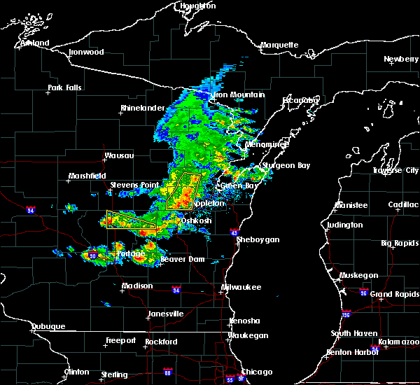 At 541 pm cdt, severe thunderstorms were located along a line extending from near pulaski to 6 miles southeast of black creek to 10 miles east of lake poygan, moving east at 50 mph (radar indicated). Hazards include 60 mph wind gusts. Expect damage to roofs. siding. and trees. severe thunderstorms will be near, green bay around 550 pm cdt. kaukauna, little chute and pulaski around 555 pm cdt. Other locations impacted by these severe thunderstorms include askeaton, greenleaf, murphy corner, sobieski, lark, kunesh, leo frigo bridge, ashwaubenon, pittsfield and hobart. At 541 pm cdt, severe thunderstorms were located along a line extending from near pulaski to 6 miles southeast of black creek to 10 miles east of lake poygan, moving east at 50 mph (radar indicated). Hazards include 60 mph wind gusts. Expect damage to roofs. siding. and trees. severe thunderstorms will be near, green bay around 550 pm cdt. kaukauna, little chute and pulaski around 555 pm cdt. Other locations impacted by these severe thunderstorms include askeaton, greenleaf, murphy corner, sobieski, lark, kunesh, leo frigo bridge, ashwaubenon, pittsfield and hobart.
|
| 6/5/2016 5:37 PM CDT |
 At 534 pm cdt, severe thunderstorms were located along a line extending from zachow to black creek to hortonville, moving east at 50 mph (radar indicated). Hazards include 70 mph wind gusts and penny size hail. Expect considerable tree damage. damage is likely to mobile homes, roofs, and outbuildings. these severe storms will be near, seymour around 540 pm appleton around 540 pm cdt. Other locations impacted by these severe thunderstorms include landstad, briarton, bonduel, twelve corners, leeman, hortonville, binghamton, seymour, greenville and mackville. At 534 pm cdt, severe thunderstorms were located along a line extending from zachow to black creek to hortonville, moving east at 50 mph (radar indicated). Hazards include 70 mph wind gusts and penny size hail. Expect considerable tree damage. damage is likely to mobile homes, roofs, and outbuildings. these severe storms will be near, seymour around 540 pm appleton around 540 pm cdt. Other locations impacted by these severe thunderstorms include landstad, briarton, bonduel, twelve corners, leeman, hortonville, binghamton, seymour, greenville and mackville.
|
| 6/5/2016 5:25 PM CDT |
 At 523 pm cdt, severe thunderstorms were located along a line extending from near shawano to near new london to near hartman creek state park, moving southeast at 50 mph (radar indicated). Hazards include 60 mph wind gusts and penny size hail. Expect damage to roofs. siding. and trees. these severe storms will be near, black creek around 540 pm cdt. appleton and fremont around 545 pm cdt. Other locations impacted by these severe thunderstorms include leeman, seymour, northport, king, navarino, zachow, manawa, shiocton, lind center and medina. At 523 pm cdt, severe thunderstorms were located along a line extending from near shawano to near new london to near hartman creek state park, moving southeast at 50 mph (radar indicated). Hazards include 60 mph wind gusts and penny size hail. Expect damage to roofs. siding. and trees. these severe storms will be near, black creek around 540 pm cdt. appleton and fremont around 545 pm cdt. Other locations impacted by these severe thunderstorms include leeman, seymour, northport, king, navarino, zachow, manawa, shiocton, lind center and medina.
|
| 6/5/2016 5:16 PM CDT |
 At 516 pm cdt, severe thunderstorms were located along a line extending from shawano to 8 miles northwest of new london to near hartman creek state park, moving southeast at 50 mph (radar indicated). Hazards include 60 mph wind gusts and penny size hail. Expect damage to roofs. siding. and trees. these severe storms will be near, new london and navarino wildlife area around 525 pm cdt. appleton around 545 pm cdt. Other locations impacted by these severe thunderstorms include leeman, pella, northport, king, navarino, shiocton, readfield, nichols, dale and buckbee. At 516 pm cdt, severe thunderstorms were located along a line extending from shawano to 8 miles northwest of new london to near hartman creek state park, moving southeast at 50 mph (radar indicated). Hazards include 60 mph wind gusts and penny size hail. Expect damage to roofs. siding. and trees. these severe storms will be near, new london and navarino wildlife area around 525 pm cdt. appleton around 545 pm cdt. Other locations impacted by these severe thunderstorms include leeman, pella, northport, king, navarino, shiocton, readfield, nichols, dale and buckbee.
|
| 6/5/2016 5:01 PM CDT |
 At 500 pm cdt, severe thunderstorms were located along a line extending from near neopit to 12 miles east of randolph to 6 miles east of whiting, moving southeast at 45 mph (radar indicated). Hazards include 70 mph wind gusts and penny size hail. Expect considerable tree damage. damage is likely to mobile homes, roofs, and outbuildings. severe thunderstorms will be near, keshena around 515 pm cdt. shawano, clintonville and hartman creek state park around 520 pm cdt. chain o` lakes-king around 525 pm cdt. waupaca around 535 pm cdt. black creek and fremont around 545 pm cdt. new london around 550 pm cdt. other locations impacted by these severe thunderstorms include leeman, college of menominee nation, pella, northport, king, navarino, big falls, shiocton, polonia and jordan. This warning replaces the severe thunderstorm warning that was already in effect for portions of shawano, portage and waupaca counties. At 500 pm cdt, severe thunderstorms were located along a line extending from near neopit to 12 miles east of randolph to 6 miles east of whiting, moving southeast at 45 mph (radar indicated). Hazards include 70 mph wind gusts and penny size hail. Expect considerable tree damage. damage is likely to mobile homes, roofs, and outbuildings. severe thunderstorms will be near, keshena around 515 pm cdt. shawano, clintonville and hartman creek state park around 520 pm cdt. chain o` lakes-king around 525 pm cdt. waupaca around 535 pm cdt. black creek and fremont around 545 pm cdt. new london around 550 pm cdt. other locations impacted by these severe thunderstorms include leeman, college of menominee nation, pella, northport, king, navarino, big falls, shiocton, polonia and jordan. This warning replaces the severe thunderstorm warning that was already in effect for portions of shawano, portage and waupaca counties.
|
| 8/14/2015 5:06 PM CDT |
 The severe thunderstorm warning for northern brown and northeastern outagamie counties will expire at 515 pm cdt, the storms which prompted the warning have weakened below severe limits, and exited the warned area. therefore the warning will be allowed to expire. however gusty winds and heavy rain are still possible with these thunderstorms. a severe thunderstorm warning remains in effect for southern brown and southern oconto counties. The severe thunderstorm warning for northern brown and northeastern outagamie counties will expire at 515 pm cdt, the storms which prompted the warning have weakened below severe limits, and exited the warned area. therefore the warning will be allowed to expire. however gusty winds and heavy rain are still possible with these thunderstorms. a severe thunderstorm warning remains in effect for southern brown and southern oconto counties.
|
| 8/14/2015 5:01 PM CDT |
 At 459 pm cdt, severe thunderstorms were located along a line extending from near denmark to 7 miles southwest of bellevue town to near black creek, moving southeast at 25 mph (radar indicated). Hazards include 60 mph wind gusts and penny size hail. Expect damage to roofs. siding and trees. These severe thunderstorms will remain over mainly rural areas of central brown and northeastern outagamie counties, including the following locations, five corners, seymour, chicago corners, twelve corners, de pere, glenmore, ashwaubenon, allouez, nichols and ledgeview. At 459 pm cdt, severe thunderstorms were located along a line extending from near denmark to 7 miles southwest of bellevue town to near black creek, moving southeast at 25 mph (radar indicated). Hazards include 60 mph wind gusts and penny size hail. Expect damage to roofs. siding and trees. These severe thunderstorms will remain over mainly rural areas of central brown and northeastern outagamie counties, including the following locations, five corners, seymour, chicago corners, twelve corners, de pere, glenmore, ashwaubenon, allouez, nichols and ledgeview.
|
| 8/14/2015 4:45 PM CDT |
 At 444 pm cdt, severe thunderstorms were located along a line extending from near kewaunee to near green bay to near black creek, moving southeast at 25 mph (radar indicated). Hazards include 60 mph wind gusts and quarter size hail. Hail damage to vehicles is expected. expect wind damage to roofs, siding and trees. these severe thunderstorms will remain over mainly rural areas of brown, western kewaunee and northeastern outagamie counties, including the following locations, stangelville, seymour, chicago corners, leo frigo bridge, cherneyville, de pere, oneida, ashwaubenon, ledgeview and new franken. At 438 pm, the wind gusted to 62 mph at the green bay airport. At 444 pm cdt, severe thunderstorms were located along a line extending from near kewaunee to near green bay to near black creek, moving southeast at 25 mph (radar indicated). Hazards include 60 mph wind gusts and quarter size hail. Hail damage to vehicles is expected. expect wind damage to roofs, siding and trees. these severe thunderstorms will remain over mainly rural areas of brown, western kewaunee and northeastern outagamie counties, including the following locations, stangelville, seymour, chicago corners, leo frigo bridge, cherneyville, de pere, oneida, ashwaubenon, ledgeview and new franken. At 438 pm, the wind gusted to 62 mph at the green bay airport.
|
| 8/14/2015 4:37 PM CDT |
 At 436 pm cdt, severe thunderstorms were located along a line extending from near luxemburg to near green bay to black creek, moving southeast at 30 mph (radar indicated). Hazards include 60 mph wind gusts and quarter size hail. Hail damage to vehicles is expected. expect wind damage to roofs, siding and trees. these severe storms will be near, bellevue town around 440 pm cdt. Other locations impacted by these severe thunderstorms include kunesh, stangelville, chicago corners, frazer corners, de pere, oneida, ledgeview, humboldt, suamico and langes corners. At 436 pm cdt, severe thunderstorms were located along a line extending from near luxemburg to near green bay to black creek, moving southeast at 30 mph (radar indicated). Hazards include 60 mph wind gusts and quarter size hail. Hail damage to vehicles is expected. expect wind damage to roofs, siding and trees. these severe storms will be near, bellevue town around 440 pm cdt. Other locations impacted by these severe thunderstorms include kunesh, stangelville, chicago corners, frazer corners, de pere, oneida, ledgeview, humboldt, suamico and langes corners.
|
| 8/14/2015 4:26 PM CDT |
 At 425 pm cdt, severe thunderstorms were located along a line extending from 7 miles north of luxemburg to near pulaski to near navarino wildlife area, moving southeast at 25 mph (radar indicated). Hazards include 70 mph wind gusts and half dollar size hail. Hail damage to vehicles is expected. expect considerable tree damage. wind damage is also likely to mobile homes, roofs and outbuildings. these severe storms will be near, green bay around 435 pm cdt. luxemburg and black creek around 440 pm cdt. bellevue town around 445 pm cdt. Other locations impacted by these severe thunderstorms include kunesh, stangelville, chicago corners, chase, frazer corners, little suamico, de pere, brookside, oneida and ledgeview. At 425 pm cdt, severe thunderstorms were located along a line extending from 7 miles north of luxemburg to near pulaski to near navarino wildlife area, moving southeast at 25 mph (radar indicated). Hazards include 70 mph wind gusts and half dollar size hail. Hail damage to vehicles is expected. expect considerable tree damage. wind damage is also likely to mobile homes, roofs and outbuildings. these severe storms will be near, green bay around 435 pm cdt. luxemburg and black creek around 440 pm cdt. bellevue town around 445 pm cdt. Other locations impacted by these severe thunderstorms include kunesh, stangelville, chicago corners, chase, frazer corners, little suamico, de pere, brookside, oneida and ledgeview.
|
| 8/14/2015 4:11 PM CDT |
 At 410 pm cdt, a severe thunderstorm was located 10 miles northeast of pulaski, or 13 miles northwest of bay shore park, moving south at 25 mph (radar indicated). Hazards include 70 mph wind gusts and quarter size hail. Hail damage to vehicles is expected. expect considerable tree damage. wind damage is also likely to mobile homes, roofs and outbuildings. this severe thunderstorm will be near, green bay around 450 pm cdt. bellevue town around 505 pm cdt. Other locations impacted by this severe thunderstorm include kunesh, stangelville, chicago corners, chase, frazer corners, little suamico, de pere, brookside, oneida and ledgeview. At 410 pm cdt, a severe thunderstorm was located 10 miles northeast of pulaski, or 13 miles northwest of bay shore park, moving south at 25 mph (radar indicated). Hazards include 70 mph wind gusts and quarter size hail. Hail damage to vehicles is expected. expect considerable tree damage. wind damage is also likely to mobile homes, roofs and outbuildings. this severe thunderstorm will be near, green bay around 450 pm cdt. bellevue town around 505 pm cdt. Other locations impacted by this severe thunderstorm include kunesh, stangelville, chicago corners, chase, frazer corners, little suamico, de pere, brookside, oneida and ledgeview.
|
| 8/2/2015 4:20 PM CDT |
 At 420 pm cdt, severe thunderstorms were located along a line extending from near luxemburg to near bellevue town to near black creek to 10 miles west of menasha to near lake poygan, moving east at 45 mph (trained weather spotters). Hazards include golf ball size hail and 60 mph wind gusts. People and animals outdoors will be injured. expect hail damage to roofs, siding, windows and vehicles. expect wind damage to roofs, siding and trees. these severe storms will be near, appleton and darboy around 430 pm cdt. Other locations impacted by these severe thunderstorms include holland, greenville, metz, boom bay, chicago corners, rivermoor, de pere, hortonville, oneida and wrightstown. At 420 pm cdt, severe thunderstorms were located along a line extending from near luxemburg to near bellevue town to near black creek to 10 miles west of menasha to near lake poygan, moving east at 45 mph (trained weather spotters). Hazards include golf ball size hail and 60 mph wind gusts. People and animals outdoors will be injured. expect hail damage to roofs, siding, windows and vehicles. expect wind damage to roofs, siding and trees. these severe storms will be near, appleton and darboy around 430 pm cdt. Other locations impacted by these severe thunderstorms include holland, greenville, metz, boom bay, chicago corners, rivermoor, de pere, hortonville, oneida and wrightstown.
|
| 8/2/2015 3:57 PM CDT |
 At 356 pm cdt, severe thunderstorms were located along a line extending from 5 miles west of green bay to 8 miles northeast of black creek to 7 miles north of new london to near waupaca to near plainfield, moving east at 55 mph (trained weather spotters). Hazards include golf ball size hail and 60 mph wind gusts. People and animals outdoors will be injured. expect hail damage to roofs, siding, windows and vehicles. expect wind damage to roofs, siding and trees. these severe storms will be near, green bay around 400 pm cdt. black creek and bellevue town around 415 pm cdt. kaukauna and lake poygan around 425 pm cdt. appleton, menasha and darboy around 430 pm cdt. Other locations impacted by these severe thunderstorms include holland, greenville, metz, northport, manawa, boom bay, chicago corners, rivermoor, de pere and hortonville. At 356 pm cdt, severe thunderstorms were located along a line extending from 5 miles west of green bay to 8 miles northeast of black creek to 7 miles north of new london to near waupaca to near plainfield, moving east at 55 mph (trained weather spotters). Hazards include golf ball size hail and 60 mph wind gusts. People and animals outdoors will be injured. expect hail damage to roofs, siding, windows and vehicles. expect wind damage to roofs, siding and trees. these severe storms will be near, green bay around 400 pm cdt. black creek and bellevue town around 415 pm cdt. kaukauna and lake poygan around 425 pm cdt. appleton, menasha and darboy around 430 pm cdt. Other locations impacted by these severe thunderstorms include holland, greenville, metz, northport, manawa, boom bay, chicago corners, rivermoor, de pere and hortonville.
|
| 8/2/2015 3:47 PM CDT |
 At 347 pm cdt, severe thunderstorms were located along a line extending from 7 miles south of pulaski to 5 miles north of black creek to 10 miles southwest of clintonville to near hartman creek state park to near plainfield, moving southeast at 35 mph (trained weather spotters). Hazards include golf ball size hail and 70 mph wind gusts. People and animals outdoors will be injured. expect hail damage to roofs, siding, windows and vehicles. expect considerable tree damage. wind damage is also likely to mobile homes, roofs and outbuildings. these severe storms will be near, black creek around 350 pm cdt. waupaca around 400 pm cdt. green bay and new london around 405 pm cdt. bellevue town around 415 pm cdt. fremont and lake poygan around 420 pm cdt. appleton around 430 pm cdt. Other locations impacted by these severe thunderstorms include holland, greenville, metz, northport, manawa, boom bay, chicago corners, rivermoor, de pere and hortonville. At 347 pm cdt, severe thunderstorms were located along a line extending from 7 miles south of pulaski to 5 miles north of black creek to 10 miles southwest of clintonville to near hartman creek state park to near plainfield, moving southeast at 35 mph (trained weather spotters). Hazards include golf ball size hail and 70 mph wind gusts. People and animals outdoors will be injured. expect hail damage to roofs, siding, windows and vehicles. expect considerable tree damage. wind damage is also likely to mobile homes, roofs and outbuildings. these severe storms will be near, black creek around 350 pm cdt. waupaca around 400 pm cdt. green bay and new london around 405 pm cdt. bellevue town around 415 pm cdt. fremont and lake poygan around 420 pm cdt. appleton around 430 pm cdt. Other locations impacted by these severe thunderstorms include holland, greenville, metz, northport, manawa, boom bay, chicago corners, rivermoor, de pere and hortonville.
|
| 8/2/2015 3:28 PM CDT |
 At 327 pm cdt, severe thunderstorms were located along a line extending from 13 miles west of clintonville to near amherst to near new rome, moving east at 55 mph (trained weather spotters). Hazards include 70 mph wind gusts and quarter size hail. Hail damage to vehicles is expected. expect considerable tree damage. wind damage is also likely to mobile homes, roofs and outbuildings. severe thunderstorms will be near, chain o` lakes-king around 335 pm cdt. waupaca and clintonville around 340 pm cdt. plainfield around 345 pm cdt. new london around 355 pm cdt. black creek around 400 pm cdt. appleton and menasha around 415 pm cdt. green bay, kaukauna, little chute, kimberly, darboy and lake poygan around 420 pm cdt. bellevue town around 425 pm cdt. Other locations impacted by these severe thunderstorms include holland, greenville, metz, northport, manawa, boom bay, chicago corners, rivermoor, de pere and hortonville. At 327 pm cdt, severe thunderstorms were located along a line extending from 13 miles west of clintonville to near amherst to near new rome, moving east at 55 mph (trained weather spotters). Hazards include 70 mph wind gusts and quarter size hail. Hail damage to vehicles is expected. expect considerable tree damage. wind damage is also likely to mobile homes, roofs and outbuildings. severe thunderstorms will be near, chain o` lakes-king around 335 pm cdt. waupaca and clintonville around 340 pm cdt. plainfield around 345 pm cdt. new london around 355 pm cdt. black creek around 400 pm cdt. appleton and menasha around 415 pm cdt. green bay, kaukauna, little chute, kimberly, darboy and lake poygan around 420 pm cdt. bellevue town around 425 pm cdt. Other locations impacted by these severe thunderstorms include holland, greenville, metz, northport, manawa, boom bay, chicago corners, rivermoor, de pere and hortonville.
|
| 7/18/2015 5:59 AM CDT |
 At 557 am cdt, severe thunderstorms were located along a line extending from pulaski to near kaukauna to near chilton, moving east at 45 mph. several reports of 60 mph gusts and funnel clouds have been reported along the line of thunderstorms (trained weather spotters). Hazards include 60 mph wind gusts and possible weak tornadoes. Expect damage to roofs. siding and trees. these severe storms will be near, brillion around 605 am cdt. st. nazianz around 615 am cdt. denmark and valders around 620 am cdt. manitowoc around 630 am cdt. two creeks around 635 am cdt. kewaunee and algoma around 645 am cdt. Other locations impacted by these severe thunderstorms include kunesh, millhome, stangelville, euren, de pere, zander, oneida, dundas, ledgeview and shoto. At 557 am cdt, severe thunderstorms were located along a line extending from pulaski to near kaukauna to near chilton, moving east at 45 mph. several reports of 60 mph gusts and funnel clouds have been reported along the line of thunderstorms (trained weather spotters). Hazards include 60 mph wind gusts and possible weak tornadoes. Expect damage to roofs. siding and trees. these severe storms will be near, brillion around 605 am cdt. st. nazianz around 615 am cdt. denmark and valders around 620 am cdt. manitowoc around 630 am cdt. two creeks around 635 am cdt. kewaunee and algoma around 645 am cdt. Other locations impacted by these severe thunderstorms include kunesh, millhome, stangelville, euren, de pere, zander, oneida, dundas, ledgeview and shoto.
|
| 7/18/2015 5:53 AM CDT |
 At 552 am cdt, severe thunderstorms were located along a line extending from near pulaski to near darboy to 7 miles northeast of fond du lac, moving east at 45 mph (trained weather spotters). Hazards include 60 mph wind gusts. Expect damage to roofs. siding and trees. These severe thunderstorms will remain over mainly rural areas of winnebago, outagamie and western calumet counties, including the following locations, greenville, shiocton, seymour, rivermoor, omro, neenah, fisk, hortonville, deer creek wildlife area and wolf river bottoms wildlife area. At 552 am cdt, severe thunderstorms were located along a line extending from near pulaski to near darboy to 7 miles northeast of fond du lac, moving east at 45 mph (trained weather spotters). Hazards include 60 mph wind gusts. Expect damage to roofs. siding and trees. These severe thunderstorms will remain over mainly rural areas of winnebago, outagamie and western calumet counties, including the following locations, greenville, shiocton, seymour, rivermoor, omro, neenah, fisk, hortonville, deer creek wildlife area and wolf river bottoms wildlife area.
|
| 7/18/2015 5:47 AM CDT |
 At 547 am cdt, severe thunderstorms were located along a line extending from 7 miles north of black creek to appleton to 8 miles southeast of oshkosh, moving east at 45 mph (trained weather spotters). Hazards include 60 mph wind gusts. Expect damage to roofs. siding and trees. severe thunderstorms will be near, little chute, kimberly, darboy and high cliff state park around 550 am cdt. kaukauna around 555 am cdt. pulaski around 600 am cdt. chilton and st anna around 605 am cdt. green bay and bellevue town around 610 am cdt. valders and st. nazianz around 620 am cdt. denmark around 625 am cdt. manitowoc, luxemburg and cleveland around 630 am cdt. Other locations impacted by these severe thunderstorms include kunesh, millhome, stangelville, euren, de pere, zander, oneida, dundas, ledgeview and marytown. At 547 am cdt, severe thunderstorms were located along a line extending from 7 miles north of black creek to appleton to 8 miles southeast of oshkosh, moving east at 45 mph (trained weather spotters). Hazards include 60 mph wind gusts. Expect damage to roofs. siding and trees. severe thunderstorms will be near, little chute, kimberly, darboy and high cliff state park around 550 am cdt. kaukauna around 555 am cdt. pulaski around 600 am cdt. chilton and st anna around 605 am cdt. green bay and bellevue town around 610 am cdt. valders and st. nazianz around 620 am cdt. denmark around 625 am cdt. manitowoc, luxemburg and cleveland around 630 am cdt. Other locations impacted by these severe thunderstorms include kunesh, millhome, stangelville, euren, de pere, zander, oneida, dundas, ledgeview and marytown.
|
| 7/18/2015 5:40 AM CDT |
 At 538 am cdt, severe thunderstorms were located along a line extending from near navarino wildlife area to near menasha to 6 miles oshkosh, moving east at 50 mph. a trained weather spotter reported wind gusts to 60 mph on the southwest side of oshkosh at 535 am cdt (trained weather spotters). Hazards include 60 mph wind gusts. Expect damage to roofs. siding and trees. these severe storms will be near, appleton around 545 am cdt. little chute, kimberly and darboy around 550 am cdt. kaukauna around 555 am cdt. Other locations impacted by these severe thunderstorms include greenville, metz, northport, adams beach, boom bay, rivermoor, omro, hortonville, wolf river bottoms wildlife area and eaa. At 538 am cdt, severe thunderstorms were located along a line extending from near navarino wildlife area to near menasha to 6 miles oshkosh, moving east at 50 mph. a trained weather spotter reported wind gusts to 60 mph on the southwest side of oshkosh at 535 am cdt (trained weather spotters). Hazards include 60 mph wind gusts. Expect damage to roofs. siding and trees. these severe storms will be near, appleton around 545 am cdt. little chute, kimberly and darboy around 550 am cdt. kaukauna around 555 am cdt. Other locations impacted by these severe thunderstorms include greenville, metz, northport, adams beach, boom bay, rivermoor, omro, hortonville, wolf river bottoms wildlife area and eaa.
|
| 7/18/2015 5:30 AM CDT |
 At 528 am cdt, severe thunderstorms were located along a line extending from near embarrass to 7 miles east of fremont to near rush lake, moving east at 50 mph (radar indicated). Hazards include 60 mph wind gusts. Expect damage to roofs. siding and trees. these severe storms will be near, appleton, menasha and oshkosh around 545 am cdt. little chute, kimberly and darboy around 550 am cdt. kaukauna around 555 am cdt. Other locations impacted by these severe thunderstorms include greenville, metz, northport, adams beach, boom bay, rivermoor, omro, hortonville, wolf river bottoms wildlife area and eaa. At 528 am cdt, severe thunderstorms were located along a line extending from near embarrass to 7 miles east of fremont to near rush lake, moving east at 50 mph (radar indicated). Hazards include 60 mph wind gusts. Expect damage to roofs. siding and trees. these severe storms will be near, appleton, menasha and oshkosh around 545 am cdt. little chute, kimberly and darboy around 550 am cdt. kaukauna around 555 am cdt. Other locations impacted by these severe thunderstorms include greenville, metz, northport, adams beach, boom bay, rivermoor, omro, hortonville, wolf river bottoms wildlife area and eaa.
|
| 7/18/2015 5:14 AM CDT |
 At 512 am cdt, severe thunderstorms were located along a line extending from 10 miles northwest of embarrass to near fremont to near green lake, moving east at 45 mph (law enforcement). Hazards include 60 mph wind gusts. Expect damage to roofs. siding and trees. severe thunderstorms will be near, new london, clintonville, embarrass and rush lake around 525 am cdt. appleton, menasha and oshkosh around 545 am cdt. kaukauna, little chute, kimberly and darboy around 555 am cdt. other locations impacted by these severe thunderstorms include greenville, metz, northport, adams beach, manawa, boom bay, rivermoor, omro, hortonville and wolf river bottoms wildlife area. People attending rock usa and eaa should seek safe shelter immediately!. At 512 am cdt, severe thunderstorms were located along a line extending from 10 miles northwest of embarrass to near fremont to near green lake, moving east at 45 mph (law enforcement). Hazards include 60 mph wind gusts. Expect damage to roofs. siding and trees. severe thunderstorms will be near, new london, clintonville, embarrass and rush lake around 525 am cdt. appleton, menasha and oshkosh around 545 am cdt. kaukauna, little chute, kimberly and darboy around 555 am cdt. other locations impacted by these severe thunderstorms include greenville, metz, northport, adams beach, manawa, boom bay, rivermoor, omro, hortonville and wolf river bottoms wildlife area. People attending rock usa and eaa should seek safe shelter immediately!.
|
| 7/18/2015 2:52 AM CDT |
 The severe thunderstorm warning for chippewa and eau claire counties will expire at 300 am cdt, the storms which prompted the warning have moved out of the area. therefore the warning will be allowed to expire. however gusty winds are still possible with these thunderstorms. a severe thunderstorm watch remains in effect until 700 am cdt for west central wisconsin. The severe thunderstorm warning for chippewa and eau claire counties will expire at 300 am cdt, the storms which prompted the warning have moved out of the area. therefore the warning will be allowed to expire. however gusty winds are still possible with these thunderstorms. a severe thunderstorm watch remains in effect until 700 am cdt for west central wisconsin.
|
| 7/18/2015 2:45 AM CDT |
 At 245 am cdt, severe thunderstorms were located along a line extending from near island lake to near boyd to near taylor, moving east at 55 mph (trained weather spotters). Hazards include 60 mph wind gusts. Expect damage to roofs. siding and trees. these severe storms will be near, stanley and boyd around 250 am cdt. other locations impacted by these severe thunderstorms include tilden, jim falls, ludington, foster, chippewa moraine state rec area, seymour, lake eau claire county park, eagleton, holcombe and otter lake. this includes the following highways, interstate 94 in wisconsin between mile markers 65 and 86. u. s. Highway 53 between mile markers 86 and 116. At 245 am cdt, severe thunderstorms were located along a line extending from near island lake to near boyd to near taylor, moving east at 55 mph (trained weather spotters). Hazards include 60 mph wind gusts. Expect damage to roofs. siding and trees. these severe storms will be near, stanley and boyd around 250 am cdt. other locations impacted by these severe thunderstorms include tilden, jim falls, ludington, foster, chippewa moraine state rec area, seymour, lake eau claire county park, eagleton, holcombe and otter lake. this includes the following highways, interstate 94 in wisconsin between mile markers 65 and 86. u. s. Highway 53 between mile markers 86 and 116.
|
| 7/18/2015 2:34 AM CDT |
 At 233 am cdt, severe thunderstorms were located along a line extending from near island lake to near bateman to near independence, moving east at 55 mph (trained weather spotters). Hazards include 60 mph wind gusts. Expect damage to roofs. siding and trees. these severe storms will be near, cadott and boyd around 240 am cdt. stanley around 250 am cdt. other locations impacted by these severe thunderstorms include tilden, jim falls, ludington, foster, chippewa moraine state rec area, seymour, lake eau claire county park, eagleton, holcombe and otter lake. this includes the following highways, interstate 94 in wisconsin between mile markers 57 and 86. u. s. Highway 53 between mile markers 86 and 126. At 233 am cdt, severe thunderstorms were located along a line extending from near island lake to near bateman to near independence, moving east at 55 mph (trained weather spotters). Hazards include 60 mph wind gusts. Expect damage to roofs. siding and trees. these severe storms will be near, cadott and boyd around 240 am cdt. stanley around 250 am cdt. other locations impacted by these severe thunderstorms include tilden, jim falls, ludington, foster, chippewa moraine state rec area, seymour, lake eau claire county park, eagleton, holcombe and otter lake. this includes the following highways, interstate 94 in wisconsin between mile markers 57 and 86. u. s. Highway 53 between mile markers 86 and 126.
|
| 7/18/2015 2:16 AM CDT |
 At 216 am cdt, severe thunderstorms were located along a line extending from near hillsdale to near tilden to near gilmanton, moving east at 55 mph (trained weather spotters). Hazards include 60 mph wind gusts. Expect damage to roofs. siding and trees. these severe storms will be near, chippewa falls and bloomer around 220 am cdt. lake wissota around 225 am cdt. cadott around 235 am cdt. boyd around 240 am cdt. stanley around 245 am cdt. fairchild around 255 am cdt. other locations impacted by these severe thunderstorms include tainter lake, hoffman hills rec area, tilden, jim falls, caryville, ludington, foster, chippewa moraine state rec area, seymour and lake eau claire county park. this includes the following highways, interstate 94 in wisconsin between mile markers 45 and 86. u. s. Highway 53 between mile markers 86 and 126. At 216 am cdt, severe thunderstorms were located along a line extending from near hillsdale to near tilden to near gilmanton, moving east at 55 mph (trained weather spotters). Hazards include 60 mph wind gusts. Expect damage to roofs. siding and trees. these severe storms will be near, chippewa falls and bloomer around 220 am cdt. lake wissota around 225 am cdt. cadott around 235 am cdt. boyd around 240 am cdt. stanley around 245 am cdt. fairchild around 255 am cdt. other locations impacted by these severe thunderstorms include tainter lake, hoffman hills rec area, tilden, jim falls, caryville, ludington, foster, chippewa moraine state rec area, seymour and lake eau claire county park. this includes the following highways, interstate 94 in wisconsin between mile markers 45 and 86. u. s. Highway 53 between mile markers 86 and 126.
|
| 7/18/2015 2:00 AM CDT |
 At 159 am cdt, severe thunderstorms were located along a line extending from clayton to tainter lake to near nelson, moving east at 55 mph (trained weather spotters). Hazards include 60 mph wind gusts. Expect damage to roofs. siding and trees. severe thunderstorms will be near, colfax around 205 am cdt. bloomer and dallas around 215 am cdt. chippewa falls around 220 am cdt. lake wissota around 225 am cdt. cadott around 235 am cdt. boyd around 240 am cdt. stanley around 245 am cdt. other locations impacted by these severe thunderstorms include tainter lake, hoffman hills rec area, tilden, jim falls, caryville, ludington, foster, chippewa moraine state rec area, seymour and lake eau claire county park. this includes the following highways, interstate 94 in wisconsin between mile markers 45 and 86. u. s. Highway 53 between mile markers 86 and 126. At 159 am cdt, severe thunderstorms were located along a line extending from clayton to tainter lake to near nelson, moving east at 55 mph (trained weather spotters). Hazards include 60 mph wind gusts. Expect damage to roofs. siding and trees. severe thunderstorms will be near, colfax around 205 am cdt. bloomer and dallas around 215 am cdt. chippewa falls around 220 am cdt. lake wissota around 225 am cdt. cadott around 235 am cdt. boyd around 240 am cdt. stanley around 245 am cdt. other locations impacted by these severe thunderstorms include tainter lake, hoffman hills rec area, tilden, jim falls, caryville, ludington, foster, chippewa moraine state rec area, seymour and lake eau claire county park. this includes the following highways, interstate 94 in wisconsin between mile markers 45 and 86. u. s. Highway 53 between mile markers 86 and 126.
|
| 7/13/2015 3:56 AM CDT |
 At 355 am cdt, a severe thunderstorm was located 8 miles east of fremont, or 13 miles west of appleton, moving northeast at 45 mph (radar indicated). Hazards include 60 mph wind gusts. Expect damage to roofs. siding and trees. this severe thunderstorm will be near, appleton around 415 am cdt. little chute and kimberly around 420 am cdt. kaukauna around 425 am cdt. Other locations impacted by this severe thunderstorm include greenville, five corners, binghamton, shiocton, seymour, chicago corners, bear creek, sugar bush, twelve corners and murphy corner. At 355 am cdt, a severe thunderstorm was located 8 miles east of fremont, or 13 miles west of appleton, moving northeast at 45 mph (radar indicated). Hazards include 60 mph wind gusts. Expect damage to roofs. siding and trees. this severe thunderstorm will be near, appleton around 415 am cdt. little chute and kimberly around 420 am cdt. kaukauna around 425 am cdt. Other locations impacted by this severe thunderstorm include greenville, five corners, binghamton, shiocton, seymour, chicago corners, bear creek, sugar bush, twelve corners and murphy corner.
|
| 7/13/2015 12:20 AM CDT |
 At 1220 am cdt, severe thunderstorms were located along a line extending from near jim falls to near lake hallie to caryville, moving east at 30 mph (radar indicated). Hazards include 60 mph wind gusts and penny size hail. Expect damage to roofs. siding and trees. these severe storms will be near, lake wissota around 1225 am cdt. fall creek around 1230 am cdt. cadott around 1235 am cdt. altoona around 1240 am cdt. other locations impacted by these severe thunderstorms include jim falls, caryville, ludington, seymour, eagleton, eau claire airport, rock falls and bateman. This includes interstate 94 in wisconsin between mile markers 61 and 76. At 1220 am cdt, severe thunderstorms were located along a line extending from near jim falls to near lake hallie to caryville, moving east at 30 mph (radar indicated). Hazards include 60 mph wind gusts and penny size hail. Expect damage to roofs. siding and trees. these severe storms will be near, lake wissota around 1225 am cdt. fall creek around 1230 am cdt. cadott around 1235 am cdt. altoona around 1240 am cdt. other locations impacted by these severe thunderstorms include jim falls, caryville, ludington, seymour, eagleton, eau claire airport, rock falls and bateman. This includes interstate 94 in wisconsin between mile markers 61 and 76.
|
| 7/13/2015 12:03 AM CDT |
 At 1203 am cdt, severe thunderstorms were located along a line extending from bloomer to near eau claire airport to near downsville, moving east at 30 mph (radar indicated). Hazards include 60 mph wind gusts and penny size hail. Expect damage to roofs. siding and trees. severe thunderstorms will be near, chippewa falls, altoona, lake hallie and bloomer around 1210 am cdt. eau claire and lake wissota around 1220 am cdt. fall creek around 1230 am cdt. cadott around 1235 am cdt. other locations impacted by these severe thunderstorms include tilden, jim falls, caryville, ludington, seymour, eagleton, eau claire airport, rock falls and bateman. This includes interstate 94 in wisconsin between mile markers 55 and 76. At 1203 am cdt, severe thunderstorms were located along a line extending from bloomer to near eau claire airport to near downsville, moving east at 30 mph (radar indicated). Hazards include 60 mph wind gusts and penny size hail. Expect damage to roofs. siding and trees. severe thunderstorms will be near, chippewa falls, altoona, lake hallie and bloomer around 1210 am cdt. eau claire and lake wissota around 1220 am cdt. fall creek around 1230 am cdt. cadott around 1235 am cdt. other locations impacted by these severe thunderstorms include tilden, jim falls, caryville, ludington, seymour, eagleton, eau claire airport, rock falls and bateman. This includes interstate 94 in wisconsin between mile markers 55 and 76.
|
| 5/3/2015 7:57 PM CDT | The severe thunderstorm warning for southeastern chippewa and eau claire counties will expire at 800 pm cdt. the storms which prompted the warning have weakened below severe limits. and exited the warned area. therefore the warning will be allowed to expire. to report severe weather. Contact your nearest law enforcement. |
| 5/3/2015 7:33 PM CDT | At 733 pm cdt, severe thunderstorms were located along a line extending from near bateman to near fall creek to near strum, moving east at 40 mph (radar indicated). Hazards include ping pong ball size hail and 60 mph wind gusts. People and animals outdoors will be injured. expect hail damage to roofs, siding, windows and vehicles. expect wind damage to roofs, siding and trees. locations impacted include, eau claire, chippewa falls, altoona, lake hallie, stanley, lake wissota, augusta, cadott, fall creek, boyd, fairchild and ludington. 1. 50in. |
| 5/3/2015 7:25 PM CDT | At 724 pm cdt, severe thunderstorms were located along a line extending from near bloomer to near lake wissota to eleva, moving east at 45 mph (radar indicated). Hazards include ping pong ball size hail and 60 mph wind gusts. People and animals outdoors will be injured. expect hail damage to roofs, siding, windows and vehicles. expect wind damage to roofs, siding and trees. locations impacted include, eau claire, chippewa falls, altoona, lake hallie, stanley, bloomer, lake wissota, augusta, cornell, cadott, fall creek and boyd. 1. 50in. |
| 5/3/2015 6:53 PM CDT | At 653 pm cdt, severe thunderstorms were located along a line extending from near ridgeland to hoffman hills rec area to near durand, moving east at 45 mph (radar indicated). Hazards include ping pong ball size hail and 60 mph wind gusts. People and animals outdoors will be injured. expect hail damage to roofs, siding, windows and vehicles. Expect wind damage to roofs, siding and trees. |
Hail Maps for Seymour, WI
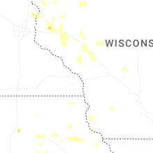

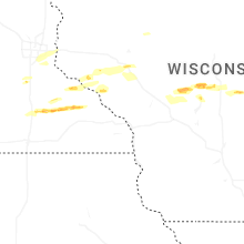


Connect with Interactive Hail Maps