

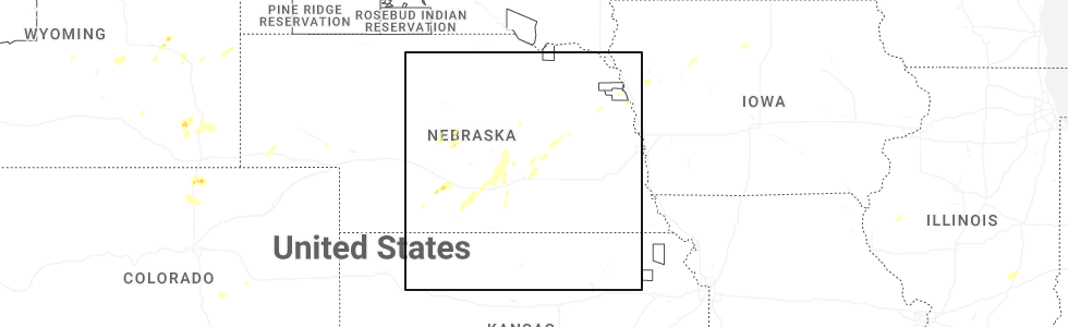
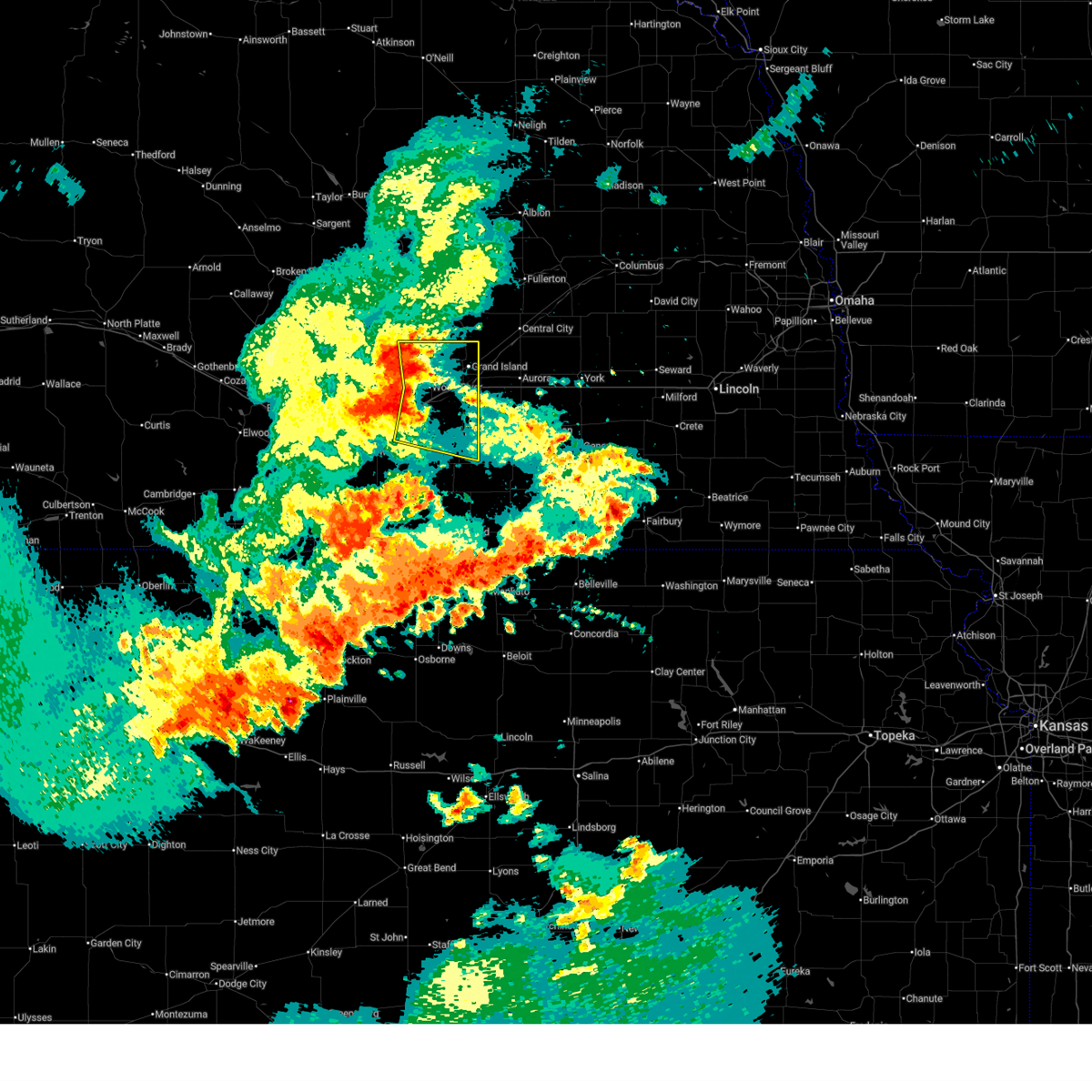
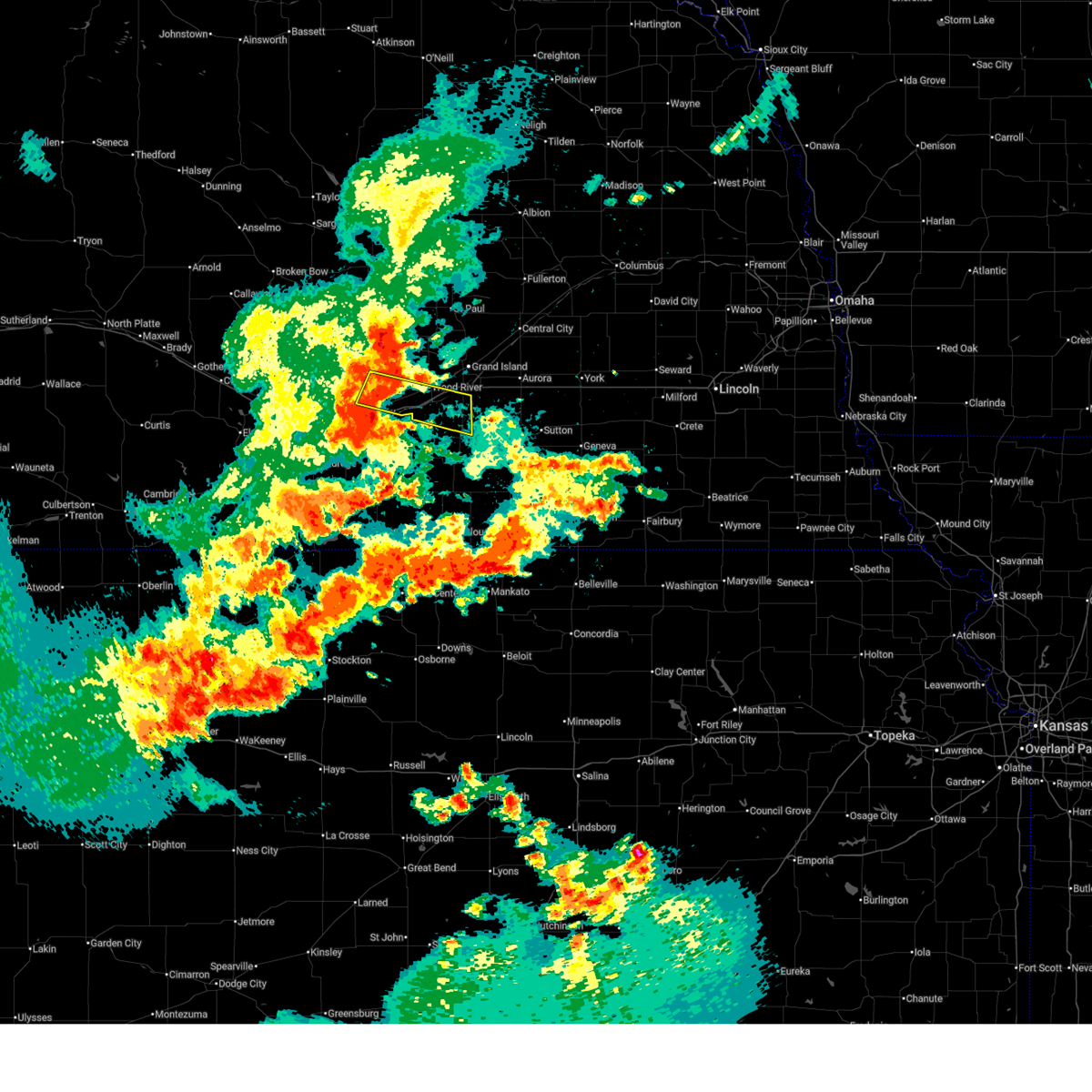
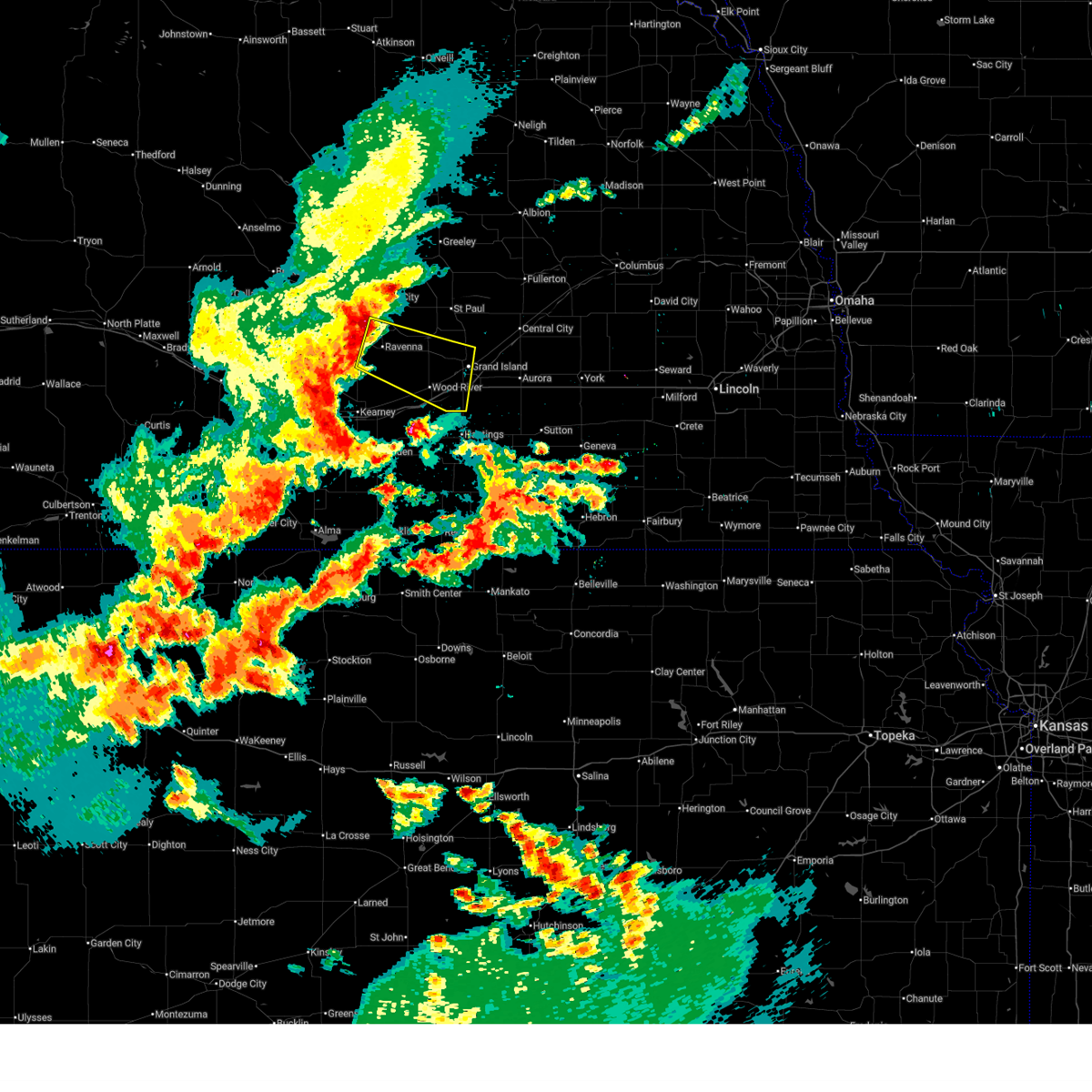
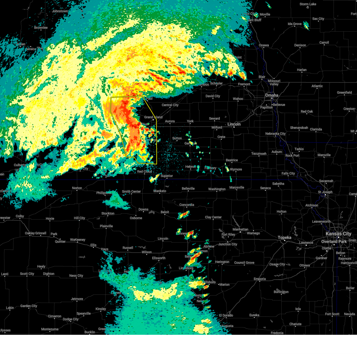
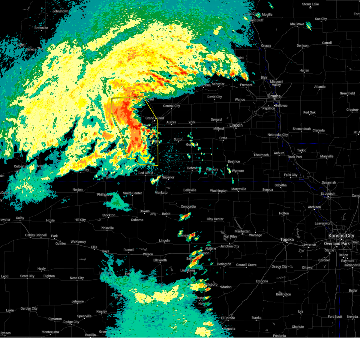
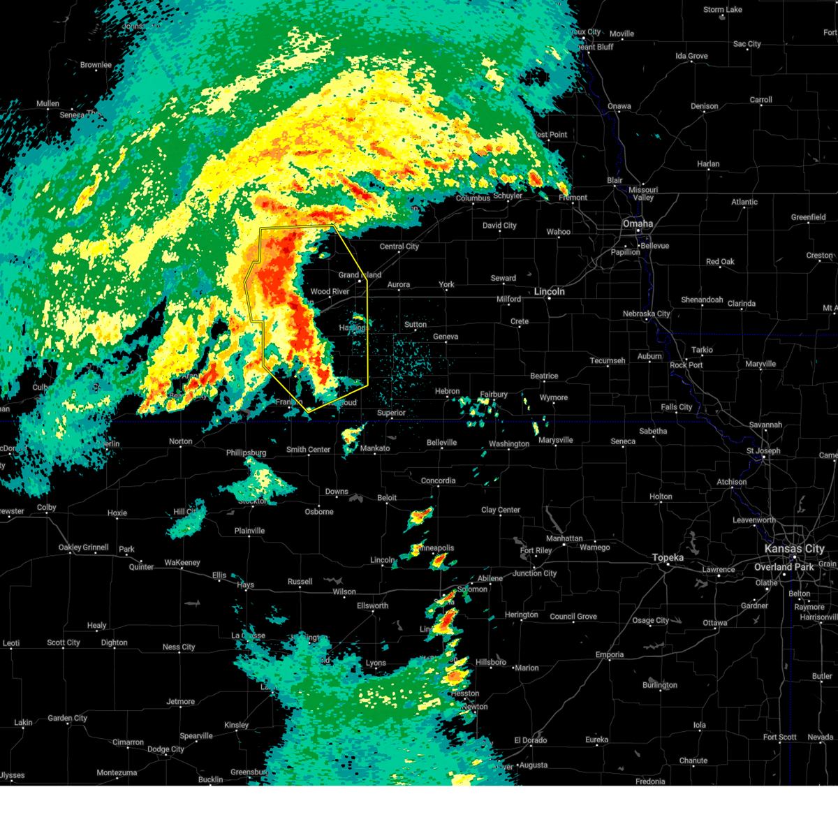
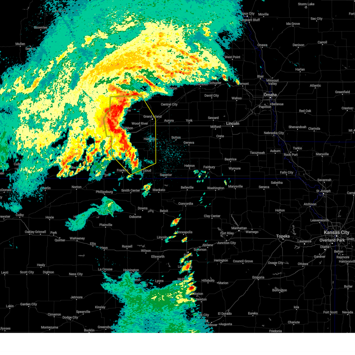
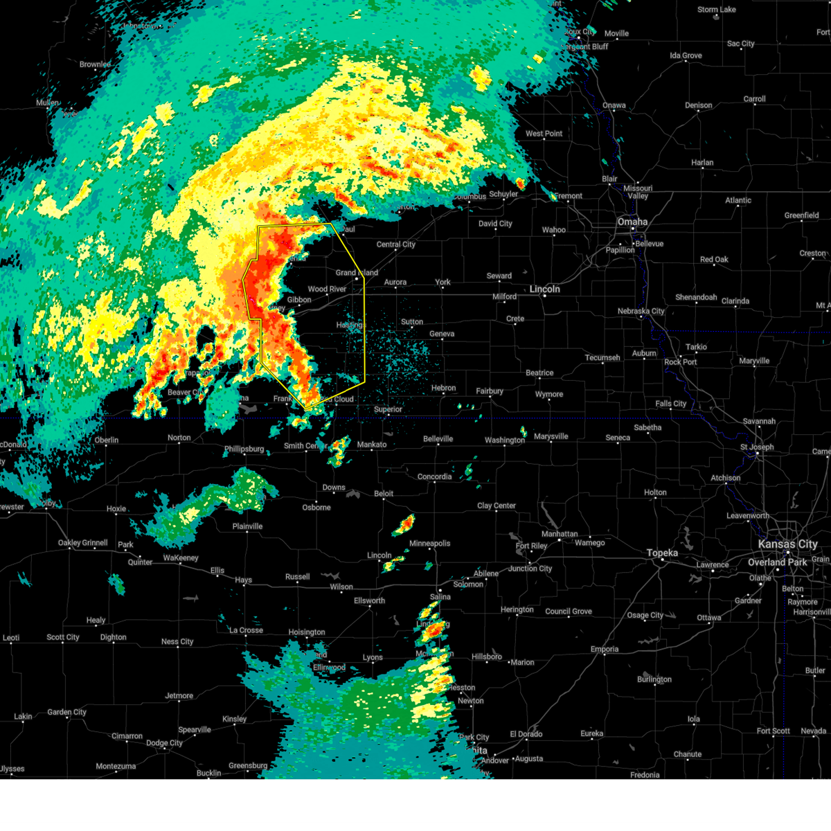
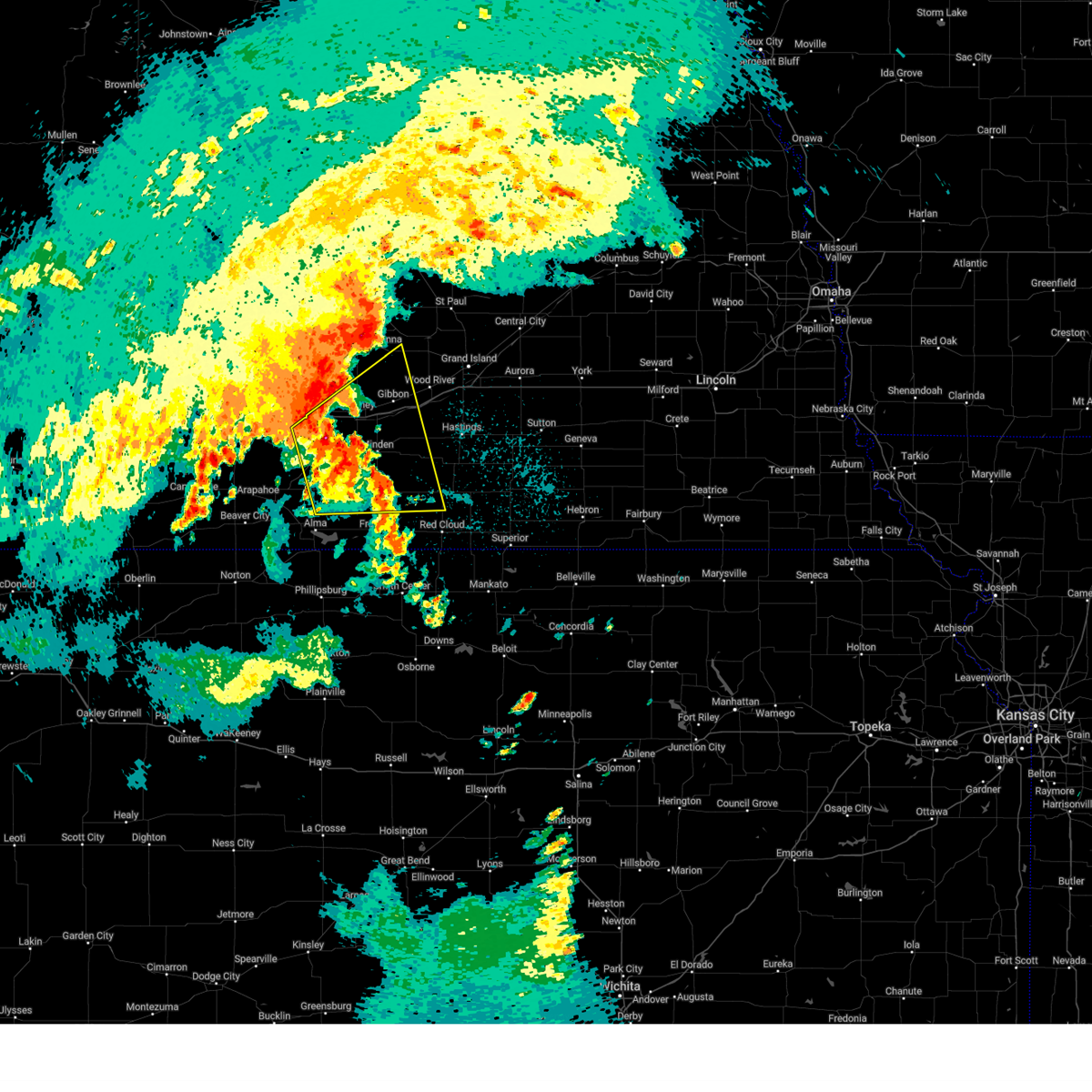
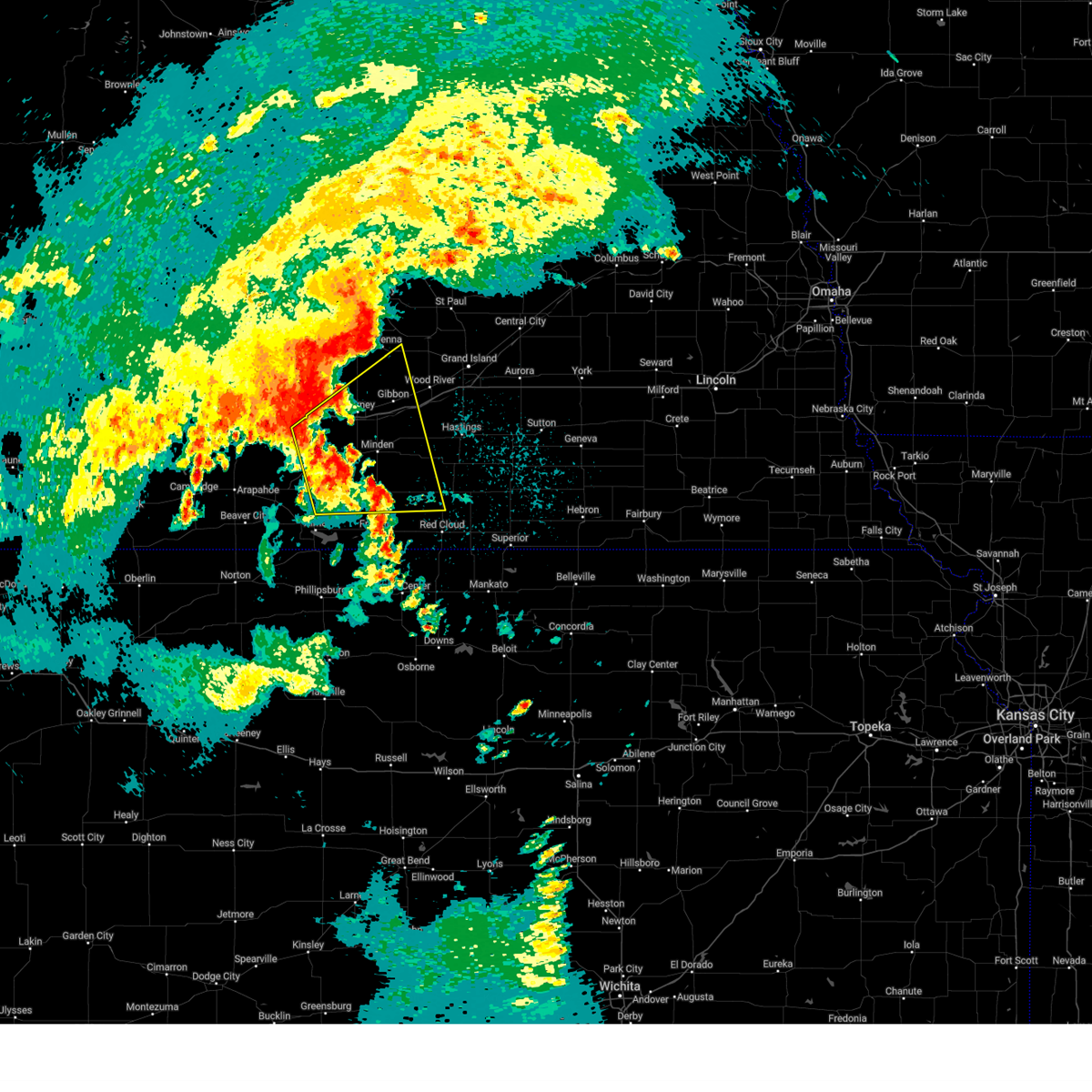
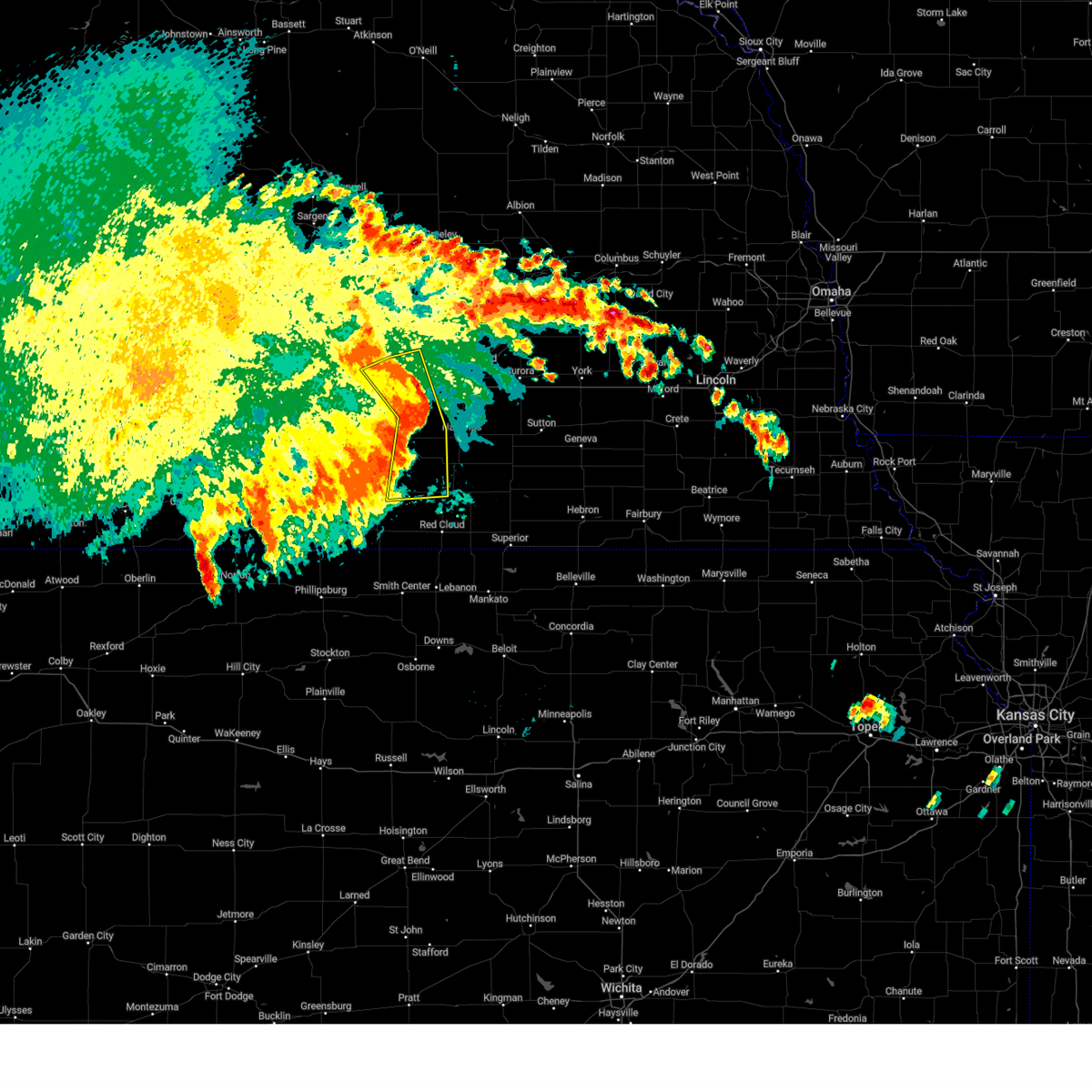
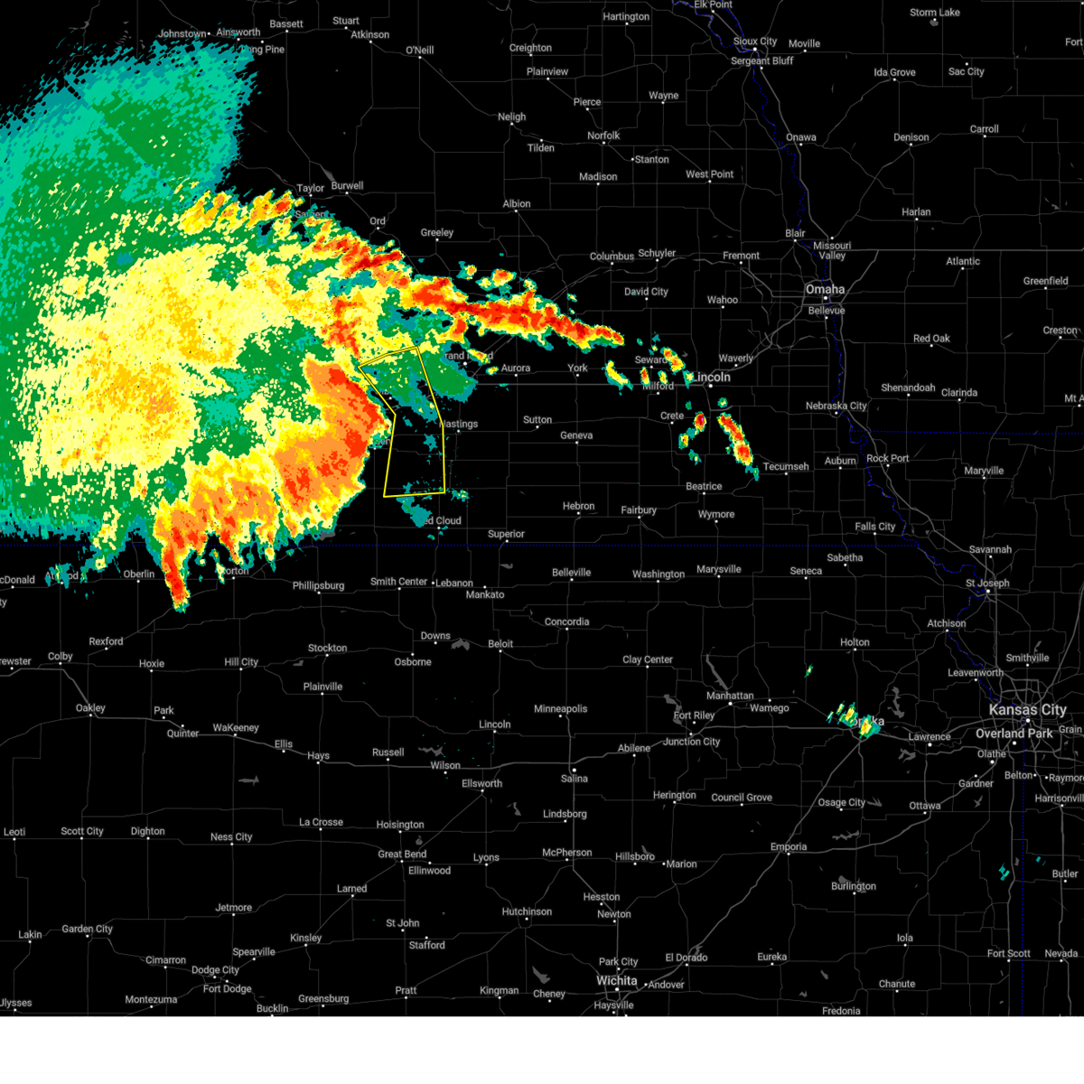
Hail Map for Shelton, NE
The Shelton, NE area has had 9 reports of on-the-ground hail by trained spotters, and has been under severe weather warnings 18 times during the past 12 months. Doppler radar has detected hail at or near Shelton, NE on 100 occasions, including 4 occasions during the past year.
| Name: | Shelton, NE |
| Where Located: | 22.7 miles WSW of Grand Island, NE |
| Map: | Google Map for Shelton, NE |
| Population: | 1059 |
| Housing Units: | 442 |
| More Info: | Search Google for Shelton, NE |
1
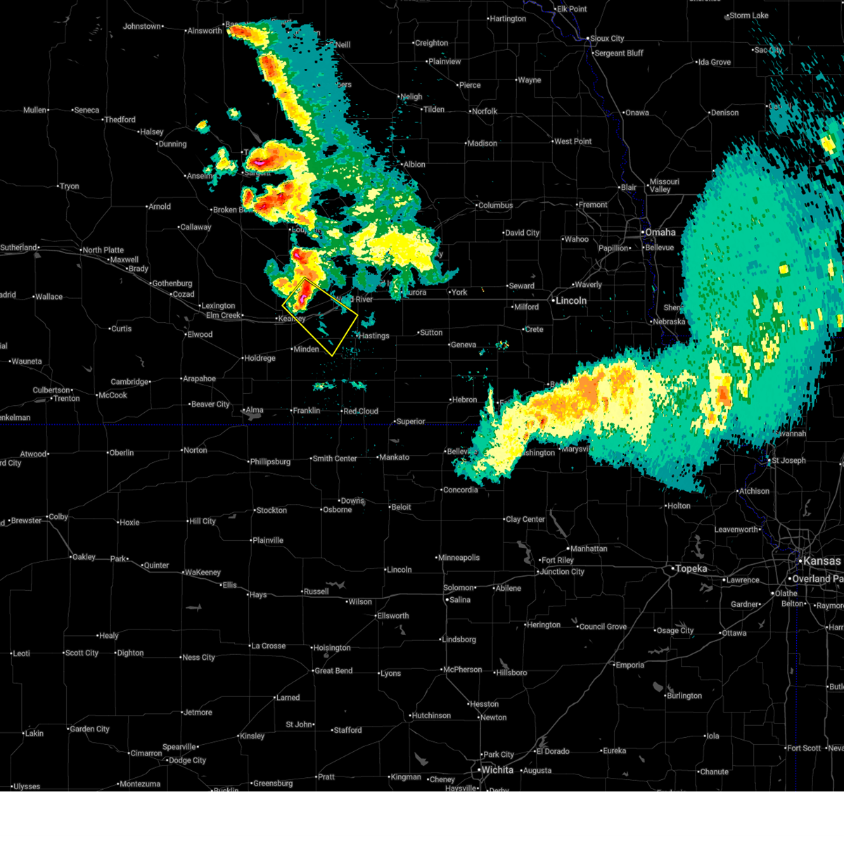
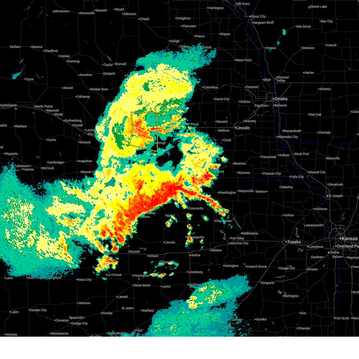
The Top Recent Hail Date for Shelton, NE is Wednesday, June 25, 2025 (27th out of 100)
Hail and Wind Damage Spotted near Shelton, NE
| Date / Time | Report Details |
|---|---|
| 7/10/2025 4:49 AM CDT |
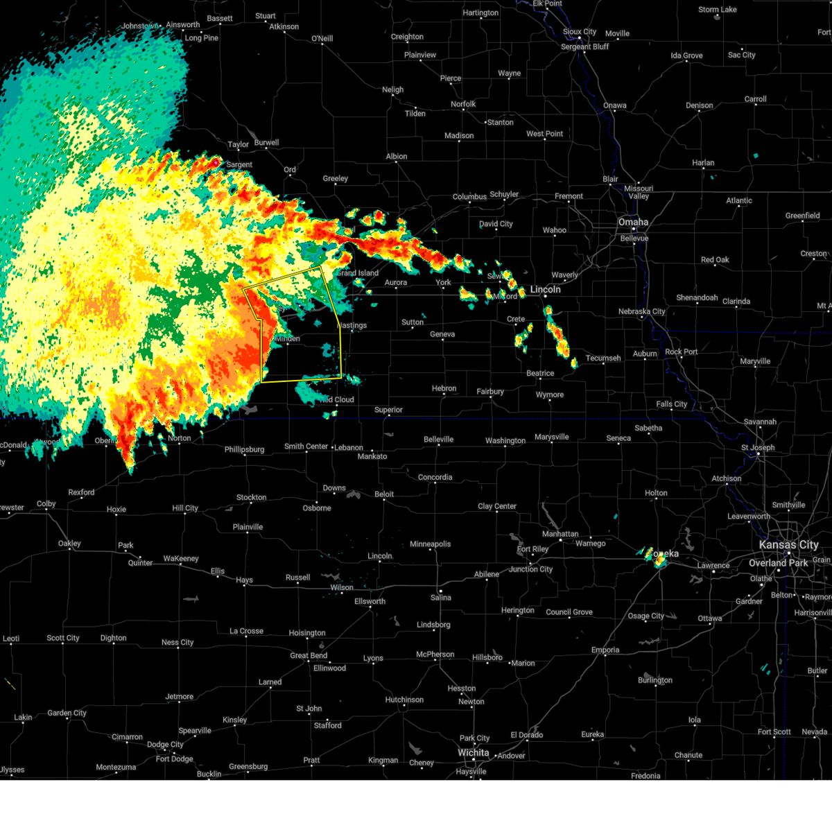
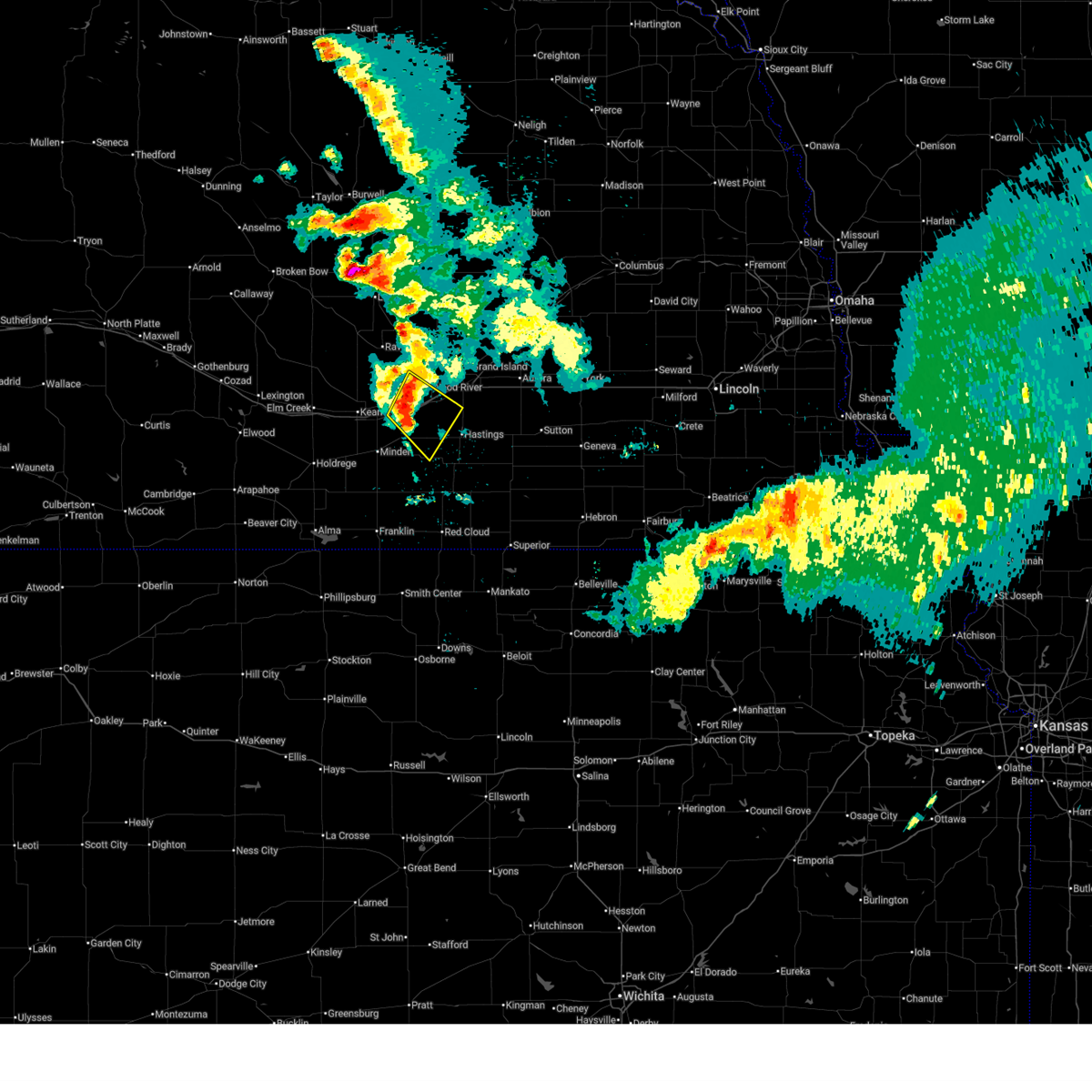 At 448 am cdt, a severe thunderstorm was located over shelton, or 18 miles east of kearney, moving southeast at 25 mph (radar indicated). Hazards include 60 mph wind gusts and quarter size hail. Hail damage to vehicles is expected. expect wind damage to roofs, siding, and trees. this severe storm will be near, prosser around 500 am cdt. This includes interstate 80 between mile markers 285 and 304. At 448 am cdt, a severe thunderstorm was located over shelton, or 18 miles east of kearney, moving southeast at 25 mph (radar indicated). Hazards include 60 mph wind gusts and quarter size hail. Hail damage to vehicles is expected. expect wind damage to roofs, siding, and trees. this severe storm will be near, prosser around 500 am cdt. This includes interstate 80 between mile markers 285 and 304.
|
| 7/10/2025 4:28 AM CDT |
 Svrgid the national weather service in hastings has issued a * severe thunderstorm warning for, northwestern adams county in south central nebraska, northeastern kearney county in south central nebraska, southeastern buffalo county in south central nebraska, southwestern hall county in south central nebraska, * until 515 am cdt. * at 428 am cdt, a severe thunderstorm was located near gibbon, or 14 miles northeast of kearney, moving southeast at 25 mph (radar indicated). Hazards include 60 mph wind gusts and quarter size hail. Hail damage to vehicles is expected. expect wind damage to roofs, siding, and trees. this severe thunderstorm will be near, gibbon and shelton around 435 am cdt. other locations in the path of this severe thunderstorm include prosser. This includes interstate 80 between mile markers 282 and 304. Svrgid the national weather service in hastings has issued a * severe thunderstorm warning for, northwestern adams county in south central nebraska, northeastern kearney county in south central nebraska, southeastern buffalo county in south central nebraska, southwestern hall county in south central nebraska, * until 515 am cdt. * at 428 am cdt, a severe thunderstorm was located near gibbon, or 14 miles northeast of kearney, moving southeast at 25 mph (radar indicated). Hazards include 60 mph wind gusts and quarter size hail. Hail damage to vehicles is expected. expect wind damage to roofs, siding, and trees. this severe thunderstorm will be near, gibbon and shelton around 435 am cdt. other locations in the path of this severe thunderstorm include prosser. This includes interstate 80 between mile markers 282 and 304.
|
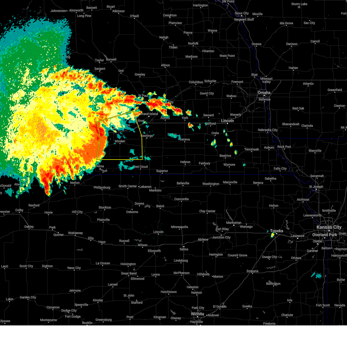
| 6/30/2025 4:16 AM CDT |
 the severe thunderstorm warning has been cancelled and is no longer in effect the severe thunderstorm warning has been cancelled and is no longer in effect
|
| 6/30/2025 3:43 AM CDT |
 Svrgid the national weather service in hastings has issued a * severe thunderstorm warning for, northern adams county in south central nebraska, northeastern kearney county in south central nebraska, eastern buffalo county in south central nebraska, hall county in south central nebraska, * until 430 am cdt. * at 342 am cdt, severe thunderstorms were located along a line extending from near boelus to near shelton to near heartwell, moving east at 30 mph (radar indicated). Hazards include 60 mph wind gusts. Expect damage to roofs, siding, and trees. severe thunderstorms will be near, wood river, kenesaw, and cairo around 345 am cdt. prosser around 350 am cdt. juniata and alda around 400 am cdt. other locations in the path of these severe thunderstorms include grand island, hastings, doniphan and hansen. This includes interstate 80 between mile markers 289 and 317. Svrgid the national weather service in hastings has issued a * severe thunderstorm warning for, northern adams county in south central nebraska, northeastern kearney county in south central nebraska, eastern buffalo county in south central nebraska, hall county in south central nebraska, * until 430 am cdt. * at 342 am cdt, severe thunderstorms were located along a line extending from near boelus to near shelton to near heartwell, moving east at 30 mph (radar indicated). Hazards include 60 mph wind gusts. Expect damage to roofs, siding, and trees. severe thunderstorms will be near, wood river, kenesaw, and cairo around 345 am cdt. prosser around 350 am cdt. juniata and alda around 400 am cdt. other locations in the path of these severe thunderstorms include grand island, hastings, doniphan and hansen. This includes interstate 80 between mile markers 289 and 317.
|
| 6/30/2025 3:26 AM CDT |
 Svrgid the national weather service in hastings has issued a * severe thunderstorm warning for, northern adams county in south central nebraska, southeastern buffalo county in south central nebraska, southern hall county in south central nebraska, * until 345 am cdt. * at 326 am cdt, a severe thunderstorm was located near gibbon, or 13 miles northeast of kearney, moving east at 35 mph (radar indicated). Hazards include 60 mph wind gusts. Expect damage to roofs, siding, and trees. this severe thunderstorm will be near, gibbon and shelton around 330 am cdt. This includes interstate 80 between mile markers 285 and 307. Svrgid the national weather service in hastings has issued a * severe thunderstorm warning for, northern adams county in south central nebraska, southeastern buffalo county in south central nebraska, southern hall county in south central nebraska, * until 345 am cdt. * at 326 am cdt, a severe thunderstorm was located near gibbon, or 13 miles northeast of kearney, moving east at 35 mph (radar indicated). Hazards include 60 mph wind gusts. Expect damage to roofs, siding, and trees. this severe thunderstorm will be near, gibbon and shelton around 330 am cdt. This includes interstate 80 between mile markers 285 and 307.
|
| 6/30/2025 3:05 AM CDT |
 Svrgid the national weather service in hastings has issued a * severe thunderstorm warning for, northeastern buffalo county in south central nebraska, southeastern sherman county in central nebraska, southwestern howard county in central nebraska, hall county in south central nebraska, * until 345 am cdt. * at 305 am cdt, a severe thunderstorm was located over ravenna, or 23 miles north of kearney, moving east at 35 mph (radar indicated). Hazards include 60 mph wind gusts. expect damage to roofs, siding, and trees Svrgid the national weather service in hastings has issued a * severe thunderstorm warning for, northeastern buffalo county in south central nebraska, southeastern sherman county in central nebraska, southwestern howard county in central nebraska, hall county in south central nebraska, * until 345 am cdt. * at 305 am cdt, a severe thunderstorm was located over ravenna, or 23 miles north of kearney, moving east at 35 mph (radar indicated). Hazards include 60 mph wind gusts. expect damage to roofs, siding, and trees
|
| 6/2/2025 10:54 PM CDT | Personal weather station reports gust to 64mp in buffalo county NE, 5.8 miles NNE of Shelton, NE |
| 6/2/2025 10:52 PM CDT |
 At 1052 pm cdt, severe thunderstorms were located along a line extending from near rockville to near wood river to near ayr, moving northeast at 40 mph (radar indicated). Hazards include 60 mph wind gusts and quarter size hail. Hail damage to vehicles is expected. expect wind damage to roofs, siding, and trees. these severe storms will be near, grand island, hastings, doniphan, cairo, alda, trumbull, howard city, rockville, boelus, and hansen around 1100 pm cdt. dannebrog and ashton around 1105 pm cdt. farwell around 1110 pm cdt. elba around 1115 pm cdt. This includes interstate 80 between mile markers 278 and 317. At 1052 pm cdt, severe thunderstorms were located along a line extending from near rockville to near wood river to near ayr, moving northeast at 40 mph (radar indicated). Hazards include 60 mph wind gusts and quarter size hail. Hail damage to vehicles is expected. expect wind damage to roofs, siding, and trees. these severe storms will be near, grand island, hastings, doniphan, cairo, alda, trumbull, howard city, rockville, boelus, and hansen around 1100 pm cdt. dannebrog and ashton around 1105 pm cdt. farwell around 1110 pm cdt. elba around 1115 pm cdt. This includes interstate 80 between mile markers 278 and 317.
|
| 6/2/2025 10:52 PM CDT |
 the severe thunderstorm warning has been cancelled and is no longer in effect the severe thunderstorm warning has been cancelled and is no longer in effect
|
| 6/2/2025 10:39 PM CDT |
 At 1038 pm cdt, severe thunderstorms were located along a line extending from pleasanton to near kenesaw to near bladen, moving northeast at 40 mph (automated weather station. several personal weather stations in the kearney area have reported wind gusts of 60 to 65 mph). Hazards include 60 to 65 mph wind gusts and quarter size hail. Hail damage to vehicles is expected. expect wind damage to roofs, siding, and trees. these severe storms will be near, hastings, ravenna, wood river, shelton, blue hill, juniata, roseland, ayr, prosser, and poole around 1045 pm cdt. alda, rockville, and hansen around 1055 pm cdt. grand island, doniphan, cairo, howard city, and boelus around 1100 pm cdt. trumbull around 1105 pm cdt. dannebrog around 1110 pm cdt. farwell around 1115 pm cdt. This includes interstate 80 between mile markers 263 and 317. At 1038 pm cdt, severe thunderstorms were located along a line extending from pleasanton to near kenesaw to near bladen, moving northeast at 40 mph (automated weather station. several personal weather stations in the kearney area have reported wind gusts of 60 to 65 mph). Hazards include 60 to 65 mph wind gusts and quarter size hail. Hail damage to vehicles is expected. expect wind damage to roofs, siding, and trees. these severe storms will be near, hastings, ravenna, wood river, shelton, blue hill, juniata, roseland, ayr, prosser, and poole around 1045 pm cdt. alda, rockville, and hansen around 1055 pm cdt. grand island, doniphan, cairo, howard city, and boelus around 1100 pm cdt. trumbull around 1105 pm cdt. dannebrog around 1110 pm cdt. farwell around 1115 pm cdt. This includes interstate 80 between mile markers 263 and 317.
|
| 6/2/2025 10:30 PM CDT |
 At 1030 pm cdt, severe thunderstorms were located along a line extending from near riverdale to heartwell to 6 miles north of inavale, moving northeast at 35 mph (radar indicated). Hazards include 60 mph wind gusts and quarter size hail. Hail damage to vehicles is expected. expect wind damage to roofs, siding, and trees. these severe storms will be near, gibbon, kenesaw, bladen, and holstein around 1035 pm cdt. roseland around 1040 pm cdt. shelton, blue hill, and prosser around 1045 pm cdt. juniata, ayr, rosemont, and poole around 1050 pm cdt. hastings, ravenna, and wood river around 1055 pm cdt. hansen around 1105 pm cdt. This includes interstate 80 between mile markers 263 and 317. At 1030 pm cdt, severe thunderstorms were located along a line extending from near riverdale to heartwell to 6 miles north of inavale, moving northeast at 35 mph (radar indicated). Hazards include 60 mph wind gusts and quarter size hail. Hail damage to vehicles is expected. expect wind damage to roofs, siding, and trees. these severe storms will be near, gibbon, kenesaw, bladen, and holstein around 1035 pm cdt. roseland around 1040 pm cdt. shelton, blue hill, and prosser around 1045 pm cdt. juniata, ayr, rosemont, and poole around 1050 pm cdt. hastings, ravenna, and wood river around 1055 pm cdt. hansen around 1105 pm cdt. This includes interstate 80 between mile markers 263 and 317.
|
| 6/2/2025 10:25 PM CDT |
 Svrgid the national weather service in hastings has issued a * severe thunderstorm warning for, northern webster county in south central nebraska, northeastern franklin county in south central nebraska, adams county in south central nebraska, kearney county in south central nebraska, buffalo county in south central nebraska, sherman county in central nebraska, southwestern howard county in central nebraska, hall county in south central nebraska, * until 1115 pm cdt. * at 1025 pm cdt, severe thunderstorms were located along a line extending from near riverdale to near heartwell to near inavale, moving northeast at 35 mph (radar indicated). Hazards include 60 mph wind gusts and quarter size hail. Hail damage to vehicles is expected. expect wind damage to roofs, siding, and trees. severe thunderstorms will be near, bladen, holstein, and heartwell around 1030 pm cdt. gibbon and kenesaw around 1035 pm cdt. roseland around 1040 pm cdt. shelton, blue hill, and prosser around 1045 pm cdt. other locations in the path of these severe thunderstorms include juniata, ayr, rosemont, poole, hastings, ravenna, wood river and hansen. This includes interstate 80 between mile markers 263 and 317. Svrgid the national weather service in hastings has issued a * severe thunderstorm warning for, northern webster county in south central nebraska, northeastern franklin county in south central nebraska, adams county in south central nebraska, kearney county in south central nebraska, buffalo county in south central nebraska, sherman county in central nebraska, southwestern howard county in central nebraska, hall county in south central nebraska, * until 1115 pm cdt. * at 1025 pm cdt, severe thunderstorms were located along a line extending from near riverdale to near heartwell to near inavale, moving northeast at 35 mph (radar indicated). Hazards include 60 mph wind gusts and quarter size hail. Hail damage to vehicles is expected. expect wind damage to roofs, siding, and trees. severe thunderstorms will be near, bladen, holstein, and heartwell around 1030 pm cdt. gibbon and kenesaw around 1035 pm cdt. roseland around 1040 pm cdt. shelton, blue hill, and prosser around 1045 pm cdt. other locations in the path of these severe thunderstorms include juniata, ayr, rosemont, poole, hastings, ravenna, wood river and hansen. This includes interstate 80 between mile markers 263 and 317.
|
| 6/2/2025 10:13 PM CDT |
 At 1013 pm cdt, severe thunderstorms were located along a line extending from near odessa to near upland, moving northeast at 45 mph (radar indicated). Hazards include 60 to 65 mph wind gusts and quarter size hail. Hail damage to vehicles is expected. expect wind damage to roofs, siding, and trees. locations impacted include, kearney, holdrege, minden, gibbon, shelton, kenesaw, axtell, odessa, hildreth, wilcox, campbell, bladen, holstein, funk, riverdale, upland, heartwell, huntley, norman, and ragan. This includes interstate 80 between mile markers 256 and 294. At 1013 pm cdt, severe thunderstorms were located along a line extending from near odessa to near upland, moving northeast at 45 mph (radar indicated). Hazards include 60 to 65 mph wind gusts and quarter size hail. Hail damage to vehicles is expected. expect wind damage to roofs, siding, and trees. locations impacted include, kearney, holdrege, minden, gibbon, shelton, kenesaw, axtell, odessa, hildreth, wilcox, campbell, bladen, holstein, funk, riverdale, upland, heartwell, huntley, norman, and ragan. This includes interstate 80 between mile markers 256 and 294.
|
| 6/2/2025 10:07 PM CDT |
 Svrgid the national weather service in hastings has issued a * severe thunderstorm warning for, northwestern webster county in south central nebraska, northern franklin county in south central nebraska, phelps county in south central nebraska, western adams county in south central nebraska, kearney county in south central nebraska, southeastern buffalo county in south central nebraska, northeastern harlan county in south central nebraska, southwestern hall county in south central nebraska, * until 1030 pm cdt. * at 1007 pm cdt, severe thunderstorms were located along a line extending from 8 miles northeast of loomis to near hildreth, moving northeast at 40 mph (radar indicated). Hazards include 60 to 65 mph wind gusts and quarter size hail. Hail damage to vehicles is expected. expect wind damage to roofs, siding, and trees. severe thunderstorms will be near, axtell, hildreth, and upland around 1010 pm cdt. minden around 1015 pm cdt. odessa around 1020 pm cdt. This includes interstate 80 between mile markers 256 and 294. Svrgid the national weather service in hastings has issued a * severe thunderstorm warning for, northwestern webster county in south central nebraska, northern franklin county in south central nebraska, phelps county in south central nebraska, western adams county in south central nebraska, kearney county in south central nebraska, southeastern buffalo county in south central nebraska, northeastern harlan county in south central nebraska, southwestern hall county in south central nebraska, * until 1030 pm cdt. * at 1007 pm cdt, severe thunderstorms were located along a line extending from 8 miles northeast of loomis to near hildreth, moving northeast at 40 mph (radar indicated). Hazards include 60 to 65 mph wind gusts and quarter size hail. Hail damage to vehicles is expected. expect wind damage to roofs, siding, and trees. severe thunderstorms will be near, axtell, hildreth, and upland around 1010 pm cdt. minden around 1015 pm cdt. odessa around 1020 pm cdt. This includes interstate 80 between mile markers 256 and 294.
|
| 8/14/2024 1:15 AM CDT |
 The storms which prompted the warning have weakened below severe limits, and no longer pose an immediate threat to life or property. therefore, the warning has been allowed to expire. a severe thunderstorm watch remains in effect until 700 am cdt for south central nebraska. The storms which prompted the warning have weakened below severe limits, and no longer pose an immediate threat to life or property. therefore, the warning has been allowed to expire. a severe thunderstorm watch remains in effect until 700 am cdt for south central nebraska.
|
| 8/14/2024 1:06 AM CDT |
 At 106 am cdt, severe thunderstorms were located along a line extending from 8 miles south of poole to 6 miles southeast of gibbon to near upland, moving east at 45 mph (radar indicated). Hazards include 60 mph wind gusts. Expect damage to roofs, siding, and trees. these severe storms will be near, gibbon, shelton, kenesaw, campbell, holstein, and norman around 110 am cdt. bladen and prosser around 115 am cdt. wood river, juniata, and roseland around 120 am cdt. This includes interstate 80 between mile markers 286 and 301. At 106 am cdt, severe thunderstorms were located along a line extending from 8 miles south of poole to 6 miles southeast of gibbon to near upland, moving east at 45 mph (radar indicated). Hazards include 60 mph wind gusts. Expect damage to roofs, siding, and trees. these severe storms will be near, gibbon, shelton, kenesaw, campbell, holstein, and norman around 110 am cdt. bladen and prosser around 115 am cdt. wood river, juniata, and roseland around 120 am cdt. This includes interstate 80 between mile markers 286 and 301.
|
| 8/14/2024 12:48 AM CDT |
 the severe thunderstorm warning has been cancelled and is no longer in effect the severe thunderstorm warning has been cancelled and is no longer in effect
|
| 8/14/2024 12:48 AM CDT |
 At 1248 am cdt, severe thunderstorms were located along a line extending from riverdale to near kearney to 6 miles southwest of hildreth, moving east at 55 mph (radar indicated). Hazards include 60 mph wind gusts. Expect damage to roofs, siding, and trees. these severe storms will be near, minden and upland around 1255 am cdt. gibbon, heartwell, and norman around 100 am cdt. shelton and campbell around 105 am cdt. kenesaw and holstein around 110 am cdt. wood river, bladen, roseland, and prosser around 115 am cdt. juniata around 120 am cdt. This includes interstate 80 between mile markers 266 and 301. At 1248 am cdt, severe thunderstorms were located along a line extending from riverdale to near kearney to 6 miles southwest of hildreth, moving east at 55 mph (radar indicated). Hazards include 60 mph wind gusts. Expect damage to roofs, siding, and trees. these severe storms will be near, minden and upland around 1255 am cdt. gibbon, heartwell, and norman around 100 am cdt. shelton and campbell around 105 am cdt. kenesaw and holstein around 110 am cdt. wood river, bladen, roseland, and prosser around 115 am cdt. juniata around 120 am cdt. This includes interstate 80 between mile markers 266 and 301.
|
| 8/14/2024 12:34 AM CDT |
 Svrgid the national weather service in hastings has issued a * severe thunderstorm warning for, northern franklin county in south central nebraska, northwestern webster county in south central nebraska, eastern phelps county in south central nebraska, western adams county in south central nebraska, kearney county in south central nebraska, buffalo county in south central nebraska, northeastern harlan county in south central nebraska, western hall county in south central nebraska, * until 115 am cdt. * at 1234 am cdt, severe thunderstorms were located along a line extending from near elm creek to 8 miles south of odessa to near huntley, moving east at 50 mph (radar indicated). Hazards include 60 mph wind gusts. Expect damage to roofs, siding, and trees. severe thunderstorms will be near, kearney, axtell, odessa, wilcox, and riverdale around 1240 am cdt. minden and hildreth around 1245 am cdt. upland around 1250 am cdt. other locations in the path of these severe thunderstorms include heartwell, gibbon, norman, shelton, kenesaw, campbell and holstein. This includes interstate 80 between mile markers 257 and 301. Svrgid the national weather service in hastings has issued a * severe thunderstorm warning for, northern franklin county in south central nebraska, northwestern webster county in south central nebraska, eastern phelps county in south central nebraska, western adams county in south central nebraska, kearney county in south central nebraska, buffalo county in south central nebraska, northeastern harlan county in south central nebraska, western hall county in south central nebraska, * until 115 am cdt. * at 1234 am cdt, severe thunderstorms were located along a line extending from near elm creek to 8 miles south of odessa to near huntley, moving east at 50 mph (radar indicated). Hazards include 60 mph wind gusts. Expect damage to roofs, siding, and trees. severe thunderstorms will be near, kearney, axtell, odessa, wilcox, and riverdale around 1240 am cdt. minden and hildreth around 1245 am cdt. upland around 1250 am cdt. other locations in the path of these severe thunderstorms include heartwell, gibbon, norman, shelton, kenesaw, campbell and holstein. This includes interstate 80 between mile markers 257 and 301.
|
| 7/1/2024 7:44 PM CDT |
 At 744 pm cdt, severe thunderstorms were located along a line extending from near wood river to kenesaw to near upland, moving east at 35 mph (radar indicated). Hazards include 60 mph wind gusts. Expect damage to roofs, siding, and trees. these severe storms will be near, wood river, kenesaw, juniata, holstein, prosser, and norman around 750 pm cdt. hastings and alda around 755 pm cdt. grand island and roseland around 800 pm cdt. doniphan and hansen around 805 pm cdt. This includes interstate 80 between mile markers 286 and 314. At 744 pm cdt, severe thunderstorms were located along a line extending from near wood river to kenesaw to near upland, moving east at 35 mph (radar indicated). Hazards include 60 mph wind gusts. Expect damage to roofs, siding, and trees. these severe storms will be near, wood river, kenesaw, juniata, holstein, prosser, and norman around 750 pm cdt. hastings and alda around 755 pm cdt. grand island and roseland around 800 pm cdt. doniphan and hansen around 805 pm cdt. This includes interstate 80 between mile markers 286 and 314.
|
| 7/1/2024 7:23 PM CDT |
 Svrgid the national weather service in hastings has issued a * severe thunderstorm warning for, adams county in south central nebraska, kearney county in south central nebraska, southeastern buffalo county in south central nebraska, southern hall county in south central nebraska, * until 815 pm cdt. * at 723 pm cdt, severe thunderstorms were located along a line extending from near gibbon to near heartwell to near upland, moving east at 35 mph (radar indicated). Hazards include 60 mph wind gusts. Expect damage to roofs, siding, and trees. severe thunderstorms will be near, gibbon, heartwell, and norman around 730 pm cdt. shelton and kenesaw around 735 pm cdt. holstein around 740 pm cdt. other locations in the path of these severe thunderstorms include roseland, prosser, wood river, juniata, hastings, ayr and hansen. This includes interstate 80 between mile markers 274 and 314. Svrgid the national weather service in hastings has issued a * severe thunderstorm warning for, adams county in south central nebraska, kearney county in south central nebraska, southeastern buffalo county in south central nebraska, southern hall county in south central nebraska, * until 815 pm cdt. * at 723 pm cdt, severe thunderstorms were located along a line extending from near gibbon to near heartwell to near upland, moving east at 35 mph (radar indicated). Hazards include 60 mph wind gusts. Expect damage to roofs, siding, and trees. severe thunderstorms will be near, gibbon, heartwell, and norman around 730 pm cdt. shelton and kenesaw around 735 pm cdt. holstein around 740 pm cdt. other locations in the path of these severe thunderstorms include roseland, prosser, wood river, juniata, hastings, ayr and hansen. This includes interstate 80 between mile markers 274 and 314.
|
| 6/7/2024 8:11 PM CDT |
 At 811 pm cdt, a severe thunderstorm was located over shelton, or 18 miles east of kearney, moving southeast at 15 mph (radar indicated). Hazards include golf ball size hail and 60 mph wind gusts. People and animals outdoors will be injured. expect hail damage to roofs, siding, windows, and vehicles. expect wind damage to roofs, siding, and trees. this severe storm will be near, shelton around 815 pm cdt. This includes interstate 80 between mile markers 286 and 301. At 811 pm cdt, a severe thunderstorm was located over shelton, or 18 miles east of kearney, moving southeast at 15 mph (radar indicated). Hazards include golf ball size hail and 60 mph wind gusts. People and animals outdoors will be injured. expect hail damage to roofs, siding, windows, and vehicles. expect wind damage to roofs, siding, and trees. this severe storm will be near, shelton around 815 pm cdt. This includes interstate 80 between mile markers 286 and 301.
|
| 6/7/2024 8:10 PM CDT |
 Svrgid the national weather service in hastings has issued a * severe thunderstorm warning for, northwestern adams county in south central nebraska, northern kearney county in south central nebraska, southeastern buffalo county in south central nebraska, southwestern hall county in south central nebraska, * until 900 pm cdt. * at 810 pm cdt, severe thunderstorms were located along a line extending from near shelton to near kearney, moving southeast at 30 mph (radar indicated). Hazards include golf ball size hail and 60 mph wind gusts. People and animals outdoors will be injured. expect hail damage to roofs, siding, windows, and vehicles. expect wind damage to roofs, siding, and trees. severe thunderstorms will be near, kearney and gibbon around 815 pm cdt. prosser around 820 pm cdt. kenesaw around 825 pm cdt. heartwell around 830 pm cdt. other locations in the path of these severe thunderstorms include juniata, minden, hastings and norman. This includes interstate 80 between mile markers 272 and 302. Svrgid the national weather service in hastings has issued a * severe thunderstorm warning for, northwestern adams county in south central nebraska, northern kearney county in south central nebraska, southeastern buffalo county in south central nebraska, southwestern hall county in south central nebraska, * until 900 pm cdt. * at 810 pm cdt, severe thunderstorms were located along a line extending from near shelton to near kearney, moving southeast at 30 mph (radar indicated). Hazards include golf ball size hail and 60 mph wind gusts. People and animals outdoors will be injured. expect hail damage to roofs, siding, windows, and vehicles. expect wind damage to roofs, siding, and trees. severe thunderstorms will be near, kearney and gibbon around 815 pm cdt. prosser around 820 pm cdt. kenesaw around 825 pm cdt. heartwell around 830 pm cdt. other locations in the path of these severe thunderstorms include juniata, minden, hastings and norman. This includes interstate 80 between mile markers 272 and 302.
|
| 6/7/2024 7:56 PM CDT | Quarter sized hail reported 0.6 miles E of Shelton, NE, nws employee reports quarter size hail on the west side of shelton. |
| 6/7/2024 7:41 PM CDT |
 Svrgid the national weather service in hastings has issued a * severe thunderstorm warning for, southeastern buffalo county in south central nebraska, southwestern hall county in south central nebraska, * until 830 pm cdt. * at 741 pm cdt, a severe thunderstorm was located 8 miles northwest of shelton, or 17 miles northeast of kearney, moving southeast at 15 mph (radar indicated). Hazards include ping pong ball size hail and 60 mph wind gusts. People and animals outdoors will be injured. expect hail damage to roofs, siding, windows, and vehicles. expect wind damage to roofs, siding, and trees. this severe thunderstorm will be near, shelton around 755 pm cdt. This includes interstate 80 between mile markers 286 and 301. Svrgid the national weather service in hastings has issued a * severe thunderstorm warning for, southeastern buffalo county in south central nebraska, southwestern hall county in south central nebraska, * until 830 pm cdt. * at 741 pm cdt, a severe thunderstorm was located 8 miles northwest of shelton, or 17 miles northeast of kearney, moving southeast at 15 mph (radar indicated). Hazards include ping pong ball size hail and 60 mph wind gusts. People and animals outdoors will be injured. expect hail damage to roofs, siding, windows, and vehicles. expect wind damage to roofs, siding, and trees. this severe thunderstorm will be near, shelton around 755 pm cdt. This includes interstate 80 between mile markers 286 and 301.
|
| 6/2/2024 9:39 PM CDT | Time estimated from radar. there was a tree down across the road in shelto in buffalo county NE, 0.1 miles E of Shelton, NE |
| 6/2/2024 9:38 PM CDT |
 the severe thunderstorm warning has been cancelled and is no longer in effect the severe thunderstorm warning has been cancelled and is no longer in effect
|
| 6/2/2024 9:38 PM CDT |
 At 938 pm cdt, severe thunderstorms were located along a line extending from near cairo to near kenesaw, moving east at 60 mph (radar indicated). Hazards include 60 mph wind gusts. Expect damage to roofs, siding, and trees. these severe storms will be near, wood river and alda around 945 pm cdt. grand island and doniphan around 950 pm cdt. This includes interstate 80 between mile markers 275 and 318. At 938 pm cdt, severe thunderstorms were located along a line extending from near cairo to near kenesaw, moving east at 60 mph (radar indicated). Hazards include 60 mph wind gusts. Expect damage to roofs, siding, and trees. these severe storms will be near, wood river and alda around 945 pm cdt. grand island and doniphan around 950 pm cdt. This includes interstate 80 between mile markers 275 and 318.
|
| 6/2/2024 9:21 PM CDT |
 At 921 pm cdt, severe thunderstorms were located along a line extending from near loup city to near hildreth, moving east at 45 mph (radar indicated). Hazards include 60 mph wind gusts. Expect damage to roofs, siding, and trees. these severe storms will be near, gibbon, ravenna, and poole around 925 pm cdt. shelton around 935 pm cdt. wood river and cairo around 945 pm cdt. This includes interstate 80 between mile markers 264 and 318. At 921 pm cdt, severe thunderstorms were located along a line extending from near loup city to near hildreth, moving east at 45 mph (radar indicated). Hazards include 60 mph wind gusts. Expect damage to roofs, siding, and trees. these severe storms will be near, gibbon, ravenna, and poole around 925 pm cdt. shelton around 935 pm cdt. wood river and cairo around 945 pm cdt. This includes interstate 80 between mile markers 264 and 318.
|
| 6/2/2024 9:21 PM CDT |
 the severe thunderstorm warning has been cancelled and is no longer in effect the severe thunderstorm warning has been cancelled and is no longer in effect
|
| 6/2/2024 9:10 PM CDT |
 At 910 pm cdt, severe thunderstorms were located along a line extending from near litchfield to near wilcox, moving east at 45 mph (radar indicated). Hazards include 60 mph wind gusts. Expect damage to roofs, siding, and trees. these severe storms will be near, kearney, pleasanton, and poole around 915 pm cdt. ravenna around 920 pm cdt. gibbon around 925 pm cdt. shelton around 935 pm cdt. This includes interstate 80 between mile markers 255 and 318. At 910 pm cdt, severe thunderstorms were located along a line extending from near litchfield to near wilcox, moving east at 45 mph (radar indicated). Hazards include 60 mph wind gusts. Expect damage to roofs, siding, and trees. these severe storms will be near, kearney, pleasanton, and poole around 915 pm cdt. ravenna around 920 pm cdt. gibbon around 925 pm cdt. shelton around 935 pm cdt. This includes interstate 80 between mile markers 255 and 318.
|
| 6/2/2024 9:10 PM CDT |
 the severe thunderstorm warning has been cancelled and is no longer in effect the severe thunderstorm warning has been cancelled and is no longer in effect
|
| 6/2/2024 9:08 PM CDT |
 Svrgid the national weather service in hastings has issued a * severe thunderstorm warning for, western clay county in south central nebraska, northwestern nuckolls county in south central nebraska, adams county in south central nebraska, southwestern hamilton county in south central nebraska, buffalo county in south central nebraska, southern sherman county in central nebraska, southern howard county in central nebraska, hall county in south central nebraska, * until 945 pm cdt. * at 907 pm cdt, severe thunderstorms were located along a line extending from near litchfield to near wilcox, moving east at 45 mph (radar indicated). Hazards include 60 mph wind gusts. Expect damage to roofs, siding, and trees. severe thunderstorms will be near, kearney, ravenna, and poole around 915 pm cdt. gibbon around 920 pm cdt. other locations in the path of these severe thunderstorms include shelton. This includes interstate 80 between mile markers 255 and 318. Svrgid the national weather service in hastings has issued a * severe thunderstorm warning for, western clay county in south central nebraska, northwestern nuckolls county in south central nebraska, adams county in south central nebraska, southwestern hamilton county in south central nebraska, buffalo county in south central nebraska, southern sherman county in central nebraska, southern howard county in central nebraska, hall county in south central nebraska, * until 945 pm cdt. * at 907 pm cdt, severe thunderstorms were located along a line extending from near litchfield to near wilcox, moving east at 45 mph (radar indicated). Hazards include 60 mph wind gusts. Expect damage to roofs, siding, and trees. severe thunderstorms will be near, kearney, ravenna, and poole around 915 pm cdt. gibbon around 920 pm cdt. other locations in the path of these severe thunderstorms include shelton. This includes interstate 80 between mile markers 255 and 318.
|
| 5/24/2024 12:41 AM CDT |
 Svrgid the national weather service in hastings has issued a * severe thunderstorm warning for, northern jewell county in north central kansas, northern smith county in north central kansas, northeastern phillips county in north central kansas, webster county in south central nebraska, adams county in south central nebraska, hamilton county in south central nebraska, eastern buffalo county in south central nebraska, southern polk county in east central nebraska, hall county in south central nebraska, clay county in south central nebraska, franklin county in south central nebraska, nuckolls county in south central nebraska, eastern kearney county in south central nebraska, york county in east central nebraska, fillmore county in south central nebraska, thayer county in south central nebraska, southwestern merrick county in central nebraska, southern howard county in central nebraska, * until 115 am cdt. * at 1237 am cdt, severe thunderstorms were located along a line extending from near chapman to near trumbull to near lawrence to 6 miles north of kensington, moving east at 60 mph (radar indicated). Hazards include 70 mph wind gusts and quarter size hail. Hail damage to vehicles is expected. expect considerable tree damage. wind damage is also likely to mobile homes, roofs, and outbuildings. severe thunderstorms will be near, aurora, red cloud, harvard, fairfield, giltner, glenvil, lawrence, marquette, inland, and deweese around 1240 am cdt. clay center, nelson, and guide rock around 1245 am cdt. sutton, edgar, hampton, saronville, and stockham around 1250 am cdt. henderson, bradshaw, oak, and ong around 1255 am cdt. other locations in the path of these severe thunderstorms include davenport, benedict, grafton, lushton, nora, york, fairmont, mccool junction, shickley, carleton, bostwick, geneva and strang. This includes interstate 80 between mile markers 286 and 365. Svrgid the national weather service in hastings has issued a * severe thunderstorm warning for, northern jewell county in north central kansas, northern smith county in north central kansas, northeastern phillips county in north central kansas, webster county in south central nebraska, adams county in south central nebraska, hamilton county in south central nebraska, eastern buffalo county in south central nebraska, southern polk county in east central nebraska, hall county in south central nebraska, clay county in south central nebraska, franklin county in south central nebraska, nuckolls county in south central nebraska, eastern kearney county in south central nebraska, york county in east central nebraska, fillmore county in south central nebraska, thayer county in south central nebraska, southwestern merrick county in central nebraska, southern howard county in central nebraska, * until 115 am cdt. * at 1237 am cdt, severe thunderstorms were located along a line extending from near chapman to near trumbull to near lawrence to 6 miles north of kensington, moving east at 60 mph (radar indicated). Hazards include 70 mph wind gusts and quarter size hail. Hail damage to vehicles is expected. expect considerable tree damage. wind damage is also likely to mobile homes, roofs, and outbuildings. severe thunderstorms will be near, aurora, red cloud, harvard, fairfield, giltner, glenvil, lawrence, marquette, inland, and deweese around 1240 am cdt. clay center, nelson, and guide rock around 1245 am cdt. sutton, edgar, hampton, saronville, and stockham around 1250 am cdt. henderson, bradshaw, oak, and ong around 1255 am cdt. other locations in the path of these severe thunderstorms include davenport, benedict, grafton, lushton, nora, york, fairmont, mccool junction, shickley, carleton, bostwick, geneva and strang. This includes interstate 80 between mile markers 286 and 365.
|
| 5/24/2024 12:38 AM CDT |
 At 1233 am cdt, severe thunderstorms were located along a line extending from near archer to near rosemont to 7 miles south of riverton, moving east at 55 mph (radar indicated). Hazards include 70 mph wind gusts and quarter size hail. Hail damage to vehicles is expected. expect considerable tree damage. wind damage is also likely to mobile homes, roofs, and outbuildings. these severe storms will be near, red cloud, harvard, giltner, glenvil, lawrence, chapman, marquette, inland, cowles, and rosemont around 1240 am cdt. guide rock around 1250 am cdt. This includes interstate 80 between mile markers 275 and 329. At 1233 am cdt, severe thunderstorms were located along a line extending from near archer to near rosemont to 7 miles south of riverton, moving east at 55 mph (radar indicated). Hazards include 70 mph wind gusts and quarter size hail. Hail damage to vehicles is expected. expect considerable tree damage. wind damage is also likely to mobile homes, roofs, and outbuildings. these severe storms will be near, red cloud, harvard, giltner, glenvil, lawrence, chapman, marquette, inland, cowles, and rosemont around 1240 am cdt. guide rock around 1250 am cdt. This includes interstate 80 between mile markers 275 and 329.
|
| 5/24/2024 12:38 AM CDT |
 the severe thunderstorm warning has been cancelled and is no longer in effect the severe thunderstorm warning has been cancelled and is no longer in effect
|
| 5/24/2024 12:23 AM CDT |
 the tornado warning has been cancelled and is no longer in effect the tornado warning has been cancelled and is no longer in effect
|
| 5/24/2024 12:12 AM CDT |
 At 1211 am cdt, a confirmed tornado was located over heartwell, or 15 miles southeast of kearney, moving northeast at 45 mph (radar confirmed tornado). Hazards include damaging tornado and quarter size hail. Flying debris will be dangerous to those caught without shelter. mobile homes will be damaged or destroyed. damage to roofs, windows, and vehicles will occur. tree damage is likely. this tornado will be near, heartwell around 1215 am cdt. kenesaw around 1220 am cdt. prosser around 1225 am cdt. hansen around 1240 am cdt. This includes interstate 80 between mile markers 285 and 302. At 1211 am cdt, a confirmed tornado was located over heartwell, or 15 miles southeast of kearney, moving northeast at 45 mph (radar confirmed tornado). Hazards include damaging tornado and quarter size hail. Flying debris will be dangerous to those caught without shelter. mobile homes will be damaged or destroyed. damage to roofs, windows, and vehicles will occur. tree damage is likely. this tornado will be near, heartwell around 1215 am cdt. kenesaw around 1220 am cdt. prosser around 1225 am cdt. hansen around 1240 am cdt. This includes interstate 80 between mile markers 285 and 302.
|
| 5/24/2024 12:08 AM CDT |
 Torgid the national weather service in hastings has issued a * tornado warning for, northwestern adams county in south central nebraska, northeastern kearney county in south central nebraska, southeastern buffalo county in south central nebraska, southwestern hall county in south central nebraska, * until 1245 am cdt. * at 1208 am cdt, a severe thunderstorm capable of producing a tornado was located near heartwell, or 13 miles southeast of kearney, moving northeast at 45 mph (radar indicated rotation). Hazards include tornado and quarter size hail. Flying debris will be dangerous to those caught without shelter. mobile homes will be damaged or destroyed. damage to roofs, windows, and vehicles will occur. tree damage is likely. this dangerous storm will be near, heartwell around 1215 am cdt. kenesaw around 1220 am cdt. prosser around 1225 am cdt. This includes interstate 80 between mile markers 285 and 302. Torgid the national weather service in hastings has issued a * tornado warning for, northwestern adams county in south central nebraska, northeastern kearney county in south central nebraska, southeastern buffalo county in south central nebraska, southwestern hall county in south central nebraska, * until 1245 am cdt. * at 1208 am cdt, a severe thunderstorm capable of producing a tornado was located near heartwell, or 13 miles southeast of kearney, moving northeast at 45 mph (radar indicated rotation). Hazards include tornado and quarter size hail. Flying debris will be dangerous to those caught without shelter. mobile homes will be damaged or destroyed. damage to roofs, windows, and vehicles will occur. tree damage is likely. this dangerous storm will be near, heartwell around 1215 am cdt. kenesaw around 1220 am cdt. prosser around 1225 am cdt. This includes interstate 80 between mile markers 285 and 302.
|
| 5/23/2024 11:55 PM CDT |
 Svrgid the national weather service in hastings has issued a * severe thunderstorm warning for, northern smith county in north central kansas, northern phillips county in north central kansas, webster county in south central nebraska, adams county in south central nebraska, western hamilton county in south central nebraska, buffalo county in south central nebraska, eastern harlan county in south central nebraska, hall county in south central nebraska, western clay county in south central nebraska, franklin county in south central nebraska, western nuckolls county in south central nebraska, eastern phelps county in south central nebraska, kearney county in south central nebraska, southern sherman county in central nebraska, southwestern merrick county in central nebraska, southern howard county in central nebraska, * until 1245 am cdt. * at 1155 pm cdt, severe thunderstorms were located along a line extending from 7 miles south of boelus to near franklin to near phillipsburg, moving east at 55 mph (radar indicated). Hazards include 70 mph wind gusts and quarter size hail. Hail damage to vehicles is expected. expect considerable tree damage. wind damage is also likely to mobile homes, roofs, and outbuildings. severe thunderstorms will be near, wood river, shelton, franklin, kenesaw, cairo, campbell, heartwell, and norman around 1200 am cdt. holstein, riverton, and prosser around 1205 am cdt. juniata, alda, bladen, and roseland around 1210 am cdt. grand island, hastings, doniphan, and ayr around 1215 am cdt. other locations in the path of these severe thunderstorms include blue hill, hansen, inavale, phillips, trumbull, cowles, rosemont, red cloud, giltner, glenvil, lawrence, chapman, inland and harvard. This includes interstate 80 between mile markers 260 and 329. Svrgid the national weather service in hastings has issued a * severe thunderstorm warning for, northern smith county in north central kansas, northern phillips county in north central kansas, webster county in south central nebraska, adams county in south central nebraska, western hamilton county in south central nebraska, buffalo county in south central nebraska, eastern harlan county in south central nebraska, hall county in south central nebraska, western clay county in south central nebraska, franklin county in south central nebraska, western nuckolls county in south central nebraska, eastern phelps county in south central nebraska, kearney county in south central nebraska, southern sherman county in central nebraska, southwestern merrick county in central nebraska, southern howard county in central nebraska, * until 1245 am cdt. * at 1155 pm cdt, severe thunderstorms were located along a line extending from 7 miles south of boelus to near franklin to near phillipsburg, moving east at 55 mph (radar indicated). Hazards include 70 mph wind gusts and quarter size hail. Hail damage to vehicles is expected. expect considerable tree damage. wind damage is also likely to mobile homes, roofs, and outbuildings. severe thunderstorms will be near, wood river, shelton, franklin, kenesaw, cairo, campbell, heartwell, and norman around 1200 am cdt. holstein, riverton, and prosser around 1205 am cdt. juniata, alda, bladen, and roseland around 1210 am cdt. grand island, hastings, doniphan, and ayr around 1215 am cdt. other locations in the path of these severe thunderstorms include blue hill, hansen, inavale, phillips, trumbull, cowles, rosemont, red cloud, giltner, glenvil, lawrence, chapman, inland and harvard. This includes interstate 80 between mile markers 260 and 329.
|
| 5/20/2024 6:28 PM CDT |
 Svrgid the national weather service in hastings has issued a * severe thunderstorm warning for, east central buffalo county in south central nebraska, southwestern hall county in south central nebraska, * until 715 pm cdt. * at 628 pm cdt, a severe thunderstorm was located over shelton, or 19 miles northwest of hastings, moving northeast at 10 mph (radar indicated). Hazards include 60 mph wind gusts and quarter size hail. Hail damage to vehicles is expected. expect wind damage to roofs, siding, and trees. this severe thunderstorm will be near, wood river around 640 pm cdt. This includes interstate 80 between mile markers 289 and 307. Svrgid the national weather service in hastings has issued a * severe thunderstorm warning for, east central buffalo county in south central nebraska, southwestern hall county in south central nebraska, * until 715 pm cdt. * at 628 pm cdt, a severe thunderstorm was located over shelton, or 19 miles northwest of hastings, moving northeast at 10 mph (radar indicated). Hazards include 60 mph wind gusts and quarter size hail. Hail damage to vehicles is expected. expect wind damage to roofs, siding, and trees. this severe thunderstorm will be near, wood river around 640 pm cdt. This includes interstate 80 between mile markers 289 and 307.
|
| 4/26/2024 1:55 PM CDT |
 the severe thunderstorm warning has been cancelled and is no longer in effect the severe thunderstorm warning has been cancelled and is no longer in effect
|
| 4/26/2024 1:40 PM CDT |
 At 140 pm cdt, a severe thunderstorm was located near shelton, or 16 miles east of kearney, moving northeast at 30 mph (radar indicated). Hazards include 60 mph wind gusts and quarter size hail. Hail damage to vehicles is expected. expect wind damage to roofs, siding, and trees. this severe storm will be near, shelton around 145 pm cdt. cairo around 210 pm cdt. This includes interstate 80 between mile markers 277 and 297. At 140 pm cdt, a severe thunderstorm was located near shelton, or 16 miles east of kearney, moving northeast at 30 mph (radar indicated). Hazards include 60 mph wind gusts and quarter size hail. Hail damage to vehicles is expected. expect wind damage to roofs, siding, and trees. this severe storm will be near, shelton around 145 pm cdt. cairo around 210 pm cdt. This includes interstate 80 between mile markers 277 and 297.
|
| 4/26/2024 1:40 PM CDT |
 the severe thunderstorm warning has been cancelled and is no longer in effect the severe thunderstorm warning has been cancelled and is no longer in effect
|
| 4/26/2024 1:25 PM CDT |
 Svrgid the national weather service in hastings has issued a * severe thunderstorm warning for, northwestern adams county in south central nebraska, northeastern kearney county in south central nebraska, eastern buffalo county in south central nebraska, western hall county in south central nebraska, * until 215 pm cdt. * at 124 pm cdt, a severe thunderstorm was located near gibbon, or 10 miles east of kearney, moving northeast at 30 mph (radar indicated). Hazards include 60 mph wind gusts and quarter size hail. Hail damage to vehicles is expected. expect wind damage to roofs, siding, and trees. this severe thunderstorm will be near, gibbon around 130 pm cdt. shelton around 135 pm cdt. This includes interstate 80 between mile markers 277 and 307. Svrgid the national weather service in hastings has issued a * severe thunderstorm warning for, northwestern adams county in south central nebraska, northeastern kearney county in south central nebraska, eastern buffalo county in south central nebraska, western hall county in south central nebraska, * until 215 pm cdt. * at 124 pm cdt, a severe thunderstorm was located near gibbon, or 10 miles east of kearney, moving northeast at 30 mph (radar indicated). Hazards include 60 mph wind gusts and quarter size hail. Hail damage to vehicles is expected. expect wind damage to roofs, siding, and trees. this severe thunderstorm will be near, gibbon around 130 pm cdt. shelton around 135 pm cdt. This includes interstate 80 between mile markers 277 and 307.
|
| 4/16/2024 3:10 AM CDT |
 Svrgid the national weather service in hastings has issued a * severe thunderstorm warning for, northeastern adams county in south central nebraska, hamilton county in south central nebraska, northeastern buffalo county in south central nebraska, hall county in south central nebraska, clay county in south central nebraska, nuckolls county in south central nebraska, northeastern kearney county in south central nebraska, western york county in east central nebraska, fillmore county in south central nebraska, thayer county in south central nebraska, sherman county in central nebraska, southwestern merrick county in central nebraska, howard county in central nebraska, * until 345 am cdt. * at 310 am cdt, severe thunderstorms were located along a line extending from near hazard to near giltner to near byron, moving northeast at 45 mph (radar indicated). Hazards include 70 mph wind gusts and penny size hail. Expect considerable tree damage. damage is likely to mobile homes, roofs, and outbuildings. severe thunderstorms will be near, grand island, ravenna, harvard, cairo, clay center, deshler, alda, edgar, giltner, and davenport around 315 am cdt. aurora, sutton, phillips, stockham, and boelus around 320 am cdt. shickley, dannebrog, and carleton around 325 am cdt. hampton, chapman, ashton, farwell, sherman reservoir dam, and st. libory around 330 am cdt. other locations in the path of these severe thunderstorms include st. paul, henderson, bruning, marquette, grafton, belvidere and strang. This includes interstate 80 between mile markers 286 and 350. Svrgid the national weather service in hastings has issued a * severe thunderstorm warning for, northeastern adams county in south central nebraska, hamilton county in south central nebraska, northeastern buffalo county in south central nebraska, hall county in south central nebraska, clay county in south central nebraska, nuckolls county in south central nebraska, northeastern kearney county in south central nebraska, western york county in east central nebraska, fillmore county in south central nebraska, thayer county in south central nebraska, sherman county in central nebraska, southwestern merrick county in central nebraska, howard county in central nebraska, * until 345 am cdt. * at 310 am cdt, severe thunderstorms were located along a line extending from near hazard to near giltner to near byron, moving northeast at 45 mph (radar indicated). Hazards include 70 mph wind gusts and penny size hail. Expect considerable tree damage. damage is likely to mobile homes, roofs, and outbuildings. severe thunderstorms will be near, grand island, ravenna, harvard, cairo, clay center, deshler, alda, edgar, giltner, and davenport around 315 am cdt. aurora, sutton, phillips, stockham, and boelus around 320 am cdt. shickley, dannebrog, and carleton around 325 am cdt. hampton, chapman, ashton, farwell, sherman reservoir dam, and st. libory around 330 am cdt. other locations in the path of these severe thunderstorms include st. paul, henderson, bruning, marquette, grafton, belvidere and strang. This includes interstate 80 between mile markers 286 and 350.
|
| 4/16/2024 3:03 AM CDT |
 At 302 am cdt, severe thunderstorms were located along a line extending from 6 miles southwest of cairo to near harvard to near deshler, moving northeast at 65 mph (radar indicated). Hazards include 60 mph wind gusts and penny size hail. Expect damage to roofs, siding, and trees. locations impacted include, kearney, hastings, superior, gibbon, ravenna, wood river, shelton, harvard, kenesaw, doniphan, clay center, juniata, deshler, alda, edgar, nelson, fairfield, giltner, pleasanton, and glenvil. this includes interstate 80 between mile markers 277 and 317. Please note that smaller tornado warnings are in effect and embedded within this much larger severe thunderstorm warning. At 302 am cdt, severe thunderstorms were located along a line extending from 6 miles southwest of cairo to near harvard to near deshler, moving northeast at 65 mph (radar indicated). Hazards include 60 mph wind gusts and penny size hail. Expect damage to roofs, siding, and trees. locations impacted include, kearney, hastings, superior, gibbon, ravenna, wood river, shelton, harvard, kenesaw, doniphan, clay center, juniata, deshler, alda, edgar, nelson, fairfield, giltner, pleasanton, and glenvil. this includes interstate 80 between mile markers 277 and 317. Please note that smaller tornado warnings are in effect and embedded within this much larger severe thunderstorm warning.
|
| 4/16/2024 3:03 AM CDT |
 the severe thunderstorm warning has been cancelled and is no longer in effect the severe thunderstorm warning has been cancelled and is no longer in effect
|
| 4/16/2024 3:00 AM CDT |
 The tornado threat has diminished and the tornado warning has been cancelled. however, large hail and damaging winds remain likely and a severe thunderstorm warning remains in effect for the area. a tornado watch remains in effect until 500 am cdt for south central nebraska. remember, a severe thunderstorm warning still remains in effect for portions of adams, kearney, buffalo, and hall counties. The tornado threat has diminished and the tornado warning has been cancelled. however, large hail and damaging winds remain likely and a severe thunderstorm warning remains in effect for the area. a tornado watch remains in effect until 500 am cdt for south central nebraska. remember, a severe thunderstorm warning still remains in effect for portions of adams, kearney, buffalo, and hall counties.
|
| 4/16/2024 2:48 AM CDT |
 At 248 am cdt, a severe thunderstorm capable of producing a tornado was located near gibbon, or 14 miles east of kearney, moving northeast at 50 mph (radar indicated rotation). Hazards include tornado. Flying debris will be dangerous to those caught without shelter. mobile homes will be damaged or destroyed. damage to roofs, windows, and vehicles will occur. tree damage is likely. this dangerous storm will be near, shelton around 255 am cdt. This includes interstate 80 between mile markers 280 and 306. At 248 am cdt, a severe thunderstorm capable of producing a tornado was located near gibbon, or 14 miles east of kearney, moving northeast at 50 mph (radar indicated rotation). Hazards include tornado. Flying debris will be dangerous to those caught without shelter. mobile homes will be damaged or destroyed. damage to roofs, windows, and vehicles will occur. tree damage is likely. this dangerous storm will be near, shelton around 255 am cdt. This includes interstate 80 between mile markers 280 and 306.
|
| 4/16/2024 2:36 AM CDT |
 Torgid the national weather service in hastings has issued a * tornado warning for, northwestern adams county in south central nebraska, northeastern kearney county in south central nebraska, southeastern buffalo county in south central nebraska, southwestern hall county in south central nebraska, * until 300 am cdt. * at 236 am cdt, a severe thunderstorm capable of producing a tornado was located near heartwell, or 13 miles southeast of kearney, moving northeast at 50 mph (radar indicated rotation). Hazards include tornado. Flying debris will be dangerous to those caught without shelter. mobile homes will be damaged or destroyed. damage to roofs, windows, and vehicles will occur. tree damage is likely. this dangerous storm will be near, gibbon and shelton around 250 am cdt. This includes interstate 80 between mile markers 280 and 306. Torgid the national weather service in hastings has issued a * tornado warning for, northwestern adams county in south central nebraska, northeastern kearney county in south central nebraska, southeastern buffalo county in south central nebraska, southwestern hall county in south central nebraska, * until 300 am cdt. * at 236 am cdt, a severe thunderstorm capable of producing a tornado was located near heartwell, or 13 miles southeast of kearney, moving northeast at 50 mph (radar indicated rotation). Hazards include tornado. Flying debris will be dangerous to those caught without shelter. mobile homes will be damaged or destroyed. damage to roofs, windows, and vehicles will occur. tree damage is likely. this dangerous storm will be near, gibbon and shelton around 250 am cdt. This includes interstate 80 between mile markers 280 and 306.
|
| 4/16/2024 2:30 AM CDT |
 Svrgid the national weather service in hastings has issued a * severe thunderstorm warning for, jewell county in north central kansas, clay county in south central nebraska, northeastern franklin county in south central nebraska, nuckolls county in south central nebraska, webster county in south central nebraska, northeastern phelps county in south central nebraska, adams county in south central nebraska, kearney county in south central nebraska, southwestern hamilton county in south central nebraska, buffalo county in south central nebraska, western thayer county in south central nebraska, hall county in south central nebraska, * until 315 am cdt. * at 230 am cdt, severe thunderstorms were located along a line extending from near odessa to near bladen to mankato, moving northeast at 65 mph (radar indicated). Hazards include 60 mph wind gusts and penny size hail. Expect damage to roofs, siding, and trees. severe thunderstorms will be near, kearney, blue hill, roseland, guide rock, holstein, ayr, heartwell, norman, lovewell state park, and rosemont around 235 am cdt. superior, gibbon, kenesaw, juniata, lawrence, and webber around 240 am cdt. hastings, shelton, nelson, glenvil, hardy, deweese, prosser, and nora around 245 am cdt. wood river, edgar, fairfield, ruskin, inland, byron, oak, and hansen around 250 am cdt. other locations in the path of these severe thunderstorms include harvard, doniphan, clay center, deshler, trumbull, alda, giltner, davenport, ong and saronville. This includes interstate 80 between mile markers 257 and 317. Svrgid the national weather service in hastings has issued a * severe thunderstorm warning for, jewell county in north central kansas, clay county in south central nebraska, northeastern franklin county in south central nebraska, nuckolls county in south central nebraska, webster county in south central nebraska, northeastern phelps county in south central nebraska, adams county in south central nebraska, kearney county in south central nebraska, southwestern hamilton county in south central nebraska, buffalo county in south central nebraska, western thayer county in south central nebraska, hall county in south central nebraska, * until 315 am cdt. * at 230 am cdt, severe thunderstorms were located along a line extending from near odessa to near bladen to mankato, moving northeast at 65 mph (radar indicated). Hazards include 60 mph wind gusts and penny size hail. Expect damage to roofs, siding, and trees. severe thunderstorms will be near, kearney, blue hill, roseland, guide rock, holstein, ayr, heartwell, norman, lovewell state park, and rosemont around 235 am cdt. superior, gibbon, kenesaw, juniata, lawrence, and webber around 240 am cdt. hastings, shelton, nelson, glenvil, hardy, deweese, prosser, and nora around 245 am cdt. wood river, edgar, fairfield, ruskin, inland, byron, oak, and hansen around 250 am cdt. other locations in the path of these severe thunderstorms include harvard, doniphan, clay center, deshler, trumbull, alda, giltner, davenport, ong and saronville. This includes interstate 80 between mile markers 257 and 317.
|
| 4/6/2024 4:32 PM CDT |
 At 431 pm cdt, severe thunderstorms were located along a line extending from near weissert to 6 miles northeast of hazard to near heartwell, moving north at 65 mph (automated weather station). Hazards include 70 mph wind gusts. Expect considerable tree damage. damage is likely to mobile homes, roofs, and outbuildings. these severe storms will be near, gibbon, ravenna, shelton, loup city, heartwell, and poole around 435 pm cdt. arcadia, rockville, and sherman reservoir dam around 440 pm cdt. ashton around 445 pm cdt. howard city and boelus around 450 pm cdt. ord around 455 pm cdt. elyria and fort hartsuff state park around 500 pm cdt. This includes interstate 80 between mile markers 278 and 298. At 431 pm cdt, severe thunderstorms were located along a line extending from near weissert to 6 miles northeast of hazard to near heartwell, moving north at 65 mph (automated weather station). Hazards include 70 mph wind gusts. Expect considerable tree damage. damage is likely to mobile homes, roofs, and outbuildings. these severe storms will be near, gibbon, ravenna, shelton, loup city, heartwell, and poole around 435 pm cdt. arcadia, rockville, and sherman reservoir dam around 440 pm cdt. ashton around 445 pm cdt. howard city and boelus around 450 pm cdt. ord around 455 pm cdt. elyria and fort hartsuff state park around 500 pm cdt. This includes interstate 80 between mile markers 278 and 298.
|
| 4/6/2024 4:32 PM CDT |
 the severe thunderstorm warning has been cancelled and is no longer in effect the severe thunderstorm warning has been cancelled and is no longer in effect
|
| 4/6/2024 4:14 PM CDT |
 Svrgid the national weather service in hastings has issued a * severe thunderstorm warning for, northeastern franklin county in south central nebraska, kearney county in south central nebraska, valley county in central nebraska, buffalo county in south central nebraska, sherman county in central nebraska, southwestern howard county in central nebraska, western hall county in south central nebraska, * until 500 pm cdt. * at 413 pm cdt, severe thunderstorms were located along a line extending from near ansley to pleasanton to norman, moving north at 55 mph (automated weather station. this line of thunderstorms has a history of producing 60 to 70 mph wind gusts). Hazards include 70 mph wind gusts. Expect considerable tree damage. damage is likely to mobile homes, roofs, and outbuildings. severe thunderstorms will be near, gibbon, pleasanton, litchfield, heartwell, hazard, and poole around 420 pm cdt. ravenna around 425 pm cdt. shelton around 430 pm cdt. other locations in the path of these severe thunderstorms include loup city, arcadia, rockville, howard city, sherman reservoir dam, ashton and boelus. This includes interstate 80 between mile markers 267 and 298. Svrgid the national weather service in hastings has issued a * severe thunderstorm warning for, northeastern franklin county in south central nebraska, kearney county in south central nebraska, valley county in central nebraska, buffalo county in south central nebraska, sherman county in central nebraska, southwestern howard county in central nebraska, western hall county in south central nebraska, * until 500 pm cdt. * at 413 pm cdt, severe thunderstorms were located along a line extending from near ansley to pleasanton to norman, moving north at 55 mph (automated weather station. this line of thunderstorms has a history of producing 60 to 70 mph wind gusts). Hazards include 70 mph wind gusts. Expect considerable tree damage. damage is likely to mobile homes, roofs, and outbuildings. severe thunderstorms will be near, gibbon, pleasanton, litchfield, heartwell, hazard, and poole around 420 pm cdt. ravenna around 425 pm cdt. shelton around 430 pm cdt. other locations in the path of these severe thunderstorms include loup city, arcadia, rockville, howard city, sherman reservoir dam, ashton and boelus. This includes interstate 80 between mile markers 267 and 298.
|
| 4/6/2024 4:07 PM CDT |
 At 407 pm cdt, severe thunderstorms were located along a line extending from 7 miles southwest of berwyn to near riverdale to near campbell, moving north at 60 mph (automated weather station). Hazards include 70 mph wind gusts. Expect considerable tree damage. damage is likely to mobile homes, roofs, and outbuildings. these severe storms will be near, pleasanton, heartwell, and norman around 410 pm cdt. gibbon, litchfield, hazard, and poole around 415 pm cdt. shelton around 425 pm cdt. This includes interstate 80 between mile markers 259 and 292. At 407 pm cdt, severe thunderstorms were located along a line extending from 7 miles southwest of berwyn to near riverdale to near campbell, moving north at 60 mph (automated weather station). Hazards include 70 mph wind gusts. Expect considerable tree damage. damage is likely to mobile homes, roofs, and outbuildings. these severe storms will be near, pleasanton, heartwell, and norman around 410 pm cdt. gibbon, litchfield, hazard, and poole around 415 pm cdt. shelton around 425 pm cdt. This includes interstate 80 between mile markers 259 and 292.
|
| 4/6/2024 3:53 PM CDT |
 At 352 pm cdt, severe thunderstorms were located along a line extending from 7 miles north of callaway to near sumner to near norman, moving northeast at 55 mph (automated weather station). Hazards include 70 mph wind gusts. Expect considerable tree damage. damage is likely to mobile homes, roofs, and outbuildings. these severe storms will be near, heartwell around 400 pm cdt. gibbon and pleasanton around 405 pm cdt. shelton, litchfield, hazard, and poole around 410 pm cdt. This includes interstate 80 between mile markers 254 and 292. At 352 pm cdt, severe thunderstorms were located along a line extending from 7 miles north of callaway to near sumner to near norman, moving northeast at 55 mph (automated weather station). Hazards include 70 mph wind gusts. Expect considerable tree damage. damage is likely to mobile homes, roofs, and outbuildings. these severe storms will be near, heartwell around 400 pm cdt. gibbon and pleasanton around 405 pm cdt. shelton, litchfield, hazard, and poole around 410 pm cdt. This includes interstate 80 between mile markers 254 and 292.
|
| 4/6/2024 3:53 PM CDT |
 the severe thunderstorm warning has been cancelled and is no longer in effect the severe thunderstorm warning has been cancelled and is no longer in effect
|
| 4/6/2024 3:29 PM CDT |
 Svrgid the national weather service in hastings has issued a * severe thunderstorm warning for, franklin county in south central nebraska, phelps county in south central nebraska, kearney county in south central nebraska, northeastern gosper county in south central nebraska, buffalo county in south central nebraska, southwestern sherman county in central nebraska, dawson county in south central nebraska, northeastern harlan county in south central nebraska, * until 415 pm cdt. * at 329 pm cdt, severe thunderstorms were located along a line extending from 13 miles northeast of gothenburg to overton to near franklin, moving north at 65 mph (automated weather station). Hazards include 70 mph wind gusts. Expect considerable tree damage. damage is likely to mobile homes, roofs, and outbuildings. severe thunderstorms will be near, elm creek, axtell, odessa, hildreth, sumner, upland, and eddyville around 335 pm cdt. kearney, minden, amherst, and miller around 340 pm cdt. riverdale around 345 pm cdt. other locations in the path of these severe thunderstorms include gibbon, pleasanton, litchfield, hazard and poole. This includes interstate 80 between mile markers 224 and 292. Svrgid the national weather service in hastings has issued a * severe thunderstorm warning for, franklin county in south central nebraska, phelps county in south central nebraska, kearney county in south central nebraska, northeastern gosper county in south central nebraska, buffalo county in south central nebraska, southwestern sherman county in central nebraska, dawson county in south central nebraska, northeastern harlan county in south central nebraska, * until 415 pm cdt. * at 329 pm cdt, severe thunderstorms were located along a line extending from 13 miles northeast of gothenburg to overton to near franklin, moving north at 65 mph (automated weather station). Hazards include 70 mph wind gusts. Expect considerable tree damage. damage is likely to mobile homes, roofs, and outbuildings. severe thunderstorms will be near, elm creek, axtell, odessa, hildreth, sumner, upland, and eddyville around 335 pm cdt. kearney, minden, amherst, and miller around 340 pm cdt. riverdale around 345 pm cdt. other locations in the path of these severe thunderstorms include gibbon, pleasanton, litchfield, hazard and poole. This includes interstate 80 between mile markers 224 and 292.
|
| 10/3/2023 6:04 PM CDT |
 At 603 pm cdt, severe thunderstorms were located along a line extending from near cairo to near doniphan to near esbon, moving east at 55 mph (radar indicated). Hazards include 60 mph wind gusts and quarter size hail. Hail damage to vehicles is expected. expect wind damage to roofs, siding, and trees. these severe storms will be near, grand island, hastings, doniphan, guide rock, and burr oak around 610 pm cdt. This includes interstate 80 between mile markers 293 and 316. At 603 pm cdt, severe thunderstorms were located along a line extending from near cairo to near doniphan to near esbon, moving east at 55 mph (radar indicated). Hazards include 60 mph wind gusts and quarter size hail. Hail damage to vehicles is expected. expect wind damage to roofs, siding, and trees. these severe storms will be near, grand island, hastings, doniphan, guide rock, and burr oak around 610 pm cdt. This includes interstate 80 between mile markers 293 and 316.
|
| 10/3/2023 5:44 PM CDT |
 At 544 pm cdt, severe thunderstorms were located along a line extending from poole to near shelton to near bellaire, moving northeast at 50 mph (radar indicated). Hazards include ping pong ball size hail and 60 mph wind gusts. People and animals outdoors will be injured. expect hail damage to roofs, siding, windows, and vehicles. expect wind damage to roofs, siding, and trees. severe thunderstorms will be near, ravenna, wood river, shelton, kenesaw, bladen, holstein, and inavale around 550 pm cdt. red cloud, roseland, and prosser around 555 pm cdt. cairo and juniata around 600 pm cdt. other locations in the path of these severe thunderstorms include hastings, blue hill, alda, ayr and cowles. This includes interstate 80 between mile markers 275 and 316. At 544 pm cdt, severe thunderstorms were located along a line extending from poole to near shelton to near bellaire, moving northeast at 50 mph (radar indicated). Hazards include ping pong ball size hail and 60 mph wind gusts. People and animals outdoors will be injured. expect hail damage to roofs, siding, windows, and vehicles. expect wind damage to roofs, siding, and trees. severe thunderstorms will be near, ravenna, wood river, shelton, kenesaw, bladen, holstein, and inavale around 550 pm cdt. red cloud, roseland, and prosser around 555 pm cdt. cairo and juniata around 600 pm cdt. other locations in the path of these severe thunderstorms include hastings, blue hill, alda, ayr and cowles. This includes interstate 80 between mile markers 275 and 316.
|
| 8/10/2023 5:40 PM CDT |
 At 540 pm cdt, a severe thunderstorm was located near gibbon, or 9 miles east of kearney, moving east at 25 mph. at 520 pm cdt, the public reported half dollar size hail 3 miles south southeast of riverdale. at 525 pm cdt, an off duty nws employee reported quarter size hail 2 miles north northeast of kearney (trained weather spotters). Hazards include quarter size hail. Damage to vehicles is expected. locations impacted include, kearney, gibbon and shelton. this includes interstate 80 between mile markers 278 and 291. hail threat, observed max hail size, 1. 00 in wind threat, radar indicated max wind gust, <50 mph. At 540 pm cdt, a severe thunderstorm was located near gibbon, or 9 miles east of kearney, moving east at 25 mph. at 520 pm cdt, the public reported half dollar size hail 3 miles south southeast of riverdale. at 525 pm cdt, an off duty nws employee reported quarter size hail 2 miles north northeast of kearney (trained weather spotters). Hazards include quarter size hail. Damage to vehicles is expected. locations impacted include, kearney, gibbon and shelton. this includes interstate 80 between mile markers 278 and 291. hail threat, observed max hail size, 1. 00 in wind threat, radar indicated max wind gust, <50 mph.
|
| 8/10/2023 5:17 PM CDT |
 At 516 pm cdt, a severe thunderstorm was located over kearney, moving east at 30 mph (radar indicated). Hazards include half dollar size hail. damage to vehicles is expected At 516 pm cdt, a severe thunderstorm was located over kearney, moving east at 30 mph (radar indicated). Hazards include half dollar size hail. damage to vehicles is expected
|
| 8/8/2023 11:57 PM CDT |
 At 1156 pm cdt, severe thunderstorms were located along a line extending from near alda to near prosser to near kenesaw to near heartwell, moving east at 50 mph (radar indicated). Hazards include 60 mph wind gusts. Expect damage to roofs, siding, and trees. these severe storms will be near, doniphan and alda around 1200 am cdt. hastings and hansen around 1205 am cdt. this includes interstate 80 between mile markers 283 and 317. hail threat, radar indicated max hail size, <. 75 in wind threat, radar indicated max wind gust, 60 mph. At 1156 pm cdt, severe thunderstorms were located along a line extending from near alda to near prosser to near kenesaw to near heartwell, moving east at 50 mph (radar indicated). Hazards include 60 mph wind gusts. Expect damage to roofs, siding, and trees. these severe storms will be near, doniphan and alda around 1200 am cdt. hastings and hansen around 1205 am cdt. this includes interstate 80 between mile markers 283 and 317. hail threat, radar indicated max hail size, <. 75 in wind threat, radar indicated max wind gust, 60 mph.
|
| 8/8/2023 11:43 PM CDT |
 At 1142 pm cdt, severe thunderstorms were located along a line extending from cairo to near shelton to near heartwell to near axtell, moving east at 45 mph (radar indicated). Hazards include 60 mph wind gusts. Expect damage to roofs, siding, and trees. these severe storms will be near, kenesaw, cairo and prosser around 1150 pm cdt. alda around 1155 pm cdt. grand island around 1200 am cdt. hastings and hansen around 1205 am cdt. juniata around 1210 am cdt. holstein around 1215 am cdt. roseland around 1220 am cdt. this includes interstate 80 between mile markers 268 and 317. hail threat, radar indicated max hail size, <. 75 in wind threat, radar indicated max wind gust, 60 mph. At 1142 pm cdt, severe thunderstorms were located along a line extending from cairo to near shelton to near heartwell to near axtell, moving east at 45 mph (radar indicated). Hazards include 60 mph wind gusts. Expect damage to roofs, siding, and trees. these severe storms will be near, kenesaw, cairo and prosser around 1150 pm cdt. alda around 1155 pm cdt. grand island around 1200 am cdt. hastings and hansen around 1205 am cdt. juniata around 1210 am cdt. holstein around 1215 am cdt. roseland around 1220 am cdt. this includes interstate 80 between mile markers 268 and 317. hail threat, radar indicated max hail size, <. 75 in wind threat, radar indicated max wind gust, 60 mph.
|
| 8/8/2023 11:29 PM CDT |
 At 1129 pm cdt, severe thunderstorms were located along a line extending from 8 miles southwest of cairo to near gibbon to 8 miles southwest of odessa, moving east at 50 mph (radar indicated). Hazards include 60 mph wind gusts. Expect damage to roofs, siding, and trees. severe thunderstorms will be near, gibbon, shelton and cairo around 1135 pm cdt. wood river around 1140 pm cdt. kenesaw and prosser around 1145 pm cdt. other locations in the path of these severe thunderstorms include alda, minden, doniphan, juniata, grand island, hastings, hansen, heartwell, norman and holstein. this includes interstate 80 between mile markers 255 and 317. hail threat, radar indicated max hail size, <. 75 in wind threat, radar indicated max wind gust, 60 mph. At 1129 pm cdt, severe thunderstorms were located along a line extending from 8 miles southwest of cairo to near gibbon to 8 miles southwest of odessa, moving east at 50 mph (radar indicated). Hazards include 60 mph wind gusts. Expect damage to roofs, siding, and trees. severe thunderstorms will be near, gibbon, shelton and cairo around 1135 pm cdt. wood river around 1140 pm cdt. kenesaw and prosser around 1145 pm cdt. other locations in the path of these severe thunderstorms include alda, minden, doniphan, juniata, grand island, hastings, hansen, heartwell, norman and holstein. this includes interstate 80 between mile markers 255 and 317. hail threat, radar indicated max hail size, <. 75 in wind threat, radar indicated max wind gust, 60 mph.
|
| 8/8/2023 11:15 PM CDT |
 At 1114 pm cdt, severe thunderstorms were located along a line extending from poole to near kearney to 8 miles south of elm creek, moving east at 55 mph (radar indicated). Hazards include 60 mph wind gusts and penny size hail. Expect damage to roofs, siding, and trees. these severe storms will be near, gibbon and funk around 1125 pm cdt. axtell and heartwell around 1130 pm cdt. minden around 1140 pm cdt. norman around 1145 pm cdt. this includes interstate 80 between mile markers 244 and 292. hail threat, radar indicated max hail size, 0. 75 in wind threat, radar indicated max wind gust, 60 mph. At 1114 pm cdt, severe thunderstorms were located along a line extending from poole to near kearney to 8 miles south of elm creek, moving east at 55 mph (radar indicated). Hazards include 60 mph wind gusts and penny size hail. Expect damage to roofs, siding, and trees. these severe storms will be near, gibbon and funk around 1125 pm cdt. axtell and heartwell around 1130 pm cdt. minden around 1140 pm cdt. norman around 1145 pm cdt. this includes interstate 80 between mile markers 244 and 292. hail threat, radar indicated max hail size, 0. 75 in wind threat, radar indicated max wind gust, 60 mph.
|
| 8/8/2023 10:51 PM CDT |
 At 1050 pm cdt, severe thunderstorms were located along a line extending from near miller to elm creek to 7 miles northeast of smithfield, moving southeast at 45 mph (radar indicated). Hazards include 60 mph wind gusts and nickel size hail. Expect damage to roofs, siding, and trees. severe thunderstorms will be near, elm creek around 1055 pm cdt. odessa around 1100 pm cdt. pleasanton and amherst around 1105 pm cdt. kearney and riverdale around 1110 pm cdt. other locations in the path of these severe thunderstorms include funk, minden, gibbon, shelton, axtell, heartwell and norman. this includes interstate 80 between mile markers 236 and 292. hail threat, radar indicated max hail size, 0. 88 in wind threat, radar indicated max wind gust, 60 mph. At 1050 pm cdt, severe thunderstorms were located along a line extending from near miller to elm creek to 7 miles northeast of smithfield, moving southeast at 45 mph (radar indicated). Hazards include 60 mph wind gusts and nickel size hail. Expect damage to roofs, siding, and trees. severe thunderstorms will be near, elm creek around 1055 pm cdt. odessa around 1100 pm cdt. pleasanton and amherst around 1105 pm cdt. kearney and riverdale around 1110 pm cdt. other locations in the path of these severe thunderstorms include funk, minden, gibbon, shelton, axtell, heartwell and norman. this includes interstate 80 between mile markers 236 and 292. hail threat, radar indicated max hail size, 0. 88 in wind threat, radar indicated max wind gust, 60 mph.
|
| 7/29/2023 6:04 AM CDT |
 At 603 am cdt, severe thunderstorms were located along a line extending from near doniphan to norman to near hildreth, moving southeast at 50 mph (automated weather station). Hazards include 60 mph wind gusts and penny size hail. Expect damage to roofs, siding, and trees. these severe storms will be near, hansen around 610 am cdt. hastings, franklin, campbell, trumbull and bloomington around 615 am cdt. bladen around 620 am cdt. blue hill, glenvil and inland around 625 am cdt. this includes interstate 80 between mile markers 281 and 308. hail threat, radar indicated max hail size, 0. 75 in wind threat, observed max wind gust, 60 mph. At 603 am cdt, severe thunderstorms were located along a line extending from near doniphan to norman to near hildreth, moving southeast at 50 mph (automated weather station). Hazards include 60 mph wind gusts and penny size hail. Expect damage to roofs, siding, and trees. these severe storms will be near, hansen around 610 am cdt. hastings, franklin, campbell, trumbull and bloomington around 615 am cdt. bladen around 620 am cdt. blue hill, glenvil and inland around 625 am cdt. this includes interstate 80 between mile markers 281 and 308. hail threat, radar indicated max hail size, 0. 75 in wind threat, observed max wind gust, 60 mph.
|
| 7/29/2023 5:54 AM CDT |
 At 553 am cdt, severe thunderstorms were located along a line extending from near alda to near minden to wilcox, moving southeast at 50 mph (automated weather station. this storm has a history of producing measured wind gusts of 60 to 70 mph). Hazards include 70 mph wind gusts and penny size hail. Expect considerable tree damage. damage is likely to mobile homes, roofs, and outbuildings. these severe storms will be near, norman around 600 am cdt. holstein and hansen around 610 am cdt. hastings, franklin, campbell, trumbull and bloomington around 615 am cdt. bladen around 620 am cdt. blue hill, glenvil and inland around 625 am cdt. this includes interstate 80 between mile markers 257 and 308. thunderstorm damage threat, considerable hail threat, radar indicated max hail size, 0. 75 in wind threat, observed max wind gust, 70 mph. At 553 am cdt, severe thunderstorms were located along a line extending from near alda to near minden to wilcox, moving southeast at 50 mph (automated weather station. this storm has a history of producing measured wind gusts of 60 to 70 mph). Hazards include 70 mph wind gusts and penny size hail. Expect considerable tree damage. damage is likely to mobile homes, roofs, and outbuildings. these severe storms will be near, norman around 600 am cdt. holstein and hansen around 610 am cdt. hastings, franklin, campbell, trumbull and bloomington around 615 am cdt. bladen around 620 am cdt. blue hill, glenvil and inland around 625 am cdt. this includes interstate 80 between mile markers 257 and 308. thunderstorm damage threat, considerable hail threat, radar indicated max hail size, 0. 75 in wind threat, observed max wind gust, 70 mph.
|
| 7/29/2023 5:43 AM CDT |
 At 541 am cdt, severe thunderstorms were located along a line extending from near cairo to near kearney to funk, moving southeast at 50 mph (automated weather station. this line has a history of producing measured wind gusts of 60 to 70 mph). Hazards include 70 mph wind gusts and penny size hail. Expect considerable tree damage. damage is likely to mobile homes, roofs, and outbuildings. these severe storms will be near, axtell around 545 am cdt. minden and wilcox around 550 am cdt. wood river and heartwell around 555 am cdt. hildreth and norman around 600 am cdt. hansen around 610 am cdt. hastings, franklin, campbell, trumbull and bloomington around 615 am cdt. bladen around 620 am cdt. glenvil and inland around 625 am cdt. this includes interstate 80 between mile markers 255 and 308. thunderstorm damage threat, considerable hail threat, radar indicated max hail size, 0. 75 in wind threat, observed max wind gust, 70 mph. At 541 am cdt, severe thunderstorms were located along a line extending from near cairo to near kearney to funk, moving southeast at 50 mph (automated weather station. this line has a history of producing measured wind gusts of 60 to 70 mph). Hazards include 70 mph wind gusts and penny size hail. Expect considerable tree damage. damage is likely to mobile homes, roofs, and outbuildings. these severe storms will be near, axtell around 545 am cdt. minden and wilcox around 550 am cdt. wood river and heartwell around 555 am cdt. hildreth and norman around 600 am cdt. hansen around 610 am cdt. hastings, franklin, campbell, trumbull and bloomington around 615 am cdt. bladen around 620 am cdt. glenvil and inland around 625 am cdt. this includes interstate 80 between mile markers 255 and 308. thunderstorm damage threat, considerable hail threat, radar indicated max hail size, 0. 75 in wind threat, observed max wind gust, 70 mph.
|
| 7/29/2023 5:20 AM CDT |
 At 518 am cdt, severe thunderstorms were located along a line extending from near ravenna to near riverdale to 7 miles southwest of overton, moving southeast at 50 mph (automated weather station. this line of thunderstorms has a history of producing measured wind gusts of 60 to 70 mph). Hazards include 70 mph wind gusts and penny size hail. Expect considerable tree damage. damage is likely to mobile homes, roofs, and outbuildings. severe thunderstorms will be near, kearney around 530 am cdt. other locations in the path of these severe thunderstorms include holdrege, shelton, minden, wood river, funk, heartwell, ragan, wilcox, prosser, norman, juniata, holstein, hansen, hastings, trumbull, campbell, bladen and inland. this includes interstate 80 between mile markers 240 and 308. thunderstorm damage threat, considerable hail threat, radar indicated max hail size, 0. 75 in wind threat, observed max wind gust, 70 mph. At 518 am cdt, severe thunderstorms were located along a line extending from near ravenna to near riverdale to 7 miles southwest of overton, moving southeast at 50 mph (automated weather station. this line of thunderstorms has a history of producing measured wind gusts of 60 to 70 mph). Hazards include 70 mph wind gusts and penny size hail. Expect considerable tree damage. damage is likely to mobile homes, roofs, and outbuildings. severe thunderstorms will be near, kearney around 530 am cdt. other locations in the path of these severe thunderstorms include holdrege, shelton, minden, wood river, funk, heartwell, ragan, wilcox, prosser, norman, juniata, holstein, hansen, hastings, trumbull, campbell, bladen and inland. this includes interstate 80 between mile markers 240 and 308. thunderstorm damage threat, considerable hail threat, radar indicated max hail size, 0. 75 in wind threat, observed max wind gust, 70 mph.
|
| 7/12/2023 12:30 AM CDT |
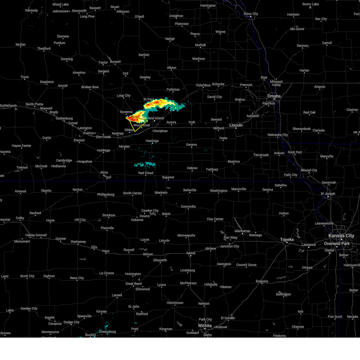 At 1229 am cdt, a severe thunderstorm was located 9 miles southeast of ravenna, or 21 miles west of grand island, moving southeast at 25 mph (radar indicated). Hazards include half dollar size hail. damage to vehicles is expected At 1229 am cdt, a severe thunderstorm was located 9 miles southeast of ravenna, or 21 miles west of grand island, moving southeast at 25 mph (radar indicated). Hazards include half dollar size hail. damage to vehicles is expected
|
| 5/6/2023 12:39 AM CDT |
 At 1239 am cdt, severe thunderstorms were located along a line extending from near wolbach to near st. libory to near wood river to 6 miles north of heartwell, moving east at 50 mph (radar indicated). Hazards include 60 mph wind gusts and quarter size hail. Hail damage to vehicles is expected. expect wind damage to roofs, siding, and trees. these severe storms will be near, palmer, wolbach, cushing and st. libory around 1245 am cdt. archer around 1250 am cdt. grand island around 1255 am cdt. phillips around 100 am cdt. this includes interstate 80 between mile markers 307 and 319. hail threat, radar indicated max hail size, 1. 00 in wind threat, radar indicated max wind gust, 60 mph. At 1239 am cdt, severe thunderstorms were located along a line extending from near wolbach to near st. libory to near wood river to 6 miles north of heartwell, moving east at 50 mph (radar indicated). Hazards include 60 mph wind gusts and quarter size hail. Hail damage to vehicles is expected. expect wind damage to roofs, siding, and trees. these severe storms will be near, palmer, wolbach, cushing and st. libory around 1245 am cdt. archer around 1250 am cdt. grand island around 1255 am cdt. phillips around 100 am cdt. this includes interstate 80 between mile markers 307 and 319. hail threat, radar indicated max hail size, 1. 00 in wind threat, radar indicated max wind gust, 60 mph.
|
| 5/6/2023 12:14 AM CDT |
 At 1214 am cdt, severe thunderstorms were located along a line extending from 6 miles west of cotesfield to near boelus to near gibbon to near kearney, moving east at 50 mph (radar indicated). Hazards include 60 mph wind gusts and quarter size hail. Hail damage to vehicles is expected. expect wind damage to roofs, siding, and trees. severe thunderstorms will be near, cairo, dannebrog and boelus around 1220 am cdt. elba and cotesfield around 1225 am cdt. st. paul around 1230 am cdt. other locations in the path of these severe thunderstorms include wood river, st. libory, palmer, wolbach, cushing, alda, chapman, doniphan, archer and grand island. this includes interstate 80 between mile markers 268 and 325. hail threat, radar indicated max hail size, 1. 00 in wind threat, radar indicated max wind gust, 60 mph. At 1214 am cdt, severe thunderstorms were located along a line extending from 6 miles west of cotesfield to near boelus to near gibbon to near kearney, moving east at 50 mph (radar indicated). Hazards include 60 mph wind gusts and quarter size hail. Hail damage to vehicles is expected. expect wind damage to roofs, siding, and trees. severe thunderstorms will be near, cairo, dannebrog and boelus around 1220 am cdt. elba and cotesfield around 1225 am cdt. st. paul around 1230 am cdt. other locations in the path of these severe thunderstorms include wood river, st. libory, palmer, wolbach, cushing, alda, chapman, doniphan, archer and grand island. this includes interstate 80 between mile markers 268 and 325. hail threat, radar indicated max hail size, 1. 00 in wind threat, radar indicated max wind gust, 60 mph.
|
| 5/6/2023 12:11 AM CDT |
 At 1210 am cdt, severe thunderstorms were located along a line extending from near sherman reservoir dam to boelus to near gibbon to 6 miles southeast of odessa, moving east at 50 mph (emergency management reported quarter size hail in elm creek and minor wind damage in loup city). Hazards include 60 mph wind gusts and quarter size hail. Hail damage to vehicles is expected. expect wind damage to roofs, siding, and trees. these severe storms will be near, ashton and boelus around 1215 am cdt. shelton around 1225 am cdt. this includes interstate 80 between mile markers 256 and 293. hail threat, observed max hail size, 1. 00 in wind threat, observed max wind gust, 60 mph. At 1210 am cdt, severe thunderstorms were located along a line extending from near sherman reservoir dam to boelus to near gibbon to 6 miles southeast of odessa, moving east at 50 mph (emergency management reported quarter size hail in elm creek and minor wind damage in loup city). Hazards include 60 mph wind gusts and quarter size hail. Hail damage to vehicles is expected. expect wind damage to roofs, siding, and trees. these severe storms will be near, ashton and boelus around 1215 am cdt. shelton around 1225 am cdt. this includes interstate 80 between mile markers 256 and 293. hail threat, observed max hail size, 1. 00 in wind threat, observed max wind gust, 60 mph.
|
| 5/6/2023 12:07 AM CDT |
 At 1203 am cdt, severe thunderstorms were located along a line extending from near loup city to near rockville to near kearney to 6 miles south of odessa, moving east at 50 mph (radar indicated). Hazards include 60 mph wind gusts and quarter size hail. Hail damage to vehicles is expected. expect wind damage to roofs, siding, and trees. these severe storms will be near, ashton, rockville, boelus and sherman reservoir dam around 1210 am cdt. gibbon around 1220 am cdt. shelton around 1225 am cdt. this includes interstate 80 between mile markers 256 and 293. hail threat, radar indicated max hail size, 1. 00 in wind threat, observed max wind gust, 60 mph. At 1203 am cdt, severe thunderstorms were located along a line extending from near loup city to near rockville to near kearney to 6 miles south of odessa, moving east at 50 mph (radar indicated). Hazards include 60 mph wind gusts and quarter size hail. Hail damage to vehicles is expected. expect wind damage to roofs, siding, and trees. these severe storms will be near, ashton, rockville, boelus and sherman reservoir dam around 1210 am cdt. gibbon around 1220 am cdt. shelton around 1225 am cdt. this includes interstate 80 between mile markers 256 and 293. hail threat, radar indicated max hail size, 1. 00 in wind threat, observed max wind gust, 60 mph.
|
| 5/5/2023 11:42 PM CDT |
 At 1142 pm cdt, severe thunderstorms were located along a line extending from near mason city to 7 miles northwest of pleasanton to near elm creek to 8 miles north of loomis, moving east at 45 mph (automated weather station). Hazards include 60 mph wind gusts and quarter size hail. Hail damage to vehicles is expected. expect wind damage to roofs, siding, and trees. severe thunderstorms will be near, pleasanton, litchfield and hazard around 1150 pm cdt. riverdale around 1155 pm cdt. kearney and poole around 1200 am cdt. other locations in the path of these severe thunderstorms include ravenna, loup city, rockville, sherman reservoir dam, gibbon, ashton, boelus and shelton. this includes interstate 80 between mile markers 256 and 293. hail threat, radar indicated max hail size, 1. 00 in wind threat, observed max wind gust, 60 mph. At 1142 pm cdt, severe thunderstorms were located along a line extending from near mason city to 7 miles northwest of pleasanton to near elm creek to 8 miles north of loomis, moving east at 45 mph (automated weather station). Hazards include 60 mph wind gusts and quarter size hail. Hail damage to vehicles is expected. expect wind damage to roofs, siding, and trees. severe thunderstorms will be near, pleasanton, litchfield and hazard around 1150 pm cdt. riverdale around 1155 pm cdt. kearney and poole around 1200 am cdt. other locations in the path of these severe thunderstorms include ravenna, loup city, rockville, sherman reservoir dam, gibbon, ashton, boelus and shelton. this includes interstate 80 between mile markers 256 and 293. hail threat, radar indicated max hail size, 1. 00 in wind threat, observed max wind gust, 60 mph.
|
| 8/18/2022 6:06 PM CDT |
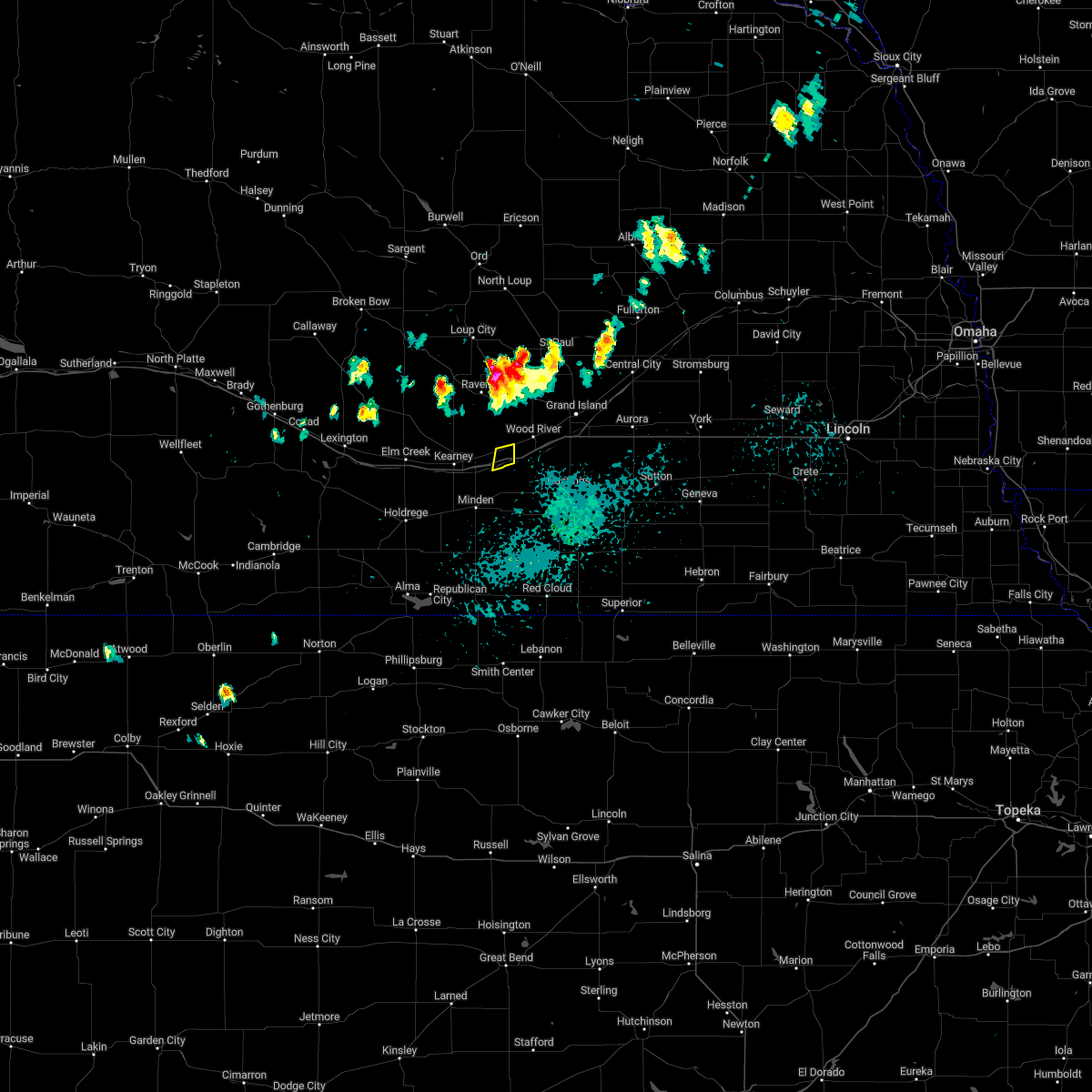 At 605 pm cdt, a severe thunderstorm was located near gibbon, or 16 miles east of kearney, moving south at 20 mph (radar indicated). Hazards include 60 mph wind gusts and quarter size hail. Hail damage to vehicles is expected. expect wind damage to roofs, siding, and trees. locations impacted include, shelton. this includes interstate 80 between mile markers 286 and 292. hail threat, radar indicated max hail size, 1. 00 in wind threat, radar indicated max wind gust, 60 mph. At 605 pm cdt, a severe thunderstorm was located near gibbon, or 16 miles east of kearney, moving south at 20 mph (radar indicated). Hazards include 60 mph wind gusts and quarter size hail. Hail damage to vehicles is expected. expect wind damage to roofs, siding, and trees. locations impacted include, shelton. this includes interstate 80 between mile markers 286 and 292. hail threat, radar indicated max hail size, 1. 00 in wind threat, radar indicated max wind gust, 60 mph.
|
| 8/18/2022 6:02 PM CDT |
 At 602 pm cdt, a severe thunderstorm was located near gibbon, or 16 miles east of kearney, moving south at 30 mph (public). Hazards include 60 mph wind gusts and quarter size hail. Hail damage to vehicles is expected. expect wind damage to roofs, siding, and trees. locations impacted include, gibbon and shelton. this includes interstate 80 between mile markers 286 and 295. hail threat, observed max hail size, 1. 00 in wind threat, radar indicated max wind gust, 60 mph. At 602 pm cdt, a severe thunderstorm was located near gibbon, or 16 miles east of kearney, moving south at 30 mph (public). Hazards include 60 mph wind gusts and quarter size hail. Hail damage to vehicles is expected. expect wind damage to roofs, siding, and trees. locations impacted include, gibbon and shelton. this includes interstate 80 between mile markers 286 and 295. hail threat, observed max hail size, 1. 00 in wind threat, radar indicated max wind gust, 60 mph.
|
| 1/1/0001 12:00 AM | Quarter sized hail reported 0.9 miles SE of Shelton, NE, report from mping: quarter (1.00 in.). |
| 8/18/2022 5:48 PM CDT |
 At 547 pm cdt, a severe thunderstorm was located near shelton, or 19 miles northeast of kearney, moving south at 30 mph (public. multiple reports of quarter to golf ball size hail were reported earlier with this storm in southeast sherman county and northeast buffalo county). Hazards include 60 mph wind gusts and half dollar size hail. Hail damage to vehicles is expected. expect wind damage to roofs, siding, and trees. locations impacted include, gibbon, wood river and shelton. this includes interstate 80 between mile markers 286 and 302. hail threat, observed max hail size, 1. 25 in wind threat, radar indicated max wind gust, 60 mph. At 547 pm cdt, a severe thunderstorm was located near shelton, or 19 miles northeast of kearney, moving south at 30 mph (public. multiple reports of quarter to golf ball size hail were reported earlier with this storm in southeast sherman county and northeast buffalo county). Hazards include 60 mph wind gusts and half dollar size hail. Hail damage to vehicles is expected. expect wind damage to roofs, siding, and trees. locations impacted include, gibbon, wood river and shelton. this includes interstate 80 between mile markers 286 and 302. hail threat, observed max hail size, 1. 25 in wind threat, radar indicated max wind gust, 60 mph.
|
| 8/18/2022 5:35 PM CDT |
 At 535 pm cdt, a severe thunderstorm was located 9 miles north of shelton, or 20 miles west of grand island, moving south at 20 mph (public). Hazards include 60 mph wind gusts and half dollar size hail. Hail damage to vehicles is expected. expect wind damage to roofs, siding, and trees. locations impacted include, gibbon, wood river and shelton. this includes interstate 80 between mile markers 286 and 303. hail threat, observed max hail size, 1. 25 in wind threat, radar indicated max wind gust, 60 mph. At 535 pm cdt, a severe thunderstorm was located 9 miles north of shelton, or 20 miles west of grand island, moving south at 20 mph (public). Hazards include 60 mph wind gusts and half dollar size hail. Hail damage to vehicles is expected. expect wind damage to roofs, siding, and trees. locations impacted include, gibbon, wood river and shelton. this includes interstate 80 between mile markers 286 and 303. hail threat, observed max hail size, 1. 25 in wind threat, radar indicated max wind gust, 60 mph.
|
| 8/18/2022 5:27 PM CDT |
 At 527 pm cdt, a severe thunderstorm was located 8 miles southwest of cairo, or 20 miles west of grand island, moving south at 20 mph (radar indicated). Hazards include 60 mph wind gusts and half dollar size hail. Hail damage to vehicles is expected. Expect wind damage to roofs, siding, and trees. At 527 pm cdt, a severe thunderstorm was located 8 miles southwest of cairo, or 20 miles west of grand island, moving south at 20 mph (radar indicated). Hazards include 60 mph wind gusts and half dollar size hail. Hail damage to vehicles is expected. Expect wind damage to roofs, siding, and trees.
|
| 7/23/2022 1:29 AM CDT | Nebraska dot mesonet along interstate 80 at shelton exi in buffalo county NE, 4.2 miles N of Shelton, NE |
| 7/23/2022 1:20 AM CDT |
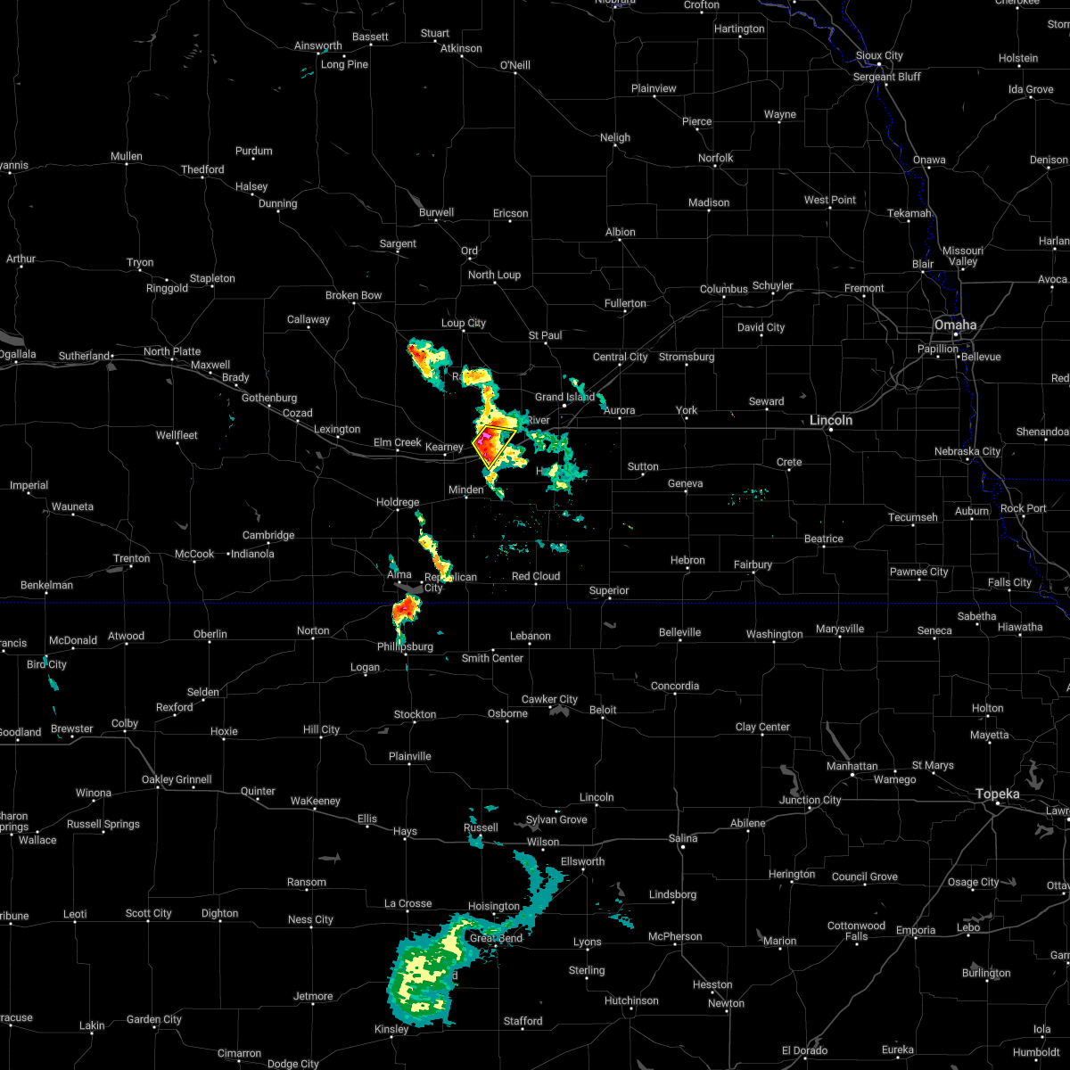 At 119 am cdt, a severe thunderstorm was located over gibbon, or 14 miles east of kearney, moving southeast at 20 mph (radar indicated). Hazards include quarter size hail. Damage to vehicles is expected. this severe storm will be near, shelton around 125 am cdt. this includes interstate 80 between mile markers 285 and 292. hail threat, radar indicated max hail size, 1. 00 in wind threat, radar indicated max wind gust, <50 mph. At 119 am cdt, a severe thunderstorm was located over gibbon, or 14 miles east of kearney, moving southeast at 20 mph (radar indicated). Hazards include quarter size hail. Damage to vehicles is expected. this severe storm will be near, shelton around 125 am cdt. this includes interstate 80 between mile markers 285 and 292. hail threat, radar indicated max hail size, 1. 00 in wind threat, radar indicated max wind gust, <50 mph.
|
| 7/23/2022 1:12 AM CDT |
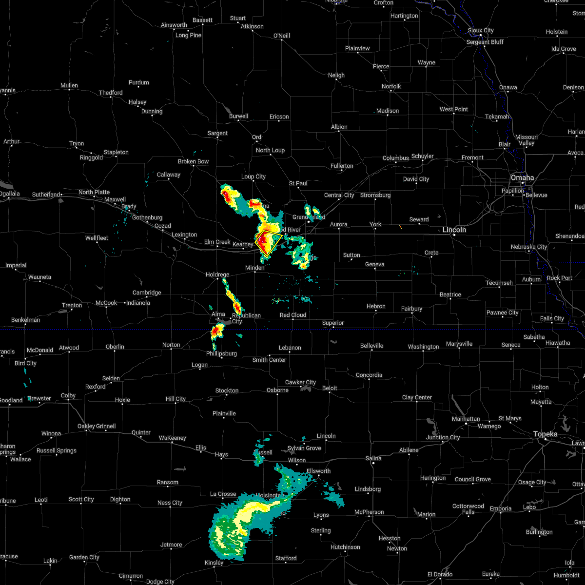 At 112 am cdt, a severe thunderstorm was located over gibbon, or 12 miles east of kearney, moving southeast at 20 mph (radar indicated). Hazards include 60 mph wind gusts and half dollar size hail. Hail damage to vehicles is expected. expect wind damage to roofs, siding, and trees. this severe storm will be near, gibbon around 115 am cdt. shelton around 125 am cdt. this includes interstate 80 between mile markers 284 and 292. hail threat, radar indicated max hail size, 1. 25 in wind threat, radar indicated max wind gust, 60 mph. At 112 am cdt, a severe thunderstorm was located over gibbon, or 12 miles east of kearney, moving southeast at 20 mph (radar indicated). Hazards include 60 mph wind gusts and half dollar size hail. Hail damage to vehicles is expected. expect wind damage to roofs, siding, and trees. this severe storm will be near, gibbon around 115 am cdt. shelton around 125 am cdt. this includes interstate 80 between mile markers 284 and 292. hail threat, radar indicated max hail size, 1. 25 in wind threat, radar indicated max wind gust, 60 mph.
|
| 7/23/2022 12:56 AM CDT |
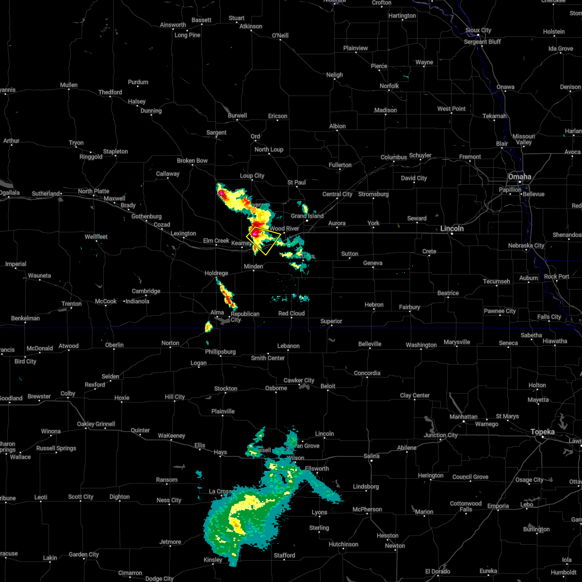 At 1255 am cdt, a severe thunderstorm was located near gibbon, or 11 miles northeast of kearney, moving southeast at 20 mph (radar indicated). Hazards include 60 mph wind gusts and half dollar size hail. Hail damage to vehicles is expected. expect wind damage to roofs, siding, and trees. this severe thunderstorm will be near, gibbon around 110 am cdt. other locations in the path of this severe thunderstorm include shelton. this includes interstate 80 between mile markers 283 and 292. hail threat, radar indicated max hail size, 1. 25 in wind threat, radar indicated max wind gust, 60 mph. At 1255 am cdt, a severe thunderstorm was located near gibbon, or 11 miles northeast of kearney, moving southeast at 20 mph (radar indicated). Hazards include 60 mph wind gusts and half dollar size hail. Hail damage to vehicles is expected. expect wind damage to roofs, siding, and trees. this severe thunderstorm will be near, gibbon around 110 am cdt. other locations in the path of this severe thunderstorm include shelton. this includes interstate 80 between mile markers 283 and 292. hail threat, radar indicated max hail size, 1. 25 in wind threat, radar indicated max wind gust, 60 mph.
|
| 7/16/2022 9:11 PM CDT |
 At 911 pm cdt, a severe thunderstorm capable of producing a tornado was located over kenesaw, or 15 miles west of hastings, moving southeast at 45 mph (radar indicated rotation). Hazards include tornado and half dollar size hail. Flying debris will be dangerous to those caught without shelter. mobile homes will be damaged or destroyed. damage to roofs, windows, and vehicles will occur. tree damage is likely. this dangerous storm will be near, juniata around 920 pm cdt. holstein around 925 pm cdt. roseland around 930 pm cdt. This includes interstate 80 between mile markers 285 and 298. At 911 pm cdt, a severe thunderstorm capable of producing a tornado was located over kenesaw, or 15 miles west of hastings, moving southeast at 45 mph (radar indicated rotation). Hazards include tornado and half dollar size hail. Flying debris will be dangerous to those caught without shelter. mobile homes will be damaged or destroyed. damage to roofs, windows, and vehicles will occur. tree damage is likely. this dangerous storm will be near, juniata around 920 pm cdt. holstein around 925 pm cdt. roseland around 930 pm cdt. This includes interstate 80 between mile markers 285 and 298.
|
| 7/16/2022 9:04 PM CDT |
 At 904 pm cdt, a severe thunderstorm capable of producing a tornado was located near shelton, or 18 miles east of kearney, moving southeast at 45 mph (radar indicated rotation). Hazards include tornado and half dollar size hail. Flying debris will be dangerous to those caught without shelter. mobile homes will be damaged or destroyed. damage to roofs, windows, and vehicles will occur. tree damage is likely. this dangerous storm will be near, kenesaw and prosser around 915 pm cdt. other locations in the path of this tornadic thunderstorm include juniata, holstein and roseland. This includes interstate 80 between mile markers 285 and 298. At 904 pm cdt, a severe thunderstorm capable of producing a tornado was located near shelton, or 18 miles east of kearney, moving southeast at 45 mph (radar indicated rotation). Hazards include tornado and half dollar size hail. Flying debris will be dangerous to those caught without shelter. mobile homes will be damaged or destroyed. damage to roofs, windows, and vehicles will occur. tree damage is likely. this dangerous storm will be near, kenesaw and prosser around 915 pm cdt. other locations in the path of this tornadic thunderstorm include juniata, holstein and roseland. This includes interstate 80 between mile markers 285 and 298.
|
| 7/16/2022 8:46 PM CDT |
 At 845 pm cdt, severe thunderstorms were located along a line extending from 8 miles west of cairo to near gibbon to kearney to near amherst, moving southeast at 40 mph (radar indicated). Hazards include 60 mph wind gusts and quarter size hail. Hail damage to vehicles is expected. expect wind damage to roofs, siding, and trees. these severe storms will be near, gibbon around 850 pm cdt. shelton around 900 pm cdt. this includes interstate 80 between mile markers 255 and 292. hail threat, radar indicated max hail size, 1. 00 in wind threat, radar indicated max wind gust, 60 mph. At 845 pm cdt, severe thunderstorms were located along a line extending from 8 miles west of cairo to near gibbon to kearney to near amherst, moving southeast at 40 mph (radar indicated). Hazards include 60 mph wind gusts and quarter size hail. Hail damage to vehicles is expected. expect wind damage to roofs, siding, and trees. these severe storms will be near, gibbon around 850 pm cdt. shelton around 900 pm cdt. this includes interstate 80 between mile markers 255 and 292. hail threat, radar indicated max hail size, 1. 00 in wind threat, radar indicated max wind gust, 60 mph.
|
| 7/16/2022 8:33 PM CDT |
 At 833 pm cdt, severe thunderstorms were located along a line extending from ravenna to 8 miles southeast of pleasanton to near riverdale to near miller, moving southeast at 45 mph (radar indicated). Hazards include 70 mph wind gusts and quarter size hail. Hail damage to vehicles is expected. expect considerable tree damage. wind damage is also likely to mobile homes, roofs, and outbuildings. severe thunderstorms will be near, ravenna and poole around 840 pm cdt. elm creek around 845 pm cdt. gibbon around 850 pm cdt. other locations in the path of these severe thunderstorms include shelton, odessa and kearney. this includes interstate 80 between mile markers 255 and 292. thunderstorm damage threat, considerable hail threat, radar indicated max hail size, 1. 00 in wind threat, radar indicated max wind gust, 70 mph. At 833 pm cdt, severe thunderstorms were located along a line extending from ravenna to 8 miles southeast of pleasanton to near riverdale to near miller, moving southeast at 45 mph (radar indicated). Hazards include 70 mph wind gusts and quarter size hail. Hail damage to vehicles is expected. expect considerable tree damage. wind damage is also likely to mobile homes, roofs, and outbuildings. severe thunderstorms will be near, ravenna and poole around 840 pm cdt. elm creek around 845 pm cdt. gibbon around 850 pm cdt. other locations in the path of these severe thunderstorms include shelton, odessa and kearney. this includes interstate 80 between mile markers 255 and 292. thunderstorm damage threat, considerable hail threat, radar indicated max hail size, 1. 00 in wind threat, radar indicated max wind gust, 70 mph.
|
| 6/15/2022 1:42 AM CDT |
 The severe thunderstorm warning for northeastern kearney and southeastern buffalo counties will expire at 145 am cdt, the storm which prompted the warning has weakened below severe limits, and no longer poses an immediate threat to life or property. therefore, the warning will be allowed to expire. however small hail and gusty winds are still possible with this thunderstorm. a severe thunderstorm watch remains in effect until 400 am cdt for south central nebraska. The severe thunderstorm warning for northeastern kearney and southeastern buffalo counties will expire at 145 am cdt, the storm which prompted the warning has weakened below severe limits, and no longer poses an immediate threat to life or property. therefore, the warning will be allowed to expire. however small hail and gusty winds are still possible with this thunderstorm. a severe thunderstorm watch remains in effect until 400 am cdt for south central nebraska.
|
| 6/15/2022 1:29 AM CDT |
 At 129 am cdt, a severe thunderstorm was located near gibbon, or 11 miles east of kearney, moving east at 50 mph (radar indicated). Hazards include 60 mph wind gusts and quarter size hail. Hail damage to vehicles is expected. expect wind damage to roofs, siding, and trees. this severe storm will be near, shelton around 140 am cdt. this includes interstate 80 between mile markers 278 and 292. hail threat, radar indicated max hail size, 1. 00 in wind threat, radar indicated max wind gust, 60 mph. At 129 am cdt, a severe thunderstorm was located near gibbon, or 11 miles east of kearney, moving east at 50 mph (radar indicated). Hazards include 60 mph wind gusts and quarter size hail. Hail damage to vehicles is expected. expect wind damage to roofs, siding, and trees. this severe storm will be near, shelton around 140 am cdt. this includes interstate 80 between mile markers 278 and 292. hail threat, radar indicated max hail size, 1. 00 in wind threat, radar indicated max wind gust, 60 mph.
|
| 6/15/2022 1:16 AM CDT |
 At 116 am cdt, a severe thunderstorm was located near kearney, moving east at 40 mph (radar indicated). Hazards include 60 mph wind gusts and quarter size hail. Hail damage to vehicles is expected. expect wind damage to roofs, siding, and trees. this severe storm will be near, gibbon around 135 am cdt. shelton around 140 am cdt. this includes interstate 80 between mile markers 269 and 292. hail threat, radar indicated max hail size, 1. 00 in wind threat, radar indicated max wind gust, 60 mph. At 116 am cdt, a severe thunderstorm was located near kearney, moving east at 40 mph (radar indicated). Hazards include 60 mph wind gusts and quarter size hail. Hail damage to vehicles is expected. expect wind damage to roofs, siding, and trees. this severe storm will be near, gibbon around 135 am cdt. shelton around 140 am cdt. this includes interstate 80 between mile markers 269 and 292. hail threat, radar indicated max hail size, 1. 00 in wind threat, radar indicated max wind gust, 60 mph.
|
| 6/15/2022 12:55 AM CDT |
 At 1254 am cdt, a severe thunderstorm was located near odessa, or 12 miles southwest of kearney, moving east at 45 mph (radar indicated). Hazards include ping pong ball size hail and 60 mph wind gusts. People and animals outdoors will be injured. expect hail damage to roofs, siding, windows, and vehicles. expect wind damage to roofs, siding, and trees. this severe thunderstorm will be near, kearney around 110 am cdt. other locations in the path of this severe thunderstorm include gibbon and shelton. this includes interstate 80 between mile markers 255 and 292. hail threat, radar indicated max hail size, 1. 50 in wind threat, radar indicated max wind gust, 60 mph. At 1254 am cdt, a severe thunderstorm was located near odessa, or 12 miles southwest of kearney, moving east at 45 mph (radar indicated). Hazards include ping pong ball size hail and 60 mph wind gusts. People and animals outdoors will be injured. expect hail damage to roofs, siding, windows, and vehicles. expect wind damage to roofs, siding, and trees. this severe thunderstorm will be near, kearney around 110 am cdt. other locations in the path of this severe thunderstorm include gibbon and shelton. this includes interstate 80 between mile markers 255 and 292. hail threat, radar indicated max hail size, 1. 50 in wind threat, radar indicated max wind gust, 60 mph.
|
| 6/15/2022 12:32 AM CDT |
 At 1232 am cdt, a severe thunderstorm was located over heartwell, or 16 miles southeast of kearney, moving east at 45 mph (radar indicated). Hazards include golf ball size hail and 60 mph wind gusts. People and animals outdoors will be injured. expect hail damage to roofs, siding, windows, and vehicles. expect wind damage to roofs, siding, and trees. this severe storm will be near, kenesaw around 1245 am cdt. prosser around 1250 am cdt. juniata around 1255 am cdt. hastings and hansen around 105 am cdt. this includes interstate 80 between mile markers 279 and 316. thunderstorm damage threat, considerable hail threat, radar indicated max hail size, 1. 75 in wind threat, radar indicated max wind gust, 60 mph. At 1232 am cdt, a severe thunderstorm was located over heartwell, or 16 miles southeast of kearney, moving east at 45 mph (radar indicated). Hazards include golf ball size hail and 60 mph wind gusts. People and animals outdoors will be injured. expect hail damage to roofs, siding, windows, and vehicles. expect wind damage to roofs, siding, and trees. this severe storm will be near, kenesaw around 1245 am cdt. prosser around 1250 am cdt. juniata around 1255 am cdt. hastings and hansen around 105 am cdt. this includes interstate 80 between mile markers 279 and 316. thunderstorm damage threat, considerable hail threat, radar indicated max hail size, 1. 75 in wind threat, radar indicated max wind gust, 60 mph.
|
| 6/15/2022 12:24 AM CDT |
 At 1222 am cdt, a severe thunderstorm was located near minden, or 10 miles southeast of kearney, moving east at 45 mph (radar indicated). Hazards include ping pong ball size hail and 60 mph wind gusts. People and animals outdoors will be injured. expect hail damage to roofs, siding, windows, and vehicles. expect wind damage to roofs, siding, and trees. this severe thunderstorm will be near, heartwell around 1235 am cdt hastings around 110 am cdt. other locations in the path of this severe thunderstorm include kenesaw, prosser, juniata, and hansen. this includes interstate 80 between mile markers 274 and 316. hail threat, radar indicated max hail size, 1. 50 in wind threat, radar indicated max wind gust, 60 mph. At 1222 am cdt, a severe thunderstorm was located near minden, or 10 miles southeast of kearney, moving east at 45 mph (radar indicated). Hazards include ping pong ball size hail and 60 mph wind gusts. People and animals outdoors will be injured. expect hail damage to roofs, siding, windows, and vehicles. expect wind damage to roofs, siding, and trees. this severe thunderstorm will be near, heartwell around 1235 am cdt hastings around 110 am cdt. other locations in the path of this severe thunderstorm include kenesaw, prosser, juniata, and hansen. this includes interstate 80 between mile markers 274 and 316. hail threat, radar indicated max hail size, 1. 50 in wind threat, radar indicated max wind gust, 60 mph.
|
| 6/15/2022 12:01 AM CDT |
 At 1200 am cdt, a severe thunderstorm was located near prosser, or 10 miles west of hastings, moving east at 50 mph (radar indicated). Hazards include 60 mph wind gusts and quarter size hail. Hail damage to vehicles is expected. expect wind damage to roofs, siding, and trees. this severe storm will be near, hastings, doniphan and hansen around 1215 am cdt. this includes interstate 80 between mile markers 290 and 317. hail threat, radar indicated max hail size, 1. 00 in wind threat, radar indicated max wind gust, 60 mph. At 1200 am cdt, a severe thunderstorm was located near prosser, or 10 miles west of hastings, moving east at 50 mph (radar indicated). Hazards include 60 mph wind gusts and quarter size hail. Hail damage to vehicles is expected. expect wind damage to roofs, siding, and trees. this severe storm will be near, hastings, doniphan and hansen around 1215 am cdt. this includes interstate 80 between mile markers 290 and 317. hail threat, radar indicated max hail size, 1. 00 in wind threat, radar indicated max wind gust, 60 mph.
|
| 6/14/2022 11:46 PM CDT |
 At 1146 pm cdt, a severe thunderstorm was located near heartwell, or 15 miles east of kearney, moving east at 50 mph (radar indicated). Hazards include golf ball size hail. People and animals outdoors will be injured. expect damage to roofs, siding, windows, and vehicles. this severe storm will be near, kenesaw around 1155 pm cdt. prosser around 1200 am cdt. juniata around 1205 am cdt. hastings, doniphan and hansen around 1215 am cdt. this includes interstate 80 between mile markers 278 and 317. thunderstorm damage threat, considerable hail threat, radar indicated max hail size, 1. 75 in wind threat, radar indicated max wind gust, <50 mph. At 1146 pm cdt, a severe thunderstorm was located near heartwell, or 15 miles east of kearney, moving east at 50 mph (radar indicated). Hazards include golf ball size hail. People and animals outdoors will be injured. expect damage to roofs, siding, windows, and vehicles. this severe storm will be near, kenesaw around 1155 pm cdt. prosser around 1200 am cdt. juniata around 1205 am cdt. hastings, doniphan and hansen around 1215 am cdt. this includes interstate 80 between mile markers 278 and 317. thunderstorm damage threat, considerable hail threat, radar indicated max hail size, 1. 75 in wind threat, radar indicated max wind gust, <50 mph.
|
| 6/14/2022 11:40 PM CDT |
 At 1140 pm cdt, a severe thunderstorm was located 7 miles northwest of heartwell, or 10 miles southeast of kearney, moving east at 50 mph (radar indicated). Hazards include golf ball size hail. People and animals outdoors will be injured. expect damage to roofs, siding, windows, and vehicles. this severe thunderstorm will be near, heartwell around 1145 pm cdt. kenesaw around 1155 pm cdt. prosser around 1200 am cdt. other locations in the path of this severe thunderstorm include juniata, hastings, doniphan and hansen. this includes interstate 80 between mile markers 270 and 317. thunderstorm damage threat, considerable hail threat, radar indicated max hail size, 1. 75 in wind threat, radar indicated max wind gust, <50 mph. At 1140 pm cdt, a severe thunderstorm was located 7 miles northwest of heartwell, or 10 miles southeast of kearney, moving east at 50 mph (radar indicated). Hazards include golf ball size hail. People and animals outdoors will be injured. expect damage to roofs, siding, windows, and vehicles. this severe thunderstorm will be near, heartwell around 1145 pm cdt. kenesaw around 1155 pm cdt. prosser around 1200 am cdt. other locations in the path of this severe thunderstorm include juniata, hastings, doniphan and hansen. this includes interstate 80 between mile markers 270 and 317. thunderstorm damage threat, considerable hail threat, radar indicated max hail size, 1. 75 in wind threat, radar indicated max wind gust, <50 mph.
|
| 6/12/2022 5:56 AM CDT |
 The severe thunderstorm warning for southeastern buffalo and southern hall counties will expire at 600 am cdt, the storms which prompted the warning have weakened below severe limits, and have exited the warned area. therefore, the warning will be allowed to expire. however small hail and gusty winds are still possible with these thunderstorms. The severe thunderstorm warning for southeastern buffalo and southern hall counties will expire at 600 am cdt, the storms which prompted the warning have weakened below severe limits, and have exited the warned area. therefore, the warning will be allowed to expire. however small hail and gusty winds are still possible with these thunderstorms.
|
| 6/12/2022 5:49 AM CDT |
 At 549 am cdt, severe thunderstorms were located along a line extending from near prosser to near doniphan to near giltner, moving east at 50 mph (radar indicated). Hazards include quarter size hail. Damage to vehicles is expected. these severe thunderstorms will remain over mainly rural areas of southeastern buffalo and southern hall counties. this includes interstate 80 between mile markers 279 and 317. hail threat, radar indicated max hail size, 1. 00 in wind threat, radar indicated max wind gust, <50 mph. At 549 am cdt, severe thunderstorms were located along a line extending from near prosser to near doniphan to near giltner, moving east at 50 mph (radar indicated). Hazards include quarter size hail. Damage to vehicles is expected. these severe thunderstorms will remain over mainly rural areas of southeastern buffalo and southern hall counties. this includes interstate 80 between mile markers 279 and 317. hail threat, radar indicated max hail size, 1. 00 in wind threat, radar indicated max wind gust, <50 mph.
|
| 6/12/2022 5:21 AM CDT |
 At 521 am cdt, severe thunderstorms were located along a line extending from near kearney to near gibbon to near prosser, moving east at 50 mph (radar indicated). Hazards include half dollar size hail. Damage to vehicles is expected. these severe storms will be near, shelton around 525 am cdt. wood river around 535 am cdt. alda around 545 am cdt. doniphan around 550 am cdt. this includes interstate 80 between mile markers 268 and 317. hail threat, radar indicated max hail size, 1. 25 in wind threat, radar indicated max wind gust, <50 mph. At 521 am cdt, severe thunderstorms were located along a line extending from near kearney to near gibbon to near prosser, moving east at 50 mph (radar indicated). Hazards include half dollar size hail. Damage to vehicles is expected. these severe storms will be near, shelton around 525 am cdt. wood river around 535 am cdt. alda around 545 am cdt. doniphan around 550 am cdt. this includes interstate 80 between mile markers 268 and 317. hail threat, radar indicated max hail size, 1. 25 in wind threat, radar indicated max wind gust, <50 mph.
|
| 6/12/2022 5:09 AM CDT |
 At 509 am cdt, severe thunderstorms were located along a line extending from near odessa to 8 miles northwest of gibbon to near shelton, moving east at 50 mph (radar indicated). Hazards include half dollar size hail. Damage to vehicles is expected. severe thunderstorms will be near, shelton around 525 am cdt. other locations in the path of these severe thunderstorms include gibbon, wood river, alda and doniphan. this includes interstate 80 between mile markers 266 and 317. hail threat, radar indicated max hail size, 1. 25 in wind threat, radar indicated max wind gust, <50 mph. At 509 am cdt, severe thunderstorms were located along a line extending from near odessa to 8 miles northwest of gibbon to near shelton, moving east at 50 mph (radar indicated). Hazards include half dollar size hail. Damage to vehicles is expected. severe thunderstorms will be near, shelton around 525 am cdt. other locations in the path of these severe thunderstorms include gibbon, wood river, alda and doniphan. this includes interstate 80 between mile markers 266 and 317. hail threat, radar indicated max hail size, 1. 25 in wind threat, radar indicated max wind gust, <50 mph.
|
| 6/7/2022 8:34 PM CDT | Hen Egg sized hail reported 0.1 miles E of Shelton, NE |
| 6/7/2022 8:33 PM CDT |
 At 832 pm cdt, a severe thunderstorm was located near prosser, or 13 miles northwest of hastings, moving southeast at 50 mph (trained weather spotters reported wind driven hail in shelton and wood river). Hazards include two inch hail and 70 mph wind gusts. People and animals outdoors will be injured. expect hail damage to roofs, siding, windows, and vehicles. expect considerable tree damage. wind damage is also likely to mobile homes, roofs, and outbuildings. this severe storm will be near, juniata and hansen around 845 pm cdt. hastings and trumbull around 850 pm cdt. inland around 855 pm cdt. glenvil around 900 pm cdt. this includes interstate 80 between mile markers 290 and 319. thunderstorm damage threat, considerable hail threat, observed max hail size, 2. 00 in wind threat, observed max wind gust, 70 mph. At 832 pm cdt, a severe thunderstorm was located near prosser, or 13 miles northwest of hastings, moving southeast at 50 mph (trained weather spotters reported wind driven hail in shelton and wood river). Hazards include two inch hail and 70 mph wind gusts. People and animals outdoors will be injured. expect hail damage to roofs, siding, windows, and vehicles. expect considerable tree damage. wind damage is also likely to mobile homes, roofs, and outbuildings. this severe storm will be near, juniata and hansen around 845 pm cdt. hastings and trumbull around 850 pm cdt. inland around 855 pm cdt. glenvil around 900 pm cdt. this includes interstate 80 between mile markers 290 and 319. thunderstorm damage threat, considerable hail threat, observed max hail size, 2. 00 in wind threat, observed max wind gust, 70 mph.
|
| 6/7/2022 8:20 PM CDT |
 At 820 pm cdt, a severe thunderstorm was located near wood river, or 17 miles west of grand island, moving southeast at 50 mph (radar indicated). Hazards include two inch hail and 70 mph wind gusts. People and animals outdoors will be injured. expect hail damage to roofs, siding, windows, and vehicles. expect considerable tree damage. wind damage is also likely to mobile homes, roofs, and outbuildings. this severe thunderstorm will be near, wood river around 830 pm cdt. alda and prosser around 835 pm cdt. doniphan around 840 pm cdt. other locations in the path of this severe thunderstorm include hansen, hastings, trumbull, harvard, glenvil and inland. this includes interstate 80 between mile markers 290 and 324. thunderstorm damage threat, considerable hail threat, observed max hail size, 2. 00 in wind threat, observed max wind gust, 70 mph. At 820 pm cdt, a severe thunderstorm was located near wood river, or 17 miles west of grand island, moving southeast at 50 mph (radar indicated). Hazards include two inch hail and 70 mph wind gusts. People and animals outdoors will be injured. expect hail damage to roofs, siding, windows, and vehicles. expect considerable tree damage. wind damage is also likely to mobile homes, roofs, and outbuildings. this severe thunderstorm will be near, wood river around 830 pm cdt. alda and prosser around 835 pm cdt. doniphan around 840 pm cdt. other locations in the path of this severe thunderstorm include hansen, hastings, trumbull, harvard, glenvil and inland. this includes interstate 80 between mile markers 290 and 324. thunderstorm damage threat, considerable hail threat, observed max hail size, 2. 00 in wind threat, observed max wind gust, 70 mph.
|
| 6/7/2022 8:16 PM CDT |
 At 815 pm cdt, a severe thunderstorm was located 8 miles north of shelton, or 19 miles west of grand island, moving southeast at 50 mph (trained weather spotters reported golf ball size hail near ravenna). Hazards include two inch hail and 70 mph wind gusts. People and animals outdoors will be injured. expect hail damage to roofs, siding, windows, and vehicles. expect considerable tree damage. wind damage is also likely to mobile homes, roofs, and outbuildings. this severe storm will be near, shelton around 820 pm cdt. this includes interstate 80 between mile markers 290 and 292. thunderstorm damage threat, considerable hail threat, observed max hail size, 2. 00 in wind threat, observed max wind gust, 70 mph. At 815 pm cdt, a severe thunderstorm was located 8 miles north of shelton, or 19 miles west of grand island, moving southeast at 50 mph (trained weather spotters reported golf ball size hail near ravenna). Hazards include two inch hail and 70 mph wind gusts. People and animals outdoors will be injured. expect hail damage to roofs, siding, windows, and vehicles. expect considerable tree damage. wind damage is also likely to mobile homes, roofs, and outbuildings. this severe storm will be near, shelton around 820 pm cdt. this includes interstate 80 between mile markers 290 and 292. thunderstorm damage threat, considerable hail threat, observed max hail size, 2. 00 in wind threat, observed max wind gust, 70 mph.
|
| 6/7/2022 8:08 PM CDT |
 At 808 pm cdt, a severe thunderstorm was located near ravenna, or 22 miles northeast of kearney, moving southeast at 50 mph (trained weather spotters reported hail to golf ball size near ravenna). Hazards include two inch hail and 70 mph wind gusts. People and animals outdoors will be injured. expect hail damage to roofs, siding, windows, and vehicles. expect considerable tree damage. wind damage is also likely to mobile homes, roofs, and outbuildings. this severe storm will be near, shelton around 825 pm cdt. this includes interstate 80 between mile markers 290 and 292. thunderstorm damage threat, considerable hail threat, observed max hail size, 2. 00 in wind threat, observed max wind gust, 70 mph. At 808 pm cdt, a severe thunderstorm was located near ravenna, or 22 miles northeast of kearney, moving southeast at 50 mph (trained weather spotters reported hail to golf ball size near ravenna). Hazards include two inch hail and 70 mph wind gusts. People and animals outdoors will be injured. expect hail damage to roofs, siding, windows, and vehicles. expect considerable tree damage. wind damage is also likely to mobile homes, roofs, and outbuildings. this severe storm will be near, shelton around 825 pm cdt. this includes interstate 80 between mile markers 290 and 292. thunderstorm damage threat, considerable hail threat, observed max hail size, 2. 00 in wind threat, observed max wind gust, 70 mph.
|
| 6/7/2022 8:04 PM CDT |
 At 802 pm cdt, a severe thunderstorm was located over ravenna, or 23 miles north of kearney, moving southeast at 50 mph. this is a destructive storm for northern buffalo county and western hall county (emergency management). Hazards include three inch hail and 70 mph wind gusts. People and animals outdoors will be severely injured. expect shattered windows, extensive damage to roofs, siding, and vehicles. this severe storm will be near, shelton around 825 pm cdt. this includes interstate 80 between mile markers 290 and 292. thunderstorm damage threat, destructive hail threat, observed max hail size, 3. 00 in wind threat, observed max wind gust, 70 mph. At 802 pm cdt, a severe thunderstorm was located over ravenna, or 23 miles north of kearney, moving southeast at 50 mph. this is a destructive storm for northern buffalo county and western hall county (emergency management). Hazards include three inch hail and 70 mph wind gusts. People and animals outdoors will be severely injured. expect shattered windows, extensive damage to roofs, siding, and vehicles. this severe storm will be near, shelton around 825 pm cdt. this includes interstate 80 between mile markers 290 and 292. thunderstorm damage threat, destructive hail threat, observed max hail size, 3. 00 in wind threat, observed max wind gust, 70 mph.
|
| 6/7/2022 7:57 PM CDT |
 At 756 pm cdt, a severe thunderstorm was located near hazard, or 24 miles north of kearney, moving southeast at 50 mph. this is a destructive storm for northern buffalo county (emergency management). Hazards include three inch hail and 70 mph wind gusts. People and animals outdoors will be severely injured. expect shattered windows, extensive damage to roofs, siding, and vehicles. this severe thunderstorm will be near, ravenna and poole around 805 pm cdt. other locations in the path of this severe thunderstorm include shelton. this includes interstate 80 between mile markers 287 and 292. thunderstorm damage threat, destructive hail threat, observed max hail size, 3. 00 in wind threat, observed max wind gust, 70 mph. At 756 pm cdt, a severe thunderstorm was located near hazard, or 24 miles north of kearney, moving southeast at 50 mph. this is a destructive storm for northern buffalo county (emergency management). Hazards include three inch hail and 70 mph wind gusts. People and animals outdoors will be severely injured. expect shattered windows, extensive damage to roofs, siding, and vehicles. this severe thunderstorm will be near, ravenna and poole around 805 pm cdt. other locations in the path of this severe thunderstorm include shelton. this includes interstate 80 between mile markers 287 and 292. thunderstorm damage threat, destructive hail threat, observed max hail size, 3. 00 in wind threat, observed max wind gust, 70 mph.
|
| 6/4/2022 11:42 PM CDT |
 At 1142 pm cdt, a severe thunderstorm was located 9 miles southwest of cairo, or 19 miles west of grand island, moving southeast at 15 mph (radar indicated). Hazards include half dollar size hail. damage to vehicles is expected At 1142 pm cdt, a severe thunderstorm was located 9 miles southwest of cairo, or 19 miles west of grand island, moving southeast at 15 mph (radar indicated). Hazards include half dollar size hail. damage to vehicles is expected
|
| 5/17/2022 9:37 PM CDT |
 At 937 pm cdt, severe thunderstorms were located along a line extending from near alda to wood river to gibbon, moving southeast at 20 mph (radar indicated). Hazards include quarter size hail. Damage to vehicles is expected. locations impacted include, gibbon, wood river and shelton. this includes interstate 80 between mile markers 286 and 305. hail threat, radar indicated max hail size, 1. 00 in wind threat, radar indicated max wind gust, <50 mph. At 937 pm cdt, severe thunderstorms were located along a line extending from near alda to wood river to gibbon, moving southeast at 20 mph (radar indicated). Hazards include quarter size hail. Damage to vehicles is expected. locations impacted include, gibbon, wood river and shelton. this includes interstate 80 between mile markers 286 and 305. hail threat, radar indicated max hail size, 1. 00 in wind threat, radar indicated max wind gust, <50 mph.
|
| 5/17/2022 9:22 PM CDT |
 At 922 pm cdt, severe thunderstorms were located along a line extending from near alda to near shelton to near gibbon, moving southeast at 20 mph (radar indicated). Hazards include quarter size hail. damage to vehicles is expected At 922 pm cdt, severe thunderstorms were located along a line extending from near alda to near shelton to near gibbon, moving southeast at 20 mph (radar indicated). Hazards include quarter size hail. damage to vehicles is expected
|
| 5/12/2022 7:21 PM CDT |
 At 721 pm cdt, a severe thunderstorm was located over gibbon, or 11 miles east of kearney, moving northeast at 50 mph (radar indicated). Hazards include 60 mph wind gusts and quarter size hail. Hail damage to vehicles is expected. expect wind damage to roofs, siding, and trees. this severe thunderstorm will be near, shelton around 730 pm cdt. wood river around 740 pm cdt. other locations in the path of this severe thunderstorm include cairo and alda. this includes interstate 80 between mile markers 281 and 306. hail threat, radar indicated max hail size, 1. 00 in wind threat, radar indicated max wind gust, 60 mph. At 721 pm cdt, a severe thunderstorm was located over gibbon, or 11 miles east of kearney, moving northeast at 50 mph (radar indicated). Hazards include 60 mph wind gusts and quarter size hail. Hail damage to vehicles is expected. expect wind damage to roofs, siding, and trees. this severe thunderstorm will be near, shelton around 730 pm cdt. wood river around 740 pm cdt. other locations in the path of this severe thunderstorm include cairo and alda. this includes interstate 80 between mile markers 281 and 306. hail threat, radar indicated max hail size, 1. 00 in wind threat, radar indicated max wind gust, 60 mph.
|
| 5/12/2022 2:35 PM CDT |
 At 235 pm cdt, severe thunderstorms were located along a line extending from near comstock to 8 miles east of arcadia to ashton to near boelus to near wood river to near prosser to near campbell, moving east at 65 mph (radar indicated). Hazards include 70 mph wind gusts and half dollar size hail. Hail damage to vehicles is expected. expect considerable tree damage. wind damage is also likely to mobile homes, roofs, and outbuildings. severe thunderstorms will be near, wood river, cairo, alda, dannebrog and prosser around 240 pm cdt. doniphan, north loup, farwell, cotesfield and hansen around 245 pm cdt. grand island, ord, st. paul, scotia, elba, trumbull, ayr, elyria and st. libory around 250 pm cdt. greeley, palmer, giltner, phillips, wolbach and cushing around 255 pm cdt. other locations in the path of these severe thunderstorms include glenvil, chapman, inland, archer, aurora, central city, clay center, fairfield, marquette, hampton, hordville, sutton, fullerton, spalding, clarks, belgrade and saronville. this includes interstate 80 between mile markers 277 and 340. thunderstorm damage threat, considerable hail threat, radar indicated max hail size, 1. 25 in wind threat, radar indicated max wind gust, 70 mph. At 235 pm cdt, severe thunderstorms were located along a line extending from near comstock to 8 miles east of arcadia to ashton to near boelus to near wood river to near prosser to near campbell, moving east at 65 mph (radar indicated). Hazards include 70 mph wind gusts and half dollar size hail. Hail damage to vehicles is expected. expect considerable tree damage. wind damage is also likely to mobile homes, roofs, and outbuildings. severe thunderstorms will be near, wood river, cairo, alda, dannebrog and prosser around 240 pm cdt. doniphan, north loup, farwell, cotesfield and hansen around 245 pm cdt. grand island, ord, st. paul, scotia, elba, trumbull, ayr, elyria and st. libory around 250 pm cdt. greeley, palmer, giltner, phillips, wolbach and cushing around 255 pm cdt. other locations in the path of these severe thunderstorms include glenvil, chapman, inland, archer, aurora, central city, clay center, fairfield, marquette, hampton, hordville, sutton, fullerton, spalding, clarks, belgrade and saronville. this includes interstate 80 between mile markers 277 and 340. thunderstorm damage threat, considerable hail threat, radar indicated max hail size, 1. 25 in wind threat, radar indicated max wind gust, 70 mph.
|
| 5/12/2022 2:25 PM CDT |
 At 224 pm cdt, severe thunderstorms were located along a line extending from 6 miles north of mason city to 8 miles northeast of riverdale to upland, moving northeast at 55 mph (radar indicated). Hazards include 70 mph wind gusts and half dollar size hail. Hail damage to vehicles is expected. expect considerable tree damage. wind damage is also likely to mobile homes, roofs, and outbuildings. these severe storms will be near, pleasanton around 230 pm cdt. arcadia and poole around 235 pm cdt. ravenna, holstein and norman around 240 pm cdt. heartwell around 245 pm cdt. kenesaw, rockville and boelus around 250 pm cdt. ord, ashton and elyria around 255 pm cdt. wood river, farwell, prosser and fort hartsuff state park around 300 pm cdt. this includes interstate 80 between mile markers 255 and 302. thunderstorm damage threat, considerable hail threat, radar indicated max hail size, 1. 25 in wind threat, radar indicated max wind gust, 70 mph. At 224 pm cdt, severe thunderstorms were located along a line extending from 6 miles north of mason city to 8 miles northeast of riverdale to upland, moving northeast at 55 mph (radar indicated). Hazards include 70 mph wind gusts and half dollar size hail. Hail damage to vehicles is expected. expect considerable tree damage. wind damage is also likely to mobile homes, roofs, and outbuildings. these severe storms will be near, pleasanton around 230 pm cdt. arcadia and poole around 235 pm cdt. ravenna, holstein and norman around 240 pm cdt. heartwell around 245 pm cdt. kenesaw, rockville and boelus around 250 pm cdt. ord, ashton and elyria around 255 pm cdt. wood river, farwell, prosser and fort hartsuff state park around 300 pm cdt. this includes interstate 80 between mile markers 255 and 302. thunderstorm damage threat, considerable hail threat, radar indicated max hail size, 1. 25 in wind threat, radar indicated max wind gust, 70 mph.
|
| 5/12/2022 2:11 PM CDT |
 At 211 pm cdt, severe thunderstorms were located along a line extending from near mason city to near kearney to 8 miles north of franklin, moving northeast at 55 mph (radar indicated). Hazards include 70 mph wind gusts and half dollar size hail. Hail damage to vehicles is expected. expect considerable tree damage. wind damage is also likely to mobile homes, roofs, and outbuildings. severe thunderstorms will be near, pleasanton around 225 pm cdt. arcadia and poole around 230 pm cdt. other locations in the path of these severe thunderstorms include ravenna, norman, holstein, heartwell, ord, kenesaw, rockville, elyria and boelus. this includes interstate 80 between mile markers 249 and 302. thunderstorm damage threat, considerable hail threat, radar indicated max hail size, 1. 25 in wind threat, radar indicated max wind gust, 70 mph. At 211 pm cdt, severe thunderstorms were located along a line extending from near mason city to near kearney to 8 miles north of franklin, moving northeast at 55 mph (radar indicated). Hazards include 70 mph wind gusts and half dollar size hail. Hail damage to vehicles is expected. expect considerable tree damage. wind damage is also likely to mobile homes, roofs, and outbuildings. severe thunderstorms will be near, pleasanton around 225 pm cdt. arcadia and poole around 230 pm cdt. other locations in the path of these severe thunderstorms include ravenna, norman, holstein, heartwell, ord, kenesaw, rockville, elyria and boelus. this includes interstate 80 between mile markers 249 and 302. thunderstorm damage threat, considerable hail threat, radar indicated max hail size, 1. 25 in wind threat, radar indicated max wind gust, 70 mph.
|
| 4/29/2022 6:09 PM CDT |
 At 608 pm cdt, severe thunderstorms were located along a line extending from near cairo to near prosser to holstein, moving east at 30 mph (trained weather spotters. wind gusts of 70 mph have been measured with this line of thunderstorms). Hazards include 70 mph wind gusts and half dollar size hail. Hail damage to vehicles is expected. expect considerable tree damage. wind damage is also likely to mobile homes, roofs, and outbuildings. these severe storms will be near, hastings, doniphan, hansen and st. libory around 625 pm cdt. grand island and ayr around 630 pm cdt. This includes interstate 80 between mile markers 289 and 317. At 608 pm cdt, severe thunderstorms were located along a line extending from near cairo to near prosser to holstein, moving east at 30 mph (trained weather spotters. wind gusts of 70 mph have been measured with this line of thunderstorms). Hazards include 70 mph wind gusts and half dollar size hail. Hail damage to vehicles is expected. expect considerable tree damage. wind damage is also likely to mobile homes, roofs, and outbuildings. these severe storms will be near, hastings, doniphan, hansen and st. libory around 625 pm cdt. grand island and ayr around 630 pm cdt. This includes interstate 80 between mile markers 289 and 317.
|
| 4/29/2022 5:50 PM CDT | Train cars derailed in this general area by strong winds. unknown how many cars. time estimated from rada in buffalo county NE, 1.8 miles ENE of Shelton, NE |
| 4/29/2022 5:48 PM CDT |
 At 547 pm cdt, severe thunderstorms were located along a line extending from near boelus to shelton to near minden, moving east at 30 mph (radar indicated). Hazards include 70 mph wind gusts and half dollar size hail. Hail damage to vehicles is expected. expect considerable tree damage. wind damage is also likely to mobile homes, roofs, and outbuildings. severe thunderstorms will be near, wood river and cairo around 600 pm cdt. prosser around 605 pm cdt. other locations in the path of these severe thunderstorms include holstein, roseland, hastings, doniphan, hansen, st. libory, grand island and ayr. This includes interstate 80 between mile markers 285 and 317. At 547 pm cdt, severe thunderstorms were located along a line extending from near boelus to shelton to near minden, moving east at 30 mph (radar indicated). Hazards include 70 mph wind gusts and half dollar size hail. Hail damage to vehicles is expected. expect considerable tree damage. wind damage is also likely to mobile homes, roofs, and outbuildings. severe thunderstorms will be near, wood river and cairo around 600 pm cdt. prosser around 605 pm cdt. other locations in the path of these severe thunderstorms include holstein, roseland, hastings, doniphan, hansen, st. libory, grand island and ayr. This includes interstate 80 between mile markers 285 and 317.
|
| 4/29/2022 5:10 PM CDT |
 At 509 pm cdt, a severe thunderstorm was located over kearney, moving northeast at 25 mph (radar indicated). Hazards include ping pong ball size hail and 60 mph wind gusts. People and animals outdoors will be injured. expect hail damage to roofs, siding, windows, and vehicles. Expect wind damage to roofs, siding, and trees. At 509 pm cdt, a severe thunderstorm was located over kearney, moving northeast at 25 mph (radar indicated). Hazards include ping pong ball size hail and 60 mph wind gusts. People and animals outdoors will be injured. expect hail damage to roofs, siding, windows, and vehicles. Expect wind damage to roofs, siding, and trees.
|
| 8/7/2021 9:08 PM CDT |
 At 908 pm cdt, severe thunderstorms were located along a line extending from grand island to near kenesaw to near upland, moving east at 15 mph (radar indicated). Hazards include 60 mph wind gusts and quarter size hail. Hail damage to vehicles is expected. expect wind damage to roofs, siding, and trees. these severe storms will be near, alda around 915 pm cdt. grand island around 920 pm cdt. prosser around 930 pm cdt. holstein around 940 pm cdt. juniata around 945 pm cdt. this includes interstate 80 between mile markers 285 and 317. hail threat, radar indicated max hail size, 1. 00 in wind threat, radar indicated max wind gust, 60 mph. At 908 pm cdt, severe thunderstorms were located along a line extending from grand island to near kenesaw to near upland, moving east at 15 mph (radar indicated). Hazards include 60 mph wind gusts and quarter size hail. Hail damage to vehicles is expected. expect wind damage to roofs, siding, and trees. these severe storms will be near, alda around 915 pm cdt. grand island around 920 pm cdt. prosser around 930 pm cdt. holstein around 940 pm cdt. juniata around 945 pm cdt. this includes interstate 80 between mile markers 285 and 317. hail threat, radar indicated max hail size, 1. 00 in wind threat, radar indicated max wind gust, 60 mph.
|
| 8/7/2021 8:46 PM CDT |
 At 846 pm cdt, severe thunderstorms were located along a line extending from near grand island to near upland, and are nearly stationary (radar indicated). Hazards include 60 mph wind gusts and quarter size hail. Hail damage to vehicles is expected. expect wind damage to roofs, siding, and trees. severe thunderstorms will be near, grand island and alda around 850 pm cdt. other locations in the path of these severe thunderstorms include minden and norman. this includes interstate 80 between mile markers 280 and 317. hail threat, radar indicated max hail size, 1. 00 in wind threat, radar indicated max wind gust, 60 mph. At 846 pm cdt, severe thunderstorms were located along a line extending from near grand island to near upland, and are nearly stationary (radar indicated). Hazards include 60 mph wind gusts and quarter size hail. Hail damage to vehicles is expected. expect wind damage to roofs, siding, and trees. severe thunderstorms will be near, grand island and alda around 850 pm cdt. other locations in the path of these severe thunderstorms include minden and norman. this includes interstate 80 between mile markers 280 and 317. hail threat, radar indicated max hail size, 1. 00 in wind threat, radar indicated max wind gust, 60 mph.
|
| 7/9/2021 10:17 PM CDT |
 At 1017 pm cdt, severe thunderstorms were located along a line extending from 6 miles southwest of pleasanton to near loomis to near atlanta to 6 miles north of edison, moving southeast at 60 mph (radar indicated). Hazards include 70 mph wind gusts and half dollar size hail. Hail damage to vehicles is expected. expect considerable tree damage. wind damage is also likely to mobile homes, roofs, and outbuildings. severe thunderstorms will be near, holdrege and atlanta around 1020 pm cdt. oxford, funk and riverdale around 1025 pm cdt. kearney and ragan around 1030 pm cdt. gibbon, wilcox and huntley around 1035 pm cdt. other locations in the path of these severe thunderstorms include orleans, hildreth, republican city, alma, naponee, heartwell, bloomington and harlan county dam. This includes interstate 80 between mile markers 242 and 292. At 1017 pm cdt, severe thunderstorms were located along a line extending from 6 miles southwest of pleasanton to near loomis to near atlanta to 6 miles north of edison, moving southeast at 60 mph (radar indicated). Hazards include 70 mph wind gusts and half dollar size hail. Hail damage to vehicles is expected. expect considerable tree damage. wind damage is also likely to mobile homes, roofs, and outbuildings. severe thunderstorms will be near, holdrege and atlanta around 1020 pm cdt. oxford, funk and riverdale around 1025 pm cdt. kearney and ragan around 1030 pm cdt. gibbon, wilcox and huntley around 1035 pm cdt. other locations in the path of these severe thunderstorms include orleans, hildreth, republican city, alma, naponee, heartwell, bloomington and harlan county dam. This includes interstate 80 between mile markers 242 and 292.
|
| 7/9/2021 10:12 PM CDT | Storm damage reported in hall county NE, 9 miles S of Shelton, NE |
| 7/9/2021 10:12 PM CDT | Storm damage reported in buffalo county NE, 9.7 miles S of Shelton, NE |
| 7/9/2021 9:46 PM CDT |
 At 945 pm cdt, severe thunderstorms were located along a line extending from near cedar rapids to near farwell to near poole, moving southeast at 50 mph (radar indicated). Hazards include 60 mph wind gusts and half dollar size hail. Hail damage to vehicles is expected. expect wind damage to roofs, siding, and trees. severe thunderstorms will be near, st. paul, dannebrog and belgrade around 950 pm cdt. gibbon and fullerton around 1000 pm cdt. shelton and st. libory around 1005 pm cdt. other locations in the path of these severe thunderstorms include wood river, clarks, chapman, silver creek and doniphan. This includes interstate 80 between mile markers 273 and 317. At 945 pm cdt, severe thunderstorms were located along a line extending from near cedar rapids to near farwell to near poole, moving southeast at 50 mph (radar indicated). Hazards include 60 mph wind gusts and half dollar size hail. Hail damage to vehicles is expected. expect wind damage to roofs, siding, and trees. severe thunderstorms will be near, st. paul, dannebrog and belgrade around 950 pm cdt. gibbon and fullerton around 1000 pm cdt. shelton and st. libory around 1005 pm cdt. other locations in the path of these severe thunderstorms include wood river, clarks, chapman, silver creek and doniphan. This includes interstate 80 between mile markers 273 and 317.
|
| 6/15/2021 7:52 PM CDT |
 The severe thunderstorm warning for southeastern buffalo and southwestern hall counties will expire at 800 pm cdt, the storm which prompted the warning has weakened below severe limits, and no longer poses an immediate threat to life or property. therefore, the warning will be allowed to expire. however gusty winds and moderate to heavy rain are still possible with this thunderstorm. The severe thunderstorm warning for southeastern buffalo and southwestern hall counties will expire at 800 pm cdt, the storm which prompted the warning has weakened below severe limits, and no longer poses an immediate threat to life or property. therefore, the warning will be allowed to expire. however gusty winds and moderate to heavy rain are still possible with this thunderstorm.
|
| 6/15/2021 7:45 PM CDT |
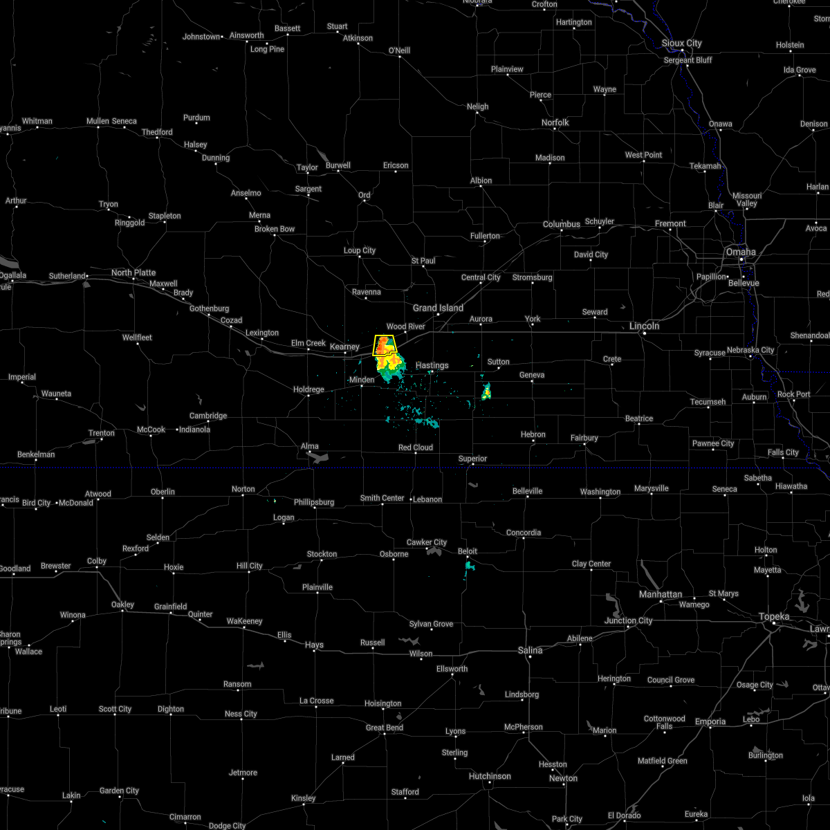 At 744 pm cdt, a severe thunderstorm was located between gibbon and shelton, or 15 miles east of kearney, moving south at 10 mph (radar indicated). Hazards include 60 mph wind gusts and penny size hail. Expect damage to roofs, siding, and trees. locations impacted include, gibbon and shelton. This includes interstate 80 between mile markers 285 and 294. At 744 pm cdt, a severe thunderstorm was located between gibbon and shelton, or 15 miles east of kearney, moving south at 10 mph (radar indicated). Hazards include 60 mph wind gusts and penny size hail. Expect damage to roofs, siding, and trees. locations impacted include, gibbon and shelton. This includes interstate 80 between mile markers 285 and 294.
|
| 6/15/2021 7:30 PM CDT | Golf Ball sized hail reported 0.1 miles E of Shelton, NE |
| 6/15/2021 7:28 PM CDT |
 At 727 pm cdt, a severe thunderstorm was located near shelton, or 17 miles east of kearney, and is nearly stationary (radar indicated). Hazards include 60 mph wind gusts and quarter size hail. Hail damage to vehicles is expected. Expect wind damage to roofs, siding, and trees. At 727 pm cdt, a severe thunderstorm was located near shelton, or 17 miles east of kearney, and is nearly stationary (radar indicated). Hazards include 60 mph wind gusts and quarter size hail. Hail damage to vehicles is expected. Expect wind damage to roofs, siding, and trees.
|
| 6/15/2021 7:25 PM CDT | Hen Egg sized hail reported 0.1 miles E of Shelton, NE, fb photo. |
| 4/28/2021 2:27 AM CDT |
 The severe thunderstorm warning for southeastern buffalo and western hall counties will expire at 230 am cdt, the storm which prompted the warning has weakened below severe limits, and no longer poses an immediate threat to life or property. therefore, the warning will be allowed to expire. The severe thunderstorm warning for southeastern buffalo and western hall counties will expire at 230 am cdt, the storm which prompted the warning has weakened below severe limits, and no longer poses an immediate threat to life or property. therefore, the warning will be allowed to expire.
|
| 4/28/2021 1:47 AM CDT |
 At 147 am cdt, a severe thunderstorm was located near gibbon, or 7 miles east of kearney, moving northeast at 30 mph (radar indicated). Hazards include 60 mph wind gusts and quarter size hail. Hail damage to vehicles is expected. Expect wind damage to roofs, siding, and trees. At 147 am cdt, a severe thunderstorm was located near gibbon, or 7 miles east of kearney, moving northeast at 30 mph (radar indicated). Hazards include 60 mph wind gusts and quarter size hail. Hail damage to vehicles is expected. Expect wind damage to roofs, siding, and trees.
|
| 8/16/2020 6:24 PM CDT |
 At 624 pm cdt, a severe thunderstorm was located near shelton, or 18 miles northeast of kearney, moving south at 15 mph (radar indicated). Hazards include 60 mph wind gusts and half dollar size hail. Hail damage to vehicles is expected. expect wind damage to roofs, siding, and trees. locations impacted include, gibbon and shelton. This includes interstate 80 between mile markers 284 and 300. At 624 pm cdt, a severe thunderstorm was located near shelton, or 18 miles northeast of kearney, moving south at 15 mph (radar indicated). Hazards include 60 mph wind gusts and half dollar size hail. Hail damage to vehicles is expected. expect wind damage to roofs, siding, and trees. locations impacted include, gibbon and shelton. This includes interstate 80 between mile markers 284 and 300.
|
| 8/16/2020 6:17 PM CDT |
 At 617 pm cdt, a severe thunderstorm was located 8 miles north of shelton, or 21 miles northeast of kearney, moving south at 15 mph (radar indicated). Hazards include 60 mph wind gusts and half dollar size hail. Hail damage to vehicles is expected. Expect wind damage to roofs, siding, and trees. At 617 pm cdt, a severe thunderstorm was located 8 miles north of shelton, or 21 miles northeast of kearney, moving south at 15 mph (radar indicated). Hazards include 60 mph wind gusts and half dollar size hail. Hail damage to vehicles is expected. Expect wind damage to roofs, siding, and trees.
|
| 8/16/2020 6:07 PM CDT |
 The severe thunderstorm warning for eastern buffalo, southern sherman, southwestern howard and hall counties will expire at 615 pm cdt, the storm which prompted the warning has weakened below severe limits, and no longer poses an immediate threat to life or property. therefore, the warning will be allowed to expire. however small hail is still possible with this thunderstorm. a severe thunderstorm watch remains in effect until 900 pm cdt for south central and central nebraska. The severe thunderstorm warning for eastern buffalo, southern sherman, southwestern howard and hall counties will expire at 615 pm cdt, the storm which prompted the warning has weakened below severe limits, and no longer poses an immediate threat to life or property. therefore, the warning will be allowed to expire. however small hail is still possible with this thunderstorm. a severe thunderstorm watch remains in effect until 900 pm cdt for south central and central nebraska.
|
| 8/16/2020 5:26 PM CDT |
 At 525 pm cdt, a severe thunderstorm was located near boelus, or 23 miles west of grand island, moving southeast at 25 mph (radar indicated). Hazards include 60 mph wind gusts and half dollar size hail. Hail damage to vehicles is expected. Expect wind damage to roofs, siding, and trees. At 525 pm cdt, a severe thunderstorm was located near boelus, or 23 miles west of grand island, moving southeast at 25 mph (radar indicated). Hazards include 60 mph wind gusts and half dollar size hail. Hail damage to vehicles is expected. Expect wind damage to roofs, siding, and trees.
|
| 7/11/2020 12:44 AM CDT |
 At 1243 am cdt, a severe thunderstorm was located over alda, or near grand island, moving southeast at 50 mph (trained weather spotters. a 63 mph gust was observed at central nebraska regional airport in grand island). Hazards include 70 mph wind gusts and nickel size hail. Expect considerable tree damage. damage is likely to mobile homes, roofs, and outbuildings. this severe storm will be near, doniphan around 1255 am cdt. This includes interstate 80 between mile markers 293 and 320. At 1243 am cdt, a severe thunderstorm was located over alda, or near grand island, moving southeast at 50 mph (trained weather spotters. a 63 mph gust was observed at central nebraska regional airport in grand island). Hazards include 70 mph wind gusts and nickel size hail. Expect considerable tree damage. damage is likely to mobile homes, roofs, and outbuildings. this severe storm will be near, doniphan around 1255 am cdt. This includes interstate 80 between mile markers 293 and 320.
|
| 7/11/2020 12:41 AM CDT |
 At 1240 am cdt, severe thunderstorms were located along a line extending from near marquette to 6 miles northwest of shelton, moving southeast at 55 mph (trained weather spotters). Hazards include 70 mph wind gusts. Expect considerable tree damage. Damage is likely to mobile homes, roofs, and outbuildings. At 1240 am cdt, severe thunderstorms were located along a line extending from near marquette to 6 miles northwest of shelton, moving southeast at 55 mph (trained weather spotters). Hazards include 70 mph wind gusts. Expect considerable tree damage. Damage is likely to mobile homes, roofs, and outbuildings.
|
| 7/11/2020 12:32 AM CDT |
 At 1232 am cdt, a severe thunderstorm was located over cairo, or 11 miles northwest of grand island, moving southeast at 60 mph (radar indicated). Hazards include 70 mph wind gusts and nickel size hail. Expect considerable tree damage. damage is likely to mobile homes, roofs, and outbuildings. this severe storm will be near, grand island and alda around 1245 am cdt. doniphan around 1250 am cdt. This includes interstate 80 between mile markers 293 and 320. At 1232 am cdt, a severe thunderstorm was located over cairo, or 11 miles northwest of grand island, moving southeast at 60 mph (radar indicated). Hazards include 70 mph wind gusts and nickel size hail. Expect considerable tree damage. damage is likely to mobile homes, roofs, and outbuildings. this severe storm will be near, grand island and alda around 1245 am cdt. doniphan around 1250 am cdt. This includes interstate 80 between mile markers 293 and 320.
|
| 7/11/2020 12:18 AM CDT |
 At 1218 am cdt, a severe thunderstorm was located near boelus, or 24 miles northwest of grand island, moving southeast at 50 mph (radar indicated). Hazards include 60 mph wind gusts. Expect damage to roofs, siding, and trees. this severe thunderstorm will be near, dannebrog around 1225 am cdt. cairo around 1235 am cdt. wood river and alda around 1245 am cdt. doniphan around 1255 am cdt. This includes interstate 80 between mile markers 293 and 320. At 1218 am cdt, a severe thunderstorm was located near boelus, or 24 miles northwest of grand island, moving southeast at 50 mph (radar indicated). Hazards include 60 mph wind gusts. Expect damage to roofs, siding, and trees. this severe thunderstorm will be near, dannebrog around 1225 am cdt. cairo around 1235 am cdt. wood river and alda around 1245 am cdt. doniphan around 1255 am cdt. This includes interstate 80 between mile markers 293 and 320.
|
| 7/10/2020 6:45 PM CDT |
 At 642 pm cdt, severe thunderstorms were located along a line extending from near kenesaw to 6 miles north of upland to near ragan, moving south at 40 mph (radar indicated. in addition, at 630 pm cdt law enforcement estimated 60 mph winds in minden). Hazards include 70 mph wind gusts and ping pong ball size hail. People and animals outdoors will be injured. expect hail damage to roofs, siding, windows, and vehicles. expect considerable tree damage. wind damage is also likely to mobile homes, roofs, and outbuildings. locations impacted include, minden, gibbon, shelton, kenesaw, axtell, hildreth, campbell, bladen, roseland, holstein, upland, heartwell and norman. this includes interstate 80 between mile markers 281 and 292. Please note that the main threat for large hail will focus over eastern kearney county. At 642 pm cdt, severe thunderstorms were located along a line extending from near kenesaw to 6 miles north of upland to near ragan, moving south at 40 mph (radar indicated. in addition, at 630 pm cdt law enforcement estimated 60 mph winds in minden). Hazards include 70 mph wind gusts and ping pong ball size hail. People and animals outdoors will be injured. expect hail damage to roofs, siding, windows, and vehicles. expect considerable tree damage. wind damage is also likely to mobile homes, roofs, and outbuildings. locations impacted include, minden, gibbon, shelton, kenesaw, axtell, hildreth, campbell, bladen, roseland, holstein, upland, heartwell and norman. this includes interstate 80 between mile markers 281 and 292. Please note that the main threat for large hail will focus over eastern kearney county.
|
| 7/10/2020 6:36 PM CDT |
 At 634 pm cdt, severe thunderstorms were located along a line extending from near kenesaw to near minden to near funk, moving south at 45 mph (radar indicated. in addition, the kearney airport reported a 61 mph wind gust at 620 pm cdt). Hazards include 70 mph wind gusts and ping pong ball size hail. People and animals outdoors will be injured. expect hail damage to roofs, siding, windows, and vehicles. expect considerable tree damage. wind damage is also likely to mobile homes, roofs, and outbuildings. locations impacted include, kearney, minden, gibbon, shelton, kenesaw, axtell, hildreth, wilcox, campbell, bladen, roseland, holstein, funk, upland, heartwell, huntley, norman and ragan. This includes interstate 80 between mile markers 269 and 292. At 634 pm cdt, severe thunderstorms were located along a line extending from near kenesaw to near minden to near funk, moving south at 45 mph (radar indicated. in addition, the kearney airport reported a 61 mph wind gust at 620 pm cdt). Hazards include 70 mph wind gusts and ping pong ball size hail. People and animals outdoors will be injured. expect hail damage to roofs, siding, windows, and vehicles. expect considerable tree damage. wind damage is also likely to mobile homes, roofs, and outbuildings. locations impacted include, kearney, minden, gibbon, shelton, kenesaw, axtell, hildreth, wilcox, campbell, bladen, roseland, holstein, funk, upland, heartwell, huntley, norman and ragan. This includes interstate 80 between mile markers 269 and 292.
|
| 7/10/2020 6:25 PM CDT |
 At 622 pm cdt, severe thunderstorms were located along a line extending from near shelton to 6 miles northwest of minden to 8 miles south of overton, moving southeast at 35 mph (radar indicated). Hazards include 70 mph wind gusts. Expect considerable tree damage. damage is likely to mobile homes, roofs, and outbuildings. locations impacted include, kearney, gibbon, shelton, elm creek, odessa, amherst and riverdale. this includes interstate 80 between mile markers 255 and 288. Please note that a new severe thunderstorm warning has been issued for portions of buffalo, phelps and kearney counties valid until 700 pm cdt. At 622 pm cdt, severe thunderstorms were located along a line extending from near shelton to 6 miles northwest of minden to 8 miles south of overton, moving southeast at 35 mph (radar indicated). Hazards include 70 mph wind gusts. Expect considerable tree damage. damage is likely to mobile homes, roofs, and outbuildings. locations impacted include, kearney, gibbon, shelton, elm creek, odessa, amherst and riverdale. this includes interstate 80 between mile markers 255 and 288. Please note that a new severe thunderstorm warning has been issued for portions of buffalo, phelps and kearney counties valid until 700 pm cdt.
|
| 7/10/2020 6:20 PM CDT |
 At 619 pm cdt, severe thunderstorms were located along a line extending from near shelton to 7 miles southeast of kearney to near holdrege, moving south at 40 mph (radar indicated. in addition, at 613 pm cdt, a mesonet station recorded a 60 mph wind gust on the northeast side of kearney). Hazards include 70 mph wind gusts and ping pong ball size hail. People and animals outdoors will be injured. expect hail damage to roofs, siding, windows, and vehicles. expect considerable tree damage. Wind damage is also likely to mobile homes, roofs, and outbuildings. At 619 pm cdt, severe thunderstorms were located along a line extending from near shelton to 7 miles southeast of kearney to near holdrege, moving south at 40 mph (radar indicated. in addition, at 613 pm cdt, a mesonet station recorded a 60 mph wind gust on the northeast side of kearney). Hazards include 70 mph wind gusts and ping pong ball size hail. People and animals outdoors will be injured. expect hail damage to roofs, siding, windows, and vehicles. expect considerable tree damage. Wind damage is also likely to mobile homes, roofs, and outbuildings.
|
| 7/10/2020 6:11 PM CDT |
 At 609 pm cdt, severe thunderstorms were located along a line extending from 9 miles southeast of poole to near kearney to near overton, moving southeast at 35 mph (radar indicated). Hazards include 70 mph wind gusts and quarter size hail. Hail damage to vehicles is expected. expect considerable tree damage. wind damage is also likely to mobile homes, roofs, and outbuildings. locations impacted include, kearney, gibbon, ravenna, shelton, elm creek, overton, odessa, pleasanton, amherst, riverdale, miller, rockville and poole. this includes interstate 80 between mile markers 245 and 288. please note that the main threat for large hail will focus between kearney and gibbon. Damaging winds are the main threat within most of the warning area. At 609 pm cdt, severe thunderstorms were located along a line extending from 9 miles southeast of poole to near kearney to near overton, moving southeast at 35 mph (radar indicated). Hazards include 70 mph wind gusts and quarter size hail. Hail damage to vehicles is expected. expect considerable tree damage. wind damage is also likely to mobile homes, roofs, and outbuildings. locations impacted include, kearney, gibbon, ravenna, shelton, elm creek, overton, odessa, pleasanton, amherst, riverdale, miller, rockville and poole. this includes interstate 80 between mile markers 245 and 288. please note that the main threat for large hail will focus between kearney and gibbon. Damaging winds are the main threat within most of the warning area.
|
| 7/10/2020 5:58 PM CDT |
 At 556 pm cdt, severe thunderstorms were located along a line extending from near ravenna to riverdale to near lexington, moving southeast at 45 mph (radar indicated. in addition, a trained spotter reported estimated 60 mph winds north of riverdale at 552 pm cdt). Hazards include 70 mph wind gusts and ping pong ball size hail. People and animals outdoors will be injured. expect hail damage to roofs, siding, windows, and vehicles. expect considerable tree damage. wind damage is also likely to mobile homes, roofs, and outbuildings. locations impacted include, kearney, gibbon, ravenna, shelton, elm creek, overton, odessa, pleasanton, amherst, sumner, riverdale, miller, rockville, eddyville, hazard and poole. this includes interstate 80 between mile markers 240 and 288. please note that the main threat for large hail will focus over central buffalo county. damaging winds are the main threat within most of the warning area. precautionary/preparedness actions, for your protection move to an interior room on the lowest floor of a building. torrential rainfall is occurring with these storms, and may lead to flash flooding. do not drive your vehicle through flooded roadways. At 556 pm cdt, severe thunderstorms were located along a line extending from near ravenna to riverdale to near lexington, moving southeast at 45 mph (radar indicated. in addition, a trained spotter reported estimated 60 mph winds north of riverdale at 552 pm cdt). Hazards include 70 mph wind gusts and ping pong ball size hail. People and animals outdoors will be injured. expect hail damage to roofs, siding, windows, and vehicles. expect considerable tree damage. wind damage is also likely to mobile homes, roofs, and outbuildings. locations impacted include, kearney, gibbon, ravenna, shelton, elm creek, overton, odessa, pleasanton, amherst, sumner, riverdale, miller, rockville, eddyville, hazard and poole. this includes interstate 80 between mile markers 240 and 288. please note that the main threat for large hail will focus over central buffalo county. damaging winds are the main threat within most of the warning area. precautionary/preparedness actions, for your protection move to an interior room on the lowest floor of a building. torrential rainfall is occurring with these storms, and may lead to flash flooding. do not drive your vehicle through flooded roadways.
|
| 7/10/2020 5:44 PM CDT |
 At 544 pm cdt, severe thunderstorms were located along a line extending from near rockville to near amherst to 7 miles southwest of eddyville, moving southeast at 35 mph (radar indicated). Hazards include 70 mph wind gusts and ping pong ball size hail. People and animals outdoors will be injured. expect hail damage to roofs, siding, windows, and vehicles. expect considerable tree damage. Wind damage is also likely to mobile homes, roofs, and outbuildings. At 544 pm cdt, severe thunderstorms were located along a line extending from near rockville to near amherst to 7 miles southwest of eddyville, moving southeast at 35 mph (radar indicated). Hazards include 70 mph wind gusts and ping pong ball size hail. People and animals outdoors will be injured. expect hail damage to roofs, siding, windows, and vehicles. expect considerable tree damage. Wind damage is also likely to mobile homes, roofs, and outbuildings.
|
| 7/8/2020 11:34 PM CDT |
 At 1134 pm cdt, severe thunderstorms were located along a line extending from near st. libory to near wood river to near gibbon, moving southeast at 60 mph (radar indicated). Hazards include 70 mph wind gusts and penny size hail. Expect considerable tree damage. damage is likely to mobile homes, roofs, and outbuildings. locations impacted include, grand island, st. paul, gibbon, wood river, shelton, doniphan, cairo, alda, dannebrog, st. libory and boelus. This includes interstate 80 between mile markers 289 and 315. At 1134 pm cdt, severe thunderstorms were located along a line extending from near st. libory to near wood river to near gibbon, moving southeast at 60 mph (radar indicated). Hazards include 70 mph wind gusts and penny size hail. Expect considerable tree damage. damage is likely to mobile homes, roofs, and outbuildings. locations impacted include, grand island, st. paul, gibbon, wood river, shelton, doniphan, cairo, alda, dannebrog, st. libory and boelus. This includes interstate 80 between mile markers 289 and 315.
|
| 7/8/2020 11:20 PM CDT |
 At 1119 pm cdt, severe thunderstorms were located along a line extending from elba to near boelus to 7 miles south of poole, moving east at 60 mph (radar indicated). Hazards include 60 mph wind gusts and penny size hail. Expect damage to roofs, siding, and trees. locations impacted include, grand island, st. paul, gibbon, ravenna, wood river, shelton, doniphan, cairo, alda, pleasanton, dannebrog, elba, ashton, farwell, rockville, hazard, sherman reservoir dam, st. libory, poole and boelus. This includes interstate 80 between mile markers 290 and 315. At 1119 pm cdt, severe thunderstorms were located along a line extending from elba to near boelus to 7 miles south of poole, moving east at 60 mph (radar indicated). Hazards include 60 mph wind gusts and penny size hail. Expect damage to roofs, siding, and trees. locations impacted include, grand island, st. paul, gibbon, ravenna, wood river, shelton, doniphan, cairo, alda, pleasanton, dannebrog, elba, ashton, farwell, rockville, hazard, sherman reservoir dam, st. libory, poole and boelus. This includes interstate 80 between mile markers 290 and 315.
|
| 7/8/2020 11:06 PM CDT |
 At 1106 pm cdt, severe thunderstorms were located along a line extending from near loup city to near pleasanton, moving east at 50 mph (radar indicated). Hazards include 60 mph wind gusts. expect damage to roofs, siding, and trees At 1106 pm cdt, severe thunderstorms were located along a line extending from near loup city to near pleasanton, moving east at 50 mph (radar indicated). Hazards include 60 mph wind gusts. expect damage to roofs, siding, and trees
|
| 6/28/2020 1:33 AM CDT |
 At 133 am cdt, severe thunderstorms were located along a line extending from near amherst to near shelton, moving northeast at 35 mph (radar indicated). Hazards include 60 mph wind gusts and quarter size hail. Hail damage to vehicles is expected. expect wind damage to roofs, siding, and trees. Locations impacted include, ravenna, shelton, cairo, pleasanton, rockville, hazard, poole and boelus. At 133 am cdt, severe thunderstorms were located along a line extending from near amherst to near shelton, moving northeast at 35 mph (radar indicated). Hazards include 60 mph wind gusts and quarter size hail. Hail damage to vehicles is expected. expect wind damage to roofs, siding, and trees. Locations impacted include, ravenna, shelton, cairo, pleasanton, rockville, hazard, poole and boelus.
|
| 6/28/2020 1:20 AM CDT |
 At 119 am cdt, severe thunderstorms were located along a line extending from near shelton to near prosser to trumbull, moving northeast at 20 mph (radar indicated). Hazards include 60 mph wind gusts and quarter size hail. Hail damage to vehicles is expected. expect wind damage to roofs, siding, and trees. locations impacted include, hastings, gibbon, wood river, shelton, doniphan, juniata, giltner, trumbull, prosser and hansen. People attending doniphan trap range should seek safe shelter immediately! this includes interstate 80 between mile markers 285 and 321. At 119 am cdt, severe thunderstorms were located along a line extending from near shelton to near prosser to trumbull, moving northeast at 20 mph (radar indicated). Hazards include 60 mph wind gusts and quarter size hail. Hail damage to vehicles is expected. expect wind damage to roofs, siding, and trees. locations impacted include, hastings, gibbon, wood river, shelton, doniphan, juniata, giltner, trumbull, prosser and hansen. People attending doniphan trap range should seek safe shelter immediately! this includes interstate 80 between mile markers 285 and 321.
|
| 6/28/2020 1:17 AM CDT |
 At 116 am cdt, severe thunderstorms were located along a line extending from near elm creek to near gibbon, moving northeast at 35 mph (radar indicated). Hazards include ping pong ball size hail and 60 mph wind gusts. People and animals outdoors will be injured. expect hail damage to roofs, siding, windows, and vehicles. Expect wind damage to roofs, siding, and trees. At 116 am cdt, severe thunderstorms were located along a line extending from near elm creek to near gibbon, moving northeast at 35 mph (radar indicated). Hazards include ping pong ball size hail and 60 mph wind gusts. People and animals outdoors will be injured. expect hail damage to roofs, siding, windows, and vehicles. Expect wind damage to roofs, siding, and trees.
|
| 6/28/2020 12:56 AM CDT |
 At 1256 am cdt, severe thunderstorms were located along a line extending from near heartwell to near juniata to near hastings, moving northeast at 20 mph (radar indicated). Hazards include 60 mph wind gusts and quarter size hail. Hail damage to vehicles is expected. Expect wind damage to roofs, siding, and trees. At 1256 am cdt, severe thunderstorms were located along a line extending from near heartwell to near juniata to near hastings, moving northeast at 20 mph (radar indicated). Hazards include 60 mph wind gusts and quarter size hail. Hail damage to vehicles is expected. Expect wind damage to roofs, siding, and trees.
|
| 9/30/2019 7:57 PM CDT |
 At 757 pm cdt, a severe thunderstorm was located over gibbon, or 13 miles northeast of kearney, moving northeast at 35 mph (radar indicated). Hazards include quarter size hail. damage to vehicles is expected At 757 pm cdt, a severe thunderstorm was located over gibbon, or 13 miles northeast of kearney, moving northeast at 35 mph (radar indicated). Hazards include quarter size hail. damage to vehicles is expected
|
| 8/26/2019 6:27 AM CDT |
 The severe thunderstorm warning for northern adams, southwestern hamilton, east central buffalo, southwestern merrick, southeastern howard and hall counties will expire at 630 am cdt, the storms which prompted the warning have weakened below severe limits, and no longer pose an immediate threat to life or property. therefore, the warning will be allowed to expire. however gusty winds of 40 mph or more are still possible with these thunderstorms. The severe thunderstorm warning for northern adams, southwestern hamilton, east central buffalo, southwestern merrick, southeastern howard and hall counties will expire at 630 am cdt, the storms which prompted the warning have weakened below severe limits, and no longer pose an immediate threat to life or property. therefore, the warning will be allowed to expire. however gusty winds of 40 mph or more are still possible with these thunderstorms.
|
| 8/26/2019 6:22 AM CDT |
 At 621 am cdt, severe thunderstorms were located along a line extending from near st. libory to 7 miles west of chapman to near grand island to near wood river to near gibbon to near kearney, moving southeast at 50 mph (radar indicated). Hazards include 60 mph wind gusts. Expect damage to roofs, siding, and trees. locations impacted include, grand island, wood river, shelton, kenesaw, doniphan, alda, chapman, phillips, prosser, hansen and st. libory. This includes interstate 80 between mile markers 292 and 325. At 621 am cdt, severe thunderstorms were located along a line extending from near st. libory to 7 miles west of chapman to near grand island to near wood river to near gibbon to near kearney, moving southeast at 50 mph (radar indicated). Hazards include 60 mph wind gusts. Expect damage to roofs, siding, and trees. locations impacted include, grand island, wood river, shelton, kenesaw, doniphan, alda, chapman, phillips, prosser, hansen and st. libory. This includes interstate 80 between mile markers 292 and 325.
|
| 8/26/2019 6:14 AM CDT |
 At 612 am cdt, severe thunderstorms were located along a line extending from near st. paul to near st. libory to near cairo to near shelton to 8 miles northwest of gibbon to near riverdale, moving southeast at 50 mph (radar indicated). Hazards include 60 mph wind gusts and quarter size hail. Hail damage to vehicles is expected. expect wind damage to roofs, siding, and trees. locations impacted include, grand island, central city, st. paul, gibbon, wood river, shelton, kenesaw, doniphan, cairo, alda, palmer, dannebrog, chapman, phillips, marquette, prosser, hansen, archer and st. libory. This includes interstate 80 between mile markers 280 and 325. At 612 am cdt, severe thunderstorms were located along a line extending from near st. paul to near st. libory to near cairo to near shelton to 8 miles northwest of gibbon to near riverdale, moving southeast at 50 mph (radar indicated). Hazards include 60 mph wind gusts and quarter size hail. Hail damage to vehicles is expected. expect wind damage to roofs, siding, and trees. locations impacted include, grand island, central city, st. paul, gibbon, wood river, shelton, kenesaw, doniphan, cairo, alda, palmer, dannebrog, chapman, phillips, marquette, prosser, hansen, archer and st. libory. This includes interstate 80 between mile markers 280 and 325.
|
| 8/26/2019 5:52 AM CDT |
 At 551 am cdt, severe thunderstorms were located along a line extending from near cotesfield to near farwell to near rockville to poole to near miller, moving southeast at 50 mph (radar indicated). Hazards include 60 mph wind gusts and half dollar size hail. Hail damage to vehicles is expected. Expect wind damage to roofs, siding, and trees. At 551 am cdt, severe thunderstorms were located along a line extending from near cotesfield to near farwell to near rockville to poole to near miller, moving southeast at 50 mph (radar indicated). Hazards include 60 mph wind gusts and half dollar size hail. Hail damage to vehicles is expected. Expect wind damage to roofs, siding, and trees.
|
| 8/21/2019 2:20 AM CDT |
 A severe thunderstorm warning remains in effect until 245 am cdt for northeastern buffalo. southwestern merrick. sherman. southwestern howard and hall counties. At 220 am cdt, severe thunderstorms were located along a line extending from near hazard to near trumbull, and are nearly stationary. A severe thunderstorm warning remains in effect until 245 am cdt for northeastern buffalo. southwestern merrick. sherman. southwestern howard and hall counties. At 220 am cdt, severe thunderstorms were located along a line extending from near hazard to near trumbull, and are nearly stationary.
|
| 8/21/2019 1:59 AM CDT |
 At 159 am cdt, severe thunderstorms were located along a line extending from near hazard to near trumbull, moving east at 20 mph (radar indicated). Hazards include golf ball size hail and 60 mph wind gusts. People and animals outdoors will be injured. expect hail damage to roofs, siding, windows, and vehicles. Expect wind damage to roofs, siding, and trees. At 159 am cdt, severe thunderstorms were located along a line extending from near hazard to near trumbull, moving east at 20 mph (radar indicated). Hazards include golf ball size hail and 60 mph wind gusts. People and animals outdoors will be injured. expect hail damage to roofs, siding, windows, and vehicles. Expect wind damage to roofs, siding, and trees.
|
| 8/7/2019 2:28 AM CDT |
 At 227 am cdt, severe thunderstorms were located along a line extending from 8 miles south of boelus to near cairo to near st. libory to archer, moving southeast at 35 mph. the strongest portion of this line of storms is currently moving through southern howard county into northern hall county (radar indicated). Hazards include golf ball size hail and 70 mph wind gusts. People and animals outdoors will be injured. expect hail damage to roofs, siding, windows, and vehicles. expect considerable tree damage. wind damage is also likely to mobile homes, roofs, and outbuildings. locations impacted include, grand island, aurora, central city, st. paul, wood river, shelton, doniphan, cairo, alda, palmer, hampton, giltner, dannebrog, phillips, chapman, marquette, elba, ashton, hordville and farwell. This includes interstate 80 between mile markers 291 and 341. At 227 am cdt, severe thunderstorms were located along a line extending from 8 miles south of boelus to near cairo to near st. libory to archer, moving southeast at 35 mph. the strongest portion of this line of storms is currently moving through southern howard county into northern hall county (radar indicated). Hazards include golf ball size hail and 70 mph wind gusts. People and animals outdoors will be injured. expect hail damage to roofs, siding, windows, and vehicles. expect considerable tree damage. wind damage is also likely to mobile homes, roofs, and outbuildings. locations impacted include, grand island, aurora, central city, st. paul, wood river, shelton, doniphan, cairo, alda, palmer, hampton, giltner, dannebrog, phillips, chapman, marquette, elba, ashton, hordville and farwell. This includes interstate 80 between mile markers 291 and 341.
|
| 8/7/2019 2:15 AM CDT |
 At 215 am cdt, severe thunderstorms were located along a line extending from near rockville to near st. paul to near palmer, moving southeast at 40 mph (radar indicated). Hazards include golf ball size hail and 60 mph wind gusts. People and animals outdoors will be injured. expect hail damage to roofs, siding, windows, and vehicles. Expect wind damage to roofs, siding, and trees. At 215 am cdt, severe thunderstorms were located along a line extending from near rockville to near st. paul to near palmer, moving southeast at 40 mph (radar indicated). Hazards include golf ball size hail and 60 mph wind gusts. People and animals outdoors will be injured. expect hail damage to roofs, siding, windows, and vehicles. Expect wind damage to roofs, siding, and trees.
|
| 7/8/2019 11:55 PM CDT |
 The severe thunderstorm warning for eastern phelps, kearney, eastern buffalo and western hall counties will expire at midnight cdt, the storms which prompted the warning have weakened below severe limits, and no longer pose an immediate threat to life or property. therefore, the warning will be allowed to expire. however gusty winds are still possible with these thunderstorms. The severe thunderstorm warning for eastern phelps, kearney, eastern buffalo and western hall counties will expire at midnight cdt, the storms which prompted the warning have weakened below severe limits, and no longer pose an immediate threat to life or property. therefore, the warning will be allowed to expire. however gusty winds are still possible with these thunderstorms.
|
| 7/8/2019 11:14 PM CDT |
 At 1114 pm cdt, severe thunderstorms were located along a line extending from ravenna to near rockville to 9 miles northwest of shelton to near gibbon to near kearney to 6 miles northwest of minden to axtell to near wilcox, moving east at 20 mph (radar indicated). Hazards include 60 mph wind gusts and half dollar size hail. Hail damage to vehicles is expected. Expect wind damage to roofs, siding, and trees. At 1114 pm cdt, severe thunderstorms were located along a line extending from ravenna to near rockville to 9 miles northwest of shelton to near gibbon to near kearney to 6 miles northwest of minden to axtell to near wilcox, moving east at 20 mph (radar indicated). Hazards include 60 mph wind gusts and half dollar size hail. Hail damage to vehicles is expected. Expect wind damage to roofs, siding, and trees.
|
| 6/21/2019 1:11 AM CDT |
 At 109 am cdt, severe thunderstorms were located along a line extending from 6 miles northwest of gibbon to near kenesaw to near lawrence, moving northeast at 40 mph (radar indicated. in addition, estimated 60 mph wind gusts were reported in kenesaw at 105 am cdt, by a trained spotter). Hazards include 70 mph wind gusts. Expect considerable tree damage. damage is likely to mobile homes, roofs, and outbuildings. locations impacted include, grand island, hastings, gibbon, wood river, shelton, harvard, blue hill, kenesaw, doniphan, clay center, juniata, alda, fairfield, giltner, glenvil, lawrence, phillips, bladen, roseland and holstein. This includes interstate 80 between mile markers 278 and 324. At 109 am cdt, severe thunderstorms were located along a line extending from 6 miles northwest of gibbon to near kenesaw to near lawrence, moving northeast at 40 mph (radar indicated. in addition, estimated 60 mph wind gusts were reported in kenesaw at 105 am cdt, by a trained spotter). Hazards include 70 mph wind gusts. Expect considerable tree damage. damage is likely to mobile homes, roofs, and outbuildings. locations impacted include, grand island, hastings, gibbon, wood river, shelton, harvard, blue hill, kenesaw, doniphan, clay center, juniata, alda, fairfield, giltner, glenvil, lawrence, phillips, bladen, roseland and holstein. This includes interstate 80 between mile markers 278 and 324.
|
| 6/21/2019 12:50 AM CDT |
 At 1249 am cdt, severe thunderstorms were located along a line extending from near kearney to near norman to cowles, moving northeast at 40 mph (radar indicated). Hazards include 70 mph wind gusts. Expect considerable tree damage. Damage is likely to mobile homes, roofs, and outbuildings. At 1249 am cdt, severe thunderstorms were located along a line extending from near kearney to near norman to cowles, moving northeast at 40 mph (radar indicated). Hazards include 70 mph wind gusts. Expect considerable tree damage. Damage is likely to mobile homes, roofs, and outbuildings.
|
| 5/23/2019 7:42 PM CDT |
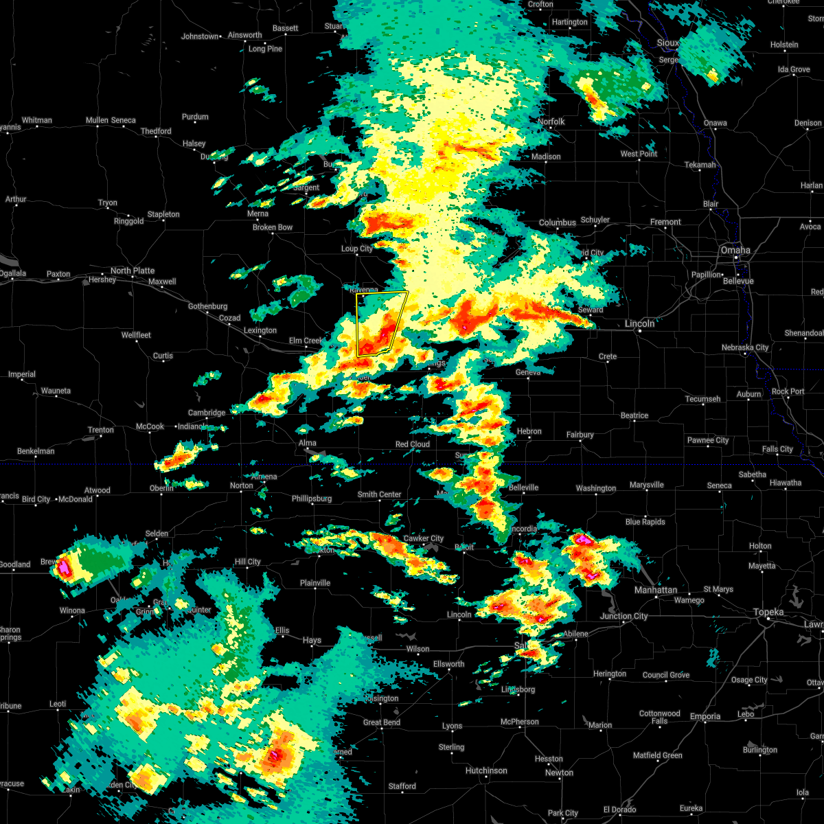 The severe thunderstorm warning for eastern buffalo and western hall counties will expire at 745 pm cdt, the storms which prompted the warning have weakened below severe limits, and no longer pose an immediate threat to life or property. therefore, the warning will be allowed to expire. The severe thunderstorm warning for eastern buffalo and western hall counties will expire at 745 pm cdt, the storms which prompted the warning have weakened below severe limits, and no longer pose an immediate threat to life or property. therefore, the warning will be allowed to expire.
|
| 5/23/2019 7:32 PM CDT |
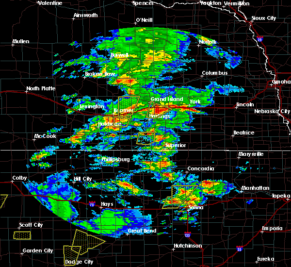 At 732 pm cdt, severe thunderstorms were located along a line extending from 8 miles northwest of heartwell to near gibbon, moving north at 20 mph (radar indicated). Hazards include quarter size hail. Damage to vehicles is expected. locations impacted include, gibbon, ravenna, shelton, cairo and poole. This includes interstate 80 between mile markers 280 and 293. At 732 pm cdt, severe thunderstorms were located along a line extending from 8 miles northwest of heartwell to near gibbon, moving north at 20 mph (radar indicated). Hazards include quarter size hail. Damage to vehicles is expected. locations impacted include, gibbon, ravenna, shelton, cairo and poole. This includes interstate 80 between mile markers 280 and 293.
|
| 5/23/2019 7:15 PM CDT |
 The national weather service in hastings has issued a * severe thunderstorm warning for. northeastern kearney county in south central nebraska. eastern buffalo county in south central nebraska. western hall county in south central nebraska. Until 745 pm cdt. The national weather service in hastings has issued a * severe thunderstorm warning for. northeastern kearney county in south central nebraska. eastern buffalo county in south central nebraska. western hall county in south central nebraska. Until 745 pm cdt.
|
| 7/18/2018 10:49 PM CDT |
 At 1049 pm cdt, a severe thunderstorm was located near gibbon, or 8 miles east of kearney, moving southeast at 30 mph (radar indicated). Hazards include two inch hail and 60 mph wind gusts. People and animals outdoors will be injured. expect hail damage to roofs, siding, windows, and vehicles. this severe thunderstorm will remain over mainly rural areas of southeastern buffalo county. This includes interstate 80 between mile markers 274 and 292. At 1049 pm cdt, a severe thunderstorm was located near gibbon, or 8 miles east of kearney, moving southeast at 30 mph (radar indicated). Hazards include two inch hail and 60 mph wind gusts. People and animals outdoors will be injured. expect hail damage to roofs, siding, windows, and vehicles. this severe thunderstorm will remain over mainly rural areas of southeastern buffalo county. This includes interstate 80 between mile markers 274 and 292.
|
| 7/18/2018 10:38 PM CDT |
 At 1037 pm cdt, a severe thunderstorm was located 8 miles northwest of gibbon, or 10 miles northeast of kearney, moving south at 40 mph (radar indicated). Hazards include golf ball size hail and 60 mph wind gusts. People and animals outdoors will be injured. expect hail damage to roofs, siding, windows, and vehicles. expect wind damage to roofs, siding, and trees. this severe storm will be near, kearney and gibbon around 1045 pm cdt. This includes interstate 80 between mile markers 274 and 292. At 1037 pm cdt, a severe thunderstorm was located 8 miles northwest of gibbon, or 10 miles northeast of kearney, moving south at 40 mph (radar indicated). Hazards include golf ball size hail and 60 mph wind gusts. People and animals outdoors will be injured. expect hail damage to roofs, siding, windows, and vehicles. expect wind damage to roofs, siding, and trees. this severe storm will be near, kearney and gibbon around 1045 pm cdt. This includes interstate 80 between mile markers 274 and 292.
|
| 7/18/2018 10:20 PM CDT |
 At 1020 pm cdt, a severe thunderstorm was located over poole, or 20 miles north of kearney, moving south at 30 mph (radar indicated). Hazards include golf ball size hail and 60 mph wind gusts. People and animals outdoors will be injured. expect hail damage to roofs, siding, windows, and vehicles. expect wind damage to roofs, siding, and trees. this severe thunderstorm will be near, gibbon and shelton around 1055 pm cdt. This includes interstate 80 between mile markers 274 and 292. At 1020 pm cdt, a severe thunderstorm was located over poole, or 20 miles north of kearney, moving south at 30 mph (radar indicated). Hazards include golf ball size hail and 60 mph wind gusts. People and animals outdoors will be injured. expect hail damage to roofs, siding, windows, and vehicles. expect wind damage to roofs, siding, and trees. this severe thunderstorm will be near, gibbon and shelton around 1055 pm cdt. This includes interstate 80 between mile markers 274 and 292.
|
| 7/18/2018 9:16 PM CDT |
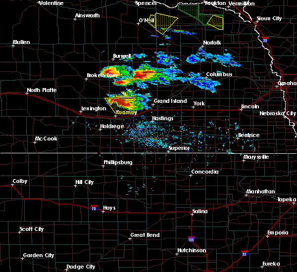 At 916 pm cdt, a severe thunderstorm was located over pleasanton, or 20 miles north of kearney, moving south at 25 mph (radar indicated). Hazards include tennis ball size hail and 60 mph wind gusts. People and animals outdoors will be injured. expect hail damage to roofs, siding, windows, and vehicles. this severe storm will be near, pleasanton around 920 pm cdt. Poole around 925 pm cdt. At 916 pm cdt, a severe thunderstorm was located over pleasanton, or 20 miles north of kearney, moving south at 25 mph (radar indicated). Hazards include tennis ball size hail and 60 mph wind gusts. People and animals outdoors will be injured. expect hail damage to roofs, siding, windows, and vehicles. this severe storm will be near, pleasanton around 920 pm cdt. Poole around 925 pm cdt.
|
| 7/18/2018 9:08 PM CDT |
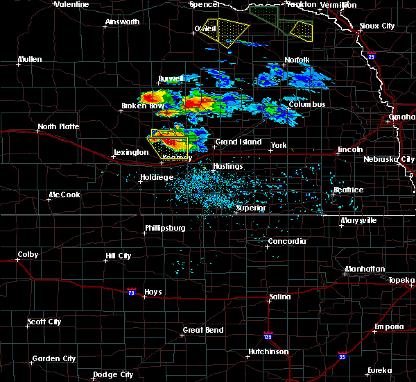 At 907 pm cdt, a severe thunderstorm was located near pleasanton, or 21 miles north of kearney, moving southeast at 30 mph (trained spotters). Hazards include golf ball size hail and 60 mph wind gusts. this storm has a history of producing golf ball size hail around hazard and litchfield. People and animals outdoors will be injured. expect hail damage to roofs, siding, windows, and vehicles. expect wind damage to roofs, siding, and trees. This severe storm will be near, poole around 915 pm cdt. At 907 pm cdt, a severe thunderstorm was located near pleasanton, or 21 miles north of kearney, moving southeast at 30 mph (trained spotters). Hazards include golf ball size hail and 60 mph wind gusts. this storm has a history of producing golf ball size hail around hazard and litchfield. People and animals outdoors will be injured. expect hail damage to roofs, siding, windows, and vehicles. expect wind damage to roofs, siding, and trees. This severe storm will be near, poole around 915 pm cdt.
|
| 7/18/2018 8:48 PM CDT |
 At 848 pm cdt, a severe thunderstorm was located over hazard, or 26 miles north of kearney, moving southeast at 30 mph (radar indicated). Hazards include golf ball size hail and 60 mph wind gusts. People and animals outdoors will be injured. expect hail damage to roofs, siding, windows, and vehicles. expect wind damage to roofs, siding, and trees. this severe thunderstorm will be near, ravenna and pleasanton around 900 pm cdt. poole around 905 pm cdt. Shelton around 930 pm cdt. At 848 pm cdt, a severe thunderstorm was located over hazard, or 26 miles north of kearney, moving southeast at 30 mph (radar indicated). Hazards include golf ball size hail and 60 mph wind gusts. People and animals outdoors will be injured. expect hail damage to roofs, siding, windows, and vehicles. expect wind damage to roofs, siding, and trees. this severe thunderstorm will be near, ravenna and pleasanton around 900 pm cdt. poole around 905 pm cdt. Shelton around 930 pm cdt.
|
| 6/9/2018 1:59 AM CDT | Power line downed by fallen tree. time estimated from radar and nearby ob in buffalo county NE, 0.1 miles E of Shelton, NE |
| 6/1/2018 11:41 PM CDT |
 The severe thunderstorm warning for northeastern phelps, northwestern kearney, southeastern buffalo and west central hall counties will expire at 1145 pm cdt, the storms which prompted the warning have weakened below severe limits, and no longer pose an immediate threat to life or property. therefore the warning will be allowed to expire. however gusty winds are still possible with these thunderstorms. a severe thunderstorm watch remains in effect until 400 am cdt for south central nebraska. The severe thunderstorm warning for northeastern phelps, northwestern kearney, southeastern buffalo and west central hall counties will expire at 1145 pm cdt, the storms which prompted the warning have weakened below severe limits, and no longer pose an immediate threat to life or property. therefore the warning will be allowed to expire. however gusty winds are still possible with these thunderstorms. a severe thunderstorm watch remains in effect until 400 am cdt for south central nebraska.
|
| 6/1/2018 11:33 PM CDT |
 At 1133 pm cdt, severe thunderstorms were located along a line extending from 8 miles south of poole to near odessa to 6 miles south of elm creek, moving east at 20 mph (radar indicated). Hazards include 60 mph wind gusts and quarter size hail. Hail damage to vehicles is expected. expect wind damage to roofs, siding, and trees. locations impacted include, kearney, gibbon, shelton, odessa and riverdale. This includes interstate 80 between mile markers 261 and 286. At 1133 pm cdt, severe thunderstorms were located along a line extending from 8 miles south of poole to near odessa to 6 miles south of elm creek, moving east at 20 mph (radar indicated). Hazards include 60 mph wind gusts and quarter size hail. Hail damage to vehicles is expected. expect wind damage to roofs, siding, and trees. locations impacted include, kearney, gibbon, shelton, odessa and riverdale. This includes interstate 80 between mile markers 261 and 286.
|
| 6/1/2018 11:10 PM CDT |
 At 1110 pm cdt, severe thunderstorms were located along a line extending from 6 miles south of poole to odessa to near bertrand, moving southeast at 25 mph (radar indicated). Hazards include ping pong ball size hail and 60 mph wind gusts. People and animals outdoors will be injured. expect hail damage to roofs, siding, windows, and vehicles. Expect wind damage to roofs, siding, and trees. At 1110 pm cdt, severe thunderstorms were located along a line extending from 6 miles south of poole to odessa to near bertrand, moving southeast at 25 mph (radar indicated). Hazards include ping pong ball size hail and 60 mph wind gusts. People and animals outdoors will be injured. expect hail damage to roofs, siding, windows, and vehicles. Expect wind damage to roofs, siding, and trees.
|
| 5/28/2018 1:25 PM CDT |
 The severe thunderstorm warning for east central buffalo and southwestern hall counties will expire at 130 pm cdt, the storm which prompted the warning has weakened below severe limits, and no longer poses an immediate threat to life or property. therefore the warning will be allowed to expire. however small hail and gusty winds are still possible with this thunderstorm. to report severe weather, contact your nearest law enforcement agency. they will relay your report to the national weather service hastings. The severe thunderstorm warning for east central buffalo and southwestern hall counties will expire at 130 pm cdt, the storm which prompted the warning has weakened below severe limits, and no longer poses an immediate threat to life or property. therefore the warning will be allowed to expire. however small hail and gusty winds are still possible with this thunderstorm. to report severe weather, contact your nearest law enforcement agency. they will relay your report to the national weather service hastings.
|
| 5/28/2018 1:21 PM CDT |
 At 121 pm cdt, a severe thunderstorm was located over wood river, or 13 miles west of grand island, moving north at 20 mph (radar indicated). Hazards include 60 mph wind gusts and quarter size hail. Hail damage to vehicles is expected. expect wind damage to roofs, siding, and trees. locations impacted include, wood river, shelton and alda. This includes interstate 80 between mile markers 291 and 306. At 121 pm cdt, a severe thunderstorm was located over wood river, or 13 miles west of grand island, moving north at 20 mph (radar indicated). Hazards include 60 mph wind gusts and quarter size hail. Hail damage to vehicles is expected. expect wind damage to roofs, siding, and trees. locations impacted include, wood river, shelton and alda. This includes interstate 80 between mile markers 291 and 306.
|
| 5/28/2018 1:09 PM CDT |
 A severe thunderstorm warning remains in effect until 130 pm cdt for east central buffalo and southwestern hall counties. at 109 pm cdt, a severe thunderstorm was located over wood river, or 16 miles southwest of grand island, moving north at 20 mph. hazard. 60 mph wind gusts and quarter size hail. source. Radar indicated. A severe thunderstorm warning remains in effect until 130 pm cdt for east central buffalo and southwestern hall counties. at 109 pm cdt, a severe thunderstorm was located over wood river, or 16 miles southwest of grand island, moving north at 20 mph. hazard. 60 mph wind gusts and quarter size hail. source. Radar indicated.
|
| 5/28/2018 12:54 PM CDT |
 At 1254 pm cdt, a severe thunderstorm was located near shelton, or 18 miles northwest of hastings, moving north at 20 mph (radar indicated). Hazards include ping pong ball size hail and 60 mph wind gusts. People and animals outdoors will be injured. expect hail damage to roofs, siding, windows, and vehicles. Expect wind damage to roofs, siding, and trees. At 1254 pm cdt, a severe thunderstorm was located near shelton, or 18 miles northwest of hastings, moving north at 20 mph (radar indicated). Hazards include ping pong ball size hail and 60 mph wind gusts. People and animals outdoors will be injured. expect hail damage to roofs, siding, windows, and vehicles. Expect wind damage to roofs, siding, and trees.
|
| 5/11/2018 2:43 AM CDT |
 At 242 am cdt, a severe thunderstorm was located near heartwell, or 14 miles east of kearney, moving northeast at 35 mph (radar indicated). Hazards include 60 mph wind gusts and quarter size hail. Hail damage to vehicles is expected. expect wind damage to roofs, siding, and trees. locations impacted include, gibbon, shelton, kenesaw, heartwell and prosser. This includes interstate 80 between mile markers 282 and 299. At 242 am cdt, a severe thunderstorm was located near heartwell, or 14 miles east of kearney, moving northeast at 35 mph (radar indicated). Hazards include 60 mph wind gusts and quarter size hail. Hail damage to vehicles is expected. expect wind damage to roofs, siding, and trees. locations impacted include, gibbon, shelton, kenesaw, heartwell and prosser. This includes interstate 80 between mile markers 282 and 299.
|
| 5/11/2018 2:28 AM CDT |
 At 228 am cdt, a severe thunderstorm was located near minden, or 10 miles southeast of kearney, moving northeast at 35 mph (radar indicated). Hazards include 60 mph wind gusts and quarter size hail. Hail damage to vehicles is expected. Expect wind damage to roofs, siding, and trees. At 228 am cdt, a severe thunderstorm was located near minden, or 10 miles southeast of kearney, moving northeast at 35 mph (radar indicated). Hazards include 60 mph wind gusts and quarter size hail. Hail damage to vehicles is expected. Expect wind damage to roofs, siding, and trees.
|
| 5/11/2018 1:43 AM CDT |
 The national weather service in hastings has issued a * severe thunderstorm warning for. adams county in south central nebraska. eastern kearney county in south central nebraska. southeastern buffalo county in south central nebraska. Southern hall county in south central nebraska. The national weather service in hastings has issued a * severe thunderstorm warning for. adams county in south central nebraska. eastern kearney county in south central nebraska. southeastern buffalo county in south central nebraska. Southern hall county in south central nebraska.
|
| 5/11/2018 1:27 AM CDT |
 The severe thunderstorm warning for phelps, kearney, buffalo, southeastern dawson and southwestern hall counties will expire at 130 am cdt, the storm which prompted the warning has weakened below severe limits, and no longer poses an immediate threat to life or property. therefore the warning will be allowed to expire. however small hail and gusty winds are still possible with this thunderstorm. a severe thunderstorm watch remains in effect until 300 am cdt for south central nebraska. The severe thunderstorm warning for phelps, kearney, buffalo, southeastern dawson and southwestern hall counties will expire at 130 am cdt, the storm which prompted the warning has weakened below severe limits, and no longer poses an immediate threat to life or property. therefore the warning will be allowed to expire. however small hail and gusty winds are still possible with this thunderstorm. a severe thunderstorm watch remains in effect until 300 am cdt for south central nebraska.
|
| 5/11/2018 12:44 AM CDT |
 At 1243 am cdt, a severe thunderstorm was located near elm creek, or 16 miles east of lexington, moving east at 40 mph (radar indicated). Hazards include 60 mph wind gusts and penny size hail. expect damage to roofs, siding, and trees At 1243 am cdt, a severe thunderstorm was located near elm creek, or 16 miles east of lexington, moving east at 40 mph (radar indicated). Hazards include 60 mph wind gusts and penny size hail. expect damage to roofs, siding, and trees
|
| 5/11/2018 12:30 AM CDT |
 At 1227 am cdt, severe thunderstorms were located along a line extending from near dannebrog to heartwell to near hildreth to near huntley, moving southeast at 40 mph (trained weather spotters. numerous reports continue to come in from trained spotters and automated observing equipment indicating fairly widespread 60 to 70 mph winds associated with the leading gust front and then with the thunderstorms back behind the gust front. gustnadoes have also been reported along the gust front, which are comparable to very strong dust devils). Hazards include 70 mph wind gusts and penny size hail. Expect considerable tree damage. damage is likely to mobile homes, roofs, and outbuildings. locations impacted include, kearney, holdrege, minden, st. paul, gibbon, ravenna, wood river, shelton, loup city, kenesaw, cairo, bertrand, axtell, loomis, hildreth, wilcox, pleasanton, dannebrog, wolbach and elba. This includes interstate 80 between mile markers 264 and 304. At 1227 am cdt, severe thunderstorms were located along a line extending from near dannebrog to heartwell to near hildreth to near huntley, moving southeast at 40 mph (trained weather spotters. numerous reports continue to come in from trained spotters and automated observing equipment indicating fairly widespread 60 to 70 mph winds associated with the leading gust front and then with the thunderstorms back behind the gust front. gustnadoes have also been reported along the gust front, which are comparable to very strong dust devils). Hazards include 70 mph wind gusts and penny size hail. Expect considerable tree damage. damage is likely to mobile homes, roofs, and outbuildings. locations impacted include, kearney, holdrege, minden, st. paul, gibbon, ravenna, wood river, shelton, loup city, kenesaw, cairo, bertrand, axtell, loomis, hildreth, wilcox, pleasanton, dannebrog, wolbach and elba. This includes interstate 80 between mile markers 264 and 304.
|
| 5/11/2018 12:06 AM CDT |
 At 1204 am cdt, severe thunderstorms were located along a line extending from near rockville to near kearney to near oxford, moving southeast at 30 mph (trained weather spotters reported damaging wind gusts along the outflow ahead of the thunderstorms). Hazards include 70 mph wind gusts. Expect considerable tree damage. Damage is likely to mobile homes, roofs, and outbuildings. At 1204 am cdt, severe thunderstorms were located along a line extending from near rockville to near kearney to near oxford, moving southeast at 30 mph (trained weather spotters reported damaging wind gusts along the outflow ahead of the thunderstorms). Hazards include 70 mph wind gusts. Expect considerable tree damage. Damage is likely to mobile homes, roofs, and outbuildings.
|
| 10/1/2017 10:07 PM CDT |
 The severe thunderstorm warning for northeastern phelps, northern kearney and buffalo counties will expire at 1015 pm cdt, the storm which prompted the warning has weakened below severe limits, and no longer poses an immediate threat to life or property. therefore the warning will be allowed to expire. however small hail, gusty winds and heavy rain are still possible with this thunderstorm. a tornado watch remains in effect until 1100 pm cdt for south central nebraska. a severe thunderstorm watch remains in effect until 100 am cdt for south central nebraska. The severe thunderstorm warning for northeastern phelps, northern kearney and buffalo counties will expire at 1015 pm cdt, the storm which prompted the warning has weakened below severe limits, and no longer poses an immediate threat to life or property. therefore the warning will be allowed to expire. however small hail, gusty winds and heavy rain are still possible with this thunderstorm. a tornado watch remains in effect until 1100 pm cdt for south central nebraska. a severe thunderstorm watch remains in effect until 100 am cdt for south central nebraska.
|
| 10/1/2017 9:51 PM CDT |
 At 951 pm cdt, a severe thunderstorm was located near kearney, moving east at 55 mph (radar indicated). Hazards include 60 mph wind gusts and quarter size hail. Hail damage to vehicles is expected. expect wind damage to roofs, siding, and trees. locations impacted include, kearney, minden, gibbon, shelton, elm creek, axtell, odessa, amherst, riverdale, heartwell and norman. this includes interstate 80 between mile markers 255 and 292. A tornado watch remains in effect until 1100 pm cdt for south central nebraska. At 951 pm cdt, a severe thunderstorm was located near kearney, moving east at 55 mph (radar indicated). Hazards include 60 mph wind gusts and quarter size hail. Hail damage to vehicles is expected. expect wind damage to roofs, siding, and trees. locations impacted include, kearney, minden, gibbon, shelton, elm creek, axtell, odessa, amherst, riverdale, heartwell and norman. this includes interstate 80 between mile markers 255 and 292. A tornado watch remains in effect until 1100 pm cdt for south central nebraska.
|
| 10/1/2017 9:31 PM CDT |
 At 930 pm cdt, a severe thunderstorm was located near elm creek, or 12 miles west of kearney, moving east at 60 mph. this warning replaces the previous warning in effect for buffalo and phelps county (radar indicated). Hazards include 70 mph wind gusts and quarter size hail. Hail damage to vehicles is expected. expect considerable tree damage. Wind damage is also likely to mobile homes, roofs, and outbuildings. At 930 pm cdt, a severe thunderstorm was located near elm creek, or 12 miles west of kearney, moving east at 60 mph. this warning replaces the previous warning in effect for buffalo and phelps county (radar indicated). Hazards include 70 mph wind gusts and quarter size hail. Hail damage to vehicles is expected. expect considerable tree damage. Wind damage is also likely to mobile homes, roofs, and outbuildings.
|
| 8/27/2017 4:48 AM CDT |
 At 446 am cdt, severe thunderstorms were located along a line extending from near kenesaw to near minden to near axtell, moving southeast at 40 mph (radar indicated). Hazards include 60 mph wind gusts. Expect damage to roofs, siding, and trees. locations impacted include, grand island, kearney, gibbon, wood river, shelton, elm creek, doniphan, cairo, alda, odessa, amherst and riverdale. This includes interstate 80 between mile markers 255 and 316. At 446 am cdt, severe thunderstorms were located along a line extending from near kenesaw to near minden to near axtell, moving southeast at 40 mph (radar indicated). Hazards include 60 mph wind gusts. Expect damage to roofs, siding, and trees. locations impacted include, grand island, kearney, gibbon, wood river, shelton, elm creek, doniphan, cairo, alda, odessa, amherst and riverdale. This includes interstate 80 between mile markers 255 and 316.
|
| 8/27/2017 4:30 AM CDT |
 At 429 am cdt, severe thunderstorms were located along a line extending from gibbon to near kearney to 6 miles southwest of odessa, moving southeast at 40 mph (radar indicated. at kearney 58 mph wind gust was measured). Hazards include 70 mph wind gusts. Expect considerable tree damage. Damage is likely to mobile homes, roofs, and outbuildings. At 429 am cdt, severe thunderstorms were located along a line extending from gibbon to near kearney to 6 miles southwest of odessa, moving southeast at 40 mph (radar indicated. at kearney 58 mph wind gust was measured). Hazards include 70 mph wind gusts. Expect considerable tree damage. Damage is likely to mobile homes, roofs, and outbuildings.
|
| 8/27/2017 4:10 AM CDT |
 At 408 am cdt, severe thunderstorms were located along a line extending from near wood river to near prosser to near kearney, moving southeast at 55 mph (emergency management. at 405am power lines were down near pleasanton). Hazards include 70 mph wind gusts and quarter size hail. Hail damage to vehicles is expected. expect considerable tree damage. wind damage is also likely to mobile homes, roofs, and outbuildings. locations impacted include, grand island, kearney, lexington, cozad, gibbon, ravenna, wood river, shelton, elm creek, doniphan, cairo, alda, overton, odessa, pleasanton, amherst, sumner, riverdale, miller and eddyville. This includes interstate 80 between mile markers 218 and 317. At 408 am cdt, severe thunderstorms were located along a line extending from near wood river to near prosser to near kearney, moving southeast at 55 mph (emergency management. at 405am power lines were down near pleasanton). Hazards include 70 mph wind gusts and quarter size hail. Hail damage to vehicles is expected. expect considerable tree damage. wind damage is also likely to mobile homes, roofs, and outbuildings. locations impacted include, grand island, kearney, lexington, cozad, gibbon, ravenna, wood river, shelton, elm creek, doniphan, cairo, alda, overton, odessa, pleasanton, amherst, sumner, riverdale, miller and eddyville. This includes interstate 80 between mile markers 218 and 317.
|
| 8/27/2017 3:43 AM CDT |
 At 343 am cdt, severe thunderstorms were located along a line extending from near boelus to 6 miles east of poole to 7 miles west of pleasanton, moving southeast at 55 mph (radar indicated). Hazards include 60 mph wind gusts and quarter size hail. Hail damage to vehicles is expected. Expect wind damage to roofs, siding, and trees. At 343 am cdt, severe thunderstorms were located along a line extending from near boelus to 6 miles east of poole to 7 miles west of pleasanton, moving southeast at 55 mph (radar indicated). Hazards include 60 mph wind gusts and quarter size hail. Hail damage to vehicles is expected. Expect wind damage to roofs, siding, and trees.
|
| 8/19/2017 11:40 PM CDT |
 The severe thunderstorm warning for northeastern kearney and southeastern buffalo counties will expire at 1145 pm cdt, the storm which prompted the warning has weakened below severe limits, and no longer poses an immediate threat to life or property. therefore the warning will be allowed to expire. a severe thunderstorm watch remains in effect until 100 am cdt for south central nebraska. The severe thunderstorm warning for northeastern kearney and southeastern buffalo counties will expire at 1145 pm cdt, the storm which prompted the warning has weakened below severe limits, and no longer poses an immediate threat to life or property. therefore the warning will be allowed to expire. a severe thunderstorm watch remains in effect until 100 am cdt for south central nebraska.
|
| 8/19/2017 11:32 PM CDT |
 At 1132 pm cdt, a severe thunderstorm was located over gibbon, or 10 miles east of kearney, moving east at 20 mph (radar indicated). Hazards include 60 mph wind gusts and quarter size hail. Hail damage to vehicles is expected. expect wind damage to roofs, siding, and trees. locations impacted include, gibbon, shelton and heartwell. This includes interstate 80 between mile markers 280 and 292. At 1132 pm cdt, a severe thunderstorm was located over gibbon, or 10 miles east of kearney, moving east at 20 mph (radar indicated). Hazards include 60 mph wind gusts and quarter size hail. Hail damage to vehicles is expected. expect wind damage to roofs, siding, and trees. locations impacted include, gibbon, shelton and heartwell. This includes interstate 80 between mile markers 280 and 292.
|
| 8/19/2017 11:22 PM CDT |
 At 1122 pm cdt, a severe thunderstorm was located near gibbon, or near kearney, moving east at 15 mph (radar indicated). Hazards include 60 mph wind gusts and quarter size hail. Hail damage to vehicles is expected. expect wind damage to roofs, siding, and trees. locations impacted include, kearney, gibbon, shelton and heartwell. This includes interstate 80 between mile markers 276 and 292. At 1122 pm cdt, a severe thunderstorm was located near gibbon, or near kearney, moving east at 15 mph (radar indicated). Hazards include 60 mph wind gusts and quarter size hail. Hail damage to vehicles is expected. expect wind damage to roofs, siding, and trees. locations impacted include, kearney, gibbon, shelton and heartwell. This includes interstate 80 between mile markers 276 and 292.
|
| 8/19/2017 10:57 PM CDT |
 At 1057 pm cdt, a severe thunderstorm was located over kearney, moving east at 20 mph (radar indicated). Hazards include 60 mph wind gusts and penny size hail. expect damage to roofs, siding, and trees At 1057 pm cdt, a severe thunderstorm was located over kearney, moving east at 20 mph (radar indicated). Hazards include 60 mph wind gusts and penny size hail. expect damage to roofs, siding, and trees
|
| 8/3/2017 12:16 AM CDT |
 At 1215 am cdt, severe thunderstorms were located along a line extending from near alda to near shelton, moving southeast at 30 mph (trained weather spotters). Hazards include 60 mph wind gusts and quarter size hail. Hail damage to vehicles is expected. Expect wind damage to roofs, siding, and trees. At 1215 am cdt, severe thunderstorms were located along a line extending from near alda to near shelton, moving southeast at 30 mph (trained weather spotters). Hazards include 60 mph wind gusts and quarter size hail. Hail damage to vehicles is expected. Expect wind damage to roofs, siding, and trees.
|
| 6/27/2017 6:30 PM CDT |
 At 1124 pm cdt, severe thunderstorms were located along a line extending from near alda to near juniata to norman to near wilcox, moving east at 90 mph (radar indicated). Hazards include 60 mph wind gusts and penny size hail. expect damage to roofs, siding, and trees At 1124 pm cdt, severe thunderstorms were located along a line extending from near alda to near juniata to norman to near wilcox, moving east at 90 mph (radar indicated). Hazards include 60 mph wind gusts and penny size hail. expect damage to roofs, siding, and trees
|
| 6/27/2017 6:25 PM CDT |
 At 1124 pm cdt, severe thunderstorms were located along a line extending from near alda to near juniata to norman to near wilcox, moving east at 90 mph (radar indicated). Hazards include 60 mph wind gusts and penny size hail. expect damage to roofs, siding, and trees At 1124 pm cdt, severe thunderstorms were located along a line extending from near alda to near juniata to norman to near wilcox, moving east at 90 mph (radar indicated). Hazards include 60 mph wind gusts and penny size hail. expect damage to roofs, siding, and trees
|
| 6/27/2017 5:54 PM CDT |
 At 1054 pm cdt, severe thunderstorms were located along a line extending from near ravenna to 7 miles northeast of riverdale to 9 miles south of elm creek to 7 miles southwest of loomis, moving east at 60 mph (radar indicated). Hazards include 70 mph wind gusts and nickel size hail. Expect considerable tree damage. damage is likely to mobile homes, roofs, and outbuildings. locations impacted include, grand island, kearney, hastings, holdrege, minden, gibbon, ravenna, wood river, shelton, elm creek, kenesaw, doniphan, cairo, juniata, axtell, alda, odessa, loomis, wilcox and pleasanton. This includes interstate 80 between mile markers 256 and 316. At 1054 pm cdt, severe thunderstorms were located along a line extending from near ravenna to 7 miles northeast of riverdale to 9 miles south of elm creek to 7 miles southwest of loomis, moving east at 60 mph (radar indicated). Hazards include 70 mph wind gusts and nickel size hail. Expect considerable tree damage. damage is likely to mobile homes, roofs, and outbuildings. locations impacted include, grand island, kearney, hastings, holdrege, minden, gibbon, ravenna, wood river, shelton, elm creek, kenesaw, doniphan, cairo, juniata, axtell, alda, odessa, loomis, wilcox and pleasanton. This includes interstate 80 between mile markers 256 and 316.
|
| 6/27/2017 5:42 PM CDT |
 At 1041 pm cdt, severe thunderstorms were located along a line extending from near pleasanton to amherst to near bertrand to 7 miles northeast of arapahoe, moving east at 60 mph (radar indicated). Hazards include 70 mph wind gusts and nickel size hail. Expect considerable tree damage. Damage is likely to mobile homes, roofs, and outbuildings. At 1041 pm cdt, severe thunderstorms were located along a line extending from near pleasanton to amherst to near bertrand to 7 miles northeast of arapahoe, moving east at 60 mph (radar indicated). Hazards include 70 mph wind gusts and nickel size hail. Expect considerable tree damage. Damage is likely to mobile homes, roofs, and outbuildings.
|
| 5/16/2017 7:42 PM CDT |
 The severe thunderstorm warning for buffalo county will expire at 745 pm cdt, the storms which prompted the warning have weakened below severe limits, and have exited the warned area. therefore, the warning will be allowed to expire. however gusty winds are still possible with these thunderstorms. a severe thunderstorm watch remains in effect until midnight cdt for south central nebraska. a severe thunderstorm watch also remains in effect until midnight cdt for south central and central nebraska. The severe thunderstorm warning for buffalo county will expire at 745 pm cdt, the storms which prompted the warning have weakened below severe limits, and have exited the warned area. therefore, the warning will be allowed to expire. however gusty winds are still possible with these thunderstorms. a severe thunderstorm watch remains in effect until midnight cdt for south central nebraska. a severe thunderstorm watch also remains in effect until midnight cdt for south central and central nebraska.
|
| 5/16/2017 7:24 PM CDT |
 At 723 pm cdt, severe thunderstorms were located along a line extending from 6 miles northeast of overton to near pleasanton to near wood river, moving north at 45 mph (radar indicated). Hazards include 60 mph wind gusts. Expect damage to roofs, siding, and trees. locations impacted include, kearney, gibbon, ravenna, shelton, elm creek, odessa, pleasanton, amherst, riverdale, miller and poole. This includes interstate 80 between mile markers 255 and 292. At 723 pm cdt, severe thunderstorms were located along a line extending from 6 miles northeast of overton to near pleasanton to near wood river, moving north at 45 mph (radar indicated). Hazards include 60 mph wind gusts. Expect damage to roofs, siding, and trees. locations impacted include, kearney, gibbon, ravenna, shelton, elm creek, odessa, pleasanton, amherst, riverdale, miller and poole. This includes interstate 80 between mile markers 255 and 292.
|
| 5/16/2017 7:03 PM CDT |
 At 703 pm cdt, severe thunderstorms were located along a line extending from 7 miles northeast of bertrand to near kearney to near kenesaw, moving north at 45 mph (radar indicated). Hazards include 70 mph wind gusts. Expect considerable tree damage. Damage is likely to mobile homes, roofs, and outbuildings. At 703 pm cdt, severe thunderstorms were located along a line extending from 7 miles northeast of bertrand to near kearney to near kenesaw, moving north at 45 mph (radar indicated). Hazards include 70 mph wind gusts. Expect considerable tree damage. Damage is likely to mobile homes, roofs, and outbuildings.
|
| 4/9/2017 6:54 PM CDT |
 The severe thunderstorm warning for eastern kearney and southeastern buffalo counties will expire at 700 pm cdt, the storms which prompted the warning have moved out of the area. therefore the warning will be allowed to expire. The severe thunderstorm warning for eastern kearney and southeastern buffalo counties will expire at 700 pm cdt, the storms which prompted the warning have moved out of the area. therefore the warning will be allowed to expire.
|
| 4/9/2017 6:43 PM CDT |
 At 643 pm cdt, severe thunderstorms were located along a line extending from near gibbon to near norman to near campbell, moving east at 40 mph (radar indicated). Hazards include 60 mph wind gusts. Expect damage to roofs, siding, and trees. locations impacted include, minden, gibbon, shelton, heartwell and norman. This includes interstate 80 between mile markers 277 and 292. At 643 pm cdt, severe thunderstorms were located along a line extending from near gibbon to near norman to near campbell, moving east at 40 mph (radar indicated). Hazards include 60 mph wind gusts. Expect damage to roofs, siding, and trees. locations impacted include, minden, gibbon, shelton, heartwell and norman. This includes interstate 80 between mile markers 277 and 292.
|
| 4/9/2017 6:27 PM CDT |
 At 625 pm cdt, severe thunderstorms were located along a line extending from near riverdale to near minden to near upland, moving east at 55 mph (trained weather spotters. this storm has a history of producing large hail with the largest hail located across southern kearney county). Hazards include ping pong ball size hail and 60 mph wind gusts. People and animals outdoors will be injured. expect hail damage to roofs, siding, windows, and vehicles. expect wind damage to roofs, siding, and trees. locations impacted include, kearney, minden, gibbon, shelton, axtell, wilcox, riverdale, heartwell and norman. This includes interstate 80 between mile markers 266 and 292. At 625 pm cdt, severe thunderstorms were located along a line extending from near riverdale to near minden to near upland, moving east at 55 mph (trained weather spotters. this storm has a history of producing large hail with the largest hail located across southern kearney county). Hazards include ping pong ball size hail and 60 mph wind gusts. People and animals outdoors will be injured. expect hail damage to roofs, siding, windows, and vehicles. expect wind damage to roofs, siding, and trees. locations impacted include, kearney, minden, gibbon, shelton, axtell, wilcox, riverdale, heartwell and norman. This includes interstate 80 between mile markers 266 and 292.
|
| 4/9/2017 6:04 PM CDT |
 At 604 pm cdt, severe thunderstorms were located along a line extending from elm creek to 9 miles south of odessa to near funk to wilcox, moving east at 45 mph (radar indicated). Hazards include 70 mph wind gusts and nickel size hail. Expect considerable tree damage. Damage is likely to mobile homes, roofs, and outbuildings. At 604 pm cdt, severe thunderstorms were located along a line extending from elm creek to 9 miles south of odessa to near funk to wilcox, moving east at 45 mph (radar indicated). Hazards include 70 mph wind gusts and nickel size hail. Expect considerable tree damage. Damage is likely to mobile homes, roofs, and outbuildings.
|
| 3/23/2017 10:17 PM CDT |
 At 1016 pm cdt, severe thunderstorms were producing severe outflow wind extending from near eddyville to near giltner, moving northeast at 35 mph (radar indicated). Hazards include 70 mph wind gusts. Expect considerable tree damage. Damage is likely to mobile homes, roofs, and outbuildings. At 1016 pm cdt, severe thunderstorms were producing severe outflow wind extending from near eddyville to near giltner, moving northeast at 35 mph (radar indicated). Hazards include 70 mph wind gusts. Expect considerable tree damage. Damage is likely to mobile homes, roofs, and outbuildings.
|
| 3/23/2017 9:43 PM CDT |
 At 940 pm cdt, severe thunderstorms were located along a line extending from elm creek to near upland to near athol, moving east at 70 mph (emergency management). Hazards include 70 mph wind gusts. Expect considerable tree damage. damage is likely to mobile homes, roofs, and outbuildings. several locations outside of rainfall have reported blowing dust reducing visibility to less than a quarter mile. stop signs and trees have been blown over. power lines are down in arapahoe. locations impacted include, kearney, hastings, holdrege, phillipsburg, minden, gibbon, smith center, ravenna, wood river, alma, shelton, arapahoe, red cloud, franklin, blue hill, elm creek, kenesaw, oxford, juniata and bertrand. This includes interstate 80 between mile markers 240 and 306. At 940 pm cdt, severe thunderstorms were located along a line extending from elm creek to near upland to near athol, moving east at 70 mph (emergency management). Hazards include 70 mph wind gusts. Expect considerable tree damage. damage is likely to mobile homes, roofs, and outbuildings. several locations outside of rainfall have reported blowing dust reducing visibility to less than a quarter mile. stop signs and trees have been blown over. power lines are down in arapahoe. locations impacted include, kearney, hastings, holdrege, phillipsburg, minden, gibbon, smith center, ravenna, wood river, alma, shelton, arapahoe, red cloud, franklin, blue hill, elm creek, kenesaw, oxford, juniata and bertrand. This includes interstate 80 between mile markers 240 and 306.
|
| 3/23/2017 9:25 PM CDT |
 At 924 pm cdt, severe thunderstorms were located along a line extending from near smithfield to 7 miles southwest of hildreth to near kirwin, moving northeast at 70 mph (emergency management). Hazards include 70 mph wind gusts. Expect considerable tree damage. Damage is likely to mobile homes, roofs, and outbuildings. At 924 pm cdt, severe thunderstorms were located along a line extending from near smithfield to 7 miles southwest of hildreth to near kirwin, moving northeast at 70 mph (emergency management). Hazards include 70 mph wind gusts. Expect considerable tree damage. Damage is likely to mobile homes, roofs, and outbuildings.
|
| 12/25/2016 12:45 PM CST |
 At 1244 pm cst, severe thunderstorms were located along a line extending from near rockville to 6 miles south of cairo to prosser, moving east at 45 mph (radar indicated). Hazards include 60 mph wind gusts and penny size hail. Expect damage to roofs, siding, and trees. locations impacted include, grand island, st. paul, wood river, shelton, doniphan, cairo, alda, dannebrog, elba, ashton, howard city, farwell, rockville, prosser, cushing, boelus, st. libory and hansen. This includes interstate 80 between mile markers 293 and 317. At 1244 pm cst, severe thunderstorms were located along a line extending from near rockville to 6 miles south of cairo to prosser, moving east at 45 mph (radar indicated). Hazards include 60 mph wind gusts and penny size hail. Expect damage to roofs, siding, and trees. locations impacted include, grand island, st. paul, wood river, shelton, doniphan, cairo, alda, dannebrog, elba, ashton, howard city, farwell, rockville, prosser, cushing, boelus, st. libory and hansen. This includes interstate 80 between mile markers 293 and 317.
|
| 12/25/2016 12:31 PM CST |
 At 1230 pm cst, severe thunderstorms were located along a line extending from near poole to 8 miles north of gibbon to near shelton, moving east at 50 mph (radar indicated). Hazards include 60 mph wind gusts and penny size hail. expect damage to roofs, siding, and trees At 1230 pm cst, severe thunderstorms were located along a line extending from near poole to 8 miles north of gibbon to near shelton, moving east at 50 mph (radar indicated). Hazards include 60 mph wind gusts and penny size hail. expect damage to roofs, siding, and trees
|
| 7/27/2016 1:29 AM CDT |
 At 129 am cdt, severe thunderstorms were located along a line extending from near farwell to near shelton to near oxford, moving southeast at 45 mph (radar indicated). Hazards include 70 mph wind gusts. Expect considerable tree damage. Damage is likely to mobile homes, roofs, and outbuildings. At 129 am cdt, severe thunderstorms were located along a line extending from near farwell to near shelton to near oxford, moving southeast at 45 mph (radar indicated). Hazards include 70 mph wind gusts. Expect considerable tree damage. Damage is likely to mobile homes, roofs, and outbuildings.
|
| 7/7/2016 12:46 AM CDT |
 At 1246 am cdt, severe thunderstorms were located along a line extending from near grand island to near glenvil to lawrence to 6 miles south of guide rock, moving east at 45 mph (radar indicated). Hazards include 70 mph wind gusts and ping pong ball size hail. People and animals outdoors will be injured. expect hail damage to roofs, siding, windows, and vehicles. expect considerable tree damage. wind damage is also likely to mobile homes, roofs, and outbuildings. Locations impacted include, grand island, kearney, hastings, minden, gibbon, wood river, shelton, red cloud, franklin, blue hill, kenesaw, doniphan, juniata, alda, hildreth, campbell, bladen, roseland, guide rock and holstein. At 1246 am cdt, severe thunderstorms were located along a line extending from near grand island to near glenvil to lawrence to 6 miles south of guide rock, moving east at 45 mph (radar indicated). Hazards include 70 mph wind gusts and ping pong ball size hail. People and animals outdoors will be injured. expect hail damage to roofs, siding, windows, and vehicles. expect considerable tree damage. wind damage is also likely to mobile homes, roofs, and outbuildings. Locations impacted include, grand island, kearney, hastings, minden, gibbon, wood river, shelton, red cloud, franklin, blue hill, kenesaw, doniphan, juniata, alda, hildreth, campbell, bladen, roseland, guide rock and holstein.
|
| 7/7/2016 12:08 AM CDT |
 At 1207 am cdt, severe thunderstorms were located along a line extending from 8 miles north of gibbon to near heartwell to campbell to 7 miles southeast of franklin, moving east at 50 mph (radar indicated). Hazards include ping pong ball size hail and 60 mph wind gusts. People and animals outdoors will be injured. expect hail damage to roofs, siding, windows, and vehicles. Expect wind damage to roofs, siding, and trees. At 1207 am cdt, severe thunderstorms were located along a line extending from 8 miles north of gibbon to near heartwell to campbell to 7 miles southeast of franklin, moving east at 50 mph (radar indicated). Hazards include ping pong ball size hail and 60 mph wind gusts. People and animals outdoors will be injured. expect hail damage to roofs, siding, windows, and vehicles. Expect wind damage to roofs, siding, and trees.
|
| 7/6/2016 11:54 PM CDT |
 At 1153 pm cdt, a severe thunderstorm was located over riverdale, or 7 miles northwest of kearney, moving east at 40 mph (radar indicated). Hazards include 60 mph wind gusts and quarter size hail. Hail damage to vehicles is expected. expect wind damage to roofs, siding, and trees. Locations impacted include, kearney, gibbon, ravenna, shelton, elm creek, odessa, amherst and riverdale. At 1153 pm cdt, a severe thunderstorm was located over riverdale, or 7 miles northwest of kearney, moving east at 40 mph (radar indicated). Hazards include 60 mph wind gusts and quarter size hail. Hail damage to vehicles is expected. expect wind damage to roofs, siding, and trees. Locations impacted include, kearney, gibbon, ravenna, shelton, elm creek, odessa, amherst and riverdale.
|
| 7/6/2016 11:38 PM CDT |
 At 1138 pm cdt, a severe thunderstorm was located near elm creek, or 15 miles west of kearney, moving east at 35 mph (radar indicated). Hazards include 60 mph wind gusts and half dollar size hail. Hail damage to vehicles is expected. expect wind damage to roofs, siding, and trees. Locations impacted include, kearney, gibbon, ravenna, shelton, elm creek, overton, odessa, pleasanton, amherst and riverdale. At 1138 pm cdt, a severe thunderstorm was located near elm creek, or 15 miles west of kearney, moving east at 35 mph (radar indicated). Hazards include 60 mph wind gusts and half dollar size hail. Hail damage to vehicles is expected. expect wind damage to roofs, siding, and trees. Locations impacted include, kearney, gibbon, ravenna, shelton, elm creek, overton, odessa, pleasanton, amherst and riverdale.
|
| 7/6/2016 11:35 PM CDT |
 At 1135 pm cdt, a severe thunderstorm was located near elm creek, or 15 miles west of kearney, moving east at 40 mph (radar indicated). Hazards include 60 mph wind gusts and nickel size hail. Expect damage to roofs. siding. And trees. At 1135 pm cdt, a severe thunderstorm was located near elm creek, or 15 miles west of kearney, moving east at 40 mph (radar indicated). Hazards include 60 mph wind gusts and nickel size hail. Expect damage to roofs. siding. And trees.
|
| 5/10/2016 7:48 PM CDT |
 At 747 pm cdt, a severe thunderstorm was located near heartwell, or 15 miles southeast of kearney, moving northeast at 35 mph (radar indicated). Hazards include 60 mph wind gusts and quarter size hail. Hail damage to vehicles is expected. expect wind damage to roofs, siding, and trees. Locations impacted include, kearney, minden, gibbon, wood river, shelton, kenesaw, juniata, heartwell and prosser. At 747 pm cdt, a severe thunderstorm was located near heartwell, or 15 miles southeast of kearney, moving northeast at 35 mph (radar indicated). Hazards include 60 mph wind gusts and quarter size hail. Hail damage to vehicles is expected. expect wind damage to roofs, siding, and trees. Locations impacted include, kearney, minden, gibbon, wood river, shelton, kenesaw, juniata, heartwell and prosser.
|
| 5/10/2016 7:28 PM CDT |
 At 728 pm cdt, a severe thunderstorm was located near minden, or 10 miles southeast of kearney, moving northeast at 30 mph (radar indicated). Hazards include 60 mph wind gusts and quarter size hail. Hail damage to vehicles is expected. Expect wind damage to roofs, siding, and trees. At 728 pm cdt, a severe thunderstorm was located near minden, or 10 miles southeast of kearney, moving northeast at 30 mph (radar indicated). Hazards include 60 mph wind gusts and quarter size hail. Hail damage to vehicles is expected. Expect wind damage to roofs, siding, and trees.
|
| 3/29/2016 8:22 AM CDT |
 The severe thunderstorm warning for east central buffalo and southwestern hall counties will expire at 830 am cdt, the storm which prompted the warning has weakened below severe limits, and no longer poses an immediate threat to life or property. therefore the warning will be allowed to expire. however small hail is still possible with this thunderstorm. The severe thunderstorm warning for east central buffalo and southwestern hall counties will expire at 830 am cdt, the storm which prompted the warning has weakened below severe limits, and no longer poses an immediate threat to life or property. therefore the warning will be allowed to expire. however small hail is still possible with this thunderstorm.
|
| 3/29/2016 8:10 AM CDT |
 At 810 am cdt, a severe thunderstorm was located over shelton, or 20 miles southwest of grand island, moving north at 25 mph (radar indicated). Hazards include quarter size hail. Damage to vehicles is expected. locations impacted include, wood river and shelton. This includes interstate 80 between mile markers 290 and 303. At 810 am cdt, a severe thunderstorm was located over shelton, or 20 miles southwest of grand island, moving north at 25 mph (radar indicated). Hazards include quarter size hail. Damage to vehicles is expected. locations impacted include, wood river and shelton. This includes interstate 80 between mile markers 290 and 303.
|
| 3/29/2016 7:59 AM CDT |
 At 758 am cdt, a severe thunderstorm was located near shelton, or 18 miles east of kearney, moving north at 30 mph (radar indicated). Hazards include quarter size hail. damage to vehicles is expected At 758 am cdt, a severe thunderstorm was located near shelton, or 18 miles east of kearney, moving north at 30 mph (radar indicated). Hazards include quarter size hail. damage to vehicles is expected
|
| 9/10/2015 4:59 PM CDT |
 At 458 pm cdt, a severe thunderstorm was located near gibbon, or 7 miles east of kearney, moving southeast at 40 mph (radar indicated). Hazards include quarter size hail. Damage to vehicles is expected. Locations impacted include, gibbon this includes interstate 80 between mile markers 255 and 292. At 458 pm cdt, a severe thunderstorm was located near gibbon, or 7 miles east of kearney, moving southeast at 40 mph (radar indicated). Hazards include quarter size hail. Damage to vehicles is expected. Locations impacted include, gibbon this includes interstate 80 between mile markers 255 and 292.
|
| 9/10/2015 4:38 PM CDT |
 At 438 pm cdt, severe thunderstorms were located along a line extending from 6 miles northwest of shelton to near riverdale to near amherst, moving east at 35 mph (radar indicated). Hazards include quarter size hail. damage to vehicles is expected At 438 pm cdt, severe thunderstorms were located along a line extending from 6 miles northwest of shelton to near riverdale to near amherst, moving east at 35 mph (radar indicated). Hazards include quarter size hail. damage to vehicles is expected
|
| 8/7/2015 11:49 PM CDT |
 At 1148 pm cdt, a severe thunderstorm was located near heartwell, or 14 miles east of kearney, moving northeast at 15 mph (a trained spotter estimated winds of 60 mph near gibbon). Hazards include 60 mph wind gusts and penny size hail. Expect damage to roofs. siding and trees. this severe thunderstorm will be near, gibbon around 1205 am cdt. shelton around 1225 am cdt. wood river around 1230 am cdt. This includes interstate 80 between mile markers 283 and 305. At 1148 pm cdt, a severe thunderstorm was located near heartwell, or 14 miles east of kearney, moving northeast at 15 mph (a trained spotter estimated winds of 60 mph near gibbon). Hazards include 60 mph wind gusts and penny size hail. Expect damage to roofs. siding and trees. this severe thunderstorm will be near, gibbon around 1205 am cdt. shelton around 1225 am cdt. wood river around 1230 am cdt. This includes interstate 80 between mile markers 283 and 305.
|
| 6/6/2015 4:45 PM CDT | At 444 pm cdt, a severe thunderstorm was located over kearney, moving northeast at 40 mph. this statement is a correction to the current location (radar indicated). Hazards include 60 mph wind gusts and quarter size hail. Hail damage to vehicles is expected. expect wind damage to roofs, siding and trees. this severe storm will be near, gibbon around 505 pm cdt. this includes interstate 80 between mile markers 258 and 287. A tornado watch remains in effect until 900 pm cdt for south central nebraska. |
| 6/6/2015 4:43 PM CDT | At 443 pm cdt, a severe thunderstorm was located near poole, or 18 miles northeast of kearney, moving northeast at 45 mph (radar indicated). Hazards include 60 mph wind gusts and quarter size hail. Hail damage to vehicles is expected. expect wind damage to roofs, siding and trees. this severe thunderstorm will remain over mainly rural areas of buffalo county. this includes interstate 80 between mile markers 258 and 287. A tornado watch remains in effect until 900 pm cdt for south central nebraska. |
| 6/6/2015 4:33 PM CDT | At 433 pm cdt, a severe thunderstorm was located near odessa, or 8 miles southwest of kearney, moving northeast at 45 mph (radar indicated). Hazards include ping pong ball size hail and 60 mph wind gusts. People and animals outdoors will be injured. expect hail damage to roofs, siding, windows and vehicles. Expect wind damage to roofs, siding and trees. |
| 4/18/2015 7:48 PM CDT | At 748 pm cdt, a severe thunderstorm was located near wood river, or 13 miles west of grand island, moving north at 15 mph (radar indicated). Hazards include quarter size hail. Damage to vehicles is expected. locations impacted include, wood river, shelton and cairo. this includes interstate 80 between mile markers 301 and 304. 1. 00in. |
| 4/18/2015 7:39 PM CDT | At 739 pm cdt, a severe thunderstorm was located near wood river, or 13 miles west of grand island, moving north at 15 mph (radar indicated). Hazards include quarter size hail. damage to vehicles is expected |
| 7/9/2014 7:04 PM CDT | Golf Ball sized hail reported 4.5 miles NNE of Shelton, NE, at the i-80 interchange. time est fm radar. |
| 6/20/2014 10:28 PM CDT | Quarter sized hail reported 4.1 miles N of Shelton, NE |
| 5/19/2013 4:00 PM CDT | Quarter sized hail reported 4.8 miles ENE of Shelton, NE |
| 4/14/2012 9:23 PM CDT | Golf Ball sized hail reported 11.2 miles NNE of Shelton, NE |
Hail Maps for Shelton, NE
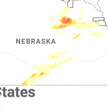
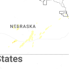


Connect with Interactive Hail Maps