

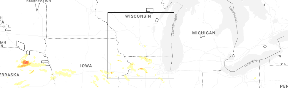
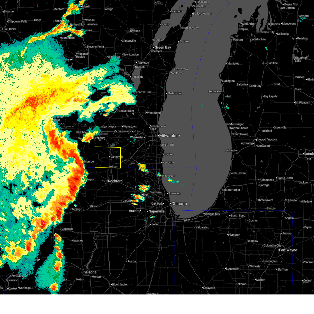
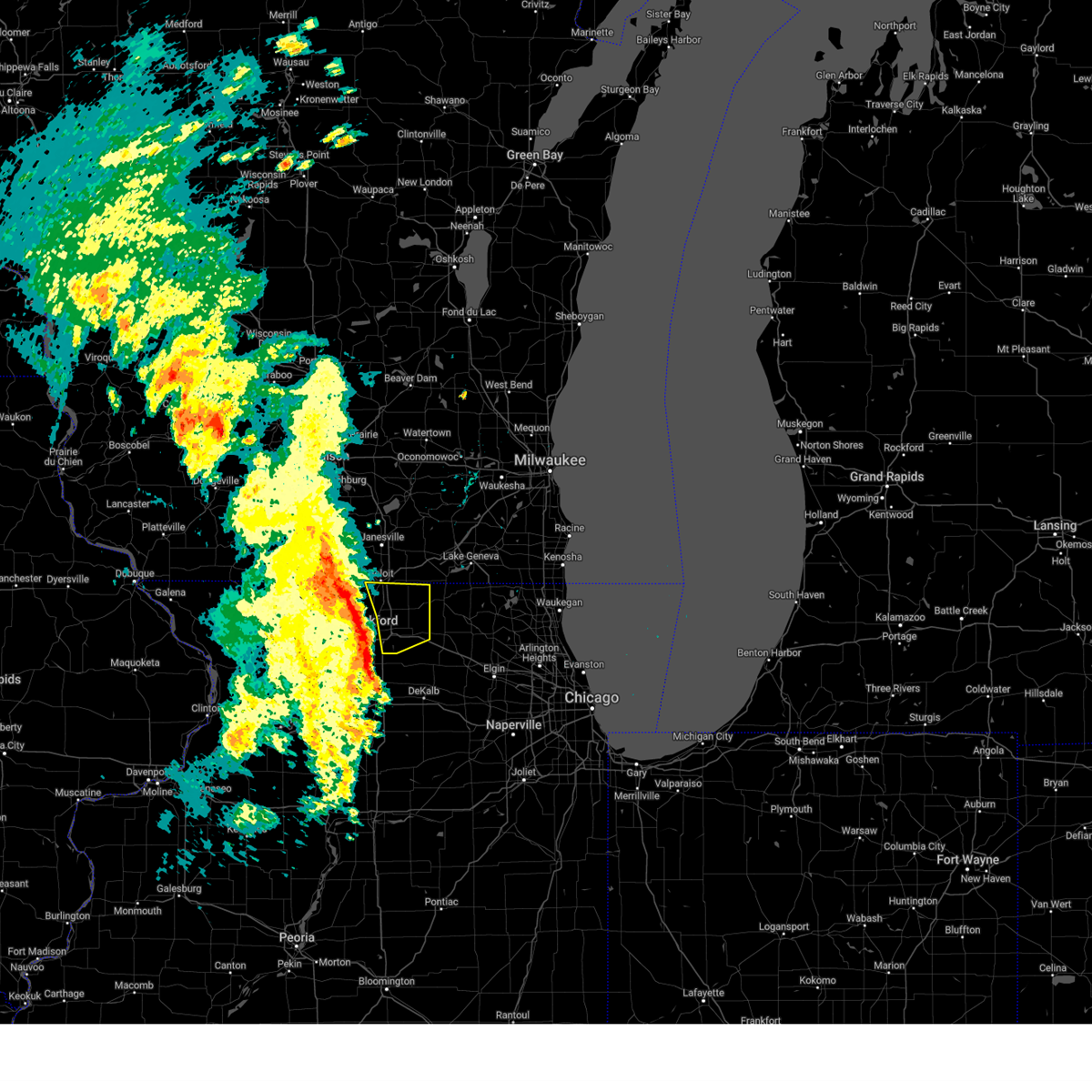
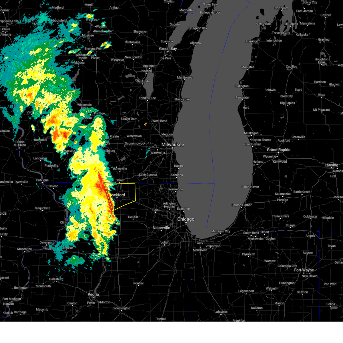
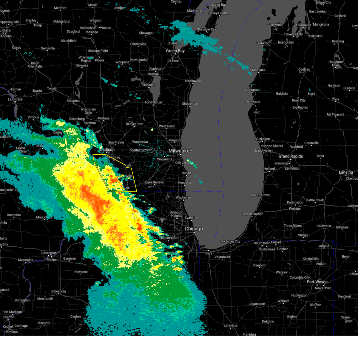
Hail Map for South Beloit, IL
The South Beloit, IL area has had 4 reports of on-the-ground hail by trained spotters, and has been under severe weather warnings 31 times during the past 12 months. Doppler radar has detected hail at or near South Beloit, IL on 72 occasions, including 4 occasions during the past year.
| Name: | South Beloit, IL |
| Where Located: | 44.6 miles SSE of Madison, WI |
| Map: | Google Map for South Beloit, IL |
| Population: | 7892 |
| Housing Units: | 3385 |
| More Info: | Search Google for South Beloit, IL |
1
The Top Recent Hail Date for South Beloit, IL is Thursday, July 10, 2025 (13th out of 72)
Hail and Wind Damage Spotted near South Beloit, IL
| Date / Time | Report Details |
|---|---|
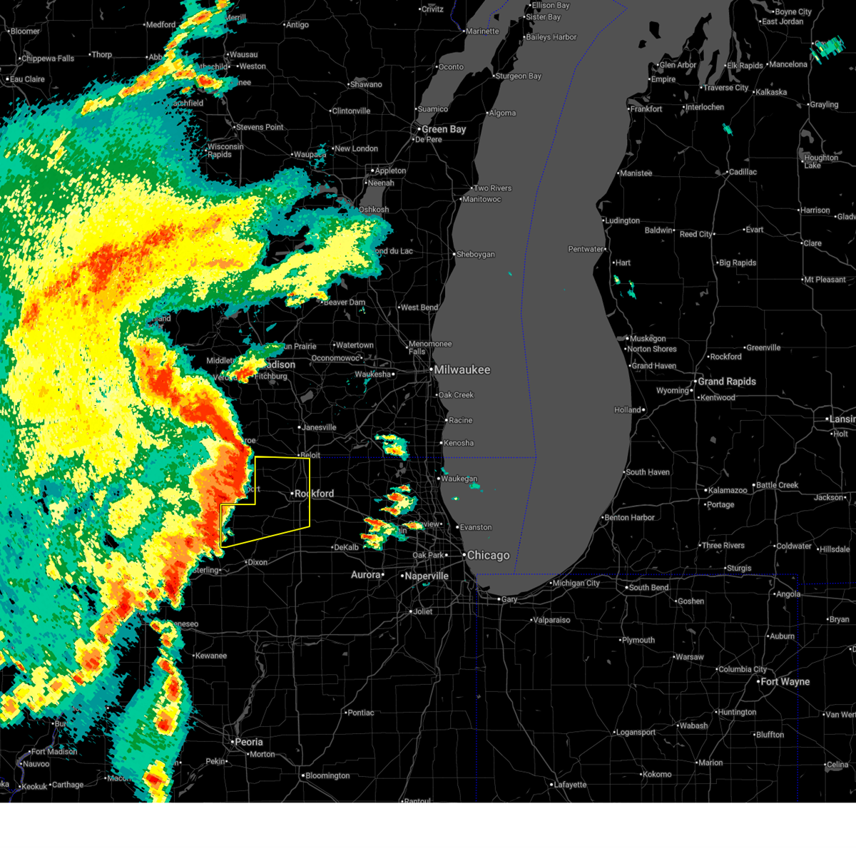
| 7/11/2025 7:10 PM CDT | The storms which prompted the warning have weakened below severe limits, and have exited the warned area. therefore, the warning will be allowed to expire. however, gusty winds up to 40 mph are still possible with these thunderstorms. a tornado watch remains in effect until 1100 pm cdt for north central illinois. |
| 7/11/2025 7:01 PM CDT |
 At 701 pm cdt, severe thunderstorms were located along a line extending from near clinton to near rockford to near stillman valley, moving east at 35 mph (radar indicated). Hazards include 60 mph wind gusts. Expect damage to roofs, siding, and trees. Locations impacted include, new milford, oregon, rockton, byron, rockford airport, winnebago, shirland, lindenwood, machesney park, davis junction, harrison, monroe center, loves park, rockford, cherry valley, south beloit, roscoe, and stillman valley. At 701 pm cdt, severe thunderstorms were located along a line extending from near clinton to near rockford to near stillman valley, moving east at 35 mph (radar indicated). Hazards include 60 mph wind gusts. Expect damage to roofs, siding, and trees. Locations impacted include, new milford, oregon, rockton, byron, rockford airport, winnebago, shirland, lindenwood, machesney park, davis junction, harrison, monroe center, loves park, rockford, cherry valley, south beloit, roscoe, and stillman valley.
|
| 7/11/2025 6:47 PM CDT |
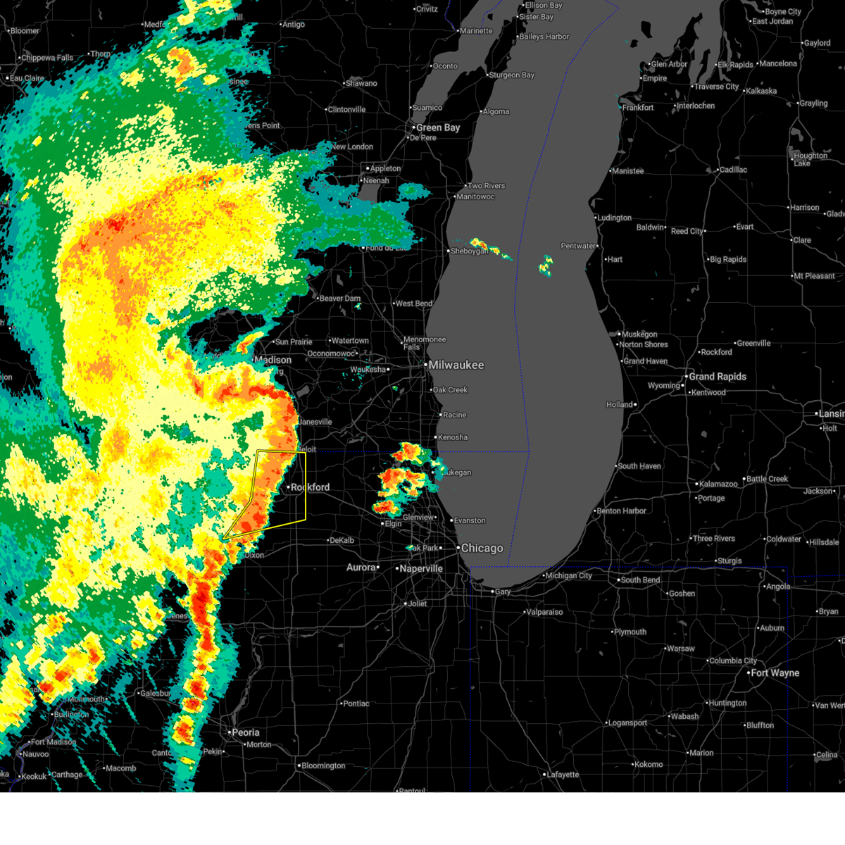 At 646 pm cdt, severe thunderstorms were located along a line extending from near beloit to near winnebago to oregon, moving east at 35 mph (radar indicated). Hazards include 60 mph wind gusts. Expect damage to roofs, siding, and trees. Locations impacted include, new milford, oregon, rockton, byron, leaf river, pecatonica, rockford airport, polo, mount morris, winnebago, shirland, seward, lindenwood, machesney park, davis junction, harrison, monroe center, loves park, rockford, cherry valley, durand, south beloit, roscoe, and stillman valley. At 646 pm cdt, severe thunderstorms were located along a line extending from near beloit to near winnebago to oregon, moving east at 35 mph (radar indicated). Hazards include 60 mph wind gusts. Expect damage to roofs, siding, and trees. Locations impacted include, new milford, oregon, rockton, byron, leaf river, pecatonica, rockford airport, polo, mount morris, winnebago, shirland, seward, lindenwood, machesney park, davis junction, harrison, monroe center, loves park, rockford, cherry valley, durand, south beloit, roscoe, and stillman valley.
|
| 7/11/2025 6:24 PM CDT | At 624 pm cdt, severe thunderstorms were located along a line extending from albany to near durand to near german valley, moving east at 40 mph (radar indicated). Hazards include 60 mph wind gusts and penny size hail. Expect damage to roofs, siding, and trees. Locations impacted include, oregon, pecatonica, rockford airport, polo, baileyville, seward, lindenwood, lake summerset, loves park, cherry valley, south beloit, stillman valley, new milford, rockton, byron, leaf river, mount morris, winnebago, shirland, machesney park, davis junction, adeline, forreston, harrison, and monroe center. |
| 7/11/2025 6:10 PM CDT |
 At 609 pm cdt, severe thunderstorms were located along a line extending from near monticello to dakota to near forreston, moving east at 40 mph (radar indicated). Hazards include 60 mph wind gusts and nickel size hail. Expect damage to roofs, siding, and trees. Locations impacted include, oregon, pecatonica, rockford airport, polo, baileyville, seward, lindenwood, lake summerset, loves park, cherry valley, south beloit, stillman valley, new milford, rockton, byron, leaf river, mount morris, winnebago, shirland, machesney park, davis junction, adeline, forreston, harrison, and monroe center. At 609 pm cdt, severe thunderstorms were located along a line extending from near monticello to dakota to near forreston, moving east at 40 mph (radar indicated). Hazards include 60 mph wind gusts and nickel size hail. Expect damage to roofs, siding, and trees. Locations impacted include, oregon, pecatonica, rockford airport, polo, baileyville, seward, lindenwood, lake summerset, loves park, cherry valley, south beloit, stillman valley, new milford, rockton, byron, leaf river, mount morris, winnebago, shirland, machesney park, davis junction, adeline, forreston, harrison, and monroe center.
|
| 7/11/2025 6:07 PM CDT |
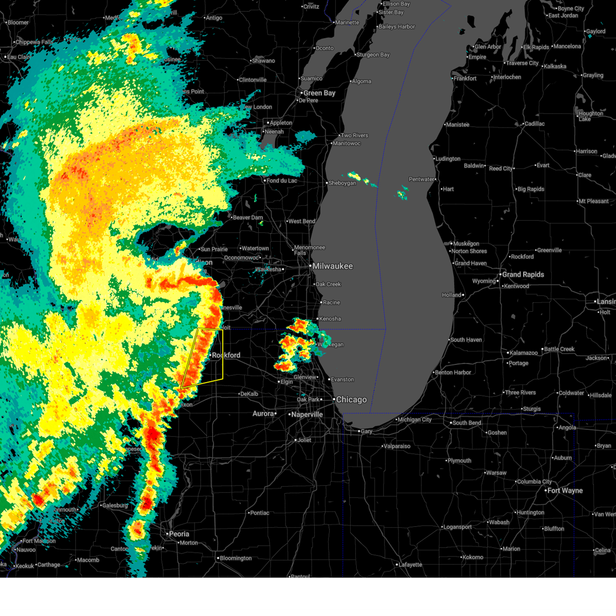
 Svrmkx the national weather service in milwaukee/sullivan has issued a * severe thunderstorm warning for, rock county in south central wisconsin, * until 645 pm cdt. * at 606 pm cdt, severe thunderstorms were located along a line extending from near monticello to near lake summerset to german valley, moving east at 60 mph. these are destructive storms for evansville, janesville, beloit (radar indicated). Hazards include 80 mph wind gusts and quarter size hail. Flying debris will be dangerous to those caught without shelter. mobile homes will be heavily damaged. expect considerable damage to roofs, windows, and vehicles. Extensive tree damage and power outages are likely. Svrmkx the national weather service in milwaukee/sullivan has issued a * severe thunderstorm warning for, rock county in south central wisconsin, * until 645 pm cdt. * at 606 pm cdt, severe thunderstorms were located along a line extending from near monticello to near lake summerset to german valley, moving east at 60 mph. these are destructive storms for evansville, janesville, beloit (radar indicated). Hazards include 80 mph wind gusts and quarter size hail. Flying debris will be dangerous to those caught without shelter. mobile homes will be heavily damaged. expect considerable damage to roofs, windows, and vehicles. Extensive tree damage and power outages are likely.
|
| 7/11/2025 5:59 PM CDT |
 Svrlot the national weather service in chicago has issued a * severe thunderstorm warning for, ogle county in north central illinois, winnebago county in north central illinois, * until 715 pm cdt. * at 559 pm cdt, severe thunderstorms were located along a line extending from near argyle to near cedarville to near shannon, moving east at 40 mph (radar indicated). Hazards include 60 mph wind gusts and nickel size hail. expect damage to roofs, siding, and trees Svrlot the national weather service in chicago has issued a * severe thunderstorm warning for, ogle county in north central illinois, winnebago county in north central illinois, * until 715 pm cdt. * at 559 pm cdt, severe thunderstorms were located along a line extending from near argyle to near cedarville to near shannon, moving east at 40 mph (radar indicated). Hazards include 60 mph wind gusts and nickel size hail. expect damage to roofs, siding, and trees
|
| 7/10/2025 4:59 PM CDT | The storm which prompted the warning has moved out of the area. therefore, the warning will be allowed to expire. however, small hail and heavy rain are still possible with this thunderstorm. remember, a severe thunderstorm warning still remains in effect for areas including roscoe and machesney park until 545 pm cdt. |
| 7/10/2025 4:41 PM CDT |
 At 440 pm cdt, a severe thunderstorm was located over rockton, moving north at 10 mph (radar indicated). Hazards include 60 mph wind gusts and half dollar size hail. Hail damage to vehicles is expected. expect wind damage to roofs, siding, and trees. Locations impacted include, rockton, harrison, loves park, shirland, machesney park, south beloit, and roscoe. At 440 pm cdt, a severe thunderstorm was located over rockton, moving north at 10 mph (radar indicated). Hazards include 60 mph wind gusts and half dollar size hail. Hail damage to vehicles is expected. expect wind damage to roofs, siding, and trees. Locations impacted include, rockton, harrison, loves park, shirland, machesney park, south beloit, and roscoe.
|
| 7/10/2025 4:25 PM CDT |
 Svrlot the national weather service in chicago has issued a * severe thunderstorm warning for, northeastern winnebago county in north central illinois, northwestern boone county in north central illinois, * until 500 pm cdt. * at 425 pm cdt, a severe thunderstorm was located over rockton, moving north at 20 mph (radar indicated). Hazards include 60 mph wind gusts and half dollar size hail. Hail damage to vehicles is expected. Expect wind damage to roofs, siding, and trees. Svrlot the national weather service in chicago has issued a * severe thunderstorm warning for, northeastern winnebago county in north central illinois, northwestern boone county in north central illinois, * until 500 pm cdt. * at 425 pm cdt, a severe thunderstorm was located over rockton, moving north at 20 mph (radar indicated). Hazards include 60 mph wind gusts and half dollar size hail. Hail damage to vehicles is expected. Expect wind damage to roofs, siding, and trees.
|
| 6/25/2025 7:15 PM CDT | At 714 pm cdt, a severe thunderstorm was located near beloit, moving northeast at 25 mph (radar indicated). Hazards include 60 mph wind gusts. Expect damage to roofs, siding, and trees. Locations impacted include, janesville, beloit, south beloit, clinton, tiffany, johnstown center, foxhollow, avalon, shopiere, afton, and emerald grove. |
| 6/25/2025 7:04 PM CDT |
 Svrmkx the national weather service in milwaukee/sullivan has issued a * severe thunderstorm warning for, southeastern rock county in south central wisconsin, * until 745 pm cdt. * at 704 pm cdt, a severe thunderstorm was located over beloit, moving northeast at 25 mph (radar indicated). Hazards include 60 mph wind gusts. expect damage to roofs, siding, and trees Svrmkx the national weather service in milwaukee/sullivan has issued a * severe thunderstorm warning for, southeastern rock county in south central wisconsin, * until 745 pm cdt. * at 704 pm cdt, a severe thunderstorm was located over beloit, moving northeast at 25 mph (radar indicated). Hazards include 60 mph wind gusts. expect damage to roofs, siding, and trees
|
| 6/25/2025 7:02 PM CDT | 7 to 8 inch diameter tree uproote in winnebago county IL, 1.6 miles W of South Beloit, IL |
| 6/25/2025 7:01 PM CDT | Video shared by local broadcast media showing several trees snapped in south beloit off prairie hill road. time estimated by rada in winnebago county IL, 1.4 miles NW of South Beloit, IL |
| 6/3/2025 9:05 PM CDT | Svrmkx the national weather service in milwaukee/sullivan has issued a * severe thunderstorm warning for, western walworth county in southeastern wisconsin, eastern rock county in south central wisconsin, * until 945 pm cdt. * at 905 pm cdt, a severe thunderstorm was located over south beloit, moving northeast at 60 mph (radar indicated). Hazards include 60 mph wind gusts. expect damage to roofs, siding, and trees |
| 6/3/2025 1:04 PM CDT |
 At 103 pm cdt, severe thunderstorms were located along a line extending from rockton to near cherry valley, moving northeast at 50 mph (radar indicated). Hazards include 60 mph wind gusts. Expect damage to roofs, siding, and trees. Locations impacted include, rockton, poplar grove, candlewick lake, machesney park, caledonia, loves park, cherry valley, timberlane, south beloit, roscoe, garden prairie, belvidere, capron, and rockford. At 103 pm cdt, severe thunderstorms were located along a line extending from rockton to near cherry valley, moving northeast at 50 mph (radar indicated). Hazards include 60 mph wind gusts. Expect damage to roofs, siding, and trees. Locations impacted include, rockton, poplar grove, candlewick lake, machesney park, caledonia, loves park, cherry valley, timberlane, south beloit, roscoe, garden prairie, belvidere, capron, and rockford.
|
| 6/3/2025 1:04 PM CDT |
 the severe thunderstorm warning has been cancelled and is no longer in effect the severe thunderstorm warning has been cancelled and is no longer in effect
|
| 6/3/2025 12:50 PM CDT |
 Svrlot the national weather service in chicago has issued a * severe thunderstorm warning for, northeastern ogle county in north central illinois, winnebago county in north central illinois, boone county in north central illinois, * until 130 pm cdt. * at 1250 pm cdt, a severe thunderstorm was located near rockford airport, moving northeast at 45 mph (radar indicated). Hazards include 60 mph wind gusts. expect damage to roofs, siding, and trees Svrlot the national weather service in chicago has issued a * severe thunderstorm warning for, northeastern ogle county in north central illinois, winnebago county in north central illinois, boone county in north central illinois, * until 130 pm cdt. * at 1250 pm cdt, a severe thunderstorm was located near rockford airport, moving northeast at 45 mph (radar indicated). Hazards include 60 mph wind gusts. expect damage to roofs, siding, and trees
|
| 3/15/2025 12:10 AM CDT |
 The storms which prompted the warning have weakened below severe limits, and have exited the warned area. therefore, the warning will be allowed to expire. a severe thunderstorm watch remains in effect until 200 am cdt for north central and northeastern illinois. The storms which prompted the warning have weakened below severe limits, and have exited the warned area. therefore, the warning will be allowed to expire. a severe thunderstorm watch remains in effect until 200 am cdt for north central and northeastern illinois.
|
| 3/14/2025 11:58 PM CDT |
 At 1158 pm cdt, severe thunderstorms were located along a line extending from near fitchburg to near edgerton to near clinton, moving east at 25 mph (radar indicated). Hazards include 60 mph wind gusts. Expect damage to roofs, siding, and trees. Locations impacted include, fulton, oregon, hanover, stoughton, avalon, cooksville, footville, brodhead, brooklyn, dayton, mount vernon, foxhollow, edgerton, orfordville, albany, janesville, fitchburg, attica, belleville, and afton. At 1158 pm cdt, severe thunderstorms were located along a line extending from near fitchburg to near edgerton to near clinton, moving east at 25 mph (radar indicated). Hazards include 60 mph wind gusts. Expect damage to roofs, siding, and trees. Locations impacted include, fulton, oregon, hanover, stoughton, avalon, cooksville, footville, brodhead, brooklyn, dayton, mount vernon, foxhollow, edgerton, orfordville, albany, janesville, fitchburg, attica, belleville, and afton.
|
| 3/14/2025 11:43 PM CDT | At 1143 pm cdt, severe thunderstorms were located along a line extending from near footville to plano, moving northeast at 50 mph (radar indicated). Hazards include 70 mph wind gusts. Expect considerable tree damage. damage is likely to mobile homes, roofs, and outbuildings. Locations impacted include, somonauk, rockford airport, candlewick lake, lindenwood, kingston, fairdale, west brooklyn, kings, malta, loves park, cherry valley, cortland, hillcrest, genoa, south beloit, garden prairie, steward, new milford, rockton, poplar grove, compton, kirkland, machesney park, davis junction, and lee. |
| 3/14/2025 11:35 PM CDT | Report shared via social media of power lines downed on i-90 near south beloit. time estimated by rada in winnebago county IL, 1.6 miles W of South Beloit, IL |
| 3/14/2025 11:35 PM CDT |
 At 1134 pm cdt, severe thunderstorms were located along a line extending from near belleville to near evansville to near beloit, moving northeast at 25 mph (trained weather spotters report tree damage and wind gusts up to 65 mph). Hazards include 70 mph wind gusts. Expect considerable tree damage. damage is likely to mobile homes, roofs, and outbuildings. Locations impacted include, fulton, oregon, hanover, stoughton, avalon, cooksville, footville, brodhead, brooklyn, dayton, mount vernon, foxhollow, edgerton, orfordville, albany, janesville, fitchburg, attica, belleville, and afton. At 1134 pm cdt, severe thunderstorms were located along a line extending from near belleville to near evansville to near beloit, moving northeast at 25 mph (trained weather spotters report tree damage and wind gusts up to 65 mph). Hazards include 70 mph wind gusts. Expect considerable tree damage. damage is likely to mobile homes, roofs, and outbuildings. Locations impacted include, fulton, oregon, hanover, stoughton, avalon, cooksville, footville, brodhead, brooklyn, dayton, mount vernon, foxhollow, edgerton, orfordville, albany, janesville, fitchburg, attica, belleville, and afton.
|
| 3/14/2025 11:18 PM CDT | At 1118 pm cdt, severe thunderstorms were located along a line extending from 6 miles southwest of brodhead to near earlville, moving east at 40 mph (radar indicated). Hazards include 70 mph wind gusts. Expect considerable tree damage. damage is likely to mobile homes, roofs, and outbuildings. Locations impacted include, somonauk, candlewick lake, lindenwood, seward, lake summerset, fairdale, loves park, cherry valley, genoa, garden prairie, poplar grove, compton, winnebago, kirkland, rochelle, dekalb, harrison, shabbona, rockford, creston, roscoe, belvidere, capron, pecatonica, and rockford airport. |
| 3/14/2025 11:11 PM CDT | Svrmkx the national weather service in milwaukee/sullivan has issued a * severe thunderstorm warning for, green county in south central wisconsin, rock county in south central wisconsin, southern dane county in south central wisconsin, * until 1215 am cdt. * at 1111 pm cdt, severe thunderstorms were located along a line extending from 6 miles northeast of blanchardville to near albany to near durand, moving northeast at 25 mph (radar indicated). Hazards include 60 mph wind gusts. these storms have a history of producing 50 to 60 mph wind gusts. expect damage to roofs, siding, and trees |
| 3/14/2025 10:59 PM CDT | Svrlot the national weather service in chicago has issued a * severe thunderstorm warning for, eastern lee county in north central illinois, eastern ogle county in north central illinois, de kalb county in north central illinois, winnebago county in north central illinois, boone county in north central illinois, * until 1215 am cdt. * at 1058 pm cdt, severe thunderstorms were located along a line extending from near winslow to mendota, moving east at 40 mph (radar indicated). Hazards include 70 mph wind gusts. Expect considerable tree damage. Damage is likely to mobile homes, roofs, and outbuildings. |
| 7/15/2024 8:03 PM CDT | At 803 pm cdt, severe thunderstorms were located along a line extending from machesney park to near rockford airport to near hillcrest to near ashton, moving east at 50 mph (radar indicated). Hazards include 70 mph wind gusts. Expect considerable tree damage. damage is likely to mobile homes, roofs, and outbuildings. Locations impacted include, rockford, loves park, machesney park, dixon, roscoe, rochelle, south beloit, rockton, byron, oregon, mount morris, rockford airport, cherry valley, winnebago, davis junction, pecatonica, durand, hillcrest, stillman valley, franklin grove, ashton, lost nation, new milford, creston, and lindenwood. |
| 7/15/2024 8:01 PM CDT | Svrlot the national weather service in chicago has issued a * severe thunderstorm warning for, southeastern ogle county in north central illinois, eastern lee county in north central illinois, de kalb county in north central illinois, eastern winnebago county in north central illinois, kane county in northeastern illinois, mchenry county in northeastern illinois, boone county in north central illinois, * until 915 pm cdt. * at 801 pm cdt, severe thunderstorms were located along a line extending from near rockton to rockford airport to near davis junction to near ashton, moving east at 45 mph (radar indicated). Hazards include 70 mph wind gusts. Expect considerable tree damage. Damage is likely to mobile homes, roofs, and outbuildings. |
| 7/15/2024 7:40 PM CDT | At 740 pm cdt, severe thunderstorms were located along a line extending from davis to near german valley to near mount morris to near dixon, moving east at 50 mph (radar indicated). Hazards include 70 mph wind gusts. Expect considerable tree damage. damage is likely to mobile homes, roofs, and outbuildings. Locations impacted include, rockford, loves park, machesney park, dixon, roscoe, rochelle, south beloit, rockton, byron, oregon, mount morris, polo, rockford airport, cherry valley, winnebago, davis junction, pecatonica, forreston, durand, hillcrest, stillman valley, franklin grove, ashton, lost nation, and new milford. |
| 7/15/2024 7:39 PM CDT |
 the severe thunderstorm warning has been cancelled and is no longer in effect the severe thunderstorm warning has been cancelled and is no longer in effect
|
| 7/15/2024 7:39 PM CDT |
 At 737 pm cdt, severe thunderstorms were located along a line extending from near footville to near orfordville to 7 miles southeast of monroe, moving east at 30 mph. these are destructive storms for footville, janesville, beloit, clinton (spotters recorded 78 mph winds in brodhead). Hazards include 80 mph wind gusts. Flying debris will be dangerous to those caught without shelter. mobile homes will be heavily damaged. expect considerable damage to roofs, windows, and vehicles. extensive tree damage and power outages are likely. Locations impacted include, janesville, beloit, south beloit, milton, evansville, clinton, orfordville, footville, newark, magnolia, tiffany, hanover, avalon, afton, shopiere, avon, emerald grove, johnstown center, leyden, and foxhollow. At 737 pm cdt, severe thunderstorms were located along a line extending from near footville to near orfordville to 7 miles southeast of monroe, moving east at 30 mph. these are destructive storms for footville, janesville, beloit, clinton (spotters recorded 78 mph winds in brodhead). Hazards include 80 mph wind gusts. Flying debris will be dangerous to those caught without shelter. mobile homes will be heavily damaged. expect considerable damage to roofs, windows, and vehicles. extensive tree damage and power outages are likely. Locations impacted include, janesville, beloit, south beloit, milton, evansville, clinton, orfordville, footville, newark, magnolia, tiffany, hanover, avalon, afton, shopiere, avon, emerald grove, johnstown center, leyden, and foxhollow.
|
| 7/15/2024 7:20 PM CDT |
 At 718 pm cdt, severe thunderstorms were located along a line extending from 6 miles north of cedarville to near freeport to near shannon to chadwick, moving east at 50 mph (radar indicated. at 716 pm cdt an 70 mph wind gust was reported in freeport, il). Hazards include 70 mph wind gusts. Expect considerable tree damage. damage is likely to mobile homes, roofs, and outbuildings. Locations impacted include, rockford, loves park, machesney park, dixon, roscoe, rochelle, south beloit, rockton, byron, oregon, mount morris, polo, rockford airport, cherry valley, winnebago, davis junction, pecatonica, forreston, durand, hillcrest, stillman valley, franklin grove, ashton, lost nation, and new milford. At 718 pm cdt, severe thunderstorms were located along a line extending from 6 miles north of cedarville to near freeport to near shannon to chadwick, moving east at 50 mph (radar indicated. at 716 pm cdt an 70 mph wind gust was reported in freeport, il). Hazards include 70 mph wind gusts. Expect considerable tree damage. damage is likely to mobile homes, roofs, and outbuildings. Locations impacted include, rockford, loves park, machesney park, dixon, roscoe, rochelle, south beloit, rockton, byron, oregon, mount morris, polo, rockford airport, cherry valley, winnebago, davis junction, pecatonica, forreston, durand, hillcrest, stillman valley, franklin grove, ashton, lost nation, and new milford.
|
| 7/15/2024 7:17 PM CDT | Svrmkx the national weather service in milwaukee/sullivan has issued a * severe thunderstorm warning for, southeastern lafayette county in south central wisconsin, rock county in south central wisconsin, * until 815 pm cdt. * at 717 pm cdt, severe thunderstorms were located along a line extending from near evansville to near brodhead to near winslow, moving southeast at 30 mph (radar indicated). Hazards include 70 mph wind gusts and penny size hail. Expect considerable tree damage. Damage is likely to mobile homes, roofs, and outbuildings. |
| 7/15/2024 7:00 PM CDT |
 Svrlot the national weather service in chicago has issued a * severe thunderstorm warning for, ogle county in north central illinois, northern lee county in north central illinois, winnebago county in north central illinois, * until 815 pm cdt. * at 700 pm cdt, severe thunderstorms were located along a line extending from near warren to near stockton to near mount carroll to sabula, moving east at 50 mph (radar indicated). Hazards include 70 mph wind gusts. Expect considerable tree damage. Damage is likely to mobile homes, roofs, and outbuildings. Svrlot the national weather service in chicago has issued a * severe thunderstorm warning for, ogle county in north central illinois, northern lee county in north central illinois, winnebago county in north central illinois, * until 815 pm cdt. * at 700 pm cdt, severe thunderstorms were located along a line extending from near warren to near stockton to near mount carroll to sabula, moving east at 50 mph (radar indicated). Hazards include 70 mph wind gusts. Expect considerable tree damage. Damage is likely to mobile homes, roofs, and outbuildings.
|
| 6/22/2024 8:19 PM CDT |
 At 819 pm cdt, severe thunderstorms were located along a line extending from near walworth to near sharon to near roscoe, moving east at 45 mph (radar indicated). Hazards include 70 mph wind gusts. Expect considerable tree damage. damage is likely to mobile homes, roofs, and outbuildings. these severe storms will be near, harvard, poplar grove, and capron around 825 pm cdt. hebron around 830 pm cdt. woodstock, genoa city, and richmond around 835 pm cdt. twin lakes, spring grove, wonder lake, and bull valley around 840 pm cdt. mchenry, fox lake, johnsburg, pistakee highlands, and mccullom lake around 845 pm cdt. lakemoor around 850 pm cdt. Other locations impacted by these severe thunderstorms include greenwood, chemung, and ringwood. At 819 pm cdt, severe thunderstorms were located along a line extending from near walworth to near sharon to near roscoe, moving east at 45 mph (radar indicated). Hazards include 70 mph wind gusts. Expect considerable tree damage. damage is likely to mobile homes, roofs, and outbuildings. these severe storms will be near, harvard, poplar grove, and capron around 825 pm cdt. hebron around 830 pm cdt. woodstock, genoa city, and richmond around 835 pm cdt. twin lakes, spring grove, wonder lake, and bull valley around 840 pm cdt. mchenry, fox lake, johnsburg, pistakee highlands, and mccullom lake around 845 pm cdt. lakemoor around 850 pm cdt. Other locations impacted by these severe thunderstorms include greenwood, chemung, and ringwood.
|
| 6/22/2024 8:09 PM CDT |
 Svrlot the national weather service in chicago has issued a * severe thunderstorm warning for, northeastern winnebago county in north central illinois, northern mchenry county in northeastern illinois, northern boone county in north central illinois, * until 900 pm cdt. * at 808 pm cdt, severe thunderstorms were located along a line extending from darien to near clinton to south beloit, moving east at 45 mph (radar indicated). Hazards include 60 mph wind gusts. Expect damage to roofs, siding, and trees. severe thunderstorms will be near, roscoe, south beloit, and sharon around 815 pm cdt. harvard, poplar grove, and capron around 820 pm cdt. hebron around 825 pm cdt. woodstock, twin lakes, spring grove, wonder lake, genoa city, and richmond around 835 pm cdt. mchenry, fox lake, johnsburg, bull valley, and mccullom lake around 840 pm cdt. lakemoor and pistakee highlands around 845 pm cdt. other locations impacted by these severe thunderstorms include greenwood, chemung, and ringwood. Including the following interstate, i-90 between mile markers 0 and 4. Svrlot the national weather service in chicago has issued a * severe thunderstorm warning for, northeastern winnebago county in north central illinois, northern mchenry county in northeastern illinois, northern boone county in north central illinois, * until 900 pm cdt. * at 808 pm cdt, severe thunderstorms were located along a line extending from darien to near clinton to south beloit, moving east at 45 mph (radar indicated). Hazards include 60 mph wind gusts. Expect damage to roofs, siding, and trees. severe thunderstorms will be near, roscoe, south beloit, and sharon around 815 pm cdt. harvard, poplar grove, and capron around 820 pm cdt. hebron around 825 pm cdt. woodstock, twin lakes, spring grove, wonder lake, genoa city, and richmond around 835 pm cdt. mchenry, fox lake, johnsburg, bull valley, and mccullom lake around 840 pm cdt. lakemoor and pistakee highlands around 845 pm cdt. other locations impacted by these severe thunderstorms include greenwood, chemung, and ringwood. Including the following interstate, i-90 between mile markers 0 and 4.
|
| 6/22/2024 7:55 PM CDT |
 Svrmkx the national weather service in milwaukee/sullivan has issued a * severe thunderstorm warning for, southern rock county in south central wisconsin, * until 815 pm cdt. * at 755 pm cdt, severe thunderstorms were located along a line extending from near beloit to near lake summerset, moving east at 40 mph (radar indicated). Hazards include 60 mph wind gusts and quarter size hail. Hail damage to vehicles is expected. Expect wind damage to roofs, siding, and trees. Svrmkx the national weather service in milwaukee/sullivan has issued a * severe thunderstorm warning for, southern rock county in south central wisconsin, * until 815 pm cdt. * at 755 pm cdt, severe thunderstorms were located along a line extending from near beloit to near lake summerset, moving east at 40 mph (radar indicated). Hazards include 60 mph wind gusts and quarter size hail. Hail damage to vehicles is expected. Expect wind damage to roofs, siding, and trees.
|
| 6/16/2024 4:29 PM CDT |
 The storm which prompted the warning has moved out of the area. therefore, the warning will be allowed to expire. a severe thunderstorm watch remains in effect until 800 pm cdt for north central illinois. The storm which prompted the warning has moved out of the area. therefore, the warning will be allowed to expire. a severe thunderstorm watch remains in effect until 800 pm cdt for north central illinois.
|
| 6/16/2024 4:18 PM CDT |
 At 418 pm cdt, a severe thunderstorm was located over roscoe, moving northeast at 35 mph (radar indicated). Hazards include 60 mph wind gusts. Expect damage to roofs, siding, and trees. This severe storm will be near, roscoe and south beloit around 425 pm cdt. At 418 pm cdt, a severe thunderstorm was located over roscoe, moving northeast at 35 mph (radar indicated). Hazards include 60 mph wind gusts. Expect damage to roofs, siding, and trees. This severe storm will be near, roscoe and south beloit around 425 pm cdt.
|
| 6/16/2024 4:03 PM CDT |
 At 402 pm cdt, a severe thunderstorm was located near winnebago, or near rockford, moving northeast at 25 mph (radar indicated). Hazards include 60 mph wind gusts. Expect damage to roofs, siding, and trees. this severe storm will be near, rockford, loves park, and machesney park around 410 pm cdt. roscoe around 415 pm cdt. rockton around 420 pm cdt. south beloit around 425 pm cdt. other locations impacted by this severe thunderstorm include harrison. Including the following interstate, i-90 between mile markers 1 and 17. At 402 pm cdt, a severe thunderstorm was located near winnebago, or near rockford, moving northeast at 25 mph (radar indicated). Hazards include 60 mph wind gusts. Expect damage to roofs, siding, and trees. this severe storm will be near, rockford, loves park, and machesney park around 410 pm cdt. roscoe around 415 pm cdt. rockton around 420 pm cdt. south beloit around 425 pm cdt. other locations impacted by this severe thunderstorm include harrison. Including the following interstate, i-90 between mile markers 1 and 17.
|
| 6/16/2024 3:49 PM CDT |
 Svrlot the national weather service in chicago has issued a * severe thunderstorm warning for, winnebago county in north central illinois, * until 430 pm cdt. * at 348 pm cdt, a severe thunderstorm was located over winnebago, or 7 miles north of byron, moving northeast at 40 mph (radar indicated). Hazards include 60 mph wind gusts. Expect damage to roofs, siding, and trees. this severe thunderstorm will be near, rockford and winnebago around 355 pm cdt. loves park and machesney park around 400 pm cdt. roscoe around 405 pm cdt. other locations impacted by this severe thunderstorm include seward and harrison. Including the following interstate, i-90 between mile markers 1 and 17. Svrlot the national weather service in chicago has issued a * severe thunderstorm warning for, winnebago county in north central illinois, * until 430 pm cdt. * at 348 pm cdt, a severe thunderstorm was located over winnebago, or 7 miles north of byron, moving northeast at 40 mph (radar indicated). Hazards include 60 mph wind gusts. Expect damage to roofs, siding, and trees. this severe thunderstorm will be near, rockford and winnebago around 355 pm cdt. loves park and machesney park around 400 pm cdt. roscoe around 405 pm cdt. other locations impacted by this severe thunderstorm include seward and harrison. Including the following interstate, i-90 between mile markers 1 and 17.
|
| 6/3/2024 7:04 PM CDT |
 the severe thunderstorm warning has been cancelled and is no longer in effect the severe thunderstorm warning has been cancelled and is no longer in effect
|
| 6/3/2024 6:45 PM CDT |
 At 644 pm cdt, severe thunderstorms were located along a line extending from edgerton to near janesville to near beloit, moving east at 40 mph (radar indicated). Hazards include 60 mph wind gusts. Expect damage to roofs, siding, and trees. Locations impacted include, janesville, beloit, whitewater, south beloit, milton, edgerton, clinton, orfordville, footville, lake koshkonong, richmond, fulton, newark, tiffany, hanover, avalon, afton, shopiere, emerald grove, and johnstown center. At 644 pm cdt, severe thunderstorms were located along a line extending from edgerton to near janesville to near beloit, moving east at 40 mph (radar indicated). Hazards include 60 mph wind gusts. Expect damage to roofs, siding, and trees. Locations impacted include, janesville, beloit, whitewater, south beloit, milton, edgerton, clinton, orfordville, footville, lake koshkonong, richmond, fulton, newark, tiffany, hanover, avalon, afton, shopiere, emerald grove, and johnstown center.
|
| 6/3/2024 6:45 PM CDT |
 the severe thunderstorm warning has been cancelled and is no longer in effect the severe thunderstorm warning has been cancelled and is no longer in effect
|
| 6/3/2024 6:37 PM CDT |
 the severe thunderstorm warning has been cancelled and is no longer in effect the severe thunderstorm warning has been cancelled and is no longer in effect
|
| 6/3/2024 6:37 PM CDT |
 At 637 pm cdt, severe thunderstorms were located along a line extending from near edgerton to near footville to 6 miles south of orfordville, moving east at 40 mph (radar indicated). Hazards include 60 mph wind gusts. Expect damage to roofs, siding, and trees. Locations impacted include, janesville, beloit, whitewater, fort atkinson, south beloit, milton, edgerton, evansville, clinton, orfordville, footville, lake koshkonong, richmond, fulton, newark, magnolia, tiffany, hanover, avalon, and cooksville. At 637 pm cdt, severe thunderstorms were located along a line extending from near edgerton to near footville to 6 miles south of orfordville, moving east at 40 mph (radar indicated). Hazards include 60 mph wind gusts. Expect damage to roofs, siding, and trees. Locations impacted include, janesville, beloit, whitewater, fort atkinson, south beloit, milton, edgerton, evansville, clinton, orfordville, footville, lake koshkonong, richmond, fulton, newark, magnolia, tiffany, hanover, avalon, and cooksville.
|
| 6/3/2024 6:25 PM CDT |
 Svrmkx the national weather service in milwaukee/sullivan has issued a * severe thunderstorm warning for, southeastern green county in south central wisconsin, northwestern walworth county in southeastern wisconsin, rock county in south central wisconsin, southeastern dane county in south central wisconsin, southwestern jefferson county in southeastern wisconsin, * until 715 pm cdt. * at 624 pm cdt, severe thunderstorms were located along a line extending from near evansville to near orfordville to near lake summerset, moving east at 40 mph (radar indicated). Hazards include 60 mph wind gusts. expect damage to roofs, siding, and trees Svrmkx the national weather service in milwaukee/sullivan has issued a * severe thunderstorm warning for, southeastern green county in south central wisconsin, northwestern walworth county in southeastern wisconsin, rock county in south central wisconsin, southeastern dane county in south central wisconsin, southwestern jefferson county in southeastern wisconsin, * until 715 pm cdt. * at 624 pm cdt, severe thunderstorms were located along a line extending from near evansville to near orfordville to near lake summerset, moving east at 40 mph (radar indicated). Hazards include 60 mph wind gusts. expect damage to roofs, siding, and trees
|
| 5/21/2024 11:18 PM CDT |
 the severe thunderstorm warning has been cancelled and is no longer in effect the severe thunderstorm warning has been cancelled and is no longer in effect
|
| 5/21/2024 11:18 PM CDT |
 At 1117 pm cdt, severe thunderstorms were located along a line extending from near watertown to near clinton, moving northeast at 65 mph (radar indicated). Hazards include 60 mph wind gusts. Expect damage to roofs, siding, and trees. Locations impacted include, janesville, beloit, watertown, whitewater, fort atkinson, jefferson, milton, johnson creek, palmyra, lake koshkonong, ixonia, rome, milford, hebron, sullivan, tiffany, avalon, helenville, lima center, and nws milwaukee/sullivan. At 1117 pm cdt, severe thunderstorms were located along a line extending from near watertown to near clinton, moving northeast at 65 mph (radar indicated). Hazards include 60 mph wind gusts. Expect damage to roofs, siding, and trees. Locations impacted include, janesville, beloit, watertown, whitewater, fort atkinson, jefferson, milton, johnson creek, palmyra, lake koshkonong, ixonia, rome, milford, hebron, sullivan, tiffany, avalon, helenville, lima center, and nws milwaukee/sullivan.
|
| 5/21/2024 10:48 PM CDT |
 Svrmkx the national weather service in milwaukee/sullivan has issued a * severe thunderstorm warning for, rock county in south central wisconsin, southeastern dane county in south central wisconsin, jefferson county in southeastern wisconsin, * until 1130 pm cdt. * at 1048 pm cdt, severe thunderstorms were located along a line extending from near watertown to near orfordville to beloit, moving northeast at 65 mph (radar indicated). Hazards include 60 mph wind gusts. expect damage to roofs, siding, and trees Svrmkx the national weather service in milwaukee/sullivan has issued a * severe thunderstorm warning for, rock county in south central wisconsin, southeastern dane county in south central wisconsin, jefferson county in southeastern wisconsin, * until 1130 pm cdt. * at 1048 pm cdt, severe thunderstorms were located along a line extending from near watertown to near orfordville to beloit, moving northeast at 65 mph (radar indicated). Hazards include 60 mph wind gusts. expect damage to roofs, siding, and trees
|
| 5/21/2024 10:38 PM CDT |
 At 1038 pm cdt, a severe thunderstorm was located near durand, or 10 miles southwest of rockton, moving northeast at 75 mph (radar indicated). Hazards include 60 mph wind gusts. Expect damage to roofs, siding, and trees. Locations impacted include, south beloit, durand, harrison, shirland, and lake summerset. At 1038 pm cdt, a severe thunderstorm was located near durand, or 10 miles southwest of rockton, moving northeast at 75 mph (radar indicated). Hazards include 60 mph wind gusts. Expect damage to roofs, siding, and trees. Locations impacted include, south beloit, durand, harrison, shirland, and lake summerset.
|
| 5/21/2024 10:28 PM CDT |
 Svrlot the national weather service in chicago has issued a * severe thunderstorm warning for, winnebago county in north central illinois, * until 1115 pm cdt. * at 1028 pm cdt, a severe thunderstorm was located near german valley, or 11 miles northwest of byron, moving northeast at 75 mph (radar indicated). Hazards include 60 mph wind gusts and quarter size hail. Hail damage to vehicles is expected. Expect wind damage to roofs, siding, and trees. Svrlot the national weather service in chicago has issued a * severe thunderstorm warning for, winnebago county in north central illinois, * until 1115 pm cdt. * at 1028 pm cdt, a severe thunderstorm was located near german valley, or 11 miles northwest of byron, moving northeast at 75 mph (radar indicated). Hazards include 60 mph wind gusts and quarter size hail. Hail damage to vehicles is expected. Expect wind damage to roofs, siding, and trees.
|
| 5/21/2024 8:56 PM CDT |
 the severe thunderstorm warning has been cancelled and is no longer in effect the severe thunderstorm warning has been cancelled and is no longer in effect
|
| 5/21/2024 8:50 PM CDT |
 At 849 pm cdt, a severe thunderstorm was located over roscoe, moving northeast at 60 mph (radar indicated). Hazards include 60 mph wind gusts. Expect damage to roofs, siding, and trees. Locations impacted include, loves park, machesney park, roscoe, south beloit, rockton, and caledonia. At 849 pm cdt, a severe thunderstorm was located over roscoe, moving northeast at 60 mph (radar indicated). Hazards include 60 mph wind gusts. Expect damage to roofs, siding, and trees. Locations impacted include, loves park, machesney park, roscoe, south beloit, rockton, and caledonia.
|
| 5/21/2024 8:47 PM CDT |
 Svrmkx the national weather service in milwaukee/sullivan has issued a * severe thunderstorm warning for, western walworth county in southeastern wisconsin, rock county in south central wisconsin, * until 915 pm cdt. * at 847 pm cdt, a severe thunderstorm was located over roscoe, moving northeast at 70 mph (radar indicated). Hazards include 60 mph wind gusts. expect damage to roofs, siding, and trees Svrmkx the national weather service in milwaukee/sullivan has issued a * severe thunderstorm warning for, western walworth county in southeastern wisconsin, rock county in south central wisconsin, * until 915 pm cdt. * at 847 pm cdt, a severe thunderstorm was located over roscoe, moving northeast at 70 mph (radar indicated). Hazards include 60 mph wind gusts. expect damage to roofs, siding, and trees
|
| 5/21/2024 8:36 PM CDT |
 Svrlot the national weather service in chicago has issued a * severe thunderstorm warning for, winnebago county in north central illinois, northwestern boone county in north central illinois, * until 915 pm cdt. * at 836 pm cdt, a severe thunderstorm was located over rockford airport, moving northeast at 60 mph (radar indicated). Hazards include 60 mph wind gusts. expect damage to roofs, siding, and trees Svrlot the national weather service in chicago has issued a * severe thunderstorm warning for, winnebago county in north central illinois, northwestern boone county in north central illinois, * until 915 pm cdt. * at 836 pm cdt, a severe thunderstorm was located over rockford airport, moving northeast at 60 mph (radar indicated). Hazards include 60 mph wind gusts. expect damage to roofs, siding, and trees
|
| 5/7/2024 2:03 PM CDT |
 Svrlot the national weather service in chicago has issued a * severe thunderstorm warning for, northeastern winnebago county in north central illinois, northwestern mchenry county in northeastern illinois, boone county in north central illinois, * until 230 pm cdt. * at 203 pm cdt, a severe thunderstorm was located near poplar grove, moving northeast at 50 mph (radar indicated). Hazards include 60 mph wind gusts and quarter size hail. Hail damage to vehicles is expected. Expect wind damage to roofs, siding, and trees. Svrlot the national weather service in chicago has issued a * severe thunderstorm warning for, northeastern winnebago county in north central illinois, northwestern mchenry county in northeastern illinois, boone county in north central illinois, * until 230 pm cdt. * at 203 pm cdt, a severe thunderstorm was located near poplar grove, moving northeast at 50 mph (radar indicated). Hazards include 60 mph wind gusts and quarter size hail. Hail damage to vehicles is expected. Expect wind damage to roofs, siding, and trees.
|
| 4/16/2024 9:26 PM CDT |
 The storms which prompted the warning have moved out of the area. therefore, the warning will be allowed to expire. a tornado watch remains in effect until 1000 pm cdt for north central illinois. The storms which prompted the warning have moved out of the area. therefore, the warning will be allowed to expire. a tornado watch remains in effect until 1000 pm cdt for north central illinois.
|
| 4/16/2024 9:15 PM CDT |
 At 915 pm cdt, severe thunderstorms were located along a line extending from 6 miles west of beloit to near loves park to cherry valley, moving northeast at 45 mph (radar indicated). Hazards include 60 mph wind gusts. Expect damage to roofs, siding, and trees. Locations impacted include, rockford, beloit, loves park, machesney park, roscoe, south beloit, rockton, byron, oregon, rockford airport, cherry valley, winnebago, davis junction, durand, stillman valley, new milford, lindenwood, monroe center, shirland, and harrison. At 915 pm cdt, severe thunderstorms were located along a line extending from 6 miles west of beloit to near loves park to cherry valley, moving northeast at 45 mph (radar indicated). Hazards include 60 mph wind gusts. Expect damage to roofs, siding, and trees. Locations impacted include, rockford, beloit, loves park, machesney park, roscoe, south beloit, rockton, byron, oregon, rockford airport, cherry valley, winnebago, davis junction, durand, stillman valley, new milford, lindenwood, monroe center, shirland, and harrison.
|
| 4/16/2024 9:03 PM CDT |
 At 903 pm cdt, severe thunderstorms were located along a line extending from near durand to near rockford to rockford airport, moving northeast at 50 mph (radar indicated). Hazards include 60 mph wind gusts. Expect damage to roofs, siding, and trees. Locations impacted include, rockford, beloit, loves park, machesney park, roscoe, south beloit, rockton, byron, oregon, rockford airport, cherry valley, winnebago, davis junction, pecatonica, durand, stillman valley, new milford, lindenwood, monroe center, shirland, lake summerset, and harrison. At 903 pm cdt, severe thunderstorms were located along a line extending from near durand to near rockford to rockford airport, moving northeast at 50 mph (radar indicated). Hazards include 60 mph wind gusts. Expect damage to roofs, siding, and trees. Locations impacted include, rockford, beloit, loves park, machesney park, roscoe, south beloit, rockton, byron, oregon, rockford airport, cherry valley, winnebago, davis junction, pecatonica, durand, stillman valley, new milford, lindenwood, monroe center, shirland, lake summerset, and harrison.
|
| 4/16/2024 8:48 PM CDT |
 At 848 pm cdt, severe thunderstorms were located along a line extending from pecatonica to byron to near oregon, moving northeast at 40 mph (radar indicated). Hazards include 60 mph wind gusts. Expect damage to roofs, siding, and trees. Locations impacted include, rockford, byron, rockford airport, winnebago, stillman valley, davis junction, loves park, machesney park, cherry valley, roscoe, south beloit, rockton and beloit. At 848 pm cdt, severe thunderstorms were located along a line extending from pecatonica to byron to near oregon, moving northeast at 40 mph (radar indicated). Hazards include 60 mph wind gusts. Expect damage to roofs, siding, and trees. Locations impacted include, rockford, byron, rockford airport, winnebago, stillman valley, davis junction, loves park, machesney park, cherry valley, roscoe, south beloit, rockton and beloit.
|
| 4/16/2024 8:42 PM CDT |
 Svrmkx the national weather service in milwaukee/sullivan has issued a * severe thunderstorm warning for, eastern green county in south central wisconsin, rock county in south central wisconsin, eastern dane county in south central wisconsin, southwestern jefferson county in southeastern wisconsin, * until 930 pm cdt. * at 841 pm cdt, severe thunderstorms were located along a line extending from near deforest to near oregon to near brodhead, moving northeast at 30 mph (radar indicated). Hazards include 60 mph wind gusts and quarter size hail. Hail damage to vehicles is expected. Expect wind damage to roofs, siding, and trees. Svrmkx the national weather service in milwaukee/sullivan has issued a * severe thunderstorm warning for, eastern green county in south central wisconsin, rock county in south central wisconsin, eastern dane county in south central wisconsin, southwestern jefferson county in southeastern wisconsin, * until 930 pm cdt. * at 841 pm cdt, severe thunderstorms were located along a line extending from near deforest to near oregon to near brodhead, moving northeast at 30 mph (radar indicated). Hazards include 60 mph wind gusts and quarter size hail. Hail damage to vehicles is expected. Expect wind damage to roofs, siding, and trees.
|
| 4/16/2024 8:33 PM CDT |
 Svrlot the national weather service in chicago has issued a * severe thunderstorm warning for, northeastern ogle county in north central illinois, winnebago county in north central illinois, * until 930 pm cdt. * at 832 pm cdt, severe thunderstorms were located along a line extending from near german valley to near mount morris to near oregon, moving northeast at 40 mph (radar indicated). Hazards include 60 mph wind gusts. Expect damage to roofs, siding, and trees. severe thunderstorms will be near, byron, oregon, and pecatonica around 840 pm cdt. winnebago and stillman valley around 845 pm cdt. rockford, rockford airport, and davis junction around 850 pm cdt. loves park, machesney park, and cherry valley around 900 pm cdt. roscoe and rockton around 905 pm cdt. south beloit around 910 pm cdt. beloit around 915 pm cdt. including the following interstates, i-39 between mile markers 108 and 123. I-90 between mile markers 0 and 18. Svrlot the national weather service in chicago has issued a * severe thunderstorm warning for, northeastern ogle county in north central illinois, winnebago county in north central illinois, * until 930 pm cdt. * at 832 pm cdt, severe thunderstorms were located along a line extending from near german valley to near mount morris to near oregon, moving northeast at 40 mph (radar indicated). Hazards include 60 mph wind gusts. Expect damage to roofs, siding, and trees. severe thunderstorms will be near, byron, oregon, and pecatonica around 840 pm cdt. winnebago and stillman valley around 845 pm cdt. rockford, rockford airport, and davis junction around 850 pm cdt. loves park, machesney park, and cherry valley around 900 pm cdt. roscoe and rockton around 905 pm cdt. south beloit around 910 pm cdt. beloit around 915 pm cdt. including the following interstates, i-39 between mile markers 108 and 123. I-90 between mile markers 0 and 18.
|
| 3/4/2024 3:10 PM CST |
 Tormkx the national weather service in milwaukee/sullivan has issued a * tornado warning for, southeastern rock county in south central wisconsin, * until 345 pm cst. * at 308 pm cst, a severe thunderstorm capable of producing a tornado was located near rockton, moving northeast at 35 mph (radar indicated rotation). Hazards include tornado. Flying debris will be dangerous to those caught without shelter. mobile homes will be damaged or destroyed. damage to roofs, windows, and vehicles will occur. Tree damage is likely. Tormkx the national weather service in milwaukee/sullivan has issued a * tornado warning for, southeastern rock county in south central wisconsin, * until 345 pm cst. * at 308 pm cst, a severe thunderstorm capable of producing a tornado was located near rockton, moving northeast at 35 mph (radar indicated rotation). Hazards include tornado. Flying debris will be dangerous to those caught without shelter. mobile homes will be damaged or destroyed. damage to roofs, windows, and vehicles will occur. Tree damage is likely.
|
| 3/4/2024 3:07 PM CST |
 The storm which prompted the warning will be moving out of the area. therefore, the warning will be allowed to expire. The storm which prompted the warning will be moving out of the area. therefore, the warning will be allowed to expire.
|
| 3/4/2024 3:00 PM CST |
 At 259 pm cst, a severe thunderstorm was located near orfordville, or 8 miles southeast of brodhead, moving northeast at 35 mph (radar indicated). Hazards include 60 mph wind gusts and quarter size hail. Hail damage to vehicles is expected. expect wind damage to roofs, siding, and trees. Locations impacted include, janesville, beloit, south beloit, clinton, orfordville, newark, tiffany, hanover, avalon, afton, shopiere, avon, foxhollow, and emerald grove. At 259 pm cst, a severe thunderstorm was located near orfordville, or 8 miles southeast of brodhead, moving northeast at 35 mph (radar indicated). Hazards include 60 mph wind gusts and quarter size hail. Hail damage to vehicles is expected. expect wind damage to roofs, siding, and trees. Locations impacted include, janesville, beloit, south beloit, clinton, orfordville, newark, tiffany, hanover, avalon, afton, shopiere, avon, foxhollow, and emerald grove.
|
| 3/4/2024 2:50 PM CST |
 At 250 pm cst, a severe thunderstorm was located over durand, or 13 miles south of brodhead, moving east at 30 mph (radar indicated). Hazards include 60 mph wind gusts and quarter size hail. Hail damage to vehicles is expected. expect wind damage to roofs, siding, and trees. Locations impacted include, roscoe, south beloit, rockton, durand, harrison, shirland, and lake summerset. At 250 pm cst, a severe thunderstorm was located over durand, or 13 miles south of brodhead, moving east at 30 mph (radar indicated). Hazards include 60 mph wind gusts and quarter size hail. Hail damage to vehicles is expected. expect wind damage to roofs, siding, and trees. Locations impacted include, roscoe, south beloit, rockton, durand, harrison, shirland, and lake summerset.
|
| 3/4/2024 2:38 PM CST |
 Svrmkx the national weather service in milwaukee/sullivan has issued a * severe thunderstorm warning for, southeastern green county in south central wisconsin, rock county in south central wisconsin, * until 345 pm cst. * at 237 pm cst, a severe thunderstorm was located over davis, or 13 miles south of brodhead, moving northeast at 35 mph (radar indicated). Hazards include 60 mph wind gusts and quarter size hail. Hail damage to vehicles is expected. Expect wind damage to roofs, siding, and trees. Svrmkx the national weather service in milwaukee/sullivan has issued a * severe thunderstorm warning for, southeastern green county in south central wisconsin, rock county in south central wisconsin, * until 345 pm cst. * at 237 pm cst, a severe thunderstorm was located over davis, or 13 miles south of brodhead, moving northeast at 35 mph (radar indicated). Hazards include 60 mph wind gusts and quarter size hail. Hail damage to vehicles is expected. Expect wind damage to roofs, siding, and trees.
|
| 3/4/2024 2:34 PM CST |
 Svrlot the national weather service in chicago has issued a * severe thunderstorm warning for, northern winnebago county in north central illinois, * until 315 pm cst. * at 233 pm cst, a severe thunderstorm was located over rock city, or 10 miles northeast of freeport, moving northeast at 35 mph (radar indicated). Hazards include 60 mph wind gusts and quarter size hail. Hail damage to vehicles is expected. Expect wind damage to roofs, siding, and trees. Svrlot the national weather service in chicago has issued a * severe thunderstorm warning for, northern winnebago county in north central illinois, * until 315 pm cst. * at 233 pm cst, a severe thunderstorm was located over rock city, or 10 miles northeast of freeport, moving northeast at 35 mph (radar indicated). Hazards include 60 mph wind gusts and quarter size hail. Hail damage to vehicles is expected. Expect wind damage to roofs, siding, and trees.
|
| 2/27/2024 8:08 PM CST |
 The storm which prompted the warning has weakened below severe limits, and has exited the warned area. therefore, the warning will be allowed to expire. a tornado watch remains in effect until 1000 pm cst for north central illinois. The storm which prompted the warning has weakened below severe limits, and has exited the warned area. therefore, the warning will be allowed to expire. a tornado watch remains in effect until 1000 pm cst for north central illinois.
|
| 2/27/2024 7:56 PM CST |
 At 756 pm cst, a severe thunderstorm was located over roscoe, moving northeast at 25 mph (radar indicated). Hazards include 60 mph wind gusts and quarter size hail. Hail damage to vehicles is expected. expect wind damage to roofs, siding, and trees. Locations impacted include, beloit, loves park, machesney park, roscoe, south beloit, and rockton. At 756 pm cst, a severe thunderstorm was located over roscoe, moving northeast at 25 mph (radar indicated). Hazards include 60 mph wind gusts and quarter size hail. Hail damage to vehicles is expected. expect wind damage to roofs, siding, and trees. Locations impacted include, beloit, loves park, machesney park, roscoe, south beloit, and rockton.
|
| 2/27/2024 7:47 PM CST |
 At 747 pm cst, a severe thunderstorm was located over rockton, moving northeast at 25 mph (radar indicated. at 740 pm cst pea sized hail was reported near rockford). Hazards include 60 mph wind gusts and quarter size hail. Hail damage to vehicles is expected. expect wind damage to roofs, siding, and trees. Locations impacted include, rockford, loves park, machesney park, roscoe, south beloit, and rockton. At 747 pm cst, a severe thunderstorm was located over rockton, moving northeast at 25 mph (radar indicated. at 740 pm cst pea sized hail was reported near rockford). Hazards include 60 mph wind gusts and quarter size hail. Hail damage to vehicles is expected. expect wind damage to roofs, siding, and trees. Locations impacted include, rockford, loves park, machesney park, roscoe, south beloit, and rockton.
|
| 2/27/2024 7:29 PM CST |
 Svrlot the national weather service in chicago has issued a * severe thunderstorm warning for, northeastern winnebago county in north central illinois, * until 815 pm cst. * at 729 pm cst, a severe thunderstorm was located near winnebago, or 8 miles west of machesney park, moving northeast at 25 mph (radar indicated). Hazards include 60 mph wind gusts and quarter size hail. Hail damage to vehicles is expected. Expect wind damage to roofs, siding, and trees. Svrlot the national weather service in chicago has issued a * severe thunderstorm warning for, northeastern winnebago county in north central illinois, * until 815 pm cst. * at 729 pm cst, a severe thunderstorm was located near winnebago, or 8 miles west of machesney park, moving northeast at 25 mph (radar indicated). Hazards include 60 mph wind gusts and quarter size hail. Hail damage to vehicles is expected. Expect wind damage to roofs, siding, and trees.
|
| 2/8/2024 5:55 PM CST |
 At 555 pm cst, a severe thunderstorm was located near durand, or 8 miles southeast of brodhead, moving northeast at 45 mph (radar indicated). Hazards include quarter size hail. damage to vehicles is expected At 555 pm cst, a severe thunderstorm was located near durand, or 8 miles southeast of brodhead, moving northeast at 45 mph (radar indicated). Hazards include quarter size hail. damage to vehicles is expected
|
| 8/17/2023 5:26 AM CDT | Quarter sized hail reported 0.7 miles SE of South Beloit, IL, time estimated by radar. |
| 8/17/2023 5:22 AM CDT |
 At 522 am cdt, a severe thunderstorm was located over south beloit, moving east at 60 mph (radar indicated). Hazards include quarter size hail. damage to vehicles is expected At 522 am cdt, a severe thunderstorm was located over south beloit, moving east at 60 mph (radar indicated). Hazards include quarter size hail. damage to vehicles is expected
|
| 8/11/2023 10:44 PM CDT |
 At 1044 pm cdt, a severe thunderstorm was located near albany, or 10 miles west of evansville, moving southeast at 50 mph (radar indicated). Hazards include 60 mph wind gusts and quarter size hail. Hail damage to vehicles is expected. Expect wind damage to roofs, siding, and trees. At 1044 pm cdt, a severe thunderstorm was located near albany, or 10 miles west of evansville, moving southeast at 50 mph (radar indicated). Hazards include 60 mph wind gusts and quarter size hail. Hail damage to vehicles is expected. Expect wind damage to roofs, siding, and trees.
|
| 7/26/2023 8:21 AM CDT |
 At 819 am cdt, severe thunderstorms were located along a line extending from 6 miles north of poplar grove to near rockford airport, moving east at 55 mph (trained weather spotters reported trees downed along the state line near beloit, wi). Hazards include 70 mph wind gusts and nickel size hail. Expect considerable tree damage. damage is likely to mobile homes, roofs, and outbuildings. locations impacted include, rockford, crystal lake, beloit, lake in the hills, belvidere, woodstock, huntley, loves park, machesney park, roscoe, harvard, south beloit, rockton, marengo, poplar grove, rockford airport, hampshire, candlewick lake, wonder lake and lakewood. this includes, boone county fairgrounds, mchenry county fairgrounds, rock cut state park, rock valley college, rockford rivets baseball, and rockford speedway. including the following interstates, i-39 between mile markers 115 and 123. i-90 between mile markers 0 and 41. thunderstorm damage threat, considerable hail threat, radar indicated max hail size, 0. 88 in wind threat, observed max wind gust, 70 mph. At 819 am cdt, severe thunderstorms were located along a line extending from 6 miles north of poplar grove to near rockford airport, moving east at 55 mph (trained weather spotters reported trees downed along the state line near beloit, wi). Hazards include 70 mph wind gusts and nickel size hail. Expect considerable tree damage. damage is likely to mobile homes, roofs, and outbuildings. locations impacted include, rockford, crystal lake, beloit, lake in the hills, belvidere, woodstock, huntley, loves park, machesney park, roscoe, harvard, south beloit, rockton, marengo, poplar grove, rockford airport, hampshire, candlewick lake, wonder lake and lakewood. this includes, boone county fairgrounds, mchenry county fairgrounds, rock cut state park, rock valley college, rockford rivets baseball, and rockford speedway. including the following interstates, i-39 between mile markers 115 and 123. i-90 between mile markers 0 and 41. thunderstorm damage threat, considerable hail threat, radar indicated max hail size, 0. 88 in wind threat, observed max wind gust, 70 mph.
|
| 7/26/2023 8:04 AM CDT |
 At 803 am cdt, severe thunderstorms were located along a line extending from beloit to near winnebago, moving east at 55 mph (radar indicated). Hazards include 70 mph wind gusts and nickel size hail. Expect considerable tree damage. Damage is likely to mobile homes, roofs, and outbuildings. At 803 am cdt, severe thunderstorms were located along a line extending from beloit to near winnebago, moving east at 55 mph (radar indicated). Hazards include 70 mph wind gusts and nickel size hail. Expect considerable tree damage. Damage is likely to mobile homes, roofs, and outbuildings.
|
| 7/26/2023 7:55 AM CDT |
 At 755 am cdt, severe thunderstorms were located along a line extending from near durand to 6 miles southeast of german valley, moving east at 50 mph (trained weather spotters). Hazards include 70 mph wind gusts and quarter size hail. Hail damage to vehicles is expected. expect considerable tree damage. wind damage is also likely to mobile homes, roofs, and outbuildings. locations impacted include, rockford, loves park, machesney park, roscoe, south beloit, rockton, byron, rockford airport, cherry valley, winnebago, davis junction, pecatonica, durand, stillman valley, new milford, monroe center, leaf river, seward, adeline and shirland. this includes, rock cut state park, rock valley college, rockford rivets baseball, rockford speedway, and winnebago county fairgrounds. including the following interstates, i-39 between mile markers 111 and 123. i-90 between mile markers 1 and 18. thunderstorm damage threat, considerable hail threat, radar indicated max hail size, 1. 00 in wind threat, observed max wind gust, 70 mph. At 755 am cdt, severe thunderstorms were located along a line extending from near durand to 6 miles southeast of german valley, moving east at 50 mph (trained weather spotters). Hazards include 70 mph wind gusts and quarter size hail. Hail damage to vehicles is expected. expect considerable tree damage. wind damage is also likely to mobile homes, roofs, and outbuildings. locations impacted include, rockford, loves park, machesney park, roscoe, south beloit, rockton, byron, rockford airport, cherry valley, winnebago, davis junction, pecatonica, durand, stillman valley, new milford, monroe center, leaf river, seward, adeline and shirland. this includes, rock cut state park, rock valley college, rockford rivets baseball, rockford speedway, and winnebago county fairgrounds. including the following interstates, i-39 between mile markers 111 and 123. i-90 between mile markers 1 and 18. thunderstorm damage threat, considerable hail threat, radar indicated max hail size, 1. 00 in wind threat, observed max wind gust, 70 mph.
|
| 7/26/2023 7:34 AM CDT |
 At 734 am cdt, severe thunderstorms were located along a line extending from near cedarville to near shannon, moving east at 45 mph (trained weather spotters). Hazards include 70 mph wind gusts and penny size hail. Expect considerable tree damage. Damage is likely to mobile homes, roofs, and outbuildings. At 734 am cdt, severe thunderstorms were located along a line extending from near cedarville to near shannon, moving east at 45 mph (trained weather spotters). Hazards include 70 mph wind gusts and penny size hail. Expect considerable tree damage. Damage is likely to mobile homes, roofs, and outbuildings.
|
| 7/5/2023 3:23 PM CDT |
 At 323 pm cdt, severe thunderstorms were located along a line extending from near machesney park to near clinton, moving northeast at 10 mph (radar indicated). Hazards include 60 mph wind gusts and quarter size hail. Hail damage to vehicles is expected. expect wind damage to roofs, siding, and trees. locations impacted include, rockford, beloit, loves park, machesney park, roscoe, south beloit, rockton, poplar grove, candlewick lake and caledonia. this includes, rock cut state park, rock valley college, and rockford speedway. including the following interstate, i-90 between mile markers 0 and 12. hail threat, radar indicated max hail size, 1. 00 in wind threat, radar indicated max wind gust, 60 mph. At 323 pm cdt, severe thunderstorms were located along a line extending from near machesney park to near clinton, moving northeast at 10 mph (radar indicated). Hazards include 60 mph wind gusts and quarter size hail. Hail damage to vehicles is expected. expect wind damage to roofs, siding, and trees. locations impacted include, rockford, beloit, loves park, machesney park, roscoe, south beloit, rockton, poplar grove, candlewick lake and caledonia. this includes, rock cut state park, rock valley college, and rockford speedway. including the following interstate, i-90 between mile markers 0 and 12. hail threat, radar indicated max hail size, 1. 00 in wind threat, radar indicated max wind gust, 60 mph.
|
| 7/5/2023 3:04 PM CDT |
 At 304 pm cdt, a severe thunderstorm was located over roscoe, moving northeast at 20 mph (radar indicated). Hazards include 60 mph wind gusts and quarter size hail. Hail damage to vehicles is expected. Expect wind damage to roofs, siding, and trees. At 304 pm cdt, a severe thunderstorm was located over roscoe, moving northeast at 20 mph (radar indicated). Hazards include 60 mph wind gusts and quarter size hail. Hail damage to vehicles is expected. Expect wind damage to roofs, siding, and trees.
|
| 6/29/2023 3:23 AM CDT |
 At 322 am cdt, a severe thunderstorm was located over loves park and machesney park, moving east at 20 mph (radar indicated). Hazards include ping pong ball size hail. People and animals outdoors will be injured. expect damage to roofs, siding, windows, and vehicles. locations impacted include, rockford, loves park, machesney park, roscoe, south beloit, rockton and cherry valley. hail threat, radar indicated max hail size, 1. 50 in wind threat, radar indicated max wind gust, <50 mph. At 322 am cdt, a severe thunderstorm was located over loves park and machesney park, moving east at 20 mph (radar indicated). Hazards include ping pong ball size hail. People and animals outdoors will be injured. expect damage to roofs, siding, windows, and vehicles. locations impacted include, rockford, loves park, machesney park, roscoe, south beloit, rockton and cherry valley. hail threat, radar indicated max hail size, 1. 50 in wind threat, radar indicated max wind gust, <50 mph.
|
| 6/29/2023 3:14 AM CDT |
 At 314 am cdt, a severe thunderstorm was located near machesney park, moving east at 15 mph (radar indicated). Hazards include quarter size hail. damage to vehicles is expected At 314 am cdt, a severe thunderstorm was located near machesney park, moving east at 15 mph (radar indicated). Hazards include quarter size hail. damage to vehicles is expected
|
| 6/24/2023 10:44 PM CDT |
 At 1044 pm cdt, severe thunderstorms were located along a line extending from near durand to near byron to near forreston, moving east at 55 mph (radar indicated). Hazards include 60 mph wind gusts. expect damage to roofs, siding, and trees At 1044 pm cdt, severe thunderstorms were located along a line extending from near durand to near byron to near forreston, moving east at 55 mph (radar indicated). Hazards include 60 mph wind gusts. expect damage to roofs, siding, and trees
|
| 4/20/2023 5:02 PM CDT |
 At 502 pm cdt, a severe thunderstorm was located over rockford, moving northeast at 45 mph (radar indicated). Hazards include 60 mph wind gusts and quarter size hail. Hail damage to vehicles is expected. Expect wind damage to roofs, siding, and trees. At 502 pm cdt, a severe thunderstorm was located over rockford, moving northeast at 45 mph (radar indicated). Hazards include 60 mph wind gusts and quarter size hail. Hail damage to vehicles is expected. Expect wind damage to roofs, siding, and trees.
|
| 4/15/2023 10:56 PM CDT |
 The severe thunderstorm warning for western walworth and rock counties will expire at 1100 pm cdt, the storms which prompted the warning have weakened below severe limits, and no longer pose an immediate threat to life or property. therefore, the warning will be allowed to expire. however, gusty winds below severe limits are still possible with these thunderstorms. The severe thunderstorm warning for western walworth and rock counties will expire at 1100 pm cdt, the storms which prompted the warning have weakened below severe limits, and no longer pose an immediate threat to life or property. therefore, the warning will be allowed to expire. however, gusty winds below severe limits are still possible with these thunderstorms.
|
| 4/15/2023 10:29 PM CDT |
 At 1028 pm cdt, severe thunderstorms were located along a line extending from near pecatonica to roscoe to 6 miles south of capron, moving north at 40 mph (radar indicated). Hazards include 60 mph wind gusts and penny size hail. Expect damage to roofs, siding, and trees. locations impacted include, rockford, belvidere, loves park, machesney park, roscoe, south beloit, rockton, poplar grove, candlewick lake, cherry valley, pecatonica, durand, capron, timberlane, garden prairie, caledonia, shirland, lake summerset and harrison. this includes, boone county fairgrounds, rock cut state park, rock valley college, rockford rivets baseball, rockford speedway, and winnebago county fairgrounds. including the following interstate, i-90 between mile markers 1 and 17, and between mile markers 22 and 31. hail threat, radar indicated max hail size, 0. 75 in wind threat, radar indicated max wind gust, 60 mph. At 1028 pm cdt, severe thunderstorms were located along a line extending from near pecatonica to roscoe to 6 miles south of capron, moving north at 40 mph (radar indicated). Hazards include 60 mph wind gusts and penny size hail. Expect damage to roofs, siding, and trees. locations impacted include, rockford, belvidere, loves park, machesney park, roscoe, south beloit, rockton, poplar grove, candlewick lake, cherry valley, pecatonica, durand, capron, timberlane, garden prairie, caledonia, shirland, lake summerset and harrison. this includes, boone county fairgrounds, rock cut state park, rock valley college, rockford rivets baseball, rockford speedway, and winnebago county fairgrounds. including the following interstate, i-90 between mile markers 1 and 17, and between mile markers 22 and 31. hail threat, radar indicated max hail size, 0. 75 in wind threat, radar indicated max wind gust, 60 mph.
|
| 4/15/2023 10:18 PM CDT |
 At 1018 pm cdt, severe thunderstorms were located along a line extending from near durand to near marengo, moving north at 40 mph (radar indicated). Hazards include 60 mph wind gusts. expect damage to roofs, siding, and trees At 1018 pm cdt, severe thunderstorms were located along a line extending from near durand to near marengo, moving north at 40 mph (radar indicated). Hazards include 60 mph wind gusts. expect damage to roofs, siding, and trees
|
| 4/15/2023 10:10 PM CDT |
 At 1007 pm cdt, severe thunderstorms were located along a line extending from near forreston to the rockford airport to near kirkland, moving northeast at 40 mph (radar indicated. the rockford airport recently gusted to 54 mph). Hazards include 60 mph wind gusts and penny size hail. Expect damage to roofs, siding, and trees. locations impacted include, rockford, belvidere, loves park, machesney park, roscoe, south beloit, rockton, poplar grove, byron, mount morris, rockford airport, candlewick lake, cherry valley, winnebago, davis junction, pecatonica, kirkland, forreston, durand and capron. this includes, boone county fairgrounds, lowden state park, rock cut state park, rock valley college, rockford rivets baseball, rockford speedway, and winnebago county fairgrounds. including the following interstates, i-39 between mile markers 106 and 123. i-90 between mile markers 1 and 31. hail threat, radar indicated max hail size, 0. 75 in wind threat, radar indicated max wind gust, 60 mph. At 1007 pm cdt, severe thunderstorms were located along a line extending from near forreston to the rockford airport to near kirkland, moving northeast at 40 mph (radar indicated. the rockford airport recently gusted to 54 mph). Hazards include 60 mph wind gusts and penny size hail. Expect damage to roofs, siding, and trees. locations impacted include, rockford, belvidere, loves park, machesney park, roscoe, south beloit, rockton, poplar grove, byron, mount morris, rockford airport, candlewick lake, cherry valley, winnebago, davis junction, pecatonica, kirkland, forreston, durand and capron. this includes, boone county fairgrounds, lowden state park, rock cut state park, rock valley college, rockford rivets baseball, rockford speedway, and winnebago county fairgrounds. including the following interstates, i-39 between mile markers 106 and 123. i-90 between mile markers 1 and 31. hail threat, radar indicated max hail size, 0. 75 in wind threat, radar indicated max wind gust, 60 mph.
|
| 4/15/2023 9:51 PM CDT |
 At 950 pm cdt, severe thunderstorms were located along a line extending from near polo to near malta, moving north at 40 mph (radar indicated). Hazards include 60 mph wind gusts and penny size hail. expect damage to roofs, siding, and trees At 950 pm cdt, severe thunderstorms were located along a line extending from near polo to near malta, moving north at 40 mph (radar indicated). Hazards include 60 mph wind gusts and penny size hail. expect damage to roofs, siding, and trees
|
| 4/5/2023 5:51 AM CDT |
 At 550 am cdt, severe thunderstorms were located along a line extending from 7 miles northeast of durand to near winnebago, moving east at 45 mph (radar indicated). Hazards include 60 mph wind gusts. Expect damage to roofs, siding, and trees. locations impacted include, rockford, loves park, machesney park, roscoe, south beloit, rockton, rockford airport, cherry valley, winnebago, davis junction, pecatonica, durand, new milford, seward, shirland and harrison. this includes, rock cut state park, rock valley college, rockford rivets baseball, and rockford speedway. including the following interstates, i-39 between mile markers 115 and 123. I-90 between mile markers 1 and 18. At 550 am cdt, severe thunderstorms were located along a line extending from 7 miles northeast of durand to near winnebago, moving east at 45 mph (radar indicated). Hazards include 60 mph wind gusts. Expect damage to roofs, siding, and trees. locations impacted include, rockford, loves park, machesney park, roscoe, south beloit, rockton, rockford airport, cherry valley, winnebago, davis junction, pecatonica, durand, new milford, seward, shirland and harrison. this includes, rock cut state park, rock valley college, rockford rivets baseball, and rockford speedway. including the following interstates, i-39 between mile markers 115 and 123. I-90 between mile markers 1 and 18.
|
| 4/5/2023 5:35 AM CDT |
 At 535 am cdt, severe thunderstorms were located along a line extending from near lake summerset to near german valley, moving east at 50 mph (radar indicated). Hazards include 60 mph wind gusts. expect damage to roofs, siding, and trees At 535 am cdt, severe thunderstorms were located along a line extending from near lake summerset to near german valley, moving east at 50 mph (radar indicated). Hazards include 60 mph wind gusts. expect damage to roofs, siding, and trees
|
| 4/4/2023 1:59 PM CDT |
 At 159 pm cdt, a severe thunderstorm was located near sharon, or near harvard, moving northeast at 40 mph (radar indicated). Hazards include half dollar size hail. Damage to vehicles is expected. locations impacted include, beloit, loves park, machesney park, roscoe, harvard, south beloit, rockton, poplar grove, candlewick lake, sharon, capron, hebron, timberlane, chemung, caledonia and harrison. this includes, rock cut state park, rockford rivets baseball, and rockford speedway. including the following interstate, i-90 between mile markers 0 and 13. hail threat, radar indicated max hail size, 1. 25 in wind threat, radar indicated max wind gust, <50 mph. At 159 pm cdt, a severe thunderstorm was located near sharon, or near harvard, moving northeast at 40 mph (radar indicated). Hazards include half dollar size hail. Damage to vehicles is expected. locations impacted include, beloit, loves park, machesney park, roscoe, harvard, south beloit, rockton, poplar grove, candlewick lake, sharon, capron, hebron, timberlane, chemung, caledonia and harrison. this includes, rock cut state park, rockford rivets baseball, and rockford speedway. including the following interstate, i-90 between mile markers 0 and 13. hail threat, radar indicated max hail size, 1. 25 in wind threat, radar indicated max wind gust, <50 mph.
|
| 4/4/2023 1:44 PM CDT |
 At 144 pm cdt, a severe thunderstorm was located near roscoe, moving northeast at 40 mph (radar indicated). Hazards include golf ball size hail and 60 mph wind gusts. People and animals outdoors will be injured. expect hail damage to roofs, siding, windows, and vehicles. Expect wind damage to roofs, siding, and trees. At 144 pm cdt, a severe thunderstorm was located near roscoe, moving northeast at 40 mph (radar indicated). Hazards include golf ball size hail and 60 mph wind gusts. People and animals outdoors will be injured. expect hail damage to roofs, siding, windows, and vehicles. Expect wind damage to roofs, siding, and trees.
|
| 4/4/2023 1:39 PM CDT | Quarter sized hail reported 0.7 miles SE of South Beloit, IL |
| 4/4/2023 1:02 PM CDT |
 At 101 pm cdt, a severe thunderstorm was located over machesney park, moving northeast at 35 mph (radar indicated). Hazards include 60 mph wind gusts and quarter size hail. Hail damage to vehicles is expected. Expect wind damage to roofs, siding, and trees. At 101 pm cdt, a severe thunderstorm was located over machesney park, moving northeast at 35 mph (radar indicated). Hazards include 60 mph wind gusts and quarter size hail. Hail damage to vehicles is expected. Expect wind damage to roofs, siding, and trees.
|
| 11/5/2022 11:24 AM CDT |
 The severe thunderstorm warning for eastern winnebago and boone counties will expire at 1130 am cdt, the storms which prompted the warning have moved out of the area. therefore, the warning will be allowed to expire. The severe thunderstorm warning for eastern winnebago and boone counties will expire at 1130 am cdt, the storms which prompted the warning have moved out of the area. therefore, the warning will be allowed to expire.
|
| 11/5/2022 10:55 AM CDT |
 At 1054 am cdt, severe thunderstorms were located along a line extending from near beloit to near south beloit to near kirkland, moving northeast at 55 mph. rockford recorded at 60 mph wind gust (radar indicated). Hazards include 60 mph wind gusts. Expect damage to roofs, siding, and trees. locations impacted include, rockford, beloit, belvidere, loves park, machesney park, roscoe, south beloit, rockton, poplar grove, candlewick lake, cherry valley, capron, timberlane, garden prairie and caledonia. this includes, boone county fairgrounds, rock cut state park, rock valley college, rockford aviators baseball, and rockford speedway. including the following interstates, i-39 between mile markers 117 and 123. I-90 between mile markers 0 and 31. At 1054 am cdt, severe thunderstorms were located along a line extending from near beloit to near south beloit to near kirkland, moving northeast at 55 mph. rockford recorded at 60 mph wind gust (radar indicated). Hazards include 60 mph wind gusts. Expect damage to roofs, siding, and trees. locations impacted include, rockford, beloit, belvidere, loves park, machesney park, roscoe, south beloit, rockton, poplar grove, candlewick lake, cherry valley, capron, timberlane, garden prairie and caledonia. this includes, boone county fairgrounds, rock cut state park, rock valley college, rockford aviators baseball, and rockford speedway. including the following interstates, i-39 between mile markers 117 and 123. I-90 between mile markers 0 and 31.
|
| 11/5/2022 10:39 AM CDT |
 At 1039 am cdt, severe thunderstorms were located along a line extending from near lake summerset to near winnebago to rockford airport, moving northeast at 40 mph (radar indicated). Hazards include 60 mph wind gusts. expect damage to roofs, siding, and trees At 1039 am cdt, severe thunderstorms were located along a line extending from near lake summerset to near winnebago to rockford airport, moving northeast at 40 mph (radar indicated). Hazards include 60 mph wind gusts. expect damage to roofs, siding, and trees
|
| 11/4/2022 10:13 AM CDT |
 At 1013 am cdt, a severe thunderstorm was located over durand, or 12 miles west of rockton, moving northeast at 55 mph (radar indicated). Hazards include 60 mph wind gusts and quarter size hail. Hail damage to vehicles is expected. Expect wind damage to roofs, siding, and trees. At 1013 am cdt, a severe thunderstorm was located over durand, or 12 miles west of rockton, moving northeast at 55 mph (radar indicated). Hazards include 60 mph wind gusts and quarter size hail. Hail damage to vehicles is expected. Expect wind damage to roofs, siding, and trees.
|
| 9/20/2022 4:05 PM CDT |
 At 405 pm cdt, a severe thunderstorm was located near clinton, or near south beloit, moving east at 40 mph (radar indicated). Hazards include 60 mph wind gusts and quarter size hail. Hail damage to vehicles is expected. expect wind damage to roofs, siding, and trees. locations impacted include, janesville, beloit, clinton, tiffany, hanover, foxhollow, shopiere and afton. hail threat, radar indicated max hail size, 1. 00 in wind threat, radar indicated max wind gust, 60 mph. At 405 pm cdt, a severe thunderstorm was located near clinton, or near south beloit, moving east at 40 mph (radar indicated). Hazards include 60 mph wind gusts and quarter size hail. Hail damage to vehicles is expected. expect wind damage to roofs, siding, and trees. locations impacted include, janesville, beloit, clinton, tiffany, hanover, foxhollow, shopiere and afton. hail threat, radar indicated max hail size, 1. 00 in wind threat, radar indicated max wind gust, 60 mph.
|
| 9/20/2022 4:02 PM CDT |
 At 402 pm cdt, a severe thunderstorm was located over roscoe, moving southeast at 35 mph (radar indicated). Hazards include golf ball size hail and 70 mph wind gusts. People and animals outdoors will be injured. expect hail damage to roofs, siding, windows, and vehicles. expect considerable tree damage. wind damage is also likely to mobile homes, roofs, and outbuildings. locations impacted include, rockford, beloit, belvidere, loves park, machesney park, roscoe, south beloit, rockton, poplar grove, candlewick lake, capron, timberlane, garden prairie and caledonia. this includes, boone county fairgrounds, rock cut state park, rockford aviators baseball, and rockford speedway. Including the following interstate, i-90 between mile markers 0 and 14, and between mile markers 26 and 31. At 402 pm cdt, a severe thunderstorm was located over roscoe, moving southeast at 35 mph (radar indicated). Hazards include golf ball size hail and 70 mph wind gusts. People and animals outdoors will be injured. expect hail damage to roofs, siding, windows, and vehicles. expect considerable tree damage. wind damage is also likely to mobile homes, roofs, and outbuildings. locations impacted include, rockford, beloit, belvidere, loves park, machesney park, roscoe, south beloit, rockton, poplar grove, candlewick lake, capron, timberlane, garden prairie and caledonia. this includes, boone county fairgrounds, rock cut state park, rockford aviators baseball, and rockford speedway. Including the following interstate, i-90 between mile markers 0 and 14, and between mile markers 26 and 31.
|
| 9/20/2022 3:54 PM CDT |
 At 354 pm cdt, a severe thunderstorm was located over rockton, moving southeast at 35 mph (radar indicated). Hazards include golf ball size hail and 60 mph wind gusts. People and animals outdoors will be injured. expect hail damage to roofs, siding, windows, and vehicles. expect wind damage to roofs, siding, and trees. locations impacted include, rockford, belvidere, loves park, machesney park, roscoe, south beloit, rockton, poplar grove, candlewick lake, capron, timberlane, garden prairie, caledonia, shirland and harrison. this includes, boone county fairgrounds, rock cut state park, rockford aviators baseball, and rockford speedway. Including the following interstate, i-90 between mile markers 1 and 13, and between mile markers 26 and 31. At 354 pm cdt, a severe thunderstorm was located over rockton, moving southeast at 35 mph (radar indicated). Hazards include golf ball size hail and 60 mph wind gusts. People and animals outdoors will be injured. expect hail damage to roofs, siding, windows, and vehicles. expect wind damage to roofs, siding, and trees. locations impacted include, rockford, belvidere, loves park, machesney park, roscoe, south beloit, rockton, poplar grove, candlewick lake, capron, timberlane, garden prairie, caledonia, shirland and harrison. this includes, boone county fairgrounds, rock cut state park, rockford aviators baseball, and rockford speedway. Including the following interstate, i-90 between mile markers 1 and 13, and between mile markers 26 and 31.
|
| 9/20/2022 3:49 PM CDT |
 At 349 pm cdt, a severe thunderstorm was located near beloit, moving east at 40 mph (radar indicated). Hazards include quarter size hail. damage to vehicles is expected At 349 pm cdt, a severe thunderstorm was located near beloit, moving east at 40 mph (radar indicated). Hazards include quarter size hail. damage to vehicles is expected
|
| 9/20/2022 3:45 PM CDT |
 At 345 pm cdt, a severe thunderstorm was located near rockton, moving southeast at 40 mph (radar indicated). Hazards include 60 mph wind gusts and quarter size hail. Hail damage to vehicles is expected. Expect wind damage to roofs, siding, and trees. At 345 pm cdt, a severe thunderstorm was located near rockton, moving southeast at 40 mph (radar indicated). Hazards include 60 mph wind gusts and quarter size hail. Hail damage to vehicles is expected. Expect wind damage to roofs, siding, and trees.
|
| 8/28/2022 3:31 PM CDT | At 331 pm cdt, severe thunderstorms were located along a line extending from roscoe to 6 miles south of cherry valley, moving northeast at 45 mph (radar indicated). Hazards include 60 mph wind gusts and penny size hail. Expect damage to roofs, siding, and trees. locations impacted include, rockford, loves park, machesney park, roscoe, south beloit, rockton, rockford airport, cherry valley, davis junction and new milford. this includes, rock cut state park, rock valley college, rockford aviators baseball, and rockford speedway. including the following interstates, i-39 between mile markers 115 and 123. I-90 between mile markers 1 and 18. |
| 8/28/2022 3:06 PM CDT | At 306 pm cdt, severe thunderstorms were located along a line extending from near orfordville to near stillman valley, moving northeast at 50 mph (radar indicated). Hazards include 60 mph wind gusts and penny size hail. Expect damage to roofs, siding, and trees. locations impacted include, rockford, loves park, machesney park, roscoe, south beloit, rockton, rockford airport, cherry valley, winnebago, davis junction, durand, new milford, shirland and harrison. this includes, rock cut state park, rock valley college, rockford aviators baseball, and rockford speedway. including the following interstates, i-39 between mile markers 115 and 123. I-90 between mile markers 1 and 18. |
| 8/28/2022 2:47 PM CDT | At 247 pm cdt, severe thunderstorms were located along a line extending from near davis to 6 miles southeast of german valley, moving northeast at 35 mph (radar indicated). Hazards include 60 mph wind gusts and penny size hail. expect damage to roofs, siding, and trees |
| 7/24/2022 2:44 AM CDT |
 At 244 am cdt, severe thunderstorms were located along a line extending from near clinton to near capron to near cherry valley, moving northeast at 35 mph (radar indicated). Hazards include 60 mph wind gusts. expect damage to roofs, siding, and trees At 244 am cdt, severe thunderstorms were located along a line extending from near clinton to near capron to near cherry valley, moving northeast at 35 mph (radar indicated). Hazards include 60 mph wind gusts. expect damage to roofs, siding, and trees
|
| 7/5/2022 6:37 PM CDT |
 The severe thunderstorm warning for northeastern winnebago county will expire at 645 pm cdt, the storms which prompted the warning have weakened below severe limits, and no longer pose an immediate threat to life or property. therefore, the warning will be allowed to expire. however gusty winds to 40 mph, which may move light objects, are still possible with these thunderstorms. a severe thunderstorm watch remains in effect until midnight cdt for north central illinois. The severe thunderstorm warning for northeastern winnebago county will expire at 645 pm cdt, the storms which prompted the warning have weakened below severe limits, and no longer pose an immediate threat to life or property. therefore, the warning will be allowed to expire. however gusty winds to 40 mph, which may move light objects, are still possible with these thunderstorms. a severe thunderstorm watch remains in effect until midnight cdt for north central illinois.
|
| 7/5/2022 6:32 PM CDT |
 At 631 pm cdt, severe thunderstorms were located along a line extending from 6 miles north of lake summerset to near rockton to near roscoe, moving southeast at 20 mph (radar indicated). Hazards include 60 mph wind gusts and penny size hail. Expect damage to roofs, siding, and trees. locations impacted include, beloit, loves park, machesney park, roscoe, south beloit, rockton, harrison and shirland. this includes, rock cut state park. including the following interstate, i-90 between mile markers 0 and 11. hail threat, radar indicated max hail size, 0. 75 in wind threat, radar indicated max wind gust, 60 mph. At 631 pm cdt, severe thunderstorms were located along a line extending from 6 miles north of lake summerset to near rockton to near roscoe, moving southeast at 20 mph (radar indicated). Hazards include 60 mph wind gusts and penny size hail. Expect damage to roofs, siding, and trees. locations impacted include, beloit, loves park, machesney park, roscoe, south beloit, rockton, harrison and shirland. this includes, rock cut state park. including the following interstate, i-90 between mile markers 0 and 11. hail threat, radar indicated max hail size, 0. 75 in wind threat, radar indicated max wind gust, 60 mph.
|
| 7/5/2022 6:21 PM CDT |
 At 619 pm cdt, severe thunderstorms were located along a line extending from brodhead to 6 miles southeast of orfordville to south beloit, moving southeast at 15 mph. wind gusts may be occurring out ahead of the main area of thunderstorms (radar indicated). Hazards include 60 mph wind gusts and penny size hail. Expect damage to roofs, siding, and trees. locations impacted include, beloit, machesney park, roscoe, south beloit, rockton, durand, harrison, shirland and lake summerset. this includes, rock cut state park, rock valley college. including the following interstate, i-90 between mile markers 0 and 13. hail threat, radar indicated max hail size, 0. 75 in wind threat, radar indicated max wind gust, 60 mph. At 619 pm cdt, severe thunderstorms were located along a line extending from brodhead to 6 miles southeast of orfordville to south beloit, moving southeast at 15 mph. wind gusts may be occurring out ahead of the main area of thunderstorms (radar indicated). Hazards include 60 mph wind gusts and penny size hail. Expect damage to roofs, siding, and trees. locations impacted include, beloit, machesney park, roscoe, south beloit, rockton, durand, harrison, shirland and lake summerset. this includes, rock cut state park, rock valley college. including the following interstate, i-90 between mile markers 0 and 13. hail threat, radar indicated max hail size, 0. 75 in wind threat, radar indicated max wind gust, 60 mph.
|
| 7/5/2022 5:56 PM CDT |
 At 555 pm cdt, a severe thunderstorm was located over orfordville, or near brodhead, moving southeast at 15 mph (radar indicated). Hazards include 60 mph wind gusts and penny size hail. Expect damage to roofs, siding, and trees. locations impacted include, rockford, beloit, loves park, machesney park, roscoe, south beloit, rockton, durand, harrison, shirland and lake summerset. this includes, rock cut state park, rock valley college, rockford rivets baseball, and rockford speedway. including the following interstate, i-90 between mile markers 0 and 14. hail threat, radar indicated max hail size, 0. 75 in wind threat, radar indicated max wind gust, 60 mph. At 555 pm cdt, a severe thunderstorm was located over orfordville, or near brodhead, moving southeast at 15 mph (radar indicated). Hazards include 60 mph wind gusts and penny size hail. Expect damage to roofs, siding, and trees. locations impacted include, rockford, beloit, loves park, machesney park, roscoe, south beloit, rockton, durand, harrison, shirland and lake summerset. this includes, rock cut state park, rock valley college, rockford rivets baseball, and rockford speedway. including the following interstate, i-90 between mile markers 0 and 14. hail threat, radar indicated max hail size, 0. 75 in wind threat, radar indicated max wind gust, 60 mph.
|
| 7/5/2022 5:37 PM CDT |
 At 537 pm cdt, severe thunderstorms were located along a line extending from near monticello to 6 miles south of orfordville, moving southeast at 15 mph (radar indicated). Hazards include 60 mph wind gusts and penny size hail. expect damage to roofs, siding, and trees At 537 pm cdt, severe thunderstorms were located along a line extending from near monticello to 6 miles south of orfordville, moving southeast at 15 mph (radar indicated). Hazards include 60 mph wind gusts and penny size hail. expect damage to roofs, siding, and trees
|
| 7/4/2022 9:40 PM CDT |
 At 940 pm cdt, a severe thunderstorm was located over clinton, or 9 miles east of beloit, moving east at 25 mph (radar indicated). Hazards include 60 mph wind gusts and quarter size hail. Hail damage to vehicles is expected. expect wind damage to roofs, siding, and trees. locations impacted include, beloit, south beloit, clinton, tiffany, foxhollow, avalon, shopiere and emerald grove. hail threat, radar indicated max hail size, 1. 00 in wind threat, radar indicated max wind gust, 60 mph. At 940 pm cdt, a severe thunderstorm was located over clinton, or 9 miles east of beloit, moving east at 25 mph (radar indicated). Hazards include 60 mph wind gusts and quarter size hail. Hail damage to vehicles is expected. expect wind damage to roofs, siding, and trees. locations impacted include, beloit, south beloit, clinton, tiffany, foxhollow, avalon, shopiere and emerald grove. hail threat, radar indicated max hail size, 1. 00 in wind threat, radar indicated max wind gust, 60 mph.
|
| 7/4/2022 9:30 PM CDT |
 At 930 pm cdt, a severe thunderstorm was located over beloit, moving southeast at 30 mph (radar indicated). Hazards include 60 mph wind gusts and quarter size hail. Hail damage to vehicles is expected. Expect wind damage to roofs, siding, and trees. At 930 pm cdt, a severe thunderstorm was located over beloit, moving southeast at 30 mph (radar indicated). Hazards include 60 mph wind gusts and quarter size hail. Hail damage to vehicles is expected. Expect wind damage to roofs, siding, and trees.
|
| 7/4/2022 9:22 PM CDT |
 At 921 pm cdt, a severe thunderstorm was located near beloit, moving east at 25 mph (radar indicated). Hazards include 60 mph wind gusts and quarter size hail. Hail damage to vehicles is expected. expect wind damage to roofs, siding, and trees. locations impacted include, janesville, beloit, south beloit, clinton, tiffany, foxhollow, avalon, afton, shopiere and emerald grove. hail threat, radar indicated max hail size, 1. 00 in wind threat, radar indicated max wind gust, 60 mph. At 921 pm cdt, a severe thunderstorm was located near beloit, moving east at 25 mph (radar indicated). Hazards include 60 mph wind gusts and quarter size hail. Hail damage to vehicles is expected. expect wind damage to roofs, siding, and trees. locations impacted include, janesville, beloit, south beloit, clinton, tiffany, foxhollow, avalon, afton, shopiere and emerald grove. hail threat, radar indicated max hail size, 1. 00 in wind threat, radar indicated max wind gust, 60 mph.
|
| 7/4/2022 9:20 PM CDT |
 The severe thunderstorm warning for southwestern walworth and southeastern rock counties will expire at 930 pm cdt, the storm which prompted the warning has moved out of the area. therefore, the warning will be allowed to expire. a severe thunderstorm watch remains in effect until 300 am cdt for south central and southeastern wisconsin. The severe thunderstorm warning for southwestern walworth and southeastern rock counties will expire at 930 pm cdt, the storm which prompted the warning has moved out of the area. therefore, the warning will be allowed to expire. a severe thunderstorm watch remains in effect until 300 am cdt for south central and southeastern wisconsin.
|
| 7/4/2022 9:11 PM CDT |
 At 911 pm cdt, a severe thunderstorm was located near footville, or near janesville, moving east at 25 mph (radar indicated). Hazards include 60 mph wind gusts and quarter size hail. Hail damage to vehicles is expected. Expect wind damage to roofs, siding, and trees. At 911 pm cdt, a severe thunderstorm was located near footville, or near janesville, moving east at 25 mph (radar indicated). Hazards include 60 mph wind gusts and quarter size hail. Hail damage to vehicles is expected. Expect wind damage to roofs, siding, and trees.
|
| 7/4/2022 9:01 PM CDT |
 At 901 pm cdt, a severe thunderstorm was located over sharon, or near harvard, moving southeast at 30 mph (radar indicated). Hazards include 60 mph wind gusts and quarter size hail. Hail damage to vehicles is expected. expect wind damage to roofs, siding, and trees. locations impacted include, beloit, south beloit, walworth, clinton, fontana-on-geneva lake, sharon, darien, allens grove, foxhollow and delavan lake. People attending beloit fourth of july celebration should seek safe shelter immediately!. At 901 pm cdt, a severe thunderstorm was located over sharon, or near harvard, moving southeast at 30 mph (radar indicated). Hazards include 60 mph wind gusts and quarter size hail. Hail damage to vehicles is expected. expect wind damage to roofs, siding, and trees. locations impacted include, beloit, south beloit, walworth, clinton, fontana-on-geneva lake, sharon, darien, allens grove, foxhollow and delavan lake. People attending beloit fourth of july celebration should seek safe shelter immediately!.
|
| 7/4/2022 8:45 PM CDT |
 At 845 pm cdt, a severe thunderstorm was located over clinton, or 8 miles east of beloit, moving southeast at 30 mph (radar indicated). Hazards include 60 mph wind gusts and quarter size hail. Hail damage to vehicles is expected. expect wind damage to roofs, siding, and trees. locations impacted include, beloit, south beloit, walworth, clinton, fontana-on-geneva lake, sharon, darien, tiffany, allens grove, avalon, shopiere, emerald grove, foxhollow and delavan lake. People attending beloit fourth of july celebration should seek safe shelter immediately!. At 845 pm cdt, a severe thunderstorm was located over clinton, or 8 miles east of beloit, moving southeast at 30 mph (radar indicated). Hazards include 60 mph wind gusts and quarter size hail. Hail damage to vehicles is expected. expect wind damage to roofs, siding, and trees. locations impacted include, beloit, south beloit, walworth, clinton, fontana-on-geneva lake, sharon, darien, tiffany, allens grove, avalon, shopiere, emerald grove, foxhollow and delavan lake. People attending beloit fourth of july celebration should seek safe shelter immediately!.
|
| 7/4/2022 8:44 PM CDT |
 At 844 pm cdt, a severe thunderstorm was located over beloit, moving southeast at 25 mph (radar indicated). Hazards include 60 mph wind gusts and quarter size hail. Hail damage to vehicles is expected. expect wind damage to roofs, siding, and trees. locations impacted include, beloit, roscoe, harvard, south beloit, rockton, poplar grove, candlewick lake, sharon, capron, hebron, timberlane, garden prairie, chemung and caledonia. Including the following interstate, i-90 between mile markers 0 and 5. At 844 pm cdt, a severe thunderstorm was located over beloit, moving southeast at 25 mph (radar indicated). Hazards include 60 mph wind gusts and quarter size hail. Hail damage to vehicles is expected. expect wind damage to roofs, siding, and trees. locations impacted include, beloit, roscoe, harvard, south beloit, rockton, poplar grove, candlewick lake, sharon, capron, hebron, timberlane, garden prairie, chemung and caledonia. Including the following interstate, i-90 between mile markers 0 and 5.
|
| 7/4/2022 8:32 PM CDT |
 At 832 pm cdt, a severe thunderstorm was located near beloit, moving southeast at 35 mph (radar indicated). Hazards include 60 mph wind gusts and quarter size hail. this storm is also exhibiting weak low-level rotation. Hail damage to vehicles is expected. Expect wind damage to roofs, siding, and trees. At 832 pm cdt, a severe thunderstorm was located near beloit, moving southeast at 35 mph (radar indicated). Hazards include 60 mph wind gusts and quarter size hail. this storm is also exhibiting weak low-level rotation. Hail damage to vehicles is expected. Expect wind damage to roofs, siding, and trees.
|
| 7/4/2022 8:27 PM CDT |
 At 827 pm cdt, a severe thunderstorm was located near beloit, moving southeast at 30 mph (radar indicated). Hazards include 60 mph wind gusts and quarter size hail. Hail damage to vehicles is expected. Expect wind damage to roofs, siding, and trees. At 827 pm cdt, a severe thunderstorm was located near beloit, moving southeast at 30 mph (radar indicated). Hazards include 60 mph wind gusts and quarter size hail. Hail damage to vehicles is expected. Expect wind damage to roofs, siding, and trees.
|
| 7/4/2022 8:05 PM CDT |
 At 805 pm cdt, a severe thunderstorm was located near beloit, moving southeast at 25 mph (radar indicated). Hazards include 60 mph wind gusts and quarter size hail. Hail damage to vehicles is expected. expect wind damage to roofs, siding, and trees. locations impacted include, janesville, beloit, south beloit, orfordville, footville, tiffany, hanover, avalon, afton and shopiere. people attending abc supply stadium should seek safe shelter immediately! hail threat, radar indicated max hail size, 1. 00 in wind threat, radar indicated max wind gust, 60 mph. At 805 pm cdt, a severe thunderstorm was located near beloit, moving southeast at 25 mph (radar indicated). Hazards include 60 mph wind gusts and quarter size hail. Hail damage to vehicles is expected. expect wind damage to roofs, siding, and trees. locations impacted include, janesville, beloit, south beloit, orfordville, footville, tiffany, hanover, avalon, afton and shopiere. people attending abc supply stadium should seek safe shelter immediately! hail threat, radar indicated max hail size, 1. 00 in wind threat, radar indicated max wind gust, 60 mph.
|
| 7/4/2022 7:48 PM CDT |
 At 748 pm cdt, a severe thunderstorm was located over orfordville, or 7 miles east of brodhead, moving southeast at 25 mph (radar indicated). Hazards include 60 mph wind gusts and quarter size hail. Hail damage to vehicles is expected. Expect wind damage to roofs, siding, and trees. At 748 pm cdt, a severe thunderstorm was located over orfordville, or 7 miles east of brodhead, moving southeast at 25 mph (radar indicated). Hazards include 60 mph wind gusts and quarter size hail. Hail damage to vehicles is expected. Expect wind damage to roofs, siding, and trees.
|
| 7/4/2022 3:24 PM CDT |
 At 324 pm cdt, severe thunderstorms were located along a line extending from near freeport to near durand to 6 miles north of clinton, moving southeast at 35 mph (radar indicated). Hazards include 60 mph wind gusts. Expect damage to roofs, siding, and trees. locations impacted include, rockford, loves park, machesney park, roscoe, south beloit, rockton, poplar grove, rockford airport, candlewick lake, cherry valley, winnebago, pecatonica, durand, timberlane, seward, caledonia, shirland, lake summerset and harrison. this includes, rock cut state park, rock valley college, rockford rivets baseball, rockford speedway, and winnebago county fairgrounds. including the following interstate, i-90 between mile markers 1 and 17. hail threat, radar indicated max hail size, <. 75 in wind threat, radar indicated max wind gust, 60 mph. At 324 pm cdt, severe thunderstorms were located along a line extending from near freeport to near durand to 6 miles north of clinton, moving southeast at 35 mph (radar indicated). Hazards include 60 mph wind gusts. Expect damage to roofs, siding, and trees. locations impacted include, rockford, loves park, machesney park, roscoe, south beloit, rockton, poplar grove, rockford airport, candlewick lake, cherry valley, winnebago, pecatonica, durand, timberlane, seward, caledonia, shirland, lake summerset and harrison. this includes, rock cut state park, rock valley college, rockford rivets baseball, rockford speedway, and winnebago county fairgrounds. including the following interstate, i-90 between mile markers 1 and 17. hail threat, radar indicated max hail size, <. 75 in wind threat, radar indicated max wind gust, 60 mph.
|
| 7/4/2022 3:10 PM CDT |
 At 309 pm cdt, severe thunderstorms were located along a line extending from near freeport to durand to janesville, moving southeast at 35 mph (radar indicated). Hazards include 60 mph wind gusts and penny size hail. Expect damage to roofs, siding, and trees. locations impacted include, rockford, loves park, machesney park, roscoe, south beloit, rockton, poplar grove, rockford airport, candlewick lake, cherry valley, winnebago, pecatonica, durand, timberlane, seward, caledonia, shirland, lake summerset and harrison. this includes, rock cut state park, rock valley college, rockford rivets baseball, rockford speedway, and winnebago county fairgrounds. including the following interstate, i-90 between mile markers 1 and 17. hail threat, radar indicated max hail size, 0. 75 in wind threat, radar indicated max wind gust, 60 mph. At 309 pm cdt, severe thunderstorms were located along a line extending from near freeport to durand to janesville, moving southeast at 35 mph (radar indicated). Hazards include 60 mph wind gusts and penny size hail. Expect damage to roofs, siding, and trees. locations impacted include, rockford, loves park, machesney park, roscoe, south beloit, rockton, poplar grove, rockford airport, candlewick lake, cherry valley, winnebago, pecatonica, durand, timberlane, seward, caledonia, shirland, lake summerset and harrison. this includes, rock cut state park, rock valley college, rockford rivets baseball, rockford speedway, and winnebago county fairgrounds. including the following interstate, i-90 between mile markers 1 and 17. hail threat, radar indicated max hail size, 0. 75 in wind threat, radar indicated max wind gust, 60 mph.
|
| 7/4/2022 2:50 PM CDT |
 At 249 pm cdt, severe thunderstorms were located along a line extending from near lena to 7 miles southeast of monroe to near evansville, moving southeast at 35 mph. these storms have a history of producing wind damage in lafayette county (radar indicated). Hazards include 60 mph wind gusts and penny size hail. expect damage to roofs, siding, and trees At 249 pm cdt, severe thunderstorms were located along a line extending from near lena to 7 miles southeast of monroe to near evansville, moving southeast at 35 mph. these storms have a history of producing wind damage in lafayette county (radar indicated). Hazards include 60 mph wind gusts and penny size hail. expect damage to roofs, siding, and trees
|
| 5/25/2022 6:56 PM CDT |
 The tornado warning for south central rock county will expire at 700 pm cdt, the storm which prompted the warning has weakened below severe limits, and no longer appears capable of producing a tornado. therefore, the warning will be allowed to expire. The tornado warning for south central rock county will expire at 700 pm cdt, the storm which prompted the warning has weakened below severe limits, and no longer appears capable of producing a tornado. therefore, the warning will be allowed to expire.
|
| 5/25/2022 6:44 PM CDT |
 At 643 pm cdt, a severe thunderstorm capable of producing a tornado was located near beloit, moving northeast at 25 mph (radar indicated rotation). Hazards include tornado. Flying debris will be dangerous to those caught without shelter. mobile homes will be damaged or destroyed. damage to roofs, windows, and vehicles will occur. tree damage is likely. Locations impacted include, beloit and newark. At 643 pm cdt, a severe thunderstorm capable of producing a tornado was located near beloit, moving northeast at 25 mph (radar indicated rotation). Hazards include tornado. Flying debris will be dangerous to those caught without shelter. mobile homes will be damaged or destroyed. damage to roofs, windows, and vehicles will occur. tree damage is likely. Locations impacted include, beloit and newark.
|
| 5/25/2022 6:25 PM CDT |
 At 625 pm cdt, a severe thunderstorm capable of producing a tornado was located near durand, or 9 miles west of rockton, moving northeast at 25 mph (radar indicated rotation). Hazards include tornado. Flying debris will be dangerous to those caught without shelter. mobile homes will be damaged or destroyed. damage to roofs, windows, and vehicles will occur. Tree damage is likely. At 625 pm cdt, a severe thunderstorm capable of producing a tornado was located near durand, or 9 miles west of rockton, moving northeast at 25 mph (radar indicated rotation). Hazards include tornado. Flying debris will be dangerous to those caught without shelter. mobile homes will be damaged or destroyed. damage to roofs, windows, and vehicles will occur. Tree damage is likely.
|
| 5/25/2022 6:24 PM CDT |
 At 624 pm cdt, a severe thunderstorm capable of producing a tornado was located near durand, or 9 miles west of rockton, moving northeast at 25 mph (radar indicated rotation). Hazards include tornado. Flying debris will be dangerous to those caught without shelter. mobile homes will be damaged or destroyed. damage to roofs, windows, and vehicles will occur. tree damage is likely. this dangerous storm will be near, beloit and south beloit around 645 pm cdt. Other locations impacted by this tornadic thunderstorm include shirland and harrison. At 624 pm cdt, a severe thunderstorm capable of producing a tornado was located near durand, or 9 miles west of rockton, moving northeast at 25 mph (radar indicated rotation). Hazards include tornado. Flying debris will be dangerous to those caught without shelter. mobile homes will be damaged or destroyed. damage to roofs, windows, and vehicles will occur. tree damage is likely. this dangerous storm will be near, beloit and south beloit around 645 pm cdt. Other locations impacted by this tornadic thunderstorm include shirland and harrison.
|
| 4/30/2022 5:47 PM CDT |
 At 547 pm cdt, a severe thunderstorm was located over cherry valley, or near belvidere, moving northeast at 45 mph (radar indicated). Hazards include 60 mph wind gusts and nickel size hail. Expect damage to roofs, siding, and trees. locations impacted include, rockford, belvidere, loves park, machesney park, roscoe, south beloit, rockton, poplar grove, candlewick lake, cherry valley, timberlane, new milford, monroe center and caledonia. this includes, boone county fairgrounds, rock cut state park, rock valley college, rockford rivets baseball, and rockford speedway. including the following interstates, i-39 between mile markers 111 and 123. I-90 between mile markers 1 and 23. At 547 pm cdt, a severe thunderstorm was located over cherry valley, or near belvidere, moving northeast at 45 mph (radar indicated). Hazards include 60 mph wind gusts and nickel size hail. Expect damage to roofs, siding, and trees. locations impacted include, rockford, belvidere, loves park, machesney park, roscoe, south beloit, rockton, poplar grove, candlewick lake, cherry valley, timberlane, new milford, monroe center and caledonia. this includes, boone county fairgrounds, rock cut state park, rock valley college, rockford rivets baseball, and rockford speedway. including the following interstates, i-39 between mile markers 111 and 123. I-90 between mile markers 1 and 23.
|
| 4/30/2022 5:30 PM CDT |
 At 530 pm cdt, a severe thunderstorm was located over davis junction, or 8 miles south of rockford airport, moving northeast at 40 mph (radar indicated). Hazards include 60 mph wind gusts and nickel size hail. Expect damage to roofs, siding, and trees. locations impacted include, rockford, belvidere, loves park, machesney park, roscoe, south beloit, rockton, poplar grove, rockford airport, candlewick lake, cherry valley, winnebago, davis junction, hillcrest, stillman valley, timberlane, new milford, lindenwood, monroe center and caledonia. this includes, boone county fairgrounds, rock cut state park, rock valley college, rockford rivets baseball, and rockford speedway. including the following interstates, i-39 between mile markers 101 and 123. I-90 between mile markers 1 and 23. At 530 pm cdt, a severe thunderstorm was located over davis junction, or 8 miles south of rockford airport, moving northeast at 40 mph (radar indicated). Hazards include 60 mph wind gusts and nickel size hail. Expect damage to roofs, siding, and trees. locations impacted include, rockford, belvidere, loves park, machesney park, roscoe, south beloit, rockton, poplar grove, rockford airport, candlewick lake, cherry valley, winnebago, davis junction, hillcrest, stillman valley, timberlane, new milford, lindenwood, monroe center and caledonia. this includes, boone county fairgrounds, rock cut state park, rock valley college, rockford rivets baseball, and rockford speedway. including the following interstates, i-39 between mile markers 101 and 123. I-90 between mile markers 1 and 23.
|
| 4/30/2022 5:13 PM CDT |
 At 513 pm cdt, a cluster of severe thunderstorms was located from rockford to chana, moving northeast at 45 mph (radar indicated). Hazards include 60 mph wind gusts and quarter size hail. Hail damage to vehicles is expected. Expect wind damage to roofs, siding, and trees. At 513 pm cdt, a cluster of severe thunderstorms was located from rockford to chana, moving northeast at 45 mph (radar indicated). Hazards include 60 mph wind gusts and quarter size hail. Hail damage to vehicles is expected. Expect wind damage to roofs, siding, and trees.
|
| 3/5/2022 10:25 PM CST |
 The severe thunderstorm warning for eastern lee, eastern ogle and eastern winnebago counties will expire at 1030 pm cst, the storms which prompted the warning have moved out of the area. therefore, the warning will be allowed to expire. The severe thunderstorm warning for eastern lee, eastern ogle and eastern winnebago counties will expire at 1030 pm cst, the storms which prompted the warning have moved out of the area. therefore, the warning will be allowed to expire.
|
| 3/5/2022 10:16 PM CST |
 At 1016 pm cst, severe thunderstorms were located along a line extending from south beloit to near kirkland to near paw paw, moving northeast at 65 mph (radar indicated). Hazards include 70 mph wind gusts. Expect considerable tree damage. damage is likely to mobile homes, roofs, and outbuildings. these severe storms will be near, beloit, roscoe and south beloit around 1020 pm cst. other locations impacted by these severe thunderstorms include new milford, harrison, monroe center, compton, shirland, lindenwood, creston, west brooklyn, steward and kings. this includes, rock cut state park, rock valley college, rockford rivets baseball, and rockford speedway. including the following interstates, i-39 between mile markers 78 and 123. i-88 between mile markers 73 and 82. i-90 between mile markers 0 and 18. thunderstorm damage threat, considerable hail threat, radar indicated max hail size, <. 75 in wind threat, radar indicated max wind gust, 70 mph. At 1016 pm cst, severe thunderstorms were located along a line extending from south beloit to near kirkland to near paw paw, moving northeast at 65 mph (radar indicated). Hazards include 70 mph wind gusts. Expect considerable tree damage. damage is likely to mobile homes, roofs, and outbuildings. these severe storms will be near, beloit, roscoe and south beloit around 1020 pm cst. other locations impacted by these severe thunderstorms include new milford, harrison, monroe center, compton, shirland, lindenwood, creston, west brooklyn, steward and kings. this includes, rock cut state park, rock valley college, rockford rivets baseball, and rockford speedway. including the following interstates, i-39 between mile markers 78 and 123. i-88 between mile markers 73 and 82. i-90 between mile markers 0 and 18. thunderstorm damage threat, considerable hail threat, radar indicated max hail size, <. 75 in wind threat, radar indicated max wind gust, 70 mph.
|
| 3/5/2022 9:57 PM CST |
 At 956 pm cst, severe thunderstorms were located along a line extending from near davis to near ashton to near la moille, moving northeast at 65 mph (radar indicated). Hazards include 70 mph wind gusts. Expect considerable tree damage. damage is likely to mobile homes, roofs, and outbuildings. these severe storms will be near, pecatonica and lake summerset around 1000 pm cst. rochelle, durand and hillcrest around 1005 pm cst. beloit, roscoe, south beloit, rockton and paw paw around 1015 pm cst. including the following interstates, i-39 between mile markers 78 and 123. i-88 between mile markers 52 and 82. i-90 between mile markers 0 and 18. thunderstorm damage threat, considerable hail threat, radar indicated max hail size, <. 75 in wind threat, radar indicated max wind gust, 70 mph. At 956 pm cst, severe thunderstorms were located along a line extending from near davis to near ashton to near la moille, moving northeast at 65 mph (radar indicated). Hazards include 70 mph wind gusts. Expect considerable tree damage. damage is likely to mobile homes, roofs, and outbuildings. these severe storms will be near, pecatonica and lake summerset around 1000 pm cst. rochelle, durand and hillcrest around 1005 pm cst. beloit, roscoe, south beloit, rockton and paw paw around 1015 pm cst. including the following interstates, i-39 between mile markers 78 and 123. i-88 between mile markers 52 and 82. i-90 between mile markers 0 and 18. thunderstorm damage threat, considerable hail threat, radar indicated max hail size, <. 75 in wind threat, radar indicated max wind gust, 70 mph.
|
| 3/5/2022 9:38 PM CST |
 At 938 pm cst, severe thunderstorms were located along a line extending from near pearl city to 6 miles west of dixon to near walnut, moving northeast at 65 mph (radar indicated). Hazards include 70 mph wind gusts. Expect considerable tree damage. damage is likely to mobile homes, roofs, and outbuildings. these severe storms will be near, franklin grove and lost nation around 950 pm cst. oregon, pecatonica and woodhaven lakes around 955 pm cst. amboy, lake summerset, durand and sublette around 1000 pm cst. rochelle, hillcrest and stillman valley around 1005 pm cst. davis junction and paw paw around 1010 pm cst. beloit, machesney park, roscoe, south beloit and rockton around 1015 pm cst. including the following interstates, i-39 between mile markers 78 and 123. i-88 between mile markers 45 and 82. i-90 between mile markers 0 and 18. thunderstorm damage threat, considerable hail threat, radar indicated max hail size, <. 75 in wind threat, radar indicated max wind gust, 70 mph. At 938 pm cst, severe thunderstorms were located along a line extending from near pearl city to 6 miles west of dixon to near walnut, moving northeast at 65 mph (radar indicated). Hazards include 70 mph wind gusts. Expect considerable tree damage. damage is likely to mobile homes, roofs, and outbuildings. these severe storms will be near, franklin grove and lost nation around 950 pm cst. oregon, pecatonica and woodhaven lakes around 955 pm cst. amboy, lake summerset, durand and sublette around 1000 pm cst. rochelle, hillcrest and stillman valley around 1005 pm cst. davis junction and paw paw around 1010 pm cst. beloit, machesney park, roscoe, south beloit and rockton around 1015 pm cst. including the following interstates, i-39 between mile markers 78 and 123. i-88 between mile markers 45 and 82. i-90 between mile markers 0 and 18. thunderstorm damage threat, considerable hail threat, radar indicated max hail size, <. 75 in wind threat, radar indicated max wind gust, 70 mph.
|
| 3/5/2022 9:24 PM CST |
 At 923 pm cst, severe thunderstorms were located along a line extending from near mount carroll to near emerson to near hooppole, moving northeast at 65 mph (radar indicated). Hazards include 60 mph wind gusts. Expect damage to roofs, siding, and trees. severe thunderstorms will be near, polo around 940 pm cst. dixon around 945 pm cst. franklin grove and lost nation around 950 pm cst. oregon, amboy, pecatonica, ashton and woodhaven lakes around 955 pm cst. winnebago, lake summerset, durand, stillman valley and sublette around 1000 pm cst. rochelle and hillcrest around 1005 pm cst. paw paw around 1010 pm cst. beloit, loves park, machesney park, roscoe, south beloit and rockton around 1015 pm cst. including the following interstates, i-39 between mile markers 78 and 123. i-88 between mile markers 45 and 82. i-90 between mile markers 0 and 18. hail threat, radar indicated max hail size, <. 75 in wind threat, radar indicated max wind gust, 60 mph. At 923 pm cst, severe thunderstorms were located along a line extending from near mount carroll to near emerson to near hooppole, moving northeast at 65 mph (radar indicated). Hazards include 60 mph wind gusts. Expect damage to roofs, siding, and trees. severe thunderstorms will be near, polo around 940 pm cst. dixon around 945 pm cst. franklin grove and lost nation around 950 pm cst. oregon, amboy, pecatonica, ashton and woodhaven lakes around 955 pm cst. winnebago, lake summerset, durand, stillman valley and sublette around 1000 pm cst. rochelle and hillcrest around 1005 pm cst. paw paw around 1010 pm cst. beloit, loves park, machesney park, roscoe, south beloit and rockton around 1015 pm cst. including the following interstates, i-39 between mile markers 78 and 123. i-88 between mile markers 45 and 82. i-90 between mile markers 0 and 18. hail threat, radar indicated max hail size, <. 75 in wind threat, radar indicated max wind gust, 60 mph.
|
| 9/7/2021 12:37 PM CDT |
 At 1236 pm cdt, a severe thunderstorm was located near poplar grove, moving east at 50 mph (radar indicated). Hazards include 60 mph wind gusts and quarter size hail. Hail damage to vehicles is expected. Expect wind damage to roofs, siding, and trees. At 1236 pm cdt, a severe thunderstorm was located near poplar grove, moving east at 50 mph (radar indicated). Hazards include 60 mph wind gusts and quarter size hail. Hail damage to vehicles is expected. Expect wind damage to roofs, siding, and trees.
|
| 8/24/2021 6:10 PM CDT |
 At 609 pm cdt, a severe thunderstorm was located near beloit, moving east at 25 mph (radar indicated). Hazards include 60 mph wind gusts and quarter size hail. Hail damage to vehicles is expected. Expect wind damage to roofs, siding, and trees. At 609 pm cdt, a severe thunderstorm was located near beloit, moving east at 25 mph (radar indicated). Hazards include 60 mph wind gusts and quarter size hail. Hail damage to vehicles is expected. Expect wind damage to roofs, siding, and trees.
|
| 8/24/2021 5:58 PM CDT |
 At 557 pm cdt, severe thunderstorms were located along a line extending from 6 miles west of rockton to near byron to near rock falls, moving east at 50 mph. this line of storms has a history of producing wind gusts in excess of 60 mph (radar indicated). Hazards include 60 mph wind gusts. Expect damage to roofs, siding, and trees. locations impacted include, rockford, belvidere, loves park, machesney park, dixon, roscoe, rochelle, south beloit, rockton, poplar grove, byron, oregon, mount morris, amboy, polo, rockford airport, candlewick lake, cherry valley, winnebago and davis junction. hail threat, radar indicated max hail size, <. 75 in wind threat, observed max wind gust, 60 mph. At 557 pm cdt, severe thunderstorms were located along a line extending from 6 miles west of rockton to near byron to near rock falls, moving east at 50 mph. this line of storms has a history of producing wind gusts in excess of 60 mph (radar indicated). Hazards include 60 mph wind gusts. Expect damage to roofs, siding, and trees. locations impacted include, rockford, belvidere, loves park, machesney park, dixon, roscoe, rochelle, south beloit, rockton, poplar grove, byron, oregon, mount morris, amboy, polo, rockford airport, candlewick lake, cherry valley, winnebago and davis junction. hail threat, radar indicated max hail size, <. 75 in wind threat, observed max wind gust, 60 mph.
|
| 8/24/2021 5:33 PM CDT |
 At 532 pm cdt, severe thunderstorms were located along a line extending from near brodhead to near freeport to near morrison, moving east at 50 mph. this line of storms has a history of producing winds in excess of 60 mph (radar indicated). Hazards include 60 mph wind gusts. Expect damage to roofs, siding, and trees. locations impacted include, rockford, belvidere, loves park, machesney park, dixon, roscoe, rochelle, south beloit, rockton, poplar grove, byron, oregon, mount morris, amboy, polo, rockford airport, candlewick lake, cherry valley, winnebago and davis junction. hail threat, radar indicated max hail size, <. 75 in wind threat, observed max wind gust, 60 mph. At 532 pm cdt, severe thunderstorms were located along a line extending from near brodhead to near freeport to near morrison, moving east at 50 mph. this line of storms has a history of producing winds in excess of 60 mph (radar indicated). Hazards include 60 mph wind gusts. Expect damage to roofs, siding, and trees. locations impacted include, rockford, belvidere, loves park, machesney park, dixon, roscoe, rochelle, south beloit, rockton, poplar grove, byron, oregon, mount morris, amboy, polo, rockford airport, candlewick lake, cherry valley, winnebago and davis junction. hail threat, radar indicated max hail size, <. 75 in wind threat, observed max wind gust, 60 mph.
|
| 8/24/2021 5:26 PM CDT |
 At 525 pm cdt, severe thunderstorms were located along a line extending from near brodhead to near freeport to near garden plain, moving east at 50 mph (radar indicated). Hazards include 60 mph wind gusts. expect damage to roofs, siding, and trees At 525 pm cdt, severe thunderstorms were located along a line extending from near brodhead to near freeport to near garden plain, moving east at 50 mph (radar indicated). Hazards include 60 mph wind gusts. expect damage to roofs, siding, and trees
|
| 8/11/2021 9:56 AM CDT |
 At 956 am cdt, a severe thunderstorm was located near marengo, moving east at 55 mph (trained weather spotters). Hazards include 60 mph wind gusts and nickel size hail. Expect damage to roofs, siding, and trees. locations impacted include, rockford, dekalb, belvidere, loves park, machesney park, sycamore, roscoe, south beloit, rockton, poplar grove, genoa, rockford airport, candlewick lake, cortland, cherry valley, davis junction, kirkland, capron, maple park and kingston. hail threat, radar indicated max hail size, 0. 88 in wind threat, observed max wind gust, 60 mph. At 956 am cdt, a severe thunderstorm was located near marengo, moving east at 55 mph (trained weather spotters). Hazards include 60 mph wind gusts and nickel size hail. Expect damage to roofs, siding, and trees. locations impacted include, rockford, dekalb, belvidere, loves park, machesney park, sycamore, roscoe, south beloit, rockton, poplar grove, genoa, rockford airport, candlewick lake, cortland, cherry valley, davis junction, kirkland, capron, maple park and kingston. hail threat, radar indicated max hail size, 0. 88 in wind threat, observed max wind gust, 60 mph.
|
| 8/11/2021 9:35 AM CDT |
 At 935 am cdt, a severe thunderstorm was located over davis junction, or near rockford airport, moving east at 55 mph (radar indicated). Hazards include 60 mph wind gusts. a 60 mph wind gust was measured at rockford airport, and 52 mph gust was measured in rochelle. the winds may last longer than 30 minutes!. expect damage to roofs, siding, and trees At 935 am cdt, a severe thunderstorm was located over davis junction, or near rockford airport, moving east at 55 mph (radar indicated). Hazards include 60 mph wind gusts. a 60 mph wind gust was measured at rockford airport, and 52 mph gust was measured in rochelle. the winds may last longer than 30 minutes!. expect damage to roofs, siding, and trees
|
| 8/10/2021 6:54 PM CDT |
 At 653 pm cdt, strong thunderstorms located along a line extending from near oakfield to near oconomowoc to delavan, moving east at 35 mph (a 68 mph wind gust was reported in eagle in waukesha county). Hazards include 60 mph wind gusts. Expect damage to roofs, siding, and trees. locations impacted include, janesville, beloit, watertown, beaver dam, whitewater, stoughton, fort atkinson, waupun, jefferson, south beloit, lake mills, milton, edgerton, evansville, marshall, horicon, waterloo, juneau, johnson creek and deerfield. hail threat, radar indicated max hail size, <. 75 in wind threat, observed max wind gust, 60 mph. At 653 pm cdt, strong thunderstorms located along a line extending from near oakfield to near oconomowoc to delavan, moving east at 35 mph (a 68 mph wind gust was reported in eagle in waukesha county). Hazards include 60 mph wind gusts. Expect damage to roofs, siding, and trees. locations impacted include, janesville, beloit, watertown, beaver dam, whitewater, stoughton, fort atkinson, waupun, jefferson, south beloit, lake mills, milton, edgerton, evansville, marshall, horicon, waterloo, juneau, johnson creek and deerfield. hail threat, radar indicated max hail size, <. 75 in wind threat, observed max wind gust, 60 mph.
|
| 8/10/2021 6:44 PM CDT |
 At 643 pm cdt, severe thunderstorms were located along a line extending from near beloit to near paw paw, moving northeast at 45 mph. these thunderstorms have a history of producing wind damage across ogle and winnebago counties (trained weather spotters). Hazards include 70 mph wind gusts and quarter size hail. Hail damage to vehicles is expected. expect considerable tree damage. wind damage is also likely to mobile homes, roofs, and outbuildings. Locations impacted include, rockford, loves park, machesney park, dixon, roscoe, rochelle, south beloit, rockton, byron, oregon, mount morris, amboy, rockford airport, cherry valley, winnebago, davis junction, pecatonica, durand, hillcrest and stillman valley. At 643 pm cdt, severe thunderstorms were located along a line extending from near beloit to near paw paw, moving northeast at 45 mph. these thunderstorms have a history of producing wind damage across ogle and winnebago counties (trained weather spotters). Hazards include 70 mph wind gusts and quarter size hail. Hail damage to vehicles is expected. expect considerable tree damage. wind damage is also likely to mobile homes, roofs, and outbuildings. Locations impacted include, rockford, loves park, machesney park, dixon, roscoe, rochelle, south beloit, rockton, byron, oregon, mount morris, amboy, rockford airport, cherry valley, winnebago, davis junction, pecatonica, durand, hillcrest and stillman valley.
|
| 8/10/2021 6:28 PM CDT |
 At 627 pm cdt, severe thunderstorms were located along a line extending from near waupun to near jefferson to near clinton, moving east at 45 mph (tree damage was reported in rock county around janesville). Hazards include 60 mph wind gusts. Expect damage to roofs, siding, and trees. locations impacted include, janesville, beloit, watertown, beaver dam, whitewater, stoughton, fort atkinson, waupun, jefferson, south beloit, lake mills, milton, edgerton, evansville, marshall, horicon, waterloo, juneau, johnson creek and deerfield. hail threat, radar indicated max hail size, <. 75 in wind threat, observed max wind gust, 60 mph. At 627 pm cdt, severe thunderstorms were located along a line extending from near waupun to near jefferson to near clinton, moving east at 45 mph (tree damage was reported in rock county around janesville). Hazards include 60 mph wind gusts. Expect damage to roofs, siding, and trees. locations impacted include, janesville, beloit, watertown, beaver dam, whitewater, stoughton, fort atkinson, waupun, jefferson, south beloit, lake mills, milton, edgerton, evansville, marshall, horicon, waterloo, juneau, johnson creek and deerfield. hail threat, radar indicated max hail size, <. 75 in wind threat, observed max wind gust, 60 mph.
|
| 8/10/2021 6:25 PM CDT |
 At 624 pm cdt, severe thunderstorms were located along a line extending from durand to near ashton, moving northeast at 50 mph. the strongest winds with these storms will move in the rockford and rochelle area shortly (trained weather spotters). Hazards include 70 mph wind gusts and quarter size hail. Hail damage to vehicles is expected. expect considerable tree damage. wind damage is also likely to mobile homes, roofs, and outbuildings. Locations impacted include, rockford, loves park, machesney park, dixon, roscoe, rochelle, south beloit, rockton, byron, oregon, mount morris, amboy, polo, rockford airport, cherry valley, winnebago, davis junction, pecatonica, forreston and durand. At 624 pm cdt, severe thunderstorms were located along a line extending from durand to near ashton, moving northeast at 50 mph. the strongest winds with these storms will move in the rockford and rochelle area shortly (trained weather spotters). Hazards include 70 mph wind gusts and quarter size hail. Hail damage to vehicles is expected. expect considerable tree damage. wind damage is also likely to mobile homes, roofs, and outbuildings. Locations impacted include, rockford, loves park, machesney park, dixon, roscoe, rochelle, south beloit, rockton, byron, oregon, mount morris, amboy, polo, rockford airport, cherry valley, winnebago, davis junction, pecatonica, forreston and durand.
|
| 8/10/2021 6:14 PM CDT |
 At 614 pm cdt, severe thunderstorms were located along a line extending from 6 miles southwest of markesan to near cottage grove to near clinton, moving east at 35 mph (radar indicated). Hazards include 60 mph wind gusts. Expect damage to roofs, siding, and trees. locations impacted include, janesville, beloit, watertown, beaver dam, whitewater, stoughton, fort atkinson, waupun, jefferson, south beloit, lake mills, milton, edgerton, evansville, marshall, horicon, waterloo, juneau, johnson creek and deerfield. hail threat, radar indicated max hail size, <. 75 in wind threat, radar indicated max wind gust, 60 mph. At 614 pm cdt, severe thunderstorms were located along a line extending from 6 miles southwest of markesan to near cottage grove to near clinton, moving east at 35 mph (radar indicated). Hazards include 60 mph wind gusts. Expect damage to roofs, siding, and trees. locations impacted include, janesville, beloit, watertown, beaver dam, whitewater, stoughton, fort atkinson, waupun, jefferson, south beloit, lake mills, milton, edgerton, evansville, marshall, horicon, waterloo, juneau, johnson creek and deerfield. hail threat, radar indicated max hail size, <. 75 in wind threat, radar indicated max wind gust, 60 mph.
|
| 8/10/2021 6:13 PM CDT |
 At 612 pm cdt, severe thunderstorms were located along a line extending from near lake summerset to near franklin grove, moving northeast at 45 mph. isolated severe storms are ahead of these and responsible for producing wind damage near loves park (trained weather spotters). Hazards include 70 mph wind gusts and quarter size hail. Hail damage to vehicles is expected. expect considerable tree damage. wind damage is also likely to mobile homes, roofs, and outbuildings. Locations impacted include, rockford, loves park, machesney park, dixon, roscoe, rochelle, south beloit, rockton, byron, oregon, mount morris, amboy, polo, rockford airport, cherry valley, winnebago, davis junction, pecatonica, forreston and durand. At 612 pm cdt, severe thunderstorms were located along a line extending from near lake summerset to near franklin grove, moving northeast at 45 mph. isolated severe storms are ahead of these and responsible for producing wind damage near loves park (trained weather spotters). Hazards include 70 mph wind gusts and quarter size hail. Hail damage to vehicles is expected. expect considerable tree damage. wind damage is also likely to mobile homes, roofs, and outbuildings. Locations impacted include, rockford, loves park, machesney park, dixon, roscoe, rochelle, south beloit, rockton, byron, oregon, mount morris, amboy, polo, rockford airport, cherry valley, winnebago, davis junction, pecatonica, forreston and durand.
|
| 8/10/2021 5:53 PM CDT |
 At 552 pm cdt, severe thunderstorms were located along a line extending from warren to 5 miles west of freeport, moving northeast at 45 mph. the strongest winds with these storms are moving across ogle county and toward western and southern winnebago county (radar indicated). Hazards include 70 mph wind gusts and quarter size hail. Hail damage to vehicles is expected. expect considerable tree damage. wind damage is also likely to mobile homes, roofs, and outbuildings. locations impacted include, rockford, loves park, machesney park, dixon, roscoe, rochelle, south beloit, rockton, byron, oregon, mount morris, amboy, polo, rockford airport, cherry valley, winnebago, davis junction, pecatonica, forreston and durand. thunderstorm damage threat, considerable hail threat, radar indicated max hail size, 1. 00 in wind threat, radar indicated max wind gust, 70 mph. At 552 pm cdt, severe thunderstorms were located along a line extending from warren to 5 miles west of freeport, moving northeast at 45 mph. the strongest winds with these storms are moving across ogle county and toward western and southern winnebago county (radar indicated). Hazards include 70 mph wind gusts and quarter size hail. Hail damage to vehicles is expected. expect considerable tree damage. wind damage is also likely to mobile homes, roofs, and outbuildings. locations impacted include, rockford, loves park, machesney park, dixon, roscoe, rochelle, south beloit, rockton, byron, oregon, mount morris, amboy, polo, rockford airport, cherry valley, winnebago, davis junction, pecatonica, forreston and durand. thunderstorm damage threat, considerable hail threat, radar indicated max hail size, 1. 00 in wind threat, radar indicated max wind gust, 70 mph.
|
| 8/10/2021 5:42 PM CDT |
 At 542 pm cdt, severe thunderstorms were located along a line extending from near portage to near fitchburg to 6 miles southwest of brodhead, moving northeast at 35 mph (radar indicated). Hazards include 60 mph wind gusts. expect damage to roofs, siding, and trees At 542 pm cdt, severe thunderstorms were located along a line extending from near portage to near fitchburg to 6 miles southwest of brodhead, moving northeast at 35 mph (radar indicated). Hazards include 60 mph wind gusts. expect damage to roofs, siding, and trees
|
| 8/10/2021 5:39 PM CDT |
 At 538 pm cdt, severe thunderstorms were located along a line extending from near apple river to near walnut, moving northeast at 50 mph. the strongest winds with these storms look to move into western and central ogle and western winnebago counties (radar indicated). Hazards include 60 mph wind gusts and nickel size hail. expect damage to roofs, siding, and trees At 538 pm cdt, severe thunderstorms were located along a line extending from near apple river to near walnut, moving northeast at 50 mph. the strongest winds with these storms look to move into western and central ogle and western winnebago counties (radar indicated). Hazards include 60 mph wind gusts and nickel size hail. expect damage to roofs, siding, and trees
|
| 7/29/2021 1:54 AM CDT |
 The tornado warning for southern rock county will expire at 200 am cdt, the storms which prompted the warning have weakened below severe limits, and no longer appear capable of producing a tornado. therefore, the warning will be allowed to expire. however gusty winds are still possible with these thunderstorms. a severe thunderstorm watch remains in effect until 200 am cdt for south central and southeastern wisconsin. The tornado warning for southern rock county will expire at 200 am cdt, the storms which prompted the warning have weakened below severe limits, and no longer appear capable of producing a tornado. therefore, the warning will be allowed to expire. however gusty winds are still possible with these thunderstorms. a severe thunderstorm watch remains in effect until 200 am cdt for south central and southeastern wisconsin.
|
| 7/29/2021 1:50 AM CDT |
 At 149 am cdt, severe thunderstorms were located along a line extending from near lake summerset to near delavan, moving southeast at 45 mph (radar indicated). Hazards include 70 mph wind gusts. Expect considerable tree damage. damage is likely to mobile homes, roofs, and outbuildings. Locations impacted include, rockford, beloit, lake in the hills, belvidere, woodstock, huntley, loves park, machesney park, roscoe, harvard, south beloit, rockton, marengo, poplar grove, rockford airport, hampshire, candlewick lake, cherry valley, winnebago and davis junction. At 149 am cdt, severe thunderstorms were located along a line extending from near lake summerset to near delavan, moving southeast at 45 mph (radar indicated). Hazards include 70 mph wind gusts. Expect considerable tree damage. damage is likely to mobile homes, roofs, and outbuildings. Locations impacted include, rockford, beloit, lake in the hills, belvidere, woodstock, huntley, loves park, machesney park, roscoe, harvard, south beloit, rockton, marengo, poplar grove, rockford airport, hampshire, candlewick lake, cherry valley, winnebago and davis junction.
|
| 7/29/2021 1:36 AM CDT |
 At 136 am cdt, severe thunderstorms capable of producing both tornadoes and extensive straight line wind damage were located along a line extending from near footville to near brodhead, moving southeast at 30 mph (radar indicated rotation). Hazards include tornado. Flying debris will be dangerous to those caught without shelter. mobile homes will be damaged or destroyed. damage to roofs, windows, and vehicles will occur. Tree damage is likely. At 136 am cdt, severe thunderstorms capable of producing both tornadoes and extensive straight line wind damage were located along a line extending from near footville to near brodhead, moving southeast at 30 mph (radar indicated rotation). Hazards include tornado. Flying debris will be dangerous to those caught without shelter. mobile homes will be damaged or destroyed. damage to roofs, windows, and vehicles will occur. Tree damage is likely.
|
| 7/29/2021 1:23 AM CDT |
 At 123 am cdt, severe thunderstorms were located along a line extending from near monticello to near whitewater, moving southeast at 40 mph (radar indicated). Hazards include 70 mph wind gusts. Expect considerable tree damage. Damage is likely to mobile homes, roofs, and outbuildings. At 123 am cdt, severe thunderstorms were located along a line extending from near monticello to near whitewater, moving southeast at 40 mph (radar indicated). Hazards include 70 mph wind gusts. Expect considerable tree damage. Damage is likely to mobile homes, roofs, and outbuildings.
|
| 7/15/2021 12:47 AM CDT |
 At 1246 am cdt, a severe thunderstorm was located near rockford, moving east northeast at 45 mph (radar indicated). Hazards include 60 mph wind gusts. expect damage to roofs, siding, and trees At 1246 am cdt, a severe thunderstorm was located near rockford, moving east northeast at 45 mph (radar indicated). Hazards include 60 mph wind gusts. expect damage to roofs, siding, and trees
|
| 7/7/2021 1:25 PM CDT |
 At 125 pm cdt, a severe thunderstorm capable of producing a tornado was located over rockton, moving east at 25 mph (radar indicated rotation). Hazards include tornado. Flying debris will be dangerous to those caught without shelter. mobile homes will be damaged or destroyed. damage to roofs, windows, and vehicles will occur. tree damage is likely. this dangerous storm will be near, rockton around 130 pm cdt. machesney park and south beloit around 135 pm cdt. Other locations in the path of this tornadic thunderstorm include roscoe. At 125 pm cdt, a severe thunderstorm capable of producing a tornado was located over rockton, moving east at 25 mph (radar indicated rotation). Hazards include tornado. Flying debris will be dangerous to those caught without shelter. mobile homes will be damaged or destroyed. damage to roofs, windows, and vehicles will occur. tree damage is likely. this dangerous storm will be near, rockton around 130 pm cdt. machesney park and south beloit around 135 pm cdt. Other locations in the path of this tornadic thunderstorm include roscoe.
|
| 7/7/2021 1:16 PM CDT |
 At 115 pm cdt, a severe thunderstorm capable of producing a tornado was located near rockton, moving east at 25 mph (radar indicated rotation). Hazards include tornado. Flying debris will be dangerous to those caught without shelter. mobile homes will be damaged or destroyed. damage to roofs, windows, and vehicles will occur. tree damage is likely. this dangerous storm will be near, south beloit and rockton around 130 pm cdt. machesney park and roscoe around 135 pm cdt. Including the following interstate, i-90 between mile markers 1 and 9. At 115 pm cdt, a severe thunderstorm capable of producing a tornado was located near rockton, moving east at 25 mph (radar indicated rotation). Hazards include tornado. Flying debris will be dangerous to those caught without shelter. mobile homes will be damaged or destroyed. damage to roofs, windows, and vehicles will occur. tree damage is likely. this dangerous storm will be near, south beloit and rockton around 130 pm cdt. machesney park and roscoe around 135 pm cdt. Including the following interstate, i-90 between mile markers 1 and 9.
|
| 6/20/2021 8:56 PM CDT |
 The severe thunderstorm warning for northern winnebago county will expire at 900 pm cdt, the storm which prompted the warning has moved out of the area. therefore, the warning will be allowed to expire. a severe thunderstorm watch remains in effect until 100 am cdt for north central illinois. to report severe weather, contact your nearest law enforcement agency. they will relay your report to the national weather service chicago. The severe thunderstorm warning for northern winnebago county will expire at 900 pm cdt, the storm which prompted the warning has moved out of the area. therefore, the warning will be allowed to expire. a severe thunderstorm watch remains in effect until 100 am cdt for north central illinois. to report severe weather, contact your nearest law enforcement agency. they will relay your report to the national weather service chicago.
|
| 6/20/2021 8:55 PM CDT |
 At 855 pm cdt, a severe thunderstorm was located near rockton, moving northeast at 50 mph (radar indicated). Hazards include quarter size hail. Damage to vehicles is expected. Locations impacted include, janesville, beloit, clinton, newark, tiffany, johnstown center, foxhollow, avalon, afton, shopiere, lima center and emerald grove. At 855 pm cdt, a severe thunderstorm was located near rockton, moving northeast at 50 mph (radar indicated). Hazards include quarter size hail. Damage to vehicles is expected. Locations impacted include, janesville, beloit, clinton, newark, tiffany, johnstown center, foxhollow, avalon, afton, shopiere, lima center and emerald grove.
|
| 6/20/2021 8:48 PM CDT |
 At 848 pm cdt, a severe thunderstorm was located near durand, or 7 miles west of rockton, moving northeast at 45 mph (radar indicated). Hazards include quarter size hail. Damage to vehicles is expected. Locations impacted include, roscoe, south beloit, rockton, durand, harrison and shirland. At 848 pm cdt, a severe thunderstorm was located near durand, or 7 miles west of rockton, moving northeast at 45 mph (radar indicated). Hazards include quarter size hail. Damage to vehicles is expected. Locations impacted include, roscoe, south beloit, rockton, durand, harrison and shirland.
|
| 6/20/2021 8:40 PM CDT |
 At 839 pm cdt, a severe thunderstorm was located over durand, or 13 miles south of brodhead, moving northeast at 45 mph (radar indicated). Hazards include quarter size hail. damage to vehicles is expected At 839 pm cdt, a severe thunderstorm was located over durand, or 13 miles south of brodhead, moving northeast at 45 mph (radar indicated). Hazards include quarter size hail. damage to vehicles is expected
|
| 6/20/2021 8:39 PM CDT |
 At 839 pm cdt, a severe thunderstorm was located over durand, or 13 miles west of rockton, moving northeast at 50 mph (radar indicated). Hazards include quarter size hail. damage to vehicles is expected At 839 pm cdt, a severe thunderstorm was located over durand, or 13 miles west of rockton, moving northeast at 50 mph (radar indicated). Hazards include quarter size hail. damage to vehicles is expected
|
| 11/10/2020 3:41 PM CST |
 At 340 pm cst, severe thunderstorms were located along a line extending from near durand to rockford to amboy, moving northeast at 65 mph (trained weather spotters. 73 mph gust observed in winnebago at 332 pm cst). Hazards include 70 mph wind gusts and penny size hail. Expect considerable tree damage. damage is likely to mobile homes, roofs, and outbuildings. Locations impacted include, rockford, dekalb, belvidere, loves park, machesney park, sycamore, roscoe, rochelle, south beloit, rockton, poplar grove, genoa, shabbona, rockford airport, candlewick lake, cortland, cherry valley, winnebago, davis junction and pecatonica. At 340 pm cst, severe thunderstorms were located along a line extending from near durand to rockford to amboy, moving northeast at 65 mph (trained weather spotters. 73 mph gust observed in winnebago at 332 pm cst). Hazards include 70 mph wind gusts and penny size hail. Expect considerable tree damage. damage is likely to mobile homes, roofs, and outbuildings. Locations impacted include, rockford, dekalb, belvidere, loves park, machesney park, sycamore, roscoe, rochelle, south beloit, rockton, poplar grove, genoa, shabbona, rockford airport, candlewick lake, cortland, cherry valley, winnebago, davis junction and pecatonica.
|
| 11/10/2020 3:20 PM CST |
 At 319 pm cst, severe thunderstorms were located along a line extending from near german valley to near mount morris to near walnut, moving northeast at 65 mph (radar indicated). Hazards include 70 mph wind gusts. Expect considerable tree damage. Damage is likely to mobile homes, roofs, and outbuildings. At 319 pm cst, severe thunderstorms were located along a line extending from near german valley to near mount morris to near walnut, moving northeast at 65 mph (radar indicated). Hazards include 70 mph wind gusts. Expect considerable tree damage. Damage is likely to mobile homes, roofs, and outbuildings.
|
| 8/10/2020 3:02 PM CDT |
 At 301 pm cdt, damaging winds were located along a line extending from near footville to near capron to near waterman to tonica, moving east at 70 mph (radar indicated). Hazards include 60 mph wind gusts. Expect damage to roofs, siding, and trees. Locations impacted include, rockford, beloit, loves park, machesney park, dixon, roscoe, rochelle, south beloit, rockton, byron, oregon, mount morris, amboy, polo, rockford airport, cherry valley, winnebago, davis junction, pecatonica and forreston. At 301 pm cdt, damaging winds were located along a line extending from near footville to near capron to near waterman to tonica, moving east at 70 mph (radar indicated). Hazards include 60 mph wind gusts. Expect damage to roofs, siding, and trees. Locations impacted include, rockford, beloit, loves park, machesney park, dixon, roscoe, rochelle, south beloit, rockton, byron, oregon, mount morris, amboy, polo, rockford airport, cherry valley, winnebago, davis junction, pecatonica and forreston.
|
| 8/10/2020 2:41 PM CDT |
 At 241 pm cdt, severe thunderstorms were located along a line extending from near monroe to near rockford to 6 miles southeast of ashton to 7 miles east of bradford, moving east at 70 mph. these are very dangerous storms (trained weather spotters). Hazards include 80 mph wind gusts and quarter size hail. the winds will last for more than 30 minutes!. Flying debris will be dangerous to those caught without shelter. mobile homes will be heavily damaged. expect considerable damage to roofs, windows, and vehicles. extensive tree damage and power outages are likely. Locations impacted include, rockford, beloit, loves park, machesney park, dixon, roscoe, rochelle, south beloit, rockton, byron, oregon, mount morris, amboy, polo, rockford airport, cherry valley, winnebago, davis junction, pecatonica and forreston. At 241 pm cdt, severe thunderstorms were located along a line extending from near monroe to near rockford to 6 miles southeast of ashton to 7 miles east of bradford, moving east at 70 mph. these are very dangerous storms (trained weather spotters). Hazards include 80 mph wind gusts and quarter size hail. the winds will last for more than 30 minutes!. Flying debris will be dangerous to those caught without shelter. mobile homes will be heavily damaged. expect considerable damage to roofs, windows, and vehicles. extensive tree damage and power outages are likely. Locations impacted include, rockford, beloit, loves park, machesney park, dixon, roscoe, rochelle, south beloit, rockton, byron, oregon, mount morris, amboy, polo, rockford airport, cherry valley, winnebago, davis junction, pecatonica and forreston.
|
| 8/10/2020 2:35 PM CDT |
 At 233 pm cdt, severe thunderstorms were located along a line extending from near brooklyn to near davis, moving east at 30 mph (trained weather spotters. a 62 mph wind gust was measured at the monroe airport in green county). Hazards include 60 mph wind gusts and quarter size hail. Hail damage to vehicles is expected. Expect wind damage to roofs, siding, and trees. At 233 pm cdt, severe thunderstorms were located along a line extending from near brooklyn to near davis, moving east at 30 mph (trained weather spotters. a 62 mph wind gust was measured at the monroe airport in green county). Hazards include 60 mph wind gusts and quarter size hail. Hail damage to vehicles is expected. Expect wind damage to roofs, siding, and trees.
|
| 8/10/2020 2:29 PM CDT |
 At 229 pm cdt, severe thunderstorms were located along a line extending from near belleville to near rock city, moving east at 30 mph (radar indicated). Hazards include 60 mph wind gusts and quarter size hail. Hail damage to vehicles is expected. Expect wind damage to roofs, siding, and trees. At 229 pm cdt, severe thunderstorms were located along a line extending from near belleville to near rock city, moving east at 30 mph (radar indicated). Hazards include 60 mph wind gusts and quarter size hail. Hail damage to vehicles is expected. Expect wind damage to roofs, siding, and trees.
|
| 8/10/2020 2:15 PM CDT |
 At 214 pm cdt, severe thunderstorms were located along a line extending from near shullsburg to near pearl city to near rock falls to near altona, moving east at 70 mph. these are very dangerous storms! (trained weather spotters). Hazards include 80 mph wind gusts and golf ball size hail. the largest hail will fall across winnebago county, and the strongest winds are moving into lee and ogle counties now. the winds will last longer than 30 minutes!. Flying debris will be dangerous to those caught without shelter. mobile homes will be heavily damaged. expect considerable damage to roofs, windows, and vehicles. extensive tree damage and power outages are likely. Locations impacted include, rockford, beloit, loves park, machesney park, dixon, roscoe, rochelle, south beloit, rockton, byron, oregon, mount morris, amboy, polo, rockford airport, cherry valley, winnebago, davis junction, pecatonica and forreston. At 214 pm cdt, severe thunderstorms were located along a line extending from near shullsburg to near pearl city to near rock falls to near altona, moving east at 70 mph. these are very dangerous storms! (trained weather spotters). Hazards include 80 mph wind gusts and golf ball size hail. the largest hail will fall across winnebago county, and the strongest winds are moving into lee and ogle counties now. the winds will last longer than 30 minutes!. Flying debris will be dangerous to those caught without shelter. mobile homes will be heavily damaged. expect considerable damage to roofs, windows, and vehicles. extensive tree damage and power outages are likely. Locations impacted include, rockford, beloit, loves park, machesney park, dixon, roscoe, rochelle, south beloit, rockton, byron, oregon, mount morris, amboy, polo, rockford airport, cherry valley, winnebago, davis junction, pecatonica and forreston.
|
| 8/10/2020 1:55 PM CDT |
 At 154 pm cdt, severe thunderstorms were located along a line extending from near menominee to near massbach to near erie to near north henderson, moving east at 70 mph. these are very dangerous storms! (automated wind measurement. a wind gust of 86 mph was measured in davenport with this storms. additionally, 2 inch hail was reported in freeport). Hazards include 80 mph wind gusts and quarter size hail. a second severe storm was located near dakota, moving northeast at 35 mph. Flying debris will be dangerous to those caught without shelter. mobile homes will be heavily damaged. expect considerable damage to roofs, windows, and vehicles. extensive tree damage and power outages are likely. Locations impacted include, rockford, beloit, loves park, machesney park, dixon, roscoe, rochelle, south beloit, rockton, byron, oregon, mount morris, amboy, polo, rockford airport, cherry valley, winnebago, davis junction, pecatonica and forreston. At 154 pm cdt, severe thunderstorms were located along a line extending from near menominee to near massbach to near erie to near north henderson, moving east at 70 mph. these are very dangerous storms! (automated wind measurement. a wind gust of 86 mph was measured in davenport with this storms. additionally, 2 inch hail was reported in freeport). Hazards include 80 mph wind gusts and quarter size hail. a second severe storm was located near dakota, moving northeast at 35 mph. Flying debris will be dangerous to those caught without shelter. mobile homes will be heavily damaged. expect considerable damage to roofs, windows, and vehicles. extensive tree damage and power outages are likely. Locations impacted include, rockford, beloit, loves park, machesney park, dixon, roscoe, rochelle, south beloit, rockton, byron, oregon, mount morris, amboy, polo, rockford airport, cherry valley, winnebago, davis junction, pecatonica and forreston.
|
| 8/10/2020 1:41 PM CDT |
 At 141 pm cdt, severe thunderstorms were located along a line extending from centralia to near springbrook to near princeton to near little york, moving east at 70 mph. these storms are producing widespread wind damage! (radar indicated). Hazards include 70 mph wind gusts and quarter size hail. Hail damage to vehicles is expected. expect considerable tree damage. Wind damage is also likely to mobile homes, roofs, and outbuildings. At 141 pm cdt, severe thunderstorms were located along a line extending from centralia to near springbrook to near princeton to near little york, moving east at 70 mph. these storms are producing widespread wind damage! (radar indicated). Hazards include 70 mph wind gusts and quarter size hail. Hail damage to vehicles is expected. expect considerable tree damage. Wind damage is also likely to mobile homes, roofs, and outbuildings.
|
| 5/23/2020 5:06 PM CDT |
 At 505 pm cdt, a confirmed tornado was located over beloit, moving northeast at 20 mph (law enforcement confirmed tornado near the i-90 and i-43 interchange). Hazards include damaging tornado and quarter size hail. Flying debris will be dangerous to those caught without shelter. mobile homes will be damaged or destroyed. damage to roofs, windows, and vehicles will occur. tree damage is likely. Locations impacted include, janesville, beloit, clinton, tiffany, shopiere and afton. At 505 pm cdt, a confirmed tornado was located over beloit, moving northeast at 20 mph (law enforcement confirmed tornado near the i-90 and i-43 interchange). Hazards include damaging tornado and quarter size hail. Flying debris will be dangerous to those caught without shelter. mobile homes will be damaged or destroyed. damage to roofs, windows, and vehicles will occur. tree damage is likely. Locations impacted include, janesville, beloit, clinton, tiffany, shopiere and afton.
|
| 5/23/2020 4:50 PM CDT |
 At 450 pm cdt, a confirmed tornado was located over south beloit, moving northeast at 20 mph (public confirmed tornado). Hazards include damaging tornado and quarter size hail. Flying debris will be dangerous to those caught without shelter. mobile homes will be damaged or destroyed. damage to roofs, windows, and vehicles will occur. Tree damage is likely. At 450 pm cdt, a confirmed tornado was located over south beloit, moving northeast at 20 mph (public confirmed tornado). Hazards include damaging tornado and quarter size hail. Flying debris will be dangerous to those caught without shelter. mobile homes will be damaged or destroyed. damage to roofs, windows, and vehicles will occur. Tree damage is likely.
|
| 5/23/2020 4:28 PM CDT |
 At 428 pm cdt, a severe thunderstorm was located 7 miles southeast of orfordville, or 8 miles northwest of rockton, moving northeast at 25 mph (radar indicated). Hazards include 60 mph wind gusts and quarter size hail. Hail damage to vehicles is expected. Expect wind damage to roofs, siding, and trees. At 428 pm cdt, a severe thunderstorm was located 7 miles southeast of orfordville, or 8 miles northwest of rockton, moving northeast at 25 mph (radar indicated). Hazards include 60 mph wind gusts and quarter size hail. Hail damage to vehicles is expected. Expect wind damage to roofs, siding, and trees.
|
| 5/23/2020 4:13 PM CDT |
 The severe thunderstorm warning for northeastern winnebago county will expire at 415 pm cdt, the storm which prompted the warning has moved out of the area. therefore, the warning will be allowed to expire. a tornado watch remains in effect until 800 pm cdt for north central illinois. The severe thunderstorm warning for northeastern winnebago county will expire at 415 pm cdt, the storm which prompted the warning has moved out of the area. therefore, the warning will be allowed to expire. a tornado watch remains in effect until 800 pm cdt for north central illinois.
|
| 5/23/2020 4:10 PM CDT |
 The tornado warning for northeastern winnebago county will expire at 415 pm cdt, the storm which prompted the warning has moved out of the area. therefore, the warning will be allowed to expire. a tornado watch remains in effect until 800 pm cdt for north central illinois. The tornado warning for northeastern winnebago county will expire at 415 pm cdt, the storm which prompted the warning has moved out of the area. therefore, the warning will be allowed to expire. a tornado watch remains in effect until 800 pm cdt for north central illinois.
|
| 5/23/2020 4:04 PM CDT |
 At 404 pm cdt, a severe thunderstorm capable of producing a tornado was located over beloit, moving north at 15 mph (radar indicated rotation). Hazards include tornado and quarter size hail. Flying debris will be dangerous to those caught without shelter. mobile homes will be damaged or destroyed. damage to roofs, windows, and vehicles will occur. tree damage is likely. this dangerous storm will be near, janesville around 430 pm cdt. Other locations impacted by this tornadic thunderstorm include shopiere, afton, tiffany and avalon. At 404 pm cdt, a severe thunderstorm capable of producing a tornado was located over beloit, moving north at 15 mph (radar indicated rotation). Hazards include tornado and quarter size hail. Flying debris will be dangerous to those caught without shelter. mobile homes will be damaged or destroyed. damage to roofs, windows, and vehicles will occur. tree damage is likely. this dangerous storm will be near, janesville around 430 pm cdt. Other locations impacted by this tornadic thunderstorm include shopiere, afton, tiffany and avalon.
|
| 5/23/2020 3:54 PM CDT |
 At 351 pm cdt, a severe thunderstorm was located near beloit, moving north at 20 mph (radar indicated). Hazards include 60 mph wind gusts and quarter size hail. Hail damage to vehicles is expected. expect wind damage to roofs, siding, and trees. Locations impacted include, janesville, beloit, tiffany, hanover, shopiere, afton and avalon. At 351 pm cdt, a severe thunderstorm was located near beloit, moving north at 20 mph (radar indicated). Hazards include 60 mph wind gusts and quarter size hail. Hail damage to vehicles is expected. expect wind damage to roofs, siding, and trees. Locations impacted include, janesville, beloit, tiffany, hanover, shopiere, afton and avalon.
|
| 5/23/2020 3:50 PM CDT | Winnebago county dispatch reports wires down across south beloit. location estimated based on report tim in winnebago county IL, 0.7 miles SE of South Beloit, IL |
| 5/23/2020 3:44 PM CDT |
 At 344 pm cdt, a severe thunderstorm capable of producing a tornado was located over rockton, moving northeast at 20 mph (radar indicated rotation). Hazards include tornado and quarter size hail. Flying debris will be dangerous to those caught without shelter. mobile homes will be damaged or destroyed. damage to roofs, windows, and vehicles will occur. tree damage is likely. This dangerous storm will be near, south beloit around 350 pm cdt. At 344 pm cdt, a severe thunderstorm capable of producing a tornado was located over rockton, moving northeast at 20 mph (radar indicated rotation). Hazards include tornado and quarter size hail. Flying debris will be dangerous to those caught without shelter. mobile homes will be damaged or destroyed. damage to roofs, windows, and vehicles will occur. tree damage is likely. This dangerous storm will be near, south beloit around 350 pm cdt.
|
| 5/23/2020 3:43 PM CDT |
 At 343 pm cdt, a severe thunderstorm was located over rockton, moving northeast at 25 mph (radar indicated). Hazards include 60 mph wind gusts and quarter size hail. Hail damage to vehicles is expected. expect wind damage to roofs, siding, and trees. Locations impacted include, south beloit, rockton and roscoe. At 343 pm cdt, a severe thunderstorm was located over rockton, moving northeast at 25 mph (radar indicated). Hazards include 60 mph wind gusts and quarter size hail. Hail damage to vehicles is expected. expect wind damage to roofs, siding, and trees. Locations impacted include, south beloit, rockton and roscoe.
|
| 5/23/2020 3:38 PM CDT |
 At 338 pm cdt, a severe thunderstorm capable of producing a tornado was located over rockton, moving northeast at 25 mph (radar indicated rotation). Hazards include tornado and quarter size hail. Flying debris will be dangerous to those caught without shelter. mobile homes will be damaged or destroyed. damage to roofs, windows, and vehicles will occur. tree damage is likely. This dangerous storm will be near, south beloit and roscoe around 350 pm cdt. At 338 pm cdt, a severe thunderstorm capable of producing a tornado was located over rockton, moving northeast at 25 mph (radar indicated rotation). Hazards include tornado and quarter size hail. Flying debris will be dangerous to those caught without shelter. mobile homes will be damaged or destroyed. damage to roofs, windows, and vehicles will occur. tree damage is likely. This dangerous storm will be near, south beloit and roscoe around 350 pm cdt.
|
| 5/23/2020 3:30 PM CDT |
 At 330 pm cdt, a severe thunderstorm was located near rockton, moving northeast at 30 mph (radar indicated). Hazards include 60 mph wind gusts and quarter size hail. Hail damage to vehicles is expected. expect wind damage to roofs, siding, and trees. Locations impacted include, machesney park, south beloit, rockton and roscoe. At 330 pm cdt, a severe thunderstorm was located near rockton, moving northeast at 30 mph (radar indicated). Hazards include 60 mph wind gusts and quarter size hail. Hail damage to vehicles is expected. expect wind damage to roofs, siding, and trees. Locations impacted include, machesney park, south beloit, rockton and roscoe.
|
| 5/23/2020 3:27 PM CDT |
 At 327 pm cdt, a severe thunderstorm capable of producing a tornado was located near machesney park, moving northeast at 20 mph (radar indicated rotation). Hazards include tornado and quarter size hail. Flying debris will be dangerous to those caught without shelter. mobile homes will be damaged or destroyed. damage to roofs, windows, and vehicles will occur. tree damage is likely. this dangerous storm will be near, rockton around 350 pm cdt. south beloit around 355 pm cdt. Roscoe around 400 pm cdt. At 327 pm cdt, a severe thunderstorm capable of producing a tornado was located near machesney park, moving northeast at 20 mph (radar indicated rotation). Hazards include tornado and quarter size hail. Flying debris will be dangerous to those caught without shelter. mobile homes will be damaged or destroyed. damage to roofs, windows, and vehicles will occur. tree damage is likely. this dangerous storm will be near, rockton around 350 pm cdt. south beloit around 355 pm cdt. Roscoe around 400 pm cdt.
|
| 5/23/2020 3:23 PM CDT |
 At 322 pm cdt, a severe thunderstorm was located near rockton, moving northeast at 20 mph (radar indicated). Hazards include 60 mph wind gusts and quarter size hail. Hail damage to vehicles is expected. Expect wind damage to roofs, siding, and trees. At 322 pm cdt, a severe thunderstorm was located near rockton, moving northeast at 20 mph (radar indicated). Hazards include 60 mph wind gusts and quarter size hail. Hail damage to vehicles is expected. Expect wind damage to roofs, siding, and trees.
|
| 5/23/2020 3:14 PM CDT |
 At 314 pm cdt, a severe thunderstorm capable of producing a tornado was located near winnebago, or 8 miles northwest of rockford, moving northeast at 20 mph (radar indicated rotation). Hazards include tornado and quarter size hail. Flying debris will be dangerous to those caught without shelter. mobile homes will be damaged or destroyed. damage to roofs, windows, and vehicles will occur. tree damage is likely. this dangerous storm will be near, rockford around 320 pm cdt. machesney park around 345 pm cdt. rockton around 350 pm cdt. south beloit and roscoe around 355 pm cdt. Including the following interstate, i-90 between mile markers 1 and 5. At 314 pm cdt, a severe thunderstorm capable of producing a tornado was located near winnebago, or 8 miles northwest of rockford, moving northeast at 20 mph (radar indicated rotation). Hazards include tornado and quarter size hail. Flying debris will be dangerous to those caught without shelter. mobile homes will be damaged or destroyed. damage to roofs, windows, and vehicles will occur. tree damage is likely. this dangerous storm will be near, rockford around 320 pm cdt. machesney park around 345 pm cdt. rockton around 350 pm cdt. south beloit and roscoe around 355 pm cdt. Including the following interstate, i-90 between mile markers 1 and 5.
|
| 5/23/2020 3:09 PM CDT |
 At 309 pm cdt, a severe thunderstorm was located near winnebago, or 7 miles northwest of rockford, moving northeast at 25 mph (radar indicated). Hazards include 60 mph wind gusts and quarter size hail. Hail damage to vehicles is expected. Expect wind damage to roofs, siding, and trees. At 309 pm cdt, a severe thunderstorm was located near winnebago, or 7 miles northwest of rockford, moving northeast at 25 mph (radar indicated). Hazards include 60 mph wind gusts and quarter size hail. Hail damage to vehicles is expected. Expect wind damage to roofs, siding, and trees.
|
| 4/7/2020 6:47 PM CDT |
 At 647 pm cdt, a severe thunderstorm was located near durand, or 9 miles southwest of rockton, moving southeast at 45 mph (radar indicated). Hazards include two inch hail and 60 mph wind gusts. People and animals outdoors will be injured. expect hail damage to roofs, siding, windows, and vehicles. expect wind damage to roofs, siding, and trees. Locations impacted include, rockford, loves park, machesney park, south beloit, rockton, roscoe, cherry valley, winnebago, pecatonica, durand and lake summerset. At 647 pm cdt, a severe thunderstorm was located near durand, or 9 miles southwest of rockton, moving southeast at 45 mph (radar indicated). Hazards include two inch hail and 60 mph wind gusts. People and animals outdoors will be injured. expect hail damage to roofs, siding, windows, and vehicles. expect wind damage to roofs, siding, and trees. Locations impacted include, rockford, loves park, machesney park, south beloit, rockton, roscoe, cherry valley, winnebago, pecatonica, durand and lake summerset.
|
| 4/7/2020 6:26 PM CDT |
 At 625 pm cdt, a severe thunderstorm was located near rock city, or 11 miles southwest of brodhead, moving east-southeast at 40 mph (radar indicated). Hazards include tennis ball size hail and 60 mph wind gusts. People and animals outdoors will be injured. expect hail damage to roofs, siding, windows, and vehicles. expect wind damage to roofs, siding, and trees. Locations impacted include, rockford, loves park, machesney park, south beloit, rockton, roscoe, cherry valley, winnebago, pecatonica, durand and lake summerset. At 625 pm cdt, a severe thunderstorm was located near rock city, or 11 miles southwest of brodhead, moving east-southeast at 40 mph (radar indicated). Hazards include tennis ball size hail and 60 mph wind gusts. People and animals outdoors will be injured. expect hail damage to roofs, siding, windows, and vehicles. expect wind damage to roofs, siding, and trees. Locations impacted include, rockford, loves park, machesney park, south beloit, rockton, roscoe, cherry valley, winnebago, pecatonica, durand and lake summerset.
|
| 4/7/2020 6:14 PM CDT |
 At 614 pm cdt, a severe thunderstorm was located near rock city, or 9 miles southeast of monroe, moving east at 40 mph (radar indicated). Hazards include golf ball size hail and 60 mph wind gusts. People and animals outdoors will be injured. expect hail damage to roofs, siding, windows, and vehicles. Expect wind damage to roofs, siding, and trees. At 614 pm cdt, a severe thunderstorm was located near rock city, or 9 miles southeast of monroe, moving east at 40 mph (radar indicated). Hazards include golf ball size hail and 60 mph wind gusts. People and animals outdoors will be injured. expect hail damage to roofs, siding, windows, and vehicles. Expect wind damage to roofs, siding, and trees.
|
| 3/28/2020 7:01 PM CDT |
 At 701 pm cdt, a severe thunderstorm was located near stillman valley, or near rockford airport, moving northeast at 55 mph (radar indicated). Hazards include quarter size hail. damage to vehicles is expected At 701 pm cdt, a severe thunderstorm was located near stillman valley, or near rockford airport, moving northeast at 55 mph (radar indicated). Hazards include quarter size hail. damage to vehicles is expected
|
| 7/20/2019 3:55 PM CDT |
 At 354 pm cdt, severe thunderstorms were located along a line extending from richmond to near cherry valley, moving east at 40 mph (trained weather spotters. at 334 pm, tree limbs were reported down in loves park). Hazards include 60 mph wind gusts. expect damage to roofs, siding, and trees At 354 pm cdt, severe thunderstorms were located along a line extending from richmond to near cherry valley, moving east at 40 mph (trained weather spotters. at 334 pm, tree limbs were reported down in loves park). Hazards include 60 mph wind gusts. expect damage to roofs, siding, and trees
|
| 6/27/2019 4:53 PM CDT |
 The severe thunderstorm warning for northwestern walworth, southeastern rock, northwestern waukesha, southeastern jefferson and eastern dodge counties will expire at 500 pm cdt, the storms which prompted the warning have weakened below severe limits, and no longer pose an immediate threat to life or property. therefore, the warning will be allowed to expire. however gusty winds and frequent lightning are still possible with these thunderstorms. a severe thunderstorm watch remains in effect until 900 pm cdt for south central, southeastern and east central wisconsin. to report severe weather, contact your nearest law enforcement agency. they will relay your report to the national weather service milwaukee/sullivan. The severe thunderstorm warning for northwestern walworth, southeastern rock, northwestern waukesha, southeastern jefferson and eastern dodge counties will expire at 500 pm cdt, the storms which prompted the warning have weakened below severe limits, and no longer pose an immediate threat to life or property. therefore, the warning will be allowed to expire. however gusty winds and frequent lightning are still possible with these thunderstorms. a severe thunderstorm watch remains in effect until 900 pm cdt for south central, southeastern and east central wisconsin. to report severe weather, contact your nearest law enforcement agency. they will relay your report to the national weather service milwaukee/sullivan.
|
| 6/27/2019 4:35 PM CDT |
 At 434 pm cdt, severe thunderstorms were located along a line extending from near waupun to 6 miles east of johnson creek to near beloit, moving east at 50 mph (emergency management. trees down have been reported in the beaver dam area. in addition the observation site at juneau has measured a wind gust of 63 mph). Hazards include 60 mph wind gusts and penny size hail. Expect damage to roofs, siding, and trees. Locations impacted include, janesville, beloit, watertown, beaver dam, whitewater, hartford, fort atkinson, waupun, jefferson, delafield, lake mills, milton, edgerton, mayville, evansville, horicon, waterloo, juneau, okauchee lake and oconomowoc. At 434 pm cdt, severe thunderstorms were located along a line extending from near waupun to 6 miles east of johnson creek to near beloit, moving east at 50 mph (emergency management. trees down have been reported in the beaver dam area. in addition the observation site at juneau has measured a wind gust of 63 mph). Hazards include 60 mph wind gusts and penny size hail. Expect damage to roofs, siding, and trees. Locations impacted include, janesville, beloit, watertown, beaver dam, whitewater, hartford, fort atkinson, waupun, jefferson, delafield, lake mills, milton, edgerton, mayville, evansville, horicon, waterloo, juneau, okauchee lake and oconomowoc.
|
| 6/27/2019 4:15 PM CDT |
 At 415 pm cdt, severe thunderstorms were located along a line extending from 6 miles northeast of randolph to near lake mills to near orfordville, moving east at 40 mph (radar indicated. these storms have a history of producing wind gusts between 50 and 60 mph with sporadic trees down). Hazards include 60 mph wind gusts and penny size hail. Expect damage to roofs, siding, and trees. Locations impacted include, janesville, beloit, watertown, beaver dam, whitewater, hartford, fort atkinson, waupun, jefferson, delafield, lake mills, milton, edgerton, mayville, evansville, horicon, waterloo, juneau, okauchee lake and oconomowoc. At 415 pm cdt, severe thunderstorms were located along a line extending from 6 miles northeast of randolph to near lake mills to near orfordville, moving east at 40 mph (radar indicated. these storms have a history of producing wind gusts between 50 and 60 mph with sporadic trees down). Hazards include 60 mph wind gusts and penny size hail. Expect damage to roofs, siding, and trees. Locations impacted include, janesville, beloit, watertown, beaver dam, whitewater, hartford, fort atkinson, waupun, jefferson, delafield, lake mills, milton, edgerton, mayville, evansville, horicon, waterloo, juneau, okauchee lake and oconomowoc.
|
| 6/27/2019 4:08 PM CDT |
 At 407 pm cdt, severe thunderstorms were located along a line extending from near randolph to near deerfield to brodhead, moving east at 40 mph (radar indicated). Hazards include 60 mph wind gusts and penny size hail. expect damage to roofs, siding, and trees At 407 pm cdt, severe thunderstorms were located along a line extending from near randolph to near deerfield to brodhead, moving east at 40 mph (radar indicated). Hazards include 60 mph wind gusts and penny size hail. expect damage to roofs, siding, and trees
|
| 8/26/2018 11:51 PM CDT |
 At 1150 pm cdt, a severe thunderstorm was located near roscoe, or near south beloit, moving northeast at 45 mph (radar indicated). Hazards include 60 mph wind gusts and quarter size hail. Hail damage to vehicles is expected. expect wind damage to roofs, siding, and trees. Locations impacted include, rockford, loves park, machesney park, rockton, roscoe and durand. At 1150 pm cdt, a severe thunderstorm was located near roscoe, or near south beloit, moving northeast at 45 mph (radar indicated). Hazards include 60 mph wind gusts and quarter size hail. Hail damage to vehicles is expected. expect wind damage to roofs, siding, and trees. Locations impacted include, rockford, loves park, machesney park, rockton, roscoe and durand.
|
| 8/26/2018 11:40 PM CDT |
 At 1139 pm cdt, a severe thunderstorm was located 4 miles north of pecatonica, or 14 miles west northwest of rockford, moving northeast at 30 mph (radar indicated). Hazards include 60 mph wind gusts and quarter size hail. Hail damage to vehicles is expected. expect wind damage to roofs, siding, and trees. Locations impacted include, rockford, loves park, machesney park, south beloit, rockton, roscoe, pecatonica, durand and lake summerset. At 1139 pm cdt, a severe thunderstorm was located 4 miles north of pecatonica, or 14 miles west northwest of rockford, moving northeast at 30 mph (radar indicated). Hazards include 60 mph wind gusts and quarter size hail. Hail damage to vehicles is expected. expect wind damage to roofs, siding, and trees. Locations impacted include, rockford, loves park, machesney park, south beloit, rockton, roscoe, pecatonica, durand and lake summerset.
|
| 8/26/2018 11:37 PM CDT |
 At 1136 pm cdt, a severe thunderstorm was located 4 miles north of pecatonica, or 14 miles west northwest of rockford, moving northeast at 30 mph (radar indicated). Hazards include 60 mph wind gusts and quarter size hail. Hail damage to vehicles is expected. Expect wind damage to roofs, siding, and trees. At 1136 pm cdt, a severe thunderstorm was located 4 miles north of pecatonica, or 14 miles west northwest of rockford, moving northeast at 30 mph (radar indicated). Hazards include 60 mph wind gusts and quarter size hail. Hail damage to vehicles is expected. Expect wind damage to roofs, siding, and trees.
|
| 8/26/2018 11:24 PM CDT |
 At 1124 pm cdt, a severe thunderstorm was located over ridott, or 9 miles east of freeport, moving northeast at 30 mph (radar indicated). Hazards include 60 mph wind gusts and quarter size hail. Hail damage to vehicles is expected. Expect wind damage to roofs, siding, and trees. At 1124 pm cdt, a severe thunderstorm was located over ridott, or 9 miles east of freeport, moving northeast at 30 mph (radar indicated). Hazards include 60 mph wind gusts and quarter size hail. Hail damage to vehicles is expected. Expect wind damage to roofs, siding, and trees.
|
| 7/13/2018 8:08 PM CDT |
 A severe thunderstorm warning remains in effect until 830 pm cdt for rock and southeastern dane counties. at 808 pm cdt, severe thunderstorms were located along a line extending from near deerfield to lake koshkonong to near milton to 8 miles northwest of darien to clinton, moving east at 50 mph. hazard. 60 mph wind gusts and penny size hail. A severe thunderstorm warning remains in effect until 830 pm cdt for rock and southeastern dane counties. at 808 pm cdt, severe thunderstorms were located along a line extending from near deerfield to lake koshkonong to near milton to 8 miles northwest of darien to clinton, moving east at 50 mph. hazard. 60 mph wind gusts and penny size hail.
|
| 7/13/2018 7:58 PM CDT |
 At 758 pm cdt, severe thunderstorms were located along a line extending from near stoughton to near edgerton to near janesville to 7 miles northwest of clinton to near beloit, moving east at 50 mph (radar indicated). Hazards include 60 mph wind gusts and penny size hail. Expect damage to roofs, siding, and trees. Locations impacted include, janesville, beloit, stoughton, milton, edgerton, evansville, brodhead, belleville, clinton, orfordville, brooklyn, albany, footville, fulton, albion, newark, magnolia, dayton, tiffany and rockdale. At 758 pm cdt, severe thunderstorms were located along a line extending from near stoughton to near edgerton to near janesville to 7 miles northwest of clinton to near beloit, moving east at 50 mph (radar indicated). Hazards include 60 mph wind gusts and penny size hail. Expect damage to roofs, siding, and trees. Locations impacted include, janesville, beloit, stoughton, milton, edgerton, evansville, brodhead, belleville, clinton, orfordville, brooklyn, albany, footville, fulton, albion, newark, magnolia, dayton, tiffany and rockdale.
|
| 7/13/2018 7:50 PM CDT |
 At 748 pm cdt, severe thunderstorms were located along a line extending from oregon to near evansville to near footville to 7 miles east of orfordville to near south beloit, moving east at 50 mph (law enforcement. there are numerous reports of trees and power lines down from lafayette county into greene county). Hazards include 70 mph wind gusts and quarter size hail. Hail damage to vehicles is expected. expect considerable tree damage. wind damage is also likely to mobile homes, roofs, and outbuildings. Locations impacted include, janesville, beloit, stoughton, monroe, oregon, milton, edgerton, evansville, brodhead, belleville, new glarus, clinton, orfordville, brooklyn, monticello, albany, footville, fulton, albion and newark. At 748 pm cdt, severe thunderstorms were located along a line extending from oregon to near evansville to near footville to 7 miles east of orfordville to near south beloit, moving east at 50 mph (law enforcement. there are numerous reports of trees and power lines down from lafayette county into greene county). Hazards include 70 mph wind gusts and quarter size hail. Hail damage to vehicles is expected. expect considerable tree damage. wind damage is also likely to mobile homes, roofs, and outbuildings. Locations impacted include, janesville, beloit, stoughton, monroe, oregon, milton, edgerton, evansville, brodhead, belleville, new glarus, clinton, orfordville, brooklyn, monticello, albany, footville, fulton, albion and newark.
|
| 7/13/2018 7:29 PM CDT |
 At 729 pm cdt, severe thunderstorms were located along a line extending from near new glarus to lake summerset, moving east at 50 mph (radar indicated). Hazards include 70 mph wind gusts and quarter size hail. Hail damage to vehicles is expected. expect considerable tree damage. Wind damage is also likely to mobile homes, roofs, and outbuildings. At 729 pm cdt, severe thunderstorms were located along a line extending from near new glarus to lake summerset, moving east at 50 mph (radar indicated). Hazards include 70 mph wind gusts and quarter size hail. Hail damage to vehicles is expected. expect considerable tree damage. Wind damage is also likely to mobile homes, roofs, and outbuildings.
|
| 6/26/2018 2:21 PM CDT |
 At 221 pm cdt, a severe thunderstorm was located over janesville, moving northeast at 30 mph (radar indicated). Hazards include 60 mph wind gusts. Expect damage to roofs, siding, and trees. Locations impacted include, janesville, beloit, tiffany, shopiere and afton. At 221 pm cdt, a severe thunderstorm was located over janesville, moving northeast at 30 mph (radar indicated). Hazards include 60 mph wind gusts. Expect damage to roofs, siding, and trees. Locations impacted include, janesville, beloit, tiffany, shopiere and afton.
|
| 6/26/2018 2:05 PM CDT |
 At 205 pm cdt, a severe thunderstorm was located near footville, or 7 miles northwest of beloit, moving northeast at 30 mph (radar indicated). Hazards include 60 mph wind gusts. Expect damage to roofs, siding, and trees. Locations impacted include, janesville, beloit, orfordville, footville, newark, tiffany, hanover, shopiere and afton. At 205 pm cdt, a severe thunderstorm was located near footville, or 7 miles northwest of beloit, moving northeast at 30 mph (radar indicated). Hazards include 60 mph wind gusts. Expect damage to roofs, siding, and trees. Locations impacted include, janesville, beloit, orfordville, footville, newark, tiffany, hanover, shopiere and afton.
|
| 6/26/2018 1:47 PM CDT |
 At 146 pm cdt, a severe thunderstorm was located near durand, or 8 miles west of rockton, moving northeast at 30 mph (radar indicated). Hazards include 60 mph wind gusts. expect damage to roofs, siding, and trees At 146 pm cdt, a severe thunderstorm was located near durand, or 8 miles west of rockton, moving northeast at 30 mph (radar indicated). Hazards include 60 mph wind gusts. expect damage to roofs, siding, and trees
|
| 5/2/2018 8:52 PM CDT |
 At 851 pm cdt, a severe thunderstorm was located over walworth, or near harvard, moving southeast at 45 mph (radar indicated). Hazards include 70 mph wind gusts and half dollar size hail. Hail damage to vehicles is expected. expect considerable tree damage. wind damage is also likely to mobile homes, roofs, and outbuildings. Locations impacted include, woodstock, harvard, south beloit, marengo, roscoe, poplar grove, richmond, capron, hebron and greenwood. At 851 pm cdt, a severe thunderstorm was located over walworth, or near harvard, moving southeast at 45 mph (radar indicated). Hazards include 70 mph wind gusts and half dollar size hail. Hail damage to vehicles is expected. expect considerable tree damage. wind damage is also likely to mobile homes, roofs, and outbuildings. Locations impacted include, woodstock, harvard, south beloit, marengo, roscoe, poplar grove, richmond, capron, hebron and greenwood.
|
| 5/2/2018 8:31 PM CDT |
 At 831 pm cdt, a severe thunderstorm was located over clinton, or 7 miles northeast of beloit, moving southeast at 35 mph (radar indicated). Hazards include golf ball size hail and 70 mph wind gusts. People and animals outdoors will be injured. expect hail damage to roofs, siding, windows, and vehicles. expect considerable tree damage. Wind damage is also likely to mobile homes, roofs, and outbuildings. At 831 pm cdt, a severe thunderstorm was located over clinton, or 7 miles northeast of beloit, moving southeast at 35 mph (radar indicated). Hazards include golf ball size hail and 70 mph wind gusts. People and animals outdoors will be injured. expect hail damage to roofs, siding, windows, and vehicles. expect considerable tree damage. Wind damage is also likely to mobile homes, roofs, and outbuildings.
|
| 7/21/2017 3:12 PM CDT |
 The severe thunderstorm warning for winnebago and northwestern boone counties will expire at 315 pm cdt. the storms which prompted the warning have moved out of the area. therefore the warning will be allowed to expire. Remember, a severe thunderstorm warning still remains in effect for portions of boone, mchenry, and dekalb counties unti 345 pm. The severe thunderstorm warning for winnebago and northwestern boone counties will expire at 315 pm cdt. the storms which prompted the warning have moved out of the area. therefore the warning will be allowed to expire. Remember, a severe thunderstorm warning still remains in effect for portions of boone, mchenry, and dekalb counties unti 345 pm.
|
| 7/21/2017 2:53 PM CDT |
 At 253 pm cdt, severe thunderstorms were located along a line extending from near roscoe to near rockford airport, moving southeast at 40 mph (radar indicated). Hazards include 70 mph wind gusts and quarter size hail. Hail damage to vehicles is expected. expect considerable tree damage. wind damage is also likely to mobile homes, roofs, and outbuildings. these severe storms will be near, poplar grove, timberlane and caledonia around 300 pm cdt. cherry valley and capron around 305 pm cdt. Other locations impacted by these severe thunderstorms include new millford and davis junction. At 253 pm cdt, severe thunderstorms were located along a line extending from near roscoe to near rockford airport, moving southeast at 40 mph (radar indicated). Hazards include 70 mph wind gusts and quarter size hail. Hail damage to vehicles is expected. expect considerable tree damage. wind damage is also likely to mobile homes, roofs, and outbuildings. these severe storms will be near, poplar grove, timberlane and caledonia around 300 pm cdt. cherry valley and capron around 305 pm cdt. Other locations impacted by these severe thunderstorms include new millford and davis junction.
|
| 7/21/2017 2:39 PM CDT |
 The national weather service in chicago has issued a * severe thunderstorm warning for. winnebago county in north central illinois. northwestern boone county in north central illinois. Until 315 pm cdt * at 239 pm cdt, severe thunderstorms were located along a line. The national weather service in chicago has issued a * severe thunderstorm warning for. winnebago county in north central illinois. northwestern boone county in north central illinois. Until 315 pm cdt * at 239 pm cdt, severe thunderstorms were located along a line.
|
| 7/20/2017 4:13 AM CDT |
 At 413 am cdt, severe thunderstorms were located along a line extending from machesney park to stillman valley, moving east at 35 mph. the public reported golf ball size hail in winnebago with this storm (public). Hazards include golf ball size hail and 60 mph wind gusts. People and animals outdoors will be injured. expect hail damage to roofs, siding, windows, and vehicles. expect wind damage to roofs, siding, and trees. Locations impacted include, rockford, beloit, belvidere, loves park, machesney park, south beloit, rockton, rockford airport, roscoe, poplar grove, byron, cherry valley, winnebago, kirkland, capron, kingston, stillman valley, timberlane, caledonia and davis junction. At 413 am cdt, severe thunderstorms were located along a line extending from machesney park to stillman valley, moving east at 35 mph. the public reported golf ball size hail in winnebago with this storm (public). Hazards include golf ball size hail and 60 mph wind gusts. People and animals outdoors will be injured. expect hail damage to roofs, siding, windows, and vehicles. expect wind damage to roofs, siding, and trees. Locations impacted include, rockford, beloit, belvidere, loves park, machesney park, south beloit, rockton, rockford airport, roscoe, poplar grove, byron, cherry valley, winnebago, kirkland, capron, kingston, stillman valley, timberlane, caledonia and davis junction.
|
| 7/20/2017 4:03 AM CDT |
 At 347 am cdt, severe thunderstorms were located along a line extending from near durand to near german valley, moving east at 35 mph (radar indicated). Hazards include 60 mph wind gusts and nickel size hail. expect damage to roofs, siding, and trees At 347 am cdt, severe thunderstorms were located along a line extending from near durand to near german valley, moving east at 35 mph (radar indicated). Hazards include 60 mph wind gusts and nickel size hail. expect damage to roofs, siding, and trees
|
| 7/20/2017 3:48 AM CDT |
 At 347 am cdt, severe thunderstorms were located along a line extending from near durand to near german valley, moving east at 35 mph (radar indicated). Hazards include 60 mph wind gusts and nickel size hail. expect damage to roofs, siding, and trees At 347 am cdt, severe thunderstorms were located along a line extending from near durand to near german valley, moving east at 35 mph (radar indicated). Hazards include 60 mph wind gusts and nickel size hail. expect damage to roofs, siding, and trees
|
| 7/19/2017 8:26 PM CDT |
 At 826 pm cdt, severe thunderstorms were located along a line extending from poplar grove to near kirkland to near ashton, moving east at 60 mph (radar indicated). Hazards include 70 mph wind gusts. Expect considerable tree damage. damage is likely to mobile homes, roofs, and outbuildings. Locations impacted include, rockford, beloit, belvidere, loves park, machesney park, sycamore, dixon, rochelle, harvard, south beloit, rockton, marengo, genoa, oregon, mount morris, shabbona, rockford airport, dekalb, roscoe and poplar grove. At 826 pm cdt, severe thunderstorms were located along a line extending from poplar grove to near kirkland to near ashton, moving east at 60 mph (radar indicated). Hazards include 70 mph wind gusts. Expect considerable tree damage. damage is likely to mobile homes, roofs, and outbuildings. Locations impacted include, rockford, beloit, belvidere, loves park, machesney park, sycamore, dixon, rochelle, harvard, south beloit, rockton, marengo, genoa, oregon, mount morris, shabbona, rockford airport, dekalb, roscoe and poplar grove.
|
| 7/19/2017 8:10 PM CDT |
 At 809 pm cdt, severe thunderstorms were located along a line extending from near rockton to near byron to near mount morris, moving east at 60 mph (radar indicated). Hazards include 70 mph wind gusts. Expect considerable tree damage. damage is likely to mobile homes, roofs, and outbuildings. Locations impacted include, rockford, beloit, belvidere, loves park, machesney park, sycamore, dixon, rochelle, harvard, south beloit, rockton, marengo, genoa, oregon, mount morris, shabbona, rockford airport, dekalb, roscoe and poplar grove. At 809 pm cdt, severe thunderstorms were located along a line extending from near rockton to near byron to near mount morris, moving east at 60 mph (radar indicated). Hazards include 70 mph wind gusts. Expect considerable tree damage. damage is likely to mobile homes, roofs, and outbuildings. Locations impacted include, rockford, beloit, belvidere, loves park, machesney park, sycamore, dixon, rochelle, harvard, south beloit, rockton, marengo, genoa, oregon, mount morris, shabbona, rockford airport, dekalb, roscoe and poplar grove.
|
| 7/19/2017 8:09 PM CDT |
 At 809 pm cdt, severe thunderstorms were located along a line extending from near south beloit to near stillman valley to near polo, moving southeast at 55 mph (radar indicated). Hazards include 70 mph wind gusts. Expect considerable tree damage. damage is likely to mobile homes, roofs, and outbuildings. Locations impacted include, rockford, beloit, loves park, machesney park, south beloit, rockton, oregon, mount morris, rockford airport, roscoe, byron, cherry valley, winnebago, polo, pecatonica, forreston, durand, stillman valley, lake summerset and davis junction. At 809 pm cdt, severe thunderstorms were located along a line extending from near south beloit to near stillman valley to near polo, moving southeast at 55 mph (radar indicated). Hazards include 70 mph wind gusts. Expect considerable tree damage. damage is likely to mobile homes, roofs, and outbuildings. Locations impacted include, rockford, beloit, loves park, machesney park, south beloit, rockton, oregon, mount morris, rockford airport, roscoe, byron, cherry valley, winnebago, polo, pecatonica, forreston, durand, stillman valley, lake summerset and davis junction.
|
| 7/19/2017 7:54 PM CDT |
 At 754 pm cdt, severe thunderstorms were located along a line extending from near brodhead to near ridott to near shannon, moving southeast at 60 mph (radar indicated). Hazards include 70 mph wind gusts. Expect considerable tree damage. Damage is likely to mobile homes, roofs, and outbuildings. At 754 pm cdt, severe thunderstorms were located along a line extending from near brodhead to near ridott to near shannon, moving southeast at 60 mph (radar indicated). Hazards include 70 mph wind gusts. Expect considerable tree damage. Damage is likely to mobile homes, roofs, and outbuildings.
|
| 7/19/2017 7:46 PM CDT |
 At 746 pm cdt, severe thunderstorms were located along a line extending from near albany to near freeport to near lanark, moving east at 60 mph (radar indicated). Hazards include 70 mph wind gusts. Expect considerable tree damage. damage is likely to mobile homes, roofs, and outbuildings. Locations impacted include, rockford, beloit, loves park, machesney park, south beloit, rockton, oregon, mount morris, rockford airport, roscoe, byron, cherry valley, winnebago, polo, pecatonica, forreston, durand, stillman valley, lake summerset and davis junction. At 746 pm cdt, severe thunderstorms were located along a line extending from near albany to near freeport to near lanark, moving east at 60 mph (radar indicated). Hazards include 70 mph wind gusts. Expect considerable tree damage. damage is likely to mobile homes, roofs, and outbuildings. Locations impacted include, rockford, beloit, loves park, machesney park, south beloit, rockton, oregon, mount morris, rockford airport, roscoe, byron, cherry valley, winnebago, polo, pecatonica, forreston, durand, stillman valley, lake summerset and davis junction.
|
| 7/19/2017 7:35 PM CDT |
 At 734 pm cdt, severe thunderstorms were located along a line extending from near new glarus to near lena to hanover, moving east at 60 mph (radar indicated). Hazards include 70 mph wind gusts. Expect considerable tree damage. damage is likely to mobile homes, roofs, and outbuildings. Locations impacted include, rockford, beloit, loves park, machesney park, south beloit, rockton, oregon, mount morris, rockford airport, roscoe, byron, cherry valley, winnebago, polo, pecatonica, forreston, durand, stillman valley, lake summerset and davis junction. At 734 pm cdt, severe thunderstorms were located along a line extending from near new glarus to near lena to hanover, moving east at 60 mph (radar indicated). Hazards include 70 mph wind gusts. Expect considerable tree damage. damage is likely to mobile homes, roofs, and outbuildings. Locations impacted include, rockford, beloit, loves park, machesney park, south beloit, rockton, oregon, mount morris, rockford airport, roscoe, byron, cherry valley, winnebago, polo, pecatonica, forreston, durand, stillman valley, lake summerset and davis junction.
|
| 7/19/2017 7:21 PM CDT |
 At 721 pm cdt, severe thunderstorms were located along a line extending from near blanchardville to near nora to near st. donatus, moving east at 60 mph (radar indicated). Hazards include 70 mph wind gusts. Expect considerable tree damage. Damage is likely to mobile homes, roofs, and outbuildings. At 721 pm cdt, severe thunderstorms were located along a line extending from near blanchardville to near nora to near st. donatus, moving east at 60 mph (radar indicated). Hazards include 70 mph wind gusts. Expect considerable tree damage. Damage is likely to mobile homes, roofs, and outbuildings.
|
| 6/28/2017 2:46 PM CDT |
 At 746 pm cdt, severe thunderstorms were located along a line extending from near beloit to near rockton to pecatonica, moving east at 40 mph (radar indicated). Hazards include 70 mph wind gusts and ping pong ball size hail. People and animals outdoors will be injured. expect hail damage to roofs, siding, windows, and vehicles. expect considerable tree damage. wind damage is also likely to mobile homes, roofs, and outbuildings. locations impacted include, rockford, belvidere, loves park, machesney park, south beloit, rockton, roscoe, poplar grove, cherry valley, winnebago, pecatonica, durand, timberlane, caledonia and lake summerset. A tornado watch remains in effect until midnight cdt for north central illinois. At 746 pm cdt, severe thunderstorms were located along a line extending from near beloit to near rockton to pecatonica, moving east at 40 mph (radar indicated). Hazards include 70 mph wind gusts and ping pong ball size hail. People and animals outdoors will be injured. expect hail damage to roofs, siding, windows, and vehicles. expect considerable tree damage. wind damage is also likely to mobile homes, roofs, and outbuildings. locations impacted include, rockford, belvidere, loves park, machesney park, south beloit, rockton, roscoe, poplar grove, cherry valley, winnebago, pecatonica, durand, timberlane, caledonia and lake summerset. A tornado watch remains in effect until midnight cdt for north central illinois.
|
| 6/28/2017 2:45 PM CDT |
 At 744 pm cdt, severe thunderstorms were located along a line extending from near beloit to near rockton to pecatonica, moving east at 40 mph (radar indicated). Hazards include 70 mph wind gusts and quarter size hail. Hail damage to vehicles is expected. expect considerable tree damage. wind damage is also likely to mobile homes, roofs, and outbuildings. locations impacted include, rockford, belvidere, loves park, machesney park, south beloit, rockton, roscoe, poplar grove, cherry valley, winnebago, pecatonica, durand, timberlane, caledonia and lake summerset. A tornado watch remains in effect until midnight cdt for north central illinois. At 744 pm cdt, severe thunderstorms were located along a line extending from near beloit to near rockton to pecatonica, moving east at 40 mph (radar indicated). Hazards include 70 mph wind gusts and quarter size hail. Hail damage to vehicles is expected. expect considerable tree damage. wind damage is also likely to mobile homes, roofs, and outbuildings. locations impacted include, rockford, belvidere, loves park, machesney park, south beloit, rockton, roscoe, poplar grove, cherry valley, winnebago, pecatonica, durand, timberlane, caledonia and lake summerset. A tornado watch remains in effect until midnight cdt for north central illinois.
|
| 6/28/2017 2:36 PM CDT |
 At 736 pm cdt, a severe thunderstorm was located near beloit, moving east at 70 mph (radar indicated). Hazards include 60 mph wind gusts and nickel size hail. Expect damage to roofs, siding, and trees. locations impacted include, janesville, beloit, clinton, footville, newark, tiffany, hanover, avalon, shopiere, afton, emerald grove and johnstown center. A tornado watch remains in effect until 1000 pm cdt for south central wisconsin. At 736 pm cdt, a severe thunderstorm was located near beloit, moving east at 70 mph (radar indicated). Hazards include 60 mph wind gusts and nickel size hail. Expect damage to roofs, siding, and trees. locations impacted include, janesville, beloit, clinton, footville, newark, tiffany, hanover, avalon, shopiere, afton, emerald grove and johnstown center. A tornado watch remains in effect until 1000 pm cdt for south central wisconsin.
|
| 6/28/2017 2:26 PM CDT |
 At 726 pm cdt, severe thunderstorms were located along a line extending from near orfordville to pecatonica, moving east at 40 mph (radar indicated). Hazards include 60 mph wind gusts and quarter size hail. Hail damage to vehicles is expected. expect wind damage to roofs, siding, and trees. locations impacted include, rockford, belvidere, loves park, machesney park, south beloit, rockton, roscoe, poplar grove, cherry valley, winnebago, pecatonica, durand, timberlane, caledonia and lake summerset. A tornado watch remains in effect until midnight cdt for north central illinois. At 726 pm cdt, severe thunderstorms were located along a line extending from near orfordville to pecatonica, moving east at 40 mph (radar indicated). Hazards include 60 mph wind gusts and quarter size hail. Hail damage to vehicles is expected. expect wind damage to roofs, siding, and trees. locations impacted include, rockford, belvidere, loves park, machesney park, south beloit, rockton, roscoe, poplar grove, cherry valley, winnebago, pecatonica, durand, timberlane, caledonia and lake summerset. A tornado watch remains in effect until midnight cdt for north central illinois.
|
| 6/28/2017 2:22 PM CDT |
 At 722 pm cdt, a severe thunderstorm was located over brodhead, moving east at 55 mph (radar indicated). Hazards include 60 mph wind gusts and quarter size hail. Hail damage to vehicles is expected. Expect wind damage to roofs, siding, and trees. At 722 pm cdt, a severe thunderstorm was located over brodhead, moving east at 55 mph (radar indicated). Hazards include 60 mph wind gusts and quarter size hail. Hail damage to vehicles is expected. Expect wind damage to roofs, siding, and trees.
|
| 6/28/2017 2:10 PM CDT |
 At 710 pm cdt, severe thunderstorms were located along a line extending from near evansville to freeport, moving east at 40 mph (radar indicated). Hazards include 60 mph wind gusts and quarter size hail. Hail damage to vehicles is expected. Expect wind damage to roofs, siding, and trees. At 710 pm cdt, severe thunderstorms were located along a line extending from near evansville to freeport, moving east at 40 mph (radar indicated). Hazards include 60 mph wind gusts and quarter size hail. Hail damage to vehicles is expected. Expect wind damage to roofs, siding, and trees.
|
| 6/28/2017 1:57 PM CDT |
 At 656 pm cdt, a severe thunderstorm was located near brodhead, moving east at 50 mph (radar indicated). Hazards include 60 mph wind gusts and penny size hail. expect damage to roofs, siding, and trees At 656 pm cdt, a severe thunderstorm was located near brodhead, moving east at 50 mph (radar indicated). Hazards include 60 mph wind gusts and penny size hail. expect damage to roofs, siding, and trees
|
| 6/14/2017 12:25 PM CDT |
 At 1224 pm cdt, a severe thunderstorm was located over caledonia, or near loves park, moving northeast at 30 mph (radar indicated). Hazards include 60 mph wind gusts and quarter size hail. Hail damage to vehicles is expected. expect wind damage to roofs, siding, and trees. Locations impacted include, rockford, belvidere, loves park, machesney park, harvard, roscoe, poplar grove, cherry valley, capron, timberlane and caledonia. At 1224 pm cdt, a severe thunderstorm was located over caledonia, or near loves park, moving northeast at 30 mph (radar indicated). Hazards include 60 mph wind gusts and quarter size hail. Hail damage to vehicles is expected. expect wind damage to roofs, siding, and trees. Locations impacted include, rockford, belvidere, loves park, machesney park, harvard, roscoe, poplar grove, cherry valley, capron, timberlane and caledonia.
|
| 6/14/2017 12:11 PM CDT |
 At 1211 pm cdt, a severe thunderstorm was located near cherry valley, or near loves park, moving northeast at 25 mph (radar indicated). Hazards include 60 mph wind gusts and quarter size hail. Hail damage to vehicles is expected. Expect wind damage to roofs, siding, and trees. At 1211 pm cdt, a severe thunderstorm was located near cherry valley, or near loves park, moving northeast at 25 mph (radar indicated). Hazards include 60 mph wind gusts and quarter size hail. Hail damage to vehicles is expected. Expect wind damage to roofs, siding, and trees.
|
| 5/17/2017 10:29 PM CDT |
 At 1029 pm cdt, severe thunderstorms were located along a line extending from sharon to 7 miles northwest of paw paw to near mendota, moving northeast at 60 mph (radar indicated). Hazards include 70 mph wind gusts and quarter size hail. Hail damage to vehicles is expected. expect considerable tree damage. wind damage is also likely to mobile homes, roofs, and outbuildings. locations impacted include, rockford, belvidere, loves park, machesney park, sycamore, rochelle, south beloit, rockton, mendota, genoa, shabbona, rockford airport, dekalb, roscoe, poplar grove, cortland, cherry valley, amboy, kirkland and earlville. A tornado watch remains in effect until 1100 pm cdt for north central illinois, and until 100 am cdt for north central and northeastern illinois. At 1029 pm cdt, severe thunderstorms were located along a line extending from sharon to 7 miles northwest of paw paw to near mendota, moving northeast at 60 mph (radar indicated). Hazards include 70 mph wind gusts and quarter size hail. Hail damage to vehicles is expected. expect considerable tree damage. wind damage is also likely to mobile homes, roofs, and outbuildings. locations impacted include, rockford, belvidere, loves park, machesney park, sycamore, rochelle, south beloit, rockton, mendota, genoa, shabbona, rockford airport, dekalb, roscoe, poplar grove, cortland, cherry valley, amboy, kirkland and earlville. A tornado watch remains in effect until 1100 pm cdt for north central illinois, and until 100 am cdt for north central and northeastern illinois.
|
| 5/17/2017 10:13 PM CDT |
 At 1013 pm cdt, severe thunderstorms were located along a line extending from loves park to near stillman valley to near la moille, moving northeast at 50 mph (radar indicated). Hazards include 70 mph wind gusts and quarter size hail. Hail damage to vehicles is expected. expect considerable tree damage. wind damage is also likely to mobile homes, roofs, and outbuildings. locations impacted include, rockford, belvidere, loves park, machesney park, sycamore, dixon, rochelle, south beloit, rockton, mendota, genoa, oregon, mount morris, shabbona, walton, rockford airport, dekalb, roscoe, poplar grove and cortland. A tornado watch remains in effect until 1100 pm cdt for north central illinois. At 1013 pm cdt, severe thunderstorms were located along a line extending from loves park to near stillman valley to near la moille, moving northeast at 50 mph (radar indicated). Hazards include 70 mph wind gusts and quarter size hail. Hail damage to vehicles is expected. expect considerable tree damage. wind damage is also likely to mobile homes, roofs, and outbuildings. locations impacted include, rockford, belvidere, loves park, machesney park, sycamore, dixon, rochelle, south beloit, rockton, mendota, genoa, oregon, mount morris, shabbona, walton, rockford airport, dekalb, roscoe, poplar grove and cortland. A tornado watch remains in effect until 1100 pm cdt for north central illinois.
|
| 5/17/2017 10:09 PM CDT |
 At 1007 pm cdt, a severe thunderstorm was located near milton, moving northeast at 65 mph (trained weather spotters. at 1002 pm, 47 mph winds were reported in janesville). Hazards include 60 mph wind gusts and penny size hail. Expect damage to roofs, siding, and trees. locations impacted include, janesville, beloit, whitewater, milton, edgerton, clinton, darien, orfordville, footville, richmond, fulton, la grange, newark, tiffany, hanover, millard, avalon, allens grove, shopiere and afton. A tornado watch remains in effect until 100 am cdt for south central and southeastern wisconsin. At 1007 pm cdt, a severe thunderstorm was located near milton, moving northeast at 65 mph (trained weather spotters. at 1002 pm, 47 mph winds were reported in janesville). Hazards include 60 mph wind gusts and penny size hail. Expect damage to roofs, siding, and trees. locations impacted include, janesville, beloit, whitewater, milton, edgerton, clinton, darien, orfordville, footville, richmond, fulton, la grange, newark, tiffany, hanover, millard, avalon, allens grove, shopiere and afton. A tornado watch remains in effect until 100 am cdt for south central and southeastern wisconsin.
|
| 5/17/2017 9:59 PM CDT |
 At 958 pm cdt, severe thunderstorms were located along a line extending from near durand to near oregon to near princeton, moving northeast at 65 mph (radar indicated). Hazards include 60 mph wind gusts and nickel size hail. expect damage to roofs, siding, and trees At 958 pm cdt, severe thunderstorms were located along a line extending from near durand to near oregon to near princeton, moving northeast at 65 mph (radar indicated). Hazards include 60 mph wind gusts and nickel size hail. expect damage to roofs, siding, and trees
|
| 5/17/2017 9:59 PM CDT |
 The national weather service in milwaukee/sullivan has issued a * severe thunderstorm warning for. western walworth county in southeastern wisconsin. rock county in south central wisconsin. Until 1030 pm cdt * at 958 pm cdt, a severe thunderstorm was located near footville, or. The national weather service in milwaukee/sullivan has issued a * severe thunderstorm warning for. western walworth county in southeastern wisconsin. rock county in south central wisconsin. Until 1030 pm cdt * at 958 pm cdt, a severe thunderstorm was located near footville, or.
|
| 5/17/2017 9:37 PM CDT |
 At 937 pm cdt, severe thunderstorms were located along a line extending from near lake summerset to near forreston, moving northeast at 65 mph (radar indicated). Hazards include 60 mph wind gusts and nickel size hail. expect damage to roofs, siding, and trees At 937 pm cdt, severe thunderstorms were located along a line extending from near lake summerset to near forreston, moving northeast at 65 mph (radar indicated). Hazards include 60 mph wind gusts and nickel size hail. expect damage to roofs, siding, and trees
|
| 5/17/2017 9:17 PM CDT |
 At 916 pm cdt, severe thunderstorms were located along a line extending from 6 miles southwest of columbus to stoughton to 6 miles northwest of lake summerset, moving east at 35 mph (law enforcement. at 834pm, trees were reported down 3 miles east of argyle). Hazards include 60 mph wind gusts and penny size hail. Expect damage to roofs, siding, and trees. locations impacted include, madison, janesville, beloit, sun prairie, fitchburg, watertown, middleton, stoughton, fort atkinson, waunakee, monroe, verona, oregon, jefferson, mcfarland, monona, windsor, lake mills, milton and edgerton. A tornado watch remains in effect until 100 am cdt for south central and southeastern wisconsin. At 916 pm cdt, severe thunderstorms were located along a line extending from 6 miles southwest of columbus to stoughton to 6 miles northwest of lake summerset, moving east at 35 mph (law enforcement. at 834pm, trees were reported down 3 miles east of argyle). Hazards include 60 mph wind gusts and penny size hail. Expect damage to roofs, siding, and trees. locations impacted include, madison, janesville, beloit, sun prairie, fitchburg, watertown, middleton, stoughton, fort atkinson, waunakee, monroe, verona, oregon, jefferson, mcfarland, monona, windsor, lake mills, milton and edgerton. A tornado watch remains in effect until 100 am cdt for south central and southeastern wisconsin.
|
| 5/17/2017 9:10 PM CDT |
 At 909 pm cdt, severe thunderstorms were located along a line extending from 6 miles north of sun prairie to near stoughton to 7 miles southeast of monroe, moving east at 35 mph (trained weather spotters. at 903 pm, 55 mph winds were reported in madison). Hazards include 60 mph wind gusts and penny size hail. Expect damage to roofs, siding, and trees. locations impacted include, madison, janesville, beloit, sun prairie, fitchburg, watertown, middleton, stoughton, fort atkinson, waunakee, monroe, verona, oregon, jefferson, mcfarland, monona, windsor, lake mills, milton and edgerton. A tornado watch remains in effect until 100 am cdt for south central and southeastern wisconsin. At 909 pm cdt, severe thunderstorms were located along a line extending from 6 miles north of sun prairie to near stoughton to 7 miles southeast of monroe, moving east at 35 mph (trained weather spotters. at 903 pm, 55 mph winds were reported in madison). Hazards include 60 mph wind gusts and penny size hail. Expect damage to roofs, siding, and trees. locations impacted include, madison, janesville, beloit, sun prairie, fitchburg, watertown, middleton, stoughton, fort atkinson, waunakee, monroe, verona, oregon, jefferson, mcfarland, monona, windsor, lake mills, milton and edgerton. A tornado watch remains in effect until 100 am cdt for south central and southeastern wisconsin.
|
| 5/17/2017 8:53 PM CDT |
 At 852 pm cdt, severe thunderstorms were located along a line extending from near waunakee to near belleville to near winslow, moving east at 35 mph (radar indicated). Hazards include 60 mph wind gusts and penny size hail. expect damage to roofs, siding, and trees At 852 pm cdt, severe thunderstorms were located along a line extending from near waunakee to near belleville to near winslow, moving east at 35 mph (radar indicated). Hazards include 60 mph wind gusts and penny size hail. expect damage to roofs, siding, and trees
|
| 5/17/2017 6:40 PM CDT |
 At 639 pm cdt, a severe thunderstorm was located over janesville, moving northeast at 60 mph (radar indicated). Hazards include 70 mph wind gusts and ping pong ball size hail. People and animals outdoors will be injured. expect hail damage to roofs, siding, windows, and vehicles. expect considerable tree damage. Wind damage is also likely to mobile homes, roofs, and outbuildings. At 639 pm cdt, a severe thunderstorm was located over janesville, moving northeast at 60 mph (radar indicated). Hazards include 70 mph wind gusts and ping pong ball size hail. People and animals outdoors will be injured. expect hail damage to roofs, siding, windows, and vehicles. expect considerable tree damage. Wind damage is also likely to mobile homes, roofs, and outbuildings.
|
| 5/17/2017 6:37 PM CDT |
 At 637 pm cdt, a severe thunderstorm was located near rockton, moving northeast at 60 mph (trained weather spotters). Hazards include golf ball size hail and 70 mph wind gusts. People and animals outdoors will be injured. expect hail damage to roofs, siding, windows, and vehicles. expect considerable tree damage. wind damage is also likely to mobile homes, roofs, and outbuildings. locations impacted include, janesville, beloit, clinton, newark, tiffany, hanover, shopiere and afton. A tornado watch remains in effect until 1100 pm cdt for south central wisconsin. At 637 pm cdt, a severe thunderstorm was located near rockton, moving northeast at 60 mph (trained weather spotters). Hazards include golf ball size hail and 70 mph wind gusts. People and animals outdoors will be injured. expect hail damage to roofs, siding, windows, and vehicles. expect considerable tree damage. wind damage is also likely to mobile homes, roofs, and outbuildings. locations impacted include, janesville, beloit, clinton, newark, tiffany, hanover, shopiere and afton. A tornado watch remains in effect until 1100 pm cdt for south central wisconsin.
|
| 5/17/2017 6:28 PM CDT |
 At 627 pm cdt, a severe thunderstorm was located near new lisbon, or 8 miles north of mauston, and is nearly stationary (trained weather spotters). Hazards include 70 mph wind gusts and ping pong ball size hail. People and animals outdoors will be injured. expect hail damage to roofs, siding, windows, and vehicles. expect considerable tree damage. wind damage is also likely to mobile homes, roofs, and outbuildings. locations impacted include, janesville, beloit, clinton, orfordville, footville, newark, tiffany, hanover, shopiere and afton. A tornado watch remains in effect until 1100 pm cdt for south central wisconsin. At 627 pm cdt, a severe thunderstorm was located near new lisbon, or 8 miles north of mauston, and is nearly stationary (trained weather spotters). Hazards include 70 mph wind gusts and ping pong ball size hail. People and animals outdoors will be injured. expect hail damage to roofs, siding, windows, and vehicles. expect considerable tree damage. wind damage is also likely to mobile homes, roofs, and outbuildings. locations impacted include, janesville, beloit, clinton, orfordville, footville, newark, tiffany, hanover, shopiere and afton. A tornado watch remains in effect until 1100 pm cdt for south central wisconsin.
|
| 5/17/2017 6:24 PM CDT |
 At 624 pm cdt, a severe thunderstorm was located near winnebago, or 8 miles west of machesney park, moving northeast at 60 mph (radar indicated). Hazards include golf ball size hail and 70 mph wind gusts. People and animals outdoors will be injured. expect hail damage to roofs, siding, windows, and vehicles. expect considerable tree damage. wind damage is also likely to mobile homes, roofs, and outbuildings. locations impacted include, rockford, loves park, machesney park, south beloit, rockton, roscoe, winnebago, pecatonica, durand and lake summerset. A tornado watch remains in effect until 1100 pm cdt for north central illinois. At 624 pm cdt, a severe thunderstorm was located near winnebago, or 8 miles west of machesney park, moving northeast at 60 mph (radar indicated). Hazards include golf ball size hail and 70 mph wind gusts. People and animals outdoors will be injured. expect hail damage to roofs, siding, windows, and vehicles. expect considerable tree damage. wind damage is also likely to mobile homes, roofs, and outbuildings. locations impacted include, rockford, loves park, machesney park, south beloit, rockton, roscoe, winnebago, pecatonica, durand and lake summerset. A tornado watch remains in effect until 1100 pm cdt for north central illinois.
|
| 5/17/2017 6:12 PM CDT |
 At 611 pm cdt, a severe thunderstorm was located over pecatonica, or 12 miles west of rockford, moving northeast at 60 mph (radar indicated). Hazards include 60 mph wind gusts and quarter size hail. Hail damage to vehicles is expected. Expect wind damage to roofs, siding, and trees. At 611 pm cdt, a severe thunderstorm was located over pecatonica, or 12 miles west of rockford, moving northeast at 60 mph (radar indicated). Hazards include 60 mph wind gusts and quarter size hail. Hail damage to vehicles is expected. Expect wind damage to roofs, siding, and trees.
|
| 5/17/2017 6:11 PM CDT |
 At 610 pm cdt, a severe thunderstorm was located near byron, or 9 miles north of mount morris, moving northeast at 65 mph (radar indicated). Hazards include ping pong ball size hail and 60 mph wind gusts. People and animals outdoors will be injured. expect hail damage to roofs, siding, windows, and vehicles. expect wind damage to roofs, siding, and trees. locations impacted include, rockford, loves park, machesney park, south beloit, rockton, roscoe, byron, winnebago, pecatonica, durand, lake summerset, leaf river and adeline. A tornado watch remains in effect until 1100 pm cdt for north central illinois. At 610 pm cdt, a severe thunderstorm was located near byron, or 9 miles north of mount morris, moving northeast at 65 mph (radar indicated). Hazards include ping pong ball size hail and 60 mph wind gusts. People and animals outdoors will be injured. expect hail damage to roofs, siding, windows, and vehicles. expect wind damage to roofs, siding, and trees. locations impacted include, rockford, loves park, machesney park, south beloit, rockton, roscoe, byron, winnebago, pecatonica, durand, lake summerset, leaf river and adeline. A tornado watch remains in effect until 1100 pm cdt for north central illinois.
|
| 5/17/2017 5:53 PM CDT |
 At 552 pm cdt, a severe thunderstorm was located over polo, or 7 miles southwest of mount morris, moving northeast at 60 mph (radar indicated). Hazards include 60 mph wind gusts and half dollar size hail. Hail damage to vehicles is expected. Expect wind damage to roofs, siding, and trees. At 552 pm cdt, a severe thunderstorm was located over polo, or 7 miles southwest of mount morris, moving northeast at 60 mph (radar indicated). Hazards include 60 mph wind gusts and half dollar size hail. Hail damage to vehicles is expected. Expect wind damage to roofs, siding, and trees.
|
| 5/15/2017 9:54 PM CDT |
 At 954 pm cdt, a severe thunderstorm was located near machesney park, moving east at 45 mph (radar indicated). Hazards include 60 mph wind gusts. Expect damage to roofs, siding, and trees. Locations impacted include, rockford, loves park, machesney park, south beloit, rockton, roscoe, cherry valley, winnebago, pecatonica and durand. At 954 pm cdt, a severe thunderstorm was located near machesney park, moving east at 45 mph (radar indicated). Hazards include 60 mph wind gusts. Expect damage to roofs, siding, and trees. Locations impacted include, rockford, loves park, machesney park, south beloit, rockton, roscoe, cherry valley, winnebago, pecatonica and durand.
|
| 5/15/2017 9:45 PM CDT |
 At 944 pm cdt, severe thunderstorms were located along a line extending from near evansville to 6 miles west of beloit, moving east at 40 mph (law enforcement. trees were reported down in monroe from these storms). Hazards include 60 mph wind gusts. Expect damage to roofs, siding, and trees. Locations impacted include, janesville, beloit, milton, edgerton, evansville, brodhead, clinton, orfordville, footville, fulton, newark, magnolia, tiffany, hanover, cooksville, avalon, shopiere, afton, emerald grove and johnstown center. At 944 pm cdt, severe thunderstorms were located along a line extending from near evansville to 6 miles west of beloit, moving east at 40 mph (law enforcement. trees were reported down in monroe from these storms). Hazards include 60 mph wind gusts. Expect damage to roofs, siding, and trees. Locations impacted include, janesville, beloit, milton, edgerton, evansville, brodhead, clinton, orfordville, footville, fulton, newark, magnolia, tiffany, hanover, cooksville, avalon, shopiere, afton, emerald grove and johnstown center.
|
| 5/15/2017 9:40 PM CDT |
 At 940 pm cdt, a severe thunderstorm was located near durand, or 12 miles west of rockton, moving east at 40 mph (radar indicated). Hazards include 60 mph wind gusts. expect damage to roofs, siding, and trees At 940 pm cdt, a severe thunderstorm was located near durand, or 12 miles west of rockton, moving east at 40 mph (radar indicated). Hazards include 60 mph wind gusts. expect damage to roofs, siding, and trees
|
| 5/15/2017 9:27 PM CDT |
 At 927 pm cdt, a severe thunderstorm was located over brodhead, moving east at 60 mph (radar indicated). Hazards include 60 mph wind gusts. expect damage to roofs, siding, and trees At 927 pm cdt, a severe thunderstorm was located over brodhead, moving east at 60 mph (radar indicated). Hazards include 60 mph wind gusts. expect damage to roofs, siding, and trees
|
| 3/6/2017 11:36 PM CST |
 At 1136 pm cst, severe thunderstorms were located along a line extending from near orfordville to byron to near oregon to near walnut, moving northeast at 80 mph (radar indicated). Hazards include 70 mph wind gusts. Expect considerable tree damage. damage is likely to mobile homes, roofs, and outbuildings. these severe storms will be near, byron and winnebago around 1140 pm cst. rockford, dixon, rockford airport, amboy and stillman valley around 1145 pm cst. franklin grove around 1150 pm cst. loves park, machesney park, roscoe, cherry valley and ashton around 1155 pm cst. Rochelle around 1200 am cst. At 1136 pm cst, severe thunderstorms were located along a line extending from near orfordville to byron to near oregon to near walnut, moving northeast at 80 mph (radar indicated). Hazards include 70 mph wind gusts. Expect considerable tree damage. damage is likely to mobile homes, roofs, and outbuildings. these severe storms will be near, byron and winnebago around 1140 pm cst. rockford, dixon, rockford airport, amboy and stillman valley around 1145 pm cst. franklin grove around 1150 pm cst. loves park, machesney park, roscoe, cherry valley and ashton around 1155 pm cst. Rochelle around 1200 am cst.
|
| 3/6/2017 11:18 PM CST |
 At 1118 pm cst, severe thunderstorms were located along a line extending from near cedarville to near forreston to near rock falls to atkinson, moving northeast at 75 mph (radar indicated). Hazards include 70 mph wind gusts. Expect considerable tree damage. damage is likely to mobile homes, roofs, and outbuildings. these severe storms will be near, dixon, pecatonica and lake summerset around 1130 pm cst. winnebago, durand and franklin grove around 1135 pm cst. oregon around 1140 pm cst. beloit, machesney park, rochelle, south beloit, rockton, walton and stillman valley around 1145 pm cst. roscoe and amboy around 1150 pm cst. Ashton around 1200 am cst. At 1118 pm cst, severe thunderstorms were located along a line extending from near cedarville to near forreston to near rock falls to atkinson, moving northeast at 75 mph (radar indicated). Hazards include 70 mph wind gusts. Expect considerable tree damage. damage is likely to mobile homes, roofs, and outbuildings. these severe storms will be near, dixon, pecatonica and lake summerset around 1130 pm cst. winnebago, durand and franklin grove around 1135 pm cst. oregon around 1140 pm cst. beloit, machesney park, rochelle, south beloit, rockton, walton and stillman valley around 1145 pm cst. roscoe and amboy around 1150 pm cst. Ashton around 1200 am cst.
|
| 3/6/2017 10:59 PM CST |
 At 1059 pm cst, severe thunderstorms were located along a line extending from near massbach to chadwick to 6 miles south of erie to near woodhull, moving northeast at 75 mph (radar indicated). Hazards include 70 mph wind gusts. Expect considerable tree damage. damage is likely to mobile homes, roofs, and outbuildings. severe thunderstorms will be near, forreston around 1115 pm cst. dixon, winnebago, pecatonica, durand and lake summerset around 1130 pm cst. rockford and franklin grove around 1135 pm cst. oregon and ashton around 1140 pm cst. beloit, loves park, machesney park, south beloit, rockton, walton and roscoe around 1145 pm cst. rochelle, amboy and stillman valley around 1150 pm cst. other locations impacted by these severe thunderstorms include nelson, leaf river, new millford, davis junction, lake summerset, harmon and adeline. including the following interstates, i-39 between mile markers 107 and 123. i-88 between mile markers 45 and 71. I-90 between mile markers 0 and 2, and between mile markers 61 and 76. At 1059 pm cst, severe thunderstorms were located along a line extending from near massbach to chadwick to 6 miles south of erie to near woodhull, moving northeast at 75 mph (radar indicated). Hazards include 70 mph wind gusts. Expect considerable tree damage. damage is likely to mobile homes, roofs, and outbuildings. severe thunderstorms will be near, forreston around 1115 pm cst. dixon, winnebago, pecatonica, durand and lake summerset around 1130 pm cst. rockford and franklin grove around 1135 pm cst. oregon and ashton around 1140 pm cst. beloit, loves park, machesney park, south beloit, rockton, walton and roscoe around 1145 pm cst. rochelle, amboy and stillman valley around 1150 pm cst. other locations impacted by these severe thunderstorms include nelson, leaf river, new millford, davis junction, lake summerset, harmon and adeline. including the following interstates, i-39 between mile markers 107 and 123. i-88 between mile markers 45 and 71. I-90 between mile markers 0 and 2, and between mile markers 61 and 76.
|
| 8/4/2016 9:34 PM CDT |
 At 933 pm cdt, severe thunderstorms were located along a line extending from rockton to rockford to near rockford airport to oregon, moving southeast at 45 mph (radar indicated). Hazards include 70 mph wind gusts. Expect considerable tree damage. damage is likely to mobile homes, roofs, and outbuildings. these severe storms will be near, cherry valley around 940 pm cdt. other locations impacted by these severe thunderstorms include new millford, davis junction and leaf river. this includes, lowden state park, ogle county fairgrounds, rock cut state park, rock valley college, rockford aviators baseball, and rockford speedway. including the following interstates, i-39 between mile markers 109 and 123. I-90 between mile markers 1 and 2, and between mile markers 61 and 76. At 933 pm cdt, severe thunderstorms were located along a line extending from rockton to rockford to near rockford airport to oregon, moving southeast at 45 mph (radar indicated). Hazards include 70 mph wind gusts. Expect considerable tree damage. damage is likely to mobile homes, roofs, and outbuildings. these severe storms will be near, cherry valley around 940 pm cdt. other locations impacted by these severe thunderstorms include new millford, davis junction and leaf river. this includes, lowden state park, ogle county fairgrounds, rock cut state park, rock valley college, rockford aviators baseball, and rockford speedway. including the following interstates, i-39 between mile markers 109 and 123. I-90 between mile markers 1 and 2, and between mile markers 61 and 76.
|
| 8/4/2016 9:18 PM CDT |
 At 918 pm cdt, severe thunderstorms were located along a line extending from 6 miles south of orfordville to near durand to near pecatonica to near forreston, moving southeast at 45 mph (radar indicated). Hazards include 70 mph wind gusts. Expect considerable tree damage. damage is likely to mobile homes, roofs, and outbuildings. these severe storms will be near, byron and winnebago around 925 pm cdt. rockford around 930 pm cdt. south beloit, rockton, oregon, rockford airport and stillman valley around 935 pm cdt. machesney park and roscoe around 940 pm cdt. loves park and cherry valley around 945 pm cdt. other locations impacted by these severe thunderstorms include new millford, adeline, davis junction and leaf river. this includes, lowden state park, ogle county fairgrounds, rock cut state park, rock valley college, rockford aviators baseball, rockford speedway, and winnebago county fairgrounds. including the following interstates, i-39 between mile markers 109 and 123. I-90 between mile markers 1 and 2, and between mile markers 61 and 76. At 918 pm cdt, severe thunderstorms were located along a line extending from 6 miles south of orfordville to near durand to near pecatonica to near forreston, moving southeast at 45 mph (radar indicated). Hazards include 70 mph wind gusts. Expect considerable tree damage. damage is likely to mobile homes, roofs, and outbuildings. these severe storms will be near, byron and winnebago around 925 pm cdt. rockford around 930 pm cdt. south beloit, rockton, oregon, rockford airport and stillman valley around 935 pm cdt. machesney park and roscoe around 940 pm cdt. loves park and cherry valley around 945 pm cdt. other locations impacted by these severe thunderstorms include new millford, adeline, davis junction and leaf river. this includes, lowden state park, ogle county fairgrounds, rock cut state park, rock valley college, rockford aviators baseball, rockford speedway, and winnebago county fairgrounds. including the following interstates, i-39 between mile markers 109 and 123. I-90 between mile markers 1 and 2, and between mile markers 61 and 76.
|
| 8/4/2016 9:02 PM CDT |
 At 901 pm cdt, severe thunderstorms were located along a line extending from near brodhead to rock city to near shannon, moving southeast at 45 mph (radar indicated). Hazards include 70 mph wind gusts. Expect considerable tree damage. damage is likely to mobile homes, roofs, and outbuildings. severe thunderstorms will be near, lake summerset around 905 pm cdt. forreston and durand around 910 pm cdt. pecatonica around 915 pm cdt. mount morris and winnebago around 920 pm cdt. rockford and oregon around 930 pm cdt. south beloit, rockton, rockford airport and roscoe around 935 pm cdt. machesney park and cherry valley around 940 pm cdt. loves park around 945 pm cdt. other locations impacted by these severe thunderstorms include new millford, adeline, davis junction and leaf river. including the following interstates, i-39 between mile markers 109 and 123. i-90 between mile markers 1 and 2, and between mile markers 61 and 76. This includes, lowden state park, ogle county fairgrounds, rock cut state park, rock valley college, rockford aviators baseball, rockford speedway, and winnebago county fairgrounds. At 901 pm cdt, severe thunderstorms were located along a line extending from near brodhead to rock city to near shannon, moving southeast at 45 mph (radar indicated). Hazards include 70 mph wind gusts. Expect considerable tree damage. damage is likely to mobile homes, roofs, and outbuildings. severe thunderstorms will be near, lake summerset around 905 pm cdt. forreston and durand around 910 pm cdt. pecatonica around 915 pm cdt. mount morris and winnebago around 920 pm cdt. rockford and oregon around 930 pm cdt. south beloit, rockton, rockford airport and roscoe around 935 pm cdt. machesney park and cherry valley around 940 pm cdt. loves park around 945 pm cdt. other locations impacted by these severe thunderstorms include new millford, adeline, davis junction and leaf river. including the following interstates, i-39 between mile markers 109 and 123. i-90 between mile markers 1 and 2, and between mile markers 61 and 76. This includes, lowden state park, ogle county fairgrounds, rock cut state park, rock valley college, rockford aviators baseball, rockford speedway, and winnebago county fairgrounds.
|
| 7/21/2016 7:43 PM CDT | Hayes and listen avenue in winnebago county IL, 0.1 miles NW of South Beloit, IL |
| 7/17/2016 7:11 AM CDT |
 At 710 am cdt, severe thunderstorms were located along a line extending from near durand to near coleta, moving east at 30 mph (radar indicated). Hazards include 60 mph wind gusts. Expect damage to roofs. siding. and trees. locations impacted include, rockford, loves park, machesney park, south beloit, rockton, oregon, mount morris, rockford airport, roscoe, byron, cherry valley, winnebago, polo, pecatonica, forreston, durand, stillman valley, lake summerset, davis junction and leaf river. This includes, castle rock state park, lowden state park, ogle county fairgrounds, rock cut state park, rock valley college, rockford aviators baseball, rockford speedway, white pines state park, and winnebago county fairgrounds. At 710 am cdt, severe thunderstorms were located along a line extending from near durand to near coleta, moving east at 30 mph (radar indicated). Hazards include 60 mph wind gusts. Expect damage to roofs. siding. and trees. locations impacted include, rockford, loves park, machesney park, south beloit, rockton, oregon, mount morris, rockford airport, roscoe, byron, cherry valley, winnebago, polo, pecatonica, forreston, durand, stillman valley, lake summerset, davis junction and leaf river. This includes, castle rock state park, lowden state park, ogle county fairgrounds, rock cut state park, rock valley college, rockford aviators baseball, rockford speedway, white pines state park, and winnebago county fairgrounds.
|
| 7/17/2016 6:45 AM CDT |
 At 645 am cdt, severe thunderstorms were located along a line extending from near brodhead to near garden plain, moving east at 45 mph (radar indicated). Hazards include 60 mph wind gusts. Expect damage to roofs. siding. And trees. At 645 am cdt, severe thunderstorms were located along a line extending from near brodhead to near garden plain, moving east at 45 mph (radar indicated). Hazards include 60 mph wind gusts. Expect damage to roofs. siding. And trees.
|
| 7/6/2016 1:38 AM CDT |
 At 136 am cdt, a severe thunderstorm was located over harvard, moving east at 55 mph (radar indicated). Hazards include 60 mph wind gusts. Expect damage to roofs. siding. and trees. locations impacted include, beloit, algonquin, mchenry, belvidere, woodstock, love s park, machesney park, fox lake, harvard, island lake, south beloit, rockton, marengo, wonder lake, pistakee highlands, lake in the hills, huntley, roscoe and johnsburg. this includes, boone county fairgrounds, mchenry county college, mchenry county fairgrounds, moraine hills state park, rock cut state park, rock valley college, rockford aviators baseball, and rockford speedway. Including the following interstate, i-90 between mile markers 0 and 2, and between mile markers 64 and 76. At 136 am cdt, a severe thunderstorm was located over harvard, moving east at 55 mph (radar indicated). Hazards include 60 mph wind gusts. Expect damage to roofs. siding. and trees. locations impacted include, beloit, algonquin, mchenry, belvidere, woodstock, love s park, machesney park, fox lake, harvard, island lake, south beloit, rockton, marengo, wonder lake, pistakee highlands, lake in the hills, huntley, roscoe and johnsburg. this includes, boone county fairgrounds, mchenry county college, mchenry county fairgrounds, moraine hills state park, rock cut state park, rock valley college, rockford aviators baseball, and rockford speedway. Including the following interstate, i-90 between mile markers 0 and 2, and between mile markers 64 and 76.
|
| 7/6/2016 1:20 AM CDT |
 At 120 am cdt, a severe thunderstorm was located near south beloit, moving east at 55 mph (radar indicated). Hazards include 60 mph wind gusts. Expect damage to roofs. siding. And trees. At 120 am cdt, a severe thunderstorm was located near south beloit, moving east at 55 mph (radar indicated). Hazards include 60 mph wind gusts. Expect damage to roofs. siding. And trees.
|
| 6/15/2016 12:26 AM CDT | The severe thunderstorm warning for eastern ogle and eastern winnebago counties will expire at 1230 am cdt, the storms which prompted the warning have moved out of the area. therefore the warning will be allowed to expire. however, a severe thunderstorm warning still remains in effect for southeasteast ogle county until 1 am cdt. |
| 6/15/2016 12:16 AM CDT |
 At 1216 am cdt, severe thunderstorms were located along a line extending from roscoe to near cherry valley to hillcrest, moving east at 40 mph (radar indicated). Hazards include 60 mph wind gusts. Expect damage to roofs. siding. and trees. these severe thunderstorms will remain over mainly rural areas of eastern ogle and eastern winnebago counties, including the following locations: new millford and davis junction. this includes, rock cut state park, rock valley college, rockford aviators baseball, and rockford speedway. including the following interstates, i-39 between mile markers 102 and 123. I-90 between mile markers 1 and 2, and between mile markers 61 and 76. At 1216 am cdt, severe thunderstorms were located along a line extending from roscoe to near cherry valley to hillcrest, moving east at 40 mph (radar indicated). Hazards include 60 mph wind gusts. Expect damage to roofs. siding. and trees. these severe thunderstorms will remain over mainly rural areas of eastern ogle and eastern winnebago counties, including the following locations: new millford and davis junction. this includes, rock cut state park, rock valley college, rockford aviators baseball, and rockford speedway. including the following interstates, i-39 between mile markers 102 and 123. I-90 between mile markers 1 and 2, and between mile markers 61 and 76.
|
| 6/15/2016 12:01 AM CDT |
 At 1201 am cdt, severe thunderstorms were located along a line extending from near rockton to near rockford airport to near ashton, moving east at 40 mph (radar indicated). Hazards include 60 mph wind gusts. Expect damage to roofs. siding. and trees. these severe storms will be near, rockford airport around 1205 am cdt. south beloit and rockton around 1210 am cdt. machesney park, roscoe, cherry valley and hillcrest around 1215 am cdt. loves park around 1220 am cdt. other locations impacted by these severe thunderstorms include new millford and davis junction. including the following interstates, i-39 between mile markers 102 and 123. I-90 between mile markers 1 and 2, and between mile markers 61 and 76. At 1201 am cdt, severe thunderstorms were located along a line extending from near rockton to near rockford airport to near ashton, moving east at 40 mph (radar indicated). Hazards include 60 mph wind gusts. Expect damage to roofs. siding. and trees. these severe storms will be near, rockford airport around 1205 am cdt. south beloit and rockton around 1210 am cdt. machesney park, roscoe, cherry valley and hillcrest around 1215 am cdt. loves park around 1220 am cdt. other locations impacted by these severe thunderstorms include new millford and davis junction. including the following interstates, i-39 between mile markers 102 and 123. I-90 between mile markers 1 and 2, and between mile markers 61 and 76.
|
| 6/14/2016 11:38 PM CDT |
 At 1138 pm cdt, severe thunderstorms were located along a line extending from near lake summerset to near german valley to near polo, moving east at 35 to 40 mph (radar indicated). Hazards include 60 mph wind gusts. Expect damage to roofs. siding. and trees. severe thunderstorms will be near, durand around 1145 pm cdt. oregon and byron around 1150 pm cdt. winnebago around 1155 pm cdt. stillman valley around 1200 am cdt. rockton and rockford airport around 1205 am cdt. machesney park, south beloit and roscoe around 1210 am cdt. cherry valley and hillcrest around 1215 am cdt. other locations impacted by these severe thunderstorms include new millford, adeline, davis junction and leaf river. including the following interstates, i-39 between mile markers 102 and 123. i-90 between mile markers 1 and 2, and between mile markers 61 and 76. This includes, castle rock state park, lowden state park, ogle county fairgrounds, rock cut state park, rock valley college, rockford aviators baseball, rockford speedway, white pines state park, and winnebago county fairgrounds. At 1138 pm cdt, severe thunderstorms were located along a line extending from near lake summerset to near german valley to near polo, moving east at 35 to 40 mph (radar indicated). Hazards include 60 mph wind gusts. Expect damage to roofs. siding. and trees. severe thunderstorms will be near, durand around 1145 pm cdt. oregon and byron around 1150 pm cdt. winnebago around 1155 pm cdt. stillman valley around 1200 am cdt. rockton and rockford airport around 1205 am cdt. machesney park, south beloit and roscoe around 1210 am cdt. cherry valley and hillcrest around 1215 am cdt. other locations impacted by these severe thunderstorms include new millford, adeline, davis junction and leaf river. including the following interstates, i-39 between mile markers 102 and 123. i-90 between mile markers 1 and 2, and between mile markers 61 and 76. This includes, castle rock state park, lowden state park, ogle county fairgrounds, rock cut state park, rock valley college, rockford aviators baseball, rockford speedway, white pines state park, and winnebago county fairgrounds.
|
| 6/9/2016 11:07 PM CDT |
 At 1107 pm cdt, a severe thunderstorm was located over janesville, moving east at 20 mph (radar indicated). Hazards include half dollar size hail. Damage to vehicles is expected. Locations impacted include, janesville, beloit, footville, hanover, afton and emerald grove. At 1107 pm cdt, a severe thunderstorm was located over janesville, moving east at 20 mph (radar indicated). Hazards include half dollar size hail. Damage to vehicles is expected. Locations impacted include, janesville, beloit, footville, hanover, afton and emerald grove.
|
| 6/9/2016 10:55 PM CDT |
 At 1055 pm cdt, a severe thunderstorm was located near footville, or near janesville, moving east at 20 mph (radar indicated). Hazards include half dollar size hail. Damage to vehicles is expected. Locations impacted include, janesville, beloit, orfordville, footville, magnolia, hanover, afton and emerald grove. At 1055 pm cdt, a severe thunderstorm was located near footville, or near janesville, moving east at 20 mph (radar indicated). Hazards include half dollar size hail. Damage to vehicles is expected. Locations impacted include, janesville, beloit, orfordville, footville, magnolia, hanover, afton and emerald grove.
|
| 6/9/2016 10:45 PM CDT |
 At 1045 pm cdt, a severe thunderstorm was located over footville, or 7 miles southeast of evansville, moving east at 20 mph (radar indicated). Hazards include quarter size hail. damage to vehicles is expected At 1045 pm cdt, a severe thunderstorm was located over footville, or 7 miles southeast of evansville, moving east at 20 mph (radar indicated). Hazards include quarter size hail. damage to vehicles is expected
|
| 5/28/2016 7:42 PM CDT | The severe thunderstorm warning for southeastern rock county will expire at 745 pm cdt. the severe thunderstorm which prompted the warning has weakened and is moving out of the warned area. therefore the warning will be allowed to expire. A severe thunderstorm watch remains in effect until 900 pm cdt for. |
| 5/28/2016 7:27 PM CDT | The severe thunderstorm warning for eastern winnebago county will expire at 730 pm cdt, the storms which prompted the warning have weakened below severe limits, and no longer poses an immediate threat to life or property. therefore the warning will be allowed to expire. however gusty winds are still possible with these thunderstorms. a severe thunderstorm watch remains in effect until 900 pm cdt for north central illinois. |
| 5/28/2016 7:19 PM CDT |
 At 718 pm cdt, a severe thunderstorm was located near beloit, moving northeast at 40 mph (radar indicated). Hazards include 60 mph wind gusts and nickel size hail. Expect damage to roofs. siding. and trees. Locations impacted include, janesville, beloit, clinton, tiffany, shopiere and afton. At 718 pm cdt, a severe thunderstorm was located near beloit, moving northeast at 40 mph (radar indicated). Hazards include 60 mph wind gusts and nickel size hail. Expect damage to roofs. siding. and trees. Locations impacted include, janesville, beloit, clinton, tiffany, shopiere and afton.
|
| 5/28/2016 7:13 PM CDT |
 At 713 pm cdt, severe thunderstorms were located along a line extending from near rockton to rockford, moving northeast at 45 mph (radar indicated). Hazards include 60 mph wind gusts. Expect damage to roofs. siding. and trees. locations impacted include, rockford, beloit, loves park, machesney park, south beloit, rockton and roscoe. this includes, rock cut state park, rock valley college, rockford aviators baseball, and rockford speedway. Including the following interstate, i-90 between mile markers 0 and 2, and between mile markers 64 and 76. At 713 pm cdt, severe thunderstorms were located along a line extending from near rockton to rockford, moving northeast at 45 mph (radar indicated). Hazards include 60 mph wind gusts. Expect damage to roofs. siding. and trees. locations impacted include, rockford, beloit, loves park, machesney park, south beloit, rockton and roscoe. this includes, rock cut state park, rock valley college, rockford aviators baseball, and rockford speedway. Including the following interstate, i-90 between mile markers 0 and 2, and between mile markers 64 and 76.
|
| 5/28/2016 7:09 PM CDT |
 At 709 pm cdt, severe thunderstorms were located along a line extending from 6 miles northwest of rockton to near rockford to near byron, moving northeast at 40 mph (radar indicated). Hazards include 60 mph wind gusts and nickel size hail. Expect damage to roofs. siding. And trees. At 709 pm cdt, severe thunderstorms were located along a line extending from 6 miles northwest of rockton to near rockford to near byron, moving northeast at 40 mph (radar indicated). Hazards include 60 mph wind gusts and nickel size hail. Expect damage to roofs. siding. And trees.
|
| 5/28/2016 7:06 PM CDT |
 At 705 pm cdt, severe thunderstorms were located along a line extending from 6 miles west of rockton to rockford airport, moving northeast at 45 mph (radar indicated). Hazards include 60 mph wind gusts. Expect damage to roofs. siding. and trees. locations impacted include, rockford, beloit, loves park, machesney park, south beloit, rockton, rockford airport, roscoe, byron, cherry valley, winnebago, pecatonica, durand, stillman valley, lake summerset, davis junction and new millford. this includes, rock cut state park, rock valley college, rockford aviators baseball, rockford speedway, and winnebago county fairgrounds. including the following interstates, i-39 between mile markers 115 and 123. I-90 between mile markers 0 and 2, and between mile markers 61 and 76. At 705 pm cdt, severe thunderstorms were located along a line extending from 6 miles west of rockton to rockford airport, moving northeast at 45 mph (radar indicated). Hazards include 60 mph wind gusts. Expect damage to roofs. siding. and trees. locations impacted include, rockford, beloit, loves park, machesney park, south beloit, rockton, rockford airport, roscoe, byron, cherry valley, winnebago, pecatonica, durand, stillman valley, lake summerset, davis junction and new millford. this includes, rock cut state park, rock valley college, rockford aviators baseball, rockford speedway, and winnebago county fairgrounds. including the following interstates, i-39 between mile markers 115 and 123. I-90 between mile markers 0 and 2, and between mile markers 61 and 76.
|
| 5/28/2016 6:52 PM CDT |
 At 652 pm cdt, severe thunderstorms were located along a line extending from near durand to byron, moving northeast at 45 mph (radar indicated). Hazards include 60 mph wind gusts. Expect damage to roofs. siding. And trees. At 652 pm cdt, severe thunderstorms were located along a line extending from near durand to byron, moving northeast at 45 mph (radar indicated). Hazards include 60 mph wind gusts. Expect damage to roofs. siding. And trees.
|
| 11/11/2015 8:07 PM CST |
 At 806 pm cst, severe thunderstorms were located along a line extending from near footville to near beloit, moving east at 50 mph (radar indicated). Hazards include 60 mph wind gusts. Expect damage to roofs. siding and trees. Locations impacted include, janesville, beloit, clinton, orfordville, footville, newark, tiffany, hanover, avalon, shopiere, johnstown center, afton and emerald grove. At 806 pm cst, severe thunderstorms were located along a line extending from near footville to near beloit, moving east at 50 mph (radar indicated). Hazards include 60 mph wind gusts. Expect damage to roofs. siding and trees. Locations impacted include, janesville, beloit, clinton, orfordville, footville, newark, tiffany, hanover, avalon, shopiere, johnstown center, afton and emerald grove.
|
| 11/11/2015 7:54 PM CST |
 At 752 pm cst, a severe thunderstorm was located near evansville, moving northeast at 55 mph (radar indicated). Hazards include 60 mph wind gusts. Expect damage to roofs. siding and trees. Locations impacted include, janesville, beloit, clinton, orfordville, footville, newark, magnolia, tiffany, shopiere, johnstown center, afton, emerald grove, hanover and avalon. At 752 pm cst, a severe thunderstorm was located near evansville, moving northeast at 55 mph (radar indicated). Hazards include 60 mph wind gusts. Expect damage to roofs. siding and trees. Locations impacted include, janesville, beloit, clinton, orfordville, footville, newark, magnolia, tiffany, shopiere, johnstown center, afton, emerald grove, hanover and avalon.
|
| 11/11/2015 7:47 PM CST |
 At 746 pm cst, a severe thunderstorm was located near brodhead, moving northeast at 55 mph (radar indicated). Hazards include 60 mph wind gusts. Expect damage to roofs. siding and trees. Locations impacted include, janesville, beloit, brodhead, clinton, orfordville, albany, footville, newark, magnolia, tiffany, shopiere, johnstown center, afton, emerald grove, hanover and avalon. At 746 pm cst, a severe thunderstorm was located near brodhead, moving northeast at 55 mph (radar indicated). Hazards include 60 mph wind gusts. Expect damage to roofs. siding and trees. Locations impacted include, janesville, beloit, brodhead, clinton, orfordville, albany, footville, newark, magnolia, tiffany, shopiere, johnstown center, afton, emerald grove, hanover and avalon.
|
| 11/11/2015 7:36 PM CST |
 At 734 pm cst, a line of severe thunderstorms was located near monroe, moving northeast at 55 mph (radar indicated). Hazards include 60 mph wind gusts. Expect damage to roofs. Siding and trees. At 734 pm cst, a line of severe thunderstorms was located near monroe, moving northeast at 55 mph (radar indicated). Hazards include 60 mph wind gusts. Expect damage to roofs. Siding and trees.
|
| 8/14/2015 10:19 PM CDT |
 At 1019 pm cdt, a severe thunderstorm was located over aurora, and is moving southeast at 30 mph (radar indicated). Hazards include 60 mph wind gusts and quarter size hail. Hail damage to vehicles is expected. expect wind damage to roofs, siding and trees. This severe thunderstorm will remain over mainly rural areas of western rock county, including the following locations, tiffany, shopiere, hanover, magnolia and afton. At 1019 pm cdt, a severe thunderstorm was located over aurora, and is moving southeast at 30 mph (radar indicated). Hazards include 60 mph wind gusts and quarter size hail. Hail damage to vehicles is expected. expect wind damage to roofs, siding and trees. This severe thunderstorm will remain over mainly rural areas of western rock county, including the following locations, tiffany, shopiere, hanover, magnolia and afton.
|
| 8/14/2015 10:04 PM CDT |
 At 1003 pm cdt, a severe thunderstorm was located near footville, or 7 miles west of janesville, moving south at 30 mph (radar indicated). Hazards include 60 mph wind gusts and quarter size hail. Hail damage to vehicles is expected. expect wind damage to roofs, siding and trees. this severe thunderstorm will be near, janesville around 1015 pm cdt. beloit around 1030 pm cdt. Other locations impacted by this severe thunderstorm include tiffany, shopiere, hanover, magnolia and afton. At 1003 pm cdt, a severe thunderstorm was located near footville, or 7 miles west of janesville, moving south at 30 mph (radar indicated). Hazards include 60 mph wind gusts and quarter size hail. Hail damage to vehicles is expected. expect wind damage to roofs, siding and trees. this severe thunderstorm will be near, janesville around 1015 pm cdt. beloit around 1030 pm cdt. Other locations impacted by this severe thunderstorm include tiffany, shopiere, hanover, magnolia and afton.
|
| 7/17/2015 3:33 PM CDT |
 At 332 pm cdt, a severe thunderstorm was located over machesney park, moving east at 25 mph (radar indicated). Hazards include 60 mph wind gusts and quarter size hail. Hail damage to vehicles is expected. Expect wind damage to roofs, siding and trees. At 332 pm cdt, a severe thunderstorm was located over machesney park, moving east at 25 mph (radar indicated). Hazards include 60 mph wind gusts and quarter size hail. Hail damage to vehicles is expected. Expect wind damage to roofs, siding and trees.
|
| 7/13/2015 9:04 PM CDT |
 At 903 pm cdt, severe thunderstorms were located along a line extending from pell lake to harvard to poplar grove to near rockton, moving southeast at 25 mph (radar indicated). Hazards include 60 mph wind gusts and quarter size hail. Hail damage to vehicles is expected. expect wind damage to roofs, siding and trees. these severe storms will be near, harvard, richmond and hebron around 910 pm cdt. greenwood around 915 pm cdt. wonder lake, spring grove and ringwood around 920 pm cdt. woodstock around 925 pm cdt. this includes, rock cut state park, rockford aviators baseball, and rockford speedway. including the following interstate, i-90 between mile markers 0 and 2, and between mile markers 66 and 76. A tornado watch remains in effect until 1100 pm cdt for northeastern illinois. At 903 pm cdt, severe thunderstorms were located along a line extending from pell lake to harvard to poplar grove to near rockton, moving southeast at 25 mph (radar indicated). Hazards include 60 mph wind gusts and quarter size hail. Hail damage to vehicles is expected. expect wind damage to roofs, siding and trees. these severe storms will be near, harvard, richmond and hebron around 910 pm cdt. greenwood around 915 pm cdt. wonder lake, spring grove and ringwood around 920 pm cdt. woodstock around 925 pm cdt. this includes, rock cut state park, rockford aviators baseball, and rockford speedway. including the following interstate, i-90 between mile markers 0 and 2, and between mile markers 66 and 76. A tornado watch remains in effect until 1100 pm cdt for northeastern illinois.
|
| 7/13/2015 8:51 PM CDT |
 At 851 pm cdt, severe thunderstorms were located along a line extending from lake geneva to near sharon to 6 miles north of caledonia to near south beloit, moving southeast at 30 mph (radar indicated). Hazards include 60 mph wind gusts and quarter size hail. Hail damage to vehicles is expected. expect wind damage to roofs, siding and trees. severe thunderstorms will be near, harvard around 900 pm cdt. poplar grove and hebron around 905 pm cdt. richmond and capron around 910 pm cdt. wonder lake and greenwood around 915 pm cdt. spring grove and ringwood around 920 pm cdt. woodstock and timberlane around 925 pm cdt. including the following interstate, i-90 between mile markers 0 and 2, and between mile markers 66 and 76. A tornado watch remains in effect until 1100 pm cdt for northeastern illinois. At 851 pm cdt, severe thunderstorms were located along a line extending from lake geneva to near sharon to 6 miles north of caledonia to near south beloit, moving southeast at 30 mph (radar indicated). Hazards include 60 mph wind gusts and quarter size hail. Hail damage to vehicles is expected. expect wind damage to roofs, siding and trees. severe thunderstorms will be near, harvard around 900 pm cdt. poplar grove and hebron around 905 pm cdt. richmond and capron around 910 pm cdt. wonder lake and greenwood around 915 pm cdt. spring grove and ringwood around 920 pm cdt. woodstock and timberlane around 925 pm cdt. including the following interstate, i-90 between mile markers 0 and 2, and between mile markers 66 and 76. A tornado watch remains in effect until 1100 pm cdt for northeastern illinois.
|
| 7/13/2015 5:36 AM CDT |
 At 536 am cdt, severe thunderstorms were located along a line extending from near rockford to near twin lakes, moving southeast at 35 mph (radar indicated). Hazards include 60 mph wind gusts. Expect damage to roofs. siding and trees. locations impacted include, rockford, mchenry, belvidere, woodstock, loves park, machesney park, harvard, island lake, south beloit, rockton, marengo, wonder lake, pistakee highlands, roscoe, johnsburg, lakemoor, spring grove, poplar grove, cherry valley and winnebago. including the following interstates, i-39 between mile markers 120 and 123. I-90 between mile markers 1 and 2, and between mile markers 52 and 76. At 536 am cdt, severe thunderstorms were located along a line extending from near rockford to near twin lakes, moving southeast at 35 mph (radar indicated). Hazards include 60 mph wind gusts. Expect damage to roofs. siding and trees. locations impacted include, rockford, mchenry, belvidere, woodstock, loves park, machesney park, harvard, island lake, south beloit, rockton, marengo, wonder lake, pistakee highlands, roscoe, johnsburg, lakemoor, spring grove, poplar grove, cherry valley and winnebago. including the following interstates, i-39 between mile markers 120 and 123. I-90 between mile markers 1 and 2, and between mile markers 52 and 76.
|
| 7/13/2015 5:26 AM CDT |
 At 523 am cdt, severe thunderstorms were located along a line extending from near durand to near bohners lake, moving southeast at 35 mph (radar indicated). Hazards include 60 mph wind gusts. Expect damage to roofs. siding and trees. locations impacted include, rockford, mchenry, belvidere, woodstock, loves park, machesney park, harvard, island lake, south beloit, rockton, marengo, wonder lake, pistakee highlands, roscoe, johnsburg, lakemoor, spring grove, poplar grove, cherry valley and winnebago. including the following interstates, i-39 between mile markers 120 and 123. I-90 between mile markers 0 and 2, and between mile markers 52 and 76. At 523 am cdt, severe thunderstorms were located along a line extending from near durand to near bohners lake, moving southeast at 35 mph (radar indicated). Hazards include 60 mph wind gusts. Expect damage to roofs. siding and trees. locations impacted include, rockford, mchenry, belvidere, woodstock, loves park, machesney park, harvard, island lake, south beloit, rockton, marengo, wonder lake, pistakee highlands, roscoe, johnsburg, lakemoor, spring grove, poplar grove, cherry valley and winnebago. including the following interstates, i-39 between mile markers 120 and 123. I-90 between mile markers 0 and 2, and between mile markers 52 and 76.
|
| 7/13/2015 5:05 AM CDT |
 At 504 am cdt, severe thunderstorms were located along a line extending from near orfordville to east troy, moving southeast at 35 mph (radar indicated). Hazards include 60 mph wind gusts. Expect damage to roofs. Siding and trees. At 504 am cdt, severe thunderstorms were located along a line extending from near orfordville to east troy, moving southeast at 35 mph (radar indicated). Hazards include 60 mph wind gusts. Expect damage to roofs. Siding and trees.
|
| 6/22/2015 10:11 AM CDT |
 At 1011 am cdt, severe thunderstorms were located along a line extending from near evansville to near freeport to near clinton, moving east at 60 mph (radar indicated). Hazards include 60 mph wind gusts. Expect damage to roofs. siding and trees. these severe storms will be near, pecatonica around 1020 am cdt. byron and winnebago around 1030 am cdt. rockford airport and stillman valley around 1035 am cdt. cherry valley around 1040 am cdt. belvidere around 1045 am cdt. other locations impacted by these severe thunderstorms include new millford, adeline, davis junction and leaf river. this includes, boone county fairgrounds, lowden state park, ogle county fairgrounds, rock cut state park, rock valley college, rockford riverhawks baseball, rockford speedway, white pines state park, and winnebago county fairgrounds. including the following interstates, i-39 between mile markers 112 and 123. I-90 between mile markers 1 and 2, and between mile markers 57 and 76. At 1011 am cdt, severe thunderstorms were located along a line extending from near evansville to near freeport to near clinton, moving east at 60 mph (radar indicated). Hazards include 60 mph wind gusts. Expect damage to roofs. siding and trees. these severe storms will be near, pecatonica around 1020 am cdt. byron and winnebago around 1030 am cdt. rockford airport and stillman valley around 1035 am cdt. cherry valley around 1040 am cdt. belvidere around 1045 am cdt. other locations impacted by these severe thunderstorms include new millford, adeline, davis junction and leaf river. this includes, boone county fairgrounds, lowden state park, ogle county fairgrounds, rock cut state park, rock valley college, rockford riverhawks baseball, rockford speedway, white pines state park, and winnebago county fairgrounds. including the following interstates, i-39 between mile markers 112 and 123. I-90 between mile markers 1 and 2, and between mile markers 57 and 76.
|
| 6/22/2015 10:06 AM CDT |
 At 1005 am cdt, severe thunderstorms were located along a line extending from evansville to near freeport to near welton, moving east at 60 mph. these are very dangerous storms (radar indicated). Hazards include 80 mph wind gusts. Flying debris will be dangerous to those caught without shelter. mobile homes will be heavily damaged. expect considerable damage to roofs, windows and vehicles. extensive tree damage and power outages are likely. these severe storms will be near, forreston around 1010 am cdt. pecatonica around 1020 am cdt. byron and winnebago around 1025 am cdt. stillman valley around 1030 am cdt. rockford airport around 1035 am cdt. cherry valley around 1040 am cdt. belvidere around 1045 am cdt. other locations impacted by these severe thunderstorms include new millford, adeline, davis junction and leaf river. this includes, boone county fairgrounds, lowden state park, ogle county fairgrounds, rock cut state park, rock valley college, rockford riverhawks baseball, rockford speedway, white pines state park, and winnebago county fairgrounds. including the following interstates, i-39 between mile markers 112 and 123. I-90 between mile markers 1 and 2, and between mile markers 57 and 76. At 1005 am cdt, severe thunderstorms were located along a line extending from evansville to near freeport to near welton, moving east at 60 mph. these are very dangerous storms (radar indicated). Hazards include 80 mph wind gusts. Flying debris will be dangerous to those caught without shelter. mobile homes will be heavily damaged. expect considerable damage to roofs, windows and vehicles. extensive tree damage and power outages are likely. these severe storms will be near, forreston around 1010 am cdt. pecatonica around 1020 am cdt. byron and winnebago around 1025 am cdt. stillman valley around 1030 am cdt. rockford airport around 1035 am cdt. cherry valley around 1040 am cdt. belvidere around 1045 am cdt. other locations impacted by these severe thunderstorms include new millford, adeline, davis junction and leaf river. this includes, boone county fairgrounds, lowden state park, ogle county fairgrounds, rock cut state park, rock valley college, rockford riverhawks baseball, rockford speedway, white pines state park, and winnebago county fairgrounds. including the following interstates, i-39 between mile markers 112 and 123. I-90 between mile markers 1 and 2, and between mile markers 57 and 76.
|
| 6/22/2015 9:47 AM CDT |
 At 947 am cdt, severe thunderstorms were located along a line extending from new glarus to near massbach to toronto, moving east at 65 mph. these are very dangerous storms (radar indicated). Hazards include 80 mph wind gusts. Flying debris will be dangerous to those caught without shelter. mobile homes will be heavily damaged. expect considerable damage to roofs, windows and vehicles. extensive tree damage and power outages are likely. severe thunderstorms will be near, forreston around 1010 am cdt. pecatonica around 1020 am cdt. byron and winnebago around 1025 am cdt. stillman valley around 1030 am cdt. rockford airport around 1035 am cdt. cherry valley around 1040 am cdt. belvidere around 1045 am cdt. other locations impacted by these severe thunderstorms include new millford, adeline, davis junction and leaf river. including the following interstates, i-39 between mile markers 112 and 123. i-90 between mile markers 1 and 2, and between mile markers 57 and 76. This includes, boone county fairgrounds, lowden state park, ogle county fairgrounds, rock cut state park, rock valley college, rockford riverhawks baseball, rockford speedway, white pines state park, and winnebago county fairgrounds. At 947 am cdt, severe thunderstorms were located along a line extending from new glarus to near massbach to toronto, moving east at 65 mph. these are very dangerous storms (radar indicated). Hazards include 80 mph wind gusts. Flying debris will be dangerous to those caught without shelter. mobile homes will be heavily damaged. expect considerable damage to roofs, windows and vehicles. extensive tree damage and power outages are likely. severe thunderstorms will be near, forreston around 1010 am cdt. pecatonica around 1020 am cdt. byron and winnebago around 1025 am cdt. stillman valley around 1030 am cdt. rockford airport around 1035 am cdt. cherry valley around 1040 am cdt. belvidere around 1045 am cdt. other locations impacted by these severe thunderstorms include new millford, adeline, davis junction and leaf river. including the following interstates, i-39 between mile markers 112 and 123. i-90 between mile markers 1 and 2, and between mile markers 57 and 76. This includes, boone county fairgrounds, lowden state park, ogle county fairgrounds, rock cut state park, rock valley college, rockford riverhawks baseball, rockford speedway, white pines state park, and winnebago county fairgrounds.
|
| 4/9/2015 7:27 PM CDT | A severe thunderstorm warning remains in effect until 745 pm cdt for eastern rock and western walworth counties. at 727 pm cdt. a severe thunderstorm was located near janesville. moving northeast at 50 mph. hazard. 60 mph wind gusts and quarter size hail. source. Radar indicated. |
| 4/9/2015 7:16 PM CDT | The national weather service in milwaukee/sullivan has issued a * severe thunderstorm warning for. eastern rock county in south central wisconsin. western walworth county in southeastern wisconsin. until 745 pm cdt * at 715 pm cdt. A severe thunderstorm was located over beloit. |
| 4/9/2015 5:37 PM CDT | A severe thunderstorm warning remains in effect until 545 pm cdt for northwest boone and northeastern winnebago counties. at 536 pm cdt. a severe thunderstorm was located near south beloit. moving northeast at 40 mph. hazard. 60 mph wind gusts and quarter size hail. source. Radar indicated. |
| 4/9/2015 5:36 PM CDT | The national weather service in milwaukee/sullivan has issued a * severe thunderstorm warning for. southeastern rock county in south central wisconsin. western walworth county in southeastern wisconsin. until 600 pm cdt * at 536 pm cdt. A severe thunderstorm was located near south. |
| 4/9/2015 5:27 PM CDT | The national weather service in chicago has issued a * severe thunderstorm warning for. northwesst boone county in north central illinois. northeastern northeast winnebago county in north central illinois. until 545 pm cdt * at 526 pm cdt. A severe thunderstorm was located over rockton. |
| 5/12/2014 3:19 PM CDT | Golf Ball sized hail reported 0.1 miles NW of South Beloit, IL, quarter to golfball size hail. |
| 5/12/2014 3:17 PM CDT | Hen Egg sized hail reported 0.1 miles NW of South Beloit, IL, 1.5 to 2 inch diameter hail near route 2 and prairie road. |
| 7/26/2012 12:53 AM CDT | Small to medium limbs blown aroun in winnebago county IL, 0.1 miles NW of South Beloit, IL |
| 7/24/2012 5:05 AM CDT | Swing set blown across yard and landed upside down. relayed by boradcast media. time estimated with rada in winnebago county IL, 0.1 miles NW of South Beloit, IL |
| 1/1/0001 12:00 AM | 5 inch branch dow in winnebago county IL, 0.1 miles NW of South Beloit, IL |
Hail Maps for South Beloit, IL
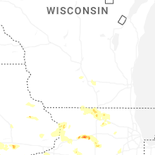


Connect with Interactive Hail Maps