

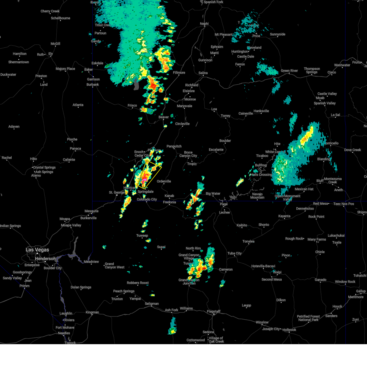
Hail Map for Springdale, UT
The Springdale, UT area has had 1 report of on-the-ground hail by trained spotters, and has been under severe weather warnings 1 time during the past 12 months. Doppler radar has detected hail at or near Springdale, UT on 13 occasions, including 2 occasions during the past year.
| Name: | Springdale, UT |
| Where Located: | 31.8 miles E of Saint George, UT |
| Map: | Google Map for Springdale, UT |
| Population: | 529 |
| Housing Units: | 327 |
| More Info: | Search Google for Springdale, UT |
0
The Top Recent Hail Date for Springdale, UT is Saturday, August 17, 2024 (9th out of 13)

Hail and Wind Damage Spotted near Springdale, UT
| Date / Time | Report Details |
|---|---|
| 8/17/2024 12:41 PM MDT |
 Svrslc the national weather service in salt lake city has issued a * severe thunderstorm warning for, east central washington county in southwestern utah, northwestern kane county in southern utah, south central iron county in southern utah, * until 115 pm mdt. * at 1241 pm mdt, a severe thunderstorm was located near zion national park, moving northeast at 25 mph (radar indicated). Hazards include 60 mph wind gusts and quarter size hail. Hail damage to vehicles is expected. Expect wind damage to roofs, siding, and trees. Svrslc the national weather service in salt lake city has issued a * severe thunderstorm warning for, east central washington county in southwestern utah, northwestern kane county in southern utah, south central iron county in southern utah, * until 115 pm mdt. * at 1241 pm mdt, a severe thunderstorm was located near zion national park, moving northeast at 25 mph (radar indicated). Hazards include 60 mph wind gusts and quarter size hail. Hail damage to vehicles is expected. Expect wind damage to roofs, siding, and trees.
|
| 7/31/2021 5:40 PM MDT | A tree fell on the tech building at zion np. received via social media. time based on rada in washington county UT, 6.3 miles SSW of Springdale, UT |
| 7/26/2021 2:01 PM MDT |
 The severe thunderstorm warning for southeastern washington county has expired, the storm which prompted the warning has weakened below severe limits, and no longer poses an immediate threat to life or property. therefore, the warning has been allowed to expire. however gusty winds are still possible with this thunderstorm. a significant weather advisory has been issued for this same storm and is valid through 245 pm. The severe thunderstorm warning for southeastern washington county has expired, the storm which prompted the warning has weakened below severe limits, and no longer poses an immediate threat to life or property. therefore, the warning has been allowed to expire. however gusty winds are still possible with this thunderstorm. a significant weather advisory has been issued for this same storm and is valid through 245 pm.
|
| 7/26/2021 1:51 PM MDT |
 At 150 pm mdt, a severe thunderstorm was located near apple valley, or 11 miles southwest of zion national park, moving west at 10 mph (radar indicated). Hazards include 60 mph wind gusts and half dollar size hail. Hail damage to vehicles is expected. expect wind damage to roofs, siding, and trees. Locations impacted include, zion national park, hurricane, la verkin, apple valley, toquerville, virgin, springdale and rockville. At 150 pm mdt, a severe thunderstorm was located near apple valley, or 11 miles southwest of zion national park, moving west at 10 mph (radar indicated). Hazards include 60 mph wind gusts and half dollar size hail. Hail damage to vehicles is expected. expect wind damage to roofs, siding, and trees. Locations impacted include, zion national park, hurricane, la verkin, apple valley, toquerville, virgin, springdale and rockville.
|
| 7/26/2021 1:37 PM MDT |
 At 136 pm mdt, a severe thunderstorm was located near apple valley, or 9 miles southwest of zion national park, moving west at 10 mph (radar indicated). Hazards include 60 mph wind gusts and half dollar size hail. Hail damage to vehicles is expected. Expect wind damage to roofs, siding, and trees. At 136 pm mdt, a severe thunderstorm was located near apple valley, or 9 miles southwest of zion national park, moving west at 10 mph (radar indicated). Hazards include 60 mph wind gusts and half dollar size hail. Hail damage to vehicles is expected. Expect wind damage to roofs, siding, and trees.
|
| 8/10/2016 2:03 PM MDT |
 At 200 pm mdt, doppler radar indicated a severe thunderstorm capable of producing large damaging hail up to golf ball size and strong gusty winds. this storm was located over zion national park, or 16 miles north of colorado city, moving northeast at 25 mph. this storm produced golf ball size hail in the community of springdale. locations impacted include, zion national park, springdale and rockville. At 200 pm mdt, doppler radar indicated a severe thunderstorm capable of producing large damaging hail up to golf ball size and strong gusty winds. this storm was located over zion national park, or 16 miles north of colorado city, moving northeast at 25 mph. this storm produced golf ball size hail in the community of springdale. locations impacted include, zion national park, springdale and rockville.
|
| 8/10/2016 1:56 PM MDT | Golf Ball sized hail reported 0.9 miles WSW of Springdale, UT |
| 8/10/2016 1:45 PM MDT |
 At 144 pm mdt, doppler radar indicated a severe thunderstorm capable of producing quarter size hail and strong gusty winds. this storm was located 10 miles southwest of zion national park, or 11 miles northwest of colorado city, and moving northeast at 25 mph. At 144 pm mdt, doppler radar indicated a severe thunderstorm capable of producing quarter size hail and strong gusty winds. this storm was located 10 miles southwest of zion national park, or 11 miles northwest of colorado city, and moving northeast at 25 mph.
|
Hail Maps for Springdale, UT


Connect with Interactive Hail Maps