

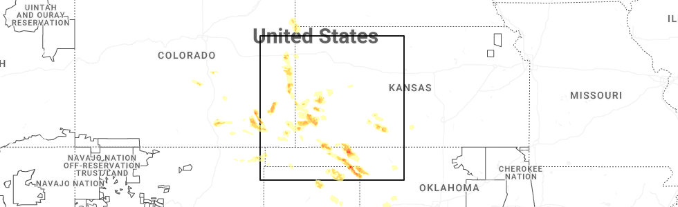
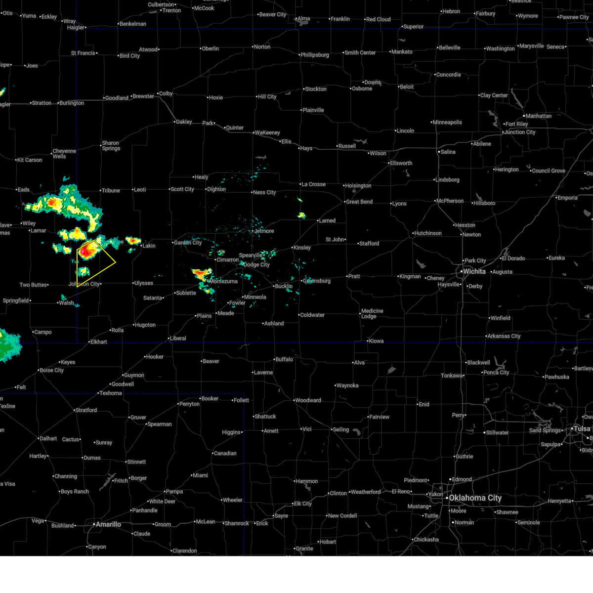
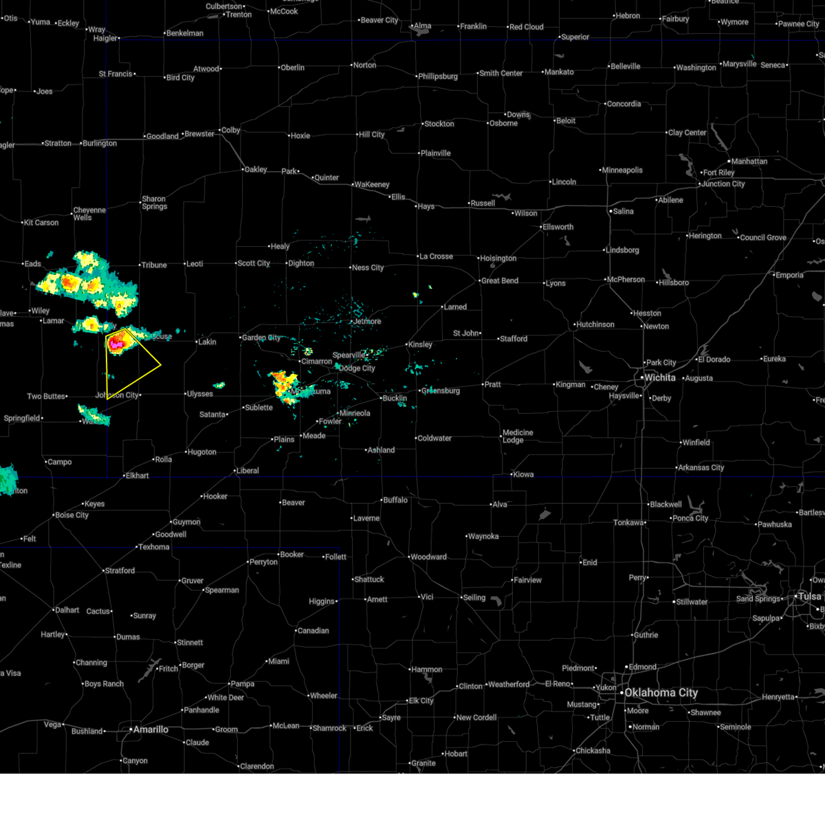
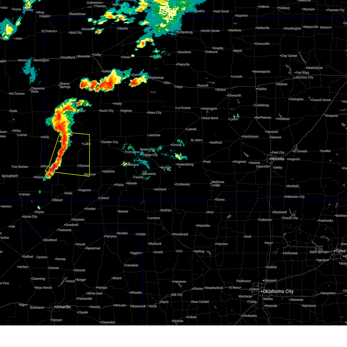
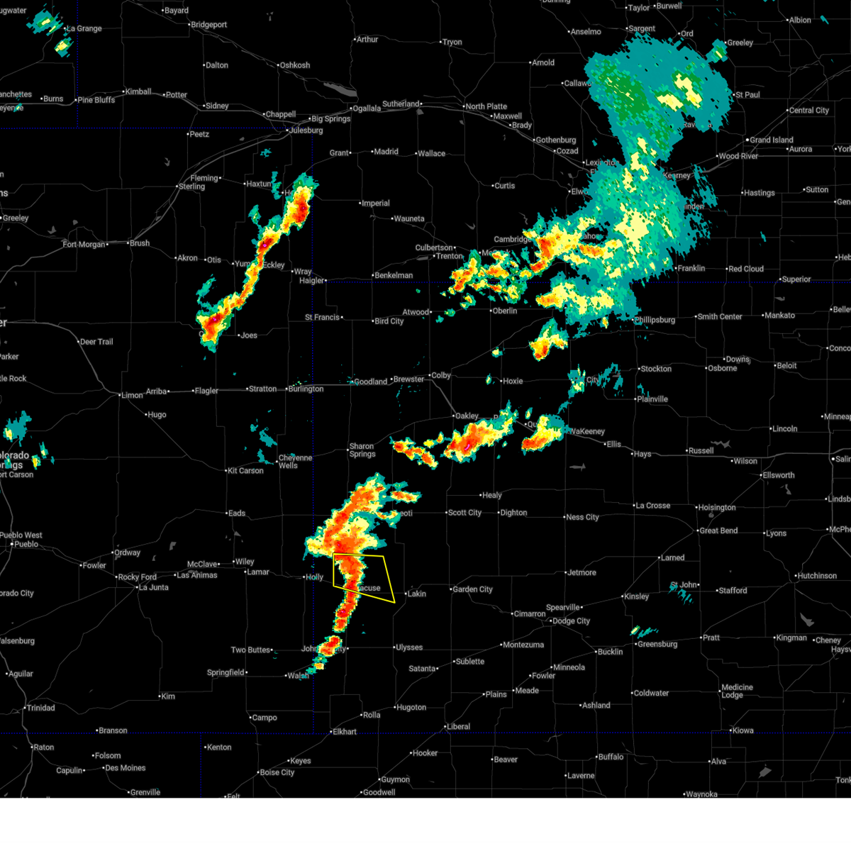
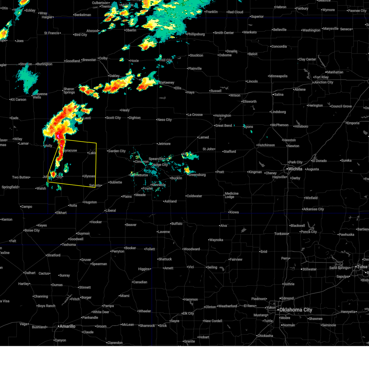
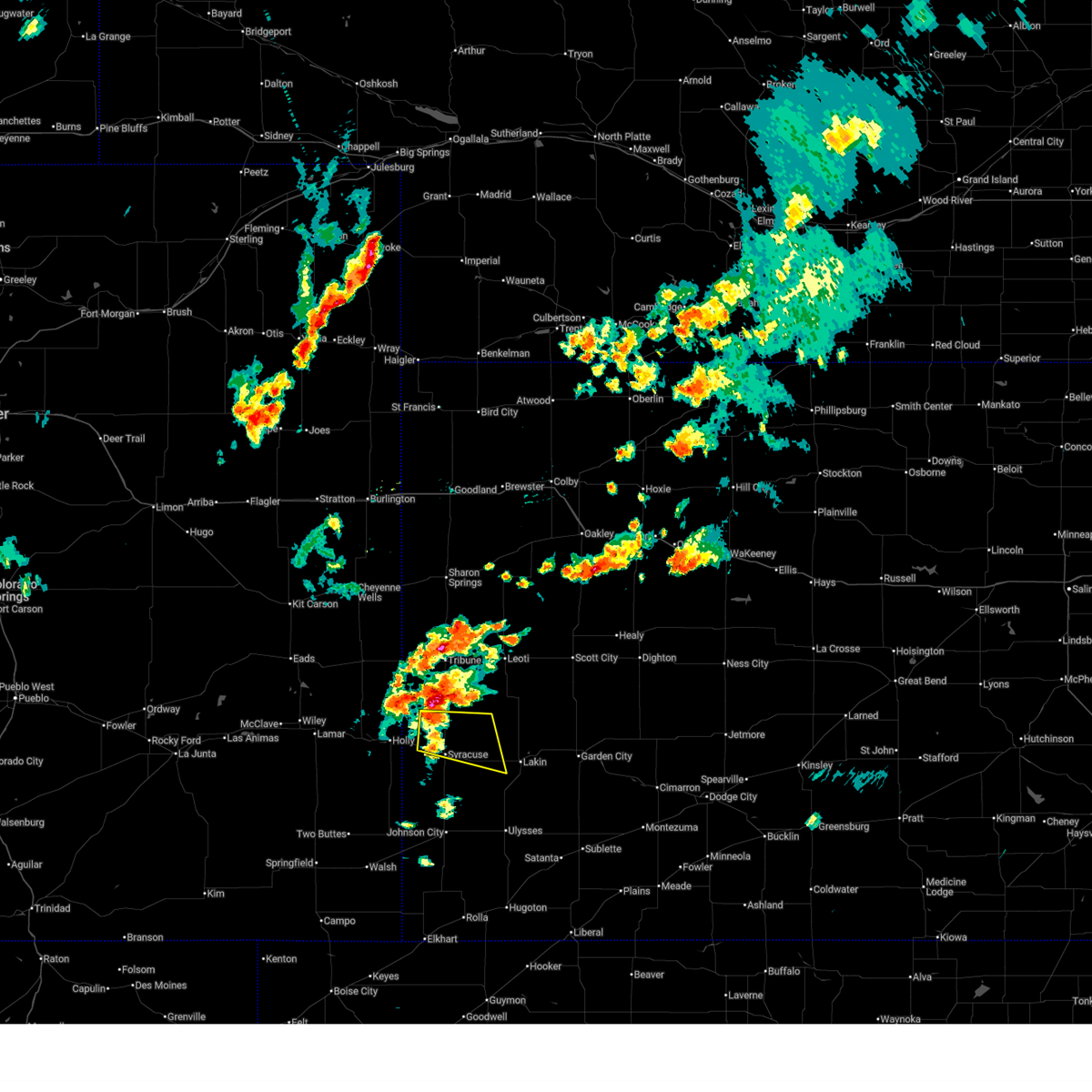
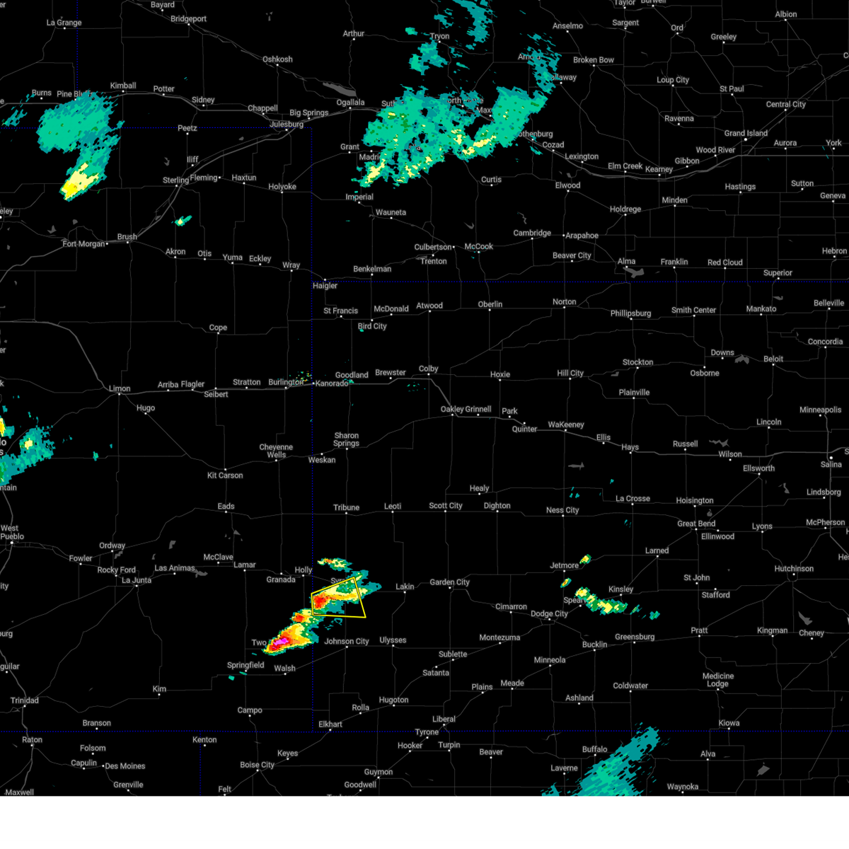
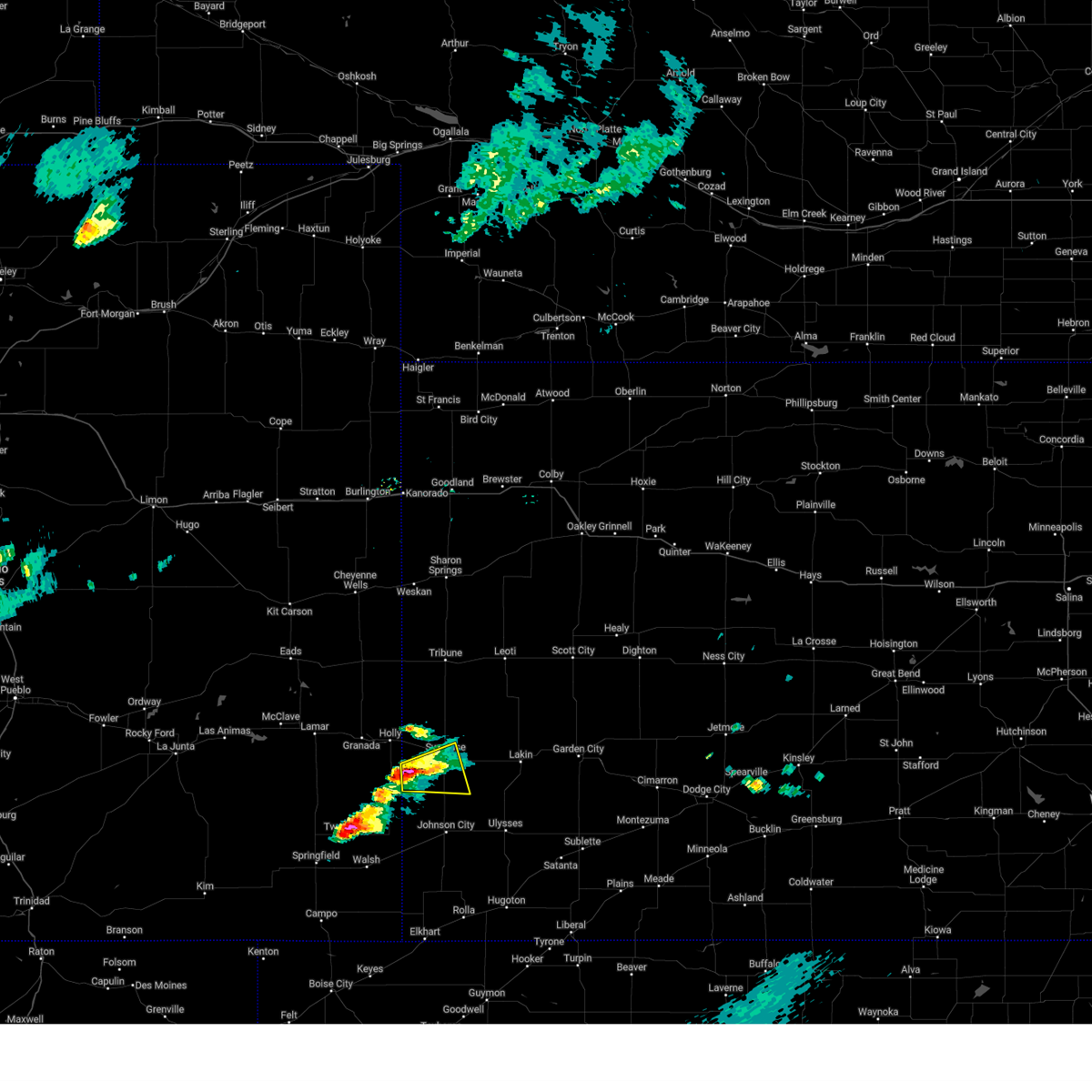
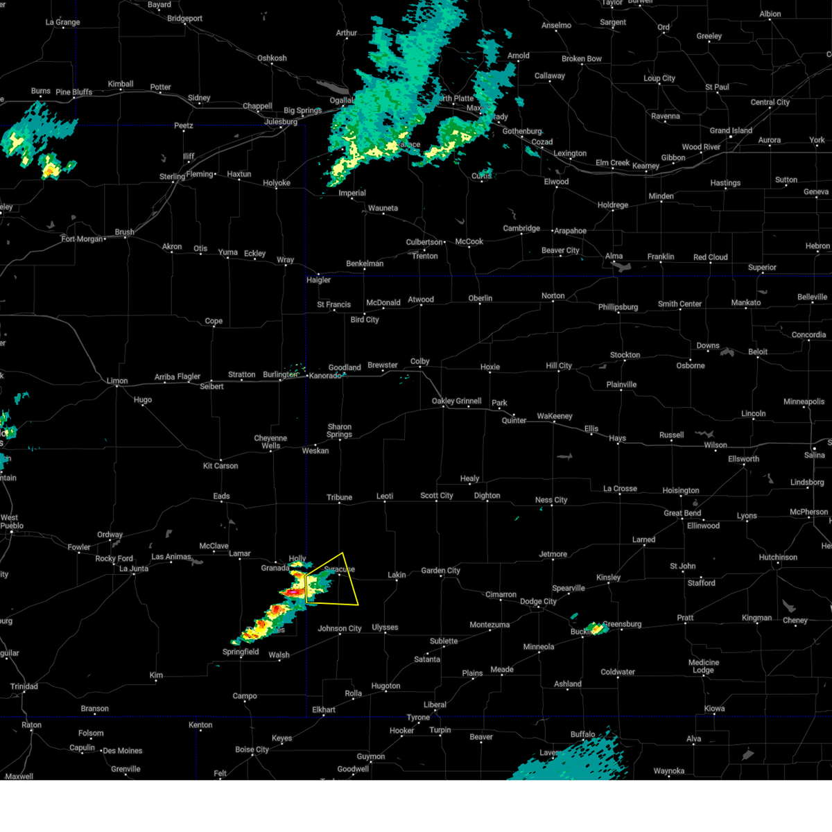
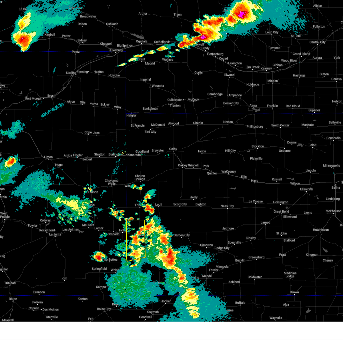
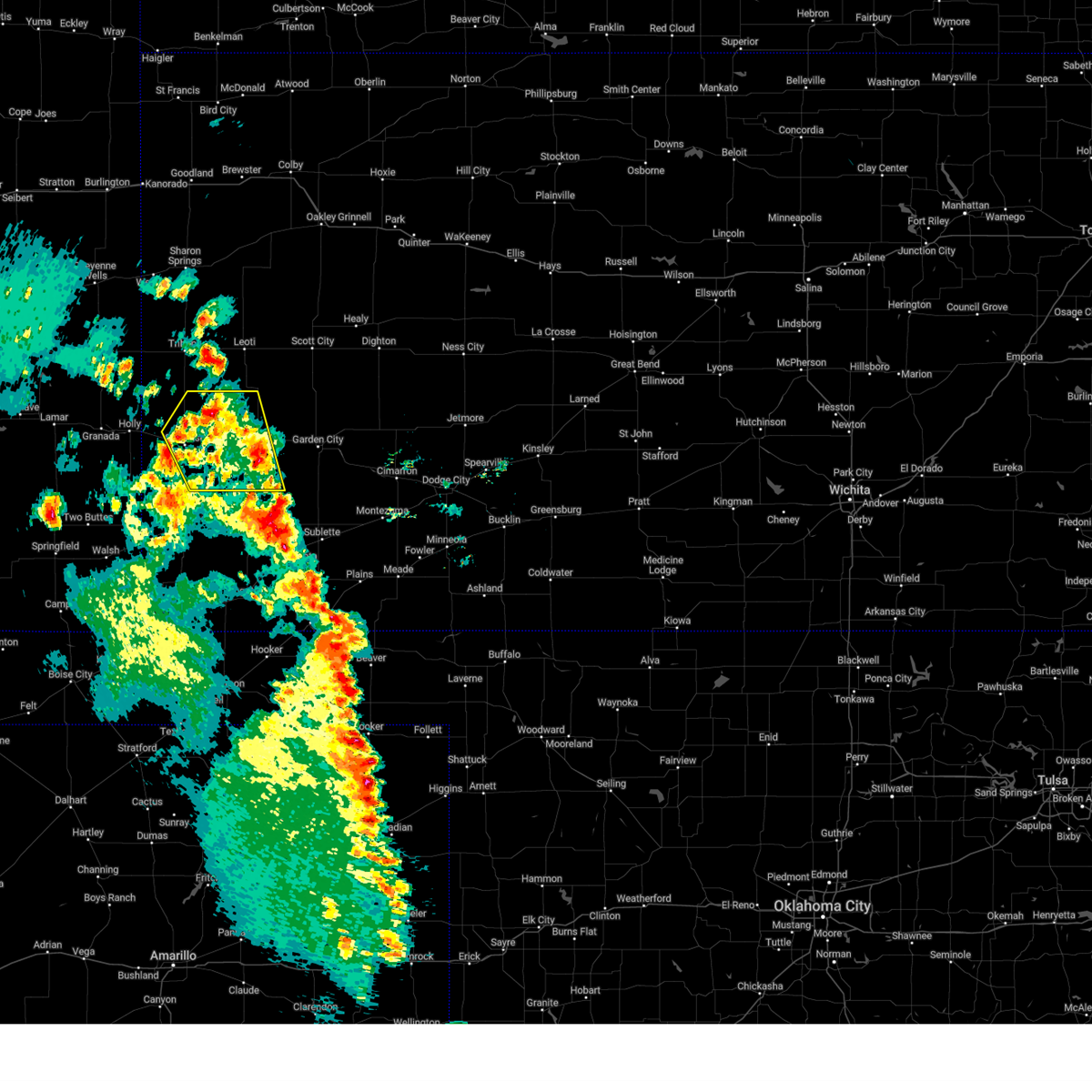
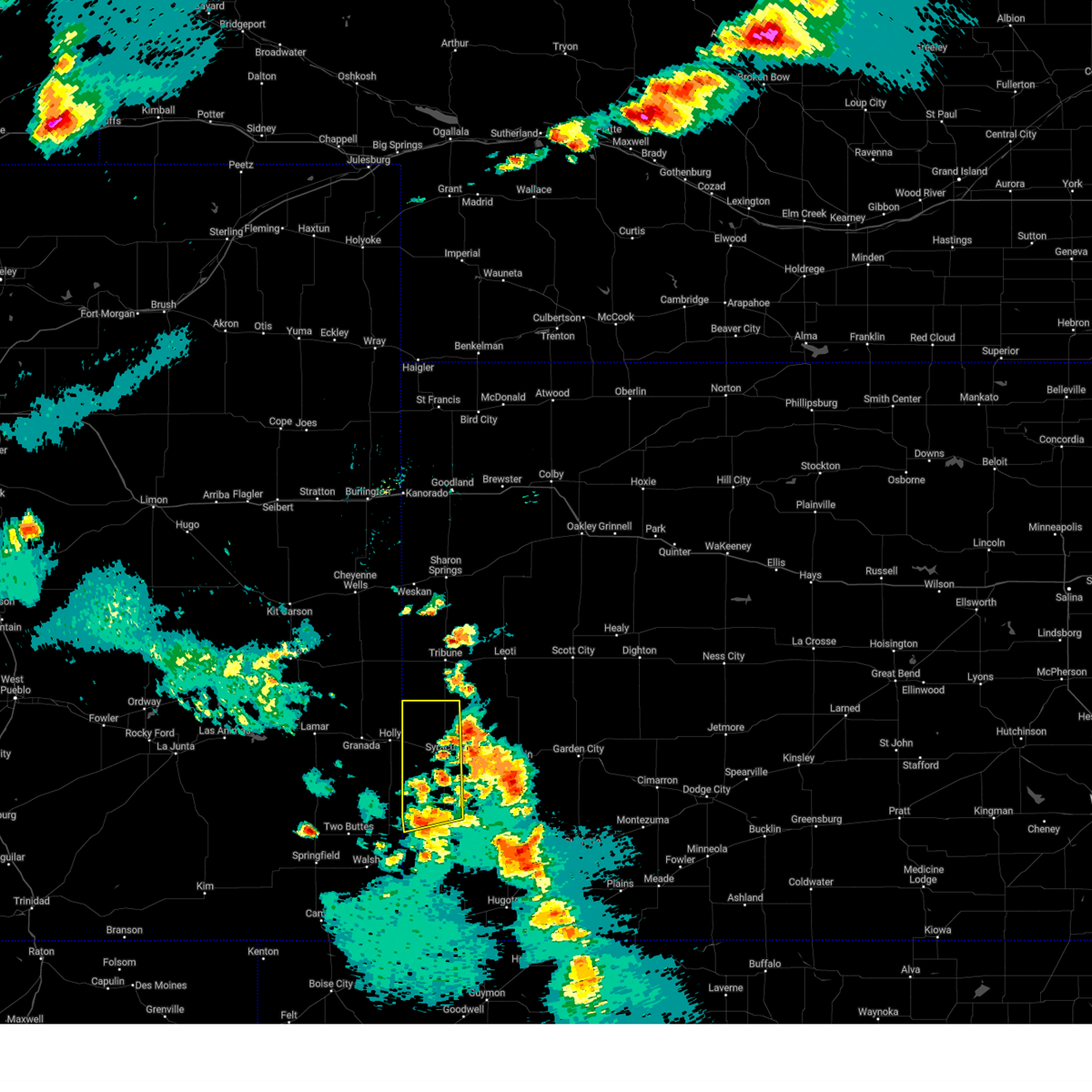
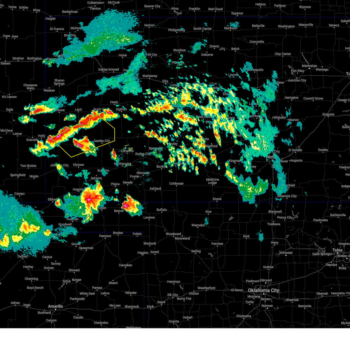
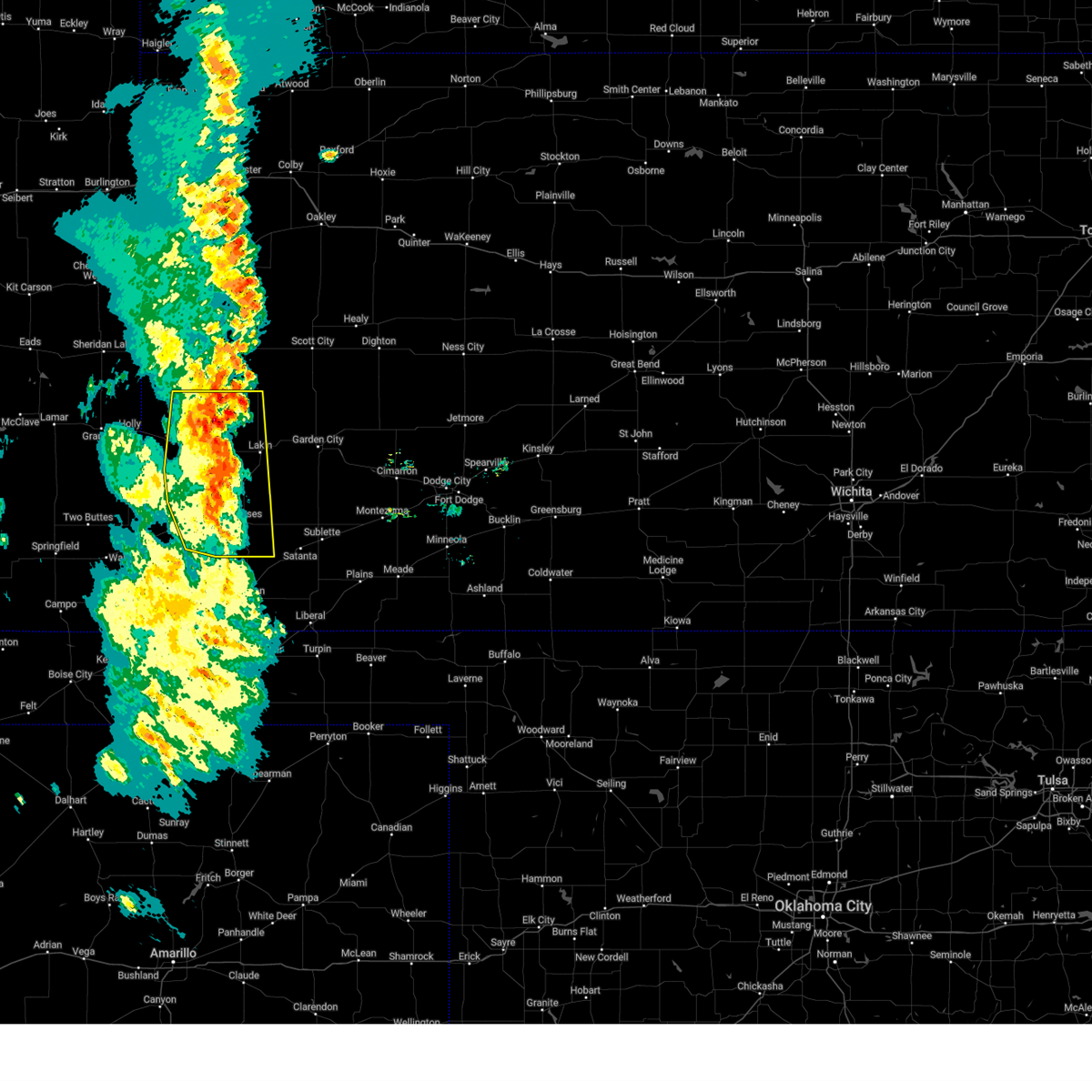
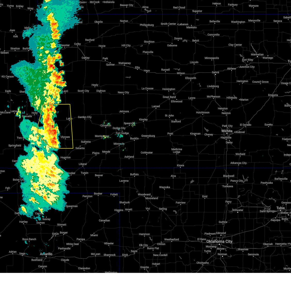
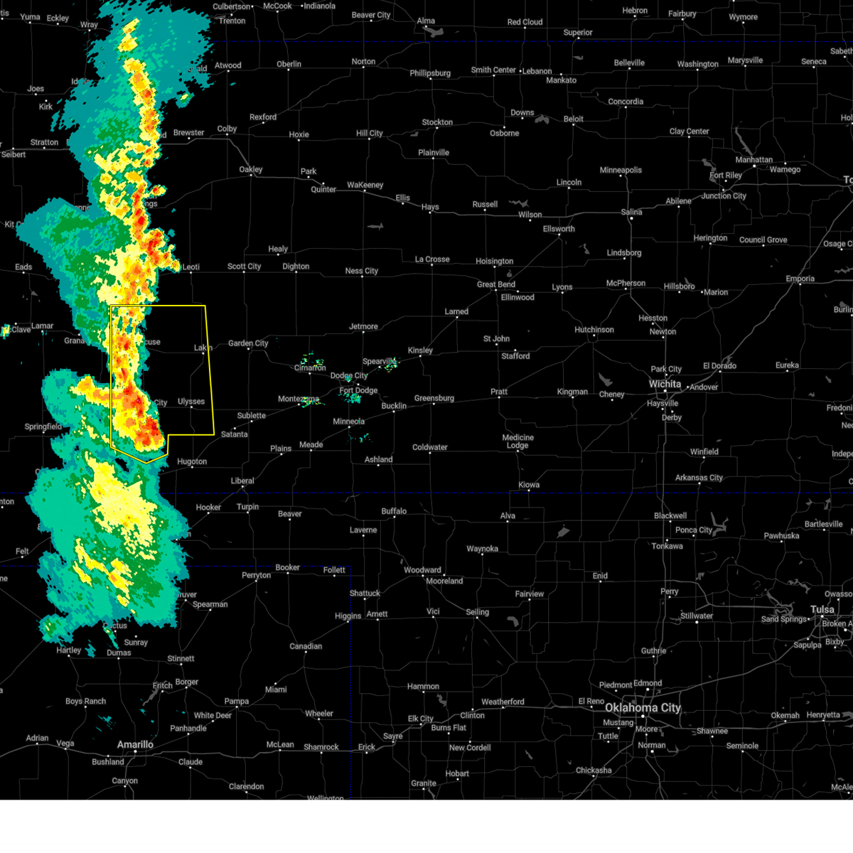
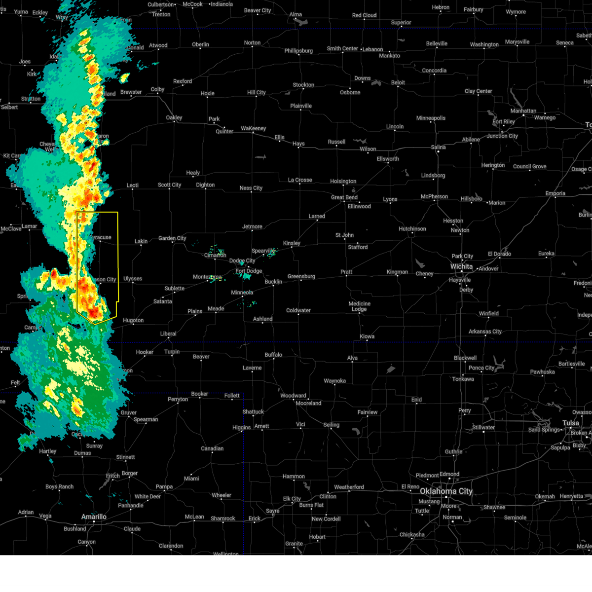
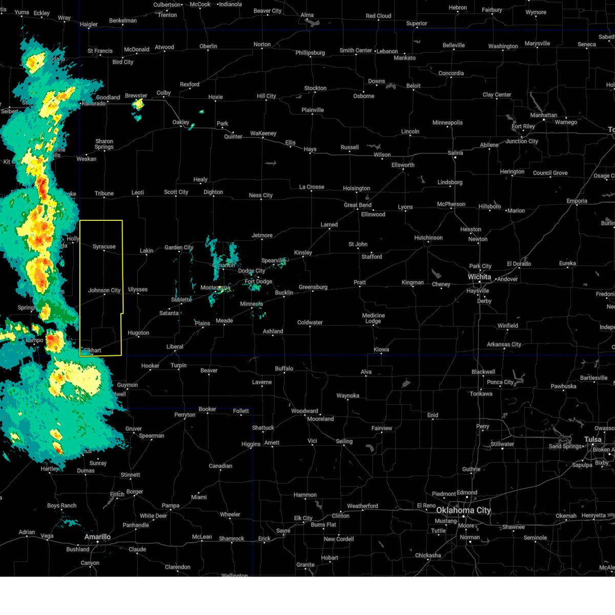
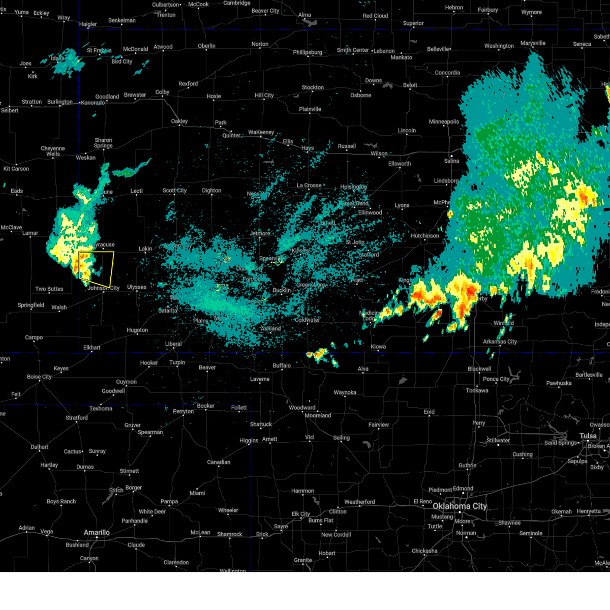
Hail Map for Syracuse, KS
The Syracuse, KS area has had 89 reports of on-the-ground hail by trained spotters, and has been under severe weather warnings 31 times during the past 12 months. Doppler radar has detected hail at or near Syracuse, KS on 103 occasions, including 5 occasions during the past year.
| Name: | Syracuse, KS |
| Where Located: | 48.1 miles W of Garden City, KS |
| Map: | Google Map for Syracuse, KS |
| Population: | 1812 |
| Housing Units: | 832 |
| More Info: | Search Google for Syracuse, KS |
1
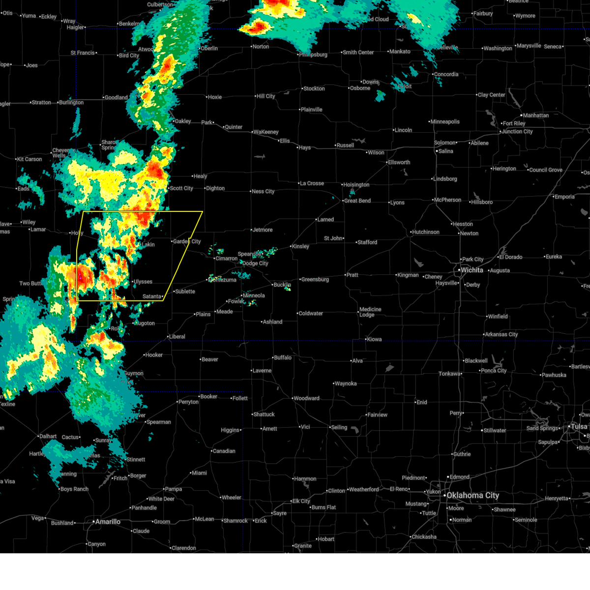
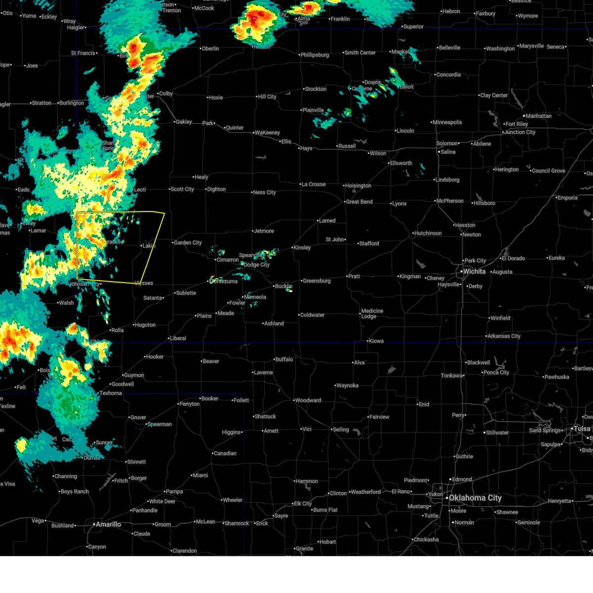
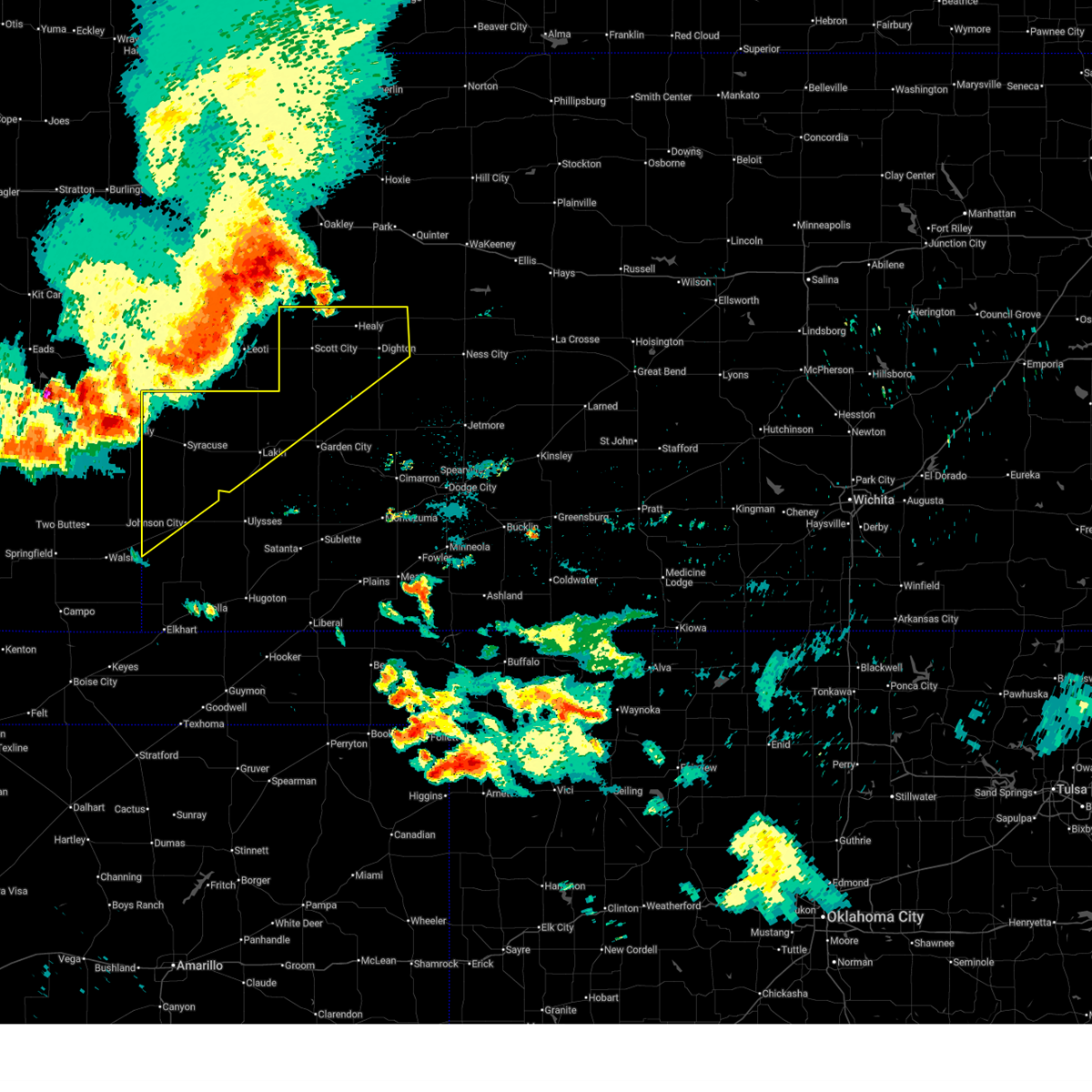
The Top Recent Hail Date for Syracuse, KS is Wednesday, May 28, 2025 (23rd out of 103)
Hail and Wind Damage Spotted near Syracuse, KS
| Date / Time | Report Details |
|---|---|
| 7/10/2025 7:56 PM CDT |
 Svrddc the national weather service in dodge city has issued a * severe thunderstorm warning for, hamilton county in southwestern kansas, kearny county in southwestern kansas, finney county in southwestern kansas, grant county in southwestern kansas, stanton county in southwestern kansas, western haskell county in southwestern kansas, * until 845 pm cdt/745 pm mdt/. * at 756 pm cdt/656 pm mdt/, severe thunderstorms were located along a line extending from 14 miles south of leoti to near johnson city, moving east at 40 mph (radar indicated). Hazards include 60 mph wind gusts and nickel size hail. Expect damage to roofs, siding, and trees. severe thunderstorms will be near, big bow around 800 pm cdt. lakin around 805 pm cdt. ulysses around 810 pm cdt. deerfield around 815 pm cdt. Other locations in the path of these severe thunderstorms include holcomb, hickok, garden city and ryus. Svrddc the national weather service in dodge city has issued a * severe thunderstorm warning for, hamilton county in southwestern kansas, kearny county in southwestern kansas, finney county in southwestern kansas, grant county in southwestern kansas, stanton county in southwestern kansas, western haskell county in southwestern kansas, * until 845 pm cdt/745 pm mdt/. * at 756 pm cdt/656 pm mdt/, severe thunderstorms were located along a line extending from 14 miles south of leoti to near johnson city, moving east at 40 mph (radar indicated). Hazards include 60 mph wind gusts and nickel size hail. Expect damage to roofs, siding, and trees. severe thunderstorms will be near, big bow around 800 pm cdt. lakin around 805 pm cdt. ulysses around 810 pm cdt. deerfield around 815 pm cdt. Other locations in the path of these severe thunderstorms include holcomb, hickok, garden city and ryus.
|
| 7/10/2025 7:31 PM CDT | Mesonet d528 in kearny county KS, 13.2 miles WNW of Syracuse, KS |
| 7/10/2025 7:30 PM CDT | Storm damage reported in kearny county KS, 13.2 miles WNW of Syracuse, KS |
| 7/10/2025 6:15 PM MDT | Awos station k3k3 syracus in hamilton county KS, 1.6 miles S of Syracuse, KS |
| 7/10/2025 7:12 PM CDT |
 Svrddc the national weather service in dodge city has issued a * severe thunderstorm warning for, hamilton county in southwestern kansas, kearny county in southwestern kansas, northwestern finney county in southwestern kansas, northwestern grant county in southwestern kansas, northern stanton county in southwestern kansas, * until 800 pm cdt/700 pm mdt/. * at 712 pm cdt/612 pm mdt/, severe thunderstorms were located along a line extending from 14 miles south of tribune to 17 miles northwest of manter, moving east at 55 mph (radar indicated). Hazards include 60 mph wind gusts. Expect damage to roofs, siding, and trees. severe thunderstorms will be near, syracuse around 620 pm mdt. kendall around 730 pm cdt. Other locations in the path of these severe thunderstorms include lakin. Svrddc the national weather service in dodge city has issued a * severe thunderstorm warning for, hamilton county in southwestern kansas, kearny county in southwestern kansas, northwestern finney county in southwestern kansas, northwestern grant county in southwestern kansas, northern stanton county in southwestern kansas, * until 800 pm cdt/700 pm mdt/. * at 712 pm cdt/612 pm mdt/, severe thunderstorms were located along a line extending from 14 miles south of tribune to 17 miles northwest of manter, moving east at 55 mph (radar indicated). Hazards include 60 mph wind gusts. Expect damage to roofs, siding, and trees. severe thunderstorms will be near, syracuse around 620 pm mdt. kendall around 730 pm cdt. Other locations in the path of these severe thunderstorms include lakin.
|
| 7/10/2025 6:09 PM MDT | Report from mesonet statio in hamilton county KS, 0.8 miles WSW of Syracuse, KS |
| 7/6/2025 11:51 PM CDT |
 Svrddc the national weather service in dodge city has issued a * severe thunderstorm warning for, hamilton county in southwestern kansas, kearny county in southwestern kansas, northwestern finney county in southwestern kansas, scott county in west central kansas, lane county in west central kansas, northwestern stanton county in southwestern kansas, * until 1245 am cdt/1145 pm mdt/. * at 1150 pm cdt/1050 pm mdt/, severe thunderstorms were located along a line extending from 8 miles south of monument to 10 miles northeast of hartman, moving southeast at 55 mph (radar indicated). Hazards include 60 mph wind gusts. expect damage to roofs, siding, and trees Svrddc the national weather service in dodge city has issued a * severe thunderstorm warning for, hamilton county in southwestern kansas, kearny county in southwestern kansas, northwestern finney county in southwestern kansas, scott county in west central kansas, lane county in west central kansas, northwestern stanton county in southwestern kansas, * until 1245 am cdt/1145 pm mdt/. * at 1150 pm cdt/1050 pm mdt/, severe thunderstorms were located along a line extending from 8 miles south of monument to 10 miles northeast of hartman, moving southeast at 55 mph (radar indicated). Hazards include 60 mph wind gusts. expect damage to roofs, siding, and trees
|
| 7/5/2025 3:37 PM MDT |
 At 437 pm cdt/337 pm mdt/, a severe thunderstorm was located 13 miles south of coolidge, moving south at 20 mph (radar indicated). Hazards include ping pong ball size hail and 60 mph wind gusts. People and animals outdoors will be injured. expect hail damage to roofs, siding, windows, and vehicles. expect wind damage to roofs, siding, and trees. This severe thunderstorm will remain over mainly rural areas of southern hamilton and northwestern stanton counties. At 437 pm cdt/337 pm mdt/, a severe thunderstorm was located 13 miles south of coolidge, moving south at 20 mph (radar indicated). Hazards include ping pong ball size hail and 60 mph wind gusts. People and animals outdoors will be injured. expect hail damage to roofs, siding, windows, and vehicles. expect wind damage to roofs, siding, and trees. This severe thunderstorm will remain over mainly rural areas of southern hamilton and northwestern stanton counties.
|
| 7/5/2025 3:23 PM MDT |
 At 423 pm cdt/323 pm mdt/, a severe thunderstorm was located 8 miles south of coolidge, moving southeast at 20 mph (radar indicated). Hazards include ping pong ball size hail and 60 mph wind gusts. People and animals outdoors will be injured. expect hail damage to roofs, siding, windows, and vehicles. expect wind damage to roofs, siding, and trees. This severe thunderstorm will remain over mainly rural areas of southern hamilton and northwestern stanton counties. At 423 pm cdt/323 pm mdt/, a severe thunderstorm was located 8 miles south of coolidge, moving southeast at 20 mph (radar indicated). Hazards include ping pong ball size hail and 60 mph wind gusts. People and animals outdoors will be injured. expect hail damage to roofs, siding, windows, and vehicles. expect wind damage to roofs, siding, and trees. This severe thunderstorm will remain over mainly rural areas of southern hamilton and northwestern stanton counties.
|
| 7/5/2025 3:17 PM MDT |
 Svrddc the national weather service in dodge city has issued a * severe thunderstorm warning for, southern hamilton county in southwestern kansas, northwestern stanton county in southwestern kansas, * until 515 pm cdt/415 pm mdt/. * at 417 pm cdt/317 pm mdt/, a severe thunderstorm was located near coolidge, moving southeast at 20 mph (radar indicated). Hazards include 60 mph wind gusts and quarter size hail. Hail damage to vehicles is expected. expect wind damage to roofs, siding, and trees. This severe thunderstorm will remain over mainly rural areas of southern hamilton and northwestern stanton counties. Svrddc the national weather service in dodge city has issued a * severe thunderstorm warning for, southern hamilton county in southwestern kansas, northwestern stanton county in southwestern kansas, * until 515 pm cdt/415 pm mdt/. * at 417 pm cdt/317 pm mdt/, a severe thunderstorm was located near coolidge, moving southeast at 20 mph (radar indicated). Hazards include 60 mph wind gusts and quarter size hail. Hail damage to vehicles is expected. expect wind damage to roofs, siding, and trees. This severe thunderstorm will remain over mainly rural areas of southern hamilton and northwestern stanton counties.
|
| 7/4/2025 6:46 PM MDT |
 the severe thunderstorm warning has been cancelled and is no longer in effect the severe thunderstorm warning has been cancelled and is no longer in effect
|
| 7/4/2025 6:46 PM MDT |
 At 746 pm cdt/646 pm mdt/, severe thunderstorms were located along a line extending from 8 miles north of kendall to near johnson city, moving east at 25 mph (radar indicated). Hazards include 60 mph wind gusts and quarter size hail. Hail damage to vehicles is expected. expect wind damage to roofs, siding, and trees. Locations impacted include, kendall, big bow, ulysses and lakin. At 746 pm cdt/646 pm mdt/, severe thunderstorms were located along a line extending from 8 miles north of kendall to near johnson city, moving east at 25 mph (radar indicated). Hazards include 60 mph wind gusts and quarter size hail. Hail damage to vehicles is expected. expect wind damage to roofs, siding, and trees. Locations impacted include, kendall, big bow, ulysses and lakin.
|
| 7/4/2025 6:37 PM MDT |
 At 737 pm cdt/637 pm mdt/, a severe thunderstorm was located near syracuse, moving east at 25 mph (radar indicated). Hazards include 60 mph wind gusts and quarter size hail. Hail damage to vehicles is expected. expect wind damage to roofs, siding, and trees. This severe thunderstorm will remain over mainly rural areas of northeastern hamilton and northwestern kearny counties. At 737 pm cdt/637 pm mdt/, a severe thunderstorm was located near syracuse, moving east at 25 mph (radar indicated). Hazards include 60 mph wind gusts and quarter size hail. Hail damage to vehicles is expected. expect wind damage to roofs, siding, and trees. This severe thunderstorm will remain over mainly rural areas of northeastern hamilton and northwestern kearny counties.
|
| 7/4/2025 6:28 PM MDT |
 Svrddc the national weather service in dodge city has issued a * severe thunderstorm warning for, eastern hamilton county in southwestern kansas, kearny county in southwestern kansas, west central finney county in southwestern kansas, grant county in southwestern kansas, stanton county in southwestern kansas, * until 830 pm cdt/730 pm mdt/. * at 727 pm cdt/627 pm mdt/, severe thunderstorms were located along a line extending from 7 miles north of syracuse to near manter, moving east at 35 mph (radar indicated). Hazards include 60 mph wind gusts and quarter size hail. Hail damage to vehicles is expected. expect wind damage to roofs, siding, and trees. severe thunderstorms will be near, johnson city around 735 pm cdt. kendall around 745 pm cdt. Other locations in the path of these severe thunderstorms include big bow, ulysses and lakin. Svrddc the national weather service in dodge city has issued a * severe thunderstorm warning for, eastern hamilton county in southwestern kansas, kearny county in southwestern kansas, west central finney county in southwestern kansas, grant county in southwestern kansas, stanton county in southwestern kansas, * until 830 pm cdt/730 pm mdt/. * at 727 pm cdt/627 pm mdt/, severe thunderstorms were located along a line extending from 7 miles north of syracuse to near manter, moving east at 35 mph (radar indicated). Hazards include 60 mph wind gusts and quarter size hail. Hail damage to vehicles is expected. expect wind damage to roofs, siding, and trees. severe thunderstorms will be near, johnson city around 735 pm cdt. kendall around 745 pm cdt. Other locations in the path of these severe thunderstorms include big bow, ulysses and lakin.
|
| 7/4/2025 6:17 PM MDT |
 Svrddc the national weather service in dodge city has issued a * severe thunderstorm warning for, central hamilton county in southwestern kansas, northwestern kearny county in southwestern kansas, * until 800 pm cdt/700 pm mdt/. * at 717 pm cdt/617 pm mdt/, a severe thunderstorm was located near syracuse, moving east at 25 mph (radar indicated). Hazards include 70 mph wind gusts and penny size hail. Expect considerable tree damage. damage is likely to mobile homes, roofs, and outbuildings. This severe thunderstorm will be near, syracuse around 625 pm mdt. Svrddc the national weather service in dodge city has issued a * severe thunderstorm warning for, central hamilton county in southwestern kansas, northwestern kearny county in southwestern kansas, * until 800 pm cdt/700 pm mdt/. * at 717 pm cdt/617 pm mdt/, a severe thunderstorm was located near syracuse, moving east at 25 mph (radar indicated). Hazards include 70 mph wind gusts and penny size hail. Expect considerable tree damage. damage is likely to mobile homes, roofs, and outbuildings. This severe thunderstorm will be near, syracuse around 625 pm mdt.
|
| 6/5/2025 1:38 PM MDT |
 The storm which prompted the warning has weakened below severe limits, and no longer poses an immediate threat to life or property. therefore, the warning will be allowed to expire. however, small hail and heavy rain are still possible with this thunderstorm. a tornado watch remains in effect until 800 pm mdt for southwestern kansas. The storm which prompted the warning has weakened below severe limits, and no longer poses an immediate threat to life or property. therefore, the warning will be allowed to expire. however, small hail and heavy rain are still possible with this thunderstorm. a tornado watch remains in effect until 800 pm mdt for southwestern kansas.
|
| 6/5/2025 1:21 PM MDT |
 At 121 pm mdt, a severe thunderstorm was located 11 miles south of coolidge, moving east at 20 mph (radar indicated). Hazards include ping pong ball size hail and 60 mph wind gusts. People and animals outdoors will be injured. expect hail damage to roofs, siding, windows, and vehicles. expect wind damage to roofs, siding, and trees. Locations impacted include, syracuse. At 121 pm mdt, a severe thunderstorm was located 11 miles south of coolidge, moving east at 20 mph (radar indicated). Hazards include ping pong ball size hail and 60 mph wind gusts. People and animals outdoors will be injured. expect hail damage to roofs, siding, windows, and vehicles. expect wind damage to roofs, siding, and trees. Locations impacted include, syracuse.
|
| 6/5/2025 12:59 PM MDT |
 Svrddc the national weather service in dodge city has issued a * severe thunderstorm warning for, southern hamilton county in southwestern kansas, * until 145 pm mdt. * at 1258 pm mdt, a severe thunderstorm was located 13 miles south of coolidge, moving east at 25 mph (radar indicated). Hazards include golf ball size hail and 60 mph wind gusts. People and animals outdoors will be injured. expect hail damage to roofs, siding, windows, and vehicles. expect wind damage to roofs, siding, and trees. This severe thunderstorm will remain over mainly rural areas of southern hamilton county. Svrddc the national weather service in dodge city has issued a * severe thunderstorm warning for, southern hamilton county in southwestern kansas, * until 145 pm mdt. * at 1258 pm mdt, a severe thunderstorm was located 13 miles south of coolidge, moving east at 25 mph (radar indicated). Hazards include golf ball size hail and 60 mph wind gusts. People and animals outdoors will be injured. expect hail damage to roofs, siding, windows, and vehicles. expect wind damage to roofs, siding, and trees. This severe thunderstorm will remain over mainly rural areas of southern hamilton county.
|
| 6/2/2025 5:06 PM MDT |
 At 606 pm cdt/506 pm mdt/, severe thunderstorms were located along a line extending from 16 miles northwest of kendall to 7 miles west of syracuse, moving north at 40 mph (radar indicated). Hazards include 60 mph wind gusts. Expect damage to roofs, siding, and trees. These severe thunderstorms will remain over mainly rural areas of hamilton and northern stanton counties. At 606 pm cdt/506 pm mdt/, severe thunderstorms were located along a line extending from 16 miles northwest of kendall to 7 miles west of syracuse, moving north at 40 mph (radar indicated). Hazards include 60 mph wind gusts. Expect damage to roofs, siding, and trees. These severe thunderstorms will remain over mainly rural areas of hamilton and northern stanton counties.
|
| 6/2/2025 5:04 PM MDT |
 At 604 pm cdt/504 pm mdt/, severe thunderstorms were located along a line extending from 17 miles southwest of leoti to 13 miles northwest of deerfield to 8 miles southeast of lakin, moving northeast at 35 mph (radar indicated). Hazards include 60 mph wind gusts and nickel size hail. Expect damage to roofs, siding, and trees. Locations impacted include, lakin, syracuse, and kendall. At 604 pm cdt/504 pm mdt/, severe thunderstorms were located along a line extending from 17 miles southwest of leoti to 13 miles northwest of deerfield to 8 miles southeast of lakin, moving northeast at 35 mph (radar indicated). Hazards include 60 mph wind gusts and nickel size hail. Expect damage to roofs, siding, and trees. Locations impacted include, lakin, syracuse, and kendall.
|
| 6/2/2025 4:46 PM MDT |
 Svrddc the national weather service in dodge city has issued a * severe thunderstorm warning for, hamilton county in southwestern kansas, northern stanton county in southwestern kansas, * until 645 pm cdt/545 pm mdt/. * at 546 pm cdt/446 pm mdt/, severe thunderstorms were located along a line extending from near syracuse to 13 miles northwest of manter, moving north at 30 mph (radar indicated). Hazards include 60 mph wind gusts. Expect damage to roofs, siding, and trees. severe thunderstorms will be near, syracuse around 450 pm mdt. Other locations in the path of these severe thunderstorms include coolidge. Svrddc the national weather service in dodge city has issued a * severe thunderstorm warning for, hamilton county in southwestern kansas, northern stanton county in southwestern kansas, * until 645 pm cdt/545 pm mdt/. * at 546 pm cdt/446 pm mdt/, severe thunderstorms were located along a line extending from near syracuse to 13 miles northwest of manter, moving north at 30 mph (radar indicated). Hazards include 60 mph wind gusts. Expect damage to roofs, siding, and trees. severe thunderstorms will be near, syracuse around 450 pm mdt. Other locations in the path of these severe thunderstorms include coolidge.
|
| 6/2/2025 4:33 PM MDT | At 533 pm cdt/433 pm mdt/, severe thunderstorms were located along a line extending from 7 miles north of kendall to 12 miles south of lakin, moving northeast at 25 mph (radar indicated). Hazards include 60 mph wind gusts and nickel size hail. Expect damage to roofs, siding, and trees. Locations impacted include, lakin. |
| 6/2/2025 4:13 PM MDT | Svrddc the national weather service in dodge city has issued a * severe thunderstorm warning for, eastern hamilton county in southwestern kansas, kearny county in southwestern kansas, * until 615 pm cdt/515 pm mdt/. * at 513 pm cdt/413 pm mdt/, severe thunderstorms were located along a line extending from near syracuse to 9 miles north of big bow, moving northeast at 25 mph (radar indicated). Hazards include 60 mph wind gusts and nickel size hail. Expect damage to roofs, siding, and trees. severe thunderstorms will be near, kendall around 520 pm cdt. Other locations in the path of these severe thunderstorms include lakin. |
| 5/28/2025 6:06 PM CDT |
 Svrddc the national weather service in dodge city has issued a * severe thunderstorm warning for, eastern hamilton county in southwestern kansas, kearny county in southwestern kansas, northwestern finney county in southwestern kansas, southwestern scott county in west central kansas, * until 645 pm cdt/545 pm mdt/. * at 605 pm cdt/505 pm mdt/, severe thunderstorms were located along a line extending from near shallow water to near syracuse, moving southeast at 30 mph (radar indicated). Hazards include 60 mph wind gusts and quarter size hail. Hail damage to vehicles is expected. expect wind damage to roofs, siding, and trees. severe thunderstorms will be near, syracuse around 510 pm mdt. friend around 615 pm cdt. Kendall around 625 pm cdt. Svrddc the national weather service in dodge city has issued a * severe thunderstorm warning for, eastern hamilton county in southwestern kansas, kearny county in southwestern kansas, northwestern finney county in southwestern kansas, southwestern scott county in west central kansas, * until 645 pm cdt/545 pm mdt/. * at 605 pm cdt/505 pm mdt/, severe thunderstorms were located along a line extending from near shallow water to near syracuse, moving southeast at 30 mph (radar indicated). Hazards include 60 mph wind gusts and quarter size hail. Hail damage to vehicles is expected. expect wind damage to roofs, siding, and trees. severe thunderstorms will be near, syracuse around 510 pm mdt. friend around 615 pm cdt. Kendall around 625 pm cdt.
|
| 9/17/2024 7:11 PM MDT |
 At 809 pm cdt/709 pm mdt/, severe thunderstorms were located along a line extending from 10 miles west of leoti to near ulysses, moving northeast at 45 mph (radar indicated. at 802 pm cdt a 60 mph wind gust was reported 9 miles ssw of kendall). Hazards include 60 mph wind gusts. Expect damage to roofs, siding, and trees. These severe storms will be near, lakin around 815 pm cdt. At 809 pm cdt/709 pm mdt/, severe thunderstorms were located along a line extending from 10 miles west of leoti to near ulysses, moving northeast at 45 mph (radar indicated. at 802 pm cdt a 60 mph wind gust was reported 9 miles ssw of kendall). Hazards include 60 mph wind gusts. Expect damage to roofs, siding, and trees. These severe storms will be near, lakin around 815 pm cdt.
|
| 9/17/2024 7:02 PM MDT | Storm damage reported in hamilton county KS, 14.9 miles NW of Syracuse, KS |
| 9/17/2024 6:59 PM MDT |
 At 757 pm cdt/657 pm mdt/, severe thunderstorms were located along a line extending from 6 miles southeast of tribune to 7 miles southeast of big bow, moving northeast at 45 mph (radar indicated). Hazards include 60 mph wind gusts. Expect damage to roofs, siding, and trees. these severe storms will be near, ulysses and kendall around 800 pm cdt. Other locations in the path of these severe thunderstorms include hickok and lakin. At 757 pm cdt/657 pm mdt/, severe thunderstorms were located along a line extending from 6 miles southeast of tribune to 7 miles southeast of big bow, moving northeast at 45 mph (radar indicated). Hazards include 60 mph wind gusts. Expect damage to roofs, siding, and trees. these severe storms will be near, ulysses and kendall around 800 pm cdt. Other locations in the path of these severe thunderstorms include hickok and lakin.
|
| 9/17/2024 6:59 PM MDT |
 the severe thunderstorm warning has been cancelled and is no longer in effect the severe thunderstorm warning has been cancelled and is no longer in effect
|
| 9/17/2024 7:43 PM CDT |
 Svrddc the national weather service in dodge city has issued a * severe thunderstorm warning for, hamilton county in southwestern kansas, northern morton county in southwestern kansas, kearny county in southwestern kansas, grant county in southwestern kansas, stanton county in southwestern kansas, * until 845 pm cdt/745 pm mdt/. * at 742 pm cdt/642 pm mdt/, severe thunderstorms were located along a line extending from 14 miles southwest of horace to 9 miles northeast of richfield, moving northeast at 45 mph (radar indicated). Hazards include 60 mph wind gusts and penny size hail. Expect damage to roofs, siding, and trees. blowing dust could lower visibilities. severe thunderstorms will be near, syracuse around 645 pm mdt. big bow around 750 pm cdt. kendall around 755 pm cdt. ulysses around 800 pm cdt. Other locations in the path of these severe thunderstorms include lakin. Svrddc the national weather service in dodge city has issued a * severe thunderstorm warning for, hamilton county in southwestern kansas, northern morton county in southwestern kansas, kearny county in southwestern kansas, grant county in southwestern kansas, stanton county in southwestern kansas, * until 845 pm cdt/745 pm mdt/. * at 742 pm cdt/642 pm mdt/, severe thunderstorms were located along a line extending from 14 miles southwest of horace to 9 miles northeast of richfield, moving northeast at 45 mph (radar indicated). Hazards include 60 mph wind gusts and penny size hail. Expect damage to roofs, siding, and trees. blowing dust could lower visibilities. severe thunderstorms will be near, syracuse around 645 pm mdt. big bow around 750 pm cdt. kendall around 755 pm cdt. ulysses around 800 pm cdt. Other locations in the path of these severe thunderstorms include lakin.
|
| 9/17/2024 7:34 PM CDT |
 At 733 pm cdt/633 pm mdt/, severe thunderstorms were located along a line extending from near leoti to near hugoton, moving east at 45 mph (radar indicated). Hazards include 60 mph wind gusts and penny size hail. Expect damage to roofs, siding, and trees. These severe thunderstorms will remain over mainly rural areas of hamilton, northern morton and stanton counties. At 733 pm cdt/633 pm mdt/, severe thunderstorms were located along a line extending from near leoti to near hugoton, moving east at 45 mph (radar indicated). Hazards include 60 mph wind gusts and penny size hail. Expect damage to roofs, siding, and trees. These severe thunderstorms will remain over mainly rural areas of hamilton, northern morton and stanton counties.
|
| 9/17/2024 6:51 PM CDT |
 Svrddc the national weather service in dodge city has issued a * severe thunderstorm warning for, hamilton county in southwestern kansas, morton county in southwestern kansas, stanton county in southwestern kansas, * until 745 pm cdt/645 pm mdt/. * at 649 pm cdt/549 pm mdt/, severe thunderstorms were located along a line extending from 12 miles northeast of hartman to 9 miles west of elkhart, moving northeast at 50 mph (radar indicated). Hazards include 70 mph wind gusts and penny size hail. Expect considerable tree damage. damage is likely to mobile homes, roofs, and outbuildings. severe thunderstorms will be near, elkhart, manter, and the saunders elevator around 655 pm cdt. coolidge around 555 pm mdt. johnson city, richfield, and wilburton around 705 pm cdt. syracuse around 605 pm mdt. Other locations in the path of these severe thunderstorms include rolla, kendall and big bow. Svrddc the national weather service in dodge city has issued a * severe thunderstorm warning for, hamilton county in southwestern kansas, morton county in southwestern kansas, stanton county in southwestern kansas, * until 745 pm cdt/645 pm mdt/. * at 649 pm cdt/549 pm mdt/, severe thunderstorms were located along a line extending from 12 miles northeast of hartman to 9 miles west of elkhart, moving northeast at 50 mph (radar indicated). Hazards include 70 mph wind gusts and penny size hail. Expect considerable tree damage. damage is likely to mobile homes, roofs, and outbuildings. severe thunderstorms will be near, elkhart, manter, and the saunders elevator around 655 pm cdt. coolidge around 555 pm mdt. johnson city, richfield, and wilburton around 705 pm cdt. syracuse around 605 pm mdt. Other locations in the path of these severe thunderstorms include rolla, kendall and big bow.
|
| 8/14/2024 11:14 PM MDT |
 Svrddc the national weather service in dodge city has issued a * severe thunderstorm warning for, southern hamilton county in southwestern kansas, northwestern stanton county in southwestern kansas, * until 100 am cdt/midnight mdt/. * at 1213 am cdt/1113 pm mdt/, a severe thunderstorm was located 14 miles south of coolidge, moving east at 30 mph (radar indicated). Hazards include 60 mph wind gusts. Expect damage to roofs, siding, and trees. This severe thunderstorm will remain over mainly rural areas of southern hamilton and northwestern stanton counties. Svrddc the national weather service in dodge city has issued a * severe thunderstorm warning for, southern hamilton county in southwestern kansas, northwestern stanton county in southwestern kansas, * until 100 am cdt/midnight mdt/. * at 1213 am cdt/1113 pm mdt/, a severe thunderstorm was located 14 miles south of coolidge, moving east at 30 mph (radar indicated). Hazards include 60 mph wind gusts. Expect damage to roofs, siding, and trees. This severe thunderstorm will remain over mainly rural areas of southern hamilton and northwestern stanton counties.
|
| 7/17/2024 6:16 PM MDT |
 the severe thunderstorm warning has been cancelled and is no longer in effect the severe thunderstorm warning has been cancelled and is no longer in effect
|
| 7/17/2024 6:14 PM MDT |
 At 714 pm cdt/614 pm mdt/, a severe thunderstorm was located 10 miles northeast of coolidge, moving south at 20 mph (radar indicated). Hazards include 60 mph wind gusts and quarter size hail. Hail damage to vehicles is expected. expect wind damage to roofs, siding, and trees. Locations impacted include, syracuse and kendall. At 714 pm cdt/614 pm mdt/, a severe thunderstorm was located 10 miles northeast of coolidge, moving south at 20 mph (radar indicated). Hazards include 60 mph wind gusts and quarter size hail. Hail damage to vehicles is expected. expect wind damage to roofs, siding, and trees. Locations impacted include, syracuse and kendall.
|
| 7/17/2024 6:00 PM MDT |
 At 659 pm cdt/559 pm mdt/, a severe thunderstorm was located 12 miles north of syracuse, moving south at 15 mph (radar indicated). Hazards include 60 mph wind gusts and quarter size hail. Hail damage to vehicles is expected. expect wind damage to roofs, siding, and trees. Locations impacted include, syracuse and kendall. At 659 pm cdt/559 pm mdt/, a severe thunderstorm was located 12 miles north of syracuse, moving south at 15 mph (radar indicated). Hazards include 60 mph wind gusts and quarter size hail. Hail damage to vehicles is expected. expect wind damage to roofs, siding, and trees. Locations impacted include, syracuse and kendall.
|
| 7/17/2024 5:52 PM MDT |
 Svrddc the national weather service in dodge city has issued a * severe thunderstorm warning for, hamilton county in southwestern kansas, northwestern kearny county in southwestern kansas, * until 745 pm cdt/645 pm mdt/. * at 652 pm cdt/552 pm mdt/, a severe thunderstorm was located 13 miles north of syracuse, moving southwest at 15 mph (radar indicated). Hazards include 60 mph wind gusts and quarter size hail. Hail damage to vehicles is expected. Expect wind damage to roofs, siding, and trees. Svrddc the national weather service in dodge city has issued a * severe thunderstorm warning for, hamilton county in southwestern kansas, northwestern kearny county in southwestern kansas, * until 745 pm cdt/645 pm mdt/. * at 652 pm cdt/552 pm mdt/, a severe thunderstorm was located 13 miles north of syracuse, moving southwest at 15 mph (radar indicated). Hazards include 60 mph wind gusts and quarter size hail. Hail damage to vehicles is expected. Expect wind damage to roofs, siding, and trees.
|
| 7/16/2024 7:21 PM MDT | Storm damage reported in hamilton county KS, 14.9 miles NW of Syracuse, KS |
| 6/14/2024 6:47 PM CDT |
 Svrddc the national weather service in dodge city has issued a * severe thunderstorm warning for, southern hamilton county in southwestern kansas, morton county in southwestern kansas, southwestern kearny county in southwestern kansas, western grant county in southwestern kansas, western stevens county in southwestern kansas, stanton county in southwestern kansas, * until 745 pm cdt/645 pm mdt/. * at 646 pm cdt/546 pm mdt/, severe thunderstorms were located along a line extending from 10 miles south of coolidge to near elkhart, moving east at 30 mph (radar indicated). Hazards include 70 mph wind gusts and quarter size hail. areas of blowing dust and reduced visibility are expected. Hail damage to vehicles is expected. expect considerable tree damage. wind damage is also likely to mobile homes, roofs, and outbuildings. severe thunderstorms will be near, elkhart and manter around 650 pm cdt. richfield around 700 pm cdt. johnson city and wilburton around 705 pm cdt. Other locations in the path of these severe thunderstorms include rolla, big bow, kendall and feterita. Svrddc the national weather service in dodge city has issued a * severe thunderstorm warning for, southern hamilton county in southwestern kansas, morton county in southwestern kansas, southwestern kearny county in southwestern kansas, western grant county in southwestern kansas, western stevens county in southwestern kansas, stanton county in southwestern kansas, * until 745 pm cdt/645 pm mdt/. * at 646 pm cdt/546 pm mdt/, severe thunderstorms were located along a line extending from 10 miles south of coolidge to near elkhart, moving east at 30 mph (radar indicated). Hazards include 70 mph wind gusts and quarter size hail. areas of blowing dust and reduced visibility are expected. Hail damage to vehicles is expected. expect considerable tree damage. wind damage is also likely to mobile homes, roofs, and outbuildings. severe thunderstorms will be near, elkhart and manter around 650 pm cdt. richfield around 700 pm cdt. johnson city and wilburton around 705 pm cdt. Other locations in the path of these severe thunderstorms include rolla, big bow, kendall and feterita.
|
| 6/14/2024 5:24 PM MDT |
 At 623 pm cdt/523 pm mdt/, a line of severe thunderstorms located along a line extending from 16 miles northeast of coolidge to 11 miles northwest of elkhart, moving east at 30 mph (radar indicated). Hazards include 70 mph wind gusts. areas of blowing dust are expected. Expect considerable tree damage. damage is likely to mobile homes, roofs, and outbuildings. Locations impacted include, manter, syracuse, johnson city and big bow. At 623 pm cdt/523 pm mdt/, a line of severe thunderstorms located along a line extending from 16 miles northeast of coolidge to 11 miles northwest of elkhart, moving east at 30 mph (radar indicated). Hazards include 70 mph wind gusts. areas of blowing dust are expected. Expect considerable tree damage. damage is likely to mobile homes, roofs, and outbuildings. Locations impacted include, manter, syracuse, johnson city and big bow.
|
| 6/14/2024 4:57 PM MDT |
 Svrddc the national weather service in dodge city has issued a * severe thunderstorm warning for, hamilton county in southwestern kansas, northern morton county in southwestern kansas, stanton county in southwestern kansas, * until 700 pm cdt/600 pm mdt/. * at 555 pm cdt/455 pm mdt/, severe thunderstorms were located along a line extending from 9 miles northeast of hartman to 12 miles south of stonington, moving east at 35 mph (automated equipment. these storms have a history of producing wind gusts of 60-70 mph at lamar, colorado). Hazards include 70 mph wind gusts. areas of blowing dust will sharply reduce visibility. Expect considerable tree damage. damage is likely to mobile homes, roofs, and outbuildings. severe thunderstorms will be near, coolidge around 500 pm mdt. the saunders elevator around 605 pm cdt. manter around 615 pm cdt. Other locations in the path of these severe thunderstorms include syracuse, johnson city and big bow. Svrddc the national weather service in dodge city has issued a * severe thunderstorm warning for, hamilton county in southwestern kansas, northern morton county in southwestern kansas, stanton county in southwestern kansas, * until 700 pm cdt/600 pm mdt/. * at 555 pm cdt/455 pm mdt/, severe thunderstorms were located along a line extending from 9 miles northeast of hartman to 12 miles south of stonington, moving east at 35 mph (automated equipment. these storms have a history of producing wind gusts of 60-70 mph at lamar, colorado). Hazards include 70 mph wind gusts. areas of blowing dust will sharply reduce visibility. Expect considerable tree damage. damage is likely to mobile homes, roofs, and outbuildings. severe thunderstorms will be near, coolidge around 500 pm mdt. the saunders elevator around 605 pm cdt. manter around 615 pm cdt. Other locations in the path of these severe thunderstorms include syracuse, johnson city and big bow.
|
| 6/14/2024 7:00 AM MDT | Half Dollar sized hail reported 1.5 miles ENE of Syracuse, KS, corrects time on previous hail report from 2 w syracuse. |
| 6/14/2024 6:58 AM MDT |
 Svrddc the national weather service in dodge city has issued a * severe thunderstorm warning for, northern hamilton county in southwestern kansas, west central kearny county in southwestern kansas, * until 830 am cdt/730 am mdt/. * at 758 am cdt/658 am mdt/, a severe thunderstorm was located near syracuse, moving northeast at 20 mph (radar indicated). Hazards include quarter size hail. Damage to vehicles is expected. This severe thunderstorm will be near, syracuse around 705 am mdt. Svrddc the national weather service in dodge city has issued a * severe thunderstorm warning for, northern hamilton county in southwestern kansas, west central kearny county in southwestern kansas, * until 830 am cdt/730 am mdt/. * at 758 am cdt/658 am mdt/, a severe thunderstorm was located near syracuse, moving northeast at 20 mph (radar indicated). Hazards include quarter size hail. Damage to vehicles is expected. This severe thunderstorm will be near, syracuse around 705 am mdt.
|
| 6/14/2024 6:53 AM MDT | Half Dollar sized hail reported 1.5 miles ENE of Syracuse, KS |
| 6/8/2024 8:57 PM MDT |
 At 957 pm cdt/857 pm mdt/, severe thunderstorms were located along a line extending from 15 miles south of leoti to near johnson city, moving southeast at 15 mph (radar indicated). Hazards include 70 mph wind gusts and penny size hail. Expect considerable tree damage. damage is likely to mobile homes, roofs, and outbuildings. Locations impacted include, syracuse, johnson city, and kendall. At 957 pm cdt/857 pm mdt/, severe thunderstorms were located along a line extending from 15 miles south of leoti to near johnson city, moving southeast at 15 mph (radar indicated). Hazards include 70 mph wind gusts and penny size hail. Expect considerable tree damage. damage is likely to mobile homes, roofs, and outbuildings. Locations impacted include, syracuse, johnson city, and kendall.
|
| 6/8/2024 8:36 PM MDT |
 At 935 pm cdt/835 pm mdt/, severe thunderstorms were located along a line extending from 16 miles southeast of tribune to 8 miles northwest of johnson city, moving east at 30 mph (public report of a 71 mph wind gust in syracuse at 830 pm mdt). Hazards include 70 mph wind gusts and penny size hail. Expect considerable tree damage. damage is likely to mobile homes, roofs, and outbuildings. Locations impacted include, kendall. At 935 pm cdt/835 pm mdt/, severe thunderstorms were located along a line extending from 16 miles southeast of tribune to 8 miles northwest of johnson city, moving east at 30 mph (public report of a 71 mph wind gust in syracuse at 830 pm mdt). Hazards include 70 mph wind gusts and penny size hail. Expect considerable tree damage. damage is likely to mobile homes, roofs, and outbuildings. Locations impacted include, kendall.
|
| 6/8/2024 8:30 PM MDT | Storm damage reported in hamilton county KS, 0.3 miles SW of Syracuse, KS |
| 6/8/2024 8:22 PM MDT |
 Svrddc the national weather service in dodge city has issued a * severe thunderstorm warning for, hamilton county in southwestern kansas, western kearny county in southwestern kansas, northern stanton county in southwestern kansas, * until 1015 pm cdt/915 pm mdt/. * at 922 pm cdt/822 pm mdt/, severe thunderstorms were located along a line extending from 12 miles south of tribune to 11 miles northwest of manter, moving east at 15 mph (public reported 60-70 mph winds at 754 mdt 4 miles south of coolidge). Hazards include 70 mph wind gusts and quarter size hail. Hail damage to vehicles is expected. expect considerable tree damage. wind damage is also likely to mobile homes, roofs, and outbuildings. Severe thunderstorms will be near, syracuse around 825 pm mdt. Svrddc the national weather service in dodge city has issued a * severe thunderstorm warning for, hamilton county in southwestern kansas, western kearny county in southwestern kansas, northern stanton county in southwestern kansas, * until 1015 pm cdt/915 pm mdt/. * at 922 pm cdt/822 pm mdt/, severe thunderstorms were located along a line extending from 12 miles south of tribune to 11 miles northwest of manter, moving east at 15 mph (public reported 60-70 mph winds at 754 mdt 4 miles south of coolidge). Hazards include 70 mph wind gusts and quarter size hail. Hail damage to vehicles is expected. expect considerable tree damage. wind damage is also likely to mobile homes, roofs, and outbuildings. Severe thunderstorms will be near, syracuse around 825 pm mdt.
|
| 6/8/2024 7:56 PM MDT |
 At 856 pm cdt/756 pm mdt/, severe thunderstorms were located along a line extending from 14 miles north of coolidge to 18 miles northeast of two buttes, moving east at 30 mph (radar indicated). Hazards include 70 mph wind gusts and quarter size hail. Hail damage to vehicles is expected. expect considerable tree damage. wind damage is also likely to mobile homes, roofs, and outbuildings. Locations impacted include, coolidge and syracuse. At 856 pm cdt/756 pm mdt/, severe thunderstorms were located along a line extending from 14 miles north of coolidge to 18 miles northeast of two buttes, moving east at 30 mph (radar indicated). Hazards include 70 mph wind gusts and quarter size hail. Hail damage to vehicles is expected. expect considerable tree damage. wind damage is also likely to mobile homes, roofs, and outbuildings. Locations impacted include, coolidge and syracuse.
|
| 6/8/2024 7:33 PM MDT |
 Svrddc the national weather service in dodge city has issued a * severe thunderstorm warning for, hamilton county in southwestern kansas, northwestern stanton county in southwestern kansas, * until 930 pm cdt/830 pm mdt/. * at 832 pm cdt/732 pm mdt/, severe thunderstorms were located along a line extending from 12 miles south of towner to 18 miles northeast of two buttes, moving east at 30 mph (radar indicated). Hazards include 70 mph wind gusts and quarter size hail. Hail damage to vehicles is expected. expect considerable tree damage. wind damage is also likely to mobile homes, roofs, and outbuildings. severe thunderstorms will be near, coolidge around 740 pm mdt. Other locations in the path of these severe thunderstorms include syracuse. Svrddc the national weather service in dodge city has issued a * severe thunderstorm warning for, hamilton county in southwestern kansas, northwestern stanton county in southwestern kansas, * until 930 pm cdt/830 pm mdt/. * at 832 pm cdt/732 pm mdt/, severe thunderstorms were located along a line extending from 12 miles south of towner to 18 miles northeast of two buttes, moving east at 30 mph (radar indicated). Hazards include 70 mph wind gusts and quarter size hail. Hail damage to vehicles is expected. expect considerable tree damage. wind damage is also likely to mobile homes, roofs, and outbuildings. severe thunderstorms will be near, coolidge around 740 pm mdt. Other locations in the path of these severe thunderstorms include syracuse.
|
| 6/2/2024 5:02 PM MDT |
 the severe thunderstorm warning has been cancelled and is no longer in effect the severe thunderstorm warning has been cancelled and is no longer in effect
|
| 6/2/2024 4:54 PM MDT |
 At 453 pm mdt, a severe thunderstorm was located 7 miles south of coolidge, moving northeast at 25 mph (radar indicated). Hazards include 60 mph wind gusts and half dollar size hail. Hail damage to vehicles is expected. expect wind damage to roofs, siding, and trees. Locations impacted include, syracuse and coolidge. At 453 pm mdt, a severe thunderstorm was located 7 miles south of coolidge, moving northeast at 25 mph (radar indicated). Hazards include 60 mph wind gusts and half dollar size hail. Hail damage to vehicles is expected. expect wind damage to roofs, siding, and trees. Locations impacted include, syracuse and coolidge.
|
| 6/2/2024 4:36 PM MDT |
 Svrddc the national weather service in dodge city has issued a * severe thunderstorm warning for, northwestern hamilton county in southwestern kansas, * until 515 pm mdt. * at 436 pm mdt, a severe thunderstorm was located 13 miles south of coolidge, moving northeast at 35 mph (radar indicated). Hazards include golf ball size hail and 60 mph wind gusts. People and animals outdoors will be injured. expect hail damage to roofs, siding, windows, and vehicles. Expect wind damage to roofs, siding, and trees. Svrddc the national weather service in dodge city has issued a * severe thunderstorm warning for, northwestern hamilton county in southwestern kansas, * until 515 pm mdt. * at 436 pm mdt, a severe thunderstorm was located 13 miles south of coolidge, moving northeast at 35 mph (radar indicated). Hazards include golf ball size hail and 60 mph wind gusts. People and animals outdoors will be injured. expect hail damage to roofs, siding, windows, and vehicles. Expect wind damage to roofs, siding, and trees.
|
| 6/1/2024 4:09 PM MDT | Ping Pong Ball sized hail reported 0.3 miles SW of Syracuse, KS, photo on social media. |
| 6/1/2024 4:00 PM MDT | Quarter sized hail reported 0.3 miles SW of Syracuse, KS |
| 5/31/2024 11:21 PM MDT | Awos station k3k3 syracus in hamilton county KS, 1.6 miles S of Syracuse, KS |
| 5/30/2024 12:19 AM MDT |
 Svrddc the national weather service in dodge city has issued a * severe thunderstorm warning for, northeastern hamilton county in southwestern kansas, northwestern kearny county in southwestern kansas, * until 200 am cdt/100 am mdt/. * at 118 am cdt/1218 am mdt/, a severe thunderstorm was located 7 miles northeast of syracuse, moving north at 20 mph (radar indicated). Hazards include half dollar size hail. Damage to vehicles is expected. This severe thunderstorm will remain over mainly rural areas of northeastern hamilton and northwestern kearny counties. Svrddc the national weather service in dodge city has issued a * severe thunderstorm warning for, northeastern hamilton county in southwestern kansas, northwestern kearny county in southwestern kansas, * until 200 am cdt/100 am mdt/. * at 118 am cdt/1218 am mdt/, a severe thunderstorm was located 7 miles northeast of syracuse, moving north at 20 mph (radar indicated). Hazards include half dollar size hail. Damage to vehicles is expected. This severe thunderstorm will remain over mainly rural areas of northeastern hamilton and northwestern kearny counties.
|
| 5/28/2024 7:27 PM CDT |
 At 726 pm cdt/626 pm mdt/, severe thunderstorms were located along a line extending from near coolidge to near ulysses to 11 miles south of hugoton, moving northeast at 20 mph (radar indicated). Hazards include 60 mph wind gusts and quarter size hail. Hail damage to vehicles is expected. expect wind damage to roofs, siding, and trees. these severe storms will be near, ulysses and hugoton around 730 pm cdt. coolidge around 630 pm mdt. Moscow around 740 pm cdt. At 726 pm cdt/626 pm mdt/, severe thunderstorms were located along a line extending from near coolidge to near ulysses to 11 miles south of hugoton, moving northeast at 20 mph (radar indicated). Hazards include 60 mph wind gusts and quarter size hail. Hail damage to vehicles is expected. expect wind damage to roofs, siding, and trees. these severe storms will be near, ulysses and hugoton around 730 pm cdt. coolidge around 630 pm mdt. Moscow around 740 pm cdt.
|
| 5/28/2024 7:23 PM CDT |
 At 723 pm cdt/623 pm mdt/, severe thunderstorms were located along a line extending from near coolidge to near ulysses to 11 miles south of hugoton, moving northeast at 20 mph (radar indicated). Hazards include quarter size hail. Damage to vehicles is expected. these severe storms will be near, ulysses around 730 pm cdt. Other locations in the path of these severe thunderstorms include moscow. At 723 pm cdt/623 pm mdt/, severe thunderstorms were located along a line extending from near coolidge to near ulysses to 11 miles south of hugoton, moving northeast at 20 mph (radar indicated). Hazards include quarter size hail. Damage to vehicles is expected. these severe storms will be near, ulysses around 730 pm cdt. Other locations in the path of these severe thunderstorms include moscow.
|
| 5/28/2024 7:14 PM CDT |
 Svrddc the national weather service in dodge city has issued a * severe thunderstorm warning for, southern hamilton county in southwestern kansas, morton county in southwestern kansas, southwestern kearny county in southwestern kansas, western grant county in southwestern kansas, stevens county in southwestern kansas, stanton county in southwestern kansas, * until 800 pm cdt/700 pm mdt/. * at 714 pm cdt/614 pm mdt/, severe thunderstorms were located along a line extending from near coolidge to near ulysses to 11 miles northwest of hooker, moving northeast at 20 mph (radar indicated). Hazards include quarter size hail. Damage to vehicles is expected. severe thunderstorms will be near, ulysses and hugoton around 720 pm cdt. coolidge around 620 pm mdt. Other locations in the path of these severe thunderstorms include moscow. Svrddc the national weather service in dodge city has issued a * severe thunderstorm warning for, southern hamilton county in southwestern kansas, morton county in southwestern kansas, southwestern kearny county in southwestern kansas, western grant county in southwestern kansas, stevens county in southwestern kansas, stanton county in southwestern kansas, * until 800 pm cdt/700 pm mdt/. * at 714 pm cdt/614 pm mdt/, severe thunderstorms were located along a line extending from near coolidge to near ulysses to 11 miles northwest of hooker, moving northeast at 20 mph (radar indicated). Hazards include quarter size hail. Damage to vehicles is expected. severe thunderstorms will be near, ulysses and hugoton around 720 pm cdt. coolidge around 620 pm mdt. Other locations in the path of these severe thunderstorms include moscow.
|
| 4/27/2024 3:35 PM MDT | Gustnado report from 10 n kendall. damaged outbuilding and power poles. reported with picture and vide in hamilton county KS, 11.4 miles WSW of Syracuse, KS |
| 4/25/2024 5:55 PM MDT | Golf Ball sized hail reported 3.7 miles S of Syracuse, KS, golf ball sized hail reported. |
| 4/25/2024 5:45 PM MDT | Golf Ball sized hail reported 16.1 miles S of Syracuse, KS |
| 4/25/2024 5:33 PM MDT | Hen Egg sized hail reported 10.6 miles S of Syracuse, KS, 2 inch hail reported. |
| 4/25/2024 5:28 PM MDT | Golf Ball sized hail reported 3.7 miles S of Syracuse, KS, report from mping: golf ball (1.75 in.). |
| 4/25/2024 5:27 PM MDT | Half Dollar sized hail reported 4.4 miles S of Syracuse, KS, report from mping: half dollar (1.25 in.). |
| 4/25/2024 5:23 PM MDT |
 Svrddc the national weather service in dodge city has issued a * severe thunderstorm warning for, northeastern hamilton county in southwestern kansas, * until 600 pm mdt. * at 522 pm mdt, a severe thunderstorm was located near syracuse, moving northeast at 50 mph. this warning replaces the existing warning in hamilton county (radar indicated). Hazards include golf ball size hail. People and animals outdoors will be injured. Expect damage to roofs, siding, windows, and vehicles. Svrddc the national weather service in dodge city has issued a * severe thunderstorm warning for, northeastern hamilton county in southwestern kansas, * until 600 pm mdt. * at 522 pm mdt, a severe thunderstorm was located near syracuse, moving northeast at 50 mph. this warning replaces the existing warning in hamilton county (radar indicated). Hazards include golf ball size hail. People and animals outdoors will be injured. Expect damage to roofs, siding, windows, and vehicles.
|
| 4/25/2024 5:20 PM MDT | Golf Ball sized hail reported 3 miles SE of Syracuse, KS |
| 4/25/2024 5:14 PM MDT |
 At 513 pm mdt, a severe thunderstorm was located near syracuse, moving northeast at 35 mph (radar indicated and public. one inch diameter hail was reported 7 miles west southwest of syracuse at 510 pm mdt). Hazards include two inch hail and 60 mph wind gusts. People and animals outdoors will be injured. expect hail damage to roofs, siding, windows, and vehicles. expect wind damage to roofs, siding, and trees. Locations impacted include, syracuse. At 513 pm mdt, a severe thunderstorm was located near syracuse, moving northeast at 35 mph (radar indicated and public. one inch diameter hail was reported 7 miles west southwest of syracuse at 510 pm mdt). Hazards include two inch hail and 60 mph wind gusts. People and animals outdoors will be injured. expect hail damage to roofs, siding, windows, and vehicles. expect wind damage to roofs, siding, and trees. Locations impacted include, syracuse.
|
| 4/25/2024 5:10 PM MDT | Quarter sized hail reported 6.8 miles ENE of Syracuse, KS |
| 4/25/2024 5:03 PM MDT |
 At 502 pm mdt, a severe thunderstorm was located 10 miles southwest of syracuse, moving northeast at 40 mph (radar indicated). Hazards include two inch hail and 60 mph wind gusts. People and animals outdoors will be injured. expect hail damage to roofs, siding, windows, and vehicles. expect wind damage to roofs, siding, and trees. Locations impacted include, syracuse and coolidge. At 502 pm mdt, a severe thunderstorm was located 10 miles southwest of syracuse, moving northeast at 40 mph (radar indicated). Hazards include two inch hail and 60 mph wind gusts. People and animals outdoors will be injured. expect hail damage to roofs, siding, windows, and vehicles. expect wind damage to roofs, siding, and trees. Locations impacted include, syracuse and coolidge.
|
| 4/25/2024 4:57 PM MDT |
 Svrddc the national weather service in dodge city has issued a * severe thunderstorm warning for, hamilton county in southwestern kansas, * until 530 pm mdt. * at 457 pm mdt, a severe thunderstorm was located 10 miles southwest of syracuse, moving northeast at 50 mph (radar indicated). Hazards include golf ball size hail. People and animals outdoors will be injured. Expect damage to roofs, siding, windows, and vehicles. Svrddc the national weather service in dodge city has issued a * severe thunderstorm warning for, hamilton county in southwestern kansas, * until 530 pm mdt. * at 457 pm mdt, a severe thunderstorm was located 10 miles southwest of syracuse, moving northeast at 50 mph (radar indicated). Hazards include golf ball size hail. People and animals outdoors will be injured. Expect damage to roofs, siding, windows, and vehicles.
|
| 4/25/2024 4:50 PM MDT |
 At 450 pm mdt, a severe thunderstorm was located 16 miles southwest of syracuse, moving north at 30 mph (radar indicated). Hazards include two inch hail and 60 mph wind gusts. People and animals outdoors will be injured. expect hail damage to roofs, siding, windows, and vehicles. expect wind damage to roofs, siding, and trees. Locations impacted include, syracuse and coolidge. At 450 pm mdt, a severe thunderstorm was located 16 miles southwest of syracuse, moving north at 30 mph (radar indicated). Hazards include two inch hail and 60 mph wind gusts. People and animals outdoors will be injured. expect hail damage to roofs, siding, windows, and vehicles. expect wind damage to roofs, siding, and trees. Locations impacted include, syracuse and coolidge.
|
| 4/25/2024 4:50 PM MDT |
 the severe thunderstorm warning has been cancelled and is no longer in effect the severe thunderstorm warning has been cancelled and is no longer in effect
|
| 4/25/2024 4:32 PM MDT |
 At 531 pm cdt/431 pm mdt/, a severe thunderstorm was located 10 miles northwest of manter, moving northeast at 40 mph (radar indicated). Hazards include two inch hail and 60 mph wind gusts. People and animals outdoors will be injured. expect hail damage to roofs, siding, windows, and vehicles. expect wind damage to roofs, siding, and trees. Locations impacted include, syracuse, johnson city, manter, coolidge, and the saunders elevator. At 531 pm cdt/431 pm mdt/, a severe thunderstorm was located 10 miles northwest of manter, moving northeast at 40 mph (radar indicated). Hazards include two inch hail and 60 mph wind gusts. People and animals outdoors will be injured. expect hail damage to roofs, siding, windows, and vehicles. expect wind damage to roofs, siding, and trees. Locations impacted include, syracuse, johnson city, manter, coolidge, and the saunders elevator.
|
| 4/25/2024 4:32 PM MDT |
 the severe thunderstorm warning has been cancelled and is no longer in effect the severe thunderstorm warning has been cancelled and is no longer in effect
|
| 4/25/2024 5:24 PM CDT |
 Svrddc the national weather service in dodge city has issued a * severe thunderstorm warning for, southern hamilton county in southwestern kansas, northwestern morton county in southwestern kansas, stanton county in southwestern kansas, * until 600 pm cdt/500 pm mdt/. * at 521 pm cdt/421 pm mdt/, a severe thunderstorm was located near the saunders elevator. another severe thunderstorm was located 15 miles west of johnson, and a third severe storm was located 7 miles northwest of richfield. these storms were moving north northeast at 45 mph (radar indicated and public report of golf ball size hail 6 miles west southwest of richfield at 515 pm cdt). Hazards include golf ball size hail and 60 mph wind gusts. People and animals outdoors will be injured. expect hail damage to roofs, siding, windows, and vehicles. Expect wind damage to roofs, siding, and trees. Svrddc the national weather service in dodge city has issued a * severe thunderstorm warning for, southern hamilton county in southwestern kansas, northwestern morton county in southwestern kansas, stanton county in southwestern kansas, * until 600 pm cdt/500 pm mdt/. * at 521 pm cdt/421 pm mdt/, a severe thunderstorm was located near the saunders elevator. another severe thunderstorm was located 15 miles west of johnson, and a third severe storm was located 7 miles northwest of richfield. these storms were moving north northeast at 45 mph (radar indicated and public report of golf ball size hail 6 miles west southwest of richfield at 515 pm cdt). Hazards include golf ball size hail and 60 mph wind gusts. People and animals outdoors will be injured. expect hail damage to roofs, siding, windows, and vehicles. Expect wind damage to roofs, siding, and trees.
|
| 7/22/2023 5:49 PM MDT |
 At 549 pm mdt, a severe thunderstorm was located 15 miles southeast of towner, or 16 miles north of coolidge, moving south at 20 mph (radar indicated). Hazards include 60 mph wind gusts and quarter size hail. Hail damage to vehicles is expected. Expect wind damage to roofs, siding, and trees. At 549 pm mdt, a severe thunderstorm was located 15 miles southeast of towner, or 16 miles north of coolidge, moving south at 20 mph (radar indicated). Hazards include 60 mph wind gusts and quarter size hail. Hail damage to vehicles is expected. Expect wind damage to roofs, siding, and trees.
|
| 7/10/2023 7:02 PM CDT |
 At 701 pm cdt/601 pm mdt/, severe thunderstorms were located along a line extending from near syracuse to near johnson city to 7 miles west of richfield, moving east at 35 mph (radar indicated). Hazards include 60 mph wind gusts and penny size hail. Expect damage to roofs, siding, and trees. locations impacted include, syracuse, johnson city, rolla, manter, coolidge, richfield, wilburton and the saunders elevator. hail threat, radar indicated max hail size, 0. 75 in wind threat, radar indicated max wind gust, 60 mph. At 701 pm cdt/601 pm mdt/, severe thunderstorms were located along a line extending from near syracuse to near johnson city to 7 miles west of richfield, moving east at 35 mph (radar indicated). Hazards include 60 mph wind gusts and penny size hail. Expect damage to roofs, siding, and trees. locations impacted include, syracuse, johnson city, rolla, manter, coolidge, richfield, wilburton and the saunders elevator. hail threat, radar indicated max hail size, 0. 75 in wind threat, radar indicated max wind gust, 60 mph.
|
| 7/10/2023 6:40 PM CDT |
 At 640 pm cdt/540 pm mdt/, severe thunderstorms were located along a line extending from near coolidge to near the saunders elevator to near stonington, moving east at 30 mph (radar indicated). Hazards include 60 mph wind gusts and penny size hail. Expect damage to roofs, siding, and trees. locations impacted include, manter, syracuse, johnson city, richfield and rolla. hail threat, radar indicated max hail size, 0. 75 in wind threat, radar indicated max wind gust, 60 mph. At 640 pm cdt/540 pm mdt/, severe thunderstorms were located along a line extending from near coolidge to near the saunders elevator to near stonington, moving east at 30 mph (radar indicated). Hazards include 60 mph wind gusts and penny size hail. Expect damage to roofs, siding, and trees. locations impacted include, manter, syracuse, johnson city, richfield and rolla. hail threat, radar indicated max hail size, 0. 75 in wind threat, radar indicated max wind gust, 60 mph.
|
| 7/10/2023 6:27 PM CDT |
 At 626 pm cdt/526 pm mdt/, severe thunderstorms were located along a line extending from near coolidge to 10 miles northwest of the saunders elevator to near vilas, moving east at 25 mph (radar indicated). Hazards include 60 mph wind gusts and quarter size hail. Hail damage to vehicles is expected. expect wind damage to roofs, siding, and trees. severe thunderstorms will be near, coolidge around 530 pm mdt. other locations in the path of these severe thunderstorms include the saunders elevator, syracuse, manter and johnson city. hail threat, radar indicated max hail size, 1. 00 in wind threat, radar indicated max wind gust, 60 mph. At 626 pm cdt/526 pm mdt/, severe thunderstorms were located along a line extending from near coolidge to 10 miles northwest of the saunders elevator to near vilas, moving east at 25 mph (radar indicated). Hazards include 60 mph wind gusts and quarter size hail. Hail damage to vehicles is expected. expect wind damage to roofs, siding, and trees. severe thunderstorms will be near, coolidge around 530 pm mdt. other locations in the path of these severe thunderstorms include the saunders elevator, syracuse, manter and johnson city. hail threat, radar indicated max hail size, 1. 00 in wind threat, radar indicated max wind gust, 60 mph.
|
| 7/8/2023 9:32 PM CDT |
 At 931 pm cdt/831 pm mdt/, severe thunderstorms were located along a line extending from 9 miles north of charleston to near kendall, moving southeast at 50 mph (radar indicated). Hazards include 60 mph wind gusts and quarter size hail. Hail damage to vehicles is expected. expect wind damage to roofs, siding, and trees. these severe thunderstorms will remain over mainly rural areas of southeastern hamilton, kearny and southwestern finney counties. hail threat, radar indicated max hail size, 1. 00 in wind threat, radar indicated max wind gust, 60 mph. At 931 pm cdt/831 pm mdt/, severe thunderstorms were located along a line extending from 9 miles north of charleston to near kendall, moving southeast at 50 mph (radar indicated). Hazards include 60 mph wind gusts and quarter size hail. Hail damage to vehicles is expected. expect wind damage to roofs, siding, and trees. these severe thunderstorms will remain over mainly rural areas of southeastern hamilton, kearny and southwestern finney counties. hail threat, radar indicated max hail size, 1. 00 in wind threat, radar indicated max wind gust, 60 mph.
|
| 7/8/2023 9:06 PM CDT |
 At 905 pm cdt/805 pm mdt/, severe thunderstorms were located along a line extending from near friend to near syracuse, moving southeast at 50 mph (radar indicated). Hazards include 60 mph wind gusts and quarter size hail. Hail damage to vehicles is expected. expect wind damage to roofs, siding, and trees. severe thunderstorms will be near, kendall around 925 pm cdt. hail threat, radar indicated max hail size, 1. 00 in wind threat, radar indicated max wind gust, 60 mph. At 905 pm cdt/805 pm mdt/, severe thunderstorms were located along a line extending from near friend to near syracuse, moving southeast at 50 mph (radar indicated). Hazards include 60 mph wind gusts and quarter size hail. Hail damage to vehicles is expected. expect wind damage to roofs, siding, and trees. severe thunderstorms will be near, kendall around 925 pm cdt. hail threat, radar indicated max hail size, 1. 00 in wind threat, radar indicated max wind gust, 60 mph.
|
| 7/6/2023 11:08 PM MDT |
 At 1207 am cdt/1107 pm mdt/, a severe thunderstorm was located 11 miles south of holly, or 11 miles southwest of coolidge, moving east at 35 mph (radar indicated). Hazards include two inch hail and 70 mph wind gusts. People and animals outdoors will be injured. expect hail damage to roofs, siding, windows, and vehicles. expect considerable tree damage. wind damage is also likely to mobile homes, roofs, and outbuildings. this severe thunderstorm will remain over mainly rural areas of southwestern hamilton and northwestern stanton counties. thunderstorm damage threat, considerable hail threat, radar indicated max hail size, 2. 00 in wind threat, radar indicated max wind gust, 70 mph. At 1207 am cdt/1107 pm mdt/, a severe thunderstorm was located 11 miles south of holly, or 11 miles southwest of coolidge, moving east at 35 mph (radar indicated). Hazards include two inch hail and 70 mph wind gusts. People and animals outdoors will be injured. expect hail damage to roofs, siding, windows, and vehicles. expect considerable tree damage. wind damage is also likely to mobile homes, roofs, and outbuildings. this severe thunderstorm will remain over mainly rural areas of southwestern hamilton and northwestern stanton counties. thunderstorm damage threat, considerable hail threat, radar indicated max hail size, 2. 00 in wind threat, radar indicated max wind gust, 70 mph.
|
| 7/6/2023 10:59 PM MDT | At 1059 pm mdt, a severe thunderstorm was located 12 miles northeast of syracuse, moving east at 40 mph (radar indicated). Hazards include 60 mph wind gusts and half dollar size hail. Hail damage to vehicles is expected. expect wind damage to roofs, siding, and trees. locations impacted include, syracuse and kendall. hail threat, radar indicated max hail size, 1. 25 in wind threat, radar indicated max wind gust, 60 mph. |
| 7/6/2023 10:41 PM MDT | At 1040 pm mdt, a severe thunderstorm was located 12 miles north of syracuse, moving east at 35 mph (radar indicated). Hazards include 60 mph wind gusts and half dollar size hail. Hail damage to vehicles is expected. expect wind damage to roofs, siding, and trees. locations impacted include, syracuse, coolidge and kendall. hail threat, radar indicated max hail size, 1. 25 in wind threat, radar indicated max wind gust, 60 mph. |
| 7/6/2023 10:23 PM MDT | At 1021 pm mdt, a severe thunderstorm was located 14 miles south of towner, or 16 miles north of coolidge, moving southeast at 40 mph (radar indicated). Hazards include 60 mph wind gusts and half dollar size hail. Hail damage to vehicles is expected. expect wind damage to roofs, siding, and trees. this severe thunderstorm will remain over mainly rural areas of northern hamilton county. hail threat, radar indicated max hail size, 1. 25 in wind threat, radar indicated max wind gust, 60 mph. |
| 7/4/2023 7:59 PM CDT |
 At 758 pm cdt/658 pm mdt/, severe thunderstorms were located along a line extending from 10 miles northwest of deerfield to 6 miles east of kendall, moving east at 35 mph (broadcast media). Hazards include 70 mph wind gusts and quarter size hail. Hail damage to vehicles is expected. expect considerable tree damage. wind damage is also likely to mobile homes, roofs, and outbuildings. broadcast media reported storm chasers estimating up to 70 mph gusts northwest of lakin. locations impacted include, garden city, ulysses, lakin, holcomb, syracuse, deerfield, kendall and friend. thunderstorm damage threat, considerable hail threat, radar indicated max hail size, 1. 00 in wind threat, radar indicated max wind gust, 70 mph. At 758 pm cdt/658 pm mdt/, severe thunderstorms were located along a line extending from 10 miles northwest of deerfield to 6 miles east of kendall, moving east at 35 mph (broadcast media). Hazards include 70 mph wind gusts and quarter size hail. Hail damage to vehicles is expected. expect considerable tree damage. wind damage is also likely to mobile homes, roofs, and outbuildings. broadcast media reported storm chasers estimating up to 70 mph gusts northwest of lakin. locations impacted include, garden city, ulysses, lakin, holcomb, syracuse, deerfield, kendall and friend. thunderstorm damage threat, considerable hail threat, radar indicated max hail size, 1. 00 in wind threat, radar indicated max wind gust, 70 mph.
|
| 7/4/2023 7:45 PM CDT |
 At 744 pm cdt/644 pm mdt/, severe thunderstorms were located along a line extending from 15 miles northwest of lakin to near kendall, moving east at 40 mph (radar indicated). Hazards include 60 mph wind gusts and quarter size hail. Hail damage to vehicles is expected. Expect wind damage to roofs, siding, and trees. At 744 pm cdt/644 pm mdt/, severe thunderstorms were located along a line extending from 15 miles northwest of lakin to near kendall, moving east at 40 mph (radar indicated). Hazards include 60 mph wind gusts and quarter size hail. Hail damage to vehicles is expected. Expect wind damage to roofs, siding, and trees.
|
| 7/4/2023 6:40 PM MDT |
 At 639 pm mdt, severe thunderstorms were located along a line extending from 12 miles north of kendall to 6 miles southeast of syracuse, moving east at 35 mph (radar indicated). Hazards include 60 mph wind gusts and quarter size hail. Hail damage to vehicles is expected. expect wind damage to roofs, siding, and trees. locations impacted include, syracuse. hail threat, radar indicated max hail size, 1. 00 in wind threat, radar indicated max wind gust, 60 mph. At 639 pm mdt, severe thunderstorms were located along a line extending from 12 miles north of kendall to 6 miles southeast of syracuse, moving east at 35 mph (radar indicated). Hazards include 60 mph wind gusts and quarter size hail. Hail damage to vehicles is expected. expect wind damage to roofs, siding, and trees. locations impacted include, syracuse. hail threat, radar indicated max hail size, 1. 00 in wind threat, radar indicated max wind gust, 60 mph.
|
| 7/4/2023 6:09 PM MDT |
 At 709 pm cdt/609 pm mdt/, severe thunderstorms were located along a line extending from 16 miles south of tribune to 11 miles south of coolidge, moving southeast at 25 mph (radar indicated). Hazards include 60 mph wind gusts and quarter size hail. Hail damage to vehicles is expected. expect wind damage to roofs, siding, and trees. these severe thunderstorms will remain over mainly rural areas of hamilton and north central stanton counties. hail threat, radar indicated max hail size, 1. 00 in wind threat, radar indicated max wind gust, 60 mph. At 709 pm cdt/609 pm mdt/, severe thunderstorms were located along a line extending from 16 miles south of tribune to 11 miles south of coolidge, moving southeast at 25 mph (radar indicated). Hazards include 60 mph wind gusts and quarter size hail. Hail damage to vehicles is expected. expect wind damage to roofs, siding, and trees. these severe thunderstorms will remain over mainly rural areas of hamilton and north central stanton counties. hail threat, radar indicated max hail size, 1. 00 in wind threat, radar indicated max wind gust, 60 mph.
|
| 7/2/2023 6:52 PM MDT |
 The severe thunderstorm warning for southeastern hamilton county will expire at 700 pm mdt, the storm which prompted the warning has weakened below severe limits, and no longer poses an immediate threat to life or property. therefore, the warning will be allowed to expire. however small hail, gusty winds and heavy rain are still possible with this thunderstorm. The severe thunderstorm warning for southeastern hamilton county will expire at 700 pm mdt, the storm which prompted the warning has weakened below severe limits, and no longer poses an immediate threat to life or property. therefore, the warning will be allowed to expire. however small hail, gusty winds and heavy rain are still possible with this thunderstorm.
|
| 7/2/2023 6:42 PM MDT |
 At 642 pm mdt, a severe thunderstorm was located near syracuse, moving east at 15 mph (radar indicated). Hazards include 60 mph wind gusts and quarter size hail. Hail damage to vehicles is expected. expect wind damage to roofs, siding, and trees. hail threat, radar indicated max hail size, 1. 00 in wind threat, radar indicated max wind gust, 60 mph. At 642 pm mdt, a severe thunderstorm was located near syracuse, moving east at 15 mph (radar indicated). Hazards include 60 mph wind gusts and quarter size hail. Hail damage to vehicles is expected. expect wind damage to roofs, siding, and trees. hail threat, radar indicated max hail size, 1. 00 in wind threat, radar indicated max wind gust, 60 mph.
|
| 7/2/2023 6:35 PM MDT | Quarter sized hail reported 0.3 miles SW of Syracuse, KS |
| 7/2/2023 6:35 PM MDT | Awos station k3k3 syracus in hamilton county KS, 1.6 miles S of Syracuse, KS |
| 7/2/2023 6:35 PM MDT | Ping Pong Ball sized hail reported 0.3 miles SW of Syracuse, KS, several fb posts of 1.0 to 1.5 inch. |
| 7/2/2023 6:31 PM MDT |
 At 631 pm mdt, a severe thunderstorm was located very near syracuse, moving east at 25 mph (public). Hazards include 60 mph wind gusts and quarter size hail. Hail damage to vehicles is expected. expect wind damage to roofs, siding, and trees. locations impacted include, syracuse. hail threat, observed max hail size, 1. 00 in wind threat, radar indicated max wind gust, 60 mph. At 631 pm mdt, a severe thunderstorm was located very near syracuse, moving east at 25 mph (public). Hazards include 60 mph wind gusts and quarter size hail. Hail damage to vehicles is expected. expect wind damage to roofs, siding, and trees. locations impacted include, syracuse. hail threat, observed max hail size, 1. 00 in wind threat, radar indicated max wind gust, 60 mph.
|
| 7/2/2023 6:30 PM MDT | Hen Egg sized hail reported 0.3 miles SW of Syracuse, KS |
| 7/2/2023 6:20 PM MDT | Quarter sized hail reported 4.4 miles ESE of Syracuse, KS |
| 7/2/2023 6:17 PM MDT |
 At 616 pm mdt, a severe thunderstorm was located near syracuse, moving east at 15 mph (radar indicated). Hazards include 60 mph wind gusts and quarter size hail. Hail damage to vehicles is expected. expect wind damage to roofs, siding, and trees. locations impacted include, syracuse. hail threat, radar indicated max hail size, 1. 00 in wind threat, radar indicated max wind gust, 60 mph. At 616 pm mdt, a severe thunderstorm was located near syracuse, moving east at 15 mph (radar indicated). Hazards include 60 mph wind gusts and quarter size hail. Hail damage to vehicles is expected. expect wind damage to roofs, siding, and trees. locations impacted include, syracuse. hail threat, radar indicated max hail size, 1. 00 in wind threat, radar indicated max wind gust, 60 mph.
|
| 7/2/2023 6:05 PM MDT |
 At 604 pm mdt, a severe thunderstorm was located near coolidge, moving east at 15 mph (radar indicated). Hazards include 60 mph wind gusts and quarter size hail. Hail damage to vehicles is expected. Expect wind damage to roofs, siding, and trees. At 604 pm mdt, a severe thunderstorm was located near coolidge, moving east at 15 mph (radar indicated). Hazards include 60 mph wind gusts and quarter size hail. Hail damage to vehicles is expected. Expect wind damage to roofs, siding, and trees.
|
| 6/28/2023 6:32 PM MDT |
 At 732 pm cdt/632 pm mdt/, a severe thunderstorm was located 12 miles south of syracuse, moving east at 20 mph (radar indicated). Hazards include tennis ball size hail and 70 mph wind gusts. People and animals outdoors will be injured. expect hail damage to roofs, siding, windows, and vehicles. expect considerable tree damage. wind damage is also likely to mobile homes, roofs, and outbuildings. this severe thunderstorm will remain over mainly rural areas of southeastern hamilton and north central stanton counties. thunderstorm damage threat, considerable hail threat, radar indicated max hail size, 2. 50 in wind threat, radar indicated max wind gust, 70 mph. At 732 pm cdt/632 pm mdt/, a severe thunderstorm was located 12 miles south of syracuse, moving east at 20 mph (radar indicated). Hazards include tennis ball size hail and 70 mph wind gusts. People and animals outdoors will be injured. expect hail damage to roofs, siding, windows, and vehicles. expect considerable tree damage. wind damage is also likely to mobile homes, roofs, and outbuildings. this severe thunderstorm will remain over mainly rural areas of southeastern hamilton and north central stanton counties. thunderstorm damage threat, considerable hail threat, radar indicated max hail size, 2. 50 in wind threat, radar indicated max wind gust, 70 mph.
|
| 6/28/2023 6:30 PM MDT | Golf Ball sized hail reported 17.8 miles NE of Syracuse, KS |
| 6/28/2023 6:14 PM MDT |
 At 714 pm cdt/614 pm mdt/, a severe thunderstorm was located 13 miles southwest of syracuse, moving northeast at 25 mph (radar indicated). Hazards include golf ball size hail and 70 mph wind gusts. People and animals outdoors will be injured. expect hail damage to roofs, siding, windows, and vehicles. expect considerable tree damage. wind damage is also likely to mobile homes, roofs, and outbuildings. locations impacted include, syracuse. thunderstorm damage threat, considerable hail threat, radar indicated max hail size, 1. 75 in wind threat, radar indicated max wind gust, 70 mph. At 714 pm cdt/614 pm mdt/, a severe thunderstorm was located 13 miles southwest of syracuse, moving northeast at 25 mph (radar indicated). Hazards include golf ball size hail and 70 mph wind gusts. People and animals outdoors will be injured. expect hail damage to roofs, siding, windows, and vehicles. expect considerable tree damage. wind damage is also likely to mobile homes, roofs, and outbuildings. locations impacted include, syracuse. thunderstorm damage threat, considerable hail threat, radar indicated max hail size, 1. 75 in wind threat, radar indicated max wind gust, 70 mph.
|
| 6/28/2023 6:09 PM MDT |
 At 709 pm cdt/609 pm mdt/, a severe thunderstorm was located 15 miles southwest of syracuse, moving northeast at 20 mph (radar indicated). Hazards include 70 mph wind gusts and quarter size hail. Hail damage to vehicles is expected. expect considerable tree damage. wind damage is also likely to mobile homes, roofs, and outbuildings. locations impacted include, syracuse and coolidge. thunderstorm damage threat, considerable hail threat, radar indicated max hail size, 1. 00 in wind threat, radar indicated max wind gust, 70 mph. At 709 pm cdt/609 pm mdt/, a severe thunderstorm was located 15 miles southwest of syracuse, moving northeast at 20 mph (radar indicated). Hazards include 70 mph wind gusts and quarter size hail. Hail damage to vehicles is expected. expect considerable tree damage. wind damage is also likely to mobile homes, roofs, and outbuildings. locations impacted include, syracuse and coolidge. thunderstorm damage threat, considerable hail threat, radar indicated max hail size, 1. 00 in wind threat, radar indicated max wind gust, 70 mph.
|
| 6/28/2023 6:02 PM MDT |
 At 701 pm cdt/601 pm mdt/, a severe thunderstorm was located 15 miles south of coolidge, moving northeast at 30 mph (radar indicated). Hazards include 70 mph wind gusts. Expect considerable tree damage. damage is likely to mobile homes, roofs, and outbuildings. locations impacted include, syracuse and coolidge. thunderstorm damage threat, considerable hail threat, radar indicated max hail size, <. 75 in wind threat, radar indicated max wind gust, 70 mph. At 701 pm cdt/601 pm mdt/, a severe thunderstorm was located 15 miles south of coolidge, moving northeast at 30 mph (radar indicated). Hazards include 70 mph wind gusts. Expect considerable tree damage. damage is likely to mobile homes, roofs, and outbuildings. locations impacted include, syracuse and coolidge. thunderstorm damage threat, considerable hail threat, radar indicated max hail size, <. 75 in wind threat, radar indicated max wind gust, 70 mph.
|
| 6/28/2023 5:50 PM MDT |
 At 650 pm cdt/550 pm mdt/, a severe thunderstorm was located 19 miles northwest of manter, moving northeast at 30 mph (radar indicated). Hazards include 60 mph wind gusts. expect damage to roofs, siding, and trees At 650 pm cdt/550 pm mdt/, a severe thunderstorm was located 19 miles northwest of manter, moving northeast at 30 mph (radar indicated). Hazards include 60 mph wind gusts. expect damage to roofs, siding, and trees
|
| 6/17/2023 6:50 PM CDT |
 The severe thunderstorm warning for hamilton, morton and stanton counties will expire at 700 pm cdt/600 pm mdt/, the storms which prompted the warning have moved out of the area. therefore, the warning will be allowed to expire. a tornado watch remains in effect until 1100 pm cdt/1000 pm mdt/ for southwestern kansas. a severe thunderstorm watch remains in effect until 1100 pm cdt/1000 pm mdt/ for southwestern kansas. The severe thunderstorm warning for hamilton, morton and stanton counties will expire at 700 pm cdt/600 pm mdt/, the storms which prompted the warning have moved out of the area. therefore, the warning will be allowed to expire. a tornado watch remains in effect until 1100 pm cdt/1000 pm mdt/ for southwestern kansas. a severe thunderstorm watch remains in effect until 1100 pm cdt/1000 pm mdt/ for southwestern kansas.
|
| 6/17/2023 6:23 PM CDT |
 At 622 pm cdt/522 pm mdt/, severe thunderstorms were located along a line extending from 16 miles north of syracuse to near wilburton, moving east at 35 mph (60 mph wind gust at 612 pm 3 miles northwest of elkhart). Hazards include 70 mph wind gusts and quarter size hail. Hail damage to vehicles is expected. expect considerable tree damage. wind damage is also likely to mobile homes, roofs, and outbuildings. Locations impacted include, elkhart, syracuse, johnson city, rolla, manter, coolidge, richfield, wilburton, the saunders elevator and big bow. At 622 pm cdt/522 pm mdt/, severe thunderstorms were located along a line extending from 16 miles north of syracuse to near wilburton, moving east at 35 mph (60 mph wind gust at 612 pm 3 miles northwest of elkhart). Hazards include 70 mph wind gusts and quarter size hail. Hail damage to vehicles is expected. expect considerable tree damage. wind damage is also likely to mobile homes, roofs, and outbuildings. Locations impacted include, elkhart, syracuse, johnson city, rolla, manter, coolidge, richfield, wilburton, the saunders elevator and big bow.
|
| 6/17/2023 6:13 PM CDT |
 At 613 pm cdt/513 pm mdt/, severe thunderstorms were located along a line extending from 15 miles northeast of coolidge to near elkhart, moving east at 35 mph (radar indicated). Hazards include 70 mph wind gusts and quarter size hail. Hail damage to vehicles is expected. expect considerable tree damage. wind damage is also likely to mobile homes, roofs, and outbuildings. Locations impacted include, wilburton. At 613 pm cdt/513 pm mdt/, severe thunderstorms were located along a line extending from 15 miles northeast of coolidge to near elkhart, moving east at 35 mph (radar indicated). Hazards include 70 mph wind gusts and quarter size hail. Hail damage to vehicles is expected. expect considerable tree damage. wind damage is also likely to mobile homes, roofs, and outbuildings. Locations impacted include, wilburton.
|
| 6/17/2023 5:54 PM CDT |
 At 554 pm cdt/454 pm mdt/, severe thunderstorms were located along a line extending from 12 miles northeast of hartman to 7 miles west of elkhart, moving east at 35 mph (radar indicated). Hazards include 60 mph wind gusts and quarter size hail. Hail damage to vehicles is expected. expect wind damage to roofs, siding, and trees. severe thunderstorms will be near, elkhart around 610 pm cdt. other locations in the path of these severe thunderstorms include wilburton. hail threat, radar indicated max hail size, 1. 00 in wind threat, radar indicated max wind gust, 60 mph. At 554 pm cdt/454 pm mdt/, severe thunderstorms were located along a line extending from 12 miles northeast of hartman to 7 miles west of elkhart, moving east at 35 mph (radar indicated). Hazards include 60 mph wind gusts and quarter size hail. Hail damage to vehicles is expected. expect wind damage to roofs, siding, and trees. severe thunderstorms will be near, elkhart around 610 pm cdt. other locations in the path of these severe thunderstorms include wilburton. hail threat, radar indicated max hail size, 1. 00 in wind threat, radar indicated max wind gust, 60 mph.
|
| 6/16/2023 9:50 PM MDT |
 The severe thunderstorm warning for northeastern hamilton county will expire at 1000 pm mdt, the storm which prompted the warning has weakened below severe limits, and no longer poses an immediate threat to life or property. therefore, the warning will be allowed to expire. a severe thunderstorm watch remains in effect until midnight mdt for southwestern kansas. The severe thunderstorm warning for northeastern hamilton county will expire at 1000 pm mdt, the storm which prompted the warning has weakened below severe limits, and no longer poses an immediate threat to life or property. therefore, the warning will be allowed to expire. a severe thunderstorm watch remains in effect until midnight mdt for southwestern kansas.
|
| 6/16/2023 9:35 PM MDT |
 At 934 pm mdt, a severe thunderstorm was located near syracuse, moving east at 20 mph (radar indicated). Hazards include 60 mph wind gusts. Expect damage to roofs, siding, and trees. locations impacted include, syracuse. hail threat, radar indicated max hail size, <. 75 in wind threat, radar indicated max wind gust, 60 mph. At 934 pm mdt, a severe thunderstorm was located near syracuse, moving east at 20 mph (radar indicated). Hazards include 60 mph wind gusts. Expect damage to roofs, siding, and trees. locations impacted include, syracuse. hail threat, radar indicated max hail size, <. 75 in wind threat, radar indicated max wind gust, 60 mph.
|
| 6/16/2023 9:14 PM MDT |
 At 914 pm mdt, a severe thunderstorm was located near syracuse, moving northeast at 30 mph (radar indicated). Hazards include 60 mph wind gusts. expect damage to roofs, siding, and trees At 914 pm mdt, a severe thunderstorm was located near syracuse, moving northeast at 30 mph (radar indicated). Hazards include 60 mph wind gusts. expect damage to roofs, siding, and trees
|
| 6/15/2023 1:16 PM MDT | Golf Ball sized hail reported 18.6 miles NNE of Syracuse, KS |
| 6/15/2023 12:20 PM MDT |
 At 120 pm cdt/1220 pm mdt/, a severe thunderstorm was located near syracuse, moving north at 15 mph (radar indicated). Hazards include golf ball size hail and 60 mph wind gusts. People and animals outdoors will be injured. expect hail damage to roofs, siding, windows, and vehicles. expect wind damage to roofs, siding, and trees. this severe storm will be near, syracuse around 1230 pm mdt. thunderstorm damage threat, considerable hail threat, radar indicated max hail size, 1. 75 in wind threat, radar indicated max wind gust, 60 mph. At 120 pm cdt/1220 pm mdt/, a severe thunderstorm was located near syracuse, moving north at 15 mph (radar indicated). Hazards include golf ball size hail and 60 mph wind gusts. People and animals outdoors will be injured. expect hail damage to roofs, siding, windows, and vehicles. expect wind damage to roofs, siding, and trees. this severe storm will be near, syracuse around 1230 pm mdt. thunderstorm damage threat, considerable hail threat, radar indicated max hail size, 1. 75 in wind threat, radar indicated max wind gust, 60 mph.
|
| 6/15/2023 12:03 PM MDT |
 At 103 pm cdt/1203 pm mdt/, a severe thunderstorm was located 9 miles south of syracuse, moving northeast at 55 mph (radar indicated). Hazards include golf ball size hail and 60 mph wind gusts. People and animals outdoors will be injured. expect hail damage to roofs, siding, windows, and vehicles. expect wind damage to roofs, siding, and trees. this severe thunderstorm will be near, kendall around 115 pm cdt. syracuse around 1215 pm mdt. thunderstorm damage threat, considerable hail threat, radar indicated max hail size, 1. 75 in wind threat, radar indicated max wind gust, 60 mph. At 103 pm cdt/1203 pm mdt/, a severe thunderstorm was located 9 miles south of syracuse, moving northeast at 55 mph (radar indicated). Hazards include golf ball size hail and 60 mph wind gusts. People and animals outdoors will be injured. expect hail damage to roofs, siding, windows, and vehicles. expect wind damage to roofs, siding, and trees. this severe thunderstorm will be near, kendall around 115 pm cdt. syracuse around 1215 pm mdt. thunderstorm damage threat, considerable hail threat, radar indicated max hail size, 1. 75 in wind threat, radar indicated max wind gust, 60 mph.
|
| 6/10/2023 11:42 PM CDT |
 The severe thunderstorm warning for eastern hamilton, kearny, northern finney, scott, northwestern ness and lane counties will expire at 1145 pm cdt/1045 pm mdt/, the storms which prompted the warning have weakened below severe limits, and no longer pose an immediate threat to life or property. therefore, the warning will be allowed to expire. The severe thunderstorm warning for eastern hamilton, kearny, northern finney, scott, northwestern ness and lane counties will expire at 1145 pm cdt/1045 pm mdt/, the storms which prompted the warning have weakened below severe limits, and no longer pose an immediate threat to life or property. therefore, the warning will be allowed to expire.
|
| 6/10/2023 11:16 PM CDT |
 At 1116 pm cdt/1016 pm mdt/, severe thunderstorms were located along a line extending from 11 miles south of gove to near grigston to 16 miles northeast of syracuse, moving southeast at 50 mph (radar indicated). Hazards include 60 mph wind gusts. Expect damage to roofs, siding, and trees. locations impacted include, amy, grigston, manning, pendennis, shields, utica, kendall, lakin and beeler. hail threat, radar indicated max hail size, <. 75 in wind threat, radar indicated max wind gust, 60 mph. At 1116 pm cdt/1016 pm mdt/, severe thunderstorms were located along a line extending from 11 miles south of gove to near grigston to 16 miles northeast of syracuse, moving southeast at 50 mph (radar indicated). Hazards include 60 mph wind gusts. Expect damage to roofs, siding, and trees. locations impacted include, amy, grigston, manning, pendennis, shields, utica, kendall, lakin and beeler. hail threat, radar indicated max hail size, <. 75 in wind threat, radar indicated max wind gust, 60 mph.
|
| 6/10/2023 10:53 PM CDT |
 At 1053 pm cdt/953 pm mdt/, severe thunderstorms were located along a line extending from 8 miles south of grinnell to near scott state lake to near horace, moving southeast at 50 mph (radar indicated). Hazards include 60 mph wind gusts. Expect damage to roofs, siding, and trees. severe thunderstorms will be near, scott state lake around 1100 pm cdt. manning around 1110 pm cdt. other locations in the path of these severe thunderstorms include grigston, amy, pendennis, shields, utica, kendall, lakin and beeler. hail threat, radar indicated max hail size, <. 75 in wind threat, radar indicated max wind gust, 60 mph. At 1053 pm cdt/953 pm mdt/, severe thunderstorms were located along a line extending from 8 miles south of grinnell to near scott state lake to near horace, moving southeast at 50 mph (radar indicated). Hazards include 60 mph wind gusts. Expect damage to roofs, siding, and trees. severe thunderstorms will be near, scott state lake around 1100 pm cdt. manning around 1110 pm cdt. other locations in the path of these severe thunderstorms include grigston, amy, pendennis, shields, utica, kendall, lakin and beeler. hail threat, radar indicated max hail size, <. 75 in wind threat, radar indicated max wind gust, 60 mph.
|
| 5/30/2023 9:36 PM CDT |
 The severe thunderstorm warning for southeastern hamilton, morton, southern kearny, grant, western stevens and stanton counties will expire at 945 pm cdt/845 pm mdt/, the storms which prompted the warning have weakened below severe limits, and no longer pose an immediate threat to life or property. therefore, the warning will be allowed to expire. however gusty winds and heavy rain are still possible with these thunderstorms. a severe thunderstorm watch remains in effect until 1100 pm cdt/1000 pm mdt/ for southwestern kansas. The severe thunderstorm warning for southeastern hamilton, morton, southern kearny, grant, western stevens and stanton counties will expire at 945 pm cdt/845 pm mdt/, the storms which prompted the warning have weakened below severe limits, and no longer pose an immediate threat to life or property. therefore, the warning will be allowed to expire. however gusty winds and heavy rain are still possible with these thunderstorms. a severe thunderstorm watch remains in effect until 1100 pm cdt/1000 pm mdt/ for southwestern kansas.
|
| 5/30/2023 9:28 PM CDT |
 At 928 pm cdt/828 pm mdt/, severe thunderstorms were located along a line extending from near lakin to 9 miles southwest of hickok to 7 miles south of rolla, moving east at 40 mph (radar indicated). Hazards include 60 mph wind gusts and penny size hail. Expect damage to roofs, siding, and trees. locations impacted include, ulysses, hugoton, lakin, elkhart, syracuse, johnson city, deerfield, rolla, moscow, kendall, richfield, big bow, feterita, wilburton and hickok. hail threat, radar indicated max hail size, 0. 75 in wind threat, radar indicated max wind gust, 60 mph. At 928 pm cdt/828 pm mdt/, severe thunderstorms were located along a line extending from near lakin to 9 miles southwest of hickok to 7 miles south of rolla, moving east at 40 mph (radar indicated). Hazards include 60 mph wind gusts and penny size hail. Expect damage to roofs, siding, and trees. locations impacted include, ulysses, hugoton, lakin, elkhart, syracuse, johnson city, deerfield, rolla, moscow, kendall, richfield, big bow, feterita, wilburton and hickok. hail threat, radar indicated max hail size, 0. 75 in wind threat, radar indicated max wind gust, 60 mph.
|
| 5/30/2023 9:11 PM CDT |
 At 911 pm cdt/811 pm mdt/, severe thunderstorms were located along a line extending from near kendall to 8 miles south of big bow to near elkhart, moving east at 40 mph (radar indicated). Hazards include 60 mph wind gusts and penny size hail. Expect damage to roofs, siding, and trees. locations impacted include, lakin, rolla, hickok and deerfield. hail threat, radar indicated max hail size, 0. 75 in wind threat, radar indicated max wind gust, 60 mph. At 911 pm cdt/811 pm mdt/, severe thunderstorms were located along a line extending from near kendall to 8 miles south of big bow to near elkhart, moving east at 40 mph (radar indicated). Hazards include 60 mph wind gusts and penny size hail. Expect damage to roofs, siding, and trees. locations impacted include, lakin, rolla, hickok and deerfield. hail threat, radar indicated max hail size, 0. 75 in wind threat, radar indicated max wind gust, 60 mph.
|
| 5/30/2023 9:00 PM CDT |
 At 859 pm cdt/759 pm mdt/, severe thunderstorms were located along a line extending from near kendall to 9 miles southwest of big bow to near elkhart, moving east at 40 mph (radar indicated). Hazards include 60 mph wind gusts and quarter size hail. Hail damage to vehicles is expected. expect wind damage to roofs, siding, and trees. severe thunderstorms will be near, kendall around 905 pm cdt. wilburton around 915 pm cdt. other locations in the path of these severe thunderstorms include rolla, lakin, deerfield and moscow. hail threat, radar indicated max hail size, 1. 00 in wind threat, radar indicated max wind gust, 60 mph. At 859 pm cdt/759 pm mdt/, severe thunderstorms were located along a line extending from near kendall to 9 miles southwest of big bow to near elkhart, moving east at 40 mph (radar indicated). Hazards include 60 mph wind gusts and quarter size hail. Hail damage to vehicles is expected. expect wind damage to roofs, siding, and trees. severe thunderstorms will be near, kendall around 905 pm cdt. wilburton around 915 pm cdt. other locations in the path of these severe thunderstorms include rolla, lakin, deerfield and moscow. hail threat, radar indicated max hail size, 1. 00 in wind threat, radar indicated max wind gust, 60 mph.
|
| 5/30/2023 8:27 PM CDT |
 At 826 pm cdt/726 pm mdt/, severe thunderstorms were located along a line extending from 12 miles southwest of syracuse to 8 miles south of johnson city to near elkhart, moving east at 45 mph (radar indicated). Hazards include 60 mph wind gusts and nickel size hail. Expect damage to roofs, siding, and trees. locations impacted include, big bow, syracuse, rolla and kendall. hail threat, radar indicated max hail size, 0. 88 in wind threat, radar indicated max wind gust, 60 mph. At 826 pm cdt/726 pm mdt/, severe thunderstorms were located along a line extending from 12 miles southwest of syracuse to 8 miles south of johnson city to near elkhart, moving east at 45 mph (radar indicated). Hazards include 60 mph wind gusts and nickel size hail. Expect damage to roofs, siding, and trees. locations impacted include, big bow, syracuse, rolla and kendall. hail threat, radar indicated max hail size, 0. 88 in wind threat, radar indicated max wind gust, 60 mph.
|
| 5/30/2023 8:10 PM CDT |
 At 810 pm cdt/710 pm mdt/, severe thunderstorms were located along a line extending from 17 miles south of coolidge to 7 miles southeast of the saunders elevator to 13 miles west of elkhart, moving east at 40 mph (radar indicated). Hazards include 60 mph wind gusts and quarter size hail. Hail damage to vehicles is expected. expect wind damage to roofs, siding, and trees. severe thunderstorms will be near, manter around 815 pm cdt. other locations in the path of these severe thunderstorms include wilburton, big bow, syracuse, rolla and kendall. hail threat, radar indicated max hail size, 1. 00 in wind threat, radar indicated max wind gust, 60 mph. At 810 pm cdt/710 pm mdt/, severe thunderstorms were located along a line extending from 17 miles south of coolidge to 7 miles southeast of the saunders elevator to 13 miles west of elkhart, moving east at 40 mph (radar indicated). Hazards include 60 mph wind gusts and quarter size hail. Hail damage to vehicles is expected. expect wind damage to roofs, siding, and trees. severe thunderstorms will be near, manter around 815 pm cdt. other locations in the path of these severe thunderstorms include wilburton, big bow, syracuse, rolla and kendall. hail threat, radar indicated max hail size, 1. 00 in wind threat, radar indicated max wind gust, 60 mph.
|
| 2/26/2023 4:01 PM CST |
 At 400 pm cst/300 pm mst/, a severe thunderstorm was located very near the saunders elevator, moving northeast at 55 mph (radar indicated). Hazards include 70 mph wind gusts and nickel size hail. Expect considerable tree damage. damage is likely to mobile homes, roofs, and outbuildings. this severe thunderstorm will be near, manter around 410 pm cst. thunderstorm damage threat, considerable hail threat, radar indicated max hail size, 0. 88 in wind threat, radar indicated max wind gust, 70 mph. At 400 pm cst/300 pm mst/, a severe thunderstorm was located very near the saunders elevator, moving northeast at 55 mph (radar indicated). Hazards include 70 mph wind gusts and nickel size hail. Expect considerable tree damage. damage is likely to mobile homes, roofs, and outbuildings. this severe thunderstorm will be near, manter around 410 pm cst. thunderstorm damage threat, considerable hail threat, radar indicated max hail size, 0. 88 in wind threat, radar indicated max wind gust, 70 mph.
|
| 9/19/2022 8:55 PM MDT | Awos station k3k3 syracus in hamilton county KS, 1.6 miles S of Syracuse, KS |
| 9/19/2022 8:40 PM MDT |
 The severe thunderstorm warning for central hamilton county will expire at 845 pm mdt, the storm which prompted the warning has weakened below severe limits, and no longer poses an immediate threat to life or property. therefore, the warning will be allowed to expire. however gusty winds are still possible with this thunderstorm. The severe thunderstorm warning for central hamilton county will expire at 845 pm mdt, the storm which prompted the warning has weakened below severe limits, and no longer poses an immediate threat to life or property. therefore, the warning will be allowed to expire. however gusty winds are still possible with this thunderstorm.
|
| 9/19/2022 8:36 PM MDT |
 At 835 pm mdt, a severe thunderstorm was located near syracuse, moving east at 20 mph (radar indicated). Hazards include 60 mph wind gusts. Expect damage to roofs, siding, and trees. this severe thunderstorm will remain over mainly rural areas of central hamilton county. hail threat, radar indicated max hail size, 0. 88 in wind threat, radar indicated max wind gust, 60 mph. At 835 pm mdt, a severe thunderstorm was located near syracuse, moving east at 20 mph (radar indicated). Hazards include 60 mph wind gusts. Expect damage to roofs, siding, and trees. this severe thunderstorm will remain over mainly rural areas of central hamilton county. hail threat, radar indicated max hail size, 0. 88 in wind threat, radar indicated max wind gust, 60 mph.
|
| 9/19/2022 8:27 PM MDT |
 At 827 pm mdt, a severe thunderstorm was located near coolidge, moving southeast at 20 mph (radar indicated). Hazards include 60 mph wind gusts and nickel size hail. Expect damage to roofs, siding, and trees. this severe thunderstorm will remain over mainly rural areas of northwestern hamilton county. hail threat, radar indicated max hail size, 0. 88 in wind threat, radar indicated max wind gust, 60 mph. At 827 pm mdt, a severe thunderstorm was located near coolidge, moving southeast at 20 mph (radar indicated). Hazards include 60 mph wind gusts and nickel size hail. Expect damage to roofs, siding, and trees. this severe thunderstorm will remain over mainly rural areas of northwestern hamilton county. hail threat, radar indicated max hail size, 0. 88 in wind threat, radar indicated max wind gust, 60 mph.
|
| 9/19/2022 8:06 PM MDT |
 At 806 pm mdt, a severe thunderstorm was located very coolidge, moving east at 25 mph (radar indicated). Hazards include 60 mph wind gusts and nickel size hail. Expect damage to roofs, siding, and trees. this severe thunderstorm will remain over mainly rural areas of northwestern hamilton county. hail threat, radar indicated max hail size, 0. 88 in wind threat, radar indicated max wind gust, 60 mph. At 806 pm mdt, a severe thunderstorm was located very coolidge, moving east at 25 mph (radar indicated). Hazards include 60 mph wind gusts and nickel size hail. Expect damage to roofs, siding, and trees. this severe thunderstorm will remain over mainly rural areas of northwestern hamilton county. hail threat, radar indicated max hail size, 0. 88 in wind threat, radar indicated max wind gust, 60 mph.
|
| 7/16/2022 8:29 PM MDT |
 At 929 pm cdt/829 pm mdt/, a severe thunderstorm was located 8 miles northeast of syracuse, moving east at 15 mph (radar indicated). Hazards include 60 mph wind gusts and penny size hail. Expect damage to roofs, siding, and trees. locations impacted include, syracuse and kendall. hail threat, radar indicated max hail size, 0. 75 in wind threat, radar indicated max wind gust, 60 mph. At 929 pm cdt/829 pm mdt/, a severe thunderstorm was located 8 miles northeast of syracuse, moving east at 15 mph (radar indicated). Hazards include 60 mph wind gusts and penny size hail. Expect damage to roofs, siding, and trees. locations impacted include, syracuse and kendall. hail threat, radar indicated max hail size, 0. 75 in wind threat, radar indicated max wind gust, 60 mph.
|
| 7/16/2022 8:06 PM MDT |
 At 906 pm cdt/806 pm mdt/, a severe thunderstorm was located near syracuse, moving east at 15 mph (radar indicated). Hazards include 70 mph wind gusts and penny size hail. Expect considerable tree damage. damage is likely to mobile homes, roofs, and outbuildings. this severe thunderstorm will remain over mainly rural areas of northeastern hamilton and northwestern kearny counties. thunderstorm damage threat, considerable hail threat, radar indicated max hail size, 0. 75 in wind threat, radar indicated max wind gust, 70 mph. At 906 pm cdt/806 pm mdt/, a severe thunderstorm was located near syracuse, moving east at 15 mph (radar indicated). Hazards include 70 mph wind gusts and penny size hail. Expect considerable tree damage. damage is likely to mobile homes, roofs, and outbuildings. this severe thunderstorm will remain over mainly rural areas of northeastern hamilton and northwestern kearny counties. thunderstorm damage threat, considerable hail threat, radar indicated max hail size, 0. 75 in wind threat, radar indicated max wind gust, 70 mph.
|
| 7/16/2022 7:55 PM MDT | Awos station k3k3 syracus in hamilton county KS, 1.6 miles S of Syracuse, KS |
| 7/6/2022 11:35 PM MDT |
 At 1134 pm mdt, severe thunderstorms were located along a line extending from 11 miles south of tribune to 6 miles northeast of syracuse, moving northeast at 30 mph (radar indicated). Hazards include 60 mph wind gusts. Expect damage to roofs, siding, and trees. these severe thunderstorms will remain over mainly rural areas of northeastern hamilton county. hail threat, radar indicated max hail size, <. 75 in wind threat, radar indicated max wind gust, 60 mph. At 1134 pm mdt, severe thunderstorms were located along a line extending from 11 miles south of tribune to 6 miles northeast of syracuse, moving northeast at 30 mph (radar indicated). Hazards include 60 mph wind gusts. Expect damage to roofs, siding, and trees. these severe thunderstorms will remain over mainly rural areas of northeastern hamilton county. hail threat, radar indicated max hail size, <. 75 in wind threat, radar indicated max wind gust, 60 mph.
|
| 7/6/2022 11:15 PM MDT |
 At 1215 am cdt/1115 pm mdt/, severe thunderstorms were located along a line extending from 15 miles north of coolidge to near syracuse to 14 miles northwest of manter, moving east at 30 mph (radar indicated). Hazards include 60 mph wind gusts. Expect damage to roofs, siding, and trees. these severe storms will be near, syracuse around 1120 pm mdt. hail threat, radar indicated max hail size, <. 75 in wind threat, radar indicated max wind gust, 60 mph. At 1215 am cdt/1115 pm mdt/, severe thunderstorms were located along a line extending from 15 miles north of coolidge to near syracuse to 14 miles northwest of manter, moving east at 30 mph (radar indicated). Hazards include 60 mph wind gusts. Expect damage to roofs, siding, and trees. these severe storms will be near, syracuse around 1120 pm mdt. hail threat, radar indicated max hail size, <. 75 in wind threat, radar indicated max wind gust, 60 mph.
|
| 7/6/2022 10:42 PM MDT |
 At 1141 pm cdt/1041 pm mdt/, severe thunderstorms were located along a line extending from 12 miles northeast of hartman to 9 miles south of holly to 7 miles north of two buttes, moving east at 20 mph (radar indicated). Hazards include 60 mph wind gusts. Expect damage to roofs, siding, and trees. severe thunderstorms will be near, coolidge around 1055 pm mdt. other locations in the path of these severe thunderstorms include syracuse. hail threat, radar indicated max hail size, <. 75 in wind threat, radar indicated max wind gust, 60 mph. At 1141 pm cdt/1041 pm mdt/, severe thunderstorms were located along a line extending from 12 miles northeast of hartman to 9 miles south of holly to 7 miles north of two buttes, moving east at 20 mph (radar indicated). Hazards include 60 mph wind gusts. Expect damage to roofs, siding, and trees. severe thunderstorms will be near, coolidge around 1055 pm mdt. other locations in the path of these severe thunderstorms include syracuse. hail threat, radar indicated max hail size, <. 75 in wind threat, radar indicated max wind gust, 60 mph.
|
| 6/12/2022 6:22 PM MDT |
 At 722 pm cdt/622 pm mdt/, a severe thunderstorm was located near syracuse, moving northeast at 30 mph (radar indicated. the syracuse airport measured a wind gust of 57 mph at 7:15 pm cdt). Hazards include 70 mph wind gusts and quarter size hail. blowing dust is likely. Hail damage to vehicles is expected. expect considerable tree damage. wind damage is also likely to mobile homes, roofs, and outbuildings. locations impacted include, syracuse and kendall. thunderstorm damage threat, considerable hail threat, radar indicated max hail size, 1. 00 in wind threat, radar indicated max wind gust, 70 mph. At 722 pm cdt/622 pm mdt/, a severe thunderstorm was located near syracuse, moving northeast at 30 mph (radar indicated. the syracuse airport measured a wind gust of 57 mph at 7:15 pm cdt). Hazards include 70 mph wind gusts and quarter size hail. blowing dust is likely. Hail damage to vehicles is expected. expect considerable tree damage. wind damage is also likely to mobile homes, roofs, and outbuildings. locations impacted include, syracuse and kendall. thunderstorm damage threat, considerable hail threat, radar indicated max hail size, 1. 00 in wind threat, radar indicated max wind gust, 70 mph.
|
| 6/12/2022 6:15 PM MDT | Storm damage reported in hamilton county KS, 0.9 miles SSW of Syracuse, KS |
| 6/12/2022 6:09 PM MDT |
 At 709 pm cdt/609 pm mdt/, a severe thunderstorm was located very near syracuse, moving northeast at 25 mph (radar indicated). Hazards include 70 mph wind gusts and half dollar size hail. Hail damage to vehicles is expected. expect considerable tree damage. wind damage is also likely to mobile homes, roofs, and outbuildings. locations impacted include, kendall. thunderstorm damage threat, considerable hail threat, radar indicated max hail size, 1. 25 in wind threat, radar indicated max wind gust, 70 mph. At 709 pm cdt/609 pm mdt/, a severe thunderstorm was located very near syracuse, moving northeast at 25 mph (radar indicated). Hazards include 70 mph wind gusts and half dollar size hail. Hail damage to vehicles is expected. expect considerable tree damage. wind damage is also likely to mobile homes, roofs, and outbuildings. locations impacted include, kendall. thunderstorm damage threat, considerable hail threat, radar indicated max hail size, 1. 25 in wind threat, radar indicated max wind gust, 70 mph.
|
| 6/12/2022 5:56 PM MDT |
 At 656 pm cdt/556 pm mdt/, a severe thunderstorm was located near syracuse, moving northeast at 35 mph (radar indicated). Hazards include 70 mph wind gusts and quarter size hail. areas of blowing dust are likely. Hail damage to vehicles is expected. expect considerable tree damage. wind damage is also likely to mobile homes, roofs, and outbuildings. this severe thunderstorm will be near, syracuse around 605 pm mdt. other locations in the path of this severe thunderstorm include kendall. thunderstorm damage threat, considerable hail threat, radar indicated max hail size, 1. 00 in wind threat, radar indicated max wind gust, 70 mph. At 656 pm cdt/556 pm mdt/, a severe thunderstorm was located near syracuse, moving northeast at 35 mph (radar indicated). Hazards include 70 mph wind gusts and quarter size hail. areas of blowing dust are likely. Hail damage to vehicles is expected. expect considerable tree damage. wind damage is also likely to mobile homes, roofs, and outbuildings. this severe thunderstorm will be near, syracuse around 605 pm mdt. other locations in the path of this severe thunderstorm include kendall. thunderstorm damage threat, considerable hail threat, radar indicated max hail size, 1. 00 in wind threat, radar indicated max wind gust, 70 mph.
|
| 6/12/2022 5:43 PM MDT |
 At 642 pm cdt/542 pm mdt/, severe thunderstorms were located along a line extending from coolidge to 10 miles northwest of manter, moving east at 20 mph (radar indicated). Hazards include 60 mph wind gusts and quarter size hail. areas of blowing dust are likely. Hail damage to vehicles is expected. expect wind damage to roofs, siding, and trees. locations impacted include, syracuse, johnson city, manter and coolidge. hail threat, radar indicated max hail size, 1. 00 in wind threat, radar indicated max wind gust, 60 mph. At 642 pm cdt/542 pm mdt/, severe thunderstorms were located along a line extending from coolidge to 10 miles northwest of manter, moving east at 20 mph (radar indicated). Hazards include 60 mph wind gusts and quarter size hail. areas of blowing dust are likely. Hail damage to vehicles is expected. expect wind damage to roofs, siding, and trees. locations impacted include, syracuse, johnson city, manter and coolidge. hail threat, radar indicated max hail size, 1. 00 in wind threat, radar indicated max wind gust, 60 mph.
|
| 6/12/2022 5:31 PM MDT |
 At 630 pm cdt/530 pm mdt/, severe thunderstorms were located along a line extending from near coolidge to 9 miles northwest of manter, moving east at 25 mph (radar indicated). Hazards include 60 mph wind gusts. areas of blowing dust are likely. Expect damage to roofs, siding, and trees. locations impacted include, manter, johnson city and syracuse. hail threat, radar indicated max hail size, <. 75 in wind threat, radar indicated max wind gust, 60 mph. At 630 pm cdt/530 pm mdt/, severe thunderstorms were located along a line extending from near coolidge to 9 miles northwest of manter, moving east at 25 mph (radar indicated). Hazards include 60 mph wind gusts. areas of blowing dust are likely. Expect damage to roofs, siding, and trees. locations impacted include, manter, johnson city and syracuse. hail threat, radar indicated max hail size, <. 75 in wind threat, radar indicated max wind gust, 60 mph.
|
| 6/12/2022 5:08 PM MDT |
 At 607 pm cdt/507 pm mdt/, severe thunderstorms were located along a line extending from near holly to 11 miles northwest of the saunders elevator, moving east at 35 mph (radar indicated). Hazards include 60 mph wind gusts. Expect damage to roofs, siding, and trees. severe thunderstorms will be near, coolidge around 520 pm mdt. other locations in the path of these severe thunderstorms include manter, johnson city and syracuse. hail threat, radar indicated max hail size, <. 75 in wind threat, radar indicated max wind gust, 60 mph. At 607 pm cdt/507 pm mdt/, severe thunderstorms were located along a line extending from near holly to 11 miles northwest of the saunders elevator, moving east at 35 mph (radar indicated). Hazards include 60 mph wind gusts. Expect damage to roofs, siding, and trees. severe thunderstorms will be near, coolidge around 520 pm mdt. other locations in the path of these severe thunderstorms include manter, johnson city and syracuse. hail threat, radar indicated max hail size, <. 75 in wind threat, radar indicated max wind gust, 60 mph.
|
| 6/3/2022 7:50 PM MDT |
 The severe thunderstorm warning for hamilton and northwestern stanton counties will expire at 900 pm cdt/800 pm mdt/, the storms which prompted the warning have moved out of the area. therefore, the warning will be allowed to expire. a severe thunderstorm watch remains in effect until 1100 pm cdt/1000 pm mdt/ for southwestern kansas. The severe thunderstorm warning for hamilton and northwestern stanton counties will expire at 900 pm cdt/800 pm mdt/, the storms which prompted the warning have moved out of the area. therefore, the warning will be allowed to expire. a severe thunderstorm watch remains in effect until 1100 pm cdt/1000 pm mdt/ for southwestern kansas.
|
| 6/3/2022 8:48 PM CDT |
 At 848 pm cdt/748 pm mdt/, severe thunderstorms were located along a line extending from 16 miles south of leoti to near kendall to 7 miles north of the saunders elevator, moving east at 40 mph (radar indicated). Hazards include 60 mph wind gusts. Expect damage to roofs, siding, and trees. severe thunderstorms will be near, kendall around 755 pm mdt. other locations in the path of these severe thunderstorms include johnson city, lakin, deerfield, big bow, friend and ulysses. hail threat, radar indicated max hail size, <. 75 in wind threat, radar indicated max wind gust, 60 mph. At 848 pm cdt/748 pm mdt/, severe thunderstorms were located along a line extending from 16 miles south of leoti to near kendall to 7 miles north of the saunders elevator, moving east at 40 mph (radar indicated). Hazards include 60 mph wind gusts. Expect damage to roofs, siding, and trees. severe thunderstorms will be near, kendall around 755 pm mdt. other locations in the path of these severe thunderstorms include johnson city, lakin, deerfield, big bow, friend and ulysses. hail threat, radar indicated max hail size, <. 75 in wind threat, radar indicated max wind gust, 60 mph.
|
| 6/3/2022 6:53 PM MDT |
 At 753 pm cdt/653 pm mdt/, severe thunderstorms were located along a line extending from 7 miles northwest of horace to 16 miles south of granada, moving southeast at 30 mph (radar indicated). Hazards include 60 mph wind gusts and penny size hail. Expect damage to roofs, siding, and trees. these severe thunderstorms will remain over mainly rural areas of hamilton and northwestern stanton counties. hail threat, radar indicated max hail size, 0. 75 in wind threat, radar indicated max wind gust, 60 mph. At 753 pm cdt/653 pm mdt/, severe thunderstorms were located along a line extending from 7 miles northwest of horace to 16 miles south of granada, moving southeast at 30 mph (radar indicated). Hazards include 60 mph wind gusts and penny size hail. Expect damage to roofs, siding, and trees. these severe thunderstorms will remain over mainly rural areas of hamilton and northwestern stanton counties. hail threat, radar indicated max hail size, 0. 75 in wind threat, radar indicated max wind gust, 60 mph.
|
| 5/1/2022 8:35 PM MDT | Awos station k3k3 syracus in hamilton county KS, 1.6 miles S of Syracuse, KS |
| 4/23/2022 12:14 AM MDT |
 At 1214 am mdt, severe thunderstorms were located along a line extending from 18 miles southwest of leoti to 9 miles south of syracuse, moving east at 25 mph (radar indicated). Hazards include 60 mph wind gusts. Expect damage to roofs, siding, and trees. these severe thunderstorms will remain over mainly rural areas of eastern hamilton county. hail threat, radar indicated max hail size, <. 75 in wind threat, radar indicated max wind gust, 60 mph. At 1214 am mdt, severe thunderstorms were located along a line extending from 18 miles southwest of leoti to 9 miles south of syracuse, moving east at 25 mph (radar indicated). Hazards include 60 mph wind gusts. Expect damage to roofs, siding, and trees. these severe thunderstorms will remain over mainly rural areas of eastern hamilton county. hail threat, radar indicated max hail size, <. 75 in wind threat, radar indicated max wind gust, 60 mph.
|
| 4/22/2022 11:55 PM MDT |
 At 1155 pm mdt, severe thunderstorms were located along a line extending from 16 miles southeast of tribune to 10 miles southwest of syracuse, moving east at 25 mph (radar indicated). Hazards include 60 mph wind gusts. Expect damage to roofs, siding, and trees. locations impacted include, syracuse. hail threat, radar indicated max hail size, <. 75 in wind threat, radar indicated max wind gust, 60 mph. At 1155 pm mdt, severe thunderstorms were located along a line extending from 16 miles southeast of tribune to 10 miles southwest of syracuse, moving east at 25 mph (radar indicated). Hazards include 60 mph wind gusts. Expect damage to roofs, siding, and trees. locations impacted include, syracuse. hail threat, radar indicated max hail size, <. 75 in wind threat, radar indicated max wind gust, 60 mph.
|
| 4/22/2022 11:30 PM MDT |
 At 1130 pm mdt, severe thunderstorms were located along a line extending from 14 miles south of tribune to 12 miles south of coolidge, moving east at 25 mph (radar indicated). Hazards include two inch hail and 60 mph wind gusts. People and animals outdoors will be injured. expect hail damage to roofs, siding, windows, and vehicles. expect wind damage to roofs, siding, and trees. these severe thunderstorms will remain over mainly rural areas of hamilton county. thunderstorm damage threat, considerable hail threat, radar indicated max hail size, 2. 00 in wind threat, radar indicated max wind gust, 60 mph. At 1130 pm mdt, severe thunderstorms were located along a line extending from 14 miles south of tribune to 12 miles south of coolidge, moving east at 25 mph (radar indicated). Hazards include two inch hail and 60 mph wind gusts. People and animals outdoors will be injured. expect hail damage to roofs, siding, windows, and vehicles. expect wind damage to roofs, siding, and trees. these severe thunderstorms will remain over mainly rural areas of hamilton county. thunderstorm damage threat, considerable hail threat, radar indicated max hail size, 2. 00 in wind threat, radar indicated max wind gust, 60 mph.
|
| 4/22/2022 10:47 PM MDT |
 At 1047 pm mdt, severe thunderstorms were located along a line extending from 14 miles southeast of towner to 11 miles south of holly, moving east at 30 mph (radar indicated). Hazards include 60 mph wind gusts. Expect damage to roofs, siding, and trees. locations impacted include, syracuse and coolidge. hail threat, radar indicated max hail size, <. 75 in wind threat, radar indicated max wind gust, 60 mph. At 1047 pm mdt, severe thunderstorms were located along a line extending from 14 miles southeast of towner to 11 miles south of holly, moving east at 30 mph (radar indicated). Hazards include 60 mph wind gusts. Expect damage to roofs, siding, and trees. locations impacted include, syracuse and coolidge. hail threat, radar indicated max hail size, <. 75 in wind threat, radar indicated max wind gust, 60 mph.
|
| 4/22/2022 10:34 PM MDT |
 At 1032 pm mdt, severe thunderstorms were located along a line extending from 12 miles south of towner to 10 miles south of granada, moving east at 30 mph (radar indicated). Hazards include two inch hail and 60 mph wind gusts. People and animals outdoors will be injured. expect hail damage to roofs, siding, windows, and vehicles. Expect wind damage to roofs, siding, and trees. At 1032 pm mdt, severe thunderstorms were located along a line extending from 12 miles south of towner to 10 miles south of granada, moving east at 30 mph (radar indicated). Hazards include two inch hail and 60 mph wind gusts. People and animals outdoors will be injured. expect hail damage to roofs, siding, windows, and vehicles. Expect wind damage to roofs, siding, and trees.
|
| 10/12/2021 7:31 PM MDT |
 At 830 pm cdt/730 pm mdt/, severe thunderstorms were located along a line extending from 6 miles west of modoc to 8 miles north of big bow, moving northeast at 55 mph (radar indicated). Hazards include 60 mph wind gusts and half dollar size hail. Hail damage to vehicles is expected. expect wind damage to roofs, siding, and trees. Locations impacted include, lakin, syracuse and kendall. At 830 pm cdt/730 pm mdt/, severe thunderstorms were located along a line extending from 6 miles west of modoc to 8 miles north of big bow, moving northeast at 55 mph (radar indicated). Hazards include 60 mph wind gusts and half dollar size hail. Hail damage to vehicles is expected. expect wind damage to roofs, siding, and trees. Locations impacted include, lakin, syracuse and kendall.
|
| 10/12/2021 7:13 PM MDT |
 At 812 pm cdt/712 pm mdt/, severe thunderstorms were located along a line extending from 13 miles south of leoti to near johnson city, moving northeast at 55 mph (radar indicated). Hazards include 60 mph wind gusts and half dollar size hail. Hail damage to vehicles is expected. Expect wind damage to roofs, siding, and trees. At 812 pm cdt/712 pm mdt/, severe thunderstorms were located along a line extending from 13 miles south of leoti to near johnson city, moving northeast at 55 mph (radar indicated). Hazards include 60 mph wind gusts and half dollar size hail. Hail damage to vehicles is expected. Expect wind damage to roofs, siding, and trees.
|
| 10/12/2021 7:02 PM MDT |
 At 802 pm cdt/702 pm mdt/, severe thunderstorms were located along a line extending from 9 miles northwest of leoti to 6 miles south of kendall, moving northeast at 55 mph (radar indicated). Hazards include 60 mph wind gusts. Expect damage to roofs, siding, and trees. Locations impacted include, syracuse, johnson city, manter, coolidge and kendall. At 802 pm cdt/702 pm mdt/, severe thunderstorms were located along a line extending from 9 miles northwest of leoti to 6 miles south of kendall, moving northeast at 55 mph (radar indicated). Hazards include 60 mph wind gusts. Expect damage to roofs, siding, and trees. Locations impacted include, syracuse, johnson city, manter, coolidge and kendall.
|
| 10/12/2021 7:00 PM MDT | Half Dollar sized hail reported 18.6 miles NNE of Syracuse, KS |
| 10/12/2021 6:49 PM MDT |
 At 749 pm cdt/649 pm mdt/, severe thunderstorms were located along a line extending from 6 miles east of tribune to 11 miles north of johnson city, moving northeast at 55 mph (radar indicated). Hazards include 60 mph wind gusts. Expect damage to roofs, siding, and trees. locations impacted include, syracuse, johnson city, manter, coolidge and kendall. hail threat, radar indicated max hail size, <. 75 in wind threat, radar indicated max wind gust, 60 mph. At 749 pm cdt/649 pm mdt/, severe thunderstorms were located along a line extending from 6 miles east of tribune to 11 miles north of johnson city, moving northeast at 55 mph (radar indicated). Hazards include 60 mph wind gusts. Expect damage to roofs, siding, and trees. locations impacted include, syracuse, johnson city, manter, coolidge and kendall. hail threat, radar indicated max hail size, <. 75 in wind threat, radar indicated max wind gust, 60 mph.
|
| 10/12/2021 6:33 PM MDT |
 At 733 pm cdt/633 pm mdt/, severe thunderstorms were located along a line extending from 8 miles south of horace to 6 miles northwest of manter, moving northeast at 55 mph (radar indicated). Hazards include 60 mph wind gusts. expect damage to roofs, siding, and trees At 733 pm cdt/633 pm mdt/, severe thunderstorms were located along a line extending from 8 miles south of horace to 6 miles northwest of manter, moving northeast at 55 mph (radar indicated). Hazards include 60 mph wind gusts. expect damage to roofs, siding, and trees
|
| 7/9/2021 11:01 PM MDT |
 At 1200 am cdt/1100 pm mdt/, a severe thunderstorm was located very near syracuse, moving southeast at 35 mph (60 mph winds at the syracuse airport at 1059 pm mdt). Hazards include 60 mph wind gusts. Expect damage to roofs, siding, and trees. This severe thunderstorm will be near, kendall around 1110 pm mdt. At 1200 am cdt/1100 pm mdt/, a severe thunderstorm was located very near syracuse, moving southeast at 35 mph (60 mph winds at the syracuse airport at 1059 pm mdt). Hazards include 60 mph wind gusts. Expect damage to roofs, siding, and trees. This severe thunderstorm will be near, kendall around 1110 pm mdt.
|
| 7/9/2021 10:55 PM MDT | Awos station k3k3 syracus in hamilton county KS, 1.6 miles S of Syracuse, KS |
| 7/9/2021 10:51 PM MDT |
 The severe thunderstorm warning for hamilton county will expire at 1100 pm mdt, the storms which prompted the warning have weakened below severe limits, and no longer pose an immediate threat to life or property. therefore, the warning will be allowed to expire. however gusty winds are still possible with these thunderstorms. a severe thunderstorm watch remains in effect until 100 am mdt for southwestern kansas. The severe thunderstorm warning for hamilton county will expire at 1100 pm mdt, the storms which prompted the warning have weakened below severe limits, and no longer pose an immediate threat to life or property. therefore, the warning will be allowed to expire. however gusty winds are still possible with these thunderstorms. a severe thunderstorm watch remains in effect until 100 am mdt for southwestern kansas.
|
| 7/9/2021 10:40 PM MDT |
 At 1040 pm mdt, severe thunderstorms were located along a line extending from 19 miles southeast of tribune to near syracuse to 19 miles northwest of manter, moving east at 35 mph (radar indicated). Hazards include 60 mph wind gusts. Expect damage to roofs, siding, and trees. Locations impacted include, syracuse and coolidge. At 1040 pm mdt, severe thunderstorms were located along a line extending from 19 miles southeast of tribune to near syracuse to 19 miles northwest of manter, moving east at 35 mph (radar indicated). Hazards include 60 mph wind gusts. Expect damage to roofs, siding, and trees. Locations impacted include, syracuse and coolidge.
|
| 7/9/2021 10:12 PM MDT |
 At 1112 pm cdt/1012 pm mdt/, severe thunderstorms were located along a line extending from 14 miles north of coolidge to 7 miles southeast of granada to 10 miles north of two buttes reservoir, moving southeast at 40 mph (public report of 60 mph winds in holly, colorado). Hazards include 70 mph wind gusts and penny size hail. Expect considerable tree damage. Damage is likely to mobile homes, roofs, and outbuildings. At 1112 pm cdt/1012 pm mdt/, severe thunderstorms were located along a line extending from 14 miles north of coolidge to 7 miles southeast of granada to 10 miles north of two buttes reservoir, moving southeast at 40 mph (public report of 60 mph winds in holly, colorado). Hazards include 70 mph wind gusts and penny size hail. Expect considerable tree damage. Damage is likely to mobile homes, roofs, and outbuildings.
|
| 7/4/2021 8:55 PM CDT | Quarter sized hail reported 13.2 miles WNW of Syracuse, KS |
| 6/24/2021 7:51 PM MDT |
 The severe thunderstorm warning for southern hamilton, southwestern kearny, northwestern grant and northeastern stanton counties will expire at 900 pm cdt/800 pm mdt/, the severe thunderstorm which prompted the warning has weakened below severe limits. therefore, the warning will be allowed to expire. a severe thunderstorm watch remains in effect until 1100 pm cdt/1000 pm mdt/ for southwestern kansas. The severe thunderstorm warning for southern hamilton, southwestern kearny, northwestern grant and northeastern stanton counties will expire at 900 pm cdt/800 pm mdt/, the severe thunderstorm which prompted the warning has weakened below severe limits. therefore, the warning will be allowed to expire. a severe thunderstorm watch remains in effect until 1100 pm cdt/1000 pm mdt/ for southwestern kansas.
|
| 6/24/2021 7:38 PM MDT |
 At 838 pm cdt/738 pm mdt/, a severe thunderstorm was located 12 miles south of syracuse, moving northeast at 20 mph (radar indicated). Hazards include 60 mph wind gusts and nickel size hail. Expect damage to roofs, siding, and trees. Locations impacted include, syracuse, johnson city and kendall. At 838 pm cdt/738 pm mdt/, a severe thunderstorm was located 12 miles south of syracuse, moving northeast at 20 mph (radar indicated). Hazards include 60 mph wind gusts and nickel size hail. Expect damage to roofs, siding, and trees. Locations impacted include, syracuse, johnson city and kendall.
|
| 6/24/2021 7:25 PM MDT |
 At 824 pm cdt/724 pm mdt/, a severe thunderstorm was located 11 miles northwest of johnson city, moving northeast at 20 mph (radar indicated). Hazards include 60 mph wind gusts and quarter size hail. Hail damage to vehicles is expected. expect wind damage to roofs, siding, and trees. Locations impacted include, syracuse, johnson city and kendall. At 824 pm cdt/724 pm mdt/, a severe thunderstorm was located 11 miles northwest of johnson city, moving northeast at 20 mph (radar indicated). Hazards include 60 mph wind gusts and quarter size hail. Hail damage to vehicles is expected. expect wind damage to roofs, siding, and trees. Locations impacted include, syracuse, johnson city and kendall.
|
| 6/24/2021 7:11 PM MDT |
 At 811 pm cdt/711 pm mdt/, a severe thunderstorm was located 11 miles north of manter, moving northeast at 25 mph (radar indicated). Hazards include 60 mph wind gusts and penny size hail. Expect damage to roofs, siding, and trees. This severe thunderstorm will remain over mainly rural areas of southern hamilton, southwestern kearny, northwestern grant and northern stanton counties. At 811 pm cdt/711 pm mdt/, a severe thunderstorm was located 11 miles north of manter, moving northeast at 25 mph (radar indicated). Hazards include 60 mph wind gusts and penny size hail. Expect damage to roofs, siding, and trees. This severe thunderstorm will remain over mainly rural areas of southern hamilton, southwestern kearny, northwestern grant and northern stanton counties.
|
| 6/24/2021 8:01 PM CDT |
 At 800 pm cdt/700 pm mdt/, severe thunderstorms were located along a line extending from near coolidge to 9 miles south of big bow, moving northeast at 35 mph (radar indicated). Hazards include 60 mph wind gusts and nickel size hail. Expect damage to roofs, siding, and trees. Locations impacted include, syracuse, johnson city, manter, coolidge and big bow. At 800 pm cdt/700 pm mdt/, severe thunderstorms were located along a line extending from near coolidge to 9 miles south of big bow, moving northeast at 35 mph (radar indicated). Hazards include 60 mph wind gusts and nickel size hail. Expect damage to roofs, siding, and trees. Locations impacted include, syracuse, johnson city, manter, coolidge and big bow.
|
| 6/24/2021 7:46 PM CDT |
 At 745 pm cdt/645 pm mdt/, severe thunderstorms were located along a line extending from 9 miles south of coolidge to 7 miles northeast of richfield, moving east at 30 mph (radar indicated). Hazards include 70 mph wind gusts and nickel size hail. areas of blowing dust are expected. Expect considerable tree damage. damage is likely to mobile homes, roofs, and outbuildings. Locations impacted include, syracuse, johnson city, manter, coolidge, big bow and the saunders elevator. At 745 pm cdt/645 pm mdt/, severe thunderstorms were located along a line extending from 9 miles south of coolidge to 7 miles northeast of richfield, moving east at 30 mph (radar indicated). Hazards include 70 mph wind gusts and nickel size hail. areas of blowing dust are expected. Expect considerable tree damage. damage is likely to mobile homes, roofs, and outbuildings. Locations impacted include, syracuse, johnson city, manter, coolidge, big bow and the saunders elevator.
|
| 6/24/2021 7:29 PM CDT |
 At 728 pm cdt/628 pm mdt/, severe thunderstorms were located along a line extending from 12 miles southwest of holly to near richfield, moving east at 30 mph (radar indicated). Hazards include 60 mph wind gusts and nickel size hail. areas of blowing dust will reduce visibility. expect damage to roofs, siding, and trees At 728 pm cdt/628 pm mdt/, severe thunderstorms were located along a line extending from 12 miles southwest of holly to near richfield, moving east at 30 mph (radar indicated). Hazards include 60 mph wind gusts and nickel size hail. areas of blowing dust will reduce visibility. expect damage to roofs, siding, and trees
|
| 6/24/2021 5:55 PM MDT |
 The severe thunderstorm warning for northeastern hamilton county will expire at 600 pm mdt, the severe thunderstorm which prompted the warning has weakened below severe limits. therefore, the warning will be allowed to expire. a severe thunderstorm watch remains in effect until 1000 pm mdt for southwestern kansas. The severe thunderstorm warning for northeastern hamilton county will expire at 600 pm mdt, the severe thunderstorm which prompted the warning has weakened below severe limits. therefore, the warning will be allowed to expire. a severe thunderstorm watch remains in effect until 1000 pm mdt for southwestern kansas.
|
| 6/24/2021 5:54 PM MDT | Tennis Ball sized hail reported 6.4 miles WSW of Syracuse, KS, tennis ball size hail reported. |
| 6/24/2021 5:51 PM MDT | Hen Egg sized hail reported 6.4 miles S of Syracuse, KS, egg size reported by storm chaser. |
| 6/24/2021 5:47 PM MDT |
 At 546 pm mdt, a severe thunderstorm was located near syracuse, moving southeast at 20 mph (radar indicated). Hazards include 60 mph wind gusts and quarter size hail. Hail damage to vehicles is expected. expect wind damage to roofs, siding, and trees. This severe thunderstorm will remain over mainly rural areas of northeastern hamilton county. At 546 pm mdt, a severe thunderstorm was located near syracuse, moving southeast at 20 mph (radar indicated). Hazards include 60 mph wind gusts and quarter size hail. Hail damage to vehicles is expected. expect wind damage to roofs, siding, and trees. This severe thunderstorm will remain over mainly rural areas of northeastern hamilton county.
|
| 6/24/2021 5:26 PM MDT | Golf Ball sized hail reported 9.9 miles S of Syracuse, KS, corrects previous hail report from 10 n syracuse. corrects previous hail report from 10 n syracuse. golf ball size hail reported. |
| 6/24/2021 5:25 PM MDT |
 At 524 pm mdt, a severe thunderstorm was located 10 miles north of syracuse, moving east at 15 mph (radar indicated). Hazards include ping pong ball size hail and 60 mph wind gusts. People and animals outdoors will be injured. expect hail damage to roofs, siding, windows, and vehicles. expect wind damage to roofs, siding, and trees. This severe thunderstorm will remain over mainly rural areas of northeastern hamilton county. At 524 pm mdt, a severe thunderstorm was located 10 miles north of syracuse, moving east at 15 mph (radar indicated). Hazards include ping pong ball size hail and 60 mph wind gusts. People and animals outdoors will be injured. expect hail damage to roofs, siding, windows, and vehicles. expect wind damage to roofs, siding, and trees. This severe thunderstorm will remain over mainly rural areas of northeastern hamilton county.
|
| 6/19/2021 8:03 PM MDT |
 At 903 pm cdt/803 pm mdt/, severe thunderstorms were located along a line extending from 8 miles east of tribune to near big bow, moving east at 35 mph (public). Hazards include 60 mph wind gusts. Expect damage to roofs, siding, and trees. Locations impacted include, syracuse, coolidge and kendall. At 903 pm cdt/803 pm mdt/, severe thunderstorms were located along a line extending from 8 miles east of tribune to near big bow, moving east at 35 mph (public). Hazards include 60 mph wind gusts. Expect damage to roofs, siding, and trees. Locations impacted include, syracuse, coolidge and kendall.
|
| 6/19/2021 7:50 PM MDT | The mesonet is a kdot siit in hamilton county KS, 10.3 miles ESE of Syracuse, KS |
| 6/19/2021 7:37 PM MDT |
 At 837 pm cdt/737 pm mdt/, severe thunderstorms were located along a line extending from near horace to 6 miles north of manter, moving east at 35 mph (radar indicated). Hazards include 60 mph wind gusts. Expect damage to roofs, siding, and trees. These severe thunderstorms will remain over mainly rural areas of hamilton and northern stanton counties. At 837 pm cdt/737 pm mdt/, severe thunderstorms were located along a line extending from near horace to 6 miles north of manter, moving east at 35 mph (radar indicated). Hazards include 60 mph wind gusts. Expect damage to roofs, siding, and trees. These severe thunderstorms will remain over mainly rural areas of hamilton and northern stanton counties.
|
| 5/24/2021 9:31 PM CDT | Half Dollar sized hail reported 15.9 miles NW of Syracuse, KS |
| 5/24/2021 8:14 PM MDT | Golf Ball sized hail reported 12.8 miles NW of Syracuse, KS |
| 5/24/2021 7:20 PM MDT | Half Dollar sized hail reported 13.6 miles N of Syracuse, KS, social media report of half dollar size hail while driving on hwy 27. |
| 5/24/2021 5:44 PM MDT |
 At 544 pm mdt, a severe thunderstorm was located near syracuse, and is nearly stationary (radar indicated). Hazards include 60 mph wind gusts and half dollar size hail. Hail damage to vehicles is expected. Expect wind damage to roofs, siding, and trees. At 544 pm mdt, a severe thunderstorm was located near syracuse, and is nearly stationary (radar indicated). Hazards include 60 mph wind gusts and half dollar size hail. Hail damage to vehicles is expected. Expect wind damage to roofs, siding, and trees.
|
| 5/24/2021 4:12 PM MDT |
 At 412 pm mdt, a severe thunderstorm was located near coolidge, moving east at 15 mph (radar indicated). Hazards include 60 mph wind gusts and quarter size hail. Hail damage to vehicles is expected. Expect wind damage to roofs, siding, and trees. At 412 pm mdt, a severe thunderstorm was located near coolidge, moving east at 15 mph (radar indicated). Hazards include 60 mph wind gusts and quarter size hail. Hail damage to vehicles is expected. Expect wind damage to roofs, siding, and trees.
|
| 5/24/2021 3:34 PM MDT |
 At 333 pm mdt, a severe thunderstorm was located near coolidge, moving northeast at 15 mph (radar indicated). Hazards include 60 mph wind gusts and half dollar size hail. Hail damage to vehicles is expected. expect wind damage to roofs, siding, and trees. Locations impacted include, syracuse and coolidge. At 333 pm mdt, a severe thunderstorm was located near coolidge, moving northeast at 15 mph (radar indicated). Hazards include 60 mph wind gusts and half dollar size hail. Hail damage to vehicles is expected. expect wind damage to roofs, siding, and trees. Locations impacted include, syracuse and coolidge.
|
| 5/24/2021 3:19 PM MDT |
 At 319 pm mdt, a severe thunderstorm was located very near coolidge, moving northeast at 15 mph (radar indicated). Hazards include golf ball size hail and 60 mph wind gusts. People and animals outdoors will be injured. expect hail damage to roofs, siding, windows, and vehicles. expect wind damage to roofs, siding, and trees. Locations impacted include, syracuse and coolidge. At 319 pm mdt, a severe thunderstorm was located very near coolidge, moving northeast at 15 mph (radar indicated). Hazards include golf ball size hail and 60 mph wind gusts. People and animals outdoors will be injured. expect hail damage to roofs, siding, windows, and vehicles. expect wind damage to roofs, siding, and trees. Locations impacted include, syracuse and coolidge.
|
| 5/24/2021 3:08 PM MDT |
 At 308 pm mdt, a severe thunderstorm was located near coolidge, moving east at 20 mph (radar indicated). Hazards include half dollar size hail. damage to vehicles is expected At 308 pm mdt, a severe thunderstorm was located near coolidge, moving east at 20 mph (radar indicated). Hazards include half dollar size hail. damage to vehicles is expected
|
| 5/2/2021 6:27 PM MDT |
 At 727 pm cdt/627 pm mdt/, a severe thunderstorm was located 13 miles north of kendall, moving east at 35 mph (radar indicated). Hazards include 60 mph wind gusts and quarter size hail. Hail damage to vehicles is expected. expect wind damage to roofs, siding, and trees. Locations impacted include, syracuse, coolidge and kendall. At 727 pm cdt/627 pm mdt/, a severe thunderstorm was located 13 miles north of kendall, moving east at 35 mph (radar indicated). Hazards include 60 mph wind gusts and quarter size hail. Hail damage to vehicles is expected. expect wind damage to roofs, siding, and trees. Locations impacted include, syracuse, coolidge and kendall.
|
| 5/2/2021 6:03 PM MDT |
 At 702 pm cdt/602 pm mdt/, a severe thunderstorm was located near syracuse, moving east at 15 mph (radar indicated). Hazards include 70 mph wind gusts and quarter size hail. Hail damage to vehicles is expected. expect considerable tree damage. Wind damage is also likely to mobile homes, roofs, and outbuildings. At 702 pm cdt/602 pm mdt/, a severe thunderstorm was located near syracuse, moving east at 15 mph (radar indicated). Hazards include 70 mph wind gusts and quarter size hail. Hail damage to vehicles is expected. expect considerable tree damage. Wind damage is also likely to mobile homes, roofs, and outbuildings.
|
| 5/2/2021 5:58 PM MDT |
 The severe thunderstorm warning for hamilton county will expire at 600 pm mdt, the storm which prompted the warning has weakened below severe limits, and has exited the warned area. therefore, the warning will be allowed to expire. however gusty winds and heavy rain are still possible with this thunderstorm. a severe thunderstorm watch remains in effect until 1100 pm mdt for southwestern kansas. to report severe weather, contact your nearest law enforcement agency. they will relay your report to the national weather service dodge city. The severe thunderstorm warning for hamilton county will expire at 600 pm mdt, the storm which prompted the warning has weakened below severe limits, and has exited the warned area. therefore, the warning will be allowed to expire. however gusty winds and heavy rain are still possible with this thunderstorm. a severe thunderstorm watch remains in effect until 1100 pm mdt for southwestern kansas. to report severe weather, contact your nearest law enforcement agency. they will relay your report to the national weather service dodge city.
|
| 5/2/2021 5:55 PM MDT | Awos station k3k3 syracus in hamilton county KS, 1.6 miles S of Syracuse, KS |
| 5/2/2021 5:48 PM MDT |
 At 546 pm mdt, a severe thunderstorm was located near coolidge, moving east at 40 mph (radar indicated). Hazards include 70 mph wind gusts and quarter size hail. Hail damage to vehicles is expected. expect considerable tree damage. wind damage is also likely to mobile homes, roofs, and outbuildings. Locations impacted include, syracuse and coolidge. At 546 pm mdt, a severe thunderstorm was located near coolidge, moving east at 40 mph (radar indicated). Hazards include 70 mph wind gusts and quarter size hail. Hail damage to vehicles is expected. expect considerable tree damage. wind damage is also likely to mobile homes, roofs, and outbuildings. Locations impacted include, syracuse and coolidge.
|
| 5/2/2021 5:12 PM MDT |
 At 612 pm cdt/512 pm mdt/, a severe thunderstorm was located 9 miles southwest of holly, or 12 miles southwest of coolidge, moving east at 30 mph. this is a very dangerous storm (radar indicated). Hazards include 80 mph wind gusts and quarter size hail. Flying debris will be dangerous to those caught without shelter. mobile homes will be heavily damaged. expect considerable damage to roofs, windows, and vehicles. Extensive tree damage and power outages are likely. At 612 pm cdt/512 pm mdt/, a severe thunderstorm was located 9 miles southwest of holly, or 12 miles southwest of coolidge, moving east at 30 mph. this is a very dangerous storm (radar indicated). Hazards include 80 mph wind gusts and quarter size hail. Flying debris will be dangerous to those caught without shelter. mobile homes will be heavily damaged. expect considerable damage to roofs, windows, and vehicles. Extensive tree damage and power outages are likely.
|
| 8/14/2020 4:26 PM MDT | Quarter sized hail reported 21.8 miles SE of Syracuse, KS |
| 8/14/2020 4:20 PM MDT | Half Dollar sized hail reported 23.7 miles SE of Syracuse, KS |
| 7/30/2020 12:18 AM CDT |
 At 1217 am cdt/1117 pm mdt/, a severe thunderstorm was located near kendall, moving southeast at 35 mph. 62 mph was reported in syracuse and 58 mph reported in coolidge (radar indicated). Hazards include 60 mph wind gusts and penny size hail. Expect damage to roofs, siding, and trees. Locations impacted include, garden city, ulysses, lakin, holcomb, syracuse, deerfield, kendall, big bow and friend. At 1217 am cdt/1117 pm mdt/, a severe thunderstorm was located near kendall, moving southeast at 35 mph. 62 mph was reported in syracuse and 58 mph reported in coolidge (radar indicated). Hazards include 60 mph wind gusts and penny size hail. Expect damage to roofs, siding, and trees. Locations impacted include, garden city, ulysses, lakin, holcomb, syracuse, deerfield, kendall, big bow and friend.
|
| 7/29/2020 11:08 PM MDT | From faceboo in hamilton county KS, 0.3 miles SW of Syracuse, KS |
| 7/30/2020 12:06 AM CDT |
 At 1205 am cdt/1105 pm mdt/, a severe thunderstorm was located near kendall, moving southeast at 35 mph (radar indicated). Hazards include 60 mph wind gusts and penny size hail. expect damage to roofs, siding, and trees At 1205 am cdt/1105 pm mdt/, a severe thunderstorm was located near kendall, moving southeast at 35 mph (radar indicated). Hazards include 60 mph wind gusts and penny size hail. expect damage to roofs, siding, and trees
|
| 7/29/2020 10:55 PM MDT | Awos station k3k3 syracus in hamilton county KS, 1.6 miles S of Syracuse, KS |
| 7/20/2020 10:07 PM CDT |
 The severe thunderstorm warning for morton, hamilton, southwestern kearny, western grant, stanton and northwestern stevens counties will expire at 1015 pm cdt/915 pm mdt/, the storms which prompted the warning have weakened below severe limits, and no longer pose an immediate threat to life or property. therefore, the warning will be allowed to expire. however gusty winds and heavy rain are still possible with these thunderstorms. The severe thunderstorm warning for morton, hamilton, southwestern kearny, western grant, stanton and northwestern stevens counties will expire at 1015 pm cdt/915 pm mdt/, the storms which prompted the warning have weakened below severe limits, and no longer pose an immediate threat to life or property. therefore, the warning will be allowed to expire. however gusty winds and heavy rain are still possible with these thunderstorms.
|
| 7/20/2020 9:44 PM CDT |
 At 943 pm cdt/843 pm mdt/, severe thunderstorms were located along a line extending from 6 miles east of coolidge to near manter to near walsh, moving southeast at 40 mph (radar indicated). Hazards include 60 mph wind gusts and penny size hail. Expect damage to roofs, siding, and trees. Locations impacted include, ulysses, hugoton, lakin, syracuse, johnson city, rolla, manter, kendall, richfield, the saunders elevator, big bow, feterita and wilburton. At 943 pm cdt/843 pm mdt/, severe thunderstorms were located along a line extending from 6 miles east of coolidge to near manter to near walsh, moving southeast at 40 mph (radar indicated). Hazards include 60 mph wind gusts and penny size hail. Expect damage to roofs, siding, and trees. Locations impacted include, ulysses, hugoton, lakin, syracuse, johnson city, rolla, manter, kendall, richfield, the saunders elevator, big bow, feterita and wilburton.
|
| 7/20/2020 9:32 PM CDT |
 At 931 pm cdt/831 pm mdt/, severe thunderstorms were located along a line extending from near coolidge to near manter to near vilas, moving southeast at 40 mph (radar indicated). Hazards include 60 mph wind gusts and penny size hail. expect damage to roofs, siding, and trees At 931 pm cdt/831 pm mdt/, severe thunderstorms were located along a line extending from near coolidge to near manter to near vilas, moving southeast at 40 mph (radar indicated). Hazards include 60 mph wind gusts and penny size hail. expect damage to roofs, siding, and trees
|
| 7/18/2020 8:23 PM MDT |
 The severe thunderstorm warning for central hamilton county will expire at 830 pm mdt, the storm which prompted the warning has weakened below severe limits, and no longer poses an immediate threat to life or property. therefore, the warning will be allowed to expire. The severe thunderstorm warning for central hamilton county will expire at 830 pm mdt, the storm which prompted the warning has weakened below severe limits, and no longer poses an immediate threat to life or property. therefore, the warning will be allowed to expire.
|
| 7/18/2020 7:36 PM MDT |
 At 735 pm mdt, a severe thunderstorm was located 7 miles northwest of kendall, moving northeast at 35 mph (radar indicated). Hazards include 60 mph wind gusts and penny size hail. Expect damage to roofs, siding, and trees. Locations impacted include, syracuse. At 735 pm mdt, a severe thunderstorm was located 7 miles northwest of kendall, moving northeast at 35 mph (radar indicated). Hazards include 60 mph wind gusts and penny size hail. Expect damage to roofs, siding, and trees. Locations impacted include, syracuse.
|
| 7/18/2020 7:24 PM MDT |
 At 724 pm mdt, a severe thunderstorm was located very near syracuse, moving northeast at 20 mph (radar indicated). Hazards include 60 mph wind gusts and penny size hail. expect damage to roofs, siding, and trees At 724 pm mdt, a severe thunderstorm was located very near syracuse, moving northeast at 20 mph (radar indicated). Hazards include 60 mph wind gusts and penny size hail. expect damage to roofs, siding, and trees
|
| 7/18/2020 7:15 PM MDT | Awos station k3k3 syracus in hamilton county KS, 1.6 miles S of Syracuse, KS |
| 7/14/2020 10:27 PM CDT |
 The severe thunderstorm warning for morton, hamilton, southwestern kearny, northwestern grant and stanton counties will expire at 1030 pm cdt/930 pm mdt/, the storms which prompted the warning have weakened below severe limits, and no longer pose an immediate threat to life or property. therefore, the warning will be allowed to expire. a severe thunderstorm watch remains in effect until 300 am cdt/200 am mdt/ for southwestern kansas. The severe thunderstorm warning for morton, hamilton, southwestern kearny, northwestern grant and stanton counties will expire at 1030 pm cdt/930 pm mdt/, the storms which prompted the warning have weakened below severe limits, and no longer pose an immediate threat to life or property. therefore, the warning will be allowed to expire. a severe thunderstorm watch remains in effect until 300 am cdt/200 am mdt/ for southwestern kansas.
|
| 7/14/2020 9:48 PM CDT |
 At 948 pm cdt/848 pm mdt/, severe thunderstorms were located along a line extending from near hartman to 11 miles northwest of manter to 13 miles east of campo, moving east at 45 mph (radar indicated). Hazards include 70 mph wind gusts and quarter size hail. Hail damage to vehicles is expected. expect considerable tree damage. wind damage is also likely to mobile homes, roofs, and outbuildings. Locations impacted include, ulysses, elkhart, syracuse, johnson city, manter, coolidge, kendall, richfield, the saunders elevator and big bow. At 948 pm cdt/848 pm mdt/, severe thunderstorms were located along a line extending from near hartman to 11 miles northwest of manter to 13 miles east of campo, moving east at 45 mph (radar indicated). Hazards include 70 mph wind gusts and quarter size hail. Hail damage to vehicles is expected. expect considerable tree damage. wind damage is also likely to mobile homes, roofs, and outbuildings. Locations impacted include, ulysses, elkhart, syracuse, johnson city, manter, coolidge, kendall, richfield, the saunders elevator and big bow.
|
| 7/14/2020 9:24 PM CDT |
 At 924 pm cdt/824 pm mdt/, severe thunderstorms were located along a line extending from near lamar to 10 miles northeast of two buttes to 12 miles south of pritchett, moving east at 45 mph (radar indicated). Hazards include 70 mph wind gusts and quarter size hail. Hail damage to vehicles is expected. expect considerable tree damage. Wind damage is also likely to mobile homes, roofs, and outbuildings. At 924 pm cdt/824 pm mdt/, severe thunderstorms were located along a line extending from near lamar to 10 miles northeast of two buttes to 12 miles south of pritchett, moving east at 45 mph (radar indicated). Hazards include 70 mph wind gusts and quarter size hail. Hail damage to vehicles is expected. expect considerable tree damage. Wind damage is also likely to mobile homes, roofs, and outbuildings.
|
| 7/3/2020 8:42 PM MDT |
 At 842 pm mdt, a severe thunderstorm was located near syracuse, moving north at 10 mph (radar indicated). Hazards include 60 mph wind gusts and quarter size hail. Hail damage to vehicles is expected. expect wind damage to roofs, siding, and trees. Locations impacted include, syracuse. At 842 pm mdt, a severe thunderstorm was located near syracuse, moving north at 10 mph (radar indicated). Hazards include 60 mph wind gusts and quarter size hail. Hail damage to vehicles is expected. expect wind damage to roofs, siding, and trees. Locations impacted include, syracuse.
|
| 7/3/2020 8:25 PM MDT |
 At 825 pm mdt, a severe thunderstorm was located near syracuse, moving northeast at 15 mph (radar indicated). Hazards include 60 mph wind gusts and half dollar size hail. Hail damage to vehicles is expected. Expect wind damage to roofs, siding, and trees. At 825 pm mdt, a severe thunderstorm was located near syracuse, moving northeast at 15 mph (radar indicated). Hazards include 60 mph wind gusts and half dollar size hail. Hail damage to vehicles is expected. Expect wind damage to roofs, siding, and trees.
|
| 7/1/2020 7:41 PM CDT | Quarter sized hail reported 13.2 miles WNW of Syracuse, KS |
| 5/21/2020 6:52 PM CDT | Baseball sized hail reported 12 miles WNW of Syracuse, KS |
| 5/21/2020 5:41 PM MDT | Quarter sized hail reported 5.3 miles N of Syracuse, KS |
| 5/21/2020 5:41 PM MDT | Ping Pong Ball sized hail reported 13.2 miles NW of Syracuse, KS |
| 5/21/2020 5:37 PM MDT |
 At 537 pm mdt, a severe thunderstorm was located near syracuse, moving east at 10 mph (radar indicated). Hazards include two inch hail and 70 mph wind gusts. People and animals outdoors will be injured. expect hail damage to roofs, siding, windows, and vehicles. expect considerable tree damage. Wind damage is also likely to mobile homes, roofs, and outbuildings. At 537 pm mdt, a severe thunderstorm was located near syracuse, moving east at 10 mph (radar indicated). Hazards include two inch hail and 70 mph wind gusts. People and animals outdoors will be injured. expect hail damage to roofs, siding, windows, and vehicles. expect considerable tree damage. Wind damage is also likely to mobile homes, roofs, and outbuildings.
|
| 5/21/2020 6:35 PM CDT | Golf Ball sized hail reported 11.8 miles W of Syracuse, KS |
| 5/21/2020 5:35 PM MDT | Quarter sized hail reported 4.6 miles N of Syracuse, KS |
| 5/21/2020 5:21 PM MDT |
 At 521 pm mdt, a severe thunderstorm was located near syracuse, moving east at 15 mph (trained weather spotters). Hazards include two inch hail and 70 mph wind gusts. People and animals outdoors will be injured. expect hail damage to roofs, siding, windows, and vehicles. expect considerable tree damage. wind damage is also likely to mobile homes, roofs, and outbuildings. Locations impacted include, syracuse. At 521 pm mdt, a severe thunderstorm was located near syracuse, moving east at 15 mph (trained weather spotters). Hazards include two inch hail and 70 mph wind gusts. People and animals outdoors will be injured. expect hail damage to roofs, siding, windows, and vehicles. expect considerable tree damage. wind damage is also likely to mobile homes, roofs, and outbuildings. Locations impacted include, syracuse.
|
| 5/21/2020 5:20 PM MDT | Half Dollar sized hail reported 5.2 miles W of Syracuse, KS |
| 5/21/2020 5:05 PM MDT | Ping Pong Ball sized hail reported 6.4 miles W of Syracuse, KS |
| 5/21/2020 5:02 PM MDT |
 At 501 pm mdt, a severe thunderstorm was located 7 miles southeast of coolidge, moving east at 10 mph. this is a very dangerous storm (trained weather spotters). Hazards include baseball size hail and 70 mph wind gusts. People and animals outdoors will be severely injured. expect shattered windows, extensive damage to roofs, siding, and vehicles. Locations impacted include, syracuse and coolidge. At 501 pm mdt, a severe thunderstorm was located 7 miles southeast of coolidge, moving east at 10 mph. this is a very dangerous storm (trained weather spotters). Hazards include baseball size hail and 70 mph wind gusts. People and animals outdoors will be severely injured. expect shattered windows, extensive damage to roofs, siding, and vehicles. Locations impacted include, syracuse and coolidge.
|
| 5/21/2020 4:53 PM MDT |
 At 452 pm mdt, a severe thunderstorm was located near coolidge, moving east at 20 mph. this is a very dangerous storm (trained weather spotters reported 3 inch sized hail in coolidge at 4:41 mdt). Hazards include three inch hail and 60 mph wind gusts. People and animals outdoors will be severely injured. Expect shattered windows, extensive damage to roofs, siding, and vehicles. At 452 pm mdt, a severe thunderstorm was located near coolidge, moving east at 20 mph. this is a very dangerous storm (trained weather spotters reported 3 inch sized hail in coolidge at 4:41 mdt). Hazards include three inch hail and 60 mph wind gusts. People and animals outdoors will be severely injured. Expect shattered windows, extensive damage to roofs, siding, and vehicles.
|
| 8/29/2019 6:11 PM CDT | Half Dollar sized hail reported 20.5 miles SW of Syracuse, KS |
| 8/24/2019 8:00 PM MDT | Ping Pong Ball sized hail reported 13.5 miles NNW of Syracuse, KS |
| 8/24/2019 7:45 PM MDT | Ping Pong Ball sized hail reported 9.4 miles NNW of Syracuse, KS |
| 8/24/2019 7:43 PM MDT | Hen Egg sized hail reported 4.6 miles N of Syracuse, KS |
| 8/24/2019 7:41 PM MDT |
 At 841 pm cdt/741 pm mdt/, a severe thunderstorm was located 8 miles south of syracuse, moving southeast at 20 mph (radar indicated). Hazards include golf ball size hail and 60 mph wind gusts. People and animals outdoors will be injured. expect hail damage to roofs, siding, windows, and vehicles. expect wind damage to roofs, siding, and trees. This severe thunderstorm will remain over mainly rural areas of southeastern hamilton, southwestern kearny and northeastern stanton counties. At 841 pm cdt/741 pm mdt/, a severe thunderstorm was located 8 miles south of syracuse, moving southeast at 20 mph (radar indicated). Hazards include golf ball size hail and 60 mph wind gusts. People and animals outdoors will be injured. expect hail damage to roofs, siding, windows, and vehicles. expect wind damage to roofs, siding, and trees. This severe thunderstorm will remain over mainly rural areas of southeastern hamilton, southwestern kearny and northeastern stanton counties.
|
| 8/24/2019 7:39 PM MDT | Quarter sized hail reported 10.1 miles N of Syracuse, KS |
| 8/24/2019 7:38 PM MDT | Golf Ball sized hail reported 0.3 miles SW of Syracuse, KS, corrects previous hail report from syracuse. |
| 8/24/2019 7:38 PM MDT | Ping Pong Ball sized hail reported 0.3 miles SW of Syracuse, KS |
| 8/24/2019 7:22 PM MDT | Ping Pong Ball sized hail reported 0.4 miles SE of Syracuse, KS |
| 8/24/2019 7:22 PM MDT |
 At 822 pm cdt/722 pm mdt/, a severe thunderstorm was located very near syracuse, moving southeast at 20 mph (radar indicated). Hazards include two inch hail and 60 mph wind gusts. People and animals outdoors will be injured. expect hail damage to roofs, siding, windows, and vehicles. Expect wind damage to roofs, siding, and trees. At 822 pm cdt/722 pm mdt/, a severe thunderstorm was located very near syracuse, moving southeast at 20 mph (radar indicated). Hazards include two inch hail and 60 mph wind gusts. People and animals outdoors will be injured. expect hail damage to roofs, siding, windows, and vehicles. Expect wind damage to roofs, siding, and trees.
|
| 8/24/2019 7:20 PM MDT | Quarter sized hail reported 0.8 miles WSW of Syracuse, KS |
| 8/24/2019 7:12 PM MDT |
 At 711 pm mdt, a severe thunderstorm was located near syracuse, moving south at 15 mph (radar indicated). Hazards include two inch hail and 60 mph wind gusts. People and animals outdoors will be injured. expect hail damage to roofs, siding, windows, and vehicles. expect wind damage to roofs, siding, and trees. Locations impacted include, syracuse. At 711 pm mdt, a severe thunderstorm was located near syracuse, moving south at 15 mph (radar indicated). Hazards include two inch hail and 60 mph wind gusts. People and animals outdoors will be injured. expect hail damage to roofs, siding, windows, and vehicles. expect wind damage to roofs, siding, and trees. Locations impacted include, syracuse.
|
| 8/24/2019 7:07 PM MDT |
 At 707 pm mdt, a severe thunderstorm was located 7 miles northwest of syracuse, moving south at 15 mph (radar indicated). Hazards include 60 mph wind gusts and quarter size hail. Hail damage to vehicles is expected. expect wind damage to roofs, siding, and trees. Locations impacted include, syracuse. At 707 pm mdt, a severe thunderstorm was located 7 miles northwest of syracuse, moving south at 15 mph (radar indicated). Hazards include 60 mph wind gusts and quarter size hail. Hail damage to vehicles is expected. expect wind damage to roofs, siding, and trees. Locations impacted include, syracuse.
|
| 8/24/2019 6:57 PM MDT |
 At 643 pm mdt, a severe thunderstorm was located 11 miles northeast of coolidge, moving south at 20 mph (radar indicated). Hazards include two inch hail and 60 mph wind gusts. People and animals outdoors will be injured. expect hail damage to roofs, siding, windows, and vehicles. Expect wind damage to roofs, siding, and trees. At 643 pm mdt, a severe thunderstorm was located 11 miles northeast of coolidge, moving south at 20 mph (radar indicated). Hazards include two inch hail and 60 mph wind gusts. People and animals outdoors will be injured. expect hail damage to roofs, siding, windows, and vehicles. Expect wind damage to roofs, siding, and trees.
|
| 8/24/2019 6:43 PM MDT |
 At 643 pm mdt, a severe thunderstorm was located 11 miles northeast of coolidge, moving south at 20 mph (radar indicated). Hazards include two inch hail and 60 mph wind gusts. People and animals outdoors will be injured. expect hail damage to roofs, siding, windows, and vehicles. Expect wind damage to roofs, siding, and trees. At 643 pm mdt, a severe thunderstorm was located 11 miles northeast of coolidge, moving south at 20 mph (radar indicated). Hazards include two inch hail and 60 mph wind gusts. People and animals outdoors will be injured. expect hail damage to roofs, siding, windows, and vehicles. Expect wind damage to roofs, siding, and trees.
|
| 8/24/2019 6:37 PM MDT |
 At 637 pm mdt, a severe thunderstorm was located 13 miles northeast of coolidge, moving south at 15 mph (radar indicated). Hazards include 60 mph wind gusts and half dollar size hail. Hail damage to vehicles is expected. Expect wind damage to roofs, siding, and trees. At 637 pm mdt, a severe thunderstorm was located 13 miles northeast of coolidge, moving south at 15 mph (radar indicated). Hazards include 60 mph wind gusts and half dollar size hail. Hail damage to vehicles is expected. Expect wind damage to roofs, siding, and trees.
|
| 8/13/2019 8:03 PM MDT | Golf Ball sized hail reported 0.3 miles SW of Syracuse, KS, multiple reports of golfball hail from social media photos. |
| 8/13/2019 8:02 PM MDT |
 At 901 pm cdt/801 pm mdt/, a severe thunderstorm was located near syracuse, moving southeast at 15 mph (radar indicated). Hazards include 60 mph wind gusts and quarter size hail. Hail damage to vehicles is expected. Expect wind damage to roofs, siding, and trees. At 901 pm cdt/801 pm mdt/, a severe thunderstorm was located near syracuse, moving southeast at 15 mph (radar indicated). Hazards include 60 mph wind gusts and quarter size hail. Hail damage to vehicles is expected. Expect wind damage to roofs, siding, and trees.
|
| 8/13/2019 7:58 PM MDT | Quarter sized hail reported 0.3 miles SW of Syracuse, KS |
| 8/13/2019 8:45 PM CDT |
 At 804 pm cdt/704 pm mdt/, severe thunderstorms were located along a line extending from 18 miles south of leoti to 10 miles north of coolidge, moving south at 20 mph (radar indicated). Hazards include ping pong ball size hail and 60 mph wind gusts. People and animals outdoors will be injured. expect hail damage to roofs, siding, windows, and vehicles. Expect wind damage to roofs, siding, and trees. At 804 pm cdt/704 pm mdt/, severe thunderstorms were located along a line extending from 18 miles south of leoti to 10 miles north of coolidge, moving south at 20 mph (radar indicated). Hazards include ping pong ball size hail and 60 mph wind gusts. People and animals outdoors will be injured. expect hail damage to roofs, siding, windows, and vehicles. Expect wind damage to roofs, siding, and trees.
|
| 8/13/2019 7:04 PM MDT |
 At 804 pm cdt/704 pm mdt/, severe thunderstorms were located along a line extending from 18 miles south of leoti to 10 miles north of coolidge, moving south at 20 mph (radar indicated). Hazards include ping pong ball size hail and 60 mph wind gusts. People and animals outdoors will be injured. expect hail damage to roofs, siding, windows, and vehicles. Expect wind damage to roofs, siding, and trees. At 804 pm cdt/704 pm mdt/, severe thunderstorms were located along a line extending from 18 miles south of leoti to 10 miles north of coolidge, moving south at 20 mph (radar indicated). Hazards include ping pong ball size hail and 60 mph wind gusts. People and animals outdoors will be injured. expect hail damage to roofs, siding, windows, and vehicles. Expect wind damage to roofs, siding, and trees.
|
| 8/1/2019 7:13 PM MDT |
 The severe thunderstorm warning for northern hamilton county will expire at 715 pm mdt, the storm which prompted the warning has weakened below severe limits, and no longer poses an immediate threat to life or property. therefore, the warning will be allowed to expire. however gusty winds and heavy rain are still possible with this thunderstorm. The severe thunderstorm warning for northern hamilton county will expire at 715 pm mdt, the storm which prompted the warning has weakened below severe limits, and no longer poses an immediate threat to life or property. therefore, the warning will be allowed to expire. however gusty winds and heavy rain are still possible with this thunderstorm.
|
| 8/1/2019 6:37 PM MDT |
 At 637 pm mdt, a severe thunderstorm was located near syracuse, moving north at 20 mph (radar indicated). Hazards include 70 mph wind gusts and quarter size hail. Hail damage to vehicles is expected. expect considerable tree damage. wind damage is also likely to mobile homes, roofs, and outbuildings. Locations impacted include, syracuse. At 637 pm mdt, a severe thunderstorm was located near syracuse, moving north at 20 mph (radar indicated). Hazards include 70 mph wind gusts and quarter size hail. Hail damage to vehicles is expected. expect considerable tree damage. wind damage is also likely to mobile homes, roofs, and outbuildings. Locations impacted include, syracuse.
|
| 8/1/2019 6:19 PM MDT |
 The national weather service in dodge city has issued a * severe thunderstorm warning for. central hamilton county in southwestern kansas. until 715 pm mdt. At 619 pm mdt, a severe thunderstorm was located near syracuse, moving north at 20 mph. The national weather service in dodge city has issued a * severe thunderstorm warning for. central hamilton county in southwestern kansas. until 715 pm mdt. At 619 pm mdt, a severe thunderstorm was located near syracuse, moving north at 20 mph.
|
| 7/20/2019 8:56 PM MDT |
 At 855 pm mdt, a severe thunderstorm was located near coolidge, moving east at 20 mph (law enforcement. at 855 pm mdt a tree was blown down and house damage was reported in coolidge). Hazards include 70 mph wind gusts and quarter size hail. Hail damage to vehicles is expected. expect considerable tree damage. Wind damage is also likely to mobile homes, roofs, and outbuildings. At 855 pm mdt, a severe thunderstorm was located near coolidge, moving east at 20 mph (law enforcement. at 855 pm mdt a tree was blown down and house damage was reported in coolidge). Hazards include 70 mph wind gusts and quarter size hail. Hail damage to vehicles is expected. expect considerable tree damage. Wind damage is also likely to mobile homes, roofs, and outbuildings.
|
| 7/20/2019 8:55 PM MDT | Storm damage reported in hamilton county KS, 1.6 miles S of Syracuse, KS |
| 7/1/2019 9:24 PM CDT |
 The severe thunderstorm warning for central morton, southwestern hamilton and stanton counties will expire at 930 pm cdt/830 pm mdt/, the storms which prompted the warning have weakened below severe limits, and no longer pose an immediate threat to life or property. therefore, the warning will be allowed to expire. however gusty winds are still possible with these thunderstorms. The severe thunderstorm warning for central morton, southwestern hamilton and stanton counties will expire at 930 pm cdt/830 pm mdt/, the storms which prompted the warning have weakened below severe limits, and no longer pose an immediate threat to life or property. therefore, the warning will be allowed to expire. however gusty winds are still possible with these thunderstorms.
|
| 7/1/2019 8:24 PM MDT |
 The severe thunderstorm warning for northwestern hamilton county will expire at 830 pm mdt, the storm which prompted the warning has weakened below severe limits, and no longer poses an immediate threat to life or property. therefore, the warning will be allowed to expire. however gusty winds are still possible with this thunderstorm. The severe thunderstorm warning for northwestern hamilton county will expire at 830 pm mdt, the storm which prompted the warning has weakened below severe limits, and no longer poses an immediate threat to life or property. therefore, the warning will be allowed to expire. however gusty winds are still possible with this thunderstorm.
|
| 7/1/2019 8:07 PM MDT |
 At 807 pm mdt, a severe thunderstorm was located 10 miles northeast of coolidge, moving northeast at 10 mph (radar indicated). Hazards include 60 mph wind gusts and quarter size hail. Hail damage to vehicles is expected. expect wind damage to roofs, siding, and trees. Locations impacted include, syracuse and coolidge. At 807 pm mdt, a severe thunderstorm was located 10 miles northeast of coolidge, moving northeast at 10 mph (radar indicated). Hazards include 60 mph wind gusts and quarter size hail. Hail damage to vehicles is expected. expect wind damage to roofs, siding, and trees. Locations impacted include, syracuse and coolidge.
|
| 7/1/2019 7:59 PM MDT |
 The national weather service in dodge city has issued a * severe thunderstorm warning for. northwestern hamilton county in southwestern kansas. until 830 pm mdt. At 759 pm mdt, a severe thunderstorm was located near coolidge, moving northeast at 15 mph. The national weather service in dodge city has issued a * severe thunderstorm warning for. northwestern hamilton county in southwestern kansas. until 830 pm mdt. At 759 pm mdt, a severe thunderstorm was located near coolidge, moving northeast at 15 mph.
|
| 7/1/2019 8:45 PM CDT |
 At 844 pm cdt/744 pm mdt/, severe thunderstorms were located along a line extending from 10 miles southwest of syracuse to 8 miles northwest of wilburton, moving east at 15 mph (radar indicated). Hazards include 60 mph wind gusts and penny size hail. expect damage to roofs, siding, and trees At 844 pm cdt/744 pm mdt/, severe thunderstorms were located along a line extending from 10 miles southwest of syracuse to 8 miles northwest of wilburton, moving east at 15 mph (radar indicated). Hazards include 60 mph wind gusts and penny size hail. expect damage to roofs, siding, and trees
|
| 6/27/2019 6:45 PM CDT | Mesonet station dw5288 kendal in kearny county KS, 13.2 miles WNW of Syracuse, KS |
| 6/14/2019 6:04 PM MDT |
 At 603 pm mdt, a severe thunderstorm was located near syracuse, moving east at 25 mph (radar indicated). Hazards include 60 mph wind gusts and half dollar size hail. Hail damage to vehicles is expected. expect wind damage to roofs, siding, and trees. Locations impacted include, syracuse and coolidge. At 603 pm mdt, a severe thunderstorm was located near syracuse, moving east at 25 mph (radar indicated). Hazards include 60 mph wind gusts and half dollar size hail. Hail damage to vehicles is expected. expect wind damage to roofs, siding, and trees. Locations impacted include, syracuse and coolidge.
|
| 6/14/2019 5:35 PM MDT |
 The national weather service in dodge city has issued a * severe thunderstorm warning for. hamilton county in southwestern kansas. until 630 pm mdt. At 534 pm mdt, a severe thunderstorm was located 10 miles south of coolidge, moving east at 20 mph. The national weather service in dodge city has issued a * severe thunderstorm warning for. hamilton county in southwestern kansas. until 630 pm mdt. At 534 pm mdt, a severe thunderstorm was located 10 miles south of coolidge, moving east at 20 mph.
|
| 6/1/2019 7:11 PM MDT |
 The severe thunderstorm warning for northeastern hamilton county will expire at 715 pm mdt, the severe thunderstorm which prompted the warning has weakened. therefore, the warning will be allowed to expire. however gusty winds are still possible with this thunderstorm. The severe thunderstorm warning for northeastern hamilton county will expire at 715 pm mdt, the severe thunderstorm which prompted the warning has weakened. therefore, the warning will be allowed to expire. however gusty winds are still possible with this thunderstorm.
|
| 6/1/2019 6:41 PM MDT |
 At 641 pm mdt, a severe thunderstorm was located 9 miles north of syracuse, and is nearly stationary (radar indicated). Hazards include 60 mph wind gusts and quarter size hail. Hail damage to vehicles is expected. expect wind damage to roofs, siding, and trees. Locations impacted include, syracuse. At 641 pm mdt, a severe thunderstorm was located 9 miles north of syracuse, and is nearly stationary (radar indicated). Hazards include 60 mph wind gusts and quarter size hail. Hail damage to vehicles is expected. expect wind damage to roofs, siding, and trees. Locations impacted include, syracuse.
|
| 6/1/2019 6:20 PM MDT |
 At 620 pm mdt, a severe thunderstorm was located 9 miles north of syracuse, moving north at 10 mph (radar indicated). Hazards include ping pong ball size hail and 60 mph wind gusts. People and animals outdoors will be injured. expect hail damage to roofs, siding, windows, and vehicles. Expect wind damage to roofs, siding, and trees. At 620 pm mdt, a severe thunderstorm was located 9 miles north of syracuse, moving north at 10 mph (radar indicated). Hazards include ping pong ball size hail and 60 mph wind gusts. People and animals outdoors will be injured. expect hail damage to roofs, siding, windows, and vehicles. Expect wind damage to roofs, siding, and trees.
|
| 5/23/2019 5:33 PM MDT | Half Dollar sized hail reported 14.2 miles SW of Syracuse, KS |
| 5/23/2019 5:24 PM MDT |
 At 624 pm cdt/524 pm mdt/, a severe thunderstorm was located near kendall, moving north at 40 mph (radar indicated). Hazards include 60 mph wind gusts and half dollar size hail. Hail damage to vehicles is expected. Expect wind damage to roofs, siding, and trees. At 624 pm cdt/524 pm mdt/, a severe thunderstorm was located near kendall, moving north at 40 mph (radar indicated). Hazards include 60 mph wind gusts and half dollar size hail. Hail damage to vehicles is expected. Expect wind damage to roofs, siding, and trees.
|
| 5/16/2019 4:15 PM MDT | The automated observation reported 13 knots gusting to 55 knot in hamilton county KS, 3.8 miles SSE of Syracuse, KS |
| 5/6/2019 8:09 PM CDT |
 The national weather service in dodge city has issued a * severe thunderstorm warning for. morton county in southwestern kansas. southeastern hamilton county in southwestern kansas. southern kearny county in southwestern kansas. Grant county in southwestern kansas. The national weather service in dodge city has issued a * severe thunderstorm warning for. morton county in southwestern kansas. southeastern hamilton county in southwestern kansas. southern kearny county in southwestern kansas. Grant county in southwestern kansas.
|
| 5/6/2019 7:00 PM MDT | Storm damage reported in hamilton county KS, 8.1 miles N of Syracuse, KS |
| 5/6/2019 7:35 PM CDT |
 At 735 pm cdt/635 pm mdt/, severe thunderstorms were located along a line extending from 10 miles southwest of syracuse to 8 miles southwest of richfield, moving east at 30 mph (radar indicated). Hazards include golf ball size hail and 70 mph wind gusts. People and animals outdoors will be injured. expect hail damage to roofs, siding, windows, and vehicles. expect considerable tree damage. wind damage is also likely to mobile homes, roofs, and outbuildings. Locations impacted include, syracuse, johnson city, rolla, manter, coolidge, richfield, wilburton and the saunders elevator. At 735 pm cdt/635 pm mdt/, severe thunderstorms were located along a line extending from 10 miles southwest of syracuse to 8 miles southwest of richfield, moving east at 30 mph (radar indicated). Hazards include golf ball size hail and 70 mph wind gusts. People and animals outdoors will be injured. expect hail damage to roofs, siding, windows, and vehicles. expect considerable tree damage. wind damage is also likely to mobile homes, roofs, and outbuildings. Locations impacted include, syracuse, johnson city, rolla, manter, coolidge, richfield, wilburton and the saunders elevator.
|
| 5/6/2019 7:14 PM CDT |
 At 713 pm cdt/613 pm mdt/, severe thunderstorms were located along a line extending from 8 miles south of holly to 7 miles southeast of stonington, moving east at 30 mph (radar indicated). Hazards include golf ball size hail and 70 mph wind gusts. People and animals outdoors will be injured. expect hail damage to roofs, siding, windows, and vehicles. expect considerable tree damage. Wind damage is also likely to mobile homes, roofs, and outbuildings. At 713 pm cdt/613 pm mdt/, severe thunderstorms were located along a line extending from 8 miles south of holly to 7 miles southeast of stonington, moving east at 30 mph (radar indicated). Hazards include golf ball size hail and 70 mph wind gusts. People and animals outdoors will be injured. expect hail damage to roofs, siding, windows, and vehicles. expect considerable tree damage. Wind damage is also likely to mobile homes, roofs, and outbuildings.
|
| 5/4/2019 4:56 PM MDT |
 The national weather service in dodge city has issued a * severe thunderstorm warning for. southeastern hamilton county in southwestern kansas. southwestern kearny county in southwestern kansas. until 700 pm cdt/600 pm mdt/. At 555 pm cdt/455 pm mdt/, a severe thunderstorm was located near. The national weather service in dodge city has issued a * severe thunderstorm warning for. southeastern hamilton county in southwestern kansas. southwestern kearny county in southwestern kansas. until 700 pm cdt/600 pm mdt/. At 555 pm cdt/455 pm mdt/, a severe thunderstorm was located near.
|
| 5/4/2019 5:41 PM CDT |
 At 540 pm cdt/440 pm mdt/, a severe thunderstorm was located near syracuse, moving east at 15 mph (law enforcement. at 438 mdt quarter size hail was reported in syracuse). Hazards include 60 mph wind gusts and quarter size hail. Hail damage to vehicles is expected. expect wind damage to roofs, siding, and trees. Locations impacted include, lakin, syracuse, deerfield and kendall. At 540 pm cdt/440 pm mdt/, a severe thunderstorm was located near syracuse, moving east at 15 mph (law enforcement. at 438 mdt quarter size hail was reported in syracuse). Hazards include 60 mph wind gusts and quarter size hail. Hail damage to vehicles is expected. expect wind damage to roofs, siding, and trees. Locations impacted include, lakin, syracuse, deerfield and kendall.
|
| 5/4/2019 4:38 PM MDT | Quarter sized hail reported 0.4 miles SE of Syracuse, KS |
| 5/4/2019 5:28 PM CDT |
 At 527 pm cdt/427 pm mdt/, a severe thunderstorm was located near kendall, moving east at 15 mph (radar indicated). Hazards include 60 mph wind gusts and quarter size hail. Hail damage to vehicles is expected. expect wind damage to roofs, siding, and trees. Locations impacted include, lakin, syracuse, deerfield and kendall. At 527 pm cdt/427 pm mdt/, a severe thunderstorm was located near kendall, moving east at 15 mph (radar indicated). Hazards include 60 mph wind gusts and quarter size hail. Hail damage to vehicles is expected. expect wind damage to roofs, siding, and trees. Locations impacted include, lakin, syracuse, deerfield and kendall.
|
| 5/4/2019 5:12 PM CDT |
 At 512 pm cdt/412 pm mdt/, a severe thunderstorm was located 7 miles northwest of kendall, moving east at 30 mph (radar indicated). Hazards include 60 mph wind gusts and quarter size hail. Hail damage to vehicles is expected. Expect wind damage to roofs, siding, and trees. At 512 pm cdt/412 pm mdt/, a severe thunderstorm was located 7 miles northwest of kendall, moving east at 30 mph (radar indicated). Hazards include 60 mph wind gusts and quarter size hail. Hail damage to vehicles is expected. Expect wind damage to roofs, siding, and trees.
|
| 5/4/2019 3:47 PM MDT |
 At 346 pm mdt, a severe thunderstorm was located 11 miles north of syracuse, moving east at 15 mph (public. at 335 mdt, quarter size hail was reported 9 miles north of coolidge). Hazards include 60 mph wind gusts and quarter size hail. Hail damage to vehicles is expected. expect wind damage to roofs, siding, and trees. Locations impacted include, syracuse and coolidge. At 346 pm mdt, a severe thunderstorm was located 11 miles north of syracuse, moving east at 15 mph (public. at 335 mdt, quarter size hail was reported 9 miles north of coolidge). Hazards include 60 mph wind gusts and quarter size hail. Hail damage to vehicles is expected. expect wind damage to roofs, siding, and trees. Locations impacted include, syracuse and coolidge.
|
| 5/4/2019 3:25 PM MDT | Quarter sized hail reported 9.2 miles S of Syracuse, KS |
| 5/4/2019 3:22 PM MDT |
 At 321 pm mdt, a severe thunderstorm was located 10 miles northeast of coolidge, moving east at 15 mph. this replaces the previous warning for hamilton county (radar indicated). Hazards include 60 mph wind gusts and quarter size hail. Hail damage to vehicles is expected. Expect wind damage to roofs, siding, and trees. At 321 pm mdt, a severe thunderstorm was located 10 miles northeast of coolidge, moving east at 15 mph. this replaces the previous warning for hamilton county (radar indicated). Hazards include 60 mph wind gusts and quarter size hail. Hail damage to vehicles is expected. Expect wind damage to roofs, siding, and trees.
|
| 8/25/2018 8:01 PM MDT |
 At 901 pm cdt/801 pm mdt/, a severe thunderstorm was located 13 miles north of syracuse, moving northeast at 35 mph (radar indicated). Hazards include 60 mph wind gusts and half dollar size hail. Hail damage to vehicles is expected. expect wind damage to roofs, siding, and trees. Locations impacted include, kendall. At 901 pm cdt/801 pm mdt/, a severe thunderstorm was located 13 miles north of syracuse, moving northeast at 35 mph (radar indicated). Hazards include 60 mph wind gusts and half dollar size hail. Hail damage to vehicles is expected. expect wind damage to roofs, siding, and trees. Locations impacted include, kendall.
|
| 8/25/2018 7:42 PM MDT |
 At 842 pm cdt/742 pm mdt/, a severe thunderstorm was located 6 miles northwest of syracuse, moving northeast at 40 mph (radar indicated). Hazards include 60 mph wind gusts and half dollar size hail. Hail damage to vehicles is expected. expect wind damage to roofs, siding, and trees. Locations impacted include, syracuse, coolidge and kendall. At 842 pm cdt/742 pm mdt/, a severe thunderstorm was located 6 miles northwest of syracuse, moving northeast at 40 mph (radar indicated). Hazards include 60 mph wind gusts and half dollar size hail. Hail damage to vehicles is expected. expect wind damage to roofs, siding, and trees. Locations impacted include, syracuse, coolidge and kendall.
|
| 8/25/2018 7:29 PM MDT |
 At 828 pm cdt/728 pm mdt/, a severe thunderstorm was located 5 miles south of coolidge, moving northeast at 35 mph (radar indicated). Hazards include ping pong ball size hail and 60 mph wind gusts. People and animals outdoors will be injured. expect hail damage to roofs, siding, windows, and vehicles. Expect wind damage to roofs, siding, and trees. At 828 pm cdt/728 pm mdt/, a severe thunderstorm was located 5 miles south of coolidge, moving northeast at 35 mph (radar indicated). Hazards include ping pong ball size hail and 60 mph wind gusts. People and animals outdoors will be injured. expect hail damage to roofs, siding, windows, and vehicles. Expect wind damage to roofs, siding, and trees.
|
| 7/29/2018 9:54 PM CDT |
 At 953 pm cdt/853 pm mdt/, a severe thunderstorm was located 3 miles east of manter, moving southeast at 50 mph. this replaces the previous warning for hamilton and stanton counties. this is a very dangerous storm (radar indicated). Hazards include 80 mph wind gusts and tennis ball size hail. Flying debris will be dangerous to those caught without shelter. mobile homes will be heavily damaged. expect considerable damage to roofs, windows, and vehicles. Extensive tree damage and power outages are likely. At 953 pm cdt/853 pm mdt/, a severe thunderstorm was located 3 miles east of manter, moving southeast at 50 mph. this replaces the previous warning for hamilton and stanton counties. this is a very dangerous storm (radar indicated). Hazards include 80 mph wind gusts and tennis ball size hail. Flying debris will be dangerous to those caught without shelter. mobile homes will be heavily damaged. expect considerable damage to roofs, windows, and vehicles. Extensive tree damage and power outages are likely.
|
| 7/29/2018 9:13 PM CDT |
 At 913 pm cdt/813 pm mdt/, a severe thunderstorm was located 9 miles south of holly, or 12 miles southwest of coolidge, moving southeast at 50 mph. this is a very dangerous storm (radar indicated). Hazards include 80 mph wind gusts and tennis ball size hail. Flying debris will be dangerous to those caught without shelter. mobile homes will be heavily damaged. expect considerable damage to roofs, windows, and vehicles. Extensive tree damage and power outages are likely. At 913 pm cdt/813 pm mdt/, a severe thunderstorm was located 9 miles south of holly, or 12 miles southwest of coolidge, moving southeast at 50 mph. this is a very dangerous storm (radar indicated). Hazards include 80 mph wind gusts and tennis ball size hail. Flying debris will be dangerous to those caught without shelter. mobile homes will be heavily damaged. expect considerable damage to roofs, windows, and vehicles. Extensive tree damage and power outages are likely.
|
| 7/27/2018 8:28 PM MDT | At the syracuse airpor in hamilton county KS, 1.8 miles SSW of Syracuse, KS |
| 7/27/2018 8:14 PM MDT |
 At 813 pm mdt, a severe thunderstorm was located 8 miles north of syracuse, moving east at 35 mph (radar indicated). Hazards include 60 mph wind gusts and penny size hail. Expect damage to roofs, siding, and trees. Locations impacted include, syracuse and coolidge. At 813 pm mdt, a severe thunderstorm was located 8 miles north of syracuse, moving east at 35 mph (radar indicated). Hazards include 60 mph wind gusts and penny size hail. Expect damage to roofs, siding, and trees. Locations impacted include, syracuse and coolidge.
|
| 7/27/2018 7:49 PM MDT |
 At 749 pm mdt, a severe thunderstorm was located 9 miles north of hartman, or 16 miles northwest of coolidge, moving east at 25 mph (radar indicated). Hazards include 60 mph wind gusts and half dollar size hail. Hail damage to vehicles is expected. Expect wind damage to roofs, siding, and trees. At 749 pm mdt, a severe thunderstorm was located 9 miles north of hartman, or 16 miles northwest of coolidge, moving east at 25 mph (radar indicated). Hazards include 60 mph wind gusts and half dollar size hail. Hail damage to vehicles is expected. Expect wind damage to roofs, siding, and trees.
|
| 7/26/2018 8:46 PM MDT |
 At 946 pm cdt/846 pm mdt/, severe thunderstorms were located along a line extending from 9 miles northwest of deerfield to 4 miles south of kendall to 10 miles southwest of syracuse, moving south at 35 mph (radar indicated). Hazards include 60 mph wind gusts and penny size hail. Expect damage to roofs, siding, and trees. Locations impacted include, lakin, syracuse, deerfield, coolidge and kendall. At 946 pm cdt/846 pm mdt/, severe thunderstorms were located along a line extending from 9 miles northwest of deerfield to 4 miles south of kendall to 10 miles southwest of syracuse, moving south at 35 mph (radar indicated). Hazards include 60 mph wind gusts and penny size hail. Expect damage to roofs, siding, and trees. Locations impacted include, lakin, syracuse, deerfield, coolidge and kendall.
|
| 7/26/2018 8:18 PM MDT |
 At 917 pm cdt/817 pm mdt/, severe thunderstorms were located along a line extending from 12 miles south of leoti to 11 miles north of kendall to 6 miles north of coolidge, moving south at 40 mph (radar indicated). Hazards include 70 mph wind gusts and ping pong ball size hail. People and animals outdoors will be injured. expect hail damage to roofs, siding, windows, and vehicles. expect considerable tree damage. wind damage is also likely to mobile homes, roofs, and outbuildings. Locations impacted include, lakin, syracuse, deerfield, coolidge and kendall. At 917 pm cdt/817 pm mdt/, severe thunderstorms were located along a line extending from 12 miles south of leoti to 11 miles north of kendall to 6 miles north of coolidge, moving south at 40 mph (radar indicated). Hazards include 70 mph wind gusts and ping pong ball size hail. People and animals outdoors will be injured. expect hail damage to roofs, siding, windows, and vehicles. expect considerable tree damage. wind damage is also likely to mobile homes, roofs, and outbuildings. Locations impacted include, lakin, syracuse, deerfield, coolidge and kendall.
|
| 7/26/2018 7:53 PM MDT |
 At 852 pm cdt/752 pm mdt/, severe thunderstorms were located along a line extending from 2 miles northeast of leoti to 13 miles southeast of tribune to 10 miles south of towner, moving south at 35 mph (radar indicated). Hazards include ping pong ball size hail and 60 mph wind gusts. People and animals outdoors will be injured. expect hail damage to roofs, siding, windows, and vehicles. Expect wind damage to roofs, siding, and trees. At 852 pm cdt/752 pm mdt/, severe thunderstorms were located along a line extending from 2 miles northeast of leoti to 13 miles southeast of tribune to 10 miles south of towner, moving south at 35 mph (radar indicated). Hazards include ping pong ball size hail and 60 mph wind gusts. People and animals outdoors will be injured. expect hail damage to roofs, siding, windows, and vehicles. Expect wind damage to roofs, siding, and trees.
|
| 7/23/2018 3:26 PM MDT |
 At 325 pm mdt, a severe thunderstorm was located 16 miles north of syracuse, moving south at 20 mph (radar indicated). Hazards include two inch hail and 60 mph wind gusts. People and animals outdoors will be injured. expect hail damage to roofs, siding, windows, and vehicles. expect wind damage to roofs, siding, and trees. Locations impacted include, syracuse and coolidge. At 325 pm mdt, a severe thunderstorm was located 16 miles north of syracuse, moving south at 20 mph (radar indicated). Hazards include two inch hail and 60 mph wind gusts. People and animals outdoors will be injured. expect hail damage to roofs, siding, windows, and vehicles. expect wind damage to roofs, siding, and trees. Locations impacted include, syracuse and coolidge.
|
| 7/23/2018 3:03 PM MDT |
 At 302 pm mdt, a severe thunderstorm was located 9 miles south of tribune, moving south at 20 mph (radar indicated). Hazards include two inch hail and 60 mph wind gusts. People and animals outdoors will be injured. expect hail damage to roofs, siding, windows, and vehicles. Expect wind damage to roofs, siding, and trees. At 302 pm mdt, a severe thunderstorm was located 9 miles south of tribune, moving south at 20 mph (radar indicated). Hazards include two inch hail and 60 mph wind gusts. People and animals outdoors will be injured. expect hail damage to roofs, siding, windows, and vehicles. Expect wind damage to roofs, siding, and trees.
|
| 7/20/2018 6:49 PM MDT |
 At 748 pm cdt/648 pm mdt/, a severe thunderstorm was located 3 miles southwest of kendall, moving northeast at 20 mph (radar indicated). Hazards include 60 mph wind gusts and half dollar size hail. Hail damage to vehicles is expected. expect wind damage to roofs, siding, and trees. Locations impacted include, lakin, syracuse and kendall. At 748 pm cdt/648 pm mdt/, a severe thunderstorm was located 3 miles southwest of kendall, moving northeast at 20 mph (radar indicated). Hazards include 60 mph wind gusts and half dollar size hail. Hail damage to vehicles is expected. expect wind damage to roofs, siding, and trees. Locations impacted include, lakin, syracuse and kendall.
|
| 7/20/2018 6:29 PM MDT |
 At 728 pm cdt/628 pm mdt/, a severe thunderstorm was located 6 miles south of syracuse, moving northeast at 20 mph (radar indicated). Hazards include 70 mph wind gusts and penny size hail. Expect considerable tree damage. Damage is likely to mobile homes, roofs, and outbuildings. At 728 pm cdt/628 pm mdt/, a severe thunderstorm was located 6 miles south of syracuse, moving northeast at 20 mph (radar indicated). Hazards include 70 mph wind gusts and penny size hail. Expect considerable tree damage. Damage is likely to mobile homes, roofs, and outbuildings.
|
| 6/29/2018 6:55 PM MDT |
 At 755 pm cdt/655 pm mdt/, severe thunderstorms were located along a line extending from 16 miles southeast of tribune to syracuse, moving northeast at 45 mph (public). Hazards include 60 mph wind gusts. Expect damage to roofs, siding, and trees. Locations impacted include, syracuse, coolidge and kendall. At 755 pm cdt/655 pm mdt/, severe thunderstorms were located along a line extending from 16 miles southeast of tribune to syracuse, moving northeast at 45 mph (public). Hazards include 60 mph wind gusts. Expect damage to roofs, siding, and trees. Locations impacted include, syracuse, coolidge and kendall.
|
| 6/29/2018 6:31 PM MDT |
 At 730 pm cdt/630 pm mdt/, severe thunderstorms were located along a line extending from 16 miles south of tribune to 9 miles southwest of syracuse, moving east at 35 mph (radar indicated). Hazards include 60 mph wind gusts. expect damage to roofs, siding, and trees At 730 pm cdt/630 pm mdt/, severe thunderstorms were located along a line extending from 16 miles south of tribune to 9 miles southwest of syracuse, moving east at 35 mph (radar indicated). Hazards include 60 mph wind gusts. expect damage to roofs, siding, and trees
|
| 6/29/2018 6:30 PM MDT | Storm damage reported in hamilton county KS, 3.9 miles SE of Syracuse, KS |
| 6/29/2018 5:58 PM MDT |
 At 558 pm mdt, severe thunderstorms were located along a line extending from 14 miles northeast of holly to 6 miles southwest of coolidge, moving northeast at 40 mph (radar indicated). Hazards include 70 mph wind gusts. Expect considerable tree damage. damage is likely to mobile homes, roofs, and outbuildings. Locations impacted include, syracuse and coolidge. At 558 pm mdt, severe thunderstorms were located along a line extending from 14 miles northeast of holly to 6 miles southwest of coolidge, moving northeast at 40 mph (radar indicated). Hazards include 70 mph wind gusts. Expect considerable tree damage. damage is likely to mobile homes, roofs, and outbuildings. Locations impacted include, syracuse and coolidge.
|
| 6/29/2018 5:39 PM MDT |
 At 539 pm mdt, severe thunderstorms were located along a line extending from 6 miles northeast of hartman to 10 miles south of granada, moving east at 55 mph (radar indicated). Hazards include 70 mph wind gusts and nickel size hail. Expect considerable tree damage. Damage is likely to mobile homes, roofs, and outbuildings. At 539 pm mdt, severe thunderstorms were located along a line extending from 6 miles northeast of hartman to 10 miles south of granada, moving east at 55 mph (radar indicated). Hazards include 70 mph wind gusts and nickel size hail. Expect considerable tree damage. Damage is likely to mobile homes, roofs, and outbuildings.
|
| 6/24/2018 7:25 PM MDT |
 The severe thunderstorm warning for central hamilton and kearny counties will expire at 830 pm cdt/730 pm mdt/, a different severe thunderstorm warning remains in effect for kearny county until 9 pm cdt. the storm which prompted the warning has moved out of the area. therefore, the warning will be allowed to expire. however gusty winds and heavy rain are still possible with this thunderstorm. The severe thunderstorm warning for central hamilton and kearny counties will expire at 830 pm cdt/730 pm mdt/, a different severe thunderstorm warning remains in effect for kearny county until 9 pm cdt. the storm which prompted the warning has moved out of the area. therefore, the warning will be allowed to expire. however gusty winds and heavy rain are still possible with this thunderstorm.
|
| 6/24/2018 6:53 PM MDT |
 At 753 pm cdt/653 pm mdt/, a severe thunderstorm was located 7 miles north of kendall, moving east at 40 mph (public). Hazards include 60 mph wind gusts and penny size hail. Expect damage to roofs, siding, and trees. locations impacted include, lakin, syracuse and kendall. At 737 pm, a 60 mph wind gust was estimated by the public 8 miles north northeast of syracuse. At 753 pm cdt/653 pm mdt/, a severe thunderstorm was located 7 miles north of kendall, moving east at 40 mph (public). Hazards include 60 mph wind gusts and penny size hail. Expect damage to roofs, siding, and trees. locations impacted include, lakin, syracuse and kendall. At 737 pm, a 60 mph wind gust was estimated by the public 8 miles north northeast of syracuse.
|
| 6/24/2018 6:39 PM MDT |
 At 724 pm cdt/624 pm mdt/, a severe thunderstorm was located near coolidge, moving east at 35 mph (radar indicated). Hazards include 60 mph wind gusts and quarter size hail. Hail damage to vehicles is expected. Expect wind damage to roofs, siding, and trees. At 724 pm cdt/624 pm mdt/, a severe thunderstorm was located near coolidge, moving east at 35 mph (radar indicated). Hazards include 60 mph wind gusts and quarter size hail. Hail damage to vehicles is expected. Expect wind damage to roofs, siding, and trees.
|
| 6/24/2018 6:37 PM MDT | Storm damage reported in hamilton county KS, 8.2 miles SSW of Syracuse, KS |
| 6/24/2018 6:25 PM MDT |
 At 724 pm cdt/624 pm mdt/, a severe thunderstorm was located near coolidge, moving east at 35 mph (radar indicated). Hazards include 60 mph wind gusts and quarter size hail. Hail damage to vehicles is expected. Expect wind damage to roofs, siding, and trees. At 724 pm cdt/624 pm mdt/, a severe thunderstorm was located near coolidge, moving east at 35 mph (radar indicated). Hazards include 60 mph wind gusts and quarter size hail. Hail damage to vehicles is expected. Expect wind damage to roofs, siding, and trees.
|
| 6/23/2018 9:22 PM CDT |
 At 921 pm cdt/821 pm mdt/, severe thunderstorms were located along a line extending from near healy to 9 miles north of deerfield to near kendall, moving southeast at 15 mph (radar indicated). Hazards include 60 mph wind gusts and quarter size hail. Hail damage to vehicles is expected. expect wind damage to roofs, siding, and trees. Locations impacted include, garden city, scott city, lakin, holcomb, syracuse, dighton, deerfield, coolidge, kendall, grigston, shallow water, manning, pendennis, amy, plymell, healy, friend and shields. At 921 pm cdt/821 pm mdt/, severe thunderstorms were located along a line extending from near healy to 9 miles north of deerfield to near kendall, moving southeast at 15 mph (radar indicated). Hazards include 60 mph wind gusts and quarter size hail. Hail damage to vehicles is expected. expect wind damage to roofs, siding, and trees. Locations impacted include, garden city, scott city, lakin, holcomb, syracuse, dighton, deerfield, coolidge, kendall, grigston, shallow water, manning, pendennis, amy, plymell, healy, friend and shields.
|
| 6/23/2018 9:05 PM CDT |
 At 903 pm cdt/803 pm mdt/, severe thunderstorms were located along a line extending from 5 miles northwest of healy to 14 miles north of deerfield to 6 miles northwest of kendall, moving southeast at 25 mph. this warning replaces the previous warning for scott county (radar indicated). Hazards include 60 mph wind gusts and quarter size hail. Hail damage to vehicles is expected. Expect wind damage to roofs, siding, and trees. At 903 pm cdt/803 pm mdt/, severe thunderstorms were located along a line extending from 5 miles northwest of healy to 14 miles north of deerfield to 6 miles northwest of kendall, moving southeast at 25 mph. this warning replaces the previous warning for scott county (radar indicated). Hazards include 60 mph wind gusts and quarter size hail. Hail damage to vehicles is expected. Expect wind damage to roofs, siding, and trees.
|
| 6/22/2018 5:23 PM MDT |
 At 622 pm cdt/522 pm mdt/, a severe thunderstorm was located 9 miles south of syracuse, moving east at 35 mph (radar indicated). Hazards include 60 mph wind gusts and half dollar size hail. Hail damage to vehicles is expected. expect wind damage to roofs, siding, and trees. Locations impacted include, syracuse and kendall. At 622 pm cdt/522 pm mdt/, a severe thunderstorm was located 9 miles south of syracuse, moving east at 35 mph (radar indicated). Hazards include 60 mph wind gusts and half dollar size hail. Hail damage to vehicles is expected. expect wind damage to roofs, siding, and trees. Locations impacted include, syracuse and kendall.
|
| 6/22/2018 5:11 PM MDT |
 At 610 pm cdt/510 pm mdt/, a severe thunderstorm was located 9 miles southwest of syracuse, moving east at 15 mph. this replaces the previous warning for hamilton and kearny counties (radar indicated). Hazards include 60 mph wind gusts and half dollar size hail. Hail damage to vehicles is expected. Expect wind damage to roofs, siding, and trees. At 610 pm cdt/510 pm mdt/, a severe thunderstorm was located 9 miles southwest of syracuse, moving east at 15 mph. this replaces the previous warning for hamilton and kearny counties (radar indicated). Hazards include 60 mph wind gusts and half dollar size hail. Hail damage to vehicles is expected. Expect wind damage to roofs, siding, and trees.
|
| 6/22/2018 4:54 PM MDT |
 At 553 pm cdt/453 pm mdt/, a severe thunderstorm was located 5 miles south of coolidge, moving east at 15 mph (radar indicated). Hazards include ping pong ball size hail and 60 mph wind gusts. People and animals outdoors will be injured. expect hail damage to roofs, siding, windows, and vehicles. expect wind damage to roofs, siding, and trees. Locations impacted include, syracuse, coolidge and kendall. At 553 pm cdt/453 pm mdt/, a severe thunderstorm was located 5 miles south of coolidge, moving east at 15 mph (radar indicated). Hazards include ping pong ball size hail and 60 mph wind gusts. People and animals outdoors will be injured. expect hail damage to roofs, siding, windows, and vehicles. expect wind damage to roofs, siding, and trees. Locations impacted include, syracuse, coolidge and kendall.
|
| 6/22/2018 4:32 PM MDT |
 At 531 pm cdt/431 pm mdt/, a severe thunderstorm was located 3 miles southwest of coolidge, moving east at 35 mph. this storm has a history of producing golf ball sized hail in prowers county (radar indicated). Hazards include two inch hail and 60 mph wind gusts. People and animals outdoors will be injured. expect hail damage to roofs, siding, windows, and vehicles. expect wind damage to roofs, siding, and trees. Locations impacted include, syracuse, coolidge and kendall. At 531 pm cdt/431 pm mdt/, a severe thunderstorm was located 3 miles southwest of coolidge, moving east at 35 mph. this storm has a history of producing golf ball sized hail in prowers county (radar indicated). Hazards include two inch hail and 60 mph wind gusts. People and animals outdoors will be injured. expect hail damage to roofs, siding, windows, and vehicles. expect wind damage to roofs, siding, and trees. Locations impacted include, syracuse, coolidge and kendall.
|
| 6/22/2018 4:14 PM MDT |
 At 513 pm cdt/413 pm mdt/, a severe thunderstorm was located near holly, or 3 miles northwest of coolidge, moving east at 30 mph (radar indicated). Hazards include two inch hail and 70 mph wind gusts. People and animals outdoors will be injured. expect hail damage to roofs, siding, windows, and vehicles. expect considerable tree damage. Wind damage is also likely to mobile homes, roofs, and outbuildings. At 513 pm cdt/413 pm mdt/, a severe thunderstorm was located near holly, or 3 miles northwest of coolidge, moving east at 30 mph (radar indicated). Hazards include two inch hail and 70 mph wind gusts. People and animals outdoors will be injured. expect hail damage to roofs, siding, windows, and vehicles. expect considerable tree damage. Wind damage is also likely to mobile homes, roofs, and outbuildings.
|
| 6/19/2018 9:12 PM CDT |
 At 911 pm cdt/811 pm mdt/, severe thunderstorms were located along a line extending from 9 miles north of healy to 7 miles southwest of friend to 16 miles south of coolidge, moving south at 40 mph (radar indicated and observed by automated weather station). Hazards include 70 mph wind gusts and penny size hail. Expect considerable tree damage. damage is likely to mobile homes, roofs, and outbuildings. locations impacted include, garden city, scott city, lakin, holcomb, syracuse, dighton, deerfield, pierceville, coolidge, alamota, kendall, grigston, scott state lake, modoc, shallow water, manning, pendennis, amy, plymell and healy. At 902 pm, a 64 mph wind gust was measured at scott city airport. At 911 pm cdt/811 pm mdt/, severe thunderstorms were located along a line extending from 9 miles north of healy to 7 miles southwest of friend to 16 miles south of coolidge, moving south at 40 mph (radar indicated and observed by automated weather station). Hazards include 70 mph wind gusts and penny size hail. Expect considerable tree damage. damage is likely to mobile homes, roofs, and outbuildings. locations impacted include, garden city, scott city, lakin, holcomb, syracuse, dighton, deerfield, pierceville, coolidge, alamota, kendall, grigston, scott state lake, modoc, shallow water, manning, pendennis, amy, plymell and healy. At 902 pm, a 64 mph wind gust was measured at scott city airport.
|
| 6/19/2018 9:03 PM CDT |
 At 902 pm cdt/802 pm mdt/, the leading edge of severe thunderstorms were located along a line extending from 11 miles southwest of gove to 7 miles west of friend to 11 miles south of holly, moving south at 40 mph (radar indicated). Hazards include 60 mph wind gusts and nickel size hail. Expect damage to roofs, siding, and trees. Locations impacted include, garden city, scott city, lakin, holcomb, syracuse, dighton, deerfield, pierceville, coolidge, alamota, kendall, grigston, scott state lake, modoc, shallow water, manning, pendennis, amy, plymell and healy. At 902 pm cdt/802 pm mdt/, the leading edge of severe thunderstorms were located along a line extending from 11 miles southwest of gove to 7 miles west of friend to 11 miles south of holly, moving south at 40 mph (radar indicated). Hazards include 60 mph wind gusts and nickel size hail. Expect damage to roofs, siding, and trees. Locations impacted include, garden city, scott city, lakin, holcomb, syracuse, dighton, deerfield, pierceville, coolidge, alamota, kendall, grigston, scott state lake, modoc, shallow water, manning, pendennis, amy, plymell and healy.
|
| 6/19/2018 8:36 PM CDT |
 At 836 pm cdt/736 pm mdt/, severe thunderstorms were located along a line extending from 6 miles southwest of gove to near modoc to 6 miles north of coolidge, moving south at 45 mph (radar indicated). Hazards include 60 mph wind gusts and quarter size hail. Hail damage to vehicles is expected. Expect wind damage to roofs, siding, and trees. At 836 pm cdt/736 pm mdt/, severe thunderstorms were located along a line extending from 6 miles southwest of gove to near modoc to 6 miles north of coolidge, moving south at 45 mph (radar indicated). Hazards include 60 mph wind gusts and quarter size hail. Hail damage to vehicles is expected. Expect wind damage to roofs, siding, and trees.
|
| 6/19/2018 8:20 PM CDT |
 At 820 pm cdt/720 pm mdt/, a severe thunderstorm was located 3 miles south of syracuse, moving east at 30 mph (radar indicated). Hazards include 60 mph wind gusts and quarter size hail. Hail damage to vehicles is expected. Expect wind damage to roofs, siding, and trees. At 820 pm cdt/720 pm mdt/, a severe thunderstorm was located 3 miles south of syracuse, moving east at 30 mph (radar indicated). Hazards include 60 mph wind gusts and quarter size hail. Hail damage to vehicles is expected. Expect wind damage to roofs, siding, and trees.
|
| 6/19/2018 7:15 PM MDT | Quarter sized hail reported 6.8 miles ENE of Syracuse, KS |
| 6/12/2018 11:36 PM MDT |
 At 1235 am cdt/1135 pm mdt/, a severe thunderstorm was located 8 miles south of syracuse, moving east at 30 mph (radar indicated). Hazards include quarter size hail. Damage to vehicles is expected. Locations impacted include, syracuse and kendall. At 1235 am cdt/1135 pm mdt/, a severe thunderstorm was located 8 miles south of syracuse, moving east at 30 mph (radar indicated). Hazards include quarter size hail. Damage to vehicles is expected. Locations impacted include, syracuse and kendall.
|
| 6/12/2018 11:28 PM MDT |
 At 1227 am cdt/1127 pm mdt/, a severe thunderstorm was located 8 miles south of syracuse, moving east at 30 mph (radar indicated). Hazards include 60 mph wind gusts and half dollar size hail. Hail damage to vehicles is expected. Expect wind damage to roofs, siding, and trees. At 1227 am cdt/1127 pm mdt/, a severe thunderstorm was located 8 miles south of syracuse, moving east at 30 mph (radar indicated). Hazards include 60 mph wind gusts and half dollar size hail. Hail damage to vehicles is expected. Expect wind damage to roofs, siding, and trees.
|
| 6/12/2018 11:03 PM MDT |
 At 1203 am cdt/1103 pm mdt/, a severe thunderstorm was located 7 miles southeast of syracuse, moving southeast at 25 mph (radar indicated). Hazards include quarter size hail. Damage to vehicles is expected. Locations impacted include, syracuse, coolidge and kendall. At 1203 am cdt/1103 pm mdt/, a severe thunderstorm was located 7 miles southeast of syracuse, moving southeast at 25 mph (radar indicated). Hazards include quarter size hail. Damage to vehicles is expected. Locations impacted include, syracuse, coolidge and kendall.
|
| 6/12/2018 10:39 PM MDT |
 At 1138 pm cdt/1038 pm mdt/, a severe thunderstorm was located near syracuse, moving east at 15 mph (radar indicated). Hazards include 60 mph wind gusts and half dollar size hail. Hail damage to vehicles is expected. Expect wind damage to roofs, siding, and trees. At 1138 pm cdt/1038 pm mdt/, a severe thunderstorm was located near syracuse, moving east at 15 mph (radar indicated). Hazards include 60 mph wind gusts and half dollar size hail. Hail damage to vehicles is expected. Expect wind damage to roofs, siding, and trees.
|
| 5/28/2018 5:06 PM CDT |
 At 506 pm cdt/406 pm mdt/, a severe thunderstorm was located 8 miles south of manter, moving north at 45 mph (radar indicated). Hazards include golf ball size hail and 60 mph wind gusts. People and animals outdoors will be injured. expect hail damage to roofs, siding, windows, and vehicles. Expect wind damage to roofs, siding, and trees. At 506 pm cdt/406 pm mdt/, a severe thunderstorm was located 8 miles south of manter, moving north at 45 mph (radar indicated). Hazards include golf ball size hail and 60 mph wind gusts. People and animals outdoors will be injured. expect hail damage to roofs, siding, windows, and vehicles. Expect wind damage to roofs, siding, and trees.
|
| 5/27/2018 4:53 PM CDT | Mesonet station d5288... 1 e kendal in kearny county KS, 13.2 miles WNW of Syracuse, KS |
| 5/27/2018 4:50 PM CDT | Pea size hail also reported with this stor in kearny county KS, 13.3 miles W of Syracuse, KS |
| 5/27/2018 4:45 PM CDT | Quarter sized hail reported 13.2 miles WNW of Syracuse, KS |
| 5/27/2018 3:42 PM MDT | Reports of tree limbs blown down and some broken windows in vehicles and building in hamilton county KS, 11.4 miles WNW of Syracuse, KS |
| 5/27/2018 3:31 PM MDT |
 At 331 pm mdt, a severe thunderstorm was located 3 miles west of kendall, moving north at 45 mph (radar indicated). Hazards include two inch hail and 60 mph wind gusts. People and animals outdoors will be injured. expect hail damage to roofs, siding, windows, and vehicles. expect wind damage to roofs, siding, and trees. Locations impacted include, syracuse. At 331 pm mdt, a severe thunderstorm was located 3 miles west of kendall, moving north at 45 mph (radar indicated). Hazards include two inch hail and 60 mph wind gusts. People and animals outdoors will be injured. expect hail damage to roofs, siding, windows, and vehicles. expect wind damage to roofs, siding, and trees. Locations impacted include, syracuse.
|
| 5/27/2018 3:30 PM MDT | Quarter sized hail reported 12.5 miles NW of Syracuse, KS |
| 5/27/2018 3:25 PM MDT |
 The severe thunderstorm warning for southeastern hamilton and north central stanton counties will expire at 430 pm cdt/330 pm mdt/, the storm which prompted the warning has moved out of the area. therefore the warning will be allowed to expire. another severe thunderstorm warning has been issued for southeast hamilton county. a severe thunderstorm watch remains in effect until 900 pm cdt/800 pm mdt/ for southwestern kansas. The severe thunderstorm warning for southeastern hamilton and north central stanton counties will expire at 430 pm cdt/330 pm mdt/, the storm which prompted the warning has moved out of the area. therefore the warning will be allowed to expire. another severe thunderstorm warning has been issued for southeast hamilton county. a severe thunderstorm watch remains in effect until 900 pm cdt/800 pm mdt/ for southwestern kansas.
|
| 5/27/2018 3:23 PM MDT |
 At 323 pm mdt, a severe thunderstorm was located 8 miles southwest of kendall, moving north at 40 mph (radar indicated). Hazards include ping pong ball size hail and 60 mph wind gusts. People and animals outdoors will be injured. expect hail damage to roofs, siding, windows, and vehicles. Expect wind damage to roofs, siding, and trees. At 323 pm mdt, a severe thunderstorm was located 8 miles southwest of kendall, moving north at 40 mph (radar indicated). Hazards include ping pong ball size hail and 60 mph wind gusts. People and animals outdoors will be injured. expect hail damage to roofs, siding, windows, and vehicles. Expect wind damage to roofs, siding, and trees.
|
| 5/27/2018 3:11 PM MDT |
 At 357 pm cdt/257 pm mdt/, a severe thunderstorm was located 7 miles northwest of johnson city, moving north at 40 mph (radar indicated). Hazards include 60 mph wind gusts and half dollar size hail. Hail damage to vehicles is expected. expect wind damage to roofs, siding, and trees. Locations impacted include, syracuse, johnson city and manter. At 357 pm cdt/257 pm mdt/, a severe thunderstorm was located 7 miles northwest of johnson city, moving north at 40 mph (radar indicated). Hazards include 60 mph wind gusts and half dollar size hail. Hail damage to vehicles is expected. expect wind damage to roofs, siding, and trees. Locations impacted include, syracuse, johnson city and manter.
|
| 5/27/2018 2:58 PM MDT |
 At 357 pm cdt/257 pm mdt/, a severe thunderstorm was located 7 miles northwest of johnson city, moving north at 40 mph (radar indicated). Hazards include 60 mph wind gusts and half dollar size hail. Hail damage to vehicles is expected. expect wind damage to roofs, siding, and trees. Locations impacted include, syracuse, johnson city and manter. At 357 pm cdt/257 pm mdt/, a severe thunderstorm was located 7 miles northwest of johnson city, moving north at 40 mph (radar indicated). Hazards include 60 mph wind gusts and half dollar size hail. Hail damage to vehicles is expected. expect wind damage to roofs, siding, and trees. Locations impacted include, syracuse, johnson city and manter.
|
| 5/27/2018 3:41 PM CDT |
 At 341 pm cdt/241 pm mdt/, a severe thunderstorm was located near manter, moving north at 40 mph (radar indicated). Hazards include ping pong ball size hail and 60 mph wind gusts. People and animals outdoors will be injured. expect hail damage to roofs, siding, windows, and vehicles. Expect wind damage to roofs, siding, and trees. At 341 pm cdt/241 pm mdt/, a severe thunderstorm was located near manter, moving north at 40 mph (radar indicated). Hazards include ping pong ball size hail and 60 mph wind gusts. People and animals outdoors will be injured. expect hail damage to roofs, siding, windows, and vehicles. Expect wind damage to roofs, siding, and trees.
|
| 5/18/2018 8:23 PM MDT |
 At 923 pm cdt/823 pm mdt/, a severe thunderstorm was located 14 miles north of syracuse, moving northeast at 25 mph (radar indicated). Hazards include 70 mph wind gusts and quarter size hail. Hail damage to vehicles is expected. expect considerable tree damage. Wind damage is also likely to mobile homes, roofs, and outbuildings. At 923 pm cdt/823 pm mdt/, a severe thunderstorm was located 14 miles north of syracuse, moving northeast at 25 mph (radar indicated). Hazards include 70 mph wind gusts and quarter size hail. Hail damage to vehicles is expected. expect considerable tree damage. Wind damage is also likely to mobile homes, roofs, and outbuildings.
|
| 5/18/2018 8:02 PM MDT |
 At 802 pm mdt, a severe thunderstorm capable of producing a tornado was located 6 miles north of syracuse, moving northeast at 35 mph (radar indicated rotation). Hazards include tornado and half dollar size hail. Flying debris will be dangerous to those caught without shelter. mobile homes will be damaged or destroyed. damage to roofs, windows, and vehicles will occur. tree damage is likely. Locations impacted include, syracuse. At 802 pm mdt, a severe thunderstorm capable of producing a tornado was located 6 miles north of syracuse, moving northeast at 35 mph (radar indicated rotation). Hazards include tornado and half dollar size hail. Flying debris will be dangerous to those caught without shelter. mobile homes will be damaged or destroyed. damage to roofs, windows, and vehicles will occur. tree damage is likely. Locations impacted include, syracuse.
|
| 5/18/2018 7:55 PM MDT |
 At 855 pm cdt/755 pm mdt/, a severe thunderstorm was located near syracuse, moving east at 30 mph (radar indicated). Hazards include two inch hail and 70 mph wind gusts. People and animals outdoors will be injured. expect hail damage to roofs, siding, windows, and vehicles. expect considerable tree damage. wind damage is also likely to mobile homes, roofs, and outbuildings. Locations impacted include, syracuse. At 855 pm cdt/755 pm mdt/, a severe thunderstorm was located near syracuse, moving east at 30 mph (radar indicated). Hazards include two inch hail and 70 mph wind gusts. People and animals outdoors will be injured. expect hail damage to roofs, siding, windows, and vehicles. expect considerable tree damage. wind damage is also likely to mobile homes, roofs, and outbuildings. Locations impacted include, syracuse.
|
| 5/18/2018 7:46 PM MDT |
 At 745 pm mdt, a confirmed tornado was located 3 miles northwest of syracuse, moving east at 20 mph (public confirmed tornado). Hazards include tornado and golf ball size hail. Flying debris will be dangerous to those caught without shelter. mobile homes will be damaged or destroyed. damage to roofs, windows, and vehicles will occur. tree damage is likely. This tornadic thunderstorm will remain over mainly rural areas of central hamilton county. At 745 pm mdt, a confirmed tornado was located 3 miles northwest of syracuse, moving east at 20 mph (public confirmed tornado). Hazards include tornado and golf ball size hail. Flying debris will be dangerous to those caught without shelter. mobile homes will be damaged or destroyed. damage to roofs, windows, and vehicles will occur. tree damage is likely. This tornadic thunderstorm will remain over mainly rural areas of central hamilton county.
|
| 5/18/2018 7:43 PM MDT |
 At 843 pm cdt/743 pm mdt/, a severe thunderstorm was located 4 miles west of syracuse, moving east at 20 mph (radar indicated). Hazards include 70 mph wind gusts and quarter size hail. Hail damage to vehicles is expected. expect considerable tree damage. Wind damage is also likely to mobile homes, roofs, and outbuildings. At 843 pm cdt/743 pm mdt/, a severe thunderstorm was located 4 miles west of syracuse, moving east at 20 mph (radar indicated). Hazards include 70 mph wind gusts and quarter size hail. Hail damage to vehicles is expected. expect considerable tree damage. Wind damage is also likely to mobile homes, roofs, and outbuildings.
|
| 10/6/2017 3:47 PM MDT |
 At 446 pm cdt/346 pm mdt/, a severe thunderstorm was located 8 miles south of syracuse, moving northeast at 35 mph (radar indicated). Hazards include 60 mph wind gusts and half dollar size hail. Hail damage to vehicles is expected. expect wind damage to roofs, siding, and trees. Locations impacted include, syracuse and kendall. At 446 pm cdt/346 pm mdt/, a severe thunderstorm was located 8 miles south of syracuse, moving northeast at 35 mph (radar indicated). Hazards include 60 mph wind gusts and half dollar size hail. Hail damage to vehicles is expected. expect wind damage to roofs, siding, and trees. Locations impacted include, syracuse and kendall.
|
| 10/6/2017 3:29 PM MDT |
 At 429 pm cdt/329 pm mdt/, a severe thunderstorm was located 16 miles southwest of syracuse, moving northeast at 35 mph (radar indicated). Hazards include ping pong ball size hail and 60 mph wind gusts. People and animals outdoors will be injured. expect hail damage to roofs, siding, windows, and vehicles. Expect wind damage to roofs, siding, and trees. At 429 pm cdt/329 pm mdt/, a severe thunderstorm was located 16 miles southwest of syracuse, moving northeast at 35 mph (radar indicated). Hazards include ping pong ball size hail and 60 mph wind gusts. People and animals outdoors will be injured. expect hail damage to roofs, siding, windows, and vehicles. Expect wind damage to roofs, siding, and trees.
|
| 8/10/2017 6:29 PM MDT |
 At 728 pm cdt/628 pm mdt/, a severe thunderstorm was located near holly, or 20 miles west of syracuse, moving east at 15 mph. a second storm was located 10 miles south of holly, moving southeast at 20 mph (radar indicated). Hazards include two inch hail and 70 mph wind gusts. People and animals outdoors will be injured. expect hail damage to roofs, siding, windows, and vehicles. expect considerable tree damage. Wind damage is also likely to mobile homes, roofs, and outbuildings. At 728 pm cdt/628 pm mdt/, a severe thunderstorm was located near holly, or 20 miles west of syracuse, moving east at 15 mph. a second storm was located 10 miles south of holly, moving southeast at 20 mph (radar indicated). Hazards include two inch hail and 70 mph wind gusts. People and animals outdoors will be injured. expect hail damage to roofs, siding, windows, and vehicles. expect considerable tree damage. Wind damage is also likely to mobile homes, roofs, and outbuildings.
|
| 7/12/2017 6:51 PM MDT |
 The severe thunderstorm warning for southwestern hamilton and north central stanton counties will expire at 800 pm cdt/700 pm mdt/, the severe thunderstorm which prompted the warning is weakening below severe limits. therefore, the warning will be allowed to expire at 8 pm mdt. The severe thunderstorm warning for southwestern hamilton and north central stanton counties will expire at 800 pm cdt/700 pm mdt/, the severe thunderstorm which prompted the warning is weakening below severe limits. therefore, the warning will be allowed to expire at 8 pm mdt.
|
| 7/12/2017 6:33 PM MDT |
 At 733 pm cdt/633 pm mdt/, a severe thunderstorm was located 11 miles southwest of syracuse, moving east at 10 mph (the public has reported wind gusts of 50 to 60 mph with this storm). Hazards include 60 mph wind gusts and penny size hail. Expect damage to roofs, siding, and trees. This severe thunderstorm will remain over mainly rural areas of southwestern hamilton and north central stanton counties. At 733 pm cdt/633 pm mdt/, a severe thunderstorm was located 11 miles southwest of syracuse, moving east at 10 mph (the public has reported wind gusts of 50 to 60 mph with this storm). Hazards include 60 mph wind gusts and penny size hail. Expect damage to roofs, siding, and trees. This severe thunderstorm will remain over mainly rural areas of southwestern hamilton and north central stanton counties.
|
| 7/12/2017 6:17 PM MDT |
 At 715 pm cdt/615 pm mdt/, a severe thunderstorm was located 14 miles southwest of syracuse, moving east at 15 mph (the public reported wind gusts of 50 to 60 mph from this storm in southwest hamilton county at 707 pm cdt). Hazards include 60 mph wind gusts and quarter size hail. Hail damage to vehicles is expected. expect wind damage to roofs, siding, and trees. This severe thunderstorm will remain over mainly rural areas of southwestern hamilton and north central stanton counties. At 715 pm cdt/615 pm mdt/, a severe thunderstorm was located 14 miles southwest of syracuse, moving east at 15 mph (the public reported wind gusts of 50 to 60 mph from this storm in southwest hamilton county at 707 pm cdt). Hazards include 60 mph wind gusts and quarter size hail. Hail damage to vehicles is expected. expect wind damage to roofs, siding, and trees. This severe thunderstorm will remain over mainly rural areas of southwestern hamilton and north central stanton counties.
|
| 7/12/2017 6:12 PM MDT |
 At 712 pm cdt/612 pm mdt/, a severe thunderstorm was located 15 miles southwest of syracuse, moving east at 15 mph (radar indicated). Hazards include 60 mph wind gusts and quarter size hail. Hail damage to vehicles is expected. expect wind damage to roofs, siding, and trees. This severe thunderstorm will remain over mainly rural areas of southwestern hamilton and north central stanton counties. At 712 pm cdt/612 pm mdt/, a severe thunderstorm was located 15 miles southwest of syracuse, moving east at 15 mph (radar indicated). Hazards include 60 mph wind gusts and quarter size hail. Hail damage to vehicles is expected. expect wind damage to roofs, siding, and trees. This severe thunderstorm will remain over mainly rural areas of southwestern hamilton and north central stanton counties.
|
| 7/3/2017 8:24 PM MDT |
 At 924 pm cdt/824 pm mdt/, a severe thunderstorm was located 15 miles southwest of horace, or 16 miles southwest of tribune, moving southeast at 25 mph (radar indicated). Hazards include golf ball size hail and 60 mph wind gusts. People and animals outdoors will be injured. expect hail damage to roofs, siding, windows, and vehicles. Expect wind damage to roofs, siding, and trees. At 924 pm cdt/824 pm mdt/, a severe thunderstorm was located 15 miles southwest of horace, or 16 miles southwest of tribune, moving southeast at 25 mph (radar indicated). Hazards include golf ball size hail and 60 mph wind gusts. People and animals outdoors will be injured. expect hail damage to roofs, siding, windows, and vehicles. Expect wind damage to roofs, siding, and trees.
|
| 6/21/2017 5:32 PM CDT | Storm damage reported in kearny county KS, 13.2 miles WNW of Syracuse, KS |
| 6/20/2017 5:07 PM MDT | Baseball sized hail reported 16.8 miles NW of Syracuse, KS |
| 4/27/2017 4:05 PM MDT | Ping Pong Ball sized hail reported 3.5 miles W of Syracuse, KS, quarter to ping pong size hail was observed along highway 400. |
| 4/27/2017 3:54 PM MDT |
 At 453 pm cdt/353 pm mdt/, a severe thunderstorm was located near syracuse, moving east at 25 mph (radar indicated). Hazards include 60 mph wind gusts and quarter size hail. Hail damage to vehicles is expected. Expect wind damage to roofs, siding, and trees. At 453 pm cdt/353 pm mdt/, a severe thunderstorm was located near syracuse, moving east at 25 mph (radar indicated). Hazards include 60 mph wind gusts and quarter size hail. Hail damage to vehicles is expected. Expect wind damage to roofs, siding, and trees.
|
| 9/17/2016 3:55 PM MDT | Half Dollar sized hail reported 14.2 miles SW of Syracuse, KS, . |
| 9/17/2016 3:15 PM MDT | Half Dollar sized hail reported 21.1 miles SE of Syracuse, KS, . |
| 7/15/2016 4:44 PM MDT |
 At 444 pm mdt, a severe thunderstorm was located 3 miles southeast of syracuse, moving east at 15 mph (radar indicated). Hazards include 60 mph wind gusts and quarter size hail. Hail damage to vehicles is expected. expect wind damage to roofs, siding, and trees. Locations impacted include, syracuse. At 444 pm mdt, a severe thunderstorm was located 3 miles southeast of syracuse, moving east at 15 mph (radar indicated). Hazards include 60 mph wind gusts and quarter size hail. Hail damage to vehicles is expected. expect wind damage to roofs, siding, and trees. Locations impacted include, syracuse.
|
| 7/15/2016 4:34 PM MDT | Half Dollar sized hail reported 8.1 miles ESE of Syracuse, KS |
| 7/15/2016 4:29 PM MDT |
 At 428 pm mdt, a severe thunderstorm was located very near syracuse, moving east at 15 mph (radar indicated). Hazards include two inch hail and 70 mph wind gusts. People and animals outdoors will be injured. expect hail damage to roofs, siding, windows, and vehicles. expect considerable tree damage. Wind damage is also likely to mobile homes, roofs, and outbuildings. At 428 pm mdt, a severe thunderstorm was located very near syracuse, moving east at 15 mph (radar indicated). Hazards include two inch hail and 70 mph wind gusts. People and animals outdoors will be injured. expect hail damage to roofs, siding, windows, and vehicles. expect considerable tree damage. Wind damage is also likely to mobile homes, roofs, and outbuildings.
|
| 7/15/2016 4:25 PM MDT |
 At 424 pm mdt, a confirmed tornado was located near syracuse, moving east at 15 mph. this storm has a history of producing a damaging tornado. residents of syracuse remain in shelter (radar confirmed tornado). Hazards include damaging tornado and baseball size hail. Flying debris will be dangerous to those caught without shelter. mobile homes will be damaged or destroyed. damage to roofs, windows, and vehicles will occur. tree damage is likely. This tornadic thunderstorm will remain over mainly rural areas of central hamilton county. At 424 pm mdt, a confirmed tornado was located near syracuse, moving east at 15 mph. this storm has a history of producing a damaging tornado. residents of syracuse remain in shelter (radar confirmed tornado). Hazards include damaging tornado and baseball size hail. Flying debris will be dangerous to those caught without shelter. mobile homes will be damaged or destroyed. damage to roofs, windows, and vehicles will occur. tree damage is likely. This tornadic thunderstorm will remain over mainly rural areas of central hamilton county.
|
| 7/15/2016 4:16 PM MDT |
 At 415 pm mdt, a confirmed tornado was located 5 miles west of syracuse, moving southeast at 15 mph. residents in syracuse should take shelter now (radar confirmed tornado). Hazards include damaging tornado and baseball size hail. Flying debris will be dangerous to those caught without shelter. mobile homes will be damaged or destroyed. damage to roofs, windows, and vehicles will occur. tree damage is likely. This tornado will be near, syracuse around 430 pm mdt. At 415 pm mdt, a confirmed tornado was located 5 miles west of syracuse, moving southeast at 15 mph. residents in syracuse should take shelter now (radar confirmed tornado). Hazards include damaging tornado and baseball size hail. Flying debris will be dangerous to those caught without shelter. mobile homes will be damaged or destroyed. damage to roofs, windows, and vehicles will occur. tree damage is likely. This tornado will be near, syracuse around 430 pm mdt.
|
| 7/15/2016 4:08 PM MDT |
 At 407 pm mdt, a confirmed tornado was located 5 miles west of syracuse moving east at 15 mph (radar confirmed tornado). Hazards include damaging tornado and baseball size hail. Flying debris will be dangerous to those caught without shelter. mobile homes will be damaged or destroyed. damage to roofs, windows, and vehicles will occur. tree damage is likely. This tornado will be near, syracuse around 430 pm mdt. At 407 pm mdt, a confirmed tornado was located 5 miles west of syracuse moving east at 15 mph (radar confirmed tornado). Hazards include damaging tornado and baseball size hail. Flying debris will be dangerous to those caught without shelter. mobile homes will be damaged or destroyed. damage to roofs, windows, and vehicles will occur. tree damage is likely. This tornado will be near, syracuse around 430 pm mdt.
|
| 7/15/2016 3:54 PM MDT |
 At 353 pm mdt, a severe thunderstorm capable of producing a tornado was located 7 miles northwest of syracuse, moving east at 10 mph. these tornado is likely wrapped in rain making it very difficult to observe (radar indicated rotation). Hazards include tornado and two inch hail. Flying debris will be dangerous to those caught without shelter. mobile homes will be damaged or destroyed. damage to roofs, windows, and vehicles will occur. tree damage is likely. This dangerous storm will be near, syracuse around 415 pm mdt. At 353 pm mdt, a severe thunderstorm capable of producing a tornado was located 7 miles northwest of syracuse, moving east at 10 mph. these tornado is likely wrapped in rain making it very difficult to observe (radar indicated rotation). Hazards include tornado and two inch hail. Flying debris will be dangerous to those caught without shelter. mobile homes will be damaged or destroyed. damage to roofs, windows, and vehicles will occur. tree damage is likely. This dangerous storm will be near, syracuse around 415 pm mdt.
|
| 7/15/2016 3:44 PM MDT |
 At 444 pm cdt/344 pm mdt/, a severe thunderstorm was located 9 miles north of coolidge, moving southeast at 30 mph (radar indicated). Hazards include two inch hail and 70 mph wind gusts. People and animals outdoors will be injured. expect hail damage to roofs, siding, windows, and vehicles. expect considerable tree damage. Wind damage is also likely to mobile homes, roofs, and outbuildings. At 444 pm cdt/344 pm mdt/, a severe thunderstorm was located 9 miles north of coolidge, moving southeast at 30 mph (radar indicated). Hazards include two inch hail and 70 mph wind gusts. People and animals outdoors will be injured. expect hail damage to roofs, siding, windows, and vehicles. expect considerable tree damage. Wind damage is also likely to mobile homes, roofs, and outbuildings.
|
| 7/15/2016 3:41 PM MDT |
 At 340 pm mdt, a severe thunderstorm capable of producing a tornado was located 6 miles east of coolidge, moving east at 10 mph. the tornadic circulation continues to be very near u.s. highway 50 (radar indicated rotation). Hazards include tornado and hail up to two inches in diameter. Flying debris will be dangerous to those caught without shelter. mobile homes will be damaged or destroyed. damage to roofs, windows, and vehicles will occur. tree damage is likely. This dangerous storm will be near, syracuse around 415 pm mdt. At 340 pm mdt, a severe thunderstorm capable of producing a tornado was located 6 miles east of coolidge, moving east at 10 mph. the tornadic circulation continues to be very near u.s. highway 50 (radar indicated rotation). Hazards include tornado and hail up to two inches in diameter. Flying debris will be dangerous to those caught without shelter. mobile homes will be damaged or destroyed. damage to roofs, windows, and vehicles will occur. tree damage is likely. This dangerous storm will be near, syracuse around 415 pm mdt.
|
| 7/2/2016 5:10 PM MDT | . in hamilton county KS, 14.2 miles SW of Syracuse, KS |
| 7/2/2016 4:56 PM MDT |
 At 556 pm cdt/456 pm mdt/, a severe thunderstorm was located 8 miles north of syracuse, moving southeast at 20 mph (radar indicated). Hazards include 60 mph wind gusts and quarter size hail. Hail damage to vehicles is expected. expect wind damage to roofs, siding and trees. Locations impacted include, syracuse and kendall. At 556 pm cdt/456 pm mdt/, a severe thunderstorm was located 8 miles north of syracuse, moving southeast at 20 mph (radar indicated). Hazards include 60 mph wind gusts and quarter size hail. Hail damage to vehicles is expected. expect wind damage to roofs, siding and trees. Locations impacted include, syracuse and kendall.
|
| 7/2/2016 4:46 PM MDT |
 At 546 pm cdt/446 pm mdt/, a severe thunderstorm was located 9 miles northwest of syracuse, moving southeast at 20 mph (radar indicated). Hazards include 60 mph wind gusts and quarter size hail. Hail damage to vehicles is expected. Expect wind damage to roofs, siding and trees. At 546 pm cdt/446 pm mdt/, a severe thunderstorm was located 9 miles northwest of syracuse, moving southeast at 20 mph (radar indicated). Hazards include 60 mph wind gusts and quarter size hail. Hail damage to vehicles is expected. Expect wind damage to roofs, siding and trees.
|
| 7/1/2016 11:08 PM CDT |
 The severe thunderstorm warning for north central morton, southern hamilton and stanton counties will expire at 1115 pm cdt, the line of storms which prompted the warning have weakened below severe limits. the severe thunderstorm warning will be allowed to expire at 1115 cdt. The severe thunderstorm warning for north central morton, southern hamilton and stanton counties will expire at 1115 pm cdt, the line of storms which prompted the warning have weakened below severe limits. the severe thunderstorm warning will be allowed to expire at 1115 cdt.
|
| 7/1/2016 10:33 PM CDT |
 At 1032 pm cdt/932 pm mdt/, severe thunderstorms were located along a line extending from 13 miles southwest of syracuse to 8 miles southeast of manter, moving northeast at 20 mph (radar indicated). Hazards include 70 mph wind gusts and up to quarter size hail. Hail damage to vehicles is expected. expect considerable tree damage. wind damage is also likely to mobile homes, roofs and outbuildings. Locations impacted include, syracuse, johnson city and manter. At 1032 pm cdt/932 pm mdt/, severe thunderstorms were located along a line extending from 13 miles southwest of syracuse to 8 miles southeast of manter, moving northeast at 20 mph (radar indicated). Hazards include 70 mph wind gusts and up to quarter size hail. Hail damage to vehicles is expected. expect considerable tree damage. wind damage is also likely to mobile homes, roofs and outbuildings. Locations impacted include, syracuse, johnson city and manter.
|
| 7/1/2016 10:18 PM CDT |
 At 1017 pm cdt/917 pm mdt/, severe thunderstorms were located along a line extending from 15 miles northwest of johnson city to 7 miles north of richfield, moving northeast at 20 mph (radar indicated). Hazards include 70 mph wind gusts and up to quarter size hail. Hail damage to vehicles is expected. expect considerable tree damage. Wind damage is also likely to mobile homes, roofs and outbuildings. At 1017 pm cdt/917 pm mdt/, severe thunderstorms were located along a line extending from 15 miles northwest of johnson city to 7 miles north of richfield, moving northeast at 20 mph (radar indicated). Hazards include 70 mph wind gusts and up to quarter size hail. Hail damage to vehicles is expected. expect considerable tree damage. Wind damage is also likely to mobile homes, roofs and outbuildings.
|
| 6/29/2016 12:55 AM MDT | Awos station syracuse /3k3 in hamilton county KS, 3.9 miles N of Syracuse, KS |
| 6/23/2016 11:05 PM CDT |
 At 1105 pm cdt/1005 pm mdt/, severe thunderstorms were located along a line extending from 10 miles northeast of kendall to 12 miles south of lakin to 4 miles southeast of big bow, moving east at 25 mph (radar indicated). Hazards include 60 mph wind gusts. Expect damage to roofs. siding and trees. Locations impacted include, garden city, ulysses, lakin, holcomb, syracuse, johnson city, deerfield, kendall, ryus, big bow, plymell and hickok. At 1105 pm cdt/1005 pm mdt/, severe thunderstorms were located along a line extending from 10 miles northeast of kendall to 12 miles south of lakin to 4 miles southeast of big bow, moving east at 25 mph (radar indicated). Hazards include 60 mph wind gusts. Expect damage to roofs. siding and trees. Locations impacted include, garden city, ulysses, lakin, holcomb, syracuse, johnson city, deerfield, kendall, ryus, big bow, plymell and hickok.
|
| 6/23/2016 10:45 PM CDT |
 At 1045 pm cdt/945 pm mdt/, severe thunderstorms were located along a line extending from 11 miles north of syracuse to 9 miles southeast of kendall to johnson city, moving east at 45 mph (radar indicated). Hazards include 60 mph wind gusts and penny size hail. Expect damage to roofs. Siding and trees. At 1045 pm cdt/945 pm mdt/, severe thunderstorms were located along a line extending from 11 miles north of syracuse to 9 miles southeast of kendall to johnson city, moving east at 45 mph (radar indicated). Hazards include 60 mph wind gusts and penny size hail. Expect damage to roofs. Siding and trees.
|
| 6/23/2016 9:16 PM MDT | . in stanton county KS, 20.8 miles NE of Syracuse, KS |
| 6/23/2016 9:12 PM MDT |
 At 1011 pm cdt/911 pm mdt/, severe thunderstorms were located along a line extending from 2 miles southwest of coolidge to 13 miles north of manter to 9 miles northwest of the saunders elevator, moving east at 30 mph (radar indicated). Hazards include 60 mph wind gusts and penny size hail. Expect damage to roofs. siding and trees. Locations impacted include, syracuse, johnson city, manter, coolidge, kendall, big bow and the saunders elevator. At 1011 pm cdt/911 pm mdt/, severe thunderstorms were located along a line extending from 2 miles southwest of coolidge to 13 miles north of manter to 9 miles northwest of the saunders elevator, moving east at 30 mph (radar indicated). Hazards include 60 mph wind gusts and penny size hail. Expect damage to roofs. siding and trees. Locations impacted include, syracuse, johnson city, manter, coolidge, kendall, big bow and the saunders elevator.
|
| 6/23/2016 8:51 PM MDT |
 At 951 pm cdt/851 pm mdt/, severe thunderstorms were located along a line extending from near granada to 16 miles north of the saunders elevator to 4 miles south of two buttes, moving east at 45 mph (radar indicated). Hazards include 60 mph wind gusts and quarter size hail. Hail damage to vehicles is expected. Expect wind damage to roofs, siding and trees. At 951 pm cdt/851 pm mdt/, severe thunderstorms were located along a line extending from near granada to 16 miles north of the saunders elevator to 4 miles south of two buttes, moving east at 45 mph (radar indicated). Hazards include 60 mph wind gusts and quarter size hail. Hail damage to vehicles is expected. Expect wind damage to roofs, siding and trees.
|
| 6/13/2016 6:25 PM CDT |
 At 625 pm cdt/525 pm mdt/, severe thunderstorms were located along a line extending from 4 miles southwest of holly to 4 miles west of manter to 9 miles west of elkhart, moving east at 40 mph (radar indicated). Hazards include 70 mph wind gusts and penny size hail. Expect considerable tree damage. damage is likely to mobile homes, roofs and outbuildings. locations impacted include, elkhart, syracuse, johnson city, rolla, manter, coolidge, richfield, the saunders elevator and wilburton. A tornado watch remains in effect until 1000 pm cdt/900 pm mdt/ for southwestern kansas. At 625 pm cdt/525 pm mdt/, severe thunderstorms were located along a line extending from 4 miles southwest of holly to 4 miles west of manter to 9 miles west of elkhart, moving east at 40 mph (radar indicated). Hazards include 70 mph wind gusts and penny size hail. Expect considerable tree damage. damage is likely to mobile homes, roofs and outbuildings. locations impacted include, elkhart, syracuse, johnson city, rolla, manter, coolidge, richfield, the saunders elevator and wilburton. A tornado watch remains in effect until 1000 pm cdt/900 pm mdt/ for southwestern kansas.
|
| 6/13/2016 6:05 PM CDT |
 At 604 pm cdt/504 pm mdt/, severe thunderstorms were located along a line extending from 7 miles southwest of granada to 8 miles west of the saunders elevator to 17 miles east of campo, moving east at 40 mph (radar indicated). Hazards include 70 mph wind gusts and penny size hail. Expect considerable tree damage. Damage is likely to mobile homes, roofs and outbuildings. At 604 pm cdt/504 pm mdt/, severe thunderstorms were located along a line extending from 7 miles southwest of granada to 8 miles west of the saunders elevator to 17 miles east of campo, moving east at 40 mph (radar indicated). Hazards include 70 mph wind gusts and penny size hail. Expect considerable tree damage. Damage is likely to mobile homes, roofs and outbuildings.
|
| 5/30/2016 10:40 PM CDT | Quarter sized hail reported 11.7 miles W of Syracuse, KS, hail covering the ground |
| 11/16/2015 5:33 PM MST |
 At 633 pm cst/533 pm mst/, severe thunderstorms were located along a line extending from 14 miles west of lydia to 4 miles southeast of manter, moving northeast at 40 mph (radar indicated). Hazards include 60 mph wind gusts and penny size hail. Expect damage to roofs. siding and trees. locations impacted include, syracuse, johnson city and kendall. A tornado watch remains in effect until 900 pm cst/800 pm mst/ for southwestern kansas. At 633 pm cst/533 pm mst/, severe thunderstorms were located along a line extending from 14 miles west of lydia to 4 miles southeast of manter, moving northeast at 40 mph (radar indicated). Hazards include 60 mph wind gusts and penny size hail. Expect damage to roofs. siding and trees. locations impacted include, syracuse, johnson city and kendall. A tornado watch remains in effect until 900 pm cst/800 pm mst/ for southwestern kansas.
|
| 11/16/2015 5:15 PM MST |
 At 615 pm cst/515 pm mst/, severe thunderstorms were located along a line extending from 12 miles north of syracuse to 3 miles east of stonington, moving northeast at 40 mph (radar indicated). Hazards include 60 mph wind gusts and penny size hail. Expect damage to roofs. Siding and trees. At 615 pm cst/515 pm mst/, severe thunderstorms were located along a line extending from 12 miles north of syracuse to 3 miles east of stonington, moving northeast at 40 mph (radar indicated). Hazards include 60 mph wind gusts and penny size hail. Expect damage to roofs. Siding and trees.
|
| 9/10/2015 4:25 PM MDT | Quarter sized hail reported 18.6 miles NNE of Syracuse, KS |
| 8/16/2015 7:54 PM MDT | Quarter sized hail reported 21.1 miles SE of Syracuse, KS, most of the hail was dime and nickel size. |
| 7/19/2015 6:42 PM MDT |
 At 741 pm cdt /641 pm mdt/, a severe thunderstorm was located 11 miles southwest of horace, moving southeast at 30 mph (radar indicated). Hazards include two inch hail and 70 mph wind gusts. People and animals outdoors will be injured. expect hail damage to roofs, siding, windows and vehicles. expect considerable tree damage. Wind damage is also likely to mobile homes, roofs and outbuildings. At 741 pm cdt /641 pm mdt/, a severe thunderstorm was located 11 miles southwest of horace, moving southeast at 30 mph (radar indicated). Hazards include two inch hail and 70 mph wind gusts. People and animals outdoors will be injured. expect hail damage to roofs, siding, windows and vehicles. expect considerable tree damage. Wind damage is also likely to mobile homes, roofs and outbuildings.
|
| 7/15/2015 5:06 PM MDT |
 At 605 pm cdt /505 pm mdt/, a severe thunderstorm was located 8 miles north of johnson city, moving north at 25 mph (radar indicated). Hazards include 60 mph wind gusts and quarter size hail. Hail damage to vehicles is expected. expect wind damage to roofs, siding and trees. This severe thunderstorm will remain over mainly rural areas of southeastern hamilton and northeastern stanton counties. At 605 pm cdt /505 pm mdt/, a severe thunderstorm was located 8 miles north of johnson city, moving north at 25 mph (radar indicated). Hazards include 60 mph wind gusts and quarter size hail. Hail damage to vehicles is expected. expect wind damage to roofs, siding and trees. This severe thunderstorm will remain over mainly rural areas of southeastern hamilton and northeastern stanton counties.
|
| 7/15/2015 5:54 PM CDT |
 At 554 pm cdt /454 pm mdt/, a severe thunderstorm was located 3 miles north of johnson city, moving north at 25 mph (radar indicated). Hazards include 70 mph wind gusts and half dollar size hail. Hail damage to vehicles is expected. expect considerable tree damage. wind damage is also likely to mobile homes, roofs and outbuildings. Locations impacted include, johnson city. At 554 pm cdt /454 pm mdt/, a severe thunderstorm was located 3 miles north of johnson city, moving north at 25 mph (radar indicated). Hazards include 70 mph wind gusts and half dollar size hail. Hail damage to vehicles is expected. expect considerable tree damage. wind damage is also likely to mobile homes, roofs and outbuildings. Locations impacted include, johnson city.
|
| 7/15/2015 5:44 PM CDT |
 At 544 pm cdt /444 pm mdt/, a severe thunderstorm was located very near johnson city, moving north at 25 mph (radar indicated). Hazards include 70 mph wind gusts and quarter size hail. Hail damage to vehicles is expected. expect considerable tree damage. Wind damage is also likely to mobile homes, roofs and outbuildings. At 544 pm cdt /444 pm mdt/, a severe thunderstorm was located very near johnson city, moving north at 25 mph (radar indicated). Hazards include 70 mph wind gusts and quarter size hail. Hail damage to vehicles is expected. expect considerable tree damage. Wind damage is also likely to mobile homes, roofs and outbuildings.
|
| 7/3/2015 4:33 PM MDT | Half Dollar sized hail reported 11.4 miles WNW of Syracuse, KS |
| 6/26/2015 12:24 AM MDT |
 At 1223 am mdt, a severe thunderstorm was located 10 miles north of syracuse, moving east at 30 mph (radar indicated). Hazards include 60 mph wind gusts and half dollar size hail. Hail damage to vehicles is expected. expect wind damage to roofs, siding and trees. Locations impacted include, syracuse and coolidge. At 1223 am mdt, a severe thunderstorm was located 10 miles north of syracuse, moving east at 30 mph (radar indicated). Hazards include 60 mph wind gusts and half dollar size hail. Hail damage to vehicles is expected. expect wind damage to roofs, siding and trees. Locations impacted include, syracuse and coolidge.
|
| 6/26/2015 12:08 AM MDT |
 At 1208 am mdt, a severe thunderstorm was located 10 miles north of syracuse, moving east at 25 mph (radar indicated). Hazards include 60 mph wind gusts and quarter size hail. Hail damage to vehicles is expected. Expect wind damage to roofs, siding and trees. At 1208 am mdt, a severe thunderstorm was located 10 miles north of syracuse, moving east at 25 mph (radar indicated). Hazards include 60 mph wind gusts and quarter size hail. Hail damage to vehicles is expected. Expect wind damage to roofs, siding and trees.
|
| 6/11/2015 5:47 PM MDT |
 At 546 pm mdt, a severe thunderstorm was located 3 miles south of holly, or 7 miles west of coolidge, moving east at 25 mph (radar indicated). Hazards include two inch hail and 70 mph wind gusts. People and animals outdoors will be injured. expect hail damage to roofs, siding, windows and vehicles. expect considerable tree damage. Wind damage is also likely to mobile homes, roofs and outbuildings. At 546 pm mdt, a severe thunderstorm was located 3 miles south of holly, or 7 miles west of coolidge, moving east at 25 mph (radar indicated). Hazards include two inch hail and 70 mph wind gusts. People and animals outdoors will be injured. expect hail damage to roofs, siding, windows and vehicles. expect considerable tree damage. Wind damage is also likely to mobile homes, roofs and outbuildings.
|
| 5/24/2015 7:18 PM MDT | At 818 pm cdt /718 pm mdt/, severe thunderstorms were located along a line extending from 17 miles south of tribune to 8 miles northeast of syracuse to 13 miles southwest of kendall, moving east at 30 mph (radar indicated). Hazards include 60 mph wind gusts and up to half dollar size hail. Hail damage to vehicles is expected. expect wind damage to roofs, siding and trees. locations impacted include, syracuse and kendall. A tornado watch remains in effect until 100 am cdt/midnight mdt/ for southwestern kansas. |
| 5/24/2015 6:45 PM MDT | At 745 pm cdt /645 pm mdt/, severe thunderstorms were located along a line extending from 12 miles northeast of holly to 5 miles east of coolidge to 19 miles northwest of manter, moving east at 30 mph (radar indicated). Hazards include 60 mph wind gusts and up to half dollar size hail. Hail damage to vehicles is expected. Expect wind damage to roofs, siding and trees. |
| 5/24/2015 6:33 PM MDT | At 632 pm mdt, severe thunderstorms were located along a line extending from 13 miles northeast of coolidge to 17 miles north of manter, moving east at 25 mph (radar indicated). Hazards include 60 mph wind gusts and up to half dollar size hail. Hail damage to vehicles is expected. expect wind damage to roofs, siding and trees. locations impacted include, syracuse and coolidge. A tornado watch remains in effect until midnight mdt for southwestern kansas. |
| 5/24/2015 6:02 PM MDT | At 600 pm mdt, severe thunderstorms were located along a line extending from 7 miles northeast of hartman to 17 miles northeast of two buttes, moving east at 25 mph (radar indicated). Hazards include 60 mph wind gusts and up to half dollar size hail. Hail damage to vehicles is expected. Expect wind damage to roofs, siding and trees. |
| 4/23/2015 7:19 PM MDT | Quarter sized hail reported 0.3 miles SW of Syracuse, KS |
| 4/23/2015 7:15 PM MDT | Storm damage reported in hamilton county KS, 0.3 miles SW of Syracuse, KS |
| 4/23/2015 7:10 PM MDT | At 810 pm cdt /710 pm mdt/, a severe thunderstorm was located near syracuse, moving east at 30 mph (radar indicated). Hazards include two inch hail and 60 mph wind gusts. People and animals outdoors will be injured. expect hail damage to roofs, siding, windows and vehicles. Expect wind damage to roofs, siding and trees. |
| 4/23/2015 7:07 PM MDT | Half Dollar sized hail reported 4.7 miles E of Syracuse, KS, quarter to half dollar |
| 4/23/2015 7:04 PM MDT | At 704 pm mdt, a severe thunderstorm was located 4 miles west of syracuse, moving east at 20 mph (radar indicated). Hazards include two inch hail and 60 mph wind gusts. People and animals outdoors will be injured. expect hail damage to roofs, siding, windows and vehicles. expect wind damage to roofs, siding and trees. locations impacted include, syracuse. Possible. |
| 4/23/2015 7:00 PM MDT | Quarter sized hail reported 6.8 miles ENE of Syracuse, KS |
| 4/23/2015 6:41 PM MDT | At 640 pm mdt, a severe thunderstorm was located 7 miles south of coolidge, moving east at 35 mph (storm chaser. at 637 pm mdt...a storm chaser reported half dollar size hail 9 miles south of coolidge). Hazards include golf ball size hail and 60 mph wind gusts. People and animals outdoors will be injured. expect hail damage to roofs, siding, windows and vehicles. expect wind damage to roofs, siding and trees. locations impacted include, syracuse and coolidge. Possible. |
| 4/23/2015 6:21 PM MDT | At 620 pm mdt, a severe thunderstorm was located 10 miles south of holly, or 12 miles southwest of coolidge, moving east at 20 mph (radar indicated). Hazards include golf ball size hail and 60 mph wind gusts. People and animals outdoors will be injured. expect hail damage to roofs, siding, windows and vehicles. Expect wind damage to roofs, siding and trees. |
| 4/16/2015 6:14 PM MDT | At 614 pm mdt, a severe thunderstorm was located 4 miles southeast of coolidge, moving north at 15 mph (radar indicated). Hazards include quarter size hail. damage to vehicles is expected |
| 8/9/2014 6:48 PM MDT | Report from the syracuse awo in hamilton county KS, 0.9 miles SSW of Syracuse, KS |
| 7/25/2014 7:26 PM MDT | Trees were uprooted and windows were blown from a residenc in hamilton county KS, 13.5 miles S of Syracuse, KS |
| 7/21/2014 4:35 PM MDT | A center pivot irrigation was flippe in hamilton county KS, 18.6 miles NNE of Syracuse, KS |
| 7/21/2014 4:34 PM MDT | A microburst from a small thunderstorm likely impacted the syracuse airport. the measurement came from the syracuse awos statio in hamilton county KS, 0.9 miles SSW of Syracuse, KS |
| 7/14/2014 12:41 PM MDT | Golf Ball sized hail reported 20.8 miles NE of Syracuse, KS, most of the hail was no larger than a quarter. |
| 7/14/2014 11:42 AM MDT | Golf Ball sized hail reported 15.9 miles SE of Syracuse, KS |
| 6/28/2014 12:15 AM CDT | Quarter sized hail reported 12 miles WNW of Syracuse, KS |
| 6/25/2014 6:22 PM MDT | Half Dollar sized hail reported 6.8 miles ENE of Syracuse, KS |
| 6/25/2014 5:35 PM MDT | Golf Ball sized hail reported 3.9 miles N of Syracuse, KS |
| 6/25/2014 5:10 PM MDT | Quarter sized hail reported 6 miles N of Syracuse, KS |
| 6/21/2014 5:30 PM MDT | Quarter sized hail reported 0.9 miles ESE of Syracuse, KS |
| 6/6/2014 4:35 PM MDT | Quarter sized hail reported 7.3 miles WNW of Syracuse, KS, quarter size hail was covering the ground. |
| 6/6/2014 4:05 PM MDT | Half Dollar sized hail reported 9.4 miles NNW of Syracuse, KS |
| 6/3/2014 6:58 PM MDT | Quarter sized hail reported 5.1 miles S of Syracuse, KS |
| 6/1/2014 2:30 PM MDT | Quarter sized hail reported 14.2 miles SW of Syracuse, KS |
| 10/10/2013 7:58 PM CDT | A tree limb was blown onto house across the road from this location. powerlines were also blown dow in kearny county KS, 13.2 miles WNW of Syracuse, KS |
| 8/6/2013 5:20 PM CDT | Roofs were blown from two houses and a metal shed was totally destroyed by high wind in kearny county KS, 12 miles WNW of Syracuse, KS |
| 8/6/2013 5:20 PM CDT | Half Dollar sized hail reported 13.6 miles W of Syracuse, KS |
| 8/6/2013 4:16 PM MDT | Storm damage reported in hamilton county KS, 10.6 miles W of Syracuse, KS |
| 8/6/2013 4:04 PM MDT | Quarter sized hail reported 10.1 miles W of Syracuse, KS |
| 8/6/2013 4:04 PM MDT | Storm damage reported in hamilton county KS, 10.1 miles W of Syracuse, KS |
| 8/6/2013 3:25 PM MDT | Tennis Ball sized hail reported 17.5 miles S of Syracuse, KS |
| 7/25/2013 3:28 PM MDT | Golf Ball sized hail reported 12.1 miles NW of Syracuse, KS |
| 7/25/2013 3:17 PM MDT | Numerous power poles were downed. roofs were blown off 2 hay building in hamilton county KS, 9.4 miles N of Syracuse, KS |
| 6/16/2013 7:00 PM MDT | Storm damage reported in hamilton county KS, 1.6 miles S of Syracuse, KS |
| 6/16/2013 6:43 PM MDT | Storm damage reported in hamilton county KS, 1.6 miles S of Syracuse, KS |
| 6/15/2013 9:00 PM MDT | Storm damage reported in hamilton county KS, 0.9 miles SSW of Syracuse, KS |
| 6/7/2013 3:37 PM MDT | Quarter sized hail reported 7 miles WNW of Syracuse, KS |
| 3/29/2013 7:10 PM MDT | Quarter sized hail reported 15 miles N of Syracuse, KS |
| 6/29/2012 10:33 PM MDT | Storm damage reported in hamilton county KS, 0.3 miles SW of Syracuse, KS |
| 4/27/2012 7:20 PM MDT | Half Dollar sized hail reported 11.4 miles WNW of Syracuse, KS, mainly quarter but a few half dollar size hail |
| 4/27/2012 7:08 PM MDT | Quarter sized hail reported 0.8 miles WSW of Syracuse, KS |
| 4/27/2012 7:02 PM MDT | Quarter sized hail reported 4.4 miles ESE of Syracuse, KS |
| 10/7/2011 10:00 PM MDT | Quarter sized hail reported 7.3 miles WNW of Syracuse, KS |
| 10/6/2011 7:35 PM MDT | Quarter sized hail reported 10.7 miles S of Syracuse, KS |
| 1/1/0001 12:00 AM | Storm damage reported in hamilton county KS, 11.4 miles WNW of Syracuse, KS |
| 1/1/0001 12:00 AM | Storm damage reported in hamilton county KS, 0.3 miles SW of Syracuse, KS |
| 1/1/0001 12:00 AM | Storm damage reported in hamilton county KS, 0.3 miles SW of Syracuse, KS |
| 1/1/0001 12:00 AM | Storm damage reported in hamilton county KS, 0.3 miles SW of Syracuse, KS |
| 1/1/0001 12:00 AM | Storm damage reported in hamilton county KS, 10.5 miles NW of Syracuse, KS |
| 1/1/0001 12:00 AM | Half Dollar sized hail reported 14.2 miles SW of Syracuse, KS |
| 1/1/0001 12:00 AM | Golf Ball sized hail reported 4.4 miles ESE of Syracuse, KS, golf ball sized hail was producing damage to automobiles. |
| 1/1/0001 12:00 AM | Half Dollar sized hail reported 5.5 miles ESE of Syracuse, KS |
| 1/1/0001 12:00 AM | Storm damage reported in hamilton county KS, 10.7 miles S of Syracuse, KS |
| 1/1/0001 12:00 AM | Several 3 inch diameter tree limbs were downe in kearny county KS, 20.5 miles SW of Syracuse, KS |
| 1/1/0001 12:00 AM | The report was at the syracuse airpor in hamilton county KS, 0.9 miles SSW of Syracuse, KS |
| 1/1/0001 12:00 AM | Powerpoles snapped along rd 35 14 miles south of syracus in hamilton county KS, 13.6 miles N of Syracuse, KS |
Hail Maps for Syracuse, KS


Connect with Interactive Hail Maps