

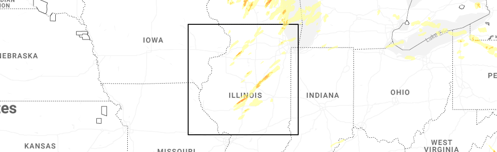
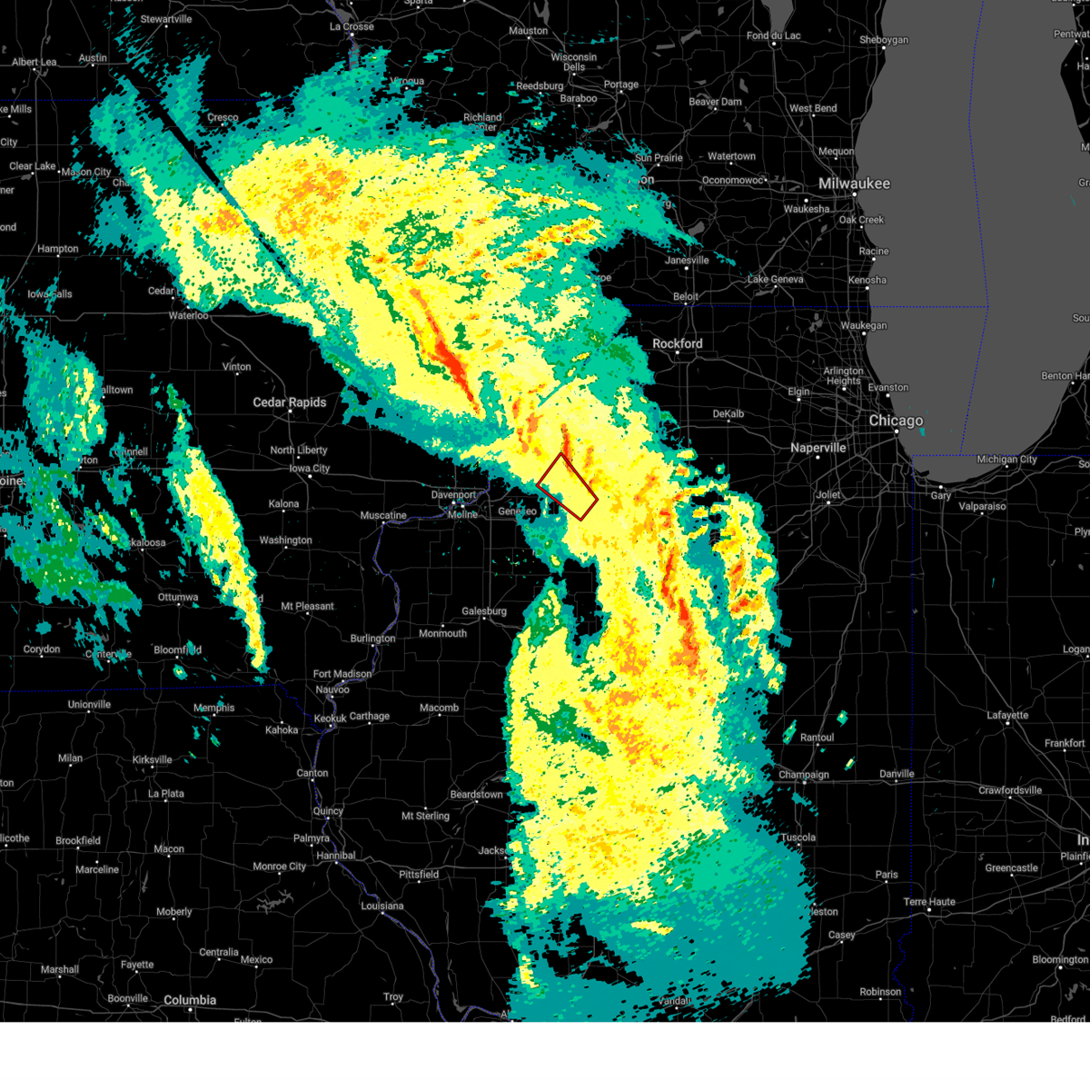
Hail Map for Tampico, IL
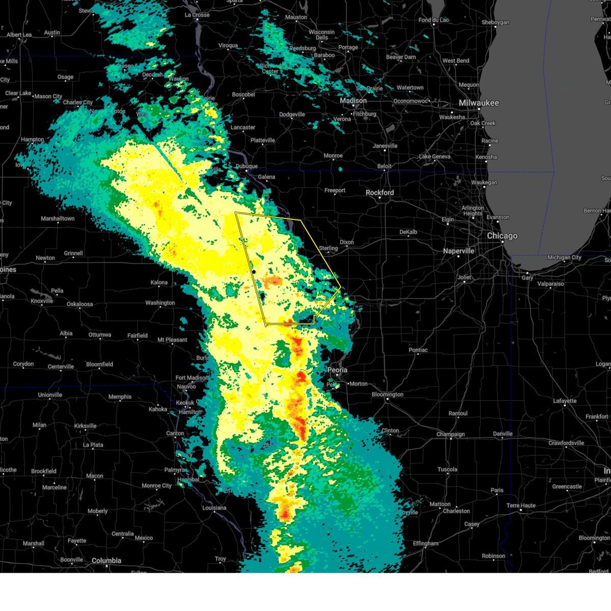
The Tampico, IL area has had 8 reports of on-the-ground hail by trained spotters, and has been under severe weather warnings 43 times during the past 12 months. Doppler radar has detected hail at or near Tampico, IL on 48 occasions, including 1 occasion during the past year.
| Name: | Tampico, IL |
| Where Located: | 65.5 miles N of Peoria, IL |
| Map: | Google Map for Tampico, IL |
| Population: | 790 |
| Housing Units: | 317 |
| More Info: | Search Google for Tampico, IL |
0
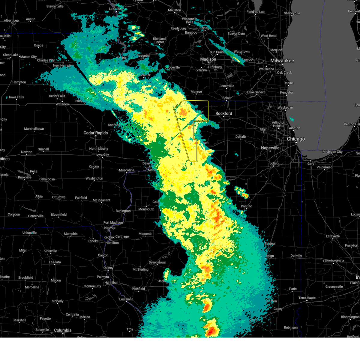
The Top Recent Hail Date for Tampico, IL is Thursday, May 15, 2025 (21st out of 48)
Hail and Wind Damage Spotted near Tampico, IL
| Date / Time | Report Details |
|---|---|
| 6/3/2025 8:06 PM CDT |
 At 805 pm cdt, severe thunderstorms were located along a line extending from franklin corners to rock falls to near dover, moving northeast at 60 mph (radar indicated). Hazards include 70 mph wind gusts and penny size hail. Expect considerable tree damage. damage is likely to mobile homes, roofs, and outbuildings. locations impacted include, freeport, sterling, rock falls, princeton, morrison, mount carroll, prophetstown, lanark, walnut, milledgeville, wyanet, fairhaven, tampico, shannon, la moille, davis, lyndon, chadwick, buda, and german valley. this includes the following highways, interstate 80 in illinois between mile markers 45 and 61. interstate 88 between mile markers 26 and 44. Interstate 180 near mile marker 13. At 805 pm cdt, severe thunderstorms were located along a line extending from franklin corners to rock falls to near dover, moving northeast at 60 mph (radar indicated). Hazards include 70 mph wind gusts and penny size hail. Expect considerable tree damage. damage is likely to mobile homes, roofs, and outbuildings. locations impacted include, freeport, sterling, rock falls, princeton, morrison, mount carroll, prophetstown, lanark, walnut, milledgeville, wyanet, fairhaven, tampico, shannon, la moille, davis, lyndon, chadwick, buda, and german valley. this includes the following highways, interstate 80 in illinois between mile markers 45 and 61. interstate 88 between mile markers 26 and 44. Interstate 180 near mile marker 13.
|
| 6/3/2025 8:06 PM CDT |
 the severe thunderstorm warning has been cancelled and is no longer in effect the severe thunderstorm warning has been cancelled and is no longer in effect
|
| 6/3/2025 8:04 PM CDT |
 At 804 pm cdt, severe thunderstorms were located along a line extending from franklin corners to whiteside county airport to near princeton, moving northeast at 60 mph (radar indicated). Hazards include 70 mph wind gusts and penny size hail. Expect considerable tree damage. damage is likely to mobile homes, roofs, and outbuildings. locations impacted include, clinton, freeport, sterling, rock falls, princeton, morrison, mount carroll, fulton, prophetstown, erie, lanark, walnut, garden plain, milledgeville, wyanet, sheffield, fairhaven, annawan, tampico, and shannon. this includes the following highways, interstate 80 in illinois between mile markers 30 and 61. interstate 88 between mile markers 17 and 44. Interstate 180 near mile marker 13. At 804 pm cdt, severe thunderstorms were located along a line extending from franklin corners to whiteside county airport to near princeton, moving northeast at 60 mph (radar indicated). Hazards include 70 mph wind gusts and penny size hail. Expect considerable tree damage. damage is likely to mobile homes, roofs, and outbuildings. locations impacted include, clinton, freeport, sterling, rock falls, princeton, morrison, mount carroll, fulton, prophetstown, erie, lanark, walnut, garden plain, milledgeville, wyanet, sheffield, fairhaven, annawan, tampico, and shannon. this includes the following highways, interstate 80 in illinois between mile markers 30 and 61. interstate 88 between mile markers 17 and 44. Interstate 180 near mile marker 13.
|
| 6/3/2025 7:49 PM CDT |
 Svrdvn the national weather service in the quad cities has issued a * severe thunderstorm warning for, whiteside county in northwestern illinois, northeastern henry county in northwestern illinois, carroll county in northwestern illinois, southeastern stephenson county in northwestern illinois, bureau county in north central illinois, east central clinton county in east central iowa, * until 845 pm cdt. * at 748 pm cdt, severe thunderstorms were located along a line extending from east clinton to portland corners to sheffield, moving northeast at 60 mph (radar indicated). Hazards include 70 mph wind gusts and penny size hail. Expect considerable tree damage. Damage is likely to mobile homes, roofs, and outbuildings. Svrdvn the national weather service in the quad cities has issued a * severe thunderstorm warning for, whiteside county in northwestern illinois, northeastern henry county in northwestern illinois, carroll county in northwestern illinois, southeastern stephenson county in northwestern illinois, bureau county in north central illinois, east central clinton county in east central iowa, * until 845 pm cdt. * at 748 pm cdt, severe thunderstorms were located along a line extending from east clinton to portland corners to sheffield, moving northeast at 60 mph (radar indicated). Hazards include 70 mph wind gusts and penny size hail. Expect considerable tree damage. Damage is likely to mobile homes, roofs, and outbuildings.
|
| 5/15/2025 5:55 PM CDT |
 The storm which prompted the warning has moved out of the area. therefore, the warning will be allowed to expire. a tornado watch remains in effect until 1000 pm cdt for north central illinois. The storm which prompted the warning has moved out of the area. therefore, the warning will be allowed to expire. a tornado watch remains in effect until 1000 pm cdt for north central illinois.
|
| 5/15/2025 5:38 PM CDT | Hen Egg sized hail reported 5.3 miles NE of Tampico, IL, damage to house siding and windows... as well as cracking of a vehicle wind shield. time estimated by radar. |
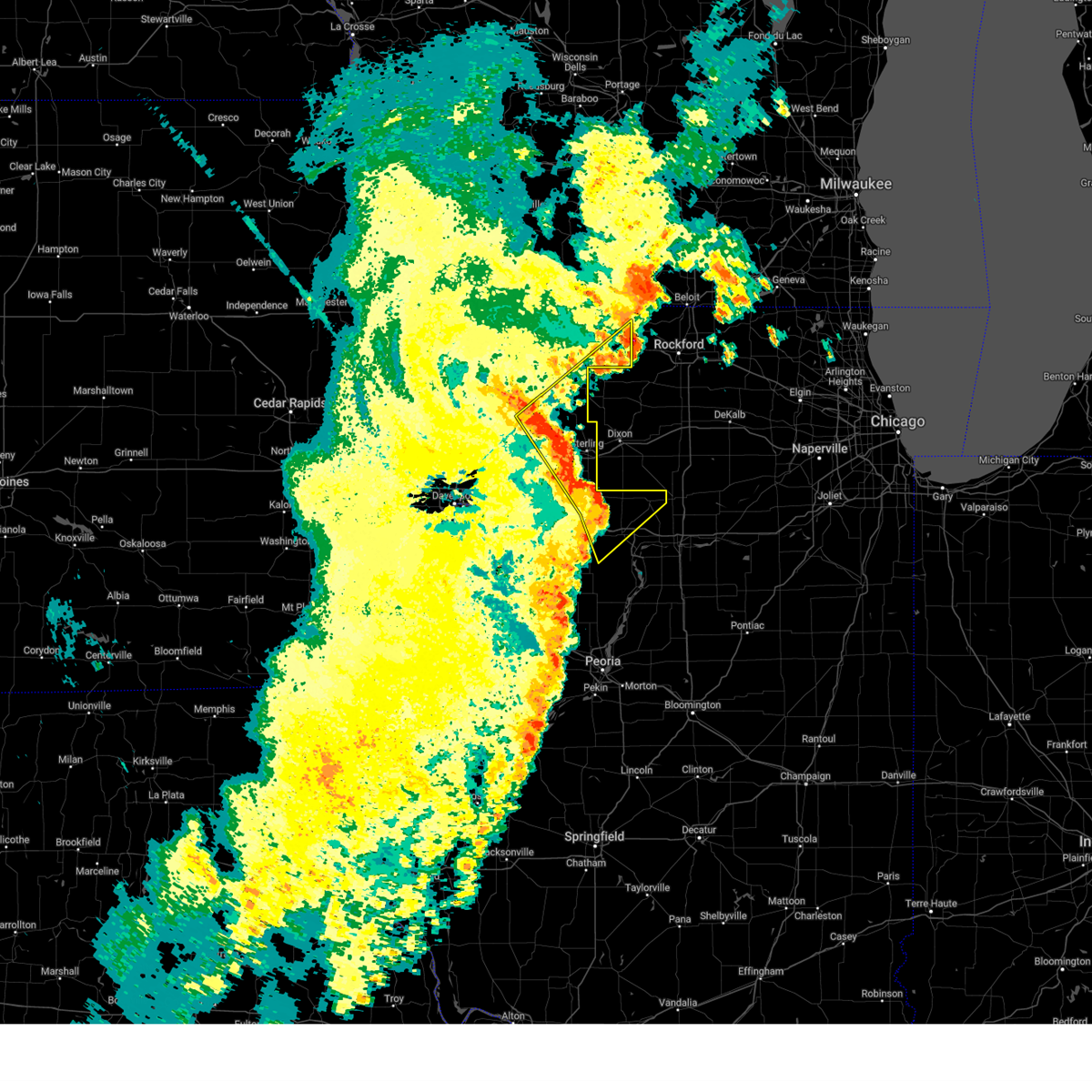
| 5/15/2025 5:38 PM CDT | At 537 pm cdt, a severe thunderstorm was located near deer grove, or 13 miles south of rock falls, moving northeast at 45 mph (radar indicated). Hazards include two inch hail and 70 mph wind gusts. People and animals outdoors will be injured. expect hail damage to roofs, siding, windows, and vehicles. expect considerable tree damage. wind damage is also likely to mobile homes, roofs, and outbuildings. Locations impacted include, tampico, deer grove, and yorktown. |
| 5/15/2025 5:38 PM CDT | the severe thunderstorm warning has been cancelled and is no longer in effect |
| 5/15/2025 5:32 PM CDT | At 532 pm cdt, a severe thunderstorm was located over thomas, or 17 miles south of rock falls, moving northeast at 45 mph (radar indicated). Hazards include golf ball size hail and 60 mph wind gusts. People and animals outdoors will be injured. expect hail damage to roofs, siding, windows, and vehicles. expect wind damage to roofs, siding, and trees. Locations impacted include, tampico, hooppole, deer grove, yorktown, new bedford, thomas, and normandy. |
| 5/15/2025 5:30 PM CDT |
 At 530 pm cdt, a severe thunderstorm was located over thomas, or 19 miles southwest of rock falls, moving northeast at 45 mph (radar indicated). Hazards include 60 mph wind gusts and half dollar size hail. Hail damage to vehicles is expected. expect wind damage to roofs, siding, and trees. Locations impacted include, tampico, hooppole, deer grove, yorktown, new bedford, thomas, and normandy. At 530 pm cdt, a severe thunderstorm was located over thomas, or 19 miles southwest of rock falls, moving northeast at 45 mph (radar indicated). Hazards include 60 mph wind gusts and half dollar size hail. Hail damage to vehicles is expected. expect wind damage to roofs, siding, and trees. Locations impacted include, tampico, hooppole, deer grove, yorktown, new bedford, thomas, and normandy.
|
| 5/15/2025 5:27 PM CDT |
 Svrdvn the national weather service in the quad cities has issued a * severe thunderstorm warning for, southeastern whiteside county in northwestern illinois, northeastern henry county in northwestern illinois, northwestern bureau county in north central illinois, * until 600 pm cdt. * at 526 pm cdt, a severe thunderstorm was located over thomas, or 17 miles north of kewanee, moving northeast at 45 mph (radar indicated). Hazards include 60 mph wind gusts and quarter size hail. Hail damage to vehicles is expected. Expect wind damage to roofs, siding, and trees. Svrdvn the national weather service in the quad cities has issued a * severe thunderstorm warning for, southeastern whiteside county in northwestern illinois, northeastern henry county in northwestern illinois, northwestern bureau county in north central illinois, * until 600 pm cdt. * at 526 pm cdt, a severe thunderstorm was located over thomas, or 17 miles north of kewanee, moving northeast at 45 mph (radar indicated). Hazards include 60 mph wind gusts and quarter size hail. Hail damage to vehicles is expected. Expect wind damage to roofs, siding, and trees.
|
| 4/20/2025 9:38 PM CDT |
 The storms which prompted the warning have moved out of the area. therefore, the warning will be allowed to expire. a tornado watch remains in effect until 1100 pm cdt for north central and northwestern illinois. The storms which prompted the warning have moved out of the area. therefore, the warning will be allowed to expire. a tornado watch remains in effect until 1100 pm cdt for north central and northwestern illinois.
|
| 4/20/2025 9:26 PM CDT |
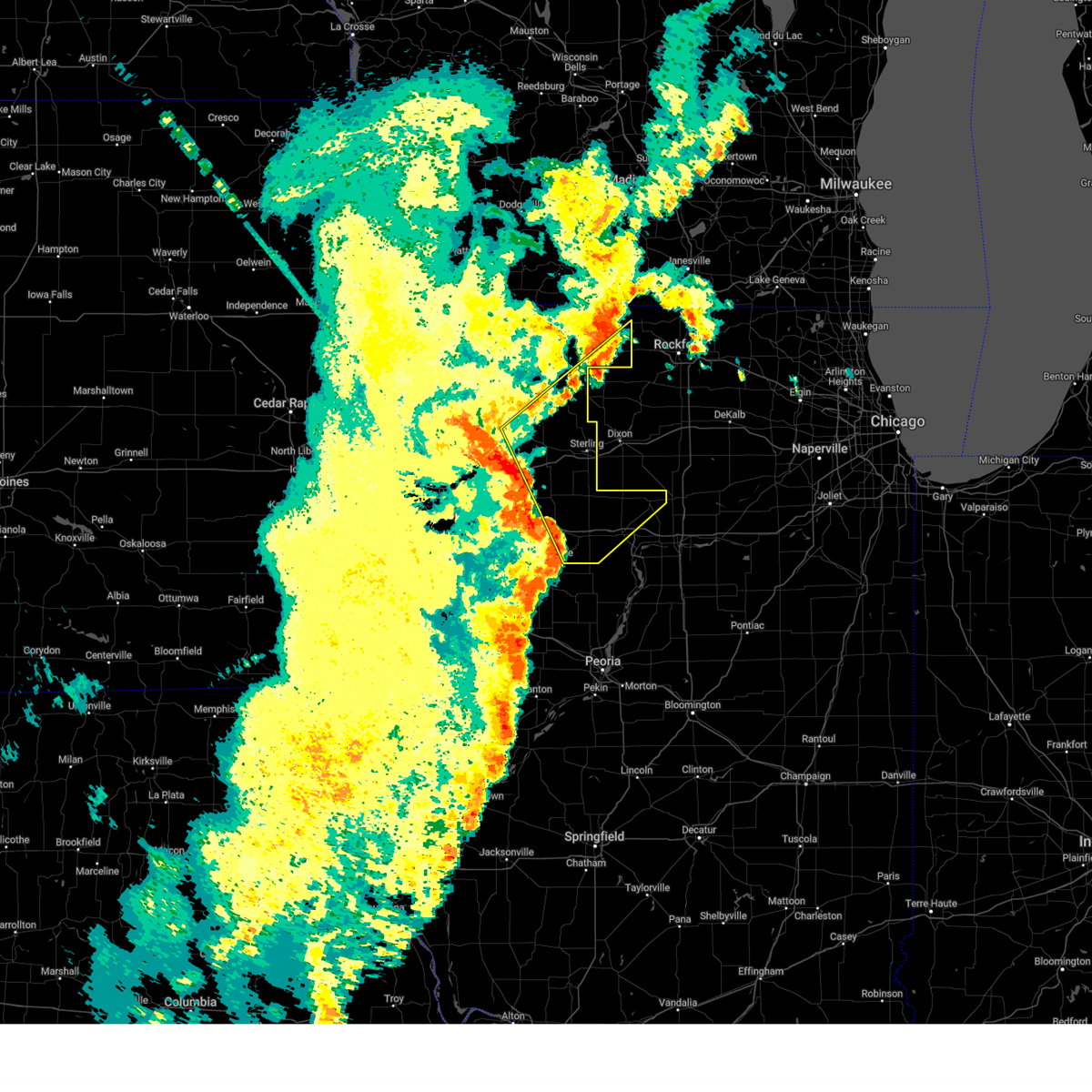
 At 926 pm cdt, severe thunderstorms capable of producing tornadoes were located along a line extending from near spring hill to near thomas, moving northeast at 40 mph (radar indicated rotation). Hazards include tornado. Flying debris will be dangerous to those caught without shelter. mobile homes will be damaged or destroyed. damage to roofs, windows, and vehicles will occur. tree damage is likely. these dangerous storms will be near, prophetstown state recreation area, tampico, yorktown, new bedford, thomas, leon corners, and prophetstown around 930 pm cdt. other locations in the path of these tornadic storms include normandy and deer grove. This includes interstate 88 between mile markers 30 and 32. At 926 pm cdt, severe thunderstorms capable of producing tornadoes were located along a line extending from near spring hill to near thomas, moving northeast at 40 mph (radar indicated rotation). Hazards include tornado. Flying debris will be dangerous to those caught without shelter. mobile homes will be damaged or destroyed. damage to roofs, windows, and vehicles will occur. tree damage is likely. these dangerous storms will be near, prophetstown state recreation area, tampico, yorktown, new bedford, thomas, leon corners, and prophetstown around 930 pm cdt. other locations in the path of these tornadic storms include normandy and deer grove. This includes interstate 88 between mile markers 30 and 32.
|
| 4/20/2025 9:14 PM CDT |
 Tordvn the national weather service in the quad cities has issued a * tornado warning for, southeastern whiteside county in northwestern illinois, northeastern henry county in northwestern illinois, northwestern bureau county in north central illinois, * until 945 pm cdt. * at 913 pm cdt, severe thunderstorms capable of producing a tornado were located along a line extending from near shady beach to near atkinson, moving northeast at 40 mph (radar indicated rotation). Hazards include tornado. Flying debris will be dangerous to those caught without shelter. mobile homes will be damaged or destroyed. damage to roofs, windows, and vehicles will occur. tree damage is likely. these dangerous storms will be near, thomas, hooppole, and leon corners around 920 pm cdt. prophetstown state recreation area, yorktown, and prophetstown around 925 pm cdt. tampico and new bedford around 930 pm cdt. this includes the following highways, interstate 80 in illinois between mile markers 29 and 39. Interstate 88 between mile markers 30 and 32. Tordvn the national weather service in the quad cities has issued a * tornado warning for, southeastern whiteside county in northwestern illinois, northeastern henry county in northwestern illinois, northwestern bureau county in north central illinois, * until 945 pm cdt. * at 913 pm cdt, severe thunderstorms capable of producing a tornado were located along a line extending from near shady beach to near atkinson, moving northeast at 40 mph (radar indicated rotation). Hazards include tornado. Flying debris will be dangerous to those caught without shelter. mobile homes will be damaged or destroyed. damage to roofs, windows, and vehicles will occur. tree damage is likely. these dangerous storms will be near, thomas, hooppole, and leon corners around 920 pm cdt. prophetstown state recreation area, yorktown, and prophetstown around 925 pm cdt. tampico and new bedford around 930 pm cdt. this includes the following highways, interstate 80 in illinois between mile markers 29 and 39. Interstate 88 between mile markers 30 and 32.
|
| 3/14/2025 10:47 PM CDT |
 the severe thunderstorm warning has been cancelled and is no longer in effect the severe thunderstorm warning has been cancelled and is no longer in effect
|
| 3/14/2025 10:47 PM CDT |
 At 1046 pm cdt, severe thunderstorms were located along a line extending from yellowstone lake st park to near bolton, moving northeast at 60 mph (radar indicated). Hazards include 70 mph wind gusts. Expect considerable tree damage. damage is likely to mobile homes, roofs, and outbuildings. locations impacted include, carroll county fairgrounds, lake le-aqua- na state park, shannon, como, davis, coleta, winslow, chadwick, douglas park, buena vista, yeoward addition, whiteside county airport, rock grove, red oak, galt, milledgeville, lena, emerson, dakota dornink airport, and willow. This includes interstate 88 between mile markers 33 and 44. At 1046 pm cdt, severe thunderstorms were located along a line extending from yellowstone lake st park to near bolton, moving northeast at 60 mph (radar indicated). Hazards include 70 mph wind gusts. Expect considerable tree damage. damage is likely to mobile homes, roofs, and outbuildings. locations impacted include, carroll county fairgrounds, lake le-aqua- na state park, shannon, como, davis, coleta, winslow, chadwick, douglas park, buena vista, yeoward addition, whiteside county airport, rock grove, red oak, galt, milledgeville, lena, emerson, dakota dornink airport, and willow. This includes interstate 88 between mile markers 33 and 44.
|
| 3/14/2025 10:34 PM CDT | At 1033 pm cdt, severe thunderstorms were located along a line extending from gratiot to near lanark, moving northeast at 60 mph (radar indicated). Hazards include 70 mph wind gusts. Expect considerable tree damage. damage is likely to mobile homes, roofs, and outbuildings. locations impacted include, portland corners, wacker, morrison, ideal, carroll county fairgrounds, round grove, lake le-aqua- na state park, shannon, malvern, como, davis, coleta, winslow, denrock, chadwick, union grove, thomson causeway, douglas park, buena vista, and yeoward addition. This includes interstate 88 between mile markers 21 and 44. |
| 3/14/2025 10:34 PM CDT | the severe thunderstorm warning has been cancelled and is no longer in effect |
| 3/14/2025 10:28 PM CDT | Measured from personal weather station. time estimate in whiteside county IL, 0.2 miles E of Tampico, IL |
| 3/14/2025 10:17 PM CDT | At 1017 pm cdt, severe thunderstorms were located along a line extending from near schapville to union grove, moving east at 65 mph (radar indicated). Hazards include 70 mph wind gusts. Expect considerable tree damage. damage is likely to mobile homes, roofs, and outbuildings. locations impacted include, wacker, ideal, carroll county fairgrounds, lake le-aqua- na state park, como, reeceville, winslow, east clinton, denrock, union grove, thomson causeway, douglas park, buena vista, albany, bryant, yeoward addition, rock grove, red oak, galt, and bulgers hollow. This includes interstate 88 between mile markers 8 and 44. |
| 3/14/2025 10:01 PM CDT | Svrdvn the national weather service in the quad cities has issued a * severe thunderstorm warning for, northeastern rock island county in northwestern illinois, whiteside county in northwestern illinois, southeastern jo daviess county in northwestern illinois, carroll county in northwestern illinois, stephenson county in northwestern illinois, southeastern jackson county in east central iowa, eastern clinton county in east central iowa, * until 1115 pm cdt. * at 1000 pm cdt, severe thunderstorms were located along a line extending from near galena territory to fulton, moving north at 65 mph (trained weather spotters). Hazards include 70 mph wind gusts. Expect considerable tree damage. Damage is likely to mobile homes, roofs, and outbuildings. |
| 3/14/2025 9:53 PM CDT | Svrdvn the national weather service in the quad cities has issued a * severe thunderstorm warning for, northeastern rock island county in northwestern illinois, whiteside county in northwestern illinois, southeastern jo daviess county in northwestern illinois, carroll county in northwestern illinois, stephenson county in northwestern illinois, southeastern jackson county in east central iowa, eastern clinton county in east central iowa, * until 1115 pm cdt. * at 953 pm cdt, severe thunderstorms were located along a line extending from near green island to near hillsdale, moving north at 180 mph (trained weather spotters reported 75 mph winds at the clinton iowa riverfront). Hazards include 70 mph wind gusts. Expect considerable tree damage. Damage is likely to mobile homes, roofs, and outbuildings. |
| 3/14/2025 9:47 PM CDT |
 At 946 pm cdt, severe thunderstorms were located along a line extending from near zwingle to johnson-sauk trail state park, moving east at 50 mph (radar indicated). Hazards include 70 mph wind gusts. Expect considerable tree damage. damage is likely to mobile homes, roofs, and outbuildings. locations impacted include, moline, wacker, ideal, cambridge, maquoketa caves state park, manlius, kewanee municipal airport, jackson county fairgrounds, east clinton, port byron, panorama park, davenport municipal airport, denrock, union grove, thomson causeway, osborn, elwood, albany, bryant, and barstow. this includes the following highways, interstate 74 in iowa between mile markers 1 and 5. interstate 80 in iowa between mile markers 294 and 306. interstate 80 in illinois between mile markers 1 and 46. interstate 74 in illinois between mile markers 1 and 33. interstate 88 between mile markers 1 and 36. Interstate 280 between mile markers 15 and 18. At 946 pm cdt, severe thunderstorms were located along a line extending from near zwingle to johnson-sauk trail state park, moving east at 50 mph (radar indicated). Hazards include 70 mph wind gusts. Expect considerable tree damage. damage is likely to mobile homes, roofs, and outbuildings. locations impacted include, moline, wacker, ideal, cambridge, maquoketa caves state park, manlius, kewanee municipal airport, jackson county fairgrounds, east clinton, port byron, panorama park, davenport municipal airport, denrock, union grove, thomson causeway, osborn, elwood, albany, bryant, and barstow. this includes the following highways, interstate 74 in iowa between mile markers 1 and 5. interstate 80 in iowa between mile markers 294 and 306. interstate 80 in illinois between mile markers 1 and 46. interstate 74 in illinois between mile markers 1 and 33. interstate 88 between mile markers 1 and 36. Interstate 280 between mile markers 15 and 18.
|
| 3/14/2025 9:47 PM CDT |
 the severe thunderstorm warning has been cancelled and is no longer in effect the severe thunderstorm warning has been cancelled and is no longer in effect
|
| 3/14/2025 9:31 PM CDT |
 the severe thunderstorm warning has been cancelled and is no longer in effect the severe thunderstorm warning has been cancelled and is no longer in effect
|
| 3/14/2025 9:31 PM CDT |
 At 930 pm cdt, severe thunderstorms were located along a line extending from near garry owen to near ulah, moving northeast at 50 mph (radar indicated). Hazards include 70 mph wind gusts. Expect considerable tree damage. damage is likely to mobile homes, roofs, and outbuildings. locations impacted include, moline, wacker, ideal, west lake park, cambridge, maquoketa caves state park, manlius, kewanee municipal airport, jackson county fairgrounds, east clinton, port byron, panorama park, davenport municipal airport, denrock, union grove, thomson causeway, osborn, elwood, albany, and bryant. this includes the following highways, interstate 74 in iowa between mile markers 1 and 5. interstate 80 in iowa between mile markers 284 and 306. interstate 80 in illinois between mile markers 1 and 46. interstate 74 in illinois between mile markers 1 and 33. interstate 88 between mile markers 1 and 36. Interstate 280 between mile markers 1 and 18. At 930 pm cdt, severe thunderstorms were located along a line extending from near garry owen to near ulah, moving northeast at 50 mph (radar indicated). Hazards include 70 mph wind gusts. Expect considerable tree damage. damage is likely to mobile homes, roofs, and outbuildings. locations impacted include, moline, wacker, ideal, west lake park, cambridge, maquoketa caves state park, manlius, kewanee municipal airport, jackson county fairgrounds, east clinton, port byron, panorama park, davenport municipal airport, denrock, union grove, thomson causeway, osborn, elwood, albany, and bryant. this includes the following highways, interstate 74 in iowa between mile markers 1 and 5. interstate 80 in iowa between mile markers 284 and 306. interstate 80 in illinois between mile markers 1 and 46. interstate 74 in illinois between mile markers 1 and 33. interstate 88 between mile markers 1 and 36. Interstate 280 between mile markers 1 and 18.
|
| 3/14/2025 9:19 PM CDT |
 At 919 pm cdt, severe thunderstorms were located along a line extending from near temple hill to near nekoma, moving northeast at 50 mph (radar indicated). Hazards include 70 mph wind gusts. Expect considerable tree damage. damage is likely to mobile homes, roofs, and outbuildings. locations impacted include, ideal, west lake park, cambridge, manlius, kewanee municipal airport, jackson county fairgrounds, east clinton, port byron, davenport municipal airport, stone city, union grove, thomson causeway, osborn, elwood, albany, bryant, blackhawk state park, maquoketa, princeton, and fruitland. this includes the following highways, interstate 74 in iowa between mile markers 1 and 5. interstate 80 in iowa between mile markers 272 and 306. interstate 80 in illinois between mile markers 1 and 46. interstate 74 in illinois between mile markers 1 and 33. interstate 88 between mile markers 1 and 36. Interstate 280 between mile markers 1 and 18. At 919 pm cdt, severe thunderstorms were located along a line extending from near temple hill to near nekoma, moving northeast at 50 mph (radar indicated). Hazards include 70 mph wind gusts. Expect considerable tree damage. damage is likely to mobile homes, roofs, and outbuildings. locations impacted include, ideal, west lake park, cambridge, manlius, kewanee municipal airport, jackson county fairgrounds, east clinton, port byron, davenport municipal airport, stone city, union grove, thomson causeway, osborn, elwood, albany, bryant, blackhawk state park, maquoketa, princeton, and fruitland. this includes the following highways, interstate 74 in iowa between mile markers 1 and 5. interstate 80 in iowa between mile markers 272 and 306. interstate 80 in illinois between mile markers 1 and 46. interstate 74 in illinois between mile markers 1 and 33. interstate 88 between mile markers 1 and 36. Interstate 280 between mile markers 1 and 18.
|
| 3/14/2025 9:08 PM CDT |
 Svrdvn the national weather service in the quad cities has issued a * severe thunderstorm warning for, rock island county in northwestern illinois, eastern mercer county in northwestern illinois, whiteside county in northwestern illinois, south central carroll county in northwestern illinois, northeastern warren county in west central illinois, henry county in northwestern illinois, northwestern bureau county in north central illinois, southern jackson county in east central iowa, eastern cedar county in east central iowa, northeastern muscatine county in east central iowa, scott county in east central iowa, southern jones county in east central iowa, clinton county in east central iowa, * until 1000 pm cdt. * at 906 pm cdt, severe thunderstorms were located along a line extending from near central park to near alpha, moving northeast at 50 mph (radar indicated). Hazards include 70 mph wind gusts. Expect considerable tree damage. Damage is likely to mobile homes, roofs, and outbuildings. Svrdvn the national weather service in the quad cities has issued a * severe thunderstorm warning for, rock island county in northwestern illinois, eastern mercer county in northwestern illinois, whiteside county in northwestern illinois, south central carroll county in northwestern illinois, northeastern warren county in west central illinois, henry county in northwestern illinois, northwestern bureau county in north central illinois, southern jackson county in east central iowa, eastern cedar county in east central iowa, northeastern muscatine county in east central iowa, scott county in east central iowa, southern jones county in east central iowa, clinton county in east central iowa, * until 1000 pm cdt. * at 906 pm cdt, severe thunderstorms were located along a line extending from near central park to near alpha, moving northeast at 50 mph (radar indicated). Hazards include 70 mph wind gusts. Expect considerable tree damage. Damage is likely to mobile homes, roofs, and outbuildings.
|
| 7/15/2024 8:22 PM CDT |
 the severe thunderstorm warning has been cancelled and is no longer in effect the severe thunderstorm warning has been cancelled and is no longer in effect
|
| 7/15/2024 8:22 PM CDT |
 At 821 pm cdt, a severe thunderstorm was located over deer grove, or 11 miles south of rock falls, moving southeast at 35 mph (radar indicated). Hazards include 80 mph wind gusts. Flying debris will be dangerous to those caught without shelter. mobile homes will be heavily damaged. expect considerable damage to roofs, windows, and vehicles. extensive tree damage and power outages are likely. locations impacted include, sterling, rock falls, walnut, tampico, deer grove, emerson, ohio, yorktown, yeoward addition, whiteside county airport, galt, penrose, como, kasbeer, leon corners, normandy, grimes addition, douglas park, and agnew. This includes interstate 88 between mile markers 34 and 44. At 821 pm cdt, a severe thunderstorm was located over deer grove, or 11 miles south of rock falls, moving southeast at 35 mph (radar indicated). Hazards include 80 mph wind gusts. Flying debris will be dangerous to those caught without shelter. mobile homes will be heavily damaged. expect considerable damage to roofs, windows, and vehicles. extensive tree damage and power outages are likely. locations impacted include, sterling, rock falls, walnut, tampico, deer grove, emerson, ohio, yorktown, yeoward addition, whiteside county airport, galt, penrose, como, kasbeer, leon corners, normandy, grimes addition, douglas park, and agnew. This includes interstate 88 between mile markers 34 and 44.
|
| 7/15/2024 8:08 PM CDT |
 At 808 pm cdt, a severe thunderstorm was located over tampico, or 10 miles southwest of rock falls, moving southeast at 35 mph (radar indicated). Hazards include 80 mph wind gusts. Flying debris will be dangerous to those caught without shelter. mobile homes will be heavily damaged. expect considerable damage to roofs, windows, and vehicles. extensive tree damage and power outages are likely. locations impacted include, sterling, rock falls, morrison, prophetstown, erie, walnut, garden plain, tampico, lyndon, coleta, deer grove, emerson, union grove, ustick, fenton, hillsdale, ohio, yorktown, round grove, and new bedford. This includes interstate 88 between mile markers 9 and 44. At 808 pm cdt, a severe thunderstorm was located over tampico, or 10 miles southwest of rock falls, moving southeast at 35 mph (radar indicated). Hazards include 80 mph wind gusts. Flying debris will be dangerous to those caught without shelter. mobile homes will be heavily damaged. expect considerable damage to roofs, windows, and vehicles. extensive tree damage and power outages are likely. locations impacted include, sterling, rock falls, morrison, prophetstown, erie, walnut, garden plain, tampico, lyndon, coleta, deer grove, emerson, union grove, ustick, fenton, hillsdale, ohio, yorktown, round grove, and new bedford. This includes interstate 88 between mile markers 9 and 44.
|
| 7/15/2024 8:08 PM CDT |
 the severe thunderstorm warning has been cancelled and is no longer in effect the severe thunderstorm warning has been cancelled and is no longer in effect
|
| 7/15/2024 7:50 PM CDT |
 Svrdvn the national weather service in the quad cities has issued a * severe thunderstorm warning for, northeastern rock island county in northwestern illinois, whiteside county in northwestern illinois, northeastern henry county in northwestern illinois, northwestern bureau county in north central illinois, eastern scott county in east central iowa, * until 845 pm cdt. * at 749 pm cdt, a severe thunderstorm was located over fenton, or near morrison, moving southeast at 35 mph (radar indicated). Hazards include 80 mph wind gusts. Flying debris will be dangerous to those caught without shelter. mobile homes will be heavily damaged. expect considerable damage to roofs, windows, and vehicles. Extensive tree damage and power outages are likely. Svrdvn the national weather service in the quad cities has issued a * severe thunderstorm warning for, northeastern rock island county in northwestern illinois, whiteside county in northwestern illinois, northeastern henry county in northwestern illinois, northwestern bureau county in north central illinois, eastern scott county in east central iowa, * until 845 pm cdt. * at 749 pm cdt, a severe thunderstorm was located over fenton, or near morrison, moving southeast at 35 mph (radar indicated). Hazards include 80 mph wind gusts. Flying debris will be dangerous to those caught without shelter. mobile homes will be heavily damaged. expect considerable damage to roofs, windows, and vehicles. Extensive tree damage and power outages are likely.
|
| 7/15/2024 7:46 PM CDT |
 At 745 pm cdt, tornado producing storms were located along a line extending from joslin to near woodhull, moving east at 50 mph. a tornado was reported near andover, near i-74 (weather spotters confirmed tornado). Hazards include damaging tornado. Flying debris will be dangerous to those caught without shelter. mobile homes will be damaged or destroyed. damage to roofs, windows, and vehicles will occur. tree damage is likely. these tornadic storms will be near, cambridge, geneseo, woodhull, bishop hill, spring hill, nekoma, ulah, and henry county fairgrounds around 750 pm cdt. galva, atkinson, hooppole, german corner, and leon corners around 755 pm cdt. kewanee, annawan, yorktown, and kewanee municipal airport around 800 pm cdt. other locations in the path of these tornadic storms include mineral, thomas, johnson-sauk trail state park, sheffield, tampico, deer grove, neponset, new bedford, walnut, buda, manlius and normandy. this includes the following highways, interstate 80 in illinois between mile markers 6 and 48. interstate 74 in illinois between mile markers 11 and 33. Interstate 88 between mile markers 14 and 16. At 745 pm cdt, tornado producing storms were located along a line extending from joslin to near woodhull, moving east at 50 mph. a tornado was reported near andover, near i-74 (weather spotters confirmed tornado). Hazards include damaging tornado. Flying debris will be dangerous to those caught without shelter. mobile homes will be damaged or destroyed. damage to roofs, windows, and vehicles will occur. tree damage is likely. these tornadic storms will be near, cambridge, geneseo, woodhull, bishop hill, spring hill, nekoma, ulah, and henry county fairgrounds around 750 pm cdt. galva, atkinson, hooppole, german corner, and leon corners around 755 pm cdt. kewanee, annawan, yorktown, and kewanee municipal airport around 800 pm cdt. other locations in the path of these tornadic storms include mineral, thomas, johnson-sauk trail state park, sheffield, tampico, deer grove, neponset, new bedford, walnut, buda, manlius and normandy. this includes the following highways, interstate 80 in illinois between mile markers 6 and 48. interstate 74 in illinois between mile markers 11 and 33. Interstate 88 between mile markers 14 and 16.
|
| 7/15/2024 7:45 PM CDT |
 At 744 pm cdt, severe thunderstorms were located along a line extending from franklin corners to barstow, moving southeast at 40 mph (radar indicated). Hazards include 80 mph wind gusts. Flying debris will be dangerous to those caught without shelter. mobile homes will be heavily damaged. expect considerable damage to roofs, windows, and vehicles. extensive tree damage and power outages are likely. locations impacted include, clinton, sterling, rock falls, morrison, eldridge, dewitt, camanche, le claire, fulton, savanna, prophetstown, port byron, erie, garden plain, milledgeville, fairhaven, albany, princeton, long grove, and tampico. This includes interstate 88 between mile markers 9 and 44. At 744 pm cdt, severe thunderstorms were located along a line extending from franklin corners to barstow, moving southeast at 40 mph (radar indicated). Hazards include 80 mph wind gusts. Flying debris will be dangerous to those caught without shelter. mobile homes will be heavily damaged. expect considerable damage to roofs, windows, and vehicles. extensive tree damage and power outages are likely. locations impacted include, clinton, sterling, rock falls, morrison, eldridge, dewitt, camanche, le claire, fulton, savanna, prophetstown, port byron, erie, garden plain, milledgeville, fairhaven, albany, princeton, long grove, and tampico. This includes interstate 88 between mile markers 9 and 44.
|
| 7/15/2024 7:42 PM CDT | Tordvn the national weather service in the quad cities has issued a * tornado warning for, southern whiteside county in northwestern illinois, henry county in northwestern illinois, western bureau county in north central illinois, * until 830 pm cdt. * at 742 pm cdt, severe thunderstorms capable of producing both tornadoes and extensive straight line wind damage were located along a line extending from joslin to near alpha, moving east at 50 mph (radar indicated rotation). Hazards include tornado. Flying debris will be dangerous to those caught without shelter. mobile homes will be damaged or destroyed. damage to roofs, windows, and vehicles will occur. tree damage is likely. these dangerous storms will be near, cambridge, geneseo, woodhull, andover, hillsdale, osco, shady beach, nekoma, ulah, and henry county fairgrounds around 745 pm cdt. atkinson, bishop hill, and spring hill around 750 pm cdt. galva, hooppole, and german corner around 755 pm cdt. kewanee, annawan, yorktown, thomas, johnson-sauk trail state park, and kewanee municipal airport around 800 pm cdt. other locations in the path of these tornadic storms include mineral, sheffield, neponset, manlius, new bedford and buda. this includes the following highways, interstate 80 in illinois between mile markers 6 and 48. interstate 74 in illinois between mile markers 11 and 33. Interstate 88 between mile markers 14 and 16. |
| 7/15/2024 7:26 PM CDT |
 At 725 pm cdt, severe thunderstorms were located along a line extending from near thomson to davenport municipal airport, moving southeast at 40 mph. these are destructive storms for eldridge, clinton, sterling, rock falls (radar indicated). Hazards include 80 mph wind gusts. Flying debris will be dangerous to those caught without shelter. mobile homes will be heavily damaged. expect considerable damage to roofs, windows, and vehicles. extensive tree damage and power outages are likely. locations impacted include, clinton, sterling, rock falls, morrison, eldridge, dewitt, camanche, le claire, fulton, savanna, prophetstown, port byron, erie, garden plain, milledgeville, preston, fairhaven, albany, princeton, and long grove. This includes interstate 88 between mile markers 9 and 44. At 725 pm cdt, severe thunderstorms were located along a line extending from near thomson to davenport municipal airport, moving southeast at 40 mph. these are destructive storms for eldridge, clinton, sterling, rock falls (radar indicated). Hazards include 80 mph wind gusts. Flying debris will be dangerous to those caught without shelter. mobile homes will be heavily damaged. expect considerable damage to roofs, windows, and vehicles. extensive tree damage and power outages are likely. locations impacted include, clinton, sterling, rock falls, morrison, eldridge, dewitt, camanche, le claire, fulton, savanna, prophetstown, port byron, erie, garden plain, milledgeville, preston, fairhaven, albany, princeton, and long grove. This includes interstate 88 between mile markers 9 and 44.
|
| 7/15/2024 7:26 PM CDT |
 the severe thunderstorm warning has been cancelled and is no longer in effect the severe thunderstorm warning has been cancelled and is no longer in effect
|
| 7/15/2024 6:42 PM CDT | Svrdvn the national weather service in the quad cities has issued a * severe thunderstorm warning for, northeastern rock island county in northwestern illinois, whiteside county in northwestern illinois, northeastern henry county in northwestern illinois, southeastern carroll county in northwestern illinois, northwestern bureau county in north central illinois, southern jackson county in east central iowa, northeastern cedar county in east central iowa, northern scott county in east central iowa, clinton county in east central iowa, * until 800 pm cdt. * at 641 pm cdt, severe thunderstorms were located along a line extending from near andrew to near tipton, moving southeast at 40 mph. these are destructive storms for sterling, leclaire, prophetown (radar indicated). Hazards include 80 mph wind gusts. Flying debris will be dangerous to those caught without shelter. mobile homes will be heavily damaged. expect considerable damage to roofs, windows, and vehicles. Extensive tree damage and power outages are likely. |
| 7/14/2024 9:16 PM CDT |
 At 915 pm cdt, a severe thunderstorm was located near yorktown, or 14 miles south of rock falls, moving east at 45 mph (radar indicated). Hazards include 60 mph wind gusts. Expect damage to roofs, siding, and trees. Locations impacted include, prophetstown, tampico, deer grove, yorktown, new bedford, leon corners, prophetstown state recreation area, and normandy. At 915 pm cdt, a severe thunderstorm was located near yorktown, or 14 miles south of rock falls, moving east at 45 mph (radar indicated). Hazards include 60 mph wind gusts. Expect damage to roofs, siding, and trees. Locations impacted include, prophetstown, tampico, deer grove, yorktown, new bedford, leon corners, prophetstown state recreation area, and normandy.
|
| 7/14/2024 9:16 PM CDT |
 the severe thunderstorm warning has been cancelled and is no longer in effect the severe thunderstorm warning has been cancelled and is no longer in effect
|
| 7/14/2024 9:08 PM CDT |
 the severe thunderstorm warning has been cancelled and is no longer in effect the severe thunderstorm warning has been cancelled and is no longer in effect
|
| 7/14/2024 9:08 PM CDT |
 At 907 pm cdt, a severe thunderstorm was located over leon corners, or 16 miles south of morrison, moving east at 45 mph (radar indicated). Hazards include 60 mph wind gusts. Expect damage to roofs, siding, and trees. Locations impacted include, prophetstown, tampico, hooppole, deer grove, yorktown, new bedford, thomas, portland corners, leon corners, prophetstown state recreation area, spring hill, and normandy. At 907 pm cdt, a severe thunderstorm was located over leon corners, or 16 miles south of morrison, moving east at 45 mph (radar indicated). Hazards include 60 mph wind gusts. Expect damage to roofs, siding, and trees. Locations impacted include, prophetstown, tampico, hooppole, deer grove, yorktown, new bedford, thomas, portland corners, leon corners, prophetstown state recreation area, spring hill, and normandy.
|
| 7/14/2024 8:59 PM CDT |
 At 858 pm cdt, a severe thunderstorm was located over spring hill, or 16 miles south of morrison, moving east at 45 mph (radar indicated). Hazards include 60 mph wind gusts. Expect damage to roofs, siding, and trees. locations impacted include, prophetstown, erie, tampico, hooppole, deer grove, hillsdale, yorktown, new bedford, thomas, portland corners, prophetstown state recreation area, spring hill, leon corners, shady beach, and normandy. This includes interstate 88 between mile markers 18 and 20. At 858 pm cdt, a severe thunderstorm was located over spring hill, or 16 miles south of morrison, moving east at 45 mph (radar indicated). Hazards include 60 mph wind gusts. Expect damage to roofs, siding, and trees. locations impacted include, prophetstown, erie, tampico, hooppole, deer grove, hillsdale, yorktown, new bedford, thomas, portland corners, prophetstown state recreation area, spring hill, leon corners, shady beach, and normandy. This includes interstate 88 between mile markers 18 and 20.
|
| 7/14/2024 8:49 PM CDT |
 Svrdvn the national weather service in the quad cities has issued a * severe thunderstorm warning for, east central rock island county in northwestern illinois, southern whiteside county in northwestern illinois, northern henry county in northwestern illinois, northwestern bureau county in north central illinois, * until 930 pm cdt. * at 849 pm cdt, a severe thunderstorm was located over hillsdale, or 13 miles east of east moline, moving east at 40 mph (radar indicated). Hazards include 60 mph wind gusts. expect damage to roofs, siding, and trees Svrdvn the national weather service in the quad cities has issued a * severe thunderstorm warning for, east central rock island county in northwestern illinois, southern whiteside county in northwestern illinois, northern henry county in northwestern illinois, northwestern bureau county in north central illinois, * until 930 pm cdt. * at 849 pm cdt, a severe thunderstorm was located over hillsdale, or 13 miles east of east moline, moving east at 40 mph (radar indicated). Hazards include 60 mph wind gusts. expect damage to roofs, siding, and trees
|
| 6/25/2024 6:48 AM CDT |
 At 647 am cdt, severe thunderstorms were located along a line extending from near ohio to near sheffield to near cambridge, moving east at 30 mph (broadcast media). Hazards include 60 mph wind gusts and quarter size hail. Hail damage to vehicles is expected. expect wind damage to roofs, siding, and trees. locations impacted include, kewanee, princeton, cambridge, geneseo, galva, orion, walnut, wyanet, atkinson, sheffield, annawan, tampico, la moille, andover, buda, hooppole, deer grove, lynn center, ohio, and neponset. this includes the following highways, interstate 80 in illinois between mile markers 12 and 58. Interstate 74 in illinois between mile markers 15 and 25. At 647 am cdt, severe thunderstorms were located along a line extending from near ohio to near sheffield to near cambridge, moving east at 30 mph (broadcast media). Hazards include 60 mph wind gusts and quarter size hail. Hail damage to vehicles is expected. expect wind damage to roofs, siding, and trees. locations impacted include, kewanee, princeton, cambridge, geneseo, galva, orion, walnut, wyanet, atkinson, sheffield, annawan, tampico, la moille, andover, buda, hooppole, deer grove, lynn center, ohio, and neponset. this includes the following highways, interstate 80 in illinois between mile markers 12 and 58. Interstate 74 in illinois between mile markers 15 and 25.
|
| 6/25/2024 6:42 AM CDT |
 At 642 am cdt, severe thunderstorms were located along a line extending from near ohio to near mineral to andover, moving southeast at 30 mph (broadcast media). Hazards include 60 mph wind gusts and quarter size hail. Hail damage to vehicles is expected. expect wind damage to roofs, siding, and trees. locations impacted include, kewanee, princeton, cambridge, geneseo, galva, orion, walnut, wyanet, atkinson, sheffield, annawan, tampico, la moille, andover, buda, hooppole, deer grove, lynn center, ohio, and neponset. this includes the following highways, interstate 80 in illinois between mile markers 12 and 58. Interstate 74 in illinois between mile markers 15 and 25. At 642 am cdt, severe thunderstorms were located along a line extending from near ohio to near mineral to andover, moving southeast at 30 mph (broadcast media). Hazards include 60 mph wind gusts and quarter size hail. Hail damage to vehicles is expected. expect wind damage to roofs, siding, and trees. locations impacted include, kewanee, princeton, cambridge, geneseo, galva, orion, walnut, wyanet, atkinson, sheffield, annawan, tampico, la moille, andover, buda, hooppole, deer grove, lynn center, ohio, and neponset. this includes the following highways, interstate 80 in illinois between mile markers 12 and 58. Interstate 74 in illinois between mile markers 15 and 25.
|
| 6/25/2024 6:35 AM CDT |
 At 634 am cdt, severe thunderstorms were located along a line extending from near walnut to near thomas to lynn center, moving southeast at 30 mph (broadcast media). Hazards include 60 mph wind gusts. Expect damage to roofs, siding, and trees. locations impacted include, sterling, kewanee, rock falls, princeton, cambridge, geneseo, colona, galva, orion, walnut, wyanet, atkinson, sheffield, annawan, tampico, la moille, andover, buda, hooppole, and deer grove. this includes the following highways, interstate 80 in illinois between mile markers 11 and 58. interstate 74 in illinois between mile markers 14 and 25. Interstate 88 between mile markers 38 and 44. At 634 am cdt, severe thunderstorms were located along a line extending from near walnut to near thomas to lynn center, moving southeast at 30 mph (broadcast media). Hazards include 60 mph wind gusts. Expect damage to roofs, siding, and trees. locations impacted include, sterling, kewanee, rock falls, princeton, cambridge, geneseo, colona, galva, orion, walnut, wyanet, atkinson, sheffield, annawan, tampico, la moille, andover, buda, hooppole, and deer grove. this includes the following highways, interstate 80 in illinois between mile markers 11 and 58. interstate 74 in illinois between mile markers 14 and 25. Interstate 88 between mile markers 38 and 44.
|
| 6/25/2024 6:27 AM CDT |
 Svrdvn the national weather service in the quad cities has issued a * severe thunderstorm warning for, southeastern rock island county in northwestern illinois, southeastern whiteside county in northwestern illinois, henry county in northwestern illinois, bureau county in north central illinois, * until 715 am cdt. * at 626 am cdt, severe thunderstorms were located along a line extending from near harmon to near hooppole to orion, moving southeast at 30 mph (radar indicated). Hazards include 60 mph wind gusts. expect damage to roofs, siding, and trees Svrdvn the national weather service in the quad cities has issued a * severe thunderstorm warning for, southeastern rock island county in northwestern illinois, southeastern whiteside county in northwestern illinois, henry county in northwestern illinois, bureau county in north central illinois, * until 715 am cdt. * at 626 am cdt, severe thunderstorms were located along a line extending from near harmon to near hooppole to orion, moving southeast at 30 mph (radar indicated). Hazards include 60 mph wind gusts. expect damage to roofs, siding, and trees
|
| 6/22/2024 11:10 PM CDT |
 The storms which prompted the warning have weakened below severe limits, and have exited the warned area. therefore, the warning will be allowed to expire. a severe thunderstorm watch remains in effect until 100 am cdt for north central and northwestern illinois. The storms which prompted the warning have weakened below severe limits, and have exited the warned area. therefore, the warning will be allowed to expire. a severe thunderstorm watch remains in effect until 100 am cdt for north central and northwestern illinois.
|
| 6/22/2024 10:53 PM CDT |
 the severe thunderstorm warning has been cancelled and is no longer in effect the severe thunderstorm warning has been cancelled and is no longer in effect
|
| 6/22/2024 10:53 PM CDT |
 At 1053 pm cdt, severe thunderstorms were located along a line extending from rock falls to 6 miles east of shady beach, moving east at 50 mph (radar indicated). Hazards include 60 mph wind gusts. Expect damage to roofs, siding, and trees. locations impacted include, sterling, rock falls, prophetstown, tampico, lyndon, hooppole, deer grove, yorktown, new bedford, thomas, yeoward addition, whiteside county airport, galt, portland corners, prophetstown state recreation area, spring hill, hamilton corners, como, leon corners, and normandy. This includes interstate 88 between mile markers 28 and 44. At 1053 pm cdt, severe thunderstorms were located along a line extending from rock falls to 6 miles east of shady beach, moving east at 50 mph (radar indicated). Hazards include 60 mph wind gusts. Expect damage to roofs, siding, and trees. locations impacted include, sterling, rock falls, prophetstown, tampico, lyndon, hooppole, deer grove, yorktown, new bedford, thomas, yeoward addition, whiteside county airport, galt, portland corners, prophetstown state recreation area, spring hill, hamilton corners, como, leon corners, and normandy. This includes interstate 88 between mile markers 28 and 44.
|
| 6/22/2024 10:39 PM CDT |
 the severe thunderstorm warning has been cancelled and is no longer in effect the severe thunderstorm warning has been cancelled and is no longer in effect
|
| 6/22/2024 10:39 PM CDT |
 At 1039 pm cdt, severe thunderstorms were located along a line extending from round grove to osborn, moving east at 50 mph (radar indicated). Hazards include 60 mph wind gusts. Expect damage to roofs, siding, and trees. locations impacted include, sterling, rock falls, prophetstown, erie, tampico, lyndon, hooppole, deer grove, osborn, fenton, hillsdale, yorktown, new bedford, portland corners, spring hill, como, denrock, shady beach, thomas, and yeoward addition. This includes interstate 88 between mile markers 1 and 44. At 1039 pm cdt, severe thunderstorms were located along a line extending from round grove to osborn, moving east at 50 mph (radar indicated). Hazards include 60 mph wind gusts. Expect damage to roofs, siding, and trees. locations impacted include, sterling, rock falls, prophetstown, erie, tampico, lyndon, hooppole, deer grove, osborn, fenton, hillsdale, yorktown, new bedford, portland corners, spring hill, como, denrock, shady beach, thomas, and yeoward addition. This includes interstate 88 between mile markers 1 and 44.
|
| 6/22/2024 10:24 PM CDT |
 Svrdvn the national weather service in the quad cities has issued a * severe thunderstorm warning for, east central rock island county in northwestern illinois, southern whiteside county in northwestern illinois, northern henry county in northwestern illinois, northwestern bureau county in north central illinois, southeastern scott county in east central iowa, * until 1115 pm cdt. * at 1024 pm cdt, severe thunderstorms were located along a line extending from near newton corners to rock island arsenal, moving east at 50 mph (radar indicated). Hazards include 60 mph wind gusts. expect damage to roofs, siding, and trees Svrdvn the national weather service in the quad cities has issued a * severe thunderstorm warning for, east central rock island county in northwestern illinois, southern whiteside county in northwestern illinois, northern henry county in northwestern illinois, northwestern bureau county in north central illinois, southeastern scott county in east central iowa, * until 1115 pm cdt. * at 1024 pm cdt, severe thunderstorms were located along a line extending from near newton corners to rock island arsenal, moving east at 50 mph (radar indicated). Hazards include 60 mph wind gusts. expect damage to roofs, siding, and trees
|
| 6/16/2024 3:18 PM CDT |
 the severe thunderstorm warning has been cancelled and is no longer in effect the severe thunderstorm warning has been cancelled and is no longer in effect
|
| 6/16/2024 3:18 PM CDT |
 At 317 pm cdt, severe thunderstorms were located along a line extending from near eldena to near ohio, moving east at 45 mph (radar indicated). Hazards include 60 mph wind gusts and quarter size hail. Hail damage to vehicles is expected. expect wind damage to roofs, siding, and trees. locations impacted include, princeton, walnut, tampico, la moille, deer grove, ohio, cherry, yorktown, malden, manlius, mineral, arlington, dover, new bedford, thomas, zearing, kasbeer, leon corners, van orin, and normandy. This includes interstate 80 in illinois between mile markers 36 and 40. At 317 pm cdt, severe thunderstorms were located along a line extending from near eldena to near ohio, moving east at 45 mph (radar indicated). Hazards include 60 mph wind gusts and quarter size hail. Hail damage to vehicles is expected. expect wind damage to roofs, siding, and trees. locations impacted include, princeton, walnut, tampico, la moille, deer grove, ohio, cherry, yorktown, malden, manlius, mineral, arlington, dover, new bedford, thomas, zearing, kasbeer, leon corners, van orin, and normandy. This includes interstate 80 in illinois between mile markers 36 and 40.
|
| 6/16/2024 2:58 PM CDT |
 At 257 pm cdt, severe thunderstorms were located along a line extending from near deer grove to near new bedford, moving east at 45 mph (radar indicated). Hazards include 60 mph wind gusts and quarter size hail. Hail damage to vehicles is expected. expect wind damage to roofs, siding, and trees. locations impacted include, princeton, walnut, annawan, tampico, la moille, hooppole, deer grove, ohio, cherry, yorktown, malden, manlius, mineral, arlington, dover, new bedford, thomas, zearing, kasbeer, and leon corners. This includes interstate 80 in illinois between mile markers 33 and 38. At 257 pm cdt, severe thunderstorms were located along a line extending from near deer grove to near new bedford, moving east at 45 mph (radar indicated). Hazards include 60 mph wind gusts and quarter size hail. Hail damage to vehicles is expected. expect wind damage to roofs, siding, and trees. locations impacted include, princeton, walnut, annawan, tampico, la moille, hooppole, deer grove, ohio, cherry, yorktown, malden, manlius, mineral, arlington, dover, new bedford, thomas, zearing, kasbeer, and leon corners. This includes interstate 80 in illinois between mile markers 33 and 38.
|
| 6/16/2024 2:45 PM CDT |
 Svrdvn the national weather service in the quad cities has issued a * severe thunderstorm warning for, southeastern whiteside county in northwestern illinois, northeastern henry county in northwestern illinois, northern bureau county in north central illinois, * until 345 pm cdt. * at 244 pm cdt, severe thunderstorms were located along a line extending from yorktown to near thomas, moving east at 45 mph (radar indicated). Hazards include 60 mph wind gusts and quarter size hail. Hail damage to vehicles is expected. Expect wind damage to roofs, siding, and trees. Svrdvn the national weather service in the quad cities has issued a * severe thunderstorm warning for, southeastern whiteside county in northwestern illinois, northeastern henry county in northwestern illinois, northern bureau county in north central illinois, * until 345 pm cdt. * at 244 pm cdt, severe thunderstorms were located along a line extending from yorktown to near thomas, moving east at 45 mph (radar indicated). Hazards include 60 mph wind gusts and quarter size hail. Hail damage to vehicles is expected. Expect wind damage to roofs, siding, and trees.
|
| 5/27/2024 6:39 PM CDT |
 At 639 pm cdt, a severe thunderstorm was located over thomas, or 18 miles south of rock falls, moving east at 40 mph (broadcast media). Hazards include ping pong ball size hail and 60 mph wind gusts. People and animals outdoors will be injured. expect hail damage to roofs, siding, windows, and vehicles. expect wind damage to roofs, siding, and trees. locations impacted include, walnut, atkinson, sheffield, annawan, tampico, buda, hooppole, deer grove, neponset, yorktown, manlius, mineral, new bedford, thomas, leon corners, and normandy. This includes interstate 80 in illinois between mile markers 30 and 49. At 639 pm cdt, a severe thunderstorm was located over thomas, or 18 miles south of rock falls, moving east at 40 mph (broadcast media). Hazards include ping pong ball size hail and 60 mph wind gusts. People and animals outdoors will be injured. expect hail damage to roofs, siding, windows, and vehicles. expect wind damage to roofs, siding, and trees. locations impacted include, walnut, atkinson, sheffield, annawan, tampico, buda, hooppole, deer grove, neponset, yorktown, manlius, mineral, new bedford, thomas, leon corners, and normandy. This includes interstate 80 in illinois between mile markers 30 and 49.
|
| 5/27/2024 6:27 PM CDT |
 At 627 pm cdt, a severe thunderstorm was located over hooppole, or 17 miles south of morrison, moving east at 40 mph (broadcast media). Hazards include golf ball size hail and 60 mph wind gusts. People and animals outdoors will be injured. expect hail damage to roofs, siding, windows, and vehicles. expect wind damage to roofs, siding, and trees. locations impacted include, prophetstown, walnut, atkinson, sheffield, annawan, tampico, buda, hooppole, deer grove, neponset, yorktown, manlius, mineral, new bedford, thomas, leon corners, normandy, and portland corners. This includes interstate 80 in illinois between mile markers 28 and 49. At 627 pm cdt, a severe thunderstorm was located over hooppole, or 17 miles south of morrison, moving east at 40 mph (broadcast media). Hazards include golf ball size hail and 60 mph wind gusts. People and animals outdoors will be injured. expect hail damage to roofs, siding, windows, and vehicles. expect wind damage to roofs, siding, and trees. locations impacted include, prophetstown, walnut, atkinson, sheffield, annawan, tampico, buda, hooppole, deer grove, neponset, yorktown, manlius, mineral, new bedford, thomas, leon corners, normandy, and portland corners. This includes interstate 80 in illinois between mile markers 28 and 49.
|
| 5/27/2024 6:19 PM CDT |
 Svrdvn the national weather service in the quad cities has issued a * severe thunderstorm warning for, southeastern whiteside county in northwestern illinois, northeastern henry county in northwestern illinois, western bureau county in north central illinois, * until 700 pm cdt. * at 619 pm cdt, a severe thunderstorm was located over spring hill, or 16 miles south of morrison, moving east at 40 mph (radar indicated). Hazards include 60 mph wind gusts and quarter size hail. Hail damage to vehicles is expected. Expect wind damage to roofs, siding, and trees. Svrdvn the national weather service in the quad cities has issued a * severe thunderstorm warning for, southeastern whiteside county in northwestern illinois, northeastern henry county in northwestern illinois, western bureau county in north central illinois, * until 700 pm cdt. * at 619 pm cdt, a severe thunderstorm was located over spring hill, or 16 miles south of morrison, moving east at 40 mph (radar indicated). Hazards include 60 mph wind gusts and quarter size hail. Hail damage to vehicles is expected. Expect wind damage to roofs, siding, and trees.
|
| 5/24/2024 9:27 AM CDT |
 The storms which prompted the warning have weakened below severe limits, and have exited the warned area. therefore, the warning will be allowed to expire. however, gusty winds are still possible with these thunderstorms. a severe thunderstorm watch remains in effect until 100 pm cdt for north central and northwestern illinois. The storms which prompted the warning have weakened below severe limits, and have exited the warned area. therefore, the warning will be allowed to expire. however, gusty winds are still possible with these thunderstorms. a severe thunderstorm watch remains in effect until 100 pm cdt for north central and northwestern illinois.
|
| 5/24/2024 9:14 AM CDT |
 At 914 am cdt, severe thunderstorms were located along a line extending from near dixon to van orin to near lone tree corners, moving east at 60 mph (radar indicated). Hazards include 60 mph wind gusts and penny size hail. Expect damage to roofs, siding, and trees. locations impacted include, sterling, kewanee, rock falls, princeton, hennepin, spring valley, galva, henry, prophetstown, depue, granville, walnut, ladd, wyanet, atkinson, sheffield, annawan, tiskilwa, tampico, and la moille. this includes the following highways, interstate 80 in illinois between mile markers 28 and 72. interstate 88 between mile markers 28 and 44. Interstate 180 between mile markers 1 and 13. At 914 am cdt, severe thunderstorms were located along a line extending from near dixon to van orin to near lone tree corners, moving east at 60 mph (radar indicated). Hazards include 60 mph wind gusts and penny size hail. Expect damage to roofs, siding, and trees. locations impacted include, sterling, kewanee, rock falls, princeton, hennepin, spring valley, galva, henry, prophetstown, depue, granville, walnut, ladd, wyanet, atkinson, sheffield, annawan, tiskilwa, tampico, and la moille. this includes the following highways, interstate 80 in illinois between mile markers 28 and 72. interstate 88 between mile markers 28 and 44. Interstate 180 between mile markers 1 and 13.
|
| 5/24/2024 9:06 AM CDT |
 the severe thunderstorm warning has been cancelled and is no longer in effect the severe thunderstorm warning has been cancelled and is no longer in effect
|
| 5/24/2024 9:06 AM CDT |
 At 905 am cdt, severe thunderstorms were located along a line extending from near penrose to ohio to near bradford, moving east at 55 mph (radar indicated). Hazards include 60 mph wind gusts and penny size hail. Expect damage to roofs, siding, and trees. locations impacted include, sterling, kewanee, rock falls, princeton, morrison, hennepin, spring valley, galva, henry, prophetstown, depue, granville, walnut, ladd, wyanet, atkinson, sheffield, annawan, tiskilwa, and tampico. this includes the following highways, interstate 80 in illinois between mile markers 23 and 72. interstate 88 between mile markers 21 and 44. Interstate 180 between mile markers 1 and 13. At 905 am cdt, severe thunderstorms were located along a line extending from near penrose to ohio to near bradford, moving east at 55 mph (radar indicated). Hazards include 60 mph wind gusts and penny size hail. Expect damage to roofs, siding, and trees. locations impacted include, sterling, kewanee, rock falls, princeton, morrison, hennepin, spring valley, galva, henry, prophetstown, depue, granville, walnut, ladd, wyanet, atkinson, sheffield, annawan, tiskilwa, and tampico. this includes the following highways, interstate 80 in illinois between mile markers 23 and 72. interstate 88 between mile markers 21 and 44. Interstate 180 between mile markers 1 and 13.
|
| 5/24/2024 8:56 AM CDT |
 At 855 am cdt, tornado producing storms were located along a line extending from near leon corners to johnson-sauk trail state park, moving east at 40 mph (weather spotters confirmed tornado around 851am, north of hooppole near the intersection of routes 78 and 92>). Hazards include damaging tornado and quarter size hail. Flying debris will be dangerous to those caught without shelter. mobile homes will be damaged or destroyed. damage to roofs, windows, and vehicles will occur. tree damage is likely. locations impacted include, atkinson, sheffield, annawan, tampico, hooppole, deer grove, yorktown, manlius, mineral, new bedford, thomas, leon corners, and normandy. This includes interstate 80 in illinois between mile markers 28 and 44. At 855 am cdt, tornado producing storms were located along a line extending from near leon corners to johnson-sauk trail state park, moving east at 40 mph (weather spotters confirmed tornado around 851am, north of hooppole near the intersection of routes 78 and 92>). Hazards include damaging tornado and quarter size hail. Flying debris will be dangerous to those caught without shelter. mobile homes will be damaged or destroyed. damage to roofs, windows, and vehicles will occur. tree damage is likely. locations impacted include, atkinson, sheffield, annawan, tampico, hooppole, deer grove, yorktown, manlius, mineral, new bedford, thomas, leon corners, and normandy. This includes interstate 80 in illinois between mile markers 28 and 44.
|
| 5/24/2024 8:54 AM CDT |
 the severe thunderstorm warning has been cancelled and is no longer in effect the severe thunderstorm warning has been cancelled and is no longer in effect
|
| 5/24/2024 8:54 AM CDT |
 At 853 am cdt, severe thunderstorms were located along a line extending from near coleta to near normandy to near elmira, moving east at 60 mph (radar indicated). Hazards include 60 mph wind gusts and penny size hail. Expect damage to roofs, siding, and trees. locations impacted include, clinton, sterling, kewanee, rock falls, princeton, morrison, cambridge, hennepin, geneseo, spring valley, fulton, galva, henry, prophetstown, depue, erie, granville, walnut, ladd, and garden plain. this includes the following highways, interstate 80 in illinois between mile markers 18 and 72. interstate 88 between mile markers 13 and 44. Interstate 180 between mile markers 1 and 13. At 853 am cdt, severe thunderstorms were located along a line extending from near coleta to near normandy to near elmira, moving east at 60 mph (radar indicated). Hazards include 60 mph wind gusts and penny size hail. Expect damage to roofs, siding, and trees. locations impacted include, clinton, sterling, kewanee, rock falls, princeton, morrison, cambridge, hennepin, geneseo, spring valley, fulton, galva, henry, prophetstown, depue, erie, granville, walnut, ladd, and garden plain. this includes the following highways, interstate 80 in illinois between mile markers 18 and 72. interstate 88 between mile markers 13 and 44. Interstate 180 between mile markers 1 and 13.
|
| 5/24/2024 8:44 AM CDT |
 At 844 am cdt, a severe thunderstorm capable of producing a tornado was located near hooppole, or 17 miles northeast of cambridge, moving east at 45 mph (radar indicated rotation). Hazards include tornado and quarter size hail. Flying debris will be dangerous to those caught without shelter. mobile homes will be damaged or destroyed. damage to roofs, windows, and vehicles will occur. tree damage is likely. locations impacted include, annawan, hooppole, yorktown, thomas, leon corners, tampico, new bedford, deer grove, manlius and normandy. This includes interstate 80 in illinois between mile markers 24 and 44. At 844 am cdt, a severe thunderstorm capable of producing a tornado was located near hooppole, or 17 miles northeast of cambridge, moving east at 45 mph (radar indicated rotation). Hazards include tornado and quarter size hail. Flying debris will be dangerous to those caught without shelter. mobile homes will be damaged or destroyed. damage to roofs, windows, and vehicles will occur. tree damage is likely. locations impacted include, annawan, hooppole, yorktown, thomas, leon corners, tampico, new bedford, deer grove, manlius and normandy. This includes interstate 80 in illinois between mile markers 24 and 44.
|
| 5/24/2024 8:40 AM CDT |
 At 840 am cdt, severe thunderstorms were located along a line extending from ustick to near thomas to galva, moving east at 60 mph (radar indicated). Hazards include 60 mph wind gusts and penny size hail. Expect damage to roofs, siding, and trees. locations impacted include, clinton, sterling, kewanee, rock falls, princeton, morrison, cambridge, hennepin, geneseo, spring valley, colona, camanche, fulton, galva, henry, prophetstown, orion, depue, port byron, and erie. this includes the following highways, interstate 80 in illinois between mile markers 2 and 72. interstate 74 in illinois between mile markers 12 and 33. interstate 88 between mile markers 1 and 44. Interstate 180 between mile markers 1 and 13. At 840 am cdt, severe thunderstorms were located along a line extending from ustick to near thomas to galva, moving east at 60 mph (radar indicated). Hazards include 60 mph wind gusts and penny size hail. Expect damage to roofs, siding, and trees. locations impacted include, clinton, sterling, kewanee, rock falls, princeton, morrison, cambridge, hennepin, geneseo, spring valley, colona, camanche, fulton, galva, henry, prophetstown, orion, depue, port byron, and erie. this includes the following highways, interstate 80 in illinois between mile markers 2 and 72. interstate 74 in illinois between mile markers 12 and 33. interstate 88 between mile markers 1 and 44. Interstate 180 between mile markers 1 and 13.
|
| 5/24/2024 8:40 AM CDT |
 the severe thunderstorm warning has been cancelled and is no longer in effect the severe thunderstorm warning has been cancelled and is no longer in effect
|
| 5/24/2024 8:26 AM CDT |
 Svrdvn the national weather service in the quad cities has issued a * severe thunderstorm warning for, northeastern rock island county in northwestern illinois, putnam county in north central illinois, east central mercer county in northwestern illinois, whiteside county in northwestern illinois, henry county in northwestern illinois, bureau county in north central illinois, northeastern scott county in east central iowa, southeastern clinton county in east central iowa, * until 930 am cdt. * at 825 am cdt, severe thunderstorms were located along a line extending from clinton to near shady beach to near woodhull, moving east at 60 mph (radar indicated). Hazards include 60 mph wind gusts and penny size hail. expect damage to roofs, siding, and trees Svrdvn the national weather service in the quad cities has issued a * severe thunderstorm warning for, northeastern rock island county in northwestern illinois, putnam county in north central illinois, east central mercer county in northwestern illinois, whiteside county in northwestern illinois, henry county in northwestern illinois, bureau county in north central illinois, northeastern scott county in east central iowa, southeastern clinton county in east central iowa, * until 930 am cdt. * at 825 am cdt, severe thunderstorms were located along a line extending from clinton to near shady beach to near woodhull, moving east at 60 mph (radar indicated). Hazards include 60 mph wind gusts and penny size hail. expect damage to roofs, siding, and trees
|
| 5/24/2024 8:24 AM CDT |
 Tordvn the national weather service in the quad cities has issued a * tornado warning for, southeastern whiteside county in northwestern illinois, northeastern henry county in northwestern illinois, northwestern bureau county in north central illinois, * until 915 am cdt. * at 824 am cdt, a confirmed tornado was located near shady beach, or 12 miles east of east moline, moving east at 50 mph (weather spotters confirmed tornado in green river around 820 am.). Hazards include damaging tornado and half dollar size hail. Flying debris will be dangerous to those caught without shelter. mobile homes will be damaged or destroyed. damage to roofs, windows, and vehicles will occur. tree damage is likely. the tornado will be near, geneseo, atkinson, and hooppole around 830 am cdt. yorktown and leon corners around 835 am cdt. thomas around 840 am cdt. other locations in the path of this tornadic thunderstorm include tampico, new bedford, deer grove, manlius and normandy. This includes interstate 80 in illinois between mile markers 15 and 44. Tordvn the national weather service in the quad cities has issued a * tornado warning for, southeastern whiteside county in northwestern illinois, northeastern henry county in northwestern illinois, northwestern bureau county in north central illinois, * until 915 am cdt. * at 824 am cdt, a confirmed tornado was located near shady beach, or 12 miles east of east moline, moving east at 50 mph (weather spotters confirmed tornado in green river around 820 am.). Hazards include damaging tornado and half dollar size hail. Flying debris will be dangerous to those caught without shelter. mobile homes will be damaged or destroyed. damage to roofs, windows, and vehicles will occur. tree damage is likely. the tornado will be near, geneseo, atkinson, and hooppole around 830 am cdt. yorktown and leon corners around 835 am cdt. thomas around 840 am cdt. other locations in the path of this tornadic thunderstorm include tampico, new bedford, deer grove, manlius and normandy. This includes interstate 80 in illinois between mile markers 15 and 44.
|
| 5/21/2024 8:13 PM CDT |
 the severe thunderstorm warning has been cancelled and is no longer in effect the severe thunderstorm warning has been cancelled and is no longer in effect
|
| 5/21/2024 8:05 PM CDT |
 the severe thunderstorm warning has been cancelled and is no longer in effect the severe thunderstorm warning has been cancelled and is no longer in effect
|
| 5/21/2024 8:05 PM CDT |
 At 805 pm cdt, severe thunderstorms were located along a line extending from near como to deer grove to manlius, moving northeast at 60 mph (radar indicated). Hazards include 60 mph wind gusts and penny size hail. Expect damage to roofs, siding, and trees. locations impacted include, sterling, rock falls, walnut, tampico, deer grove, emerson, ohio, manlius, new bedford, yeoward addition, whiteside county airport, galt, penrose, como, kasbeer, van orin, normandy, grimes addition, douglas park, and agnew. This includes interstate 88 between mile markers 33 and 44. At 805 pm cdt, severe thunderstorms were located along a line extending from near como to deer grove to manlius, moving northeast at 60 mph (radar indicated). Hazards include 60 mph wind gusts and penny size hail. Expect damage to roofs, siding, and trees. locations impacted include, sterling, rock falls, walnut, tampico, deer grove, emerson, ohio, manlius, new bedford, yeoward addition, whiteside county airport, galt, penrose, como, kasbeer, van orin, normandy, grimes addition, douglas park, and agnew. This includes interstate 88 between mile markers 33 and 44.
|
| 5/21/2024 7:57 PM CDT |
 At 757 pm cdt, severe thunderstorms were located along a line extending from near leon corners to thomas to near sheffield, moving northeast at 60 mph (radar indicated). Hazards include 60 mph wind gusts and penny size hail. Expect damage to roofs, siding, and trees. locations impacted include, sterling, rock falls, princeton, prophetstown, walnut, wyanet, sheffield, annawan, tampico, la moille, buda, hooppole, deer grove, emerson, ohio, neponset, yorktown, manlius, mineral, and dover. this includes the following highways, interstate 80 in illinois between mile markers 33 and 58. Interstate 88 between mile markers 33 and 44. At 757 pm cdt, severe thunderstorms were located along a line extending from near leon corners to thomas to near sheffield, moving northeast at 60 mph (radar indicated). Hazards include 60 mph wind gusts and penny size hail. Expect damage to roofs, siding, and trees. locations impacted include, sterling, rock falls, princeton, prophetstown, walnut, wyanet, sheffield, annawan, tampico, la moille, buda, hooppole, deer grove, emerson, ohio, neponset, yorktown, manlius, mineral, and dover. this includes the following highways, interstate 80 in illinois between mile markers 33 and 58. Interstate 88 between mile markers 33 and 44.
|
| 5/21/2024 7:45 PM CDT |
 Svrdvn the national weather service in the quad cities has issued a * severe thunderstorm warning for, eastern whiteside county in northwestern illinois, eastern henry county in northwestern illinois, bureau county in north central illinois, * until 830 pm cdt. * at 745 pm cdt, severe thunderstorms were located along a line extending from near atkinson to near german corner to near kewanee, moving northeast at 60 mph (radar indicated). Hazards include 60 mph wind gusts and penny size hail. expect damage to roofs, siding, and trees Svrdvn the national weather service in the quad cities has issued a * severe thunderstorm warning for, eastern whiteside county in northwestern illinois, eastern henry county in northwestern illinois, bureau county in north central illinois, * until 830 pm cdt. * at 745 pm cdt, severe thunderstorms were located along a line extending from near atkinson to near german corner to near kewanee, moving northeast at 60 mph (radar indicated). Hazards include 60 mph wind gusts and penny size hail. expect damage to roofs, siding, and trees
|
| 5/7/2024 12:29 PM CDT |
 Svrdvn the national weather service in the quad cities has issued a * severe thunderstorm warning for, eastern whiteside county in northwestern illinois, eastern carroll county in northwestern illinois, * until 115 pm cdt. * at 1228 pm cdt, a severe thunderstorm was located over agnew, or near rock falls, moving northeast at 50 mph (radar indicated). Hazards include 60 mph wind gusts and quarter size hail. Hail damage to vehicles is expected. Expect wind damage to roofs, siding, and trees. Svrdvn the national weather service in the quad cities has issued a * severe thunderstorm warning for, eastern whiteside county in northwestern illinois, eastern carroll county in northwestern illinois, * until 115 pm cdt. * at 1228 pm cdt, a severe thunderstorm was located over agnew, or near rock falls, moving northeast at 50 mph (radar indicated). Hazards include 60 mph wind gusts and quarter size hail. Hail damage to vehicles is expected. Expect wind damage to roofs, siding, and trees.
|
| 5/7/2024 12:24 PM CDT | Quarter sized hail reported 4.5 miles SSE of Tampico, IL |
| 5/4/2024 3:57 PM CDT |
 the severe thunderstorm warning has been cancelled and is no longer in effect the severe thunderstorm warning has been cancelled and is no longer in effect
|
| 5/4/2024 3:57 PM CDT |
 At 357 pm cdt, a severe thunderstorm was located over yeoward addition, or near rock falls, moving northeast at 40 mph (radar indicated). Hazards include 60 mph wind gusts. Expect damage to roofs, siding, and trees. this severe storm will be near, sterling, rock falls, whiteside county airport, douglas park, yeoward addition, and grimes addition around 400 pm cdt. other locations impacted by this severe thunderstorm include yeoward addition, whiteside county airport, galt, douglas park, como, and grimes addition. This includes interstate 88 between mile markers 36 and 44. At 357 pm cdt, a severe thunderstorm was located over yeoward addition, or near rock falls, moving northeast at 40 mph (radar indicated). Hazards include 60 mph wind gusts. Expect damage to roofs, siding, and trees. this severe storm will be near, sterling, rock falls, whiteside county airport, douglas park, yeoward addition, and grimes addition around 400 pm cdt. other locations impacted by this severe thunderstorm include yeoward addition, whiteside county airport, galt, douglas park, como, and grimes addition. This includes interstate 88 between mile markers 36 and 44.
|
| 5/4/2024 3:49 PM CDT |
 the severe thunderstorm warning has been cancelled and is no longer in effect the severe thunderstorm warning has been cancelled and is no longer in effect
|
| 5/4/2024 3:49 PM CDT |
 At 348 pm cdt, a severe thunderstorm was located over tampico, or 9 miles southwest of rock falls, moving northeast at 40 mph (radar indicated). Hazards include 60 mph wind gusts. Expect damage to roofs, siding, and trees. this severe storm will be near, sterling, rock falls, whiteside county airport, como, douglas park, yeoward addition, galt, and grimes addition around 355 pm cdt. other locations impacted by this severe thunderstorm include yeoward addition, whiteside county airport, galt, douglas park, como, and grimes addition. This includes interstate 88 between mile markers 36 and 44. At 348 pm cdt, a severe thunderstorm was located over tampico, or 9 miles southwest of rock falls, moving northeast at 40 mph (radar indicated). Hazards include 60 mph wind gusts. Expect damage to roofs, siding, and trees. this severe storm will be near, sterling, rock falls, whiteside county airport, como, douglas park, yeoward addition, galt, and grimes addition around 355 pm cdt. other locations impacted by this severe thunderstorm include yeoward addition, whiteside county airport, galt, douglas park, como, and grimes addition. This includes interstate 88 between mile markers 36 and 44.
|
| 5/4/2024 3:45 PM CDT | Several tree branches down in tampico... photo provided on social media. time estimated from rada in whiteside county IL, 0.2 miles E of Tampico, IL |
| 5/4/2024 3:37 PM CDT |
 Svrdvn the national weather service in the quad cities has issued a * severe thunderstorm warning for, southeastern whiteside county in northwestern illinois, northeastern henry county in northwestern illinois, northwestern bureau county in north central illinois, * until 415 pm cdt. * at 337 pm cdt, a severe thunderstorm was located over yorktown, or 17 miles southwest of rock falls, moving northeast at 40 mph (radar indicated). Hazards include 60 mph wind gusts. Expect damage to roofs, siding, and trees. this severe thunderstorm will be near, tampico, deer grove, and yorktown around 340 pm cdt. rock falls, whiteside county airport, como, and yeoward addition around 350 pm cdt. sterling, douglas park, galt, and grimes addition around 355 pm cdt. other locations impacted by this severe thunderstorm include thomas, yeoward addition, whiteside county airport, galt, leon corners, grimes addition, douglas park, como, and yorktown. This includes interstate 88 between mile markers 36 and 44. Svrdvn the national weather service in the quad cities has issued a * severe thunderstorm warning for, southeastern whiteside county in northwestern illinois, northeastern henry county in northwestern illinois, northwestern bureau county in north central illinois, * until 415 pm cdt. * at 337 pm cdt, a severe thunderstorm was located over yorktown, or 17 miles southwest of rock falls, moving northeast at 40 mph (radar indicated). Hazards include 60 mph wind gusts. Expect damage to roofs, siding, and trees. this severe thunderstorm will be near, tampico, deer grove, and yorktown around 340 pm cdt. rock falls, whiteside county airport, como, and yeoward addition around 350 pm cdt. sterling, douglas park, galt, and grimes addition around 355 pm cdt. other locations impacted by this severe thunderstorm include thomas, yeoward addition, whiteside county airport, galt, leon corners, grimes addition, douglas park, como, and yorktown. This includes interstate 88 between mile markers 36 and 44.
|
| 4/16/2024 8:02 PM CDT |
 Svrdvn the national weather service in the quad cities has issued a * severe thunderstorm warning for, whiteside county in northwestern illinois, southeastern carroll county in northwestern illinois, * until 845 pm cdt. * at 802 pm cdt, severe thunderstorms were located along a line extending from near shannon to near leon corners, moving east at 50 mph (radar indicated). Hazards include 60 mph wind gusts and quarter size hail. Hail damage to vehicles is expected. Expect wind damage to roofs, siding, and trees. Svrdvn the national weather service in the quad cities has issued a * severe thunderstorm warning for, whiteside county in northwestern illinois, southeastern carroll county in northwestern illinois, * until 845 pm cdt. * at 802 pm cdt, severe thunderstorms were located along a line extending from near shannon to near leon corners, moving east at 50 mph (radar indicated). Hazards include 60 mph wind gusts and quarter size hail. Hail damage to vehicles is expected. Expect wind damage to roofs, siding, and trees.
|
| 2/27/2024 5:52 PM CST |
 The storm which prompted the warning has weakened below severe limits, and has exited the warned area. therefore, the warning will be allowed to expire. however small hail and gusty winds are still possible with this thunderstorm. a tornado watch remains in effect until 1000 pm cst for northwestern illinois. The storm which prompted the warning has weakened below severe limits, and has exited the warned area. therefore, the warning will be allowed to expire. however small hail and gusty winds are still possible with this thunderstorm. a tornado watch remains in effect until 1000 pm cst for northwestern illinois.
|
| 2/27/2024 5:29 PM CST |
 At 529 pm cst, a severe thunderstorm was located near whiteside county airport, or near rock falls, moving northeast at 35 mph (radar indicated). Hazards include 60 mph wind gusts and quarter size hail. Hail damage to vehicles is expected. expect wind damage to roofs, siding, and trees. locations impacted include, sterling, rock falls, tampico, emerson, yeoward addition, whiteside county airport, galt, grimes addition, douglas park, agnew, and como. This includes interstate 88 between mile markers 31 and 44. At 529 pm cst, a severe thunderstorm was located near whiteside county airport, or near rock falls, moving northeast at 35 mph (radar indicated). Hazards include 60 mph wind gusts and quarter size hail. Hail damage to vehicles is expected. expect wind damage to roofs, siding, and trees. locations impacted include, sterling, rock falls, tampico, emerson, yeoward addition, whiteside county airport, galt, grimes addition, douglas park, agnew, and como. This includes interstate 88 between mile markers 31 and 44.
|
| 2/27/2024 5:21 PM CST |
 At 520 pm cst, a severe thunderstorm was located near yeoward addition, or near rock falls, moving northeast at 40 mph (radar indicated). Hazards include 60 mph wind gusts and quarter size hail. Hail damage to vehicles is expected. expect wind damage to roofs, siding, and trees. locations impacted include, sterling, rock falls, prophetstown, erie, tampico, lyndon, emerson, yeoward addition, whiteside county airport, galt, portland corners, prophetstown state recreation area, spring hill, hamilton corners, como, leon corners, denrock, grimes addition, douglas park, and agnew. This includes interstate 88 between mile markers 23 and 44. At 520 pm cst, a severe thunderstorm was located near yeoward addition, or near rock falls, moving northeast at 40 mph (radar indicated). Hazards include 60 mph wind gusts and quarter size hail. Hail damage to vehicles is expected. expect wind damage to roofs, siding, and trees. locations impacted include, sterling, rock falls, prophetstown, erie, tampico, lyndon, emerson, yeoward addition, whiteside county airport, galt, portland corners, prophetstown state recreation area, spring hill, hamilton corners, como, leon corners, denrock, grimes addition, douglas park, and agnew. This includes interstate 88 between mile markers 23 and 44.
|
| 2/27/2024 5:13 PM CST |
 Svrdvn the national weather service in the quad cities has issued a * severe thunderstorm warning for, southern whiteside county in northwestern illinois, * until 600 pm cst. * at 512 pm cst, a severe thunderstorm was located near prophetstown, or 10 miles southeast of morrison, moving east at 25 mph (radar indicated). Hazards include quarter size hail. damage to vehicles is expected Svrdvn the national weather service in the quad cities has issued a * severe thunderstorm warning for, southern whiteside county in northwestern illinois, * until 600 pm cst. * at 512 pm cst, a severe thunderstorm was located near prophetstown, or 10 miles southeast of morrison, moving east at 25 mph (radar indicated). Hazards include quarter size hail. damage to vehicles is expected
|
| 2/27/2024 5:08 PM CST |
 At 508 pm cst, a severe thunderstorm was located near como, or 7 miles southwest of rock falls, moving northeast at 20 mph (radar indicated). Hazards include 60 mph wind gusts and quarter size hail. Hail damage to vehicles is expected. expect wind damage to roofs, siding, and trees. locations impacted include, rock falls, prophetstown, tampico, yeoward addition, whiteside county airport, leon corners, prophetstown state recreation area, and portland corners. This includes interstate 88 between mile markers 39 and 44. At 508 pm cst, a severe thunderstorm was located near como, or 7 miles southwest of rock falls, moving northeast at 20 mph (radar indicated). Hazards include 60 mph wind gusts and quarter size hail. Hail damage to vehicles is expected. expect wind damage to roofs, siding, and trees. locations impacted include, rock falls, prophetstown, tampico, yeoward addition, whiteside county airport, leon corners, prophetstown state recreation area, and portland corners. This includes interstate 88 between mile markers 39 and 44.
|
| 2/27/2024 4:58 PM CST |
 At 458 pm cst, a severe thunderstorm was located near tampico, or 10 miles southwest of rock falls, moving northeast at 35 mph (radar indicated). Hazards include 60 mph wind gusts and half dollar size hail. Hail damage to vehicles is expected. expect wind damage to roofs, siding, and trees. locations impacted include, rock falls, prophetstown, tampico, yeoward addition, whiteside county airport, leon corners, prophetstown state recreation area, and portland corners. This includes interstate 88 between mile markers 39 and 44. At 458 pm cst, a severe thunderstorm was located near tampico, or 10 miles southwest of rock falls, moving northeast at 35 mph (radar indicated). Hazards include 60 mph wind gusts and half dollar size hail. Hail damage to vehicles is expected. expect wind damage to roofs, siding, and trees. locations impacted include, rock falls, prophetstown, tampico, yeoward addition, whiteside county airport, leon corners, prophetstown state recreation area, and portland corners. This includes interstate 88 between mile markers 39 and 44.
|
| 2/27/2024 4:50 PM CST |
 At 450 pm cst, a severe thunderstorm was located near tampico, or 11 miles southwest of rock falls, moving northeast at 25 mph (radar indicated). Hazards include golf ball size hail and 60 mph wind gusts. People and animals outdoors will be injured. expect hail damage to roofs, siding, windows, and vehicles. expect wind damage to roofs, siding, and trees. locations impacted include, rock falls, prophetstown, tampico, deer grove, yeoward addition, whiteside county airport, leon corners, prophetstown state recreation area, and spring hill. This includes interstate 88 between mile markers 39 and 44. At 450 pm cst, a severe thunderstorm was located near tampico, or 11 miles southwest of rock falls, moving northeast at 25 mph (radar indicated). Hazards include golf ball size hail and 60 mph wind gusts. People and animals outdoors will be injured. expect hail damage to roofs, siding, windows, and vehicles. expect wind damage to roofs, siding, and trees. locations impacted include, rock falls, prophetstown, tampico, deer grove, yeoward addition, whiteside county airport, leon corners, prophetstown state recreation area, and spring hill. This includes interstate 88 between mile markers 39 and 44.
|
| 2/27/2024 4:41 PM CST |
 At 441 pm cst, a severe thunderstorm was located over leon corners, or 13 miles south of morrison, moving northeast at 30 mph (radar indicated). Hazards include ping pong ball size hail and 60 mph wind gusts. People and animals outdoors will be injured. expect hail damage to roofs, siding, windows, and vehicles. expect wind damage to roofs, siding, and trees. locations impacted include, rock falls, prophetstown, tampico, deer grove, yorktown, yeoward addition, whiteside county airport, leon corners, prophetstown state recreation area, spring hill, and normandy. This includes interstate 88 between mile markers 39 and 44. At 441 pm cst, a severe thunderstorm was located over leon corners, or 13 miles south of morrison, moving northeast at 30 mph (radar indicated). Hazards include ping pong ball size hail and 60 mph wind gusts. People and animals outdoors will be injured. expect hail damage to roofs, siding, windows, and vehicles. expect wind damage to roofs, siding, and trees. locations impacted include, rock falls, prophetstown, tampico, deer grove, yorktown, yeoward addition, whiteside county airport, leon corners, prophetstown state recreation area, spring hill, and normandy. This includes interstate 88 between mile markers 39 and 44.
|
| 2/27/2024 4:32 PM CST |
 Svrdvn the national weather service in the quad cities has issued a * severe thunderstorm warning for, southeastern whiteside county in northwestern illinois, northeastern henry county in northwestern illinois, northwestern bureau county in north central illinois, * until 515 pm cst. * at 432 pm cst, a severe thunderstorm was located over yorktown, or 15 miles southwest of rock falls, moving northeast at 35 mph (radar indicated). Hazards include ping pong ball size hail and 60 mph wind gusts. People and animals outdoors will be injured. expect hail damage to roofs, siding, windows, and vehicles. Expect wind damage to roofs, siding, and trees. Svrdvn the national weather service in the quad cities has issued a * severe thunderstorm warning for, southeastern whiteside county in northwestern illinois, northeastern henry county in northwestern illinois, northwestern bureau county in north central illinois, * until 515 pm cst. * at 432 pm cst, a severe thunderstorm was located over yorktown, or 15 miles southwest of rock falls, moving northeast at 35 mph (radar indicated). Hazards include ping pong ball size hail and 60 mph wind gusts. People and animals outdoors will be injured. expect hail damage to roofs, siding, windows, and vehicles. Expect wind damage to roofs, siding, and trees.
|
| 8/14/2023 3:40 PM CDT |
 At 339 pm cdt, severe thunderstorms were located along a line extending from wacker to near como, moving northeast at 15 mph (radar indicated). Hazards include 60 mph wind gusts and quarter size hail. Hail damage to vehicles is expected. expect wind damage to roofs, siding, and trees. Locations impacted include, sterling, rock falls, morrison, mount carroll, savanna, milledgeville, fairhaven, tampico, chadwick, coleta, emerson, argo fay, ustick, round grove, wacker, ideal, malvern, como, white pigeon and morrison-rockwood state park. At 339 pm cdt, severe thunderstorms were located along a line extending from wacker to near como, moving northeast at 15 mph (radar indicated). Hazards include 60 mph wind gusts and quarter size hail. Hail damage to vehicles is expected. expect wind damage to roofs, siding, and trees. Locations impacted include, sterling, rock falls, morrison, mount carroll, savanna, milledgeville, fairhaven, tampico, chadwick, coleta, emerson, argo fay, ustick, round grove, wacker, ideal, malvern, como, white pigeon and morrison-rockwood state park.
|
| 8/14/2023 3:29 PM CDT |
 At 328 pm cdt, severe thunderstorms were located along a line extending from near wacker to near como, moving northeast at 15 mph (radar indicated). Hazards include 60 mph wind gusts and quarter size hail. Hail damage to vehicles is expected. Expect wind damage to roofs, siding, and trees. At 328 pm cdt, severe thunderstorms were located along a line extending from near wacker to near como, moving northeast at 15 mph (radar indicated). Hazards include 60 mph wind gusts and quarter size hail. Hail damage to vehicles is expected. Expect wind damage to roofs, siding, and trees.
|
| 7/28/2023 10:18 PM CDT |
 At 1017 pm cdt, severe thunderstorms were located along a line extending from near steward to putnam, moving east at 60 mph (trained weather spotters). Hazards include 70 mph wind gusts. Expect considerable tree damage. damage is likely to mobile homes, roofs, and outbuildings. Locations impacted include, sterling, rock falls, princeton, spring valley, walnut, ladd, tampico, la moille, dalzell, deer grove, emerson, ohio, cherry, yorktown, malden, manlius, seatonville, arlington, dover and new bedford. At 1017 pm cdt, severe thunderstorms were located along a line extending from near steward to putnam, moving east at 60 mph (trained weather spotters). Hazards include 70 mph wind gusts. Expect considerable tree damage. damage is likely to mobile homes, roofs, and outbuildings. Locations impacted include, sterling, rock falls, princeton, spring valley, walnut, ladd, tampico, la moille, dalzell, deer grove, emerson, ohio, cherry, yorktown, malden, manlius, seatonville, arlington, dover and new bedford.
|
| 7/28/2023 10:02 PM CDT |
 At 1002 pm cdt, severe thunderstorms were located along a line extending from near ashton to near providence, moving east at 60 mph (trained weather spotters). Hazards include 70 mph wind gusts. Expect considerable tree damage. damage is likely to mobile homes, roofs, and outbuildings. Locations impacted include, sterling, rock falls, princeton, morrison, spring valley, prophetstown, walnut, ladd, milledgeville, tampico, la moille, dalzell, lyndon, chadwick, hooppole, coleta, deer grove, emerson, ohio and cherry. At 1002 pm cdt, severe thunderstorms were located along a line extending from near ashton to near providence, moving east at 60 mph (trained weather spotters). Hazards include 70 mph wind gusts. Expect considerable tree damage. damage is likely to mobile homes, roofs, and outbuildings. Locations impacted include, sterling, rock falls, princeton, morrison, spring valley, prophetstown, walnut, ladd, milledgeville, tampico, la moille, dalzell, lyndon, chadwick, hooppole, coleta, deer grove, emerson, ohio and cherry.
|
| 7/28/2023 9:41 PM CDT |
 At 941 pm cdt, severe thunderstorms were located along a line extending from near polo to near german corner, moving east at 60 mph (trained weather spotters). Hazards include 70 mph wind gusts. Expect considerable tree damage. damage is likely to mobile homes, roofs, and outbuildings. Locations impacted include, sterling, rock falls, princeton, morrison, mount carroll, spring valley, prophetstown, lanark, walnut, ladd, milledgeville, fairhaven, tampico, shannon, la moille, dalzell, lyndon, chadwick, hooppole and coleta. At 941 pm cdt, severe thunderstorms were located along a line extending from near polo to near german corner, moving east at 60 mph (trained weather spotters). Hazards include 70 mph wind gusts. Expect considerable tree damage. damage is likely to mobile homes, roofs, and outbuildings. Locations impacted include, sterling, rock falls, princeton, morrison, mount carroll, spring valley, prophetstown, lanark, walnut, ladd, milledgeville, fairhaven, tampico, shannon, la moille, dalzell, lyndon, chadwick, hooppole and coleta.
|
| 7/28/2023 9:25 PM CDT |
 At 925 pm cdt, severe thunderstorms were located along a line extending from near chadwick to morristown, moving east at 60 mph (trained weather spotters). Hazards include 70 mph wind gusts. Expect considerable tree damage. Damage is likely to mobile homes, roofs, and outbuildings. At 925 pm cdt, severe thunderstorms were located along a line extending from near chadwick to morristown, moving east at 60 mph (trained weather spotters). Hazards include 70 mph wind gusts. Expect considerable tree damage. Damage is likely to mobile homes, roofs, and outbuildings.
|
| 7/28/2023 2:11 AM CDT |
 The severe thunderstorm warning for southeastern whiteside county will expire at 215 am cdt, the storm which prompted the warning has weakened below severe limits, and has exited the warned area. therefore, the warning will be allowed to expire. however gusty winds are still possible with this thunderstorm. The severe thunderstorm warning for southeastern whiteside county will expire at 215 am cdt, the storm which prompted the warning has weakened below severe limits, and has exited the warned area. therefore, the warning will be allowed to expire. however gusty winds are still possible with this thunderstorm.
|
| 7/28/2023 1:57 AM CDT |
 At 157 am cdt, a severe thunderstorm was located over whiteside county airport, or near rock falls, moving east at 30 mph (radar indicated). Hazards include 60 mph wind gusts and nickel size hail. Expect damage to roofs, siding, and trees. locations impacted include, sterling, rock falls, tampico, deer grove, emerson, yeoward addition, whiteside county airport, galt, grimes addition, douglas park, agnew and como. hail threat, radar indicated max hail size, 0. 88 in wind threat, radar indicated max wind gust, 60 mph. At 157 am cdt, a severe thunderstorm was located over whiteside county airport, or near rock falls, moving east at 30 mph (radar indicated). Hazards include 60 mph wind gusts and nickel size hail. Expect damage to roofs, siding, and trees. locations impacted include, sterling, rock falls, tampico, deer grove, emerson, yeoward addition, whiteside county airport, galt, grimes addition, douglas park, agnew and como. hail threat, radar indicated max hail size, 0. 88 in wind threat, radar indicated max wind gust, 60 mph.
|
| 7/28/2023 1:43 AM CDT |
 At 143 am cdt, a severe thunderstorm was located near lyndon, or 8 miles southwest of rock falls, moving east at 30 mph (radar indicated). Hazards include 60 mph wind gusts and nickel size hail. expect damage to roofs, siding, and trees At 143 am cdt, a severe thunderstorm was located near lyndon, or 8 miles southwest of rock falls, moving east at 30 mph (radar indicated). Hazards include 60 mph wind gusts and nickel size hail. expect damage to roofs, siding, and trees
|
| 6/24/2023 11:12 PM CDT |
 At 1112 pm cdt, severe thunderstorms were located along a line extending from garden plain to near newton corners to near hillsdale, moving east at 30 mph (radar indicated). Hazards include 60 mph wind gusts. Expect damage to roofs, siding, and trees. locations impacted include, garden plain, hillsdale, newton corners, erie, union grove, fenton, unionville, morrison, portland corners, whiteside county fairgrounds, denrock, hamilton corners, spring hill, prophetstown, lyndon, prophetstown state recreation area, round grove, agnew and leon corners. hail threat, radar indicated max hail size, <. 75 in wind threat, radar indicated max wind gust, 60 mph. At 1112 pm cdt, severe thunderstorms were located along a line extending from garden plain to near newton corners to near hillsdale, moving east at 30 mph (radar indicated). Hazards include 60 mph wind gusts. Expect damage to roofs, siding, and trees. locations impacted include, garden plain, hillsdale, newton corners, erie, union grove, fenton, unionville, morrison, portland corners, whiteside county fairgrounds, denrock, hamilton corners, spring hill, prophetstown, lyndon, prophetstown state recreation area, round grove, agnew and leon corners. hail threat, radar indicated max hail size, <. 75 in wind threat, radar indicated max wind gust, 60 mph.
|
| 6/24/2023 10:44 PM CDT |
 At 1043 pm cdt, severe thunderstorms were located along a line extending from near union grove to near princeton, moving east at 35 mph (radar indicated). Hazards include 60 mph wind gusts. Expect damage to roofs, siding, and trees. severe thunderstorms will be near, garden plain, union grove, fenton and unionville around 1050 pm cdt. morrison and whiteside county fairgrounds around 1055 pm cdt. lyndon and round grove around 1100 pm cdt. other locations in the path of these severe thunderstorms include hillsdale, newton corners, erie, emerson, galt, grimes addition, agnew, como, rock falls, spring hill, douglas park, denrock, sterling, prophetstown, yeoward addition, whiteside county airport, portland corners, prophetstown state recreation area, hamilton corners and leon corners. hail threat, radar indicated max hail size, <. 75 in wind threat, radar indicated max wind gust, 60 mph. At 1043 pm cdt, severe thunderstorms were located along a line extending from near union grove to near princeton, moving east at 35 mph (radar indicated). Hazards include 60 mph wind gusts. Expect damage to roofs, siding, and trees. severe thunderstorms will be near, garden plain, union grove, fenton and unionville around 1050 pm cdt. morrison and whiteside county fairgrounds around 1055 pm cdt. lyndon and round grove around 1100 pm cdt. other locations in the path of these severe thunderstorms include hillsdale, newton corners, erie, emerson, galt, grimes addition, agnew, como, rock falls, spring hill, douglas park, denrock, sterling, prophetstown, yeoward addition, whiteside county airport, portland corners, prophetstown state recreation area, hamilton corners and leon corners. hail threat, radar indicated max hail size, <. 75 in wind threat, radar indicated max wind gust, 60 mph.
|
| 5/7/2023 7:24 PM CDT |
 The severe thunderstorm warning for east central rock island, whiteside, northern henry, southeastern carroll, bureau and southeastern scott counties will expire at 730 pm cdt, the severe thunderstorm which prompted the warning has moved out of the warned area. therefore, the warning will be allowed to expire. a severe thunderstorm watch remains in effect until midnight cdt for north central and northwestern illinois, and east central iowa. The severe thunderstorm warning for east central rock island, whiteside, northern henry, southeastern carroll, bureau and southeastern scott counties will expire at 730 pm cdt, the severe thunderstorm which prompted the warning has moved out of the warned area. therefore, the warning will be allowed to expire. a severe thunderstorm watch remains in effect until midnight cdt for north central and northwestern illinois, and east central iowa.
|
| 5/7/2023 7:16 PM CDT |
 At 716 pm cdt, a severe thunderstorm was located near kasbeer, or 8 miles northwest of princeton, moving east at 40 mph (radar indicated). Hazards include ping pong ball size hail and 60 mph wind gusts. People and animals outdoors will be injured. expect hail damage to roofs, siding, windows, and vehicles. expect wind damage to roofs, siding, and trees. locations impacted include, moline, rock island, bettendorf, east moline, sterling, rock falls, princeton, morrison, silvis, geneseo, spring valley, colona, le claire, coal valley, prophetstown, hampton, port byron, erie, walnut and ladd. hail threat, radar indicated max hail size, 1. 50 in wind threat, radar indicated max wind gust, 60 mph. At 716 pm cdt, a severe thunderstorm was located near kasbeer, or 8 miles northwest of princeton, moving east at 40 mph (radar indicated). Hazards include ping pong ball size hail and 60 mph wind gusts. People and animals outdoors will be injured. expect hail damage to roofs, siding, windows, and vehicles. expect wind damage to roofs, siding, and trees. locations impacted include, moline, rock island, bettendorf, east moline, sterling, rock falls, princeton, morrison, silvis, geneseo, spring valley, colona, le claire, coal valley, prophetstown, hampton, port byron, erie, walnut and ladd. hail threat, radar indicated max hail size, 1. 50 in wind threat, radar indicated max wind gust, 60 mph.
|
| 5/7/2023 7:07 PM CDT |
 At 707 pm cdt, a severe thunderstorm was located over new bedford, or 13 miles northwest of princeton, moving east at 40 mph (radar indicated). Hazards include ping pong ball size hail and 60 mph wind gusts. People and animals outdoors will be injured. expect hail damage to roofs, siding, windows, and vehicles. expect wind damage to roofs, siding, and trees. locations impacted include, princeton, ohio, kasbeer, bureau county fairgrounds, malden, dover, van orin, zearing, coal hollow, la moille, seatonville, arlington, hollowayville, spring valley, ladd and cherry. hail threat, radar indicated max hail size, 1. 50 in wind threat, radar indicated max wind gust, 60 mph. At 707 pm cdt, a severe thunderstorm was located over new bedford, or 13 miles northwest of princeton, moving east at 40 mph (radar indicated). Hazards include ping pong ball size hail and 60 mph wind gusts. People and animals outdoors will be injured. expect hail damage to roofs, siding, windows, and vehicles. expect wind damage to roofs, siding, and trees. locations impacted include, princeton, ohio, kasbeer, bureau county fairgrounds, malden, dover, van orin, zearing, coal hollow, la moille, seatonville, arlington, hollowayville, spring valley, ladd and cherry. hail threat, radar indicated max hail size, 1. 50 in wind threat, radar indicated max wind gust, 60 mph.
|
| 5/7/2023 6:41 PM CDT |
 At 641 pm cdt, a severe thunderstorm was located near hooppole, or 18 miles northeast of cambridge, moving east at 40 mph (radar indicated). Hazards include ping pong ball size hail and 60 mph wind gusts. People and animals outdoors will be injured. expect hail damage to roofs, siding, windows, and vehicles. expect wind damage to roofs, siding, and trees. this severe thunderstorm will be near, annawan, hooppole and leon corners around 650 pm cdt. yorktown and thomas around 655 pm cdt. other locations in the path of this severe thunderstorm include deer grove, new bedford, manlius, normandy, walnut, princeton, ohio, kasbeer, bureau county fairgrounds, malden, arlington, dover, zearing, van orin and coal hollow. hail threat, radar indicated max hail size, 1. 50 in wind threat, radar indicated max wind gust, 60 mph. At 641 pm cdt, a severe thunderstorm was located near hooppole, or 18 miles northeast of cambridge, moving east at 40 mph (radar indicated). Hazards include ping pong ball size hail and 60 mph wind gusts. People and animals outdoors will be injured. expect hail damage to roofs, siding, windows, and vehicles. expect wind damage to roofs, siding, and trees. this severe thunderstorm will be near, annawan, hooppole and leon corners around 650 pm cdt. yorktown and thomas around 655 pm cdt. other locations in the path of this severe thunderstorm include deer grove, new bedford, manlius, normandy, walnut, princeton, ohio, kasbeer, bureau county fairgrounds, malden, arlington, dover, zearing, van orin and coal hollow. hail threat, radar indicated max hail size, 1. 50 in wind threat, radar indicated max wind gust, 60 mph.
|
| 5/7/2023 6:07 PM CDT |
 At 606 pm cdt, a cluster of severe thunderstorms was located over pleasant valley, or near bettendorf, moving southeast at 10 mph (radar indicated). Hazards include 60 mph wind gusts and quarter size hail. Hail damage to vehicles is expected. expect wind damage to roofs, siding, and trees. this severe thunderstorm will be near, east moline and illiniwek forest preserve around 610 pm cdt. le claire, hampton, fishermans corner, silvis heights and rock island county fairgrounds around 615 pm cdt. silvis and carbon cliff around 620 pm cdt. port byron and rapids city around 625 pm cdt. other locations in the path of this severe thunderstorm include coal valley, barstow, colona, cleveland, green river, geneseo, osborn, dayton, joslin and shady beach. hail threat, radar indicated max hail size, 1. 00 in wind threat, radar indicated max wind gust, 60 mph. At 606 pm cdt, a cluster of severe thunderstorms was located over pleasant valley, or near bettendorf, moving southeast at 10 mph (radar indicated). Hazards include 60 mph wind gusts and quarter size hail. Hail damage to vehicles is expected. expect wind damage to roofs, siding, and trees. this severe thunderstorm will be near, east moline and illiniwek forest preserve around 610 pm cdt. le claire, hampton, fishermans corner, silvis heights and rock island county fairgrounds around 615 pm cdt. silvis and carbon cliff around 620 pm cdt. port byron and rapids city around 625 pm cdt. other locations in the path of this severe thunderstorm include coal valley, barstow, colona, cleveland, green river, geneseo, osborn, dayton, joslin and shady beach. hail threat, radar indicated max hail size, 1. 00 in wind threat, radar indicated max wind gust, 60 mph.
|
| 4/20/2023 4:23 PM CDT |
 At 423 pm cdt, a severe thunderstorm was located near yeoward addition, or near rock falls, moving northeast at 50 mph (radar indicated). Hazards include 60 mph wind gusts and quarter size hail. Hail damage to vehicles is expected. expect wind damage to roofs, siding, and trees. this severe thunderstorm will remain over mainly rural areas of southeastern whiteside county, including the following locations, yeoward addition, whiteside county airport, galt, como and douglas park. hail threat, radar indicated max hail size, 1. 00 in wind threat, radar indicated max wind gust, 60 mph. At 423 pm cdt, a severe thunderstorm was located near yeoward addition, or near rock falls, moving northeast at 50 mph (radar indicated). Hazards include 60 mph wind gusts and quarter size hail. Hail damage to vehicles is expected. expect wind damage to roofs, siding, and trees. this severe thunderstorm will remain over mainly rural areas of southeastern whiteside county, including the following locations, yeoward addition, whiteside county airport, galt, como and douglas park. hail threat, radar indicated max hail size, 1. 00 in wind threat, radar indicated max wind gust, 60 mph.
|
| 4/20/2023 3:53 PM CDT |
 At 353 pm cdt, a severe thunderstorm was located over whiteside county fairgrounds, or over morrison, moving northeast at 40 mph (radar indicated). Hazards include 60 mph wind gusts and quarter size hail. Hail damage to vehicles is expected. expect wind damage to roofs, siding, and trees. this severe thunderstorm will be near, malvern around 400 pm cdt. emerson, white pigeon, agnew, galt and como around 405 pm cdt. rock falls, coleta, grimes addition and douglas park around 410 pm cdt. other locations in the path of this severe thunderstorm include sterling and penrose. hail threat, radar indicated max hail size, 1. 00 in wind threat, radar indicated max wind gust, 60 mph. At 353 pm cdt, a severe thunderstorm was located over whiteside county fairgrounds, or over morrison, moving northeast at 40 mph (radar indicated). Hazards include 60 mph wind gusts and quarter size hail. Hail damage to vehicles is expected. expect wind damage to roofs, siding, and trees. this severe thunderstorm will be near, malvern around 400 pm cdt. emerson, white pigeon, agnew, galt and como around 405 pm cdt. rock falls, coleta, grimes addition and douglas park around 410 pm cdt. other locations in the path of this severe thunderstorm include sterling and penrose. hail threat, radar indicated max hail size, 1. 00 in wind threat, radar indicated max wind gust, 60 mph.
|
| 4/5/2023 5:40 AM CDT |
 The severe thunderstorm warning for eastern whiteside and western bureau counties will expire at 545 am cdt, the storms which prompted the warning have moved out of the area. therefore, the warning will be allowed to expire. a severe thunderstorm watch remains in effect until 1100 am cdt for north central and northwestern illinois. to report severe weather, contact your nearest law enforcement agency. they will relay your report to the national weather service the quad cities. The severe thunderstorm warning for eastern whiteside and western bureau counties will expire at 545 am cdt, the storms which prompted the warning have moved out of the area. therefore, the warning will be allowed to expire. a severe thunderstorm watch remains in effect until 1100 am cdt for north central and northwestern illinois. to report severe weather, contact your nearest law enforcement agency. they will relay your report to the national weather service the quad cities.
|
| 4/5/2023 5:32 AM CDT |
 At 531 am cdt, severe thunderstorms were located along a line extending from near woosung to normandy to near bradford, moving east at 50 mph (radar indicated). Hazards include 60 mph wind gusts and quarter size hail. Hail damage to vehicles is expected. expect wind damage to roofs, siding, and trees. These severe thunderstorms will remain over mainly rural areas of eastern whiteside and western bureau counties, including the following locations, mineral, thomas, yeoward addition, whiteside county airport, providence, galt, penrose, como, manlius and neponset. At 531 am cdt, severe thunderstorms were located along a line extending from near woosung to normandy to near bradford, moving east at 50 mph (radar indicated). Hazards include 60 mph wind gusts and quarter size hail. Hail damage to vehicles is expected. expect wind damage to roofs, siding, and trees. These severe thunderstorms will remain over mainly rural areas of eastern whiteside and western bureau counties, including the following locations, mineral, thomas, yeoward addition, whiteside county airport, providence, galt, penrose, como, manlius and neponset.
|
| 4/5/2023 5:11 AM CDT |
 At 511 am cdt, severe thunderstorms were located along a line extending from malvern to hooppole to near kewanee municipal airport, moving east at 50 mph (radar indicated). Hazards include 60 mph wind gusts and quarter size hail. Hail damage to vehicles is expected. expect wind damage to roofs, siding, and trees. severe thunderstorms will be near, coleta, yorktown, round grove, malvern, white pigeon and agnew around 515 am cdt. rock falls, tampico, emerson, thomas, grimes addition, douglas park, galt and como around 520 am cdt. sterling, deer grove, neponset, manlius, new bedford, penrose, yeoward addition and whiteside county airport around 525 am cdt. normandy around 530 am cdt. Other locations in the path of these severe thunderstorms include walnut, milo and providence. At 511 am cdt, severe thunderstorms were located along a line extending from malvern to hooppole to near kewanee municipal airport, moving east at 50 mph (radar indicated). Hazards include 60 mph wind gusts and quarter size hail. Hail damage to vehicles is expected. expect wind damage to roofs, siding, and trees. severe thunderstorms will be near, coleta, yorktown, round grove, malvern, white pigeon and agnew around 515 am cdt. rock falls, tampico, emerson, thomas, grimes addition, douglas park, galt and como around 520 am cdt. sterling, deer grove, neponset, manlius, new bedford, penrose, yeoward addition and whiteside county airport around 525 am cdt. normandy around 530 am cdt. Other locations in the path of these severe thunderstorms include walnut, milo and providence.
|
| 4/4/2023 10:57 AM CDT |
 At 1056 am cdt, a severe thunderstorm was located over walnut, or 14 miles north of princeton, moving east at 40 mph (radar indicated). Hazards include two inch hail and 70 mph wind gusts. People and animals outdoors will be injured. expect hail damage to roofs, siding, windows, and vehicles. expect considerable tree damage. wind damage is also likely to mobile homes, roofs, and outbuildings. this severe storm will be near, ohio and kasbeer around 1105 am cdt. other locations in the path of this severe thunderstorm include van orin and la moille. thunderstorm damage threat, considerable hail threat, radar indicated max hail size, 2. 00 in wind threat, radar indicated max wind gust, 70 mph. At 1056 am cdt, a severe thunderstorm was located over walnut, or 14 miles north of princeton, moving east at 40 mph (radar indicated). Hazards include two inch hail and 70 mph wind gusts. People and animals outdoors will be injured. expect hail damage to roofs, siding, windows, and vehicles. expect considerable tree damage. wind damage is also likely to mobile homes, roofs, and outbuildings. this severe storm will be near, ohio and kasbeer around 1105 am cdt. other locations in the path of this severe thunderstorm include van orin and la moille. thunderstorm damage threat, considerable hail threat, radar indicated max hail size, 2. 00 in wind threat, radar indicated max wind gust, 70 mph.
|
| 4/4/2023 10:50 AM CDT |
 At 1050 am cdt, a severe thunderstorm was located over normandy, or 14 miles south of rock falls, moving east at 40 mph (radar indicated). Hazards include 70 mph wind gusts and ping pong ball size hail. People and animals outdoors will be injured. expect hail damage to roofs, siding, windows, and vehicles. expect considerable tree damage. wind damage is also likely to mobile homes, roofs, and outbuildings. this severe storm will be near, walnut around 1055 am cdt. other locations in the path of this severe thunderstorm include ohio, kasbeer, van orin and la moille. thunderstorm damage threat, considerable hail threat, radar indicated max hail size, 1. 50 in wind threat, radar indicated max wind gust, 70 mph. At 1050 am cdt, a severe thunderstorm was located over normandy, or 14 miles south of rock falls, moving east at 40 mph (radar indicated). Hazards include 70 mph wind gusts and ping pong ball size hail. People and animals outdoors will be injured. expect hail damage to roofs, siding, windows, and vehicles. expect considerable tree damage. wind damage is also likely to mobile homes, roofs, and outbuildings. this severe storm will be near, walnut around 1055 am cdt. other locations in the path of this severe thunderstorm include ohio, kasbeer, van orin and la moille. thunderstorm damage threat, considerable hail threat, radar indicated max hail size, 1. 50 in wind threat, radar indicated max wind gust, 70 mph.
|
| 4/4/2023 10:41 AM CDT |
 At 1040 am cdt, a severe thunderstorm was located over yorktown, or 15 miles south of rock falls, moving east at 40 mph. this is a destructive storm! (radar indicated). Hazards include 80 mph wind gusts and ping pong ball size hail. Flying debris will be dangerous to those caught without shelter. mobile homes will be heavily damaged. expect considerable damage to roofs, windows, and vehicles. extensive tree damage and power outages are likely. this severe storm will be near, new bedford around 1045 am cdt. other locations in the path of this severe thunderstorm include deer grove, manlius, normandy, walnut, ohio, kasbeer, van orin and la moille. thunderstorm damage threat, destructive hail threat, radar indicated max hail size, 1. 50 in wind threat, radar indicated max wind gust, 80 mph. At 1040 am cdt, a severe thunderstorm was located over yorktown, or 15 miles south of rock falls, moving east at 40 mph. this is a destructive storm! (radar indicated). Hazards include 80 mph wind gusts and ping pong ball size hail. Flying debris will be dangerous to those caught without shelter. mobile homes will be heavily damaged. expect considerable damage to roofs, windows, and vehicles. extensive tree damage and power outages are likely. this severe storm will be near, new bedford around 1045 am cdt. other locations in the path of this severe thunderstorm include deer grove, manlius, normandy, walnut, ohio, kasbeer, van orin and la moille. thunderstorm damage threat, destructive hail threat, radar indicated max hail size, 1. 50 in wind threat, radar indicated max wind gust, 80 mph.
|
| 4/4/2023 10:26 AM CDT |
 At 1024 am cdt, a severe thunderstorm was located near spring hill, or 17 miles south of morrison, moving east at 40 mph. this is a destructive storm! (radar indicated). Hazards include 80 mph wind gusts and two inch hail. Flying debris will be dangerous to those caught without shelter. mobile homes will be heavily damaged. expect considerable damage to roofs, windows, and vehicles. extensive tree damage and power outages are likely. this severe thunderstorm will be near, hooppole and leon corners around 1030 am cdt. yorktown around 1035 am cdt. tampico and thomas around 1040 am cdt. other locations in the path of this severe thunderstorm include new bedford, deer grove, manlius, normandy, walnut, kasbeer and ohio. thunderstorm damage threat, destructive hail threat, radar indicated max hail size, 2. 00 in wind threat, radar indicated max wind gust, 80 mph. At 1024 am cdt, a severe thunderstorm was located near spring hill, or 17 miles south of morrison, moving east at 40 mph. this is a destructive storm! (radar indicated). Hazards include 80 mph wind gusts and two inch hail. Flying debris will be dangerous to those caught without shelter. mobile homes will be heavily damaged. expect considerable damage to roofs, windows, and vehicles. extensive tree damage and power outages are likely. this severe thunderstorm will be near, hooppole and leon corners around 1030 am cdt. yorktown around 1035 am cdt. tampico and thomas around 1040 am cdt. other locations in the path of this severe thunderstorm include new bedford, deer grove, manlius, normandy, walnut, kasbeer and ohio. thunderstorm damage threat, destructive hail threat, radar indicated max hail size, 2. 00 in wind threat, radar indicated max wind gust, 80 mph.
|
| 4/4/2023 10:16 AM CDT |
 At 1016 am cdt, a severe thunderstorm capable of producing a tornado was located near spring hill, or 17 miles northeast of cambridge, moving northeast at 30 mph (radar indicated rotation). Hazards include tornado. Flying debris will be dangerous to those caught without shelter. mobile homes will be damaged or destroyed. damage to roofs, windows, and vehicles will occur. tree damage is likely. This dangerous storm will be near, hooppole, yorktown and leon corners around 1030 am cdt. At 1016 am cdt, a severe thunderstorm capable of producing a tornado was located near spring hill, or 17 miles northeast of cambridge, moving northeast at 30 mph (radar indicated rotation). Hazards include tornado. Flying debris will be dangerous to those caught without shelter. mobile homes will be damaged or destroyed. damage to roofs, windows, and vehicles will occur. tree damage is likely. This dangerous storm will be near, hooppole, yorktown and leon corners around 1030 am cdt.
|
| 3/31/2023 6:53 PM CDT | Multiple outbuildings and a detached garage down with siding damage to a house. time estimated from rada in bureau county IL, 4.5 miles NNW of Tampico, IL |
| 11/5/2022 9:29 AM CDT |
 At 928 am cdt, severe thunderstorms were located along a line extending from lyndon to new bedford to providence, moving northeast at 35 mph (radar indicated). Hazards include 60 mph wind gusts. Expect damage to roofs, siding, and trees. Locations impacted include, princeton, henry, prophetstown, walnut, wyanet, tiskilwa, tampico, lyndon, buda, bureau junction, deer grove, putnam, round grove, manlius, milo, new bedford, malvern, como, agnew and providence. At 928 am cdt, severe thunderstorms were located along a line extending from lyndon to new bedford to providence, moving northeast at 35 mph (radar indicated). Hazards include 60 mph wind gusts. Expect damage to roofs, siding, and trees. Locations impacted include, princeton, henry, prophetstown, walnut, wyanet, tiskilwa, tampico, lyndon, buda, bureau junction, deer grove, putnam, round grove, manlius, milo, new bedford, malvern, como, agnew and providence.
|
| 11/5/2022 9:27 AM CDT |
 At 927 am cdt, severe thunderstorms were located along a line extending from guilford to near mississippi palisades state park to near fenton, moving northeast at 50 mph (radar indicated). Hazards include 60 mph wind gusts. Expect damage to roofs, siding, and trees. severe thunderstorms will be near, schapville, guilford, mississippi palisades state park, galena territory and rodden around 930 am cdt. scales mound, apple canyon lake, camp far horizons and agnew around 935 am cdt. elizabeth, apple river, massbach, white pigeon, franklin corners and elizabeth fairgrounds around 940 am cdt. fairhaven, woodbine, coleta, elmoville, willow and ideal around 945 am cdt. Other locations in the path of these severe thunderstorms include stockton, milledgeville, chadwick, kent, stockton airport, carroll county fairgrounds, canyon camp, hitt, apple river canyon state park, lanark, warren, nora, jo daviess county fairgrounds, waddams grove, lake le-aqua-na state park and shannon. At 927 am cdt, severe thunderstorms were located along a line extending from guilford to near mississippi palisades state park to near fenton, moving northeast at 50 mph (radar indicated). Hazards include 60 mph wind gusts. Expect damage to roofs, siding, and trees. severe thunderstorms will be near, schapville, guilford, mississippi palisades state park, galena territory and rodden around 930 am cdt. scales mound, apple canyon lake, camp far horizons and agnew around 935 am cdt. elizabeth, apple river, massbach, white pigeon, franklin corners and elizabeth fairgrounds around 940 am cdt. fairhaven, woodbine, coleta, elmoville, willow and ideal around 945 am cdt. Other locations in the path of these severe thunderstorms include stockton, milledgeville, chadwick, kent, stockton airport, carroll county fairgrounds, canyon camp, hitt, apple river canyon state park, lanark, warren, nora, jo daviess county fairgrounds, waddams grove, lake le-aqua-na state park and shannon.
|
| 11/5/2022 9:25 AM CDT | Report of tree taking down power lines in tampico. time estimated from rada in whiteside county IL, 0.3 miles W of Tampico, IL |
| 11/5/2022 9:19 AM CDT |
 At 918 am cdt, severe thunderstorms were located along a line extending from portland corners to near thomas to near buda, moving east at 45 mph (radar indicated). Hazards include 60 mph wind gusts. Expect damage to roofs, siding, and trees. Locations impacted include, princeton, morrison, henry, prophetstown, erie, walnut, wyanet, sheffield, tiskilwa, tampico, lyndon, buda, bureau junction, hooppole, deer grove, putnam, fenton, neponset, yorktown and round grove. At 918 am cdt, severe thunderstorms were located along a line extending from portland corners to near thomas to near buda, moving east at 45 mph (radar indicated). Hazards include 60 mph wind gusts. Expect damage to roofs, siding, and trees. Locations impacted include, princeton, morrison, henry, prophetstown, erie, walnut, wyanet, sheffield, tiskilwa, tampico, lyndon, buda, bureau junction, hooppole, deer grove, putnam, fenton, neponset, yorktown and round grove.
|
| 11/5/2022 9:07 AM CDT |
 At 906 am cdt, severe thunderstorms were located along a line extending from near hillsdale to near annawan to osceola, moving northeast at 35 mph (radar indicated). Hazards include 60 mph wind gusts. expect damage to roofs, siding, and trees At 906 am cdt, severe thunderstorms were located along a line extending from near hillsdale to near annawan to osceola, moving northeast at 35 mph (radar indicated). Hazards include 60 mph wind gusts. expect damage to roofs, siding, and trees
|
| 7/23/2022 5:56 AM CDT |
 The severe thunderstorm warning for southeastern whiteside, northeastern henry and northwestern bureau counties will expire at 600 am cdt, the storm which prompted the warning has weakened below severe limits, and has exited the warned area. therefore, the warning will be allowed to expire. a severe thunderstorm watch remains in effect until 1000 am cdt for north central and northwestern illinois. The severe thunderstorm warning for southeastern whiteside, northeastern henry and northwestern bureau counties will expire at 600 am cdt, the storm which prompted the warning has weakened below severe limits, and has exited the warned area. therefore, the warning will be allowed to expire. a severe thunderstorm watch remains in effect until 1000 am cdt for north central and northwestern illinois.
|
| 7/23/2022 5:44 AM CDT |
 At 544 am cdt, a severe thunderstorm was located near deer grove, or near rock falls, moving northeast at 40 mph (radar indicated). Hazards include 60 mph wind gusts and nickel size hail. Expect damage to roofs, siding, and trees. locations impacted include, sterling, rock falls, prophetstown, sheffield, tampico, lyndon, buda, deer grove, emerson, neponset, yorktown, round grove, manlius, mineral, new bedford, portland corners, como, denrock, douglas park and agnew. hail threat, radar indicated max hail size, 0. 88 in wind threat, radar indicated max wind gust, 60 mph. At 544 am cdt, a severe thunderstorm was located near deer grove, or near rock falls, moving northeast at 40 mph (radar indicated). Hazards include 60 mph wind gusts and nickel size hail. Expect damage to roofs, siding, and trees. locations impacted include, sterling, rock falls, prophetstown, sheffield, tampico, lyndon, buda, deer grove, emerson, neponset, yorktown, round grove, manlius, mineral, new bedford, portland corners, como, denrock, douglas park and agnew. hail threat, radar indicated max hail size, 0. 88 in wind threat, radar indicated max wind gust, 60 mph.
|
| 7/23/2022 5:26 AM CDT |
 At 525 am cdt, a severe thunderstorm was located over leon corners, or 14 miles south of morrison, moving northeast at 40 mph (radar indicated). Hazards include 60 mph wind gusts and nickel size hail. expect damage to roofs, siding, and trees At 525 am cdt, a severe thunderstorm was located over leon corners, or 14 miles south of morrison, moving northeast at 40 mph (radar indicated). Hazards include 60 mph wind gusts and nickel size hail. expect damage to roofs, siding, and trees
|
| 7/5/2022 11:12 PM CDT |
 At 1112 pm cdt, severe thunderstorms were located along a line extending from thomson to shady beach to alpha, moving east at 35 mph (trained weather spotters). Hazards include 60 mph wind gusts. Expect damage to roofs, siding, and trees. locations impacted include, davenport, moline, rock island, bettendorf, clinton, east moline, sterling, kewanee, rock falls, morrison, cambridge, silvis, geneseo, milan, colona, camanche, le claire, coal valley, fulton and galva. hail threat, radar indicated max hail size, <. 75 in wind threat, observed max wind gust, 60 mph. At 1112 pm cdt, severe thunderstorms were located along a line extending from thomson to shady beach to alpha, moving east at 35 mph (trained weather spotters). Hazards include 60 mph wind gusts. Expect damage to roofs, siding, and trees. locations impacted include, davenport, moline, rock island, bettendorf, clinton, east moline, sterling, kewanee, rock falls, morrison, cambridge, silvis, geneseo, milan, colona, camanche, le claire, coal valley, fulton and galva. hail threat, radar indicated max hail size, <. 75 in wind threat, observed max wind gust, 60 mph.
|
| 7/5/2022 10:54 PM CDT |
 At 1054 pm cdt, severe thunderstorms were located along a line extending from near miles to fishermans corner to viola, moving east at 35 mph (trained weather spotters). Hazards include 60 mph wind gusts. expect damage to roofs, siding, and trees At 1054 pm cdt, severe thunderstorms were located along a line extending from near miles to fishermans corner to viola, moving east at 35 mph (trained weather spotters). Hazards include 60 mph wind gusts. expect damage to roofs, siding, and trees
|
| 3/5/2022 9:56 PM CST |
 The severe thunderstorm warning for eastern whiteside, southeastern jo daviess, carroll and stephenson counties will expire at 1000 pm cst, the storms which prompted the warning have weakened below severe limits, and no longer pose an immediate threat to life or property. therefore, the warning will be allowed to expire. however, gusty winds are still possible with these thunderstorms. a severe thunderstorm watch remains in effect until 200 am cst for northwestern illinois. The severe thunderstorm warning for eastern whiteside, southeastern jo daviess, carroll and stephenson counties will expire at 1000 pm cst, the storms which prompted the warning have weakened below severe limits, and no longer pose an immediate threat to life or property. therefore, the warning will be allowed to expire. however, gusty winds are still possible with these thunderstorms. a severe thunderstorm watch remains in effect until 200 am cst for northwestern illinois.
|
| 3/5/2022 9:41 PM CST |
 At 941 pm cst, severe thunderstorms were located along a line extending from near cedarville to 7 miles west of walton, moving northeast at 60 mph (trained weather spotters). Hazards include 70 mph wind gusts. Expect considerable tree damage. damage is likely to mobile homes, roofs, and outbuildings. these severe storms will be near, freeport and cedarville around 945 pm cst. Other locations in the path of these severe thunderstorms include dakota, rock city and davis. At 941 pm cst, severe thunderstorms were located along a line extending from near cedarville to 7 miles west of walton, moving northeast at 60 mph (trained weather spotters). Hazards include 70 mph wind gusts. Expect considerable tree damage. damage is likely to mobile homes, roofs, and outbuildings. these severe storms will be near, freeport and cedarville around 945 pm cst. Other locations in the path of these severe thunderstorms include dakota, rock city and davis.
|
| 3/5/2022 9:27 PM CST |
 At 926 pm cst, severe thunderstorms were located along a line extending from pearl city to near deer grove, moving northeast at 65 mph (radar indicated). Hazards include 70 mph wind gusts. Expect considerable tree damage. damage is likely to mobile homes, roofs, and outbuildings. severe thunderstorms will be near, pearl city around 930 pm cst. sterling and lena around 935 pm cst. freeport and cedarville around 940 pm cst. dakota, rock city and ridott around 945 pm cst. Other locations in the path of these severe thunderstorms include davis. At 926 pm cst, severe thunderstorms were located along a line extending from pearl city to near deer grove, moving northeast at 65 mph (radar indicated). Hazards include 70 mph wind gusts. Expect considerable tree damage. damage is likely to mobile homes, roofs, and outbuildings. severe thunderstorms will be near, pearl city around 930 pm cst. sterling and lena around 935 pm cst. freeport and cedarville around 940 pm cst. dakota, rock city and ridott around 945 pm cst. Other locations in the path of these severe thunderstorms include davis.
|
| 3/5/2022 9:18 PM CST |
 At 918 pm cst, a severe squall line capable of producing both tornadoes and extensive straight line wind damage was located along a line extending from argo fay to near prophetstown, moving east at 60 mph (radar indicated rotation). Hazards include tornado. Flying debris will be dangerous to those caught without shelter. mobile homes will be damaged or destroyed. damage to roofs, windows, and vehicles will occur. tree damage is likely. Locations impacted include, sterling, rock falls, morrison, prophetstown, lanark, milledgeville, fairhaven, tampico, lyndon, chadwick, coleta, emerson, argo fay, union grove, ustick, thomson, fenton, round grove, hitt and portland corners. At 918 pm cst, a severe squall line capable of producing both tornadoes and extensive straight line wind damage was located along a line extending from argo fay to near prophetstown, moving east at 60 mph (radar indicated rotation). Hazards include tornado. Flying debris will be dangerous to those caught without shelter. mobile homes will be damaged or destroyed. damage to roofs, windows, and vehicles will occur. tree damage is likely. Locations impacted include, sterling, rock falls, morrison, prophetstown, lanark, milledgeville, fairhaven, tampico, lyndon, chadwick, coleta, emerson, argo fay, union grove, ustick, thomson, fenton, round grove, hitt and portland corners.
|
| 3/5/2022 9:08 PM CST |
 At 907 pm cst, a severe squall line capable of producing both tornadoes and extensive straight line wind damage was located along a line extending from andover to 6 miles south of erie, moving east at 60 mph (radar indicated rotation). Hazards include tornado. Flying debris will be dangerous to those caught without shelter. mobile homes will be damaged or destroyed. damage to roofs, windows, and vehicles will occur. tree damage is likely. Locations impacted include, prophetstown, fairhaven, lyndon, argo fay, tampico, chadwick, lanark and milledgeville. At 907 pm cst, a severe squall line capable of producing both tornadoes and extensive straight line wind damage was located along a line extending from andover to 6 miles south of erie, moving east at 60 mph (radar indicated rotation). Hazards include tornado. Flying debris will be dangerous to those caught without shelter. mobile homes will be damaged or destroyed. damage to roofs, windows, and vehicles will occur. tree damage is likely. Locations impacted include, prophetstown, fairhaven, lyndon, argo fay, tampico, chadwick, lanark and milledgeville.
|
| 3/5/2022 8:52 PM CST |
 At 852 pm cst, severe thunderstorms capable of producing both tornadoes and extensive straight line wind damage were located along a line extending from near mccausland to near colona, moving east at 60 mph (radar indicated rotation). Hazards include tornado. Flying debris will be dangerous to those caught without shelter. mobile homes will be damaged or destroyed. damage to roofs, windows, and vehicles will occur. tree damage is likely. these dangerous storms will be near, port byron and osborn around 855 pm cst. camanche and low moor around 900 pm cst. albany and east clinton around 905 pm cst. clinton, fulton, erie and garden plain around 910 pm cst. Other locations in the path of these tornadic storms include morrison, prophetstown, lyndon, argo fay, fairhaven, tampico, chadwick, coleta and milledgeville. At 852 pm cst, severe thunderstorms capable of producing both tornadoes and extensive straight line wind damage were located along a line extending from near mccausland to near colona, moving east at 60 mph (radar indicated rotation). Hazards include tornado. Flying debris will be dangerous to those caught without shelter. mobile homes will be damaged or destroyed. damage to roofs, windows, and vehicles will occur. tree damage is likely. these dangerous storms will be near, port byron and osborn around 855 pm cst. camanche and low moor around 900 pm cst. albany and east clinton around 905 pm cst. clinton, fulton, erie and garden plain around 910 pm cst. Other locations in the path of these tornadic storms include morrison, prophetstown, lyndon, argo fay, fairhaven, tampico, chadwick, coleta and milledgeville.
|
| 12/15/2021 10:37 PM CST |
 At 1036 pm cst, severe thunderstorms were located along a line extending from cedarville to near elmira, moving east at 45 mph (radar indicated). Hazards include 60 mph wind gusts. Expect damage to roofs, siding, and trees. locations impacted include, freeport, sterling, kewanee, rock falls, lena, lanark, milledgeville, sheffield, annawan, pearl city, tampico, shannon, buda, winslow, coleta, deer grove, emerson, buena vista, oneco and orangeville. hail threat, radar indicated max hail size, <. 75 in wind threat, radar indicated max wind gust, 60 mph. At 1036 pm cst, severe thunderstorms were located along a line extending from cedarville to near elmira, moving east at 45 mph (radar indicated). Hazards include 60 mph wind gusts. Expect damage to roofs, siding, and trees. locations impacted include, freeport, sterling, kewanee, rock falls, lena, lanark, milledgeville, sheffield, annawan, pearl city, tampico, shannon, buda, winslow, coleta, deer grove, emerson, buena vista, oneco and orangeville. hail threat, radar indicated max hail size, <. 75 in wind threat, radar indicated max wind gust, 60 mph.
|
| 12/15/2021 10:21 PM CST |
 At 1021 pm cst, severe thunderstorms were located along a line extending from 6 miles west of monroe to 7 miles northwest of kewanee, moving northeast at 55 mph (radar indicated). Hazards include 60 mph wind gusts. Expect damage to roofs, siding, and trees. locations impacted include, freeport, sterling, kewanee, rock falls, morrison, mount carroll, geneseo, lena, galva, prophetstown, stockton, erie, lanark, warren, milledgeville, atkinson, sheffield, fairhaven, annawan and pearl city. hail threat, radar indicated max hail size, <. 75 in wind threat, radar indicated max wind gust, 60 mph. At 1021 pm cst, severe thunderstorms were located along a line extending from 6 miles west of monroe to 7 miles northwest of kewanee, moving northeast at 55 mph (radar indicated). Hazards include 60 mph wind gusts. Expect damage to roofs, siding, and trees. locations impacted include, freeport, sterling, kewanee, rock falls, morrison, mount carroll, geneseo, lena, galva, prophetstown, stockton, erie, lanark, warren, milledgeville, atkinson, sheffield, fairhaven, annawan and pearl city. hail threat, radar indicated max hail size, <. 75 in wind threat, radar indicated max wind gust, 60 mph.
|
| 8/24/2021 6:03 PM CDT |
 At 602 pm cdt, outflow from severe thunderstorms were located along a line extending from near amboy to near cambridge, moving southeast at 55 mph (trained weather spotters). Hazards include 60 mph wind gusts. Expect damage to roofs, siding, and trees. locations impacted include, kewanee. hail threat, radar indicated max hail size, <. 75 in wind threat, radar indicated max wind gust, 60 mph. At 602 pm cdt, outflow from severe thunderstorms were located along a line extending from near amboy to near cambridge, moving southeast at 55 mph (trained weather spotters). Hazards include 60 mph wind gusts. Expect damage to roofs, siding, and trees. locations impacted include, kewanee. hail threat, radar indicated max hail size, <. 75 in wind threat, radar indicated max wind gust, 60 mph.
|
| 8/24/2021 5:46 PM CDT |
 At 545 pm cdt, severe thunderstorms were located along a line extending from near dixon to near sherrard, moving southeast at 55 mph (trained weather spotters). Hazards include 60 mph wind gusts. Expect damage to roofs, siding, and trees. severe thunderstorms will be near, woodhull around 600 pm cdt. cambridge around 605 pm cdt. other locations in the path of these severe thunderstorms include galva and kewanee. hail threat, radar indicated max hail size, <. 75 in wind threat, radar indicated max wind gust, 60 mph. At 545 pm cdt, severe thunderstorms were located along a line extending from near dixon to near sherrard, moving southeast at 55 mph (trained weather spotters). Hazards include 60 mph wind gusts. Expect damage to roofs, siding, and trees. severe thunderstorms will be near, woodhull around 600 pm cdt. cambridge around 605 pm cdt. other locations in the path of these severe thunderstorms include galva and kewanee. hail threat, radar indicated max hail size, <. 75 in wind threat, radar indicated max wind gust, 60 mph.
|
| 8/11/2021 9:21 AM CDT |
 The severe thunderstorm warning for putnam, eastern whiteside and bureau counties will expire at 930 am cdt, the storms which prompted the warning have moved out of the warned area. therefore, the warning will be allowed to expire. however very gusty winds still expected behind the storms. an area of strong winds will continue behind the storms, with an extended period of near 60 mph winds expected to last up to one hour. a high wind warning continues through 10 am for winds up to 60 mph. The severe thunderstorm warning for putnam, eastern whiteside and bureau counties will expire at 930 am cdt, the storms which prompted the warning have moved out of the warned area. therefore, the warning will be allowed to expire. however very gusty winds still expected behind the storms. an area of strong winds will continue behind the storms, with an extended period of near 60 mph winds expected to last up to one hour. a high wind warning continues through 10 am for winds up to 60 mph.
|
| 8/11/2021 9:11 AM CDT |
 At 910 am cdt, severe thunderstorms were located along a line extending from near paw paw to near wenona, moving east at 50 mph (radar indicated). Hazards include 60 mph wind gusts will continue. an area of strong winds will continue behind the storms, with an extended period of near 60 mph winds expected to last up to one hour. a high wind warning continues through 10 am for winds up to 60 mph. Expect damage to roofs, siding, and trees. locations impacted include, sterling, rock falls, princeton, hennepin, spring valley, depue, granville, walnut, ladd, wyanet, sheffield, tiskilwa, tampico, la moille, dalzell, buda, bureau junction, mcnabb, deer grove and emerson. hail threat, radar indicated max hail size, <. 75 in wind threat, radar indicated max wind gust, 60 mph. At 910 am cdt, severe thunderstorms were located along a line extending from near paw paw to near wenona, moving east at 50 mph (radar indicated). Hazards include 60 mph wind gusts will continue. an area of strong winds will continue behind the storms, with an extended period of near 60 mph winds expected to last up to one hour. a high wind warning continues through 10 am for winds up to 60 mph. Expect damage to roofs, siding, and trees. locations impacted include, sterling, rock falls, princeton, hennepin, spring valley, depue, granville, walnut, ladd, wyanet, sheffield, tiskilwa, tampico, la moille, dalzell, buda, bureau junction, mcnabb, deer grove and emerson. hail threat, radar indicated max hail size, <. 75 in wind threat, radar indicated max wind gust, 60 mph.
|
| 8/11/2021 9:02 AM CDT |
 At 901 am cdt, severe thunderstorms were located along a line extending from 7 miles southeast of amboy to varna, moving east at 50 mph. an area of strong winds will continue behind the storms, with an extended period of near 60 mph winds expected to last up to one hour. a high wind warning continues through 10 am for winds up to 60 mph (radar indicated). Hazards include 70 mph wind gusts and quarter size hail. Hail damage to vehicles is expected. expect considerable tree damage. wind damage is also likely to mobile homes, roofs, and outbuildings. locations impacted include, sterling, rock falls, princeton, hennepin, spring valley, depue, granville, walnut, ladd, wyanet, sheffield, tiskilwa, tampico, la moille, dalzell, buda, bureau junction, mcnabb, deer grove and emerson. thunderstorm damage threat, considerable hail threat, radar indicated max hail size, 1. 00 in wind threat, radar indicated max wind gust, 70 mph. At 901 am cdt, severe thunderstorms were located along a line extending from 7 miles southeast of amboy to varna, moving east at 50 mph. an area of strong winds will continue behind the storms, with an extended period of near 60 mph winds expected to last up to one hour. a high wind warning continues through 10 am for winds up to 60 mph (radar indicated). Hazards include 70 mph wind gusts and quarter size hail. Hail damage to vehicles is expected. expect considerable tree damage. wind damage is also likely to mobile homes, roofs, and outbuildings. locations impacted include, sterling, rock falls, princeton, hennepin, spring valley, depue, granville, walnut, ladd, wyanet, sheffield, tiskilwa, tampico, la moille, dalzell, buda, bureau junction, mcnabb, deer grove and emerson. thunderstorm damage threat, considerable hail threat, radar indicated max hail size, 1. 00 in wind threat, radar indicated max wind gust, 70 mph.
|
| 8/11/2021 8:56 AM CDT |
 The severe thunderstorm warning for northeastern rock island, whiteside, henry and bureau counties will expire at 900 am cdt, the storms which prompted the warning have moved out of the area. therefore, the warning will be allowed to expire. however gusty winds are still possible with these thunderstorms. severe thunderstorm warnings continue for portions of bureau, putnam, and eastern whiteside county. an area of strong winds will continue behind the storms, with an extended period of near 60 mph winds expected to last up to one hour. a high wind warning continues through 10 am for winds up to 60 mph. to report severe weather, contact your nearest law enforcement agency. they will relay your report to the national weather service the quad cities. The severe thunderstorm warning for northeastern rock island, whiteside, henry and bureau counties will expire at 900 am cdt, the storms which prompted the warning have moved out of the area. therefore, the warning will be allowed to expire. however gusty winds are still possible with these thunderstorms. severe thunderstorm warnings continue for portions of bureau, putnam, and eastern whiteside county. an area of strong winds will continue behind the storms, with an extended period of near 60 mph winds expected to last up to one hour. a high wind warning continues through 10 am for winds up to 60 mph. to report severe weather, contact your nearest law enforcement agency. they will relay your report to the national weather service the quad cities.
|
| 8/11/2021 8:50 AM CDT |
 At 850 am cdt, severe thunderstorms were located along a line extending from near amboy to near henry, moving east at 60 mph. an area of strong winds will continue behind the storms, with an extended period of near 60 mph winds expected to last up to 2 hours (radar indicated). Hazards include 75 mph wind gusts and quarter size hail. Hail damage to vehicles is expected. expect considerable tree damage. wind damage is also likely to mobile homes, roofs, and outbuildings. locations impacted include, sterling, rock falls, princeton, hennepin, spring valley, depue, granville, walnut, ladd, wyanet, sheffield, tiskilwa, tampico, la moille, dalzell, buda, bureau junction, mcnabb, deer grove and emerson. thunderstorm damage threat, considerable hail threat, radar indicated max hail size, 1. 00 in wind threat, radar indicated max wind gust, 70 mph. At 850 am cdt, severe thunderstorms were located along a line extending from near amboy to near henry, moving east at 60 mph. an area of strong winds will continue behind the storms, with an extended period of near 60 mph winds expected to last up to 2 hours (radar indicated). Hazards include 75 mph wind gusts and quarter size hail. Hail damage to vehicles is expected. expect considerable tree damage. wind damage is also likely to mobile homes, roofs, and outbuildings. locations impacted include, sterling, rock falls, princeton, hennepin, spring valley, depue, granville, walnut, ladd, wyanet, sheffield, tiskilwa, tampico, la moille, dalzell, buda, bureau junction, mcnabb, deer grove and emerson. thunderstorm damage threat, considerable hail threat, radar indicated max hail size, 1. 00 in wind threat, radar indicated max wind gust, 70 mph.
|
| 8/11/2021 8:49 AM CDT |
 At 848 am cdt, severe thunderstorms were located along a line extending from near sterling to near buda, moving east at 45 mph. an area of strong winds will continue behind the storms, with an extended period of near 60 mph winds expected to last up to 2 hours (trained weather spotters). Hazards include 75 mph wind gusts with storm moving through bureau county. Expect considerable tree damage. damage is likely to mobile homes, roofs, and outbuildings. locations impacted include, princeton, bureau junction, hennepin, depue and spring valley. thunderstorm damage threat, considerable hail threat, radar indicated max hail size, <. 75 in wind threat, radar indicated max wind gust, 70 mph. At 848 am cdt, severe thunderstorms were located along a line extending from near sterling to near buda, moving east at 45 mph. an area of strong winds will continue behind the storms, with an extended period of near 60 mph winds expected to last up to 2 hours (trained weather spotters). Hazards include 75 mph wind gusts with storm moving through bureau county. Expect considerable tree damage. damage is likely to mobile homes, roofs, and outbuildings. locations impacted include, princeton, bureau junction, hennepin, depue and spring valley. thunderstorm damage threat, considerable hail threat, radar indicated max hail size, <. 75 in wind threat, radar indicated max wind gust, 70 mph.
|
| 8/11/2021 8:41 AM CDT |
 At 841 am cdt, severe thunderstorms were located along a line extending from near rock falls to near castleton, moving east at 50 mph. an area of strong winds will continue behind the storms, with an extended period of near 60 mph winds expected to last up to 2 hours (radar indicated). Hazards include 75 mph wind gusts and quarter size hail. Hail damage to vehicles is expected. expect considerable tree damage. wind damage is also likely to mobile homes, roofs, and outbuildings. locations impacted include, sterling, rock falls, princeton, hennepin, spring valley, depue, granville, walnut, ladd, wyanet, sheffield, tiskilwa, tampico, la moille, dalzell, buda, bureau junction, mcnabb, deer grove and emerson. thunderstorm damage threat, considerable hail threat, radar indicated max hail size, 1. 00 in wind threat, radar indicated max wind gust, 70 mph. At 841 am cdt, severe thunderstorms were located along a line extending from near rock falls to near castleton, moving east at 50 mph. an area of strong winds will continue behind the storms, with an extended period of near 60 mph winds expected to last up to 2 hours (radar indicated). Hazards include 75 mph wind gusts and quarter size hail. Hail damage to vehicles is expected. expect considerable tree damage. wind damage is also likely to mobile homes, roofs, and outbuildings. locations impacted include, sterling, rock falls, princeton, hennepin, spring valley, depue, granville, walnut, ladd, wyanet, sheffield, tiskilwa, tampico, la moille, dalzell, buda, bureau junction, mcnabb, deer grove and emerson. thunderstorm damage threat, considerable hail threat, radar indicated max hail size, 1. 00 in wind threat, radar indicated max wind gust, 70 mph.
|
| 8/11/2021 8:33 AM CDT |
 At 832 am cdt, severe thunderstorms were located along a line extending from near rock falls to near castleton, moving east at 50 mph. an area of strong winds will continue behind the storms, with an extended period of near 60 mph winds expected to last up to 2 hours (radar indicated). Hazards include 70 mph wind gusts and quarter size hail. Hail damage to vehicles is expected. expect considerable tree damage. wind damage is also likely to mobile homes, roofs, and outbuildings. these severe thunderstorms will remain over mainly rural areas of putnam, eastern whiteside and bureau counties, including the following locations, seatonville, spring valley airport, cherry, penrose, round grove, mark, standard, coal hollow, como and ottville. thunderstorm damage threat, considerable hail threat, radar indicated max hail size, 1. 00 in wind threat, radar indicated max wind gust, 70 mph. At 832 am cdt, severe thunderstorms were located along a line extending from near rock falls to near castleton, moving east at 50 mph. an area of strong winds will continue behind the storms, with an extended period of near 60 mph winds expected to last up to 2 hours (radar indicated). Hazards include 70 mph wind gusts and quarter size hail. Hail damage to vehicles is expected. expect considerable tree damage. wind damage is also likely to mobile homes, roofs, and outbuildings. these severe thunderstorms will remain over mainly rural areas of putnam, eastern whiteside and bureau counties, including the following locations, seatonville, spring valley airport, cherry, penrose, round grove, mark, standard, coal hollow, como and ottville. thunderstorm damage threat, considerable hail threat, radar indicated max hail size, 1. 00 in wind threat, radar indicated max wind gust, 70 mph.
|
| 8/11/2021 8:27 AM CDT |
 At 826 am cdt, severe thunderstorms were located along a line extending from morrison to near kewanee, moving east at 45 mph. an area of strong winds will continue behind the storms, with an extended period of near 60 mph winds expected to last up to 2 hours (radar indicated). Hazards include 60 mph wind gusts. Expect damage to roofs, siding, and trees. these severe storms will be near, morrison and lyndon around 830 am cdt. other locations in the path of these severe thunderstorms include rock falls, coleta, emerson, sterling, sheffield, buda, wyanet, tiskilwa, princeton, bureau junction, hennepin, spring valley and depue. hail threat, radar indicated max hail size, <. 75 in wind threat, radar indicated max wind gust, 60 mph. At 826 am cdt, severe thunderstorms were located along a line extending from morrison to near kewanee, moving east at 45 mph. an area of strong winds will continue behind the storms, with an extended period of near 60 mph winds expected to last up to 2 hours (radar indicated). Hazards include 60 mph wind gusts. Expect damage to roofs, siding, and trees. these severe storms will be near, morrison and lyndon around 830 am cdt. other locations in the path of these severe thunderstorms include rock falls, coleta, emerson, sterling, sheffield, buda, wyanet, tiskilwa, princeton, bureau junction, hennepin, spring valley and depue. hail threat, radar indicated max hail size, <. 75 in wind threat, radar indicated max wind gust, 60 mph.
|
| 8/11/2021 8:13 AM CDT |
 At 813 am cdt, severe thunderstorms were located along a line extending from near garden plain to near altona, moving east at 45 mph. an area of strong winds will continue behind the storms, with an extended period of near 60 mph winds expected to last up to 2 hours (radar indicated). Hazards include 60 mph wind gusts. Expect damage to roofs, siding, and trees. these severe storms will be near, prophetstown around 820 am cdt. morrison and lyndon around 825 am cdt. other locations in the path of these severe thunderstorms include kewanee, coleta, emerson, rock falls, sterling, sheffield, buda and wyanet. hail threat, radar indicated max hail size, <. 75 in wind threat, radar indicated max wind gust, 60 mph. At 813 am cdt, severe thunderstorms were located along a line extending from near garden plain to near altona, moving east at 45 mph. an area of strong winds will continue behind the storms, with an extended period of near 60 mph winds expected to last up to 2 hours (radar indicated). Hazards include 60 mph wind gusts. Expect damage to roofs, siding, and trees. these severe storms will be near, prophetstown around 820 am cdt. morrison and lyndon around 825 am cdt. other locations in the path of these severe thunderstorms include kewanee, coleta, emerson, rock falls, sterling, sheffield, buda and wyanet. hail threat, radar indicated max hail size, <. 75 in wind threat, radar indicated max wind gust, 60 mph.
|
| 8/11/2021 8:07 AM CDT |
 At 806 am cdt, severe thunderstorms were located along a line extending from near garden plain to near altona, moving east at 45 mph. in additionl strong gradient winds are occuring behind the storms and will also result in winds to 60 mph (radar indicated). Hazards include 60 mph wind gusts. Expect damage to roofs, siding, and trees. severe thunderstorms will be near, erie, garden plain and albany around 810 am cdt. morrison, prophetstown and lyndon around 820 am cdt. other locations in the path of these severe thunderstorms include kewanee, rock falls, coleta, emerson, sterling, sheffield, buda, wyanet, tiskilwa, princeton and bureau junction. hail threat, radar indicated max hail size, <. 75 in wind threat, radar indicated max wind gust, 60 mph. At 806 am cdt, severe thunderstorms were located along a line extending from near garden plain to near altona, moving east at 45 mph. in additionl strong gradient winds are occuring behind the storms and will also result in winds to 60 mph (radar indicated). Hazards include 60 mph wind gusts. Expect damage to roofs, siding, and trees. severe thunderstorms will be near, erie, garden plain and albany around 810 am cdt. morrison, prophetstown and lyndon around 820 am cdt. other locations in the path of these severe thunderstorms include kewanee, rock falls, coleta, emerson, sterling, sheffield, buda, wyanet, tiskilwa, princeton and bureau junction. hail threat, radar indicated max hail size, <. 75 in wind threat, radar indicated max wind gust, 60 mph.
|
| 8/10/2021 6:02 PM CDT |
 At 602 pm cdt, severe thunderstorms were located along a line extending from 7 miles southwest of argyle to near freeport to near franklin grove, moving northeast at 40 mph (radar indicated). Hazards include 60 mph wind gusts and nickel size hail. Expect damage to roofs, siding, and trees. locations impacted include, german valley. hail threat, radar indicated max hail size, 0. 88 in wind threat, radar indicated max wind gust, 60 mph. At 602 pm cdt, severe thunderstorms were located along a line extending from 7 miles southwest of argyle to near freeport to near franklin grove, moving northeast at 40 mph (radar indicated). Hazards include 60 mph wind gusts and nickel size hail. Expect damage to roofs, siding, and trees. locations impacted include, german valley. hail threat, radar indicated max hail size, 0. 88 in wind threat, radar indicated max wind gust, 60 mph.
|
| 8/10/2021 5:24 PM CDT |
 At 524 pm cdt, severe thunderstorms were located along a line extending from near council hill to mount carroll to near tampico, moving northeast at 40 mph (radar indicated). Hazards include 60 mph wind gusts and nickel size hail. Expect damage to roofs, siding, and trees. severe thunderstorms will be near, rock falls, chadwick and deer grove around 530 pm cdt. lanark around 540 pm cdt. other locations in the path of these severe thunderstorms include pearl city, shannon, apple river, warren, freeport and german valley. hail threat, radar indicated max hail size, 0. 88 in wind threat, radar indicated max wind gust, 60 mph. At 524 pm cdt, severe thunderstorms were located along a line extending from near council hill to mount carroll to near tampico, moving northeast at 40 mph (radar indicated). Hazards include 60 mph wind gusts and nickel size hail. Expect damage to roofs, siding, and trees. severe thunderstorms will be near, rock falls, chadwick and deer grove around 530 pm cdt. lanark around 540 pm cdt. other locations in the path of these severe thunderstorms include pearl city, shannon, apple river, warren, freeport and german valley. hail threat, radar indicated max hail size, 0. 88 in wind threat, radar indicated max wind gust, 60 mph.
|
| 11/10/2020 3:21 PM CST |
 The severe thunderstorm warning for eastern whiteside and southeastern carroll counties will expire at 330 pm cst, the storms which prompted the warning have weakened below severe limits, and have exited the warned area. therefore, the warning will be allowed to expire. however gusty winds are still possible with these thunderstorms. a tornado watch remains in effect until 800 pm cst for north central and northwestern illinois. The severe thunderstorm warning for eastern whiteside and southeastern carroll counties will expire at 330 pm cst, the storms which prompted the warning have weakened below severe limits, and have exited the warned area. therefore, the warning will be allowed to expire. however gusty winds are still possible with these thunderstorms. a tornado watch remains in effect until 800 pm cst for north central and northwestern illinois.
|
| 11/10/2020 3:01 PM CST |
 At 301 pm cst, severe thunderstorms were located along a line extending from near lanark to near coleta to deer grove, moving northeast at 55 mph (radar indicated). Hazards include 60 mph wind gusts. Expect damage to roofs, siding, and trees. locations impacted include, sterling, rock falls, morrison, prophetstown, lanark, milledgeville, fairhaven, tampico, shannon, lyndon, chadwick, coleta, deer grove, emerson, round grove, hitt, carroll county fairgrounds, penrose, malvern and como. This includes interstate 88 between mile markers 26 and 44. At 301 pm cst, severe thunderstorms were located along a line extending from near lanark to near coleta to deer grove, moving northeast at 55 mph (radar indicated). Hazards include 60 mph wind gusts. Expect damage to roofs, siding, and trees. locations impacted include, sterling, rock falls, morrison, prophetstown, lanark, milledgeville, fairhaven, tampico, shannon, lyndon, chadwick, coleta, deer grove, emerson, round grove, hitt, carroll county fairgrounds, penrose, malvern and como. This includes interstate 88 between mile markers 26 and 44.
|
| 11/10/2020 2:38 PM CST |
 At 238 pm cst, severe thunderstorms were located along a line extending from clinton to near atkinson, moving northeast at 50 mph (radar indicated). Hazards include 60 mph wind gusts. expect damage to roofs, siding, and trees At 238 pm cst, severe thunderstorms were located along a line extending from clinton to near atkinson, moving northeast at 50 mph (radar indicated). Hazards include 60 mph wind gusts. expect damage to roofs, siding, and trees
|
| 9/6/2020 5:14 AM CDT |
 At 514 am cdt, severe thunderstorms were located along a line extending from near rock falls to near sheffield to near cambridge, moving southeast at 35 mph (radar indicated). Hazards include 60 mph wind gusts and penny size hail. Expect damage to roofs, siding, and trees. locations impacted include, sterling, kewanee, rock falls, morrison, silvis, geneseo, colona, coal valley, prophetstown, erie, atkinson, sheffield, annawan, tampico, lyndon, buda, hooppole, cleveland, deer grove and osborn. this includes the following highways, interstate 80 in illinois between mile markers 3 and 48. interstate 74 in illinois between mile markers 9 and 16. Interstate 88 between mile markers 1 and 44. At 514 am cdt, severe thunderstorms were located along a line extending from near rock falls to near sheffield to near cambridge, moving southeast at 35 mph (radar indicated). Hazards include 60 mph wind gusts and penny size hail. Expect damage to roofs, siding, and trees. locations impacted include, sterling, kewanee, rock falls, morrison, silvis, geneseo, colona, coal valley, prophetstown, erie, atkinson, sheffield, annawan, tampico, lyndon, buda, hooppole, cleveland, deer grove and osborn. this includes the following highways, interstate 80 in illinois between mile markers 3 and 48. interstate 74 in illinois between mile markers 9 and 16. Interstate 88 between mile markers 1 and 44.
|
| 9/6/2020 5:02 AM CDT |
 At 502 am cdt, severe thunderstorms were located along a line extending from near lyndon to near annawan to near cambridge, moving southeast at 35 mph (radar indicated). Hazards include 60 mph wind gusts and penny size hail. Expect damage to roofs, siding, and trees. locations impacted include, moline, east moline, sterling, kewanee, rock falls, morrison, silvis, geneseo, colona, coal valley, prophetstown, erie, atkinson, rapids city, sheffield, annawan, tampico, lyndon, buda and hooppole. this includes the following highways, interstate 80 in illinois between mile markers 2 and 48. interstate 74 in illinois between mile markers 9 and 16. Interstate 88 between mile markers 1 and 44. At 502 am cdt, severe thunderstorms were located along a line extending from near lyndon to near annawan to near cambridge, moving southeast at 35 mph (radar indicated). Hazards include 60 mph wind gusts and penny size hail. Expect damage to roofs, siding, and trees. locations impacted include, moline, east moline, sterling, kewanee, rock falls, morrison, silvis, geneseo, colona, coal valley, prophetstown, erie, atkinson, rapids city, sheffield, annawan, tampico, lyndon, buda and hooppole. this includes the following highways, interstate 80 in illinois between mile markers 2 and 48. interstate 74 in illinois between mile markers 9 and 16. Interstate 88 between mile markers 1 and 44.
|
| 9/6/2020 4:49 AM CDT |
 At 448 am cdt, severe thunderstorms were located along a line extending from lyndon to near geneseo to near warner, moving southeast at 25 mph (radar indicated). Hazards include 60 mph wind gusts and penny size hail. Expect damage to roofs, siding, and trees. locations impacted include, moline, east moline, sterling, kewanee, rock falls, morrison, silvis, geneseo, colona, coal valley, prophetstown, erie, atkinson, rapids city, sheffield, annawan, tampico, lyndon, buda and hooppole. this includes the following highways, interstate 80 in illinois between mile markers 2 and 48. interstate 74 in illinois between mile markers 9 and 16. Interstate 88 between mile markers 1 and 44. At 448 am cdt, severe thunderstorms were located along a line extending from lyndon to near geneseo to near warner, moving southeast at 25 mph (radar indicated). Hazards include 60 mph wind gusts and penny size hail. Expect damage to roofs, siding, and trees. locations impacted include, moline, east moline, sterling, kewanee, rock falls, morrison, silvis, geneseo, colona, coal valley, prophetstown, erie, atkinson, rapids city, sheffield, annawan, tampico, lyndon, buda and hooppole. this includes the following highways, interstate 80 in illinois between mile markers 2 and 48. interstate 74 in illinois between mile markers 9 and 16. Interstate 88 between mile markers 1 and 44.
|
| 9/6/2020 4:40 AM CDT |
 At 440 am cdt, severe thunderstorms were located along a line extending from near morrison to near osborn to near warner, moving southeast at 25 mph (radar indicated). Hazards include 60 mph wind gusts and penny size hail. expect damage to roofs, siding, and trees At 440 am cdt, severe thunderstorms were located along a line extending from near morrison to near osborn to near warner, moving southeast at 25 mph (radar indicated). Hazards include 60 mph wind gusts and penny size hail. expect damage to roofs, siding, and trees
|
| 8/10/2020 2:38 PM CDT |
 At 237 pm cdt, severe thunderstorms were located along a line extending from near shannon to deer grove, moving east at 45 mph (trained weather spotters). Hazards include 70 mph wind gusts. Expect considerable tree damage. damage is likely to mobile homes, roofs, and outbuildings. locations impacted include, sterling, rock falls, morrison, mount carroll, fulton, savanna, prophetstown, erie, lanark, garden plain, milledgeville, fairhaven, albany, tampico, shannon, lyndon, sabula, chadwick, german valley and coleta. This includes interstate 88 between mile markers 14 and 44. At 237 pm cdt, severe thunderstorms were located along a line extending from near shannon to deer grove, moving east at 45 mph (trained weather spotters). Hazards include 70 mph wind gusts. Expect considerable tree damage. damage is likely to mobile homes, roofs, and outbuildings. locations impacted include, sterling, rock falls, morrison, mount carroll, fulton, savanna, prophetstown, erie, lanark, garden plain, milledgeville, fairhaven, albany, tampico, shannon, lyndon, sabula, chadwick, german valley and coleta. This includes interstate 88 between mile markers 14 and 44.
|
| 8/10/2020 2:15 PM CDT |
 At 214 pm cdt, severe thunderstorms were located along a line extending from near shannon to near sheffield, moving east at 65 mph. these are very dangerous storms! (trained weather spotters. this line of storms has a history of producing up to 70 to 90 mph mph wind gusts and significant tree damage). Hazards include 80 mph wind gusts. Flying debris will be dangerous to those caught without shelter. mobile homes will be heavily damaged. expect considerable damage to roofs, windows, and vehicles. Extensive tree damage and power outages are likely. At 214 pm cdt, severe thunderstorms were located along a line extending from near shannon to near sheffield, moving east at 65 mph. these are very dangerous storms! (trained weather spotters. this line of storms has a history of producing up to 70 to 90 mph mph wind gusts and significant tree damage). Hazards include 80 mph wind gusts. Flying debris will be dangerous to those caught without shelter. mobile homes will be heavily damaged. expect considerable damage to roofs, windows, and vehicles. Extensive tree damage and power outages are likely.
|
| 8/10/2020 2:07 PM CDT |
 At 206 pm cdt, severe thunderstorms were located along a line extending from near shannon to near emerson to near sheffield, moving east at 60 mph. these are very dangerous storms (trained weather spotters. this line of storms has a history of producing up to 90 mph wind gusts and significant tree damage). Hazards include 90 mph wind gusts. You are in a life-threatening situation. flying debris may be deadly to those caught without shelter. mobile homes will be heavily damaged or destroyed. homes and businesses will have substantial roof and window damage. expect extensive tree damage and power outages. locations impacted include, davenport, moline, rock island, bettendorf, clinton, east moline, sterling, rock falls, maquoketa, morrison, durant, mount carroll, silvis, geneseo, eldridge, dewitt, milan, colona, camanche and le claire. this includes the following highways, interstate 74 in iowa between mile markers 1 and 5. interstate 80 in iowa between mile markers 279 and 306. interstate 80 in illinois between mile markers 1 and 48. interstate 74 in illinois between mile markers 1 and 21. interstate 88 between mile markers 1 and 44. Interstate 280 between mile markers 1 and 18. At 206 pm cdt, severe thunderstorms were located along a line extending from near shannon to near emerson to near sheffield, moving east at 60 mph. these are very dangerous storms (trained weather spotters. this line of storms has a history of producing up to 90 mph wind gusts and significant tree damage). Hazards include 90 mph wind gusts. You are in a life-threatening situation. flying debris may be deadly to those caught without shelter. mobile homes will be heavily damaged or destroyed. homes and businesses will have substantial roof and window damage. expect extensive tree damage and power outages. locations impacted include, davenport, moline, rock island, bettendorf, clinton, east moline, sterling, rock falls, maquoketa, morrison, durant, mount carroll, silvis, geneseo, eldridge, dewitt, milan, colona, camanche and le claire. this includes the following highways, interstate 74 in iowa between mile markers 1 and 5. interstate 80 in iowa between mile markers 279 and 306. interstate 80 in illinois between mile markers 1 and 48. interstate 74 in illinois between mile markers 1 and 21. interstate 88 between mile markers 1 and 44. Interstate 280 between mile markers 1 and 18.
|
| 8/10/2020 1:33 PM CDT |
 At 132 pm cdt, severe thunderstorms were located along a line extending from fulton to near low moor to near coal valley, moving east at 70 mph. these are very dangerous storms (trained weather spotters. this line of storms has a history of producing up to 80 to 100 mph wind gusts and significant tree damage). Hazards include 90 mph wind gusts. You are in a life-threatening situation. flying debris may be deadly to those caught without shelter. mobile homes will be heavily damaged or destroyed. homes and businesses will have substantial roof and window damage. expect extensive tree damage and power outages. locations impacted include, davenport, moline, rock island, bettendorf, clinton, east moline, sterling, rock falls, maquoketa, morrison, durant, mount carroll, silvis, geneseo, eldridge, dewitt, milan, colona, camanche and le claire. this includes the following highways, interstate 74 in iowa between mile markers 1 and 5. interstate 80 in iowa between mile markers 276 and 306. interstate 80 in illinois between mile markers 1 and 48. interstate 74 in illinois between mile markers 1 and 21. interstate 88 between mile markers 1 and 44. Interstate 280 between mile markers 1 and 18. At 132 pm cdt, severe thunderstorms were located along a line extending from fulton to near low moor to near coal valley, moving east at 70 mph. these are very dangerous storms (trained weather spotters. this line of storms has a history of producing up to 80 to 100 mph wind gusts and significant tree damage). Hazards include 90 mph wind gusts. You are in a life-threatening situation. flying debris may be deadly to those caught without shelter. mobile homes will be heavily damaged or destroyed. homes and businesses will have substantial roof and window damage. expect extensive tree damage and power outages. locations impacted include, davenport, moline, rock island, bettendorf, clinton, east moline, sterling, rock falls, maquoketa, morrison, durant, mount carroll, silvis, geneseo, eldridge, dewitt, milan, colona, camanche and le claire. this includes the following highways, interstate 74 in iowa between mile markers 1 and 5. interstate 80 in iowa between mile markers 276 and 306. interstate 80 in illinois between mile markers 1 and 48. interstate 74 in illinois between mile markers 1 and 21. interstate 88 between mile markers 1 and 44. Interstate 280 between mile markers 1 and 18.
|
| 8/10/2020 1:15 PM CDT |
 At 114 pm cdt, severe thunderstorms were located along a line extending from near center junction to calamus to near montpelier, moving east at 70 mph. these are very dangerous storms! (trained weather spotters. this line of storms has a history of producing winds up to 80 to 100 mph and significant tree damage). Hazards include 90 mph wind gusts. You are in a life-threatening situation. flying debris may be deadly to those caught without shelter. mobile homes will be heavily damaged or destroyed. homes and businesses will have substantial roof and window damage. Expect extensive tree damage and power outages. At 114 pm cdt, severe thunderstorms were located along a line extending from near center junction to calamus to near montpelier, moving east at 70 mph. these are very dangerous storms! (trained weather spotters. this line of storms has a history of producing winds up to 80 to 100 mph and significant tree damage). Hazards include 90 mph wind gusts. You are in a life-threatening situation. flying debris may be deadly to those caught without shelter. mobile homes will be heavily damaged or destroyed. homes and businesses will have substantial roof and window damage. Expect extensive tree damage and power outages.
|
| 7/11/2020 8:24 PM CDT |
 The severe thunderstorm warning for southeastern whiteside and western bureau counties will expire at 830 pm cdt, the storms which prompted the warning have moved out of the area. therefore, the warning will be allowed to expire. however gusty winds and heavy rain are still possible with these thunderstorms. a severe thunderstorm watch remains in effect until midnight cdt for north central and northwestern illinois. The severe thunderstorm warning for southeastern whiteside and western bureau counties will expire at 830 pm cdt, the storms which prompted the warning have moved out of the area. therefore, the warning will be allowed to expire. however gusty winds and heavy rain are still possible with these thunderstorms. a severe thunderstorm watch remains in effect until midnight cdt for north central and northwestern illinois.
|
| 7/11/2020 8:10 PM CDT |
 At 810 pm cdt, severe thunderstorms were located along a line extending from near walnut to near wyanet to near bradford, moving southeast at 40 mph (radar indicated). Hazards include 70 mph wind gusts. Expect considerable tree damage. damage is likely to mobile homes, roofs, and outbuildings. locations impacted include, prophetstown, sheffield, tampico, buda, deer grove, neponset, yorktown, manlius, mineral, new bedford, thomas and normandy. This includes interstate 80 in illinois between mile markers 36 and 48. At 810 pm cdt, severe thunderstorms were located along a line extending from near walnut to near wyanet to near bradford, moving southeast at 40 mph (radar indicated). Hazards include 70 mph wind gusts. Expect considerable tree damage. damage is likely to mobile homes, roofs, and outbuildings. locations impacted include, prophetstown, sheffield, tampico, buda, deer grove, neponset, yorktown, manlius, mineral, new bedford, thomas and normandy. This includes interstate 80 in illinois between mile markers 36 and 48.
|
| 7/11/2020 8:07 PM CDT |
 At 807 pm cdt, severe thunderstorms were located along a line extending from near walnut to near wyanet to near bradford, moving east at 55 mph. these are very dangerous storms (radar indicated). Hazards include 80 mph wind gusts. Flying debris will be dangerous to those caught without shelter. mobile homes will be heavily damaged. expect considerable damage to roofs, windows, and vehicles. extensive tree damage and power outages are likely. locations impacted include, kewanee, prophetstown, sheffield, annawan, tampico, buda, hooppole, deer grove, neponset, yorktown, manlius, mineral, new bedford, thomas, leon corners, normandy and johnson-sauk trail state park. This includes interstate 80 in illinois between mile markers 32 and 48. At 807 pm cdt, severe thunderstorms were located along a line extending from near walnut to near wyanet to near bradford, moving east at 55 mph. these are very dangerous storms (radar indicated). Hazards include 80 mph wind gusts. Flying debris will be dangerous to those caught without shelter. mobile homes will be heavily damaged. expect considerable damage to roofs, windows, and vehicles. extensive tree damage and power outages are likely. locations impacted include, kewanee, prophetstown, sheffield, annawan, tampico, buda, hooppole, deer grove, neponset, yorktown, manlius, mineral, new bedford, thomas, leon corners, normandy and johnson-sauk trail state park. This includes interstate 80 in illinois between mile markers 32 and 48.
|
| 7/11/2020 7:53 PM CDT |
 At 753 pm cdt, severe thunderstorms were located along a line extending from near prophetstown to near hooppole to near kewanee, moving southeast at 40 mph. these are very dangerous storms (radar indicated). Hazards include 80 mph wind gusts. Flying debris will be dangerous to those caught without shelter. mobile homes will be heavily damaged. expect considerable damage to roofs, windows, and vehicles. extensive tree damage and power outages are likely. locations impacted include, kewanee, geneseo, prophetstown, atkinson, sheffield, annawan, tampico, buda, hooppole, deer grove, neponset, yorktown, manlius, mineral, new bedford, thomas, portland corners, prophetstown state recreation area, spring hill and leon corners. This includes interstate 80 in illinois between mile markers 21 and 48. At 753 pm cdt, severe thunderstorms were located along a line extending from near prophetstown to near hooppole to near kewanee, moving southeast at 40 mph. these are very dangerous storms (radar indicated). Hazards include 80 mph wind gusts. Flying debris will be dangerous to those caught without shelter. mobile homes will be heavily damaged. expect considerable damage to roofs, windows, and vehicles. extensive tree damage and power outages are likely. locations impacted include, kewanee, geneseo, prophetstown, atkinson, sheffield, annawan, tampico, buda, hooppole, deer grove, neponset, yorktown, manlius, mineral, new bedford, thomas, portland corners, prophetstown state recreation area, spring hill and leon corners. This includes interstate 80 in illinois between mile markers 21 and 48.
|
| 7/11/2020 7:38 PM CDT |
 At 738 pm cdt, severe thunderstorms were located along a line extending from near erie to 7 miles northeast of geneseo to near cambridge, moving southeast at 40 mph. these are very dangerous storms! (radar indicated). Hazards include 80 mph wind gusts. Flying debris will be dangerous to those caught without shelter. mobile homes will be heavily damaged. expect considerable damage to roofs, windows, and vehicles. Extensive tree damage and power outages are likely. At 738 pm cdt, severe thunderstorms were located along a line extending from near erie to 7 miles northeast of geneseo to near cambridge, moving southeast at 40 mph. these are very dangerous storms! (radar indicated). Hazards include 80 mph wind gusts. Flying debris will be dangerous to those caught without shelter. mobile homes will be heavily damaged. expect considerable damage to roofs, windows, and vehicles. Extensive tree damage and power outages are likely.
|
| 7/11/2020 6:57 PM CDT |
 The national weather service in the quad cities has issued a * severe thunderstorm warning for. rock island county in northwestern illinois. northeastern mercer county in northwestern illinois. southern whiteside county in northwestern illinois. Henry county in northwestern illinois. The national weather service in the quad cities has issued a * severe thunderstorm warning for. rock island county in northwestern illinois. northeastern mercer county in northwestern illinois. southern whiteside county in northwestern illinois. Henry county in northwestern illinois.
|
| 5/26/2020 5:50 PM CDT |
 At 550 pm cdt, a severe thunderstorm was located over emerson, or near sterling, moving north at 40 mph (radar indicated). Hazards include 60 mph wind gusts. Expect damage to roofs, siding, and trees. locations impacted include, sterling, rock falls, morrison, prophetstown, milledgeville, fairhaven, tampico, lyndon, chadwick, coleta, emerson, argo fay, union grove, ustick, thomson, fenton, round grove, hitt, portland corners and ideal. This includes interstate 88 between mile markers 20 and 44. At 550 pm cdt, a severe thunderstorm was located over emerson, or near sterling, moving north at 40 mph (radar indicated). Hazards include 60 mph wind gusts. Expect damage to roofs, siding, and trees. locations impacted include, sterling, rock falls, morrison, prophetstown, milledgeville, fairhaven, tampico, lyndon, chadwick, coleta, emerson, argo fay, union grove, ustick, thomson, fenton, round grove, hitt, portland corners and ideal. This includes interstate 88 between mile markers 20 and 44.
|
| 5/26/2020 5:39 PM CDT |
 At 539 pm cdt, a severe thunderstorm was located near rock falls, moving north at 50 mph (radar indicated). Hazards include 60 mph wind gusts. expect damage to roofs, siding, and trees At 539 pm cdt, a severe thunderstorm was located near rock falls, moving north at 50 mph (radar indicated). Hazards include 60 mph wind gusts. expect damage to roofs, siding, and trees
|
| 5/14/2020 10:40 PM CDT |
 The severe thunderstorm warning for southeastern whiteside and northwestern bureau counties will expire at 1045 pm cdt, the storm which prompted the warning has moved out of the area. therefore, the warning will be allowed to expire. however heavy rain is still possible with this thunderstorm. a severe thunderstorm watch remains in effect until 100 am cdt for north central and northwestern illinois. The severe thunderstorm warning for southeastern whiteside and northwestern bureau counties will expire at 1045 pm cdt, the storm which prompted the warning has moved out of the area. therefore, the warning will be allowed to expire. however heavy rain is still possible with this thunderstorm. a severe thunderstorm watch remains in effect until 100 am cdt for north central and northwestern illinois.
|
| 5/14/2020 10:20 PM CDT |
 At 1019 pm cdt, a severe thunderstorm was located over tampico, or 10 miles southwest of rock falls, moving east at 30 mph (radar indicated). Hazards include 60 mph wind gusts. expect damage to roofs, siding, and trees At 1019 pm cdt, a severe thunderstorm was located over tampico, or 10 miles southwest of rock falls, moving east at 30 mph (radar indicated). Hazards include 60 mph wind gusts. expect damage to roofs, siding, and trees
|
| 3/28/2020 8:27 PM CDT |
 At 827 pm cdt, a severe thunderstorm was located near tampico, or 13 miles south of rock falls, moving northeast at 40 mph (radar indicated). Hazards include 60 mph wind gusts. Expect damage to roofs, siding, and trees. locations impacted include, sterling, rock falls, walnut, tampico, hooppole, deer grove, yorktown, new bedford, thomas, yeoward addition, whiteside county airport, leon corners and normandy. This includes interstate 88 between mile markers 38 and 44. At 827 pm cdt, a severe thunderstorm was located near tampico, or 13 miles south of rock falls, moving northeast at 40 mph (radar indicated). Hazards include 60 mph wind gusts. Expect damage to roofs, siding, and trees. locations impacted include, sterling, rock falls, walnut, tampico, hooppole, deer grove, yorktown, new bedford, thomas, yeoward addition, whiteside county airport, leon corners and normandy. This includes interstate 88 between mile markers 38 and 44.
|
| 3/28/2020 8:24 PM CDT |
 At 824 pm cdt, a severe thunderstorm capable of producing a tornado was located near tampico, or 13 miles southwest of rock falls, moving northeast at 40 mph (radar indicated rotation). Hazards include tornado. Flying debris will be dangerous to those caught without shelter. mobile homes will be damaged or destroyed. damage to roofs, windows, and vehicles will occur. tree damage is likely. this dangerous storm will be near, deer grove around 835 pm cdt. rock falls around 840 pm cdt. sterling around 850 pm cdt. other locations impacted by this tornadic thunderstorm include leon corners, yeoward addition and whiteside county airport. This includes interstate 88 between mile markers 37 and 44. At 824 pm cdt, a severe thunderstorm capable of producing a tornado was located near tampico, or 13 miles southwest of rock falls, moving northeast at 40 mph (radar indicated rotation). Hazards include tornado. Flying debris will be dangerous to those caught without shelter. mobile homes will be damaged or destroyed. damage to roofs, windows, and vehicles will occur. tree damage is likely. this dangerous storm will be near, deer grove around 835 pm cdt. rock falls around 840 pm cdt. sterling around 850 pm cdt. other locations impacted by this tornadic thunderstorm include leon corners, yeoward addition and whiteside county airport. This includes interstate 88 between mile markers 37 and 44.
|
| 3/28/2020 8:20 PM CDT |
 At 820 pm cdt, a severe thunderstorm capable of producing a tornado was located near hooppole, or 15 miles south of morrison, moving northeast at 40 mph (radar indicated rotation). Hazards include tornado. Flying debris will be dangerous to those caught without shelter. mobile homes will be damaged or destroyed. damage to roofs, windows, and vehicles will occur. tree damage is likely. this dangerous storm will be near, tampico and deer grove around 830 pm cdt. rock falls around 840 pm cdt. sterling around 850 pm cdt. other locations impacted by this tornadic thunderstorm include leon corners, yeoward addition and whiteside county airport. This includes interstate 88 between mile markers 37 and 44. At 820 pm cdt, a severe thunderstorm capable of producing a tornado was located near hooppole, or 15 miles south of morrison, moving northeast at 40 mph (radar indicated rotation). Hazards include tornado. Flying debris will be dangerous to those caught without shelter. mobile homes will be damaged or destroyed. damage to roofs, windows, and vehicles will occur. tree damage is likely. this dangerous storm will be near, tampico and deer grove around 830 pm cdt. rock falls around 840 pm cdt. sterling around 850 pm cdt. other locations impacted by this tornadic thunderstorm include leon corners, yeoward addition and whiteside county airport. This includes interstate 88 between mile markers 37 and 44.
|
| 3/28/2020 8:07 PM CDT |
 At 807 pm cdt, a severe thunderstorm was located near atkinson, or 15 miles northeast of cambridge, moving northeast at 40 mph (radar indicated). Hazards include 60 mph wind gusts. expect damage to roofs, siding, and trees At 807 pm cdt, a severe thunderstorm was located near atkinson, or 15 miles northeast of cambridge, moving northeast at 40 mph (radar indicated). Hazards include 60 mph wind gusts. expect damage to roofs, siding, and trees
|
| 6/30/2019 7:09 PM CDT |
 The national weather service in the quad cities has issued a * severe thunderstorm warning for. southeastern whiteside county in northwestern illinois. bureau county in north central illinois. until 815 pm cdt. At 708 pm cdt, severe thunderstorms were located along a line. The national weather service in the quad cities has issued a * severe thunderstorm warning for. southeastern whiteside county in northwestern illinois. bureau county in north central illinois. until 815 pm cdt. At 708 pm cdt, severe thunderstorms were located along a line.
|
| 6/30/2019 6:45 PM CDT |
 At 645 pm cdt, severe thunderstorms were located along a line extending from near erie to illinois city to near oxford, moving south at 45 mph (trained weather spotters). Hazards include 70 mph wind gusts. Expect considerable tree damage. damage is likely to mobile homes, roofs, and outbuildings. locations impacted include, davenport, iowa city, moline, rock island, bettendorf, muscatine, east moline, sterling, kewanee, rock falls, washington, morrison, aledo, cambridge, wapello, columbus junction, durant, silvis, geneseo and eldridge. if you are at henry county fairgrounds in cambridge, or davenport airport you should seek safe shelter immediately! this includes the following highways, interstate 74 in iowa between mile markers 1 and 5. interstate 80 in iowa between mile markers 280 and 306. interstate 80 in illinois between mile markers 1 and 45. interstate 74 in illinois between mile markers 1 and 33. interstate 88 between mile markers 1 and 43. Interstate 280 between mile markers 1 and 18. At 645 pm cdt, severe thunderstorms were located along a line extending from near erie to illinois city to near oxford, moving south at 45 mph (trained weather spotters). Hazards include 70 mph wind gusts. Expect considerable tree damage. damage is likely to mobile homes, roofs, and outbuildings. locations impacted include, davenport, iowa city, moline, rock island, bettendorf, muscatine, east moline, sterling, kewanee, rock falls, washington, morrison, aledo, cambridge, wapello, columbus junction, durant, silvis, geneseo and eldridge. if you are at henry county fairgrounds in cambridge, or davenport airport you should seek safe shelter immediately! this includes the following highways, interstate 74 in iowa between mile markers 1 and 5. interstate 80 in iowa between mile markers 280 and 306. interstate 80 in illinois between mile markers 1 and 45. interstate 74 in illinois between mile markers 1 and 33. interstate 88 between mile markers 1 and 43. Interstate 280 between mile markers 1 and 18.
|
| 6/30/2019 6:37 PM CDT |
 At 637 pm cdt, severe thunderstorms were located along a line extending from near fulton to fairport to oxford, moving south at 45 mph (trained weather spotters). Hazards include 70 mph wind gusts. Expect considerable tree damage. damage is likely to mobile homes, roofs, and outbuildings. locations impacted include, davenport, iowa city, moline, rock island, bettendorf, muscatine, east moline, sterling, kewanee, rock falls, washington, morrison, aledo, cambridge, wapello, columbus junction, durant, silvis, geneseo and eldridge. if you are at henry county fairgrounds in cambridge, or davenport airport you should seek safe shelter immediately! this includes the following highways, interstate 74 in iowa between mile markers 1 and 5. interstate 80 in iowa between mile markers 280 and 306. interstate 80 in illinois between mile markers 1 and 45. interstate 74 in illinois between mile markers 1 and 33. interstate 88 between mile markers 1 and 43. Interstate 280 between mile markers 1 and 18. At 637 pm cdt, severe thunderstorms were located along a line extending from near fulton to fairport to oxford, moving south at 45 mph (trained weather spotters). Hazards include 70 mph wind gusts. Expect considerable tree damage. damage is likely to mobile homes, roofs, and outbuildings. locations impacted include, davenport, iowa city, moline, rock island, bettendorf, muscatine, east moline, sterling, kewanee, rock falls, washington, morrison, aledo, cambridge, wapello, columbus junction, durant, silvis, geneseo and eldridge. if you are at henry county fairgrounds in cambridge, or davenport airport you should seek safe shelter immediately! this includes the following highways, interstate 74 in iowa between mile markers 1 and 5. interstate 80 in iowa between mile markers 280 and 306. interstate 80 in illinois between mile markers 1 and 45. interstate 74 in illinois between mile markers 1 and 33. interstate 88 between mile markers 1 and 43. Interstate 280 between mile markers 1 and 18.
|
| 6/30/2019 6:29 PM CDT |
 At 622 pm cdt, severe thunderstorms were located along a line extending from near charlotte to near rochester to amana, moving south at 45 mph (trained weather spotters). Hazards include 70 mph wind gusts. Expect considerable tree damage. Damage is likely to mobile homes, roofs, and outbuildings. At 622 pm cdt, severe thunderstorms were located along a line extending from near charlotte to near rochester to amana, moving south at 45 mph (trained weather spotters). Hazards include 70 mph wind gusts. Expect considerable tree damage. Damage is likely to mobile homes, roofs, and outbuildings.
|
| 6/30/2019 6:22 PM CDT |
 At 622 pm cdt, severe thunderstorms were located along a line extending from near charlotte to near rochester to amana, moving south at 45 mph (trained weather spotters). Hazards include 70 mph wind gusts. Expect considerable tree damage. Damage is likely to mobile homes, roofs, and outbuildings. At 622 pm cdt, severe thunderstorms were located along a line extending from near charlotte to near rochester to amana, moving south at 45 mph (trained weather spotters). Hazards include 70 mph wind gusts. Expect considerable tree damage. Damage is likely to mobile homes, roofs, and outbuildings.
|
| 6/4/2019 11:32 PM CDT |
 At 1132 pm cdt, severe thunderstorms were located along a line extending from deer grove to 6 miles north of wyanet to near buda, moving east at 45 mph (radar indicated). Hazards include 70 mph wind gusts. Expect considerable tree damage. damage is likely to mobile homes, roofs, and outbuildings. locations impacted include, princeton, hennepin, spring valley, depue, granville, walnut, ladd, wyanet, sheffield, tiskilwa, tampico, la moille, dalzell, buda, bureau junction, deer grove, mark, ohio, cherry and neponset. this includes the following highways, interstate 80 in illinois between mile markers 37 and 72. Interstate 180 between mile markers 1 and 13. At 1132 pm cdt, severe thunderstorms were located along a line extending from deer grove to 6 miles north of wyanet to near buda, moving east at 45 mph (radar indicated). Hazards include 70 mph wind gusts. Expect considerable tree damage. damage is likely to mobile homes, roofs, and outbuildings. locations impacted include, princeton, hennepin, spring valley, depue, granville, walnut, ladd, wyanet, sheffield, tiskilwa, tampico, la moille, dalzell, buda, bureau junction, deer grove, mark, ohio, cherry and neponset. this includes the following highways, interstate 80 in illinois between mile markers 37 and 72. Interstate 180 between mile markers 1 and 13.
|
| 6/4/2019 11:24 PM CDT |
 At 1122 pm cdt, severe thunderstorms were located along a line extending from tampico to 7 miles southwest of walnut to sheffield, moving east at 40 mph (radar indicated). Hazards include 70 mph wind gusts. Expect considerable tree damage. Damage is likely to mobile homes, roofs, and outbuildings. At 1122 pm cdt, severe thunderstorms were located along a line extending from tampico to 7 miles southwest of walnut to sheffield, moving east at 40 mph (radar indicated). Hazards include 70 mph wind gusts. Expect considerable tree damage. Damage is likely to mobile homes, roofs, and outbuildings.
|
| 6/4/2019 11:13 PM CDT |
 At 1113 pm cdt, severe thunderstorms were located along a line extending from near prophetstown to near hooppole to annawan, moving east at 45 mph (radar indicated). Hazards include 70 mph wind gusts and nickel size hail. Expect considerable tree damage. damage is likely to mobile homes, roofs, and outbuildings. locations impacted include, prophetstown, walnut, atkinson, annawan, tampico, hooppole, deer grove, yorktown, manlius, mineral, new bedford, thomas, portland corners, prophetstown state recreation area, spring hill, leon corners, denrock, normandy and hamilton corners. This includes interstate 80 in illinois between mile markers 22 and 41. At 1113 pm cdt, severe thunderstorms were located along a line extending from near prophetstown to near hooppole to annawan, moving east at 45 mph (radar indicated). Hazards include 70 mph wind gusts and nickel size hail. Expect considerable tree damage. damage is likely to mobile homes, roofs, and outbuildings. locations impacted include, prophetstown, walnut, atkinson, annawan, tampico, hooppole, deer grove, yorktown, manlius, mineral, new bedford, thomas, portland corners, prophetstown state recreation area, spring hill, leon corners, denrock, normandy and hamilton corners. This includes interstate 80 in illinois between mile markers 22 and 41.
|
| 6/4/2019 11:08 PM CDT |
 A severe thunderstorm warning remains in effect until 1130 pm cdt for southern whiteside. northeastern henry and northwestern bureau counties. At 1108 pm cdt, severe thunderstorms were located along a line extending from prophetstown to near hooppole to near annawan to near atkinson, moving east at 45 mph. A severe thunderstorm warning remains in effect until 1130 pm cdt for southern whiteside. northeastern henry and northwestern bureau counties. At 1108 pm cdt, severe thunderstorms were located along a line extending from prophetstown to near hooppole to near annawan to near atkinson, moving east at 45 mph.
|
| 6/4/2019 11:05 PM CDT |
 At 1104 pm cdt, severe thunderstorms were located along a line extending from lyndon to near hooppole to near annawan to near atkinson, moving east at 45 mph (radar indicated). Hazards include 60 mph wind gusts and nickel size hail. Expect damage to roofs, siding, and trees. locations impacted include, geneseo, colona, prophetstown, erie, walnut, atkinson, annawan, tampico, lyndon, hooppole, cleveland, deer grove, osborn, dayton, fenton, hillsdale, yorktown, manlius, mineral and new bedford. this includes the following highways, interstate 80 in illinois between mile markers 5 and 8, and between mile markers 15 and 41. Interstate 88 between mile markers 1 and 30. At 1104 pm cdt, severe thunderstorms were located along a line extending from lyndon to near hooppole to near annawan to near atkinson, moving east at 45 mph (radar indicated). Hazards include 60 mph wind gusts and nickel size hail. Expect damage to roofs, siding, and trees. locations impacted include, geneseo, colona, prophetstown, erie, walnut, atkinson, annawan, tampico, lyndon, hooppole, cleveland, deer grove, osborn, dayton, fenton, hillsdale, yorktown, manlius, mineral and new bedford. this includes the following highways, interstate 80 in illinois between mile markers 5 and 8, and between mile markers 15 and 41. Interstate 88 between mile markers 1 and 30.
|
| 6/4/2019 11:00 PM CDT |
 At 1100 pm cdt, severe thunderstorms were located along a line extending from near lyndon to near hooppole to near atkinson to near geneseo, moving east at 45 mph (trained weather spotters). Hazards include 60 mph wind gusts and penny size hail. Expect damage to roofs, siding, and trees. locations impacted include, east moline, geneseo, colona, le claire, prophetstown, hampton, port byron, erie, walnut, atkinson, rapids city, princeton, annawan, tampico, cordova, lyndon, hooppole, cleveland, deer grove and osborn. this includes the following highways, interstate 80 in iowa between mile markers 305 and 306. interstate 80 in illinois between mile markers 1 and 7, and between mile markers 15 and 41. Interstate 88 between mile markers 1 and 30. At 1100 pm cdt, severe thunderstorms were located along a line extending from near lyndon to near hooppole to near atkinson to near geneseo, moving east at 45 mph (trained weather spotters). Hazards include 60 mph wind gusts and penny size hail. Expect damage to roofs, siding, and trees. locations impacted include, east moline, geneseo, colona, le claire, prophetstown, hampton, port byron, erie, walnut, atkinson, rapids city, princeton, annawan, tampico, cordova, lyndon, hooppole, cleveland, deer grove and osborn. this includes the following highways, interstate 80 in iowa between mile markers 305 and 306. interstate 80 in illinois between mile markers 1 and 7, and between mile markers 15 and 41. Interstate 88 between mile markers 1 and 30.
|
| 6/4/2019 10:50 PM CDT |
 At 1049 pm cdt, severe thunderstorms were located along a line extending from near garden plain to near erie to near geneseo to near cleveland, moving east at 45 mph (trained weather spotters). Hazards include 60 mph wind gusts and penny size hail. Expect damage to roofs, siding, and trees. locations impacted include, east moline, rock falls, geneseo, colona, le claire, prophetstown, hampton, port byron, erie, walnut, atkinson, rapids city, princeton, annawan, tampico, cordova, lyndon, hooppole, cleveland and deer grove. this includes the following highways, interstate 80 in iowa between mile markers 305 and 306. interstate 80 in illinois between mile markers 1 and 7, and between mile markers 15 and 41. Interstate 88 between mile markers 1 and 44. At 1049 pm cdt, severe thunderstorms were located along a line extending from near garden plain to near erie to near geneseo to near cleveland, moving east at 45 mph (trained weather spotters). Hazards include 60 mph wind gusts and penny size hail. Expect damage to roofs, siding, and trees. locations impacted include, east moline, rock falls, geneseo, colona, le claire, prophetstown, hampton, port byron, erie, walnut, atkinson, rapids city, princeton, annawan, tampico, cordova, lyndon, hooppole, cleveland and deer grove. this includes the following highways, interstate 80 in iowa between mile markers 305 and 306. interstate 80 in illinois between mile markers 1 and 7, and between mile markers 15 and 41. Interstate 88 between mile markers 1 and 44.
|
| 6/4/2019 10:42 PM CDT |
 At 1040 pm cdt, severe thunderstorms were located along a line extending from clinton to 6 miles northeast of osborn to near colona, moving east at 45 mph (radar indicated. at 1021 pm, an off duty national weather service meteorologist estimated winds near 60 mph in park view). Hazards include 60 mph wind gusts and quarter size hail. Hail damage to vehicles is expected. Expect wind damage to roofs, siding, and trees. At 1040 pm cdt, severe thunderstorms were located along a line extending from clinton to 6 miles northeast of osborn to near colona, moving east at 45 mph (radar indicated. at 1021 pm, an off duty national weather service meteorologist estimated winds near 60 mph in park view). Hazards include 60 mph wind gusts and quarter size hail. Hail damage to vehicles is expected. Expect wind damage to roofs, siding, and trees.
|
| 5/27/2019 3:23 PM CDT |
 At 323 pm cdt, a severe thunderstorm capable of producing a tornado was located over deer grove, or 10 miles south of rock falls, moving east at 35 mph (radar indicated rotation). Hazards include tornado. Flying debris will be dangerous to those caught without shelter. mobile homes will be damaged or destroyed. damage to roofs, windows, and vehicles will occur. tree damage is likely. This tornadic thunderstorm will remain over mainly rural areas of southeastern whiteside and northwestern bureau counties, including the following locations, normandy. At 323 pm cdt, a severe thunderstorm capable of producing a tornado was located over deer grove, or 10 miles south of rock falls, moving east at 35 mph (radar indicated rotation). Hazards include tornado. Flying debris will be dangerous to those caught without shelter. mobile homes will be damaged or destroyed. damage to roofs, windows, and vehicles will occur. tree damage is likely. This tornadic thunderstorm will remain over mainly rural areas of southeastern whiteside and northwestern bureau counties, including the following locations, normandy.
|
| 5/27/2019 3:14 PM CDT |
 At 313 pm cdt, a severe thunderstorm capable of producing a tornado was located over tampico, or 13 miles southwest of rock falls, moving east at 35 mph (radar indicated rotation). Hazards include tornado. Flying debris will be dangerous to those caught without shelter. mobile homes will be damaged or destroyed. damage to roofs, windows, and vehicles will occur. tree damage is likely. this dangerous storm will be near, deer grove around 325 pm cdt. walnut around 330 pm cdt. Other locations impacted by this tornadic thunderstorm include yorktown and normandy. At 313 pm cdt, a severe thunderstorm capable of producing a tornado was located over tampico, or 13 miles southwest of rock falls, moving east at 35 mph (radar indicated rotation). Hazards include tornado. Flying debris will be dangerous to those caught without shelter. mobile homes will be damaged or destroyed. damage to roofs, windows, and vehicles will occur. tree damage is likely. this dangerous storm will be near, deer grove around 325 pm cdt. walnut around 330 pm cdt. Other locations impacted by this tornadic thunderstorm include yorktown and normandy.
|
| 5/27/2019 3:09 PM CDT |
 A tornado warning remains in effect until 315 pm cdt for southeastern whiteside and northwestern bureau counties. at 308 pm cdt, a severe thunderstorm capable of producing a tornado was located over tampico, or 11 miles southwest of rock falls, moving east at 30 mph. hazard. Tornado. A tornado warning remains in effect until 315 pm cdt for southeastern whiteside and northwestern bureau counties. at 308 pm cdt, a severe thunderstorm capable of producing a tornado was located over tampico, or 11 miles southwest of rock falls, moving east at 30 mph. hazard. Tornado.
|
| 5/27/2019 2:56 PM CDT |
 At 256 pm cdt, a severe thunderstorm capable of producing a tornado was located near prophetstown, or 14 miles south of morrison, moving east at 30 mph (radar indicated rotation). Hazards include tornado. Flying debris will be dangerous to those caught without shelter. mobile homes will be damaged or destroyed. damage to roofs, windows, and vehicles will occur. tree damage is likely. this dangerous storm will be near, tampico around 310 pm cdt. deer grove around 315 pm cdt. other locations impacted by this tornadic thunderstorm include yeoward addition, whiteside county airport, portland corners, leon corners, prophetstown state recreation area, normandy and yorktown. This includes interstate 88 between mile markers 39 and 44. At 256 pm cdt, a severe thunderstorm capable of producing a tornado was located near prophetstown, or 14 miles south of morrison, moving east at 30 mph (radar indicated rotation). Hazards include tornado. Flying debris will be dangerous to those caught without shelter. mobile homes will be damaged or destroyed. damage to roofs, windows, and vehicles will occur. tree damage is likely. this dangerous storm will be near, tampico around 310 pm cdt. deer grove around 315 pm cdt. other locations impacted by this tornadic thunderstorm include yeoward addition, whiteside county airport, portland corners, leon corners, prophetstown state recreation area, normandy and yorktown. This includes interstate 88 between mile markers 39 and 44.
|
| 5/27/2019 2:49 PM CDT |
 At 249 pm cdt, a severe thunderstorm capable of producing a tornado was located near hooppole, or 15 miles south of morrison, moving east at 30 mph (radar indicated rotation). Hazards include tornado. Flying debris will be dangerous to those caught without shelter. mobile homes will be damaged or destroyed. damage to roofs, windows, and vehicles will occur. tree damage is likely. this dangerous storm will be near, hooppole around 255 pm cdt. prophetstown around 300 pm cdt. tampico around 310 pm cdt. deer grove around 315 pm cdt. other locations impacted by this tornadic thunderstorm include yeoward addition, whiteside county airport, portland corners, leon corners, prophetstown state recreation area, spring hill, normandy and yorktown. This includes interstate 88 between mile markers 39 and 44. At 249 pm cdt, a severe thunderstorm capable of producing a tornado was located near hooppole, or 15 miles south of morrison, moving east at 30 mph (radar indicated rotation). Hazards include tornado. Flying debris will be dangerous to those caught without shelter. mobile homes will be damaged or destroyed. damage to roofs, windows, and vehicles will occur. tree damage is likely. this dangerous storm will be near, hooppole around 255 pm cdt. prophetstown around 300 pm cdt. tampico around 310 pm cdt. deer grove around 315 pm cdt. other locations impacted by this tornadic thunderstorm include yeoward addition, whiteside county airport, portland corners, leon corners, prophetstown state recreation area, spring hill, normandy and yorktown. This includes interstate 88 between mile markers 39 and 44.
|
| 5/27/2019 2:44 PM CDT |
 At 243 pm cdt, a severe thunderstorm capable of producing a tornado was located near erie, or 16 miles south of morrison, moving east at 30 mph (radar indicated rotation). Hazards include tornado. Flying debris will be dangerous to those caught without shelter. mobile homes will be damaged or destroyed. damage to roofs, windows, and vehicles will occur. tree damage is likely. this dangerous storm will be near, hooppole around 255 pm cdt. prophetstown around 300 pm cdt. tampico around 310 pm cdt. deer grove around 315 pm cdt. other locations impacted by this tornadic thunderstorm include yeoward addition, whiteside county airport, portland corners, leon corners, prophetstown state recreation area, spring hill, normandy, yorktown and thomas. This includes interstate 88 between mile markers 39 and 44. At 243 pm cdt, a severe thunderstorm capable of producing a tornado was located near erie, or 16 miles south of morrison, moving east at 30 mph (radar indicated rotation). Hazards include tornado. Flying debris will be dangerous to those caught without shelter. mobile homes will be damaged or destroyed. damage to roofs, windows, and vehicles will occur. tree damage is likely. this dangerous storm will be near, hooppole around 255 pm cdt. prophetstown around 300 pm cdt. tampico around 310 pm cdt. deer grove around 315 pm cdt. other locations impacted by this tornadic thunderstorm include yeoward addition, whiteside county airport, portland corners, leon corners, prophetstown state recreation area, spring hill, normandy, yorktown and thomas. This includes interstate 88 between mile markers 39 and 44.
|
| 5/27/2019 2:35 PM CDT |
 At 234 pm cdt, a severe thunderstorm capable of producing a tornado was located 7 miles south of erie, or 18 miles east of east moline, moving east at 35 mph (radar indicated rotation). Hazards include tornado. Flying debris will be dangerous to those caught without shelter. mobile homes will be damaged or destroyed. damage to roofs, windows, and vehicles will occur. tree damage is likely. this dangerous storm will be near, prophetstown and hooppole around 250 pm cdt. tampico around 300 pm cdt. deer grove around 310 pm cdt. walnut around 315 pm cdt. other locations impacted by this tornadic thunderstorm include yeoward addition, whiteside county airport, portland corners, leon corners, prophetstown state recreation area, spring hill, normandy, yorktown and thomas. This includes interstate 88 between mile markers 39 and 44. At 234 pm cdt, a severe thunderstorm capable of producing a tornado was located 7 miles south of erie, or 18 miles east of east moline, moving east at 35 mph (radar indicated rotation). Hazards include tornado. Flying debris will be dangerous to those caught without shelter. mobile homes will be damaged or destroyed. damage to roofs, windows, and vehicles will occur. tree damage is likely. this dangerous storm will be near, prophetstown and hooppole around 250 pm cdt. tampico around 300 pm cdt. deer grove around 310 pm cdt. walnut around 315 pm cdt. other locations impacted by this tornadic thunderstorm include yeoward addition, whiteside county airport, portland corners, leon corners, prophetstown state recreation area, spring hill, normandy, yorktown and thomas. This includes interstate 88 between mile markers 39 and 44.
|
| 5/16/2019 10:15 PM CDT |
 At 1015 pm cdt, severe thunderstorms were located along a line extending from near la moille to deer grove to near hooppole, moving east at 45 mph (radar indicated). Hazards include 60 mph wind gusts and quarter size hail. Hail damage to vehicles is expected. expect wind damage to roofs, siding, and trees. locations impacted include, prophetstown, erie, walnut, tampico, hooppole, deer grove, ohio, yorktown, new bedford, thomas, whiteside county airport, prophetstown state recreation area, spring hill, leon corners, normandy and yeoward addition. This includes interstate 88 between mile markers 13 and 14, and near mile marker 31. At 1015 pm cdt, severe thunderstorms were located along a line extending from near la moille to deer grove to near hooppole, moving east at 45 mph (radar indicated). Hazards include 60 mph wind gusts and quarter size hail. Hail damage to vehicles is expected. expect wind damage to roofs, siding, and trees. locations impacted include, prophetstown, erie, walnut, tampico, hooppole, deer grove, ohio, yorktown, new bedford, thomas, whiteside county airport, prophetstown state recreation area, spring hill, leon corners, normandy and yeoward addition. This includes interstate 88 between mile markers 13 and 14, and near mile marker 31.
|
| 5/16/2019 10:05 PM CDT |
 At 1005 pm cdt, severe thunderstorms were located along a line extending from 6 miles east of walnut to tampico to near hooppole, moving east at 45 mph (radar indicated). Hazards include 60 mph wind gusts and quarter size hail. Hail damage to vehicles is expected. expect wind damage to roofs, siding, and trees. locations impacted include, prophetstown, erie, walnut, tampico, lyndon, hooppole, deer grove, ohio, yorktown, new bedford, thomas, whiteside county airport, portland corners, prophetstown state recreation area, spring hill, hamilton corners, leon corners, denrock, normandy and yeoward addition. This includes interstate 88 between mile markers 13 and 31. At 1005 pm cdt, severe thunderstorms were located along a line extending from 6 miles east of walnut to tampico to near hooppole, moving east at 45 mph (radar indicated). Hazards include 60 mph wind gusts and quarter size hail. Hail damage to vehicles is expected. expect wind damage to roofs, siding, and trees. locations impacted include, prophetstown, erie, walnut, tampico, lyndon, hooppole, deer grove, ohio, yorktown, new bedford, thomas, whiteside county airport, portland corners, prophetstown state recreation area, spring hill, hamilton corners, leon corners, denrock, normandy and yeoward addition. This includes interstate 88 between mile markers 13 and 31.
|
| 5/16/2019 9:54 PM CDT |
 At 953 pm cdt, severe thunderstorms were located along a line extending from near deer grove to prophetstown to near erie, moving east at 45 mph (radar indicated). Hazards include 60 mph wind gusts and quarter size hail. Hail damage to vehicles is expected. Expect wind damage to roofs, siding, and trees. At 953 pm cdt, severe thunderstorms were located along a line extending from near deer grove to prophetstown to near erie, moving east at 45 mph (radar indicated). Hazards include 60 mph wind gusts and quarter size hail. Hail damage to vehicles is expected. Expect wind damage to roofs, siding, and trees.
|
| 4/22/2019 4:47 PM CDT |
 At 447 pm cdt, a severe thunderstorm was located over walnut, or 14 miles northwest of princeton, moving east at 40 mph (radar indicated). Hazards include ping pong ball size hail. People and animals outdoors will be injured. expect damage to roofs, siding, windows, and vehicles. Locations impacted include, walnut, tampico, deer grove, ohio, manlius, new bedford, kasbeer, normandy and thomas. At 447 pm cdt, a severe thunderstorm was located over walnut, or 14 miles northwest of princeton, moving east at 40 mph (radar indicated). Hazards include ping pong ball size hail. People and animals outdoors will be injured. expect damage to roofs, siding, windows, and vehicles. Locations impacted include, walnut, tampico, deer grove, ohio, manlius, new bedford, kasbeer, normandy and thomas.
|
| 4/22/2019 4:44 PM CDT |
 At 444 pm cdt, a severe thunderstorm was located near deer grove, or 15 miles south of rock falls, moving east at 40 mph (radar indicated). Hazards include quarter size hail. Damage to vehicles is expected. Locations impacted include, walnut, tampico, deer grove, ohio, manlius, new bedford, kasbeer, normandy and thomas. At 444 pm cdt, a severe thunderstorm was located near deer grove, or 15 miles south of rock falls, moving east at 40 mph (radar indicated). Hazards include quarter size hail. Damage to vehicles is expected. Locations impacted include, walnut, tampico, deer grove, ohio, manlius, new bedford, kasbeer, normandy and thomas.
|
| 4/22/2019 4:37 PM CDT |
 At 437 pm cdt, a severe thunderstorm was located 7 miles east of hooppole, or 18 miles south of rock falls, moving east at 40 mph (radar indicated). Hazards include quarter size hail. Damage to vehicles is expected. locations impacted include, princeton, walnut, tampico, hooppole, deer grove, ohio, yorktown, malden, manlius, dover, new bedford, thomas, kasbeer, leon corners and normandy. This includes interstate 80 in illinois near mile marker 32. At 437 pm cdt, a severe thunderstorm was located 7 miles east of hooppole, or 18 miles south of rock falls, moving east at 40 mph (radar indicated). Hazards include quarter size hail. Damage to vehicles is expected. locations impacted include, princeton, walnut, tampico, hooppole, deer grove, ohio, yorktown, malden, manlius, dover, new bedford, thomas, kasbeer, leon corners and normandy. This includes interstate 80 in illinois near mile marker 32.
|
| 4/22/2019 4:25 PM CDT |
 At 425 pm cdt, a severe thunderstorm was located near atkinson, or 15 miles north of kewanee, moving east at 40 mph (radar indicated). Hazards include quarter size hail. damage to vehicles is expected At 425 pm cdt, a severe thunderstorm was located near atkinson, or 15 miles north of kewanee, moving east at 40 mph (radar indicated). Hazards include quarter size hail. damage to vehicles is expected
|
| 4/22/2019 3:58 PM CDT |
 The severe thunderstorm warning for southeastern whiteside. northeastern henry and northwestern bureau counties will expire at 400 pm cdt. this warning has been cancelled for henry and bureau counties and extended for whiteside county. A new severe thunderstorm warning is in effect until 415 pm cdt for whiteside county. The severe thunderstorm warning for southeastern whiteside. northeastern henry and northwestern bureau counties will expire at 400 pm cdt. this warning has been cancelled for henry and bureau counties and extended for whiteside county. A new severe thunderstorm warning is in effect until 415 pm cdt for whiteside county.
|
| 4/22/2019 3:56 PM CDT |
 The severe thunderstorm warning for southeastern whiteside county will expire at 400 pm cdt, this warning has been extended and a new severe thunderstorm warning is in effect until 415 pm cdt. The severe thunderstorm warning for southeastern whiteside county will expire at 400 pm cdt, this warning has been extended and a new severe thunderstorm warning is in effect until 415 pm cdt.
|
| 4/22/2019 3:51 PM CDT |
 At 351 pm cdt, severe thunderstorms were located along a line extending from near sterling to near deer grove to near tampico, moving northeast at 40 mph (radar indicated). Hazards include quarter size hail. damage to vehicles is expected At 351 pm cdt, severe thunderstorms were located along a line extending from near sterling to near deer grove to near tampico, moving northeast at 40 mph (radar indicated). Hazards include quarter size hail. damage to vehicles is expected
|
| 4/22/2019 3:47 PM CDT |
 At 346 pm cdt, a severe thunderstorm was located over rock falls, moving northeast at 45 mph (radar indicated). Hazards include ping pong ball size hail. People and animals outdoors will be injured. expect damage to roofs, siding, windows, and vehicles. locations impacted include, prophetstown, tampico, emerson, galt, portland corners, leon corners, prophetstown state recreation area, agnew and como. This includes interstate 88 between mile markers 34 and 39. At 346 pm cdt, a severe thunderstorm was located over rock falls, moving northeast at 45 mph (radar indicated). Hazards include ping pong ball size hail. People and animals outdoors will be injured. expect damage to roofs, siding, windows, and vehicles. locations impacted include, prophetstown, tampico, emerson, galt, portland corners, leon corners, prophetstown state recreation area, agnew and como. This includes interstate 88 between mile markers 34 and 39.
|
| 4/22/2019 3:46 PM CDT |
 At 346 pm cdt, a severe thunderstorm was located near tampico, or 11 miles southwest of rock falls, moving northeast at 45 mph (radar indicated). Hazards include ping pong ball size hail. People and animals outdoors will be injured. expect damage to roofs, siding, windows, and vehicles. Locations impacted include, tampico, deer grove, yorktown and leon corners. At 346 pm cdt, a severe thunderstorm was located near tampico, or 11 miles southwest of rock falls, moving northeast at 45 mph (radar indicated). Hazards include ping pong ball size hail. People and animals outdoors will be injured. expect damage to roofs, siding, windows, and vehicles. Locations impacted include, tampico, deer grove, yorktown and leon corners.
|
| 4/22/2019 3:35 PM CDT |
 At 335 pm cdt, a severe thunderstorm was located near prophetstown, or 14 miles south of morrison, moving northeast at 45 mph (radar indicated). Hazards include ping pong ball size hail. People and animals outdoors will be injured. expect damage to roofs, siding, windows, and vehicles. Locations impacted include, tampico, hooppole, deer grove, yorktown, thomas and leon corners. At 335 pm cdt, a severe thunderstorm was located near prophetstown, or 14 miles south of morrison, moving northeast at 45 mph (radar indicated). Hazards include ping pong ball size hail. People and animals outdoors will be injured. expect damage to roofs, siding, windows, and vehicles. Locations impacted include, tampico, hooppole, deer grove, yorktown, thomas and leon corners.
|
| 4/22/2019 3:34 PM CDT |
 At 330 pm cdt, a severe thunderstorm was located over lyndon, or 7 miles south of morrison, moving east at 45 mph (trained weather spotters). Hazards include quarter size hail. Damage to vehicles is expected. locations impacted include, morrison, prophetstown, erie, tampico, lyndon, emerson, union grove, ustick, fenton, round grove, portland corners, spring hill, malvern, como, white pigeon, morrison-rockwood state park, denrock, unionville, agnew and galt. This includes interstate 88 between mile markers 19 and 39. At 330 pm cdt, a severe thunderstorm was located over lyndon, or 7 miles south of morrison, moving east at 45 mph (trained weather spotters). Hazards include quarter size hail. Damage to vehicles is expected. locations impacted include, morrison, prophetstown, erie, tampico, lyndon, emerson, union grove, ustick, fenton, round grove, portland corners, spring hill, malvern, como, white pigeon, morrison-rockwood state park, denrock, unionville, agnew and galt. This includes interstate 88 between mile markers 19 and 39.
|
| 4/22/2019 3:32 PM CDT |
 At 332 pm cdt, a severe thunderstorm was located near erie, or 15 miles south of morrison, moving northeast at 45 mph (radar indicated). Hazards include quarter size hail. Damage to vehicles is expected. Locations impacted include, tampico, hooppole, deer grove, yorktown, thomas and leon corners. At 332 pm cdt, a severe thunderstorm was located near erie, or 15 miles south of morrison, moving northeast at 45 mph (radar indicated). Hazards include quarter size hail. Damage to vehicles is expected. Locations impacted include, tampico, hooppole, deer grove, yorktown, thomas and leon corners.
|
| 4/22/2019 3:31 PM CDT |
 At 330 pm cdt, a severe thunderstorm was located over lyndon, or 7 miles south of morrison, moving east at 45 mph (trained weather spotters). Hazards include quarter size hail. Damage to vehicles is expected. locations impacted include, morrison, prophetstown, erie, tampico, lyndon, emerson, union grove, ustick, fenton, round grove, portland corners, spring hill, malvern, como, white pigeon, morrison-rockwood state park, denrock, unionville, agnew and galt. This includes interstate 88 between mile markers 19 and 39. At 330 pm cdt, a severe thunderstorm was located over lyndon, or 7 miles south of morrison, moving east at 45 mph (trained weather spotters). Hazards include quarter size hail. Damage to vehicles is expected. locations impacted include, morrison, prophetstown, erie, tampico, lyndon, emerson, union grove, ustick, fenton, round grove, portland corners, spring hill, malvern, como, white pigeon, morrison-rockwood state park, denrock, unionville, agnew and galt. This includes interstate 88 between mile markers 19 and 39.
|
| 4/22/2019 3:22 PM CDT |
 At 322 pm cdt, a severe thunderstorm was located near osborn, or 15 miles east of east moline, moving northeast at 45 mph (radar indicated). Hazards include quarter size hail. damage to vehicles is expected At 322 pm cdt, a severe thunderstorm was located near osborn, or 15 miles east of east moline, moving northeast at 45 mph (radar indicated). Hazards include quarter size hail. damage to vehicles is expected
|
| 4/22/2019 3:10 PM CDT |
 At 309 pm cdt, a severe thunderstorm was located near port byron, or 12 miles east of bettendorf, moving northeast at 45 mph (radar indicated). Hazards include quarter size hail. damage to vehicles is expected At 309 pm cdt, a severe thunderstorm was located near port byron, or 12 miles east of bettendorf, moving northeast at 45 mph (radar indicated). Hazards include quarter size hail. damage to vehicles is expected
|
| 9/25/2018 3:52 PM CDT |
 At 351 pm cdt, severe thunderstorms were located along a line extending from mount morris to near sterling to near annawan, moving east at 45 mph. these are very dangerous storms (radar indicated). Hazards include 80 mph wind gusts. Flying debris will be dangerous to those caught without shelter. mobile homes will be heavily damaged. expect considerable damage to roofs, windows, and vehicles. extensive tree damage and power outages are likely. locations impacted include, rock falls, princeton, walnut, wyanet, sheffield, annawan, tampico, hooppole, deer grove, ohio, yorktown, manlius, mineral, new bedford, thomas, yeoward addition, whiteside county airport, kasbeer and normandy. this includes the following highways, interstate 80 in illinois between mile markers 31 and 56. Interstate 88 between mile markers 39 and 43. At 351 pm cdt, severe thunderstorms were located along a line extending from mount morris to near sterling to near annawan, moving east at 45 mph. these are very dangerous storms (radar indicated). Hazards include 80 mph wind gusts. Flying debris will be dangerous to those caught without shelter. mobile homes will be heavily damaged. expect considerable damage to roofs, windows, and vehicles. extensive tree damage and power outages are likely. locations impacted include, rock falls, princeton, walnut, wyanet, sheffield, annawan, tampico, hooppole, deer grove, ohio, yorktown, manlius, mineral, new bedford, thomas, yeoward addition, whiteside county airport, kasbeer and normandy. this includes the following highways, interstate 80 in illinois between mile markers 31 and 56. Interstate 88 between mile markers 39 and 43.
|
| 9/25/2018 3:48 PM CDT |
 At 347 pm cdt, a severe thunderstorm capable of producing a tornado was located over deer grove, or 11 miles south of rock falls, moving east at 60 mph (radar indicated rotation). Hazards include tornado. Flying debris will be dangerous to those caught without shelter. mobile homes will be damaged or destroyed. damage to roofs, windows, and vehicles will occur. tree damage is likely. This tornadic thunderstorm will remain over mainly rural areas of southeastern whiteside county. At 347 pm cdt, a severe thunderstorm capable of producing a tornado was located over deer grove, or 11 miles south of rock falls, moving east at 60 mph (radar indicated rotation). Hazards include tornado. Flying debris will be dangerous to those caught without shelter. mobile homes will be damaged or destroyed. damage to roofs, windows, and vehicles will occur. tree damage is likely. This tornadic thunderstorm will remain over mainly rural areas of southeastern whiteside county.
|
| 9/25/2018 3:42 PM CDT |
 At 342 pm cdt, severe thunderstorms were located along a line extending from near polo to rock falls to atkinson, moving east at 45 mph. these are very dangerous storms (trained weather spotters). Hazards include 80 mph wind gusts. Flying debris will be dangerous to those caught without shelter. mobile homes will be heavily damaged. expect considerable damage to roofs, windows, and vehicles. extensive tree damage and power outages are likely. locations impacted include, sterling, rock falls, princeton, geneseo, prophetstown, walnut, wyanet, atkinson, sheffield, annawan, tampico, hooppole, deer grove, ohio, yorktown, manlius, mineral, new bedford, como and kasbeer. this includes the following highways, interstate 80 in illinois between mile markers 21 and 56. Interstate 88 between mile markers 36 and 44. At 342 pm cdt, severe thunderstorms were located along a line extending from near polo to rock falls to atkinson, moving east at 45 mph. these are very dangerous storms (trained weather spotters). Hazards include 80 mph wind gusts. Flying debris will be dangerous to those caught without shelter. mobile homes will be heavily damaged. expect considerable damage to roofs, windows, and vehicles. extensive tree damage and power outages are likely. locations impacted include, sterling, rock falls, princeton, geneseo, prophetstown, walnut, wyanet, atkinson, sheffield, annawan, tampico, hooppole, deer grove, ohio, yorktown, manlius, mineral, new bedford, como and kasbeer. this includes the following highways, interstate 80 in illinois between mile markers 21 and 56. Interstate 88 between mile markers 36 and 44.
|
| 9/25/2018 3:35 PM CDT |
 At 334 pm cdt, severe thunderstorms were located along a line extending from near polo to near emerson to near geneseo, moving east at 45 mph (trained weather spotters). Hazards include 70 mph wind gusts. Expect considerable tree damage. damage is likely to mobile homes, roofs, and outbuildings. locations impacted include, sterling, rock falls, princeton, morrison, geneseo, prophetstown, erie, walnut, milledgeville, wyanet, atkinson, sheffield, annawan, tampico, lyndon, hooppole, coleta, deer grove, emerson and fenton. this includes the following highways, interstate 80 in illinois between mile markers 15 and 56. Interstate 88 between mile markers 21 and 44. At 334 pm cdt, severe thunderstorms were located along a line extending from near polo to near emerson to near geneseo, moving east at 45 mph (trained weather spotters). Hazards include 70 mph wind gusts. Expect considerable tree damage. damage is likely to mobile homes, roofs, and outbuildings. locations impacted include, sterling, rock falls, princeton, morrison, geneseo, prophetstown, erie, walnut, milledgeville, wyanet, atkinson, sheffield, annawan, tampico, lyndon, hooppole, coleta, deer grove, emerson and fenton. this includes the following highways, interstate 80 in illinois between mile markers 15 and 56. Interstate 88 between mile markers 21 and 44.
|
| 9/25/2018 3:31 PM CDT |
 At 331 pm cdt, severe thunderstorms were located along a line extending from near milledgeville to near lyndon to near geneseo, moving east at 45 mph (trained weather spotters). Hazards include 60 mph wind gusts. Expect damage to roofs, siding, and trees. locations impacted include, sterling, rock falls, princeton, morrison, mount carroll, geneseo, colona, coal valley, prophetstown, orion, erie, walnut, milledgeville, wyanet, atkinson, sheffield, fairhaven, annawan, tampico and lyndon. this includes the following highways, interstate 80 in illinois between mile markers 4 and 56. interstate 74 in illinois between mile markers 10 and 20. Interstate 88 between mile markers 1 and 44. At 331 pm cdt, severe thunderstorms were located along a line extending from near milledgeville to near lyndon to near geneseo, moving east at 45 mph (trained weather spotters). Hazards include 60 mph wind gusts. Expect damage to roofs, siding, and trees. locations impacted include, sterling, rock falls, princeton, morrison, mount carroll, geneseo, colona, coal valley, prophetstown, orion, erie, walnut, milledgeville, wyanet, atkinson, sheffield, fairhaven, annawan, tampico and lyndon. this includes the following highways, interstate 80 in illinois between mile markers 4 and 56. interstate 74 in illinois between mile markers 10 and 20. Interstate 88 between mile markers 1 and 44.
|
| 9/25/2018 3:26 PM CDT |
 At 326 pm cdt, severe thunderstorms were located along a line extending from near milledgeville to lyndon to near geneseo, moving east at 40 mph (radar indicated). Hazards include 60 mph wind gusts. Expect damage to roofs, siding, and trees. locations impacted include, sterling, rock falls, princeton, morrison, mount carroll, geneseo, colona, coal valley, prophetstown, orion, erie, walnut, milledgeville, wyanet, atkinson, sheffield, fairhaven, annawan, tampico and lyndon. this includes the following highways, interstate 80 in illinois between mile markers 4 and 56. interstate 74 in illinois between mile markers 10 and 20. Interstate 88 between mile markers 1 and 44. At 326 pm cdt, severe thunderstorms were located along a line extending from near milledgeville to lyndon to near geneseo, moving east at 40 mph (radar indicated). Hazards include 60 mph wind gusts. Expect damage to roofs, siding, and trees. locations impacted include, sterling, rock falls, princeton, morrison, mount carroll, geneseo, colona, coal valley, prophetstown, orion, erie, walnut, milledgeville, wyanet, atkinson, sheffield, fairhaven, annawan, tampico and lyndon. this includes the following highways, interstate 80 in illinois between mile markers 4 and 56. interstate 74 in illinois between mile markers 10 and 20. Interstate 88 between mile markers 1 and 44.
|
| 9/25/2018 3:14 PM CDT |
 At 314 pm cdt, severe thunderstorms were located along a line extending from near lanark to warner, moving east at 45 mph (radar indicated). Hazards include 60 mph wind gusts. expect damage to roofs, siding, and trees At 314 pm cdt, severe thunderstorms were located along a line extending from near lanark to warner, moving east at 45 mph (radar indicated). Hazards include 60 mph wind gusts. expect damage to roofs, siding, and trees
|
| 8/28/2018 8:02 PM CDT |
 At 801 pm cdt, severe thunderstorms were located along a line extending from chadwick to near rock falls to near walnut, moving east at 55 mph (radar indicated). Hazards include 70 mph wind gusts and penny size hail. Expect considerable tree damage. damage is likely to mobile homes, roofs, and outbuildings. locations impacted include, sterling, rock falls, princeton, morrison, mount carroll, spring valley, savanna, prophetstown, lanark, walnut, ladd, milledgeville, wyanet, fairhaven, annawan, tampico, shannon, la moille, lyndon and chadwick. this includes the following highways, interstate 80 in illinois between mile markers 32 and 72. interstate 88 between mile markers 27 and 44. Interstate 180 between mile markers 11 and 13. At 801 pm cdt, severe thunderstorms were located along a line extending from chadwick to near rock falls to near walnut, moving east at 55 mph (radar indicated). Hazards include 70 mph wind gusts and penny size hail. Expect considerable tree damage. damage is likely to mobile homes, roofs, and outbuildings. locations impacted include, sterling, rock falls, princeton, morrison, mount carroll, spring valley, savanna, prophetstown, lanark, walnut, ladd, milledgeville, wyanet, fairhaven, annawan, tampico, shannon, la moille, lyndon and chadwick. this includes the following highways, interstate 80 in illinois between mile markers 32 and 72. interstate 88 between mile markers 27 and 44. Interstate 180 between mile markers 11 and 13.
|
| 8/28/2018 7:38 PM CDT |
 At 737 pm cdt, severe thunderstorms were located along a line extending from near andover to near erie to near atkinson, moving east at 55 mph (radar indicated). Hazards include 70 mph wind gusts and penny size hail. Expect considerable tree damage. Damage is likely to mobile homes, roofs, and outbuildings. At 737 pm cdt, severe thunderstorms were located along a line extending from near andover to near erie to near atkinson, moving east at 55 mph (radar indicated). Hazards include 70 mph wind gusts and penny size hail. Expect considerable tree damage. Damage is likely to mobile homes, roofs, and outbuildings.
|
| 6/9/2018 5:16 AM CDT |
 At 515 am cdt, severe thunderstorms were located along a line extending from near deer grove to near atkinson, moving southeast at 45 mph (radar indicated). Hazards include 60 mph wind gusts. Expect damage to roofs, siding, and trees. locations impacted include, princeton, walnut, wyanet, atkinson, sheffield, annawan, tampico, buda, hooppole, deer grove, neponset, yorktown, malden, manlius, mineral, dover, hollowayville, new bedford, thomas and coal hollow. this includes the following highways, interstate 80 in illinois between mile markers 28 and 63. Interstate 180 between mile markers 10 and 13. At 515 am cdt, severe thunderstorms were located along a line extending from near deer grove to near atkinson, moving southeast at 45 mph (radar indicated). Hazards include 60 mph wind gusts. Expect damage to roofs, siding, and trees. locations impacted include, princeton, walnut, wyanet, atkinson, sheffield, annawan, tampico, buda, hooppole, deer grove, neponset, yorktown, malden, manlius, mineral, dover, hollowayville, new bedford, thomas and coal hollow. this includes the following highways, interstate 80 in illinois between mile markers 28 and 63. Interstate 180 between mile markers 10 and 13.
|
| 6/9/2018 5:02 AM CDT |
 At 502 am cdt, a severe thunderstorm was located near hooppole, or 14 miles south of morrison, moving southeast at 40 mph (radar indicated). Hazards include 60 mph wind gusts and penny size hail. expect damage to roofs, siding, and trees At 502 am cdt, a severe thunderstorm was located near hooppole, or 14 miles south of morrison, moving southeast at 40 mph (radar indicated). Hazards include 60 mph wind gusts and penny size hail. expect damage to roofs, siding, and trees
|
| 5/2/2018 10:36 PM CDT |
 The severe thunderstorm warning for southeastern whiteside county will expire at 1045 pm cdt, the storm which prompted the warning has weakened below severe limits, and no longer pose an immediate threat to life or property. therefore, the warning will be allowed to expire. however heavy rain is still possible with this thunderstorm. a severe thunderstorm watch remains in effect until 1100 pm cdt for north central and northwestern illinois. to report severe weather, contact your nearest law enforcement agency. they will relay your report to the national weather service the quad cities. The severe thunderstorm warning for southeastern whiteside county will expire at 1045 pm cdt, the storm which prompted the warning has weakened below severe limits, and no longer pose an immediate threat to life or property. therefore, the warning will be allowed to expire. however heavy rain is still possible with this thunderstorm. a severe thunderstorm watch remains in effect until 1100 pm cdt for north central and northwestern illinois. to report severe weather, contact your nearest law enforcement agency. they will relay your report to the national weather service the quad cities.
|
| 5/2/2018 10:13 PM CDT |
 At 1013 pm cdt, a severe thunderstorm was located near tampico, or 7 miles southwest of rock falls, moving east at 35 mph (radar indicated). Hazards include quarter size hail. Damage to vehicles is expected. locations impacted include, sterling, rock falls, prophetstown, tampico, lyndon, deer grove, emerson, yeoward addition, whiteside county airport, galt, prophetstown state recreation area, hamilton corners, como, leon corners, grimes addition, douglas park and agnew. This includes interstate 88 between mile markers 26 and 44. At 1013 pm cdt, a severe thunderstorm was located near tampico, or 7 miles southwest of rock falls, moving east at 35 mph (radar indicated). Hazards include quarter size hail. Damage to vehicles is expected. locations impacted include, sterling, rock falls, prophetstown, tampico, lyndon, deer grove, emerson, yeoward addition, whiteside county airport, galt, prophetstown state recreation area, hamilton corners, como, leon corners, grimes addition, douglas park and agnew. This includes interstate 88 between mile markers 26 and 44.
|
| 5/2/2018 10:03 PM CDT |
 At 955 pm cdt, a severe thunderstorm was located over prophetstown, or 11 miles south of morrison, moving east at 35 mph (radar indicated). Hazards include golf ball size hail. People and animals outdoors will be injured. expect damage to roofs, siding, windows, and vehicles. locations impacted include, sterling, rock falls, prophetstown, tampico, lyndon, deer grove, emerson, fenton, yeoward addition, whiteside county airport, galt, portland corners, prophetstown state recreation area, spring hill, hamilton corners, como, leon corners, denrock, grimes addition and douglas park. This includes interstate 88 between mile markers 20 and 44. At 955 pm cdt, a severe thunderstorm was located over prophetstown, or 11 miles south of morrison, moving east at 35 mph (radar indicated). Hazards include golf ball size hail. People and animals outdoors will be injured. expect damage to roofs, siding, windows, and vehicles. locations impacted include, sterling, rock falls, prophetstown, tampico, lyndon, deer grove, emerson, fenton, yeoward addition, whiteside county airport, galt, portland corners, prophetstown state recreation area, spring hill, hamilton corners, como, leon corners, denrock, grimes addition and douglas park. This includes interstate 88 between mile markers 20 and 44.
|
| 5/2/2018 9:55 PM CDT |
 At 955 pm cdt, a severe thunderstorm was located over prophetstown, or 11 miles south of morrison, moving east at 35 mph (radar indicated). Hazards include golf ball size hail. People and animals outdoors will be injured. expect damage to roofs, siding, windows, and vehicles. locations impacted include, sterling, rock falls, prophetstown, tampico, lyndon, deer grove, emerson, fenton, yeoward addition, whiteside county airport, galt, portland corners, prophetstown state recreation area, spring hill, hamilton corners, como, leon corners, denrock, grimes addition and douglas park. This includes interstate 88 between mile markers 20 and 44. At 955 pm cdt, a severe thunderstorm was located over prophetstown, or 11 miles south of morrison, moving east at 35 mph (radar indicated). Hazards include golf ball size hail. People and animals outdoors will be injured. expect damage to roofs, siding, windows, and vehicles. locations impacted include, sterling, rock falls, prophetstown, tampico, lyndon, deer grove, emerson, fenton, yeoward addition, whiteside county airport, galt, portland corners, prophetstown state recreation area, spring hill, hamilton corners, como, leon corners, denrock, grimes addition and douglas park. This includes interstate 88 between mile markers 20 and 44.
|
| 5/2/2018 9:53 PM CDT |
 At 953 pm cdt, a severe thunderstorm was located over prophetstown, or 11 miles south of morrison, moving east at 35 mph (radar indicated). Hazards include quarter size hail. damage to vehicles is expected At 953 pm cdt, a severe thunderstorm was located over prophetstown, or 11 miles south of morrison, moving east at 35 mph (radar indicated). Hazards include quarter size hail. damage to vehicles is expected
|
| 8/10/2017 6:20 PM CDT |
 At 619 pm cdt, severe thunderstorms were located along a line extending from near prophetstown to near geneseo, moving east at 40 mph (radar indicated). Hazards include 60 mph wind gusts and penny size hail. expect damage to roofs, siding, and trees At 619 pm cdt, severe thunderstorms were located along a line extending from near prophetstown to near geneseo, moving east at 40 mph (radar indicated). Hazards include 60 mph wind gusts and penny size hail. expect damage to roofs, siding, and trees
|
| 8/10/2017 6:11 PM CDT |
 The severe thunderstorm warning for southern whiteside, northeastern henry and northwestern bureau counties will expire at 615 pm cdt, the severe thunderstorms which prompted the warning has weakened. therefore, the warning will be allowed to expire. however gusty winds are still possible with these storms. a severe thunderstorm watch remains in effect until 900 pm cdt for north central and northwestern illinois. The severe thunderstorm warning for southern whiteside, northeastern henry and northwestern bureau counties will expire at 615 pm cdt, the severe thunderstorms which prompted the warning has weakened. therefore, the warning will be allowed to expire. however gusty winds are still possible with these storms. a severe thunderstorm watch remains in effect until 900 pm cdt for north central and northwestern illinois.
|
| 8/10/2017 5:53 PM CDT |
 At 552 pm cdt, a severe thunderstorm was located near tampico, or 13 miles southwest of rock falls, moving east at 30 mph (radar indicated). Hazards include 60 mph wind gusts and nickel size hail. Expect damage to roofs, siding, and trees. locations impacted include, prophetstown, erie, tampico, hooppole, deer grove, yorktown, new bedford, thomas, portland corners, prophetstown state recreation area, spring hill, hamilton corners, leon corners, newton corners and denrock. This includes interstate 88 between mile markers 14 and 24. At 552 pm cdt, a severe thunderstorm was located near tampico, or 13 miles southwest of rock falls, moving east at 30 mph (radar indicated). Hazards include 60 mph wind gusts and nickel size hail. Expect damage to roofs, siding, and trees. locations impacted include, prophetstown, erie, tampico, hooppole, deer grove, yorktown, new bedford, thomas, portland corners, prophetstown state recreation area, spring hill, hamilton corners, leon corners, newton corners and denrock. This includes interstate 88 between mile markers 14 and 24.
|
| 8/10/2017 5:30 PM CDT |
 At 530 pm cdt, a severe thunderstorm was located over erie, or 10 miles southwest of morrison, moving east at 30 mph (trained weather spotters). Hazards include 60 mph wind gusts and quarter size hail. Hail damage to vehicles is expected. Expect wind damage to roofs, siding, and trees. At 530 pm cdt, a severe thunderstorm was located over erie, or 10 miles southwest of morrison, moving east at 30 mph (trained weather spotters). Hazards include 60 mph wind gusts and quarter size hail. Hail damage to vehicles is expected. Expect wind damage to roofs, siding, and trees.
|
| 7/21/2017 8:26 PM CDT |
 The severe thunderstorm warning for southeastern whiteside county will expire at 830 pm cdt, the storms which prompted the warning have weakened below severe limits, and no longer pose an immediate threat to life or property. therefore, the warning will be allowed to expire. however gusty winds are still possible with these thunderstorms. a severe thunderstorm watch remains in effect until midnight cdt for northwestern illinois. The severe thunderstorm warning for southeastern whiteside county will expire at 830 pm cdt, the storms which prompted the warning have weakened below severe limits, and no longer pose an immediate threat to life or property. therefore, the warning will be allowed to expire. however gusty winds are still possible with these thunderstorms. a severe thunderstorm watch remains in effect until midnight cdt for northwestern illinois.
|
| 7/21/2017 8:23 PM CDT |
 At 823 pm cdt, severe thunderstorms were located along a line extending from near rock falls to near deer grove to near tampico, moving east at 30 mph (radar indicated). Hazards include 60 mph wind gusts. Expect damage to roofs, siding, and trees. locations impacted include, rock falls, tampico, deer grove, yeoward addition, whiteside county airport and leon corners. This includes interstate 88 between mile markers 39 and 44. At 823 pm cdt, severe thunderstorms were located along a line extending from near rock falls to near deer grove to near tampico, moving east at 30 mph (radar indicated). Hazards include 60 mph wind gusts. Expect damage to roofs, siding, and trees. locations impacted include, rock falls, tampico, deer grove, yeoward addition, whiteside county airport and leon corners. This includes interstate 88 between mile markers 39 and 44.
|
| 7/21/2017 8:08 PM CDT |
 At 808 pm cdt, severe thunderstorms were located along a line extending from near polo to near rock falls to near hooppole, moving east at 35 mph (radar indicated). Hazards include 70 mph wind gusts. Expect considerable tree damage. damage is likely to mobile homes, roofs, and outbuildings. locations impacted include, sterling, rock falls, tampico, coleta, deer grove, yeoward addition, whiteside county airport, penrose, douglas park, grimes addition and leon corners. This includes interstate 88 between mile markers 37 and 44. At 808 pm cdt, severe thunderstorms were located along a line extending from near polo to near rock falls to near hooppole, moving east at 35 mph (radar indicated). Hazards include 70 mph wind gusts. Expect considerable tree damage. damage is likely to mobile homes, roofs, and outbuildings. locations impacted include, sterling, rock falls, tampico, coleta, deer grove, yeoward addition, whiteside county airport, penrose, douglas park, grimes addition and leon corners. This includes interstate 88 between mile markers 37 and 44.
|
| 7/21/2017 7:50 PM CDT |
 At 749 pm cdt, severe thunderstorms were located along a line extending from milledgeville to emerson to near erie, moving east at 45 mph (radar indicated). Hazards include 70 mph wind gusts. Expect considerable tree damage. damage is likely to mobile homes, roofs, and outbuildings. locations impacted include, sterling, rock falls, morrison, prophetstown, erie, milledgeville, tampico, lyndon, coleta, deer grove, emerson, ustick, fenton, round grove, portland corners, spring hill, carroll county fairgrounds, penrose, malvern and como. This includes interstate 88 between mile markers 19 and 44. At 749 pm cdt, severe thunderstorms were located along a line extending from milledgeville to emerson to near erie, moving east at 45 mph (radar indicated). Hazards include 70 mph wind gusts. Expect considerable tree damage. damage is likely to mobile homes, roofs, and outbuildings. locations impacted include, sterling, rock falls, morrison, prophetstown, erie, milledgeville, tampico, lyndon, coleta, deer grove, emerson, ustick, fenton, round grove, portland corners, spring hill, carroll county fairgrounds, penrose, malvern and como. This includes interstate 88 between mile markers 19 and 44.
|
| 7/21/2017 7:33 PM CDT |
 At 733 pm cdt, a severe thunderstorm was located near garden plain, or near morrison, moving east at 35 mph (radar indicated). Hazards include 70 mph wind gusts. Expect considerable tree damage. Damage is likely to mobile homes, roofs, and outbuildings. At 733 pm cdt, a severe thunderstorm was located near garden plain, or near morrison, moving east at 35 mph (radar indicated). Hazards include 70 mph wind gusts. Expect considerable tree damage. Damage is likely to mobile homes, roofs, and outbuildings.
|
| 5/17/2017 9:55 PM CDT |
 The severe thunderstorm warning for eastern whiteside and eastern stephenson counties will expire at 1000 pm cdt, the storms which prompted the warning have moved out of the warned area. therefore, the warning will be allowed to expire. however gusty winds and heavy rain are still possible with these thunderstorms. a tornado watch remains in effect until 1100 pm cdt for northwestern illinois. The severe thunderstorm warning for eastern whiteside and eastern stephenson counties will expire at 1000 pm cdt, the storms which prompted the warning have moved out of the warned area. therefore, the warning will be allowed to expire. however gusty winds and heavy rain are still possible with these thunderstorms. a tornado watch remains in effect until 1100 pm cdt for northwestern illinois.
|
| 5/17/2017 9:50 PM CDT |
 At 950 pm cdt, severe thunderstorms were located along a line extending from orfordville to near durand to near forreston to near prophetstown, moving northeast at 40 mph (radar indicated). Hazards include 60 mph wind gusts and quarter size hail. Hail damage to vehicles is expected. expect wind damage to roofs, siding, and trees. locations impacted include, freeport, sterling, rock falls, prophetstown, tampico, cedarville, davis, dakota, german valley, rock city, ridott, deer grove, emerson, rock grove, round grove, penrose, como, winneshiek, douglas park and agnew. this includes interstate 88 between mile markers 30 and 44. A tornado watch remains in effect until 1100 pm cdt for northwestern illinois. At 950 pm cdt, severe thunderstorms were located along a line extending from orfordville to near durand to near forreston to near prophetstown, moving northeast at 40 mph (radar indicated). Hazards include 60 mph wind gusts and quarter size hail. Hail damage to vehicles is expected. expect wind damage to roofs, siding, and trees. locations impacted include, freeport, sterling, rock falls, prophetstown, tampico, cedarville, davis, dakota, german valley, rock city, ridott, deer grove, emerson, rock grove, round grove, penrose, como, winneshiek, douglas park and agnew. this includes interstate 88 between mile markers 30 and 44. A tornado watch remains in effect until 1100 pm cdt for northwestern illinois.
|
| 5/17/2017 9:44 PM CDT |
 At 937 pm cdt, severe thunderstorms were located along a line extending from brodhead to rock city to near shannon to tampico, moving northeast at 35 mph (trained weather spotters). Hazards include 70 mph wind gusts and ping pong ball size hail. People and animals outdoors will be injured. expect hail damage to roofs, siding, windows, and vehicles. expect considerable tree damage. wind damage is also likely to mobile homes, roofs, and outbuildings. locations impacted include, freeport, sterling, rock falls, prophetstown, erie, lanark, milledgeville, tampico, shannon, cedarville, davis, lyndon, chadwick, dakota, german valley, rock city, coleta, ridott, deer grove and emerson. this includes interstate 88 between mile markers 20 and 44. A tornado watch remains in effect until 1100 pm cdt for northwestern illinois. At 937 pm cdt, severe thunderstorms were located along a line extending from brodhead to rock city to near shannon to tampico, moving northeast at 35 mph (trained weather spotters). Hazards include 70 mph wind gusts and ping pong ball size hail. People and animals outdoors will be injured. expect hail damage to roofs, siding, windows, and vehicles. expect considerable tree damage. wind damage is also likely to mobile homes, roofs, and outbuildings. locations impacted include, freeport, sterling, rock falls, prophetstown, erie, lanark, milledgeville, tampico, shannon, cedarville, davis, lyndon, chadwick, dakota, german valley, rock city, coleta, ridott, deer grove and emerson. this includes interstate 88 between mile markers 20 and 44. A tornado watch remains in effect until 1100 pm cdt for northwestern illinois.
|
| 5/17/2017 9:37 PM CDT |
 At 937 pm cdt, severe thunderstorms were located along a line extending from brodhead to rock city to near shannon to tampico, moving northeast at 35 mph (trained weather spotters). Hazards include 70 mph wind gusts and ping pong ball size hail. People and animals outdoors will be injured. expect hail damage to roofs, siding, windows, and vehicles. expect considerable tree damage. wind damage is also likely to mobile homes, roofs, and outbuildings. locations impacted include, freeport, sterling, rock falls, prophetstown, erie, lanark, milledgeville, tampico, shannon, cedarville, davis, lyndon, chadwick, dakota, german valley, rock city, coleta, ridott, deer grove and emerson. this includes interstate 88 between mile markers 20 and 44. A tornado watch remains in effect until 1100 pm cdt for northwestern illinois. At 937 pm cdt, severe thunderstorms were located along a line extending from brodhead to rock city to near shannon to tampico, moving northeast at 35 mph (trained weather spotters). Hazards include 70 mph wind gusts and ping pong ball size hail. People and animals outdoors will be injured. expect hail damage to roofs, siding, windows, and vehicles. expect considerable tree damage. wind damage is also likely to mobile homes, roofs, and outbuildings. locations impacted include, freeport, sterling, rock falls, prophetstown, erie, lanark, milledgeville, tampico, shannon, cedarville, davis, lyndon, chadwick, dakota, german valley, rock city, coleta, ridott, deer grove and emerson. this includes interstate 88 between mile markers 20 and 44. A tornado watch remains in effect until 1100 pm cdt for northwestern illinois.
|
| 5/17/2017 9:32 PM CDT |
 At 931 pm cdt, severe thunderstorms were located along a line extending from near brodhead to dakota to near shannon to tampico, moving northeast at 40 mph (trained weather spotters). Hazards include golf ball size hail and 70 mph wind gusts. People and animals outdoors will be injured. expect hail damage to roofs, siding, windows, and vehicles. expect considerable tree damage. wind damage is also likely to mobile homes, roofs, and outbuildings. locations impacted include, freeport, sterling, rock falls, morrison, mount carroll, lena, prophetstown, erie, lanark, milledgeville, fairhaven, pearl city, tampico, shannon, cedarville, davis, lyndon, chadwick, dakota and german valley. this includes interstate 88 between mile markers 20 and 44. A tornado watch remains in effect until 1100 pm cdt for northwestern illinois. At 931 pm cdt, severe thunderstorms were located along a line extending from near brodhead to dakota to near shannon to tampico, moving northeast at 40 mph (trained weather spotters). Hazards include golf ball size hail and 70 mph wind gusts. People and animals outdoors will be injured. expect hail damage to roofs, siding, windows, and vehicles. expect considerable tree damage. wind damage is also likely to mobile homes, roofs, and outbuildings. locations impacted include, freeport, sterling, rock falls, morrison, mount carroll, lena, prophetstown, erie, lanark, milledgeville, fairhaven, pearl city, tampico, shannon, cedarville, davis, lyndon, chadwick, dakota and german valley. this includes interstate 88 between mile markers 20 and 44. A tornado watch remains in effect until 1100 pm cdt for northwestern illinois.
|
| 5/17/2017 9:29 PM CDT |
 At 931 pm cdt, severe thunderstorms were located along a line extending from near brodhead to dakota to near shannon to tampico, moving northeast at 40 mph (trained weather spotters). Hazards include golf ball size hail and 70 mph wind gusts. People and animals outdoors will be injured. expect hail damage to roofs, siding, windows, and vehicles. expect considerable tree damage. wind damage is also likely to mobile homes, roofs, and outbuildings. locations impacted include, freeport, sterling, rock falls, morrison, mount carroll, lena, prophetstown, erie, lanark, milledgeville, fairhaven, pearl city, tampico, shannon, cedarville, davis, lyndon, chadwick, dakota and german valley. this includes interstate 88 between mile markers 20 and 44. A tornado watch remains in effect until 1100 pm cdt for northwestern illinois. At 931 pm cdt, severe thunderstorms were located along a line extending from near brodhead to dakota to near shannon to tampico, moving northeast at 40 mph (trained weather spotters). Hazards include golf ball size hail and 70 mph wind gusts. People and animals outdoors will be injured. expect hail damage to roofs, siding, windows, and vehicles. expect considerable tree damage. wind damage is also likely to mobile homes, roofs, and outbuildings. locations impacted include, freeport, sterling, rock falls, morrison, mount carroll, lena, prophetstown, erie, lanark, milledgeville, fairhaven, pearl city, tampico, shannon, cedarville, davis, lyndon, chadwick, dakota and german valley. this includes interstate 88 between mile markers 20 and 44. A tornado watch remains in effect until 1100 pm cdt for northwestern illinois.
|
| 5/17/2017 9:19 PM CDT |
 At 918 pm cdt, severe thunderstorms were located along a line extending from near monroe to cedarville to near lanark to near prophetstown, moving northeast at 40 mph (trained weather spotters). Hazards include 60 mph wind gusts and quarter size hail. Hail damage to vehicles is expected. expect wind damage to roofs, siding, and trees. locations impacted include, freeport, sterling, rock falls, morrison, mount carroll, fulton, lena, prophetstown, erie, lanark, garden plain, milledgeville, fairhaven, pearl city, tampico, shannon, cedarville, davis, lyndon and chadwick. this includes interstate 88 between mile markers 14 and 44. A tornado watch remains in effect until 1100 pm cdt for northwestern illinois, and east central iowa. At 918 pm cdt, severe thunderstorms were located along a line extending from near monroe to cedarville to near lanark to near prophetstown, moving northeast at 40 mph (trained weather spotters). Hazards include 60 mph wind gusts and quarter size hail. Hail damage to vehicles is expected. expect wind damage to roofs, siding, and trees. locations impacted include, freeport, sterling, rock falls, morrison, mount carroll, fulton, lena, prophetstown, erie, lanark, garden plain, milledgeville, fairhaven, pearl city, tampico, shannon, cedarville, davis, lyndon and chadwick. this includes interstate 88 between mile markers 14 and 44. A tornado watch remains in effect until 1100 pm cdt for northwestern illinois, and east central iowa.
|
| 5/17/2017 9:10 PM CDT |
 At 910 pm cdt, severe thunderstorms were located along a line extending from 6 miles northwest of rock city to near pearl city to near chadwick to near erie, moving east at 30 mph (trained weather spotters). Hazards include 60 mph wind gusts and quarter size hail. Hail damage to vehicles is expected. expect wind damage to roofs, siding, and trees. locations impacted include, freeport, sterling, rock falls, morrison, mount carroll, fulton, lena, prophetstown, stockton, port byron, erie, lanark, warren, garden plain, milledgeville, fairhaven, albany, pearl city, tampico and shannon. this includes interstate 88 between mile markers 10 and 44. A tornado watch remains in effect until 1100 pm cdt for northwestern illinois, and east central iowa. At 910 pm cdt, severe thunderstorms were located along a line extending from 6 miles northwest of rock city to near pearl city to near chadwick to near erie, moving east at 30 mph (trained weather spotters). Hazards include 60 mph wind gusts and quarter size hail. Hail damage to vehicles is expected. expect wind damage to roofs, siding, and trees. locations impacted include, freeport, sterling, rock falls, morrison, mount carroll, fulton, lena, prophetstown, stockton, port byron, erie, lanark, warren, garden plain, milledgeville, fairhaven, albany, pearl city, tampico and shannon. this includes interstate 88 between mile markers 10 and 44. A tornado watch remains in effect until 1100 pm cdt for northwestern illinois, and east central iowa.
|
| 5/17/2017 9:00 PM CDT |
 At 900 pm cdt, severe thunderstorms were located along a line extending from 7 miles northwest of dakota to near cedarville to near lanark to near garden plain, moving northeast at 40 mph (trained weather spotters). Hazards include 60 mph wind gusts and quarter size hail. Hail damage to vehicles is expected. Expect wind damage to roofs, siding, and trees. At 900 pm cdt, severe thunderstorms were located along a line extending from 7 miles northwest of dakota to near cedarville to near lanark to near garden plain, moving northeast at 40 mph (trained weather spotters). Hazards include 60 mph wind gusts and quarter size hail. Hail damage to vehicles is expected. Expect wind damage to roofs, siding, and trees.
|
| 5/17/2017 8:57 PM CDT |
 At 857 pm cdt, a severe thunderstorm capable of producing a tornado was located near tampico, or 10 miles southwest of rock falls, moving northeast at 50 mph (radar indicated rotation). Hazards include tornado and quarter size hail. Flying debris will be dangerous to those caught without shelter. mobile homes will be damaged or destroyed. damage to roofs, windows, and vehicles will occur. tree damage is likely. this dangerous storm will be near, deer grove around 900 pm cdt. rock falls around 910 pm cdt. sterling around 915 pm cdt. other locations impacted by this tornadic thunderstorm include yeoward addition, whiteside county airport, leon corners, como and prophetstown state recreation area. This includes interstate 88 between mile markers 36 and 44. At 857 pm cdt, a severe thunderstorm capable of producing a tornado was located near tampico, or 10 miles southwest of rock falls, moving northeast at 50 mph (radar indicated rotation). Hazards include tornado and quarter size hail. Flying debris will be dangerous to those caught without shelter. mobile homes will be damaged or destroyed. damage to roofs, windows, and vehicles will occur. tree damage is likely. this dangerous storm will be near, deer grove around 900 pm cdt. rock falls around 910 pm cdt. sterling around 915 pm cdt. other locations impacted by this tornadic thunderstorm include yeoward addition, whiteside county airport, leon corners, como and prophetstown state recreation area. This includes interstate 88 between mile markers 36 and 44.
|
| 5/17/2017 8:46 PM CDT |
 At 846 pm cdt, a severe thunderstorm capable of producing a tornado was located near hooppole, or 17 miles south of morrison, moving northeast at 55 mph (radar indicated rotation). Hazards include tornado and quarter size hail. Flying debris will be dangerous to those caught without shelter. mobile homes will be damaged or destroyed. damage to roofs, windows, and vehicles will occur. tree damage is likely. this dangerous storm will be near, prophetstown around 855 pm cdt. tampico and deer grove around 900 pm cdt. rock falls around 910 pm cdt. sterling around 915 pm cdt. other locations impacted by this tornadic thunderstorm include thomas, yeoward addition, whiteside county airport, leon corners, como and yorktown. This includes interstate 88 between mile markers 36 and 44. At 846 pm cdt, a severe thunderstorm capable of producing a tornado was located near hooppole, or 17 miles south of morrison, moving northeast at 55 mph (radar indicated rotation). Hazards include tornado and quarter size hail. Flying debris will be dangerous to those caught without shelter. mobile homes will be damaged or destroyed. damage to roofs, windows, and vehicles will occur. tree damage is likely. this dangerous storm will be near, prophetstown around 855 pm cdt. tampico and deer grove around 900 pm cdt. rock falls around 910 pm cdt. sterling around 915 pm cdt. other locations impacted by this tornadic thunderstorm include thomas, yeoward addition, whiteside county airport, leon corners, como and yorktown. This includes interstate 88 between mile markers 36 and 44.
|
| 3/6/2017 11:39 PM CST |
 At 1138 pm cst, severe thunderstorms were located along a line extending from near sterling to near deer grove to near hooppole to near elmira, moving east at 25 mph (trained weather spotters). Hazards include 70 mph wind gusts. Expect considerable tree damage. damage is likely to mobile homes, roofs, and outbuildings. locations impacted include, sterling, kewanee, rock falls, princeton, hennepin, spring valley, galva, depue, granville, walnut, ladd, wyanet, atkinson, sheffield, annawan, tiskilwa, tampico, la moille, dalzell and buda. this includes the following highways, interstate 80 in illinois between mile markers 26 and 72. interstate 88 between mile markers 37 and 44. interstate 180 between mile markers 1 and 13. A tornado watch remains in effect until 400 am cst for north central and northwestern illinois. At 1138 pm cst, severe thunderstorms were located along a line extending from near sterling to near deer grove to near hooppole to near elmira, moving east at 25 mph (trained weather spotters). Hazards include 70 mph wind gusts. Expect considerable tree damage. damage is likely to mobile homes, roofs, and outbuildings. locations impacted include, sterling, kewanee, rock falls, princeton, hennepin, spring valley, galva, depue, granville, walnut, ladd, wyanet, atkinson, sheffield, annawan, tiskilwa, tampico, la moille, dalzell and buda. this includes the following highways, interstate 80 in illinois between mile markers 26 and 72. interstate 88 between mile markers 37 and 44. interstate 180 between mile markers 1 and 13. A tornado watch remains in effect until 400 am cst for north central and northwestern illinois.
|
| 3/6/2017 11:13 PM CST |
 At 1112 pm cst, severe thunderstorms were located along a line extending from coleta to emerson to near hooppole to near woodhull, moving east at 55 mph (trained weather spotters). Hazards include 70 mph wind gusts. Expect considerable tree damage. Damage is likely to mobile homes, roofs, and outbuildings. At 1112 pm cst, severe thunderstorms were located along a line extending from coleta to emerson to near hooppole to near woodhull, moving east at 55 mph (trained weather spotters). Hazards include 70 mph wind gusts. Expect considerable tree damage. Damage is likely to mobile homes, roofs, and outbuildings.
|
| 3/6/2017 11:02 PM CST |
 At 1102 pm cst, severe thunderstorms were located along a line extending from near fairhaven to near geneseo to near rio, moving east at 55 mph (radar indicated). Hazards include 70 mph wind gusts. Expect considerable tree damage. damage is likely to mobile homes, roofs, and outbuildings. locations impacted include, sterling, kewanee, rock falls, morrison, cambridge, geneseo, colona, galva, prophetstown, orion, erie, walnut, garden plain, wyanet, atkinson, sheffield, annawan, woodhull, tampico and new windsor. this includes the following highways, interstate 80 in illinois between mile markers 8 and 50. interstate 74 in illinois between mile markers 13 and 33. interstate 88 between mile markers 14 and 44. A tornado watch remains in effect until 400 am cst for north central and northwestern illinois. At 1102 pm cst, severe thunderstorms were located along a line extending from near fairhaven to near geneseo to near rio, moving east at 55 mph (radar indicated). Hazards include 70 mph wind gusts. Expect considerable tree damage. damage is likely to mobile homes, roofs, and outbuildings. locations impacted include, sterling, kewanee, rock falls, morrison, cambridge, geneseo, colona, galva, prophetstown, orion, erie, walnut, garden plain, wyanet, atkinson, sheffield, annawan, woodhull, tampico and new windsor. this includes the following highways, interstate 80 in illinois between mile markers 8 and 50. interstate 74 in illinois between mile markers 13 and 33. interstate 88 between mile markers 14 and 44. A tornado watch remains in effect until 400 am cst for north central and northwestern illinois.
|
| 3/6/2017 10:26 PM CST |
 At 1026 pm cst, severe thunderstorms were located along a line extending from near dewitt to near little york, moving east at 75 mph (radar indicated). Hazards include 70 mph wind gusts. Expect considerable tree damage. Damage is likely to mobile homes, roofs, and outbuildings. At 1026 pm cst, severe thunderstorms were located along a line extending from near dewitt to near little york, moving east at 75 mph (radar indicated). Hazards include 70 mph wind gusts. Expect considerable tree damage. Damage is likely to mobile homes, roofs, and outbuildings.
|
| 8/11/2016 12:06 PM CDT |
 At 1206 pm cdt, a severe thunderstorm was located near prophetstown, or 12 miles south of morrison, moving east at 45 mph (radar indicated). Hazards include 60 mph wind gusts. Expect damage to roofs. siding. and trees. Locations impacted include, sterling, rock falls, geneseo, colona, prophetstown, erie, atkinson, albany, tampico, lyndon, hooppole, cleveland, deer grove, emerson, osborn, dayton, fenton, hillsdale, yorktown and round grove. At 1206 pm cdt, a severe thunderstorm was located near prophetstown, or 12 miles south of morrison, moving east at 45 mph (radar indicated). Hazards include 60 mph wind gusts. Expect damage to roofs. siding. and trees. Locations impacted include, sterling, rock falls, geneseo, colona, prophetstown, erie, atkinson, albany, tampico, lyndon, hooppole, cleveland, deer grove, emerson, osborn, dayton, fenton, hillsdale, yorktown and round grove.
|
| 8/11/2016 11:44 AM CDT |
 At 1143 am cdt, a severe thunderstorm was located over port byron, or 9 miles northeast of bettendorf, moving east at 45 mph (radar indicated). Hazards include 60 mph wind gusts. Expect damage to roofs. siding. And trees. At 1143 am cdt, a severe thunderstorm was located over port byron, or 9 miles northeast of bettendorf, moving east at 45 mph (radar indicated). Hazards include 60 mph wind gusts. Expect damage to roofs. siding. And trees.
|
| 7/17/2016 7:11 AM CDT |
 At 711 am cdt, a severe thunderstorm was located near tampico, or 15 miles south of rock falls, moving east at 55 mph (radar indicated). Hazards include 60 mph wind gusts. Expect damage to roofs. siding. And trees. At 711 am cdt, a severe thunderstorm was located near tampico, or 15 miles south of rock falls, moving east at 55 mph (radar indicated). Hazards include 60 mph wind gusts. Expect damage to roofs. siding. And trees.
|
| 7/17/2016 7:03 AM CDT |
 At 703 am cdt, severe thunderstorms were located along a line extending from coleta to prophetstown to near geneseo, moving east at 60 mph (radar indicated). Hazards include 60 mph wind gusts. Expect damage to roofs. siding. and trees. Locations impacted include, sterling, kewanee, rock falls, morrison, cambridge, silvis, geneseo, colona, coal valley, fulton, galva, prophetstown, orion, erie, garden plain, atkinson, albany, annawan, tampico and lyndon. At 703 am cdt, severe thunderstorms were located along a line extending from coleta to prophetstown to near geneseo, moving east at 60 mph (radar indicated). Hazards include 60 mph wind gusts. Expect damage to roofs. siding. and trees. Locations impacted include, sterling, kewanee, rock falls, morrison, cambridge, silvis, geneseo, colona, coal valley, fulton, galva, prophetstown, orion, erie, garden plain, atkinson, albany, annawan, tampico and lyndon.
|
| 7/17/2016 6:48 AM CDT |
 At 647 am cdt, severe thunderstorms were located along a line extending from near argo fay to near erie to moline, moving east at 60 mph (radar indicated). Hazards include 60 mph wind gusts. Expect damage to roofs. siding. and trees. Locations impacted include, davenport, moline, rock island, bettendorf, east moline, sterling, kewanee, rock falls, morrison, cambridge, silvis, geneseo, eldridge, milan, colona, camanche, le claire, coal valley, fulton and galva. At 647 am cdt, severe thunderstorms were located along a line extending from near argo fay to near erie to moline, moving east at 60 mph (radar indicated). Hazards include 60 mph wind gusts. Expect damage to roofs. siding. and trees. Locations impacted include, davenport, moline, rock island, bettendorf, east moline, sterling, kewanee, rock falls, morrison, cambridge, silvis, geneseo, eldridge, milan, colona, camanche, le claire, coal valley, fulton and galva.
|
| 7/17/2016 6:14 AM CDT |
 At 614 am cdt, severe thunderstorms were located along a line extending from near delmar to near calamus to near wilton, moving east at 60 mph (radar indicated). Hazards include 60 mph wind gusts. Expect damage to roofs. siding. And trees. At 614 am cdt, severe thunderstorms were located along a line extending from near delmar to near calamus to near wilton, moving east at 60 mph (radar indicated). Hazards include 60 mph wind gusts. Expect damage to roofs. siding. And trees.
|
| 7/13/2016 4:40 PM CDT |
 The severe thunderstorm warning for southeastern whiteside county will expire at 445 pm cdt, the storms which prompted the warning have weakened below severe limits, and exited the warned area. therefore the warning will be allowed to expire. however heavy rain is still possible with these thunderstorms. a severe thunderstorm watch remains in effect until 900 pm cdt for north central and northwestern illinois. The severe thunderstorm warning for southeastern whiteside county will expire at 445 pm cdt, the storms which prompted the warning have weakened below severe limits, and exited the warned area. therefore the warning will be allowed to expire. however heavy rain is still possible with these thunderstorms. a severe thunderstorm watch remains in effect until 900 pm cdt for north central and northwestern illinois.
|
| 7/13/2016 4:37 PM CDT |
 At 436 pm cdt, severe thunderstorms were located along a line extending from lyndon to hooppole, moving east at 35 mph (radar indicated). Hazards include 60 mph wind gusts. Expect damage to roofs. siding. and trees. locations impacted include, prophetstown, tampico, lyndon, hamilton corners, denrock, portland corners, leon corners and prophetstown state recreation area. This includes interstate 88 between mile markers 24 and 30, and between mile markers 37 and 38. At 436 pm cdt, severe thunderstorms were located along a line extending from lyndon to hooppole, moving east at 35 mph (radar indicated). Hazards include 60 mph wind gusts. Expect damage to roofs. siding. and trees. locations impacted include, prophetstown, tampico, lyndon, hamilton corners, denrock, portland corners, leon corners and prophetstown state recreation area. This includes interstate 88 between mile markers 24 and 30, and between mile markers 37 and 38.
|
| 7/13/2016 4:30 PM CDT |
 At 429 pm cdt, severe thunderstorms were located along a line extending from near tampico to near bradford, moving east at 35 mph (radar indicated). Hazards include 60 mph wind gusts. Expect damage to roofs. siding. and trees. locations impacted include, rock falls, princeton, hennepin, spring valley, henry, depue, granville, walnut, ladd, wyanet, sheffield, tiskilwa, tampico, la moille, dalzell, buda, bureau junction, mcnabb, deer grove and putnam. this includes the following highways, interstate 80 in illinois between mile markers 36 and 72. Interstate 88 between mile markers 36 and 44. At 429 pm cdt, severe thunderstorms were located along a line extending from near tampico to near bradford, moving east at 35 mph (radar indicated). Hazards include 60 mph wind gusts. Expect damage to roofs. siding. and trees. locations impacted include, rock falls, princeton, hennepin, spring valley, henry, depue, granville, walnut, ladd, wyanet, sheffield, tiskilwa, tampico, la moille, dalzell, buda, bureau junction, mcnabb, deer grove and putnam. this includes the following highways, interstate 80 in illinois between mile markers 36 and 72. Interstate 88 between mile markers 36 and 44.
|
| 7/13/2016 4:27 PM CDT |
 At 427 pm cdt, severe thunderstorms were located along a line extending from near prophetstown to near annawan, moving east at 35 mph (radar indicated). Hazards include 60 mph wind gusts. Expect damage to roofs. siding. and trees. locations impacted include, prophetstown, erie, atkinson, annawan, tampico, lyndon, hooppole, yorktown, mineral, denrock, leon corners, hamilton corners, thomas, portland corners, spring hill and prophetstown state recreation area. this includes the following highways, interstate 80 in illinois between mile markers 30 and 43. Interstate 88 between mile markers 15 and 31, and between mile markers 37 and 38. At 427 pm cdt, severe thunderstorms were located along a line extending from near prophetstown to near annawan, moving east at 35 mph (radar indicated). Hazards include 60 mph wind gusts. Expect damage to roofs. siding. and trees. locations impacted include, prophetstown, erie, atkinson, annawan, tampico, lyndon, hooppole, yorktown, mineral, denrock, leon corners, hamilton corners, thomas, portland corners, spring hill and prophetstown state recreation area. this includes the following highways, interstate 80 in illinois between mile markers 30 and 43. Interstate 88 between mile markers 15 and 31, and between mile markers 37 and 38.
|
| 7/13/2016 4:22 PM CDT |
 At 421 pm cdt, severe thunderstorms were located along a line extending from near prophetstown to near annawan, moving east at 40 mph (this storm has a history of producing damaging winds in the quad cities metro area). Hazards include 60 mph wind gusts. Expect damage to roofs. siding. and trees. locations impacted include, geneseo, prophetstown, erie, atkinson, annawan, tampico, lyndon, hooppole, yorktown, mineral, denrock, leon corners, hamilton corners, thomas, portland corners, spring hill and prophetstown state recreation area. this includes the following highways, interstate 80 in illinois between mile markers 20 and 43. Interstate 88 between mile markers 15 and 31, and between mile markers 37 and 38. At 421 pm cdt, severe thunderstorms were located along a line extending from near prophetstown to near annawan, moving east at 40 mph (this storm has a history of producing damaging winds in the quad cities metro area). Hazards include 60 mph wind gusts. Expect damage to roofs. siding. and trees. locations impacted include, geneseo, prophetstown, erie, atkinson, annawan, tampico, lyndon, hooppole, yorktown, mineral, denrock, leon corners, hamilton corners, thomas, portland corners, spring hill and prophetstown state recreation area. this includes the following highways, interstate 80 in illinois between mile markers 20 and 43. Interstate 88 between mile markers 15 and 31, and between mile markers 37 and 38.
|
| 7/13/2016 4:09 PM CDT |
 The national weather service in the quad cities has issued a * severe thunderstorm warning for. bureau county in north central illinois. putnam county in north central illinois. southeastern whiteside county in northwestern illinois. Until 500 pm cdt. The national weather service in the quad cities has issued a * severe thunderstorm warning for. bureau county in north central illinois. putnam county in north central illinois. southeastern whiteside county in northwestern illinois. Until 500 pm cdt.
|
| 7/13/2016 4:04 PM CDT |
 At 401 pm cdt, severe thunderstorms were located along a line extending from cordova to near warner, moving east at 35 mph (this storm has a history of wind damage with reports of downed branches and trees in portions of scott, rock island, and henry counties). Hazards include 60 mph wind gusts. Expect damage to roofs. siding. and trees. locations impacted include, east moline, silvis, geneseo, colona, le claire, prophetstown, hampton, port byron, erie, atkinson, rapids city, princeton, annawan, tampico, cordova, lyndon, hooppole, cleveland, warner and osborn. this includes the following highways, interstate 80 in iowa between mile markers 304 and 306. interstate 80 in illinois between mile markers 1 and 43. Interstate 88 between mile markers 1 and 31, and between mile markers 37 and 38. At 401 pm cdt, severe thunderstorms were located along a line extending from cordova to near warner, moving east at 35 mph (this storm has a history of wind damage with reports of downed branches and trees in portions of scott, rock island, and henry counties). Hazards include 60 mph wind gusts. Expect damage to roofs. siding. and trees. locations impacted include, east moline, silvis, geneseo, colona, le claire, prophetstown, hampton, port byron, erie, atkinson, rapids city, princeton, annawan, tampico, cordova, lyndon, hooppole, cleveland, warner and osborn. this includes the following highways, interstate 80 in iowa between mile markers 304 and 306. interstate 80 in illinois between mile markers 1 and 43. Interstate 88 between mile markers 1 and 31, and between mile markers 37 and 38.
|
| 7/13/2016 3:48 PM CDT |
 At 348 pm cdt, severe thunderstorms were located along a line extending from long grove to near coal valley, moving east at 35 mph (radar indicated). Hazards include 60 mph wind gusts. Expect damage to roofs. siding. And trees. At 348 pm cdt, severe thunderstorms were located along a line extending from long grove to near coal valley, moving east at 35 mph (radar indicated). Hazards include 60 mph wind gusts. Expect damage to roofs. siding. And trees.
|
| 7/6/2016 3:39 AM CDT |
 At 338 am cdt, a severe thunderstorm was located over mccausland, or 10 miles north of bettendorf, moving east at 50 mph (radar indicated). Hazards include 60 mph wind gusts. Expect damage to roofs. siding. and trees. locations impacted include, davenport, bettendorf, clinton, freeport, sterling, rock falls, maquoketa, morrison, galena, mount carroll, eldridge, dewitt, camanche, le claire, savanna, lena, bellevue, prophetstown, stockton and port byron. this includes the following highways, interstate 80 in iowa between mile markers 282 and 295, and between mile markers 301 and 304. Interstate 88 between mile markers 10 and 44. At 338 am cdt, a severe thunderstorm was located over mccausland, or 10 miles north of bettendorf, moving east at 50 mph (radar indicated). Hazards include 60 mph wind gusts. Expect damage to roofs. siding. and trees. locations impacted include, davenport, bettendorf, clinton, freeport, sterling, rock falls, maquoketa, morrison, galena, mount carroll, eldridge, dewitt, camanche, le claire, savanna, lena, bellevue, prophetstown, stockton and port byron. this includes the following highways, interstate 80 in iowa between mile markers 282 and 295, and between mile markers 301 and 304. Interstate 88 between mile markers 10 and 44.
|
| 7/6/2016 3:19 AM CDT |
 At 318 am cdt, severe thunderstorms were located along a line extending from near bernard to calamus, moving east at 50 mph (radar indicated). Hazards include 70 mph wind gusts. Expect considerable tree damage. damage is likely to mobile homes, roofs, and outbuildings. locations impacted include, davenport, bettendorf, clinton, freeport, sterling, rock falls, maquoketa, morrison, galena, mount carroll, eldridge, dewitt, camanche, le claire, savanna, lena, bellevue, prophetstown, stockton and port byron. this includes the following highways, interstate 80 in iowa between mile markers 282 and 295, and between mile markers 301 and 304. Interstate 88 between mile markers 10 and 44. At 318 am cdt, severe thunderstorms were located along a line extending from near bernard to calamus, moving east at 50 mph (radar indicated). Hazards include 70 mph wind gusts. Expect considerable tree damage. damage is likely to mobile homes, roofs, and outbuildings. locations impacted include, davenport, bettendorf, clinton, freeport, sterling, rock falls, maquoketa, morrison, galena, mount carroll, eldridge, dewitt, camanche, le claire, savanna, lena, bellevue, prophetstown, stockton and port byron. this includes the following highways, interstate 80 in iowa between mile markers 282 and 295, and between mile markers 301 and 304. Interstate 88 between mile markers 10 and 44.
|
| 7/6/2016 3:06 AM CDT |
 At 306 am cdt, severe thunderstorms were located along a line extending from near cascade to near lowden, moving east at 75 mph (radar indicated). Hazards include 70 mph wind gusts. Expect considerable tree damage. Damage is likely to mobile homes, roofs, and outbuildings. At 306 am cdt, severe thunderstorms were located along a line extending from near cascade to near lowden, moving east at 75 mph (radar indicated). Hazards include 70 mph wind gusts. Expect considerable tree damage. Damage is likely to mobile homes, roofs, and outbuildings.
|
| 7/6/2016 2:26 AM CDT |
 The severe thunderstorm warning for whiteside county will expire at 230 am cdt, the storms which prompted the warning have weakened below severe limits, and no longer pose an immediate threat to life or property. therefore the warning will be allowed to expire. however gusty winds and heavy rain are still possible with these thunderstorms. a severe thunderstorm watch remains in effect until 500 am cdt for northwestern illinois. a severe thunderstorm watch also remains in effect until 900 am cdt for northwestern illinois. to report severe weather, contact your nearest law enforcement agency. they will relay your report to the national weather service the quad cities. The severe thunderstorm warning for whiteside county will expire at 230 am cdt, the storms which prompted the warning have weakened below severe limits, and no longer pose an immediate threat to life or property. therefore the warning will be allowed to expire. however gusty winds and heavy rain are still possible with these thunderstorms. a severe thunderstorm watch remains in effect until 500 am cdt for northwestern illinois. a severe thunderstorm watch also remains in effect until 900 am cdt for northwestern illinois. to report severe weather, contact your nearest law enforcement agency. they will relay your report to the national weather service the quad cities.
|
| 7/6/2016 2:17 AM CDT |
 At 217 am cdt, severe thunderstorms were located along a line extending from near amboy to near lyndon to near garden plain, moving southeast at 30 mph (radar indicated). Hazards include 60 mph wind gusts. Expect damage to roofs. siding. and trees. Locations impacted include, sterling, rock falls, morrison, fulton, prophetstown, erie, garden plain, tampico, lyndon, deer grove, east clinton, emerson, union grove, fenton, round grove, agnew, douglas park, leon corners, yeoward addition and unionville. At 217 am cdt, severe thunderstorms were located along a line extending from near amboy to near lyndon to near garden plain, moving southeast at 30 mph (radar indicated). Hazards include 60 mph wind gusts. Expect damage to roofs. siding. and trees. Locations impacted include, sterling, rock falls, morrison, fulton, prophetstown, erie, garden plain, tampico, lyndon, deer grove, east clinton, emerson, union grove, fenton, round grove, agnew, douglas park, leon corners, yeoward addition and unionville.
|
| 7/6/2016 2:00 AM CDT |
 At 159 am cdt, severe thunderstorms were located along a line extending from near polo to morrison to near dewitt, moving south at 35 mph (radar indicated). Hazards include 60 mph wind gusts. Expect damage to roofs. siding. and trees. Locations impacted include, clinton, sterling, rock falls, morrison, camanche, fulton, prophetstown, erie, garden plain, albany, tampico, lyndon, coleta, deer grove, east clinton, emerson, union grove, ustick, fenton and round grove. At 159 am cdt, severe thunderstorms were located along a line extending from near polo to morrison to near dewitt, moving south at 35 mph (radar indicated). Hazards include 60 mph wind gusts. Expect damage to roofs. siding. and trees. Locations impacted include, clinton, sterling, rock falls, morrison, camanche, fulton, prophetstown, erie, garden plain, albany, tampico, lyndon, coleta, deer grove, east clinton, emerson, union grove, ustick, fenton and round grove.
|
| 7/6/2016 1:52 AM CDT |
 At 152 am cdt, severe thunderstorms were located along a line extending from near polo to near morrison to dewitt, moving south at 40 mph (radar indicated). Hazards include 60 mph wind gusts. Expect damage to roofs. siding. and trees. Locations impacted include, clinton, sterling, rock falls, morrison, camanche, fulton, prophetstown, erie, garden plain, milledgeville, fairhaven, albany, tampico, lyndon, coleta, andover, deer grove, emerson, east clinton and union grove. At 152 am cdt, severe thunderstorms were located along a line extending from near polo to near morrison to dewitt, moving south at 40 mph (radar indicated). Hazards include 60 mph wind gusts. Expect damage to roofs. siding. and trees. Locations impacted include, clinton, sterling, rock falls, morrison, camanche, fulton, prophetstown, erie, garden plain, milledgeville, fairhaven, albany, tampico, lyndon, coleta, andover, deer grove, emerson, east clinton and union grove.
|
| 7/6/2016 1:41 AM CDT |
 At 140 am cdt, severe thunderstorms were located along a line extending from forreston to near argo fay to near welton, moving south at 40 mph (radar indicated). Hazards include 60 mph wind gusts. Expect damage to roofs. siding. and trees. Locations impacted include, clinton, sterling, rock falls, morrison, camanche, fulton, prophetstown, erie, lanark, garden plain, milledgeville, fairhaven, albany, tampico, shannon, lyndon, chadwick, coleta, andover and deer grove. At 140 am cdt, severe thunderstorms were located along a line extending from forreston to near argo fay to near welton, moving south at 40 mph (radar indicated). Hazards include 60 mph wind gusts. Expect damage to roofs. siding. and trees. Locations impacted include, clinton, sterling, rock falls, morrison, camanche, fulton, prophetstown, erie, lanark, garden plain, milledgeville, fairhaven, albany, tampico, shannon, lyndon, chadwick, coleta, andover and deer grove.
|
| 7/6/2016 1:26 AM CDT |
 At 126 am cdt, severe thunderstorms were located along a line extending from forreston to near argo fay to near welton, moving south at 35 mph (radar indicated). Hazards include 60 mph wind gusts. Expect damage to roofs. siding. And trees. At 126 am cdt, severe thunderstorms were located along a line extending from forreston to near argo fay to near welton, moving south at 35 mph (radar indicated). Hazards include 60 mph wind gusts. Expect damage to roofs. siding. And trees.
|
| 6/22/2016 7:40 PM CDT |
 At 740 pm cdt, a severe thunderstorm capable of producing a tornado was located near hooppole, or 17 miles southwest of rock falls, moving east at 35 mph (radar indicated rotation). Hazards include tornado. Flying debris will be dangerous to those caught without shelter. mobile homes will be damaged or destroyed. damage to roofs, windows, and vehicles will occur. tree damage is likely. this dangerous storm will be near, deer grove around 755 pm cdt. walnut around 805 pm cdt. wyanet around 815 pm cdt. other locations impacted by this tornadic thunderstorm include leon corners, normandy, thomas, manlius, new bedford and yorktown. This includes interstate 80 in illinois between mile markers 46 and 51. At 740 pm cdt, a severe thunderstorm capable of producing a tornado was located near hooppole, or 17 miles southwest of rock falls, moving east at 35 mph (radar indicated rotation). Hazards include tornado. Flying debris will be dangerous to those caught without shelter. mobile homes will be damaged or destroyed. damage to roofs, windows, and vehicles will occur. tree damage is likely. this dangerous storm will be near, deer grove around 755 pm cdt. walnut around 805 pm cdt. wyanet around 815 pm cdt. other locations impacted by this tornadic thunderstorm include leon corners, normandy, thomas, manlius, new bedford and yorktown. This includes interstate 80 in illinois between mile markers 46 and 51.
|
| 6/22/2016 7:38 PM CDT |
 At 738 pm cdt, a severe thunderstorm capable of producing a tornado was located near hooppole, or 17 miles south of morrison, moving east at 35 mph (radar indicated rotation). Hazards include tornado. Flying debris will be dangerous to those caught without shelter. mobile homes will be damaged or destroyed. damage to roofs, windows, and vehicles will occur. tree damage is likely. this dangerous storm will be near, tampico around 745 pm cdt. deer grove around 755 pm cdt. walnut around 805 pm cdt. wyanet around 815 pm cdt. other locations impacted by this tornadic thunderstorm include leon corners, normandy, thomas, manlius, new bedford and yorktown. This includes interstate 80 in illinois between mile markers 46 and 51. At 738 pm cdt, a severe thunderstorm capable of producing a tornado was located near hooppole, or 17 miles south of morrison, moving east at 35 mph (radar indicated rotation). Hazards include tornado. Flying debris will be dangerous to those caught without shelter. mobile homes will be damaged or destroyed. damage to roofs, windows, and vehicles will occur. tree damage is likely. this dangerous storm will be near, tampico around 745 pm cdt. deer grove around 755 pm cdt. walnut around 805 pm cdt. wyanet around 815 pm cdt. other locations impacted by this tornadic thunderstorm include leon corners, normandy, thomas, manlius, new bedford and yorktown. This includes interstate 80 in illinois between mile markers 46 and 51.
|
| 6/22/2016 7:07 PM CDT |
 At 705 pm cdt, a severe thunderstorm was located over deer grove, or 8 miles south of rock falls, moving east at 30 mph (radar indicated). Hazards include 60 mph wind gusts and quarter size hail. this storm could eventually produce a tornado if it strengthens. Hail damage to vehicles is expected. expect wind damage to roofs, siding, and trees. locations impacted include, sterling, rock falls, tampico, deer grove, yeoward addition, douglas park, galt, whiteside county airport and como. this includes interstate 88 between mile markers 35 and 44. A tornado watch remains in effect until 100 am cdt for north central and northwestern illinois. At 705 pm cdt, a severe thunderstorm was located over deer grove, or 8 miles south of rock falls, moving east at 30 mph (radar indicated). Hazards include 60 mph wind gusts and quarter size hail. this storm could eventually produce a tornado if it strengthens. Hail damage to vehicles is expected. expect wind damage to roofs, siding, and trees. locations impacted include, sterling, rock falls, tampico, deer grove, yeoward addition, douglas park, galt, whiteside county airport and como. this includes interstate 88 between mile markers 35 and 44. A tornado watch remains in effect until 100 am cdt for north central and northwestern illinois.
|
| 6/22/2016 6:59 PM CDT |
 At 658 pm cdt, a severe thunderstorm was located near tampico, or 7 miles south of rock falls, moving east at 30 mph (radar indicated). Hazards include 60 mph wind gusts and quarter size hail. spotters show that this storm has a slowly rotating wall cloud. if the storm were to strengthen, a tornado could become possible. Hail damage to vehicles is expected. expect wind damage to roofs, siding, and trees. locations impacted include, sterling, rock falls, tampico, deer grove, yeoward addition, douglas park, galt, whiteside county airport and como. this includes interstate 88 between mile markers 35 and 44. A tornado watch remains in effect until 100 am cdt for north central and northwestern illinois. At 658 pm cdt, a severe thunderstorm was located near tampico, or 7 miles south of rock falls, moving east at 30 mph (radar indicated). Hazards include 60 mph wind gusts and quarter size hail. spotters show that this storm has a slowly rotating wall cloud. if the storm were to strengthen, a tornado could become possible. Hail damage to vehicles is expected. expect wind damage to roofs, siding, and trees. locations impacted include, sterling, rock falls, tampico, deer grove, yeoward addition, douglas park, galt, whiteside county airport and como. this includes interstate 88 between mile markers 35 and 44. A tornado watch remains in effect until 100 am cdt for north central and northwestern illinois.
|
| 6/22/2016 6:52 PM CDT |
 At 651 pm cdt, a severe thunderstorm was located near tampico, or 7 miles southwest of rock falls, moving east at 30 mph (radar indicated). Hazards include 60 mph wind gusts and quarter size hail. this storm is rotating slowly and may pose a tornado threat if the storm strengthens. Hail damage to vehicles is expected. expect wind damage to roofs, siding, and trees. locations impacted include, sterling, rock falls, morrison, prophetstown, erie, garden plain, tampico, lyndon, deer grove, emerson, fenton, round grove, agnew, douglas park, leon corners, yeoward addition, unionville, spring hill, grimes addition and prophetstown state recreation area. this includes interstate 88 between mile markers 14 and 44. A tornado watch remains in effect until 100 am cdt for north central and northwestern illinois. At 651 pm cdt, a severe thunderstorm was located near tampico, or 7 miles southwest of rock falls, moving east at 30 mph (radar indicated). Hazards include 60 mph wind gusts and quarter size hail. this storm is rotating slowly and may pose a tornado threat if the storm strengthens. Hail damage to vehicles is expected. expect wind damage to roofs, siding, and trees. locations impacted include, sterling, rock falls, morrison, prophetstown, erie, garden plain, tampico, lyndon, deer grove, emerson, fenton, round grove, agnew, douglas park, leon corners, yeoward addition, unionville, spring hill, grimes addition and prophetstown state recreation area. this includes interstate 88 between mile markers 14 and 44. A tornado watch remains in effect until 100 am cdt for north central and northwestern illinois.
|
| 6/22/2016 6:45 PM CDT |
 At 643 pm cdt, a severe thunderstorm was located near lyndon, or 7 miles southeast of morrison, moving east at 30 mph (radar indicated). Hazards include 60 mph wind gusts and quarter size hail. this storm is rotating slowly and could pose a tornado threat if it strengthens. Hail damage to vehicles is expected. expect wind damage to roofs, siding, and trees. locations impacted include, sterling, rock falls, morrison, prophetstown, erie, garden plain, tampico, lyndon, deer grove, emerson, fenton, round grove, agnew, douglas park, leon corners, yeoward addition, unionville, spring hill, grimes addition and prophetstown state recreation area. this includes interstate 88 between mile markers 14 and 44. A tornado watch remains in effect until 100 am cdt for north central and northwestern illinois. At 643 pm cdt, a severe thunderstorm was located near lyndon, or 7 miles southeast of morrison, moving east at 30 mph (radar indicated). Hazards include 60 mph wind gusts and quarter size hail. this storm is rotating slowly and could pose a tornado threat if it strengthens. Hail damage to vehicles is expected. expect wind damage to roofs, siding, and trees. locations impacted include, sterling, rock falls, morrison, prophetstown, erie, garden plain, tampico, lyndon, deer grove, emerson, fenton, round grove, agnew, douglas park, leon corners, yeoward addition, unionville, spring hill, grimes addition and prophetstown state recreation area. this includes interstate 88 between mile markers 14 and 44. A tornado watch remains in effect until 100 am cdt for north central and northwestern illinois.
|
| 6/22/2016 6:41 PM CDT |
 At 641 pm cdt, a severe thunderstorm was located over lyndon, or 7 miles southeast of morrison, moving east at 30 mph (radar indicated). Hazards include 60 mph wind gusts and quarter size hail. Hail damage to vehicles is expected. expect wind damage to roofs, siding, and trees. locations impacted include, sterling, rock falls, morrison, prophetstown, erie, garden plain, tampico, lyndon, deer grove, emerson, fenton, round grove, agnew, douglas park, leon corners, yeoward addition, unionville, spring hill, grimes addition and prophetstown state recreation area. this includes interstate 88 between mile markers 14 and 44. A tornado watch remains in effect until 100 am cdt for north central and northwestern illinois. At 641 pm cdt, a severe thunderstorm was located over lyndon, or 7 miles southeast of morrison, moving east at 30 mph (radar indicated). Hazards include 60 mph wind gusts and quarter size hail. Hail damage to vehicles is expected. expect wind damage to roofs, siding, and trees. locations impacted include, sterling, rock falls, morrison, prophetstown, erie, garden plain, tampico, lyndon, deer grove, emerson, fenton, round grove, agnew, douglas park, leon corners, yeoward addition, unionville, spring hill, grimes addition and prophetstown state recreation area. this includes interstate 88 between mile markers 14 and 44. A tornado watch remains in effect until 100 am cdt for north central and northwestern illinois.
|
| 6/22/2016 6:36 PM CDT |
 At 636 pm cdt, a severe thunderstorm was located over lyndon, or near morrison, moving east at 30 mph (radar indicated). Hazards include 60 mph wind gusts and quarter size hail. Hail damage to vehicles is expected. expect wind damage to roofs, siding, and trees. locations impacted include, sterling, rock falls, morrison, prophetstown, erie, garden plain, tampico, lyndon, deer grove, emerson, fenton, round grove, agnew, douglas park, leon corners, yeoward addition, unionville, spring hill, grimes addition and prophetstown state recreation area. this includes interstate 88 between mile markers 14 and 44. A tornado watch remains in effect until 100 am cdt for north central and northwestern illinois. At 636 pm cdt, a severe thunderstorm was located over lyndon, or near morrison, moving east at 30 mph (radar indicated). Hazards include 60 mph wind gusts and quarter size hail. Hail damage to vehicles is expected. expect wind damage to roofs, siding, and trees. locations impacted include, sterling, rock falls, morrison, prophetstown, erie, garden plain, tampico, lyndon, deer grove, emerson, fenton, round grove, agnew, douglas park, leon corners, yeoward addition, unionville, spring hill, grimes addition and prophetstown state recreation area. this includes interstate 88 between mile markers 14 and 44. A tornado watch remains in effect until 100 am cdt for north central and northwestern illinois.
|
| 6/22/2016 6:30 PM CDT |
 At 630 pm cdt, a severe thunderstorm was located near lyndon, or near morrison, moving east at 25 mph (radar indicated). Hazards include 60 mph wind gusts and quarter size hail. Hail damage to vehicles is expected. Expect wind damage to roofs, siding, and trees. At 630 pm cdt, a severe thunderstorm was located near lyndon, or near morrison, moving east at 25 mph (radar indicated). Hazards include 60 mph wind gusts and quarter size hail. Hail damage to vehicles is expected. Expect wind damage to roofs, siding, and trees.
|
| 3/15/2016 8:33 PM CDT |
 At 833 pm cdt, a severe thunderstorm capable of producing a tornado was located near deer grove, or 7 miles south of rock falls, moving northeast at 40 mph (radar indicated rotation). Hazards include tornado and quarter size hail. Flying debris will be dangerous to those caught without shelter. mobile homes will be damaged or destroyed. damage to roofs, windows, and vehicles will occur. tree damage is likely. this tornadic thunderstorm will remain over mainly rural areas of southeastern whiteside county. This includes interstate 88 between mile markers 43 and 44. At 833 pm cdt, a severe thunderstorm capable of producing a tornado was located near deer grove, or 7 miles south of rock falls, moving northeast at 40 mph (radar indicated rotation). Hazards include tornado and quarter size hail. Flying debris will be dangerous to those caught without shelter. mobile homes will be damaged or destroyed. damage to roofs, windows, and vehicles will occur. tree damage is likely. this tornadic thunderstorm will remain over mainly rural areas of southeastern whiteside county. This includes interstate 88 between mile markers 43 and 44.
|
| 11/11/2015 7:17 PM CST |
 At 716 pm cst, severe thunderstorms were located along a line extending from 7 miles south of polo to near walton to near buda, moving northeast at 55 mph (radar indicated). Hazards include 60 mph wind gusts. Expect damage to roofs. siding and trees. locations impacted include, sterling, rock falls, princeton, hennepin, spring valley, henry, depue, granville, walnut, ladd, wyanet, sheffield, tiskilwa, tampico, la moille, dalzell, buda, bureau junction, mcnabb and coleta. this includes the following highways, interstate 80 in illinois between mile markers 36 and 72. interstate 88 between mile markers 33 and 44. A tornado watch remains in effect until 900 pm cst for northwestern illinois. At 716 pm cst, severe thunderstorms were located along a line extending from 7 miles south of polo to near walton to near buda, moving northeast at 55 mph (radar indicated). Hazards include 60 mph wind gusts. Expect damage to roofs. siding and trees. locations impacted include, sterling, rock falls, princeton, hennepin, spring valley, henry, depue, granville, walnut, ladd, wyanet, sheffield, tiskilwa, tampico, la moille, dalzell, buda, bureau junction, mcnabb and coleta. this includes the following highways, interstate 80 in illinois between mile markers 36 and 72. interstate 88 between mile markers 33 and 44. A tornado watch remains in effect until 900 pm cst for northwestern illinois.
|
| 11/11/2015 6:56 PM CST |
 At 655 pm cst, severe thunderstorms were located along a line extending from near lyndon to near tampico to near galva, moving northeast at 55 mph (radar indicated). Hazards include 60 mph wind gusts. Expect damage to roofs. Siding and trees. At 655 pm cst, severe thunderstorms were located along a line extending from near lyndon to near tampico to near galva, moving northeast at 55 mph (radar indicated). Hazards include 60 mph wind gusts. Expect damage to roofs. Siding and trees.
|
| 7/6/2015 5:40 PM CDT |
 At 540 pm cdt, a severe thunderstorm was located near tampico, or 8 miles south of rock falls, moving east at 30 mph (trained weather spotters). Hazards include 70 mph wind gusts. Expect considerable tree damage. damage is likely to mobile homes, roofs and outbuildings. this severe thunderstorm will remain over mainly rural areas of north central bureau and southeastern whiteside counties, including the following locations, yeoward addition, douglas park, kasbeer, van orin, normandy, whiteside county airport, como, ohio and galt. This includes interstate 88 between mile markers 35 and 44. At 540 pm cdt, a severe thunderstorm was located near tampico, or 8 miles south of rock falls, moving east at 30 mph (trained weather spotters). Hazards include 70 mph wind gusts. Expect considerable tree damage. damage is likely to mobile homes, roofs and outbuildings. this severe thunderstorm will remain over mainly rural areas of north central bureau and southeastern whiteside counties, including the following locations, yeoward addition, douglas park, kasbeer, van orin, normandy, whiteside county airport, como, ohio and galt. This includes interstate 88 between mile markers 35 and 44.
|
| 5/11/2014 3:50 PM CDT | Quarter sized hail reported 7.3 miles NNW of Tampico, IL, penny to quarter size hail reported. |
| 6/24/2013 4:20 PM CDT | Tree branch 2.5 inches in diameter dow in whiteside county IL, 0.2 miles E of Tampico, IL |
| 6/24/2013 4:20 PM CDT | 2.5 inch diameter tree branch down - relayed by wfo lot in whiteside county IL, 0.2 miles E of Tampico, IL |
| 6/29/2012 7:50 PM CDT | Ping Pong Ball sized hail reported 6.6 miles NNE of Tampico, IL |
| 6/29/2012 7:49 PM CDT | Ping Pong Ball sized hail reported 7.6 miles N of Tampico, IL, most stones .5 to 1.o inch in diameter. |
| 1/1/0001 12:00 AM | Quarter sized hail reported 5.3 miles NE of Tampico, IL, time estimated |
| 1/1/0001 12:00 AM | Half Dollar sized hail reported 0.2 miles E of Tampico, IL, quarter to half dollar size hail. |
| 1/1/0001 12:00 AM | Quarter sized hail reported 1.4 miles S of Tampico, IL |
| 1/1/0001 12:00 AM | Pole barn flattened...grain bins damaged...tree down...and irrigator moved at farmstea in bureau county IL, 4.8 miles NE of Tampico, IL |
Hail Maps for Tampico, IL


Connect with Interactive Hail Maps