

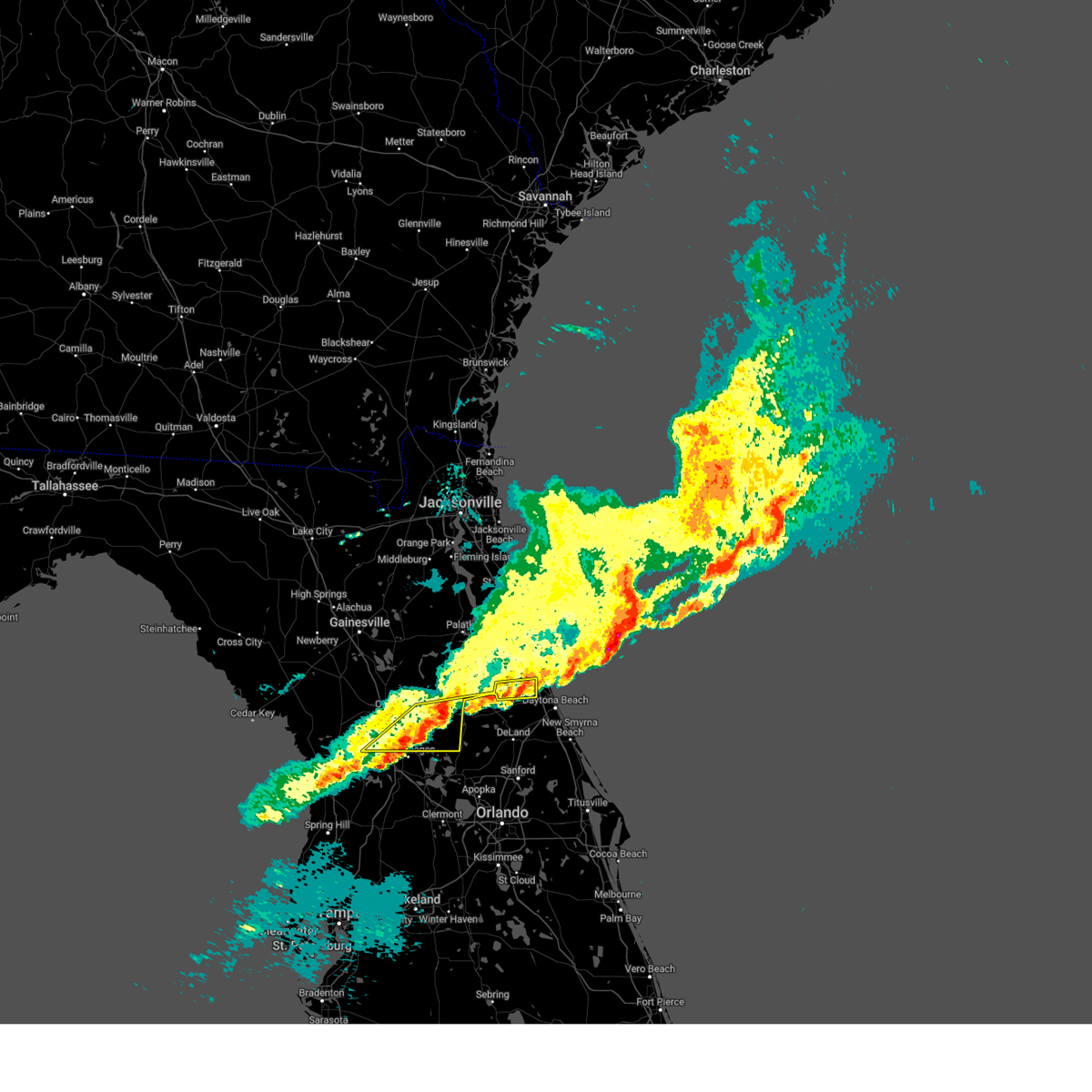
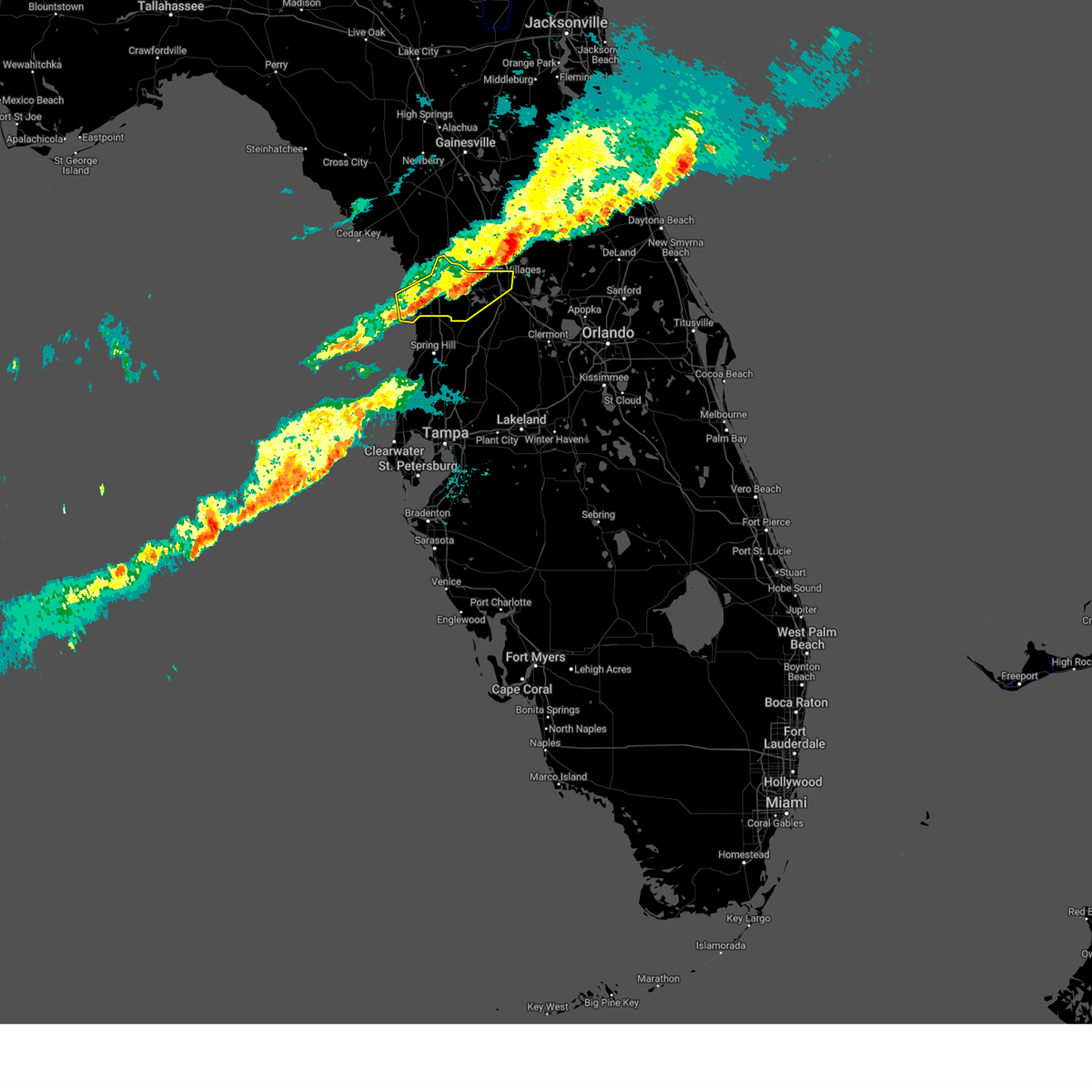
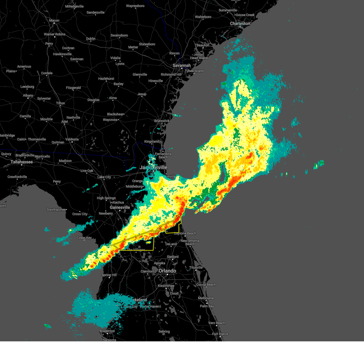
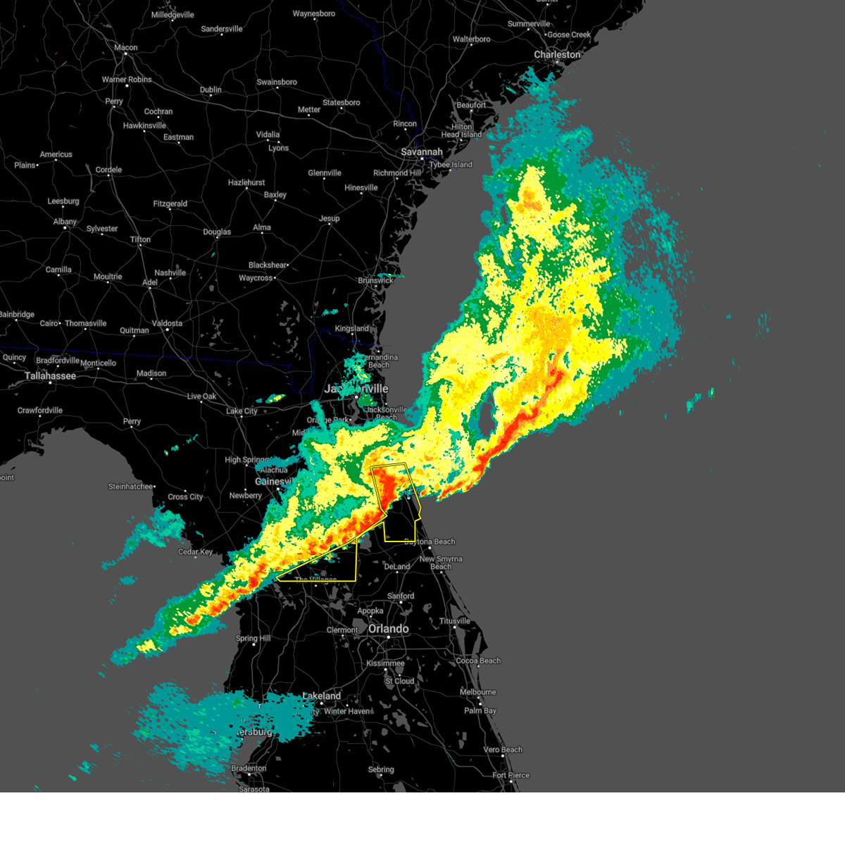
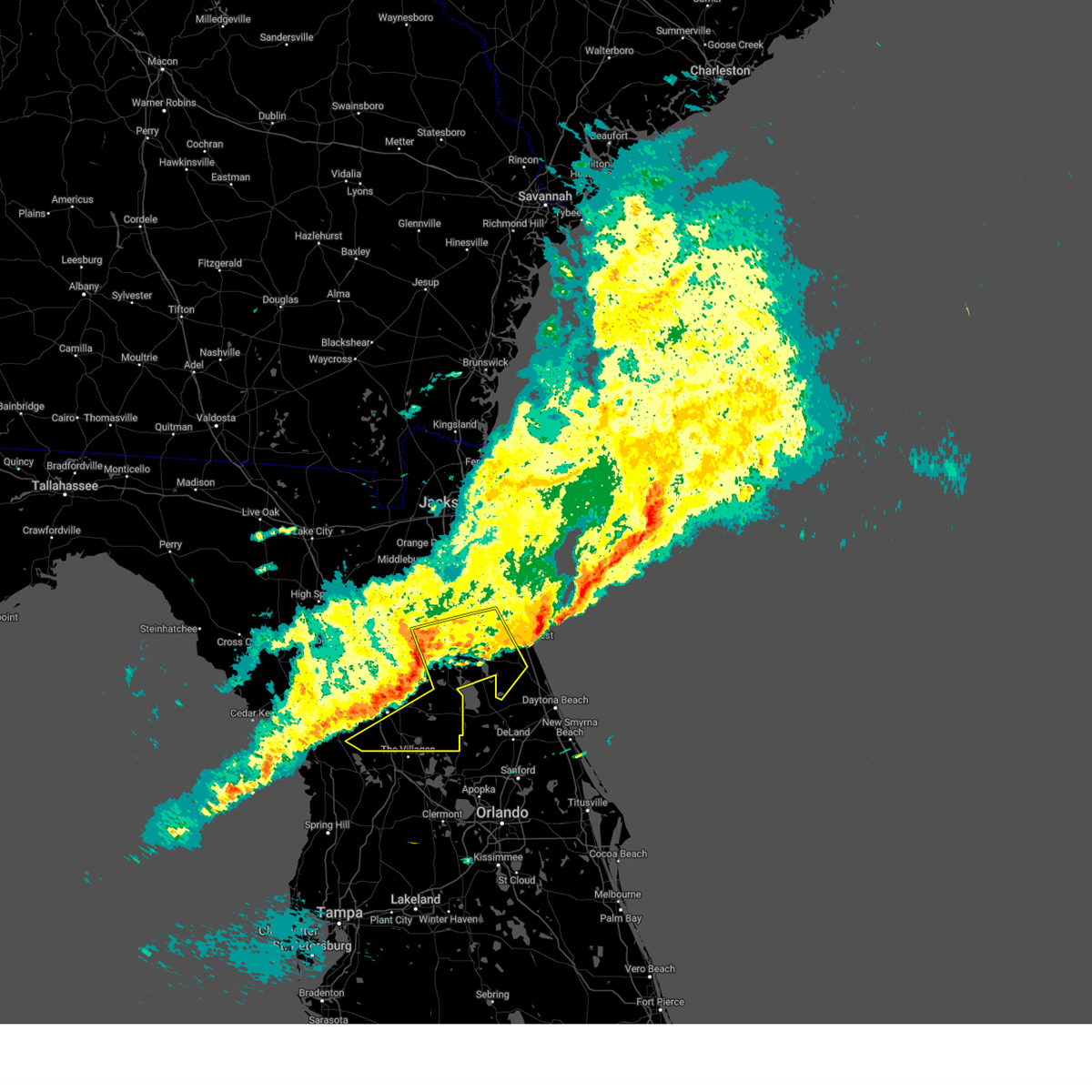
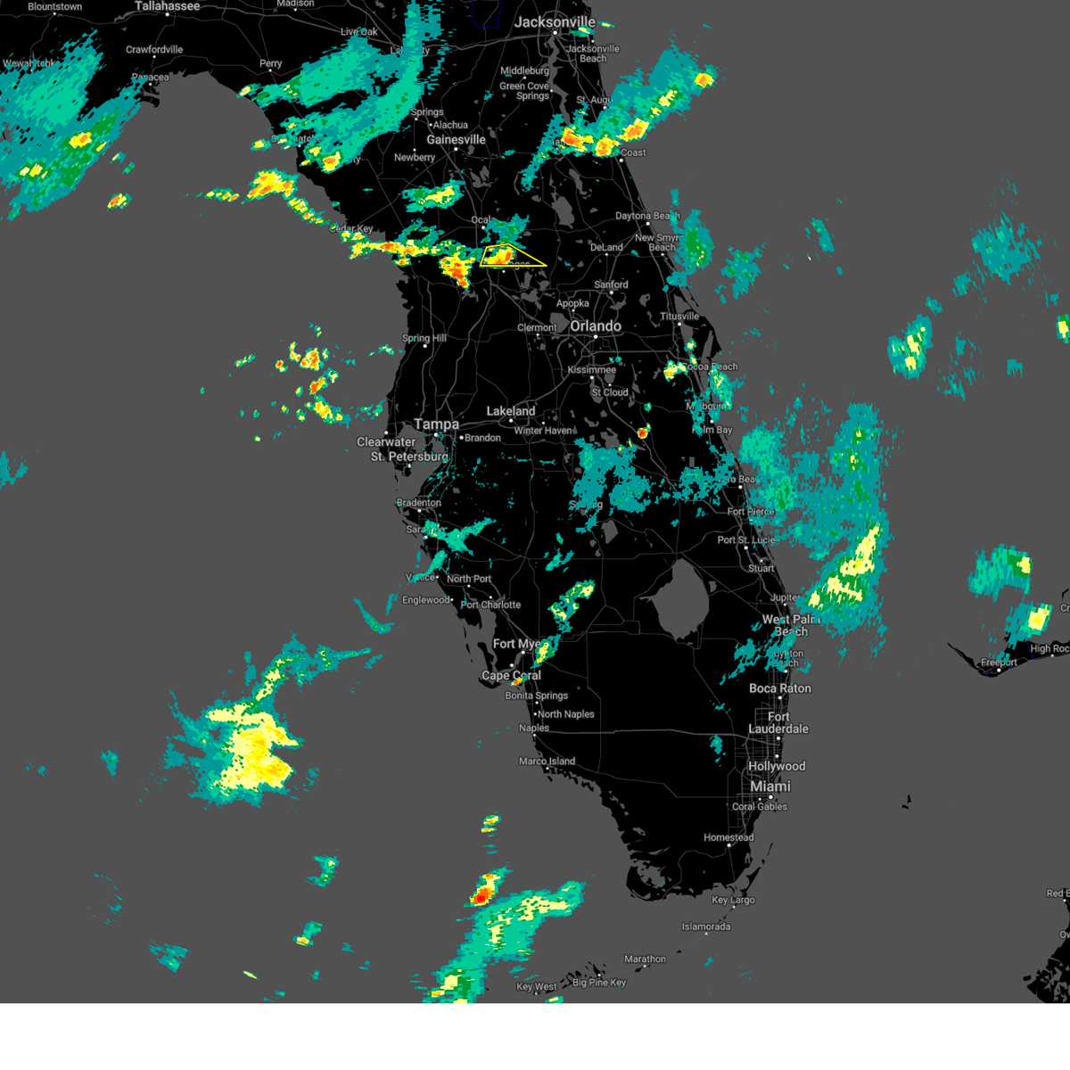
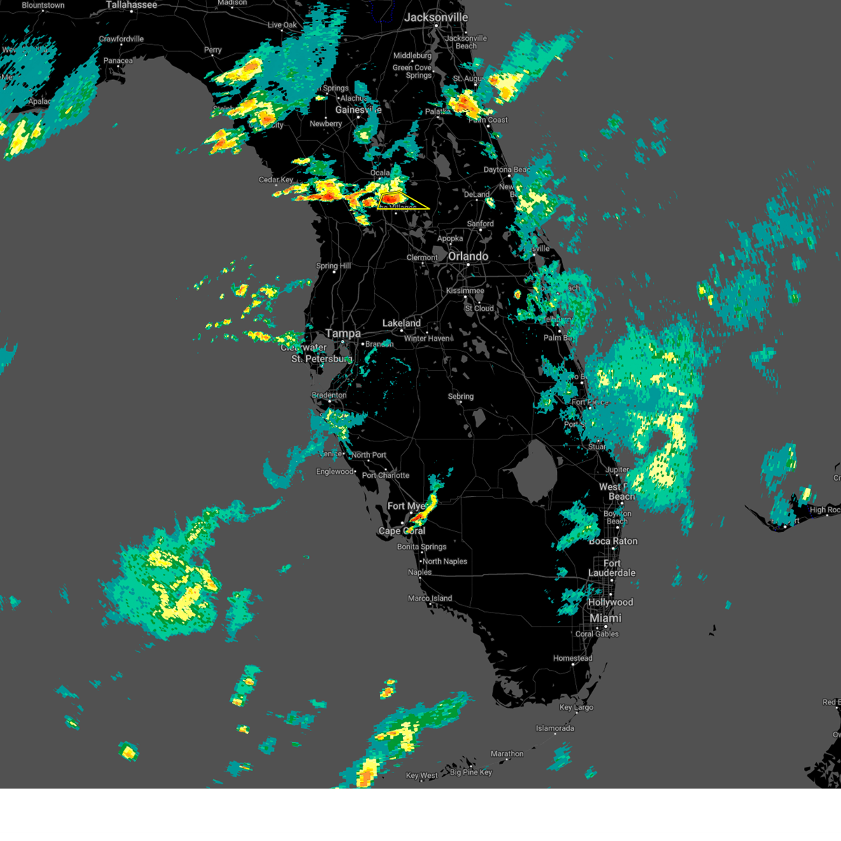
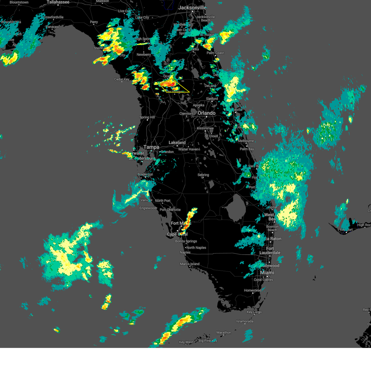
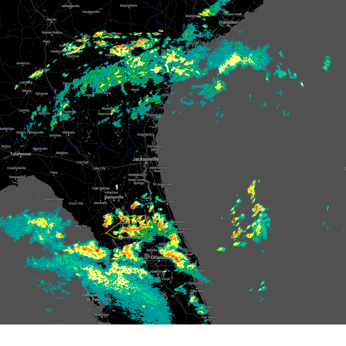
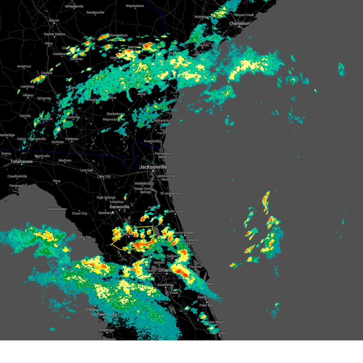
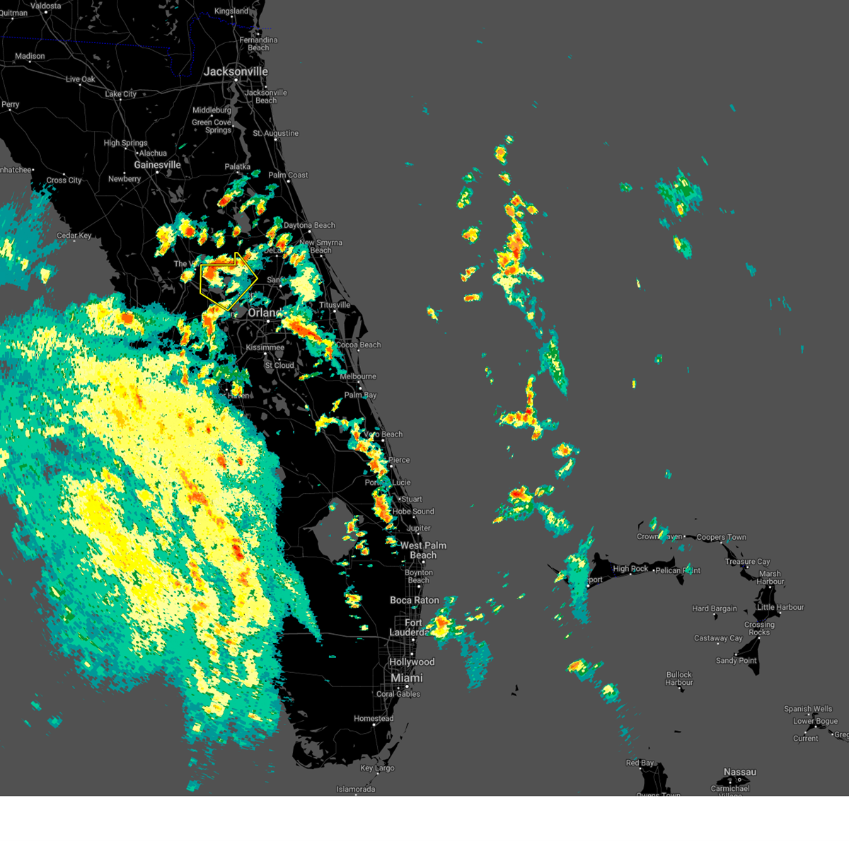
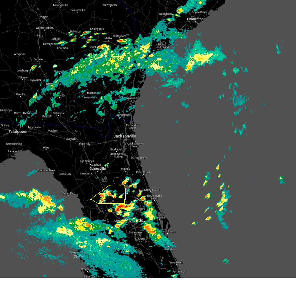
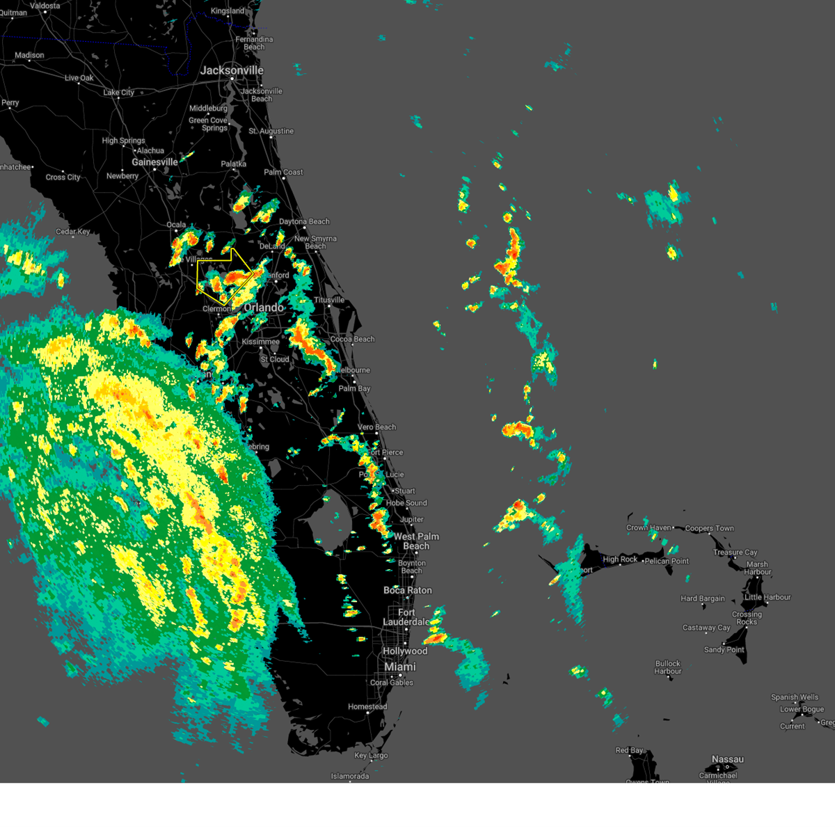
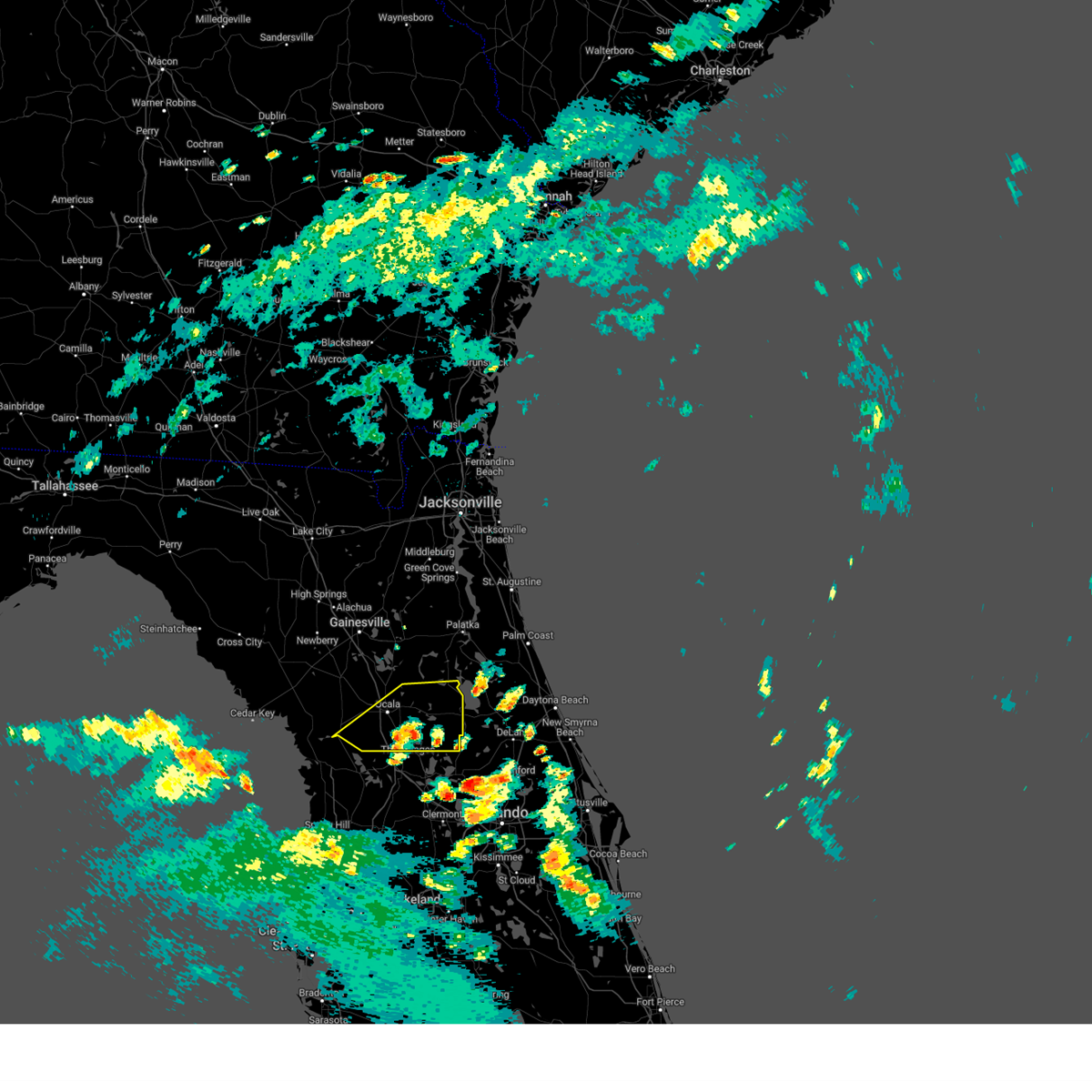
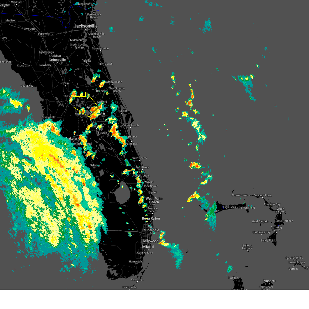
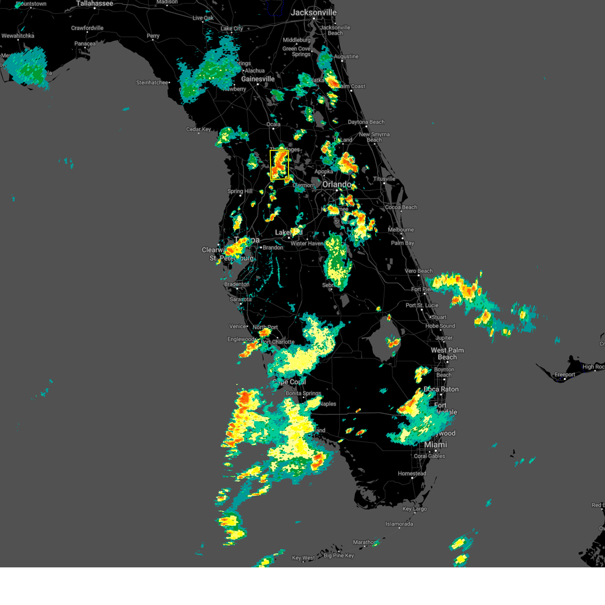
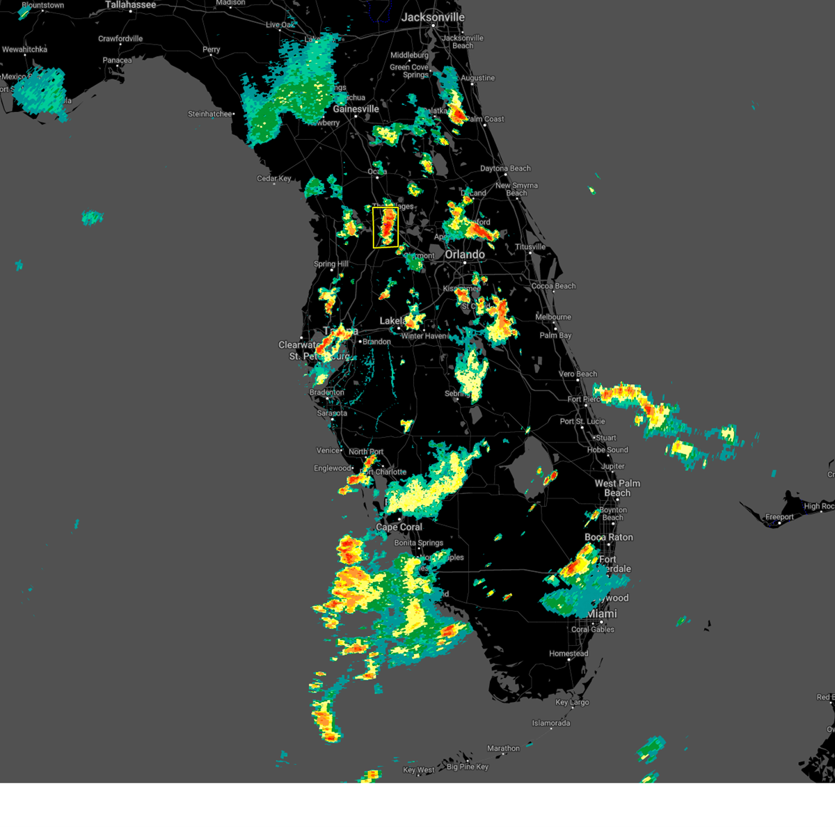
Hail Map for The Villages, FL
The The Villages, FL area has had 0 reports of on-the-ground hail by trained spotters, and has been under severe weather warnings 22 times during the past 12 months. Doppler radar has detected hail at or near The Villages, FL on 81 occasions, including 3 occasions during the past year.
| Name: | The Villages, FL |
| Where Located: | 44.9 miles NW of Orlando, FL |
| Map: | Google Map for The Villages, FL |
| Population: | 51442 |
| Housing Units: | 35587 |
| More Info: | Search Google for The Villages, FL |
0
The Top Recent Hail Date for The Villages, FL is Sunday, May 25, 2025 (50th out of 81)

Hail and Wind Damage Spotted near The Villages, FL
| Date / Time | Report Details |
|---|---|
| 1/19/2025 8:38 AM EST |
 At 838 am est, severe thunderstorms were located along a line extending from near salt springs to near moss bluff to inverness highlands south, moving east at 55 mph (radar indicated). Hazards include 60 mph wind gusts and penny size hail. Expect damage to roofs, siding, and trees. Locations impacted include, juniper springs, lynne, weirsdale, santos, the village of briar meadow, ocklawaha, moss bluff, silver springs shores, lake weir, and belleview. At 838 am est, severe thunderstorms were located along a line extending from near salt springs to near moss bluff to inverness highlands south, moving east at 55 mph (radar indicated). Hazards include 60 mph wind gusts and penny size hail. Expect damage to roofs, siding, and trees. Locations impacted include, juniper springs, lynne, weirsdale, santos, the village of briar meadow, ocklawaha, moss bluff, silver springs shores, lake weir, and belleview.
|
| 1/19/2025 8:26 AM EST |
 The storms which prompted the warning have weakened below severe limits, and no longer pose an immediate threat to life or property. therefore, the warning will be allowed to expire. however, gusty winds are still possible with these thunderstorms. The storms which prompted the warning have weakened below severe limits, and no longer pose an immediate threat to life or property. therefore, the warning will be allowed to expire. however, gusty winds are still possible with these thunderstorms.
|
| 1/19/2025 8:15 AM EST |
 Svrjax the national weather service in jacksonville has issued a * severe thunderstorm warning for, southern flagler county in northeastern florida, southern marion county in northern florida, * until 845 am est. * at 814 am est, severe thunderstorms were located along a line extending from 9 miles east of marineland to 7 miles southwest of flagler beach to 7 miles south of lake george to homosassa springs, moving east at 50 mph (radar indicated). Hazards include 60 mph wind gusts and penny size hail. expect damage to roofs, siding, and trees Svrjax the national weather service in jacksonville has issued a * severe thunderstorm warning for, southern flagler county in northeastern florida, southern marion county in northern florida, * until 845 am est. * at 814 am est, severe thunderstorms were located along a line extending from 9 miles east of marineland to 7 miles southwest of flagler beach to 7 miles south of lake george to homosassa springs, moving east at 50 mph (radar indicated). Hazards include 60 mph wind gusts and penny size hail. expect damage to roofs, siding, and trees
|
| 1/19/2025 8:01 AM EST |
 At 801 am est, severe thunderstorms were located along a line extending from 7 miles west of saint augustine south to near butler beach to near palm coast to 7 miles southeast of crescent city to near silver springs shores, moving east at 65 mph (radar indicated). Hazards include 70 mph wind gusts and quarter size hail. Hail damage to vehicles is expected. expect considerable tree damage. wind damage is also likely to mobile homes, roofs, and outbuildings. Locations impacted include, palm coast, flagler beach, bunnell, hastings, juniper springs, saint augustine beach, marineland, weirsdale, the village of briar meadow, and ocklawaha. At 801 am est, severe thunderstorms were located along a line extending from 7 miles west of saint augustine south to near butler beach to near palm coast to 7 miles southeast of crescent city to near silver springs shores, moving east at 65 mph (radar indicated). Hazards include 70 mph wind gusts and quarter size hail. Hail damage to vehicles is expected. expect considerable tree damage. wind damage is also likely to mobile homes, roofs, and outbuildings. Locations impacted include, palm coast, flagler beach, bunnell, hastings, juniper springs, saint augustine beach, marineland, weirsdale, the village of briar meadow, and ocklawaha.
|
| 1/19/2025 8:00 AM EST |
 At 800 am est, severe thunderstorms were located along a line extending from 6 miles southwest of rainbow lakes estates to black diamond to 13 miles northwest of pine island, moving east at 40 mph (radar indicated). Hazards include 60 mph wind gusts. Expect damage to roofs, siding, and trees. Locations impacted include, hernando, sugarmill woods, inverness, wildwood, lake panasoffkee, arbor lakes, lecanto, homosassa springs, leisure acres, and inverness highlands. At 800 am est, severe thunderstorms were located along a line extending from 6 miles southwest of rainbow lakes estates to black diamond to 13 miles northwest of pine island, moving east at 40 mph (radar indicated). Hazards include 60 mph wind gusts. Expect damage to roofs, siding, and trees. Locations impacted include, hernando, sugarmill woods, inverness, wildwood, lake panasoffkee, arbor lakes, lecanto, homosassa springs, leisure acres, and inverness highlands.
|
| 1/19/2025 7:48 AM EST |
 Svrjax the national weather service in jacksonville has issued a * severe thunderstorm warning for, flagler county in northeastern florida, southeastern st. johns county in northeastern florida, southeastern marion county in northern florida, eastern putnam county in northeastern florida, * until 815 am est. * at 748 am est, severe thunderstorms were located along a line extending from near bostwick to hastings to near andalusia to near lake george to 8 miles south of ocala airport, moving east at 70 mph (radar indicated). Hazards include 70 mph wind gusts and quarter size hail. Hail damage to vehicles is expected. expect considerable tree damage. Wind damage is also likely to mobile homes, roofs, and outbuildings. Svrjax the national weather service in jacksonville has issued a * severe thunderstorm warning for, flagler county in northeastern florida, southeastern st. johns county in northeastern florida, southeastern marion county in northern florida, eastern putnam county in northeastern florida, * until 815 am est. * at 748 am est, severe thunderstorms were located along a line extending from near bostwick to hastings to near andalusia to near lake george to 8 miles south of ocala airport, moving east at 70 mph (radar indicated). Hazards include 70 mph wind gusts and quarter size hail. Hail damage to vehicles is expected. expect considerable tree damage. Wind damage is also likely to mobile homes, roofs, and outbuildings.
|
| 1/19/2025 7:42 AM EST |
 At 742 am est, severe thunderstorms were located along a line extending from near palatka to fruitland to 10 miles southwest of ocala airport, moving east at 70 mph (radar indicated). Hazards include 70 mph wind gusts and quarter size hail. Hail damage to vehicles is expected. expect considerable tree damage. wind damage is also likely to mobile homes, roofs, and outbuildings. Locations impacted include, palatka, bunnell, crescent city, interlachen, pomona park, hastings, east palatka, salt springs, andalusia, and juniper springs. At 742 am est, severe thunderstorms were located along a line extending from near palatka to fruitland to 10 miles southwest of ocala airport, moving east at 70 mph (radar indicated). Hazards include 70 mph wind gusts and quarter size hail. Hail damage to vehicles is expected. expect considerable tree damage. wind damage is also likely to mobile homes, roofs, and outbuildings. Locations impacted include, palatka, bunnell, crescent city, interlachen, pomona park, hastings, east palatka, salt springs, andalusia, and juniper springs.
|
| 1/19/2025 7:38 AM EST |
 Svrtbw the national weather service in ruskin has issued a * severe thunderstorm warning for, citrus county in west central florida, northwestern sumter county in central florida, * until 830 am est. * at 738 am est, severe thunderstorms were located along a line extending from 14 miles northwest of crystal river airport to 11 miles west of homosassa to 28 miles west of pine island, moving east at 50 mph (radar indicated). Hazards include 60 mph wind gusts. expect damage to roofs, siding, and trees Svrtbw the national weather service in ruskin has issued a * severe thunderstorm warning for, citrus county in west central florida, northwestern sumter county in central florida, * until 830 am est. * at 738 am est, severe thunderstorms were located along a line extending from 14 miles northwest of crystal river airport to 11 miles west of homosassa to 28 miles west of pine island, moving east at 50 mph (radar indicated). Hazards include 60 mph wind gusts. expect damage to roofs, siding, and trees
|
| 1/19/2025 7:32 AM EST |
 Svrjax the national weather service in jacksonville has issued a * severe thunderstorm warning for, western flagler county in northeastern florida, south central st. johns county in northeastern florida, eastern marion county in northern florida, putnam county in northeastern florida, * until 800 am est. * at 732 am est, severe thunderstorms were located along a line extending from near lake geneva to near fort mccoy to 8 miles southwest of rainbow lakes estates, moving east at 55 mph (radar indicated). Hazards include 70 mph wind gusts and quarter size hail. Hail damage to vehicles is expected. expect considerable tree damage. Wind damage is also likely to mobile homes, roofs, and outbuildings. Svrjax the national weather service in jacksonville has issued a * severe thunderstorm warning for, western flagler county in northeastern florida, south central st. johns county in northeastern florida, eastern marion county in northern florida, putnam county in northeastern florida, * until 800 am est. * at 732 am est, severe thunderstorms were located along a line extending from near lake geneva to near fort mccoy to 8 miles southwest of rainbow lakes estates, moving east at 55 mph (radar indicated). Hazards include 70 mph wind gusts and quarter size hail. Hail damage to vehicles is expected. expect considerable tree damage. Wind damage is also likely to mobile homes, roofs, and outbuildings.
|
| 8/22/2024 7:24 PM EDT |
 The storm which prompted the warning has weakened below severe limits, and no longer poses an immediate threat to life or property. therefore, the warning will be allowed to expire. however, heavy rain is still possible with this thunderstorm. The storm which prompted the warning has weakened below severe limits, and no longer poses an immediate threat to life or property. therefore, the warning will be allowed to expire. however, heavy rain is still possible with this thunderstorm.
|
| 8/22/2024 6:50 PM EDT |
 At 650 pm edt, a severe thunderstorm was located over lake weir, or 8 miles northwest of the villages, moving southeast at 10 mph (radar indicated). Hazards include 60 mph wind gusts. Expect damage to roofs, siding, and trees. Locations impacted include, weirsdale, ocklawaha, lake weir, the village of briar meadow, belleview, and summerfield. At 650 pm edt, a severe thunderstorm was located over lake weir, or 8 miles northwest of the villages, moving southeast at 10 mph (radar indicated). Hazards include 60 mph wind gusts. Expect damage to roofs, siding, and trees. Locations impacted include, weirsdale, ocklawaha, lake weir, the village of briar meadow, belleview, and summerfield.
|
| 8/22/2024 6:30 PM EDT |
 Svrjax the national weather service in jacksonville has issued a * severe thunderstorm warning for, south central marion county in northern florida, * until 730 pm edt. * at 630 pm edt, a severe thunderstorm was located near santos, or 8 miles southeast of ocala, moving southeast at 10 mph (radar indicated). Hazards include 60 mph wind gusts. expect damage to roofs, siding, and trees Svrjax the national weather service in jacksonville has issued a * severe thunderstorm warning for, south central marion county in northern florida, * until 730 pm edt. * at 630 pm edt, a severe thunderstorm was located near santos, or 8 miles southeast of ocala, moving southeast at 10 mph (radar indicated). Hazards include 60 mph wind gusts. expect damage to roofs, siding, and trees
|
| 8/4/2024 1:38 PM EDT |
 The storms which prompted the warning have weakened below severe limits, and no longer pose an immediate threat to life or property. therefore, the warning will be allowed to expire. however, gusty winds and heavy rain are still possible with these thunderstorms. a tornado watch remains in effect until 800 pm edt for northern and northeastern florida. The storms which prompted the warning have weakened below severe limits, and no longer pose an immediate threat to life or property. therefore, the warning will be allowed to expire. however, gusty winds and heavy rain are still possible with these thunderstorms. a tornado watch remains in effect until 800 pm edt for northern and northeastern florida.
|
| 8/4/2024 1:28 PM EDT |
 At 128 pm edt, severe thunderstorms were located along a line extending from near juniper springs to near lake weir, moving northwest at 40 mph (radar indicated). Hazards include 60 mph wind gusts. Expect damage to roofs, siding, and trees. Locations impacted include, ocala, salt springs, juniper springs, lynne, weirsdale, anthony, ocklawaha, moss bluff, silver springs shores, and lake weir. At 128 pm edt, severe thunderstorms were located along a line extending from near juniper springs to near lake weir, moving northwest at 40 mph (radar indicated). Hazards include 60 mph wind gusts. Expect damage to roofs, siding, and trees. Locations impacted include, ocala, salt springs, juniper springs, lynne, weirsdale, anthony, ocklawaha, moss bluff, silver springs shores, and lake weir.
|
| 8/4/2024 1:13 PM EDT |
 The storm which prompted the warning has weakened below severe limits, and no longer poses an immediate threat to life or property. therefore, the warning will be allowed to expire. however gusty winds are still possible with this thunderstorm. a tornado watch remains in effect until 800 pm edt for east central florida. remember, a tornado warning still remains in effect until 8 pm. The storm which prompted the warning has weakened below severe limits, and no longer poses an immediate threat to life or property. therefore, the warning will be allowed to expire. however gusty winds are still possible with this thunderstorm. a tornado watch remains in effect until 800 pm edt for east central florida. remember, a tornado warning still remains in effect until 8 pm.
|
| 8/4/2024 1:07 PM EDT |
 At 107 pm edt, severe thunderstorms were located along a line extending from near pittman to leesburg, moving northwest at 40 mph (radar indicated). Hazards include 60 mph wind gusts. Expect damage to roofs, siding, and trees. Locations impacted include, ocala, salt springs, juniper springs, lynne, weirsdale, anthony, the village of briar meadow, ocklawaha, moss bluff, and silver springs shores. At 107 pm edt, severe thunderstorms were located along a line extending from near pittman to leesburg, moving northwest at 40 mph (radar indicated). Hazards include 60 mph wind gusts. Expect damage to roofs, siding, and trees. Locations impacted include, ocala, salt springs, juniper springs, lynne, weirsdale, anthony, the village of briar meadow, ocklawaha, moss bluff, and silver springs shores.
|
| 8/4/2024 1:02 PM EDT |
 At 101 pm edt, a severe thunderstorm was located over eustis, moving northwest at 45 mph (radar indicated). Hazards include 60 mph wind gusts. Expect damage to roofs, siding, and trees. Locations impacted include, leesburg, eustis, tavares, lady lake, and mount dora. At 101 pm edt, a severe thunderstorm was located over eustis, moving northwest at 45 mph (radar indicated). Hazards include 60 mph wind gusts. Expect damage to roofs, siding, and trees. Locations impacted include, leesburg, eustis, tavares, lady lake, and mount dora.
|
| 8/4/2024 1:02 PM EDT |
 the severe thunderstorm warning has been cancelled and is no longer in effect the severe thunderstorm warning has been cancelled and is no longer in effect
|
| 8/4/2024 12:53 PM EDT |
 Svrjax the national weather service in jacksonville has issued a * severe thunderstorm warning for, marion county in northern florida, * until 145 pm edt. * at 1252 pm edt, severe thunderstorms were located along a line extending from near mount plymouth to near howey-in-the-hills, moving northwest at 35 mph (radar indicated). Hazards include 60 mph wind gusts. expect damage to roofs, siding, and trees Svrjax the national weather service in jacksonville has issued a * severe thunderstorm warning for, marion county in northern florida, * until 145 pm edt. * at 1252 pm edt, severe thunderstorms were located along a line extending from near mount plymouth to near howey-in-the-hills, moving northwest at 35 mph (radar indicated). Hazards include 60 mph wind gusts. expect damage to roofs, siding, and trees
|
| 8/4/2024 12:45 PM EDT |
 Svrmlb the national weather service in melbourne has issued a * severe thunderstorm warning for, west central seminole county in east central florida, central lake county in east central florida, northwestern orange county in east central florida, * until 115 pm edt. * at 1245 pm edt, a severe thunderstorm was located over zellwood, moving northwest at 40 mph (radar indicated). Hazards include 60 mph wind gusts. expect damage to roofs, siding, and trees Svrmlb the national weather service in melbourne has issued a * severe thunderstorm warning for, west central seminole county in east central florida, central lake county in east central florida, northwestern orange county in east central florida, * until 115 pm edt. * at 1245 pm edt, a severe thunderstorm was located over zellwood, moving northwest at 40 mph (radar indicated). Hazards include 60 mph wind gusts. expect damage to roofs, siding, and trees
|
| 8/2/2024 6:45 PM EDT |
 the severe thunderstorm warning has been cancelled and is no longer in effect the severe thunderstorm warning has been cancelled and is no longer in effect
|
| 8/2/2024 6:30 PM EDT |
 Svrtbw the national weather service in ruskin has issued a * severe thunderstorm warning for, northeastern sumter county in central florida, * until 700 pm edt. * at 630 pm edt, a severe thunderstorm was located over wildwood, moving west at 10 mph (radar indicated). Hazards include 60 mph wind gusts and nickel size hail. expect damage to roofs, siding, and trees Svrtbw the national weather service in ruskin has issued a * severe thunderstorm warning for, northeastern sumter county in central florida, * until 700 pm edt. * at 630 pm edt, a severe thunderstorm was located over wildwood, moving west at 10 mph (radar indicated). Hazards include 60 mph wind gusts and nickel size hail. expect damage to roofs, siding, and trees
|
| 6/28/2024 5:53 PM EDT |
 The storm which prompted the warning has weakened below severe limits, and no longer poses an immediate threat to life or property. therefore, the warning will be allowed to expire. however, gusty winds and heavy rain are still possible with this thunderstorm. The storm which prompted the warning has weakened below severe limits, and no longer poses an immediate threat to life or property. therefore, the warning will be allowed to expire. however, gusty winds and heavy rain are still possible with this thunderstorm.
|
| 6/28/2024 5:19 PM EDT |
 Svrjax the national weather service in jacksonville has issued a * severe thunderstorm warning for, south central marion county in northern florida, * until 600 pm edt. * at 519 pm edt, a severe thunderstorm was located 8 miles southwest of santos, or 10 miles south of ocala, moving east at 20 mph (radar indicated). Hazards include 60 mph wind gusts. expect damage to roofs, siding, and trees Svrjax the national weather service in jacksonville has issued a * severe thunderstorm warning for, south central marion county in northern florida, * until 600 pm edt. * at 519 pm edt, a severe thunderstorm was located 8 miles southwest of santos, or 10 miles south of ocala, moving east at 20 mph (radar indicated). Hazards include 60 mph wind gusts. expect damage to roofs, siding, and trees
|
| 5/15/2024 4:21 AM EDT |
 Svrtbw the national weather service in ruskin has issued a * severe thunderstorm warning for, northeastern sumter county in central florida, * until 445 am edt. * at 421 am edt, a severe thunderstorm was located over wildwood, moving east at 25 mph (radar indicated). Hazards include 60 mph wind gusts. expect damage to roofs, siding, and trees Svrtbw the national weather service in ruskin has issued a * severe thunderstorm warning for, northeastern sumter county in central florida, * until 445 am edt. * at 421 am edt, a severe thunderstorm was located over wildwood, moving east at 25 mph (radar indicated). Hazards include 60 mph wind gusts. expect damage to roofs, siding, and trees
|
| 5/11/2024 1:06 AM EDT |
 The storm which prompted the warning has moved out of the area. therefore, the warning will be allowed to expire. The storm which prompted the warning has moved out of the area. therefore, the warning will be allowed to expire.
|
| 5/11/2024 12:44 AM EDT |
 Svrjax the national weather service in jacksonville has issued a * severe thunderstorm warning for, south central marion county in northern florida, * until 115 am edt. * at 1244 am edt, a severe thunderstorm was located near lake weir, or 8 miles northwest of the villages, moving southeast at 35 mph (radar indicated). Hazards include 60 mph wind gusts and quarter size hail. Hail damage to vehicles is expected. Expect wind damage to roofs, siding, and trees. Svrjax the national weather service in jacksonville has issued a * severe thunderstorm warning for, south central marion county in northern florida, * until 115 am edt. * at 1244 am edt, a severe thunderstorm was located near lake weir, or 8 miles northwest of the villages, moving southeast at 35 mph (radar indicated). Hazards include 60 mph wind gusts and quarter size hail. Hail damage to vehicles is expected. Expect wind damage to roofs, siding, and trees.
|
| 4/11/2024 1:04 PM EDT |
 At 104 pm edt, severe thunderstorms were located along a line extending from 7 miles southwest of bushnell to near pebble creek to near fort desoto park, moving east at 45 mph (radar indicated). Hazards include 60 mph wind gusts. Expect damage to roofs, siding, and trees. locations impacted include, tampa, st. petersburg, bradenton, plant city, temple terrace, zephyrhills, palmetto, gulfport, st. Pete beach, and wildwood. At 104 pm edt, severe thunderstorms were located along a line extending from 7 miles southwest of bushnell to near pebble creek to near fort desoto park, moving east at 45 mph (radar indicated). Hazards include 60 mph wind gusts. Expect damage to roofs, siding, and trees. locations impacted include, tampa, st. petersburg, bradenton, plant city, temple terrace, zephyrhills, palmetto, gulfport, st. Pete beach, and wildwood.
|
| 4/11/2024 12:30 PM EDT |
 Svrtbw the national weather service in ruskin has issued a * severe thunderstorm warning for, southeastern citrus county in west central florida, sumter county in central florida, pasco county in west central florida, hernando county in west central florida, northwestern manatee county in west central florida, pinellas county in west central florida, northwestern polk county in central florida, hillsborough county in west central florida, * until 115 pm edt. * at 1229 pm edt, severe thunderstorms were located along a line extending from near spring hill to 6 miles southwest of citrus park to 17 miles west of anna maria, moving east at 45 mph (radar indicated). Hazards include 60 mph wind gusts. expect damage to roofs, siding, and trees Svrtbw the national weather service in ruskin has issued a * severe thunderstorm warning for, southeastern citrus county in west central florida, sumter county in central florida, pasco county in west central florida, hernando county in west central florida, northwestern manatee county in west central florida, pinellas county in west central florida, northwestern polk county in central florida, hillsborough county in west central florida, * until 115 pm edt. * at 1229 pm edt, severe thunderstorms were located along a line extending from near spring hill to 6 miles southwest of citrus park to 17 miles west of anna maria, moving east at 45 mph (radar indicated). Hazards include 60 mph wind gusts. expect damage to roofs, siding, and trees
|
| 4/11/2024 11:54 AM EDT |
 Svrjax the national weather service in jacksonville has issued a * severe thunderstorm warning for, southeastern marion county in northern florida, * until 1215 pm edt. * at 1153 am edt, a severe thunderstorm was located over silver springs shores, or 7 miles southwest of lynne, moving northeast at 70 mph (radar indicated). Hazards include 70 mph wind gusts. Expect considerable tree damage. Damage is likely to mobile homes, roofs, and outbuildings. Svrjax the national weather service in jacksonville has issued a * severe thunderstorm warning for, southeastern marion county in northern florida, * until 1215 pm edt. * at 1153 am edt, a severe thunderstorm was located over silver springs shores, or 7 miles southwest of lynne, moving northeast at 70 mph (radar indicated). Hazards include 70 mph wind gusts. Expect considerable tree damage. Damage is likely to mobile homes, roofs, and outbuildings.
|
| 4/11/2024 11:29 AM EDT |
 Svrtbw the national weather service in ruskin has issued a * severe thunderstorm warning for, citrus county in west central florida, northern sumter county in central florida, northern hernando county in west central florida, southeastern levy county in northern florida, * until noon edt. * at 1129 am edt, severe thunderstorms were located along a line extending from 7 miles northwest of crystal river airport to black diamond to near inverness highlands north, moving northeast at 50 mph (radar indicated). Hazards include 60 mph wind gusts. expect damage to roofs, siding, and trees Svrtbw the national weather service in ruskin has issued a * severe thunderstorm warning for, citrus county in west central florida, northern sumter county in central florida, northern hernando county in west central florida, southeastern levy county in northern florida, * until noon edt. * at 1129 am edt, severe thunderstorms were located along a line extending from 7 miles northwest of crystal river airport to black diamond to near inverness highlands north, moving northeast at 50 mph (radar indicated). Hazards include 60 mph wind gusts. expect damage to roofs, siding, and trees
|
| 1/9/2024 4:40 PM EST |
 The severe thunderstorm warning for western flagler, southeastern st. johns, eastern marion and eastern putnam counties will expire at 445 pm est, the storms that prompted this severe thunderstorm warning continue to impact putnam, marion, st johns and flagler counties. a new severe thunderstorm warning will reissued for these threatened areas. a tornado watch remains in effect until 600 pm est for northern and northeastern florida. The severe thunderstorm warning for western flagler, southeastern st. johns, eastern marion and eastern putnam counties will expire at 445 pm est, the storms that prompted this severe thunderstorm warning continue to impact putnam, marion, st johns and flagler counties. a new severe thunderstorm warning will reissued for these threatened areas. a tornado watch remains in effect until 600 pm est for northern and northeastern florida.
|
| 1/9/2024 4:30 PM EST |
 A severe thunderstorm warning remains in effect until 445 pm est for western flagler. southeastern st. johns. eastern marion and eastern putnam counties. at 430 pm est, severe thunderstorms were located along a line extending from near hastings to lady lake, moving east at 45 mph. hazard. 60 mph wind gusts. A severe thunderstorm warning remains in effect until 445 pm est for western flagler. southeastern st. johns. eastern marion and eastern putnam counties. at 430 pm est, severe thunderstorms were located along a line extending from near hastings to lady lake, moving east at 45 mph. hazard. 60 mph wind gusts.
|
| 1/9/2024 4:28 PM EST |
 The tornado warning for southeastern marion county will expire at 430 pm est. the storm which prompted the warning has weakened below severe limits, and no longer appears capable of producing a tornado. therefore, the warning will be allowed to expire. A tornado watch remains in effect until 600 pm est for northern. The tornado warning for southeastern marion county will expire at 430 pm est. the storm which prompted the warning has weakened below severe limits, and no longer appears capable of producing a tornado. therefore, the warning will be allowed to expire. A tornado watch remains in effect until 600 pm est for northern.
|
| 1/9/2024 4:13 PM EST |
 The severe thunderstorm warning for central citrus and northern sumter counties will expire at 415 pm est. the storm which prompted the warning has weakened below severe limits, and has exited the warned area. therefore, the warning will be allowed to expire. A tornado watch remains in effect until 900 pm est for central and. The severe thunderstorm warning for central citrus and northern sumter counties will expire at 415 pm est. the storm which prompted the warning has weakened below severe limits, and has exited the warned area. therefore, the warning will be allowed to expire. A tornado watch remains in effect until 900 pm est for central and.
|
| 1/9/2024 4:04 PM EST |
 At 402 pm est, a severe thunderstorm capable of producing a tornado was located near inverness airport, or near inverness, moving east at 50 mph (radar indicated rotation). Hazards include tornado. Flying debris will be dangerous to those caught without shelter. mobile homes will be damaged or destroyed. damage to roofs, windows, and vehicles will occur. tree damage is likely. this dangerous storm will be near, the village of briar meadow around 420 pm est. weirsdale around 425 pm est. Other locations impacted by this tornadic thunderstorm include belleview and summerfield. At 402 pm est, a severe thunderstorm capable of producing a tornado was located near inverness airport, or near inverness, moving east at 50 mph (radar indicated rotation). Hazards include tornado. Flying debris will be dangerous to those caught without shelter. mobile homes will be damaged or destroyed. damage to roofs, windows, and vehicles will occur. tree damage is likely. this dangerous storm will be near, the village of briar meadow around 420 pm est. weirsdale around 425 pm est. Other locations impacted by this tornadic thunderstorm include belleview and summerfield.
|
| 1/9/2024 4:01 PM EST |
 At 401 pm est, severe thunderstorms were located along a line extending from near bardin to 9 miles northeast of inverness highlands north, moving east at 45 mph (radar indicated). Hazards include 60 mph wind gusts. expect damage to roofs, siding, and trees At 401 pm est, severe thunderstorms were located along a line extending from near bardin to 9 miles northeast of inverness highlands north, moving east at 45 mph (radar indicated). Hazards include 60 mph wind gusts. expect damage to roofs, siding, and trees
|
| 1/9/2024 3:41 PM EST |
 At 340 pm est, a severe thunderstorm was located near black diamond, or near beverly hills, moving northeast at 45 mph (radar indicated). Hazards include 60 mph wind gusts. expect damage to roofs, siding, and trees At 340 pm est, a severe thunderstorm was located near black diamond, or near beverly hills, moving northeast at 45 mph (radar indicated). Hazards include 60 mph wind gusts. expect damage to roofs, siding, and trees
|
| 1/9/2024 3:38 PM EST |
 A severe thunderstorm warning remains in effect until 400 pm est for southeastern alachua. marion. northwestern putnam and southwestern clay counties. At 337 pm est, severe thunderstorms were located along a line extending from melrose to 7 miles north of inverness highlands north, moving east at 35 mph. A severe thunderstorm warning remains in effect until 400 pm est for southeastern alachua. marion. northwestern putnam and southwestern clay counties. At 337 pm est, severe thunderstorms were located along a line extending from melrose to 7 miles north of inverness highlands north, moving east at 35 mph.
|
| 1/9/2024 2:57 PM EST |
 At 257 pm est, severe thunderstorms were located along a line extending from near alachua to 15 miles west of rainbow lakes estates, moving east at 35 mph (radar indicated). Hazards include 60 mph wind gusts. expect damage to roofs, siding, and trees At 257 pm est, severe thunderstorms were located along a line extending from near alachua to 15 miles west of rainbow lakes estates, moving east at 35 mph (radar indicated). Hazards include 60 mph wind gusts. expect damage to roofs, siding, and trees
|
| 1/9/2024 2:09 PM EST |
 At 209 pm est, severe thunderstorms were located along a line extending from near high springs to 20 miles northwest of crystal river airport, moving east at 45 mph (radar indicated). Hazards include 60 mph wind gusts. expect damage to roofs, siding, and trees At 209 pm est, severe thunderstorms were located along a line extending from near high springs to 20 miles northwest of crystal river airport, moving east at 45 mph (radar indicated). Hazards include 60 mph wind gusts. expect damage to roofs, siding, and trees
|
| 10/12/2023 4:26 AM EDT |
 At 425 am edt, a severe thunderstorm capable of producing a tornado was located over leesburg airport, or over lake griffin, moving northeast at 60 mph (radar indicated rotation). Hazards include tornado. Flying debris will be dangerous to those caught without shelter. mobile homes will be damaged or destroyed. damage to roofs, windows, and vehicles will occur. tree damage is likely. this dangerous storm will be near, eustis, tavares, and lisbon around 430 am edt. paisley and pittman around 440 am edt. deleon springs around 450 am edt. barberville around 500 am edt. Other locations impacted by this tornadic thunderstorm include pine lakes. At 425 am edt, a severe thunderstorm capable of producing a tornado was located over leesburg airport, or over lake griffin, moving northeast at 60 mph (radar indicated rotation). Hazards include tornado. Flying debris will be dangerous to those caught without shelter. mobile homes will be damaged or destroyed. damage to roofs, windows, and vehicles will occur. tree damage is likely. this dangerous storm will be near, eustis, tavares, and lisbon around 430 am edt. paisley and pittman around 440 am edt. deleon springs around 450 am edt. barberville around 500 am edt. Other locations impacted by this tornadic thunderstorm include pine lakes.
|
| 10/12/2023 4:01 AM EDT |
 At 401 am edt, a severe thunderstorm was located near bushnell, moving northeast at 40 mph (radar indicated). Hazards include 60 mph wind gusts. expect damage to roofs, siding, and trees At 401 am edt, a severe thunderstorm was located near bushnell, moving northeast at 40 mph (radar indicated). Hazards include 60 mph wind gusts. expect damage to roofs, siding, and trees
|
| 10/12/2023 3:12 AM EDT |
 At 312 am edt, a severe thunderstorm capable of producing a tornado was located near hill n dale, or 10 miles east of brooksville, moving northeast at 35 mph (radar indicated rotation). Hazards include tornado. Flying debris will be dangerous to those caught without shelter. mobile homes will be damaged or destroyed. damage to roofs, windows, and vehicles will occur. tree damage is likely. this dangerous storm will be near, bushnell around 315 am edt. Other locations impacted by this tornadic thunderstorm include webster, ridge manor, tarrytown, croom, center hill, sumterville, adamsville, and spring lake. At 312 am edt, a severe thunderstorm capable of producing a tornado was located near hill n dale, or 10 miles east of brooksville, moving northeast at 35 mph (radar indicated rotation). Hazards include tornado. Flying debris will be dangerous to those caught without shelter. mobile homes will be damaged or destroyed. damage to roofs, windows, and vehicles will occur. tree damage is likely. this dangerous storm will be near, bushnell around 315 am edt. Other locations impacted by this tornadic thunderstorm include webster, ridge manor, tarrytown, croom, center hill, sumterville, adamsville, and spring lake.
|
| 8/16/2023 5:51 PM EDT |
 The severe thunderstorm warning for southwestern marion county will expire at 600 pm edt, the storm which prompted the warning has weakened below severe limits, and no longer poses an immediate threat to life or property. therefore, the warning will be allowed to expire. however, gusty winds and heavy rain are still possible with this thunderstorm. The severe thunderstorm warning for southwestern marion county will expire at 600 pm edt, the storm which prompted the warning has weakened below severe limits, and no longer poses an immediate threat to life or property. therefore, the warning will be allowed to expire. however, gusty winds and heavy rain are still possible with this thunderstorm.
|
| 8/16/2023 5:25 PM EDT |
 At 525 pm edt, a severe thunderstorm was located over ocala airport, or near ocala, moving south at 10 mph (radar indicated). Hazards include 60 mph wind gusts and penny size hail. expect damage to roofs, siding, and trees At 525 pm edt, a severe thunderstorm was located over ocala airport, or near ocala, moving south at 10 mph (radar indicated). Hazards include 60 mph wind gusts and penny size hail. expect damage to roofs, siding, and trees
|
| 7/31/2023 1:21 PM EDT |
 The severe thunderstorm warning for south central marion county will expire at 130 pm edt, the storm which prompted the warning has weakened below severe limits, and no longer poses an immediate threat to life or property. therefore, the warning will be allowed to expire. The severe thunderstorm warning for south central marion county will expire at 130 pm edt, the storm which prompted the warning has weakened below severe limits, and no longer poses an immediate threat to life or property. therefore, the warning will be allowed to expire.
|
| 7/31/2023 12:55 PM EDT |
 At 1255 pm edt, a severe thunderstorm was located over lake weir, or 7 miles northwest of the villages, moving east at 10 mph (radar indicated). Hazards include 60 mph wind gusts and penny size hail. expect damage to roofs, siding, and trees At 1255 pm edt, a severe thunderstorm was located over lake weir, or 7 miles northwest of the villages, moving east at 10 mph (radar indicated). Hazards include 60 mph wind gusts and penny size hail. expect damage to roofs, siding, and trees
|
| 7/30/2023 4:50 PM EDT |
 The severe thunderstorm warning for south central marion county will expire at 500 pm edt, the storm which prompted the warning has weakened below severe limits, and has exited the warned area. therefore, the warning will be allowed to expire. however gusty winds and heavy rain are still possible with this thunderstorm. The severe thunderstorm warning for south central marion county will expire at 500 pm edt, the storm which prompted the warning has weakened below severe limits, and has exited the warned area. therefore, the warning will be allowed to expire. however gusty winds and heavy rain are still possible with this thunderstorm.
|
| 7/30/2023 4:23 PM EDT |
 At 423 pm edt, a severe thunderstorm was located 9 miles southwest of santos, or 11 miles northwest of wildwood, and is nearly stationary (radar indicated). Hazards include 60 mph wind gusts and penny size hail. expect damage to roofs, siding, and trees At 423 pm edt, a severe thunderstorm was located 9 miles southwest of santos, or 11 miles northwest of wildwood, and is nearly stationary (radar indicated). Hazards include 60 mph wind gusts and penny size hail. expect damage to roofs, siding, and trees
|
| 6/17/2023 10:46 AM EDT |
 At 1046 am edt, a severe thunderstorm was located 8 miles southwest of leesburg, moving southeast at 55 mph (radar indicated). Hazards include 60 mph wind gusts. expect damage to roofs, siding, and trees At 1046 am edt, a severe thunderstorm was located 8 miles southwest of leesburg, moving southeast at 55 mph (radar indicated). Hazards include 60 mph wind gusts. expect damage to roofs, siding, and trees
|
| 6/15/2023 12:27 AM EDT |
 The severe thunderstorm warning for southern marion county will expire at 1230 am edt, the storms which prompted the warning have weakened below severe limits, and no longer pose an immediate threat to life or property. therefore, the warning will be allowed to expire. however gusty winds and heavy rain are still possible with these thunderstorms. a severe thunderstorm watch remains in effect until 100 am edt for northern florida. The severe thunderstorm warning for southern marion county will expire at 1230 am edt, the storms which prompted the warning have weakened below severe limits, and no longer pose an immediate threat to life or property. therefore, the warning will be allowed to expire. however gusty winds and heavy rain are still possible with these thunderstorms. a severe thunderstorm watch remains in effect until 100 am edt for northern florida.
|
| 6/15/2023 12:20 AM EDT |
 At 1220 am edt, severe thunderstorms were located along a line extending from near juniper springs to near moss bluff to 9 miles north of inverness highlands north, moving southeast at 40 mph (radar indicated). Hazards include 60 mph wind gusts. Expect damage to roofs, siding, and trees. locations impacted include, ocala, juniper springs, lynne, weirsdale, the village of briar meadow, ocklawaha, moss bluff, silver springs shores, lake weir and santos. hail threat, radar indicated max hail size, <. 75 in wind threat, radar indicated max wind gust, 60 mph. At 1220 am edt, severe thunderstorms were located along a line extending from near juniper springs to near moss bluff to 9 miles north of inverness highlands north, moving southeast at 40 mph (radar indicated). Hazards include 60 mph wind gusts. Expect damage to roofs, siding, and trees. locations impacted include, ocala, juniper springs, lynne, weirsdale, the village of briar meadow, ocklawaha, moss bluff, silver springs shores, lake weir and santos. hail threat, radar indicated max hail size, <. 75 in wind threat, radar indicated max wind gust, 60 mph.
|
| 6/14/2023 11:57 PM EDT |
 At 1157 pm edt, severe thunderstorms were located along a line extending from near fort mccoy to near ocala to 7 miles south of rainbow lakes estates, moving southeast at 40 mph (radar indicated). Hazards include 60 mph wind gusts. expect damage to roofs, siding, and trees At 1157 pm edt, severe thunderstorms were located along a line extending from near fort mccoy to near ocala to 7 miles south of rainbow lakes estates, moving southeast at 40 mph (radar indicated). Hazards include 60 mph wind gusts. expect damage to roofs, siding, and trees
|
| 4/26/2023 10:40 PM EDT |
 The severe thunderstorm warning for northeastern sumter county will expire at 1045 pm edt, the storm which prompted the warning has weakened below severe limits, and no longer poses an immediate threat to life or property. therefore, the warning will be allowed to expire. however, small hail, gusty winds and heavy rain are still possible with this thunderstorm. The severe thunderstorm warning for northeastern sumter county will expire at 1045 pm edt, the storm which prompted the warning has weakened below severe limits, and no longer poses an immediate threat to life or property. therefore, the warning will be allowed to expire. however, small hail, gusty winds and heavy rain are still possible with this thunderstorm.
|
| 4/26/2023 10:26 PM EDT |
 The severe thunderstorm warning for south central marion county will expire at 1030 pm edt, the storm which prompted the warning has weakened below severe limits, and has exited the warned area. therefore, the warning will be allowed to expire. however small hail, gusty winds and heavy rain are still possible with this thunderstorm. The severe thunderstorm warning for south central marion county will expire at 1030 pm edt, the storm which prompted the warning has weakened below severe limits, and has exited the warned area. therefore, the warning will be allowed to expire. however small hail, gusty winds and heavy rain are still possible with this thunderstorm.
|
| 4/26/2023 10:04 PM EDT |
 At 1004 pm edt, a severe thunderstorm was located 7 miles west of lake weir, or 9 miles west of the villages, moving southeast at 15 mph (radar indicated). Hazards include 60 mph wind gusts and quarter size hail. Hail damage to vehicles is expected. Expect wind damage to roofs, siding, and trees. At 1004 pm edt, a severe thunderstorm was located 7 miles west of lake weir, or 9 miles west of the villages, moving southeast at 15 mph (radar indicated). Hazards include 60 mph wind gusts and quarter size hail. Hail damage to vehicles is expected. Expect wind damage to roofs, siding, and trees.
|
| 4/26/2023 9:56 PM EDT |
 At 956 pm edt, a severe thunderstorm was located 8 miles southwest of lake weir, or 9 miles northwest of wildwood, moving southeast at 15 mph (radar indicated). Hazards include 60 mph wind gusts and half dollar size hail. Hail damage to vehicles is expected. Expect wind damage to roofs, siding, and trees. At 956 pm edt, a severe thunderstorm was located 8 miles southwest of lake weir, or 9 miles northwest of wildwood, moving southeast at 15 mph (radar indicated). Hazards include 60 mph wind gusts and half dollar size hail. Hail damage to vehicles is expected. Expect wind damage to roofs, siding, and trees.
|
| 4/26/2023 9:48 PM EDT |
 At 948 pm edt, a severe thunderstorm was located near lake weir, or 8 miles west of the villages, moving southeast at 20 mph (radar indicated). Hazards include 60 mph wind gusts and half dollar size hail. Hail damage to vehicles is expected. expect wind damage to roofs, siding, and trees. Locations impacted include, the village of briar meadow and summerfield. At 948 pm edt, a severe thunderstorm was located near lake weir, or 8 miles west of the villages, moving southeast at 20 mph (radar indicated). Hazards include 60 mph wind gusts and half dollar size hail. Hail damage to vehicles is expected. expect wind damage to roofs, siding, and trees. Locations impacted include, the village of briar meadow and summerfield.
|
| 4/26/2023 9:40 PM EDT |
 At 940 pm edt, a severe thunderstorm was located 7 miles south of santos, or 10 miles west of the villages, moving southeast at 20 mph (radar indicated). Hazards include 60 mph wind gusts and quarter size hail. Hail damage to vehicles is expected. expect wind damage to roofs, siding, and trees. Locations impacted include, the village of briar meadow and summerfield. At 940 pm edt, a severe thunderstorm was located 7 miles south of santos, or 10 miles west of the villages, moving southeast at 20 mph (radar indicated). Hazards include 60 mph wind gusts and quarter size hail. Hail damage to vehicles is expected. expect wind damage to roofs, siding, and trees. Locations impacted include, the village of briar meadow and summerfield.
|
| 4/26/2023 9:20 PM EDT |
 At 920 pm edt, a severe thunderstorm was located near santos, or 8 miles southwest of ocala, moving southeast at 20 mph (radar indicated). Hazards include 60 mph wind gusts and quarter size hail. Hail damage to vehicles is expected. Expect wind damage to roofs, siding, and trees. At 920 pm edt, a severe thunderstorm was located near santos, or 8 miles southwest of ocala, moving southeast at 20 mph (radar indicated). Hazards include 60 mph wind gusts and quarter size hail. Hail damage to vehicles is expected. Expect wind damage to roofs, siding, and trees.
|
| 4/25/2023 4:05 PM EDT |
 At 404 pm edt, a severe thunderstorm was located over the village of briar meadow, or over the villages, moving southeast at 25 mph (radar indicated). Hazards include quarter size hail. Damage to vehicles is expected. this severe thunderstorm will remain over mainly rural areas of northeastern sumter county. hail threat, radar indicated max hail size, 1. 00 in wind threat, radar indicated max wind gust, <50 mph. At 404 pm edt, a severe thunderstorm was located over the village of briar meadow, or over the villages, moving southeast at 25 mph (radar indicated). Hazards include quarter size hail. Damage to vehicles is expected. this severe thunderstorm will remain over mainly rural areas of northeastern sumter county. hail threat, radar indicated max hail size, 1. 00 in wind threat, radar indicated max wind gust, <50 mph.
|
| 4/24/2023 5:17 PM EDT |
 At 517 pm edt, a severe thunderstorm was located near wildwood, moving east at 10 mph (radar indicated). Hazards include 60 mph wind gusts and quarter size hail. Hail damage to vehicles is expected. Expect wind damage to roofs, siding, and trees. At 517 pm edt, a severe thunderstorm was located near wildwood, moving east at 10 mph (radar indicated). Hazards include 60 mph wind gusts and quarter size hail. Hail damage to vehicles is expected. Expect wind damage to roofs, siding, and trees.
|
| 9/10/2022 3:02 PM EDT | Marion county reports a road closure of us-441 near summerfield due to powerlines down and blocking the roadway. no injuries or fires were reporte in marion county FL, 5.5 miles S of The Villages, FL |
| 9/10/2022 2:27 PM EDT |
 At 227 pm edt, severe thunderstorms were located along a line extending from 11 miles southwest of santos to near the villages, moving north at 35 mph (radar indicated). Hazards include 60 mph wind gusts and penny size hail. expect damage to roofs, siding, and trees At 227 pm edt, severe thunderstorms were located along a line extending from 11 miles southwest of santos to near the villages, moving north at 35 mph (radar indicated). Hazards include 60 mph wind gusts and penny size hail. expect damage to roofs, siding, and trees
|
| 8/17/2022 3:38 PM EDT |
 The severe thunderstorm warning for northeastern sumter county will expire at 345 pm edt, the severe thunderstorm which prompted the warning has weakened. moved out of the warned area. therefore, the warning will be allowed to expire. however heavy rain is still possible with this thunderstorm. The severe thunderstorm warning for northeastern sumter county will expire at 345 pm edt, the severe thunderstorm which prompted the warning has weakened. moved out of the warned area. therefore, the warning will be allowed to expire. however heavy rain is still possible with this thunderstorm.
|
| 8/17/2022 3:26 PM EDT |
 The severe thunderstorm warning for south central marion county will expire at 330 pm edt, the storm which prompted the warning has weakened below severe limits, and has exited the warned area. therefore, the warning will be allowed to expire. however heavy rain is still possible with this thunderstorm. The severe thunderstorm warning for south central marion county will expire at 330 pm edt, the storm which prompted the warning has weakened below severe limits, and has exited the warned area. therefore, the warning will be allowed to expire. however heavy rain is still possible with this thunderstorm.
|
| 8/17/2022 3:09 PM EDT |
 At 309 pm edt, a severe thunderstorm was located near santos, or 10 miles northwest of the villages, moving southeast at 25 mph (radar indicated). Hazards include 60 mph wind gusts and quarter size hail. Hail damage to vehicles is expected. expect wind damage to roofs, siding, and trees. locations impacted include, weirsdale, lake weir, belleview and summerfield. hail threat, radar indicated max hail size, 1. 00 in wind threat, radar indicated max wind gust, 60 mph. At 309 pm edt, a severe thunderstorm was located near santos, or 10 miles northwest of the villages, moving southeast at 25 mph (radar indicated). Hazards include 60 mph wind gusts and quarter size hail. Hail damage to vehicles is expected. expect wind damage to roofs, siding, and trees. locations impacted include, weirsdale, lake weir, belleview and summerfield. hail threat, radar indicated max hail size, 1. 00 in wind threat, radar indicated max wind gust, 60 mph.
|
| 8/17/2022 3:06 PM EDT |
 At 305 pm edt, a severe thunderstorm was located 7 miles west of lake weir, or 10 miles west of the villages, moving southeast at 20 mph (radar indicated). Hazards include 60 mph wind gusts and quarter size hail. Hail damage to vehicles is expected. Expect wind damage to roofs, siding, and trees. At 305 pm edt, a severe thunderstorm was located 7 miles west of lake weir, or 10 miles west of the villages, moving southeast at 20 mph (radar indicated). Hazards include 60 mph wind gusts and quarter size hail. Hail damage to vehicles is expected. Expect wind damage to roofs, siding, and trees.
|
| 8/17/2022 2:59 PM EDT |
 At 259 pm edt, a severe thunderstorm was located near santos, or 10 miles south of ocala, moving southeast at 30 mph (radar indicated). Hazards include 60 mph wind gusts and quarter size hail. Hail damage to vehicles is expected. Expect wind damage to roofs, siding, and trees. At 259 pm edt, a severe thunderstorm was located near santos, or 10 miles south of ocala, moving southeast at 30 mph (radar indicated). Hazards include 60 mph wind gusts and quarter size hail. Hail damage to vehicles is expected. Expect wind damage to roofs, siding, and trees.
|
| 8/17/2022 2:53 PM EDT |
 At 253 pm edt, a severe thunderstorm was located near santos, or 8 miles south of ocala, moving southeast at 20 mph (radar indicated). Hazards include 60 mph wind gusts. Expect damage to roofs, siding, and trees. locations impacted include, santos, ocklawaha, silver springs shores, lake weir, belleview and summerfield. hail threat, radar indicated max hail size, <. 75 in wind threat, radar indicated max wind gust, 60 mph. At 253 pm edt, a severe thunderstorm was located near santos, or 8 miles south of ocala, moving southeast at 20 mph (radar indicated). Hazards include 60 mph wind gusts. Expect damage to roofs, siding, and trees. locations impacted include, santos, ocklawaha, silver springs shores, lake weir, belleview and summerfield. hail threat, radar indicated max hail size, <. 75 in wind threat, radar indicated max wind gust, 60 mph.
|
| 8/17/2022 2:33 PM EDT |
 At 233 pm edt, a severe thunderstorm was located near ocala airport, or near ocala, moving east at 30 mph (radar indicated). Hazards include 60 mph wind gusts. expect damage to roofs, siding, and trees At 233 pm edt, a severe thunderstorm was located near ocala airport, or near ocala, moving east at 30 mph (radar indicated). Hazards include 60 mph wind gusts. expect damage to roofs, siding, and trees
|
| 7/22/2022 7:38 PM EDT | Thunderstorm wind damage... possible tornado reporte in marion county FL, 5 miles SSW of The Villages, FL |
| 6/24/2022 3:45 PM EDT |
 At 345 pm edt, a severe thunderstorm was located 7 miles southwest of santos, or 10 miles south of ocala, moving south at 15 mph (radar indicated). Hazards include 60 mph wind gusts and nickel size hail. Expect damage to roofs, siding, and trees. locations impacted include, weirsdale, santos, ocklawaha, silver springs shores, lake weir, belleview and summerfield. hail threat, radar indicated max hail size, 0. 88 in wind threat, radar indicated max wind gust, 60 mph. At 345 pm edt, a severe thunderstorm was located 7 miles southwest of santos, or 10 miles south of ocala, moving south at 15 mph (radar indicated). Hazards include 60 mph wind gusts and nickel size hail. Expect damage to roofs, siding, and trees. locations impacted include, weirsdale, santos, ocklawaha, silver springs shores, lake weir, belleview and summerfield. hail threat, radar indicated max hail size, 0. 88 in wind threat, radar indicated max wind gust, 60 mph.
|
| 6/24/2022 3:38 PM EDT |
 At 337 pm edt, a severe thunderstorm was located 7 miles southwest of santos, or 8 miles southwest of ocala, moving south at 15 mph (radar indicated). Hazards include 70 mph wind gusts and half dollar size hail. Hail damage to vehicles is expected. expect considerable tree damage. wind damage is also likely to mobile homes, roofs, and outbuildings. locations impacted include, weirsdale, santos, ocklawaha, silver springs shores, lake weir, belleview and summerfield. thunderstorm damage threat, considerable hail threat, radar indicated max hail size, 1. 25 in wind threat, radar indicated max wind gust, 70 mph. At 337 pm edt, a severe thunderstorm was located 7 miles southwest of santos, or 8 miles southwest of ocala, moving south at 15 mph (radar indicated). Hazards include 70 mph wind gusts and half dollar size hail. Hail damage to vehicles is expected. expect considerable tree damage. wind damage is also likely to mobile homes, roofs, and outbuildings. locations impacted include, weirsdale, santos, ocklawaha, silver springs shores, lake weir, belleview and summerfield. thunderstorm damage threat, considerable hail threat, radar indicated max hail size, 1. 25 in wind threat, radar indicated max wind gust, 70 mph.
|
| 6/24/2022 3:29 PM EDT |
 At 328 pm edt, a severe thunderstorm was located near ocala airport, or near ocala, moving south at 15 mph (radar indicated). Hazards include 70 mph wind gusts and half dollar size hail. Hail damage to vehicles is expected. expect considerable tree damage. Wind damage is also likely to mobile homes, roofs, and outbuildings. At 328 pm edt, a severe thunderstorm was located near ocala airport, or near ocala, moving south at 15 mph (radar indicated). Hazards include 70 mph wind gusts and half dollar size hail. Hail damage to vehicles is expected. expect considerable tree damage. Wind damage is also likely to mobile homes, roofs, and outbuildings.
|
| 6/19/2022 2:36 PM EDT |
 At 236 pm edt, a severe thunderstorm was located 7 miles southwest of wildwood, and is nearly stationary (radar indicated). Hazards include 60 mph wind gusts and quarter size hail. Hail damage to vehicles is expected. Expect wind damage to roofs, siding, and trees. At 236 pm edt, a severe thunderstorm was located 7 miles southwest of wildwood, and is nearly stationary (radar indicated). Hazards include 60 mph wind gusts and quarter size hail. Hail damage to vehicles is expected. Expect wind damage to roofs, siding, and trees.
|
| 3/15/2022 11:46 PM EDT |
 At 1146 pm edt, a severe thunderstorm capable of producing a tornado was located over weirsdale, or over the villages, moving northeast at 25 mph (radar indicated rotation). Hazards include tornado. Flying debris will be dangerous to those caught without shelter. mobile homes will be damaged or destroyed. damage to roofs, windows, and vehicles will occur. tree damage is likely. this dangerous storm will be near, moss bluff around 1200 am edt. juniper springs around 1225 am edt. Other locations impacted by this tornadic thunderstorm include summerfield. At 1146 pm edt, a severe thunderstorm capable of producing a tornado was located over weirsdale, or over the villages, moving northeast at 25 mph (radar indicated rotation). Hazards include tornado. Flying debris will be dangerous to those caught without shelter. mobile homes will be damaged or destroyed. damage to roofs, windows, and vehicles will occur. tree damage is likely. this dangerous storm will be near, moss bluff around 1200 am edt. juniper springs around 1225 am edt. Other locations impacted by this tornadic thunderstorm include summerfield.
|
| 3/12/2022 8:45 AM EST |
 At 843 am est, severe thunderstorms were located along a line extending from near the villages to near hill n dale to near new port richey to 30 miles west of bay pines, moving east at 45 mph (radar indicated). Hazards include 60 mph wind gusts. expect damage to roofs, siding, and trees At 843 am est, severe thunderstorms were located along a line extending from near the villages to near hill n dale to near new port richey to 30 miles west of bay pines, moving east at 45 mph (radar indicated). Hazards include 60 mph wind gusts. expect damage to roofs, siding, and trees
|
| 3/12/2022 8:35 AM EST |
 At 834 am est, severe thunderstorms were located along a line extending from near the villages to near hill n dale to near beacon square, moving east at 50 mph (radar indicated). Hazards include 60 mph wind gusts. Expect damage to roofs, siding, and trees. locations impacted include, spring hill, new port richey, brooksville, wildwood, lake panasoffkee, ridge manor, bushnell, coleman, new port richey east and shady hills. hail threat, radar indicated max hail size, <. 75 in wind threat, radar indicated max wind gust, 60 mph. At 834 am est, severe thunderstorms were located along a line extending from near the villages to near hill n dale to near beacon square, moving east at 50 mph (radar indicated). Hazards include 60 mph wind gusts. Expect damage to roofs, siding, and trees. locations impacted include, spring hill, new port richey, brooksville, wildwood, lake panasoffkee, ridge manor, bushnell, coleman, new port richey east and shady hills. hail threat, radar indicated max hail size, <. 75 in wind threat, radar indicated max wind gust, 60 mph.
|
| 3/12/2022 7:55 AM EST |
 At 754 am est, severe thunderstorms were located along a line extending from 7 miles south of rainbow lakes estates to 17 miles northwest of beacon square, moving east at 40 mph (radar indicated). Hazards include 60 mph wind gusts. expect damage to roofs, siding, and trees At 754 am est, severe thunderstorms were located along a line extending from 7 miles south of rainbow lakes estates to 17 miles northwest of beacon square, moving east at 40 mph (radar indicated). Hazards include 60 mph wind gusts. expect damage to roofs, siding, and trees
|
| 10/28/2021 1:25 PM EDT |
 At 125 pm edt, severe thunderstorms were located along a line extending from near pomona park to ocklawaha, moving east at 30 mph (radar indicated). Hazards include 60 mph wind gusts. expect damage to roofs, siding, and trees At 125 pm edt, severe thunderstorms were located along a line extending from near pomona park to ocklawaha, moving east at 30 mph (radar indicated). Hazards include 60 mph wind gusts. expect damage to roofs, siding, and trees
|
| 10/28/2021 1:08 PM EDT |
 At 108 pm edt, severe thunderstorms were located along a line extending from 6 miles north of lynne to near lake weir, moving east at 35 mph (radar indicated). Hazards include 60 mph wind gusts. Expect damage to roofs, siding, and trees. Locations impacted include, salt springs, juniper springs, lynne, weirsdale, santos, ocklawaha, moss bluff, silver springs shores, lake weir and belleview. At 108 pm edt, severe thunderstorms were located along a line extending from 6 miles north of lynne to near lake weir, moving east at 35 mph (radar indicated). Hazards include 60 mph wind gusts. Expect damage to roofs, siding, and trees. Locations impacted include, salt springs, juniper springs, lynne, weirsdale, santos, ocklawaha, moss bluff, silver springs shores, lake weir and belleview.
|
| 10/28/2021 12:45 PM EDT |
 At 1244 pm edt, severe thunderstorms were located along a line extending from ocala to 8 miles northeast of inverness highlands north, moving east at 15 mph (radar indicated). Hazards include 60 mph wind gusts. expect damage to roofs, siding, and trees At 1244 pm edt, severe thunderstorms were located along a line extending from ocala to 8 miles northeast of inverness highlands north, moving east at 15 mph (radar indicated). Hazards include 60 mph wind gusts. expect damage to roofs, siding, and trees
|
| 10/28/2021 12:26 PM EDT | At 1226 pm edt, a severe thunderstorm was located 8 miles southeast of rainbow lakes estates, moving east at 15 mph (radar indicated). Hazards include 60 mph wind gusts. Expect damage to roofs, siding, and trees. Locations impacted include, ocala, rainbow lakes estates, santos, ocala airport, silver springs shores, lake weir, belleview, dunnellon, burbank and summerfield. |
| 10/28/2021 12:10 PM EDT |
 At 1210 pm edt, a severe thunderstorm was located 7 miles south of rainbow lakes estates, moving east at 15 mph (radar indicated). Hazards include 60 mph wind gusts. expect damage to roofs, siding, and trees At 1210 pm edt, a severe thunderstorm was located 7 miles south of rainbow lakes estates, moving east at 15 mph (radar indicated). Hazards include 60 mph wind gusts. expect damage to roofs, siding, and trees
|
| 3/30/2021 6:48 PM EDT |
 At 648 pm edt, a severe thunderstorm was located near bushnell, moving northeast at 10 mph (radar indicated). Hazards include quarter size hail. damage to vehicles is expected At 648 pm edt, a severe thunderstorm was located near bushnell, moving northeast at 10 mph (radar indicated). Hazards include quarter size hail. damage to vehicles is expected
|
| 7/22/2020 1:48 PM EDT |
 At 148 pm edt, a severe thunderstorm was located near zellwood, moving northwest at 15 mph (radar indicated). Hazards include 60 mph wind gusts. expect damage to roofs, siding, and trees At 148 pm edt, a severe thunderstorm was located near zellwood, moving northwest at 15 mph (radar indicated). Hazards include 60 mph wind gusts. expect damage to roofs, siding, and trees
|
| 6/6/2020 6:04 PM EDT |
 At 603 pm edt, a severe thunderstorm capable of producing a tornado was located near bushnell, moving north at 25 mph (radar indicated rotation). Hazards include tornado. Flying debris will be dangerous to those caught without shelter. mobile homes will be damaged or destroyed. damage to roofs, windows, and vehicles will occur. tree damage is likely. This tornadic thunderstorm will remain over mainly rural areas of northeastern sumter county, including the following locations, webster, adamsville, coleman, center hill, sumterville and lake panasoffkee. At 603 pm edt, a severe thunderstorm capable of producing a tornado was located near bushnell, moving north at 25 mph (radar indicated rotation). Hazards include tornado. Flying debris will be dangerous to those caught without shelter. mobile homes will be damaged or destroyed. damage to roofs, windows, and vehicles will occur. tree damage is likely. This tornadic thunderstorm will remain over mainly rural areas of northeastern sumter county, including the following locations, webster, adamsville, coleman, center hill, sumterville and lake panasoffkee.
|
| 6/6/2020 4:15 PM EDT | Trees and power lines were damaged by thunderstorm winds from belleview to summerfield along se 95th court... nw 20th ave... 92th loop and se 126th plac in marion county FL, 7.1 miles SSE of The Villages, FL |
| 6/6/2020 4:14 PM EDT |
 At 412 pm edt, a severe thunderstorm capable of producing a tornado was located near silver springs shores, or near lynne, moving north at 20 mph. another storm capable of producing a tornado was located just southwest of silver spring shores moving north at 15 mph (radar indicated rotation). Hazards include tornado. Flying debris will be dangerous to those caught without shelter. mobile homes will be damaged or destroyed. damage to roofs, windows, and vehicles will occur. tree damage is likely. this dangerous storm will be near, lynne around 420 pm edt. Other locations impacted by this tornadic thunderstorm include burbank, belleview and summerfield. At 412 pm edt, a severe thunderstorm capable of producing a tornado was located near silver springs shores, or near lynne, moving north at 20 mph. another storm capable of producing a tornado was located just southwest of silver spring shores moving north at 15 mph (radar indicated rotation). Hazards include tornado. Flying debris will be dangerous to those caught without shelter. mobile homes will be damaged or destroyed. damage to roofs, windows, and vehicles will occur. tree damage is likely. this dangerous storm will be near, lynne around 420 pm edt. Other locations impacted by this tornadic thunderstorm include burbank, belleview and summerfield.
|
| 6/6/2020 4:00 PM EDT |
 At 359 pm edt, a severe thunderstorm capable of producing a tornado was located over silver springs shores, or 8 miles southeast of ocala, moving north at 15 mph. another storm near summerfield is moving north at 15 mph (radar indicated rotation). Hazards include tornado. Flying debris will be dangerous to those caught without shelter. mobile homes will be damaged or destroyed. damage to roofs, windows, and vehicles will occur. tree damage is likely. this dangerous storm will be near, lynne around 420 pm edt. ocala around 425 pm edt. anthony around 440 pm edt. Other locations impacted by this tornadic thunderstorm include burbank, belleview and summerfield. At 359 pm edt, a severe thunderstorm capable of producing a tornado was located over silver springs shores, or 8 miles southeast of ocala, moving north at 15 mph. another storm near summerfield is moving north at 15 mph (radar indicated rotation). Hazards include tornado. Flying debris will be dangerous to those caught without shelter. mobile homes will be damaged or destroyed. damage to roofs, windows, and vehicles will occur. tree damage is likely. this dangerous storm will be near, lynne around 420 pm edt. ocala around 425 pm edt. anthony around 440 pm edt. Other locations impacted by this tornadic thunderstorm include burbank, belleview and summerfield.
|
| 6/6/2020 3:51 PM EDT |
 The tornado warning for east central citrus and north central sumter counties will expire at 400 pm edt, the tornadic thunderstorm which prompted the warning has weakened. therefore, the warning will be allowed to expire. The tornado warning for east central citrus and north central sumter counties will expire at 400 pm edt, the tornadic thunderstorm which prompted the warning has weakened. therefore, the warning will be allowed to expire.
|
| 6/6/2020 3:45 PM EDT |
 At 345 pm edt, a severe thunderstorm was located near lake weir, or 8 miles northwest of the villages, moving north at 15 mph (radar indicated). Hazards include 60 mph wind gusts. Expect damage to roofs, siding, and trees. Locations impacted include, ocala, silver springs shores, lake weir, santos, belleview and summerfield. At 345 pm edt, a severe thunderstorm was located near lake weir, or 8 miles northwest of the villages, moving north at 15 mph (radar indicated). Hazards include 60 mph wind gusts. Expect damage to roofs, siding, and trees. Locations impacted include, ocala, silver springs shores, lake weir, santos, belleview and summerfield.
|
| 6/6/2020 3:44 PM EDT |
 At 343 pm edt, a severe thunderstorm capable of producing a tornado was located 8 miles southwest of wildwood, moving north at 25 mph (radar indicated rotation). Hazards include tornado. Flying debris will be dangerous to those caught without shelter. mobile homes will be damaged or destroyed. damage to roofs, windows, and vehicles will occur. tree damage is likely. This tornadic thunderstorm will remain over mainly rural areas of east central citrus and north central sumter counties, including the following locations, lake panasoffkee and rutland. At 343 pm edt, a severe thunderstorm capable of producing a tornado was located 8 miles southwest of wildwood, moving north at 25 mph (radar indicated rotation). Hazards include tornado. Flying debris will be dangerous to those caught without shelter. mobile homes will be damaged or destroyed. damage to roofs, windows, and vehicles will occur. tree damage is likely. This tornadic thunderstorm will remain over mainly rural areas of east central citrus and north central sumter counties, including the following locations, lake panasoffkee and rutland.
|
| 6/6/2020 3:29 PM EDT |
 At 329 pm edt, a severe thunderstorm was located near lake weir, or near the villages, moving north at 15 mph (radar indicated). Hazards include 60 mph wind gusts. expect damage to roofs, siding, and trees At 329 pm edt, a severe thunderstorm was located near lake weir, or near the villages, moving north at 15 mph (radar indicated). Hazards include 60 mph wind gusts. expect damage to roofs, siding, and trees
|
| 6/6/2020 3:27 PM EDT |
 At 326 pm edt, a severe thunderstorm capable of producing a tornado was located near bushnell, moving north at 25 mph (radar indicated rotation). Hazards include tornado. Flying debris will be dangerous to those caught without shelter. mobile homes will be damaged or destroyed. damage to roofs, windows, and vehicles will occur. tree damage is likely. this dangerous storm will be near, wildwood around 400 pm edt. Other locations impacted by this tornadic thunderstorm include lake panasoffkee, wahoo, coleman, withlapopka isle and rutland. At 326 pm edt, a severe thunderstorm capable of producing a tornado was located near bushnell, moving north at 25 mph (radar indicated rotation). Hazards include tornado. Flying debris will be dangerous to those caught without shelter. mobile homes will be damaged or destroyed. damage to roofs, windows, and vehicles will occur. tree damage is likely. this dangerous storm will be near, wildwood around 400 pm edt. Other locations impacted by this tornadic thunderstorm include lake panasoffkee, wahoo, coleman, withlapopka isle and rutland.
|
| 6/6/2020 2:57 PM EDT |
 At 257 pm edt, a severe thunderstorm was located near wildwood, moving north at 25 mph (radar indicated). Hazards include 60 mph wind gusts. expect damage to roofs, siding, and trees At 257 pm edt, a severe thunderstorm was located near wildwood, moving north at 25 mph (radar indicated). Hazards include 60 mph wind gusts. expect damage to roofs, siding, and trees
|
| 4/24/2020 5:25 AM EDT |
 At 525 am edt, severe thunderstorms were located along a line extending from near wildwood to 15 miles southwest of harbor bluffs, moving east at 30 mph (radar indicated). Hazards include 60 mph wind gusts. Expect damage to roofs, siding, and trees. locations impacted include, tampa, spring hill, clearwater, largo, pinellas park, seminole, new port richey, brooksville, wildwood, dade city, bushnell, hudson, holiday, lutz, st. petersburg, st. pete beach, st. Leo, weeki wachee, palm harbor and new port richey east. At 525 am edt, severe thunderstorms were located along a line extending from near wildwood to 15 miles southwest of harbor bluffs, moving east at 30 mph (radar indicated). Hazards include 60 mph wind gusts. Expect damage to roofs, siding, and trees. locations impacted include, tampa, spring hill, clearwater, largo, pinellas park, seminole, new port richey, brooksville, wildwood, dade city, bushnell, hudson, holiday, lutz, st. petersburg, st. pete beach, st. Leo, weeki wachee, palm harbor and new port richey east.
|
| 4/24/2020 5:12 AM EDT |
 At 512 am edt, a severe thunderstorm was located over lake weir, or near the villages, moving northeast at 45 mph (radar indicated). Hazards include 60 mph wind gusts. expect damage to roofs, siding, and trees At 512 am edt, a severe thunderstorm was located over lake weir, or near the villages, moving northeast at 45 mph (radar indicated). Hazards include 60 mph wind gusts. expect damage to roofs, siding, and trees
|
| 4/24/2020 4:59 AM EDT |
 At 458 am edt, severe thunderstorms were located along a line extending from near inverness highlands north to 27 miles west of harbor bluffs, moving east at 30 mph (radar indicated). Hazards include 60 mph wind gusts. expect damage to roofs, siding, and trees At 458 am edt, severe thunderstorms were located along a line extending from near inverness highlands north to 27 miles west of harbor bluffs, moving east at 30 mph (radar indicated). Hazards include 60 mph wind gusts. expect damage to roofs, siding, and trees
|
| 4/20/2020 10:37 AM EDT |
 The severe thunderstorm warning for southeastern marion county will expire at 1045 am edt, the storm which prompted the warning has moved out of the area. therefore, the warning will be allowed to expire. a tornado watch remains in effect until 1100 am edt for northern florida. The severe thunderstorm warning for southeastern marion county will expire at 1045 am edt, the storm which prompted the warning has moved out of the area. therefore, the warning will be allowed to expire. a tornado watch remains in effect until 1100 am edt for northern florida.
|
| 4/20/2020 10:20 AM EDT |
 At 1020 am edt, a severe thunderstorm was located near pittman, or 8 miles south of juniper springs, moving east at 45 mph (radar indicated). Hazards include 60 mph wind gusts and penny size hail. Expect damage to roofs, siding, and trees. Locations impacted include, juniper springs, weirsdale, ocklawaha and moss bluff. At 1020 am edt, a severe thunderstorm was located near pittman, or 8 miles south of juniper springs, moving east at 45 mph (radar indicated). Hazards include 60 mph wind gusts and penny size hail. Expect damage to roofs, siding, and trees. Locations impacted include, juniper springs, weirsdale, ocklawaha and moss bluff.
|
| 4/20/2020 10:09 AM EDT |
 At 1008 am edt, severe thunderstorms were located along a line extending from 8 miles west of wildwood to 8 miles northeast of north weeki wachee, moving east at 40 mph (radar indicated). Hazards include 60 mph wind gusts and nickel size hail. expect damage to roofs, siding, and trees At 1008 am edt, severe thunderstorms were located along a line extending from 8 miles west of wildwood to 8 miles northeast of north weeki wachee, moving east at 40 mph (radar indicated). Hazards include 60 mph wind gusts and nickel size hail. expect damage to roofs, siding, and trees
|
| 4/20/2020 10:04 AM EDT |
 At 1004 am edt, a severe thunderstorm was located over ocklawaha, or 7 miles north of the villages, moving east at 50 mph (radar indicated). Hazards include 60 mph wind gusts and penny size hail. Expect damage to roofs, siding, and trees. Locations impacted include, juniper springs, lynne, weirsdale, santos, ocklawaha, moss bluff, lake weir, silver springs shores, belleview and summerfield. At 1004 am edt, a severe thunderstorm was located over ocklawaha, or 7 miles north of the villages, moving east at 50 mph (radar indicated). Hazards include 60 mph wind gusts and penny size hail. Expect damage to roofs, siding, and trees. Locations impacted include, juniper springs, lynne, weirsdale, santos, ocklawaha, moss bluff, lake weir, silver springs shores, belleview and summerfield.
|
| 4/20/2020 9:54 AM EDT |
 At 953 am edt, a severe thunderstorm was located near santos, or 10 miles southeast of ocala, moving east at 45 mph (radar indicated). Hazards include 60 mph wind gusts and penny size hail. expect damage to roofs, siding, and trees At 953 am edt, a severe thunderstorm was located near santos, or 10 miles southeast of ocala, moving east at 45 mph (radar indicated). Hazards include 60 mph wind gusts and penny size hail. expect damage to roofs, siding, and trees
|
| 4/20/2020 9:47 AM EDT |
 At 946 am edt, a severe thunderstorm was located over santos, or 7 miles south of ocala, moving east at 55 mph (radar indicated). Hazards include 60 mph wind gusts and penny size hail. Expect damage to roofs, siding, and trees. Locations impacted include, ocala, rainbow lakes estates, fort mccoy, salt springs, juniper springs, lynne, weirsdale, lake delancy, anthony and ocklawaha. At 946 am edt, a severe thunderstorm was located over santos, or 7 miles south of ocala, moving east at 55 mph (radar indicated). Hazards include 60 mph wind gusts and penny size hail. Expect damage to roofs, siding, and trees. Locations impacted include, ocala, rainbow lakes estates, fort mccoy, salt springs, juniper springs, lynne, weirsdale, lake delancy, anthony and ocklawaha.
|
| 4/20/2020 9:37 AM EDT |
 At 936 am edt, a severe thunderstorm was located near ocala airport, or 10 miles southwest of ocala, moving east at 60 mph (radar indicated). Hazards include 60 mph wind gusts and penny size hail. Expect damage to roofs, siding, and trees. Locations impacted include, ocala, rainbow lakes estates, fort mccoy, salt springs, juniper springs, lynne, weirsdale, lake delancy, sparr and anthony. At 936 am edt, a severe thunderstorm was located near ocala airport, or 10 miles southwest of ocala, moving east at 60 mph (radar indicated). Hazards include 60 mph wind gusts and penny size hail. Expect damage to roofs, siding, and trees. Locations impacted include, ocala, rainbow lakes estates, fort mccoy, salt springs, juniper springs, lynne, weirsdale, lake delancy, sparr and anthony.
|
| 4/20/2020 9:27 AM EDT |
 At 927 am edt, a severe thunderstorm was located near rainbow lakes estates, moving east at 45 mph (radar indicated). Hazards include 60 mph wind gusts and penny size hail. Expect damage to roofs, siding, and trees. Locations impacted include, ocala, rainbow lakes estates, fort mccoy, salt springs, juniper springs, citra, lynne, weirsdale, lake delancy and sparr. At 927 am edt, a severe thunderstorm was located near rainbow lakes estates, moving east at 45 mph (radar indicated). Hazards include 60 mph wind gusts and penny size hail. Expect damage to roofs, siding, and trees. Locations impacted include, ocala, rainbow lakes estates, fort mccoy, salt springs, juniper springs, citra, lynne, weirsdale, lake delancy and sparr.
|
| 4/20/2020 9:22 AM EDT |
 At 922 am edt, severe thunderstorms were located along a line extending from 6 miles west of sparr to near ocala airport to near beverly hills, moving east at 60 mph (radar indicated). Hazards include 60 mph wind gusts. expect damage to roofs, siding, and trees At 922 am edt, severe thunderstorms were located along a line extending from 6 miles west of sparr to near ocala airport to near beverly hills, moving east at 60 mph (radar indicated). Hazards include 60 mph wind gusts. expect damage to roofs, siding, and trees
|
| 4/15/2020 2:39 PM EDT |
 The severe thunderstorm warning for southwestern marion county will expire at 245 pm edt, the storm which prompted the warning has weakened below severe limits, and no longer poses an immediate threat to life or property. therefore, the warning will be allowed to expire. however gusty winds and heavy rain are still possible with this thunderstorm. The severe thunderstorm warning for southwestern marion county will expire at 245 pm edt, the storm which prompted the warning has weakened below severe limits, and no longer poses an immediate threat to life or property. therefore, the warning will be allowed to expire. however gusty winds and heavy rain are still possible with this thunderstorm.
|
| 4/15/2020 2:10 PM EDT |
 At 209 pm edt, a severe thunderstorm was located near rainbow lakes estates, moving east at 25 mph (radar indicated). Hazards include 60 mph wind gusts. expect damage to roofs, siding, and trees At 209 pm edt, a severe thunderstorm was located near rainbow lakes estates, moving east at 25 mph (radar indicated). Hazards include 60 mph wind gusts. expect damage to roofs, siding, and trees
|
| 2/6/2020 10:57 PM EST |
 At 1056 pm est, severe thunderstorms were located along a line extending from near satsuma to near the villages, moving east at 45 mph (radar indicated). Hazards include 60 to 70 mph wind gusts. Expect considerable tree damage. Damage is likely to mobile homes, roofs, and outbuildings. At 1056 pm est, severe thunderstorms were located along a line extending from near satsuma to near the villages, moving east at 45 mph (radar indicated). Hazards include 60 to 70 mph wind gusts. Expect considerable tree damage. Damage is likely to mobile homes, roofs, and outbuildings.
|
| 2/6/2020 10:50 PM EST |
 At 1049 pm est, severe thunderstorms were located along a line extending from 9 miles northeast of inverness to near land o lakes to 25 miles southwest of anna maria, moving east at 35 mph (radar indicated). Hazards include 60 mph wind gusts. expect damage to roofs, siding, and trees At 1049 pm est, severe thunderstorms were located along a line extending from 9 miles northeast of inverness to near land o lakes to 25 miles southwest of anna maria, moving east at 35 mph (radar indicated). Hazards include 60 mph wind gusts. expect damage to roofs, siding, and trees
|
| 2/6/2020 10:49 PM EST |
 At 1049 pm est, severe thunderstorms were located along a line extending from 6 miles north of lake delancy to 6 miles southeast of fort mccoy to 7 miles north of wildwood, moving east at 50 mph (radar indicated). Hazards include 60 mph wind gusts. Expect damage to roofs, siding, and trees. Locations impacted include, ocala, crescent city, pomona park, fort mccoy, salt springs, juniper springs, lynne, lake delancy, sparr and moss bluff. At 1049 pm est, severe thunderstorms were located along a line extending from 6 miles north of lake delancy to 6 miles southeast of fort mccoy to 7 miles north of wildwood, moving east at 50 mph (radar indicated). Hazards include 60 mph wind gusts. Expect damage to roofs, siding, and trees. Locations impacted include, ocala, crescent city, pomona park, fort mccoy, salt springs, juniper springs, lynne, lake delancy, sparr and moss bluff.
|
| 2/6/2020 10:28 PM EST |
 At 1026 pm est, severe thunderstorms were located along a line extending from near ocala airport to 7 miles south of homosassa springs to near new port richey to 23 miles west of anna maria, moving east at 35 mph (radar indicated). Hazards include 60 mph wind gusts. Expect damage to roofs, siding, and trees. locations impacted include, tampa, spring hill, clearwater, largo, pinellas park, seminole, new port richey, brooksville, inverness, wildwood, bushnell, downtown saint petersburg, hudson, beverly hills, holiday, homosassa springs, saint petersburg, lutz, fort desoto park and st. Petersburg. At 1026 pm est, severe thunderstorms were located along a line extending from near ocala airport to 7 miles south of homosassa springs to near new port richey to 23 miles west of anna maria, moving east at 35 mph (radar indicated). Hazards include 60 mph wind gusts. Expect damage to roofs, siding, and trees. locations impacted include, tampa, spring hill, clearwater, largo, pinellas park, seminole, new port richey, brooksville, inverness, wildwood, bushnell, downtown saint petersburg, hudson, beverly hills, holiday, homosassa springs, saint petersburg, lutz, fort desoto park and st. Petersburg.
|
| 2/6/2020 10:11 PM EST |
 At 1011 pm est, severe thunderstorms were located along a line extending from near cross creek to 9 miles west of anthony to near beverly hills, moving east at 50 mph (radar indicated). Hazards include 60 mph wind gusts. expect damage to roofs, siding, and trees At 1011 pm est, severe thunderstorms were located along a line extending from near cross creek to 9 miles west of anthony to near beverly hills, moving east at 50 mph (radar indicated). Hazards include 60 mph wind gusts. expect damage to roofs, siding, and trees
|
| 2/6/2020 10:02 PM EST |
 At 1002 pm est, severe thunderstorms were located along a line extending from near williston to 8 miles southwest of homosassa to 36 miles southwest of harbor bluffs, moving east at 30 mph (radar indicated). Hazards include 60 mph wind gusts. expect damage to roofs, siding, and trees At 1002 pm est, severe thunderstorms were located along a line extending from near williston to 8 miles southwest of homosassa to 36 miles southwest of harbor bluffs, moving east at 30 mph (radar indicated). Hazards include 60 mph wind gusts. expect damage to roofs, siding, and trees
|
| 9/9/2019 6:15 PM EDT | Trained spotter reports estimated wind gusts to 50 mp in marion county FL, 8.1 miles SSE of The Villages, FL |
| 6/9/2019 3:01 PM EDT |
 At 301 pm edt, a severe thunderstorm was located over the villages, moving northeast at 30 mph (radar indicated). Hazards include 60 mph wind gusts and penny size hail. Expect damage to roofs, siding, and trees. Locations impacted include, wildwood and oxford. At 301 pm edt, a severe thunderstorm was located over the villages, moving northeast at 30 mph (radar indicated). Hazards include 60 mph wind gusts and penny size hail. Expect damage to roofs, siding, and trees. Locations impacted include, wildwood and oxford.
|
| 6/9/2019 2:44 PM EDT |
 At 244 pm edt, a severe thunderstorm was located near wildwood, moving northeast at 40 mph (radar indicated). Hazards include 60 mph wind gusts and penny size hail. expect damage to roofs, siding, and trees At 244 pm edt, a severe thunderstorm was located near wildwood, moving northeast at 40 mph (radar indicated). Hazards include 60 mph wind gusts and penny size hail. expect damage to roofs, siding, and trees
|
| 5/5/2019 2:11 PM EDT |
 The severe thunderstorm warning for northeastern sumter county will expire at 215 pm edt, the storm which prompted the warning has moved out of the area. therefore, the warning will be allowed to expire. to report severe weather, contact your nearest law enforcement agency. they will relay your report to the national weather service ruskin. The severe thunderstorm warning for northeastern sumter county will expire at 215 pm edt, the storm which prompted the warning has moved out of the area. therefore, the warning will be allowed to expire. to report severe weather, contact your nearest law enforcement agency. they will relay your report to the national weather service ruskin.
|
| 5/5/2019 2:03 PM EDT |
 At 202 pm edt, a severe thunderstorm was located near fruitland park, or near lady lake, moving northeast at 50 mph (radar indicated). Hazards include 60 mph wind gusts. Expect damage to roofs, siding, and trees. Locations impacted include, wildwood, coleman, adamsville, sumterville and oxford. At 202 pm edt, a severe thunderstorm was located near fruitland park, or near lady lake, moving northeast at 50 mph (radar indicated). Hazards include 60 mph wind gusts. Expect damage to roofs, siding, and trees. Locations impacted include, wildwood, coleman, adamsville, sumterville and oxford.
|
| 5/5/2019 1:46 PM EDT |
 At 146 pm edt, a severe thunderstorm was located near bushnell, moving northeast at 55 mph (radar indicated). Hazards include 60 mph wind gusts. expect damage to roofs, siding, and trees At 146 pm edt, a severe thunderstorm was located near bushnell, moving northeast at 55 mph (radar indicated). Hazards include 60 mph wind gusts. expect damage to roofs, siding, and trees
|
| 4/19/2019 1:52 PM EDT |
 At 151 pm edt, severe thunderstorms were located along a line extending from moss bluff to near hill n dale to downtown saint petersburg, moving northeast at 65 mph (radar indicated). Hazards include 60 mph wind gusts. Expect damage to roofs, siding, and trees. locations impacted include, tampa, clearwater, largo, bradenton, pinellas park, plant city, temple terrace, seminole, zephyrhills, palmetto, wildwood, dade city, bushnell, downtown saint petersburg, fort desoto park, fish hawk, saint petersburg, lutz, brandon and st. Petersburg. At 151 pm edt, severe thunderstorms were located along a line extending from moss bluff to near hill n dale to downtown saint petersburg, moving northeast at 65 mph (radar indicated). Hazards include 60 mph wind gusts. Expect damage to roofs, siding, and trees. locations impacted include, tampa, clearwater, largo, bradenton, pinellas park, plant city, temple terrace, seminole, zephyrhills, palmetto, wildwood, dade city, bushnell, downtown saint petersburg, fort desoto park, fish hawk, saint petersburg, lutz, brandon and st. Petersburg.
|
| 4/19/2019 1:25 PM EDT |
 At 125 pm edt, severe thunderstorms were located along a line extending from sawgrass to near lake weir, moving east at 40 mph (radar indicated). Hazards include 60 mph wind gusts. expect damage to roofs, siding, and trees At 125 pm edt, severe thunderstorms were located along a line extending from sawgrass to near lake weir, moving east at 40 mph (radar indicated). Hazards include 60 mph wind gusts. expect damage to roofs, siding, and trees
|
| 4/19/2019 1:18 PM EDT |
 At 118 pm edt, severe thunderstorms were located along a line extending from 6 miles west of bushnell to keystone to 18 miles southwest of anna maria, moving northeast at 65 mph (radar indicated). Hazards include 60 mph wind gusts. expect damage to roofs, siding, and trees At 118 pm edt, severe thunderstorms were located along a line extending from 6 miles west of bushnell to keystone to 18 miles southwest of anna maria, moving northeast at 65 mph (radar indicated). Hazards include 60 mph wind gusts. expect damage to roofs, siding, and trees
|
| 4/19/2019 1:15 PM EDT | Florida department of transportation reports a downed tree that is blocking all lanes of traffic on southeast 147th place at southeast 77th court in summerfield. time o in marion county FL, 7 miles SSE of The Villages, FL |
| 4/19/2019 12:50 PM EDT |
 At 1249 pm edt, a severe thunderstorm was located near north brooksville, or near brooksville, moving northeast at 45 mph (radar indicated). Hazards include 60 mph wind gusts. expect damage to roofs, siding, and trees At 1249 pm edt, a severe thunderstorm was located near north brooksville, or near brooksville, moving northeast at 45 mph (radar indicated). Hazards include 60 mph wind gusts. expect damage to roofs, siding, and trees
|
| 4/19/2019 12:45 PM EDT |
 At 1244 pm edt, severe thunderstorms were located along a line extending from near green cove springs to 10 miles northeast of inverness highlands north, moving east at 50 mph (radar indicated). Hazards include 60 mph wind gusts. expect damage to roofs, siding, and trees At 1244 pm edt, severe thunderstorms were located along a line extending from near green cove springs to 10 miles northeast of inverness highlands north, moving east at 50 mph (radar indicated). Hazards include 60 mph wind gusts. expect damage to roofs, siding, and trees
|
| 4/19/2019 11:54 AM EDT |
 At 1154 am edt, severe thunderstorms were located along a line extending from near keystone heights to near beverly hills, moving northeast at 50 mph (radar indicated). Hazards include 60 mph wind gusts. expect damage to roofs, siding, and trees At 1154 am edt, severe thunderstorms were located along a line extending from near keystone heights to near beverly hills, moving northeast at 50 mph (radar indicated). Hazards include 60 mph wind gusts. expect damage to roofs, siding, and trees
|
| 11/2/2018 4:25 PM EDT |
 The tornado warning for sumter county will expire at 430 pm edt, the tornadic thunderstorm which prompted the warning has weakened. therefore, the warning will be allowed to expire. The tornado warning for sumter county will expire at 430 pm edt, the tornadic thunderstorm which prompted the warning has weakened. therefore, the warning will be allowed to expire.
|
| 11/2/2018 4:06 PM EDT |
 At 406 pm edt, a severe thunderstorm capable of producing a tornado was located over bushnell, moving northeast at 40 mph (radar indicated rotation). Hazards include tornado. Flying debris will be dangerous to those caught without shelter. mobile homes will be damaged or destroyed. damage to roofs, windows, and vehicles will occur. tree damage is likely. This tornadic thunderstorm will remain over mainly rural areas of sumter county, including the following locations, webster, wahoo, lake panasoffkee, adamsville, coleman, center hill, sumterville, oxford and nobleton. At 406 pm edt, a severe thunderstorm capable of producing a tornado was located over bushnell, moving northeast at 40 mph (radar indicated rotation). Hazards include tornado. Flying debris will be dangerous to those caught without shelter. mobile homes will be damaged or destroyed. damage to roofs, windows, and vehicles will occur. tree damage is likely. This tornadic thunderstorm will remain over mainly rural areas of sumter county, including the following locations, webster, wahoo, lake panasoffkee, adamsville, coleman, center hill, sumterville, oxford and nobleton.
|
| 11/2/2018 3:47 PM EDT |
 At 347 pm edt, severe thunderstorms were located along a line extending from near hill n dale to dade city to near hillsborough river state park, moving northeast at 50 mph (radar indicated). Hazards include 60 mph wind gusts and quarter size hail. Hail damage to vehicles is expected. Expect wind damage to roofs, siding, and trees. At 347 pm edt, severe thunderstorms were located along a line extending from near hill n dale to dade city to near hillsborough river state park, moving northeast at 50 mph (radar indicated). Hazards include 60 mph wind gusts and quarter size hail. Hail damage to vehicles is expected. Expect wind damage to roofs, siding, and trees.
|
| 7/22/2018 2:42 PM EDT |
 At 242 pm edt, a severe thunderstorm was located over juniper springs, moving east at 45 mph (radar indicated). Hazards include 70 mph wind gusts and quarter size hail. Hail damage to vehicles is expected. expect considerable tree damage. Wind damage is also likely to mobile homes, roofs, and outbuildings. At 242 pm edt, a severe thunderstorm was located over juniper springs, moving east at 45 mph (radar indicated). Hazards include 70 mph wind gusts and quarter size hail. Hail damage to vehicles is expected. expect considerable tree damage. Wind damage is also likely to mobile homes, roofs, and outbuildings.
|
| 5/15/2018 1:31 PM EDT |
 At 130 pm edt, a severe thunderstorm was located 9 miles southwest of santos, or 12 miles southwest of ocala, moving north at 20 mph (radar indicated). Hazards include 60 mph wind gusts. expect damage to roofs, siding, and trees At 130 pm edt, a severe thunderstorm was located 9 miles southwest of santos, or 12 miles southwest of ocala, moving north at 20 mph (radar indicated). Hazards include 60 mph wind gusts. expect damage to roofs, siding, and trees
|
| 4/15/2018 2:40 PM EDT |
 At 240 pm edt, severe thunderstorms were located along a line extending from near kingsley to interlachen to near weirsdale, moving northeast at 50 mph (radar indicated). Hazards include 60 mph wind gusts. expect damage to roofs, siding, and trees At 240 pm edt, severe thunderstorms were located along a line extending from near kingsley to interlachen to near weirsdale, moving northeast at 50 mph (radar indicated). Hazards include 60 mph wind gusts. expect damage to roofs, siding, and trees
|
| 3/20/2018 2:05 PM EDT |
 The severe thunderstorm warning for southeastern marion county will expire at 215 pm edt, the storm which prompted the warning has weakened below severe limits, and no longer poses an immediate threat to life or property. therefore the warning will be allowed to expire. however small hail, gusty winds and heavy rain are still possible with this thunderstorm. a tornado watch remains in effect until 700 pm edt for northern and northeastern florida. The severe thunderstorm warning for southeastern marion county will expire at 215 pm edt, the storm which prompted the warning has weakened below severe limits, and no longer poses an immediate threat to life or property. therefore the warning will be allowed to expire. however small hail, gusty winds and heavy rain are still possible with this thunderstorm. a tornado watch remains in effect until 700 pm edt for northern and northeastern florida.
|
| 3/20/2018 2:04 PM EDT |
 At 202 pm edt, multiple severe thunderstorms was located in hernando and pasco counties moving northeast at 55 mph (radar indicated). Hazards include 60 mph wind gusts and quarter size hail. Hail damage to vehicles is expected. Expect wind damage to roofs, siding, and trees. At 202 pm edt, multiple severe thunderstorms was located in hernando and pasco counties moving northeast at 55 mph (radar indicated). Hazards include 60 mph wind gusts and quarter size hail. Hail damage to vehicles is expected. Expect wind damage to roofs, siding, and trees.
|
| 3/20/2018 1:41 PM EDT |
 At 141 pm edt, a severe thunderstorm was located near ocala airport, or 9 miles southwest of ocala, moving east at 50 mph (radar indicated). Hazards include 60 mph wind gusts and penny size hail. Expect damage to roofs, siding, and trees. locations impacted include, ocala, salt springs, juniper springs, lynne, weirsdale, santos, ocklawaha, moss bluff, silver springs shores and lake weir. A tornado watch remains in effect until 700 pm edt for northern and northeastern florida. At 141 pm edt, a severe thunderstorm was located near ocala airport, or 9 miles southwest of ocala, moving east at 50 mph (radar indicated). Hazards include 60 mph wind gusts and penny size hail. Expect damage to roofs, siding, and trees. locations impacted include, ocala, salt springs, juniper springs, lynne, weirsdale, santos, ocklawaha, moss bluff, silver springs shores and lake weir. A tornado watch remains in effect until 700 pm edt for northern and northeastern florida.
|
| 3/20/2018 1:26 PM EDT |
 At 126 pm edt, a severe thunderstorm was located 7 miles northeast of beverly hills, moving east at 50 mph (radar indicated). Hazards include 60 mph wind gusts and quarter size hail. Hail damage to vehicles is expected. Expect wind damage to roofs, siding, and trees. At 126 pm edt, a severe thunderstorm was located 7 miles northeast of beverly hills, moving east at 50 mph (radar indicated). Hazards include 60 mph wind gusts and quarter size hail. Hail damage to vehicles is expected. Expect wind damage to roofs, siding, and trees.
|
| 12/8/2017 10:41 PM EST |
 The severe thunderstorm warning for southeastern marion county will expire at 1045 pm est, the storm which prompted the warning has weakened below severe limits, and no longer poses an immediate threat to life or property. therefore the warning will be allowed to expire. however heavy rain and gusty winds are expected with this thunderstorm. The severe thunderstorm warning for southeastern marion county will expire at 1045 pm est, the storm which prompted the warning has weakened below severe limits, and no longer poses an immediate threat to life or property. therefore the warning will be allowed to expire. however heavy rain and gusty winds are expected with this thunderstorm.
|
| 12/8/2017 10:24 PM EST |
 At 1024 pm est, a severe thunderstorm was located over weirsdale, or near the villages, moving northeast at 45 mph (radar indicated). Hazards include 60 mph wind gusts. Expect damage to roofs, siding, and trees. Locations impacted include, juniper springs, weirsdale, ocklawaha and moss bluff. At 1024 pm est, a severe thunderstorm was located over weirsdale, or near the villages, moving northeast at 45 mph (radar indicated). Hazards include 60 mph wind gusts. Expect damage to roofs, siding, and trees. Locations impacted include, juniper springs, weirsdale, ocklawaha and moss bluff.
|
| 12/8/2017 10:08 PM EST |
 At 1007 pm est, a severe thunderstorm was located near wildwood, moving northeast at 40 mph (radar indicated). Hazards include 60 mph wind gusts and nickel size hail. expect damage to roofs, siding, and trees At 1007 pm est, a severe thunderstorm was located near wildwood, moving northeast at 40 mph (radar indicated). Hazards include 60 mph wind gusts and nickel size hail. expect damage to roofs, siding, and trees
|
| 12/8/2017 10:00 PM EST |
 At 1000 pm est, a severe thunderstorm was located over wildwood, moving northeast at 40 mph (radar indicated). Hazards include 60 mph wind gusts. expect damage to roofs, siding, and trees At 1000 pm est, a severe thunderstorm was located over wildwood, moving northeast at 40 mph (radar indicated). Hazards include 60 mph wind gusts. expect damage to roofs, siding, and trees
|
| 11/23/2017 6:30 AM EST |
 At 628 am est, a severe thunderstorm was located near silver springs shores, or 9 miles southeast of ocala, moving northeast at 25 mph (radar indicated). Hazards include 60 mph wind gusts and quarter size hail. Hail damage to vehicles is expected. expect wind damage to roofs, siding, and trees. Locations impacted include, ocala, fort mccoy, lynne, santos, ocklawaha, silver springs shores, lake weir, belleview, burbank and summerfield. At 628 am est, a severe thunderstorm was located near silver springs shores, or 9 miles southeast of ocala, moving northeast at 25 mph (radar indicated). Hazards include 60 mph wind gusts and quarter size hail. Hail damage to vehicles is expected. expect wind damage to roofs, siding, and trees. Locations impacted include, ocala, fort mccoy, lynne, santos, ocklawaha, silver springs shores, lake weir, belleview, burbank and summerfield.
|
| 11/23/2017 6:22 AM EST |
 At 622 am est, a severe thunderstorm was located near santos, or 10 miles northwest of the villages, moving north at 25 mph (radar indicated). Hazards include quarter size hail. damage to vehicles is expected At 622 am est, a severe thunderstorm was located near santos, or 10 miles northwest of the villages, moving north at 25 mph (radar indicated). Hazards include quarter size hail. damage to vehicles is expected
|
| 4/4/2017 1:03 PM EDT |
 At 103 pm edt, severe thunderstorms were located along a line extending from near lake george to 6 miles southeast of juniper springs to near emeralda, moving east at 30 mph (radar indicated). Hazards include 60 mph wind gusts and penny size hail. Expect damage to roofs, siding, and trees. Locations impacted include, juniper springs, weirsdale, ocklawaha, moss bluff and lake weir. At 103 pm edt, severe thunderstorms were located along a line extending from near lake george to 6 miles southeast of juniper springs to near emeralda, moving east at 30 mph (radar indicated). Hazards include 60 mph wind gusts and penny size hail. Expect damage to roofs, siding, and trees. Locations impacted include, juniper springs, weirsdale, ocklawaha, moss bluff and lake weir.
|
| 4/4/2017 12:45 PM EDT |
 At 1245 pm edt, severe thunderstorms were located along a line extending from near fruitland to near juniper springs to ocklawaha, moving east at 30 mph (radar indicated). Hazards include 60 mph wind gusts and quarter size hail. Hail damage to vehicles is expected. expect wind damage to roofs, siding, and trees. Locations impacted include, ocala, juniper springs, lynne, salt springs, weirsdale, fruitland, ocklawaha, moss bluff, silver springs shores and lake weir. At 1245 pm edt, severe thunderstorms were located along a line extending from near fruitland to near juniper springs to ocklawaha, moving east at 30 mph (radar indicated). Hazards include 60 mph wind gusts and quarter size hail. Hail damage to vehicles is expected. expect wind damage to roofs, siding, and trees. Locations impacted include, ocala, juniper springs, lynne, salt springs, weirsdale, fruitland, ocklawaha, moss bluff, silver springs shores and lake weir.
|
| 4/4/2017 12:12 PM EDT |
 At 1210 pm edt, severe thunderstorms were located along a line extending from near orange springs to near ocala to near ocala airport, moving east at 25 mph (radar indicated). Hazards include 60 mph wind gusts and quarter size hail. doppler radar continues to indicate weak rotation within this storm. a tornado may form at any time. Hail damage to vehicles is expected. Expect wind damage to roofs, siding, and trees. At 1210 pm edt, severe thunderstorms were located along a line extending from near orange springs to near ocala to near ocala airport, moving east at 25 mph (radar indicated). Hazards include 60 mph wind gusts and quarter size hail. doppler radar continues to indicate weak rotation within this storm. a tornado may form at any time. Hail damage to vehicles is expected. Expect wind damage to roofs, siding, and trees.
|
| 2/15/2017 3:37 PM EST |
 At 336 pm est, a severe thunderstorm capable of producing a tornado was located over wildwood, moving east at 45 mph (radar indicated rotation). Hazards include tornado. Flying debris will be dangerous to those caught without shelter. mobile homes will be damaged or destroyed. damage to roofs, windows, and vehicles will occur. tree damage is likely. This tornadic thunderstorm will remain over mainly rural areas of northeastern sumter county, including the following locations: adamsville and coleman. At 336 pm est, a severe thunderstorm capable of producing a tornado was located over wildwood, moving east at 45 mph (radar indicated rotation). Hazards include tornado. Flying debris will be dangerous to those caught without shelter. mobile homes will be damaged or destroyed. damage to roofs, windows, and vehicles will occur. tree damage is likely. This tornadic thunderstorm will remain over mainly rural areas of northeastern sumter county, including the following locations: adamsville and coleman.
|
| 2/15/2017 3:28 PM EST |
 At 327 pm est, a severe thunderstorm capable of producing a tornado was located 5 miles southwest of wildwood, moving east at 50 mph (radar indicated rotation). Hazards include tornado. Flying debris will be dangerous to those caught without shelter. mobile homes will be damaged or destroyed. damage to roofs, windows, and vehicles will occur. tree damage is likely. this dangerous storm will be near, wildwood around 340 pm est. Other locations impacted by this tornadic thunderstorm include adamsville, coleman and lake panasoffkee. At 327 pm est, a severe thunderstorm capable of producing a tornado was located 5 miles southwest of wildwood, moving east at 50 mph (radar indicated rotation). Hazards include tornado. Flying debris will be dangerous to those caught without shelter. mobile homes will be damaged or destroyed. damage to roofs, windows, and vehicles will occur. tree damage is likely. this dangerous storm will be near, wildwood around 340 pm est. Other locations impacted by this tornadic thunderstorm include adamsville, coleman and lake panasoffkee.
|
| 1/22/2017 7:25 PM EST |
 At 725 pm est, severe thunderstorms were located along a line extending from near moss bluff to fruitland park to near bushnell to 7 miles southeast of hernando county airport, moving east at 45 mph (radar indicated). Hazards include 70 mph wind gusts. Expect considerable tree damage. damage is likely to mobile homes, roofs, and outbuildings. locations impacted include, spring hill, new port richey, zephyrhills, brooksville, wildwood, dade city, bushnell, hudson, holiday, st. leo, new port richey east, hill `n dale, zephyrhills west, land o lakes, hernando county airport, wesley chapel south, beacon square, jasmine estates, land o` lakes and south brooksville. A tornado watch remains in effect until 1000 pm est for central and west central florida. At 725 pm est, severe thunderstorms were located along a line extending from near moss bluff to fruitland park to near bushnell to 7 miles southeast of hernando county airport, moving east at 45 mph (radar indicated). Hazards include 70 mph wind gusts. Expect considerable tree damage. damage is likely to mobile homes, roofs, and outbuildings. locations impacted include, spring hill, new port richey, zephyrhills, brooksville, wildwood, dade city, bushnell, hudson, holiday, st. leo, new port richey east, hill `n dale, zephyrhills west, land o lakes, hernando county airport, wesley chapel south, beacon square, jasmine estates, land o` lakes and south brooksville. A tornado watch remains in effect until 1000 pm est for central and west central florida.
|
| 1/22/2017 7:02 PM EST |
 At 702 pm est, severe thunderstorms were located along a line extending from lake delancy to near wildwood, moving northeast at 75 mph (radar indicated). Hazards include 60 mph wind gusts and quarter size hail. Hail damage to vehicles is expected. expect wind damage to roofs, siding, and trees. locations impacted include, palm coast, flagler beach, bunnell, crescent city, pomona park, fort mccoy, andalusia, juniper springs, salt springs and lynne. A tornado watch remains in effect until 800 pm est for northern and northeastern florida. At 702 pm est, severe thunderstorms were located along a line extending from lake delancy to near wildwood, moving northeast at 75 mph (radar indicated). Hazards include 60 mph wind gusts and quarter size hail. Hail damage to vehicles is expected. expect wind damage to roofs, siding, and trees. locations impacted include, palm coast, flagler beach, bunnell, crescent city, pomona park, fort mccoy, andalusia, juniper springs, salt springs and lynne. A tornado watch remains in effect until 800 pm est for northern and northeastern florida.
|
| 1/22/2017 6:47 PM EST |
 At 647 pm est, severe thunderstorms were located along a line extending from near anthony to inverness highlands south, moving northeast at 75 mph (radar indicated). Hazards include 60 mph wind gusts and quarter size hail. Hail damage to vehicles is expected. expect wind damage to roofs, siding, and trees. locations impacted include, palm coast, ocala, flagler beach, bunnell, crescent city, pomona park, fort mccoy, andalusia, juniper springs and salt springs. A tornado watch remains in effect until 800 pm est for northern and northeastern florida. At 647 pm est, severe thunderstorms were located along a line extending from near anthony to inverness highlands south, moving northeast at 75 mph (radar indicated). Hazards include 60 mph wind gusts and quarter size hail. Hail damage to vehicles is expected. expect wind damage to roofs, siding, and trees. locations impacted include, palm coast, ocala, flagler beach, bunnell, crescent city, pomona park, fort mccoy, andalusia, juniper springs and salt springs. A tornado watch remains in effect until 800 pm est for northern and northeastern florida.
|
| 1/22/2017 6:42 PM EST |
 At 641 pm est, severe thunderstorms were located along a line extending from 6 miles northeast of inverness highlands north to 6 miles southwest of inverness highlands south to timber pines to 7 miles northwest of beacon square, moving east at 45 mph (radar indicated). Hazards include 60 to 70 mph wind gusts. Expect considerable tree damage. Damage is likely to mobile homes, roofs, and outbuildings. At 641 pm est, severe thunderstorms were located along a line extending from 6 miles northeast of inverness highlands north to 6 miles southwest of inverness highlands south to timber pines to 7 miles northwest of beacon square, moving east at 45 mph (radar indicated). Hazards include 60 to 70 mph wind gusts. Expect considerable tree damage. Damage is likely to mobile homes, roofs, and outbuildings.
|
| 1/22/2017 6:40 PM EST |
 At 640 pm est, severe thunderstorms were located along a line extending from near anthony to 6 miles southwest of inverness highlands south, moving northeast at 75 mph (radar indicated). Hazards include 60 mph wind gusts and quarter size hail. Hail damage to vehicles is expected. Expect wind damage to roofs, siding, and trees. At 640 pm est, severe thunderstorms were located along a line extending from near anthony to 6 miles southwest of inverness highlands south, moving northeast at 75 mph (radar indicated). Hazards include 60 mph wind gusts and quarter size hail. Hail damage to vehicles is expected. Expect wind damage to roofs, siding, and trees.
|
| 1/22/2017 5:59 PM EST |
 At 558 pm est, a severe thunderstorm was located near inverness highlands north, or near inverness, moving northeast at 60 mph (radar indicated). Hazards include 60 mph wind gusts. expect damage to roofs, siding, and trees At 558 pm est, a severe thunderstorm was located near inverness highlands north, or near inverness, moving northeast at 60 mph (radar indicated). Hazards include 60 mph wind gusts. expect damage to roofs, siding, and trees
|
| 1/22/2017 5:52 PM EST |
 At 552 pm est, a severe thunderstorm capable of producing a tornado was located near inverness highlands north, or near inverness, moving northeast at 60 mph (radar indicated rotation). Hazards include tornado. Flying debris will be dangerous to those caught without shelter. mobile homes will be damaged or destroyed. damage to roofs, windows, and vehicles will occur. tree damage is likely. Locations impacted include, inverness, inverness highlands south, inverness airport, inverness highlands north, hernando, arbor lakes, inverness highlands, river lakes manor, rutland, citrus hills, stokes ferry, gospel island, oxford and lecanto. At 552 pm est, a severe thunderstorm capable of producing a tornado was located near inverness highlands north, or near inverness, moving northeast at 60 mph (radar indicated rotation). Hazards include tornado. Flying debris will be dangerous to those caught without shelter. mobile homes will be damaged or destroyed. damage to roofs, windows, and vehicles will occur. tree damage is likely. Locations impacted include, inverness, inverness highlands south, inverness airport, inverness highlands north, hernando, arbor lakes, inverness highlands, river lakes manor, rutland, citrus hills, stokes ferry, gospel island, oxford and lecanto.
|
| 1/7/2017 2:51 AM EST |
 The severe thunderstorm warning for southeastern marion county will expire at 300 am est, the storm which prompted the warning has weakened below severe limits, and no longer pose an immediate threat to life or property. therefore the warning will be allowed to expire. The severe thunderstorm warning for southeastern marion county will expire at 300 am est, the storm which prompted the warning has weakened below severe limits, and no longer pose an immediate threat to life or property. therefore the warning will be allowed to expire.
|
| 1/7/2017 2:39 AM EST |
 The severe thunderstorm warning for northern sumter and northeastern citrus counties will expire at 245 am est, the storm which prompted the warning has moved out of the area. therefore the warning will be allowed to expire. however heavy rain is still possible with this thunderstorm. a tornado watch remains in effect until 500 am est for west central and central florida. The severe thunderstorm warning for northern sumter and northeastern citrus counties will expire at 245 am est, the storm which prompted the warning has moved out of the area. therefore the warning will be allowed to expire. however heavy rain is still possible with this thunderstorm. a tornado watch remains in effect until 500 am est for west central and central florida.
|
| 1/7/2017 2:35 AM EST |
 At 234 am est, a severe thunderstorm was located over santos, or 8 miles southeast of ocala, moving east at 55 mph. radar continued to indicate some rotation within this storm. severe thunderstorms can produce brief tornadoes with little or no advanced warning (radar indicated). Hazards include 60 mph wind gusts and penny size hail. Expect damage to roofs, siding, and trees. Locations impacted include, ocala, juniper springs, lynne, ocklawaha, silver springs shores, moss bluff, weirsdale, lake weir, santos and belleview. At 234 am est, a severe thunderstorm was located over santos, or 8 miles southeast of ocala, moving east at 55 mph. radar continued to indicate some rotation within this storm. severe thunderstorms can produce brief tornadoes with little or no advanced warning (radar indicated). Hazards include 60 mph wind gusts and penny size hail. Expect damage to roofs, siding, and trees. Locations impacted include, ocala, juniper springs, lynne, ocklawaha, silver springs shores, moss bluff, weirsdale, lake weir, santos and belleview.
|
| 1/7/2017 2:18 AM EST |
 At 216 am est, a severe thunderstorm was located 10 miles north of inverness highlands north, or 11 miles northeast of beverly hills, moving east at 55 mph. radar indicated rotation with this storm. severe thunderstorms can produce brief tornadoes with little or no advanced warning (radar indicated). Hazards include 60 mph wind gusts and penny size hail. expect damage to roofs, siding, and trees At 216 am est, a severe thunderstorm was located 10 miles north of inverness highlands north, or 11 miles northeast of beverly hills, moving east at 55 mph. radar indicated rotation with this storm. severe thunderstorms can produce brief tornadoes with little or no advanced warning (radar indicated). Hazards include 60 mph wind gusts and penny size hail. expect damage to roofs, siding, and trees
|
| 1/7/2017 2:17 AM EST |
 At 216 am est, a severe thunderstorm was located near inverness, moving east at 40 mph (radar indicated). Hazards include 60 mph wind gusts and nickel size hail. expect damage to roofs, siding, and trees At 216 am est, a severe thunderstorm was located near inverness, moving east at 40 mph (radar indicated). Hazards include 60 mph wind gusts and nickel size hail. expect damage to roofs, siding, and trees
|
| 8/14/2016 3:22 PM EDT |
 At 332 pm edt, severe thunderstorms were located along a line extending from near eustis to tavares to near howey in the hills, moving northwest at 15 mph (radar indicated). Hazards include 60 mph wind gusts. Expect damage to roofs. siding. and trees. Locations impacted include, leesburg, eustis, tavares, lady lake and mount dora. At 332 pm edt, severe thunderstorms were located along a line extending from near eustis to tavares to near howey in the hills, moving northwest at 15 mph (radar indicated). Hazards include 60 mph wind gusts. Expect damage to roofs. siding. and trees. Locations impacted include, leesburg, eustis, tavares, lady lake and mount dora.
|
| 7/23/2016 8:45 PM EDT |
 At 845 pm edt, a severe thunderstorm was located 8 miles southwest of santos, or 12 miles south of ocala, moving northwest at 25 mph (radar indicated). Hazards include 60 mph wind gusts and quarter size hail. Hail damage to vehicles is expected. Expect wind damage to roofs, siding, and trees. At 845 pm edt, a severe thunderstorm was located 8 miles southwest of santos, or 12 miles south of ocala, moving northwest at 25 mph (radar indicated). Hazards include 60 mph wind gusts and quarter size hail. Hail damage to vehicles is expected. Expect wind damage to roofs, siding, and trees.
|
| 7/17/2016 5:37 PM EDT |
 The severe thunderstorm warning for south central marion county will expire at 545 pm edt, the storm which prompted the warning was located just south of silver springs shores, moving west at 10 mph. the storm has weakened below severe limits, but may still produce strong gusty winds. The severe thunderstorm warning for south central marion county will expire at 545 pm edt, the storm which prompted the warning was located just south of silver springs shores, moving west at 10 mph. the storm has weakened below severe limits, but may still produce strong gusty winds.
|
| 7/17/2016 5:19 PM EDT |
 At 519 pm edt, a severe thunderstorm was located over ocklawaha, or near the villages, moving west at 10 mph (radar indicated). Hazards include 60 mph wind gusts. Expect damage to roofs. siding. And trees. At 519 pm edt, a severe thunderstorm was located over ocklawaha, or near the villages, moving west at 10 mph (radar indicated). Hazards include 60 mph wind gusts. Expect damage to roofs. siding. And trees.
|
| 5/20/2016 12:00 PM EDT | Tree reported down in summerfield - via 911 call center. time and location estimate in marion county FL, 8.1 miles SSE of The Villages, FL |
| 2/24/2016 8:41 AM EST |
 At 841 am est, a severe thunderstorm was located 7 miles southwest of ocala airport, or 11 miles southeast of rainbow lakes estates, moving northeast at 50 mph (radar indicated). Hazards include 60 mph wind gusts. Expect damage to roofs. Siding and trees. At 841 am est, a severe thunderstorm was located 7 miles southwest of ocala airport, or 11 miles southeast of rainbow lakes estates, moving northeast at 50 mph (radar indicated). Hazards include 60 mph wind gusts. Expect damage to roofs. Siding and trees.
|
| 6/23/2015 3:48 PM EDT |
 At 348 pm edt, doppler radar indicated a severe thunderstorm capable of producing quarter size hail and damaging winds in excess of 60 mph. this storm was located 8 miles southeast of rainbow lakes estates. this storm was nearly stationary. At 348 pm edt, doppler radar indicated a severe thunderstorm capable of producing quarter size hail and damaging winds in excess of 60 mph. this storm was located 8 miles southeast of rainbow lakes estates. this storm was nearly stationary.
|
| 6/21/2015 6:42 PM EDT | The severe thunderstorm warning for south central marion county will expire at 645 pm edt, the storm which prompted the warning has weakened below severe limits, and no longer poses an immediate threat to life or property. therefore the warning will be allowed to expire. however gusty winds are still possible with this thunderstorm. |
| 6/21/2015 5:55 PM EDT |
 At 554 pm edt, doppler radar indicated a severe thunderstorm capable of producing damaging winds in excess of 60 mph. this storm was located near santos, or 8 miles northwest of the villages. this storm was nearly stationary. nickel size hail may also accompany the damaging winds. At 554 pm edt, doppler radar indicated a severe thunderstorm capable of producing damaging winds in excess of 60 mph. this storm was located near santos, or 8 miles northwest of the villages. this storm was nearly stationary. nickel size hail may also accompany the damaging winds.
|
| 4/20/2015 4:06 PM EDT | The severe thunderstorm warning for eastern marion county will expire at 415 pm edt, the storms which prompted the warning have weakened below severe limits and exited the warned area. therefore the warning will be allowed to expire. however small hail, gusty winds and heavy rain are still possible with lingering thunderstorm activity. to report severe weather, contact your nearest law enforcement agency. they will relay your report to the national weather service jacksonville. |
| 4/20/2015 3:47 PM EDT | At 346 pm edt, doppler radar indicated a line of severe thunderstorms capable of producing quarter size hail and damaging winds in excess of 60 mph. these storms were located along a line extending from near lake delancy to 6 miles south of santos, moving east at 45 mph. locations impacted include, ocala, fort mccoy, juniper springs, salt springs, lynne, lake delancy, moss bluff, lake weir, ocklawaha, silver springs shores, weirsdale, santos, belleview, burbank and summerfield. |
| 4/20/2015 3:31 PM EDT | At 331 pm edt, doppler radar indicated a line of severe thunderstorms capable of producing quarter size hail and damaging winds in excess of 60 mph. these storms were located along a line extending from near citra to 10 miles northeast of beverly hills, and moving east at 35 mph. |
| 6/9/2014 4:55 PM EDT | A tree and wires were reported down in the summerfield area. time estimated from radar dat in marion county FL, 7.9 miles SSE of The Villages, FL |
| 4/15/2014 12:50 PM EDT | Trees were blown down along sw 165th stret west of lake wie in marion county FL, 5.5 miles S of The Villages, FL |
| 8/23/2012 12:45 PM EDT | Marion county 911 dispatch reports a large tree downed by strong wind gusts across us 301 in the vicinity of summerfield. time of damage based on radar dat in marion county FL, 7.4 miles SSE of The Villages, FL |
| 8/16/2012 1:50 PM EDT | County roads department reported a tree down on se 58th avenue between highway 42 and se 177th plac in marion county FL, 4.2 miles SSE of The Villages, FL |
| 1/1/0001 12:00 AM | Law enforcement reported a tree down on county road 42 just west of highway 30 in marion county FL, 6.5 miles SSE of The Villages, FL |
| 1/1/0001 12:00 AM | Multiple trees down in marion county FL, 4.1 miles S of The Villages, FL |
| 1/1/0001 12:00 AM | A cocorahs spotter reported trees down...strong winds...lots of debris. rainfall amount of 0.64 inches fell in five minutes. time of report is based on rada in marion county FL, 4.1 miles S of The Villages, FL |
Hail Maps for The Villages, FL


Connect with Interactive Hail Maps